EXHIBIT 99.4
UPDATED NI 43-101 TECHNICAL REPORT ON EXPLORATION - CALAIS RESOURCES INC.
MANHATTAN PROJECT, NYE COUNTY, NEVADA, USA
DATED AUGUST 11, 2011 PREPARED BY SRK CONSULTING (U.S.), INC.
Updated NI 43-101 Technical Report on Exploration
Calais Resources Inc.
Manhattan Project
Nye County, Nevada, USA
Prepared for:
Calais Resources Inc.
PO Box 653
Nederland, CO 80466
303-258-3806
SRK Project Number: 161800.050
Prepared by:
SRK CONSULTING
Engineers and Scientists
7175 W. Jefferson Ave.
Suite 3000
Lakewood, CO 80235
Effective Date: February 10, 2011
Original Report Date: February 10, 2011
Updated Report Date: August 11, 2011
Contributors: Endorsed by QP:
Mark Crouter, R.G. Bart Stryhas, PhD, CPG
Calais Resources Inc. Manhattan Project | i NI 43-101 Technical Report on Exploration |
Table of Contents
| 1 | INTRODUCTION (ITEM 4) | 1-1 | ||
| 1.1 | Terms of Reference and Purpose of the Report | 1-1 | ||
| 1.2 | Reliance on Other Experts (Item 5) | 1-1 | ||
| 1.2.1 | Sources of Information | 1-2 | ||
| 1.3 | Qualifications of Consultant (SRK) | 1-2 | ||
| 1.3.1 | Site Visit | 1-3 | ||
| 2 | PROPERTY DESCRIPTION AND LOCATION (ITEM 6) | 2-1 | ||
| 2.1 | Property Location | 2-1 | ||
| 2.2 | Mineral Titles | 2-1 | ||
| 2.2.1 | The Manhattan South Project Area (MSPA) | 2-2 | ||
| 2.2.2 | The Manhattan North Project Area (MNPA) | 2-3 | ||
| 2.2.3 | Legal Issues | 2-4 | ||
| 2.3 | Location of Mineralization | 2-4 | ||
| 2.4 | Royalties, Agreements and Encumbrances | 2-5 | ||
| 2.4.1 | Royalties | 2-5 | ||
| 2.4.2 | Agreements | 2-5 | ||
| 2.4.5 | Encumbrances | 2-5 | ||
| 2.5 | Environmental Liabilities and Permitting | 2-7 | ||
| 2.5.1 | Required Permits and Status | 2-7 | ||
| 2.5.2 | Compliance Evaluation | 2-8 | ||
| 3 | ACCESSIBILITY, CLIMATE, LOCAL RESOURCES, INFRASTRUCTURE AND PHYSIOGRAPHY (ITEM 7) | 3-1 | ||
| 3.1 | Topography, Elevation and Vegetation | 3-1 | ||
| 3.2 | Climate and Length of Operating Season | 3-1 | ||
| 3.3 | Access to Property | 3-1 | ||
| 3.4 | Surface Rights | 3-1 | ||
| 3.5 | Local Resources and Infrastructure | 3-1 | ||
| 3.5.1 | Access Road and Transportation | 3-2 | ||
| 3.5.2 | Power Supply | 3-2 | ||
| 3.5.3 | Water Supply | 3-2 | ||
| 3.5.4 | Buildings & Ancillary Facilities | 3-2 | ||
| 3.5.5 | Tailings Storage Area | 3-2 | ||
| 3.5.6 | Waste Disposal Area | 3-2 | ||
| 3.5.7 | Manpower | 3-2 | ||
| 4 | HISTORY (ITEM 8) | 4-1 | ||
| 4.1 | Ownership | 4-1 | ||
| 4.2 | Past Exploration and Development | 4-1 | ||
| 4.3 | Historic Mineral Resource and Reserve Estimates | 4-1 | ||
| 4.4 | Historic Production | 4-2 | ||
| 5 | GEOLOGICAL SETTING (ITEM 9) | 5-1 | ||
| 5.1 | Regional Geology | 5-1 | ||
| 5.2 | Local Geology | 5-1 | ||
| 5.2.1 | Local Lithology | 5-1 | ||
SRK Consulting (U.S.), Inc. Manhattan_NI_43-101_Exploration_161800.050_KG_002.doc | August 11, 2011 |
Calais Resources Inc. Manhattan Project | ii NI 43-101 Technical Report on Exploration |
| 5.2.2 | Alteration | 5-1 | ||
| 5.2.3 | Structure | 5-2 | ||
| 6 | DEPOSIT TYPE (ITEM 10) | 6-1 | ||
| 7 | MINERALIZATION (ITEM 11) | 7-1 | ||
| 7.1 | Mineralized Zones | 7-1 | ||
| 7.1.1 | Manhattan South | 7-1 | ||
| 7.1.2 | Manhattan North | 7-1 | ||
| 8 | EXPLORATION (ITEM 12) | 8-1 | ||
| 8.1 | Surveys and Investigations | 8-1 | ||
| 8.1.1 | Procedures and Parameters | 8-1 | ||
| 8.2 | Interpretation | 8-1 | ||
| 9 | DRILLING (ITEM 13) | 9-1 | ||
| 9.1 | Type and Extent of Drilling | 9-1 | ||
| 9.2 | Results | 9-2 | ||
| 10 | SAMPLING METHOD AND APPROACH (ITEM 14) | 10-1 | ||
| 10.1 | Sample Methods | 10-1 | ||
| 10.2 | Factors Impacting Accuracy of Results | 10-1 | ||
| 11 | SAMPLE PREPARATION, ANALYSES AND SECURITY (ITEM 15) | 11-1 | ||
| 11.1 | Sample Preparation and Assaying Methods | 11-1 | ||
| 11.2 | Quality Controls and Quality Assurance | 11-1 | ||
| 11.3 | Interpretation | 11-1 | ||
| 12 | DATA VERIFICATION (ITEM 16) | 12-1 | ||
| 13 | ADJACENT PROPERTIES (ITEM 17) | 13-1 | ||
| 13.1 | Statement | 13-1 | ||
| 14 | MINERAL PROCESSING AND METALLURGICAL TESTING (ITEM 18) | 14-1 | ||
| 15 | MINERAL RESOURCES AND MINERAL RESERVE ESTIMATES (ITEM 19) | 15-1 | ||
| 16 | OTHER RELEVANT DATA AND INFORMATION (ITEM 20) | 16-1 | ||
| 17 | INTERPRETATION AND CONCLUSIONS (ITEM 21) | 17-1 | ||
| 17.1 | Field Surveys | 17-1 | ||
| 17.2 | Analytical and Testing Data | 17-1 | ||
| 17.3 | Exploration Conclusions | 17-1 | ||
| 18 | RECOMMENDATIONS (ITEM 22) | 18-1 | ||
| 18.1 | Recommended Work Programs | 18-1 | ||
| 18.1.1 | Costs | 18-1 | ||
| 19 | REFERENCES (ITEM 23) | 19-1 | ||
| 20 | GLOSSARY | 20-1 | ||
SRK Consulting (U.S.), Inc. Manhattan_NI_43-101_Exploration_161800.050_KG_002.doc | August 11, 2011 |
Calais Resources Inc. Manhattan Project | iii NI 43-101 Technical Report on Exploration |
List of Tables
Table 2.2.1: Summary of MSPA Claims | 2-2 |
Table 2.2.2: Summary of MNPA Claims | 2-3 |
Table 9.1.1: Significant Drilling Results from the FMC 1982-1984 Exploration* | 9-1 |
Table 18.1.1: Phase I and Phase II Drilling Recommendations | 18-1 |
Table 20.1: Glossary | 20-1 |
Table 20.2: Abbreviations | 20-2 |
List of Exhibits
Exhibit 2-1(A): MSPA – Summary of Patented Claims | 2-11 |
| Exhibit 2-1(B): MSPA – Summary of White Caps Claims (Unpatented) | 2-12 |
Exhibit 2-1(C): MSPA – Summary of Argus Unpatented Claims | 2-13 |
Exhibit 2-1(D): MSPA – Summary of Surviving Selig Claims (Unpatented) | 2-14 |
Exhibit 2-1(E): MNPA – Summary of Wild Horse Claims (Unpatented) | 2-15 |
List of Figures
| Figure 2-1: General Location Map of the Manhattan Project | 2-9 |
| Figure 2-2: Manhattan Claim Location Map | 2-10 |
| Figure 5-1: General Geology of the Calais Project Area | 5-3 |
List of Appendices
Appendix A
Certificate of Author
SRK Consulting (U.S.), Inc. Manhattan_NI_43-101_Exploration_161800.050_KG_002.doc | August 11, 2011 |
Calais Resources Inc. Manhattan Project | I NI 43-101 Technical Report on Exploration |
Summary (Item 3)
Introduction
The Manhattan Project is located in Nye County in south central Nevada within the historic Manhattan Mining District. The project is centered around the historic White Caps Mine that operated continuously from 1906 until 1942, and intermittently from 1942 until 1954. During the period from 1907 to 1925, the mine is reported to have produced 194,400oz of gold (Ferguson 1924). An underground fire in 1964, burned down the main shaft and the mine was closed. The project consists of 28 patented lode mining claims and 187 unpatented lode mining claims.
This report is largely unchanged from the NI 43-101 Technical Report on Exploration, Calais Resources Inc., Manhattan Project, Nye County, Nevada, USA dated February 10, 2011. Only certain portions of Section 1 - Introduction, Section 20 - Glossary and the Certificate of Author have been updated.
Mineral Titles
The claim package is divided into two areas; the Manhattan South Project Area (MSPA) which includes the historic White Caps Mine, and the Manhattan North Project Area (MNPA). Overall, the property is comprised of 183 unpatented (3,370ac/1,363ha)) and 28 patented (428ac/173ha) claims, 211 claims in all totaling 3,798ac (1,537ha).
Calais Resources Inc. controls 100% or the Property and can conduct exploration and mining on these claims. However, MSPA is potentially subject to the following encumbrances:
| · | Manhattan Property Joint Venture between NMMI (24.5%) and Calais (75.5%) on 28 patented claims and 56 surviving Selig claims and 29 Argus claims , subject to the NMMI Settlement Agreement (Some claims in the original venture no longer exist, or were conveyed by Anthony Selig to third parties); the NMMI Agreement established claims subject to the agreement; |
| · | Silenus lien - $2,000,000. It is unclear if this is a valid lien, or applies solely to the NMMI 24.5% interest; |
| · | NMMI payment - $75,000; |
| · | Marlow Harvey, et al. – 15,000ft exploration drilling program; |
| · | Marlow Harvey, et al. – 250k restrictive and 2.5m common stock; |
| · | White Cap Mines 42 unpatented claims (re-locations of former Selig claims) – Subject to a prior claim location correction and not subject to the NMMI Agreement; |
| · | WC-114, 115, 116, &117 unpatented claims - titled to Argus Resources, Inc. Possible BLM clerical error as Argus claims have been transferred to Calais under applicable deeds; |
| · | WC#14, WC#16, WC#18, WC#20, WC#106, WC#108, WC#110, WC#112 and WC# 145 unpatented claims - dual claimed by Calais and Selig; |
| · | Calais is required to perform annual assessment work obligations; |
| · | Various deeds of trust on property groups in favor of a former Argus principal; |
SRK Consulting (U.S.), Inc. Manhattan_NI_43-101_Exploration_161800.050_KG_002.doc | August 11, 2011 |
Calais Resources Inc. Manhattan Project | II NI 43-101 Technical Report on Exploration |
| · | Successive agreements on various of the property groups, some of which appear to be mutually inconsistent or potentially contradictory; and |
| · | Various liens, defects, encumbrances or limitations revealed in the litigation title commitment or updated commitment. |
There are no encumbrances associated with the MNPA claims.
Geology and Mineralization
The geology at the Manhattan project consists of a three main rock types. The most abundant are Paleozoic age, foliated quartzites, marbles, schists and phyllites. These are cut by Cretaceous age granitic intrusive rocks. Both of which were subsequently cut by a Tertiary age caldera complex and its associated volcanic rocks. Faulting of the Paleozoic age rocks related to later tectonic events add to their complexity.
There are four types of mineralization found in the Manhattan project area. These are 1) Gold-quartz veins; 2) Folded and faulted replacement gold deposits within the meta-sedimentary rocks; 3) Disseminated gold with pyrite and arsenopyrite in limestone; 4) Gold associated with arsenic, mercury, and stibnite. All of these styles of mineralization appear to be concentrated along faults structures and bedding. The mineralization is believed to have occurred during three events dated at 75Ma, 45Ma, and 16Ma (Shawe et al 1986). The main mineralization in the White Caps Mine area is the gold associated with mercury and arsenic.
Exploration
In the past, exploratory drilling was conducted in the Manhattan South area focused on defining resources within the Cambrian aged White Caps Limestone unit near the White Caps Mine. Several exploration companies over the years have drilled mostly reverse circulation (RC) drillholes. The most comprehensive program was conducted from 1982 through 1984 targeting a shallow, bulk tonnage open pit type mineralization. A few of these holes encountered discrete, high-grade gold zones but wider intercepts of disseminated gold mineralization were not found.
In 1995, Calais commissioned a magnetotellurics survey over the entire property. The results of this survey showed a series of anomalies that occur in a linear trend parallel to the general strike of the Paleozoic rocks in the Manhattan South area. A drill program was completed in 1997 to target the magnetotellurics anomalies. The results showed that anomalous gold mineralization is associated with some of the magnetic anomalies.
The Manhattan North area is an exploration target that was staked in 2004. This is an area of northwest-southeast striking veins and mineralized shear zones with anomalous gold values. The gold assays from the outcrop sampling completed by Daniel R. Shawe of the USGS can be found in Open-File Report 86-0459.
Conclusions and Recommendations
The Calais Manhattan Project is a historical producing gold mine with subsequent exploration drilling. More recent attempts to define a deeper gold resource have been hampered by drilling reverse circulation from surface due to the depth of the mineralization and poor drilling conditions within the overlying rocks.
Further drill testing accompanied by a modern QA/QC program needs to be completed on the MSPA to further test identified targets. Once the drilling is completed and if significant zones of
SRK Consulting (U.S.), Inc. Manhattan_NI_43-101_Exploration_161800.050_KG_002.doc | August 11, 2011 |
Calais Resources Inc. Manhattan Project | III NI 43-101 Technical Report on Exploration |
mineralization are encountered, a resource level NI 43-101 compliant Technical Report should be carried out.
The MNPA is an exploration target that needs further outcrop sampling and surface mapping to help guide a future drill program. If warranted, a drilling program should then be completed to explore and define the mineralization. This area is the least advanced portion of the project.
SRK Consulting (U.S.), Inc. Manhattan_NI_43-101_Exploration_161800.050_KG_002.doc | August 11, 2011 |
Calais Resources Inc. Manhattan Project | 1-1 NI 43-101 Technical Report on Exploration |
| 1 | Introduction (Item 4) |
| 1.1 | Terms of Reference and Purpose of the Report |
SRK Consulting (U.S.), Inc. (SRK) was commissioned by Calais Resources Inc. (Calais) to prepare a Canadian National Instrument 43-101 (NI 43-101) compliant Technical Report for the Manhattan Project, Nye County, Nevada, USA located 50mi (80km) north of Tonopah Nevada (the Project).
The intent of this Technical Report is to provide the reader with the status of the Project and an understanding of geology and historic exploration activities.
The Manhattan Project is a past producing underground gold mine that was explored and drilled mainly in the period from 1982 to 1997. Calais completed a geophysical survey in 1995 and performed reverse circulation drilling on the property during 1997. The property has largely been inactive since 1997.
This Technical Report is prepared using the industry accepted Canadian Institute of Mining, Metallurgy and Petroleum (CIM) “Best Practices and Reporting Guidelines” for disclosing mineral exploration information, the Canadian Securities Administrators revised regulations in NI 43-101 (Standards of Disclosure For Mineral Projects) and Companion Policy 43-101CP.
This report is largely unchanged from the NI 43-101 Technical Report on Exploration, Calais Resources Inc., Manhattan Project, Nye County, Nevada, USA dated February 10, 2011. Only certain portions of Section 1 - Introduction, Section 20 - Glossary and the Certificate of Author have been updated.
| 1.2 | Reliance on Other Experts (Item 5) |
The Qualified Person (QP), Bart Stryhas, has reviewed the report of the Manhattan Project compiled by Mark Crouter and Mr. Crouter has worked under the QP’s supervision and the QP takes responsibility for Mr. Crouter’s work and opinions contained within this report. Mr. Crouter has reviewed the historical data for the Manhattan Project provided by Calais, and has relied upon that basic data to support the statements and opinions presented in this Technical Report. In the opinion of the QP, the historical data is present in sufficient detail, is credible and verifiable in the field, and is an accurate representation of the Manhattan Project.
The historic documentation available for the Manhattan Project is limited in certain areas, but of very good quality. It is the opinion of the QP that there are no material gaps in the drilling and assay information for the project. Sufficient information is available to prepare this report, and any statements in this report related to deficiency of information are directed at information that, in the opinion of the author, either has been lost over the period of inactivity and ownership transfers, is stored in non-sorted corporate file cases, or else was not gathered by previous workers.
This report includes technical information, which requires subsequent calculations to derive sub-totals, totals, and weighted averages. Such calculations inherently involve a degree of rounding and consequently can introduce a margin of error. Where these rounding errors occur, SRK does not consider them material.
The authors have relied upon the work of others to describe the land tenure and land title in, referring specifically to Sections 2.1 – Property Location and 2.2 – Mineral Titles. The
SRK Consulting (U.S.), Inc. Manhattan_NI_43-101_Exploration_161800.050_KG_002.doc | August 11, 2011 |
Calais Resources Inc. Manhattan Project | 1-2 NI 43-101 Technical Report on Exploration |
information contained in these sections was obtained from Bureau of Land Management (BLM) LR2000 active claims database and Nye County Nevada Courthouse public records. Additionally, information was obtained from Calais’ legal counsel, Mr. John Henderson, Boulder Colorado.
The authors have relied upon the work of others to describe the royalties, agreements and encumbrances in Section 2.4. The information contained in this section was obtained from Calais’ legal counsel, Mr. John Henderson, Boulder Colorado.
The authors and SRK are not insiders, associates, or affiliates of Calais. The results of this Technical Report are not dependent upon any prior agreements concerning the conclusions to be reached, nor are there any undisclosed understandings concerning any future business dealings between Calais and the authors. SRK was paid a fee for its work in accordance with normal professional consulting practice.
1.2.1 Sources of Information
SRK reviewed historical data provided by Calais Resources. Most exploration data for the Manhattan Project is historic; dating from the 1920s through the 1990s. The historical data sources include hard copy reports, and hard copy maps and cross-sections. Specifically, SRK has relied upon the work of Henry G. Ferguson, a geologist for the U.S. Bureau of Mines who was first to study the Manhattan area from 1915 to 1924. He published Bulletin 723, “Geology and Ore Deposits of the Manhattan Mining District.” His early works have provided information for the structural controls of the mineralization Manhattan District, including the White Caps Mine. Additionally, during the 1970s and 1980s, Daniel R. Shawe a USGS geologist, published several reports including:
| · | Complex History of Precious Metal Deposits, Southern Toquima Range, Nevada, U.S. Geological Survey Open File report 86-0459; |
| · | Geologic Map of the Manhattan Quardrangle Nye County, Nevada, U.S. Geological Survey Geologic Quadrangle Map GQ-1775; |
| · | Geochemisty, Geochronology, Mineralogy, and Geology Suggest Sources of and Controls on Mineral Systems in the Southern Toquima Range, Nye County, Nevada, U.S. Geological Survey Miscellaneous Field Studies Pamphlet MF-2327-Can; and |
| · | Geologic Insights and Suggestions on Mineral Potential Based on Analysis of Geophysical Data of the Southern Toquima Range, Nye County, Nevada, U.S. Geological Survey Miscellaneous Field Studies Pamphlet MF-2327-D. |
These reports are used as general references. Historical drill core or drill chips are not available for examination.
| 1.3 | Qualifications of Consultant (SRK) |
Dr. Bart Stryhas is a “Qualified Person” as defined by NI 43-101 and is responsible for this report.
Mark Crouter, a geologist with SRK, is a contributor to this report. He conducted a review of reports provided by Calais Resources at the office in Nederland, Colorado. Mr. Crouter is the principle author for the background, geology and exploration information presented in this document.
SRK Consulting (U.S.), Inc. Manhattan_NI_43-101_Exploration_161800.050_KG_002.doc | August 11, 2011 |
Calais Resources Inc. Manhattan Project | 1-3 NI 43-101 Technical Report on Exploration |
The SRK Group comprises over 1000 staff, offering expertise in a wide range of resource engineering disciplines. The SRK Group’s independence is ensured by the fact that it holds no equity in any project and that its ownership rests solely with its staff. This permits SRK to provide its clients with conflict-free and objective recommendations on crucial judgment issues. SRK has a demonstrated track record in undertaking independent assessments of Mineral Resources and Mineral Reserves, project evaluations and audits, technical reports and independent feasibility evaluations to bankable standards on behalf of exploration and mining companies and financial institutions worldwide. The SRK Group has also worked with a large number of major international mining companies and their projects, providing mining industry consultancy service inputs.
1.3.1 Site Visit
On April 30, 2008, Dr. Stryhas conducted a site visit of the Manhattan Project. The area was free of snow, it was a clear day with a brisk wind the temperature was about 50°F. Four hours were spent on site.
Two mining areas were visited. These included the historic White Caps and Consolidated Manhattan Mines. Both mines are situated in moderately hilly areas with benched level areas for the site facilities. The access roads to both mines are single-lane gravel tracks.
The White Caps Mine site facilities consists of several old buildings, an old ore roaster and a foundation where a burned down mill was once located. The former shaft is open but all infrastructure was lost in a fire.
The Consolidated Manhattan Mine consists of an old winze and several waste dumps. There is no mill at the mine site. The winze, partially caved at the surface, appears to be open at depth. The waste dumps show primarily silica alteration with minor calcite veining within metasedimentary rock units.
SRK Consulting (U.S.), Inc. Manhattan_NI_43-101_Exploration_161800.050_KG_002.doc | August 11, 2011 |
Calais Resources Inc. Manhattan Project | 2-1 NI 43-101 Technical Report on Exploration |
| 2 | Property Description and Location (Item 6) |
| 2.1 | Property Location |
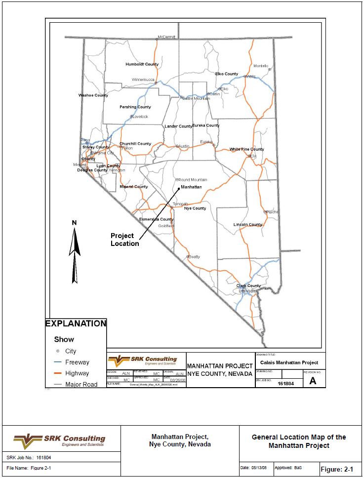
The Project is located in the southern portion of the Toquima Mountains approximately 1mi east of the town of Manhattan, Nye County, Nevada, as shown on the Location Map in Figure 2-1.
The geographic center of the property has UTM coordinates of 4,263,545m North and 495,509m East (Zone 11).
| 2.2 | Mineral Titles |
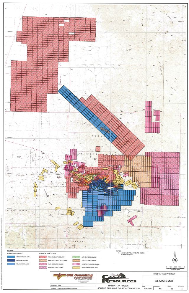
The Project is comprised of 183 unpatented (3,370ac/1,363ha) and 28 patented (428ac/173ha) claims, 211 claims in all totaling 3,798ac (1,537ha). See Figure 2-2. These claims are located within the Mount Diablo Baseline and Meridian;
| · | Sections 5 and 6 of Township 7 North, Range 44 East; |
| · | Sections 4, 5, 6, 8, 9, 20, 21, 22, 27, 28, 29, 30, 31, 32 and 33 of Township 8 North, Range 44 East; |
| · | Sections 25 and 36 of Township 9 North, Range 43 East; and |
| · | Sections 30, 31, and 32 Township 9 North, Range 44 East. |
The mining law of 1872 established a process, which a claimant may bring a claim to patent. When patented, ownership of the land and mineral rights transfer from the Federal Government to the claimant. The U.S. Bureau of Land Management (BLM) and the U.S. Forest Service (USFS) manage the lands covered by unpatented claims.
Each unpatented claim is typically 600ft x 1,500ft (183m x 457m) in size covering approximately 20ac (8ha)of surface area, though a number of claims cover land fractions between patented claims that are substantially smaller. Claim corners are typically marked in the field with 2in by 2in by 4ft wooden posts or by 4in by4ft pvc pipes.
Claim location notices for each claim are filed with the BLM and at the courthouse in the County in which the claims are located. Copies of the individual claim notices and the detailed map showing their locations are on file with the central BLM office in Reno, Nevada, and with the Nye County Recorder’s office in Pahrump, Nevada. The map and claim notices on file constitute the legal surveys for the property.
To maintain mining claims in good standing, a claim holder must make annual maintenance fee payments to the BLM of $140.00 per claim, plus a $10.00 per claim process fee totaling $150 per claim. Fees are payable in the County in which the claims are located.
Calais Resources records indicate that all claim filings are current and that the claims are valid until August 31, 2011, when the next annual maintenance fee payments and filings are due.
The authors did not verify any claim posts in the field, nor have they verified the validity of the mining claims or their ownership.
SRK Consulting (U.S.), Inc. Manhattan_NI_43-101_Exploration_161800.050_KG_002.doc | August 11, 2011 |
Calais Resources Inc. Manhattan Project | 2-2 NI 43-101 Technical Report on Exploration |
Ownership of Project claims is divided into 2 areas:
| · | Manhattan South Project Area (MSPA). This areas consists of 28 patented claims and 127 unpatented claims; and |
| · | Manhattan North Project Area (MNPA). This area consists of 56 unpatented claims. |
2.2.1 The Manhattan South Project Area (MSPA)
The MSPA consists of 28 patented claims (Table 2.2.1) and 127 unpatented claims totaling 2,678ac (1,083ha) more or less. Claims are shown in Figure 2-2, and are summarized in Exhibit 2-1(A-D) at the end of this Section. These claims are located within an historic mining district, and as a result, some of these have been subject to numerous assignments and litigation through the years. The ownership of MSPA claims is summarized in Table 2.2.1.
Table 2.2.1: Summary of MSPA Claims
| Area/Claim Group | No. of Claims | Subject to MPJV | Notes |
| Patented Claims | |||
| Argus Patented Claims | 26 | Yes | Owned 60% by Calais Resources Nevada, Inc. and 40% by Nevada Manhattan Mining, Inc. ("NMMI"). Claims are subject to the MPJV, and the 2000 Settlement Agreement. Assignment of these claims was received July 2004 from Argus Resources Inc. ("Argus"). |
| Calais | 1 | Yes | Owned 100% by Calais Resources Nevada, Inc.. This claim is subject to the MPJV and the 2000 Settlement Agreement. |
| Calais | 1 | Yes | Owned 100% by Calais Resources Nevada through a land exchange. It is subject to the MPJV through a land exchange. |
| Total Patented | 28 | ||
| Unpatented Claims | |||
| White Caps Claims | 42 | No | Owned 100% by Calais Resources Nevada, Inc.. |
| Argus Unpatented Claims (A) | 17 | Yes | Owned 60% by Calais Resources Nevada, Inc., and 40% by Nevada Manhattan Mining, Inc. ("NMMI"). Claims are subject to the MPJV, and the 2000 Settlement Agreement. Assignment of these claims was received July 2004 from Argus Resources Inc. ("Argus"). |
| Argus Unpatented Claims (B) | 12 | Yes | Owned 100% by Calais Resources Nevada, Inc.. Claim is subject to the MPJV and the 2000 Settlement Agreement. |
| Surviving Selig Claims | 56 | Yes | Owned 100% by Anthony Selig. |
| Total Unpatented | 127 | ||
| Total Claims | 155 |
The current MSPA claim position was assembled from claims owned by Anthony Selig, Marlowe Harvey, Argus Resources and Nevada Manhattan Mining, Inc. (NMMI). The MSPA claims were initially assembled under the Manhattan Property Joint Venture (MPJV) in 1993, between Marlowe Harvey (51%), NMMI (24.5%) and Argus Resources, Inc. (24.5%). Calais Resources acquired a 51% interest in Manhattan Property in December 1994, with Calais purchasing 100% of Marlowe Harvey’s interest. All patented claims, as well as the Argus Unpatented Claims, and the Surviving Selig Claims are subject to the MPJV.
Calais Resources, as a party to legal action (the 2000 Settlement Agreement) in September 2000 acquired the right to purchase Nevada Manhattan Mining, Inc.’s 24.5% interest in the Manhattan Project, subject to a royalty payment creditable against the buyout price. A subsequent legal action (the 2004 Settlement Agreement) between Marlowe Harvey entities, including Argus Resources, transferred Argus Resources 24.5% interest to Calais, thereby increasing Calais’ interest to 100% in the Manhattan Property. Under the 2000 Settlement Agreement, Calais also
SRK Consulting (U.S.), Inc. Manhattan_NI_43-101_Exploration_161800.050_KG_002.doc | August 11, 2011 |
Calais Resources Inc. Manhattan Project | 2-3 NI 43-101 Technical Report on Exploration |
assumed full operational control of the MPJV, subject to a royalty and royalty buyout agreement with NMMI.
The 2000 Settlement Agreement and 2004 Settlement Agreement, taken together, accord Calais 100% control of the property for mining and exploration purposes, subject to the terms of the agreements.
Calais received the White Caps Claims from Argus in July, 2004. These claims are 100% owned by Calais and are not subject to the MPJV or the 2000 Settlement Agreement.
The Surviving Selig Claims are 100% owned by Anthony Selig (or entities controlled of affiliated with Mr. Selig. These claims are subject to an obligation to convey the claims to NMMI and thence to the MPJV, when they will be subject to the MPJV and the 2000 Settlement Agreement. Anthony Selig entered into an agreement in 1997 with NMMI (the 1997 Agreement), which concerned certain subsets of the patented and unpatented claims, and, a certain deed of trust and other prior agreements. It is through the 1997 Agreement that Selig is obligated to convey to NMMI his interests in these unpatented claims.
Mr. Selig has denied any obligation to convey any portion of the claims directly to us, but has admitted an obligation to convey his interest in claims listed in a 1997 agreement between Selig and NMMI to NMMI. Selig is fully aware of the outcome of the Calais/NMMI litigation, and he and his counsel have indicated a willingness to tender the NMMI deed to the District Court in and for Nye County if properly directed to do so. We believe that the settlement of the NMMI litigation reached in September 2000 results in NMMI being obligated to convey its interests in the prospects to Calais, subject to the terms of the settlement, including payment of royalties to NMMI from production. We are currently unable to locate any person with authority to act for NMMI; management is evaluating the possible invocation of the jurisdiction of the District Court to accept the Selig deed on behalf of the joint venture, and subject to the terms of the recorded settlement. We also plan to deposit the remaining funds due to NMMI with the registry fund of the Nye County, Nevada District Court, as NMMI itself cannot be located or contacted.
2.2.2 The Manhattan North Project Area (MNPA)
The Manhattan North project area has 56 unpatented claims totaling 1,120 acres more or less. The claims, known as the Wild Horse claims, numbered 1-57 (no #11 claim), were located by Calais on or around Feb-Apr 2004. The claims are located on BLM administered lands, Calais Resources Colorado, Inc. is the claimant and owns a 100% interest in these claims. These claims are presented in Table 2.2.2, and shown in Figure 2-2. The ownership of MNPA claims is summarized in Exhibit 2-1(E).
Table 2.2.2: Summary of MNPA Claims
| Area/Claim Group | No. of Claims | Subject to MPJV | Notes |
| Unpatented Claims | |||
| Wild Horse Claims | 56 | No | Owned 100% by Calais Resources Colorado, Inc. These claims were located by Calais and are outside of the MPJV and 2000 Settlement Agreement. |
| Unpatented Claims | 56 |
SRK Consulting (U.S.), Inc. Manhattan_NI_43-101_Exploration_161800.050_KG_002.doc | August 11, 2011 |
Calais Resources Inc. Manhattan Project | 2-4 NI 43-101 Technical Report on Exploration |
2.2.3 Legal Issues
Overview Regarding Unpatented Claims
As is the case for all companies in the US, there are unavoidable risks in holding unpatented mining claims located under the General Mining Law. These include potential challenges to the validity of any claimed discovery, a challenge as to whether claimed discoveries would satisfy the prudent man rule, potential errors in location or recording, and the risk of changes in the law or regulations. Claims upon which no actual discovery exists are held by virtue of the doctrine of pedis possessio, which involves the occupation of claimed mining ground while engaged in a diligent search for a discovery of valuable minerals. There can be no guarantee that pedis possessio rights would be recognized as to any or all of the unpatented mining claims in Nevada if challenged by a third party. There can be no guarantee that any claimed discovery on unpatented grounds will survive challenge by the federal government, if the government sought to challenge title or right to occupy the ground.
Manhattan Property Joint Venture (MPJV)
The MPJV was historically owned 75.5% by Calais, and, formerly, Argus Resources, and 24.5% by NMMI. An agreement, Settlement Agreement and Mutual General Release, March 2004, transferred the interests of Argus Resources and certain Harvey related entities title of 28 patented and 146 unpatented claims to Calais through a series of agreements, some inside the MPJV, and others outside of it. The 2000 Settlement Agreement provided Calais with operational control of the NMMI interests in the MPJV, subject to a buyout agreement and royalty payment agreement contained therein.
However, the transfer of some of these claims, and multiple prior agreements, recorded and unrecorded, concerning some of the properties, are in question. Calais has initiated curative title work to address these issues. This work is in progress, however, additional work must still be completed to secure title to the claims.
As part of this curative work, Calais retained Almar Professional Land Services, Inc. (Almar) to update an earlier Almar report (dated October, 2003) also prepared by Almar in January, 2007. Almar searched Nye County Recorder’s Office, Nye County District Court, BLM and US District Court for the District of Nevada public records, filings and decisions for information affecting title to the claims. Several informational items, typos and missing documents were disclosed as well as several claim ownership name change discrepancies were noted.
Calais also obtained a litigation title commitment from First America Title Insurance Company for the patented claims (28 in all) in its curative title work.
There is no assurance that Calais can obtain a full and complete title of all mining claims included in the MPJV. Calais’ curative title work currently under way must be completed before a significant expenditure on exploration of the property can be recommended.
Manhattan North Property Area (MPNA)
There are no legal issues with respect to the MPNA property.
| 2.3 | Location of Mineralization |
The primary gold mineralization is located in the vicinity if the White Caps Mine located near the town of Manhattan in Nye County, south central Nevada within the historic Manhattan
SRK Consulting (U.S.), Inc. Manhattan_NI_43-101_Exploration_161800.050_KG_002.doc | August 11, 2011 |
Calais Resources Inc. Manhattan Project | 2-5 NI 43-101 Technical Report on Exploration |
Mining District. The main zone of mineralization is located along the north end of the Manhattan Fault and within the White Caps and Zanzabar limestones. The historical underground workings followed the higher grade quartz veins within fault structures. Gold mineralization is known to occur as disseminations in the quartz veins and within a halo of surrounding wall rock. Typical gangue minerals include realgar and stibnite.
| 2.4 | Royalties, Agreements and Encumbrances |
2.4.1 Royalties
At the MSPA, there is a 2% NSR royalty payable to the MPJV on production from;
| · | All patented claims; |
| · | The Argus Unpatented Claims; and |
| · | The Surviving Selig Claims. |
There are no royalties payable on the White Caps Claims.
There are no royalties associated with the Wild Horse Claims located in the MNPA.
2.4.2 Agreements
The Project is in early stages of exploration. Currently, there are no operating agreements. Calais will likely sign a contract with a drilling company to perform exploration drilling activities in the future.
2.4.3 Encumbrances
Manhattan Property Joint Venture (MPJV)
MSPA is potentially subject to the following encumbrances:
| · | The Manhattan South Project Area’s origination is the Manhattan Properties Joint Venture as formed in June 1993 between NMMI, Marlowe Harvey/Maran Holding, Inc. (Harvey), and Argus Resources, Inc. (Argus). The initial joint venture property consisted of 28 patented claims and 29 unpatented claims. |
| · | Concurrent with the MPJV formation, 13 of the original claims were encumbered for a $532,000 note in favor of Anthony C. Selig (Anthony Selig Note). Selig, who was a contract purchaser of the properties, was granted the Deed of Trust for his role in allowing a 40% interest in certain of the unpatented and patented claims to be transferred from Argus to NMMI. The Selig Entities were the original owners of the patented and unpatented mining claims comprising the Manhattan Properties, or had contracts to acquire those interests on various terms under agreements which were themselves subject to several amendments over time. In March 1997, NMMI entered into a Sale and Purchase agreement with the Selig Entities to repurchase the Anthony Selig Note for $375,000. NMMI (Manhattan Properties Joint Venture’s 24.5% partner) fulfilled the terms of the note with payments on March 1997 and June 1997. Calais is in possession of this satisfied note, which has not yet been released of record. As noted, the Selig entities have not yet released the quitclaim deed to the 1997 properties which is currently being held by Selig’s attorney. |
| · | In 1997, NMMI encumbered the Manhattan Property joint venture through NMMI’s 24.5% share. NMMI entered into a Subscription Agreement with Silenus Limited on |
SRK Consulting (U.S.), Inc. Manhattan_NI_43-101_Exploration_161800.050_KG_002.doc | August 11, 2011 |
Calais Resources Inc. Manhattan Project | 2-6 NI 43-101 Technical Report on Exploration |
| April 14, 1997. The Subscription Agreement required NMMI to grant Silenus Limited a $2,000,000 deed of trust encompassing the Manhattan Property until the Debentures issued to Silenus are converted, redeemed or paid in full. Further title investigation has determined that the Silenus deed of trust, executed by NMMI, has been recorded and does purport to encumber any after-acquired title of NMMI. Calais, which was the majority interest holder in the venture at that date, questions the ability of Silenus to encumber the joint venture property and the Calais and Argus interests in those properties. |
| All above Manhattan South Project Area properties (28 patented and 131 unpatented claims) may be encumbered by the Silenus lien. The existence and status of the Silenus lien, and whether it attaches to any venture properties, is a material concern regarding title to the Manhattan South Project Area and must be resolved before a significant expenditure on exploration of the properties is undertaken. Not all of the unpatented claims purporting to be encumbered are current claims, or, claims titled in NMMI at the time of the purported encumberance. |
| · | The Sep 2000 Legal Action (Also, “2000 Settlement Agreement”) provides for Calais Resources and Argus Resources to pay to NMMI and Jeff Kramer (an officer of NMMI) $300,000 total plus 5% interest (four $75,000 annual payments, the first payment at closing and a payment on each anniversary of closing). This payment was to reimburse NMMI’s payment of the Anthony Selig Note paid by NMMI in June 1997. Four $37,500 payments were made to Jeff Kramer and only two $37,500 payments were made to NMMI, as NMMI could not be located after the initial two payments were made; Calais made tender of the funds, but all correspondence was returned as un-deliverable. Two contractual payments, totaling $75,000, have not been made to NMMI. NMMI has no address and no living officers or directors have been located. Calais has resolved to deposit the remaining payments totaling $75,000 with the District Court as part of a proposed curative action. |
| · | The above March 2004 Agreement required Calais to complete a minimum of 15,000ft of exploration drilling within two years. At Calais’ option, the agreement further provided a prescriptive path for development of the project through stages ending in a production plan for the Manhattan South Project Area. The agreement provides a cure process and failing to cure, the 24.5% interest is returned to Argus Resources. Calais has not received marketable title from Mr. Harvey and Calais has not conducted the 15,000ft drill program. A number of the significant problems with title are described above. Mr. Harvey has been notified that marketable title was not received. |
| · | The March 2004 Settlement Agreement also required Calais to pay Marlowe Harvey and/or related entities, 250,000 shares of Calais restricted stock in payment for the 24.5% interest. After completion of exploration drilling (discussed above) and the identification of gold or gold equivalent resources exceeding 2Moz, Calais is to issue 2.5million shares of Calais common stock to Argus Resources. Identification of less than 2Moz results in a proportional reduction in the 2.5million shares of stock. Calais has not received marketable title from Mr. Harvey and no shares have been transferred. |
| · | The 42 unpatented claims, originally located by White Cap Mines, Inc., (and which were themselves re-locations of prior Selig claims) were conveyed to Calais Resources Nevada, Inc. in July 2004, by Quitclaim deed dated July 20, 2004, recorded August 10, |
SRK Consulting (U.S.), Inc. Manhattan_NI_43-101_Exploration_161800.050_KG_002.doc | August 11, 2011 |
Calais Resources Inc. Manhattan Project | 2-7 NI 43-101 Technical Report on Exploration |
| 2004, between White Cap Mines, Inc. (Marlowe Harvey, President) and Calais Resources Nevada, Inc. The 42 unpatented claims were originally located in Range 44E and are currently listed in Range 41E in the Nye County Recorders records and the BLM-LR2000 claim reports. Further survey work, and or claim location work may be required. Work to correct the description of the proper range in documents recorded in Nye County and with the BLM was completed in 2008. The claims are believed to have been properly located on the ground in Range 44E, and it is further believed that Nevada curative statutes allow correction of the error in the recorded documents. |
| · | WC-114, WC-115, WC-116, WC-117 unpatented claims are titled to Argus Resources, Inc. Further curative title work is required, which may consist of a clerical error at BLM, which received a deed transferring these interests to Calais. |
| · | WC#14, WC#16, WC#18, WC#20, WC#106, WC#108, WC#110, WC#112 and WC# 145 are dual claimed by Calais and Selig. Further curative title work is required. |
The Manhattan North Project Area (MNPA)
There are 2 senior claims immediately north of the common corner of Sections 4, 5, 8 and 9 of T8N, R44E. The claims are Wild Cat and Wild Cat #1, located in 1981, currently owned by Jason and Mark Pauley. This is the area of Wild Horse claims # 44, 47, 48, and 51. These claims are senior to the Wild Horse claims.
There are claims contiguous to the Wild Horse claims. While these claims do not encumber the project area, they do bound the project area.
Round Mountain (Smoky Valley Common Operation – Joint Venture between Kinross Gold Corporation and Barrick Gold Corporation) controls a large block of claims contiguous to the north, northeast and east of the Wild Horse claims. These are the MAN claims. Round Mountain controls claims to the south of the Wild Horse claims. These are the SAL claims. In addition, Round Mountain controls claims to the west of the Wild Horse claims. These are the SEP claims.
Newcrest Resources controls claims to the south east of the Wild Horse claims, immediately adjacent to the Round Mountain claims.
| 2.5 | Environmental Liabilities and Permitting |
The Calais owned and controlled lands are subject to no known environmental liabilities or mitigative measures. There are no current activities requiring permits. Mine tailings located on or near several of the properties have not been the subject of evaluation. The majority of those tailings had been previously conveyed by prior owners to Anthony C. Selig. The areas of dumps and tailings conveyed to Anthony Selig were surveyed and described prior to conveyance in several 1989 deeds.
2.5.1 Required Permits and Status
Calais has not applied for nor holds any permits for exploration or mining activities on Calais owned or controlled lands. Calais has no posted bonds with Nevada Department of Environmental Protection (NDEP) or BLM. The most recent exploration program was conducted in the 1997.
SRK Consulting (U.S.), Inc. Manhattan_NI_43-101_Exploration_161800.050_KG_002.doc | August 11, 2011 |
Calais Resources Inc. Manhattan Project | 2-8 NI 43-101 Technical Report on Exploration |
The BLM manages surface disturbances associated with mining activities under 45 CFR 3809 and Nevada manages the reclamation of mining activities under NRS 519A, with the intent of preventing undue and unnecessary degradation to lands in Nevada. Prior to exploring any Calais owned or controlled lands, an Exploration Plan of Operation and Reclamation Permit Application, satisfying the requirements of the BLM and NDEP must be filed, along with appropriate permit fees and reclamation bond.
Similarly, prior to mining any Calais owned or controlled lands, a Plan of Operations, satisfying the requirements of the BLM and NDEP, describing the proposed operations, detailing operating practices that prevent undue and unnecessary degradation, and presenting the reclamation practices that will be undertaken must be filed, along with the appropriate fees and reclamation bond. Prior to the authorization of the Plan of Operations, a National Environmental Policy Act (NEPA) analysis is typically required to describe the proposed activities and disclose potential environmental impacts. This analysis can take the form of an environmental assessment (EA) or environmental impact statement (EIS).
2.5.2 Compliance Evaluation
Calais is currently in compliance with BLM and NDEP environmental requirements.
SRK Consulting (U.S.), Inc. Manhattan_NI_43-101_Exploration_161800.050_KG_002.doc | August 11, 2011 |
Calais Resources Inc. Manhattan Project | 2-9 NI 43-101 Technical Report on Exploration |
Figure 2-1: General Location Map of the Manhattan Project
SRK Consulting (U.S.), Inc. Manhattan_NI_43-101_Exploration_161800.050_KG_002.doc | August 11, 2011 |
Calais Resources Inc. Manhattan Project | 2-10 NI 43-101 Technical Report on Exploration |
Figure 2-2: Manhattan Claim Location Map
SRK Consulting (U.S.), Inc. Manhattan_NI_43-101_Exploration_161800.050_KG_002.doc | August 11, 2011 |
Calais Resources Inc. Manhattan Project | 2-11 NI 43-101 Technical Report on Exploration |
Exhibit 2-1(A): MSPA – Summary of Patented Claims
| Claim Name | Mineral Survey | Township | Range | |
| Parcel No. 6-14 | ||||
| 1 | Katie No. 1 | MS2651 | T8N | R44E |
| 2 | Keystone | MS2692 | T8N | R44E |
| 3 | Red Boy | MS2693 | T8N | R44E |
| 4 | Silver Pick, as modified | MS25287 | T8N | R44E |
| 5 | Whoopee Fraction | MS2694 | T8N | R44E |
| Parcel No. 6-15 | ||||
| 6 | Annie Laurie | MS2874 | T8N | R44E |
| 7 | Dexter No. 7 | MS2602 | T8N | R44E |
| 8 | Dexter No. 8 | MS2602 | T8N | R44E |
| 9 | Earl | MS2544 | T8N | R44E |
| 10 | Eva | MS3667 | T8N | R44E |
| 11 | Flying Cloud | MS3667 | T8N | R44E |
| 12 | Snowman | MS3667 | T8N | R44E |
| 13 | Snow Drift | MS2764 | T8N | R44E |
| 14 | Union No. 2 | MS2552 | T8N | R44E |
| 15 | Union No. 3 | MS2553 | T8N | R44E |
| 16 | Union No. 4 | MS2554 | T8N | R44E |
| 17 | Union No. 5, as modified | MS2555 | T8N | R44E |
| 18 | Uno | MS2695 | T8N | R44E |
| Parcel No. 6-16 | ||||
| 19 | Ivanhoe | MS2773 | T8N | R44E |
| 20 | Morning Glory | MS4073 | T8N | R44E |
| 21 | Muleskinner | MS2882 | T8N | R44E |
| 22 | Pine Nut No. 2 | MS4073 | T8N | R44E |
| 23 | Union | MS2625 | T8N | R44E |
| 24 | Union No. 1 | MS2625 | T8N | R44E |
| 25 | White Cap | MS2579 | T8N | R44E |
| 26 | White Cap No. 1 | MS2579 | T8N | R44E |
| 27 | White Cap Extension | MS4335 | T8N | R44E |
| 28 | White Cap Ext. No. 1 | MS4335 | T8N | R44E |
SRK Consulting (U.S.), Inc. Manhattan_NI_43-101_Exploration_161800.050_KG_002.doc | August 11, 2011 |
Calais Resources Inc. Manhattan Project | 2-12 NI 43-101 Technical Report on Exploration |
Exhibit 2-1(B): MSPA – Summary of White Caps Claims (Unpatented)
| Claim Name | Mineral Survey | Royalty | Township | Range | Claimant | |
| 1 | WC No 6 | NMC712130 | 0% | T8N | R41E | Calais Resources NV |
| 2 | WC No 8 | NMC712131 | 0% | T8N | R41E | Calais Resources NV |
| 3 | WC No 10 | NMC712132 | 0% | T8N | R41E | Calais Resources NV |
| 4 | WC No 12 | NMC712133 | 0% | T8N | R41E | Calais Resources NV |
| 5 | WC No 21 | NMC712134 | 0% | T8N | R41E | Calais Resources NV |
| 6 | WC No 22 | NMC712135 | 0% | T8N | R41E | Calais Resources NV |
| 7 | WC No 23 | NMC712136 | 0% | T8N | R41E | Calais Resources NV |
| 8 | WC No 24 | NMC712137 | 0% | T8N | R41E | Calais Resources NV |
| 9 | WC No 25 | NMC712138 | 0% | T8N | R41E | Calais Resources NV |
| 10 | WC No 26 | NMC712139 | 0% | T8N | R41E | Calais Resources NV |
| 11 | WC No 27 | NMC712140 | 0% | T8N | R41E | Calais Resources NV |
| 12 | WC No 28 | NMC712141 | 0% | T8N | R41E | Calais Resources NV |
| 13 | WC No 29 | NMC712142 | 0% | T8N | R41E | Calais Resources NV |
| 14 | WC No 30 | NMC712143 | 0% | T8N | R41E | Calais Resources NV |
| 15 | WC No 31 | NMC712144 | 0% | T8N | R41E | Calais Resources NV |
| 16 | WC No 32 | NMC712145 | 0% | T8N | R41E | Calais Resources NV |
| 17 | WC No 33 | NMC712146 | 0% | T8N | R41E | Calais Resources NV |
| 18 | WC No 34 | NMC712147 | 0% | T8N | R41E | Calais Resources NV |
| 19 | WC No 35 | NMC712148 | 0% | T8N | R41E | Calais Resources NV |
| 20 | WC No 98 | NMC712149 | 0% | T8N | R41E | Calais Resources NV |
| 21 | WC No 100 | NMC712150 | 0% | T8N | R41E | Calais Resources NV |
| 22 | WC No 102 | NMC712151 | 0% | T8N | R41E | Calais Resources NV |
| 23 | WC No 145 | NMC712152 | 0% | T8N | R41E | Calais Resources NV |
| 24 | SM #1 | NMC712153 | 0% | T8N | R41E | Calais Resources NV |
| 25 | SM #2 | NMC712154 | 0% | T8N | R41E | Calais Resources NV |
| 26 | SM #3 | NMC712155 | 0% | T8N | R41E | Calais Resources NV |
| 27 | SM #4 | NMC712156 | 0% | T8N | R41E | Calais Resources NV |
| 28 | SM #5 | NMC712157 | 0% | T8N | R41E | Calais Resources NV |
| 29 | SM #6 | NMC712158 | 0% | T8N | R41E | Calais Resources NV |
| 30 | SM #7 | NMC712159 | 0% | T8N | R41E | Calais Resources NV |
| 31 | SM #8 | NMC712160 | 0% | T8N | R41E | Calais Resources NV |
| 32 | SM #9 | NMC712161 | 0% | T8N | R41E | Calais Resources NV |
| 33 | SM #10 | NMC712162 | 0% | T8N | R41E | Calais Resources NV |
| 34 | SM #12 | NMC712163 | 0% | T8N | R41E | Calais Resources NV |
| 35 | SM #14 | NMC712164 | 0% | T8N | R41E | Calais Resources NV |
| 36 | SM #16 | NMC712165 | 0% | T8N | R41E | Calais Resources NV |
| 37 | SM #18 | NMC712166 | 0% | T8N | R41E | Calais Resources NV |
| 38 | SM #21 | NMC712167 | 0% | T8N | R41E | Calais Resources NV |
| 39 | SM #23 | NMC712168 | 0% | T8N | R41E | Calais Resources NV |
| 40 | SM #25 | NMC712169 | 0% | T8N | R41E | Calais Resources NV |
| 41 | Little Joe Fraction No. 11 | NMC712170 | 0% | T8N | R41E | Calais Resources NV |
| 42 | Little Joe Fraction No. 22 | NMC712171 | 0% | T8N | R41E | Calais Resources NV |
SRK Consulting (U.S.), Inc. Manhattan_NI_43-101_Exploration_161800.050_KG_002.doc | August 11, 2011 |
Calais Resources Inc. Manhattan Project | 2-13 NI 43-101 Technical Report on Exploration |
Exhibit 2-1(C): MSPA – Summary of Argus Unpatented Claims
| Claim Name | Mineral Survey | Royalty | Township | Range | Claimant | |
| 1 | Little Joe #1 | NMC93115 | 2% | T8N | R44E | Calais Resources NV |
| 2 | Little Joe #2 | NMC93116 | 2% | T8N | R44E | Calais Resources NV |
| 3 | Little Joe #3 | NMC93117 | 2% | T8N | R44E | Calais Resources NV |
| 4 | Little Joe #4 | NMC93118 | 2% | T8N | R44E | Calais Resources NV |
| 5 | Little Joe #5 | NMC93119 | 2% | T8N | R44E | Calais Resources NV |
| 6 | Little Joe #6 | NMC93120 | 2% | T8N | R44E | Calais Resources NV |
| 7 | Little Joe #7 | NMC93121 | 2% | T8N | R44E | Calais Resources NV |
| 8 | Little Joe #8 | NMC93122 | 2% | T8N | R44E | Calais Resources NV |
| 9 | Little Joe #9 | NMC93123 | 2% | T8N | R44E | Calais Resources NV |
| 10 | Little Joe #10 | NMC93124 | 2% | T8N | R44E | Calais Resources NV |
| 11 | Little Joe #11 | NMC93125 | 2% | T8N | R44E | Calais Resources NV |
| 12 | Little Joe #12 | NMC93126 | 2% | T8N | R44E | Calais Resources NV |
| 13 | Little Joe #13 | NMC93127 | 2% | T8N | R44E | Calais Resources NV |
| 14 | Little Joe #14 | NMC93128 | 2% | T8N | R44E | Calais Resources NV |
| 15 | Little Joe #15 | NMC93129 | 2% | T8N | R44E | Calais Resources NV |
| 16 | Little Joe #16 | NMC93130 | 2% | T8N | R44E | Calais Resources NV |
| 17 | Little Joe #17 | NMC93131 | 2% | T8N | R44E | Calais Resources NV |
| 18 | Little Joe #18 | NMC93132 | 2% | T8N | R44E | Calais Resources NV |
| 19 | Little Joe Fraction #19 | NMC93133 | 2% | T8N | R44E | Calais Resources NV |
| 20 | Little Joe Fraction #20 | NMC93134 | 2% | T8N | R44E | Calais Resources NV |
| 21 | Little Joe Fraction #21 | NMC93135 | 2% | T8N | R44E | Calais Resources NV |
| 22 | Mable A | NMC93107 | 2% | T8N | R44E | Calais Resources NV |
| 23 | Lillie Fraction | NMC93108 | 2% | T8N | R44E | Calais Resources NV |
| 24 | Little Johnnie Fraction | NMC93109 | 2% | T8N | R44E | Calais Resources NV |
| 25 | Pandora Fraction | NMC93110 | 2% | T8N | R44E | Calais Resources NV |
| 26 | Turtle Dove Fraction | NMC93111 | 2% | T8N | R44E | Calais Resources NV |
| 27 | Combination | NMC93112 | 2% | T8N | R44E | Calais Resources NV |
| 28 | Granny Fraction | NMC93113 | 2% | T8N | R44E | Calais Resources NV |
| 29 | Yellow Horse Fraction | NMC93114 | 2% | T8N | R44E | Calais Resources NV |
SRK Consulting (U.S.), Inc. Manhattan_NI_43-101_Exploration_161800.050_KG_002.doc | August 11, 2011 |
Calais Resources Inc. Manhattan Project | 2-14 NI 43-101 Technical Report on Exploration |
Exhibit 2-1(D): MSPA – Summary of Surviving Selig Claims (Unpatented)
| Claim Name | Mineral Survey | Royalty | Township | Range | Claimant | |
| 1 | WC # 2 | NMC260866 | 2% | T8N | R44E | Calais Resources NV |
| 2 | WC # 4 | NMC260868 | 2% | T8N | R44E | Calais Resources NV |
| 3 | WC # 13 | NMC443689 | 2% | T8N | R44E | Calais Resources NV |
| 4 | WC # 14 | NMC443690 | 2% | T8N | R44E | Calais Resources NV |
| 5 | WC # 15 | NMC260879 | 2% | T8N | R44E | Calais Resources NV |
| 6 | WC # 16 | NMC443691 | 2% | T8N | R44E | Calais Resources NV |
| 7 | WC # 17 | NMC260881 | 2% | T8N | R44E | Calais Resources NV |
| 8 | WC # 18 | NMC443692 | 2% | T8N | R44E | Calais Resources NV |
| 9 | WC # 19 | NMC260883 | 2% | T8N | R44E | Calais Resources NV |
| 10 | WC # 20 | NMC443693 | 2% | T8N | R44E | Calais Resources NV |
| 11 | WC # 36 | NMC260900 | 2% | T8N | R44E | Calais Resources NV |
| 12 | WC # 37 | NMC260901 | 2% | T8N | R44E | Calais Resources NV |
| 13 | WC # 38 | NMC260902 | 2% | T7 & 8N | R44E | Calais Resources NV |
| 14 | WC # 39 | NMC260903 | 2% | T8N | R44E | Calais Resources NV |
| 15 | WC # 40 | NMC260904 | 2% | T7 & 8N | R44E | Calais Resources NV |
| 16 | WC # 41 | NMC260905 | 2% | T8N | R44E | Calais Resources NV |
| 17 | WC # 42 | NMC260906 | 2% | T7 & 8N | R44E | Calais Resources NV |
| 18 | WC # 43 | NMC260907 | 2% | T8N | R44E | Calais Resources NV |
| 19 | WC # 44 | NMC260908 | 2% | T7 & 8N | R44E | Calais Resources NV |
| 20 | WC # 46 | NMC260910 | 2% | T7 & 8N | R44E | Calais Resources NV |
| 21 | WC # 69 | NMC443718 | 2% | T8N | R44E | Calais Resources NV |
| 22 | WC # 70 | NMC443719 | 2% | T8N | R44E | Calais Resources NV |
| 23 | WC # 71 | NMC443720 | 2% | T8N | R44E | Calais Resources NV |
| 24 | WC # 73 | NMC443722 | 2% | T8N | R44E | Calais Resources NV |
| 25 | WC # 75 | NMC443724 | 2% | T8N | R44E | Calais Resources NV |
| 26 | WC # 77 | NMC443726 | 2% | T8N | R44E | Calais Resources NV |
| 27 | WC # 97 | NMC260961 | 2% | T8N | R44E | Calais Resources NV |
| 28 | WC # 99 | NMC260963 | 2% | T8N | R44E | Calais Resources NV |
| 29 | WC # 101 | NMC260965 | 2% | T8N | R44E | Calais Resources NV |
| 30 | WC # 103 | NMC260967 | 2% | T8N | R44E | Calais Resources NV |
| 31 | WC # 104 | NMC443749 | 2% | T8N | R44E | Calais Resources NV |
| 32 | WC # 105 | NMC260969 | 2% | T8N | R44E | Calais Resources NV |
| 33 | WC # 106 | NMC443750 | 2% | T8N | R44E | Calais Resources NV |
| 34 | WC # 107 | NMC260971 | 2% | T8N | R44E | Calais Resources NV |
| 35 | WC # 108 | NMC443751 | 2% | T8N | R44E | Calais Resources NV |
| 36 | WC # 109 | NMC260973 | 2% | T8N | R44E | Calais Resources NV |
| 37 | WC # 110 | NMC443752 | 2% | T8N | R44E | Calais Resources NV |
| 38 | WC # 111 | NMC260975 | 2% | T8N | R44E | Calais Resources NV |
| 39 | WC # 112 | NMC443753 | 2% | T8N | R44E | Calais Resources NV |
| 40 | WC # 113 | NMC260977 | 2% | T8N | R44E | Calais Resources NV |
| 41 | WC # 114 | NMC260978 | 2% | T8N | R44E | Argus Resources Inc. |
| 42 | WC # 115 | NMC260979 | 2% | T8N | R44E | Argus Resources Inc. |
| 43 | WC # 116 | NMC260980 | 2% | T8N | R44E | Argus Resources Inc. |
| 44 | WC # 117 | NMC260981 | 2% | T8N | R44E | Argus Resources Inc. |
| 45 | WC # 126 | NMC260990 | 2% | T8N | R44E | Calais Resources NV |
| 46 | WC # 128 | NMC260992 | 2% | T8N | R44E | Calais Resources NV |
| 47 | WC # 130 | NMC260994 | 2% | T8N | R44E | Calais Resources NV |
| 48 | WC # 132 | NMC260996 | 2% | T8N | R44E | Calais Resources NV |
| 49 | WC # 134 | NMC260998 | 2% | T8N | R44E | Calais Resources NV |
| 50 | WC # 136 | NMC261000 | 2% | T8N | R44E | Calais Resources NV |
| 51 | WC # 140 | NMC261004 | 2% | T8N | R44E | Calais Resources NV |
| 52 | WC # 141 | NMC261005 | 2% | T8N | R44E | Calais Resources NV |
| 53 | WC # 142 | NMC261006 | 2% | T8N | R44E | Calais Resources NV |
| 54 | WC # 143 | NMC261007 | 2% | T8N | R44E | Calais Resources NV |
| 55 | Boggie Lode | NMC569966 | 2% | T8N | R44E | Calais Resources NV |
| 56 | Granny Lode Fraction | NMC594683 | 2% | T8N | R44E | Calais Resources NV |
SRK Consulting (U.S.), Inc. Manhattan_NI_43-101_Exploration_161800.050_KG_002.doc | August 11, 2011 |
Calais Resources Inc. Manhattan Project | 2-15 NI 43-101 Technical Report on Exploration |
Exhibit 2-1(E): MNPA – Summary of Wild Horse Claims (Unpatented)
| Claim Name | Mineral Survey | Royalty | Township | Range | Claimant | |
| 1 | Wild Horse 1 | NMC 866234 | 0% | T9N | R43E | Calais Resources CO |
| 2 | Wild Horse 2 | NMC 866235 | 0% | T9N | R43E | Calais Resources CO |
| 3 | Wild Horse 3 | NMC 866236 | 0% | T9N | R43E | Calais Resources CO |
| 4 | Wild Horse 4 | NMC 866237 | 0% | T9N | R43E | Calais Resources CO |
| 5 | Wild Horse 5 | NMC 866238 | 0% | T9N | R43 & 44E | Calais Resources CO |
| 6 | Wild Horse 6 | NMC 866239 | 0% | T9N | R43E | Calais Resources CO |
| 7 | Wild Horse 7 | NMC 866240 | 0% | T9N | R43E | Calais Resources CO |
| 8 | Wild Horse 8 | NMC 866241 | 0% | T9N | R43E | Calais Resources CO |
| 9 | Wild Horse 9 | NMC 866242 | 0% | T9N | R43 & 44E | Calais Resources CO |
| 10 | Wild Horse 10 | NMC 866243 | 0% | T9N | R43 & 44E | Calais Resources CO |
| 11 | Wild Horse 12 | NMC 866244 | 0% | T9N | R43 & 44E | Calais Resources CO |
| 12 | Wild Horse 13 | NMC 866245 | 0% | T9N | R43 & 44E | Calais Resources CO |
| 13 | Wild Horse 14 | NMC 866246 | 0% | T9N | R44E | Calais Resources CO |
| 14 | Wild Horse 15 | NMC 866247 | 0% | T9N | R44E | Calais Resources CO |
| 15 | Wild Horse 16 | NMC 866248 | 0% | T9N | R44E | Calais Resources CO |
| 16 | Wild Horse 17 | NMC 866249 | 0% | T9N | R43 & 44E | Calais Resources CO |
| 17 | Wild Horse 18 | NMC 866250 | 0% | T9N | R44E | Calais Resources CO |
| 18 | Wild Horse 19 | NMC 866251 | 0% | T9N | R44E | Calais Resources CO |
| 19 | Wild Horse 20 | NMC 866252 | 0% | T9N | R44E | Calais Resources CO |
| 20 | Wild Horse 21 | NMC 866253 | 0% | T9N | R44E | Calais Resources CO |
| 21 | Wild Horse 22 | NMC 866254 | 0% | T9N | R44E | Calais Resources CO |
| 22 | Wild Horse 23 | NMC 866255 | 0% | T9N | R44E | Calais Resources CO |
| 23 | Wild Horse 24 | NMC 866256 | 0% | T9N | R44E | Calais Resources CO |
| 24 | Wild Horse 25 | NMC 866257 | 0% | T8 & 9N | R44E | Calais Resources CO |
| 25 | Wild Horse 26 | NMC 866258 | 0% | T9N | R44E | Calais Resources CO |
| 26 | Wild Horse 27 | NMC 866259 | 0% | T8 & 9N | R44E | Calais Resources CO |
| 27 | Wild Horse 28 | NMC 866260 | 0% | T8 & 9N | R44E | Calais Resources CO |
| 28 | Wild Horse 29 | NMC 866261 | 0% | T8 & 9N | R44E | Calais Resources CO |
| 29 | Wild Horse 30 | NMC 866262 | 0% | T8 & 9N | R44E | Calais Resources CO |
| 30 | Wild Horse 31 | NMC 866263 | 0% | T8N | R44E | Calais Resources CO |
| 31 | Wild Horse 32 | NMC 866264 | 0% | T8N | R44E | Calais Resources CO |
| 32 | Wild Horse 33 | NMC 866265 | 0% | T8N | R44E | Calais Resources CO |
| 33 | Wild Horse 34 | NMC 866266 | 0% | T8N | R44E | Calais Resources CO |
| 34 | Wild Horse 35 | NMC 866267 | 0% | T8N | R44E | Calais Resources CO |
| 35 | Wild Horse 36 | NMC 866268 | 0% | T8N | R44E | Calais Resources CO |
| 36 | Wild Horse 37 | NMC 866269 | 0% | T8N | R44E | Calais Resources CO |
| 37 | Wild Horse 38 | NMC 866270 | 0% | T8N | R44E | Calais Resources CO |
| 38 | Wild Horse 39 | NMC 866271 | 0% | T8N | R44E | Calais Resources CO |
| 39 | Wild Horse 40 | NMC 866272 | 0% | T8N | R44E | Calais Resources CO |
| 40 | Wild Horse 41 | NMC 866273 | 0% | T8N | R44E | Calais Resources CO |
| 41 | Wild Horse 42 | NMC 866274 | 0% | T8N | R44E | Calais Resources CO |
| 42 | Wild Horse 43 | NMC 866275 | 0% | T8N | R44E | Calais Resources CO |
| 43 | Wild Horse 44 | NMC 866276 | 0% | T8N | R44E | Calais Resources CO |
| 44 | Wild Horse 45 | NMC 866277 | 0% | T8N | R44E | Calais Resources CO |
| 45 | Wild Horse 46 | NMC 866278 | 0% | T8N | R44E | Calais Resources CO |
| 46 | Wild Horse 47 | NMC 866279 | 0% | T8N | R44E | Calais Resources CO |
| 47 | Wild Horse 48 | NMC 866280 | 0% | T8N | R44E | Calais Resources CO |
| 48 | Wild Horse 49 | NMC 866281 | 0% | T8N | R44E | Calais Resources CO |
| 49 | Wild Horse 50 | NMC 866282 | 0% | T8N | R44E | Calais Resources CO |
| 50 | Wild Horse 51 | NMC 866283 | 0% | T8N | R44E | Calais Resources CO |
| 51 | Wild Horse 52 | NMC 866284 | 0% | T8N | R44E | Calais Resources CO |
| 52 | Wild Horse 53 | NMC 866285 | 0% | T8N | R44E | Calais Resources CO |
| 53 | Wild Horse 54 | NMC 866286 | 0% | T8N | R44E | Calais Resources CO |
| 54 | Wild Horse 55 | NMC 866287 | 0% | T8N | R44E | Calais Resources CO |
| 55 | Wild Horse 56 | NMC 866288 | 0% | T8N | R44E | Calais Resources CO |
| 56 | Wild Horse 57 | NMC 866289 | 0% | T8N | R44E | Calais Resources CO |
SRK Consulting (U.S.), Inc. Manhattan_NI_43-101_Exploration_161800.050_KG_002.doc | August 11, 2011 |
Calais Resources Inc. Manhattan Project | 3-1 NI 43-101 Technical Report on Exploration |
| 3 | Accessibility, Climate, Local Resources, Infrastructure and Physiography (Item 7) |
| 3.1 | Topography, Elevation and Vegetation |
The Manhattan Project lies within the Basin and Range physiographic province of Central Nevada. This province consists of northerly trending mountain ranges with 2,000 to 5,000ft (610 to 1,500m) of topographic relief above relatively broad and flat intervening valleys. The Manhattan Project is located on the southwestern flank of the Toquima Mountain range at elevations between 7,600 to 8,000ft (2,300 to 2,400m) above mean sea level. The topography is considered “mature” and generally of moderate-relief. The northern boundary of the South Manhattan area is located near the headwaters of a seasonally flowing stream in Consolidated Canyon. Vegetation is sparse consisting of Pinion Juniper and sagebrush.
| 3.2 | Climate and Length of Operating Season |
Climate is typical for the high-desert regions of Central Nevada, with usually hot dry summers and cold snowy winters. Summer temperatures are typically in the mid 80ºF (27ºC) but highs can peak at 95ºF. Winter temperatures range between lows of 0-20ºF (-18 to -7 ºC) to highs of 30 to 40ºF (-1 to 4 ºC). Most of the precipitation for the region falls as snow in the winter months. Snow many feet deep in the upper mountains above 7,000ft (2,100m), occurs from December through February. Rainfall occurs as mild showers in the spring and as severe thunderstorms during the late summer.
The typical exploration season would be from mid-March through the end of November. If snow removal equipment is used, the exploration season can be extended through the winter months.
| 3.3 | Access to Property |
The Manhattan Project is accessed by driving north from Tonopah, Nevada on State Highway 366 for 37mi (59km). Then, turn east onto State Highway 377 for 7mi (11km). Continue though the town of Manhattan and turn south onto the Consolidated Gulch road. Follow this gravel road for 1mi to the White Caps Mine. This is the northern boundary of the main claim block. To access the northern claim block from the town of Manhattan, continue traveling east on Consolidated Gulch road for 2mi (3.2km) and turn north onto the Slaughterhouse Gulch gravel road. Proceed to the north for 2mi (3.2km) to reach the southern edge of the claim area.
| 3.4 | Surface Rights |
Calais owns surface rights to the 428ac (173ha) included within the 28 patented claims. Surface access is provided to the remaining 3,370ac (1,364ha) of federal land by the 1872 Mining Law. Applications for exploration activities must be filed with the appropriate agencies if surface disturbance is to occur. Calais is currently negotiating a land exchange, which may involve a trade of one patented claim of lesser mineral interest for a claim of greater interest and of equal or greater size.
| 3.5 | Local Resources and Infrastructure |
Manhattan is an historic mining and ranching town with one general store, a couple of dining establishments, a hotel and numerous homes. Tonopah, located 40mi (64km) south has been a supporting town for many of the active mines in the area.
SRK Consulting (U.S.), Inc. Manhattan_NI_43-101_Exploration_161800.050_KG_002.doc | August 11, 2011 |
Calais Resources Inc. Manhattan Project | 3-2 NI 43-101 Technical Report on Exploration |
3.5.1 Access Road and Transportation
Access from Tonopah is along a two-lane paved State Highway 366 to Manhattan. From there, a two-lane, all season, gravel road, capable of handling heavy truck traffic leads to the White Caps Mine. The Union Pacific Railroad runs through both Carson City and Las Vegas Nevada, approximately 200mi (322km) north and south of Tonopah respectively. The closest air service is provided by Desert Flying Service at Tonopah and scheduled passenger service is available in Reno or Las Vegas, Nevada.
3.5.2 Power Supply
Currently, there is no electric service to either the White Caps or Consolidated Mines. These lines appear to have been removed, likely for the salvage value of the transmission lines. There is reportedly 440kV service at the town of Manhattan located one mile from the mine site. Electrical service is provided by the Sierra Pacific Power Company.
3.5.3 Water Supply
There is currently no water supply at the White Caps or Consolidated mine sites.
3.5.4 Buildings and Ancillary Facilities
There are no usable buildings or facilities at the property. Near the shaft of the White Caps mine, a couple of historic buildings are in various states of disrepair. A historic roaster is also located at the White Caps mine site.
3.5.5 Tailings Storage Area
There is a small tailing disposal area located at the White Caps mine site. The tailings are dry and cover an area of about one half acre. The runoff of the tailing area is currently uncontrolled. There are several potential areas for valley fill type tailings disposal. Several areas of tailings and dumps in the vicinity of several of the patented properties were previously conveyed by prior owners to Anthony C. Selig.
3.5.6 Waste Disposal Area
There are several small waste disposal piles at both the White Caps and Consolidated Manhattan Mines. All are located in close proximity to the old shaft or winze openings and all combined contain approximately 250,000st (227,000tonnes) of material. There are no obvious signs of any acid generation and sulfides are rarely visible in the piles, most of the material consists of unaltered country rock.
3.5.7 Manpower
The nearest town of size that would have the needed skilled labor is Tonopah. There are limited resources in the town of Manhattan.
SRK Consulting (U.S.), Inc. Manhattan_NI_43-101_Exploration_161800.050_KG_002.doc | August 11, 2011 |
Calais Resources Inc. Manhattan Project | 4-1 NI 43-101 Technical Report on Exploration |
| 4 | History (Item 8) |
| 4.1 | Ownership |
The Manhattan Project centered on the historic White Caps Mine, which operated continuously from 1906 until 1942, and intermittently from 1942 until 1964. The Keystone claims and the Jumbo Mine Group claims comprise the historic White Caps Mine. After the discovery of the White Caps mine in 1905, the first formal company to own the property was the White Caps Mining Company, formed in 1915 (Gibbs 1985). In 1925, the White Caps Mining Company sold the property to the White Caps Gold Mining Company. The White Caps Gold Mining Company leased the property in 1931 to W.J. Fancher a former mine superintendent for the White Caps Gold Mining Company. Between 1933 and 1934, 25 to 30 unnamed leasers operated in the White Caps Mine between the 800-level and the surface (Mining World). Although substantial work has been done to consolidate and rationalize titles to the unpatented and patented claims, additional curative work will be necessary.
| 4.2 | Past Exploration and Development |
Exploration work on the Manhattan Project claims consists of geologic mapping, rock chip sampling, geophysical surveys, drilling and underground drifting. The majority of the modern bedrock mapping was conducted by Shawe during the period between 1984-2004. Shawe also conducted rock chip sampling of the quartz veins in the North Manhattan area prior to his report on the same in 1986.
Several exploration companies over the years have drilled the property mainly using reverse circulation drilling. The most comprehensive program was conducted from 1982 through 1984 by Freeport Mineral Company. They completed 43 drillholes near the historic mining areas to test shallow and deep-seated mineralization potential near the White Caps, Manhattan, Consolidated and Litigation Hill Mines. A few of these holes encountered discrete high-grade gold zones but broader intercepts of disseminated gold mineralization were not found. A significant drill intercept was encountered in drill hole WC-49. This drillhole reported 25ft of 0.698oz/st (23.9g/t) from 465ft to 490ft (142m to 149m) in depth.
In 1986, NMMI drilled over 10 holes up to 120ft (37m) deep with a truck mounted reverse-circulation drill. The program was targeting shallow mineralization and the results were not encouraging. In 1988, NMMI drilled five more holes with a truck mounted rotary drill rig targeting deeper mineralization than previously. These drill holes were all between 200ft-525ft (61m-160m) deep. The results of this program encountered several intercepts of anomalous gold but no coherent zones of mineralization were established.
In September 1993, a 1,200ft (366m) decline was driven by Harrison Western for NMMI in an attempt to intercept the high-grade gold intercept identified by Freeport in drillhole WC-49. The decline was completed in March 1994. It was successful in locating the gold mineralization but did not encounter the high-grade intercept. This decline could be used for future drill programs.
| 4.3 | Historic Mineral Resource and Reserve Estimates |
There are no reported mineral resources or reserves within the historical documentation of the mines located in the current Manhattan Project claims. Historic sampling from the White Caps Mine were reported from the 1100 mine level to the 1310 mine level in the White Caps Mine.
SRK Consulting (U.S.), Inc. Manhattan_NI_43-101_Exploration_161800.050_KG_002.doc | August 11, 2011 |
Calais Resources Inc. Manhattan Project | 4-2 NI 43-101 Technical Report on Exploration |
The reported gold grade ranges from 0.97oz/st to 2.30oz/st (33g/t to 79g/t) over 20 to 30ft (6 to 9m) wide.
| 4.4 | Historic Production |
The White Caps Mine was the largest producer in the Manhattan district. The mine operated from 1905 until 1964 and is reported to have produced approximately 120koz of gold (Anderson 1990). Other mines within the project area include the Nevada Manhattan, the Manhattan Consolidated, the Jumbo, the Bath, and the Union Consolidated Mines. All of these together are reported to have produced an estimated 30koz of gold (Anderson 1990). Koschmann and Bergandahl (1968) report that a total of 280koz of gold were mined from lode claims within the Manhattan district. However, they do not quantify exactly which mines were included within the “Manhattan District”.
SRK Consulting (U.S.), Inc. Manhattan_NI_43-101_Exploration_161800.050_KG_002.doc | August 11, 2011 |
Calais Resources Inc. Manhattan Project | 5-1 NI 43-101 Technical Report on Exploration |
| 5 | Geologic Setting (Item 9) |
| 5.1 | Regional Geology |
The Manhattan mining district is located in the southern Toquima Range a block faulted horst of the basin and range tectonic province. The area is underlain by Paleozoic meta-sedimentary rocks intruded by two large Cretaceous granite plutons, and cut by a variety of Tertiary volcanic rocks (Shawe 1999). See Figure 5-1.
During the Cambrian through Devonian Periods, the study area was part of a large passive continental shelf forming the western margin of the North American Craton (NAC). During this time predominantly deeper water mud, limey mud and reefs were deposited in the area. During the Carboniferous Period, the Antler Arc collided with the NAC creating the Antler Mountain Range within the study area. These formed a predominate highland which underwent erosion through the end of the Permian Period. In the Triassic Period, the area was subject to over thrusting related to the collision of the Quesnel Fragment. This deformation style transitioned into an arc related subduction zone and the study area was located within a back arc basin during most of the Jurassic Period. This back arc basin eventually collapsed and by the Cretaceous Period the western margin of the NAC was comprised of a classic Andean style arc complex. As The Wrangellia oceanic plateau was subducted beneath the NAC large batholiths and plutons began to form farther inland within the study area. The Tertiary Period brought about a change from compressional to extensional tectonics marked by the development of widespread volcanism and caldera development followed by the eventual development of the basin and range faulting which predominates the landscape today (Blakely 1997).
The Toquima Range is a caldera complex which includes; the Moores Creek, Mount Jefferson, Trail Canyon, and Manhattan Calderas. The caldera volcanism becomes younger toward the southeastward parallel to regional southeast striking faults. This suggests that older and likely more deeply rooted structures have controlled their development (Boden 1896). Most of the major zones of mineralization in the Toquima Range are located near the intersections of caldera margins and principal northwest striking fault zones. The Manhattan mining district is located near the southern margin of the Manhattan Caldera (Shawe 2003).
| 5.2 | Local Geology |
5.2.1 Local Lithology
The oldest rocks in the Manhattan district are the Cambrian Gold Hill Formation. The formation consists predominantly of massive phyllites with textural variations between slate and schist. Minor lenses of quartzite, sandstones and limestones are also present. Four, Late Cambrian to Ordovician age limestone units that are also present in the district. These include the White Caps Limestone, the Pine Nut Limestone, the Morning Glory Li mestone and the Zanzabar Limestone. All of these contain minor zones of dolomitization and can be highly fractured.
5.2.2 Alteration
Several alteration types are present including; chlorite, clay, minor pyrite oxidized to limonite, adularia, quartz, sericite and K-spar. Many of these alteration types occur in combination with each other and no distinct pattern of zonation has yet been determined.
SRK Consulting (U.S.), Inc. Manhattan_NI_43-101_Exploration_161800.050_KG_002.doc | August 11, 2011 |
Calais Resources Inc. Manhattan Project | 5-2 NI 43-101 Technical Report on Exploration |
5.2.3 Structure
The Manhattan Fault is the main structure in the project area. The fault strikes southeast and dips steeply to the southwest. To the south of the Manhattan Fault, a series of low angle southeast striking faults have also been observed (Shawe 1999). There are also numerous northeasterly striking faults with a variety of dips located in the northeastern portions of the main claim block. Each of the calderas in the area have a series of ring structures that delineate the calderas.
SRK Consulting (U.S.), Inc. Manhattan_NI_43-101_Exploration_161800.050_KG_002.doc | August 11, 2011 |
Calais Resources Inc. Manhattan Project | 5-3 NI 43-101 Technical Report on Exploration |
Figure 5-1: General Geology of the Calais Project Area

SRK Consulting (U.S.), Inc. Manhattan_NI_43-101_Exploration_161800.050_KG_002.doc | August 11, 2011 |
Calais Resources Inc. Manhattan Project | 6-1 NI 43-101 Technical Report on Exploration |
| 6 | Deposit Type (Item 10) |
Shawe (2003) has documented three stages of mineralization within the Manhattan District. The earliest was a skarn type located near the White Caps Mine and dated at 75Ma. This was probably related to the emplacement of the Pipe Spring granite pluton. It may be associated with base metals and silver deposition. A second system developed at about 45Ma over moderate to shallow depths. This produced a gold-mercury-arsenic-antimony-sulfur mineralized zone with minor molybdenum, copper, lead, beryllium, and fluorine. The third event is dated at 16Ma. This was a shallow epithermal gold-rich system which modified earlier systems in the project area and added gold and quartz-adularia.
Mineralization within the project area is best developed at the historic White Caps Mine. Here, gold mineralization occurs as two main types, higher grade narrow quartz veins and lower grade disseminations within limestone wall rocks. These styles of mineralization were likely developed during the most recent epithermal event. This deposit type typically has a strong affiliation between gold mercury and antimony. In general, the higher grade, vein hosted gold deposits are associated with hydrothermal systems where mineralizing fluids are open to the surface. Gold deposition is typically related to a sudden change in oxygen fugacity commonly caused by boiling (Buchanan 1981). The lower grade disseminated mineralization typically forms within hydrothermal systems which are closed to the surface. In this setting, sulfur rich gold bearing fluids are circulated up through permeable structures and out along carbonate units by selectively removing calcite and depositing silica and gold bearing pyrite. These form slowly and over extended periods of time (Romberger 1988). It is very possible that the gold mineralization at the White Caps Mine formed during a single event. In this case, the lower grade disseminated mineralization developed first within a closed hydrothermal system and the higher grade vein mineralization developed later when the system vented to surface.
Daniel Shawe of the USGS has proposed that there is a strong possibility for skarn type mineralization located directly below or adjacent to the White Caps Mine. The skarn body in the Manhattan District would likely be hosted in the Ordovician limestone that underlies the south-dipping fault north of the White Caps Mine. This fault separates the Cambrian rocks of the White Caps Mine from the Ordovician rocks. Potential exists for a “Fortitude-type”, ore deposit below the White Caps mine based on the geologic relations found at the surface and the rock types proposed at depth (Shawe 1986).
SRK Consulting (U.S.), Inc. Manhattan_NI_43-101_Exploration_161800.050_KG_002.doc | August 11, 2011 |
Calais Resources Inc. Manhattan Project | 7-1 NI 43-101 Technical Report on Exploration |
| 7 | Mineralization (Item 11) |
| 7.1 | Mineralized Zones |
The mineralized zones in the Manhattan District typically occur at the intersections of northeast striking faults and southeast striking limestone units. The faults provided the pathway for the mineralizing fluids to enter into the system and the porosity of the limestone allowed for the fluids to disperse into the limestone depositing gold.
7.1.1 Manhattan South
At the White Caps Mine, the main mineralized zones were localized along the Manhattan Fault which strikes 120° azimuth and dips 70° southwest and the adjacent White Caps limestone unit. This fault forms the south-west margin of the Manhattan Caldera and extends to the southeast through the Manhattan gold district. The Manhattan Fault has been cross cut by numerous faults with an orientation of 20° azimuth which dip steeply to the northwest or southeast. Strongly mineralized areas are also found at the intersections of the northeast striking faults and the limestone units. Gold typically occurs as fine-grained disseminations within the quartz veins and surrounding limestone. Some of the stopes within the White Caps mine indicate ore widths of 5ft-40ft (1.5m-12m) (Adams 1983).
7.1.2 Manhattan North
The mineralized zones within the Manhattan North area have been mapped by narrow quartz veins within the Upper Member of the Diamond King Formation located at Bald Mountain Canyon. The Diamond King Formation is a series of interlayered, partially to densely welded ash-flow tuffs with volcanic sandstone. The Upper member is a light pink to light gray moderately welded ash flow tuff with abundant smoky quartz dipyramids (Shawe 1999). This unit occurs within the Manhattan Caldera.
SRK Consulting (U.S.), Inc. Manhattan_NI_43-101_Exploration_161800.050_KG_002.doc | August 11, 2011 |
Calais Resources Inc. Manhattan Project | 8-1 NI 43-101 Technical Report on Exploration |
| 8 | Exploration (Item 12) |
| 8.1 | Surveys and Investigations |
Exploration on the Manhattan Project claims consists of geologic mapping, rock chip sampling, geophysical surveys, drilling and underground drifting all completed by predecessors to Calais and described in Section 4.2. During the spring of 1995, Calais Resources contracted Zonge Engineering to conduct a controlled source audio-frequency magnetotellurics survey (CSAMT) over the Manhattan Project claim area. In 1997, Calais attempted to drill several of the anomalies identified with the magnetotellurics survey.
8.1.1 Procedures and Parameters
The magnetotellurics survey started in March 1995 but was interrupted due to weather and poor line access and was subsequently completed in June 1995. A total of 27 lines were surveyed in by Calais Resources for CSAMT data recordings. A station spacing and electric-field dipole length of 200ft was used on all the lines. The data was gathered in sets of four or six stations simultaneously, by reading six electric-field dipoles parallel to the transmitting dipole, plus the horizontal magnetic field perpendicular to the transmitter in the center of the six-dipole spread. Magnetic field curve shapes were checked regularly to ensure that the magnetic field was varying smoothly and predictably along the line (Zonge 1996).
A drill program was completed by Calais in 1997 to target the magnetotellurics anomalies. The results showed that anomalous gold mineralization is associated with some of the magnetic anomalies. Overall, the drilling success rate was very low with only one drill hole reaching the intended target due to poor ground conditions.
| 8.2 | Interpretation |
No formal interpretation of the CSAMT data was performed by Zonge. SRK made a brief review of the survey data and recognized two distinct magnetic low zones. These lows may indicate the presence of metal mineralization. The trends of both of the lows are parallel to the general northeast oriented strike of the faulting in the area.
SRK Consulting (U.S.), Inc. Manhattan_NI_43-101_Exploration_161800.050_KG_002.doc | August 11, 2011 |
Calais Resources Inc. Manhattan Project | 9-1 NI 43-101 Technical Report on Exploration |
| 9 | Drilling (Item 13) |
| 9.1 | Type and Extent of Drilling |
Freeport Mineral Company drilled 72 reverse circulation drillholes between 1982-1984 to test for shallow and deep-seated mineralization near the old workings of the White Caps, Manhattan, Consolidated and Litigation Hill mines. Several narrow but relatively high-grade gold intercepts were encountered during this program. These are presented in Table 9.1.1. Because the drilling was completed by reverse circulation and the intercepts were not correlated from hole to hole it is unknown what the true thickness of the mineralized zones are. The mineralized intercepts reported below do not represent true thickness. The most significant intercept was in drillhole WC-49, a 25ft intercept reporting 0.698oz/st (23.9g/t) gold (Yacoub 1994).
In 1986, Nevada Manhattan Mining Inc, drilled over 10 holes with a truck mounted rotary, reverse-circulation drill. The maximum depth drilled during the program was 120ft. The purpose of this drill program was to attempt to locate a shallow disseminated ore deposit. The results of this drill program were not encouraging as only minor amounts of mineralization were encountered.
In 1988, Nevada Manhattan Mining Inc, drilled five holes with a truck mounted rotary drill rig. The depths of the holes were from 200ft to 525ft (61m-160m). The purpose of this drill program was to step out from previous intercepts in hopes of delineating a larger zone of mineralization. The program resulted in defining small zones of anomalous gold no continuous zone of mineralization could be established.
A short drill program was completed by Calais in 1997 to target the magnetotellurics anomalies identified in 1995. Overall, the drilling success rate was very low with only one drillhole reaching the intended target due to poor ground conditions.
Table 9.1.1: Significant Drilling Results from the FMC 1982-1984 Exploration*
| Drill Hole ID | Depth (ft) | Intercept Length (ft) | Au (oz/st) |
| WC-2 | 75-80 | 5 | 0.211 |
| WC-13 | 345-350 | 5 | 0.157 |
| WC-17 | 450-455 | 5 | 0.260 |
| WC-19 | 215-235 | 20 | 0.273 |
| WC-35 | 490-495 | 5 | 0.495 |
| WC-36 | 105-170 | 65 | 0.330 |
| WC-37 | 150-160 | 10 | 0.125 |
| WC-41 | 170-180 | 10 | 0.348 |
| WC-41 | 290-295 | 5 | 0.105 |
| WC-49 | 465-490 | 25 | 0.698 |
| WC-50 | 265-275 | 10 | 0.202 |
| WC-54 | 415-425 | 10 | 0.161 |
| WC-56 | 515-520 | 5 | 0.102 |
| WC-60 | 760-765 | 5 | 0.233 |
| WC-67 | 725-740 | 15 | 0.210 |
| WC-67 | 750-765 | 15 | 0.121 |
| WC-71 | 105-125 | 20 | 0.108 |
| DH-1 | 1040-1055 | 15 | 0.162 |
*Akright 2004
SRK Consulting (U.S.), Inc. Manhattan_NI_43-101_Exploration_161800.050_KG_002.doc | August 11, 2011 |
Calais Resources Inc. Manhattan Project | 9-2 NI 43-101 Technical Report on Exploration |
| 9.2 | Results |
SRK is of the opinion that the drilling operations conducted by Freeport McMoran were properly conducted. The cuttings were handled, logged and sampled in an acceptable manner by professional geologists. Since there are no clearly defined zones of mineralization it is not possible to compare the sample width to the true width of mineralization.
SRK Consulting (U.S.), Inc. Manhattan_NI_43-101_Exploration_161800.050_KG_002.doc | August 11, 2011 |
Calais Resources Inc. Manhattan Project | 10-1 NI 43-101 Technical Report on Exploration |
| 10 | Sampling Method and Approach (Item 14) |
| 10.1 | Sample Methods |
There are no references in any of the documents supplied to SRK pertaining to sampling procedures in effect at the drill sites. During the 1980’s it was not a standard component of project reporting to document these routines of project operation. Industry and corporate standards have always been to prohibit any outsiders to handle or inspect fresh drill samples at any stage of exploration operations. The drill cuttings are typically picked up at the drill site by the geologist or designated assistant, or delivered by the driller at the end of shift. The cuttings are normally logged at the drill rig or at a nearby field office from chip trays prepared by the sampler. Only the geologist and samplers are permitted to handle and prepare the drill cuttings. Transportation of the bagged samples to a laboratory facility are usually handled by commercial carriers in bulk form in boxes, larger sacks, pallets, or buckets.
| 10.2 | Factors Impacting Accuracy of Results |
SRK assumes the drill samples for the 1982-1998 programs were handled in the accustomed industry manner by drill contractors, geologists, and transportation carriers, and was not compromised by outsiders.
SRK Consulting (U.S.), Inc. Manhattan_NI_43-101_Exploration_161800.050_KG_002.doc | August 11, 2011 |
Calais Resources Inc. Manhattan Project | 11-1 NI 43-101 Technical Report on Exploration |
| 11 | Sample Preparation, Analyses and Security (Item 15) |
| 11.1 | Sample Preparation and Assaying Methods |
There are no references in any of the documents supplied to SRK pertaining to sample preparation, analysis or security during any of the drilling programs. During the 1980s it was not a standard component of project reporting to document these routines of project operation. Industry and corporate standards have always been to use reputable and reliable laboratories for these procedures. The drill cuttings are typically dried, then split with a rifle splitter, the split sample is then pulverized and the remaining sample becomes a reject split. The pulverized material would likely have been analyzed by either fire assay or atomic absorption analysis for gold and silver content.
| 11.2 | Quality Controls and Quality Assurance |
SRK is not aware that any QA/QC procedures were employed during the drilling, sampling or analysis programs.
| 11.3 | Interpretation |
Pending further details of the sampling and analysis procedures, SRK is of the opinion that the historical exploration drill sampling on the Manhattan Project will not support any future resource estimation.
SRK Consulting (U.S.), Inc. Manhattan_NI_43-101_Exploration_161800.050_KG_002.doc | August 11, 2011 |
Calais Resources Inc. Manhattan Project | 12-1 NI 43-101 Technical Report on Exploration |
| 12 | Data Verification (Item 16) |
SRK has not conducted any data verification on any aspects of the historical exploration work.
SRK Consulting (U.S.), Inc. Manhattan_NI_43-101_Exploration_161800.050_KG_002.doc | August 11, 2011 |
Calais Resources Inc. Manhattan Project | 13-1 NI 43-101 Technical Report on Exploration |
| 13 | Adjacent Properties (Item 17) |
| 13.1 | Statement |
The nearest property to the Calais’ Manhattan Project are the East and West Pits that were operated by Echo Bay. This property is located approximately one mile northwest of the White Caps Mine. The two pits combined produced an estimated 50,000oz of gold (Anderson 1990).
The Goldwedge Mine is located approximately 2mi to the west. It is owned by Royal Standard Minerals Inc and is currently in the reserve development phase. The mine is centered around previous underground workings which are currently being pumped out and used for underground drilling. Royal Standard has reported a measured resource at Goldwedge of 200,000st containing 68,000oz of gold in 2004 (MEG 2008).
The Raspberry Mine is located approximately 4mi to the west. It is a placer gold mine operated in 1984 by Gold Seeker Resources. Production for the year was reported to be 201oz of gold.
The Round Mountain Mine, is located approximately 11mi to the north. Round Mountain is a 50/50 joint venture between Kinross Gold Corporation and Barrick Gold Corporation. The mine was originally developed in 1977 by Louisiana Land and Exploration Co. and has been operated by several owners to present day. Currently the gold and silver production is from low-grade disseminated mineralization containing minor higher-grade veins mined within a large open pit and processed by a heap leach recovery circuit.
For the three months ending September 30, 2010, the Round Mountain Mine, , produced approximately 48,477oz of gold. For the nine months ending September 30, 2010 the Round Mountain Mine produced approximately 141,033oz of gold, (Kinross, Q3 MD&A, November 3, 2010). The Proven and Probable Reserves at December 31, 2009 were reported to be 157.6Mst (143.0Mt) containing 2.9Moz of gold (intierra.com, February 2, 2011).
SRK Consulting (U.S.), Inc. Manhattan_NI_43-101_Exploration_161800.050_KG_002.doc | August 11, 2011 |
Calais Resources Inc. Manhattan Project | 14-1 NI 43-101 Technical Report on Exploration |
| 14 | Mineral Processing and Metallurgical Testing (Item 18) |
There is no mineral processing or metallurgical test work for the project.
SRK Consulting (U.S.), Inc. Manhattan_NI_43-101_Exploration_161800.050_KG_002.doc | August 11, 2011 |
Calais Resources Inc. Manhattan Project | 15-1 NI 43-101 Technical Report on Exploration |
| 15 | Mineral Resources and Mineral Reserve Estimates (Item 19) |
There are no mineral resources for the project.
SRK Consulting (U.S.), Inc. Manhattan_NI_43-101_Exploration_161800.050_KG_002.doc | August 11, 2011 |
Calais Resources Inc. Manhattan Project | 16-1 NI 43-101 Technical Report on Exploration |
| 16 | Other Relevant Data and Information (Item 20) |
There is no other relevant data or information for this project.
SRK Consulting (U.S.), Inc. Manhattan_NI_43-101_Exploration_161800.050_KG_002.doc | August 11, 2011 |
Calais Resources Inc. Manhattan Project | 17-1 NI 43-101 Technical Report on Exploration |
| 17 | Interpretation and Conclusions (Item 21) |
| 17.1 | Field Surveys |
In the past, exploratory drilling focused on defining resources within the Cambrian aged limestone unit near the White Caps Mine. Several exploration companies over the years have drilled mostly reverse circulation to test for gold and silver mineralization. The most comprehensive program was conducted from 1982 through 1984 targeting a shallow, bulk tonnage open pit type mineralization. A few of these holes encountered discrete high-grade gold zones but broader intercepts of disseminated gold mineralization were not found.
In 1995, Calais commissioned a magnetotellurics survey over the property. The results of this survey showed a series of anomalies that occur in a linear trend parallel to the general strike of the Paleozoic rocks. A drill program was completed in 1997 to target the magnetic anomalies. The results showed that anomalous mineralization is associated with some of the anomalies. Overall, the drilling success rate was very low with only one drillhole reaching the intended target due to poor ground conditions.
The Manhattan North area is an exploration target that was staked in 2004. This is an area of northwest-southeast striking veins and mineralized shear zones with anomalous gold values.
| 17.2 | Analytical and Testing Data |
There are no references in any of the documents supplied to SRK pertaining to sampling procedures in effect at the drill sites nor analytical procedures used to test these samples. During the 1980s it was not a standard component of project reporting to document these routines of project operation. Industry and corporate standards have always been to prohibit any outsiders to handle or inspect fresh drill samples at any stage of exploration operations. Additionally, reputable and reliable laboratories were generally used for these procedures. SRK assumes the drill samples for the 1982-1988 programs were handled in the accustomed industry manner and that reputable laboratories were used for sample analysis. Pending further details of the sampling and analysis procedures, SRK is of the opinion that the historical exploration drill sampling on the Manhattan Project will not support any future resource estimation.
| 17.3 | Exploration Conclusions |
The Calais Manhattan Project is a historical producing gold mine with subsequent exploration drilling. Recent attempts to define a disseminated shallow gold resource were never fully completed. However, numerous relatively narrow and high-grade intercepts have been found. Further efforts to define a deeper gold resource have been hampered by drilling reverse circulation from surface due to the depth of the mineralization and poor drilling conditions within the overlying rocks.
SRK Consulting (U.S.), Inc. Manhattan_NI_43-101_Exploration_161800.050_KG_002.doc | August 11, 2011 |
Calais Resources Inc. Manhattan Project | 18-1 NI 43-101 Technical Report on Exploration |
| 18 | Recommendations (Item 22) |
| 18.1 | Recommended Work Programs |
Further drill testing accompanied by a modern QA/QC program should be completed on the Manhattan South project area to further test the targets of gold mineralization. Once the drilling is completed and if significant zones of mineralization are encountered, a resource level NI 43-101 compliant Technical Report should be undertaken.
The Manhattan North project area is an exploration target that would need further outcrop sampling and surface mapping to help guide a drill program. If warranted, a drilling program should then be completed to explore and define the mineralization. An industry standard QA/QC program should accompany assay program.
18.1.1 Costs
Table 18.1.1 shows a proposed budget for recommended phase one exploration program in the Manhattan South and North project areas.
Table 18.1.1: Phase I and Phase II Drilling Recommendations
| Phase I Drilling Program | ||
| Legal Curative Work | $200,000 | |
| Manhattan South Diamond Core Drilling 3 holes totaling 6,000ft | One season | $300,000 |
| Field Mapping and Sampling at Manhattan North | One season | $100,000 |
| Project management and general overhead | $50,000 | |
| Total | 9 Months | $650,000 |
| Phase II Resource Evaluation | ||
| NI 43-101 Technical Report | 3 Months | $150,000 |
SRK Consulting (U.S.), Inc. Manhattan_NI_43-101_Exploration_161800.050_KG_002.doc | August 11, 2011 |
Calais Resources Inc. Manhattan Project | 19-1 NI 43-101 Technical Report on Exploration |
| 19 | References (Item 23) |
Adams, O., 1983, Geology and Ore Deposits of the Manhattan District and Geology of The Northumberland Mine, Nye County, Nevada.
Akright, R.L. 2004, Manhattan Gold Project, Nye County, Nevada, Internal company report Manhattan Minerals, April 2004.
Anderson, E., & Crackel, E, 1990, Progress Report Manhattan Mine Development Program, Placer Management Group, Inc, July 1990.
Blakey, R.C. 1997, Paleogeography of the Southwestern U.S. Geologic Society of America Presentation October 1997. www2.nau.edu/rcb7/paleogeowus.html
Boden, David R, 1986, Eruptive History and Structural Development of the Toquima caldera Complex, Central Nevada, GSA Bulletin Volume 97, Issue 1, p.61-74.
Buchanan, L. J. 1981, Precious Metal Deposits Associated with Volcanic Environments in the Southwest, in Dickenson, W.R. and Payne, W.D. eds. Relations of Tectonics to Ore Deposits in the Southern Cordillera: Arizona Geological Society Digest, vol. XIV, p. 237-262
Ferguson, H.G., 1924, Geology and ore deposits of the Manhattan District, Nevada, U.S. Geological Survey Bulletin 723.
Gibbs, R.B., 1985, The White Caps Mine, Manhattan, Nevada, The Mineralogical Record, Vol. 16, Jan-Feb 1985.
Koschmann, A.H. and Bergandahl, M.H. 1968, Principal Gold Producing Districts of the Untied States, United States Geological Survey Professional Paper 610.
MEG 2008, Metals Economics Group Web based research site, www.metalseconomics.com
Romberger, S.B. 1988, Disseminated Gold Deposits, in Ore Deposit Models Geological Association of Canada Special reprint Series, 10p
Shawe, D.R., 1986, Complex History of Precious Metal Deposits, Southern Toquima Range, Nevada, U.S. Geological Survey Open File report 86-0459.
Shawe, D.R., 1999, Geologic Map of the Manhattan Quardrangle Nye County, Nevada, U.S. Geological Survey Geologic Quadrangle Map GQ-1775.
Shawe, D.R., 2003, Geochemisty, Geochronology, Mineralogy, and Geology Suggest Sources of and Controls on Mineral Systems in the Southern Toquima Range, Nye County, Nevada, U.S. Geological Survey Miscellaneous Field Studies Pamphlet MF-2327-C.
Shawe, D.R., Kucks R.P., and Hildenbrand T.G. 2004, Geologic Insights and Suggestions on Mineral Potential Based on Analysis of Geophysical Data of the Southern Toquima Range, Nye County, Nevada, U.S. Geological Survey Miscellaneous Field Studies Pamphlet MF-2327-D.
Mining World Files, White Caps Mine., unknown author or date.
Yacoub, Fayz, November 10 1994, Geological Report on the Manhattan Property, Nye County, Nevada U.S.A. Ashworth Explorations Limited, West Vancouver, B.C. Canada.
Zonge Engineering & Research Organization Inc., 1996, Logistics Report CSAMT Survey Manhattan II Project, Round Mountain, Nevada for Calais Resources, Zonge Job #9527.
SRK Consulting (U.S.), Inc. Manhattan_NI_43-101_Exploration_161800.050_KG_002.doc | August 11, 2011 |
Calais Resources Inc. Manhattan Project | 20-1 NI 43-101 Technical Report on Exploration |
| 20 | Glossary and Abbreviations |
Table 20.1: Glossary
| Term | Definition |
| Assay: | The chemical analysis of mineral samples to determine the metal content. |
| Capital Expenditure: | All other expenditures not classified as operating costs. |
| Composite: | Combining more than one sample result to give an average result over a larger distance. |
| Concentrate: | A metal-rich product resulting from a mineral enrichment process such as gravity concentration or flotation, in which most of the desired mineral has been separated from the waste material in the ore. |
| Crushing: | Initial process of reducing ore particle size to render it more amenable for further processing. |
| Cut-off Grade (CoG): | The grade of mineralized rock, which determines as to whether or not it is economic to recover its gold content by further concentration. |
| Dilution: | Waste, which is unavoidably mined with ore. |
| Dip: | Angle of inclination of a geological feature/rock from the horizontal. |
| Fault: | The surface of a fracture along which movement has occurred. |
| Footwall: | The underlying side of an orebody or stope. |
| Gangue: | Non-valuable components of the ore. |
| Grade: | The measure of concentration of gold within mineralized rock. |
| Hangingwall: | The overlying side of an orebody or slope. |
| Haulage: | A horizontal underground excavation which is used to transport mined ore. |
| Hydrocyclone: | A process whereby material is graded according to size by exploiting centrifugal forces of particulate materials. |
| Igneous: | Primary crystalline rock formed by the solidification of magma. |
| Kriging: | An interpolation method of assigning values from samples to blocks that minimizes the estimation error. |
| Level: | Horizontal tunnel the primary purpose is the transportation of personnel and materials. |
| Lithological: | Geological description pertaining to different rock types. |
| LoM Plans: | Life-of-Mine plans. |
| LRP: | Long Range Plan. |
| Material Properties: | Mine properties. |
| Milling: | A general term used to describe the process in which the ore is crushed and ground and subjected to physical or chemical treatment to extract the valuable metals to a concentrate or finished product. |
| Mineral/Mining Lease: | A lease area for which mineral rights are held. |
| Mining Assets: | The Material Properties and Significant Exploration Properties. |
| Ongoing Capital: | Capital estimates of a routine nature, which is necessary for sustaining operations. |
| Ore Reserve: | See Mineral Reserve. |
| Pillar: | Rock left behind to help support the excavations in an underground mine. |
| RoM: | Run-of-Mine. |
| Sedimentary: | Pertaining to rocks formed by the accumulation of sediments, formed by the erosion of other rocks. |
| Shaft: | An opening cut downwards from the surface for transporting personnel, equipment, supplies, ore and waste. |
| Sill: | A thin, tabular, horizontal to sub-horizontal body of igneous rock formed by the injection of magma into planar zones of weakness. |
| Smelting: | A high temperature pyrometallurgical operation conducted in a furnace, in which the valuable metal is collected to a molten matte or doré phase and separated from the gangue components that accumulate in a less dense molten slag phase. |
| Stope: | Underground void created by mining. |
| Stratigraphy: | The study of stratified rocks in terms of time and space. |
| Strike: | Direction of line formed by the intersection of strata surfaces with the horizontal plane, always perpendicular to the dip direction. |
| Sulfide: | A sulfur bearing mineral. |
| Tailings: | Finely ground waste rock from which valuable minerals or metals have been extracted. |
| Thickening: | The process of concentrating solid particles in suspension. |
| Total Expenditure: | All expenditures including those of an operating and capital nature. |
| Variogram: | A statistical representation of the characteristics (usually grade). |
SRK Consulting (U.S.), Inc. Manhattan_NI_43-101_Exploration_161800.050_KG_002.doc | August 11, 2011 |
Calais Resources Inc. Manhattan Project | 20-2 NI 43-101 Technical Report on Exploration |
Abbreviations
US units are used throughout this report unless otherwise stated. All currency is in U.S. dollars. Market prices are reported in US$ per troy oz. The following abbreviations are used in this report.
Table 20.2: Abbreviations
| Abbreviation | Unit or Term |
| A | ampere |
| AA | atomic absorption |
A/m2 | amperes per square meter |
| ANFO | ammonium nitrate fuel oil |
| Ag | silver |
| Au | gold |
| AuEq | gold equivalent grade |
| °C | degrees Centigrade |
| CCD | counter-current decantation |
| CIL | carbon-in-leach |
| CoG | cut-off grade |
| cm | centimeter |
cm2 | square centimeter |
cm3 | cubic centimeter |
| cfm | cubic feet per minute |
| ConfC | confidence code |
| CRec | core recovery |
| CSS | closed-side setting |
| CTW | calculated true width |
| ° | degree (degrees) |
| dia. | diameter |
| EIS | Environmental Impact Statement |
| EMP | Environmental Management Plan |
| FA | fire assay |
| ft | foot (feet) |
ft2 | square foot (feet) |
ft3 | cubic foot (feet) |
| g | gram |
| gal | gallon |
| g/L | gram per liter |
| g-mol | gram-mole |
| gpm | gallons per minute |
| g/st | grams per short ton |
| ha | hectares |
| HDPE | Height Density Polyethylene |
| hp | horsepower |
| HTW | horizontal true width |
| ICP | induced couple plasma |
| ID2 | inverse-distance squared |
| ID3 | inverse-distance cubed |
| IFC | International Finance Corporation |
| ILS | Intermediate Leach Solution |
| kA | kiloamperes |
| kg | kilograms |
| km | kilometer |
km2 | square kilometer |
| koz | thousand troy ounce |
| kst | thousand short tons |
| kstpd | thousand short tons per day |
| kstpy | thousand short tons per year |
| kV | kilovolt |
| kW | kilowatt |
SRK Consulting (U.S.), Inc. Manhattan_NI_43-101_Exploration_161800.050_KG_002.doc | August 11, 2011 |
Calais Resources Inc. Manhattan Project | 20-3 NI 43-101 Technical Report on Exploration |
| Abbreviation | Unit or Term |
| kWh | kilowatt-hour |
| kWh/st | kilowatt-hour per short ton |
| L | liter |
| Lps | liters per second |
| lb | pound |
| LHD | Long-Haul Dump truck |
| LLDDP | Linear Low Density Polyethylene Plastic |
| LOI | Loss On Ignition |
| LoM | Life-of-Mine |
| m | meter |
m2 | square meter |
m3 | cubic meter |
| masl | meters above sea level |
| MARN | Ministry of the Environment and Natural Resources |
| MDA | Mine Development Associates |
| mg/L | milligrams/liter |
| mm | millimeter |
mm2 | square millimeter |
mm3 | cubic millimeter |
| MME | Mine & Mill Engineering |
| Moz | million troy ounces |
| Mst | million short tons |
| MTW | measured true width |
| MW | million watts |
| m.y. | million years |
| NGO | non-governmental organization |
| NI 43-101 | Canadian National Instrument 43-101 |
| OSC | Ontario Securities Commission |
| oz | troy ounce |
| % | percent |
| PLC | Programmable Logic Controller |
| PLS | Pregnant Leach Solution |
| PMF | probable maximum flood |
| ppb | parts per billion |
| ppm | parts per million |
| QA/QC | Quality Assurance/Quality Control |
| RC | rotary circulation drilling |
| RoM | Run-of-Mine |
| RQD | Rock Quality Description |
| SEC | U.S. Securities & Exchange Commission |
| s | second |
| SG | specific gravity |
| SPT | standard penetration testing |
| st | short ton (2,000 pounds) |
| stph | short tons per hour |
| stpd | short tons per day |
| stpy | short tons per year |
| TSF | tailings storage facility |
| TSP | total suspended particulates |
| µ | micron or microns |
| V | volts |
| VFD | variable frequency drive |
| W | watt |
| XRD | x-ray diffraction |
| yr | year |
SRK Consulting (U.S.), Inc. Manhattan_NI_43-101_Exploration_161800.050_KG_002.doc | August 11, 2011 |
Appendix A
Certificate of Author
Updated NI 43-101 Technical Report on Exploration, Calais Resources Inc., Manhattan Project, Nye County Nevada, USA, February 10, 2011.
Dated this 11th Day of August, 2011.
Signed Sealed
Dr. Bart Stryhas, PhD, CPG CPG # 11034