ENDEAVOUR SILVER CORP.
NI 43-101 TECHNICAL REPORT
AUDIT OF THE
RESOURCE AND RESERVE ESTIMATES
FOR THE
GUANAJUATO MINES PROJECT
GUANAJUATO STATE,
MEXICO
March 18, 2009
Report By
William J. Lewis, BSc., P.Geo.
Charley Murahwi, M.Sc., P.Geo, MAusIMM
Robert J. Leader, P.Eng.
Ing. Alan San Martin
SUITE 900 - 390 BAY STREET, TORONTO ONTARIO, CANADA M5H 2Y2
Telephone (1) (416) 362-5135 Fax (1) (416) 362 5763

TABLE OF CONTENTS
i
ii
| APPENDIX 1 GLOSSARY OF MINING TERMS | At end of report |
iii
List of Tables
iv
v
| Table 13.11 | Summary of the Gold Results Outside the Accepted Range for the Standard Reference Material Sample Edr-11 | 106 |
| ||
| Table 13.12 | Summary of the Silver Results Outside the Accepted Range for the Standard Reference Material Sample Edr-11 | 107 |
| Table 13.13 | Summary of Results for Standard Reference Material Sample Edr-14 | 107 |
| Table 13.14 | Summary of Results for Standard Reference Material Sample Edr-15 | 108 |
| Table 13.15 | Summary of the Gold Results Outside the Accepted Range for the Standard Reference Material Sample Edr-15 | 108 |
| Table 13.16 | Summary of Results for Standard Reference Material Sample Edr-11 | 112 |
| Table 13.17 | Summary of Results for Standard Reference Material Sample Edr-14 | 113 |
| Table 13.18 | Summary of the Reconciliation between the Mine and Plant at Guanajuato in 2008 | 116 |
| Table 13.19 | Summary of Endeavour Silver’s Bulk Density Determinations | 116 |
| Table 17.1 | Parameters of the Search Ellipsoids for the 3785 (Robbins #5) zone 3-D Wireframe | 130 |
| Table 17.2 | Summary of the Channel Sample Capping Grades for the Various Areas at Guanajuato | 130 |
| Table 17.3 | December 31, 2008 Indicated Mineral Resource Estimate, Guanajuato Mines Project | 133 |
| Table 17.4 | December 31, 2008 Inferred Mineral Resource Estimate, Guanajuato Mines Project | 133 |
| Table 17.5 | December 31, 2008 Probable Mineral Reserve Estimate, Guanajuato Mines Project | 134 |
| Table 18.1 | Summary of Actual Production from May to December, 2007 | 138 |
| Table 18.2 | Summary of Mine Production from January to December, 2008 | 139 |
| Table 18.3 | Summary of 2008 Budget versus Actual Production for the Guanajuato Mines | 140 |
| Table 18.4 | Actual 2008 and Proposed 2009 Capital Cost Estimates for the Guanajuato Mines Project | 141 |
| ||
| Table 18.5 | Actual 2008 and Estimated 2009 Operating Cost Estimates for the Guanajuato Project | 141 |
vi
vii
List of Figures
viii
ix
x
| Figure 13.16 | Control Chart for Silver Assays from the Standard Reference Sample Edr-11 | 106 |
| Figure 13.17 | Control Chart for Silver Assays from the Standard Reference Sample Edr-14 | 107 |
| Figure 13.18 | Control Chart for Gold Assays from the Standard Reference Sample Edr-15 | 108 |
| Figure 13.19 | Control Chart for Gold Assays over Time for the Standard Reference Samples Submitted as part of the Guanajuato Drilling Program | 109 |
| Figure 13.20 | Control Chart for Silver Assays over Time for the Standard Reference Samples Submitted as Part of the Guanajuato Drilling Program | 109 |
| Figure 13.21 | Scatter Diagram of the 154 Gold Check Samples Above Detection Limits | 110 |
| Figure 13.22 | Scatter Diagram of the 155 Silver Check Samples Above Detection Limits | 111 |
| Figure 13.23 | Control Chart for Gold Assays from the Standard Reference Sample Edr-11 | 112 |
| Figure 13.24 | Control Chart for Silver Assays from the Standard Reference Sample Edr-11 | 113 |
| Figure 13.25 | Control Chart for Silver Assays from the Standard Reference Sample Edr-14 | 113 |
| Figure 13.26 | Scatter Diagram of the Gold Check Samples indicating the Differences between the Bolañitos and ALS-Chemex Laboratories | 114 |
| Figure 13.27 | Scatter Diagram of the Silver Check Samples indicating the Differences between the Bolañitos and ALS-Chemex Laboratories | 115 |
| Figure 14.1 | Guanajuato Core Shed Facility | 119 |
| Figure 14.2 | The Guanajuato New Laboratory Complex (As at September 4, 2008) | 120 |
| Figure 15.1 | Major Land Positions held in the Guanajuato Mining District | 123 |
| Figure 16.1 | Bolañitos Mill Process Flow Sheet | 125 |
| Figure 18.1 | View Looking Northwest along the Trend of the Veta Madre | 137 |
xi
1.0 SUMMARY
Endeavour Silver Corp. (Endeavour Silver) has retained Micon International Limited (Micon) to conduct an audit of the updated resource and reserve estimate for its Guanajuato Mines project, located near the city of Guanajuato in the State of Guanajuato in Mexico. This Technical Report constitutes an audit of the December 31, 2008 mineral resource and reserve estimate conducted on the property by Endeavour Silver. The audit was performed to ensure that the resources and reserves comply with the Canadian Institute of Mining, Metallurgy and Petroleum (CIM) standards and definitions referred to in Canadian National Instrument 43-101 (NI 43-101).
An earlier resource and reserve estimate was the subject of a March, 2008, NI 43-101 Technical Report prepared by SRK Consulting (SRK). The Micon audit incorporates the exploration data gathered since the publication of the March, 2008 report. The March, 2008 SRK Technical Report was electronically posted on the System for Electronic Document Analysis and Retrieval (SEDAR). SEDAR is the filing system developed for the Canadian Securities Administrators (CSA).
Endeavour Silver advises that it holds the Guanajuato Mines project through its 100% owned Mexican subsidiary Mina Bolañitos S.A. de C.V.
In 2007, Endeavour Silver acquired the Guanajuato Mines project from Industrias Peñoles S.A. de C.V. (Peñoles), the owner at the time, and Minas de la Luz, S.A. de C.V. (Minas de la Luz), the operator at the time. The acquisition included the Mina Cebada, Mina Bolañitos, Mina Golondrinas and Mina Asuncion (as well as a few other currently closed mines). Minas de la Luz continued as the operator of the mines until June, 2007, when Endeavour assumed control. The Mina Asuncion is very close to the Mina Bolañitos and has recently been connected underground.
The Guanajuato Mines project consists of 13 properties which are not all contiguous and vary in size for a total of 2,071 hectares (ha). The project included three operating silver (gold) mines (Bolañitos, Golondrinas and Cebada), several past-producing silver (gold) mines, and the 500 t/d Bolañitos processing plant.
The exploitation lease was held by Minas de la Luz and purchased by Endeavour Silver in conjunction with the asset purchase from Peñoles. Endeavour Silver previously reported that some licensing issues were inherited with the properties. However, these have now been resolved although the transfer of the water license and the explosive permit to Endeavour Silver’s Mina Bolanitos S.A. de C.V. is still in process.
The annual 2009 concession tax payment for the Guanajuato Mines property is approximately 462,903 Mexican pesos (pesos), which is equal to about US$30,400 at an exchange rate of 15.23 pesos to US$1.00 dollar. All concessions are subject to a bi-annual fee (i.e., twice per year) and the filing of reports in May of each year covering the work accomplished on the property between January and December of the preceding year. It
1
should be noted that as of December 21, 2005 (by means of an amendment made on April 28, 2005 to the Mexican mining law) there is only one type of mineral concession in Mexico.
In addition to the mineral rights, Endeavour Silver has agreements with various private ranch owners that provide access for exploration and exploitation purposes.
The Guanajuato Mines project consists of three operating mines in two areas. Mina Cebada is located about 5 km north of the city of Guanajuato. The Bolañitos mine and the processing plant are situated approximately 5 km west of Cebada, and both properties are readily accessed by paved and well maintained gravel roads. The Golondrinas mine is 3.5 km to the southwest of Cebada. The Bolañitos and Golondrinas mines are located near the town of La Luz, about 12 km to the northeast of Guanajuato.
The State of Guanajuato is situated within the Central Plateau of Mexico in the Sierra de Guanajuato at elevations ranging from 2,000 to 2,600 m. From Guanajuato, the properties are accessible via a gravel road, with about a 15 minute drive to Mina Cebada and a 35 minute drive to the Bolañitos or Golondrinas mines. The gravel road is heavily eroded by the intense thunderstorms which occur in the area and it receives sporadic maintenance by a grader. Therefore the road is highly washboarded which keeps driving speeds to generally less than 50 km/h.
Most of the supplies and labour required for the exploration programs and mining operations are purchased in either the city of Guanajuato or Leon. The area has a rich tradition of mining and there is an ample supply of skilled personnel sufficient for both the underground mining operations and the surface facilities. Power supply to the Guanajuato Mines project is provided by the national grid (Comisión Federal de Electricidad).
The Guanajuato mining district is located at the southern end of what used to be the Chichimeca empire which was colonized by Nuño de Guzmán in 1540.
It is not known if the indigenous peoples or the Spanish colonists first began mining in the Guanajuato district but mining extends back to at least 1548 when the silver veins began to be exploited by the Spanish. The Guanajuato was one of the premier mining districts of Nueva España (New Spain).
Although the Spanish began mining as early as 1548 and worked the mines until 1700, it was not until after the latter date that they commenced to work them strongly, continuing to do so until 1810 with the start of the War of Independence.
During the war many of the mines were abandoned and either filled with water or caved in, and so they remained until 1824. In 1824 a number of English capitalists took the rehabilitation of the principal mines in hand and worked them for approximately 10 years. However, during this period they sustained great losses that were principally due to the lack of railroads which necessitated the transportation of all heavy machinery to the mines on the backs of mules. In some cases it took a couple of years to transport the equipment from England to the mine in Mexico.
2
Mining in Mexico became more prevalent again from the 1880s until the early 1900s when many of the mining districts were in decline due to low prices. The Civil War in 1910 for the most part paralyzed mining in Mexico and in many districts it did not recover until late in the 20th century.
It is impossible to state with even approximate accuracy what the production of precious metals was in the early days. When the Spanish arrived in Mexico there were no Aztec records and although accurate records were kept up until 1810, smuggling prevailed to such an extent, owing to the heavy tax on silver, as to render it impossible to arrive at exact figures.
The Mining District of Guanajuato is located on the south and eastern flank of the Sierra Madre Occidental geological province, a north-northwesterly trending linear volcanic belt of Tertiary age. It is approximately 1,200 km long and 200 to 300 km in width. The project area is located in the southern portion of the Sierra de Guanajuato, an anticlinal structure about 100 km long and 20 km wide. The Guanajuato district is located on the northeast side of this structure where the typical primary bedding textures dip 10° to 20° to the north-northeast.
The stratigraphy of the Guanajuato mining district can be divided into a Mesozoic basement and overlying Cenozoic units. The lower Mesozoic lithological units are the Esperanza and La Luz formations which are composed of rocks of marine origin, weakly to moderately metamorphosed and intensely deformed by shortening. These rocks are unconformably overlain by the Tertiary Conglomerado Rojo de Guanajuato, and the Loseros, Bufa, Calderones, Cedros and Chichíndaro formations. The Tertiary rocks consist of continental sediments and sedimentary rocks, which generally occupy lower topographical zones, and subaerial volcanic rocks, which are principally exposed in the ranges and higher plateaus. The rocks of the Cenozoic cover have experienced only extensional deformation and in some places are gently tilted. Tertiary-aged rocks correspond to a period of tectonism accompanied by volcanism and intrusive magmatic activity.
Randall et al (1994) originally proposed a caldera structure for the Guanajuato mining district, sighting the presence of a megabreccia in the Calderones Formation and the distribution of the Oligocene volcanic formations described above. The hypothesis states that the caldera collapse occurred in at least two stages and the collapse was a trap-door type. The presence of a peripheral three-quarter ring of rhyolite domes intruding along bounding faults, the location of the Oligocene volcanic formations ponded within this ring, megabreccia and topographic rim, all contribute evidence to support this hypothesis.
Subsequent normal faulting combined with hydrothermal activity around 27 Ma resulted in many of the silver-gold deposits found in the district. There are four principal orientations of normal faults: northwest, north-south, east-west and northeast but the economic mineralization is generally related to the north and northwesterly trending structures. Within the Guanajuato mining district there are three major mineralized fault systems, the La Luz, Sierra and the Veta Madre systems. Veta Madre is a north-northwest trending fault system and the largest at 25 km long.
3
Mining of the epithermal silver-gold veins has occurred for more than 450 years and is estimated to have produced more than 130 tonnes of gold and 30,000 tonnes of silver.
Most of the production has been extracted from three principal vein systems on normal faults, the La Luz, Veta Madre and La Sierra which are illustrated in Figures 7.3 and 7.4. Economic concentrations of precious metals are present in isolated packets (known as bonanzas, or “spikes”) distributed vertically and laterally between non-mineralized segments of the veins. There is a vertical mineralogical zonation within these veins. The upper-levels are acanthite + adularia + pyrite + electrum + calcite + quartz and the lower-levels are chalcopyrite + galena + sphalerite + adularia + quartz + acanthite. The Veta Madre has been the most productive vein and it is by far the most continuous, having been traced on the surface for approximately 20 km. The vein dips from 35° to 55º to the southwest and it has measured displacements of around 1,200 m near the Las Torres mine and 1,700 m near La Valenciana mine. Most of the other productive veins in the district strike parallel to the Veta Madre.
In addition to the epithermal veins near Guanajuato, small deposits of stratabound massive sulphides have been reported in the Mesozoic volcano-sedimentary association (Los Mexicanos). Similarly, there is gold mineralization in the Comanja granite, and in its contact aureole small tungsten deposits have been found. In the Tertiary volcanic rocks, principally in the topaz rhyolites, there are small tin prospects.
With the Guanajuato Mines project, Endeavour Silver has acquired a silver mining operation located in the State of Guanajuato, Mexico with a high potential for the discovery of additional resources and reserves as development and exploration at the mines continue. In addition since Endeavour Silver has taken over the day-to-day operation of the mine there are a number of areas which will see increased productivity and efficiency measures which may lead to increased cost savings in the future.
Micon has conducted an audit of the Endeavour Silver resource and reserve estimate for the period ending December 31, 2008.
The probable mineral reserves are those indicated mineral resource blocks which are currently economic and for which Endeavour Silver has a mine plan in place. The indicated mineral resources are those blocks which have had some of the historical mine sampling superseded by Endeavour Silver’s 2007 check channel samples and the 2008 channel sampling program which, in conjunction with confidence gained from the historical reconciliations, provide a reasonable level of confidence in the sample grades and resultant block estimates where channel sampling has identified economically mineable mineralization.
Endeavour Silver caps the channel samples statistically based on the cumulative probability of approximately 95%. Endeavour Silver has capped each area or vein separately and has not used an average for its entire project which preserves the individual mineralogical nature of each area or vein during the resource and reserve estimate.
4
A minimum horizontal width of 1.50 m was used for compositing channel and drill hole sample grades.
The cut-off grade applied to resource blocks was 200 g/t AgEq. The cut-off grade applied to reserve blocks was 230 g/t AgEq. Silver-equivalencies are calculated using long-term prices of US$12 per ounce for silver and US$900 per ounce for gold.
For the December 31, 2008 resource and reserve report, two different methodologies have been employed for the estimation for the Guanajuato Mines project. Endeavour Silver is still using a classic polygonal method to estimate the majority of the mineral resources and all mineral reserves. All resources for the 3785 (Robbins #5) zone discovered in the Cebada mine at the end of 2007 are now being estimated using block model methods using Vulcan computer software. Endeavour Silver is in a transition period in regard to the resource and reserve estimates and since taking over the Guanajuato operations in 2007 has been implementing a number of changes.
A varying amount of dilution, ranging between 6% and 33%, has been applied to convert the mineral resources to mineral reserves. Dilution for individual blocks depends mainly on the deposit width and the size of equipment that will be used.
In 2008, a recovery factor ranging from 92% to 97% was also included in the estimation process to generate the mineral reserves. This is because some mineralized pillars are now being left behind during the mining of the various veins when mining at Cebada, and 100% extraction for some resource and reserve blocks is not possible at the mines. The cut and fill method does allow for a resource block to be mined from the bottom up in its entirety in some areas but complete extraction is rarely achieved.
Micon’s audited Endeavour Silver mineral resource estimates are contained in Tables 1.1 and 1.2, with the mineral reserves summarized in Table 1.3. The figures in the tables have been rounded to reflect that the resources and reserves are estimates. However, while rounding has been applied to the block estimates in order to provide a statement which implies an appropriate level of accuracy; this may result in apparent errors which are not considered material.
Micon believes that the resource and reserve estimate compiled by Endeavour and audited by Micon has been reasonably prepared and conforms to the current CIM standards and definitions for estimating resources and reserves as required under NI 43-101 “Standards of Disclosure for Mineral Projects”. Therefore, Micon accepts Endeavour Silver’s resource and reserve estimate as its basis for the ongoing mining operations at the Guanajuato Mines project.
5
Table 1.1
December 31, 2008 Indicated Mineral Resource Estimate, Guanajuato Mines Project
(Cut-off Grade 200 g/t Silver-Equivalent)
| Area | Tonnes | Gold (g/t) | Silver (g/t) | Gold (oz) | Silver (oz) |
| Cebada | 83,000 | 2.00 | 179 | 5,000 | 478,000 |
| Bolañitos | 186,000 | 1.34 | 217 | 8,000 | 1,298,000 |
| Golondrinas | 19,000 | 2.39 | 159 | 2,000 | 97,000 |
| Total | 288,000 | 1.60 | 202 | 15,000 | 1,873,000 |
Table 1.2
December 31, 2008 Inferred Mineral Resource Estimate, Guanajuato Mines Project
(Cut-off Grade 200 g/t Silver-Equivalent)
| Area | Tonnes | Gold (g/t) | Silver (g/t) | Gold (oz) | Silver (oz) |
| Cebada | 162,000 | 1.90 | 280 | 10,000 | 1,461,000 |
| Bolañitos | 513,000 | 1.96 | 231 | 32,000 | 3,809,000 |
| Golondrinas | 107,000 | 2.32 | 140 | 8,000 | 481,000 |
| Total | 782,000 | 2.00 | 229 | 50,000 | 5,751,000 |
Thus, at a block cut-off grade of 200 g/t silver, Micon estimates that the total remaining mineral resource as of December 31, 2008 is 288,000 t at a grade of 202 g/t silver and 1.60 g/t gold for the Indicated Resources, and 782,000 t at a grade of 229 g/t silver and 2.0 g/t gold for the Inferred Resources. The Indicated portion of this mineral resource contains an estimated 1,873,000 oz of silver and 15,000 oz of gold, while the Inferred portion of the mineral resource contains an estimated 5,751,000 oz of silver and 50,000 oz of gold. The mineral resources are exclusive of the mineral reserves.
Table 1.3
December 31, 2008 Mineral Reserve Estimate, Guanajuato Mines Project
(Cut-off Grade 230 g/t Silver-Equivalent)
Area | In-situ Tonnes and Grade | Recoverable Tonnes and Grade | ||||||||
| Tonnes (t) | Gold (g/t) | Silver (g/t) | Gold (oz) | Silver (oz) | Tonnes (t) | Gold (g/t) | Silver (g/t) | Gold (oz) | Silver (oz) | |
| Cebada | 82,000 | 2.02 | 319 | 5,000 | 844,000 | 89,000 | 1.75 | 277 | 5,000 | 792,000 |
| Bolañitos | 73,000 | 2.60 | 200 | 6,000 | 468,000 | 76,000 | 2.31 | 178 | 6,000 | 437,000 |
| Lucero | 39,000 | 3.42 | 389 | 4,000 | 483,000 | 41,000 | 3.03 | 346 | 4,000 | 451,000 |
| Soledad | 6,000 | 2.60 | 189 | 1,000 | 36,000 | 6,000 | 2.31 | 168 | 400 | 34,000 |
| San Jose | 2,000 | 1.00 | 240 | 100 | 15,000 | 2,000 | 0.89 | 213 | 100 | 14,000 |
| Total | 202,000 | 2.51 | 285 | 16,100 | 1,846,000 | 214,000 | 2.20 | 251 | 15,500 | 1,728,000 |
Thus, at a cut-off grade of 230 g/t silver-equivalent, Micon estimates that the total remaining mineral reserve as of December 31, 2008 is 214,000 t at a grade of 251 g/t silver and 2.2 g/t gold for the recoverable probable mineral reserves. The recoverable probable mineral reserves contain an estimated 1,728,000 oz of silver and 15,500 oz of gold. The recoverable reserves include appropriate factors for mine recovery and dilution, but do not include metallurgical recovery factors.
Micon believes that the land controlled by Endeavour Silver is highly prospective both along strike and down dip of the known mineralization and that further resources could be
6
converted into reserves with additional exploration and development. According to historical production, the Guanajuato mining district has the potential to be a significant silver producing district in Mexico once again.
Given the success of Endeavour Silver’s previous exploration program it plans a two-phase exploration program focused on following up several of the new discoveries made near Endeavour Silver's mining operation at Guanajuato and testing several new prospective targets within the district. If the initial 2009 drilling is successful, a budget for a second phase exploration program will be prepared and submitted for approval by the Endeavour Silver’s Board of Directors. The primary long-term goal of this program is to expand reserves and resources and to identify properties for potential acquisition in the Guanajuato district to secure future growth.
Phase 1 of the exploration program will include 3,000 m of core in 11 surface diamond drill holes to target vein discoveries and new prospective areas in the Cebada and Bolanitos areas of the Guanajuato district. Endeavour Silver is budgeting to spend an estimated US$500,000, mainly on surface diamond drilling, in an effort to continue to expand the resource base through both exploration and development on its properties during 2009. The estimated cost of diamond drilling is US$140/m.
Phase 1 Target Areas
Phase 1 targets include: Bolañitos-San Jose South and Cebada North.
| 1) | Bolañitos-San Jose South – surface mapping/sampling; surface diamond drilling (1,500 m). | |
| 2) | Cebada North - surface mapping/sampling/trenching; surface diamond drilling (1,500 m). |
Micon has reviewed Endeavour Silver’s proposal for further exploration on its Guanajuato Mines property and recommends that Endeavour Silver conducts the exploration program as proposed subject to funding and any other matters which may cause the proposed exploration program to be altered in the normal course of its business activities or alterations which may affect the program as a result of exploration activities themselves.
Through its acquisition of the Guanajuato Mines project, Endeavour Silver has acquired an operating project in one of the major silver producing districts in Mexico. Micon has audited and accepted the current resource and reserve estimate for the project and makes the following additional recommendations:
| 1) | Micon recommends that Endeavour Silver continues to develop a reconciliation plan for the Guanajuato Mines project. The ability to be able to reconcile the ore mined and milled on a stope-by-stope basis to the original estimates for the stope will be a critical factor in future resource and reserve estimations. The reconciliations will form the basis of reviewing dilution estimates, mining loss and |
7
gain estimates, and will assist in reviewing the classification categories of the resources. | ||
| 2) | Micon recommends that Endeavour Silver continues to pursue the necessary paperwork for its on-site laboratory to join a proficiency program of round robin testing such as the one run by CanMet. This would assist the on-site laboratory in assessing its performance for one or more analytical methods independently of internal quality control. Coupled with this program a total of between 5% and 10% of the samples submitted to the on-site assay laboratory should be sent out to a secondary accredited laboratory. | |
| 3) | Micon recommends that a blank sample should be generated from either un- mineralized rock formations within the district or from un-mineralized sand deposits in the area. Enough material should be acquired to generate blank samples for use throughout the QA/QC program at the Guanajuato Mines project. | |
| 4) | Micon recommends that Endeavour Silver continues sending out representative samples of the various mineralized zones encountered in the drilling for bulk density determinations and that this information is used in conducting future resource and reserve estimates on the Guanajuato Mines project. | |
| 5) | Micon recommends that Endeavour Silver completes its conversion of the existing paper database. As further data are generated from the mining, more detailed examination of the block modelling parameters should be done to develop better estimation protocols. This would not only help in future exploration but would also help in infill drilling. |
Given the amount of historical mining conducted on the Guanajuato Mines project, the extent of the remaining mineralization within the known mining areas, and the lack of a modern comprehensive exploration program covering the entire property in the past, the property has the potential to host further zones of silver and gold mineralization, similar in character and grade to those exploited in the past, outside the present resource and reserve base.
8
2.0 INTRODUCTION AND TERMS OF REFERENCE
At the request of Mr. Godfrey Walton, President and Chief Operating Officer of Endeavour Silver Corp. (Endeavour Silver), Micon International Limited (Micon) has been retained to provide an independent audit and review of the resource estimate for the Guanajuato Mines project in the State of Guanajuato, Mexico. The Micon NI 43-101 Technical Report is an update of the SRK Consulting (SRK) Technical Report dated March, 2008 and posted on the System for Electronic Document Analysis and Retrieval (SEDAR). SEDAR is the filing system developed for the Canadian Securities Administrators (CSA).
This report constitutes an audit of the December 31, 2008 mineral resource estimate conducted on the project by Endeavour Silver. The audit was conducted to ensure that the resource estimate complied with the Canadian Institute of Mining, Metallurgy and Petroleum (CIM) standards and definitions required by Canadian National Instrument 43-101 (NI 43-101).
The geological setting of the property, mineralization style and occurrences, and exploration history were described in reports that were prepared by SRK (2008) and various government and other publications listed in Section 21 “References”. The relevant sections of those reports are reproduced herein.
All currency amounts are stated in US dollars or Mexican pesos, as specified, with costs and commodity prices typically expressed in US dollars. Quantities are generally stated in metric (SI) units, the standard Canadian and international practice, including metric tons (tonnes, t) and kilograms (kg) for weight, kilometres (km) or metres (m) for distance, hectares (ha) for area, grams (g) and grams per metric tonne (g/t) for gold and silver grades (g/t Au, g/t Ag). Wherever applicable, any Imperial units of measure encountered have been converted to Système International d’Unités (SI) units for reporting consistency. Precious metal grades may be expressed in parts per million (ppm) or parts per billion (ppb) and their quantities may also be reported in troy ounces (ounces, oz), a common practice in the mining industry. Table 2.1 summarizes a list of the various abbreviations used throughout this report. Appendix 1 contains a glossary of mining terms.
Table 2.1
List of the Abbreviations
| Name | Abbreviations |
| BSI Inspectorate | BSI |
| Canadian Institute of Mining, Metallurgy and Petroleum | CIM |
| Canadian National Instrument 43-101 | NI 43-101 |
| Carbon in leach | CIL |
| Centimetre(s) | cm |
| Comisión de Fomento Minero | Fomento Minero |
| Day | d |
| Degree(s) | o |
| Degrees Celsius | oC |
| Digital elevation model | DEM |
| Dirección General de Minas | DGM |
| Dollar(s), Canadian and US | $, CDN$ and US$ |
9
| Name | Abbreviations |
| Endeavour Gold S.A de C.V. | Endeavour Gold |
| Endeavour Silver Corp | Endeavour Silver |
| Gram(s) | g |
| Grams per metric tonne | g/t |
| Greater than | > |
| Hectare(s) | ha |
| Industrias Peñoles S.A. de C.V. | Peñoles |
| Internal rate of return | IRR |
| Kilogram(s) | kg |
| Kilometre(s) | km |
| Less than | < |
| Litre(s) | L |
| Metre(s) | m |
| Mexican Peso | peso |
| Micon International Limited | Micon |
| Million tonnes | Mt |
| Million ounces | Moz |
| Million years | Ma |
| Million metric tonnes per year | Mt/y |
| Milligram(s) | mg |
| Millimetre(s) | mm |
| Mina Bolañitos S.A. de C.V. | Mina Bolañitos |
| Minas de la Luz S.A. de C.V. | Minas del la Luz |
| Minera Planta Adelente S.A. de C.V. | Minera Planta Adelente |
| North American Datum | NAD |
| Net present value | NPV |
| Net smelter return | NSR |
| Not available/applicable | n.a. |
| Ounces | oz |
| Ounces per year | oz/y |
| Parts per billion | ppb |
| Parts per million | ppm |
| Percent(age) | % |
| Quality Assurance/Quality Control | QA/QC |
| Second | s |
| Specific gravity | SG |
| SRK Consulting | SRK |
| System for Electronic Document Analysis and Retrieval | SEDAR |
| Système International d’Unités | SI |
| Tonne (metric) | t |
| Tonnes (metric) per day | t/d |
| Tonnes (metric) per month | t/m |
| Universal Transverse Mercator | UTM |
| Year | y |
Micon visited Endeavour Silver’s Guanajuato Mines project from September 2 and 4, 2008 with a visit to the Durango exploration office on September 5, 2009 to discuss the exploration and Quality Assurance and Quality Control (QA/QC) programs. Micon was assisted during the visit by a number of employees and consultants working for Endeavour Silver including Barry Devlin, M.SC., P.Geo., Vice President of Exploration, Ing. Luis R. Castro V., Exploration Manager, Endeavour Silver’s chief planning engineer, Nelson Peña, and Endeavour’s chief mine geologist, Miguel Lampson, in Guanajuato. No independent sampling was undertaken by Micon because the Guanajuato Mines Project has been in
10
production for many years and the mineralization has been verified by settlement statements from the smelter.
The review of the Guanajuato Mines project was based on published material researched by Micon, as well as data, professional opinions and unpublished material submitted by the professional staff of Endeavour Silver or its consultants. Much of the data came from reports prepared and provided by Endeavour Silver and/or Mina Bolañitos S.A. de C.V. The review of the resource and reserve estimation parameters was conducted both during the site visit to the Guanajuato Mines project and during the audit of the resource estimate undertaken in February, 2009 upon completion of the estimates by Endeavour Silver.
Micon is pleased to acknowledge the helpful cooperation of Endeavour Silver’s management and personnel, all of whom made any and all data requested available and responded openly and helpfully to all questions, queries and requests for material.
The qualified persons responsible for the preparation of this report and the audit of the resource and reserve estimate on the Guanajuato Mines project are William J. Lewis, B.Sc., P.Geo., a senior geologist with Micon, Charley Murahwi, P.Geo. MAusIMM., a senior geologist with Micon, Robert J. Leader, P. Eng., a senior mining engineer with Micon and Ing. Alan San Martin who assisted Mr. Murahwi but is not a Qualified Person under the NI 43-101 regulations.
Mr. Murahwi visited the Guanajuato property where the underground mine workings and surface facilities were inspected, and the initial review of the database and block model for the resource and reserve estimate was performed.
Micon does not have nor has it previously had any material interest in Endeavour Silver or related entities or interests. The relationship with Endeavour Silver is solely a professional association between the client and the independent consultant. This report is prepared in return for fees based upon agreed commercial rates and the payment of these fees is in no way contingent on the results of this report.
This report includes technical information which requires subsequent calculations or estimates to derive sub-totals, totals and weighted averages. Such calculations or estimations inherently involve a degree of rounding and consequently introduce a margin of error. Where these occur, Micon does not consider them to be material.
11
3.0 RELIANCE ON OTHER EXPERTS
Micon has reviewed and analyzed data provided by Endeavour Silver, its consultants and previous operators of the property, and has drawn its own conclusions therefrom, augmented by its direct field examination. Micon has not carried out any independent exploration work, drilled any holes or carried out any sampling and assaying on the property.
Micon briefly reviewed the results of a previously published audit of the resource and reserve estimates completed by SRK Consulting in March, 2008 for Endeavour Silver. The March, 2008 resource and reserve estimate has been superseded by a new resource estimate which was completed by Endeavour Silver in early January, 2009 but has an effective date of December 31, 2008. The December 31, 2008 estimate conforms to the presently accepted industry standards and definitions for resource estimates and is compliant with the CIM definitions required by NI 43-101 and, therefore, is reportable as mineral resources and reserves by Endeavour Silver.
While exercising all reasonable diligence in checking, confirming and testing it, Micon has relied upon Endeavour Silver’s presentation of the project data from previous operators and Endeavour’s mining and exploration experience in the Guanajuato project in formulating its opinion.
Micon has not reviewed any of the documents or agreements, under which Endeavour Silver holds title to the Guanajuato Mines project or the underlying mineral concessions and Micon offers no opinion as to the validity of the mineral titles claimed. A description of the properties, and ownership thereof, is provided for general information purposes only. The existing environmental conditions, liabilities and remediation have been described where required by NI 43-101 regulations. These statements also are provided for information purposes only and Micon offers no opinion in this regard.
The descriptions of geology, mineralization and exploration are taken from reports prepared by various companies or their contracted consultants. The conclusions of this report rely on data available in published and unpublished reports and information supplied by the various companies which have conducted exploration on the property, and information supplied by Endeavour Silver. The information provided to Endeavour Silver was supplied by reputable companies and Micon has no reason to doubt its validity.
The maps and tables for this report were reproduced or derived from reports written for Endeavour Silver and the majority of the photographs taken by Mr. Charley Murahwi during the Micon site visit.
12
4.0 PROPERTY DESCRIPTION AND LOCATION
The Guanajuato Mines project is located in the state of Guanajuato, Mexico as shown in Figure 4.1. It consists of three operating mines in two areas. Mina Cebada is located about 5 km north of the city of Guanajuato. The Bolañitos mine and the processing plant are situated approximately 5 km west of Cebada, and both properties are readily accessed by paved and well maintained gravel roads. The Golondrinas Mine is 3.5 km to the southwest of Cebada. The ore sourced during 2008 from the Cebada, Bolañitos and Golondrinas mines was trucked to the Bolañitos plant for campaign processing.
Figure 4.1
Guanajuato Mines Project Location Map
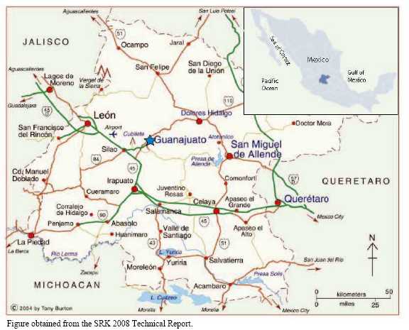
The Cebada mine exploits the Veta Madre (Mother Lode) which has historically been host to some of the richest silver mines in the world. The Bolañitos and Golondrinas mines are located near the town of La Luz, about 12 km to the northeast of Guanajuato. Coordinates of the Cebada mine shaft, the approximate centre of Guanajuato Mines project, are given in Table 4.1.
Figure 4.2 is a map illustrating the claims included in Endeavour Silver’s Guanajuato Mines project.
13
Figure 4.2
Guanajuato Mines Project Claim Map
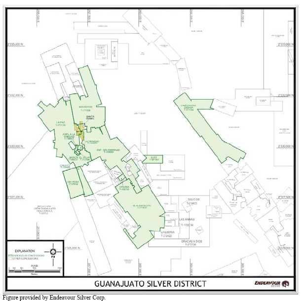
Table 4.1
Coordinates of the Cebada Mine Shaft
| Coordinates | Geographic | UTM |
| North | 21° 03’ 45” | 2,330,550 |
| East | Not applicable | 263,851 |
| West | 101°16’ 23” | Not applicable |
Table provided by Endeavour Silver Corp.
In 2007, Endeavour Silver acquired the Guanajuato Mines project from Industrias Peñoles S.A. de C.V. (Peñoles), the owner at the time, and Minas de la Luz, S.A. de C.V. (Minas de
14
la Luz), the operator at the time. The acquisition included the Mina Cebada, Mina Bolañitos, Mina Golondrinas and Mina Asuncion (as well as a few other currently closed mines). Minas de la Luz continued as the operator of the mines until June, 2007, when Endeavour assumed control. The Mina Asuncion is very close to the Mina Bolañitos and is currently connected underground to the Mina Bolañitos.
The Guanajuato Mines project consists of 13 properties totalling 2,071 hectares (ha) including three operating silver (gold) mines (Bolañitos, Golondrinas and Cebada), several past-producing silver (gold) mines, and the 500 t/d Bolañitos processing plant.
The exploitation lease was held by Minas de la Luz and purchased by Endeavour Silver in conjunction with the asset purchase from Peñoles. Endeavour Silver reports that the transfer of the permits into Endeavour Silver’s subsidiary (Mina Bolañitos S.A. de C.V.) will be concluded during 2009.
The following is a summary of the relevant legal aspects of Endeavour Silver’s Guanajuato Mines Project:
• | Minas de la Luz signed a mining exploitation contract with subsidiaries of Met Mex Peñoles (Met Mex) on April, 2002. Through this contract, Minas de la Luz had the right to develop, explore and exploit the lots listed in Table 4.2, as well as the use of the mining works, the processing plant, the tailings pond, operating or not, offices, shops, warehouses, the housing compound for the employees, the clinic located in the town of La Luz, two ranch ruins, two houses in the mine compound and all the terrains that are in the facilities of which it is the owner. | ||
• | Subsidiary companies of Met Mex are: | ||
• | Compañia Minera Las Torres, S.A. de C.V. (Minera Las Torres). | ||
• | Compañia Minera La Parreña, S.A. de C.V. (Minera La Parreña). | ||
Minera Las Torres was the holder of the rights for the lots contained in Table 4.2:
Table 4.2
Summary of the Lots Owned by Minera Las Torres
| Lot | Title Number | Lot | Title Number |
| Unificación Golondrinas | 188680 | Ana Rosa | 191492 |
| Virginia | 189038 | Bolañitos | 171538 |
| Susy | 191487 | El Puertecito | 171537 |
| Chuyita | 191489 |
Table provided by Endeavour Silver Corp.
15
Minera La Parreña owned a mineral processing plant, with a capacity of 500 t/day, property including 7 houses and a clinic located in the town named La Luz, and the lots mentioned in Table 4.3.
Table 4.3
Summary of the Lots owned Minera La Parreña
| Lot | Title Number |
| El dollar | 212398 |
| La paz | 172120 |
| Marion | 189037 |
| La Trinidad | 195076 |
| Ampliación la trinidad | 190961 |
Table provided by Endeavour Silver Corp.
The mining lots are located in the district of Mineral de La Luz, and were in compliance with all the obligations that the holders have according to the Mining Law and its regulations, especially those regarding the payments of rights on mining concessions for exploration and exploitation. There is no tax, affectation or any limitation on these lots.
In September, 2003, Minas de la Luz modified the original contract with Met Mex to add a lot named La Cebada owned by Minera Las Torres, another subsidiary of Met Mex.
In August, 2005, there was another modification to the contract, in which it is noted that the mining concessions for the lots of which Minera La Parreña was the owner, now belonged to Exploraciones Mineras Parreña S.A. de C.V. (Exploraciones Mineras Parreña) which acquired the concessions for these lots through a spin off. The modified contract was for another five years, scheduled to expire in August, 2010.
Minas de la Luz was responsible for the environmental, physical and chemical stability of the terrain, tailings pond, waste and mining works during the effective contract period, as well as preventing any acid drainage generation.
The mineral concessions owned by Endeavour Silver are summarized in Table 4.4
In addition to the mineral rights, Endeavour Silver has agreements with various private ranch owners and a local ejido (Mesa Cuata) that provide access for exploration and exploitation purposes. Table 4.5 summarizes the surface access rights as at December 31, 2008.
16
Table 4.4
Summary of the Mineral Concessions Owned by Endeavour Silver
| Lot Name | Title No. | Term of Mineral Concession | Hectares | Annual Taxes (pesos) | ||
| From | To | 1st Half | 2ndHalf | |||
| La Cebada | 171340 | 20/09/82 | 19/09/32 | 353.04 | 39,282 | 39,675 |
| El Puertecito | 171537 | 20/10/82 | 19/10/32 | 441.95 | 49,176 | 49,668 |
| Bolañitos | 171538 | 20/10/82 | 19/10/32 | 305.48 | 33,990 | 34,330 |
| La Paz | 172120 | 26/09/83 | 25/09/33 | 413.06 | 45,961 | 46,421 |
| Unif. Golondrina | 188680 | 29/11/90 | 28/11/40 | 361.65 | 40,241 | 40,643 |
| Marion | 189037 | 05/12/90 | 04/12/40 | 1.05 | 117 | 118 |
| Virginia | 189038 | 05/12/90 | 04/12/40 | 7.13 | 794 | 802 |
| Ampl. de la Trinidad | 190961 | 29/04/91 | 28/04/41 | 4.61 | 513 | 518 |
| Susy | 191487 | 19/12/91 | 18/12/41 | 35.43 | 3,942 | 3,981 |
| Chuyita | 191489 | 19/12/91 | 18/12/41 | 43.32 | 4,820 | 4,868 |
| Ana Rosa | 191492 | 19/12/91 | 18/12/41 | 96.74 | 10,764 | 10,872 |
| La Trinidad | 195076 | 25/08/92 | 24/08/42 | 4.48 | 498 | 503 |
| El Dólar | 212398 | 04/10/00 | 03/10/50 | 3.20 | 202 | 204 |
| Totals | 2,071.12 | 230,300 | 232,603 | |||
Table provided by Endeavour Silver Corp.
Table 4.5
Summary of Endeavour Silver’s Surface Access Rights
| Owner | Area Name | Area (ha) | Validity | Annual Cash Payments (pesos) |
| Florentino Ortega Camarillo | Golondrinas | 30 | 15 Years Renewable | 30,000 |
| Benjamin Tapias Cruces | Golondrinas | 91 | 15 Years | 24,000 |
| Alfredo Ortega Gonzalez | Golondrinas | 30 | 15 Years Renewable | 24,000 |
| Ignacio Camarillo Velasquez | Puertecito | 30 | 2 Years Renewable | 125,000 |
Table provided by Endeavour Silver Corp.
In the March, 2008, Technical Report by SRK the following was noted under Section 3.6 environmental, permits and approvals:
“Endeavour has indicated that the Guanajuato mines are generally behind in their environmental, waste disposal and safety reporting obligations. Endeavour Silver has recently appointed an Environmental Manager to assess what tasks need to be completed in the short term to satisfy relevant authorities and local investigators. It appears that the mines were operated up until recently without adequate concern in this regard, probably owing to the ineffective regulation and enforcement.”
17
“Endeavour is actively developing a reclamation plan that will have both expenditures during mining operations, as well as a final closure plan that is traditional for this type of facility. Further, Endeavour Silver is implementing environmental policies typical of Canadian and US mining companies that include accidental spill procedures and prevention, material containment procedures, and re-vegetation plans near active areas.”
“Endeavour is keen to ensure that correct permits are in place and that the relevant authorities are approached to assist in this process.”
In response to the above concerns Endeavour Silver has instituted a number of improvements and changes which are discussed below.
Safety
In 2008, a number of advances were made in safety at the Guanajuato Mines project. Safety talks and demonstrations were undertaken at Guanajuato with more than 11,931 hours of training recorded in 2008 and in 2009 Endeavour Silver is programming more hours. Four lost time accidents were recorded; however, these were generally considered to be low risk accidents. A new Safety Manager was hired for Guanajuato and a functional mine rescue team is on site. Mine rescue training includes advanced first aid, fire fighting, ventilation, use of Draeger re-breathing equipment, rescue knots, and fire fighting training by a local Guanajuato firemen team. In 2009, underground fire and smoke scenarios are planned for training purposes.
The Guanajuato safety department undertakes all inductions of new personnel to train them in the basics of mine and plant safety, monitors housekeeping and sign installation and is also involved with the environmental department. Safety talks are given at the beginning of each shift to reinforce safety in the workplace. Safety training at the mines includes the Five Point Safety method, First Aid, use of PPE (personal protective equipment – helmet, safety glasses, steel toe boots, gloves, hearing protection), talks on explosives, barring down, identification of risks, lock-out/tag-out of equipment, prevention and fighting of fires, mining gases and ventilation. In addition to the underground personnel, personnel in the plant (mill) and the other departments all receive safety training.
During 2008, Endeavour Silver began safety audits that include management and workers undertaking detailed audits and these, like the safety training, are ongoing throughout the year. In 2009, Endeavour Silver is adding the Safety Monitor system at Guanajuato to aid the safety department and make people more responsible for their own safety. At Guanajuato, safety is also an element in the production bonus system and in 2008, upper management introduced the Chairman’s and President’s Safety Awards (annual and quarterly safety awards) which introduced incentives for all personnel to work safely.
18
Environmental
In Guanajuato, Endeavour Silver has improved the level of housekeeping and the management of toxic substances by building a new temporary storage building for oil, used filters, contaminated soil, etc. Endeavour Silver has cleaned up the scrap metal and junk areas and conducts frequent scrap sales and/or recycling to avoid build up of junk on site. Presently the environmental department is also monitoring the new assay laboratory for emission contaminants although this is not necessary to operate the assay laboratory. Endeavour Silver has also installed and is continuing to install oil traps in the mechanic shop and jackleg repair shop to control any oily spillage.
Currently, Endeavour Silver is working with the Secretaria Medio Ambiente y Recursos Naturales (SEMARNAT) in order to get the Licencia Ambiental Unica (LAU). This is a license is to prove that Endeavour Silver is working in accordance with all the Mexican environmental regulations. The operations are in order and Endeavour Silver is able to work while it obtains the LAU because it is in compliance with the Programa de Auditoria Ambiental de la Procuradia Federal de Proteccion al Ambiente de Gobierno Federal.
19
5.0 ACCESSIBILITY, CLIMATE, LOCAL RESOURCES, INFRASTRUCTURE AND PHYSIOGRAPHY
The Guanajuato Mines project is located north of the city of Guanajuato, capital of the State of Guanajuato which is approximately 430 km northwest of Mexico City. The city of Guanajuato has a population of approximately 150,000 and is the host of several universities and post-secondary schools including a mining college. The city is well maintained with numerous hotels, restaurants and museums. Tourism, which is comprised primarily of Mexican nationals, is the principal industry of the city.
The State of Guanajuato is situated within the Central Plateau of Mexico in the Sierra de Guanajuato at elevations ranging from 2,000 to 2,600 m.
International access to Guanajuato is relatively good as the Leon/Guanajuato international airport has daily services from Los Angeles, Dallas/Fort Worth, Houston and Mexico City, giving many options for travelling to and from the project. The airport is located between the large city of Leon, a city of over 1 million inhabitants, and the city of Guanajuato. Guanajuato is approximately a 25 to 30 minute drive from the airport on a toll highway. From Guanajuato, the properties are accessible via a gravel road, with about a 15 minute drive to Mina Cebada and a 35 minute drive to the Bolañitos or Golondrinas mines. The gravel road is heavily eroded by the intense thunderstorms which occur in the area and it receives sporadic maintenance by a grader. Therefore, the road is highly washboarded which keeps driving speeds to generally less than 50 km/h.
Most of the supplies and labour required for the exploration programs and mining operations are purchased in either the city of Guanajuato or Leon. The area has a rich tradition of mining and there is an ample supply of skilled personnel sufficient for both the underground mining operations and the surface facilities.
Power supply to the Guanajuato Mines project is provided by the national grid (Comisión Federal de Electricidad).
Telephone communications are integrated into the national land-base telephone system that provides reliable national and international direct dial telephone communications. Satellite communications also provide phone and internet capabilities at the Guanajuato Mines project. However, the satellite phone and internet services are slow and sometimes unreliable. There is no cell phone service at any of the mines.
The climate is generally dry with sporadic, often violent thunderstorms in the summer months which are also the source of most of the precipitation for the area. The average precipitation is about 600 mm, which occurs primarily between May and October. The summer months are temperate, with comfortable daytime high temperatures of between 22 and 30°C. Generally, the thunderstorms occur in the late afternoons. The winter months are cool and dry, though some rain does occur. Daytime highs in the winter are generally 15 to 25°C and overnight lows can drop below freezing. The winter is the windy season and winds can be very strong.
20
Grass, small trees and shrubs along with several varieties of cacti make up most of the vegetation on the steep hillsides, with larger trees found near springs and streams. The area is mainly devoid of trees, however, in the valleys and where reforestation has taken place, there are stands of trees. The Encino tree is a protected species in the area. In the higher elevations sheltered areas can be home to pine forests.
Even though there is a reasonable amount of rainfall each year, most of the creeks in the area are usually dry with the exception of the man-made reservoirs surrounding the city of Guanajuato. Some cattle and/or goat grazing is carried out in the area over the scrub land. Sections of more arable land have been deforested to support small plots for growing crops.
At each of the mine sites, the required water for the operations is supplied from dewatering of the mines. The tailings facility at Mina Bolañitos is set up to recycle all water back into the ore processing plant.
Endeavour provides limited housing for employees, apart from offices, warehouses and other facilities. Most of the work force lives in the nearby communities and Guanajuato. There is an ample supply of skilled labour in the area due to its long mining history.
21
6.0 HISTORY
6.1 MINING IN MEXICO
Mining has played an important role in Mexico since pre-historic times, but it entered a period of rapid expansion after the Spanish conquest when rich mineral deposits were found. The wealth found in these early mines served as incentives for the early colonizers to locate to remote and barely accessible portions of the county.
Although the Spanish began mining as early as 1526 and worked the mines until 1700, it was not until after the latter date that they commenced to work them strongly, continuing to do so until 1810 with the start of the War of Independence. In 1810, the yearly mining production fell in Mexico from $27,000,000 to $5,000,000 and this state of affairs continued until 1821 with the expulsion of the Spaniards.
During the war many of the mines were abandoned and either filled with water or caved in, and so they remained until 1824. In 1824 a number of English capitalists took the rehabilitation of the principal mines in hand and worked them for approximately 10 years. However, during this period they sustained great losses that were principally due to the lack of railroads which necessitated the transportation of all heavy machinery to the mines on the backs of mules. In some cases it took a couple of years to transport the equipment from England to the mine in Mexico.
Mining in Mexico became more prevalent again from the 1880s until the early 1900s when many of the mining districts were in decline due to low prices. The Civil War in 1910 for the most part paralyzed mining in Mexico and in many districts it did not recover until late in the 20th century.
It is impossible to state with even approximate accuracy what the production of precious metals was in the early days. When the Spanish arrived in Mexico there were no Aztec records and although accurate records were kept up until 1810, smuggling prevailed to such an extent, owing to the heavy tax on silver, as to render it impossible to arrive at exact figures. The coinage records, however, are more exact, and according the best estimates from 1522 to 1879, the production of precious metals in Mexico has been about $3,723,139,070, of which gold amounted to about 0.4 to 0.8 percent or approximately $236,000,000. The annual coinage from 1521 to 1879, a period of 355 years, has been approximately $8,173,565 and the annual product nearly $10,000,000.
In the early days 90% of all the ores were amalgamated with the balance being smelted. However, this proportion varied in different districts with smelting taking precedence in some districts and amalgamation in others. Many of the silver mines also had gold to some extent which was termed the “ley” or percentage of gold.
22
6.2 GUANAJUATO MINING DISTRICT
The Guanajuato mining district is located at the southern end of what used to be the Chichimeca empire which was colonized by Nuño de Guzmán in 1540.
It is not known if the indigenous peoples or the Spanish colonists first began mining in the Guanajuato district but mining extends back to at least 1548 when the silver veins began to be exploited by the Spanish. Guanajuato was one of the premier mining districts of Nueva España (New Spain). The following is a brief timeline of the history of the Guanajuato mining district:
1548: The first silver vein, San Bernabé (La Luz), was discovered by a local mule driver. In these early years the silver ore was hand mined and transported by mule to Zacatecas to be milled.
1550: Juan de Rayas discovered the Veta Madre system at the site where the present day Rayas shaft is located. This discovery triggered an exploration rush that saw the discovery of the Valenciana, Tepeyec, Mellado, Cata and Sirena silver occurrences.
1726: Don Jose de Sardeneta y Legaspi introduced gunpowder to be used for blasting. Prior to this, production was very limited as the method of extracting ores was by fire where the rock face was heated and then quickly quenched with water, shattering the rock. Construction began on the Rayas shaft.
1760 to 1770: Antonio Obregón y Alcocer, who later became Count Valenciana, completed a number of exploration ventures, culminating with the discovery of the Valenciana ore-shoot and the development of the Valenciana mine.
1771: Immense masses of silver sulphides, mixed with ruby silver and native silver were discovered at Valenciana. At the time, the Valenciana mine was estimated to be producing one-third of the world’s silver. Production was increased under the Count’s direction, and the Santo Cristo de Burgos shaft was sunk to a depth of 150 m.
1775: The San Antonio shaft on the Valenciana vein was sunk to a depth of 227 m.
1810 to 1868: Production stopped as the result of the War of Independence.
1821: Revolutionaries burned all the mining installations, including the headworks of the newly-built Valenciana shaft.
1868: The Valenciana mine was reopened by British investment capital.
1936: Peñoles tested the Veta Madre with four diamond drill holes.
23
1939: Sociedad Cooperativa Minero Metalúrgica Santa Fe de Guanajuato (SCMMSFG) became the legal owner of the properties of the Guanajuato Reduction and Mines Company. Starting out with no mineral reserves and working capital, the new Cooperative had a very difficult time conducting exploration and mining with outdated equipment.
1947-1949: The Fresnillo Company, a division of Peñoles, completed a diamond drilling program consisting of 9 holes which intersected the Veta Madre 80 m to 150 m below the lowest existing workings.
1968: Fresnillo discovered the Torres-Cedros deposit during an exploration and drilling campaign.
1973: The SCMMSFG discovered the Clavo de Rayas “bonanza” mineral shoot.
6.3 GUANAJUATO MINES PROJECT
Below is an abbreviated timeline of the history of Endeavour’s Guanajuato Mines project since the 1960s.
1968: The Fresnillo Company acquired additional claims and incorporated Negociación Minera Santa Lucía (now Cebada) and the Peregrina mine.
1973: The contracting company Tormex S.A. completed a photogeological study in the area of the Cebada mine holdings.
1976: The Cebada mine began production. Between 1976 and 1995, the Cebada mine produced 1,277,216 tonnes at an average grade of 4.04 g/t gold and 372 g/t silver.
2003: The Grupo Guanajuato closed the Torres, Sirena, Peregrina and Apolo mines. The Bolañitos, Golondrinas, Asunción and Cebada mines stayed in production on a break-even basis.
2007: Endeavour Silver acquired the Guanajuato Mines Project from Peñoles, the owner at the time, and Minas de la Luz, the operator at the time, which included, Mina Cebada, Mina Bolañitos, Mina Golondrinas and Mina Asuncion (as well as a few other currently closed mines). Minas de la Luz, was kept on as the operator of the mines until June, 2007, when Endeavour Silver assumed control. Mina Asuncion is very close to the Bolañitos mine and has recently been connected to the Bolañitos mine.
Records from the mining operations provide surveyed information of the historical workings and channel sample data from stopes, raises and drifts excavated on the mineralized zones. Limited drilling on the properties has been conducted during the past 20 years, and none during the past 10 years before Endeavour Silver took control. Several well mineralized and
24
high-grade drill holes completed by Peñoles have not yet been followed-up and these contribute to the remaining exploration potential for the property. Endeavour Silver believes that surface mapping and exploration, together with compilation of the Peñoles data, should help to identify some new veins, breccia/stockwork zones and related splays for future drilling.
There is potential both along the strike of the veins and at depth below the old workings as these areas are largely untested and present a major exploration target for Endeavour Silver.
In 2007, Endeavour Silver spent approximately US$842,000 on exploration on the Guanajuato Mines project. The exploration program consisted of 13 surface diamond drill holes totalling 3,513 m at the Cebada mine and 2 underground diamond holes totalling 58 m at the Golondrinas mine. A total of 1,091 samples were also collected and submitted for assay. Table 6.1 summarizes the 2007 surface drilling conducted by Endeavour Silver at the Cebada mine.
Table 6.1
Summary of the 2007 Surface Drilling conducted by Endeavour Silver at the Cedada Mine
| Drill Hole Identifier | Azimuth | Dip | Drill Hole Diameter | Total Depth (m) | Drill Hole Start Date | Drill Hole Finish Date | Drilling Company |
| CE250-1 | 45° | -47° | HQ | 288.45 | 18/10/2007 | 25/10/2007 | Layne |
| CE256-1 | 45° | -55° | HQ | 169.45 | 26/10/2007 | 28/10/2007 | Layne |
| CE264-1 | 45° | -65° | HQ | 212.55 | 28/10/2007 | 01/11/2007 | Layne |
| CE274-1 | 45° | -58° | HQ | 214.00 | 01/11/2007 | 04/11/2007 | Layne |
| CE422-1 | 45° | -67° | HQ | 255.95 | 04/11/2007 | 08/11/2007 | Layne |
| CE427-1 | 45° | -60° | HQ | 265.30 | 08/11/2007 | 12/11/2007 | Layne |
| CE435-1 | 45° | -50° | HQ | 392.10 | 12/11/2007 | 18/11/2007 | Layne |
| CE410-1 | 45° | -57° | HQ | 331.10 | 19/11/2007 | 23/11/2007 | Layne |
| CE372-1 | 45° | -66° | HQ | 358.55 | 24/11/2007 | 28/11/2007 | Layne |
| CE378-1 | 45° | -65° | HQ | 405.60 | 29/11/2007 | 04/12/2007 | Layne |
| CE378-2 | 45° | -57° | HQ | 393.95 | 04/12/2007 | 09/12/2007 | Layne |
| CE235-1 | 45° | -90° | HQ | 100.60 | 10/12/2007 | 11/12/2007 | Layne |
| CE240-1 | 45° | -45° | HQ | 125.60 | 11/12/2007 | 13/12/2007 | Layne |
| Total | 3,513.2 |
Table adapted from the March, 2008 SRK Report.
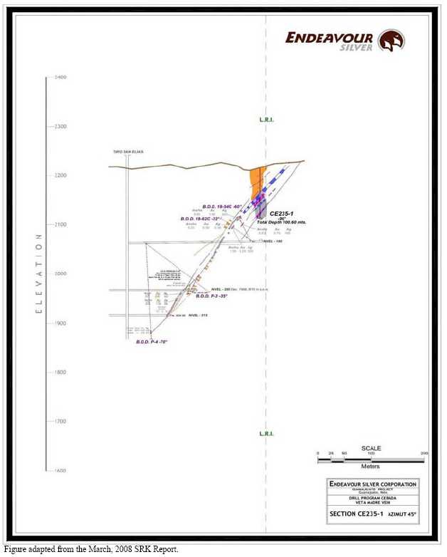
The approximate locations of the 2007 drill holes are illustrated in Figures 6.1 (plan view) and 6.2 (longitudinal view). Figures 6.3 and 6.4 are sectional views of the drill holes completed in the Robbins #5 portion of the Cebada mine.
25
Figure 6.1
Plan View ofCebada MineIllustrating the 2007DrillingProgram

26
Figure 6.2
Longitudinal View ofCebada MineIllustrating the 2007DrillingProgram

27
Figure 6.3
Cross-Section View of Drill Hole CE235-1 Testing the Veta Madre Fault at the Cebada Mine
28
Figure 6.4
Cross-Section View of Drill Holes CE378-1 and CE378-2 Testing the Veta Madre Fault at the Cebada Mine
![]()
29
Initial 2007 drilling results at Guanajuato outlined a new gold-silver mineralized zone north of the Cebada mine. The results are summarized in Tables 6.2.
Three drill holes intersected a new mineralized zone near Section Line 3785 (Robbins #5 mineralized zone), about 800 m north of the Cebada shaft, over an area 50 m along strike by 50 m down dip. An old Peñoles exploration drift along the Veta Madre vein that passes about 50 m beneath the new drill holes was reported to have intersected 4.62 g/t gold and 466 g/t silver over 4.27 m, indicating that the high grade mineralization continues at depth.
Table 6.2
Summary of the 2007 Surface Drilling Conducted by Endeavour Silver at the Cedada Mine
| Drill Hole Number | Interval (m) | Assays (g/t) | |||
| From | Core Length | True Width | Silver | Gold | |
| CE378-1 | 372.05 | 1.80 | 1.70 | 194 | 3.59 |
| CE378-2 | 336.70 | 1.70 | 1.40 | 316 | 4.54 |
| CE383-1 | 389.40 | 1.80 | 1.47 | 90 | 4.38 |
Table adapted from the March, 2008 SRK Report.
As indicated in Table 6.3 significant assay values were not returned for the remaining holes drilled from surface in the area of the Cebada mine in 2007.
Table 6.3
Summary of the Remaining 2007 Surface Drilling Conducted by Endeavour Silver at the Cedada Mine
| DrillHole Number | Vein | Interval (m) | ALS-Chemex Assays | |||
| From | To | True Width | ||||
| Gold g/t | Silver g/t | |||||
| CE235-1 | Veta Madre Fault | 49.90 | 58.30 | 5.40 | 0.18 | <5 |
| CE240-1 | Veta Madre Fault | 64.70 | 73.45 | 8.68 | <0.05 | <5 |
| CE250-1 | Veta Madre Vein | 103.80 | 109.65 | 5.50 | 0.29 | 7 |
| CE256-1 | Veta Madre Zone | 117.65 | 125.30 | 5.45 | 0.07 | <5 |
| CE264-1 | Veta Madre Fault | 128.55 | 131.50 | 2.55 | 0.09 | 61 |
| CE274-1 | Veta Madre Fault | 115.60 | 121.10 | 5.17 | 0.07 | 5 |
| CE372-1 | Veta Madre Fault | 297.05 | 303.35 | 6.30 | <0.05 | <5 |
| Veta Madre Vein | 342.75 | 346.15 | 2.55 | 0.29 | 29 | |
| CE410-1 | Veta Madre Fault | 298.90 | 319.10 | 19.32 | 0.06 | 6 |
| CE422-1 | Veta Madre Fault | 194.25 | 218.70 | 21.17 | <0.05 | 5 |
| CE427-1 | Veta Madre Fault | 203.20 | 210.05 | 6.05 | <0.05 | <5 |
| CE435-1 | Veta Madre Fault | 347.25 | 365.25 | 16.91 | <0.05 | <5 |
Table adapted from the March, 2008 SRK Report.
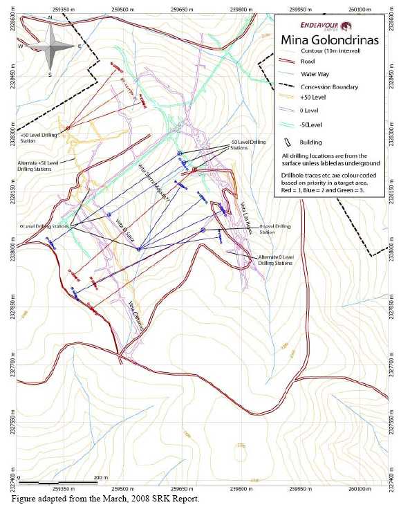
In November, 2007, underground diamond drilling commenced at the Golondrinas mine using Worldwide Exploration S.A. de C.V. (Worldwide Exploration) as the contractor.
30
Drilling started at Golondrinas rather than Bolañitos because of easier access and the existing infrastructure being better situated to supporting an underground drill program. A 220 kW diesel generator was also purchased to support this program.
Only two underground diamond holes, totalling 58 m, were drilled in the Golondrinas mine during 2007 (Table 6.4) . The first two holes (GD220-1 and 2) were collared, near the +50 level of the Sauz Vein as shown in Figure 6.5. Drilling at this area was slow and without good results because of problematic ground conditions. In December, 2007, the drill rig was moved deeper into the Golondrinas mine. The first drill platform was on the 0 level, at the south end of the drift on the Sauz vein. Underground diamond drilling commenced with one hole RV-1750-1 being started and completed at total depth of 227.85 m in mid-January, 2008. The Los Reyes vein was intercepted but returned only low-grade values, as shown in Tables 6.5. The remaining 2008 exploration and drilling programs are discussed in Sections 10 and 11 later in this report.
Table 6.4
Summary of the 2007 Drilling Conducted by Endeavour Silver at the Golondrinas Mine
| Drill Hole Number | Azimuth | Dip | Diameter | Total Drill Hole Depth | Observations | Drilling Company |
| GD220-1 | 52° | -56° | NQ | 30.20 | Not concluded, drilling problems | Worldwide |
| GD220-2 | 55° | -68° | NQ | 27.50 | Not concluded, drilling problems | Worldwide |
Table adapted from the March, 2008 SRK Report.
Table 6.5
Summary of the Underground Diamond Drilling Results for the Golondrinas Mine
| Drill Hole | Vein | Interval (m) | ALS-CHEMEX | |||
| From | To | True Width | ||||
| Gold (g/t) | Silver (g/t) | |||||
| RV-1750-1 | Reyes Vein | 192.25 | 192.85 | 0.56 | 0.13 | 7 |
Table adapted from the March, 2008 SRK Report.
In addition to the drilling, surface mapping and sampling in the area of the Cebada and Bolañitos – Golondrinas mines was an important part of the exploration program. Despite the long mining history on these properties, detailed geological maps of sufficient quality for defining drill targets do not exist. As well, most of the mineral concessions in the Guanajuato district remain under-explored. In July, 2007, Endeavour’s geologists commenced surface mapping and sampling in the Cebada Bolañitos and Golondrinas mines area.
In the Cebada mine area and elsewhere in the Guanajuato district, the Veta Madre has wide but lower grade hanging wall breccia/stockwork mineral zones, in addition to the rich vein mineral zones. Both types of mineral zones are apparently related to splays and intersecting
31
structures. Such mineralized zones have been stoped at the Cebada, Bolañitos and Golondrinas dilation zones.
Figure 6.5
Composite Plan View of the Golondrinas Mine Illustrating the Underground Workings and Proposed
Drill Holes from Existing Platforms
32
Endevour Silver believes that surface mapping, together with compilation of the Peñoles data, should help to identify some of these hanging wall breccia/stockwork zones and related splays as well as intersecting structures for future drilling. Favourable structures on the Guanajuatito (Cooperativo) may also extend onto the extreme southern end of the Cebada mine and mapping and sampling will be required here.
There is potential both along the strike of the veins and at depth below the old workings as these areas are largely untested and present a major exploration target for Endeavour Silver.
6.4 HISTORICAL PRODUCTION
Mining in the Guanajuato district extends back to at least 1548 when the mines were first worked by the Spanish. The total production from this district is estimated at about 6 million oz of gold and 1.2 billion oz of silver
During the late sixteenth century silver production accounted for 80% of all exports from Nueva España (New Spain), although, by the mid-seventeenth century silver production collapsed when mercury, necessary to the refining process, was diverted to the silver mines of Potosí in present day Bolivia. Collapse of the seventeenth century mining led to widespread bankruptcy among the miners and hacienda owners; however, in the latter half of the seventeenth century silver mining began to recover in Nueva España.
The peasant uprisings of 1810 to 1821 were disastrous to the Mexican mining industry with both the insurgents’ soldiers and royalist troops all but destroying the mining production in Mexico, and the Guanajuato mining district was not spared during this period.
It is evident that historical production has occurred in the Guanajuato mining district since pre-colonial times and early production records from the Spanish colonial period probably exist in the Archive of the Indies (Archivo des Indies), in Seville, Spain, in the records of the Viceroyalty of Mexico or in the records for Nueva España. However, Micon does not have access to any historical records of the actual silver and gold production from the Guanajuato mining district.
In 2006, before Endeavour Silver took control, the previous operators Minas de la Luz produced 255,766 oz silver and 3,349 oz gold from 76,532 tonnes ore grading 128 g/t silver and 1.62 g/t gold from the Bolañitos, Cebada and Golondrinas mines. The Bolañitos plant operated at about 43% of its capacity.
6.5 RESOURCE AND RESERVE ESTIMATES PRIOR TO DECEMBER, 2008
Prior to this report, the last resource and reserve estimate for the Guanajuato Mines project was reported in a Technical Report by SRK Consulting dated March, 2008 and posted on SEDAR. The Technical Report was entitled “NI 43-101 Technical Report for the Guanajuato Mines Project, Guanajuato State, Mexico”. The resource and reserve estimates discussed in the previous Technical Report were audited by SRK Consulting to comply with
33
the current CIM standards and definitions for estimating resources and reserves as required by NI 43-101 regulations.
Since the last resource and reserve estimate was completed in March, 2008, Endeavour Silver has conducted further diamond drilling and underground development and has completed a new resource and reserve estimate for the Guanajuato Mines project. Micon has audited Endeavour Silver’s new resource and reserve estimate for the project and the discussions related to the new estimate are located in Section 17 of this report. The new resource and reserve estimate conducted by Endeavour Silver and audited by Micon complies with the current CIM standards and definitions for estimating resources and reserves as required by NI 43-101 regulations.
34
7.0 GEOLOGICAL SETTING
The geological setting of the Guanajuato property is described in detail in the March, 2008 NI 43-101 Technical Report by SRK which was filed by Endeavour Silver on SEDAR. The following description of the geological setting has been excerpted and edited from the March, 2008 report.
7.1 REGIONAL GEOLOGY
The mining district of Guanajuato is located on the south and eastern flank of the Sierra Madre Occidental geological province, a north-northwesterly trending linear volcanic belt of Tertiary age. It is approximately 1,200 km long and 200 to 300 km in width. The project area is located in the southern portion of the Sierra de Guanajuato, an anticlinal structure about 100 km long and 20 km wide. The Guanajuato district is located on the northeast side of this structure where the typical primary bedding textures dip 10° to 20° to the north-northeast.
7.1.1 Stratigraphy
The stratigraphy of the Guanajuato mining district can be divided into a Mesozoic basement (Chiodi et al, 1988; Dávila and Martinez, 1987; Martinez-Reyes, 1992) and overlying Cenozoic units as shown in Figures 7.1 and 7.2. The lower Mesozoic lithological units are the Esperanza and La Luz formations which are composed of rocks of marine origin, weakly to moderately metamorphosed and intensely deformed by shortening. These rocks are unconformably overlain by the Tertiary Conglomerado Rojo de Guanajuato, and the Loseros, Bufa, Calderones, Cedros and Chichíndaro formations. The Tertiary rocks consist of continental sediments and sedimentary rocks, which generally occupy lower topographical zones, and subaerial volcanic rocks, which are principally exposed in the ranges and higher plateaus. The rocks of the Cenozoic cover have experienced only extensional deformation and in some places are gently tilted. Tertiary-aged rocks correspond to a period of tectonism accompanied by volcanism and intrusive magmatic activity.
7.1.1.1 Esperanza Formation (Middle to Upper Triassic)
The oldest rocks in the area comprise the Esperanza Formation made up of carbonaceous and calcareous shale interbedded with arenite, limestone, and andesitic to basaltic lava flows, all weakly metamorphosed to phyllites, slates and marble. The thickness of this unit exceeds 600 m though the true thickness in unknown. It is middle to upper Triassic in age. Pervasive propylitic alteration is common.
7.1.1.2 La Luz Formation (Upper Triassic to lower Jurassic)
The La Luz formation which overlies the Esperanza consists primarily of interbedded clastic sedimentary rocks and tholeiitic massive and pillow basalts that are dated at 108.4 ±2 Ma. Locally, rhyolite tuffs and agglomerates are present, and some volcanogenic massive
35
Figure 7.1
Regional Geology of the Guanajuato Mining District
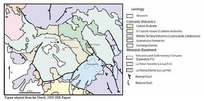
Figure 7.2
Stratagraphic Column for the Guanajuato Mining District
(From the Geological – Mining Monograph for Guanajuato State, COREMI)
36
sulphide occurrences have been noted. A minimum thickness of at least 1,000 m is recognized, but the true thickness is unknown due to deformation and sub-greenschist metamorphism. Included with the La Luz formation are the La Palma diorite and La Pelon tonalite. These form the upper part of the Guanajuato arc. Pervasive propylitic alteration is common.
7.1.1.3 Guanajuato Formation (Paleocene to Eocene)
The red Guanajuato conglomerate lies unconformably over the Esperanza and less frequently on the La Luz andesite (Edwards, 1955). The conglomerate consists of pebbles to boulders of quartz, limestone, granite and andesite belonging to younger rock units cemented by a clay matrix. It also contains some interlayers of sandstone. At its base, there are beds of volcanic arenites and andesitic lavas. The Guanajuato conglomerate has been estimated to be 1,500 m thick. Vertebrate paleontology and andesitic lavas (49 Ma, Aranda-Gómez and McDowell, 1998), contemporaneous with the conglomerates, indicate that the unit is Eocene to Oligocene in age.
7.1.1.4 Loseros Tuff (Cenozoic)
This overlying mid-Tertiary volcanic sequence is interpreted to be within and adjacent to a caldera. The Loseros tuff is a well-bedded, green to cream-red volcanic arenite from 10 m to 52 m thick. It is interpreted to be a surge deposit at the base of the Cubo caldera filling and Oligocene in age.
7.1.1.5 Bufa Rhyolite (Cenozoic)
The Bufa rhyolite is a felsic ignimbrite ash-flow tuff that is approximately 360 m thick and lies above a sharp to gradational contact. It is a sanidine-bearing rhyolite-ignimbrite with biotite as a mafic phase, and is often massive, but locally bedded. Owing to moderate welding and extensive and pervasive silicification, it is a hard rock that forms prominent cliffs east of the city of Guanajuato. It occasionally contains large lithic clasts of various types; many of which were derived from the pre-volcanic basement. At El Cubo, it has three mappable units: a lower breccia overlain by a dense, red rhyolite porphyry, in turn overlain by a massive to bedded ignimbrite. The Bufa rhyolite has been dated using the K-Ar dating technique to be 37 ±3 Ma, placing it in the middle Oligocene.
7.1.1.6 Calderones Formation (Cenozoic)
The Calderones Formation includes a wide variety of volcanic rocks. These include low- to medium-grade ignimbrites, deposits of pyroclastic flows, pyroclastic surge layers related to phreato-magmatic activity, airfall ash-rich tuffs, minor Plinian pumice layers, lahars, debris flows, reworked tuffaceous layers deposited in water, tuff-breccias and mega-breccias. Ubiquitous and characteristic chlorite alteration imparts a green to greenish blue colour to almost all outcrops of the Calderones. Propylitic alteration adjacent to veins and dikes is of local importance in many outcrops.
37
The Calderones Formation overlies the Bufa with a contact at El Cubo marked by a mega-breccia composed of large (often 5 to 10 m) fragments of the Esperanza, La Luz or Guanajuato formations. The Calderones Formation, which exceeds 300 m in thickness at El Cubo, is the upper caldera-filling unit above the surge deposit and the Bufa ignimbrites.
7.1.1.7 Cedros Andesite (Cenozoic)
The Calderones Formation passes upward into the Cedros andesite, which is a package of lava flows and associated tuffs of andesitic to possibly basaltic composition. The Cedros andesite is made up of grey to black andesite lava flows, in places with interbeds of pyroclastic materials. The total thickness varies from 100 to 640 m.
7.1.1.8 Chichindaro Rhyolite (Cenozoic)
This is the youngest volcanic unit in the Guanajuato mining district. It forms large domes and lava flows, along with associated ignimbrites and volcanic breccias. In places, the rhyolite domes contain disseminated tin and vapour-phase cavity-filling topaz distributed along the flow foliation. Three K-Ar ages have been obtained from this formation (Gross, 1975; Nieto- Samaniego et al, 1996) of 32 ±1 Ma, 30.8 ±0.8 Ma and 30.1 ±0.8 Ma.
7.1.1.9 Comanja Granite (Cenozoic)
The Comanja granite is an important unit of batholithic size, apparently emplaced along the axis of the Sierra de Guanajuato. Its age is Eocene and has been radiometrically dated at 53 ±3 Ma and 51 ±1 Ma by K-Ar in biotite (Zimmermann et al, 1990). This defines the youngest age for the Bufa formation, the youngest unit cut by the granite.
The volcanic activity that produced the bulk of the upper volcanic group had stopped by the late Oligocene, although there was some eruptive activity as recently as 23 Ma (early Miocene). The Sierra Madre Occidental belt appears to have been uplifted as the result of the combination of basin and range tectonics and the opening of the Sea of Cortez. Post volcanism, there was a period during which peneplanation took place, with uplift beginning probably toward the end of the Miocene with the onset of block faulting that resulted in the present geomorphology of the belt.
7.1.2 Structure
The structural setting of the Guanajuato district was briefly described in the March, 2008 NI 43-101 Technical Report by SRK. The following description of the structural setting has been excerpted from the March, 2008 report.
“Randall et al (1994) originally proposed a caldera structure for the Guanajuato Mining district, citing the presence of a megabreccia in the Calderones Formation and the distribution of the Oligocene volcanic formations described above. The hypothesis states that the caldera collapse occurred in at least two stages and the collapse was a trap-door
38
type. The presence of a peripheral three-quarter ring of rhyolite domes intruding along bounding faults, the location of the Oligocene volcanic formations ponded within this ring, megabreccia and topographic rim, all contribute evidence to support this hypothesis.
Subsequent normal faulting combined with hydrothermal activity around 27 Ma (Buchanan, 1980) resulted in many of the silver-gold deposits found in the district. There are four principal orientations of normal faults: northwest, north-south, east-west and northeast but, the economic mineralization is generally related to the north and northwesterly trending structures. Within the Guanajuato Mining district there are three major mineralized fault systems, the La Luz, Sierra, and the Veta Madre systems. Veta Madre is a north-northwest trending fault system and the largest at the 25 km long.”
In March, 2008, Tony Starling of Telluris Consulting Ltd. made a 7 day field visit to the Guanajuato mines and deposits on behalf of Endeavour Silver (Telluris Consulting, 2008). The emphasis on this visit was placed on the La Luz and Cebada mine areas. The aim of this structural study was to provide a detailed appraisal of the control of mineralization in the Guanajuato group of deposits to generate a model that could be applied to near-mine exploration.
The preliminary conclusions of this structural geology study are summarized as follows:
Pre-mineralization deformation occurred during the Laramide orogeny (~80-40 Ma) with two main phases; NE-SW to ENE-WSW compression followed by a swing to NNE directed compression. As a result pre-mineral folds and thrusts in the Esperanza Formation at the Cebada Mine trend WNW.
Early post-Laramide extension (~30 Ma) was oriented N-S to NNE and controlled many vein deposits in the region (e.g. Fresnillo, Zacatecas, La Guitarra). Guanajuato appears to lie on a NNW-trending terrane boundary which was reactivated as a sinistral transtensional fault zone during early stage intermediate-sulphidation style mineralization.
Regional extension then rotated abruptly to the ENE-WSW (~28 Ma) resulting in early stage basin and range deformation and block faulting at Guanajuato. The second stage of mineralization occurred at Guanajuato during this event and resulted in tilting of the sequence to the NE along NNW-trending listric (?) fault zones such as the Veta Madre.
Following mineralization ENE extension continued to around 12 Ma when it began to rotate to the NW (under the influence of the San Andreas system) and at the present day probably is oriented N-S due to subduction along the Trans-Mexico Volcanic Belt (post-mineralization graben formation).
Regionally the two extensional events active around the time of mineralization appear to have resulted in two phases of mineralization (30-27 Ma?) at Guanajuato, a
39
Along the Veta Madre system ore shoots were controlled during early-stage mineralization by anti-clockwise strike-swings along the main structure and at intersections with WNW and NE fault zones (<2,100 m ?). These tended to generate relatively steep ore shoots plunging to the south along the Veta Madre.
During the second phase, early basin and range deformation, the listric block faulting and tilting accompanying mineralization reactivated parts of the Veta Madre and developed new systems such as La Luz (>2,000 m ?). The veins at La Luz appear to have formed as extensional arrays between reactivated WNW fault zones acting as dextral transtensional structures.
The second phase vein systems tend to have formed sub-horizontal ore zones either reflecting fluid mixing zones or structural controls due to changes in dip of the fault surface. The overprint of two events means that in some deposits ore shoots have more than one orientation and that there are vertical gaps in ore grade.
With the protracted tectonic evolution at Guanajuato there appears to have operated structural and hydrothermal telescoping along with pinching of ore shoots due to changes in dip and/or strike. There is potential to find extensions to mineralization below barren horizons and high-level ore bodies that are blind to surface.
phenomenon which has been seen in other important epithermal vein districts in the Altiplano such as Zacatecas-El Orito and San Sebastian-Don Sergio.
7.2 PROJECT GEOLOGY
The most important mineralization in the Guanajuato mining district consists of epithermal silver-gold veins formed 27.4 ±0.4 Ma (Buchanan, 1975). Mining of these veins has occurred for more than 450 years and is estimated to have produced more than 130 tonnes of gold and 30,000 tonnes of silver.
Most of the production has been extracted from three principal vein systems on normal faults, the La Luz, Veta Madre and La Sierra which are illustrated in Figures 7.3 and 7.4. Economic concentrations of precious metals are present in isolated packets (known as bonanzas, or “spikes”) distributed vertically and laterally between non-mineralized segments of the veins. There is a vertical mineralogical zonation within these veins. The upper-levels are acanthite + adularia + pyrite + electrum + calcite + quartz and the lower-levels are chalcopyrite + galena + sphalerite + adularia + quartz + acanthite. The Veta Madre has been the most productive vein and it is by far the most continuous, having been traced on the surface for approximately 20 km. The vein dips from 35° to 55º to the southwest and it has measured displacements of around 1,200 m near the Las Torres mine and 1,700 m near La Valenciana mine. Most of the other productive veins in the district strike parallel to the Veta Madre.
40
Figure 7.5 is a surface map showing the veins and concession boundaries for the Bolañitos and Golondrinas mines.
Figure 7.3
Sketch Models for the Control on Mineralization during second stage (~27 Ma) Mineralization at
Guanajuato (From Telluris Consulting, 2008).
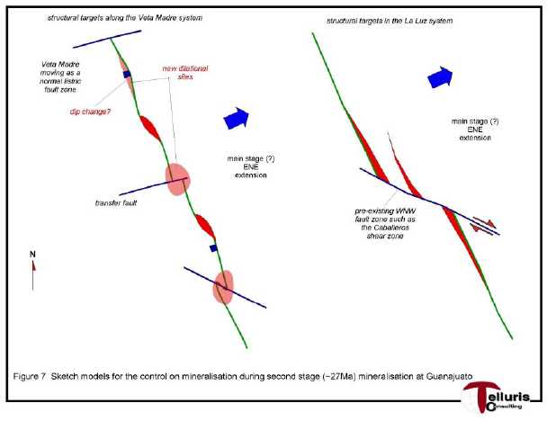
In addition to the epithermal veins near Guanajuato, small deposits of stratabound massive sulphides have been reported in the Mesozoic volcano-sedimentary association (Los Mexicanos). Similarly, there is gold mineralization in the Comanja granite, and in its contact aureole small tungsten deposits have been found. In the Tertiary volcanic rocks, principally in the topaz rhyolites, there are small tin prospects.
Endeavour Silver currently has three mines at Guanajuato that are in operation. These include the Cebada mine, exploiting the Veta Madre, and the Bolañitos and Golondrinas mines which exploit various north-northwest striking veins in the La Luz vein system shown in Figure 7.3. Mina Asuncion, another of Endeavour Silver’s mines at La Luz, is currently extracting previously broken ore left behind in old stopes. There are a number of other mines not currently in operation, such as the San Roman mine in the La Luz system, which is contained within Endeavour’s land concessions.
41

Figure 7.5
Surface Map Indicating the Location of the Veins and Mineral Concession Boundaries for the Bolañitos –
Golondrinas (El Puertecito Area) Mines in the La Luz District, Guanajuato
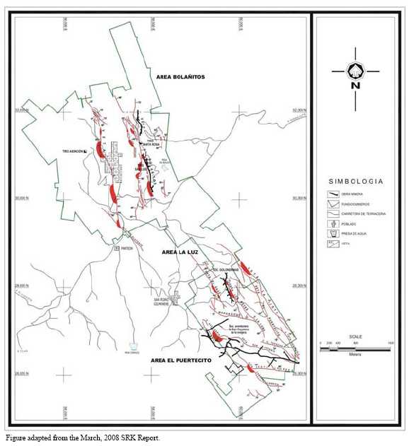
43
8.0 DEPOSIT TYPES
The Guanajuato silver-gold district comprises classic, high grade silver-gold, epithermal vein deposits, characterized by low sulphidation mineralization and adularia-sericite alteration. The Guanajuato veins are typical of most other epithermal silver-gold vein deposits in Mexico in that they are primarily hosted in either a volcanic series of andesite flows, pyroclastics and epiclastics or sedimentary sequences of mainly shale and their metamorphic counterparts.
Low-sulphidation epithermal veins in Mexico typically have a well defined, subhorizontal ore horizon about 300 m to 500 m in vertical extent where the bonanza grade ore shoots have been deposited due to boiling of the hydrothermal fluids. Neither the top nor the bottom of the mineralized horizons at the Guanajuato Mines project has yet been established precisely. However, drilling at Cebada suggests that the top of the boiling zone is just below surface since mineralization is spotty on surface above the deposit. The bottom is not currently known. In La Luz, veins with weak mineralization have been observed on surface. In summary, the initial drilling suggests a vertical extent of mineralization around 250 m to 300 m in the La Luz system.
Low-sulphidation deposits are formed by the circulation of hydrothermal solutions that are near neutral in pH, resulting in very little acidic alteration with the host rock units. The characteristic alteration assemblages include illite, sericite and adularia that are typically hosted by either the veins themselves or in the vein wall rocks. The hydrothermal fluid can travel either along discrete fractures where it may create vein deposits or it can travel through permeable lithology such as a poorly welded ignimbrite flow, where it may deposit its load of precious metals in a disseminated deposit. In general terms this style of mineralization is found at some distance from the heat source. Figure 8.1 illustrates the spatial distribution of the alteration and veining found in a hypothetical low-sulphidation hydrothermal system.
44
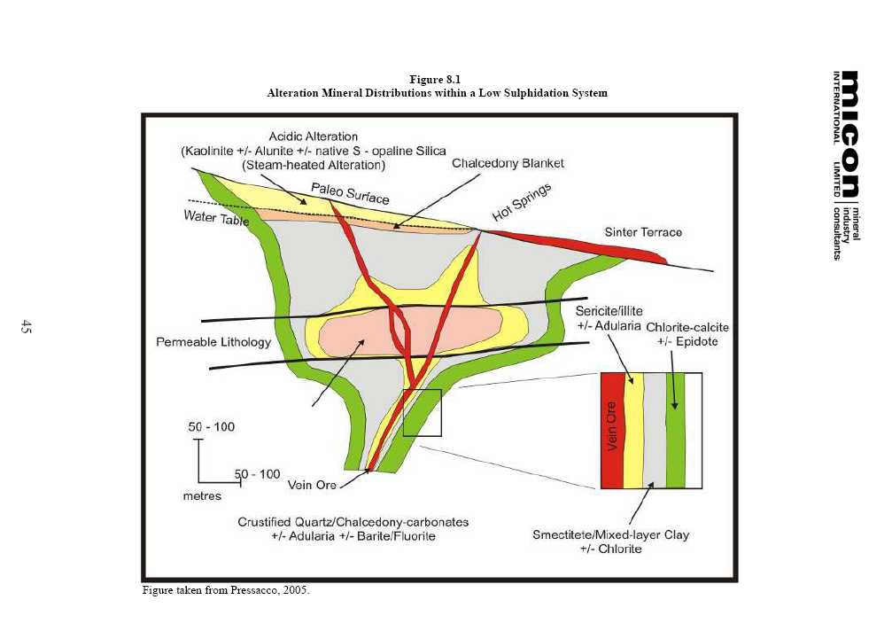
9.0 MINERALIZATION
The mineralization of the Guanajuato property is described in detail in the March, 2008 NI 43-101 Technical Report by SRK which was filed by Endeavour Silver on SEDAR. The following description of the mineralization has been excerpted and edited from the March, 2008 report.
Mineralized veins on the Guanajuato Mines project consist of the classic banded and brecciated epithermal variety. Silver occurs primarily in dark sulphide-rich bands within the veins, with little mineralization within the wall-rocks. The major metallic minerals reported include pyrite, argentite, electrum and ruby silver as well as some galena and sphalerite, generally deeper in the veins. The mineralization is generally associated with the phyllic (sericite) and silicification alteration which forms haloes around the mineralizing structure.
The textures are attributed to the brittle fracturing-healing cycle of the fault-hosted veins during and/or after faulting. There are examples of both syn- and post-kinematic mineralized veining within Endeavour Silver’s concessions. All of the mineralized structures within Endeavour Silver’s concessions are hosted within the Esperanza and La Luz formations.
9.1 VETA MADRE VEIN
The Veta Madre is the main mineralized structure in the Guanajuato mining district (Figure 9.1) . The vein typically strikes about 310° to 345° and dips 50° to 70° to the west. It can be traced for more than 20 km in a shear zone which can be over 200 m thick. It contains five major mines, all of which are in operation, or currently being explored. Most of the major mineralization is concentrated near the footwall of the fault. The vein commonly displays brecciated and comb-type banded textures, with strong areas of sericitic and occasionally potassic alteration. The Cebada mine is Endeavour Silver’s only mine on this system and is located at the northern limit of known economic grade mineralization.
9.2 LA LUZ VEINS
The mineral zones of the La Luz vein system are spread over a zone some 8 km wide and include the more significant veins of La Luz, Bolañitos and Los Reyes as well as countless other parallel striking veins, many of which have been exploited. They generally strike 315° to 360° and dip steeply to the east and or the west. In contrast to Veta Madre, individual veins are less extensive and generally no more than 1.5 km in strike length, although the La Luz vein itself is much longer, and the associated structures are much less pronounced than the Veta Madre fault.
46
Figure 9.1
Veta Madre Vein in the Cebada Mine

There are two operating mines and one mine currently under rehabilitation that Endeavour Silver operates on the La Luz vein system. These are the Bolañitos, Golondrinas and Asuncion mines. Mina Golondrinas exploits two principal veins, the Los Reyes and Canarios, and a few minor veins that have been worked on. The two principal veins strike northwest and dip steeply to the southwest. The attitudes of the smaller veins are similar to the two major veins; however, in the southeast part of the mine the veins dip in the opposite direction. The Mina Bolañitos exploits the Bolañitos, San Jose and Soledad veins which strike north-northwest and dip either to the west or east. Soledad is the only vein to dip west. The San Jose vein splays of the Bolañitos vein in the southern part of the mine. The Lucero vein which also occurs in the Bolañitos area was one of the targets evaluated during the latter half of 2009 and is set to attract a lot of attention in 2009.
In 2008, surface diamond drilling by Endeavour Silver discovered a new vein, named Lucero, in the footwall of the San Jose vein. The Lucero vein generally strikes northwest, subparallel to the San Jose vein, but dips moderately to the west, opposite to that of the San Jose vein. The Lucero vein is located only 35 metres from the the San Jose vein. By the end of December, 2008, Endeavour’s development crews had already advanced approximately 100 m and the vein was still open to the northwest and southeast. For this distance, the average grade of the vein was 410 g/t Ag and 3.0 g/t Au over a true width of 2.3 m. New reserves and resources have since been estimated for the Lucero vein and further exploration and development shall continue in 2009.
47
Mina Asuncion, located just to the west of Mina Bolañitos, exploits the north-northwest striking, west dipping La Luz vein. Like Golondrinas, larger veins to the west of the Bolañitos-Asuncion mine area dip west, and veins in the east dip to the east.
48
10.0 EXPLORATION
A detailed description of Endeavour Silver’s 2007 exploration program was recorded in the March, 2008 Technical Report by SRK and only the 2008 exploration program will be discussed in this section.
10.1 2008 EXPLORATION PROGRAM
10.1.1 Drilling
In 2008, exploration drilling at Guanajuato focused in two areas:
| 1) | Testing several targets along the Veta Madre vein structure close to the Cebada mine. | |
| 2) | Testing several targets along the La Luz vein structures (La Luz consists of multiple sub-parallel veins) close to the Bolañitos mine. |
The 2008 drilling program was successful in expanding the 3785 (Robbins #5) mineralized zone discovered near the Cebada mine in 2007, and discovering new high-grade silver-gold mineralized zones in four other target areas: the Bolañitos, Santa Maria, San Jose and Lucero vein prospects near the Bolañitos mine.
Within the Guanajuato district, the Veta Madre vein typically forms a central lode, with hanging wall and footwall splays, occupying a major fault structure, whereas the La Luz veins form a swarm of sub-parallel veins occupying lesser fault structures. The Cebada mineralized bodies were typically larger and had greater vertical extent (500+ m) than at La Luz but the Bolañitos mineralized-bodies were more numerous.
During 2008, Endeavour spent US$3,431,207 on exploration activities on the Guanajuato Mines project, as seen in Table 10.1. The exploration drilling program included 5,241 m in 15 surface diamond holes at the Cebada mine and 16,012 m in 55 surface and underground diamond drill holes at the Golondrinas and Bolañitos mines. A total of 3,662 samples were also collected and submitted for assay.
10.1.2 Surface Mapping and Sampling
In 2008, surface mapping and sampling in the Cebada, Bolañitos and Golondrinas mines areas continued to be an important part of the Guanajuato exploration program. Even though these properties have had a long mining history, detailed geological maps of sufficient quality for defining drill targets do not exist. In addition, many concessions in the Guanajuato district remain under-explored and are possibly available for acquisition.
49
Table 10.1
Summary of the 2008 Expenditures for the Guanajuato Mines Project Exploration Program
| Mine or Area | Description | Pesos | US$ |
| Cebada | Assays | 996,934 | 90,426 |
| Consultants | 1,247,837 | 119,497 | |
| Diamond drilling | 7,725,174 | 726,148 | |
| Supplies and sundries | 271,698 | 25,545 | |
| Geology and engineering personnel | 135,368 | 12,966 | |
| Management | 3,686 | 345 | |
| Reclamation | 22,100 | 2,117 | |
| Roads and drill pads | 277,000 | 25,887 | |
| Salaries (Subtotal) | 1,179,775 | 110,534 | |
| Travel & Lodging | 55,256 | 5,193 | |
| Vehicles | 84,507 | 7,895 | |
| Not deductible | 69,366 | 6,551 | |
| Subtotal | 12,068,701 | 1,133,104 | |
| Bolañitos | Assays | 712,883 | 62,038 |
| Consultants | 297,799 | 28,584 | |
| Diamond drilling | 9,680,610 | 906,736 | |
| Supplies and sundries | 701,058 | 63,408 | |
| Geology and engineering personnel | 1,674,300 | 146,298 | |
| Management | 2,172 | 210 | |
| Reclamation | 27,500 | 2,670 | |
| Roads and drill pads | 474,996 | 43,541 | |
| Salaries (Subtotal) | 1,023,181 | 87,824 | |
| Travel & Lodging | 86,891 | 7,714 | |
| Vehicles | 186,128 | 16,710 | |
| Not deductible | 216,079 | 19,144 | |
| Subtotal | 15,083,596 | 1,384,879 | |
| Golondrinas | Assays | 687,730 | 65,290 |
| Consultants | 192,198 | 18,515 | |
| Diamond drilling | 7,316,606 | 689,237 | |
| Supplies and sundries | 319,834 | 30,066 | |
| Geology and engineering personnel | 287,840 | 27,946 | |
| Management | 875 | 81 | |
| Roads and drill pads | 97,533 | 9,342 | |
| Salaries (Subtotal) | 212,006 | 20,113 | |
| Travel & Lodging | 34,349 | 3,250 | |
| Vehicles | 60,954 | 5,744 | |
| Not deductible | 34,376 | 3,243 | |
| Subtotal | 9,244,301 | 872,827 | |
| Guanajuato General | Supplies and sundries | 94,800 | 8,770 |
| Salaries (Subtotal) | 338,843 | 31,628 | |
| Subtotal | 433,643 | 40,398 | |
| Total | 36,830,241 | 3,431,207 |
Table provided by Endeavour Silver Corp.
In 2008, Endeavour Silver geologists conducted surface mapping and sampling in both the Cebada and Golondrinas-Bolañitos mine areas. Mapping and sampling priorities were as follows:
Reconnaissance mapping along strike to the north of the Cebada mine area.
South of the Golondrinas mine area.
50
North of the Bolañitos mine area.
Reconnaissance mapping and sampling of surrounding concessions in the vicinity of Endeavour Silver’s concessions in the Guanajuato district.
During 2008, surface exploration activities to the south of the Golondrinas mine included:
Trenching of the Reyes and Margaritas veins to check the continuity of the structures and possibly extend the mineralization to the south (Figure 10.1).
Trenching of the Periquitas vein to the north and south.
Trenching of the Vaca and La Loba veins.
Reclamation of the trenches was completed.
Figure 10.1
Surface Geological Mapping and Sampling in the Golondrinas Mine Area

51
During 2008, surface exploration activities to the north of the Cebada mine included the following:
• | Characterization rock and soil samples were collected in the area around Cebada shaft. A geochemical signature was recognized and is described as follows: | ||
• | Rocks - the following maximum values were found: gold 0.165 ppm, silver 1.09 ppm, arsenic 754 ppm, barium 190 ppm, bismuth 0.35 ppm, cadmium 1.25 ppm, cobalt 73.4 ppm, mercury 11.95 ppm, manganese 2,280 ppm, antimony 6.28 ppm and zinc 720 ppm. The proposed visual clues to mineralization at depth were beta quartz crystals developing in the rock matrix, iron/manganese oxides and silicification/quartz veining. Samples with beta quartz showed anomalous arsenic, barium, bismuth, cadmium, manganese, antimony and zinc. Samples with moderate to strong oxides had anomalous silver, arsenic, barium, bismuth, cadmium, cobalt, mercury, manganese, antimony and zinc. Different styles of silicification/quartz veining were anomalous in silver, arsenic, bismuth, cobalt, mercury, manganese and antimony. | ||
• | Soils - the following maximum values were found: gold 0.318 ppm, silver 0.95 ppm, arsenic 103 ppm, mercury 6.72 ppm, manganese 1,150 ppm and antimony 2.09 ppm. | ||
• | Soil and rock samples were collected north from the Cebada shaft area along the Veta Madre towards the northern concession limit, where a west-northwest fault juxtaposes Tertiary volcanics and Mesozoic intrusives/sediments. Samples were taken at 100 m x 10 m spacings. A total of 674 samples were collected (464 soil samples and 210) from outcrop, subcrop, roadcut, dump and float rock. | ||
• | Evaluation of the assay data for the North Cebada O horizon soil samples shows coherent and re-inforcing anomalies of silver, arsenic, gold, barium, beryllium, bismuth, potassium, phosphorous, lead, antimony and thorium. The anomalies lie within areas expected from alteration mapping. Analyses of subsequent rock chip samples returned assays to 66 ppm silver, which supports the soil anomalies. The target area identified from this program is about 1.5 km. northwest of the Cebada shaft (Figure 10.2). | ||
• | Sericite and thermal silica give fewer and tighter anomalies useful in target identification. | ||
52
Figure 10.2
Surface Geological Mapping and Sampling in the Cebada Mine Area

10.1.3 Data Compilation and Geological Modelling
Historic drilling and sampling results continue to be interpreted in order to identify exploration targets. Veins and structures on plans and cross-sections are being digitized for the Cebada and Bolañitos mines. Work in the Golondrinas mine has been deferred for now due to poor results from drilling and mining.
3-D modelling of structures in the Cebada and Bolañitos mines will continue in 2009. The geological modelling of the Bolañitos and Cebada mines will include the following:
The continuation with the assembly of all available data for Cebada and Bolañitos (inc. Asuncion) mines.
Incorporation of the data into a 3-D Vulcan model.
Interpretation of the data with the objective of making recommendations for drilling, either from surface or underground.
53
10.2 2009 EXPLORATION PROGRAM
In 2009, Endeavour Silver plans a two-phase exploration program focused on following up several of the new discoveries made near Endeavour Silver's mining operation at Guanajuato and testing several new prospective targets within the district. If the initial drilling in 2009 is successful, a second phase budget for follow-up exploration will be prepared and submitted for approval by the Endeavour Silver’s Board of Directors. The primary long-term goal of this program is to expand reserves and resources and to identify properties for potential acquisition in the Guanajuato district to secure future growth.
Phase 1 of the exploration program will include 3,000 m of core in 11 surface diamond drill holes to target vein discoveries and new prospective areas in the Cebada and Bolañitos areas of the Guanajuato district. Endeavour Silver is budgeting to spend an estimated US$500,000, mainly on diamond drilling, in an effort to continue to expand the resource base through both exploration and development on its properties during 2009. The estimated cost of diamond drilling is US$140/m.
Table 10.2 summarizes the planned Phase 1 2009 budget for the Guanajuato Mines project.
Table 10.2
Summary of the Phase 12009 Expenditures for the Guanajuato Mines Project Exploration Program
| Project Area | 2009 Exploration Program | Budget (US$) | ||
| Drill Holes | Metres | Samples | ||
| BOLAÑITOS – SAN JOSE SOUTH | 6 | 1,500 | 450 | 245,000 |
| CEBADA NORTH | 5 | 1,500 | 500 | 255,000 |
| Total | 11 | 3,000 | 950 | 500,000 |
Table provided by Endeavour Silver Corp.
Phase 1 Target Areas
Phase 1 targets include: Bolañitos-San Jose South and Cebada North.
| 1. | Bolañitos-San Jose South – surface mapping/sampling; surface diamond drilling (1,500 m). | |
| 2. | Cebada North - surface mapping/sampling/trenching; surface diamond drilling (1,500 m). |
10.2.1 Bolañitos-San Jose South
Historic production at the Bolañitos mine came mainly from the Bolañitos and San Jose veins (Figure 10.3) . Drilling has extended the Bolañitos and San Jose vein mineralization an additional 250 m to the south and it still remains open in this direction. Several new veins, like Lucero, have also been discovered very close to the Bolañitos mine workings. Endeavour Silver is already developing and converting new resources in this area into reserves.
54
During 2008, Endeavour Silver also completed a mapping and sampling program along the northern extension of the Bolañitos vein (Figure 10.3) . In addition to the north-south trending Bolañitos vein, several other veins with varying strike and dip directions (eg. San Miguelito, San Ignacio and San Bernabé) have been identified.
Endeavour Silver has concluded that the preliminary exploration work in the Bolañitos North area has revealed multiple veins with very limited drilling and that further investigation of this area followed by surface diamond drilling is clearly warranted.
Figure 10.3
Surface Geological Map Illustrating the Veins in the Bolañitos and Golondrinas Mine Areas of the La
Luz District, Guanajuato. The Bolañitos – San Jose South and Bolañitos North Target Areas are also Indicated
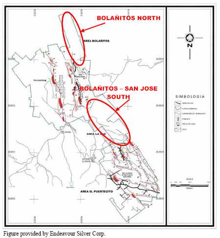
Proposed 2009 exploration for the Bolañitos - San Jose South area will include the following:
- Bolañitos – San Jose Veins South: Surface diamond drilling will further test the south extension of the vein mineralization. Geochemical soil sampling is also planned.
55
- Lucero Vein: Surface diamond drilling will try to extend the vein mineralization further to south and at depth.
A total of 1,500 m in 6 diamond drill holes is proposed. The estimated total cost of the program is US$245,000 (Table 10.3) . The approximate time-frame for execution of this program is 3 months.
Table 10.3
Summary of the 2009 Proposed Budget for the Bolañitos and San Jose South Exploration Program
| Activity (units) | Units | Unit Cost (US$) | Total Cost (US$) |
| Assays (samples) | 450 | 40.00 | 18,000 |
| Diamond drilling (m) | 1,500 | 130.00 | 195,000 |
| Field and office supplies (weeks) | 12 | 250.00 | 3,000 |
| Housing and food (weeks) | 12 | 150.00 | 1,800 |
| Geology and engineering personnel (weeks) | 12 | 1,000.00 | 12,000 |
| Salaries and labour (weeks) | 12 | 166.67 | 2,000 |
| Trenches, roads, drill pads and reclaimation (weeks) | 12 | 250.00 | 3,000 |
| Travel and logging (weeks) | 12 | 108.33 | 1,300 |
| Vehicle inc. gasoline, repair and maintenance (weeks) | 12 | 291.67 | 3,500 |
| Surface use agreements (months) | 1 | 5,000.00 | 5,000 |
| Expenses non deductable (weeks) | 12 | 33.33 | 400 |
| Total | 245,000 |
Table provided by Endeavour Silver Corp.
10.2.2 Cebada North
In late 2008, mapping and sampling was conducted along the Veta Madre trend, northwest of the Cebada shaft (Figure 10.2) . The dominant geological feature in this area, herein called Cebada North, is the northwest trending, moderately southwest dipping Veta Madre structural zone. Mapping revealed that the Veta Madre structural zone was re-activated several times during Tertiary extension. There have been multiple phases of hydrothermal activity, one of which generated the bonanza grade silver-gold deposits. The most favourable structural environment for mineralization is where the Veta Madre structure and cross structures intersect.
Approximately 1.5 km northwest of the Cebada shaft, and 700 m north of the 3785 (Robbins #5) zone, a new zone of alteration was discovered on the Veta Madre. A soil grid with samples collected at 10 m spacing on lines spaced 100 m apart showed coherent anomalies of silver, arsenic, gold, barium, beryllium, bismuth, potassium, phosphorous, lead, antimony and thorium coincident with the alteration areas. Analyses of rock chip samples up to 66 ppm silver support the soil anomalies. The soil grid that was used provided a consistent distribution of data and the 10 m sample spacing was selected as a reasonable compromise between one that was close enough to find the vein signature while far enough apart that work could advance at a reasonable pace.
56
This new discovery possibly represents another mineralized shoot on the Veta Madre. The area has never been drilled and the strong alteration and elevated silver and gold values indicate an excellent blind target for drill testing.
A follow-up program of mapping, sampling and trenching followed by surface diamond drilling is proposed (Figures 10.4 and 10.5) .
Figure 10.4
Summary Map of the Cebada North Target Area Showing Proposed Trenches and Drill Holes

57
Figure 10.5
Cross-Sections with Proposed Drill Holes for the Cebada North Area (Plan Views Shown on Figure 10.4)

The proposed 2009 exploration on the Cebada North target will include the following:
Follow-up mapping and sampling to identify mineralized structural trends and to aid in locating trenches and targeting drill holes.
Trenching for structural information to plan drilling depths and orientations. Trenching will also help to locate the Veta Madre and find the orientations of cross structures.
Surface diamond drilling to test the Veta Madre and structural intersections.
A total of 1,500 m in 5 surface diamond drill holes is proposed with the total estimated cost of the program being US$255,000 (Table 10.4) . The approximate time frame for execution of this program, including the trenching, is approximately 3 months.
Table 10.4
Summary of the 2009 Proposed Budget for the Cebada North Exploration Program
| Activity (units) | Units | Unit Cost (US$) | Total Cost (US$) |
| Trench assays (samples) | 50 | 30.00 | 1,500 |
| Assays (samples) | 450 | 40.00 | 18,000 |
| Surface diamond drilling (m) | 1,500 | 130.00 | 195,000 |
| Field and office supplies (weeks) | 12 | 250.00 | 3,000 |
| Housing and food (weeks) | 12 | 150.00 | 1,800 |
| Geology and engineering personnel (weeks) | 12 | 875.00 | 10,500 |
| Salaries and labour (weeks) | 12 | 333.33 | 4,000 |
| Trenches, roads, drill pads and reclaimation (weeks) | 12 | 583.33 | 7,000 |
| Travel and logging (weeks) | 12 | 50.00 | 600 |
58
| Activity (units) | Units | Unit Cost (US$) | Total Cost (US$) |
| Vehicle inc. gasoline, repair and maintenance (weeks) | 12 | 250.00 | 3,000 |
| Surface use agreements – Eijidos (months) | 2 | 5,000.00 | 10,000 |
| Expenses non deductable (weeks) | 12 | 50.00 | 600 |
| Total | 255,000 | ||
Table provided by Endeavour Silver Corp.
Micon believes that, based on the results of the exploration programs conducted to date and the historical production, the properties held by Endeavour Silver are worthy of further exploration.
Micon has reviewed Endeavour Silver’s proposal for further exploration on its Guanajuato Mines project and recommends that Endeavour Silver conducts the exploration program as proposed subject to funding and any other matters which may cause the proposed exploration program to be altered in the normal course of its business activities or alterations which may affect the program as a result of exploration activities themselves.
59
11.0 DRILLING
A detailed description of Endeavour Silver’s 2007 exploration program was recorded in the March, 2008 Technical Report by SRK and only the 2008 exploration program will be discussed in this section.
11.1 2008 EXPLORATION DRILLING PROGRAM
Endeavour Silver’s, exploration drilling at Guanajuato in 2008 is summarized in Table 11.1 and discussed in the following Sections 11.1.1 through 11.1.3.
11.1.1 Cebada 2008 Surface Diamond Drilling Program
In January, 2008, surface diamond drilling continued in the Cebada mine area with one drill rig provided by Layne de Mexico S.A. de C.V. (Layne de Mexico) By May, 2008, Endeavour Silver had completed a total of 5,241 m in 15 surface diamond drill holes at the Cebada Mine, see Table 11.2. All completed surface drill holes are shown on Figures 11.1 through 11.3.
Table 11.2
Summary of the 2008 Cebada Mine Surface Diamond Drilling Program
| Drill Hole | Azimuth | Dip | Diameter | Total Depth (m) | Start date | Finish date | Drilling Company |
| CE383-1 | 45° | -62° | HQ | 460.55 | 09/01/2008 | 15/01/2008 | Layne |
| CE410-1 | 45° | -57° | HQ | 50.90 | 15/01/2008 | 16/01/2008 | Layne |
| CE427-2 | 45° | -46° | HQ | 246.95 | 17/01/2008 | 20/01/2008 | Layne |
| CE160-1 | 45° | -75° | HQ | 233.40 | 21/01/2008 | 24/01/2008 | Layne |
| CE170-1 | 336° | -60° | HQ | 289.40 | 28/01/2008 | 01/02/2008 | Layne |
| CE160-2 | 45° | -45° | HQ | 310.35 | 02/02/2008 | 06/02/2008 | Layne |
| CE400-1 | 45° | -45° | HQ | 493.15 | 06/02/2008 | 15/02/2008 | Layne |
| CE390-1 | 45° | -55° | HQ | 379.75 | 15/02/2008 | 05/03/2008 | Layne |
| CE383-2 | 45° | -49° | HQ | 371.65 | 05/03/2008 | 13/03/2008 | Layne |
| CE378-3 | 45° | -45° | HQ | 336.35 | 13/03/2008 | 18/03/2008 | Layne |
| CE378-4 | 45° | -79° | HQ | 535.45 | 19/03/2008 | 26/03/2008 | Layne |
| CE372-2 | 45° | -80° | HQ/NQ | 580.75 | 27/03/2008 | 09/04/2008 | Layne |
| CE390-2 | 45° | -70° | HQ | 322.05 | 17/04/2008 | 23/04/2008 | Layne |
| CE378-5 | 45° | -45° | HQ | 210.70 | 24/04/2008 | 28/04/2008 | Layne |
| CE180-1 | 308° | -53° | HQ/NQ | 419.40 | 30/04/2008 | 09/05/2008 | Layne |
| Total | 5,240.8 |
Table provided by Endeavour Silver Corp.
60
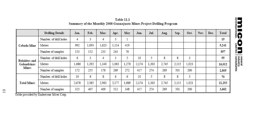
The 2008 drill program at Guanajuato Mine project expanded the new gold-silver mineralized 3785 (Robbins #5) zone north of the Cebada mine discovered in 2007. The new mineralized zone is located near Section Line 3785, about 800 m north of the Cebada shaft, over an area 100 m along strike by more than 300 m down dip. An old Peñoles exploration drift along the Veta Madre vein that passes through the area of the new drill holes was reported to have intersected 4.62 g/t gold and 466 g/t silver over 4.27 m, corroborating the high grade mineralization for this new zone. Drilling highlights at the Cebada mine are shown in Table 11.3. All of the Cebada mine surface diamond drilling results are summarized in Table 11.4.
In 2009, rehabilitating the 315 level exploration tunnel is planned for accessing the 3785 (Robbins #5) zone and preparing it for production later in the year.
Table 11.3
Highlights of the 2008 Cebada Mine Surface Diamond Drilling Program
| Drill Hole No. | Vein | Interval (m) | Assays (g/t) | ||||
| From | To | Core Length | True Width | Silver | Gold | ||
| CE378-3 | Veta Madre | 301.80 | 303.05 | 1.25 | 1.17 | 599 | 6.4 |
| Inc. | 302.10 | 302.40 | 0.30 | 0.28 | 1,850 | 23.3 | |
| CE378-5 | Veta Madre | 164.40 | 165.55 | 1.15 | 1.13 | 442 | 0.6 |
| Inc. | 164.40 | 164.90 | 0.50 | 0.49 | 821 | 1.0 | |
Table provided by Endeavour Silver Corp.
Table 11.4
Summary of All Results from the 2008 Cebada Mine Surface Diamond Drilling Program
| Drill Hole Number | Vein | Interval (m) | Assay (g/t) | ||||
| From | To | Core Length | True Width | Silver | Gold | ||
| CE160-1 | Veta Madre Vein Zone | No significant intercepts | |||||
| CE160-2 | Veta Madre Vein Zone | No significant intercepts | |||||
| CE170-1 | Veta Madre Vein Zone | No significant intercepts | |||||
| CE180-1 | Veta Madre Vein Zone | No significant intercepts | |||||
| CE372-2 | Veta Madre Fault | 433.65 | 435.20 | 1.55 | 0.88 | 5 | 0.1 |
| CE378-3 | Veta Madre Vein | 301.80 | 303.05 | 1.25 | 1.17 | 599 | 6.4 |
| Incl. | 302.10 | 302.40 | 0.30 | 0.28 | 1,850 | 23.3 | |
| CE378-4 | Veta Madre Vein Zone | 500.00 | 501.00 | 1.00 | 0.57 | 162 | 1.4 |
| CE378-5 | Veta Madre Fault Zone | 164.40 | 165.55 | 1.15 | 1.13 | 442 | 0.6 |
| Incl. | 164.40 | 164.90 | 0.50 | 0.49 | 821 | 1.0 | |
| CE383-1 | Veta Madre Vein | 389.40 | 391.20 | 1.80 | 1.47 | 90 | 4.4 |
| CE383-2 | Veta Madre Fault | 338.65 | 339.50 | 0.85 | 0.65 | 5 | 0.2 |
| CE390-1 | Veta Madre Fault | 361.85 | 363.70 | 1.85 | 1.58 | 7 | 0.1 |
| CE390-2 | Veta Madre Fault | 262.45 | 263.00 | 0.55 | 0.42 | 12 | 0.1 |
| CE400-1 | Veta Madre Vein Zone | No significant intercepts | |||||
| CE410-1 | Veta Madre Vein Zone | No significant intercepts | |||||
| CE427-2 | Veta Madre Vein Zone | No significant intercepts | |||||
Table provided by Endeavour Silver Corp.
62
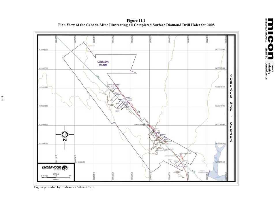

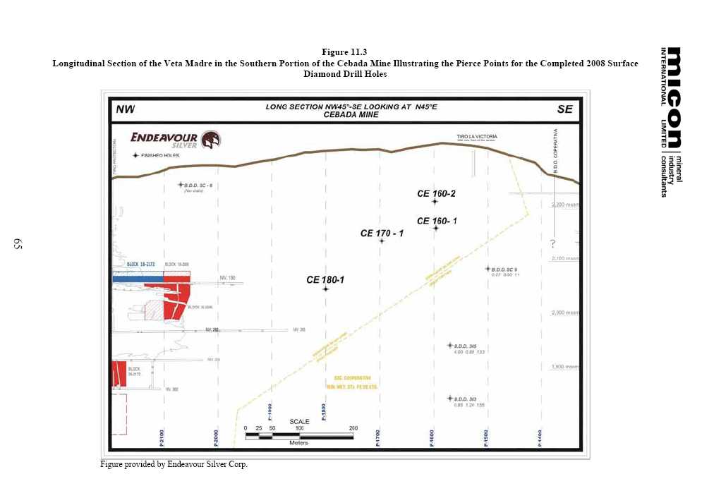
Figure 11.4 is a cross-section showing the drill holes testing the Veta Madre in the 3785 (Robbins #5) zone.
11.1.2 Golondrinas 2008 Underground and Surface Diamond Drilling Program
In January, 2008, underground diamond drilling continued in the Golondrinas mine area with one drill rig provided by Worldwide Exploration. By mid-April, Endeavour Silver had completed a total of 5,088 m in 15 underground diamond drill holes at the Golondrinas mine, (Table 11.5) .
In May, 2008, Endeavour commenced surface diamond drilling with one drill rig provided by Layne de Mexico. By early July, Endeavour Silver had completed a total of 2,210 m in 10 surface diamond drill holes at the Golondrinas mine (Table 11.5) .
Underground and surface diamond drill holes are shown on Figures 11.5 through 11.8.
In 2008, drilling in the Golondrinas mine area discovered new gold-silver mineralization in several historic veins. Drilling highlights include 269 g/t silver and 1.45 g/t gold over a 1.43 m true width in Hole RV-5, 102 g/t silver and 3.84 g/t gold over a 1.41 m true width in Hole SFV-3, 312 g/t silver and 2.03 g/t gold over a 1.15 m true width in Hole MV-1 and 1,060 g/t silver and 2.1 g/t gold over a 0.19 m true width in Hole CV-1. See Table 11.6 for a summary of the highlights from the drilling in the Golondrinas mine area.
Table 11.6
Highlights of the 2008 Golondrinas Mine Underground and Surface Diamond Drilling Program
| Location of Drill Hole | Drill Hole Number | Vein | Interval (m) | Assays (g/t) | ||||
| From | To | Core Length | True Width | Silver | Gold | |||
| Underground | RV-5 | Sierra Mojada | 131.90 | 133.55 | 1.65 | 1.43 | 269 | 1.45 |
| CV-1 | Canarios | 386.85 | 387.30 | 0.45 | 0.19 | 1,060 | 2.11 | |
| SFV-3 | San Francisco | 370.70 | 372.15 | 1.45 | 1.41 | 102 | 3.84 | |
| Surface | MV-1 | Periquitas | 68.95 | 70.75 | 1.80 | 1.15 | 312 | 2.03 |
Table provided by Endeavour Silver Corp.
The Periquitas vein is a new discovery. It was not originally known at surface but subsequent surface trenching has since located the vein in subcrop. The mineralized zone on the Periquitas vein is shallow and future mine development on this vein will probably be from a new ramp collared at the surface.
All of the Golondrinas mine underground and surface diamond drilling results are summarized in Table 11.7.
Figure 11.9 is a cross-section showing the Canarios, El Sauz, Sierra Mojada, Reyes and San Francisco veins intercepted in Holes CV-5, RV-5 and SFV-3 drilled in the Golondrinas mine area.
Figure 11.10 is a cross-section showing Hole MV-1 testing the various vein structures, including the Margaritas and newly discovered Periquitas vein, in the Golondrinas mine area.
66
Figure 11.4
Cross-Section CE378 S Illustrating the Holes Drilled to Test the Veta Madre Vein and Fault in the 3785 (Robbins #5) Zone

67
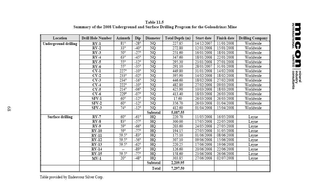
Figure 11.5
Composite Plan View of the Golondrinas Mine Illustrating the Underground Workings and Diamond Drill Holes
![]()
69


Table 11.7
Summary of All Results from the 2008 Golondrinas Mine Underground and Surface Diamond Drilling Program
| Hole | Vein | Interval (m) | Assays (g/t) | ||||
| From | To | Core Length | True Width | Silver | Gold | ||
| RV-1 | Reyes Vein | 192.25 | 192.85 | 0.60 | 0.56 | 7 | 0.13 |
| RV-2 | Reyes Vein | 219.55 | 221.05 | 1.50 | 1.41 | 5 | 0.31 |
| RV-3 | Reyes Vein | 218.55 | 219.05 | 0.50 | 0.43 | 41 | 1.48 |
| RV-4 | Reyes Vein | 236.20 | 237.45 | 1.25 | 0.88 | 5 | 0.17 |
| RV-5 | Sierra Mojada Vein | 131.90 | 133.55 | 1.65 | 1.43 | 269 | 1.45 |
| Reyes Vein | 246.90 | 247.80 | 0.90 | 0.78 | 66 | 0.49 | |
| RV-6 | Sierra Mojada Vein | 130.95 | 131.35 | 0.40 | 0.26 | 16 | 2.15 |
| Reyes Vein | 225.65 | 226.30 | 0.65 | 0.42 | 5 | 0.31 | |
| FW Reyes Vein | 239.20 | 240.95 | 1.75 | 1.52 | 6 | 1.45 | |
| RV-7 | Vein | 42.90 | 45.00 | 2.10 | 1.82 | 133 | 0.81 |
| Vein | 46.25 | 48.20 | 1.95 | 1.25 | 161 | 0.71 | |
| Sierra Mojada Vein | 96.45 | 96.95 | 0.50 | 0.47 | 69 | 0.36 | |
| Reyes Vein | 186.85 | 187.15 | 0.30 | 0.28 | 6 | 0.05 | |
| RV-8 | Sierra Mojada Vein | 90.50 | 91.60 | 1.10 | 1.09 | 95 | 0.36 |
| Reyes Vein | 191.60 | 194.10 | 2.50 | 2.35 | 20 | 1.99 | |
| RV-9 | Vein | 85.40 | 85.90 | 0.50 | 0.47 | 222 | 0.83 |
| Reyes Vein | 112.65 | 113.30 | 0.65 | 0.56 | 59 | 0.86 | |
| RV-10 | Reyes Vein | 154.50 | 157.35 | 2.85 | 2.57 | 41 | 1.20 |
| RV-11 | Reyes Vein | 84.8 | 85.2 | 0.40 | 0.31 | 406 | 0.62 |
| La Loba Vein | 138.8 | 140.85 | 2.05 | 1.44 | 71 | 0.49 | |
| RV-12 | Reyes Vein | 221.6 | 222.45 | 0.85 | 0.77 | 84 | 0.43 |
| La Loba Vein | 231.6 | 232 | 0.40 | 0.39 | 23 | 0.16 | |
| RV-13 | HW Reyes Vein | 95.9 | 98.1 | 2.20 | 1.65 | 69 | 0.5 |
| Reyes Vein | 111.9 | 114.25 | 2.35 | 2.21 | 5 | 0.07 | |
| RV-14 | Reyes Vein | 84.35 | 85.25 | 0.90 | 0.69 | 37 | 0.49 |
| La Loba Vein | 99.65 | 100.25 | 0.60 | 0.46 | 219 | 0.61 | |
| RV-15 | HW Reyes Vein | 72.15 | 73.05 | 0.90 | 0.86 | 5 | 0.12 |
| Reyes Vein | 106.90 | 107.20 | 0.30 | 0.19 | <5 | <0.05 | |
| MV-1 | Periquitas Vein | 68.95 | 70.75 | 1.80 | 1.15 | 312 | 2.03 |
| Reyes Vein | 92.75 | 94.00 | 1.25 | 0.96 | 48 | 0.54 | |
| Margaritas Vein | 159.35 | 160.25 | 0.90 | 0.69 | 75 | 0.36 | |
| CV-1 | Canarios Vein | 386.85 | 387.30 | 0.45 | 0.19 | 1,060 | 2.11 |
| CV-2 | Canarios Vein | 351.70 | 352.30 | 0.60 | 0.30 | 82 | 0.95 |
| CV-3 | Canarios Vein | 429.90 | 430.95 | 1.05 | 0.80 | 5 | 2.04 |
| CV-4 | Canarios Vein | 399.45 | 401.00 | 1.55 | 1.32 | 5 | 0.12 |
| CV-5 | Vein | 78.75 | 79.65 | 0.90 | 0.73 | 149 | 2.10 |
| Canarios Vein | 370.85 | 371.45 | 0.60 | 0.50 | 131 | 0.52 | |
| CV-6 | Canarios Vein | 352.55 | 352.90 | 0.35 | 0.29 | 15 | 0.05 |
| SFV-2 | Reyes Vein | 7.85 | 11.65 | 3.80 | 2.67 | 25 | 0.99 |
| FW Reyes Vein | 14.70 | 16.40 | 1.70 | 1.20 | 25 | 0.92 | |
| San Francisco Vein | 273.90 | 274.15 | 0.25 | 0.22 | 5 | 0.05 | |
| SFV-3 | Reyes Vein | 8.60 | 10.45 | 1.85 | 1.30 | 81 | 0.49 |
| Incl. | 8.60 | 8.90 | 0.30 | 0.21 | 338 | 0.40 | |
| San Francisco Vein | 370.70 | 372.15 | 1.45 | 1.41 | 102 | 3.84 | |
| Incl. | 370.70 | 371.00 | 0.30 | 0.29 | 189 | 11.20 | |
Table provided by Endeavour Silver Corp.
73

Figure 11.10
Cross-Section MV-1 Illustrating Drill Hole MV-1 Drilled to Test the Margaritas Vein in the Golondrinas Mine

The new Periquitas discovery is the previously unknown vein intercepted at a shallow depth in drill hole MV-1
75
11.1.3 Bolañitos 2008 Underground and Surface Diamond Drilling Program
In April, 2008, underground diamond drilling commenced in the Bolañitos mine area with one drill rig provided by Worldwide Exploration. By mid-October, Endeavour Silver had completed a total of 4,334 m in 15 underground diamond drill holes at the Bolañitos mine, (Table 11.8) .
In July, 2008, Endeavour Silver commenced surface diamond drilling with one drill rig provided by Layne de Mexico. By mid-October, Endeavour Silver had completed a total of 4,380 m in 15 surface diamond drill holes at the Bolañitos mine (Table 11.8) .
Underground and surface diamond drill holes are shown on Figures 11.11 through 11.14.
In 2008, the exploration drilling discovered multiple new zones of high grade silver-gold mineralization on the Bolañitos vein system. The Bolañitos vein mineralization has now been extended an additional 250 m along strike to the south. This vein system is known to extend for several kilometres on Endeavour Silver’s properties and the potential remains high for the discovery of additional high grade silver-gold mineralized shoots.
High grade silver-gold mineralization has been intersected on multiple separate vein zones to the south of the Bolanitos mine. Drilling highlights, as shown in Table 11.9, include 166 g/t silver and 5.54 g/t gold over 5.80 m, including 239 g/t silver and 11.45 g/t gold over 1.90 m, in drill hole BSV-3, 208 g/t silver and 6.48 g/t gold over 1.53 m in Hole BSV-5, 204 g/t silver and 0.92 g/t gold over 6.39 m in Hole BSV-8, 537 g/t silver and 0.56 g/t gold over 2.34 m in Hole BUV-7, and 374 g/t silver and 3.14 g/t gold over 3.62 m in Hole SJS-1.
The new high grade silver-gold Lucero vein was found by two holes (SJS 1 and 2) drilled close to existing mine workings. The Lucero vein is located 35 m in the footwall of the past-producing San Jose vein. This vein has since been accessed by a new underground cross-cut and is in production. To date, nearly 150 m of drift have been completed along the Lucero vein, sampled at 2 m intervals. Channel sampling averages 380 g/t silver and 3.37 g/t gold over an average width of 2.7 m. This new high grade vein discovery is still open for expansion in several directions and development is ongoing both along strike and down dip to try and locate the limits of the mineralization.
The drilling highlights at the Bolañitos mine are summarized in Table 11.9.
All of the Bolañitos mine underground and surface diamond drilling results are summarized in Table 11.10.
76
Table 11.8
Summary of the 2008 Underground and Surface Drilling Program for the Bolañitos Mine
| Location | Drill Hole Number | Azimuth | Dip | Diameter | Total Depth (m) | Start Date | Finish Date | Drilling Company |
| Underground | SV-1 | 263° | +4° | NQ | 293.80 | 19/04/2008 | 28/04/2008 | Worldwide |
| SV-2 | 273° | -6° | NQ | 351.50 | 29/04/2008 | 15/05/2008 | Worldwide | |
| R-1 | 90° | 0° | NQ-BQ | 453.40 | 20/05/2008 | 10/06/2008 | Worldwide | |
| BUV-1 | 239° | -59° | NQ | 197.80 | 10/06/2008 | 12/06/2008 | Worldwide | |
| BUV-2 | 251° | -37° | NQ | 158.50 | 13/06/2008 | 14/06/2008 | Worldwide | |
| BUV-3 | 295° | -53° | NQ | 203.20 | 15/06/2008 | 17/06/2008 | Worldwide | |
| BUV-4 | 261° | -52° | NQ | 173.70 | 17/06/2008 | 20/06/2008 | Worldwide | |
| BUV-5 | 264° | -44° | NQ | 253.20 | 30/07/2008 | 02/08/2008 | Worldwide | |
| BUV-6 | 293° | -54° | NQ | 305.40 | 03/08/2008 | 09/08/2008 | Worldwide | |
| BUV-7 | 299º | -58º | NQ | 269.40 | 14/08/2008 | 20/08/2008 | Worldwide | |
| R-2 | 90º | -1º | NQ | 455.60 | 20/08/2008 | 31/08/2008 | Worldwide | |
| SJU-1 | 70° | -23° | NQ | 329.50 | 04/09/2008 | 08/09/2008 | Worldwide | |
| SJU-2 | 48° | -23° | NQ | 323.60 | 09/09/2008 | 14/09/2008 | Worldwide | |
| BUV-8 | 270º | -50º | NQ | 162.00 | 15/09/2008 | 19/09/2008 | Worldwide | |
| BUV-9 | 104º | -18º | NQ | 403.50 | 23/09/2008 | 11/10/2008 | Worldwide | |
| Subtotal | 4,334.1 | |||||||
| Surface | SJS-1 | 238° | -46° | HQ | 267.25 | 03/07/2008 | 11/07/2008 | Layne |
| SJS-2 | 239° | -52° | HQ | 340.15 | 12/07/2008 | 15/10/2008 | Layne | |
| BSV-1 | 270° | -65° | HQ | 288.10 | 17/07/2008 | 22/07/2008 | Layne | |
| SJSV-3 | 240° | -55° | HQ | 209.00 | 22/07/2008 | 28/07/2008 | Layne | |
| BSV-2 | 269º | -54º | HQ | 281.00 | 31/07/2008 | 05/08/2008 | Layne | |
| SJS-4 | 236º | -60º | HQ | 343.15 | 07/08/2008 | 15/08/2008 | Layne | |
| SJS-5 | 217º | -65º | HQ | 429.00 | 15/08/2008 | 22/08/2008 | Layne | |
| SJS-6 | 240º | -69º | HQ | 408.50 | 24/08/2008 | 30/08/2008 | Layne | |
| BSV-3 | 270º | -45º | HQ | 227.75 | 01/09/2008 | 06/09/2008 | Layne | |
| BSV-4 | 270º | -67º | HQ | 230.80 | 07/09/2008 | 12/09/2008 | Layne | |
| BSV-5 | 234º | -70º | HQ | 286.10 | 14/09/2008 | 18/09/2008 | Layne | |
| BSV-6 | 270º | -59º | HQ | 254.00 | 19/09/2008 | 23/09/2008 | Layne | |
| BSV-7 | 270º | -70º | HQ | 301.30 | 24/09/2008 | 29/09/2008 | Layne | |
| BSV-8 | 270º | -55º | HQ | 295.40 | 30/09/2008 | 05/10/2008 | Layne | |
| SJS-7 | 239º | -50º | HQ | 218.25 | 07/10/2008 | 10/10/2008 | Layne | |
| Subtotal | 4,379.75 | |||||||
| Total | 8,713.85 |
Table provided by Endeavour Silver Corp.
77
Figure 11.11
Composite Plan View of Bolañitos Mine showing Underground Workings and Diamond Drill Holes

78
![]()
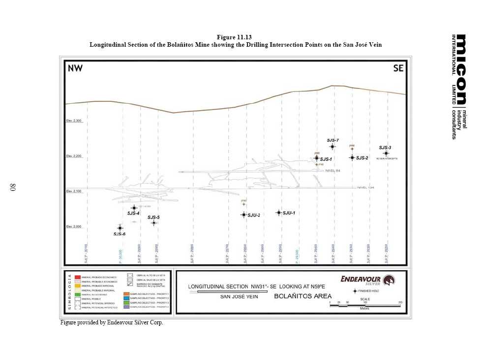

Table 11.9
Highlights of the 2008 Bolañitos Mine Underground and Surface Diamond Drilling Program
| Location of Drill Hole | Drill Hole Number | Vein | Interval (m) | Assays (g/t) | ||||
| From | To | Core Length | True Width | Silver | Gold | |||
| Surface | BSV-3 | Bolanitos Vein | 155.25 | 161.25 | 6.00 | 5.80 | 166 | 5.54 |
| Incl. | 157.05 | 159.05 | 2.00 | 1.93 | 239 | 11.45 | ||
| BSV-5 | HW Bolañitos Vein | 133.35 | 136.50 | 2.65 | 1.53 | 208 | 6.48 | |
| BSV-8 | Bolanitos Vein | 129.15 | 135.20 | 7.05 | 6.39 | 204 | 0.92 | |
| Incl. | 128.15 | 128.60 | 0.45 | 0.41 | 854 | 1.09 | ||
| Underground | BUV-7 | Santa Maria | 102.70 | 106.10 | 3.40 | 2.34 | 537 | 0.56 |
| Surface | SJS-1 | Vein | 184.95 | 185.95 | 1.00 | 0.57 | 661 | 0.07 |
| Vein | 191.60 | 192.00 | 0.40 | 0.23 | 647 | 0.13 | ||
| San Jose | 197.45 | 199.35 | 1.90 | 0.84 | 1,147 | 1.33 | ||
| FW San Jose | 203.95 | 205.35 | 1.40 | 0.73 | 315 | 0.39 | ||
| Lucero | 226.00 | 235.50 | 9.50 | 3.62 | 374 | 3.14 | ||
| Incl. | 229.05 | 229.65 | 0.60 | 0.21 | 1,160 | 3.97 | ||
| Incl. | 234.45 | 235.05 | 0.60 | 0.39 | 917 | 15.6 | ||
Table provided by Endeavour Silver Corp.
Table 11.10
Summary of All Results from the 2008 Bolañitos Mine Underground and Surface Diamond Drilling Program
| Location of Drill Hole | Drill Hole Number | Vein | Interval (m) | Assays (g/t) | ||||
| From | To | Core Length | True Width | Silver | Gold | |||
| SV-1 | Soledad Vein | 258.05 | 258.85 | 0.80 | 0.76 | <5 | <0.05 | |
| SV-2 | Soledad Vein | 290.10 | 290.40 | 0.30 | 0.19 | <5 | <0.05 | |
| R-1 | Realejo Vein | No Significant Intercepts | ||||||
| R-2 | Realejo Vein | 329.85 | 332.25 | 2.40 | 1.82 | 77 | 0.27 | |
| BSV-1 | Bolañitos Vein | 189.45 | 189.95 | 0.50 | 0.32 | 162 | 3.43 | |
| FW Bolañitos Vein | 201.20 | 203.85 | 2.65 | 2.03 | 126 | 1.36 | ||
| BSV-2 | Bolañitos Vein | 247.90 | 249.55 | 1.65 | 1.22 | 13 | 0.82 | |
| FW Bolañitos Vein | 252.05 | 255.50 | 3.45 | 2.27 | 178 | 0.48 | ||
| Bolañitos Vein | 155.25 | 161.25 | 6.00 | 5.80 | 166 | 5.54 | ||
| BSV-3 | Including | 157.05 | 159.05 | 2.00 | 1.93 | 239 | 11.45 | |
| FW Bolañitos Vein | 168.25 | 168.80 | 0.55 | 0.52 | 5 | 0.05 | ||
| BSV-4 | HW Bolañitos Vein | 144.45 | 146.00 | 1.55 | 1.34 | 38 | 1.73 | |
| Bolañitos Vein | 180.45 | 180.85 | 0.40 | 0.20 | 33 | 0.48 | ||
| BSV-5 | HW Bolañitos Vein | 133.35 | 136.40 | 3.05 | 1.53 | 208 | 6.48 | |
| Bolañitos Vein | 243.85 | 244.75 | 0.90 | 0.69 | 307 | 3.83 | ||
| FW Bolañitos Vein | 258.20 | 258.80 | 0.60 | 0.46 | 8 | 0.16 | ||
| BSV-6 | Bolañitos Vein | 186.10 | 188.10 | 2.00 | 1.53 | 88 | 0.48 | |
| BSV-7 | Vein | 124.75 | 126.65 | 1.90 | 0.65 | 92 | 0.31 | |
| Bolañitos Vein | 273.55 | 275.40 | 1.85 | 1.31 | 40 | 0.80 | ||
| Mineralized Zone | 278.40 | 279.30 | 0.90 | 0.64 | 323 | 1.36 | ||
| BSV-8 | Bolañitos Vein | 128.15 | 135.20 | 7.05 | 6.39 | 204 | 0.92 | |
82
| Location of Drill Hole | Drill Hole Number | Vein | Interval (m) | Assays (g/t) | ||||
| From | To | Core Length | True Width | Silver | Gold | |||
| Including | 128.15 | 128.60 | 0.45 | 0.41 | 854 | 1.09 | ||
| FW Bolañitos Vein | 180.35 | 180.75 | 0.40 | 0.36 | 16 | 0.16 | ||
| BUV-1 | Bolañitos Vein | 85.75 | 86.30 | 0.55 | 0.39 | 6 | 0.13 | |
| BUV-2 | Santa Maria Vein | 71.80 | 73.00 | 1.20 | 0.42 | 544 | 0.52 | |
| Bolañitos Vein | 120.10 | 120.65 | 0.55 | 0.35 | 8 | 0.19 | ||
| BUV-3 | Santa Maria Vein | 55.15 | 55.60 | 0.45 | 0.39 | 11 | 0.25 | |
| Bolañitos Vein | 148.30 | 149.30 | 1.00 | 0.34 | <5 | 0.43 | ||
| BUV-4 | Santa Maria Vein | 75.35 | 77.35 | 2.00 | 1.73 | 345 | 0.48 | |
| Bolañitos Vein | 138.25 | 138.65 | 0.40 | 0.26 | 475 | 0.81 | ||
| BUV-5 | HW Bolañitos Vein | 116.15 | 118.80 | 2.65 | 1.87 | 184 | 0.51 | |
| Bolañitos Vein | 183.65 | 185.30 | 1.65 | 1.59 | 126 | 0.35 | ||
| BUV-6 | HW Bolañitos | 196.10 | 197.30 | 1.20 | 0.92 | 254 | 0.19 | |
| Bolañitos Vein | 211.40 | 215.25 | 3.85 | 2.95 | 54 | 0.12 | ||
| FW Bolañitos | 300.00 | 302.25 | 2.25 | 1.72 | 71 | 0.22 | ||
| Santa Maria | 102.70 | 106.10 | 3.40 | 2.34 | 537 | 0.56 | ||
| BUV-7 | HW Bolañitos Vein | 133.40 | 135.45 | 2.05 | 1.04 | 158 | 0.73 | |
| Bolañitos Vein | 188.80 | 189.45 | 0.65 | 0.32 | 6 | 0.05 | ||
| BUV-8 | Bolañitos Vein | 109.20 | 110.85 | 1.65 | 1.35 | 63 | 1.23 | |
| BUV-9 | Bolañitos Vein | 383.70 | 384.60 | 0.90 | 0.64 | 1,015 | 1.60 | |
| SJS-1 | Vein | 184.95 | 185.95 | 1.00 | 0.57 | 661 | 0.07 | |
| Vein | 191.60 | 192.00 | 0.40 | 0.23 | 647 | 0.13 | ||
| San José Vein Zone | 197.45 | 199.35 | 1.90 | 0.84 | 1,147 | 1.33 | ||
| FW San José Vein | 203.95 | 205.35 | 1.40 | 0.73 | 315 | 0.39 | ||
| Lucero Vein | 226.00 | 235.50 | 9.50 | 3.62 | 374 | 3.14 | ||
| Including | 229.05 | 229.65 | 0.60 | 0.21 | 1,160 | 3.97 | ||
| Including | 234.45 | 235.05 | 0.60 | 0.39 | 917 | 15.60 | ||
| SJS-2 | San José Vein | 158.00 | 158.65 | 0.65 | 0.27 | 10 | 0.23 | |
| FW San José Vein | 167.55 | 168.90 | 1.35 | 0.67 | 156 | 0.62 | ||
| Lucero Vein | 293.70 | 299.05 | 5.35 | 1.89 | 23 | 2.54 | ||
| SJS-3 | San José Vein | No Significant Intercepts | ||||||
| SJS-4 | San José Vein | 265.25 | 265.80 | 0.55 | 0.35 | 5 | 0.05 | |
| Bolañitos Vein | 315.15 | 315.75 | 0.60 | 0.39 | 49 | 0.23 | ||
| SJS-5 | San José Vein | 303.00 | 304.80 | 1.80 | 1.27 | 309 | 0.32 | |
| SJS-6 | San José Vein | 354.90 | 356.10 | 1.20 | 0.16 | 5 | 0.05 | |
| SJS-7 | San José Vein | 166.95 | 167.95 | 1.00 | 0.97 | 10 | 0.05 | |
| SJU-1 | FW San José Vein | 190.05 | 191.10 | 1.05 | 0.91 | 5 | 0.91 | |
| San José Vein | 280.35 | 281.20 | 0.85 | 0.74 | 5 | 0.05 | ||
| SJU-2 | FW San José Vein | 214.20 | 214.90 | 0.70 | 0.24 | 35 | 0.10 | |
| San José Vein | 288.05 | 289.70 | 1.65 | 1.26 | 5 | 0.32 | ||
Table provided by Endeavour Silver Corp.
Figures 11.15 and 11.16 are typical cross-sections showing drill holes testing the Bolañitos and San Jose-Lucero vein structures in the Bolañitos mine area.
83
Figure 11.17 is a plan map showing development and channel sampling completed on the Lucero vein by the end of 2008.
Figure 11.15
Cross-Section BSV-8 Based on Hole BSV-8 Drilled to Test the Bolañitos Vein
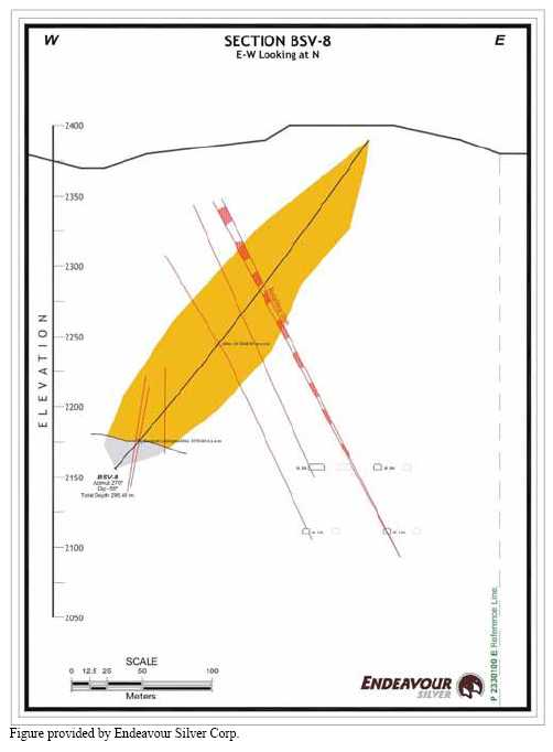
84
Figure 11.16
Cross-Section SJS-1 Based on Hole SJS-1 Drilled to Test the San José Vein

85
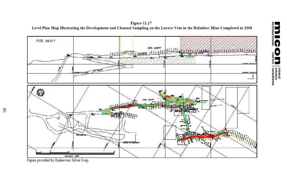
12.0 SAMPLING METHOD AND APPROACH
A description of Endeavour Silver’s sampling method and approach for the Guanajuato Mines project was previously provided in the March, 2008 NI 43-101 Technical Report by SRK. For completeness of this report the sampling method and approach for the Guanajuato Mines project has been excerpted and edited from the March, 2008 report.
12.1 DRILLING PROCEDURES
Drill holes are typically drilled from the hanging wall, perpendicular to and passing through the target structure, into the footwall. No drilling is designed for intercept angles less than about 35° to the target, and most are between 45° and 90°. Drill holes are typically HQ to NQ size in diameter.
On the drill site, the drill set-up is surveyed for azimuth, inclination and collar coordinates with the drilling subject to daily scrutiny and coordination, with the drill crew, by Endeavour Silver’s geologists. At or near the targeted drill hole depth, the hole is surveyed using a Reflex multi-shot down-hole survey instrument. Survey measurements are obtained at a depth of approximately 4 m below the end of the drill string and at 30 m to 50 m intervals from the bottom of the hole back up to the collar. The survey data obtained from the drill hole are transferred to a handheld personal digital assistant (PDA), and thence to the Vulcan mine planning software and AutoCAD databases. True thicknesses are estimated from the measured inclination of the drill hole intercept and the interpreted dip of the vein.
The full drill core boxes are collected daily and brought to the core storage building where the core is laid out, measured, logged for geotechnical and geological data, and marked for sampling.
Depending on the competency of the core, it is either cut in half with a diamond bladed saw or split with a pneumatic core splitter.
The core storage facilities at Guanajuato are well protected by high level security fences and are under 24 hours surveillance by security personnel.
12.2 CORE LOGGING PROCEDURES
In 2008, Endeavour Silver implemented a drill hole data collection and data management system for its exploration projects.
A configuration setup by Century Systems Technologies Inc. (Century) was selected for this purpose (Figure 12.1) . Century was chosen because it directly interfaces with other software, like Vulcan, MapInfo and ArcGIS. The configuration selected was as follows:
- DHLogger for drill hole data collection, management and reporting which runs on a Windows XP or Vista computer.
87
- DHLite for drill hole data collection which runs on a handheld Windows mobile computer Fusion Client to move data back and forth between the local computer and the server(s).
In 2008, Endeavour Silver established logging codes and other database organization and implemented the Century data collection and data management system at the Guanajuato properties.
Figure 12.1
Century’s Configuration for Drill Hole Data Collection for the Guanajuato Mines Project
![]()
Each project will be captured into a DHLogger stand-alone database. The database comes in two files that can be easily copied to the office for backup and sharing of the data.
Only one person can be adding data to a project’s database at a given time in DHLogger but many people can be logging drill holes on DHLite at the same time.
The data will be captured at the project or in the office and the database files can be posted to a secure area in the office for others to copy to their computer and view.
Directories can be setup in the office similar to the one shown below to store the database files for backup purposes and to view the project data.
Mineral resource (Vulcan), GIS, reports, Lab Import, geochemical QAQC analysis, and other access to the data are from this PC only. To be able to access the data on the DHLogger
88
database from another computer requires copying the Fusion Local database or implementing Fusion Server.
12.3 CHANNEL SAMPLING PROCEDURES
12.3.1 Historic Channel Sampling Practices
Historical chip and channel sample records exist for vein exposures in stopes, raises and at 3 m intervals along lode drives. The sample weights were known to be low and representivity was not assured; further the laboratory results were not subject to quality control. Whilst these historical results have been useful in confirming the presence of mineralization the grades themselves are considered to have low confidence. Therefore, Endeavour Silver has undertaken re-sampling of certain blocks in order to plan with more confidence.
12.3.2 Current Channel Sampling Practices
Endeavour Silver conducts underground development and continuous level back mapping to guide sampling crews and to facilitate the interpretation of the sampling results. Channel sampling is conducted after every blast in the stope or development, under the guidance of the geologist. The channel samples are used for determining if the mineralized material can be classified as an indicated resource at each mine.
Channel sampling procedures are generally described as follows:
| 1) | A channel profile approximately 15 cm to 20 cm wide is marked across the face to be sampled using water based paint. | |
| 2) | Depending on lithological boundaries, sample lengths varying from 0.3 m to 2.5 m are marked along the channel. The differentiation between sample limits is similar to that described for core samples. The sampler records a brief description of the sample in a note book. | |
| 3) | Using a chisel and hammer, a sample is chipped from the profile in a systematic manner to achieve a fair representation. The chips are collected in a pan before being bagged and ticketed. The sample site is numbered for future reference. | |
| 4) | Where the roof of the drive/stope is too high, a ladder/sampling platform is used in conjunction with a 1.5 m to 2 m long jumper rod as a chisel. | |
| 5) | The spacing between channels is 2.5 m. | |
| 6) | The position of the channel is offset and referenced from an existing survey peg. Only the top part of the channel is actually surveyed. |
89
| 7) | Sample crews have been instructed to collect a duplicate sample after every 20 samples as part of the QA/QC control measures. However, this protocol has yet to be completely adopted by Guanajuato’s sample crews. |
The procedure outlined above has a number of weaknesses which include the potential un-representativeness of the chips, loss of fine particles during sample collection and contamination of sampling faces by dust particles. The quality of the samples could be improved by using a hose and water to clean up the faces/roof before chipping the sample and using a pneumatic hammer or a diamond saw rock sampling tool to acquire a proper channel sample. However, in a production environment the consequences of the deficiencies noted above would not materially affect the resource estimate and in many instances the chip samples are used to assist in the resource estimation. The spacing between the channels of 2.5 m is considered adequate to cope with local variations and/or short range variability within the deposit.
12.4 MICON’S COMMENTS
Endeavour Silver’s chip and core sampling procedures respect the mineralization and geology with the length of the sample being dependent on the extent of the mineralization and geological boundaries between separate units. The minimum and maximum sample lengths vary between chip and drill core as well as between the different drill core sizes. However, generally smaller samples are taken in the zones of mineralization than in un-mineralized areas. While this comment may appear to be intuitive it is important that, in the pursuit of acquiring sample information, the geological boundaries are respected irrespective of the mineralization which may cross geological boundaries.
Chip sampling can at times be a somewhat selective sampling method since it is occasionally difficult to take a representative sample due to the hardness of the material being sampled and only the softer material is sampled. This is especially the case in mineral deposits where the mineralization is associated with quartz veins or siliceous alteration as is the case with the Guanajuato Mines project. However, the practice of chip sampling is common around the world for underground deposits and the practice of systematically sampling the faces, backs or walls of the development drifts on a close spacing tends to generate a very large set of samples which, in most cases, is statistically representative of the material being sampled. Chip sampling is a routine sampling method used in mines in order to identify ore and waste development rounds. In these cases, the chip sampling is submitted to the mine’s on-site assay laboratory with the results available usually within 24 to 36 hours of being submitted. The results obtained in the on-site laboratory are commonly used in the estimation of the resource of a mine.
The mine assay laboratory usually includes a number of control assays within the batches of mine samples and commonly sends out a number of samples, generally between 5 and 10% of all samples received, for secondary testing at independent laboratories. In an increasing number of mines the laboratory is participating in a round-robin assay program which allows the laboratory to be awarded a certificate of proficiency in assaying one or more elements. In
90
addition to the regular QA/QC program the round-robin program allows the operators of the mine a degree of confidence that the assay results being produced at the mine laboratory are of sufficient quality to be used in predicting and estimating the grade of the material being produced.
Core sampling was conducted not only with visible evidence of mineralization, such as veins and stringers, but also on barren core to preserve the sampling continuity in between mineralized zones and to test for broad zones of lower grade material. The sampling of the wall rock next to the zone of mineralization also assists Endeavour Silver in understanding the grade of the external dilution associated with mining some of the mineralized zones.
Manual rock splitting of the core can be subject to a number of sampling biases based usually on the hardness of the material being split. In the case of very hard core, the core may twist in the splitter which may result in uneven core fragments which result in a slightly greater split than 50% being sent to the assay laboratory or left in the box as a representative sample. In the case of soft core, the core may crumble when being split or may split along natural fracture lines which again results in uneven core representation. Also to prevent contamination the splitter and pans used to collect the samples must be cleaned after each sample. Despite the potential to introduce a bias into the sampling procedure as a result of uneven sample sizes, the splitting of drill core continues to remain a common practice in the exploration and mining industries. Endeavour Silver has recognized these potential problems and has ensured that the splitter and pans are cleaned between samples and that the sample is split is such as way as to best represent half of the core. In addition, Endeavour Silver only uses the manual rock splitting in areas where the core is soft.
Sawn core can also have its share of sampling biases. For instance the use of water during the sawing process may wash out free gold and therefore under-report the gold content of the sample. It is prudent in this case to periodically sample the cuttings from the core sawing process in order to determine if there is any loss of the mineralization which may impact the overall grade of the samples. Additionally it is important that the same half of the core is sampled in all cases for consistency purposes.
It is Micon’s opinion based on a general assessment of the chip sampling, drilling and drill sampling procedures and based on direct discussions with Endeavour Silver personnel at the mine site that the general procedures and controls in practice meets accepted industry standards. In general, both the channel and core sampling is considered to be representative of the areas examined and suitable for use in resource and reserve estimation.
91
13.0 SAMPLE PREPARATION, ANALYSES AND SECURITY
A description of Endeavour Silver’s sample preparation, analysis and security is contained in the SRK March, 2008 NI 43-101 Technical Report. During the September, 2008 site visit by Micon, Endeavour Silver’s sampling preparation, analyses and security were discussed and are summarized below.
13.1 SAMPLE PREPARATION
13.1.1 Sampling Preparation
The historical mine chip, channel and drill hole samples, and mill feed belt samples, were prepared at an in-house laboratory located at the Bolañitos mine. However, all of Endeavour Silver’s drill core samples and underground channel samples, collected as part of the 2007 and 2008 exploration programs, were bagged and tagged at the Cebada mine field office and shipped to the ALS-Chemex assay laboratory in Guadalajara, Mexico.
Upon arrival at ALS-Chemex, all of the samples are logged into the laboratory’s tracking system. Then the entire sample is weighed, dried and fine crushed to better than 70% passing 2 mm. A sample split of up to 250 g is then taken and pulverized to 85% passing 75 microns.
13.1.2 ALS-Chemex Sample Analysis
The analytical procedure for the gold and silver mineralization is a fire assay followed by a gravimetric finish. A 50 g nominal pulp sample weight is used.
As an economical tool for first pass exploration geochemistry, the pulps are also subjected to aqua regia digestion and inductively coupled plasma (ICP) multi-element analysis. The data reported from an aqua regia leach are considered to represent the leachable portion of the particular analyte.
These analytical methods are optimized for low detection limits. The assays for evaluation of ores and high-grade materials have been optimized for accuracy and precision at high concentrations (>10,000 ppm). Over-limits for lead, zinc and copper are determined by either using atomic adsorption (AA) or atomic emission spectroscopy (AES).
The turn-around time required for analyses has typically been from 2 to 4 weeks.
13.2 QUALITY ASSURANCE/QUALITY CONTROL (QA/QC)
A QA/QC program of blanks, duplicates, reference standards and check assays has been instituted by Endeavour Silver to monitor the integrity of assay results.
92
13.2.1 Drilling Programs
Drilling in the Cebada and Bolañitos-Golondrinas mine areas included a QA/QC program. For each batch of approximately 20 samples, control samples are inserted into the sample stream. Each batch of 20 samples includes one blank, one duplicate and one standard reference control sample. Check assaying is also conducted on the samples at a frequency of between 5% and 10%.
A total 3,754 samples were collected during Endeavour Silver’s 2008 drilling program.
Discrepancies and inconsistencies in the blank and duplicate data are resolved by re-assaying either the pulp or reject or both.
Endeavour Silver’s sampling process, including handling of samples, preparation and analysis, is shown in the quality control flow sheet below (Figure 13.1) .
Figure 13.1
Endeavour Silver’s Flow Sheet for Core Sampling, Preparation and Anaysis
![]()
93
13.2.2 Blanks
Blank samples were inserted to monitor possible contamination during the preparation process and analysis of the samples in the laboratory. The blank material used was derived from core samples with no apparent mineralization from Endeavour Silver’s drilling programs in Guanajuato.
Blank samples were inserted at an average rate of approximately 1 for each 20 original samples.
The assay results obtained from the blank samples should indicate if there has been any contamination on the part of laboratory during either the preparation or handling of the samples.
For gold, 16 samples (9.8%) out of a total of 164 blanks were over the detection limit of 0.05 g/t gold (Figure 13.2) . Of these, only one was out of the confidence range of 2 times the standard deviation of the same population.
For silver, 24 samples (14.6%) out of a total of 164 were above the detection limit of 5 g/t silver for the analytical method (Figure 13.3) . All assays were considered within the limits of the confidence range of 2 times the standard deviation of the same population.
Upon review of the data, it is reasonable to conclude that the few cases of higher assay values were more related to the quality of the original blank material rather than to contamination in the preparation process or analysis in the laboratory. Some material used for blanks may in fact have had some minor amount of mineralization. Endeavour Silver considers that, based on the results obtained from the blank samples, its assay results for the drilling programs are for the most part free of any significant contamination.
Figure 13.2
Control Chart for Gold Assays from the Blank Samples Inserted into the Sample Stream for the Drilling
![]()
94
Figure 13.3
Control Chart for Silver Assays from the Blank Samples Inserted into the Sample Stream for the Drilling
![]()
Micon agrees with Endeavour Silver’s conclusion However, it would be better if the blank sample was derived from a geological unit in the area of the mines which was known to be barren, rather than material derived from core samples with no apparent mineralization derived from each drilling program. In the case of drill core derived from each program there is always the chance that it may have been contaminated or that that a small amount of mineralization was missed during the initial logging. In both cases that could give misleading results for the blank sample.
13.2.3 Duplicates
Duplicate samples were used to monitor (a) potential mixing up of samples and (b) variability of the data as a result of laboratory error or lack of homogeneity of the samples.
Duplicate core samples were prepared by Endeavour Silver personnel at the core storage facility at the Guanajuato Mines project. Preparation first involved randomly selecting a sample interval for duplicate sampling purposes. The duplicates were then collected at the time of initial sampling. This required splitting the core in half and then crushing and dividing the half-split into two separate portions which were then sent to the laboratory separately. The duplicate samples were ticketed with the consecutive number following the original sample. One duplicate sample was collected for each batch of 20 samples.
A total of 155 duplicate samples were taken representing 4.2% of the total samples.
Basic statistics for duplicate samples are shown in Figures 13.4 and 13.5.
95
Figure 13.4
Histogram for Gold Assays from the Duplicate Samples Inserted into the Sample Stream for the Drilling
![]()
Figure 13.5
Histogram for Silver Assays from the Duplicate Samples Inserted into the Sample Stream for the Drilling
![]()
96
For the duplicate samples, graphical analysis shows low correlation indices for the majority of the samples (Figures 13.6 and 13.7) . This can, however, be mainly attributed to most of the samples, as shown on the histogram, being near the detection limit of the analytical method.
Out of a total 155 duplicate samples, only 8 samples for gold and 6 samples for silver were outside the zone of +/- 5% of confidence in the precision (orange lines) and 21 samples for gold and 20 samples for silver were outside the 5% confidence interval (blue line). The low correlation coefficients (0.27 for gold and 0.34 for silver) suggest that the homogeneity of the samples is very low. However, Endeavour Silver believes that the low homogeneity of the samples is primarily due to most of the samples being close the lower detection limit, resulting in increased variability in the assays.
Figure 13.6
Graph of the Original versus Duplicate Sample for the Gold Assays from Endeavour Silver’s Drilling Program
![]()
97
Figure 13.7
Graph of the Original versus Duplicate Sample for the Silver Assays from Endeavour Silver’s Drilling Program
![]()
Micon agrees with Endeavour Silver’s observation. However, Micon would recommend that Endeavour Silver run a second set of assays for a selected group of duplicates to see if the results are similar and that there has not been any bias introduced to the process related to the preparation method of the samples. Micon also recommends that a number of non-duplicate sample rejects and pulps be re-assayed as a further check.
13.2.4 Standard Reference Samples
Endeavour Silver uses commercial standard reference samples to monitor the accuracy of the laboratories. The standard reference material has been purchased from various internationally-recognized companies (eg. WCM Minerals, Geostats Pty. Ltd. etc.). Each standard reference sample was prepared by the vendor at its own laboratories and shipped directly to Endeavour Silver along with a certificate of analysis for each standard purchased.
In 2008, a total of 97 reference control samples were submitted at an average frequency of 1 for each batch of 20 samples. The standard reference samples were ticketed with preassigned numbers in order to avoid inadvertently using numbers that were being used during logging.
98
Nine different standards were submitted and analyzed for gold and silver for a total of 194 analyses (97 samples multiplied by 2 analyses each (gold and silver) = 194). The standard reference material samples used during Endeavour Silver’s drilling programs are summarized in Table 13.1.
Table 13.1
Summary of the Standard Reference Material Samples used during the Diamond Drilling Program
| Standard | Sample No. | Gold (g/t) | Silver (g/t) | Copper (%) | Lead (%) | Zinc (%) |
| Edr-3 | G302-5 | 1.66 | ||||
| Edr-4 | PM1112 | 1.34 | 228 | 0.23 | ||
| Edr-5 | PM1120 | 12.2 | 372 | 5.36 | ||
| Edr-7 | PB-127 | 101 | 0.86 | 3.89 | 1.83 | |
| Edr-9 | PM1110 | 1.78 | 164 | 0.39 | ||
| Edr-10 | PM1119 | 3.6 | 111 | 1.34 | ||
| Edr-11 | PM1118 | 1.82 | 38 | |||
| Edr-14 | PM1124 | 228 | ||||
| Edr-15 | PM408 | 1.42 |
Table provided by Endeavour Silver Corp.
For graphical analysis, results for the standards were scrutinized relative to the mean or control limit (CL), and a lower control limit (LC) and an upper control limit (UL), as follows:
| Limit | Value | |
| UL | Plus two standard deviation of standard reference material. | |
| CL | Recommended value (mean) of standard reference material). | |
| LL | Minus two standard deviation of standard reference material. |
Analysis of the data showed that out of the 97 standards submitted of 9 different reference materials for a total of 194 assays for both gold and silver, most analyses ranged between 5% and 22% but 28 were outside the control limits (14%). There were only 3 cases in which the difference was greater than 30%.
Results for each standard reference material sample used are presented separately below.
Edr-3
Twenty-three samples of reference standard Edr-3 (a gold standard) were inserted in the sample stream. Only two samples (BDH 370 and 1546) were outside the control limits (±9.6%) . Sample BDH 370 was approximately 13% higher than the accepted value of the standard, whereas sample BDH 1546 was 33 % below the accepted value for gold. The average value of the standards submitted was slightly below the accepted value as shown in Table 13.2. Figure 13.8 is the control chart for the gold assays.
99
Table 13.2
Summary of Results for Standard Reference Material Sample Edr-3
| Element | Average Grade of Samples Submitted | Accepted Value of Standard |
| Gold (g/t) | 1.64 | 1.65 |
Table provided by Endeavour Silver Corp.
Figure 13.8
Control Chart for Gold Assays from the Standard Reference Sample Edr-3
![]()
Edr-4
Twenty samples of reference standard Edr-4 (a gold and silver standard) were submitted. The average values of the standards and the control charts are shown in Tables 13.3, 13.4, 13.5 and Figures 13.9 and 13.10.
Table 13.3
Summary of Results for Standard Reference Material Sample Edr-4
| Element | Average Grade of Samples Submitted | Accepted Value of Standard |
| Gold (g/t) | 1.346 | 1.34 |
| Silver(g/t) | 214 | 228 |
Table provided by Endeavour Silver Corp.
100
Figure 13.9
Control Chart for Gold Assays from the Standard Reference Sample Edr-4
![]()
Figure 13.10
Control Chart for Silver Assays from the Standard Reference Sample Edr-4
![]()
For standard Edr-4, seven of the samples were outside the accepted gold range for the standard (±7.92%) and these have been summarized in Table 13.4.
101
Table 13.4
Summary of the Gold Results Outside the Accepted Range for the Standard Reference Material Sample Edr-4
| Edr-4 Gold Sample Number | Percent of the Expected Value |
| BDH 1660 | -28% |
| BDH 662 | -25% |
| BDH 903 | -16% |
| BDH 235 | 8% |
| BDH 727 | 10% |
| BDH 494 | 14% |
| BDH 995 | 22% |
| BDH 1203 | 26% |
Table provided by Endeavour Silver Corp.
For standard Edr-4, five of the samples were outside the accepted silver range for the standard (±7%) and these have been summarized in Table 13.5.
Table 13.5
Summary of the Silver Results Outside the Accepted Range for the Standard Reference Material Sample Edr-4
| EDR-4 Silver Sample Number | Percent of the Expected Value |
| BDH 1660 | -18% |
| BDH 1263 | -14% |
| BDH 1203 | -11% |
| BDH 550 | -10% |
| BDH 315 | -10% |
Table provided by Endeavour Silver Corp.
Edr-5
Twenty-six samples of standard Edr-5 (a gold and silver standard) were submitted. The average assay values for gold and silver for this standard are summarized in Table 13.6 and the control charts are shown in Figures 13.11 and 13.12.
Table 13.6
Summary of Results for Standard Reference Material Sample Edr-5
| Element | Average Grade of Samples Submitted | Accepted Value of Standard |
| Gold (g/t) | 11.83 | 12.20 |
| Silver(g/t) | 350 | 372 |
Table provided by Endeavour Silver Corp.
102
Figure 13.11
Control Chart for Gold Assays from the Standard Reference Sample Edr-5
![]()
Figure 13.12
Control Chart for Silver Assays from the Standard Reference Sample Edr-5
![]()
For standard Edr-5, six of samples were outside the accepted gold range for the standard (±8.7%) and these have been summarized in Table 13.7.
103
Table 13.7
Summary of the Gold Results Outside the Accepted Range for the Standard Reference Material Sample Edr-5
| Edr-5 Gold Sample Number | Percent of the Expected Value |
| BDH 1060 | -29% |
| BDH 328 | -16% |
| BDH 1027 | -16% |
| BDH 1194 | -15% |
| BDH 826 | -13% |
| BDH 346 | 10% |
Table provided by Endeavour Silver Corp.
For standard Edr-5, four of the samples were outside the accepted silver range for the standard (±9.4%) and these have been summarized in Table 13.8.
Table 13.8
Summary of the Silver Results Outside the Accepted Range for the Standard Reference Material Sample Edr-5
| Edr-5 Silver Sample Number | Percent of Expected Value |
| BDH 1060 | -37% |
| BDH 1027 | -19% |
| BDH 328 | - 14% |
| BDH 1251 | -11% |
Table provided by Endeavour Silver Corp.
Edr-7 and 9
Only three samples were submitted for standards Edr 7 and 9. Most of the results of these samples were within the control limits. The only exception was sample BDH 1403 which was 11% below the expected gold values.
Edr-10
The average assay values for gold and silver standard Edr-10 are summarized in Table 13.9 and the control charts are shown in Figures 13.13 and 13.14.
Table 13.9
Summary of Results for Standard Reference Material Sample Edr-10
| Element | Average of Grade of Samples Submitted | Accepted Value of Standard |
| Gold (g/t) | 3.63 | 3.60 |
| Silver (g/t) | 111 | 111 |
Table provided by Endeavour Silver Corp.
104
Figure 13.13
Control Chart for Gold Assays from the Standard Reference Sample Edr-10
![]()
Figure 13.14
Control Chart for Silver Assays from the Standard Reference Sample Edr-10
![]()
Edr-11
Four samples of standard Edr-11 (a gold and silver standard) were submitted. The average assay values for gold and silver for this standard reference material sample are summarized in Table 13.10 and the control charts are shown in Figures 13.15 and 13.16.
Table 13.10
Summary of Results for Standard Reference Material Sample Edr-11
| Element | Average of Grade of Samples Submitted | Accepted Value of Standard |
| Gold (g/t) | 1.63 | 1.82 |
| Silver (g/t) | 45 | 38 |
Table provided by Endeavour Silver Corp.
105
Figure 13.15
Control Chart for Gold Assays from the Standard Reference Sample Edr-11
![]()
Figure 13.16
Control Chart for Silver Assays from the Standard Reference Sample Edr-11
![]()
For standard Edr-11, only one sample had a value outside the accepted gold range for the standard (±9.1%) and these have been summarized in Table 13.11.
Table 13.11
Summary of the Gold Results Outside the Accepted Range for the Standard Reference Material Sample Edr-11
| Edr-11 Gold Sample Number | Percent of the Expected Value |
| BDH 1426 | 10% |
| BDH 1526 | 2% |
| BDH 1546 | 39% |
Table provided by Endeavour Silver Corp.
For standard reference material sample Edr-11, all three of the values for the samples were higher than the accepted silver range for the standard (±9.2%) and these have been summarized in Table 13.12.
106
Table 13.12
Summary of the Silver Results Outside the Accepted Range for the Standard Reference Material Sample Edr-11
| Edr-11 Silver Sample Number | Percent of the Expected Value |
| BDH 1426 | 11% |
| BDH 1526 | 37% |
| BDH 1546 | 13% |
Table provided by Endeavour Silver Corp.
Edr-14
Five samples of standard Edr-14 (a silver standard) were submitted. The average assay values for silver for this standard are within the control limits but slightly below the expected values. The average assay values are summarized in Table 13.13 and the control chart is shown in Figure 13.17.
Table 13.13
Summary of Results for Standard Reference Material Sample Edr-14
| Element | Average of Grade of Samples Submitted | Accepted Value of Standard |
| Silver (g/t) | 223 | 228 |
Table provided by Endeavour Silver Corp.
Figure 13.17
Control Chart for Silver Assays from the Standard Reference Sample Edr-14
![]()
Edr-15
Five samples of reference standard Edr-15 (a gold standard) were submitted.
The average assay values for gold for this standard are summarized in Table 13.14 and the control chart is shown in Figure 13.18.
107
Table 13.14
Summary of Results for Standard Reference Material Sample Edr-15
| Element | Average of Grade of Samples Submitted | Accepted Value of Standard |
| Gold (g/t) | 1.36 | 1.42 |
Table provided by Endeavour Silver Corp.
Figure 13.18
Control Chart for Gold Assays from the Standard Reference Sample Edr-15
![]()
For standard Edr-15, only one sample (BDH1726) had a value outside the accepted gold range for the standard (±9.1%) a shown in Table 13.15.
Table 13.15
Summary of the Gold Results Outside the Accepted Range for the Standard Reference Material Sample Edr-15
| Edr-15 Gold Sample Number | Percent of the Expected Value |
| BDH 1726 | -44% |
Table provided by Endeavour Silver Corp.
Summary of Control Sample Results
Several different standards have been used during the Guanajuato drilling program. To view the overall results of this QA/QC program, it was necessary to prepare a single control chart for each of gold and silver to show the variability of results over time. The summary control charts are shown in Figures 13.19 and 13.20.
The control chart for gold shows most of the results clustering close to the expected values for the standards, dropping slightly below the expected value near the end of the drilling program.
108
Figure 13.19
Control Chart for Gold Assays over Time for the Standard Reference Samples Submitted as part of the
Guanajuato Drilling Program
![]()
For silver, there is a smaller amount of variability with respect to time. Assays depict a more concentrated cloud but with a marked tendency for values for all silver standards to be lower than the expected values. Assays were closer to expected values near the end of the program.
Figure 13.20
Control Chart for Silver Assays over Time for the Standard Reference Samples Submitted as Part of the
Guanajuato Drilling Program
![]()
109
13.2.5 Check Assay Samples
Random pulps were selected from original core samples and sent to a second laboratory to verify the original assay and monitor any possible deviation due to sample handling and laboratory procedures.
A total of 265 pulps were sent to a third party laboratory (BSI-Inspectorate) for check analysis. This amounts to approximately to 7% of the total samples taken during the drilling program.
For the majority of these samples, there was close correlation between the original assay and the check assay.
For gold, a total of 111 samples (43%) were below the detection limit of the assay method and the distribution of the remaining 154 samples is shown Figure 13.21.
Figure 13.21
Scatter Diagram of the 154 Gold Check Samples Above Detection Limits
![]()
For silver, a total of 155 samples were above the detection limit of the assay method and the distribution of the silver assays is shown in Figure 13.22.
110
Figure 13.22
Scatter Diagram of the 155 Silver Check Samples Above Detection Limits
![]()
13.3 BOLAÑITOS LABORATORY
In late 2008, Endeavour Silver commissioned a new laboratory facility at the Bolañitos mine for the Guanajuato Mines project. This laboratory was constructed as a measure to ensure accuracy and reliability of in-house analytical data. Endeavour Silver is currently in the process of developing new QA/QC protocols for monitoring assay results for this laboratory.
During the commissioning of the new Bolañitos laboratory, Endeavour Silver is taking steps to improve deficiencies partly due to old equipment and also some bad practices. For example, Endeavour Silver has now adopted the practice of drying the sample before crushing and homogenizing the pulp prior to extracting the aliquot for final analysis. Sample preparation is also now being carried out under the direction of the laboratory supervisor.
In order to minimize contamination between samples, Endeavour Silver plans to submit blanks along with its control samples.
The Bolañitos laboratory also hopes to participate in a proficiency program of round robin testing such as the one run by CanMet. This would assist the on-site laboratory in assessing its performance for one or more analytical methods independently of internal quality control.
13.3.1 Standards
Late in 2008, Endeavour Silver submitted twelve commercial standard reference material samples to the Bolañitos laboratory as a preliminary evaluation of the accuracy of the
111
laboratory. The standard reference material samples were purchased from various internationally-recognized companies
Three samples each of the standards Edr-11 and Edr-14 were submitted to the Bolañitos laboratory
Edr-11
The average values for standard Edr-11 are summarized in Table 13.16 and Figures 13.23 and 13.24.
Table 13.16
Summary of Results for Standard Reference Material Sample Edr-11
| Element | Average of Grade of Samples Submitted | Accepted Value of Standard |
| Gold (g/t) | 1.63 | 1.82 |
| Silver (g/t) | 31 | 38 |
Table provided by Endeavour Silver Corp.
For gold, the control chart (Figure 13.23) indicates that the values for all six of the standard samples were the below the accepted value of the standard. Four of the six values for gold were below the lower control limit.
For silver, all of the values for the samples were lower than the lower control limit of the standard (Figure 13.24) .
Figure 13.23
Control Chart for Gold Assays from the Standard Reference Sample Edr-11
![]()
112
Figure 13.24
Control Chart for Silver Assays from the Standard Reference Sample Edr-11
![]()
Edr-14
Six samples of standard Edr-14 were submitted to the Bolañitos laboratory. The average values are summarized in Table 13.17 and Figure 13.25.
Table 13.17
Summary of Results for Standard Reference Material Sample Edr-14
| Element | Average of Grade of Samples Submitted | Accepted Value of Standard |
| Silver (g/t) | 191 | 228 |
Table provided by Endeavour Silver Corp.
Figure 13.25
Control Chart for Silver Assays from the Standard Reference Sample Edr-14
![]()
The control chart indicates that all of the silver values were below the lower control limit.
13.3.2 Check Assays
A total of 85 pulps were randomly selected from the original channel samples assayed by the Bolañitos laboratory during 2008. These samples were subsequently sent to second
113
laboratory (ALS-Chemex) to verify the original assay and monitor any possible deviation due to sample handling and laboratory procedures.
For the majority of these samples, the correlation between the original assay and the check assay was not very good. For both gold and silver, check assays from ALS-Chemex tended to be higher than the original assays reported by the Bolañitos laboratory, as shown in Figures 13.26 and 13.27.
Graphical analysis of the data, however, is difficult due to the limited amount of check assaying done and the differences in the detection limits reported by each laboratory. For assays below the detection limit, the Bolañitos laboratory reports zero ppm for gold and <2 ppm for silver. The detection limits of the assay method employed by ALS-Chemex are 0.05 ppm for gold and 5 ppm for silver. Many of the assays for the samples submitted were close to the detection limits.
It should be noted that check analyses conducted on the pulps of samples already analyzed at the mine site laboratory is not the best option as the pulp has already passed through the potential contamination process. Micon recommends re-sampling a representative 25% of all samples and conducting fresh analyses at the ALS-Chemex laboratory. If the results are comparable with the mine laboratory results, then the contamination levels were minimal and would not significantly affect the grade estimates.
Figure 13.26
Scatter Diagram of the Gold Check Samples indicating the Differences between the Bolañitos and ALS-Chemex Laboratories
![]()
114
Figure 13.27
Scatter Diagram of the Silver Check Samples indicating the Differences between the Bolañitos and ALS-Chemex Laboratories
![]()
13.4 PRODUCTION RECONCILIATION
The over-riding indication of grade reliability at the Guanajuato Mines project is the historical production records. Grades are measured at the mill feed conveyor and these are related to production at the plant. The final mill production grades are related to the reserve grade of the block as estimated by the historical channel sample results and the dilution factors. The in-situ grades may suffer from some bias as indicated by the previous re-sampling programs.
In 2008, Endeavour Silver implemented a mine-to-mill reconciliation for its operation at Guanajuato. The ability to be able to reconcile the ore mined and milled on a stope-by-stope basis to the original reserve estimate for the stopes is considered a critical factor in the resource and reserve estimations conducted on a project in production. The reconciliation forms a basis for reviewing dilution estimates, mining loss and gain estimates, and will assist in reviewing the classification categories of the resources.
Table 13.18 is a summary of the reconciliation between the mine and plant at Guanajuato in 2008.
115
Table 13.18
Summary of the Reconciliation between the Mine and Plant at Guanajuato in 2008
| Month | Mine Production | Plant Production | ||||||
| Wet Metric Tonnes | Moisture % | Dry Tonnes | Silver g/t | Gold g/t | Dry Tonnes | Silver g/t | Gold g/t | |
| JANUARY | 4,745 | 3.2 | 4,593 | 193 | 1.50 | 4,374 | 200 | 1.76 |
| FEBRUARY | 1,552 | 3.2 | 1,502 | 210 | 1.60 | 1,431 | 217 | 1.87 |
| MARCH | 4,044 | 4.2 | 3,874 | 192 | 1.90 | 3,689 | 199 | 2.22 |
| APRIL | 5,665 | 3.0 | 5,495 | 159 | 1.60 | 5,233 | 164 | 1.87 |
| MAY | 7,843 | 3.3 | 7,584 | 147 | 1.60 | 7,222 | 152 | 1.87 |
| JUNE | 10,445 | 4.0 | 10,027 | 164 | 1.40 | 9,548 | 170 | 1.64 |
| JULY | 10,573 | 3.9 | 10,161 | 156 | 1.20 | 9,675 | 161 | 1.40 |
| AUGUST | 12,078 | 3.8 | 11,619 | 145 | 1.10 | 11,064 | 150 | 1.29 |
| SEPTEMBER | 12,988 | 3.6 | 12,520 | 163 | 1.30 | 11,922 | 169 | 1.52 |
| OCTOBER | 10,951 | 3.7 | 10,546 | 141 | 1.10 | 10,042 | 146 | 1.29 |
| NOVEMBER | 11,520 | 3.3 | 11,140 | 184 | 1.40 | 10,608 | 190 | 1.64 |
| DECEMBER | 13,387 | 3.9 | 12,865 | 219 | 1.50 | 12,250 | 227 | 1.76 |
| Totals | 105,791 | 101,927 | 169 | 1.37 | 97,058 | 175 | 1.60 | |
| Reconciliation Factor | 0.952 | 1.034 | 1.170 | |||||
13.5 DENSITY DETERMINATIONS
In 2007, bulk density determinations were completed on 9 mineralized samples collected from the active mine workings in the Cebada, Bolañitos and Golondrinas mines (Table 13.19) .
The bulk density determinations were conducted at the SGS Lakefield (SGS) laboratory in Durango. Based on the SGS results, an average value of 2.5 was used for mineral resource and reserve tonnage estimates.
Table 13.19
Summary of Endeavour Silver’s Bulk Density Determinations
| Sample | Bulk Density | Average |
| Golondrinas 1 | 2.51 | 2.52 |
| Golondrinas 2 | 2.52 | |
| Golondrinas 3 | 2.54 | |
| Bolañitos 1 | 2.65 | 2.55 |
| Bolañitos 2 | 2.56 | |
| Bolañitos 3 | 2.52 | |
| Cebada 1 | 2.47 | 2.55 |
| Cebada 2 | 2.64 | |
| Cebada 3 | 2.52 |
Table provided by Endeavour Silver Corp.
116
Micon believes that, based on a review of the previous Technical Report and on discussions with Endeavour Silver personnel, Endeavour Silver applies a reasonable degree of care and diligence in monitoring the sample results on the property. Micon considers that the QA/QC procedures and protocols employed at the Guanajuato Mines project, along with the ongoing improvements to the procedures and protocols, are rigorous enough to ensure that the sample data are appropriate for use a mineral resource and reserve estimation. It is also Micon’s opinion that the database and the procedures in-place at the Guanajuato Mine project are appropriate for use in a mineral resource and reserve estimate.
117
14.0 DATA VERIFICATION
14.1 INTRODUCTION
Micon’s site visit to Guanajuato was conducted by Charley Murahwi from September 2 to 4, 2008. During the site visit the following validation tasks were completed:
Review of the state of geological/mineralization knowledge.
Review of the exploration practices, specifically drilling, underground channel sampling, drill core handling and sampling procedures and sample security arrangements.
Review of on-site laboratory facilities.
Review of Quality Assurance/Quality Control (QA/QC) procedures.
Review of database integrity/back-up and storage procedures.
14.2 STATE OF GEOLOGICAL/MINERALIZATION KNOWLEDGE
Endeavour Silver conducts underground development and continuous level back mapping to guide sampling crews and to facilitate the interpretation of the sampling results. Following its review, Micon is satisfied that the geology team at Guanajuato has acquired a good understanding of the geology and mineralization controls which have an important bearing on resource estimates and future exploration efforts. The resource estimation process is well supported by a good geological/mineralization model.
14.3 REVIEW OF EXPLORATION PRACTICES
The drilling procedures as observed by Micon are standard for the industry. On the drill site, surveys are conducted to obtain collar coordinates, elevation of the site and its surroundings, inclination and azimuth of the drill hole. This is important for accuracy in the production of maps, sections and plans. As drilling progresses, the inclination and azimuth of the drill hole are monitored by conducting down-hole surveys. As the targeted drill hole depth is approached, the hole is surveyed using a Reflex down-hole survey instrument in multi-shot mode.
Endeavour Silver aims for HQ and NQ core sizes for surface and underground drilling, respectively. The bigger the sample, the more representative it is. The slightly smaller underground core is due to the lower capacity of the rigs as compared to surface rigs. Core logging is by bar-coding systems with a minimum of descriptive content. This is good practice and is to be commended as it provides a check list, minimizes data transcription errors and assists in maintaining consistency in logging.
118
In summary, Endeavour Silver’s diamond drilling QA/QC are assured by good survey control, NQ and HQ core sizes which yield representative samples, good core recoveries which yield whole intercepts in targeted potential ore zones, and target intersection angles as near to perpendicular as possible. The core storage facilities at Guanajuato are well protected by a high level security fence and are located in an area under 24-hour surveillance by security personnel. This arrangement rules out any possibility of tampering with the drill cores. The core shed facilities at Guanajuato are depicted in Figure 14.1.
Figure 14.1
Guanajuato Core Shed Facility
![]()
14.4 ON SITE LABORATORY INSPECTION
Micon carried out inspections of the laboratory facilities at Guanajuato and established that the weakest link in the analytical chain is the sample preparation stage. This is mainly due to deficiencies in the outdated equipment and also partly due to some bad practices. At the time of the visit, Micon noted that a new laboratory complex had been built and was in the process of being equipped (Figure 14.2) . More importantly, Micon established that Endeavour Silver utilizes external laboratories for all its analytical work involving exploration projects. Thus,
119
,the deficiencies noted at the on-site laboratory have no effect on the resource drill hole database.
Figure 14.2
The Guanajuato New Laboratory Complex (As at September 4, 2008)
![]()
14.5 QA/QC ON ASSAY DATA
In addition to using accredited independent, Endeavour Silver’s exploration division has imposed and maintains various quality controls on sampling and assaying procedures including:
- Duplicate samples.
- Certified standard samples.
- Blanks.
- Check assaying of selected pulps at different laboratories.
- Check assaying using alternative methods.
120
Micon’s review/evaluation of the QA/QC data generated from the above practices does not reveal any major deficiencies that are likely to have a material impact on the assay results used in the reserve/resource database.
14.6 REVIEW OF THE DATABASE
Endeavour Silver’s data are stored in digital format but, for both internal and external audit purposes, hard copy output of raw and interpreted data in the form of tables, plans and sections is readily available.
Micon conducted an audit of the database at Endeavour Silver’s exploration office in Durango City on September 5, 2008. The audit comprised a review of its construction, and the categories of information contained in it, to ensure that all the data necessary for the proper estimation of the resources have been assembled, and that data relating to all key geological and physical features can be accessed individually or in groupings.
As a means of verification, Micon inspected various prints and plots from the database to ensure that the output is sensible. Micon noted that Endeavour Silver ensures and maintains a clean database by imposing restricted access to the database files and established that in all respects the database is in good order. However, Endeavour Silver is encouraged to review its security measures for the ultimate protection of the database against destruction by fire, theft or electronic failure. Good house-keeping practice generally requires regular backups of electronic data with at least one up-to-date copy being maintained off site.
14.7 RESOURCE/RESERVE AUDITS
Micon’s review and audit of the Endeavour Silver resource and reserve estimate is summarized as follows:
| 1) | A site visit was conducted to the Guanajuato Mines project in Mexico where the data input procedures, geological model, block model parameters and resource classification details were reviewed in detail over a period of two days. The site visit included an underground tour to examine the various vein systems for continuity and mineralization; geological mark-up procedures and mining methods were observed and discussed. A tour of the mill was also arranged. | |
| 2) | The review of the resource block model included review of the cut-off grade, wireframing, capping of high grade assays and block model protocols. |
A review of the spreadsheets of tabulated reserves for each zone and by polygon block was undertaken to verify that:
- Appropriate methodology and parameters had been used to estimate quantities of dilution and recovery of mineral within the stoping areas.
121
Calculations had been made correctly.
Blocks had been correctly categorized as proven or probable reserves.
Summary tables had correctly listed total tonnages, grades and contained metal within reserve categories.
122
15.0 ADJACENT PROPERTIES
Endeavour Silver’s Guanajuato Mines project exists within the Guanajuato mining district which has hosted a number of past producers. A number of the past producers are located on the property and a majority of the past producers in the district are located on quartz veins which are similar or related to those located on the Guanajuato Mines project. However, there are no immediately adjacent properties which directly affect the interpretation or evaluation of the mineralization and anomalies found on the property.
Several other mineral properties and mines are present in the region and within the Guanajuato mining district as illustrated in Figure 15.1. The most noteworthy include the El Cubo mine, purchased by a Canadian company MexGold Resources (Gammon Lake Resources) in 2004 and the Guanajuato mines , which include the Valenciana, Cata and Reyes mines as well as a few other land holdings in the area, purchased by another Canadian company, Great Panther Resources, in 2005.
In addition, the Bolañitos plant also conducts custom milling and processing for a number of small mines in the Guanajuato district. The material from each mine is run through the plant in batches. These smaller mines typically exploit quartz-carbonate veins similar in character to the vein mineralization on Endeavour Silver’s Guanajuato Mines project.
Figure 15.1
Major Land Positions held in the Guanajuato Mining District
![]()
123
16.0 MINERAL PROCESSING AND METALLURGICAL TESTING
The mineral processing and metallurgical testing for the Guanajuato property is described in detail in the March, 2008 NI 43-101 Technical Report by SRK which was filed by Endeavour Silver on SEDAR. The following description of the mineral processing and metallurgical testing has been excerpted and edited from the March, 2008 report.
16.1 BOLAÑITOS PLANT DESCRIPTION
In 2008, the plant processed ore from the Cebada, Golondrinas and Bolanitos mines on a campaign basis.
The process plant is a conventional flotation plant which appears to be well suited to the campaign processing of different ore types. The process flow sheet is illustrated in Figure 16.1. The primary jaw crusher receives ore from the mines in the size range 250 to 375 mm. After the primary crusher there are two ore bins each with a 450 t capacity. The presence of the bins allows different ore types to be crushed and stored independently thus optimizing the plant availability and reducing change over time.
Secondary cone crushing takes the ore size down to 50 mm after which the tertiary crusher reduces it further to 9-10 mm. After the tertiary crusher there is a second set of two ore bins, each with a 120 t capacity that adds to the plant flexibility. The conveyor belt below the tertiary crusher bins is fitted with a weightometer which is regularly checked and recalibrated by the plant operators as required. Also at this point, manual samples are regularly taken to determine the plant head grade.
A ball mill grinds the material down to 73% passing 74 microns after which it is subjected to conventional flotation in column and tank cells. Automatic samplers are in place to take samples of the tailings and concentrate. A single concentrate is produced which grades around 7.5 kg/t silver and 70 g/t gold. The concentrate is dewatered in a conventional thickener followed by filtration and drying in a gas drier.
At the maximum processing rate of 500 t/d the plant can produce around 5 to 6 t/d of concentrate which is then trucked to either to a smelter (for the first 10 months of 2008) or to Endeavour’s Silver’s plant in Guanacevi, Mexico where it is added to the mill stream for production of doré (for the last 2 months of 2008 and continuing into the future).
Operations at the plant improved in 2008 with an average recovery of between 80% and 89% being achieved for silver, while for gold the recovery is presently 88%. The campaign milling allows for each ore type to have different reagent dosages and for separate metallurgical balances to be carried out.
124
![]()
16.2 BOLAÑITOS PLANT METALLURGICAL BALANCE
A description of the methodology of the monthly metallurgical balance which is undertaken at the Bolañitos plant is given below.
To generate the metallurgical monthly balance and also for the control of quality at the plant, key points of the process circuit are sampled:
Head grade - taken from the conveyor which feeds the milling circuit.
Wet head grade - taken from the pulp that feeds the flotation circuit.
Concentrate grade - taken from the pulp of the final product that goes to the thickening stage.
Tails grade - taken from the pulp sent to the tailings facility.
The samples are prepared and analyzed at the Bolañitos mine in-house laboratory, where a report is generated each day that contains the gold and silver grades for each sample on each shift. There are 3 shifts of 8 hours at the plant. The laboratory also measures the moisture content of the samples in order to calculate the dry tonnes.
A metallurgical balance for the concentrates is generated per shift using the gold grade, silver grade, % moisture and the tonnage which is registered by the weightometer on the belt that feeds the grinding circuit.
In addition to the above, after filtering and drying, the concentrate is stored and samples are taken for grade and moisture content. The daily calculated and accumulated balance is checked against the mass of concentrate produced.
The daily metallurgical balance forms the basis of the monthly reconciliation report. The monthly reconciliation is reviewed by senior staff and cross-checked against the mass and grade of concentrate samples taken from the dried concentrate.
126
17.0 MINERAL RESOURCE AND MINERAL RESERVE ESTIMATES
17.1 INTRODUCTION
Mineral Reserve and Mineral Resource estimates have been produced and classified using the current CIM standards and definitions for estimating resources and reserves as set out in Canadian National Instrument 43-101 and the accompanying documents NI 43-101-F1 and NI 43-101-CP.
The last reserve and resource estimate for the Guanajuato Mines project was reported in a Technical Report by SRK dated March, 2008 and posted on SEDAR by Endeavour Silver. Since the last resource and reserve estimate was completed, Endeavour Silver has conducted further diamond drilling and underground development at the Guanajuato Mines project and as a result it completed a new resource and reserve estimate for the project which is dated as of December 31, 2008.
The resources and reserves have been updated for all three of Endeavour’s mines in the Guanajuato Mines project. These include the Cebada, Bolañitos and Golondrinas mines which are considered as separate entities and as such have been estimated separately.
The reported reserves for the Guanajuato Mines project only represent that portion of the mineral resources for which Endeavour Silver has a mine plan in place.
Micon was engaged to audit Endeavour Silver’s December 31, 2008 mineral resource and reserve estimates. A discussion of the Micon audit of the Guanajuato Mines project December 31, 2008 resources and reserves is contained in Section 17.3.
Micon believes that the resource and reserve estimates by Endeavour Silver, as audited by Micon, have been reasonably prepared and conform to the current CIM standards and definitions for estimating resources and reserves. Therefore, Micon accepts Endeavour Silver’s resource and reserve estimates as its basis for the ongoing mining operations at the Guanajuato Mines project. In Micon’s opinion there are no significant technical, legal, environmental or political considerations which would affect the extraction and processing of the resources and reserves at the Guanajuato Mines project.
17.2 ENDEAVOUR SILVER RESOURCE AND RESERVE ESTIMATION METHODOLOGIES
17.2.1 Tonnage and Grade Estimation
For the December 31, 2008 resource and reserve report, two different methodologies have been employed for the estimation for the Guanajuato Mines project. Endeavour Silver is still using a classic polygonal method to estimate the majority of the mineral resources and all mineral reserves. All resources for the 3785 (Robbins #5) zone discovered in the Cebada mine at the end of 2007 are now being estimated using block model methods using Vulcan computer software.
127
The Guanajuato Mines project uses a specific gravity of 2.5 to estimate the tonnages. This is considered reasonable for this type of deposit and is based on a limited number of SG tests on samples collected from the Guanajuato Mines project.
17.2.1.1 2-D Polygonal Resource and Reserve Estimates
The 2-D polygonal method is based on the use of a longitudinal section to estimate the mineral resources and reserves. Mineral resource and reserve blocks are defined along the various sill levels and raises within the mine where both historical and current channel sampling has indicated potentially economically minable mineralization. The block volumes are estimated by drawing each block area on a longitudinal section and measuring this area using AutoCAD. For indicated mineral resources, a 25 m vertical height is projected for each block, above and/or below the mine working that has been channel sampled. When continuity of mineralization is determined, an additional 25 m projection will be made for inferred mineral resources above and/or below the indicated resource block. The area of the blocks is then multiplied by the average horizontal width of the composited samples to estimate the volume.
Drill indicated mineral resource blocks are defined by drawing a polygon around each drill intercept on a longitudinal section. Before a polygon is drawn the intercept must be above the established cut-off grade and meet the 1.5 m minimum width criteria. A 25 m projection from the centroid of the drill intercept is then made for indicated resource blocks. When the continuity of mineralization is determined, an additional 25 m projection will be made for inferred resources. Block volumes are estimated by drawing each block area on a longitudinal section and measuring this area using AutoCAD. The area of the block is then multiplied by the average horizontal width of the composited drill intercept to estimate the volume.
17.2.1.2 3-D Wireframe Modelling (3785/Robbins #5 Zone)
For the December 31, 2008 resource estimate of the 3785/Robbins #5 zone, 3-D wireframe modelling was conducted by the geologists and technicians working for Endeavour Silver’s exploration department. However, only the Veta Madre vein structure was 3-D modelled using drill holes from cross-sections 3720 through 3900.
3-D wireframe modelling was completed in a manner to best represent the selective mining method currently being employed at the Guanajuato Mines project. In order to minimize dilution and ensure that only material above the incremental cut-off is actually mined and sent to the mill for processing, grade control geologists are only marking for exploitation, the economical portion of the vein at a minimum mining width. To honour this practice, wireframes were also constructed at a minimum mining width.
For wireframe construction, the portion of the vein with a composite grade greater than 200 g/t silver-equivalent and having a minimum true vein width of 1.5 m was selected. This was done only for drill core. When only a low-grade (<200 g/t silver) composite is present, a
128
mineralized boundary is still selected to ensure that the wireframe model maintains a 1.5 m minimum true vein width throughout its entirety.
Because wireframe construction is based on the pre-compositing of the drill intercepts, the triangulation does not exactly match with limits of the samples or geological intervals. The primary objective was to select the best intervals based on an economic grade over a minimum mining width.
This methodology should not have any adverse effect on the resource estimation, especially since best practices are used during the wireframe modelling.
Statistical and Spatial Analysis
For the December 31, 2008 resource estimates, no 3-D statistical analysis was conducted for the 3785 (Robbins #5) zone. It was also determined that there were insufficient samples upon which to conduct meaningful variography.
Block Model Description
The resource block model for 3785 (Robbins #5) zone was generated using a block size of 5 m (northing) by 5 m (easting) by the width of the vein (z). The block size chosen was deemed appropriate relative to the geometry of the zones, the distance between samples and mine planning.
The blocks were rotated to fit the general dip and strike of the Veta Madre structure (135° azimuth and -65° dip).
Grade Interpolation
The 3-D wireframe for the 3785 (Robbins #5) zone was filled with blocks. Parent blocks were sub-blocked to fill the wireframe completely and to remove any volume discrepancy arising out of the difference between the wireframe volume and the block model volume.
A bulk density of 2.5 t/m3 was assigned to these individual blocks before grade interpolation.
The method used by Endeavour for silver and gold grade interpolation was Inverse Distance with a power of 3. The minimum number of samples used in the grade estimation of each block was 3 and maximum 10.
To assign grades to the blocks, two different search ellipsoids were used. The first pass was used basically to assign grades to the indicated resources blocks and the second pass for the inferred resources in areas that were not interpolated during the first pass, as shown in Table 17.1.
129
Table 17.1
Parameters of the Search Ellipsoids for the 3785 (Robbins #5) zone 3-D Wireframe
| Pass | Major Axis | Semi-Major Axis | Minor Axis | Min. No. of Samples | Max. No. of Samples |
| 1 | 30 | 60 | 20 | 3 | 10 |
| 2 | 100 | 200 | 50 | 3 | 10 |
Table provided by Endeavour Silver Corp
17.2.2 Capping of High Grade Assays
Endeavour Silver has developed basic statistical parameters for raw silver and gold assays. The parameters indicated that the data are positively skewed and that it was necessary to limit the influence of high outlier assays. To limit the influence of high outlier assays, Endeavour Silver has elected to top-cut high assays and make equal length composites within each zone. To determine appropriate capping for each zone, lognormal probability plots were examined and the results for the capping used for each zone are shown in Table 17.2.
For Indicated Resources at the Guanajuato Mines Project, Endeavour Silver capped the channel samples statistically based on the cumulative probability of approximately 95%, this is shown in Table 17.2.
Table 17.2
Summary of the Channel Sample Capping Grades for the Various Areas at Guanajuato
| Area | Gold (g/t) | Silver (g/t) |
| Cebada – All resources and reserves | 6.30 | 1,100 |
| Cebada (3785 (Robbins #5) zone only) – All resources | 4.96 | 381 |
| Bolañitos (Lucero vein only) – All resources and reserves | 6.60 | 875 |
| Bolañitos & Golondrinas – All resources. | 7.25 | 854 |
Table provided by Endeavour Silver Corp.
17.2.3 Sample Composites
A minimum horizontal width of 1.50 m was used for compositing channel and drill hole sample grades. The cut-off grade applied to resource blocks was 200 g/t silver equivalent (AgEq). The equivalent grade was reached by multiplying the gold grade by 70 and adding it to the silver grade. This reflects the relative recoverable values of the metals. The cut-off grade applied to reserve blocks was 230 g/t AgEq.
17.2.4 Modifying Factors and Reserve Estimation
Mineral reserve estimation work was carried out by both Endeavour staff and consulting engineer, John Thompson in 2007 (Thompson, 2007).
A varying amount of dilution, ranging between 6% and 33%, has been applied to convert the mineral resources to mineral reserves. Dilution for individual blocks depends mainly on the deposit width and the size of equipment that will be used. Thompson initially conducted the
130
dilution study and it was subsequently audited by SRK in 2007. In 2008, further work on the percentage of dilution and grade assumptions was carried out by Endeavour Silver’s chief planning engineer, Nelson Peña, and Endeavour’s chief mine geologist, Miguel Lampson, in Guanajuato.
In 2008, a mining recovery factor ranging from 92% to 97% was also included in the estimation process to generate the mineral reserves. This is because some mineralized pillars are now being left behind during the mining of the various veins at Cebada, and 100% extraction for some resource and reserve blocks is not possible at the mines. The cut and fill method does allow for a resource block to be mined from the bottom up in its entirety in some areas but complete extraction is rarely achieved.
17.2.5 Classification
Mineral resources and mineral reserves were classified on the basis of the location of blocks relative to the data used to interpolate the block grade. Mineral resources and reserves have been derived by classifying the blocks according to the following criteria:
Probable mineral reserves are those indicated mineral resource blocks which are currently economic and for which Endeavour Silver has a mine plan in place. This is the case for the Cebada mine which, during 2008, had a program of investment in development and infrastructure to support the generation of mineral reserves. During 2008, Endeavour monitored planned production as well as that achieved in the mill and attempted reconciliation between the mine and the mill on a month-to-month basis. However, the lack of rigorous QA/QC and a detailed reconciliation of the volumes and grades mined from each area still prevent any mineral resources being classified as measured. Therefore, proven mineral reserves cannot be generated from the currently available data.
Indicated mineral resources are those blocks which have had some of the historical mine sampling superseded by Endeavour Silver’s 2007 check channel samples and the 2008 channel sampling program which, in conjunction with confidence gained from the historical reconciliations, provide a reasonable level of confidence in the sample grades and resultant block estimates.
Inferred mineral resources are those outlined and estimated based on the mine’s interpretation and historical sampling results. The historical sampling method and laboratory performance resulted in a low confidence in the results, despite reasonable historical reconciliations. Therefore it is prudent to consider any resource blocks based on these parameters as inferred.
17.2.5.1 Mineral Resource Classifications (3785/Robbins #5 Zone Only)
The mineral resources for the 3785 (Robbins #5) zone are categorized as follows:
- Indicated mineral resources are those blocks which lie within a 30 m radius from the
131
- last drill hole in the periphery of the mineralized zone.
- Inferred mineral resources are those blocks outside the 30 m periphery but within 75 m from the last drill hole in any direction within the defined mineralization.
17.2.6 Cut-off Grades
A breakeven cut-off grade was used which considers metal prices, total mining, milling and administration costs, freight costs, mill recoveries and smelter charges. The cut-off grade does not include either exploration or capital costs.
For the December 31, 2008, resource estimates the same breakeven cut-off grade reported in the March, 2008, SRK Technical Report was used. The geological cut-off grade used for resources was 200 g/t AgEq. Future plans to lower mine operating costs, raise mill throughput and improve mill recoveries at Guanajuato justify using the 200 g/t AgEq geological cut-off grade for resources, which eventually can be reasonably expected to be converted into mineral reserves.
For reserves, a cut-off grade of 230 g/t AgEq was used for the December 31, 2008 estimate. The cut-off grade calculation was based on the following assumptions made at the time of resource and reserve estimation.
An estimated average cost of US$75.00 per tonne of ore processed at the Guanajuato plant (the operating cost is calculated net of gold credits and royalties).
Estimated average recovery for silver in the plant estimated at 86%.
Long term price assumption of US$12.00 per AgEq oz.
The AgEq grade was reached by multiplying the gold grade by 70 and adding it to the silver grade, this reflects the relative recoverable values of the metals.
The economic breakeven cut-off grade was estimated based on the following:
AgEq Cut-off = (Total Operating Costs/Price AgEq x Ag Met Recovery x Payable Silver)
= $75.00/ ($12.00 x 0.86 x 0.99) = 7.4 oz/t AgEq
= (7.4 oz/t x 31.1 g/oz) = 230 g/t AgEq
As of the end of 2008, the improved silver and gold prices and operating performance are already starting to have a positive impact on operations at the Guanajuato Mines project. Plant expansion and a more rigorous stope sampling, mapping and supervision process has been instituted in order to reduce mine dilution and increase production grades. All of these factors are expected to have a positive effect on lowering the operating costs.
132
17.2.7 Mineral Resource and Reserve Statement
The mineral resources and mineral reserves have been estimated, classified and reported using the guidelines given in the CIM Standards on Mineral Resources and Reserves Definitions and Guidelines which has been adopted for reporting under NI 43-101 and the accompanying documents NI 43-101.F1 and NI 43-101.CP.
The mineral resources are exclusive of the mineral reserves. The summary of the resource and reserve estimates as contained in Tables 17.3, 17.4 and 17.5, is effective December 31, 2008. Mineral reserves are those indicated resource blocks with grades in excess of 230 g/t AgEq.
Some rounding has been applied to the block estimates in order to provide a mineral resource and reserve statement which implies an appropriate level of accuracy; this may result in apparent errors which are not considered material.
Table 17.3
December 31, 2008 Indicated Mineral Resource Estimate, Guanajuato Mines Project
(Cut-off Grade 200 g/t Silver-Equivalent)
| Area | Tonnes | Gold (g/t) | Silver (g/t) | Gold (oz) | Silver (oz) |
| Cebada | 83,000 | 2.00 | 179 | 5,000 | 478,000 |
| Bolañitos | 186,000 | 1.34 | 217 | 8,000 | 1,298,000 |
| Golondrinas | 19,000 | 2.39 | 159 | 2,000 | 97,000 |
| Total | 288,000 | 1.60 | 202 | 15,000 | 1,873,000 |
Table 17.4
December 31, 2008 Inferred Mineral Resource Estimate, Guanajuato Mines Project
(Cut-off Grade 200 g/t Silver-Equivalent)
| Area | Tonnes | Gold (g/t) | Silver (g/t) | Gold (oz) | Silver (oz) |
| Cebada | 162,000 | 1.90 | 280 | 10,000 | 1,461,000 |
| Bolañitos | 513,000 | 1.96 | 231 | 32,000 | 3,809,000 |
| Golondrinas | 107,000 | 2.32 | 140 | 8,000 | 481,000 |
| Total | 782,000 | 2.00 | 229 | 50,000 | 5,751,000 |
Thus, at a block cut-off grade of 200 g/t silver-equivalent, Micon estimates that the total remaining mineral resource as of December 31, 2008 is 288,000 t at a grade of 202 g/t silver and 1.60 g/t gold for the Indicated Resources, and 782,000 t at a grade of 229 g/t silver and 2.00 g/t gold for the Inferred Resources. The Indicated portion of this mineral resource contains an estimated 1,873,000 oz of silver and 15,000 oz of gold, while the Inferred portion of the mineral resource contains an estimated 5,751,000 oz of silver and 50,000 oz of gold. Silver-equivalencies were calculated using long-term price assumptions of US$12 per ounce for silver and US$900 per ounce for gold.
133
Table 17.5
December 31, 2008 Probable Mineral Reserve Estimate, Guanajuato Mines Project
(Cut-off Grade 230 g/t Silver-Equivalent)
| Area | In-situ Tonnes and Grade | Recoverable Tonnes and Grade | ||||||||
| Tonnes (t) | Gold (g/t) | Silver (g/t) | Gold (oz) | Silver (oz) | Tonnes (t) | Gold (g/t) | Silver (g/t) | Gold (oz) | Silver (oz) | |
| Cebada | 82,000 | 2.02 | 319 | 5,000 | 844,000 | 89,000 | 1.75 | 277 | 5,000 | 792,000 |
| Bolañitos | 73,000 | 2.60 | 200 | 6,000 | 468,000 | 76,000 | 2.31 | 178 | 6,000 | 437,000 |
| Lucero | 39,000 | 3.42 | 389 | 4,000 | 483,000 | 41,000 | 3.03 | 346 | 4,000 | 451,000 |
| Soledad | 6,000 | 2.60 | 189 | 1,000 | 36,000 | 6,000 | 2.31 | 168 | 400 | 34,000 |
| San Jose | 2,000 | 1.00 | 240 | 100 | 15,000 | 2,000 | 0.89 | 213 | 100 | 14,000 |
| Total | 202,000 | 2.51 | 285 | 16,100 | 1,846,000 | 214,000 | 2.20 | 251 | 15,500 | 1,728,000 |
At a cut-off grade of 230 g/t silver-equivalent, Micon estimates that the total remaining mineral reserve as of December 31, 2008 is 214,000 t at a grade of 251 g/t silver and 2.2 g/t gold for the recoverable probable mineral reserves. The recoverable probable mineral reserves contain an estimated 1,728,000 oz of silver and 15,500 oz of gold.
17.2.8 Exploration Potential
The mineral exploration potential for the Guanajuato Mines project is considered to be very good. In the veins that have been partially mined and within which the resource blocks are to be found, there is good potential to add to the resources by gathering information in the vicinity of these blocks and expanding them into unmined ground, like the Lucero vein. This could be achieved using a combination of underground drilling and further channel sampling. The block boundaries are in many cases only constrained by the arbitrary rules for how far a sample’s influence should be extended.
Parts of these veins beyond the historically mined areas also represent good exploration targets for additional resource tonnage; however, surface drilling will be required. The concession areas contain many veins and Micon considers there to be reasonable potential to discover new veins and splays beyond those currently mapped.
17.3 MICON AUDIT OF THE ENDEAVOUR SILVER RESOURCE AND RESERVE ESTIMATES FOR THE GUANAJUATO MINES PROJECT
Micon’s data verification process for the resource and reserve audit is contained in Section 14. This section contains Micon’s comments on Endeavour Silver’s resource and reserve estimation parameters and processes.
Micon has audited the Endeavour Silver resource and reserve estimates for the Guanajuato Mines project. At this time, Endeavour Silver is still using the traditional manual polygonal method based on the use of a longitudinal section to estimate the resources and the reserves. However, since taking over the operations, Endeavour Silver has been introducing a number of efficiencies one of which is to start building an electronic database for future resource and reserve estimates.
134
Endeavour Silver caps the channel samples statistically based on the cumulative probability of approximately 95%. Endeavour Silver has capped each area or vein separately and has not used an average for its entire project which preserves the individual mineralogical nature of each area or vein during the resource and reserve estimate. Micon agrees with this approach but cautions that Endeavour Silver will have to continue to review its capping parameters to ensure their continuing relevance to the project.
A minimum horizontal width of 1.50 m was used for compositing channel and drill hole sample grades. Micon agrees with the current use of 1.50 m as the minimum mining width but recommends that Endeavour Silver undertake a review of the minimum width as well as conduct a sensitivity analysis using 2.0 as the minimum mining width.
The cut-off grade applied to resource blocks was 200 g/t AgEq. The cut-off grade applied to reserve blocks was 230 g/t AgEq. Micon agrees with the usage of these cut-off grades for the mines; however, for the purpose of block modelling estimation Micon recommends that the resource cut-off be reviewed using a lower cut-off grade in order to establish a potentially more consistent and continuous mineral envelope which will encompass the resource and reserve estimate.
Endeavour Silver is still using a classic polygonal method to estimate the majority of the mineral resources and all mineral reserves. Endeavour Silver is in a transition period in regard to the resource and reserve estimates and, since taking over the Guanajuato operations in 2007, has been implementing a number of changes. While it is increasingly common to see block model methods used to generate the resources and reserves, in the mining industry in a number of countries with long mining histories it is still common to see the classic polygonal or sectional methods used. Micon has reviewed the parameters and techniques used by Endeavour Silver at its Guanajuato Mines project and believes that the techniques are appropriate to generate resources and reserves for the project. However, Micon also believes that Endeavour Silver should make every effort to convert its database into an electronic one as soon as possible. The electronic database will allow Endeavour Silver to gain a better understanding of the geological relationships prevalent on the property and will allow it more flexibility when generating exploration targets at its Guanajuato Mines project.
Micon believes that the varying dilution and mining recovery factors used in generating the mineral reserve estimate at the Guanajuato Mines project are appropriate at this stage in Endeavour Silver’s estimation process. However, Micon recommends that, once good reconciliation data are available which can reconcile the material sent to the mill back to individual stopes, Endeavour Silver use the reconciliation data to review and update the varying dilution and recovery factors, if necessary.
Micon notes that while the resource and reserve methodology closely correlates to the actual mining practice, a true reconciliation record of reserves versus production versus mill does not exist. Micon therefore recommends that Endeavour Silver continue to improve the reconciliation practices at the Guanajuato Mines project in order to gain a more complete understanding of the dilution and recoverability of the broken muck underground and its relationship to the mill production. The reconciliation process will assist Endeavour Silver in
135
gaining a better understanding of the mining processes at the mines and will assist in identifying further efficiencies.
136
18.0 OTHER RELEVANT DATA AND INFORMATION
All relevant data and information regarding Endeavour Silver’s Guanajuato Mines project is included in other sections of this report. This section will focus on covering the items contained in Item 25 of Form 43-101F1 Technical Report “Additional Requirements for Technical Reports on Development Properties and Production Properties”. As a number of areas in this section have not changed since the publication of the SRK report in March, 2008 some of the following descriptions have been excerpted and edited from the SRK report and others have been changed to reflect the ongoing work undertaken at the mine by Endeavour Silver.
18.1 MINING OPERATIONS
As of June, 2007, Endeavour Silver assumed the running of day-to-day mining operations at the Guanajuato Mines project pictured in Figure 18.1. Endeavour Silver undertook control of the mining operations in order to allow for more flexibility in the operations and to continue optimizing the costs. As of December, 28 2008, the Guanajuato Mines project had a roster totalling 391 employees. The mine’s operating schedule consists of three 8-hour shifts 6 days a week. The miners are skilled and experienced in vein mining and according to Endeavour Silver are currently not unionized. There is an incentive system in place rewarding personnel for safety and production. Technical services and overall supervision is provided by Endeavour Silver staff.
The mine employs geology, planning and surveying personnel and operates using detailed production plans and schedules. All the mining activities are conducted under the direct supervision and guidance of the mine manager.
Figure 18.1 is a view looking northwest along the trend of the Veta Madre.
Figure 18.1
View Looking Northwest along the Trend of the Veta Madre
![]()
137
18.2 GROUND CONDITIONS
The ground conditions at the Bolañitos and Golondrinas mines are considered to be good. The rocks are competent and require no special measures for support other than occasional rock bolting and regular scaling. At the Cebada mine the ground conditions are similar to the other mines with the exception of the hanging wall of the deposit which is comprised of a weak, laminated graphitic shale. The weak nature of the hanging wall material requires additional rock bolting. The current cut and fill mining method is well suited to these ground conditions.
18.3 MINING METHOD
A conventional bottom-up cut and fill mining method is employed with waste rock brought in using small diesel or electric loaders. The rock used to backfill the stopes is either dropped down a raise bore hole from surface or is generated from the waste development underground.
18.4 PRODUCTION
Endeavour Silver took over the operations in May, 2007 and for the period from May to December, 2007 the Bolañitos plant produced 227,689 oz silver and 2,360 oz gold from 65,266 t ore grading 133 g/t silver and 1.47 g/t gold. Silver and gold recoveries averaged 81.50% and 76.60%, respectively. Table 18.1 summarizes the production from the different areas from May to December, 2007.
Table 18.1
Summary of Actual Production from May to December, 2007
| Description/Month | May | June | July | Aug | Sept | Oct | Nov | Dec | Average |
| Cebada silver g/t | 130 | 168 | 147 | 108 | 128 | 157 | 160 | 174 | 147 |
| Cebada gold g/t | 1.44 | 1.65 | 1.42 | 1.25 | 1.21 | 1.44 | 1.50 | 1.60 | 1.43 |
| Tonnes | 3,181 | 2,722 | 2,787 | 3,054 | 4,067 | 3,826 | 3,281 | 3,840 | 26,758 |
| Bolañitos silver g/t | 128 | 118 | 142 | 124 | 187 | 145 | 135 | 143 | 142 |
| Bolañitos gold g/t | 2.10 | 2.01 | 1.61 | 1.38 | 1.27 | 1.44 | 1.52 | 2.0 | 1.62 |
| Tonnes | 2,153 | 3,022 | 2,785 | 3,303 | 3,573 | 2,479 | 2,403 | 1,688 | 21,406 |
| Golondrinas silver g/t | 106 | 74 | 88 | 96 | 74 | 99 | 116 | 178 | 94 |
| Golondrinas gold g/t | 2.23 | 1.46 | 1.44 | 1.10 | 1.27 | 1.26 | 1.47 | 1.4 | 1.41 |
| Tonnes | 976 | 1,391 | 1,483 | 1,382 | 1,810 | 1,684 | 743 | 445 | 9,914 |
| Grand total | 6,310 | 7,135 | 7,054 | 7,739 | 9,450 | 7,989 | 6,427 | 5,973 | 58,077 |
Table provided by Endeavour Silver Corp.
In 2008, the Bolañitos plant produced 484,978 oz silver and 4,343 oz gold from 96,545 t ore grading 175 g/t silver and 1.59 g/t gold. Silver and gold recoveries averaged 89%% and 88%%, respectively. Table 18.2 summarizes the production from the different areas from January to December, 2008 and Table 18.3 summarizes the actual production versus the budgeted production for 2008.
138
![]()
Table 18.3
Summary of 2008 Budget versus Actual Production for the Guanajuato Mines
| Area | Description | Budget | Actual | Variance | % Difference |
| Plant | No. of Days | 304 | 304 | 0 | 100.0% |
| Tonnes of Ore | 66,432 | 96,545 | 30,113 | 145.3% | |
| Silver Grade (g/t) | 195 | 175 | -20 | 89.9% | |
| Gold Grade (g/t) | 1.51 | 1.59 | 0.08 | 105.4% | |
| Silver Recovery | 87% | 89% | 2% | 101.9% | |
| Gold Recovery | 87% | 88% | 1% | 100.9% | |
| Silver Ounces Recovered | 363,958 | 484,978 | 121,020 | 133.3% | |
| Gold Ounces Recovered | 2,810 | 4,343 | 1,532 | 154.5% | |
| Mine | No. of Days | 304 | 304 | 0 | 100.0% |
| Tonnes of Ore | 66,432 | 102,497 | 36,065 | 154.3% | |
| Silver Grade (g/t) | 195 | 170 | -25 | 87.1% | |
| Gold Grade (g/t) | 1.51 | 1.38 | -0.13 | 91.4% | |
| Development | Endeavour | 1,786.0 | 2,196.7 | 410.7 | 123.0% |
| Contractor | |||||
| Total (m) : | 1,786.0 | 2,196.7 | 410.7 | 123.0% |
Table provided by Endeavour Silver Corp.
18.5 MINERAL PROCESSING
Mineral processing is discussed in Section 16 of this report.
18.6 TAILINGS DAM
Endeavour Silver in 2007 was conducting work in order to expand the tailings facility with the work concentrated on raising the downstream embankment and developing the diversion tunnel. Endeavour Silver continued with the expansion of the tailings facility in 2008.
18.7 CONTRACTS
Endeavour Silver has advised Micon that there are no contracts for mining, smelting, refining, transportation, handling, sales, contracts or agreements that are outside of normal or generally accepted practices within the mining industry. Endeavour Silver has a policy on not hedging or forward selling any of its products.
18.8 ENVIRONMENTAL CONSIDERATIONS AND SAFETY
The Bolañitos plant monitors all the effluents and air quality on the site. Regular monitoring and laboratory testing are out-sourced to qualified contractors. Regular meetings are held with the local Ejido and President of the Municipality of Guanajuato to discuss areas of mutual concern.
The mill and mine recycle batteries, oils, greases, steel and aluminum.
The mine and mill have safety induction meetings and tours with all new employees and hold regular weekly half hour safety meetings with all employees and contractor employees.
140
18.9 TAXES
Taxation in Canada and Mexico is often complex and varies from one jurisdiction to the other. There are numerous calculations and allowances, all of which are outside the scope of this report. However, taxes are all levied in the normal course of business. Endeavour Silver is subject to the taxing jurisdictions of Guanajuato, Mexico and Canada. Endeavour Silver represents that all taxes assessed have been paid or will be paid when due, aside from any protests or other tax relief available under law.
18.10 CAPITAL COST ESTIMATES
In 2008, Endeavour Silver’s Guanajuato mines project consisted of a modest size underground mining operation based at Cebada and Bolañitos. As 2008 was the first complete year in which Endeavour Silver was in complete control of the operations, the capital outlay was higher than in previous years, as a number of improvements and up-grades were conducted on the project and some of these will continue into 2009. The actual 2008 and proposed 2009 capital costs for the Guanajuato mines project are outlined in Table 18.4.
Table 18.4
Actual 2008 and Proposed 2009 Capital Cost Estimates for the Guanajuato Mines Project
| Item | Actual 2008 Costs (US$) | Estimated 2009 Cost (US$) |
| Equipment | 95,005 | 155,700 |
| Shaft & Development | 922,226 | 1,144,655 |
| Vehicles | 14,372 | 0 |
| Various Construction | 99,731 | 162,500 |
| Plant | 468,361 | |
| Total | 1,131,334 | 1,931,216 |
Table provided by Endeavour Silver Corp.
The capital expenditure budget for the mine and plant is in addition to the exploration budget.
18.11 ECONOMIC ANALYSIS
18.11.1 Operating Costs
The actual 2008 and estimated 2009 operating costs for the project are summarized below in Table 18.5.
Table 18.5
Actual 2008 and Estimated 2009 Operating Cost Estimates for the Guanajuato Project
| Item | Actual 2008 Costs (US$/t) | Estimated 2009 Costs (US$/t) |
| Mining Cost | 38.48 | 36.90 |
| Development Cost | NA | NA |
| Plant (Milling) Cost | 27.50 | 21.10 |
| Administration | 15.48 | 9.34 |
| Tailings Pond Expansion | NA | NA |
| Total | 81.46 | 67.34 |
Table provided by Endeavour Silver Corp.
141
18.11.2 Economic Analysis
Micon has not undertaken a cash flow analysis for the Guanajuato Mines project due to the fact that there are currently only mineral reserves sufficient for a short term operation of less than two years.
18.11.3 Future Production Potential
The mine life based on probable reserves as of December 31, 2008 is approximately one and a half years at a projected production levels of 400 t/d or 12,000 t/m. This is less than the mill capacity and Endeavour Silver is hoping that ongoing exploration will add to the mineral reserve inventory so that the mining and processing rate can be increased in 2009.
Given that many epithermal vein systems of this type have vertical mineralized extents ranging from 500 m to 800 m, Endeavour Silver could reasonably expect to increase its mineral resource base as more exploration is conducted. Micon believes there is a good likelihood of discovering additional resources at Endeavour Silver’s Guanajuato mines project.
142
19.0 INTERPRETATION AND CONCLUSIONS
With the Guanajuato Mines project, Endeavour Silver has acquired a group of silver mines located in one of the major historical silver mining districts in Mexico. The project has a good potential for the discovery of additional resources and reserves as development and exploration at and around the mines continue. Also, since Endeavour Silver has taken over the day-to-day operation of the mines, there are potentially a number of areas which will see increased productivity and efficiency measures which may lead to increased cost savings in the future.
Micon has conducted an audit of the Endeavour Silver resource and reserve estimate for the period ending December 31, 2008. Micon’s audited resource estimates are contained in Tables 19.1 and 19.2 for the Indicated and Inferred Mineral Resources. The Probable Mineral Reserves are shown in Table 19.3. These reserves are in addition to the mineral resources.
Micon considers the resource and reserve estimates, compiled by Endeavour Silver and audited by Micon, to have been reasonably prepared and to conform to the current CIM standards and definitions for estimating resources and reserves as required under NI 43-101 “Standards of Disclosure for Mineral Projects.” Therefore, Micon accepts Endeavour Silver’s resource and reserve estimate as its basis for the ongoing mining operations at the Guanajuato Mine project. In Micon’s opinion there are no significant technical, legal, environmental or political considerations which would affect the extraction and processing of the resources and reserves at the Guanajuato Mine project.
Table 19.1
December 31, 2008 Indicated Mineral Resource Estimate, Guanajuato Mines Project
(Cut-off Grade 200 g/t Silver-Equivalent)
| Area | Tonnes | Gold (g/t) | Silver (g/t) | Gold (oz) | Silver (oz) |
| Cebada | 83,000 | 2.00 | 179 | 5,000 | 478, 00 |
| Bolañitos | 186,000 | 1.34 | 217 | 8,000 | 1,298,000 |
| Golondrinas | 19,000 | 2.39 | 159 | 2,000 | 97,000 |
| Total | 288,000 | 1.60 | 202 | 15,000 | 1,873,000 |
Table 19.2
December 31, 2008 Inferred Mineral Resource Estimate, Guanajuato Mines Project
(Cut-off Grade 200 g/t Silver-Equivalent)
| Area | Tonnes | Gold (g/t) | Silver (g/t) | Gold (oz) | Silver (oz) |
| Cebada | 162,000 | 1.90 | 280 | 10,000 | 1,461,000 |
| Bolañitos | 513,000 | 1.96 | 231 | 32,000 | 3,809,000 |
| Golondrinas | 107,000 | 2.32 | 140 | 8,000 | 481,000 |
| Total | 782,000 | 2.00 | 229 | 50,000 | 5,751,000 |
143
Table 19.3
December 31, 2008 Probable Mineral Reserve Estimate, Guanajuato Mines Project
(Cut-off Grade 230 g/t Silver-Equivalent)
Area | In-situ Tonnes and Grade | Recoverable Tonnes and Grade | ||||||||
| Tonnes (t) | Gold (g/t) | Silver (g/t) | Gold (oz) | Silver (oz) | Tonnes (t) | Gold (g/t) | Silver (g/t) | Gold (oz) | Silver (oz) | |
| Cebada | 82,000 | 2.02 | 319 | 5,000 | 844,000 | 89,000 | 1.75 | 277 | 5,000 | 792,000 |
| Bolañitos | 73,000 | 2.60 | 200 | 6,000 | 468,000 | 76,000 | 2.31 | 178 | 6,000 | 437,000 |
| Lucero | 39,000 | 3.42 | 389 | 4,000 | 483,000 | 41,000 | 3.03 | 346 | 4,000 | 451,000 |
| Soledad | 6,000 | 2.60 | 189 | 1,000 | 36,000 | 6,000 | 2.31 | 168 | 500 | 34,000 |
| San Jose | 2,000 | 1.00 | 240 | 100 | 15,000 | 2,000 | 0.89 | 213 | 100 | 14,000 |
| Total | 202,000 | 2.51 | 285 | 16,100 | 1,846,000 | 214,000 | 2.20 | 251 | 15,500 | 1,728,000 |
Micon believes that the land controlled by Endeavour Silver is highly prospective both along strike and down dip of the existing mineralization and that further resources could be converted into reserves with additional exploration and development.
19.1 CONCLUSIONS
Upon acquiring the Guanajuato Mines project, Endeavour Silver has obtained an operating project with an extensive mining history and known silver and gold bearing veins. Although a number of mineralized areas have been exploited in the past, improvements in mining techniques have allowed mining to be expanded within the boundaries of previously mined areas and extended into new areas.
The resources and reserves reported herein by Endeavour Silver for the Guanajuato Mines project were audited and accepted by Micon as constituting a portion of Endeavour Silver’s operations in Mexico. The resources and reserves for the Guanajuato Mines project conform to the current CIM standards and definitions for estimating resources and reserves as required under NI 43-101 regulations.
The mineral exploration potential for the Guanajuato Mines project is considered to be very good. In the veins that have been partially mined and within which the resource blocks are to be found, there is good potential to add to the resources by gathering information in the vicinity of these blocks and expanding them into unmined ground, like the Lucero vein. This could be achieved using a combination of underground drilling and further channel sampling. The block boundaries are in many cases only constrained by the arbitrary rules for how far a sample’s influence should be extended.
Parts of these veins beyond the historically mined areas also represent good exploration targets for additional resource tonnage; however, surface drilling will be required. The license areas contain many veins and Micon considers there to be reasonable potential to discover new veins and splays beyond those currently mapped.
Endeavour Silver is also in the position of having acquired a portion of a major historical mining district in Mexico that has not been subjected fully to modern exploration concepts and technology. The property holds the potential for the discovery of mineralized deposits of
144
similar character and grade as those discovered in the past, either along the trend of the veins or at depth below the presently exploited areas.
145
20.0 RECOMMENDATIONS
Given the success of Endeavour Silver’s previous exploration program, it plans a two-phase exploration program focused on following up several of the new discoveries made near Endeavour Silver's mining operation at Guanajuato and testing several new prospective targets within the district. If the initial 2009 drilling is successful, a budget for a second phase exploration program will be prepared and submitted for approval by the Endeavour Silver’s Board of Directors. The primary long-term goal of this program is to expand reserves and resources and to identify properties for potential acquisition in the Guanajuato district to secure future growth.
Phase 1 of the exploration program will include 3,000 m of core in 11 surface diamond drill holes to target vein discoveries and new prospective areas in the Cebada and Bolañitos areas of the Guanajuato district. Endeavour Silver is budgeting to spend an estimated US$500,000, mainly on surface diamond drilling, in an effort to continue to expand the resource base through both exploration and development on its properties during 2009. The estimated cost of diamond drilling is US$140/m.
Table 20.1 summarizes the planned 2009 budget for the Guanajuato Mines project.
Table 20.1
Summary of the 2009 Expenditures for the Guanajuato Mines Project Exploration Program
| Project Area | 2009 Exploration Program | Budget (US$) | ||
| Drill Holes | Metres | Samples | ||
| BOLAÑITOS – SAN JOSE SOUTH | 6 | 1,500 | 450 | 245,000 |
| CEBADA NORTH | 5 | 1,500 | 500 | 255,000 |
| Total | 11 | 3,000 | 950 | 500,000 |
Table provided by Endeavour Silver Corp.
Micon has reviewed Endeavour Silver’s proposal for further exploration on its Guanajuato Mines property and recommends that Endeavour Silver conducts the exploration program as proposed subject to funding and any other matters which may cause the proposed exploration program to be altered in the normal course of its business activities or alterations which may affect the program as a result of exploration activities themselves.
Through its acquisition of the Guanajuato Mines project, Endeavour Silver has acquired an operating project in one of the major silver producing districts in Mexico. Micon has audited and accepted the current resource and reserve estimate for the project and makes the following additional recommendations:
| 1) | Micon recommends that Endeavour Silver continues to develop a reconciliation plan for the Guanajuato Mines project. The ability to be able to reconcile the ore mined and milled on a stope-by-stope basis to the original estimates for the stope will be a critical factor in future resource and reserve estimations. The reconciliations will form the basis of reviewing dilution estimates, mining loss and gain estimates, and will assist in reviewing the classification categories of the resources. |
146
| 2) | Micon recommends that Endeavour Silver continues to pursue the necessary paperwork for its on-site laboratory to join a proficiency program of round robin testing such as the one run by CanMet. This would assist the on-site laboratory in assessing its performance for one or more analytical methods independently of internal quality control. Coupled with this program a total of between 5% and 10% of the samples submitted to the on-site assay laboratory should be sent out to a secondary accredited laboratory. | |
| 3) | Micon recommends that a blank sample should be generated from either un- mineralized rock formations within the district or from un-mineralized sand deposits in the area. Enough material should be acquired to generate blank samples for use throughout the QA/QC program at the Guanajuato Mines project. | |
| 4) | Micon recommends that Endeavour Silver continues sending out representative samples of the various mineralized zones encountered in the drilling for bulk density determinations and that this information is used in conducting future resource and reserve estimates on the Guanajuato Mines project. At the same time representative samples of the mineralized material from the various zones could be sent out for metallurgical and mineralogical testwork. | |
| 5) | Micon recommends that Endeavour Silver completes its conversion of the existing paper database. As further data are generated from the mining, more detailed examination of the block modelling parameters should be done to develop better estimation protocols. This would not only help in future exploration but would also help in infill drilling. |
| MICON INTERNATIONAL LIMITED | |
| “William J. Lewis” | |
| William J. Lewis, B.Sc., P.Geo. | |
| Senior Geologist | March 18, 2008 |
| “Charley Murahwi” | |
| Charley Murahwi, M.SC., P.Geo, MAusIMM | |
| Senior Geologist | March 18, 2008 |
| “Robert J. Leader” | |
| Robert J. Leader, P.Eng | |
| Senior Mining Engineer | March 18, 2008 |
147
21.0 REFERENCES
Aranda-Gómez, J.J., and McDowell, F.W., (1998), Paleogene extension in the southern asin and Range Province of Mexico; syndepositional tilting of Eocene Red Beds and Oligocene volcanic rocks in the Guanajuato Mining District: International Geology Review, v. 40, p. 116–134.
Buchanan, L.J., (1980), Ore controls of vertically stacked deposits, Guanajuato, Mexico: American Institute of Mining Engineers, Preprint 80-82, 26 p.
Cerca-Martínez, M.; Aguirre-Díaz, G.J.; and López-Martínez, M., (2000), The geologic evolution of southern Sierra de Guanajuato, Mexico-A documented example of the transition from the Sierra Madre Occidental to the Mexican Volcanic Belt: International Geology Review, v. 12, no. 2, p. 131-151.
Chiodi, M.; Monod, O.; Busnardo, R.; Gaspard, D.; Sánchez, A.; and Yta, M., (1988), Une discordance anté-albienne datée par una faune d’ammonites et de brachiopodes de type téthysien au Mexique central: Geobios, no. 21, p. 125-135.
Dávila-Alcocer, V.M., and Martínez-Reyes, Juventino, (1987), Una edad cretácica para las rocas basales de la Sierra de Guanajuato: Universidad Nacional Autónoma de México, Instituto de Geología, Simposio sobre la geología de la Sierra de Guanajuato, resúmenes, p.19-20 (abstract).
Edwards, D.J., (1955), Studies of some early Tertiary red conglomerates of central Mexico: U.S. Geological Survey, Professional Paper 264-H, p. 153–185.
Gross, W.H., (1975), New ore discovery and source of silver-gold veins, Guanajuato, Mexico: Economic Geology, v. 70, p. 1175–1189.
Martínez-Reyes, Juventino, and Nieto-Samaniego, A.F., (1992), Efectos geológicos de la ectónica reciente en la parte central de México: Universidad Nacional Autónoma de éxico, Instituto de Geología, Revista, v. 9, p. 33–50.
Nieto-Samaniego, A.F.; Macías-Romo, Consuelo; and Alaniz- Alvarez, S.A., (1996), uevas edades isotópicas de la cubierta volcánica cenozoica de la parte meridional de la Mesa Central, México: Revista Mexicana de Ciencias Geológicas, v. 13, no. 1, p. 117–122.
Randall-Roberts, J.A.; Saldaña-A., E.; and Clark, K.F., (1994), Exploration in a volcano-plutonic center at Guanajuato, Mexico: Economic Geology, v. 89, p. 1722–1751.
Salas, G.P., et al, (1991), Economic Geology, Mexico, Volume P-3 of the Geology of North America, in The Decade of North American Geology Project series by The Geological Society of America, Inc., 438 p.
148
Southworth, J.R., (1905), Las Minas de México (Edición Ilustrada) Historia, Geologia, Antigua Mineria y Descipción General de los Estados Mineros de la República Mexicana, En Español é Inglés, 260 p.
SRK Consulting, (2008), NI 43-101 Technical Report for the Guanajuato Mines Project, Guanajuato State Mexico, Prepared for Endeavour Silver Corp, 75 p.
Telluris Consulting (2008), Structural Review of the Deposits of the Northern Guanajuato District, Mexico, Field Visit Conclusions 03-08 prepared for Endeavour Silver Corp.23 p.
Thompson, J.E, (2007), Grade & Dilution Control (with commentary on Development, Mining Methods and Backfill), private company report on Guanajuato Mines Project for Endeavour Corp.
Vargas, J.C., et al., (1992), Geological – Mining Monograph of the State of Guanajuato, Secretaria de Energia, Minas e Industria Paraestatal, 136,p.
149
CERTIFICATE OF AUTHOR
WILLIAM J. LEWIS
As the co-author of this report on the Guanajuato Mines project of Endeavour Silver Corp., in Guanajuato State, Mexico, I, William J. Lewis do hereby certify that:
| 1) | I am employed by, and carried out this assignment for, Micon International Limited, Suite 900, 390 Bay Street, Toronto, Ontario M5H 2Y2, tel. (416) 362-5135, fax (416) 362-5763, e-mailwlewis@micon- international.com; |
| 2) | I hold the following academic qualifications: |
B.Sc. (Geology) University of British Columbia 1985 | |
| 3) | I am a registered Professional Geoscientist with the Association of Professional Geoscientists of Manitoba (membership # 20480); as well, I am a member in good standing of several other technical associations and societies, including: |
| • | Association of Professional Engineers and Geoscientists of British Columbia (Membership # 20333) | |
| • | Association of Professional Engineers, Geologists and Geophysicists of the Northwest Territories (Membership # 1450) | |
| • | The Geological Association of Canada (Associate Member # A5975) | |
| • | The Canadian Institute of Mining, Metallurgy and Petroleum (Member # 94758) |
| 4) | I have worked as a geologist in the minerals industry for 23 years; |
| 5) | I am familiar with NI 43-101 and, by reason of education, experience and professional registration; I fulfill the requirements of a Qualified Person as defined in NI 43-101. My work experience includes 4 years as an exploration geologist looking for gold and base metal deposits, more than 11 years as a mine geologist in underground mines and 5 years as a surficial geologist and consulting geologist on precious and base metals and industrial minerals; |
| 6) | I have had no prior involvement with the mineral properties in question; |
| 7) | As of the date of this certificate to the best of my knowledge, information and belief, the technical report contains all scientific and technical information that is required to be disclosed to make this report not misleading; |
| 9) | I am independent of the parties involved in the transaction for which this report is required, other than providing consulting services; |
| 10) | I am responsible for the preparation of sections 1, through 11, 15 16, 18, 19, 21 and jointly wrote sections 12, 13, and 20 of the Technical Report dated March 18, 2009 entitled “NI 43-101 Technical Report Audit of the Resource and Reserve Estimate for the Guanajuato Mines Project, Guanajuato State Mexico.” |
Dated this 18 day of March, 2008
“William J. Lewis”
William J. Lewis, B.Sc., P.Geo.
Senior Geologist,
Micon International Limited
150
CERTIFICATE OF AUTHOR
CHARLEY MURAHWI
As a co-author of this report on the Guanajuato Mines project of Endeavour Silver Corp., I Charley Z. Murahwi do hereby certify that:
| 1) | I am employed as an Senior Geologist by, and carried out this assignment for, Micon International Limited, Suite 900, 390 Bay Street, Toronto, Ontario M5H 2Y2, telephone 416 362 5135, fax 416 362 5763, e-mailcmurahwi@micon-international.com. |
| 2) | I hold the following academic qualifications: |
| B. Sc. (Geology and Botany) University of Rhodesia, Zimbabwe, 1979; | |
Diplome d„Ingénieur Expert en Techniques Minières, Nancy, France, 1987; | |
| M. Sc. (Economic Geology), Rhodes University, South Africa, 1996. | |
| 3) | I am a registered Professional Geoscientist of Ontario (membership number 1618) and am also a member of the Australasian Institute of Mining & Metallurgy (AusIMM) (membership number 300395). |
| 4) | I have worked as a mining and exploration geologist in the minerals industry for over 28 years; |
| 5) | I do, by reason of education, experience and professional registration, fulfill the requirements of a Qualified Person as defined in NI 43-101. My work experience includes 14 years on gold, silver, copper, tin and tantalite projects (on and off- mine), and 12 years on Cr-Ni-Cu-PGE deposits in layered intrusions/komatiitic environments. |
| 6) | I visited the Guanajuato Mines Project in Mexico between 2 and 4 September, 2008 and the Endeavour Silver exploration office in Durango (Mexico) on 5 September, 2008. |
| 7) | I have had no prior involvement with the mineral property in question; |
| 8) | As of the date of this certificate to the best of my knowledge, information and belief, the Technical Report contains all scientific and technical information that is required to be disclosed to make this report not misleading; |
| 9) | I am independent of the parties involved in the Guanajuato property, other than providing consulting services; |
| 10) | I have read the NI 43-101 and the portions of this Technical Report for which I am responsible have been prepared in compliance with this Instrument. |
| 11) | I am responsible for the preparation of sections 14, 19, 20, and co-authored section 17 of this Technical Report dated March 18, 2009 and entitled “NI 43-101 Technical Report Audit of the Resource and Reserve Estimate for the Guanajuato Mines Project, Guanajuato State, Mexico.” |
Dated this 18th day of March, 2009
“Charley Z. Murahwi”
Charley Z. Murahwi, M.Sc., P. Geo. MAusIMM
151
CERTIFICATE OF AUTHOR
ROBERT JAMES LEADER
As the co-author of this report on the Guanajuato Mines project of Endeavour Silver Corp., in Guanajuato State, Mexico, I, Robert James Leader do hereby certify that:
| 1) | I am employed by, and carried out this assignment for, Micon International Limited, Suite 205, 700 West Pender Street, Vancouver, BC, V6C 1G8, tel. (604) 647-6463, fax (604) 647-6455, e-mail jleader@micon-international.com; |
| 2) | I hold the following academic qualifications: |
| ACSM (First Class) | Camborne School of Mines - 1974 | |
| M.Sc. (Engineering) | Queens University, Kingston, Ontario - 1981 |
| 3) | I am a registered Professional Engineer with the Association of Professional Engineers and Geoscientists of British Columbia (Membership #13896), I am a member in good standing of other technical associations and societies, including: | |
• | The Canadian Institute of Mining, Metallurgy and Petroleum | |
• | The Institute of Materials, Minerals and Mining (IOM3), UK | |
| 4) | I have worked as a mining engineer in the minerals industry for 32 years; | |
| 5) | I am familiar with NI 43-101 and, by reason of education, experience and professional registration; I fulfill the requirements of a Qualified Person as defined in NI 43-101. My work experience includes 3 years working as a mining engineer on a base metal underground mine, and over 15 years as a senior mining engineer and consultant carrying out reserves estimates and mine planning and design for diverse mining projects both underground and open pit; | |
| 6) | I have had no prior involvement with the mineral properties in question; | |
| 7) | As of the date of this certificate to the best of my knowledge, information and belief, the technical report contains all scientific and technical information that is required to be disclosed to make this report not misleading; | |
| 8) | I am independent of the parties involved in the transaction for which this report is required, other than providing consulting services; | |
| 9) | I am responsible for the preparation of parts of sections 1, 16, 17.2 and 17.3, 18, 19 and 20 of the Technical Report dated March 18, 2009 entitled “NI 43-101 Technical Report Audit of the Resource and Reserve Estimate for the Guanajuato Mines Project, Guanajuato State Mexico.” | |
Dated this 18th day of March, 2008
“Robert J. Leader”
Robert J. Leader, M.Sc., P.Eng.
Senior Mining Engineer
Micon International Limited
152
CERTIFICATE OF AUTHOR
ALAN J. SAN MARTIN
As the co-author of this report on the Guanajuato Mines project of Endeavour Silver Corp., in Guanajuato State, Mexico, I, Alan J. San Martin do hereby certify that:
| 1) | I am employed by Micon International Limited, Suite 900, 390 Bay Street, Toronto, Ontario M5H 2Y2, tel. (416) 362-5135, fax (416) 362-5763, e-mailasanmartin@micon-international.com; | |
| ||
| 2) | Bachelor Degree in Mining Engineering (equivalent to B.Sc.) National University of Piura, Peru, 1999; | |
| ||
| 3) | I am a registered Engineer with the Colegio de Ingenieros del Peru (CIP) Membership # 79184; | |
| ||
| 4) | I have worked as a mining engineer in the minerals industry for 10 years; | |
| ||
| 5) | I am familiar with NI 43-101 but I am not a Qualified Person in Canada. My work was supervised and approved by Charley Z. Murahwi, one of the authors and Qualified Persons for this report; | |
| ||
| 6) | I have not visited the Guanajuato Mines project of Endeavour Silver Corp.; | |
| ||
| 7) | As of the date of this certificate to the best of my knowledge, information and belief, the Technical Report contains all scientific and technical information that is required to be disclosed to make this report not misleading; | |
| ||
| 8) | I am independent of the parties involved in the Guanajuato Mines project, other than providing consulting services; | |
| ||
| 9) | I assisted Charley Z. Murahwi in the preparation of section 17 of this Technical Report dated March 18, 2009 entitled “NI 43-101 Technical Report Audit of the Resource and Reserve Estimate for the Guanajuato Mines Project, Guanajuato State Mexico.” |
Dated this 18th day of March, 2009
“Alan J. San Martin”
Ing. Alan J. San Martin.
Micon International Limited
153
APPENDIX 1
GLOSSARY OF MINING TERMS
154
| GLOSSARY AND DEFINED TERMS |
The following is a glossary of certain mining terms that may be used in this Technical Report.
| A | |
| |
| Adit | A horizontal passage from the surface into the mine providing access to a mineral deposit. |
| |
| Ag | Silver. |
| |
| Assay | A chemical test performed on a sample of ores or minerals to determine the amount of valuable metals contained |
| |
| Au | Gold. |
| B | |
| |
| Backfill | Waste material used to fill the void created by mining an orebody. |
| |
| Ball mill | A steel cylinder filled with steel balls into which crushed ore is fed. The ball mill is rotated, causing the balls to cascade and grind the ore. |
| |
| Base metal | Any non-precious metal (eg. copper, lead, zinc, nickel, etc.). |
| |
| Blasthole | A drill hole in a mine that is filled with explosives in order to blast loose a quantity of rock. |
| |
| Block caving | An inexpensive method of mining in which large blocks of ore are undercut, causing the ore to break or cave under its own weight. |
| |
| Bulk mining | Any large-scale, mechanized method of mining involving many thousands of tonnes of ore being brought to surface per day. |
| |
| Bulk sample | A large sample of mineralized rock, frequently hundreds of tonnes, selected in such a manner as to be representative of the potential orebody being sampled. Used to determine metallurgical characteristics. |
| |
| Bullion | Metal formed into bars or ingots. |
| |
| Byproduct | A secondary metal or mineral product recovered in the milling process. |
| C | |
| |
| Calcine | Name given to concentrate that is ready for smelting (i .e. the sulphur has been driven off by oxidation). |
| |
| Chalcopyrite | A sulphide mineral of copper and iron; the most important ore mineral of copper. |
| Channel sample | A sample composed of pieces of vein or mineral deposit that have been cut out of a small trench or channel, usually about 10 cm wide and 2 cm deep. |
| |
| Chip sample | A method of sampling a rock exposure whereby a regular series of small chips of rock is broken off along a line across the face. |
| |
| Chute | An opening, usually constructed of timber and equipped with a gate, through which ore is drawn from a stope into mine cars. |
| |
| CIM Standards | The CIM Definition Standards on Mineral Resources and Mineral Reserves adopted by CIM Council from time to time. |
| |
| CIM | The Canadian Institute of Mining, Metallurgy and Petroleum. |
| |
| Concentrate | A fine, powdery product of the milling process containing a high percentage of valuable metal. |
| |
| Contact | A geological term used to describe the line or plane along which two different rock formations meet. |
| |
| Core | The long cylindrical piece of rock, about an inch in diameter, brought to surface by diamond drilling. |
| |
| Core sample | One or several pieces of whole or split parts of core selected as a sample for analysis or assay. |
| |
| Cross-cut | A horizontal opening driven from a shaft and (or near) right angles to the strike of a vein or other orebody. Also used to signify that a drill hole is crossing the mineralization at or near right angles to it. |
| |
| Cu | Copper. |
| |
| Custom smelter | A smelter which processes concentrates from independent mines. Concentrates may be purchased or the smelter may be contracted to do the processing for the independent company. |
| |
| Cut-off grade | The lowest grade of mineralized rock that qualifies as ore grade in a given deposit, and is also used as the lowest grade below which the mineralized rock currently cannot be profitably exploited. Cut-off grades vary between deposits depending upon the amenability of ore to gold extraction and upon costs of production. |
| |
| Cyanidation | A method of extracting exposed gold or silver grains from crushed or ground ore by dissolving it in a weak cyanide solution. May be carried out in tanks inside a mill or in heaps of ore out of doors. |
| |
| Cyanide | A chemical species containing carbon and nitrogen used to dissolve gold and silver from ore. |
| D | |
| |
| Dacite | The extrusive (volcanic) equivalent of quartz diorite. |
156
| Decline | A sloping underground opening for machine access from level to level or from surface; also called a ramp. |
| |
| Deposit | An informal term for an accumulation of mineralization or other valuable earth material of any origin. |
| |
| Development | Underground work carried out for the purpose of opening up a mineral deposit. Includes shaft sinking, cross-cutting, drifting and raising. |
| |
| Development drilling | Drilling to establish accurate estimates of mineral resources or reserves. |
| |
| Dilution | Rock that is, by necessity, removed along with the ore in the mining process, subsequently lowering the grade of the ore. |
| |
| Diorite | An intrusive igneous rock composed chiefly of sodic plagioclase, hornblende, biotite or pyroxene. |
| |
| Dip | The angle at which a vein, structure or rock bed is inclined from the horizontal as measured at right angles to the strike. |
| |
| Drift | A horizontal or nearly horizontal underground opening driven along a vein to gain access to the deposit. |
| E | |
| Ejido | A local community of people who own the surface rights to an area of land |
| |
| Endeavour Silver | Endeavour Silver Corp., including, unless the context otherwise requires, the Company's subsidiaries. |
| |
| Epithermal | Hydrothermal mineral deposit formed within one kilometer of the earth’s surface, in the temperature range of 50–200°C. |
| |
| Epithermal deposit | A mineral deposit consisting of veins and replacement bodies, usually in volcanic or sedimentary rocks, containing precious metals or, more rarely, base metals. |
| |
| Exploration | Prospecting, sampling, mapping, diamond drilling and other work involved in searching for ore. |
| F | |
| |
| Face | The end of a drift, cross-cut or stope in which work is taking place. |
| |
| Fault | A break in the Earth's crust caused by tectonic forces which have moved the rock on one side with respect to the other. |
157
| Flotation | A milling process in which valuable mineral particles are induced to become attached to bubbles and float as others sink. |
| |
| Fold | Any bending or wrinkling of rock strata. |
| |
| Footwall | The rock on the underside of a vein or ore structure. |
| |
| Fracture | A break in the rock, the opening of which allows mineral-bearing solutions to enter. A "cross-fracture" is a minor break extending at more-or-less right angles to the direction of the principal fractures. |
| G | |
| |
| g/t | Grams per metric tonne. |
| |
| Galena | Lead sulphide, the most common ore mineral of lead. |
| |
| gpt | Grams per tonne. |
| |
| Grade | Term used to indicate the concentration of an economically desirable mineral or element in its host rock as a function of its relative mass. With gold, this term may be expressed as grams per tonne (g/t) or ounces per tonne (opt). |
| |
| Gram | 0.0321507 troy ounces. |
| H | |
| |
| Hanging wall | The rock on the upper side of a vein or ore deposit. |
| |
| High grade | Rich ore. As a verb, it refers to selective mining of the best ore in a deposit. |
| |
| Host rock | The rock surrounding an ore deposit. |
| |
| Hydrothermal | Processes associated with heated or superheated water, especially mineralization or alteration. |
| I | |
| |
| Indicated Mineral Resource | An Indicated Mineral Resource is that part of a Mineral Resource for which quantity, grade or quality, densities, shape and physical characteristics, can be estimated with a level of confidence sufficient to allow the appropriate application of technical and economic parameters, to support mine planning and evaluation of the economic viability of the deposit. The estimate is based on detailed and reliable exploration and testing information gathered through appropriate techniques from locations such as outcrops, trenches, pits, workings and drill holes that are spaced closely enough for geological and grade continuity to be reasonably assumed. |
| |
| Inferred Mineral Resource |
|
158
An Inferred Mineral Resource is that part of a Mineral Resource for which quantity and grade or quality can be estimated on the basis of geological evidence and limited sampling and reasonably assumed, but not verified, geological and grade continuity. The estimate is based on limited information and sampling gathered through appropriate techniques from locations such as outcrops, trenches, pits, workings and drill holes. | |
| |
| Intrusive | A body of igneous rock formed by the consolidation of magma intruded into other |
| |
| K |
|
| |
| km | Kilometre(s). Equal to 0.62 miles. |
| |
| L |
|
| |
| Leaching | The separation, selective removal or dissolving-out of soluble constituents from a rock or ore body by the natural actions of percolating solutions. |
| |
| Level | The horizontal openings on a working horizon in a mine; it is customary to work mines from a shaft, establishing levels at regular intervals, generally about 50 m or more apart. |
| |
| Limestone | A bedded, sedimentary deposit consisting chiefly of calcium carbonate. |
| |
| M |
|
| |
| m | Metre(s). Equal to 3.28 feet. |
| |
| Marble | A metamorphic rock derived from the recrystallization of limestone under intense heat and pressure. |
| |
| Measured Mineral Resource | A Measured Mineral Resource is that part of a Mineral Resource for which quantity, grade or quality, densities, shape, physical characteristics are so well established that they can be estimated with confidence sufficient to allow the appropriate application of technical and economic parameters, to support production planning and evaluation of the economic viability of the deposit. The estimate is based on detailed and reliable exploration, sampling and testing information gathered through appropriate techniques from locations such as outcrops, trenches, pits, workings and drill holes that are spaced closely enough to confirm both geological and grade continuity. |
| |
| Metallurgy | The science and art of separating metals and metallic minerals from their ores by mechanical and chemical processes. |
| |
| Metamorphic | Affected by physical, chemical, and structural processes imposed by depth in the earth’s crust. |
159
| Mill | A plant in which ore is treated and metals are recovered or prepared for smelting; also a revolving drum used for the grinding of ores in preparation for treatment. |
| |
| Mine | An excavation beneath the surface of the ground from which mineral matter of value is extracted. |
| |
| Mineral | A naturally occurring homogeneous substance having definite physical properties and chemical composition and, if formed under favorable conditions, a definite crystal form. |
| |
| Mineral Claim | That portion of public mineral lands which a party has staked or marked out in accordance with federal or state mining laws to acquire the right to explore for and exploit the minerals under the surface. |
| |
| Mineralization | The process or processes by which mineral or minerals are introduced into a rock, resulting in a valuable or potentially valuable deposit. |
| |
| Mineral Resource | A concentration or occurrence of natural, solid, inorganic or fossilized organic material in or on the earth's crust in such form and quantity and of such grade or quality that it has reasonable prospects for economic extraction. The location, quantity, grade, geological characteristics and continuity of a mineral resource are known, estimated or interpreted from specific geological evidence and knowledge. The term mineral resource covers mineralization and natural material of intrinsic economic interest which has been identified and estimated through exploration and sampling and within which mineral reserves may subsequently be defined by the consideration and application of technical, economic, legal, environmental, socio-economic and governmental factors. The phrase reasonable prospects for economic extraction implies a judgment by the Qualified Person in respect of the technical and economic factors likely to influence the prospect of economic extraction. A mineral resource is an inventory of mineralization that under realistically assumed and justifiable technical and economic conditions, might become economically extractable. The term mineral resource used in this AIF is a Canadian mining term as defined in accordance with NI 43-101 – Standards of Disclosure for Mineral Projects under the guidelines set out in the Canadian Institute of Mining, Metallurgy and Petroleum (the CIM), Standards on Mineral Resource and Mineral Reserves Definitions and guidelines adopted by the CIM Council on August 20, 2000 (the CIM Standards). |
| |
| N |
|
| |
| Net Smelter Return | A payment made by a producer of metals based on the value of the gross metal production from the property, less deduction of certain limited costs including smelting, refining, transportation and insurance costs. |
160
| O | |
| Outcrop | An exposure of rock or mineral deposit that can be seen on surface, that is, not covered by soil or water. |
| Oxidation | A chemical reaction caused by exposure to oxygen that results in a change in the chemical composition of a mineral. |
| Ounce | A measure of weight in gold and other precious metals, correctly troy ounces, which weigh 31.2 grams as distinct from an imperial ounce which weigh 28.4 grams. |
| oz | Ounce |
| P | |
| |
| Plant | A building or group of buildings in which a process or function is carried out; at a mine site it will include warehouses, hoisting equipment, compressors, maintenance shops, offices and the mill or concentrator. |
| |
| Pyrite | A common, pale-bronze or brass-yellow, mineral. Pyrite has a brilliant metallic luster and has been mistaken for gold. Pyrite is the most wide- spread and abundant of the sulfide minerals and occurs in all kinds of rocks. |
| Q | |
| |
| Qualified Person | Conforms to that definition under NI 43-101 for an individual: (a) to be an engineer or geoscientist with at least five years' experience in mineral exploration, mine development or operation or mineral project assessment, or any combination of these; (b) to have experience relevant to the subject matter of the mineral project and the technical report; and (c) to be a member in good standing of a professional association that, among other things, is self-regulatory, has been given authority by statute, admits members based on their qualifications and experience, requires compliance with professional standards of competence and ethics and has disciplinary powers to suspend or expel a member. |
| |
| R | |
| Raise | A vertical hole between mine levels used to move ore or waste rock or to provide ventilation. |
| |
| Ramp | An inclined underground tunnel which provides access for exploration or a connection between levels of a mine. |
| |
| Reclamation | The restoration of a site after mining or exploration activity is completed. |
161
| Recovery Rate | A term used in process metallurgy to indicate the proportion of valuable material obtained in the processing of an ore. It is generally stated as a percentage of the material recovered compared to the total material present. |
| |
| Refining | The final stage of metal production in which impurities are removed from the molten metal. |
| |
| Refractory ore | Ore that resists the action of chemical reagents in the normal treatment processes and which may require pressure leaching or other means to effect the full recovery of the valuable minerals. |
| S | |
| |
| Shaft | A vertical passageway to an underground mine for moving personnel, equipment, supplies and material including ore and waste rock. |
| |
| Shoot | A concentration of mineral values; that part of a vein or zone carrying values of ore grade. |
| |
| Skarn | Name for the metamorphic rocks surrounding an igneous intrusive where it comes in contact with a limestone or dolostone formation. |
| |
| Sphalerite | A zinc sulphide mineral; the most common ore mineral of zinc. |
| |
| Stockpile | Broken ore heaped on surface, pending treatment or shipment. |
| |
| Stope | An area in an underground mine where ore is mined. |
| |
| Strike | The direction, or bearing from true north, of a vein or rock formation measureon a horizontal surface. |
| |
| Stringer | A narrow vein or irregular filament of a mineral or minerals traversing a rock mass. |
| |
| Sulphides | A group of minerals which contains sulfur and other metallic element such as copper and zinc. Gold is usually associated with sulphide enrichment in mineral deposits. |
| T | |
| |
| Tailings | Material rejected from a mill after most of the recoverable valuable minerals have been extracted. |
| |
| Tailings pond | A low-lying depression used to confine tailings, the prime function of which is to allow enough time for heavy metals to settle out or for cyanide to be destroyed before water is discharged into the local watershed. |
| |
| Tonne | A metric ton of 1,000 kilograms (2,205 pounds). |
| |
| Tunnel | A horizontal underground opening, open to the atmosphere at both ends. |
| V |
162
| Vein | A fissure, fault or crack in a rock filled by minerals that have travelled upwards from some deep source. |
| W | |
| |
| Wall rocks | Rock units on either side of an orebody. The hanging wall and footwall rocks of an orebody. |
| |
| Waste | Unmineralized, or sometimes mineralized, rock that is not minable at a profit. |
| Z | |
Zone - An area of distinct mineralization. |
163