Exhibit 99.4
TECHNICAL REPORT ON THE
COMMITTEE BAY PROJECT,
NUNAVUT TERRITORY, CANADA
NI 43-101 Report
Qualified Person:
David Ross, P.Geo.


| Roscoe Postle Associates Inc. |
| 55 University Avenue, Suite 501 |
| Toronto, ON M5J 2H7 |
| Canada |
| Tel: +1 416 947 0907 |
| Fax: +1 416 947 0395 |
| mining@rpacan.com |
| | www.rpacan.com |
TABLE OF CONTENTS
| | PAGE |
| | |
| 1 SUMMARY | 1-1 |
| Executive Summary | 1-1 |
| Technical Summary | 1-6 |
| 2 INTRODUCTION | 2-1 |
| 3 RELIANCE ON OTHER EXPERTS | 3-1 |
| 4 PROPERTY DESCRIPTION AND LOCATION | 4-1 |
| 5 ACCESSIBILITY, CLIMATE, LOCAL RESOURCES, INFRASTRUCTURE AND PHYSIOGRAPHY | 5-1 |
| 6 HISTORY | 6-1 |
| 7 GEOLOGICAL SETTING AND MINERALIZATION | 7-1 |
| Regional Geology | 7-1 |
| Local Geology | 7-4 |
| Property Geology | 7-8 |
| Mineralization | 7-15 |
| 8 DEPOSIT TYPES | 8-1 |
| 9 EXPLORATION | 9-1 |
| 10 DRILLING | 10-1 |
| RAB Drilling | 10-3 |
| Diamond Drilling | 10-12 |
| 11 SAMPLE PREPARATION, ANALYSES AND SECURITY | 11-1 |
| Sample Transport, Storage and Security | 11-2 |
| Sample Preparation | 11-2 |
| Sample Analysis | 11-2 |
| 12 DATA VERIFICATION | 12-1 |
| Site Inspection | 12-1 |
| Database Verification | 12- 2 |
| Quality Assurance and Quality Control | 12- 3 |
| 13 MINERAL PROCESSING AND METALLURGICAL TESTING | 13-1 |
| 14 MINERAL RESOURCE ESTIMATE | 14-1 |
| Summary | 14-1 |
| Wireframe Models | 14-2 |
| Sample Database and Statistics | 14-5 |
| Capping of High Grades | 14-6 |
| Composites | 14-6 |
| Geostatistics | 14-7 |
| Block Model | 14-10 |
| Auryn Resources Inc. – Committee Bay Project, Project #2655 | |
| Technical Report NI 43- 101 – October 23, 2017 | Page i |
| | www.rpacan.com |
| Search Strategy | 14-11 |
| Bulk Density | 14-11 |
| Block Model Validation | 14- 12 |
| Classification | 14- 12 |
| Cut-off Criteria | 14- 13 |
| 15 MINERAL RESERVE ESTIMATE | 15-1 |
| 16 MINING METHODS | 16-1 |
| 17 RECOVERY METHODS | 17-1 |
| 18 PROJECT INFRASTRUCTURE | 18-1 |
| 19 MARKET STUDIES AND CONTRACTS | 19-1 |
| 20 ENVIRONMENTAL STUDIES, PERMITTING, AND SOCIAL OR COMMUNITY IMPACT | 20-1 |
| 21 CAPITAL AND OPERATING COSTS | 21-1 |
| 22 ECONOMIC ANALYSIS | 22-1 |
| 23 ADJACENT PROPERTIES | 23-1 |
| 24 OTHER RELEVANT DATA AND INFORMATION | 24-1 |
| 25 INTERPRETATION AND CONCLUSIONS | 25-1 |
| 26 RECOMMENDATIONS | 26-1 |
| 27 REFERENCES | 27-1 |
| 28 DATE AND SIGNATURE PAGE | 28-1 |
| 29 CERTIFICATE OF QUALIFIED PERSON | 29-1 |
| 30 APPENDIX 1 | 30-1 |
| Property Description | 30-1 |
| 31 APPENDIX 2 | 31-1 |
| SIGNIFICANT HISTORICAL DRILL RESULTS | 31-1 |
LIST OF TABLES
| | | PAGE |
| | | |
| Table 1-1 | Mineral Resources as of May 31, 2017 | 1-2 |
| Table 1-2 | Proposed Budgets | 1-5 |
| Table 5-1 | Climatic Data | 5-2 |
| Table 10-1 | Summary of Auryn Drilling | 10-1 |
| Table 10-2 | Auryn RAB Drilling | 10-3 |
| Table 10-3 | Auryn Significant RAB Intersections | 10-5 |
| Table 10-4 | Auryn Diamond Drilling | 10-12 |
| Table 10-5 | Auryn Significant DDH Intersections | 10-13 |
| Table 12-1 | 2015-2016 CRMs | 12-4 |
| Table 13-1 | 2008 Gold Recovery Results | 13-2 |
| Table 13-2 | Results of Various Test Processes on Committee Bay Samples | 13-7 |
| Auryn Resources Inc. – Committee Bay Project, Project #2655 | |
| Technical Report NI 43- 101 – October 23, 2017 | Page ii |
| | www.rpacan.com |
| Table 14-1 | Mineral Resources as of May 31, 2017 | 14-1 |
| Table 14-2 | Zone Codes | 14-3 |
| Table 14-3 | Sample Statistics – 1.0 g/t Au Wireframes | 14-5 |
| Table 14-4 | Declustered Capped Composite Statistics for 1.0 g/t Au Solids | 14-7 |
| Table 14-5 | Block Model Geometry | 14- 10 |
| Table 14-6 | Block vs Composite Means | 14- 12 |
| Table 14-7 | Effect of Cut-off Grade on the Open Pit Model | 14- 15 |
| Table 14-8 | Effect of Cut-off Grade on the Underground Model | 14- 16 |
| Table 26-1 | Proposed Budget – Phase 1 | 26-1 |
| Table 26-2 | Proposed Budget – Phase 2 | 26-2 |
LIST OF FIGURES
| | | PAGE |
| | | |
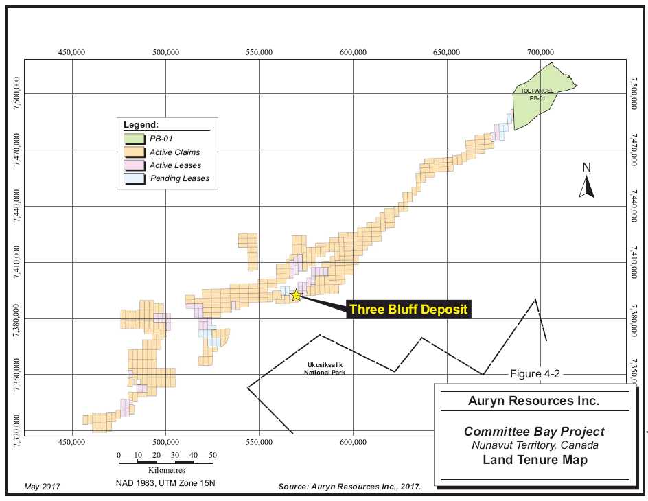
| Figure 4-1 | Location Map | 4-5 |
| Figure 4-2 | Claim Map | 4-6 |
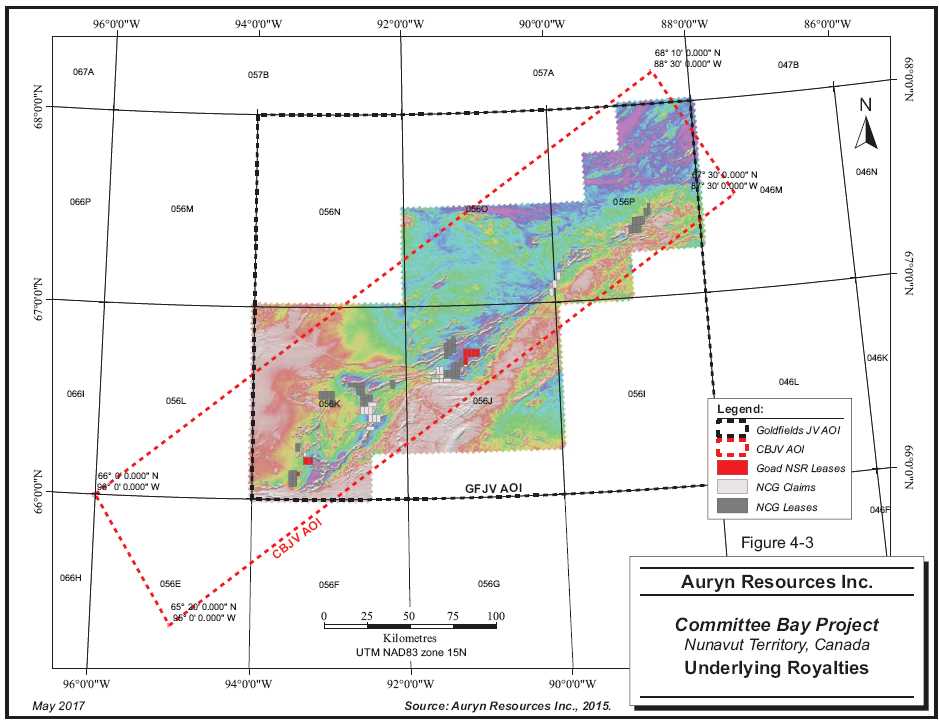
| Figure 4-3 | Underlying Royalties | 4-7 |
| Figure 6-1 | 2004 and 2012 Ground Magnetic Survey – Three Bluffs | 6-7 |
| Figure 6-2 | Three Bluffs Hinge Zone Drilling | 6-12 |
| Figure 6-3 | Walker Lake Trend Drilling | 6-13 |
| Figure 6-4 | Drilling to 2011 | 6- 15 |
| Figure 6-5 | West Plains Drill Program | 6-16 |
| Figure 7-1 | Regional Geology | 7-3 |
| Figure 7-2 | Local Geology | 7-7 |
| Figure 7-3 | Property Geology | 7- 13 |
| Figure 7-4 | Magnetic Compilation | 7-14 |
| Figure 7-5 | Mineral Occurrences | 7-16 |
| Figure 9-1 | 2016 Till Sample Locations | 9-3 |
| Figure 9-2 | 2016 Total Field Magnetic Survey | 9-4 |
| Figure 10- 1 | 2015 and 2016 Drill Hole Locations | 10-2 |
| Figure 10- 2 | West Plains RAB Drilling | 10-6 |
| Figure 10- 3 | Anuri RAB Drilling | 10-7 |
| Figure 10- 4 | Muskox RAB Drilling | 10-8 |
| Figure 10-5 | Core Handling and Sampling Workflow | 10- 19 |
| Figure 11- 1 | 2016 Diamond Drilling Sample Preparation and Analysis Flow Sheet | 11-4 |
| Figure 11- 2 | 2016 RAB Drilling Sample Preparation and Analysis Flow Sheet | 11-5 |
| Figure 13- 1 | Process Plant Flowsheet | 13-8 |
| Figure 14-1 | 3D View of Wireframe Models | 14-4 |
| Figure 14- 2 | Downhole Semi-variogram | 14-8 |
| Figure 14- 3 | Experimental Semi-Variograms | 14-9 |
| Figure 23- 1 | Adjacent Properties | 23-2 |
| Auryn Resources Inc. – Committee Bay Project, Project #2655 | |
| Technical Report NI 43- 101 – October 23, 2017 | Page iii |
| | www.rpacan.com |
LIST OF APPENDIX FIGURES & TABLES
| | | PAGE |
| | | |
| Table 30-1 | Committee Bay Project Leases | 30-2 |
| Table 30-2 | Committee Bay Project Claims | 30-3 |
| Table 31-1 | 2010 Drilling Significant Assays | 31-2 |
| Table 31-2 | 2011 Drilling Significant Assays | 31-4 |
| Table 31-3 | 2012 Drilling Significant Assays | 31-7 |
| Auryn Resources Inc. – Committee Bay Project, Project #2655 | |
| Technical Report NI 43- 101 – October 23, 2017 | Page iv |
| | www.rpacan.com |
1 SUMMARY
EXECUTIVE SUMMARY
Roscoe Postle Associates Inc. (RPA) was retained by Auryn Resources Inc. (Auryn) to prepare an updated independent Technical Report on the Committee Bay Project (the Project or the Property), located in Nunavut Territory, Canada. The purpose of this report is to document the current Mineral Resource estimate and recent work completed by Auryn on the Project. This Technical Report conforms to NI 43-101 Standards of Disclosure for Mineral Projects. RPA visited the Property on August 16-17, 2016.
The Project comprises three non-contiguous blocks consisting of 44 crown leases, 274 claims, and one sub-surface exploration agreement covering Inuit Owned Land (IOL) totalling approximately 427,978 ha, located in 1:250,000 scale NTS map sheets 56J, 56K, 59O and 56P, approximately 430 km northwest of the town of Rankin Inlet. Applications for 13 additional leases totalling approximately 13,714 ha are pending. The Property is accessible only by air.
Auryn is a Vancouver-based company formed in June 2008 and is a reporting issuer in British Columbia, Alberta, and Ontario. The common shares of Auryn trade on the Toronto Stock Exchange and the OTCQX Market. The company is under the jurisdiction of the British Columbia Securities Commission.
On March 20, 2015, Auryn announced that it had entered into a definitive joint venture agreement with North Country Gold Corp. (NCG) whereby it could earn a 51% interest in NCG’s Committee Bay Project by incurring $6 million in expenditures over a 30-month period.
On June 30, 2015, Auryn announced that it had entered into a letter agreement with NCG whereby it would acquire all the NCG shares that it did not already own in exchange for 13.8 million shares of Auryn valued at approximately $20.4 million. The Auryn shares issued as part of the agreement constituted approximately 30.7% of Auryn’s outstanding shares. On September 25, 2015, Auryn announced that it had completed the agreement and that NCG had become a subsidiary of Auryn.
| Auryn Resources Inc. – Committee Bay Project, Project #2655 | |
| Technical Report NI 43- 101 – October 23, 2017 | Page 1-1 |
| | www.rpacan.com |
Currently, the major asset associated with the Project is a strategic land position covering prospective lithologies and structures for gold deposits. The Property hosts the Three Bluffs deposit, which is at the Mineral Resource definition stage, as well as a large land position, which merits additional exploration. A number of other gold targets, in addition to the Three Bluffs deposit, have been identified on the Property, most of which have yet to be fully evaluated.
Since acquiring the Property, Auryn has initiated a comprehensive exploration program consisting of geological mapping, till sampling, aerial drone imagery, a combined airborne magnetic gradiometer and electromagnetic survey, and rotary air blast (RAB) and diamond drilling.
The Mineral Resource estimate prepared by RPA for the Three Bluffs deposit as of May 31, 2017 is summarized in Table 1-1. The Mineral Resource is based on work by RPA in 2013 and new cut-off grades based on updated metal price, exchange rate, and operating costs.
TABLE 1-1 MINERAL RESOURCES AS OF MAY 31, 2017
Auryn Resources Inc. – Committee Bay Project
| | | | | Gold | Contained |
| Class | Type | Cut-Off | Tonnes | Grade | Gold |
| | | (g/t Au) | (000 t) | (g/t Au) | (oz Au) |
| Indicated | Open Pit | 3.0 | 1,760 | 7.72 | 437,000 |
| | Underground | 4.0 | 310 | 8.57 | 86,000 |
| | Total | | 2,070 | 7.85 | 524,000 |
| | | | | | |
| Inferred | Open Pit | 3.0 | 590 | 7.57 | 144,000 |
| | Underground | 4.0 | 2,340 | 7.65 | 576,000 |
| | Total | | 2,930 | 7.64 | 720,000 |
| Notes: | | |
| | 1. | CIM definitions were followed for Mineral Resources. |
| 2. | Mineral Resources are estimated at cut-off grades of 3.0 g/t Au for open pit and 4.0 g/t Au for underground. |
| 3. | Mineral Resources are estimated using a long-term gold price of US$1,200 per ounce, and a US$/C$ exchange rate of 1:25. |
| | 4. | Nominal minimum mining widths of five metres (open pit) and two metres (underground) were used. |
| | 5. | Numbers may not add due to rounding. |
RPA is not aware of any environmental, permitting, legal, title, taxation, socio-economic, marketing, political, or other relevant factors that could materially affect the Mineral Resource estimate.
| Auryn Resources Inc. – Committee Bay Project, Project #2655 | |
| Technical Report NI 43- 101 – October 23, 2017 | Page 1-2 |
| | www.rpacan.com |
CONCLUSIONS
The Property is located within the granite-greenstone rocks of the Archean Prince Albert group, a component of the Rae Domain within the Western Churchill Province. The Three Bluffs gold deposit is characterized by a thick interval of iron formation that appears to form the nose of an upright isoclinal antiform. The majority of the gold mineralization is hosted in silicate, oxide, and/or sulphide facies iron formation. Gold mineralization has also been identified in shear hosted quartz veins in sedimentary and volcanic rocks.
Drilling has outlined mineralization with three-dimensional continuity, and size and grades that can potentially be extracted economically. Project geologists have a good understanding of the regional, local, and deposit geology and controls on mineralization. The geological models are reasonable and plausible interpretations of the drill results.
Exploration protocols for drilling, sampling, analysis, security, and database management meet industry standard practices. The drill hole database was verified by RPA and is suitable for Mineral Resource estimation work.
The previous Mineral Resource model prepared by RPA in April 2013 remains current and has been assigned a new effective date of May 31, 2017. There has been no new drilling in the immediate area of those resources. The cut-off grades were adjusted based on an updated metal price, exchange rate, and operating cost assumptions.
Mineral Resources for the Three Bluffs deposit were estimated assuming combined open pit and underground mining methods. At cut-off grades of 3.0 g/t Au for open pit and 4.0 g/t Au for underground, Indicated Mineral Resources are estimated to total 2.07 Mt at an average grade of 7.85 g/t Au containing 524,000 ounces gold. At the same cut-off grades, Inferred Mineral Resources are estimated to total 2.93 Mt at an average grade of 7.64 g/t Au containing 720,000 ounces gold. The open pit resources were constrained by a preliminary pit shell generated in Whittle software. Underground resources are reported at the high cut-off grade outside of the pit shell.
The limited metallurgical testwork conducted so far suggests that the gold can be recovered by conventional means, such as a combination of gravity and flotation followed by cyanide leaching of the concentrate. In RPA’s opinion, however, additional metallurgical testwork is warranted.
| Auryn Resources Inc. – Committee Bay Project, Project #2655 | |
| Technical Report NI 43- 101 – October 23, 2017 | Page 1-3 |
| | www.rpacan.com |
The Project covers virtually all of the Committee Bay supracrustal belt which hosts a regionally significant and highly prospective corridor for gold. Previous exploration on the Committee Bay Project did not effectively screen the large property holdings. Auryn’s exploration strategy is both successful and cost effective. Auryn’s work in 2015 and 2016, which covers approximately 85% of the current property holdings, was able to highlight 17 significant gold in till anomalies, several of which are located away from any previously known gold occurrences. There is good potential to discover additional mineralization and to add to the resource base on the Property.
RECOMMENDATIONS
RPA has reviewed and concurs with Auryn’s proposed exploration programs and budgets. Phase 1 of the recommended work program will include a desktop review of the 2015 and 2016 exploration results in an effort to define the most effective exploration program to determine the source of the recently identified 17 gold in till anomalies. The field portion of Phase 1 will consist of boulder mapping, detailed infill till sampling, and ground magnetics to identify the highest probability targets which will be immediately drill tested. In addition to the target follow-up, Phase 1 exploration should include the completion of the regional till sampling and drone programs over the remaining 15% of the Committee Bay Greenstone Belt (CBGB).
The Phase 1 program is anticipated to include collection of 17,000 detailed infill till samples and 2,350 regional till samples and completion of 1,200 km2 of drone coverage and 25,000 m of RAB drilling. The Phase 1 program is estimated to cost approximately $20 million.
A Phase 2 exploration program, contingent on the results of Phase 1, will mainly consist of drilling. Initially, all of the Three Bluffs drill core should be re-logged so that controls on mineralization can be better understood. Following that, 5,000 m to 10,000 m of exploration diamond drilling is proposed at Three Bluffs to test for the continuity of high grade mineralization at depth and along strike from the current deposit. In addition to the focused work at Three Bluffs, it is recommended that any significant RAB drill intersections from the Phase 1 program be followed up with additional RAB drilling and focused diamond drilling. It is also anticipated that additional targets will be identified during the completion of the regional program and these will have to be targeted using a systematic approach, which includes boulder mapping, detailed infill till sampling, and ground magnetics.
| Auryn Resources Inc. – Committee Bay Project, Project #2655 | |
| Technical Report NI 43- 101 – October 23, 2017 | Page 1-4 |
| | www.rpacan.com |
The Phase 2 exploration program is anticipated to include the completion of both diamond and RAB drilling, along with the collection of surface samples. The recommended Phase 2 program is estimated to cost between $20 million and $25 million.
Details of the recommended programs can be found in Table 1-2.
TABLE 1-2 PROPOSED BUDGETS
Auryn Resources Inc. – Committee Bay Project
| ITEM | | C$ | |
| PHASE 1 | | | |
| Head Office Expenses | | 228,000 | |
| Project Management/Staff Cost | | 2,462,000 | |
| Expense Account/Staff Travel | | 1,771,000 | |
| Lease Payments | | 157,000 | |
| Till Sampling | | 685,000 | |
| Ground Magnetics | | 200,000 | |
| Drone Surveying | | 93,000 | |
| RAB Drilling | | 4,863,000 | |
| Assaying/Analyses | | 1,084,000 | |
| Camp Costs | | 650,000 | |
| Air Support | | 5,936,000 | |
| Subtotal | | 18,129,000 | |
| Contingency | | 1,813,000 | |
| TOTAL | | 19,942,000 | |
| | | | |
| PHASE 2 | | | |
| Head Office Expenses | | 250,000 | |
| Project Management/Staff Cost | | 2,500,000 | |
| Expense Account/Staff Travel | | 1,800,000 | |
| Lease Payments | | 157,000 | |
| Till Sampling | | 500,000 | |
| RAB Drilling | | 2,000,000 | |
| Diamond Drilling | | 6,000,000 | |
| Assaying/Analyses | | 1,100,000 | |
| Resource Estimate Update | | 65,000 | |
| Metallurgical Test Work | | 100,000 | |
| Air Support | | 6,000,000 | |
| Camp Costs | | 700,000 | |
| Subtotal | | 21,172,000 | |
| Contingency | | 2,117,000 | |
| TOTAL | | 23,289,000 | |
| Auryn Resources Inc. – Committee Bay Project, Project #2655 | |
| Technical Report NI 43- 101 – October 23, 2017 | Page 1-5 |
| | www.rpacan.com |
TECHNICAL SUMMARY
PROPERTY DESCRIPTION AND LOCATION
The Project is located in the eastern part of the Kitikmeot Region of Nunavut, approximately 430 km northwest of the town of Rankin Inlet, Nunavut. The Project is only accessible by air, either from Rankin Inlet or Yellowknife, Northwest Territories. The Project is centred at approximately 7,400,000m N and 570,000m E (NAD 83, Zone 15N) in 1:250,000 scale map sheets 56J (Waker Lake), 56K (Laughland Lake), 56O (Arrowsmith River) and 56P (Ellice Hills).
LAND TENURE
As of the effective date of this report, the Project consists of three non-contiguous blocks totalling 44 crown leases, 274 claims and one sub-surface exploration agreement covering IOL totalling approximately 427,978 ha. Auryn reports that the leases, claims and the sub-surface exploration agreement are in good standing. Applications are pending for an additional 13 leases totalling approximately 13,714.5 ha.
On March 20, 2015, Auryn announced that it had entered into a definitive joint venture agreement with NCG whereby it could earn a 51% interest in NCG’s Committee Bay Project by incurring $6 million in expenditures over a 30 month period. Of that amount, $500,000 was a firm commitment to be spent within 12 months. Auryn also agreed to buy 10 million of NCG shares at a price of $0.05 each as part of a non-brokered private placement.
On June 30, 2015, Auryn announced that it had entered into a letter agreement with NCG whereby it would acquire all the NCG shares that it did not already own in exchange for 13.8 million shares of Auryn valued at approximately $20.4 million. The Auryn shares issued as part of the agreement constituted approximately 30.7% of Auryn’s outstanding shares. On September 25, 2015, Auryn announced that it had completed the agreement and that NCG had become a subsidiary of Auryn
EXISTING INFRASTRUCTURE
There is no permanent infrastructure on the Property. Auryn maintains three camps to support seasonal exploration campaigns in various portions of the Property, namely the Hayes Camp (100 person capacity), the Bullion Camp (20 to 40 person capacity) and the Ingot Camp (10 person capacity). The Project also benefits from a 914 m, graded, esker airstrip at the Hayes Camp, a permitted, seasonally prepared 1,580 m winter ice airstrip, which is constructed on the adjacent Sandspit Lake, and 320 m tundra airstrip at the Bullion Camp. A drill water system is maintained at the Three Bluffs site.
| Auryn Resources Inc. – Committee Bay Project, Project #2655 | |
| Technical Report NI 43- 101 – October 23, 2017 | Page 1-6 |
| | www.rpacan.com |
HISTORY
Key historical events are:
1961 and 1967: Mapping done in the area by the Geological Survey of Canada (GSC).
1970: King Resources Company conducted reconnaissance geological mapping and sampling in the Laughland Lake and Ellice Hills areas. Follow-up work includes geophysics and detailed mapping, trenching, and sampling.
1970, 1974, and 1976: Cominco Ltd. carried out reconnaissance and detailed geological mapping, ground geophysics, and sampling in the Hayes River area.
1971: The Aquitaine Company conducted airborne electromagnetic (EM) and magnetometer surveys.
1972 to 1977: Detailed re-mapping of the area was done by the GSC.
1979: Urangesellschaft Canada Ltd. carried out reconnaissance airborne radiometric surveys and prospecting for uranium in the Laughland Lake area.
1986: Wollex carried out geological mapping and rock sampling in the West Laughland Lake area.
1992: GSC conducted geological re-assessment of the mineral potential of the Prince Albert Group.
1994: Channel sampling carried out over the Three Bluffs area but the results were lost.
1996: Terraquest Ltd. conducted a high-resolution airborne magnetometer survey.
1997 to 1998: P.H. Thompson Geological Consulting Ltd. conducted regional geological mapping in the Three Bluffs area.
1999 to 2002: GSC conducted a multi-disciplinary study of the Committee Bay Greenstone Belt.
1992 to 2012: Apex Geoscience Ltd. (Apex) carried out prospecting, rock sampling, gridding, airborne and ground geophysics, geological mapping, and reverse circulation and diamond drilling on several of the gold targets including Three Bluffs, Three Bluffs West, West Plains, Anuri, Inuk, Antler, and Hayes.
GEOLOGY AND MINERALIZATION
The Committee Bay area, situated in the Churchill Structural Province, is underlain by Archean and Proterozoic rocks and extensively covered by Quaternary glacial drift. It comprises three distinct Archean sub-domains (Prince Albert Group, Northern Migmatite, and Walker Lake Intrusive Complex).
| Auryn Resources Inc. – Committee Bay Project, Project #2655 | |
| Technical Report NI 43- 101 – October 23, 2017 | Page 1-7 |
| | www.rpacan.com |
The CBGB, which hosts the gold occurrences discussed in this report, is composed of Prince Albert Group rocks. These are bounded by the wide, northeast-striking Slave-Chantrey mylonite belt to the northwest and by the Amer and Wager Bay shear zones to the south. Two major fault systems, the northeast-striking Kellet fault and the northwest-striking Hayes River fault, intersect the central portion of the CBGB and cut the Prince Albert Group rocks. Gold occurrences in the CBGB appear to be spatially related to the major shear systems and their sub-structures indicating the potential for the re-mobilization of mineral-bearing fluids along these structures.
The regional strike of rock units in the West Laughland Lake area is generally north but shows a degree of variability. Units, generally vertically dipping in much of the CBGB, have a more moderate to shallow dip at Four Hills. Rocks generally strike northeast from Four Hills east to Committee Bay. In the Hayes River area, the east-striking Walker Lake shear zone is the dominant structure. Dips in the Hayes River area are generally sub-vertical and there is evidence of flexural shear and silicification along lithological contacts between iron formation and talc-actinolite schist (meta-komatiite). Rocks of the Curtis River area, approximately 120 km northeast of the Hayes River area, strike northeast and dip sub-vertically.
The iron formations that host the Three Bluffs, Antler, Hayes, and Ledge gold occurrences have unique lithological associations with their contact rocks and do not appear to be stratigraphically equivalent.
Three low, rounded, rusty outcrops, called West, Central, and East, comprise the Three Bluffs gold occurrence. Gold mineralization is hosted in gossanous, predominantly oxide, silicate, and sulphide facies iron formations. Iron formation thicknesses range from 25 m to 30 m at the West Bluff to 55 m at the Central Bluff. The Three Bluffs iron formation maintains a thickness of 10 m for a minimum strike length of 1.8 km and is at least 55 m thick for 700 m. The iron formations are poorly banded to massive with locally shared, quartz-veined intervals of up to three metres near lithological contacts. Chlorite and epidote alteration indicates either lower amphibolite grade metamorphism (epidote-amphibolite facies) or the result of retrograde greenschist facies metamorphism associated with gold deposition. Local mineralization, composed of disseminated pyrite and pyrrhotite, can occupy up to 50% of the rock volume.
| Auryn Resources Inc. – Committee Bay Project, Project #2655 | |
| Technical Report NI 43- 101 – October 23, 2017 | Page 1-8 |
| | www.rpacan.com |
EXPLORATION STATUS
The Three Bluffs deposit is at the Mineral Resource development stage. The remainder of the Property is at the early exploration stage.
In 2015 and 2016, Auryn completed a total of 95 RAB holes for approximately 13,045 m and seven diamond drill holes for approximately 3,715 m on the Property. This drilling was located on new prospects and did not affect the current Mineral Resources.
MINERAL RESOURCES
The Mineral Resources at the Project are estimated to be approximately 2.07 million tonnes of Indicated Mineral Resources grading 7.85 g/t Au, containing 524,000 ounces of gold, and 2.93 million tonnes of Inferred Mineral Resources grading 7.64 g/t Au, containing 720,000 ounces of gold.
The estimate was carried out using a block model method constrained by wireframe grade-shell models, with Inverse Distance Cubed (ID3) weighting. Two sets of wireframes and block models were employed: one contemplated open pit mining and the other, underground mining. A lower set of cut-off criteria were used for the open pit versus the underground to reflect the lower costs that should be incurred by mining from surface. To fulfil the resource criteria of “reasonable prospects for eventual economic extraction”, a preliminary pit shell was generated from the open pit model. Blocks from the open pit model captured within this shell were considered eligible for reporting as open pit resources. The same pit shell was applied to the underground model, except that blocks from this model were included in the resource only if they were outside of the shell.
There are no current Mineral Reserves on the Committee Bay Project.
| Auryn Resources Inc. – Committee Bay Project, Project #2655 | |
| Technical Report NI 43- 101 – October 23, 2017 | Page 1-9 |
| | www.rpacan.com |
2 INTRODUCTION
Roscoe Postle Associates Inc. (RPA) was retained by Auryn Resources Inc. (Auryn) to prepare an updated independent Technical Report on the Committee Bay Project (the Project or the Property), located in Kitikmeot Region, northeastern Nunavut Territory, Canada. The purpose of this report is to document the current Mineral Resource estimate and recent work completed by Auryn on the Project. This Technical Report conforms to NI 43-101 Standards of Disclosure for Mineral Projects.
Auryn is a Vancouver-based exploration company formed in June 2008 which is engaged in acquiring, exploring, and evaluating natural resource properties in Canada and Peru. It is a reporting issuer in British Columbia, Alberta, and Ontario whose common shares trade on the Toronto Stock Exchange (TSX:V-AUG) and the OTCQX Market (OTCQX:GGTCF). Auryn is under the jurisdiction of the British Columbia Securities Commission.
Apart from the Committee Bay Project, Auryn controls a large land position along the Gibsons MacQuoid greenstone belt elsewhere in Nunavut, the Mineral Resource development stage Au-Ag-Cu Homestake Ridge property in British Columbia, and a portfolio of properties with the potential to host epithermal Au-Ag and porphyry Cu-Au mineralization in Peru.
On March 20, 2015, Auryn announced that it had entered into a definitive joint venture agreement with North Country Gold Corp. (NCG) whereby it could earn a 51% interest in the Project by incurring $6 million in expenditures over a 30 month period. Of that amount, $500,000 was a firm commitment to be spent within 12 months. Auryn also agreed to buy 10 million NCG shares at a price of $0.05 each as part of a non-brokered private placement.
On September 25, 2015, Auryn announced that it had closed an agreement with NCG whereby it would acquire all the NCG shares that it did not already own in exchange for 13.8 million shares of Auryn valued at approximately $20.4 million resulting in NCG becoming a subsidiary of Auryn.
Since acquiring its initial right to earn an interest in the Property, Auryn has initiated a comprehensive exploration program consisting of geological mapping and sampling, till sampling, high resolution drone imagery, ground and airborne geophysical surveying as well as both rotary air blast and diamond drilling.
| Auryn Resources Inc. – Committee Bay Project, Project #2655 | |
| Technical Report NI 43- 101 – October 23, 2017 | Page 2-1 |
| | www.rpacan.com |
Currently, the major asset associated with the Project is a strategic land position covering prospective lithologies and structures for gold deposits. The Property hosts the Three Bluffs deposit, which is at the resource definition stage, as well as a large land position, which merits additional exploration.
SOURCES OF INFORMATION
A site visit to the Property was carried out by David Ross, M.Sc., P.Geo., Principal Geologist with RPA, on August 16-17, 2016. During and subsequent to the site visit, discussions were held with the following personnel from Auryn and Apex Geoscience Ltd. (Apex):
Michael Henrichsen, COO, Auryn
Peter Rees, CFO and Corporate Secretary, Auryn
David Smithson, Vice President Exploration, Auryn
Yury Likhtarov, Manager Database and Resources, Auryn
Bryan Atkinson, Auryn
Philo Schoeman, P.Geo., Apex
Apex is a privately-owned geological consulting company which has carried out a significant portion of the exploration work on the Project.
Mr. Ross prepared all sections of this report and is the Independent Qualified Person (QP) for this report.
The documentation reviewed, and other sources of information, are listed at the end of this report in Section 27 References.
| Auryn Resources Inc. – Committee Bay Project, Project #2655 | |
| Technical Report NI 43- 101 – October 23, 2017 | Page 2-2 |
| | www.rpacan.com |
LIST OF ABBREVIATIONS
Units of measurement used in this report conform to the metric system. All currency in this report is Canadian dollars (C$) unless otherwise noted.
| a | | annum | | | kWh | | | kilowatt-hour | |
| A | | ampere | | | L | | | litre | |
| bbl | | barrels | | | lb | | | pound | |
| btu | | British thermal units | | | L/s | | | litres per second | |
| °C | | degree Celsius | | | m | | | metre | |
| C$ | | Canadian dollars | | | M | | | mega (million); molar | |
| cal | | calorie | | | m2 | | | square metre | |
| cfm | | cubic feet per minute | | | m3 | | | cubic metre | |
| cm | | centimetre | | | µ | | | micron | |
| cm2 | | square centimetre | | | MASL | | | metres above sea level | |
| d | | day | | | µg | | | microgram | |
| dia | | diameter | | | m3/h | | | cubic metres per hour | |
| dmt | | dry metric tonne | | | mi | | | mile | |
| dwt | | dead-weight ton | | | min | | | minute | |
| °F | | degree Fahrenheit | | | µm | | | micrometre | |
| ft | | foot | | | mm | | | millimetre | |
| ft2 | | square foot | | | mph | | | miles per hour | |
| ft3 | | cubic foot | | | MVA | | | megavolt-amperes | |
| ft/s | | foot per second | | | MW | | | megawatt | |
| g | | gram | | | MWh | | | megawatt-hour | |
| G | | giga (billion) | | | oz | | | Troy ounce (31.1035g) | |
| Gal | | Imperial gallon | | | oz/st, opt | | | ounce per short ton | |
| g/L | | gram per litre | | | ppb | | | part per billion | |
| Gpm | | Imperial gallons per minute | | | ppm | | | part per million | |
| g/t | | gram per tonne | | | psia | | | pound per square inch absolute | |
| gr/ft3 | | grain per cubic foot | | | psig | | | pound per square inch gauge | |
| gr/m3 | | grain per cubic metre | | | RL | | | relative elevation | |
| ha | | hectare | | | s | | | second | |
| hp | | horsepower | | | st | | | short ton | |
| hr | | hour | | | stpa | | | short ton per year | |
| Hz | | hertz | | | stpd | | | short ton per day | |
| in. | | inch | | | t | | | metric tonne | |
| in2 | | square inch | | | tpa | | | metric tonne per year | |
| J | | joule | | | tpd | | | metric tonne per day | |
| k | | kilo (thousand) | | | US$ | | | United States dollar | |
| kcal | | kilocalorie | | | USg | | | United States gallon | |
| kg | | kilogram | | | USgpm | | | US gallon per minute | |
| km | | kilometre | | | V | | | volt | |
| km2 | | square kilometre | | | W | | | watt | |
| km/h | | kilometre per hour | | | wmt | | | wet metric tonne | |
| kPa | | kilopascal | | | wt% | | | weight percent | |
| kVA | | kilovolt-amperes | | | yd3 | | | cubic yard | |
| kW | | kilowatt | | | yr | | | year | |
| Auryn Resources Inc. – Committee Bay Project, Project #2655 | |
| Technical Report NI 43- 101 – October 23, 2017 | Page 2-3 |
| | www.rpacan.com |
3 RELIANCE ON OTHER EXPERTS
This report has been prepared by RPA for Auryn. The information, conclusions, opinions, and estimates contained herein are based on:
Information available to RPA at the time of preparation of this report,
Assumptions, conditions, and qualifications as set forth in this report, and
Data, reports, and other information supplied by Auryn and other third party sources.
For the purpose of this report, RPA has relied on ownership information provided by Auryn. RPA has not researched property title or mineral rights for the Committee Bay Project and expresses no opinion as to the ownership status of the Property.
Except for the purposes legislated under provincial securities laws, any use of this report by any third party is at that party’s sole risk.
| Auryn Resources Inc. – Committee Bay Project, Project #2655 | |
| Technical Report NI 43- 101 – October 23, 2017 | Page 3-1 |
| | www.rpacan.com |
4 PROPERTY DESCRIPTION AND LOCATION
The Committee Bay Project consists of three non-contiguous block of claims located in eastern part of the Kitikmeot Region of Nunavut, located approximately 430 km northwest of the town of Rankin Inlet (Figure 4-1). The Project is only accessible by air. Fixed-wing and helicopter charters may be arranged either from Rankin Inlet, Nunavut, or from Yellowknife, Northwest Territories (NWT).
The three claim blocks are grouped over a distance of approximately 280 km in a northeast–southwest direction. The approximate centre of the Project is located at Universal Transverse Mercator (UTM) co-ordinates 7,400,000m N and 570,000m E (NAD 83, Zone 15N). The approximate UTM co-ordinates for the centre of the currently defined Three Bluffs mineralization are 7,393,600m N and 568,000m E. The Project is located within National Topographic System (NTS) 1:250,000 scale map sheets 56J (Walker Lake), 56K (Laughland Lake), 56O (Arrowsmith River) and 56P (Ellice Hills).
LAND TENURE
The Project consists of three non-contiguous blocks totalling 44 crown leases, 274 claims, and one sub-surface exploration agreement covering IOL totalling approximately 427,978 ha. Applications are pending for an additional 13 leases totalling approximately 13,714.5 ha (Figure 4-2). Tables 30-1, 30-2 and 30-3, Appendix 1, list all of the subject leases, claims and sub-surface exploration agreement along with the relevant tenure information for the lands including their designated number, registration and expiry dates, area, assessment work credits and work requirements for renewal. The claims are map designated and have pre-established positions. No legal survey of the claims is required.
Assessment credits totalling $3,221,320.29 are required in order to renew all of the Project claims upon their respective anniversary dates. Assessment credits of $162,623.14 are currently available.
Lease payments of $2.50/ha, totalling $145,474.20 annually, are required to maintain the Project leases in good standing.
| Auryn Resources Inc. – Committee Bay Project, Project #2655 | |
| Technical Report NI 43- 101 – October 23, 2017 | Page 4-1 |
| | www.rpacan.com |
Some claims comprising the Property have a full ten years of assessment and no longer require additional expenditures for their maintenance and have been, or will be, converted to leases. All the mineral leases were legally surveyed and registered by Ollerhead and Associates of Yellowknife, NWT with the Mining Recorder’s and Surveyor General’s offices in Iqaluit, Nunavut. The mineral leases and claims are shown in Figure 4-2.
On March 20, 2015, Auryn announced that it had entered into a definitive joint venture agreement with NCG whereby it could earn a 51% interest in NCG’s Committee Bay Project by incurring $6 million in expenditures over a 30 month period. Of that amount, $500,000 was a firm commitment to be spent within 12 months. Auryn also agreed to buy 10 million NCG shares at a price of $0.05 each as part of a non-brokered private placement.
On June 30, 2015, Auryn announced that it had entered into a letter agreement with NCG whereby it would acquire all the NCG shares that it did not already own in exchange for 13.8 million shares of Auryn valued at approximately $20.4 million. The Auryn shares issued as part of the agreement constituted approximately 30.7% of Auryn’s outstanding shares. On September 25, 2015, Auryn announced that it had completed the agreement and that NCG had become a subsidiary of Auryn.
MINERAL RIGHTS
Crown lands in Nunavut are managed pursuant to the Territorial Lands Act and its related Regulations, including the Nunavut Mining Regulations. Sub-surface lands include hard-rock minerals, precious gems, and coal. The rights to these materials are administered through the Nunavut Mining Regulations and the Territorial Coal Regulations. There is a distinction between sub-surface minerals and surface mineral substances that have specific purposes such as carving stone and building materials. These special use surface minerals are administered through the Territorial Quarry Regulations. The Nunavut Mining Recorder’s office is responsible for sub-surface rights administration of Crown Land. The Mining Recorder’s office is responsible for administering the Nunavut Mining Regulations which entered into force on March 31, 2014.
The NCG property and exploration camps are, in part, situated on Inuit Owned Lands (IOL) wherein the Inuit control surface rights but not subsurface or mineral rights. There are no annual fees for the IOL and no claims in the Three Bluffs area, located on IOL.
| Auryn Resources Inc. – Committee Bay Project, Project #2655 | |
| Technical Report NI 43- 101 – October 23, 2017 | Page 4-2 |
| | www.rpacan.com |
ROYALTIES AND OTHER ENCUMBRANCES
Several claims comprising the Property are subject to royalties. Terracon Geotechnique Ltd. (Terracon) and a group formerly Apex Geoscience Ltd. (Apex) each hold a 0.5% net smelter return (NSR) royalty on the property and the area of interest referenced in Figure 4-3 (denoted CBJV AOI). Effective May 30, 2011, Apex transferred 51% of its 0.5% NSR to a private party, Oar-Rock Geoscience Ltd., and the remaining 49% interest to two companies: 677081 Alberta Ltd. and 678119 Alberta Ltd.
Maverix Metals Inc. holds a 1% gross override diamond royalty on the area denoted in Figure 4-3 as GFJV AOI.
Bruce Goad holds a 1.5% NSR on the following claims (see Figure 4-3 and Table 30-1 in Appendix 1):
Wren 1 to 5 claims, inclusive (claim tag F60231 to F60235, inclusive)
Pick 2 and 3 claims (claim tags F54798 and F54760)
West claim (claim tag F60212)
The Goad NSR royalty can be bought down for $2 million for each 0.5% NSR.
Gold production from the Three Bluffs deposit would only trigger the royalty due under the CBJV AOI.
RPA is not aware of any other royalties, back-in rights, or other obligations related to the acquisition of NCG or any other underlying agreement.
PERMITTING
Land use permits are required to conduct exploration on both IOL and non-Inuit owned lands. The majority of the IOL parcels in the Committee Bay area are administered by the Kitikmeot Inuit Association (KIA). Land use permits for non-Inuit owned lands (Federal lands) are obtained from Aboriginal Affairs and Northern Development Canada. A water permit for any and all uses of water, including camp and drilling, is also required in order to conduct exploration work in Nunavut. The permitted camp and work sites are subject to inspection by the administrators of various permits as well as representatives of the Workers Safety and Compensation Commission.
| Auryn Resources Inc. – Committee Bay Project, Project #2655 | |
| Technical Report NI 43- 101 – October 23, 2017 | Page 4-3 |
| | www.rpacan.com |
The following is a list of permits and licences acquired and maintained in good standing by Auryn:
Indigenous and Northern Affairs Canada Commercial Leases: 056J/11-1-2, 056J/12- 1-2
Indigenous and Northern Affairs Canada Land Use Permits: N2014CD002 (Bullion Camp), N2014C0005 (Hayes Camp)
Kitikmeot Inuit Association Land Use Permit: KTL314C003 (Ingot and Crater Camps)
Kitikmeot Inuit Association Land Use Permit: KTL116B008 (PB-01)
Nunavut Impact Review Board Project Reference Number: 07EN021
Nunavut Water Board Licence: 2BE-CRA1520
RPA is not aware of any environmental liabilities on the property. Auryn has all required permits to conduct the proposed work on the property. RPA is not aware of any other significant factors and risks that may affect access, title, or the right or ability to perform the proposed work program on the property.
| Auryn Resources Inc. – Committee Bay Project, Project #2655 | |
| Technical Report NI 43- 101 – October 23, 2017 | Page 4-4 |
| | www.rpacan.com |

4 - 5
| | www.rpacan.com |
4 - 6
| | www.rpacan.com |
4 - 7
| | www.rpacan.com |
5 ACCESSIBILITY, CLIMATE, LOCAL RESOURCES, INFRASTRUCTURE AND PHYSIOGRAPHY
ACCESSIBILITY
The Project is located 430 km northwest of Rankin Inlet, Nunavut. Access to Rankin Inletis achieved via regularly scheduled commercial flights (Canadian North and/or First Air) from Yellowknife, Northwest Territories; Winnipeg, Manitoba; and Ottawa, Ontario.Rankin Inlet and Baker Lake are serviced seasonally by barge and ship. The hamlets of Baker Lake, Naujaat (Repulse Bay), Gjoa Haven, Taloyoak, and Kugaaruk (Pelly Bay) are accessible by scheduled commercial flights.
At the Three Bluffs camp site, Hayes Camp, an esker airstrip is accessible by Twin Otter fixed-wing aircraft on oversized tires from June through early September. Parts of the Hayes River area are accessible to float-equipped fixed-wing aircraft by late June. Fixed-wing and helicopter charters may be arranged either from Rankin Inlet or from Yellowknife. In order to facilitate the mobilization of large quantities of equipment and supplies for exploration programs, a 5,000 ft airstrip (ice-strip) is constructed each spring on Sandspit Lake at Hayes Camp.
CLIMATE
The Project is located in the Wager Bay Plateau Ecoregion of the Northern Arctic Ecozone (Marshall and Schutt, 1999). This ecoregion is classified as having a low arctic ecoclimate. Summers are short and cold, with mean daily temperatures above freezing only in July and August. Snow cover usually lasts from September to June, but it can fall during any month. Most of the lakes are icebound until approximately mid-July.
Precipitation is moderate throughout the year, but drifting of snow in the winter can result in considerable localized accumulations, particularly on the sides of hills. Fog is often a problem near the coast and at higher elevations particularly during the late spring to early summer and the fall months.
| Auryn Resources Inc. – Committee Bay Project, Project #2655 | |
| Technical Report NI 43- 101 – October 23, 2017 | Page 5-1 |
| | www.rpacan.com |
Table 5-1 illustrates the major climatic data for the three closest Environment Canada weather stations, Repulse Bay, Pelly Bay and Gjoa Haven, located approximately 235 km to the east, 220 km to the north, and 290 km to the northwest, respectively.
| TABLE 5-1 CLIMATIC DATA |
| Auryn Resources Inc. – Committee Bay Project |
| | | | |
| | Repulse Bay | Pelly Bay | Gjoa Haven |
| Mean January temperature | -31.3°C | -33°5C | -33.8°C |
| Mean July temperature | 8.8°C | 9.3°C | 11.6°C |
| Extreme maximum temperature | 28.0°C | 29.0°C | 33.6°C |
| Extreme minimum temperature | -50.0°C | -51.5°C | -50.6°C |
| Average annual precipitation | 311.3 mm | 261.3 mm | 272.5 mm |
| Average annual rainfall | 123.8 mm | 116.6 mm | 163.4 mm |
| Average annual snowfall | 215.4 cm | 146.2 cm | 126.5 cm |
Source: Environment Canada
LOCAL RESOURCES
Most services are available in Baker Lake, Kugaaruk, and Rankin Inlet, including: groceries; hotel accommodations; expediting services; and some camp supplies. Anything that is not locally available can be shipped in via daily scheduled air services.
The Rankin Inlet area is a hub of mining activity in the region. Exploration and mining suppliers and contractors are available from Manitoba and the Northwest Territories. General labour is readily available from the local communities.
INFRASTRUCTURE
There are three semi-permanent camps along the Committee Bay Greenstone Belt (CBGB); Haynes (66°39’30”N, 091°32’11”W), Bullion (66°23’39”N, 093°06’55”W), and Ingot (66°35’40”N, 092°37’34”), which are operational as required to support exploration programs in various sectors of the Property. There is no permanent infrastructure on the Property. At the time of RPA’s site inspection, only the Hayes Camp was operational and contained the following:
| Auryn Resources Inc. – Committee Bay Project, Project #2655 | |
| Technical Report NI 43- 101 – October 23, 2017 | Page 5-2 |
| | www.rpacan.com |
PHYSIOGRAPHY
The Project area is located on the northern portion of the glaciated Canadian Shield. Topography varies between 200 MASL and 560 MASL.
This area has been modified by continental glaciation, and comprises numerous glacially sculpted hills, which rise above boulder fields, till moraines, and sand plains.
Rock exposure in the Project area is generally 10% to 20% as either rock outcrop or, more frequently, as felsenmeer. In a few places, rock exposure may reach up to 70%, however, there are also extensive areas in which rock exposure is minimal or non-existent. Extensive felsenmeer is developed in most areas of rock exposure, forming large boulder fields that consist mainly of in-situ frost-heaved blocks.
Turbic and static cryosols developed on discontinuous, thin, sandy moraine and alluvial deposits are the dominant soils. Permafrost is continuous with low ice content.
The area is characterized by a discontinuous cover of tundra vegetation, consisting of dwarf birch, willow, and northern Labrador tea. Taller dwarf birch, willow, and alder occur on warm sites; wet sites are dominated by willow and sedge. Lichen-covered rock outcroppings are prominent throughout the ecoregion, and towards the south the vegetation becomes a mix of tundra vegetation and open, dwarf coniferous forest.
Characteristic wildlife includes caribou, muskox, wolverine, Arctic hare, fox, raptors, and various waterfowl.
| Auryn Resources Inc. – Committee Bay Project, Project #2655 | |
| Technical Report NI 43- 101 – October 23, 2017 | Page 5-3 |
| | www.rpacan.com |
6 HISTORY
EXPLORATION AND DEVELOPMENT HISTORY
The following is taken from Blakley and Rennie (2008), Turner (2010), Rennie and McDonough (2012), and Rennie and McDonough (2015) and describes work completed in the general vicinity of the Project prior to Auryn’s involvement with the Project in 2015.
GEOLOGICAL SURVEY OF CANADA MULTI-DISCIPLINARY STUDIES
The Geological Survey of Canada (GSC) initially mapped the Laughland Lake–Ellice Hills area at a scale of 1:506,880 in 1961 and 1967. Detailed re-mapping (1:250,000) and airborne magnetic surveys were completed between 1972 and 1977. A geological re-assessment of the mineral potential of Prince Albert group (PAg) rocks, within the parts of the Laughland Lake area that lie within the proposed Wager Bay National Park, was performed by the GSC in 1992. Between 1999 and 2002, the GSC, through the Canada-Nunavut Geoscience Office, performed a multi-disciplinary study of the CBGB that included geological (bedrock) mapping (1:100,000 scale), Quaternary surficial mapping, regional till sampling, airborne magnetic surveying, and some rock sampling.
HISTORIC EXPLORATION
Prior to 1992, historical assessment reports indicate that most exploration in the area was focused on the identification of base metals in PAg rocks after reconnaissance mapping by the GSC identified several serpentinized ultramafic intrusions within what was referred to as the “Precambrian metasedimentary belt”.
In 1970, King Resources Company (KRC) performed a base metal exploration program in the Laughland Lake (NTS 56K) and Ellice Hills (NTS 56P) areas. Reconnaissance geological mapping and sampling concentrated on the delineation of ultramafic bodies. Ground geophysical surveys followed the reconnaissance mapping to further delineate the ultramafic zones. The third phase of its exploration consisted of detailed geological mapping, detailed geophysical surveying, trenching, and sampling. From their field work it was concluded that the Project area contained a distinctive linear metasedimentary belt into which ultramafic rocks had been intruded. It was further concluded that the ultramafic rocks contained the nickel content typically seen on other ultramafic orogenic belts worldwide. KRC concluded that the area was favourable for continued nickel exploration.
| Auryn Resources Inc. – Committee Bay Project, Project #2655 | |
| Technical Report NI 43- 101 – October 23, 2017 | Page 6-1 |
| | www.rpacan.com |
The Aquitaine Company of Canada (Aquitaine) conducted base metal exploration on its Har claims (NTS 56K), Heb claims (NTS 56J), and the now expired Prospecting Permits 231 to 234 (NTS 56J and 56K) in 1971. Aquitaine completed a 2,556 line-mile airborne electromagnetic and magnetic survey over the area. The survey resulted in the identification of 18 conducting zones, 47 isolated anomalies, and several areas with good conductivity parameters coupled with coincident magnetic responders. Further ground geophysical and geological follow-up work over the anomalous zones was recommended.
Cominco Limited (Cominco) conducted reconnaissance and detailed geological mapping, ground geophysical surveys and sampling in the Hayes River area (NTS 56J) in 1970 and between 1974 and 1976. This work suggested that the Hayes River area was underlain by predominantly granitic and paragneissic rocks with minor metavolcanics and small zones of komatiitic rocks. Cominco concluded that there was a limited potential on its properties for identifying large ultramafic bodies capable of carrying significant amounts of sulphides and did not recommend further work.
After a number of radiometric anomalies were discovered by the Federal Uranium Reconnaissance Program, Urangesellschaft Canada Ltd., in 1979, performed reconnaissance airborne radiometric surveys and follow-up prospecting for uranium within NTS 56K in the Laughland Lake area. These anomalies were found to have been caused by areas of elevated background radioactivity in gneissic and granitic rocks and were not considered significant. No other work was recommended.
During 1986, Wollex Exploration, a division of Comaplex Minerals Corp., performed reconnaissance geological mapping at 1:20,000 and 1:60,000 scales in a portion of the West Laughland Lake area (NTS 56K). A number of north-northwest trending quartz veins were discovered that returned anomalous silver, lead, and zinc values. Other shear zones were found that carried anomalous gold and arsenic. One magnetite sample and 65 rock samples were collected, however, results were not encouraging enough to recommend further work.
Between 1992 and 2002, Apex performed reconnaissance and detailed exploration for gold within the CBGB region on behalf of several companies related to CBR Gold Corp. (CBR), the predecessor company to NCG. Work included prospecting, rock grab and rock chip sampling, frost boil sampling, gridding, staking, airborne and ground geophysical surveying, geological mapping, and diamond drilling. In 1994, channel sampling was undertaken across Bluff #2 in the Project area, however, that data is missing. Other work includes regional mapping performed by P.H. Thompson Geological Consulting Ltd. during 1997 and 1998 and high-resolution airborne magnetic surveys conducted by Terraquest Ltd. in 1996.
| Auryn Resources Inc. – Committee Bay Project, Project #2655 | |
| Technical Report NI 43- 101 – October 23, 2017 | Page 6-2 |
| | www.rpacan.com |
Gold Fields Limited (GFL), through a subsidiary, entered into an option agreement with CBR in 2003 to acquire up to 55% interest, exclusive of diamond rights, in the CBGB properties by spending C$7.5 million over four years. The agreement stated that GFL could earn an additional 10% interest by expending another C$7.5 million. The diamond rights were subsequently optioned to Indicator Minerals Inc. (Indicator) in 2004.
In 2003, Apex managed the exploration program that comprised 1,388.5 line-km of time-domain electromagnetic (EM) and magnetic airborne geophysical surveys over 11 targets. Diamond drilling comprised 15 holes (totalling 1,480 m) at Three Bluffs, Koffy and Inuk properties, reconnaissance and detailed prospecting (resulting in 530 rock samples collected), and regional geological mapping. The final three holes at Three Bluffs encountered gold mineralization with intersections up to 27.41 g/t Au over 9.44 m.
In 2004, Apex continued to manage the exploration that comprised 6,781 m of diamond drilling, in 47 holes, over five CBGB prospects (Four Hills, Cop, Ledge, Prospector, and Three Bluffs), with the majority of the work being conducted at Three Bluffs (31 holes totalling 5,355 m). Drilling at Three Bluffs aimed to define the zone of gold mineralization that was found in 2003. The results from the 2004 drilling were used to model the mineralization and produce the Project’s initial Mineral Resource estimate. Other work completed in 2004 included lake water geochemical sampling (519 samples), reconnaissance to detailed prospecting (1,639 rock grab samples collected), and regional mapping.
Having met its initial expenditure threshold to acquire 55% of the Project, GFL elected not to expend the additional funds to acquire the additional 10% interest. In 2005, an agreement was reached that provided CBR the opportunity to return to full ownership by spending C$10 million. The 2005 program, funded entirely by CBR, included airborne geophysical surveys, mapping and prospecting, and diamond drilling (2,619 m in seven holes at Three Bluffs and 643 m in three holes at Anuri) that totalled C$8.5 million in expenditures.
| Auryn Resources Inc. – Committee Bay Project, Project #2655 | |
| Technical Report NI 43- 101 – October 23, 2017 | Page 6-3 |
| | www.rpacan.com |
In 2006, GFL allowed its option to lapse and returned 100% ownership to CBR. The 2006 exploration program comprised 3,503 m of drilling at Anuri and West Plains in addition to the collection of 579 rock samples and 175 till samples (Blakley and Rennie, 2008).
The 2007 field program consisted of 5,669 m of diamond drilling at Three Bluffs and Inuk prospects, and the collection of 876 rock grab samples and 687 till samples across the CBGB prospects, mostly in areas that had seen limited previous exploration (Turner, 2010). Of the rock samples collected, 28 returned values greater than 1.0 g/t Au and, of these, three were considered to be new prospects. The remaining 25 samples expanded and confirmed the extent of mineralization at Ghost, Muskox, Maro, Shamrock, Betwixt, and Ridge prospects.
Other gold-associated elements were part of the Inductively Coupled Plasma (ICP) analyses including arsenic and antimony. There were no antimony anomalies, and the three arsenic anomalies that were returned were not considered significant by NCG due to previous results and the lack of significant mineralization and alteration.
Several base metal, notably copper, anomalies were identified. The four highest copper values and four highest silver values were located in the vicinity of the Muskox and Maro prospects. No significant lead and one zinc anomaly, northeast of Castle Rock, was observed (Turner, 2010).
Poor outcrop exposure necessitated the collection of 687 till samples. These samples were taken along designated lines that typically traversed north, roughly “down-ice”, of magnetic and EM anomalies and other areas of interest. Twenty-three samples were taken south of the Ghost occurrence and returned no assays of significance.
Several magnetic features of interest west of the Central Tonalite/Deformation Zone intrusive complex were tested by 79 samples. Several anomalous samples, defined as being in the ninetieth percentile of the anomalies, were identified for future follow-up.
The Shamrock, Betwixt, and Ridge prospects were tested with 48 samples. A cluster of anomalies was identified south of the Shamrock occurrence.
Northwest of the Castle Rock occurrence, 153 samples were taken. Two anomalies were found in an area that was previously identified by a cluster of gold-in-till anomalies. No significant dispersion train was identified potentially indicating a localized gold source near the centre of claim JT2. A previous anomaly at the north end of HYR 9 was confirmed by 2007 sampling. On claim JT3, a 200 ppb Au sample, the highest gold-in-till value of 2007, was taken.
| Auryn Resources Inc. – Committee Bay Project, Project #2655 | |
| Technical Report NI 43- 101 – October 23, 2017 | Page 6-4 |
| | www.rpacan.com |
Northeast of Castle Rock, a poorly exposed regional magnetic anomaly was tested with 284 till samples that followed up two previously identified areas of interest. The 2007 program supported the earlier results on the LL claims.
The KN claims, in the vicinity of the Kinngalugjuaq (Kinng) area occurrence, had nine anomalous results for gold with two small clusters on claims KN 28 and KN 29 (Turner, 2010).
The 2008 program consisted of prospecting, rock and till sampling, and diamond drilling. A total of 2,678 m was cored, and 662 grab samples and 1,170 till samples were taken. CBR took rock and till samples to follow up past anomalous results or to test previously underexplored sections of the CBGB.
A total of 662 rock samples were collected in 2008 to follow up previous anomalies or to test underexplored areas. Only five of the samples returned values greater than 1.0 g/t Au and no antimony anomalies were identified. Four arsenic anomalies were found but all were associated with gold values equal to or less than 1.06 g/t Au. Several minor base metal anomalies were identified for copper, silver, and nickel (Turner, 2010).
A total of 1,170 till samples were collected in 2008 over numerous prospects, none of which returned significant gold assays.
The 2009 exploration program consisted of rock and till sampling; no drilling was conducted in 2009. A total of 666 rock grab samples and 61 till samples were taken (Turner, 2010).
Fieldwork in 2009 concentrated on areas away from known occurrences and, as a result, only two of 666 grab samples returned values greater than 1.0 g/t Au. A sample of altered and mineralized iron formation was collected on claim LL 24 and returned 11.80 g/t Au in an area that had previously identified gold-in-till anomalies. The other anomalous sample was collected from an outcrop on claim KN 26 and assayed 2.11 g/t Au and was the first anomalous sample found on the north side of the Kinng quartzite. Similar to the rock sampling, till sampling in 2009 was intended to investigate areas away from known gold occurrences. No significant gold assays were identified from the 61 samples taken (Turner, 2010).
| Auryn Resources Inc. – Committee Bay Project, Project #2655 | |
| Technical Report NI 43- 101 – October 23, 2017 | Page 6-5 |
| | www.rpacan.com |
Exploration activity conducted by NCG in 2010 comprised additional diamond drilling, the completion of a Titan 24 Induced Polarization (IP) survey over Three Bluffs and along strike to the southwest, and a concurrent field-based prospecting and assessment of the company’s regional mineral properties.
Quantec Geoscience Ltd. conducted a Titan Direct Current (DC)/IP survey on twelve lines, spaced 420 m apart, over the Three Bluffs area and covered from 4.5 km east of Three Bluffs to the Hayes occurrence. The survey identified conductive bodies that correlated with known gold mineralization locations at Three Bluffs as well as new anomalies located at Antler and Hayes. The survey identified new areas of potential gold mineralization along the mostly untested Walker Lake trend.
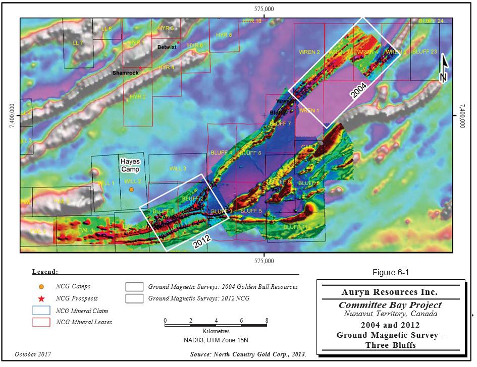
In March 2012, NCG completed a 116 line-km ground magnetic geophysical survey over the area covering the strike extension of the Three Bluffs stratigraphy to the northeast of the main deposit and infilled areas covered by the 2004 geophysical survey. The results indicate linear “magnetic highs” extending from the main linear anomaly of the Walker Lake trend eastward. These magnetic highs were interpreted to represent iron formation stratigraphy. Figure 6-1 illustrates the results of the merged 2004 and 2012 ground magnetic surveys.
No work was performed on the Project in 2013 and 2014.
| Auryn Resources Inc. – Committee Bay Project, Project #2655 | |
| Technical Report NI 43- 101 – October 23, 2017 | Page 6-6 |
| | www.rpacan.com |
6 - 7
| | www.rpacan.com |
HISTORICAL DRILLING
Descriptions of drilling completed in the general vicinity of the Project by NCG and its predecessors prior to 2012 are taken from Blakley and Rennie (2008), Turner (2010), and Rennie and McDonough (2012 and 2015).
2003-2008
From 2003 to 2008, diamond drilling at the Three Bluffs Project was conducted by Connors Drilling Ltd. (Connors) of Kamloops, British Columbia. The standard core size drilled at Three Bluffs at the time was NQ2 (50.6 mm diameter).
2003 DRILLING
In 2003, a total of six holes totalling 694 m were completed at Three Bluffs and an additional nine holes (786 m) were drilled on other prospects for a total of 1,480 m. Drill hole collars, including the historic 1994 to 1996 holes, were surveyed using a total station GPS system. Downhole dips were measured at 30 m intervals using a Roto-dip mechanism.
The first three holes at Three Bluffs, which were drilled in the area of previous drilling, tested the extent and possible rake of known high-grade gold mineralization that had been identified at surface in prior drilling. The intent of the remaining three drill holes was to test the strike extent of gold mineralization and iron formation beyond (east of) a broad fold flexure approaching a large intrusive body mapped grid east/northeast of the Three Bluffs occurrence. Significant sulphide iron formation and greywacke were intersected in all six holes (Blakley and Rennie, 2008).
2004 DRILLING
In 2004, the drilling was carried out by Connors in two programs using three different drills. The drilling totalled 5,355 m in 31 holes at Three Bluffs (6,781 m in 47 holes overall). Drill hole collars were located on the ground using differential GPS and downhole surveying was done with EZ-Shot or Maxibor instruments. Oriented core was marked to help interpret the true orientation of the quartz veins and foliations. The drilling successfully extended the mineralization along strike and to depth (Blakley and Rennie, 2008).
| Auryn Resources Inc. – Committee Bay Project, Project #2655 | |
| Technical Report NI 43- 101 – October 23, 2017 | Page 6-8 |
| | www.rpacan.com |
2005 DRILLING
In 2005, a program of 2,619 m of drilling in seven holes was conducted at the Three Bluffs Project to explore the down-dip potential of the zones (Blakley and Rennie, 2008). An additional 643 m were drilled at Anuri in three drill holes.
2006 DRILLING
There was no diamond drilling conducted at Three Bluffs, while 3,503 m were drilled at Anuri and West Plains in 2006.
2007 DRILLING
Drilling in 2007 totalled 5,669 m of which 4,546 m were drilled in 28 holes at Three Bluffs and 1,123 m were cored in nine holes at the Inuk prospect, located approximately 147 km northeast of Three Bluffs. Drilling at Three Bluffs was intended to upgrade the classification of estimated resources while Inuk was targeted to follow up on previously encountered high-grade intercepts and expand the zone of known mineralization.
The 2007 program at Three Bluffs confirmed the continuity of mineralization in the limbs for the anticlinal structure and in the high-grade hinge zone. The 2007 results were incorporated in the 2008 revised Mineral Resource estimate.
Gold mineralization at Inuk occurs as high-grade, sulphide-bearing silicified zones hosted within a low-grade envelop of mineralization contained within a folded iron formation that can be up to 60 m thick in the hinge of the fold. Mineralization in this hinge was confirmed by the 2007 program with an intersection of 13.56 g/t Au over 5.44 m. Another intersection of 11.18 g/t Au over 11.0 m was encountered on the north limb of the Inuk fold structure (Turner, 2010).
2008 DRILLING
Drilling in 2008 was carried out by Refined Energy based in Edmonton, Alberta and focused on the stratigraphy in the west portion of Three Bluffs and on regional anomalies east and northeast of Three Bluffs. Sixteen holes were cored for a total of 2,678 m. Seven holes were drilled at Three Bluffs for an aggregated depth of 1,286 m, including one hole drilled immediately to the north on the Ledge iron formation unit (160 m). An additional eight holes tested along strike of Three Bluffs and were drilled to an aggregated depth of 1,228 m. These include five “Bluff Regional” holes, drilled along strike to the east, one of which was lost before intersecting its intended target, and three at the BLUFF 7 prospect to the northeast.
| Auryn Resources Inc. – Committee Bay Project, Project #2655 | |
| Technical Report NI 43- 101 – October 23, 2017 | Page 6-9 |
| | www.rpacan.com |
Three of the holes at Three Bluffs were intended to test an anomalous gold intersection that was encountered in 2003. The intersection, within altered dacite with quartz veining north of the Three Bluffs iron formation, returned 11.4 g/t Au over 3.2 m. No gold was intersected in the dacite, however, the holes were extended into the iron formation where anomalous gold was encountered. The remaining four holes tested on-strike stratigraphy to the west of Three Bluffs. Anomalous gold, 13.97 g/t Au over 23.53 m, was intersected 400 m west of the previous drill limit in hole 08TB077. Additional mineralization was observed in drill holes 08TB075 (2.46 g/t Au over 15.36 m) and 08TB076 (1.39 g/t Au over 4.22 m). The one hole into the Ledge iron formation did not intersect any significant mineralization or alteration.
Along strike to the east, four geophysical anomalies were tested with five holes. One hole was lost in overburden and the remaining four did not intersect any significant mineralization.
Three holes were cored 13 km to the northeast of Three Bluffs on the BLUFF 7 prospect. One hole, 08BL001, intersected 4.00 g/t Au over 3.60 m in highly altered and mineralized iron formation.
2010-2011
The 2010 and 2011 diamond drilling programs were conducted by Phoenix Energy Services Corp. of Calgary, Alberta and Bodnar Drilling Ltd. of Ste. Rose du Lac, Manitoba, using a combination of contract equipment and drills owned by NCG. Drilling for these two programs was concentrated west of the resource area in an effort to increase the amount of Inferred Resources. The 2010 program comprised separate spring and summer component.
Drill holes were originally located and, upon completion, picked up using a Trimble R8 GNSS (global navigation satellite system) instrument. Drill casings were removed but anchors were left in the ground. Any readings taken of the drill rods were done using a total station electronic transit.
Downhole surveys were taken approximately every 30 m using a Reflex EZ-Shot survey tool with a magnetic susceptible reading taken with each survey. Reflex readings were then corrected for declination and magnetic susceptibility. At the end of a successfully completed hole, a Reflex Maxibor or Icefield Gyro instrument was used to take readings every three metres.
| Auryn Resources Inc. – Committee Bay Project, Project #2655 | |
| Technical Report NI 43- 101 – October 23, 2017 | Page 6-10 |
| | www.rpacan.com |
2010 DRILLING
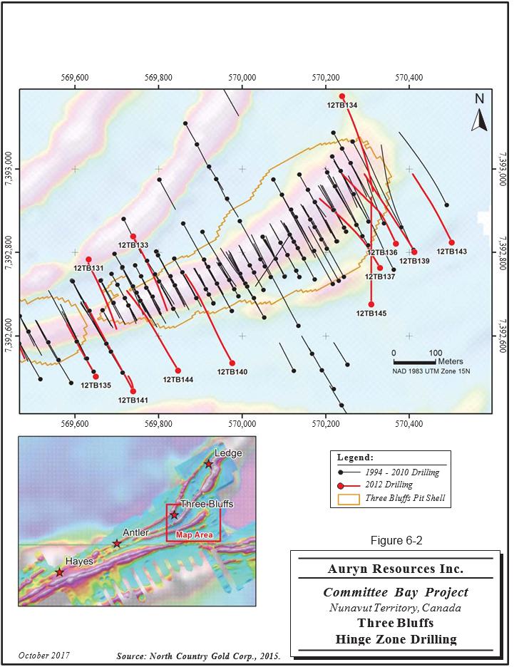
In 2010, a total of 54 NQ (47.6 mm diameter) holes were cored for an aggregated depth of 5,749 m. The shallow, structurally thickened portion of the hinge zone of Three Bluffs was tested by 15 holes that intersected variable widths of structurally disturbed silica, and locally sericite altered, sulphidized iron formation with associated gold mineralization (Figure 6-2).
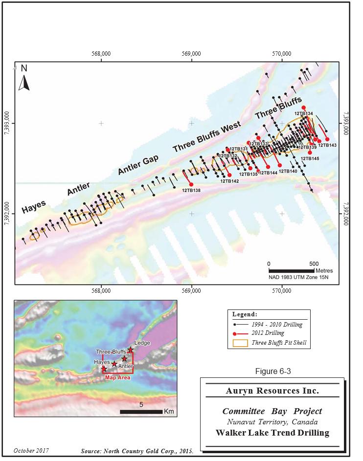
Another 16 holes were drilled along a 500 m corridor immediately west of the Three Bluffs resource area. This drilling identified gold mineralization associated with either altered, sulphidized iron formation or altered, sulphidized and crenulated greywacke (Figure 6-3).
Seventeen holes were drilled at Antler as a series of two hole set-ups on 60 m spaced sections. Sixteen of the 17 holes intersected variable widths and tenor of gold mineralization associated with altered iron formation, greywacke, and felsic volcanics. A mechanical failure of the drill caused the abandonment of one hole.
Four holes, completed as two two-hole fences 120 m apart, were drilled 1.5 km west of Antler (four kilometres west of Three Bluffs) in the Hayes area where a high-grade surface sample had been found. Two of the four holes intersected mineralized iron formation while the other holes intersected localized late-stage pegmatite dykes that crossed the mineralized trend at a shallow angle.
Significant intersections from the 2010 drill program are presented in Appendix 2, Table 31-1.
| Auryn Resources Inc. – Committee Bay Project, Project #2655 | |
| Technical Report NI 43- 101 – October 23, 2017 | Page 6-11 |
| | www.rpacan.com |
6 - 12
| | www.rpacan.com |
6 - 13
| | www.rpacan.com |
2011 DRILLING
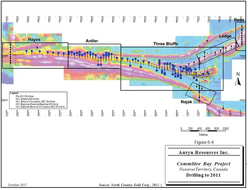
A total of 187 holes were drilled at Three Bluffs for 28,640 m in aggregate depth. The drilling comprised 10,148 m in 95 RC holes totalling 10,148 m and 18,496 m in 92 NQ diameter diamond drill holes.
Drilling concentrated on resource delineation along the main Walker Lake trend from Three Bluffs in the west to Hayes to the east. Drilling was carried out near existing holes that had returned high-grade results, in an effort to expand the resource. Two additional deep holes (greater than 300 m in depth) were drilled to test grade at depth and to target potential high-grade “shoots.” An additional two diamond drill holes and 55 RC holes were drilled to the north and south to test stratigraphy and magnetic anomalies. The data from the RC drilling was not used in the estimation of Mineral Resources.
Significant intersections from the 2011 program are tabulated in Appendix 2, Table 31-2.
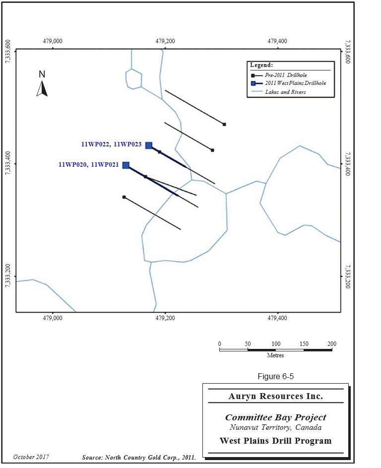
A four hole drill program was carried out on the West Plains prospect late in the 2011 field season totalling an aggregate depth of 426 m. These holes were drilled to examine stratigraphy and to potentially define the geometry of plunging mineralized shoots. Results were inconclusive. Drill hole locations are shown in Figures 6-4 and 6-5.
| Auryn Resources Inc. – Committee Bay Project, Project #2655 | |
| Technical Report NI 43- 101 – October 23, 2017 | Page 6-14 |
| | www.rpacan.com |
6 - 15
| | www.rpacan.com |
6 - 16
| | www.rpacan.com |
2012 DRILLING
Sixteen NQ-size diamond drill holes totalling 7.005.7 m were completed on the down-dip projection of the principal zones. Significant intercepts from the 2012 drilling are shown in Appendix 2, Table 31-3.
At Three Bluffs, drill hole collars were most commonly oriented at -45°, range from -41° to -73.5°, and average -54°. Drill holes intersected the vertically dipping mineralized bodies at an oblique angle so that true thicknesses averaged approximately 40% less than the downhole intersection lengths.
PREVIOUS RESOURCE ESTIMATES
In 2004, Committee Bay prepared a Mineral Resource estimate for the Three Bluffs Project using a block model method constrained by wireframe grade-shell models, with Inverse Distance Squared (ID2) weighting. A bulk density of 3.1 t/m3 was used and the high Au values were capped at 60 g/t Au prior to compositing. At a cut-off grade of 3 g/t Au, the Inferred Mineral Resources at Three Bluffs were estimated to be 1.9 million tonnes grading 8.0 g/t Au, for 488,000 contained ounces of Au. In 2004, RPA audited the resource estimate and was of the opinion that the Mineral Resources had been estimated in a reasonable fashion, using appropriate parameters, plausible geological inference, and methods commonly used in the industry (Rennie and Wallis, 2004).
In 2008, Scott Wilson Roscoe Postle Associates Inc. (Scott Wilson RPA), a predecessor company to RPA, updated the Mineral Resource estimate using a block model method constrained by wireframe grade-shell models, with Inverse Distance Cubed (ID3) weighting. The grade estimation was constrained using wireframe models, which were constructed by Committee Bay personnel using a 2 g/t Au grade cut-off and a nominal minimum width of 1.5 m. The database contained records for 84 holes, totalling 13,304 m of drilling. Scott Wilson RPA estimated Indicated Resources totalling 2.45 million tonnes grading 5.94 g/t Au for 468,000 contained ounces of gold and Inferred Resources of 1.34 million tonnes grading 5.34 g/t Au for 230,000 contained ounces of gold (Blakley and Rennie, 2008).
In 2009, Scott Wilson RPA completed another update to the resource model using a block model constrained by three-dimensional (3D) wireframes of the principal mineralogical domains. Grade for Au was interpolated into the model using ID3. Scott Wilson RPA estimated Indicated Resources totalling 2.70 million tonnes grading 5.85 g/t Au for 508,000 contained ounces of gold and Inferred Resources of 1.27 million tonnes grading 5.98 g/t Au for 244,000 contained ounces of gold (Scott, Rennie and Lambert, 2010).
| Auryn Resources Inc. – Committee Bay Project, Project #2655 | |
| Technical Report NI 43- 101 – October 23, 2017 | Page 6-17 |
| | www.rpacan.com |
In December 2011, RPA prepared an updated Mineral Resource estimate for the Three Bluffs Project using a block model method constrained by wireframe grade-shell models, with ID3 weighting. Two sets of wireframes and block models were employed: one which contemplated open pit mining and the other underground mining. A lower set of cut-off criteria were used for the open pit versus the underground to reflect the lower costs that should be incurred by mining from surface. A pit shell was generated from the open pit model and blocks from the open pit model captured within this shell were considered eligible for reporting as open pit resources. The same pit shell was applied to the underground model, except that blocks were included only if they were outside of the shell. As of December 2011, RPA estimated Indicated Resources totalling 4.30 million tonnes grading 4.90 g/t Au for 678,000 contained ounces of gold and Inferred Resources of 4.53 million tonnes grading 5.69 g/t Au for 829,000 contained ounces of gold (Rennie and McDonough, 2012).
In 2013, RPA updated the 2011 estimate to include the results of the 2012 diamond drilling program comprising 7,005.7 m in 16 holes. The estimate was carried out using a block model constrained by wireframe grade-shell models. Estimated gold grades were interpolated into the blocks using ID3 weighting. The estimation methodology, cut-off grades, and commodity price used for this update were the same as those employed in the last resource estimate conducted by RPA for NCG in 2011. RPA estimated Indicated Resources totalling 4.31 million tonnes grading 4.90 g/t Au for 680,000 contained ounces of gold and Inferred Resources of 5.53 million tonnes grading 5.69 g/t Au for 938,000 contained ounces of gold (McDonough, 2013). This block model was reviewed with respect to new data and cost and metal price assumptions. In RPA’s opinion, the model remains representative of the mineralization and therefore suitable to report Mineral Resources. As discussed in Section 14, Mineral Resource Estimate of this report, cut-off grades were adjusted based on updated metal price, exchange rate, and operating cost assumptions and the Mineral Resource was assigned a new effective date of May 31, 2017.
PAST PRODUCTION
There has been no previous production from the Property.
| Auryn Resources Inc. – Committee Bay Project, Project #2655 | |
| Technical Report NI 43- 101 – October 23, 2017 | Page 6-18 |
| | www.rpacan.com |
7 GEOLOGICAL SETTING AND MINERALIZATION
The following description is taken from Turner (2010).
REGIONAL GEOLOGY
The Canadian Shield consists of a number of Archean cratons that are welded together by Paleoproterozoic orogenic belts. The Western Churchill Province, where the Property is located, is formed by two Archean crustal blocks, namely the Hearne and Rae domains, separated by the Archean to Paleoproterozoic Snowbird tectonic zone (Figure 7-1). The Snowbird tectonic zone has been identified by means of geophysical data and is expressed on the ground as discrete mylonite zones and wide corridors of heterogeneous low-grade cataclasites (Hanmer et al., 1992; Aspler et al., 1999).
The Hearne domain, to the southeast, includes the largely juvenile northwest Hearne subdomain and the juvenile central Hearne subdomain further to the southeast (Sandeman et al., 2001a). The Rae domain to the northwest, which hosts the Committee Bay belt, comprises much older Archean supracrustal rocks that have widespread continental affinities as reflected in local evidence for deposition on older basement (3.05 Ga, Hartlaub et al., 2001; 2.87 Ga. Zaleski et al., 2001), quartzite samples containing older Meso- to Paleoarchean detrital zircons (Ashton, 1988, Davis and Zaleski, 1998, Hartlaub et al., 2001), and lastly widespread occurrences of compositionally mature quartzite.
The Churchill Province is separated from the Slave craton to the west by the Thelon Tectonic zone, a magmatic welt comprised of granulite facies ortho- and para-gneisses, and younger granitoid plutons (Hanmer et al., 1992; Henderson et al., 1990; Van Breemen et al., 1987a, b; Thompson and Henderson, 1983). To the east of the Churchill Province lies a complex amalgamation of Archean cratonic blocks that are surrounded by orogens ranging in age from ca. 1.94 Ga to ca. 1.74 Ga (Van Kranendonk et al., 1993). The suture between the Western Churchill Province and the Superior Province to the south is marked by the Trans-Hudson orogenic belt which extends from the central United States, through central Canada and as far north as Labrador (Orrell et al., 1999). The Rae domain comprises voluminous plutonic bodies that intruded a number of Archean supracrustal sequences of mutually similar lithological character. One of these supracrustal sequences is the granite-greenstone terrane of the Archean Prince Albert group (PAg; Heywood, 1961). Correlative rocks to the PAg, spanning over 2,000 km, have been identified as the Murmac Bay group in Saskatchewan (Hartlaub et al., 2001), the Woodburn Lake group northeast of Baker Lake (host to the Meadowbank deposit; Zaleski et al., 2001), and the Mary River group on Baffin Island (Bethune and Scammell, 1997).
| Auryn Resources Inc. – Committee Bay Project, Project #2655 | |
| Technical Report NI 43- 101 – October 23, 2017 | Page 7-1 |
| | www.rpacan.com |
Volcanic rocks within the eastern Rae domain include komatiite, basalt, andesite, and rhyolite, with the latter yielding U/Pb ages in the Woodburn Lake and Committee Bay area between 2.73 and 2.69 Ga (Zaleski et aI., 2001; Skulski et aI., 2003). Plutonic rocks in the eastern Rae domain were emplaced between 2.64 and 2.58 Ga and are dominated by calc-alkaline granitoid plutons (Le Cheminant and Roddick, 1991; Zaleski et al., 2001; Skulski et aI., 2003).
| Auryn Resources Inc. – Committee Bay Project, Project #2655 | |
| Technical Report NI 43- 101 – October 23, 2017 | Page 7-2 |
| | www.rpacan.com |
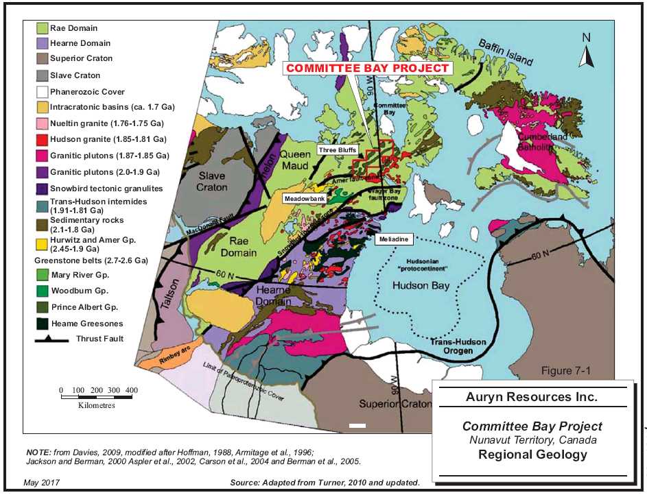
7 - 3
| | www.rpacan.com |
LOCAL GEOLOGY
The following is taken from Turner and Schoeman (2013).
The Committee Bay area is underlain by Archean and Proterozoic rocks extensively covered by Quaternary glacial drift in the northern part of the Churchill Structural Province (Heywood and Schau, 1978). The focus of gold exploration in the area has been the granite-greenstone terrane of the PAg (Heywood, 1961) (Figure 7-2).
The Committee Bay area comprises three distinct Archean-aged subdomains including the Prince Albert Group (PAg) and Northern Migmatite subdomains and the Walker Lake intrusive complex (Skulski et al., 2003). The PAg subdomain contains abundant supracrustal rocks of the lower and middle PAg. The lower PAg comprises basalts, komatiites, and 2,732 Ma rhyolite while the middle PAg consists of a sequence of iron formation, psammite, semipelite, and <2,722 Ma quartzite. The middle PAg is overlain by a 2,711 Ma dacite while both the lower and middle PAg were cut by 2,718 Ma synvolcanic intrusions and post-volcanic intrusions aged 2,610 to 2,585 Ma (Skulski et al., 2003).
The Arrowsmith River shear zone separates the PAg and Northern Migmatite subdomains. The Northern Migmatite subdomain is composed of metasedimentary rocks with lesser mafic and ultramafic rocks from the upper PAg, bracketed to <2,691 Ma. These high-grade metamorphic rocks are cut by variably composed 2,580 Ma plutonic rocks. Rocks of the Walker Lake intrusive complex are in faulted contact with the PAg subdomain proximal to the Walker Lake shear zone but are in intrusive contact with the PAg subdomain elsewhere. The Walker Lake intrusive complex comprises 2,610 Ma granodiorite to monzogranite that is cut by late- to post-tectonic 1,821 Ma monzogranite (Skulski et al., 2003).
The CBGB is composed of rocks from the PAg which are bounded in the northwest by the wide, northeasterly-striking, Slave-Chantrey Mylonite Belt and in the south by the narrow, easterly-striking Amer-Wager Bay Shear Zone. Ductile shearing along the Amer and Wager Bay shear zones has been assigned a maximum age of 1.79 Ga and 1.81 Ga, respectively (Henderson and Broome, 1990). The Wager Bay shear zone is believed to be a strike-slip fault related to collision of two Archean plates (Parrish, 1989). The sinistral reactivation of the easterly striking structures are believed to post-date emplacement of the MacKenzie dyke swarm at 1,270 Ma (Le Cheminant and Heaman, 1989) and predate the emplacement of the Franklin dyke swarm at 720 Ma (Heaman et al., 1992). These mafic dyke swarms appear to follow a set of pre-existing northwesterly-striking structures in the Committee Bay region.
| Auryn Resources Inc. – Committee Bay Project, Project #2655 | |
| Technical Report NI 43- 101 – October 23, 2017 | Page 7-4 |
| | www.rpacan.com |
Three main phases of regional ice movement were identified by the GSC, where Phase I being the oldest, is characterized by a northward movement and is tentatively associated with the last glacial maximum (Little, 2001, McMartin et al. 2003). Phase I was followed by a northeastward flow (Phase II - EAST) that dominated the eastern part of the Committee Bay belt (mainly NTS sheets 56O/2-8 and NTS sheets 56P/5-7, 9-16). In the western part of the Committee Bay study area (NTS 56K and parts of 56J), Phase I was followed by a northwesterly phase (Phase II - WEST) (Little, 2001, McMartin et al., 2003). Phase II may have occurred during early deglaciation of the region, when Keewatin Sector ice, while progressively retreating southward, was re-orientated into a general east-west configuration and the flow shifted to a north-northwesterly direction (Phase III) (Little, 2001, McMartin et al., 2003).
STRUCTURE
Two major fault systems in the central portion of CBGB cut PAg rocks. These are: (a) the northeasterly striking Kellett fault; and (b) the northwesterly striking Hayes River fault. Several other north, northwest, and easterly striking faults occur within the Laughland Lake–Ellice Hills area (Heywood and Schau, 1978). Geological and geophysical evidence indicates that easterly striking dextral shearing and northeasterly striking sinistral shearing components cut or deform rocks of the CBGB. These shear zones may have acted as conduits for gold-bearing fluids, as most of the gold occurrences discovered to date appear to be spatially related to the major shear systems and their kinematically related sub-structures. The northeasterly shears, which are generally parallel to the strike of the rock units, may be part of a conjugate shear set that is related to the easterly striking Walker Lake and Amer shear zones, indicating that the principal component of regional pure shear is oriented north-northwesterly in the CBGB (Turner, 2010).
Three phases of ductile deformation are recognized in the rocks of the Committee Bay greenstones. The S1 foliation is typically recognized in komatiitic and plutonic rocks, in particular, as a northwest striking fabric parallel to bedding in the komatiites. Axial planar folds from the first deformation phase are locally recognized. The dominant fabric throughout the Committee Bay region is the northeasterly striking S2 foliation which is axial planar to regional F2 folds. This regional foliation is interpreted to represent a composite S2+/-S1 fabric. D3 structures include northeast trending F3 folds and S3 fabrics that overprint D2 fabrics (Skulski et al., 2003).
| Auryn Resources Inc. – Committee Bay Project, Project #2655 | |
| Technical Report NI 43- 101 – October 23, 2017 | Page 7-5 |
| | www.rpacan.com |
In the West Laughland Lake area of the CBGB, the regional strikes of the rock units are variable, but most commonly northerly striking. A significant change in the regional strike of the rock units occurs in the Wolf Lake area. At the Four Hills gold occurrence, complexly refolded iron formations are broadly warped, changing from a northerly regional strike in the western part to a northeasterly regional strike in the eastern part. Bedding, which generally is vertically dipping in the majority of the CBGB, dips shallowly to moderately in the Four Hills area. The rock units generally continue striking in a northeasterly direction from east of the Four Hills gold occurrence all the way to Committee Bay. The change in overall dip and strike of the rock units that occur in the Four Hills area may be the result of deflection of the CBGB during ductile deformation, either through regional folding or rheological refraction through a tectonothermal front such as the Hudsonian Orogeny (Turner, 2010).
In the Hayes River area, the easterly striking Walker Lake shear zone forms the dominant structure. The influence of this shear zone is evident in a number of small shear splays off the main zone. There is a shear splay that is spatially related to the Three Bluffs gold occurrence, which can be traced along strike from Three Bluffs to at least the Antler gold occurrence (Turner, 2010). Bedding in the Hayes River area generally dips sub-vertically and there is evidence of flexural shear and silicification along lithological contacts between iron formation and talc-actinolite schist (meta-komatiite).
| Auryn Resources Inc. – Committee Bay Project, Project #2655 | |
| Technical Report NI 43- 101 – October 23, 2017 | Page 7-6 |
| | www.rpacan.com |
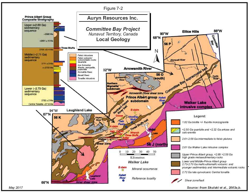
7 - 7
| | www.rpacan.com |
PROPERTY GEOLOGY
The following is taken from Turner and Schoeman (2013).
THREE BLUFFS AREA
Figure 7-3 depicts the interpretive geology along the Walker Lake trend, indicating the three key areas of the Hayes Grid, namely Hayes in the west, Antler in the central portion, and Three Bluffs to the east.
The following is largely derived from Davies (2010).
The Three Bluffs area of the Hayes Grid is extensively covered by post-glacial felsenmeer. Bedrock exposure in the immediate deposit area is limited to three low, rounded, oxidized outcrops, called West, Central, and East, which make up the Three Bluffs gold occurrence, and are on-strike iron formation outcrops interbedded with metapelitic rocks of the PAg that plunge shallowly to the northeast.
The Three Bluffs area is dominated by northeast to east-northeast trending, steeply dipping to sub-vertical bedding and penetrative foliation, and by locally preserved upright folds. Bedding in the Three Bluffs Grid area generally dips sub-vertically, and there is evidence of silicification and flexural shear along lithological contacts between iron formation and talc-actinolite schist. The S1 foliation is rarely observed in the hinges of F2 folds, and is represented by a variably dipping schistosity. The dominant fabric is the northeast striking S2 foliation, typical throughout the Committee Bay region. Late stage, northeast trending, tight crenulation folds can also be seen deforming existing F2 folds, however, it is questionable whether these represent F3 folds or late-F2 crenulations.
The Three Bluffs gold deposit is characterized by a thick interval of iron formation that appears to form the nose of an upright isoclinal antiform. The Bluffs represent the thickened outcrop sections of a fold repeated sequence of iron formation that ranges from 25 m to 30 m wide at West Bluff and up to 55 m at Central Bluff. The Three Bluffs iron formation is 55 m thick for at least 700 m of strike length and maintains a thickness of more than ten metres for a minimum strike length of 1.8 km (Freeman and Wyllie, 2002). The main iron formation unit is flanked to both the northwest and southeast by interbedded metasedimentary rocks and minor iron formation horizons. A concordant “dacite” unit occurs on the northwest limb of the interpreted antiform, with thickness diminishing by half on the southeast limb, giving the appearance of a homoclinal assemblage. The fold hinge in the iron formation has been removed by erosion in the western portion of the drill area, and has been truncated at shallow levels by a gently dipping diorite intrusion to the east. The entire iron formation-dacite-metasediment package is bounded by thick metasedimentary successions that lack both iron formation and dacite.
| Auryn Resources Inc. – Committee Bay Project, Project #2655 | |
| Technical Report NI 43- 101 – October 23, 2017 | Page 7-8 |
| | www.rpacan.com |
Strong magnetic anomalies clearly define the extent of the Three Bluffs iron formations, which can be traced along strike to the northeast for more than 10 km (Figure 7-4). Northeast of Three Bluffs is an area of low magnetic relief which represents the diorite intrusion. South of this intrusion are several east to northeast trending magnetic features that are mainly associated with mafic and ultramafic volcanic units.
Due to the degree of hydrothermal alteration and metamorphic recrystallization in the vicinity of the deposit, determining and naming meaningful lithological units is difficult. At least seven main rock types are commonly observed in both outcrop and/or drill core: clastic metasedimentary rocks (cordierite and muscovite-bearing greywacke), iron formation, komatiite, dacite, felsic volcanic, diorite, and quartz veins. These are described in detail below.
ROCK TYPES OF THE THREE BLUFFS AREA
Clastic metasedimentary rocks consist of fine grained greywackes which are distinguished based on their cordierite, muscovite, or aluminous content. Cordierite bearing greywacke is characterized by knotted biotite schist with distinct coarse grained blue cordierite commonly rimmed by brown biotite and could also contain garnet. Muscovite bearing greywacke has a distinctive aluminous character with muscovite, kyanite, and possibly andalusite, lacking cordierite and garnet. Millimetre-scale compositional banding is common.
Foliation varies from unfoliated to strongly schistose, generally showing a gradual increase towards iron formation contacts. Also, strongly deformed greywackes contain abundant cross cutting, centimetre- to decimetre-scale diorite dikes, which appear to have been deformed along with the metasedimentary rocks. In the Three Bluffs area, the metasedimentary rocks are attenuated into a strong bedding-parallel foliation, and primary features have been destroyed by recrystallization and deformation. The contact between metasedimentary rocks and the iron formation is gradational and is associated with an increasing amount of fine grained clastic sedimentary grains towards both the footwall and hanging wall of the iron formation. The iron formations at Three Bluffs are variably magnetic, and consist of alternating bands of millimetre- to centimetre-scale magnetite and quartz, with intervals rich in actinolite (fine grained and coarse grained, euhedral and randomly orientated crystals), garnet, biotite, hornblende, grunerite, and sulphides. Iron formation bands with fine grained actinolite typically co-exist with disseminated magnetite, whereas coarse grained actinolite forms near mono-mineralic iron formation bands sometimes rimmed by fine grained magnetite (Turner and L’Heureux, 2005). Coarse grained, red garnet can also occur within coarse actinolite-rich bands.
| Auryn Resources Inc. – Committee Bay Project, Project #2655 | |
| Technical Report NI 43- 101 – October 23, 2017 | Page 7-9 |
| | www.rpacan.com |
The iron formation has been divided into three sub-facies based on abundances of the minerals present. Oxide-facies iron formation has a high magnetite content and low abundance of sulphide minerals. This sub-facies is characterized by thick bands of coarse grained, euhedral, randomly orientated crystals of hornblende and magnetite, with minor quartz veining. Euhedral arsenopyrite commonly occurs intergrown with large crystals of randomly oriented hornblende, overprinting deformational structures.
Areas where quartz veining is abundant but sulphide content is low are interpreted as silica-veined iron formation. In these areas, garnet, and cordierite porphyroblasts up to two centimetres in diameter commonly occur within coarse grained hornblende-rich bands, which are typically one to ten centimetres thick. Magnetite content is relatively high, but has a more disseminated texture than in the oxide-facies iron formation.
Sulphide-facies iron formation consists of bands of intergrown pyrrhotite and pyrite, and is typically associated with areas of high quartz veining as well as a low abundance of magnetite, amphibole, and garnet. Sulphides are deformed parallel to a strong S2 foliation, and also occur within the necks of boudinaged quartz veins and within porphyroblast pressure shadows. In areas of intense silica flooding, primary banding is disrupted and sulphides are disseminated throughout the rock. The highest grades of gold mineralization occur in this sulphide-facies iron formation.
The most abundant metavolcanic rock type in the PAg is komatiite, which is exposed in several locations within the Three Bluffs area, however, it is rarely observed in drill core from the deposit itself. These komatiitic flows generally display retrograde mineral assemblages of serpentine-chlorite-tremolite/actinolite-magnetite (MacHattie, 2002). Primary volcanic textures are not preserved.
| Auryn Resources Inc. – Committee Bay Project, Project #2655 | |
| Technical Report NI 43- 101 – October 23, 2017 | Page 7-10 |
| | www.rpacan.com |
Iron formation is flanked to the northwest by an altered, highly siliceous, buff coloured unit termed “dacite.” The dacite forms part of a mixed assemblage of banded iron formation and greywacke which is interbedded on metre to tens of metre scale. The banded iron formation is poorly bedded to massive and consists of magnetite, amphibole, and chert with grunerite rare to absent. On the northwest limb of the interpreted antiform, the dacite is present throughout the drill area, and is immediately adjacent to the auriferous iron formation, forming a highly correlatable unit. The stratigraphic thickness of the dacite on the southeast limb is half of that on the northwest limb. The dacite consists of quartz, plagioclase, sericite, and biotite, and is strongly to weakly mineralized with sulfides and gold. The fine-grained interlocking texture and high plagioclase content suggest an igneous origin for this rock type. Likewise, the lack of cross-cutting relationships, and the conformable nature of the unit with the interbedded iron formation, support a volcanic, likely tuffaceous origin.
A felsic volcanic unit, between 10 m and 20 m thick, unconformably overlies the iron formation-dacite-greywacke package on the northwest limb and is not present on the southeast limb. This has previously been described as a rhyolite, dominantly white to buff coloured with localized greywacke interbeds. The felsic volcanic unit consists of abundant medium grained feldspar phenocrysts and square quartz phenocrysts within highly siliceous banding or flow banding. The felsic volcanic unit increases in stratigraphic thickness southwestward and eventually directly overlies the iron formation-dacite-greywacke package of the northwest limb towards Antler and Hayes on the Hayes Grid. Where drilling is done from southeast to northwest to cut the antiform, there is poor control on the felsic volcanic unit since the drilling is not always carried through to intersect the felsic volcanic unit.
The supracrustal rocks at Three Bluffs are truncated to the northeast by a medium grained diorite intrusion, consisting of undeformed quartz, plagioclase, biotite, hornblende, muscovite, and trace amounts of pyrite. A weak southwest trending fabric is recognized at the margins of this intrusion, but its interior is generally undeformed and massive. In outcrop, the contact between the iron formation and the diorite is irregular and appears to be folded with the iron formation. This relationship can also be seen in drill core, where several diorite dikes (assumed to be cogenetic with the main intrusion) have been folded parallel to the iron formation and other lithologies. The iron formation continues beneath the diorite body, which has a lower contact that appears to have a shallow dip to the northeast. The implication of these observations is that the diorite intruded the supracrustal sequence prior to D2 deformation.
| Auryn Resources Inc. – Committee Bay Project, Project #2655 | |
| Technical Report NI 43- 101 – October 23, 2017 | Page 7-11 |
| | www.rpacan.com |
At least two types of quartz veins occur in all rock types including the iron formation. The first phase is elongated, parallel to D2 fabrics, boudinaged, and either blue-grey in colour or massive and whitish. These veins are thought to be syn-D2, and are genetically related to mineralization since they contain a similar sulphide assemblage as in the mineralized iron formation. Where abundant quartz veining occurs, the wallrocks appear silica flooded and display muscovite alteration. High gold grades are associated with these quartz veins.
The second phase of quartz veins cross-cuts D2 foliation and, therefore, post-dates mineralization. These veins are much thinner (0.5 mm) than the first phase, but still display moderate strain textures. They are less widespread and do not appear to be associated with gold or sulphide mineralization.
| Auryn Resources Inc. – Committee Bay Project, Project #2655 | |
| Technical Report NI 43- 101 – October 23, 2017 | Page 7-12 |
| | www.rpacan.com |
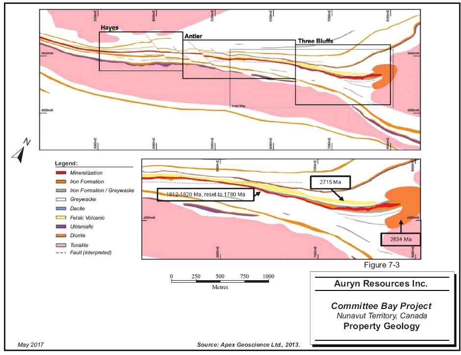
7 - 13
| | www.rpacan.com |
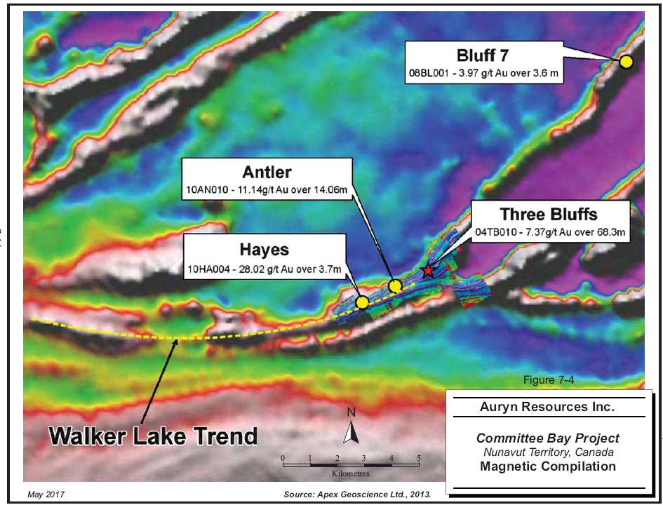
7 - 14
| | www.rpacan.com |
MINERALIZATION
The following is derived from Blakley and Rennie (2008) and Turner (2010). Figure 7-5 illustrates the locations of the various mineral occurrences on the Property.
The majority of the gold mineralization throughout the CBGB is hosted in silicate, oxide, and/or sulphide facies iron formation. Gold mineralization has also been identified in shear hosted quartz veins in sediments and volcanics throughout the belt (Blakely and Rennie, 2008).
Pyrite and pyrrhotite are the most common sulphides and occur as fine grained disseminations or irregular patches along quartz vein margins in iron formations and chlorite-epidote-amphibole alteration zones in mafic to ultramafic rocks, and as semi-massive bands parallel to bedding in both oxide and silicate facies iron formations.
Arsenopyrite occurs locally as disseminations, individual euhedral acicular crystals, semi-massive bands, and clots. At Three Bluffs, arsenopyrite occurs in sedimentary units adjacent to mineralized/altered iron formation. At the Raven occurrence, arsenopyrite has a strong association with gold mineralization where it occurs as fine to medium grained euhedral disseminations with tourmaline and quartz.
Chalcopyrite occurs mainly as disseminations associated with pyrite at Anuri and Three Bluffs but has been observed at other locations within the CBGB. Galena was observed south of Kinngalugjuaq Mountain in two localities, one of which was associated with silver mineralization. Sphalerite has been identified in several locations, most notably at the Burro occurrence where coarse black iron-rich sphalerite comprises up to 5% of an auriferous quartz vein. The presence of elevated base metals at Anuri also suggests the potential for a volcanogenic massive sulphide-type deposit (Turner, 2010).
Turner notes that while, generally, elevated gold has been found with arsenopyrite, pyrite, and pyrrhotite bearing iron formation, metasedimentary, and metavolcanic rocks, no consistent positive correlation has been found between the highest-grade gold grades and the volume percent of these minerals. The most important characteristic common to the majority of the high-grade gold occurrences, according to Turner (2010), is silicification.
| Auryn Resources Inc. – Committee Bay Project, Project #2655 | |
| Technical Report NI 43- 101 – October 23, 2017 | Page 7-15 |
| | www.rpacan.com |
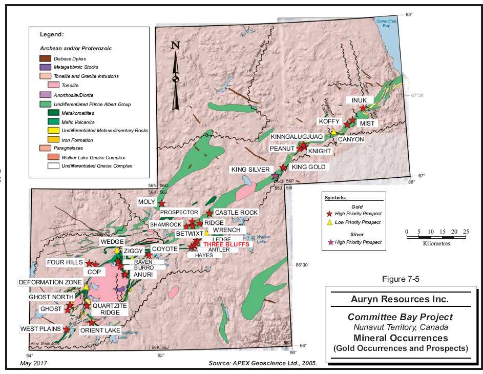
7 - 16
| | www.rpacan.com |
8 DEPOSIT TYPES
The primary deposit type of interest in the CBGB is gold within silicate, oxide, and sulphide iron formation. The following is taken from Robert et al. (2007).
Iron formation hosted deposits consist mainly of sulphidic replacements of Fe-rich layers in magnetite or silicate banded iron formation (BIF), adjacent to variably developed quartz veins and veinlets. The intensely mineralized central parts of some deposits consist of nearly continuous wallrock replacements, which can obscure their epigenetic character and can lead to ambiguities about the timing of mineralization (Caddy et al., 1991; Kerswill, 1996).
BIF-hosted deposits occur in greenstone belts that are either volcanic-dominated or sediment-dominated, where they are located stratigraphically near regional volcanic-sedimentary transition, as is the case at Homestake and Morro Velho. A few deposits, like Lupin, also occur near the edges of large clastic sedimentary basins, in absence of significant mafic volcanic rocks. Magnetite BIF is the dominant host in greenschist grade rocks, whereas silicate BIF prevails at mid-amphibolite grade or higher (Kerswill, 1996). At the local scale, BIF-hosted deposits are commonly associated with the hinges of folds, anticlines or synclines, and intersections of shear zones and faults. As a consequence, the deposits are commonly stratabound and plunge parallel to their host fold hinge or to the line of intersection of controlling shear zones with the BIF unit. In greenstone belts, many BIF-hosted deposits also contain concentrations of intermediate to felsic porphyry stocks and dykes.
Kerswill (1996) has divided iron formation-hosted gold deposits, based on the dominant style of gold distribution, into two principal varieties; stratiform and non-stratiform (or vein type). Some deposits have characteristics of both varieties.
In the vein-type deposits, gold hosted by iron-formation is restricted to late structures (quartz veins and/or shear zones) and/or iron sulphide-rich zones adjacent to such structures. Ore is confined to discrete, commonly small shoots separated by barren (gold- and sulphide-poor) iron formation, typically of oxide facies. These non-stratiform ores are essentially a variety of the mesothermal quartz-carbonate vein deposits.
| Auryn Resources Inc. – Committee Bay Project, Project #2655 | |
| Technical Report NI 43- 101 – October 23, 2017 | Page 8-1 |
| | www.rpacan.com |
Deposits of the stratiform type can be subdivided into those occurring within sediment-dominated settings and those within mixed volcanic-sedimentary settings. In the former, gold is uniformly disseminated in thin, but laterally extensive units of cherty pyrrhotite-rich iron formation that are conformably interlayered with sulphide- and oxide-poor iron formation and pelitic sedimentary rocks in portions of turbidite basins relatively distant from felsic volcanic centers. In the deposits within mixed settings, gold is uniformly disseminated in thin, but laterally extensive units of cherty sulphide iron formation that are associated with carbonate iron formation and black carbonaceous shale relatively close to volcanic centres.
Work carried out by NCG and its predecessors has identified that gold associated with quartz veins occurs in most localities and is present throughout the belt in anomalous concentrations in nearly all lithologies, so there exists the possibility for shear zone-hosted deposits.
Elevated amounts of gold generally exist in arsenopyrite, pyrite, and pyrrhotite bearing iron formations, metavolcanic and metasedimentary rocks. Despite gold occurrences across the belt displaying macroscopic differences in geology and mineralogy, one or more of these sulphide minerals, in varying proportions, accompany silicification and chloritization in samples that have high amounts of gold mineralization. The most important common characteristic appears to be silicification.
| Auryn Resources Inc. – Committee Bay Project, Project #2655 | |
| Technical Report NI 43- 101 – October 23, 2017 | Page 8-2 |
| | www.rpacan.com |
9 EXPLORATION
Since acquiring the Project in 2015, Auryn has initiated a comprehensive exploration program consisting of geological mapping, prospecting and sampling, till sampling, high resolution aerial drone imagery, ground and airborne geophysical surveying, as well as both rotary air blast (RAB) and diamond drilling.
Information related to Auryn’s drilling activity on the Property can be found in Section 10 of this report.
TILL SAMPLING
In 2016, Auryn completed an extensive till geochemical sampling program consisting of 5,160 samples over a large portion of the property and filled in unsampled areas between previously known targets. The survey identified 17 new gold anomalies in the till requiring follow-up testing in the 2017 field season. Figure 9-1 illustrates the area covered by the 2016 sampling.
BOULDER MAPPING
An approximately 1,000 line-km boulder mapping program was completed during the 2016 field season. A new high grade boulder train was discovered which trends north-south parallel to the Anuri structure. The five highest grade samples collected within the boulder train returned values of 45.9 g/t Au, 41.5 g/t Au, 33.3 g/t Au, 14.55 g/t Au, and 12.65 g/t Au.
AERIAL DRONE IMAGERY
Aerial drone surveying was flown in 2015 and 2016 using a hand launched unmanned aerial vehicle. Both visible spectrum imagery and relative digital elevation information were collected at 10 cm resolution to aid in the interpretation of surficial geology and in logistical drill planning. Approximately 1,600 km2was surveyed in 2015 and approximately 3,150 km2was surveyed in 2016.
AIRBORNE GEOPHYSICAL SURVEYS
A combined airborne magnetic gradiometer and electromagnetic (Resolve) survey was flown between April 12 and June 12, 2016. A total of 6,584.8 line-km were flown including 5,979.3 km of traverse lines at 50 m to 200 m line spacing and 605.5 km of tie lines at 500 m to 2,000 m line spacing. The results from the survey are being analyzed with respect to geochemical and geological information to identify high quality targets for future exploration and drilling. Figure 9-2 illustrates the total field magnetic results.
| Auryn Resources Inc. – Committee Bay Project, Project #2655 | |
| Technical Report NI 43- 101 – October 23, 2017 | Page 9-1 |
| | www.rpacan.com |
GROUND GEOPHYSICAL SURVEYS
In 2016, a ground magnetic survey in the Three Bluffs area totalling 64.31 ln-km was completed.
PROSPECTING
In 2016, 921 grab samples were collected as part of an on-going program of prospecting.
| Auryn Resources Inc. – Committee Bay Project, Project #2655 | |
| Technical Report NI 43- 101 – October 23, 2017 | Page 9-2 |
| | www.rpacan.com |
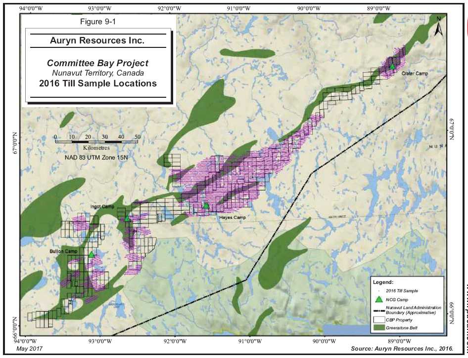
9 - 3
| | www.rpacan.com |
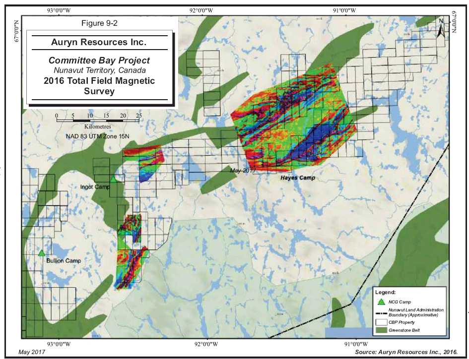
9 - 4
| | www.rpacan.com |
10 DRILLING
Drilling prior to Auryn’s acquisition of the Property in 2015 is described in Section 6 History of this report. In RPA’s opinion, diamond drilling conducted by previous owners on the Project and other prospects is in a manner consistent with industry standards. RPA is not aware of any drilling or recovery issues that may impact upon the accuracy and reliability of the results. In RPA’s opinion, the results generated from these drill programs are suitable for use in a Mineral Resource estimate.
From July to August 2015 and June to August 2016, Auryn completed 95 RAB holes for approximately 13,045 m and seven diamond drill holes for approximately 3,715 m. Table 10-1 summarizes the drilling completed by Auryn since its acquisition of the Property. Figure 10-1 illustrates the locations of Auryn’s 2015 to 2016 drill holes.
TABLE 10-1 SUMMARY OF AURYN DRILLING
Auryn Resources Inc. – Committee Bay Project
| Prospect | Type | No. of Holes | Metres | Period |
| | | Drilled | Drilled | |
| West Plains | RAB | 29 | 2,733.96 | July – August, 2015 |
| Four Hills | RAB | 4 | 345. 40 | August, 2015 |
| Anuri | RAB | 34 | 5,690.70 | July – August, 2016 |
| Muskox | RAB | 7 | 1,255.00 | August, 2016 |
| West Plains | RAB | 21 | 3,001.30 | June -July, 2016 |
| Three Bluffs | DDH | 5 | 2,799.57 | July – August, 2016 |
| Antler | DDH | 2 | 891.54 | July, 2016 |
| Auryn Resources Inc. – Committee Bay Project, Project #2655 | |
| Technical Report NI 43- 101 – October 23, 2017 | Page 10-1 |
| | www.rpacan.com |
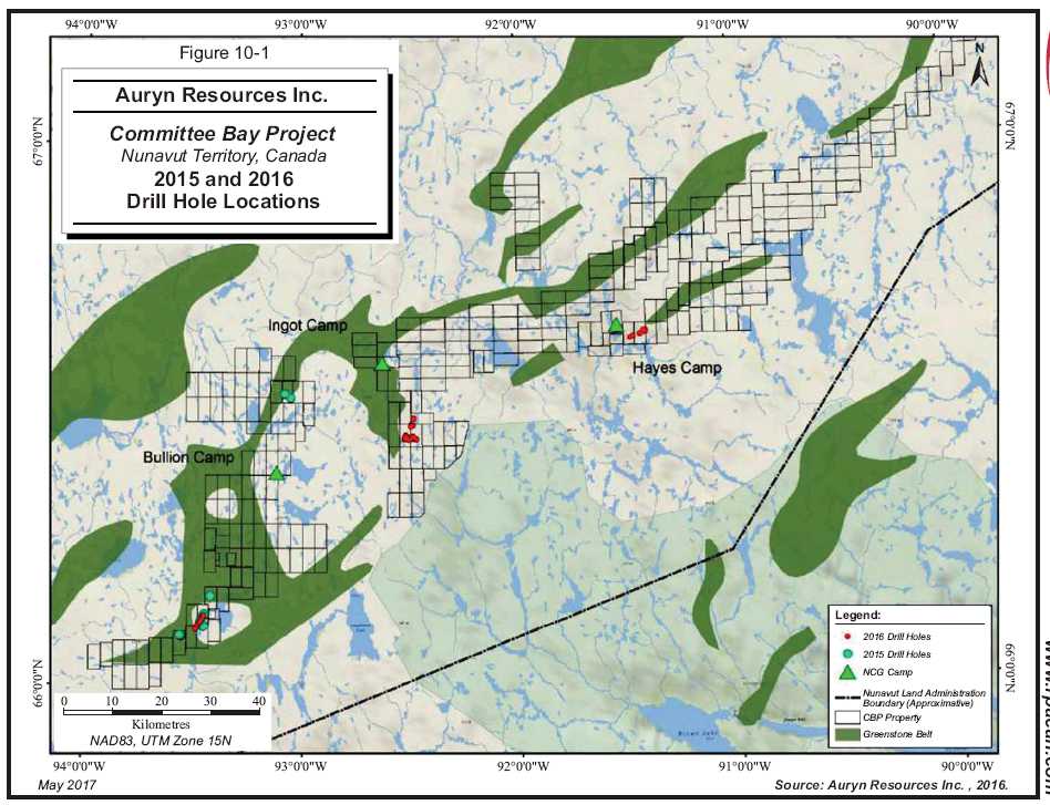
10 - 2
| | www.rpacan.com |
RAB DRILLING
Table 10-2 lists the RAB holes completed by Auryn in 2015 and 2016. Table 10-3 lists the significant intersections obtained.
TABLE 10-2 AURYN RAB DRILLING
Auryn Resources Inc. - Committee Bay Project
| | | | | Start | Finish | | Length |
| Hole | Prospect | Easting | Northing | Date | Date | Attitude | (m) |
| 15FHR001 | Four Hills | 497,805 | 7,379,152 | 13-Aug-15 | 13-Aug-15 | 180°/-55° | 100.58 |
| 15FHR002 | Four Hills | 497,804 | 7,379,197 | 14-Aug-15 | 14-Aug-15 | 180°/-65° | 44.20 |
| 15FHR003 | Four Hills | 496,558 | 7,379,929 | 14-Aug-15 | 14-Aug-15 | 180°/-55° | 100.58 |
| 15FHR004 | Four Hills | 496,602 | 7,379,957 | 14-Aug-15 | 15-Aug-15 | 180°/-55° | 100.58 |
| 15WPR001 | West Plains | 479,180 | 7,333,374 | 11-Jul-15 | 11-Jul-15 | 120°/-65° | 77.72 |
| 15WPR002 | West Plains | 479,466 | 7,332,182 | 12-Jul-15 | 12-Jul-15 | 120°/-55° | 100.58 |
| 15WPR003 | West Plains | 479,517 | 7,332,158 | 13-Jul-15 | 13-Jul-15 | 120°/-55° | 100.58 |
| 15WPR004 | West Plains | 479,569 | 7,332,131 | 14-Jul-15 | 14-Jul-15 | 120°/-55° | 100.58 |
| 15WPR005 | West Plains | 479,738 | 7,332,358 | 15-Jul-15 | 16-Jul-15 | 120°/-55° | 100.58 |
| 15WPR006 | West Plains | 479,785 | 7,332,321 | 16-Jul-15 | 17-Jul-15 | 120°/-55° | 82.30 |
| 15WPR007 | West Plains | 479,832 | 7,332,285 | 18-Jul-15 | 18-Jul-15 | 120°/-55° | 100.58 |
| 15WPR008 | West Plains | 479,875 | 7,332,249 | 18-Jul-15 | 18-Jul-15 | 120°/-55° | 100.58 |
| 15WPR009 | West Plains | 475,144 | 7,330,161 | 19-Jul-15 | 19-Jul-15 | 120°/-60° | 51.82 |
| 15WPR010 | West Plains | 475,147 | 7,330,155 | 20-Jul-15 | 20-Jul-15 | 120°/-60° | 100.58 |
| 15WPR011 | West Plains | 475,087 | 7,330,202 | 20-Jul-15 | 20-Jul-15 | 120°/-60° | 100.58 |
| 15WPR012 | West Plains | 474,952 | 7,330,295 | 24-Jul-15 | 25-Jul-15 | 120°/-60° | 100.58 |
| 15WPR013 | West Plains | 474,911 | 7,330,326 | 25-Jul-15 | 25-Jul-15 | 120°/-60° | 100.58 |
| 15WPR014 | West Plains | 474,852 | 7,330,369 | 26-Jul-15 | 26-Jul-15 | 120°/-60° | 100.58 |
| 15WPR015 | West Plains | 479,116 | 7,333,244 | 27-Jul-15 | 28-Jul-15 | 120°/-55° | 100.58 |
| 15WPR016 | West Plains | 479,827 | 7,334,691 | 28-Jul-15 | 28-Jul-15 | 120°/-55° | 100.58 |
| 15WPR017 | West Plains | 479,797 | 7,334,704 | 29-Jul-15 | 29-Jul-15 | 120°/-55° | 100.58 |
| 15WPR018 | West Plains | 479,882 | 7,334,768 | 31-Jul-15 | 31-Jul-15 | 120°/-55° | 100.58 |
| 15WPR019 | West Plains | 479,863 | 7,334,551 | 31-Jul-15 | 01-Aug-15 | 120°/-55° | 100.58 |
| 15WPR020 | West Plains | 479,823 | 7,334,573 | 01-Aug-15 | 02-Aug-15 | 120°/-55° | 100.58 |
| 15WPR021 | West Plains | 479,860 | 7,334,609 | 02-Aug-15 | 03-Aug-15 | 120°/-55° | 100.58 |
| 15WPR022 | West Plains | 479,762 | 7,334,489 | 03-Aug-15 | 04-Aug-15 | 120°/-55° | 100.58 |
| 15WPR023 | West Plains | 479,712 | 7,334,402 | 08-Aug-15 | 08-Aug-15 | 120°/-55° | 100.58 |
| 15WPR024 | West Plains | 479,925 | 7,334,874 | 05-Aug-15 | 06-Aug-15 | 120°/-55° | 100.58 |
| 15WPR025 | West Plains | 479,925 | 7,334,874 | 06-Aug-15 | 06-Aug-15 | 120°/-55° | 100.58 |
| 15WPR026 | West Plains | 479,867 | 7,334,826 | 07-Aug-15 | 07-Aug-15 | 120°/-55° | 7.62 |
| 15WPR027 | West Plains | 479,176 | 7,333,343 | 07-Aug-15 | 08-Aug-15 | 120°/-70° | 100.58 |
| 15WPR028 | West Plains | 481,238 | 7,338,574 | 11-Aug-15 | 11-Aug-15 | 120°/-55° | 100.58 |
| 15WPR029 | West Plains | 481,192 | 7,338,600 | 12-Aug-15 | 12-Aug-15 | 120°/-55° | 100.58 |
| 16WPR030 | West Plains | 479,181 | 7,333,376 | 28-Jun-16 | 30-Jun-16 | 120°/-65° | 201.17 |
| 16WPR031 | West Plains | 478,595 | 7,332,453 | 30-Jun-16 | 02-Jul-16 | 140°/-55° | 137.16 |
| Auryn Resources Inc. – Committee Bay Project, Project #2655 | |
| Technical Report NI 43- 101 – October 23, 2017 | Page 10-3 |
| | www.rpacan.com |
| | | | | Start | Finish | | Length |
| Hole | Prospect | Easting | Northing | Date | Date | Attitude | (m) |
| 16WPR032 | West Plains | 479,131 | 7,333,498 | 30-Jun-16 | 01-Jul-16 | 090°/-55° | 56.39 |
| 16WPR033 | West Plains | 479,133 | 7,333,410 | 01-Jul-16 | 03-Jul-16 | 090°/-55° | 67.06 |
| 16WPR034 | West Plains | 478,561 | 7,332,495 | 02-Jul-16 | 04-Jul-16 | 140°/-55° | 143.26 |
| 16WPR035 | West Plains | 479,181 | 7,333,380 | 03-Jul-16 | 05-Jul-16 | 090°/-55° | 201.17 |
| 16WPR036 | West Plains | 478,529 | 7,332,537 | 04-Jul-16 | 05-Jul-16 | 140°/-55° | 137.16 |
| 16WPR037 | West Plains | 479,105 | 7,333,219 | 05-Jul-16 | 06-Jul-16 | 130°/-55° | 201.17 |
| 16WPR038 | West Plains | 478,428 | 7,332,460 | 05-Jul-16 | 06-Jul-16 | 140°/-55° | 137.16 |
| 16WPR039 | West Plains | 479,044 | 7,333,242 | 06-Jul-16 | 07-Jul-16 | 130°/-55° | 201.17 |
| 16WPR040 | West Plains | 478,460 | 7,332,417 | 06-Jul-16 | 08-Jul-16 | 140°/-55° | 137.16 |
| 16WPR041 | West Plains | 479,410 | 7,333,894 | 07-Jul-16 | 08-Jul-16 | 130°/-55° | 100.58 |
| 16WPR042 | West Plains | 478,182 | 7,331,535 | 08-Jul-16 | 09-Jul-16 | 135°/-55° | 82.3 |
| 16WPR043 | West Plains | 479,453 | 7,333,857 | 08-Jul-16 | 09-Jul-16 | 130°/-55° | 152.40 |
| 16WPR044 | West Plains | 478,136 | 7,331,575 | 09-Jul-16 | 10-Jul-16 | 135°/-50° | 137.16 |
| 16WPR045 | West Plains | 479,345 | 7,333,804 | 09-Jul-16 | 10-Jul-16 | 125°/-55° | 152.40 |
| 16WPR046 | West Plains | 479,561 | 7,334,254 | 10-Jul-16 | 12-Jul-16 | 125°/-55° | 152.40 |
| 16WPR047 | West Plains | 479,498 | 7,330,064 | 10-Jul-16 | 11-Jul-16 | 125°/-55° | 152.40 |
| 16WPR048 | West Plains | 479,302 | 7,333,707 | 12-Jul-16 | 13-Jul-16 | 125°/-55° | 152.40 |
| 16WPR049 | West Plains | 479,677 | 7,334,421 | 13-Jul-16 | 15-Jul-16 | 125°/-55° | 152.40 |
| 16WPR050 | West Plains | 479,728 | 7,334,622 | 15-Jul-16 | 16-Jul-16 | 125°/-55° | 152.40 |
| 16ARR001 | Anuri | 521,402 | 7,371,400 | 13-Jul-16 | 14-Jul-16 | 150°/-55° | 201.17 |
| 16ARR002 | Anuri | 521,560 | 7,370,992 | 15-Jul-16 | 17-Jul-16 | 180°/-55° | 173.74 |
| 16ARR003 | Anuri | 521,619 | 7,370,814 | 18-Jul-16 | 19-Jul-16 | 180°/-55° | 152.40 |
| 16ARR004 | Anuri | 521,251 | 7,370,963 | 18-Jul-16 | 19-Jul-16 | 225°/-55° | 201.17 |
| 16ARR005 | Anuri | 521,332 | 7,371,040 | 19-Jul-16 | 20-Jul-16 | 225°/-55° | 201.17 |
| 16ARR006 | Anuri | 521,646 | 7,370,708 | 20-Jul-16 | 22-Jul-16 | 180°/-55° | 152.40 |
| 16ARR007 | Anuri | 521,912 | 7,370,767 | 20-Jul-16 | 22-Jul-16 | 210°/-55° | 201.17 |
| 16ARR008 | Anuri | 521,663 | 7,370,624 | 22-Jul-16 | 24-Jul-16 | 180°/-55° | 121.92 |
| 16ARR009 | Anuri | 521,978 | 7,370,832 | 23-Jul-16 | 24-Jul-16 | 210°/-55° | 160.02 |
| 16ARR010 | Anuri | 522,763 | 7,370,733 | 25-Jul-16 | 27-Jul-16 | 180°/-55° | 152.40 |
| 16ARR011 | Anuri | 522,046 | 7,370,903 | 24-Jul-16 | 25-Jul-16 | 210°/-55° | 129.54 |
| 16ARR012 | Anuri | 521,891 | 7,370,671 | 26-Jul-16 | 27-Jul-16 | 210°/-55° | 201.17 |
| 16ARR013 | Anuri | 522,770 | 7,370,803 | 27-Jul-16 | 29-Jul-16 | 180°/-55° | 152.40 |
| 16ARR014 | Anuri | 523,067 | 7,370,645 | 27-Jul-16 | 29-Jul-16 | 200°/-55° | 201.17 |
| 16ARR015 | Anuri | 522,774 | 7,370,873 | 29-Jul-16 | 31-Jul-16 | 180°/-55° | 152.40 |
| 16ARR016 | Anuri | 523,104 | 7,370,742 | 29-Jul-16 | 31-Jul-16 | 200°/-55° | 175.26 |
| 16ARR017 | Anuri | 522,793 | 7,370,938 | 31-Jul-16 | 02-Aug-16 | 180°/-55° | 152.40 |
| 16ARR018 | Anuri | 522,235 | 7,370,956 | 01-Aug-16 | 02-Aug-16 | 180°/-55° | 152.40 |
| 16ARR019 | Anuri | 522,228 | 7,370,867 | 02-Aug-16 | 05-Aug-16 | 180°/-55° | 184.40 |
| 16ARR020 | Anuri | 523,627 | 7,370,603 | 02-Aug-16 | 05-Aug-16 | 225°/-55° | 155.45 |
| 16ARR021 | Anuri | 523,671 | 7,370,659 | 06-Aug-16 | 08-Aug-16 | 225°/-55° | 152.40 |
| 16ARR022 | Anuri | 521,847 | 7,370,912 | 06-Aug-16 | 08-Aug-16 | 050°/-55° | 201.17 |
| 16ARR023 | Anuri | 522,825 | 7,371,193 | 08-Aug-16 | 09-Aug-16 | 180°/-55° | 152.40 |
| 16ARR024 | Anuri | 521,922 | 7,370,972 | 08-Aug-16 | 10-Aug-16 | 050°/-55° | 161.54 |
| 16ARR025 | Anuri | 522,829 | 7,371,120 | 09-Aug-16 | 10-Aug-16 | 180°/-55° | 152.40 |
| Auryn Resources Inc. – Committee Bay Project, Project #2655 | |
| Technical Report NI 43- 101 – October 23, 2017 | Page 10-4 |
| | www.rpacan.com |
| | | | | Start | Finish | | Length |
| Hole | Prospect | Easting | Northing | Date | Date | Attitude | (m) |
| 16ARR026 | Anuri | 523,024 | 7,370,952 | 11-Aug-16 | 12-Aug-16 | 180°/-55° | 152.40 |
| 16ARR027 | Anuri | 521,465 | 7,371,131 | 11-Aug-16 | 12-Aug-16 | 180°/-55° | 201.17 |
| 16ARR028 | Anuri | 523,020 | 7,371,039 | 12-Aug-16 | 13-Aug-16 | 180°/-55° | 152.40 |
| 16ARR029 | Anuri | 521,393 | 7,371,219 | 12-Aug-16 | 13-Aug-16 | 180°/-55° | 201.17 |
| 16ARR030 | Anuri | 521,986 | 7,370,523 | 13-Aug-16 | 15-Aug-16 | 210°/-55° | 152.40 |
| 16ARR031 | Anuri | 522,025 | 7,370,598 | 14-Aug-16 | 15-Aug-16 | 210°/-55° | 201.17 |
| 16ARR032 | Anuri | 521,194 | 7,370,666 | 15-Aug-16 | 19-Aug-16 | 180°/-55° | 152.40 |
| 16ARR033 | Anuri | 521,194 | 7,370,769 | 19-Aug-16 | 21-Aug-16 | 180°/-55° | 152.40 |
| 16ARR034 | Anuri | 522,159 | 7,370,534 | 21-Aug-16 | 24-Aug-16 | 210°/-55° | 141.73 |
| 16MXR001 | Muskox | 522,688 | 7,373,603 | 16-Aug-16 | 17-Aug-16 | 110°/-55° | 147.83 |
| 16MXR002 | Muskox | 522,779 | 7,373,562 | 19-Aug-16 | 20-Aug-16 | 110°/-55° | 201.17 |
| 16MXR003 | Muskox | 522,866 | 7,373,507 | 20-Aug-16 | 22-Aug-16 | 110°/-55° | 201.17 |
| 16MXR004 | Muskox | 523,007 | 7,374,925 | 22-Aug-16 | 26-Aug-16 | 110°/-55° | 201.17 |
| 16MXR005 | Muskox | 522,427 | 7,373,323 | 24-Aug-16 | 26-Aug-16 | 180°/-55° | 152.40 |
| 16MXR006 | Muskox | 523,082 | 7,374,886 | 26-Aug-16 | 28-Aug-16 | 110°/-55° | 201.17 |
| 16MXR007 | Muskox | 522,445 | 7,373,238 | 28-Aug-16 | 30-Aug-16 | 1810°/-55° | 152.40 |
Figures 10-2, 10-3, and 10-4 illustrate the locations of the RAB drilling in the West Plains, Anuri and Muskox areas, respectively.
TABLE 10-3 AURYN SIGNIFICANT RAB INTERSECTIONS
Auryn Resources Inc. - Committee Bay Project
| | Hole | From | To | Length | Gold |
| Prospect | Number | (m) | (m) | (m) | (g/t) |
| West Plains | 15WPR001 | 15.24 | 44.20 | 28.96 | 1.41 |
| | 15WPR001 | 60.96 | 77.72 | 16.76 | 10.36 |
| | including | | | 12.19 | 13.65 |
| | 15WPR015 | 13.72 | 38.10 | 24.38 | 0.64 |
| | 15WPR020 | 67.06 | 74.68 | 7.62 | 0.51 |
| | 15WPR023 | 38.10 | 48.77 | 10.67 | 1.26 |
| | 15WPR027 | 1.52 | 28.96 | 27.43 | 2.97 |
| | including | | | 10.67 | 5.45 |
| | 16WPR047 | 79,25 | 83.82 | 4.60 | 1.86 |
| Anuri | 16ARR002 | 153.92 | 173.74 | 19,81 | 0.81 |
| | 16ARR003 | 36.58 | 50.29 | 13.71 | 1.91 |
| | 16ARR003 | 108.21 | 112.78 | 4.57 | 1.48 |
| Muskox | 16MXR002 | 96.01 | 103.63 | 7.62 | 0.40 |
| Auryn Resources Inc. – Committee Bay Project, Project #2655 | |
| Technical Report NI 43- 101 – October 23, 2017 | Page 10-5 |
| | www.rpacan.com |
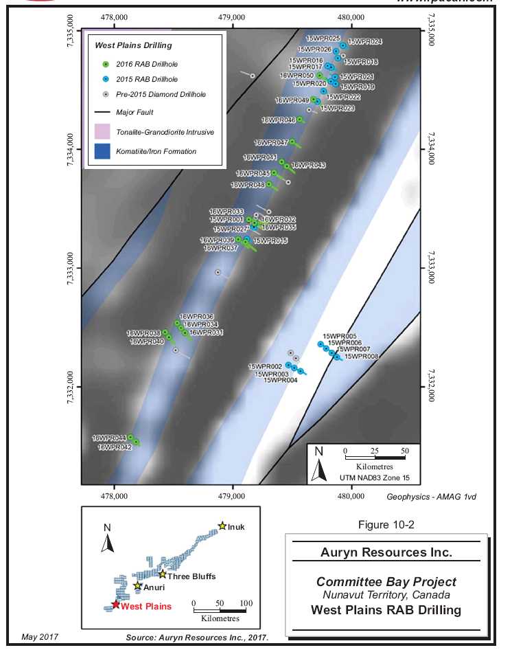
10 - 6
| | www.rpacan.com |
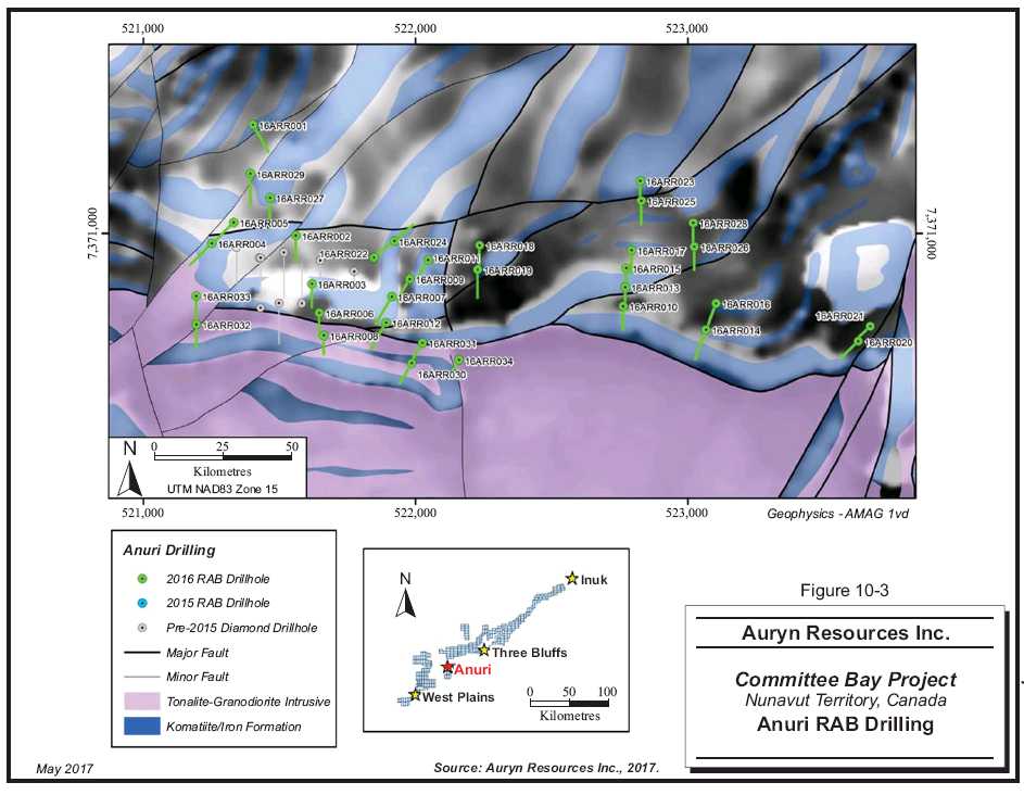
10 - 7
| | www.rpacan.com |
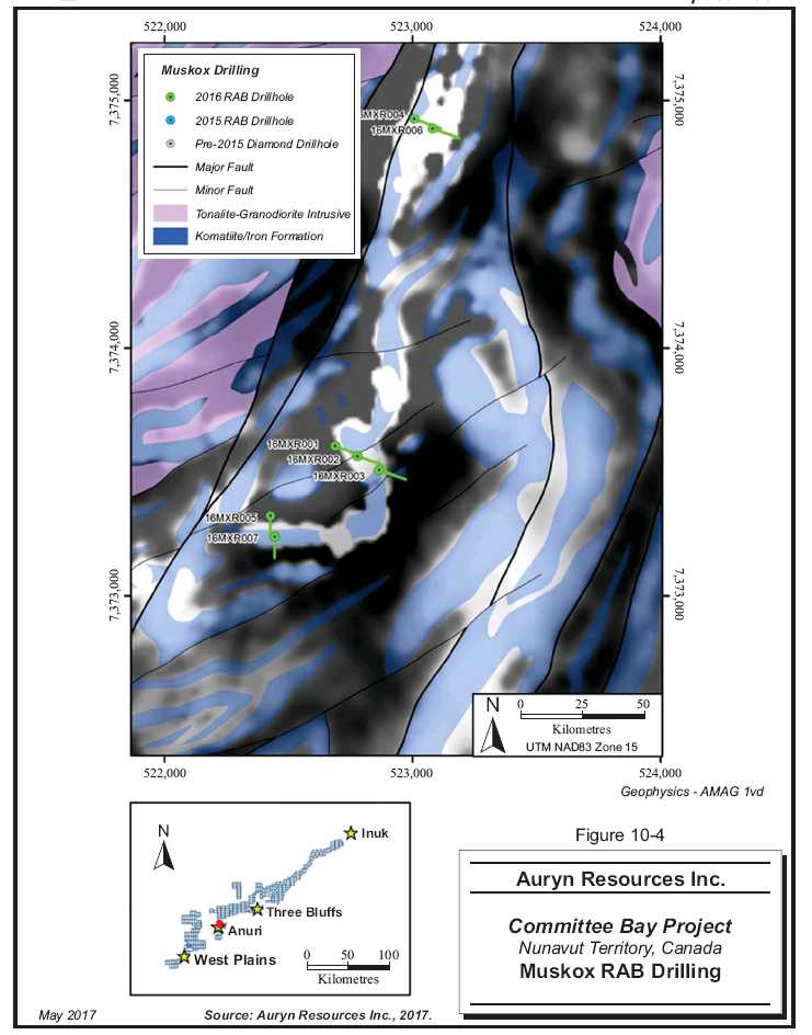
10 - 8
| | www.rpacan.com |
The following is abridged from Auryn’s Standard Operating Procedure, RAB Drill Sampling, Committee Bay Property, Nunavut.
RAB holes are planned (location, azimuth, dip, length) by the supervising geologist. The drill hole azimuth is established in the field by aligning the drill rig frame or mast with front and back sight pickets. The dip is checked by the geologist prior to collaring the hole. Samples of drill cuttings are taken by the sampler at every five feet, corresponding to the length of individual drill rods. Samples are packaged into rice bags for helicopter transport back to camp.
Duties completed by the Auryn geologist at camp include:
Completion of a geological quick log using the appropriate template
X-ray fluorescence (XRF) analysis (where applicable)
Detailed geological logging
Selection of base of overburden samples
Separation of base of overburden samples
Removal of overburden samples
Preparation for sample dispatch
Completion of laboratory submission form
QUICK LOG
As samples are transported back to camp, they will be quick logged by the logging geologist. These quick logs entail:
Lithologies and alteration designated at this point in logging are subject to change during detailed geological logging; however, they will provide a reasonable real-time data set for use in drill hole planning.
XRF ANALYSIS
Following the completion of the quick log, an XRF analysis of each sample should be completed in accordance with the established procedure. XRF data will generally provide valuable information to assist with geological logging.
| Auryn Resources Inc. – Committee Bay Project, Project #2655 | |
| Technical Report NI 43- 101 – October 23, 2017 | Page 10-9 |
| | www.rpacan.com |
DETAILED GEOLOGICAL LOGGING
Detailed geological logging is completed using chip tray samples (and XRF information where appropriate). Geological data will be captured using a Samsung Galaxy data logger equipped with WellCAD software. Logging will be completed in camp according to the following guidelines:
Chip trays received from the drill will be quick logged and set aside for drying in the logging workspace.
Detailed logging will be interval based, not sample based (i.e., logging will be completed for each unit/alteration interval as it is encountered downhole, and not for each five foot interval separately; example table below).
Hole ID | Alteration | Lithology |
| From | To | Code | From | To | Code |
16RB001 | 55 | 75 | QPo | 0 | 15 | OB |
| 85 | 95 | QSPo | 15 | 60 | Ar-ps |
| | | | 60 | 75 | Ar-i |
| | | | 75 | 100 | Ar-k |
Logged units will be assigned a lithology consistent with designated log codes and will include basic mineralogy and unit descriptions. XRF data may be useful to assist in assigning lithologies.
Intervals of alteration will also be logged consistent with designated alteration codes.
Completed logs will be submitted to the supervising geologist for review and upload to Auryn data storage.
The logging geologist will be familiarized with these procedures prior to the completion of any detailed logging. Auryn technical personnel on site may periodically review and/or assist with the detailed logging as necessary to ensure consistent data collection.
SAMPLE SORTING
After geological logging is complete, the geologist opens all rice bags and physically sorts samples by sequential sample number, ensuring the following:
All samples are accounted for.
That intervals on the data logger and included sample tag correspond.
Standards and blanks can now be inserted.
| Auryn Resources Inc. – Committee Bay Project, Project #2655 | |
| Technical Report NI 43- 101 – October 23, 2017 | Page 10-10 |
| | www.rpacan.com |
INSERTION OF STANDARDS AND BLANKS
At this point, the geologist takes sample tags previously set aside and assigns standards and blanks.
| | | Standards are inserted on sample numbers ending with 13, 53, and 93 (3% of data) |
| | | i) | The appropriate standards are selected randomly. |
| | | ii) | The sticker is removed from the standards and affixed to the inner sample tag. The standard ID is also written on the inner barcoded sample tag. |
| | | iii) | The standard is inserted into a 12 in. x 20 in. clear plastic sample bag. |
| | | iv) | The outer sample tag (not labelled with standard ID) is then inserted into the 12 in. x 20 in. clear plastic sample bag. |
| | | v) | Blanks are inserted on sample numbers ending with 33 and 73 (2% of data). Blanks alternate between coarse crush and fine (pulp) blanks. |
| | | vi) | Blanks are inserted using the same protocol as standards (above). |
BASE OF OVERBURDEN SAMPLES
Following the completion of geological logging, the geologist is able to establish the base of overburden interval. This sample plus the preceding sample (two samples total) are selected for separate analysis. These samples are bagged into a separate rice bag and sent as a separate sample submission with separate standards. Overburden samples from several holes are collected until the sample submission contains eight to ten overburden samples, to which one standard and one blank are added to comprise the final sample submission. All standards and blanks used in base of overburden samples use tags from a separate tag book kept specifically for that purpose.
All analytical samples occurring up hole of (before) the two overburden samples are removed and discarded.
Base of overburden samples are allocated submission numbers using the format: YYCB-OB-XXX (e.g., 16CB-OB-001).
PREPARATION FOR SAMPLE DISPATCH
All samples are packaged in double bagged rice bags (i.e., two bags for added protection).
The following is completed in preparation for sample dispatch:
| | 1. | A pre-addressed ALS Vancouver 20”x40” polywoven rice bag is pre-labelled with shipment number, bag number, and shipper details. |
| Auryn Resources Inc. – Committee Bay Project, Project #2655 | |
| Technical Report NI 43- 101 – October 23, 2017 | Page 10-11 |
| | www.rpacan.com |
| | 2. | Following removal of overburden samples and separate bagging of base of overburden samples, all other analytical samples are placed into rice bags in sequence. |
| | | |
| | 3. | A maximum of ten samples are included in each bag. Rice bags used to ship samples from the drill can be reused as the internal sample bag. The outer bag is the bag labelled previously. |
| | | |
| | 4. | Rice bags are then labelled with bag number and total number of bags in the sample submission (e.g., Bag 1 of 10, 2 of 10 etc.). |
| | | |
| | 5. | Each 12 in. x 20 in. plastic sample bag is scanned using the data logger and recorded against the appropriate rice bag number as it is inserted into the rice bag. |
| | | |
| | 6. | Prior to sealing the rice bags, the sample submittal form is placed within the first bag of the sample shipment. |
| | | |
| | 7. | Security tags are also scanned for the corresponding bag. These rice bags are then zip tied and sealed with the security tag. The zip tie should pass through the security tag when sealing the rice bag so the security tag does not break during transport. |
| | | |
| | 8. | Each rice bag is then labelled with the submission number. The submission number is allocated sequentially and use the convention: YYCB-RB-XXX (e.g., 16CB-RB-001). |
| | | |
| | 9. | Completed sample submission shipments are lined up in the sample dispatch area in sequential order and separated by hole. Each hole is marked with a different colour combination of flagging tape wrapped around the top of the rice bag for easy identification for transport out of camp. |
| | | |
| | 10. | Samples placed in the dispatch area are dispatched by the logistics department. |
DIAMOND DRILLING
Table 10-4 lists those diamond drill holes completed by Auryn and Table 10-5 lists the significant intersections obtained.
TABLE 10-4 AURYN DIAMOND DRILLING
Auryn Resources Inc. - Committee Bay Project
| | | Easting | Northing | Start | Finish | | Length |
| Hole | Prospect | | | Date | Date | Attitude | (m) |
| 16AN043 | Antler | 567,421 | 7,391,591 | 10-Jul-16 | 14-Jul-16 | 353°/-56° | 413.61 |
| 16AN044 | Antler | 568,078 | 7,391,928 | 12-Jul-16 | 18-Jul-16 | 003°/-67° | 477.87 |
| 16TE001 | Three Bluffs East | 570,602 | 7,393,194 | 15-Jul-16 | 24-Jul-16 | 358°/-71° | 712.32 |
| 16TB146 | Three Bluffs | 569,419 | 7,392,425 | 19-Jul-16 | 21-Jul-16 | | 157.58 |
| 16TB147 | Three Bluffs | 569,587 | 7,392,453 | 22-Jul-16 | 28-Jul-16 | 358°/-70° | 474.57 |
| 16TB148 | Three Bluffs | 570,580 | 7,392,805 | 25-Jul-16 | 01-Aug-16 | 357°/-66° | 654.41 |
| 16TB149 | Three Bluffs | 570,112 | 7,393,107 | 28-Jul-16 | 07-Aug-16 | 181°/-70° | 825.09 |
| Auryn Resources Inc. – Committee Bay Project, Project #2655 | |
| Technical Report NI 43- 101 – October 23, 2017 | Page 10-12 |
| | www.rpacan.com |
TABLE 10-5 AURYN SIGNIFICANT DDH INTERSECTIONS
Auryn Resources Inc. - Committee Bay Project
| | Hole | From | To | Length | Gold |
| Prospect | Number | (m) | (m) | (m) | (g/t) |
| Antler | 16AN044 | 443.00 | 452.00 | 9.00 | 3.43 |
| | including | 444.00 | 447.00 | 3.00 | 7.44 |
| Three Bluffs | 16TB147 | 419.00 | 442.00 | 23.00 | 2.50 |
| | including | 430.00 | 433.00 | 3.00 | 7.01 |
| | 16TB148 | 465.00 | 476.00 | 11.00 | 1.73 |
| | 16TB148 | 552.00 | 566.00 | 14.00 | 1.73 |
| | 16TB148 | 600.00 | 601.00 | 1.00 | 10.95 |
| | 16TB149 | 688.00 | 716.00 | 28.00 | 1.03 |
| | including | 689.00 | 690.00 | 1.00 | 4.17 |
| | including | 715.00 | 716.00 | 1.00 | 4.79 |
| | 16TB149 | 767.00 | 768.00 | 1.00 | 6.70 |
| | 16TB149 | 777.00 | 807.00 | 30.00 | 2.12 |
| | including | 790.00 | 791.00 | 1.00 | 4.99 |
| | including | 801.00 | 806.00 | 5.00 | 7.01 |
The following is abridged from Auryn’s Standard Operating Procedure, Diamond Core Drilling, Committee Bay Property, Nunavut.
Drill hole collar coordinates, azimuth, depth, and target information is provided by the Supervising Geologist in advance to enable the surveyor/geologist to mark out the drill hole and front/back sights for drill crews. At this time, a pre-drill site photograph should be taken for reference.
Prior to commencement of drilling, a geologist checks to ensure that the drill rig is located over the correct collar peg. The drill hole azimuth is checked by aligning the drill rig frame or mast with the front and rear sight pegs, which will be positioned in advance. Alternatively, a Reflex TN14 Gyro compass may be used for drill rig alignment.
DOWNHOLE SURVEYS
Two types of survey instruments are used to measure downhole deviation at the Committee Bay Project.
| Auryn Resources Inc. – Committee Bay Project, Project #2655 | |
| Technical Report NI 43- 101 – October 23, 2017 | Page 10-13 |
| | www.rpacan.com |
REFLEX EZ-SHOT OR EZ-TRAC
The Reflex Ez-shot/Ez-Trac system is a single-shot/multi-shot survey tool used to measure downhole dip and azimuth. Azimuth is measured using magnetic field and is therefore prone to interference by drill rods (if measured too close to rods) and the presence of magnetite and or pyrrhotite in rock units. The tool measures total magnetic field to enable an assessment of the quality of azimuth data.
At the Committee Bay Project, the Ez-shot/Ez-trac system is used to measure dip and azimuth as the hole progresses. Ez-shot surveys should be completed 6 m below the base of casing and approximately every 30 m thereafter as drilling proceeds. In general, to complete an Ez-shot/Ez-trac survey, the driller will pull the core tube, remove two drill rods, circulate water/brine to warm the hole for one to two hours, then pump the Ez-shot/Ez-trac tool to the bottom of hole (past the end of the rod string so that the rods do not interfere with the azimuth reading).
REFLEX GYRO
The Reflex Gyro is a downhole instrument that comprises a sealed probe with three digital micro-gyros, three accelerometers and integrated electronics which allow accurate downhole measurements of dip and azimuth to be collected within a drill hole string and in areas where magnetic interference is common. Data input, output, and processing is completed in a ruggedized field tablet/laptop via wireless/Bluetooth connectivity. Gyro data produces dip and azimuth data enabling accurate spatial location of downhole data (assays, geological features, structures, etc.)
At the Committee Bay Project, Gyro surveys are generally completed at the end of each drill hole. In deeper holes, gyro surveys may be completed periodically as the hole progresses. Gyro data is more accurate than Ez-shot/Ez-trac data.
At the completion of each drill hole (or as required), the surveyor, technician, or drill geologist is required to complete a gyro survey. In preparation for gyro surveying, the drillers remove the core tube and circulate sufficient hot water/brine to suppress permafrost. Gyro surveys can take up to 90 minutes depending on hole depth. The survey operator inputs location coordinates (Northing, Easting) and the starting azimuth of the survey. The starting azimuth is generated using a Reflex TN14 Gyro compass or by completing rod shots (survey on base and top of the rod attached when rods are pulled to top of the mast) to calculate the azimuth.
| Auryn Resources Inc. – Committee Bay Project, Project #2655 | |
| Technical Report NI 43- 101 – October 23, 2017 | Page 10-14 |
| | www.rpacan.com |
DRILL INSPECTIONS
During the day and night shift of drilling, the drill rig geologist visits the drills in order to inspect the drill, check on drill progress, collect geological information, and monitor downhole surveys. While at the rig, the geologist works with the drillers to identify any problems, gain information regarding the hole, and to complete a quick log of the drill core in order to monitor the hole with respect to the drill target.
Drills are inspected by the drill geologist at least once per shift. Inspections include the following:
| | | Record the current depth and hole number in the drill notebook. |
| | | | |
| | | Record any important notes provided by the driller. Notes may include: production difficulties, hard ground/soft ground, zones of lost water pressure, any bit changes or expected bit changes, broken components or components needing maintenance, water consumption, etc. |
| | | | |
| | | Collect downhole survey information recorded by driller. |
| | | | |
| | | Complete a brief safety and environmental inspection of the drill making sure that: |
| | | | |
| | | | All guards are in place |
| | | | All personnel are wearing correct personal protection equipment |
| | | | Any hazards are identified and addressed (tripping hazards, etc.) |
| | | | Spill kit is present and easily accessible |
| | | | All fuel, oils, and chemicals are in containment |
| | | | Drill cuttings are being managed appropriately |
| | | | Water readings are being kept to monitor water consumption. |
| | | | |
| | | Complete a quick log of the core. |
QUICK LOG
The quick log is completed to provide real time feedback on the status of drilling and geological information as holes progress. Lithology, alteration, mineralization, and structure provide valuable information which can assist with hole planning. Hole depths will vary based on geological information provided by the quick logs.
Quick logs are completed at the drill. Core boxes are placed in order and core is reviewed, noting from and to intervals of lithology, alteration, structure, and mineralization. Upon return to camp, a quick log Microsoft Excel sheet is completed. The quick log file is distributed to relevant geological personnel.
| Auryn Resources Inc. – Committee Bay Project, Project #2655 | |
| Technical Report NI 43- 101 – October 23, 2017 | Page 10-15 |
| | www.rpacan.com |
Where applicable, cross sections are updated using quick log information. Downhole survey information collected by drillers (Ez-shot/ez-trac data) is used to adjust drill hole trace to reflect changes in dip which may occur during drilling. This will provide real time data to assess how the drill hole is progressing, when the target has been reached, and when to end the hole.
CORE PROCEDURES
Core is delivered to camp by Alltrack or Hagglund during winter programs and by air (helicopter) in the summer. Auryn has followed the core procedures as described below.
All data are recorded in the NCG Data Logger software on one of the core logging laptops provided in the core shack. Each hole has its own separate file and upon its completion is merged into one master database by the database manager.
Core is laid out on logging tables in the core shack so that the boxes are in numerical order. The boxes are checked to ensure that they are properly labelled, that all metre/footage blocks are in their proper order, and that none are missing.
GEOTECHNICAL MEASUREMENTS
Upon receipt of core at the core shack the following tasks are completed by the geological technician/geologist.
CHECK BLOCKS
Check that all footage blocks are in proper order, with no blocks missing. A block will appear every 10 ft, or 3.048 m.
CONVERT BLOCKS
If the core blocks are in feet, convert the footage depths on the blocks to metres. Write the depth in metres to two decimal places on each block on a side other than where the drillers wrote the depth in feet.
PIECE TOGETHER CORE
Fit the ends of the broken core back together without changing the “up-hole” direction. Some pieces may have been put in backward by the drill helper. Some pieces might not even be in the proper place. Where possible, core is reconstructed. If a foliation, banding, or other fabric is present in the rock, the core is rotated in the core box so that the fabric is in a consistent orientation.
| Auryn Resources Inc. – Committee Bay Project, Project #2655 | |
| Technical Report NI 43- 101 – October 23, 2017 | Page 10-16 |
| | www.rpacan.com |
METRE MARKS
Draw metre marks on the core with yellow lumber crayons and on the core box with permanent markers. Markings on the core must be visible in core photographs. The core runs are not always exactly 10 ft, or 3.048 m, in length, so the distance between two core blocks can be slightly more or less.
RECOVERY
The percent recovery is a function of the theoretical length between blocks by the recovered length.
ROCK QUALITY DESIGNATION
Rock Quality Designation (RQD) is the ratio (percentage) of intact core pieces longer than 10 cm over a given length of core. Only natural fractures are taken into account.
MAGNETIC SUSCEPTIBILITY
Magnetic susceptibility is recorded over the entire length of the core. Measurements are taken every one metre for all lithologies, except in iron formations, which will be measured at 50 cm intervals.
SPECIFIC GRAVITY
For resource drilling, take a specific gravity measurement each 10 ft (3.04 m) interval. Sampling is controlled by changes in lithology or significant changes in alteration or oxidation, so that all zones are represented. Measurements are taken using the water immersion method.
LOGGING PROCEDURES
Logging is completed by the geologist, and focuses on the collection of geological and mineralogical parameters, which have a suspected or demonstrated relationship to gold mineralization. Logging is performed on laptop computers, using the NCG Data Logger.
The geologist fills in the geology data entry forms using pick lists with standard codes for lithology, rock texture, silicate mineralogy, metallic mineralogy and visible gold texture, structure and veining. For each data type on the log form, there is a pick-list of permissible entries to ensure consistency. Only entries that are on the list are allowed into the database.
| Auryn Resources Inc. – Committee Bay Project, Project #2655 | |
| Technical Report NI 43- 101 – October 23, 2017 | Page 10-17 |
| | www.rpacan.com |
Each lithological interval is assigned a record. Each interval has a description/comments box where the general description of the interval and any special features it may contain is entered. Each of these data types are assigned from-to intervals independently.
Once the hole is finished logging, the geologist reviews the various forms to ensure all the data (both geological and geotechnical) is complete before labelling the file as “Final”. Once the complete log is saved on the Dropbox or server, the geologist or geotechnical engineer informs the database manager.
PHOTOGRAPHY OF CORE
After geotechnical and geological logging and sample marking is completed, the core is photographed using a digital camera. Photographs are taken when the core is both dry and wet.
SAMPLING PROCEDURE
After core photography, the NQ core is sawn in half along a line marked on the core by the logging geologist. The samples are assigned unique assay tag numbers which are placed in the sample bags. The sample bags are sealed with plastic cable ties and placed in larger plastic fibre rice bags for shipment. The rice bags are in turn sealed with larger cable ties. One half of the core is kept as a reference in a core box and is stored on site. Core recovery is generally excellent, allowing for representative samples to be taken and accurate analyses to be performed. Figure 10-5 illustrates the core handling and sampling workflow at Committee Bay.
COMMENTS
In RPA’s opinion, the core handling, logging, and sampling protocols adopted by Auryn meet or exceed industry standards. The drill programs have been configured and carried out in a manner that is appropriate for the geometry of the deposit. Drill holes are oriented perpendicular to strike and aimed to intersect the zones at an angle generally greater than 45°. As such, the samples should be representative of the deposit as it is presently known, and suitable for use in Mineral Resource estimation.
| Auryn Resources Inc. – Committee Bay Project, Project #2655 | |
| Technical Report NI 43- 101 – October 23, 2017 | Page 10-18 |
| | www.rpacan.com |
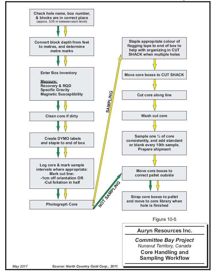
10 - 19
| | www.rpacan.com |
11 SAMPLE PREPARATION, ANALYSES AND SECURITY
Since acquiring the Property, Auryn has adopted the Sample Preparation, Analytical and Security protocols previously established by NCG. Sample preparation, analytical and security protocols followed prior to Auryn’s acquisition of the Property are reviewed in Rennie and McDonough (2015) and are described below.
Core arrives in camp at the end of each drill shift where geological technicians check and correct and downhole distance discrepancies. Technicians record core recovery, fracture density and orientation, magnetic susceptibility, and overall RQD. Geological logging follows, comprising measurement and descriptions of geological units and the collection of semi-quantitative data such as the number of visible gold occurrences, volume percent sulphide minerals, volume percent of alteration minerals, volume percent vein quartz, etc. Sample intervals are then designated by the logging geologist focusing on sulphide bearing and/or silicified intervals that are well bracketed by apparently unmineralized rock. Protocols limit sampling intervals between 0.75 m and one metre in length with a minimum length of 0.3 m and a maximum length of 1.5 m so long as geological boundaries were honoured.
Drill core is digitally photographed and core samples are marked for sawing. Sampling intervals, geological boundaries, and a “saw line” are marked by the logging geologist and the core is sawed in half longitudinally by technicians. One half of the core is placed in a sample bag with a uniquely numbered tag and secured with plastic cable ties. Each batch of 20 field samples contain a blank and one of four commercial CRMs. The remaining half core is returned to the core box for reference. The majority of the reference core remains on-site except for chosen intervals which are taken to Edmonton, Alberta for display purposes. Individual sample bags are placed inside a larger bag which is closed with a security seal for shipment to the laboratory.
Assaying procedures are generally similar to those used in 2003, with some minor modifications. The standard aliquot size was increased to 2AT (58.32 g) and the samples were all analyzed using FA with a gravimetric finish. Selected samples, containing visible gold or which assayed greater than 20 g/t Au, are re-analyzed using metallic screen fire assay that include twin 2AT gravimetric assays of the fine fraction. A pulp from each sample is sent for standard 30 element ICP analysis using a three-acid digestion (Blakley and Rennie, 2008).
| Auryn Resources Inc. – Committee Bay Project, Project #2655 | |
| Technical Report NI 43- 101 – October 23, 2017 | Page 11-1 |
| | www.rpacan.com |
The Auryn diamond drill and RAB sample preparation and analysis procedures are illustrated in Figures 11-1 and 11-2, respectively.
SAMPLE TRANSPORT, STORAGE AND SECURITY
In 2015, approximately half of the RAB samples were sent to the ALS laboratory in Yellowknife, NWT, for preparation prior to shipment of the pulps to the ALS laboratory in Vancouver, BC, for analysis. Subsequently, the RAB samples were shipped to the ALS laboratory in Vancouver for both preparation and analysis. In 2016, both the RAB and diamond drill core samples were transported by chartered fixed wing aircraft to Rankin Inlet in security sealed rice bags. In Rankin Inlet the rice bags were placed in Mega bags and palletized for shipment to Winnipeg by commercial aircraft (Calm Air). In Winnipeg, the palletized samples were picked up from Calm Air Cargo by Day and Ross Transportation for shipment to the ALS laboratory in Vancouver.
SAMPLE PREPARATION
Both the Yellowknife and Vancouver preparation facilities are accredited to ISO 9001:2008 for their quality management system.
Security seals were verified once the sample shipments reached the laboratory. Individual samples were crushed to 90% <2 mm or -10 mesh. A one kilogram sample was split and pulverized to 95% < 106 µm or -150 mesh using a puck or ring pulverizer. The remainder of the sample was stored as coarse reject material. A 50 g aliquot of pulverized material was split for analysis and the remainder of the pulverized material was stored.
SAMPLE ANALYSIS
All the RAB and diamond drill core samples were analyzed at the ALS laboratory in Vancouver by fire assay of a 50 g sample followed by a gravimetric finish according to ALS lab code Au-GRA22 and by a multi-element inductively coupled plasma atomic emission spectrometry or mass spectrometry (ICP-AES/ICP-MS) package following a four acid digestion of a one gram sample according to ALS lab code ME-MS61. Sample intervals with visible gold in core were assayed using a Screen Fire Assay method on a one kilogram sample according to ALS lab code Au-SCR24 where the entire sample is screened to 100 µm and fire assays are performed on a 50 g sample of the <100 µm material and on the entire >100 µm material. The fire assay is calculated as a weighted average of the two fire assays.
| Auryn Resources Inc. – Committee Bay Project, Project #2655 | |
| Technical Report NI 43- 101 – October 23, 2017 | Page 11-2 |
| | www.rpacan.com |
RPA and Auryn are independent of ALS. In RPA’s opinion, the sample collection, preparation, analysis, transport, and security procedures at the Project are adequate for use in the estimation of Mineral Resources.
| Auryn Resources Inc. – Committee Bay Project, Project #2655 | |
| Technical Report NI 43- 101 – October 23, 2017 | Page 11-3 |
| | www.rpacan.com |
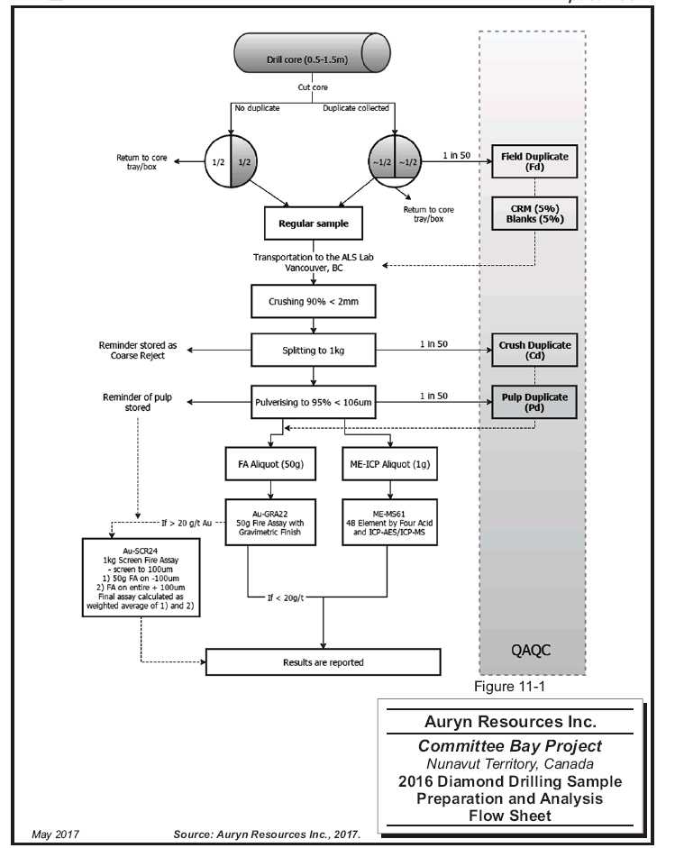
11 - 4
| | www.rpacan.com |

11 - 5
| | www.rpacan.com |
12 DATA VERIFICATION
SITE INSPECTION
2004
RPA’s predecessor, Scott Wilson RPA, visited the Three Bluffs Project on August 19 and 20, 2004 and took three independent grab samples from the Three Bluffs showing and six samples from three drill holes. One of the three grab samples confirmed the presence of anomalous gold and, generally, the samples from the drill core compared favourably with the results obtained by CBR (Blakley and Rennie, 2008).
2007
Scott Wilson RPA visited the property on September 18 and 19, 2007 and conducted a number of verification checks (Blakley and Rennie, 2008). These checks are described under Database Verification.
2011
RPA visited the property on August 23 to 24, 2011 and conducted a tour of the drill and camp facilities (Rennie and McDonough, 2015). A number of verification checks were carried out, as described under Database Verification below.
2016
The most recent site visit to the Property was carried out by David Ross, P.Geo., Principal Geologist with RPA, on August 16-17, 2016. Mr. Ross visited numerous outcrops, active drill sites and core logging facilities, reviewed drill core, and took several quarter core samples for independent assaying.
In RPA’s opinion, the logging, sampling, and data handling procedures conducted on the Project exceeds industry standards.
| Auryn Resources Inc. – Committee Bay Project, Project #2655 | |
| Technical Report NI 43- 101 – October 23, 2017 | Page 12-1 |
| | www.rpacan.com |
DATABASE VERIFICATION
2004
Scott Wilson RPA compared the written logs and original assay files for five drill holes from the 2004 drilling with the database and found no errors with respect to lithology, intercepts, and gold assays. Checks on earlier holes were also done and were error free (Blakley and Rennie, 2008).
2007
For the 2007 drill program, the assay database was compared against original assay certificates and no significant errors were encountered. The written drill logs from two holes were checked against the database in terms of lithology, intercepts, and gold assays and were error-free (Blakley and Rennie, 2008).
2011
RPA compared the drill core assay database against original assay certificates from ALS, ActLabs, and TSL. The database included assays from 2003 to 2011. RPA spot checked portions of each program so a total of approximately 8% of the overall database was inspected.
RPA noted a number of apparent discrepancies between the database and the assay certificates, which, in RPA’s opinion, were due to NCG’s practice of averaging results for those samples that were re-analyzed. A total of 67 samples fell into this category. An additional 12 entries that could not be attributed to averaging were found for an “error” rate of 0.51%, which is considered acceptable. The discrepancies were minor, the largest being 0.4 g/t Au, and generally the certificate value exceeded the database value. In RPA’s opinion, NCG’s database management was effective and the database was reasonably error-free.
2012
RPA received the lithology and assay results from the 2012 drilling in the form of a GEOVIA GEMS database. The resulting database contained records for 353 drill holes totalling 58,222.9 m in aggregate depth. RPA carried out validation exercises on the database after the inclusion of the new information and found no errors. Verification of the new data was conducted against assay certificates provided in digital format and no significant issues were noted.
| Auryn Resources Inc. – Committee Bay Project, Project #2655 | |
| Technical Report NI 43- 101 – October 23, 2017 | Page 12-2 |
| | www.rpacan.com |
2015-2016
During and subsequent to the 2016 site visit, RPA reviewed all available Standard Operating Procedures (SOPs), visited core logging facility and core storage area, independently surveyed several holes with a handheld GPS, reviewed and verified various components of the drill hole database including from/to errors and mix-ups. No significant issues were identified.
QUALITY ASSURANCE AND QUALITY CONTROL
Quality assurance (QA) provides evidence to demonstrate that the assay data has precision and accuracy within generally accepted limits for the sampling and analytical method(s) used in order to have confidence in a resource estimate. Quality control (QC) consists of procedures used to ensure that an adequate level of quality is maintained in the process of collecting, preparing, and assaying the exploration drilling samples.
In general, QA/QC programs are designed to prevent or detect contamination and allow assaying (analytical), precision (repeatability) and accuracy to be quantified. In addition, a QA/QC program can disclose the overall sampling-assaying variability of the sampling method itself.
QA/QC protocols, including the duplicate assaying of coarse rejects, and the insertion of blanks and certified reference materials (CRMs) into the RAB and drill core assay sample stream were established in 2003 and continued with updates and refinements through the 2016 drilling program. A review of the QA/QC protocols related to drilling programs completed prior to Auryn’s acquisition of the Property can be found in Rennie and McDonough (2015) and are summarized below.
In 2003, field blanks and CRMs were submitted for each assay batch and coarse reject material, representing 10% of the samples assayed, were sent to ALS in Vancouver, British Columbia for re-analysis. No external CRMs were used but TSL employed two internal CRMs that were qualified using a round robin with five laboratories (AuL-1) and three laboratories (AuM-1), respectively. These CRMs did not meet the same rigorous standards that are applied to commercial CRMs. The tolerance limits (TLs) for accuracy were considered to be two standard deviations (2SD) above or below the recommended value (RV). Any assay result that fell outside of these TLs was considered to be a failure. In 2004, commercial CRMs were added in addition to TSL’s internal standards. In 2010, NCG switched its primary laboratory from TSL to ALS for the summer drill program. For the 2011 drill program, the primary lab was shared between ActLabs and ALS, with TSL remaining the secondary laboratory used for check assaying. ActLabs was engaged when ALS could no longer provide results in a timely manner. The amount of work done by ActLabs, however, was limited when sample preparation and assay issues were discovered and the majority of samples were re-routed back to ALS as a result.
| Auryn Resources Inc. – Committee Bay Project, Project #2655 | |
| Technical Report NI 43- 101 – October 23, 2017 | Page 12-3 |
| | www.rpacan.com |
CERTIFIED REFERENCE MATERIAL
Results of the regular submission of CRMs (standards) are used to identify problems with specific sample batches, and biases associated with the primary assay laboratory.
Auryn’s QA/QC protocol calls for CRMs to be inserted into the RAB sample stream at a nominal rate of 3% and into the diamond drilling sample stream at a nominal rate of 5%. All CRMs used by Auryn were supplied by CDN Research Laboratories (CDN). All of the samples were analyzed at the ALS laboratory in Vancouver. The CRMs used during the 2015 and 2016 drilling campaigns are summarized in Table 12-1.
TABLE 12-1 2015-2016 CRMS
Auryn Resources Inc. - Committee Bay Project
| | | | | Std. | Acceptable Range (±2SD) | | |
| Drilling | | | RV | Dev. | Low | High | | |
| Type | Year | CRM | (g/t) | (g/t) | (g/t) | (g/t) | Analyses | Fails |
| RAB | 2015 | CDN-GS-IP5C | 1.56 | 0.065 | 1.43 | 1.69 | 11 | 0 |
| RAB | 2015 | CDN-GS-2G | 2.26 | 0.095 | 2.07 | 2.45 | 8 | 0 |
| RAB | 2015 | CDN-GS-4C | 4.25 | 0.10 | 4.05 | 4.45 | 9 | 2 |
| RAB | 2015 | CDN-GS-8B | 7.72 | 0.16 | 7.40 | 8.04 | 10 | 0 |
| RAB | 2015 | CDN-GS-6A | 5.79 | 0.23 | 5.33 | 6.25 | 10 | 0 |
| RAB | 2015 | CDN-GS-P3B | 0.41 | 0.042 | 0.325 | 0.493 | 8 | 0 |
| RAB | 2016 | CDN-GS-20B | 20.23 | 0.545 | 19.10 | 21.30 | 36 | 5 |
| RAB | 2016 | CDN-GS-2M | 2.21 | 0.122 | 1.966 | 2.454 | 34 | 5 |
| RAB | 2016 | CDN-GS-3Q | 3.30 | 0.13 | 3.04 | 3.56 | 35 | 10 |
| RAB | 2016 | CDN-GS-6E | 6.06 | 0.15 | 5.76 | 6.36 | 35 | 7 |
| RAB | 2016 | CDN-GS-8C | 8.59 | 0.26 | 8.07 | 9.11 | 34 | 2 |
| RAB | 2016 | CDN-GS-P4E | 0.493 | 0.029 | 0.435 | 0.551 | 30 | 3 |
| DDH | 2016 | CDN-GS-IP5C | 1.56 | 0.065 | 1.43 | 1.69 | 7 | 1 |
| DDH | 2016 | CDN-GS-2G | 2.26 | 0.095 | 2.07 | 2.45 | 11 | 0 |
| DDH | 2016 | CDN-GS-8B | 7.72 | 0.16 | 7.40 | 8.04 | 4 | 1 |
| DDH | 2016 | CDN-GS-6A | 5.79 | 0.23 | 5.33 | 6.25 | 5 | 1 |
| DDH | 2016 | CDN-GS-P3B | 0.41 | 0.021 | 0.37 | 0.45 | 7 | 4 |
| Auryn Resources Inc. – Committee Bay Project, Project #2655 | |
| Technical Report NI 43- 101 – October 23, 2017 | Page 12-4 |
| | www.rpacan.com |
A total of 226 CRMs was inserted into the RAB sample stream in 2015 and 2016. A total of 29 failures were identified, most of which were attributable to two CRMs in 2016; CDN-GS-3Q (10) and CDN-GS-6E (7). Eight of the failures related to CDN-GS-3Q were above the upper threshold and all of the failures related to CDN-GS-6E were above the upper threshold. RPA notes that the failures do not appear to be systematic.
A total of 34 CRMs were inserted into the diamond drill sample stream in 2016 and a total of seven failures were identified, including four related to CDN-GS-P3B. Three of the failures related to CDN-GS-P3B were above the upper threshold. The poor assay performance may be attributable to the CRM’s low best value of 0.409 g/t Au. The assay values related to these failures are all ≤0.50 g/t Au.
In RPA’s opinion, these failures will have no material impact on the Mineral Resource estimate, however, RPA recommends that, if it has not already been done, Auryn contact the laboratory to investigate this issue.
BLANKS
The regular submission of blank material is used to assess contamination during sample preparation and to identify sample numbering errors.
Auryn’s QA/QC protocol calls for blank material to be inserted into the RAB sample stream at a nominal rate of 2% and into the diamond drilling sample stream at a nominal rate of 5%. All of the samples were analyzed at the ALS laboratory in Vancouver.
Auryn purchased a pulp blank from CDN (CDN-BL-10). A coarse blank was developed by NCG. Approximately 200 kg of clean, rounded, unmineralized, Athabasca Sandstone (quartzite) cobbles were collected from a gravel pit west of Edmonton, Alberta. The cobbles were sent to TSL Laboratories in Saskatoon where they were crushed to minus 2.5 cm. The crushed material was riffle split and five one-kilogram sub-samples were collected for analysis. The five sub-samples were prepared and two low-level fire assays with an atomic absorption (AA) finish were completed on each. All ten fire assays failed to identify gold above the detection limit of 5 ppb Au.
In 2015 and 2016, a total of 219 samples of blank material were inserted into the RAB and diamond drill sample stream. No failures were identified.
| Auryn Resources Inc. – Committee Bay Project, Project #2655 | |
| Technical Report NI 43- 101 – October 23, 2017 | Page 12-5 |
| | www.rpacan.com |
FIELD DUPLICATES
Duplicate samples help to monitor preparation and assay precision and grade variability as a function of sample homogeneity and laboratory error. The field duplicate includes the natural variability of the original core sample, as well all levels of error including core splitting, sample size reduction in the prep laboratory, sub-sampling of the pulverized sample, and the analytical error. Coarse reject and pulp duplicates provide a measure of the sample homogeneity at different stages of the preparation process (crushing and pulverizing).
Auryn’s QA/QC protocol calls for RAB field duplicates to be taken at a nominal rate of 1 in 20 samples and drill core sample field duplicates to be taken at a nominal rate of 1 in 50 samples.
For the 2015-2016 RAB drilling programs, a total of 716 field duplicates were taken, with no reject or independent pulp duplicates. There were 275 pulp duplicates taken at the laboratory.
RPA reviewed the field duplicates results and considers them to be generally within acceptable limits. The majority of the duplicates were either at or near the detection limit for gold, with 75 above 0.10 g/t Au, which was the threshold applied by Auryn for review. The means of the original and duplicate samples above this threshold were 0.60 g/t Au and 0.57 g/t Au, respectively, which in RPA’s opinion is acceptably close. There was a very large scatter between pairs up to a mean grade of 0.40 g/t Au, although no obvious bias was observed.
The laboratory duplicates were observed to have a markedly lower scatter between original and duplicate values, which is an expected result. RPA further notes that there was no significant bias in the laboratory duplicates results.
RPA CONCLUSIONS
RPA notes that the data verification practices, as conducted by Auryn, meet or exceed industry standards and that Auryn and its predecessors have designed and mostly implemented consistent QA/QC practices since early in the Project’s exploration history.
RPA recommends increased and consistent scrutiny of QA/QC results and the implementation of a consistent protocol for dealing with any issues. In RPA’s opinion, the assay database is well maintained and the data has been handled in a manner that should render it reasonably error-free. In RPA’s opinion, the database is appropriate for use in an estimation of Mineral Resources.
| Auryn Resources Inc. – Committee Bay Project, Project #2655 | |
| Technical Report NI 43- 101 – October 23, 2017 | Page 12-6 |
| | www.rpacan.com |
13 MINERAL PROCESSING AND METALLURGICAL TESTING
The following section is taken from Blakley and Rennie (2008) and Turner and Schoeman (2013). There has been no mineralogical processing and metallurgical testing since 2009.
2003
Dawson Metallurgical Laboratories, Inc. (Dawson) of Salt Lake City, Utah, was commission in 2003 to conduct metallurgical tests on Three Bluffs mineralized material. Twelve drill core samples, eight high-grade and four low-grade, totalling approximately 20 kg were used. The resulting test specimens ranged in grade from 4.5 g/t Au to 5.6 g/t Au and testwork consisted of:
Direct cyanide leach,
Carbon- in-leach (CIL) cyanide leach of whole ore,
Diagnostic sequence of amalgamation, magnetic separation and flotation,
Diagnostic sequence of gravity concentration and flotation,
Mineralogical examination.
The mineralogical study reported the principal sulphide minerals as pyrrhotite with minor pyrite. No reference was made to any deleterious elements in the samples.
The test indicated that 92% gold recovery could be achieved with cyanidation but the presence of pyrrhotite would result in high cyanide consumption.
Mercury amalgamation recovered 63% of the gold (i.e., the free gold). Magnetic separation of the pyrrhotite concentrate from the amalgamation tail recovered an additional 12.5% . The remaining material, when subjected to bulk sulphide flotation, yielded an additional 22% of the gold for a total recovery of 97.5% .
Gravity separation using a Knelson concentrator yielded 62% recovery. Bulk flotation of the gravity tail recovered an additional 28% for a total recovery of 90% RPA notes that the grade ranges and sulphide composition of the test samples were representative of the mineralization found at Three Bluffs. RPA further notes that these preliminary tests suggest gold at Three Bluffs can be recovered using conventional methods.
| Auryn Resources Inc. – Committee Bay Project, Project #2655 | |
| Technical Report NI 43- 101 – October 23, 2017 | Page 13-1 |
| | www.rpacan.com |
2008
Mineral processing testwork comprising exploratory gravity concentration, cyanide leaching, and froth flotation studies were undertaken by Process Research Associates Ltd. (PRA) under the guidance of Scott Wilson RPA. The sample used was a 110 kg composite of drill core samples from the 2007 exploration program with an average estimated grade of 4.3 g/t Au and 7.5%S.
Additional gravity recovery testwork on Three Bluffs mineralization was performed by Knelson Research Technology Centre. An 18 kg sample, taken from a composite of coarse rejects sample material from 2007 drill core samples, was subjected to multi-pass testing utilizing a bench-scale enhanced gravity concentrator. The tests were designed to examine recovery trends for gold and gold-bearing sulphides (CBR Gold, 2009).
The gold recovery results are summarized in Table 13-1. Based on the composite sample tested it was expected that Three Bluffs mineralization could be processed by various standard beneficiation steps to recover approximately 93% of the gold. The metallurgical test results indicated that a combination of gravity and flotation followed by cyanide leaching of the concentrate is likely the most suitable processing option.
TABLE 13-1 2008 GOLD RECOVERY RESULTS
Auryn Resources Inc. – Committee Bay Project
| | Mass | Grade | Gold |
| Process | | | Recovery |
| | (%) | (g/t Au) | (%) |
| Gravity Flotation (Locked Cycle) | 18 | 30.5 | 95.8 |
| Rougher Flotation Only | 15 | 60.5 | 97.2 |
| Gravity Only | 7 | 47.7 | 77.9 |
| Cyanide Leaching (72 hours) | | | 94.6 |
The limited metallurgical testwork conducted to date suggests that the gold can be recovered by conventional means, a combination of gravity and flotation followed by cyanide leaching of the concentrate.
| Auryn Resources Inc. – Committee Bay Project, Project #2655 | |
| Technical Report NI 43- 101 – October 23, 2017 | Page 13-2 |
| | www.rpacan.com |
2009
Follow-up work at PRA was then undertaken in April 2009 to look specifically at a flowsheet consisting of gravity recovery followed by cyanidation. These results were reported by PRA on May 6, 2009.
MINERALOGY
Petrographic and X-ray diffraction analysis indicated the presence of sulphide minerals including mainly pyrrhotite and lesser pyrite. Thin section analysis indicated that some pyrite was contained within pyrrhotite fractures and some magnetite was intergrown in the pyrite which also contained some chalcopyrite and galena inclusions.
COMMINUTION
PRA determined a grind size P80 of 75 μm is considered the most suitable grind. The Bond Ball-Mill Work Index determination indicated a moderately hard ore of 18.7 kWh/tonne.
GRAVITY RECOVERY
Gravity testing completed at the Knelson Research and Technology Centre (KRTC) yielded good results on a sample ground to a P80 of 141 μm. The gravity gold recovery from the multi- ass test was 77.9% in 7.0% concentrate mass, with 69.4% of the gold recovered in the initial pass containing 1.4% of the mass. The initial pass Knelson concentrate was 212 g/t Au and concentrating this by pan yielded 40 % of the total gold to a pan concentrate of 4,500 g/t. The calculated gold head grade was 4.3 g/t Au with a corresponding tailings grade of 1.0 g/t Au. The recovery to mass yield curve for gold and sulphur indicated that sulphur was upgraded very little initially but showed moderate upgrading at relatively higher concentrate yield from 4 % to 7 %. This indicated that gold bearing sulphides are not amenable to enhanced gravity separation and that batch concentration and not continuous gravity concentration should be utilized.
FLOTATION
PRA assembled a single composite sample from the 45 individual samples which CBR obtained from three drill holes from the 2007 drilling campaign: 07TB046, 07TB048, and 07TB054. The holes are all located in the central part of the hinge zone. The blended composite assayed: 4.3 g/t Au, <0.5 g/t Ag, 17.2% Fe, and 7.5% S. The composite sample is considered to be reasonably representative of the Life of Mine (LOM) production head grade. The calculated gold head grades from the various tests showed considerable fluctuation from a low of 2.9 g/t Au to a high of 11.8 g/t Au, with an average calculated head grade of 5.6 g/t Au, 1.1 g/t Ag, and 7.8% S. This variation is likely attributable to the presence of coarser gold particles, indicating a significant nugget effect for Three Bluffs.
| Auryn Resources Inc. – Committee Bay Project, Project #2655 | |
| Technical Report NI 43- 101 – October 23, 2017 | Page 13-3 |
| | www.rpacan.com |
GRAVITY-FLOTATION BATCH TESTING
At a primary grind size P80 of 74 μm, gold was effectively extracted by gravity and flotation, with 96% of the gold recovered. Coarser grinding at a P80 of 103 μm and 135 μm showed that gold recovery was reduced.
GRAVITY-FLOTATION LOCKED-CYCLE TESTING
In a single Locked-Cycle test, a gravity circuit recovery of 60.5% gold in 0.22% of mass, followed by a cleaner flotation recovery of 35.3% gold in 17.7% of the mass, was obtained. Thus an overall gold recovery of 95.8% in 17.9% of the mass was shown to be possible. The gravity concentrate assayed 1,750 g/t Au, while the flotation concentrate assayed 11.4 g/t. Flotation provided significant sulphide concentration with sulphur recovery at 90.6% to a 35.7% S grade in the cleaned concentrate.
FLOTATION BATCH TESTING
Flotation recovery without gravity scalping was reasonably successful. Rougher flotation produced concentrate grades up to 60 g/t Au at 97.2% recovery at a primary grind size P80 of 74 μm. Tailings grades of 0.2 g/t Au were consistently obtained. Flotation testing was carried out using only xanthates and MIBC in roughing and with no pH modification. It is expected that future testing could further optimize the flotation circuit.
LEACHING
CONCENTRATE CYANIDE LEACHING
Flotation concentrate was subjected to cyanide leach test work. A total of eight concentrate leach tests were performed. After 120 hours of leaching at starting NaCN concentration levels of 1 g/t, gold extraction was typically >98%. In general, leaching kinetics were slow, although more favorable results were obtained with pre-aeration followed by continuous aeration. The best concentrate leach test provided 81% recovery after 48 hours and 89% recovery after 72 hours. Intensive cyanide leaching of concentrates at cyanide concentration levels in the order of 20 g/t should be investigated in future test work.
| Auryn Resources Inc. – Committee Bay Project, Project #2655 | |
| Technical Report NI 43- 101 – October 23, 2017 | Page 13-4 |
| | www.rpacan.com |
WHOLE ORE LEACHING
A single whole ore cyanide leach test obtained 79.2% gold extraction after 48 hours and 94.6% after 72 hours. The cyanide consumption rate was high at 2.0 kg/t feed but was considerably lower than that observed in the Dawson work. Dawson obtained 91.8% recovery after 48 hours, but at a NaCN concentration of double that used by PRA.
The same composite sample from the 2008 test work was ground to a P80 size of 75 μm and subjected to cyanide leaching for 120 hours at a base concentration of 1.0 g/L NaCN. A series of diagnostic tests were conducted to see how varying conditions might impact on gold recovery results. Gravity gold recovery was fairly consistent with recoveries averaging 48.8% in approximately 0.14 of the mass after panning of Knelson concentrates. This falls along the same curve as produced from the KRTC test work. The gold grades of these concentrates are typically 1,300 g/t Au to 2,200 g/t Au. The cyanide leach extraction was significantly improved with aeration, with recoveries of 42% to 43% after 48 hours. The cyanide leach recovery after 72 hours was 47% to 48% in these two tests. The overall gold recovery can be increased to approximately 98.5% with leach times extended to 120 hours.
The lower cyanide concentration had only a minor impact on gold extraction. Finer grinding resulted in higher gravity gold recovery, but overall recovery was not significantly impacted. The cyanide consumption in the two tests with aeration was 1.83 g/t to 2.04 g/t after 48 hours and 2.38 g/t to 2.58 g/t after 72 hours. With lower cyanide concentration, the rates were reduced to 1.63 g/t after 48 hours. Lime consumption ranged from 0.12 kg/t to 0.31 kg/t to maintain a pH between 10 and 10.5.
METALLURGICAL ISSUES IDENTIFIED IN TEST WORK
Several issues were identified during metallurgical testing of samples, the largest issue lies with cyanide consumption. Cyanide consumption has been found to be extremely high at up to 0.2 kg/h, while leaching kinetics remain low. Dawson identified levels of pyrrhotite to be as high as 14.3%, which is suspected to be responsible for the high levels of NaCN consumption. Attempts to remove pyrrhotite through magnetic separation were unsuccessful. Consumption of NaCN can be mitigated through the use of cement or pre-aeration/continuous aeration methods, however, this area should be researched further. Another issue that has been identified is that gold bearing sulphides are not amenable to enhanced gravity separation, therefore batch concentration and not continuous gravity concentration should be utilized. A significant nugget effect has also been identified in the samples tested.
| Auryn Resources Inc. – Committee Bay Project, Project #2655 | |
| Technical Report NI 43- 101 – October 23, 2017 | Page 13-5 |
| | www.rpacan.com |
CONCLUSIONS SPECIFIC TO METALLURGY
Based on the samples tested to date, Three Bluffs ore is generally considered to be relatively free-milling. Gravity concentration has been effective in recovering up to 60% of the gold. Much of the remaining gold can be effectively recovered by either flotation or cyanide leaching to produce an overall metallurgical recovery above 90%. Based on the defined mineable resource, a processing plant has been preliminarily designed which uses gravity recovery followed by carbon-in-leach (CIL) processing of the gravity tailings at a rate of 1,200 tpd to produce gold doré. Table 13-2 provides the gold recovery results from preliminary testing, including results for downstream processing of concentrates by intensive cyanide leaching and/or smelting.
RPA recommends further optimization and variability work on a greater variety of samples from the Three Bluffs property if further economic studies are conducted. Figure 13-1 shows the complete proposed process plant flow sheet, confirmation of the proposed gravity-CIL flowsheet and grinding size should be performed by another metallurgical laboratory, with specific focus on cyanide consumption and improving leaching kinetics. Tailings, metal leaching, and cyanide destruction testing should also be undertaken at the next phase.
| Auryn Resources Inc. – Committee Bay Project, Project #2655 | |
| Technical Report NI 43- 101 – October 23, 2017 | Page 13-6 |
| | www.rpacan.com |
TABLE 13-2RESULTS OFVARIOUS TESTPROCESSES ONCOMMITTEE BAYSAMPLES
AurynResources Inc. –Committee BayProject
| Test Lab and | Test | Process Specifications | Process Details | Time | Recovery |
| Year | Number | | | (Hours) | % |
| DML- 2003 | 3 | 2 gm/L NaCN, P80- 74 µm | CIL Leach of Whole Ore Grind | 48 | 92.9 |
| DML- 2003 | 4 | P80- 74 µm | Amalgamation, Pyrrhotite Removal, Bulk Sulphide Float | NA | 84.7 |
| DML- 2003 | 2 | 2 gm/L NaCN, P80- 74 µm | Direct Leach of Whole Core | 48 | 91.8 |
| PRA- 2009 | C1 | 1 gm/L NaCN, P80- 70 µm | Direct Leach | 72 | 94.6 |
| PRA- 2009 | CF8 | 1 gm/L NaCN, P80- 57 µm | Cyanidation of Float Concentrate (Product of test F8) | 72 | 76.8 |
| PRA- 2009 | CLC- 1 | 1 gm/L NaCN, P80- 57 µm | Cyanidation of Float Concentrate, 20- hours pre aeration | 96 | 91.4 |
| PRA- 2009 | CLC- 2 | 1 gm/L NaCN, P80- 57 µm | Cyanidation of Float Concentrate, 20- hours pre aeration then continuous aeration | 96 | 96.1 |
| PRA- 2009 | CLC- 3 | 1 gm/L NaCN, P80- 57 µm | Cyanidation of Float Concentrate, 20- hours pre aeration then continuous aeration, addition of 500g/t Pb(NO3)2 | 96 | 72.9 |
| PRA- 2009 | CLC- 4 | 1 gm/L NaCN, P80- 57 µm | Cyanidation of Float Concentrate, 20- hours pre aeration then continuous aeration | 120 | 98.0 |
| PRA- 2009 | CLC- 5 | 1 gm/L NaCN, P80- 57 µm | Cyanidation of Float Concentrate, 20- hours pre aeration then continuous aeration with oxygen | 120 | 99.5 |
| PRA- 2009 | CLC- 6 | 1 gm/L NaCN, P80- 57 µm | Cyanidation of Float Concentrate, 20- hours pre aeration then continuous aeration, lime replaced with cement | 120 | 99.0 |
| PRA- 2009 | CLC- 7 | 1 gm/L NaCN, P80- 28 µm | Cyanidation of Float Concentrate, 20- hours pre aeration then continuous aeration | 120 | 99.4 |
| PRA- 2009 | CLC- 8 | 1 gm/L NaCN, P80- 57 µm | Cyanidation of Float Concentrate, 20- hours pre aeration then continuous aeration, lime replaced with optimized cement | 120 | 98.7 |
| PRA- 2009 | GC1 | 1 gm/L NaCN, P80- 74 µm | Gravity Separation Followed by Direct Leach | 120 | 98.3 |
| PRA- 2009 | GC2 | 1 gm/L NaCN, P80- 74 µm | Gravity Separation Followed by CIL | 120 | 99.0 |
| PRA- 2009 | GC3 | 1 gm/L NaCN, P80- 75 µm | Gravity Separation Followed by 18 hrs. pre- aeration then Direct Leach | 120 | 98.7 |
| PRA- 2009 | GC4 | 1 gm/L NaCN, P80- 75 µm | Gravity Separation Followed by 18 hrs. pre- aeration then Continuous Aeration | 120 | 98.5 |
| PRA- 2009 | GC5 | 0.5 gm/L NaCN, P80- 74 µm | Gravity Separation Followed by Direct Leach | 120 | 98.0 |
| PRA- 2009 | GC6 | 1 gm/L NaCN, P80- 58 µm | Gravity Separation Followed by Direct Leach | 120 | 97.7 |
| PRA- 2009 | GF1 | P80- 74 µm | Gravity and Flotation Concentration | NA | 96.5 |
| PRA- 2009 | GF2 | P80- 74 µm | Gravity and Flotation Concentration | NA | 96.3 |
| PRA- 2009 | GF7 | P80- 73 µm | Gravity and Flotation with shorter rougher time and lower collector in cleaning | NA | 97.9 |
| PRA- 2007 | LC1 | P80- 74 µm | Locked Cycle Gravity and Flotation | N/A | 95.8 |
| PRA- 2008 | F1 | P80- 135 µm | Flotation Concentration | NA | 89.5 |
| PRA- 2009 | F2 | P80- 103 µm | Flotation Concentration | NA | 94.1 |
| PRA- 2009 | F3 | P80- 74 µm | Flotation Concentration | NA | 96.3 |
| PRA- 2009 | F4 | P80- 74 µm | Gravity and Flotation Concentration | NA | 96.5 |
| PRA- 2009 | F5 | P80- 41µm | Cleaner test to upgrade Au, Gravity and Flotation Concentration Regrind to 41µm | NA | 96.7 |
| PRA- 2009 | F6 | P80- 73 µm | Kinetic Flotation test using A3418 as a secondary collector | NA | 98.5 |
| PRA- 2009 | F8 | P80- 69 µm | Reagent dosage optimization, concentrate for cyanide leaching | NA | 98.8 |
From Turner and Schoeman, 2013
| Auryn Resources Inc. – Committee Bay Project, Project #2655 | |
| Technical Report NI 43- 101 – October 23, 2017 | Page 13-7 |
| | www.rpacan.com |

13 - 8
| | www.rpacan.com |
14 MINERAL RESOURCE ESTIMATE
SUMMARY
The Mineral Resource estimate, generated by RPA, was first disclosed in a Technical Report in 2012 (McDonough and Rennie, 2012), and subsequently updated in a re-addressed Technical Report dated August 20, 2015 (Rennie and McDonough, 2015). No further drilling has been carried within the area of the Mineral Resources and the resource model remains unchanged since the 2015 Technical Report. The cut-off grades were adjusted based on updated metal price, exchange rate, and operating cost assumptions and the Mineral Resource has been assigned a new effective date of May 31, 2017.
The estimate was carried out using a block model method constrained by wireframe grade-shell models, with Inverse Distance Cubed (ID3) weighting. Two sets of wireframes and block models were employed: one which contemplated open pit mining and the other, underground mining. A lower set of cut-off criteria were used for the open pit versus the underground to reflect the lower costs that should be incurred by mining from surface. To fulfil the resource criteria of “reasonable prospects for eventual economic extraction”, a preliminary pit shell was generated from the open pit model. Blocks from the open pit model captured within this shell were considered eligible for reporting as open pit resources. The same pit shell was applied to the underground model, except that blocks from this model were included in the resource only if they were outside of the shell.
The results of this estimate, including both open pit and underground Mineral Resources, are shown in Table 14-1.
TABLE 14-1 MINERAL RESOURCES AS OF MAY 31, 2017
Auryn Resources Inc. – Committee Bay Project
| | | | | Gold | Contained |
| Class | Type | Cut-Off | Tonnes | Grade | Gold |
| | | (g/t Au) | (000 t) | (g/t Au) | (oz Au) |
| Indicated | Open Pit | 3.0 | 1,760 | 7.72 | 437,000 |
| | Underground | 4.0 | 310 | 8.57 | 86,000 |
| | Total | | 2,070 | 7.85 | 524,000 |
| | | | | | |
| Inferred | Open Pit | 3.0 | 590 | 7.57 | 144,000 |
| | Underground | 4.0 | 2,340 | 7.65 | 576,000 |
| | Total | | 2,930 | 7.64 | 720,000 |
| Auryn Resources Inc. – Committee Bay Project, Project #2655 | |
| Technical Report NI 43- 101 – October 23, 2017 | Page 14-1 |
| | www.rpacan.com |
| Notes: | | |
| | 1. | CIM definitions were followed for Mineral Resources. |
| 2. | Mineral Resources are estimated at cut-off grades of 3.0 g/t Au for open pit and 4.0 g/t Au for underground. |
| 3. | Mineral Resources are estimated using a long-term gold price of US$1,200 per ounce, and a US$/C$ exchange rate of 1:25. |
| | 4. | Nominal minimum mining widths of five metres (open pit) and two metres (underground) were used. |
| | 5. | Numbers may not add due to rounding. |
RPA is not aware of any known environmental, permitting, legal, title, taxation, socio-economic, marketing, political, or other relevant factors that could materially affect the Mineral Resource estimate.
WIREFRAME MODELS
The grade estimation was constrained using wireframe models, which were constructed by NCG personnel. The mineralization is interpreted to occur in a series of sulphide-bearing iron formation horizons, which strike generally east-west, and dip near-vertically (Figure 14-1). The principal zones, termed North Limb, South Limb and Hinge, are interpreted to form a tight anticline which plunges shallowly to the east. The limbs of the anticline are near-vertical and more or less parallel to one another, with one lying immediately north of the other (Figures 14-2 and 14-3). Narrower and less continuous zones parallel the main structure on both the north and south walls.
To the west, the zones have been traced for a considerable distance by both drilling and geophysics. Immediately west is the Antler Gap Zone, which was a more recent discovery made while filling in a gap between the Hinge/Limb Zones and the Antler, located some distance to the west. Antler was originally discovered in the 2005 drill program but was considered too remote and sparsely drilled to include in the resource estimates. Follow-up drilling conducted in 2010 and 2011 has confirmed the extent of the Antler mineralization, as well as filled in the Antler Gap. Drilling has now delineated the iron formation for a strike length of 4,100 m and to a depth of approximately 350 m below surface. Almost all of the drill intercepts are within 150 m of surface.
Two sets of wireframe models were constructed: one using a nominal cut-off grade of 0.5 g/t Au and the other, 1.0 g/t Au. A total of 17 zones have been modelled with 3D wireframes, although not all contribute to the Mineral Resources. The open pit (0.5 g/t Au) models were built using a minimum width constraint of five metres, while the underground (1.0 g/t Au) models used a nominal two-metre constraint.
| Auryn Resources Inc. – Committee Bay Project, Project #2655 | |
| Technical Report NI 43- 101 – October 23, 2017 | Page 14-2 |
| | www.rpacan.com |
The wireframe models were assigned unique integer codes, which could be applied to the drill composites. This provided a means for the software to discriminate between zones for the purposes of statistical analyses and grade interpolation. The rock codes used are listed in Table 14-2.
TABLE 14-2 ZONE CODES
Auryn Resources Inc. – Committee Bay Project
| Zone Name | Block Rock Code |
| NORTH | 101 |
| SOUTH | 102 |
| HINGE | 103 |
| 104 | 104 |
| 105 | 105 |
| HAYES | 106 |
| TBGAP | 107 |
| 108 | 108 |
| 109 | 109 |
| 110 | 110 |
| 111 | 111 |
| 113 | 113 |
| 115 | 115 |
| 117 | 117 |
| ANTLER | 118 |
| ANTL_ADD | 119 |
| ANTL_GAP | 120 |
A 3D view of the 0.5 g/t Au wireframes is provided in Figure 14-1.
| Auryn Resources Inc. – Committee Bay Project, Project #2655 | |
| Technical Report NI 43- 101 – October 23, 2017 | Page 14-3 |
| | www.rpacan.com |
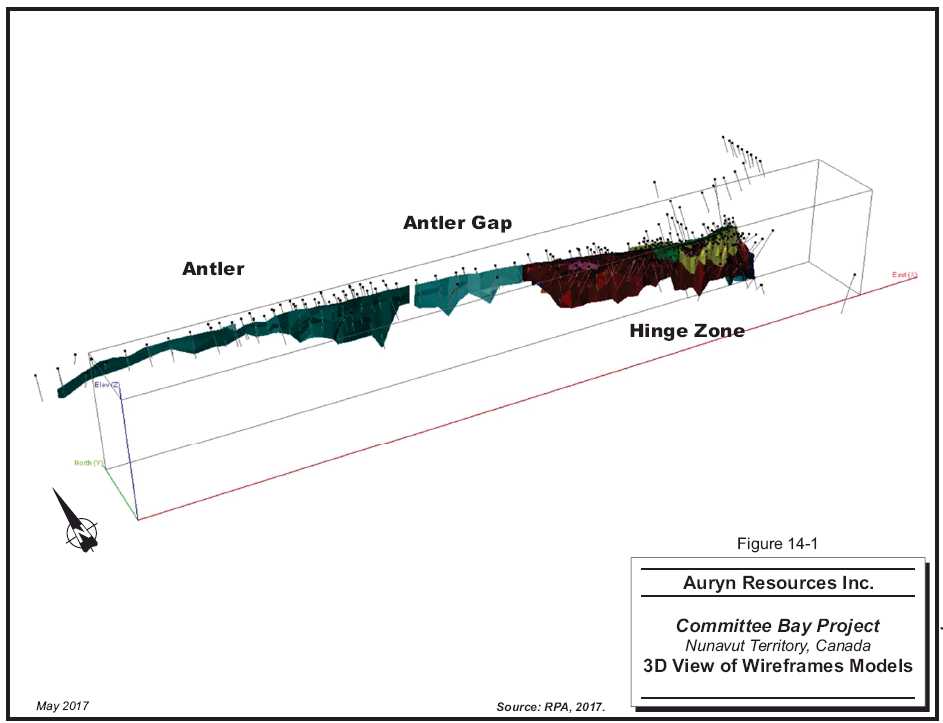
14 - 4
| | www.rpacan.com |
SAMPLE DATABASE AND STATISTICS
The lithology information and assay results from the drilling were supplied to RPA in the form of a GEMS database. The database contained records for 353 holes, totalling 58,222.9 m of drilling. There are tables for assays, basic lithology, texture, silicate minerals, metallic (sulphide) mineral content, structure, veining, magnetic susceptibility, and bulk density measurements. The assay table contained 32,047 records, with fields for Au grade, rock type, assay type, sample ID, and certificate ID. The 95 RAB holes that were drilled on the property by Auryn in 2015 and 2016 were located on prospects distant from the deposits included in the Mineral Resources. As such, they did not impact the estimate.
For previous resource estimates, RPA carried out three validation exercises on the Three Bluffs database. No significant errors were found in any of those audits. For this update, RPA carried out a validation exercise on the assay data for the 2012 drilling and found no significant errors. Assay QA/QC results were, for the most part, within an acceptable standard. Core handling, sampling, and logging protocols are appropriate and the logging and sampling competently managed.
Surveying of the collars and downhole deviations of the drill holes have been carried out to a standard consistent with industry best practice.
In RPA’s opinion, the assay database is suitable for use in estimation of Mineral Resources.
TABLE 14-3 SAMPLE STATISTICS – 1.0 G/T AU WIREFRAMES
Auryn Resources Inc. – Committee Bay Project
| | | | | | | Coefficient of | |
| Solid(s) | Min | Max | Mean | Median | Std Dev | Variation | Number |
| 101 | 0.010 | 320.80 | 2.626 | 1.300 | 10.379 | 3.953 | 1,188 |
| 102 | 0.015 | 1,423.00 | 3.851 | 1.420 | 21.872 | 5.679 | 1,271 |
| 103 | 0.010 | 475.30 | 5.885 | 1.965 | 20.886 | 3.549 | 1,427 |
| 104 | 0.015 | 72.51 | 2.643 | 1.180 | 6.565 | 2.484 | 249 |
| 118 | 0.015 | 178.00 | 3.328 | 1.364 | 8.935 | 2.685 | 411 |
| 105 to 120 | 0.015 | 92.22 | 2.333 | 1.220 | 6.222 | 2.667 | 273 |
| Auryn Resources Inc. – Committee Bay Project, Project #2655 | |
| Technical Report NI 43- 101 – October 23, 2017 | Page 14-5 |
| | www.rpacan.com |
CAPPING OF HIGH GRADES
The grade distribution for gold is highly skewed and, like many gold deposits, resembles a log normal distribution. There are outliers to the distribution in the highest grade ranges. Block model grade interpolations are often vulnerable to overestimation of the metal content due to the disproportionate impact that these higher samples tend to have on the grade interpolations. It is fairly common practice to limit the effect of these high grade samples by either capping the values or limiting their radius of influence.
For the estimates done to date, the gold grades were capped at 100 g/t Au in the Hinge Zone and 60 g/t Au in the limbs. There was only a small change to the database in 2012 so RPA did not review the capping levels in detail. In RPA’s opinion, the older ones were still valid. The top cuts were set to 75 g/t Au for the Hinge (Zone 103) and 50 g/t Au for the Limb (101 and 102) zones. A cap level of 30 g/t Au was established for the Antler and all other zones.
For the 2012 estimate, it was determined that the Hinge and Limb zones were particularly vulnerable to overestimation due to a relatively few very high grade samples, so the top cuts were set at 75 g/t Au and 50 g/t Au, respectively. A cap level of 30 g/t Au was established for the Antler and all other zones.
COMPOSITES
Samples were capped and then composited to 1.5 m lengths prior to grade estimation. The compositing was carried out starting at the drill hole point of entry of a grade shell, progressing downwards in 1.5 m intervals to the exit point. Remnants of less than 1.5 m in length (termed “orphans”) occurred at the point where the holes exited the grade shells. All orphans less than 0.5 m were excluded from the grade interpolation. Declustered capped composite statistics for the 1.0 g/t Au wireframes are provided in Table 14-4.
| Auryn Resources Inc. – Committee Bay Project, Project #2655 | |
| Technical Report NI 43- 101 – October 23, 2017 | Page 14-6 |
| | www.rpacan.com |
TABLE 14-4 DECLUSTERED CAPPED COMPOSITE STATISTICS FOR 1.0 G/T AU SOLIDS
Auryn Resources Inc. – Committee Bay Project
| | | | | | Std | Coefficient of | |
| Solid(s) | Min | Max | Mean | Median | Dev | Variation | Number |
| 101 | 0.012 | 47.32 | 2.265 | 1.418 | 3.409 | 1.505 | 748 |
| 102 | 0.015 | 49.98 | 3.297 | 1.632 | 5.489 | 1.665 | 822 |
| 103 | 0.021 | 70.37 | 4.817 | 2.302 | 7.536 | 1.564 | 833 |
| 104 | 0.015 | 22.57 | 2.231 | 1.318 | 3.002 | 1.346 | 163 |
| 118 | 0.015 | 27.38 | 2.913 | 1.655 | 3.619 | 1.242 | 267 |
| 105 to 120 | 0.010 | 29.99 | 2.094 | 1.253 | 3.417 | 1.632 | 202 |
RPA notes that, compared to the 2011 estimate, the mean and median grades of the samples within the 101 (North Limb) wireframe are higher by 4.5% and 3.3% respectively, while the mean and median grades of samples captured within the 102 (South Limb) wireframe are lower by 8.2% and 9.4% respectively.
GEOSTATISTICS
RPA carried out a variography analysis on the composites to check the search parameters for use in the grade estimate. The analysis was carried out using Sage 2001 and GEMS 6.4.1 software. The database used for the analysis was the consolidated (i.e., not sub-set by domain) table of composites from the 1.0 g/t Au wireframes.
The downhole semi-variogram was generated and was found to have a range of four metres and a relative nugget effect of 14% (i.e., 14% of the total sill). Directional correlograms and pairwise relative correlograms were generated using Sage. The directional correlograms did not yield a reasonable model that was consistent with the geological interpretation. The models derived from variography tended to have shapes that were unrealistically elongated in one direction, and attenuated in the other axis directions. The longest range for the pairwise relative correlograms was 48 m oriented parallel to the on-strike direction. The correlogram model generated from the raw data had a longest range of 58 m oriented roughly parallel to the overall dip of the zones and plunging steeply west-southwest.
The variogram model generated in GEMS yielded a major axis with a range of 40 m plunging at -35° towards the west (i.e., in the plane of the zones). The other two axes, however, had ranges of ten metres or less. This produced an elongated ellipsoid, similar in shape to the models generated in Sage but oriented in a completely different direction.
| Auryn Resources Inc. – Committee Bay Project, Project #2655 | |
| Technical Report NI 43- 101 – October 23, 2017 | Page 14-7 |
| | www.rpacan.com |
In RPA’s opinion, the variogram analysis was not conclusive and did not provide any compelling reasons to significantly change the search parameters from those used in previous estimates. These search parameters were derived from a variogram analysis conducted on the data within the 0.5 g/t Au wireframes, which are larger and encompass more samples than the 1.0 g/t Au wireframes.
FIGURE 14-2 DOWNHOLE SEMI-VARIOGRAM
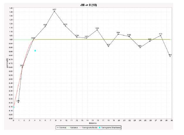
| Auryn Resources Inc. – Committee Bay Project, Project #2655 | |
| Technical Report NI 43- 101 – October 23, 2017 | Page 14-8 |
| | www.rpacan.com |
FIGURE 14-3 EXPERIMENTAL SEMI-VARIOGRAMS
| Auryn Resources Inc. – Committee Bay Project, Project #2655 | |
| Technical Report NI 43- 101 – October 23, 2017 | Page 14-9 |
| | www.rpacan.com |
BLOCK MODEL
The block model was constructed using GEOVIA GEMS 6.4.1 software. The model comprises an array of blocks measuring ten metres along strike by ten metres down-dip and two metres across strike. The array was parallel to the property survey grid (i.e., no rotation). Block model geometry and parameters are listed in Table 14-5.
Gold grade was interpolated into the blocks using ID3 weighting. Rock codes were assigned to the blocks using the wireframe models. Any block touching a wireframe was given a rock code assignment. The volumetrics routine within GEMS accounted for the proportion of each block residing within the wireframes in order to correctly sum the tonnages. Composites were coded using the same wireframe models so that the interpolations for each zone would only use composites from within that zone. An exception to this was the Hinge Zone, which used composites from either limb as well as the Hinge itself.
TABLE 14-5 BLOCK MODEL GEOMETRY
Auryn Resources Inc. – Committee Bay Project
| Origin | | |
| | X | 3,600 |
| | Y | 4,400 |
| | Z | 350 |
| | | |
| Extents | | |
| | Columns | 450 |
| | Rows | 400 |
| | Levels | 60 |
| | | |
| Block Size | | |
| | X | 10 |
| | Y | 2 |
| | Z | 10 |
In addition to gold grade and rock code, the block model contains variables for resource class, average distance to composites, number of composites used in the estimate, number of holes contributing composites to the estimate, and anisotropic distance to the nearest composite.
| Auryn Resources Inc. – Committee Bay Project, Project #2655 | |
| Technical Report NI 43- 101 – October 23, 2017 | Page 14-10 |
| | www.rpacan.com |
SEARCH STRATEGY
The grade interpolation was run in three passes with search ranges that were derived from the ranges of the variogram model generated for the earlier estimates.
The across-strike search distance (i.e., the 5 m distance) was deliberately made longer than the variograms would dictate in order to better cope with small-scale inflections in the zone orientations. The orientation of the search ellipsoid was dictated by the interpreted local strike and dip of the wireframe models. Three different orientations were used: 100°/-80°NE, 090°/-90°, and 075°/-80°SE.
The first pass used an ellipsoid measuring 15 m x 15 m x 5 m, which was approximately half of the range of the variogram model. The interpolation required a minimum of two composites and a maximum of six, with no more than two composites from any one drill hole.
The second pass was carried out at a maximum range of 30 m x 30 m x 10 m. This is roughly equivalent to the variogram model range, except in the across-strike direction, which was deliberately exaggerated. The same composite selection constraints were applied for the second pass as for the first pass. The range for the third pass was slightly more than double the variogram range. This was done in order to capture at least two drill holes for the interpolation. The drill section spacing is approximately 50 m to 60 m for most of the deposit. In the more densely drilled Hinge area, the spacing has been reduced to a nominal 25 m. A 75 m search tends to conveniently capture two drill holes in those portions of the deposit drilled at the 60 m spacing.
For the third pass, a minimum of two and a maximum of 12 composites were required, with a maximum of two composites from a single drill hole.
BULK DENSITY
A bulk density of 3.15 t/m3 was applied for estimation of tonnage. This value was derived from a total of 6,426 density determinations carried out on drill core from a variety of locations in the deposit. The determinations were done by weighing the specimen in air and again submerged in water. The density is derived from the ratio of the difference between the dry and submerged weights and the dry weight, or more correctly, the ratio of the weight of the specimen to the weight of the water that it displaces.
| Auryn Resources Inc. – Committee Bay Project, Project #2655 | |
| Technical Report NI 43- 101 – October 23, 2017 | Page 14-11 |
| | www.rpacan.com |
BLOCK MODEL VALIDATION
The block model grade interpolations were checked using the following methods:
Inspection of the block grades in plan and section indicates that the grade estimation honours the drill hole grades reasonably well.
RPA carried out a statistical comparison of the Indicated block grades and the composites. The results of this analysis are listed in Table 14-6. The global mean block grade for the open pit model is 4.4% lower than the mean composite grade, while for the underground model the difference is negligible. In RPA’s opinion, the global mean comparisons are within an acceptable tolerance.
TABLE 14-6 BLOCK VS COMPOSITE MEANS
Auryn Resources Inc. – Committee Bay Project
| Model | Block Mean | Composite Mean | Difference |
| | (g/t Au) | (g/t Au) | (%) |
| 0.5 (OP) | 2.16 | 2.26 | -4.42 |
| 1.0 (UG) | 3.30 | 3.33 | -0.90 |
CLASSIFICATION
Mineral Resources have been classified according to the Canadian Institute of Mining, Metallurgy and Petroleum (CIM) Definition Standards for Mineral Resources and Mineral Reserves, as incorporated by reference in NI 43-101. The classification criteria used were identical to those followed for the 2011 estimate, specifically:
| Auryn Resources Inc. – Committee Bay Project, Project #2655 | |
| Technical Report NI 43- 101 – October 23, 2017 | Page 14-12 |
| | www.rpacan.com |
All blocks that were captured in the search and received an estimate during the grade interpolation were assigned to at least an Inferred category (maximum of 75 m from the nearest composite).
Blocks estimated by at least three drill holes and located less than 25 m from the nearest composite were nominally assigned to the Indicated category.
The blocks were then inspected in section views in order to define reasonably coherent volumes of Indicated blocks with a more or less uniform density of drilling. RPA reviewed the areas affected by the new drilling and concluded that the new drill holes did not impact the extent of the Indicated Resources in the model. Wireframe models, originally constructed for the 2011 Mineral Resource estimate, were used to capture blocks for coding as Indicated. Isolated blocks, with the preliminary Indicated classification but located outside of these volumes, were manually reclassified to Inferred. Similarly, a few Inferred blocks contained within the Indicated volumes were reclassified to Indicated.
CUT-OFF CRITERIA
RPA reported Mineral Resources at calculated cut-off grades of 3.0 g/t Au for open pit mining and 4.0 g/t Au for underground mining based on the following assumptions:
| • | Gold Sale Price: | US$1,200/oz |
| • | Process Recovery | 93% |
| • | Open Pit Mining Cost | C$10.00/t |
| • | Underground Mining Cost | C$70.00/t |
| • | Process + G&A Costs | C$75.00/t |
| • | Exchange Rate | 1.25 US$/C$ |
To fulfill the resource criteria of “reasonable prospects for eventual economic extraction”, a pit shell analysis was run on the 0.5 g/t Au model to determine how much of the deposit could potentially be extracted using open pit methods. The analysis was done using Whittle software with very preliminary assumptions for pit slopes, metallurgical recovery, prices, and costs.
For this Mineral Resource update, RPA used the preliminary pit shell that was optimized in 2013 using a different gold price and cost assumptions (listed below) than those used to calculate the updated cut-off grade. RPA considers this approach reasonable given that the pit shell used to report open pit resources is conceptual and the relative difference between the underground and open-pit resource cut-off grades is negligible.
| Auryn Resources Inc. – Committee Bay Project, Project #2655 | |
| Technical Report NI 43- 101 – October 23, 2017 | Page 14-13 |
| | www.rpacan.com |
| | • | Gold Sale Price: | US$1,500/oz |
| | • | Overall Pit Slope Angles: | 50° |
| | • | Process Recovery | 93% |
| | • | Mining Cost | US$10.00/t |
| | • | Process + G&A Costs | US$60.00/t |
Mineral Resource blocks in the 0.5 g/t Au model captured within this preliminary pit shell were reported at a cut-off grade of 3.00 g/t Au and are shown as “Open Pit” in Table 14-1. The pit shell was then used on the 1.0 g/t Au model to isolate material deemed as “Underground” Mineral Resources. Blocks in the 1.0 g/t Au model located outside of the preliminary pit shell were deemed as eligible for inclusion as Underground resources. A cut-off grade of 4.0 g/t Au was applied to this material for derivation of the Underground Mineral Resources reported in Table 14-1. This cut-off grade was derived by adding an increment of $60/t to the mining costs used in the pit optimization to account for the additional cost of mining from underground.
The impact of varying the cut-off grades is shown in Tables 14-7 and 14-8. The tables show the Indicated and Inferred category block model results at a range of cut-off grades for the open pit (0.5 g/t Au) and underground (1.0 g/t Au) models, respectively. The tonnes reported for each model honour the pit shells such that only in-pit resources are reported from the open pit model, and resources outside the pit, for the underground model. The base-case cut-off grades used by RPA to report the Mineral Resources are highlighted. The tonnages reported at less than the base-case cut-off grade should not be considered Mineral Resources. They are shown in the tables for comparison purposes only.
| Auryn Resources Inc. – Committee Bay Project, Project #2655 | |
| Technical Report NI 43- 101 – October 23, 2017 | Page 14-14 |
| | www.rpacan.com |
| TABLE 14-7EFFECT OF CUT-OFF GRADE ON THE OPEN PIT MODEL |
| Auryn Resources Inc. – Committee Bay Project |
| Indicated |
| Cut-Off | Tonnage | Grade | Contained Gold |
| (g/t Au) | (000 t) | (g/t Au) | (oz Au) |
| 15.00 | 190.5 | 23.07 | 141,312 |
| 10.00 | 350.2 | 18.10 | 203,755 |
| 5.00 | 942.0 | 11.12 | 336,696 |
| 4.50 | 1,072.0 | 10.34 | 356,516 |
| 4.00 | 1,234.2 | 9.54 | 378,669 |
| 3.50 | 1,474.3 | 8.60 | 407,514 |
| 3.00 | 1,761.9 | 7.72 | 437,467 |
| 2.50 | 2,126.4 | 6.87 | 469,606 |
| 2.00 | 2,592.4 | 6.03 | 502,979 |
| 1.50 | 3,340.0 | 5.07 | 544,621 |
| 1.35 | 3,599.7 | 4.81 | 556,520 |
| 1.00 | 4,417.8 | 4.13 | 587,234 |
| 0.50 | 5,963.0 | 3.25 | 623,990 |
| Inferred |
| Cut-Off | Tonnage | Grade | Contained Gold |
| (g/t Au) | (000 t) | (g/t Au) | (oz Au) |
| 15.00 | 57.8 | 21.23 | 39,439 |
| 10.00 | 109.8 | 16.93 | 59,753 |
| 5.00 | 369.2 | 9.78 | 116,050 |
| 4.50 | 411.0 | 9.26 | 122,399 |
| 4.00 | 470.1 | 8.63 | 130,493 |
| 3.50 | 524.4 | 8.13 | 137,043 |
| 3.00 | 592.4 | 7.57 | 144,126 |
| 2.50 | 646.5 | 7.16 | 148,821 |
| 2.00 | 728.7 | 6.60 | 154,671 |
| 1.50 | 908.9 | 5.63 | 164,637 |
| 1.35 | 1,001.6 | 5.24 | 168,886 |
| 1.00 | 1,249.9 | 4.43 | 178,112 |
| 0.50 | 1,533.9 | 3.76 | 185,258 |
| Auryn Resources Inc. – Committee Bay Project, Project #2655 | |
| Technical Report NI 43- 101 – October 23, 2017 | Page 14-15 |
| | www.rpacan.com |
| TABLE 14-8EFFECT OF CUT-OFF GRADE ON THE UNDERGROUND MODEL |
| Auryn Resources Inc. – Committee Bay Project |
| Indicated |
| Cut-Off | Tonnage | Gold Grade | Contained Gold |
| (g/t Au) | (000 t) | (g/t Au) | (oz Au) |
| 15 | 36.9 | 20.07 | 23,790 |
| 10 | 86.4 | 15.56 | 43,233 |
| 5.0 | 222 | 10.24 | 73,082 |
| 4.5 | 273 | 9.21 | 80,894 |
| 4.0 | 313 | 8.57 | 86,368 |
| 3.5 | 379 | 7.74 | 94,215 |
| 3.0 | 505 | 6.61 | 107,309 |
| 2.5 | 716 | 5.46 | 125,755 |
| 2.0 | 1,102 | 4.33 | 153,311 |
| 1.5 | 1,830 | 3.29 | 193,588 |
| 1.35 | 2,175 | 2.99 | 209,382 |
| 1.0 | 2,966 | 2.51 | 239,244 |
| 0.5 | 3,494 | 2.26 | 253,365 |
| Inferred |
| Cut-Off | Tonnage | Gold Grade | Contained Gold |
| (g/t Au) | (000 t) | (g/t Au) | (oz Au) |
| 15 | 208 | 17.76 | 118,683 |
| 10 | 488 | 14.71 | 230,972 |
| 5.0 | 1,606 | 9.13 | 471,262 |
| 4.5 | 1,876 | 8.50 | 512,517 |
| 4.0 | 2,342 | 7.65 | 576,238 |
| 3.5 | 2,830 | 6.98 | 635,136 |
| 3.0 | 3,569 | 6.21 | 712,003 |
| 2.5 | 4,520 | 5.48 | 795,864 |
| 2.0 | 5,689 | 4.81 | 879,277 |
| 1.5 | 8,102 | 3.89 | 1,013,687 |
| 1.35 | 8,892 | 3.67 | 1,049,799 |
| 1.0 | 10,347 | 3.32 | 1,105,300 |
| 0.5 | 11,298 | 3.11 | 1,130,477 |
| Auryn Resources Inc. – Committee Bay Project, Project #2655 | |
| Technical Report NI 43- 101 – October 23, 2017 | Page 14-16 |
| | www.rpacan.com |
15 MINERAL RESERVE ESTIMATE
There is no current Mineral Reserve estimate on the Committee Bay Project.
| Auryn Resources Inc. – Committee Bay Project, Project #2655 | |
| Technical Report NI 43- 101 – October 23, 2017 | Page 15-1 |
| | www.rpacan.com |
16 MINING METHODS
This section is not applicable.
| Auryn Resources Inc. – Committee Bay Project, Project #2655 | |
| Technical Report NI 43- 101 – October 23, 2017 | Page 16-1 |
| | www.rpacan.com |
17 RECOVERY METHODS
This section is not applicable.
| Auryn Resources Inc. – Committee Bay Project, Project #2655 | |
| Technical Report NI 43- 101 – October 23, 2017 | Page 17-1 |
| | www.rpacan.com |
18 PROJECT INFRASTRUCTURE
This section is not applicable.
| Auryn Resources Inc. – Committee Bay Project, Project #2655 | |
| Technical Report NI 43- 101 – October 23, 2017 | Page 18-1 |
| | www.rpacan.com |
19 MARKET STUDIES AND CONTRACTS
This section is not applicable.
| Auryn Resources Inc. – Committee Bay Project, Project #2655 | |
| Technical Report NI 43- 101 – October 23, 2017 | Page 19-1 |
| | www.rpacan.com |
20 ENVIRONMENTAL STUDIES, PERMITTING, AND SOCIAL OR COMMUNITY IMPACT
This section is not applicable.
| Auryn Resources Inc. – Committee Bay Project, Project #2655 | |
| Technical Report NI 43- 101 – October 23, 2017 | Page 20-1 |
| | www.rpacan.com |
21 CAPITAL AND OPERATING COSTS
This section is not applicable.
| Auryn Resources Inc. – Committee Bay Project, Project #2655 | |
| Technical Report NI 43- 101 – October 23, 2017 | Page 21-1 |
| | www.rpacan.com |
22 ECONOMIC ANALYSIS
This section is not applicable.
| Auryn Resources Inc. – Committee Bay Project, Project #2655 | |
| Technical Report NI 43- 101 – October 23, 2017 | Page 22-1 |
| | www.rpacan.com |
23 ADJACENT PROPERTIES
The Property is contiguous with claims held by various companies and individuals (Figure 23-1). None of the adjacent claims are known to host mineralized zones comparable to the Three Bluffs deposit. No reliance was placed on any information from adjacent properties in the estimation and preparation of the resources reported in this technical report. Adjacent properties are therefore not deemed material to this report.
| Auryn Resources Inc. – Committee Bay Project, Project #2655 | |
| Technical Report NI 43- 101 – October 23, 2017 | Page 23-1 |
| | www.rpacan.com |
23 - 2
| | www.rpacan.com |
24 OTHER RELEVANT DATA AND INFORMATION
No additional information or explanation is necessary to make this Technical Report understandable and not misleading.
| Auryn Resources Inc. – Committee Bay Project, Project #2655 | |
| Technical Report NI 43- 101 – October 23, 2017 | Page 24-1 |
| | www.rpacan.com |
25 INTERPRETATION AND CONCLUSIONS
The Property is located within the granite-greenstone rocks of the Archean Prince Albert group, a component of the Rae Domain within the Western Churchill Province. The Three Bluffs gold deposit is characterized by a thick interval of iron formation that appears to form the nose of an upright isoclinal antiform. The majority of the gold mineralization is hosted in silicate, oxide, and/or sulphide facies iron formation. Gold mineralization has also been identified in shear hosted quartz veins in sedimentary and volcanic rocks.
Drilling has outlined mineralization with three-dimensional continuity, and size and grades that can potentially be extracted economically. Project geologists have a good understanding of the regional, local, and deposit geology and controls on mineralization. The geological models are reasonable and plausible interpretations of the drill results.
Exploration protocols for drilling, sampling, analysis, security, and database management meet industry standard practices. The drill hole database was verified by RPA and is suitable for Mineral Resource estimation work.
The previous Mineral Resource model prepared by RPA in April 2013 remains current and has been assigned a new effective date of May 31, 2017. There has been no new drilling in the immediate area of those resources. The cut-off grades were adjusted based on an updated metal price, exchange rate, and operating cost assumptions.
Mineral Resources for the Three Bluffs deposit were estimated assuming combined open pit and underground mining methods. At cut-off grades of 3.0 g/t Au for open pit and 4.0 g/t Au for underground, Indicated Mineral Resources are estimated to total 2.07 Mt at an average grade of 7.85 g/t Au containing 524,000 ounces gold. At the same cut-off grades, Inferred Mineral Resources are estimated to total 2.93 Mt at an average grade of 7.64 g/t Au containing 720,000 ounces gold. The open pit resources were constrained by a preliminary pit shell generated in Whittle software. Underground resources are reported at the high cut-off grade outside of the pit shell.
The limited metallurgical testwork conducted so far suggests that the gold can be recovered by conventional means, such as a combination of gravity and flotation followed by cyanide leaching of the concentrate. In RPA’s opinion, however, additional metallurgical testwork is warranted.
| Auryn Resources Inc. – Committee Bay Project, Project #2655 | |
| Technical Report NI 43- 101 – October 23, 2017 | Page 25-1 |
| | www.rpacan.com |
The Project covers virtually all of the Committee Bay supracrustal belt which hosts a regionally significant and highly prospective corridor for gold. Previous exploration on the Committee Bay Project did not effectively screen the large property holdings. Auryn’s exploration strategy is both successful and cost effective. Auryn’s work in 2015 and 2016, which covers approximately 85% of the current property holdings, was able to highlight 17 significant gold in till anomalies, several of which are located away from any previously known gold occurrences. There is good potential to discover additional mineralization and to add to the resource base on the Property.
| Auryn Resources Inc. – Committee Bay Project, Project #2655 | |
| Technical Report NI 43- 101 – October 23, 2017 | Page 25-2 |
| | www.rpacan.com |
26 RECOMMENDATIONS
RPA has reviewed and concurs with Auryn’s proposed exploration programs and budgets. Phase 1 of the recommended work program will include a desktop review of the 2015 and 2016 exploration results in an effort to define the most effective exploration program to determine the source of the recently identified 17 gold in till anomalies. The field portion of Phase 1 will consist of boulder mapping, detailed infill till sampling, and ground magnetics to identify the highest probability targets which will be immediately drill tested. In addition to the target follow-up, Phase 1 exploration should include the completion of the regional till sampling and drone programs over the remaining 15% of the CBGB.
The Phase 1 program is anticipated to include collection of 17,000 detailed infill till samples and 2,350 regional till samples and completion of 1,200 km2of drone coverage and 25,000 m of RAB drilling. The Phase 1 program is estimated to cost approximately $20 million. Details of the recommended Phase I program can be found in Table 26-1.
TABLE 26-1 PROPOSED BUDGET – PHASE 1
Auryn Resources Inc. – Committee Bay Project
| Item | | C$ | |
| PHASE 1 | | | |
| Head Office Expenses | | 228,000 | |
| Project Management/Staff Cost | | 2,462,000 | |
| Expense Account/Staff Travel | | 1,771,000 | |
| Lease Payments | | 157,000 | |
| Till Sampling | | 685,000 | |
| Ground Magnetics | | 200,000 | |
| Drone Surveying | | 93,000 | |
| RAB Drilling | | 4,863,000 | |
| Assaying/Analyses | | 1,084,000 | |
| Camp Costs | | 650,000 | |
| Air Support | | 5,936,000 | |
| Subtotal | | 18,129,000 | |
| Contingency | | 1,813,000 | |
| TOTAL | | 19,942,000 | |
A Phase 2 exploration program, contingent on the results of Phase 1, will mainly consist of drilling. Initially, all of the Three Bluffs drill core should be re-logged so that controls on mineralization can be better understood. Following that, 5,000 m to 10,000 m of exploration diamond drilling is proposed at Three Bluffs to test for the continuity of high grade mineralization at depth and along strike from the current deposit. In addition to the focused work at Three Bluffs, it is recommended that any significant RAB drill intersections from the Phase 1 program be followed up with additional RAB drilling and focused diamond drilling. It is also anticipated that additional targets will be identified during the completion of the regional program and these will have to be targeted using a systematic approach, which includes boulder mapping, detailed infill till sampling, and ground magnetics.
| Auryn Resources Inc. – Committee Bay Project, Project #2655 | |
| Technical Report NI 43- 101 – October 23, 2017 | Page 26-1 |
| | www.rpacan.com |
The Phase 2 exploration program is anticipated to include the completion of both diamond and RAB drilling, along with the collection of surface samples. The recommended Phase 2 program is estimated to cost between $20 million and $25 million. Details of the recommended Phase 2 program can be found in Table 26-2.
TABLE 26-2 PROPOSED BUDGET – PHASE 2
Auryn Resources Inc. – Committee Bay Project
| Item | | C$ | |
| PHASE 2 | | | |
| Head Office Expenses | | 250,000 | |
| Project Management/Staff Cost | | 2,500,000 | |
| Expense Account/Staff Travel | | 1,800,000 | |
| Lease Payments | | 157,000 | |
| Till Sampling | | 500,000 | |
| RAB Drilling | | 2,000,000 | |
| Diamond Drilling | | 6,000,000 | |
| Assaying/Analyses | | 1,100,000 | |
| Resource Estimate Update | | 65,000 | |
| Metallurgical Test Work | | 100,000 | |
| Air Support | | 6,000,000 | |
| Camp Costs | | 700,000 | |
| Subtotal | | 21,172,000 | |
| Contingency | | 2,117,000 | |
| TOTAL | | 23,289,000 | |
| Auryn Resources Inc. – Committee Bay Project, Project #2655 | |
| Technical Report NI 43- 101 – October 23, 2017 | Page 26-2 |
| | www.rpacan.com |
27 REFERENCES
Acres, M.R., 2003. Committee Bay 2003 Quality Control Standards (Gold). Internal Report for Committee Bay Resources Ltd., 2 p.
Agnico-Eagle Mines Limited, 2015. Retrieved July 29, 2015 fromhttp://www.agnico-eagle.com.
Apex Geoscience, 2011: Resource Estimation Re-Run for Three Bluffs – August, 2011. A letter report prepared by Apex Geoscience Ltd. for Committee Bay Resources Ltd., 4p. Ashton, K.A., 1988: Precambrian geology of the southeastern Amer Lake area (66H/1), near Baker Lake, N.W.T., PhD. Thesis, Queen’s University, Kingston, Ontario, 335p.
Aspler, L.B., Chiarenzelli, I.R., Cousens, B.L., and Valentino, D., 1999: Precambrian geology, northern Angikuni Lake and a transact across the Snowbird tectonic zone, western Angikuni Lake, Northwest Territories (Nunavut),inHearne Domain, Nunavut, Canada: intracratonic response to Trans-Hudson orogen: Precambrian Research, vol. 116, pp. 331-354.
Auryn Resources, 2016: Committee Bay Project 2016 Annual Report. Unpublished report prepared by Auryn Resources Inc.
Bethune, K, M, and Scammell, R.J.M. (1997): Precambrian geology, Koch Island area, District of Franklin (part of NTS 37C), Northwest Territories. Geological Survey of Canada, Open File 3391, 4 sheets (including marginal notes), 1:50,000 scale.
Blakley, I., and Rennie, D., 2008, Technical Report on the Mineral Resource Estimate for the Three Bluffs Project, Nunavut Territory, Canada, Prepared by Scott Wilson Roscoe Postle Associates Inc. for Committee Bay Resources Ltd., 98 p.
Caddey, S.W., Bachman, R.L., Campbell, T.J., Reed, R.R., and Otto, R.P., 1991: The Homestake gold mine, an Early Proterozoic iron formation-hosted gold deposit, Lawrence County, South Dakota. USGS Bulletin 1857-J.
Canadian Institute of Mining, Metallurgy and Petroleum (CIM), 2014: CIM Definition Standards for Mineral Resources and Mineral Reserves, adopted by CIM Council on May 10, 2014. Davies, T., 2009: Gold mineralization in the Three Bluffs gold deposit, Committee Bay greenstone belt, Nunavut. Unpublished MSc thesis. Department of Earth and Atmospheric Sciences, University of Alberta, Edmonton, Alberta, 141p.
Davis, W.J., and Zaleski, E., 1998: Geochronological investigations of the Woodburn Lake Group, western Churchill Province, Northwest Territories: preliminary resultsinRadiogenic Age and Isotopic Studies: Report 11, Geological Survey of Canada, Current Research 1998-F, pp. 89-97.
Freeman, M.E., and Wyllie, R.J., 2002: Committee Bay Joint Venture, Exploration – 1997, Laughland Lake – Ellis Hills Area, District of Keewatin, N.W.T.; Unpublished report prepared for North Country Gold Corp.
| Auryn Resources Inc. – Committee Bay Project, Project #2655 | |
| Technical Report NI 43- 101 – October 23, 2017 | Page 27-1 |
| | www.rpacan.com |
Hanmer, S., Bowring, S., van Breemen, O., and Parrish, R., 1992: Great Slave Lake shear zone, Northwestern Canada: mylonite record of early Proterozoic continental convergence, collision and indentation. Journal of Structural Geology, vol. 14, no. 7, pp. 757-773.
Hartlaub, R.P., Heaman, L.M., Ashton, K.E. and Chacko, T., 2001: The Murmac Group, Rae Province: record of a giant Archean rift?In4th International Archean Symposium 2001, Extended Abstracts, K.F. Cassidy, J.M. Dunphy and M.J. van Kranendonk (eds.); Australian Geological Survey Organization – Geoscience Australia, Record 2001/37, pp. 317-318.
Heaman, L.M., Le Cheminant, A.N., and Rainbird, R.H., 1992: Nature and timing of Franklin igneous events, Canada: Implications for a Late Proterozoic mantle plume and the breakup of Laurentia. Earth and Planetary Sciences Letters, vol. 109, pp. 117-131. Henderson, J.B., and Broome, J., 1990: Geometry and kinematics of the Wager shear zone interpreted from structural fabrics and magnetic data. Canadian Journal of Earth Sciences, vol. 27, pp. 590-604.
Henderson, J.B., McGrath, P.H., Theriault, R.J., and van Breeman, O., 1990: Intracratonic indentation of the Archean Slave Province into the Early Proterozoic Thelon Tectonic zone of the Churchill Province, northwestern Canadian Shield. Canadian Journal of Earth Sciences, vol. 27, pp. 590-604.
Heywood, W.W., and Schau, M., 1978: A Subdivision of the Northern Churchill Structural Province. Geological Survey of Canada, Paper 78-1A, pp. 139-143.
Heywood, W.W., 1961: Geological Notes, Northern District of Keewatin, Parts of 56, 57, 66 and 67; Geological Survey of Canada, Paper 61-18, 9p.
Kerswill, J.A., 1996: Iron formation-hosted stratabound goldIn Geology of Canadian Mineral Deposit Types, (ed.) O.R. Eckstrand, W.D. Sinclair, and R.I. Thorpe; Geological Survey of Canada, Geology of Canada, no. 8, pp. 367-382.
Le Cheminant, A,N., and Heaman, L.M., 1989: Mackenzie igneous events, Canada: Middle Proterozoic hotspot magmatism associated with ocean opening. Earth and Planetary Sciences Letters, vol. 96, pp. 38-48.
Le Cheminant, A.N. and Roddick, J.C., 1991: U-Pb zircon evidence for widespread 2.6 Ga felsic magmatism in the central District of Keewatin, N.W.T.;inRadiogenic Age and Isotopic Studies, Report 4; Geological Survey of Canada, Paper 90-2, pp. 91-98.
Little, E., 2001: Preliminary results of relative ice-movement chronology of the Laughland Lake areas, Committee Bay belt, Nunavut. Geological survey of Canada, Current Research 2002-C-14, 7p.
MacHattie, T., 2002: Physical volcanology of komatiites in the Laughland and Walker Lake area, Committee Bay belt, Nunavut. Geological Survey of Canada. Current Research 2002-C14, 7p.
Marshall, I.B., and Schutt, P.H., 1999: A national ecological framework for Canada – Overview. A co-operative product by Ecosystems Science Directorate, Environment Canada, and Research Branch, Agriculture and Agri — Food Canada.
| Auryn Resources Inc. – Committee Bay Project, Project #2655 | |
| Technical Report NI 43- 101 – October 23, 2017 | Page 27-2 |
| | www.rpacan.com |
McDonough, B., 2013: Three Bluffs Resource Update, internal letter report by RPA Inc. to North Country Gold Corp., 10 p.
McMartin, I., Little, E.C., Ferbey, T., Ozyer, C.A., and Utting, D.J., 2003: Ice-flow history and drift prospecting in the Committee Bay Belt, Central Nunavut, results from the Targeted Geoscience Initiative. Current Research 2003-C4. Geological Survey of Canada, 13p.
North Country Gold, 2015. Consolidated Financial Statements for the Years Ended February 28, 2015 and 2014, 19 p.
North Country Gold, 2012. Diamond Core Logging & Sampling Guide, 59 p.
Orrell, S.E., Bickford, M.E., and Lewry, J.F., 1999: Crustal evolution and age of thermotectonic reworking in the western hinterland of the Trans-Hudson Orogen, northern Saskatchewan. Precambrian Research, vol. 95, pp. 187-223.
Parrish, R.R., 1989: U-Pb geochronology of the Cape Smith Belt and Sugluk Blocks, northern Quebec. Geoscience Canada, vol. 16, pp. 126-130.
Rennie, D.W., and McDonough, B., 2015: Technical Report on the Three Bluffs Project, Nunavut Territory, Canada. A technical report prepared by RPA Inc. for North Country Gold Corp.
Rennie, D. W., and McDonough, B., 2012, Technical Report on the Three Bluffs Projects, Nunavut Territory, Canada. A technical report prepared by RPA Inc. for North Country Gold Corp., 163 p.
Rennie, D.W., and Wallis, S., 2004: Technical Report on the Three Bluffs Area, Nunavut, Canada. A technical report prepared by RPA Inc. for Committee Resources Ltd., 64p.
Robert, F., Brommecker, R., Bourne, B.T., Dobak, P.J., McEwan, C.J., Rowe, R.R., and Zhou, X., 2007: Models and Exploration Methods for Major Gold Deposit Types, Paper 48InProceedings of Exploration 07. Fifth Decennial International Conference on Mineral Exploration, edited by B. Milkereit, pp. 691-711.
Ryan, J.J., Nadeau, L., Hinchey, A.M., James, D.T., Sandeman, H.A., Schetselaar, E.M., Davis, W.J., and Berman, R.G., 2009: Bedrock geology of the southern Boothia mainland area, (Pelly Bay – Rae Strait – Spence Bay map areas) Kitikmeot region, Nunavut. Geological Survey of Canada, Current Research 2009-1, 18p.
Sandeman, H.A., 2001: 40Ar-39 geochronological investigations in the central Hearne domain, western Churchill Province, Nunavut: a progress report. 41p.
Scott, K.C., Rennie, D., and Lambert, R.J., 2010: Preliminary Assessment of the Three Bluffs Project, Nunavut Territory, Canada. A technical report prepared by Scott Wilson Roscoe Postle Associates for Committee Bay Resources Ltd., 142p.
Skulski, T., Sanborn-Barrie, M., MacHattie, T., Young, M., Carson, C., Berman, R., Brown, J., Rayner, N., Panagapko, D., Byrne, D., and Deyell, C., 2003: Bedrock geology of the Ellis Hills map area and new constraints on the regional geology of the Committee Bay area, Nunavut; Geological Survey of Canada, Current Research 2003-C22, 11p.
| Auryn Resources Inc. – Committee Bay Project, Project #2655 | |
| Technical Report NI 43- 101 – October 23, 2017 | Page 27-3 |
| | www.rpacan.com |
Thompson, P.H., and Henderson, J.B., 1983: Polymetamorphism in the Healy Lake map area – implications for the Thelon Tectonic zone,in Geological Survey of Canada, Current Activities Forum, 1983. Programs with Abstracts, pp. 2-3.
Turner, A.J., 2010, Technical Report on 2007-2009 Exploration at the Committee Bay Project, Kitikmeot Region, Nunavut Territory, Canada. A technical report prepared by Apex Geoscience Ltd. for CBR Gold Corp., 182 p.
Turner, A.J., and L’Heureux, R.B., 2005: 2004 Exploration Summary Report, Committee Bay Greenstone Belt, Laughland Lake – Ellis Hills Area, Nunavut, Canada. Unpublished report prepared by Apex Geoscience Ltd. for the Gold Fields Joint Venture.
Turner, A.J., and Schoeman, P., 2013: Technical Report on the Committee Bay Project, Nunavut Territory, Canada, NTS 56J, K, O and P. A technical report prepared by Apex Geoscience Ltd. for North Country Gold Corp. 94p.
Van Breemen, O., Henderson, J.B., Loveridge, W.D. and Thompson, P.H., 1987a: U-Pb zircon and monzanite geochronology and zircon morphology of granulites and granites from the Thelon Tectonic zone, Healey Lake and Artillery Lake areas, NWT,in Current Research, Part A, Geological Survey of Canada, Paper 87-1A, pp. 783-801.
Van Breemen, O., Thompson, P.H., Hunt, P.A., and Culshaw, M., 1987b: U-Pb zircon and monzanite geochronology from the northern Thelon Tectonic zone, District of Mackenzie,in Radiogenic Age and Isotopic Studies: Report 1. Geological Survey of Canada, Paper 87-2, pp. 81-93.
Van Kranendonk, M.I., St-Onge, M.R., and Henderson, J.R., 1993: Paleoproterozoic tectonic assembly of northeast Laurentia through multiple indentations. Precambrian Research, vol. 63, pp. 325-347.
Zaleski, E., Davis, W.J., and Sandeman, H.A., 2001: Continental extension, mantle magmas and basement cover relationships,in International Archean Symposium 2001, Extended Abstracts, K.F. Cassidy, J.M. Dunphy and M.J. van Kranendonck (eds.): Australian Geological Survey Organization – Geoscience Australia, Record 2001/37, pp. 374-376.
| Auryn Resources Inc. – Committee Bay Project, Project #2655 | |
| Technical Report NI 43- 101 – October 23, 2017 | Page 27-4 |
| | www.rpacan.com |
28 DATE AND SIGNATURE PAGE
This report titled “Technical Report on the Committee Bay Project, Nunavut Territory, Canada” and dated May 31, 2017 was prepared and signed by the following author:
| | (Signed and Sealed ) “David A. Ross” |
| | |
| | |
| | |
| Dated at Toronto, ON | David A. Ross, M.Sc., P.Geo. |
| May 31, 2017 | Principal Geologist |
| Auryn Resources Inc. – Committee Bay Project, Project #2655 | |
| Technical Report NI 43- 101 – October 23, 2017 | Page 28-1 |
| | www.rpacan.com |
29 CERTIFICATE OF QUALIFIED PERSON
DAVID A. ROSS
I, David A, Ross, P.Geo., as the author of this report entitled “Technical Report on the Committee Bay Project, Nunavut Territory” prepared for Auryn Resources Inc. and dated May 31, 2017, do hereby certify that:
| 1. | I am a Principal Geologist and Director, Resource Estimation, with Roscoe Postle Associates Inc. of Suite 501, 55 University Ave., Toronto, ON, M5J 2H7. |
| | | |
| 2. | I am a graduate of Carleton University, Ottawa, Canada, in 1993 with a Bachelor of Science degree in Geology and Queen’s University, Kingston, Ontario, Canada, in 1999 with a Master of Science degree in Mineral Exploration. |
| | | |
| 3. | I am registered as a Professional Geologist in the Province of Ontario (Reg. #1192). I have worked as a geologist for a total of 21 years since my graduation. My relevant experience for the purpose of the Technical Report is: |
| | | |
| | Review and report as a consultant on numerous mining and exploration projects around the world for due diligence and regulatory requirements |
| | | |
| | Exploration geologist on a variety of gold and base metal projects in Canada, Indonesia, Chile, and Mongolia. |
| | | |
| 4. | I have read the definition of "qualified person" set out in National Instrument 43-101 (NI 43- 101) and certify that by reason of my education, affiliation with a professional association (as defined in NI 43-101) and past relevant work experience, I fulfill the requirements to be a "qualified person" for the purposes of NI 43- 101. |
| 1. | I visited the Committee Bay Project on August 16-17, 2016. |
| | |
| 2. | I am responsible for overall preparation of the Technical Report. |
| | |
| 3. | I am independent of the Issuer applying the test set out in Section 1.5 of NI 43-101. |
| | |
| 4. | I have had no prior involvement with the property that is the subject of the Technical Report. |
| | |
| 5. | I have read NI 43- 101, and the Technical Report has been prepared in compliance with NI 43-101 and Form 43-101F1. |
| | |
| 6. | At the effective date of the Technical Report, to the best of my knowledge, information, and belief, the Technical Report contains all scientific and technical information that is required to be disclosed to make the Technical Report not misleading. |
Dated 31stday of May, 2017
(Signed and Sealed ) “David A. Ross”
David A. Ross, M.Sc., P.Geo.
| Auryn Resources Inc. – Committee Bay Project, Project #2655 | |
| Technical Report NI 43- 101 – October 23, 2017 | Page 29-1 |
| | www.rpacan.com |
30 APPENDIX 1
PROPERTY DESCRIPTION
| Auryn Resources Inc. – Committee Bay Project, Project #2655 | |
| Technical Report NI 43- 101 – October 23, 2017 | Page 30-1 |
| | www.rpacan.com |
TABLE 30-1 COMMITTEE BAY PROJECT LEASES
Auryn Resources Inc. - Committee Bay Project
| Claim | Lease | Claim | Recorded | Area | Area | Annual Holding | Recording | Anniversary |
| Name | Number | Number | Holder | (Acres) | (ha) | Costs | Date | Date |
| BLUFF 1 | 4910 | F57003 | Committee Bay North Ltd. | 2577.0 | 1042.9 | $2,577.00 | 11-Oct-2005 | 11-Oct-2026 |
| BLUFF 2 | 4911 | F57004 | Committee Bay North Ltd. | 2583.0 | 1045.3 | $2,583.00 | 11-Oct-2005 | 11-Oct-2026 |
| BLUFF 3 | 4912 | F57005 | Committee Bay North Ltd. | 2606.0 | 1054.6 | $2,606.00 | 11-Oct-2005 | 11-Oct-2026 |
| BLUFF 4 | 4913 | F57006 | Committee Bay North Ltd. | 2489.0 | 1007.3 | $2,489.00 | 11-Oct-2005 | 11-Oct-2026 |
| BLUFF 5 | 4914 | F57010 | Committee Bay North Ltd. | 2635.0 | 1066.4 | $2,635.00 | 11-Oct-2005 | 11-Oct-2026 |
| BLUFF 6 | 4915 | F57011 | Committee Bay North Ltd. | 2612.0 | 1057.0 | $2,612.00 | 11-Oct-2005 | 11-Oct-2026 |
| BLUFF 7 | 4916 | F57012 | Committee Bay North Ltd. | 2609.0 | 1055.8 | $2,609.00 | 11-Oct-2005 | 11-Oct-2026 |
| HAYES 7 | 4917 | F60389 | Committee Bay North Ltd. | 2476.0 | 1002.0 | $2,476.00 | 25-Jul-2006 | 25-Jul-27 |
| CRK 4 | 4918 | F60365 | Committee Bay North Ltd. | 2630.0 | 1064.3 | $2,630.00 | 25-Jul-2006 | 25-Jul-27 |
| CRK 6 | 4919 | F60367 | Committee Bay North Ltd. | 2602.0 | 1053.0 | $2,602.00 | 25-Jul-2006 | 25-Jul-27 |
| CRK 7 | 4920 | F60368 | Committee Bay North Ltd. | 2650.0 | 1072.4 | $2,650.00 | 25-Jul-2006 | 25-Jul-27 |
| CRK 18 | 4921 | F60379 | Committee Bay North Ltd. | 2114.0 | 855.5 | $2,114.00 | 25-Jul-2006 | 25-Jul-27 |
| COP 3 | 5310 | F63952 | Committee Bay North Ltd. | 2551.0 | 1032.4 | $2,551.00 | 11- Feb-2012 | 09-Feb- 30 |
| COP 1 | 5311 | F63950 | Committee Bay North Ltd. | 2432.0 | 984.2 | $2,432.00 | 11- Feb-2012 | 09-Feb- 30 |
| COP 2 | 5308 | F65541 | Committee Bay North Ltd. | 2742.0 | 1109.7 | $2,742.00 | 15- Nov-2012 | 15- Nov-2033 |
| COP 4 | 5309 | F65542 | Committee Bay North Ltd. | 2589.0 | 1047.7 | $2,589.00 | 15- Nov-2012 | 15- Nov-2033 |
| FYE 1 | 5312 | F70467 | Committee Bay North Ltd. | 2468.0 | 998.8 | $2,468.00 | 15- Nov-2012 | 15-Nov-2033 |
| GST 5 | 5313 | F69886 | Committee Bay North Ltd. | 2582.0 | 1044.9 | $2,582.00 | 15- Nov-2012 | 15- Nov-2033 |
| GST 6 | 5314 | F69887 | Committee Bay North Ltd. | 2604.0 | 1053.8 | $2,604.00 | 15- Nov-2012 | 15- Nov-2033 |
| GST 7 | 5315 | F69888 | Committee Bay North Ltd. | 2612.0 | 1057.0 | $2,612.00 | 15- Nov-2012 | 15- Nov-2033 |
| GST 8 | 5316 | F69889 | Committee Bay North Ltd. | 2641.0 | 1068.8 | $2,641.00 | 15- Nov-2012 | 15- Nov-2033 |
| HYR 3 | 5319 | F69872 | Committee Bay North Ltd. | 2468.0 | 978.9 | $2,468.00 | 15- Nov-2012 | 15- Nov-2033 |
| HYR 4 | 5320 | F69873 | Committee Bay North Ltd. | 2611.0 | 1056.6 | $2,611.00 | 15- Nov-2012 | 15- Nov-2033 |
| HYR 5 | 5321 | F69874 | Committee Bay North Ltd. | 2552.0 | 1032.8 | $2,552.00 | 15- Nov-2012 | 15- Nov-2033 |
| HYR 6 | 5322 | F69875 | Committee Bay North Ltd. | 2503.0 | 1012.9 | $2,503.00 | 15- Nov-2012 | 15- Nov-2033 |
| HYR 7 | 5323 | F69876 | Committee Bay North Ltd. | 2582.0 | 1044.9 | $2,582.00 | 15- Nov-2012 | 15- Nov-2033 |
| HYR 8 | 5324 | F69877 | Committee Bay North Ltd. | 2574.0 | 1041.7 | $2,574.00 | 15- Nov-2012 | 15- Nov-2033 |
| LGL 10 | 5330 | F65559 | Committee Bay North Ltd. | 2592.0 | 1049.0 | $2,592.00 | 15- Nov-2012 | 15- Nov-2033 |
| YKS 1 | 5334 | F80232 | Committee Bay North Ltd. | 2634.0 | 1065.9 | $2,634.00 | 15- Nov-2012 | 15- Nov-2033 |
| YKS 2 | 5335 | F80233 | Committee Bay North Ltd. | 2639.0 | 1068.0 | $2,639.00 | 15- Nov-2012 | 15- Nov-2033 |
| YKS 3 | 5336 | F80234 | Committee Bay North Ltd. | 2611.0 | 1056.6 | $2,611.00 | 15- Nov-2012 | 15- Nov-2033 |
| YKS 4 | 5337 | F80235 | Committee Bay North Ltd. | 2572.0 | 1040.9 | $2,572.00 | 15- Nov-2012 | 15- Nov-2033 |
| YKS 5 | 5338 | F80236 | Committee Bay North Ltd. | 2570.0 | 1040.0 | $2,570.00 | 15- Nov-2012 | 15- Nov-2033 |
| YKS 6 | 5339 | F80237 | Committee Bay North Ltd. | 2552.0 | 1032.8 | $2,552.00 | 15- Nov-2012 | 15- Nov-2033 |
| YKS 7 | 5340 | F80238 | Committee Bay North Ltd. | 2552.0 | 1032.8 | $2,552.00 | 15- Nov-2012 | 15- Nov-2033 |
| YKS 8 | 5341 | F80239 | Committee Bay North Ltd. | 2599.0 | 1051.8 | $2,599.00 | 15- Nov-2012 | 15- Nov-2033 |
| PICK 2 | 5343 | F54798 | Committee Bay North Ltd. | 3086.0 | 1248.9 | $3,086.00 | 15- Nov-2012 | 15- Nov-2033 |
| PICK 3 | 5344 | F54760 | Committee Bay North Ltd. | 2384.0 | 964.8 | $2,384.00 | 15- Nov-2012 | 15- Nov-2033 |
| WEST | 5345 | F60212 | Committee Bay North Ltd. | 795.0 | 321.7 | $ 795.00 | 15- Nov-2012 | 15- Nov-2033 |
| WREN 1 | 5346 | F60231 | Committee Bay North Ltd. | 2555.0 | 1034.0 | $2,555.00 | 15- Nov-2012 | 15- Nov-2033 |
| WREN 2 | 5347 | F60232 | Committee Bay North Ltd. | 2527.0 | 1022.6 | $2,527.00 | 15- Nov-2012 | 15- Nov-2033 |
| Auryn Resources Inc. – Committee Bay Project, Project #2655 | |
| Technical Report NI 43- 101 – October 23, 2017 | Page 30-2 |
| | www.rpacan.com |
| Claim | Lease | Claim | Recorded | Area | Area | Annual Holding | Recording | Anniversary |
| Name | Number | Number | Holder | (Acres) | (ha) | Costs | Date | Date |
| WREN 3 | 5348 | F60233 | Committee Bay North Ltd. | 2505.0 | 1013.7 | $2,505.00 | 15- Nov-2012 | 15- Nov-2033 |
| WREN 4 | 5349 | F60234 | Committee Bay North Ltd. | 2473.0 | 1000.8 | $2,473.00 | 15- Nov-2012 | 15- Nov-2033 |
| WREN 5 | 5350 | F60235 | Committee Bay North Ltd. | 2448.0 | 990.7 | $2,448.00 | 15- Nov-2012 | 15- Nov-2033 |
| 44 | | | | 111,188.0 | 44,976.4 | 111,188.00 | | |
| | | | | | | | | |
| INK 1 | Pending | F70463 | Committee Bay North Ltd. | 2738.0 | 1108.0 | $2,770.08 | | |
| INK 2 | Pending | F70464 | Committee Bay North Ltd. | 2721.0 | 1101.2 | $2,752.88 | | |
| INK 3 | Pending | F70465 | Committee Bay North Ltd. | 2614.0 | 1057.9 | $2,644.63 | | |
| INK 4 | Pending | F70466 | Committee Bay North Ltd. | 2569.0 | 1040.5 | $2,601.13 | | |
| WILL1 | Pending | F82871 | Committee Bay North Ltd. | 2530.0 | 1025.0 | $2,562.50 | | |
| WILL2 | Pending | F82872 | Committee Bay North Ltd. | 2526.0 | 1063.0 | $2,657.50 | | |
| ADD1 | Pending | F88091 | Committee Bay North Ltd. | 2582.0 | 1046.0 | $2,615.00 | | |
| NET1 | Pending | F84128 | Committee Bay North Ltd. | 2635.0 | 1067.0 | $2,667.50 | | |
| NET2 | Pending | F84129 | Committee Bay North Ltd. | 2567.0 | 1040.0 | $2,600.00 | | |
| NET3 | Pending | F84130 | Committee Bay North Ltd. | 2571.0 | 1041.0 | $2,602.50 | | |
| NET5 | Pending | F84149 | Committee Bay North Ltd. | 2562.0 | 1038.0 | $2,595.00 | | |
| NET6 | Pending | F84150 | Committee Bay North Ltd. | 2557.0 | 1036.0 | $2,590.00 | | |
| SK1 | Pending | F84151 | Committee Bay North Ltd. | 2596.0 | 1051.0 | $2,627.50 | | |
| 13 | | | | 33,768.00 | 13,714.48 | $34,286.20 | | |
TABLE 30-2 COMMITTEE BAY PROJECT CLAIMS
Auryn Resources Inc. - Committee Bay Project
| | | | | | | | Work | |
| Claim | Claim | Recorded | Area | Area | Recording | Anniversary | Requirement by | Excess |
| Name | Number | Holder | (Acres) | (ha) | Date | Date | Anniversary Date | Credits |
| BL 1 | F95292 | Committee Bay North Ltd. | 3088.82 | 1250 | 16-Jun-2015 | 16-June-17 | $12,500.00 | |
| BL 2 | F95291 | Committee Bay North Ltd. | 3088.82 | 1250 | 16-Jun-2015 | 16-June-17 | $12,500.00 | |
| BL 3 | F95290 | Committee Bay North Ltd. | 1899.25 | 768.6 | 16-Jun-2015 | 16-June-17 | $7,686.00 | |
| BL 4 | F95288 | Committee Bay North Ltd. | 2162.17 | 875 | 16-Jun-2015 | 16-June-17 | $8,750.00 | |
| BL 5 | F95289 | Committee Bay North Ltd. | 3027.04 | 1225 | 16-Jun-2015 | 16-June-17 | $12,250.00 | |
| BL 6 | F95285 | Committee Bay North Ltd. | 3088.82 | 1250 | 16-Jun-2015 | 16-June-17 | $12,500.00 | |
| BL 7 | F95286 | Committee Bay North Ltd. | 3088.82 | 1250 | 16-Jun-2015 | 16-June-17 | $12,500.00 | |
| BL 8 | F95287 | Committee Bay North Ltd. | 3088.82 | 1250 | 16-Jun-2015 | 16-June-17 | $12,500.00 | |
| CP 1 | F95360 | Committee Bay North Ltd. | 2872.53 | 1162.47 | 16-Jun-2015 | 16-June-17 | $11,624.70 | |
| CP 10 | F95369 | Committee Bay North Ltd. | 3088.82 | 1250 | 16-Jun-2015 | 16-June-17 | $12,500.00 | |
| CP 11 | F95370 | Committee Bay North Ltd. | 3088.82 | 1250 | 16-Jun-2015 | 16-June-17 | $12,500.00 | |
| CP 12 | F95371 | Committee Bay North Ltd. | 3088.82 | 1250 | 16-Jun-2015 | 16-June-17 | $12,500.00 | |
| CP 13 | F95372 | Committee Bay North Ltd. | 3088.82 | 1250 | 16-Jun-2015 | 16-June-17 | $12,500.00 | |
| CP 14 | F95373 | Committee Bay North Ltd. | 3039.03 | 1229.85 | 16-Jun-2015 | 16-June-17 | $12,298.50 | |
| CP 15 | F95374 | Committee Bay North Ltd. | 3088.82 | 1250 | 16-Jun-2015 | 16-June-17 | $12,500.00 | |
| CP 16 | F95375 | Committee Bay North Ltd. | 3088.82 | 1250 | 16-Jun-2015 | 16-June-17 | $12,500.00 | |
| CP 17 | F95376 | Committee Bay North Ltd. | 3088.82 | 1250 | 16-Jun-2015 | 16-June-17 | $12,500.00 | |
| CP 18 | F95377 | Committee Bay North Ltd. | 3088.82 | 1250 | 16-Jun-2015 | 16-June-17 | $12,500.00 | |
| CP 19 | F95378 | Committee Bay North Ltd. | 3088.82 | 1250 | 16-Jun-2015 | 16-June-17 | $12,500.00 | |
| Auryn Resources Inc. – Committee Bay Project, Project #2655 | |
| Technical Report NI 43- 101 – October 23, 2017 | Page 30-3 |
| | www.rpacan.com |
| | | | | | | | Work | |
| Claim | Claim | Recorded | Area | Area | Recording | Anniversary | Requirement by | Excess |
| Name | Number | Holder | (Acres) | (ha) | Date | Date | Anniversary Date | Credits |
| CP 2 | F95361 | Committee Bay North Ltd. | 2897.78 | 1172.69 | 16-Jun-2015 | 16-June-17 | $11,726.90 | |
| CP 20 | F95379 | Committee Bay North Ltd. | 3088.82 | 1250 | 16-Jun-2015 | 16-June-17 | $12,500.00 | |
| CP 21 | F95380 | Committee Bay North Ltd. | 3088.82 | 1250 | 16-Jun-2015 | 16-June-17 | $12,500.00 | |
| CP 3 | F95362 | Committee Bay North Ltd. | 3088.82 | 1250 | 16-Jun-2015 | 16-June-17 | $12,500.00 | |
| CP 4 | F95363 | Committee Bay North Ltd. | 3088.82 | 1250 | 16-Jun-2015 | 16-June-17 | $12,500.00 | |
| CP 5 | F95364 | Committee Bay North Ltd. | 3088.82 | 1250 | 16-Jun-2015 | 16-June-17 | $12,500.00 | |
| CP 6 | F95365 | Committee Bay North Ltd. | 3088.82 | 1250 | 16-Jun-2015 | 16-June-17 | $12,500.00 | |
| CP 7 | F95366 | Committee Bay North Ltd. | 3088.82 | 1250 | 16-Jun-2015 | 16-June-17 | $12,500.00 | |
| CP 8 | F95367 | Committee Bay North Ltd. | 3088.82 | 1250 | 16-Jun-2015 | 16-June-17 | $12,500.00 | |
| CP 9 | F95368 | Committee Bay North Ltd. | 3088.82 | 1250 | 16-Jun-2015 | 16-June-17 | $12,500.00 | |
| CY 1 | F95323 | Committee Bay North Ltd. | 3088.82 | 1250 | 16-Jun-2015 | 16-June-17 | $12,500.00 | |
| CY 10 | F95332 | Committee Bay North Ltd. | 1007.08 | 407.55 | 16-Jun-2015 | 16-June-17 | $4,075.50 | |
| CY 11 | F95333 | Committee Bay North Ltd. | 2292.27 | 927.65 | 16-Jun-2015 | 16-June-17 | $9,276.50 | |
| CY 12 | F95334 | Committee Bay North Ltd. | 3088.82 | 1250 | 16-Jun-2015 | 16-June-17 | $12,500.00 | |
| CY 13 | F95335 | Committee Bay North Ltd. | 3088.82 | 1250 | 16-Jun-2015 | 16-June-17 | $12,500.00 | |
| CY 14 | F95336 | Committee Bay North Ltd. | 3088.82 | 1250 | 16-Jun-2015 | 16-June-17 | $12,500.00 | |
| CY 15 | F95337 | Committee Bay North Ltd. | 3088.82 | 1250 | 16-Jun-2015 | 16-June-17 | $12,500.00 | |
| CY 16 | F95338 | Committee Bay North Ltd. | 3088.82 | 1250 | 16-Jun-2015 | 16-June-17 | $12,500.00 | |
| CY 2 | F95324 | Committee Bay North Ltd. | 3088.82 | 1250 | 16-Jun-2015 | 16-June-17 | $12,500.00 | |
| CY 3 | F95325 | Committee Bay North Ltd. | 3088.82 | 1250 | 16-Jun-2015 | 16-June-17 | $12,500.00 | |
| CY 4 | F95326 | Committee Bay North Ltd. | 3088.82 | 1250 | 16-Jun-2015 | 16-June-17 | $12,500.00 | |
| CY 5 | F95327 | Committee Bay North Ltd. | 3088.82 | 1250 | 16-Jun-2015 | 16-June-17 | $12,500.00 | |
| CY 6 | F95328 | Committee Bay North Ltd. | 3088.82 | 1250 | 16-Jun-2015 | 16-June-17 | $12,500.00 | |
| CY 7 | F95329 | Committee Bay North Ltd. | 3088.82 | 1250 | 16-Jun-2015 | 16-June-17 | $12,500.00 | |
| CY 8 | F95330 | Committee Bay North Ltd. | 3088.82 | 1250 | 16-Jun-2015 | 16-June-17 | $12,500.00 | |
| CY 9 | F95331 | Committee Bay North Ltd. | 2323.63 | 940.34 | 16-Jun-2015 | 16-June-17 | $9,403.40 | |
| FH 1 | F95311 | Committee Bay North Ltd. | 3088.82 | 1250 | 16-Jun-2015 | 16-June-17 | $12,500.00 | |
| FH 10 | F95306 | Committee Bay North Ltd. | 3088.82 | 1250 | 16-Jun-2015 | 16-June-17 | $12,500.00 | |
| FH 11 | F95307 | Committee Bay North Ltd. | 3088.82 | 1250 | 16-Jun-2015 | 16-June-17 | $12,500.00 | |
| FH 12 | F95308 | Committee Bay North Ltd. | 3088.82 | 1250 | 16-Jun-2015 | 16-June-17 | $12,500.00 | |
| FH 13 | F95309 | Committee Bay North Ltd. | 3088.82 | 1250 | 16-Jun-2015 | 16-June-17 | $12,500.00 | |
| FH 14 | F95293 | Committee Bay North Ltd. | 3088.82 | 1250 | 16-Jun-2015 | 16-June-17 | $12,500.00 | |
| FH 15 | F95294 | Committee Bay North Ltd. | 3088.82 | 1250 | 16-Jun-2015 | 16-June-17 | $12,500.00 | |
| FH 16 | F95295 | Committee Bay North Ltd. | 3061.86 | 1239.09 | 16-Jun-2015 | 16-June-17 | $12,390.90 | |
| FH 17 | F95296 | Committee Bay North Ltd. | 2356.27 | 953.55 | 16-Jun-2015 | 16-June-17 | $9,535.50 | |
| FH 18 | F95297 | Committee Bay North Ltd. | 2348.04 | 950.22 | 16-Jun-2015 | 16-June-17 | $9,502.20 | |
| FH 19 | F95298 | Committee Bay North Ltd. | 1499.06 | 606.65 | 16-Jun-2015 | 16-June-17 | $6,066.50 | |
| FH 2 | F95310 | Committee Bay North Ltd. | 3088.82 | 1250 | 16-Jun-2015 | 16-June-17 | $12,500.00 | |
| FH 3 | F95305 | Committee Bay North Ltd. | 3088.82 | 1250 | 16-Jun-2015 | 16-June-17 | $12,500.00 | |
| FH 4 | F95304 | Committee Bay North Ltd. | 3088.82 | 1250 | 16-Jun-2015 | 16-June-17 | $12,500.00 | |
| FH 5 | F95303 | Committee Bay North Ltd. | 3088.82 | 1250 | 16-Jun-2015 | 16-June-17 | $12,500.00 | |
| FH 6 | F95302 | Committee Bay North Ltd. | 3088.82 | 1250 | 16-Jun-2015 | 16-June-17 | $12,500.00 | |
| FH 7 | F95301 | Committee Bay North Ltd. | 3088.82 | 1250 | 16-Jun-2015 | 16-June-17 | $12,500.00 | |
| FH 8 | F95300 | Committee Bay North Ltd. | 3088.82 | 1250 | 16-Jun-2015 | 16-June-17 | $12,500.00 | |
| Auryn Resources Inc. – Committee Bay Project, Project #2655 | |
| Technical Report NI 43- 101 – October 23, 2017 | Page 30-4 |
| | www.rpacan.com |
| | | | | | | | Work | |
| Claim | Claim | Recorded | Area | Area | Recording | Anniversary | Requirement by | Excess |
| Name | Number | Holder | (Acres) | (ha) | Date | Date | Anniversary Date | Credits |
| FH 9 | F95299 | Committee Bay North Ltd. | 3010.14 | 1218.16 | 16-Jun-2015 | 16-June-17 | $12,181.60 | |
| GT 1 | F95279 | Committee Bay North Ltd. | 3088.82 | 1250 | 16-Jun-2015 | 16-June-17 | $12,500.00 | |
| GT 10 | F95258 | Committee Bay North Ltd. | 1898.86 | 768.44 | 16-Jun-2015 | 16-June-17 | $7,684.40 | |
| GT 11 | F95259 | Committee Bay North Ltd. | 1533.59 | 620.62 | 16-Jun-2015 | 16-June-17 | $6,206.20 | |
| GT 12 | F95263 | Committee Bay North Ltd. | 1751.43 | 708.78 | 16-Jun-2015 | 16-June-17 | $7,087.80 | |
| GT 2 | F95280 | Committee Bay North Ltd. | 3088.82 | 1250 | 16-Jun-2015 | 16-June-17 | $12,500.00 | |
| GT 3 | F95281 | Committee Bay North Ltd. | 3088.82 | 1250 | 16-Jun-2015 | 16-June-17 | $12,500.00 | |
| GT 4 | F95278 | Committee Bay North Ltd. | 3088.82 | 1250 | 16-Jun-2015 | 16-June-17 | $12,500.00 | |
| GT 5 | F95277 | Committee Bay North Ltd. | 3088.82 | 1250 | 16-Jun-2015 | 16-June-17 | $12,500.00 | |
| GT 6 | F95276 | Committee Bay North Ltd. | 3088.82 | 1250 | 16-Jun-2015 | 16-June-17 | $12,500.00 | |
| GT 7 | F95252 | Committee Bay North Ltd. | 2213.94 | 895.95 | 16-Jun-2015 | 16-June-17 | $8,959.50 | |
| GT 8 | F95253 | Committee Bay North Ltd. | 3088.82 | 1250 | 16-Jun-2015 | 16-June-17 | $12,500.00 | |
| GT 9 | F95257 | Committee Bay North Ltd. | 2840.77 | 1149.62 | 16-Jun-2015 | 16-June-17 | $11,496.20 | |
| HA 1 | F95339 | Committee Bay North Ltd. | 3020.25 | 1222.25 | 16-Jun-2015 | 16-June-17 | $12,222.50 | |
| HA 10 | F95348 | Committee Bay North Ltd. | 3088.82 | 1250 | 16-Jun-2015 | 16-June-17 | $12,500.00 | |
| HA 11 | F95349 | Committee Bay North Ltd. | 3088.82 | 1250 | 16-Jun-2015 | 16-June-17 | $12,500.00 | |
| HA 12 | F95350 | Committee Bay North Ltd. | 3088.82 | 1250 | 16-Jun-2015 | 16-June-17 | $12,500.00 | |
| HA 13 | F95351 | Committee Bay North Ltd. | 3077.15 | 1245.28 | 16-Jun-2015 | 16-June-17 | $12,452.80 | |
| HA 14 | F95352 | Committee Bay North Ltd. | 2941.72 | 1190.47 | 16-Jun-2015 | 16-June-17 | $11,904.70 | |
| HA 15 | F95353 | Committee Bay North Ltd. | 967.54 | 391.55 | 16-Jun-2015 | 16-June-17 | $3,915.50 | |
| HA 2 | F95340 | Committee Bay North Ltd. | 3039.89 | 1230.20 | 16-Jun-2015 | 16-June-17 | $12,302.00 | |
| HA 3 | F95341 | Committee Bay North Ltd. | 3059.44 | 1238.11 | 16-Jun-2015 | 16-June-17 | $12,381.10 | |
| HA 4 | F95342 | Committee Bay North Ltd. | 3079.01 | 1246.03 | 16-Jun-2015 | 16-June-17 | $12,460.30 | |
| HA 5 | F95343 | Committee Bay North Ltd. | 3088.82 | 1250 | 16-Jun-2015 | 16-June-17 | $12,500.00 | |
| HA 6 | F95344 | Committee Bay North Ltd. | 3088.82 | 1250 | 16-Jun-2015 | 16-June-17 | $12,500.00 | |
| HA 7 | F95345 | Committee Bay North Ltd. | 3088.82 | 1250 | 16-Jun-2015 | 16-June-17 | $12,500.00 | |
| HA 8 | F95346 | Committee Bay North Ltd. | 3088.82 | 1250 | 16-Jun-2015 | 16-June-17 | $12,500.00 | |
| HA 9 | F95347 | Committee Bay North Ltd. | 3088.82 | 1250 | 16-Jun-2015 | 16-June-17 | $12,500.00 | |
| QR 1 | F95282 | Committee Bay North Ltd. | 3088.82 | 1250 | 16-Jun-2015 | 16-June-17 | $12,500.00 | |
| QR 10 | F95260 | Committee Bay North Ltd. | 2393.71 | 968.7 | 16-Jun-2015 | 16-June-17 | $9,687.00 | |
| QR 11 | F95261 | Committee Bay North Ltd. | 3088.82 | 1250 | 16-Jun-2015 | 16-June-17 | $12,500.00 | |
| QR 12 | F95262 | Committee Bay North Ltd. | 3088.82 | 1250 | 16-Jun-2015 | 16-June-17 | $12,500.00 | |
| QR 2 | F95283 | Committee Bay North Ltd. | 3088.82 | 1250 | 16-Jun-2015 | 16-June-17 | $12,500.00 | |
| QR 3 | F95284 | Committee Bay North Ltd. | 3088.82 | 1250 | 16-Jun-2015 | 16-June-17 | $12,500.00 | |
| QR 4 | F95275 | Committee Bay North Ltd. | 3088.82 | 1250 | 16-Jun-2015 | 16-June-17 | $12,500.00 | |
| QR 5 | F95274 | Committee Bay North Ltd. | 3088.82 | 1250 | 16-Jun-2015 | 16-June-17 | $12,500.00 | |
| QR 6 | F95273 | Committee Bay North Ltd. | 3088.82 | 1250 | 16-Jun-2015 | 16-June-17 | $12,500.00 | |
| QR 7 | F95254 | Committee Bay North Ltd. | 3088.82 | 1250 | 16-Jun-2015 | 16-June-17 | $12,500.00 | |
| QR 8 | F95255 | Committee Bay North Ltd. | 3088.82 | 1250 | 16-Jun-2015 | 16-June-17 | $12,500.00 | |
| QR 9 | F95256 | Committee Bay North Ltd. | 3088.82 | 1250 | 16-Jun-2015 | 16-June-17 | $12,500.00 | |
| RA 1 | F95312 | Committee Bay North Ltd. | 2875.00 | 1163.47 | 16-Jun-2015 | 16-June-17 | $11,634.70 | |
| RA 10 | F95321 | Committee Bay North Ltd. | 3088.82 | 1250 | 16-Jun-2015 | 16-June-17 | $12,500.00 | |
| RA 11 | F95322 | Committee Bay North Ltd. | 3086.84 | 1249.20 | 16-Jun-2015 | 16-June-17 | $12,492.00 | |
| RA 2 | F95313 | Committee Bay North Ltd. | 3088.82 | 1250 | 16-Jun-2015 | 16-June-17 | $12,500.00 | |
| Auryn Resources Inc. – Committee Bay Project, Project #2655 | |
| Technical Report NI 43- 101 – October 23, 2017 | Page 30-5 |
| | www.rpacan.com |
| | | | | | | | Work | |
| Claim | Claim | Recorded | Area | Area | Recording | Anniversary | Requirement by | Excess |
| Name | Number | Holder | (Acres) | (ha) | Date | Date | Anniversary Date | Credits |
| RA 3 | F95314 | Committee Bay North Ltd. | 3088.82 | 1250 | 16-Jun-2015 | 16-June-17 | $12,500.00 | |
| RA 4 | F95315 | Committee Bay North Ltd. | 2848.83 | 1152.88 | 16-Jun-2015 | 16-June-17 | $11,528.80 | |
| RA 5 | F95316 | Committee Bay North Ltd. | 2811.00 | 1137.57 | 16-Jun-2015 | 16-June-17 | $11,375.70 | |
| RA 6 | F95317 | Committee Bay North Ltd. | 2673.63 | 1081.98 | 16-Jun-2015 | 16-June-17 | $10,819.80 | |
| RA 7 | F95318 | Committee Bay North Ltd. | 3088.82 | 1250 | 16-Jun-2015 | 16-June-17 | $12,500.00 | |
| RA 8 | F95319 | Committee Bay North Ltd. | 3088.82 | 1250 | 16-Jun-2015 | 16-June-17 | $12,500.00 | |
| RA 9 | F95320 | Committee Bay North Ltd. | 3088.82 | 1250 | 16-Jun-2015 | 16-June-17 | $12,500.00 | |
| SH 1 | F95354 | Committee Bay North Ltd. | 3088.82 | 1250 | 16-Jun-2015 | 16-June-17 | $12,500.00 | |
| SH 2 | F95355 | Committee Bay North Ltd. | 3088.82 | 1250 | 16-Jun-2015 | 16-June-17 | $12,500.00 | |
| SH 3 | F95356 | Committee Bay North Ltd. | 3088.82 | 1250 | 16-Jun-2015 | 16-June-17 | $12,500.00 | |
| SH 4 | F95357 | Committee Bay North Ltd. | 3088.82 | 1250 | 16-Jun-2015 | 16-June-17 | $12,500.00 | |
| SH 5 | F95358 | Committee Bay North Ltd. | 2627.10 | 1063.15 | 16-Jun-2015 | 16-June-17 | $10,631.50 | |
| SH 6 | F95359 | Committee Bay North Ltd. | 2765.26 | 1119.06 | 16-Jun-2015 | 16-June-17 | $11,190.60 | |
| TB 1 | F95381 | Committee Bay North Ltd. | 2519.96 | 1019.79 | 16-Jun-2015 | 16-June-17 | $10,197.90 | |
| TB 2 | F96164 | Committee Bay North Ltd. | 2988.52 | 1209.41 | 16-Jun-2015 | 16-June-17 | $12,094.10 | |
| TB 3 | F96165 | Committee Bay North Ltd. | 2865.95 | 1159.81 | 16-Jun-2015 | 16-June-17 | $11,598.10 | |
| TB 4 | F96166 | Committee Bay North Ltd. | 3044.96 | 1232.25 | 16-Jun-2015 | 16-June-17 | $12,322.50 | |
| TB 5 | F96167 | Committee Bay North Ltd. | 3040.46 | 1230.43 | 16-Jun-2015 | 16-June-17 | $12,304.30 | |
| WP 1 | F95272 | Committee Bay North Ltd. | 3088.82 | 1250 | 16-Jun-2015 | 16-June-17 | $12,500.00 | |
| WP 2 | F95271 | Committee Bay North Ltd. | 3088.82 | 1250 | 16-Jun-2015 | 16-June-17 | $12,500.00 | |
| WP 3 | F95270 | Committee Bay North Ltd. | 3027.04 | 1225.00 | 16-Jun-2015 | 16-June-17 | $12,250.00 | |
| WP 4 | F95269 | Committee Bay North Ltd. | 3019.38 | 1221.9 | 16-Jun-2015 | 16-June-17 | $12,219.00 | |
| WP 5 | F95268 | Committee Bay North Ltd. | 2623.52 | 1061.7 | 16-Jun-2015 | 16-June-17 | $10,617.00 | |
| WP 6 | F95267 | Committee Bay North Ltd. | 3017.55 | 1221.16 | 16-Jun-2015 | 16-June-17 | $12,211.60 | |
| WP 7 | F95266 | Committee Bay North Ltd. | 3087.95 | 1249.65 | 16-Jun-2015 | 16-June-17 | $12,496.50 | |
| WP 8 | F95265 | Committee Bay North Ltd. | 3088.82 | 1250.00 | 16-Jun-2015 | 16-June-17 | $12,500.00 | |
| WP 9 | F95264 | Committee Bay North Ltd. | 3088.82 | 1250 | 16-Jun-2015 | 16-June-17 | $12,500.00 | |
| FWL 5 | F92446 | Committee Bay North Ltd. | 1417.99 | 573.84 | 12-Oct-10 | 12-Oct-20 | $2,869.20 | $2,817.42 |
| FWL 6 | F92447 | Committee Bay North Ltd. | 1534.01 | 620.79 | 12-Oct-10 | 12-Oct-20 | $3,103.95 | $143,603.88 |
| FWL 7 | F92448 | Committee Bay North Ltd. | 2543.01 | 1029.12 | 12-Oct-10 | 12-Oct-20 | $5,145.60 | $4,910.00 |
| FWL 8 | F92449 | Committee Bay North Ltd. | 2454.99 | 993.5 | 12-Oct-10 | 12-Oct-20 | $4,967.50 | $11,291.84 |
| BL 9 | K90027 | Committee Bay North Ltd. | 3088.82 | 1250 | 01-Jun-16 | 01-Jun-18 | $12,500.00 | |
| CR 1 | K90063 | Committee Bay North Ltd. | 3088.82 | 1250 | 01-Jun-16 | 01-Jun-18 | $12,500.00 | |
| CR 2 | K90064 | Committee Bay North Ltd. | 3088.82 | 1250 | 01-Jun-16 | 01-Jun-18 | $12,500.00 | |
| CR 3 | K90065 | Committee Bay North Ltd. | 3088.82 | 1250 | 01-Jun-16 | 01-Jun-18 | $12,500.00 | |
| CR 4 | K90060 | Committee Bay North Ltd. | 3052.91 | 1235.47 | 01-Jun-16 | 01-Jun-18 | $12,354.70 | |
| CR 5 | K90061 | Committee Bay North Ltd. | 3056.45 | 1236.9 | 01-Jun-16 | 01-Jun-18 | $12,369.00 | |
| CR 6 | K90062 | Committee Bay North Ltd. | 2562.93 | 1037.18 | 01-Jun-16 | 01-Jun-18 | $10,371.80 | |
| CR 7 | K90059 | Committee Bay North Ltd. | 2696.14 | 1091.09 | 01-Jun-16 | 01-Jun-18 | $10,910.90 | |
| ET 1 | K90042 | Committee Bay North Ltd. | 2618.40 | 1059.63 | 01-Jun-16 | 01-Jun-18 | $10,596.30 | |
| ET 10 | K90041 | Committee Bay North Ltd. | 1511.48 | 611.676 | 01-Jun-16 | 01-Jun-18 | $6,116.76 | |
| ET 11 | K90035 | Committee Bay North Ltd. | 3088.82 | 1250 | 01-Jun-16 | 01-Jun-18 | $12,500.00 | |
| ET 12 | K90036 | Committee Bay North Ltd. | 3088.82 | 1250 | 01-Jun-16 | 01-Jun-18 | $12,500.00 | |
| ET 13 | K90039 | Committee Bay North Ltd. | 3022.02 | 1222.97 | 01-Jun-16 | 01-Jun-18 | $12,229.70 | |
| Auryn Resources Inc. – Committee Bay Project, Project #2655 | |
| Technical Report NI 43- 101 – October 23, 2017 | Page 30-6 |
| | www.rpacan.com |
| | | | | | | | Work | |
| Claim | Claim | Recorded | Area | Area | Recording | Anniversary | Requirement by | Excess |
| Name | Number | Holder | (Acres) | (ha) | Date | Date | Anniversary Date | Credits |
| ET 2 | K90043 | Committee Bay North Ltd. | 2763.23 | 1118.24 | 01-Jun-16 | 01-Jun-18 | $11,182.40 | |
| ET 3 | K90044 | Committee Bay North Ltd. | 3088.82 | 1250 | 01-Jun-16 | 01-Jun-18 | $12,500.00 | |
| ET 4 | K90045 | Committee Bay North Ltd. | 2610.22 | 1056.32 | 01-Jun-16 | 01-Jun-18 | $10,563.20 | |
| ET 5 | K90047 | Committee Bay North Ltd. | 2401.16 | 971.72 | 01-Jun-16 | 01-Jun-18 | $9,717.16 | |
| ET 6 | K90046 | Committee Bay North Ltd. | 705.26 | 285.41 | 01-Jun-16 | 01-Jun-18 | $2,854.08 | |
| ET 7 | K90038 | Committee Bay North Ltd. | 2791.67 | 1129.75 | 01-Jun-16 | 01-Jun-18 | $11,297.50 | |
| ET 8 | K90037 | Committee Bay North Ltd. | 3088.82 | 1250 | 01-Jun-16 | 01-Jun-18 | $12,500.00 | |
| ET 9 | K90040 | Committee Bay North Ltd. | 3071.05 | 1242.81 | 01-Jun-16 | 01-Jun-18 | $12,428.10 | |
| FH 20 | K90028 | Committee Bay North Ltd. | 3088.82 | 1250 | 01-Jun-16 | 01-Jun-18 | $12,500.00 | |
| FH 21 | K90029 | Committee Bay North Ltd. | 3079.72 | 1246.32 | 01-Jun-16 | 01-Jun-18 | $12,463.20 | |
| FH 22 | K90030 | Committee Bay North Ltd. | 3070.98 | 1242.78 | 01-Jun-16 | 01-Jun-18 | $12,427.80 | |
| HK 10 | K90070 | Committee Bay North Ltd. | 2223.96 | 900.00 | 01-Jun-16 | 01-Jun-18 | $9,000.04 | |
| HK 11 | K90081 | Committee Bay North Ltd. | 1544.41 | 625 | 01-Jun-16 | 01-Jun-18 | $6,250.00 | |
| HK 12 | K90080 | Committee Bay North Ltd. | 3088.82 | 1250 | 01-Jun-16 | 01-Jun-18 | $12,500.00 | |
| HK 13 | K90079 | Committee Bay North Ltd. | 3088.82 | 1250 | 01-Jun-16 | 01-Jun-18 | $12,500.00 | |
| HK 14 | K90078 | Committee Bay North Ltd. | 3088.82 | 1250 | 01-Jun-16 | 01-Jun-18 | $12,500.00 | |
| HK 15 | K90077 | Committee Bay North Ltd. | 3088.82 | 1250 | 01-Jun-16 | 01-Jun-18 | $12,500.00 | |
| HK 16 | K90076 | Committee Bay North Ltd. | 3088.82 | 1250 | 01-Jun-16 | 01-Jun-18 | $12,500.00 | |
| HK 17 | K90089 | Committee Bay North Ltd. | 3088.82 | 1250 | 01-Jun-16 | 01-Jun-18 | $12,500.00 | |
| HK 18 | K90088 | Committee Bay North Ltd. | 3088.82 | 1250 | 01-Jun-16 | 01-Jun-18 | $12,500.00 | |
| HK 19 | K90087 | Committee Bay North Ltd. | 3088.82 | 1250 | 01-Jun-16 | 01-Jun-18 | $12,500.00 | |
| HK 2 | K90067 | Committee Bay North Ltd. | 3078.81 | 1245.95 | 01-Jun-16 | 01-Jun-18 | $12,459.50 | |
| HK 20 | K90085 | Committee Bay North Ltd. | 3088.82 | 1250 | 01-Jun-16 | 01-Jun-18 | $12,500.00 | |
| HK 21 | K90084 | Committee Bay North Ltd. | 3088.82 | 1250 | 01-Jun-16 | 01-Jun-18 | $12,500.00 | |
| HK 22 | K90083 | Committee Bay North Ltd. | 3088.82 | 1250 | 01-Jun-16 | 01-Jun-18 | $12,500.00 | |
| HK 23 | K90082 | Committee Bay North Ltd. | 3088.82 | 1250 | 01-Jun-16 | 01-Jun-18 | $12,500.00 | |
| HK 24 | K90102 | Committee Bay North Ltd. | 3088.82 | 1250 | 01-Jun-16 | 01-Jun-18 | $12,500.00 | |
| HK 25 | K90101 | Committee Bay North Ltd. | 3088.82 | 1250 | 01-Jun-16 | 01-Jun-18 | $12,500.00 | |
| HK 26 | K90092 | Committee Bay North Ltd. | 3088.82 | 1250 | 01-Jun-16 | 01-Jun-18 | $12,500.00 | |
| HK 27 | K90091 | Committee Bay North Ltd. | 3088.82 | 1250 | 01-Jun-16 | 01-Jun-18 | $12,500.00 | |
| HK 28 | K90090 | Committee Bay North Ltd. | 3088.82 | 1250 | 01-Jun-16 | 01-Jun-18 | $12,500.00 | |
| HK 29 | K90086 | Committee Bay North Ltd. | 3088.82 | 1250 | 01-Jun-16 | 01-Jun-18 | $12,500.00 | |
| HK 3 | K90068 | Committee Bay North Ltd. | 3088.82 | 1250 | 01-Jun-16 | 01-Jun-18 | $12,500.00 | |
| HK 30 | K90104 | Committee Bay North Ltd. | 1544.41 | 625 | 01-Jun-16 | 01-Jun-18 | $6,250.00 | |
| HK 31 | K90103 | Committee Bay North Ltd. | 3088.82 | 1250 | 01-Jun-16 | 01-Jun-18 | $12,500.00 | |
| HK 32 | K90096 | Committee Bay North Ltd. | 3088.82 | 1250 | 01-Jun-16 | 01-Jun-18 | $12,500.00 | |
| HK 33 | K90095 | Committee Bay North Ltd. | 3088.82 | 1250 | 01-Jun-16 | 01-Jun-18 | $12,500.00 | |
| HK 34 | K90094 | Committee Bay North Ltd. | 3088.82 | 1250 | 01-Jun-16 | 01-Jun-18 | $12,500.00 | |
| HK 35 | K90093 | Committee Bay North Ltd. | 1544.41 | 625 | 01-Jun-16 | 01-Jun-18 | $6,250.00 | |
| HK 36 | K90105 | Committee Bay North Ltd. | 1487.75 | 602.07 | 01-Jun-16 | 01-Jun-18 | $6,020.71 | |
| HK 37 | K90100 | Committee Bay North Ltd. | 3054.82 | 1236.24 | 01-Jun-16 | 01-Jun-18 | $12,362.40 | |
| HK 38 | K90099 | Committee Bay North Ltd. | 3077.48 | 1245.41 | 01-Jun-16 | 01-Jun-18 | $12,454.10 | |
| HK 39 | K90098 | Committee Bay North Ltd. | 3088.82 | 1250 | 01-Jun-16 | 01-Jun-18 | $12,500.00 | |
| HK 4 | K90069 | Committee Bay North Ltd. | 3088.82 | 1250 | 01-Jun-16 | 01-Jun-18 | $12,500.00 | |
| Auryn Resources Inc. – Committee Bay Project, Project #2655 | |
| Technical Report NI 43- 101 – October 23, 2017 | Page 30-7 |
| | www.rpacan.com |
| | | | | | | | Work | |
| Claim | Claim | Recorded | Area | Area | Recording | Anniversary | Requirement by | Excess |
| Name | Number | Holder | (Acres) | (ha) | Date | Date | Anniversary Date | Credits |
| HK 40 | K90097 | Committee Bay North Ltd. | 3088.82 | 1250 | 01-Jun-16 | 01-Jun-18 | $12,500.00 | |
| HK 41 | K90107 | Committee Bay North Ltd. | 3088.82 | 1250 | 01-Jun-16 | 01-Jun-18 | $12,500.00 | |
| HK 42 | K90106 | Committee Bay North Ltd. | 3088.82 | 1250 | 01-Jun-16 | 01-Jun-18 | $12,500.00 | |
| HK 43 | K90111 | Committee Bay North Ltd. | 3088.82 | 1250 | 01-Jun-16 | 01-Jun-18 | $12,500.00 | |
| HK 44 | K90110 | Committee Bay North Ltd. | 3088.82 | 1250 | 01-Jun-16 | 01-Jun-18 | $12,500.00 | |
| HK 45 | K90109 | Committee Bay North Ltd. | 3088.82 | 1250 | 01-Jun-16 | 01-Jun-18 | $12,500.00 | |
| HK 46 | K90108 | Committee Bay North Ltd. | 3088.82 | 1250 | 01-Jun-16 | 01-Jun-18 | $12,500.00 | |
| HK 47 | K90112 | Committee Bay North Ltd. | 3088.82 | 1250 | 01-Jun-16 | 01-Jun-18 | $12,500.00 | |
| HK 48 | K90113 | Committee Bay North Ltd. | 3088.82 | 1250 | 01-Jun-16 | 01-Jun-18 | $12,500.00 | |
| HK 5 | K90074 | Committee Bay North Ltd. | 3088.82 | 1250 | 01-Jun-16 | 01-Jun-18 | $12,500.00 | |
| HK 6 | K90075 | Committee Bay North Ltd. | 3087.98 | 1249.66 | 01-Jun-16 | 01-Jun-18 | $12,496.60 | |
| HK 7 | K90073 | Committee Bay North Ltd. | 2134.56 | 863.82 | 01-Jun-16 | 01-Jun-18 | $8,638.24 | |
| HK 8 | K90072 | Committee Bay North Ltd. | 2428.44 | 982.75 | 01-Jun-16 | 01-Jun-18 | $9,827.54 | |
| HK 9 | K90071 | Committee Bay North Ltd. | 2158.66 | 873.58 | 01-Jun-16 | 01-Jun-18 | $8,735.77 | |
| KM 10 | K90127 | Committee Bay North Ltd. | 3088.82 | 1250 | 01-Jun-16 | 01-Jun-18 | $12,500.00 | |
| KM 11 | K90126 | Committee Bay North Ltd. | 3088.82 | 1250 | 01-Jun-16 | 01-Jun-18 | $12,500.00 | |
| KM 12 | K90131 | Committee Bay North Ltd. | 3086.57 | 1249.09 | 01-Jun-16 | 01-Jun-18 | $12,490.90 | |
| KM 13 | K90128 | Committee Bay North Ltd. | 3088.82 | 1250 | 01-Jun-16 | 01-Jun-18 | $12,500.00 | |
| KM 14 | K90129 | Committee Bay North Ltd. | 3088.82 | 1250 | 01-Jun-16 | 01-Jun-18 | $12,500.00 | |
| KM 15 | K90130 | Committee Bay North Ltd. | 3075.15 | 1244.47 | 01-Jun-16 | 01-Jun-18 | $12,444.70 | |
| KM 16 | K90132 | Committee Bay North Ltd. | 3088.82 | 1250 | 01-Jun-16 | 01-Jun-18 | $12,500.00 | |
| KM 17 | K90133 | Committee Bay North Ltd. | 3088.82 | 1250 | 01-Jun-16 | 01-Jun-18 | $12,500.00 | |
| KM 18 | K90134 | Committee Bay North Ltd. | 3088.82 | 1250 | 01-Jun-16 | 01-Jun-18 | $12,500.00 | |
| KM 19 | K90138 | Committee Bay North Ltd. | 3088.82 | 1250 | 01-Jun-16 | 01-Jun-18 | $12,500.00 | |
| KM 2 | K90118 | Committee Bay North Ltd. | 3088.82 | 1250 | 01-Jun-16 | 01-Jun-18 | $12,500.00 | |
| KM 20 | K90137 | Committee Bay North Ltd. | 3088.82 | 1250 | 01-Jun-16 | 01-Jun-18 | $12,500.00 | |
| KM 21 | K90136 | Committee Bay North Ltd. | 3088.82 | 1250 | 01-Jun-16 | 01-Jun-18 | $12,500.00 | |
| KM 22 | K90135 | Committee Bay North Ltd. | 3088.82 | 1250 | 01-Jun-16 | 01-Jun-18 | $12,500.00 | |
| KM 23 | K90142 | Committee Bay North Ltd. | 3088.82 | 1250 | 01-Jun-16 | 01-Jun-18 | $12,500.00 | |
| KM 24 | K90141 | Committee Bay North Ltd. | 3088.82 | 1250 | 01-Jun-16 | 01-Jun-18 | $12,500.00 | |
| KM 25 | K90140 | Committee Bay North Ltd. | 3088.82 | 1250 | 01-Jun-16 | 01-Jun-18 | $12,500.00 | |
| KM 26 | K90139 | Committee Bay North Ltd. | 3088.82 | 1250 | 01-Jun-16 | 01-Jun-18 | $12,500.00 | |
| KM 27 | K90145 | Committee Bay North Ltd. | 2626.75 | 1063.01 | 01-Jun-16 | 01-Jun-18 | $10,630.10 | |
| KM 28 | K90144 | Committee Bay North Ltd. | 2628.46 | 1063.70 | 01-Jun-16 | 01-Jun-18 | $10,637.00 | |
| KM 29 | K90143 | Committee Bay North Ltd. | 3088.82 | 1250 | 01-Jun-16 | 01-Jun-18 | $12,500.00 | |
| KM 3 | K90119 | Committee Bay North Ltd. | 3088.82 | 1250 | 01-Jun-16 | 01-Jun-18 | $12,500.00 | |
| KM 4 | K90120 | Committee Bay North Ltd. | 3088.82 | 1250 | 01-Jun-16 | 01-Jun-18 | $12,500.00 | |
| KM 5 | K90121 | Committee Bay North Ltd. | 3088.82 | 1250 | 01-Jun-16 | 01-Jun-18 | $12,500.00 | |
| KM 6 | K90122 | Committee Bay North Ltd. | 3088.82 | 1250 | 01-Jun-16 | 01-Jun-18 | $12,500.00 | |
| KM 7 | K90123 | Committee Bay North Ltd. | 3088.82 | 1250 | 01-Jun-16 | 01-Jun-18 | $12,500.00 | |
| KM 8 | K90124 | Committee Bay North Ltd. | 3088.82 | 1250 | 01-Jun-16 | 01-Jun-18 | $12,500.00 | |
| KM 9 | K90125 | Committee Bay North Ltd. | 3088.82 | 1250 | 01-Jun-16 | 01-Jun-18 | $12,500.00 | |
| MO 1 | K90048 | Committee Bay North Ltd. | 3088.82 | 1250 | 01-Jun-16 | 01-Jun-18 | $12,500.00 | |
| MO 10 | K90057 | Committee Bay North Ltd. | 3088.82 | 1250 | 01-Jun-16 | 01-Jun-18 | $12,500.00 | |
| Auryn Resources Inc. – Committee Bay Project, Project #2655 | |
| Technical Report NI 43- 101 – October 23, 2017 | Page 30-8 |
| | www.rpacan.com |
| | | | | | | | Work | |
| Claim | Claim | Recorded | Area | Area | Recording | Anniversary | Requirement by | Excess |
| Name | Number | Holder | (Acres) | (ha) | Date | Date | Anniversary Date | Credits |
| MO 11 | K90058 | Committee Bay North Ltd. | 3088.82 | 1250 | 01-Jun-16 | 01-Jun-18 | $12,500.00 | |
| MO 2 | K90049 | Committee Bay North Ltd. | 3088.82 | 1250 | 01-Jun-16 | 01-Jun-18 | $12,500.00 | |
| MO 3 | K90051 | Committee Bay North Ltd. | 3088.82 | 1250 | 01-Jun-16 | 01-Jun-18 | $12,500.00 | |
| MO 4 | K90050 | Committee Bay North Ltd. | 3088.82 | 1250 | 01-Jun-16 | 01-Jun-18 | $12,500.00 | |
| MO 5 | K90052 | Committee Bay North Ltd. | 3088.82 | 1250 | 01-Jun-16 | 01-Jun-18 | $12,500.00 | |
| MO 6 | K90053 | Committee Bay North Ltd. | 3088.82 | 1250 | 01-Jun-16 | 01-Jun-18 | $12,500.00 | |
| MO 7 | K90054 | Committee Bay North Ltd. | 3088.82 | 1250 | 01-Jun-16 | 01-Jun-18 | $12,500.00 | |
| MO 8 | K90055 | Committee Bay North Ltd. | 3088.82 | 1250 | 01-Jun-16 | 01-Jun-18 | $12,500.00 | |
| MO 9 | K90056 | Committee Bay North Ltd. | 3088.82 | 1250 | 01-Jun-16 | 01-Jun-18 | $12,500.00 | |
| QR 13 | K90022 | Committee Bay North Ltd. | 3088.82 | 1250 | 01-Jun-16 | 01-Jun-18 | $12,500.00 | |
| QR 14 | K90019 | Committee Bay North Ltd. | 3088.82 | 1250 | 01-Jun-16 | 01-Jun-18 | $12,500.00 | |
| QR 15 | K90021 | Committee Bay North Ltd. | 3088.82 | 1250 | 01-Jun-16 | 01-Jun-18 | $12,500.00 | |
| QR 16 | K90020 | Committee Bay North Ltd. | 3088.82 | 1250 | 01-Jun-16 | 01-Jun-18 | $12,500.00 | |
| QR 17 | K90026 | Committee Bay North Ltd. | 3088.82 | 1250 | 01-Jun-16 | 01-Jun-18 | $12,500.00 | |
| QR 18 | K90023 | Committee Bay North Ltd. | 3088.82 | 1250 | 01-Jun-16 | 01-Jun-18 | $12,500.00 | |
| QR 19 | K90025 | Committee Bay North Ltd. | 3088.82 | 1250 | 01-Jun-16 | 01-Jun-18 | $12,500.00 | |
| QR 20 | K90024 | Committee Bay North Ltd. | 3088.82 | 1250 | 01-Jun-16 | 01-Jun-18 | $12,500.00 | |
| RA 12 | K90032 | Committee Bay North Ltd. | 3088.82 | 1250 | 01-Jun-16 | 01-Jun-18 | $12,500.00 | |
| RA 13 | K90031 | Committee Bay North Ltd. | 2940.13 | 1189.83 | 01-Jun-16 | 01-Jun-18 | $11,898.30 | |
| RA 14 | K90033 | Committee Bay North Ltd. | 3088.82 | 1250 | 01-Jun-16 | 01-Jun-18 | $12,500.00 | |
| RA 15 | K90034 | Committee Bay North Ltd. | 3088.82 | 1250 | 01-Jun-16 | 01-Jun-18 | $12,500.00 | |
| WP 10 | K90015 | Committee Bay North Ltd. | 3088.82 | 1250 | 01-Jun-16 | 01-Jun-18 | $12,500.00 | |
| WP 11 | K90014 | Committee Bay North Ltd. | 3088.82 | 1250 | 01-Jun-16 | 01-Jun-18 | $12,500.00 | |
| WP 12 | K90016 | Committee Bay North Ltd. | 3088.82 | 1250 | 01-Jun-16 | 01-Jun-18 | $12,500.00 | |
| WP 13 | K90013 | Committee Bay North Ltd. | 3088.82 | 1250 | 01-Jun-16 | 01-Jun-18 | $12,500.00 | |
| WP 14 | K90017 | Committee Bay North Ltd. | 3088.82 | 1250 | 01-Jun-16 | 01-Jun-18 | $12,500.00 | |
| WP 15 | K90012 | Committee Bay North Ltd. | 3088.82 | 1250 | 01-Jun-16 | 01-Jun-18 | $12,500.00 | |
| WP 16 | K90018 | Committee Bay North Ltd. | 3088.82 | 1250 | 01-Jun-16 | 01-Jun-18 | $12,500.00 | |
| WP 17 | K90011 | Committee Bay North Ltd. | 3088.82 | 1250 | 01-Jun-16 | 01-Jun-18 | $12,500.00 | |
| WP 18 | K90010 | Committee Bay North Ltd. | 3088.82 | 1250 | 01-Jun-16 | 01-Jun-18 | $12,500.00 | |
| HK 1 | K90066 | Apex Geoscience Ltd. | 616.09 | 249.32 | 01-Jun-16 | 01-Jun-18 | $2,493.24 | |
| HK 50 | K90115 | Apex Geoscience Ltd. | 3088.82 | 1250 | 01-Jun-16 | 01-Jun-18 | $12,500.00 | |
| HK 49 | K90114 | Apex Geoscience Ltd. | 3088.82 | 1250 | 01-Jun-16 | 01-Jun-18 | $12,500.00 | |
| HK 51 | K90116 | Apex Geoscience Ltd. | 3088.82 | 1250 | 01-Jun-16 | 01-Jun-18 | $12,500.00 | |
| KM 1 | K90117 | Apex Geoscience Ltd. | 3088.82 | 1250 | 01-Jun-16 | 01-Jun-18 | $12,500.00 | |
| Total | 274 | | 799,980.58 | 323,740.65 | | | $3,221,320.29 | $162,623.14 |
| Auryn Resources Inc. – Committee Bay Project, Project #2655 | |
| Technical Report NI 43- 101 – October 23, 2017 | Page 30-9 |
| | www.rpacan.com |
31 APPENDIX 2
SIGNIFICANT HISTORICAL DRILL RESULTS
| Auryn Resources Inc. – Committee Bay Project, Project #2655 | |
| Technical Report NI 43- 101 – October 23, 2017 | Page 31-1 |
| | www.rpacan.com |
TABLE 31-1 2010 DRILLING SIGNIFICANT ASSAYS
Auryn Resources Inc. – Committee Bay Project
| | | From | To | Interval | Au |
| Prospect | Hole Number | (m) | (m) | (m) | (g/t) |
| Three Bluffs Hinge | 10TB079 | 7.00 | 10.49 | 3.49 | 2.27 |
| | 10TB082 | 7.00 | 49.14 | 42.14 | 5.88 |
| | including | 15.56 | 19.94 | 4.38 | 9.06 |
| | and | 29.00 | 44.00 | 15.00 | 10.20 |
| | 10TB083 | 38.00 | 41.50 | 3.50 | 10.24 |
| | including | 67.00 | 74.50 | 7.50 | 4.28 |
| | 10TB086 | 20.90 | 35.06 | 14.16 | 2.62 |
| | including | 27.00 | 35.06 | 8.06 | 3.55 |
| | 10TB087 | 19.00 | 44.00 | 25.00 | 4.17 |
| | including | 33.00 | 42.00 | 9.00 | 7.35 |
| | 10TB088 | 14.00 | 45.85 | 31.85 | 2.27 |
| | including | 14.00 | 21.00 | 7.00 | 5.39 |
| | 10TB092 | 40.00 | 79.00 | 39.00 | 5.52 |
| | including | 50.00 | 63.00 | 13.00 | 11.56 |
| | 10TB093 | 16.00 | 22.98 | 6.98 | 3.63 |
| | including | 19.00 | 22.98 | 3.98 | 5.54 |
| | | 32.00 | 34.00 | 2.00 | 2.16 |
| | 10TB094 | 25.00 | 27.55 | 2.55 | 2.02 |
| | | 33.00 | 43.05 | 10.05 | 2.64 |
| | including | 33.00 | 36.00 | 3.00 | 5.99 |
| | 10TB095 | 13.00 | 14.92 | 1.92 | 9.90 |
| | | 31.00 | 53.00 | 22.00 | 3.09 |
| | including | 34.00 | 40.00 | 6.00 | 4.83 |
| | and | 44.00 | 47.60 | 3.60 | 6.16 |
| | 10TB096 | 11.59 | 31.00 | 19.41 | 12.51 |
| | 10TB097 | 8.00 | 27.00 | 19.00 | 2.58 |
| | including | 8.00 | 16.00 | 8.00 | 4.40 |
| | 10TB098 | 2.30 | 60.34 | 58.04 | 1.35 |
| | including | 7.00 | 21.00 | 15.00 | 2.72 |
| | 10TB099 | 3.80 | 43.00 | 39.20 | 1.88 |
| | including | 3.80 | 9.00 | 5.20 | 3.96 |
| | and | 22.00 | 31.00 | 9.00 | 2.51 |
| | 10TB100 | 3.00 | 54.00 | 51.00 | 1.30 |
| | including | 3.00 | 7.00 | 4.00 | 2.03 |
| | and | 21.54 | 29.00 | 7.46 | 4.00 |
| | | | | | |
| Antler | 10TB084 | 63.00 | 70.00 | 7.00 | 2.48 |
| | 10TB085 | 76.00 | 86.00 | 10.00 | 2.67 |
| | including | 76.00 | 77.50 | 1.50 | 5.67 |
| | and | 84.37 | 86.00 | 1.63 | 9.97 |
| Auryn Resources Inc. – Committee Bay Project, Project #2655 | |
| Technical Report NI 43- 101 – October 23, 2017 | Page 31-2 |
| | www.rpacan.com |
| | | From | To | Interval | Au |
| Prospect | Hole Number | (m) | (m) | (m) | (g/t) |
| | 10TB089 | 140.76 | 146.00 | 5.24 | 0.92 |
| | 10AN004 | 48.00 | 53.00 | 6.00 | 2.23 |
| | including | 48.00 | 49.30 | 1.30 | 6.90 |
| | and | 59.00 | 62.00 | 3.00 | 2.50 |
| | 10AN005 | 78.21 | 90.50 | 12.29 | 4.51 |
| | including | 80.00 | 87.67 | 7.67 | 6.00 |
| | 10AN006 | 204.00 | 213.94 | 13.70 | 2.61 |
| | including | 206.00 | 210.00 | 4.00 | 5.00 |
| | 10AN007 | 249.00 | 253.00 | 4.00 | 3.47 |
| | 10AN008 | 67.42 | 69.00 | 1.58 | 1.32 |
| | 10AN009 | 83.00 | 89.00 | 6.00 | 1.20 |
| | 10AN010 | 75.85 | 89.91 | 14.06 | 11.14 |
| | including | 75.85 | 80.00 | 4.15 | 32.97 |
| | and | 85.00 | 89.91 | 4.91 | 3.36 |
| | 10AN011 | 119.95 | 124.95 | 5.00 | 10.67 |
| | 10AN012 | 37.20 | 40.42 | 3.22 | 2.46 |
| | | 45.00 | 52.62 | 7.62 | 1.83 |
| | 10AN013 | 82.00 | 96.00 | 14.00 | 3.51 |
| | 10AN014 | 69.55 | 77.74 | 8.19 | 2.29 |
| | including | 73.00 | 77.74 | 4.74 | 3.07 |
| | 10AN015 | 94.00 | 100.00 | 6.00 | 1.28 |
| | 10AN016 | 58.00 | 64.00 | 6.00 | 5.53 |
| | | | | | |
| Hayes | 10HA003 | 45.00 | 47.00 | 2.00 | 6.30 |
| | | | | | |
| | 10HA004 | 62.30 | 64.00 | 3.70 | 28.08 |
| | | | | | |
| Three Bluff West | 10TB090 | 53.00 | 71.80 | 18.80 | 2.33 |
| | including | 66.75 | 71.80 | 5.05 | 4.85 |
| | and | 79.00 | 81.40 | 2.40 | 13.20 |
| | 10TB091 | 65.00 | 91.00 | 26.00 | 4.28 |
| | including | 72.00 | 78.00 | 6.00 | 12.47 |
| | or | 72.00 | 74.00 | 2.00 | 35.28 |
| | 10TW001 | 42.00 | 59.00 | 17.00 | 2.04 |
| | including | 55.00 | 59.00 | 4.00 | 6.25 |
| | 10TW002 | 55.00 | 93.50 | 38.50 | 1.41 |
| | including | 60.00 | 64.00 | 4.00 | 2.41 |
| | and | 70.00 | 77.00 | 7.00 | 1.65 |
| | and | 90.00 | 93.50 | 3.50 | 5.10 |
| | 10TW003 | 43.50 | 47.00 | 3.50 | 8.06 |
| | | 55.50 | 64.00 | 8.50 | 1.67 |
| | 10TW004 | 71.00 | 112.00 | 41.00 | 1.75 |
| | including | 71.00 | 79.00 | 8.00 | 6.53 |
| Auryn Resources Inc. – Committee Bay Project, Project #2655 | |
| Technical Report NI 43- 101 – October 23, 2017 | Page 31-3 |
| | www.rpacan.com |
| | | From | To | Interval | Au |
| Prospect | Hole Number | (m) | (m) | (m) | (g/t) |
| | or | 72.00 | 76.00 | 4.00 | 11.13 |
| | 10TW005 | 40.60 | 44.00 | 3.40 | 2.18 |
| | 10TW006 | 71.00 | 106.00 | 36.00 | 1.35 |
| | including | 71.00 | 75.40 | 4.45 | 3.98 |
| | and | 103.00 | 106.00 | 3.00 | 5.36 |
| | 10TW007 | 56.00 | 58.10 | 2.10 | 7.72 |
| | | 68.00 | 72.10 | 4.10 | 2.39 |
| | 10TW008 | 118.00 | 128.00 | 10.00 | 7.84 |
| | including | 123.00 | 128.00 | 5.00 | 15.20 |
| | | 133.00 | 140.00 | 7.00 | 3.86 |
| | 10TW009 | 29.00 | 32.00 | 3.00 | 2.41 |
| | | 73.00 | 74.00 | 1.00 | 4.60 |
| | 10TW011 | 33.00 | 50.00 | 17.00 | 1.72 |
| | including | 41.00 | 46.00 | 5.00 | 3.26 |
| | 10TW010 | 34.00 | 45.00 | 11.00 | 2.03 |
| | including | 34.00 | 38.00 | 4.00 | 3.94 |
| | 10TW012A | 133.00 | 154.00 | 21.00 | 1.47 |
| | including | 137.00 | 144.00 | 7.00 | 1.90 |
| | and | 148.00 | 154.00 | 6.00 | 1.70 |
| | 10TW013 | 60.20 | 73.07 | 12.80 | 2.47 |
| | including | 64.40 | 70.00 | 5.53 | 3.67 |
Source: North Country Gold, 2010a
TABLE 31-2 2011 DRILLING SIGNIFICANT ASSAYS
Auryn Resources Inc. – Committee Bay Project
| | Hole | From | To | Interval | Au |
| Prospect | Number | (m) | (m) | (m) | (g/t) |
| Three Bluffs | 11TB101 | 94.40 | 149.00 | 54.60 | 1.25 |
| | including | 145.00 | 149.00 | 4.00 | 7.69 |
| | 11TB102 | 118.00 | 122.69 | 4.69 | 1.39 |
| | | 131.00 | 137.00 | 6.00 | 2.38 |
| | including | 131.00 | 135.00 | 4.00 | 3.00 |
| | 11TB103 | 147.00 | 174.00 | 27.00 | 2.45 |
| | including | 163.00 | 174.00 | 11.00 | 4.62 |
| | or | 169.00 | 173.13 | 4.13 | 8.83 |
| | 11TB104 | 108.00 | 133.00 | 25.00 | 7.34 |
| | Including | 108.00 | 113.90 | 5.90 | 28.71 |
| | 11TB105 | 148.00 | 181.00 | 33.00 | 2.30 |
| | including | 148.00 | 157.00 | 9.00 | 6.30 |
| | or | 152.00 | 157.00 | 5.00 | 9.63 |
| Auryn Resources Inc. – Committee Bay Project, Project #2655 | |
| Technical Report NI 43- 101 – October 23, 2017 | Page 31-4 |
| | www.rpacan.com |
| | Hole | From | To | Interval | Au |
| Prospect | Number | (m) | (m) | (m) | (g/t) |
| | 11TB106 | 129.50 | 136.00 | 6.50 | 2.96 |
| | including | 131.00 | 134.00 | 3.00 | 4.21 |
| | | 153.00 | 169.39 | 16.39 | 2.10 |
| | including | 162.00 | 168.00 | 6.00 | 2.92 |
| | 11TB107 | 169.00 | 187.00 | 18.00 | 2.41 |
| | including | 172.00 | 175.00 | 3.00 | 3.42 |
| | and | 178.00 | 182.00 | 4.00 | 3.70 |
| | and | 186.00 | 187.00 | 1.00 | 7.09 |
| | 11TB107B | 188.00 | 200.00 | 12.00 | 15.00 |
| | including | 191.00 | 196.00 | 5.00 | 27.53 |
| | | 221.00 | 227.00 | 6.00 | 2.15 |
| | 11TB108B | 128.00 | 136.00 | 8.00 | 1.19 |
| | | 145.52 | 156.00 | 10.48 | 2.43 |
| | including | 149.00 | 153.00 | 4.00 | 3.64 |
| | 11TB0110 | 85.00 | 95.00 | 10.00 | 2.84 |
| | including | 85.00 | 88.19 | 3.19 | 4.82 |
| | and | 90.00 | 91.00 | 1.00 | 5.69 |
| | and | 94.00 | 95.00 | 1.00 | 5.26 |
| | 11TB116 | 130.02 | 159.00 | 28.98 | 0.97 |
| | including | 133.00 | 138.00 | 5.00 | 3.09 |
| | | 188.00 | 212.00 | 24.00 | 1.08 |
| | including | 199.00 | 201.00 | 2.00 | 4.18 |
| | 11TB119 | 129.00 | 155.80 | 26.80 | 0.80 |
| | including | 129.00 | 131.75 | 2.75 | 1.89 |
| | and | 147.00 | 149.00 | 2.00 | 1.69 |
| | | 180.94 | 192.00 | 11.06 | 2.74 |
| | including | 186.00 | 190.00 | 4.00 | 4.40 |
| | 11TB120 | 115.00 | 116.00 | 1.00 | 8.04 |
| | including | 124.90 | 134.00 | 9.10 | 1.21 |
| | | 176.00 | 187.00 | 11.00 | 2.22 |
| | including | 185.00 | 187.00 | 2.00 | 6.49 |
| | 11TB122 | 225.00 | 243.00 | 18.00 | 9.59 |
| | including | 226.00 | 231.00 | 5.00 | 30.73 |
| | | 264.00 | 272.00 | 8.00 | 2.79 |
| | 11TB124 | 222.00 | 226.00 | 4.00 | 6.65 |
| | | | | | |
| Three Bluffs | | | | | |
| RC | 11TBC001 | 24.37 | 54.86 | 30.49 | 8.06 |
| | including | 41.15 | 51.81 | 10.66 | 18.71 |
| | 11TBC002 | 7.61 | 24.37 | 16.76 | 2.20 |
| | including | 7.61 | 12.18 | 4.57 | 3.79 |
| | | 39.6 | 42.66 | 3.05 | 1.77 |
| | 11TBC003 | 22.86 | 45.72 | 22.86 | 1.98 |
| | including | 32.00 | 36.57 | 4.57 | 3.33 |
| Auryn Resources Inc. – Committee Bay Project, Project #2655 | |
| Technical Report NI 43- 101 – October 23, 2017 | Page 31-5 |
| | www.rpacan.com |
| | Hole | From | To | Interval | Au |
| Prospect | Number | (m) | (m) | (m) | (g/t) |
| | and | 41.14 | 45.72 | 4.58 | 4.35 |
| | | 57.91 | 76.19 | 18.28 | 1.47 |
| | | 109.72 | 111.25 | 1.52 | 12.20 |
| | 11TBC004 | 16.76 | 30.47 | 13.71 | 1.49 |
| | including | 16.76 | 19.81 | 3.04 | 3.80 |
| | | 41.14 | 48.76 | 7.62 | 1.22 |
| | 11TBC005 | 9.14 | 13.71 | 4.57 | 1.94 |
| | | 21.33 | 25.90 | 4.57 | 1.85 |
| | | | | | |
| Three Bluffs | | | | | |
| West | 11TW014 | 190.00 | 199.00 | 9.00 | 2.92 |
| | including | 195.00 | 199.00 | 4.00 | 5.26 |
| | 11TW015 | 105.00 | 109.00 | 4.00 | 43.02 |
| | | 126.80 | 155.00 | 28.20 | 2.24 |
| | including | 148.00 | 155.00 | 7.00 | 6.07 |
| | 11TW016 | 146.00 | 157.25 | 11.25 | 15.00 |
| | including | 152.00 | 157.25 | 5.25 | 29.02 |
| | 11TW017 | 101.00 | 110.00 | 9.00 | 2.11 |
| | including | 105.00 | 110.00 | 5.00 | 2.93 |
| | 11TW018 | 170.00 | 175.00 | 5.00 | 1.61 |
| | 11TW020 | 150.94 | 153.00 | 2.06 | 1.84 |
| | | 159.00 | 167.00 | 8.00 | 4.85 |
| | including | 163.00 | 167.00 | 4.00 | 8.58 |
| | 11TWC004 | 48.77 | 50.29 | 1.52 | 1.93 |
| | | 59.43 | 62.47 | 3.04 | 2.23 |
| | 11TWC005 | 108.20 | 112.77 | 4.57 | 1.94 |
| | | 124.96 | 129.53 | 4.57 | 8.67 |
| | 11TWC008 | 57.91 | 59.43 | 1.52 | 4.93 |
| | 11TWC009 | 88.39 | 92.96 | 4.57 | 2.16 |
| | 11TWC011 | 88.39 | 94.48 | 6.09 | 2.44 |
| | | | | | |
| Antler | 11AN018 | 181.00 | 86.00 | 5.00 | 2.37 |
| | including | 181.00 | 184.00 | 3.00 | 3.22 |
| | 11AN019 | 196.00 | 201.69 | 5.69 | 1.81 |
| | 11AN020 | 157.91 | 167.39 | 9.48 | 7.58 |
| | including | 163.80 | 167.39 | 3.59 | 15.38 |
| | 11AN021C | 206.00 | 214.00 | 8.00 | 4.33 |
| | including | 210.00 | 214.00 | 4.00 | 5.93 |
| | 11AN025B | 160.00 | 173.00 | 13.00 | 3.06 |
| | including | 162.00 | 166.00 | 4.00 | 6.48 |
| | 11AN034 | 155.00 | 168.36 | 13.36 | 2.71 |
| | including | 158.00 | 161.00 | 3.00 | 6.83 |
| | and | 166.41 | 168.36 | 1.95 | 4.99 |
| Auryn Resources Inc. – Committee Bay Project, Project #2655 | |
| Technical Report NI 43- 101 – October 23, 2017 | Page 31-6 |
| | www.rpacan.com |
| | Hole | From | To | Interval | Au |
| Prospect | Number | (m) | (m) | (m) | (g/t) |
| | 11AN041 | 37.0 | 50.00 | 13.0 | 4.99 |
| | including | 38.0 | 41.00 | 3.0 | 9.52 |
| | and | 44.79 | 50.00 | 5.2 | 6.12 |
| | 11AN042 | 308.00 | 318.0 | 10.00 | 4.35 |
| | including | 312.00 | 315.00 | 3.00 | 8.42 |
| | or | 312.00 | 317.00 | 5.00 | 6.00 |
| | | | | | |
| Antler RC | 11ANC001 | 65.53 | 71.62 | 6.09 | 1.13 |
| | 11ANC002 | 65.53 | 67.05 | 1.52 | 2.35 |
| | 11ANC003 | 41.14 | 48.76 | 7.62 | 3.89 |
| | including | 45.72 | 48.76 | 3.04 | 6.83 |
| | 11ANC006 | 22.86 | 30.47 | 7.61 | 3.63 |
| | including | 22.86 | 25.90 | 3.04 | 6.10 |
| | 11ANC007 | 48.76 | 51.81 | 3.05 | 5.66 |
Source: North Country Gold, 2011
TABLE 31-3 2012 DRILLING SIGNIFICANT ASSAYS
Auryn Resources Inc. – Committee Bay Project
| Prospect | Hole | From | To | Interval | Au |
| | Number | (m) | (m) | (m) | (g/t) |
| Three Bluffs | 12TB131 | 254.00 | 274.00 | 20.00 | 1.19 |
| | 12TB131 | 293.00 | 312.00 | 19.00 | 2.20 |
| | 12TB132 | 130.00 | 136.00 | 6.00 | 1.44 |
| | 12TB132 | 237.00 | 239.00 | 2.00 | 5.44 |
| | 12TB132 | 273.00 | 281.00 | 8.00 | 5.03 |
| | 12TB132 | 285.00 | 289.00 | 4.00 | 3.27 |
| | 12TB132 | 297.85 | 303.00 | 5.15 | 2.02 |
| | 12TB133 | 312.42 | 326.00 | 13.58 | 1.65 |
| | 12TB133 | 334.00 | 338.00 | 4.00 | 1.76 |
| | 12TB133 | 355.00 | 365.00 | 10.00 | 3.07 |
| | 12TB134 | 342.00 | 344.00 | 2.00 | 1.41 |
| | 12TB134 | 479.00 | 483.00 | 4.00 | 1.95 |
| | 12TB134 | 552.00 | 599.00 | 47.00 | 3.23 |
| | 12TB135 | 308.00 | 314.00 | 6.00 | 1.84 |
| | 12TB135 | 323.00 | 337.00 | 14.00 | 5.58 |
| | 12TB136 | 268.60 | 272.60 | 4.00 | 1.14 |
| | 12TB136 | 325.00 | 330.00 | 5.00 | 1.17 |
| | 12TB136 | 352.00 | 357.00 | 5.00 | 1.43 |
| | 12TB137 | 297.00 | 305.00 | 8.00 | 1.00 |
| | 12TB137 | 374.00 | 383.00 | 9.00 | 11.95 |
| | 12TB137 | 401.00 | 403.00 | 2.00 | 1.49 |
| Auryn Resources Inc. – Committee Bay Project, Project #2655 | |
| Technical Report NI 43- 101 – October 23, 2017 | Page 31-7 |
| | www.rpacan.com |
| Prospect | Hole | From | To | Interval | Au |
| | Number | (m) | (m) | (m) | (g/t) |
| | 12TB137 | 408.00 | 422.61 | 14.61 | 1.08 |
| | 12TB139 | 258.00 | 262.00 | 4.00 | 1.33 |
| | 12TB139 | 356.00 | 364.00 | 8.00 | 3.73 |
| | 12TB139 | 444.00 | 447.00 | 3.00 | 2.10 |
| | 12TB139 | 475.00 | 478.00 | 3.00 | 1.80 |
| | 12TB139 | 494.00 | 496.00 | 2.00 | 1.98 |
| | 12TB140 | 480.00 | 483.00 | 3.00 | 1.31 |
| | 12TB140 | 491.00 | 501.00 | 10.00 | 2.06 |
| | 12TB141B | 430.00 | 453.00 | 23.00 | 2.25 |
| | 12TB142 | 304.00 | 310.00 | 6.00 | 7.71 |
| | 12TB143 | 391.69 | 394.00 | 2.31 | 1.08 |
| | 12TB143 | 404.00 | 416.00 | 12.00 | 2.66 |
| | 12TB144 | 419.00 | 431.00 | 12.00 | 2.19 |
| | 12TB145 | 386.00 | 390.00 | 4.00 | 3.02 |
| | 12TB145 | 456.00 | 469.00 | 13.00 | 1.19 |
| | 12TB145 | 498.00 | 500.86 | 2.86 | 3.76 |
| Auryn Resources Inc. – Committee Bay Project, Project #2655 | |
| Technical Report NI 43- 101 – October 23, 2017 | Page 31-8 |