![]()
| TECHNICAL REPORT AND MINERAL RESOURCE ESTIMATE FOR THE LAS CHISPAS PROPERTY, SONORA, MEXICO |
| 704-ENG.VMIN03016-05 | MAY 2019 | ISSUED FOR USE |
This page left intentionally blank.
| TECHNICAL REPORT AND MINERAL RESOURCE ESTIMATE FOR THE LAS CHISPAS PROPERTY, SONORA, MEXICO |
| 704-ENG.VMIN03016-05 | MAY 2019 | ISSUED FOR USE |
| TABLE OF CONTENTS |
| i |  |
| TECHNICAL REPORT AND MINERAL RESOURCE ESTIMATE FOR THE LAS CHISPAS PROPERTY, SONORA, MEXICO |
| 704-ENG.VMIN03016-05 | MAY 2019 | ISSUED FOR USE |
| ii | |
| TECHNICAL REPORT AND MINERAL RESOURCE ESTIMATE FOR THE LAS CHISPAS PROPERTY, SONORA, MEXICO |
| 704-ENG.VMIN03016-05 | MAY 2019 | ISSUED FOR USE |
| iii | |
| TECHNICAL REPORT AND MINERAL RESOURCE ESTIMATE FOR THE LAS CHISPAS PROPERTY, SONORA, MEXICO |
| 704-ENG.VMIN03016-05 | MAY 2019 | ISSUED FOR USE |
| LIST OF TABLES |
| iv | |
| TECHNICAL REPORT AND MINERAL RESOURCE ESTIMATE FOR THE LAS CHISPAS PROPERTY, SONORA, MEXICO |
| 704-ENG.VMIN03016-05 | MAY 2019 | ISSUED FOR USE |
| LIST OF FIGURES |
| v | |
| TECHNICAL REPORT AND MINERAL RESOURCE ESTIMATE FOR THE LAS CHISPAS PROPERTY, SONORA, MEXICO |
| 704-ENG.VMIN03016-05 | MAY 2019 | ISSUED FOR USE |
| vi | |
| TECHNICAL REPORT AND MINERAL RESOURCE ESTIMATE FOR THE LAS CHISPAS PROPERTY, SONORA, MEXICO |
| 704-ENG.VMIN03016-05 | MAY 2019 | ISSUED FOR USE |
| vii | |
| TECHNICAL REPORT AND MINERAL RESOURCE ESTIMATE FOR THE LAS CHISPAS PROPERTY, SONORA, MEXICO |
| 704-ENG.VMIN03016-05 | MAY 2019 | ISSUED FOR USE |
| LIST OF PHOTOS |
| viii | |
| TECHNICAL REPORT AND MINERAL RESOURCE ESTIMATE FOR THE LAS CHISPAS PROPERTY, SONORA, MEXICO |
| 704-ENG.VMIN03016-05 | MAY 2019 | ISSUED FOR USE |
| ix | |
| TECHNICAL REPORT AND MINERAL RESOURCE ESTIMATE FOR THE LAS CHISPAS PROPERTY, SONORA, MEXICO |
| 704-ENG.VMIN03016-05 | MAY 2019 | ISSUED FOR USE |
| ACRONYMS & ABBREVIATIONS |
| Acronyms/Abbreviations | Definition |
| AAS | atomic absorption spectroscopy |
| AES | atomic emission spectroscopy |
| Ag | silver |
| Ai | Bond abrasion index |
| Ai | Bond abrasion index |
| Au | gold |
| AgEq | silver equivalent |
| BD | bulk density |
| BLEG | bulk leach extractable gold |
| BWi | Bond ball mill work index |
| CaO | calcium oxide |
| CaO | calcium oxide |
| CDN Labs | CDB Resource Laboratories Ltd. |
| CIM | Canadian Institute of Mining, Metallurgy and Petroleum |
| Cirett-Cruz | Jorge Ernesto Cirett Galán and María Lourdes Cruz Ochoa |
| CRM | certified reference material |
| First Majestic | First Majestic Silver Corp. |
| FW | Footwall |
| G&A | general and administrative |
| GIS | geographic information system |
| GPS | global positioning system |
| Gutierrez-Perez-Ramirez | Adelaido Gutierrez Arce, Luis Francisco Perez Agosttini, and Graciela Ramírez Santos |
| HW | Hanging Wall |
| ICP | inductively coupled plasma |
| ID2 | inverse distance weighted to the second power |
| ID3 | Inverse Distance Weighted to the power of three |
| Las Chispas Property | Las Chispas or the Property |
| LiDar | Light Detection and Ranging |
| Llamarada | Compañia Minera La Llamarada S.A. de C.V. (Llamarada) |
| MIA | Manifestación de Impacto Ambiental (environmental impact statement) |
| Minefinders | Minefinders Corporation Ltd. |
| x | |
| TECHNICAL REPORT AND MINERAL RESOURCE ESTIMATE FOR THE LAS CHISPAS PROPERTY, SONORA, MEXICO |
| 704-ENG.VMIN03016-05 | MAY 2019 | ISSUED FOR USE |
| Acronyms/Abbreviations | Definition |
| Morales-Fregoso | Felizardo Morales Baldenegro and Martha Silvia Fregoso |
| MS | mass spectrometry |
| NaCN | sodium cyanide |
| NaCN | sodium cyanide |
| NI 43-101 | National Instrument 43-101 |
| NSR | net smelter return |
| OK | ordinary kriging |
| Pb(NO3)2 | lead nitrate |
| PEA | Preliminary Economic Assessment |
| Pedrazzini | Pedrazzini Gold and Silver Mining Company |
| Premier Gold | Premier Gold Mines Limites |
| QA | quality assurance |
| QA | quality assurance |
| QC | quality control |
| QC | quality control |
| QP | Qualified Person |
| Q-Q | quantile-quantile |
| RC | reverse circulation |
| RDCLF | rhyodacitic tuff |
| RDCLF | dacitic-rhyodacitic crystal tuff |
| RPD | relative percent difference |
| SACTS | silicic andesite units |
| SEMARNAT | Secretaría de Medio Ambiente y Recursos Naturales (Secretariat of Environmental and Natural Resources) |
| SG | specific gravity |
| SGS Durango | SGS de Mexico S.A. de C.V. |
| SilverCrest | SilverCrest Metals Inc. |
| Tetra Tech | Tetra Tech Canada Inc. |
| UTM | Universal Transverse Mercator |
| WGS | World Geodetic System |
| XRF | x-ray fluorescence |
| ix | |
| TECHNICAL REPORT AND MINERAL RESOURCE ESTIMATE FOR THE LAS CHISPAS PROPERTY, SONORA, MEXICO |
| 704-ENG.VMIN03016-05 | MAY 2019 | ISSUED FOR USE |
| 1.0 | SUMMARY |
SilverCrest Metals Inc. (SilverCrest) retained Tetra Tech Canada Inc. (Tetra Tech) to prepare a National Instrument 43-101 (NI 43-101) Technical Report to document new information and to update the Mineral Resource Estimate for the Las Chispas Property (Las Chispas or the Property), located in the State of Sonora, Mexico. The effective date of this Technical Report is February 8, 2019, which supersedes the previous Technical Report titledTechnical Report and Updated Mineral Resource Estimate for the Las Chispas Property, Sonora, Mexico (Fier 2018), effective September 13, 2018. Prior to Fier (2018), the maiden Mineral Resource Estimate was disclosed in the report titledTechnical Report and Mineral Resource Estimate for the Las Chispas Property, Sonora, Mexico effective February 12, 2018 and amended May 9, 2018 (Barr 2018).
Las Chispas is the site of historical production of silver (Ag) and gold (Au) from narrow high-grade veins in numerous underground mines dating back to approximately 1640. The bulk of historical mining occurred between 1880 and 1930 by Minas Pedrazzini Gold and Silver Mining Company (Minas Pedrazzini). Minimal mining activity is believed to have been conducted on the Property since this time. In 1910, annual production for three years trailing ranged between 3,064 and 3,540 t with average grades of 1.29 ounces per tonne of gold and 173 ounces per tonne of silver over the period. High grades in the mine are a result of the concentration and formation of numerous primary and secondary silver sulphides; mainly argentite, acanthite, stephanite, polybasite, and pyrargyrite. Numerous world-class mineral specimens from the mine were donated to museums and educational institutions.
Historical mining was conducted along three main structures that are identified by SilverCrest as the Las Chispas Vein, the William Tell Vein, and the Babicanora Vein. Each of these structures has various extents of underground development and many of the workings are restricted to small-scale development on one or two working levels. The most extensive development appears to be along the Las Chispas Vein; historical mining has occurred over a strike length of approximately 1,250 m to a maximum depth of approximately 350 m. Mining at Las Chispas targeted high-grade mineralization through a series of interconnected stopes. An adit was driven into the Babicanora Vein in the 1860’s. Mining was conducted in the hanging wall of the vein at various historic periods. Small-scale mining was also conducted from three, 30 m tunnels at the La Victoria Prospect, located on the southwest portion of the Property.
SilverCrest has gained access to many of the historical workings through extensive mine rehabilitation of approximately 11 km of a known 11.5 km of underground development. Rehabilitation is now complete with access to nine levels (approximately 900 vertical feet) on the Las Chispas Vein.
Access to the Property is very good. An upgraded 10 km dirt road connects to the paved Highway 89. Highway 89 connects to Hermosillo, approximately 220 km to the southwest; to Cananea, 150 km to the north; or to Tucson, Arizona, approximately 350 km to the northwest. Nearby communities include Banamichi, located 25 km to the south, which is the service community for the nearby Santa Elena Mine operated by First Majestic Silver Corp. (First Majestic) and Arizpe, located 12 km to the north. The Mercedes Mine operated by Premier Gold Mines Limited (Premier Gold), is located 33 km northwest of Las Chispas.
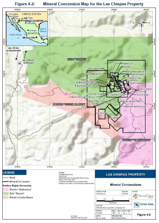
The Property comprises 28 mineral concessions totalling 1,400.96 ha. Compañia Minera La Llamarada S.A. de C.V. (LLA), a Mexican wholly-owned subsidiary of SilverCrest, has acquired title to, or entered into option agreements to purchase with five concession holders. SilverCrest owns approximately two thirds of the surface rights covering its optioned mining concessions. A 20-year lease agreement for land access and exploration activities for the remaining one third of the surface rights on the mineral concessions is in place with the local Ejido (Ejido Bamori). All current Mineral Resources are on SilverCrest controlled surface and mining concessions. The map shown in Figure 1-1 shows the Property layout including mineral concessions and surface rights ownership.
| 1-1 | |
| TECHNICAL REPORT AND MINERAL RESOURCE ESTIMATE FOR THE LAS CHISPAS PROPERTY, SONORA, MEXICO |
| 704-ENG.VMIN03016-05 | MAY 2019 | ISSUED FOR USE |
![]()
| 1-2 | |
| TECHNICAL REPORT AND MINERAL RESOURCE ESTIMATE FOR THE LAS CHISPAS PROPERTY, SONORA, MEXICO |
| 704-ENG.VMIN03016-05 | MAY 2019 | ISSUED FOR USE |
Las Chispas will require ongoing exploration permits to continue drilling and exploration activities. SilverCrest currently holds an exploration permit for surface drilling that will need to be extended in 2020. SilverCrest submitted an environmental impact statement (Manifestación de Impacto Ambiental [MIA]) to the Mexican Government’s Secretariat of Environment and Natural Resources (Secretaría de Medio Ambiente y Recursos Naturales [SEMARNAT]) along with an application for an underground drilling permit. The permit was authorized on September 19, 2016 for a 10-year period and also authorizes a proposed program to extract a bulk sample up to 100,000 t for off-site test work. Future amendments to the MIA will be required for exploration work beyond historic areas and for building on-site facilities.
No known environmental liabilities exist on the Property from historical mining and process operations. Soil and tailings testing were conducted as part of the overall sampling that has been ongoing on site. To date there are no known contaminants. Water quality testing is currently ongoing for an on-site baseline environmental study.
The mineral deposits are classified as low to intermediate sulphidation epithermal veins, stockwork, and breccia zones, where silver mineralization is present as primary minerals argentite/acanthite and secondary minerals stephanite, polybasite, and pyrargyrite/proustite. Gold concentration is related to silver mineralization and may occur in trace quantities within the silver-sulphosalts, in addition to an electrum phase. Historical records document the irregular ore shoots of extreme high-grade mineralization that often occur in contact with, and likely in relation to, zones of leached and barren quartz and calcite filled fractures. Dufourcq (1910) describes these zones as commonly occurring horizontally and are a result of leaching, concentrating, and redistributing the primary silver sulphides.
The deposits have been emplaced through a felsic to more mafic volcaniclastic sequence associated with volcanism of the upper portion of the Lower Volcanic Series, a dominant member of the Sierra Madre Occidental terrane which hosts similar deposits in northeastern portions of the state of Sonora and northwestern portions of the state of Chihuahua.
Minefinders Corporation Ltd. (Minefinders) conducted previous exploration work on the Property between 2008 and 2011; however, this exploration work was limited by mineral concession rights. Regional activities consisted of geologic mapping and a geochemical sampling program totaling 143 stream sediment and bulk leach extractable gold (BLEG) samples; 213 underground rock chip samples; and 1,352 surface rock chip samples. The work was successful in identifying three gold targets along the 3 km long structural zone. The most prospective of these targets was interpreted to be an area between the Las Chispas Vein and the Babicanora Vein. Minefinders focused on the furthest western extension of the Babicanora Vein called El Muerto, which is the only part of the trend that was acquired by concession and accessible for exploration work. Minefinders drilled seven reverse circulation (RC) holes, totalling 1,842.5 m from the road to the west and off the main mineralized trends. The program returned negative results and Minefinders dropped the Property in 2012.
SilverCrest Mines Inc. (now a subsidiary of First Majestic), through its subsidiary Nusantara de Mexico S.A. de C.V., executed option agreements to acquire rights to 17 mineral concessions in September 2015. On October 1, 2015, these mineral concessions were transferred to SilverCrest Metals subsidiary LLA further to an arrangement agreement among SilverCrest Metals Inc., SilverCrest Mines Inc., and First Majestic. After October 2015, LLA obtained the rights to 11 additional mineral concessions.
Before SilverCrest acquired the Las Chispas Property in October 2015, no drilling had been completed on the northwest to southeast mineralized trend that contains the Las Chispas and Babicanora areas.
| 1-3 | |
| TECHNICAL REPORT AND MINERAL RESOURCE ESTIMATE FOR THE LAS CHISPAS PROPERTY, SONORA, MEXICO |
| 704-ENG.VMIN03016-05 | MAY 2019 | ISSUED FOR USE |
SilverCrest began exploration work on the Property in February 2016 with a primary focus on the Las Chispas, William Tell, and Babicanora veins. From February to October 2016, the Phase I exploration program consisted of initial core drilling in the Las Chispas area, surface and underground mapping and sampling, and rehabilitating an estimated 6 km of underground workings. From November 2016 to February 2018, the Phase II exploration program consisted of additional drilling, surface and underground mapping and sampling, further rehabilitation of 4 km of underground workings, plus auger and trenching of approximately 175,000 t of surface historic waste dumps. The Phase III exploration program commenced in February 2018 and is currently ongoing as of the effective date of this Technical Report. The Phase III exploration program has so far consisted of drilling, additional surface and underground mapping and sampling, and rehabilitation of 1 km of underground workings to complete the underground rehabilitation program of 11 km. The extensive mapping and sampling program being undertaken by SilverCrest has identified that many of the mineralized showings are narrow and high-grade, low to intermediate sulphidation epithermal deposits hosted in volcaniclastic rocks. To date, the completed Phase I, Phase II, and partial Phase III surface and underground drill programs total approximately 117,057.65 m in 439 core holes.
The Phase I core drilling of 22 holes totalling 6,392.6 m and 4,227 samples targeted near surface mineralization and lateral extensions of previously mined areas in the Las Chispas Vein, in addition to the William Tell Vein and the La Victoria Prospect. The Phase II core drilling of 161 drill holes totaling 39,354.60 m and 22,899 samples targeted unmined portions of the Las Chispas Vein, delineation of the Giovanni, Giovanni Mini, La Blanquita, and other unnamed veins, in addition to exploration of the La Varela Vein, all within the Las Chispas Area. Drilling of the Babicanora Vein focused on delineating the down plunge and vertical extents of the Babicanora Vein, in addition to exploratory drilling on the Amethyst Vein and the Granaditas Target, all within the Babicanora Area. The Phase III core drilling of 256 drill holes totaling 71,310.45 m and 33,551 samples targeted the Babicanora, Babicanora Norte, Babi Sur, Luigi, and Granaditas veins as well as continuing to delineate the down plunge and vertical extents of the Babicanora Hanging Wall (HW) Vein and Footwall (FW) Vein.
Drilling on the Babicanora Vein has identified significant silver and gold mineralization along a regional plunging trend that has been named the Area 51, based on anchor mineral intersection in hole BA17-51. The Area 51 Zone measures approximately 800 m along strike, 300 m vertically, and remains open down plunge. The top of Area 51 is located at approximately the same elevation as the valley bottom, or 200 vertical metres from the ridge crest. Within the Area 51 Zone, a high-grade shoot named Shoot 51, has been delineated by drilling to be approximately 300 by 250 m and represents a high-grade core of mineralization with silver equivalent (AgEq) grades greater then 1,000 gpt on a vein composite basis and minimum true thickness of 1.5 m.
Table 1-1 shows select highlights of the Phase III drilling results. The locations of SilverCrest’s drilling in the Las Chispas Area is shown in Figure 1-2 and in the Babicanora Area in Figure 1-3. Surface collar locations were initially surveyed using a handheld global positioning system (GPS) unit and then by a professional surveyor using a differential Trimble GPS. All drill hole inclinations were surveyed utilizing single-shot measurements with a Flex-it® tool. Underground collar locations were surveyed relative to the underground survey network, which has been tied in by a professional survey contractor.
| 1-4 | |
| TECHNICAL REPORT AND MINERAL RESOURCE ESTIMATE FOR THE LAS CHISPAS PROPERTY, SONORA, MEXICO |
| 704-ENG.VMIN03016-05 | MAY 2019 | ISSUED FOR USE |
| Table 1-1: | Las Chispas Most Significant Drill Hole Results for Recent Phase III (September2018 to February 2019)(3,4,5,6) |
Vein | Hole No. | From (m) | To (m) | Drilled Width (m) | Est. True Width (m) | Au (gpt) | Ag (gpt) | AgEq* (gpt) |
| Babicanora | BA18-93 | 300.5 | 304.6 | 4.1 | 3.8 | 6.78 | 1,091 | 1,599 |
| Babicanora | incl. | 302.4 | 304.6 | 2.2 | 2.0 | 8.97 | 1,505 | 2,177 |
| Babicanora | BA18-94 | 307.4 | 312.0 | 4.6 | 3.5 | 33.06 | 2,092 | 4,570 |
| Babicanora | incl. | 310.2 | 311.3 | 1.1 | 0.8 | 80.65 | 6,573 | 12,622 |
| Babicanora | BA18-95 | 294.0 | 308.2 | 14.2 | 11.1 | 3.99 | 580 | 879 |
| Babicanora | incl. | 296.0 | 298.7 | 2.7 | 2.1 | 8.01 | 1,250 | 1,850 |
| Babicanora | incl. | 303.1 | 304.2 | 1.1 | 0.9 | 25.5 | 2,381 | 4,293 |
| Babicanora | BA18-96 | 200.2 | 214.4 | 14.1 | 9.9 | 14.40 | 2,132 | 3,212 |
| Babicanora | incl. | 204.1 | 210.5 | 6.4 | 4.5 | 30.28 | 4,498 | 6,769 |
| Babicanora | incl. | 208.5 | 209.5 | 1.0 | 0.7 | 102.15 | 12,757 | 20,418 |
| Babicanora | BA18-97 | 294.0 | 296.0 | 2.0 | 1.5 | 2.52 | 454 | 643 |
| Babicanora | incl. | 294.0 | 295.0 | 1.0 | 0.7 | 4.57 | 821 | 1,164 |
| Babicanora | BA18-110 | 370.0 | 373.6 | 3.7 | 3.3 | 3.72 | 451 | 730 |
| Babicanora | incl. | 373.1 | 373.6 | 0.6 | 0.5 | 14.55 | 1,640 | 2,731 |
| Babicanora | BA18-112 | 205.9 | 206.6 | 0.7 | 0.6 | 0.65 | 174 | 223 |
| Babicanora | BA18-113 | 137.2 | 140.4 | 3.3 | 2.9 | 1.08 | 365 | 445 |
| Babicanora | BA18-114 | 289.0 | 293.2 | 4.2 | 3.0 | 5.37 | 998 | 1,401 |
| Babicanora | incl. | 291.1 | 292.2 | 1.1 | 0.8 | 11.95 | 1,860 | 2,756 |
| Babicanora | incl. | 309.1 | 311.2 | 2.1 | 1.5 | 2.49 | 226 | 413 |
| Babicanora | BA18-115 | 172.7 | 177.4 | 4.7 | 4.3 | 0.73 | 149 | 204 |
| Babicanora | BA18-116 | 318.9 | 321.6 | 2.8 | 2.4 | 4.30 | 1,572 | 1,894 |
| Babicanora | incl. | 320.0 | 320.8 | 0.8 | 0.7 | 6.38 | 4,160 | 4,639 |
| Babicanora | BA18-118 | 219.6 | 226.1 | 6.5 | 4.0 | 0.50 | 211 | 249 |
| Babicanora | BA18-119 | 351.8 | 352.3 | 0.5 | 0.4 | 0.78 | 106 | 164 |
| Babicanora | incl. | 362.6 | 364.1 | 1.5 | 1.2 | 5.44 | 774 | 1,182 |
| Babicanora | BA18-120 | 185.8 | 195.0 | 9.2 | 8.6 | 0.98 | 409 | 483 |
| Babicanora | BA18-122 | 194.3 | 207.5 | 13.2 | 9.3 | 39.66 | 3,361 | 6,336 |
| Babicanora | incl. | 194.3 | 194.8 | 0.5 | 0.4 | 252 | 9,740 | 28,640 |
| Babicanora | incl. | 198.9 | 200.2 | 1.3 | 0.9 | 92.7 | 7,570 | 14,522 |
| Babicanora | incl. | 205.4 | 206 | 0.6 | 0.4 | 47.3 | 7,760 | 11,307 |
| Babicanora | incl. | 224.8 | 226.8 | 1.9 | 1.4 | 6.01 | 722 | 1,173 |
| table continues… | ||||||||
| 1-5 | |
| TECHNICAL REPORT AND MINERAL RESOURCE ESTIMATE FOR THE LAS CHISPAS PROPERTY, SONORA, MEXICO |
| 704-ENG.VMIN03016-05 | MAY 2019 | ISSUED FOR USE |
Vein | Hole No. | From (m) | To (m) | Drilled Width (m) | Est. True Width (m) | Au (gpt) | Ag (gpt) | AgEq* (gpt) |
| Babicanora | BA18-123 | 260.8 | 264.6 | 3.9 | 3.1 | 12.58 | 326 | 1,269 |
| Babicanora | incl. | 262.5 | 263.1 | 0.6 | 0.5 | 81.80 | 540 | 6,675 |
| Babicanora | BA18-124A | 240.6 | 241.4 | 0.8 | 0.7 | 1.38 | 151 | 254 |
| Babicanora | BA18-125 | 207.2 | 208.7 | 1.5 | 1.2 | 1.81 | 34 | 170 |
| Babicanora | BA18-126 | 428.0 | 429.5 | 1.5 | 1.2 | 11.29 | 1,037 | 1,885 |
| Babicanora | incl. | 428.0 | 428.5 | 0.5 | 0.4 | 30.70 | 2,760 | 5,062 |
| Babicanora | BA18-128 | 334.2 | 337.4 | 3.2 | 2.6 | 3.33 | 357 | 607 |
| Babicanora | incl. | 334.2 | 335.8 | 1.7 | 1.4 | 5.10 | 951 | 959 |
| Babicanora | BA18-131 | 277.5 | 284.0 | 6.5 | 4.2 | 9.99 | 837 | 1,586 |
| Babicanora | incl. | 280.3 | 281.7 | 1.4 | 0.9 | 35.70 | 2,670 | 5,347 |
| Babicanora | BA18-132 | 205.7 | 210.8 | 5.1 | 3.3 | 11.47 | 1,314 | 2,174 |
| Babicanora | incl. | 207.2 | 208.9 | 1.7 | 1.1 | 14.96 | 1,666 | 2,788 |
| Babicanora | incl. | 210.3 | 210.8 | 0.5 | 0.3 | 36.90 | 4,100 | 6,867 |
| Babicanora | BA18-133 | 227.8 | 229.2 | 1.4 | 1.0 | 64.25 | 11,020 | 15,839 |
| Babicanora | incl. | 228.3 | 229.2 | 0.9 | 0.6 | 96.30 | 16,721 | 23,943 |
| Babicanora | BA18-134 | 179.8 | 181.4 | 1.6 | 1.6 | 0.06 | 175 | 179 |
| Babicanora | BA19-139 | 262.5 | 264.2 | 1.7 | 1.5 | 0.05 | 296 | 300 |
| Babicanora | BA19-142 | 431.4 | 432.9 | 1.5 | 1.3 | 15.57 | 1,526 | 2,694 |
| Babicanora | incl. | 431.9 | 432.4 | 0.5 | 0.4 | 31.30 | 3,100 | 5,448 |
| Babicanora Central | UB18-14 | 92.2 | 99.1 | 6.9 | 5.1 | 4.16 | 197 | 510 |
| Babicanora Central | incl. | 96.0 | 96.5 | 0.5 | 0.4 | 10.80 | 458 | 1,268 |
| Babicanora Central | UB18-15 | 64.5 | 66.9 | 2.4 | 1.8 | 0.10 | 192 | 197 |
| Babicanora Central | UB18-16 | 21.1 | 21.6 | 0.5 | 0.4 | 2.05 | 5 | 159 |
| Babicanora Central | UB18-17 | 66.6 | 75.5 | 8.9 | 6.3 | 0.21 | 330 | 346 |
| Babicanora Central | UB18-18 | 70.8 | 73.7 | 2.9 | 2.6 | 9.84 | 236 | 974 |
| Babicanora Central | UB18-20 | 91.5 | 93.0 | 1.5 | 1.0 | 2.73 | 40 | 245 |
| Babicanora Central | UB18-21 | 39.8 | 48.0 | 8.3 | 7.8 | 0.95 | 408 | 479 |
| Babicanora Central | incl. | 46.5 | 48.0 | 1.5 | 1.4 | 0.14 | 1,917 | 1,928 |
| Babicanora Central | UB18-22 | 48.0 | 57.0 | 9.0 | 9.0 | 2.09 | 353 | 509 |
| Babicanora Central | incl. | 49.5 | 51.0 | 1.5 | 1.5 | 1.90 | 933 | 1,076 |
| Babicanora Central | UB18-23 | 37.1 | 51.0 | 13.9 | 13.9 | 1.42 | 208 | 314 |
| Babicanora Central | incl. | 50.0 | 51.0 | 1.0 | 1.0 | 16.40 | 349 | 1,579 |
| Babicanora FW | BA18-115 | 208.7 | 209.2 | 0.5 | 0.5 | 9.81 | 935 | 1,671 |
| table continues… | ||||||||
| 1-6 | |
| TECHNICAL REPORT AND MINERAL RESOURCE ESTIMATE FOR THE LAS CHISPAS PROPERTY, SONORA, MEXICO |
| 704-ENG.VMIN03016-05 | MAY 2019 | ISSUED FOR USE |
Vein | Hole No. | From (m) | To (m) | Drilled Width (m) | Est. True Width (m) | Au (gpt) | Ag (gpt) | AgEq* (gpt) |
| Babicanora FW | BA18-120 | 225.5 | 226.0 | 0.5 | 0.5 | 0.98 | 409 | 483 |
| Babicanora FW | BA18-122 | 224.8 | 225.4 | 0.7 | 0.6 | 17.6 | 2,110 | 3,430 |
| Babicanora FW | BA18-128 | 342.7 | 343.7 | 1.0 | 0.8 | 5.13 | 543 | 927 |
| Babicanora FW | incl. | 343.2 | 343.7 | 0.5 | 0.4 | 9.57 | 997 | 1,714 |
| Babicanora FW | BA18-134 | 192.5 | 194.5 | 2.0 | 2.0 | 1.18 | 149 | 238 |
| Babicanora FW | BA19-142 | 435.6 | 436.1 | 0.5 | 0.4 | 2.55 | 268 | 459 |
| Babicanora FW | UB18-14 | 34.0 | 36.0 | 2.0 | 1.0 | 1.21 | 143 | 234 |
| Babicanora FW | UB18-18 | 5.1 | 6.2 | 1.1 | 1.0 | 1.59 | 128 | 247 |
| Babicanora FW | UB18-19 | 3.5 | 6.0 | 2.5 | 2.3 | 1.26 | 52 | 146 |
| Babicanora FW | UB18-20 | 10.3 | 11.4 | 1.1 | 0.7 | 0.79 | 90 | 149 |
| Babicanora FW | UB18-21 | 9.5 | 10.0 | 0.5 | 0.5 | 25.90 | 2,010 | 3,952 |
| Babicanora FW | UB18-22 | 13.3 | 16.1 | 2.8 | 2.8 | 1.61 | 35 | 156 |
| Babicanora HW | BA18-110 | 342.4 | 342.9 | 0.5 | 0.4 | 2.88 | 270 | 486 |
| Babicanora HW | BA18-116 | 300.8 | 301.4 | 0.6 | 0.5 | 1.72 | 152 | 281 |
| Babicanora HW | BA18-123 | 240.4 | 244.0 | 3.6 | 2.9 | 0.05 | 328 | 332 |
| Babicanora HW | BA18-124A | 237.8 | 238.4 | 0.6 | 0.6 | 0.66 | 113 | 163 |
| Babicanora HW | BA18-130 | 146.9 | 147.4 | 0.5 | 0.5 | 5.73 | 195 | 625 |
| Babicanora HW | BA18-134 | 156.0 | 156.5 | 0.5 | 0.5 | 1.47 | 199 | 309 |
| Babicanora HW | BA19-142 | 423.3 | 424.6 | 1.3 | 1.2 | 2.18 | 268 | 432 |
| Babicanora HW | UB18-23 | 79.3 | 80.6 | 1.3 | 1.3 | 0.05 | 167 | 171 |
| Babicanora Norte | BAN18-43 | 119.4 | 120.4 | 1.0 | 0.6 | 2.79 | 295 | 504 |
| Babicanora Norte | BAN18-50 | 366.0 | 367.8 | 1.8 | 1.3 | 2.10 | 2 | 159 |
| Babicanora Norte | BAN18-51 | 58.5 | 59.0 | 0.5 | 0.5 | 0.81 | 93 | 154 |
| Babicanora Norte | BAN18-54 | 161.4 | 161.9 | 0.5 | 0.5 | 5.57 | 32 | 450 |
| Babicanora Norte | BAN18-56 | 150.3 | 151.0 | 0.7 | 0.6 | 4.66 | 409 | 759 |
| Babicanora Vista | UBN18-03 | 163.1 | 163.7 | 0.6 | 0.6 | 3.26 | 530 | 775 |
| Babicanora Vista | BAN18-53 | 269.9 | 271.0 | 1.1 | 1.0 | 2.72 | 176 | 380 |
| Babi Sur | BAS18-07 | 147.6 | 149.9 | 2.2 | 2.2 | 4.63 | 209 | 556 |
| Babi Sur | incl. | 149.0 | 149.9 | 0.9 | 0.9 | 8.44 | 376 | 1,009 |
| Babi Sur | BAS18-09 | 139.4 | 140.1 | 0.6 | 0.6 | 5.47 | 123 | 533 |
| Babi Sur | BAS18-10 | 98.6 | 99.8 | 1.3 | 1.2 | 6.56 | 4 | 496 |
| Babi Sur | BAS18-14 | 158.6 | 159.6 | 1.1 | 1.1 | 2.30 | 166 | 338 |
| Babi Sur | BAS18-16 | 183.5 | 184.7 | 1.2 | 1.1 | 1.14 | 94 | 180 |
| table continues… | ||||||||
| 1-7 | |
| TECHNICAL REPORT AND MINERAL RESOURCE ESTIMATE FOR THE LAS CHISPAS PROPERTY, SONORA, MEXICO |
| 704-ENG.VMIN03016-05 | MAY 2019 | ISSUED FOR USE |
Vein | Hole No. | From (m) | To (m) | Drilled Width (m) | Est. True Width (m) | Au (gpt) | Ag (gpt) | AgEq* (gpt) |
| Babi Sur | BAS18-19 | 234.5 | 235.5 | 1.0 | 0.8 | 3.29 | 286 | 533 |
| Babi Sur | incl. | 234.5 | 235.0 | 0.5 | 0.4 | 6.51 | 571 | 1,059 |
| Babi Sur | BAS18-24 | 77.6 | 78.2 | 0.6 | 0.5 | 1.76 | 117 | 249 |
| Babi Sur | BAS18-26 | 227.0 | 228.1 | 1.1 | 0.9 | 1.53 | 117 | 232 |
| Babi Sur | BAS18-27 | 124.4 | 125.4 | 1.0 | 0.6 | 9.33 | 66 | 766 |
| Babi Sur | BAS18-29 | 193.0 | 194.0 | 1.0 | 1.0 | 1.04 | 80 | 158 |
| Babi Sur | BAS18-31 | 230.6 | 232.8 | 2.2 | 2.2 | 18.78 | 2,147 | 3,556 |
| Babi Sur | incl. | 231.7 | 232.8 | 1.1 | 1.1 | 33.85 | 3,905 | 6,444 |
| Babi Sur | BAS18-33 | 148.6 | 150.0 | 1.4 | 0.9 | 5.01 | 197 | 573 |
| Babi Sur | incl. | 148.6 | 149.3 | 0.7 | 0.5 | 6.86 | 301 | 816 |
| Babi Sur | BAS19-37 | 111.0 | 112.6 | 1.6 | 1.2 | 2.66 | 16 | 215 |
| Babi Sur | BAS19-39 | 248.0 | 250.1 | 2.1 | 1.7 | 2.73 | 204 | 409 |
| Babi Sur | incl. | 248.7 | 249.4 | 0.7 | 0.6 | 4.24 | 327 | 645 |
| Babi Sur HW | BAS18-11 | 76.3 | 78.0 | 1.8 | 1.7 | 2.01 | 4 | 155 |
| Babi Sur HW | BAS18-23 | 206.8 | 207.5 | 0.7 | 0.6 | 1.52 | 128 | 242 |
| Babi Sur HW | BAS18-27 | 13.7 | 15.1 | 1.5 | 0.8 | 7.63 | 34 | 606 |
| Babi Sur HW | BAS19-35 | 36.0 | 36.5 | 0.5 | 0.3 | 10.25 | 7 | 775 |
| Babi Sur HW | BAS18-08 | 70.3 | 70.8 | 0.6 | 0.6 | 2.60 | 5 | 200 |
| Babi Sur HW | BAS18-11 | 76.3 | 78.0 | 1.8 | 1.7 | 2.01 | 4 | 155 |
| Babi Sur HW | BAS18-19 | 190.5 | 191.6 | 1.0 | 0.8 | 5.57 | 183 | 601 |
| Babi Sur HW | BAS18-23 | 195.0 | 197.0 | 2.0 | 1.2 | 1.19 | 106 | 195 |
| Note: | (1)AgEq based on 75 (Ag):1 (Au), calculated using long-term silver and gold prices of US$17/oz silver and US$1,225/oz gold with average metallurgical recoveries of 90% silver and 95% gold. |
(2)True width is 80 to 100% of drilled width. | |
(3)Based on a cut-off grade of 150 gpt AgEq with a 0.5 m minimum width. | |
(4)U signifies an underground core hole; BA signifies a surface core hole. | |
(5)The Babi FW Vein intercept in hole BA18-122 was noted as part of Babicanora Vein. Babi Vista Vein intercepts in BAN18-14, BAN18-30, BAN18-33, and UBN18-03 were previously reported in various news releases as unknown veins. |
| 1-8 | |
| TECHNICAL REPORT AND MINERAL RESOURCE ESTIMATE FOR THE LAS CHISPAS PROPERTY, SONORA, MEXICO |
| 704-ENG.VMIN03016-05 | MAY 2019 | ISSUED FOR USE |

| 1-9 | |
| TECHNICAL REPORT AND MINERAL RESOURCE ESTIMATE FOR THE LAS CHISPAS PROPERTY, SONORA, MEXICO |
| 704-ENG.VMIN03016-05 | MAY 2019 | ISSUED FOR USE |

| 1-10 | |
| TECHNICAL REPORT AND MINERAL RESOURCE ESTIMATE FOR THE LAS CHISPAS PROPERTY, SONORA, MEXICO |
| 704-ENG.VMIN03016-05 | MAY 2019 | ISSUED FOR USE |
The February 2018 maiden Mineral Resource Estimate (Barr 2018) encompassed vein-hosted material at the Babicanora, Las Chispas, William Tell, and Giovanni veins and surface stockpiled material remaining from historical operations such as waste dumps, waste tailings deposits, and recovered underground muck material. This model was updated in September 2018. Currently, the new updated Mineral Resource Estimate (February 2019) encompasses vein material from the Babicanora, Babicanora FW, Babicanora HW, Babicanora Norte, Babicanora Sur, Granaditas, Las Chispas, William Tell, Giovanni, and Luigi veins and previously reported surface stockpiled material.
New drilling since September 2018 has focused on the Babicanora Area, which has enabled SilverCrest to update the Mineral Resources for these veins. Mineral Resources for the Las Chispas Area and the Granaditas Area have not been updated from Fier (2018). Table 1-2 compares the February 2018 maiden Mineral Resource Estimate (Barr 2018) to the February 2019 Mineral Resource Estimate.
| Table 1-2: | Maiden vs. Updated Mineral Resource Comparison(3,4) |
| Resource Category(¹) | Tonnes (Mt) | Au (gpt) | Ag (gpt) | AgEq(2) (gpt) | Contained Au Ounces | Contained Ag Ounces | Contained AgEq(2)Ounces |
| September 2018 Resource | |||||||
| Indicated | - | - | - | - | - | - | - |
| Inferred | 3.4 | 3.63 | 296 | 568 | 401,600 | 32,675,600 | 62,826,100 |
| Including Area 51 | |||||||
| Indicated | - | - | - | - | - | - | - |
| Inferred | 1.0 | 7.43 | 469 | 1,026 | 231,000 | 14,581,000 | 32,247,000 |
| February 2019 Resource | |||||||
| Indicated | 1.0 | 6.98 | 711 | 1,234 | 224,900 | 22,894,800 | 39,763,600 |
| Inferred | 3.6 | 3.32 | 333 | 582 | 388,300 | 38,906,000 | 68,069,800 |
| Including Area 51 | |||||||
| Indicated | 0.47 | 7.90 | 801 | 1,393 | 118,500 | 12,011,600 | 20,898,100 |
| Inferred | 0.39 | 6.06 | 715 | 1,170 | 76,500 | 9,032,700 | 14,767,600 |
| Notes: | (1)Conforms to NI 43-101 Companion Policy 43-101CP and the Canadian Institute of Mining, Metallurgy and Petroleum (CIM) Definition Standards on Mineral Resources and Mineral Reserves. Inferred Mineral Resources have been estimated from geological evidence and limited sampling and must be treated with a lower level of confidence than Measured and Indicated Resources. |
(2)AgEq, based on a silver to gold ratio of 75:1, was calculated using long-term silver and gold prices of US$17/oz silver and US$1,225/oz gold with average metallurgical recoveries of 90% silver and 95% gold. | |
(3)There are no known legal, political, environmental, or other risks that could materially affect the potential development of the Mineral Resources. | |
(4)All numbers are rounded. Overall numbers may not be exact due to rounding. |
For all Mineral Resources estimated up to February 8, 2019, SilverCrest constructed vein models using Seequent Limited Leapfrog® Geo v.4.4 and the Tetra Tech Qualified Person (QP) reviewed the vein models. Veins in the Las Chispas and Granaditas areas were constrained to a minimum thickness of 1.5 m true width, and veins in the Babicanora Area were constrained to a minimum thickness of 0.5 m true width. Assay data was composted to 1.0 m lengths in the Las Chispas and Granaditas areas and to 0.5 m lengths in the Babicanora Area. Block models were constructed using GEOVIA GEMS™ v.6.8 and Mineral Resource Estimates, were calculated from surface and underground diamond drilling information A total of 2,647 composite drill core data points were used as the basis for the Mineral Resource Estimate.
| 1-11 | |
| TECHNICAL REPORT AND MINERAL RESOURCE ESTIMATE FOR THE LAS CHISPAS PROPERTY, SONORA, MEXICO |
| 704-ENG.VMIN03016-05 | MAY 2019 | ISSUED FOR USE |
One block model was developed for the February 2019 Mineral Resource Estimate. The model was developed for the Babicanora Area, which includes the Babicanora, Babicanora FW, Babicanora HW, Babicanora Norte, and Babicanora Sur veins. The block model was established on 2 m by 2 m by 2 m blocks using the percent model methods in GEOVIA GEMS™ v.6.8. Average estimated overall true vein thickness ranged from 0.84 m at Babicanora Norte to 3.05 m at Babicanora. Refer to previous technical reports for modelling methodology used in the Las Chispas, Granditas Areas and historic dumps.
Input parameters for block model interpolation included silver and gold grades. Metal grades were interpolated using Ordinary Kriging (OK) and Inverse Distance Weighted to the second power (ID2) methods. Where sufficient data existed, search parameters were based on variographic assessment. Where input grades were used from underground and drill hole sampling, multiple interpolation passes were used to first isolate the underground sample in short range searches, followed by larger searches which included both underground and drill hole sampling. Where only drill hole sampling was available, single interpolation passes were used.
A fixed bulk density value of 2.55 g/cm3was applied to all materials within the block models. Bulk density was measured in 72 independent laboratory wax coated bulk density tests on mineralized and non-mineralized rock samples resulting in a mean density of 2.69 g/cm3 and in 641 specific gravity measurements collected and analyzed on site by SilverCrest resulting in a mean density of 2.52 g/cm3.
Table 1-3 summarizes the Mineral Resource Estimates which are effective as of February 8, 2019. Table 1-4 includes a detailed breakdown of the vein estimates and Table 1-5 details the stockpile estimate. These Mineral Resource Estimates adhere to guidelines set forth in NI 43-101 and the CIM Best Practices. All Mineral Resource Estimates prepared for the Las Chispas Property have been classified as Inferred using CIM Definition Standards.
Table 1-3: | Summary of Mineral Resource Estimates for Vein Material and Surface StockpileMaterial at the Las Chispas Property, Effective February 8, 2019(3,5,6,7,8) |
Type | Cut-off Grade(4) (gpt AgEq(2)) | Classification(1) | Tonnes | Au (gpt) | Ag (gpt) | AgEq(2) (gpt) | Contained Au Ounces | Contained Ag Ounces | Contained AgEq(2) Ounces |
| Vein | 150 | Indicated | 1,002,200 | 6.98 | 711 | 1,234 | 224,900 | 22,894,800 | 39,763,600 |
| Vein | 150 | Inferred | 3,464,700 | 3.42 | 343 | 600 | 380,700 | 38,241,400 | 66,823,700 |
| Stockpile | 100 | Inferred | 174,500 | 1.38 | 119 | 222 | 7,600 | 664,600 | 1,246,100 |
| Overall | - | Indicated | 1,002,200 | 6.98 | 711 | 1,234 | 224,900 | 22,894,800 | 39,763,600 |
| Overall | - | Inferred | 3,639,000 | 3.32 | 333 | 582 | 388,300 | 38,906,000 | 68,069,800 |
| Notes: | (1)Conforms to NI 43-101 Companion Policy 43-101CP and the CIM Definition Standards on Mineral Resources and Mineral Reserves. Inferred Mineral Resources have been estimated from geological evidence and limited sampling and must be treated with a lower level of confidence than Measured and Indicated Mineral Resources. |
(2)AgEq, based on a silver to gold ratio of 75:1, was calculated using long-term silver and gold prices of US$17/oz silver and US$1,225/oz gold, with average metallurgical recoveries of 90% silver and 95% gold. | |
(3)Bulk density of 2.55 t/m3has been applied to all materials. | |
(4)Vein resource is reported using a 150 gpt AgEq cut-off grade and minimum 0.5 m true width; the Babicanora Norte, Babicanora Sur, Babicanora FW, and Babicanora HW Veins have been modelled to a minimum undiluted thickness of 0.5 m; Babicanora Main Vein has been modelled to a minimum undiluted thickness of 1.5 m. | |
(5)The Babicanora resource includes the Babicanora Vein with the Shoot 51 zone. The Giovanni resource includes the Giovanni, Giovanni Mini and the La Blanquita Veins. | |
(6)Mineral Resource Estimates for the Las Chispas and William Tell Veins and the surface stockpiles are unchanged from the February 2018 Maiden Resource Estimate (Barr 2018). | |
(7)There are no known legal, political, environmental, or other risks that could materially affect the potential development of the Mineral Resources. | |
(8)All numbers are rounded. Overall numbers may not be exact due to rounding. |
| 1-12 | |
| TECHNICAL REPORT AND MINERAL RESOURCE ESTIMATE FOR THE LAS CHISPAS PROPERTY, SONORA, MEXICO |
| 704-ENG.VMIN03016-05 | MAY 2019 | ISSUED FOR USE |
| Table 1-4: | Mineral Resource Estimate for Vein Material at the Las Chispas Property, EffectiveFebruary 8, 2019(4,5,6,7,8) |
Vein(6) | Classification(1) | Tonnes | Au (gpt) | Ag (gpt) | AgEq(2) (gpt) | Contained Au Ounces | Contained Ag Ounces | Contained AgEq(2) Ounces |
| Babicanora | Indicated | 646,800 | 6.57 | 683 | 1,175 | 136,500 | 14,198,000 | 24,438,600 |
| Inferred | 670,300 | 4.46 | 500 | 842 | 98,300 | 10,775,800 | 18,145,100 | |
| includes Area 51 | Indicated | 466,600 | 7.90 | 801 | 1,393 | 118,500 | 12,011,600 | 20,898,100 |
| Inferred | 392,700 | 6.06 | 715 | 1,170 | 76,500 | 9,032,700 | 14,767,600 | |
| includes Shoot 51 | Indicated | 280,100 | 10.09 | 1,060 | 1,816 | 90,900 | 9,543,200 | 16,360,700 |
| Inferred | 92,00 | 8.54 | 984 | 1,625 | 25,300 | 2,912,100 | 4,809,600 | |
| Babicanora FW | Indicated | 157,100 | 7.49 | 676 | 1,237 | 37,800 | 3,411,200 | 6,248,500 |
| Inferred | 207,400 | 7.62 | 465 | 1,037 | 50,800 | 3,103,800 | 6,913,400 | |
| Babicanora HW | Indicated | 67,800 | 0.93 | 154 | 223 | 2,000 | 334,800 | 486,200 |
| Inferred | 31,500 | 0.80 | 145 | 205 | 800 | 147,100 | 207,500 | |
| Babicanora Norte | Indicated | 130,500 | 11.57 | 1,180 | 2,047 | 48,500 | 4,950,900 | 8,590,300 |
| Inferred | 277,700 | 8.21 | 780 | 1,395 | 73,300 | 6,960,000 | 12,458,000 | |
| Babicanora Sur | Indicated | - | - | - | - | - | - | - |
| Inferred | 543,900 | 4.10 | 268 | 575 | 71,600 | 4,687,800 | 10,058,700 | |
| Las Chispas | Indicated | - | - | - | - | - | - | - |
| Inferred | 171,000 | 2.39 | 340 | 520 | 13,000 | 1,869,500 | 2,861,000 | |
| Giovanni | Indicated | - | - | - | - | - | - | - |
| Inferred | 686,600 | 1.47 | 239 | 349 | 32,500 | 5,269,000 | 7,699,800 | |
| William Tell | Indicated | - | - | - | - | - | - | - |
| Inferred | 595,000 | 1.32 | 185 | 284 | 25,000 | 3,543,000 | 5,438,000 | |
| Luigi | Indicated | - | - | - | - | - | - | - |
| Inferred | 186,200 | 1.32 | 202 | 301 | 7,900 | 1,210,200 | 1,803,000 | |
| Granaditas | Indicated | - | - | - | - | - | - | - |
| Inferred | 95,100 | 2.46 | 221 | 405 | 7,500 | 675,100 | 1,239,200 | |
| All Veins | Indicated | 1,002,200 | 6.98 | 711 | 1,234 | 224,900 | 22,894,800 | 39,763,600 |
| Inferred | 3,639,200 | 3.32 | 333 | 582 | 388,300 | 38,906,000 | 68,069,800 |
| Notes: | (1)Conforms to NI 43-101 Companion Policy 43-101CP and the CIM Definition Standards on Mineral Resources and Mineral Reserves. Inferred Mineral Resources have been estimated from geological evidence and limited sampling and must be treated with a lower level of confidence than Measured and Indicated Mineral Resources. |
(2)AgEq, based on a silver to gold ratio of 75:1, was calculated using long-term silver and gold prices of US$17/oz silver and US$1,225/oz gold, with average metallurgical recoveries of 90% silver and 95% gold. | |
(3)Bulk density of 2.55 t/m3has been applied to all materials. | |
(4)Vein resource is reported using a 150 gpt AgEq cut-off grade and minimum 0.5 m true width; the Babicanora Norte, Babicanora Sur, Babicanora FW, and Babicanora HW Veins have been modelled to a minimum undiluted thickness of 0.5 m; the Babicanora Main has been modelled to a minimum undiluted thickness of 1.5 m. | |
(5)The Babicanora resource includes the Babicanora Vein with the Shoot 51 Zone. The Giovanni resource includes the Giovanni, Giovanni Mini and the La Blanquita Veins. |
| 1-13 | |
| TECHNICAL REPORT AND MINERAL RESOURCE ESTIMATE FOR THE LAS CHISPAS PROPERTY, SONORA, MEXICO |
| 704-ENG.VMIN03016-05 | MAY 2019 | ISSUED FOR USE |
(6)MineralResource Estimates for the Las Chispas and William Tell veins and the surface stockpiles are unchanged from the February 2018 Maiden Resource Estimate (Barr 2018).
(7)There are no known legal, political, environmental, or other risks that could materially affect the potential development of the Mineral Resources.
(8)All numbers are rounded. Overall numbers may not be exact due to rounding.
| Table 1-5: | Mineral Resource Estimate for Surface Stockpile Material at the Las ChispasProperty, Effective September 13, 2018 |
Stockpile Name | Tonnes | Au (gpt) | Ag (gpt) | AgEq(2) (gpt) | Contained Gold Ounces | Contained Silver Ounces | Contained AgEq(2) Ounces |
| North Chispas 1 | 1,200 | 0.54 | 71 | 111 | 20 | 2,700 | 4,200 |
| La Capilla | 14,200 | 4.92 | 137 | 506 | 2,300 | 62,700 | 231,600 |
| San Gotardo | 79,500 | 0.79 | 121 | 180 | 2,000 | 308,100 | 459,600 |
| Lupena | 17,500 | 1.38 | 79 | 182 | 800 | 44,300 | 102,700 |
| Las Chispas 1 (LCH) | 24,200 | 0.78 | 125 | 183 | 600 | 97,000 | 142,500 |
| Las Chispas 2 | 1,100 | 1.23 | 236 | 329 | 40 | 8,100 | 11,300 |
| Las Chispas 3 (San Judas) | 1,000 | 2.05 | 703 | 857 | 100 | 22,400 | 27,300 |
| La Central | 3,800 | 0.75 | 116 | 172 | 100 | 14,300 | 21,200 |
| Chiltepines 1 | 200 | 0.87 | 175 | 240 | 0 | 800 | 1,200 |
| Espiritu Santo | 1,700 | 0.52 | 94 | 133 | 30 | 5,000 | 7,100 |
| La Blanquita 2 | 4,600 | 0.53 | 118 | 158 | 100 | 17,500 | 23,400 |
| El Muerto | 5,800 | 2.52 | 79 | 268 | 500 | 14,900 | 50,200 |
| Sementales | 800 | 4.38 | 47 | 376 | 100 | 1,200 | 9,700 |
| Buena Vista | 400 | 4.62 | 57 | 403 | 100 | 700 | 5,100 |
| Babicanora | 10,300 | 1.81 | 56 | 192 | 600 | 18,500 | 63,300 |
| Babicanora 2 | 1,000 | 2.63 | 276 | 473 | 100 | 8,900 | 15,300 |
| El Cruce & 2,3 | 100 | 0.75 | 39 | 96 | 3 | 200 | 400 |
| Babi stockpiled fill | 800 | 1.80 | 120 | 255 | 50 | 3,100 | 6,600 |
| LC stockpiled fill | 300 | 2.50 | 243 | 431 | 20 | 2,300 | 4,200 |
| Las Chispas Underground Backfill | 2,000 | 2.10 | 243 | 431 | 100 | 16,500 | 26,600 |
| Babicanora Underground Backfill | 4,000 | 1.80 | 120 | 255 | 200 | 15,500 | 32,800 |
| Total | 174,500 | 1.38 | 119 | 222 | 7,600 | 664,600 | 1,246,100 |
| Notes: | (1)Conforms to NI 43-101, Companion Policy 43-101CP, and the CIM Definition Standards for Mineral Resources and Mineral Reserves. Inferred Resources have been estimated from geological evidence and limited sampling and must be treated with a lower level of confidence than Measured and Indicated Resources. |
(2)AgEq, based on a silver to gold ration of 75:1, was calculated using long-term silver and gold prices of U.S.$17 per ounce silver and U.S.$1,225 per ounce gold with average metallurgical recoveries of 90% silver and 95% gold. | |
(3)Resource is reported using a 100 gpt AgEq cut-off grade. | |
(4)Resource estimations for the historical dumps are unchanged from the February 2018 Maiden Resource Estimate. | |
(5)There are no known legal, political, environmental, or other risks that could materially affect the potential development of the Mineral Resources. | |
(6)All numbers are rounded. Overall numbers may not be exact due to rounding. |
| 1-14 | |
| TECHNICAL REPORT AND MINERAL RESOURCE ESTIMATE FOR THE LAS CHISPAS PROPERTY, SONORA, MEXICO |
| 704-ENG.VMIN03016-05 | MAY 2019 | ISSUED FOR USE |
In August 2017, SilverCrest conducted preliminary metallurgical test work using 19 drill core samples from the Las Chispas and Babicanora veins that were combined into three composite samples. The test work conducted at SGS de Mexico S.A. de C.V in Durango, Mexico (SGS Durango) included standard bottle rolls with 85% of material passing 150 mesh, pH at 11 to 11.5, 48% solids, and retention time of 50 hours. After 50 hours, the tests resulted in an average gold recovery of 98.9% and an average silver recovery of 86.6% . Sodium cyanide (NaCN) consumption rates averaged 1.5 kg/t and calcium oxide (CaO) consumption rates averaged 1.4 kg/t.
In November 2018, 445 kg of material was selected from 51 core holes and 9 underground samples to compile 15 different samples, based on geo-metallurgical domains, that were combined into three master composites. These composites utilized 210 kg of mass representing a variety of grades (low, medium, and high) of 500 to 2,000 gpt AgEq expected during conceptual operation. The balance of the 445 kg was reserved for further metallurgical test work in 2019. One sample labeled as “Waste Composite” was also collected and constructed. The samples were delivered to SGS Durango for test work including comminution, ball mill grindability work index and abrasion, mineralogy, gravity concentration, flotation, intensive leaching of gravity concentrates, and direct cyanide leaching. Only results for the gravity concentration and grindability test work were available as of the effective date of this Technical Report; all other test work was incomplete and is currently ongoing.
The gravity concentration and grindability test results indicated that materials were relatively hard to ball mill grinding. A Bond abrasion index (Ai) was determined on a composite sample and the test results showed an abrasion index of 0.580 g, indicating the material was abrasive to conventional crushing and grinding. The samples tested responded well to the gravity concentration, which indicated that significant amounts of nugget gold and silver occurred in the samples. Dependent on gravity concentrate mass pulls, recoveries were in the range of 27 to 40% for gold and 16 to 33% for silver when the gravity concentrate mass pulls ranged from 0.27 to 0.67% . When gravity concentrate mass recovery was increased to approximately 1.2 to 1.6%, the recoveries improved to approximately 40 to 47% for gold and 32 to 37% for silver.
Based on the results of exploration work completed to date, the Las Chispas Property comprises an extensive mineralizing system with numerous veins, or portions of veins, that remain intact and potentially undiscovered.
The Las Chispas Property comprises an extensive mineralization system and merits further work to continue to characterize the internal variability and extents of the 30 known veins in the district and to explore the numerous veins not yet tested. The Phase III program, estimated to cost approximately US$15 million and originally recommended in Barr (2018), continues to be reasonable. This exploration program, which commenced in February 2018 and is currently ongoing as of the effective date of this report, includes additional underground channel sampling, dedicated metallurgical test work on significant veins, expansion and infill drilling along multiple veins, exploration decline at the Area 51 Zone, baseline work, and permitting. A Preliminary Economic Assessment (PEA) is also currently in progress for the Property. Based on the results from the remainder of the Phase III program and the PEA, the Las Chispas Project should be advanced to further engineering studies. A significant amount of drilling will be required in the Las Chispas Area to increase confidence in the Mineral Resources to commensurate with advanced engineering studies. Table 1-6 outlines the cost estimate for the ongoing Phase III program.
| 1-15 | |
| TECHNICAL REPORT AND MINERAL RESOURCE ESTIMATE FOR THE LAS CHISPAS PROPERTY, SONORA, MEXICO |
| 704-ENG.VMIN03016-05 | MAY 2019 | ISSUED FOR USE |
| Table 1-6: | Cost Estimate for Additional Phase III Exploration Work |
Item | Units | Cost Estimate (USD$000) |
| Dedicated Sampling and Metallurgical Test Work on Most Significant Veins | 200 samples, composites and test work | 150 |
| Expansion and Infill Drilling Along Multiple Veins | 55,000 m (surface and underground) | 9,000 |
| Area 51 Decline and Exploration | 1,500 m | 3,000 |
| Baseline Work and Permitting | Decline, explosives, added drilling | 445 |
| Water Exploration, Permitting and Purchase Update Resource and Technical Report | All rights for water use | 200 |
| Q1 2019 Technical Report | 100 | |
| PEA Mexico Administration and Labour | Q1 2019 PEA | 300 |
| G&A | 1,500 | |
| Corporate Support Total | Corporate G&A | 500 |
| - | 14,750 |
| Note: | G&A – general and administrative |
| 1-16 | |
| TECHNICAL REPORT AND MINERAL RESOURCE ESTIMATE FOR THE LAS CHISPAS PROPERTY, SONORA, MEXICO |
| 704-ENG.VMIN03016-05 | MAY 2019 | ISSUED FOR USE |
| 2.0 | INTRODUCTION |
SilverCrest retained Tetra Tech to prepare a NI 43-101 Technical Report to document an update to the Mineral Resource Estimate for the Las Chispas Property, located in the State of Sonora, Mexico. The effective date of this report is February 8, 2019. Las Chispas is being explored for vein-hosted gold and silver mineralization and is being evaluated for underground mining potential. To date, thirty veins have been identified on site; Mineral Resources have been prepared for ten of the veins.
Since February 2016, SilverCrest has conducted mapping, sampling, and drilling as part of their early exploration efforts to identify the extent of historical development and to delineate targets for further exploration. Over 11 km of historical underground development has been made accessible by an extensive underground rehabilitation program. Core drilling has been completed on 439 holes for a total of 117,057.65 m and 60,677 core samples.
This Technical Report supersedes the previous Technical Report for the Las Chispas Property titled,Technical Report and Updated Mineral Resource Estimate for the Las Chispas Property, Sonora, Mexico (Fier 2018) effective September 13, 2018, a non-independent report completed by N. Eric Fier, CPG, P.Eng., Chief Executive Officer of SilverCrest as author and QP.
Las Chispas is the site of historical production of silver and gold from narrow high-grade veins in numerous underground mines. SilverCrest obtained some records from the most recent operations which occurred between 1880 and 1930. There was reprocessing of approximately 75,000 tonnes of tailings material from 1974-1984.
Terms of reference for Las Chispas throughout this report include the following:
| • | The Las Chispas Property: this encompasses all mineral occurrences and land underlying the mineral concessions under option to SilverCrest or 100% owned by SilverCrest. |
| • | The Las Chispas District: this is a general term used in historical context for the various mines which operated in the area prior to the 1930s. The District has an approximate footprint of 4 km north to south, 3 km east to west, and consists of the Las Chispas Area and Babicanora Area which are approximately 1.5 km apart. |
| • | The Las Chispas Area: this consists of the Las Chispas Vein and Historic Mine, Giovanni Vein including La Blanquita Vein, William Tell Vein, Luigi Vein, Varela Veins, and various other unnamed veins. |
| • | The Babicanora Area: this consists of the Babicanora Vein, Babicanora FW Vein, Babicanora HW Vein, Babicanora Norte Vein, Babicanora Sur Vein, Amethyst Vein, La Victoria Vein, Granaditas Vein and various other unnamed veins. |
| • | The Las Chispas Mine: this refers to a historical shaft and series of underground developments believed to be sunk under the original discovery outcrop that was located in the 1640s. |
| • | Area 51 Zone (Area 51): the southeast extension of the Babicanora Vein discovered by high-grade hole BA17- 51 at 3.1 m true width grading 40.45 gpt gold, 5375.2 gpt silver, or 8,409 gpt AgEq |
| • | Shoot 51: the high-grade mineralized area or zone of the Babicanora Vein defined by SilverCrest as having average Inferred Mineral Resource grades of greater than 1,700gpt AgEq. |
| • | Vein: this is a current term used by SilverCrest consisting of semi-continuous structures, quartz veins, stockwork, and breccia. |
| • | Bonanza grade or zone: the term bonanza grade is used in the report to describe mineral concentration of greater than 1,000 gpt AgEq. |
| 2-1 | |
| TECHNICAL REPORT AND MINERAL RESOURCE ESTIMATE FOR THE LAS CHISPAS PROPERTY, SONORA, MEXICO |
| 704-ENG.VMIN03016-05 | MAY 2019 | ISSUED FOR USE |
| 2.1 | Site Visit |
Five site visits have been completed by Mr. James Barr, P.Geo., starting from August 30 to September 1, 2016; January 15 to 19, 2017; November 21 to 22, 2017; October 14, 2018; and February 10 to 11, 2019. During the site visits, Mr. Barr reviewed the Property layout, drill operations, sample collection methods, quality assurance protocols, and collected independent verification samples. Conversations with on-site SilverCrest technical personnel included:
| • | Stephany (Rosy) Fier, Vice President of Exploration and Technical Services |
| • | Maria Lopez, Regional Manager |
| • | Nathan Fier, Mining Engineer |
| • | Ruben Molina, Project Geologist |
| • | Pasqual Martinez, Senior Geologist |
| • | N. Eric Fier, CPG, P.Eng., Chief Executive Officer. |
Topics covered during review related to Property geology, drilling methods, sample collection methods, analytical methods, surface property ownership, mineral tenure, and other project considerations.
In accordance with NI 43-101 guidelines, the QP for this Technical Report is Mr. James Barr, P.Geo., Senior Geologist and Team Lead with Tetra Tech.
| 2.2 | Effective Date |
The effective date of February 8, 2019 applied to this Technical Report reflects the cut-off date by which all scientific and technical information was received and used for the preparation of the Technical Report and the Mineral Resource Estimate. For drilling, the last holes to receive assay data for inclusion to the Mineral Resource Estimate are as follows:
| • | Drill holes at the Las Chispas Area, up to and including: |
| − | surface hole LC18-77 | |
| − | underground hole LCU18-38 |
| • | Drill holes at the Babicanora Area, up to and including: |
| − | surface hole BA19-142 | |
| − | underground hole UB18-24 | |
| − | surface hole BAN18-58 | |
| − | underground hole UBN18-3 | |
| − | surface hole BAS18-39 | |
| − | surface holes GR18-23. |
| 2-2 | |
| TECHNICAL REPORT AND MINERAL RESOURCE ESTIMATE FOR THE LAS CHISPAS PROPERTY, SONORA, MEXICO |
| 704-ENG.VMIN03016-05 | MAY 2019 | ISSUED FOR USE |
| 2.3 | Reporting of Grades by Silver Equivalent |
Throughout the Technical Report reference is made to silver equivalent (AgEq) grade to aid in assessment of the polymetallic nature of the mineralization.
For the purpose of this report, the silver equivalent calculation uses long-term silver and gold prices of US$17/oz silver and US$1,225/oz gold. From the metallurgical test work detailed in Section 13.0, the average metal recoveries are 90% silver and 95% gold. Assuming these stated metal prices and recoveries, the silver equivalent calculation equates to a silver to gold ratio of 75:1. Based on preliminary metallurgical testing and at this stage of the Las Chispas Project, the conceptual process for metal recoveries would be cyanidation with no smelter charge reduction and no metal losses assumed.
| 2-3 | |
| TECHNICAL REPORT AND MINERAL RESOURCE ESTIMATE FOR THE LAS CHISPAS PROPERTY, SONORA, MEXICO |
| 704-ENG.VMIN03016-05 | MAY 2019 | ISSUED FOR USE |
| 3.0 | RELIANCE ON OTHER EXPERTS |
With respect to information regarding mineral tenure and ownership of surface rights described in Section 4.0, the QP has relied on information in title opinions dated December 7, 2018, from independent Mexican legal counsel, Urias Romero y Associados, S.C., as updated as of the effective date of this report. The QP has no reason to believe the title opinions are not true or are not accurate as of the effective date of this Technical Report.
| 3-1 | |
| TECHNICAL REPORT AND MINERAL RESOURCE ESTIMATE FOR THE LAS CHISPAS PROPERTY, SONORA, MEXICO |
| 704-ENG.VMIN03016-05 | MAY 2019 | ISSUED FOR USE |
| 4.0 | PROPERTY DESCRIPTION AND LOCATION |
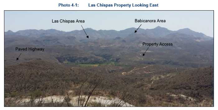
The Property is located in the State of Sonora, Mexico, at approximate 30.233902°N latitude and 110.163396°W longitude (Universal Transverse Mercator [UTM] World Geodetic System [WGS]84: 580,500E, 3,344,500N) within the Arizpe Mining District. The city of Hermosillo is approximately 220 km, or a three-hour drive, to the southwest; Tucson, Arizona, is approximately 350 km via Cananea, or a five-hour drive, to the northwest; and the community and mine in Cananea is located approximately 150 km, or a two-and-a-half-hour drive, to the north along Highway 89. Photo 4-1 shows view of the general topography of the area surrounding Las Chispas and Figure 4-1 provides a location map for the Property.
Other nearby communities include Banamichi, which is located 25 linear km to the southwest and Arizpe, which is located approximately 12 linear km to the northeast. The area is covered by the 1:50,000 topographic map sheet “Banamichi” H12-B83.
Few surface remnants exist on the Property which show the active mining history and community development that once existed in this district. There are numerous historic mine portals and shafts that are partially overgrown with vegetation, which have been flagged and/or fenced.
| 4-1 | |
| TECHNICAL REPORT AND MINERAL RESOURCE ESTIMATE FOR THE LAS CHISPAS PROPERTY, SONORA, MEXICO |
| 704-ENG.VMIN03016-05 | MAY 2019 | ISSUED FOR USE |

| 4-2 | |
| TECHNICAL REPORT AND MINERAL RESOURCE ESTIMATE FOR THE LAS CHISPAS PROPERTY, SONORA, MEXICO |
| 704-ENG.VMIN03016-05 | MAY 2019 | ISSUED FOR USE |
| 4.1 | Mineral Tenure |
Las Chispas comprises 28 mineral concessions, totaling 1,400.96 ha, as shown in Figure 4-2. Compañia Minera La Llamarada S.A. de C.V. (LLA), a Mexican wholly-owned subsidiary of SilverCrest, has acquired title to or has entered into option agreements to purchase the concessions listed in Table 4-1.
| 4-3 | |
| TECHNICAL REPORT AND MINERAL RESOURCE ESTIMATE FOR THE LAS CHISPAS PROPERTY, SONORA, MEXICO |
| 704-ENG.VMIN03016-05 | MAY 2019 | ISSUED FOR USE |
| Table 4-1: | Mineral Concessions held by SilverCrest for the Las Chispas Property |
| Concession Name | Title Number | Registration Date | End Date | Surface Area (ha) | Concession Holder |
| El Bervano Fraccion 1 | 212027 | 8/25/2000 | 8/24/2050 | 53.4183 | (3) LLA |
| El Bervano Fraccion 2 | 212028 | 8/25/2000 | 8/24/2050 | 0.9966 | (3) LLA |
| Las Chispas Uno | 188661 | 11/29/1990 | 11/28/2040 | 33.7110 | (3) LLA |
| El Siete | 184913 | 12/6/1989 | 12/5/2039 | 43.2390 | (3) LLA |
| Babicanora Grande | 159377 | 10/29/1973 | 10/28/2023 | 16.0000 | (3) LLA |
| Fernandez Leal | 190472 | 4/29/1991 | 4/28/2041 | 3.1292 | (3) LLA |
| Guillermo Tell | 191051 | 4/29/1991 | 4/28/2041 | 5.6521 | (3) LLA |
| Limantour | 191060 | 4/29/1991 | 4/28/2041 | 4.5537 | (3) LLA |
| San Gotardo | 210776 | 11/26/1999 | 11/25/2049 | 3.6171 | (3) LLA |
| Las Chispas | 156924 | 5/12/1972 | 5/11/2022 | 4.4700 | (3) LLA |
| La Fortuna | -(1) | Pending | Pending | 15.2800 | (6) Pending |
| Espiritu Santo Fracc. I | 217589 | 8/6/2002 | 8/5/2052 | 733.3232 | (3) LLA |
| Espiritu Santo Fracc. II | 217590 | 8/6/2002 | 8/5/2052 | 0.8770 | (3) LLA |
| La Cruz | 223784 | 2/15/2005 | 2/14/2055 | 14.4360 | (3) LLA |
| Lopez | 190855 | 4/29/1991 | 4/28/2041 | 1.7173 | (4) Lopez Mejia – Espina- Cruz |
| Nuevo Babicanora Fracc. I | 235366 | 11/18/2009 | 11/17/2059 | 392.5760 | (2) Cirett-LLA |
| Nuevo Babicanora Fracc. II | 235367 | 11/18/2009 | 11/17/2059 | 9.8115 | (2) Cirett-LLA |
| Nuevo Babicanora Fracc. III | 235368 | 11/18/2009 | 11/17/2059 | 2.2777 | (2) Cirett-LLA |
| Nuevo Babicanora Fracc. IV | 235369 | 11/18/2009 | 11/17/2059 | 3.6764 | (2) Cirett-LLA |
| Nuevo Lupena | 212971 | 2/20/2001 | 2/19/2051 | 13.0830 | (1) LLA |
| Panuco II | 193297 | Cancelled (legal recourse pending) | Cancelled (legal recourse pending) | 12.9300 | (1) Pending |
| La Victoria | 216994 | 6/5/2002 | 6/4/2052 | 24.0000 | (5) Morales- Fregoso |
| Las Chispas 3-A | 245423 | 01/24/2017 | 01/23/2067 | 1.0809 | LLA |
| Las Chispas 3-B | 245424 | 01/24/2017 | 01/23/2067 | 0.3879 | LLA |
| Las Chispas 3-C | 245425 | 01/24/2017 | 01/23/2067 | 0.3413 | LLA |
| Las Chispas 3-D | 245426 | 01/24/2017 | 01/23/2067 | 0.3359 | LLA |
| Las Chispas 3-E | 245427 | 01/24/2017 | 01/23/2067 | 0.4241 | LLA |
| Las Chispas 3-F | 245428 | 01/24/2017 | 01/23/2067 | 5.6112 | LLA |
| Total (28) | - | - | - | 1,400.9600 | - |
| Note: | (1)Non-titled applications No.082/39410 and 082/38731 |
Mining duties are based on the surface area and date of issue of each concession and are due in January and July of each year at a total annual cost of approximately US$20,000 (adjusted scale). All mining duties have been paid to date by LLA.
| 4-4 | |
| TECHNICAL REPORT AND MINERAL RESOURCE ESTIMATE FOR THE LAS CHISPAS PROPERTY, SONORA, MEXICO |
| 704-ENG.VMIN03016-05 | MAY 2019 | ISSUED FOR USE |
| 4.1.1 | Mineral Concession Payment Terms |
Payment terms under each option agreement is included in the following subsections. All dollar figures are in US dollars (US$), unless stated otherwise.
| 4.1.1.1 | Concession Holder 1: LLA Previously; Adelaido Gutierrez Arce (34%), LuisFrancisco Perez Agosttini (33%) and Graciela Ramírez Santos (33%) |
LLA agreed to four payments totaling $150,000 with Adelaido Gutierrez Arce, Luis Francisco Perez Agosttini, and Graciela Ramírez Santos (Gutierrez-Perez-Ramirez). As of December 2018, all payments have been completed with LLA holding 100% ownership of the concession.
Panuco II was cancelled in 1999; public notice of open ground has not been published and a legal recourse for reinstatement of concessions was filed. This process is ongoing as of this effective date. At the time of cancellation, the registered owner was Gutierrez who transferred the mining concession to LLA subject to its reinstatement. The Nuevo Lupena agreement has an area of influence that covers the Panuco II concession; therefore, the terms of this agreement apply to Panuco II.
| 4.1.1.2 | Concession Holder 2: Jorge Ernesto Cirett Galán (80%) and María Lourdes CruzOchoa (20%) |
LLA agreed to the following payment terms with Jorge Ernesto Cirett Galán and María Lourdes Cruz Ochoa (Cirett-Cruz):
| • | Five payments totaling $575,000: |
| − | first payment of $30,000 due on May 20, 2016 (paid) | |
| − | second payment of $35,000 due May 20, 2017 (paid) | |
| − | third payment of $60,000 due May 20, 2018 (paid) | |
| − | fourth payment of $100,000 due May 20, 2019 | |
| − | fifth payment of $350,000 due May 20, 2020. |
On June 29, 2018, and MaríaLourdes Cruz Ochoa agreed to amend the fourth and final payments whereby LLA could exercise its option and earn a 20% interest in the concessions. On June 29, 2018, LLA made an agreed discount payment (4%) of $86,400 and earned a 20% interest in the concessions.
| 4.1.1.3 | Concession Holder 3: Local Mexican Company now 100% owned by LLA |
LLA agreed to the cash payments totaling $2,450,000 over a three-year period from December 2015 to 2018. All payments have been completed and LLA owns 100% of the concessions.
LLA also agreed to issue SilverCrest shares equal to $250,000 on each of the June 3, 2018 (issued) and December 3, 2018 (issued) payments. On August 7, 2018, the Local Mexican company assigned and transferred to LLA 100% title to these concessions, subject to the reservation of legal ownership to be released on the final payment of $1,012,500 in cash and $250,000 in SilverCrest shares by December 3, 2018 (paid and reservation of legal ownership by Local Mexican company is cancelled).
| 4-5 | |
| TECHNICAL REPORT AND MINERAL RESOURCE ESTIMATE FOR THE LAS CHISPAS PROPERTY, SONORA, MEXICO |
| 704-ENG.VMIN03016-05 | MAY 2019 | ISSUED FOR USE |
4.1.1.4 | Concession Holder 4: Jose Cruz Lopez Mejia (34%); Eliseo Espina Guillen (33%); and Jesus Cruz Lopez (33%) |
LLA entered into an arrangement agreement in order to acquire 67% of the Lopez concession, but under Mexican law the owner of the remaining 33% is required to consent to such transfer to LLA. Such consent has not been obtained as of this date.
| 4.1.1.5 | Concession Holder 5: Felizardo Morales Baldenegro (70%) and Martha Silvia Fregoso (30%) |
LLA agreed to the following payment terms with Felizardo Morales Baldenegro and Martha Silvia Fregoso (Morales-Fregoso):
| • | Three payments totaling $150,000: |
| − | first payment of $30,000 due on June 15, 2016 (paid) | |
| − | second payment of $20,000 due June 15, 2017 (paid) | |
| − | third payment of $100,000 due June 15, 2019. |
| 4.1.1.6 | Concession Holder 6: Minerales de Tarachi S. de R.L. de C.V. |
On February 21, 2018 LLA acquired from Minerales Tarachi, S. de R.L. de C.V. an option to purchase the rights to the La Fortuna mining concession applications No. 082/39410 and 082/38731, which cover the Panuco II and Carmen Dos Fracción II mineral lots on payment of $500,000 Mexican Pesos (MXN$) (paid) and $150,000 payable on acquisition of title by LLA. Title transfer of concessions are pending until the applications are issued as mining concessions.
| 4.2 | Land Access and Ownership Agreements |
The surface rights overlying the Las Chispas mineral concessions and road access are either owned by LLA or held by LLA under a negotiated 20-year lease agreement.
4.2.1 Ejido Bamori
On November 18, 2015, LLA signed a 20-year lease agreement with the Ejido Bamori for surface access and use of facilities. Compensation for exploration activities will be paid at a rate of MXN$700/ha, up to a total of 315.5 ha. After exploration and announcement of mine construction/production, compensation will be paid on a scaled timeframe at a rate of MXN$2,000/ha in construction and production Years 1 to 4 and MXN$4,000/ha on the fifth year and beyond.
4.2.2 Cuesta Blanca Ranch
In February 2018, LLA purchased the Cuesta Blanca Ranch covering 671.9 ha of land situated in the municipality of Arizpe, Sonora.
4.2.3 Babicanora Ranch
In April 2017, LLA purchased from Maprejex Distributions Mexico, S.A. de C.V. the Babicanora Ranch covering 2,500 ha of land situated in the municipality of Arizpe, Sonora.
| 4-6 | |
| TECHNICAL REPORT AND MINERAL RESOURCE ESTIMATE FOR THE LAS CHISPAS PROPERTY, SONORA, MEXICO |
| 704-ENG.VMIN03016-05 | MAY 2019 | ISSUED FOR USE |
4.2.4 Tetuachi Ranch
In November 2017, LLA signed a lease agreement for a term of 20 years with Maria Dolores Pesqueira Serrano for the lease of the Tetuachi Ranch covering 32.3 ha of land situated in Arizpe, Sonora, for payment of an annual rental fee of US$2,000 during exploration phase and US$7,000 during exploitation phase.
| 4.3 | Royalties |
A 2% net smelter return (NSR) royalty is payable to the current concession holder, Gutierrez-Perez-Ramirez, of the Nuevo Lupena and Panuco II (pending registry) concessions for material that has processed grades of equal to or greater than 40 oz per tonne of silver and 0.5 oz per tonne of gold, combined.
| 4-7 | |
| TECHNICAL REPORT AND MINERAL RESOURCE ESTIMATE FOR THE LAS CHISPAS PROPERTY, SONORA, MEXICO |
| 704-ENG.VMIN03016-05 | MAY 2019 | ISSUED FOR USE |
| 5.0 | ACCESSIBILITY, CLIMATE, LOCAL RESOURCES, INFRASTRUCTURE, AND PHYSIOGRAPHY |
| 5.1 | Climate |
The climate is typical for the Sonoran Desert, with a dry season from October to May. Seasonal temperatures vary from 0 to 40°C. Average rainfall is estimated at 300 mm/a. There are two wet seasons, one in the summer (July to September) and another in the winter (December). The summer rains are short with heavy thunderstorms, whereas the winter rains are longer and lighter. Summer afternoon thunderstorms are common and can temporarily impact the local electrical service.
| 5.2 | Physiography |
The Property is located on the western edge of the north trending Sierra Madre Occidental mountain range geographically adjacent to the Sonora River Valley. The Property surface elevation ranges from 950 masl to approximately 1,250 masl; the San Gotardo portal to the Las Chispas and William Tell Veins is located at 980 masl. Hillsides are often characterized with steep colluvium slopes or subvertical scarps resulting from fractures through local volcaniclastic bedrock units.
Drainage valleys generally flow north to south, and east to west towards the Rio Sonora. Flash flooding is common in the area.
Vegetation is scarce during the dry season, limited primarily to juvenile and mature mesquite trees and cactus plants. During the wet season, various blooming cactus, trees, and grasses are abundant in drainage areas and on hillsides.
| 5.3 | Property Access |
From Banamichi, the paved Highway 89 follows for approximately 25 km. The Property is accessed via secondary gravel roads, as shown in Figure 4-2, approximately 10 km off the paved highway. Fording across the Rio Sonora river bed is required; the water levels in the river are typically low and easily passed, but can raise to temporary unpassable levels following major rain events. The remainder of the road has been upgraded by dozer/grader. Net elevation gain to the Property from the highway is approximately +250 vertical metres.
| 5.4 | Local Resources |
5.4.1 Water Supply
Current water requirements during exploration are minimal; diamond drilling requires the greatest capacity. Some wells have been established to supply local ranches. Preliminary hydrogeological testing has been conducted to determine depth to water table. Twelve pilot water wells have been completed on the Property, and initial preliminary pump testing results show ample water for potential production facilities in the future. Pilot wells need to be upgraded to larger diameter wells for adequate capacity.
| 5-1 | |
| TECHNICAL REPORT AND MINERAL RESOURCE ESTIMATE FOR THE LAS CHISPAS PROPERTY, SONORA, MEXICO |
| 704-ENG.VMIN03016-05 | MAY 2019 | ISSUED FOR USE |
Historical underground workings have been noted to be dry down to the 900 (feet from surface) level where the water table has been defined underground and in pilot wells.
5.4.2 Power
Low-voltage power lines and generators exist on the Property to supply local ranches. This amount of power is sufficient for exploration requirements. Provision of grid power to a potential operation may be possible in the future, but would require permitting and a significant capital expenditure. Conceptually, diesel generators may be used for future production similar to the nearby Santa Elena Mine.
5.4.3 Infrastructure
No surface infrastructure from the historical mining industry remains on the Property except for roads and a few eroding rock foundations. Several ranch buildings, corrals, and fencing were acquired from the purchase of ranches.
5.4.4 Community Services
Mining supplies and services are readily available from Cananea, north of Las Chispas, Hermosillo, to the southwest, and Tucson, Arizona, to the northwest.
| 5-2 | |
| TECHNICAL REPORT AND MINERAL RESOURCE ESTIMATE FOR THE LAS CHISPAS PROPERTY, SONORA, MEXICO |
| 704-ENG.VMIN03016-05 | MAY 2019 | ISSUED FOR USE |
| 6.0 | HISTORY |
Historical records indicated mining around the Las Chispas Property started as early as the 1640s. There are incomplete records and history available on mining activities which took place in the 1800s and 1900s. There is also a gap in mining activity records for Las Chispas between the mid-1930s through to 1974. In 2008, exploration activities resumed on Las Chispas with modern techniques.
A summary of Las Chispas’ history has been extracted from the limited documentation available to SilverCrest in the public domain and private libraries. Numbers and mine descriptions extracted from these documents are historical in nature, cannot be relied upon, and should only be used in context for the rich mining history of the Las Chispas district.
| 6.1 | 1800s and Early 1900s |
Mining interest on the Property is believed to have begun in 1640 when outcrop of the Las Chispas Vein was discovered by a Spanish General named Pedro de Perra (Wallace 2008), which led to the development of the Las Chispas Mine. Through to 1880, small-scale mining was intermittently conducted along this trend with significant interference from local Apache resistance. The company operating the mine at this time was called the Santa Maria Mining Company (Russell 1908).
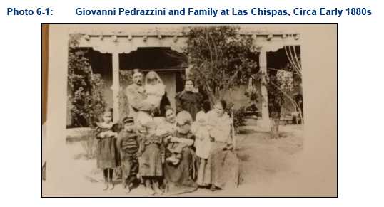
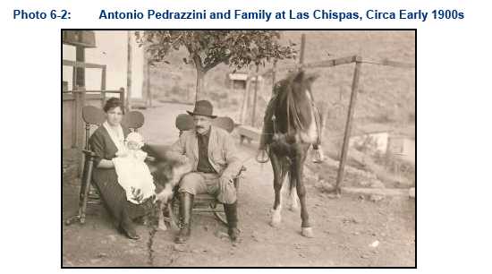
The Las Chispas Mine operated intermittently from the 1880s to the 1920s by John (Giovanni) Pedrazzini (Photo 6-1), as President, or the family who maintained control of the development along the Las Chispas Vein and the William Tell Vein through the company Minas Pedrazzini (established February 1907). Giovanni Pedrazzini was reportedly a former cook and accountant of the Santa Maria Mining Company, and he received the Las Chispas Mine as compensation for unpaid back wages. Antonio Pedrazzini (Photo 6-2), nephew of Giovanni, maintained an active role in the operation and management of the mine into the 1920s. In 1904, Edward Dufourcq, a well-known mining engineer, was appointed as general manager of the mine. Minas Pedrazzini was the first operator to drive an adit into the Las Chispas Vein known as the San Gotardo Tunnel, or 600 level, an estimated length of 1,250 m. Referenced historical levels (i.e., 600 level) are marked as the depth in feet from the Las Chispas shaft collar (Figure 6-1).
| 6-1 | |
| TECHNICAL REPORT AND MINERAL RESOURCE ESTIMATE FOR THE LAS CHISPAS PROPERTY, SONORA, MEXICO |
| 704-ENG.VMIN03016-05 | MAY 2019 | ISSUED FOR USE |
Pedrazzini’s company was one of three working in the area at this time. At least two other companies focused efforts on the El Carmen, located approximately 5 km southeast of the Las Chispas Mine, and the Babicanora Area, approximately 1.5 km south of the Las Chispas Mine. Little is known about the historical production and operations of these companies; however, it is understood that small mills were installed at Babicanora and El Carmen to process ores of the Babicanora, El Carmen, and Granaditas veins in a similar manner to the San Gotardo (Las Chispas) Mill (Russell 1907). The district had a mix of at least six operating flotation and cyanidation mills from the late 1880s to 1984.
The San Gotardo Mill, operated by Minas Pedrazzini, was located at the northern portal to the 600 level of the Las Chispas and William Tell veins, and consisted of rock breakers, five gravity stamps, two Wilfley tables, and three amalgamation pans, with reported recovery of 70 to 75% (Russell 1907). The mill developed up to 20 operating stamps and four pans in 1910, when total recovery was noted then to be between 71 and 84%. An estimate of approximately 26,000 t were treated in the mill, and over 12,000 t of tailings were estimated to have been deposited as tails into ponds below the mill. In 1910, a 24-inch gauge tramway was built from the San Gotardo portal to the new mill, anticipating daily production to increase to 60 t/d. Wallace (2008) reports that in the 1970s the mill was salvaged and hauled away with old mine buildings and much of the tailings for reprocessing.
In 1910, the decision was made to install a cyanide plant at the Las Chispas Mine in an effort to reduce overall processing costs, enable reprocessing of the earlier deposited tailings, and attempt higher metal recoveries with a throughput of 30 to 40 t/d. Construction of the plant occurred during and was delayed by the occurrence of the Mexican Revolution (Dufourcq 1912). Mulchay (1935) indicates that this plant was used for less than six months due to interference from sulphides in the ore with cyanidation. A small flotation plant was installed prior to 1926 (Mulchay 1935).
Water for the operations was supplied via a 5 km long pipe line from the Sonora River and power reportedly from a small power line running from a diesel generator at Nacozari. In 1918, the pumping station along the Rio Sonora was destroyed by a flood; the mine resorted to pumping from within the mine to supply the mill with water (Wallace 2008). Dufourcq (1910) indicates that water was originally intersected below the 900 level of the mine.
In 1917, it is reported that the mine was confiscated by the local government who operated and extracted “rich ore” before eventually returning the mine back to Pedrazzini (Montijo Jr. 1920).
| 6-2 | |
| TECHNICAL REPORT AND MINERAL RESOURCE ESTIMATE FOR THE LAS CHISPAS PROPERTY, SONORA, MEXICO |
| 704-ENG.VMIN03016-05 | MAY 2019 | ISSUED FOR USE |
Two versions exist regarding how the mine was taken over and eventually closed. Mulchay (1935) suggests that in 1935 Minas Pedrazzini was taken over under option by Douglas-Williams associated with the Phelps-Dodge Corporation. The mine was managed by Henry Bollweg at this time. Whereas Wallace (2008) reports the mine was acquired by a French corporate subsidiary Corporación Miñera de Mexico, S.A. in 1921. This company was reported to have remodelled the power plant and continued mining until its eventual closure in 1930.
A French company under the name Camou Brothers are reported to have re-developed the Babicanora Mine around 1865 (SilverCrest 2015). The Babicanora area was most recently mined by Chinese immigrants who originally settled in Baja, relocated to the State of Sinaloa in the late 1800s for agriculture, and were eventually pushed inland by competition. Here they found occupation in the mines. The portal construction and dimensions of underground development in Babicanora is notably different than that of the Las Chispas and William Tell workings. The main access is a 4 m by 4 m drift and approximately 230 m in length to intersect the Babicanora Vein.
From 1900 to 1926, production from the Las Chispas and William Tell veins is reported to have been interrupted several times due to numerous interventions, including theft of high-grade ore, the Mexican revolution from 1910 to 1920, the Mexican National Catholic Church revolution in 1925, mill flooding/fire, and the government take over of the mine with no economic plan (Montijo 1920).
The limited information available on metal production suggests approximately 100 Moz of silver and 200,000 oz of gold were recovered from mines within the loosely defined Las Chispas District, including approximately 20 to 40 Moz of silver estimated to have been recovered from the Las Chispas and William Tell veins. Wallace (2008) estimates that in the period between 1907 and 1911, annual production at the Las Chispas Mine achieved approximately 3,000 to 12,000 t (estimated projected budget for 1911), producing 1.5 Moz of silver and 10,000 oz of gold per year with an estimated average grade of 1.1 ounces per tonne of gold and 146.8 ounces per tonne of silver (Table 6-1). Reports indicate that gold and silver were produced from both quartz/amethyst veinlets less than 5 cm thick and local high-grade shoots up to 4 m thick.
| Table 6-1: | Las Chispas Mine Production, 1908 to 1911 |
| 1908 | 1909 | 1910 | 1911(1) | Total | |
| Tonnes | 3,286 | 3,064 | 3,540 | 12,000 | 21,890 |
| Gold ounces per tonne | 1.5 | 1.4 | 1.0 | 1.0 | 1.1 |
| Silver ounces per tonne | 199.9 | 187.2 | 136.9 | 125.0 | 146.8 |
| Gold ounces | 4,876 | 4,189 | 3,615 | 12,000 | 24,680 |
| Silver ounces | 656,882 | 573,448 | 484,746 | 1,500,000 | 3,215,076 |
| Notes: | (1)Estimated projected budget for 1911. |
| Source: | Dufourcq (1910) |
Some records suggest that small-scale mining at Espiritu Santo and operation of a small mill at Babicanora occurred in 1935 (Mulchay 1935). Espiritu Santo workings consisted of a small inclined shaft approximately 80 cm wide, which declined below a small drainage to two short ore drifts where grades up to 500 ounces per tonne of silver were noted. Approximately 13.2 t of ore were reported to have been shipped from this small mine in 1934 and ranged in grade from 0.17 to 1.36 ounces per tonne of gold and 79.2 to 490 ounces per tonne of silver.
Another small mining operation at La Victoria was estimated around 1940. The workings consisted of three short ore drives on separate levels approximately 30 m in length, with gold grades up to 6 ounces per tonne over one metre (Mulchay 1941).
| 6-3 | |
| TECHNICAL REPORT AND MINERAL RESOURCE ESTIMATE FOR THE LAS CHISPAS PROPERTY, SONORA, MEXICO |
| 704-ENG.VMIN03016-05 | MAY 2019 | ISSUED FOR USE |
Photo 6-3 provides an overview of the Las Chispas Valley and highlights the locations where the community of Las Chispas once stood, in addition to the original San Gotardo mill and the later developed rail-connected mill near the community. Historical Photo 6-3 through Photo 6-7 are from various locations around the historical operation. Photo 6-8 is a rendering of the current view to the Upper Babicanora portal.
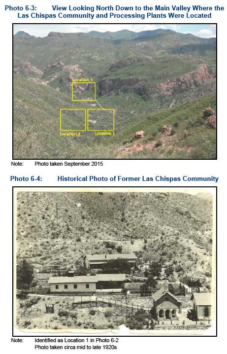
| 6-4 | |
| TECHNICAL REPORT AND MINERAL RESOURCE ESTIMATE FOR THE LAS CHISPAS PROPERTY, SONORA, MEXICO |
| 704-ENG.VMIN03016-05 | MAY 2019 | ISSUED FOR USE |
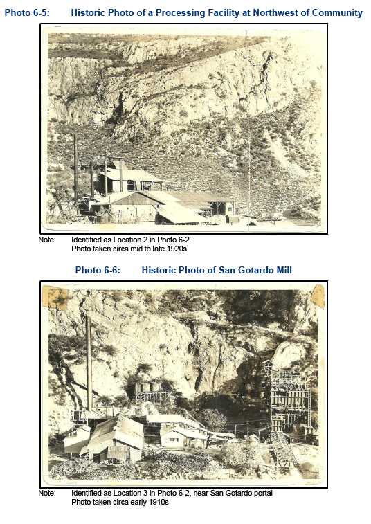
| 6-5 | |
| TECHNICAL REPORT AND MINERAL RESOURCE ESTIMATE FOR THE LAS CHISPAS PROPERTY, SONORA, MEXICO |
| 704-ENG.VMIN03016-05 | MAY 2019 | ISSUED FOR USE |

| 6-6 | |
| TECHNICAL REPORT AND MINERAL RESOURCE ESTIMATE FOR THE LAS CHISPAS PROPERTY, SONORA, MEXICO |
| 704-ENG.VMIN03016-05 | MAY 2019 | ISSUED FOR USE |
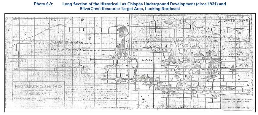
| 6-7 | |
| TECHNICAL REPORT AND MINERAL RESOURCE ESTIMATE FOR THE LAS CHISPAS PROPERTY, SONORA, MEXICO |
| 704-ENG.VMIN03016-05 | MAY 2019 | ISSUED FOR USE |
| 6.2 | Mid to Late 1900s to Early 2000s |
No written documented information is available for the Property during this period. Verbal discussions with Luis Perez, a local operator, indicate that from 1974 to 1984 a small cyanide leach mill was constructed near the highway entrance to the Property. During this period, approximately 75,000 t of historic waste was processed with doré poured on site. No production estimation is available.
It is assumed that sometime between the mid-1930s and 2008, the historic and 1974 processing plants were dismantled and transported from the area and that both concession and surface Property ownership likely changed hands at least once from the mining companies to their current owners. As seen in Section 4.0, Table 4-1, the current mineral concessions (excluding the Nuevo Babicanora concessions) were registered, or reregistered under new mining regulation, from 1972 to as recently as 2002.
| 6.3 | Minefinders Corporation Ltd. (2008–2011) |
In 2008, Minefinders operating under their Mexican affiliate, Miñera Minefinders, acquired the Cirett concessions under option Nuevo Babicanora I to IV (Section 4.0, Table 4-1 and Figure 4-2) but were unable to negotiate with the main district concession owners. Subsequently, Minefinders completed initial exploration work on the district which they referred to as collectively the Babicanora Project. They drilled seven RC holes off the main mineralized trends with negative results and then dropped the Property option in 2012.
Minefinders conducted a systematic exploration program across these concessions between 2008 and 2011. Regional activities consisted of geologic mapping and a geochemical sampling program totaling 143 stream sediment and (BLEG samples, 213 underground rock chip samples, and 1,352 surface rock chips. The work was successful in identifying three gold targets along the 3 km long structural zone. The most prospective of these targets was interpreted to be an area between the Las Chispas Vein and the Babicanora Vein. Minefinders focused on the furthest western extension of the Babicanora Vein called El Muerto, which is the only part of the trend that was acquired by concession and accessible for exploration work.
Targeted exploration conducted solely within the Babicanora Project area included the collection of 24 stream sediment and BLEG samples, 184 select surface rock chip samples, 474 grid rock chip samples, and drilling of seven RC drill holes for a total of 1,842.5 m. The drill hole locations are provided in Section 10.0 (Figure 10-1).
6.3.1 Minefinders Surface Sampling
Turner (2011) describes the work by Minefinders on the Babicanora Project in detail. Outcrop in the area is variable and the sampling was adjusted based on terrain limitations. Minefinders determined that high-grade gold and silver occurrences (1 to 2 gpt of gold and 30 to 60 gpt of silver) noted in mine workings and outcrops occurred mainly as discontinuous and narrow quartz stockwork zones. Notable exceptions were a 5 m zone of 1.53 gpt of gold and narrow veins up to 13 gpt of gold with 439 gpt of silver from El Muerto north of the Babicanora Mine workings.
Twenty-four stream sediment samples were collected from drainages in the Las Chispas Area as part of a regional sampling program. The large samples were analyzed as both 2 kg BLEG samples and via a more conventional analysis of a -80 mesh sieved product. The material utilized for the -80 mesh analysis was obtained after splitting the initial 2 kg used for BLEG analysis. Anomalous zones defined by the regional stream sediment program were later confirmed by a follow-up rock chip grid sampling program.
| 6-8 | |
| TECHNICAL REPORT AND MINERAL RESOURCE ESTIMATE FOR THE LAS CHISPAS PROPERTY, SONORA, MEXICO |
| 704-ENG.VMIN03016-05 | MAY 2019 | ISSUED FOR USE |
All surface rock chip and stream sediment samples were collected by the staff of Minefinders and submitted to ALS Chemex in Hermosillo. Sampling coverage and results are illustrated in Figure 6-1 and Figure 6-2.
![]()
| 6-9 | |
| TECHNICAL REPORT AND MINERAL RESOURCE ESTIMATE FOR THE LAS CHISPAS PROPERTY, SONORA, MEXICO |
| 704-ENG.VMIN03016-05 | MAY 2019 | ISSUED FOR USE |

| 6-10 | |
| TECHNICAL REPORT AND MINERAL RESOURCE ESTIMATE FOR THE LAS CHISPAS PROPERTY, SONORA, MEXICO |
| 704-ENG.VMIN03016-05 | MAY 2019 | ISSUED FOR USE |
6.3.2 Minefinders Drilling, 2011
Minefinders carried out a seven-hole RC drill program in 2011. The purpose of the program was to test a porous volcanic agglomerate (i.e., lithic tuff) unit located along a 1.5 km structural zone located adjacent to the Babicanora and Las Chispas historical workings.
Minefinders contracted Drift Drilling to drill seven holes utilizing a MPD-1000 RC drill rig. The drilling was conducted from existing roads with drill pads enlarged to allow for safe and effective operations. Environmental permitting with SEMARNAT was prepared by Bufete Miñera y Servicios de Ingenieria S.A. de C.V. and completed on March 23, 2011. All assay work was conducted by Inspectorate Laboratories of Hermosillo, Mexico and Reno, Nevada.
The drill program was conducted between April 7, 2011 through May 3,2011, with a total of 1,842.5 m drilled. The drill holes were oriented to intercept a range of host rocks in areas of anomalous precious metals or adjacent to mine workings. The hope was that bulk tonnage targets might exist within more porous or chemically reactive rocks. Table 6-2 shows a summary of the drilling and Figure 10-1 shows the collar locations.
| Table 6-2: | Summary of Minefinders 2011 RC Drill Program |
Hole ID | Easting | Northing | Elevation (m) | Dip (°) | Azimuth (°) | Depth (m) | Depth (ft) |
| BAB11-01 | 579527 | 3344033 | 1,135 | -60 | 30 | 304.80 | 1,000 |
| BAB11-02 | 579526 | 3344060 | 1,130 | -90 | 0 | 324.60 | 1,065 |
| BAB11-03 | 579372 | 3343914 | 1,091 | -60 | 50 | 242.30 | 795 |
| BAB11-04 | 579382 | 3343638 | 1,132 | -55 | 60 | 350.50 | 1,150 |
| BAB11-05 | 579386 | 3344130 | 1,053 | -45 | 115 | 198.12 | 650 |
| BAB11-06 | 579507 | 3344503 | 1,009 | -70 | 90 | 182.90 | 600 |
| BAB11-07 | 579693 | 3345216 | 977 | -70 | 90 | 239.30 | 785 |
| Total | 1,842.52 | 6,045 |
The drill results were disappointing in that none of the holes are interpreted to have intersected the mineralized structure beneath the historic workings. Only narrow zones of gold mineralization at scattered depths were encountered and only one hole, BAB-11-02, intercepted significant mineralization in four narrow intervals of greater than 900 ppb of gold. The most significant of these intercepts was 4.6 m of 1.1 gpt of gold and 2 gpt silver including a 1.5 m interval of 2.9 gpt gold at a depth of 292.6 m. This mineralized interval occurs within basal volcaniclastic sandstones and rhyodacitic tuffs cut by propylitic altered dacite dykes.
Results of the drilling indicate that several phases of quartz veining, accompanied by broad zones of argillic and propylitic alteration, are present in the 1.5 km long target zone. Mineralization was determined to occur as low sulphidation gold-silver epithermal quartz and calcite veins and stockwork within an Oligocene volcanic sequence consisting of volcaniclastic sediments interbedded with rhyolitic tuff and andesitic dykes/flow cut by dacitic dykes.
In 2012, Minefinders dropped their interest in the Nuevo Babicanora I to IV mineral concessions, which returned to Cirett as having controlling interest.
| 6-11 | |
| TECHNICAL REPORT AND MINERAL RESOURCE ESTIMATE FOR THE LAS CHISPAS PROPERTY, SONORA, MEXICO |
| 704-ENG.VMIN03016-05 | MAY 2019 | ISSUED FOR USE |
| 6.4 | SilverCrest, 2013 to Start of Phase I Drilling in 2016 |
Following Minefinders’ retreat, SilverCrest Mines Inc. (now a subsidiary of First Majestic) through its subsidiary Nusantara de Mexico S.A. de C.V. initiated their interest in Las Chispas in 2013. Legal issues in the main Las Chispas District were settled and SilverCrest Mines Inc. could negotiate option agreements with all the concession holders through their Mexican subsidiary Nusantara de Mexico S.A. de C.V. By the end of September 2015, SilverCrest Mines Inc. executed options agreements to acquire rights to 17 concessions.
On October 1, 2015, pursuant to an arrangement agreement, SilverCrest Mines Inc. was acquired by First Majestic and these mineral concessions were transferred to a new spun out company, SilverCrest Metals Inc. and its subsidiary LLA, which was listed on the TSX Venture Exchange on October 9, 2015 and has subsequently obtained rights to 11 additional mineral concessions for a total of 28 concessions.
| 6-12 | |
| TECHNICAL REPORT AND MINERAL RESOURCE ESTIMATE FOR THE LAS CHISPAS PROPERTY, SONORA, MEXICO |
| 704-ENG.VMIN03016-05 | MAY 2019 | ISSUED FOR USE |
| 7.0 | GEOLOGICAL SETTING AND MINERALIZATION |
| 7.1 | Regional Geology |
The Las Chispas Property is located in northwestern Mexico where much of the exposed geology can be attributed to the subduction and related magmatic arc volcanism of the Farallon Plate beneath the North American Plate. The east-directed subduction of the Farallon Plate began in early Jurassic (approximately 200 Ma) with the tectonic rifting of the supercontinent Pangea (Rogers 2004). The resulting northwest-southeast trending Sierra Madre Occidental extends over 1.200 km from the US-Mexican border to Guadalajara in the southeast.
Delgado-Granados et al. (2000) proposed that subduction of the Farallon Plate occurred at a relatively shallow angle, resulting in continental uplift across northern Mexico with accretionary terranes developing along the western fringes of the pre-existing Jurassic continental and marine sediments and crystalline Cambrian basement rocks.
Volcanism is related to fractional crystallization of mantle sourced basalts during subduction (Johnson 1991; Wark 1991). The widespread volcanic deposits and intrusive stock development from emplacement of the regional batholith typify the upper Cretaceous record in the area, which was followed by dramatic accumulation of volcanic flows, pyroclastics, and volcano-sedimentary rocks during the Upper Cretaceous through to the Eocene.
Continental arc volcanism culminated with the Laramide orogeny in the early to late Eocene (Alaniz-Alvarez et al. 2007). The waning of compression coincides with east-west directed extension between late Eocene to the early Oligocene (Wark et al. 1990; Aguirre-Diaz and McDowell 1991; 1993) along the eastern Sierra Madre Occidental flank and is considered to be the first formation stage of the Basin and Range province.
By early to mid-Miocene, extension migrated west into Northern Sonora and along the western flank of the Sierra Madre Occidental resulting in north-northwest to south-southeast trending, west dipping, and normal faults. This extensional regime caused major deformation across the Sierra Madre Occidental resulting in localized exhumation of pre-Cambrian basement rocks within horst structures, especially in the Northern Sierra Madre Occidental (Ferrari et. al. 2007). Bimodal volcanic flows capped the volcano-sedimentary deposit of the late Eocene. Migration of later hydrothermal fluids along the pre-existing structures are related to the cooling of the orogenic system.
The Pliocene-Pleistocene is characterized by a general subsidence of volcanic activity, with deposition of some basalt flows, and accumulation of conglomerate, locally known as the Baucarit Formation.
Ferrari et al. (2007) summarizes five main igneous deposits of the Sierra Madre Occidental:
| • | Plutonic/volcanic rocks: Late Cretaceous –Paleocene. |
| • | Andesite and lesser Dacite-Rhyolite: Eocene (Lower Volcanic Complex). |
| • | Felsic dominant and silicic ignimbrites: Early Oligocene and Miocene (Upper Volcanic Complex). |
| • | Basaltic-andesitic flows: late stage of and after ignimbrite pulses. |
| • | Alkaline basalts and ignimbrites: Late Miocene-Pleistocene (Post-subduction volcanism). |
Mineralizing fluids are likely sourced from mid-Cenozoic intrusions. The structural separation along the faults formed conduits for mineral bearing solutions. The heat source for the mineralizing fluids was likely from the plutonic rocks that commonly outcrop in Sonora.
| 7-1 | |
| TECHNICAL REPORT AND MINERAL RESOURCE ESTIMATE FOR THE LAS CHISPAS PROPERTY, SONORA, MEXICO |
| 704-ENG.VMIN03016-05 | MAY 2019 | ISSUED FOR USE |
Many significant porphyry deposits of the Sierra Madre Occidental occur in the Lower Volcanics and are correlated with the various Middle Jurassic through to Tertiary aged intrusions. These deposits include Cananea, Nacozari and La Caridad (Ferrari et. al. 2007). In Sonora, emplacement of these systems is considered to be influenced by east-west and east-northeast to west-southwest directed extension. Early Eocene tectonic activity, which resulted in northwest-trending shear and fault zones, appears to be an important control on mineralization in the Sonora region.
Figure 7-1 provides a regional view of the major geological features that exist near the Las Chispas Property.
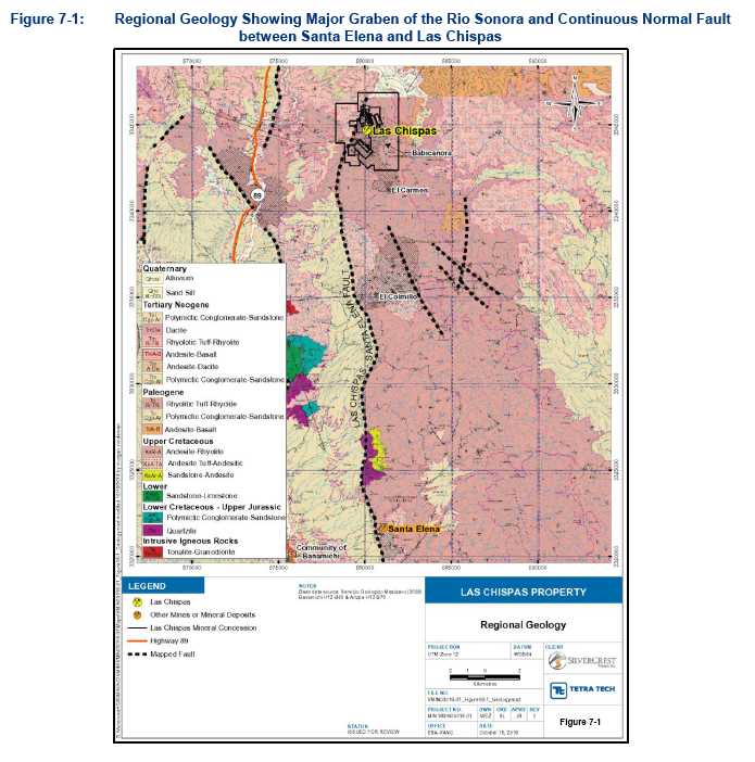
| 7-2 | |
| TECHNICAL REPORT AND MINERAL RESOURCE ESTIMATE FOR THE LAS CHISPAS PROPERTY, SONORA, MEXICO |
| 704-ENG.VMIN03016-05 | MAY 2019 | ISSUED FOR USE |
| 7.2 | Local Geology |
The western and southwestern portion of the Las Chispas Property is overlain by a series of young Oligocene aged reddish dark brown vesicular dacitic-andesitic to basaltic lava flows (Upper Volcanic Complex) with subordinate pyroclastic to lapilli tuff interbeds (Gonzalez-Becuar et al. 2017). The exposed thickness of these units on-site is 150 m (approximately 500 ft). Underlying this package (Lower Volcanic Complex) and exposed in the eastern portion of the land package is a thick sequence (greater than 500 m) of Early Tertiary rhyodacitic to andesitic lapilli (lithic) to variably welded ash tuffs (Colombo 2017). Both sequences are intruded by two phases of intermediate intrusive rocks. The volcanic rocks are variably altered, brecciated, mineralized, and display a range of intensities of brittle deformation. Outcrop exposure is moderate to poor on slopes, with most areas covered by a mantle of colluvium at the lower elevations and along the valley bottoms. Exceptions are intensely silicified rocks which often form resistant ridges, ledges and ribs.
The Upper Volcanic Complex including felsic volcanics and ignimbrites are primarily composed of lava flows, with lesser lapilli tuffs and volcanic breccias. These rocks are widespread at higher elevations and cap the surrounding mountains in the western and southwestern portion of the Property. This upper volcanic unit conformably overlay the lower Early Tertiary rhyodacitic to andesitic volcanics. The lava flows consist of strongly erosion resistant, reddish brown crystal-rich dacites with intercalated, dark brown, fine grained crystal-poor dark brown to black andesitic to basalt flows. Individual flows vary in thickness from 0.5 m to tens of metres with easily identified flow tops consisting of increasing vesicles or angular broken rubbly breccia. Beds of lapilli ash also outcrop on bluffs and are observed in the typically recessive cliffs. The lapilli ash and airfall tuffs are poorly sorted, angular, and theorised to be basal surge or pyroclastic flows. These members typically have an upper ash layer, reverse grading of pumice and lapilli clasts (rare blocks) with a lower basal ash layer, with evidence of welding observed in the ash unit. Laterally, these sub-intervals show continuity throughout the Property and region (Gonzalez-Becuar et al. 2017).
The upper part of the Lower Volcanic Complex hosts the presently identified mineralization on the Property. These units are comprised of rhyodacitic to andesitic flows and volcanic rocks that vary widely in texture and genesis, from course pyroclastic, air fall breccias to finely laminated ash, and from welded tuff through reworked volcano-lithic greywackes. There are also interbedded flows of a similar composition to the volcaniclastics that infill distinct local basins based on the local paleo topography during the eruption, adding complexity in identifying these restricted sub-intervals. The source of the clastic, and flow lithologies infilling the basin is local, within 5 km. The thin section study undertaken by SilverCrest demonstrates that most quartz fragments are angular throughout all the clastic units. This indicates that there has been little transport in the high-energy environment of pyroclastic flows and air fall tuffs. Most mineralization is located within a lapilli lithic tuff that is approximately 200 m thick.
Intrusive rocks are noted throughout the Property as coarse to fine grained dacitic, andesitic and rhyolitic interbedded volcaniclastics, flows and pyroclastics. These units are cross-cut by several late, fine-to-medium grained, and steeply dipping andesitic and rhyodacitic dykes. Often the intrusive dykes and plugs exploit the same faults used by the mineralizing fluids (Figure 7-2); however, early dykes appear to be related to mineralization influencing ground preparation (fracturing) of host rocks. Both styles of intrusives vary from mafic, andesitic-dacitic to rhyolitic and are very fine grained to aphanitic. In the coarser grained samples, the mineral assemblage is dominated by white laths of plagioclase with rare trigonal K-feldspar, quartz grains, and elongate hornblende. Typically, intrusives seen on the Property are weakly to strongly magnetic unless strongly clay altered.
To summarize, host rocks in the Las Chispas District are generally pyroclastic, tuffs, and rhyolitic flows which are interpreted as members of the Lower Volcanic Complex. Locally, volcanic pyroclastic units mapped within the underground workings include rhyolite, welded rhyodacite tuff, lapilli (lithic) tuff, and volcanic agglomerate. Figure 7-2 provides a schematic summary of the regional and local stratigraphy.
| 7-3 | |
| TECHNICAL REPORT AND MINERAL RESOURCE ESTIMATE FOR THE LAS CHISPAS PROPERTY, SONORA, MEXICO |
| 704-ENG.VMIN03016-05 | MAY 2019 | ISSUED FOR USE |

The volcanic units form a gentle syncline and anticline complex across the Property, which is cross cut nearly perpendicular to the folds axis by the dominant vein trend (Mulchay 1935). Figure 7-3 show the district geology and a typical section looking towards the east through the Las Chispas Property.
Numerous mineral occurrences around the Las Chispas Mine were identified by previous operators on the Property with historic reports of up to 14 nearly parallel veins (Russell 1908). Many of these veins fall along, or are parallel to, the Las Chispas and William Tell veins. Veins in the Babicanora area also have similar orientation to those at the Las Chispas Mine. Each structural zone occurs along a consistent orientation and may be comprised of pinch and swell veins, stockwork, parallel sheet veins, or breccia. Varying degrees of mining has occurred within these structures; however, based on historical records for both Las Chispas and Babicanora areas, the mining appears to have been selective based on grade cut-offs of greater than 1,000 gpt silver. Mineralization grading below these cut-offs may have been considered sub-economic to previous operators and remain intact today. These remaining deposits along with high-grade vein splays and fault-displaced unmined veins are the main targets of SilverCrest exploration.
| 7-4 | |
| TECHNICAL REPORT AND MINERAL RESOURCE ESTIMATE FOR THE LAS CHISPAS PROPERTY, SONORA, MEXICO |
| 704-ENG.VMIN03016-05 | MAY 2019 | ISSUED FOR USE |
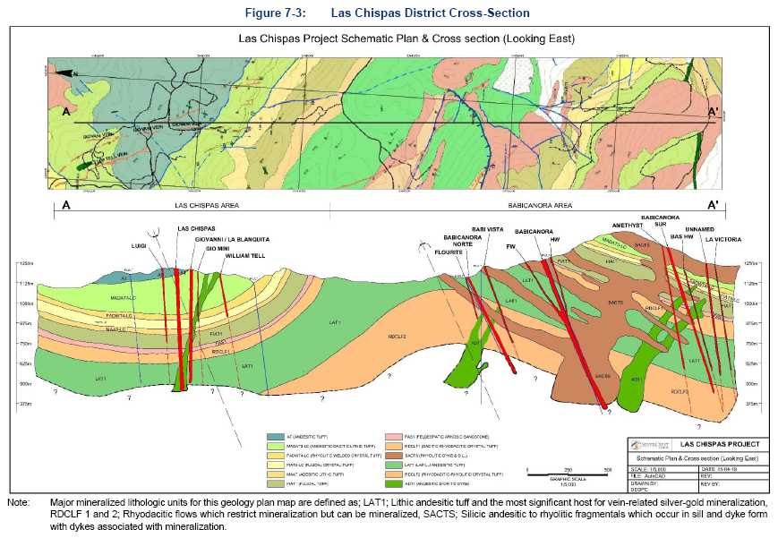
| 7-5 | |
| TECHNICAL REPORT AND MINERAL RESOURCE ESTIMATE FOR THE LAS CHISPAS PROPERTY, SONORA, MEXICO |
| 704-ENG.VMIN03016-05 | MAY 2019 | ISSUED FOR USE |
7.2.1 Geochemistry
Thin section and TerraSpec studies show that the mineralizing fluids on the Las Chispas Property are dominantly neutral with separate acidic fluid pulses overprinting alteration and mineralization. Relative metal abundance and correlation coefficients have been calculated to characterize the geochemistry of the Las Chispas deposits and showings.
Both the thin section report and TerraSpec work indicates that the alteration generated during the mineralization events are dominantly multi-pulse neutral and consistent with low-sulphidation mineralization. The typical alteration assemblage is montmorillonite-illite ± kaolinite ± MgFe chlorite ± pyrite. However, more acidic species of minerals and clays are also present, such as alunite, dickite and ammonium. In conjunction with the more acidic alteration, magmatically derived orthoclase is noted in thin sections as fine grained interlobated aggregates that occupy the interstices between the course grained quartz. This indicates that the quartz-rich mineralizing fluids and the orthoclase are syngenetic. Thus, both the orthoclase and quartz are part of the same event (Colombo 2017). To produce these near neutral clays and minerals in conjunction with the more highly acidic species, two or more distinct fluid pulses are plausible.
A review of the core database was undertaken in January 2018, comprised of 46,925 samples from all known deposits within the Las Chispas Property. The review centered on the correlation coefficient (Table 7-1) and modal abundance (Table 7-2) of the anomalous and expected elements typically associated with low- to intermediate-sulphidation deposits. The correlation complex was used to determine the relationship between elements and the modal abundances of those relationships.
Gold and silver have a strong positive correlation coefficient. Emplacement of both silver and gold seems to be strongly related, although there is thin section evidence of a quartz+gold only event at Babicanora. The core low- to intermediate-sulphidation elements (gold, silver, copper, lead, zinc, and antimony) all have a strong affinity for one another. Mercury does not have a conclusive positive or a negative correlation and has negligible values. Lead and zinc have a very high correlation coefficient 0.870. However, base metals and accessory minerals have low abundance within all the targets. There is a slight increase in base metal content in the targets located deeper in the eastern portion of the Property. This may indicate an evolution of the fluids as they ascend or separate base metal rich pulses, the mode of which emplacement is unclear. Sulphur has a moderate correlation with zinc and lead, likely due to sulphur in their respective sulphides. The gold and silver mineralization in the uppermost portion of the targets has been oxidized and the sulphides have been weathered to sulphate and mobilized, resulting in a lower total sulphur signature.
| 7-6 | |
| TECHNICAL REPORT AND MINERAL RESOURCE ESTIMATE FOR THE LAS CHISPAS PROPERTY, SONORA, MEXICO |
| 704-ENG.VMIN03016-05 | MAY 2019 | ISSUED FOR USE |
| Table 7-1: | Correlation Coefficient Table, Anomalous Values Highlighted, >0.25 and <-0.25 (January 2018) |
| Au | Ag | Cu | Pb | Zn | As | Ba | Cd | Co | Fe | Hg | Mn | Mo | S | Sb | |
| Au | 1.00 | 0.87 | 0.33 | 0.20 | 0.17 | 0.04 | 0.00 | 0.23 | -0.01 | 0.00 | 0.11 | 0.00 | 0.01 | 0.01 | 0.52 |
| Ag | 0.87 | 1.00 | 0.31 | 0.18 | 0.16 | 0.03 | 0.00 | 0.20 | -0.01 | 0.00 | 0.09 | 0.00 | 0.02 | 0.01 | 0.41 |
| Cu | 0.33 | 0.31 | 1.00 | 0.14 | 0.14 | 0.06 | 0.01 | 0.19 | 0.09 | 0.05 | 0.08 | 0.01 | 0.14 | 0.04 | 0.33 |
| Pb | 0.20 | 0.18 | 0.14 | 1.00 | 0.39 | 0.21 | 0.00 | 0.43 | 0.00 | -0.03 | 0.08 | 0.01 | 0.09 | 0.07 | 0.17 |
| Zn | 0.17 | 0.16 | 0.14 | 0.39 | 1.00 | 0.20 | 0.00 | 0.93 | 0.10 | 0.07 | 0.12 | 0.06 | 0.03 | 0.17 | 0.16 |
| As | 0.04 | 0.03 | 0.06 | 0.21 | 0.20 | 1.00 | 0.00 | 0.20 | 0.07 | 0.07 | 0.11 | 0.08 | 0.06 | 0.18 | 0.12 |
| Ba | 0.00 | 0.00 | 0.01 | 0.00 | 0.00 | 0.00 | 1.00 | 0.00 | -0.01 | -0.01 | 0.04 | 0.39 | 0.02 | -0.07 | 0.21 |
| Cd(1) | 0.23 | 0.20 | 0.19 | 0.43 | 0.93 | 0.20 | 0.00 | 1.00 | 0.03 | -0.04 | 0.13 | 0.04 | 0.05 | 0.12 | 0.21 |
| Co | -0.01 | -0.01 | 0.09 | 0.00 | 0.10 | 0.07 | -0.01 | 0.03 | 1.00 | 0.74 | 0.03 | 0.21 | 0.02 | 0.10 | 0.05 |
| Fe | 0.00 | 0.00 | 0.05 | -0.03 | 0.07 | 0.07 | -0.01 | -0.04 | 0.74 | 1.00 | -0.03 | 0.15 | -0.02 | -0.25 | 0.04 |
| Hg(1) | 0.11 | 0.09 | 0.08 | 0.08 | 0.12 | 0.11 | 0.04 | 0.13 | 0.03 | -0.03 | 1.00 | 0.02 | 0.03 | 0.05 | 0.14 |
| Mn | 0.00 | 0.00 | 0.01 | 0.01 | 0.06 | 0.08 | 0.39 | 0.04 | 0.21 | 0.15 | 0.02 | 1.00 | -0.02 | -0.03 | 0.31 |
| Mo(1) | 0.01 | 0.02 | 0.14 | 0.09 | 0.03 | 0.06 | 0.02 | 0.05 | 0.02 | -0.02 | 0.03 | -0.02 | 1.00 | 0.02 | 0.17 |
| S | 0.01 | 0.01 | 0.04 | 0.07 | 0.17 | 0.18 | -0.07 | 0.12 | 0.10 | -0.25 | 0.05 | -0.03 | 0.02 | 1.00 | 0.00 |
| Sb(1) | 0.52 | 0.41 | 0.33 | 0.17 | 0.16 | 0.12 | 0.21 | 0.21 | 0.05 | 0.04 | 0.14 | 0.31 | 0.17 | 0.00 | 1.00 |
| Note: | (1)Low statistical population |
| 7-7 | |
| TECHNICAL REPORT AND MINERAL RESOURCE ESTIMATE FOR THE LAS CHISPAS PROPERTY, SONORA, MEXICO |
| 704-ENG.VMIN03016-05 | MAY 2019 | ISSUED FOR USE |
| Table 7-2: | Basic Statistics for Trace Elements (January 2018) |
Parameter | Count | Minimum | Maximum | Mean | Total | Variance | Standard Deviation | Coefficient of Variation | Skewness | Kurtosis |
| Weight (kg) | 45,944 | 0.22 | 12.94 | 3.899 | 179,149 | 3.77 | 1.942 | 0.5 | 0.81 | -0.23 |
| Length (m) | 46,925 | 0.1 | 7.5 | 1.113 | 52,249 | 0.28 | 0.527 | 0.47 | 0.83 | 0.94 |
| Au (ppm) | 45,934 | 0.001 | 305 | 0.122 | 5,611 | 5.7 | 2.387 | 19.54 | 77.06 | 7,654 |
| Ag (ppm) | 45,934 | 0.2 | 21,858 | 11.068 | 508,393 | 34,356 | 185.353 | 16.75 | 68.64 | 6,237 |
| Cu (ppm) | 29,184 | 1 | 10,250 | 10 | 290,069 | 5,810 | 76 | 7.67 | 91.07 | 11,398 |
| Pb (ppm) | 29,184 | 2 | 8,150 | 37 | 1,089,937 | 36,473 | 191 | 5.11 | 19.58 | 526.5 |
| Zn (ppm) | 29,060 | 2 | 17,700 | 58 | 1,699,437 | 45,639 | 214 | 3.65 | 38.92 | 2477 |
| Ba (ppm) | 29,091 | 1 | 10,000 | 151 | 4,386,336 | 78,966 | 281 | 1.86 | 9.57 | 207.5 |
| Ca (pct) | 28,933 | 0.01 | 25 | 1.086 | 31,420 | 1.87 | 1.366 | 1.26 | 5.69 | 64.74 |
| Cd (ppm) | 3,740 | 0.5 | 130 | 2.023 | 7,568 | 25.96 | 5.095 | 2.52 | 13.74 | 248 |
| Co (ppm) | 24,678 | 1 | 176 | 4 | 101,027 | 31.29 | 6 | 1.37 | 3.45 | 41.09 |
| Hg (ppm) | 4,311 | 0 | 41 | 1 | 4,692 | 1.03 | 1 | 0.93 | 22.57 | 705.3 |
| Mn (ppm) | 29,064 | 1 | 50,000 | 564 | 16,399,438 | 991,598 | 996 | 1.76 | 26.17 | 1,063 |
| Mo (ppm) | 11,304 | 0 | 1,670 | 4 | 43,432 | 623.7 | 25 | 6.5 | 44.69 | 2,531 |
| S (pct) | 24,815 | 0.01 | 34 | 0.388 | 9,636 | 0.9 | 0.947 | 2.44 | 16.65 | 381.9 |
| Sb (ppm) | 13,910 | 1 | 1,045 | 5 | 75,476 | 316.2 | 18 | 3.28 | 36 | 1,717 |
| 7-8 | |
| TECHNICAL REPORT AND MINERAL RESOURCE ESTIMATE FOR THE LAS CHISPAS PROPERTY, SONORA, MEXICO |
| 704-ENG.VMIN03016-05 | MAY 2019 | ISSUED FOR USE |
7.2.2 Alteration
All rock types on Las Chispas show signs of extensive hydrothermal alteration. Thin section and TerraSpec spectral analysis were completed on drill core samples from DDH BA17-9A, which cuts all the major lithologies on the Babicanora target and the alteration is generally consistent with the all the showings on the Property. The TerraSpec work was completed using the Mineral Deposits Research Unit (MDRU) TerraSpec 4 at the University of British Columbia. Both studies identified alteration consistent with argillic and advanced argillic alteration. The alteration minerals identified throughout the Las Chispas Property include smectite, illite, kaolinite, chlorite, carbonate, iron oxy/hydroxides, probable ammonium, gypsum/anhydrite, silica, and patch trace alunite.
The dominant alteration mineralogy throughout the drill hole is montmorillonite-illite ± kaolinite ± MgFe chlorite. This is consistent with argillic and possibly advanced argillic alteration. Most the alteration shows a progression of alteration minerals consistent with lower hydrothermal fluid temperatures. These low temperature clays and minerals indicate a near neutral pH with decreasing depth and distance from the conduit of flow.
White clay composition is predominantly low aluminum (phengitic) but there are several interbedded narrow intervals of typical alumina bearing muscovitic illite zones at the top and base of sampling. This variation may be due to lithological variations of the parent rock. Sericitic alteration occurs as widespread fine-grained aggregates that form anhedral grains. These grains replace the fine-grained matrix and feldspar phenocrysts. White clay crystallinity ranges from poor to moderate, indicting lower temperatures of emplacement.
Chlorite is relatively common, and two phases have been identified, Mg>Fe, with minor intervals of Fe>Mg chlorite. These differences may be related to parent lithologies or relative iron-magnesium. Localized, coarse clots of chlorite can replace small clasts, although fine grained pervasive chlorite is more common.
Pyrite is consistently observed throughout the target, overprinting the host rock and associated with the silicification adjacent to, and within, the mineralized zones. Forms include cubic disseminations, aggregates and veins. Pyrite is often weathered to iron oxides to depths of greater than 200 m from surface within the mineralized zones.
Silicification ranges from white to pale massive chalcedonic and saccharoidal to coarse crystalline comb quartz. Despite the visual identification of silicification in the core, little silica was noted in spectra. Silica is not infrared active but is suggested by the presence of strong groundwater features in the spectra. The groundwater features were largely absent, but their absence may be due to destructive reheating of the silica due to multiple pulses of fluids and/or syngenetic reactivation of fault structures causing damage to the previously emplaced quartz veins. Reactivation of faulting is noted within the mineralization and the generation of cataclastic breccias which are, in turn, recemented with later pulses of coarse to microcrystalline silica.
Calcite with trace anhydrite ± gypsum is abundant throughout the Property. It is emplaced during and after the mineralizing events. In thin section, coarse-grained equigranular aggregates of quartz hosts rare interstitial crystals of calcite (up to 3 mm) in the mineralized zone. Late fine- to coarse-grained calcite veins and veinlets cross-cut the mineralization. The northwest part of the Babicanora Vein shows late stage, coarse-grained white and black banded (+manganese) calcite infills open spaces and cross-cuts mineralization (Photo 7-1).
| 7-9 | |
| TECHNICAL REPORT AND MINERAL RESOURCE ESTIMATE FOR THE LAS CHISPAS PROPERTY, SONORA, MEXICO |
| 704-ENG.VMIN03016-05 | MAY 2019 | ISSUED FOR USE |
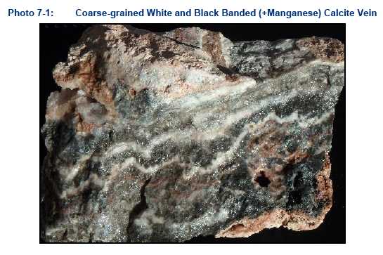
Near neutral pH and reduced fluids form low-sulphidation state sulphide minerals and alteration mineralogy (Barton and Skinner 1979). However, within the Babicanora samples there is sporadic localized potassic alunite, dickite and ammonium identified at approximately 90 m in depth indicating a more acidic environment. This change in pH may be due to the incorporation of higher volumes of magmatic fluids or changes in the volumes of the meteoric fluids content. Thin section work notes a change in the chemical environment within this zone, “Euhedral to subhedral phenocrysts of orthoclase are immersed within a heterogeneous groundmass. The heterogeneity of the groundmass suggests that a strong alteration event altered the groundmass. K-feldspar-K-bearing clays comprise the groundmass. The clays are weak to moderate after the plagioclase, strong after biotite with weak quartz within the groundmass” (Colombo 2017).
Generally, the host rocks are above the existing water table. Oxidation of sulphides is noted from near surface to depths greater than 300 m and the presence of secondary minerals are noted from the Las Chispas underground workings approximately 60 to 275 m depth from surface. Hematite mineralization occurs as halos around small veins due to percolated meteoric water along small faults and fractures from oxidized iron sulphides. Strong and pervasive near surface oxidation is noted to occur in the Babicanora Area where host rocks have experienced faulting and advanced weathering to limonite, hematite, and clays.
7.2.3 Mineralization
Mineralization at the Las Chispas Property is characterized as a deeply emplaced, low- to intermediate-sulphidation system, with mineralization hosted in hydrothermal veins, stockwork, and breccia. Emplacement of the mineralization is influenced by fractures and low-pressure conduits formed within the rocks during tectonic movements. Mineralization can be controlled lithologically along regional structures, local tension cracks, and faulted bedding planes. Brecciated mineralization forms in two ways: in zones of low pressure as hydrothermal brecciation and mechanical breccias. Both are interpreted to occur most often at the intersection of two or more regional structural trends. Historic reports and work conducted by SilverCrest have further investigated the gold, silver, base metals, and gangue minerals associated with the mineralization.
| 7-10 | |
| TECHNICAL REPORT AND MINERAL RESOURCE ESTIMATE FOR THE LAS CHISPAS PROPERTY, SONORA, MEXICO |
| 704-ENG.VMIN03016-05 | MAY 2019 | ISSUED FOR USE |
The width of mineralization is 0.10 to 7.9 m in true width that typically encompasses a central quartz ±calcite mineralized corridor with narrow veinlets within the adjacent fault damage zone. Stockwork and breccia zones are centered on structurally controlled hydrothermal conduits.
Historical reporting has identified economic mineralization in the form of silver sulphides and sulfosalts as the primary silver mineral species, and in association with pyrite. Secondary silver enrichment is indicated by the gradation from chlorargyrite near the surface to pyrargyrite at depth. Dufourcq (1910) noted the variability of the mineralization within the Las Chispas Vein and attributed the variation to changing elevations of water tables, late-stage hydrothermal pulses, and supergene remobilization. Current thin section work and observations during
SilverCrest’s ongoing field work support Dufourcq’s historic observations.
Silver mineralization is dominant throughout the Las Chispas Property. Typical ratios of silver to gold are: Babicanora Vein at 64:1, Babicanora Bonanza Zone (Area 51) at 63:1, Las Chispas Vein at 142:1, Giovanni Vein at 172:1, and William Tell Vein at 140:1. Overall, a 100:1 silver to gold ratio is considered for the Las Chispas Property. Stronger gold mineralization is noted within the Babicanora Area than within the Las Chispas Area. The modes of gold mineralization currently identified are: gold associated with pyrite and chalcopyrite, gold emplacement with silver sulphides (typically argentite), and native gold flakes in quartz (Photo 7-2).
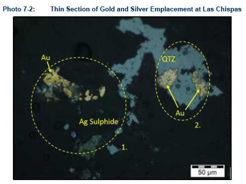
Other sulphide species identified at the Las Chispas Property include minor chalcopyrite, sphalerite, and galena. The Las Chispas Veins are conspicuously low in base metal mineralization, except for the Granaditas Vein located in the southeastern part of the district. Historic documents show that base metal abundances are significantly higher in the El Carmen Area, a historic mine to the south of the Property. In addition to the petrographic findings in Babicanora samples of an early sphalerite phase followed by a later galena phase of mineralization (see Section 6.2.3.1), visual inspection of the base metal mineralization also shows galena and sphalerite emplaced at the same time within the same discrete vein. This observation indicates that there are multiple pulses of base metal-rich fluids of variable composition that comprise the mineralization at the Las Chispas Property. Furthermore, there seems to be an increasing base metal content to the southeast and to depth. Government geophysical maps note a large magnetic anomaly to the east of the Property, which could be a buried intrusive and potentially the main source of the district’s mineralization.
| 7-11 | |
| TECHNICAL REPORT AND MINERAL RESOURCE ESTIMATE FOR THE LAS CHISPAS PROPERTY, SONORA, MEXICO |
| 704-ENG.VMIN03016-05 | MAY 2019 | ISSUED FOR USE |
The veins and stockwork within the Las Chispas Vein consist of fine- to medium-grained, subhedral to euhedral interlocking quartz with minor cavities lined by comb quartz (typically crystals are 5 to 10 mm in length). SilverCrest geologists have not noted any quartz-pseudomorphed blades after platy carbonate or other textures that would indicate a shallow environment. Vein emplacement and form are structurally and lithologic controlled. The rheology of the host rock plays an important role in structural preparation and emplacement of the mineralization. Within the fine-grained welded tuff, veining is narrow and chaotic. Veins and breccia emplacement in the more competent, medium-grained lapilli tuffs are wider and focused along the main structure with denser veining in the adjacent fault damage zone.
The two types of breccias associated with mineralization at Las Chispas, hydrothermal breccia and recemented mechanical breccia, are hosted differently. In the hydrothermal breccia, mineralization is hosted in a siliceous matrix of hydrothermal quartz ±calcite, and previously formed vein clasts that have been brecciated and recemented (Photo 7-3 A and B). Clasts are typically homolithic, angular, and show minimal signs of milling and rounding by hydrothermal processes. Although heterolithic breccias are present, they tend to be at the intersection points of the cross-cutting faults (striking 360o) to the main trend and at depth. The gold values increase with increasing visible pyrite and chalcopyrite within the quartz matrix.
Recemented mechanical breccia generated by the reactivation of the fault hosting the mineralization are also present. These breccias are comprised of fault gouge and have a cataclasitetexture and are recemented with quartz and calcite. This mechanism also produces open space filling ores including narrow stockwork quartz ± calcite ± adularia veins. Other textures include banding, crustiform, comb, and chalcedonic silica-calcite veins. Often the matrix has fine disseminated to course banded sulphides associated with the cement.
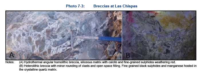
Argentite is the principle silver mineral in association with galena, pyrite ± marcasite and chalcopyrite. Silver and gold values have a strong correlation with one another and are likely precipitated together during the crystallization of quartz. Base metals are low in veins. Minor zinc and lead are principally found in black sphalerite and galena as blebs and veinlets. Arsenic and mercury are noticeably absent from the geochemistry. Minor antimony is present. Minor secondary copper minerals as chrysocolla and malachite are noted in the underground in association with oxidized chalcopyrite.
Styles of mineralization present on the Property include laminated veins (Photo 7-4), stockwork and quartz-calcite filled hydro-brecciated structures (Photo 7-5). The presence of epithermal textures, such as bladed calcite (replaced by quartz), miarolitic cavities, and chalcedony/crustiform banding mapped underground, suggest multiple phases of fluid pulses have contributed to the mineral deposits.
| 7-12 | |
| TECHNICAL REPORT AND MINERAL RESOURCE ESTIMATE FOR THE LAS CHISPAS PROPERTY, SONORA, MEXICO |
| 704-ENG.VMIN03016-05 | MAY 2019 | ISSUED FOR USE |
Generally, it appears that epithermal mineralization is higher in the system (closer to the paleo-surface) on the west side (i.e. La Victoria Vein and historic mine) of the district versus the east side (Granaditas Vein and historic mine) where there is a noted increase in base metals. Government geophysical maps note a large magnetic anomaly to the east of the Property which could be a buried intrusive and potentially the main influence of district mineralization.

| 7-13 | |
| TECHNICAL REPORT AND MINERAL RESOURCE ESTIMATE FOR THE LAS CHISPAS PROPERTY, SONORA, MEXICO |
| 704-ENG.VMIN03016-05 | MAY 2019 | ISSUED FOR USE |
7.2.3.1 Petrographic Analysis
Thin section work on the Babicanora Vein indicates that there are discrete base metal pulses within the fluids, and consequently within the quartz veining. Thin sections show that clusters of anhedral sphalerite are associated with subordinate fine grained blebs of galena and lesser chalcopyrite. The microstructure shown by sphalerite and galena indicates that galena post-dated the crystallization of the sphalerite, which was fractured then partially replaced by the galena. This indicates that there was an early phase of sphalerite with a later galena pulse of mineralization (Colombo 2017).
Gangue minerals, from visual inspection of core and underground workings include calcite, pyrite, goethite, adularia, chlorite, sericite, epidote (dykes only), barite, manganese oxides (e.g., pyrolusite), and rhodonite. Adularia and manganese oxides are noted to occur within quartz veining and cavities. Amethyst and fluorite are present at Babicanora, William Tell and the Las Chispas veins. Abundant limonite ± jarosite is commonly in association with goethite and pyritic alteration in proximity to, and within the mineralized faults and dykes, of all the targets to depths of +175 m below surface.
7.2.3.2 Fluid Inclusion Study
The fluid inclusion study for the Las Chispas Property found depths of emplacement of mineralization ranging from approximately 100 m to greater than 2 km. The shallow depth of emplacement readings is outside the main mineralized zones. Depth of emplacement in the main mineralized zone is well below 1,000 m with a maximum depth of greater than 2 km (Pérez 2017). These deeper depths of emplacement are complicated by possible caldera collapse with a change in the paleo-surface.
Overprinting of low- and high-sulphidation mineralization and alteration with conflicting depths of formation are noted in the fluid inclusion, TerraSpec, and thin section studies that point towards caldera collapse as a mechanism of emplacement.
7.2.4 Structural Geology
Mapping and interpretation of the structural controls on mineralization and post-mineral displacement is ongoing by SilverCrest (Figure 7-4,Figure 7-5, and Figure 7-6). Regionally, the Las Chispas Property is situated in an extension basin related to a Late Oligocene half graben of the Sonora River basin. Multiple stages of normal faulting affect the basin. The main structures are steep, west dipping (80°) and sub-parallel to the Granaditas normal fault located along the western margin of the Property, striking approximately 030°. The basin is further cross-cut by younger nowthwest-southeast normal faults dipping to the southwest, creating both regional and local graben structures (Carlos et al. 2010).
Three local grabens have been identified on the Property, referred to as the Las Chispas, Babicanora and El Carmen grabens. All three grabens are bounded by:
| • | steeply dipping (80 to 90°) oblique strike-slip sinistral faults trending northeast and south-southwest |
| • | oblique strike-slip dextral faults trending southeast dipping (60 to 80°) to the northeast. |
Locally, graben structures are complicated by probable caldera collapse. Circular structures noted in the lineament analysis in conjunction with locally derived immature volcanic fill containing sharp primary quartz clasts indicate local volcanism (Colombo 2018). Within a collapsed caldera, telescoping, juxtaposing or overprinting deep mineralization, is common. Paleo-surfaces may be easily lowered by 1.0 km, leading to vertical compression of contained ore deposits (Sillitoe 1994).
| 7-14 | |
| TECHNICAL REPORT AND MINERAL RESOURCE ESTIMATE FOR THE LAS CHISPAS PROPERTY, SONORA, MEXICO |
| 704-ENG.VMIN03016-05 | MAY 2019 | ISSUED FOR USE |
Current understanding suggests that mineralized structures are oriented along a northwest-southeast trend. Three structural controls, excluding bedding contacts, are considered to influence alteration and mineralization:
| • | 150° to 170° and are inclined at approximately 65° to 75° to the southwest |
| • | 340° to 360° and are inclined 75° west to 75° east |
| • | 210° to 230° and are inclined 70° to 85° to the northwest. |
Russell (1908) states that a total of 14 veins were mapped by Pedrazzini concordant to this trend near the Las Chispas Mine. SilverCrest has defined 30 epithermal veins on the Property (Las Chispas and Babicanora areas) to date.
Vein and stockwork mineralization are influenced by fractures and low-pressure conduits formed within the rocks during tectonic movements. These can be controlled along regional structures, local tension cracks, and along broken or sheared bedding planes. Brecciated mineralization forms in zones of low pressure and is interpreted to occur at the intersection of two or more regional structural trends.
Regionally, the mineralized structures are terminated against the northeast trending regional fault (Las Chispas-Santa Elena Fault) which is a normal fault that has down dropped to the west. Absolute direction and magnitude of movement along the fault in this area is not known. At the nearby Santa Elena mine, this post mineralization normal fault is down dropped on the west side by approximately 400 m (drill tested). This normal fault is also considered a major controlling feature for important regional aquifers.
7.2.5 Deposits and Mineral Occurrences
The Las Chispas District with subsequent mineral deposit is split into the Las Chispas Area and the Babicanora Area and currently consists of 30 epithermal veins (Figure 7-4). Of the 30 veins, SilverCrest has partially drilled 21 and has intercepted high-grade (greater than 150 gpt AgEq) mineralization in all. The updated resource presented in this report is based on 10 of the 30 veins.
| 7-15 | |
| TECHNICAL REPORT AND MINERAL RESOURCE ESTIMATE FOR THE LAS CHISPAS PROPERTY, SONORA, MEXICO |
| 704-ENG.VMIN03016-05 | MAY 2019 | ISSUED FOR USE |
| 7-16 | |
| TECHNICAL REPORT AND MINERAL RESOURCE ESTIMATE FOR THE LAS CHISPAS PROPERTY, SONORA, MEXICO |
| 704-ENG.VMIN03016-05 | MAY 2019 | ISSUED FOR USE |
7.2.5.1 Babicanora, Babicanora FW and Babicanora HW Veins
The Babicanora Vein is located in the southern portion of the Las Chispas Property. Historically, the Babicanora Vein and surrounding area was considered the largest mineralized system in the Las Chispas District. Mineralization is hosted in structurally controlled veins with associated stockwork and breccias. A majority of high-grade mineralization is located within medium to coarse-grained lithic tuff (LAT1). The strike length of the surface exposures of mineralization and old workings is approximately 3.2 km. The historic workings are in the hanging wall of the vein and are reported to be as much as 450 ft deep (Dahlgren 1883).
Underground workings along the Babicanora Vein are located to the northwest portion of the vein and is currently accessed by several adits including a 4 m by 4 m adit (Photo 7-6) which continues as a 230 m horizonal decline. Mineralization is characterized as quartz veins, stockwork, and breccias. The mineralized structural zone is oriented along strike between 140° to 150° with inclination of approximately 60 to 70° to the southwest. Several 200 to 220° striking faults and dense fractures intersect the Babicanora Vein. These intersections appear to influence mineralization by developing high-grade shoots that typically plunge to the northwest. From observations underground at the nearby Las Chispas Vein, these cross-cutting faults or dense fractures can be mineralized along an approximate 220° strike for up to 20 metres.
The Babicanora Mine had hanging wall stoping from the main adit level (1152 masl) to the surface, approximately 150 m. Depth of historic underground workings is approximately 25 m below the main adit level. SilverCrest removed and stockpiled approximately 800 tonnes of material for underground drill access in 2017 (Photo 7-7). The Babicanora Vein is in the footwall of the historic stoping along a fault with no known mining in the footwall where SilverCrest has discovered high-grade mineralization. Geological mapping in the Babicanora Area is shown in Figure 7-5 and a typical cross-section is shown in Figure 7-6.
![]()
| 7-17 | |
| TECHNICAL REPORT AND MINERAL RESOURCE ESTIMATE FOR THE LAS CHISPAS PROPERTY, SONORA, MEXICO |
| 704-ENG.VMIN03016-05 | MAY 2019 | ISSUED FOR USE |
| 7-18 | |
| TECHNICAL REPORT AND MINERAL RESOURCE ESTIMATE FOR THE LAS CHISPAS PROPERTY, SONORA, MEXICO |
| 704-ENG.VMIN03016-05 | MAY 2019 | ISSUED FOR USE |
Major mineralized lithologic units are defined as; LAT1; Lithic andesitic tuff and the most significant host for vein-related silver-gold mineralization, RDCLF 1 and 2; Rhyodacitic Flows which restrict mineralization with narrow high-grade mineralized veining, SACTS; Silicic andesitic tuff or ignimbrite which can be in sill and dyke form. Dykes are associated with mineralization.
General lithologies are andesitic to dacitic with rhyolitic interbeds. These units are cross-cut by andesitic dykes to the southeast strike of the Babicanora Vein and rhyodacitic dykes to the northwest. Strong to intense silicification caps the ridges in the area with a 300 m by 400 m horizontal zone interpreted as possibly sinter (Photo 7-8,A) covering the slopes in the southwestern portion of the Property.
Mineralization of the Babicanora Vein is characterized as a low to intermediate sulphidation system. SilverCrest has identified numerous sulphidation features including; possibly sinter capping on the ridges which indicate the silica saturated fluids have reached the surface and cooled, generating hard siliceous terraces. Quartz after calcite, bladed textures (Photo 7-8, B), were found at high elevations on the western side of the Property. This texture and composition are comprised of intersecting blades where each blade consists of a series of parallel seams. This texture indicates boiling. It is typically caused when an ascending fluid undergoes rapid expansion, and the vapour pressure exceeds hydrostatic pressure causing boiling and a dramatic decrease in metal solubility. Massive chalcedonic textured silica (Photo 7-8, C) were also identified on the western portion of the Property, indicating low temperatures before and after deposition (Morrison et al. 1990). These high-level features and textures point to the preservation of the mineralized system below and at depth.
| 7-19 | |
| TECHNICAL REPORT AND MINERAL RESOURCE ESTIMATE FOR THE LAS CHISPAS PROPERTY, SONORA, MEXICO |
| 704-ENG.VMIN03016-05 | MAY 2019 | ISSUED FOR USE |
Base metals are low in Babicanora. Zinc and lead are principally found in black sphalerite and galena. Early stages of galena are noted in the thin section study. With clusters of anhedral sphalerite (up to 1 mm long) are associated with subordinate fine-grained blebs of galena and lesser chalcopyrite (up to 0.2 mm). Microstructures shown in the sphalerite and in the galena indicate that the galena post-dates the crystallization of the sphalerite which is partly replaced by the galena. Indicating galena only pulses of mineralization. Arsenic and mercury are noticeably absent from the geochemistry. Silver and gold mineralization can be characterized with three end-member types; breccia hosted, vein hosted, and vuggy quartz hosted (Photo 7-10).
| 7-20 | |
| TECHNICAL REPORT AND MINERAL RESOURCE ESTIMATE FOR THE LAS CHISPAS PROPERTY, SONORA, MEXICO |
| 704-ENG.VMIN03016-05 | MAY 2019 | ISSUED FOR USE |
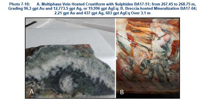
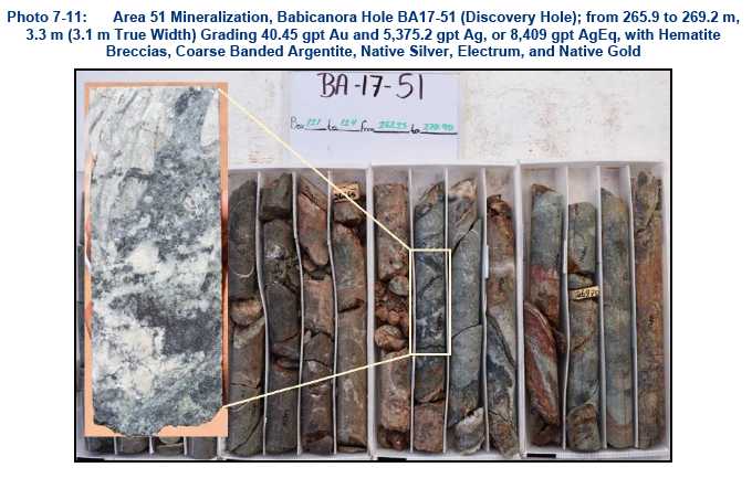
| 7-21 | |
| TECHNICAL REPORT AND MINERAL RESOURCE ESTIMATE FOR THE LAS CHISPAS PROPERTY, SONORA, MEXICO |
| 704-ENG.VMIN03016-05 | MAY 2019 | ISSUED FOR USE |
The Babicanora FW Vein is sub-parallel to the Babicanora Vein. This vein is approximately 30 m north of the Babicanora Vein in the northwestern part of the area. The vein appears to intersect the Babicanora Vein near Area 51. The Babicanora HW Vein is a minor hangingwall splay sub-parallel to the Babicanora Vein.
7.2.5.2 Babicanora Norte Vein
The mineralization of the Babicanora Norte Vein is similar to components found at the adjacent Babicanora Vein. A majority of the high-grade mineralization is located within the RDCLF1 (rhyodacitic flow) near intersections of cross-cutting 220° striking faults and dense fracturing. Argentite is the principle silver mineral, gold occurs as native flakes and in association with pyrite and chalcopyrite. This vein is dissimilar then other veins in the Babicanora Area with a high component of pyrargyrite and/or proustite visually identified in cavities within core samples (Photo 7-12).

Base metals in Babicanora Norte are similar in nature to the Babicanora Vein but higher in content (up to 0.5%) . Zinc and lead are principally found in black sphalerite and galena. A chalky white mineral is immediately adjacent to high-grade silver and may be a silver halide. Arsenic and mercury are noticeably absent from the geochemistry. Silver and gold mineralization can be characterized with three end-member types; breccia hosted, vein hosted, and vuggy quartz hosted.
7.2.5.3 Babicanora Sur Vein
The Babicanora Sur Vein is located approximately 300 m southwest of the Babicanora Vein and is parallel to the vein. The structural zone is oriented along strike between 140° to 150° with inclination of approximately 55 to 65° to the southwest. It is cross-cut by several 220° trending faults and dense fractures. Mineralization at Babicanora Sur is hosted in lapilli tuff and breccia with moderate to strong alteration overprinting (Photo 7-13).
| 7-22 | |
| TECHNICAL REPORT AND MINERAL RESOURCE ESTIMATE FOR THE LAS CHISPAS PROPERTY, SONORA, MEXICO |
| 704-ENG.VMIN03016-05 | MAY 2019 | ISSUED FOR USE |

7.2.5.4 Las Chispas Vein
The Las Chispas Vein is located in the northern portion of the Las Chispas Property and is the most extensively mined vein in the district(Figure 7-7). Mining along the Las Chispas Vein is well documented in the historical longitudinal section documented by Pedrazzini, circa December 31, 1921 (Figure 5-1).
SilverCrest’s exploration work has focused on defining the lithology, structure, alteration, mineralization and channel sampling in unmined pillars and surrounding intact vein. Vein mineralization is described as an undulating and dilating quartz stockwork and breccia zone, as defined in underground mapping and in drill core, of 0.10 to 7.9 m in true width which typically encompass narrow veins of quartz, visible sulphides, and calcite (Photo 7-14).
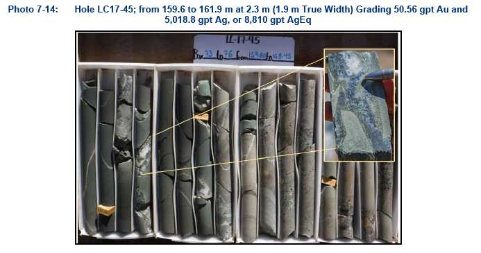
| 7-23 | |
| TECHNICAL REPORT AND MINERAL RESOURCE ESTIMATE FOR THE LAS CHISPAS PROPERTY, SONORA, MEXICO |
| 704-ENG.VMIN03016-05 | MAY 2019 | ISSUED FOR USE |
The Las Chispas Vein strikes 150° and inclined at approximately 75° to the southwest. Cross-cutting the Las Chispas Vein are normal secondary faults trending 220° and dipping 65°. These secondary faults seem to play an important role in generating zones of dilatation for the emplacement of high-grade shoots and breccia zones. Flat to steeply inclined bedding parallel to faults are also noted to offset the late stage andesitic dykes by 10 to 20 m and are a common feature of drag folds (Schlische 1995). A majority of high-grade mineralization is within the lithic tuff units. Geological mapping in the Las Chispas Area is shown in Figure7-7 and a typical cross-section is shown in Figure 7-8.
Alteration is similar to the other veins on the Property. Silicification is extensive in mineralized zones with multiple generations of quartz and chalcedony commonly accompanied by calcite with minor adularia. Pervasive silicification in vein envelopes is flanked by sericite and clay alteration of the host rock. Intermediate argillic alteration (likely kaolinite-illite-smectite) forms adjacent to some veins. Advanced argillic alteration (kaolinite-alunite) is suspected within the Las Chispas Vein, but formal studies of the alteration mineralogy have not been completed to confirm their presence. Propylitic alteration dominates at depth and peripherally to the mineralization with abundant fine-grained chlorite and pyrite proximal to the mineralization. Fe-oxyhydroxides, manganese after pyrite and other fine-grained sulphides are closely associated with the mineralization. Reactivation of the central fault hosting the mineralization provided a conduit for deep weathering of the sulphides and possible supergene enrichment of the silver mineralization. The andesitic dykes are weakly to moderately clay altered with weak epidote along their narrow chill margins.
Recent mapping by SilverCrest, confirms the location and extent of mining indicated on the historical longitudinal section (Figure 5-1) as being representative and accurate. At the date of the most recent QP site visit, access, and mine rehabilitation had been completed from the 50 level to the 900 level covering most of the historic workings. Mapping and sampling on all levels is near completion.
| 7-24 | |
| TECHNICAL REPORT AND MINERAL RESOURCE ESTIMATE FOR THE LAS CHISPAS PROPERTY, SONORA, MEXICO |
| 704-ENG.VMIN03016-05 | MAY 2019 | ISSUED FOR USE |
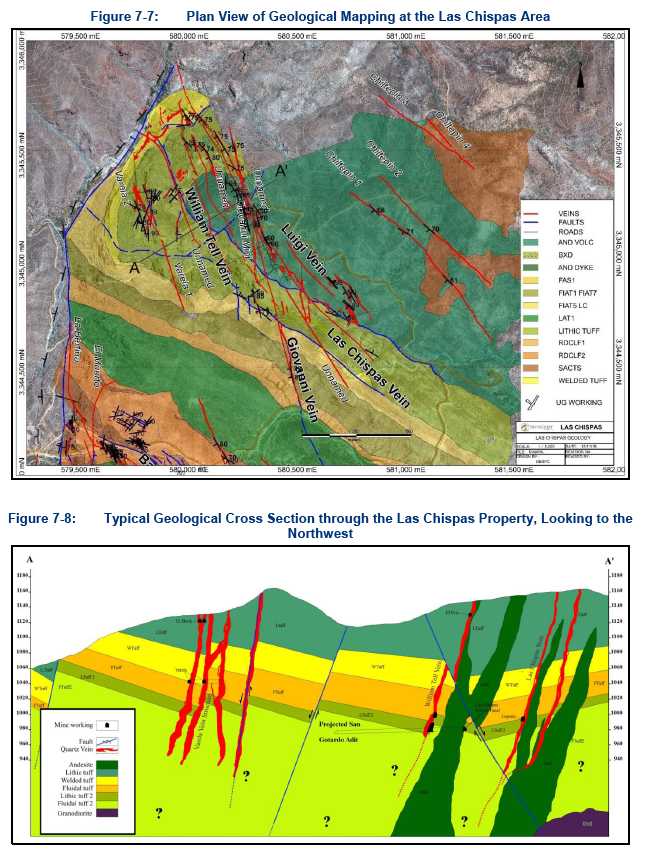
| 7-25 | |
| TECHNICAL REPORT AND MINERAL RESOURCE ESTIMATE FOR THE LAS CHISPAS PROPERTY, SONORA, MEXICO |
| 704-ENG.VMIN03016-05 | MAY 2019 | ISSUED FOR USE |
7.2.5.5 William Tell Vein
The William Tell Vein is located 115 m to the west and is oriented roughly sub-parallel to the Las Chispas Vein.
The mineralization is characterized as a quartz stockwork zone in the footwall of a continuous northeast-southwest fault striking 140° and dipping 65°. Underground mapping by SilverCrest indicates that mining from the main San Gotardo adit terminated against a cross-cutting fault (220°/70°), which SilverCrest interprets to have approximately 10 m of left lateral displacement based on drilling results.
The William Tell Vein is hosted in the same sequence of course- to fine-grained volcaniclastic, flows, and pyroclastics that are detailed in the Las Chispas Vein description. Alteration is comprised of white clays, sericite, and, fine-grained chlorite with strong silicification. Within the mineralized structure and central vein, fine pyrite, limonite, and iron oxides are present.
Historic mining of the structure is contemporaneous to mining within the Las Chispas Vein, although there is limited historic documentation available. The northern portion of the historical workings can be accessed from the same adit that connects with the San Gotardo level within the Las Chispas Vein. The extents of mapped workings total approximately 3 km horizontally over three levels and approximately 60 m vertical (450 level to 650 level). A shaft or a small stope exists from the lower working level. The vertical extent of this shaft/stope cannot be confirmed but based on the historical long section and drilling in the area it is not believed to be significant.
Mining activity along this structure south of the projected fault cannot be confirmed; however, no voids were intersected by SilverCrest drilling where the structure was interpreted to be, and no surface workings are noted.
In 2016, underground channel sampling by SilverCrest was completed with high-grade mineralization defined in pillars and intact exposures (Photo 7-15, Photo 7-16).
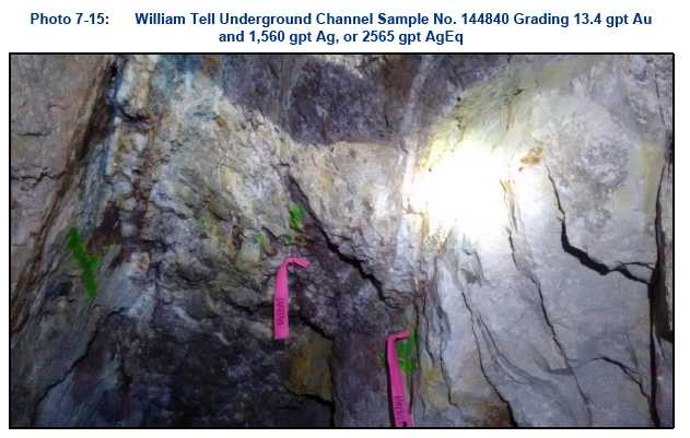
| 7-26 | |
| TECHNICAL REPORT AND MINERAL RESOURCE ESTIMATE FOR THE LAS CHISPAS PROPERTY, SONORA, MEXICO |
| 704-ENG.VMIN03016-05 | MAY 2019 | ISSUED FOR USE |
![]()
7.2.5.6 Giovanni and La Blanquita
SilverCrest discovered the Giovanni and La Blanquita Veins in 2016 while drill testing the Las Chispas Vein from surface. The La Blanquita Vein may be the southern extension of the Giovanni Vein with similar orientation.
The mineralization is hosted in a quartz stockwork zone striking 340 to 10°, near vertical dipping, and cross-cutting the same volcanic units as the Las Chispas Vein. The best lithologic host appears to be a lapilli (lithic) tuff approximately 200 m in thickness. The zone is near-parallel to an andesite dyke.
The Giovanni Vein is exposed in several historic cross-cuts in the Las Chispas Vein historic workings but was never historically mined. Photo 7-17 shows a photo of the vein intersection in drill hole LC17-69.

| 7-27 | |
| TECHNICAL REPORT AND MINERAL RESOURCE ESTIMATE FOR THE LAS CHISPAS PROPERTY, SONORA, MEXICO |
| 704-ENG.VMIN03016-05 | MAY 2019 | ISSUED FOR USE |
The La Blanquita Vein is located 250 m southwest of the projected extension of the Giovanni Vein on the southwestern flank of a south-east trending ridge. Historical information on the target is limited, although there are historical trenches, pits, and waste dumps (Photo 7-18).

At surface, the host rocks are strongly clay altered with moderate to strong sericite. Fine-grained chlorite is also noted but is confined to a fine-grained crystal crowded rhyodacitic ash. Chalcedonic and saccharoidal silicification and veining is noted along the surface trace of the mineralized zone, infilling joints and fractures (Photo 7-19).
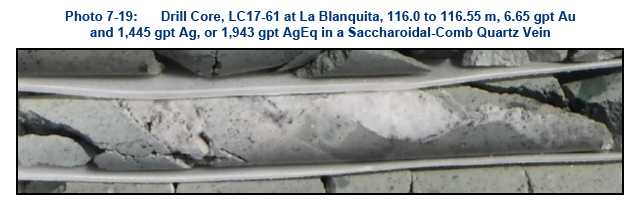
7.2.5.7 Granaditas Vein
The Granaditas Vein is located to the southeast of Babicanora in the eastern portion of the Property. The Spaniards discovered the Granaditas Mine in 1845 (Dahlgren 1883) with subsequent mining. Little information is available on this historic mine. Mining appears to have been to a depth of 90 ft with about US$300,000 (historic dollars) in ore extracted. After a local rancher provided an 1882 district map, SilverCrest was able to locate several adits, shafts, and dumps in the area.
| 7-28 | |
| TECHNICAL REPORT AND MINERAL RESOURCE ESTIMATE FOR THE LAS CHISPAS PROPERTY, SONORA, MEXICO |
| 704-ENG.VMIN03016-05 | MAY 2019 | ISSUED FOR USE |
The showing is located within 75 m of the confluence of two major lineaments interpreted as faults. The first trends 220°, has a strike length of 3.5 km, and is interpreted to be the eastern bounding structure to the Las Chispas graben. The second is mineralized, strikes 145°, and parallels the Babicanora trend. The interpreted mineralized strike length is over 500 m. Several drill holes have intersected fractured zones and encountered mafic andesitic dykes at depth.
Alteration at the target is consistent with the intermediate sulphidation model with strong silicification in patches and strong clay alteration with zones of pervasive sericite and chlorite.
During the Phase II exploration program, two diamond drill holes were completed on the target. The highest assay was from GR17-02, which returned values of 8.15 gpt gold and 387 gpt silver, or 998 gpt AgEq, with highly anomalous lead (600 ppm), copper (10,250 ppm), and zinc (595 ppm) over 0.7 m (Photo 7-20). Copper and base metals are elevated over 20 to 40 m with grades of 0.5% lead and 0.3% zinc.
During the Phase III exploration program, 19 diamond drill holes were completed on the target. The highest assay was from GR17-04, which returned values of 47.5 gpt gold and 5,620 gpt silver, or 9,183 gpt AgEq, with highly anomalous lead (2,610 ppm), copper (1,010 ppm), and zinc (3,130 ppm) over 0.5 m (Photo 7-21).
These elevated base metals in core suggest that base metals increase to the southeast and may indicate deeper depths of emplacement of the mineralization.

| 7-29 | |
| TECHNICAL REPORT AND MINERAL RESOURCE ESTIMATE FOR THE LAS CHISPAS PROPERTY, SONORA, MEXICO |
| 704-ENG.VMIN03016-05 | MAY 2019 | ISSUED FOR USE |

7.2.5.8 Other Structures or Mineral Occurrences of Significance
Amethyst Vein
The Amethyst (Amatista) Vein is located 200 m southeast of, and parallel to, the Babicanora Vein. Historic information is limited, but there are numerous historic workings pits and trenches along the 1 km strike length of the surface lineament.
The Amethyst Vein is steeply dipping and strikes 140°. It is cross-cut by several 200 to 220° trending faults and dense fractures that intersect the vein with high-grade near these intersections. The mineralization is hosted in sequence of 10 to 15° striking, northeast dipping lithic tuffs (LAT1). The individual units and lithology details are detailed Section 6.2.5.1. Drill hole BA17-20 drill-intercepted high-grade mineralization from 75.7 to 78.2 m grading 3.05 gpt gold and 77.8 gpt silver, or 306 gpt AgEq (Photo 7-22).
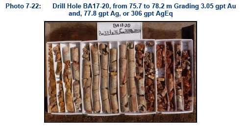
| 7-30 | |
| TECHNICAL REPORT AND MINERAL RESOURCE ESTIMATE FOR THE LAS CHISPAS PROPERTY, SONORA, MEXICO |
| 704-ENG.VMIN03016-05 | MAY 2019 | ISSUED FOR USE |
La Victoria Vein
This area is defined by small workings near surface on the southwest portion of the Property. The workings consist of three short and vertically off-set tunnels, each approximately 30 m in length. The vein trends 140° with an inclination of approximately 70° to the northeast. In 2016, SilverCrest rehabilitated the access underground due to the highly oxidized and soft nature of the host rock, comprised of strongly clay altered breccia. SilverCrest sampling of old underground workings suggests this structure to be gold-dominated with assays up to 100 gpt gold.
Historical sampling from three levels of the La Victoria Mine by Ronald Mulchay in 1941 assayed as high as 6.5 ounces per tonne of gold (approximately 220 gpt gold) with minor silver, with a gold to silver ratio of 1:1 for high-grade mineralization.
In June 2016, SilverCrest drilled three drill holes down-dip of the workings. Significant mineralization was not intersected by the drill holes, suggesting a possible offset in the mineral continuity at depth or epithermal zonation. Significant alteration was encountered in the drill holes along with multiple stages of intrusive activity. The nature of the mineralization and alteration at La Victoria is currently not well understood. SilverCrest proposes additional work in the future.
Espiritu Santo Vein
The Espiritu Santo workings are developed to the southeast of the Las Chispas Vein and William Tell Vein. Two historic adits and a shaft are accessible and have been mapped and sampled.
Two structural trends appear to have been mined in the workings. The first, on an upper level, strikes 150° with a dip of 60°. The second, on the lower level, strikes 290° with a dip of 48°. The latter mineralization is as stockwork within the footwall and parallel to the volcanic bedding contact. At surface, the andesitic volcanics that are exposed are strongly silicified with moderate to strong clay alteration focused along the above noted structures. Historic selective underground sampling shows grades at Espiritu Santo as high as 500 ounces per tonne of silver (Mulchay 1941). Historic dump samples returned seven samples greater than 111 gpt gold and 100 to 892 gpt silver (Mulchay 1941). Three drill holes were completed at the target with negligible results.
La Varela Veins
The La Varela workings are located approximately 300 m to the west of the William Tell Vein. Two veins are oriented along a strike of 170° and are near vertical with an average vein width of 1 m. Higher grade precious metal mineralization is dominant in the southern part of the two noted veins. SilverCrest has rehabilitated the existing underground workings (an estimated 400 m) with mapping and sampling. Three drill holes have been completed in this area with the most significant intercept from drill hole LC17-55 with a length of 0.8 m grading 2.67 gpt gold and 272 gpt silver, or 472 gpt AgEq.
| 7-31 | |
| TECHNICAL REPORT AND MINERAL RESOURCE ESTIMATE FOR THE LAS CHISPAS PROPERTY, SONORA, MEXICO |
| 704-ENG.VMIN03016-05 | MAY 2019 | ISSUED FOR USE |
| 8.0 | DEPOSIT TYPES |
Mineral deposits in the Las Chispas district are classified as silver and gold, low to intermediate sulphidation epithermal systems, typical of many local deposits in northeastern Sonora, including the nearby Santa Elena Mine (First Majestic) and the Mercedes Mine (Premier Gold). Elsewhere in the Sierra Madre, other examples include Dolores Mine (Pan American Silver) in the state of Chihuahua and Piños Altos Mine (Agnico Eagle) also Chihuahua.
| 8.1 | Low Sulphidation |
The terms low and intermediate sulphidation are based on the sulphidation state of the sulphide assemblages. In low sulphidation epithermal deposits are formed at shallow depths from hydrothermal systems related to volcanic activity (Figure 8-1). Low-sulphidation deposits typically display all or most of the following characteristics (e.g., Sillitoe 1991; White and Hedenquist 1990):
| • | Hosted in volcanic rocks ranging from andesite to rhyolite in composition. |
| • | Hydrothermal fluids are characterized to be lower temperatures, have circumneutral pH and are reduced. |
| • | Alteration consists of quartz, sericite, illite, adularia and silica. Barite and fluorite may also be present. |
| • | Mineralization hosted in quartz and quartz-carbonate veins and silicified zones. |
| • | Silica types range from opal through chalcedony to massive quartz. Textures include crustiform and colloform banding, drusy, massive and saccharoidal varieties. Calcite may form coarse blades and is frequently replaced by quartz. |
| • | Deposits of this type may be overlain by barren zones of opaline silica. |
| • | Sulphides typically comprise less than 5% by volume. |
| • | Sulphides average up to several per cent and comprise very fine-grained pyrite, with lesser sphalerite, galena, tetrahedrite and chalcopyrite sometimes present. |
| • | Gold may be present as discreet, very fine grains or may be silica or sulphide refractory. |
| • | Gold and silver grades are typically low but may form extremely high-grade “bonanza” ore shoots. |
| • | Common associated elements include mercury, arsenic, antimony, tellurium, selenium, and molybdenum. |
| 8-1 | |
| TECHNICAL REPORT AND MINERAL RESOURCE ESTIMATE FOR THE LAS CHISPAS PROPERTY, SONORA, MEXICO |
| 704-ENG.VMIN03016-05 | MAY 2019 | ISSUED FOR USE |
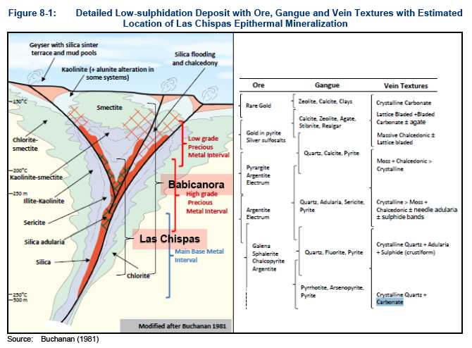
Low sulphidation gold-silver epithermal systems commonly precipitate gold from hydrothermal fluids in near surface hot spring environments. The mechanism most commonly evoked for gold precipitation is boiling. As pressure decreases in fluid rising to the surface, boiling occurs. The physical and chemical changes that accompany boiling cause breakdown of the gold-bearing chemical complexes and result in gold precipitation. Because pressure from the overlying fluid column or rock column constrains the level at which boiling occurs, the location of the boiling zone commonly lies within a particular vertical range. However, this depth can change significantly with changes in the water table, sealing of the system, burial of the system through deposition of volcanic rocks, or emergence due to tectonic uplift. The boiling zone is typically within 500 m and rarely more than 1 km of the surface at the time of mineralization.
| 8.2 | Intermediate Sulphidation |
Intermediate sulphidation epithermal systems are less common but share some characteristics of both the high and the low types. Like the high-sulphidation types, they also occur in mainly in volcanic sequences of andesite to dacite composition within volcanic arcs.
Like the low-sulphidation systems, the mineralization normally occurs in veins, stockworks and breccias. The veins can be rich in quartz, with manganiferous carbonates like manganese-rich calcite or rhodochrosite plus adularia, which typically hosts the gold mineralization. Gold is present as the native metal but is also found as tellurides and in a variety of gold-rich base metal sulphides and sulfosalts. Low iron sphalerite, tetrahedrite-tennantite and galena often are the dominant sulphide minerals. The overall sulphide content of the deposits is in the range of 5 to 20 percent by volume.
| 8-2 | |
| TECHNICAL REPORT AND MINERAL RESOURCE ESTIMATE FOR THE LAS CHISPAS PROPERTY, SONORA, MEXICO |
| 704-ENG.VMIN03016-05 | MAY 2019 | ISSUED FOR USE |
Alteration consists of a mixture of high- and low-sulphidation assemblages that may overprint one another depending on the evolution of the fluids. Silica (vuggy), advance argillic (alunite, pyrophyllite, diaspore, dickite, and sericite), argillic (kaolinite), anhydrite, barite, sericite, illite, and adularia may be present or absent within the system (Figure 8-2).
Permeable host rocks within the deposit may allow the mineral fluids to form a large tonnage of low-grade, bulk-minable stockwork mineralization (Ralf 2017).
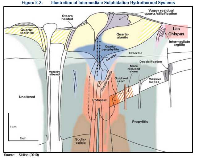
| 8-3 | |
| TECHNICAL REPORT AND MINERAL RESOURCE ESTIMATE FOR THE LAS CHISPAS PROPERTY, SONORA, MEXICO |
| 704-ENG.VMIN03016-05 | MAY 2019 | ISSUED FOR USE |
| 9.0 | EXPLORATION |
Before SilverCrest acquired the Las Chispas Property in 2015, no drilling had been completed on the northwest to southeast mineralized trend which contains the Las Chispas and Babicanora Areas. This trend is approximately 2.5 km long and 3.5 km wide.
SilverCrest exploration began work on the Property in February 2016 with a primary focus on the Las Chispas, William Tell, and Babicanora Veins. From February to November 2016, the Phase I exploration program consisted of initial drilling, surface and underground mapping and sampling, and rehabilitating an estimated 6 km of underground workings. Drilling of 22 holes during Phase I is described in the following subsections.
From November 2016 to February 2018, the Phase II exploration program consisted of drilling, additional surface and underground mapping and sampling, further rehabilitation of 4 km of underground workings, plus auger and trenching of approximately 174,500 tonnes in 42 surface historic waste dumps. Drilling of 161 additional holes during Phase II is described in the following subsections.
Phase III exploration program commenced in February 2018 and is currently ongoing as of the effective date of this report. From February 2018 to February 2019, the Phase III exploration program consisted of drilling, additional surface and underground mapping and sampling, and finalizing approximately 11 km of underground rehabilitation, a majority of which is located on the Las Chispas Vein and historic mine. Drilling of 256 additional holes during Phase III is described in the following subsections.
| 9.1 | Underground Exploration |
Initial access to the underground historical workings, the majority located in the Las Chispas (Historic Vein) Mine, commenced with an underground rehabilitation program in February 2016. Rehabilitation included removal of backfill, construction of a network of bridges and ladders across open stopes, installation of safety cables, removal of obstructions and unsafe overhead supports, construction of new overhead supports, rough rock scaling, and development of a control survey (Figure 9-1). As of the effective date of this report, SilverCrest estimates that approximately 11.0 km of underground workings has been rehabilitated with work nearly complete (Figure 9-2).
As part of the rehabilitation program, an underground mapping and sampling program began in February 2016. Collection of a series of select chip samples was followed by a systematic and continuous saw cut channel sampling program along the rehabilitated underground workings. Samples were collected perpendicular to mineralization as transverse samples and as longitudinal samples along footwall or hanging wall contacts through stopes. More than 8,984 chip and channel samples have been collected as of the effective date of this report. Of these, 1,094 sample results graded above a cut-off of 150 gpt AgEq with averages of 4.05 gpt Au and 504.4 gpt Ag, or 807 gpt AgEq. There were an additional 140 underground channel samples taken from Feb 2018 to Feb 2019 in the Las Chispas area; these samples have not been reviewed by a QP and have not been incorporated into this updated resource report.
A total of 94 samples have been collected from historical underground and backfill muck at Las Chispas, grading in average 2.1 gpt Au and 256 gpt Ag, or 414 gpt AgEq.
Table 9-1 shows summary statistics of underground chip and channel sampling for the Las Chispas workings, Table 9-2 shows other workings in the Las Chispas Area, and Table 9-3 shows workings in the northwest portion of the Babicanora Area.
| 9-1 | |
| TECHNICAL REPORT AND MINERAL RESOURCE ESTIMATE FOR THE LAS CHISPAS PROPERTY, SONORA, MEXICO |
| 704-ENG.VMIN03016-05 | MAY 2019 | ISSUED FOR USE |
| Table 9-1: | Las Chispas Vein–Significant Channel Sampling Results |
| Las Chispas | Mean Au | Mean Ag | Mean AgEq(1) |
| 200L | 0.050 | 7.4 | 11.1 |
| 300L | 1.008 | 141.0 | 216.6 |
| 350L | 2.329 | 333.2 | 507.9 |
| 400L | 1.688 | 266.2 | 392.8 |
| 450L | 3.237 | 439.9 | 682.6 |
| 500L | 2.549 | 336.6 | 527.8 |
| 550L | 1.784 | 256.1 | 389.9 |
| 600L | 0.410 | 57.6 | 88.3 |
| 700L | 0.121 | 15.5 | 24.5 |
| 743L | 0.615 | 118.2 | 164.3 |
| Average | 0.903 | 131.4 | 199.17 |
| Number of Samples | 3,923 | 3,923 | 3,923 |
| Maximum Value | 136 | 10,000 | 20,200 |
| Minimum Value | 0.002 | 0.2 | 0.575 |
| Standard Deviation | 3.713 | 444.5 | 704.0 |
| Number of Samples >150 AgEq | 805.0 |
Note: | (1)AgEq is based on 75 (Ag):1 (Au), calculated using long-term silver and gold prices of US$18.50/oz silver and US$1,225/oz gold, with average metallurgical recoveries of 86.6% silver and 98.9% gold. |
| Table 9-2: | Las Chispas Area, Other Vein Targets–Significant Channel Sampling Results |
| Las Chispas | Mean Au | Mean Ag | Mean AgEq* |
| El Erick | 1.85 | 117.8 | 256.4 |
| El Sheik | 1.16 | 75.8 | 162.8 |
| Espiritu Santo | 0.02 | 11.2 | 12.4 |
| Lupena | 0.45 | 39.4 | 73.0 |
| Varela | 0.22 | 26.5 | 43.1 |
| WT500L | 1.05 | 62.8 | 141.4 |
| WT600L | 1.29 | 145.8 | 242.4 |
| Average | 0.91 | 73.9 | 142.0 |
| Number of Samples | 1,292 | 1,292 | 1,292 |
| Maximum Value | 52.2 | 3,220 | 5,455 |
| Minimum Value | 0.01 | 0.2 | 0.0 |
| Standard Deviation | 3.44 | 221.4 | 431.1 |
| Number of Samples >150 AgEq | 237 |
Note: | (1)AgEq is based on 75 (Ag):1 (Au), calculated using long-term silver and gold prices of US$18.50/oz silver and US$1,225/oz gold, with average metallurgical recoveries of 86.6% silver and 98.9% gold. |
| 9-2 | |
| TECHNICAL REPORT AND MINERAL RESOURCE ESTIMATE FOR THE LAS CHISPAS PROPERTY, SONORA, MEXICO |
| 704-ENG.VMIN03016-05 | MAY 2019 | ISSUED FOR USE |
| Table 9-3: | Babicanora Area, Other Vein Targets–Significant Channel Sampling Results |
| Las Chispas | Mean Au | Mean Ag | Mean AgEq(1) |
| Babicanora | 0.41 | 26.1 | 56.6 |
| Babicanora de abajo | 0.07 | 7.7 | 12.6 |
| Bertina | 0.08 | 4.6 | 10.9 |
| Buena Vista | 0.03 | 7.1 | 9.1 |
| El Muerto | 0.62 | 33.4 | 80.1 |
| Jabali | 0.15 | 10.3 | 21.9 |
| Sementales | 0.49 | 18.7 | 55.0 |
| Average | 0.31 | 16 | 39 |
| Number of Samples | 756 | 756 | 756 |
| Maximum Value | 20.80 | 821.0 | 2,381 |
| Minimum Value | 0.01 | 0.2 | 1.0 |
| Standard Deviation | 1.22 | 51.9 | 135.8 |
| Number of Samples >150 AgEq | 52 |
Note: | (1)AgEq is based on 75 (Ag):1 (Au), calculated using long-term silver and gold prices of US$18.50/oz silver and US$1,225/oz gold, with average metallurgical recoveries of 86.6% silver and 98.9% gold. |
![]()
| 9-3 | |
| TECHNICAL REPORT AND MINERAL RESOURCE ESTIMATE FOR THE LAS CHISPAS PROPERTY, SONORA, MEXICO |
| 704-ENG.VMIN03016-05 | MAY 2019 | ISSUED FOR USE |

| 9-4 | |
| TECHNICAL REPORT AND MINERAL RESOURCE ESTIMATE FOR THE LAS CHISPAS PROPERTY, SONORA, MEXICO |
| 704-ENG.VMIN03016-05 | MAY 2019 | ISSUED FOR USE |
9.1.1 Underground Surveying
A network of control points was first established by a SilverCrest surveying crew once accesses to workings had been rehabilitated and secured. Control points were established at approximately 15 m intervals using portable drills, survey chains, distance lasers, and a handheld Brunton compass. The control network was then re-surveyed by Precision GPS, with professional surveying crew using a Trimble VX Total Station on level 600 to level 150. The center line of each drift was collected, this included a data set of 178 points. The purpose of this survey was to adjust the tape and Brunton survey completed by the SilverCrest staff. This underground control network is the base reference for all underground sampling and drilling activities.
| 9.2 | Surface Exploration |
Surface exploration has focused on geological mapping and delineation of the numerous historical shafts and portals present across the Property. As of the effective date, a total of 8.0 km2have been mapped by SilverCrest geologists.
Surface dump augering, trenching, and sampling has been completed. Analytical results received as of the effective date of this report total 1,340 surface dump samples, averaging 1.12 gpt Au and 106.6 gpt Ag, or 185 AgEq. Select grades from the dump sampling range up to 4,548 gpt AgEq. The mapping data is georeferenced and being used to develop a geographic information system (GIS) database for Las Chispas.
In 2017, historical waste dumps were sampled by a trenching and auger program to collect data, identify dump volumes, and calculate precious metal grades. Data was collected from field measurements using a GPS and trenching rock and sediment material in the dumps. The dumps were later surveyed between December 14, 2017 and January 26, 2018 using a Trimble Spectra Total Station Model TS-415. Samples were sent to ALS Chemex in Hermosillo, Mexico for preparation and then sent to its Northern Vancouver lab for analysis of gold and silver.
In total, 41 dumps at 20 locations within the Las Chispas Property were sampled by an auger or trenching process between July 2017 and January 2018. Table 9-4 summarizes the dump names are Figure 9-2 shows the locations.
| Table 9-4: | List of Surface Stockpiles (Dumps, Muck and Tailing) Mapped on the Las ChispasProperty |
| Dump Name | Sample Style |
| North Chispas 1, 2 | Trench |
| La Capilla (LCA), tailings | Auger |
| San Gotardo (LCD) | Trench |
| Lupena (LUP) | Trench |
| El Eric | Trench |
| Locarno 1, 2, 3, 4 | Trench |
| Las Chispas 1, 2, 3 (LCH) | Trench |
| La Central | Trench |
| Maria | Trench |
| Chiltepines 1, 2, 3 | Trench |
| table continues… |
| 9-5 | |
| TECHNICAL REPORT AND MINERAL RESOURCE ESTIMATE FOR THE LAS CHISPAS PROPERTY, SONORA, MEXICO |
| 704-ENG.VMIN03016-05 | MAY 2019 | ISSUED FOR USE |
| Dump Name | Sample Style |
| La Providenca 1, 2, 3 | Trench |
| Espiritu Santo 1, 2 | Trench |
| La Blanquita 1, 2 | Trench |
| La Curva 1, 2 | Trench |
| La Bertina 1, 2 | Trench |
| El Muerto 1, 2 | Trench |
| Sementales 1, 2 | Trench |
| Buena Vista 1. 2, 3 | Trench |
| Babicanora 1, 2 | Trench |
| El Cruce 1, 2, 3 | Trench |
| Total | 41 |
To initially determine the feasibility of evaluating historical dumps, an auger program was tested in July 2017. Auger drilling was only found to be useful for one dump (La Capilla tailings), due to problems occurring with large rocks and low recovery. A standard mechanical gas-powered auger was used to complete the auger program.
The auger program began by setting up the base grid lines with a north-south direction near the center of a dump. First, a compass, a GPS, and tape were used to mark a hole, then flag and tag it with 10 m between each flag. Depending on the site’s size, a specific number of gridlines were placed running parallel east-west, 10 m away from the base gridline. Second, a tripod was situated over the surface of a flagged hole and a pulley attached at the top. Next, the standard penetration test equipment was aligned at the tripod’s center and the initial hole within 1 m proximity to the flagging. Two personnel man the sampler and one on the capstan, to drive the sampler into the soil surface and down until either the sampler hits a fixed depth of 1 m or it until it cannot gain depth. If a rock prevents downward movement of the auger, it must either drill down by uplifting it or pushing it into the wall, or the piercer can be used to pulverize the rock. Once a fixed depth or bedrock reached, the sampler is pulled up to the surface placing the contents on a tarp to spread and homogenize the mixture. Each interval was bagged with the hole ID and interval. The process of three personnel manning the sampler and capstan was repeated at 1 m interval depths.
In 2016 and early 2017, initial testing of waste dump material was completed by hand cut trenches for sample collection. Trenches were hand excavated to approximately 0.5 m in the face of dumps with collection of samples every 1 m down strike. This program identified that most dump had significant precious metals that warranted further evaluation.
From mid-2017 to January 2018, mechanical trenching was completed on all accessible historic dumps. A backhoe with used to dig trenches approximately 1.5 m deep and pile materials next to the trench for sampling and description. Samples were collected with and approximate weight of 3 to 5.0 kilograms. Samples were labelled with an interval ID, GPS coordinate, and depth recorded. The backhoe continued to work on an interval until either the soil was reached, or the walls collapsed into the trench. The removal process repeats until the backhoe reached the marked end of the trench. Additionally, a supervisor analyzed the piles for quartz percentage, historical trash, and describing the grain size and rock type.
| 9-6 | |
| TECHNICAL REPORT AND MINERAL RESOURCE ESTIMATE FOR THE LAS CHISPAS PROPERTY, SONORA, MEXICO |
| 704-ENG.VMIN03016-05 | MAY 2019 | ISSUED FOR USE |

| 9-7 | |
| TECHNICAL REPORT AND MINERAL RESOURCE ESTIMATE FOR THE LAS CHISPAS PROPERTY, SONORA, MEXICO |
| 704-ENG.VMIN03016-05 | MAY 2019 | ISSUED FOR USE |
| 9.3 | Phase III Surface Geological Mapping and Lithology Model |
SilverCrest initiated a comprehensive surface mapping and drill core relogging program in November 2018 to support development of a detailed stratigraphic section and three-dimensional lithological model across the Babicanora and Las Chispas Areas. The work resulted in improved understanding of the regional structure and local structures, location of various intrusive phases, and understanding of the relationship between host rock lithology with mineralization styles observed in drill core. The three-dimensional model is being used to drive exploration targeting in areas not previously considered:
| • | deep targets under Las Chispas and Babicarona area related to specific lithology host rocks and cross structures |
| • | Chiltepin Area, northeast of the Las Chispas Area |
| • | La Victoria Vein mineralization within respect to host lithologies |
| • | Babicanora Sur southeast high-grade extension with respect to host lithologies |
| • | mineralization along the Babicanora Ring structure and rhyolite/andesite dikes. |
| 9.4 | Exploration Decline in the Babicanora Vein |
SilverCrest has permitted and intends to develop a 600 m exploration decline into Shoot 51 of the Babicanora Vein in Area 51 to enable access to the vein for bulk sampling and to conduct underground infill drilling. As of the effective date of this Technical Report the portal for the decline had not yet been established.
| 9.5 | Aerial Drone Topographic Survey |
On February 7th, 2019, an aerial drone survey was initiated to collect a Light Detection and Ranging (LiDar) survey for the Las Chispas Property using a MD4-1000 drone with a LiDar module. The work was being completed by Precision GPS from Hermosillo, MX and is ongoing as of the effective date of this Technical Report.
| 9-8 | |
| TECHNICAL REPORT AND MINERAL RESOURCE ESTIMATE FOR THE LAS CHISPAS PROPERTY, SONORA, MEXICO |
| 704-ENG.VMIN03016-05 | MAY 2019 | ISSUED FOR USE |
| 10.0 | DRILLING |
| 10.1 | Program Overview |
SilverCrest completed drilling during their Phase I and Phase II drilling programs. The Phase III exploration and delineation program is ongoing. Since March 2016, drilling completed from surface and underground totals 117,057.65 m in 439 drill holes.
The Phase I drill program targeted near surface mineralization, lateral extensions of previously mined areas, and potential deep extensional mineralization proximal to the historical workings. The Phase II drill program focused on extensive surface drilling at Las Chispas, Babicanora, William Tell, and Giovanni veins and on underground drilling at Las Chispas and Babicanora veins. The Phase III drill program has focused on extensive surface drilling at Babicanora, Babicanora FW, Babicanora HW, Babicanora Norte, Babicanora Sur, Granaditas, Luigi, and Giovanni veins and underground drilling at Las Chispas veins. Table 10-1 summarizes the drilling programs.
| Table 10-1: | Summary of Sampling Completed by SilverCrest (Inception to February 12, 2019) |
Drill Location | Number of Drill holes | Length Drilled (m) | Number of Samples | Length of Samples (m) | |
| Phase I | |||||
| Las Chispas(1) | Surface | 19 | 5,461.40 | 3,516 | 5,243.10 |
| La Victoria | Surface | 3 | 931.20 | 711 | 924.00 |
| Subtotal | 22 | 6,392.60 | 4,227 | 6,167.10 | |
| Phase II | |||||
| Las Chispas(1) | Surface | 54 | 14,123.95 | 10,395 | 11,233.30 |
| Underground | 21 | 1,992.90 | 1,782 | 1,780.20 | |
| Babicanora(2) | Surface | 70 | 21,137.60 | 8,876 | 9,781.60 |
| Underground | 14 | 1,446.70 | 1,252 | 1,415.40 | |
| Granaditas | Surface | 2 | 653.45 | 594 | 653.50 |
| Subtotal | 161 | 39,354.60 | 22,899 | 24,864.00 | |
| Phase III (up to September 2018) | |||||
| Las Chispas(1) | Surface | 4 | 1,176.90 | 831 | 907.30 |
| Underground | 7 | 622.80 | 526 | 562.40 | |
| Babicanora | Surface | 22 | 9,508.75 | 1,815 | 1,930.60 |
| Granaditas | Surface | 23 | 7,144.80 | 5,978 | 6,037.20 |
| Babicanora Norte | Surface | 40 | 11,810.70 | 7,233 | 7,767.90 |
| Babi Sur | Surface | 7 | 3,069.30 | 967 | 995.30 |
| table continues… | |||||
| 10-1 | |
| TECHNICAL REPORT AND MINERAL RESOURCE ESTIMATE FOR THE LAS CHISPAS PROPERTY, SONORA, MEXICO |
| 704-ENG.VMIN03016-05 | MAY 2019 | ISSUED FOR USE |
Drill Location | Number of Drill holes | Length Drilled (m) | Number of Samples | Length of Samples (m) | |
| Ranch | Surface | 10 | 3,305.80 | 1,856 | 2,105.30 |
| Well | Surface | 12 | 1,103.00 | 623 | 952.90 |
| Subtotal | 125 | 37,742.05 | 19,829 | 21,259.00 | |
| Phase III (up to February 2019) | |||||
| Las Chispas(1) | Underground | 12 | 1,576.80 | 960 | 1,008.60 |
| Babicanora(2) | Surface | 52 | 17,075.40 | 5,328 | 5,676.10 |
| Underground | 10 | 1,078.50 | 770 | 879.60 | |
| Babicanora Norte | Surface | 18 | 3,884.10 | 1,853 | 2,241.80 |
| Underground | 3 | 1,147.20 | 702 | 783.80 | |
| Babi Sur | Surface | 32 | 8,160.40 | 3,749 | 4,382.90 |
| Ranch | Surface | 4 | 646.00 | 360 | 393.40 |
| Subtotal | 131 | 33,568.40 | 13,722 | 15,366.00 | |
| Total | 439 | 117,057.65 | 60,677 | 67,656.00 |
| Notes: | (1)Las Chispas Area totals include some re-drilled holes and holes drilled at Las Chispas, William Tell, Giovanni, Giovanni Mini, La Blanquita, La Varela, Luigi, and other unnamed veins in the Las Chispas Area. |
(2)Babicanora Area totals include holes drilled at Babicanora, Babicanora FW, Babicanora HW, Amethyst Vein, and other unnamed veins in the Babicanora Area. |
The Phase I drilling program commenced in March 2016 and was completed in October 2016. This phase included the completion of 22 surface drill holes totaling 6,392.6 m. This drilling program targeted 19 holes on the Las Chispas and William Tell areas near to and along strike of the historical workings extension (drill holes up to LC16-19), and 3 holes on the La Victoria showing located to the south of Babicanora (drill holes LV16-01 to -03).
The Phase II drilling program commenced in November 2016 and was completed in February of 2018. The program included the completion of 161 drill holes totaling 39,354.60 m; 126 drill holes totaling 35,915.0 m of surface drilling and 35 drill holes totaling 3,439.6 m of underground drilling. This drilling program focused on testing unmined portions of the Las Chispas Vein, delineation of the Giovanni; Giovanni Mini, La Blanquita, and other unnamed veins, in addition to exploration of the La Varela veins, all within the Las Chispas Area (drill holes ending LC18-73 and LCU18-20). Drilling at Babicanora focused on delineating the down plunge and vertical extents of the Babicanora Vein, in addition to exploratory drilling on the Amethyst Vein and the Granaditas Target, all within the Babicanora Area (drill holes ending BA18-69 and UB17-13).
The Phase III drilling program commenced in February 2018 and was ongoing and included in the previous Technical Report (Fier 2018). This included 125 drill holes totaling 37,742.01 m; 118 drill holes totaling 37,119.21 m of surface drilling and 7 drill holes totaling 622.8 m of underground drilling. These holes focused on the Babicanora Area to delineate the up and down mineralized plunge to the southeast and vertical extents of the Babicanora, Babicanora HW, and Babicanora FW veins (up to drill holes BA18-91, BAN18-40) and exploratory drilling on the Babicanora Norte Vein (up to drill hole BAN18-40) and Babicanora Sur vein (up to drill hole BAS18-07). Additional infill drilling was completed in the Las Chispas Area on the Giovanni veins and Luigi Vein (up to drill holes LC18-77 and LCU18-29). Exploratory drilling was conducted at Granaditas (up to drill hole GR18-19), the Ranch area (up to drill hole GR18-09), in addition to 12 groundwater test holes.
| 10-2 | |
| TECHNICAL REPORT AND MINERAL RESOURCE ESTIMATE FOR THE LAS CHISPAS PROPERTY, SONORA, MEXICO |
| 704-ENG.VMIN03016-05 | MAY 2019 | ISSUED FOR USE |
Drilling in the Phase III program has continued since September 2018 and was ongoing as of the effective date of this Technical Report. Drilling completed during this part of Phase III included 131 surface drill holes totaling 33,568.25 m; 106 drill holes totaling 29,765.8 m of surface drilling and 25 drill holes totaling 3,802.5 m of underground drilling. Infill, delineation, and expansion drilling was prioritized in the Babicanora, Babicanora HW and Babicanora FW in the Shoot 51 area, Babicanora Norte, and Babicanora Sur veins. Some additional exploration drilling near the Ranch and Luigi veins was also conducted.
Table 10-1 and Figure 10-1 provide a summary of drilling. Surface collar locations were initially surveyed using a handheld GPS unit, then professionally surveyed by local contractor. The most recent surface survey was done by external consultant David Chavez Valenzuela in October of 2018. This survey was done using a GNSS Acnovo GX9 UHF. The purpose of this survey was to survey surface drill hole collars, additional roads, and more detail on the Property boundaries.
Underground collars were surveyed using the underground control points established for each of the workings, which were professionally surveyed. All holes were surveyed as single shot measurements with a Flex-it® tool starting at 15 m with measurements at every 50 m to determine deviation. The survey measurements were monitoring for significant magnetic interference from the drill rods that would prevent accurate readings.
| 10-3 | |
| TECHNICAL REPORT AND MINERAL RESOURCE ESTIMATE FOR THE LAS CHISPAS PROPERTY, SONORA, MEXICO |
| 704-ENG.VMIN03016-05 | MAY 2019 | ISSUED FOR USE |
![]()
| 10-4 | |
| TECHNICAL REPORT AND MINERAL RESOURCE ESTIMATE FOR THE LAS CHISPAS PROPERTY, SONORA, MEXICO |
| 704-ENG.VMIN03016-05 | MAY 2019 | ISSUED FOR USE |
| 10.2 | Drilling Results |
10.2.1 Phase I
During the Phase 1 program, 4,227 core samples totaling 6,167.1 m were collected and assayed. The program targeted the historical Las Chispas Vein to verify location of the vein and existence of mineralization along trend of mapped historical workings. All drill holes intercepted quartz stockwork veinlets, veining and/or breccia, along with variable amounts of gold and silver mineralization. The results confirmed the historic mineralized structure and suggested that relatively unexplored and unmined areas exist proximal to the historic workings. Hole LC16-05 intercepted 4.6 m (true width) at 4.56 gpt gold and 622 gpt silver, or 963 gpt AgEq, in a breccia. The intersection is near the location of an underground channel sampling grading 1,163 gpt AgEq over 8 m in vein strike length and 1 m true width.
Additional drilling targeted the William Tell Vein, which intercepted the mineralized structure in four of seven holes with grades greater than 400 gpt AgEq over estimated true widths of 0.8 to 1.5 m.
The 2016 program also included three holes (LV16-01, LV16-02, and LV16-03) in the La Victoria Area, located 800 m southwest of the Babicanora Vein. These holes intersected only low-grade mineralization.
Significant results for this drilling were reported in the Qualifying Report for Las Chispas (Barr 2016), with effective date September 15, 2016, prepared by James Barr, P. Geo, independent QP, and Senior Geologist and Team Lead with Tetra Tech.
10.2.2 Phase II
During the Phase II program, 22,899 core samples totaling 24,864.0 m were collected and assayed. The program targeted delineation and expansion of known vein targets at Las Chispas, William Tell, and Babicanora and tested new targets, such as La Varela, La Blanquita, Granaditas, and Amethyst veins. Table 10-2 presents significant drill hole intercepts for these areas.
Significant results for this drilling were reported in Barr (2018).
10.2.3 Phase III
To date, 33,551 core samples totaling 36,625.1 m have been collected and assayed during the Phase III program, to the period ending February 8, 2019. The program has targeted delineation and expansion of known vein targets in the Babicanora including Area 51, Babicanora HW, Babicanora FW, Babicanora Norte, and Babicanora Sur veins in addition to the Giovanni vein. Newly tested targets for the Phase III program include the Babicanora Norte, Babicanora Sur, Granaditas, Luigi, and Ranch veins.Table 10-2 presents the intercepts for these areas.
10.2.3.1 Babicanora
Expansion and delineation of Babicanora during Phase III focused in the Babicanora Vein surface drilling in the southeast portion of the vein, mainly to delineate Shoot 51, a high-grade subarea of Area 51. This drilling was accessed via a high-elevation road from the ridge crest permitting drill access to the vein from the hanging wall side. Numerous high-grade intercepts were made in this area previously defined as Area 51 including BA18-122 with an estimated true thickness of 9.3 m grading at 39.66 gpt gold and 3,361 gpt silver, or 6,336 gpt AgEq (Table 10-2). Figure 10-2 shows the Babicanora long section with distribution of drill hole pierce points, high-grade footprint (Precious Metal Zone), and location of the Shoot 51. Figure 10-3 shows a plan view of Level 1,130 (masl) with the Babicanora, Babicanora FW, and Babicanora HW veins shape as modelled for Mineral Resource Estimation along with drill hole traces on this level and select mineralized intercepts.
| 10-5 | |
| TECHNICAL REPORT AND MINERAL RESOURCE ESTIMATE FOR THE LAS CHISPAS PROPERTY, SONORA, MEXICO |
| 704-ENG.VMIN03016-05 | MAY 2019 | ISSUED FOR USE |
Drilling has established good lithological control on the upper portion of the Shoot 51 Zone where welded RDCLF overlies a more permeable lapilli tuff, which is host to the highest-grade mineralization. Mineralization transects the contact; however, it is reduced in both thickness and grade due to permeability contrasts between the lapilli and welded tuff unit. The orientation of this lithological contact appears to be a controlling feature on the southeast directed plunge of mineralization within the Babicanora Vein. A lower boundary is less defined and the target of ongoing drilling in this area.
10.2.3.2 Babicanora Foot Wall Vein
The Babicanora FW Vein is immediately adjacent to the Babicanora Vein and was discovered at the same time in late 2017. This vein was drill tested at the same time as the Babicanora Vein. This vein can be observed underground in the Babicanora adit and on surface in select locations. Hole BA18-122 intercepted 0.7 m with an estimated true thickness of 0.5 m grading 17.6 gpt gold, 2110 gpt silver, and 3,430 gpt AgEq.
10.2.3.3 Babicanora Norte
Surface drilling commenced on the Babicanora Norte Vein in March 2018 and was discovered on the second drill hole, BAN18-02. The vein is located near the portal of the Babicanora adit and projects under historical waste dumps. Initial drilling was directed 50 m below a shallow shaft where the high-grade vein was intercepted. After discovery, the Babicanora Norte Vein was systematically drilled to the northwest and southeast along vein strike. Numerous high-grade intercepts were made from step-out drilling, including the most significant in hole BAN18-10with an estimated true thickness of 2.2 m grading at 61.36 gpt gold and 2,833.5 gpt silver, or 7,436 gpt AgEq.
In contrast to the Babicanora Vein, the Babicanora Norte Vein is hosted in welded RDCLF as a discordant extensional vein of consistent width and sharp contacts with host rock. Current interpretation of drilling results has identified a flexure in the Babicanora Norte Vein with change in orientation from 160º degrees azimuth in the northwestern portion to 125° azimuth in the central. This flexure may represent an intersection of regional structural trends and is a target for further drill testing in the area.
10.2.3.4 Babicanora Sur
The Babicanora Sur Vein is located approximately 300 m southwest and is oriented roughly parallel to the Babicanora Vein. Drilling commenced on Babicanora Sur in the southeast portion of the Property based on availability and access of surface drill rigs on roads constructed in the Babicanora Area. Progress of delineating the vein will continue throughout the Phase III program as surface access is constructed to the northwest. Drill sampling highlights in the area include drill hole BAS18-31 with an estimated true thickness of approximately 2.2 m grading 18.78 gpt gold and 2,147 gpt silver, or 3,556 gpt AgEq.
To date, interpretation of drilling results indicates that mineralization in the vein is comprised of three subvertical shoots; however, insufficient infill drilling has been conducted along the full strike of the vein to confirm this.
10.2.3.5 Granaditas
The Granaditas Vein is parallel to the Babicanora and Babicanora Norte veins and consists of southeastward plunging high-grade mineralization similar to the adjacent Babicanora and Babicanora Norte veins. Drilling during Phase III has focused on delineating the high-grade footprint that included drill hole GR18-04 with an estimated true thickness of 1.8 m grading at 12.14 gpt gold and 1,440.3 gpt silver, or 2,350 gpt AgEq.
| 10-6 | |
| TECHNICAL REPORT AND MINERAL RESOURCE ESTIMATE FOR THE LAS CHISPAS PROPERTY, SONORA, MEXICO |
| 704-ENG.VMIN03016-05 | MAY 2019 | ISSUED FOR USE |
10.2.3.6 Luigi
The Luigi Vein was discovered in the footwall of the Las Chispas Vein in mid-2017, but it remained unnamed until there was enough drilling to delineate an actual mineral vein. The Phase III program has focused on delineating the vein through underground drilling on the 550 and 600 Level of the historic Las Chispas workings.
10.2.3.7 Ranch Area
Surface drilling commenced in the Babicanora Ranch area during Phase III with thirteen holes to accomplish condemnation drilling in the surrounding area for potential processing facilities.
10.2.3.8 Espiritu Santo
The Espiritu Santo workings are located to the southeast of the Las Chispas Vein and William Tell Vein. Drilling during phase III targeted the two adits and a shaft in this area with a total of three holes completed.
| 10-7 | |
| TECHNICAL REPORT AND MINERAL RESOURCE ESTIMATE FOR THE LAS CHISPAS PROPERTY, SONORA, MEXICO |
| 704-ENG.VMIN03016-05 | MAY 2019 | ISSUED FOR USE |
![]()
| 10-8 | |
| TECHNICAL REPORT AND MINERAL RESOURCE ESTIMATE FOR THE LAS CHISPAS PROPERTY, SONORA, MEXICO |
| 704-ENG.VMIN03016-05 | MAY 2019 | ISSUED FOR USE |
![]()
| 10-9 | |
| TECHNICAL REPORT AND MINERAL RESOURCE ESTIMATE FOR THE LAS CHISPAS PROPERTY, SONORA, MEXICO |
| 704-ENG.VMIN03016-05 | MAY 2019 | ISSUED FOR USE |
| Table 10-2: | Las Chispas Most Significant Drill Hole Results for Recent Phase III (September2018 to February 2019(3,4,5,) |
Vein | Hole No. | From (m) | To (m) | Drilled Width (m) | Est. True Width (m) | Au (gpt) | Ag (gpt) | AgEq* (gpt) |
| Babicanora | BA18-93 | 300.5 | 304.6 | 4.1 | 3.8 | 6.78 | 1,091 | 1,599 |
| Babicanora | incl. | 302.4 | 304.6 | 2.2 | 2.0 | 8.97 | 1,505 | 2,177 |
| Babicanora | BA18-94 | 307.4 | 312.0 | 4.6 | 3.5 | 33.06 | 2,092 | 4,570 |
| Babicanora | incl. | 310.2 | 311.3 | 1.1 | 0.8 | 80.65 | 6,573 | 12,622 |
| Babicanora | BA18-95 | 294.0 | 308.2 | 14.2 | 11.1 | 3.99 | 580 | 879 |
| Babicanora | incl. | 296.0 | 298.7 | 2.7 | 2.1 | 8.01 | 1,250 | 1,850 |
| Babicanora | incl. | 303.1 | 304.2 | 1.1 | 0.9 | 25.50 | 2,381 | 4,293 |
| Babicanora | BA18-96 | 200.2 | 214.4 | 14.1 | 9.9 | 14.40 | 2,132 | 3,212 |
| Babicanora | incl. | 204.1 | 210.5 | 6.4 | 4.5 | 30.28 | 4,498 | 6,769 |
| Babicanora | incl. | 208.5 | 209.5 | 1.0 | 0.7 | 102.15 | 12,757 | 20,418 |
| Babicanora | BA18-97 | 294.0 | 296.0 | 2.0 | 1.5 | 2.52 | 454 | 643 |
| Babicanora | incl. | 294.0 | 295.0 | 1.0 | 0.7 | 4.57 | 821 | 1,164 |
| Babicanora | BA18-110 | 370.0 | 373.6 | 3.7 | 3.3 | 3.72 | 451 | 730 |
| Babicanora | incl. | 373.1 | 373.6 | 0.6 | 0.5 | 14.55 | 1,640 | 2,731 |
| Babicanora | BA18-112 | 205.9 | 206.6 | 0.7 | 0.6 | 0.65 | 174 | 223 |
| Babicanora | BA18-113 | 137.2 | 140.4 | 3.3 | 2.9 | 1.08 | 365 | 445 |
| Babicanora | BA18-114 | 289.0 | 293.2 | 4.2 | 3.0 | 5.37 | 998 | 1,401 |
| Babicanora | incl. | 291.1 | 292.2 | 1.1 | 0.8 | 11.95 | 1,860 | 2,756 |
| Babicanora | incl. | 309.1 | 311.2 | 2.1 | 1.5 | 2.49 | 226 | 413 |
| Babicanora | BA18-115 | 172.7 | 177.4 | 4.7 | 4.3 | 0.73 | 149 | 204 |
| Babicanora | BA18-116 | 318.9.0 | 321.6 | 2.8 | 2.4 | 4.30 | 1,572 | 1,894 |
| Babicanora | incl. | 320 | 320.8 | 0.8 | 0.7 | 6.38 | 4,160 | 4,639 |
| Babicanora | BA18-118 | 219.6 | 226.1 | 6.5 | 4 | 0.5 | 211 | 249 |
| Babicanora | BA18-119 | 351.8 | 352.3 | 0.5 | 0.4 | 0.78 | 106 | 164 |
| Babicanora | incl. | 362.6 | 364.1 | 1.5 | 1.2 | 5.44 | 774 | 1,182 |
| Babicanora | BA18-120 | 185.8 | 195.0 | 9.2 | 8.6 | 0.98 | 409 | 483 |
| Babicanora | BA18-122 | 194.3 | 207.5 | 13.2 | 9.3 | 39.66 | 3,361 | 6,336 |
| Babicanora | incl. | 194.3 | 194.8 | 0.5 | 0.4 | 252.00 | 9,740 | 28,640 |
| Babicanora | incl. | 198.9 | 200.2 | 1.3 | 0.9 | 92.70 | 7,570 | 14,522 |
| Babicanora | incl. | 205.4 | 206.0 | 0.6 | 0.4 | 47.30 | 7,760 | 11,307 |
| Babicanora | incl. | 224.8 | 226.8 | 1.9 | 1.4 | 6.01 | 722 | 1,173 |
| table continues… | ||||||||
| 10-10 | |
| TECHNICAL REPORT AND MINERAL RESOURCE ESTIMATE FOR THE LAS CHISPAS PROPERTY, SONORA, MEXICO |
| 704-ENG.VMIN03016-05 | MAY 2019 | ISSUED FOR USE |
Vein | Hole No. | From (m) | To (m) | Drilled Width (m) | Est. True Width (m) | Au (gpt) | Ag (gpt) | AgEq* (gpt) |
| Babicanora | BA18-123 | 260.8 | 264.6 | 3.9 | 3.1 | 12.58 | 326 | 1,269 |
| Babicanora | incl. | 262.5 | 263.1 | 0.6 | 0.5 | 81.8 | 540 | 6,675 |
| Babicanora | BA18-124A | 240.6 | 241.4 | 0.8 | 0.7 | 1.38 | 151 | 254 |
| Babicanora | BA18-125 | 207.2 | 208.7 | 1.5 | 1.2 | 1.81 | 34 | 170 |
| Babicanora | BA18-126 | 428.0 | 429.5 | 1.5 | 1.2 | 11.29 | 1,037 | 1,885 |
| Babicanora | incl. | 428.0 | 428.5 | 0.5 | 0.4 | 30.70 | 2,760 | 5,062 |
| Babicanora | BA18-128 | 334.2 | 337.4 | 3.2 | 2.6 | 3.33 | 357 | 607 |
| Babicanora | incl. | 334.2 | 335.8 | 1.7 | 1.4 | 5.10 | 951 | 959 |
| Babicanora | BA18-131 | 277.5 | 284.0 | 6.5 | 4.2 | 9.99 | 837 | 1,586 |
| Babicanora | incl. | 280.3 | 281.7 | 1.4 | 0.9 | 35.70 | 2,670 | 5,347 |
| Babicanora | BA18-132 | 205.7 | 210.8 | 5.1 | 3.3 | 11.47 | 1,314 | 2,174 |
| Babicanora | incl. | 207.2 | 208.9 | 1.7 | 1.1 | 14.96 | 1,666 | 2,788 |
| Babicanora | incl. | 210.3 | 210.8 | 0.5 | 0.3 | 36.90 | 4,100 | 6,867 |
| Babicanora | BA18-133 | 227.8 | 229.2 | 1.4 | 1.0 | 64.25 | 11,020 | 15,839 |
| Babicanora | incl. | 228.3 | 229.2 | 0.9 | 0.6 | 96.30 | 16,721 | 23,943 |
| Babicanora | BA18-134 | 179.8 | 181.4 | 1.6 | 1.6 | 0.06 | 175 | 179 |
| Babicanora | BA19-139 | 262.5 | 264.2 | 1.7 | 1.5 | 0.05 | 296 | 300 |
| Babicanora | BA19-142 | 431.4 | 432.9 | 1.5 | 1.3 | 15.57 | 1,526 | 2,694 |
| Babicanora | incl. | 431.9 | 432.4 | 0.5 | 0.4 | 31.30 | 3,100 | 5,448 |
| Babicanora Central | UB18-14 | 92.2 | 99.1 | 6.9 | 5.1 | 4.16 | 197 | 510 |
| Babicanora Central | incl. | 96.0 | 96.5 | 0.5 | 0.4 | 10.80 | 458 | 1,268 |
| Babicanora Central | UB18-15 | 64.5 | 66.9 | 2.4 | 1.8 | 0.10 | 192 | 197 |
| Babicanora Central | UB18-16 | 21.1 | 21.6 | 0.5 | 0.4 | 2.05 | 5 | 159 |
| Babicanora Central | UB18-17 | 66.6 | 75.5 | 8.9 | 6.3 | 0.21 | 330 | 346 |
| Babicanora Central | UB18-18 | 70.8 | 73.7 | 2.9 | 2.6 | 9.84 | 236 | 974 |
| Babicanora Central | UB18-20 | 91.5 | 93.0 | 1.5 | 1.0 | 2.73 | 40 | 245 |
| Babicanora Central | UB18-21 | 39.8 | 48.0 | 8.3 | 7.8 | 0.95 | 408 | 479 |
| Babicanora Central | incl. | 46.5 | 48.0 | 1.5 | 1.4 | 0.14 | 1,917 | 1,928 |
| Babicanora Central | UB18-22 | 48.0 | 57.0 | 9.0 | 9.0 | 2.09 | 353 | 509 |
| Babicanora Central | incl. | 49.5 | 51.0 | 1.5 | 1.5 | 1.90 | 933 | 1,076 |
| Babicanora Central | UB18-23 | 37.1 | 51.0 | 13.9 | 13.9 | 1.42 | 208 | 314 |
| Babicanora Central | incl. | 50.0 | 51.0 | 1.0 | 1.0 | 16.40 | 349 | 1,579 |
| Babicanora FW | BA18-115 | 208.7 | 209.2 | 0.5 | 0.5 | 9.81 | 935 | 1,671 |
| table continues… | ||||||||
| 10-11 | |
| TECHNICAL REPORT AND MINERAL RESOURCE ESTIMATE FOR THE LAS CHISPAS PROPERTY, SONORA, MEXICO |
| 704-ENG.VMIN03016-05 | MAY 2019 | ISSUED FOR USE |
Vein | Hole No. | From (m) | To (m) | Drilled Width (m) | Est. True Width (m) | Au (gpt) | Ag (gpt) | AgEq* (gpt) |
| Babicanora FW | BA18-120 | 225.5 | 226.0 | 0.5 | 0.5 | 0.98 | 409 | 483 |
| Babicanora FW | BA18-122 | 224.8 | 225.4 | 0.7 | 0.6 | 17.6 | 2,110 | 3,430 |
| Babicanora FW | BA18-128 | 342.7 | 343.7 | 1.0 | 0.8 | 5.13 | 543 | 927 |
| Babicanora FW | incl. | 343.2 | 343.7 | 0.5 | 0.4 | 9.57 | 997 | 1,714 |
| Babicanora FW | BA18-134 | 192.5 | 194.5 | 2.0 | 2.0 | 1.18 | 149 | 238 |
| Babicanora FW | BA19-142 | 435.6 | 436.1 | 0.5 | 0.4 | 2.55 | 268 | 459 |
| Babicanora FW | UB18-14 | 34.0 | 36.0 | 2.0 | 1 0 | 1.21 | 143 | 234 |
| Babicanora FW | UB18-18 | 5.1 | 6.2 | 1.1 | 1.0 | 1.59 | 128 | 247 |
| Babicanora FW | UB18-19 | 3.5 | 6.0 | 2.5 | 2.3 | 1.26 | 52 | 146 |
| Babicanora FW | UB18-20 | 10.3 | 11.4 | 1.1 | 0.7 | 0.79 | 90 | 149 |
| Babicanora FW | UB18-21 | 9.5 | 10.0 | 0.5 | 0.5 | 25.90 | 2,010 | 3,952 |
| Babicanora FW | UB18-22 | 13.3 | 16.1 | 2.8 | 2.8 | 1.61 | 35 | 156 |
| Babicanora HW | BA18-110 | 342.4 | 342.9 | 0.5 | 0.4 | 2.88 | 270 | 486 |
| Babicanora HW | BA18-116 | 300.8 | 301.4 | 0.6 | 0.5 | 1.72 | 152 | 281 |
| Babicanora HW | BA18-123 | 240.4 | 244.0 | 3.6 | 2.9 | 0.05 | 328 | 332 |
| Babicanora HW | BA18-124A | 237.8 | 238.4 | 0.6 | 0.6 | 0.66 | 113 | 163 |
| Babicanora HW | BA18-130 | 146.9 | 147.4 | 0.5 | 0.5 | 5.73 | 195 | 625 |
| Babicanora HW | BA18-134 | 156.0 | 156.5 | 0.5 | 0.5 | 1.47 | 199 | 309 |
| Babicanora HW | BA19-142 | 423.3 | 424.6 | 1.3 | 1.2 | 2.18 | 268 | 432 |
| Babicanora HW | UB18-23 | 79.3 | 80.6 | 1.3 | 1.3 | 0.05 | 167 | 171 |
| Babicanora Norte | BAN18-43 | 119.4 | 120.4 | 1.0 | 0.6 | 2.79 | 295 | 504 |
| Babicanora Norte | BAN18-50 | 366.0 | 367.8 | 1.8 | 1.3 | 2.10 | 2 | 159 |
| Babicanora Norte | BAN18-51 | 58.5 | 59.0 | 0.5 | 0.5 | 0.81 | 93 | 154 |
| Babicanora Norte | BAN18-54 | 161.4 | 161.9 | 0.5 | 0.5 | 5.57 | 32 | 450 |
| Babicanora Norte | BAN18-56 | 150.3 | 151.0 | 0.7 | 0.6 | 4.66 | 409 | 759 |
| Babicanora Vista | UBN18-03 | 163.1 | 163.7 | 0.6 | 0.6 | 3.26 | 530 | 775 |
| Babicanora Vista | BAN18-53 | 269.9 | 271.0 | 1.1 | 1.0 | 2.72 | 176 | 380 |
| Babi Sur | BAS18-07 | 147.6 | 149.9 | 2.2 | 2.2 | 4.63 | 209 | 556 |
| Babi Sur | incl. | 149.0 | 149.9 | 0.9 | 0.9 | 8.44 | 376 | 1,009 |
| Babi Sur | BAS18-09 | 139.4 | 140.1 | 0.6 | 0.6 | 5.47 | 123 | 533 |
| Babi Sur | BAS18-10 | 98.6 | 99.8 | 1.3 | 1.2 | 6.56 | 4 | 496 |
| Babi Sur | BAS18-14 | 158.6 | 159.6 | 1.1 | 1.1 | 2.30 | 166 | 338 |
| Babi Sur | BAS18-16 | 183.5 | 184.7 | 1.2 | 1.1 | 1.14 | 94 | 180 |
| table continues… | ||||||||
| 10-12 | |
| TECHNICAL REPORT AND MINERAL RESOURCE ESTIMATE FOR THE LAS CHISPAS PROPERTY, SONORA, MEXICO |
| 704-ENG.VMIN03016-05 | MAY 2019 | ISSUED FOR USE |
Vein | Hole No. | From (m) | To (m) | Drilled Width (m) | Est. True Width (m) | Au (gpt) | Ag (gpt) | AgEq* (gpt) |
| Babi Sur | BAS18-19 | 234.5 | 235.5 | 1.0 | 0.8 | 3.29 | 286 | 533 |
| Babi Sur | incl. | 234.5 | 235 | 0.5 | 0.4 | 6.51 | 571 | 1,059 |
| Babi Sur | BAS18-24 | 77.6 | 78.2 | 0.6 | 0.5 | 1.76 | 117 | 249 |
| Babi Sur | BAS18-26 | 227.0 | 228.1 | 1.1 | 0.9 | 1.53 | 117 | 232 |
| Babi Sur | BAS18-27 | 124.4 | 125.4 | 1.0 | 0.6 | 9.33 | 66 | 766 |
| Babi Sur | BAS18-29 | 193.0 | 194.0 | 1.0 | 1.0 | 1.04 | 80 | 158 |
| Babi Sur | BAS18-31 | 230.6 | 232.8 | 2.2 | 2.2 | 18.78 | 2,147 | 3,556 |
| Babi Sur | incl. | 231.7 | 232.8 | 1.1 | 1.1 | 33.85 | 3,905 | 6,444 |
| Babi Sur | BAS18-33 | 148.6 | 150.0 | 1.4 | 0.9 | 5.01 | 197 | 573 |
| Babi Sur | incl. | 148.6 | 149.3 | 0.7 | 0.5 | 6.86 | 301 | 816 |
| Babi Sur | BAS19-37 | 111.0 | 112.6 | 1.6 | 1.2 | 2.66 | 16 | 215 |
| Babi Sur | BAS19-39 | 248.0 | 250.1 | 2.1 | 1.7 | 2.73 | 204 | 409 |
| Babi Sur | incl. | 248.7 | 249.4 | 0.7 | 0.6 | 4.24 | 327 | 645 |
| Babi Sur HW | BAS18-11 | 76.3 | 78.0 | 1.8 | 1.7 | 2.01 | 4 | 155 |
| Babi Sur HW | BAS18-23 | 206.8 | 207.5 | 0.7 | 0.6 | 1.52 | 128 | 242 |
| Babi Sur HW | BAS18-27 | 13.7 | 15.1 | 1.5 | 0.8 | 7.63 | 34 | 606 |
| Babi Sur HW | BAS19-35 | 36.0 | 36.5 | 0.5 | 0.3 | 10.25 | 7 | 775 |
| Babi Sur HW | BAS18-08 | 70.3 | 70.8 | 0.6 | 0.6 | 2.60 | 5 | 200 |
| Babi Sur HW | BAS18-11 | 76.3 | 78.0 | 1.8 | 1.7 | 2.01 | 4 | 155 |
| Babi Sur HW | BAS18-19 | 190.5 | 191.6 | 1.0 | 0.8 | 5.57 | 183 | 601 |
| Babi Sur HW | BAS18-23 | 195.0 | 197.0 | 2.0 | 1.2 | 1.19 | 106 | 195 |
| Note: | (1)AgEq based on 75 (Ag):1 (Au), calculated using long-term silver and gold prices of US$17/oz silver and US$1,225/oz gold with average metallurgical recoveries of 90% silver and 95% gold. |
(2)True width is 80 to 100% of drilled width. | |
(3)Based on a cut-off grade of 150 gpt AgEq with a 0.5 m minimum width. | |
(4)U signifies an underground core hole; BA signified a surface core hole. | |
(5)The Babi FW Vein intercept in hole BA18-122 was noted as part of Babicanora Vein. Babi Vista Vein intercepts BAN18-14, BAN18-30, BAN18-33, and UBN18-03 were previously reported in various news releases as unknown veins. |
| 10-13 | |
| TECHNICAL REPORT AND MINERAL RESOURCE ESTIMATE FOR THE LAS CHISPAS PROPERTY, SONORA, MEXICO |
| 704-ENG.VMIN03016-05 | MAY 2019 | ISSUED FOR USE |
| 11.0 | SAMPLE PREPARATION, ANALYSES AND SECURITY |
To date, four types of sample collection programs have been conducted on the Property:
| • | underground and surface sampling as chip samples and/or channel samples |
| • | stockpile/backfill sampling as intact historical muck from draw points and/or placed or remobilized muck within underground development |
| • | drill core sampling as hand split core or wet saw cut core |
| • | surface dump trenching and sampling. |
The sample collection approaches being conducted by SilverCrest are described in the following subsections. SilverCrest has established a sample processing facility on the Property where core samples are logged, specific gravity measurements collected, photographed, sampled, bagged and tagged, and stored on site prior to being transported to the laboratory by SilverCrest staff. Underground chip samples are bagged and tagged at the point of collection and are also stored at the sample processing facility. All coarse reject materials, pulps, and blank materials are stored indoors within the facility.
| 11.1 | Underground Chip Sample Collection Approach |
This subsection describes SilverCrest’s approach to underground rock sample collection.
| • | Underground continuous chip samples were marked by a geologist, per lithology or mineralization contacts, using spray paint prior to sample collection. |
| • | The chip samples were collected using a small sledge hammer, a hand maul/chisel, and a small tarp on the floor to collect the chips. |
| • | The chip samples were then collected and placed into clear plastic sample bags with a sample tab, secured with a zip tie, labelled, and stored in the semi-secure core storage facility at Las Chispas prior to being transported to the ALS Chemex preparation facility located in Hermosillo. |
| • | The chips were collected along development ribs as longitudinal samples, along backs and overhead stope pillars as transverse samples, and along some cross cuts as transverse samples. The SilverCrest collection program was eventually modified to allow identification of each sample type in the geological database. |
| • | SilverCrest initiated a follow-up program to collect duplicate and new samples using a power saw to cut a channel along the initial chip path; saw cut samples were collected at approximately every five to eight samples, depending on access; |
| • | Each sample path was labelled with a sample number written on a piece of flagging and anchored to the development wall. |
| • | SilverCrest’s senior geologist and exploration manager conducted a follow-up review of the sampling program to ensure that all development tunnels near the mineralized zone were sampled, that transverse samples were properly collected across veins, and that the samples were clearly and properly labelled. |
| 11-1 | |
| TECHNICAL REPORT AND MINERAL RESOURCE ESTIMATE FOR THE LAS CHISPAS PROPERTY, SONORA, MEXICO |
| 704-ENG.VMIN03016-05 | MAY 2019 | ISSUED FOR USE |
| 11.2 | Underground Muck/Stockpile Sample Collection Approach |
This subsection describes SilverCrest’s approach to underground muck and/or stockpile sample collection (refer to Figure 9-2 for muck locations).
| • | Samples were collected at random within the existing historical muck and material stockpiles in the Las Chispas, William Tell, and Babicanora workings. |
| • | The average mass of the samples collected was approximately 4 kg. |
| • | Sample spacing along continuous muck piles was approximately 10 m, suggesting that each sample could represent approximately 20 to 40 t of material, depending on the size of the pile. |
| • | Sample collection was completed by hand or shovel, from near surface material, as non-selective collection to represent both the fine and coarse fragment portions of the muck piles. |
| • | The muck samples were then collected and placed into clear plastic sample bags with a sample tab, secured with a zip tie, labelled, and stored in the semi-secure core storage facility at Las Chispas prior to being transported to the ALS Chemex preparation facility located in Hermosillo. |
| • | SilverCrest’s senior geologist and exploration manager conducted a follow-up review of the sampling program to ensure that all appropriate muck piles were sampled, and that the samples were clearly and properly labelled. |
| 11.3 | Drill Core Sample Collection Approach |
This subsection describes SilverCrest’s approach to drill core sample collection.
| • | Project geologists logged the drill holes, and the senior geologist reviewed the logs. |
| • | Sample intervals were laid out for mineralization, veining, and structure. Approximately 10 m before and after each mineralized zone was included in the sampling intervals. A minimum of 0.5 m sample lengths of mineralized material was taken up to a maximum of 3 m in non-mineralized rock. |
| • | Each sample interval was either split using a hand splitter or cut by wet core saw perpendicular to veining, where possible, to leave representative core in the box and to reduce bias in mineral submitted with the sample. |
| • | Half of the core was placed into clear plastic sample bags with a sample tab, secured with a zip tie, labelled, and stored in the semi-secure core storage facility at Las Chispas before being transported to the ALS Chemex preparation facility located in Hermosillo. |
| • | SilverCrest’s senior geologist and exploration manager conducted a follow-up review of the core sampling program to ensure that each core sample was properly split/cut, that the sample intervals were clearly marked, that representative core samples remain in the core box, and that sample tags were stapled to the core boxes in sequential order. |
| 11.4 | Sample Analytical Methods |
SilverCrest personnel delivered all of the samples collected from the Las Chispas site to the ALS Chemex preparation facility in Hermosillo, Sonora. The standard analytical procedures are as follows:
| • | All samples were received, registered, and dried. |
| • | All samples were crushed to 75% less than 2 mm, then mixed and split with a riffle splitter. |
| 11-2 | |
| TECHNICAL REPORT AND MINERAL RESOURCE ESTIMATE FOR THE LAS CHISPAS PROPERTY, SONORA, MEXICO |
| 704-ENG.VMIN03016-05 | MAY 2019 | ISSUED FOR USE |
| • | A split from all samples were then pulverized to 80% less than 75 µm. |
| |
| • | All pulverized splits were submitted for multi-element aqua regia digestion with inductively coupled plasma (ICP)-mass spectrometry (MS) detection (ME ICP41). |
| |
| • | All pulverized splits were submitted for gold fire assay fusion with atomic absorption spectroscopy (AAS) detection (30 g, Au AA25); |
| |
| • | Silver analyses were conducted per the following criteria: |
| − | Samples returning grades above the upper detection limit of greater than 100 gpt silver from ICP analysis were then re-run using aqua regia digestion and ICP-atomic emission spectroscopy (AES) detection, (Ag OG46) and diluted to account for ore grade detection limits (less than 1,500 gpt). | |
| − | Grade analysis returning silver grades greater than 1,500 gpt silver was then re-run using fire assay fusion with gravimetric detection (Ag GRA-21). |
| • | Gold analyses were conducted per the following criteria by ALS Minerals in North Vancouver, Canada: |
| − | During Phase I (March 2016 to October 2016) all samples were analyzed for gold by 30 g fire assay with AAS detection (FA-AA23). | |
| − | During Phase II (November 2016 to February 2018) samples were analyzed by ICP-MS. Where gold measured greater than 1 gpt gold, the samples were re-run using fire assay fusion with gravimetric detection (Au GRA-21), and where gold measured greater than 10 gpt gold, the samples were re-run using 30 g fire assay with AAS detection (FA-AA25), | |
| − | During Phase III (March 2018 to present) silver and gold are analyzed by 30 g fire assay with gravimetric finish (ME-GRAV21) by ALS Minerals in North Vancouver. | |
| − | During Phase III, selective metallic screen analysis was completed at SGS Durango (see Section 12.5.2.4). |
| • | Samples returning grades of greater than 10,000 ppm of zinc, lead, or copper from ICP-MS analysis were then re-run using aqua regia digestion with ICP-AES finish (Pb/Zn/Cu OG46). |
| 11.5 | SilverCrest Internal QA/QC Approach |
At the exploration stage, SilverCrest has implemented a program of certified reference material (CRM), blank sample insertions for all sample types being collected, and duplicate samples for some underground chip samples.
A summary of the quality assurance (QA)/quality control (QC) program for the Phase I and Phase II programs can be referenced in the Barr (2018). The program being implemented for Phase III is described in the following subsections.
11.5.1 Phase III QA/QC Program
11.5.1.1 Certified Reference Standards
Commercial standards in 1 kg plastic bottles were sourced from CDN Resource Laboratories Ltd. (CDN Labs). The CRM was selected to contain silver/gold grades, a matrix consistent with the grades of the known mineralization, and a similar host rock lithology to the host rocks. At the Property’s core logging facility, approximately 100 g of reference material is weighed, placed in a paper envelope, and added to the sample stream as directed by the field geologists. These samples are used to test the precision and accuracy of both gold and silver assays and to monitor the consistency of the laboratory’s performance. Insertion frequency of the standards is approximately one to every 50 samples (2.9%) .
| 11-3 | |
| TECHNICAL REPORT AND MINERAL RESOURCE ESTIMATE FOR THE LAS CHISPAS PROPERTY, SONORA, MEXICO |
| 704-ENG.VMIN03016-05 | MAY 2019 | ISSUED FOR USE |
A total of 389 standards were inserted into the sample stream during this phase of drilling. Each standard and corresponding sample number was recorded in a QA/QC sample tracking spreadsheet. Figure 11-1 shows a shotgun plot illustrating the analytical results for the CRM in relation to their referenced failure threshold of three standard deviations (SDs). Standard results greater than two SD and less than 3 SD are flagged as cautionary for review.
![]()
A CRM failure is defined by receipt of analytical results for a standard which is greater than three standard deviations above or below the expected value in either silver or gold. The protocol for re-assaying the standard failures is to re-analyse the pulps within a range of 10 samples above and 10 samples below the failed standard. In cases where the standard failures occurred in a batch of samples comprised of “non-mineralized” rock (generally in zones returning less than 0.1 gpt gold or less than 5 ppm silver), no action is taken. Table 11-1 shows the standard’s expected values and failure rates. Figure 11-2 through Figure 11-7 chart the results of the CRM performance analysis for sampling conducted during the Phase 3 program since September 2018.
| 11-4 | |
| TECHNICAL REPORT AND MINERAL RESOURCE ESTIMATE FOR THE LAS CHISPAS PROPERTY, SONORA, MEXICO |
| 704-ENG.VMIN03016-05 | MAY 2019 | ISSUED FOR USE |
| Table 11-1: | Standards Expected Ag and Au Values and the Failure Rates for the Drill Program |
Standards | Expected Ag Values, ± 3SD (gpt) | Expected Au Values, ± 3SD (gpt) | Sent | Au Failures (%) | Ag Failures (%) |
| CDN-ME-1601 | 39.6, ±2.70 | 0.613, ±0.069 | 12 | 25.0 | 33.3 |
| CDN-ME-1505 | 360, ±18 | 1.29, ±0.165 | 19 | 0.0 | 11.1 |
| CDN-GS-P6A | 81, ±10.50 | 0.738, ±0.084 | 358 | 14.2 | 1.1 |
![]()
| 11-5 | |
| TECHNICAL REPORT AND MINERAL RESOURCE ESTIMATE FOR THE LAS CHISPAS PROPERTY, SONORA, MEXICO |
| 704-ENG.VMIN03016-05 | MAY 2019 | ISSUED FOR USE |
![]()
| 11-6 | |
| TECHNICAL REPORT AND MINERAL RESOURCE ESTIMATE FOR THE LAS CHISPAS PROPERTY, SONORA, MEXICO |
| 704-ENG.VMIN03016-05 | MAY 2019 | ISSUED FOR USE |
![]()
| 11-7 | |
| TECHNICAL REPORT AND MINERAL RESOURCE ESTIMATE FOR THE LAS CHISPAS PROPERTY, SONORA, MEXICO |
| 704-ENG.VMIN03016-05 | MAY 2019 | ISSUED FOR USE |
![]()
Assessment of the CRM performance concluded that CDN-ME-1601 had a significant number of failures (33.3% in silver and 25% in gold, respectively) whereas CDN-ME-1505 was better (11.1% for silver, 0% for gold). Both standards were used infrequently (combined only 31 samples, or 8% of standard insertions); however, provided insufficient data to properly validate overall standard performance. Use of the CRM CDN-ME-1601 was discontinued.
Standard CDN-GS-P4A was the primary standard used during the Phase III drill program. This standard had a failure rate of 1.1% for silver and 14.2% for gold. This is a high failure rate for gold that should be investigated further.
SilverCrest purchases its standards in 1 kg plastic bottles and individual standard packages are prepared on site. This leads to a variety of potential issues with standard performance, including contamination of the standard from dust in the air, contamination from a scoop that is not properly cleaned between samples, and a loss of homogeneity from sample settling within the bottle (especially with regard to gold). Purchasing pre-packaged 100 g standards from the standard laboratory would help resolve all of these issues.
Also of note, the gold value of CDN-GS-P4A is 0.738 gpt, which is much lower than the average grade of mineralized material at Las Chispas. Using multiple standards covering a range of gold values, including overlimit values, would provide a more robust QA/QC database.
11.5.1.2 Blanks
To monitor for contamination or contamination of sample crushing, grinding, and sorting equipment, SilverCrest inserted a benign rock sample at an interval of one for every 20 samples. The material used for blanks was collected from a nearby silica cap. Figure 11-8 to Figure 11-9 show the analytical results for the blank samples. A total of 644 blank insertions were noted in the database reviewed by the QP.
| 11-8 | |
| TECHNICAL REPORT AND MINERAL RESOURCE ESTIMATE FOR THE LAS CHISPAS PROPERTY, SONORA, MEXICO |
| 704-ENG.VMIN03016-05 | MAY 2019 | ISSUED FOR USE |
The failure threshold for the blanks is five times the detection limits of the analytical equipment: 25 gpt silver and 0.25 gpt gold for the fire assay (gravimetric) method and 1 gpt silver for the aqua regia (ICP) method. Table 11-2 tabulates the performance of the blank sample insertions. No contamination was identified in the fire assay stream, for high-grade analysis (one gold sample returned a value of 0.23 ppm; however, the previous sample was below the detection limit, therefore contamination was not a factor).
![]()
| 11-9 | |
| TECHNICAL REPORT AND MINERAL RESOURCE ESTIMATE FOR THE LAS CHISPAS PROPERTY, SONORA, MEXICO |
| 704-ENG.VMIN03016-05 | MAY 2019 | ISSUED FOR USE |
![]()
Minor contamination could have been observed in the ICP silver analytical stream, where five of the six failing blanks followed high-grade silver samples; however, the overall failure rate of 1.4% is not considered to indicate any systematic contamination issues.
Table 11-2: | Summary of Blank Sample Insertion Performance for the Phase IIIExplorationCampaign (September 2018 to February 2019) |
Element | Method | Number of Samples | DL (ppm) | No. of Samples >DL | No. of Samples >5x DL | Failure Rate (%) |
| Au | FA, Gravity | 644 | 0.05 | 6 | 0 | 0.0 |
| Ag | 214 | 5.00 | 4 | 0 | 0.0 | |
| Ag | Aqua Regia, ICP | 430 | 0.20 | 12 | 6 | 1.4 |
11.5.1.3 Duplicate Program
A routine duplicate sampling program has not been conducted as part of the Phase III program. The QP completed an independent duplicate data study, which is fully described in Section 12.5 of this Technical Report.
| 11.6 | QP Opinion on Sample Preparation, Analysis and Security |
The sample preparation, analysis, and security program implemented by SilverCrest was designed with the intent to support collection of a large volume of data. Sample collection and handling routines were well documented. The laboratory analytical methods, detection limits, and ore grade assay limits are suited to the style and grade of mineralization.
| 11-10 | |
| TECHNICAL REPORT AND MINERAL RESOURCE ESTIMATE FOR THE LAS CHISPAS PROPERTY, SONORA, MEXICO |
| 704-ENG.VMIN03016-05 | MAY 2019 | ISSUED FOR USE |
The QA/QC methods implemented by SilverCrest enabled assessment of sample security, assay accuracy, assay precision, and potential for contamination. The results of the QA/QC program identified the use of CRM CDN-ME-1601 and SN97 as improperly prepared samples and were discontinued. The geological sampling QA/QC program should be modified to include certified reference standards for high-grade gold and silver ranges to evaluate the fire assay results. There were no other significant concerns related to the integrity of sample collection and analysis.
The QP has reviewed sample collection and handling procedures, laboratory analytical methods, QA/QC methods, and QA/QC program results and believes these methods are adequate for Mineral Resource Estimation, as used in this Technical Report.
| 11-11 | |
| TECHNICAL REPORT AND MINERAL RESOURCE ESTIMATE FOR THE LAS CHISPAS PROPERTY, SONORA, MEXICO |
| 704-ENG.VMIN03016-05 | MAY 2019 | ISSUED FOR USE |
| 12.0 | DATA VERIFICATION |
| 12.1 | Phase I Independent QP Site Visit–August 30 to September 1,2016 |
James Barr, P.Geo., Senior Geologist and Team Lead with Tetra Tech, visited the Las Chispas Property from August 30, 2016 to September 1, 2016. The three-day site visit included the review of underground chip samples, core samples, underground stockpile samples, grain size and metal distribution test work, bulk density test work, and laboratory analysis.
12.1.1 Underground Chip Samples
Two verification samples were collected from the underground workings as duplicates to the existing chip sample records. At the time of the visit, neither of these samples had been channel cut. Due to the large number of underground samples, the Independent QP did not attempt to collect a representative proportion of samples for verification. The purpose of these samples was to evaluate reproducibility of chip samples; however, due to the inherent sampling bias naturally introduced with chip samples, it was not anticipated that the duplicate sample grades will be equal. The results indicate poor reproducibility of the chip sample grades, with no apparent bias indicated.
The Independent QP collected the samples along the existing chip sampling path using a geological rock hammer. The chips were collected in a plastic bag with a sample tag, sealed, and submitted to ALS Chemex by the Independent QP for analysis. Table 12-1 lists the two samples with comparison between the analytical results reported by SilverCrest and the results of the Independent QPs independent sample analysis.
| Table 12-1: | List of Verification Samples Collected by the Independent QP from UndergroundChip Samples |
Location | Source | Sample ID | Description | Au (gpt) | Ag (gpt) | Cu (ppm) | Pb (ppm) | Zn (ppm) |
| Las | SIL | 144712 | Silicified lithic tuff, quartz veining, FeOx | 7.99 | 867 | 56 | 201 | 401 |
| Chispas | Tt | 500458 | 0.10 | 6 | 7 | 31 | 78 | |
| % Difference | - | >100% | >100% | >100% | >100% | >100% | ||
| William Tell | SIL | 144843 | Lithic tuff, propylitic alt with Py cubes, qtz-calcite veining with MnOx, weak malachite precip on walls | 0.07 | 237 | 115 | 71 | 49 |
| Tt | 500459 | 1.86 | 248 | 384 | 197 | 125 | ||
| % Difference | - | <- | -4% | <- | <- | <- | ||
| 100% | 100% | 100% | 100% |
12.1.2 Core Samples
Numerous holes and core intersections were inspected during the QP site visit. The intervals were selected to provide good coverage of hanging wall, mineralized zone, and footwall intersections. The intervals were retrieved from storage and laid out in core boxes.
| 12-1 | |
| TECHNICAL REPORT AND MINERAL RESOURCE ESTIMATE FOR THE LAS CHISPAS PROPERTY, SONORA, MEXICO |
| 704-ENG.VMIN03016-05 | MAY 2019 | ISSUED FOR USE |
Seven verification samples from drill core were selected from the available core. Table 12-2 lists the verification samples with comparison between the analytical results reported by SilverCrest and the results of the Independent QPs sample analysis. Each interval was marked with orange flagging, photographed and quarter-cut by diamond blade. Sample tickets were stapled to the core boxes for record of sampling.
| Table 12-2: | List of Verification Samples Collected by the QP from Surface Diamond Drill CoreSamples |
Hole ID | From (m) | To (m) | Sample ID | Source | Au (gpt) | Ag (gpt) | Cu (ppm) | Pb (ppm) | Zn (ppm) |
| LC16-05 | 169 | 170 | 604951 | SIL | 2.28 | 354 | 31 | 98 | 142 |
| 500460 | Tt | 0.49 | 64 | 17 | 25 | 48 | |||
| - | % Difference | >100% | >100% | 82% | >100% | >100% | |||
| LC16-05 | 170 | 171 | 604952 | SIL | 0.67 | 71 | 7 | 30 | 40 |
| 500461 | Tt | 1.70 | 198 | 20 | 73 | 71 | |||
| - | % Difference | -61% | -64% | -65% | -59% | -44% | |||
| LC16-05 | 171 | 172 | 604953 | SIL | 18.55 | 2,460 | 190 | 881 | 2150 |
| 500462 | Tt | 23.00 | 3,340 | 234 | 886 | 2670 | |||
| - | % Difference | -19% | -26% | -19% | -1% | -19% | |||
| LC16-06 | 66 | 67 | 612229 | SIL | 14.90 | 1,815 | 44 | 105 | 146 |
| 500463 | Tt | 0.04 | 537 | 62 | 108 | 150 | |||
| - | % Difference | >100% | >100% | -29% | -3% | -3% | |||
| LC16-06 | 67 | 68 | 612230 | SIL | 0.02 | 5 | 8 | 17 | 40 |
| 500464 | Tt | 0.01 | 6 | 9 | 15 | 47 | |||
| - | % Difference | 100% | -11% | -11% | 13% | -15% | |||
| LC16-13 | 168 | 169 | 920833 | SIL | 3.58 | 249 | 18 | 46 | 102 |
| 500465 | Tt | 5.74 | 269 | 21 | 53 | 109 | |||
| - | % Difference | -38% | -7% | -14% | -13% | -6% | |||
| LC16-13 | 169 | 170 | 920834 | SIL | 0.47 | 62 | 17 | 36 | 101 |
| 500466 | Tt | 0.10 | 14 | 9 | 36 | 93 | |||
| - | % Difference | >100% | >100% | 89% | 0% | 9% |
Note: SIL – SilverCrest; Tt – Tetra Tech
| 12-2 | |
| TECHNICAL REPORT AND MINERAL RESOURCE ESTIMATE FOR THE LAS CHISPAS PROPERTY, SONORA, MEXICO |
| 704-ENG.VMIN03016-05 | MAY 2019 | ISSUED FOR USE |
![]()
12.1.3 Underground Stockpile Samples
Historical muck, that has been stockpiled by SilverCrest in the Babicanora Adit, was sampled to verify reported grades. The samples were collected at two locations. The first sample location was at a draw point where coarse rock material in fist size grab sample was collected. This sample underrepresents bulk grade as the fine fragment portion was selectively omitted from the sample.
The second location was from the muck pile that was created by SilverCrest using material from the draw points. Here, two samples were collected: one to represent to coarse fragment portion (fist size fragments) and a second sample represents the smaller fragment portion (gravels through to clays).
Table 12-3 lists the sample descriptions and comparison between the analytical results reported by SilverCrest and the results of Independent QPs independent sample analysis. The results for the Independent QP check samples 500468 and 500469 have been averaged per proportional mass and compared to the composite sample collected by SilverCrest. It is acknowledged that the proportion of “coarse fraction” collected in sample 500468, in relation to the “fine fraction” collected in sample 500469, is not representative of the actual fragment/grain size distributions with the muck. A further analysis of this was conducted and is presented in Section 11.1.4.
| 12-3 | |
| TECHNICAL REPORT AND MINERAL RESOURCE ESTIMATE FOR THE LAS CHISPAS PROPERTY, SONORA, MEXICO |
| 704-ENG.VMIN03016-05 | MAY 2019 | ISSUED FOR USE |
| Table 12-3: | List of Verification Samples Collected by the Independent QP from UndergroundStockpiles in the Babicanora Workings |
Location | Source | Sample ID | Comment | Au (gpt) | Ag (gpt) | Cu (ppm) | Pb (ppm) | Zn (ppm) |
| Babicanora Draw Point | SIL | 612656 | Composite sample collected by SilverCrest | 1.29 | 122 | 32 | 81 | 123 |
| Tt | 500467 | Mixed, coarse and fine, quartz ±silicified tuff fragments, stockwork- breccia | 2.40 | 58 | 37 | 51 | 118 | |
| % Difference | - | - | -46% | >100% | -14% | 59% | 4% | |
| Babicanora Stockpile in Adit | SIL | 16507 | Composite sample collected by SilverCrest | 3.44 | 213 | 39 | 39 | 64 |
| Tt | 500468 | Coarse fraction, green silicified tuff, prominent quartz, visible silver- sulphides | 30.00 | 689 | 113 | 186 | 340 | |
| Tt | 500469 | Finer fraction, soft brown clayey-sand, with 10% quartz pebbles | 5.97 | 372 | 74 | 115 | 182 | |
| Tt | Average (by %mass) | - | 20.53 | 564 | 98 | 158 | 278 | |
| % Difference | - | - | -83% | -62% | -60% | -75% | -77% |
| Note: | SIL – SilverCrest; Tt – Tetra Tech |
12.1.4 Grain Size and Metal Distribution Test Work
For the purposes of verification and to develop insight into metal distribution in the various fragment/grain size fractions, the Independent QP requested that a grain size gradation test fine fragment sample collected in Babicanora (Tetra Tech sample number 500459). Screen sizes were set up to roughly separate cobbles, from sand from fines using a 12.5 mm screen and a 0.15 mm screen. The three size fractions were then submitted for metals analysis. Table 12-4 summarizes the results of this test work are summarized in.
| Table 12-4: | Assay Results by Grain Size Distribution for Sample 500459 |
| Size Fraction | Mass (g) | Percentage (%) | Au (gpt) | Ag (gpt) | Zn (ppm) | Pb (ppm) | Cu (ppm) | Al (pct) | Fe (pct) | Mn |
| +12.5 mm | 896 | 25 | 4.65 | 286 | 173 | 89 | 99 | 0.93 | 1.46 | 363 |
| -12.5 mm, +150 µm | 2,275 | 64 | 6.40 | 398 | 184 | 124 | 64 | 1.70 | 1.73 | 706 |
| -150 µm | 45 | 1 | 10.85 | 807 | 238 | 179 | 103 | 2.67 | 2.42 | 985 |
| Sum Weights | 3,216 | 90 | 5.97 | 372 | 182 | 115 | 74 | 1.50 | 1.66 | 614 |
| Moisture Content | 344 | 10 | - | - | - | - | - | - | - | - |
| Total Sample Weight | 3,560 | 100 | - | - | - | - | - | - | - | - |
| 12-4 | |
| TECHNICAL REPORT AND MINERAL RESOURCE ESTIMATE FOR THE LAS CHISPAS PROPERTY, SONORA, MEXICO |
| 704-ENG.VMIN03016-05 | MAY 2019 | ISSUED FOR USE |
12.1.5 Bulk Density Test Work
The Independent QP requested that bulk density measurements for Phase III to be completed using wax coating (OA-GRA09a) be performed on all samples except 500459. Table 12-5 shows the results of the measurements and a mean value of 2.69 g/cm3. Figure 12-1 shows a histogram as a visual display of the distribution.
| Table 12-5: | Results of Bulk Density Measurements |
Sample ID | Sample Weight (kg) | Bulk Density (g/cm3) |
| 500458 | 0.22 | 2.98 |
| 500459 | 0.21 | 2.67 |
| 500460 | 0.16 | 2.80 |
| 500461 | 0.16 | 2.54 |
| 500462 | 0.17 | 2.57 |
| 500463 | 0.16 | 2.91 |
| 500464 | 0.15 | 2.56 |
| 500465 | 0.14 | 2.53 |
| 500466 | 0.17 | 2.67 |
| 500467 | 0.41 | 2.70 |
| 500468 | 0.36 | 2.65 |
| Mean | - | 2.69 |
![]()
| 12-5 | |
| TECHNICAL REPORT AND MINERAL RESOURCE ESTIMATE FOR THE LAS CHISPAS PROPERTY, SONORA, MEXICO |
| 704-ENG.VMIN03016-05 | MAY 2019 | ISSUED FOR USE |
The measurements were compared with grade and there does not appear to be an obvious relationship between bulk density and metal grade; however, this is not conclusive as the sample population is small.
Estimated resources use 2.55 g/cm3 based on an overall average bulk density (see Section 14.3.2.5) .
12.1.6 Independent QP Verification Samples, Laboratory Analysis
All of the QP’s independent samples collected from the Las Chispas site were delivered to the ALS Chemex preparation facility in Hermosillo, Sonora, by the Independent QP. To be consistent with current SilverCrest analytical procedures, the same procedures were requested for the verification samples. The standard analytical procedures are as follows:
| • | All samples were received, registered, and dried. |
| • | All samples were crushed to 70% less than 2 mm, then mixed and split with a riffle splitter. |
| • | A split from all samples were then pulverized to 85% less than 75 µm. |
| • | All pulverized splits were submitted for multi-element aqua regia digestion with ICP-MS detection (ME ICP41). |
| • | All pulverized splits were submitted for gold fire assay fusion with AAS detection (30 g, Au AA25). |
| • | Grade analysis is conducted on samples which return results at ICP-MS upper detection limits, per the following criteria by ALS Minerals in North Vancouver, Canada: |
| − | Samples returning grades of greater than 100 gpt from ICP-MS analysis were then re-run using aqua regia digestion and ICP-AES detection, (Ag OG46) and diluted to account for grade detection limits. | |
| − | Sample returning grades of greater than 10 gpt gold from ICP-MS were then re-run using fire assay fusion with gravimetric detection (Au GRA-21). | |
| − | Samples returning grades of greater than 10,000 ppm zinc, lead, or copper from ICP-MS analysis were then re-run using aqua regia digestion with ICP-AES finish (Pb/Zn/Cu OG46). |
| • | Grade analyses returning gold grades of greater than 1,500 gpt silver was then re-run again fire assay fusion with gravimetric detection (Ag GRA-21). |
| 12.2 | Phase II Independent QP Site Visit–January 15 to 19, 2017 |
James Barr, P.Geo. and independent QP, completed a second site visit from January 15 to 19, 2017. The four-day site visit allowed for discussions with project geologists, a more thorough inspection of drill core to understand local stratigraphy, and more thorough inspection of the underground workings to understand various structural controls on mineralization across the Property. The inspections were not conducted as a strict verification of SilverCrest assay results.
A total of 33 samples were collected: 22 from underground workings and 11 from drill core. The samples were collected by the Independent QP, bagged, and delivered directly to the ALS Chemex preparation lab located in Hermosillo where the samples were weighted, crushed, and pulverized prior to being shipped for analysis to ALS Minerals located in North Vancouver, British Columbia. The samples were submitted for 35 element trace geochemistry (aqua regia, ICP-AES), whole rock (fusion, x-ray fluorescence [XRF]) and analysis of gold and silver by fire assay and gravimetric finish. Representative hand specimens of the samples were packaged in buckets and shipped to Tetra Tech’s laboratory in Kelowna, British Columbia, for further inspection and preservation.
| 12-6 | |
| TECHNICAL REPORT AND MINERAL RESOURCE ESTIMATE FOR THE LAS CHISPAS PROPERTY, SONORA, MEXICO |
| 704-ENG.VMIN03016-05 | MAY 2019 | ISSUED FOR USE |
| 12.3 | Phase II Independent QP Site Visit–November 21 to 22, 2017 |
James Barr, P.Geo. and independent QP, completed a third site visit from November 21 to 22, 2017. The two-day site visit included review of recent Phase II drill core and related assay results, review of on-site core handling and processing methods, and to view newly accessible portions of the underground workings at Las Chispas.
Three composite samples were collected from three drill holes and marked as “TTLC” to verify reported assay grades. Composites were prepared from consecutive samples which occurred within demarcated mineralized zones. Composite samples reduce the amount of local variability which can be observed in individual samples.
The samples were collected by the Independent QP, bagged, and delivered directly to the ALS Chemex preparation lab located in Hermosillo where the samples were weighted, crushed, and pulverized prior to being shipped for analysis to ALS Minerals located in North Vancouver, British Columbia. The samples were submitted for 35 element trace geochemistry (aqua regia, ICP-AES), whole rock (fusion, XRF), analysis of gold by fire assay (AAS finish), silver (aqua regia, ICP-AES), silver by fire assay (gravimetric finish), and bulk density.
The results of the verification sampling were compared using relative percent difference which showed good to excellent reproduction. Sample TTLC-02 did not reproduce the same concentration of gold as the SilverCrest sample; however, the magnitude of gold returned in the verification sample of 20.1 gpt gold was indicative of the high-grade gold reported by SilverCrest assays with value of 41.27 gpt gold. Table 12-6 shows a comparison of the verification samples.
| Table 12-6: | Summary of Independent QP Verification Samples Collected November 2017 |
| Sample No. | Hole ID | Sample | From (m) | To (m) | Length (m) | Au (ppm) | Ag (ppm) |
| SilverCrest | BA17-42 | 125673 | 279.3 | 279.8 | 0.5 | 0.03 | 3 |
| BA17-42 | 125675 | 279.8 | 280.45 | 0.65 | 8.03 | 787 | |
| BA17-42 | 125676 | 280.45 | 280.95 | 0.5 | 1.58 | 37 | |
| Length Weighted Average | - | - | - | - | 5.84 | 500 | |
| QP - Field Duplicate | Composite | TTLC11-01 | - | - | - | 5.34 | 478 |
| RPD (%) | - | - | - | - | - | 8.9 | 4.5 |
| SilverCrest | LC17-72 | 125846 | 115 | 115.8 | 0.8 | 74.08 | 2,312 |
| LC17-72 | 125847 | 115.8 | 116.8 | 1 | 0.20 | 416 | |
| Length Weighted Average | - | - | - | - | 41.27 | 1516 | |
| QP - Field Duplicate | Composite | TTLC11-02 | - | - | - | 21.10 | 1620 |
| RPD (%) | - | - | - | - | - | 64.67 | 6.6 |
| SilverCrest | BA17-17 | 19171 | 274 | 275 | 1 | 14.75 | 182 |
| BA17-17 | 19172 | 275 | 276 | 1 | 0.05 | 285 | |
| Length Weighted Average | - | - | - | - | 7.40 | 234 | |
| QP - Field Duplicate | Composite | TTLC11-03 | - | - | - | 3.31 | 546 |
| table continues… | |||||||
| 12-7 | |
| TECHNICAL REPORT AND MINERAL RESOURCE ESTIMATE FOR THE LAS CHISPAS PROPERTY, SONORA, MEXICO |
| 704-ENG.VMIN03016-05 | MAY 2019 | ISSUED FOR USE |
| Sample No. | Hole ID | Sample | From (m) | To (m) | Length (m) | Au (ppm) | Ag (ppm) |
| RPD (%) | - | - | - | - | - | 76.4 | 0.01 |
| Standard CRM | n/a | CDN-ME-19 | n/a | n/a | n/a | 0.62 ±0.062 | 103 ±7 |
| QP - Field Duplicate | - | TTLC11-04 | - | - | - | 0.66 | 104 |
| RPD (%) | - | - | - | - | - | 6.25 | 1.0 |
| Note: | RPD – relative percent difference |
12.3.1 Bulk Density Test Work
Using the samples collected during the November 2017 site visit, coated bulk density tests were conducted at ALS Minerals prior to sample preparation and analysis. The results of the measurements are shown in Table 12-7 and show a mean value of 2.56 g/cm3.
| Table 12-7: | Results of Bulk Density Measurements, November 2017 |
Sample ID | Sample Weight (kg) | Bulk Density (g/cm3) |
| TTLC-01 | 2.74 | 2.59 |
| TTLC-02 | 2.48 | 2.57 |
| TTLC-03 | 1.50 | 2.52 |
| Mean | - | 2.56 |
| 12.4 | Phase III QP Site Visit–Various dates in 2018 |
Non-independent QP, N. Eric Fier, conducted several site visits between February 12 to September 13, 2018, as documented in the Fier (2018). Site visits included review of recent Phase III drill core and related assay results, the review of on-site core handling and processing methods, and review of newly accessible portions of the underground workings at Las Chispas.
Seventy-five quarter-cut core samples were collected from 13 drill holes to verify reported assay grades. Samples were from demarcated mineralized zones.
The samples were collected by the non-independent QP, bagged, and delivered directly to the ALS Chemex preparation lab located in Hermosillo where the samples were weighted, crushed, and pulverized prior to being shipped for analysis to ALS Minerals located in North Vancouver, British Columbia. The samples were submitted for 35 element trace geochemistry (aqua regia, ICP-AES), whole rock (fusion, XRF), analysis of gold by fire assay (AAS finish), silver (aqua regia, ICP-AES), and silver by fire assay (gravimetric finish).
The results of the verification sampling were compared using relative percent difference which showed moderately low to high reproduction (Table 12-8). After review of the quarter-cut core results verses half-cut core results, it was determined that: using quarter-cut verses half-cut core is not recommended with a range of variables, including size of sample, making comparisons unreliable; and this method of comparison did confirm a high-nugget effect, which is common for high-grade deposits. With the confirmation of a high-nugget effect, several analytical steps were implemented to determine the effects of larger samples for pulverizing, 250 g increased to 500 g, larger sample for fire assaying, 30 g to 50 g and testing of metallic screen analysis verses gravity analysis.
| 12-8 | |
| TECHNICAL REPORT AND MINERAL RESOURCE ESTIMATE FOR THE LAS CHISPAS PROPERTY, SONORA, MEXICO |
| 704-ENG.VMIN03016-05 | MAY 2019 | ISSUED FOR USE |
| Table 12-8: | Summary of Phase III Sample Analytical Results by Independent Lab |
Hole ID | Original Sample | From (m) | To (m) | Interval | Au Results | Ag Results | ||||
| Au_orig | Au_dup | Au_RPD (%) | Ag_orig | Ag_dup | Ag_RPD (%) | |||||
| ½ core | ¼ core | ½ core | ¼ core | |||||||
| BA18-70 | 130306 | 446.5 | 447.2 | 0.70 | 0.05 | 0.07 | 33 | 5.0 | 1.5 | 108 |
| 130308 | 447.2 | 448.0 | 0.80 | 0.10 | 0.05 | 67 | 2,670.0 | 1,290.0 | 70 | |
| 130309 | 448.0 | 448.6 | 0.60 | 0.71 | 0.57 | 22 | 77.0 | 69.7 | 10 | |
| 130302 | 444.1 | 444.6 | 0.50 | 0.05 | 0.05 | 0 | 5.0 | 0.8 | 145 | |
| 130303 | 444.6 | 445.5 | 0.85 | 0.05 | 0.05 | 0 | 5.0 | 0.4 | 170 | |
| 130304 | 445.5 | 446.0 | 0.50 | 0.05 | 0.05 | 0 | 5.0 | 0.7 | 151 | |
| 130305 | 446.0 | 446.5 | 0.50 | 0.05 | 0.05 | 0 | 5.0 | 0.6 | 157 | |
| 130310 | 448.6 | 449.7 | 1.15 | 0.05 | 0.05 | 0 | 5.0 | 1.4 | 113 | |
| 130311 | 449.7 | 450.2 | 0.50 | 0.05 | 0.05 | 0 | 6.0 | 1.0 | 143 | |
| 130312 | 450.2 | 450.8 | 0.55 | 0.05 | 0.05 | 0 | 5.0 | 1.0 | 133 | |
| 130313 | 450.8 | 452.1 | 1.35 | 0.05 | 0.05 | 0 | 5.0 | 2.1 | 82 | |
| 130315 | 452.1 | 452.8 | 0.65 | 0.05 | 0.05 | 0 | 5.0 | 1.0 | 133 | |
| BA17-31 | 124549 | 313.7 | 314.2 | 0.45 | 0.20 | 0.05 | 120 | 398.0 | 376.0 | 6 |
| 124550 | 314.2 | 314.8 | 0.60 | 5.75 | 2.87 | 67 | 505.0 | 349.0 | 37 | |
| 124551 | 314.8 | 315.4 | 0.65 | 25.70 | 33.40 | 26 | 1,405.0 | 841.0 | 50 | |
| 124552 | 315.4 | 316.8 | 1.35 | 0.67 | 0.34 | 65 | 163.0 | 156.0 | 4 | |
| 124553 | 316.8 | 317.5 | 0.70 | 0.05 | 0.05 | 0 | 111.0 | 66.3 | 50 | |
| 124554 | 317.5 | 318.3 | 0.85 | 0.05 | 0.05 | 0 | 78.0 | 149.0 | 63 | |
| UB17-05 | 41488 | 7.7 | 8.7 | 1.00 | 0.51 | 1.99 | 118 | 79.0 | 50.3 | 44 |
| 41489 | 8.7 | 10.0 | 1.25 | 18.75 | 7.69 | 84 | 360.0 | 131.0 | 93 | |
| 41490 | 10.0 | 10.6 | 0.68 | 4.63 | 1.04 | 127 | 2,560.0 | 396.0 | 146 | |
| 41491 | 10.6 | 11.7 | 1.02 | 0.24 | 0.05 | 131 | 48.0 | 33.5 | 36 | |
| 41492 | 11.7 | 12.7 | 1.00 | 0.05 | 0.05 | 0 | 75.0 | 16.6 | 128 | |
| 41493 | 12.7 | 13.4 | 0.70 | 0.05 | 0.05 | 0 | 40.0 | 16.2 | 85 | |
| 41494 | 13.4 | 14.5 | 1.10 | 4.69 | 4.29 | 9 | 103.0 | 134.0 | 26 | |
| BA17-63 | 128766 | 468.2 | 468.7 | 0.54 | 0.05 | 0.05 | 0 | 83.0 | 94.0 | 12 |
| 128768 | 468.7 | 471.3 | 2.51 | 72.50 | 59.40 | 20 | 1,800.0 | 1,945.0 | 8 | |
| 128769 | 471.3 | 473.3 | 2.00 | 1.57 | 8.97 | 140 | 164.0 | 1,245.0 | 153 | |
| table continues… | ||||||||||
| 12-9 | |
| TECHNICAL REPORT AND MINERAL RESOURCE ESTIMATE FOR THE LAS CHISPAS PROPERTY, SONORA, MEXICO |
| 704-ENG.VMIN03016-05 | MAY 2019 | ISSUED FOR USE |
Hole ID | Original Sample | From (m) | To (m) | Interval | Au Results | Ag Results | ||||
| Au_orig | Au_dup | Au_RPD (%) | Ag_orig | Ag_dup | Ag_RPD (%) | |||||
| ½ core | ¼ core | ½ core | ¼ core | |||||||
| LC17-72 | 125846 | 115.0 | 115.8 | 0.80 | 92.60 | 25.90 | 113 | 2,890.0 | 1,440.0 | 67 |
| 125847 | 115.8 | 116.8 | 1.00 | 0.20 | 2.31 | 168 | 416.0 | 363.0 | 14 | |
| 125848 | 116.8 | 117.5 | 0.70 | 0.05 | 0.10 | 67 | 6.0 | 10.5 | 55 | |
| 125849 | 117.5 | 118.0 | 0.50 | 0.17 | 0.05 | 109 | 39.0 | 55.4 | 35 | |
| 125850 | 118.0 | 119.0 | 1.00 | 0.05 | 0.05 | 0 | 33.0 | 16.5 | 67 | |
| GR18-04 | 131437 | 133.3 | 133.8 | 0.50 | 0.79 | 1.07 | 30 | 123.0 | 128.0 | 4 |
| 131439 | 133.8 | 134.3 | 0.50 | 47.50 | 54.20 | 13 | 5,620.0 | 5,890.0 | 5 | |
| 131440 | 134.3 | 134.8 | 0.50 | 0.20 | 0.07 | 96 | 17.8 | 12.9 | 32 | |
| 131441 | 134.8 | 135.3 | 0.50 | 0.05 | 0.05 | 0 | 1.7 | 1.3 | 27 | |
| BAN18-02 | 132210 | 70.8 | 71.3 | 0.50 | 0.63 | 0.26 | 83 | 74.1 | 33.8 | 75 |
| 132211 | 71.3 | 71.8 | 0.50 | 1.71 | 0.70 | 84 | 266.0 | 121.0 | 75 | |
| 132212 | 71.8 | 72.3 | 0.50 | 25.00 | 19.55 | 24 | 2,760.0 | 2,550.0 | 8 | |
| 132213 | 72.3 | 73.3 | 1.00 | 0.05 | 0.05 | 0 | 1.9 | 2.2 | 15 | |
| BA18-77 | 130786 | 356.0 | 356.9 | 0.85 | 0.16 | 0.98 | 144 | 288.0 | 263.0 | 9 |
| 130788 | 356.9 | 357.9 | 1.05 | 34.30 | 22.10 | 43 | 2,960.0 | 2,390.0 | 21 | |
| 130789 | 357.9 | 359.0 | 1.07 | 7.21 | 5.95 | 19 | 1,390.0 | 1,200.0 | 15 | |
| 130790 | 359.0 | 360.1 | 1.13 | 1.17 | 1.17 | 0 | 244.0 | 183.0 | 29 | |
| 130791 | 360.1 | 360.8 | 0.65 | 1.96 | 0.05 | 190 | 242.0 | 159.0 | 41 | |
| 130792 | 360.8 | 362.0 | 1.20 | 0.78 | 0.05 | 176 | 128.0 | 166.0 | 26 | |
| 130793 | 362.0 | 362.5 | 0.55 | 0.17 | 0.05 | 109 | 43.0 | 29.4 | 38 | |
| 130794 | 362.5 | 363.0 | 0.50 | 0.07 | 0.07 | 0 | 32.0 | 19.2 | 50 | |
| 130795 | 363.0 | 363.9 | 0.85 | 0.05 | 0.05 | 0 | 17.0 | 8.0 | 72 | |
| BA18-65 | 128677 | 382.6 | 383.1 | 0.50 | 10.45 | 39.80 | 117 | 1,835.0 | 3,000.0 | 48 |
| 128678 | 383.1 | 384.1 | 1.05 | 0.25 | 1.46 | 142 | 592.0 | 548.0 | 8 | |
| 128679 | 384.1 | 385.0 | 0.90 | 39.20 | 27.10 | 37 | 3,750.0 | 3,040.0 | 21 | |
| 128680 | 385.0 | 385.7 | 0.65 | 11.85 | 9.74 | 20 | 1,290.0 | 1,125.0 | 14 | |
| 128681 | 385.7 | 386.2 | 0.59 | 1.56 | 2.55 | 48 | 288.0 | 276.0 | 4 | |
| 128682 | 386.2 | 387.6 | 1.36 | 8.73 | 7.60 | 14 | 887.0 | 768.0 | 14 | |
| GR18-13 | 425032 | 212.0 | 212.5 | 0.50 | 0.05 | 0.07 | 33 | 7.2 | 7.0 | 3 |
| 425033 | 212.5 | 213.1 | 0.60 | 0.05 | 0.05 | 0 | 4.7 | 4.0 | 16 | |
| 425034 | 213.1 | 213.6 | 0.50 | 0.05 | 0.05 | 0 | 2.8 | 4.0 | 35 | |
| 425035 | 213.6 | 214.5 | 0.90 | 0.39 | 0.22 | 56 | 41.6 | 39.0 | 6 | |
| 425036 | 214.5 | 215.0 | 0.50 | 0.14 | 0.05 | 95 | 13.0 | 5.0 | 89 | |
| table continues… | ||||||||||
| 12-10 | |
| TECHNICAL REPORT AND MINERAL RESOURCE ESTIMATE FOR THE LAS CHISPAS PROPERTY, SONORA, MEXICO |
| 704-ENG.VMIN03016-05 | MAY 2019 | ISSUED FOR USE |
Hole ID | Original Sample | From (m) | To (m) | Interval | Au Results | Ag Results | ||||
| Au_orig | Au_dup | Au_RPD (%) | Ag_orig | Ag_dup | Ag_RPD (%) | |||||
| ½ core | ¼ core | ½ core | ¼ core | |||||||
| GR18-14 | 425527 | 216.9 | 218.2 | 1.25 | 0.05 | 0.05 | 0 | 1.1 | 1.0 | 10 |
| 425529 | 218.2 | 218.7 | 0.55 | 0.05 | 0.05 | 0 | 1.5 | 1.0 | 40 | |
| BA18-72 | 130452 | 461.0 | 461.9 | 0.90 | 0.05 | 0.05 | 0 | 8.0 | 10.0 | 22 |
| 130453 | 461.9 | 462.6 | 0.75 | 1.46 | 1.20 | 20 | 141.0 | 126.0 | 11 | |
| 130454 | 462.6 | 463.9 | 1.30 | 0.17 | 0.24 | 34 | 23.0 | 34.0 | 39 | |
| 130455 | 463.9 | 464.4 | 0.50 | 0.05 | 0.19 | 117 | 6.0 | 1.0 | 143 | |
| 130456 | 464.4 | 465.2 | 0.80 | 0.05 | 0.05 | 0 | 5.0 | 3.0 | 50 | |
| 130457 | 465.2 | 466.3 | 1.10 | 0.05 | 0.05 | 0 | 5.0 | 3.0 | 50 | |
| GR18-18 | 427876 | 192.1 | 192.7 | 0.60 | 0.05 | 0.05 | 0 | 1.5 | 4.0 | 91 |
| 427877 | 192.7 | 193.3 | 0.55 | 0.13 | 0.17 | 27 | 41.9 | 21.0 | 66 | |
| 427878 | 193.3 | 193.8 | 0.50 | 0.05 | 0.07 | 33 | 0.4 | 1.0 | 86 | |
| 427879 | 193.8 | 194.3 | 0.50 | 0.05 | 0.05 | 0 | 0.2 | 1.0 | 133 | |
| 427880 | 194.3 | 195.1 | 0.85 | 0.05 | 0.05 | 0 | 0.3 | 1.0 | 108 | |
| 427881 | 195.1 | 195.6 | 0.50 | 0.05 | 0.05 | 0 | 0.2 | 1.0 | 133 | |
| Count | 75 | - | - | - | - | - | - | - | - | - |
| Average | 0.8 | 5.69 | 4.63 | 43.84 | 497.5 | 419.1 | 58.30 | |||
| Minimum | 0.5 | 0.05 | 0.05 | 0 | 0.20 | 0.40 | 3 | |||
| Maximum | 2.51 | 92.6 | 59.4 | 190 | 5,620.0 | 5,890.0 | 170 | |||
| Average >1 gpt Au or>100 gpt Ag | 0.94 | 19.90 | 14.80 | 56.00 | 1,175.0 | 994.0 | 37.00 | |||
| Note: | Select samples had triplicate testing and most comparative used. |
| “orig” is the original ½ core sample, “dup” is a duplicate of the original using ¼ core sample. RPD is relative percent difference | |
| between original and duplicate sample. |
| 12.5 | Phase III Independent QP Site Visit–January 10 to 11, 2019 |
James Barr, P.Geo. and independent QP, conducted a fourth site visit between January 10 and 11, 2019 to review drill core and the drill hole database completed since September 2018. The review focused on core logging and collection of duplicate check samples from the Babicanora Area. Table 12-9 lists the drill holes that were reviewed.
| 12-11 | |
| TECHNICAL REPORT AND MINERAL RESOURCE ESTIMATE FOR THE LAS CHISPAS PROPERTY, SONORA, MEXICO |
| 704-ENG.VMIN03016-05 | MAY 2019 | ISSUED FOR USE |
| Table 12-9: List of Drill Holes Reviewed During Site Visit |
| Hole ID | Area | Hole ID | Area |
| BA18-83 | Babicanora | BA19-147 | Babicanora |
| BA19-94 | Babicanora | BA19-148 | Babicanora |
| BA18-96A | Babicanora | BA18-100 | Babicanora |
| BA18-120 | Babicanora | BA19-152 | Babicanora |
| BA18-122 | Babicanora | BA19-153 | Babicanora |
| BA18-123 | Babicanora | BAS18-06 | Babicanora Sur |
| BA18-124 | Babicanora | BAS19-45 | Babicanora Sur |
| BA18-125 | Babicanora | BAS19-40 | Babicanora Sur |
| BA18-126 | Babicanora | BAS19-38 | Babicanora Sur |
| BA18-127 | Babicanora | BAS19-37 | Babicanora Sur |
| BA18-128 | Babicanora | BAS19-36 | Babicanora Sur |
| BA18-129 | Babicanora | BAS19-34 | Babicanora Sur |
| BA18-130 | Babicanora | BAS19-33 | Babicanora Sur |
| BA18-131 | Babicanora | BAS19-26 | Babicanora Sur |
| BA18-132 | Babicanora | BAS18-19 | Babicanora Sur |
| BA18-133 | Babicanora | BAS18-16 | Babicanora Sur |
| BA18-134 | Babicanora | BAS19-15 | Babicanora Sur |
| BA18-135 | Babicanora | BAS19-14 | Babicanora Sur |
| BA18-138 | Babicanora | BAS19-31 | Babicanora Sur |
| BA18-139 | Babicanora | BAS19-39 | Babicanora Sur |
| BA18-142 | Babicanora | BAS19-43 | Babicanora Sur |
| BA18-72 | Babicanora | BAN19-10 | Babicanora Norte |
| BA17-63 | Babicanora | BAN19-26 | Babicanora Norte |
| BA18-136 | Babicanora | BAN18-31 | Babicanora Norte |
| BA19-140 | Babicanora | BAN18-40 | Babicanora Norte |
| BA19-145 | Babicanora | BAN18-33 | Babicanora Norte |
| BA19-146 | Babicanora | - | - |
The independent QP conducted a field duplicate program using 28 samples collected from drill core to evaluate variability in analytical test results from the field collection, laboratory preparation, and laboratory analytical sampling stages. A total of 28 quarter core field samples were collected to replicate sample intervals marked by SilverCrest. Additionally, coarse rejects were recovered for 20 of these sample intervals (8 were not found) and 28 pulps. All samples were given new identification numbers and were submitted to SGS Durango for analytical work. The samples were prepared to a grind size of 90% less than 2 mm, pulverized to 90% less than 75 µm, and then submitted for 500 g screen metallics with fire assay analysis for gold and silver (FAS50K), 50 g fire assay with gravimetric finish for gold and silver (FAG505 and FAG515), and ICP-AES analysis which included silver (ICP14B).
| 12-12 | |
| TECHNICAL REPORT AND MINERAL RESOURCE ESTIMATE FOR THE LAS CHISPAS PROPERTY, SONORA, MEXICO |
| 704-ENG.VMIN03016-05 | MAY 2019 | ISSUED FOR USE |
Additionally, the samples were submitted for measurement of carbon and sulphur concentration by LECO furnace to act as proxy for carbonate and sulphide concentration.
The laboratory test program was designed to:
| • | quality control test the ALS sample preparation grain sizing of the coarse reject and pulps, as received at SGS |
| • | evaluate variability of sample grades through sample preparation and crushing stages |
| • | confirm grades reported by SilverCrest |
| • | evaluate nugget effect with screen metallic testing in comparison to other analytical methods. |
Screen metallic analyses were requested for gold and silver on all field sample duplicates, however, due to an error in the laboratory, only gold was measured and reported from the screen metallics. The majority of the samples were entirely consumed for the gold screen metallics analysis and insufficient sample mass remained to re-run the test to measure silver grades. Sufficient material remained to complete the silver work on only nine of the 28 submitted samples.
Table 12-9 includes duplicate results; analysis of the results is included in Section 12.5.1.
12.5.1 Quality Control Test on ALS Sample Preparation Grain Sizing
Quality control test sampling of ALS Chemex sample preparation grain sizing was requested from SGS Durango, by having SGS Durango screen the coarse reject and pulp material to see if they passed the 80% passing 2 mm and 90% passing 75 µm grain sizes, respectfully, that ALS was supposed to have done.
Of the 20 coarse reject samples screened, 16 samples had 80% of material or more passing 2 mm. Of the 24 pulp reject samples screened, 23 samples had 90% of material or more passing 75 µm. These results are considered acceptable and provide confidence in ALSs sample preparation procedures.
12.5.2 Duplicate Sampling Program Results
The duplicate testing program was undertaken to evaluate variation of grade between the stages of sample preparation and subsampling performed by the primary analytical laboratory ALS Chemex, to confirm grades reported by SilverCrest using fire assay with gravimetric methods, and to compare reported grades by various analytical methods. The results of the independent duplicate analytical program are summarized in Table 12-9.
| 12-13 | |
| TECHNICAL REPORT AND MINERAL RESOURCE ESTIMATE FOR THE LAS CHISPAS PROPERTY, SONORA, MEXICO |
| 704-ENG.VMIN03016-05 | MAY 2019 | ISSUED FOR USE |
| Table 12-9: | Summary of Phase III Duplicate Sample Analytical Results by Independent Lab |
Hole ID | From (m) | To (m) | Original | Au Results (gpt) | Ag Results (gpt) | ||||||
Sample | Au (orig) | Au (dup) | Au (met) | RPD (%) | Ag (orig) | Ag (dup) | Ag (met) | RPD (%) | |||
| 1/4 Core Duplicates | |||||||||||
| BA18-123 | 260.75 | 261.55 | 443520 | 0.1 | 0.0 | 0.00 | -200.0 | 400 | 213 | -61.0 | |
| 261.55 | 262.05 | 443521 | 0.2 | 0.0 | 0.00 | -200.0 | 158 | 135 | -16.0 | ||
| 262.05 | 262.55 | 443522 | 0.2 | 0.0 | 0.00 | -200.0 | 167 | 181 | 8.0 | ||
| 262.55 | 263.1 | 443523 | 81.8 | 71.6 | 75.00 | -13.0 | 540 | 563 | 4.0 | ||
| 263.1 | 263.6 | 443524 | 2.0 | 4.4 | 4.00 | 76.0 | 245 | 222 | -10.0 | ||
| 263.6 | 264.1 | 443525 | 2.1 | 0.6 | 0.00 | -116.0 | 419 | 307 | -31.0 | ||
| 264.1 | 264.6 | 443526 | 2.4 | 2.3 | 2.00 | -8.0 | 285 | 473 | 50.0 | ||
| BA18-132 | 205.7 | 206.3 | 446532 | 1.1 | 0.9 | 0.00 | -16.0 | 150 | 181 | 19.0 | |
| 206.3 | 207.2 | 446534 | 5.5 | 4.4 | 5.00 | -23.0 | 948 | 584 | -48.0 | ||
| 207.2 | 207.8 | 446535 | 23.4 | 16.9 | 16.00 | -33.0 | 2,260 | 1,919 | -16.0 | ||
| 207.8 | 208.3 | 446536 | 4.9 | 4.5 | 4.00 | -9.0 | 762 | 750 | -2.0 | ||
| 208.3 | 208.9 | 446537 | 14.9 | 18.7 | 17.00 | 23.0 | 1,825 | 2,143 | 16.0 | ||
| 208.9 | 209.65 | 446538 | 6.7 | 7.9 | 8.00 | 17.0 | 695 | 978 | 968 | 34.0 | |
| 209.65 | 210.3 | 446539 | 6.2 | 7.5 | 8.00 | 18.0 | 545 | 690 | 708 | 23.0 | |
| 210.3 | 210.8 | 446540 | 36.9 | 25.1 | 24.00 | -38.0 | 4,100 | 2,839 | -36.0 | ||
| BAN18-31 | 208.82 | 210.2 | 429253 | 0.1 | 0.0 | 0.00 | -200.0 | 73 | 63 | 58 | -15.0 |
| 210.2 | 210.7 | 429254 | 56.7 | 48.8 | 51.00 | -15.0 | 6,260 | 5,708 | -9.0 | ||
| 210.7 | 211.45 | 429255 | 0.1 | 0.0 | 0.00 | -200.0 | 6 | 4 | -43.0 | ||
| BAS18-06 | 168.55 | 169.45 | 423862 | 1.2 | 0.6 | 0.00 | -68.0 | 116 | 63 | -60.0 | |
| 169.45 | 171.15 | 423863 | 0.1 | 0.0 | 0.00 | -200.0 | 6 | 6 | 0 | -2.0 | |
| 171.15 | 171.7 | 423864 | 4.3 | 2.9 | 3.00 | -38.0 | 151 | 109 | -32.0 | ||
| BAS19-19 | 233.9 | 234.49 | 452368 | 0.1 | 0.0 | 0.00 | -200.0 | 17 | 24 | 24 | 35.0 |
| 234.49 | 234.99 | 452369 | 6.5 | 6.0 | 6.00 | -7.0 | 571 | 559 | -2.0 | ||
| 234.99 | 235.5 | 452370 | 0.1 | 0.0 | 0.00 | -200.0 | 7 | 5 | -25.0 | ||
| BAS19-39 | 247.05 | 247.95 | 452956 | 0.2 | 0.9 | 0.00 | 121.0 | 90 | 105 | 106 | 15.0 |
| 247.95 | 248.7 | 452957 | 2.4 | 3.9 | 4.00 | 47.0 | 153 | 326 | 330 | 72.0 | |
| 248.7 | 249.42 | 452958 | 4.2 | 2.5 | 2.00 | -53.0 | 327 | 223 | 232 | -38.0 | |
| 249.42 | 250.05 | 452959 | 1.4 | 1.4 | 1.00 | 1.0 | 125 | 152 | 156 | 19.0 | |
| Overall Average | 9.5 | 8.3 | 8.21 | -61.9 | 764 | 697 | 287 | -5.4 | |||
| Average of: >5 gpt Au >500 gpt Ag | 26.5 | 25.3 | 23.33 | -7.9 | 1,851 | 1,673 | -3.6 | ||||
| table continues… | |||||||||||
| 12-14 | |
| TECHNICAL REPORT AND MINERAL RESOURCE ESTIMATE FOR THE LAS CHISPAS PROPERTY, SONORA, MEXICO |
| 704-ENG.VMIN03016-05 | MAY 2019 | ISSUED FOR USE |
Hole ID | From (m) | To (m) | Original | Au Results (gpt) | Ag Results (gpt) | ||||||
Sample | Au (orig) | Au (dup) | Au (met) | RPD (%) | Ag (orig) | Ag (dup) | Ag (met) | RPD (%) | |||
| Coarse Reject Duplicates | |||||||||||
| BA18-123 | 260.75 | 261.55 | 443520 | 0.1 | 0.0 | -200.0 | 400 | 412 | 3.0 | ||
| 261.55 | 262.05 | 443521 | 0.2 | 0.0 | -200.0 | 158 | 150 | -5.0 | |||
| 262.05 | 262.55 | 443522 | 0.2 | 0.0 | -200.0 | 167 | 163 | -2.0 | |||
| 262.55 | 263.1 | 443523 | 81.8 | 80.9 | -1.0 | 540 | 448 | -19.0 | |||
| 263.1 | 263.6 | 443524 | 2.0 | 2.0 | 1.0 | 245 | 234 | -5.0 | |||
| 263.6 | 264.1 | 443525 | 2.1 | 1.4 | -39.0 | 419 | 361 | -15.0 | |||
| 264.1 | 264.6 | 443526 | 2.4 | 1.6 | -41.0 | 285 | 290 | 2.0 | |||
| BA18-132 | 205.7 | 206.3 | 446532 | 1.1 | 0.7 | -39.0 | 150 | 141 | -6.0 | ||
| 206.3 | 207.2 | 446534 | 5.5 | 5.0 | -10.0 | 948 | 925 | -2.0 | |||
| 207.2 | 207.8 | 446535 | 23.4 | 22.0 | -6.0 | 2,260 | 2,110 | -7.0 | |||
| 207.8 | 208.3 | 446536 | 4.9 | 4.3 | -14.0 | 762 | 709 | -7.0 | |||
| 208.3 | 208.9 | 446537 | 14.9 | 17.6 | 16.0 | 1,825 | 2,078 | 13.0 | |||
| 208.9 | 209.65 | 446538 | 6.7 | 6.6 | -1.0 | 695 | 696 | 0.0 | |||
| 209.65 | 210.3 | 446539 | 6.2 | 5.3 | -15.0 | 545 | 520 | -5.0 | |||
| 210.3 | 210.8 | 446540 | 36.9 | 26.3 | -34.0 | 4,100 | 2,995 | -31.0 | |||
| BAN18-31 | 210.7 | 211.45 | 429255 | 0.1 | 0.0 | -200.0 | 6 | 3 | -48.0 | ||
| BAS19-39 | 247.05 | 247.95 | 452956 | 0.2 | 0.0 | -200.0 | 90 | 82 | -10.0 | ||
| 247.95 | 248.7 | 452957 | 2.4 | 2.1 | -14.0 | 153 | 137 | -11.0 | |||
| 248.7 | 249.42 | 452958 | 4.2 | 3.9 | -7.0 | 327 | 322 | -2.0 | |||
| 249.42 | 250.05 | 452959 | 1.4 | 1.3 | -4.0 | 125 | 113 | -10.0 | |||
| Overall Average | 9.8 | 9.0 | -60.4 | 710 | 644 | -4.9 | |||||
| Average of: >5 gpt Au >500 gpt Ag | 25.1 | 26.4 | -7.3 | 1,459 | 1,433 | -7.3 | |||||
| Pulp Duplicates | |||||||||||
| BA18-123 | 260.75 | 261.55 | 443520 | 0.1 | 0.0 | -200.0 | 400 | 389 | -3.0 | ||
| 261.55 | 262.05 | 443521 | 0.2 | 0.0 | -200.0 | 158 | 153 | -3.0 | |||
| 262.05 | 262.55 | 443522 | 0.2 | 0.0 | -200.0 | 167 | 161 | -4.0 | |||
| 262.55 | 263.1 | 443523 | 81.8 | 82.3 | 1.0 | 540 | 530 | -2.0 | |||
| 263.1 | 263.6 | 443524 | 2.0 | 1.9 | -7.0 | 245 | 241 | -2.0 | |||
| 263.6 | 264.1 | 443525 | 2.1 | 1.8 | -16.0 | 419 | 402 | -4.0 | |||
| 264.1 | 264.6 | 443526 | 2.4 | 2.6 | 6.0 | 285 | 278 | -2.0 | |||
| table continues… | |||||||||||
| 12-15 | |
| TECHNICAL REPORT AND MINERAL RESOURCE ESTIMATE FOR THE LAS CHISPAS PROPERTY, SONORA, MEXICO |
| 704-ENG.VMIN03016-05 | MAY 2019 | ISSUED FOR USE |
Hole ID | From (m) | To (m) | Original | Au Results (gpt) | Ag Results (gpt) | ||||||
Sample | Au (orig) | Au (dup) | Au (met) | RPD (%) | Ag (orig) | Ag (dup) | Ag (met) | RPD (%) | |||
| BA18-132 | 205.7 | 206.3 | 446532 | 1.1 | 0.8 | -33.0 | 150 | 142 | -5.0 | ||
| 206.3 | 207.2 | 446534 | 5.5 | 5.3 | -4.0 | 948 | 931 | -2.0 | |||
| 207.2 | 207.8 | 446535 | 23.4 | 22.7 | -3.0 | 2,260 | 2,209 | -2.0 | |||
| 207.8 | 208.3 | 446536 | 4.9 | 4.6 | -7.0 | 762 | 767 | 1.0 | |||
| 208.3 | 208.9 | 446537 | 14.9 | 14.3 | -4.0 | 1,825 | 1,782 | -2.0 | |||
| 208.9 | 209.65 | 446538 | 6.7 | 6.3 | -6.0 | 695 | 649 | -7.0 | |||
| 209.65 | 210.3 | 446539 | 6.2 | 5.7 | -8.0 | 545 | 537 | -1.0 | |||
| 210.3 | 210.8 | 446540 | 36.9 | 33.9 | -8.0 | 4,100 | 4,008 | -2.0 | |||
| BAN18-31 | 208.82 | 210.2 | 429253 | 0.1 | 0.0 | -200.0 | 73 | 64 | -14.0 | ||
| 210.2 | 210.7 | 429254 | 56.7 | 58.9 | 4.0 | 6,260 | 6,137 | -2.0 | |||
| 210.7 | 211.45 | 429255 | 0.1 | 0.0 | -200.0 | 6 | 5 | -17.0 | |||
| BAS18-06 | 169.45 | 171.15 | 423863 | 0.1 | 0.0 | -200.0 | 6 | 0 | -200.0 | ||
| BAS19-19 | 233.9 | 234.49 | 452368 | 0.1 | 0.0 | -200.0 | 17 | 17 | 1.0 | ||
| 234.49 | 234.99 | 452369 | 6.5 | 5.7 | -14.0 | 571 | 582 | 2.0 | |||
| 234.99 | 235.5 | 452370 | 0.1 | 0.0 | -200.0 | 7 | 9 | 24.0 | |||
| BAS19-39 | 247.05 | 247.95 | 452956 | 0.2 | 0.0 | -200.0 | 90 | 86 | -5.0 | ||
| 247.95 | 248.7 | 452957 | 2.4 | 2.1 | -14.0 | 153 | 145 | -5.0 | |||
| 248.7 | 249.42 | 452958 | 4.2 | 4.2 | -1.0 | 327 | 326 | 0.0 | |||
| 249.42 | 250.05 | 452959 | 1.4 | 1.3 | -5.0 | 125 | 126 | 1.0 | |||
| Overall Average | 10.0 | 9.8 | -73.8 | 813 | 795 | -9.8 | |||||
| Average of: >5 gpt Au >500 gpt Ag | 26.5 | 26.1 | -4.7 | 1,851 | 1,813 | -1.7 | |||||
| Note: | “orig” is the original ½ core sample reported by SilverCrest; “dup” is a duplicate of the original collected as independent sample; |
| “met” is the screen metallic duplicate of the original (from ¼ core) collected as independent sample; RPD is the relative percent difference between original and duplicate samples divided by their average. |
12.5.2.1 Core Duplicate Results
Core duplicate results are shown for silver and gold in Figure 12-2 and Figure 12-3, respectively. Results are as expected from core duplicate samples in a nuggety silver and gold environment—the overall trend is close to 1:1 and results are for the most part comparable. Using a ±30% threshold for duplicate results to pass or fail, the failure rate for silver is 36% and for gold is 57%.
| 12-16 | |
| TECHNICAL REPORT AND MINERAL RESOURCE ESTIMATE FOR THE LAS CHISPAS PROPERTY, SONORA, MEXICO |
| 704-ENG.VMIN03016-05 | MAY 2019 | ISSUED FOR USE |
![]()
| 12-17 | |
| TECHNICAL REPORT AND MINERAL RESOURCE ESTIMATE FOR THE LAS CHISPAS PROPERTY, SONORA, MEXICO |
| 704-ENG.VMIN03016-05 | MAY 2019 | ISSUED FOR USE |
12.5.2.2 Coarse Reject Duplicate Results
Coarse reject duplicate results are shown for silver and gold in Figure 12-4 and Figure 12-5, respectively. Results are overall very good for coarse reject duplicates.
![]()
| 12-18 | |
| TECHNICAL REPORT AND MINERAL RESOURCE ESTIMATE FOR THE LAS CHISPAS PROPERTY, SONORA, MEXICO |
| 704-ENG.VMIN03016-05 | MAY 2019 | ISSUED FOR USE |
12.5.2.3 Pulp Duplicate Results
Pulp duplicate results are shown for silver and gold in Figure 12-6 and Figure 12-7, respectively. Results are overall very good for coarse reject duplicates.
![]()
| 12-19 | |
| TECHNICAL REPORT AND MINERAL RESOURCE ESTIMATE FOR THE LAS CHISPAS PROPERTY, SONORA, MEXICO |
| 704-ENG.VMIN03016-05 | MAY 2019 | ISSUED FOR USE |
12.5.2.4 Screen Metallic Results
Screen metallic duplicates were completed on 28 core duplicate samples for gold and on 9 core duplicate samples for silver. Table 11-3 shows the results. The screen metallic analysis was requested for gold and silver on 500 g samples using a 75 µm mesh, which was completed for gold but not for silver. Enough material remained to later complete the silver work on nine of 28 samples.
The overall gold average is lower in the screen metallics than fire assay, 8.21 gpt compared to 9.48 gpt, respectively. The overall silver average is higher in the screen metallics than fire assay, 287 gpt compared to 226 gpt, respectively.
The screen metallic results indicate that approximately 17% of total gold grade by mass and 13% of total silver grade by mass is contained in the coarse +200 mesh fraction. These results confirm the presence of coarse-grained gold and silver in the system. Overall comparison of gold and silver grades between the screen metallics fire assay and the 50 g fire assay with gravimetric finish indicates an average RPD value of 0%. This result indicates that variability exists in RPD for grades reported by each method, however, no significant positive nor negative bias was observed overall between the two analytical methods.
| Table 12-10: | Screen Metallic Results for Gold (gpt) and Silver (gpt) |
Hole | Duplicate Sample Number | Au (gpt) Original | Screen Metallic Au (gpt) | RPD | % Au in +200 | Ag (gpt) Original | Screen Metallic Ag (gpt) | RPD | % Ag in +200 |
| BA18-123 | 445240 | 0.1 | <1 | 9% | |||||
| BA18-123 | 445241 | 0.2 | <1 | 10% | |||||
| BA18-123 | 445242 | 0.2 | <1 | 15% | |||||
| BA18-123 | 445243 | 81.8 | 74.8 | -9% | 13% | ||||
| BA18-123 | 445244 | 2.0 | 4.4 | 67% | 15% | ||||
| BA18-123 | 445245 | 2.1 | <1 | -200% | 10% | ||||
| BA18-123 | 445246 | 2.4 | 2.1 | -19% | 8% | ||||
| BA18-132 | 445252 | 1.1 | <1 | -200% | 6% | ||||
| BA18-132 | 445253 | 5.5 | 4.6 | -9% | 10% | ||||
| BA18-132 | 445254 | 23.4 | 16.0 | -38% | 12% | ||||
| BA18-132 | 445255 | 4.9 | 4.5 | -21% | 12% | ||||
| BA18-132 | 445256 | 14.9 | 17.0 | 13% | 4% | ||||
| BA18-132 | 445257 | 6.7 | 8.3 | 18% | 14% | 695 | 968 | 33% | 14% |
| BA18-132 | 445258 | 6.2 | 7.7 | 25% | 16% | 545 | 708 | 26% | 11% |
| BA18-132 | 445259 | 36.9 | 24.5 | -42% | 14% | 73 | 58 | -22% | 6% |
| BAN18-31 | 445269 | 0.1 | <1 | 5% | |||||
| BAN18-31 | 445270 | 56.7 | 50.6 | -11% | 4% | ||||
| BAN18-31 | 445272 | 0.1 | <1 | 11% | |||||
| BAS18-06 | 445265 | 1.2 | <1 | -200% | 3% | ||||
| BAS18-06 | 445266 | 0.1 | <1 | 15% | 6 | 0 | -200% | 8% | |
| table continues… | |||||||||
| 12-20 | |
| TECHNICAL REPORT AND MINERAL RESOURCE ESTIMATE FOR THE LAS CHISPAS PROPERTY, SONORA, MEXICO |
| 704-ENG.VMIN03016-05 | MAY 2019 | ISSUED FOR USE |
Hole | Duplicate Sample Number | Au (gpt) Original | Screen Metallic Au (gpt) | RPD | % Au in +200 | Ag (gpt) Original | Screen Metallic Ag (gpt) | RPD | % Ag in +200 |
| BAS18-06 | 445267 | 4.3 | 2.7 | -35% | 10% | ||||
| BAS19-19 | 445261 | 0.1 | <1 | 13% | 17 | 24 | 34% | 13% | |
| BAS19-19 | 445262 | 6.5 | 6.3 | -8% | 12% | ||||
| BAS19-19 | 445264 | 0.1 | <1 | 14% | |||||
| BAS19-39 | 445247 | 0.2 | <1 | 9% | 90 | 106 | 16% | 16% | |
| BAS19-39 | 445248 | 2.4 | 4.1 | 49% | 10% | 153 | 330 | 73% | 12% |
| BAS19-39 | 445249 | 4.2 | 2.4 | -72% | 10% | 327 | 232 | -34% | 20% |
| BAS19-39 | 445251 | 1.4 | 1.4 | -32% | 16% | 125 | 156 | 22% | 9% |
| Overall Average | 9.5 | 14.5 | -4% | 11% | 226 | 287 | -6% | 12% | |
| Average of: >5 gpt Au, >500 gpt Ag | 26.5 | 23.3 | -7% | 11% | 620 | 838 | 30% | 13% | |
| 12.6 | QP Opinion on Data Verification |
An extensive dataset has been developed by SilverCrest for the Las Chispas Property which is saved and managed using a Geospark database. The QP has reviewed the data compilation and management procedures and has audited the Geospark database.
It is recommended that all fire assay analyses use a minimum of 50 g nominal sample weights. Additionally, it is recommended that a routine duplicate program is implemented for sample in high grade range which would incorporate use of screen metallic analyses to evaluate the local grade variation due to physical nugget effects. This data will assist in development of grade control program planning.
Based on the QP’s review of data compilation, management procedures, the results of the data audit and independent verification samples of drill core, underground channel samples and underground muck sample, the QP believes the data verification methods are adequate to support for Mineral Resource Estimation, as used in this Technical Report.
| 12-21 | |
| TECHNICAL REPORT AND MINERAL RESOURCE ESTIMATE FOR THE LAS CHISPAS PROPERTY, SONORA, MEXICO |
| 704-ENG.VMIN03016-05 | MAY 2019 | ISSUED FOR USE |
| 13.0 | MINERAL PROCESSING AND METALLURGICAL TESTING |
| 13.1 | Phase 1–Preliminary Metallurgical Test Work, 2017 |
In August 2017, 19 core samples from the Las Chispas and Babicanora areas were combined into three representative bulk composites for metallurgical testing as follows:
| • | Composite 1 – Babicanora Vein near the defined top of the precious metal zone, approximately 50 m from surface. The sample included partly oxidized quartz veining, stockwork, and breccia. |
| • | Composite 2 – Babicanora Vein near the defined bottom of the precious metal zone, approximately 220 m from the surface. The sample included partly oxidized quartz veining, stockwork, breccia, and visible sulphides. |
| • | Composite 3 – Las Chispas and Giovanna veins near the center of the known high-grade mineralization, approximately 175 m from surface and near historic underground workings. The sample included quartz veining and stockwork with visible argentite (silver sulphide). |
Location and analytical results for the core used in the composites are presented in Table 13-1.
| 13-1 | |
| TECHNICAL REPORT AND MINERAL RESOURCE ESTIMATE FOR THE LAS CHISPAS PROPERTY, SONORA, MEXICO |
| 704-ENG.VMIN03016-05 | MAY 2019 | ISSUED FOR USE |
| Table 13-1: | List of Drill Core Samples used for Metallurgical Test Work Bulk Composite Sample |
| Composite ID | Location | Hole ID | Sample ID | From (m) | To (m) | Interval (m) | Au (ppm) | Ag (ppm) | Cu (ppm) | Pb (ppm) | Zn (ppm) | Ba (ppm) | Ca (%) | Cd (ppm) | Fe (%) | Mn (ppm) | S (%) | Sb (ppm) |
| 1 | Babicanora | UB17-09 | 46897 | 70.2 | 71.7 | 1.5 | 0.05 | 218.0 | 14.0 | 9.0 | 86.0 | 40.0 | 0.5 | 0.6 | 1.1 | 356 | 0.0 | 2.0 |
| 1 | Babicanora | UB17-09 | 46898 | 71.7 | 73.5 | 1.8 | 0.09 | 321.0 | 28.0 | 24.0 | 46.0 | 40.0 | 0.7 | 1.0 | 1.0 | 279 | 0.0 | 5.0 |
| 1 | Babicanora | UB17-09 | 46899 | 73.5 | 75.6 | 2.0 | 3.11 | 87.0 | 50.0 | 70.0 | 49.0 | 20.0 | 1.9 | 3.9 | 0.9 | 78 | 0.0 | 5.0 |
| 1 | Babicanora | UB17-09 | 46900 | 75.6 | 77.8 | 2.3 | 10.80 | 181.0 | 74.0 | 127.0 | 158.0 | 40.0 | 1.7 | 0.7 | 0.9 | 635 | 0.0 | 2.0 |
| 2 | Babicanora | UB17-11 | 13137 | 89.3 | 89.8 | 0.6 | 0.10 | 221.0 | 73.0 | 83.0 | 76.0 | 500.0 | 0.1 | <0.5 | 0.9 | 189 | 0.0 | 19.0 |
| 2 | Babicanora | UB17-11 | 13138 | 89.8 | 90.3 | 0.6 | 12.55 | 853.0 | 133.0 | 122.0 | 106.0 | 220.0 | 0.1 | <0.5 | 0.7 | 171 | 0.0 | 10.0 |
| 2 | Babicanora | UB17-11 | 13139 | 90.3 | 90.9 | 0.6 | 12.60 | 1,590.0 | 161.0 | 185.0 | 186.0 | 330.0 | 0.1 | <0.5 | 0.9 | 255 | 0.0 | 6.0 |
| 2 | Babicanora | UB17-11 | 13140 | 90.9 | 91.9 | 1.0 | 4.33 | 279.0 | 31.0 | 47.0 | 93.0 | 20.0 | 0.1 | <0.5 | 0.7 | 137 | 0.0 | 6.0 |
| 3 | Las Chispas | LC16-08 | 905684 | 171.0 | 172.0 | 1.0 | 2.39 | 271.0 | 36.0 | 84.0 | 88.0 | 20.0 | 0.7 | 0.6 | 2.8 | 841 | 1.6 | 23.0 |
| 3 | Las Chispas | LC16-08 | 905685 | 172.0 | 173.0 | 1.0 | 0.88 | 137.0 | 33.0 | 120.0 | 57.0 | 50.0 | 1.5 | 0.5 | 2.0 | 1,060 | 1.1 | 13.0 |
| 3 | Las Chispas | LC16-08 | 905686 | 173.0 | 174.0 | 1.0 | 0.05 | 6.6 | 22.0 | 25.0 | 39.0 | 30.0 | 0.9 | <0.5 | 1.9 | 793 | 1.2 | 2.0 |
| 3 | Las Chispas | LC16-08 | 905687 | 174.0 | 175.0 | 1.0 | 2.29 | 323.0 | 27.0 | 239.0 | 280.0 | 30.0 | 0.4 | 1.7 | 2.2 | 1,500 | 1.0 | 10.0 |
| 3 | Las Chispas | LC16-08 | 905688 | 175.0 | 176.0 | 1.0 | 5.62 | 644.0 | 37.0 | 921.0 | 927.0 | 100.0 | 1.1 | 5.8 | 2.4 | 1,450 | 1.4 | 24.0 |
| 3 | Las Chispas | LC16-08 | 905689 | 176.0 | 177.0 | 1.0 | 0.01 | 1.5 | 2.0 | 17.0 | 27.0 | 50.0 | 0.4 | <0.5 | 1.1 | 447 | 0.6 | <2.0 |
| 3 | Las Chispas | LC16-08 | 905690 | 177.0 | 178.0 | 1.0 | 0.01 | 1.0 | 3.0 | 15.0 | 26.0 | 130.0 | 0.5 | <0.5 | 1.2 | 452 | 0.8 | <2.0 |
| 3 | Las Chispas | LC16-08 | 905691 | 178.0 | 179.0 | 1.0 | 0.37 | 60.9 | 8.0 | 50.0 | 46.0 | 70.0 | 0.4 | <0.5 | 1.4 | 497 | 0.7 | 2.0 |
| 3 | Las Chispas | LC16-08 | 905692 | 179.0 | 180.0 | 1.0 | 0.36 | 53.1 | 6.0 | 43.0 | 57.0 | 110.0 | 1.5 | <0.5 | 1.3 | 922 | 0.4 | 2.0 |
| 3 | Las Chispas | LC16-08 | 905693 | 180.0 | 181.0 | 1.0 | 0.17 | 28.4 | 6.0 | 28.0 | 51.0 | 110.0 | 0.5 | <0.5 | 1.4 | 526 | 0.5 | <2.0 |
| 3 | Las Chispas | LC16-08 | 905694 | 181.0 | 182.0 | 1.0 | 14.40 | 1,900.0 | 88.0 | 1,465.0 | 1,600.0 | 130.0 | 0.6 | 11.8 | 1.5 | 492 | 1.0 | 25.0 |
| 13-2 | |
| TECHNICAL REPORT AND MINERAL RESOURCE ESTIMATE FOR THE LAS CHISPAS PROPERTY, SONORA, MEXICO |
| 704-ENG.VMIN03016-05 | MAY 2019 | ISSUED FOR USE |
SGS Mineral Services in Durango, Mexico completed the metallurgical test work, including geochemical analysis.
The metallurgical test work included cyanidation using a bottle roll test procedure with the following processing parameters:
| • | 85% passing 150 mesh |
| • | 11.0 to 11.5 pH |
| • | 48% w/w solids |
| • | 55-hour leach retention time. |
Table 13-2 summarizes initial metallurgical test results for Las Chispas.
| Table 13-2: | Initial Metallurgical Test Results for Las Chispas |
Sample ID | Assay Head (Au gpt) | Assay Head (Ag gpt) | Head Calculated (Au gpt) | Head Calculated (Ag gpt) | Gold Recovery (%) | Silver Recovery (%) |
| Composite 1 (oxide) | 3.61 | 180.0 | 3.49 | 189.8 | 93.3 | 66.3 |
| Composite 2 (mixed) | 6.19 | 500.0 | 5.61 | 527.7 | 96.8 | 59.3 |
| Composite 3 (sulphide) | 2.95 | 274.0 | 2.11 | 271.3 | 97.6 | 82.7 |
Separate tests were conducted using oxidizing agents, including lead nitrate (Pb(NO3)2), in an effort to improve the precious metal recovery. The test parameters used included:
| • | 85% passing 150 mesh |
| • | 11.0 to 11.5 pH |
| • | 100 ppm lead nitrate |
| • | 20 to 30 mg/L dissolved oxygen |
| • | 48% w/w solids |
| • | 55-hour leach retention time. |
Table 13-3 shows the test results with adding the oxidizing agents. Significant improvements in gold and silver recoveries, particularly for silver, were reported.
| Table 13-3: | Initial Metallurgical Test Results for Las Chispas |
Sample ID | Assay Head (Au gpt) | Assay Head (Ag gpt) | Head Calculated (Au gpt) | Head Calculated (Ag gpt) | Gold Recovery (%) | Silver Recovery (%) |
| Composite 1 (oxide) | 3.61 | 180.0 | 3.66 | 203.4 | 99.2 | 77.8 |
| Composite 2 (mixed) | 6.19 | 500.0 | 5.63 | 552.7 | 98.6 | 85.9 |
| Composite 3 (sulfphide) | 2.95 | 274.0 | 2.15 | 295.0 | 99.1 | 96.2 |
Both sodium cyanide (NaCN) and lime (CaO) consumption rates averaged approximately 1.5 kg/t.
| 13-3 | |
| TECHNICAL REPORT AND MINERAL RESOURCE ESTIMATE FOR THE LAS CHISPAS PROPERTY, SONORA, MEXICO |
| 704-ENG.VMIN03016-05 | MAY 2019 | ISSUED FOR USE |
| 13.2 | Phase 2–Composite Metallurgical Test Work, 2018/2019 |
In November 2018, a total of 445 kg was selected from 51 core holes and 9 underground samples to compile 15 different samples based on geo-metallurgical domains that were combined into three master composites. These composites utilized 210 kg of mass representing a variety of grades (low, medium, and high) of 500 to 2,000 gpt AgEq expected during conceptual operation. Table 13-4 presents the assay results with duplicate analysis for the 15 individual samples and Table 13-5 summarizes the average grades for the three composites. The balance of the 445 kg was reserved for further metallurgical test work in 2019. One sample labeled as “Waste Composite” was also collected and constructed. The samples were delivered to SGS in Durango, Mexico for preparation and analysis.
| Table 13-4: | Head Assay Summary for 15 Individual Samples |
Sample ID | Au (gpt) | Ag (gpt) | ||||
| Assay 1 | Assay 2 (Dup)* | Average | Assay 1 | Assay 2 (Dup)* | Average | |
| 1 | 16 | 16 | 16 | 1,679 | 1,850 | 1,765 |
| 2 | 4 | 4 | 4 | 360 | 409 | 385 |
| 3 | 1 | 1 | 1 | 165 | 173 | 169 |
| 4 | 21 | 24 | 22.5 | 2,178 | 2,754 | 2,466 |
| 5 | 4 | 4 | 4 | 321 | 336 | 329 |
| 6 | <1 | <1 | <1 | 165 | 168 | 167 |
| 7 | 1 | 1 | 1 | 278 | 271 | 275 |
| 8 | 2 | 1 | 1.5 | 125 | 116 | 121 |
| 9 | 18 | 22 | 20 | 1,725 | 1,803 | 1,764 |
| 10 | 5 | 5 | 5 | 868 | 872 | 870 |
| 11 | 6 | 5 | 5.5 | 633 | 629 | 631 |
| 12 | 2 | 3 | 2.5 | 301 | 339 | 320 |
| 13 | 2 | 2 | 2 | 222 | 228 | 225 |
| 14 | 2 | 4 | 3 | 377 | 470 | 424 |
| 15 | 3 | 3 | 3 | 378 | 443 | 411 |
| Note: | *duplicate assay results |
| Table 13-5: | Grade Summary for Three Master Metallurgical Sample Composites |
| Head Grade | ||
| Composite Sample | Au (gpt) | Ag (gpt) |
| Waste | 3.2 | 357 |
| Low-grade Composite | 2.5 | 341 |
| Medium-grade Composite | 5.3 | 583 |
| High-grade Composite | 11.7 | 1,259 |
| 13-4 | |
| TECHNICAL REPORT AND MINERAL RESOURCE ESTIMATE FOR THE LAS CHISPAS PROPERTY, SONORA, MEXICO |
| 704-ENG.VMIN03016-05 | MAY 2019 | ISSUED FOR USE |
A metallurgical testing program was designed to provide preliminary metal recovery results for use in a PEA, which is in progress as of the effective date of this Technical Report. The program included the following test work:
| • | comminution, including ball mill grindability work index and abrasion |
| • | mineralogy |
| • | gravity concentration |
| • | flotation |
| • | intensive leaching of gravity concentrates |
| • | direct cyanide leaching. |
Only results for the gravity concentration and the grindability test work were available as of the effective date of this Technical Report; all other test work was incomplete and ongoing.
13.2.1 Grindability Test Results
A standard Bond ball work index (BWi) was determined for the three composite samples and the waste composite sample. As shown in Table 13-6, the test results indicate that materials were relatively hard to ball mill grinding. A Bond abrasion index (Ai) was also determined on a composite sample and the test results showed an abrasion index of 0.580 g, indicating the material is abrasive to conventional crushing and grinding.
| Table 13-6: | Bond Ball Mill Work Index–Composite Samples |
| Composite | BWi (kWh/t) |
| Waste Composite | 18.3 |
| Low-grade Composite | 18.0 |
| Medium-grade Composite | 17.6 |
| High-grade Composite | 16.0 |
13.2.2 Preliminary Gravity Concentration Test Results
The preliminary test work was conducted to evaluate the metallurgical response of the composite samples to gravity concentration using a centrifugal concentration procedure. Table 13-7 shows the gravity concentration test results. In general, the samples tested responded well to the gravity concentration, indicating significant amount of nugget gold and silver occurring in the samples. Depended on gravity concentrate mass pulls, the gold and silver recoveries were in the ranges of 27 to 40% for the gold and 16 to 33% for the silver respectively when the gravity concentrate mass pulls ranged from 0.27 to 0.67% . The gold and silver recoveries were improved to approximately 40 to 47% for the gold and 32 to 37% for the silver when the gravity concentrate mass recovery was increased to approximately 1.2 to 1.6%
| 13-5 | |
| TECHNICAL REPORT AND MINERAL RESOURCE ESTIMATE FOR THE LAS CHISPAS PROPERTY, SONORA, MEXICO |
| 704-ENG.VMIN03016-05 | MAY 2019 | ISSUED FOR USE |
| Table 13-7: | Gravity Concentration Test Results |
Test Run | Composite | Grade (gpt) | Recovery (%) | |||
| Au | Ag | Mass | Au | Ag | ||
| Small Sample (Run #1) | Waste Composite | 317 | 23,144 | 0.27 | 27.0 | 17.8 |
| Low-grade Composite | 298 | 20,274 | 0.28 | 33.2 | 16.5 | |
| Medium-grade Composite | 428 | 35,823 | 0.40 | 32.7 | 24.8 | |
| High-grade Composite | 1,030 | 93,894 | 0.40 | 35.4 | 30.0 | |
| Small Sample (Run #2) | Waste Composite | 291 | 23,798 | 0.36 | 32.3 | 23.9 |
| Low-grade Composite | 204 | 18,628 | 0.45 | 36.4 | 24.4 | |
| Medium-grade Composite | 487 | 31,889 | 0.43 | 40.1 | 23.8 | |
| High-grade Composite | 653 | 62,853 | 0.67 | 37.5 | 33.5 | |
| Large Sample (15,000 kg) | Low-grade Composite | 75 | 7,007 | 1.50 | 47.0 | 32.6 |
| Medium-grade Composite | 176 | 16,550 | 1.20 | 40.8 | 34.0 | |
| High-grade Composite | 317 | 29,487 | 1.60 | 45.1 | 37.0 | |
Further metallurgical test work is ongoing as of the effective date of this Technical Report.
| 13-6 | |
| TECHNICAL REPORT AND MINERAL RESOURCE ESTIMATE FOR THE LAS CHISPAS PROPERTY, SONORA, MEXICO |
| 704-ENG.VMIN03016-05 | MAY 2019 | ISSUED FOR USE |
| 14.0 | MINERAL RESOURCE ESTIMATES |
The statement of Mineral Resources presented in this report includes new and existing information available up to and including the effective date for February 8, 2019. This statement is provided as an update to, and supersedes, the previous statement disclosed in the report titledTechnical Report and Updated Mineral Resource Estimate for the Las Chispas Property, Sonora Mexico, effective September 13, 2018 (Fier 2018). New drilling has focused on the Babicanora Area, which has enabled SilverCrest to update the Mineral Resources for these veins. Mineral Resources for the Las Chispas Area and the Granaditas Area have not been updated from Fier (2018).
The Mineral Resource statement includes estimates for 10 veins, and 41 historical surface stockpiles.
| 14.1 | Basis of Current Mineral Resource Estimate |
Mineral Resource Estimates have been prepared for intact vein-hosted material at the Babicanora Area, including the Babicanora Main; Babicanora FW; Babicanora HW; Babicanora Norte; Granaditas Vein and Babi Sur veins. The Las Chispas Area veins, include the Las Chispas, William Tell, Luigi, and Giovanni veins; as potential underground narrow vein mining targets. Vein models were constructed by SilverCrest using Seequent Limited Leapfrog® Geo v.4.4 and reviewed by the Tetra Tech QP. Las Chispas Area veins and the Granaditas Vein were previously constrained (Fier 2018) to a minimum thickness of 1.5 m true width, and veins in the Babicanora Area were constrained to a minimum thickness of 0.5 to 1.0 m true width. Block models were constructed using GEOVIA GEMS™ v.6.8 and Mineral Resource Estimates were calculated from surface and underground diamond drilling information and recent Las Chispas Area underground chip sampling information. Further details on block model development and vein resources are included in Section 14.3.
Mineral Resource Estimates have also been prepared for surface stockpiled material remaining from historical operations as waste dumps, waste tailings deposits, and as accessible underground muck backfill material. A total of 41 material stockpiles were mapped, surveyed, and sampled by SilverCrest between July 2017 and January 2018. The stockpiles are easily accessible by site roads. These Mineral Resources were disclosed in the February 12, 2018, and amended May 9, 2018, report titledTechnical Report and Mineral Resource Estimate for the Las Chispas Property, Sonora, Mexico (Barr 2018) and remain current. Further details on development of the stockpile resources are included in Section 14.4.
| 14.2 | Previous Mineral Resource Estimates |
There is no historical Mineral Resource Estimate for the Las Chispas Property. To SilverCrest’s knowledge, they are the first company to have drilled the district-wide mineralized trend.
Previous Mineral Resource Estimates prepared for the Las Chispas Area, including the Las Chispas Vein, the Giovanni Vein (with Giovanni Mini and La Blanquita), the William Tell Vein, and the Luigi Vein, are unchanged from the previous Mineral Resource Estimate stated with effective date of September 12, 2018 (Fier 2018). Please refer to this report for additional details on the veins in the Las Chispas Area and Granaditas Vein.
Previous Mineral Resource Estimates prepared for the Granaditas Vein remain unchanged from the previous estimate stated with effective date of September 12, 2018 (Fier 2018).
Previous estimates prepared for the Babicanora Area, including the Babicanora Vein (with Area 51), the Babicanora FW Vein, the Babicanora HW Vein, the Babicanora Norte Vein, and the Babicanora Sur Vein have been updated and are superseded with the current Mineral Resource Estimate with effective date of February 8, 2019. Changes to the modelling approach used in the current Mineral Resource Estimate include modelling veins with a minimum 0.5 m true thickness, use of 0.5 m rather than 1.0 m composites, and stringent clipping to the vein models to constrain mineralized zones. A subzone of Area 51 has been defined as Shoot 51, which comprises a continuous zone of high-grade mineralization. Additional drilling has increased the sampling density and has improved confidence in the model to enable portions of the Mineral Resources in the Babicanora, Babicanora FW, and Babicanora Norte veins to be classified as Indicated from Inferred.
| 14-1 | |
| TECHNICAL REPORT AND MINERAL RESOURCE ESTIMATE FOR THE LAS CHISPAS PROPERTY, SONORA, MEXICO |
| 704-ENG.VMIN03016-05 | MAY 2019 | ISSUED FOR USE |
Table 14-1 shows a comparison of the September 12, 2018 Mineral Resource Estimate (Fier 2018) to the current February 8, 2019 updated Mineral Resource Estimate.
| Table 14-1: | Comparison of Previous vs. Current Mineral Resource Estimates |
| Resource Category(¹) | Tonnes (Mt) | Au (gpt) | Ag (gpt) | AgEq(2) (gpt) | Contained Au Ounces | Contained Ag Ounces | Contained AgEq(2)Ounces |
| September 2018 Resource | |||||||
| Indicated | - | - | - | - | - | - | - |
| Inferred | 3.4 | 3.63 | 296 | 568 | 401,600 | 32,675,600 | 62,826,100 |
| Including Area 51 | |||||||
| Indicated | - | - | - | - | - | - | - |
| Inferred | 1.0 | 7.43 | 469 | 1,026 | 231,000 | 14,581,000 | 32,247,000 |
| February 2019 Resource | |||||||
| Indicated | 1.0 | 6.98 | 711 | 1,234 | 224,900 | 22,894,800 | 39,763,600 |
| Inferred | 3.6 | 3.32 | 333 | 582 | 388,300 | 38,906,000 | 68,069,800 |
| Including Area 51 | |||||||
| Indicated | 0.47 | 7.90 | 801 | 1,393 | 118,500 | 12,011,600 | 20,898,100 |
| Inferred | 0.39 | 6.06 | 715 | 1,170 | 76,500 | 9,032,700 | 14,767,600 |
| Notes: | (1)Conforms to NI 43-101 Companion Policy 43-101CP and the Canadian Institution of Mining, Metallurgy and Petroleum (CIM) Definition Standards on Mineral Resources and Mineral Reserves. Inferred Mineral Resources have been estimated from geological evidence and limited sampling and must be treated with a lower level of confidence than Measured and Indicated Resources. |
(2)AgEq, based on 75 (Ag):1 (Au), was calculated using long-term silver and gold prices of US$17/oz silver and US$1,225/oz gold with average metallurgical recoveries of 90% silver and 95% gold. | |
(3)All numbers are rounded. Overall numbers may not be exact due to rounding. | |
(4)There are no known legal, political, environmental, or other risks that could materially affect the potential development of the Mineral Resources. |
| 14.3 | Vein Models |
14.3.1 Geological Interpretation for Model
Each of the Las Chispas and Babicanora areas are understood to be part of the same regional mineralizing system; however, each are characterized by local variation in structural controls and host rock lithology resulting in variation to style of mineralization and overall dimensions. A brief description for each area is provided in Section 7.2.5 and summarized in the following subsections.
| 14-2 | |
| TECHNICAL REPORT AND MINERAL RESOURCE ESTIMATE FOR THE LAS CHISPAS PROPERTY, SONORA, MEXICO |
| 704-ENG.VMIN03016-05 | MAY 2019 | ISSUED FOR USE |
A lithological model for the Babicanora Area was developed by SilverCrest using drilling information and surface mapping. The model depicts broad folding of the volcanic host rocks, identifies significant contacts between lapilli tuff and dacitic-rhyodacitic crystal tuff (RDCLF), and includes intrusive dikes and sills such as the silicic andesite units (SACTS) which appear to be syngenetic to mineralization. Host lithology is interpreted to impart a strong influence in the location and style of mineralization observed with the veins.
Vein models were developed for each vein using the core field logs and assays. The vein models represent the continuous zone of structurally hosted silver and gold mineralization and the structural extensions of the veins. The models provide orientations for further development of both geological and resource modelling and are used to support exploration drill targeting. The average true thickness for each vein model in the Babicanora area are listed in Table 14-2.
At the Babicanora Area, the vein models were manually clipped to include mineralization areas with a composite vein thickness grade of approximately 150 gpt AgEq or greater, out to a maximum distance of 50 m beyond mineralized intercepts where no other drilling information was available. This was not strictly applied where mineral continuity could be interpreted between drill hole intercepts along strike and/or dip, which resulted in the inclusion of some intercepts with less than 150 gpt AgEq. Additionally, the veins were clipped to at least 10 m below surface along the dip of the vein. The clipped veins were used to constrain the Mineral Resource Estimate.
| Table 14-2: | Estimated True Thickness of Babicanora Area Vein Models |
Vein | Average Downhole Thickness (m) | Estimated Average True Thickness (m) |
| Babicanora Main | 3.59 | 3.05 |
| Babicanora Shoot 51 | 3.8 | 3.25 |
| Babicanora FW | 1.1 | 0.94 |
| Babicanora HW | 1.1 | 0.86 |
| Babicanora Norte, NW | 0.93 | 0.74 |
| Babicanora Norte, SE | 1.16 | 0.93 |
| Babicanora Sur | 1.2 | 0.95 |
14.3.1.1 Babicanora
The Babicanora Vein includes the Babicanora Main Vein, Babicanora FW Vein and the Babicanora HW Vein. The veins cross cut host lithology and are controlled within a broad structure that is oriented between 140 to 150° azimuth, with inclination of approximately 65° to the southwest.
The Babicanora Vein is transected by several cross-cutting, 220° azimuth directed faults and dikes, two of which are interpreted to divide the vein into three zones of mineralization that include, from northwest to southeast, the Babicanora Central, the Silica Rib, and the Area 51 Zone (Figure 14-1). The Babicanora Vein has been intersected by drilling over a strike length of approximately 1.5 km and to a depth extent of approximately 250 m from the valley bottom (approximately 1,100 masl), or an estimated 450 m from the outcrop along the ridge slope (approximately 1,350 masl). The deepest drill holes in the area show strong quartz veining and stockwork with less precious metal mineralization in unfavorable host rock. This vein was modelled using only drilling intercepts with elevated silver and gold grades with a minimum true width of 0.5 m. The estimated average true width of the vein is 3.05 m.
| 14-3 | |
| TECHNICAL REPORT AND MINERAL RESOURCE ESTIMATE FOR THE LAS CHISPAS PROPERTY, SONORA, MEXICO |
| 704-ENG.VMIN03016-05 | MAY 2019 | ISSUED FOR USE |
The Babicanora FW Vein is sub-parallel to the Babicanora Main Vein and is interpreted as a narrow splay from the Babicanora Main Vein with maximum separation distance of approximately 30 m. The vein was intercepted by drill testing over a strike length of 1,200 m and down to approximately 250 m below valley bottom (Figure 14-2).
The Babicanora HW Vein, also interpreted as a splay, was identified by drilling over a strike length of 900 m and down to 100 m below the valley bottom (Figure 14-3).
Historical workings were mapped by SilverCrest and are located in the northwest portion of the Babicanora Vein and Babicanora FW Vein in the Babicanora Central area. These excavations are in the hanging wall of the Babicanora Vein, small in proportion to the vein model, and have been excluded from the vein model based on void intercepts logged from surface drilling and positioning of underground drilling.
![]()
| 14-4 | |
| TECHNICAL REPORT AND MINERAL RESOURCE ESTIMATE FOR THE LAS CHISPAS PROPERTY, SONORA, MEXICO |
| 704-ENG.VMIN03016-05 | MAY 2019 | ISSUED FOR USE |
![]()
| 14-5 | |
| TECHNICAL REPORT AND MINERAL RESOURCE ESTIMATE FOR THE LAS CHISPAS PROPERTY, SONORA, MEXICO |
| 704-ENG.VMIN03016-05 | MAY 2019 | ISSUED FOR USE |
14.3.1.2 Babicanora Norte
The Babicanora Norte Vein model includes three zones. They are, from northwest to southeast, the northwest, central, and southeast portions of the vein. The Babicanora Norte Vein is transected by cross-cutting 220° faults, which divides the vein into three zones (Figure 14-4).
The vein model is hosted within a structural zone with variable orientation. In the northwest portion, the vein is oriented at 160° azimuth and in the central portion at 125° azimuth. These portions of the vein may represent an intersection between two regional structures. The southeast portion is isolated from the northwest and central portions and has a strike of approximately 150° azimuth, with an inclination of approximately 60 to 70° to the southwest. The Babicanora Norte Vein was intersected by drilling over a strike length of approximately 900 m and to a depth of approximately 250 m from the valley bottom (approximately 1,100 masl). The vein is visible at surface within shallow historical shafts and follows approximately a lineament of a small dry stream bed. This vein was modelled using only drilling intercepts with elevated silver and gold grades with a minimum downhole width of 0.5 m, which resulted in an estimated average true width of 0.74 m in the Babicanora Norte NW and Central, and of 0.93 m in the Babicanora Norte SE.
![]()
14.3.1.3 Granaditas
The Granaditas Vein is hosted within a structural zone oriented at a 130° azimuth and with a near vertical inclination, and a small splay with azimuth of approximately 115°. The Granaditas Vein was intersected by drilling over a strike length of approximately 350 m and to a depth of approximately 200 m from the valley bottom (approximately 1,210 masl) where the vein was observed in small historical shafts near surface. This vein was modelled using only drilling intercepts with elevated silver and gold grades with a minimum downhole width of 1.5 m, which resulted in an estimated average true width of 1.5 m (Figure 14-5).
| 14-6 | |
| TECHNICAL REPORT AND MINERAL RESOURCE ESTIMATE FOR THE LAS CHISPAS PROPERTY, SONORA, MEXICO |
| 704-ENG.VMIN03016-05 | MAY 2019 | ISSUED FOR USE |
![]()
14.3.1.4 Las Chispas Area
The following Las Chispas Area veins were not modeled for this Technical Report. Please refer to Fier (2018) for detailed information.
14.3.1.5 Las Chispas
Extensive underground rehabilitation has enabled SilverCrest access to the historical workings for mapping and sampling over a 1.3 km strike length and over 300 m of vertical elevation. Drilling intersected the vein down to an elevation of approximately 850 masl, or a depth of 350 m from outcrop along the ridge crest (approximately 1,200 masl). The vein was modelled using drilling intercepts with elevated silver and gold grades and underground sampling and mapping to have a minimum downhole width of 1.5 m, which resulted in an average estimated true width of 1.5 m (Figure 14-6).
| 14-7 | |
| TECHNICAL REPORT AND MINERAL RESOURCE ESTIMATE FOR THE LAS CHISPAS PROPERTY, SONORA, MEXICO |
| 704-ENG.VMIN03016-05 | MAY 2019 | ISSUED FOR USE |
The Las Chispas Vein is hosted within a structural zone with orientations between 140 to 150° azimuth, with inclination of approximately 80° to the southwest, and is cross cut by 220° faults that appear to control high-grade mineralization. The Las Chispas Vein has been mapped with various splays and anastomosing structures. The vein has been modelled as a single continuous vein solid respecting drill hole intersections and underground sampling, where possible, which is the basis for Mineral Resource estimation.
Some manual adjustments were required to reconcile vein contacts interpreted from underground sampling with the vein contacts delineated by drilling due to a slight shift identified in the underground surveying. The resulting vein model will require correction to the underground surveying before the vein is ready for detailed mine planning; however, the vein model is believed to be suitable for initial Mineral Resource estimation.
A preliminary void model was developed for portions of the Las Chispas Vein with known historical workings based on SilverCrest mapping and the historical long section; the model is not based on detailed cavity survey scanning and is an approximate representation of the underground excavations which includes excluding drifts, cross cuts, and stopes. The void model represents 62,923 m3of material which was applied as “air” material in the block model to exclude tonnage and grade from reporting in the Mineral Resource Estimate.
![]()
14.3.1.6 William Tell
The William Tell Vein is located 115 m to the west and is oriented sub-parallel to the Las Chispas Vein. The William Tell Vein has been modelled as a single continuous vein solid approximately 600 m along strike and to depth of approximately 100 m below valley bottom (approximately 990 masl), or 300 m below outcrop along the ridge crest at approximately 1,200 masl (Figure 14-7).
| 14-8 | |
| TECHNICAL REPORT AND MINERAL RESOURCE ESTIMATE FOR THE LAS CHISPAS PROPERTY, SONORA, MEXICO |
| 704-ENG.VMIN03016-05 | MAY 2019 | ISSUED FOR USE |
This vein was modelled using drill hole intersections with elevated silver and gold grades and limited underground mapping and sampling data to have a minimum and an estimated average width of 1.2 m. Historical workings exist within the northwestern portion of the vein, where chip sampling locally mapped vein widths up to 10 m. Portions of the vein with known historical workings were removed from Mineral Resource Estimate following grade interpolation.
![]()
14.3.1.7 Giovanni, La Blanquita, and Gio Mini
The Giovanni Vein includes the Giovanni, Giovanni Mini, and La Blanquita veins. The Giovanni Mini Vein is located in the hanging wall and is parallel to the Giovanni Vein (Figure 14-8) and in the hanging wall to the Las Chispas Vein.
The Giovanni Vein has been modelled using drill hole intersections and limited underground mapping and sampling data to have a minimum downhole width of 1.5 m, which resulted in an estimated average true width of 1.8 m, strike length of approximately 700 m, and depth of 100 m below valley bottom (approximately 990 masl), or a depth of 300 m from outcrop along the ridge crest (approximately 1,200 masl). The vein strikes at approximately 120° degrees azimuth and has a sub-vertical to slight incline with an east facing dip of 85°. Shallow historical workings exist within the northwestern portion of the vein and are outside the modelled mineralization. These volumes were removed following grade interpolation.
The Giovanni Mini Vein was modelled using drill hole intersections with elevated silver and gold grades with an estimated average true width of 1.2 m, a strike length of approximately 530 m, and a depth of 100 m below valley bottom (approximately 990 masl), or a depth of 300 m from outcrop along the ridge crest (approximately 1,200 masl). The vein is approximately parallel to the Giovanni Vein.
| 14-9 | |
| TECHNICAL REPORT AND MINERAL RESOURCE ESTIMATE FOR THE LAS CHISPAS PROPERTY, SONORA, MEXICO |
| 704-ENG.VMIN03016-05 | MAY 2019 | ISSUED FOR USE |
The La Blanquita Vein is located approximately 300 m to the south of the Giovanni Vein with a strike of approximately 130° azimuth and a slight inclination of 85° to the west. The vein may represent the continued trend of the Giovanni Vein; however, more work is required to support geological continuity between these mineralized areas. The La Blanquita Vein was modelled using only drill hole intersections with elevated silver and gold grades to have a minimum downhole width of 1.5 m and an estimated average true thickness of 1.6 m. The vein model strikes for approximately 300 m.
![]()
14.3.1.8 Luigi
The Luigi Vein is located 45 m to the east and sub-parallel to the Las Chispas Vein. The Luigi Vein has been modelled as a single continuous solid approximately 650 m along strike and to a depth of 100 m below the valley bottom (approximately 990 masl), or a depth of 400 m from outcrop along the ridge crest at approximately 1,200 masl (Figure 14-9).
This Luigi Vein was modelled using only drilling intercepts with elevated silver and gold grades with a minimum downhole width of 1.5 m, which resulted in an average true thickness of 1.7 m. There have been no historical workings found to date on the Luigi Vein.
| 14-10 | |
| TECHNICAL REPORT AND MINERAL RESOURCE ESTIMATE FOR THE LAS CHISPAS PROPERTY, SONORA, MEXICO |
| 704-ENG.VMIN03016-05 | MAY 2019 | ISSUED FOR USE |
![]()
14.3.2 Input Data and Analysis
14.3.2.1 Database
Data is managed by SilverCrest using Geospark Core, a relational database designed for collection of exploration information, drill logs, assay and quality assurance (QA)/quality control (QC) results.The database can be accessed by multiple users; however, it is generally administered by one user.
The current Mineral Resource Estimate is based on information collected from surface and underground geological mapping; 2,647 samples taken from drill holes; 2,652 underground exploration channel samples; and 1,340 surface stockpile samples collected by SilverCrest since project inception in March 2016. All sampling data received by SilverCrest, up to and including the effective date of February 8, 2019, was used in the development of the Mineral Resource Estimate. The locations of the block models are shown in Figure 14-10.
Table 14-3 shows summarized descriptive geostatistics for each of the input files used for grade interpolation into the block model, where underground and drilling data exists.
| 14-11 | |
| TECHNICAL REPORT AND MINERAL RESOURCE ESTIMATE FOR THE LAS CHISPAS PROPERTY, SONORA, MEXICO |
| 704-ENG.VMIN03016-05 | MAY 2019 | ISSUED FOR USE |
![]()
| 14-12 | |
| TECHNICAL REPORT AND MINERAL RESOURCE ESTIMATE FOR THE LAS CHISPAS PROPERTY, SONORA, MEXICO |
| 704-ENG.VMIN03016-05 | MAY 2019 | ISSUED FOR USE |
| Table 14-3: | Summary of Basic Statistics for Input Composite Data Used for Block Model Interpolation |
Area | n | Gold | Silver | ||||||
Mean | Variance | Standard Deviation | Coefficient of Variation | Mean | Variance | Standard Deviation | Coefficient of Variation | ||
| Babicanora, DH | 805 | 8.0 | 429 | 20.7 | 2.59 | 759 | 2,523,712 | 1,589 | 2.1 |
| Babicanora FW, DH | 190 | 4.2 | 308.9 | 17.6 | 4.21 | 401 | 3,235,321 | 1,799 | 4.5 |
| Babicanora HW, DH | 150 | 0.5 | 1.3 | 1.1 | 2.18 | 82 | 15,184 | 123 | 1.5 |
| Granaditas, DH | 64 | 0.77 | 4.9 | 2.20 | 2.86 | 53 | 41,968 | 205 | 3.8 |
| Babicanora Norte NE, DH | 52 | 11.7 | 1,891 | 43.5 | 3.72 | 874 | 5,110,000 | 2,261 | 2.6 |
| Babicanora Norte SW, DH | 8 | 20.5 | 2,418 | 49.2 | 2.4 | 1,091 | 5,897,291 | 2,422 | 2.2 |
| Babicanora Sur, DH | 64 | 3.9 | 47.9 | 6.9 | 1.77 | 268 | 578,963 | 761 | 2.8 |
| Babicanora Sur HW, DH | 54 | 1.2 | 5.65 | 2.4 | 2.05 | 17.6 | 1,860 | 43 | 2.5 |
| Giovanni, DH | 152 | 1.28 | 19.6 | 4.42 | 3.44 | 156 | 129,354 | 360 | 2.3 |
| Giovanni, UG | 434 | 0.83 | 3.0 | 1.70 | 2.10 | 135 | 73,706 | 271 | 2.0 |
| Giovanni, All | 586 | 0.95 | 7.3 | 2.71 | 2.85 | 141 | 88,223 | 297 | 2.1 |
| Giovanni Mini, DH | 97 | 0.37 | 0.6 | 0.78 | 2.10 | 45 | 7,449 | 86 | 1.9 |
| La Blanquita, DH | 15 | 0.74 | 1.7 | 1.30 | 1.70 | 152 | 80,911 | 284 | 1.9 |
| GIO, GIOmini, La Blanq. All | 698 | 0.86 | 6.3 | 2.51 | 2.91 | 128 | 77,952 | 279 | 2.2 |
| Luigi, DH | 61 | 0.69 | 3.7 | 1.91 | 2.76 | 87 | 58,373 | 242 | 2.8 |
| Las Chispas, DH | 174 | 1.79 | 143.0 | 11.98 | 6.70 | 201 | 1,422,142 | 1,193 | 5.9 |
| Las Chispas, UG | 1887 | 1.45 | 15.0 | 3.93 | 2.70 | 212 | 261,712 | 512 | 2.4 |
| Las Chispas, All | 2050 | 1.42 | 18.0 | 4.19 | 3.00 | 205 | 275,960 | 525 | 2.6 |
| William Tell, DH | 63 | 0.45 | 1.0 | 1.00 | 2.20 | 98 | 47,659 | 218 | 2.2 |
| William Tell, UG | 331 | 1.77 | 16.0 | 4.04 | 2.30 | 165 | 113,793 | 337 | 2.1 |
| William Tell, All | 394 | 1.56 | 14.0 | 3.75 | 2.40 | 154 | 103,821 | 322 | 2.1 |
Note: DH – drill hole; UG – underground
| 14-13 | |
| TECHNICAL REPORT AND MINERAL RESOURCE ESTIMATE FOR THE LAS CHISPAS PROPERTY, SONORA, MEXICO |
| 704-ENG.VMIN03016-05 | MAY 2019 | ISSUED FOR USE |
A total of 20 drill holes were omitted from the Mineral Resource Estimate. Table 14-4 lists these holes with a description for why they were omitted.
| Table 14-4: | Drill Holes Omitted from the Mineral Resource Estimation Database |
| Hole Omitted | Reason |
| BA17-09 | Hole lost before reaching the vein. Twinned the hole as BA17-09A |
| BA17-21 | Issues with hole survey |
| BA17-34 | On unnamed vein not used in resource |
| BA17-38 | On unnamed vein not used in resource |
| BA17-54 | Drilled into the foot wall, did not intercept vein |
| BA17-59 | Hole was re-entered and used in the resource as BA17-59A |
| BA18-124 | Hole lost before reaching the vein. Twinned the hole as BA18-124A |
| BA18-127 | No recovery through mineralized intervals |
| BA18-135 | No recovery through mineralized intervals |
| BA18-69 | Not drilled deep enough to hit the vein target |
| BA18-75 | Hole was re-entered and used in the resource as BA17-75B |
| LC17-29 | Hole was re-entered and used in the resource as LC17-29A |
| LC17-67 | Not Sampled |
| LCU17-07 | Hole was re-entered and used in the resource as LCU17-07A |
| LCU17-10 | Hole lost before reaching target due to void |
| UB17-02 | Not included due to deviation, did not intercept main vein |
| UB17-12 | Not included due to deviation, did not intercept main vein |
| UB17-19 | No recovery through mineralized intervals |
| UB17-01A | Displacement and survey issue. Hole UB16-01 used in resource. |
| LC16-14 | Hole was re-entered and used in resource as LC16-14B |
14.3.2.2 Compositing
Samples were collected from drill core at various interval lengths ranging from 0.05 to 9.6 m, with the average length approximately 1 m (Figure 14-11); this includes those samples collected in surrounding waste rock. Sample intervals were selected by SilverCrest geologists to respect lithological and mineralization contacts.
Based on statistical analysis, the raw assay data for the Las Chispas Area and the Granaditas Vein were composited to 1 m samples lengths within the vein model boundaries starting from the up-hole contact.
At the Babicanora Area, samples within the vein model were isolated and determined to have mode length of 0.5 m, which was used as the composite length (Figure 14-13). This length corresponds well for narrow vein models down to 0.50 m true width and with the small 2 m by 2 m by 2 m blocks used for the Mineral Resource Estimate. Residual intervals at the downhole contact less than 0.1 m were ignored. This resulted in an increase from 906 raw samples to 1,323 composite samples. The mean values and overall sample distribution were not significantly impacted by the compositing process. Quantile-quantile (Q-Q) plots in Figure 14-13 show a slight and insignificant positive bias is introduced by composited data that is filtered to greater than 0.25 gpt silver and greater than 0.25 gpt gold. A bias to the raw sample grades is observed with increasing grade filtering.
| 14-14 | |
| TECHNICAL REPORT AND MINERAL RESOURCE ESTIMATE FOR THE LAS CHISPAS PROPERTY, SONORA, MEXICO |
| 704-ENG.VMIN03016-05 | MAY 2019 | ISSUED FOR USE |
![]()
| 14-15 | |
| TECHNICAL REPORT AND MINERAL RESOURCE ESTIMATE FOR THE LAS CHISPAS PROPERTY, SONORA, MEXICO |
| 704-ENG.VMIN03016-05 | MAY 2019 | ISSUED FOR USE |
![]()
14.3.2.3 Capping Analysis
A grade capping assessment was completed separately for each vein and individual caps were applied, where deemed appropriate to do so, for both drill hole and underground drilling data. Data were capped based on a statistical analysis, which included examination of probability plots and decile analysis to remove potential outlier sample grades. A capping analysis was performed on the composited sample grades for both silver and gold.Table 14-5 shows a summary of the capping values applied to the data.
| 14-16 | |
| TECHNICAL REPORT AND MINERAL RESOURCE ESTIMATE FOR THE LAS CHISPAS PROPERTY, SONORA, MEXICO |
| 704-ENG.VMIN03016-05 | MAY 2019 | ISSUED FOR USE |
| Table 14-5: | Summary of Grade Capping Applied to Drilling for Babicanora Area |
Dataset | Au Capping | Ag Capping | ||||||
| Au Uncapped Max | Au Cap | Percentile | No of Samples Capped | Ag Uncapped Max | Ag Cap | Percentile | No. of Samples Capped | |
| Babicanora Main (includes Area 51, Central, Silica Rib), DH | 271.800 | 102.20 | 99.62 | 3 | 16,721.0 | 9,740 | 99.37 | 5 |
| Babicanora FW Vein, DH | 178.300 | 95.50 | 99.47 | 1 | 21,233.8 | 6,750 | 98.95 | 2 |
| Babicanora HW Vein, DH | 5.980 | 5.85 | 99.33 | 1 | 617.5 | 547 | 99.33 | 1 |
| Babicanora Norte Central, DH | 305.000 | 71.80 | 98.07 | 1 | 13,889.5 | 6,230 | 98.07 | 1 |
| Babicanora Norte South, DH | 141.998 | 71.80 | 93.37 | 1 | 6,953.2 | 6,230 | 98.35 | 1 |
| Babicanora Sur, DH | 37.300 | 35.10 | 98.44 | 1 | 3,870.0 | 3,143 | 96.88 | 2 |
| Babicanora Sur HW, DH | 10.250 | 10.25 | 100.00 | 0 | 183 | 183 | 100.0 | 0 |
Note: DH – drill hole;
| 14-17 | |
| TECHNICAL REPORT AND MINERAL RESOURCE ESTIMATE FOR THE LAS CHISPAS PROPERTY, SONORA, MEXICO |
| 704-ENG.VMIN03016-05 | MAY 2019 | ISSUED FOR USE |
14.3.2.4 Block Model Dimensions
Three block models were developed for Mineral Resource estimation. One block model was developed for the veins in the Las Chispas Area, which includes the Las Chispas, William Tell, Giovanni, Giovanni Mini, La Blanquita, and Luigi veins; and one block model was developed for the Babicanora Area, which includes the Babicanora, Babicanora FW, Babicanora HW, Babicanora Norte, and Babicanora Sur veins; one model was developed for the Granaditas Vein. Refer to previous technical report (Fier 2018) for details. The block models were established using the percent model methods in GEOVIA GEMS™ v.6.8 software.
All block models were built using 2 m by 2 m by 2 m blocks to reflect the narrow vein nature of the mineralization. Table 14-6 lists the block dimensions. The models are referenced in zone 12R of the UTM grid with WGS 84 as reference datum.
| Table 14-6: | Babicanora and Las Chispas Block Model Dimensions (ref. UTM WGS84 z12R) |
Origin X | Origin Y | Origin Z | Rotation (°) | Columns | Rows | Levels | Block Size (m) | |
| Babicanora | 579,370 | 3,342,750 | 1,410 | 0 | 735 | 825 | 325 | 2 |
| Granaditas | 580,775 | 3,342,290 | 1,300 | 0 | 350 | 501 | 300 | 2 |
| Las Chispas | 579,840 | 3,344,174 | 1,240 | 0 | 377 | 788 | 250 | 2 |
14.3.2.5 Bulk Density Estimation
A total of 641 specific gravity (SG) measurements were collected at SilverCrest’s core processing facility using measurement apparatus made of a water bucket and a scale. Core fragments greater than 5 cm in length were dried and weighed prior to being suspended and submerged from a scale in a bucket of water using a wire basket. The mass of the submerged core sample was recorded. The scale was reset and tared between each measurement.
The measurements tested various mineralized and unmineralized material types at approximately 20 m downhole intervals. Where rock material was highly fragmented or strongly clay altered, in situ SG measurements were not collected.
When plotted, the measurements form a log-normal distribution with a mean value of 2.516, a standard deviation of 0.146, and a geometric mean of 2.511 (Figure 14-14). Three outliers were removed from the sample data in Figure 14-16 (n = 638).
| 14-18 | |
| TECHNICAL REPORT AND MINERAL RESOURCE ESTIMATE FOR THE LAS CHISPAS PROPERTY, SONORA, MEXICO |
| 704-ENG.VMIN03016-05 | MAY 2019 | ISSUED FOR USE |
![]()
Seventy-two samples were shipped to ALS Chemex in Hermosillo, Mexico, for wax coated bulk density (BD) testing to validate the in situ measurements. The samples were collected from non-mineralized HW and FW materials, and mineralized material free of clay alteration. Table 14-7 shows the results of the bulk density tests.
| Table 14-7: | Summary of Bulk Density Measurements on Babicanora and Las Chispas |
Las Chispas | Babicanora | Combined Las Chispas and Babicanora | |||
| Number of Samples | 27 | Number of Samples | 45 | Number of Samples | 72 |
| Me | 2.50 | Mean (g/cm3) | 2.49 | Mean (g/cm3) | 2.50 |
| Standard Deviation | 0.06 | Standard Deviation | 0.10 | Standard Deviation | 0.08 |
| Minimum (g/cm3) | 2.36 | Minimum (g/cm3) | 2.18 | Minimum (g/cm3) | 2.18 |
| Ma | 2.65 | Maximum (g/cm3) | 2.59 | Maximum (g/cm3) | 2.65 |
In November 2018, two samples were collected and sent by SilverCrest to Geotecnia del Noroeste S.A. de C.V. based in Hermosillo, Sonora, for wax coated dry bulk density testing. Each sample was split into two subsamples. Themeasured values ranged from 2.48 t/m3to 2.60 t/m3, with anaverage dry bulk density of 2.56 t/m3.
A mean bulk density of 2.55 t/m3 was applied to all rock types in the Mineral Resource Estimate based on the results of the bulk density test work completed by SilverCrest and previous bulk density test work completed by an independent QP.
| 14-19 | |
| TECHNICAL REPORT AND MINERAL RESOURCE ESTIMATE FOR THE LAS CHISPAS PROPERTY, SONORA, MEXICO |
| 704-ENG.VMIN03016-05 | MAY 2019 | ISSUED FOR USE |
14.3.2.6 Variography Assessment
Experimental variogram modelling was undertaken on drill core results for the Babicanora and the Las Chispas veins where sample spacing and sample density were considered sufficient. Nugget, sill, range, and structures were estimated purely from spherical experimental semi-variogram plots of composited data contained within the vein models. Table 14->8 and Table 14-9 list the experimental variogram parameter values for Babicanora and Las Chispas, respectively.
| Table 14-8: | Experimental Variogram Parameters for Babicanora |
Element | Rotation Z | Rotation X | Rotation Z | Nugget | Structure 1 Range | S1 Gamma | Total Range | Total Sill | ||||
| X | Y | Z | X | Y | Z | |||||||
| Babicanora FW | ||||||||||||
| Au | 130 | -60 | 165 | 0.4 | 107 | 96 | 3 | 0.78 | 485 | 236 | 5 | 1.0 |
| Ag | 130 | -60 | 145 | 0.4 | 103 | 96 | 3 | 0.72 | 377 | 236 | 5 | 1.0 |
| Babicanora HW | ||||||||||||
| Au | 130 | -70 | 145 | 0.16 | 36 | 96 | 3 | 0.66 | 168 | 132 | 5 | 1.0 |
| Ag | 130 | -70 | 145 | 0.17 | 232 | 128 | 3 | 0.98 | 233 | 152 | 5 | 1.0 |
| Babicanora Main | ||||||||||||
| Au | 120 | -80 | 160 | 0.18 | 53 | 32 | 3 | 0.78 | 155 | 35 | 5 | 1.0 |
| Ag | 120 | -60 | 160 | 0.19 | 121 | 39 | 3 | 0.75 | 275 | 170 | 5 | 1.0 |
| Table 14-9: | Experimental Variogram Parameters for Las Chispas |
Element | Rotation (Az) | Rotation (Dip) | Rotation (Az) | Nugget | Structure 1 Range | S1 Gamma | Total Range | Total Sill | ||||
| X | Y | Z | X | Y | Z | |||||||
| Las Chispas (Underground Samples) | ||||||||||||
| Au | 344 | 23 | 132 | 0.33 | - | - | - | - | 12 | 8 | 4 | 1.0 |
| Ag | 344 | 24 | 132 | 0.72 | 7 | 2 | 2 | 0.83 | 112 | 35 | 24 | 1.0 |
| Las Chispas (Underground Samples and Drill Samples) | ||||||||||||
| Au | 344 | 23 | 132 | 0.33 | - | - | - | - | 120 | 60 | 40 | 1.0 |
| Ag | 343 | 21 | 132 | 0.47 | 12 | 5 | 2 | 0.79 | 121 | 54 | 18 | 1.0 |
For the Las Chispas Vein, silver and gold grades were transformed into log10 values prior to experimental variogram analysis and back-transformed following the analysis. Anisotropic search parameters were based on factored ranges extracted from the experimental variogram model.
For the Babicanora Main, Babicanora FW, and Babicanora HW veins, silver and gold grades were transformed to normal scores prior to experimental variogram analysis and back-transformed following the analysis.
| 14-20 | |
| TECHNICAL REPORT AND MINERAL RESOURCE ESTIMATE FOR THE LAS CHISPAS PROPERTY, SONORA, MEXICO |
| 704-ENG.VMIN03016-05 | MAY 2019 | ISSUED FOR USE |
Variogram assessment was not undertaken for the Luigi, Giovanni, Giovanni Mini, La Blanquita, William Tell, Babicanora Norte, Babicanora Sur, and Granaditas veins due to insufficient sample density.
14.3.2.7 Interpolation Parameters
Grade interpolations for the Luigi, Giovanni, Giovanni Mini, La Blanquita, William Tell, Babicanora Norte, Babicanora Sur, and Granaditas veins were performed using ID2. Grade interpolation by OK was performed for the Las Chispas, Babicanora Main, Babicanora FW, and Babicanora HW veins.
Interpolation search ellipse anisotropies and orientations were defined for each vein and based on variography where the information was available. Where variography was not available, search ellipses were made to match vein orientation and to visually estimate dominant mineralization plunge directions using average drill spacing and known geologic constraints. All searches were performed with major and intermediate axes orientation parallel to the average plane of the vein.
Where underground sampling data was available in the Las Chispas Area, multiple interpolation passes were used to first isolate underground sampling from drill hole data in the short range, followed by longer-range searches using combined underground and surface drilling data.
Details of the interpolation search anisotropy and orientation are listed in Table 14-10 to Table 14-14 for Babicanora Area veins(Table 14-10), Granaditas (Table 14-11), Las Chispas (Table 14-12), William Tell (Table 14-13), and Giovanni, Giovanni Mini, and La Blanquita (Table 14-14).
| Table 14-10: | Interpolation Search Anisotropy and Orientation for Babicanora Area Veins |
Element | Ellipse | Min Comp | Max Comp | Max Comp per Hole | Rotation Z | Rotation X | Rotation Z | Major (m) | Semi-major (m) | Minor (m) |
| Babicanora Area 51 | ||||||||||
| Ag | PASS 1 | 3 | 12 | 4 | 125 | -70 | 155 | 200 | 150 | 50 |
| Au | PASS 1 | 3 | 12 | 4 | 120 | -65 | 135 | 200 | 150 | 50 |
| Babicanora Central | ||||||||||
| Ag | PASS 1 | 4 | 16 | 4 | 135 | -70 | 175 | 200 | 150 | 50 |
| Au | PASS 1 | 4 | 16 | 4 | 135 | -70 | 175 | 200 | 150 | 50 |
| Babicanora FW | ||||||||||
| Ag | PASS 1 | 2 | 8 | 3 | 120 | -55 | 160 | 150 | 125 | 50 |
| Au | PASS 1 | 2 | 8 | 3 | 120 | -55 | 160 | 150 | 125 | 50 |
| Babicanora HW | ||||||||||
| Ag | PASS 1 | 2 | 8 | 3 | 130 | -70 | 145 | 200 | 125 | 50 |
| Au | PASS 1 | 2 | 8 | 3 | 130 | -70 | 145 | 200 | 125 | 50 |
| table continues… | ||||||||||
| 14-21 | |
| TECHNICAL REPORT AND MINERAL RESOURCE ESTIMATE FOR THE LAS CHISPAS PROPERTY, SONORA, MEXICO |
| 704-ENG.VMIN03016-05 | MAY 2019 | ISSUED FOR USE |
Element | Ellipse | Min Comp | Max Comp | Max Comp per Hole | Rotation Z | Rotation X | Rotation Z | Major (m) | Semi-major (m) | Minor (m) |
| Babicanora Norte | ||||||||||
| NW Zone | ||||||||||
| Ag | PASS 1 | 2 | 8 | 3 | 100 | -65 | -150 | 200 | 125 | 50 |
| Au | PASS 1 | 2 | 8 | 3 | 100 | -65 | -150 | 200 | 125 | 50 |
| SE Zone | ||||||||||
| Ag | PASS 1 | 2 | 8 | 3 | 145 | -65 | -175 | 200 | 125 | 50 |
| Au | PASS 1 | 2 | 8 | 3 | 145 | -65 | -175 | 200 | 125 | 50 |
| BAN_2 | ||||||||||
| Ag | PASS 1 | 2 | 8 | 3 | 120 | -60 | 175 | 200 | 125 | 50 |
| Au | PASS 1 | 2 | 8 | 3 | 120 | -60 | 175 | 200 | 125 | 50 |
| Babicanora Sur | ||||||||||
| Main | ||||||||||
| Ag | PASS 1 | 1 | 8 | 3 | 125 | -60 | 135 | 200 | 125 | 50 |
| Au | PASS 1 | 1 | 8 | 3 | 125 | -60 | 130 | 200 | 125 | 50 |
| HW | ||||||||||
| Ag | PASS 1 | 1 | 8 | 3 | 115 | -55 | 155 | 200 | 135 | 50 |
| Au | PASS 1 | 1 | 8 | 3 | 115 | -65 | 155 | 200 | 135 | 50 |
| Table 14-11: | Interpolation Search Anisotropy and Orientation for Granaditas |
Ellipse | Min Comp | Max Comp | Max Comp per Hole | Rotation (Az) | Rotation (Dip) | Rotation (Az) | Major (m) | Semi-major (m) | Minor (m) |
| PASS 1 | 3 | 12 | 3 | 216 | -63 | 137.6 | 200 | 175 | 75 |
| Source: | Fier (2018) |
| Table 14-12: | Interpolation Search Anisotropy and Orientation for Las Chispas |
Ellipse | Min Comp | Max Comp | Max Comp Per Hole | P.Azi | P.Dip | Int. Azi | Major (m) | Semi-Major (m) | Minor (m) | Comment |
| PASS 1 | 2 | 4 | 3 | 344 | 23 | 132 | 25 | 15 | 10 | UG samples only |
| PASS 2 | 3 | 9 | 3 | 344 | 23 | 132 | 50 | 35 | 20 | UG and DH samples |
| PASS 3 | 2 | 12 | 3 | 344 | 23 | 132 | 100 | 60 | 30 | UG and DH samples |
| Source: | Barr (2018) |
| 14-22 | |
| TECHNICAL REPORT AND MINERAL RESOURCE ESTIMATE FOR THE LAS CHISPAS PROPERTY, SONORA, MEXICO |
| 704-ENG.VMIN03016-05 | MAY 2019 | ISSUED FOR USE |
| Table 14-13: | Interpolation Search Anisotropy and Orientation for William Tell |
Ellipse | Min Comp | Max Comp | Max Comp Per Hole | P.Azi | P.Dip | Int. Azi | Major (m) | Semi-Major (m) | Minor (m) | Comment |
| PASS 1 | 2 | 4 | 3 | 340 | 20 | 105 | 20 | 20 | 15 | UG samples only |
| PASS 2 | 3 | 15 | 3 | 340 | 20 | 105 | 125 | 100 | 50 | UG and DH samples |
| Source: | Barr (2018) |
| Table 14-14: | Interpolation Search Anisotropy and Orientation for Giovanni, Giovanni Mini, andLa Blanquita |
Ellipse | Min Comp | Max Comp | Max Comp Per Hole | P.Azi | P.Dip | Int. Azi | Major (m) | Semi-major (m) | Minor (m) | Comment |
| PASS 1 | 2 | 4 | 3 | 338 | -22 | 159 | 20 | 20 | 15 | UG samples only |
| PASS 2 | 3 | 15 | 3 | (rot_Z) 280 | (rot_X) -89 | (rot_Z) 15 | 125 | 100 | 50 | UG and DH samples |
| Source: | Barr (2018) |
| 14.4 | Surface Stockpile Material Models |
14.4.1 Calculation of Estimated Tonnage and Grade
Stockpiles that were trenched with subsequent assay results were initially estimated for tonnage by calculating length x width x height x rock density. Following a visual estimation, a surveyor was hired to provide a more accurate estimation of the perimeter and surface area measurements. The survey was completed between December 14, 2017 and January 26, 2018 using a Trimble Spectra Total Station Model TS-415.
Based on the average profile depths of the trenches, the stockpiles were estimated to have an average depth of 2.0 m, except for La Capilla (2.5 m) and San Gotardo (3.0 m). The stockpiles were estimated to have an average density of 1.7 g/cm3, including the tailings material at La Capilla. Thus, the estimated tonnage of each stockpile was calculated using the average depths, estimated density, and measured surface area of each dump.
Average grades were estimated for each stockpile area based on the samples collected for each stockpile. The tonnage and average grades for stockpiles with average AgEq >100 AgEq were then tabulated for the Mineral Resource Estimate. The Mineral Resource Estimate was first disclosed in the Barr (2018) Technical Report with an effective date of February 12, 2018. The estimate remains unchanged.
14.4.2 Potential Error and Inaccuracy
Potential sources of error during the trenching program include the high degree of inaccuracy of global positioning system (GPS) measurements for profile elevations and cross sections. Additionally, samples may not completely be random and representative enough of the entire dump, and human error is a factor. The intervals used in the trenching process were not measured with a set length but estimated by the length of the backhoe bucket.
The following assumptions were incorporated into the stockpile estimates:
| • | The estimated density is the same across all stockpiles. |
| 14-23 | |
| TECHNICAL REPORT AND MINERAL RESOURCE ESTIMATE FOR THE LAS CHISPAS PROPERTY, SONORA, MEXICO |
| 704-ENG.VMIN03016-05 | MAY 2019 | ISSUED FOR USE |
| • | The estimated depth is 2.0 m across all stockpiles, except for La Capilla and San Gotardo. |
| • | The perimeter measurements used to calculate surface areas were performed by a surveyor and may not be accurate. |
| • | The stockpiles not on a horizontal plane are more open to visual estimation for depth and area. |
| • | The gold and silver grades measured from assay results are averaged for each stockpile, even though there can be a significant standard deviation and difference between the minimum and maximum result. Grade capping was not applied. |
| 14.5 | Mineral Resource Estimate |
Table 14-15 summarized the Mineral Resource Estimates for the Las Chispas Property. These estimates are effective as of February 8, 2019 and adhere to guidelines set forth by NI 43-101 and the CIM Best Practices and Definition Standards.
Table 14-15: | Summary of Mineral Resource Estimates for Vein Material and Surface StockpileMaterial at the Las Chispas Property, Effective February 8, 2019(3,5,6,7,8) |
Type | Cut-off Grade(4) (gpt AgEq(2)) | Classification(1) | Tonnes | Au (gpt) | Ag (gpt) | AgEq(2) (gpt) | Contained Au Ounces | Contained Ag Ounces | Contained AgEq(2) Ounces |
| Vein | 150 | Indicated | 1,002,200 | 6.98 | 711 | 1,234 | 224,900 | 22,894,800 | 39,763,600 |
| Vein | 150 | Inferred | 3,464,700 | 3.42 | 343 | 600 | 380,700 | 38,241,400 | 66,823,700 |
| Stockpile | 100 | Inferred | 174,500 | 1.38 | 119 | 222 | 7,600 | 664,600 | 1,246,100 |
| Overall | - | Indicated | 1,002,200 | 6.98 | 711 | 1,234 | 224,900 | 22,894,800 | 39,763,600 |
| Overall | - | Inferred | 3,639,000 | 3.32 | 333 | 582 | 388,300 | 38,906,000 | 68,069,800 |
| Notes: | (1)Conforms to NI 43-101 Companion Policy 43-101CP and the CIM Definition Standards on Mineral Resources and Mineral Reserves. Inferred Mineral Resources have been estimated from geological evidence and limited sampling and must be treated with a lower level of confidence than Measured and Indicated Mineral Resources. |
(2)AgEq is based on 75 (Ag):1 (Au) and calculated using long-term silver and gold prices of US$17/oz silver and US$1,225/oz gold, with average metallurgical recoveries of 90% silver and 95% gold. | |
(3)Bulk density has been applied to all materials as 2.55 t/m3. | |
(4)Vein resource is reported using a 150 gpt AgEq cut-off grade and minimum 0.5 m true width; the Babicanora Norte, Babicanora Sur, Babicanora FW, and Babicanora HW Veins have been modelled to a minimum undiluted thickness of 0.5 m; Babicanora Main Vein has been modelled to a minimum undiluted thickness of 1.5 m. | |
(5)The Babicanora resource includes the Babicanora Vein with the Area 51 zone and Shoot 51. The Giovanni resource includes the Giovanni, Giovanni Mini and the La Blanquita Veins. | |
(6)Mineral Resource estimations for the Las Chispas and William Tell Veins and the surface stockpiles are unchanged from the February 2018 Maiden Resource Estimate (Barr 2018). | |
(7)There are no known legal, political, environmental, or other risks that could materially affect the potential development of the mineral resources. | |
(8)All numbers are rounded. Overall numbers may not be exact due to rounding. |
14.5.1 Cut-off Grade
The Las Chispas Property is being contemplated as a potential underground narrow vein mining operation using standard cut-and-fill and/or long-hole mining or equivalent methods and metal recovery using a standard cyanide extraction method. Mining, process engineering, and economic studies have not been conducted for the Las Chispas Property.
| 14-24 | |
| TECHNICAL REPORT AND MINERAL RESOURCE ESTIMATE FOR THE LAS CHISPAS PROPERTY, SONORA, MEXICO |
| 704-ENG.VMIN03016-05 | MAY 2019 | ISSUED FOR USE |
The vein Mineral Resource Estimates are reported using a 150 gpt AgEq cut-off grade based on long-term silver and gold prices of US$17/oz silver and US$1,225/oz gold, approximate metallurgical recoveries of 95% gold and 90% silver, and possible operating cost of $100/t. The surface stockpile estimates are reported using a 100 gpt AgEq cut-off grade since surface mining costs are assumed to be significantly lower than underground mining costs.
Based on similar host geology, deposit types, and metal grades, the nearby underground gold-silver vein mining projects at the Santa Elena Mine (operated by First Majestic) and Los Mercedes Mine (operated by Premier Gold) are considered analogous projects to verify reasonableness of the selected cut-off grade for in situ vein material. The Santa Elena Mine has reported underground Mineral Resources at cut-off grade of 110 gpt AgEq for extraction by long-hole and cut-and-fill mining in the main vein, and 120 gpt AgEq for extraction by cut-and-fill mining in narrow veins (First Majestic AIF 2018). The Los Mercedes Mine has reported underground Mineral Resources at 2.0 gpt gold (Premier Gold AIF 2018), or 150 gpt AgEq in terms of the Las Chispas AgEq calculation. Although the mining, processing and operating methods used at these mines may not be considered as a direct comparison, the QP is satisfied that the cut-off grade assumptions are reasonable for the style and size of the mineral deposits on the Las Chispas Property.
14.5.2 Vein Mineral Resource Estimate
The Mineral Resource Estimate for intact vein material was calculated using GEOVIA GEMS™v.6.8 applying vein models developed with Seequent Leapfrog®Geo v.4.4 and sample data collected from underground mapping, underground drilling, and surface drilling. Silver and gold assay grades were interpolated into a block model. Block volumes were reduced based on the proportion of each block bisected by the vein solid. A fixed bulk density value of 2.55 t/m3was applied to the volumes. The Mineral Resource Estimate is constrained to interpreted vein solids and reports average silver and gold grades on block volume weighted basis.
Table 14-16 shows the Mineral Resource Estimate effective as of February 12, 2019. This Mineral Resource Estimate adheres to guidelines set forth by NI 43-101 and the CIM Best Practices and Definition Standards.
Table 14-16: | Mineral Resource Estimate for Vein Material at the Las Chispas Property, EffectiveFebruary 8, 2019(4,5,6,7,8) |
Vein(6) | Classification(1) | Tonnes | Au (gpt) | Ag (gpt) | AgEq(2) (gpt) | Contained Au Ounces | Contained Ag Ounces | Contained AgEq(2) Ounces |
| Babicanora | Indicated | 646,800 | 6.57 | 683 | 1,175 | 136,500 | 14,198,000 | 24,438,600 |
| Inferred | 670,300 | 4.46 | 500 | 842 | 98,300 | 10,775,800 | 18,145,100 | |
| includes Area 51 | Indicated | 466,600 | 7.90 | 801 | 1,393 | 118,500 | 12,011,600 | 20,898,100 |
| Inferred | 392,700 | 6.06 | 715 | 1,170 | 76,500 | 9,032,700 | 14,767,600 | |
| includes Shoot 51 | Indicated | 280,100 | 10.09 | 1,060 | 1,816 | 90,900 | 9,543,200 | 16,360,700 |
| Inferred | 92,00 | 8.54 | 984 | 1,625 | 25,300 | 2,912,100 | 4,809,600 | |
| Babicanora FW | Indicated | 157,100 | 7.49 | 676 | 1,237 | 37,800 | 3,411,200 | 6,248,500 |
| Inferred | 207,400 | 7.62 | 465 | 1,037 | 50,800 | 3,103,800 | 6,913,400 | |
| Babicanora HW | Indicated | 67,800 | 0.93 | 154 | 223 | 2,000 | 334,800 | 486,200 |
| Inferred | 31,500 | 0.80 | 145 | 205 | 800 | 147,100 | 207,500 | |
| table continues… | ||||||||
| 14-25 | |
| TECHNICAL REPORT AND MINERAL RESOURCE ESTIMATE FOR THE LAS CHISPAS PROPERTY, SONORA, MEXICO |
| 704-ENG.VMIN03016-05 | MAY 2019 | ISSUED FOR USE |
Vein(6) | Classification(1) | Tonnes | Au (gpt) | Ag (gpt) | AgEq(2) (gpt) | Contained Au Ounces | Contained Ag Ounces | Contained AgEq(2) Ounces |
| Babicanora Norte | Indicated | 130,500 | 11.57 | 1,180 | 2,047 | 48,500 | 4,950,900 | 8,590,300 |
| Inferred | 277,700 | 8.21 | 780 | 1,395 | 73,300 | 6,960,000 | 12,458,000 | |
| Babicanora Sur | Indicated | - | - | - | - | - | - | - |
| Inferred | 543,900 | 4.10 | 268 | 575 | 71,600 | 4,687,800 | 10,058,700 | |
| Las Chispas | Indicated | - | - | - | - | - | - | - |
| Inferred | 171,000 | 2.39 | 340 | 520 | 13,000 | 1,869,500 | 2,861,000 | |
| Giovanni | Indicated | - | - | - | - | - | - | - |
| Inferred | 686,600 | 1.47 | 239 | 349 | 32,500 | 5,269,000 | 7,699,800 | |
| William Tell | Indicated | - | - | - | - | - | - | - |
| Inferred | 595,000 | 1.32 | 185 | 284 | 25,000 | 3,543,000 | 5,438,000 | |
| Luigi | Indicated | - | - | - | - | - | - | - |
| Inferred | 186,200 | 1.32 | 202 | 301 | 7,900 | 1,210,200 | 1,803,000 | |
| Granaditas | Indicated | - | - | - | - | - | - | - |
| Inferred | 95,100 | 2.46 | 221 | 405 | 7,500 | 675,100 | 1,239,200 | |
| All Veins | Indicated | 1,002,200 | 6.98 | 711 | 1,234 | 224,900 | 22,894,800 | 39,763,600 |
| Inferred | 3,639,200 | 3.32 | 333 | 582 | 388,300 | 38,906,000 | 68,069,800 |
| Notes: | (1)Conforms to NI 43-101 Companion Policy 43-101CP and the CIM Definition Standards on Mineral Resources and Mineral Reserves. Inferred Mineral Resources have been estimated from geological evidence and limited sampling and must be treated with a lower level of confidence than Measured and Indicated Mineral Resources. |
(2)AgEq is based on 75 (Ag):1 (Au) and calculated using long-term silver and gold prices of US$17/oz silver and US$1,225/oz gold, with average metallurgical recoveries of 90% silver and 95% gold. | |
(3)Bulk density has been applied to all materials as 2.55 t/m3. | |
(4)Vein resource is reported using a 150 gpt AgEq cut-off grade and minimum 0.5 m true width; the Babicanora Norte, Babicanora Sur, Babicanora FW, and Babicanora HW Veins have been modelled to a minimum undiluted thickness of 0.5 m; the Babicanora Main Vein has been modelled to a minimum undiluted thickness of 1.5 m. | |
(5)The Babicanora resource includes the Babicanora Vein with Area 51 Zone and Shoot 51. The Giovanni resource includes the Giovanni, Giovanni Mini and the La Blanquita Veins. | |
(6)Mineral Resource estimations for the Las Chispas and William Tell Veins and the surface stockpiles are unchanged from the February 2018 Maiden Resource Estimate (Barr 2018). | |
(7)There are no known legal, political, environmental, or other risks that could materially affect the potential development of the mineral resources. | |
(8)All numbers are rounded. Overall numbers may not be exact due to rounding. |
Figure 14-15 shows a perspective view of the block models filtered to greater than150 gpt AgEq. Figure sets showing the AgEq block model, the resource classification, and an AgEq x Thickness contour are shown for the Babicanora Vein in Figure 14-16, Figure 14-17 and Figure 14-18; for the Babicanora Norte Vein in Figure 14-19, Figure 14-20, and Figure 14-21; for the Babicanora Sur Vein in Figure 14-22, Figure 14-23, and Figure 14-24; and for the Babicanora FW Vein in Figure 14-25, Figure 14-26, and Figure 14-27.
| 14-26 | |
| TECHNICAL REPORT AND MINERAL RESOURCE ESTIMATE FOR THE LAS CHISPAS PROPERTY, SONORA, MEXICO |
| 704-ENG.VMIN03016-05 | MAY 2019 | ISSUED FOR USE |
![]()
| 14-27 | |
| TECHNICAL REPORT AND MINERAL RESOURCE ESTIMATE FOR THE LAS CHISPAS PROPERTY, SONORA, MEXICO |
| 704-ENG.VMIN03016-05 | MAY 2019 | ISSUED FOR USE |
![]()
| 14-28 | |
| TECHNICAL REPORT AND MINERAL RESOURCE ESTIMATE FOR THE LAS CHISPAS PROPERTY, SONORA, MEXICO |
| 704-ENG.VMIN03016-05 | MAY 2019 | ISSUED FOR USE |
![]()
| 14-29 | |
| TECHNICAL REPORT AND MINERAL RESOURCE ESTIMATE FOR THE LAS CHISPAS PROPERTY, SONORA, MEXICO |
| 704-ENG.VMIN03016-05 | MAY 2019 | ISSUED FOR USE |
![]()
| 14-30 | |
| TECHNICAL REPORT AND MINERAL RESOURCE ESTIMATE FOR THE LAS CHISPAS PROPERTY, SONORA, MEXICO |
| 704-ENG.VMIN03016-05 | MAY 2019 | ISSUED FOR USE |
![]()
| 14-31 | |
| TECHNICAL REPORT AND MINERAL RESOURCE ESTIMATE FOR THE LAS CHISPAS PROPERTY, SONORA, MEXICO |
| 704-ENG.VMIN03016-05 | MAY 2019 | ISSUED FOR USE |
![]()
| 14-32 | |
| TECHNICAL REPORT AND MINERAL RESOURCE ESTIMATE FOR THE LAS CHISPAS PROPERTY, SONORA, MEXICO |
| 704-ENG.VMIN03016-05 | MAY 2019 | ISSUED FOR USE |
![]()
14.5.3 Surface Stockpile Mineral Resource Estimate
A total of 21 surface dumps, stockpiles, and back fills are estimated to have an AgEq value of greater than 100 gpt, out of the total 42 sampled by auger and trenching. The 21 surface dumps, stockpiles and back fills are estimated to total 172,491 t and have an average grade of 1.37 gpt gold (containing 7,618 oz gold), 116.85 gpt silver (containing 648,108 oz silver), and 219 gpt AgEq (containing 1,219,426 oz AgEq). The Mineral Resource Estimate was first disclosed in the Barr (2018) Technical Report with an effective date of February 12, 2018. The Mineral Resource Estimate remains unchanged and is summarized in Table 14-17. This Mineral Resource Estimate adheres to guidelines set forth by NI 43-101 and the CIM Best Practices and Definition Standards.
| Table 14-17: | Mineral Resource Estimate for Surface Stockpile Material at the Las ChispasProperty, Effective September 13, 2018 |
Stockpile Name | Tonnes | Au (gpt) | Ag (gpt) | AgEq(2) (gpt) | Contained Gold Ounces | Contained Silver Ounces | Contained AgEq(2) Ounces |
| North Chispas 1 | 1,200 | 0.54 | 71 | 111 | 20 | 2,700 | 4,200 |
| La Capilla | 14,200 | 4.92 | 137 | 506 | 2,300 | 62,700 | 231,600 |
| San Gotardo | 79,500 | 0.79 | 121 | 180 | 2,000 | 308,100 | 459,600 |
| Lupena | 17,500 | 1.38 | 79 | 182 | 800 | 44,300 | 102,700 |
| Las Chispas 1 (LCH) | 24,200 | 0.78 | 125 | 183 | 600 | 97,000 | 142,500 |
| Las Chispas 2 | 1,100 | 1.23 | 236 | 329 | 40 | 8,100 | 11,300 |
| Las Chispas 3 (San Judas) | 1,000 | 2.05 | 703 | 857 | 100 | 22,400 | 27,300 |
| La Central | 3,800 | 0.75 | 116 | 172 | 100 | 14,300 | 21,200 |
| Chiltepines 1 | 200 | 0.87 | 175 | 240 | 0 | 800 | 1,200 |
| table continues… |
| 14-33 | |
| TECHNICAL REPORT AND MINERAL RESOURCE ESTIMATE FOR THE LAS CHISPAS PROPERTY, SONORA, MEXICO |
| 704-ENG.VMIN03016-05 | MAY 2019 | ISSUED FOR USE |
Stockpile Name | Tonnes | Au (gpt) | Ag (gpt) | AgEq(2) (gpt) | Contained Gold Ounces | Contained Silver Ounces | Contained AgEq(2) Ounces |
| Espiritu Santo La Blanquita 2 | 1,700 | 0.52 | 94 | 133 | 30 | 5,000 | 7,100 |
| 4,600 | 0.53 | 118 | 158 | 100 | 17,500 | 23,400 | |
| El Muerto | 5,800 | 2.52 | 79 | 268 | 500 | 14,900 | 50,200 |
| Sementales | 800 | 4.38 | 47 | 376 | 100 | 1,200 | 9,700 |
| Buena Vista | 400 | 4.62 | 57 | 403 | 100 | 700 | 5,100 |
| Babicanora | 10,300 | 1.81 | 56 | 192 | 600 | 18,500 | 63,300 |
| Babicanora 2 | 1,000 | 2.63 | 276 | 473 | 100 | 8,900 | 15,300 |
| El Cruce & 2, 3 | 100 | 0.75 | 39 | 96 | 3 | 200 | 400 |
| Babi Stockpiled Fill | 800 | 1.80 | 120 | 255 | 50 | 3,100 | 6,600 |
| Las Chispas Stockpiled Fill | 300 | 2.50 | 243 | 431 | 20 | 2,300 | 4,200 |
| Las Chispas Underground Backfill | 2,000 | 2.10 | 243 | 431 | 100 | 16,500 | 26,600 |
| Babicanora Underground Backfill | 4,000 | 1.80 | 120 | 255 | 200 | 15,500 | 32,800 |
| Total | 174,500 | 1.38 | 119 | 222 | 7,600 | 664,600 | 1,246,100 |
| Notes: | (1)All Stockpile Mineral Resource Estimates are classified as Inferred. This conforms to NI 43-101, Companion Policy 43-101CP, and the CIM Definition Standards on Mineral Resources and Mineral Reserves. Inferred Resources have been estimated from geological evidence and limited sampling and must be treated with a lower level of confidence than Measured and Indicated Resources. |
(2)AgEq based on 75 (Ag):1 (Au), calculated using long-term silver and gold prices of U.S.$17 per ounce silver and U.S.$1,225 per ounce gold with average metallurgical recoveries of 90% silver and 95% gold. | |
(3)Resource is reported using a 100 gpt AgEq cut-off grade. | |
(4)There are no known legal, political, environmental, or other risks that could materially affect the potential development of the mineral resources. | |
(5)Resource estimations for the historical dumps are unchanged from the February 2018 Maiden Resource Estimate. |
14.5.4 Classification
Work undertaken and ongoing by SilverCrest has set a solid foundation in support of a geological model and demonstrated grade continuity from drilling and underground mapping activities. The block model has been classified with both Inferred and Indicated Mineral Resource categories.
The classification of Indicated blocks is based on the following:
| • | Being constrained within a Mineral Resource vein model with sufficient drilling and sample density to support interpretation of vein continuity. |
| • | Having at least three drill holes informing the block grade. |
| • | Having an average distance of 40 m or less to the reporting composites. |
| • | Having a slope of regression (block variance to kriging variance) of 0.65 or more, based on assessment of variation. |
The classification of Inferred blocks is based on the following:
• | Being constrained within a Mineral Resource vein model with sufficient drilling and sample density to support interpretation of vein continuity. |
| 14-34 | |
| TECHNICAL REPORT AND MINERAL RESOURCE ESTIMATE FOR THE LAS CHISPAS PROPERTY, SONORA, MEXICO |
| 704-ENG.VMIN03016-05 | MAY 2019 | ISSUED FOR USE |
| • | Having nearby drilling and sample spacing sufficient to corelate vein intersections, but is too broad to identify the various short-range complexities mapped within the veins such as splays, faults offsets, and pinch and swell structures. |
| • | Having search ellipses used in the interpolation with long ranges resulting in smearing of grades along the fringes of some veins. Although geological continuity is believed to exist in these areas, the presence and concentration of silver and gold mineralization has not been confirmed. |
| • | In some areas, use of extensive underground mapping and channel sampling has helped delineate areas of mineralization not extracted from previous mining operations. Currently at Las Chispas and Giovanni, the number of underground samples far outweigh the number of drill hole samples used to define the geological structure and metal concentration. The mineralization should continue to be drill tested to confirm grade continuity outward into wall from best underground sample targets. |
| • | Some uncertainty exists in the underground survey reconciliation with drilling intercepts. |
It cannot be assumed that all of an Inferred Mineral Resource will be upgraded to an Indicated or Measured Mineral Resource as a result of continued drilling and exploration; however, it is reasonably expected that the majority of Inferred Mineral Resources could be upgraded to Indicated.
14.5.5 Validation
Model validation is undertaken to demonstrate that the input data has been fairly and accurately represented in outputs of the block modelling process. Substantial deviations to the data distribution or mean tendency, or inflations to high-grade ranges, can lead to misrepresentation or overstatement of the Mineral Resource Estimate.
Methods used to validate the models include visual spatial comparison of input data (i.e., drill hole and underground sampling) on cross sections with block model output and swath plot analysis. Additionally, the results of the OK models developed for Babicanora and Las Chispas were also compared to the results of Inverse Distance Weighted to power of three (ID3) interpolation model. These methods provide qualitative comparison of the results. Quantitative comparison of results can be more challenging to achieve, particularly in widely spaced data, as the results of the model and the input composite data have vastly different sample density to volume relationships (i.e., sample support) due to the large search parameters that are required to support grade continuity.
Visual comparison of the input data with the output block model resulted in decent correlation. The modelled grade trends in certain areas did not appear to follow consistent trends; however, this can be improved in future modelling by incorporating additional geological and structural controls.
In general, the ID methods resulted in slightly higher than average grades with lower tonnages and sharper contrasts (i.e., steeper gradients) between high-and low-grade samples compared to the OK model. The effect of kriging the mineral grades is that higher grades can be slightly reduced and lower grades are slightly increased resulting in an overall smoother correlation between the input data.
Swath plots provide a qualitative method to observe preservation of the grade trends on a spatial basis. The data is plotted with average values along discrete intervals along the Cartesian X, Y, and Z axes (i.e., easting, northing, and elevation). Sample data used for these swath plots is composited and capped, resulting in a slightly smoother trend than raw data. However, the sample data can be clustered and may misrepresent areas of high-grade mineralization that has been oversampled. The block data is based on the composited and capped data but is non-clustered. Both datasets have been constrained to the vein models.Figure 14-28 to Figure 14-32 shows the swath plots for Babicanora; Figure 14-33 shows the swath plot for Las Chispas; Figure 14-34 shows the swath plots for Giovanni, Giovanni Mini, and La Blanquita; and Figure 14-35 shows the swath plot for William Tel.
| 14-35 | |
| TECHNICAL REPORT AND MINERAL RESOURCE ESTIMATE FOR THE LAS CHISPAS PROPERTY, SONORA, MEXICO |
| 704-ENG.VMIN03016-05 | MAY 2019 | ISSUED FOR USE |
The model validation indicates that the input data has been reasonably represented in the model, at a confidence suitable for Mineral Resource estimation.
![]()
| 14-36 | |
| TECHNICAL REPORT AND MINERAL RESOURCE ESTIMATE FOR THE LAS CHISPAS PROPERTY, SONORA, MEXICO |
| 704-ENG.VMIN03016-05 | MAY 2019 | ISSUED FOR USE |
![]()
| 14-37 | |
| TECHNICAL REPORT AND MINERAL RESOURCE ESTIMATE FOR THE LAS CHISPAS PROPERTY, SONORA, MEXICO |
| 704-ENG.VMIN03016-05 | MAY 2019 | ISSUED FOR USE |
![]()
| 14-38 | |
| TECHNICAL REPORT AND MINERAL RESOURCE ESTIMATE FOR THE LAS CHISPAS PROPERTY, SONORA, MEXICO |
| 704-ENG.VMIN03016-05 | MAY 2019 | ISSUED FOR USE |
![]()
| 14-39 | |
| TECHNICAL REPORT AND MINERAL RESOURCE ESTIMATE FOR THE LAS CHISPAS PROPERTY, SONORA, MEXICO |
| 704-ENG.VMIN03016-05 | MAY 2019 | ISSUED FOR USE |
![]()
| 14-40 | |
| TECHNICAL REPORT AND MINERAL RESOURCE ESTIMATE FOR THE LAS CHISPAS PROPERTY, SONORA, MEXICO |
| 704-ENG.VMIN03016-05 | MAY 2019 | ISSUED FOR USE |
![]()
| 14-41 | |
| TECHNICAL REPORT AND MINERAL RESOURCE ESTIMATE FOR THE LAS CHISPAS PROPERTY, SONORA, MEXICO |
| 704-ENG.VMIN03016-05 | MAY 2019 | ISSUED FOR USE |
![]()
| 14-42 | |
| TECHNICAL REPORT AND MINERAL RESOURCE ESTIMATE FOR THE LAS CHISPAS PROPERTY, SONORA, MEXICO |
| 704-ENG.VMIN03016-05 | MAY 2019 | ISSUED FOR USE |
![]()
14.5.6 Grade-Tonnage Curves
Grade-tonnage curves provide an indication of average grade and tonnage sensitivity to various cut-off grades based on the existing block model and constraining parameters. True increase or reduction of the cut-off grades could alter the limits of the vein model, which would have an influence on the volume and tonnage of material available to the model resulting in different grade-tonnage plots than those shown in the following figures.
Grade-tonnage plots are included in Figure 14-36 to Figure 14-42 for the Babicanora Main Vein, Shoot 51 in isolation, Babicanora Norte, Babicanora Sur, Babicanora FW, Babicanora HW, and for the entire Las Chispas Area block model, including Las Chispas, William Tell, Giovanni, Giovanni Mini, La Blanquita and Luigi
| 14-43 | |
| TECHNICAL REPORT AND MINERAL RESOURCE ESTIMATE FOR THE LAS CHISPAS PROPERTY, SONORA, MEXICO |
| 704-ENG.VMIN03016-05 | MAY 2019 | ISSUED FOR USE |
![]()
| 14-44 | |
| TECHNICAL REPORT AND MINERAL RESOURCE ESTIMATE FOR THE LAS CHISPAS PROPERTY, SONORA, MEXICO |
| 704-ENG.VMIN03016-05 | MAY 2019 | ISSUED FOR USE |
![]()
| 14-45 | |
| TECHNICAL REPORT AND MINERAL RESOURCE ESTIMATE FOR THE LAS CHISPAS PROPERTY, SONORA, MEXICO |
| 704-ENG.VMIN03016-05 | MAY 2019 | ISSUED FOR USE |
![]()
| 14-46 | |
| TECHNICAL REPORT AND MINERAL RESOURCE ESTIMATE FOR THE LAS CHISPAS PROPERTY, SONORA, MEXICO |
| 704-ENG.VMIN03016-05 | MAY 2019 | ISSUED FOR USE |
![]()
| 14-47 | |
| TECHNICAL REPORT AND MINERAL RESOURCE ESTIMATE FOR THE LAS CHISPAS PROPERTY, SONORA, MEXICO |
| 704-ENG.VMIN03016-05 | MAY 2019 | ISSUED FOR USE |
| 15.0 | ENVIRONMENTAL STUDIES, PERMITTING AND SOCIAL ORCOMMUNITY IMPACT |
| 15.1 | Permitting |
The Las Chispas Project will require ongoing exploration permits to continue with drilling and exploration activities. SilverCrest currently holds an exploration permit for surface drilling that will require extension as of June 26, 2021.
| 15.2 | Environmental Impact Statement for Exploration and BulkSampling |
SilverCrest submitted an MIA to SEMARNAT along with an application for an underground drilling permit. SEMARNAT authorized the permit on September 19, 2016 for 10 years and authorized a proposed program to extract a bulk sample up to 100,000 t for off-site test work. Amendments to the MIA will be required to conduct exploration activities beyond the historical mining areas and prior to the construction of any building facilities on-site.
| 15.3 | Environmental Liabilities |
No known environmental liabilities exist on the Property from historical mining and processing operations. Soil and tailings testing were conducted as part of the overall sampling that has been ongoing on-site. To date, there are no known contaminants in the soils. Water quality testing is currently ongoing for a baseline environmental study that is underway on site.
| 15-1 | |
| TECHNICAL REPORT AND MINERAL RESOURCE ESTIMATE FOR THE LAS CHISPAS PROPERTY, SONORA, MEXICO |
| 704-ENG.VMIN03016-05 | MAY 2019 | ISSUED FOR USE |
| 16.0 | ADJACENT PROPERTIES |
No advanced exploration or operating properties are known to exist immediately adjacent, or contiguous to, the Las Chispas Property, which have relevance to this report.
| 16.1 | Nearby Operating Mines |
Numerous operating mines exist along the Rio Sonora valley in proximity to the Las Chispas Property. These include the nearby Santa Elena Mine, operated by First Majestic, and the Mercedes Mine, operated by Premier Gold. The Santa Elena Mine is a gold-silver underground mine, processing approximately 3,000 t/d and is located approximately 22 km south-southwest of Las Chispas (First Majestic 2018). The Mercedes Mine is also a gold-silver underground mine, processing approximately 2,000 t/d and is located approximately 33 km to the northwest of Las Chispas (Premier 2018).
The mineral deposits being exploited at these mines are low to intermediate sulphidation epithermal veins with associated breccia and stockwork over varying widths of less than 1 m to greater than 10 m. The deposits are hosted in volcaniclastic host rock lithologies with similar age of precious metal emplacement of late Cretaceous to Tertiary compared to Las Chispas. The gold-silver endowment and mineralization found on these properties are similar to Las Chispas in lithology, structural controls, alteration, and geochemistry with some variations. These mine operations may differ from a potential future operation at Las Chispas.
The QP has visited the Santa Elena Mine on numerous occasions prior to 2016 while it was operated by SilverCrest. The QP has not visited the Mercedes Mine; the description of the mine operation and geology are based on disclosure by Premier Gold. (Premier Gold 2019).
| 16-1 | |
| TECHNICAL REPORT AND MINERAL RESOURCE ESTIMATE FOR THE LAS CHISPAS PROPERTY, SONORA, MEXICO |
| 704-ENG.VMIN03016-05 | MAY 2019 | ISSUED FOR USE |
| 17.0 | OTHER RELEVANT DATA AND INFORMATION |
On October 31, 2019, SilverCrest announced the commencement of a PEA for the Las Chispas Project. The PEA is ongoing as of the effective date of this Technical Report. Assumptions related to mineral resources, including minimum vein widths; cut-off grade; and metal recoveries, were informed from conceptual input assumptions to the PEA; however, the final parameters will be developed and discussed in future NI 43-101 disclosure documents.
| 17-1 | |
| TECHNICAL REPORT AND MINERAL RESOURCE ESTIMATE FOR THE LAS CHISPAS PROPERTY, SONORA, MEXICO |
| 704-ENG.VMIN03016-05 | MAY 2019 | ISSUED FOR USE |
| 18.0 | INTERPRETATIONS AND CONCLUSIONS |
The vein models currently assume that all mineralization is hosted in competent and semi-homogenous material. Zones of strong clay alteration or brecciation have been observed to exist at vein contacts and internal to vein structures. Veins have been modelled to a minimum true width of 1.5 m in the Las Chispas Area and to a minimum true width of 0.5 m in the Babicanora Area.
Phase I core drilling of 22 drill holes, totalling 6,392.6 m and 4,227 samples, targeted near surface mineralization and lateral extensions of previously mined areas in the Las Chispas Vein, in addition to the William Tell Vein and the La Victoria Prospect. Phase II core drilling of 161 drill holes, totalling 39,354.6 m and 22,899 samples, targeted the testing of unmined portions of the Las Chispas Vein, delineation of the Giovanni; Giovanni Mini; La Blanquita; and other unnamed veins, in addition to the exploration of the La Varela Vein, all within the Las Chispas Area. Drilling at Babicanora focused on delineating the down plunge and vertical extents of the Babicanora Vein, in addition to exploratory drilling on the Amethyst Vein and the Granaditas Target, all within the Babicanora Area. Phase III core drilling of 256 drill holes, totalling 71,310.26 m and 33,551 samples, targeted the Babicanora Norte; Babicanora Sur; Luigi; and Granaditas Veins, as well as continuing to delineate the down plunge and vertical extents of the Babicanora Vein and Footwall Vein. As of the effective date of this Technical Report, SilverCrest has drilled a total of 117,057.65 m in 439 core holes since drilling began in March 2016.
Drilling on the Babicanora Vein has discovered significant silver and gold mineralization along a regional plunging trend, which has been named Area 51 Zone, based on anchor mineral intersection in hole BA17-51 (3.1 m grading at 40.45 gpt gold and 5,375.2 gpt silver, or 8,409 gpt AgEq). The area measures approximately 800 metres along strike and 500 m vertically. Delineation drilling in the Area 51 Zone has identified a high-grade core comprised of composite vein intercepts grading 1,000 gpt AgEq or greater, which has been named Shoot 51, and has dimensions of approximately 300 m long by 125 m high. The top of Shoot 51 is located at approximately the same elevation as the valley bottom or 200 vertical m from the ridge crest.
Drilling along the Babicanora Norte Vein has discovered significant silver and gold mineralization hosted within a narrow well-defined quartz vein which has been observed in historical shafts to continue to surface. Hole BAN18-26 intercepted approximately 1.4 m estimated true width grading 51.43 gpt gold and 2,838.0 gpt silver, or 6,695 gpt AgEq.
Drilling along the Babicanora Sur Vein has discovered an addition mineralized zone in parallel to the Babicanora Vein and within an approximate distance of 350 m, which has a strike length of approximately 2,300 m and height ranging from 80 to 175 m along dip. Highlights from this area include hole BAS18-31 which intercepted 2.2 m of 18.78 gpt gold and 2,147 gpt silver, or 3,556 gpt AgEq.
SilverCrest, through an extensive mapping and sampling program, has identified that many of the mineralized showings comprise narrow and high-grade mineralized veins corresponding with low to intermediate sulphidation epithermal deposit models, which are hosted in volcanic and volcaniclastic rocks.
The Tetra Tech QP reviewed the geological database integrity and conducted an independent verification sampling program during a site investigation. The QP is comfortable that the data is adequate for Mineral Resource Estimation. Mineral Resources have been updated in this Technical Report and have been classified in accordance with NI 43-101 Companion Policy 43-101CP and the CIM Definition Standards on Mineral Resources and Mineral Reserves as Inferred in the Las Chispas and Granaditas areas and as both Inferred and Indicated in the Babicanora Area based on sampling density and confidence in vein models.
| 18-1 | |
| TECHNICAL REPORT AND MINERAL RESOURCE ESTIMATE FOR THE LAS CHISPAS PROPERTY, SONORA, MEXICO |
| 704-ENG.VMIN03016-05 | MAY 2019 | ISSUED FOR USE |
| 19.0 | RECOMMENDATIONS |
Based on the results of exploration work completed to date, the Las Chispas Property comprises an extensive mineralizing system with numerous veins, or portions of veins, that remain intact and potentially undiscovered. The Las Chispas Project merits further work to continue to characterize the internal variability and extents of the 10 veins included in the resource estimation and to explore the additional 20 veins currently known in the district and not yet tested by drilling.
The Phase III program was estimated to cost approximately US$15 million, which was originally recommended in the Barr (2018) report; this program continues to be executed. This exploration program, which commenced in February 2018, and is currently ongoing as of the effective date of this report, includes additional underground channel sampling, dedicated metallurgical test work on significant veins, expansion and infill drilling along multiple veins, exploration decline at the Area 51 Zone, baseline work, and permitting.
Phase III drilling has focused on the Babicanora Area and has been successful in the discovery of new veins, and with increasing the understanding in the known veins. The confidence in the Mineral Resource Estimates in the area have improved. Continued infill drilling on veins in the Babicanora Area to further upgrading confidence in MR is recommended.
Currently, a portion of the Mineral Resource Estimate is within the Las Chispas Area, where widely spaced exploration drilling maintains a lower confidence for Mineral Resource classification at an Inferred level. Based on results to date, infill drilling along the Giovanni Vein should be undertaken to confirm the interpreted continuation of the vein to the south into the La Blanquita area. Additionally, the Las Chispas, William Tell, and Luigi veins should continue to be tested with infill drilling to upgrade confidence in the Mineral Resources to an Indicated level for future mine planning evaluation at a prefeasibility or higher level.
Infill drilling should be combined with a geotechnical drilling program for collection of rock mass rating information, detailed structural geological data, and material property determination using a suitably designed laboratory test work program. The geotechnical drilling should be augmented with underground scanline mapping in historical workings and face mapping in a new development. This work will be used in the development of ground support requirements and stope design in advanced studies.
Underground surveying including cavity scanning in the Las Chispas area is recommended to further delineate remaining in situ resources in the hanging wall and footwall of the historical workings, which are not currently included in the Mineral Resource statement. This survey should be reconciled with surface and underground drilling to provide a high confidence vein and mineralization model.
The Phase III program has successfully implemented drilling using triple tube to improve core recovery in altered rock in the Babicanora Area. A review of drilling recovery with reported assay is recommended to identify areas where assay grade may be over, or under, reporting due to material loss at the drill bit.
A cost estimate for this ongoing Phase III program is included in Table 19-1.
| 19-1 | |
| TECHNICAL REPORT AND MINERAL RESOURCE ESTIMATE FOR THE LAS CHISPAS PROPERTY, SONORA, MEXICO |
| 704-ENG.VMIN03016-05 | MAY 2019 | ISSUED FOR USE |
| Table 19-1: | Cost Estimate for Additional Phase III Exploration Work |
Item | Units | Cost Estimate (USD$000) |
| Dedicated Sampling and Metallurgical Test Work on Most Significant veins | 200 samples, composites and test work | 150 |
| Expansion and Infill Drilling Along Multiple Veins | 55,000 m (surface and underground) | 9,000 |
| Area 51 Decline and Exploration | 1,500 m | 3,000 |
| Baseline Work and Permitting | Decline, explosives, added drilling | 445 |
| Water Exploration, Permitting and Purchase Update Resource and Technical Report | All rights for water use | 200 |
| Q1 2019 Technical Report | 100 | |
| PEA Mexico Administration and Labour | Q1 2019 PEA | 300 |
| G&A | 1,500 | |
| Corporate Support Total | Corporate G&A | 500 |
| - | 14,750 |
| 19-2 | |
| TECHNICAL REPORT AND MINERAL RESOURCE ESTIMATE FOR THE LAS CHISPAS PROPERTY, SONORA, MEXICO |
| 704-ENG.VMIN03016-05 | MAY 2019 | ISSUED FOR USE |
| 20.0 | REFERENCES |
Aguirre-Díaz, G., and McDowell, F., 1991, The volcanic section at Nazas, Durango, Mexico, and the possibility of widespread Eocene volcanism within the Sierra Madre Occidental: Journal of Geophysical Research, v. 96, p. 13,373–13,388.
Aguirre-Díaz, G., and McDowell, F., 1993, Nature and timing of faulting and synextensional magmatism in the southern Basin and Range, central-eastern Durango, Mexico: Geological Society of America Bulletin, v. 105, p. 1435–1444.
Alaniz-Alvarez and Nieto-Samaniego, A.F., 2007, the Taxco-San Miguel de Allende fault system and the Trans-Mexican Volcanic Belt: Two tectonic boundaries in central Mexico active during the Cenozoic, in Alaniz-Alvarez, S.A and Nieto-Samaniego, A.F., ed., Geology of Mexico: Celebrating the Centenary of the Geological Society of Mexico: Geological society of America special Paper 422, p. 301-316.
Barr, James (2018). Technical Report and Mineral Resource Estimate for the Las Chispas Property Sonora, Mexico. Completed for SilverCrest Metals Inc. Effective date February 12, 2018. Amended date May 9, 2018.
Barton, P.B., Jr., and Skinner, B.J., 1979, Sulfide mineral stabilities, in Barnes, H.L., ed., Geochemistry of Hydrothermal Ore Deposits: New York, Wiley Interscience, p.278-403.
Buchanan, L.J., 1981, Precious metal deposits associated with volcanic environments in the southwest: in Relations of Tectonics to Ore Deposits in the Southern Cordillera: Arizona Geological Society Digest, v. 14, p. 237-262.
Carlos M. González-León, Luigi Solari, Jesús Solé, Mihai N. Ducea, Timothy F. Lawton, Juan Pablo Bernal, Elizard González Becuar, Floyd Gray, Margarita López Martínez, and Rufi no Lozano., 2011Stratigraphy, geochronology, and geochemistry of the Laramide magmatic arc in north-central Sonora, Mexico.Geosphere; December 2011; v. 7; no. 6; p. 1392–1418.
Carlos M. González-León., Víctor A. Valencia., Margarita López-Martínez., Hervey Bellon., Martín Valencia-Moreno., and Thierry Calmus, 2010, Arizpe sub-basin: A sedimentary and volcanic record of Basin and Range extension in north-central Sonora, Mexico. Revista Mexicana de Ciencias Geológicas, v. 27, núm. 2, 2010, p. 292-312
Colombo, F., 2017, Petrographic Report on 24 Rock Samples from Las Chispas District, Sonora, Mexico for SilverCrest Metals Inc. Internal report for SilverCrest Metals, p. 1-71. December 1, 2017
Colombo, F.., 2017, Petrographic Report on Eight Rock Samples from Las Chispas District, Sonora, Mexico for SilverCrest Metals Inc. Internal report, Oct 31, 2017, pp 1-17.
Dahlgren, C.B., 1883, Historic Mines of Mexico: a Review of the Mines of that Republic for the past Three Centuries, p 81-82.
Delgado-Granados, H., Aguirre-Diaz, G.J., Stock, J.M., 2000, Cenozoic Tectonics and Volcanism of Mexico, Geological Society of America Special Paper 336, 278 pages.
Desautels, P.E., 1960, Occurrence of Multi-form Fluorite from Mexico, Notes and News in the American Mineralogist, vol 45, p 884, July-August 1960.
Dufourcq, E.L., 1910, Minas Pedrazzini Operations near Arizpe Sonora, Engineering and Mining Journal, vol 90, p 1,105, December 3, 1910.
Dufourcq, E.L., 1912, Chispas Cyanide Plant, Arizpe, Sonora, Columbia University, The School of Mines Quarterly, vol 33, p 18, 1912.
Ferrari, L. Valencia-Moreo, M., Bryan, S., 2007, Magmatism and tectonics of the Sierra Madre Occidental and its relation with the evolution of the western margin of north America, p. 1-29; in Geology of Mexico:
| 20-1 | |
| TECHNICAL REPORT AND MINERAL RESOURCE ESTIMATE FOR THE LAS CHISPAS PROPERTY, SONORA, MEXICO |
| 704-ENG.VMIN03016-05 | MAY 2019 | ISSUED FOR USE |
Celebrating the Centenary of the Geological Society of Mexico, The Geological Society of America, Special Paper 422, 2007, edited by Susana A. Alaniz-Alvarez and Angel F. Nieto-Samaniego; 465pp.
Fier, N. Eric (2018). Technical Report and Updated Mineral Resource Estimate for the Las Chispas Property Sonora, Mexico. Effective date September 13, 2018.
First Majestic Silver, 2017. Annual Information Form (AIF) for the Year Ended December 31, 2016, report dated March 31, 2017.
Gonzalez-Becuar Elizard., Efren Perez-Segura., Ricardo Vega-Granillo., Luigi Solari., Carlos M. Gonzalez-Leon, Jesus Sole., and Margarita Lopez Martinez., 2017, Laramide to Miocene synextensional plutonism in the Puerta del Sol area, central Sonora, Mexico. Revista Mexicana de Ciencias Geológicas, vol. 34, number. 1, March, 2017, pp. 45-61
Heberlein Kim., 2018, Thin Section Anaylisis of Babicanora, SilverCrest Internal report, pp 1-18.
Henley, R.W., and Ellis, A.J., 1983. Geothermal systems, ancient and modern. Earth Science Reviews, v.19, p. 1-50.
Johnson, C. M., 1991, Large-scale crust formation and lithosphere modification beneath middle to late Cenozoic calderas and volcanic fields, Western North-America: Journal of Geophysical Research, v. 96, p. 13485–13507.
Mining and Scientific Press, 1897, published June 26, 1897, p 539.
Montijo, F., 1920, the Las Chispas Mine, in Sonora Mexico, Mining and Scientific Press, vol 121, p 58, July-December. 1920.
Morrison Greg, Guoyi Dong, Jaireth., 1990, Textural Zoning in Epithermal Quartz Veins, Klondike Exploration Services, pp 5-10.
Mulchay, R., 1941, Victoria – Chispas District, File Collection Dr6: historical sample analysis records from the La Victoria workings, internal SilverCrest document.
Mulchay, R.B., 1935, Summary of Reconnaissance Examinations and General Information Arizpe District, Sonora, West Coast Syndicate.
Pérez Segura Efrén, 2017, Estudio microtermométrico (inclusiones fluidas) del yacimiento Las Chispas, Sonora México, Internal report for SilverCrest Ltd, May 2017.
Premier Gold Mines Limited, 2018. Annual Information Form (AIF) for the Year Ended December 31, 2017, report dated March 29, 2018.
Quevedo Léon, A., Ramírez López, J.A., 2008, Carta Geológico-Minera Bánamichi, H12-B83, Sonora, Servicio Geológico Mexicano, map scale 1:50,000
Ralf, C., 2017 Epithermal Gold and Silver Deposits: ICMJ’s Prospecting and Mining Journal, on line https://www.icmj.com/magazine/print-article/epithermal-gold-and-silver-deposits-3618/
Rogers, J.W et.al., 2004, Continents and Supercontinents. Chapter 6. p85.
Russell, B.E., 1908, Las Chispas Mines, Sonora, Mexico, The Engineering and Mining Journal, vol 86, p 1,006, November 21, 1908.
Schlische W. R., 1995, Geometry and Origin of Fault-Related Folds in Extensional Settings. AAPG Bulletin, V. 79, No. 11, November 1995, p. 1661-1678.
SGS Mineral Services, 2017. Lixiviacion en Botella con NaCN Paratres Muestras de Mineral de Silvercrest "Las Chispas", document DU36998, November 15, 2017.
Sillitoe, R.H., 1991, Gold rich porphyry systems in the Maricunga Belt, northern Chile: Economic Geology, v. 86, p. 1238-1260.
Sillitoe, R.H., 1994, Erosion and collapse of volcanoes: Causes of telescoping in intrusion-centered ore deposits. Geology, v. 22, number 10, p. 945-967.
| 20-2 | |
| TECHNICAL REPORT AND MINERAL RESOURCE ESTIMATE FOR THE LAS CHISPAS PROPERTY, SONORA, MEXICO |
| 704-ENG.VMIN03016-05 | MAY 2019 | ISSUED FOR USE |
Sillitoe, R.H., 2010, Porphyry copper systems. Economic Geology, v. 105, p. 3-41.
SilverCrest, 2015, Babicanora Project, Arizpe, Sonora, Mexico, internal SilverCrest report.
Turner, M., 2011, Babicanora Project, Sonora, Mexico, Nuevo Babicanora Lote, Drilling Summary, internal Minefinders report.
Wallace, T.C., 2008, Famous Mineral Localities: The Las Chispas Mine, Arizpe, Sonora, The Mineralogical Record, vol 39, November-December, 2008.
Wark, D. A., Kempter, K. A., and McDowell, F. W., 1990, Evolution of waning subduction-related magmatism, northern Sierra Madre Occidental, Mexico: Geological Society of America Bulletin, v. 102, p. 1555–1564.
Weed, W.H., 1922, The Mines Handbook, vol 15, p 1946-1947.
White, N.C. and Hedenquist, J.W., 1995, Epithermal gold deposits: styles, characteristics and exploration: SEG Newsletter, no. 23, p. 1, 9-13.
| 20-3 | |
| TECHNICAL REPORT AND MINERAL RESOURCE ESTIMATE FOR THE LAS CHISPAS PROPERTY, SONORA, MEXICO |
| 704-ENG.VMIN03016-05 | MAY 2019 | ISSUED FOR USE |
James Barr, P.Geo
I, James Barr, P.Geo., of Kelowna, British Columbia, do hereby certify:
| • | I am a Senior Geologist and Team Lead with Tetra Tech Canada Inc. with a business address at Suite 150 – 1715 Dickson Avenue, Kelowna, British Columbia, V1Y 9G6. |
| • | This certificate applies to the technical report entitledTechnical Report and Mineral Resource Estimate for theLas Chispas Property, Sonora, Mexicowith effective date of February 8, 2019 (the “Technical Report”). |
| • | I graduated from the University of Waterloo in 2003 with a B.Sc. (Honours) in Environmental Science, Earth Science and Chemistry. I am a registered Professional Geoscientist with the Association of Professional Engineers and Geoscientists of the province of British Columbia (#35150). Since 2003 I have worked as an exploration and resource geologist for numerous precious and base metal projects in Canada, Africa and Mexico. I am a “Qualified Person” for purposes of National Instrument 43-101 (the “Instrument”). |
| • | I visited the Property that is the subject of the Technical Report on five separate occasions: from August 30 to September 1, 2016; from January 15 to 19, 2017; from November 21 to 22, 2017; October 14, 2018; and from February 10 to 11, 2019. |
| • | I am independent of SilverCrest Metals Inc. as defined by Section 1.5 of the Instrument. |
| • | My prior experience with the Property is as author and Qualified Person for theTechnical Report titled TechnicalReport and Mineral Resource Estimate for the Las Chispas Property Sonora, Mexicowith an effective date of February 12, 2019 and an amended date of May 9, 2018. |
| • | I am responsible for Sections 1.0 to 12.0 and 14.0 to 20.0 of this Technical Report. |
| • | I have read the Instrument and the sections of the Technical Report that I am responsible for has been prepared in compliance with the Instrument. |
| • | As of the date of this certificate, to the best of my knowledge, information and belief, the sections of the Technical Report that I am responsible for contain all scientific and technical information that is required to be disclosed to make the Technical Report not misleading. |
Signed and dated this 14thday of May 2019, in Kelowna, British Columbia.
| ______________________________________________________ |
| James Barr, P.Geo. |
| Senior Geologist and Team Lead |
| Tetra Tech Canada Inc. |
| QP Certificate - James Barr.docx | |
| TECHNICAL REPORT AND MINERAL RESOURCE ESTIMATE FOR THE LAS CHISPAS PROPERTY, SONORA, MEXICO |
| 704-ENG.VMIN03016-05 | MAY 2019 | ISSUED FOR USE |
Jianhui (John) Huang, Ph.D., P.Eng.
I, Jianhui (John) Huang, Ph.D., P.Eng., of Coquitlam, British Columbia, do hereby certify:
| • | I am a Senior Metallurgist with Tetra Tech Canada Inc. with a business address at Suite 1000 – 10thFloor, 885 Dunsmuir Street, Vancouver, British Columbia, V6C 1N5. |
| • | This certificate applies to the technical report entitledTechnical Report and Mineral Resource Estimate for theLas Chispas Property, Sonora, Mexicowith effective date of February 8, 2019 (the “Technical Report”). |
| • | I am a graduate of North-East University (B.Eng., 1982), Beijing General Research Institute for Non-ferrous Metals (M.Eng., 1988), and Birmingham University (Ph.D., 2000). I am a member in good standing of the Association of Professional Engineers and Geoscientists of the Province of British Columbia (License #30898). My relevant experience with respect to mineral engineering includes more than 30 years of involvement in mineral process for base metal ores, gold and silver ores, and rare metal ores. I am a “Qualified Person” for the purposes of National Instrument 43-101 (the “Instrument”). |
| • | I have not visited the Property that is the subject of the Technical Report. |
| • | I am independent of SilverCrest Metals Inc. as defined by Section 1.5 of the Instrument. |
| • | I have no prior experience with the Property that is the subject of this Technical Report. |
| I am responsible for Section 13.0 of this Technical Report. | |
| • | I have read the Instrument and the sections of the Technical Report that I am responsible for has been prepared in compliance with the Instrument. |
| • | As of the date of this certificate, to the best of my knowledge, information and belief, the sections of the Technical Report that I am responsible for contain all scientific and technical information that is required to be disclosed to make the Technical Report not misleading. |
Signed and dated this 14thday of May 2019, in Vancouver, British Columbia.
| “original document signed and sealed” | |
| Jianhui (John) Huang, Ph.D., P.Eng. | |
| Senior Metallurgist | |
| Tetra Tech Canada Inc. |
| QP Certificate - Jianhui (John) Huang.docx | |