Exhibit 96.1
S-K 1300 TECHNICAL REPORT:
THE BASIN GULCH PROPERTY,
GRANITE COUNTY, MONTANA, USA
| Prepared For: | Lannister Mining Corp. | |
| | 1500 – 1055 West Georgia Street | |
| | Vancouver BC | |
| | Canada V6E 4N7 | |
| | | |
| Prepared by: | APEX Geoscience Ltd. |  |
| | #100, 11450 - 160 ST NW |
| | Edmonton AB T5M 3Y7 |
| | Canada |
Michael B. Dufresne, M.Sc., P. Geol., P.Geo.
And: Dean J. Besserer, B.Sc., P.Geo.
Effective Date: March 29, 2024
Technical Report for the Basin Gulch Property, Granite County, Montana, USA
Contents
| 1 | Executive Summary | 1 |
| | 1.1 | Overview | 1 |
| | 1.2 | Property Ownership and Description | 1 |
| | 1.3 | Geology and Mineralization | 2 |
| | 1.4 | Exploration History | 3 |
| | | 1.4.1 | Historical Exploration | 3 |
| | | 1.4.2 | Recent Exploration - Lannister 2020 – 2023 | 4 |
| | 1.5 | Conclusions and Recommendations | 5 |
| 2 | Introduction | 7 |
| | 2.1 | Issuer and Purpose | 7 |
| | 2.2 | Authors and Site Inspection | 7 |
| | 2.3 | Sources of Information | 9 |
| | 2.4 | Units of Measure | 9 |
| 3 | Property Description | 9 |
| | 3.1 | Description and Location | 9 |
| | 3.2 | Ownership Agreements and Royalties | 12 |
| | 3.3 | Environmental Liabilities, Permitting and Significant Factors | 13 |
| 4 | Accessibility, Climate, Local Resources, Infrastructure and Physiography | 14 |
| | 4.1 | Accessibility | 14 |
| | 4.2 | Site Topography, Elevation and Vegetation | 14 |
| | 4.3 | Climate | 15 |
| | 4.4 | Local Resources and Infrastructure | 15 |
| 5 | History | 15 |
| | 5.1 | 1987 – 1992 -Discovery and Early Exploration | 16 |
| | 5.2 | 1993 – 1997 - Cable Mountain Mine Exploration | 17 |
| | 5.3 | 1996 – 1997 Kinross | 23 |
| | 5.4 | Historical Sample Preparation and Analyses Review | 23 |
| | 5.5 | Historical Metallurgical Processing | 24 |
| 6 | Geological Setting, Mineralization and Deposit | 26 |
| | 6.1 | Regional Geology | 26 |
| | 6.2 | Property Geology | 29 |
| | | 6.2.1 | Bedrock Geology | 29 |
| | | | 6.2.1.1 | Precambrian Sedimentary Rocks | 29 |
| | | | 6.2.1.2 | Tertiary Shallow Intrusive and Extrusive Volcanic Rocks | 31 |
| | | | 6.2.1.3 | Diatremes | 33 |
| | 6.3 | Structural Geology | 36 |
| | | 6.3.1 | Thrust Relationships | 36 |
| | | 6.3.2 | Normal and Reverse Faulting | 37 |
| | 6.4 | Mineralization | 37 |
| | 6.5 | Deposit Types | 39 |
| | 6.6 | Diatreme-Hosted Gold Deposit | 39 |
| | | 6.6.1 | Cripple Creek, Colorado | 39 |
| | | 6.6.2 | Montana Tunnels | 40 |
| | 6.7 | Porphyry Deposits | 41 |
| March 29, 2024 | | i |
Technical Report for the Basin Gulch Property, Granite County, Montana, USA
| 7 | Exploration | 42 |
| | 7.1 | Reconnaissance and Sampling program | 43 |
| | | 7.1.1 | Soil Sampling | 43 |
| | | 7.1.2 | Rock Sampling | 47 |
| | 7.2 | Ground Geophysics | 47 |
| 8 | Sample Preparation, Analyses and Security | 50 |
| | 8.1 | Sample Collection, Preparation and Security | 50 |
| | | 8.1.1 | Soil samples | 50 |
| | | 8.1.2 | Rock Samples | 51 |
| | 8.2 | Analytical Procedures | 51 |
| | | 8.2.1 | Soil Sample Processing and Analysis | 51 |
| | | 8.2.2 | Rock Sample Processing and Analysis | 51 |
| | 8.3 | Quality Assurance – Quality Control (QA/QC) | 52 |
| | | 8.3.1 | Soil Samples QA/QC | 52 |
| | | 8.3.2 | Rock Sample QA/QC | 53 |
| | 8.4 | Adequacy of Sample Collection, Preparation, Security and Analytical Procedures | 56 |
| 9 | Data Verification. | 57 |
| | 9.1 | Data Verification Procedures | 57 |
| | 9.2 | Qualified Person Site Inspection | 57 |
| | 9.3 | Validation Limitations | 60 |
| | 9.4 | Adequacy of the Data | 60 |
| 10 | Mineral Processing and Metallurgical Testing | 60 |
| 11 | Mineral Resource Estimates | 60 |
| 12 | Adjacent Properties | 61 |
| | 12.1 | Montana Tunnels | 61 |
| 13 | Other Relevant Data and Information | 63 |
| 14 | Interpretation and Conclusions | 63 |
| | 14.1 | Results and Interpretations | 63 |
| | 14.2 | Risks and Uncertainties | 65 |
| 15 | Recommendations | 66 |
| 16 | References | 69 |
| 17 | Reliance on Information Provided by the Registrant | 72 |
| March 29, 2024 | | ii |
Technical Report for the Basin Gulch Property, Granite County, Montana, USA
| Tables | | |
| | | |
| Table 1.1 | Proposed budget for the recommended exploration program. | 6 |
| Table 3.1 | Metesh Patented Claims | 11 |
| Table 5.1 | Historical Drill hole summary | 16 |
| Table 5.2 | CMM Historical Assay Highlights from Drilling. | 18 |
| Table 5.3 | KCA Summary of Cyanide Bottle Roll Test (Brown, 2009) | 25 |
| Table 5.4 | KCA Metal Recoveries (KCA, 1996). | 26 |
| Table 9.1 | Verification grab sample results from the Basin Gulch Property. | 58 |
| Table 15.1 | Proposed budget for the recommended exploration program | 67 |
| | | |
| Figures | | |
| | | |
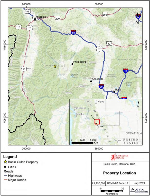
| Figure 2.1. | General location of the Basin Gulch Property | 8 |
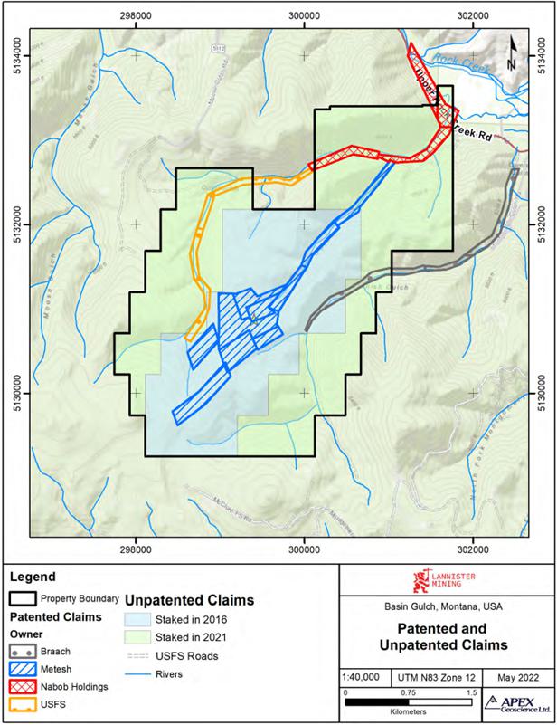
| Figure 3.1. | Basin Gulch active patented and unpatented mining claims. | 10 |
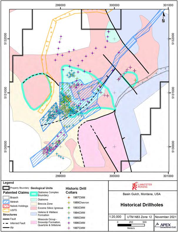
| Figure 5.1 | Historical Drilling on the Basin Gulch Property. | 19 |
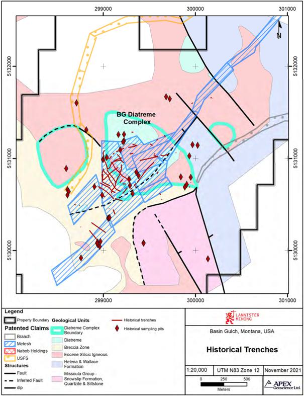
| Figure 5.2 | Historical Trench Locations on the Basin Gulch Property | 20 |
| Figure 5.3 | Portion of Line BL-4 showing a representative section through the diatreme as imaged by CSAMT. | 22 |
| Figure 6.1. | Regional geology of Basin Gulch Property | 28 |
| Figure 6.2. | Property Geology | 30 |
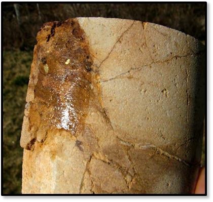
| Figure 6.3. | Core samples containing coarse gold from Basin Gulch (Brown, 2009) | 38 |
| Figure 6.4 | Reconstructed schematic section of the Wau maar-diatreme system to illustrate aspects of the genetic model (Ross et al., 2017 after Sillitoe et al., 1984) | 41 |
| Figure 6.5 | Hydrothermal alteration zones, minerals and ores in porphyry deposits (Modified from Lowell and Guilbert, 1970). | 42 |
| Figure 7.1 | Ionic Leach soil sample results – Au (ppb) | 44 |
| Figure 7.2 | Ionic Leach soil sample results – Ag (ppb) | 45 |
| Figure 7.3 | Ionic Leach soil sample results – As (ppb) | 46 |
| Figure 7.4 | Rock sample assay results – Au (ppm) | 48 |
| Figure 7.5 | 2021 Residual Magnetic Intensity (RMI) with Upward Continuation filter of 10 m and Reduced to Pole (RTP) | 49 |
| Figure 8.1 | Coarse Blank Au concentration. | 52 |
| Figure 8.2 | Duplicate sample Au concentration. | 53 |
| Figure 8.3 | CDN-CM-47 Au concentration. | 54 |
| Figure 8.4 | CDN-ME1811 Au concentration. | 54 |
| Figure 8.5 | CDN-BL-10 Au concentration. | 55 |
| Figure 8.6 | Coarse Blank Au concentration. | 55 |
| Figure 8.7 | Duplicate sample Au concentration. | 56 |
| Figure 9.1 | 2020 Site visit locations | 59 |
| Figure 12.1 | Properties adjacent to the Basin Gulch Project. | 62 |
| | | |
| Appendices | | |
| Appendix 1 Basin Gulch Property Unpatented Claims | 73 |
| March 29, 2024 | | iii |
Technical Report for the Basin Gulch Property, Granite County, Montana, USA
1 Executive Summary
1.1 Overview
The Basin Gulch Property (the “Property” or the “Project”) is located in west-central Montana (MT), U.S.A. The Property is located approximately 17 miles (27 km) west of Philipsburg, MT in Granite County and lies within the Rock Creek Mining District. The Project comprises 11 patented mining claims totaling 216.33 acres (87.55 hectares) and 131 unpatented mining claims totaling approximately 2,642 acres (1,069 hectares). The unpatented claims overlap the patented claims.
APEX Geoscience Ltd. (APEX) of Edmonton, Alberta was engaged by Lannister Mining Corp. (“Lannister” or the “Company”), a private mineral exploration company, to complete a Technical Report (the Report) relating to the Basin Gulch Property. The Technical Report summarizes the geology, the historical and recent exploration conducted on the Project and includes recommendations for future work. The Report has been written on behalf of Lannister and was prepared in accordance with the guidelines set out by the United States Security and Exchange Commission’s regulation Subpart S- K 1300 guidelines for Technical Reports.
1.2 Property Ownership and Description
On September 15, 2020, 124766 BC Ltd. (now Lannister Mining Corp.) signed a Property acquisition agreement with BG Holdings Group, LLC and Basin Gulch Co. to acquire 53 unpatented claims and assume the lease agreement for 11 patented mining claims.
The patented claims are owned by the Metesh Family of Philipsburg, MT and are held under a lease agreement with Strategic Minerals Inc. The agreement covers 11 patented claims and was signed on April 6, 2006. A Memorandum of Lease was filed, by and between Margery Metesh and Lannister Mining, Corp., a British Columbia corporation, assignee and successor in interest to Strategic Minerals, Inc., a Nevada corporation and Basin Gulch Co, a Florida Company, dated March 3, 2022, and recorded March 7, 2022 in the official records of Granite County. The lease is valid for 10 years. A total of 78 unpatented claims were staked in January 2021 by 60431 Montana Ltd. on behalf of Lannister.
The Metesh family holds an advance production royalty over the patented claims of US$25,000 paid every 6 months (March 10 and September 10) to be paid until production commences. The Metesh family retains a production royalty of 3% of gross gold and silver sales due semi-annually once commercial production has commenced. The total sum of payments, whether advance production royalty or production royalties to be paid to the Metesh family shall not exceed US$8 million dollars.
| March 29, 2024 | | 1 |
Technical Report for the Basin Gulch Property, Granite County, Montana, USA
As per the Property acquisition agreement there is a 2% royalty on claims outside the Metesh Lease. Lannister can purchase half of the 2% royalty for $1 million dollars (USD) until December 31, 2025. This is payable to BG Holdings.
1.3 Geology and Mineralization
The Property is located at the head of Basin Gulch and Quartz Gulch, on the northern slopes of West Fork Buttes, within the Sapphire Range of the Western Montana Rocky Mountains. This area is underlain by a series of metamorphosed Precambrian (1.5 Ga to 800 Ma) marine sedimentary rocks known as the Belt Supergroup which were intruded by Laramide-age silicic volcanics. In this area the late Cretaceous to early Tertiary Laramide orogeny resulted in the formation of the Sapphire Mountain Range. In the area of Basin Gulch, the Tertiary igneous rocks are predominantly biotite-rich rhyolites and trachytes, ash flow tuffs, and associated granites of Eocene age (~50 Ma).
Several diatreme complexes located within the igneous complex have been identified at the head of Basin Gulch. The major diatreme complex on the Property is known as the Basin Gulch or BG diatreme. Several, smaller parasitic diatremes are found throughout the Property and in the surrounding area. The BG diatreme can be described as an Eocene silicic volcanic and intrusive complex that intruded between the plates of two Precambrian thrust sheets. The gold mineralization on the Property is directly related to the diatremes and their associated structures which form the main gold target in the area.
Gold mineralization has been identified throughout the Property at or near surface in rock samples, outcrops and trenches. Drilling has confirmed that the mineralization extends to depths greater than 1,000 feet (300 m) and averages approximately 0.01 to 0.02 ounces per ton (opt). Locally higher grade zones have been identified associated with the margins of the various diatremes and with the post- and pre-diatreme dykes and faults. Interpretation of a CSAMT geophysical survey modelled the diatreme complex to extend to below the geophysical study datum of 1,500 feet (450 m). The majority of historical drilling completed on the Property has been relatively shallow and has not intersected the base of the diatreme.
Basin Gulch is interpreted to be a gold and silver intrusion related, diatreme-type deposit that is associated with, and constrained by, the structures surrounding the local diatremes. The mineralized zones are hosted in breccias associated with fracture zones found at the margins of the diatremes. The mineralization is fairly simple, with the gold varying from fine to very coarse. Test work conducted by Kappes, Cassiday & Associates on behalf of Cable Mountain Mine Inc. (CMM) in the 1990’s indicated that the gold is easily extracted using cyanidation or other gold extraction reagents. A leach recovery rate exceeding 90 percent was reported for some samples. However, due to the prohibition of open pit cyanide leach mining in Montana an alternative processing and extraction method will need to be investigated.
| March 29, 2024 | | 2 |
Technical Report for the Basin Gulch Property, Granite County, Montana, USA
CMM additionally completed gravity separation testing to assess the presence and location of coarse gold on the Property. Coarse gold was found to be locally common especially along the BG diatreme margins and along the northeast-trending structural zones. Several zones of coarse gold mineralization were identified. A thorough review of the historical gravity separation testing and additional modern metallurgical studies are recommended.
1.4 Exploration History
1.4.1 Historical Exploration
Historically, gold has been placer mined in the Basin and Quartz Gulch area since the early 1900’s. Modern exploration was conducted over the Property between 1987 and 1997. In 1987, CMM discovered the lode source of the historical placer gold in the upper drainage of Basin Gulch. The mineralization was interpreted to be associated with a large diatreme complex. In collaboration with various partners, the area was explored until 1997 resulting in the completion of 330 drill holes totalling over 110,000 feet (33,530 m), 46 trenches totalling over 15,000 feet (4,570 m), two geophysical surveys, a soil geochemistry survey, topographic surveys, geological mapping and pre-development studies.
Results from the drilling and trench sampling programs indicate that the diatreme complex measures approximately 2,600 feet (790 m) by 3,300 feet (1,000 m) on the surface and appears to be related to other mineralized occurrences in the local area. The majority (87%) of the historical drill holes were shallow (<500 feet [150 m]) and targeted a large, low-grade deposit associated with the diatreme complex. Limited drilling was completed within the diatreme complex itself, however holes drilled within the diatreme complex returned encouraging results. The deepest drill hole (1,045 feet [320 m]) ended in a mineralized zone. The deposit is characterized by overall low-grade gold and silver mineralization and zones of local high-grade mineralization. Widely distributed areas of the intrusive complex contain base levels of gold averaging between 0.01 to 0.02 ounces per ton (opt). Numerous holes returned excellent results intersecting both wide modest grade intercepts and narrower high grade intercepts. For example hole BG94-05RC intersected returned an average grade of 0.096 opt Au (3.276 g/t) over an intersection of 240 feet (73 m) including a zone of 125 feet (38 m) which averaged 0.146 opt Au (4.996 g/t). Core hole (BG94-05blD) which was completed at the same location returned comparable average grades over similar intervals: 0.119 opt Au (4.064 g/t) over 197 feet (60 m) including a zone of 77 feet (23 m) at 0.279 opt Au (9.549 g/t). Other wide intercepts included hole BG95-073RC with an intersection 180 feet (55 m) and an average grade of 0.029 opt (0.992 g/t) including 110 feet averaging 0.043 opt (1.471 g/t) Au; hole BG95- 91RC with an intersection of 370 feet (112 m) averaging 0.034 opt (1.181 g/t) Au with a subsequent intersection of 100 feet (30 m) averaging 0.067 opt (2.287 g/t) Au; BG94- 01RC with an intersection 240 feet (73 m) averaging 0.096 opt (3.276 g/t) including 125 feet (38 m) averaging 0.0146 opt (4.996 g/t) Au.
The mineralization was found to be ubiquitous in all rocks with no one rock type showing preferential mineralization. Higher-grade mineralization is associated with the marginal areas and edges of the intrusive rocks. Outside of the main mineralized zones, rock and soil sampling has identified anomalous mineralization across the Property extending across an area of at least 8,000 feet (2,500 m) by 14,000 feet (4,270 m).
| March 29, 2024 | | 3 |
Technical Report for the Basin Gulch Property, Granite County, Montana, USA
In 1996-1997 Kinross extensively reviewed the Basin Gulch project and offered to purchase it. During the sale process Montana banned the use of cyanide in open pit heap leach mining simultaneously with a major decline in the gold price and the sale was not completed. CMM dropped the Property in 1997. Between 2006 and 2016, the Property was held by several entities. During this period the focus was on desktop studies with limited field exploration completed. Very limited to no information is available about these exploration programs.
The authors have reviewed and accepted the historical results as disclosed herein.
1.4.2 Recent Exploration - Lannister 2020 – 2023
Lannister engaged APEX to complete a data compilation and review for the Basin Gulch Project in 2020. Lannister subsequently carried out a ground geophysical survey, prospecting and a soil and rock sampling program in 2021.
During the prospecting program 47 additional trenches were located that were not shown on the historical maps, additionally 41 small sample pits were identified located throughout the Property. The majority of the newly identified trenches are located within the main BG diatreme complex northeast of the previously orthorectified historical workings. A total of 1,247 soil samples were collected including 65 duplicates. The soil samples were analysed using ALS’s ultra-sensitive Ionic Leach method which is designed to detect and define subtle, low level anomalies. The results of the 2021 soil sampling program show an anomalous response in Au and Ag related to the BG diatreme and the edge of the diatreme as well as several coherent Au anomalies located outside of the diatreme. The rock sampling program included the collection of 126 rock samples, including 3 duplicates. Samples were collected from float samples, outcrop exposures and historical trenches across the soil grid area. Anomalous gold assays were recovered across the Property associated with the historical workings in and around the BG diatreme and the anomalous areas identified by the soil sample survey.
The ground magnetics survey totalled 130 line-km and covered a large portion of the Property including the BG diatreme and other areas with historical workings. The processed geophysical data show that the major, northeast trending fault crossing the Property and the BG diatreme are associated with a low amplitude magnetic response. Mineralization within and along the margins of the BG diatreme is also associated with a low amplitude magnetic response.
In 2023, trenching and sampling were conducted. Results are pending.
| March 29, 2024 | | 4 |
Technical Report for the Basin Gulch Property, Granite County, Montana, USA
1.5 Conclusions and Recommendations
Historical exploration has defined a significant zone of gold mineralization at the Basin Gulch Property. Based upon the site visit, the historical exploration work and the current exploration carried out by Lannister discussed in this Technical Report, it is the opinion of the authors of this Technical Report that the Basin Gulch Property is a “Property of Merit” warranting further exploration work including additional drilling. A phased exploration program is recommended and should include but is not be limited to:
The Phase 1 exploration program should include surface exploration, drilling and mineral resource estimation. The surface exploration program should consist of detailed geological mapping, prospecting, and a structural interpretation of the Property. Sampling should be completed over a total of 10 trenches totalling 5,000 m.
Confirmed historical drilling on the Property totals approximately 110,000 feet (33,530 m). However, the majority of the historical drilling was shallow typically less than 200 m depth and largely pattern-drilled with a focus on evaluating a large, low-grade open-pit deposit outside of the diatreme complex. Several deeper holes, up to 1,045 ft (320 m) depth, were completed within the diatreme complex and returned encouraging results. However, these holes did not reach the highly conductive mineralized portions of the diatreme modelled at approximately 450 m depth. Drilling should consist of both infill and twin core drilling to confirm historical results and to test the deeper highly conductive mineralized portions of the diatreme. Approximately 25 drill holes totalling 5,000 m should be completed. The exact number of holes and the total depth may be adjusted depending on initial results.
Preliminary metallurgical bench – scale testing should be completed. Metallurgical testing should evaluate alternative reagents for gold extraction such as thiosulfate and chloride, and/or commercially sold reagents such as EarthGold or Gold Dressing Agent that can be substituted for cyanide in gold heap leaching. Additionally, the efficiency of gravity recovery should also be evaluated.
The drill program should culminate in a 3D geological model based on the historical and modern drilling that will lead to the calculation of a maiden mineral resource estimate. The maiden mineral resource estimate would be completed in accordance with CIM “Estimation of Mineral Resources and Mineral Reserves Best Practice Guidelines” dated November 29, 2019 and CIM “Definition Standards for Mineral Resources and Mineral Reserves” dated May 10th, 2014 to be reported in accordance with the CSA NI 43-101 rules for disclosure.
The budget to complete Phase 1 of the exploration program is estimated to be $4,400,000 (Table 1.1). Phase 2 of the exploration program will be contingent on the results of Phase 1 and is recommended to proceed upon the successful delineation of a maiden mineral resource estimate. Phase 2 exploration should include follow-up exploration and expansion drilling of 20 drill holes totalling approximately 4,000 m. The proposed budget to complete Phase 2 is approximately $2,600,000 (Table 1.1).
The budget to complete the Phase 1 and 2 exploration programs is $7,500,000 CND.
| March 29, 2024 | | 5 |
Technical Report for the Basin Gulch Property, Granite County, Montana, USA
Table 1.1 Proposed budget for the recommended exploration program.
| PHASE 1 | | | |
Drilling – Core Drilling ~5000m at $650 / meter all up (includes geologists, assays,
drilling, mob / demo etc.) Approximately 25 drill holes including both infill and twinning. | | $ | 3,250,000 | |
| Metallurgy - Preliminary Metallurgical Bench Scale Tests | | $ | 200,000 | |
| Mechanized Trenching ~ 10 x 500m trenches (includes geologists, assays, equipment) | | $ | 400,000 | |
| Mapping, prospecting and structural interpretation | | $ | 50,000 | |
| Maiden NI 43-101 Resource Report which incorporates all technical data to date | | $ | 100,000 | |
| CONTINGENCY 10% | | $ | 400,000 | |
| TOTAL PHASE 1 | | $ | 4,400,000 | |
| PHASE 2 – contingent on the results of phase 1 | | | | |
Drilling – Core Drilling ~ 4000m at $650 / meter all up (includes, geologists, assays,
drilling, mob / demo etc.) Approximately 20 drill holes including follow-up, expansion
and exploration drilling. | | $ | 2,600,000 | |
| OTHER | | | | |
| Administration and overhead | | $ | 500,000 | |
| | | | | |
| TOTAL | | $ | 7,500,000CND | |
| March 29, 2024 | | 6 |
Technical Report for the Basin Gulch Property, Granite County, Montana, USA
2 Introduction
2.1 Issuer and Purpose
This Technical Report has been completed on behalf of Lannister Mining (“Lannister” or the “Company”). Lannister is a private Vancouver-based mineral exploration company exploring for precious metals in the United States of America (USA). Lannister’s Basin Gulch Property (the “Property”) comprises 11 patented claims and 131 unpatented Bureau of Land Management (“BLM”) mining claims. The patented claims cover an area of 216.33 acres (87.55 hectares). The unpatented claims largely overlie the patented claims and encompass approximately 2,642 acres (1,069 hectares) in Granite County, Montana (“MT”) (Figure 2.1). The Basin Gulch Property is an intermediate stage precious metal exploration Property located within the Sapphire Range of the Western Montana Rocky Mountains.
This Technical Report for the Basin Gulch Property has been prepared by Mr. Michael Dufresne, M.Sc., P.Geol., P.Geo. of APEX Geoscience Ltd. (APEX) and Mr. Dean Besserer, B.Sc., P.Geo., on behalf of Lannister. The intent and purpose of this Technical Report is to provide a geological introduction to the Property, to summarize historical and recent exploration work completed on the Property from 1987 to 2023 and to provide recommendations for future exploration programs. This Technical Report has been prepared in accordance with the United States Security and Exchange Commission’s regulation Subpart S-K 1300 guidelines for Technical Reports. The effective date of this Technical Report is March 29, 2024.
2.2 Authors and Site Inspection
The authors of this Technical Report are Mr. Michael Dufresne M.Sc., P.Geol., P.Geo. of APEX and Mr. Dean Besserer, B.Sc., P.Geol. Mr. Dufresne is independent of Lannister and Mr. Besserer is the Vice President of Exploration for the Company. Mr. Dufresne is a Professional Geologist with the Association of Professional Engineers and Geoscientists of Alberta (APEGA; Membership Number 48439), a Professional Geologist with the Engineers and Geoscientists British Columbia (EGBC; Membership Number 37074) and has worked as a geologist for more than 40 years since his graduation from University. Mr. Dufresne has been involved in all aspects and stages of precious metal mineral exploration in North America, and has extensive experience exploring for intrusion related type precious metals deposits in the Western USA and in Canada. Mr. Besserer is a Professional Geologist with the Association of Professional Engineers and Geoscientists of Alberta (APEGA; Membership Number 61856) has been involved in all aspects and stages of precious metal mineral exploration in North and South America, Africa and Australia, and has extensive experience exploring for intrusion related type precious metals deposits in the Western USA and in Canada.
| March 29, 2024 | | 7 |
Technical Report for the Basin Gulch Property, Granite County, Montana, USA
Figure 2.1. General location of the Basin Gulch Property.
| March 29, 2024 | | 8 |
Technical Report for the Basin Gulch Property, Granite County, Montana, USA
Mr. Dufresne visited the Basin Gulch Property on September 17, 2020. The author toured the Property with Mr. Rauno Perrtu and collected samples for confirmation check assays. The author located several historical drill holes, including the discovery hole BG- 2, and historical trenches on the Property to confirm their locations. The locations in the field compare favourably with the corresponding drill holes and trenches in the database that was provided. Six samples were collected during the Property visit and were submitted to ALS Laboratory in North Vancouver, BC, Canada for assay. The sample assays confirmed the presence of gold mineralization at the Property. Mr. Besserer has been to the Property on numerous occasions and has managed the exploration conducted to date by Lannister.
2.3 Sources of Information
This Technical Report is a compilation of proprietary and publicly available information as listed in the reference section and relies heavily on information from three previous reports written by Brown, 2009 and 2010, and Perttu, 2017. The data discussed in this report was provided by Mr. Perrtu in scanned and digital format and as hard copies. The data was compiled and examined by the author and QP who has conducted a preliminary data verification. The data provided included previous technical reports, exploration data, and drill data. The supporting documents used as background information are referenced in the History, Geological Setting and Mineralization, Deposit Types and Reference sections. The authors of this Technical Report have supervised the preparation of the report and take responsibility for the data used herein and all sections of this report. Based on the authors Property visits and the work performed on the Property to date, they believes that exploration completed by previous property owners as listed in the reference section is accurate and complete.
2.4 Units of Measure
With respect to units of measure, unless otherwise stated, this Technical Report uses:
| ● | Abbreviated shorthand consistent with the International System of Units (International Bureau of Weights and Measures, 2006); |
| | | |
| ● | ‘Bulk’ weight is presented in both United States short tons (“tons”; 2,000 lbs or 907.2 kg) and metric tonnes (“tonnes”; 1,000 kg or 2,204.6 lbs.); |
| | | |
| ● | Geographic coordinates are projected in the Universal Transverse Mercator (“UTM”) system relative to Zone 12 of the North American Datum (“NAD”) 1983; and, |
| | | |
| ● | Currency in United States dollars (US$), unless otherwise specified (e.g., Canadian dollars, CDN$; Euro dollars, €); |
| | | |
| ● | Assay and analytical results for precious metals are quoted in parts-per-million (ppm), parts-per-billion (ppb), ounces per short ton (opt or oz/st), where “ounces” refers to “troy ounces” and “ton” means “short ton”, which is equivalent to 2,000 lbs. Where ppm (also commonly referred to as grams per metric tonne [g/t]) have been converted to opt (or oz/st), a conversion factor of 0.029166 (or 34.2857) was used; |
| 3.1 | Description and Location |
The Basin Gulch Property is located in west-central Montana in Granite County within the Rock Creek Mining District and is surrounded by the Deer Lodge National Forest. The Property consists of 11 patented claims and 131 unpatented mining claims (Figure 3.1). The claims cover portions of Sections 26, 27, 32, 33, 34, and 35 Township 7 North, Range 16 West, and Sections 3, 4, 5, 8, 9 and 10 Township 6 North, Range 16 West. The Property is located within the USGS Cornish Gulch 1:24,000 scale, 7.5-minute series quadrangle map. The claims are located on the northern slopes of West Fork Buttes within the Sapphire Mountains and overlie portions of Basin Gulch, Quartz Gulch and Cornish Gulch. The approximate center of the Basin Gulch Property is located at Universal Transverse Mercator (“UTM”) 299,328 m Easting and 5,130,808 m Northing, Zone 12, North American Datum 83 (“NAD83”). The unpatented claims largely overlie the patented claims.
| March 29, 2024 | | 9 |
Technical Report for the Basin Gulch Property, Granite County, Montana, USA
Figure 3.1. Basin Gulch active patented and unpatented mining claims.
| March 29, 2024 | | 10 |
Technical Report for the Basin Gulch Property, Granite County, Montana, USA
A mineral patent gives the owner exclusive title to the locatable minerals and, in most cases, also grants title to surface rights. In 1994, Congress prohibited the filing of new mineral patent applications. The moratorium has been renewed annually since that time. Ownership of the patented claims that are part of the Basin Gulch Property was confirmed on the Montana Cadastral website (http://svc.mt.gov/msl/mtcadastral). The patented claims are owned by the Metesh family. The primary owner of record for 11 patented claims (Table 4.1) that comprise the Basin Gulch Group is Brian Metesh of 7 Porters Corner Lane, Philipsburg, MT.
The Metesh patents encompass an area of 216.33 acres (87.5 ha) as displayed on Figure 4.1. Property taxes are due annually on the patented claims, which can be paid either in full by November 30 annually, or in two installments: by November 30th and by May 31st. The Property taxes associated with the patented mining claims have been paid to Granite County for the 2022-2023 period.
Table 3.1 Metesh Patented Claims
| Patented Claim Name | | Survey Number | | Claim Type | | Area (acres) | |
| Landes | | Mineral Survey 5565 | | Placer | | | 12.1 | |
| Shylock | | Mineral Survey 6354 | | Placer | | | 17.23 | |
| Shively | | Mineral Survey 5754 | | Lode | | | 11.56 | |
| Quartz Hill | | Mineral Survey 5564 | | Lode | | | 16.09 | |
| Gold Hill 5 | | Mineral Survey 5755 | | Lode | | | 19.45 | |
| Basin | | Mineral Survey 9026 | | Lode | | | 55.18 | |
| Blue Bell | | Mineral Survey 9530 | | Lode | | | 20.52 | |
| Spencerian | | Mineral Survey 8140 | | Lode | | | 64.20 | |
| White Pine | | Mineral Survey 8137 | | Lode | | | | |
| Yellow Pine | | Mineral Survey 8139 | | Lode | | | | |
| Jack White | | Mineral Survey 8138 | | Lode | | | | |
| | | | | Total | | | 216.33 | |
The Basin Gulch Property overlaps 7 additional patented claims: Tenderfoot Placer claim owned by Braach, the Quartz Gulch Lode, JIC Placer, and Midnight Placer claims owned by the USFS and the Black Horse, Hatty and Last Chance placer claims owned by Nabob Holdings. Lannister does not have agreements with Braach to access any areas underlain by their patented claims. Lannister has permission to access and explore on the Quartz Gulch Lode, JIC Placer and Midnight Placer patent claims that are held by the USFS.
The 131 active unpatented Bureau of Land Management (“BLM”) lode mining claims encompass approximately 2,6424 acres (1,069 ha) and over lie the patented claims (Figure 4.1). The unpatented claims were staked in 2 groups the AG group and the BG group. The “AG” group consist of 53 unpatented claims that were re-staked by Basin Gulch Co. in 2016. The owner of record of the AG group of unpatented claims is BG Holdings Group, LLC, who presently holds the claims on behalf of Basin Gulch Co. The AG claims are active and in good standing.
| March 29, 2024 | | 11 |
Technical Report for the Basin Gulch Property, Granite County, Montana, USA
The BG group of claims consists of 78 unpatented claims that were staked by 60431 Montana Ltd. in January 2021. The owner of record of the BG group of unpatented claims is 60431 Montana Ltd., who presently holds the claims on behalf of Lannister. The BG claims are active and in good standing.
Unpatented lode mining claims grant the mineral rights and access to the surface for exploration activities which cause insignificant surface disturbance. The mineral rights are maintained by paying a maintenance fee of $165 per claim to the Department of Interior, Bureau of Land Management (“BLM”) prior to the end of the business day on August 31 every year. The claims are valid as long as the annual filings and payments are made. The federal BLM maintenance fees and the filing fees and taxes for the Basin Gulch Property have been paid in full for 2022-2023. A complete listing of all claims on file with the BLM and Granite County is presented in Appendix 1. All of the unpatented (BLM) claims are valid until August 31st, 2024.
3.2 Ownership Agreements and Royalties
On September 15, 2020, 124766 BC Ltd. (now Lannister) signed a property acquisition agreement with BG Holdings Group, LLC and Basin Gulch Co. to acquire 53 unpatented claims and assume the lease agreement for 11 patented mining claims. A novation agreement between Skanderbeg, Lannister, 124766 BC Ltd. and BG Holdings Group, LLC to assign the agreement to Lannister and complete a share exchange. Furthermore, Lannister must pay the Vendors:
| ● | $150,000 USD on signing (complete); |
| | | |
| ● | $250,000 USD on the first anniversary of the agreement (complete); |
| | | |
| ● | $300,000 USD on the second anniversary of the agreement, (complete) and; |
| | | |
| ● | $350,000 USD on or before the second anniversary of the agreement. |
As well, upon Lannister going public, Lannister must provide the Vendors shares equalling 5% of the shares outstanding.
The patented claims are held under a lease agreement with Strategic Minerals, Inc. The agreement covers 11 patented claims (as described above) and was signed on April 6, 2006. A Memorandum of Lease was filed, by and between Metesh family and Lannister Mining, Corp., a British Columbia corporation, assignee and successor in interest to Strategic Minerals, Inc., a Nevada corporation, and Basin Gulch Co., a Florida Company, dated March 3rd, 2022, and recorded March 7th, 2022 in the official records of Granite County, MT. The lease is valid for 10 years.
The Metesh family holds an advance production royalty over the patented claims of US$25,000 paid every 6 months (March 10 and September 10) to be paid until production commences. The Metesh family retains a production royalty of 3% of gross gold and silver sales due semi-annually once commercial production has commenced. The total sum of payments, whether advance production royalty or production royalties to be paid to the Metesh family shall not exceed US$8 million dollars.
| March 29, 2024 | | 12 |
Technical Report for the Basin Gulch Property, Granite County, Montana, USA
As per the property acquisition agreement there is a 2% royalty on claims outside the Metesh Lease. Lannister can purchase half of the 2% royalty for $1 million dollars (USD) until December 31, 2025. This is payable to BG Holdings.
3.3 Environmental Liabilities, Permitting and Significant Factors
State mining regulation apply to both private (patented) and public (unpatented) lands in Montana. An Exploration License is required to complete all mineral exploration activities that may involve surface or subsurface disturbance. To acquire an exploration license the company must submit a plan of operations including the area to be explored, location and type of planned exploration activities (i.e. drill holes, trenches) and a disturbance reclamation plan. A reclamation bond as determined by the Department of Environmental Quality must be posted. Once approved an exploration license is renewable annually by filing an annual report and payment of a $25 fee. An Exploration License is not a mining permit and cannot be used for mining. There are no defined review times but typically approvals are processed within 30-45 days.
The Company currently holds a valid exploration license (License #00875) to conduct drilling and trenching within the patented mining claims. As part of this license a reclamation bond of $219,181 was submitted to the DEQ on December 16, 2022. While the bond is in place the exploration license can be renewed annually for US$25 which has been completed for 2024.
Additionally, a stormwater permit, along with a stormwater pollution prevention plan, a temporary water use permit and a Notice of Intent (NOI) are required. The Company currently has a stormwater permit (Permit#MTR100000) which is valid until 2027 by paying an annual fee of US$750 which has been paid for 2024.
For small scale mining and test mining operations a Small Miner’s Exclusion Statement (SMES) can be obtained. The SMES process is much faster and simpler than the permitting process for an Operating Permit which is required for larger mines in Montana. The SME allows for ≤ 5 acres of disturbance at up to 2 sites if they are ≥ 1mile apart. The application must include a plan of operations containing a map and a reclamation plan. A reclamation bond and/or performance bond may be assessed by the DEQ and the federal agency. There is no application or renewal fee for SMES. A SMES can be obtained within months of filing of an application.
In 1998, Montana passed a statute strictly prohibiting the use of cyanide heap and vat leach open pit mining. Citizens Initiative Cl-137 states:
“...82-4-390. Cyanide heap and vat leach open-pit gold and silver mining prohibited.
| (1) | Open-pit mining for gold or silver using heap leaching or vat leaching with cyanide ore-processing reagents is prohibited except as described in subsection (2). |
| (2) | A mine described in this section operating on November 3, 1998, may continue operating under its existing operating permit or any amended permit that is necessary for the continued operation of the mine…” |
| March 29, 2024 | | 13 |
Technical Report for the Basin Gulch Property, Granite County, Montana, USA
Lannister is aware of this law and aims to develop this deposit in accordance with the regulations.
The author and QP observed during the site visit that most evidence of prior exploration including drill holes, drill hole pads and trenches have for the most part been long reclaimed. There is significant disturbance in some of the creeks leading up to the project from placer mining, however, this historical disturbance is not the responsibility of the Company to address.
To the Authors knowledge there are no environmental liabilities to which the property is subject. The Author understands that the Company has yet to perform any ground disturbance work and there is appears to be significant historical work which would result in any environmental liabilities on the Property. There are no other significant factors or risks that the author is aware of that would affect access, title or the ability to perform work on the Property.
4 Accessibility, Climate, Local Resources, Infrastructure and Physiography
4.1 Accessibility
The Basin Gulch Project is located in west-central Montana approximately 17 road miles (27 km) west of Philipsburg, MT (population ~1,000). The Property can be accessed by travelling west from Philipsburg for approximately 15 miles (24 km) on State Highway 438, continuing west along the Lower Rock Creek Road for 2 miles (3.2 Km) to an unimproved mine access road that heads up to Basin Gulch toward the south. The Property can be accessed using four-wheel drive vehicle. Local access to most areas of the Property is via historical drill roads and logging roads.
4.2 Site Topography, Elevation and Vegetation
The Property lies along the Basin Gulch drainage, through which Basin Creek flows north into Eureka Gulch and then into Rock Creek. Elevation on the Property increases from the northeast to the southwest and ranges from 5,520 feet (1,680 m) to 6,960 feet (2,120 m) based on the Cornish Gulch USGS Quadrangle map. Elevations around the main mineralized zones near the centre of the Property range from ~6,100 – 6,500 feet (1,860 – 1980 m). Locally the topography is rugged and steep with slopes ranging from 35 to 60 percent, along with flatter areas. The mountainsides are rocky and mostly talus covered. Vegetation in the area consists mainly of Lodgepole Pine and Douglas Fir forests, with a fairly clear understory and low ground cover.
| March 29, 2024 | | 14 |
Technical Report for the Basin Gulch Property, Granite County, Montana, USA
4.3 Climate
The Basin Gulch area has a continental climate which is characterized by short, cool summers and long, cold winters. The coldest months are December to February with average daily high of 33-38°F (0.5-3°C) and overnight lows averaging 14°F (-10°C). During the summer months daytime temperatures average around 80°F (27°C). However daily extremes temperatures in summer have been reported up to 100°F (38°C).
Precipitation is significantly dependant on elevation with upper elevations receiving more precipitation than lower elevations especially in the form of snowfall during the winter months. The lower elevations receive 13 to 15 inches (33-38 cm) of precipitation annually, while upper elevations can receive 50 inches (130 cm) or more. Previous field work in the area has encountered impassable snowbanks at around 6,000 feet (1,800 m) elevation up to late April.
4.4 Local Resources and Infrastructure
The town of Philipsburg, MT is located approximately 17 miles (27 km) by road east of the Basin Gulch Property. It has a population of ~1,000 according to 2008 United States Census data. Philipsburg is a mining and tourist town and is the county seat of Granite County. Services available at Philipsburg include housing, hotels, food and restaurants, hospital and a non-commercial airfield. The nearest major city is Butte, MT located 70 miles (110 km) southeast of the Property and 54 miles (87 km) southeast of Philipsburg. The closest full-service community is Anaconda, Montana, located 47 miles (75 km) southeast of the Property along State Highway 1. The nearest commercial domestic airport is located in Butte, MT. An international airport is located 90 miles (145 km) away in Missoula, Montana. Highway truck transport services are available in Philipsburg. No rail service is available to Philipsburg.
No public power or phone service or other mining infrastructure is available at the Property. Radio and cell phone communications and a diesel generator have been used during previous field seasons. Sufficient water for exploration is available from Basin Gulch, Rock Creek and other local creeks draining the Property. There is very good access to the property for exploration work. The Project can be accessed year-round. Most exploration activities associated with fieldwork and drilling can likely be conducted year-round, although there may be periods in December to March, where snow conditions at the higher elevations may temporarily impede fieldwork.
5 History
The information discussed in this history section is largely based on the following reports: Perttu, 1997, Brown, 2009, 2010 and Perttu, 2017 and a review of the digital data provided.
| March 29, 2024 | | 15 |
Technical Report for the Basin Gulch Property, Granite County, Montana, USA
The Basin Gulch Project lies within the Rock Creek Mining District. The Rock Creek area is best known for it’s sapphire production. However, gold has historically been placer mined in the Basin/Quartz Gulch area since the early 1900’s. The source of the placer gold was unknown. Gold mining was intermittent with production reported in 1911, 1914 to 1928, 1934 sand 1940. Historical reports indicate that production from Basin Gulch was modest, production being impeded by a lack of water impeded. In 1948, Lynch (1948) suggested that the gold was sourced from the intrusive volcanic rocks exposed near the headwaters of Basin Creek. Sapphires have also been reportedly recovered from the placer operations in Basin Gulch (Frishman, 1992). Historical workings including excavations, mine ponds, remains of log cabins and out buildings, log and dirt dams, and hydraulic diversion structures are still found on the Property.
Modern exploration was conducted over the Property area between 1987 and 1997. In 1987, Cable Mountain Mine Inc. (CMM) discovered a large, mineralized diatreme complex in the upper drainage of the Basin Gulch which was interpreted to be the lode source of the placer gold. The area was extensively explored until 1997 resulting in the completion of 318 reverse circulation (RC) and diamond drill holes totalling over 110,000 feet (33,530 m) (Table 6.1), 46 trenches totalling over 15,000 feet (4,570 m), two geophysical surveys, a soil geochemistry survey, topographic surveys, geological mapping and pre-development studies. From 1997 to 2017 the Property changed ownership several times; only desktop studies including data compilation and verification and modelling were completed during this period.
Table 5.1 Historical Drill hole summary
| | | | | Total Drill Holes | |
| Company | | Year | | | RC | | | DDH | | | RC with Core tail | |
| CMM | | 1987 | | | | 2 | | | | | | | | | |
| Chevron | | 1989 | | | | 11 | | | | | | | | | |
| Cyprus | | 1992 | | | | 5 | | | | | | | | | |
| CMM | | 1993 | | | | 14 | | | | 2 | | | | 2 | |
| CMM | | 1994 | | | | 68 | | | | 2 | | | | 1 | |
| CMM | | 1995 | | | | 117 | | | | | | | | | |
| CMM | | 1996 | | | | 50 | | | | | | | | | |
| CMM | | 1997 | | | | 52 | | | | 3 | | | | | |
| | | Total | | | | 319 | | | | 7 | | | | 3 | |
5.1 1987 – 1992 - Discovery and Early Exploration
In 1987, Rauno Perttu of CMM recognised the lode potential of the Basin Gulch area and acquired the patented claims. A large block of unpatented claims in the surrounding area was additionally staked. Two shallow holes (BG-1 and BG-2) were drilled near the upper part of the Basin Gulch drainage near the central area of the current Property. The holes targeted a suspected diatreme. Hole BG-1 was too shallow and did not intersect the diatreme. Hole BG-2 was drilled on the southwest margin of the diatreme and intersected significant shallow ore-grade gold and silver mineralization (Perttu, 2009).
| March 29, 2024 | | 16 |
Technical Report for the Basin Gulch Property, Granite County, Montana, USA
The project was subsequently farmed out to Chevron Resources. Chevron’s work was clustered around, and downhill of, the discovery hole BG-2. Chevron’s exploration program included a soil geochemistry survey, 11 shallow RC holes and 13 shallow trenches. The geochemistry survey covered the area over and surrounding the placer mining. Several strong soil anomalies were identified across the soil survey including in the area of hole BG-2. Some of the soil anomalies extended beyond the boundary of the survey. The drill holes were completed in the area of hole BG-2 along what Chevron interpreted to be a mineralized high angle structure. Six of the 11 holes intersected shallow ore-grade mineralization. The remaining 5 holes did not intersect mineralization and were interpreted to be too shallow. From the trench sampling program broad zones of silver and gold mineralization were intersected in several of the trenches. The property was subsequently sold to Cyprus.
Cyprus completed an exploration program in late 1992 that included six (6) trenches and five (5) drill holes. Five (5) of the trenches were excavated in the Basin Gulch area and encountered broad zones of mineralization. However, Cyprus’s program was largely focused on a small area in Cornish Gulch located ~1.3 km (4,500 ft) northeast of the earlier drilling. The longest trench and all 5 drill holes targeted mineralization in the middle and lower hillside of ridge on the west side of Cornish Gulch near the eastern margin of the current unpatented claims. This area contained anomalous mineralization in outcrop within altered shallow rhyolitic igneous rocks. The mineralization appeared to dip gently into the hillside and did not extend to the bottom of the hill. Cyprus interpreted the mineralization to be controlled by a high-angle structure and along with the steep topographical constraints in this area drilled on the lower flank of the hill below the mineralization. Three of the five drill holes intersected anomalous mineralization. Vertical hole 92BG-C2, bottomed out at 350 feet (107 m) in continuous gold mineralization. The trench was located along the road below the hillside and largely contained colluvium. Anomalous gold mineralization was intersected over an interval of 160 feet (50 m).
Cyprus dropped the project due a corporate decision and CMM regained control of the Project in 1993.
5.2 1993 – 1997 - Cable Mountain Mine Exploration
CMM conducted exploration programs on the project from 1993 to 1997 including drilling, trench sampling, and ground geophysics. The work completed by CMM identified significant gold and silver mineralization associated with the main BG diatreme complex located at the head of Basin Gulch. Float and outcrops containing anomalous mineralization were also identified across the Property.
Between 1993 and 1997 CMM drilled 312 holes totalling approximately 105,000 feet (32,000 m) over the entire property, all of these holes lie within the confines of the current Property (Figure 6.1). The majority of holes were drilled vertically using RC rigs; 8 diamond drill holes and 4 RC holes with core tails were completed. The majority of holes (87%) were shallow with total depths less than 500 ft. The deepest hole total totalled 1,045 feet (320 m) and ended in mineralization. Additionally, 27 trenches were completed most of which were located over the main mineralized zone (Figure 6.2).
The results from the drilling and trench sampling programs indicated that the diatreme complex measured approximately 2,600 feet by 3,300 feet (800 by 1000 m) on the surface, and appeared to be related to other mineralized occurrences in the local area. The diatreme complex was characterized by overall low-grade gold and silver mineralization and local high-grade mineralization. Widely scattered areas of the intrusive contained base levels of gold averaging between 0.01 to 0.02 opt. Numerous holes returned anomalous results with both wide modest grade intercepts and narrower high grade intercepts (Table 6.2). As demonstrated by holes: BG94-05RC intersected 0.096 opt Au (3.276 g/t) over 240 feet (73 m) including a zone of 125 feet (38 m) which averaged 0.146 opt Au (4.996 g/t). Core hole (BG94-05blD) which was completed at the same location and returned comparable assays over similar intervals: 0.119 opt Au (4.064 g/t) over 197 feet (60 m) including a zone of 77 feet (23 m) at 0.279 opt Au (9.549 g/t). Other wide intercepts included hole BG95-073RC with an intersection 180 feet (55 m) with an average grade of 0.029 opt (0.992 g/t) including 110 feet averaging 0.043 opt (1.471 g/t) Au; hole BG95-91RC with an intersection 370 feet (112 m) with and average grade of 0.034 opt (1.181 g/t) Au with a subsequent intersection of 100 feet (30 m) with an average grade of 0.067 opt (2.287 g/t) Au; BG94-01RC with an intersection 240 feet (73 m) averaging 0.096 opt (3.276 g/t) including 125 feet (38 m) averaging 0.0146 opt (4.996 g/t) Au.
| March 29, 2024 | | 17 |
Technical Report for the Basin Gulch Property, Granite County, Montana, USA
Table 5.2 CMM Historical Assay Highlights from Drilling.
| Hole ID | | From (ft) | | | To (ft) | | | Width (ft) | | | Au (opt) | | | Ag (opt) | | | Au (g/t) | | | Ag (g/t) | |
| BG93-08RC | | | 0 | | | | 110 | | | | 110 | | | | 0.048 | | | | 0.651 | | | | 1.641 | | | | 22.323 | |
| including | | | 0 | | | | 70 | | | | 70 | | | | 0.063 | | | | 0.694 | | | | 2.162 | | | | 23.793 | |
| BG93-14RC | | | 0 | | | | 80 | | | | 80 | | | | 0.026 | | | | 0.661 | | | | 0.891 | | | | 22.675 | |
| BG94-01RC | | | 10 | | | | 250 | | | | 240 | | | | 0.096 | | | | 0.789 | | | | 3.276 | | | | 27.036 | |
| including | | | 100 | | | | 225 | | | | 125 | | | | 0.146 | | | | 0.486 | | | | 4.996 | | | | 16.677 | |
| BG94-05RC | | | 10 | | | | 250 | | | | 240 | | | | 0.096 | | | | 0.789 | | | | 3.276 | | | | 27.036 | |
| including | | | 100 | | | | 225 | | | | 125 | | | | 0.146 | | | | 0.486 | | | | 4.996 | | | | 16.677 | |
| BG94-05blD | | | 25.3 | | | | 221.9 | | | | 197.6 | | | | 0.119 | | | | 0.882 | | | | 4.064 | | | | 30.251 | |
| including | | | 130.5 | | | | 207 | | | | 76.5 | | | | 0.279 | | | | 0.867 | | | | 9.549 | | | | 29.722 | |
| BG94-12RC | | | 60 | | | | 145 | | | | 85 | | | | 0.052 | | | | 2.721 | | | | 1.771 | | | | 93.297 | |
| BG94-15RC | | | 205 | | | | 310 | | | | 105 | | | | 0.053 | | | | 0.359 | | | | 1.809 | | | | 12.31 | |
| including | | | 220 | | | | 290 | | | | 70 | | | | 0.068 | | | | 0.337 | | | | 2.346 | | | | 11.559 | |
| BG94-33RC | | | 40 | | | | 195 | | | | 155 | | | | 0.022 | | | | 0.316 | | | | 0.765 | | | | 10.839 | |
| BG94-36RC | | | 195 | | | | 275 | | | | 80 | | | | 0.02 | | | | 0.313 | | | | 0.677 | | | | 10.714 | |
| BG94-55RC | | | 70 | | | | 235 | | | | 165 | | | | 0.024 | | | | 0.241 | | | | 0.806 | | | | 8.268 | |
| BG94-56RC | | | 30 | | | | 165 | | | | 135 | | | | 0.016 | | | | 0.419 | | | | 0.556 | | | | 14.349 | |
| BG95-003RC | | | 70 | | | | 150 | | | | 80 | | | | 0.028 | | | | 0.161 | | | | 0.96 | | | | 5.529 | |
| BG95-004RC | | | 50 | | | | 215 | | | | 165 | | | | 0.027 | | | | 0.204 | | | | 0.933 | | | | 6.992 | |
| BG95-008RC | | | 65 | | | | 300 | | | | 235 | | | | 0.089 | | | | 0.3 | | | | 3.052 | | | | 10.286 | |
| including | | | 125 | | | | 295 | | | | 170 | | | | 0.114 | | | | 0.319 | | | | 3.923 | | | | 10.951 | |
| BG95-010RC | | | 185 | | | | 270 | | | | 85 | | | | 0.035 | | | | 0.186 | | | | 1.202 | | | | 6.373 | |
| including | | | 205 | | | | 270 | | | | 65 | | | | 0.04 | | | | 0.198 | | | | 1.361 | | | | 6.804 | |
| BG95-034RC | | | 70 | | | | 180 | | | | 110 | | | | 0.039 | | | | 0.416 | | | | 1.322 | | | | 14.275 | |
| BG95-036RC | | | 160 | | | | 240 | | | | 80 | | | | 0.033 | | | | 0.158 | | | | 1.136 | | | | 5.4 | |
| BG95-037RC | | | 215 | | | | 295 | | | | 80 | | | | 0.031 | | | | 0.321 | | | | 1.071 | | | | 11.014 | |
| including | | | 225 | | | | 280 | | | | 55 | | | | 0.037 | | | | 0.395 | | | | 1.284 | | | | 13.527 | |
| BG95-062RC | | | 130 | | | | 320 | | | | 190 | | | | 0.036 | | | | 0.237 | | | | 1.22 | | | | 8.12 | |
| BG95-067RC | | | 140 | | | | 235 | | | | 95 | | | | 0.044 | | | | 0.2 | | | | 1.523 | | | | 6.857 | |
| BG95-073RC | | | 195 | | | | 375 | | | | 180 | | | | 0.029 | | | | 0.323 | | | | 0.992 | | | | 11.086 | |
| and | | | 415 | | | | 525 | | | | 110 | | | | 0.043 | | | | 0.235 | | | | 1.471 | | | | 8.042 | |
| BG95-084RC | | | 50 | | | | 150 | | | | 100 | | | | 0.022 | | | | 0.079 | | | | 0.744 | | | | 2.709 | |
| BG95-086RC | | | 315 | | | | 420 | | | | 105 | | | | 0.029 | | | | 0.143 | | | | 0.98 | | | | 4.898 | |
| BG95-091RC | | | 35 | | | | 405 | | | | 370 | | | | 0.034 | | | | 0.302 | | | | 1.181 | | | | 10.36 | |
| and | | | 425 | | | | 525 | | | | 100 | | | | 0.067 | | | | 0.447 | | | | 2.287 | | | | 15.326 | |
| BG96-001RC | | | 170 | | | | 245 | | | | 75 | | | | 0.021 | | | | 0.197 | | | | 0.731 | | | | 6.766 | |
| BG96-015RC | | | 380 | | | | 460 | | | | 80 | | | | 0.017 | | | | 0.171 | | | | 0.574 | | | | 5.871 | |
| BG97-24RC | | | 0 | | | | 130 | | | | 130 | | | | 0.081 | | | | 0.376 | | | | 2.767 | | | | 12.897 | |
| including | | | 0 | | | | 60 | | | | 60 | | | | 0.108 | | | | 0.455 | | | | 3.709 | | | | 15.6 | |
| FS97-04cRC | | | 110 | | | | 210 | | | | 100 | | | | 0.068 | | | | 0.286 | | | | 2.338 | | | | 9.806 | |
| March 29, 2024 | | 18 |
Technical Report for the Basin Gulch Property, Granite County, Montana, USA
Figure 5.1 Historical Drilling on the Basin Gulch Property.
| March 29, 2024 | | 19 |
Technical Report for the Basin Gulch Property, Granite County, Montana, USA
Figure 5.2 Historical Trench Locations on the Basin Gulch Property
| March 29, 2024 | | 20 |
Technical Report for the Basin Gulch Property, Granite County, Montana, USA
Nearby shallow much smaller diatreme zones appear to be adjacent outliers to the main diatreme complex. These outliers are associated with an inferred controlling fault zone that may also be an important control for the main diatreme and for some of the inferred veins. Two of these smaller adjacent diatremes appear to contain near-surface “boiling zones”, and contain high-grade gold and silver mineralization. CMM also reported that anomalous mineralization occurred along structural zones projecting potentially several miles outward from the Basin Gulch mineralized area.
Surface sampling indicated that the mineralization extends across an area of at least 8,000 feet by 14,000 feet (2,400 by 4,300 m) encompassing an area of approximately 2,600 acres (1,052 hectares). Outside of this area of mineralization, geochemical anomalies associated with favorably altered, shattered quartzites and igneous rocks indicated the potential area of mineralization may extend to cover approximately 4,500 acres (1,821 hectares; Perrtu, 1997).
Two geophysical surveys were completed by CMM in 1993 and 1994.
In 1993 a VLF (Very Low Frequency) survey was completed by W.I. Van der Poel of Missoula, MT. This report or data were not available for inspection however, DBA, 2009 and Perttu, 2017 report that the results of the survey were confusing. The general geologic interpretation reported by the geophysicist was somewhat consistent with the local geologic mapping however the lack of detail provided with the interpretation made the survey data un-useable. There is no record of the location of the VLF lines negating the possibility of re-interpretation or correlation with the geology.
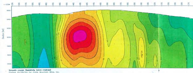
In July 1994, Zonge Engineering and Research of Tucson, AZ was contracted to complete a series of Controlled Source Audiofrequency Magnetotelluric (CSAMT) geophysical survey lines across the top of the mineralized zone. These lines clearly delineate the location of the highly conductive diatreme (Figure 6.3). The survey was completed along seven (7) lines that were located on or near the Basin Gulch Diatreme. A total of 214 stations were read at frequencies from 8,192 Hz to 2 Hz. The interpretation of the CSAMT data included a correlation to the geology of the area (Zonge, 1994).
The CSAMT data indicated that the highly conductive and altered portions of the diatreme extend to the depth of the survey, approximately 1,500 feet (450 m) below the surface. This was interpreted to indicate that the breccia pipe extends well past 1,500 feet (450 m) depth with a consistent electrical signature.
The CSAMT geophysical survey may have traced the location of the main cross-fault. The geophysics shows a paired high-conductivity zone, which crosses the diatreme surface expression from northeast to southwest. The high-conductivity zone may be offset by a younger, northwest-trending right-lateral, strike-slip fault, which appears to have post-diatreme movement. This younger fault follows the Basin Gulch drainage, and is suggested by a possible offset of the two parallel high-conductivity zones in the geophysical data, by possible similar sense surface offsets of the diatreme, and by post- diatreme faulting seen in core hole BG94-37C, at the projection of the proposed fault.
| March 29, 2024 | | 21 |
Technical Report for the Basin Gulch Property, Granite County, Montana, USA
Morphologic and lithologic changes across the projection of the proposed fault are consistent with this interpretation. The fault appears to post-date diatreme emplacement but pre-date mineralization (Perttu, 1997).
Figure 5.3 Portion of Line BL-4 showing a representative section through the diatreme as imaged by CSAMT.
Additionally various CSAMT cross-sections indicate the presence of small parasitic diatremes that emanate from the main eruptive center and appear to be connected at depth. These small diatremes are consistent with small features that have been mapped at the surface.
Zonge summarized the results of the survey as follows (Zonge, 1994):
“… On all lines, the area outlined as the diatreme on the surface geology map is seen to be conductive on the northern two-thirds of the diatreme, and more resistive on the southern portion. The conductive zone is bounded by a strong narrow resistor. (…)
The mapped southern boundary of the diatreme on lines BL-1, BL-2, and BL-4 is associated with a weak, locally resistive zone in the CSAMT data. Lines BL-3 and BL- 5 do not cross the southern boundary of the diatreme. The northern boundary of the diatreme is less well-defined in the CSAMT data; the change in resistivity to the north is more gradual, and is associated primarily with deep changes in resistivity. These deeper changes, best seen on Plate 8, form a “bench” near the northern limit of the diatreme.
On the lines that crossed it, the contact between the Tertiary intrusive (on the north) and the Missoula Group (on the south) is associated with a locally resistive zone. This contact does not show as much resistivity contrast as the contact described above within the diatreme.
In general, Line BL-4 (Plate 7) shows the best overall picture of the subsurface electrical resistivity structure at this site; a large low resistivity zone, extending from station 0 to station 1700, bounded sharply on the south and more gradually on the north. A large resistive zone extends from station 1700 to the south, and a very steep dip to the north is indicated.
| March 29, 2024 | | 22 |
Technical Report for the Basin Gulch Property, Granite County, Montana, USA
Near the southern end of Line BL-4, a strong low resistivity zone is seen from approximately station 4000 to 4600. This conductive anomaly is bounded on the south by a narrow resistive feature, similar to the resistive-conductive contact within the diatreme itself. This conductive zone apparently does not extend far enough west to be detected on Line BL-2.
It is very important to note that static effects (from very near-surface features) and high contact resistance definitely influenced the data on this project. These effects also provide information, however, and the interpretation has been made on the basis of both raw Cagniard resistivity and static-corrected resistivity. The raw data provide surface and very near-surface information, while the static-corrected data de- emphasize shallow features in order to delineate deeper resistivity structures…”
5.3 1996 – 1997 Kinross
In 1996, Kinross became interested in acquiring the property from CMM. Kinross completed a review of the project in 1996-1997 which included re-logging of the available core holes and over 200 RC holes, re-assaying 275 sample intervals and metallurgical testing. The re-assay samples were sent to American Assay Labs, Sparks (NV). Results confirmed the original assays reported by CMM. The re-logging confirmed that mineralization was ubiquitous in all rocks with no one rock type having preferential mineralization. Higher grade mineralization was found to be associated with the marginal areas and edges of the intrusive volcanics (Kinross, 1997; Perttu, 1997). The sale of the property was never competed due to the passing of Citizens Initiative Cl-137 in 1998 and a coincidental drop in gold prices. Citizens Initiative Cl-137 banned cyanide leach processing from open pit gold operations in Montana (see Section 4.3 for details) and was effectively seen by most mining companies as a moratorium on large-scale open-pit gold mining in the State. Shortly thereafter, in 1997, CMM ceased its activities and terminated its lease on the Metesh property. Between 1997 and 2006 the Metesh property remained dormant.
5.4 Historical Sample Preparation and Analyses Review
Historically samples were collected from outcrops, float rock, trenches and from drill holes as RC chips and core samples by CMM, Kennecott, Cyprus and Chevron. Ninety percent of the assay analyses conducted on the drill samples (RC chips and core) were completed by Mount Powell Laboratories of Deer Lodge, Montana. Brown, 2009, 2010 and Perttu, 2017 provide discuss the sample preparation procedures and the reader is directed to those reports for further information. The majority of drill hoes were assayed on 5 foot intervals.
Mount Powell Laboratories (Mount Powell) was owned by Mr. Wayne Olmstead who was also the head assayer. Although Mount Powell was a small, owner operated laboratory several previous reviews of the laboratory by David Brown and Associates and Kinross concluded that the laboratory was operated carefully and meticulously. Mr. Olmstead was highly regarded in this field and taught assaying techniques and chemistry at the School of Mines at Montana Tech in Butte, Montana. Samples analysed at Mount Powell returning high-grade assays were automatically re-run as two additional splits to confirm the initial results.
| March 29, 2024 | | 23 |
Technical Report for the Basin Gulch Property, Granite County, Montana, USA
Additionally, CMM conducted numerous duplicate assay analyses at other labs including Assay Lab, Inc., ALS-Chemex, Bondar Clegg, and other laboratories which returned overall comparable results. During their review of the project Kinross re-assayed 189 intervals of RC chips at American Assay labs in Sparks, Nevada and confirmed that the Mount Powell assays were acceptable. Mr. Olmstead has since passed away and Mount Powell has been closed. The remaining RC chip and core samples were destroyed and were not available for review (pers comm. R. Perttu, 2020). Assay certificates from Mount Powell, Assay Lab, ALS-Chemex, Bondar Clegg, Dawson Metallurgical Laboratories and Barringer Laboratories were made available to the author for review. Based upon a review of the historical drill hole data, it is the author’s opinion that the data is suitable for the purposes used in the Technical Report. It is also the author’s opinion that the data is suitable for future work including future mineral resource estimations, however, additional drilling and analysis of results may be required. The assay results from the historical drilling have been compiled into digital format in an excel workbook and validated against the available assay certificates.
5.5 Historical Metallurgical Processing
CMM conducted a series of metallurgical analyses throughout their involvement in the project from 1993-1997. Most of the metallurgical work included cyanide leach testing. The most pertinent results are summarized below. Gravity separation testing was also conducted by CMM once coarse gold was identified on the Property. Coarse gold was found to be locally common especially associated with the margins of the BG diatreme and northeast-trending structural zones. Several zones of coarse gold mineralization were identified on the Property. Nugget effects were also recognised on the Property. The results of the gravity separation testing were encouraging. A large amount of data from the gravity testing was included with the data transfer. The data was provided as pdf scans of original assay files. Due to time constraints a full review of the gravity separation testing has not been completed. It is recommended that a full review of the gravity data be completed as well as modern metallurgical work to fully assess the potential of gravity separation processing on the Property.
In 1996 and 1997 CMM submitted several series of samples for metallurgical testing to 2 different laboratories: Kappes, Cassiday & Associates (KCA) and American Assay Laboratories, Inc (AAL). The metallurgical testing is summarised below. A detailed discussion and review of the metallurgical testing is presented in Brown, (2009).
| March 29, 2024 | | 24 |
Technical Report for the Basin Gulch Property, Granite County, Montana, USA
In 1996 five samples were submitted to KCA of Reno Nevada for metallurgical and resource recovery testing. The samples were processed separately using a series of column tests to determine gold and silver recovery. The tests included:
| - | Gold and silver assays on head splits from each of the five different type of ore samples. |
| - | Five separate head screen analyses on the samples for the column leach tests (as received crushed size). |
| - | Cyanide bottle roll leach tests. |
| - | Five separate cyanide column leach tests on the as-received samples (four columns at 21 day leach tests and one column at 35 day leach tests). |
| - | Tail screen analyses of the cyanide column tailings. |
The cyanide bottle roll leach tests were conducted on pulverized (minus #100-mesh) portions of all 5 samples. Gold recovery varied from 73% to 89.5% after 48 hours of leaching (Table 6.3). From the column leach tests gold recoveries of 69 % to 92% were achieved after 21 days of leaching (Table 6.4).
Table 5.3 KCA Summary of Cyanide Bottle Roll Test (Brown, 2009).
KCA Sample No. | | KCA Test No. | | CMM Sample ID | | Calculated Head opt Au | | Average Tail opt Au | | Percent Recovery Au | |
| 23239 | | 23281 A | | Siliceous | | 0.033 | | 0.007 | | 80.6 | |
| 23240 | | 23281 B | | Igneous | | 0.014 | | 0.002 | | 85.7 | |
| 23241 | | 23281 C | | Pile #1 | | 0.153 | | 0.016 | | 89.5 | |
| 23241 | | 23281 D | | Pile #2 | | 0.008 | | 0.002 | | 75 | |
| 23243 | | 23281 E | | Pile #3 | | 0.015 | | 0.004 | | 73.3 | |
| March 29, 2024 | | 25 |
Technical Report for the Basin Gulch Property, Granite County, Montana, USA
Table 5.4 KCA Metal Recoveries (KCA, 1996).
KCA Column Test No. | | Cable Mt. Description | | Calculated Head opt Au | | % Gold Recovery | |
| 23401 | | Siliceous | | 0.036 | | 55.6 | |
| 23458 | | Igneous | | 0.013 | | 92.3 | |
| 23404 | | Pile #1 | | 0.139 | | 85.6 | |
| 23461 | | Pile #2 | | 0.006 | | 75 | |
| 23464 | | Pile #3 | | 0.009 | | 69.2 | |
In 1997, 14 samples were submitted AAL of Sparks, Nevada to conduct Agitated Cyanidation Testing. Standard bottle roll cyanidation tests were conducted on each sample to determine gold recovery, recovery rate and reagent consumption. Gold extraction rates were tested after 2, 6, 24, 48, 72, 96, 120, 144, 168 and 192 hours. Initial leach rates for the samples, with one exception, indicated fairly rapid recovery of finely disseminated gold particles in the first 24 hours. After which recovery decreased and began to increase again after 96- 120 hours. The decrease in recovery was attributed to “pitting” of gold particles by the cyanide solution. With the subsequent increase in recovery attributed to dissolution of the gold particles (AAL, 1997).
The Basin Gulch ores have good recoveries and moderately high cyanide consumption with definite preg robbing characteristics after 48 hours. Best results are obtained with moderate cyanide consumption with relatively short time frames.
The beneficiation studies indicated that the gold can be easily extracted from the ore using cyanide, however, due to the prohibition of open pit cyanide leach mining in Montana an alternative mining method or extraction method will need to be investigated.
The authors have reviewed and accepted the historical results as disclosed herein.
6 Geological Setting, Mineralization and Deposit
A comprehensive review of the geology was completed by Brown in 2006 and is reported in Brown 2009, 2010 and Perttu, 2017. Brown, 2009 based their property geology discussion on work completed by CMM including Rauno Perttu’s surface geological mapping (1997a and b), the Zonge geophysical survey (Zonge, 1994) and the drillhole geology in the context of regional geological work completed by the United States Geological Survey (USGS) and the Montana Bureau of Mines and Geology (MBMG). The geological descriptions as presented in Brown 2009, 2010 and Perttu, 2017 have been reviewed by the author and are considered to contain all relevant geological information for the project area and are summarized below.
6.1 Regional Geology
The regional geology of western Montana is dominated by the north-northwest trending, fold and thrust belt of the Rocky Mountains. The Basin Gulch Property is located within the northern extent of the Sapphire Mountain Range on the northeast slopes of the West Fork Buttes. This area is characterized by folded and faulted Precambrian, Paleozoic and Mesozoic sedimentary rocks that have been intruded by early Tertiary batholiths (Figure 7.1).
| March 29, 2024 | | 26 |
Technical Report for the Basin Gulch Property, Granite County, Montana, USA
The majority of the area is underlain by a series of metamorphosed Precambrian marine sedimentary rocks known as the Belt Supergroup which were intruded by Laramide-age silicic volcanics. The Belt Supergroup was largely deposited between 1.5 billion to 800 million years ago with intermittent deposition continuing throughout the Paleozoic and Mesozoic (600 to 65 million years ago). It covers a large area of western Montana and extends into Idaho, Washington, Wyoming and Canada where it is correlated with the Purcell Supergroup. The thickest sedimentary packages found in western Montana are in excess of 15 km (10 miles). The lithologies of the Belt Supergroup include argillite, quartzite, siliceous limestone, and argillaceous shales typically having a very fine-grained texture.
The earliest tectonic event that can be documented in the region is gentle (2º -5º) westward tilting and subsequent erosion of the Mesoproterozoic Belt Supergroup prior to the Cambrian. No other major tectonic events affected the area until a major period of mountain building occurred throughout the Western United States from the Cretaceous to Paleocene (150 to 60 million years ago). During this period there was rapid under thrusting of oceanic plates beneath the continental North American Plate off the West coast of North America. This period of orogenesis is divided into two phases: the Sevier orogeny and the Laramide orogeny. The Sevier Orogeny resulted in thin-skinned thrust faulting that locally sliced, shortened and stacked the Belt Supergroup and Paleozoic rocks. During the Laramide Orogeny both the overlying sedimentary rocks, and the underlying basement rocks were uplifted and block-faulted and large masses of silicic crystalline rocks were emplaced. The plate interactions caused uplift and compression, resulting in large-scale folding, faulting, and regional monocline development. During the Laramide faulting and regional monocline development, as opposed to folding, were more prevalent due to the hard, brittle nature of the Belt Supergroup rocks. Thrust faults and normal faults in the Philipsburg area are reported to have several tens of miles of displacement (Lonn, 2010).
In western Montana Late Cretaceous to early Tertiary granitic intrusions were emplaced contemporaneously with orogenesis. The intrusions were emplaced east of the main magmatic arc which is exposed in the Idaho Batholith west of the Property (Hamilton and Myers, 1974). The intrusions were of variable size. The late Cretaceous to early Tertiary Sapphire Batholith and Phillipsburg Pluton are found near the Basin Gulch Property (Figure 7.1). In the immediate Basin Gulch area, the Tertiary igneous rocks are predominantly biotite-rich rhyolites and trachytes, ash flow tuffs, and associated granites of Eocene age (~50 million years old; Lonn, 2010). These silicic rocks are found in faulted, intrusive, and unconformable relationship with the Precambrian sediments. In the immediate area of the Property an area of intense silicic volcanism and associated shallow intrusives, approximately 15 miles by 15 miles, has been identified and termed by some workers as the Rock Creek Volcanic Field (Figure 7.1). The Basin Gulch Property is located in the center of this volcanic field. At the head of Basin Gulch, a number of diatreme complexes lying within the igneous complex have been identified. These diatremes and their related structures are host to the main gold mineralization in this area.
| March 29, 2024 | | 27 |
Technical Report for the Basin Gulch Property, Granite County, Montana, USA
Figure 6.1. Regional geology of Basin Gulch Property.
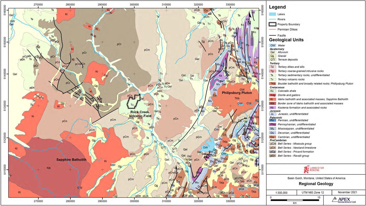
| March 29, 2024 | | 28 |
Technical Report for the Basin Gulch Property, Granite County, Montana, USA
6.2 Property Geology
The following description of the Property geology is adapted from CMM’s interpretation from their surface geological mapping (Perttu, 1997), geophysics, and drillhole geology and review and adaptation of the work by the USGS, the MBMG and Brown 2009, 2010 and Perttu, 2017. The geological descriptions as presented in these sources have been reviewed by the author and are considered to contain all relevant geological information for the Project and are summarized and /or partially reproduced below.
6.2.1 Bedrock Geology
6.2.1.1 Precambrian Sedimentary Rocks
The Precambrian sedimentary strata in the Property area consist of two sedimentary packages that are interpreted to be juxtaposed thrust plates.
The first of these packages comprises the Wallace and Helena Formations of the Middle Belt Supergroup. This package is characterized by dark gray dolomitic siltstone and silty limestone beds of the lower Wallace Formation and/or Helena Formation. These units form massive outcrops of alternating dark and light carbonaceous and silicic beds. The beds are dense, relatively impermeable, fine-grained and wavy, and commonly exhibit current marks and algal mat structures. These strata are gently dipping, relatively coherent and less altered than the other geological units. This unit has been identified in the northern extent and along the eastern part of the current Property.
The second package consists of the Missoula Group of the Upper Belt Supergroup. This package is characterized by green and purple marine siltstones of the Snowslip Formation that grade upward into purple and green quartzite of the Mount Shields Formation. The medium to coarse quartzites of the Mount Shields Formation display numerous tidal flat features indicating shallow-water to subaerial deposition. The sedimentary sequence is a coarsening-upward and shallowing sedimentary package that is typical of Belt Supergroup sedimentary rocks. In the Basin Gulch area, these strata have been pervasively strongly bleached, altered and shattered by faulting and by the local volcanic activity. This unit is found throughout the Property west of, and in fault contact with, the Wallace/Helena Formation.
| March 29, 2024 | | 29 |
Technical Report for the Basin Gulch Property, Granite County, Montana, USA
Figure 6.2. Property Geology
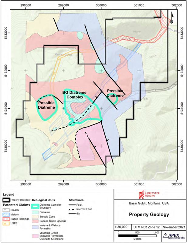
| March 29, 2024 | | 30 |
Technical Report for the Basin Gulch Property, Granite County, Montana, USA
The Missoula Group units observed at Basin Gulch are characterized by void spaces, random brecciation, pervasive fracturing and veining, and local pebble dykes. These features are interpreted to have formed by steam flashing and venting in the area surrounding the diatreme complex. The fractures in these rocks contain euhedral quartz crystals, sulphides (below the zone of oxidation), argillization, bleaching, carbonate mobilization, manganese and sericite. The seemingly isolated voids, which are very common in these rocks, are interpreted to have been created by phreatic shattering when superheated fluids from the intruding diatreme penetrated the rocks. The rocks, which contain these voids, were observed to contain scattered small diatreme pebble dykes and breccias. Hydrothermal and fumarolic leaching have bleached these rocks and removed almost all of the mafic minerals. In places, the alteration is so strong that it is difficult to identify the original rock type.
| 6.2.1.2 | Tertiary Shallow Intrusive and Extrusive Volcanic Rocks |
The Precambrian strata at Basin Gulch have been intruded and overlain by a complex series of silicic igneous rocks (Figure 7.2). These igneous units are probably early Tertiary in age, and may be younger than the Mesozoic thrust faulting which extensively displaced and shattered the Precambrian units. Mapping by the MBMG has indicated they are Eocene in age (50 million years old; Lonn, 2010).
These units have generally intruded the Precambrian strata along pre-existing fault structures. The eruptive center identified at the head of Basin Gulch appears to have intruded along the contact between the Wallace/Helena units and the Missoula units of the Belt Supergroup. The igneous rocks are predominantly extremely altered shallow granitic porphyries, silicic flows and domes, and welded ash flow tuffs, which form shallow intrusive and extrusive bodies on and near the Property. Most of the silicic rocks show flow banding and degassing bubble trains. The rock types range from rhyolitic to trachytic. In the intrusive phase, the rocks are more granitic in nature and display large phenocrysts of euhedral biotite and sanidine.
Gold and silver mineralization is associated with the main intrusive complex, the BG diatreme. The BG diatreme is a large, complex silicic mass, which extends from west of Quartz Gulch, eastward across the hill between Quartz Gulch and Basin Gulch, to the mineralized area in Cornish Gulch (Figure 7.2). This igneous center appears to be made up of multiple nested magmatic pulses, endogenous domes, base-surge deposits, and associated flows.
The rocks within this igneous mass all display volcanic characteristics. The silicic rocks and surrounding intruded rocks also contain rounded pebble breccia zones and pebble dykes, which are interpreted to have formed in de-gassing volcanic vents, or diatremes.
| March 29, 2024 | | 31 |
Technical Report for the Basin Gulch Property, Granite County, Montana, USA
Silicic igneous dykes have been identified across the Property. The dykes range from thin and incoherent to massive and coherent and were emplaced along pre-existing faults and fracture zones. It is interpreted that there are at least three ages of dykes present in the area. Many of the dykes have intruded highly altered igneous and Precambrian rocks, where it appears that some of the alteration and associated mineralization occurred before dyke intrusion. The majority of drill holes on the Property intersected significantly altered dykes, even those drill holes that are located away from the igneous units on the surface. Typically drill holes intersected more than one dyke. Many of the dykes appear to have been emplaced in large-scale stock work fashion, with meandering orientations suggestive that they followed the margins of slump blocks that collapsed back into the diatreme complex. Some of the highly altered dykes are associated with the margin of the BG diatreme complex and dip toward the diatreme. Numerous other highly altered dykes occur south of the diatreme boundary. Many of the larger dykes appear to strike approximately northwest (320°). However, some of the dykes, including those associated with strong mineralization strike northeast (20° to 60°). The dykes vary from steeply dipping to almost flat-lying. All of the young, less altered, post-mineralization dykes observed to date, as well as the major dykes are northwest trending.
Many of the drill holes, especially on the eastern slope of Quartz Gulch, and on the south side of the hilltop area, bottomed out in highly altered shallow intrusive bodies. The association of numerous dykes with the intrusive bodies suggests that igneous masses may underlie much, if not all of the Precambrian rocks in the Basin Gulch area. It appears probable that the igneous bodies may have intruded along the stacked thrust sheet fault zones which underlie the area.
The geometry of the rock units, when combined with other features, such as the numerous pebble dykes within the adjacent Missoula Group sedimentary units, suggests that the majority of the igneous rocks are of very shallow intrusive origin. The intrusive rocks show extensive leaching alteration, brecciation and apparent phreatic steam fracturing. The alteration is interpreted to have occurred above the boiling zone, as vapor alteration rather than hot water alteration indicating that the boiling zone was located at some depth. Leaching of the mafic minerals, and remobilization of the silica from the Precambrian and igneous units is pervasive.
The bedrock and derived placer materials are void of magnetite. The hematite and limonite are derived from oxidation of pyrite films and crystals, and were observed to form up to 5% of the un-oxidized rock. Occasional rare quartz-pyrite veins were also observed. These field observations indicate the mineralization system was a low sulfur system.
Although the Precambrian quartzites have been re-cemented, silica flooding is not common, leaving much of the Basin Gulch bedrock soft, with fine unhealed fractures and crackle structures. The fractures and vugs are locally coated with, but unfilled by, euhedral quartz crystals growing from the rock faces.
| March 29, 2024 | | 32 |
Technical Report for the Basin Gulch Property, Granite County, Montana, USA
6.2.1.3 Diatremes
Several diatremes or potential diatremes have been identified on the Property. The largest is the Basin Gulch or BG diatreme complex located in the central portion of the Property and is covered by evidence of historically mining. The BG diatreme complex has a surface extent of 2,600 feet (790 m) by 3,300 feet (1,000 m) and comprises several nested diatreme vents. A second, large potential diatreme was recognised west of the BG diatreme on the western side of Quartz Gulch (Figure 7.2) Additional smaller diatremes have been identified on the Property and are interpreted to be parasitic associates of the main eruptive center at the head of Basin Gulch. The diatremes on the Property are associated with local structural weaknesses.
Diatremes (breccia pipes) are recognized to be highly prospective targets for base metal and precious metal exploration. A significant genetic connection has been observed between shallow, ore-forming processes and volcanic and sub-volcanic activity (Sillitoe and Bonhom, 1984).
In 1997 Miles Silberman, a petrography consultant, examined a rock sample from the BG diatreme. Silberman, (1997) reported:
“…The rock is a polymictic breccia with a variety of clasts. The most common are fine grained hornblende-biotite trachyte. Biotite in these is partially altered to sericite. Some of the tiny feldspars in the clast matrix appear to be argillically altered. The Precambrian clasts are fine grained micaceous sandstone or quartzite. They are fine growths of quartz and K-spar with sericite and contain much limonite spots and stains, probably from oxidation of pyrite. We noted the occurrence of lots of pyrite in unoxidized breccias from several cores. In the quartzite clasts there is a preferred orientation of micas which is probably an effect of bedding and foliation. The feldspar content is on the order of about one-quarter in the quartzite clasts. The trachyte clasts, which go down to sand sized fragments are strongly K-spar stained which suggests that they are K-feldspar altered or are primary, and represent an initial K rich composition in the protolith. The matrix between clasts is a mass of mosaic, interlocking quartz crystals with an occasional intergrown muscovite grain. Some small clasts appear to be fragments of trachyte that are altered to clay minerals, but some also have inclusions of muscovite. The matrix does not look igneous, but like crushed rock fragments with a silica infilling. This silica matrix still has porosity, so the silicification is not complete…”
The igneous rocks at Basin Gulch are interpreted to initially have been very gas-rich. The extremely altered intrusive rocks in and near the BG diatreme contain gas bubble voids and quartz eyes which appear to be gas bubbles filled with secondary quartz. The orientation of the gas bubble voids are indicative of flow lamination near the intrusive - Precambrian contacts. The margins of the intrusive, even away from the diatremes, contain breccia zones, in which diatreme characteristics have been observed.
| March 29, 2024 | | 33 |
Technical Report for the Basin Gulch Property, Granite County, Montana, USA
The volcanic and Precambrian wall rocks of the Basin Gulch diatremes are highly brecciated and intensely altered. Several breccia zones show extreme mechanical rounding and leaching. The breccias were intruded by fine-grained dykes, which were extremely altered by associated thermal activity. De-gassing bubbles which are stretched near the dyke contacts have been observed in some of the dykes, (ex. dyke intersected in drillhole BG-2C). Portions of the BG diatreme complex contain highly altered ash and tuff fragments, encapsulated in slightly younger tuffs. Some of the tuffs may be the remnants of tuff cones and base surge deposits, or maars, which form where a diatreme reaches the surface. Trenches 94-27 and 94-28 cut across the remnants of a tuff cone, suggesting that the BG diatreme complex is not deeply eroded.
Basin Gulch Diatreme Complex
The Basin Gulch (BG) diatreme complex is approximately 3,300 feet (1,000 m) across. Along the southern margin of the diatreme it extends irregularly into the Missoula Group Precambrian rocks; along the western margin of the complex it extends under younger volcanics. This size makes the diatreme complex larger than is typical for diatremes. The diatreme is very intensely altered, shows strong mixing and mechanical rounding of clasts, and silica flooding is evident deeper in the complex. Mechanical rounding is particularly intense in the smaller diatreme centers that are contained within the diatreme complex. The variation in the intensity of brecciation and alteration suggests that gas venting within the complex was localized within preferred pathways, which may have been isolated, leaving other parts of the complex less impacted. Along the diatreme margins large blocks of bedrock collapsed into the diatreme complex. Some of these blocks remained relatively coherent and are associated with strong vent zones that wrap around them.
The clasts in the diatreme include tuff fragments, quartz vein material, pyrite fragments, intrusive material and xenoliths from both Precambrian thrust plates. Pebbles of the Helena Formation have been found in the main diatreme complex and in other diatremes on the Property. These pebbles are generally strongly mechanically rounded, and often subject to chloritic alteration.
Many of the diatreme clasts are composed of welded and cemented chunks of slightly older diatreme breccias. Some of the breccia is clast-supported, with unfilled voids still visible. Where igneous material (welded ash, tuff) has not filled the voids between clasts, the matrix material is composed of secondary silica: euhedral quartz crystals growing from the walls of the voids. The matrix contains common hematite films and blebs, derived from the oxidation of pyrite. The current level of exposure of the diatreme complex is interpreted to be close to its original surface, at least along the southern margin.
As is typical of diatremes, the BG diatreme complex appears to be funnel-shaped. Complicating the picture is the possibility that individual venting centers may be tilted in different directions. The diatreme may have formed in the stress-shadow, where northeast and northwest-trending high-angle faults intersected the fault zone between the Precambrian thrust sheets.
| March 29, 2024 | | 34 |
Technical Report for the Basin Gulch Property, Granite County, Montana, USA
The northeastern wall of the BG diatreme is projected to dip at between 70 and 75 degrees into the complex. This is based on two widely spaced drill holes that intersected the diatreme boundary, and by the dip of the contact in core hole BG94-43RC at 325 feet to 835 feet (100 m – 250 m). Alternately, the northeastern diatreme wall can be projected as step-faulted in the same sense, based on a prominent resistivity bench between the diatreme’s northeastern surface boundary and the edge of the highly conductivity root zone. The southern margin of the diatreme appears to dip somewhat variably toward the root zone, from 30 degrees to almost vertical, based on drill holes in the area.
Other Diatremes
Several other diatremes have been tentatively identified on the Property. This is typical of a silicic volcanic center, where an eruption center consists of a number of pulses and nested volcanic centers. Parasitic and small offshoot gas vents and eruptions are also very common. The CSAMT cross-sections indicate the presence of numerous diatremes on the Property.
Northwest of the BG diatreme lies a possible diatreme (“CG” diatreme; Figure 7.2) however due to a lack of exposure and lack of drilling in the area it is not well defined. If it exists, this diatreme is located immediately southwest of the gold mineralization found in Cornish Gulch. The locality has brecciated diatreme-like characteristics across an area roughly 500 feet (150 m) across. This possible breccia pipe may be associated with a strong gold and arsenic anomaly identified in the soil samples collected from the area.
The large area of highly altered, leached breccia along the drainage immediately south of the Hilltop area (see Figure 6.4), in the southern part of the Property, may be a breccia pipe. It occurs near the contact of the Missoula Group quartzites with another highly altered igneous body to the south. The brecciated area, which contains both sedimentary and igneous clasts, is south of the soil grid, and lies along the projection of a gold and arsenic anomaly. No trenching or drilling has been completed in this area and little is known about this eruptive center.
Breccia pipes occur on the northern and northeastern margins of the Quartz Gulch intrusive, north of Quartz Gulch. Float and limited outcrops of apparent diatreme breccias occur locally in several other places. Smaller vent breccias, or small diatremes, were also intersected by some of the trenches, and most notably by drill holes BG94-5RC and BG95-8RC. In these two holes, high grade gold mineralization occurred in strongly rounded, high-energy diatreme material.
| March 29, 2024 | | 35 |
Technical Report for the Basin Gulch Property, Granite County, Montana, USA
6.3 Structural Geology
6.3.1 Thrust Relationships
The USGS has mapped the contact of the two stratigraphic packages as a younger- over-older thrust fault (Wallace, 1986). Younger-over-older thrust faults such as this are rare and involve complex structural development. Later mapping completed by the MBMG did not support this thrust relationship as identified by the USGS (Lonn, 2003).
Based on drilling into the main diatreme complex, the thrust relationship between the Helena-Wallace thrust plate and the Missoula Group plate appears to be a much more common older (Helena-Wallace) over younger (Missoula Group) thrust. In contradiction to the USGS mapping but supported by the MBMG work. The Precambrian units are all generally gently dipping towards the northwest, and straight projection places the Helena- Wallace rocks over the Snowslip Formation (Missoula Group) rocks. This projection may, however, result from complications of later high-angle faulting. Assuming that the thrust relationship is normal older-over-younger, the fact that the BG diatreme complex, and other diatreme zones, structurally below the rim of the BG diatreme contain Helena pebbles suggests possible further complications. The occurrence of the xenolithic pebbles in the diatremes can be explained in several ways:
| ● | After episodes of gas venting diatremes can experience repeated periods of collapse, when overlying rocks and wall rocks fall back into the open vent. These collapse episodes allow rocks from overlying formations to work their way deep into the diatreme. Based on the area’s geological history, at the time of emplacement, the Helena/Wallace thrust plate still overlay the diatreme intrusions and would have contributed to the vent materials. Since diatreme emplacement the overlying Helena/Wallace rocks have locally been eroded. |
| ● | The thrusting may be imbricated or stacked. The small diatremes could then entrench Helena pebbles from a lower thrust slice of Helena Formation during ascent. |
| ● | The USGS interpretation of younger over older thrusting may be correct regionally, and the BG diatreme may be centered on a local secondary ramp structure, which would have locally pushed the Helena/Wallace plate over the Missoula plate. This interpretation is compatible with the continued occurrences of dykes and intrusive masses well to the south and east of the local thrust contact. If a large intrusive mass continues to follow the main thrust plate boundary, these igneous bodies would be intruding overlying structures and producing diatremes where gas build-ups occur. |
| ● | The BG diatreme, and the thrust fault where it is likely rooted, both appear to be dipping steeply (possibly sub-parallel) and may remain in proximity with each other to considerable depths. If the thrust boundary and diatreme remain in close proximity, Helena pebbles may have been carried short distances into the diatreme along connecting fractures deeper in the diatreme or could have been recycled from the thrust sheet rubble zone. |
| March 29, 2024 | | 36 |
Technical Report for the Basin Gulch Property, Granite County, Montana, USA
The Precambrian units are not only in thrust contact with each other, but they also contain local internal high-angle faults and thrust faults. To date, the Missoula Group rocks have been found to be extensively mineralized and brecciated, while the less broken Wallace and Helena Formations have generally been poorly mineralized, except along the margin of the BG diatreme, and on the ridge north of Quartz Gulch, about two miles to the north.
6.3.2 Normal and Reverse Faulting
In addition to the preferred northwest strike of the major dykes on the Property, several of the contacts between the igneous rocks and the Precambrian sedimentary rocks, are straight, parallel, and northwest trending. The lithological boundaries and the dykes appear to be following a series of northwest-trending faults. These trends follow the structural orientation of the entire Sapphire Range, and the Northern Rocky Mountain Range as a whole.
The northeast-sloping hillside has an abrupt northwest-trending break in slope. The break generally follows the contact of the intrusive rocks downhill and the Precambrian rocks uphill but has Precambrian rocks on both sides of the break in slope. This break also appears to be a northwest-trending fault. This fault may continue downhill to become the mineralized contact in Quartz Gulch, between the intrusive rocks to the northeast and the Precambrian rocks to the southwest.
These northwest-trending faults are clearly very important local geological controls. At least some of these faults existed before the mineralization, and apparently helped to control it. Several of these faults, such as the faults that form the northwest-trending linear boundaries of the intrusive complex, clearly had post-intrusive, post-diatreme and post- mineralization movement. They appear to have had more recent movement than the northeast-trending structures, although it is possible that the northwest- and northeast- trending faults were originally formed as a conjugate set.
6.4 Mineralization
The mineralization in Basin Gulch can actually be termed as a gold and silver intrusion related deposit that is constrained by the structures surrounding and associated with the emplacement of the local diatremes. Review of the historical drilling and assay results indicates there is a very high background gold and silver level throughout the Tertiary rocks, and in the Precambrian rocks that have been brecciated, altered and in-filled by the effects of the diatremes. This elevated background of gold and silver mineralization (0.01 to 0.02 ounces per ton) is punctuated by areas of high-grade mineralization, associated with the edges of the diatremes, and areas where the boundaries of the diatremes have been penetrated by local faulting. Historical work was largely focused on the low-temperature uppermost part of the gold system; the mineralization in the deeper part of the diatreme has not been fully evaluated.
| March 29, 2024 | | 37 |
Technical Report for the Basin Gulch Property, Granite County, Montana, USA
The mineralized zones are found in breccias associated with fracture zones bounding the diatremes, with fracture and slump features formed within the diatremes or during post-magmatic pulses, and fault zones either created during the emplacement of the diatremes, or re-mobilized by the diatremes emplacement. Fundamentally, any structure that provided a fluid and/or vapor pathway appears to have been inundated with gold- bearing fluids and vapors.
Mineralization in the diatreme is hosted in polymictic breccias (Silberman, 1997) comprising juvenile silicic clasts, xenoliths of surrounding Precambrian country rock, and silica and volcanic ash that flooded the open spaces during fluid emplacement. The gold and silver are seen primarily as free metal, with possibly some Ruby Silver (Pyrargerite or Proustite) observed. The gold is very fine to very coarse, and can actually be seen in drill core and some outcropping breccia samples with the unaided eye (Figure 7.3). Analytical data from selected drill holes indicates that the gold is associated with very strong arsenic anomalies and somewhat weaker antimony anomalies. However, no Realgar or Orpiment (sulphides of arsenic) were observed in the mineralized samples.
Drilling has shown that oxidation extends down to a depth of about 250 feet (75 m). Any sulphides near the surface have been oxidized to hematite and limonite. It appears that this oxidation is due to normal weathering and oxidation processes. Oxidation observed at higher elevations extends to deeper than 300 feet (90 m), but is shallower at lower elevations.
Figure 6.3. Core samples containing coarse gold from Basin Gulch (Brown, 2009)
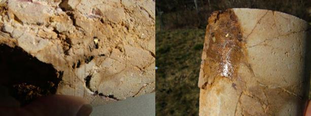
| March 29, 2024 | | 38 |
Technical Report for the Basin Gulch Property, Granite County, Montana, USA
6.5 Deposit Types
The Basin Gulch Property lies along a north-south trending belt along the eastern edge of the North American Cordillera that encompasses an important group of gold deposits. This belt extends from Canada to eastern Mexico. The gold deposits share a consistent spatial and temporal association with alkaline igneous rocks and consist primarily of breccia pipes, epithermal vein, porphyry, and skarn deposits (Kelley and Ludington, 2002 and references therein). In many of the gold deposits found along this belt mineralization and the associated alkaline igneous rocks have a close spatial relationship suggesting a genetic link between the alkaline magmatism and gold mineralization (Kelley and Ludington, 2002 and references therein). The Basin Gulch deposit is interpreted to contain intrusion related mineralization related to diatreme emplacement.
6.6 Diatreme-Hosted Gold Deposit
Diatremes (breccia pipes) have been recognized as highly prospective targets for base metal and precious metal exploration. A significant genetic connection has been observed between shallow ore-forming processes and volcanic and sub-volcanic activity (Sillitoe and Bonhom, 1984). Along the eastern edge of the North American Cordillera numerous diatreme deposits have been identified and mined to date. Along this belt diatreme deposits associated with porphyry style gold mineralization include the currently producing Cripple Creek Mine located in Colorado (Koschmann, 1947) and the nearby past producing Montana Tunnels Mine located in Montana (Kelley and Ludington, 2002, Sillitoe et al., 1985).
6.6.1 Cripple Creek, Colorado
The diatreme-hosted gold deposit at Cripple Creek, Colorado as described by Thompson et al (1985), and Kelley et al. (1998) is similar in nature to the breccia-hosted mineralization observed at Basin Gulch. As outlined by Thompson et al., (1985), the Cripple Creek deposit is characterized by Au-Te veining and disseminated gold hosted within a nested diatreme system and a related alkalic igneous suite. These volcanic and sub-volcanic suites are comprised of phonolite, latite, syenite and alkali basalt that intrude a large basin of brecciated Precambrian basement rocks. Phreatomagmatic brecciation is commonly associated with the diatreme intrusions. Late-stage mineralized veining cross-cut both the Precambrian basement as well as the margins of the diatreme complexes. These veins are regularly oriented in the Precambrian country rock and anastomose when within the diatreme and breccia complexes. Mineralized vein systems are vertically continuous, reaching as deep as 3,000 feet (1,000 m) below surface (Thompson et al., 1985). Mineralization of the Cripple Creek deposit consists of native gold, silver, and electrum throughout the deposit, though they are more common in the oxide zone (Leichliter and Larson, 2013).
| March 29, 2024 | | 39 |
Technical Report for the Basin Gulch Property, Granite County, Montana, USA
Mineralization at Cripple Creek can be best characterized as a polymetallic epithermal system resulting from three separate hydrothermal events (Thompson et al., 1985). These hydrothermal events are directly tied to structural systems of various ages:
1) Hydrothermal breccia and veining, with open space silica breccia-matrix-filling characterized by boiling textures. Mineralization in this system consists of pyrite, sphalerite, galena, chalcopyrite, pyrrhotite, calaverite and specular hematite.
2) Structurally controlled veining and dissemination through the wall-rock adjacent to later structures. These veins are thin, and are variably mineralized with galena, sphalerite, calaverite and chalcopyrite. Sulphides rarely exceed a few percent. The disseminated mineralization is chiefly composed of pyrite and is limited to a few meters of the veining surface.
3) This zone is characterized by fragment-supported hydrothermal breccia, partially cemented and veined by significant clay minerals (montmorillonite). Other evaporites are present, such as gypsum and anhydrite, as well as subordinate fluorite. Gold mineralization in this interval is limited to trace concentrations (Thompson et al., 1985).
6.6.2 Montana Tunnels
The diatreme-hosted gold deposit at Montana Tunnels described by Sillitoe et al., (1985) is similar in nature to the breccia associated mineralization observed at Basin Gulch. Montana Tunnels hosts a gold-silver deposit that is located in the central part of a diatreme. This diatreme was emplaced along the faulted contact between andesitic volcaniclastic rocks and a sequence of quartz latitic ignimbrites. A north-northeast striking swarm of quartz latite porphyry dykes was emplaced during the weakening stages of Lowland Creek volcanism. The dykes intruded into the diatreme prior to the termination of brecciation and mineralization.
Sulphide minerals in the diatreme occur as disseminations in the breccia matrix and in subordinate amounts, as widely spaced, multidirectional veinlets and as the matrix to brecciated blocks of Elkhorn Mountains Volcanics. All forms of mineralization consist of pyrite, sphalerite, galena, minor chalcopyrite and rare electrum accompanied by a gangue of manganocalcite siderite and minor quartz. Clastic grains and fragments of sulphides and gangue minerals are common indicating multiple alternating episodes of brecciation and mineralization occurred. In the ore zone the introduction of abundant manganocalcite and siderite was accompanied by pervasive sericitic alteration but only weak kaolinization and silicification. The gold and silver occur within an assemblage of sulphide minerals that are found as disseminations in the matrix of the diatreme breccia, as multidirectional veinlets in the breccia and as a matrix in included masses of Elkhorn Mountains breccia. Gold occurs in electrum, with a fineness of about 550 mm and as inclusions of less than 200 mm in pyrite and sphalerite.
The Montana Tunnels gold-silver deposit is characterized geochemically by anomalously high concentrations of zinc, lead, and manganese and in comparison to many volcanic-hosted precious metal deposits, is low in arsenic, antimony and mercury. This metal association and the low fineness of the gold are features shared by the Wau gold deposit in Papua New Guinea. The mineralized diatreme at Montana Tunnels is interpreted to have been emplaced several hundred meters beneath the paleosurface upon which a gold-bearing maar volcano like that preserved at Wau, was emplaced.
| March 29, 2024 | | 40 |
Technical Report for the Basin Gulch Property, Granite County, Montana, USA
Figure 8.1 shows a representative geologic cross-section of an auriferous diatreme from Papua, New Guinea (Sillitoe et al., 1984). This section shows the relationship between the eruptive vent, the association with local structural weaknesses, and the presence of country rock that had been intruded and then fell back into the vent during the quiescent periods between eruptive pulses.
Figure 6.4 Reconstructed schematic section of the Wau maar-diatreme system to illustrate aspects of the genetic model (Ross et al., 2017 after Sillitoe et al., 1984)
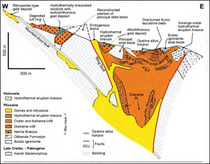
6.7 Porphyry Deposits
Porphyry deposits are the world’s most important source of Cu (50 – 60 % world’s production) and Mo (95 % worlds production), and are major sources of Au, Ag and Sn; furthermore, they comprise significant by-product metals such as Re, W, In, Pt, Pd and Se (Sinclair, 2007). Porphyry deposits are specially and genetically related to felsic to intermediate porphyritic intrusions and are large tonnage, low- to medium-grade deposits in which primary (hypogene) ore minerals are dominantly structurally controlled (Sinclair, 2007). A close temporal and genetic association between magmatic activity and hydrothermal mineralization in porphyry deposits is indicated by the presence of inter- mineral intrusions and breccias that were emplaced between or during periods of mineralization (Sinclair, 2007). Porphyry deposits are zoned with various alteration minerals and ores, as demonstrated in Figure 8.2. Porphyry deposits range in age from Archean to Recent, although most economic deposits are Jurassic or younger (Sinclair, 2007).
| March 29, 2024 | | 41 |
Technical Report for the Basin Gulch Property, Granite County, Montana, USA
Figure 6.5 Hydrothermal alteration zones, minerals and ores in porphyry deposits (Modified from Lowell and Guilbert, 1970).
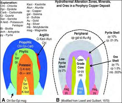
In porphyry Au and Cu-Au deposits, Au grades generally range from 0.2 to 2 g/t Au (Sinclair, 2007). Gold-rich porphyry deposits are generated at convergent plate boundaries during or immediately following subduction of oceanic lithosphere (Sillitoe, 2000). Gold porphyry deposits are commonly located in subduction-related volcano- plutonic arcs, in which epithermal deposits are also widespread. Although these deposits may be generated during intervals when arcs are subjected to periods of weak extension, most commonly they are emplaced during regional compression (Petford and Atherton, 1994; Sillitoe, 1991, 1998). Gold-rich porphyry deposits are found in Cordilleran arc underlain by either continental or oceanic crust (Sillitoe, 2000).
7 Exploration
In 2021 Lannister conducted an exploration program on the Basin Gulch Property. The exploration work included the reconnaissance of historical trenches and drill holes, the collection of 126 rock samples and 1,562 soil samples, along with a ground geophysical survey.
| March 29, 2024 | | 42 |
Technical Report for the Basin Gulch Property, Granite County, Montana, USA
7.1 Reconnaissance and Sampling program
The reconnaissance work and sampling program was completed between May 30 and July 5, 2021. During the reconnaissance program the crew was tasked with trying to locate and identify historical trenches that were ortho-rectified from historical maps. The majority of the historical trenches on the Property have been reclaimed so they were difficult to locate. Only 2 instances of trenches that match historical records were identified in the field. However, 47 additional trenches were identified in the field that were not on the historical maps as well as 41 small sample pits scattered throughout the Property (Figure 9.1). The majority of the newly identified trenches are located with the main diatreme complex northeast of the previously orthorectified historical workings.
7.1.1 Soil Sampling
In the summer of 2021, soil samples were collected on a grid centered over the patented claims but extending onto the BLM mineral claims. The soil grid covered an area of 1.7 km by 2.0 km covering the BG diatreme complex and extending southwards. A total of 1,247 soil samples were collected including 65 duplicates. The samples were analysed for 61 elements using the ultra-sensitive Ionic Leach method at ALS Global, Vancouver, BC, Canada (ALS). The ionic leach technique is designed to detect and define subtle, low level anomalies and is very useful where conventional geochemical techniques may be ineffective due to the presence of overburden deposits. Ionic leach sampling identifies geochemical anomalies that are typically weak but the anomalies are in sharp contrast to background values. Additionally anomalies identified by ionic leach sampling tend to be spatially coherent indicating that the anomaly is related to a bedrock signature rather than overburden noise.
The results of the 2021 soil sampling program show an anomalous response in Au and Ag related to the BG diatreme and edge of the diatreme (Figure 9.1). Further work is needed to assess the relationship between the anomalous Au responses and the historical ground disturbance in this area. Preliminary PCR (Principal Component Regression) analysis of the data did not identify any strong positive correlations between Au or Ag and other pathfinder elements. A general association between anomalous Au and low Ca was observed which may indicate a correlation between anomalous gold and decalcified areas. A correlation between anomalous gold and high As and Sb results is evident within the diatreme. Detailed interpretation of the soil sampling results should be completed.
Additional anomalies were also identified by the soil sampling program (Figures 9.2 and 9.3). A coherent Au and As anomaly is located approximately 500 m south of the BG diatreme in an area that was the focus of historical drilling and trenching. The anomaly measures approximately 500 m by 500 m. Smaller gold anomalies are also evident to the southwest and southeast of the BG diatreme.
| March 29, 2024 | | 43 |
Technical Report for the Basin Gulch Property, Granite County, Montana, USA
Figure 7.1 Ionic Leach soil sample results – Au (ppb)
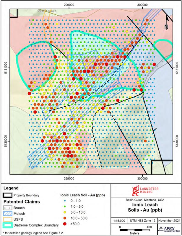
| March 29, 2024 | | 44 |
Technical Report for the Basin Gulch Property, Granite County, Montana, USA
Figure 7.2 Ionic Leach soil sample results – Ag (ppb)
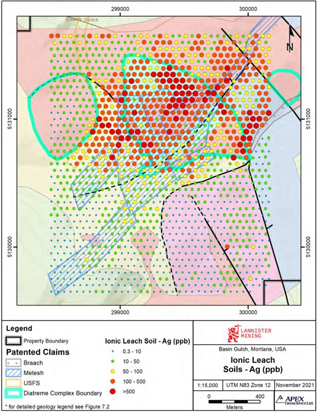
| March 29, 2024 | | 45 |
Technical Report for the Basin Gulch Property, Granite County, Montana, USA
Figure 7.3 Ionic Leach soil sample results – As (ppb)
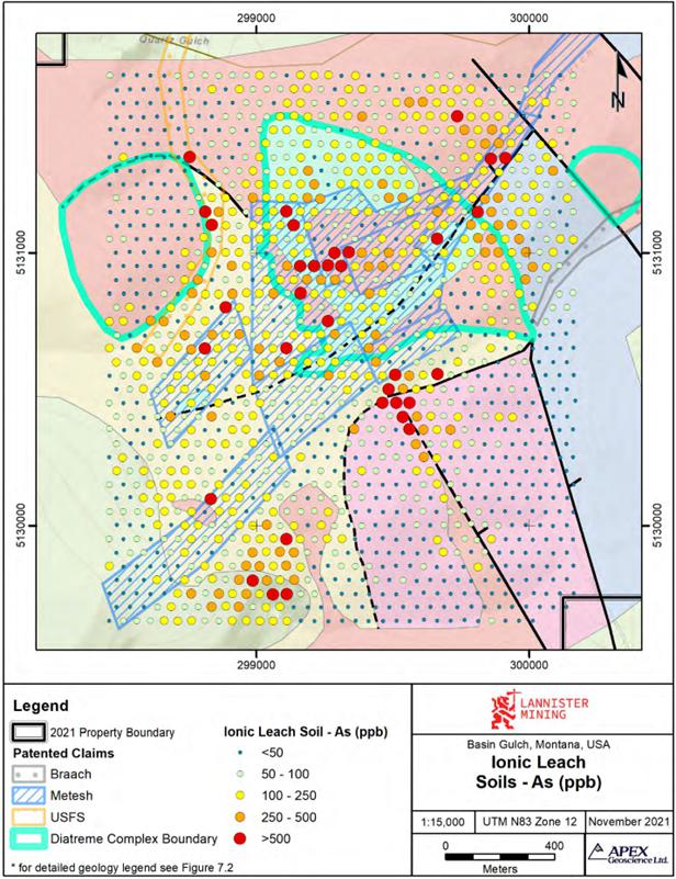
| March 29, 2024 | | 46 |
Technical Report for the Basin Gulch Property, Granite County, Montana, USA
7.1.2 Rock Sampling
Rock samples were collected during the soil program. Rock samples were collected from float samples, outcrop exposures and historical trenches across the soil grid area. A total of 126 rock samples including 3 duplicates were collected. Anomalous gold assays were recovered across the Property associated with the historical workings in and around the BG diatreme and other historically active areas including the anomalous areas identified by the soil sample survey (Figure 9.4).
Samples collected within and along the southwest edge of the BG diatreme returned up to 3.43 ppm Au with 10 samples returning >0.5 ppm Au. The samples were mainly collected from float and consisted of silicified volcaniclastic rocks and quartzite that exhibited limonite and hematite.
Samples collected to the southwest of the BG diatreme returned up to 3.72 ppm Au with 6 samples in the area returning >0.5 ppm Au. Sample D239174 which returned 3.72 ppm Au also returned 124 ppm Ag. This sample was collected from, a historical trench and consisted of a silicified pink quartzite breccia. The vein surfaces were limonite rich. A secondary vein containing drusy quartz contained hematite.
Samples collected approximately 500 m south of the BG diatreme in the area associated with the Au-in-soil anomaly and historical workings returned up to 3.72 ppm Au with 6 samples returning >1.0 ppm Au. Samples consisted largely of float samples of vuggy and/or brecciated quartz veins showing hematite, limonite and goethite alteration.
7.2 Ground Geophysics
Lannister conducted a ground magnetics survey over the Basin Gulch property between January 31st and February 27th, 2021 (Figure 9.5). The survey was focussed over the BG diatreme, other historical workings and areas identified as highly prospective for gold and silver mineralization. The survey was completed using a high sampling rate paired with closely spaced survey lines to produce a high-resolution magnetics map over the Property.
The ground magnetics survey grid consisted of 120 survey lines: traverse lines were oriented east west and spaced 50 metres (m) apart; with infill lines offset at 25 m from the main grid. Survey lines of variable length between 1,100 m and 1,750 m were used to avoid avalanche prone areas of the Property. The survey totalled 129.76 line-km of magnetic survey data, covering approximately 530 hectares. Several areas of the Property remained inaccessible at the time of surveying due to extensive snow cover and avalanche danger.
| March 29, 2024 | | 47 |
Technical Report for the Basin Gulch Property, Granite County, Montana, USA
Figure 7.4 Rock sample assay results – Au (ppm)
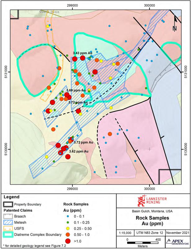
| March 29, 2024 | | 48 |
Technical Report for the Basin Gulch Property, Granite County, Montana, USA
Figure 7.5 2021 Residual Magnetic Intensity (RMI) with Upward Continuation filter of 10 m and Reduced to Pole (RTP)
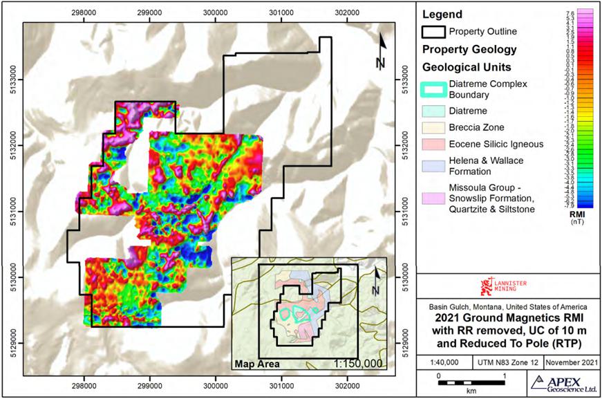
| March 29, 2024 | | 49 |
Technical Report for the Basin Gulch Property, Granite County, Montana, USA
Smoothing and enhancement filters were applied to the Residual Magnetic Intensity (RMI) to highlight and attenuate high-frequency signals and enhance the signals originating from geological sources. Regional trends on the Property were best highlighted using an upward continuation (UC) filter at 10 m to minimize the high- frequency responses and a Reduce to Pole (RTP) algorithm which places the peak of the response over the anomaly producing it (Figure 9.5). The processed geophysical data show that the major, northeast trending fault crossing the Property and the BG diatreme are associated with a low amplitude magnetic response. Mineralization within and along the margins of the BG diatreme is also associated with a low amplitude magnetic response.
No drilling has been completed on the Property by Lannister. During 2023 a trenching program was completed by Lannister. The program included trenching, mapping and sampling. Results and pending.
8 Sample Preparation, Analyses and Security
8.1 Sample Collection, Preparation and Security
8.1.1 Soil samples
In the summer of 2021, soil samples were collected on a grid centered over the patented claims with a sample spacing of 50 m. At each sample site tools were brushed and flushed to eliminate residue from the previous sample. Organic matter (~5 – 10 cm), if present, was removed and included decomposed leaf matter, rootlets and hairs. Organic Matter will not adversely affect the Ionic Leach analyses, but large rocks and twigs were removed by hand from each sample. The “Zero Datum” depth where organics decompose and start to see soil formation was recorded. Ionic Leach samples were taken at a constant depth 20 – 30 cm below the “Zero Datum”, often in the B-horizon. In skeletal soils with sub-crop/outcrop, samples were collected nearer to the surface. All field data was recorded within the Fulcrum App. Samples were placed in a labeled snap and seal bag. Excess air was removed from the snap and seal bags preserving volatile elements (Hg, I, and Br) in the sample. Excess water, when present, was immediately decanted from the sample bags at site. Samples were not allowed to air dry. The samples were placed in groups in rice bags and tied with a security seal. These samples were then placed on a pallet and shipped to ALS Global Vancouver, BC, Canada (ALS) by semi- truck for analysis.
A total of 1,562 soil samples including 78 blanks and 77 duplicates were submitted for analysis.
| March 29, 2024 | | 50 |
Technical Report for the Basin Gulch Property, Granite County, Montana, USA
8.1.2 Rock Samples
Rock samples were collected across the Basin Gulch Property. The samples were collected from historical pits and trenches, float and outcrop. Samples sizes varied between 0.5 and 2 kg. Grab and chip samples were collected where sufficient material was available (n=96). Composite samples of similar type material were collected at 27 locations. Sample information including sample location, geological information and photographs of the sample and sample site were recorded directly into the Fulcrum App. Sample locations were recorded using a handheld GPS. Samples were placed in labeled plastic bags and sealed with zip ties. Rock sample shipments were prepared on the Property. The samples were placed in groups in rice bags and tied with a security seal. These samples were then placed on a pallet and shipped to ALS by semi-truck for analysis.
A total of 138 samples including 3 duplicates, 3 coarse blanks and 9 standards were submitted to ALS, Vancouver BC for analysis.
8.2 Analytical Procedures
Both rock and soil samples were submitted to ALS for analysis. ALS is independent of APEX and Lannister. ALS is accredited and certified to International Standards: ISO 9001:2015 for process and management systems and ISO/IEC 17025:2017 for specific analytical procedures.
8.2.1 Soil Sample Processing and Analysis
The soil samples were analysed using ALS’s Ionic LeachTM method. Ionic LeachTM is a proprietary method offered by ALS that is a partial extraction technique for surface samples that relies on complexing agents to selectively extract and hold ionic species from soil, stream and organic rich sediment samples in the leachant solution. The leachant solution is introduced directly into the ICP-MS instrument. Using advanced sample introduction technology and ultra-low sub-ppb detection limits, this technique routinely achieves ‘natural background’ levels and enhances ‘signal to noise’ ratios. This helps identify often subtle, but significant responses from mineralization, geology and alteration that can be diagnostic of numerous mineral systems. The samples were analysed for 61 elements.
8.2.2 Rock Sample Processing and Analysis
Rock samples were crushed to 2 mm (70% passing mesh), split using a Boyd crusher/rotary splitter combination, and 1,000 g was pulverized to 75 μm (85% passing mesh). Assays for gold were conducted using a 50 g fire assay with an Atomic Absorption Spectrometry (AAS) finish (ALS code Au-AA24). This method has a lower detection limit of 0.005 ppm and an upper limit of 10 ppm. Silver and 53 other elements were assayed using aqua-regia digestion and finished with ICP-MS (ALS code ME-MS41LTM). Samples exceeding upper detection limits were analysed for overlimits for silver, copper, zinc and other elements using aqua-regia digestion followed by ICP-AES analysis on a 0.5 g sample.
| March 29, 2024 | | 51 |
Technical Report for the Basin Gulch Property, Granite County, Montana, USA
8.3 Quality Assurance – Quality Control (QA/QC)
8.3.1 Soil Samples QA/QC
Lannister’s soil sampling program quality assurance/quality control (QA/QC) protocol involved collecting duplicate samples and inserting blank samples into the soil sample stream. Blank samples were inserted into the sample stream at irregular intervals for samples ending in “0” at a rate of 5%. A Duplicate samples were collected at irregular intervals for samples ending in “9”, a rate of 5%. A total of 65 duplicate samples and 64 blanks were inserted into the soil sampling stream.
Forty-six coarse blanks returned a value above the limit of detection (Au= 0.02 ppb) but within 3 standard deviations of the detection limit (x3 LOD) (Figure 11.1). Five samples returned values above x3 LOD. These failures do not pose any concern for the confidence in the lab or dataset. The author and QP believes the data is suitable for its intended use herein and is suitable for exploration.
Figure 8.1 Coarse Blank Au concentration.
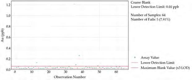
There was a significant proportion of discrepancies between the duplicate samples with duplicate samples returning a failure rate of 52% (Figure 11.2). Part of the error can be attributed to the inherent nature of soil sampling and part can be attributed to the low concentrations that were measured in the samples. Soil samples are inherently biased to some degree and a higher degree of variance is expected. The author believes the discrepancies are reasonable for the type of sampling conducted. The author and QP believes the data is suitable for its intended use herein and is suitable for exploration.
| March 29, 2024 | | 52 |
Technical Report for the Basin Gulch Property, Granite County, Montana, USA
Figure 8.2 Duplicate sample Au concentration.
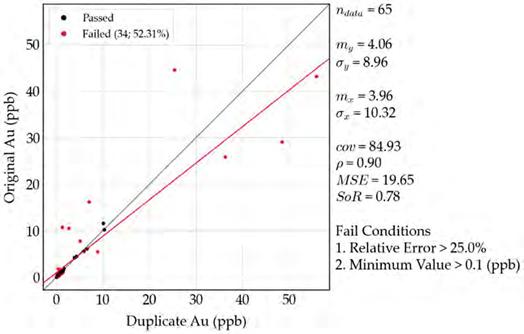
8.3.2 Rock Sample QA/QC
Lannister’s rock sampling program QA/QC protocol consisted of the insertion of coarse blank material, standards and field duplicate samples. The standards were inserted into the sample stream at approximately every tenth sample on sample numbers ending in “0”. The standard reference material (SRM) used included standards CDN-CM- 47 and CDN-ME-1811 and a blank pulp CDN-BL-10. SRMs were inserted at a rate of 6%. Duplicate samples were inserted throughout the sample stream at sample numbers ending in “5” at a rate of 3%. Three coarse blank samples were inserted into the sample stream at sample numbers ending in “5” at a rate of 2%. A total of 15 QAQC samples were inserted into the rock sample stream including 3 coarse blanks, 3 duplicates and 9 standards.
Standard CDN-CM-47 (Figure. 11.3) returned no failures, all assays returned values within 2 standard deviations of the expected value.
| March 29, 2024 | | 53 |
Technical Report for the Basin Gulch Property, Granite County, Montana, USA
Figure 8.3 CDN-CM-47 Au concentration.
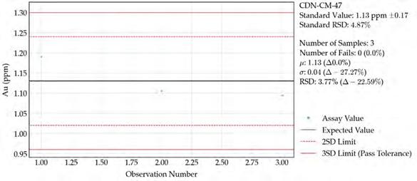
Standard CDN-ME-1811 (Figure. 11.4) retruend one recorded failure with a result just outside of 3 standard deviations of the expected value. This failure does not pose any concern for the confidence in the lab or dataset.
Figure 8.4 CDN-ME1811 Au concentration.
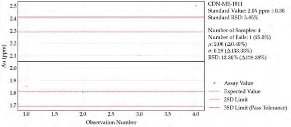
| March 29, 2024 | | 54 |
Technical Report for the Basin Gulch Property, Granite County, Montana, USA
All pulp blank, CDN-BL-10, samples returned assays below the pulp ceritifed value (Figure 11.5).
Figure 8.5 CDN-BL-10 Au concentration.
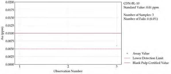
One coarse blank sample returned a value above the limit of detection but within 2 standard deviations of the detection limit (Figure 11.6).
Figure 8.6 Coarse Blank Au concentration.
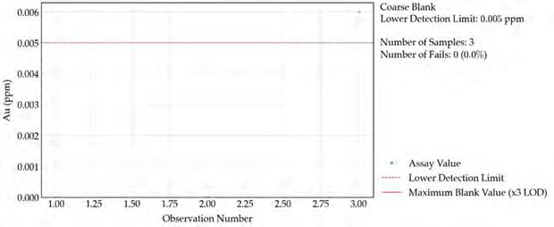
Two duplicate samples returned significantly different assays from the parent samples (Figure 11.7). Due to the inherent nature of rock sampling, rock grab samples are biased to some degree with respect to selective sampling of obviously mineralized material to the exclusion of weakly or not mineralized material that may occur in the same area.
| March 29, 2024 | | 55 |
Technical Report for the Basin Gulch Property, Granite County, Montana, USA
Figure 8.7 Duplicate sample Au concentration.
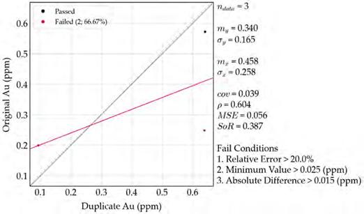
There are no significant issues to report with the analytical work completed at ALS based up Lannister’s QA/QC program. The author believes the discrepancies that are present are reasonable for the type of sampling conducted. The author and QP believes the data is suitable for its intended use herein and is suitable for exploration.
8.4 Adequacy of Sample Collection, Preparation, Security and Analytical Procedures
In the opinion of the authors of this report, there were no issues with respect to the sample collection methodology, sample security, sample preparation or sample analyses in the 2021 exploration program completed at the Basin Gulch Property. In addition, there were no indications that there were any significant issues with respect to sample bias. For future exploration programs the author recommends that the sample collection, preparation, security, analytical procedures and QA/QC procedures of any exploration program completed by the Issuer is current with CIM standards and guidelines and with respect to trench sampling and/or drill sampling be robust enough to develop confidence in the database for any future mineral resource estimations.
The data within the Project’s exploration databases is considered suitable for use in the further evaluation of the Property.
| March 29, 2024 | | 56 |
Technical Report for the Basin Gulch Property, Granite County, Montana, USA
9 Data Verification
The primary author and QP visited the Property on September 17, 2020. He was accompanied to the Property by Mr. Rauno Perrtu. The author collected six (6) rock samples and located several historical drill holes, trenches and adits. The samples were collected to confirm the presence of mineralization on the Property. The historical roads, trenches and drill pads have been extensively reclaimed by the former owners of the project. Mr. Besserer visited the Property on numerous occasions in 2021, 2022 and 2023 and also was able to locate several historical drill holes, trenches and adits. Mr. Dufresne also visited the property in 2023.
9.1 Data Verification Procedures
The authors and QPs have reviewed the historical exploration data including the compiled drill hole database provided by Mr. Perrtu and completed a preliminary data verification program on behalf of Lannister. The digital drill hole assays were compared to scanned, original assay certificates from Mount Powell Laboratories, Dawson Metallurgical, Barringer Laboratories, Assay Labs, ACME Analytical and Precision Assay Labs provided by Mr. Perrtu. All typographical errors were corrected, and missing assays were digitized and added to the database.
Drill hole locations were provided with local grid coordinates and plotted on a detailed orthophoto. Orthorectification of this image allowed for the recalculation of the drill hole coordinates into NAD83 Z12 coordinates with an estimated error of <20 m. The historical drill data is considered in good shape for exploration and its use herein. Additional verification work, including confirmation drilling, may be required to utilize the data in a future MRE.
9.2 Qualified Person Site Inspection
Mr. Michael Dufresne, M.Sc., P. Geol., P.Geo., the primary author, conducted a site inspection of the Basin Gulch Property for data verification purposes on September 17, 2020. Mr. Rauno Perrtu, a former project geologist on the Basin Gulch Project accompanied Mr. Dufresne during the visit. Access to the site was via secondary highways, local roads, historical drill roads and logging roads.
The objectives of the site visit included:
| ● | Location of historical drill hole collars. |
| ● | Observation and sampling of historical trenches. |
| ● | Collection of 6 verification rock samples. |
| March 29, 2024 | | 57 |
Technical Report for the Basin Gulch Property, Granite County, Montana, USA
The Property site visit included stops in the southwest area of the BG diatreme both inside and outside the diatreme area as well as an investigation of historical workings south of the BG diatreme (Figure 12.1). During the site visit Mr. Dufresne located several historical drill holes, trenches, pits and adits. Mr. Dufresne observed that significant reclamation has been completed at the Property and additionally that ongoing logging has occurred in the area. Some of the historical mining roads and most of the logging roads remain in good condition and are accessible with a four-wheel drive truck. Some trenches, adits and pits remain on the Property however the identification markers and labels have been removed or destroyed. From the 11 historical drill holes that were located during the site visit only 3 holes had legible labels. The drill collars were located using a hand-held GPS. The location of the 3 labeled drill holes was compared with the orthorectified coordinates for those holes and their locations were found to be accurate within 10-15 m. This is within the estimated error for the orthorectified holes.
Rock grab samples were collected from historical workings including trenches, waste piles, adits and road cuts (Figure 12.1; Table 12.1). All samples returned anomalous Au and Ag assays. The sample results are consistent with the style and tenor of mineralization previously described on the Property. Composite sample 20MDP600 was collected from a historical sample pit located at the edge of the BG diatreme. The sample consisted of pieces of oxidized and silicified diatreme breccia and yielded the highest Au and Ag assays from the site visit. The sample assayed 7.59 ppm Au and 112 ppm Ag.
All verification samples were submitted for analysis to ALS in Vancouver, BC. ALS is an International Standard ISO/IEC 17025:2005 certified laboratory, which is independent of the Company and the author of this Technical Report. Samples were analysed using ALS’s ME-MS61 48 element, four-acid ICP-MS package. Ag overlimit samples were processed using the Ag-OG62 four-acid ICP package.
In the opinion of the Qualified Persons, the visual inspection and verification sampling confirmed the presence and style of historically reported mineralization on the Property.
Table 9.1 Verification grab sample results from the Basin Gulch Property.
Sample
Number | | X
N83Z12 | | | Y
N83Z12 | | | Au
(ppm) | | | Ag
(ppm) | | | Description |
| 20MDP600 | | | 299066 | | | | 5130856 | | | | 7.59 | | | | 112 | | | Composite sample across 15 feet (4.5 m) at old pit and waste pile, oxidized & silicified diatreme breccia |
| 20MDP601 | | | 299066 | | | | 5130856 | | | | 2.06 | | | | 101 | | | Rock grab sample of fines from waste pile beside small pit |
| 20MDP602 | | | 298980 | | | | 5130089 | | | | 2.04 | | | | 2.06 | | | Rock grab sample of oxidized and rusty quartzite beside shaft at the top of the hill |
| 20MDP603 | | | 298963 | | | | 5130671 | | | | 2.4 | | | | 39.2 | | | Rock grab sample in old trench, mainly quartzite, breccia pieces |
| 20MDP604 | | | 298876 | | | | 5130710 | | | | 1.015 | | | | 7.38 | | | Rubble sample from adit, hematite-goethite stained with minor quartz veinlets |
| 20MDP605 | | | 299133 | | | | 5130915 | | | | 1.655 | | | | 32.5 | | | Grab sample of oxidized Proterozoic sedimentary rocks in road cut |
| March 29, 2024 | | 58 |
Technical Report for the Basin Gulch Property, Granite County, Montana, USA
Figure 9.1 2020 Site visit locations
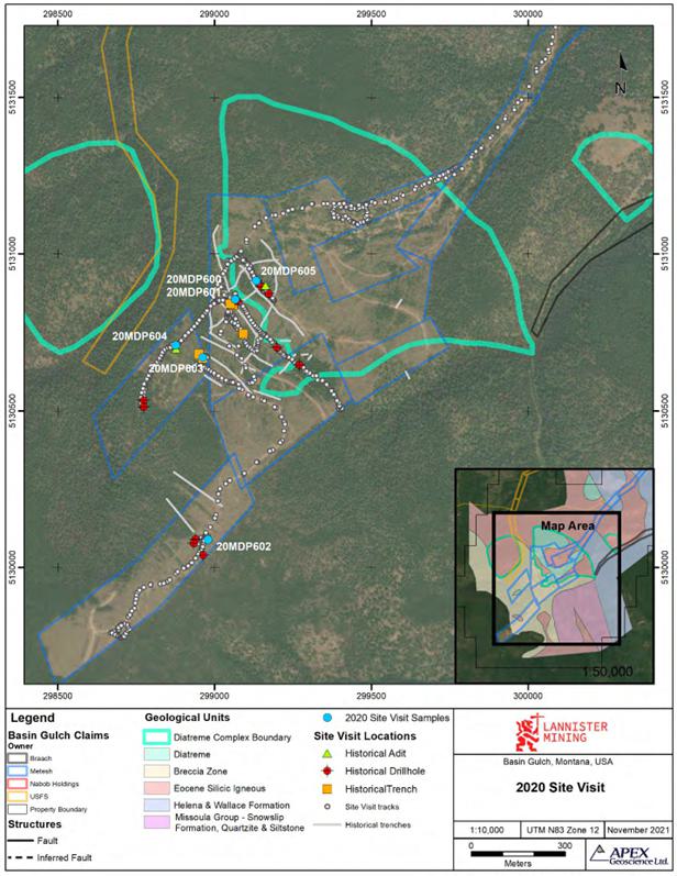
| March 29, 2024 | | 59 |
Technical Report for the Basin Gulch Property, Granite County, Montana, USA
9.3 Validation Limitations
The historical core and sample rejects from the CMM drill programs are not available for review. These were stored at the Mount Powell laboratory and upon the death of the owner these samples were discarded.
Additional effort should be made to locate historical drillhole collars in the field and verify the location of as many historical drill holes as possible to increase the accuracy of the drillhole locations. This may however be impeded by the extensive remediation and logging completed on the Property.
Geological data in the drillhole database should be verified against available geological data from historical drillhole logs.
The Company has initiated re-opening of select trenches to further conduct validation against the historical data under the direction of Mr. Besserer. Results are pending.
9.4 Adequacy of the Data
The QPs reviewed the adequacy of the exploration information and the visual, physical, and geological characteristics of the Property and found no significant issues or inconsistencies that would cause one to question the validity of the data.
Based on the data validation process described above and Mr. Dufresne’s site visit, the authors are satisfied, and take responsibility, to include the exploration data including geochemical surveys and drill information as background information for this geological introduction and qualifying Technical Report. It is also the author’s opinion that the data is suitable for future work including future mineral resource estimations, however, additional drilling and analysis of results will be required.
In the future, the authors recommend that the sample collection, preparation, security, analytical procedures and QA/QC procedures of any Basin Gulch exploration program is current with CIM definition standards and guidelines and robust enough to develop confidence for any future mineral resource estimations.
10 Mineral Processing and Metallurgical Testing
No mineral processing or metallurgical testing has been completed by the current issuer.
11 Mineral Resource Estimates
No current resource estimates have been completed for the Property.
| March 29, 2024 | | 60 |
Technical Report for the Basin Gulch Property, Granite County, Montana, USA
12 Adjacent Properties
Within the nearby vicinity of the Property numerous placer claims are held by numerous owners. The placer claims mainly produce gold and sapphire. In close proximity to the Basin Gulch Property the Gemstone Mountain Mine located 3.5 km to the south is operated by Cooney’s Sapphire Village and recovers sapphires.
Historically, several mines operated in the Rock Creek Mining district including the past producing Crescent Gold Mine: an underground gold mine with secondary silver and barium-barite located 4.3 km WNW of the Property. The Bagdad Gold Mine is a past producing underground gold mine with secondary copper and molybdenum, it is located 7.8 km NW of the Property (Figure 15.1).
12.1 Montana Tunnels
The Montana Tunnels Mine is located approximately 115 km east-northeast of the Basin Gulch Project (Figure 15.1). This formerly producing gold-silver mine is not an “adjacent property” to the Basin Gulch Property but is discussed below due to the geological similarities between Basin Gulch and this precious metal deposit. Both projects are precious metal systems that are considered intrusion related and could be considered to be at the northeastern extent of the Trans-Challis Fault System, which is a northeast oriented regional fault system that potentially links a number of intrusion related precious metal deposits from southwest Idaho into southwest Montana, including the Basin Gulch Property. The author has not visited the Montana Tunnels Mine nor is he inferring in any way that mineralization at Montana Tunnels is in any way linked to Basin Gulch or that a similar deposit can be expected to be found at Basin Gulch. The author has not verified the production figures for the Montana Tunnels Mine.
The Montana Tunnels Mine was in production between 1987 and 2008. The mine was operated as an open pit mine. Over the life of the mine 99.6 Million tons of ore were processed which resulted in the recovery of 1.7 Million oz. Au, 30.9 Million oz. Ag, 551, 400 tons Zn and 202,800 tons of Pb (Eastern Resources, 2013). Eastern Resources completed the purchase of the mine from Apollo Gold Corp., the last operator of the mine, in 2010. Eastern Resources has permitted the “M-Pit” which is an expansion to the current existing open pit. Delineation drilling has been completed at the M-Pit to gain a better understanding of the ore body on this area (https://easternresourcesinc.com/montana- tunnels/).
The Montana Tunnels deposit is a bulk-mineable gold-silver deposit hosted in a vertical vent of a Maar-type volcano (diatreme). The diatreme was emplaced along faulted contact between volcaniclastic rocks of the Cretaceous Elkhorn Mountains Volcanic suite and ignimbrites of the Eocene aged Lowland Creek Volcanics. The diatreme covers an area of 1 km2 and has been drill intersected to a depth of 310 m (Sillitoe, 1985). The principal rock type in the diatreme is matrix-rich breccia comprising volcanic wall rock and intrusive rock fragments. Sulphide mineralization is widely disseminated throughout the diatreme. The economic grade material, which is sulphide enriched, was located more centrally in the volcanic pipe around the late-stage emplacement of intrusive quartz latite porphyry dykes. Gold occurs in electrum with a fineness of about 550 µm, and as inclusions of less than 200 µm in pyrite and sphalerite (Sillitoe et al., 1985). Initial operations mined the upper level of the main central ore body. Additional development drilling extended the depth of the main central ore body below the original pit designs. To facilitate mining at these greater depths the upper part of the mine had to be increasingly widened to maintain stable pit highwalls. The ever increasing breadth of the mine eventually destabilized the slopes and resulted in mine closure.
| March 29, 2024 | | 61 |
Technical Report for the Basin Gulch Property, Granite County, Montana, USA
Figure 12.1 Properties adjacent to the Basin Gulch Project.
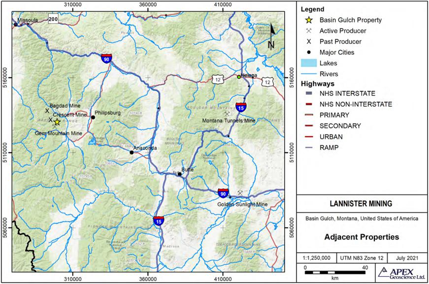
| March 29, 2024 | | 62 |
Technical Report for the Basin Gulch Property, Granite County, Montana, USA
The Mill Complex includes two flotation plants capable of processing 15,000-tons and 1,000 tons of ore per day. The mines uses a conventional ore grinding and flotation process mill. The mill was a permitted cyanide circuit, but according to DEQ, towards the end of mine life it was no longer being used. Historically, between 8% and 12% of the gold recovered at Montana Tunnels has reported to the gravity circuit and has been smelted onsite into doré flats. The concentrator recovered all other metals by flotation into two concentrate products, a lead concentrate and a zinc concentrate. The concentrates were shipped for processing to various smelter’s worldwide (Eastern Resources, 2013; Apollo Gold web archive).
The author and QP is not implying any size or grade relationship between the Montana Tunnels Mine, and the Basin Gulch Property and notes that this information is not necessarily indicative of the mineralization known or to be expected on the Basin Gulch Property, which is the subject of this Technical Report. However, the geology and style of mineralization along with the processing methodology using gravity separation and processing of concentrates offsite that has been employed at Montana Tunnels is relevant and perhaps is a potential scenario for future processing at the Basin Gulch Project.
13 Other Relevant Data and Information
The authors are not aware of any other information or data relevant to the Basin Gulch Project at this time.
14 Interpretation and Conclusions
14.1 Results and Interpretations
The Basin Gulch Project is an intermediate stage exploration project that has been locally extensively drilled between 1987 and 1997 as a large, low-grade bulk mineable open-pit target. Previous work includes geological mapping, sampling, drilling, geophysical surveying and metallurgical studies to delineate the extent of the mineralized BG diatreme complex. The author and QP has reviewed and accepts the historical data generated by CMM, Chevron and Cyprus during their exploration programs conducted between 1987 and 1997.
| March 29, 2024 | | 63 |
Technical Report for the Basin Gulch Property, Granite County, Montana, USA
The claims are located at the head of Basin Gulch and Quartz Gulch, on the northern slopes of West Fork Buttes, within the Sapphire Range of the Western Montana Rocky Mountains. The Property is approximately 17 miles (27 km) west of Philipsburg, MT and lies within the Rock Creek Mining District of Granite County. The Project comprises 11 patented mining claims totaling 216.33 acres (87.5 ha) and 131 unpatented mining claims totaling approximately 2,642 acres (1,069 ha). The unpatented claims overlap the patented claims. Lannister acquired the rights to the unpatented and patented claims that comprise the Basin Gulch Property in 2020.
The area is historically known for placer gold mining. The source of the placer gold in Basin Gulch was determined to be located in the upper drainage of Basin Gulch and appear to be spatially associated with an Eocene silicic volcanic and intrusive complex. The igneous rocks formed a major diatreme complex that is directly associated with gold and silver mineralization. The results from the drilling and trench sampling programs indicate that the diatreme complex measures approximately 2,600 feet (790 m) by 3,300 feet (1,000 m) on the surface, and appears to be related to other mineralized occurrences in the local area. The majority (87%) of the drill holes were shallow (<500 feet [150 m]) and targeted at evaluating a large, low-grade bulk tonnage deposit associated with the diatreme complex. The limited drilling within the diatreme complex was encouraging with the deepest drill hole (1,045 feet [320 m]) ending in a mineralized zone. The deposit is characterized by overall low-grade gold and silver mineralization and zones of local high- grade mineralization. Widely scattered areas of the intrusive contain base levels of gold averaging between 0.01 to 0.02 opt (0.34 to 0.68 ppm). Numerous historical holes returned excellent results with both wide modest grade intercepts and narrower high grade intercepts. The mineralization is ubiquitous in all rocks with no one rock type having preferential mineralization, however, higher-grade mineralization is associated with the marginal areas and edges of the intrusive volcanics or diatremes. Outside of the main mineralized zones, rock and soil sampling has identified anomalous mineralization across the Property extending across an area of at least 14,000 feet (4,267 m) by 8,000 feet (2,438 m).
In 1996-1997 Kinross extensively reviewed the project and offered to purchase it. The sale was never completed due to Montana banning the use of cyanide in open pit heap leach mining simultaneously with a major decline in the gold price. CMM dropped the Property in 1997. Subsequently between 2006 and 2016, the Property was held by several entities. During this period mainly desktop studies were completed with limited field exploration for which there is very limited information available.
Metallurgical test work conducted by Kappes, Cassiday & Associates on behalf of Cable Mountain Mine in the 1990’s indicated that the gold is easily extracted using cyanidation or other gold extraction reagents. A leach recovery rate exceeding 90 percent was observed for some samples. However, due to the prohibition of open pit cyanide leach mining in Montana an alternative mining method or extraction method will need to be investigated. CMM additionally completed gravity separation testing to assess the presence and location of coarse gold on the Property. Coarse gold was found to be locally common especially along the BG diatreme margins and northeast-trending structural zones. Several zones of coarse gold mineralization were identified. A thorough review of the gravity separation testing has not been completed.
| March 29, 2024 | | 64 |
Technical Report for the Basin Gulch Property, Granite County, Montana, USA
The 2021 exploration program completed on behalf of Lannister included soil and rock sampling, prospecting and a ground geophysical survey. The Prospecting program identified 47 additional trenches that were not on the historical maps as well as 41 small sample pits scattered throughout the Property. The majority of the newly identified trenches are located with the main diatreme complex northeast of the previously orthorectified historical workings. A total of 1,247 soil samples were collected including 65 duplicates. The soils samples were analysed using ALS’s ultra-sensitive Ionic Leach method which is designed to detect and define subtle, low level anomalies. The results of the 2021 soil sampling program show an anomalous response in Au and Ag related to the BG diatreme and edge of the diatreme as well as several coherent Au anomalies associated with areas outside of the diatreme. The rock sampling program included the collection of 126 rock samples including 3 duplicates from float samples, outcrop exposures and historical trenches across the soil grid area. Anomalous gold assays were identified across the Property associated with the historical workings in and around the BG diatreme and the anomalous areas identified by the soil sample survey.
The ground magnetics survey totalled 130 line-km and covered a large portion of the Property including the BG diatreme and other areas with historical workings. The processed geophysical data show that the major, northeast trending fault crossing the Property and the BG diatreme are associated with a low amplitude magnetic response. Mineralization within and along the margins of the BG diatreme is also associated with a low amplitude magnetic response.
Based on the site visit, review of historical data and Lannister’s current exploration the author considers the Basin Gulch Property a property of significant merit that requires further exploration.
14.2 Risks and Uncertainties
As discussed in section 4.4 in 1998, Montana passed Citizens Initiative Cl-137, a statute strictly prohibiting the use of cyanide heap and vat leach open pit mining. This was effectively seen by most mining companies as a moratorium on large-scale open-pit gold mining in the State. At the Basin Gulch project, the majority of the historical metallurgical work focused on heap leach recovery of mineralized material. Those beneficiation studies indicated that the gold was easily extracted from the material using cyanide, however, due to the prohibition of open pit cyanide leach mining an alternative mining method or extraction method will need to be investigated. This could include the investigation of the use of alternative reagents for gold extraction, other than cyanide, such as thiosulfate and chloride, and/or commercially sold reagents such as EarthGold or Gold Dressing Agent. These alternative reagents have not been tested on the Basin Gulch mineralized material and their efficacy remains to be evaluated.
| March 29, 2024 | | 65 |
Technical Report for the Basin Gulch Property, Granite County, Montana, USA
Gravity separation and/or float separation could also be considered as an alternate recovery method for gold extraction at Basin Gulch. Some gravity separation testing was completed during the exploration programs in the 1990’s to test recoveries of coarse gold observed in drill samples. Gravity separation results were encouraging and identified zones on the Property with anomalous coarse gold mineralization. Kinross re-assay samples, analysed using a technique Kinross developed at their Gold Banks project, returned assays 39% higher than the original fire assay values. The strongest increases were largely associated with zones of stronger mineralization. This increase was interpreted to indicate the presence of more moderate levels of coarse gold mineralization than found in the identified coarse gold zones (Perttu, 1997). However, no large scale or systematic gravity separation testing was completed over the entire mineralized zones and the effectiveness of gravity separation on a large scale remains to be evaluated.
15 Recommendations
Historical exploration has defined a significant zone of gold mineralization at the Basin Gulch Property. Based upon the site visit, the historical exploration work and the current exploration carried out by Lannister discussed in this Technical Report, it is the opinion of the author of this Technical Report that the Basin Gulch Property is a “Property of Merit” warranting further exploration work including additional drilling. Additional work is recommended on the Property to re-evaluate and re-assess the potential for bulk tonnage gold and localized high-grade gold deposits along with deeper high-grade mineralized zones.
A phased exploration program is recommended and should include but not be limited to the following:
Phase 1 of the program should include surface exploration and drilling. The surface exploration program should consist of detailed geological mapping, prospecting, and a structural interpretation of the Property. Sampling should be completed over a total of 10 trenches totalling 5,000 m.
Confirmed historical drilling on the Property totals approximately 110,000 feet (33,530 m). However, the majority of the historical drilling was shallow typically less than 200 m depth and largely pattern-drilled with a focus on evaluating a large, low-grade open-pit deposit outside of the diatreme complex. Several deeper holes up to 1,045 ft (320 m) depth were completed within the diatreme complex and returned encouraging results. However, these holes did not reach the highly conductive mineralized portions of the diatreme modelled at approximately 450 m depth. Drilling should consist of both infill and twin core drilling to confirm historical results and to test the deeper highly conductive mineralized portions of the diatreme. Approximately 25 drill holes totalling 5,000 m should be completed. The exact number of holes and the total depth may be adjusted depending on initial results.
Preliminary metallurgical bench – scale testing should be completed. Metallurgical testing should evaluate alternative reagents for gold extraction such as thiosulfate and chloride, and/or commercially sold reagents such as EarthGold or Gold Dressing Agent that can be substituted for cyanide in gold heap leaching. Additionally, the efficiency of gravity recovery and/or float separation should also be evaluated.
| March 29, 2024 | | 66 |
Technical Report for the Basin Gulch Property, Granite County, Montana, USA
The drill program should culminate in a 3D geological model based on the historical and modern drilling that will lead to the calculation of a maiden mineral resource estimate. The maiden mineral resource estimate would be completed in accordance with CIM “Estimation of Mineral Resources and Mineral Reserves Best Practice Guidelines” dated November 29, 2019 and CIM “Definition Standards for Mineral Resources and Mineral Reserves” dated May 10th, 2014 to be reported in accordance with the CSA NI 43-101 rules for disclosure.
The budget to complete phase 1 of the exploration program is estimated to be $4,400,000 (Table 18.1).
Phase 2 of the exploration program will be contingent on the results of Phase 1 and is recommended to proceed upon the successful delineation of a maiden mineral resource estimate. Phase 2 exploration should include follow-up exploration and expansion drilling of 20 drill holes totalling approximately 4,000 m. The proposed budget to complete Phase 2 is approximately $2,600,000 (Table 18.1).
The budget to complete the Phase 1 and 2 exploration programs is $7,500,000 CND.
Table 15.1 Proposed budget for the recommended exploration program.
| PHASE 1 | | | |
Drilling – Core Drilling ~5000m at $650 / meter all up
(includes geologists, assays, drilling, mob / demo etc.) Approximately 25 drill holes including both infill and twinning. | | $ | 3,250,000 | |
| Metallurgy - Preliminary Metallurgical Bench Scale Tests | | $ | 200,000 | |
| Mechanized Trenching ~ 10 x 500m trenches (includes geologists, assays, equipment) | | $ | 400,000 | |
| Mapping, prospecting and structural interpretation | | $ | 50,000 | |
| Maiden NI 43-101 Resource Report which incorporates all technical data to date | | $ | 100,000 | |
| CONTINGENCY 10% | | $ | 400,000 | |
| TOTAL PHASE 1 | | $ | 4,400,000 | |
| PHASE 2 – contingent on the results of phase 1 | | | | |
Drilling – Core Drilling ~ 4000m at $650 / meter all up (includes, geologists, assays,
drilling, mob / demo etc.) Approximately 20 drill holes including follow-up,
expansion and exploration drilling. | | $ | 2,600,000 | |
| OTHER | | | | |
| Administration and overhead | | $ | 500,000 | |
| | | | | |
| TOTAL | | $ | 7,500,000CND |
| March 29, 2024 | | 67 |
Technical Report for the Basin Gulch Property, Granite County, Montana, USA
| APEX Geoscience Ltd. |  |
 |
| Michael Dufresne, M.Sc., P.Geol., P.Geo. |
| Edmonton, Alberta, Canada |
| March 29, 2024 |

Dean J. Besserer, B.Sc., P.Geo.
Edmonton, Alberta, Canada
March 29, 2024
| March 29, 2024 | | 68 |
Technical Report for the Basin Gulch Property, Granite County, Montana, USA
16 References
American Assay Laboratories, Inc., 1997, Report on Agitated Cyanidation Testing of Cable Mountain Mine Samples: Consulting Report to Cable Mountain Mine, Inc, 20p.
Brown, D., 2006, Preliminary Draft Report National Instrument 43-101 Basin Gulch Gold Property Independent Third-Party Evaluation Granite County, Montana. Prepared for Dutch Mining Ltd. by David Brown & Associates 46p.
Brown, D., 2009, National Instrument 43-101 Basin Gulch Gold Property Independent Third-Party Evaluation Granite County, Montana. Prepared for Aultra Gold Inc. by David Brown & Associates 59p.
Brown, D., 2010, National Instrument 43-101 Basin Gulch Gold Property Independent Third-Party Evaluation Granite County, Montana. Prepared for Dutch Gold Resources Inc. by David Brown & Associates 59p.
CIM, 2003, Estimation of Mineral Resources & Mineral Reserves Best Practices Guidelines: Prepared by the CIM Mineral Resource & Mineral Reserve Committee and Adopted by CIM Council November 23rd, 2003; document available from the CIM website at http://web.cim.org/standards, 55 p.
CIM, (2011): CIM Best Practice Guidelines for Mineral Processing: Prepared by the sub- committee on Best Practice Guidelines for Mineral Processing, available from the CIM website at https://mrmr.cim.org/en/best-practices/mineral-processing/ , 12 p.
CIM, (2014): Definition Standards for Mineral Resources and Mineral Reserves. Prepared by the CIM Standing Committee on Reserve Definitions, May 10, 2014: CIM Bulletin Vol. 93, No. 1044, pp. 53-61.
CIM, (2019): Estimation of Mineral Resources & Mineral Reserves Best Practices Guidelines: Prepared by the CIM Mineral Resource & Mineral Reserve Committee and Adopted by CIM Council November 29th, 2019; document available from the CIM website at http://web.cim.org/standards, 75 p.
Eastern Resources, 2013, Annual Report Ending December 31, 2012. Filed with the United States Securities and Exchange Commission, 56p. https://www.sec.gov/Archives/edgar/data/1429373/000114420413022203/v33974 1_10k.htm
Frishman, D., Elliott, J.E., Foord, R.C., Pearson, R.C., Raymond, W.H. 1992, Map showing the location of Productive Lode and Placer Gold Mines in Montana. United States Geological Survey, 1p.
| March 29, 2024 | | 69 |
Technical Report for the Basin Gulch Property, Granite County, Montana, USA
Hamilton, W., and Myers, W.B., 1974, Nature of the Boulder Batholith of Montana: Geological Society of America Bulletin, v. 85, p. 365–378,
Kappes, Cassiday & Associates, Inc., 1996, Cable Mountain Mine Project Metallurgical Test Program: Consulting Report to Cable Mountain Mine, Inc., 57p.
Kelley, K.D., Romberger, S.B., Beaty, D.W., Pontius, J.A., Snee, L.W., Stein, H.J., Thompson, T.B., 1998, Geochemical and Geochronological Constraints on the Genesis of Au-Te Deposits at Cripple Creek, Colorado. Economic Geology 93, 981- 1012.
Kelley, K.D., Ludington, S. 2002, Cripple Creek and other alkaline-related gold deposits in the southern Rocky Mountains, USA: influence of regional tectonics. Min Dep Vol. 37, pp. 38–60 https://doi.org/10.1007/s00126-001-0229-4
Kinross, 1997, Basin Gulch project Review. Internal company memo.
Koschmann, A.H., 1947, Structural Control of the Gold Deposits of the Cripple Creek District Teller County, Colorado. Contributions to economic geology, pp. 19-58. https://doi.org/10.3133/b955B
Leichliter, S., Larson, D., 2013, Geometallurgy for two recovery process operations: At Cripple Creek & Victor gold mine. Mining Engineering, pp. 29-33.
Lonn, J.D., 2003, Preliminary Geologic Map of the Philipsburg 30‘X 60’ Quadrangle, Western Montana: Montana Bureau of Mines and Geology Open File report MBMG 483.
Lowell, J. D., Guilbert, J. M., 1970, Lateral and vertical alteration-mineralization zoning in porphyry ore deposits. Economic geology, Vol. 65 (4), pp. 373-408.
Perttu, R., 1997, Summary of Continuing Exploration at Basin Gulch, Granite County, Montana: Internal Exploration Report, Cable Mountain Mine, Inc., 37p
Perttu, R., 2017, Basin Gulch Gold Property, Technical Update and Report, Granite County, Montana, USA: Internal Exploration Report, 62p
Petford, N., Atherton, M. P., 1994, Cretaceous-Tertiary volcanism and syn-subduction crustal extension in northern central Peru. Geological Society, London, Special Publications, Vol. 81 (1), pp. 233-248.
Ross, P., Carrasco Núñez, G. Hayman, P. 2017, Felsic maar-diatreme volcanoes: a review. Bull Volcanol Vol. 79, 20p. https://doi.org/10.1007/s00445-016-1097-1
Silberman, M.L., 1997, Letter Report on Petrology of Rock Samples: Letter report to Magma Gold, Inc., 3p.
| March 29, 2024 | | 70 |
Technical Report for the Basin Gulch Property, Granite County, Montana, USA
Silberman, M.L., 2016, Supplementary and Updated Report Basin Gulch Gold Property. Internal company report prepared for Basin Gulch Co., 5p.
Sillitoe, R. H., 1991, Intrusion-related gold deposits. In: Foster (ed.) Gold Metallogeny and Exploration, Blackie, Glasgow and London, pp. 165-203
Sillitoe, R. H., 1998, Major regional factors favouring large size, high hypogene grade, elevated gold content and supergene oxidation and enrichment of porphyry copper deposits. Porphyry and hydrothermal copper and gold deposits: A global perspective: Adelaide, Australian Mineral Foundation, pp. 21-34.
Sillitoe, R. H., 2000, Gold-rich porphyry deposits: descriptive and genetic models and their role in exploration and discovery. Reviews in Economic Geology, Vol. 13, pp. 315-345.
Sillitoe R. H., Bonhom, H.F. 1984, Volcanic Landforms and Ore Deposits. Economic Geology, Vol. 79, pp. 1286-1298
Sillitoe, R. H., Baker, E. M., Brook, W. A., 1984, Gold deposits and hydrothermal eruption breccias associated with a maar volcano at Wau, Papua New Guinea. Economic Geology, Vol. 79 (4), pp. 638-655.
Sillitoe, R. H., Grauberger, G.L., Elliott, J.E. 1985, A Diatreme-Hosted Gold Deposit at Montana Tunnels, Montana. Economic Geology, Vol. 80, pp. 1707-1721
Sinclair, W. D., Goodfellow, W. D., 2007, Porphyry deposits. Mineral deposits of Canada: A synthesis of major deposit-types, district metallogeny, the evolution of geological provinces, and exploration methods: Geological Association of Canada, Mineral Deposits Division, Special Publication, Vol. 5, pp. 223-243.
Smyers, N.B. 1998, Minerals and Geology Missoula Ranger District, Lolo National Forest Rock Creek Drainage: US Forest Service Report.
Thompson, T.B., Trippel, A.D., Dwelley, P.C., 1985, Mineralized Veins and Breccias of the Cripple Creek District, Colorado. Economic Geology Vol. 80, pp. 1669-1688.
Wallace, C.A., 1986, Generalized Geologic Map of the Butte 1o X 2o Quadrangle, Montana: US Geological Survey Miscellaneous Field Studies Map MF-1924, scale 1:250,000
Zonge Engineering & Research Organization, Inc., 1994, Final Report CSAMT Surveys Basin Gulch Prospect Granite County, Montana: Consulting Report to Cable Mountain Mine, Inc., 17p.
| March 29, 2024 | | 71 |
Technical Report for the Basin Gulch Property, Granite County, Montana, USA
17 Reliance on Information Provided by the Registrant
If relying on information provided by the registrant for matters discussed in this Technical Report as permitted under §229.1302(f), provide the disclosure required pursuant to § 229.1302(f)(2).
Section 3.0 – Property Description
The authors relied entirely on background information and details regarding the nature and extent of Mineral and Land Titles (in Section 4.2) provided to the authors by Mr. Perrtu (on behalf of Lannister) as digital and hard copy files on October 7, 2020 and digital files from Mr. Besserer (on behalf of Lannister) on April 28, 2022. The documents provided by Mr. Besserer included: Updated Title Report by Parsons Behle and Latimer dated April 12, 2022, and a Mining Lease Agreement between Margery Metesh and Strategic Minerals dated March 10, 2006. The authors of this Technical Report have not attempted to verify the legal status of the Property.
The status of the unpatented mineral claims was verified on September 10, 2023 on the BLM’s MLRS mineral claims registration system. All 131 unpatented claims were confirmed to be active and in good standing.
| March 29, 2024 | | 72 |
Technical Report for the Basin Gulch Property, Granite County, Montana, USA
APPENDIX 1
Basin Gulch Property Unpatented Claims
| March 29, 2024 | | 73 |
Technical Report for the Basin Gulch Property, Granite County, Montana, USA
| Serial Number | Lead File Number | Claimant | Claim Name | Case Disposition | Claim Type | Next Payment Due Date | Date Of Location | Meridian Township Range Section | Quadrant |
| MT105234315 | MT105234315 | 60431 MONTANA LTD. | BG 1 | ACTIVE | LODE CLAIM | 9/1/2022 | 1/21/2021 | 20 0070N 0160W 033 | NW |
| SW |
| |
| MT105234316 | MT105234315 | 60431 MONTANA LTD. | BG 2 | ACTIVE | LODE CLAIM | 9/1/2022 | 1/21/2021 | 20 0070N 0160W 033 | NW |
| SW |
| |
| MT105234317 | MT105234315 | 60431 MONTANA LTD. | BG 3 | ACTIVE | LODE CLAIM | 9/1/2022 | 1/21/2021 | 20 0070N 0160W 033 | NW |
| SW |
| |
| MT105234318 | MT105234315 | 60431 MONTANA LTD. | BG 4 | ACTIVE | LODE CLAIM | 9/1/2022 | 1/21/2021 | 20 0070N 0160W 033 | NE |
| NW |
| SE |
| SW |
| |
| MT105234319 | MT105234315 | 60431 MONTANA LTD. | BG 5 | ACTIVE | LODE CLAIM | 9/1/2022 | 1/21/2021 | 20 0070N 0160W 033 | NE |
| SE |
| |
| MT105234320 | MT105234315 | 60431 MONTANA LTD. | BG 6 | ACTIVE | LODE CLAIM | 9/1/2022 | 1/21/2021 | 20 0060N 0160W 004 | NW |
20 0060N 0160W 005 | NE |
20 0070N 0160W 032 | SE |
20 0070N 0160W 033 | SW |
| |
| MT105234321 | MT105234315 | 60431 MONTANA LTD. | BG 7 | ACTIVE | LODE CLAIM | 9/1/2022 | 1/21/2021 | 20 0060N 0160W 004 | NW |
| |
20 0070N 0160W 033 | SW |
| |
| MT105234322 | MT105234315 | 60431 MONTANA LTD. | BG 8 | ACTIVE | LODE CLAIM | 9/1/2022 | 1/21/2021 | 20 0060N 0160W 004 | NW |
| |
20 0070N 0160W 033 | SW |
| |
| MT105234323 | MT105234315 | 60431 MONTANA LTD. | BG 9 | ACTIVE | LODE CLAIM | 9/1/2022 | 1/21/2021 | 20 0060N 0160W 004 | NW |
| |
20 0070N 0160W 033 | SW |
| |
| MT105234324 | MT105234315 | 60431 MONTANA LTD. | BG 10 | ACTIVE | LODE CLAIM | 9/1/2022 | 1/20/2021 | 20 0060N 0160W 005 | NE |
| MT105234325 | MT105234315 | 60431 MONTANA LTD. | BG 11 | ACTIVE | LODE CLAIM | 9/1/2022 | 1/20/2021 | 20 0060N 0160W 004 | NW |
| March 29, 2024 | | 74 |
Technical Report for the Basin Gulch Property, Granite County, Montana, USA
| Serial Number | Lead File Number | Claimant | Claim Name | Case Disposition | Claim Type | Next Payment Due Date | Date Of Location | Meridian Township Range Section | Quadrant |
| | | | | | | | | 20 0060N 0160W 005 | NE |
| MT105234326 | MT105234315 | 60431 MONTANA LTD. | BG 12 | ACTIVE | LODE CLAIM | 9/1/2022 | 1/20/2021 | 20 0060N 0160W 004 | NW |
| |
| MT105234327 | MT105234315 | 60431 MONTANA LTD. | BG 13 | ACTIVE | LODE CLAIM | 9/1/2022 | 1/20/2021 | 20 0060N 0160W 004 | NW |
| MT105234328 | MT105234315 | 60431 MONTANA LTD. | BG 14 | ACTIVE | LODE CLAIM | 9/1/2022 | 1/20/2021 | 20 0060N 0160W 004 | NW |
| |
| MT105234329 | MT105234315 | 60431 MONTANA LTD. | BG 15 | ACTIVE | LODE CLAIM | 9/1/2022 | 1/20/2021 | 20 0060N 0160W 005 | NE |
| SE |
| MT105234330 | MT105234315 | 60431 MONTANA LTD. | BG 16 | ACTIVE | LODE CLAIM | 9/1/2022 | 1/20/2021 | 20 0060N 0160W 005 | NE |
| SE |
| MT105234331 | MT105234315 | 60431 MONTANA LTD. | BG 17 | ACTIVE | LODE CLAIM | 9/1/2022 | 1/20/2021 | 20 0060N 0160W 004 | NW |
| SW |
| |
20 0060N 0160W 005 | NE |
| SE |
| MT105234332 | MT105234315 | 60431 MONTANA LTD. | BG 18 | ACTIVE | LODE CLAIM | 9/1/2022 | 1/20/2021 | 20 0060N 0160W 004 | NW |
| SW |
| MT105234333 | MT105234315 | 60431 MONTANA LTD. | BG 19 | ACTIVE | LODE CLAIM | 9/1/2022 | 1/20/2021 | 20 0060N 0160W 004 | NW |
| SW |
| MT105234334 | MT105234315 | 60431 MONTANA LTD. | BG 20 | ACTIVE | LODE CLAIM | 9/1/2022 | 1/20/2021 | 20 0060N 0160W 005 | SE |
| MT105234335 | MT105234315 | 60431 MONTANA LTD. | BG 21 | ACTIVE | LODE CLAIM | 9/1/2022 | 1/20/2021 | 20 0060N 0160W 005 | SE |
| MT105234336 | MT105234315 | 60431 MONTANA LTD. | BG 22 | ACTIVE | LODE CLAIM | 9/1/2022 | 1/20/2021 | 20 0060N 0160W 005 | SE |
| MT105234337 | MT105234315 | 60431 MONTANA LTD. | BG 23 | ACTIVE | LODE CLAIM | 9/1/2022 | 1/20/2021 | 20 0060N 0160W 008 | NE |
| MT105234338 | MT105234315 | 60431 MONTANA LTD. | BG 24 | ACTIVE | LODE CLAIM | 9/1/2022 | 1/19/2021 | 20 0070N 0160W 034 | NW |
| MT105234339 | MT105234315 | 60431 MONTANA LTD. | BG 25 | ACTIVE | LODE CLAIM | 9/1/2022 | 1/19/2021 | 20 0070N 0160W 027 | SW |
20 0070N 0160W 034 | NW |
| MT105234340 | MT105234315 | 60431 MONTANA LTD. | BG 26 | ACTIVE | LODE CLAIM | 9/1/2022 | 1/19/2021 | 20 0070N 0160W 027 | SW |
20 0070N 0160W 034 | NW |
| |
| MT105234341 | MT105234315 | 60431 MONTANA LTD. | BG 27 | ACTIVE | LODE CLAIM | 9/1/2022 | 1/19/2021 | 20 0070N 0160W 027 | SE |
| SW |
20 0070N 0160W 034 | NE |
| NW |
| |
| March 29, 2024 | | 75 |
Technical Report for the Basin Gulch Property, Granite County, Montana, USA
| Serial Number | Lead File Number | Claimant | Claim Name | Case Disposition | Claim Type | Next Payment Due Date | Date Of Location | Meridian Township Range Section | Quadrant |
| MT105234342 | MT105234315 | 60431 MONTANA LTD. | BG 28 | ACTIVE | LODE CLAIM | 9/1/2022 | 1/19/2021 | 20 0070N 0160W 027 | SE |
20 0070N 0160W 034 | NE |
| |
| MT105234343 | MT105234315 | 60431 MONTANA LTD. | BG 29 | ACTIVE | LODE CLAIM | 9/1/2022 | 1/19/2021 | 20 0070N 0160W 027 | SE |
| |
20 0070N 0160W 034 | NE |
| |
| MT105234344 | MT105234315 | 60431 MONTANA LTD. | BG 30 | ACTIVE | LODE CLAIM | 9/1/2022 | 1/19/2021 | 20 0070N 0160W 027 | SE |
| |
20 0070N 0160W 034 | NE |
| |
| MT105234345 | MT105234315 | 60431 MONTANA LTD. | BG 31 | ACTIVE | LODE CLAIM | 9/1/2022 | 1/19/2021 | 20 0070N 0160W 026 | SW |
| |
20 0070N 0160W 027 | SE |
20 0070N 0160W 034 | NE |
| |
20 0070N 0160W 035 | NW |
| |
| MT105234346 | MT105234315 | 60431 MONTANA LTD. | BG 32 | ACTIVE | LODE CLAIM | 9/1/2022 | 1/19/2021 | 20 0070N 0160W 034 | NW |
| |
| MT105234347 | MT105234315 | 60431 MONTANA LTD. | BG 33 | ACTIVE | LODE CLAIM | 9/1/2022 | 1/19/2021 | 20 0070N 0160W 034 | NW |
| |
| MT105234348 | MT105234315 | 60431 MONTANA LTD. | BG 34 | ACTIVE | LODE CLAIM | 9/1/2022 | 1/19/2021 | 20 0070N 0160W 034 | NW |
| |
| MT105234349 | MT105234315 | 60431 MONTANA LTD. | BG 35 | ACTIVE | LODE CLAIM | 9/1/2022 | 1/19/2021 | 20 0070N 0160W 034 | NE |
| NW |
| |
| MT105234350 | MT105234315 | 60431 MONTANA LTD. | BG 36 | ACTIVE | LODE CLAIM | 9/1/2022 | 1/19/2021 | 20 0070N 0160W 034 | NE |
| NW |
| |
| MT105234351 | MT105234315 | 60431 MONTANA LTD. | BG 37 | ACTIVE | LODE CLAIM | 9/1/2022 | 1/19/2021 | 20 0070N 0160W 034 | NE |
| |
| MT105234352 | MT105234315 | 60431 MONTANA LTD. | BG 38 | ACTIVE | LODE CLAIM | 9/1/2022 | 1/19/2021 | 20 0070N 0160W 034 | NE |
| |
| MT105234353 | MT105234315 | 60431 MONTANA LTD. | BG 39 | ACTIVE | LODE CLAIM | 9/1/2022 | 1/19/2021 | 20 0070N 0160W 034 | NE |
| |
20 0070N 0160W 035 | NW |
| |
| March 29, 2024 | | 76 |
Technical Report for the Basin Gulch Property, Granite County, Montana, USA
| Serial Number | Lead File Number | Claimant | Claim Name | Case Disposition | Claim Type | Next Payment Due Date | Date Of Location | Meridian Township Range Section | Quadrant |
| MT105234354 | MT105234315 | 60431 MONTANA LTD. | BG 40 | ACTIVE | LODE CLAIM | 9/1/2022 | 1/19/2021 | 20 0070N 0160W 035 | NW |
| |
| MT105234355 | MT105234315 | 60431 MONTANA LTD. | BG 41 | ACTIVE | LODE CLAIM | 9/1/2022 | 1/19/2021 | 20 0070N 0160W 034 | NW |
| SW |
| |
| MT105234356 | MT105234315 | 60431 MONTANA LTD. | BG 42 | ACTIVE | LODE CLAIM | 9/1/2022 | 1/19/2021 | 20 0070N 0160W 034 | NW |
| SW |
| |
| MT105234357 | MT105234315 | 60431 MONTANA LTD. | BG 43 | ACTIVE | LODE CLAIM | 9/1/2022 | 1/19/2021 | 20 0070N 0160W 034 | NW |
| SW |
| |
| MT105234358 | MT105234315 | 60431 MONTANA LTD. | BG 44 | ACTIVE | LODE CLAIM | 9/1/2022 | 1/19/2021 | 20 0070N 0160W 034 | NE |
| NW |
| SE |
| SW |
| |
| MT105234359 | MT105234315 | 60431 MONTANA LTD. | BG 45 | ACTIVE | LODE CLAIM | 9/1/2022 | 1/19/2021 | 20 0070N 0160W 034 | SE |
| SW |
| |
| MT105234360 | MT105234315 | 60431 MONTANA LTD. | BG 46 | ACTIVE | LODE CLAIM | 9/1/2022 | 1/19/2021 | 20 0070N 0160W 034 | NE |
| SE |
| |
| MT105234361 | MT105234315 | 60431 MONTANA LTD. | BG 47 | ACTIVE | LODE CLAIM | 9/1/2022 | 1/19/2021 | 20 0070N 0160W 034 | NE |
| SE |
| |
| MT105234362 | MT105234315 | 60431 MONTANA LTD. | BG 48 | ACTIVE | LODE CLAIM | 9/1/2022 | 1/19/2021 | 20 0070N 0160W 034 | NE |
| SE |
| |
| MT105234363 | MT105234315 | 60431 MONTANA LTD. | BG 49 | ACTIVE | LODE CLAIM | 9/1/2022 | 1/19/2021 | 20 0070N 0160W 034 | NE |
| SE |
| |
20 0070N 0160W 035 | NW |
| SW |
| MT105234364 | MT105234315 | 60431 MONTANA LTD. | BG 50 | ACTIVE | LODE CLAIM | 9/1/2022 | 1/19/2021 | 20 0070N 0160W 035 | NW |
| SW |
| |
| MT105234365 | MT105234315 | 60431 MONTANA LTD. | BG 51 | ACTIVE | LODE CLAIM | 9/1/2022 | 1/19/2021 | 20 0070N 0160W 024 | SE |
| SW |
| |
| March 29, 2024 | | 77 |
Technical Report for the Basin Gulch Property, Granite County, Montana, USA
| Serial Number | Lead File Number | Claimant | Claim Name | Case Disposition | Claim Type | Next Payment Due Date | Date Of Location | Meridian Township Range Section | Quadrant |
| MT105234366 | MT105234315 | 60431 MONTANA LTD. | BG 52 | ACTIVE | LODE CLAIM | 9/1/2022 | 1/19/2021 | 20 0070N 0160W 034 | SE |
| MT105234367 | MT105234315 | 60431 MONTANA LTD. | BG 53 | ACTIVE | LODE CLAIM | 9/1/2022 | 1/19/2021 | 20 0070N 0160W 034 | SE |
| MT105234368 | MT105234315 | 60431 MONTANA LTD. | BG 54 | ACTIVE | LODE CLAIM | 9/1/2022 | 1/19/2021 | 20 0070N 0160W 034 | SE |
| MT105234369 | MT105234315 | 60431 MONTANA LTD. | BG 55 | ACTIVE | LODE CLAIM | 9/1/2022 | 1/19/2021 | 20 0070N 0160W 034 | SE |
20 0070N 0160W 035 | SW |
| |
| MT105234370 | MT105234315 | 60431 MONTANA LTD. | BG 56 | ACTIVE | LODE CLAIM | 9/1/2022 | 1/19/2021 | 20 0070N 0160W 035 | SW |
| |
| MT105234371 | MT105234315 | 60431 MONTANA LTD. | BG 57 | ACTIVE | LODE CLAIM | 9/1/2022 | 1/19/2021 | 20 0060N 0160W 003 | NE |
| NW |
| |
| MT105234372 | MT105234315 | 60431 MONTANA LTD. | BG 58 | ACTIVE | LODE CLAIM | 9/1/2022 | 1/19/2021 | 20 0060N 0160W 003 | NE |
| |
| MT105234373 | MT105234315 | 60431 MONTANA LTD. | BG 59 | ACTIVE | LODE CLAIM | 9/1/2022 | 1/20/2021 | 20 0060N 0160W 003 | NE |
| NW |
| |
| MT105234374 | MT105234315 | 60431 MONTANA LTD. | BG 60 | ACTIVE | LODE CLAIM | 9/1/2022 | 1/20/2021 | 20 0060N 0160W 003 | NE |
| |
| MT105234375 | MT105234315 | 60431 MONTANA LTD. | BG 61 | ACTIVE | LODE CLAIM | 9/1/2022 | 1/20/2021 | 20 0060N 0160W 003 | NE |
| NW |
| SE |
| SW |
| |
| MT105234376 | MT105234315 | 60431 MONTANA LTD. | BG 62 | ACTIVE | LODE CLAIM | 9/1/2022 | 1/20/2021 | 20 0060N 0160W 003 | NE |
| NW |
| SE |
| |
| MT105234377 | MT105234315 | 60431 MONTANA LTD. | BG 63 | ACTIVE | LODE CLAIM | 9/1/2022 | 1/20/2021 | 20 0060N 0160W 003 | SW |
| |
| MT105234378 | MT105234315 | 60431 MONTANA LTD. | BG 64 | ACTIVE | LODE CLAIM | 9/1/2022 | 1/20/2021 | 20 0060N 0160W 003 | SW |
| |
| MT105234379 | MT105234315 | 60431 MONTANA LTD. | BG 65 | ACTIVE | LODE CLAIM | 9/1/2022 | 1/20/2021 | 20 0060N 0160W 003 | SW |
| |
| MT105234380 | MT105234315 | 60431 MONTANA LTD. | BG 66 | ACTIVE | LODE CLAIM | 9/1/2022 | 1/20/2021 | 20 0060N 0160W 003 | SE |
| SW |
| |
| MT105234381 | MT105234315 | 60431 MONTANA LTD. | BG 67 | ACTIVE | | 9/1/2022 | 1/20/2021 | | SE |
| March 29, 2024 | | 78 |
Technical Report for the Basin Gulch Property, Granite County, Montana, USA
| Serial Number | Lead File Number | Claimant | Claim Name | Case Disposition | Claim Type | Next Payment Due Date | Date Of Location | Meridian Township Range Section | Quadrant |
| | | | | | LODE CLAIM | | | 20 0060N 0160W 004 | |
20 0060N 0160W 009 | NE |
| MT105234382 | MT105234315 | 60431 MONTANA LTD. | BG 68 | ACTIVE | LODE CLAIM | 9/1/2022 | 1/20/2021 | 20 0060N 0160W 003 | SW |
20 0060N 0160W 004 | SE |
| |
20 0060N 0160W 009 | NE |
20 0060N 0160W 010 | NW |
| MT105234383 | MT105234315 | 60431 MONTANA LTD. | BG 69 | ACTIVE | LODE CLAIM | 9/1/2022 | 1/20/2021 | 20 0060N 0160W 003 | SW |
| |
20 0060N 0160W 010 | NW |
| MT105234384 | MT105234315 | 60431 MONTANA LTD. | BG 70 | ACTIVE | LODE CLAIM | 9/1/2022 | 1/20/2021 | 20 0060N 0160W 003 | SW |
| |
20 0060N 0160W 010 | NW |
| MT105234385 | MT105234315 | 60431 MONTANA LTD. | BG 71 | ACTIVE | LODE CLAIM | 9/1/2022 | 1/20/2021 | 20 0060N 0160W 003 | SW |
| |
20 0060N 0160W 010 | NW |
| MT105234386 | MT105234315 | 60431 MONTANA LTD. | BG 72 | ACTIVE | LODE CLAIM | 9/1/2022 | 1/20/2021 | 20 0060N 0160W 009 | NE |
| SE |
| MT105234387 | MT105234315 | 60431 MONTANA LTD. | BG 73 | ACTIVE | LODE CLAIM | 9/1/2022 | 1/20/2021 | 20 0060N 0160W 009 | NE |
| SE |
| MT105234388 | MT105234315 | 60431 MONTANA LTD. | BG 74 | ACTIVE | LODE CLAIM | 9/1/2022 | 1/20/2021 | 20 0060N 0160W 009 | NE |
| SE |
| MT105234389 | MT105234315 | 60431 MONTANA LTD. | BG 75 | ACTIVE | LODE CLAIM | 9/1/2022 | 1/20/2021 | 20 0060N 0160W 009 | NE |
| SE |
20 0060N 0160W 010 | NW |
| SW |
| MT105234390 | MT105234315 | 60431 MONTANA LTD. | BG 76 | ACTIVE | LODE CLAIM | 9/1/2022 | 1/20/2021 | 20 0060N 0160W 010 | NW |
| SW |
| |
| MT105234391 | MT105234315 | 60431 MONTANA LTD. | BG 77 | ACTIVE | LODE CLAIM | 9/1/2022 | 1/19/2021 | 20 0070N 0160W 026 | SW |
20 0070N 0160W 035 | NW |
| |
| MT105234392 | MT105234315 | 60431 MONTANA LTD. | BG 78 | ACTIVE | LODE CLAIM | 9/1/2022 | 1/19/2021 | 20 0070N 0160W 034 | SW |
| |
| March 29, 2024 | | 79 |
Technical Report for the Basin Gulch Property, Granite County, Montana, USA
| Serial Number | Lead File Number | Claimant | Claim Name | Case Disposition | Claim Type | Next Payment Due Date | Date Of Location | Meridian Township Range Section | Quadrant |
| MT101757510 | MT101757510 | BG HOLDINGS GROUP LLC | AG 1 | ACTIVE | LODE CLAIM | 9/1/2022 | 11/11/2016 | 20 0070N 0160W 034 | SW |
| MT101757511 | MT101757511 | BG HOLDINGS GROUP LLC | AG 2 | ACTIVE | LODE CLAIM | 9/1/2022 | 11/11/2016 | 20 0070N 0160W 034 | SW |
| MT101757512 | MT101757512 | BG HOLDINGS GROUP LLC | AG 3 | ACTIVE | LODE CLAIM | 9/1/2022 | 11/11/2016 | 20 0070N 0160W 034 | SW |
| MT101757513 | MT101757513 | BG HOLDINGS GROUP LLC | AG 4 | ACTIVE | LODE CLAIM | 9/1/2022 | 11/11/2016 | 20 0070N 0160W 034 | SW |
| MT101758837 | MT101758837 | BG HOLDINGS GROUP LLC | AG 5 | ACTIVE | LODE CLAIM | 9/1/2022 | 11/11/2016 | 20 0070N 0160W 033 | SE |
| MT101758838 | MT101758838 | BG HOLDINGS GROUP LLC | AG 6 | ACTIVE | LODE CLAIM | 9/1/2022 | 11/8/2016 | 20 0070N 0160W 033 | SE |
| MT101758839 | MT101758839 | BG HOLDINGS GROUP LLC | AG 7 | ACTIVE | LODE CLAIM | 9/1/2022 | 11/8/2016 | 20 0070N 0160W 033 | SE |
| MT101758840 | MT101758840 | BG HOLDINGS GROUP LLC | AG 8 | ACTIVE | LODE CLAIM | 9/1/2022 | 11/8/2016 | 20 0070N 0160W 033 | SE |
| MT101758841 | MT101758841 | BG HOLDINGS GROUP LLC | AG 9 | ACTIVE | LODE CLAIM | 9/1/2022 | 11/8/2016 | 20 0070N 0160W 033 | SE |
| SW |
| MT101758842 | MT101758842 | BG HOLDINGS GROUP LLC | AG 10 | ACTIVE | LODE CLAIM | 9/1/2022 | 11/11/2016 | 20 0060N 0160W 003 | NW |
| MT101758843 | MT101758843 | BG HOLDINGS GROUP LLC | AG 11 | ACTIVE | LODE CLAIM | 9/1/2022 | 11/11/2016 | 20 0060N 0160W 003 | NW |
| MT101758844 | MT101758844 | BG HOLDINGS GROUP LLC | AG 12 | ACTIVE | LODE CLAIM | 9/1/2022 | 11/9/2016 | 20 0060N 0160W 003 | NW |
| MT101758845 | MT101758845 | BG HOLDINGS GROUP LLC | AG 13 | ACTIVE | LODE CLAIM | 9/1/2022 | 11/8/2016 | 20 0060N 0160W 003 | NW |
| MT101758846 | MT101758846 | BG HOLDINGS GROUP LLC | AG 13A | ACTIVE | LODE CLAIM | 9/1/2022 | 11/9/2016 | 20 0060N 0160W 003 | NW |
| MT101758847 | MT101758847 | BG HOLDINGS GROUP LLC | AG 14 | ACTIVE | LODE CLAIM | 9/1/2022 | 11/8/2016 | 20 0060N 0160W 004 | NE |
| MT101758848 | MT101758848 | BG HOLDINGS GROUP LLC | AG 15 | ACTIVE | LODE CLAIM | 9/1/2022 | 11/8/2016 | 20 0060N 0160W 004 | NE |
| MT101758849 | MT101758849 | BG HOLDINGS GROUP LLC | AG 16 | ACTIVE | LODE CLAIM | 9/1/2022 | 11/8/2016 | 20 0060N 0160W 004 | NE |
| MT101758850 | MT101758850 | BG HOLDINGS GROUP LLC | AG 17 | ACTIVE | LODE CLAIM | 9/1/2022 | 11/8/2016 | 20 0060N 0160W 004 | NE |
| MT101758851 | MT101758851 | BG HOLDINGS GROUP LLC | AG 18 | ACTIVE | LODE CLAIM | 9/1/2022 | 11/8/2016 | 20 0060N 0160W 004 | NE |
| NW |
| MT101758852 | MT101758852 | BG HOLDINGS GROUP LLC | AG 19 | ACTIVE | LODE CLAIM | 9/1/2022 | 11/9/2016 | 20 0060N 0160W 003 | NW |
| SW |
| MT101758853 | MT101758853 | BG HOLDINGS GROUP LLC | AG 20 | ACTIVE | LODE CLAIM | 9/1/2022 | 11/9/2016 | 20 0060N 0160W 003 | NW |
| SW |
| MT101758854 | MT101758854 | BG HOLDINGS GROUP LLC | AG 21 | ACTIVE | LODE CLAIM | 9/1/2022 | 11/9/2016 | 20 0060N 0160W 003 | NW |
| SW |
| MT101758855 | MT101758855 | BG HOLDINGS GROUP LLC | AG 22 | ACTIVE | LODE CLAIM | 9/1/2022 | 11/12/2016 | 20 0060N 0160W 004 | NE |
| SE |
| MT101758856 | MT101758856 | BG HOLDINGS GROUP LLC | AG 23 | ACTIVE | LODE CLAIM | 9/1/2022 | 11/9/2016 | 20 0060N 0160W 004 | NE |
| SE |
| March 29, 2024 | | 80 |
Technical Report for the Basin Gulch Property, Granite County, Montana, USA
| Serial Number | Lead File Number | Claimant | Claim Name | Case Disposition | Claim Type | Next Payment Due Date | Date Of Location | Meridian Township Range Section | Quadrant |
| MT101758857 | MT101758857 | BG HOLDINGS GROUP LLC | AG 24 | ACTIVE | LODE CLAIM | 9/1/2022 | 11/9/2016 | 20 0060N 0160W 004 | NE |
| SE |
| MT101758858 | MT101758858 | BG HOLDINGS GROUP LLC | AG 25 | ACTIVE | LODE CLAIM | 9/1/2022 | 11/9/2016 | 20 0060N 0160W 004 | NE |
| SE |
| MT101760186 | MT101760186 | BG HOLDINGS GROUP LLC | AG 26 | ACTIVE | LODE CLAIM | 9/1/2022 | 11/9/2016 | 20 0060N 0160W 004 | NE |
| NW |
| SE |
| SW |
| MT101760187 | MT101760187 | BG HOLDINGS GROUP LLC | AG 27 | ACTIVE | LODE CLAIM | 9/1/2022 | 11/9/2016 | 20 0060N 0160W 004 | NW |
| SW |
| MT101760188 | MT101760188 | BG HOLDINGS GROUP LLC | AG 28 | ACTIVE | LODE CLAIM | 9/1/2022 | 11/12/2016 | 20 0060N 0160W 004 | SE |
| MT101760189 | MT101760189 | BG HOLDINGS GROUP LLC | AG 29 | ACTIVE | LODE CLAIM | 9/1/2022 | 11/10/2016 | 20 0060N 0160W 004 | SE |
| MT101760190 | MT101760190 | BG HOLDINGS GROUP LLC | AG 30 | ACTIVE | LODE CLAIM | 9/1/2022 | 11/10/2016 | 20 0060N 0160W 004 | SE |
| MT101760191 | MT101760191 | BG HOLDINGS GROUP LLC | AG 31 | ACTIVE | LODE CLAIM | 9/1/2022 | 11/10/2016 | 20 0060N 0160W 004 | SE |
| MT101760192 | MT101760192 | BG HOLDINGS GROUP LLC | AG 32 | ACTIVE | LODE CLAIM | 9/1/2022 | 11/11/2016 | 20 0060N 0160W 004 | SW |
| MT101760193 | MT101760193 | BG HOLDINGS GROUP LLC | AG 33 | ACTIVE | LODE CLAIM | 9/1/2022 | 11/11/2016 | 20 0060N 0160W 004 | SW |
| MT101760194 | MT101760194 | BG HOLDINGS GROUP LLC | AG 34 | ACTIVE | LODE CLAIM | 9/1/2022 | 11/11/2016 | 20 0060N 0160W 004 | SW |
| MT101760195 | MT101760195 | BG HOLDINGS GROUP LLC | AG 35 | ACTIVE | LODE CLAIM | 9/1/2022 | 11/11/2016 | 20 0060N 0160W 004 | SW |
| MT101760196 | MT101760196 | BG HOLDINGS GROUP LLC | AG 36 | ACTIVE | LODE CLAIM | 9/1/2022 | 11/11/2016 | 20 0060N 0160W 004 | SW |
20 0060N 0160W 005 | SE |
| MT101760197 | MT101760197 | BG HOLDINGS GROUP LLC | AG 37 | ACTIVE | LODE CLAIM | 9/1/2022 | 11/10/2016 | 20 0060N 0160W 004 | SE |
20 0060N 0160W 009 | NE |
| MT101760198 | MT101760198 | BG HOLDINGS GROUP LLC | AG 38 | ACTIVE | LODE CLAIM | 9/1/2022 | 11/10/2016 | 20 0060N 0160W 004 | SE |
20 0060N 0160W 009 | NE |
| MT101760199 | MT101760199 | BG HOLDINGS GROUP LLC | AG 39 | ACTIVE | LODE CLAIM | 9/1/2022 | 11/10/2016 | 20 0060N 0160W 004 | SE |
| SW |
20 0060N 0160W 009 | NE |
| NW |
| MT101760200 | MT101760200 | BG HOLDINGS GROUP LLC | AG 39A | ACTIVE | LODE CLAIM | 9/1/2022 | 11/10/2016 | 20 0060N 0160W 004 | SW |
| MT101760201 | MT101760201 | BG HOLDINGS GROUP LLC | AG 40 | ACTIVE | LODE CLAIM | 9/1/2022 | 11/11/2016 | 20 0060N 0160W 004 | SW |
| March 29, 2024 | | 81 |
Technical Report for the Basin Gulch Property, Granite County, Montana, USA
| Serial Number | Lead File Number | Claimant | Claim Name | Case Disposition | Claim Type | Next Payment Due Date | Date Of Location | Meridian Township Range Section | Quadrant |
| | | | | | | | | 20 0060N 0160W 009 | NW |
| MT101760202 | MT101760202 | BG HOLDINGS GROUP LLC | AG 40A | ACTIVE | LODE CLAIM | 9/1/2022 | 11/11/2016 | 20 0060N 0160W 009 | NW |
| MT101760203 | MT101760203 | BG HOLDINGS GROUP LLC | AG 41 | ACTIVE | LODE CLAIM | 9/1/2022 | 11/11/2016 | 20 0060N 0160W 004 | SW |
20 0060N 0160W 009 | NW |
| MT101760204 | MT101760204 | BG HOLDINGS GROUP LLC | AG 42 | ACTIVE | LODE CLAIM | 9/1/2022 | 11/12/2016 | 20 0060N 0160W 004 | SW |
20 0060N 0160W 009 | NW |
| MT101760205 | MT101760205 | BG HOLDINGS GROUP LLC | AG 43 | ACTIVE | LODE CLAIM | 9/1/2022 | 11/12/2016 | 20 0060N 0160W 004 | SW |
20 0060N 0160W 005 | SE |
20 0060N 0160W 008 | NE |
20 0060N 0160W 009 | NW |
| MT101760206 | MT101760206 | BG HOLDINGS GROUP LLC | AG 44 | ACTIVE | LODE CLAIM | 9/1/2022 | 11/12/2016 | 20 0060N 0160W 005 | SE |
20 0060N 0160W 008 | NE |
| MT101760207 | MT101760207 | BG HOLDINGS GROUP LLC | AG 45 | ACTIVE | LODE CLAIM | 9/1/2022 | 11/10/2016 | 20 0060N 0160W 009 | NE |
| NW |
| MT101781531 | MT101781531 | BG HOLDINGS GROUP LLC | AG 46 | ACTIVE | LODE CLAIM | 9/1/2022 | 11/10/2016 | 20 0060N 0160W 009 | NW |
| MT101781532 | MT101781532 | BG HOLDINGS GROUP LLC | AG 47 | ACTIVE | LODE CLAIM | 9/1/2022 | 11/12/2016 | 20 0060N 0160W 009 | NW |
| MT101781533 | MT101781533 | BG HOLDINGS GROUP LLC | AG 48 | ACTIVE | LODE CLAIM | 9/1/2022 | 11/12/2016 | 20 0060N 0160W 009 | NW |
| MT101781534 | MT101781534 | BG HOLDINGS GROUP LLC | AG 49 | ACTIVE | LODE CLAIM | 9/1/2022 | 11/12/2016 | 20 0060N 0160W 008 | NE |
20 0060N 0160W 009 | NW |
| MT101781535 | MT101781535 | BG HOLDINGS GROUP LLC | AG 50 | ACTIVE | LODE CLAIM | 9/1/2022 | 11/12/2016 | 20 0060N 0160W 008 | NE |
| March 29, 2024 | | 82 |