FOR THE EASTERN DISTRICT OF WISCONSIN
| UNITED STATES OF AMERICA and the STATE OF WISCONSIN | ||
| Plaintiffs, | ||
| v. | CIVIL ACTION NO. 03-C-0949 | |
| P. H. GLATFELTER COMPANY and WTM I COMPANY (f/k/a Wisconsin Tissue Mills Inc.), | The Honorable Lynn Adelman | |
| Defendants. | ||
FOR REMEDIAL DESIGN AND REMEDIAL ACTION AT OPERABLE UNIT 1 OF
THE LOWER FOX RIVER AND GREEN BAY SITE
| I. BACKGROUND | 1 | |||
| II. JURISDICTION | 4 | |||
| III. PARTIES BOUND | 4 | |||
| IV. DEFINITIONS | 5 | |||
| V. GENERAL PROVISIONS | 13 | |||
| VI. ESTABLISHMENT AND USE OF CERTAIN SITE-SPECIFIC ACCOUNTS | 15 | |||
| VII. PERFORMANCE OF THE RESPONSE WORK BY SETTLING DEFENDANTS | 19 | |||
| VIII. POST-REMEDY RESPONSE WORK AND REMEDY REVIEW | 26 | |||
| IX. QUALITY ASSURANCE, SAMPLING, AND DATA ANALYSIS | 28 | |||
| X. ACCESS AND INSTITUTIONAL CONTROLS | 31 | |||
| XI. REPORTING REQUIREMENTS | 36 | |||
| XII. RESPONSE AGENCIES’ APPROVAL OF PLANS AND OTHER SUBMISSIONS | 41 | |||
| XIII. PROJECT COORDINATORS | 44 | |||
| XIV. CERTIFICATION OF COMPLETION | 45 | |||
| XV. EMERGENCY RESPONSE | 48 | |||
| XVI. NATURAL RESOURCE RESTORATION EFFORTS | 49 | |||
| XVII. PAYMENTS | 51 | |||
| XVIII. INDEMNIFICATION AND INSURANCE | 61 | |||
| XIX. FORCE MAJEURE EVENTS | 64 | |||
| XX. DISPUTE RESOLUTION | 66 | |||
| XXI. STIPULATED PENALTIES AND STIPULATED DAMAGES | 71 | |||
| XXII. COVENANTS NOT TO SUE BY PLAINTIFFS | 77 | |||
| XXIII. COVENANTS BY SETTLING DEFENDANTS | 83 | |||
| XXIV. [DELETED] | 86 | |||
| XXV. EFFECT OF SETTLEMENT AND CONTRIBUTION PROTECTION | 86 | |||
| XXVI. ACCESS TO INFORMATION | 89 | |||
| XXVII. RETENTION OF RECORDS | 90 | |||
| XXVIII. NOTICES AND SUBMISSIONS | 92 | |||
| XXIX. EFFECTIVE DATE | 94 | |||
| XXX. RETENTION OF JURISDICTION | 94 | |||
| XXXI. APPENDICES | 95 | |||
| XXXII. COMMUNITY RELATIONS | 95 | |||
| XXXIII. MODIFICATION | 96 | |||
| XXXIV. LODGING AND OPPORTUNITY FOR PUBLIC COMMENT | 96 | |||
| XXXV. SIGNATORIES/SERVICE | 97 | |||
| XXXVI. FINAL JUDGMENT | 98 |
i
| Appendix A | Trustee Council Resolution relating to this Consent Decree | |
| Appendix B | Appendix addressing Management of the Disbursement Special Account | |
| Appendix C | Appendix addressing Escrow Account Management | |
| Appendix D | Form of Escrow Agreement (including Amendments thereto) | |
| Appendix E | Appendix addressing Special Procedures for Restoration Work | |
| Appendix F | Administrative Order on Consent between WTM I Company, EPA, and WDNR, captioned In the matter of the Lower Fox River and the Green Bay Site, Docket No. V-W’03-C-745 (including the Statement of Work for Remedial Design) | |
| Appendix G | Map of Operable Unit 1 | |
| Appendix H | Record of Decision for Operable Units 1 and 2 and Record of Decision Amendment for Operable Unit 1 | |
| Appendix I | Statement of Work for the Remedial Action | |
| Appendix J | Form of EPA Payment Directive |
ii
FOR REMEDIAL DESIGN AND REMEDIAL ACTION AT OPERABLE UNIT 1 OF
THE LOWER FOX RIVER AND GREEN BAY SITE
1
2
3
4
5
6
7
8
9
10
11
12
13
14
15
16
17
18
19
20
21
22
23
24
25
26
27
28
29
30
31
32
33
34
35
36
37
38
39
40
41
42
43
44
45
46
47
48
49
50
51
52
53
54
55
56
57
U.S. Environmental Protection Agency
Region 5 Mail Code MF-10J
77 W. Jackson Blvd.
Chicago, IL 60604
58
Superfund Payments – Cincinnati
Finance Center
P.O. Box 979076
St. Louis, MO 63197-9000
U.S. Environmental Protection Agency
Region 5, Mail Code MF-10J
77 W. Jackson Blvd.
Chicago, IL 60604
59
Natural Resource Damage Assessment and
Restoration Program
Attn: Restoration Fund Manager
1849 C Street, NW, Mailstop 4449
Washington, DC 20240
60
Attn: Greg Hill, State Project Coordinator
101 S. Webster St.
Madison, WI 53703
61
62
63
64
65
66
67
68
69
70
| PENALTY PER DAY | ||||||||||||
| UP TO 11-30 | OVER | |||||||||||
| VIOLATION | 10 DAYS | DAYS | 30 DAYS | |||||||||
| Failure to deposit funds in the Escrow Account as required by Subparagraph 50.a: | $ | 10,00 | $ | 15,000 | $ | 25,000 | ||||||
| Failure to make any Initial Payments to Plaintiffs as required by Paragraph 52: | $ | 1,000 | $ | 2,500 | $ | 5,000 | ||||||
| Failure to make any payment of Specified Future Response Costs as required by Subparagraphs 54.a.(2) or 54.b.(2): | $ | 1,000 | $ | 2,500 | $ | 5,000 | ||||||
71
| PENALTY PER DAY | ||||||||||||
| UP TO 11-30 | OVER | |||||||||||
| VIOLATION | 10 DAYS | DAYS | 30 DAYS | |||||||||
| Failure to perform the Remedial Action in accordance with the schedule and requirements established by the Remedial Action Work Plan, as mandated by Paragraph 14: | $ | 2,000 | $ | 5,000 | $ | 10,000 | ||||||
| Failure to perform O&M or Long Term Monitoring in accordance with the schedule and requirements established by the Final Operation and Maintenance Plan, as mandated by Paragraph 14, Paragraph 18, and Paragraph 19: | $ | 1,000 | $ | 2,500 | $ | 5,000 | ||||||
| Failure to perform Institutional Controls requirements in accordance with the schedule and requirements established by the Institutional Controls Plan, as mandated by Paragraph 14 and Paragraph 18: $1,000 $2,500 $5,000 | $ | 1,000 | $ | 2,500 | $ | 5,000 | ||||||
| Failure to undertake response action as required by Section XV (Emergency Response): | $ | 5,000 | $ | 10,000 | $ | 20,000 | ||||||
72
| PENALTY PER DAY | ||||||||||||
| UP TO 11-30 | OVER | |||||||||||
| VIOLATION | 10 DAYS | DAYS | 30 DAYS | |||||||||
| Failure to submit a Remedial Action Work Plan or any other Remedial Action Plan as Required by Paragraph 14: | $ | 2,000 | $ | 4,000 | $ | 5,000 | ||||||
| Failure to submit any Monthly RD/RA Progress Report as required by Paragraph 31: | $ | 1,000 | $ | 2,000 | $ | 2,500 | ||||||
| Failure to submit any Quarterly Report as required by Paragraph 32: | $ | 1,000 | $ | 2,000 | $ | 2,500 | ||||||
| Failure to comply with the Release Reporting requirements under Paragraph 33: | $ | 1,000 | $ | 2,000 | $ | 2,500 | ||||||
73
| DAMAGES PER DAY | ||||||||||||
| UP TO 11-30 | OVER | |||||||||||
| VIOLATION | 10 DAYS | DAYS | 30 DAYS | |||||||||
| Failure to make the Subsequent Payment for Natural Resource Restoration as required by Subparagraph 53.a: | $ | 1,000 | $ | 2,500 | $ | 5,000 | ||||||
| Failure to perform Approved Restoration Work in accordance with an approved Project Implementation Plan, as required by Paragraph 48: | $ | 500 | $ | 1,000 | $ | 1,500 | ||||||
| Failure to submit a Final Project Report on Approved Restoration Work, as required by Subparagraph 48.e: | $ | 500 | $ | 1,000 | $ | 2,000 | ||||||
74
75
76
77
78
79
80
81
82
83
84
85
86
87
88
89
90
91
Environment and Natural Resources Division
U.S. Department of Justice (DJ # 90-11-2-1045/2)
| P.O. Box 7611 | 601 D Street, N.W. — Room 2121 | |||
| Washington, D.C. 20044-7611 | Washington, DC 20004 |
U.S. Environmental Protection Agency
Region 5
77 West Jackson Blvd.
Chicago, IL 60604
Division of Parks and Wildlife
U.S. Department of the Interior
1849 C Street, N.W.
Washington, DC 20240
92
Assistant Attorney General
Wisconsin Department of Justice
| P.O. Box 7857 | 17 West Main Street | |||
| Madison, WI 53707-7857 | Madison, WI 53702 |
State Project Coordinator
Wisconsin Department of Natural Resources
P.O. Box 7921 101 S. Webster St.
Madison, WI 53707-7921 Madison, WI 53703
Assistant General Counsel
96 South George Street
York, PA 17401-1434
Ballard Spahr Andrews & Ingersoll, LLP
1735 Market Street, 51st Floor
Philadelphia, PA 19103-7599
Vice President & Corporate Secretary/WTM I Company
c/o Chesapeake Corporation
1021 E. Cary Street
Box 2350
Richmond, VA 23218-2350
93
Quarles & Brady LLP
411 East Wisconsin Avenue, Suite 2040
Milwaukee, Wisconsin 53202-4497
94
95
96
97
| THE COURT’S APPROVAL AND ENTRY OF THIS CONSENT DECREE SHALL BE SIGNIFIED BY ENTRY OF A SEPARATE ORDER IN ACCORDANCE WITH THE COURT’S ELECTRONIC CASE FILING POLICIES AND PROCEDURES MANUAL | ||
| United States District Judge |
98
| FOR THE UNITED STATES OF AMERICA | ||||
| 18 June 2008 | /s/ Ronald J. Tenpas | |||
| Assistant Attorney General | ||||
| Environment and Natural Resources Division | ||||
| U.S. Department of Justice | ||||
| Washington, D.C. 20530 | ||||
| June 19, 2008 | /s/ Randall M. Stone | |||
| Date | RANDALL M. STONE, Senior Attorney | |||
| Environmental Enforcement Section | ||||
| Environment and Natural Resources Division | ||||
| U.S. Department of Justice | ||||
| P. O. Box 7611 | ||||
| Washington, D.C. 20044-7611 | ||||
| STEVEN M. BISKUPIC | ||||
| United States Attorney | ||||
| MATTHEW V. RICHMOND | ||||
| Assistant United States Attorney | ||||
| Eastern District of Wisconsin | ||||
| U.S. Courthouse and Federal Building | ||||
| Room 530 | ||||
| 517 E. Wisconsin Avenue | ||||
| Milwaukee, WI 53202 |
99
| 6/13/08 | /s/ Walter W. Kovalich — for | |||
| Acting Regional Administrator | ||||
| U. S. Environmental Protection Agency | ||||
| Region 5 | ||||
| 77 West Jackson Boulevard | ||||
| Chicago, IL 60604 | ||||
| June 5, 2008 | /s/ Richard Murawski | |||
| Date | RICHARD MURAWSKI | |||
| Associate Regional Counsel | ||||
| U.S. Environmental Protection Agency | ||||
| Region 5 | ||||
| 77 West Jackson Boulevard | ||||
| Chicago, IL 60604 |
100
| FOR THE STATE OF WISCONSIN | ||||
| 6-12-08 | /s/ Mary Ellen Vollbradt — for | |||
| Secretary | ||||
| Wisconsin Department of Natural Resources | ||||
| 101 South Webster Street | ||||
| Madison, WI 53703 | ||||
| 6/12/08 | /s/ Cynthia R. Hirsch | |||
| Date | CYNTHIA R. HIRSCH | |||
| Assistant Attorney General | ||||
| Wisconsin Department of Justice | ||||
| 17 West Main Street | ||||
| Madison, WI 53702 |
101
| FOR P.H. GLATFELTER COMPANY | ||||||
| Signature: | /s/ John P. Jacunski | |||||
| Name (print): | ||||||
| Title: | Sr. Vice President | |||||
| Address: | 96 South George Street | |||||
| Suite 500 | ||||||
| York, Pennsylvania 17401-1434 | ||||||
| Name (print): | ||||||
| Title: | ||||||
| Address: | ||||||
| Ph. Number: | ||||||
102
| FOR WTM I COMPANY | ||||||
| June 4, 2008 | Signature: | /s/ J. P. Causey, Jr. | ||||
| Name (print): | ||||||
| Title: | Vice President & Secretary | |||||
| Address: | WTM I Company | |||||
| c/o Chesapeake Corporation | ||||||
| 1071 E. Cary Street | ||||||
| Box 2350 | ||||||
| Richmond, VA 23218 | ||||||
| Name (print): | Nancy K. Patterson | |||||
| Title: | Attorney | |||||
| Address: | Quarles & Brady LLP | |||||
| 411 E. Wisconsin Avenue | ||||||
| Milwaukee, WI 53202 | ||||||
| Ph. Number: 414-277-5515 | ||||||
103
B-1
B-1
C-1
C-2
C-3
C-4
C-5
D-1
For the Fox River OUI Escrow Account
D1-1
For the Fox River OUI Escrow Account
D2-1
For the Fox River OUI Escrow Account
D3-1
D3-2
D3-3
D3-4
| P. H. GLATFELTER COMPANY | ||||
| By: | ||||
| Its: | ||||
| WTM I COMPANY | ||||
| By: | ||||
| Its: | ||||
| GW PARTNERS, LLC | ||||
| By: | ||||
| Its: | ||||
| By: | ||||
| Its: | ||||
| DEUTSCHE BANK TRUST COMPANY AMERICAS as Escrow Agent | ||||
| By: | ||||
| Its: | ||||
D3-5
| FOR THE UNITED STATES OF AMERICA | ||
| RONALD J. TENPAS | ||
| Assistant Attorney General | ||
| Environmental and Natural Resources Division | ||
/s/ Randall M. Stone | ||
| RANDAL M. STONE | ||
| Senior Attorney | ||
| Environmental Enforcement Section | ||
| U.S. Department of Justice | ||
/s/ Richard Murawski | ||
| RICHARD MURAWSKI | ||
| Associate Regional Counsel | ||
| U.S. Environmental Protection Agency | ||
| Region 5 | ||
| FOR THE STATE OF WISCONSIN | ||
| Deputy Administrator, Division of Water | ||
| Wisconsin Department of Natural Resources | ||
/s/ Cynthia Hirsch | ||
| CYNTHIA HIRSCH | ||
| Assistant Attorney General | ||
| Wisconsin Department of Justice |
D3-6
E-1
In the matter of the Lower Fox River and the Green Bay Site, Docket No. V-W-’03-C-745
(including the Statement of Work for Remedial Design)
F-1
G-1
H1-1
 |  |
| Abbreviations and Acronyms | 4 | |||||
| I. | Introduction | 6 | ||||
| II. | Site History | 8 | ||||
| III. | Site Location and Description | 8 | ||||
| IV. | Site Characteristics | 10 | ||||
| V. | Site Risks | 10 | ||||
| VI. | Agency Evaluations and Decisions | 11 | ||||
| A. Site Evaluations and Original Remedy Selection Decisions | 11 | |||||
| B. Remedial Action Objectives | 11 | |||||
| C. New Information Gathered During 2003-2004 and 2006-2007 Sampling and 2004-2007 Remedial Activities and Its Bearing on the 2002 ROD | 12 | |||||
| VII. | Procedure for Changing the Remedy | 17 | ||||
| VIII. | Community Relations | 18 | ||||
| IX. | Development of the Remedial Action Alternatives | 18 | ||||
| X. | Evaluation of Alternatives | 20 | ||||
| A. Evaluation Criteria | 20 | |||||
| B. Application of the Evaluation Criteria to Amended Remedy and the 2002 ROD Remedy | 21 | |||||
| XI. | Description of the Amended Remedy | 27 | ||||
| A. The Primary Remedial Approach and Alternate Remedial Approaches | 31 | |||||
| B. The Relationship Between the Remedial Action Level (RAL) and the Surface-Weighted Average Concentration (SWAC) Goal | 36 | |||||
| C. Other Features of the Amended Remedy | 38 | |||||
| D. Long Term Monitoring, Cap Maintenance, and Institutional Controls | 39 | |||||
| XII. | Comparison of the Amended Remedy and the 2002 ROD Remedy | 42 | ||||
| XIII. | Statutory Findings | 45 | ||||
| XIV. | Public Participation and Documentation of Significant Changes from Proposed Plan | 48 | ||||
| XVI. | New Information Obtained During the Public Comment Period | 48 | ||||
| Signatures | 48 | |||||
| 1. | Lower Fox River PCB-Contaminated Sediment Deposits and Operable Units | 9 | ||||
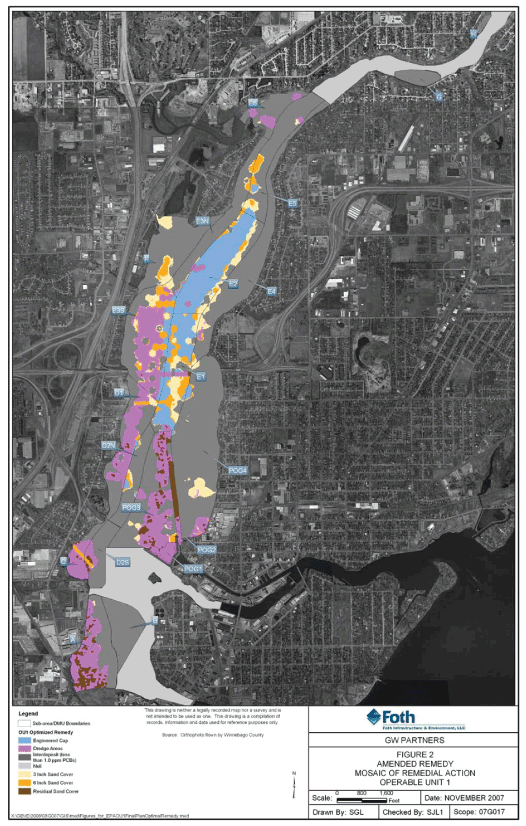
| 2. | Amended Remedy, Mosaic of Remedial Action, Operable Unit 1 | 29 | ||||
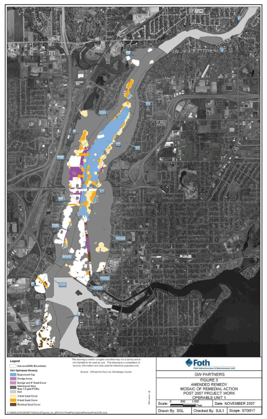
| 3. | Amended Remedy, Mosaic of Remedial Action, Post-2007 Project Work, Operable Unit 1 | 30 |
| 1. | Operable Units and Previously Selected Remedies | 10 | ||||
| 2. | Comparison of PCB Mass Within 1.0 ppm Prism | 13 | ||||
| 3. | Estimated Current PCB SWAC and Projected SWAC results for All-Dredging Remedy and Amended Remedy | 21 | ||||
| 4. | Comparative Costs of the 2002 ROD Remedy and Amended Remedy | 25 | ||||
| 5. | Summary of Design Features for Capping and Sand Covers | 36 |
2
| 6. | Summary of Changes to 2002 ROD | 43 | ||||
| 7. | Comparison of Remedy Volumes, Mass Removal and Remediation Areas for OU 1 | 44 | ||||
| 8. | Fox River ARARS | 46 |
Appendix B – Administrative Record Index
Appendix C – SWAC Estimating Procedure
3
| Agencies | Wisconsin Department of Natural Resources and United States Environmental Protection Agency | |
| Amended | Remedy selected in Record of Decision Amendment, | |
| Remedy | Operable Unit 1, Lower Fox River and Green Bay Superfund Site | |
| ARARs | Applicable or Relevant and Appropriate Requirements | |
| CERCLA | Comprehensive Environmental Response, Compensation, and Liability Act | |
| cy | cubic yards | |
| footprint | Areas that encompass the 1 ppm PCB Remedial Action Level | |
| kg | Kilograms | |
| MNR | Monitored Natural Recovery | |
| NCP | National Oil and Hazardous Substances Pollution Contingency Plan | |
| O&M | operation and maintenance | |
| OU | Operable Unit | |
| OU 1 | Little Lake Butte des Morts reach | |
| OU 2 | Appleton to Little Rapids reach | |
| OU 3 | Little Rapids to De Pere reach | |
| OU 4 | De Pere to Green Bay reach | |
| OU 5 | Green Bay | |
| PCB | polychlorinated biphenyl | |
| ppm | parts per million | |
| PRPs | Potentially Responsible Parties under CERCLA | |
| RAL | Remedial Action Level | |
| RAO | Remedial Action Objective | |
| RIFS | Remedial Investigation/Feasibility Study | |
| ROD | Record of Decision | |
| RS | Responsiveness Summary | |
| Site | Lower Fox River and Green Bay Site | |
| Design | OU1 Design Supplement, Lower Fox River Operable Unit 1, | |
| Supplement | November 2007 | |
| SWAC | Surface Weighted Average Concentration | |
| TSCA | Toxic Substances Control Act | |
| EPA | United States Environmental Protection Agency | |
| WDNR | Wisconsin Department of Natural Resources | |
| 2002 ROD | Record of Decision, Operable Units 1 and 2, Lower Fox River and Green Bay Site, December 2002 | |
| 2003 ROD | Record of Decision, Operable Units 3, 4, and 5, Lower Fox River and Green Bay Site, June 2003 |
4
5
Outagamie and Winnebago Counties, Wisconsin
| 1 | The Administrative Record contains detailed information EPA considered in selection of this Amended Remedy, and is available at the DNR Northeast Region office, 2984 Shawano Ave., Green Bay, Wis.; DNR Bureau of Watershed Management, 3rd Floor, 101 S. Webster St., Madison, Wis.; and the EPA Records Center, 7th floor, 77 W. Jackson Blvd., Chicago, III. |
6
| 1. | Polychlorinated biphenyls (PCBs) are more heavily concentrated in discrete areas in OU 1; and | ||
| 2. | The total PCB mass in the 1.0 ppm prism2 is less than predicted in the ROD, amounting to 2/3 of the 2002 ROD estimate; and | ||
| 3. | PCBs are present at low concentrations (i.e., slightly above the PCB Remedial Action Level (RAL) of 1.0 ppm) in areas containing large volumes and relatively thin deposits of contaminated sediment. |
| 1. | A specified dredge-line can only be attained if a dredging contractor is provided with an overcut allowance. Based on dredging experience in OU 1, an average 4-inch overcut is necessary to attain a dredge cut line to a degree of accuracy that attains remediation results that are acceptable to the Agencies. This results in additional dredging volume. This additional volume of material was not accounted for in the 2002 ROD and thus the total dredging cost was underestimated. | ||
| 2. | When the 1.0 ppm RAL cutline (elevation) is achieved, experience in OU 1 has demonstrated that all sediment containing more than 1.0 ppm PCBs can often be removed by dredging. However, generated dredge residuals sometimes remain above 1.0 ppm PCBs. Thus, a sand cover over selected areas having dredge residuals would be required in order to meet the Surface Weighted Average Concentration (SWAC) goal specified in the 2002 ROD. Sand cover costs were also not accounted for in the 2002 ROD estimate. | ||
| 3 | The cost of implementing the all-dredging remedy set forth in the 2002 ROD would be more than twice the cost estimated in the 2002 ROD. Based on additional data and operational experience discussed above, the current estimate for the 2002 ROD Remedy is $144 million, an increase of $78 million compared to the $66 million estimated by the 2002 ROD. | ||
| 4. | Dredging, capping and sand covering options are all implementable and environmentally protective. |
| 2 | The 1 ppm PCB dredge prism is the area and volume of sediments that includes all contaminated sediments that have PCB concentrations 1 ppm or greater. |
7
8
| Figure 1. Lower Fox River PCB-Contaminated Sediment Deposits and Operable Units |
9
| ROD | Operable Unit | Location | Remedy | |||||
| 2002 ROD | 1 | Little Lake Butte des Morts | Dredging and disposal | |||||
| 2 | Appleton to Little Rapids | Monitored Natural Recovery | ||||||
| 2007 ROD Amendment | 3 (and OU 2 Deposit DD) | Little Rapids to De Pere | Dredging and disposal, Capping and Sand Covers | |||||
| 4 | De Pere to Green Bay | Dredging and disposal, Capping and Sand | ||||||
| Covers | ||||||||
| 2007 ROD Amendment and 2003 ROD | 5 | Green Bay | Monitored Natural Recovery | |||||
| • | The primary contaminant of concern is PCBs. | ||
| • | Human health and ecological receptors are at risk from PCB bioaccumulation. |
10
| • | Fish consumption is the exposure pathway presenting the greatest risk for human health and ecological receptors. |
| A. | Site Evaluations and Remedy Selection Decisions |
| B. | Remedial Action Objectives |
11
| • | RAO 1: Achieve, to the extent practicable, surface water quality criteria throughout the Lower Fox River and Green Bay.This RAO is intended to reduce PCB concentrations in surface water as quickly as possible. The current water quality criteria for PCBs are 0.003 nanograms per liter (ng/L) for the protection of human health, and 0.012 ng/L for the protection of wild and domestic animals. Water quality criteria incorporate all routes of exposure assuming the maximum amount is ingested daily over a person’s (or animals) lifetime. | ||
| • | RAO 2: Protect humans who consume fish from exposure to Contaminants of Concern (COCs) that exceed protective levels.This RAO is intended to protect human health by targeting removal of fish consumption advisories as quickly as possible. The WDNR and EPA defined the expectation for the protection of human health as recreational and high intake fish consumers being able to safely eat unlimited amounts of fish within 10 years to 30 years, respectively. | ||
| • | RAO 3: Protect ecological receptors from exposure to COCs above protective levels.RAO 3 is intended to protect ecological receptors such as invertebrates, birds, fish, and mammals. WDNR and EPA defined the ecological expectation of achieving safe ecological thresholds for fish-eating birds and mammals within 30 years following remedy completion. Although the Feasibility Study did not identify a specific time frame for evaluating ecological protection, the 30-year figure was used as a measurement tool. | ||
| • | RAO 4: Reduce transport of PCBs from the Lower Fox River into Green Bay and Lake Michigan. The objective of this RAO is to reduce the transport of PCBs from the River into the Bay and Lake Michigan as quickly as possible. The WDNR and EPA defined the transport expectation as a reduction in loading to the Bay and Lake Michigan to levels comparable to the loading from other Lake Michigan tributaries. This RAO applies to each OU encompassing part of the River (sometimes referred to as River “reaches”). | ||
| • | RAO 5: Minimize the downstream movement of PCBs during implementation of the remedy.This objective would minimize as much as feasible the release of contaminants during remedial activities such as dredging, capping or placing sand covers. |
| C. | New Information Gathered During 2003-2004 and 2006-2007 Sampling and 2004-2007 Remedial Activities and Its Bearing on the 2002 ROD |
| 3 | From page 10 of the Design Supplement. |
12
| 1989 – 1999 RIFS1 | 2003 – 2007 Post-RIFS2 | |||||||||||||||
| Sub-area | kg | % of total | Kg | % of total | ||||||||||||
| A | 237 | 16.6 | 218.3 | 19.1 | ||||||||||||
| B | 409 | 28.5 | 0 | 0 | ||||||||||||
| C | 35 | 2.4 | 33.5 | 2.9 | ||||||||||||
| D | 78 | 5.4 | 37.6 | 3.3 | ||||||||||||
| E | 373 | 26.0 | 331.4 | 29.0 | ||||||||||||
| F | 3 | 0.002 | 2.5 | 0.002 | ||||||||||||
| G | 0 | 0 | 0 | 0 | ||||||||||||
| H | 0.4 | 0.0003 | 0 | 0 | ||||||||||||
| POG | 299 | 20.9 | 519.5 | 45.5 | ||||||||||||
| TOTAL | 1,434.4 | 99.8 | 3 | 1,142.8 | 99.8 | 3 | ||||||||||
13
| 1 | Source: December 2002 RI, Table 5-14; December 2002 FS, Table 5-3. Data was compiled from data collected from 1989 – 1999. | |
| 2 | Source: Data collected in 2004 – 2004 and 2006 – 2007. | |
| 3 | Percent total is not 100% because of rounding. |
| • | First, even if all sediment exceeding the 1.0 ppm PCB RAL is dredged in an area, the post-dredging surface concentrations may still exceed 1.0 ppm PCBs. That is because experience with dredging projects at OU 1 and other dredging projects has shown that the dredging process itself commonly re-suspends some contaminated sediment that is then re-deposited in a thin layer on top of the newly-dredged area. That re-deposited contamination is called “generated residuals.”5The 2002 ROD stated that generated residuals could be addressed by re-dredging and/or placement of sand covers over dredged areas. | ||
| • | Second, contrary to earlier expectations, the recent sampling data shows that large areas of relatively low PCB levels on the surface of undredged areas (i.e., |
| 4 | From page 10 of the Concept Paper, November 19, 2007. | |
| 5 | In this ROD Amendment, the term “generated residuals” is used to describe contaminated sediment that is re-deposited at the surface of a newly-dredged area (i.e., in the top six inches of the sediment surface). A different term – “undisturbed residuals” – is used to describe contaminated sediment that is more than six inches below the surface of a newly-dredged area. |
14
| m | Sediment removal.The 2002 ROD called for removal of all sediment with a PCB concentration exceeding the 1.0 ppm RAL. The estimated volume of the sediment that would need to be removed under that remedy has increased. As discussed above in Section I, it is now estimated that approximately 928,400 cy of sediment would need to be dredged under the remedy selected by the 2002 ROD, in light of new sampling data and overdredge allowance. The 2002 ROD originally estimated approximately 784,200 cy would be removed, as it did not include overdredging volumes. |
15
| m | Sediment dewatering and disposal.The 2002 ROD envisioned that contaminated sediment would be dewatered using mechanical processes similar to those used at other Fox River dredging projects (e.g., plate and frame presses). Experience at OU 1 has shown that geotextile tubes have proven to be effective for dewatering dredged sediments from OU 1. | ||
| m | Water treatment.Water generated by dredging and dewatering operations will be treated prior to discharging it back to the Fox River to meet State and federal water quality standards, consistent with the 2002 ROD. | ||
| m | Capping.A capping contingency plan included in the 2002 ROD allowed for the use of an engineered cap in limited areas it was shown to be protective and less costly than dredging. At a minimum, an Explanation of Significant Differenceswould have been required prior to implementation of capping. The capping portion of the Amended Remedy is consistent with the capping contingency allowed in the 2002 ROD. | ||
| m | Long-term monitoring.Long-term monitoring of surface water and biota would continue until PCB concentrations and exposures are below risk levels. | ||
| m | Institutional controls.Institutional controls (e.g., fish advisories) would be maintained to minimize human and ecological exposures to contaminants. | ||
| m | RAL and SWAC.Sediments with PCB concentrations greater than the 1.0 ppm RAL were targeted for removal. The 2002 ROD stated that SWAC levels of approximately 0.25 ppm PCB would be achieved if all sediment above the 1.0 ppm RAL were removed by dredging. If all sediments above the 1.0 ppm RAL were not removed in OU 1 due to dredge-generated residuals remaining in dredge areas, then the 2002 ROD indicated that a SWAC of approximately 0.25 ppm for OU 1 could be met by other means, such as redredging, capping or placement of sand cover on dredged residual. The specific SWAC goals in the 2002 ROD were 0.25 ppm. | ||
| m | Natural recovery after remediation.Although the 2002 ROD specified that the RAL requirement or SWAC goal would need to be met immediately after the completion of dredging in a particular OU, it was also recognized that it would take additional time for natural recovery before some of the RAOs would be achieved. For example, the 2002 ROD estimated that a SWAC of approximately 0.25 ppm PCBs would be achieved at construction completion, but the 2002 ROD also estimated that it would take another 14 years before reduced PCB levels in fish tissue would allow relatively safe consumption of walleye for high-intake consumers. If the 2002 ROD remedy did not achieve the SWAC goal, longer natural recovery periods would be required to meet RAOs. |
16
| m | Costs. Based on new information gathered after issuing the 2002 ROD, the cost of implementing the 2002 ROD remedy in OU 1 is currently projected at $144 million. The 2002 ROD originally estimated the cost at $66.2 million. The lower cost estimate in the 2002 ROD did not include dredging overcut volumes. The additional volume is significant in OU 1 due to thin contaminant zones. The added volume increases costs for dewatering, transportation and disposal. |
| • | Dredging as the primary remedial approach |
| • | capping, and | ||
| • | sand covers for residuals management and as the sole remedial approach in certain areas. |
17
| • | Oct. 2003 — OU 1 cleanup Consent Decree press conference, | ||
| • | Aug 2004 — OU 1 2004 season pre-construction public meeting, | ||
| • | May 2005 — OU 3-5 design update public meeting, | ||
| • | July 2005 — OU 1 construction update public meeting, | ||
| • | April 2006 – OU 4 Phase I Consent Decree press conference, | ||
| • | June 2006 — OU 1 construction update meeting, | ||
| • | December 5, 2006 – Public meeting for comments on the Proposed Plan to amend the 2003 ROD, and | ||
| • | December 13, 2007 – Public meeting for comments on the Proposed Plan to amend the 2002 ROD. |
| • | http://www.epa.gov/region5/sites/foxriver/index.html, | ||
| • | http://www.dnr.state.wi.us/org/water/wm/foxriver/reportsanddocs.html, and | ||
| • | http://www.littlelakecleanup.com/. |
18
| • | Although the Amended Remedy is primarily a dredging remedy, the Amended Remedy also allows alternate remedial approaches in certain situations (such as sand covering or capping undredged areas). This will result in the Amended Remedy being more likely to produce PCB SWAC levels at or less than 0.25 ppm upon completion of active remediation. | ||
| • | The Amended Remedy is projected to be completed by 2009 rather than 2014 under the 2002 ROD. The active remediation work will be done sooner (2 more years for the Amended Remedy, rather than 7 more years under the 2002 ROD Remedy – following 2007 cleanup activities). In addition, less time will be needed for post-remediation natural recovery in order to achieve the RAOs because the Amended Remedy is expected to yield a lower SWAC than the 2002 ROD Remedy. | ||
| • | The Amended Remedy allows alternate remedial approaches that are much more efficient than dredging the relatively thin layer of PCB deposits found to be present in OU 1. Under the 2002 ROD Remedy a large volume of relatively clean sediment would need to be removed as the amount of overdredging (about 4-inches) would be significant due to the thin nature of the contaminated sediment deposits (in an average thickness of layers about 1-foot). Once removed, that relatively clean sediment would take up valuable disposal space since it would need to be disposed of in a landfill along with the more contaminated sediment. The Amended Remedy would allow caps or sand covers in some areas with thin layer deposits, if specified criteria can be met. It is estimated that the Amended Remedy would thereby reduce the overdredge volume by 122,000 cubic yards. |
19
| A. | Evaluation Criteria |
20
| B. | Application of the Evaluation Criteria to the Amended Remedy and the 2002 ROD Remedy |
| 1. | Overall Protection of Human Health and the Environment |
| • | The Amended Remedy is projected to achieve a lower PCB SWAC in OU 1 sediment than an all dredging remedy and thus reduce contaminant exposure sooner. The Amended Remedy will leave lower PCB surface concentrations in capped and sand cover areas, as compared to the higher expected levels that would remain at the surface if the same areas were dredged. The Amended Remedy also provides additional options for meeting the SWAC (e.g., placement of sand covers over undredged areas). Table 3 presents the estimated pre-remediation SWAC and the estimated SWAC results under the two remedial approaches, assuming a post-dredging sand cover for both remedies. |
for an All-Dredging Remedy and Amended Remedy6
| Pre-Remediation | After all-dredging | After Amended | ||||||
| (ppm) | remedy (ppm) | Remedy (ppm) | ||||||
| 1.9 | 0.48 | 0.25 | ||||||
| • | The Amended Remedy will also achieve RAOs years before they would be achieved under the 2002 ROD Remedy. The active remediation work will be done sooner (within 2 more years under the Amended Remedy, rather than |
| 6 | From the Concept Paper, page 10. |
21
| m | Scour from hydrodynamic flows.The caps are designed to remain stable under maximum shear stresses for reasonable worst case scenarios (e.g., 100-year storm event). Experts in the fields of environmental engineering, hydrodynamic flow modeling, and sediment remediation have determined an |
| 7 | 100% of PCBs are not addressed because some limited areas are inaccessible due to utilities or shoreline issues. |
22
| appropriately conservative design, reflected in the Amended Remedy. | |||
| m | Disruption from bioturbation (i.e., biological activity).The caps are designed with thicknesses that will resist cap damage or exposure of underlying contamination due to bioturbation. Data from other similar Great Lakes sediment sites indicates that the potential bioturbation depth is approximately 4 inches. This is incorporated into the cap design. | ||
| m | Ice scour.An independent expert evaluation of potential ice scour was conducted using available historic climate data, site visits, and interviews with local individuals who have significant experience on the Lower Fox River. Among other things, the evaluation considered the risk of frazil ice negatively impacting the capped areas (i.e., ice on the river bottom that occurs in supercooled areas of the River with turbulent water). Areas in OU 1 with potential frazil ice formation were determined to be outside the areas that would be capped. Thus, the evaluation did not identify any areas where frazil ice or other ice forms (e.g., ice dams or jams) would be expected to cause erosion or damage to caps either directly from ice or indirectly from increased water velocities under the ice. | ||
| m | Scour from propeller wash.The cap design criteria include minimum depth requirements (i.e., 6-foot water depth for post capped areas) and cap design requirements (such as an armor stone layer) to ensure that caps are resistant to propeller wash from recreational or commercial vessels. Those requirements were developed based on analyses of existing and possible future vessel types and river uses for OU 1, including physical tests and modeling. | ||
| m | Other technical considerations. The caps are designed for stability, by requiring that a cap can only be installed if the underlying sediment has sufficient load bearing capacity and if the capped area will have stable side slopes. |
23
24
| Item | 2002 ROD | Amended Remedy | ||||||||||
| 2004-2007 Dredging/dewatering/water treatment and disposal | $ | 67,000,000 | $ | 67,000,000 | 1 | |||||||
| Post-2007 | Dredging/dewatering/water treatment and disposal | $ | 56,250,000 | 2 | $ | 6,450,000 | 2 | |||||
| Capping | 0 | $ | 9,650,000 | |||||||||
| Sand Cover | $ | 17,150,000 | 2 | $ | 8,700,000 | 2 | ||||||
| Demobilization | $ | 1,750,000 | 2 | $ | 1,750,000 | 2 | ||||||
| Monitoring and Maintenance | $ | 2,000,000 | $ | 4,650,000 | ||||||||
| Contingency | 0 | 3 | $ | 4,050,000 | ||||||||
| TOTAL | $ | 144,150,000 | $ | 102,250,000 | ||||||||
| 1 | Although these costs were for cleanup actions completed consistent with the 2002 ROD, they are listed here to allow comparison of overall cleanup costs. | |
| 2 | Averages are used for the estimated cost ranges. | |
| 3 | No contingency is used for the 2002 ROD costs because experience at OU 1 gives a high confidence based on actual operating expenses from dredging completed during 2004 to 2007 (with 335,000 cy of sediments dredged). |
25
26
27
28
29
30
| A. | The Primary Remedial Approach and the Alternate Remedial Approaches |
| m | Sediment removal requirements.All sediment with PCB concentrations exceeding the 1.0 ppm RAL will be targeted for removal in all areas within OU 1 unless use of an alternate remedial approach is approved by the Agencies for a particular area under the eligibility criteria listed below in Section XI.A.2. More specifically, in each sediment removal area, sediment shall be removed to a target elevation that: (1) encompasses all contaminated sediment exceeding the 1.0 ppm PCB RAL (as determined from 2003-2004, 2006-2007 and 2008 sampling data and data interpolation), including an overdredge allowance, as appropriate; and (2) includes any remaining sediments with PCB concentrations greater or equal to 50 ppm. | ||
| m | Sediment removal methods and precautions.Sediment removal will be conducted using a dredge appropriate to Site conditions. In-water pipelines or other appropriate methods will transport the dredged sediment from the dredge to the staging area(s). Dredging experience at OU 1 from 2004 – 2007 has shown that with careful operation of environmental dredges, silt curtains or other containment devices generally are not necessary during dredging activities. However, if future operations indicate that controls are necessary to ensure protectiveness, then additional measures or modifications to the dredging process will be employed, as appropriate. Turbidity will be monitored during dredging operations. Buoys and other waterway markers will be installed around the perimeter of the in-water work area. | ||
| m | Sediment dewatering and disposal. Dewatering will be employed at the staging facility for dredged sediment. The dewatering will be accomplished using processes such as plate and frame presses, belt filter presses, or geotextile tubes to remove water from PCB contaminated sediment before disposal. Based on dredging and dewatering from 2004 – 2007, it is expected that geotextile tubes will likely be used to complete the dewatering of dredged sediments for the remainder of the project. Dewatered contaminated sediment will be transported by truck, rail, and/or barge to a dedicated engineered landfill or another suitable upland disposal facility, consistent with applicable federal and state requirements. Based on previous |
31
| experience at OU 1, it is anticipated that trucks would be utilized to transport dredged PCB-contaminated sediments to an approved upland disposal facility. All known TSCA sediments were removed during dredging operations from 2004 to 2006. Although only non-TSCA sediments are expected to remain at OU 1, if TSCA sediments were found to still remain at OU 1, dewatered sediments subject to TSCA disposal requirements must be transported consistent with TSCA requirements by truck, rail, and/or barge to a landfill facility appropriately permitted to receive TSCA waste. | |||
| m | Water treatment.Superfund cleanups are required to meet the substantive discharge requirements of the Clean Water Act, but National Pollutant Discharge Elimination System (NPDES) permits are not required for on-site work. Thus, water generated by dredging and dewatering operations will be treated prior to discharge back to the River and will meet all state and federal water quality standards. This may include (but not be limited to) bag filter and sand filtration and granulated activated carbon (GAC) treatment. Treated water will be sampled and analyzed to verify compliance with the appropriate discharge requirements according to plans that will be developed in the design phase and approved by the Agencies. | ||
| m | Post-removal confirmatory surveys and sampling.After removal of sediments from a particular area, a survey and sampling activities will be performed to: (1) determine whether the sediment removal requirements specified above were met; and/or (2) determine whether there is a need for post-removal residuals management measures, as specified below. If the survey and/or sampling results show that the sediment removal requirements were not met in an area, then additional sediment in the area shall be removed until compliance with the sediment removal requirements is achieved. If the survey and/or sampling results in a particular area shows that post-removal dredge residuals management measures are needed, then those measures shall be implemented. The post-removal surveys and sampling will be done when the initial round of dredging in a particular area is completed. | ||
| m | Post-removal residuals management.As explained above, this ROD Amendment uses the term “generated residuals” for sediment that is re-suspended and re-deposited on the surface of a newly-dredged area (i.e., within the top six inches of the sediment), and it uses the term “undisturbed residuals” for sediment that is more than six inches below the surface of the newly-dredged sediment. If post-removal confirmatory sampling in a sediment removal area reveals post-removal generated residuals or undisturbed residuals with PCB concentrations exceeding the 1.0 ppm PCB RAL, then one or more of the following must occur: |
32
| • | For management of generated residuals |
| § | Generated residuals with a PCB concentration equal to or greater than 5.0 ppm must either be: (1) removed (typically by re-dredging) in accordance with the sediment removal requirements specified above; or (2) capped, if the eligibility criteria for that alternate remedial approach can be met, as specified below. | ||
| § | Generated residuals with a PCB concentration between 1.0 ppm and 5.0 ppm must be covered with at least 6 inches of clean sand from an off-Site source (referred to as a “residual sand cover”). | ||
| § | Place a residual sand cover as necessary to meet the SWAC goal for the OU of 0.25 ppm. |
| • | For management of undisturbed residuals |
| § | Unless EPA and WDNR approve use of a different residuals management approach in a particular area within OU 1, undisturbed residuals with a PCB concentration exceeding the 1.0 ppm PCB RAL must be removed (typically by re-dredging) in accordance with the sediment removal requirements specified above. EPA and WDNR may evaluate and approve the use of a different residuals management approach (such as a cap or a sand cover) for undisturbed residuals in limited areas if the eligibility criteria for alternate remedial approaches in Section XI.A.2 below is met. |
33
| m | Engineered caps.An engineered cap consisting of a sand layer and an armor stone layer may be installed in an area if the following eligibility criteria are satisfied: |
| • | Minimum water depth criteria for capping. |
| § | Capping will not be allowed in areas within the federally-authorized navigation channels. (Note: Sand covering will be allowed in the navigation channel(s) to manage dredged residuals. These sand covers must be at least 6 inches thick and must not impede navigation.) | ||
| § | Capping will be allowed in areas outside of the federally authorized navigation channel only if the top of the cap is at least 6 feet below the low water datum. |
| • | Engineered caps of 13 inches in thickness.This type of cap may be used in areas outside of the federally authorized navigational channel if the minimum water depth criteria for capping and all of the following additional criteria are met: |
| § | The cap shall be constructed of at least 3 inches of clean sand covered by at least 4 inches of armor stone, with an overplacement allowance of 3 inches of sand and 3 inches of armor stone. | ||
| § | The PCB concentration in the sediment in the eight inches immediately beneath the cap8 shall not exceed an average of 10.0 ppm. |
| • | Initial post-construction cap monitoring.Immediately after completion of capping construction activities for both sand and then separately for armor layers, a hydrographic survey shall be performed and direct cap thickness verification sampling shall be conducted. The post-construction thickness sampling will verify that cap placement specifications and cap construction criteria have been met, including an evaluation of whether the installed cap is sufficient in aerial coverage and thickness, and whether the cap material meets all applicable physical and chemical design standards. If the initial post-construction cap monitoring in a particular area shows that the cap |
| 8 | This eight inches is comprised of two 4-inch sampling intervals. |
34
| placement specifications and cap construction criteria have not been met, then the cap in that area shall be augmented or replaced to meet the applicable specifications and criteria. |
| m | Sand covers in undredged areas. |
| o | A cover composed of at least an average of 6 inches (3-inch minimum thickness) of uncontaminated sand from an off-Site source may be placed over certain undredged areas that have low PCB concentrations in a relatively thin layer of PCB-contaminated sediment exceeding the 1.0 ppm PCB RAL if both of the following criteria are met: |
| • | The sediment beneath the sand cover must not exceed 2.0 ppm at any depth within the sediment profile. | ||
| • | The sediment profile shall contain only one 8-inch interval with PCB concentrations between 1.4 – 2.0 ppm. |
| o | A cover composed of at least an average of 3 inches (1.5-inch minimum) of uncontaminated sand from an off-Site source may be placed over certain undredged areas that have low PCB concentrations in a relatively thin layer of PCB-contaminated sediment exceeding the 1.0 ppm PCB RAL if both of the following criteria are met: |
| • | The sediment beneath the sand cover must not exceed 1.4 ppm at any depth within the sediment profile. | ||
| • | The sediment profile shall contain only one 8-inch interval with PCB concentrations between 1.0 – 1.4 ppm. |
| Immediately after completion of sand cover placement activities, sand cover cores shall be collected. These initial post-construction cores or other measures approved by the agencies will verify that sand cover placement specifications have been met, including an evaluation of whether the sand cover is sufficient in areal coverage and thickness. If the initial post-construction sand cover monitoring in a particular area shows that the sand cover placement specifications have not been met, then the sand cover in that area shall be augmented or replaced to meet the applicable specifications and criteria. | |||
| m | Exceptional areas.EPA and WNDR may approve use of modified remedial approaches or other remedial approaches in exceptional areas at the Site based upon a showing that use of another remedial approach in an exceptional area is sufficiently protective and is more feasible and more cost effective than the primary remedial approach or any of the alternate remedial |
35
| approaches described above. EPA and WDNR expect that there will only be a relatively small number of areas at the Site that will need to be treated as exceptional areas, including some shallower near shore areas or areas near utilities. The specific remedial approach for each exceptional area will be subject to review and approval by EPA and WDNR, and will be included in the final remedial design. |
| Minimum post- | ||||||||||
| cap/cover water | Area covered by cap or | |||||||||
| Description | depth | PCB concentration | sand cover | |||||||
| Cap: 6-inches of sand and 7-inches of gravel | 6 feet | <=10 ppm1 | 112 acres | |||||||
| 6-inches of sand | Varies | 1.4 – 2.0 ppm2 | 46 acres | |||||||
| Sand Cover | 3-inches of sand | Varies | 1.0 – 1.4 ppm2 | 68 | ||||||
| 6-inches of sand | Varies | Dredge residuals | 30 | |||||||
| Table Notes: | ||
| 1 | PCB average concentration in 0 – 0.5 foot depth below mudline. | |
| 2 | Maximum PCB concentration in any 8-inch interval. Sand cover is assumed to completely mix with the top three (3) inches of underlying sediment and will achieve the 1.0 ppm RAL in the 0 - - 0.5 foot depth below mudline. | |
| B. | The Relationship Between the Remedial Action Level (RAL) Performance Standard and the Surface-Weighted Average Concentration (SWAC) Goal |
36
Surface-Weighted Average Concentration
37
| 1. | Performing additional dredging or capping to ensure that all sediments with PCB concentrations greater than the 1.0 ppm PCB RAL are removed, contained or covered; | ||
| 2. | Installing capping in areas with higher PCB concentrations (provided minimum water depth criteria and other capping criteria and design requirements are met); | ||
| 3. | Placing a residual sand cover over dredged areas; and | ||
| 4. | Placing a sand cover over undredged areas (consistent with the general requirements for sand covers outlined above). |
| m | Site mobilization and preparation.Staging area(s) will be required for facilities associated with sediment dewatering, sediment handling, water treatment, and material handling for cap and cover operations. Specific staging areas will likely be facilities previously utilized for the OU 1 project from 2004 to 2007. Docking facilities for dredging equipment and ancillary equipment for capping or sand covers at the existing facility will also likely be utilized. | ||
| m | Demobilization and staging area(s) restoration.Demobilization, staging area(s) restoration, and decontamination of all equipment will require removing all equipment from the staging and work areas and restoring the staging area(s) as needed to meet the legal requirements or any agreement with the property owner. |
38
| m | Natural recovery after remediation.Although the RAL Performance Standard or the SWAC goal will need to be met before construction of the remedial action can be deemed complete in OU 1, it will take additional time for natural recovery before some of the remedial action objectives are achieved. Sediment Quality Thresholds vary depending on the sensitivity of the particular receptor (such as recreational anglers, high-intake fish consumers walleye, mink, etc.), but post-remediation natural recovery will need to occur before certain SQTs and other remedial action objectives can be achieved. This is unchanged from the 2002 ROD, because the 2002 ROD and the Amended Remedy selected the same RAL and comparable SWACs. | ||
| m | Long-term monitoring, cap maintenance, and institutional controls. These requirements are discussed below in Section XI.D | ||
| m | Monitored Natural Recovery and Institutional Controls.This ROD Amendment does not change the original remedy for OU 2 in the 2002 ROD (i.e., Monitored Natural Recovery and Institutional Controls other than in Deposit DD). | ||
| m | Estimated costs.Costs for the Amended Remedy are estimated to be approximately $102 million and are presented in detail in Table 4 above. |
| m | Long-term monitoring of surface water and biota.The Amended Remedy requires long-term monitoring of surface water and biota to assess progress in achieving the remedial action objectives. Monitoring will continue until acceptable levels of PCBs are reached in surface water and fish. A detailed Long-Term Monitoring Plan, specifying the types and frequency of monitoring, will be developed. | ||
| m | Long-term cap monitoring.The Amended Remedy requires long-term monitoring of any engineered caps that are installed at the Site to confirm their long-term integrity and protectiveness. The long-term monitoring will include: |
| • | Hydrographic surveys and core sampling.A hydrographic survey shall be performed and cores of the cap shall be collected, at a minimum, 2 years and 4 years after the initial post-construction survey and every 5 years thereafter. Based on the results observed in that periodic monitoring, EPA and WDNR may increase or decrease the frequency of periodic monitoring. EPA and WDNR may require additional cap monitoring (between periodic monitoring events) after particular events that could cause cap damage, such as major storm events, ice scour events, or propeller wash scour events. |
39
| § | Monitoring for physical integrity.Hydrographic survey results and core samples collected during cap monitoring events will be analyzed to determine cap thickness and integrity. | ||
| § | Monitoring for chemical containment.Some core samples collected during cap monitoring events will also be analyzed for PCB contamination within 6 inch intervals (or less) to determine whether contamination is being effectively contained and isolated from the biota. |
| m | Cap enhancement and/or removal in response to cap degradation.If monitoring, or other information, indicates that the cap in an area no longer meets its original as-built design criteria and that degradation of the cap in the area may result in an actual or threatened release of PCBs at or from the area, then EPA and WDNR shall identify additional response activities to be undertaken in the area. If monitoring or other information shows a pattern of cap degradation in multiple areas, then EPA and WDNR may identify additional response activities to be undertaken in multiple capped areas at the Site (including in areas that have not yet shown any signs of degradation). The additional response activities shall include either: |
| • | Cap enhancement (e.g., application of a thicker sand layer or stone layer or use of larger armor stone); and/or | ||
| • | Cap removal and removal of underlying contaminated sediment (consistent with the requirements of the primary remedial approach). |
| m | Cap enhancement and/or removal in response to changed water levels. EPA and WDNR may identify additional response activities to be undertaken in a capped area if monitoring or other information indicates that the minimum water depth criteria for capping are no longer being met in the area and that the failure to meet the water depth criteria: (1) may result in an actual or threatened release of PCBs at or from the area (e.g., due to an increased risk of damage caused by propeller wash, ice scour, or other factors); or (2) may have adverse impacts on Lower Fox River uses. The additional response activities may include either: |
| • | Cap enhancement; and/or | ||
| • | Cap removal and removal of underlying contaminated sediment (consistent with the requirements of the primary remedial approach). |
| m | Institutional controls.Institutional Controls (ICs) are necessary to prevent interference with the remedy and to reduce exposure of contaminants to |
40
| human or ecological receptors. ICs are defined as non-engineered instruments, such as administrative and legal controls that help minimize potential for exposure to contamination and protect the integrity of the remedy. ICs are also required to assure long-term protectiveness for those areas that do not allow for unlimited use and unrestricted exposure. ICs are also required to maintain the integrity of the remedy. At this Site, ICs are required to protect the cap (engineered remedy), and reduce potential exposure for all areas where residual contamination will remain. Also, interim ICs may be necessary to prevent exposure to contaminants which may be released during construction activities such as dredging, capping and placing of sand covers. Long-term protectiveness requires compliance with effective ICs. Hence, effective ICs must be implemented, monitored and maintained. | |||
| Institutional controls will be identified as part of the remedial design process in an Institutional Control Implementation and Assurance Plan (ICIAP) for review and approval by EPA and WDNR. The required ICs may include property use controls (such as easements and restrictive covenants), governmental controls (including zoning ordinances and local permits), and informational devices (including signage and fish consumption advisories). The ICIAP shall identify parties responsible (i.e., federal, State or local authorities or private entities) for implementation, enforcement, and monitoring and long-term assurance of each institutional control including costs, both short-term and long-term, and methods to fund the costs and responsibilities for each step. | |||
| The ICIAP shall include maps, which shall describe coordinates of the restricted areas on paper and provide shape files in an acceptable GIS format (i.e., NAD 83) depicting all areas that do not allow unlimited use/unrestricted exposure, where dredging is not allowed (e.g., capped areas, buried utilities and near highway bridges) and areas where ICs have been implemented along with a schedule for updating them. The maps and information about the ICs shall be made available to the public in at least several ways, such as a website that is easily accessible to the public and posted in the public library. In addition the ICIAP shall identify reporting requirements associated with each institutional control which shall include at a minimum an annual certification regarding the status and effectiveness of the ICs. | |||
| Among other things, the ICIAP shall include the following institutional controls for any capped areas: |
| • | By using governmental and/or property use ICs, establishment of a Regulated Navigation Area (designating areas including an appropriate buffer) where use restrictions are required such as water use restrictions (e.g., limitations on anchoring, dredging, spudding, or dragging limitations, conducting salvage operations, establishment of “no wake” areas and other operating restrictions for commercial and non-commercial vessels which could potentially disturb the riverbed or the engineered remedy limitations); construction limitations (e.g., |
41
| restrictions on utilities such as laying cable, new bridges or dredging limitations for marina expansion or maintenance); and monitoring and maintenance requirements for all areas including dams. | |||
| • | Provide additional information to the public to assure protectiveness of the remedy (such as fish consumption advisories.) |
42
| Remedy Element | 2002 ROD | Amended Remedy | ||
| Remedial Action Level | 1.0 ppm PCBs | 1.0 ppm PCBs | ||
| SWAC Goal for OU 1 | 0.25 ppm PCBs | 0.25 ppm PCBs | ||
| Dredging Volume removed | 928,400 cubic yards | 406,100 cubic yards | ||
| PCB Mass removed (kilograms) | 1143 | 843 | ||
| Engineered Cap | Allowed under contingent remedy | Estimated 112 acres or less | ||
| Sand cover over sediments with PCB concentrations 1.0 — 2.0 ppm and 8-inch thickness or less that exceed the 1.0 ppm PCB RAL | None (not allowed) | Estimated 114 acres or less | ||
| Post-dredging sand cover in dredged areas if contaminants have PCB concentrations greater than the 1.0 ppm PCB RAL | Required (as necessary to meet the SWAC) | Estimated 30 acres | ||
| Transportation of dredge slurry from dredge to river-side facility | In-water pipeline | In-water pipeline | ||
| Separation of water from sediments | Mechanical presses | Geotextile tubes | ||
| Transportation of contaminated sediment from a river-side dewatering facility to landfill for final disposal | Trucks | Trucks | ||
| Disposal of dredged sediments | Contaminated sediments will go to a landfill that complies with all applicable federal and state laws and regulations | Contaminated sediments will go to a landfill that complies with all applicable federal and state laws and regulations | ||
| Institutional Controls until contaminants are at acceptable levels | Required | Required | ||
| Long-term monitoring of biota and water until contaminants are at acceptable levels | Required | Required | ||
| Monitored Natural Recovery until contaminants are at acceptable levels | Required | Required | ||
| Long-term monitoring and maintenance of cap | Required for contingent remedy | Required | ||
| Time (from 2007) to complete remediation | 7 years | 2 years | ||
| Cost | $144 million | $102 million |
43
| Sediment Volume | ||||||||||||||||||||||||
| Addressed | Mass Removed | Area Remediated | ||||||||||||||||||||||
| (cubic yards; cy) | (kilograms; kg) | (acres) | ||||||||||||||||||||||
| Amended | Amended | Amended | ||||||||||||||||||||||
| Remedial Action | 2002 ROD | Remedy | 2002 ROD | Remedy | 2002 ROD | Remedy | ||||||||||||||||||
Dredge/dispose3 | 928,400 | 2 | 406,100 | 1,143 | 843 | 426 | 216 | |||||||||||||||||
Engineered cap4 | 0 | 325,100 | 0 | 0 | 0 | 112 | ||||||||||||||||||
| Sand cover over PCB concentrations 1.0 - 2.0 ppm | 0 | 178,800 | 0 | 0 | 0 | 114 | ||||||||||||||||||
| Remedial action area total | 928,400 | 910,000 | 1,143 | 843 | 426 | 442 | ||||||||||||||||||
| Table Notes: | ||
| 1 | Figures are modeled estimates except for dredge and residual sand cover components which are based on actual data. Because of variation between actual conditions and modeled estimates, the total acreage, sediment volume, and PCB mass projected for the Amended Remedy vary from the acreage, sediment volume and PCB mass estimate for the 2002 ROD Remedy. | |
| 2 | The ROD estimate did not account for overcut. In addition, the 928,400 cubic yard volume estimate is a modeled estimate and does not account for “high subgrade” (i.e., areas that have a hard undredgable surface at higher than expected elevation underneath the zone of contaminated sediments, resulting in a lower volume than predicted of contaminated sediments). Based on actual dredging experience, high subgrade is estimated to reduce the total dredge volume by up to 90,000 cubic yards. | |
| 3 | Values indicated are based on actual data for the 2004-2006 RA activities and projections for the 2007 and 2008 RA activities. This Amended Remedy includes dredging in the following areas beyond those areas already identified by the 2007 RA Work Plan: re-dredge of Sub-Area POG2 and areas north of the trestle trail with residual concentrations above 5.0 ppm; 7-8 acres in Sub-Area D1; 40 acres in Sub-Areas D2N, E3 North, E3 South, E4, POG4, and F (due to capping constraints, based on a 6-foot post-cap water depth requirement); and 0.7 acres in Sub-Area E2. | |
| 4 | Approximate average of 13-inches includes 3-inch overplacement allowances in both the sand and armor layers. | |
44
| • | Dredging and off-site disposal of PCB-contaminated sediment.Dredging is focused on sediments with higher PCB concentrations. | |
| • | In-place containment of PCB contaminated sediments under engineered caps designed to provide long-term stability.Capping will generally be performed where PCB concentrations are lower and contaminated deposits are relatively thin. | |
| • | Enhanced natural recovery by placement of a sand cover.Natural recovery will be accelerated where PCB concentrations are only slightly above the 1.0 ppm PCB RAL (i.e., between 1.0 to 2.0 ppm) and would also be limited to areas where the thickness of sediment at those PCB levels is eight inches or less. | |
| • | Construction monitoring to ensure that there are no significant releases of contaminants during remedial activities. | |
| • | Long-term monitoring and maintenance of caps. | |
| • | Long-term monitoring of surface water and biota. | |
| • | Implementation of an Institutional Control Implementation and Assurance Plan. |
45
| Act/Regulation | Citation | |
Federal Chemical-Specific ARARs | ||
TSCA1 | 40 CFR 761.79 and EPA Disposal Approval | |
| 40 CFR 761.75 | ||
| 40 CFR 761.61(c) | ||
| Clean Water Act — Federal Water Quality Standards | 40 CFR 131 and 33 CFR 323 | |
Federal Action-/Location-Specific ARARs | ||
| Fish and Wildlife Coordination Act | 16 USC 661 et seq. | |
| 33 CFR 320-330 — Rivers and Harbors Act | ||
| 40 CFR 6.304 | ||
| Endangered Species Act | 16 USC 1531 et seq. | |
| 50 CFR 200 | ||
| 50 CFR 402 | ||
| Rivers and Harbors Act | 33 USC 403; 33 CFR 322, 323 | |
| National Historic Preservation Act | 15 USC 470; et seq. 36 CFR Part 800 | |
| Floodplain and Wetlands Regulations and Executive Orders | 40 CFR 264.18(b) and Executive Order 11988 | |
State Chemical-Specific ARARs | ||
| Surface Water Quality Standards | NR 102, 105 (To Be Considered), and 207 | |
| NR 722.09 1-2 | ||
| Groundwater Quality Standards | NR 140 | |
| Soil Cleanup Standards | NR 720 and 722 | |
| Hazardous Waste Statutes and Rules | NR 600-685 | |
State Action-/Location-Specific ARARs | ||
| Management of PCBs and Products Containing PCBs | NR 157 | |
| Wisconsin’s Floodplain Management Program | NR 116 | |
| Solid Waste Management | NR 500-520 | |
| Fish and Game | Chapter 29.415 — Wisconsin Statutes |
46
Proposed Plan
47
| /s/ Richard C. Karl | ||||
| Richard C. Karl, Director | Date 6/17/08 | |||
| Superfund Division | ||||
| EPA — Region 5 | ||||
| /s/ Bruce Baker | ||||
| Bruce Baker, Deputy Administrator | Date June 6, 2008 | |||
| Water Division |
48
| I. | PURPOSE |
| 1 | The RD for OU1 was originally addressed in an Administrative Order on Consent between WTM I Company, EPA, and WDNR, captionedIn the matter of the Lower Fox River and the Green Bay Site, Docket No. V-W-’03-C-745 (the “July 2003 AOC”), which was incorporated into the Original Decree and made enforceable only as to WTM I Company. Consistent with the approach taken in that prior settlement agreement, this Amended SOW specifies certain RD requirements that apply solely to WTM I Company. |
Appendix I - Page 1
| original RD SOW that accompanied the July 2003 AOC, this Amended SOW shall control. | ||
| II. | DESCRIPTION OF THE OU 1 REMEDIAL ACTION, AS MODIFIED BY THE 2008 ROD AMENDMENT |
| A. | The Primary Remedial Approach and the Alternate Remedial Approaches |
| 1. | The Primary Remedial Approach |
| m | Sediment removal requirements.All sediment with PCB concentrations exceeding the 1.0 ppm RAL will be targeted for removal in all areas within OU 1 unless use of an alternate remedial approach is approved by the Agencies for a particular area under the eligibility criteria listed below in Section II.A.2. More specifically, in each sediment removal area, sediment shall be removed to a target elevation that: (1) encompasses all contaminated sediment exceeding the 1.0 ppm PCB RAL (as determined from 2003-2004, 2006-2007 and 2008 sampling data and data interpolation), including an overdredge allowance, as appropriate; and (2) includes any remaining sediments with PCB concentrations greater or equal to 50 ppm. | ||
| m | Sediment removal methods and precautions.Sediment removal will be conducted using a dredge appropriate to Site conditions. In-water pipelines |
Appendix I - Page 2
| or other appropriate methods will transport the dredged sediment from the dredge to the staging area(s). Dredging experience at OU 1 from 2004 — 2007 has shown that with careful operation of environmental dredges, silt curtains or other containment devices generally are not necessary during dredging activities. However, if future operations indicate that controls are necessary to ensure protectiveness, then additional measures or modifications to the dredging process will be employed, as appropriate. Turbidity will be monitored during dredging operations. Buoys and other waterway markers will be installed around the perimeter of the in-water work area. | |||
| m | Sediment dewatering and disposal. Dewatering will be employed at the staging facility for dredged sediment. The dewatering will be accomplished using processes such as plate and frame presses, belt filter presses, or geotextile tubes to remove water from PCB contaminated sediment before disposal. Based on dredging and dewatering from 2004 — 2007, it is expected that geotextile tubes will likely be used to complete the dewatering of dredged sediments for the remainder of the project. Dewatered contaminated sediment will be transported by truck, rail, and/or barge to a dedicated engineered landfill or another suitable upland disposal facility, consistent with applicable federal and state requirements. Based on previous experience at OU 1, it is anticipated that trucks would be utilized to transport dredged PCB-contaminated sediments to an approved upland disposal facility. All known TSCA sediments were removed during dredging operations from 2004 to 2006. Although only non-TSCA sediments are expected to remain at OU 1, if TSCA sediments were found to still remain at OU 1, dewatered sediments subject to TSCA disposal requirements must be transported consistent with TSCA requirements by truck, rail, and/or barge to a landfill facility appropriately permitted to receive TSCA waste. | ||
| m | Water treatment.Superfund cleanups are required to meet the substantive discharge requirements of the Clean Water Act, but National Pollutant Discharge Elimination System (NPDES) permits are not required for on-site work. Thus, water generated by dredging and dewatering operations will be treated prior to discharge back to the River and will meet all state and federal water quality standards. This may include (but not be limited to) bag filter and sand filtration and granulated activated carbon (GAC) treatment. Treated water will be sampled and analyzed to verify compliance with the appropriate discharge requirements according to plans that will be developed in the design phase and approved by the Agencies. | ||
| m | Post-removal confirmatory surveys and sampling.After removal of sediments from a particular area, a survey and sampling activities will be performed to: (1) determine whether the sediment removal requirements specified above were met; and/or (2) determine whether there is a need for post-removal residuals management measures, as specified below. If the |
Appendix I - Page 3
| survey and/or sampling results show that the sediment removal requirements were not met in an area, then additional sediment in the area shall be removed until compliance with the sediment removal requirements is achieved. If the survey and/or sampling results in a particular area shows that post-removal dredge residuals management measures are needed, then those measures shall be implemented. The post-removal surveys and sampling will be done when the initial round of dredging in a particular area is completed. | |||
| m | Post-removal residuals management.The 2008 ROD Amendment uses the term “generated residuals” for sediment that is re-suspended and re-deposited on the surface of a newly-dredged area (i.e., within the top six inches of the sediment), and it uses the term “undisturbed residuals” for sediment that is more than six inches below the surface of the newly-dredged sediment. If post-removal confirmatory sampling in a sediment removal area reveals post-removal generated residuals or undisturbed residuals with PCB concentrations exceeding the 1.0 ppm PCB RAL, then one or more of the following must occur: |
| • | For management of generated residuals |
| § | Generated residuals with a PCB concentration equal to or greater than 5.0 ppm must either be: (1) removed (typically by re-dredging) in accordance with the sediment removal requirements specified above; or (2) capped, if the eligibility criteria for that alternate remedial approach can be met, as specified below. | ||
| § | Generated residuals with a PCB concentration between 1.0 ppm and 5.0 ppm must be covered with at least 6 inches of clean sand from an off-Site source (referred to as a “residual sand cover”). | ||
| § | Placement of a residual sand cover as necessary to meet the SWAC goal for the OU of 0.25 ppm. |
| • | For management of undisturbed residuals |
| § | Unless EPA and WDNR approve use of a different residuals management approach in a particular area within OU 1, undisturbed residuals with a PCB concentration exceeding the 1.0 ppm PCB RAL must be removed (typically by re-dredging) in accordance with the sediment removal requirements specified above. EPA and WDNR may evaluate and approve the use of a different residuals management approach (such as a cap or a sand cover) for undisturbed residuals in limited areas if the eligibility criteria |
Appendix I - Page 4
| for alternate remedial approaches in Section II.A.2 below is met. |
| 2. | Alternate Remedial Approaches |
| m | Engineered caps.An engineered cap consisting of a sand layer and an armor stone layer may be installed in an area if the following eligibility criteria are satisfied: |
| • | Minimum water depth criteria for capping. |
| § | Capping will not be allowed in areas within the federally-authorized navigation channels. (Note: Sand covering will be allowed in the navigation channel(s) to manage dredged residuals. These sand covers must be at least 6 inches thick and must not impede navigation.) | ||
| § | Capping will be allowed in areas outside of the federally authorized navigation channel only if the top of the cap is at least 6 feet below the low water datum. |
| • | Engineered caps of 13 inches in thickness.This type of cap may be used in areas outside of the federally authorized navigational channel if the minimum water depth criteria for capping and all of the following additional criteria are met: |
| § | The cap shall be constructed of at least 3 inches of clean sand covered by at least 4 inches of armor stone, with an overplacement allowance of 3 inches of sand and 3 inches of armor stone. |
Appendix I - Page 5
| § | The PCB concentration in the sediment in the eight inches immediately beneath the cap2 shall not exceed an average of 10.0 ppm. |
| • | Initial post-construction cap monitoring.Immediately after completion of capping construction activities for both sand and then separately for armor layers, a hydrographic survey shall be performed and direct cap thickness verification sampling shall be conducted. The post-construction thickness sampling will verify that cap placement specifications and cap construction criteria have been met, including an evaluation of whether the installed cap is sufficient in aerial coverage and thickness, and whether the cap material meets all applicable physical and chemical design standards. If the initial post-construction cap monitoring in a particular area shows that the cap placement specifications and cap construction criteria have not been met, then the cap in that area shall be augmented or replaced to meet the applicable specifications and criteria. |
| m | Sand covers in undredged areas. |
| o | A cover composed of at least an average of 6 inches (3-inch minimum thickness) of uncontaminated sand from an off-Site source may be placed over certain undredged areas that have low PCB concentrations in a relatively thin layer of PCB-contaminated sediment exceeding the 1.0 ppm PCB RAL if both of the following criteria are met: |
| • | The sediment beneath the sand cover must not exceed 2.0 ppm at any depth within the sediment profile. | ||
| • | The sediment profile shall contain only one 8-inch interval with PCB concentrations between 1.4 – 2.0 ppm. |
| o | A cover composed of at least an average of 3 inches (1.5-inch minimum) of uncontaminated sand from an off-Site source may be placed over certain undredged areas that have low PCB concentrations in a relatively thin layer of PCB-contaminated sediment exceeding the 1.0 ppm PCB RAL if both of the following criteria are met: |
| • | The sediment beneath the sand cover must not exceed 1.4 ppm at any depth within the sediment profile. | ||
| • | The sediment profile shall contain only one 8-inch interval with PCB concentrations between 1.0 – 1.4 ppm. |
| Immediately after completion of sand cover placement activities, sand cover |
| 2 | This eight inches is comprised of two 4-inch sampling intervals. |
Appendix I - Page 6
| cores shall be collected. These initial post-construction cores or other measures approved by the agencies will verify that sand cover placement specifications have been met, including an evaluation of whether the sand cover is sufficient in areal coverage and thickness. If the initial post-construction sand cover monitoring in a particular area shows that the sand cover placement specifications have not been met, then the sand cover in that area shall be augmented or replaced to meet the applicable specifications and criteria. | |||
| m | Exceptional areas.EPA and WNDR may approve use of modified remedial approaches or other remedial approaches in exceptional areas at the Site based upon a showing that use of another remedial approach in an exceptional area is sufficiently protective and is more feasible and more cost effective than the primary remedial approach or any of the alternate remedial approaches described above. EPA and WDNR expect that there will only be a relatively small number of areas at the Site that will need to be treated as exceptional areas, including some shallower near shore areas or areas near utilities. The specific remedial approach for each exceptional area will be subject to review and approval by EPA and WDNR, and will be included in the final remedial design. |
| B. | The Relationship Between the Remedial Action Level (RAL) Performance Standard and the Surface-Weighted Average Concentration (SWAC) Goal |
Appendix I - Page 7
| 1. | Performing additional dredging or capping to ensure that all sediments with PCB concentrations greater than the 1.0 ppm PCB RAL are removed, contained or covered; | ||
| 2. | Installing capping in areas with higher PCB concentrations (provided minimum water depth criteria and other capping criteria and design requirements are met); | ||
| 3. | Placing a residual sand cover over dredged areas; and | ||
| 4. | Placing a sand cover over undredged areas (consistent with the general requirements for sand covers outlined above). |
Appendix I - Page 8
| C. | Other Features of the Remedial Action |
| m | Site mobilization and preparation.Staging area(s) will be required for facilities associated with sediment dewatering, sediment handling, water treatment, and material handling for cap and cover operations. Specific staging areas will likely be facilities previously utilized for the OU 1 project from 2004 to 2007. Docking facilities for dredging equipment and ancillary equipment for capping or sand covers at the existing facility will also likely be utilized. | ||
| m | Demobilization and Staging Area(s) restoration.Demobilization, Staging area(s) restoration, and decontamination of all equipment will require removing all equipment from the staging and work areas and restoring the staging area(s) as needed to meet the legal requirements or any agreement with the property owner. | ||
| m | Natural recovery after remediation.Although the RAL Performance Standard or the SWAC goal will need to be met before construction of the remedial action can be deemed complete in OU 1, it will take additional time for natural recovery before some of the remedial action objectives are achieved. | ||
| m | Long-term monitoring, cap maintenance, and institutional controls. These requirements are discussed below in Section II.D. |
| D. | Long Term Monitoring, Cap Maintenance, and Institutional Controls |
| m | Long-term monitoring of surface water and biota.The remedial action requires long-term monitoring of surface water and biota to assess progress in achieving the remedial action objectives. Monitoring will continue until acceptable levels of PCBs are reached in surface water and fish. A detailed Long-Term Monitoring Plan, specifying the types and frequency of monitoring, will be developed. | ||
| m | Long-term cap monitoring.The remedial action requires long-term monitoring of any engineered caps that are installed at the Site to confirm their long-term integrity and protectiveness. The long-term monitoring will include: |
| • | Hydrographic surveys and core sampling.A hydrographic survey |
Appendix I - Page 9
| shall be performed and cores of the cap shall be collected, at a minimum, 2 years and 4 years after the initial post-construction survey and every 5 years thereafter. Based on the results observed in that periodic monitoring, EPA and WDNR may increase or decrease the frequency of periodic monitoring. EPA and WDNR may require additional cap monitoring (between periodic monitoring events) after particular events that could cause cap damage, such as major storm events, ice scour events, or propeller wash scour events. |
| § | Monitoring for physical integrity.Hydrographic survey results and core samples collected during cap monitoring events will be analyzed to determine cap thickness and integrity. | ||
| § | Monitoring for chemical containment.Some core samples collected during cap monitoring events will also be analyzed for PCB contamination within 6 inch intervals (or less) to determine whether contamination is being effectively contained and isolated from the biota. |
| m | Cap enhancement and/or removal in response to cap degradation.If monitoring, or other information, indicates that the cap in an area no longer meets its original as-built design criteria and that degradation of the cap in the area may result in an actual or threatened release of PCBs at or from the area, then EPA and WDNR shall identify additional response activities to be undertaken in the area. If monitoring or other information shows a pattern of cap degradation in multiple areas, then EPA and WDNR may identify additional response activities to be undertaken in multiple capped areas at the Site (including in areas that have not yet shown any signs of degradation). The additional response activities shall include either: |
| • | Cap enhancement (e.g., application of a thicker sand layer or stone layer or use of larger armor stone); and/or | ||
| • | Cap removal and removal of underlying contaminated sediment (consistent with the requirements of the primary remedial approach). |
| m | Cap enhancement and/or removal in response to changed water levels. EPA and WDNR may identify additional response activities to be undertaken in a capped area if monitoring or other information indicates that the minimum water depth criteria for capping are no longer being met in the area and that the failure to meet the water depth criteria: (1) may result in an actual or threatened release of PCBs at or from the area (e.g., due to an increased risk of damage caused by propeller wash, ice scour, or other factors); or (2) may have adverse impacts on Lower Fox River uses. The additional response activities may include either: |
Appendix I - Page 10
| • | Cap enhancement; and/or | ||
| • | Cap removal and removal of underlying contaminated sediment (consistent with the requirements of the primary remedial approach). |
| m | Institutional controls.Institutional Controls (ICs) are necessary to prevent interference with the remedy and to reduce exposure of contaminants to human or ecological receptors. ICs are defined as non-engineered instruments, such as administrative and legal controls that help minimize potential for exposure to contamination and protect the integrity of the remedy. ICs are also required to assure long-term protectiveness for those areas that do not allow for unlimited use and unrestricted exposure. ICs are also required to maintain the integrity of the remedy. At this Site, ICs are required to protect the cap (engineered remedy), and reduce potential exposure for all areas where residual contamination will remain. Also, interim ICs may be necessary to prevent exposure to contaminants which may be released during construction activities such as dredging, capping and placing of sand covers. Long-term protectiveness requires compliance with effective ICs. Hence, effective ICs must be implemented, monitored and maintained. | ||
| Institutional controls will be identified as part of the remedial design process in an Institutional Control Implementation and Assurance Plan (ICIAP) for review and approval by EPA and WDNR. The required ICs may include property use controls (such as easements and restrictive covenants), governmental controls (including zoning ordinances and local permits), and informational devices (including signage and fish consumption advisories). The ICIAP shall identify parties responsible (i.e., federal, State or local authorities or private entities) for implementation, enforcement, and monitoring and long-term assurance of each institutional control including costs, both short-term and long-term, and methods to fund the costs and responsibilities for each step. | |||
| The ICIAP shall include maps, which shall describe coordinates of the restricted areas on paper and provide shape files in an acceptable GIS format (i.e., NAD 83) depicting all areas that do not allow unlimited use/unrestricted exposure, where dredging is not allowed (e.g., capped areas, buried utilities and near highway bridges) and areas where ICs have been implemented along with a schedule for updating them. The maps and information about the ICs shall be made available to the public in at least several ways, such as a website that is easily accessible to the public and posted in the public library. In addition the ICIAP shall identify reporting requirements associated with each institutional control which shall include at a minimum an annual certification regarding the status and effectiveness of the ICs. | |||
| Among other things, the ICIAP shall include the following institutional controls for any capped areas: |
Appendix I - Page 11
| • | By using governmental and/or property use ICs, establishment of a Regulated Navigation Area (designating areas including an appropriate buffer) where use restrictions are required such as water use restrictions (e.g., limitations on anchoring, dredging, spudding, or dragging limitations, conducting salvage operations, establishment of “no wake” areas and other operating restrictions for commercial and non-commercial vessels which could potentially disturb the riverbed or the engineered remedy limitations); construction limitations (e.g., restrictions on utilities such as laying cable, new bridges or dredging limitations for marina expansion or maintenance); and monitoring and maintenance requirements for all areas including dams. | ||
| • | Provide additional information to the public to assure protectiveness of the remedy (such as fish consumption advisories.) |
| III. | THE RESPONSE WORK |
| A. | Timing |
| B. | Scope of the Work |
Appendix I - Page 12
| C. | Remedial Design and Remedial Action Plans |
| 1. | Final Design and Remedial Action Work Plan for 2008-2009 Response Work |
| s | dredging; | ||
| s | sediment dewatering, loading, hauling, and disposal; | ||
| s | water treatment and discharge; | ||
| s | sand cover placement; and | ||
| s | engineered cap placement. |
| s | a Health and Safety and Contingency Plan; | ||
| s | a Construction Quality Assurance Project Plan; | ||
| s | an Operation and Maintenance Plan; | ||
| s | a Sediment Removal Verification Plan; | ||
| s | a Quality Assurance Project Plan for the Operation and Maintenance Plan; |
Appendix I - Page 13
| s | an updated Regulatory Substantive Requirements Compliance Plan; | ||
| s | a Dredge Plan; | ||
| s | a Dewatering Plan; | ||
| s | a Water Treatment Plan; | ||
| s | a Loading, Transportation, and Disposal Plan; | ||
| s | a Sand Cover and Armored Cap Placement Plan; | ||
| s | a Capital and Operation and Maintenance Cost Estimate; and | ||
| s | a Final Project Schedule for the construction and implementation of the Response Work in 2008-2009 which identifies timing for initiation and completion of all critical path tasks. |
| 2. | Pre-Final and Final Design and Draft and Final Remedial Action Work Plan for Post 2009 Response Work |
Appendix I - Page 14
| C. | Content of Certain Supporting Plans |
| 1. | Health and Safety Plan |
| 2. | Quality Assurance Project Plans |
| D. | Other Requirements |
| 1. | Community Relations Support |
| 2. | Progress Reports |
Appendix I - Page 15
| E. | Implementation of the Response Work |
| F. | Completion of the Remedial Action for OU1 |
| 1. | Construction Completion inspection |
| 2. | RA Completion Plan |
| 3. | RA Pre-Certification Inspection |
Appendix I - Page 16
| 4. | EPA Response to RA Certification of Completion Report |
Appendix I - Page 17
| G. | Completion of the Response Work for OU1 |
| 1. | Response Work Pre-Certification Inspection |
| 2. | Continuation of Response Work |
| 3. | Response Work Certification of Completion Report |
Appendix I - Page 18
| 4. | EPA Response to Response Work Certification of Completion Report |
| IV. | SUMMARY OF MAJOR MILESTONES AND DEADLINES |
Appendix I - Page 19
| Deliverable/Milestone | Due Date | |
| Final Design and Remedial Action Work Plan for 2008-2009 | Within 10 calendar days after the Date of Lodging of the Amended Consent Decree | |
| Pre-Final Design and Draft Remedial Action Work Plan for Remaining Response Work | February 1, 2010 | |
| Final Design and Remedial Action Work Plan for Remaining Response Work | Within 30 calendar days after receipt of the Response Agencies’ comments on the Pre-Final Design and Draft Remedial Action Work Plan for Remaining Response Work | |
| Pre-Completion Inspection | At least 90 days before the anticipated completion of all phases of construction specified by the RD, and before final demobilization and staging area restoration efforts | |
| Construction Completion Inspection/RA Pre-Certification Inspection | Within 90 days after completion of all phases of construction specified by the RD and after conducting post-construction sampling to determine whether the RAL Performance Standard or the SWAC goal has been achieved as described in Section II.B of this Amended SOW; a Construction Completion Inspection will also serve as an RA Pre- Certification Inspection if the Settling Defendants believe that the RA has been performed such that the Performance Standards have been achieved | |
| RA Certification of Completion Report | Within 60 days after an RA Pre-Certification Inspection, provided Settling Defendants still believe Performance Standards have been achieved | |
| Revised RA Certification of Completion Report | 30 calendar days after receipt of the Response Agencies’ comments on the Report | |
| Certification of Completion of the RA | Upon EPA’s approval of the RA Certification of Completion Report | |
| Response Work Pre- Certification Inspection | Within 90 days after Settling Defendants conclude that all phases of Response Work are completed | |
| Response Work Certification of Completion Report | Within 60 days after Response Work Pre- Certification Inspection, provided Settling Defendants believe Response Work has been fully performed |
Appendix I - Page 20
| Deliverable/Milestone | Due Date | |
| Revised Response Work Certification of Completion Report | 30 calendar days after receipt of the Response Agencies’ comments on the Report | |
| Issuance of Certification of Completion of Response Work | Upon EPA’s approval of the Response Work Certification of Completion Report | |
| Monthly Progress Reports | By the 10th of each month from the Date of Lodging of the Amended Decree for so long as the RA continues, until Certification of Completion of the RA | |
| Quarterly Reports | Quarterly basis for so long as the RA continues under the Amended Decree, until Certification of Completion of the RA |
Appendix I - Page 21
500 FIRST AVENUE 3RD FLOOR
PITTSBURGH PA 15219
J-1
| SUPERFUND DIVISION DIRECTOR | ||||
| U.S. ENVIRONMENTAL PROTECTION AGENCY, REGION 5 | ||||
ABA 021001033
ACCOUNT NAME: TRUST AND SECURITIES SERVICES
ACCOUNT NUMBER: 01419647 FCT
PAYMENT DETAILS: GLATFELTER SUB-ACCOUNT
NO. 58528 REF: FOX RIVER OU-1 ESCROW ACCOUNT
J-2