Moose Mountain Technical Services | |
Resource Potential, New Polaris Project |
1.0
RESOURCE POTENTIAL
NEW POLARIS PROJECT
| North Western British Columbia | |
| NTS: 104 K 12 | |
| Latitude: 58º42’N | Longitude: 133º37’W |
| Atlin Mining Division | |
| Submitted to: Canarc Resource Corp. 800-850 West Hastings Street Vancouver, BC V6C 1E1 14 March, 2007 Prepared by: R.J. Morris, M.Sc., P.Geo. Moose Mountain Technical Services And G.H. Giroux, MASc., P. Eng. Giroux Consultants Ltd. |
Resource Potential, New Polaris Project
Prepared for Canarc Resource Corp.
Page 2 of 94
Moose Mountain Technical Services | |
Resource Potential, New Polaris Project |
2.0 TABLE OF CONTENTS
| 1.0 | TITLE PAGE | 2 |
| 2.0 | TABLE OF CONTENTS | 3 |
| 3.0 | SUMMARY | 6 |
| 4.0 | INTRODUCTION | 8 |
| 5.0 | RELIANCE ON OTHER EXPERTS | 9 |
| 6.0 | PROPERTY DESCRIPTION AND LOCATION | 10 |
| 7.0 | ACCESSIBILITY, CLIMATE, LOCATE RESOURCES, | |
| INFRASTRUCTURE AND PHYSIOGRAPHY | 15 | |
| 8.0 | HISTORY | 16 |
| 9.0 | GEOLOGICAL SETTING | 22 |
| 9.1 | Regional Geology | 22 |
| 9.2 | Property Geology | 22 |
| 10.0 | DEPOSIT TYPES | 26 |
| 11.0 | MINERALIZATION | 27 |
| 12.0 | EXPLORATION | 29 |
| 13.0 | DRILLING | 31 |
| 14.0 | SAMPLING METHOD AND APPROACH | 40 |
| 15.0 | SAMPLE PREPARATION, ANALYSES AND SECURITY | 42 |
| 15.1 | 2006 Program | 42 |
| 16.0 | DATA VERIFICATION | 50 |
| 17.0 | ADJACENT PROPERTIES | 51 |
| 18.0 | MINERAL PROCESSING AND METALLURGICAL TESTING | 52 |
| 19.0 | MINERAL RESOURCE AND MINERAL RESERVE ESTIMATES | 54 |
| 19.1 | DATA ANALYSIS | 54 |
| 19.2 | GEOLOGIC MODEL | 55 |
| 19.3 | COMPOSITES | 58 |
| 19.4 | VARIOGRAPHY | 58 |
| 19.5 | BULK DENSITY | 59 |
| 19.6 | BLOCK MODEL | 59 |
| 19.7 | GRADE INTERPOLATION | 59 |
| 19.8 | CLASSIFICATION | 61 |
| 20.0 | OTHER RELEVANT DATA AND INFORMATION | 65 |
| 21.0 | INTERPRETATION AND CONCLUSIONS | 66 |
| 22.0 | RECOMMENDATIONS | 68 |
| 23.0 | REFERENCES | 69 |
| 24.0 | DATE AND SIGNATURE PAGE | 71 |
| 25.0 | ADDITIONAL REQUIREMENTS FOR TECHNICAL REPORTS ON | |
| DEVELOPMENT PROPERTIES AND PRODUCTION PROPERTIES | 73 |
Resource Potential, New Polaris Project
Prepared for Canarc Resource Corp.
Page 3 of 94
Moose Mountain Technical Services | |
Resource Potential, New Polaris Project |
LIST OF TABLES
| Table | 6-1 List of Claims | 12 | |
| Table | 8-1 Summary of Exploration Drilling to 2006 | 17 | |
| Table | 8-2 Historic Resource Estimates | 21 | |
| Table | 12-1 | Exploration Employees / Contractors | 30 |
| Table | 13-1 | Assay Composites C Vein System | 33 |
| Table | 15-1 | Univariate Statistics, Blank Samples | 42 |
| Table | 15-2 | Univariate Statistics, Duplicate Samples | 43 |
| Table | 15-3 | Standard Samples | 44 |
| Table | 15-4 | Univariate Statistics, Round Robin Samples | 46 |
| Table | 19-1 | Summary of gold populations within mineralized zones | 54 |
| Table | 19-2 | Summary of gold statistics for uncapped and capped assays within | |
| mineralized zones | 54 | ||
| Table | 19-3 | Summary Description of Geologic Domains | 55 |
| Table | 19-4 | Summary of gold statistics in 2.5 m composites for geologic domains | |
| 58 | |||
| Table | 19-5 | Summary of Semivariogram Parameters | 58 |
| Table | 19-6 | Summary of Kriging Parameters | 60 |
| Table | 19-7- New Polaris Resource, Undiluted | 63 | |
LIST OF FIGURES
| Figure | 6-1 | Location Map | 11 |
| Figure | 6-2 | Claim Location Map | 13 |
| Figure | 6-3 | Claim Map with Principle Vein Locations | 14 |
| Figure | 9-1 | Regional Geology | 24 |
| Figure | 9-2 | Property Geology | 25 |
| Figure | 11-1 | 3D Model C Vein, plan view | 28 |
| Figure | 13-1 | Drillholes, cross-section, viewed from the east | 36 |
| Figure | 13-2 | 3D solids, cross-section, viewed from the south | 37 |
| Figure | 13-3 | Cross-section East 1766 | 38 |
| Figure | 13-4 | Cross-section East 1796 | 39 |
| Figure | 15-1 | Blank Samples, 2006 | 42 |
| Figure | 15-2 | Duplicate Samples, 2006 | 44 |
| Figure | 15-3 | Standard PM 165, 2006 | 45 |
| Figure | 15-4 | Standard PM 415, 2006 | 45 |
| Figure | 15-5 | Standard PM 916, 2006 | 46 |
| Figure | 15-6 | Round Robin, Chemex 1 vs. Acme, 2006 | 47 |
| Figure | 15-7 | Round Robin, Chemex 1 vs. Chemex 2, 2006 | 48 |
| Figure | 15-8 | Round Robin, Acme vs. Chemex 2, 2006 | 49 |
| Figure | 19-1 | Gold Grade Distribution | 55 |
| Figure | 19-2 | 3D view, cross-section, looking to the northeast | 56 |
Resource Potential, New Polaris Project
Prepared for Canarc Resource Corp.
Page 4 of 94
Moose Mountain Technical Services | |
Resource Potential, New Polaris Project |
| Figure | 19-3 | 3D view, cross-section, looking to the west | 57 | |
| Figure | 19-4 | Cross-section 1766 | 64 | |
| Figure | 19-5 | Cross-section 1706 | 64 | |
LIST OF APPENDICES
| APPENDIX A SEMIVARIOGRAM MODELS | 74 |
| APPENDIX B LISTING OF SPECIFIC GRAVITY DETERMINATIONS | 86 |
| APPENDIX C DIAMOND DRILL HOLES (1988 TO 2006) | 88 |
Resource Potential, New Polaris Project
Prepared for Canarc Resource Corp.
Page 5 of 94
Moose Mountain Technical Services | |
Resource Potential, New Polaris Project |
3.0 SUMMARY
New Polaris (formerly Polaris-Taku) is an early Tertiary mesothermal gold mineralized body located in northwestern British Columbia about 100 kilometres south of Atlin, BC and 60 kilometres northeast of Juneau, Alaska. The nearest roads in the area terminate twenty kilometres due south of Atlin and 10 kilometres southeast of Juneau. Access at the present time is by aircraft. A short airstrip for light aircraft exists on the property.
The deposit was mined by underground methods from 1938 to 1942, and from 1946 to early 1951, producing a total of 740,000 tonnes of ore at an average grade of 10.3g/t gold.
The property consists of 61 contiguous Crown-granted mineral claims and one modified grid claim covering 2,100 acres. All claims are 100% owned and held by New Polaris Gold Mines Ltd., a wholly owned subsidiary of Canarc Resource Corp. subject to a 15% net profit interest held by Rembrandt Gold Mines Ltd. Canarc can reduce this net profit interest to a 10% net profit.
The deposit is composed of three sets of veins (quartz-carbonate stringers in altered rock), the “AB” veins are northwest striking and southwest dipping, the “Y” veins are north striking and dipping steeply east and finally the “C” veins are east-west striking and dipping to the south to southeast at 65º to vertical. The “C” veins appear to hook around to the north and south into the other two sets of veins so that their junctions form an arc. The gold is refractory and occurs dominantly in finely disseminated arsenopyrite grains that mineralize the altered wallrock and stockwork veins. The next most abundant mineral is pyrite, followed by minor stibnite and a trace of sphalerite. The zones of mineralization range from 15 to 250 metres in length and 0.3 to 14 metres in width.
Canarc explored the “C” vein system between 1988 and 1997, and carried out infill drilling in 2003 through 2006, to better define the continuity and grade of the vein systems.
An updated resource estimate was prepared by Giroux Consultants Ltd. using ordinary kriging of 192 recent drillholes and 1,432 gold assay intervals constrained within four main vein segments as modeled in 3D by Canarc geologists. The total New Polaris database consists of 1,056 diamond drillholes with a total of 31,514 sample intervals.
The geologic continuity of the C vein has been well established through historic mining and diamond drilling. Grade continuity was quantified using a geostatistical method called the semivariogram, which measures distances (ranges) and directions of maximum continuity. The four principle veins in the semivariogram model produced ranges between 50 and 90 metres, both along strike and down plunge.
For this study, the classification for each resource block was a function of the semivariogram range. In general, blocks estimated using ¼ of the semivariogram range were classed as measured, blocks estimated using ½ of the semivariogram range were classed as indicated, and all other blocks estimated were classed as inferred.
The following tables list the undiluted resource estimate, including the “C” vein west (CWM) from the –90m elevation down, and the “C” vein east (CLOE and CHIE) from the –135m elevation down (the elevations, –90m in the west, and –135m in the east, represent the lower
Resource Potential, New Polaris Project
Prepared for Canarc Resource Corp.
Page 6 of 94
Moose Mountain Technical Services | |
Resource Potential, New Polaris Project |
elevations of previous mine development and production. The resource potential above these elevations has been discounted in this study, but are listed in the History item, Section 8).
Measured, undiluted resource
| Cutoff grade, | Tonnes > Cutoff | Grade > Cutoff | Contained |
| g/t Au | (tonnes) | Au (g/t) | Metal (oz) |
| 2.00 | 390,000 | 9.48 | 119,000 |
| 4.00 | 330,000 | 10.62 | 113,000 |
| 6.00 | 271,000 | 11.89 | 104,000 |
| 8.00 | 203,000 | 13.54 | 88,000 |
Indicated, undiluted resource
| Cutoff grade, | Tonnes > Cutoff | Grade > Cutoff | Contained |
| g/t Au | (tonnes) | Au (g/t) | Metal (oz) |
| 2.00 | 1,280,000 | 10.97 | 451,000 |
| 4.00 | 1,180,000 | 11.65 | 442,000 |
| 6.00 | 1,017,000 | 12.71 | 416,000 |
| 8.00 | 806,000 | 14.22 | 368,000 |
Measured + Indicated, undiluted resource
| Cutoff grade, | Tonnes > Cutoff | Grade > Cutoff | Contained |
| g/t Au | (tonnes) | Au (g/t) | Metal (oz) |
| 2.00 | 1,670,000 | 10.62 | 570,000 |
| 4.00 | 1,510,000 | 11.42 | 555,000 |
| 6.00 | 1,288,000 | 12.54 | 519,000 |
| 8.00 | 1,009,000 | 14.08 | 457,000 |
Inferred, undiluted resource
| Cutoff grade, | Tonnes > Cutoff | Grade > Cutoff | Contained |
| g/t Au | (tonnes) | Au (g/t) | Metal (oz) |
| 2.00 | 2,060,000 | 10.52 | 697,000 |
| 4.00 | 1,925,000 | 11.03 | 683,000 |
| 6.00 | 1,628,000 | 12.15 | 636,000 |
| 8.00 | 1,340,000 | 13.27 | 571,000 |
The deposit represents an important gold resource and follow-up work should include test mining and infill drilling.
Resource Potential, New Polaris Project
Prepared for Canarc Resource Corp.
Page 7 of 94
Moose Mountain Technical Services | |
Resource Potential, New Polaris Project |
4.0 INTRODUCTION
Canarc Resources Corp. (Canarc) is engaged in the exploration and advancement of the New Polaris Gold Project in British Columbia, Canada.
Moose Mountain Technical Services (MM Tech) and Giroux Consultants Ltd. (GCL) were retained by Canarc to assist with the mineral resource modeling and resource estimate of the New Polaris property, and to prepare a Technical Report compliant with NI 43-101 (the Instrument) and Form 43-101F1.
Canarc has consolidated the exploration information for the property from previous owners and participants including the Polaris-Taku Mining Company and Suntac Minerals Corp. Canarc completed their first drill program on the property in 1992.
Mr. Robert J. Morris of MM Tech conducted a site visit and detailed examination of the property August 22 through to August 23 2006. During the site visit, sufficient opportunity was available to examine core logging procedures, drill core from the 2006 program as well as conduct a general overview of the property, including selected drill sites, historic core, an underground tour, and the condition of existing project infrastructure. Based on his experience, qualifications and review of the site and resulting data, the author, Mr. Morris, is of the opinion that the programs have been conducted in a professional manner and the quality of data and information produced from the efforts meet or exceed acceptable industry standards. It is also believed that for the most part, the work has been directed or supervised by individuals who would fit the definition of a Qualified Person in their particular areas of responsibility as set out by the Instrument.
Mr. Gary Giroux of Giroux Consultants Ltd. completed the resource estimate. While actively involved in the preparation of the resource estimate, MM Tech and GCL had no direct involvement or responsibility in the collection of the data and information or any role in the execution or direction of the work programs conducted for the project on the property or elsewhere. The resource estimate is based on the most recent interpretations by project staff coupled with other data and reports provided by Canarc. Much of the data, including the drill hole assay and geological database upon which the estimate is based, has undergone thorough scrutiny by project staff as well as certain data verification procedures by MM Tech.
Sources of information are listed in the references, Item 23.
Resource Potential, New Polaris Project
Prepared for Canarc Resource Corp.
Page 8 of 94
Moose Mountain Technical Services | |
Resource Potential, New Polaris Project |
5.0 RELIANCE ON OTHER EXPERTS
Moose Mountain Technical Services (MM Tech) and Giroux Consultants Ltd. (GCL) prepared this report for Canarc Resources Corp. (Canarc). The quality of information, conclusions and estimates contained herein are based on industry standards for engineering and evaluation of a mineral project. The report is based on: i) information available at the time of preparation, ii) data supplied by outside sources, iii) engineering, evaluation, and costing by other technical specialists and iv) the assumptions, conditions and qualifications set forth in this report.
This report is intended to be used by Canarc, subject to the terms and conditions of its contract with MMTech. MMTech disclaims any liability to any third party in respect of any reliance upon this document without MMTech’s written consent.
MMTech has not verified the Legal aspects of the ownership of the mineral claims nor the rights granted by the Government of British Columbia. MMTech has not verified Environmental and Political issues. Preliminary Metallurgy has been completed and reported, McClintock 2006, and further sampling and testing has been completed with results expected shortly, MMTech has not verified the metallurgical work.
Resource Potential, New Polaris Project
Prepared for Canarc Resource Corp.
Page 9 of 94
Moose Mountain Technical Services | |
Resource Potential, New Polaris Project |
6.0 PROPERTY DESCRIPTION AND LOCATION
Adapted from McClintock, 2006
“The New Polaris (formerly the Polaris-Taku mine) property consisting of a group of 61 contiguous crown grants and one modified grid claim totaling 1,196 ha (2,956 acres) located 96 km (60 miles) south of Atlin, BC and 64 km (40 miles) northeast of Juneau, Alaska. Located at approximately 133º37’W Longitude and 58º42’N Latitude, the deposit lies in close proximity to the “Tulsequah Chief” property of Redcorp on the eastern flank of the Tulsequah River Valley (Figure 6-1).
The claims are 100% owned and held by New Polaris Gold Mines Ltd., a wholly owned subsidiary of Canarc Resource Corp. subject to a 15% net profit interest held by Rembrandt Gold Mines Ltd. which Canarc has the right to reduce to 10%. The claims locations are shown on Figure 6-2 while Table 6-1 summarizes the claims shown on Figure 6-2. With the exception of the W.W.1 claim, the claims are crown granted and are kept in good standing through annual tax payments. The W.W.1 is a modified grid claim. The claim has sufficient work filed on it to keep it in good standing until February 4, 2015. The crown granted claims were legally surveyed in 1937. The mineralized areas are shown on Figure 6-3 and 9-2, which shows the geology of the property on the mineral showings. The Polaris No. 1, Silver King No. 1, Silver King No. 5, Black Diamond, Lloyd and Ant Fraction crown grants include the surface rights. Surface rights for the remainder of the property lie with the Crown.
The location of the known mineralization relative to the outside boundary of the property is shown on Figure 6-3.
Mining of the AB Vein system and to a lesser extent the Y and C veins was carried out during the 1930s to early 1950s. Much of the former infrastructure has been reclaimed. A $200,000 reclamation bond is in place and it is the writer’s opinion that this adequately covers the cost of reclaiming the original mill site and infrastructure. At this time there is no legal or regulatory requirement to remove or treat the tailings on the property. It is recommended that sampling of the tailings and water be carried out to determine if there acid water or contaminants draining from the tailings and mine workings. As well, sampling of water down stream from the site to determine if drainage form the tailings and waste rock is affecting the water quality of Whitewater Creek or the Tulsequah River. If there is contamination of the waters down stream from the waste dumps and tailings a mitigation plan will be required. The cost of the mitigation will depend upon the level of contamination of the water down stream.
Prior to commencing exploration on the property a Notice of Work is required to be submitted to the Mining and Minerals Department of the BC Ministry of Energy and Mines. Work can only commence once approval has been received.”
Exploration work carried out in 2006 was covered by:
Mines Act Permit MX-1-208 Approval #06-0100054-0808
Resource Potential, New Polaris Project
Prepared for Canarc Resource Corp.
Page 10 of 94
Moose Mountain Technical Services | |
Resource Potential, New Polaris Project |
Figure 6-1 Location Map
Resource Potential, New Polaris Project
Prepared for Canarc Resource Corp.
Page 11 of 94
Moose Mountain Technical Services | |
Resource Potential, New Polaris Project |
Table 6-1 List of Claims
| Claim Name | Lot No. | Folio No. | Claim Name | Lot No. | Folio No. |
| Polaris No. 1 | 6109 | 4472 | Snow | 3497 | 4545 |
| Polaris No. 2 | 6140 | 5223 | Snow No. 2 | 3495 | 5088 |
| Polaris No. 3 | 6141 | 5223 | Snow No. 3 | 3494 | 5495 |
| Polaris No. 4 | 3498 | 4545 | Snow No. 4 | 3499 | 5495 |
| Polaris No. 5 | 6143 | 5223 | Snow No. 5 | 6105 | 4472 |
| Polaris No. 6 | 6144 | 5223 | Snow No. 8 | 6107 | 4472 |
| Polaris No. 7 | 6145 | 5223 | Snow No. 7 | 3500 | 4472 |
| Polaris No. 8 | 6146 | 5223 | Snow No. 6 | 6106 | 4472 |
| Polaris No. 9 | 6147 | 5223 | Snow No. 9 | 6108 | 4472 |
| Polaris No. 10 | 6148 | 5290 | Black Diamond | 3491 | 4472 |
| Polaris No. 11 | 6149 | 5290 | Black Diamond No. 3 | 6030 | 4944 |
| Polaris No. 12 Fr | 6150 | 5290 | Blue Bird No. 1 | 5708 | 4545 |
| Polaris No. 13 Fr | 6151 | 5290 | Blue Bird No. 2 | 5707 | 4545 |
| Polaris No. 14 | 6152 | 5290 | Lloyd | 6035 | 5010 |
| Polaris No. 15 | 6153 | 5290 | Lloyd No. 2 | 6036 | 5010 |
| Silver King No. 1 | 5489 | 4804 | Rand No. 1 | 6039 | 5010 |
| Silver King No. 2 | 5490 | 4804 | Rand No. 2 | 6040 | 5010 |
| Silver King No. 3 | 5493 | 4804 | Minto No. 2 | 6033 | 4944 |
| Silver King No. 4 | 5494 | 4804 | Minto No. 3 | 6034 | 4944 |
| Silver King No. 5 | 5491 | 4804 | Jumbo No. 5 | 6031 | 4944 |
| Silver King No. 6 | 5492 | 4804 | Ready Bullion | 6032 | 4944 |
| Silver King No. 7 | 5495 | 4804 | Roy | 6042 | 5088 |
| Silver King No. 8 | 5717 | 4545 | Frances | 6041 | 5010 |
| Silver Queen No. 1 | 6026 | 4545 | Eve Fraction | 6170 | 5495 |
| Silver Queen No. 2 | 6027 | 4545 | Eve No. 1 Fraction | 6171 | 5495 |
| Silver Queen No. 3 | 6028 | 4944 | P.T. Fraction | 3493 | 5495 |
| Silver Queen No. 4 | 6029 | 4944 | Ant Fraction | 3492 | 5088 |
| Silver Strand No. 1 | 6037 | 5010 | Atlin Fraction | 3496 | 5088 |
| Silver Strand No. 2 | 6038 | 5010 | Powder Fraction | 6043 | 5088 |
| F.M. Fraction | 6044 | 5088 | Jay Fraction | 6045 | 5088 |
| Par Fraction | 6154 | 5290 |
W.W.1 Tenure No. 353540 Issue date February 4, 1997. Expiry date: February 4, 2015.
Resource Potential, New Polaris Project
Prepared for Canarc Resource Corp.
Page 12 of 94
Moose Mountain Technical Services | |
Resource Potential, New Polaris Project |
Figure 6-2 Claim Location Map
Resource Potential, New Polaris Project
Prepared for Canarc Resource Corp.
Page 13 of 94
Moose Mountain Technical Services | |
Resource Potential, New Polaris Project |
![]()
Figure 6-3 Claim Map with Principle Vein Locations
Resource Potential, New Polaris Project
Prepared for Canarc Resource Corp.
Page 14 of 94
Moose Mountain Technical Services | |
Resource Potential, New Polaris Project |
7.0 ACCESSIBILITY, CLIMATE, LOCATE RESOURCES, INFRASTRUCTURE AND PHYSIOGRAPHY
Adapted from McClintock, 2006
“The New Polaris project area lies on the eastern flank of the steep, rugged, Coast Range Mountains. Relief is extreme with elevations ranging from the sea level to 2,600 metres.
Extensive recent glaciation was the dominant factor in topographic development. The Taku and Tulsequah Rivers are the most prominent topographic feature of broad valley bounded by steep mountains. Numerous tributary streams flow from valleys filled with glaciers. The majority of the glaciers are fingers branching from the extensive Muir ice cap, lying to the northwest of the Taku River. The Tulsequah glacier, which terminates in the Tulsequah valley about 16 kilometres north of the New Polaris mine site, is one of the largest glaciers in the immediate area. It forms a dam causing a large lake in a tributary valley that breaks through the ice barrier (Jakülhlaup) during the spring thaw every year, flooding the Tulsequah and Taku valleys below for three to five days.
Small aircraft provides access from Atlin or Juneau. Ocean-going barges have been used in the past to access the site when heavier equipment is required. Redcorp Ventures Ltd. (Redcorp) has applied to complete a road to their project site, across the river and to the north, which could change the infrastructure to the site. The property can be operated year round, however access would be difficult during break up and freeze up.
The climate is one of heavy rainfalls during the late summer and fall months, and comparatively heavy snowfall, interspersed with rain during the winter. The annual precipitation is approximately 1.5 metres of which 0.7 metres occurs as rainfall. The snow seldom accumulates to a depth greater than 1.5 metres on the level. Winter temperatures are not severe and rarely fall below –15ºC. Summer temperatures, in July, average 10ºC with daytime temperatures reaching the high 20’s on occasion. The vegetation is typical of northern temperature rain forest, consisting primarily of fir, hemlock, spruce and cedar forest on the hillsides and aspen and alder groves in the river valley.”
Resource Potential, New Polaris Project
Prepared for Canarc Resource Corp.
Page 15 of 94
Moose Mountain Technical Services | |
Resource Potential, New Polaris Project |
8.0 HISTORY
Adapted from McClintock, 2006
“From 1923 to 1925 the Big Bull and Tulsequah Chief properties were discovered along the east side of the Tulsequah River and opened up the Taku River district. In 1930, Noah A. Timmins Corporation optioned some of the claims that make up the New Polaris property and conducted trenching and diamond drilling in 1931. The trenching exposed a number of veins of which 10 showed promising grades. A short exploration adit about 9 m long (30 feet) was also driven into the side of the hill and Timmins drilled 19 holes for a total of 1,615 m (5,297 feet) but was unable to correlate the intersections and elected to drop the option in September 1932.
The Alaska Juneau Gold Mining Company then optioned the property and conducted underground exploration from the “AJ” (Alaska Juneau) adit. Alaska Juneau drove a total of 190 m of drifting (625 feet) and, although they intersected “ore grade” mineralization, they too had problems with correlation and dropped the property in the fall of 1934.
H. Townsend and M.H. Gidel of the Anaconda Corporation examined the property in 1934 carefully mapping the showings. They came to the conclusion that commercial ore bodies existed even though these showed irregularity due to faulting. Samples were sent to Geo. G. Griswold in Butte, Montana, who obtained gold recoveries from flotation tests in the order of 88%.
D.C. Sharpstone then secured an option on the property on behalf of Edward C. Congdon and Associates of Duluth, Minnesota. Congdon conducted 236m (775 feet) of underground exploration in the “AJ” tunnel and collared 26 m (85 feet) into the Canyon adit. The Polaris-Taku Mining Company was then incorporated in 1936 to take over the property from Congdon. Polaris-Taku erected a 150-ton per day flotation mill in 1937 and mined underground continuously until it was closed down in April 1942 due to labor restrictions brought on by the Second World War. Mining operations resumed in April 1946 and continued until 1951 when the mine was closed due to high operating costs, a fixed gold price and the sinking of a concentrate barge shipment during a storm in March 1951. Up to this date, 231,604 oz of gold was produced at a recovered grade of 0.3opt.
An Edwards Roaster and a cyanide plant to produce bullion were installed and tested in 1949 in order to improve recovery and reduce shipping cost of concentrates to the Tacoma smelter. The addition of the roaster helped improve milling economics, but its capacity was somewhat limited as it could treat only about 45% of the concentrates produced from the flotation plant. After closure, the mill was leased to Tulsequah Mines Ltd. (owned by Cominco) who modified it to process 600 TPD of massive sulphide polymetallic ore (containing gold, silver, copper, lead and zinc) from the Tulsequah Chief and Big Bull Mines. Tulsequah Mines Ltd. used the mill from 1953 to 1957.
Numalake Mines acquired the property in 1953, changed their name to New Taku Mines Ltd and undertook rehabilitation work of the mine’s plant. A negative feasibility study in 1973 halted this work. New Taku changed its name to Rembrandt Gold Mines Ltd. in 1974. The property lay idle until Suntac Minerals Corp. optioned the property in 1988
Resource Potential, New Polaris Project
Prepared for Canarc Resource Corp.
Page 16 of 94
Moose Mountain Technical Services | |
Resource Potential, New Polaris Project |
and started surface exploration. Canarc merged with Suntac in 1992 and acquired a 100% interest from Rembrandt in 1994 subject to a 15% net profit interest, which Canarc can reduce to 10%. Canarc’s subsidiary, New Polaris Gold Mines Ltd. (formerly Golden Angus Mines Ltd.), currently operates the property.
Exploration restarted on the Polaris-Taku property in 1988. During the period 1988 to the end of 2005, a total of 49,427 m (162,163 feet) in 220 holes were drilled on the AB, C and Y vein systems. Individual annual footages are provided in Table 8-1.”
Table 8-1 Summary of Exploration Drilling to 2006
| Year | Zone | No. of Holes | Metres |
| 1988 | Y vein | 8 | 1028 |
| 1989 | Y vein | 19 | 4078 |
| 1990 | C vein | 10 | 2862 |
| 1991 | Y & C veins | 11 | 3333 |
| 1992 | Y& C veins | 23 | 6378 |
| 1993 | C vein | 8 | 1301 |
| 1994 | C & Y veins, North Zone | 30 | 5235 |
| 1995 | North Zone | 20 | 7600 |
| 1996 | Underground | 24 | 3205 |
| 1997 | Underground | 49 | 8869 |
| 1998 | No drilling | 0 | 0 |
| 1999 | No drilling | 0 | 0 |
| 2000 | No drilling | 0 | 0 |
| 2001 | No drilling | 0 | 0 |
| 2002 | No drilling | 0 | 0 |
| 2003 | C & AB veins | 3 | 1530 |
| 2004 | C vein | 7 | 1651 |
| 2005 | C vein | 8 | 2357 |
| 2006 | C vein | 72 | 24801 |
| Total | 220 | 73,821m |
“A general distribution of this drilling can be seen in Figure 11-1. Initial efforts were confined to the lower elevations of the property due to limited availability of road building equipment and were designed to test the "Y" Vein system either down dip or along strike from old workings. Discovery of the "C" Vein system in 1989 resulted in a refocusing of efforts towards defining this zone. Drilling during 1994 and 1995 was designed to test the North Zone and the downward continuity of the "C" Zone. Drilling on the North Zone cut low-grade gold mineralization in a gently dipping shear zone. Drilling at 60 m (200 foot) centres showed the mineralization to be of limited extent and
Resource Potential, New Polaris Project
Prepared for Canarc Resource Corp.
Page 17 of 94
Moose Mountain Technical Services | |
Resource Potential, New Polaris Project |
bounded down dip by a post mineralization fault. No additional drilling of the North Zone is warranted.
Diamond drilling from underground workings in 1996 was focused from the AJ level and targeted both the AB and Y vein systems. This work showed that the AB system did not continue to depth and appears at its south east end to bend from a south east strike to an easterly strike direction and become part of the C vein system. As there appears to be little potential for significant additional mineralization on the AB vein system, little exploration of the AB vein has been carried out since 1997.
Diamond drilling from underground workings in 1997, was focused from the AJ, Polaris and 150 levels and targeted the AB, Y, and C vein systems. Due to the location of the workings relative to the orientation of the veins, many of the holes were drilled sub-parallel to the dip and strike of the veins. For this reason, since 1997 drilling has been carried out from surface to allow holes to test the veins obliquely to strike and dip.
Drilling to the end of 1997 identified the C vein system as having the most potential for extensive gold mineralization with gold grades and thicknesses comparable to that mined in the 1930s to early 1950s. Mineralization was encountered in drill holes over a 250 metre by 300 metre area, which remained open to depth. Although the mineralization appears to be continuous between drill holes, the spacing between vein pierce points was too great to give the confidence to calculate a resource. Drilling from 2003 to 2005 focused on closing the drill hole spacing in order to determine the continuity of the grade and thickness of the C vein system.
Drilling to the end of 1997, on the Y vein, indicates they are relatively narrow and less continuous along strike than the C veins. Gold grades are comparable to the C vein and these veins have remaining potential for the discovery of additional gold mineralization at depth. Further drilling is required to prove the continuity, gold grades and thicknesses of the veins. The smaller size potential of the Y vein system makes it a second order priority for future drilling.
Since the closure of the Taku Polaris Mine in 1951, several resource estimations have been made with the goal of identifying the probable order of magnitude of "reserves" that may be defined over time.None of these estimations meet the definition requirements of NI 43 – 101 for a resource. The Author has not done sufficient work to classify them as current reserves or resources and is not treating them as current. These estimates, therefore, should not be relied upon.
An estimate of Polaris-Taku reserves was made prior to closure in 1951 based on stringent precepts. "Reasonably Assured" ore was projected 7.6 m (25 feet) in the plane of the vein above and below sampled drift sections of mineable grade while "possible" ore was projected an additional 7.6 m beyond these confines (Parliament 1949). These reserves were apparently based solely on underground sampling without using underground diamond drill intercepts (WGM 1992). The "remaining reserves" at the time of closure was 105,000 tons grading 0.42 oz/ton including 17% dilution. None of these estimations meet the definition requirements of NI 43 – 101 for a resource. The Author has not done sufficient work to classify them as current reserves or resources and is not treating them as current. These estimates, therefore, should not be relied upon.
Resource Potential, New Polaris Project
Prepared for Canarc Resource Corp.
Page 18 of 94
Moose Mountain Technical Services | |
Resource Potential, New Polaris Project |
Adtec Mining Consultants (1972) re-estimated these "reserves" in contemplation of reopening the mine. These were recalculated to be 148,000 tons at 0.29 oz/ton. Based on similar definitions and existing mine drawings and assay plans, Adtec Consultants (1983) re-estimated the remaining "reserves" within the mine workings. These were defined to be in the order of 223,000 tons at 0.32 opt gold (diluted) based on a 0.15 oz/t cut-off and a minimum mining width of 4 feet. These reserves were subdivided into 51,000 tons of "assured" and 72,000 tons of "reasonably assured" reserves. This estimate does not meet the definition requirements of NI 43 – 101 for a resource. The Author has not done sufficient work to classify them as current reserves or resources and is not treating them as current. This estimate, therefore, should not be relied upon.Significant work has been done since this estimation and the Author does not believe this estimate is relevant.
Beacon Hill re-estimated these reserves in 1988 for Suntac Minerals Corporation using a minimum mining width of 1.5 m (5 feet (instead of 4 feet)) with similar results. Their reserve estimate was "limited to those areas where continuous sampling data was available along drifts, raises and stope backs, etc. and where it appears that minimal development work would be required to access the reserves". Beacon Hill estimated a total probable and possible reserve of 244,420 tons at 0.33 oz. opt gold with 132,210 tons at 0.33 opt gold classed as probable and 112,210 tons at 0.32 opt gold classed as possible. This estimate does not meet the definition requirements of NI 43 – 101 for a resource. The Author has not done sufficient work to classify them as current reserves or resources and is not treating them as current. This estimate, therefore, should not be relied upon.
In 1989, Beacon Hill added further probable and possible mining reserves from 27 new drill holes completed by Suntac. They estimated that the new drilling had increased the reserves by 380,000 tons at 0.39 oz. Au/SDT (probable) and 820,000 tons at 0.39 opt gold (possible) which, added to their previously calculated reserves, brought the overall reserve potential up to 1,450,000 tons at 0.38 opt gold (diluted) above the lowest worked level of the mine (600 level at elev. –462 feet Below Sea level ‘BSL’). This estimate does not meet the definition requirements of NI 43 – 101 for a resource. The Author has not done sufficient work to classify them as current reserves or resources and is not treating them as current. This estimate, therefore, should not be relied upon.
Montgomery Consultants were commissioned to conduct a Geostatistical Study of the Geological Resource for the Polaris-Taku Deposit in 1991. G.H. Giroux carried out this review and calculated a total resource of 2,225,000 tons grading 0.433 opt gold based on a geostatistical approach using a cut-off grade of 0.25 opt gold. These reserves were divided into 333,000 tons at 0.437 opt gold (probable) and 1,892,000 tons at 0.432 opt gold (possible). The estimate discounted much of the reserves around the old workings and did not include dilution and minimum mining width provisions. These estimates were based on both old and new drilling and extended the resource base down to roughly 1200 feet BSL. This estimate does not meet the definition requirements of NI 43 – 101 for a resource. The Author has not done sufficient work to classify them as current reserves or resources and is not treating them as current. This estimate, therefore, should not be relied upon.
Watts, Griffis,and McQuat were contracted to review the previous reserves in August 1992. Their review incorporated the residual reserves within the mine workings, as
Resource Potential, New Polaris Project
Prepared for Canarc Resource Corp.
Page 19 of 94
Moose Mountain Technical Services | |
Resource Potential, New Polaris Project |
estimated by Beacon Hill in 1989, into their overall estimate of a total (diluted) mineral resource of 1,600,000 tons at 0.46 opt gold. Their estimations were based upon a minimum mining width of 5 feet or 15 % dilution and a cut-off grade of 0.25 opt gold. The improvement in grade stems from the inclusion of new deeper holes that extend the known mineralization to a depth of 1200 feet BSL and exclusion of lower grade material previously included in the Montgomery estimate. This estimate does not meet the definition requirements of NI 43 – 101 for a resource. The Author has not done sufficient work to classify them as current reserves or resources and is not treating them as current. This estimate, therefore, should not be relied upon.
Giroux was further contracted to provide resource updates throughout 1992 and in February 1995 he re-estimate the resources for the newly drilled portions of the "C" Zone. Recent drilling has also confirmed the existence of a new "North" Zone, which, although it appears to be low grade (0. 18 opt gold) has exhibited possible significant widths in the order of 22 feet. Giroux has included estimations for this zone, which for purposes of this review have been excluded due to grade. The results of his re-estimate show that the "C" Vein discovered just prior to mine closure represents a significant new addition to the resource base. He has estimated a total of 85,700 tons grading 0.426 opt gold (probable) and 595,000 tons grading 0.425 opt gold (possible) for this zone below the 450 Level (elev. 313 ft BSL) and 1000 feet BSL.
Most of this resource lies above 800 feet BSL and within 200 feet of the existing shaft bottom. The total resources estimated by Giroux to date are summarized on Table 4.2. His estimates were in situ based on a 0.25 opt gold cut-off and did not include dilution provisions as shown below and considered to be relevant as they are based on a significant amount of data and were independently calculated.
In order to summarize the variety of estimations identified above; Godfrey Walton did the following: Beacon Hill estimation of residual reserves within and around the workings was totaled. To this total, the geostatistical resource estimation of Giroux was added after applying a general dilution factor of 25% at zero grade to Giroux's figures for the " Y " Zone and 15% at zero grade for the "AB" and "C" Zones. The in-situ resource base is presently estimated as 582,910 tons at 0.359 opt gold (Probable), and 2,614,210 tons at 0.363 opt gold (Possible) including appropriate dilution factors. The dilution factors were estimated based on vein characteristics. The "Y" veins are described as being high grade, but narrow which makes them prone to high dilution from over-break during mining as well as over mining. The "AB" veins in-situ grade, as estimated by Giroux, already contains internal dilution from a parallel dyke. To this total, Walton added overall additional dilution of 15 %, which, he felt, was appropriate, as the "C" vein would not experience much dilution since it is generally thought to be fairly thick. This estimate does not meet the definition requirements of NI 43 – 101 for a resource. The Author has not done sufficient work to classify them as current reserves or resources and is not treating them as current. This estimate, therefore, should not be relied upon.
In the Author’s opinion, the residual reserves in and around the workings included in the Beacon Hill estimation are unlikely to contribute significantly to any new mining operation. For the most part it is in remnants scattered amongst the old stopes and will be difficult to access and develop.”
Resource Potential, New Polaris Project
Prepared for Canarc Resource Corp.
Page 20 of 94
Moose Mountain Technical Services | |
Resource Potential, New Polaris Project |
Table 8-2 Historic Resource Estimates
Note: With NI 43-101 guidelines, the terms Probable Resources and Possible Resources have been replaced with Indicated Resources and Inferred Resources.
Resource Potential, New Polaris Project
Prepared for Canarc Resource Corp.
Page 21 of 94
Moose Mountain Technical Services | |
Resource Potential, New Polaris Project |
9.0 GEOLOGICAL SETTING
Adapted from McClintock, 2006
“The geology has been taken from regional reports and a number of company reports listed in the references.”
9.1 Regional Geology
Adapted from McClintock, 2006
“The New Polaris Mine lies on the western edge of a large body of Upper Triassic Stuhini Group volcanic rocks, which has been intruded by a Jurassic-Cretaceous granodiorite body north of the mine. Older Triassic volcanic rocks and earlier sediments underlie the Stuhini volcanic rocks. The granodiorite is part of the Coast Plutonic Complex (Figure 9-1).
The structural trend in the area is northwest-southeast, paralleling major faults and folds to the east and intrusive alignment to the west. The Triassic volcanic rocks and older sedimentary rocks have been folded and sheared with the Stuhini Group rocks being deformed into broad to isoclinal, doubly plunging symmetrical folds with large amplitudes.”
9.2 Property Geology
Adapted from McClintock, 2006
“Canarc has carried out extensive mapping of the Polaris-Taku property since the early 1990’s. The work has been done by a number of employees and contractors and is shown in Figure 9-2. The gold deposit is hosted within an assemblage of mafic (basalt and andesite units) volcanic rocks altered to greenschist metamorphic facies. The orientation of these units is inconclusive because there are no marker beds in the sequence. It is thought that the units are steeply dipping (70º to 80º) to the north based on the orientation of the limestone/basalt interface at the southern portion of the property.
A serpentinite unit is located to the northeast, which was identified in recent (1996/97) drilling and underground mapping. This unit appears to form the eastern extent of the mineralization. The age relationship is unclear, but it is assumed that the serpentinite is a later stage feature possibly associated with tectonism in the area.
The ‘vein’ zones are structurally controlled shear zones and are typified by silicification and carbonatization cross cutting actual quartz-carbonate veins. These zones have sharp contacts with the wall rock and form anastamosing ribbons and dilations. These zones have been deformed several times, which makes original textures difficult to determine. The zones are generally tabular in geometry forming en-echelon sheets within the more competent host lithologies.
Resource Potential, New Polaris Project
Prepared for Canarc Resource Corp.
Page 22 of 94
Moose Mountain Technical Services | |
Resource Potential, New Polaris Project |
All of the strata within the property have been subjected to compression, rotation and subsequent extension. The plunge of folds appears to be variable though generally shallow. Small-scale isoclinal folds strike north-northwesterly and plunge moderately to the north. Numerous faults are found on the property, the more significant of which are discussed later.
The possible extension of the Llewellyn fault, termed the South Llewellyn fault, continues south from the Chief Cross fault along mine grid coordinate 4400 East. Slightly north of Whitewater Creek it is offset to the west by an east-west fault, the 101 fault, to continue in a more southeast orientation of the opposite side of Whitewater Creek. This northwest-southeast orientation structure was named the Limestone Fault due to its bedding parallel attitude within a discontinuous limestone/marble horizon. It marks the southwest boundary of the “mine wedge”: the wedge shaped package of rock within which all past production took place. The northern boundary of the “mine wedge” is further defined as mentioned above by the Whitewater Creek Schist Zone, a zone of schistose chlorite-amphibolite-serpentinite less than 300 feet thick. A complex network of brittle faults is also found within this zone.
Three major faults, Numbers 1 and 5, and an unnamed fault, lie within the mine wedge. The No.1 and No.5 faults strike northwest-southeast, dipping approximately 45º to the northeast, and are sub-parallel to the unnamed fault, which dips steeply to the southwest. The No.1 fault has reverse displacement of up to 100 feet while the displacement of the No.5 fault is poorly defined. The southwest dipping, unnamed fault showed no displacement, as it apparently parallels the A-B vein system. The mined out areas indicate the wedge shape, the predominant orientations and continuity of the zones, and the overall plunge of the system to the southeast. An early interpretation of the structure showed that various veins appear to meet and form “junction arcs” where both thickness and grade improve.”
Resource Potential, New Polaris Project
Prepared for Canarc Resource Corp.
Page 23 of 94
Moose Mountain Technical Services | |
Resource Potential, New Polaris Project |
Figure 9-1 Regional Geology
Resource Potential, New Polaris Project
Prepared for Canarc Resource Corp.
Page 24 of 94
Moose Mountain Technical Services | |
Resource Potential, New Polaris Project |

Figure 9-2Property Geology
Resource Potential, New Polaris Project
Prepared for Canarc Resource Corp.
Page 25 of 94
Moose Mountain Technical Services | |
Resource Potential, New Polaris Project |
10.0 DEPOSIT TYPES
The New Polaris deposit is classified as a mesothermal lode-gold deposit Hodgson, (1993).
“In general, it is quartz-vein-related, with associated carbonatized wall rocks. The deposits are characterized by a high gold/silver ratio, great vertical continuity with little vertical zonation, and a broadly syn-tectonic time of emplacement. They are commonly associated with pyrite, arsenopyrite, tourmaline and molybdenite. Mineralization may occur in any rock type and ranges in form from veins, to veinlet systems, to disseminated replacement zones. Most mineralized zones are hosted by and always related to steeply dipping reverse- or oblique-slip brittle-fracture to ductile-shear zones.”
Adapted from McClintock, 2006
“The exploration target on the New Polaris project is orogenic lode gold deposits also known as Mesothermal vein deposits. Numerous examples of this type of deposit are known through out the work including the Cambell Red Lake deposits in Ontario and the Bralorne deposit in British Columbia. Past exploration studies have demonstrated that the New Polaris vein systems have all of the attributes of the orogenic vein gold deposit including, but not limited to association with major structural break, quartz-carbonate vein association, low-sulphide assemblage of pyrite and arsenopyrite, chloritic and sericitically altered wall rocks and persistent gold mineralization over a vertical distance of nearly 1 km.”
The deposit type and model is considered appropriate for a Mesothermal lode-gold deposit.
Resource Potential, New Polaris Project
Prepared for Canarc Resource Corp.
Page 26 of 94
Moose Mountain Technical Services | |
Resource Potential, New Polaris Project |
11.0 MINERALIZATION
Adapted from McClintock, 2006
“Mineralization of the New Polaris deposit bears strong similarities to many Archean lode gold deposits such as the arsenical gold camp of Red Lake, Ontario where the gold-bearing arsenopyrite is disseminated in the altered rock and in quartz-carbonate stringers.
The vein mineralization consists of arsenopyrite, pyrite, stibnite and gold in a gangue of quartz and carbonates. The sulphide content is up to 10% with arsenopyrite the most abundant and pyrite the next important. Stibnite is fairly abundant in some specimens but overall comprises less then one-tenth of 1% of the vein matter. Alteration minerals include fuchsite, silica, pyrite, sericite, carbonate and albite.
In general, the zones of mineralization ranging from 15 to 250 metres in length with widths up to 14 metres appear to have been deposited only on the larger and stronger shears. Their walls pinch and swell showing considerable irregularity both vertically and horizontally. Gold values in the veins have remarkable continuity and uniformity, and are usually directly associated with the amount of arsenopyrite present. The prominent strike directions are north-south and northwest-southeast, which is interpreted to be within a major shear zone. Up to 80% of the mine production was from “structural knots” or what is now known as “C” zones. In detail the “C” zones are arcuate structures. Figure 11-1 shows a 3D view of the “C” vein system.
The vein mineralization has well marked contacts with the wall rock. The transition from mineralized to nonmineralized rock occurs over a few centimeters. The mineralization consists of at least 3 stages of quartz veining. The initial stage of quartz-ankerite introduced into the structure was accompanied by a pervasive hydrothermal alteration of the immediately surrounding wall rock. Arsenopyrite, pyrite and lesser stibnite were deposited with the alteration. Later stages of quartz-ankerite veining are barren and have the effect of diluting the gold grades in the structure. The sulphide minerals are very fine-grained and disseminated in both the wall rock and early quartz and ankerite veins. Free gold is extremely rare and to the end of 2005 had not been recognized in core samples. The majority of the gold occurs in arsenopyrite and to a lesser extent in pyrite and stibnite. Because there is no visible gold and the host sulphides are very fine-grained and disseminated there is little nugget effect and gold values even over short intervals rarely exceed 1 opt.”
Mineralization was observed by Morris during the site visit both in drill core and underground. The description of the mineralization appears applicable to the New Polaris project.
Resource Potential, New Polaris Project
Prepared for Canarc Resource Corp.
Page 27 of 94
Moose Mountain Technical Services | |
Resource Potential, New Polaris Project |
Figure 11-13D Model C Vein, plan view (C vein segments are red, yellow, green, as well as the two small purple and blue; the two Y veins are in the north, shown as purple; the grid is 100m north/south and 250m east/west; shows only drillholes since 1992)
Resource Potential, New Polaris Project
Prepared for Canarc Resource Corp.
Page 28 of 94
Moose Mountain Technical Services | |
Resource Potential, New Polaris Project |
12.0 EXPLORATION
The New Polaris property represents an advanced exploration project on a former gold producer. The early exploration work in the area located gold mineralization on surface and subsequent exploration led to mining of approximately 689,500 tonnes of material grading 10.29 g/t gold. Recent exploration work, since 1988, has been directed at gaining knowledge about the geology of the area and expanding the resource base of the mineralized zones.
Geological mapping, geochemical surveys, geophysical techniques, and drilling have added considerable value to the project. Table 12.1 lists the relevant exploration work on the property along with contractor name and supervisor.
Surface mapping, geochemistry and geophysics over the “mine wedge” were completed by Orequest in 1988. Surface mapping and geochemistry, on the “north grid”, were completed in 1993.
Underground exploration included the rehabilitation of the AJ Level in 1988 and the rehabilitation of all of the other levels, including the Polaris Portal, in 1996 and 1997. The underground rehabilitation also included a re-survey of the old workings so that the more recent surface work could be aligned with the old underground workings.
Only drill hole data has been used in this analysis. In total the database includes 1,056 drillholes with a total of 31,514 samples, of which 1,432 are within the mineralized zones (see section 19 for more details).
The procedures followed in the field and through the interpretation stage of exploration have been professional. Various crews under the supervision of professional geologists carried out the exploration work. It is considered that the reliability of the data obtained with exploration is very high.
Resource Potential, New Polaris Project
Prepared for Canarc Resource Corp.
Page 29 of 94
Moose Mountain Technical Services | |
Resource Potential, New Polaris Project |
Table 12-1 Exploration Employees / Contractors
| Year | Supervisor | Drilling Contractors | Laboratory | Underground |
| 1988 | Cloutier | TSL | ||
| 1989 | Cloutier | TSL | ||
| 1990 | Cloutier | TSL | ||
| 1991 | Marriott | Arctic | Min En/Chemex | |
| 1992 | Marriott | Arctic | Chemex | |
| 1993 | Marriott/Moors | Arctic | Chemex | |
| 1994 | Moors | Arctic/Falcon | Chemex | |
| 1995 | Moors | Arctic/Falcon | Chemex | |
| 1996 | Karelse/Watkinson | Advanced | Northern | Main Street |
| 1997 | Karelse/Watkinson | Advanced | Northern | Main Street |
| 1998 | - | |||
| 1999 | - | |||
| 2000 | - | |||
| 2001 | - | |||
| 2002 | Moors | |||
| 2003 | Moors | Hy-Tech | ALS Chemex | |
| 2004 | Moors/Aspinall | Hy-Tech | ALS Chemex | |
| 2005 | Moors/Aspinall | Hy-Tech | ALS Chemex | |
| 2006 | Moors/Cote | Hy-Tech | ALS Chemex |
Resource Potential, New Polaris Project
Prepared for Canarc Resource Corp.
Page 30 of 94
Moose Mountain Technical Services | |
Resource Potential, New Polaris Project |
13.0 DRILLING
Adapted from McClintock, 2006
“Diamond drill programs have been carried out on the New Polaris Project since the project was reactivated in 1988 (Table 13-1). Initially, the drilling focused on the down dip and along strike extensions of the Y veins. This work showed that the Y veins, while good grade were narrow and less continuous than the AB vein system. It also showed that the Y vein system is comprised of about 12 separate veins all of which are narrow and of short strike length.
In 1990, drilling shifted to the area beneath the lowest most C vein stopes. This drilling found that the vein system continued to depth and that gold grades in the 0.3 to 0.45 opt range over an average true thickness of 3 m (10 feet) were present. From 1991 to 1993 most of the drillholes tested the C veins with fewer drilled on the Y vein system.
In 1994, the North Zone was discovered and was tested with a total of 30 drill holes during the 1994 and 1995 period. Although thicknesses of the North Zone are up to 6.7 m (22 feet), the grades are overall low (less than 0.2 opt). This combined with the limited extent due to structural termination of the zone by a fault resulted in a decision to terminate exploration of the North Zone.
Encouraging drill results from the C veins and to a lesser extent from the Y vein system led to further drilling on these two vein systems. Drilling on the C vein showed the veins to be open to depth and to have gold grades that ranged from 0.2 to 0.6 opt over true thicknesses of 3 m (10 feet). The increased interest in the C vein system was due to its greater continuity and thickness compared to the Y vein. The narrow width and lesser continuity of the Y vein system made it a secondary exploration target.
In 1996 and 1997 the Y, C and AB veins were explored from underground. The plan was to closely test the upper portions of the Y, C and AB veins in order to allow calculation of a resource that might form the basis for resumption of mining. The results of the underground drilling program were mixed. The underground workings for the most part were driven along the vein structures with few crosscuts from which holes could be drilled to cut the down dip and along strike extension of the veins. As a result, except for those holes that tested the area immediately below the workings, most cut the veins at shallow angles. The very shallow angles that in places approach parallel to the vein make the use of these intersections inappropriate for a resource calculation (An example is hole 97-44 that cut 34.1 m grading 0.42 opt). Despite the number of holes drilled during 1996 and 1997, the work did little to expand the extent of the mineralization in the AB, C or Y vein systems. The work did confirm that the mineralized shoots in the lower most stopes on the Y and C veins were open to depth. The tables below summarize the locations of the 1988 to 2005 drilling. Composites of assay results are listed for the C vein system holes that intersected significant mineralization.
Poor market conditions after 1997 made financing of the New Polaris Project difficult. Drilling restarted on the property in 2003 with the objective of testing the extent of the C vein mineralization
Resource Potential, New Polaris Project
Prepared for Canarc Resource Corp.
Page 31 of 94
Moose Mountain Technical Services | |
Resource Potential, New Polaris Project |
Godfrey Walton, P. Geo., at the request of Bradford J. Cooke undertook a review of the Polaris Project and recommended additional drilling in order to test the continuity of the “C” vein zone mineralization at depth below the lower most mine workings. To this end, limited drill programs were carried in 2003 to 2005. If successful, these programs would lead to the expanded drill program, to allow a higher confidence level for the mineral resource estimation, as recommended as a second phase by Walton.
The 2003 to 2005 exploration programs targeted the “C” vein extensions below the existing mine workings. Collar locations for the holes drilled during the 2003 to December 31, 2005 as well as relevant holes from earlier drilling are plotted on Figure 13-1. Because there are 220 surface drill holes on the property it is not possible to plot all of these holes in page size format and still be legible. A more complete plan map is presented in Appendix III. This map is in PDF format and can be expanded to see detail using Adobe Acrobat 7 reader. An inclined section showing the pierce points of drill holes and grades of the 2003 to 2005 drilling is presented in Figure 13-2. Cross sections of the C vein to assist the reader in understanding the attitude, grades and thickness of the C vein system are presented in Figures 13-3 through 13-5.
The results of the 2003 to 2005 drilling of the C vein system confirmed the continuity of gold mineralization and the vein structure between the earlier drilled holes. As can be seen in the sections below, drill results show the “C” vein system to be an arc-like structure oriented east-west in the west swinging to a northeastern strike in the east. The change in strike occurs across the No.1 fault. To the east of the No.1 fault, the vein splays into two or more branches. The dip of the vein system is to the south and southeast and has an average dip of about 50º, although east of the No.1 fault the vein appears to flatten and thicken in a simoid-like feature. The exact nature of the apparent flattening of the vein’s dip is not clear and requires additional drilling to be resolved.
The thickness of the C veins varies from 0.30m to a maximum of 15.2 m (50 feet). The thicker parts of the vein occur to the east of the No. 1 fault where the dip of the vein flattens due to an apparent folding of the vein.
Table 13-2 lists the core length of the vein material cut in the drill hole. Depending upon the angle of intersection, the true thickness ranges from 100% to about 70%. The average core length thickness of the intersections is approximately 4.5 m (13 feet) and the average grade is 14.4g/t (0.4 opt) gold. The estimated average true thickness of the vein is 3.0 m (10 feet).
All of the holes in this period were drilled from surface and intersected a similar geologic sequence. From the collar, the holes penetrated from 15.2 m to 79.2 m (50 to 260 feet) of overburden followed by interlayered ash and lapilli tuff, volcanic wacke, and foliated andesite. The C vein system crosscuts the strike of the volcanic and volcaniclastic rocks at steep angles.”
Resource Potential, New Polaris Project
Prepared for Canarc Resource Corp.
Page 32 of 94
Moose Mountain Technical Services | |
Resource Potential, New Polaris Project |
Table 13-1 Assay Composites C Vein System
| Hole-ID | From | To | Length (m) | Au_Comp (g/t) |
| 04-1707E1 | 201.93 | 203.03 | 1.10 | 10.20 |
| 04-1707E1 | 209.46 | 213.42 | 3.96 | 5.10 |
| 04-1707E2 | 222.08 | 224.73 | 2.65 | 10.10 |
| 04-1707E2 | 246.64 | 248.72 | 2.07 | 11.80 |
| 04-1737E1 | 184.25 | 190.80 | 7.77 | 17.13 |
| 04-1737E1 | 200.25 | 207.57 | 7.32 | 4.00 |
| 04-1737E1 | 231.19 | 235.37 | 4.18 | 13.60 |
| 04-1737E2 | 233.66 | 233.96 | 0.30 | 30.90 |
| 04-1737E2 | 256.64 | 259.08 | 2.44 | 9.20 |
| 04-300SW1 | 180.75 | 181.72 | 0.98 | 11.20 |
| 04-300SW2 | 181.20 | 181.66 | 0.46 | 5.50 |
| 04-300SW2 | 206.53 | 208.94 | 2.41 | 14.80 |
| 04-300SW3 | 196.38 | 203.61 | 7.22 | 7.20 |
| 04-300SW3 | 223.88 | 230.73 | 6.86 | 14.50 |
| 04-330SW1 | 167.18 | 168.80 | 1.62 | 4.00 |
| 04-330SW1 | 172.36 | 174.49 | 2.13 | 35.30 |
| 04-330SW2 | 168.86 | 171.60 | 2.74 | 5.40 |
| 04-330SW2 | 194.22 | 202.27 | 8.05 | 31.90 |
| 04-360SW1 | 162.76 | 163.67 | 0.91 | 5.10 |
| 04-360SW1 | 179.10 | 193.43 | 14.33 | 11.60 |
| 04-360SW2 | 191.20 | 195.38 | 4.18 | 25.70 |
| 04-360SW2 | 198.24 | 201.87 | 3.63 | 5.20 |
| 05-1676E1 | 185.62 | 191.20 | 5.58 | 12.10 |
| 05-1676E2 | 210.01 | 213.27 | 3.26 | 8.90 |
| 05-300SW4 | 200.13 | 200.86 | 0.73 | 13.40 |
| 05-300SW4 | 261.34 | 269.05 | 7.71 | 17.40 |
| 05-300SW5 | 215.80 | 218.30 | 2.50 | 14.10 |
| 05-300SW5 | 241.10 | 246.74 | 5.64 | 21.60 |
| 05-300SW6 | 233.54 | 240.79 | 7.25 | 16.70 |
| 05-300SW6 | 260.91 | 266.09 | 5.18 | 18.20 |
| 05-330SW3 | 213.94 | 223.11 | 9.17 | 9.90 |
| 05-330SW4 | 221.89 | 233.00 | 11.89 | 19.88 |
| 05-330SW5 | 230.89 | 246.28 | 15.39 | 8.57 |
| 06-1676E-6 | 284.8 | 292.2 | 7.4 | 8.0 |
| 06-1707E-3 | 232.7 | 235.8 | 3.1 | 17.4 |
| 06-1707E-3 | 247.0 | 250.0 | 3.0 | 5.9 |
| 06-1707E-3 | 253.0 | 254.9 | 1.9 | 10.5 |
| 06-1707E-6A | 312.0 | 313.4 | 1.4 | 18.8 |
| 06-1737E-3 | 242.3 | 244.3 | 2.0 | 24.6 |
| 06-1737E-3 | 252.7 | 254.7 | 2.0 | 10.6 |
| 06-240SW-8 | 263.5 | 270.0 | 6.5 | 7.7 |
| 06-240SW-8 | 297.7 | 299.2 | 1.5 | 8.8 |
| 06-240SW-8 | 316.1 | 317.55 | 1.45 | 8.3 |
| 06-270SW-4 | 263.1 | 268.85 | 5.75 | 12.3 |
Resource Potential, New Polaris Project
Prepared for Canarc Resource Corp.
Page 33 of 94
Moose Mountain Technical Services | |
Resource Potential, New Polaris Project |
| Hole-ID | From | To | Length (m) | Au_Comp (g/t) |
| 06-270SW-4 | 310.8 | 313.7 | 2.9 | 4.9 |
| 06-1615E-8 | 346.4 | 352.6 | 6.2 | 44.7 |
| 06-1768E-2 | 259.2 | 262.7 | 3.5 | 17.9 |
| 06-1768E-3 | 329.6 | 332.1 | 2.5 | 9.1 |
| 06-270SW-2 | 201.6 | 207.5 | 5.9 | 23.0 |
| 06-270SW-3 | 239.5 | 252.15 | 12.65 | 7.4 |
| 06-270SW-3 | 262.0 | 264.0 | 2.0 | 17.5 |
| 06-330SW-11 | 361.0 | 363.5 | 2.5 | 6.6 |
| 06-1768E-1A | 225.8 | 242.3 | 16.5 | 23.1 |
| 06-1646E-6 | 258.3 | 265.5 | 7.2 | 15.5 |
| 06-1676E-5B | 257.2 | 271.2 | 14.0 | 10.9 |
| 06-300SW-8 | 303.3 | 338.3 | 35.0 | 8.9 |
| 06-330SW-9 | 326.4 | 333.0 | 6.6 | 8.3 |
| 06-330SW-10 | 330.5 | 333.25 | 2.75 | 12.9 |
| 06-330SW-10 | 373.85 | 376.45 | 2.6 | 17.7 |
| 06-1585E-8 | 391.2 | 392.05 | 0.85 | 7.7 |
| 06-1615E-2 | 142.1 | 147.3 | 5.2 | 25.0 |
| 06-1615E-7.5 | 351.15 | 354.2 | 3.05 | 22.5 |
| 06-1615E-9 | 439.5 | 451.9 | 12.4 | 16.1 |
| 06-1813E-1 | 300.1 | 303.1 | 3.0 | 16.7 |
| 06-1813E-2 | 313.3 | 314.9 | 1.6 | 12.7 |
| 06-1813E-2 | 331.5 | 333.0 | 1.5 | 6.4 |
| 06-1813E-2 | 336.3 | 343.5 | 7.2 | 18.2 |
| 06-1813E-2 | 338.2 | 339.1 | 0.9 | 38.4 |
| 06-1813E-3 | 332.6 | 333.6 | 1.0 | 6.3 |
| 06-1813E-3 | 392.5 | 394.35 | 1.85 | 6.0 |
| 06-1813E-3 | 405.7 | 407.25 | 1.55 | 7.3 |
| 06-1707DE-1 | 425.6 | 430.1 | 4.5 | 11.8 |
| 06-1768DE-1 | 473.3 | 474.0 | 0.7 | 12.6 |
| 06-1768DE-1 | 487.4 | 491.9 | 4.5 | 9.5 |
| 06-1768DE-2 | 538.4 | 548.6 | 10.2 | 7.1 |
| 06-1859E-2 | 297.5 | 299.1 | 1.6 | 14.9 |
| 06-1859E-2 | 336.2 | 338.3 | 2.1 | 15.6 |
| 06-1859E-2 | 417.4 | 420.8 | 3.4 | 11.0 |
| P8918A | 194.43 | 199.49 | 5.06 | 37.70 |
| P91C01 | 251.83 | 258.17 | 6.34 | 7.80 |
| P91C01 | 274.93 | 281.48 | 6.55 | 20.20 |
| P91C02 | 263.35 | 268.10 | 4.75 | 25.70 |
| P91C03 | 226.47 | 229.64 | 4.20 | 11.46 |
| P91C04 | 282.55 | 288.74 | 6.19 | 4.80 |
| P91C05 | 156.73 | 169.10 | 12.37 | 10.30 |
| P91C06 | 228.66 | 231.31 | 2.65 | 22.40 |
| P91C07 | 292.06 | 294.35 | 2.29 | 18.80 |
| P92C08 | 124.05 | 127.35 | 3.29 | 8.90 |
| P92C09 | 161.85 | 163.98 | 2.13 | 4.20 |
| P92C12 | 216.26 | 218.08 | 1.83 | 4.20 |
Resource Potential, New Polaris Project
Prepared for Canarc Resource Corp.
Page 34 of 94
Moose Mountain Technical Services | |
Resource Potential, New Polaris Project |
| Hole-ID | From | To | Length (m) | Au_Comp (g/t) |
| P92C12 | 258.47 | 265.27 | 6.80 | 15.20 |
| P92C13 | 190.56 | 192.39 | 1.83 | 15.00 |
| P92C14 | 246.10 | 248.69 | 2.59 | 6.90 |
| P92C15 | 231.77 | 233.17 | 1.40 | 4.80 |
| P92C15 | 236.89 | 238.66 | 1.77 | 18.70 |
| P92C16 | 229.36 | 231.65 | 2.29 | 4.20 |
| P92C17 | 209.70 | 213.48 | 3.78 | 21.80 |
| P92C18 | 281.18 | 283.98 | 2.80 | 9.20 |
| P92C19 | 282.64 | 285.51 | 2.87 | 23.80 |
| P92C20 | 243.35 | 245.97 | 2.62 | 8.90 |
| P92C20A | 233.08 | 235.82 | 2.74 | 12.50 |
| P92C21 | 172.15 | 178.06 | 5.91 | 18.70 |
| P92C24 | 136.52 | 139.39 | 2.87 | 23.70 |
| P93C26 | 108.02 | 110.95 | 2.93 | 26.60 |
| P93C27 | 148.89 | 151.49 | 2.59 | 12.50 |
| P93C28 | 140.27 | 142.43 | 2.16 | 10.50 |
| P93C31 | 184.80 | 186.99 | 2.19 | 8.00 |
| P94C33 | 266.43 | 269.53 | 3.11 | 6.90 |
| P94C34 | 176.72 | 180.14 | 3.41 | 7.20 |
| P94C36 | 261.21 | 262.28 | 1.07 | 6.40 |
| P94C37 | 255.24 | 261.27 | 6.04 | 22.20 |
| P94C38 | 255.54 | 257.13 | 1.58 | 20.10 |
| P94C38 | 274.53 | 279.23 | 4.69 | 22.90 |
| P94C39 | 262.01 | 266.58 | 4.57 | 28.70 |
| P95C40 | 493.01 | 498.93 | 5.92 | 8.47 |
| P95C40 | 727.77 | 735.24 | 7.47 | 11.31 |
| P95C42 | 456.47 | 457.54 | 1.10 | 13.13 |
| P95C43 | 482.04 | 484.51 | 2.47 | 15.89 |
| P95C44 | 586.50 | 589.57 | 3.07 | 18.76 |
| P95C44 | 640.08 | 641.70 | 1.62 | 12.41 |
| P95C44 | 692.38 | 694.15 | 1.77 | 28.06 |
| PC25A | 137.31 | 141.00 | 3.69 | 5.60 |
| PC44A | 586.40 | 591.22 | 4.78 | 16.00 |
| PC44A | 726.40 | 730.60 | 4.18 | 6.00 |
| PC9001 | 206.35 | 213.79 | 7.44 | 11.80 |
| PC9002 | 277.31 | 279.96 | 2.65 | 29.30 |
| PC9003 | 215.59 | 222.50 | 6.92 | 14.80 |
| PC9003 | 227.17 | 232.87 | 5.70 | 31.20 |
| PC9004 | 221.25 | 225.25 | 3.99 | 16.10 |
| PC9005 | 189.43 | 190.96 | 1.52 | 18.90 |
| PC9007 | 160.90 | 162.31 | 1.40 | 15.20 |
Resource Potential, New Polaris Project
Prepared for Canarc Resource Corp.
Page 35 of 94
Moose Mountain Technical Services | |
Resource Potential, New Polaris Project |

Figure 13-1 Drillholes, cross-section, viewed from the east(C vein segments include; the red solid is CWM, green is CLOE, yellow is CHIE, the small blue and purple segments were not included in the resource estimate; the Y veins are to the north, shown as purple; the grid is 100m vertical and 200m horizontal; only drillholes since 1992 are shown)
Resource Potential, New Polaris Project
Prepared for Canarc Resource Corp.
Page 36 of 94
Moose Mountain Technical Services | |
Resource Potential, New Polaris Project |
Figure 13-2 3D solids, cross-section, viewed from the south (see Figure 13.1 for explanation)
Resource Potential, New Polaris Project
Prepared for Canarc Resource Corp.
Page 37 of 94
Moose Mountain Technical Services | |
Resource Potential, New Polaris Project |
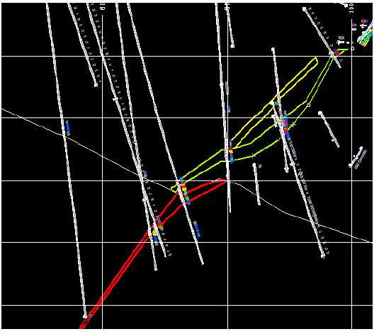
Figure 13-3 Cross-section East 1766 (shows Drillholes intersecting three segments of C vein, CWM is red, CLOE is green, CHIE is yellow; colour coding for the assay intercepts are >30g/t Au is red, 15-30g/t Au is orange, 10-15g/t is yellow, 5-10g/t Au is green, and light blue is 0-5g/t Au; the grid is 100m vertical and 200m horizontal; the white line separating the segments is No. 1 Fault)
Resource Potential, New Polaris Project
Prepared for Canarc Resource Corp.
Page 38 of 94
Moose Mountain Technical Services | |
Resource Potential, New Polaris Project |
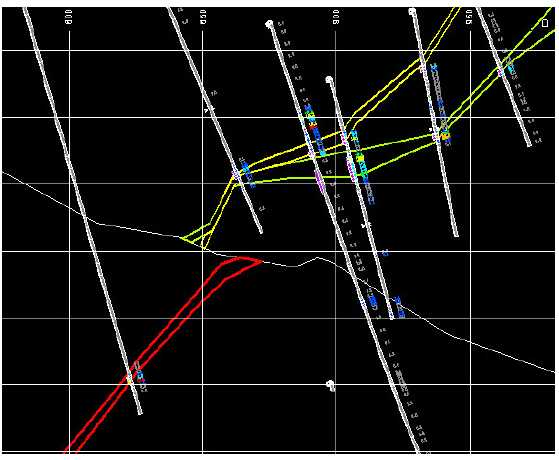
Figure 13-4 Cross-section East 1796 (see Figure 13.3 for explanation of colours)
Resource Potential, New Polaris Project
Prepared for Canarc Resource Corp.
Page 39 of 94
Moose Mountain Technical Services | |
Resource Potential, New Polaris Project |
14.0 SAMPLING METHOD AND APPROACH
Adapted from McClintock, 2006
“Sampling of the vein was done by wire line diamond drills using NQ-size rods. Drill collar locations were surveyed in by total station surveying method. Drilling azimuth and dip were set using a Brunton compass and clinometer. Routine downhole measurements of azimuth and dip were not done on the three holes drilled in 2003 and prior. In 2004, three different downhole survey systems were tried before settling on a Reflex system. The Reflex system was also used in 2005. The downhole surveying was operated by the Hytech’s drill crew. This information was entered into a GEMCOM program to plot the location of the collar and the pierce point of the veins.
Core recovery was very good and ranged from the low 90% to nearly 100% and is a fair sampling of the mineralization at the point where the drill hole pierced the vein.
The vein mineralization has well marked contacts with the wall rock. The transition from mineralized to nonmineralized rock occurs over a few centimeters. The mineralization consists of at least 3 stages of quartz veining. The initial stage of quartz-ankerite introduced into the structure was accompanied by a pervasive hydrothermal alteration of the immediately surrounding wall rock. Arsenopyrite, pyrite and lesser stibnite were deposited with the alteration. Later stages of quartz-ankerite veining are barren and have the effect of diluting the gold grades in the structure. The sulphide minerals are very fine-grained and disseminated in both the wall rock and early quartz and ankerite veins. Free gold is extremely rare and to the end of 2005 had not been recognized in core samples. The majority of the gold occurs in arsenopyrite and to a lesser extent in pyrite and stibnite. Because there is no visible gold and the host sulphides are very fine-grained and disseminated there is little nugget effect and gold values even over short intervals rarely exceed 1 opt. Out of 4,700 samples with greater than 0.03 opt gold collected from core and the underground workings, only 185 samples had a value greater than 1 opt, the highest being 3.69 opt. For this reason, no cutting of assays has been done in calculating composites nor are there many cases where a composite sample is carried by a single assay.
Determining intervals of core for sampling was done by the geologist during logging of the core. The mineralized vein structures were marked out. Selection of core intervals for sampling were based in the presence of veining and sulphide mineralization particularly arsenopyrite. Within the defined vein structure sample intervals ranged from 0.3 m to 1.5 m (1 foot to 5 feet). Divisions were based on intensity of mineralization and veining. Sampling of the core for 10’s of feet either side of the mineralized vein structures was also done to the point where hydrothermal alteration disappeared. No sampling of core from the unaltered rock was done.
The core was logged and stored in the camp. Access to the core was only available to the geologists and the core sampler. The core was brought from the drill to the logging facility by the geologist at the end of each shift. The core was geologically logged, recoveries calculated and samples marked out in intervals of 0.5 to 1 metre. The core was handed to the sample cutter who cut it with a diamond saw. Each sample was
Resource Potential, New Polaris Project
Prepared for Canarc Resource Corp.
Page 40 of 94
Moose Mountain Technical Services | |
Resource Potential, New Polaris Project |
individually wrapped in plastic bags for shipment. The sample intervals were easily identified and correlate well with the drill logs.”
Core logging, sample layout, cutting and bagging procedures were observed by Morris during the site visit. The procedures in the field remained as described by McClintock and follow accepted engineering standards.
Table 13.3, in the previous section, lists the relevant composite samples with gold values and sample length. True widths of the mineralized zone varies from 70% to 100%
Resource Potential, New Polaris Project
Prepared for Canarc Resource Corp.
Page 41 of 94
Moose Mountain Technical Services | |
Resource Potential, New Polaris Project |
15.0 SAMPLE PREPARATION, ANALYSES AND SECURITY
15.1 2006 Program
The 2006 QA/AC program was similar to the previous programs in that samples were collected by employees of Canarc on site and shipped to ALS Chemex in Vancouver. For quality control and quality assurance, core samples were regularly mixed with blanks, duplicates, and standards. The program in the field was run in an efficient and proper manner following accepted engineering standards.
Blank samples represent material from the old mine, which is known to have a very low gold value. In total 56 blank samples were assayed. The sample statistics are shown in Table 15.1.
Table 15-1 Univariate Statistics, Blank Samples
| Parameter | Result |
| Population | 56 |
| Minimum value | 0.05 |
| Maximum value | 0.57 |
| Mean value | 0.07 |
| Standard Deviation | 0.08 |
| CV | 1.12 |
Three samples had gold values greater than three times the detection limit for gold (Sample C090930 with 0.57g/t, sample C 090800 with 0.26g/t, and sample C090770 with 0.17g/t) . Figure 15.1 shows the test results of the blank samples (excluding the highest value sample). The three samples, and others from the same batch, should be re-tested by the laboratory.
Figure 15-1 Blank Samples, 2006
![]()
Resource Potential, New Polaris Project
Prepared for Canarc Resource Corp.
Page 42 of 94
Moose Mountain Technical Services | |
Resource Potential, New Polaris Project |
Duplicate samples were made by cutting ½ of the drill core into ¼ core and submitting the quarters as two different samples. In total 45 duplicate samples were assayed. The sample statistics are shown in Table 15.2.
Table 15-2Univariate Statistics, Duplicate Samples
| Parameter | Result, First | Result, Duplicate | Result, |
| Sample | Sample | Sample Difference | |
| Population | 45 | 45 | 45 |
| Minimum value | 0.025 | 0.025 | -1.1 |
| Maximum value | 19.85 | 27.1 | 7.25 |
| Mean value | 1.52 | 1.81 | 0.30 |
| Standard Deviation | 3.72 | 4.76 | 0.18 |
| CV | 2.45 | 2.63 | 4.09 |
Three tests were completed to compare the duplicate sample results: a Student’s t-test, which is a comparison of the mean values; an F-test, which is a comparison of the variance; and a Paired t-test, which is a test for bias. The Student’s t-test shows that the means of the duplicate samples are likely to be the same (the calculated t-value is -0.32, well below the critical value of 1.96) . The F-test shows that the variances of the two sample sets are likely to represent the same population (the calculated F-value is 0.61, within the range 0.065 and 1.68 of F-values characteristic of a normal distribution). The Paired t-test shows that the difference between the two data sets is minimal, and they are distributed around the value zero (the standard error is calculated to be 0.18, while the mean, 0.30, is between –0.065 and 0.657) .
The three statistical tests indicate that the results of the duplicate sampling are acceptable.
Figure 15.2 shows the duplicate sample results. As shown, there is a strong correlation between the two sample sets, with a coefficient of correlation of 0.98.
Resource Potential, New Polaris Project
Prepared for Canarc Resource Corp.
Page 43 of 94
Moose Mountain Technical Services | |
Resource Potential, New Polaris Project |
Figure 15-2 Duplicate Samples, 2006

(values are Au g/t along both axes)
Three standard samples were submitted randomly for assay throughout the program to test the accuracy of the laboratory.
Table 15-3Standard Samples
| Standard | Mean (Au g/t) | Standard Deviation | Upper Range | Lower Range |
| PM 165 | 6.51 | 0.10 | 6.71 | 6.31 |
| PM 415 | 2.37 | 0.12 | 2.49 | 2.13 |
| PM 916 | 12.7 | 0.09 | 12.9 | 12.5 |
Resource Potential, New Polaris Project
Prepared for Canarc Resource Corp.
Page 44 of 94
Moose Mountain Technical Services | |
Resource Potential, New Polaris Project |
Figure 15-3 Standard PM 165, 2006

Figure 15.3 shows the results for standard PM 165. As shown, there are two samples with lower than acceptable values and two with higher than acceptable values. These samples, and others in the same batch, should be re-assayed.
Figure 15-4Standard PM 415, 2006

Figure 15.4 shows the results for standard PM 415. As shown, there is one sample with higher than acceptable values. This sample, and others in the same batch, should be re-assayed.
Resource Potential, New Polaris Project
Prepared for Canarc Resource Corp.
Page 45 of 94
Moose Mountain Technical Services | |
Resource Potential, New Polaris Project |
Figure 15-5Standard PM 916, 2006

Figure 15.5 shows the results for standard PM 916. As shown, there are five samples with lower than acceptable values and two with higher than acceptable values. These samples, and others in the same batch, should be re-assayed.
A preliminary set of sample pulps was selected for re-assay by another laboratory. Acme Analytical Laboratory Ltd. (a highly accredited lab in Vancouver) was chosen as the second lab. The results are generally very consistent except for one sample in the Chemex Sample 1 set, which assayed 22g/t compared to 31.4g/t by Acme and 31.4g/t by Chemex the second time.
Table 15-4 Univariate Statistics, Round Robin Samples
| Parameter | Chemex | Difference | Acme | Difference | Chemex | Difference |
| Sample 1 | Chemex 1 | Acme vs. | Sample 2 | Chemex 1 vs. | ||
| vs. Acme | Chemex 2 | Chemex 2 | ||||
| Population | 30 | 30 | 30 | 30 | 30 | 30 |
| Minimum value | 0.0 | -9.43 | 0.01 | -0.31 | 0.0 | -9.4 |
| Maximum value | 40.7 | 0.36 | 42.11 | 2.04 | 41.4 | 0.8 |
| Mean value | 7.49 | -0.50 | 7.99 | 0.19 | 7.80 | -0.31 |
| Standard Deviation | 10.47 | 1.82 | 11.31 | 0.43 | 11.08 | 1.76 |
| CV | 1.40 | 3.65 | 1.42 | 2.25 | 1.42 | 5.70 |
Three tests were completed to compare the round robin sample results: a Student’s t-test, which is a comparison of the mean values; an F-test, which is a comparison of the variance; and a Paired t-test, which is a test for bias. The Student’s t-test shows that the means of the round robin samples are likely to be the same (the calculated t-value is -0.18 for the Chemex 1 vs. Acme samples; 0.11 for the Chemex 1 vs. Chemex 2 samples; and 0.07 for the Acme vs. Chemex 2 samples, well below the critical value of 1.96) . The F-test shows that the variances of the three sample sets are likely to represent the same population (the calculated F-value is 1.04, for the Chemex 1 vs. Acme samples; 1.12 for the Chemex 1 vs. Chemex 2 samples; and 0.96 for the Acme vs. Chemex 2 samples, within the range 0.065 and 1.68 of F-values characteristic of a normal distribution).
Resource Potential, New Polaris Project
Prepared for Canarc Resource Corp.
Page 46 of 94
Moose Mountain Technical Services | |
Resource Potential, New Polaris Project |
The Paired t-test shows that the difference between the Acme and Chemex 2 data set is minimal, and they are distributed around the value zero (the standard error is calculated to be 0.08, while the mean, 0.19, is between –0.065 and 0.657) . In both cases, the Chemex 1 vs. Acme and Chemex 1 vs. Chemex 2 data sets, show a slight bias with the Chemex 1 samples being 0.32 to 0.33g/t lower than the Chemex 2 and Acme respectively.
The three statistical tests indicate that the results of the round robin sampling are acceptable.
Figure 15-6Round Robin, Chemex 1 vs. Acme, 2006

Resource Potential, New Polaris Project
Prepared for Canarc Resource Corp.
Page 47 of 94
Moose Mountain Technical Services | |
Resource Potential, New Polaris Project |
Figure 15-7Round Robin, Chemex 1 vs. Chemex 2, 2006
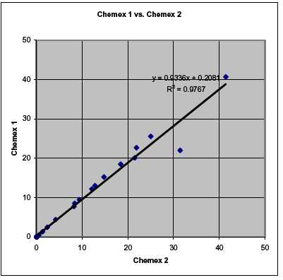
Resource Potential, New Polaris Project
Prepared for Canarc Resource Corp.
Page 48 of 94
Moose Mountain Technical Services | |
Resource Potential, New Polaris Project |
Figure 15-8 Round Robin, Acme vs. Chemex 2, 2006

Resource Potential, New Polaris Project
Prepared for Canarc Resource Corp.
Page 49 of 94
Moose Mountain Technical Services | |
Resource Potential, New Polaris Project |
16.0 DATA VERIFICATION
Morris spent two days on the New Polaris property. While on the property, the author examined underground workings to confirm the nature of mineralization, dimensions and extent of the vein system. The writer also viewed a selection of core from key holes drilled from the early 1990’s to the end of 2006 and compared his observations with those documented in the drill logs. In both the case of the underground workings and the core, the author found that his observations confirmed that recorded in logs and sections. The author also confirmed that core had been properly cut and stored.
In addition to the site visit, a detailed review of the database was completed. Forty-one drill holes were selected from the C vein area, and the drill logs and assay sheets were compared with the database. Only minor differences were observed between the hard copy material and the database. As well, the input of the database into the modeling program was also checked.
The procedures used in the development of the database follow accepted engineering standards.
Resource Potential, New Polaris Project
Prepared for Canarc Resource Corp.
Page 50 of 94
Moose Mountain Technical Services | |
Resource Potential, New Polaris Project |
17.0 ADJACENT PROPERTIES
Adapted from McClintock, 2006
“There are no adjacent properties with similar types of vein mineralization.”
Resource Potential, New Polaris Project
Prepared for Canarc Resource Corp.
Page 51 of 94
Moose Mountain Technical Services | |
Resource Potential, New Polaris Project |
18.0 MINERAL PROCESSING AND METALLURGICAL TESTING
Adapted from McClintock, 2006
“As part of the 2003 to 2005 exploration program a 200kg sample of vein mineralization was collected from a muck pile on the “AJ” mine working level. The mineralization sampled was a single boulder from the Y vein that had been exposed to air for over 40 years. For the following reason this sample may not be representative of the “C” and “Y” vein systems:
Although care was taken to remove the oxidized material from the surfaceof the boulder, there is no guarantee that the oxidation was not present alonginternal fractures.
The sample is of AB material and not from the “C” vein system that is thefocus of the current work program.
The sample is from a single point in the vein and may not be representativeof other parts of the vein systems.
Two metallurgical studies were carried out on the 200kg sample. The initial test by Resource Development Incorporated (RDI) had the primary objective of determining the deportation of gold in various minerals, reconfirm and/or optimize the flotation process conditions and producing a flotation concentrate containing maximum gold recovery and minimum amount of carbonate for bio-oxidation studies. A copy of the RDI work can be found in Appendix II (not included with this report, see McClintock 2006).
A second metallurgical study on the amenability of the concentrate to bio-oxidation was carried out by Mintek on the concentrate produced by RDI. This report is also available in Appendix II (not included with this report, see McClintock 2006).
The RDI study highlighted the following:
The composite sample received by RDI assayed 19.41gpt Au, 2.835% As,122ppm Sb, 1% S and less than 1.7gpt Ag.
The major minerals in the host rock were dolomite (32 to 35%), micalillite(32%), and quartz (23%).
Only 9% of the gold was free-milling and, therefore, the ore is refractory.Approximately 4.5% of the gold was associated with stibnite and 68% of thegold was associated with arsenopyrite and pyrite. About 20% of the gold isassociated with quartz, possibly due to find-grained arsenopyriteencapsulated in quartz.
Base-case flotation test using potassium anylxanthate (PAX) and methylisobutt carbonal (MIBC) recovered 83.6% of the gold and 83.5% are arsenicin a concentrate assaying 73.63gpt gold. The concentrate weight recoverywas 20.7%
Modified flotation test using Na2S in the grind and CuSO4in the flotationalong with base-case reagents improved the flotation recovery andconcentrate grade to 93.9% to 96.1% and ± 94gpt gold respectively.
Resource Potential, New Polaris Project
Prepared for Canarc Resource Corp.
Page 52 of 94
Moose Mountain Technical Services | |
Resource Potential, New Polaris Project |
- March, 2007
Cleaner flotation tests indicate that significant amount of carbonates in theconcentrate could be rejected in the first cleaner flotation (78.6%) whilelosing only 3% of the gold. The carbonate content was reduced from 15% inthe rougher concentrate to less than 1% in the first cleaner concentrate. Theconcentrate weight was also reduced from 18% to 15.27%.
A second cleaner did not reject sufficient gangue material, but reduced goldrecovery by an additional 5%, therefore, only one stage of cleaning isjustified.
Gravity concentrate did not preferentially upgrade rougher concentrate orrecover additional gold from the rougher tailings.
Leaching of rougher tailings resulted in 2% additional gold recovery.However, it is not economically justified due to high NaCN consumption.
In summary, a flotation process consisting of roughers and one stage of cleaners can produce a concentrate assaying ± 110gpt gold and ± 15.7% arsenic by weight and gold recoveries of 15.3% and 95.9% respectively. The concentrate will contain less than 1% carbonate.
The bio-oxidation study carried out by Mintek used a 12 kg sample of rougher concentrate obtained from RDI. This work showed that high levels of iron and arsenic extraction were achieved: however, there may be inhibitory substances associated with the concentrate. Further bio-oxidation studies were carried out by Oxidor Corporation who concluded that bio-oxidation of the New Polaris concentrate appears facile and economically attractive. Gold recovery by bio-oxidation was later estimated by RDI to be 92%.
RDI also undertook pressure oxidation tests on the sample. This test concluded that the average gold extraction was 98% in 24 hours with NaCN consumption ranging from 0.8 to 1.4 kg/t. It concluded that pressure oxidation was more attractive than bio-oxidation.”
More sampling and test work was completed in 2006, and the results are expected in early 2007.
Resource Potential, New Polaris Project
Prepared for Canarc Resource Corp.
Page 53 of 94
Moose Mountain Technical Services | |
Resource Potential, New Polaris Project |
19.0 MINERAL RESOURCE AND MINERAL RESERVE ESTIMATES
19.1 DATA ANALYSIS
The database for the New Polaris resource estimated consisted of 1,056 diamond drill holes with a total of 31,514 sample intervals.
A total of 1,432 gold assays were within the mineralized zones outlined by Canarc geologists. The gold grade distribution is shown below in Figure 19.1 as a lognormal cumulative probability plot. Partitioning this plot shows 6 overlapping lognormal gold populations with mean grades and proportions of the total data set shown in Table 19.1.
Table 19-1Summary of gold populations within mineralized zones
| Population | Mean Au (g/t) | Proportion | Number of Assays |
| 1 | 99.18 | 0.42% | 6 |
| 2 | 27.42 | 18.44% | 264 |
| 3 | 10.61 | 27.84% | 399 |
| 4 | 4.22 | 15.75% | 226 |
| 5 | 1.50 | 9.44% | 135 |
| 6 | 0.09 | 28.12% | 402 |
Population 1 consisting of only 0.42 % of the data are widely spaced throughout the mineralized zone and as a result can be considered erratic. A cap of 2 standard deviations above the mean of population 2, a level of 63 g/t Au, was used to cap 10 assays. The statistics for all assays both capped and uncapped are shown below in Table 19.2.
Table 19-2 Summary of gold statistics for uncapped and capped assays within mineralized zones
| Uncapped Au (g/t) | Capped Au (g/t) | |
| Number of Assays | 1,432 | 1,432 |
| Mean Au | 10.43 | 10.21 |
| Standard Deviation | 13.88 | 12.59 |
| Minimum | 0.001 | 0.001 |
| Maximum | 118.5 | 63.0 |
| Coefficient of Variation | 1.33 | 1.23 |
Resource Potential, New Polaris Project
Prepared for Canarc Resource Corp.
Page 54 of 94
Moose Mountain Technical Services | |
Resource Potential, New Polaris Project |
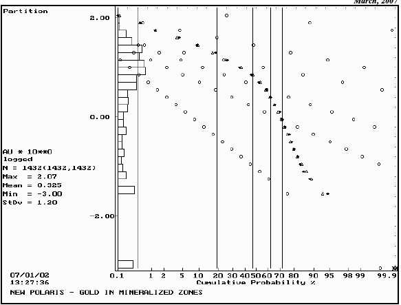
Figure 19-1Gold Grade Distribution
19.2 GEOLOGIC MODEL
Using cross sections, Canarc geologists developed a three dimensional geologic model of the mineralized veins. The mineralized veins were subdivided into the following solids:
Table 19-3 Summary Description of Geologic Domains
| Solid | Description | Number of drill hole | Mean Au |
| intersections | (g/t) | ||
| 1 | C High Vein East of Fault (CHIE) | 186 | 6.80 |
| 2 | C Low Vein East of Fault (CLOE) | 439 | 12.09 |
| 3 | C Vein Hanging Wall fragment | 4 | 3.71 |
| 4 | C Vein Hanging Wall fragment | 4 | 14.67 |
| 5 | C Vein West of Fault (CWM) | 433 | 12.34 |
| 6 | C Vein Mineralized Fragment | 190 | 5.42 |
| 7 | Y 19 Vein Striking N-S | 133 | 10.59 |
| 8 | Y 20 Vein Striking Azim 340 | 43 | 11.92 |
Three dimensional solids were created in GemCom software to constrain these mineralized zones, Figures 19.2 and 19.3.
Resource Potential, New Polaris Project
Prepared for Canarc Resource Corp.
Page 55 of 94
Moose Mountain Technical Services | |
Resource Potential, New Polaris Project |
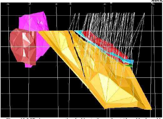
Figure 19-2 3D view, cross-section, looking to the northeast (the gold coloured body is CWM, the “gap” is a cross-cutting felsic dyke, the red solid is CHIE, blue is CLOE, the small green and blue bodies are not used in the resource estimate, the two solids in the north are Y veins; the grid is 100m vertical; only 2006 drillholes are shown).

Resource Potential, New Polaris Project
Prepared for Canarc Resource Corp.
Page 56 of 94
Moose Mountain Technical Services | |
Resource Potential, New Polaris Project |
Figure 19-3 3D view, cross-section, looking to the west (see Figure 19-2 for explanation of colours).
Resource Potential, New Polaris Project
Prepared for Canarc Resource Corp.
Page 57 of 94
Moose Mountain Technical Services | |
Resource Potential, New Polaris Project |
19.3 COMPOSITES
The drill holes were compared to the 3 dimensional solids and the point each hole entered and left each solid was recorded. Using these limits downhole composites 2.5 m in length were formed that honoured the domain boundaries. Intervals at the domain boundaries less than 1.25 m were combined with adjoining samples to produce composites of uniform support 2.5 ± 1.25 m in length. The statistics for each domain are summarized in Table 19.4.
Table 19-4 Summary of gold statistics in 2.5 m composites for geologic domains
| Domain | 1 | 2 | 3 | 4 | 5 | 6 | 7 | 8 |
| Number | 73 | 158 | 1 | 2 | 150 | 83 | 53 | 17 |
| Mean Au (g/t) | 5.62 | 10.11 | 3.61 | 13.88 | 11.38 | 4.61 | 6.23 | 13.60 |
| Standard Deviation | 5.12 | 9.59 | 0.59 | 9.25 | 7.81 | 7.64 | 11.40 | |
| Minimum | 0.001 | 0.001 | 13.29 | 0.001 | 0.001 | 0.001 | 0.001 | |
| Maximum | 24.37 | 44.09 | 14.47 | 46.30 | 42.89 | 35.50 | 36.34 | |
| Coefficient of Variation | 0.91 | 0.95 | 0.04 | 0.81 | 1.69 | 1.23 | 0.84 |
19.4 VARIOGRAPHY
Semi-variograms were produced along the three principal directions for each vein system; along strike, down dip and across dip. Where information on plunge of mineralization was available variograms were modeled in these directions. In all cases pairwise relative semivariograms were used and spherical models were fit to the experimental data. Domain 5 was split into an eastern segment and a steeper dipping western segment. The parameters for all models are summarized in Table 19.5. Individual models are shown in Appendix A.
Table 19-5 Summary of Semivariogram Parameters
| Domain | Azimuth | Dip | Co | C1 | C2 | Short Range Long Range | |
| (m) | (m) | ||||||
| 1 | 067 | 11 | 0.30 | 0.90 | 80 | ||
| 157 | -48 | 0.30 | 0.90 | 60 | |||
| 337 | -42 | 0.30 | 0.90 | 10 | |||
| 2 | 069 | 4 | 0.40 | 0.55 | 80 | ||
| 159 | -27 | 0.40 | 0.55 | 60 | |||
| 339 | -63 | 0.40 | 0.55 | 12 | |||
| 5 | 066 | 11 | 0.10 | 0.60 | 50 | ||
| East | 156 | -50 | 0.10 | 0.60 | 90 | ||
| 336 | -40 | 0.10 | 0.60 | 10 | |||
| 5 | 087 | 14 | 0.10 | 0.60 | 50 | ||
| West | 177 | -69 | 0.10 | 0.60 | 90 | ||
| 357 | -21 | 0.10 | 0.60 | 10 | |||
| 6 | Omni Directional | 0.60 | 0.75 | 0.10 | 10 | 60 | |
| 7 | 0 | 0 | 0.20 | 0.80 | 0.40 | 12 | 40 |
| 270 | 0 | 0.20 | 0.80 | 0.40 | 2 | 8 | |
| 0 | -90 | 0.20 | 0.80 | 0.40 | 10 | 50 | |
| Waste | Omni Directional | 0.40 | 0.75 | 0.28 | 25 | 50 | |
Resource Potential, New Polaris Project
Prepared for Canarc Resource Corp.
Page 58 of 94
Moose Mountain Technical Services | |
Resource Potential, New Polaris Project |
Domains 3 and 4 had insufficient composites to model or estimate. Domain 8 also had too few composites to develop a model so the model for Domain 7 was used.
19.5 BULK DENSITY
A total of 87 specific gravity determinations were available for examination. All measurements were made from core drilled in 1996 and 1997. The list of results is contained in Appendix B. Unfortunately the majority of these samples were from parts of the deposit not included in this resource estimate (higher up on the C Vein). A total of 17 samples were measured from C Vein Domain 6 and 1 from Y Vein Domain 7. These 18 samples had an average specific gravity of 2.81 and this value was used for all estimated blocks.
More measurements should be taken from future drilling to better understand bulk density on this property.
19.6 BLOCK MODEL
A block model consisting of 5 x 5 x 5 m blocks was superimposed on the geologic solids. The block model origin was as follows:
| Lower Left Corner | 1300 E | 5 m block | 180 columns | |
| 450 N | 5 m block | 230 rows | ||
| Top of Model | 300 | 5 m block | 180 levels | |
| No Rotation | ||||
The block model was compared to the three dimensional geologic solids and the solid code and proportion of the principal solid in each block was recorded. In cases where two solids were present within the same block the minority solid was also recorded. Finally the amount of waste was calculated as 100 % - Prop. Solid 1 – Prop. Solid 2.
19.7 GRADE INTERPOLATION
Each geologic domain was interpolated separately using only composites from that domain. A gold grade was interpolated by ordinary kriging into all blocks containing some proportion of a geologic solid. A second gold grade, for blocks containing some proportion of a second solid, was then interpolated. Finally for blocks less than 100% within geologic solids, a gold grade for waste was interpolated using composites outside the geologic solids. The final gold grade for the block was a weighted average of these three values. Blocks within Domains 3 and 4 were not estimated since each domain contained only a single drill hole. Domain 5 was estimated in two sections to allow for the change in strike and dip. These two parts of Domain 5 and Domains 1 and 2 were all estimated using a soft boundary with both sides of the boundary seeing the same composites.
In all cases kriging was completed in a series of passes using expanding search ellipses whose dimensions and orientation were dictated by the semivariogram models. Pass 1 used dimensions
Resource Potential, New Polaris Project
Prepared for Canarc Resource Corp.
Page 59 of 94
Moose Mountain Technical Services | |
Resource Potential, New Polaris Project |
for the search ellipse equal to ¼ the semivariogram range of the particular domain being estimated. Pass 2 expanded to ½ the semivariogram ranges while Pass 3 used the entire ranges. In an attempt to fill the limits of the geologic solids a fourth pass using twice the range of the semivariograms was completed in most cases. For pass 1 a minimum of 3 composites were required within the search ellipse to estimate a block. For passes 2 to 4 a minimum of 2 composites were required. In all cases the maximum number of composites used was 8 and if more than 8 were found, the closest 8 were used. The search ellipse directions and distances for each pass are shown below in Table 19.6.
Table 19-6 Summary of Kriging Parameters
| Domain | Pass | Az/Dip | Dist. (m) | Az/Dip | Dist. (m) | Az/Dip | Dist. (m) | |||
| 1 | 1 | 67 | /+11 | 20.0 | 157 | /-48 | 15 | 337 | /-42 | 5.0 |
| 2 | 67 | /+11 | 40.0 | 157 | /-48 | 30 | 337 | /-42 | 5.0 | |
| 3 | 67 | /+11 | 80.0 | 157 | /-48 | 60 | 337 | /-42 | 10.0 | |
| 4 | 67 | /+11 | 160.0 | 157 | /-48 | 120 | 337 | /-42 | 20.0 | |
| 2 | 1 | 69 | /+4 | 20.0 | 159 | /-27 | 15 | 339 | /-63 | 6.0 |
| 2 | 69 | /+4 | 40.0 | 159 | /-27 | 30 | 339 | /-63 | 6.0 | |
| 3 | 69 | /+4 | 80.0 | 159 | /-27 | 60 | 339 | /-63 | 12.0 | |
| 4 | 69 | /+4 | 160.0 | 159 | /-27 | 120 | 339 | /-63 | 24.0 | |
| 5 | 1 | 87 | /-14 | 12.5 | 177 | /-69 | 22.5 | 357 | /-21 | 5.0 |
| West | 2 | 87 | /-14 | 25.0 | 177 | /-69 | 45.0 | 357 | /-21 | 5.0 |
| 3 | 87 | /-14 | 50.0 | 177 | /-69 | 90.0 | 357 | /-21 | 10.0 | |
| 4 | 87 | /-14 | 100.0 | 177 | /-69 | 180.0 | 357 | /-21 | 20.0 | |
| 5 | 1 | 66 | /+11 | 12.5 | 156 | /-50 | 22.5 | 336 | /-40 | 5.0 |
| East | 2 | 66 | /+11 | 25.0 | 156 | /-50 | 45.0 | 336 | /-40 | 5.0 |
| 3 | 66 | /+11 | 50.0 | 156 | /-50 | 90.0 | 336 | /-40 | 10.0 | |
| 4 | 66 | /+11 | 100.0 | 156 | /-50 | 180.0 | 336 | /-40 | 20.0 | |
| 6 | 1 | Omni Directional | 15.0 | |||||||
| 2 | Omni Directional | 30.0 | ||||||||
| 3 | Omni Directional | 60.0 | ||||||||
| 7 | 1 | 0/0 | 10.0 | 270/0 | 4.0 | 0 | /-90 | 12.5 | ||
| 2 | 0/0 | 20.0 | 270/0 | 4.0 | 0 | /-90 | 25.0 | |||
| 3 | 0/0 | 40.0 | 270/0 | 8.0 | 0 | /-90 | 50.0 | |||
| 4 | 0/0 | 80.0 | 270/0 | 16.0 | 0 | /-90 | 100.0 | |||
| 8 | 1 | 340/0 | 10.0 | 250/0 | 4.0 | 0 | /-90 | 12.5 | ||
| 2 | 340/0 | 20.0 | 250/0 | 4.0 | 0 | /-90 | 25.0 | |||
| 3 | 340/0 | 40.0 | 250/0 | 8.0 | 0 | /-90 | 50.0 | |||
| 4 | 340/0 | 80.0 | 250/0 | 16.0 | 0 | /-90 | 100.0 | |||
| Waste | 1 | Omni Directional | 12.5 | |||||||
| 2 | Omni Directional | 25.0 | ||||||||
| 3 | Omni Directional | 50.0 | ||||||||
| 4 | Omni Directional | 100.0 | ||||||||
Resource Potential, New Polaris Project
Prepared for Canarc Resource Corp.
Page 60 of 94
Moose Mountain Technical Services | |
Resource Potential, New Polaris Project |
19.8 CLASSIFICATION
Based on the study herein reported, delineated mineralization of the New Polaris Project is classified as a resource according to the following definition from National Instrument 43-101:
“In this Instrument, the terms "mineral resource", "inferred mineral resource", "indicated mineral resource" and "measured mineral resource" have the meanings ascribed to those terms by the Canadian Institute of Mining, Metallurgy and Petroleum, as the CIM Standards on Mineral Resources and Reserves Definitions and Guidelines adopted by CIM Council on August 20, 2000, as those definitions may be amended from time to time by the Canadian Institute of Mining, Metallurgy, and Petroleum.”
“AMineral Resource is a concentration or occurrence of natural, solid, inorganic or fossilized organic material in or on the Earth's crust in such form and quantity and of such a grade or quality that it has reasonable prospects for economic extraction. The location, quantity, grade, geological characteristics and continuity of a Mineral Resource are known, estimated or interpreted from specific geological evidence and knowledge.”
The terms Measured, Indicated and Inferred are defined in 43-101 as follows:
“A'Measured Mineral Resource' is that part of a Mineral Resource for which, quantity, grade or quality, densities, shape, physical characteristics are so well established that they can be estimated with confidence sufficient to allow the appropriate application of technical and economic parameters, to support production planning and evaluation of the economic viability of the deposit. The estimate is based on detailed and reliable exploration, sampling and testing information gathered through appropriate techniques from locations such as outcrops, trenches, pits, workings and drill holes that are spaced closely enough to confirm both geological and grade continuity.”
“An 'Indicated Mineral Resource' is that part of a Mineral Resource for which, quantity, grade or quality, densities, shape and physical characteristics, can be estimated with a level of confidence sufficient to allow the appropriate application of technical and economic parameters, to support mine planning and evaluation of the economic viability of the deposit. The estimate is based on detailed and reliable exploration and testing information gathered through appropriate techniques from locations such as outcrops, trenches, pits, workings and drill holes that are spaced closely enough for geological and grade continuity to be reasonably assumed.”
“An 'Inferred Mineral Resource' is that part of a Mineral Resource for which, quantity and grade or quality can be estimated on the basis of geological evidence and limited sampling and reasonably assumed, but not verified, geological and grade continuity. The estimate is based on limited information
Resource Potential, New Polaris Project
Prepared for Canarc Resource Corp.
Page 61 of 94
Moose Mountain Technical Services | |
Resource Potential, New Polaris Project |
and sampling gathered through appropriate techniques from locations such as outcrops, trenches, pits, workings and drill holes.”
For this project the geologic continuity has been well established through historic mining and diamond drilling. Grade continuity is best quantified by the semivariogram, which measures distances and directions of maximum continuity. For this study the classification for each block was based on the pass during which it was estimated which, was a function of the semivariogram range. In general, blocks estimated during pass 1 using ¼ of the semivariogram range, were classed measured although some of these blocks were later downgraded to indicated if they were based on a single drill hole. Blocks estimated during pass 2, using ½ the semivariogram range, were classed as indicated. All other blocks estimated during pass 3 or 4 were classed as inferred.
The results are presented as a series of grade-tonnage tables. Table 19.7 reports all material within the mineralized solids (undiluted) below -95 elevation in the CWM vein and below -140 elevation in the CLOE and CHIE veins (the lowest elevations of the old mines).
Resource Potential, New Polaris Project
Prepared for Canarc Resource Corp.
Page 62 of 94
Moose Mountain Technical Services | |
Resource Potential, New Polaris Project |
Table 19-7- New Polaris Resource, Undiluted
BLOCKS IN CWM BELOW –90m BLOCKS IN CLOE CHIE BELOW –135m ELEVATIONS
| New Polaris Resource - Only Mineralized Portions of Blocks Tabulated | ||||||
| MEASURED RESOURCE | INDICATED RESOURCE | |||||
| Au | Tonnes > | Contained | Contained | |||
| Cutoff | Cutoff | Grade>Cutoff | Metal | Tonnes > Cutoff | Grade>Cutoff | Metal |
| (g/t) | (tonnes) | Au (g/t) | Au (ozs) | (tonnes) | Au (g/t) | Au (ozs) |
| 1.00 | 410,000 | 9.09 | 120,000 | 1,330,000 | 10.61 | 454,000 |
| 2.00 | 390,000 | 9.48 | 119,000 | 1,280,000 | 10.97 | 451,000 |
| 3.00 | 360,000 | 10.13 | 117,000 | 1,240,000 | 11.23 | 448,000 |
| 3.50 | 340,000 | 10.37 | 113,000 | 1,220,000 | 11.41 | 448,000 |
| 4.00 | 330,000 | 10.62 | 113,000 | 1,180,000 | 11.65 | 442,000 |
| 4.50 | 320,000 | 10.87 | 112,000 | 1,130,000 | 11.95 | 434,000 |
| 5.00 | 304,000 | 11.19 | 109,000 | 1,090,000 | 12.21 | 428,000 |
| 5.50 | 287,000 | 11.55 | 107,000 | 1,057,000 | 12.45 | 423,000 |
| 6.00 | 271,000 | 11.89 | 104,000 | 1,017,000 | 12.71 | 416,000 |
| 7.00 | 233,000 | 12.77 | 96,000 | 910,000 | 13.45 | 393,000 |
| 8.00 | 203,000 | 13.54 | 88,000 | 806,000 | 14.22 | 368,000 |
| 9.00 | 173,000 | 14.42 | 80,000 | 696,000 | 15.11 | 338,000 |
| MEASURED PLUS INDICATED | ||||||
| RESOURCE | INFERRED RESOURCE | |||||
| Au | Tonnes > | Contained | Contained | |||
| Cutoff | Cutoff | Grade>Cutoff | Metal | Tonnes > Cutoff | Grade>Cutoff | Metal |
| (g/t) | (tonnes) | Au (g/t) | Au (ozs) | (tonnes) | Au (g/t) | Au (ozs) |
| 1.00 | 1,740,000 | 10.25 | 573,000 | 2,090,000 | 10.36 | 696,000 |
| 2.00 | 1,670,000 | 10.62 | 570,000 | 2,060,000 | 10.52 | 697,000 |
| 3.00 | 1,600,000 | 10.99 | 565,000 | 1,990,000 | 10.77 | 689,000 |
| 3.50 | 1,560,000 | 11.18 | 561,000 | 1,960,000 | 10.90 | 687,000 |
| 4.00 | 1,510,000 | 11.42 | 555,000 | 1,925,000 | 11.03 | 683,000 |
| 4.50 | 1,450,000 | 11.71 | 546,000 | 1,824,000 | 11.40 | 669,000 |
| 5.00 | 1,400,000 | 11.99 | 540,000 | 1,752,000 | 11.68 | 658,000 |
| 5.50 | 1,340,000 | 12.26 | 528,000 | 1,696,000 | 11.89 | 648,000 |
| 6.00 | 1,288,000 | 12.54 | 519,000 | 1,628,000 | 12.15 | 636,000 |
| 7.00 | 1,143,000 | 13.31 | 489,000 | 1,473,000 | 12.74 | 603,000 |
| 8.00 | 1,009,000 | 14.08 | 457,000 | 1,340,000 | 13.27 | 571,000 |
| 9.00 | 870,000 | 14.97 | 419,000 | 1,149,000 | 14.06 | 519,000 |
Resource Potential, New Polaris Project
Prepared for Canarc Resource Corp.
Page 63 of 94
Moose Mountain Technical Services | |
Resource Potential, New Polaris Project |
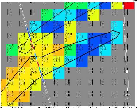
Figure 19-4 Cross-section 1766, each block shows the Au grade, Ore %, Geology code, and Resource Classification (1=measured, 2=indicated, 3=inferred); the block size is 5x5x5m.
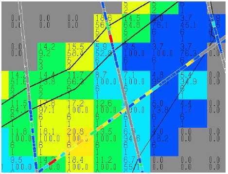
Figure 19-5 Cross-section 1706 (see Figure 19.4 for explanation)
Resource Potential, New Polaris Project
Prepared for Canarc Resource Corp.
Page 64 of 94
Moose Mountain Technical Services | |
Resource Potential, New Polaris Project |
20.0 OTHER RELEVANT DATA AND INFORMATION
No relevant data or information has knowingly been omitted by the author.
Resource Potential, New Polaris Project
Prepared for Canarc Resource Corp.
Page 65 of 94
Moose Mountain Technical Services | |
Resource Potential, New Polaris Project |
21.0 INTERPRETATION AND CONCLUSIONS
The New Polaris deposit was mined by underground methods from 1938 to 1942, and from 1946 to early 1951, producing a total of 740,000 tonnes of ore at an average grade of 10.3g/t gold.
The deposit is composed of three sets of veins (quartz-carbonate stringers in altered rock), the “AB” veins are northwest striking and southwest dipping, the “Y” veins are north striking and dipping steeply east and finally the “C” veins are east-west striking and dipping to the south to southeast at 65º to 90º. The “C” veins appear to hook around to the north and south into the other two sets of veins so that their junctions form an arc. The gold is refractory and occurs dominantly in finely disseminated arsenopyrite grains that mineralize the altered wallrock and stockwork veins. The next most abundant mineral is pyrite, followed by minor stibnite and a trace of sphalerite. The zones of mineralization range from 15 to 250 metres in length and 0.3 to 14 metres in width.
Exploration, from 1988 – 1997 and 2003 to 2006, and in-fill drilling from 2003 to the end of 2006, has confirmed the continuity of the “C” vein system and improved the confidence that the mineralized vein systems are continuous between the earlier widely spaced holes. The “C” vein system appears to be the larger and most continuous of the vein systems found to date on the property.
Preliminary metallurgical test work confirmed the refractory nature of the mineralization and that up to 96% of the gold can be recovered into concentrate. Bio-oxidation and pressure oxidation also yielded positive results with 96 % and 93 % recoveries respectively. Further sampling and testing was completed in 2006.
An updated resource estimate was prepared by Giroux Consultants Ltd. using ordinary kriging of 192 recent drillholes and 1,432 gold assay intervals constrained within four main vein segments as modeled in 3D by Canarc geologists. The total New Polaris database consists of 1,056 diamond drillholes with a total of 31,514 sample intervals.
The geologic continuity of the C vein has been well established through historic mining and diamond drilling. Grade continuity was quantified using a geostatistical method called the semivariogram, which measures distances (ranges) and directions of maximum continuity. The four principle veins in the semivariogram model produced ranges between 50 and 90 metres, both along strike and down plunge.
For this study, the classification for each resource block was a function of the semivariogram range. In general, blocks estimated using ¼ of the semivariogram range were classed as measured, blocks estimated using ½ of the semivariogram range were classed as indicated, and all other blocks estimated were classed as inferred.
The following tables list the undiluted resource estimate, including the “C” vein west (CWM) from the –90m elevation and below, and the “C” vein east (CLOE and CHIE) from the –135m elevation and below.
Resource Potential, New Polaris Project
Prepared for Canarc Resource Corp.
Page 66 of 94
Moose Mountain Technical Services | |
Resource Potential, New Polaris Project |
Measured, undiluted resource
| Cutoff grade, | Tonnes > Cutoff | Grade > Cutoff | Contained |
| g/t Au | (tonnes) | Au (g/t) | Metal (oz) |
| 2.00 | 390,000 | 9.48 | 119,000 |
| 4.00 | 330,000 | 10.62 | 113,000 |
| 6.00 | 271,000 | 11.89 | 104,000 |
| 8.00 | 203,000 | 13.54 | 88,000 |
Indicated, undiluted resource
| Cutoff grade, | Tonnes > Cutoff | Grade > Cutoff | Contained |
| g/t Au | (tonnes) | Au (g/t) | Metal (oz) |
| 2.00 | 1,280,000 | 10.97 | 451,000 |
| 4.00 | 1,180,000 | 11.65 | 442,000 |
| 6.00 | 1,017,000 | 12.71 | 416,000 |
| 8.00 | 806,000 | 14.22 | 368,000 |
Measured + Indicated, undiluted resource
| Cutoff grade, | Tonnes > Cutoff | Grade > Cutoff | Contained |
| g/t Au | (tonnes) | Au (g/t) | Metal (oz) |
| 2.00 | 1,670,000 | 10.62 | 570,000 |
| 4.00 | 1,510,000 | 11.42 | 555,000 |
| 6.00 | 1,288,000 | 12.54 | 519,000 |
| 8.00 | 1,009,000 | 14.08 | 457,000 |
Inferred, undiluted resource
| Cutoff grade, | Tonnes > Cutoff | Grade > Cutoff | Contained |
| g/t Au | (tonnes) | Au (g/t) | Metal (oz) |
| 2.00 | 2,060,000 | 10.52 | 697,000 |
| 4.00 | 1,925,000 | 11.03 | 683,000 |
| 6.00 | 1,628,000 | 12.15 | 636,000 |
| 8.00 | 1,340,000 | 13.27 | 571,000 |
This latest estimate shows an important gold resource at the New Polaris deposit, which should be further tested with infill drilling and underground exploration.
Resource Potential, New Polaris Project
Prepared for Canarc Resource Corp.
Page 67 of 94
Moose Mountain Technical Services | |
Resource Potential, New Polaris Project |
22.0 RECOMMENDATIONS
Exploration completed on the property to the end of 2006, as recommended by Walton and McClintock, has demonstrated the continuity and grade of the “C” vein system.
Further work should include a preliminary assessment of the mineable resource to determine the nature of the “C” vein, a better estimate of the SG, and the collection of representative samples for metallurgical testing. As well, more infill drilling should be completed from underground stations.
Resource Potential, New Polaris Project
Prepared for Canarc Resource Corp.
Page 68 of 94
Moose Mountain Technical Services | |
Resource Potential, New Polaris Project |
23.0 REFERENCES
BCMinistry of Mines Annual Reports 1936 to 1953
Beacon Hill Consultants Ltd. (1989): Conceptual Study by RJ Morris, M.Sc.; BM Briggs, P.Eng., and WR Stokes, P.Eng, Suntac Minerals Corporation; internal company report.
Beattie, M. (1993): Report on the metallurgical testing of gold ore from the Polaris-Taku Deposit, Golden Angus Mines Ltd. (Canarc Resource Corp.), internal company report.
Canarc Resource Corp. (1996 and 1997) News Releases.
Dewonck, B., Brucciani, P. (1991): Geological, Geochemical and Geophysical Report on Suntac Minerals Corporations Polaris-Taku Project, 1990 Surface Exploration Program, Orequest Consultants Ltd., internal company report.
Giroux, G.H. (1991): 1991 Geostatistical Study of the Geological Resource contained within the Polaris-Taku Gold Deposit for Suntac Minerals Corporation; amended Feb 1995; internal company report.
Giroux, G.H. (1991): Geostatistical Study of the Geological Resource contained within the Polaris-Taku Gold Deposit, Montgomery Consultants Ltd.
Giroux, G.H , (1995): Update of Resource Estimate for Polaris-Taku “C” Vein System and NI Vein System (1995).
Harrison, I and Moors, J.G.: Report on the 1995 North Grid Trenching and Diamond Drilling Programs
Hill, A.R. (1992): Structural Analysis and Discussion of Exploration Targets, Polaris-Taku Project; Suntac Minerals Corporation, internal company report.
Hodgson, C.J., (1993): Mesothermal lode-gold deposits, in Kirkham, R.V., Sinclair, W.D., Thorpe, R.I. and Duke, J.M., eds., Mineral Deposit Modeling: GAC Special Paper 40.
Kerr, F.A. (1948): Taku River area, B.C.; Geological Survey of Canada, Memoir 248.
Lewis, P.D. (1994): Polaris-Taku Project, North Grid Mapping and Structural Analysis - Preliminary Report; Golden Angus Mines Ltd. (Canarc Resource Corp.), internal company report.
Marriott, C.C. (1991): Report on the 1991 Diamond Drilling Program and Geological Review of the Polaris-Taku Gold Property; Suntac Minerals Corporation, internal company report.
Marriott, C.C. (1992): Report on the 1992 Diamond Drilling Program of the Polaris-Taku Gold Property; Suntac Minerals Corporation, internal company report.
McClintock, J.A. (2006): Report on the 2003 to 2005 Exploration Program on the New Polaris Mine Site
Resource Potential, New Polaris Project
Prepared for Canarc Resource Corp.
Page 69 of 94
Moose Mountain Technical Services | |
Resource Potential, New Polaris Project |
McKay D.L. (1996): Technical and Economic Review of the Polaris-Taku Project.
McKay D.L. (1997): Update Report on the New Polaris Project.
Monger, J. W. H. (1977): Upper Pa1aeozoic rocks of the western Canadian Cordillera and their bearing on Cordilleran evolution; Canadian Journal of Earth Science, V. 14, pp. 1832-1859.
Monger, J. W. H. (1984): Cordilleran Tectonics: a Canadian Perspective; Bull. Soc. Geol. France, 1984(7) t. XXVI, N. 2, pp. 255-278.
Moors, J.G. (1995): Report on the 1994 Exploration and Diamond Drilling Programs
Moors, J.G. (1995): Report on the 1995 Mine Wedge Deep Drilling Program
Parliament, H. (1949): The Geology and Ore Deposits of Polaris-Taku Mine with Particular Reference to the Lower Levels; Theses, B.C. Professional Engineers.
Rhys, D.A. (1992) Structural Study of the Polaris-Taku Mine and Potential Exploration Applications; internal company report.
Smith, A. (1938): Report on the Surface Geology of the Polaris-Taku Mine and Adjacent Area, Tulsequah, B.C.; internal company report.
Smith, A. (1948): Taku River Area; In C.I.M. Symposium Volume, Structural Control of Canadian Ore Deposits.
Smith, A. (1950): Report on Polaris-Taku Mine, Geology and Exploratory Development Program; Taku River Gold Mines Ltd., internal company report.
Souther, J. G., and Armstrong, J. E. (1966): North Central Belt of the Cordil1era of British Columbia, in Tectonic History and Mineral Deposits of the Western Cordillera; Canadian Institute of Mining and Metallurgy, Special Vol. 8, pp. 171-184.
Souther, J. G. (1969): Tulsequah and Juneau, Cassiar District, British Columbia; Geological Survey of Canada, Map 1262A.
Souther, J. G., and Symons, D. T. A. (1974): Stratigraphy and Palaeomagnetism of the Mount Edziza volcanic complex, northwestern British Columbia; Geological Survey of Canada Paper 73-32,48 pp.
Watts, Griffis, and McOuat Ltd (1992): A Report on the Polaris-Taku Gold Project for Canarc Resource Corp., internal company report.
Watkinson, D. (1997): Technical Overview.
Walton, G.J. (2002): Report on the 1996 and 1997 Exploration program on the New Polaris Mine site, Northwestern British Columbia.
Resource Potential, New Polaris Project
Prepared for Canarc Resource Corp.
Page 70 of 94
Moose Mountain Technical Services | |
Resource Potential, New Polaris Project |
24.0 DATE AND SIGNATURE PAGE
I, Robert J. Morris, M.Sc., P.Geo., do hereby certify that:
| 1. | I am a Principal of Moose Mountain Technical Services, 6243 Kubinec Road, Fernie BC V0B 1M1. |
| 2. | I graduated with a B.Sc. from the University of British Columbia in 1973. |
| 3. | I graduated with a M.Sc. from Queen’s University in 1978. |
| 4. | I am a member of the Association of Professional Engineers and Geoscientists of B.C. (#18301). |
| 5. | I have worked as a geologist for a total of thirty-three years since my graduation from university. |
| 6. | My past experience with gold exploration and mining includes work in the Bralorne area, China, Argentina, and Northern Saskatchewan. |
| 7. | I have read the definition of “qualified person” set out in NI 43-101 and certify that by reason of my education, affiliation with a professional association and past relevant work experience, I fulfill the requirements to be a “qualified person” as defined in National Policy 43-101.5. |
| 8. | I am responsible for the geology and resource review and verification and preparation of the technical report titled“Resource Potential, New Polaris Project”, dated 14 March 2007. |
| 9. | I completed a site visit of the New Polaris Property during the period 22-24 August 2006.My prior involvement with the project includes a site visit 21 August 1988, and work on the geology, resource estimate, and exploration program during 1988 and 1989, while with Beacon Hill Consultants. |
| 10. | As of the date of this certificate, to the best of my knowledge, information and belief, the technical report contains all scientific and technical information that is required to be disclosed to make the technical report not misleading. |
| 11. | I am independent of the issuer applying all of the tests in section 1.4 of National Instrument 43-101. |
| 12. | I have read NI 43-101 and Form 43-101F1, and the Technical Report has been prepared in compliance with that instrument and form. |
Date this 14th day of March 2007,
________________________
Signature of Qualified Person
Robert J. Morris, M.Sc., P.Geo.
Print Name of Qualified Person
Resource Potential, New Polaris Project
Prepared for Canarc Resource Corp.
Page 71 of 94
Moose Mountain Technical Services | |
Resource Potential, New Polaris Project |
G.H. Giroux
I, G.H. Giroux, of 982 Broadview Drive, North Vancouver, British Columbia, do hereby certify that:
| 1) | I am a consulting geological engineer with an office at #1215 - 675 West Hastings Street, Vancouver, British Columbia. |
| 2) | I am a graduate of the University of British Columbia in 1970 with a B.A.Sc. and in 1984 with a M.A.Sc. both in Geological Engineering. |
| 3) | I have practiced my profession continuously since 1970. I have completed resource estimation studies for over 30 years on a wide variety of base and precious metal deposits including several narrow vein mesothermal deposits. |
| 4) | I am a member in good standing of the Association of Professional Engineers of the Province of British Columbia. |
| 5) | I have read the definition of “qualified person” set out in National Instrument 43- 101 and certify that by reason of education, experience, independence and affiliation with a professional association, I meet the requirements of an Independent Qualified Person as defined in National Policy 43-101.5 |
| 6) | This report titled Resource Potential New Polaris Project and dated March 14, 2007 (“Technical Report”) is based on a study of the available data and literature for the New Polaris (formerly the Polaris-Taku) Deposit. I am responsible for the resource estimation section of this report. The work was completed in Vancouver during September 2006 to February 2007. I have not visited the property. |
| 7) | I have previously completed resource estimations on this property in 1991 and 1995. |
| 8) | As of the date of this certificate, to the best of my knowledge, information and belief, the technical report contains all scientific and technical information that is required to be disclosed to make the technical report not misleading. |
| 9) | I am independent of the issuer applying all of the tests in section 1.4 of National Instrument 43-101. |
| 10) | I have read National Instrument 43-101 and Form 43-101F1, and the Technical Report has been prepared in compliance with that instrument and form. |
Dated this 14th day of March, 2007
GIROUX CONSULTANTS LTD. Per:
G. H. Giroux, P.Eng., MASc.
Resource Potential, New Polaris Project
Prepared for Canarc Resource Corp.
Page 72 of 94
Moose Mountain Technical Services | |
Resource Potential, New Polaris Project |
25.0 ADDITIONAL REQUIREMENTS FOR TECHNICAL REPORTS ON DEVELOPMENT PROPERTIES AND PRODUCTION PROPERTIES
No further technical information available.
Resource Potential, New Polaris Project
Prepared for Canarc Resource Corp.
Page 73 of 94
Moose Mountain Technical Services | |
Resource Potential, New Polaris Project |
APPENDIX A SEMIVARIOGRAM MODELS

Resource Potential, New Polaris Project
Prepared for Canarc Resource Corp.
Page 74 of 94
Moose Mountain Technical Services | |
Resource Potential, New Polaris Project |

Resource Potential, New Polaris Project
Prepared for Canarc Resource Corp.
Page 75 of 94
Moose Mountain Technical Services | |
Resource Potential, New Polaris Project |

Resource Potential, New Polaris Project
Prepared for Canarc Resource Corp.
Page 76 of 94
Moose Mountain Technical Services | |
Resource Potential, New Polaris Project |
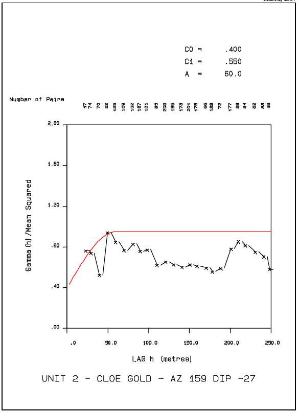
Resource Potential, New Polaris Project
Prepared for Canarc Resource Corp.
Page 77 of 94
Moose Mountain Technical Services | |
Resource Potential, New Polaris Project |
Resource Potential, New Polaris Project
Prepared for Canarc Resource Corp.
Page 78 of 94
Moose Mountain Technical Services | |
Resource Potential, New Polaris Project |

Resource Potential, New Polaris Project
Prepared for Canarc Resource Corp.
Page 79 of 94
Moose Mountain Technical Services | |
Resource Potential, New Polaris Project |

Resource Potential, New Polaris Project
Prepared for Canarc Resource Corp.
Page 80 of 94
Moose Mountain Technical Services | |
Resource Potential, New Polaris Project |

Resource Potential, New Polaris Project
Prepared for Canarc Resource Corp.
Page 81 of 94
Moose Mountain Technical Services | |
Resource Potential, New Polaris Project |
Resource Potential, New Polaris Project
Prepared for Canarc Resource Corp.
Page 82 of 94
Moose Mountain Technical Services | |
Resource Potential, New Polaris Project |
Resource Potential, New Polaris Project
Prepared for Canarc Resource Corp.
Page 83 of 94
Moose Mountain Technical Services | |
Resource Potential, New Polaris Project |
Resource Potential, New Polaris Project
Prepared for Canarc Resource Corp.
Page 84 of 94
Moose Mountain Technical Services | |
Resource Potential, New Polaris Project |
Resource Potential, New Polaris Project
Prepared for Canarc Resource Corp.
Page 85 of 94
Moose Mountain Technical Services | |
Resource Potential, New Polaris Project |
APPENDIX BLISTING OF SPECIFIC GRAVITY DETERMINATIONS
| HOLE | FROM | TO | GEOL | AU | SG |
| PT30A | 271.70 | 273.22 | 27.430 | 2.88 | |
| PT9601 | 54.07 | 55.66 | 12.820 | 2.84 | |
| PT9601 | 99.40 | 99.64 | 7.100 | 2.83 | |
| PT9601 | 99.64 | 100.40 | 7.100 | 2.83 | |
| PT9602 | 72.85 | 73.67 | 50.740 | 2.84 | |
| PT9603 | 28.29 | 29.57 | 17.620 | 2.91 | |
| PT9603 | 73.97 | 74.98 | 11.310 | 2.87 | |
| PT9604 | 84.09 | 85.28 | 17.860 | 2.84 | |
| PT9604 | 85.28 | 86.00 | 8.020 | 2.92 | |
| PT9604 | 86.00 | 86.56 | 8.020 | 2.92 | |
| PT9604 | 91.62 | 92.66 | 10.080 | 2.89 | |
| PT9604 | 97.05 | 97.78 | 15.980 | 2.91 | |
| PT9604 | 97.78 | 99.06 | 8.500 | 2.94 | |
| PT9604 | 99.06 | 99.30 | 8.500 | 2.94 | |
| PT9605 | 44.47 | 44.99 | 11.070 | 2.93 | |
| PT9606 | 28.50 | 29.57 | 9.810 | 2.82 | |
| PT9606 | 62.33 | 62.85 | 8.910 | 2.80 | |
| PT9607 | 11.70 | 13.11 | 11.520 | 2.88 | |
| PT9609 | 56.85 | 57.91 | 49.030 | 2.87 | |
| PT9610 | 60.90 | 62.42 | 14.060 | 2.83 | |
| PT9610 | 82.45 | 83.36 | 8.060 | 2.90 | |
| PT9611 | 72.54 | 72.80 | 7.170 | 2.88 | |
| PT9611 | 72.80 | 73.03 | 7.170 | 2.88 | |
| PT9613 | 51.79 | 53.31 | 8.980 | 2.90 | |
| PT9613 | 56.36 | 57.88 | 9.770 | 2.91 | |
| PT9613 | 59.41 | 60.24 | 7.820 | 2.98 | |
| PT9613 | 60.24 | 60.72 | 7.820 | 2.98 | |
| PT9613 | 83.79 | 84.49 | 44.090 | 2.93 | |
| PT9613 | 84.49 | 85.04 | 44.090 | 2.93 | |
| PT9615 | 115.85 | 116.28 | 13.710 | 2.91 | |
| PT9615 | 116.28 | 117.68 | 10.800 | 2.89 | |
| PT9616 | 112.29 | 112.78 | 8.400 | 2.81 | |
| PT9616 | 112.78 | 113.84 | 8.540 | 2.83 | |
| PT9617 | 57.24 | 58.12 | 12.030 | 2.98 | |
| PT9617 | 58.12 | 58.58 | 12.030 | 2.98 | |
| PT9618 | 124.54 | 125.43 | 13.710 | 2.90 | |
| PT9618 | 125.43 | 126.07 | 13.710 | 2.90 | |
| PT9618 | 126.07 | 127.59 | 10.080 | 2.90 | |
| PT9619 | 126.46 | 127.41 | 20.670 | 2.85 | |
| PT9622 | 119.54 | 121.07 | 23.830 | 2.85 | |
| PT9622 | 139.29 | 140.82 | 7.130 | 3.96 | |
| PT9624 | 167.58 | 168.92 | 10.830 | 2.90 | |
| PT9624 | 168.92 | 169.55 | 36.140 | 2.93 | |
| PT9624 | 169.55 | 170.23 | 36.140 | 2.93 | |
| PT9624 | 170.23 | 171.57 | 14.190 | 2.90 | |
| PT9704 | 176.05 | 177.52 | 27.670 | 2.88 | |
| PT9709 | 52.33 | 53.10 | 9.810 | 2.87 | |
| PT9711 | 150.02 | 151.55 | 19.170 | 3.00 | |
| PT9732 | 212.54 | 214.06 | 10.250 | 2.81 |
Resource Potential, New Polaris Project
Prepared for Canarc Resource Corp.
Page 86 of 94
Moose Mountain Technical Services | |
Resource Potential, New Polaris Project |
| HOLE | FROM | TO | GEOL | AU | SG |
| PT9733 | 0.76 | 2.29 | 11.690 | 2.94 | |
| PT9733 | 257.83 | 259.35 | 7.0 | 8.980 | 2.84 |
| PT9734 | 0.00 | 1.52 | 11.250 | 2.84 | |
| PT9734 | 2.93 | 4.06 | 16.940 | 2.88 | |
| PT9734 | 4.06 | 4.21 | 16.940 | 2.88 | |
| PT9734 | 5.73 | 6.19 | 13.270 | 2.92 | |
| PT9734 | 92.57 | 94.09 | 8.670 | 2.89 | |
| PT9734 | 94.09 | 94.74 | 24.100 | 2.85 | |
| PT9734 | 94.74 | 95.62 | 24.100 | 2.85 | |
| PT9735 | 1.28 | 3.14 | 11.450 | 2.81 | |
| PT9735 | 127.25 | 128.93 | 18.380 | 2.85 | |
| PT9735 | 131.98 | 133.50 | 6.960 | 2.82 | |
| PT9736 | 226.86 | 228.39 | 7.200 | 2.86 | |
| PT9743 | 5.55 | 7.07 | 10.350 | 2.82 | |
| PT9743 | 8.60 | 9.51 | 15.460 | 2.80 | |
| PT9743 | 161.27 | 162.25 | 17.970 | 2.88 | |
| PT9743 | 162.25 | 162.55 | 17.970 | 2.88 | |
| PT9743 | 164.44 | 165.14 | 12.510 | 2.88 | |
| PT9743 | 166.27 | 166.88 | 16.940 | 2.87 | |
| PT9744 | 249.88 | 250.45 | 29.730 | 2.79 | |
| PT9744 | 250.45 | 251.49 | 20.980 | 2.73 | |
| PT9744 | 257.77 | 259.35 | 6.0 | 7.030 | 2.76 |
| PT9744 | 259.35 | 259.69 | 6.0 | 19.920 | 2.88 |
| PT9744 | 259.69 | 260.79 | 6.0 | 19.920 | 2.88 |
| PT9744 | 262.19 | 263.41 | 6.0 | 15.870 | 2.84 |
| PT9744 | 264.90 | 266.27 | 6.0 | 22.110 | 2.82 |
| PT9744 | 266.61 | 268.10 | 6.0 | 25.270 | 2.84 |
| PT9744 | 268.10 | 268.65 | 6.0 | 7.440 | 2.78 |
| PT9744 | 269.32 | 270.45 | 6.0 | 17.180 | 2.79 |
| PT9744 | 270.45 | 271.88 | 6.0 | 28.830 | 2.79 |
| PT9744 | 271.88 | 273.34 | 6.0 | 10.290 | 2.79 |
| PT9744 | 273.34 | 274.93 | 6.0 | 24.450 | 2.83 |
| PT9744 | 274.93 | 276.45 | 6.0 | 29.790 | 2.79 |
| PT9744 | 276.45 | 277.98 | 6.0 | 17.350 | 2.84 |
| PT9744 | 277.98 | 279.11 | 6.0 | 20.230 | 2.82 |
| PT9744 | 279.11 | 280.11 | 6.0 | 8.300 | 2.74 |
| PT9744 | 280.11 | 281.09 | 6.0 | 21.290 | 2.80 |
| PT9744 | 281.09 | 282.82 | 6.0 | 43.340 | 2.82 |
Resource Potential, New Polaris Project
Prepared for Canarc Resource Corp.
Page 87 of 94
Moose Mountain Technical Services | |
Resource Potential, New Polaris Project |
APPENDIX C DIAMOND DRILL HOLES (1988 TO 2006)
| Hole ID | Easting | Northing | Elevation | Length | Dip | Azimuth |
| 03-P01 | 1569.72 | 1021.08 | 17.45 | 365.46 | -70 | 345 |
| 03-P02 | 1513.33 | 1021.08 | 17.98 | 426.72 | -70 | 330 |
| 03-P03 | 1591.06 | 1255.78 | 31.82 | 768.71 | -60 | 260 |
| 04-1707E1 | 1706.88 | 873.25 | 16.55 | 259.08 | -75 | 359 |
| 04-1707E2 | 1707.44 | 873.25 | 16.55 | 280.11 | -83 | 359 |
| 04-1737E1 | 1737.63 | 873.16 | 16.79 | 287.43 | -83 | 359 |
| 04-1737E2 | 1737.33 | 845.82 | 16.72 | 289.26 | -83 | 320 |
| 04-300SW1 | 1842.61 | 902.79 | 17.07 | 224.03 | -66 | 320 |
| 04-330SW2 | 1789.62 | 904.06 | 16.46 | 237.44 | -84 | 324 |
| 04-360SW1 | 1777.39 | 884.53 | 16.48 | 237.44 | -75 | 318 |
| 04-360SW2 | 1777.39 | 884.53 | 16.48 | 243.84 | -83 | 318 |
| 05-1676E1 | 1676.40 | 872.49 | 16.76 | 210.92 | -71 | 359 |
| 05-1676E2 | 1676.40 | 872.49 | 16.76 | 240.49 | -78 | 359 |
| 05-1676E3 | 1676.40 | 872.49 | 16.76 | 94.49 | -83 | 359 |
| 05-300SW4 | 1875.64 | 860.29 | 17.30 | 289.86 | -78 | 322 |
| 05-300SW5 | 1877.20 | 858.36 | 17.32 | 315.16 | -85 | 318 |
| 05-300SW6 | 1911.06 | 816.86 | 17.52 | 347.17 | -85 | 320 |
| 05-330SW3 | 1835.64 | 860.95 | 16.76 | 277.98 | -77 | 320 |
| 05-330SW4 | 1835.69 | 860.88 | 17.10 | 298.40 | -83 | 320 |
| 05-330SW5 | 1853.22 | 839.92 | 16.76 | 315.16 | -83 | 320 |
| 06-1585E8 | 1560.00 | 725.00 | 16.76 | 396.00 | -74 | 0 |
| 06-1585E9 | 1560.00 | 725.00 | 16.76 | 483.00 | -76 | 353 |
| 06-1615E1 | 1605.07 | 913.78 | 15.48 | 150.00 | -63 | 0 |
| 06-1615E2 | 1605.07 | 913.78 | 15.48 | 165.00 | -77 | 360 |
| 06-1615E4 | 1621.13 | 827.57 | 15.73 | 252.00 | -70 | 349 |
| 06-1615E5 | 1621.13 | 827.57 | 15.73 | 249.00 | -76 | 350 |
| 06-1615E6 | 1621.13 | 827.57 | 15.73 | 274.00 | -79 | 349 |
| 06-1615E7.5 | 1615.44 | 750.77 | 15.77 | 372.00 | -74 | 355 |
| 06-1615E8 | 1615.68 | 791.00 | 15.87 | 377.50 | -82 | 355 |
| 06-1615E9 | 1615.44 | 750.77 | 15.77 | 471.00 | -84 | 355 |
| 06-1646E1 | 1646.51 | 916.90 | 15.82 | 176.50 | -75 | 357 |
| 06-1646E2A | 1646.17 | 914.73 | 15.99 | 186.00 | -83 | 356 |
| 06-1646E4 | 1647.00 | 840.50 | 16.76 | 231.00 | -72 | 356 |
| 06-1646E5 | 1645.66 | 825.32 | 15.52 | 269.00 | -77 | 355 |
| 06-1646E6 | 1645.66 | 825.32 | 15.52 | 273.00 | -79 | 356 |
| 06-1646E7 | 1645.85 | 797.57 | 15.49 | 317.00 | -79 | 350 |
| 06-1646E7A | 1645.90 | 796.00 | 15.50 | 303.00 | -80 | 355 |
| 06-1646E8 | 1645.84 | 795.00 | 15.57 | 369.00 | -84 | 355 |
| 06-1646E9 | 1645.91 | 754.60 | 15.45 | 407.00 | -82 | 356 |
| 06-1676E4 | 1677.41 | 826.88 | 15.89 | 297.00 | -77 | 356 |
| 06-1676E5B | 1673.93 | 807.58 | 15.76 | 285.00 | -76 | 356 |
| 06-1676E6 | 1675.06 | 785.32 | 15.65 | 309.00 | -80 | 356 |
Resource Potential, New Polaris Project
Prepared for Canarc Resource Corp.
Page 88 of 94
Moose Mountain Technical Services | |
Resource Potential, New Polaris Project |
| Hole ID | Easting | Northing | Elevation | Length | Dip | Azimuth |
| 06-1676E7 | 1675.06 | 785.32 | 15.65 | 344.00 | -85 | 356 |
| 06-1676E8A | 1676.40 | 697.00 | 16.76 | 405.00 | -79 | 358 |
| 06-1685DE1 | 1681.50 | 570.00 | 16.76 | 642.00 | -76 | 352 |
| 06-1707DE1 | 1711.50 | 615.50 | 16.76 | 462.00 | -77 | 352 |
| 06-1707E3 | 1706.73 | 823.15 | 15.60 | 285.00 | -78 | 356 |
| 06-1707E4 | 1706.73 | 823.15 | 15.60 | 363.00 | -84 | 355 |
| 06-1707E6 | 1711.67 | 776.02 | 15.74 | 129.00 | -84 | 343 |
| 06-1707E6A | 1711.67 | 776.02 | 15.74 | 360.00 | -84 | 355 |
| 06-1707E7 | 1704.68 | 729.96 | 15.47 | 366.00 | -82 | 356 |
| 06-1737E3 | 1736.73 | 823.38 | 15.95 | 342.00 | -82 | 356 |
| 06-1737E4 | 1736.61 | 772.69 | 15.82 | 318.00 | -80 | 355 |
| 06-1737E5 | 1736.61 | 772.69 | 15.82 | 336.00 | -85 | 355 |
| 06-1737E6 | 1730.37 | 722.08 | 15.64 | 390.00 | -82 | 358 |
| 06-1768DE1 | 1767.84 | 575.00 | 16.76 | 568.00 | -76 | 353 |
| 06-1768DE2 | 1767.84 | 575.00 | 16.76 | 574.00 | -88 | 353 |
| 06-1768E1A | 1765.16 | 800.61 | 15.79 | 294.60 | -75 | 356 |
| 06-1768E2 | 1765.16 | 800.61 | 15.79 | 291.00 | -82 | 356 |
| 06-1768E3 | 1767.81 | 744.20 | 15.92 | 345.00 | -82 | 356 |
| 06-1768E4A | 1768.59 | 689.41 | 15.78 | 444.00 | -84 | 360 |
| 06-1813E1 | 1813.23 | 739.20 | 16.10 | 315.00 | -73 | 355 |
| 06-1813E2 | 1813.23 | 739.20 | 16.10 | 351.00 | -82 | 356 |
| 06-1813E3 | 1813.78 | 682.54 | 16.25 | 417.00 | -82 | 355 |
| 06-1859E1 | 1859.28 | 720.00 | 16.76 | 165.00 | -73 | 355 |
| 06-1859E1A | 1859.28 | 720.00 | 16.76 | 381.00 | -81 | 355 |
| 06-1859E2 | 1859.28 | 685.00 | 16.76 | 461.00 | -85 | 355 |
| 06-195SW1 | 2027.16 | 841.38 | 16.59 | 420.00 | -71 | 316 |
| 06-195SW2 | 2027.16 | 841.38 | 16.59 | 336.00 | -84 | 316 |
| 06-195SW3 | 2059.58 | 799.53 | 16.44 | 363.00 | -82 | 316 |
| 06-240SW3 | 1889.82 | 940.39 | 16.61 | 309.00 | -82 | 316 |
| 06-240SW4 | 1923.13 | 898.68 | 16.95 | 341.00 | -77 | 316 |
| 06-240SW4.5 | 1938.62 | 880.48 | 16.81 | 330.00 | -78 | 316 |
| 06-240SW5 | 1923.13 | 898.68 | 16.95 | 114.00 | -83 | 317 |
| 06-240SW5A | 1923.13 | 898.68 | 16.95 | 318.00 | -83 | 317 |
| 06-240SW7 | 1950.04 | 860.89 | 16.65 | 401.50 | -84 | 316 |
| 06-240SW8 | 1991.88 | 813.61 | 15.95 | 432.00 | -81 | 317 |
| 06-240SW9 | 2026.26 | 770.78 | 15.93 | 371.00 | -82 | 317 |
| 06-270SW2 | 1880.17 | 902.95 | 16.56 | 240.00 | -64 | 316 |
| 06-270SW3 | 1880.17 | 902.95 | 16.56 | 279.00 | -78 | 318 |
| 06-270SW4 | 1898.98 | 880.21 | 16.64 | 384.00 | -77 | 318 |
| 06-270SW5 | 1898.98 | 880.21 | 16.64 | 378.00 | -85 | 316 |
| 06-270SW7 | 1931.30 | 836.25 | 16.61 | 413.50 | -84 | 316 |
| 06-270SW8 | 1978.38 | 777.34 | 16.40 | 420.00 | -81 | 316 |
| 06-300SW4.5 | 1919.45 | 806.49 | 16.58 | 299.00 | -70 | 316 |
| 06-300SW7 | 1937.96 | 783.08 | 16.86 | 427.50 | -83 | 315 |
Resource Potential, New Polaris Project
Prepared for Canarc Resource Corp.
Page 89 of 94
Moose Mountain Technical Services | |
Resource Potential, New Polaris Project |
Hole ID | Easting | Northing | Elevation | Length | Dip | Azimuth |
| 06-300SW8 | 1975.97 | 736.58 | 15.94 | 365.50 | -80 | 316 |
| 06-300SW9A | 1978.91 | 736.12 | 16.09 | 397.00 | -85 | 318 |
| 06-330SW10 | 1998.39 | 664.71 | 16.30 | 389.00 | -73 | 316 |
| 06-330SW11 | 1998.39 | 664.71 | 16.30 | 405.00 | -82 | 316 |
| 06-330SW6 | 1866.83 | 819.57 | 16.31 | 357.00 | -84 | 316 |
| 06-330SW9 | 1998.39 | 664.71 | 16.30 | 351.00 | -66 | 315 |
| L52 | 1465.17 | 1330.15 | 41.45 | 248.41 | -25 | 85 |
| L55 | 1510.89 | 1361.54 | 41.45 | 274.32 | -17 | 40 |
| L56 | 1498.70 | 1313.69 | 41.45 | 161.85 | -25 | 92 |
| L57 | 1464.26 | 1330.45 | 41.45 | 215.49 | -25 | 51 |
| L58 | 1473.40 | 1278.79 | 41.45 | 189.28 | -25 | 112 |
| L59 | 1477.67 | 1279.25 | 41.45 | 343.20 | -25 | 95 |
| L62 | 1463.04 | 1233.83 | 41.45 | 306.32 | -25 | 149 |
| L84 | 1342.64 | 1237.79 | -186.84 | 229.21 | -3 | 248 |
| P8918A | 1819.79 | 889.97 | 21.49 | 367.89 | -70 | 315 |
| P91C01 | 1888.57 | 762.30 | 16.86 | 322.17 | -65 | 338 |
| P91C02 | 1888.57 | 762.30 | 16.86 | 331.62 | -77 | 338 |
| P91C03 | 1937.98 | 805.62 | 16.70 | 320.04 | -75 | 339 |
| P91C04 | 1937.98 | 805.62 | 16.70 | 324.92 | -87 | 339 |
| P91C05 | 1827.28 | 942.78 | 16.82 | 199.19 | -73 | 339 |
| P91C06 | 1672.83 | 818.27 | 15.97 | 263.96 | -71 | 339 |
| P91C07 | 1907.53 | 704.18 | 16.79 | 320.65 | -75 | 335 |
| P91Y01 | 1767.03 | 1369.25 | 22.25 | 330.10 | -66 | 270 |
| P91Y02 | 1769.59 | 1336.46 | 17.64 | 305.10 | -64 | 266 |
| P91Y03 | 1705.02 | 1095.33 | 18.29 | 274.93 | -49 | 268 |
| P91Y04B | 1845.38 | 1336.03 | 17.65 | 444.09 | -68 | 274 |
| P92C08 | 1810.12 | 984.99 | 15.70 | 199.03 | -71 | 342 |
| P92C09 | 1889.24 | 964.20 | 16.73 | 210.31 | -72 | 340 |
| P92C10 | 1917.31 | 894.37 | 17.19 | 243.84 | -77 | 340 |
| P92C11 | 1978.82 | 925.86 | 17.25 | 251.16 | -72 | 337 |
| P92C12 | 1870.25 | 819.00 | 16.46 | 282.55 | -72 | 337 |
| P92C13 | 1635.16 | 860.39 | 16.76 | 223.72 | -70 | 345 |
| P92C14 | 1614.98 | 823.90 | 17.37 | 262.13 | -70 | 343 |
| P92C15 | 1702.92 | 823.57 | 16.46 | 258.17 | -72 | 338 |
| P92C16 | 1816.00 | 780.29 | 17.37 | 254.20 | -72 | 338 |
| P92C17 | 1730.41 | 865.11 | 17.37 | 264.26 | -76 | 339 |
| P92C18 | 1606.63 | 792.60 | 17.37 | 350.22 | -70 | 337 |
| P92C19 | 1694.87 | 761.73 | 17.37 | 381.30 | -70 | 350 |
| P92C20 | 1549.57 | 832.74 | 17.10 | 267.31 | -70 | 350 |
| P92C20A | 1549.57 | 832.74 | 17.10 | 273.71 | -70 | 350 |
| P92C21 | 1534.49 | 871.36 | 17.59 | 213.97 | -71 | 358 |
| P92C22 | 1624.58 | 743.71 | 17.68 | 413.61 | -71 | 336 |
| P92C23 | 1518.98 | 873.06 | 17.37 | 274.62 | -72 | 337 |
| P92C24 | 1798.02 | 918.21 | 16.43 | 149.66 | -61 | 331 |
Resource Potential, New Polaris Project
Prepared for Canarc Resource Corp.
Page 90 of 94
Moose Mountain Technical Services | |
Resource Potential, New Polaris Project |
| Hole ID | Easting | Northing | Elevation | Length | Dip | Azimuth |
| P92Y05 | 1769.67 | 1335.82 | 17.80 | 346.56 | -70 | 259 |
| P92Y08 | 1787.35 | 1367.03 | 19.20 | 326.96 | -67 | 274 |
| P92Y09 | 1745.28 | 1336.55 | 20.12 | 248.11 | -61 | 269 |
| P93C25 | 1737.36 | 911.35 | 16.46 | 102.41 | -66 | 340 |
| P93C26 | 1858.98 | 1036.32 | 17.07 | 144.17 | -70 | 295 |
| P93C27 | 1860.13 | 1034.89 | 16.79 | 166.73 | -85 | 295 |
| P93C28 | 1882.41 | 1050.04 | 16.40 | 165.51 | -75 | 310 |
| P93C29 | 1906.65 | 1088.81 | 16.73 | 179.83 | -75 | 280 |
| P93C30 | 1928.77 | 1144.68 | 16.46 | 168.25 | -75 | 280 |
| P93C31 | 1815.61 | 901.17 | 16.76 | 215.49 | -74 | 335 |
| P94C32 | 1908.04 | 962.37 | 17.07 | 249.02 | -72 | 303 |
| P94C33 | 1908.37 | 961.28 | 17.05 | 279.81 | -86 | 284 |
| P94C34 | 1937.31 | 1015.90 | 16.46 | 258.17 | -72 | 287 |
| P94C35 | 1937.31 | 1015.90 | 16.46 | 339.55 | -83 | 288 |
| P94C36 | 1957.12 | 891.54 | 16.46 | 371.86 | -80 | 288 |
| P94C37 | 1883.66 | 789.74 | 16.46 | 279.50 | -74 | 327 |
| P94C38 | 1699.87 | 806.20 | 16.46 | 287.73 | -82 | 348 |
| P94C39 | 1769.36 | 768.10 | 16.46 | 290.17 | -77 | 351 |
| P94N01 | 1469.75 | 2124.76 | 248.72 | 84.73 | -55 | 85 |
| P94N02 | 1469.75 | 2124.76 | 248.72 | 84.73 | -85 | 85 |
| P94N03 | 1488.95 | 2194.26 | 251.16 | 60.35 | -55 | 85 |
| P94N04 | 1488.95 | 2194.26 | 251.16 | 106.07 | -90 | 0 |
| P94N05 | 1495.96 | 2258.26 | 260.30 | 118.26 | -56 | 85 |
| P94N06 | 1495.96 | 2258.26 | 260.30 | 124.36 | -87 | 85 |
| P94N07 | 1488.34 | 2332.63 | 289.26 | 224.94 | -55 | 85 |
| P94N08 | 1488.34 | 2332.63 | 289.26 | 273.71 | -85 | 85 |
| P94N09 | 1490.17 | 2438.10 | 300.84 | 264.57 | -50 | 70 |
| P94N10 | 1481.33 | 2438.10 | 300.84 | 96.93 | -85 | 70 |
| P94N11 | 1492.30 | 2499.36 | 306.32 | 75.59 | -50 | 70 |
| P94N12 | 1492.30 | 2499.36 | 309.37 | 71.02 | -85 | 70 |
| P94N13 | 1482.85 | 2384.76 | 294.13 | 66.45 | -50 | 70 |
| P94N14 | 1482.85 | 2384.76 | 294.13 | 66.45 | -85 | 70 |
| P94N15 | 1187.20 | 1822.70 | 236.22 | 51.21 | -60 | 70 |
| P94N16 | 1187.20 | 1822.70 | 236.22 | 57.30 | -60 | 100 |
| P94Y10 | 1663.90 | 1203.96 | 17.07 | 236.83 | -63 | 266 |
| P94Y11 | 1813.56 | 1280.16 | 16.46 | 251.76 | -55 | 270 |
| P94Y12 | 1813.56 | 1280.16 | 16.46 | 276.15 | -63 | 265 |
| P94Y13 | 1929.69 | 1191.46 | 16.46 | 371.86 | -62 | 265 |
| P94Y14 | 1929.69 | 1191.46 | 16.46 | 400.81 | -55 | 262 |
| P95C40 | 1965.96 | 575.77 | 17.07 | 786.69 | -83 | 355 |
| P95C41 | 2029.97 | 553.21 | 17.07 | 769.01 | -80 | 360 |
| P95C42 | 1861.72 | 571.50 | 17.07 | 673.00 | -78 | 0 |
| P95C43 | 1861.72 | 571.50 | 17.07 | 751.94 | -80 | 340 |
| P95C44 | 1920.24 | 525.78 | 17.07 | 792.48 | -83 | 340 |
Resource Potential, New Polaris Project
Prepared for Canarc Resource Corp.
Page 91 of 94
Moose Mountain Technical Services | |
Resource Potential, New Polaris Project |
| Hole ID | Easting | Northing | Elevation | Length | Dip | Azimuth |
| P95C44A | 1920.24 | 525.78 | 17.07 | 749.81 | -83 | 340 |
| P95N17 | 1347.22 | 2122.93 | 312.12 | 264.57 | -70 | 85 |
| P95N18 | 1370.69 | 2183.89 | 332.23 | 270.66 | -72 | 85 |
| P95N19 | 1350.26 | 2243.33 | 354.79 | 315.47 | -68 | 85 |
| P95N20 | 1348.74 | 2302.76 | 354.48 | 335.28 | -70 | 85 |
| P95N21 | 1348.13 | 2329.59 | 363.32 | 215.80 | -70 | 70 |
| P95N22 | 1353.92 | 2387.80 | 375.82 | 227.99 | -72 | 70 |
| P95N23 | 1338.07 | 2449.07 | 393.80 | 261.52 | -68 | 70 |
| P95N24 | 1336.24 | 2449.07 | 393.80 | 294.74 | -85 | 70 |
| P95N25 | 1502.66 | 2804.16 | 347.47 | 255.42 | -55 | 100 |
| P95N26 | 1325.88 | 2804.16 | 480.06 | 273.71 | -80 | 100 |
| P95N27 | 1325.88 | 2804.16 | 480.06 | 334.67 | -80 | 80 |
| P-9612 | 1289.97 | 1259.92 | 77.21 | 174.65 | -35 | 119 |
| P9705A | 1055.52 | 1545.03 | 80.70 | 231.34 | -21 | 52 |
| PC25A | 1738.27 | 909.83 | 16.46 | 159.41 | -68 | 336 |
| PC8801 | 1554.16 | 1178.32 | 30.51 | 106.68 | -50 | 310 |
| PC8802 | 1554.16 | 1178.32 | 30.51 | 38.71 | -90 | 0 |
| PC8803 | 1496.69 | 1146.74 | 41.14 | 133.20 | -60 | 310 |
| PC8804 | 1496.21 | 1141.91 | 41.12 | 119.48 | -60 | 280 |
| PC8805 | 1614.15 | 1363.59 | 51.28 | 149.35 | -45 | 271 |
| PC8806 | 1614.68 | 1363.74 | 51.26 | 189.28 | -60 | 270 |
| PC8807 | 1614.14 | 1364.20 | 51.39 | 180.14 | -48 | 290 |
| PC8808 | 1614.26 | 1365.03 | 51.27 | 110.95 | -48 | 310 |
| PC8901 | 1573.08 | 1149.96 | 23.76 | 142.34 | -90 | 0 |
| PC8902 | 1594.63 | 1088.77 | 19.11 | 128.32 | -86 | 275 |
| PC8903 | 1593.56 | 1088.51 | 19.14 | 167.64 | -55 | 265 |
| PC8904 | 1546.21 | 1068.50 | 19.83 | 50.90 | -52 | 90 |
| PC8904A | 1546.21 | 1068.50 | 19.83 | 230.73 | -52 | 90 |
| PC8905 | 1546.73 | 1039.04 | 19.79 | 167.94 | -60 | 90 |
| PC8906 | 1705.42 | 1363.04 | 22.96 | 220.98 | -55 | 268 |
| PC8907 | 1704.52 | 1363.20 | 23.11 | 236.83 | -70 | 290 |
| PC8908 | 1704.52 | 1363.20 | 23.11 | 243.23 | -50 | 290 |
| PC8909 | 1639.71 | 1341.13 | 38.47 | 185.32 | -45 | 270 |
| PC8910 | 1639.14 | 1341.19 | 38.41 | 126.34 | -59 | 270 |
| PC8911 | 1639.77 | 1342.07 | 38.50 | 187.45 | -53 | 310 |
| PC8912 | 1726.56 | 1440.13 | 23.96 | 307.85 | -45 | 270 |
| PC8913 | 1727.76 | 1440.48 | 23.96 | 244.75 | -60 | 270 |
| PC8914 | 1726.95 | 1439.69 | 23.95 | 253.59 | -56 | 256 |
| PC8915 | 1726.18 | 1163.72 | 18.70 | 413.31 | -65 | 270 |
| PC8916 | 1762.08 | 1377.37 | 22.01 | 233.78 | -55 | 270 |
| PC8917 | 1676.68 | 1157.69 | 18.70 | 171.30 | -45 | 270 |
| PC8918 | 1819.79 | 889.97 | 21.49 | 191.11 | -70 | 315 |
| PC8919 | 1777.26 | 1103.56 | 20.20 | 219.15 | -60 | 270 |
| PC9001 | 1820.17 | 822.27 | 21.49 | 400.51 | -70 | 340 |
Resource Potential, New Polaris Project
Prepared for Canarc Resource Corp.
Page 92 of 94
Moose Mountain Technical Services | |
Resource Potential, New Polaris Project |
| Hole ID | Easting | Northing | Elevation | Length | Dip | Azimuth |
| PC9002 | 1838.20 | 767.83 | 16.61 | 388.92 | -70 | 340 |
| PC9003 | 1746.57 | 837.70 | 21.34 | 305.10 | -70 | 340 |
| PC9004 | 1853.47 | 897.63 | 21.34 | 305.71 | -70 | 340 |
| PC9004A | 1853.47 | 897.63 | 21.34 | 108.91 | -70 | 340 |
| PC9005 | 1675.88 | 852.91 | 21.49 | 265.48 | -60 | 340 |
| PC9006 | 1762.29 | 792.22 | 21.49 | 404.16 | -70 | 340 |
| PC9007 | 1605.02 | 880.79 | 21.34 | 242.62 | -68 | 340 |
| PC9008 | 1778.45 | 746.71 | 21.58 | 441.05 | -70 | 330 |
| PT23A | 1317.96 | 1244.50 | 43.28 | 206.65 | -32 | 195 |
| PT29A | 1317.96 | 1244.50 | 43.28 | 325.53 | -31 | 134 |
| PT30A | 1317.96 | 1244.50 | 43.28 | 279.81 | -15 | 90 |
| PT31A | 1334.41 | 1456.94 | 43.74 | 406.30 | 0 | 20 |
| PT37B | 1595.05 | 1102.00 | -45.96 | 179.53 | -52 | 45 |
| PT38A | 1595.32 | 1097.49 | -46.09 | 260.30 | -35 | 124 |
| PT9601 | 1444.26 | 1379.06 | 79.14 | 106.07 | -36 | 79 |
| PT9602 | 1441.21 | 1379.06 | 79.14 | 120.40 | -51 | 79 |
| PT9603 | 1441.22 | 1378.72 | 79.14 | 102.11 | -36 | 96 |
| PT9604 | 1441.22 | 1378.72 | 79.14 | 130.76 | -51 | 96 |
| PT9605 | 1441.09 | 1379.36 | 79.14 | 101.80 | -49 | 68 |
| PT9606 | 1441.33 | 1378.29 | 79.14 | 115.82 | -38 | 110 |
| PT9607 | 1436.92 | 1380.33 | 79.14 | 43.59 | 22 | 291 |
| PT9608 | 1436.92 | 1380.62 | 79.14 | 17.98 | 22 | 299 |
| PT9609 | 1437.02 | 1380.72 | 79.14 | 119.48 | 22 | 304 |
| PT9610 | 1437.02 | 1380.73 | 79.14 | 119.48 | -5 | 304 |
| PT9611 | 1436.91 | 1380.62 | 79.14 | 125.88 | -22 | 299 |
| PT9613 | 1289.76 | 1259.71 | 77.21 | 149.05 | -41 | 134 |
| PT9614 | 1289.43 | 1258.88 | 77.21 | 121.01 | -52 | 164 |
| PT9615 | 1289.76 | 1259.71 | 77.21 | 147.52 | -52 | 134 |
| PT9616 | 1289.97 | 1259.92 | 77.21 | 176.78 | -46 | 119 |
| PT9617 | 1288.85 | 1263.64 | 77.21 | 152.10 | 0 | 15 |
| PT9618 | 1055.52 | 1545.03 | 80.70 | 146.00 | 18 | 88 |
| PT9619 | 1055.52 | 1545.03 | 80.70 | 127.41 | 18 | 108 |
| PT9620 | 1055.52 | 1545.03 | 80.70 | 173.74 | -10 | 118 |
| PT9621 | 1055.52 | 1545.03 | 80.70 | 141.43 | -9 | 80 |
| PT9622 | 1055.52 | 1545.03 | 80.70 | 152.10 | 22 | 108 |
| PT9623 | 1055.52 | 1545.03 | 80.70 | 167.34 | -14 | 110 |
| PT9624 | 1055.52 | 1545.03 | 80.70 | 272.19 | -10 | 52 |
| PT9701 | 1055.52 | 1545.03 | 80.70 | 9.75 | -5 | 52 |
| PT9702 | 1055.52 | 1545.03 | 80.70 | 287.73 | -7 | 52 |
| PT9703 | 1055.52 | 1545.03 | 80.70 | 220.07 | -13 | 60 |
| PT9704 | 1055.52 | 1545.03 | 80.70 | 205.44 | -10 | 60 |
| PT9706 | 1055.52 | 1545.03 | 80.70 | 255.42 | -10 | 49 |
| PT9707 | 1055.52 | 1545.03 | 80.70 | 240.18 | 10 | 52 |
| PT9708 | 1049.12 | 1542.59 | 80.70 | 144.48 | 0 | 242 |
Resource Potential, New Polaris Project
Prepared for Canarc Resource Corp.
Page 93 of 94
Moose Mountain Technical Services | |
Resource Potential, New Polaris Project |
| Hole ID | Easting | Northing | Elevation | Length | Dip | Azimuth | |
| PT9709 | 1217.37 | 1301.04 | 77.11 | 69.80 | -22 | 0 | |
| PT9710 | 1217.98 | 1301.19 | 77.11 | 69.49 | -22 | 340 | |
| PT9711 | 1218.90 | 1301.04 | 77.11 | 163.37 | -16 | 78 | |
| PT9712 | 1218.90 | 1301.04 | 77.11 | 171.30 | 4 | 60 | |
| PT9713 | 1222.10 | 1299.97 | 78.64 | 281.33 | -15 | 90 | |
| PT9714 | 1219.20 | 1297.84 | 78.33 | 47.61 | -42 | 0 | |
| PT9715 | 1218.90 | 1301.04 | 78.33 | 59.74 | -46 | 330 | |
| PT9716 | 1217.07 | 1296.62 | 78.64 | 135.33 | -15 | 270 | |
| PT9717 | 1217.07 | 1296.62 | 78.33 | 154.84 | -30 | 270 | |
| PT9718 | 1217.07 | 1296.62 | 78.64 | 118.26 | -18 | 249 | |
| PT9719 | 1290.83 | 1417.62 | 43.28 | 112.47 | -5 | 90 | |
| PT9720 | 1290.83 | 1417.62 | 43.28 | 133.81 | -35 | 90 | |
| PT9721 | 1290.52 | 1417.62 | 43.28 | 153.92 | -44 | 71 | |
| PT9722 | 1289.30 | 1418.23 | 44.04 | 219.15 | -5 | 270 | |
| PT9723 | 1317.96 | 1244.50 | 43.28 | 17.98 | -32 | 195 | |
| PT9724 | 1317.96 | 1244.50 | 43.28 | 192.94 | -30 | 217 | |
| PT9725 | 1317.96 | 1244.50 | 43.28 | 244.14 | -47 | 218 | |
| PT9726 | 1317.96 | 1244.50 | 43.28 | 124.66 | -10 | 334 | |
| PT9727 | 1317.96 | 1244.50 | 43.28 | 110.34 | -12 | 351 | |
| PT9728 | 1317.96 | 1244.50 | 43.28 | 228.60 | -31 | 351 | |
| PT9731 | 1334.11 | 1456.94 | 43.74 | 19.20 | 0 | 20 | |
| PT9732 | 1594.99 | 1102.89 | -45.90 | 229.51 | -22 | 27 | |
| PT9733 | 1594.65 | 1102.28 | -46.45 | 272.49 | -52 | 24 | |
| PT9734 | 1595.23 | 1101.76 | -45.78 | 155.14 | -32 | 50 | |
| PT9735 | 1594.96 | 1102.83 | -45.54 | 198.73 | -10 | 26 | |
| PT9736 | 1594.87 | 1102.95 | -46.02 | 237.13 | -29 | 24 | |
| PT9738 | 1595.35 | 1097.49 | -46.09 | 14.33 | -35 | 124 | |
| PT9739 | 1594.96 | 1097.43 | -46.39 | 204.52 | -29 | 136 | |
| PT9740 | 1594.53 | 1097.25 | -46.18 | 180.75 | -34 | 146 | |
| PT9741 | 1594.93 | 1097.74 | -46.60 | 155.14 | -42 | 130 | |
| PT9742 | 1593.46 | 1096.88 | -46.54 | 247.65 | -37 | 188 | |
| PT9743 | 1592.92 | 1096.85 | -46.54 | 246.58 | -36 | 210 | |
| PT9744 | 1594.71 | 1097.40 | -46.39 | 290.17 | -38 | 134 | |
| PT9744A | 1594.71 | 1097.40 | -46.39 | 136.55 | -36 | 142 | |
| PT9745 | 1593.10 | 1096.85 | -46.18 | 219.46 | -26 | 193 | |
| PY06B | 1769.36 | 1406.96 | 19.81 | 295.05 | -60 | 273 | |
| PY07A | 1772.11 | 1406.96 | 19.81 | 387.10 | -67 | 275 | |
| Total Length | |||||||
| 299 Drill Holes | = | 77,642.3 | m |
Resource Potential, New Polaris Project
Prepared for Canarc Resource Corp.
Page 94 of 94