NEW MINERALISED ZONES INTERSECTED AT INATA
Toronto, Ontario – (November 14, 2007) Goldbelt Resources Ltd. (TSX: GLD) is pleased to announce new results from reverse circulation (‘RC’) drilling at three locations around the Inata Gold Project in northern Burkina Faso.
Highlights
| ● | Confirmation of multiple gold mineralized zones at Inata Far North |
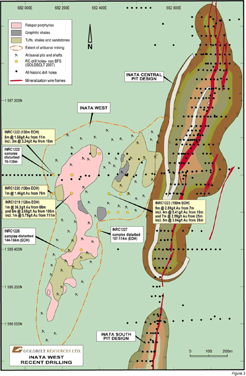
| ● | New shallow zones of oxide mineralization drilled at Inata West that geologically resemble the main Inata Trend – first results of 9m @ 2.89 g/t Au, 7m @ 2.59 g/t Au, 1m @ 36.3 g/t Au & 6m @ 2.65 g/t Au |
| ● | Artisanal activity reported at Inata West over an area of about 1,200m long by between 200m and 500m wide, similar in dimensions to the Inata Central pit design |
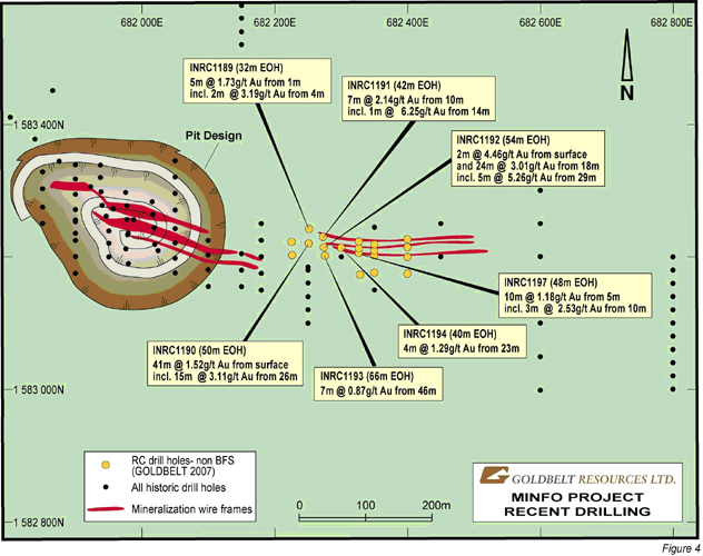
| ● | New drilling extends known mineralization to the east of the Minfo pit design by an additional 200m with results of 41m @ 1.52 g/t Au from surface including 15m @ 3.11 g/t Au from 26m (INRC 1190) and 24m @ 3.01 g/t Au from 18m including 5m @ 5.26 g/t Au from 29m (INRC 1192) |
41 drill holes for 3,245m of drilling were completed over three areas: Inata Far North (Figures 1 & 2), immediately west of Inata Central (herein called ‘Inata West’) (Figures 1 & 3) and east of the Minfo pit design (‘Minfo East’) (Figures 1 & 4).
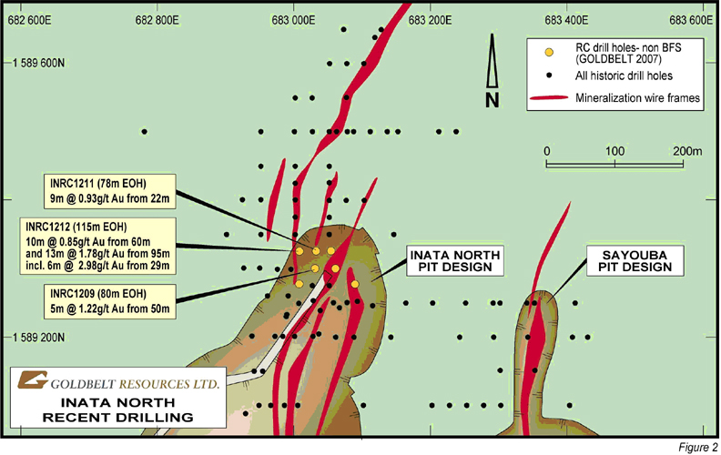
Results from Inata Far North were largely as expected – multiple zones of shallow oxide mineralization with intercepts including 13m @ 1.78 g/t gold from 95m (INRC1212).
Results from Inata West, however, were better than expected with only 500m of strike length drill-tested of what appears to be a 1,200m long by a 200m to 500m wide mineralized zone identified by artisanal shafts and pits. However, up to 54m of continuous down-hole samples were disturbed from five of the fifteen drill holes at Inata West by illegal miners prior to sampling and no sampling of these intervals was possible (see Figures 1 & 3). These holes will be re-drilled in the near-future to determine the exact extent of the mineralization but it is suggested from the geological logs that the disturbed samples – extensive felsic porphyries, quartz veining with sulphide alteration – are intervals that are likely to contain gold mineralization. This is backed up by the presence of gold before or after the disturbed interval.
Of significance is the size of the ever increasing area of the artisanal workings at Inata West – which at present have approximately the same dimensions as the Inata Central deposit of 1.2 km long by between 200m and 500m wide (see Figure 3). The similarity of the geology of the Inata West Zone to the main Inata Trend is of particular interest.
Sterilisation drilling (deep auger) is currently underway over the proposed waste dump areas, to the west of the Inata deposits, and over the processing plant, tailings facility and over other mine infrastructure. This drilling will assist in determining the actual size of the bedrock mineralization in the Inata West area in preparation for a step-out program of deeper reverse circulation drilling.
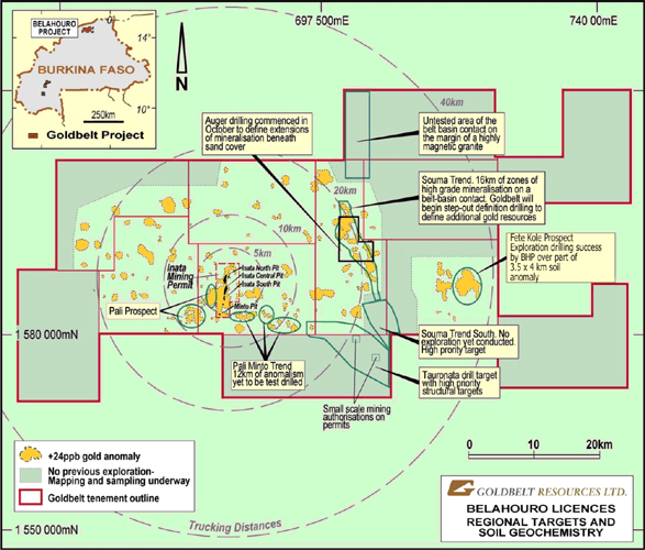
The 20 drill holes at Minfo East have an average depth of 40m yet the intercepts have successfully delineated more oxide gold mineralization that remains open to the east and at depth (Figure 4). The Minfo and Minfo East mineralization is a small part of a larger gold system that can be traced for over 10km to the east and over 5km to the west (Figure 5).
Although the drilling at all three prospects was conducted in June and July 2007, significant delays were experienced in retrieving the samples from Inata due to the heavier-than-expected seasonal rains. Significant delays were also experienced at the SGS Laboratory in Ouagadougou where large numbers of samples were submitted by other companies prior to the onset of the 2007 rainy season.
Future resource estimation
To date, no resource estimation has been conducted at the Inata West Prospect. Goldbelt will incorporate the new drilling data at Inata Far North, Inata West and at Minfo East into the Inata resource model once further infill drilling at Inata West is completed conditional upon the results having a significant impact on the existing resources.
The current resource estimation for the Inata, Sayouba and Minfo deposits remains as of 10 July, 2007 (1,396,930 ounces of measured and indicated resources and a further 297,910 ounces of gold in the inferred category).
Future exploration at Belahouro
Auger drilling has commenced over 8 km strike of the ‘Souma Trend’ that lies some 20km east of Inata. This drilling is targeting extensions of mineralization that are known to be buried under sand cover and to provide a ‘bedrock-gold’ map that will direct the forthcoming reverse circulation drilling programs over the highest priority targets (Figure 5).
The auger drilling methodology has been deployed to enable an in-situ‘saprolite’ sample to be collected by penetrating through overlying surface transported soils. By utilizing this low cost method, Goldbelt is generating a high quality, reliable sample that will immediately indicate if buried gold mineralization exists.
The Souma Trend has been selected for auger drilling because to date, Goldbelt has drilled a number of RAB and RC drill holes and reported encouraging results at five prospects along a 16km zone (see release dated 22 February 2007). Before further expensive drill testing of these
areas continues, the Goldbelt teams will use the auger data to define a bedrock-gold anomaly map that will guide future RAB and/or RC drilling.
Drill planning is in progress at the Fété Kole prospect where BHP achieved considerable exploration success. The target is considered high priority as it falls within the 40km of the proposed mill site at Inata and is drill-ready.
A regional team of geologists has embarked on mapping and sampling of key sites over the Belahouro licenses. This will provide field data for a regional geological interpretation which is underway and which will utilize all geophysical data. This will lead to a structural framework which will assist in the final target generation exercise. Professor Campbell McCuaig of the Centre for Exploration Targeting, University of Western Australia will be providing expert advice through training in the development of the model and subsequent targeting.
“Goldbelt has entered a new and exciting phase at Inata. We have demonstrated the robust economics of the Inata Gold Project in the feasibility study and are ramping up for the start of construction. The exploration department’s attention is now focused on delivering the next generation of resources both at Inata and on the adjacent Belahouro licenses for processing through the Inata Mill. With over 20km of known surface gold anomalism, 12 km of which has yet to be tested by drilling, we are very hopeful that we will find additional resources in the 2007-2008 field season” said Peter Turner, Vice President of Exploration and Business Development.
The information in this report relating to exploration results is based on information compiled by Dr. Peter Turner, who is the Vice President of Exploration and Business Development of Goldbelt Resources Ltd, and a Member of the Australian Institute of Mining and Metallurgy. Dr. Turner has sufficient experience relevant to the exploration data, style of mineralization and type of deposit under consideration and to the activity which he is undertaking to qualify as a Qualified Person as defined by National Instrument 43-101.
Dr. Turner consented to the filing of the written disclosure in this press release with the securities regulatory authorities referred to above.
For additional information, please visit the Company’s website www.goldbeltresources.com or contact Laura Sandilands, Investor Relations or Collin Ellison, President and CEO at (416) 364-0557 or by email lsandilands@goldbeltresources.com.
GOLDBELT RESOURCES LTD.
Per: “Peter Turner”
Dr. Peter Tuner, VP Exploration & Business Development
The TSX has not reviewed and does not accept responsibility for the adequacy or accuracy of this news release. No stock exchange, securities commission or other regulatory authority has approved or disapproved the information contained herein. Certain statements contained in this disclosure document constitute forward-looking statements which are not historical facts and are made pursuant to the “safe harbor” provisions under the United States Private Securities Litigation Reform Act of 1995. When used in this document, words like "anticipate", "believe", "estimate" and "expect" and similar expressions are intended to identify forward-looking statements.
Information concerning exploration results and mineral reserve and resource estimates may also be deemed to be forward-looking statements, as it constitutes a prediction of what might be found to be present when and if a project is actually developed. These forward-looking statements are necessarily based upon a number of estimates and assumptions that, while considered reasonable at the time they are made, are inherently subject to a variety of risks and uncertainties which could cause actual events or results to differ materially from those reflected in the forward-looking statements, including, without limitation: uncertainties related to raising sufficient financing to fund the planned work in a timely manner and on acceptable terms; changes in planned work resulting from logistical, technical or other factors; the possibility that results of work will not fulfill projections/expectations and realize the perceived potential of the Company’s projects; uncertainties involved in the interpretation of drilling results and other tests and the estimation of gold reserves and resources; risk of accidents, equipment breakdowns and labour disputes or other unanticipated difficulties or interruptions; the possibility of environmental issues at the Company’s projects; the possibility of cost overruns or unanticipated expenses in work programs; the need to obtain permits and comply with environmental laws and regulations and other government requirements; fluctuations in the price of gold and other risks and uncertainties.
The United States Securities and Exchange Commission permits mining companies in their filings with the SEC to disclose only those mineral deposits that a company can economically and legally extract or produce. We may use certain terms in this disclosure document such as resources that are prescribed by Canadian regulatory policy and guidelines but are not provided for in the SEC guidelines on publications and filings.
Forward-looking statements are based on the beliefs, estimates and opinions of the Company’s management or its independent professional consultants on the date the statements are made. The reader is cautioned that actual results, performance or achievements may be materially different from those implied or expressed in such statements.
Hole Number | Prospect | East | North | Depth of hole (m) | From (m) | To (m) | Interval (m) | Gold grade (g/t) |
INATA MINING PERMIT DRILLING RESULTS |
| INRC1189 | Minfo | 682251 | 1583243 | 32 | 1 | 6 | 5 | 1.73 |
Including | | | | | 4 | 6 | 2 | 3.19 |
| INRC1190 | Minfo | 682252 | 1583221 | 50 | 0 | 41 | 41 | 1.52 |
Including | | | | | 26 | 41 | 15 | 3.11 |
| INRC1191 | Minfo | 682273 | 1583230 | 42 | 10 | 17 | 7 | 2.14 |
Including | | | | | 14 | 15 | 1 | 6.25 |
| INRC1192 | Minfo | 682274 | 1583214 | 54 | 0 | 2 | 2 | 4.46 |
And | | 682274 | 1583214 | 54 | 18 | 42 | 24 | 3.01 |
Including | | | | | 29 | 34 | 5 | 5.26 |
| INRC1193 | Minfo | 682275 | 1583203 | 66 | 46 | 53 | 7 | 0.87 |
Including | | | | | 50 | 51 | 1 | 2.58 |
| INRC1194 | Minfo | 682300 | 1583213 | 40 | 23 | 27 | 4 | 1.29 |
| INRC1197 | Minfo | 682327 | 1583207 | 48 | 5 | 15 | 10 | 1.18 |
Including | | | | | 10 | 13 | 3 | 2.53 |
| INRC1209 | Inata North | 683028 | 1589301 | 80 | 50 | 55 | 5 | 1.22 |
| INRC1211 | Inata North | 683029 | 1589326 | 78 | 22 | 31 | 9 | 0.93 |
| INRC1212 | Inata North | 683006 | 1589326 | 115 | 60 | 70 | 10 | 0.85 |
And | | | | 115 | 95 | 108 | 13 | 1.78 |
Including | | | | | 101 | 107 | 6 | 2.98 |
| INRC1219 | Inata West | 682248 | 1586702 | 126 | 68 | 69 | 1 | 36.3 |
And | | | | 126 | 106 | 112 | 6 | 2.65 |
Including | | | | | 111 | 112 | 1 | 9.79 |
| INRC1220 | Inata West | 682151 | 1586701 | 130 | 78 | 85 | 7 | 1.46 |
Including | | | | | 79 | 80 | 1 | 3.65 |
| INRC1222 | Inata West | 682151 | 1586802 | 130 | 11 | 19 | 8 | 1.60 |
Including | | | | | 16 | 19 | 3 | 3.24 |
| INRC1223 | Inata West | 682450 | 1586700 | 150 | 7 | 16 | 9 | 2.89 |
Including | | | | | 10 | 14 | 4 | 5.41 |
And | | | | 150 | 25 | 32 | 7 | 2.59 |
Including | | | | | 26 | 31 | 5 | 3.04 |
Table 1. Significant RC drill results from the Inata Mining Permit, northern Burkina Faso |
Notes accompanying drilling results
| § | All holes are drilled by reverse circulation with a face-sampling hammer |
| § | All holes at Inata have been drilled to UTM Grid East (090o at an inclination of -60o). All holes at Minfo have been drilled to UTM Grid North (360o/000o at an inclination of -60o). Down-hole surveying has been conducted at a minimum of the base of hole and 30m intervals to the top. |
| § | Each sample is 2kg of a 1 metre riffle-split sample that is uniquely numbered at the drill site |
| § | All samples were prepared at the SGS Laboratory in Ouagadougou by drying and pulverizing to 90% passing 75µm. |
| § | Gold analysis was conducted by lead recuperation, fire assay with an atomic absorption spectrometry (AAS) finish (a detection limit of 0.01 ppm Au quoted by SGS) |
| § | Internationally recognized geo-reference standards, duplicate samples and blank samples are inserted in sequence with all drilling samples at a frequency of 1 in every 20 (5%) to monitor the accuracy of the procedure |
| § | All results of geo-reference standards and blanks are routinely monitored to be within acceptable limits for the type and method of analysis used |
| § | All results are reported to two decimal places |
| § | The intercepts quoted are down-hole lengths and therefore might not represent the true widths of the mineralisation |
| § | All intercepts are greater than 5 gramme-metres and are quoted using a 0.5 g/t gold lower cut-off, no upper cut-off and less than 4m of internal dilution (<0.5 g/t gold) |
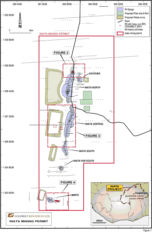
Figure 1. Inata Mine Permit with proposed layout of the mine infrastructure. Inset shows
the position of the Inata Project in Burkina Faso. New drill holes are shown as red filled
circles.
Figure 2. New drill holes with significant results for the Inata Far North zone. The red polygons are the surface outline of mineralized
domains. See Figure 1 for location.
Figure 3. Drill hole locations and results for the Inata West zone where extensive artisanal
workings occur. See Figure 1 for location.
Figure 4. Drill hole locations and results for the Minfo East area. See Figure 1 for location.
Figure 5. Overview target map of the Belahouro licenses. Notice the high-order soil anomalism yet to be fully
drill tested to the east and west of Minfo. Future drilling will be conducted at the Souma Trend and at
Fété Kole. Auger drilling is currently proceeding at the Souma Trend (area outlined by the black box).