EXPLORATION UPDATE ON SOUTHWEST LICENSES IN BURKINA FASO
Toronto, Ontario – (December 11, 2007) Goldbelt Resources Ltd. (TSX: GLD) is pleased to announce new results from rotary air-blast (‘RAB’) drilling over its extensive exploration license portfolio in southwest Burkina Faso.
Highlights
| · | New RAB drilling results confirm importance of the 20km long mineralized zone at Karba – six semi-continuous geochemical anomalies over 10 km remain untested by drilling |
| · | Extensional step-out drilling and Induced Polarisation geophysical surveying begins at Kari Nord where Barrick drilled 29m @ 2.4 g/t gold and 60m @ 2.9 g/t gold |
| · | 4,500m of infill drilling begins at the Kuérédougou Prospect, Mandiosso-Diosso licenses |
| · | Reconnaissance drilling begins on the recently-acquired Barrick Burkina Faso portfolio |
New results are from 264 rotary air-blast (‘RAB’) holes from the Wakui License, 170 RAB holes from the Lamou License, 215 RAB holes from the Bouhaoun License and 60 RAB holes from the Kopoi License. The significant results are captured in Table 1 and shown on Figures 1, 2 and 4.
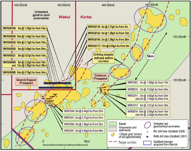
The results of the RAB drilling at Karba/Wakui are especially encouraging (WKRAB009: 8m @ 2.22 g/t gold from 18m and 12m @ 2.26 g/t gold from 38m) when placed in their regional context. Limited drilling of soil geochemical anomalies was undertaken in late 2006 by Goldbelt but many of the high-priority targets were not drilled due to farming activity in the area. As Figure 2 shows in the Grand Espoir area, there is a 3km gold-in-soil anomaly which remains relatively untested by drilling even when the current drilling is considered. In addition, at least six other high priority drilling targets exist in the Karba Trend which will become the focus of the 2008 drilling in the Hounde area.
Future work programs
The Goldbelt license portfolio in southwest Burkina Faso has been expanded considerably from 7 licenses occupying 1,655 km2 to 14 licenses covering 3,184km2 due to the recent acquisition of the Barrick projects in Burkina Faso (Figure 1). Goldbelt has recognized the importance of this extremely under-explored area for gold mineralization and is increasing its level of operations to include the contiguous Barrick licenses.
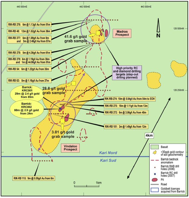
Step-out RC drilling has already begun on the Kari Nord permit (Figure 1) where a 4km long, NE-trending soil anomaly occurs (Figure 3). Barrick drilled a number of 1km-spaced fence lines of shallow RAB holes across parts of this anomaly and determined that bedrock mineralization occurs in almost all drill lines (Figure 3).
Goldbelt has commenced drilling at the Vindaloo Prospect on the Kari Nord license where Barrick drilled only 2 RC drill holes and reported results of 29m @ 2.4 g/t gold from 85m including 6m @ 5.6 g/t gold from 85m (KRC001) and 60m @ 2.9 g/t gold from 24m including 36m @ 4.4 g/t gold from 26m (KRC002)– see Figure 3. A number of the Goldbelt drill holes will also test a second high-priority target, herein called the Madras Prospect, some 4 km to the NNE where Barrick intersected 5m @ 4.36 g/t gold from 61m (RIK-RAB 278) and 12m @ 1.52 g/t gold from 36m (RIK-RAB 048) on two separate drill lines spaced 1 km apart. Numerous artisanal pits occur in these two prospects.
Although the surface, soil geochemical anomaly is approximately 4km long and is consistent with the geological strike of the bedrock, Goldbelt believes that the true strike-length of the bedrock mineralization is closer to 7km. Alluvial sediments occur in between the two prospects and it is thought that these are obscuring the gold anomalism in the surface sampling. Barrick’s RAB drilling data as well as the presence of high-grade, in-situ gold mineralized rock samples that were collected between the two prospects (Figure 3) suggests that bedrock mineralization may be continuous between the two prospects.
Induced Polarisation (‘IP’) ground geophysical surveying will be conducted in due course at Kari Nord and will probably define the position of any buried sulphides, silicified bodies and fault zones from which further drilling may be sited.
The first drill results from the Kari Nord license are expected this week.
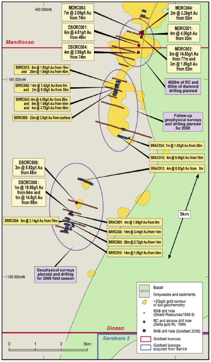
Drilling has commenced at the Kuérédougou Prospect on the Mandiosso-DiossoLicense border (Figures 1 & 5) to follow-up on the successful 2006 Goldbelt reconnaissance drilling over 600m of strike length of altered basaltic rocks. Deep artisanal mining occurs along 1,000m of strike-length where visible gold is commonly seen in quartz vein and porphyritic intrusives. Initial results of an anticipated 4,000m of RC and 500m of diamond drilling program are expected by the end of January 2008.
Figure 5 also shows the position of previous explorers’ drill collar positions and results over the Diosso License. A number of defined pods of gold mineralization occur to the south of the Kuérédougou Prospect (often high-grade too) which will be tested by IP surveying in combination with further drill testing in the 2008 field season.
Goldbelt is also keen to test the area of workings that have steadily grown in the last few months at the Serakoro 2 license situated immediately to the south of the Diosso license (Figure 1). An initial 600m RC and diamond core drilling program will be conducted to test the lateral continuity and width of multiple quartz reefs that are currently the site of approximately 5,000 local miners.
Peter Turner, Vice President of Exploration and Business Development said, “We have an enviable license portfolio over a prolific, yet under-explored gold belt in Burkina Faso and will now concentrate our exploration efforts on key projects that we see as delivering resource ounces.”
The information in this report relating to exploration results is based on information compiled by Dr. Peter Turner, who is the Vice President of Exploration and Business Development of Goldbelt Resources Ltd, and a Member of the Australian Institute of Mining and Metallurgy. Dr. Turner has sufficient experience relevant to the exploration data, style of mineralization and type of deposit under consideration and to the activity which he is undertaking to qualify as a Qualified Person as defined by National Instrument 43-101.
Dr. Turner consented to the filing of the written disclosure in this press release with the securities regulatory authorities referred to above.
For additional information, please visit the Company’s website www.goldbeltresources.com or contact Laura Sandilands, Investor Relations or Collin Ellison, President and CEO at (416) 364-0557 or by email lsandilands@goldbeltresources.com.
GOLDBELT RESOURCES LTD.
Per: “Peter Turner”
Dr. Peter Tuner, VP Exploration & Business Development
The TSX has not reviewed and does not accept responsibility for the adequacy or accuracy of this news release. No stock exchange, securities commission or other regulatory authority has approved or disapproved the information contained herein. Certain statements contained in this disclosure document constitute forward-looking statements which are not historical facts and are made pursuant to the “safe harbor” provisions under the United States Private Securities Litigation Reform Act of 1995. When used in this document, words like "anticipate", "believe", "estimate" and "expect" and similar expressions are intended to identify forward-looking statements.
Information concerning exploration results and mineral reserve and resource estimates may also be deemed to be forward-looking statements, as it constitutes a prediction of what might be found to be present when and if a project is actually developed. These forward-looking statements are necessarily based upon a number of estimates and assumptions that, while considered reasonable at the time they are made, are inherently subject to a variety of risks and uncertainties which could cause actual events or results to differ materially from those reflected in the forward-looking statements, including, without limitation: uncertainties related to raising sufficient financing to fund the planned work in a timely manner and on acceptable terms; changes in planned work resulting from logistical, technical or other factors; the possibility that results of work will not fulfill projections/expectations and realize the perceived potential of the Company’s projects; uncertainties involved in the interpretation of drilling results and other tests and the estimation of gold reserves and resources; risk of accidents, equipment breakdowns and labour disputes or other unanticipated difficulties or interruptions; the possibility of environmental issues at the Company’s projects; the possibility of cost overruns or unanticipated expenses in work programs; the need to obtain permits and comply with environmental laws and regulations and other government requirements; fluctuations in the price of gold and other risks and uncertainties.
The United States Securities and Exchange Commission permits mining companies in their filings with the SEC to disclose only those mineral deposits that a company can economically and legally extract or produce. We may use certain terms in this disclosure document such as resources that are prescribed by Canadian regulatory policy and guidelines but are not provided for in the SEC guidelines on publications and filings.
Forward-looking statements are based on the beliefs, estimates and opinions of the Company’s management or its independent professional consultants on the date the statements are made. The reader is cautioned that actual results, performance or achievements may be materially different from those implied or expressed in such statements.
Hole Number | License | East | North | Depth | From | To | Interval | Gold grade |
| | | | | of hole | (m) | (m) | (m) | (g/t) |
| | | | | (m) | | | | |
SW BURKINA FASO LICENSES |
| KPRAB38 | Kopoi | 450603 | 1274000 | 50 | 16 | 20 | 4 | 1.3 |
| KPRAB41 | Kopoi | 450677 | 1273998 | 43 | 18 | 22 | 4 | 3.43 |
Including | | | | | 18 | 20 | 2 | 5.34 |
| *LMRAB0001 | Lamou | 420500 | 1242820 | 21 | 16 | 21 | 5 | 2.08 |
Including | | | | | 20 | 21 | 1 | 4.5 |
| LMRAB0002 | Lamou | 420525 | 1242820 | 21 | 14 | 20 | 6 | 0.88 |
| LMRAB0118 | Lamou | 420875 | 1243800 | 39 | 2 | 4 | 2 | 4.32 |
| LMRAB0160 | Lamou | 421375 | 1244200 | 36 | 22 | 26 | 4 | 7.48 |
Including | | | | | 22 | 24 | 2 | 11.1 |
| LMRAB0168 | Lamou | 421375 | 1244600 | 36 | 2 | 4 | 2 | 9.95 |
| *WKRAB008 | Wakui | 431176 | 1275402 | 48 | 34 | 48 | 14 | 0.78 |
Including | | | | | 40 | 42 | 2 | 2.13 |
| *WKRAB009 | Wakui | 431200 | 1275403 | 50 | 18 | 26 | 8 | 2.22 |
*And | | | | | 38 | 50 | 12 | 2.26 |
| WKRAB021 | Wakui | 431498 | 1275400 | 50 | 14 | 22 | 8 | 0.67 |
| WKRAB025 | Wakui | 431599 | 1275401 | 42 | 30 | 38 | 8 | 0.69 |
| WKRAB038 | Wakui | 431920 | 1275402 | 46 | 10 | 20 | 10 | 0.73 |
| *WKRAB039 | Wakui | 431947 | 1275399 | 40 | 30 | 40 | 10 | 1.44 |
*Including | | | | | 34 | 36 | 2 | 3.13 |
| WKRAB106 | Wakui | 432698 | 1275399 | 29 | 14 | 18 | 4 | 1.35 |
| WKRAB138 | Wakui | 431976 | 1275799 | 29 | 2 | 4 | 2 | 2.73 |
| WKRAB162 | Wakui | 432531 | 1275801 | 36 | 12 | 16 | 4 | 1.28 |
| WKRAB166 | Wakui | 432624 | 1275801 | 34 | 26 | 28 | 2 | 3.39 |
| WKRAB173 | Wakui | 432823 | 1275802 | 27 | 2 | 14 | 12 | 0.5 |
Table 1. Significant RAB drill results from the Lamou, Wakui and Kopoi Licenses, Hounde District, SW Burkina Faso * denotes that the drill hole ended in mineralization meaning that the true extent of the mineralization may not have been intersected.
Notes accompanying drilling results
All holes are drilled by rotary air-blast technique
| · | All holes have been drilled to UTM Grid East (090o at an inclination of -60o). No down-hole surveying has been conducted due to the reconnaissance and shallow nature of the drilling |
| · | Each sample is a 3kg sample of a 2 metre composite that was riffle split at the drilling site and uniquely numbered |
| · | All samples were prepared at the SGS Laboratory in Ouagadougou by drying and pulverizing to 90% passing 75µm. |
| · | Gold analysis was conducted by lead recuperation, fire assay with an atomic absorption spectrometry (AAS) finish (a detection limit of 0.01 ppm Au quoted by SGS) |
| · | Internationally recognized geo-reference standards, duplicate samples and blank samples are inserted in sequence with all drilling samples at a frequency of 1 in every 25, 20 and 30 respectively to monitor the accuracy of the procedure |
| · | All results of geo-reference standards and blanks are routinely monitored to be within acceptable limits for the type and method of analysis used |
| · | All results are reported to two decimal places |
| · | The intercepts quoted are down-hole lengths and therefore might not represent the true widths of the mineralisation |
| · | All intercepts are greater than 5 gramme-metres and are quoted using a 0.5 g/t gold lower cut-off, no upper cut-off |
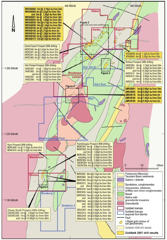
Figure 1. The new results of Goldbelt’s RAB drilling program (shown in boxes with a darker yellow background)
on the Goldbelt license map which includes all recently acquired Barrick Licenses (blue perimeters).
The positions of Figures 2-5 are shown in black hatched boxes.
Figure 2. Goldbelt 2007 RAB drill results shown in relation to RAB and RC drill results for Goldbelt’s 2006 program.
Untested soil anomalies will be drilled in the 2008 field season. For location of Figure 2, see Figure 1.
Figure 2: Drilling results for
the Karba area, Hounde,
SW Burkina
Figure 3. Historic Barrick drill and rock chip results at the Kari Nord License and future Goldbelt work programs.
RC Drilling has already begun on the Vindaloo and Madras Prospects and results are awaited. For location of Figure 3, see Figure 1.
Figure 3: Drilling results for
the kari Nord area, Hounde,
SW Burkina
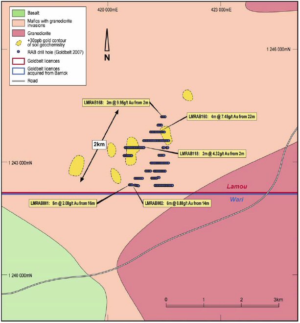
Figure 4. Goldbelt 2007 RAB drill results at the Lamou License, Hounde area, SW Burkina
Faso. For location of Figure 4, see Figure 1.
Figure 4: Lamou Project
RAB Drill Results
Figure 5. Historic drill results for the Diosso-Mandiosso Licenses and the anticipated
future Goldbelt work programs. For location of Figure 5, see Figure 1.
Figure 5: Drilling results for
the Diosso-Mandioso area,
SW Burkina