| | BELAHOURO GOLD PROJECT
Burkina Faso, West Africa Inata, Minfo and Sayouba Deposits -
Database Review, Geological Modelling
and Resource Estimate April 2006 Update Prepared by RSG Global on behalf of: Goldbelt Resources Limited |
BELAHOURO GOLD PROJECT
Burkina Faso, West Africa
Inata Minfo and Sayouba Deposits - Database Review,
Geological Modelling and Resource Estimate
April 2006 Update
Prepared by RSG Global on behalf of:
Goldbelt Resources Limited
| | | | |
| Author(s): | B. Nicholls | Regional Manager - Ghana | BSc (Geology) |
| | D. Slater | Resource Geologist | B.App.Sci. (Geol.) Dip.Ed MAusIMM |
| | | | |
| | | | |
| Date: | 30th April 2006 | | |
| | | | |
| | | | |
| Job Number: | PBEL02 | | |
| | | | |
| | | | |
| Copies: | Goldbelt Resources Limited | (2) | |
| | RSG Global – Perth | (1) | |
| | | | |
| | |
| | |
| | |
| | |
| [signed] [signed] | [signed] |
| Primary Authors | Supervising Principal |
| David Slater and Beau Nicholls | Brett Gossage |
The Reader is advised to read the Disclaimer
(Section 3 of this document)
Table of Contents
| | |
| Belahouro Gold Project | Page: i |
| Update of Independent Technical Report – April 2006 |
| Belahouro Gold Project | Page: ii |
| Update of Independent Technical Report – April 2006 |
List of Tables
| Table 1.4_1 – Summary Resource Statement Inata (24 April 2006) | 6 |
| Table 1.4_2 – Summary Resource Statement Minfo (24 April 2006) | 6 |
| Table 1.4_3 – Summary Resource Statement Sayouba (24 April 2006) | 6 |
| Table 2.5_1 – List of Abbreviations | 9 |
| Table 4.3_1 – Tenement Schedule | 11 |
| Table 6.2_1 – Belahouro Project Exploration History | 15 |
| Table 6.3_1 – Resolute Resource 2000 | 16 |
| Table 6.3_2 – Ore quest Resource December 2004 | 16 |
| Table 6.3_3 – Summary RSG Global Resource Statement Inata at 0.5g/t lower cutoff (26 May 2005) | 16 |
| Table 6.3_4 – Summary RSG Global Resource Statement Inata at 0.5g/t lower cutoff (30 Setember 2005) | 17 |
| Table 10_1 – Exploration Statistics | 22 |
| Table 14.2.5_1 – Original Assay : Au QAQC Assay Laboratory Details | 35 |
| Table 14.2.5_2 – Umpire Assay : Au QAQC Assay Laboratory Details | 36 |
| Table 14.2.5.1_1 – Umpire QAQC - Standards Analysis Details | 36 |
| Table 14.2.5.2_1 – Pulp Umpire Duplicates ITS | 37 |
| Table 14.2.5.3_1 – Pulp Umpire Duplicates TWL | 37 |
| Table 14.2.5.4_1 – Pulp Umpire Duplicates SGS | 38 |
| Table 14.2.5.5_1 – Genalysis Pulp Repeats | 38 |
| Table 14.2.5.6_1 – Table Description | 38 |
| Table 14.7_1 – Summary of Drilling Database Statistics Grouped by Drill Type | 42 |
| Table 14.7_2 – Summary of Drilling Database Statistics Grouped by Company | 42 |
| Table 14.7_3 – Summary of Drilling Database Statistics Grouped by Laboratory | 42 |
| Table 16_1 – Gravity Cyanaidation Test Results | 45 |
| Table 17.4_1 – Summary Statistics by Grouped Domain Inata: Gold Grade – 2m Composite Uncut | 48 |
| Table 17.4_2 – Summary Statistics by Grouped Domain Minfo: Gold Grade – 2m Composite Uncut | 48 |
| Table 17.4_3 – Summary Statistics by Grouped Domain Sayouba: Gold Grade – 2m Composite Uncut | 48 |
| Table 17.4_4 – Upper Cut Statistics- Inata | 49 |
| Table 17.4_5 – Bulk Density Summary Statistics | 49 |
| Table 17.5_1 – Inata Deposit : Summary of Variogram Models | 51 |
| Table 17.5_2 – Minfo Deposit : Summary of Variogram Models | 51 |
| Table 17.6_1 – Block Model Parameters Inata | 52 |
| Table 17.6_2 – Block Model Parameters Minfo | 52 |
| Table 17.6_3 – Block Model Parameters Sayouba | 52 |
| Table 17.7_1 – Sample Search Criteria Inata | 53 |
| Table 17.7_1 – Sample Search Criteria Minfo | 53 |
| Table 17.7_1 – Sample Search Criteria Sayouba | 53 |
| Table 17.7_2 – Variance Adjustment Factors Inata | 54 |
| Table 17.7_3 – Variance Adjustment Factors Minfo | 54 |
| Table 17.8_1 – Confidence Levels of Key Criteria Inata, Minfo and Sayouba Deposits | 55 |
| Table 17.9_1 – Inata Resource Statement – 24 April 2006 | 56 |
| Table 17.9_2 – Inata Resource Statement – 24 April 2006 Subdivided by Weathering | 56 |
| Table 17.9_3 – Minfo Resource Statement – 24 April 2006 | 57 |
| Table 17.9_4 – Minfo Resource Statement – 24 April 2006 Subdivided by Weathering | 57 |
| Table 17.9_5 – Sayouba Resource Statement – 24 April 2006 | 58 |
| Table 17.9_6 – Sayouba Resource Statement – 24 April 2006 Subdivided by Weathering | 58 |
| |
| Belahouro Gold Project | Page: iii |
| Update of Independent Technical Report – April 2006 |
List of Figures
| Figure 4.2_1 – Location of Ougadougou Burkina Faso | 64 |
| Figure 6.3_1 – Resource Development Tonnage and Metal Comparison | 65 |
| Figure 12.2_1 – Inata DDH Recovery | 66 |
| Figure 14.2.3_1 – Inata Pills 0.58 | 67 |
| Figure 14.2.3_2 – Inata Pills 2.25 | 68 |
| Figure 14.2.3_3 – Inata Pills 7.98 | 69 |
| Figure 14.2.3_4 – Duplicates All data | 70 |
| Figure 14.2.3_5 – Duplicates gt 0.1 | 71 |
| Figure 14.2.3_6 – Blanks | 72 |
| Figure 14.2.3_7 – Standard 0.42 | 73 |
| Figure 14.2.3_8 – Standard 1.30 | 74 |
| Figure 14.2.3_9 – Standard 3.46 | 75 |
| Figure 14.2.4_1 – Pill HOME10 Aug05 | 76 |
| Figure 14.2.4_2 – Pill HOME25 Aug 05 | 77 |
| Figure 14.2.4_3 – Pill HOME13 Aug05 | 78 |
| Figure 14.2.4_4 – Pill PAD22 Aug05 | 79 |
| Figure 14.2.4_5 – Pill SOG9 Aug 05 | 80 |
| Figure 14.2.4_6 – Inata Field Duplicates-Aug05 Data >0.1g/t | 81 |
| Figure 14.2.4_7 – Blanks Aug05 | 82 |
| Figure 14.2.4_8 – Standard OXA26-Aug05 | 83 |
| Figure 14.2.4_9 – Standard OXC30-Aug05 | 84 |
| Figure 14.2.4_10 – Standard OX9-Aug05 | 85 |
| Figure 14.2.4_11 – Standard OXA28-Aug05 | 86 |
| Figure 14.2.4_12 – Standard OXL14-Aug05 | 87 |
| Figure 14.2.4_13 – Standard OXL40-Aug05 | 88 |
| Figure 14.2.4_14 – Standard OXL25-Aug05 | 89 |
| Figure 14.2.4_15 – Standard SN16-Aug05 | 90 |
| Figure 14.2.5.1_1 – Reassay Standard OXF41-Sept05 | 91 |
| Figure 14.2.5.1_2 – Reassay Standard OXF140-Sept05 | 92 |
| Figure 14.2.5.2_1 – Pulp Repeats ITS Sept05 | 93 |
| Figure 14.2.5.3_1 – Pulp Repeats TWL Sept05 | 94 |
| Figure 14.2.5.4_1 – Pulp Repeats SGS Sept05 | 95 |
| Figure 14.2.5.4_1 – Genalysis Pulp Duplicates Sept05 | 96 |
| Figure 17.3_1 – Sectional View of Weathering profiles | 97 |
| Figure 17.3_2 – Inata Plan View of Mineralised Domains | 97 |
| Figure 17.3_3 – Plan View of Mineralised Domains Inata North | 98 |
| Figure 17.3_4 – Plan View of Mineralised Domains Inata Central | 98 |
| Figure 17.3_5 – Plan View of Mineralised Domains Inata South | 99 |
| Figure 17.3_6 – Sectional View of Mineralised Domains Inata North | 99 |
| Figure 17.3_7 – Sectional View of Mineralised Domains Inata Central | 100 |
| Figure 17.3_8 – Sectional View of Mineralised Domains Inata South | 100 |
| Figure 17.3_9 – Plan View of Mineralised Domains Minfo | 101 |
| Figure 17.3_10 – Plan View of Mineralised Domains Sayouba | 101 |
| Figure 17.4_1 – Log Probability Plot Domain 310 | 102 |
| Figure 17.4_2 – Mean vs Contribution to metal plot Domain 310 | 102 |
| | |
| Belahouro Gold Project | Page: iv |
| Update of Independent Technical Report – April 2006 |
1 SUMMARY
1.1 Introduction
RSG Global Pty Ltd (RSG Global) has been commissioned by Goldbelt Resources Limited (Goldbelt) to update the Mineral Resource estimate for the Inata deposits and conduct Mineral Resource esimates for the Minfo and Sayouba deposits, which are all part of the Belahouro Gold Project in Burkina Faso, West Africa. This Mineral Resources are current as at 24th April 2006. This report complies with disclosure and reporting requirements set forth in the Canadian Venture Exchange (CNDX) Corporate Finance Manual, National Instrument 43-101, Companion Policy 43-101CP, and Form 43-101F1.
1.2 Geology
The Belahouro Project is located in the western region of the Birimian Djibo Greenstone Belt. The belt has undergone regional lower greenschist metamorphism and is comprised of intermediate to mafic volcano-sedimentary successions and syn to post-kinematic granite and gabbro intrusions. Further emplacement of dolerite and felsic-porphyry has also occurred during and after mineralising events.
Gold within the Belahouro Project is exclusively associated with mesothermal vein style mineralisation, entirely consistent with the majority of Archaean and Proterozoic terrains worldwide, including the Birimian Series of West Africa. This style of mineralisation is generally associated with regionally metamorphosed terrains that have experienced considerable deformation. As such, the deposits are invariably structurally controlled, with the dominance of structural control increasing proportionally with metamorphic grade.
The principal gold mineralisation within the Belahouro Project is confined to the Inata, Fete Kole and Souma trends. The three Inata deposits (North, Central and South) are located over a strike length of 4km. The deposits appear to be related to the same mineralising event and are associated with shearing. Inata Central and Inata South occur within the same mineralised zone, separated by intermittent low grades and cross-faults. Inata North lies some 300m west of the Inata Central-South trend. The shear zone encompassing the Inata deposits strikes north-northeast and dips steeply to the west-southwest. The Minfo lies 2 kilometres to the southwest of the Inata trend and the mineralisation strikes to the northwest. The Sayouba deposit lies 350m to the east of the Inata trend and appears to be an en echelon shear zone. Gold occurs as free grains and with sulphides associated with quartz veins or silicified rocks in all mineralised zones.
1.3 Project Status
A feasibility program and study is scheduled to start in May 2006, when the current resource drilling and subsequent resource estimation studies have been completed. The study will investigate the economic viability of establishing a moderate tonnage mining scenario. Carbon in leach (CIL) and heap leach processing methods will be used to targeting both the oxide and primary resources.
| Belahouro Gold Project | Page: 5 |
| Update of Independent Technical Report – April 2006 |
1.4 Resources
Resource estimates for the Inata deposits have been generated by RSG Global on the basis of analytical results available up to 1 April 2006. The resource models were generated based on geological and mineralisation models.
Estimation involved the application of Multiple Indicator Kriging (MIK) for the Inata and Minfo deposits, and Ordinary Kriging for the Sayouba deposit. Technique selection was based on the quantity and spacing of available data, and the interpreted controls and styles of the mineralisation under review.
RSG Global also completed a detailed assessment of all analytical quality control data applied in resource estimation. At the time of resource estimation, no material bias had been identified, and the analytical precision for both standards and field duplicate data generally lie within accepted industry limits for mesothermal vein gold deposits.
The summarised Resource Statement in Tables 1.4_1 to 1.4_3 have been determined as at 24 April 2006 and reported in accordance with Canadian National Instrument 43-101, Standards of Disclosure for Mineral Projects of February 2001 (the Instrument) and the classifications adopted by CIM Council in August 2000. Furthermore, the resource classification is also consistent with the Australasian Code for the Reporting of Mineral Resources and Ore Reserves of December 2004 (the Code) as prepared by the Joint Ore Reserves Committee of the Australasian Institute of Mining and Metallurgy, Australian Institute of Geoscientists and Mineral Council of Australia (JORC).
Table 1.4_1 |
Summary Resource Statement Inata |
MIK Model Reported above 0.5g/t cutoff (24 April 2006) |
| | Average Gold Grade | Contained Gold |
Resource Category | Tonnes | (g/t Au) | (oz) |
Measured | 2,480,000 | 2.6 | 203,000 |
Indicated | 12,544,000 | 1.8 | 718,000 |
Inferred | 3,567,000 | 1.4 | 165,000 |
| | | | |
Table 1.4_1 |
Summary Resource StatementMinfo |
MIK Model Reported above 0.5g/t cutoff (24 April 2006) |
| | Average Gold Grade | Contained Gold |
Resource Category | Tonnes | (g/t Au) | (oz) |
Indicated | 622,000 | 1.3 | 27,000 |
Inferred | 347,000 | 1.2 | 14,000 |
| | | |
Table 1.4_1 |
Summary Resource Statement Sayouba |
OK Model Reported above 0.5g/t cutoff (24 April 2006) |
| | Average Gold Grade | Contained Gold |
Resource Category | Tonnes | (g/t Au) | (oz) |
Inferred | 144,000 | 2.4 | 11,000 |
| | |
| Belahouro Gold Project | Page: 6 |
| Update of Independent Technical Report – April 2006 |
1.5 Conclusions
Current exploration has confirmed the significant potential of the Belahouro Project gold mineralisation. Recent observations and current exploration models indicate that the known mineralisation may represent the periphery of a larger mineralised system. Significant potential exists to identify open-pit resources on the Souma trend. In addition, the Fete Kole trend represents a significant exploration target albeit that the geological controls on mineralisation are complex and to-date, poorly understood. The mineralisation controls on the Inata, Minfo and Sayouba deposits are generally well understood allowing effective targeting for future exploration programs, including logical step out drilling which has the potential to extend the known resources north of Inata North and south from the Inata South deposit.
High quality data has been collected by Goldbelt in recent exploration phases. The analytical accuracy and precision of assaying is high and suitable for resource estimation. Infill drilling has confirmed the presence and contiuity of analous zones of mineralisation at Inata. While significant short scale variability exists in the gold grades, the 25m or better spaced drill fences are considered appropriate to allow high confidence resource definition consistent with the Measured and Indicated Mineral Resource categories. The implication of the moderate short scale variability in mining and grade control is that a high quality grade control drilling will be required to enable increased selectivity during mining. It is likely that a high density of drilling, for example an 8m x 5m pattern, will also be required for adequate ore demarcation.
RSG Global's approach in defining broader mineralisation zones for estimation that are based on a nominal 0.3g/t Au lower cutoff grade and geology is considered appropriate for this style of vein hosted mesothermal gold deposit when open cut mining is considered. Oppurtunity exists to constrain higher grade shoots based on an elevated lower cutoff grade at Inata North and to a lesser extent Inata Central. In these areas, potential exists to target underground mining.
The interpretated mineralisation is consistent with the geological interpretation constructed on site and further refined by RSG Global. Refinement of the geological model is important as detailed scheduling maybe dependant on geological features. For example, optimum process performance may be dependant on the ability to blend ore types which have associated hydroscopic clays (viscosity complications) or are dominated by carbonaceous schales that have preg robbing characteristics.
1.6 Recommendations
Based on the completed study RSG Global provides the following bullet point recommendations:-
- Step out drilling is completed to extend defined mineralisation in the Inata North, Minfo and Sayouba trends.
- If not already available, a suite of multi-element assays be collected. This can readily be achieved by assay of umpire assay pulps.
- Ongoing refinement of the geological model is completed.
| Belahouro Gold Project | Page: 7 |
| Update of Independent Technical Report – April 2006 |
2 INTRODUCTION AND TERMS OF REFERENCE
2.1 Scope of the Report
RSG Global Pty Ltd (RSG Global) has been commissioned by Goldbelt Resources Limited (Goldbelt) to update the Mineral Resource estimate for the Inata deposits and conduct Mineral Resource estimates for the Minfo and Sayouba deposits, which are part of the Belahouro Gold Project in Burkina Faso, West Africa. The Mineral Resources are reported as at 24th April 2006.
This report is prepared to comply with reporting requirements set forth in the Canadian National Instrument 43-101. The report is also consistent with the 'Australasian Code for Reporting of Mineral Resources and Ore Reserves' of December 2004 (the Code) as prepared by the Joint Ore Reserves Committee of the Australasian Institute of Mining and Metallurgy, Australian Institute of Geoscientists and Mineral Council of Australia (JORC).
All monetary figures expressed in this report are in United States of American dollars (US$) unless otherwise stated.
2.2 Principal Sources of Information
In addition to site visits undertaken to the Belahouro Gold Project between 2004 and 2005, the authors of this report have relied extensively on information provided by Goldbelt management, various reports previously prepared by RSG Global, and studies completed by previous operators and independent consulting groups. A full listing of the principal sources of information is included in Section 23.
RSG Global has made all reasonable enquiries to establish the completeness and authenticity of the information provided and identified, and a final draft of this report was provided to Goldbelt along with a written request to identify any material errors or omissions prior to lodgement.
2.3 Qualifications and Experience
RSG Global is an integrated Australian-based consulting firm, which has been providing services and advice to the international mineral industry and financial institutions since 1987. RSG Global has maintained a fully operational office at Accra in Ghana since 1996, providing an operational base for consulting and contracting assignments throughout the West African region. An additional African office was established in Johannesburg, South Africa, in 1999 to support expanding activities within southern and eastern portions of the continent.
The report is co-authored by David Slater and Beau Nicholls and all aspects of the report have been peer reviewed by Brett Gossage. Brett Gossage is a professional geologist with 17 years experience in mining geology, geostatistical modelling and estimation of Mineral Resources. He is Partner of RSG Global and Manager of the Resource Division. Mr Gossage is also a Member of the AusIMM, and has the appropriate relevant qualifications, experience and independence to be considered a Qualified Person as defined in Canadian National Instrument 43-101 and an Expert as defined in the Australasian JORC Code.
| Belahouro Gold Project | Page: 8 |
| Update of Independent Technical Report – April 2006 |
David Slater is a professional geologist with 17 years experience in mining geology geostatistical modelling and estimation of Mineral Resources. He is a senior consultant with RSG Global, and has the appropriate relevant qualifications, experience and independence to be considered a Qualified Person as defined in Canadian National Instrument 43-101 and an Expert as defined in the Australasian JORC Code.
The site visits and review of data quality and sampling methodologies was undertaken by RSG Global West African Regional Manager, Mr Beau Nicholls between March and August 2005.
2.4 Independence
Neither RSG Global, nor the authors of this report, have or have had previously any material interest in Goldbelt or related entities or interests. Our relationship with Goldbelt is solely one of professional association between client and independent consultant. This report is prepared in return for fees based upon agreed commercial rates and the payment of these fees is in no way contingent on the results of this report.
2.5 Abbreviations
A full listing of abbreviations used in this report is provided in Table 2.5_1 below.
| Table 2.5_1 |
| |
| List of Abbreviations |
| | | | |
| Description | | | Description |
$ | United States of America dollars | | l/hr/m2 | litres per hour per square metre |
µ | microns | | M | million |
3D | three dimensional | | m | metres |
AAS | atomic absorption spectrometer | | Ma | thousand years |
Au | gold | | MIK | Multiple Indicator Kriging |
bcm | bank cubic metres | | ml | millilitre |
CC | correlation coefficient | | mm | millimetres |
cfm | cubic feet per minute | | MMI | mobile metal ion |
CIC | carbon in column | | Moz | million ounces |
CIL | carbon-in-leach | | Mtpa | million tonnes per annum |
cm | centimetre | | N (Y) | northing |
cusum | cumulative sum of the deviations | | NaCN | sodium cyanide |
CV | coefficient of variation | | NATA | National Association of Testing Authorities |
DDH | diamond drillhole | | NPV | net present value |
DTM | digital terrain model | | NQ2 | size of diamond drill rod/bit/core |
E (X) | easting | | ºC | degrees centigrade |
EDM | electronic distance measuring | | OK | Ordinary Kriging |
EV | expected value | | oz | troy ounce |
g | gram | | P80 -75µ | 80% passing 75 microns |
g/m3 | grams per cubic metre | | PAL | pulverise and leach |
g/t | grams per tonne | | ppb | parts per billion |
HARD | half the absolute relative difference | | ppm | parts per million |
HDPE | high density poly ethylene | | psi | pounds per square inch |
HQ2 | size of diamond drill rod/bit/core | | PVC | poly vinyl chloride |
hr | hours | | QC | quality control |
HRD | half relative difference | | Q-Q | quantile-quantile |
ICP-MS | inductivity coupled plasma mass spectroscopy | | RAB | rotary air blast |
ID | Inverse Distance weighting | | RC | reverse circulation |
ID2 | Inverse Distance Squared | | RL (Z) | reduced level |
IPS | integrated pressure stripping | | ROM | run of mine |
IRR | internal rate of return | | RQD | rock quality designation |
ISO | International Standards Organisation | | SD | standard deviation |
ITS | Inchcape Testing Services | | SGS | Société Générale de Surveillance |
kg | kilogram | | SMU | simulated mining unit |
kg/t | kilogram per tonne | | t | tonnes |
km | kilometres | | t/m3 | tonnes per cubic metre |
km2 | square kilometres | | | |
| | |
| Belahouro Gold Project | Page: 9 |
| Update of Independent Technical Report – April 2006 |
3 DISCLAIMER
Neither RSG Global nor the authors of this report are qualified to provide extensive comment on legal issues associated with the Belahouro Gold Project and included in Section 4 of this report.
The assessment of the metallurgical and processing aspects of the Belahouro Project, included in Section 16 of this report, is based entirely on information and reports provided by independent metallurgical consultants upon whom RSG Global has relied.
Similarly, neither RSG Global nor the authors of this report are qualified to provide extensive comment on hydrological, environmental and geotechnical issues associated with the properties referred to in this report. Assessment of these aspects has relied heavily on information provided by Goldbelt, along with reports previously prepared by other independent consultants.
No warranty or guarantee, be it express or implied, is made by RSG Global with respect to the completeness or accuracy of the legal aspects, metallurgy and processing referred to in this document. Neither RSG Global nor the authors of this report accept any responsibility or liability in any way whatsoever to any person or entity in respect of these parts of this document, or any errors in or omissions from it, whether arising from negligence or any other basis in law whatsoever.
| Belahouro Gold Project | Page: 10 |
| Update of Independent Technical Report – April 2006 |
4 PROPERTY DESCRIPTION AND LOCATION
4.1 Background Information on Burkina Faso
Located in West Africa, Burkina Faso is completely landlocked and bordered by Benin (306km), Cote d'Ivoire (584km), Ghana (549km), Mali (1,000km), Niger (628km), Togo (126km). Burkina Faso has a land area of 274,200km2, comprised of generally flat to dissected undulating plains and hills in the west and southeast. Natural resources include managanese, limestone, copper, nickel, bauxite marble, phosphates and salt. Burkina Faso's population is estimated at 13.9 million (2005) and is made up of several ethnic groups dominated by the Mossi (over 40%). French is the official national language. Burkina Faso gained its independence from France in 1960.
Burkina Faso is one of the poorest countries in the world, has few natural resources and has fragile soil. About 90% of the population is engaged in (mainly subsistence) agriculture, which is vulnerable to variations in rainfall. Cotton is the key crop. Industry remains dominated by government-controlled corporations. Following the African franc currency devaluation in January 1994 the government updated its development program in conjunction with international agencies, and exports and economic growth have increased. Maintenance of macroeconomic progress depends on continued low inflation, reduction in the trade deficit, and reforms designed to encourage private investment. The bitter internal crisis in neighbouring Cote d'Ivoire continues to hurt trade and industrial prospects and deepens the need for international assistance.
Many observers consider that the gold potential of Burkina Faso is significantly under-explored, however the low level of investment in exploration and general lack of infrastructure have historically hampered development within the gold sector. Regardless, interest (albeit it somewhat subdued) in the mining and exploration sector has continued at the hands of both major and junior companies alike.
4.2 Project Location
The Belahouro Project is located approximately 220km north northeast of Ouagadougou, the capital of Burkina Faso, West Africa, at a latitude of 11º 40' N and longitude of 13º 00' N, 2º 00' W (Figure 4.2_1).
4.3 Land Area
The Belahouro Gold Project comprises one large permit covering an aggregate area of 1,187km2 as shown in Table 4.3_1 below. The concession boundaries have not been legally surveyed, but are described by latitude and longitude via decree.
| Table 4.3_1 |
| |
| Tenement Schedule |
| | | | | |
| | | Date Extension | |
Permit Name | Licence Type/Number | Area | | Expiry |
| | | Granted | |
Belahouro | 2003-081/2003-091 | 1,187km2 | 4 October 2004 | April 3, 2006 |
Total | | 1,187km2 | | |
| | |
| Belahouro Gold Project | Page: 11 |
| Update of Independent Technical Report – April 2006 |
RSG Global has not independently verified, nor is it qualified to independently verify, the legal status of the mineral properties in Burkina Faso in which Goldbelt is understood to have an interest. In preparing this report, RSG Global has assumed that the properties are lawfully accessible for evaluation and mineral production.
4.4 Mining Claim Description
The Belahouro Permit has been granted by the Burkina Faso government and consists of one large permit, approximately 1,187km2 in size located between 14º 17'20"-14º 30'07"N latitude and 0º 55'00"-1º28'10"W longitude in the northern region of Burkina Faso (Figure 4.2_1). The permit has been granted to the company by the Ministère des Mines, de l'Energie et des Carrières and cannot be contested by any other company. The government maintains a 10% carried interest in all permits within the country. This government interest does not occur until the Exploitation Stage.
The Belahouro Permit allows the company to carry out all types of exploration provided certain reporting conditions and fee payments are maintained with the Ministere des Mines, de l'Energie et des Carrières. All exploration permits granted in Burkina Faso are for an initial three-year period after which the permit can be renewed for two additional three-year extensions. After the second three-year period, the company must reduce the area of the exploration permit by 25%. After the third three-year period, the exploration permit must convert to an exploitation licence unless other arrangements for extension or grant of a new exploration permit are made.
The original Belahouro exploration licence of 1600km2 in size was granted in October 1994 and further renewed for another three years in October 1998. As per the requirements in Burkina Faso, the 2nd renewal was completed in October 2001 with the mandatory 25% reduction to in size to 1187km2. On November 11, 2004, the Belahouro permit was granted an extension of the expiry date until April 3, 2006.
4.5 Agreements and Encumbrances
RSG Global is not qualified to provide significant comment on legal matters pertaining to the Belahouro Project, however advice provided by Goldbelt Limited suggests that the mineral properties comprising the Belahouro Gold Project are subject to a third party agreement. The BHP Royalty agreement (2.5% of gross sales) is now owned by International Royalty Limited.
4.6 Environmental Liabilities
RSG Global is not aware, nor have we been made aware, of any significant environmental liability associated with the Belahouro Project.
4.7 Permits
All resources and areas of more significant exploration potential defined to date lie within the Belahouro Permit. The Permit provides Goldbelt Resources the right to explore for minerals, however further permitting would be required prior to mine under the general mining code (Law No 023/97/II/AN) of Burkina Faso.
| Belahouro Gold Project | Page: 12 |
| Update of Independent Technical Report – April 2006 |
5 ACCESSIBILITY, CLIMATE, LOCAL RESOURCES, INFRASTRUCTURE AND PHYSIOGRAPHY
5.1 Access
The Belahouro Project is located close to the international border with Mali in north-central Burkina Faso, approximately 220km north-northeast of the capital Ouagadougou. The nearest town to the project is Djibo, approximately 60km to the southeast.
Access to the Belahouro Gold Project is either via 200km of gravel road from Ouagadougou to Kongoussi and Djibo, or via 180km of sealed road to Ouahigouya and then 110km of gravel road to Djibo. The road from Djibo to the project is approximately 60km along unsealed village tracks. Access to Belahouro is more difficult during the monsoonal season due to heavy flooding within drainages and inundation of broader, low-lying areas.
5.2 Physiography and Climate
Burkina Faso is typical of Sudanian and Sahel areas immediately south of the Sahara Desert. The Inata Project exhibits slightly undulating topography with peneplain relief.
Vegetation throughout the project areas is generally of savannah type with trees of karib, nere and baobab. Northern Burkina Faso has an arid climate, with a well-defined rainy season from July to September. Average rainfall is approximately 500mm per annum with temperatures reaching over 45ºC during the hottest part of the year (March to May).
5.3 Local Resources and Infrastructure
Over 80% of the population of Burkina Faso are engaged in subsistence agriculture and nomadic stock keeping. A significant proportion of the male labour force migrates annually to neighbouring countries, particularly Ghana and Cote D'Ivoire, for seasonal employment. Most workers are employed in the agriculture sector growing peanuts, shea nuts, cotton, millet, corn rice, sesame sorghum and tending livestock. Burkina Faso exports cotton, animal products and gold, and imports machinery, food products and petroleum.
Belahouro is the largest permanent village located approximately 30km east of the Inata deposits. A number of nomadic communities exist in the surrounding district. These communities survive on subsistence farming and small artisan gold mining operations. The artisan workings are based on outcropping mineralisation and the reworking of anomalous laterite gravels.
As is common in most of the countries in this part of West Africa, regional infrastructure in Burkina Faso is poor, with few sealed roads and limited power distribution. Water during the dry season in Belahouro is only available from limited water bores operated by hand pumps. Village housing is a combination of mud huts and portable straw huts.
The Goldbelt central camp situated near the Belahouro village has 2 generators, accommodation for up to 40 people, 30,000 litre diesel storage and a permanent supply of bore water.
| Belahouro Gold Project | Page: 13 |
| Update of Independent Technical Report – April 2006 |
6 HISTORY
6.1 Ownership History
Exploration at Belahouro commenced in the early 1980's with four different operators exploring. The Bureau des Mines et de la Geologie du Burkina (BUMIGEB) explored the Belahouro Project between 1984 and 1991, prior to BHP Mineralis International Exploration (BHP) being granted tenure over Belahouro in 1994. Subsequently, Resolute Limited (Resolute) entered into a joint venture with BHP. The Resolute-BHP joint venture was in effect from 1998-2001 after which the concession was operated by Resolute who continued the program on its own.
In February 2004, Goldbelt entered into an agreement with Resolute for the acquisition of Resolute's 100% interest in six gold exploration properties in Burkina Faso. The properties are known as the Belahouro, Wakuy, Karba, Kopoi and Bouhaoun properties which are held by Resolute (West Africa) Limited ("RWA"), an indirect subsidiary of Resolute. Goldbelt acquired RWA for cash and securities of Goldbelt in March 2005.
Under the agreement, Goldbelt acquired the Burkina Faso assets of Resolute by the purchase from a subsidiary of Resolute of all the outstanding shares of RWA, a Jersey company, which in turn holds all the outstanding shares of Resolute (West Africa) Mining Company SA, a Burkina Faso company.
6.2 Exploration History
Exploration at Belahouro commenced in the early 1980's with four different operators exploring. Early exploration was completed by BUMIGEB (1984-1991), focused predominately on the regions near the villages of Belahouro and Souma. This exploration targeted quartz veining in the Inata, Souma and Fete Kole prospect areas.
BHP began work at Belahouro in 1994, mapping and interpreting the project geology with the aid of available airborne magnetics. BHP exploration include soil geochemistry ("B" horizon soil sampling), which identified numerous gold anomalies. BHP used the soil geochemistry and surface mapping to guide further exploration which included trenching and wide spaced RC and diamond core drilling mainly at Fete Kole, Inata and Souma.
Resolute, as operators of the Resolute-BHP joint venture from 1998 to 2001, focused exploration activities on the Inata deposit, with minor work also carried out at Souma. The principal objective of the joint venture was to develop the Inata deposit, locate possible mineralised extensions and to outline additional resources at Souma. Exploration included RAB, RC, and DD drilling and further soil geochemistry (Table 6.2_1). In addition, other targets were tested including Pali and Fete Kole as well as other targets elsewhere in the Belahouro property.
After assuming full ownership from 2001, Resolute completed additional rock and soil sampling, ground geophysics (TEM and magnetometer surveys) and additional geological mapping. In aggregate, exploration expenditure by Resolute and BHP was approximately $7.75 million.
| Belahouro Gold Project | Page: 14 |
| Update of Independent Technical Report – April 2006 |
Table 6.2_1 summarizes the work done to the end of 2003.
| Table 6.2_1 |
| Belahouro Project Exploration History |
| | | |
Work Completed | Comments | Total |
Drilling | | |
DD (Diamond Drilling) | BUMIGEB and BHP | 10 holes / 1271m |
DD | Resolute – BHP JV | 11 holes / 1185m |
DD | Resolute | 2 holes / 1025m |
RC (Reverse Circulation) | BHP | 326 holes / 22972m |
RC | Resolute - BHP J.V | 451 holes / 30830m |
RC | Resolute | 10 holes / 1145.5m |
RAB (auger) | BHP | 473 holes / 3783m |
RAB(Rotary Air Blast) | Resolute - BHP J.V | 903 holes / 23253m |
Geochemistry | | |
Soil samples | Reported only BHP | 3461 |
Soil samples | Resolute - BHP J.V | 6792 |
Rock chip | Reported only BHP | 407 |
Rock chip | Resolute - BHP J.V | 85 |
Rock chip | Resolute | 1301 |
MMI | Resolute | 262 |
Soil samples | Resolute | 1019 |
Rock samples | Resolute | 118 |
Trenching | | |
No of trenches | BUMIGEB and BHP | 167 |
Inata (25 trenches) | Line metres (Inata only) | 3295 |
Samples | Inata only | 1674 |
Pits | Souma, Inata, Pali West- Resolute | 53 |
Samples | Souma, Inata, Pali West-Resolute | 122 |
Geophysics | | |
Aeromagnetic | Line spacing 200 m by 85 m height | |
VLF – EM/Max-Min | Belahouro permit area | |
VLF – Max Min | Inata area | |
Ground mag | Resolute | 3021.7 line km |
TEM | Resolute | 777.6 line km |
Surveying | Local grid – Four geodesic stations established | No statistics |
Base lines detailed -Inata | 6.5 line km |
Mapping | Local prospect area mapped | 1600km2 |
Metallurgy | Leach test work on Inata and Souma | 420km2 |
Gravity leach test work, Inata | |
Remote Sensing | Landsat TM and aerial photography acquired by BHP | |
Landsat TM and SPOT Imagery | |
Detailed Transient Electromagnetic (TEM) data was acquired over Inata in late 2002/2003 using a SiroTEM Mk II transmitter/receiver through a 200m square loop with 200m moves between stations and 400m between traverses. The TEM data appears effective in locating shear zones, and therefore likely zones of gold mineralisation. This data has allowed existing mineralisation to be modelled within a much more detailed geological framework and has also led to the identification of new exploration targets. This data will assist follow-up exploration.
| Belahouro Gold Project | Page: 15 |
| Update of Independent Technical Report – April 2006 |
Since February 2004, Goldbelt completed a 381 hole drilling program at Belahouro that sought to evaluate mineralisation extensions at Inata, Minfo and Souma for a total of 41,050.9m. The Inata resources calculated in this report are based on both the data obtained from this drilling program and the legacy data collected by Bumigeb, BHP and Resolute.
6.3 Resource and Reserve History
In 2000, Resolute (West Africa) Ltd., on behalf of the joint venture, estimated the resources for the Inata deposits as shown in Table 6.3_1. Inverse distance weighting was used with a top cut of 20g/t Au (Resolute 2000). Resolute reported their 2000 estimate as a combination of Indicated and Inferred Mineral Resource in accordance with the guidelines set out in the Joint Ore Reserves Committee of The Australasian Institute of Mining and Metallurgy, Australian Institute of Geoscientists and Minerals Council of Australia (JORC).
| Table 6.3_1 |
| Resolute Resource Estimate 2000 |
| Reported at a 1.0g/t Au Lower Cutoff Grade |
| | | Resource Category | Approximate | Vertical Depth |
Prospect | Tonnes | Grade Au g/t | (JORC) | Drill Pattern | Drilled |
Inata | 7,682,000 | 2.8 | Indicated | 50 by 20m | 80 to 150m |
Minfo | 604,000 | 2.1 | Inferred | 50 by 20m | 60 to 80m |
Based on a review of the available data, OreQuest subsequently reported the Resolute resource estimate applying the CNI 43 -101 criteria and this is shown in Table 6.3_2.
| Table 6.3_2 |
| Ore Quest Resource Estimate December 2004 |
| Reported at a 1.0g/t Au Lower Cutoff Grade |
| OreQuest Reclassified Resource (to NI43-101 standards) |
Zone | Indicated Resources | Inferred Resources |
| tonnes | Au Grade (g/t) | tonnes | Au Grade (g/t) |
Inata North | 3,709,374 | 3.0 | 612,200 | 3.0 |
Inata Central | 2,042,850 | 2.9 | 144,500 | 2.3 |
Inata South | 956,650 | 2.3 | 216,300 | 2.3 |
Minfo | | | 604,000 | 2.1 |
Totals | 6,708,874 | 2.9 | 1,577,000 | 2.5 |
RSG Global previously estimated and reported the Inata resource in May 2005 and again in September 2005 and classified the estimate in accordance with the CNI 43-101 criteria. This is summarised in Table 6.3_3 Table 6.3_4 respectively and reported at a 0.5g/t Au lower cutoff.
| Table 6.3_3 |
| Summary Resource Statement Inata |
| Reported at a 0.5g/t Au Lower Cutoff Grade (RSG Global 26 May 2005) |
| | Average Gold Grade | Contained Gold |
Resource Category | Tonnes | (g/t Au) | (oz) |
Indicated | 10,354,000 | 2.1 | 707,000 |
Inferred | 5,492,000 | 1.6 | 288,000 |
| | |
| Belahouro Gold Project | Page: 16 |
| Update of Independent Technical Report – April 2006 |
| Table 6.3_4 |
| Summary Resource Statement Inata |
| MIK Model Reported above 0.5g/t cutoff (30 September 2005) |
| | Average Gold Grade | Contained Gold |
Resource Category | Tonnes | (g/t Au) | (oz) |
Measured | 1,396,000 | 3.0 | 132,000 |
Indicated | 13,647,000 | 1.8 | 800,000 |
Inferred | 4,869,000 | 1.4 | 226,000 |
To enable development of the resource base at Inata to be visualised, a graphical comparison of tonnage and total contained ounces is made for historic resources of the Measured/Indicated category for Inata at a nominal 1g/t Au lower cutoff and is shown in Figure 6.3_1.
6.4 Production History
The historic production derived from the Belahouro artisanal workings is unknown. Artisan workings to the west and outside of the Inata Central resource visibly have small "manhole" shafts down 15 to 20m and represent an insignificant amount of material removed from any potential insitu resource at Inata. The artisan workings at Inata are not extensive and have mostly been created by illegal miners. BHP and Resolute established control over artisanal operations from late 1990's in order to restrict any activity over the known Inata resource areas. Goldbelt has and is continuing to enforce this control. The Inata area has also been and is currently protected by government regulations.
| Belahouro Gold Project | Page: 17 |
| Update of Independent Technical Report – April 2006 |
7 GEOLOGICAL SETTING
7.1 Regional Setting
The Belahouro Project is located in the western region of the Birimian Djibo Greenstone Belt. The belt has undergone regional lower greenschist metamorphism and is comprised of intermediate to mafic volcano-sedimentary successions and syn to post-kinematic granite and gabbro intrusions dispersed within sedimentary and tuffaceous schists. A prominent marker horizon consisting of black iron-bearing quartzite lenses is observed within the volcano-sedimentary succession. Further emplacement of dolerite and felsic-porphyry has also occurred during and after mineralising events. Tarkwaian facies arkosic sandstone overlies the volcano-sedimentary sequence at the eastern border of the Belahouro granite.
The project can be separated into three principal geological domains. The Damba-Inata domain occurs in the westernmost portion of the project area. Central to the property is the Belahouro-Sona Basin, and the Feto Kole province occurs in the eastern region.
The Damba-Inata trend is dominated by metasediments and intermediate to mafic volcanics and volcanoclastics. To the west of the Inata trend, strong magnetic signatures are present in aeromagnetic data indicating the presence of mafic volcanics or sedimentary derivatives. The trend varies over the strike of the prospect, from north-northwest in the south to north in the central area and north-northeast in the northern area.
The Belahouro-Sona Basin consists of turburbitic metasediments and minor volcanoclastics and provides the key elements to understand the regional tectonic framework subsequent to basin formation. The basin is bounded to the east, west and south by early basin forming structures (D1) that have later been reactivated in subsequent phases of compressional deformation (D2). Arcuate, generally south dipping thrusts abut the southern margin of the basin indicating a significant north-south compressional event (D3). Late mineralised (D4) 040o and 330o faults crosscut the entire basin and adjacent volcano-sedimentary terranes.
Feto Kole to the east of the Sona Basin, is a complex of felsic to mafic volcanics and sedimentary derivatives, and various pre-, syn- and post deformation granitoid intrusions. The final phase of intrusion is gabbroic, which is also associated with minor volcanic ultramafic sequences.
The basement geology of the Belahouro Gold Project represents part of the Baoulé-Mossi Domain of the West African Craton which is mainly formed by Birimian volcano-sedimentary series, which dominates the basement geology of the West African Shield. The Birimian Series is composed of volcanic and plutonic bodies (basalt, andesite, rhyolite, rhyodacite, dacite, felsic tuff, gabbro, diorite and ultramafic rocks) distributed within a generally schistose and vertically titled sedimentary and tuffaceous succession of black shale, sandstone, pelitic schists, tuffaceous schist, greywacke, quartzite and chert. This basement succession is overlain by Tarkwaian siliceous and arkosic sandstone and conglomerate.
| Belahouro Gold Project | Page: 18 |
| Update of Independent Technical Report – April 2006 |
The Birimian Series of West Africa is host to some of the largest gold deposits in the world, including Sadiola, Yatela, Morila and Syama in Mali, Obuasi, Bogosu, Prestea and Bibiani in Ghana, and Siguiri in Guinea.
7.2 Project Geology
The Birimian volcano-sedimentary series was extensively deformed and metamorphosed during the Eburnean Orogeny. Metamorphic mineral assemblages reflect low-grade regional metamorphism to greenschist facies. However, in the Belahouro-Souma area, kyanite bearing mica schist and pelite indicate higher grade metamorphic regime. The succession is strongly affected by polyphase deformation displaying recumbent folding and strong sub vertical dominant schistosity with transposed bedding plans in some areas. Syn to post-tectonic granitoids intrude the basement succession.
The entire stratigraphy has been intruded by massive post Birimian dolerite dykes and sills with higher magnetic susceptibility than the surrounding host. This allows the dykes and sills readily distinguishable in airborne magnetic data.
Throughout the Belahouro Project, exposures of the Birimian basement succession are rare. Weathering is extensive, persisting up to 100 metres depth with a typical lateritic profile.
The gross structure of the Belahouro Project relies on interpretation of the airborne magnetic data.
Gold mineralisation is commonly associated with stockwork and sheeted quartz–carbonate–sulphide veining, stockworks of albite-carbonate-sulphide veinlets, or as sulphidic haematitic breccia.
Pyrite is the dominant sulphide species, present as discrete poikilitic euhedra ranging from a fraction to a few millimetres in size, largely confined to vein margins or disseminated within alteration selvedges. Traces of other sulphides, principally chalcopyrite, galena, pyrrhotite, arsenopyrite, bornite, tennantite, linneite and mackinauwite are present as veins, fracture fillings and localized disseminations adjacent to veins. Gold is largely developed within fractures in pyrite grains, rarely larger than 50 microns, and is non-refractory.
Extensive weathering and lateritisation of the mineralisation and surrounding host rocks has occurred. The base of oxidation extends to over 60m in places, but may be locally depressed within zones of fracturing and brecciation. There appears to be little evidence of depletion and corresponding supergene enrichment within the weathering profile, and the width and grade of primary mineralised zones appears to be little different from their equivalents within the saprolite profile.
| Belahouro Gold Project | Page: 19 |
| Update of Independent Technical Report – April 2006 |
8 DEPOSIT TYPES
Gold within the Belahouro Project is exclusively associated with mesothermal vein style mineralisation, entirely consistent with the majority of Archaean and Proterozoic terrains worldwide, including the Birimian Series of West Africa. This style of mineralisation is generally associated with regionally metamorphosed terrains that have experienced considerable deformation. As such, the deposits are invariably strongly structurally, rather than lithologically, controlled, however the dominance of structural control invariably increases in a manner commensurate with the metamorphic grade.
| Belahouro Gold Project | Page: 20 |
| Update of Independent Technical Report – April 2006 |
9 MINERALISATION
The principal gold mineralisation within the Belahouro Project is confined to the Inata and Souma Trends. The three Inata deposits (North, Central and South) are located over a strike length of 4km. The deposits are interpreted to be related to the same structural event and are associated with shearing. Inata Central and Inata South represent the same mineralised trend, separated by lower grade mineralisation and cross-cutting faults. Inata North lies some 300m west of the Inata Central-South trend. The Inata shear trends north-northeast and dips steeply to the west-northwest. Gold mineralisation is present as free grains and is generally associated with carbonate-pyrite alteration within quartz veins.
Sayouba is a small zone (strike 100m) of north-northwest trending gold mineralisation with a dip of 60° to 70° west. It occurs in shale, siltstone, minor intermediate volcanics, and felsic porphyry. The zone is transgressive to the regional foliation (030° to 040°).
Minfo lies on the Minfo-Filio east-west shear zone. The shear zone can be traced over a distance of 20km and is characterised by a wide zone of shearing (up to 400m) associated with a strong aeromagnetic trend. Mineralisation is associated with massive and stringer quartz veining in black shales within an intermediate volcanic shale/siltstone package.
| Belahouro Gold Project | Page: 21 |
| Update of Independent Technical Report – April 2006 |
10 EXPLORATION
Prior to commencement of the Goldbelt exploration programs (February 2004 onwards), considerable exploration has been completed by operators BHP and Resolute (Section 6.2).
The Goldbelt strategy was designed to define sufficient resources and reserves to justify investigation of the development of a 2Mtpa carbon in leach (CIL) processing operation producing approximately 150,000oz to 200,000oz of gold per year.
The Goldbelt programs focussed primarily on infill drilling of the resources identified with the objective of improving the confidence category of the identified Mineral Resources. A secondary objective of the drilling program was to expand the resource base in order to enhance the mine life of a proposed CIL operation.
This strategy has been successful, with additional higher grade zones of oxide and primary mineralisation defined. It is likely that on-going exploration will continue to identify extensions to existing mineralisation or new mineralisation elsewhere within the permit.
A summary of the principal exploration activities completed by Goldbelt in the Inata, Minfo and Sayouba areas to 1 April 2006 is provided in Table 10_1 below. A detailed listing and discussion of the exploration history is provided as Section 6.2 and is therefore not repeated.
| Table 10_1 |
| Goldbelt Exploration Statistics |
| (2004 to April 2006) |
| Exploration Activity | Exploration Statistics |
| RC Drilling | 395 holes | (42,968m) |
| Diamond Drilling | 3 holes | (290.9m) |
Exploration surveys and interpretations completed to date within the Belahouro Gold Project have largely been planned, executed and supervised by national and expatriate Goldbelt personnel, supplemented by consultants and contractors for more specialised or technical roles. The data is considered to be of good quality (Sections 11 to 14). The current Goldbelt exploration team, assisted by RSG Global technical personnel, is considered well qualified and motivated to fulfil the responsibilities of on-going exploration programs.
The geological understanding of the Belahouro Gold Project has evolved greatly since the commencement of the Goldbelt exploration strategy and will continue to do so at a similar rate. The knowledge acquired to date confirms the considerable potential of the Inata Trend and surrounding areas. RSG Global considers that the proposed exploration and development strategy is entirely appropriate and reflects the potential of the Belahouro Gold Project.
| Belahouro Gold Project | Page: 22 |
| Update of Independent Technical Report – April 2006 |
11 DRILLING
The Inata database includes drilling data generated in three main periods, Bumigeb and BHP drilling (pre 1998), Resolute (1998 to 2004) and Goldbelt drilling from 2004 onwards. The drill data contained in the database is a combination of diamond and reverse circulation (RC) drilling.
Limited documentation is available to adequately describe the Bumigeb and BHP drilling (pre 1998). The descriptions provided below relate to the Resolute and Goldbelt data, which dominates the dataset used in the resource evaluation.
11.1 Reverse Circulation Drilling
Four types of drill rigs were utilised supplied by two drilling companies.
- UDR650 (truck mounted) with 750cfm/350psi compressor. Rod string 4½ inch with 5½ inch face hammer. Supplied by West African Drilling Services (WADS).
- UDR1000 (truck mounted) supplied by West African Drilling Services (WADS).
- Schramm T66 truck mounted with 900cfm/350psi air capability using 5½ inch face hammer. Supplied by WADS.
- Schramm 685 truck mounted with air capability of 900cfm/350psi. Drill string with 4½ inch face hammer. Supplied by Grimwood Davies.
The different drilling company's performance was reported as satisfactory with high daily productivity rates, acceptable sampling recovery (except shallow diamond coring), and safety standards being achieved.
11.2 Diamond Core Drilling
WADS completed diamond drilling for both Resolute and Goldbelt. RC precollars were drilled using a UDR1000 multipurpose rig with 350psi/900cfm capacity. Precollars were completed with a 5½ inch RC drill bit while diamond coring was completed using HQ triple tube. All holes were surveyed using a single shot camera at the collar and at regular down-hole intervals. Core orientations were completed using the spear technique, with both tungsten and crayon bits utilised, depending on core competency.
Core structural orientations are routinely recorded to assist in determining the controls on mineralisation, in establishing a reliable geological model for resource estimation, and to provide additional geotechnical information to determine likely blast fragmentation and pit stability characteristics.
The core is transferred from the trays and pieced together on a V-rail (angle iron) rack and the orientation line, determined from the crayon orientation mark recorded during drilling, drawn along the entire length of the assembled core.
Geotechnical logging has recorded percentage core recovery, RQD percentage, rock type, weathering, rock strength and fractures per metre. This basic geotechnical logging is considered appropriate at this stage of project development.
| Belahouro Gold Project | Page: 23 |
| Update of Independent Technical Report – April 2006 |
11.3 Drilling Quality
The RC and diamond drilling data applied in resource estimation is generally considered to be of acceptable quality and broadly consistent with international industry standards.
The general quality of RC drilling has progressively improved over time, particularly since more experienced and well-equipped contractors have become available. Drilling practices are also benefiting from closer and more experienced exploration management. The quality of diamond drilling is considered to be of industry accepted standard, however, recoveries for diamond core from the moderate to highly weathered saprolite has been poor (Section 12.3).
Wherever possible, drilling was undertaken normal to the plane of the principal mineralised orientation. RSG Global is confident that the modelled resources adequately reflect the drilling orientation with respect to the mineralised strike and down-hole versus true intersection width.
| Belahouro Gold Project | Page: 24 |
| Update of Independent Technical Report – April 2006 |
12 SAMPLING METHOD AND APPROACH
12.1 RC Sampling and Logging
RC drill chips were collected as 1m intervals down-hole via a cyclone into PVC bags prior to splitting.
The collected samples were riffle split using either a multi stage Jones riffle splitter or via multiple passes through a single stage Jones riffle splitter. A final sample of approximately 2kg was collected for submission to the laboratory for analysis. Wet samples were collected via grab sampling. The dry sampling represents industry standard practices, but the method of grab sampling the wet RC samples may result in unreliable data, however, wet samples represent a small percentage of the dataset.
RC chip boards were systematically compiled by gluing the sieved RC chips to a board. These boards represent a good record and a useful tool for re interpretation of the geology and mineralisation. During the site visit, holes INRC001 to INRC150 were available for inspection, although the remaining chip boards (300 plus holes) for Resolute drilling were not located. This drilling represents the bulk of the Inata Deposit and needs to be located and preserved. The chip trays used by Goldbelt were inspected in Ouagadougou by RSG Global.
12.2 Diamond Core Sampling and Logging
The sampling of the core was subject to the discretion of the geologist completing the geological logging. After the marking out of the required interval, the core was cut in half by the electric diamond blade core saw. The cut is made along the orientation line with the half core portion that looks north being retained as a reference. The half portion that looks to the south is broken up for assay.
In the upper oxide zone, the core was too friable for diamond saw cutting. The procedures were to dry cut or cleave the core in this case. The sample weight required was 2kg.
The following diamond holes were inspected during the RSG Global site visit; INDD007, INDD008, INDD009, INDD016, INDD018, INDD019 and INDD020.
The zone of mineralisation in holes INDD7 to INDD9 had been weakly weathered and the core was relatively competent. Fines along fractures and veining had been washed out but recoveries were above 90%. Holes INDD16, INDD18, INDD19 and INDD20 were moderately to strongly weathered, the core was crumbly and friable and sample recovery was very poor. Figure 12.2_1 shows diamond core recovery at 42m down hole for INDD016, note the poor recovery around quartz vein where it is not possible to take a representative sample. Consequently, these holes are likely to underestimate the gold in grade and width when compared to adjacent RC.
| Belahouro Gold Project | Page: 25 |
| Update of Independent Technical Report – April 2006 |
12.3 Sample Recovery
Sample recovery for RC drilling was noted as good and generally estimated to be in excess of 20kg per metre drilled. Sample weights have not been systematically recorded; however a review of deteriorated samples in the bag farm at the Belahouro camp and at Inata indicates acceptable sample recoveries were being achieved. (Based on 5'' or 122.5mm diameter RC drillholes and the established average weighted bulk density, the notional volume recovery of dry samples should approximate 20kg/m in saprolite and 32kg/m in the primary zone). Resolute states that a few wet intervals were recorded, generally at rod changes. On inspection of RC drilling during the RSG Global site visit in April 2005, the samples were kept dry to depths of 200m. Drillers were pulling back after every metre and samples were being systematically weighted with very good recoveries noted.
Sample recovery in diamond holes was poor for the moderate to highly weathered zones. Core loss tends to occur due to washing and/or grinding at the commencement and completion of drilling runs, particularly within the partially oxidised portion of the profile or within friable zones of tectonised rock. Consequently, this drilling is considered as low confidence and recovery has been appropriately considered during estimation.
12.4 Sample Quality
The sampling procedures adopted for drilling are consistent with current industry best practise. Samples afforded by diamond coring within the highly weathered zones are of poor quality, however the sample recoveries for the RC drilling is high.
RC field duplicate samples are routinely collected to allow assessment of the field sampling error (or bias) once the laboratory error, determined from analysis of pulp duplicates, has been subtracted. Acceptable reproducibility has been identified during an assessment of RC field duplicate data (Section 14.2) generated and no distinct bias is evident. RC sampling still requires close supervision to ensure adequate representivity.
| Belahouro Gold Project | Page: 26 |
| Update of Independent Technical Report – April 2006 |
13 SAMPLE PREPARATION, ANALYSIS AND SECURITY
13.1 Sample Security
RSG Global is unable to provide comment on the sample security of the data collected prior to Goldbelt's involvement, however, the sampling and sample dispatch protocols implemented by the Resolute-BHP JV, and subsequently by Resolute, are similar to those described below.
The rapid submission of samples from drilling for analysis, and the close scrutiny of procedures by expatriate technical staff, provides little opportunity for sample tampering. Equally, given the umpire assaying via an external international laboratory and the regular 'blind' submission of international standards to both the primary and umpire assay facilities, any misleading analytical data would be readily recognised and investigated.
Current Goldbelt drilling procedures require samples to be stapled closed once taken from the rig. They are then transported to the Belahouro secure camp to be picked up by the laboratory truck. The laboratory truck then takes them directly to the laboratory.
Reference material is retained and stored on site, including chips derived from RC drilling, half-core and photographs generated by diamond drilling, and duplicate pulps and residues of all submitted samples. All pulps are stored at a Goldbelt storage facility in Ouagadougou and were inspected during the site visit. Assessment of the data indicates that the assay results are generally consistent with the logged alteration and mineralisation, and are entirely consistent with the historical and anticipated tenor of mineralisation.
13.2 Analytical Laboratories
Prior to BHP/Resolute involvement with the project, all sample analyses were completed at the Bumigeb laboratory in Bobo-Dioulasso. This laboratory represents data associated with 0.03% of the database.
Data collected by BHP represents approximately 21% of the database and was assayed at SGS in Tarkwa. Digital quality control data is not available and data has been reviewed from reports.
Quality control by Resolute identified that the Bumigeb laboratory was unreliable; therefore all Resolute samples were assayed at Intertek Testing Service (ITS) laboratory based in Ouagadougou, Burkina Faso. Data analyses by ITS represents data associated with approximately 46% of the assay database.
Analytical work completed on behalf of Goldbelt was initially done by Transworld Laboratory Tarkwa in Ghana. After identifying some issues with sample preparation with the Transworld Laboratory, all sample preparation and analysis for the current drill program (post May 2005) is being completed by SGS Tarkwa in Ghana. Both of these laboratories use conventional fire assay with AAS finish. Goldbelt has continued using Resolute standard procedures for quality control. Transworld represents data associated with approximately 33% of the database.
| Belahouro Gold Project | Page: 27 |
| Update of Independent Technical Report – April 2006 |
13.3 Sample Preparation and Analytical Procedure
13.3.1 Intertek Testing Service (ITS)
The assay method applied by ITS is summarised below.
- a 2kg or less of sample is dried, disaggregated, crushed, and pulverised (95% passing -200 micron).
- a Two 180g pulps are taken for analysis and pulp storage.
- a 30g charge, Fire Assay fusion, lead collection, AAS determination to 8ppb.
- a Gravimetric analysis completed on Au>10g/t.
Routine quality control included the submission and assay of two international standards, one international blank and two duplicates per batch of 30 samples. In addition, random checks were completed on spurious results. Sample preparation and analytical methods have been conventional and appropriate.
13.3.2 Transworld – Tarkwa
The assay method applied by Transworld (Tarkwa) was as follows:-
- 2kg to 3kg field splits are oven dried at 105°C.
- Over dried samples are crushed in a jaw crusher to a nominal 3mm.
- A 1.5kg sub-sample is collected via a riffle splitter.
- The 1.5kg sub-sample pulverised in a homogenizing mill (LM2) to 90% -75µ.
The 50g Fire Assay analytical procedure applied to the pulps is summarised as follows:-
- A 50g portion of pulverized sample is weighed.
- The sample is fused in a fusion furnace to produce a lead button.
- A lead button is cupelled in a cupellation furnace.
- The resulting prill is subjected to acid dissolution.
The resulting solutions are then read on an AAS, with a stated detection limit of 10ppb gold.
13.3.3 SGS Tarkwa
The current drill program, post May 2005 (and previously BHP samples with an undocumented procedure) is being analysed by SGS Tarkwa with the following procedure:-
- 2kg to 3kg field splits are oven dried at 105°C.
- The dried sample is crushed in a Jaw crusher to a nominal 3mm.
- A 1.5kg sub-sample is collected via a riffle splitter.
- The 1.5kg sub-sample is pulverised in a homogenizing mill (LM2) to 90% -75µm.
| Belahouro Gold Project | Page: 28 |
| Update of Independent Technical Report – April 2006 | |
The 50g Fire Assay analytical procedure applied to the pulps is summarised as follows:-
- A 50g portion of pulverized sample is weighed.
- The sub-sample is fused in a fusion furnace to produce a lead button.
- A lead button is cupelled in a cupellation furnace.
- The resulting prill is subjected to acid dissolution.
The resulting solutions are then read on an AAS, with a stated detection limit of 10ppb gold.
13.4 Adequacy of Procedures
Analytical procedures associated with data generated prior to BHP cannot be assessed, as not all of the relevant information is available. Procedures associated with BHP, Resolute and Goldbelt assaying are consistent with current industry practise and are considered acceptable for style of mineralisation identified at Belahouro.
| Belahouro Gold Project | Page: 29 |
| Update of Independent Technical Report – April 2006 | |
14 DATA VERIFICATION
14.1 Quality Control Procedures
The current quality control procedures include the submission of internationally recognised standards, umpire assaying at an internationally recognised laboratory Amdel in Australia, duplicate and replicate sample analyses and the submission of RC field duplicate samples at a rate of 1:30, with the latter providing a comparison of the total sampling and analytical error. The assay quality control procedures applying to the various laboratories is summarised in the following sections.
14.1.1 Intertek Testing Service (ITS)
The quality control procedures implemented by ITS assaying were:-
- Cross referencing of sample identifiers (sample tags) during sample sorting and preparation with sample sheets and client submission sheet.
- Compressed air gun used to clean crushing and milling equipment between samples.
- Barren quartz 'wash' applied to the milling/pulverising equipment at the rate of 1:10.
- Quartz washes assayed to determine the level of cross contamination.
- Sieve tests are carried out on pulps at the rate of 1:50 to ensure adequate size reduction.
- Assaying of internal standards data.
- Mineralised duplicate pulps despatched to Genalysis Laboratory Services in Perth, Australia, for umpire fire assay analysis.
14.1.2 Transworld (Tarkwa) and SGS (Tarkwa)
In addition to the above procedures applied at ITS, the following procedures were adopted for Transworld and SGS:-
| Belahouro Gold Project | Page: 30 |
| Update of Independent Technical Report – April 2006 | |
14.2 Quality Control Analysis
The assay quality control data, as they pertain to resource estimates completed on the basis of data available to 1 April 2006 have been subdivided into pre BHP data, BHP data, BHP/Resolute- Resolute data and Goldbelt data.
The quality control data has been assessed statistically using a number of comparative analyses for available datasets. The objectives of these analyses were to determine relative precision and accuracy levels between various sets of assay pairs and the quantum of relative error. The results of the statistical analyses are presented as summary plots, which include the following:-
Thompson and Howarth Plot showing the mean relative percentage error of grouped assay pairs across the entire grade range, used to visualise precision levels by comparing against given control lines.
- Rank % HARD Plot, which ranks all assay pairs in terms of precision levels measured as half of the absolute relative difference from the mean of the assay pairs (% HARD), used to visualise relative precision levels and to determine the percentage of the assay pairs population occurring at a certain precision level.
- Mean vs % HARD Plot, used as another way of illustrating relative precision levels by showing the range of % HARD over the grade range.
Mean vs %HRD Plot is similar to the above, but the sign is retained, thus allowing negative or positive differences to be computed. This plot gives an overall impression of precision and also shows whether or not there is significant bias between the assay pairs by illustrating the mean percent half relative difference between the assay pairs (mean % HRD).
Correlation Plot is a simple plot of the value of assay 1 against assay 2. This plot allows an overall visualisation of precision and bias over selected grade ranges. Correlation coefficients are also used.
Quantile-Quantile (Q-Q) Plot is a means where the marginal distributions of two datasets can be compared. Similar distributions should be noted if the data is unbiased.
Standard Control Plot shows the assay results of a particular reference standard over time. The results can be compared to the expected value, and the ±10% precision lines are also plotted, providing a good indication of both precision and accuracy over time.
Cumulative Deviation from Mean Plots illustrate the cumulative sum of the deviation from the expected value of a particular reference standard or from the mean of the assays over time, and is used to determine direction and severity of bias and illustrate changes in grade over time.
Cumulative Deviation from Expect Value Plot illustrates the cumulative sum of the deviation from the expected value of a particular reference standard over time. Used to determine direction and severity of bias, and to illustrate changes in grade over time.
| Belahouro Gold Project | Page: 31 |
| Update of Independent Technical Report – April 2006 | |
Comments on the results of the statistical analyses for each laboratory are provided below while a compilation of the descriptive statistics and graphical plots are presented as illustrations.
14.2.1 Pre BHP
Little quality control data exists for the assaying competed prior to the involvement of BHP. No quantitative assessment can be made in relation to the quality of this data however the data accounts for only 0.03% of the database.
As little quality control data exists for the assaying competed prior to BHP's involvment, no quantitative assessment can be made in relation to the quality of this data.
14.2.2 Resolute/BHP-Resolute (ITS)
Quality control data has been evaluated in the internal report 'Interim Report December 31 1998 by Resolute'. A total of 583 pulps were submitted to Genalysis Laboratory Services in Perth, Western Australia, as part of routine off-continent analysis. A high correlation was noted between datasets indicating no bias in the original assay dataset.
Routine quality control included two international standards, one international blank and two duplicates per batch of 30 samples. In addition, random checks were completed on spurious results. Sample preparation and analytical methods have been conventional and appropriate.
Data was reviewed by RSG Global in the form of reports for the QA/QC completed by Resolute. The available data indicates that acceptable levels of accuracy and precision were being achieved in assaying for these datasets. The pulps remain intact and were inspected during the site visit at the Goldbelt storage facility in Ouagadougou, affording the possibility of selective reassay if deemed necessary. Based on a visual review of the different drillhole datasets, no apparent change in assay quantum was identified.
14.2.3 Goldbelt (Transworld – Tarkwa)
The exploration samples generated by Goldbelt to May 2005 have been assayed at the Transworld laboratory in Tarkwa.
Digital QC data has been supplied to RSG Global for review. Field duplicate data, international standards, blanks and pill data has been reviewed.
Pill data supplied showed extreme discrepancies. After consultation with the laboratory it was determined that during sample preparation, operators saw the pills as contaminants and removed them from the sample. The later analysis conducted when operators stopped the practice of removing the pills shows that samples were generally being correctly crushed, homogenised and splits were representative of the crushed sample. Plots are supplied for the 3 pills utilised (0.58g/t, 2.25g/t and 7.89g/t as Figures 14.2.3_1 to 14.2.3_3 respectively).
| Belahouro Gold Project | Page: 32 |
| Update of Independent Technical Report – April 2006 | |
Note that pills are a form of standard that when sample weights are available metal can be calculated. The mean of the assay pill data, as shown in all QC plots (Figures 14.2.3_1 to 14.2.3_3), reports under the expected value. This under reporting is interpreted to be principally due to the identified removal of the pills. Goldbelt elected to discontinue to use TWL and to switch to SGS Tarkwa for its assaying.
Field duplicate data is available for 644 samples. Figures 14.2.3_4 and 14.2.3_5 show results for the total data and a dataset generated excluding <0.1g/t Au data respectively. The results show acceptable levels of precision, with 88% of the 0.1g/t Au data within the 20% HARD tolerance limits and a linear correlation of 0.98.
Analyses of blanks were available to review the data for possible contamination. The blanks database comprised 642 data. Little contamination was evident (Figure 14.2.3_6), with the 55% of data lying at or within twice the detection limit of 0.005g/t Au. Minor spikes are seen in the data with some clustering of higher background values apparent.
The quality control data suite investigated for the 2005 drilling comprises 37 assays of independently submitted standards. The submitted standards were sourced from Rocklab Ltd who specialise in producing international accredited standards.
RSG Global completed a review of the following Rocklab standards:-
- Standard 0.42 (expected value 0.42g/t) – Figure 14.2.3_7.
- Standard 1.30 (expected value 1.30g/t) – Figure 14.2.3_8.
- Standard 3.46 (expected value 3.46g/t) – Figure 14.2.3_9.
The data analysis revealed some notable bias with standard 0.42, 1.30 and 3.46 reporting only 54%, 69% and 77% respectively of standards within 10% tolerance limits. The limited nature of the dataset however should be appropriately considered. Some anomalies were identified which appear to reflect incorrect labelling of the standards, in particular the 0.42g/t standard, and hence indicate that supervision of this aspect of the sample submission may have been inadequate. Goldbelt has elected to discontinue to use TWL and to switch to SGS Tarkwa for its assaying.
In general, and notwithstanding the above identified and rectified sample preparation error with the pills, the Transworld laboratories have achieved acceptable levels of precision. Based on the available standards assaying, insufficient data is available to assess the assay accuracy fully, although RSG Global believes no systematic bias exists.
14.2.4 Goldbelt (SGS – Tarkwa)
The current exploration samples collected by Goldbelt since May 2005 have been assayed at the SGS laboratory in Tarkwa. Field duplicate data, international standards, blanks and pill data has been reviewed. Close monitoring of the QC data was conducted by Goldbelt and RSG Global personell on a batch by batch basis during the current drill program with any irregularities immediately investigated and if warranted samples being re assayed.
| Belahouro Gold Project | Page: 33 |
| Update of Independent Technical Report – April 2006 | |
Pill data is available for 331 samples. Data shows that samples were generally being appropriately crushed and homogenised, with splits representative of the crushed sample. Plots are supplied for the 5 pills utilised (HOME25 - 0.01g/t Au, HOME10 - 0.02g/t Au, HOME13 - 0.29g/t Au, PAD22 - 1.13g/t Au and SOG9 - 3.99g/t Au as Figures 14.2.4_1 to 14.2.4_5 respectively). The lower grade pills 0.01g/t and 0.02g/t have been treated effectively as blanks with results generally within tolerance (96% and 75% respectively). The low grade data must be treated with caution as the 2kg blank material to which the pill is added may be weakly mineralised and the pill grade is also near assay detection. Plots show that where the pill has been captured within the sample preparation, results are generally acceptable. Continued review of the SGS laboratory sample preparation is required as approxiamately 20% of the higher grade pills (PAD22 and SOG9) have not been captured in sample preparation, possibly due to the pill being removed by sample preparation staff as a contaminant or excess sample being removed along with the pill before initial crushing. Where the pill has been captured results are considered acceptable. Further review of sample preparation based on the laboratory duplicates also reveals no issue with the sample preparation.
Field duplicate data is available for 1081 samples. Figures 14.4.2_6 show results for the dataset generated excluding <0.1g/t Au data. The results show acceptable levels of precision, with 87% of the 0.1g/t Au data within the 20% HARD tolerance limits and a linear correlation of 0.96.
The blanks database comprised 644 data. Little contamination was evident (Figure 14.2.4_7), with the 93% of data lying within 0.1g/t Au. Minor spikes are seen in the data with some clustering of higher background values apparent.
The 2005 SGS Tarkwa quality control dataset includes 899 assays of independently submitted standards. The submitted standards were sourced from Rocklab Ltd who specialise in producing international accredited standards.
RSG Global completed a review of the following Rocklab standards:-
- Standard OXA26 (expected value 0.08g/t) 195 samples Figure 14.2.4_8.
- Standard OXC30 (expected value 0.20g/t) 87 samples Figure 14.2.4_9.
- Standard OX9 (expected value 0.47g/t) 49 samples Figure 14.2.4_10.
- Standard OXF28 (expected value 0.80g/t) 90 samples Figure 14.2.4_11.
- Standard OXL14 (expected value 1.22g/t) 14 samples Figure 14.2.4_12.
- Standard OXL40 (expected value 1.86g/t) 195 samples Figure 14.2.4_13.
- Standard OXL25 (expected value 5.85g/t) 48 samples Figure 14.2.4_14.
- Standard SN16 (expected value 8.37g/t) 201 samples Figure 14.2.4_15.
| Belahouro Gold Project | Page: 34 |
| Update of Independent Technical Report – April 2006 | |
The data analysis of the lower grade standards show excellent reproducibility of standard OXA26 with 98% of data falling within the +/- 0.04g/t tolerance. Standard OXC30 also shows acceptable reproducibility with 94% (bias 12%) of data falling within the +/-0.05g/t tolerance as does standard OX9 with 88% (bias 13%) of data falling within the +/-0.07g/t tolerance. Apparent large bias is related to the low order of magnitude of the datset and is not considered of concern.
Analysis of standards in the range above the reported cutoff of 0.5g/t and less than 5g/t reveal excellent accurancy was achieved by SGS Tarkwa, with Standard OXF28, OXL14 and OXL40 reporting 99% (bias 4%), 78% (bias - -8%) and 91% (bias 2%) of data respectively within 10% tolerance limits. The relatively low 78% of data within tolerance of standard OXL 14 is a function of the limited datset consiting of 14 samples and thus the large relative bias is not considered significant.
Review of the standards OXL25 and SN16, which represent the higher grade range of assaying, reports 96%, and 91% respectively within 10% tolerance limits, and a bias of -0.1 and 2.11% respectively. It appears that some mislabling of standard SN16 with standard OXL40 has occurred in sample dispatch. Removing these mislabelled standards improved the accuracy with the relative standard deviation reduced from 1.24 to 0.48 and a reduction in reported bias to an acceptable 0.3%.
Goldbelts decision to use SGS Tarkwa for its assaying appears well justified when the quality of the standards data is considered. In conclusion the SGS laboratories have achieved acceptable levels of precision and accuracy. Based on the current dataset, RSG Global believes no systematic bias exists.
14.2.5 Umpire Assaying
Umpire assay analysis was undertaken by Genalysis Laboratory, Perth, in October and November 2005 on approximately 20% (1,381 pulp samples) of all >0.5g/t Au mineralised intercepts included in the Inata resource, calculation completed on the 27th September 2005. This includes pulps analysed at ITS – Ouagadougou (ITS), Transworld –Tarkwa (TWL) and SGS Tarkwa (SGS).
ITS data is a combination of BHP drilling (pre 1998) and Resolute drilling (1998 to 2004). SGS and TWL assays were completed on Goldbelt drilling after 2004.
Original Assay Analysis completed in Inata are detailed in Table 14.2.5_1 and Umpire Assay Analysis details are presented in Table 14.2.5_2.
| Table 14.2.5_1 |
| Original Assay |
| Au QAQC Assay Laboratory Details |
| | | | | | | |
| | | | | | |
| Umpire | | | Analysis | Detection | Report |
Laboratory | Samples | Location | Analysis Method | Code(s) | Limit | Units |
| | | | | | |
| | | | | | |
ITS | 735 | Ouagadougou - Burkina Faso | 30g Fire Assay | - | 0.01 | ppm |
| | | with AAS finish | | | |
| | | | | | |
TWL | 63 | Tarkwa - Ghana | 50g Fire Assay | Au650 | 0.01 | ppm |
| | | with AAS finish | | | |
| | | | | | |
SGS | 583 | Tarkwa - Ghana | 50g Fire Assay | Au_FA50_ppm | 0.01 | ppm |
| | | with AAS finish | | | |
| Belahouro Gold Project | Page: 35 |
| Update of Independent Technical Report – April 2006 | |
| Table 14.2.5_2 |
| Umpire Assay |
| Au QAQC Assay Laboratory Details |
| | | | | | |
| | | | | | |
| | | Analysis | Detection | Report |
Laboratory | Location | Analysis Method | Code(s) | Limit | Units |
| | | | | |
Genalysis | Perth – Australia | 50g Fire Assay with AAS finish | Au_FA50_ppm | 0.01 | ppm |
The following QAQC datasets are analysed:-
- Standards (standard control samples supplied externally to the laboratory (Rocklab standards))
- Umpire Duplicates (a 50g subset of the original pulp)
- Pulp Repeats (an analytical repeat analysis of the original pulp sample) for ITS, TWL and SGS.
- Sieve analysis of pulps submitted to determine grindability.
14.2.5.1 Standards
Certified standards from Rocklabs were inserted in sequence to the pulp samples sent to Genalysis. Two standards were chosen:-
- Standard OXF41 (expected value 0.82g/t) – Figure 14.2.5.1_1.
- Standard OXF140 (expected value 1.86g/t) – Figure 14.2.5.1_2.
Summary statistics for Standards are presented in Table 14.2.5_1. QC Assure Standards data analysis plots presented in Figures 14.2.5.1_1 and 14.2.5.1_2
| | Table 14.2.5.1_1 | |
| | Umpire QAQC | |
| | Standards Analysis Details | |
| | | |
| | | |
Standard | OXF41 | OX140 |
No of Analyses | 38 | 37 |
Minimum | 0.64 | 1.72 |
Maximum | 0.95 | 3.01 |
Mean | 0.81 | 1.91 |
Std Deviation | 0.05 | 0.22 |
In general, analyses show a high level of accuracy for both standards submitted to Genalysis.
14.2.5.2 Pulp Umpire Duplicates ITS
Summary statistics are presented in Table 14.2.5.2_1. QC Assure comparative data analysis plots presented in Figure 14.2.5.2_1.
The dataset indicates a very high level of precision with 94.41% of data pairs within a precision limit of 20% for HARD analyses and a linear correlation of 0.94. High grade assays >40g/t completed by ITS returned a higher value than Genalysis, which can be a factor of the ITS gravimetric finish.
| Belahouro Gold Project | Page: 36 |
| Update of Independent Technical Report – April 2006 | |
| | Table 14.2.5.2_1 | |
| | ITS versus Genalysis | |
| | Summary Statistics - Pulp Duplicates | |
| | | |
| | | |
| | Original Assay | Duplicate Assay |
| | (ppm) | (ppm) |
Number Analysed | 734 | 734 |
Minimum | 0.50 | 0.17 |
Maximum | 98.6 | 62 |
Mean | 5.19 | 4.95 |
Median | 2.71 | 2.61 |
Std Deviation | 7.66 | 6.67 |
The level of precision of ITS assays is considered high. This data was a combination of BHP and Resolute drilling.
14.2.5.3 Pulp Umpire Duplicates TWL
Summary statistics are presented in Table 14.2.5.3_1. QC Assure comparative data analysis plots presented in Figure 14.2.5.3_1.
| Table 14.2.5.3_1 | |
| TWL versus Genalysis | |
| Summary Statistics - Pulp Duplicates | |
| | |
| | |
| Original Assay | Duplicate Assay |
| (ppm) | (ppm) |
| | |
Number Analysed | 58 | 58 |
Minimum | 0.50 | 0.10 |
Maximum | 29.3 | 32.58 |
Mean | 3.66 | 3.96 |
Median | 1.36 | 1.44 |
Std Deviation | 5.18 | 5.51 |
The dataset indicates a moderate level of precision with 79.31% of data pairs within a precision limit of 20% for HARD analyses. When a lower cut is raised to 0.5g/t this precision rises significantly. This is only a small dataset and there appears to be about 10% of all pulps that have been labelled incorrectly as re-assay by Genalysis returned low values.
The level of precision of TWL assays is considered acceptable although some pulp labelling errors are evident.
14.2.5.4 Pulp Umpire Duplicates SGS
Summary statistics are presented in Table 14.2.5.4_1. QC Assure comparative data analysis plots presented in Figure 14.2.5.4_1.
The dataset indicates an acceptable level of precision with 82.9% of data pairs within a precision limit of 20% for HARD analyses. No bias is apparent with the data.
| Belahouro Gold Project | Page: 37 |
| Update of Independent Technical Report – April 2006 | |
| | Table 14.2.5.4_1 | |
| | SGS versus Genalysis | |
| | Summary Statistics - Pulp Duplicates | |
| | | |
| | | |
| | Original Assay | Duplicate Assay |
| | (ppm) | (ppm) |
| | |
Number Analysed | 573 | 573 |
Minimum | 0.50 | 0.12 |
Maximum | 63 | 60.82 |
Mean | 3.89 | 3.79 |
Median | 1.77 | 1.79 |
Std Deviation | 5.63 | 5.61 |
14.2.5.5 Genalysis Pulp Repeats
Summary statistics are presented in Table Table 14.2.5.5_1. QC Assure comparative data analysis plots presented in Figure Table 14.2.5.5_1.
| | Table 14.2.5.5_1 | |
| | Genalysis QAQC | |
| | Summary Statistics – Pulp Repeat Dataset | |
| | | |
| | | |
| | Original Assay | Repeat Assay |
Number Analysed | 92 | 92 |
Minimum | 0.43 | 0.59 |
Maximum | 208.25 | 202.92 |
Mean | 23.75 | 25.12 |
Median | 19.29 | 18.86 |
Std Deviation | 26.1 | 28.45 |
The dataset indicates a high level of precision with 93.48% of data pairs within a limit of 20% HARD analyses. Higher grade assays >40g/t Au replicated poorly but this is expected with high nugget samples.
14.2.5.6 Sieve Tests
Regular (every 30 samples) sieve tests (-75 micron) were conducted by Genalysis on the pulps by a laser particle size analyser. The pulps were on average ground to 80micron.
Summary statistics are presented in Table 14.2.5.6_1. QC Assure comparative data analysis plots presented in Figure 14.2.5.6_1. Sieve test analyses by Genalysis show an acceptable level of grinding of samples.
| Table 14.2.5.6_1 |
| Sieve Testing by Genalysis |
| Summary Statistics passing -75micron |
| | |
| -75 micron |
Number Analysed | 95 |
Minimum | 60.68 |
Maximum | 100 |
Mean | 89.56 |
Std Deviation | 8.72 |
| Belahouro Gold Project | Page: 38 |
| Update of Independent Technical Report – April 2006 | |
14.2.6 Analytical Data Quality Summary
Detailed quality control assessment of the analytical data generated has not identified any material bias. The analytical precision for both assay standards and field duplicate data is acceptable. The quality of the analytical data applied in resource estimation is generally considered consistent with industry standards. Umpire assaying showed an acceptable level of precision for the extensive dataset reviewed. As part of normal exploration practises, ongoing review of all quality control data, including independent umpire assaying and independent submission of internationally accrediated standards, is strongly recommended.
14.3 Bulk Density Determinations
See Section 17.4 (Statistical Analysis)
14.4 Survey Control
14.4.1 Topography
Topography has been generated from the drillhole collar survey data. RSG Global considers the topography to be of moderate confidence considering the limited relief of the Inata deposits. A more extensive topographic survey is recommended for detailed mine planning.
14.4.2 Collar Surveys
In 1998, when Resolute took over exploration management at the Belahouro Project, a detailed surveying program was completed over the entire project. BAGEME/IGB, a Burkina Faso government survey agency, was employed to complete the survey. Baselines of the local grids were accurately surveyed and geodetic stations were established in UTM WGS 84 datum.
Drillholes have been accurately surveyed using standard theodolite techniques based on the geodetic stations. Subsequent drilling by Resolute has been picked up by a differential GPS unit to survey drillhole collars to an accuracy of ±1 metre.
RSG Global has independently checked nine drillhole collars using a hand held GPS (6m accuracy), randomly selected from the South Inata, Central Inata, North Inata and Minfo deposits and the Sayouba prospect. The check survey is comparable to the provided database collar survey.
All recent Goldbelt drilling has been resurveyed by DGPS and the data are incorporated into the exploration survey file. All drillhole collars are marked with a cement slab for future reference.
14.4.3 Down-hole Surveys
BHP-Resolute diamond drilling was downhole surveyed by an unstated method at regular downhole intervals. The RC holes were unsurveyed. However, the limited depth of these holes would result in little substantial deviation and therefore the lack of survey is not considered material.
| Belahouro Gold Project | Page: 39 |
| Update of Independent Technical Report – April 2006 | |
For the current Golbelt drill program, down-hole surveys are undertaken by the drilling contractor under the supervision of Goldbelt personnel prior to the completion of each hole. All down-hole surveys were completed using an Eastman single shot camera at the collar and at regular down-hole intervals. All azimuth readings taken by the camera are magnetic. No survey shots were validated during the site visit due to the site personnel being unable to locate the survey discs.
In the case of RC holes, surveys are undertaken at nominal 30m to 50m intervals in the open hole after drilling is completed. The drillholes remain very stable due to the lack of ground water (up to 200m in depth) and are easily surveyed with minor risk of hole blockage or loss of camera. Each survey result is checked onsite before being entered into the survey file and is re-surveyed if a discrepancy between the planned and determined orientation is evident. Typical deviation is less than 7º in both dip and azimuth for drillholes of up to 200m depth.
The azimuth and dip can be readily determined through the bottom of the bit for diamond core holes. This information is also determined at nominal 30m to 50m intervals down-hole and recorded in the database in a similar fashion to the RC drilling.
Once the set-up orientation of the rigs is defined, little deviation is evident in either the RC or diamond drilling and the spatial distribution of data is considered to be well controlled.
14.5 Data Quality Summary
On the basis of the 2005 RSG Global technical audit and site visits, and data provided subsequently by Goldbelt technical staff, the appropriateness of the exploration procedures relating to resource delineation can be summarised as follows:-
- Diamond and RC drilling have been undertaken by reputable contract drilling companies using industry standard drilling equipment and procedures.
Survey control for the majority of projects is accomplished by surveying of drillhole collars using a DGPS. Drillhole locations are well established in relation local and UTM grids.
- Drillhole sampling procedures are consistent with acceptable industry standards.
- Assaying procedures are considered consistent with acceptable industry standards.
Review of the pills data indicates that a high level of error is present in sample preparation where pills were removed, however no bias has been identified in samples assayed including the pills.
Review of the field duplicate data indicates that an acceptable level of precision is achieved indicating total error is also acceptable. No bias has been identified in this dataset.
- Assaying completed by ITS and Transworld displays acceptable levels of accuracy and precision.
Density stratification based on diamond core data is considered acceptable for resource calculation however more data is required for improved and possibly a higher tonnage calculation.
| Belahouro Gold Project | Page: 40 |
| Update of Independent Technical Report – April 2006 | |
14.6 Source Data
Goldbelt staff supplied digital and hard copy data for the Belahouro Project. In summary, the following key digital data relevant to the resource estimation study were provided:-
- Drillhole databases containing collar location data, downhole survey data, assay data, and geology data.
- Internal documentation including geological logging tables.
- QAQC databases.
- Density databases.
In addition, reference data and support documentation relevant to the resource estimation study were supplied as numerous internal company reports.
14.7 Drillhole Database
RSG Global was supplied with a series of binary and ASCII databases from site. These data were loaded into the Micromine software package and reviewed in detail as part of the resource estimation process. The database investigations undertaken by RSG Global included:-
- A review for completeness (hole exists in assay, collar, survey and geology files).
- Validation for duplicated sample numbers.
- Validation of azimuth and dip ranges.
- A review of assay results for consistency of recording, flagging, detection limit, and unit.
- Compilation and validation of missing intervals.
- Review of high-grade assay intervals.
- Validation of geology codes.
- 3D coordinate generation and review.
In addition to the above, a validation of primary assays against the original assay certificates was undertaken. At least one hole per section line was compared against the digital database. This represented approximately 30% of the database. A small number of inconsistencies were identified during the database validation, requiring adjustment or correction prior to resource estimation, including:-
- Incorrect and incomplete downhole survey data.
- Missing assays from intervals known to have been assayed.
- Typographical errors.
- Inconsistencies in the geological coding due to multiple phases of exploration, and variations in geology codes and logging personnel.
| Belahouro Gold Project | Page: 41 |
| Update of Independent Technical Report – April 2006 | |
The databases are considered to be of acceptable industry standards.
Summary details of the validated database grouped by drill type are provided in Table 14.7_1.
| Table 14.7_1 |
| Belahouro Gold Project |
| Summary of Drilling Database Statistics Grouped by Drill Type |
| | | | |
| | | | |
| DDH | RC | Total |
Holes | 24 | 927 | 951 |
Metres | 3,311.9 | 80,784 | 84,095.9 |
Summary details of the drilling completed grouped by company are provided in Table 14.7_2.
| Table 14.7_2 |
| Belahouro Gold Project |
| Summary of Drilling Database Statistics Grouped by Company |
| | | | | |
Company | | DDH | RC | Total |
| | | | |
Pre BHP | Holes | 4 | 0 | 4 |
| Metres | 200.9 | 0 | 200.9 |
| | | | |
BHP | Holes | 6 | 156 | 162 |
| Metres | 1,069.5 | 12,006.5 | 13,076 |
| | | | |
BHP Resolute | Holes | 0 | 309 | 309 |
| Metres | 0 | 21,445 | 21,445 |
| | | | |
Resolute | Holes | 11 | 66 | 77 |
| Metres | 1,750.5 | 4,407 | 6,157.5 |
| | | | |
Goldbelt | Holes | 3 | 395 | 398 |
| Metres | 290.9 | 42,968 | 43,158.9 |
Summary details of the drilling completed grouped by assay laboratory are provided in Table 14.7_3.
| Table 14.7_3 |
| Belahouro Gold Project |
| Summary of Drilling Database Statistics Grouped by Laboratory |
| | | | | |
| | | | | |
Company | | DDH | RC | Total |
| | | | |
Burnigeb | Holes | 4 | 0 | 4 |
| Metres | 200.9 | 0 | 200.9 |
| | | | |
SGS (BHP Tarkwa) | Holes | 6 | 156 | 162 |
| Metres | 1069.5 | 12,006.5 | 13,076 |
| | | | |
ITS | Holes | 11 | 375 | 386 |
| Metres | 1750.5 | 25,852 | 27,602.5 |
| | | | |
Transworld | Holes | 3 | 198 | 201 |
| Metres | 290.9 | 19,934 | 20224.9 |
| | | | |
SGS (Tarkwa) | Holes | 0 | 198 | 198 |
| Metres | 0 | 22,784 | 22,784 |
| Belahouro Gold Project | Page: 42 |
| Update of Independent Technical Report – April 2006 | |
15 ADJACENT PROPERTIES
The permit immediately to the North of the Belahouro Permit is owned by Orezone Resources (OZN:TSX, Amex), a Canadian gold exploration and development company that acquired the 404km2 Ouairé Kerboulé exploration permit, in April 1997 and now holds a 75% interest in the permit with an option to earn an additional 25% interest. Orezone Resources are actively exploring the permit having spent over $1 million on exploration to date and have identified significant mineralization at Kerboulé approximately 25 kilometers to the North-North East of Inata.
Orezone Resources suggests that mineralisation at Kerboulé lies in the same structural corridor to that of the Inata deposit and that mineralisation also occurs in a similar shear zone and geological setting containing the same volcano-sedimentary and volcaniclastic rocks. The global Inferred resource quoted by Orezone Resources (as September 2005) at Kerboulé is currently 4.8 million tonnes at 1.3g/t Au (200,000 ounces). Orezone Resources believe that the economic feasibility of the Kerboulé project is currently related to the advancement of the Inata Deposit. The next phase exploration program on the Ouairé Kerboulé permit, according to Orezone, will focus on defining large scale mineralization that has the potential of hosting a multi-million ounce deposit.
RSG Global considers that there are no other mineral deposits associated with adjacent projects that are directly relevant to the Belahouro Project.
| Belahouro Gold Project | Page: 43 |
| Update of Independent Technical Report – April 2006 | |
16 MINERAL PROCESSING AND METALLURGICAL TESTING
In 1999, four composite samples of Inata material were tested by AMMTEC of Australia. The samples were crushed to minus 2mm prior to splitting into both 1kg mill charges and 200g assay samples. Duplicate head assays compared well, with less than 5% variation between assays. Samples were ground to 80% passing either 106 or 75 microns. Gravity recovery was tested using a small Knelson concentrator after grinding followed by amalgamation. All gravity and amalgam tailing was then subject to cyanide leaching. Table 16_1 summarises the results of these tests.
The tests indicate that the material is not particularly grind sensitive below 100 microns. Ninety percent recoveries were achieved in oxide samples similar to results obtained from 24 bottle roll tests at ITS laboratory in Ouagadougou. Due to the relatively low recoveries in transition samples, oxygen sparging tests were performed on the T128829 106 micron sample. Aeration improved overall recovery to 90% within two hours with slightly lower lime consumption.
Test work was also done by AMMTEC regarding potential preg-robbing carbon thought to be present in some of the host rocks. Samples of core from hole INRD 09 were shipped to Australia for the tests. The samples were from carbonaceous shale at 143m depth and andesite at 181m. The mineralised zone averaged 1.35g/t Au from 151m to 164m and 6.15g/t Au from 164m to 172m. The andesite contained mainly carbonate carbon, however, the shale sample was found to be extremely preg-robbing removing 90% of the solution gold within one hour.
CIL tests were run on Inata North and Central deposit composites. Samples were ground to 80% passing 106 microns and again gravity concentrates (11% to 25% recovery) were removed prior to leaching. Oxide recoveries of 91% and 92% were achieved and transition zone recoveries were lower at 81% to 86%. Some recovery of gold was made in all cases after one day of leaching, much slower dissolution rate than previous tests and attributed to the grind size.
Samples of oxide and transition material were used to calculate the bond work index of the material. The results by AMMTEC indicated work indices of 16 for oxide material and 11 to 13 for transition material. The index of 16 reported by AMMTEC is quite high and further work is warranted to verify this number and determine the reason for it. In their various reports AMMTEC recommend that further studies are warranted to determine minor element (such as copper) effects on leaching which could be done by ICP analysis of assay samples.
| Belahouro Gold Project | Page: 44 |
| Update of Independent Technical Report – April 2006 | |
| Table 16_1 |
| Gravity Cyanaidation Test Results on Inata Composites |
| | | | | | | | | | | | |
| | | | | | | | | | | | |
| | | | Grind 80% | Calc'd | Leach | Gold Extraction % with time Hrs. | Reagent Consumption kg/t |
Comp. Sample | | | passing | Head Au | Residue Au | | | | | | |
No. | Description | microns | g/t | g/t | Gravity | 2 | 8 | 24 | Lime | NaCn |
| | | | | | | | | | | |
T128827 | L. G. Ox. | (0-16m) | 106 | 1.49 | 0.083 | 16.2 | 84.4 | 94.5 | 94.5 | 1.17 | 0.83 |
| | | 75 | 1.41 | 0.082 | 11.3 | 77.2 | 92.1 | 94.2 | 1.66 | 0.53 |
| | | | | | | | | | | |
T128828 | H.G. Ox. | (6-65m) | 106 | 8 | 0.322 | 14.9 | 91.4 | 95.2 | 96 | 1.37 | 0.78 |
| | | 75 | 8.3 | 0.341 | 13.9 | 80.4 | 94.5 | 95.9 | 1.36 | 1.08 |
| | | | | | | | | | | |
T128829 | L. G. ox./Tr. | (68-91m) | 106 | 1.6 | 0.311 | 13.6 | 80.6 | 80.6 | 80.6 | 3.7 | 0.68 |
| | | 75 | 1.38 | 0.382 | 8.8 | 82.5 | 84.7 | 86.8 | 2.52 | 0.75 |
| | | | | | | | | | | |
T128830 | H.G. Ox./Tr. | (61-90) | 106 | 7.8 | 1.21 | 16.8 | 80.9 | 83.6 | 84.4 | 2.74 | 1.08 |
| | | 75 | 7 | 1.25 | 10.4 | 80 | 82.1 | 82.1 | 3.28 | 0.75 |
| Belahouro Gold Project | Page: 45 |
| Update of Independent Technical Report – April 2006 | |
17 MINERAL RESOURCE ESTIMATES
17.1 Introduction
RSG Global has generated resource estimates for the Inata deposit within the Belahouro Gold Project as at 24th of April 2006 using the MIK estimation technique with the Sayouba deposit estimated by OK methodology. The technique selection was based on a combination of factors including the quantity and spacing of available data, the interpreted controls on mineralisation, and the style of mineralisation.
The resource model was derived via geological and mineralisation zone modelling of the individual deposits.
17.2 Database
The resource estimation was based on the updated exploration database which comprised a series of binary and ASCII files. These files were reviewed and validated by RSG Global prior to commencing the resource estimation study.
No topographic data was supplied and, as such, a topographic surface has been generated from drillhole collar co-ordinates. No depletion of the model has been undertaken for the artisanal workings due to the lack of robust topographic information and digital data pertaining to the workings. The Inata artisan workings viewed during the RSG Global site visit are small scale and are considered insignificant in respects to resource depletion.
17.3 Geological Modelling and Mineralised Zone Interpretation
Surfaces were generated for the regolith/oxidation (logged weathering) and used to code the drillhole database, the block model and bulk density stratification. The regolith/oxidation surfaces represent the base of the highly weathered, base of moderately weathered and base of the slightly weathered zones. Figure 17.3_1 provides a typical cross section.
Site based personnel have also provided basic geological wireframes representing broad lithological boundaries modelled. Further lithological modelling by site personnel should focus on refining the lithological boundaries and identify the lithological units that may impact upon processing of the ore. While lithology is not dependant upon defining the mineralisation extents of the deposit, defining lithological units such as hydroscopic clays and carbonaceous shales can assist in defining and understanding the metallurgical characterstics of the deposit.
A mineralisation interpretation was completed based on the geological review and site visit completed by RSG Global. The interpretation captured the broad mineralisation halo that encompasses the geological vein system.
| Belahouro Gold Project | Page: 46 |
| Update of Independent Technical Report – April 2006 | |
The parameters applied to mineralisation zone definition were as follows:-
- A notional 0.3g/t Au lower cutoff.
- A minimum horizontal thickness of 3m.
- No strict internal waste criterion.
- Consistency with the available geological interpretation.
Applying the notional 0.3g/t Au lower cutoff grade and geology criteria, 7 major mineralisation domains (termed domains 110,120,130,140 (Inata North), 210, 220 (Inata Central) and 310 (Inata South)) were defined at the Inata deposit. Note that domain 140 in Inata North represents a high grade zone generated at > 5g/t Au which is entirely encompassed by domain 110. Two broad domains (termed domain 510 and 520) were defined to constrain the remaining background mineralisation where the continuity of mineralisation was difficult to establish. The mineralised domains were used to code both the drillhole database and block model.
At Minfo, using the same domaining criteria as used for Inata, 3 domains were defined (termed domains 710, 720 and 730). Domain 710 represents the major shear zone, while the remaining domains are considered to be minor pods of mineralisation.
The Sayouba mineralisation is considered to be sub parallel to the Inata shear and 4 mineralised domains were defined (termed domains 610, 620, 630 and 640). Domain 610 exhibited the most continuity of these pod-like domains along strike.
Figures 17.3_2 to 17.3_5 present plan views of the drilling and the mineralisation interpretation for all domains at Inata, with typical a cross section provided as Figures 17.3_6 to 17.3_8. Note the presented figures show the down dip extensions of the mineralisation wireframes used to extrapolate the grade estimate for pit optimisation purposes. The regions of domain extension were excluded from the resource reporting.
Figures 17.3_9 to 17.3_10 depict plan views of the mineralisation for Minfo and Sayouba respectively.
17.4 Statistical Analysis
The drillhole database was composited to a 2m down-hole composite interval, recording the coded geological data. The 2m composites were used for subsequent statistical, geostatistical and grade estimation investigations. Composites less than 1m were excluded from the resource estimate.
Classical statistics were generated for all domains for Inata, Minfo and Sayouba in Tables 17.4_1 to 17.4_3 respectively. A high grade of 117.0g/t and 210.3g/t was noted for Domain 210 and 310 at Inata. The grade distributions are typical of gold deposit of this style, and show a positive skew or near lognormal behaviour. The coefficient of variations (CV - calculated by dividing the standard deviation by the mean grade) are high (generally above 1) consistent with the presence of extreme grade composites that potentially require high grade cutting for grade estimation.
| Belahouro Gold Project | Page: 47 |
| Update of Independent Technical Report – April 2006 | |
| Table 17.4_1 |
| Summary Statistics by Grouped Domain Inata |
| 2m composites uncut, Gold grade (g/t) |
| | | | | | | | | | |
| | | | | | | | | | |
| Domain | Domain | Domain | Domain | Domain | Domain | Domain | Domain | Domain |
| 110 | 120 | 130 | 140 | 210 | 220 | 310 | 510 | 520 |
Count | 2,054 | 491 | 170 | 207 | 1,601 | 72 | 620 | 7,390 | 8,428 |
Min | 0.007 | 0.007 | 0.014 | 0.03 | 0.01 | 0.034 | 0.025 | 0.005 | 0.005 |
Max | 22.05 | 18.59 | 5.77 | 27.15 | 117.0 | 12.92 | 210.3 | 25.59 | 17.95 |
Mean | 1.95 | 1.66 | 0.92 | 8.54 | 1.94 | 1.56 | 1.71 | 0.15 | 0.14 |
Median | 1.02 | 0.88 | 0.54 | 7.54 | 0.82 | 0.96 | 0.67 | 0.05 | 0.06 |
Std Dev | 2.52 | 2.30 | 1.11 | 5.23 | 4.15 | 2.03 | 9.05 | 0.57 | 0.44 |
CV | 1.29 | 1.39 | 1.20 | 0.61 | 2.14 | 1.31 | 5.30 | 3.93 | 3.07 |
| Table 17.4_2 |
| Summary Statistics by Grouped Domain Minfo |
| 2m composites uncut, Gold grade (g/t) |
| | | | |
| Domain 710 | Domain 720 | Domain 730 |
Count | 254 | 14 | 6 |
Minimum | 0.01 | 0.05 | 0.86 |
Maximum | 20.13 | 3.65 | 5.55 |
Mean | 1.19 | 0.89 | 2.11 |
Median | 0.64 | 0.55 | 1.55 |
Std Dev | 1.95 | 0.89 | 2.48 |
CV | 1.64 | 1.00 | 0.75 |
| Table 17.4_3 |
| Summary Statistics by Grouped Domain Sayouba |
| 2m composites uncut, Gold grade (g/t) |
| | | | | |
| Domain 610 | Domain 620 | Domain 630 | Domain 640 |
Count | 41 | 19 | 20 | 4 |
Minimum | 0.07 | 0.27 | 0.06 | 0.95 |
Maximum | 22.75 | 7.90 | 2.53 | 11.44 |
Mean | 2.69 | 1.40 | 1.00 | 3.73 |
Median | 1.24 | 0.97 | 0.84 | 1.26 |
Std Dev | 3.24 | 1.67 | 0.81 | 4.46 |
CV | 1.20 | 1.2 | 0.81 | 1.20 |
The requirement for high grade cuts or caps was assessed via a number of steps to ascertain the reliability and special clustering of the high grade composites. The steps completed as part of the high-grade cap assessment are summarised below:-
A review of the composite data to identify any data that deviate from the general data distribution. This was completed using histograms and log probability plots, for example, Figure 17.4_1 displays the log probability plot for Domain 310 and highlights the high grade cap applied.
- Construct and review plots comparing the contribution to the mean and standard deviation of the highest-grade composites (Figure 17.4_2).
- A visual review to allow assessment of the clustering of the higher-grade composite data.
| Belahouro Gold Project | Page: 48 |
| Update of Independent Technical Report – April 2006 | |
Based on the high grade cap investigations, high grade caps were selected and applied to the composite data as shown in Table 17.4_4. Little reduction in the available metal is noted for Inata North while the cap applied to Domain 310 adjusts few data but impacts the mean grade significantly. No caps were needed to be applied to the domains at Minfo and Sayouba.
| Table 17.4_4 |
| Summary of Upper Cuts including Pre and Post Application of High Grade Cap Sample Statistics Inata |
| 2m Run Length Composites – Gold Au (g/t) |
| | | | | | | | | | | | |
| | | | | | | | | | | | |
| | Pre Cap Statistics | | Post Cap Statistics | |
| | | | | | | | | | | |
| | | | | | High | | | | Number | % |
Region | Doma | No | | Std | | Grade | | Std | | Data | Reduction |
| in | Data | Mean | Dev | CV | Cap | Mean | Dev | CV | Capped | in Mean |
| | | | | | | | | | | |
Inata North | 110 | 2,054 | 1.95 | 2.52 | 1.29 | no cut | 1.95 | 2.52 | 1.29 | 0 | 100% |
| 120 | 491 | 1.66 | 2.30 | 1.39 | no cut | 1.66 | 2.30 | 1.39 | 0 | 100% |
| 130 | 170 | 0.92 | 1.11 | 1.20 | no cut | 0.92 | 1.11 | 1.20 | 0 | 100% |
| 140 | 207 | 8.54 | 5.23 | 0.61 | no cut | 8.54 | 5.23 | 0.61 | 0 | 100% |
| | | | | | | | | | | |
Inata Central | 210 | 1,601 | 1.94 | 4.15 | 2.14 | 28.0 | 1.87 | 2.99 | 1.60 | 0 | 97% |
| 220 | 72 | 1.56 | 2.03 | 1.31 | 12.9 | 1.56 | 2.03 | 1.31 | 2 | 100% |
| | | | | | | | | | | | |
Inata South | 310 | 620 | 1.71 | 9.05 | 5.30 | 16.0 | 1.27 | 2.03 | 1.60 | 4 | 74% |
Min. Halo Nth | 510 | 7,390 | 0.15 | 0.57 | 3.93 | 10.0 | 0.14 | 0.45 | 3.15 | 4 | 97% |
Min. Halo Sth | 520 | 8,428 | 0.14 | 0.44 | 3.07 | 8.0 | 0.14 | 0.38 | 2.68 | 0 | 99% |
In aggregate, 1491 Bulk density determinations were available for review. The Bulk density data was collected by Goldbelt using an immersion in water technique with the core billet sealed with a documented industry standard practice technique prepared by RSG Global field personnel assisting Goldbelt. The final density applied to resource reporting is presented as Table 17.4_5.
| Table 17.4_5 |
| Summary Statistics Bulk Density Data (t/m3) |
| Grouped by Weathering |
| | | | |
| Highly | Moderately | Slightly | |
Domain | Weathered | Weathered | Weathered | Primary |
| | | | |
Count | 365 | 499 | 154 | 473 |
Mean Bulk Density | 1.9 | 2.1 | 2.2 | 2.5 |
17.5 Variography
Variography is used to describe the spatial variability or correlation of an attribute (gold, silver, sulphur, etc). The spatial variability is traditionally measured by means of a variogram, which is generated by determining the averaged squared difference of data points at a nominated distance (h), or lag. The averaged squared difference (variogram or チ(h)) for each lag distance is plotted on a bivariate plot, where the X-axis is the lag distance and the Y-axis represents the average squared differences (チ(h)) for the nominated lag distance.
In this document, the term "variogram" is used as a generic word to designate the function characterising the variability of variables versus the distance between two samples. Correlograms have been used for the estimation studies completed for the Belahouro Project.
| Belahouro Gold Project | Page: 49 |
| Update of Independent Technical Report – April 2006 | |
Fitted to the determined experimental variography is a series of mathematical models which, when used in the kriging algorithm, will recreate the spatial continuity observed in the variography. All variography for the resource estimation study has been based on the 2m composite grade data captured within the investigated mineralised domains.
Geostatistical software Isatis has been used to generate and model variography. The rotations are reported as inputs for grade estimation, with X (rotation around Z axis), Y (rotation around Y`) and Z (rotation around X``) axes also being referred to as the major, semi-major and minor axes respectively.
Variography was generated and modelled for the grouped mineralisation domains with the exception being Inata South which was modelled independantly. Typically, variography was generated and modelled for the grade data and 5 indicator thresholds, generally representing the 30th, 50th, 75th, 85th and 90th percentiles of the data distribution.
A summary of the key aspects of the indicator variography is provided in bullet form below:-
The relative nugget (% nugget variance of the total variogram variance) for the indicator variography ranges between 30% and 48%, indicating a moderate amount of close-spaced variability. Similar relative nugget effects, ranging from 36% to 40%, are noted for the grade variography.
Short-range structures dominate the non-nugget variance, often with a range at or less than the average drill spacing. The implication of this is that a high degree of smoothing can be expected in estimation and that estimation of small blocks will be ineffective and result in over smoothing.
- Overall ranges are noted to be in excess of the current drill spacing.
- No plunge component within the mineralised envelopes was identified for any domains.
The modelled variography is consistent with both the geological modelling and the style of mineralisation. Increased nugget effects and reduced ranges have been fitted for the higher grade indicator thresholds. The indicator variogram models are presented as Tables 17.5_1 and 17.5_2.
Due to the difficulties in achieving realistic variagraphy for the Sayouba deposit due to the limited composites available the grade variography for Inata domain 110 was assumed for the Sayouba domains.
17.6 Block Model Development
A three dimensional block model was generated to enable grade estimation for all deposits. The selected block size was based on the geometry of the domain interpretation and the data configuration. For the Inata, Minfo and Sayouba deposits a parent block size of 15mE x 25mN x 5mRL was selected with sub-blocking to a 3.75mE x 6.25mN x 1.25mRL cell size to improve volume representation of the interpreted wireframe models. Sufficient variables were included in the block model construction to enable grade estimation and reporting.
| Belahouro Gold Project | Page: 50 |
| Update of Independent Technical Report – April 2006 | |
| Table 17.5_1 |
| Gold Indicator Variogram Models- Inata |
| | | | | | | | | | | | | |
| | | | | | | | | | | | | |
| | | Rotation | Structure 1 | Structure 2 |
| Indicator | | | | | | | | | | | | |
Domain | Thresh.or | Nugget | | | | | Range | | Range |
| Type | | z rotn | y rotn | x rotn | Sill 1 | | | | Sill 2 | | | |
| | | | | | | X | Y | Z | | X | Y | Z |
| Au | 0.40 | 05 | 0 | 70 | 0.41 | 42 | 25 | 11 | 0.19 | 110 | 70 | 26 |
| 0.59 | 0.42 | 05 | 0 | 70 | 0.40 | 45 | 34 | 12 | 0.18 | 120 | 95 | 22 |
110 / 120 / 130 / 140 | 1.27 | 0.42 | 05 | 0 | 70 | 0.40 | 40 | 31 | 10 | 0.18 | 105 | 85 | 22 |
| 2.56 | 0.45 | 05 | 0 | 70 | 0.38 | 40 | 30 | 10 | 0.17 | 90 | 70 | 22 |
| 5.16 | 0.45 | 05 | 0 | 70 | 0.38 | 35 | 26 | 9 | 0.17 | 80 | 60 | 18 |
| 8.49 | 0.48 | 05 | 0 | 70 | 0.36 | 30 | 22 | 8 | 0.16 | 70 | 50 | 18 |
| Au | 0.38 | 15 | 0 | 70 | 0.39 | 30 | 35 | 9 | 0.23 | 50 | 80 | 13 |
| 0.45 | 0.36 | 15 | 0 | 70 | 0.41 | 35 | 28 | 14 | 0.23 | 85 | 90 | 22 |
220 / 230 / 510 / 520 | 0.84 | 0.38 | 15 | 0 | 70 | 0.41 | 35 | 28 | 13 | 0.21 | 85 | 90 | 21 |
| 1.74 | 0.38 | 15 | 0 | 70 | 0.41 | 35 | 24 | 13 | 0.21 | 85 | 90 | 21 |
| 3.44 | 0.40 | 15 | 0 | 70 | 0.39 | 30 | 20 | 10 | 0.21 | 65 | 75 | 17 |
| 7.44 | 0.48 | 15 | 0 | 70 | 0.38 | 15 | 14 | 4 | 0.16 | 45 | 47 | 7 |
| Au | 0.36 | 05 | 0 | 70 | 0.46 | 35 | 28 | 14 | 0.18 | 85 | 80 | 22 |
| 0.41 | 0.38 | 05 | 0 | 70 | 0.45 | 50 | 32 | 14 | 0.17 | 110 | 80 | 26 |
310 | 0.67 | 0.38 | 05 | 0 | 70 | 0.45 | 50 | 28 | 14 | 0.17 | 110 | 60 | 26 |
| 1.15 | 0.40 | 05 | 0 | 70 | 0.43 | 45 | 28 | 14 | 0.17 | 100 | 60 | 26 |
| 2.10 | 0.42 | 05 | 0 | 70 | 0.41 | 45 | 24 | 12 | 0.17 | 70 | 50 | 20 |
| 4.27 | 0.44 | 05 | 0 | 70 | 0.41 | 30 | 20 | 8 | 0.15 | 55 | 40 | 14 |
| | | | | | | | | | | | | | |
| | | | | | | | | | | | | | |
| Table 17.5_1 |
| Gold Indicator Variogram Models- Minfo |
| | | | | | | | | | | | | | |
| | | | Rotation | Structure 1 | Structure 2 |
| | Indicator | | | | | | | | | | | | |
| Domain | Thresh.or | Nugget | | | | | Range | | Range |
| | Type | | z rotn | y rotn | x rotn | Sill 1 | | | | Sill 2 | | | |
| | | | | | | | X | Y | Z | | X | Y | Z |
| | Au | 0.38 | 300 | 0 | -70 | 0.32 | 18 | 18 | 6 | 0.19 | 50 | 30 | 12 |
| | 0.33 | 0.36 | 300 | 0 | -70 | 0.41 | 24 | 22 | 8 | 0.23 | 80 | 75 | 18 |
| | 0.66 | 0.37 | 300 | 0 | -70 | 0.40 | 22 | 20 | 8 | 0.23 | 70 | 65 | 16 |
| 710/720/730 | | | | | | | | | | | | | |
| | 1.12 | 0.37 | 300 | 0 | -70 | 0.40 | 20 | 18 | 6 | 0.23 | 60 | 50 | 12 |
| | 2.00 | 0.37 | 300 | 0 | -70 | 0.40 | 20 | 18 | 6 | 0.23 | 60 | 50 | 12 |
| | 3.73 | 0.38 | 300 | 0 | -70 | 0.39 | 18 | 16 | 6 | 0.23 | 50 | 40 | 10 |
The block model construction parameters for each deposit are displayed in Table 17.6_1 to Table 17.6_3.
The mineralisation domains and modelled regolith were coded to the block model for tonnage reporting. The mean bulk density, sub-divided by weathering, was applied to the block model for tonnage reporting, as summarised below:-
- Highly Weathered 1.9t/m3
- Moderately Weathered 2.1t/m3
- Slightly Weathered 2.2t/m3
- Primary 2.5t/m3
| Belahouro Gold Project | Page: 51 |
| Update of Independent Technical Report – April 2006 | |
| Table 17.6_1 |
| Block Model Parameters Inata |
| | | | |
| | | | |
| | East | North | Elevation |
Origin | 682300 | 1585200 | 50 |
Extent (m) | 900 | 1775 | 450 |
Parent Block size (m) | 15 | 25 | 5 |
Sub-Block Size (m) | 3. 75 | 6.25 | 1.25 |
Number of Blocks (parent) | 60 | 71 | 90 |
| | | | |
| Table 17.6_2 |
| Block Model Parameters Minfo |
| | | | |
| | | | |
| | East | North | Elevation |
Origin | 682100 | 1583000 | 50 |
Extent (m) | 300 | 500 | 300 |
Parent Block size (m) | 15 | 25 | 5 |
Sub-Block Size (m) | 3. 75 | 6.25 | 1.25 |
Number of Blocks (parent) | 20 | 20 | 60 |
Note: Model rotated 30 degrees | | | |
| | | | |
| Table 17.6_3 |
| Block Model Parameters Sayouba |
| | | | |
| | | | |
| | East | North | Elevation |
Origin | 683200 | 1588800 | 50 |
Extent (m) | 300 | 300 | 300 |
Parent Block size (m) | 15 | 25 | 5 |
Sub-Block Size (m) | 3. 75 | 6.25 | 1.25 |
Number of Blocks (parent) | 20 | 12 | 60 |
17.7 Grade Estimation
Multiple Indicator Kriging (MIK) was used to estimate the gold grade at Inata and Minfo, while ordinary kriging (OK) was used to estimate the gold grade at Sayouba. All grade estimation was completed in the mining package Vulcan using the GSLib implementation of MIK and OK methods. MIK is considered a robust estimation method for grade estimates for gold deposits such as Inata and Minfo when adequate consideration is given to restricting the influence of high-grade data. MIK grade estimation, with change of support, has been applied to produce recovered gold estimates targeting a selective mining unit (SMU) of 5mE x 10mN x 5mRL.
Panel estimates have been generated based on the parent block dimension, with the SMU emulation accomplished via an indirect lognormal change of support. Comparison of the SMU estimates with a global change of support generated using the discrete gaussian model, formed part of the resource estimate validation process.
The sample search parameters applied to the MIK were derived by various trials and included interactive testing of randomly selected blocks. The search neighbourhood testing included a review and optimisation in respect to the collection of sufficient data to ensure robust estimation but minimisation of negative kriging weights, which in the context of MIK, are considered sub-optimum. Relatively restricted sample searches were applied to limit smoothing, however the majority of the interpreted domains blocks are estimated in the first sample search.
| Belahouro Gold Project | Page: 52 |
| Update of Independent Technical Report – April 2006 | |
A consistent two-pass sample search approach was applied. Search orientations and passes are described in Tables 17.7_1 to 17.7_3. The variance adjustment factors, used to produce the selective mining estimates, are provided as Tables 17.7_4 and 17.7_5.
| Table 17.7_1 |
| Sample Search Criteria Inata |
| | | | | | | | | | |
| | | | | | | | | | |
| | Sample Search Orientation | Sample Search | Sample |
Parameter ID | Description | | Semi- | | | Semi- | | | | Max Per |
| | Major | Major | Minor | Major | Major | Minor | Min | Max | DH |
| | | | | | | | | | |
Nth110 | Domain 110 Pass 1 | 5 | 0 | 70 | 60 | 40 | 30 | 24 | 36 | 6 |
| Domain 110 Pass 2 | 5 | 0 | 70 | 120 | 80 | 60 | 12 | 36 | 6 |
| | | | | | | | | | |
Nth120 | Domain 120 Pass 1 | 5 | 0 | 70 | 60 | 40 | 30 | 24 | 36 | 6 |
| Domain 120 Pass 2 | 5 | 0 | 70 | 120 | 80 | 60 | 12 | 36 | 6 |
| | | | | | | | | | |
Nth130 | Domain 130 Pass 1 | 5 | 0 | 70 | 60 | 40 | 30 | 24 | 36 | 6 |
| Domain 130 Pass 2 | 5 | 0 | 70 | 120 | 80 | 60 | 12 | 36 | 6 |
| | | | | | | | | | |
Nth140 | Domain 130 Pass 1 | 5 | 0 | 70 | 60 | 40 | 30 | 24 | 36 | 6 |
| Domain 130 Pass 2 | 5 | 0 | 70 | 120 | 80 | 60 | 12 | 36 | 6 |
| | | | | | | | | | |
Cen210 | Domain 210 Pass 1 | 15 | 0 | 70 | 60 | 40 | 30 | 24 | 36 | 6 |
| Domain 210 Pass 2 | 15 | 0 | 70 | 120 | 80 | 60 | 12 | 36 | 6 |
| | | | | | | | | | |
Cen220 | Domain 220 Pass 1 | 15 | 0 | 70 | 60 | 40 | 30 | 24 | 36 | 6 |
| Domain 220 Pass 2 | 15 | 0 | 70 | 120 | 80 | 60 | 12 | 36 | 6 |
| | | | | | | | | | |
Sth210 | Domain 310 Pass 1 | 5 | 0 | 70 | 60 | 40 | 30 | 24 | 36 | 6 |
| Domain 310 Pass 2 | 5 | 0 | 70 | 120 | 80 | 60 | 12 | 36 | 6 |
| | | | | | | | | | |
Sth210 | Domain 310 Pass 1 | 5 | 0 | 70 | 60 | 40 | 30 | 24 | 36 | 6 |
| Domain 310 Pass 2 | 5 | 0 | 70 | 120 | 80 | 60 | 12 | 36 | 6 |
| | | | | | | | | | |
Halo510 | Domain 510 Pass 1 | 5 | 0 | 70 | 60 | 40 | 30 | 24 | 36 | 6 |
| Domain 510 Pass 2 | 5 | 0 | 70 | 120 | 80 | 60 | 12 | 36 | 6 |
| | | | | | | | | | |
Halo520 | Domain 520 Pass 1 | 5 | 0 | 70 | 60 | 40 | 30 | 24 | 36 | 6 |
| Domain 520 Pass 2 | 5 | 0 | 70 | 120 | 80 | 60 | 12 | 36 | 6 |
| | | | | | | | | | | |
| | | | | | | | | | | |
| | | | | Table 17.7_2 | | | | | |
| | | | Sample Search Criteria Minfo | | | | |
| | | | | | | | | | |
| | | | | | | | | | |
| | Sample Search Orientation | Sample Search | Sample |
Parameter ID | Description | | Semi- | | | Semi- | | | | Max Per |
| | Major | Major | Minor | Major | Major | Minor | Min | Max | DH |
| | | | | | | | | | |
Minfo710 | Domain 710 Pass 1 | 300 | 0 | 70 | 60 | 40 | 30 | 20 | 32 | 6 |
| Domain 710 Pass 2 | 300 | 0 | 70 | 120 | 90 | 50 | 4 | 32 | 6 |
| | | | | | | | | | |
Minfo 720 | Domain 720 Pass 1 | 300 | 0 | 70 | 60 | 40 | 30 | 20 | 32 | 6 |
| Domain 720 Pass 2 | 300 | 0 | 70 | 120 | 90 | 50 | 4 | 32 | 6 |
| | | | | | | | | | |
Minfo 730 | Domain 730 Pass 1 | 300 | 0 | 70 | 60 | 40 | 30 | 20 | 32 | 6 |
| Domain 730 Pass 2 | 300 | 0 | 70 | 120 | 90 | 50 | 4 | 32 | 6 |
| | | | | | | | | | | |
| | | | | | | | | | | |
| | | | | Table 17.7_3 | | | | | |
| | | | Sample Search Criteria Sayouba | | | | |
| | | | | | | | | | | |
| | | | | | | | | | | |
| | Sample Search Orientation | Sample Search | Sample |
Parameter ID | Description | | Semi- | | | Semi- | | | | Max Per |
| | Major | Major | Minor | Major | Major | Minor | Min | Max | DH |
| | | | | | | | | | |
Say610 | Domain 110 Pass 1 | 5 | 0 | 35 | 60 | 40 | 15 | 8 | 36 | 8 |
| Domain 110 Pass 2 | 5 | 0 | 35 | 120 | 80 | 30 | 2 | 36 | 8 |
| | | | | | | | | | |
Say 620 | Domain 120 Pass 1 | 5 | 0 | 35 | 60 | 40 | 15 | 8 | 36 | 8 |
| Domain 120 Pass 2 | 5 | 0 | 35 | 120 | 80 | 30 | 2 | 36 | 8 |
| | | | | | | | | | |
Say 630 | Domain 130 Pass 1 | 5 | 0 | 35 | 60 | 40 | 15 | 8 | 36 | 8 |
| Domain 130 Pass 2 | 5 | 0 | 35 | 120 | 80 | 30 | 2 | 36 | 8 |
| | | | | | | | | | |
Say 640 | Domain 130 Pass 1 | 5 | 0 | 35 | 60 | 40 | 15 | 8 | 36 | 8 |
| Domain 130 Pass 2 | 5 | 0 | 35 | 120 | 80 | 30 | 2 | 36 | 8 |
| Belahouro Gold Project | Page: 53 |
| Update of Independent Technical Report – April 2006 | |
| Table 17.7_4 |
| Change of Spport Parameters Inata |
| Emulating a 5mE x 10mN x 5mRL SMU |
| | |
Region | Domain | Variance Adjustment Factor |
| 110 | 0.11 |
Inata North | 120 | 0.08 |
| 130 | 0.19 |
| 140 | 0.11 |
| | |
Inata Central | 210 | 0.15 |
| 220 | 0.27 |
Inata South | 330 | 0.32 |
Halo 510 | 510 | 0.03 |
Halo 520 | 520 | 0.09 |
| | |
| Table 17.7_5 |
| Change of Spport Parameters Minfo |
| Eulating a 5mE x 10mN x 5mRL SMU |
| | | |
| | | |
Region | Domain | Variance Adjustment Factor |
Minfo | 710/720/730 | 0.11 |
Based on an extensive visual review completed in conjunction with statistical checks, RSG Global considers that the Inata resource estimate is globally robust, but is locally (on a block-by-block basis) of lower confidence, due to the identified moderate short-scale variability.
17.8 Resource Classification
The Resource Statement has been prepared and reported in accordance with Canadian National Instrument 43-101. The resource estimate has been classified as an Indicated and Inferred Mineral Resource based on the confidence of the input data, geological interpretation, and grade estimation. This is summarised in Table 17.8_1 as confidence levels of key criteria.
Based on the confidence criteria, a series of wireframe solids were generated to allow coding of the block model as a combination of Indicated Resource (resclass = 2) and Inferred Resource (resclass = 3). These wireframe solids were primarily based upon drill density and geological continuity of the orebody. All estimated blocks falling outside the resource categorisation solids were excluded from resource reporting.
| Belahouro Gold Project | Page: 54 |
| Update of Independent Technical Report – April 2006 | |
Items | Discussion | Confidence |
Drilling Techniques | Diamond/RC - Industry Standard approach | Moderate/High |
Logging | Standard nomenclature has been adopted but not used in entire database. Independent assessments and recommendations have been completed by RSG Global that identifies the requirement for detailed logging of oxidation and weathering. | Moderate |
Drill Sample Recovery | Recoveries are not recorded in database. RSG Global site visit indicates recoveries achieved in the highly weathered diamond drilling is below industry standards. Visual review by RSG Global suggests RC recoveries are of high standard. | Moderate |
Sub-sampling Techniques and Sample Preparation | DDH drilling sampled in selective intervals. RC sampling conducted by industry standard techniques. | Moderate/High |
Quality of Assay Data | Quality control procedures available and reviewed in site visit by RSG Global and considered to be of industry standard. | Moderate/High |
Verification of Sampling and Assaying | Assessment of sampling and assaying been completed during the RSG Global site review, resulting in the recommendation and implementation of new procedures. | Moderate/High |
Location of Sampling Points | Survey of all collars conducted with accurate survey equipment. Investigation of downhole survey indicates appropriate behaviours. | Moderate |
Data Density and Distribution | Majority of regions defined on a notional 50mE x 25mN drill spacing.
Drilling required at a 25mE x 25mN pattern for high confidence resource estimation | Moderate/High |
Audits or Reviews | Data collection assessed by RSG Global site review and Cavey(2004). | NA |
Database Integrity | Checking against original assay certificates completed by RSG Global. Checks indicate acceptable correlation with database | Moderate/High |
Geological Interpretation | Weathering (regolith) interpretation is considered preliminary with more uncertainty associated with top of fresh rock. The broad mineralisation constraints are considered robust and moderate confidence. | Low to moderate |
Estimation and Modelling Techniques | Multiple Indicator Kriging and Ordinary Kriging(Sayouba) | Moderate-High |
Cutoff Grades | MIK is independent of cutoff grade although the mineralisation constraints were based on a notional 0.3g/t Au lower cutoff grade. | Moderate-High |
Mining Factors or Assumptions | A 5mE x 10mN x 5mRL SMU replicated for gold. | Moderate |
Metallurgical Factors or Assumptions | Not applied | NA |
Tonnage Factors (Insitu Bulk Densities) | Extensive data collected. Industry standard methodologies observed by RSG Global during site visit. | Moderate/High |
17.9 Resource Statement
The Resource Statements have been prepared and reported in accordance with Canadian National Instrument 43-101, Standards of Disclosure for Mineral Projects of February 2001 (the Instrument) and the classifications adopted by CIM Council in August 2000.
Table 17.9_1 below provides a summary of the Indata deposits Mineral Resources estimated using MIK by RSG Global, as at 24th April 2006. The resources are subdivided by cutoff grade and resource category. The resource model reported by regolith/oxidation sub-division is summarised in Table 17.9_2. The MIK Mineral Resources for the Minfo deposits are presented in Tables 17.9_3 and 17.9_4 while the OK Mineral Resources for the Sayouba desposits are presented in Tables 17.9_5 and 17.9_6.
It is important to note that the grade tonnage report is based on the MIK grade estimate and replicates a 5 mE x 10 mN x 5 mRL SMU typical of an open cut mining operation. Both the MIK model and OK model is targeted at cutoff grades between 0.5 and 1.2g/t Au and is considered effective to a maximum lower cutoff grade of 1.5g/t Au.
| Belahouro Gold Project | Page: 55 |
| Update of Independent Technical Report – April 2006 |
| Table 17.9_1 |
| Grade Tonnage Report – Multiple Indicator Kriging |
| 5mEx10mNx5mRL SMU |
| Inata Block Model inamar06weath_bd.bmf Subdivided by CNI 43-101 Resource categories |
| | Measured | Indicated | Measured and Indicated | Inferred |
| Cutoff Grade | Tonnage | | | Tonnage | | | Tonnage | | | Tonnage | | |
| | (Kt) | Au g/t | K ozs | (Kt) | Au g/t | K ozs | (Kt) | Au g/t | K ozs | (Kt) | Au g/t | K ozs |
| | | | | | | | | | | | | |
| 0.4 | 2,530 | 2.5 | 204 | 13,245 | 1.7 | 729 | 15,775 | 1.8 | 933 | 4,181 | 1.3 | 174 |
| 0.5 | 2,480 | 2.6 | 203 | 12,544 | 1.8 | 718 | 15,024 | 1.9 | 921 | 3,567 | 1.4 | 165 |
| 0.6 | 2,414 | 2.6 | 202 | 11,695 | 1.9 | 703 | 14,109 | 2.0 | 905 | 3,174 | 1.5 | 158 |
| 0.7 | 2,338 | 2.7 | 201 | 10,830 | 2.0 | 685 | 13,168 | 2.1 | 885 | 2,877 | 1.6 | 151 |
| 0.8 | 2,261 | 2.7 | 199 | 9,987 | 2.1 | 664 | 12,248 | 2.2 | 863 | 2,604 | 1.7 | 145 |
| 0.9 | 2,180 | 2.8 | 196 | 9,178 | 2.2 | 642 | 11,358 | 2.3 | 838 | 2,346 | 1.8 | 137 |
| 1 | 2,089 | 2.9 | 194 | 8,417 | 2.3 | 619 | 10,505 | 2.4 | 812 | 2,094 | 1.9 | 130 |
| 1.2 | 1,906 | 3.1 | 187 | 7,072 | 2.5 | 571 | 8,978 | 2.6 | 758 | 1,647 | 2.2 | 114 |
| 1.5 | 1,638 | 3.3 | 176 | 5,465 | 2.9 | 502 | 7,102 | 3.0 | 677 | 1,140 | 2.5 | 92 |
| | | | | | | | | | | | | | | | |
| Table 17.9_2 |
| Grade Tonnage Report Subdivided by N43-101 Resource Categories and Weathering |
| Multiple Indicator Kriging 5mEx10mNx5mRL SMU |
| Inata Block Model inamar06weath_bd.bmf |
| | Highly Weathered | Moderately Weathered | Slightly Weathered | Primary | Total |
| | Tonnage | | | Tonnage | | | Tonnage | | | Tonnage | | | Tonnage | | |
| | (Kt) | Au g/t | KOz | (Kt) | Au g/t | KOz | (Kt) | Au g/t | KOz | (Kt) | Au g/t | KOz | (Kt) | Au g/t | KOz |
Measured | 0.5 | 554 | 2.3 | 42 | 1,597 | 2.7 | 139 | 236 | 2.3 | 17 | 94 | 2.0 | 6 | 2,481 | 2.6 | 203 |
0.7 | 533 | 2.4 | 41 | 1,498 | 2.8 | 137 | 224 | 2.4 | 17 | 83 | 2.2 | 6 | 2,338 | 2.7 | 201 |
1.0 | 474 | 2.6 | 39 | 1,338 | 3.1 | 132 | 205 | 2.5 | 17 | 72 | 2.3 | 5 | 2,089 | 2.9 | 194 |
Indicated | 0.5 | 2,822 | 1.7 | 153 | 5,474 | 1.8 | 315 | 1,882 | 1.9 | 114 | 2,366 | 1.8 | 136 | 12,544 | 1.8 | 718 |
0.7 | 2,404 | 1.9 | 145 | 4,705 | 2.0 | 300 | 1,636 | 2.1 | 109 | 2,085 | 2.0 | 131 | 10,830 | 2.0 | 685 |
1.0 | 1,818 | 2.2 | 129 | 3,628 | 2.3 | 271 | 1,296 | 2.4 | 100 | 1,674 | 2.2 | 120 | 8,416 | 2.3 | 619 |
Measured +
Indicated | 0.5 | 3,377 | 1.8 | 194 | 7,070 | 2.0 | 454 | 2,118 | 1.9 | 131 | 2,459 | 1.8 | 142 | 15,024 | 1.9 | 921 |
0.7 | 2,937 | 2.0 | 186 | 6,203 | 2.2 | 437 | 1,860 | 2.1 | 126 | 2,168 | 2.0 | 137 | 13,168 | 2.1 | 885 |
1.0 | 2,292 | 2.3 | 168 | 4,966 | 2.5 | 403 | 1,501 | 2.4 | 116 | 1,746 | 2.2 | 125 | 10,505 | 2.4 | 812 |
Inferred | 0.5 | 175 | 0.9 | 5 | 267 | 1.0 | 8 | 373 | 1.6 | 19 | 2,753 | 1.5 | 132 | 3,568 | 1.4 | 165 |
0.7 | 84 | 1.3 | 3 | 130 | 1.3 | 6 | 316 | 1.8 | 18 | 2,347 | 1.6 | 124 | 2,877 | 1.6 | 151 |
1.0 | 45 | 1.7 | 2 | 71 | 1.7 | 4 | 243 | 2.1 | 16 | 1,735 | 1.9 | 107 | 2,094 | 1.9 | 130 |
| | |
| Belahouro Gold Project | Page: 56 |
| Update of Independent Technical Report – April 2006 |
| Table 17.9_3 |
| Grade Tonnage Report – Multiple Indicator Kriging |
| 5mEx10mNx5mRL SMU |
| Minfo Block Model inaminfomar06_mik.bmf |
| | Indicated | Inferred |
| Cutoff Grade | Tonnage (Kt) | Au g/t | K ozs | Tonnage (Kt) | Au g/t | K ozs |
| 0.4 | 662 | 1.3 | 27 | 375 | 1.2 | 14 |
| 0.5 | 622 | 1.3 | 27 | 347 | 1.2 | 14 |
| 0.6 | 564 | 1.4 | 26 | 299 | 1.4 | 13 |
| 0.7 | 510 | 1.5 | 25 | 264 | 1.4 | 12 |
| 0.8 | 446 | 1.6 | 23 | 227 | 1.6 | 11 |
| 0.9 | 391 | 1.7 | 21 | 201 | 1.7 | 11 |
| 1 | 343 | 1.8 | 20 | 177 | 1.7 | 10 |
| 1.2 | 261 | 2.0 | 17 | 134 | 2.0 | 8 |
| 1.5 | 179 | 2.4 | 14 | 84 | 2.3 | 6 |
| | | | | | | | | | | | | | | | |
| Table 17.9_4 |
| Grade Tonnage Report Subdivided by N43-101 Resource Catgories and Weathering |
| Multiple Indicator Kriging 5mEx10mNx5mRL SMU |
| Minfo Block Model inaminfomar06_mik.bmf |
| | Highly Weathered | Moderately Weathered | Slightly Weathered | Primary | Total |
| | Tonnage | | | Tonnage | | | Tonnage | | | Tonnage | | | Tonnage | | |
| | (Kt) | Au g/t | KOz | (Kt) | Au g/t | KOz | (Kt) | Au g/t | KOz | (Kt) | Au g/t | KOz | (Kt) | Au g/t | KOz |
| 0.5 | 24 | 1.4 | 1 | 586 | 1.3 | 25 | 0 | 0.0 | 0 | 0 | 0.0 | 0 | 610 | 1.3 | 27 |
Indicated | 0.7 | 21 | 1.5 | 1 | 479 | 1.5 | 23 | 0 | 0.0 | 0 | 0 | 0.0 | 0 | 500 | 1.5 | 25 |
| 1.0 | 17 | 1.7 | 1 | 319 | 1.8 | 19 | 0 | 0.0 | 0 | 0 | 0.0 | 0 | 336 | 1.8 | 20 |
| 0.5 | 0 | 0.0 | 0 | 95 | 1.1 | 3 | 42 | 1.3 | 2 | 209 | 1.3 | 9 | 346 | 1.2 | 14 |
Inferred | 0.7 | 0 | 0.0 | 0 | 66 | 1.3 | 3 | 34 | 1.5 | 2 | 163 | 1.5 | 8 | 263 | 1.4 | 12 |
| 1.0 | 0 | 0.0 | 0 | 37 | 1.6 | 2 | 24 | 1.8 | 1 | 116 | 1.8 | 7 | 177 | 1.7 | 10 |
| | |
| Belahouro Gold Project | Page: 57 |
| Update of Independent Technical Report – April 2006 |
| Table 17.9_5 Grade Tonnage Report –Ordinary Kriging
Sayouba Block Model inasayouba060405.bmf |
| Cutoff Grade | Inferred |
| Tonnage (Kt) | Au g/t | K ozs |
| 0.5 | 144 | 2.4 | 11 |
| 0.7 | 144 | 2.4 | 11 |
| 1.0 | 133 | 2.5 | 11 |
| | | | | | | | | |
| Table 17.9_6 Grade Tonnage Disitrbution Subdivided by N43-101 Resource Catgories and Weathering Ordinary Kriging
Sayouba Block Model inasayouba060405.bmf |
| | Highly Weathered | Moderately Weathered | Total |
Tonnage
(Kt) | Au g/t | KOz | Tonnage
(Kt) | Au g/t | KOz | Tonnage
(Kt) | Au g/t | KOz |
Inferred | 0.5 | 99 | 2.1 | 6 | 45 | 3.1 | 5 | 144 | 2.4 | 11 |
| 0.7 | 99 | 2.1 | 6 | 45 | 3.1 | 5 | 144 | 2.4 | 11 |
| 1.0 | 87 | 2.2 | 6 | 45 | 3.1 | 5 | 133 | 2.5 | 11 |
Belahouro Gold Project
Update of Independent Technical Report – April 2006 | Page: 58 |
18 MINERAL RESERVE ESTIMATES
No mineral reserves have been defined for the Belahouro project.
Belahouro Gold Project
Update of Independent Technical Report – April 2006 | Page: 59 |
19 OTHER RELEVANT DATA AND INFORMATION
There is no other data or information relevant to this report.
Belahouro Gold Project
Update of Independent Technical Report – April 2006 | Page: 60 |
20 INTERPRETATION AND CONCLUSIONS
20.1 Exploration and Resource Potential
The mesothermal genetic model for gold mineralisation within the Belahouro Gold Project is well understood and is consistent with the majority of Archaean and Proterozoic terrains worldwide, including the Birimian Series of West Africa. Additional work is required to understand the paragenesis within any given deposit and determine possible structural or magmatic relationships between the various zones of mineralisation.
The potential to expand the resource base within the Belahouro Project (Inata, Minfo and Sayouba) remains significant, with several high priority areas identified. A commitment to on-going exploration is highly likely to increase the resource base, thereby increasing the projected life of the proposed CIL operation.
20.2 Data Adequacy and Reliability
The sampling procedures adopted for all exploration activities are generally considered to be representative and unbiased. Samples afforded by diamond coring within the oxide zone are of low quality, however the recoveries generated by RC drilling are of high quality.
Reproducibility is evident in the field duplicate RC analyses completed during the Goldbelt drilling programs. RC sampling and sample preparation continue to require close supervision to ensure adequate representivity.
Umpire assaying has been completed with 1,381 samples representing 20% of the mineralised intercepts (greater than 0.5g/t Au) sourced from all data being investigated. An acceptable level of repeatability was achieved in this detailed investigation giving further higher confidence to the data collected by companies preceding Goldbelt.
RSG Global has completed extensive database verification and, while errors were identified and corrected prior to resource estimation, the database is now considered to meet accepted industry standards.
The Mineral Resource statement determined for Inata as at 24 April 2006 have been prepared and reported by RSG Global in accordance with Canadian National Instrument 43-101, ‘Standards of Disclosure for Mineral Projects' of February 2001 (the Instrument) and the classifications adopted by CIM Council in August 2000. Furthermore, estimation and classification is consistent with the Australasian Code for the ‘Reporting of Identified Mineral Resources and Ore Reserves' of September 1999 (the Code) as prepared by the Joint Ore Reserves Committee of the Australasian Institute of Mining and Metallurgy, Australian Institute of Geoscientists and Minerals Council of Australia (JORC).
Belahouro Gold Project
Update of Independent Technical Report – April 2006 | Page: 61 |
21 RECOMMENDATIONS
It is recommended that the Goldbelt:-
• | Collect high confidence topographic data. |
• | Collect a spatially representative bulk density database. |
• | Undertake extensional drilling to better define the down dip and along strike extents of the Inata mineralisation. |
• | Review potential to expand the resource base within the Belahouro Project. |
• | Proceed with the pre-feasibility study. This study should investigate the viability of establishing a moderate tonnage mining and CIL processing operation to encompass both the oxide and primary resources and possible heap leach operation. |
• | If not already available, a suite of multi-element assays be collected for metallurgical and environmental investigations. This can readily be achieved by assay of umpire assay pulps. |
• | Ongoing refinement of the geological model is completed. |
Belahouro Gold Project
Update of Independent Technical Report – April 2006 | Page: 62 |
22 REFERENCES
BHP Limited. Various internal reports and internal documentation.
Cavey G, Gunning D. December 2004 Amended summary report on the Belahouro Project and Kari-Karba Project. Report by Orequest
Nicholls B. Inata Deposit – Site Visit and Data Review. Report by RSG Global.
Resolute Mining Limited Various internal reports and internal documentation.
RSG Global Pty Ltd. May 2004 Resource Summary Belahouro West Africa Gold Project (Inata), Burkina Faso, - prepared on behalf of Goldbelt Resources Limited.
RSG Global Pty Ltd. March 2005 Independent Technical Report Belahouro West Africa Gold Project (Inata), Burkina Faso, - prepared on behalf of Goldbelt Resources Limited.
RSG Global Pty Ltd. September 2005 Independent Technical Report Belahouro West Africa Gold Project (Inata), Burkina Faso, - prepared on behalf of Goldbelt Resources Limited.
Belahouro Gold Project
Update of Independent Technical Report – April 2006 | Page: 63 |
23 ILLUSTRATIONS
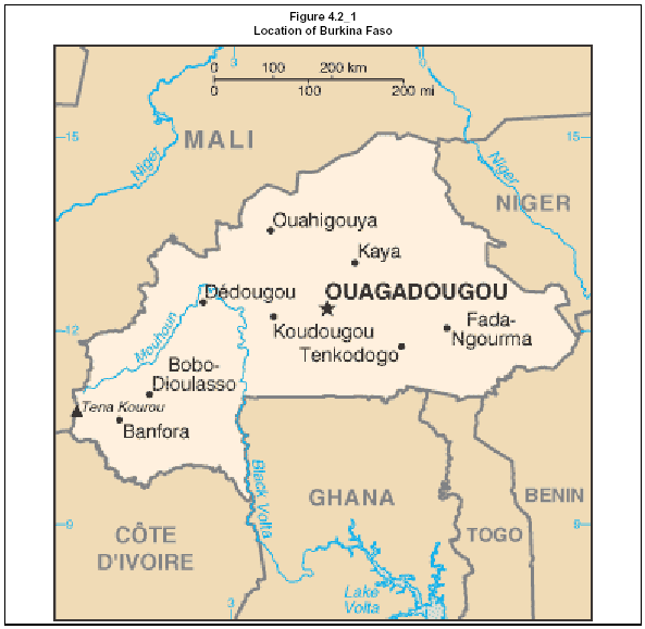
Belahouro Gold Project
Update of Independent Technical Report – April 2006 | Page: 64 |

Belahouro Gold Project
Update of Independent Technical Report – April 2006 | Page: 65 |
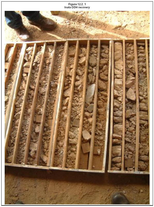
Belahouro Gold Project
Update of Independent Technical Report – April 2006 | Page: 66 |
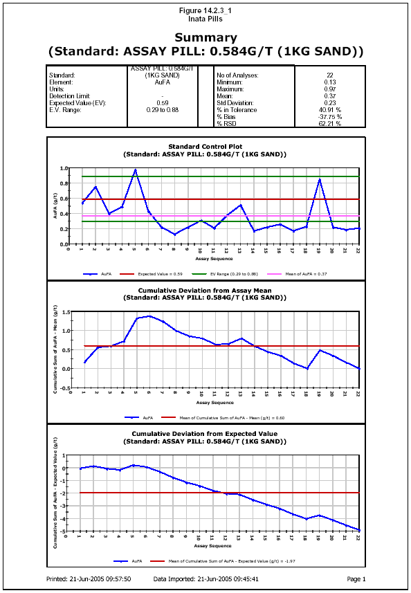
Belahouro Gold Project
Update of Independent Technical Report – April 2006 | Page: 67 |
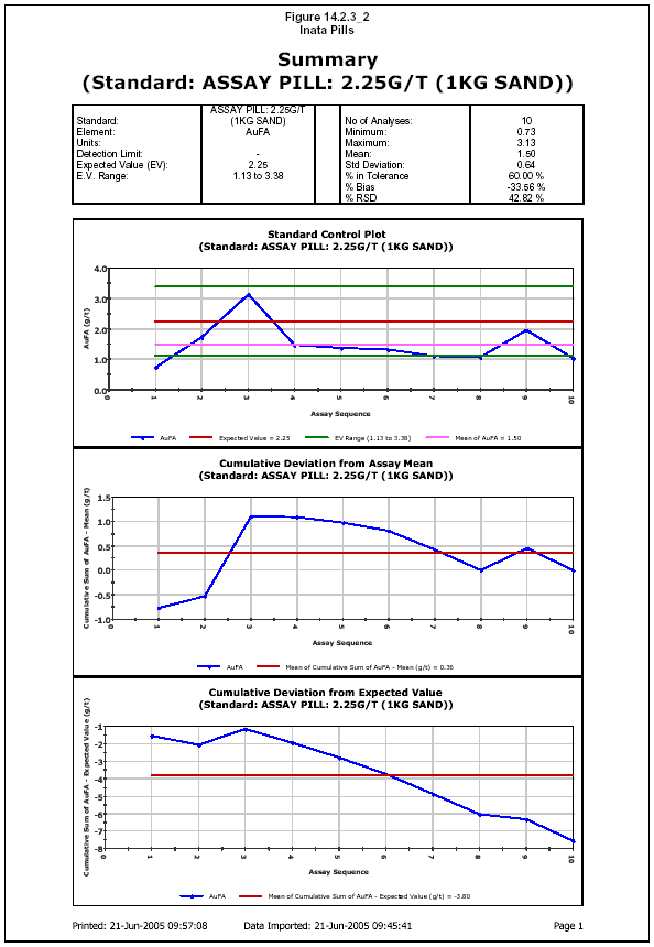
Belahouro Gold Project
Update of Independent Technical Report – April 2006 | Page: 68 |
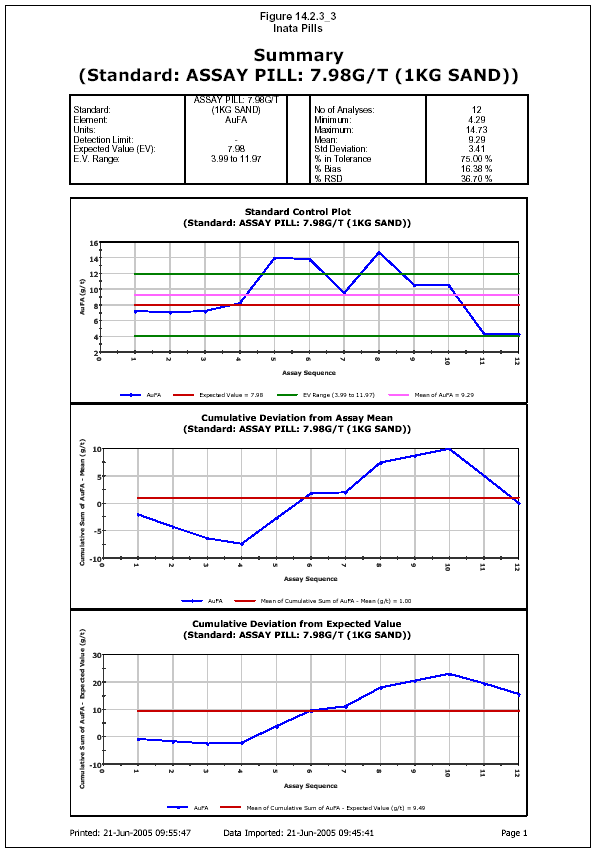
Belahouro Gold Project
Update of Independent Technical Report – April 2006 | Page: 69 |
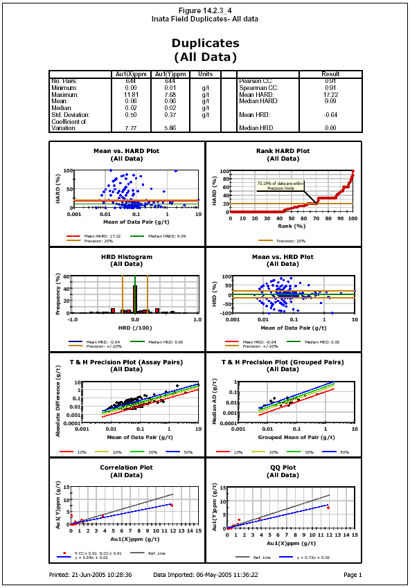
Belahouro Gold Project
Update of Independent Technical Report – April 2006 | Page: 70 |
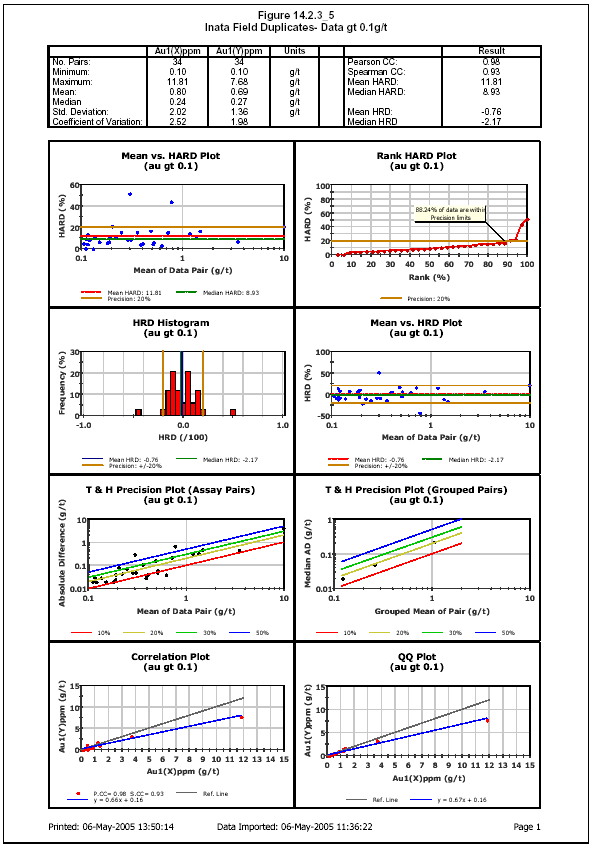
Belahouro Gold Project
Update of Independent Technical Report – April 2006 | Page: 71 |
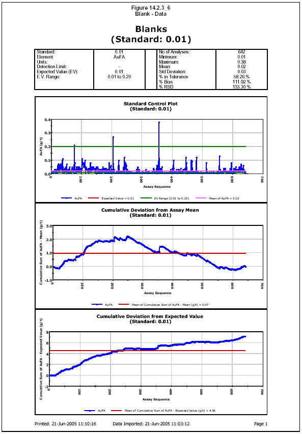
Belahouro Gold Project
Update of Independent Technical Report – April 2006 | Page: 72 |
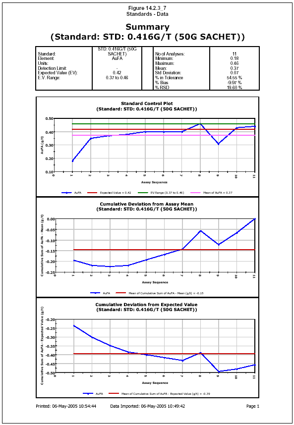
Belahouro Gold Project
Update of Independent Technical Report – April 2006 | Page: 73 |
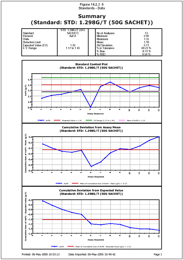
Belahouro Gold Project
Update of Independent Technical Report – April 2006 | Page: 74 |
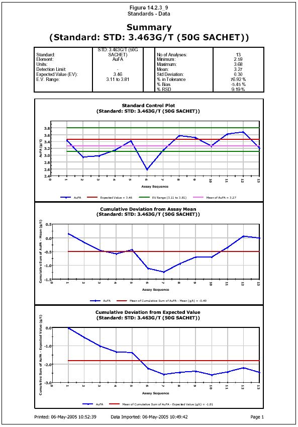
Belahouro Gold Project
Update of Independent Technical Report – April 2006 | Page: 75 |
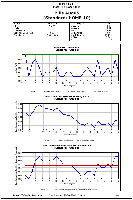
Belahouro Gold Project
Update of Independent Technical Report – April 2006 | Page: 76 |
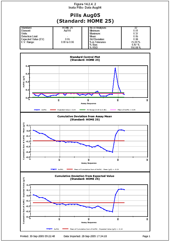
Belahouro Gold Project
Update of Independent Technical Report – April 2006 | Page: 77 |

Belahouro Gold Project
Update of Independent Technical Report – April 2006 | Page: 78 |

Belahouro Gold Project
Update of Independent Technical Report – April 2006 | Page: 79 |
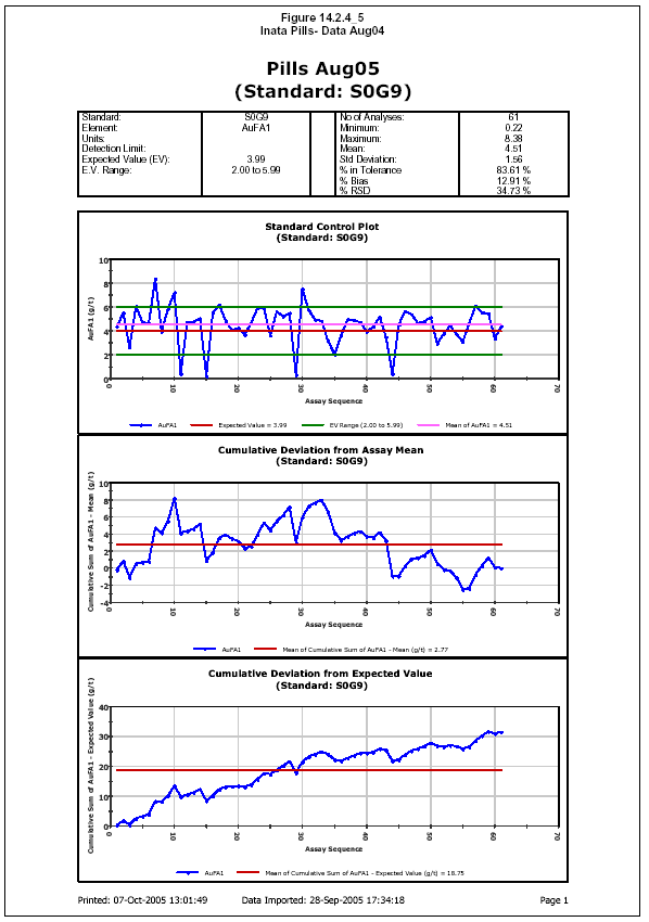
Belahouro Gold Project
Update of Independent Technical Report – April 2006 | Page: 80 |
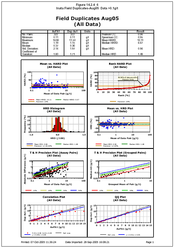
Belahouro Gold Project
Update of Independent Technical Report – April 2006 | Page: 81 |
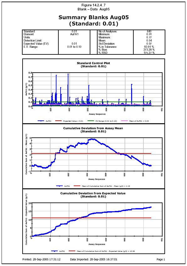
Belahouro Gold Project
Update of Independent Technical Report – April 2006 | Page: 82 |

Belahouro Gold Project
Update of Independent Technical Report – April 2006 | Page: 83 |
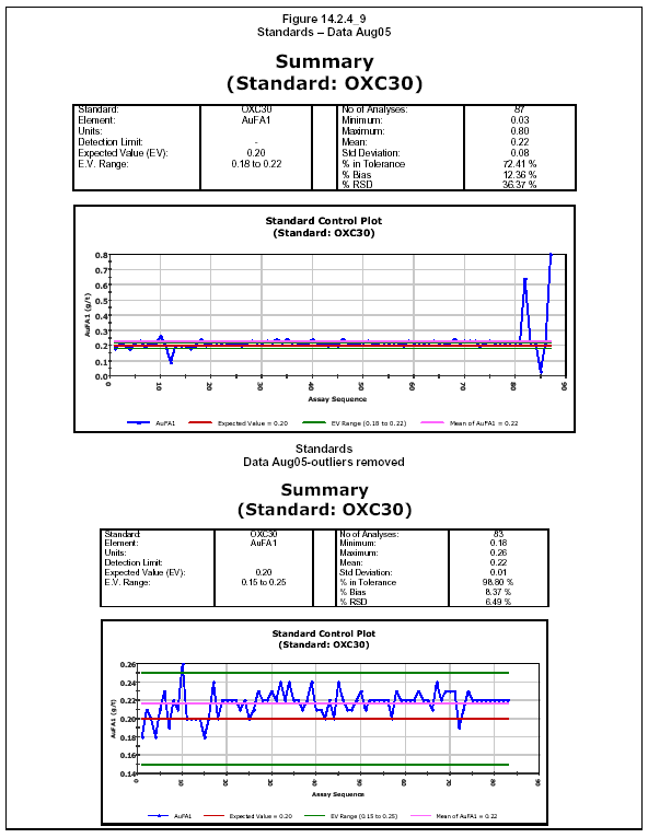
Belahouro Gold Project
Update of Independent Technical Report – April 2006 | Page: 84 |
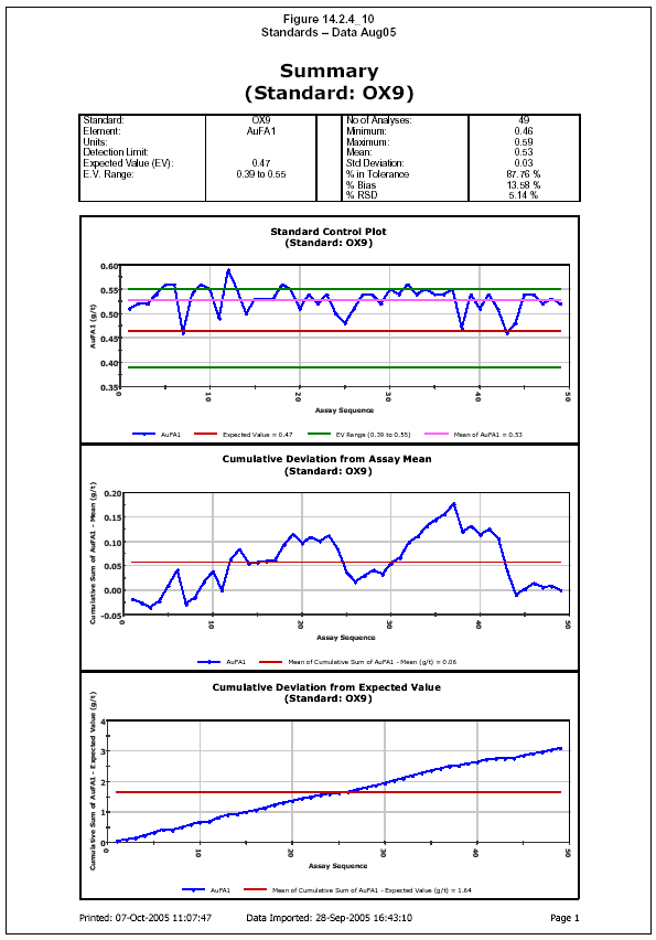
Belahouro Gold Project
Update of Independent Technical Report – April 2006 | Page: 85 |

Belahouro Gold Project
Update of Independent Technical Report – April 2006 | Page: 86 |
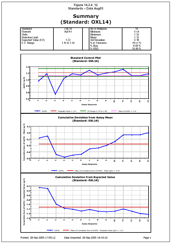
Belahouro Gold Project
Update of Independent Technical Report – April 2006 | Page: 87 |
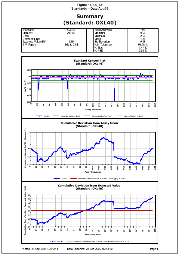
Belahouro Gold Project
Update of Independent Technical Report – April 2006 | Page: 88 |
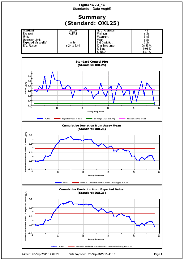
Belahouro Gold Project
Update of Independent Technical Report – April 2006 | Page: 89 |

Belahouro Gold Project
Update of Independent Technical Report – April 2006 | Page: 90 |
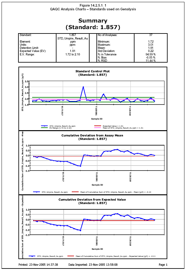
Belahouro Gold Project
Update of Independent Technical Report – April 2006 | Page: 91 |

Belahouro Gold Project
Update of Independent Technical Report – April 2006 | Page: 92 |

Belahouro Gold Project
Update of Independent Technical Report – April 2006 | Page: 93 |
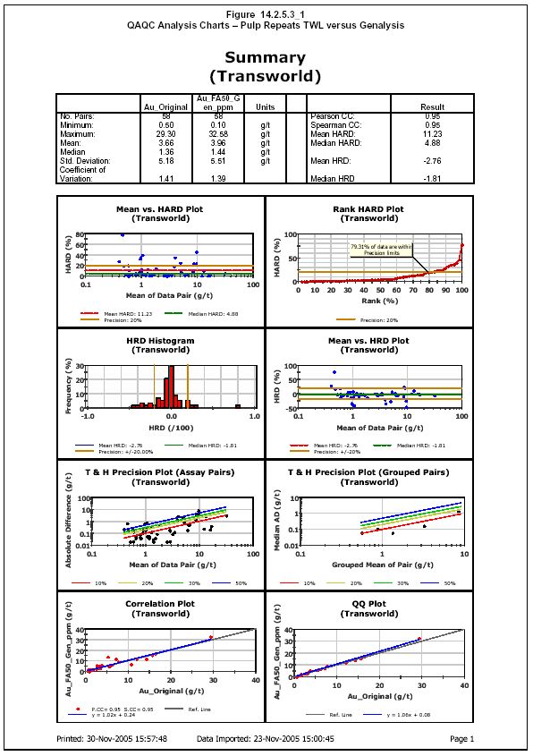
Belahouro Gold Project
Update of Independent Technical Report – April 2006 | Page: 94 |
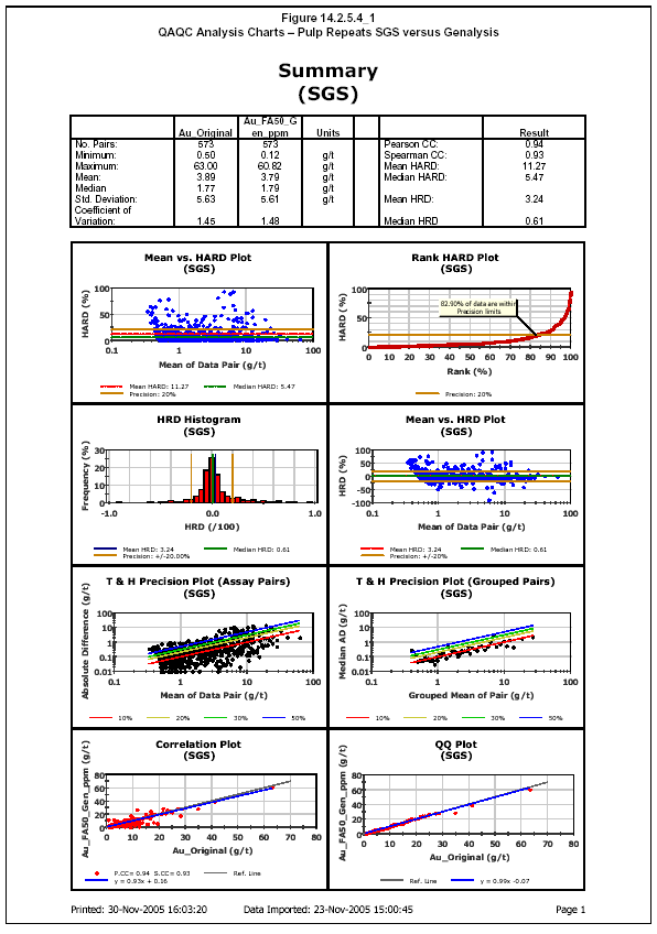
Belahouro Gold Project
Update of Independent Technical Report – April 2006 | Page: 95 |
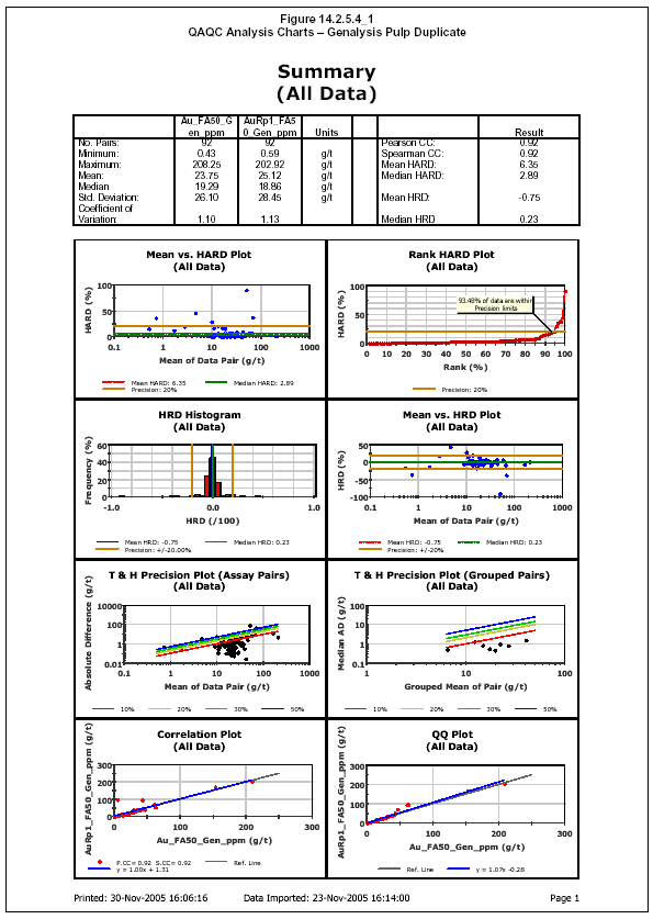
Belahouro Gold Project
Update of Independent Technical Report – April 2006 | Page: 96 |
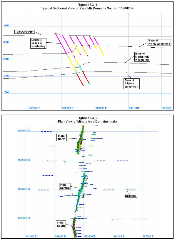
Belahouro Gold Project
Update of Independent Technical Report – April 2006 | Page: 97 |
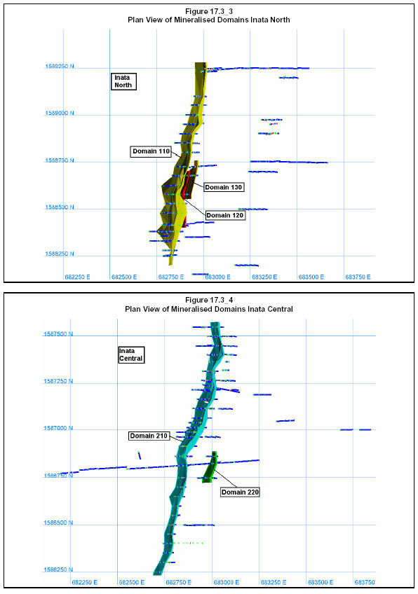
Belahouro Gold Project
Update of Independent Technical Report – April 2006 | Page: 98 |
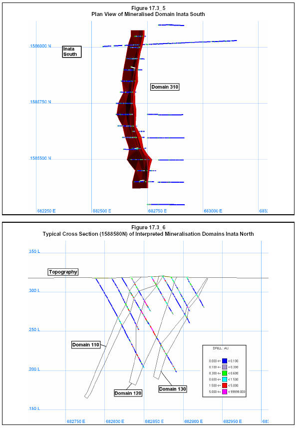
Belahouro Gold Project
Update of Independent Technical Report – April 2006 | Page: 99 |
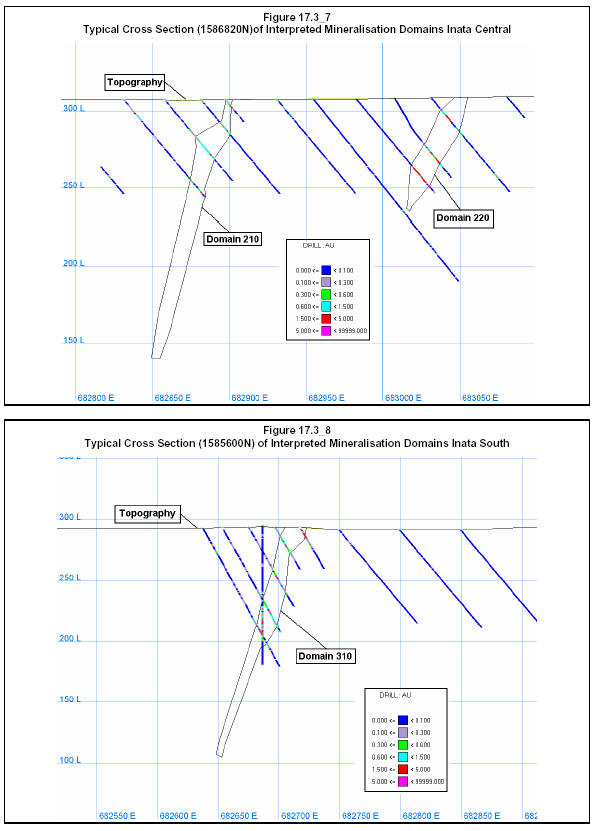
Belahouro Gold Project
Update of Independent Technical Report – April 2006 | Page: 100 |
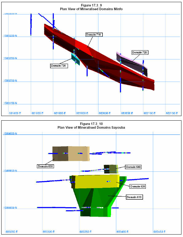
Belahouro Gold Project
Update of Independent Technical Report – April 2006 | Page: 101 |
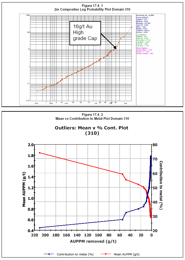
Belahouro Gold Project
Update of Independent Technical Report – April 2006 | Page: 102 |
24 CERTIFICATES
Certificate of Qualified Person
As a reviewer and author of the report entitled "Inata Minfo and Sayouba Deposits – Database Review Geological Modelling and Resource Estimate – April 2006 update" dated April, 2006, on the Belahouro Gold property of Goldbelt Resources Limited (the "Study"), I hereby state:-
| 1. | My name is Brett Lawrence Gossage and I am a Partner and Manager - Resources with the firm of RSG Global Pty. Ltd. of 1162 Hay Street, West Perth, WA, 6005, Australia. My residential address is 144 Daglish Street, Wembley, WA, 6014, Australia.
|
| 2. | I am a practising geologist registered with the Australasian Institute of Mining and Metallurgy.I am a member of the AusIMM (108490).
|
| 3. | I am a graduate of Curtin University of Technology and hold a Bachelor of Applied Science in Geology (1988) and a Post Graduate Certificate in Geostatistics (Edith Cowan University - 1999).
|
| 4. | I have practiced my profession continuously since 1989.
|
| 5. | I am a "qualified person" as that term is defined in National Instrument 43-101 (Standards of Disclosure for Mineral Projects) (the "Instrument").
|
| 6. | While I have not personally visited the Belahouro Gold Property, another member of theRSG Global study team has visited the property. I have performed consulting services during and reviewed files and data supplied by Goldbelt Resources Limited between April and June September.
|
| 7. | I contributed to all sections of the report.
|
| 8. | I am not aware of any material fact or material change with respect to the subject matter of the Study which is not reflected in the Study, the omission of which would make the Study misleading.
|
| 9. | I am independent of Goldbelt Resources Limited pursuant to section 1.5 of the Instrument.
|
| 10. | I have read the National Instrument and Form 43-101F1 (the "Form") and the Study has been prepared in compliance with the Instrument and the Form.
|
| 11. | I do not have nor do I expect to receive a direct or indirect interest in the Belahouro Gold property of Goldbelt Resources Limited, and I do not beneficially own, directly or indirectly, any securities of Goldbelt Resources Limited or any associate or affiliate of such company. |
| | | |
| Dated at Perth, Western Australia, on 30th April, 2006. |
| [signed] | |
Brett Gossage
Partner and Senior Consulting Geologist | BAppSc (Geology)
Post Grad Cert Geostatistics |
Belahouro Gold Project
Update of Independent Technical Report – April 2006 | Page: 103 |
RSG Global Pty. Ltd.
Certificate of Qualified Person
As an author of the report entitled "Inata Minfo and Sayouba Deposits – Database Review Geological Modelling and Resource Estimate – April 2006 update" dated April, 2006, on the Belahouro Gold property of Goldbelt Resources Limited (the "Study"), I hereby state:-
| 1. | My name is David Andrew Slater and I am a Senior Resource Geologist with the firm of RSG Global Pty. Ltd. of 1162 Hay Street, West Perth, 6005. My residential address is 93A Marmon Street, Fremantle, Western Australia.
|
| 2. | I am a practising Geologist registered with the AusIMM. I am a member of AusIMM.
|
| 3. | I am a graduate of RMIT University and hold an Applied Science (Geology) degree (1987).
|
| 4. | I have practiced my profession continuously since 1988.
|
| 5. | I am a "qualified person" as that term is defined in National Instrument 43-101 (Standards of Disclosure for Mineral Projects) (the "Instrument").
|
| 6. | While I have not personally visited the Belahouro Gold Property, one other member of the RSG Global Study team have visited the property. I have performed consulting services during and reviewed files and data supplied by Goldbelt Resources Limited between April and September 2005.
|
| 7. | I prepared Section 17 and contributed to the preparation of Sections 1 and 16 of the Study.
|
| 8. | I am not aware of any material fact or material change with respect to the subject matter of the Study, which is not reflected in the Study, the omission of which would make the Study misleading.
|
| 9. | I am independent of Goldbelt Resources Limited pursuant to section 1.5 of the Instrument.
|
| 10. | I have read the National Instrument and Form 43-101F1 (the "Form") and the Study has been prepared in compliance with the Instrument and the Form.
|
| 11. | I do not have nor do I expect to receive a direct or indirect interest in the Belahouro Gold property of Goldbelt Resources Limited, and I do not beneficially own, directly or indirectly, any securities of Goldbelt Resources Limited or any associate or affiliate of such company. |
| | |
| Dated at Perth, Western Australia, on 30 April, 2006. |
| [signed] | | |
David Slater
Resource Geologist | BAppSci (Geol),Dip.Ed.
|
Belahouro Gold Project
Update of Independent Technical Report – April 2006 | Page: 104 |
RSG Global Pty. Ltd.
Certificate of Qualified Person
As an author of the report entitled "Inata Minfo and Sayouba Deposits – Database Review Geological Modelling and Resource Estimate – April 2006 update" dated April, 2005, on the Belahouro Gold property of Goldbelt Resources Limited (the "Study"), I hereby state:-
| 1. | My name is Beau Nicholls and I am and have been employed since 2000 as a Consulting Geologist with the firm of RSG Global Pty. Ltd. of 1162 Hay Street, West Perth, 6005.
|
| 2. | I am a practising geologist with 10 years of Mining and Exploration geological experience. I have worked in Australia, Eastern Europe and currently West Africa. I am a member of the Australian Institute of Geoscientists ("AIG").
|
| 3. | I am a graduate of Western Australian School of Mines – Kalgoorlie and hold a Bachelor of Science Degree in Mineral Exploration and Mining Geology (1995).
|
| 4. | I have practiced my profession continuously since 1995.
|
| 5. | I am a "qualified person" as that term is defined in National Instrument 43-101 (Standards of Disclosure for Mineral Projects) (the "Instrument").
|
| 6. | I have visited the Belahouro project on three separate occasions between 13th to 17th March 2005, 8th to 13th April 2005 and 26th to 29th April 2005. During these visits I reviewed the data integrity along with drilling and sampling procedures used in this report. I am also providing ongoing consulting advice to current exploration and resource definition techniques being applied currently by Goldbelt Resources Limited.
|
| 7. | I contributed to the preparation of Sections 2 to 14 of the Study.
|
| 8. | I am not aware of any material fact or material change with respect to the subject matter of the Study, which is not reflected in the Study, the omission of which would make the Study misleading.
|
| 9. | I am independent of Goldbelt Resources Limited pursuant to section 1.5 of the Instrument.
|
| 10. | I have read the National Instrument and Form 43-101F1 (the "Form") and the Study has been prepared in compliance with the Instrument and the Form.
|
| 11. | I do not have nor do I expect to receive a direct or indirect interest in the Belahouro Gold property of Goldbelt Resources Limited, and I do not beneficially own, directly or indirectly, any securities of Goldbelt Resources Limited or any associate or affiliate of such company. |
| | |
| Dated at Perth, Western Australia, on 30 April, 2006. |
With best regards
| [signed] | | |
Beau Nicholls
Regional Manager - West Africa | BSc
|
Belahouro Gold Project
Update of Independent Technical Report – April 2006 | Page: 105 |