| OMB APPROVAL OMB Number: 3235-0116 Expires: July 31, 2008 Estimated average burden hours per response 6.2 |
| UNITED STATES SECURITIES AND EXCHANGE COMMISSION Washington, D.C. 20549 |
| FORM 6-K |
| REPORT OF FOREIGN ISSUER PURSUANT TO RULE 13a-16 AND 15d-16 UNDER THE SECURITIES EXCHANGE ACT OF 1934 |
| For the Period February 2006 |
| File No. 001-32267 |
| Desert Sun Mining Corp. (Name of Registrant) |
| 65 Queen Street West, Suite 810, P.O. Box 67, Toronto, Ontario CANADA M5H 2M5 (Address of principal executive offices) |
| 1. Updated Jacobina and Bahia Gold Belt Property Report, Results of 2005 Exploration Program |
| Indicate by check mark whether the registrant files or will file annual reports under cover Form 20-F or Form 40-F. Form 20-FForm 40-F..XXX. Indicate by check mark if the registrant is submitting the Form 6-K in paper as permitted by Regulation S-T Rule 101(b)(1): ____ Note: Regulation S-T Rule 101(b)(1) only permits the submission in paper of a Form 6-K if submitted solely to provide an attached annual report to security holders. Indicate by check mark if the registrant is submitting the Form 6-K in paper as permitted by Regulation S-T Rule 101(b)(7): ____ Note: Regulation S-T Rule 101(b)(7) only permits the submission in paper of a Form 6-K if submitted to furnish a report or other document that the registrant foreign private issuer must furnish and make public under the laws of the jurisdiction in which the registrant is incorporated, domiciled or legally organized (the registrant's "home country"), or under the rules of the home country exchange on which the registrant's securities are traded, as long as the report or other document is not a press release, is not required to be and has not been distributed to the registrant's security holders, and, if discussing a material event, has already been the subject of a Form 6-K submission or other Commission filing on EDGAR. Indicate by check mark whether by furnishing the information contained in this Form, the registrant is also thereby furnishing the information to the Commission pursuant to Rule 12g3-2(b) under the Securities Exchange Act of 1934. Yes .....No .XXX. If "Yes" is marked, indicate below the file number assigned to the registrant in connection with Rule 12g3-2(b): 82- ________ SEC 1815 (9-05)Potential persons who are to respond to the collection of information contained in this form are not required to respond unless the form displays a currently valid OMB control number. |

| AN UPDATED MINERAL RESOURCE AND MINERAL RESERVE ESTIMATE AND RESULTS OF 2005 EXPLORATION PROGRAM FOR THE JACOBINA AND BAHIA GOLD BELT PROPERTY, BAHIA STATE, BRAZIL |
| DECEMBER 2005 |

| Updated Resource & Reserve Estimate, Jacobina Dec 2005 |
| TABLE OF CONTENTS | |||
| Page | |||
| 1.0 | SUMMARY | 1 | |
| 1.1 | OVERVIEW | 1 | |
| 1.2 | GEOLOGY AND MINERALIZATION | 2 | |
| 1.3 | MINERAL RESOURCES | 2 | |
| 1.4 | MINERAL RESERVES | 3 | |
| 1.5 | CONCLUSIONS AND RECOMMENDATIONS | 5 | |
| 2.0 | INTRODUCTION AND TERMS OF REFERENCE | 7 | |
| 3.0 | DISCLAIMER | 9 | |
| 4.0 | PROPERTY DESCRIPTION AND LOCATION | 10 | |
| 5.0 | ACCESSIBILITY, CLIMATE, LOCAL RESOURCES, INFRASTRUCTURE AND | ||
| PHYSIOGRAPHY | 12 | ||
| 6.0 | HISTORY | 13 | |
| 6.1 | PRE-1970’S | 13 | |
| 6.2 | ANGLO AMERICAN-WILLIAM RESOURCES (1970-1998) | 13 | |
| 6.3 | DESERT SUN MINING (2002 – PRESENT) | 15 | |
| 6.3.1 | Exploration 2002-present | 15 | |
| 6.3.2 | Resource and Reserve Estimation (2003-present) | 16 | |
| 6.3.3 | Mining (2004-present) | 16 | |
| 7.0 | GEOLOGICAL SETTING | 18 | |
| 7.1 | REGIONAL GEOLOGY | 18 | |
| 7.2 | PROPERTY GEOLOGY | 18 | |
| 7.2.1 | Archean Basement Rocks | 22 | |
| 7.2.2 | Campo Formoso Mafic-Ultramafic Complex | 23 | |
| 7.2.3 | Jacobina Group | 23 | |
| 7.2.4 | Ultramafic Sills and Dikes | 29 | |
| 7.2.5 | Late- to Post-tectonic Granites | 30 | |
| 7.2.6 | Mafic Dikes | 30 | |
| 7.2.7 | Chapada Diamantina and Una Groups | 30 | |
| 7.2.8 | Structural Geology | 31 | |
| 8.0 | DEPOSIT TYPES | 33 | |
| 8.1 | THE WITWATERSRAND BASIN | 33 | |
| 8.2 | TARKWA | 34 | |
| 8.3 | THE RORAIMA GROUP | 35 | |
| 8.4 | JACOBINA | 35 | |
| 8.5 | COMPARISONS BETWEEN JACOBINA, TARKWA AND WITWATERSRAND | ||
| 35 | |||
| i | |||

| Updated Resource & Reserve Estimate, Jacobina Dec 2005 |
| 9.0 | MINERALIZATION | 39 | ||
| 9.1 | GOLD MINERALIZATION | 39 | ||
| 9.1.1 | Jacobina Group Domain | 41 | ||
| 9.1.2 | Mundo Novo Greenstone Belt Domain | 48 | ||
| 10.0 | EXPLORATION | 49 | ||
| 10.1 | OVERVIEW | 49 | ||
| 10.2 | 2002 EXPLORATION PROGRAM | 49 | ||
| 10.3 | 2003 EXPLORATION PROGRAM | 51 | ||
| 10.4 | 2004 EXPLORATION PROGRAM | 51 | ||
| 10.5 | 2005 EXPLORATION PROGRAM | 51 | ||
| 10.5.1 | Overview | 51 | ||
| 10.5.2 | Exploration Program, Jacobina Mine area | 52 | ||
| 10.5.3 | Exploration program, Bahia Gold Belt (excluding Jacobina Mine area) | 52 | ||
| 11.0 | DRILLING | 57 | ||
| 11.1 | JMC | 57 | ||
| 11.2 | DESERT SUN | 57 | ||
| 11.3 | DRILL HOLE DATABASE | 58 | ||
| 11.3.1 | Jacobina Mine Area | 58 | ||
| 11.3.2 | Northern Bahia Gold Belt | 59 | ||
| 11.4 | DRILLING RESULTS – JACOBINA MINE AREA | 60 | ||
| 11.4.1 | Canavieiras | 60 | ||
| 11.4.2 | Morro do Vento extension | 80 | ||
| 11.4.3 | Joao Belo Zone | 86 | ||
| 11.4.4 | Morro do Vento | 88 | ||
| 11.4.5 | Serra do Córrego | 94 | ||
| 11.4.6 | Other Targets | 94 | ||
| 11.5 | DRILLING RESULTS – NORTHERN BAHIA GOLD BELT | 96 | ||
| 11.5.1 | Pindobaçu | 96 | ||
| 11.5.2 | Fumaça | 104 | ||
| 11.5.3 | Entry Point | 106 | ||
| 11.5.4 | Other Targets | 109 | ||
| 12.0 | SAMPLING METHOD AND APPROACH | 110 | ||
| 12.1 | JMC EXPLORATION | 110 | ||
| 12.2 | DSM EXPLORATION | 110 | ||
| 13.0 | SAMPLE PREPARATION, ANALYSES AND SECURITY | 111 | ||
| 13.1 | JMC | 111 | ||
| 13.2 | DSM | 112 | ||
| 13.2.1 | Security | 112 | ||
| 13.2.2 | Sample Preparation and Analyses | 112 | ||
| 14.0 | DATA VERIFICATION | 120 | ||
| 14.1 | JMC | 120 | ||
| 14.1.1 | Production Reconciliation | 120 | ||
| ii | ||||

| Updated Resource & Reserve Estimate, Jacobina Dec 2005 |
| 14.2 | DSM | 121 | ||
| 14.2.1 | QA/QC | 121 | ||
| 14.2.2 | Database Checks | 126 | ||
| 15.0 | ADJACENT PROPERTIES | 127 | ||
| 16.0 | MINERAL PROCESSING AND METALLURGICAL TESTING | 128 | ||
| 16.1 | JACOBINA PROCESSING PLANT | 128 | ||
| 16.2 | MORRO DO VENTO TESTWORK | 129 | ||
| 16.2.1 | Proposed Plant Expansion | 129 | ||
| 17.0 | MINERAL RESOURCE AND MINERAL RESERVE ESTIMATES | 130 | ||
| 17.1 | OVERVIEW | 130 | ||
| 17.2 | MINERAL RESOURCE ESTIMATES | 130 | ||
| 17.2.1 | Database | 130 | ||
| 17.2.2 | Specific Gravity | 130 | ||
| 17.2.3 | Estimation Methodology | 131 | ||
| 17.2.4 | Resource Estimation | 132 | ||
| 17.2.5 | Mineral Resources | 133 | ||
| 17.3 | MINERAL RESERVES | 153 | ||
| 17.3.1 | Jacobina Mine (Joao Belo Zone) | 153 | ||
| 17.3.2 | Morro do Vento | 161 | ||
| 17.3.3 | Morro Do Vento Extension | 166 | ||
| 17.3.4 | Serra Do Corrego | 167 | ||
| 17.4 | RESPONSIBILITY FOR ESTIMATION | 169 | ||
| 18.0 | OTHER RELEVANT DATA AND INFORMATION | 170 | ||
| 19.0 | INTERPRETATION AND CONCLUSIONS | 171 | ||
| 19.1 | MINERAL RESOURCES | 172 | ||
| 19.2 | MINERAL RESERVES | 173 | ||
| 19.3 | EXPLORATION AND DEVELOPMENT | 174 | ||
| 19.3.1 | Exploration | 174 | ||
| 19.3.2 | Development and Exploration | 175 | ||
| 20.0 | RECOMMENDATIONS | 176 | ||
| 21.0 | REFERENCES | 177 | ||
| 22.0 | CERTIFICATE | 183 | ||
| CERTIFICATE – WILLIAM PEARSON | 183 | |||
| CERTIFICATE – PETER TAGLIAMONTE | 185 | |||
| APPENDIX I | TITLE OPINION, LIST OF CLAIMS AND MAPS SHOWING | |||
| LOCATION AND EXTENT OF CLAIMS | 187 | |||
| iii | ||||

| Updated Resource & Reserve Estimate, Jacobina Dec 2005 |
APPENDIX II INDUCED POLARIZATION SUMMARY REPORT FOR
PINDOBAÇU 188
| APPENDIX III YEAR END 2005 OPINION LETTER, MICON INTERNATIONAL 199 |
| LIST OF TABLES | ||||
| Page | ||||
| Table | 1.1 | Mineral Resource Summary For The Jacobina Project As Of December 20, 2005 | 3 | |
| Table | 1.2 | Estimated Mineral Reserves as of December 31, 2005, Jacobina Mine Area | 4 | |
| Table | 6.1 | Jacobina Annual Production History 1983-1998 | 14 | |
| Table | 8.1 | A Comparison Between Jacobina, Tarkwa and the Witwatersrand Gold Deposits | 37 | |
| Table | 9.1 | Characteristics of Principal Mineralized Reefs, Jacobina Mine Area | 45 | |
| Table | 10.1 | Exploration Diamond Drilling In Jacobina Mine Area By Dsm, 2005 | ||
| Exploration Program | 52 | |||
| Table | 11.1 | Summary of Diamond Drilling, Jacobina Mine Area (As Of December 31, 2005). 58 | ||
| Table | 11.2 | Assay Samples in Database – Jacobina Mine Area (as of December 31, 2005) | 59 | |
| Table | 11.3 | Summary of Drilling, Northern Bahia Gold Belt (as of December 31, 2005) | 59 | |
| Table | 11.4 | Assay Samples in Database - Northern Bahia Gold Belt (as of December 31, | ||
| 2005) | 60 | |||
| Table | 11.5 | Significant Drilling Results, Canavieiras | 63 | |
| Table | 11.6 | Significant Historical Drilling Results, South Extension Area, Canavieiras | 75 | |
| Table | 11.7 | Results For Re-Sampling Of Core From Old Drill Holes At Canavieiras | 76 | |
| Table | 11.8 | Significant Drilling Results, Morro Do Vento Extension (Main/Basal Reef) | 81 | |
| Table | 11.9 | Significant Results of Deep Drilling at the Jacobina Mine (João Belo Zone) | 86 | |
| Table | 11.10 | Significant Drilling Results, Northern Area, Bahia Gold Belt | 98 | |
| Table | 11.11 | Significant Drilling Results, Fumaca, Northern Area, Bahia Gold Belt | 105 | |
| Table | 11.12 | Significant Drilling Results, Entry Point Area, Northern Area, Bahia Gold Belt | 107 | |
| Table | 17.1 | Summary of Mineral Resources Updated by DSM and Reviewed and | ||
| Confirmed by Micon as of December 20, 2005 | 134 | |||
| Table | 17.2 | Summary of Measured and Indicated Mineral Resources, Joao Belo Zone | ||
| as of December 20, 2005 | 136 | |||
| Table | 17.3 | Summary of Inferred Mineral Resources, Joao Belo Zone as of December | ||
| 20, 2005 | 136 | |||
| Table | 17.4 | Summary of Measured and Indicated Mineral Resources, Morro do Vento | ||
| Zone, Intermediate Reefs | 138 | |||
| Table | 17.5 | Summary of Inferred Mineral Resources, Morro do Vento Zone, Intermediate | ||
| Reefs | 138 | |||
| Table | 17.6 | Summary of Measured and Indicated Mineral Resources, Morro do Vento Zone, | ||
| Basal and Main Reefs | 141 | |||
| Table | 17.7 | Summary of Inferred Mineral Resources, Morro do Vento Zone, Basal and | ||
| Main Reefs | 141 | |||
| Table | 17.8 | Summary of Measured and Indicated Mineral Resources, Morro do Vento | ||
| Extension Zone, Basal and Main Reefs | 144 | |||
| Table | 17.9 | Summary of Measured and Indicated Mineral Resources, Canavieiras | 145 | |
| iv | ||||

| Updated Resource & Reserve Estimate, Jacobina Dec 2005 |
| Table 17.10 | Summary of Inferred Mineral Resources, Canavieiras | 145 | |
| Table 17.11 | Summary of Measured and Indicated Mineral Resources, Serra do Córrego, | ||
| Intermediate Reefs | 149 | ||
| Table 17.12 | Summary of Inferred Mineral Resources, Serra do Córrego, Intermediate Reefs 149 | ||
| Table 17.13 | Summary of Inferred Mineral Resources in Other Areas, Jacobina Mine Area | 152 | |
| Table 17.14 | Estimated Mineral Reserves as of December 31, 2005, Jacobina Mine Area | 153 | |
| Table 17.15 | Mineral Reserves, Jacobina Mine (Joao Belo Zone) as at December 31, 2005 | 154 | |
| Table 17.16 | Grade of Dilution, Joao Belo Zone | 160 | |
| Table 17.17 | Mineral Reserves, Morro Do Vento Zone as at December 31, 2005 | 161 | |
| Table 17.18 | Mineral Reserves, Morro Do Vento Extension Zone as at December 31, 2005 | 166 | |
| Table 17.19 | Mineral Reserves, Serra Do CÓrrego Zone as at December 31, 2005 | 167 | |
| Table 19.1 | Mineral Resource Summary for the Jacobina Project as of December 20, 2005 | 172 | |
| Table 19.2 | Estimated Mineral Reserves as of December 31, 2005, Jacobina Mine Area | 173 | |
| LIST OF FIGURES | |||
| Page | |||
| Figure | 4.1 | Jacobina Project Location Map | 11 |
| Figure | 7.1 | Geotectonic Setting of the Eastern Part of the São Francisco Craton, State of Bahia | |
| Showing Location of the Jacobina Group and the Mundo Novo Greenstone Belt | 19 | ||
| Figure | 7.2 | Geology of the Serra de Jacobina and the Bahia Gold Belt | 20 |
| Figure | 7.3 | Geology of the Central Bahia Gold Belt | 21 |
| Figure | 7.4 | Geology of the Jacobina Gold Mine Area | 25 |
| Figure | 7.5 | Stratigraphic Column of the Serra do Córrego Formation, Jacobina Group | 26 |
| Figure | 7.6 | Geology of the Jacobina Gold Mine Area | 27 |
| Figure | 9.1 | Map of the Bahia Gold Belt Showing Location of Gold Mines and Occurrences | 40 |
| Figure | 9.2 | Geological Map of the Jacobina Mine Area Showing Distribution of Gold- | |
| bearing Reefs | 42 | ||
| Figure | 9.3 | Geological Cross Section Through the Morro do Vento Zone | 43 |
| Figure | 9.4 | Geological Cross Section through the João Belo Zone (Jacobina Mine) | 44 |
| Figure | 10.1 | Major Targets in the Jacobina Mine area | 50 |
| Figure | 10.2 | Geology and Major Target Areas – Pindobaçu, Northern Bahia Gold Belt | 54 |
| Figure | 11.1 | Canavieiras Cross Section N878300 looking north | 62 |
| Figure | 11.2 | Grade times Thickness Contour Plan Map of the MU Reef, Canavieiras | 73 |
| Figure | 11.3 | Coarse Native Gold in Hollandez Reef, Drill Hole CAN-106 | 77 |
| Figure | 11.4 | 3-D Model of Induced Polarization Chargeability at Canavieiras | 79 |
| Figure | 11.5 | Morro do Vento Extension Vertical Longitudinal Section Showing Grade | |
| Times Thickness Contours | 85 | ||
| Figure | 11.6 | Joao Belo Vertical Longitudinal Section Showing Grade times Thickness | |
| Contours | 87 | ||
| Figure | 11.7 | Geological Plan Map of the Morro do Vento Area | 90 |
| Figure | 11.8 | Morro do Vento Cross Section N8754200 | 91 |
| Figure | 11.9 | Vertical Longitudinal Section of the MU Reef, Morro do Vento, Showing | |
| Grade Times Thickness Contours | 92 | ||
| Figure | 11.10 Vertical Longitudinal Section of the LU Reef, Morro do Vento, Showing | ||
| v | |||

| Updated Resource & Reserve Estimate, Jacobina Dec 2005 |
| Grade times Thickness Contours | 93 | ||
| Figure | 11.11 | Plan Map Showing Geology and Diamond Drill Hole Locations, Pindobaçu | |
| Target, Northern Bahia Gold Belt | 102 | ||
| Figure | 11.12 | Drill Hole Cross Section, Pindobaçu, Section 8,811,950N | 103 |
| Figure | 11.13 | Cross Section 8817800N, Entry Point Area, Northern Bahia Gold Belt | 108 |
| Figure | 13.1 | Graph of Analytical Results at Lakefield for Standard OREAS 6Pb | 117 |
| Figure | 13.2 | Graph of Analytical Results at Lakefield for Standard OREAS 7Pa | 118 |
| Figure | 13.3 | Graph of Analytical Results at Lakefield for Standard OREAS 53P | 119 |
| Figure | 14.1 | Comparison of All Check Assay Data, 2005 Exploration Program (3 graphs | |
| with different scales showing the overall range of the data set) | 122 | ||
| Figure | 14.2 | Comparison of Check Assay Data, 2005 Exploration Program – Lakefield | |
| versus Chemex Pulps | 124 | ||
| Figure | 14.3 | Comparison of Check Assay Data, 2005 Exploration Program – Lakefield | |
| versus Chemex Rejects | 125 | ||
| Figure | 17.1 | Vertical Longitudinal Section of the LMPC Reef, Joao Belo Zone Showing | |
| Distribution of Mineral Resource Blocks | 137 | ||
| Figure | 17.2 | Vertical Longitudinal Section of the MU Reef, Morro do Vento Zone Showing | |
| Distribution of Mineral Resource Blocks | 139 | ||
| Figure | 17.3 | Vertical Longitudinal Section of the LU Reef, Morro do Vento Zone Showing | |
| Distribution of Mineral Resource Blocks | 140 | ||
| Figure | 17.4 | Vertical Longitudinal Section of the Basal Reef, Morro do Vento-Morro do | |
| Vento Extension Areas Showing Distribution of Mineral Resource Blocks | 142 | ||
| Figure | 17.5 | Vertical Longitudinal Section of the Main Reef, Morro do Vento-Morro do | |
| Vento Extension Areas Showing Distribution of Mineral Resource Blocks | 143 | ||
| Figure | 17.6 | Plan Map of Piritoso Reef, Canavieiras Mine, Showing Distribution of | |
| Mineral Resource Blocks | 146 | ||
| Figure | 17.7 | Plan map of MU Reef, Canavieiras Mine, Showing Distribution of Mineral | |
| Resource Blocks | 147 | ||
| Figure | 17.8 | Plan Map of MU Reef, Canavieiras Mine, Showing Distribution of Mineral | |
| Resource Blocks | 148 | ||
| Figure | 17.9 | Vertical Longitudinal Section of the LU Reef, Serra do Córrego Area Showing | |
| Distribution of Mineral Resource Blocks | 150 | ||
| Figure | 17.10 | Vertical Longitudinal Section of the MU Reef, Serra do Córrego Area | |
| Showing Distribution of Mineral Resource Blocks | 151 | ||
| Figure | 17.11 | Vertical longitudinal Section of the Joao Belo Zone Showing the Location of | |
| Reserve Blocks and Development | 155 | ||
| Figure | 17.12 | Typical Drilling Pattern for Stope Layout, Jacobina Mine | 157 |
| Figure | 17.13 | Schematic Diagram showing Typical Example of Dilution, Joao Belo Zone | 159 |
| Figure | 17.14 | Vertical Longitudinal Section, Morro do Vento Showing Reserve Blocks and | |
| Proposed Development | 162 | ||
| Figure | 17.15 | Vertical Longitudinal Section, Morro do Vento Showing Typical Stope Cross | |
| Section with Level Layouts | 164 | ||
| Figure | 17.16 | Typical Stope Longhole Layout, Morro do Vento | 165 |
| vi | |||

| Updated Resource & Reserve Estimate, Jacobina Dec 2005 1.0 SUMMARY |
| 1.1 OVERVIEW |
| This report summarizes the results of the 2005 exploration program and presents updated mineral resource and mineral reserve estimates incorporating new drilling results in the Jacobina Mine area and the 155km long Bahia Gold Belt property owned by Desert Sun Mining Corp. (DSM) in Bahia, Brazil. This report and the updated mineral resource estimate draws heavily from a previous NI 43-101 reports prepared Dr. William Pearson, P.Geo. and Peter Tagliamonte, P.Eng. in March 2005 and by B. Terrence Hennessey, P.Geo. of Micon International Limited (Micon) in August 2003. Similarly, the updated mineral reserve estimate draws from the Pre-feasibility study prepared by Devpro Mining in August 2005 and the Feasibility study prepared by SNC Lavalin-Dynatec in September 2003. All reports are filed on SEDAR. Desert Sun owns 100% of the Jacobina property, which includes the Jacobina Gold Mine, the Morro do Vento project currently under development, additional projects in the mine area slated for near term development, and the associated 155-kilometer long Bahia Gold Belt. Since 2002, DSM has completed a three-stage development program as follows: xIn the first stage (2002 - 2003), completed in September 2003, Desert Sun secured exclusive ownership of the Jacobina property and completed a feasibility study that supported the reopening of the Jacobina Mine. |
- The second stage (2003 - 2005), completed in June 2005, involved bringing the JacobinaMine back into production in line within the proposals contained in the SNC Lavalinfeasibility study, as modified through the development process. Rehabilitation of theJacobina Mine started in earnest in April 2004. Existing facilities were refurbished andimprovements made in the mining and processing methods. The plant facilities werecompleted in February 2005, with a rated capacity of 4,200 tonnes per day and expectedannualized production of some 100,000 ounces. The first gold pour took place in March2005 and commercial production was declared as of July 1, 2005.
- With production at the Jacobina Mine approaching 100% of design capacity, theCompany has initiated the third stage (2005 - 2009) of its development program, the goalof which is the expansion of annual production through development of additional miningareas within the immediate vicinity of the existing plant facilities to over 250,000 ouncesper annum. Planning done to date has highlighted the potential for developing fouradditional mining areas over the next three to four years in order to successfully achievethis goal.
| DSM began exploring the property in September 2002 and has had on-going exploration programs ever since. Over the past three and one-half years to December 31, 2005, a total of |
| 1 |

| Updated Resource & Reserve Estimate, Jacobina Dec 2005 |
| 65,538 in 447 surface and underground diamond drill holes have been completed. Results of this exploration which have been positive are discussed in detail within this report. |
| 1.2 GEOLOGY AND MINERALIZATION The gold mineralization of the Jacobina mine is hosted almost entirely within quartz pebble conglomerates of the Serra do Córrego Formation, the lowermost sequence of the Proterozoic- age Jacobina Group. This Formation is typically 500 m thick but locally achieves thicknesses of up to one kilometre. Overall, the property covers 155 km of strike length (8728800N – 8,900,000N) along the trend of the Jacobina Group. Within the property the Serra do Córrego Formation is exposed for 75 km (8,728,800 N – 8,810,330 N). Despite the extensive exposure of the mine sequence most of the exploration and all of the non-artisanal mining activities have been concentrated along a 10-km long (8749000N - 8759000N) central zone. The host rocks to the Jacobina gold mineralization are highly sorted and rounded quartz pebble conglomerate reefs of the Serra de Córrego Formation. Gold as fine grains 20 to 50 microns in size predominantly within well packed conglomeratic layers in which medium to larger- sized quartz pebbles are present. The gold occurs within the matrix and often in association with pyrite and fuchsite. However, these accessory minerals also occur in the absence of gold. Gold- rich reefs show a characteristic greenish aspect because of the presence of the chromium-rich muscovite, fuchsite. Intra-reef quartzites typically contain low gold grades (<0.70 g/t Au). Higher concentrations of gold are often encountered within the foreset beds, adjacent to topset beds, within a cross-bedded reef although this may also reflect structural upgrading. An important example of this style of mineralization is the Canavieiras mine, an important exploration targets. The gold-bearing reefs range in size from 1.5 to 25 m wide and can be followed along strike for hundreds of metres, and in some cases for kilometres. Some contacts between reefs and the later crosscutting mafic and ultramafic intrusives are enriched in gold. Not all conglomerates of the Serra do Córrego Formation are mineralized, and many are completely barren of gold. Although they are quite homogeneous along their strike and dip extensions, the mineralized conglomerates differ from one another in stratigraphic position and mineralization patterns. The differences are likely due to changes in the depositional environment, and possibly also in the source areas. Recent work by DSM, however, indicates that structure and hydrothermal solutions have had a more important role in localizing gold mineralization than previously recognized. |
| 1.3 MINERAL RESOURCES |
| Measured and Indicated mineral resources for all zones at Jacobina now total 27,900,000 tonnes grading 2.57g Au/t containing 2,311,000 ounces of gold (Table 1.1) . This is a significant increase of 261,000 ounces of gold compared to the December 2004 measured and indicated resource of 24,800,000 tonnes grading 2.53g Au/t containing 2,050,000 ounces of gold. Since |
| 2 |
| Updated Resource & Reserve Estimate, Jacobina Dec 2005 |
| the August 2003 resource estimate that formed the basis for the SNC-Lavalin feasibility study, exploration and development work by Desert Sun has increased Measured and Indicated mineral resources by 949,000 ounces of gold at an average discovery cost of approximately US$10 per ounce. At the Jacobina Mine, drilling and development has outlined sufficient new measured and indicated resources to replace 2005 production. Additionally, Inferred mineral resources in all zones now total 33,600,000 tonnes grading 2.80g Au/t containing 3,029,000 ounces of gold. This a substantial addition of 1,129,000 ounces of gold compared to the December 2004 inferred mineral resource of 22,200,000 tonnes grading 2.61g Au/t containing 1,900,000 ounces of gold. This increase reflects major additions at the Jacobina Mine (João Belo zone) where inferred mineral resources now total 14,430,000 tonnes grading 2.66g Au/t containing 1,235,000 ounces of gold compared to the December 2004 inferred resource of 5,300,000 grading 2.33g Au/t containing 390,000 ounces of gold. The Inferred mineral resource at Canavieiras now totals 6,900,000 tonnes grading 3.29 g Au/t containing 730,000 ounces compared to the December 2004 Inferred mineral resource of 3,700,000 tonnes grading 2.41g Au/t containing 290,000 ounces of gold, an increase of 440,000 ounces. |
| TABLE 1.1 MINERAL RESOURCE SUMMARY FOR THE JACOBINA PROJECT AS OF DECEMBER 20, 2005 |
| Category | Tonnes | Grade | Contained |
| (g/t Au) | Gold | ||
| (ounces) | |||
| Measured | 3,400,000 | 2.68 | 295,000 |
| Indicated | 24,500,000 | 2.56 | 2,016,000 |
| Total Measured and | 27,900,000 | 2.57 | 2,311,000 |
| Indicated | |||
| Inferred | 33,600,000 | 2.80 | 3,029,000 |
| B. Terrence Hennessey, P.Geo., of Micon International reviewed the updated resource estimate and confirmed that they were estimated in accordance with the requirements of National Instrument 43-101. |
| 1.4 MINERAL RESERVES |
| Proven and probable mineral reserves in the Jacobina Mine (João Belo Zone) are 13,220,000 tonnes grading 2.15 g Au/t containing 913,100 ounces of gold. Total Proven and Probable mineral reserves in all zones are 21,580,000 tonnes grading 2.18 g Au/t containing 1,510,000 |
| 3 |

| Updated Resource & Reserve Estimate, Jacobina Dec 2005 |
| ounces as summarized in Table 1.2 below. This is an increase of 310,000 ounces from the August 2005 reserve estimate (see press release August 11, 2005) This new reserve estimate is now being used in the Jacobina Mine development plan and increases mine life by over three years. A pre-feasibility study is currently in progress for the Canavieiras Mine, which has the potential to further increase reserves. The new estimate at João Belo contains a contribution from the newly discovered FW (Footwall) Reef in the main ore zone. The exploration drilling program at João Belo in 2005 also outlined inferred mineral resources totaling 1,235,000 ounces and the potential is very good that a significant portion of this resource can eventually be upgraded with further drilling to a reserve based on historical and recent experience. The mineral reserve estimate is set out in Table 1.2 below. The reserves were estimated using a gold price of US$400 per ounce and a block cutoff grade of 1.41 g Au/t. Dilution and mining recovery rates appropriate for each zone were applied following established practices at the mine. Desert Sun has all operating permits in place for production. |
| TABLE 1.2 | ESTIMATED MINERAL RESERVES AS OF DECEMBER 31, 2005, | ||||||
| JACOBINA MINE AREA | |||||||
| Mine/Area | Proven | Probable | Proven & Probable | ||||
| Ounces | |||||||
| Tonnes | g Au/t | Tonnes | g Au/t | Tonnes | g Au/t | ||
| Contained | |||||||
| Joao Belo2 | 3,007,000 | 2.18 | 10,215,000 | 2,14 | 13,220,000 | 2.15 | 913,000 |
| Morro do Vento4 | Nil | Nil | 4,672,000 | 1.95 | 4,672,000 | 1.95 | 292,000 |
| Morro do Vento | |||||||
| 3 | 58,000 | 3.57 | 2,712,000 | 2.68 | 2,770,000 | 2.69 | 240,000 |
| Ext. (Basal Reef | |||||||
| Serra de Córrego3 | Nil | Nil | 918,000 | 2.17 | 918,000 | 2.17 | 64.000 |
| Total5 | 21,580,000 | 2.18 | 1,510,000 | ||||
| 1Mineral reserves have been classified in accordance with CIM standards under NI 43-101. 2Desert Sun Mining mineral reserve estimate December 31, 2005 3Updated following original Dynatec mineral reserve estimation of September 2003 in the SNC Lavalin feasibility study (see DSM Press Release September 12, 2003). 4Desert Sun Mining mineral reserve estimate August 11, 2005 (reviewed by Devpro Mining Inc.) (see DSM Press Release August 11, 2005). 5Totals have been rounded. |
| 4 |

| Updated Resource & Reserve Estimate, Jacobina Dec 2005 |
| 1.5 CONCLUSIONS AND RECOMMENDATIONS It is recommended that DSM carry out a major exploration and development program collectively estimated to cost US$7.5 million for 2006 to followup on the success of 2005 as follows: |
- US$4.0 million exploration including a total 13,000m of diamond drilling in theCanavieiras, Serra do Córrego and Pindobaçu target areas
- US$1.5 million surface and underground drilling at Joao Belo
- US$1.5 million to drift 1500 metres and further drilling at Canavieiras
- US$0.5 million for an independent pre-feasibility study for a plant expansion,metallurgical tests for this study and geotechnical studies.
| These recommended expenditures are budgeted separately from the costs required for operation of the Jacobina mine, development of the Morro do Vento mine and operation of the processing plant. The operations budget and program are not reviewed in this report. |
| Exploration |
| At Canavieiras, the proposed exploration program, which is budgeted at US$2.0 million and includes 7,000m of diamond drilling, will focus on further extending the known mineralized reefs to the south and east. Downhole induced polarization (IP) surveys will be carried out to help define drill targets and give the wide spaced drill holes a greater area of influence in target generation. Dr. Paul Karpeta, an expert on Precambrian quartz pebble conglomerate-hosted gold deposits, will carry out a structural study of the Jacobina area to better characterize the controls on gold mineralization, especially the late hematite-gold enrichment which is the source for the very high grade intersections in the deposit. The proposed exploration program at Serra do Córrego, which includes diamond drilling of 2,800m, will focus on the Maneira, Lagartixa and Viuva target areas which have potential to host higher grade gold mineralization similar to Canavieiras. This area will also be included in Dr. Karpeta’s structural study. The budget for the proposed exploration program at Serra do Córrego is $US1.0 million. Work in 2005 continued to demonstrate the excellent potential of the Pindobaçu area to host significant gold deposits. The recommended program, which is budgeted at US$1.0 million, includes 3,200m of drilling to test the strong hydrothermal alteration zone deeper. Downhole IP surveys will be completed at Pindobaçu to aid in location of drill holes. Exploration work including geological mapping and geochemical sampling will also continued to be carried out in the Entry Point area to better characterize the distribution of the conglomerates and locate the thickest sections of conglomerates. A regional mapping and prospecting program will also be completed in the 60km of property held by DSM north of Pindobaçu. |
| 5 |

| Updated Resource & Reserve Estimate, Jacobina Dec 2005 |
| Development and Exploration |
| A US$1.5 million surface and underground exploration program is recommended at Joao Belo to followup on the successful results from the 2005 program. Drilling of deep targets will be done from surface while shallower targets will be from underground. As underground development advances, more drilling will likely be done from underground. The exploration holes will test the full stratigraphic section. Total drilling will be in the order of 8,000m. The budget includes a provision for $US1.5 million to drift 1500 metres at Canavieiras to strategically place drill platforms to test extensions of known zones, reduce drill hole length thereby enabling more ground to be tested with the same amount of drilling and increase resources. In addition this underground development will allow the opportunity to drift through the MU and LU reefs to test mining conditions and continuity of grade in the zones. Planning of the development work is in progress and the amount of drilling that can be completed in 2006 in this program will depend on the final cost and rate at which development is completed. The budget of $US0.5 million for the independent pre-feasibility study for a plant expansion includes provisions for metallurgical tests for this study and geotechnical studies. This study will look at potential plant expansion scenarios to 6,500tpd and 10,000tpd. AMEC Americas has been selected to do this work. Metallurgical tests will include testing the variability of different ore feeds to the expanded plant, test work for a potential gravity circuit and test work to size the key components in the expanded plant such as crushers, grinding mills, and leach circuit. In addition, a geotechnical assessment will be carried out at Morro do Vento Extension and Canavieiras. |
| 6 |

| Updated Resource & Reserve Estimate, Jacobina Dec 2005 2.0 INTRODUCTION AND TERMS OF REFERENCE |
| This report summarizes the results of the 2005 exploration program and presents updated mineral resource and mineral reserve estimates incorporating new drilling results in the Jacobina Mine area and the 155km long Bahia Gold Belt property owned by Desert Sun Mining Corp. (DSM) in Bahia, Brazil. This report and the updated mineral resource estimate draws heavily from previous NI 43-101 reports prepared Dr. William Pearson, P.Geo. and Peter Tagliamonte, P.Eng. in March 2005 (Pearson and Tagliamonte, 2005) and by B. Terrence Hennessey, P.Geo. of Micon International Limited (Micon) in August 2003 (Hennessey, 2003b). Similarly, the updated mineral reserve estimate draws from the Pre-feasibility study prepared by Devpro Mining in August 2005 (Adams et al., 2005) and the Feasibility study prepared by SNC Lavalin- Dynatec in September 2003. All reports are filed on SEDAR. Desert Sun owns 100% of the Jacobina property, which includes the Jacobina Gold Mine, the Morro do Vento project currently under development, additional projects in the mine area slated for near term development, and the associated 155-kilometer long Bahia Gold Belt. Since 2002, DSM has completed a three-stage development program as follows: xIn the first stage (2002 - 2003), completed in September 2003, Desert Sun secured exclusive ownership of the Jacobina property and completed a feasibility study that supported the reopening of the Jacobina Mine. |
- The second stage (2003 - 2005), completed in June 2005, involved bringing the JacobinaMine back into production in line within the proposals contained in the SNC Lavalinfeasibility study, as modified through the development process. Rehabilitation of theJacobina Mine started in earnest in April 2004. Existing facilities were refurbished andimprovements made in the mining and processing methods. The plant facilities werecompleted in February 2005, with a rated capacity of 4,200 tonnes per day and expectedannualized production of some 100,000 ounces. The first gold pour took place in March2005 and commercial production was declared as of July 1, 2005.
- With production at the Jacobina Mine approaching 100% of design capacity, theCompany has initiated the third stage (2005 - 2009) of its development program, the goalof which is the expansion of annual production through development of additional miningareas within the immediate vicinity of the existing plant facilities to over 250,000 ouncesper annum. Planning done to date has highlighted the potential for developing fouradditional mining areas over the next three to four years in order to successfully achievethis goal.
| DSM began exploring the property in September 2002 and has had on-going exploration programs ever since. Over the past three and one-half years to December 31, 2005, a total of 65,538 in 447 surface and underground diamond drill holes have been completed. Results of this exploration which have been positive are discussed in detail within this report. |
| 7 |

| Updated Resource & Reserve Estimate, Jacobina Dec 2005 |
| Dr. William N. Pearson, P.Geo. and Mr. Peter Tagliamonte, P.Eng., the authors of this report, are both experienced exploration and mining professionals who have extensive experience at Jacobina and in Brazil. Dr. Pearson is Vice President, Exploration for DSM and has made numerous trips to Jacobina in the course of the exploration work carried out since August 2002 and is the qualified person responsible for the scientific and technical work for all exploration at DSM. In addition, he worked at the Jacobina Mine from 1996 to 1998 while with the previous owner, William Resources. Mr. Tagliamonte, P.Eng., is the Vice President, Operations and Chief Operating Officer for DSM, responsible for overseeing all aspects of the operation and expansion of the Jacobina mine. He has been on-site at Jacobina since April 2004. Prior to joining DSM, he was Manager of the Sao Bento mine in Minas Gerais, Brazil for Eldorado Resources from 1997 - 2003. |
| 8 |

| Updated Resource & Reserve Estimate, Jacobina Dec 2005 3.0 DISCLAIMER |
| All of the technical information presented in this report has been prepared by DSM or in the case of work by previous operators, reviewed and verified by DSM. In the course of the exploration and mine development program, DSM has employed a number of independent consultants to perform various reviews including Devpro Mining (Pre-Feasibility study of Morro do Vento, Adams et al., 2005), Micon International (review and audit of exploration programs and mineral resources – resources at Morro do Vento in Adams et al., 2005; audit in 2004 sited in Pearson and Tagliamonte, 2005, and Hennessey 2003a and 2003b), SRK Consulting (preliminary economic evaluation - 2004) and SNC Lavalin (feasibility study - 2003). All of these reports are available on SEDAR at www.sedar.com. The various agreements under which DSM through its wholly owned Brazilian subsidiary Jacobina Mineração e Comércio (JMC) holds title to the mineral lands for this project have been reviewed by Maria Raquel Sartori de Toledo Aguiar, a legal firm based in Sao Paulo, Brazil who is the legal counsel for DSM in Brazil. DSM maintains a comprehensive mineral title administration system in Jacobina using ArcView, a well known GIS software package. The DIÁRIO OFICIAL DA UNIÃO (Official Diary) of the Brazilian government, which is issued daily, is regularly reviewed by DSM personnel and any updates to the claims recorded as they are published. The metallurgical, geological, mineralization and exploration techniques and results descriptions used in this report are taken from reports and internal memorandums prepared by DSM, Micon, William Resources, the BLM Service Group and the JMC mine staff. The name Jacobina, as used herein, refers to the mountain range, stratigraphic group designation, mine or town as specified. All currency amounts are stated in US dollars with occasional reference to the Real, the Brazilian currency. Quantities are stated in SI units, the Canadian and international practice, including metric tons (tonnes, t) and kilograms (kg) for weight, kilometres (km) or metres (m) for distance, hectares (ha) for area, grams (g) and grams per metric tonne (g/t) for gold grades (g Au/t). Precious metals quantities may also be reported in Troy ounces (ounces, oz), a common practice in the gold mining industry. |
| 9 |

| Updated Resource & Reserve Estimate, Jacobina Dec 2005 4.0 PROPERTY DESCRIPTION AND LOCATION |
| The Jacobina property, as shown in Figure 4.1, is located in the state of Bahia in northeastern Brazil approximately 340 km northwest of the city of Salvador. Salvador, the state capital of Bahia, has a population of 2.5 million. The property is comprised of 5,996 ha of mining concessions, 129,572 ha of granted exploration concessions and 6,012 ha of filed exploration claims for a total of 141,580 ha. A complete list of all exploration concessions and claims, with their current status and the text of an opinion letter by Maria Raquel Sartori de Toledo Aguiar of Monaco Moherdaui, a Brazilian legal firm located in Sao Paulo, are given in Appendix I. The title opinion includes a list of all concessions owned by DSM through its wholly owned subsidiary Jacobina Mineração é Comércio (JMC) along with a series of maps showing the locations of the concessions. The leases and granted exploration concessions were surveyed a number of years ago and are marked by concrete monuments at each corner which remain in place. The Jacobina property forms a contiguous elongated rectangle extending 155 km in a north-south direction, and varying from 2.5 to 4 km in width. This shape is a reflection of the underlying geology with the gold-mineralized host rocks trending along the property's north-south axis. DSM has a full computerized claim management system in place to closely monitor its land holdings. The Brazilian government department responsible for mining lands (DNPM) has recently introduced an internet-based system for accessing information on exploration concessions granted in Brazil. DSM monitors this site regularly and updates its claim data as appropriate as well as monitoring the DIÁRIO OFICIAL DA UNIÃO (Official Diary) which is published daily with legal details on issuance of claims. |
| 10 |


| Updated Resource & Reserve Estimate, Jacobina Dec 2005 |
| 5.0 ACCESSIBILITY, CLIMATE, LOCAL RESOURCES, INFRASTRUCTURE AND PHYSIOGRAPHY |
| Salvador is a key commercial centre in Brazil and is serviced by an international airport with numerous daily flights, as well as by a large port facility. It is one of the oldest cities in the country and, until about two centuries ago, was the capital. Access to the property from Salvador is via paved secondary highway to the town of Jacobina approximately 330km north- northwest and by a well-maintained paved road from the town to the mine site and the Jacobina mine (Joao Belo zone) and processing plant. Travel times are typically 4 to 5 hours from the mine to Salvador and less than 20 minutes from the mine to Jacobina. A second field exploration office has also been established at the town of Pindobaçu located 50km north of Jacobina. Pindobaçu is accessible by a well-maintained paved road with access to various working areas by secondary unpaved roads. The town of Jacobina was founded in 1722 and is a regional agricultural centre with an official population of 76,484 as reported in 2003 by the INSTITUTO BRASILEIRO DE GEOGRAFIA E ESTAT¥STICA (IBGE). It provides all the accommodation, shopping and social amenities necessary for the mine's labour force. As part of the re-development of the Jacobina Mine, electrical services were re-established to the mine by COELBA – Companhia de Eletricidade da Bahia. Telephone and high speed internet service are available in Jacobina and these services have been installed at both the mine site and at the exploration offices in the town of Jacobina. High speed service is not yet available in Pindobaçu but is expected to be installed sometime in 2006. The Jacobina project is located in a region of sub-tropical, semi-arid climate with generally flat to low rolling hills. Precipitation at Jacobina is somewhat higher that the regional average, likely due to the mountain range which hosts the deposits. Average annual precipitation is 84 cm with the May to October period being somewhat drier than the rest of the year. Temperatures vary little throughout the year. July is the coldest month with average daytime highs of 26º and nightly lows of 17º. February is the warmest month with average daily highs of 32º and nightly lows of 20º (Weather Underground website at www.wunderground.com). The Jacobina mine itself is located within the heart of the Serra do Jacobina mountain chain, a local exception to the regional topography. The mountains exist due to the resistant weathering of the quartzite and quartz pebble conglomerate of the Serra do Córrego and Rio do Ouro Formations from which they are formed and which have been thrust faulted to surface at this location. The mountains have resulted in a local micro-climate of highly variable but somewhat greater rainfall amounts than the surrounding region. |
| 12 |
| Updated Resource & Reserve Estimate, Jacobina Dec 2005 |
| 6.0 HISTORY |
| 6.1 PRE-1970’S |
| The Serra do Jacobina mountains have been mined for gold since the late 17th century. Numerous old workings (garimpos) from artisanal miners (garimpeiros) can be seen along a 15 km strike length, following the ridges of the mountain chain. Garimpeiro activity, on a small scale, has taken place sporadically up to the present day, mining mostly weathered ores. From 1889 to 1896, Companhia Minas do Jacobina operated the Gomes Costa Mine in the Morro do Vento area. Total reported production is 84 kg of gold from a 130-m long drift. In the 1930's, when the price of gold rose, the garimpeiro activity increased until the easily accessible weathered surface ore was mostly exhausted. In the 1950's three mines opened, Canavieiras, João Belo, and Serra Branca. Canavieiras was the largest of these operations, and, at a capacity of 30 t per day (t/d), it produced 115,653 t with an average recovered grade of 18.13 g Au/t. By the 1960's all three of these operations were shut down due to political circumstances. |
| 6.2 ANGLO AMERICAN-WILLIAM RESOURCES (1970-1998) |
| The modern history of the Jacobina mining camp began in the early 1970's with extensive geological studies and exploration carried out by Anglo American. The company was attracted to the Jacobina area because of the apparent strong similarity of the local gold-bearing conglomerates to the well-known Witwatersrand reefs in South Africa. This work, which was carried out from 1973 to 1978, provided the basis for proceeding with a feasibility study in 1979- 80. The feasibility study recommended that a mine be developed at Itapicurú (now covered by the Morro do Vento and Morro do Vento Extension areas) with an initial plant capacity of 20,000 tonnes per month (t/m). Development of the Itapicurú mine to access the Main Reef commenced in October, 1980. The processing plant was commissioned in November, 1982. In 1983, the first full year of production, production was 242,550 tonnes with a recovered grade of 4.88 g Au/t yielding 38,055 ounces of gold. From 1984 to 1987, exploration focussed on evaluating the mineralized conglomerates of the João Belo Norte Hill, located about two kilometres south of the Itapicurú mine. This work outlined sufficient reserves to warrant an open pit operation, development of which commenced in August, 1989. Concurrently, the processing plant capacity was increased to 75,000 t/m. In 1990, 538,000 tonnes grading 1.44 g Au/t were produced, mainly from the open pit. Total production at Jacobina in 1990 was 45,482 ounces of gold from 680,114 tonnes milled for a recovered grade of 2.08 g Au/t. Underground development at João Belo commenced in 1990, as open pit reserves were limited. |
| 13 |

| Updated Resource & Reserve Estimate, Jacobina Dec 2005 |
| William Resources Inc. (now Valencia Ventures Inc.) acquired 100% of the Jacobina gold mine and assumed management effective August 1, 1996, by purchasing JMC from subsidiaries of Minorco of Luxembourg and Banque Paribas de France. William operated the João Belo and Itapicurú mines from August, 1996 until December, 1998 when the mines were closed due to depressed gold prices and the strong Brazilian currency. The Canavieiras mine was also dewatered and rehabilitated during this period with a small amount of production. William did considerable work on optimizing the operations, increasing plant capacity and it began an evaluation of the exploration potential however only limited exploration drilling was carried out due to a lack of funds. From 1983 to 1998 JMC processed 7.96 million tonnes of ore at a recovered grade of 2.62 g Au/t to produce approximately 670,000 ounces of gold as shown in Table 6.1. The bulk of historic production came from the Itapicurú (Morro do Vento and Morro do Vento Extension) and João Belo areas. João Belo production during 1989 to 1993 was predominantly from open pit reserves whereas Itapicurú and post-1993 João Belo production was from underground. |
| TABLE 6.1 | JACOBINA ANNUAL PRODUCTION HISTORY 1983-1998 | |||||||||||
| Year | Itapicurú | Canavieiras | João Belo | Stockpile | Total | |||||||
| Tonnes | g Au/t1 | Tonnes | g Au/t1 | Tonnes | g Au/t1 | Tonnes | g Au/t1 | Tonnes | g Au/t1 | Ounces | ||
| 1983 | 218,117 | 4.68 | 24,433 | 6.67 | 242,550 | 4.88 | 38,055 | |||||
| 1984 | 233,059 | 4.73 | 60,490 | 5.26 | 8,397 | 2.97 | 301,946 | 4.79 | 46,500 | |||
| 1985 | 202,088 | 4.48 | 46,470 | 4.88 | 34,319 | 1.78 | 282,877 | 4.22 | 38,380 | |||
| 1986 | 246,500 | 3.91 | 34,506 | 3.20 | 30,128 | 1.58 | 311,134 | 3.61 | 36,111 | |||
| 1987 | 290,322 | 3.98 | 30,271 | 4.57 | 866 | 1.71 | 321,459 | 4.03 | 41,651 | |||
| 1988 | 267,076 | 3.82 | 32,370 | 4.93 | 23,819 | 2.71 | 323,265 | 3.85 | 40,014 | |||
| 1989 | 116,713 | 3.61 | 23,908 | 4.09 | 58,259 | 2.26 | 82,024 | 0.90 | 280,904 | 2.58 | 23,301 | |
| 1990 | 113,726 | 4.36 | 27,960 | 5.19 | 538,428 | 1.44 | 680,114 | 2.08 | 45,482 | |||
| 1991 | 142,160 | 3.99 | 29,371 | 6.22 | 604,069 | 1.75 | 775,600 | 2.33 | 58,101 | |||
| 1992 | 105,750 | 4.50 | 2,802 | 5.64 | 485,629 | 1.81 | 594,181 | 2.31 | 44,129 | |||
| 1993 | 7,532 | 3.62 | 511,355 | 2.14 | 518,887 | 2.16 | 36,035 | |||||
| 1994 | 105,167 | 3.94 | 445,974 | 1.90 | 551,141 | 2.29 | 40,578 | |||||
| 1995 | 105,865 | 3.82 | 474,048 | 2.15 | 579,913 | 2.45 | 45,679 | |||||
| 1996 | 105,683 | 3.63 | 447,745 | 2.00 | 34,741 | 0.93 | 588,169 | 2.23 | 42,380 | |||
| 1997 | 107,732 | 3.38 | 540,283 | 2.07 | 217,666 | 0.84 | 865,681 | 1.92 | 53,562 | |||
| 19982 | 82,728 | 2.09 | 30,013 | 2.27 | 593,957 | 1.68 | 34,391 | 1.61 | 741,089 | 1.76 | 39,695 | |
| Total | 2,450,218 | 4.04 | 342,594 | 4.75 | 4,797,276 | 1.88 | 368,822 | 0.93 | 7,958,910 | 2.62 | 669,653 | |
| 1 | Recovered. |
| 2 | To November 30, 1988 |
| 14 |

| Updated Resource & Reserve Estimate, Jacobina Dec 2005 |
| 6.3 DESERT SUN MINING (2002 – PRESENT) On January 8, 2002, Desert Sun Mining Corp. (DSM) entered into a letter of intent with William Multi-Tech Inc. (formerly William Resources Inc. and now Valencia Ventures) (“William”) whereby William agreed to option its Jacobina gold property in Brazil to DSM. On May 1, 2002, the Company entered into a revised agreement with William, whereby William granted the Company the option to earn a 51% interest in William’s wholly owned subsidiary, Jacobina Mineração e Comércio S.A. (“JMC”), which owns the mineral rights, mines and a 4,000 tonne per day plant located on the Jacobina Mine paleoplacer gold property in Brazil. The total land position at that time was approximately 64 kilometres long and two to four kilometres wide. To earn the 51% interest in JMC, the Company was required to spend US$2,000,000 exploring the Jacobina property prior to December 31, 2004. On September 20, 2002, DSM entered into a Memorandum of Understanding (“MOU”), pursuant to which William granted the Company an option to acquire the remaining 49% interest of the mine and related mineral concessions by making an option payment of $100,000 at the time of execution of the MOU and a further $5 million in cash within 90 days of earning the initial 51% interest, of which up to $2,500,000 could be satisfied in equivalent value of shares in the Company. In September 2003, DSM completed the required exploration expenditures to earn a 51% interest in the property and then exercised its option to acquire the remaining 49% interest of the Jacobina property. As a result of the exercise of its option, the Company owns 100% of the Jacobina property. |
| 6.3.1 EXPLORATION2002-PRESENT |
| DSM initiated exploration in the Jacobina Mine in the fall of 2002. This program was substantially expanded in September 2003 and has continued at the rate of 25,000m of drilling per year since that time. The original property holdings which extended approximately 62km along strike have been expanded considerably so that the current property covers a strike length of 155km. The term “Bahia Gold Belt” was coined by DSM to describe the overall gold mineralized belt of Proterozoic sediments. In the last three years, exploration has outlined five development projects (Joao Belo extension, Serra do Córrego, Morro do Vento, Morro do Vento Extension and Canavieiras) as well as outlined a promising target at Pindobaçu located 50km north of the town of Jacobina. Results of the 2002-2003 exploration program are discussed in Hennessey (2003b) and for the 2004 program in Pearson and Tagliamonte (2005). This report discusses results of the 2005 exploration program and updated mineral resource and mineral reserve estimates for each of the major target zones. |
| 15 |

| Updated Resource & Reserve Estimate, Jacobina Dec 2005 |
| 6.3.2 RESOURCE ANDRESERVEESTIMATION(2003-PRESENT) Prior to DSM’s involvement, the most recent mineral resource and reserve statement issued by the mine was produced in May, 1998 by the BLM Engineering Group for William Resources. The mineral resources and reserves from this statement were reviewed in Hennessey (2002, 2003a). Micon was of the opinion in these reports that the historical mineral resources were relevant at that time and that it was reasonable for DSM to rely on them as justification for its proposed exploration program (Hennessey, 2002). This information was superseded by an updated mineral resource estimate incorporating diamond drilling results in 2002-2003 by DSM and reviewed by Micon in August 2003 (Hennessey, 2003b). The August 2003 resource estimate was further updated to include diamond drilling results in 2004 by DSM (Pearson and Tagliamonte, 2005) in a report dated March 2005. This resource estimate was also reviewed by Micon. The current report presents an updated mineral resource estimate, reviewed by Micon, incorporating results of the 2005 exploration program. The original feasibility study completed by SNC-Lavalin and Dynatec in September 2003, established a new mineral reserve for Jacobina and was based on the resource estimate of August 2003 reviewed by Micon (Hennessey, 2003b). The Pre-Feasibility study completed by Devpro Mining in association with Micon International and AMEC Americas Inc. in August 2005 established a mineral reserve at Morro do Vento (Adams et al., 2005). An updated mineral reserve including an adjustment for production since March 2005 was released by DSM in August 2005. The current report updates the mineral reserves in the Jacobina Mine area based on the updated 2005 mineral resource estimate, results of production and new engineering work presented in this report. |
| 6.3.3 MINING(2004-PRESENT) |
| Reactivation of the Jacobina Mine started in earnest in April 2004. By May 2004, the underground mine was de-watered, by June 2004 the antiquated rail haulage system was removed, the drifts enlarged to accommodate mechanized equipment and new ramp development started, and in July 2004 ore development commenced. A complete fleet of new equipment was purchased from Atlas Copco and Volvo, which included 15-tonne LHDs (Load Haul Dump), 35- tonne haulage trucks, electric hydraulic 2-boom jumbos, and electric hydraulic ITH (in-the-hole) production drills. New ventilation, compressed air, and electrical systems were installed. Mine offices, heavy equipment mechanical shops, warehouses, staff facilities and a haulage road were completed by October 2004. The plant has been completely refurbished and modernized, with four additional leach tanks installed to increase leach time and gold recovery from the historical 92% to 96.5% . A new regeneration kiln has been installed and the CIP (carbon-in-pulp) circuit has been upgraded with a 100% increase in the screen capacity. A new crushing plant has been constructed with a throughput capacity of 500 tonnes per hour. The production plant has been fully automated with Siemens technology and is now operating with 40% less manpower. |
| 16 |

| Updated Resource & Reserve Estimate, Jacobina Dec 2005 |
| The capital project, including development of the Jacobina Mine, refurbishment of the mill facilities and the purchase of all machinery, equipment and vehicles, cost approximately US$37 million. The original 2003 SNC Lavalin Feasibility Study projected costs of US$34 million. Lower development costs were offset by later than expected pre-operational revenue, as a result of the delayed delivery of the long hole drills. Desert Sun poured the first gold bar at the Jacobina Mine in March 2005 and declared commercial production effective July 1, 2005. The mine produced at 75% of operating capacity during the third quarter as part of the planned ramp-up to full production. In November 2005, DSM reported that total ore mined in the third quarter ended September 30, 2005 was 340,913 tonnes and ore milled was 300,505 tonnes at an average grade of 2.03 g Au/t. Gold production was 18,683 ounces at an average cash cost of US$292 per ounce. The average recovery rate at the mill was 95.4% . Total production for 2005 is forecast at 55,000 ounces, including production of 11,935 ounces in the preproduction phase. Average head grade at full production is projected to be 2.1g Au/t with an average recovery rate expected at the plant of 96.5% . The production forecast is based on milling 4,200 tonnes per day. In August 2005, DSM issued the results of a positive pre-feasibility study prepared by Devpro Mining in association with Micon International and AMEC Americas on the Morro do Vento target area located 1.5 kilometers north of the processing plant. The Morro do Vento mine will be the second production area at Jacobina and will add an additional 50,000 ounces per year bringing overall production to 150,000 ounces per year. The mining method and equipment will be similar to that currently used at the Jacobina Mine operations. AMEC Americas has been retained to carry out a feasibility study for the plant expansion. Options of expanding to 6,500 tonnes per day and 10,000 tonnes per day are being studied. Metallurgical tests are also in progress at SGS Lakefield in Lakefield, Ontario to optimize the process. The Company has started work on collaring the 720 Level access portal for Morro do Vento and slashing the access adit. A power line directly to the Morro do Vento site is currently under construction and the mining equipment has been ordered. A strong mine development team has been assembled that will oversee all work on the project. |
| 17 |

| Updated Resource & Reserve Estimate, Jacobina Dec 2005 7.0 GEOLOGICAL SETTING |
| 7.1 REGIONAL GEOLOGY |
| The Precambrian terrains of the northeastern part of the São Francisco Craton (Almeida, 1977), in the state of Bahia show evidence of a prolonged terrain accretion history. The three major Archean crustal units, the Gavião, Serrinha and Jequié blocks, underwent several episodes of tectonism that culminated in a continental-continental collision during the Paleoproterozoic, when the consolidation of the craton took place along a main orogenic belt named the Salvador- Curaçá mobile belt as shown in Figure 7.1. A prominent zone of crustal weakness within this portion of the craton is the Contendas-Jacobina lineament, a 500 km long and approximately north-trending suture zone, located close to the eastern margin of the Gavião block (Fig. 7.1) . The first evidence of activation of the Contendas- Jacobina lineament was in Archean times when the volcano-sedimentary rocks of the Mundo Novo Greenstone Belt were deposited. The Mundo Novo Greenstone Belt is thought to have been deposited in a back-arc extensional setting and deformed by an early collision (Mascarenhas et al., 1994). A re-activation of the Contendas-Jacobina lineament during the Paleoproterozoic, prior to, and during the continental-continental collision, gave rise to a continental margin rift-type basin where the siliciclastic sediments of the Jacobina rift were deposited. |
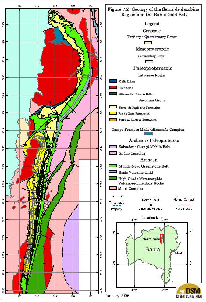
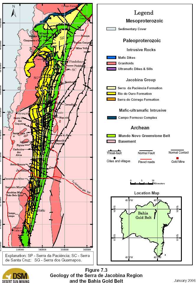
| 7.2 PROPERTY GEOLOGY |
| Figure 7.2 shows the geology of the complete Bahia Gold Belt and its neighborhood. Figure 7.3 is a more detailed geological map of the central portion of the Bahia Gold Belt extending approximately 110km along strike. The Bahia Gold Belt overlays most of the Jacobina range, where quartzites, metaconglomerates and schists of the Paleoproterozoic Jacobina Group constitute a series of north-south, elongated, mountain ranges that rise up to 1,200 metres above sea-level. The deep and longitudinal valleys, bordering the mountains, correspond to deeply weathered ultramafic sills and dikes. The east- west oriented valleys represent weathered mafic to intermediate dikes. Archean tonalitic, trondhjemitic and granodioritic gneiss-dominated basement and related remnants of supracrustal rocks, grouped as the Mairi Complex, are found on both flat to slightly hilly areas east of the Jacobina range. At its eastern border and also in a flat landscape, there are the fine-grained biotite gneisses of the Archean Saúde Complex. The transition between the hilly and the scarped domains of the eastern border corresponds to the exposures of the Archean Mundo Novo Greenstone Belt. To the west of the Jacobina range, Paleoproterozoic late- to post-tectonic, peraluminous granites (the Miguel Calmon-Itapicuru, Mirangaba-Carnaíba, and Campo Formoso granitoids) outcrop as hilly landscapes. |
| 18 |


| Updated Resource & Reserve Estimate, Jacobina Dec 2005 |
| The following sections present a brief description of the main geological units within the Bahia Gold Belt and its neighborhood. |
| 7.2.1 ARCHEANBASEMENTROCKS |
| Basement rocks of Archean-age in the Bahia Gold Belt include the Mairi Complex, Saude Complex and the Mundo Novo Greenstone Belt. |
| Mairi Complex |
| The Mairi Complex (Melo, 1991), which corresponds to the eastern portion of the Gavião block, comprises tonalitic, trondhjemitic, and granodioritic gneiss-dominated basement, of Archean age, and remnants of Archean supracrustal rocks, including quartzites, schists, calc-silicate rocks, banded iron formations, amphibolites and mafic-ultramafic bodies. The complex crops out on both flat to slightly hilly sides of the Jacobina range. The complex underwent multiple deformation events, and displays a marked northeast-southwest foliation, with a regional amphibolite facies metamorphism paragenesis. The Mairi Complex constitutes, together with the Mundo Novo Greenstone Belt and the Campo Formoso Mafic-Ultramafic Complex, the basement for the detritic Jacobina sequence. |
| Saúde Complex |
| The Saúde Complex, as re-defined by Melo (1993), represents a volcano-sedimentary association comprised predominantly of aluminum-rich gneisses, quartzites, calc-silicate rocks, biotite gneisses, mafic and ultramafic rocks, banded iron formations, and aluminum-micaceous schists, which exhibit a regional amphibolite facies metamorphism, and evidence of granitization and migmatization. Pearson et al. (in press) consider the term Saúde Complex to refer only to the characteristic fine-grained biotite gneisses, locally exhibiting porphyroblasts of garnet, which outcrop between the towns of Caém and Antônio Gonçalves (Fig. 7.3) . The supracrustal remnants, which were previously considered part of this complex, are interpreted as slices of an Archean greenstone belt type association, intimately related to the surrounding gneissic and migmatized basement (Mairi Complex). These rocks are thought to represent higher grade metamorphosed equivalents of the Mundo Novo Greenstone belt. |
| Mundo Novo Greenstone Belt |
| The Mundo Novo Greenstone Belt, according to Mascarenhas et al. (1994 and 1998) and Souza et al. (2002), comprises an Archean greenschist facies volcano-sedimentary sequence bounded to the west by the Jacobina Group, along the Pindobaçu-West fault (Fig. 7.3) . To the east, the Mundo Novo Greenstone Belt is in contact with the Saúde gneisses, and supracrustal rocks and gneisses of the basement, along the Pindobaçu fault. To the west of Pindobaçu and Antônio Gonçalves, and to the north of Carnaíba, the Mundo Novo Greenstone Belt has its widest east- west outcropping exposure, occupying the low-lands among the hills made up of the Serra da Paciência Formation rocks. |
| 22 |
| Updated Resource & Reserve Estimate, Jacobina Dec 2005 |
| In the central part of the Bahia Gold Belt, the Mundo Novo Greenstone Belt is subdivided in two major units: (1) a lower unit, represented by massive to pillowed, mafic metabasalts, displaying locally variolitic and amygdaloidal textures, and minor intercalations of banded iron formation, and metagreywackes; and, (2) an upper unit, comprising a thick package of metagreywackes with subordinate conglomeratic horizons, which grades to a chemical-exhalative zone (banded iron formation and metachert), and pelitic sediments (pyrite-bearing, graphite schist). No evidence of intermediate, or felsic, metavolcanic rocks have been identified, thus far, in this central part of the Mundo Novo Greenstone Belt outcrops. The Mundo Novo Greenstone Belt can also be divided in two metamorphic domains: an amphibolite facies domain, and a greenschist facies domain. The amphibolite facies domain is well exposed at the Serra do Cantagalo and Brejo dos Paulos hills, and to the east of the Itaitú village (Fig. 7.3) . While the greenschist facies domain, corresponds to the classical Mundo Novo Greenstone Belt, as defined by Mascarenhas et al. (1994). These authors and Souza et al. (2002), considered the biotite gneisses of the Saúde Complex as a probable equivalent to felsic metavolcanic rocks related to the development of the Mundo Novo Greenstone Belt. This genetic discussion is still however, an open question, hence the Saúde biotite gneisses have been left separated from the supracrustal rocks. |
| 7.2.2 CAMPOFORMOSOMAFIC-ULTRAMAFICCOMPLEX The chromite-bearing Campo Formoso Mafic-Ultramafic Complex occurs in the northern portion of the mapped area as a 40 km long by 0.1 to 1.0 km wide northeast-southwest elongated body (FigS. 7.2 and 7.3), dipping 50º-60º to the south-southeast. The complex overlies gneisses of the Mairi Complex, is intruded by the Campo Formoso granite, and underlies the Jacobina Group metasediments. It comprises metamorphic rocks (actinolite gneisses, tremolite-actinolite serpentinite and serpentine-chlorite-carbonate-talc schists) derived from peridotites and pyroxenites. This complex is interpreted as a layered intrusion (Couto et al., 1978), or a thick differentiated peridotite dike of komatiitic affinity (Topitsch, 1993). |
| 7.2.3 JACOBINAGROUP |
| The stratigraphic subdivisions of the Jacobina Group (Leo et al., 1964; Griffon, 1967; Mascarenhas et al., 1998) have long been controversial. While the stratigraphy in the Jacobina mine area has been well documented, the most difficult task is to develop a usable nomenclature to define the eastern formations within the Jacobina Group, specifically the Cruz das Almas, Serra do Meio, and the Serra da Paciência Formations. Pearson et al. (in press) considers that the Jacobina Group comprises basically the lower Serra do Córrego, and the upper Rio do Ouro Formations, characterized below, according to sedimentary and stratigraphic studies carried out by Oram (1975), Minter (1975), Strydom and Minter (1976), Couto et al. (1978), and Molinari et al. (1986). The stratigraphic nomenclature developed by these writers has been successfully employed within the Jacobina Mine area for over 25 years and its usage has been continued by Desert Sun. |
| 23 |

| Updated Resource & Reserve Estimate, Jacobina Dec 2005 |
| The Cruz das Almas Formation, which was previously interpreted as the uppermost part of the Jacobina Group (Leo et al., 1964), is correlated by Pearson et al. (in press) with the upper sedimentary unit of the Mundo Novo Greenstone Belt. The Serra do Meio and Serra da Paciência formations are assumed by Pearson et al. to be part of one thick package of fine- to coarse-grained quartzites with minor metaconglomerates, and andalusite schists, and metapelites, which are interpreted as time-equivalent to the Serra do Córrego and lower Rio do Ouro Formations, tectonically imbricated with slices of Mundo Novo Greenstone Belt lithologies, along the eastern border of the Jacobina range (Fig. 7.3) . |
Serra do Córrego Formation
The Serra do Córrego Formation forms the western ridge of the Serra da Jacobina and is exposed
for a strike length of about 85 km from 18 km south of Jacobina to 67 km to the north. It
consists of an interbedded series of orthoquartzites and oligomictic conglomerates that
collectively range in total thickness from 500 to 1,000 m. The conglomerate pebbles are
composed of polycrystalline quartz with rare, fine-grained, fuchsite and rutile-bearing quartzite,
with a matrix of quartz, sericite and fuchsite with detrital zircon, non-chromiferous rutile,
tourmaline, and chromite grains (Ledru et al., 1997). The three Al2SiO5polymorphs occur within
the matrix with poikiloblastic grains of andalusite and sillimanite, with aggregates of acicular
fibrolite being the most common (Ledru et al., 1997; Teixeira et al., 1999 and 2001). Rare
kyanite is restricted to major thrust faults indicating that pressures higher than 4 kb were reached
during thrusting (Teixeira et al., 1999 and 2001).
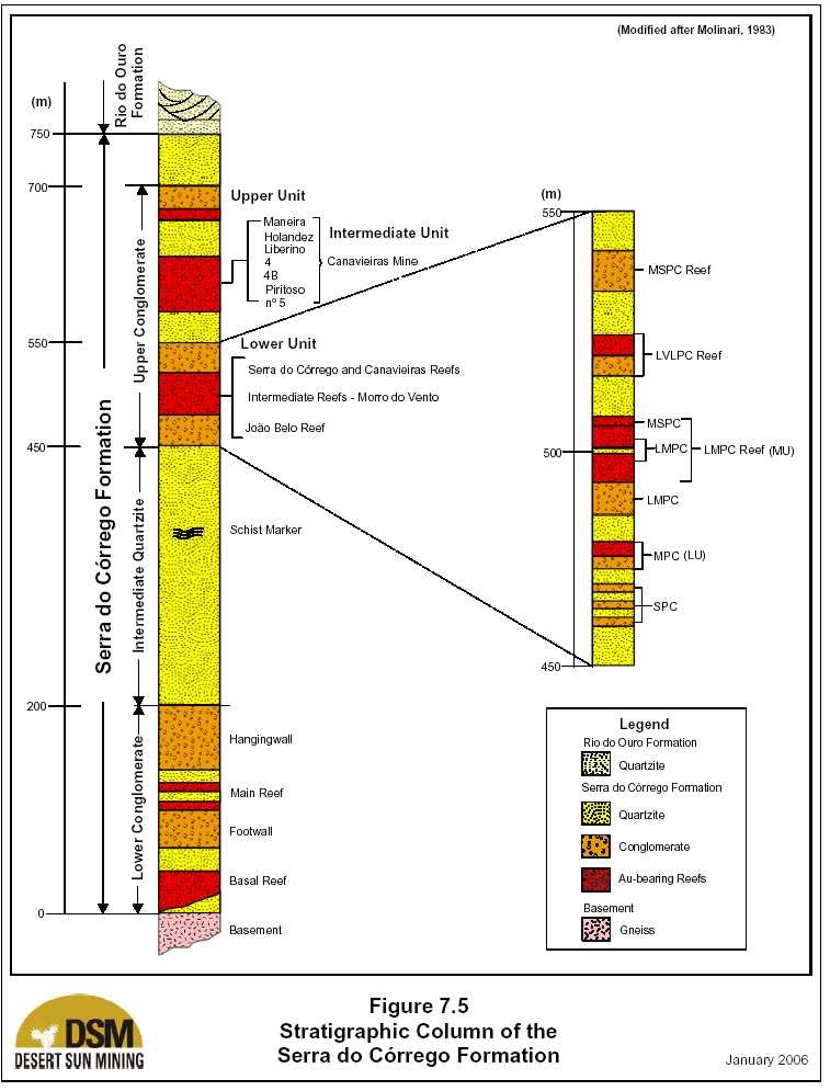
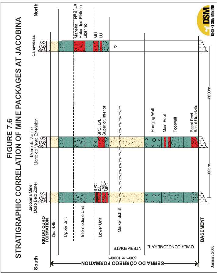
| Figure 7.4 is a geological plan map of the Jacobina mine area showing the distribution of the Serra do Córrego Formation. Figure 7.5 is a stratigraphic column of the Serra do Córrego Formation modified after Molinari et al. (1986) and Figure 7.6 shows the correlation of stratigraphy among the major present and former mines. The formation in the Jacobina mine area is divided into three major units as follows: |
| 1) | Lower Conglomerate (40 - 200 m) |
| This lower zone outcrops along the lower parts of the western slopes of the Serra do Córrego, Morro do Vento, and Morro do Vento Extension areas (Fig. 7.3), and is composed of interbedded quartzites and pebbly quartzites and conglomerates. The reef zones are oligomictic conglomerates with pebble sizes ranging from 35 mm to 60 mm that are interbedded with orthoquartzites. This unit hosts the gold orebodies of the Basal Reef and the Main Reef (Fig. 7.5). | |
| 2) | Intermediate Quartzite (130 - 425 m) |
| This unit is primarily orthoquartzites with little or no conglomerate. In the upper part of this unit is a distinct horizon known as the “marker schist” which is highly sheared quartz-sericite-chlorite schist that appears to represent a hiatus in the typical sedimentation pattern. | |
| 24 |


| Updated Resource & Reserve Estimate, Jacobina Dec 2005 |
| 3) | Upper Conglomerate (120 – 400 m) |
| This zone forms the most extensive division, and occurs from the Serra Branca block, in the north, to the Campo Limpo block, in the south (Fig. 6). The sequence is comprised of quartzites, and pebbly quartzites with a number of conglomerate layers. The reef zones are interbedded conglomerates and orthoquartzites with pebble sizes ranging from 50 mm at Canavieiras in the north to 100 mm at the João Belo Mine in the south. The Upper Conglomerate Zone hosts the main gold orebodies of the Canavieiras, Morro do Vento and João Belo mines, as well as, the Serra Branca and Serra do Córrego gold mineralization. | |
| Oram (1975), Minter (1975), and Strydom and Minter (1976) concluded, based on isopachs and pebble size data, that the paleoslope during the sedimentation of the Serra do Córrego Formation was inclined to the west. The westerly paleocurrent direction, indicated by the vectoral data, drained a provenance area to the east of the present outcrop area, and deposited these sediments in a fluvial environment. |
| Rio do Ouro Formation |
| The Rio do Ouro Formation crops out on the central ridges of the Serra de Jacobina Range and extends further to the north and south than does the Serra do Córrego Formation. The Rio do Ouro Formation comprises orthoquartzites, generally finer grained than the Serra do Córrego, that in places reach a high degree of purity. According to Minter (1975), the Rio do Ouro Formation quartzites were transported from the west direction, diametrically opposed to the source of the Serra do Córrego Formation. A vectoral mean of 126º, measured from small scale trough crossbedding, is substantiated by asymmetrical ripple marks. Consequently, the Rio do Ouro Formation has transgressively buried the Serra do Córrego Formation. The contact between the Serra do Córrego and Rio do Ouro formations, is transitional and represents a continuance of the transgression evident towards the top of the Serra do Córrego Formation. Consequently, the Rio do Ouro Formation may represent a shallow marine overlap. |
| Serra do Paciencia Formation |
| The Serra do Paciencia Formation is exposed along the eastern margin of the Jacobina basin and comprises thick packages of orthoquartzites with local andalusite-quartz-graphite schist beds and minor polymictic metaconglomerate. A recent exposure at a newly constructed water dam at the Itapicuru river, southwest from Pindobaçu, indicates that the andalusite schist units are original pelitic layers interbedded with fine-grained quartzites. Pebbles in the conglomerates comprise black metachert, metagraywacke, and polycrystalline quartz suggesting the Mundo Novo Greenstone Belt as the source area. The Jacobina metasediments on the eastern flank of the Jacobina Basin appear to form an overturned and east-dipping limb of a regional syncline which is better preserved to the east of |
| 28 |

| Updated Resource & Reserve Estimate, Jacobina Dec 2005 |
| Campo Formoso (Pearson et al. in press). This limb has been fragmented in several up-thrown blocks that are apparently intercalated with metapelites, metacherts and metagreywackes of the Mundo Novo Greenstone Belt. These pelitic and immature sediments are considered by Pearson et al. to correspond to slices of the upper unit of the Mundo Novo Greenstone Belt imbricated within these Jacobina metasediments, which corresponds to the Serra do Meio Formation which is group by Pearson et al. with the Serra da Paciência Formation. The eastern-most Jacobina blocks comprise fine- to coarse-grained quartzites, microconglomeratic quartzites, grit, and minor metaconglomerates, with characteristic blue- quartz grains of possible volcanic/sub-volcanic origin (Serra da Paciência, Santa Cruz and Guardanapos). Locally these are intercalated with fine-grained quartzites (displaying herringbone crossbedding and small-sized ripple-marks), and coarse-grained andalusite-quart- graphite schists, previously referred as the Serra do Meio Formation (Griffon, 1967; Mascarenhas et al., 1992 and 1998). This package of metasediments is considered by Pearson et al. to be part of the Serra da Paciência Formation, due to the overall sedimentological characteristics it shows along the eastern border of the Serra de Jacobina. Pearson et al. (in press) further note that the poorly-sorted, poorly-rounded, and cobble/pebble- supported conglomerates and sedimentary breccias that are well exposed eight km southwest and one km northwest of the town of Saúde, may represent proximal entry-points for the Jacobina basin. In addition, the occurrences of sedimentary breccias and conglomerates at apparently different stratigraphic horizons (west of Saúde area, Pindobaçu, Fumaça, Cercadinho) in the vicinity of the Pindobaçu-West fault, on the eastern border of the Jacobina range, are thought to be evidence of long-lived periods of movement on the Pindobaçu fault system. |
| 7.2.4 ULTRAMAFICSILLS ANDDIKES |
| The deep and longitudinal valleys bordering the mountains which form the Jacobina range, correspond to weathered pre- to syn-tectonic ultramafic sills and dikes. These intrusives include dark-green metaperidotite and metapyroxenite, which acquire a brownish stain where weathered (Teixeira et al., 2001). According to these authors, deformation and metamorphism, coupled with hydrothermal alteration, have transformed these rocks into fine-grained, protocataclastic schists containing talc, serpentine, chlorite, tremolite, and carbonate. These intrusive rocks are known to host high grade pyritic gold-bearing quartz veins in the Jacobina mine area, and at several other places like Rio Coxo, Jaqueira, Mina Velha and Várzea Comprida. The age of these sills and dikes is still unknown. Field evidence by DSM reported by Pearson et al. (in press) indicates that these rocks are intrusive bodies and not tectonic slices of Mundo Novo Greenstone Belt ultramafic rocks, as suggested by Mascarenhas et al. (1992, 1994 and 1998) and Topitsch (1993). In the Jacobina mine area, the ultramafic rocks, which were emplaced along north-trending structures, affected and reacted with the host rocks (quartzites and conglomerates of the Serra do Córrego and Rio do Ouro Formations) producing metre-scale mottled zones in the hosts. The ultramafic rocks |
| 29 |

| Updated Resource & Reserve Estimate, Jacobina Dec 2005 |
| display textural variation from aphanitic borders to a porphyroblastic core, textures typical of the chill margins of an intrusion. |
| 7.2.5 LATE- TOPOST-TECTONICGRANITES |
| According to Teixeira et al (2001), several Paleoproterozoic, two-mica- (sillimanite-bearing) and muscovite-bearing granitoid massifs are exposed along the 500-km long Contendas-Jacobina lineament, and particularly in the Campo Formoso, Carnaíba and Jacobina regions (Fig. 7.3) . Trace element and REE data indicate that these leucogranites crystallized from peraluminous magmas during syn-collisional tectonism at 1.97 to 1.88 Ga (Sabaté et al., 1990 and 1992). This probably represents an episode of S-type granitoid generation along the sutures between the Gavião block, the Jequié block, and the Salvador-Curaçá mobile belt. Important occurrences of beryl (emerald), molybdenite, and scheelite mineralization in the Campo Formoso and Carnaíba regions are related to the hydrothermal alteration associated with these peraluminous granitoids. However, there is no direct evidence to suggest a correlation between the gold mineralization with this episode of igneous activity. Field mapping and interpretation of airborne geophysical data by DSM indicates that the Carnaíba and the Mirangaba granites, are part of one continuous intrusive body in which there are a large number of zenoliths of basement rocks (gneisses, migmatites, amphibolites), and not two separate intrusive bodies as represented by Couto et al. (1978). |
| 7.2.6 MAFICDIKES |
| Distinct from the ultramafic intrusions, there is a set of east-west oriented mafic to intermediate dikes that are typically weathered and marked by valleys. These dikes correspond to a late- tectonic intrusive event, which affected the Serra de Jacobina range. These metamorphosed intrusive rocks are a distinctly later phase of intrusion cross-cutting the ultramafic sills, and the metasediments of the Serra do Córrego, Rio do Ouro and Serra da Paciência formations. The main rock types are metagabbro and metadiorite. Locally, these dikes host restricted gold mineralization. |
| 7.2.7 CHAPADADIAMANTINA ANDUNAGROUPS Meso- and Neo-Proterozoic, low metamorphic grade, detritic-carbonatic and carbonatic-detritic metasediments occur to the west from the Jacobina range, grouped in the Chapada Diamantina and Una groups, respectively (Fig. 7.3) . The former comprises conglomerates, deposited directly over Archean gneisses and supracrustal rocks, conglomeratic sandstones, sandstones, siltstones, shales and carbonatic shales. The latter is constituted by diamictites, slates, limestones, dolomites, and carbonaceous shales and quartzites. |
| 30 |

| Updated Resource & Reserve Estimate, Jacobina Dec 2005 |
| 7.2.8 STRUCTURALGEOLOGY |
| Different styles of deformation are recognized within the Jacobina Group and surrounding Archean rocks, along and across the northern portion of the 500 km long, and north-trending Contendas-Jacobina lineament. Thrust-faults, sinistral strike-slip faults with reverse components, followed by regional open and tight folding, were developed in response to the strong westward-verging mass transport event, caused by the Paleoproterozoic continental- continental collision. Regional mapping by Desert Sun has lead to a re-interpretation of several major structural elements as discussed below. To the west, the Jacobina Group is thrust over the Archean Mairi Complex metamorphic terrain, the chromium-bearing Campo Formoso Mafic-Ultramafic Complex, and the late- to post-tectonic granites (Miguel Calmon-Itapicuru, Mirangaba-Carnaíba and Campo Formoso intrusives), along a thrust-fault named the Jacobina fault. This pattern changes progressively eastwards, to a series of steeply east dipping blocks, bounded by several sub-parallel reverse-faults, such as, the Maravilha, the Pindobaçu-West and the Pindobaçu faults (Figs. 7.2 and 7.3), producing a domino structural style of blocks. The Serra do Córrego Formation exposed on the west side of the basin forms part of an extensive homocline that dips consistently 50 to 70Ú to the east with top indicators to the east. It appears that this orientation is the result of tilting during the intrusion of the late to post-tectonic Mirangaba / Carnaíba granite. The total thickness of the Rio do Ouro Formation is probably less than previously stated (2,000 m) due to partial repetition of the stratigraphy caused by the up-throw of successively more easterly blocks. Most of the apparent intercalations of phyllites/schists with quartzites, and minor metaconglomerates and andalusite schists, known along the eastern portion of the Jacobina range, were previously considered part of the Cruz das Almas and Serra do Meio formations (Griffon, 1967; Mascarenhas et al., 1992). However, regional and detailed mapping by Desert Sun has shown that they are slices of metapelites and metagreywackes of the Mundo Novo Greenstone Belt, tectonically imbricated with coarse-grained quartzites, metaconglomerates and sedimentary breccias and andalusite schists. As previously noted, these rocks are herein interpreted to be part of the Serra da Paciência Formation and a probable time-equivalent to the Serra do Córrego and the lower part of the Rio do Ouro formations. These coarse sediments appear to represent the east-dipping and overturned limb of a regional syncline, part of which is preserved along the road linking Campo Formoso and Antônio Gonçalves in the north. Evidence of imbrications of Mundo Novo Greenstone Belt rocks with the Serra da Paciência Formation is found along the Rio das Pedras and Rio Paiaiás sections, located eight km south-southwest and four km north-northwest, respectively, from the Saúde town, and in the Serra de Santa Cruz, and Serra da Paciência areas, to the west of Pindobaçu. |
| 31 |

| Updated Resource & Reserve Estimate, Jacobina Dec 2005 |
| The phyllites and schists found at the base of the Serra da Paciência, west of Pindobaçu, are considered to be part of the Mundo Novo Greenstone Belt. They comprise carbon-rich metapelites and metagreywackes, with local metachert and banded iron formation intercalations. The thick sedimentary package of quartzite and minor conglomerate, with local andalusite schist, exposed at the Serra de Santa Cruz and Serra da Paciência, corresponds to a “nappe” front, thrusted over Mundo Novo Greenstone Belt rocks. In this sense, these clastic metasediments are correlated with the Serra do Córrego and Rio do Ouro Formations. A conspicuous structural feature of the Mundo Novo Greenstone Belt, along the eastern border of the Serra de Jacobina, is the presence of elongated and imbricated slices of metagraywacke of its upper unit into orthoquartzites of the Serra da Paciência Formation. |
| 32 |
| Updated Resource & Reserve Estimate, Jacobina Dec 2005 8.0 DEPOSIT TYPES |
| Anglo American was attracted to the Jacobina area in the early 1970’s by what it felt was the remarkable similarity of the local gold-bearing conglomerates to the well-known Witwatersrand reefs in South Africa. More recently, Goldfields’ success at Tarkwa in Ghana highlighted the unique gold-bearing quartz pebble conglomerates in the lower Proterozoic of Africa and South America. Africa and South America were originally part of a supercontinent known as Gondwanaland. Gondwanaland was originally part of an even greater land mass known as Pangea, but separated from that continent about 180 million years ago. Later, Africa and South America broke apart and drifted to their present positions. Africa and South America have large Precambrian shield areas which underlie significant portions of both continents. The shields are composed of ancient rocks such as granite, gneiss, schist, and greenstone which were part of the primordial surface of the Earth. Sedimentary and metamorphic rocks of younger Precambrian age overlie the older rocks. The younger Precambrian rocks contain gold-bearing conglomerates. These include the Roraima, Tarkwa, and Witwatersrand sequences in South America and Africa, which are many thousands of metres in thickness (Heylmun, 2000). |
| 8.1 THE WITWATERSRAND BASIN |
| The Witwatersrand Basin lies within the Kaapvaal Craton of southern Africa, formed 3.7 to 2.7 Ga. The strata of the basin lie unconformably on the Archean cratonic basement. The basal sequence, the Dominion Group, is a sequence of thin conglomerates and thick lava flows containing only one known gold-bearing zone and a uranium-rich stratum. The basal sequence was deposited approximately 3.0 to 2.7 Ga. After a hiatus of 100 million years, the Witwatersrand Supergroup was deposited. The Supergroup is divided into two units, the lower West Rand Group and the upper Central Rand Group. The West Rand Group was deposited at approximately 2,970 Ma and consists of shales, quartzites, grits and conglomerates and only one gold-rich conglomerate bed. In contrast, the Central Rand Group, deposited from approximately 2,914 Ma on, consists of quartzites (90%), grits and rare shale and, most importantly, numerous gold-bearing conglomerate horizons (Minter and Loen, 1991 and Karpeta et al., 1991). The exceptional gold reefs of the Witwatersrand Basin dip at 20 to 25° towards the centre of the basin and are found to persist over areas of 10 to 100 km2, maintaining consistent gold grades (approximately 15 g/t) and reef mineralogy. The auriferous reefs are commonly no more than one metre in thickness, although some of the richest reefs within the mid-fan facies are only centimetres thick. These reefs are conglomeratic units commonly overlying "interformational" unconformities in the alluvial fan deposits (Barnicoat et al., 1997). The conglomerate units are typically pebble-supported, mature (free of clays and silts) and tightly cemented. |
| 33 |

| Updated Resource & Reserve Estimate, Jacobina Dec 2005 |
| There are two families of thought on the formation of the Witwatersrand deposits, the modified paleoplacer group and the hydrothermal group. There is some evidence supporting both models. While all writers today accept that there is a hydrothermal component to the mineralization, there is no agreement on whether the hydrothermal activity was directly responsible for formation of the deposits or only reflects re-mobilization of original paleo-placer gold. The Witwatersrand has produced over 46,000 tonnes (1,500 Moz ounces) of gold and the remaining reserves are known to contain another 40,000 tonnes (1,300Moz), making it, by well over an order of magnitude, the greatest gold producing area in the world. |
| 8.2 TARKWA |
| The Tarkwa mine is located in south central Ghana. In Ghana, the Birimian greenstone belt sequence occurs as irregular basins of predominantly metasedimentary strata, separated by a series of north-east trending belts of metavolcanics, on which the majority of the major gold deposits are clustered, and a north-northwest striking belt, the Lawra belt, which extends northwards into Burkina Faso. The Birimian greenstone belts in Ghana are unconformably overlain by Proterozoic age Tarkwaian metasediments, which are host to the gold mineralization at the Tarkwa mine. The style of the gold mineralization is similar to that found in the Witwatersrand Basin, concentrated in conglomerate reefs. The deposits at Tarkwa are composed of a succession of stacked tabular palaeoplacer units, consisting of quartz pebble conglomerates, developed within Tarkwaian sedimentary rocks. Approximately ten such separate economic units occur in the concession area within a sedimentary package ranging between 40 m and 110 m in thickness. Low grade to barren quartzite units are interlayered between the separate reef units. A second important deposit type that occurs in the Tarkwa belt is found at Damang. In contrast to the quartz pebble conglomerate-hosted deposits, gold ore at Damang occurs within sheet quartz veins cutting sedimentary rocks. Five separate production areas are located on and around the Pepe Anticline at Tarkwa, a gently north-plunging fold structure that outcrops as a whaleback hill. The sedimentary sequence and the interlayered waste zones between the mineralized units thicken to the west. In 2005, Goldfields reported mineral reserves of 324.1 million tonnes grading 1.3 g Au/t containing 13.41 million ounces (Moz) of gold at Tarkwa and. total mineral resources, which include the mineral reserves, of 409.5 million tonnes grading 1.5 g Au/t containing 20.16 Moz of gold. At Damang mineral reserves are reported as 23.5 million tonnes grading 1.8 g Au/t containing 1.34 Moz and total mineral resources of 37.1 million tonnes grading 1.8 g Au/t containing 2.09 Moz of gold 23.5 million tonnes grading 1.8 g Au/t containing 1.34 Moz. (Goldfields Annual Report 2005). |
| 34 |

| Updated Resource & Reserve Estimate, Jacobina Dec 2005 |
| 8.3 THE RORAIMA GROUP |
| The Roraima group in northern Brazil, southern Venezuela and the Guyanas contains conglomerate beds in which gold and diamonds are found. Most of the placer gold and diamonds found in Venezuela and northern Brazil are thought to have been derived from gold deposits in the Roraima (Heylmun, 2000). The gold-bearing quartz pebble conglomerates of the Serra do Córrego Formation at Jacobina are the most significant known deposit of this type in South America. |
| 8.4 JACOBINA |
| Anglo American proposed a Witwatersrand-type paleoplacer model for the deposits of the Jacobina area and operated its mines on this principle, concentrating on stratigraphic mapping and correlation. DSM is of the view as summarized by Pearson et al. (in press), however, that the majority of gold mineralization formed as a result of extensive hydrothermal alteration related to fluid flow along the Pindobaçu Fault system which forms the eastern margin of the Jacobina basin. Fuchsite, which is widespread and often associated with gold, is a hydrothermal alteration mineral. Gold mineralization is associated with strong silicification and pyritization and occurs both within the conglomerates in the Jacobina mine area as well as strongly fractured and brecciated quartzites in the Pindobaçu area, 50km north of Jacobina. In addition, the highest-grade mineralization known to exist in the area occurs at Canavieiras where the most extensive structural deformation occurs. DSM has employed a hydrothermal model for mineralization in its exploration but stratigraphy is nonetheless very important because the conglomerates are the most permeable units in the package and are prime sites for deposition of hydrothermal mineralization. |
| 8.5 COMPARISONS BETWEEN JACOBINA, TARKWA AND WITWATERSRAND Dr. Paul Karpeta, an expert on Precambrian quartz pebble conglomerate gold deposits who has worked extensively in all three major gold belts compares and contrasts the characteristics of each of the areas in Pearson et al. (in press). The following section is drawn from this paper. The Witwatersrand, Tarkwa and Jacobina basins are the three conglomerate-hosted gold deposits that have been mined extensively. Historically, the Witwatersrand has produced at least 1,500 million ounces, the Tarkwa belt 10 million ounces from conglomerates plus 3 million ounces from quartz veins, and Jacobina has produced 0.7 million ounces. Whether the conglomerate- hosted gold mineralization is paleo-placer, or hydrothermal, or both, a number of paleo-factors appear to control the extent of gold mineralization in such basins. These factors are the depositional basin style, the type, number, and lateral extent of the auriferous conglomerates (“reefs”), and their subsequent structural, metamorphic and hydrothermal histories. A summary of the characteristics of gold deposits in each of these areas is given in Table 8.1. |
| 35 |

| Updated Resource & Reserve Estimate, Jacobina Dec 2005 |
| The Tarkwa and Jacobina basins both probably originated as linear rift basins (Karpeta et al., 2002; Teixeira et al., 2001), whereas the Witwatersrand is thought to represent a foreland basin (Burke et al., 1986; Winter, 1987). Whereas the Tarkwa basin sits on early Proterozoic Birimian volcanics and volcaniclastics (Pohl and Carlson, 1993; Hirdes and Nunoo, 1994) in what was probably an oceanic back-arc rift setting, Jacobina sits on Archaean gneisses and greenstones (Teixeira et al., 2001) possibly representing rifted continental crust. The Witwatersrand basin, like Jacobina, rests on an Archaean granite-greenstone basement (Tainton, 1994; Robb and Meyer, 1995). Although Jacobina resembles Tarkwa in that it is a rift basin, it resembles the Witwatersrand more with its continental basement. Continental basement would result in the development of larger fluvial catchments producing more extensive river systems, and hence potentially auriferous fluvial conglomerates (“reefs”). Foreland basins, such as the Witwatersrand, typically have greater areas than rifts, and hence have more entry points. Therefore, if auriferous, they should produce more gold. As expected the Witwatersrand has at least six (Minter and Loen, 1991; Tainton, 1994; Robb and Meyer, 1995), whereas Tarkwa has four entry points (Strogen, 1988), and Jacobina has one so far (Molinari and Scarpelli, 1988). However, the length of the Jacobina basin indicates that more entry points, and therefore, more undiscovered gold-bearing conglomerates could be present. The richest reefs in the Witwatersrand and Tarkwa are the oligomictic conglomerates comprising predominantly of well-packed, well-sorted, well-rounded pebbles mainly of quartz with minor amounts of chert and non-durable pebbles (Tainton, 1994; Robb and Meyer, 1995). The conglomerates at Jacobina show identical characteristics reflecting both source area rock types and a high degree of reworking during deposition. The Witwatersrand appears to have a larger variety of reef depositional environments (alluvial fan, gravelly braided river, carbon seam and estuarine-submarine channel) than Tarkwa and Jacobina (alluvial fan and braided river only) but this may be due to the foreland-basin setting and the strong marine influence in Witwatersrand deposition. The estuarine-submarine channel reefs may be related to sea-level fluctuations (Karpeta, 1994; Karpeta et al., 1991). The marine shales in the Witwatersrand could also have acted as a source rock for the hydrocarbons in the rich carbon seam reefs (Gray et al., 1998). The carbon granules locally present in the Jacobina conglomerates (Horscroft, 1986) and the more extensive graphitic sediments in the Serra do Paciencia Formation could indicate the presence of such organic-rich marine shales in the associated sediments, which could have acted as a hydrocarbon source rock similar to the Witwatersrand. |
| 36 |

| Updated Resource & Reserve Estimate, Jacobina Dec 2005 |
TABLE 8.1 A COMPARISON BETWEEN JACOBINA, TARKWA AND THE WITWATERSRAND GOLD DEPOSITS
| FEATURE | JACOBINA | TARKWA | WITWATERSRAND | ||||||||
| AGE | 2.0 By | 2.1 By | 2.7 By | ||||||||
| DIMENSIONS | 200km by 25km | 220km by 40km | 300km by 150km | ||||||||
| BASEMENT | Archaean gneiss and | Proterozoic | Archaean granites and | ||||||||
| greenstones | greenstones | greenstones | |||||||||
| SHAPE | Linear | Linear | Arcuate | ||||||||
| SETTING | Inverted rift | Inverted rift | Inverted foreland or | ||||||||
| escape basin | |||||||||||
| BASIN FILL | Conglomerate to | Conglomerate to | Quartzite to phyllite to | ||||||||
| SEQUENCE | quartzite to phyllite | quartzite to phyllite | quartziteto | ||||||||
| (fining up) | (fining up) | conglomerate | |||||||||
| (coarsening up) | |||||||||||
| FILL THICKNESS | 2,500m | 2,600m | 7,000m | ||||||||
| ENVIRONMENTS | Alluvial fan to | Alluvial fan to fluvial | Fluvial tomarine | ||||||||
| marginal marine | to lacustrine, no | marginalto deep | |||||||||
| marine | marine to fluvial to | ||||||||||
| alluvial fan | |||||||||||
| ENTRY POINTS | Two known | Four known | Six known | ||||||||
| REEF TYPES | Braided river, | Braided river, | Braided river, alluvial | ||||||||
| alluvial fan | alluvial fan | fan, estuarine- | |||||||||
| submarine fan? | |||||||||||
| MAGMATISM | Post-depositional. | Post-depositional | Syn-depositional | ||||||||
| mafic, ultramafic | felsic and mafic sills | granitoids, post | |||||||||
| sills and dikes, late | and dikes, late | depositional mafic | |||||||||
| granitoids | granitoids | sills, dikes and lavas | |||||||||
| METAMORPHIC | Medium grade | Low grade | Low Grade | ||||||||
| GRADE | occasionally medium | ||||||||||
| MAIN MINERALS | Au, minor U | Au, no U | Au, U | ||||||||
| GANGUE | Pyrite, hematite | Hematite, magnetite | Pyrite, pyrrhotite | ||||||||
| MINERALS | |||||||||||
| OTHER | Much fuchsite, | Spessartine, | “Carbon”, fuchsite, | ||||||||
| MINERALS | tourmaline | tourmaline, local | little tourmaline | ||||||||
| fuchsite | |||||||||||
| QUARTZ VEIN | Yes | Yes (Damang) | Yes but small (e.g. | ||||||||
| DEPOSITS | (Pindobaçu) | Wilgespruit) | |||||||||
| HISTORICAL | 0.7 Moz (1745- | 10 Moz (1880-2000) | 1500 Moz (1886-2000) | ||||||||
| PRODUCTION | 1998) | ||||||||||
| SURFACE | 1.9g/t | 1.2g/t | 1.1g/t | ||||||||
| MINING GRADE | |||||||||||
| UNDERGROUND | 2.5-9.5 g/t | >6g/t | >6g/t | ||||||||
| MINING GRADE | |||||||||||
| 37 |

| Updated Resource & Reserve Estimate, Jacobina Dec 2005 |
| The number of reefs in a given basin greatly affects the productivity and the Witwatersrand has a significantly greater number (over 40 reefs), than Tarkwa (seven), or Jacobina (at least seven), and is a reflection of the number of entry points. In the East Rand alone there are at least twenty- four gold-bearing conglomerates (including the Nigel Reef, the Next-Aboves, the Next-Belows, the Kimberley Reefs, and the Black Reef) though only the Nigel Reef was mined everywhere. The structural deformation history subsequent to the deposition of the sediments of the Tarkwa and Jacobina basins is similar as they both appear to be inverted rifts that underwent compression and thrusting (Teixeira et al, 2001; Karpeta et al., 2002; Tunks et al., 2004), whereas the Witwatersrand is probably an inverted foreland basin (Burke et al., 1986; Winter, 1987; Coward et al., 1995) that underwent extensional faulting after thrusting. Since rift basins have higher heat flows potentially creating more hydrothermal fluids, epigenetic (disseminated and quartz vein hosted) gold mineralization should be more extensively developed in them. It has also been argued that inverted normal faults develop the geometries necessary for the creation of fault-valves in quartz vein formation (Gibson, 1995). In the Tarkwa belt at least a third of gold production has come from quartz veins (Tunks et al., 2004), whereas the Witwatersrand has produced very little quartz vein hosted gold. Present drilling in the Jacobina belt has also indicated that significant quartz-vein hosted gold mineralization may be present. The metamorphic grade of the three basins varies from low in the Witwatersrand (Barnicoat et al., 1997; Jolley et al., 2004), through low and medium in Tarkwa (Sestini, 1973; Pigois et al., 2003) to medium at Jacobina (Teixeira et al., 2001). It is interesting that in the Tarkwa belt, Damang-style quartz vein-hosted gold mineralization occurs in an area of medium grade metamorphism (Pigois et al., 2003), whereas similar stacked quartz veins associated with low grade metamorphic rocks in the same belt lack gold mineralization. Similarly, the presence of low grade metamorphism may explain the very small amount of gold recorded from quartz veins in the Witwatersrand. This suggests that medium grade metamorphism may be one of the factors necessary to form quartz vein-hosted deposits. Since the Jacobina belt shows medium grade metamorphism it has definite potential for quartz vein-hosted mineralization, as shown by recent drilling results. Hydrothermal alteration in the three basins (Barnicoat et al., 1997; Jolley et al., 2004; Pigois et al., 2003; Milesi et al., 2002) is quite variable having silicification and sericitization (muscovite in the Witwatersrand and Tarkwa, but chrome-muscovite at Jacobina) in common in all three. However, in the Witwatersrand and Jacobina the presence of pyrite suggests reducing fluids, whereas tourmaline in Tarkwa and Jacobina suggests boron-rich, intrusive-related (?) fluids, and specularite indicates oxidizing fluids at Tarkwa and Jacobina. It should be noted that locally reducing hydrothermal fluids have been recorded from the Tarkwa belt associated with auriferous quartz veins. The apparent pervasive migration of both oxidizing and reducing hydrothermal fluids through the Jacobina sediments suggests that repeated post-depositional movement of hydrothermal fluids took place in the Jacobina basin, resulting in the enhanced potential for epigenetic gold mineralization in this basin. |
| 38 |

| Updated Resource & Reserve Estimate, Jacobina Dec 2005 9.0 MINERALIZATION |
| 9.1 GOLD MINERALIZATION |
| In the Jacobina area the important gold-bearing units known thus far occur along the southern 40 km of the 85 km long conglomeratic and quartzitic Serra do Córrego Formation, which is overlain by the quartzitic Rio do Ouro Formation. Together, these formations comprise the Jacobina Group. To the east and north of the project, quartzites, metaconglomerates and andalusite schists of the Serra da Paciência Formation, here interpreted as equivalents to the Serra do Córrego and Rio do Ouro Formations, and metacherts, metagreywackes, banded iron formations, and metapelites, of the Mundo Novo Greenstone Belt, are strongly affected by the north-northeast-trending strike-slip faults with reverse components of the Pindobaçu fault system. Along these structures significant structurally-controlled and epigenetic gold occurrences, like the Pindobaçu and Fumaça garimpos (artisanal gold workings), are related to kilometer-sized hydrothermal alteration zones. The main hydrothermal alteration types are: fuchsitization; silicification; pyritization; tourmalinization; sericitization; and, hematitization. Gold occurrences are found in areas displaying a regional fuchsitization, followed by local silicification and pyritization, and sometimes, localized tourmalinization. Hematitization is a late alteration. Figure 9.1 shows the distribution of gold occurrences in the Bahia Gold Belt. In the southern part of the belt, gold is predominantly hosted in pyritic or hematitic, silicified and fuchsite- altered quartz pebble conglomerates of the Serra do Córrego Formation. However, as one moves to the north along the belt, the focus of gold mineralization appears to shift eastward. The bulk of occurrences in the northern part of the belt occur within quartz veins and silicified zones in orthoquartzites, andalusite schists and minor conglomerates of the Jacobina Group that are tectonically imbricated with slices of Mundo Novo Greenstone Belt lithologies. Hydrothermal alteration shows a strong relationship to major faults, particularly the Pindobaçu fault system. Teixeira et al. (1999 and 2001), classified the gold deposit/occurrences of the Jacobina range into four groups, mainly based on the nature of the host rock. These groups are: (1) conglomerate- hosted gold deposits – encompasses the pyritic, gold-bearing, quartz-pebble conglomerates and quartzites of the Serra do Córrego Formation, which host the gold deposits of the Jacobina gold district (the Jacobina Mine (Joao Belo Zone), Itapicurú (Morro do Vento/Morro do Vento Extension) and Canavieiras mines and other smaller occurrences); (2) mafic-hosted gold deposits - represented by small gold workings where gold is associated with disseminated hydrothermal pyrite near tension gashes and quartz-pyrite veins and veinlets, hosted by late-tectonic gabbroic and dioritic dikes, which cut the Serra do Córrego and the Rio do Ouro Formations; (3) ultramafic-hosted gold deposits – represented by narrow quartz veins with pyrite and arsenopyrite developed along the sheared footwall contact between metamorphosed peridotite and pyroxenite dikes and quartzites of the Serra do Córrego or Rio do Ouro Formations (e.g. Mina Velha and Jacinto); and (4) quartzite-hosted gold deposits – represented by shear zone- related quartz veins hosted by quartzite of the Rio do Ouro and “Cruz das Almas” Formations (e.g. Maravilha and Goela da Ema). |
| 39 |
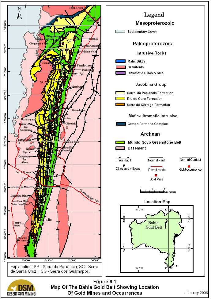

| Updated Resource & Reserve Estimate, Jacobina Dec 2005 |
| A fifth group has been defined by DSM (Pearson et al., in press) and corresponds to gold mineralization related to strongly, hydrothermally altered zones, which occur along the Pindobaçu fault system, which also affects the Mundo Novo Greenstone Belt rocks (e.g. Pindobaçu, Santa Cruz and Fumaça garimpos). DSM recently concluded an inventory on primary gold showings throughout the Bahia Gold Belt. A total of 69 gold workings, occurrences and deposits were visited and described in detail. The inventory allowed further additions to Teixeira´s classification, taking into account the host- rocks, the local structural setting, and the type/degree of hydrothermal alteration in the Jacobina Group Domain and Mundo Novo Greenstone Belt terrains as described in sections 9.1.1 and 9.1.2 below (Pearson et al., in press): |
| 9.1.1 JACOBINAGROUPDOMAIN |
| The Jacobina Group Domain hosted four different major types of gold deposits; conglomerate- hosted; quartzite, andalusite schist- and metaconglomerates-hosted; Ultramafic-hosted; and mafic/intermediate dike-hosted. The characteristics of each of these principal types of gold deposits are described in the following section: |
| Conglomerate-hosted gold deposits |
| These deposits comprise sheared and micro-fractured, gold-bearing, recrystallized, silicified and pyritic metaconglomerates with a greenish, fuchsitic matrix, of the Serra do Córrego Formation, Jacobina Group. These rocks often show overprints of hematite coatings along shear-plane, joint and fracture surfaces, which post-date gold-mineralized fabrics. The best examples of this group are found within the 40 km long Jacobina gold district (Canavieiras, Itapicurú (Morro do Vento and Morro do Vento Extension) and João Belo mines, Serra Branca and other minor occurrences), which extends from Campo Limpo, in the south, to Santa Cruz do Coqueiro, in the north. Figure 9.2 is a geological plan map of the Jacobina mine area showing the distribution of the gold-bearing reefs, and Figures 9.3 and 9.4 are cross sections of the Morro do Vento and João Belo areas, respectively. In the mine area, stratigraphy dips consistently eastward at 50o to 70o. Cross bedding and ripple marks indicate that the sequence is right-side-up. Table 9.1 summarizes the principal characteristics of the main gold mineralized reefs at Jacobina. Economically, the most important past producers have been the Basal and Main reefs in the Lower Conglomerate Unit and the lower part of the Upper Conglomerates (Figs. 7.4 and 9.3) . The majority of current mineral resources are in the lower unit of the Upper Conglomerates (Figs. 7.4 and 9.4) . It is important to note, however, that only certain reefs within a particular package will be mineralized. Other sub-parallel reefs with similar sedimentalogical features may be unmineralized. |
| 41 |
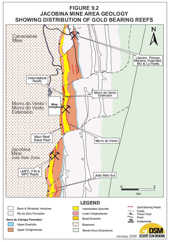
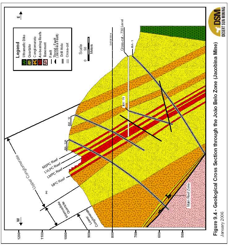

| Updated Resource & Reserve Estimate, Jacobina Dec 2005 |
| TABLE 9.1 CHARACTERISTICS OF PRINCIPAL MINERALIZED REEFS, JACOBINA MINE AREA |
| MINE | ZONE | LOCATION | STRIKE | THICKNESS | AVG. GRADE | DESCRIPTION | ||
| (m) | (g Au/t) | |||||||
| MORRO DO VENTO/MORRO DO VENTO EXTENSION (ITAPICURÚ) | ||||||||
| LVLPC | Morro de | 400 | 2 m | 4.8 | Large and very large pebbles, | |||
| Vento | only locally mineralized. | |||||||
| MU (Superior) | Morro de | 1700 | 3 to 10 | 2.0 | Medium to small pebbles | |||
| Reef | Vento | |||||||
| LU (Inferior) | Morro de | 1700 | 3 to 10 | 2.4 | Medium to large pebbles. | |||
| Reef | Vento | |||||||
| Main Reef | 60 to 90 m | 3000 | Beds of 0.1 to | 6.0 | Pyritic, small to medium pebble | |||
| above | 3, Zone up to | conglomerate beds. | ||||||
| basement | 12 | Three channels of deposition, | ||||||
| Itapicurú | broken by faults. | |||||||
| Basal Reef | At or very near | 1600 | 3 to 10 | 4.0 | Small to medium pebble, | |||
| basement | enrichment of gold at its upper | |||||||
| contact | - | and lower portions. | ||||||
| Itapicurú | ||||||||
| CANAVIEIRAS | ||||||||
| Maneira | Canavieiras | 600+ | Beds of 0.4 to | 1.7 | Large to very large pebbles | |||
| 7, Zone up to | ||||||||
| 70 | ||||||||
| Holandez | Canavieiras | 600+ | Beds of 0.9 to | 1.7 | Large to medium pebble | |||
| 6, Zone up to | ||||||||
| 30 | ||||||||
| Piritoso | Canavieiras | 600+ | 1 to 3 | 9.5 | Medium size pebbles with | |||
| abundant pyrite | ||||||||
| Liberino | Canavieiras | 600+ | 1 to 3 | 6.1 | 10 metres above Piritoso; medium | |||
| to large pebbles. | ||||||||
| MU | Canavieiras | 400+ | 10 to 25 | 3.2 | Pyritic, medium to large pebble | |||
| conglomerates. | ||||||||
| LU | Canavieiras | 400+ | 1 to 10 | 2.2 | Pyritic, large pebble | |||
| conglomerate. | ||||||||
| JACOBINA MINE (JOÃO BELO) | ||||||||
| LVLPC | João Belo | 1000+ | 1 to 3 | 4.4 | Large to very large pebbles. | |||
| North | ||||||||
| LMPC | João Belo | 1000+ | 10 to 25 | 2.2 | Large to medium pebbles. | |||
| North | ||||||||
| MPC | João Belo | 1000+ | 1 to 4 | 3.6 | Medium sized pebbles; locally | |||
| North | contains gold values. | |||||||
| ANGLO AMERICAN CLASSIFICATION TERMINOLOGY FOR CONGLOMERATES OF THE JACOBINA GROUP | ||||||||
| SIZE | < 4mm | 4 – 16 mm | 16 – 32mm | 32 – 64mm | > 64mm | |||
| SYMBOLOGY | VSPC | SPC | MPC | LPC | VLPC | |||
| NAME | Very Small | Small | Medium | Large | Very Large | |||
| Pebble | Pebble | Pebble | Pebble | Pebble | ||||
| Conglomerate | Conglomerate | Conglomerate | Conglomerate | Conglomerate | ||||
| 45 |

| Updated Resource & Reserve Estimate, Jacobina Dec 2005 |
| The vast majority of significant gold mineralization occurs within the matrix of the conglomerates. Gold occurs as very fine grains of native gold typically 20 to 50 microns in size. Gold mineralization rarely occurs in the pebbles but when it does, it is along fractures. Interbedded quartzites host gold mineralization almost exclusively along fractures especially near late mafic dikes. Fracture-controlled mineralization in the quartzites is rare in the absence of late mafic dikes in the Jacobina mine area, however structurally controlled gold mineralization in pyrite-tourmaline-bearing quartz veins is abundant in the Pindobaçu area, 50km north of Jacobina. Fuchsite is far more extensive than gold mineralization. Conglomerates with white quartz pebbles and a green matrix dominated by fuchsite, generally contain only low or erratic gold values. Gold mineralized conglomerates typically have grayish-blue pebbles and fine, disseminated pyrite and/or hematite in the matrix with strong silicification. Within particular reefs, there is considerable local grade variation with higher grade zones concentrated along shear zones parallel to stratigraphy as noted by Milesi et al. (2002) at João Belo. In the Basal Reef, previous mining was concentrated at the base of the conglomerate with stopes typically 2-2.5m wide although the actual mineralized zone is 10 to 12 m wide. Despite this local grade variation, the overall grade of different reefs based on production records is remarkably consistent both along strike and down-dip. Fluvial channels are important controls on the distribution of gold mineralization as documented by Oram (1975), Minter (1975), and Strydom and Minter (1976), in the Main Reef. Recent drilling indicates that the mineralized zone in the reef at João Belo has a 150º azimuth/44o south plunge, whereas the plunge at Morro do Vento in both main mineralized reefs the MU and LU plunges to the north at 55o. In comparing different gold mineralized reefs, those with larger pebbles tend to have higher grades and greater potential to host gold mineralization, as at João Belo and Morro do Vento, however, this is not always the case, for example at Canavieiras (Pearson et al., in press). The Canavieiras mine is in a distinct thrust slice separate from the main conglomerate trend that is bounded on all sides by ultramafic intrusions. Sinistral shearing in this block has resulted in in a greater concentration of gold along dilation zones. Previously it was thought the open folding may have influenced controls on higher grade gold mineralization however work by DSM shows that the folding is a later buckling event and does not have a major influence on the distribution of gold mineralization. Zones of hydrothermal quartz with fine, disseminated, native gold and pyrite have been intersected in several holes attesting to the importance of hydrothermal mineralization in forming this deposit. The gold occurrences which are related to disseminations of pyrite in a fuchsitic matrix of coarse-grained quartzites and minor metaconglomerates of the Serra da Paciência Formation, which is considered herein to be equivalent to the Serra do Córrego Formation, are also likely |
| 46 |

| Updated Resource & Reserve Estimate, Jacobina Dec 2005 |
| genetically related to this group. Such examples are found at Biquinha, Cercadinho, Samburá, Pindobaçu and Fumaça gold workings, which are distributed along or close to the Pindobaçu fault system. At these localities the gold mineralization is also intimately associated with gold- bearing quartz veins deposited in tension gashes classified as Group 2, below. |
| Quartzite, andalusite schist- and metaconglomerates-hosted gold deposits This group encompasses gold-bearing quartz veins and veinlets, which fill tension gashes and open fractures, related to semi-concordant shear zones hosted by quartzites and andalusite- graphite-quartz schist, and local metaconglomerates of the Rio do Ouro and Serra da Paciência formations (e.g. Goela da Ema, Biquinha, Cercadinho and Guardanapo gold workings). The main hydrothermal alterations associated with these are: silicification, sericitization, chloritization and pyritization, with minor chalcopyrite and tourmaline. The gold-bearing quartz vein and veinlets deposited along shallow-angle, west-dipping shear zones, hosted by Rio do Ouro quartzites, are also included in this group, but it is emphasized that according to their specific positioning (situated in the west block of the Maravilhas fault and positioned at nearly 90º to the bedding of the quartzites), they are thought to represent vertical shear zones developed before tilting of the Jacobina Group. The best examples of this group are: Coxo, Jaqueira, Maravilha and Lajedo gold workings. The main related hydrothermal alterations for this group are: silicification, sericitization, chloritization, pyritization (locally with chalcopyrite), and local tourmalinization. |
| Ultramafic-hosted gold deposits |
| These deposits comprise narrow, up to 4 metres thick, shear zones developed in north-south oriented ultramafic sills and dikes, close to their footwall and hangingwall contacts with the hosting quartzites and metaconglomerates of the Serra do Córrego, Rio do Ouro, and Serra da Paciência Formations. This group of gold occurrences is strongly linked with those of Group 1 above. The mineralized shear zones are characterized by the development of gold-bearing quartz veins and/or stockworks. The main hydrothermal alteration types are: silicification, fuchsitization, pyritization, and sericitization, with local tourmalinization. A number of examples of this group are known at the mine sites and surrounding areas (Canavieiras, Itapicurú, Serra do Córrego, Morro do Vento and João Belo), and at the Serra da Paciência (Mina Velha, Várzea Comprida, Ciquenta e Um, Cabeça de Nego and Milagres gold workings), in the north. |
| Mafic/Intermediate Dike-hosted gold deposits |
| This type is the last developed, and least important, group of gold mineralization within the Jacobina area. It consists of gold-bearing quartz veins in tension gashes, with local pyrite remobilization, close to the contacts between late-tectonic gabbroic and dioritic dikes and metaconglomerates and quartzites of the Serra do Córrego and Rio do Ouro Formations. The dikes are emplaced along east-west and northwest-southeast-oriented fractures and faults. Pyrite |
| 47 |

| Updated Resource & Reserve Estimate, Jacobina Dec 2005 |
| is concentrated along the contact zone with hosting metasediments, where a hornfels texture is developed in the gabbroic or dioritic rocks. |
| 9.1.2 MUNDONOVOGREENSTONEBELTDOMAIN Metasedimentary-hosted, shear-controlled gold deposits Within the Mundo Novo Greenstone Belt Domain, gold mineralization occurs with disseminated pyrite and/or quartz veins in shear zones within metasedimentary rocks of the Mundo Novo Greenstone Belt. Host rocks are strongly altered chemical (metachert, banded iron/manganese formation), detritic (metagraywacke) and pelitic (graphite schist) metasediments of the Archean Mundo Novo Greenstone Belt (e.g. Santa Cruz, Pindobaçu and Fumaça/Guiné gold workings). In addition to gold, the Mundo Novo Greenstone Belt also hosts deposits of manganese oxides, Zn-Cu-Pb massive sulfides and barite. |
| 48 |

| Updated Resource & Reserve Estimate, Jacobina Dec 2005 10.0 EXPLORATION |
| 10.1 OVERVIEW |
| Anglo American conducted several decades of extensive exploration work on the Serra do Córrego Formation, principally in the area of the Itapicurú (Morro do Vento and Morro do Vento Extension), João Belo and Canavieiras mines, resulting in the discovery of these deposits. Once the mines were discovered however, regional exploration of the Serra do Jacobina was limited. William completed a limited exploration program in 1997 to search for depth extensions to the Canavieiras mine and southerly extension to the João Belo mine. The results of this program are discussed in Sections 7, 8, 9 in this report and in Section 19 of DSM’s previously filed Technical Report entitled “A Review of The Exploration Potential of, and A Proposed Exploration Program For, The Jacobina Property, Bahia State, Brazil” (Hennessey, 2002). Except for work by garimpeiros, most of the belt of Serra do Córrego Formation rocks outside the Jacobina mine area has been relatively unexplored with the exception of some drilling carried out by Montana Minerals in the mid-1980’s in the Pindobaçu area which is described in Section 10.5.3. DSM has been carrying out systematic exploration of the Jacobina property since September 2002. In late 2003, as a result of positive results, the exploration program was substantially increased. The following sections (10.2 to 10.4 inclusive) summarize results of the exploration programs in 2002 to 2004 inclusive. The discussion of the results in each of the major target zones discussed in Section 10.5 “2005 Exploration Program Results” incorporates results of the 2002 to 2004 program and therefore these are not discussed separately. Figure 10.1 shows the locations of the major target areas in the Jacobina mine area discussed in the following sections. Assaying for the programs has been carried out by Lakefield Geosol, an ISO 9000-2001 certified laboratory based in Brazil, using fire assay on 50-g pulps. Check assaying was routinely carried out, by ALS Chemex in Vancouver, on 10% of sample pulps and 5% of sample rejects. External reference standards are also routinely added to monitor the quality of analyses by the laboratories. Security is maintained at the core logging and sampling facility. Dr. William N. Pearson, P.Geo., is DSM’s QP, as defined under NI 43-101, responsible for the scientific and technical work on the programs and has regularly visited the site from 2002 to the present. |
| 10.2 2002 EXPLORATION PROGRAM |
| The results of DSM’s Phase I exploration program are described in Hennessey (2003a) a Technical Report which is available on SEDAR (www.sedar.com). The Phase I exploration drill program consisted primarily of 12 NQ-sized (47.6 mm core) diamond drill holes totalling 2,245 m however, additional work included a regional exploration program using remote sensing imagery, analysis of airborne geophysical data, geological data compilation using GIS (geographic information system software), and a program of prospecting, sampling and mapping using garimpeiros. |
| 49 |


| Updated Resource & Reserve Estimate, Jacobina Dec 2005 |
| 10.3 2003 EXPLORATION PROGRAM |
| The 2003 exploration program commenced in March, 2003 and included 8,988m of diamond drilling in 75 NQ-sized (47.6 mm core) holes, induced polarization (IP) geophysical surveys and continuation of the regional exploration program. The bulk of the drilling in this program tested the Serra do Córrego, Morro do Vento and Joao Belo Sul areas. The budget for the program was $US1.5 million. Upon completion of this work in September 2003 and the Feasibility study, DSM earned a 51% interest in the Jacobina property and triggered its option to acquire the remaining 49% to own a 100% interest in the property. Results of this program are described in Hennessey (2003b) |
| 10.4 2004 EXPLORATION PROGRAM |
| In 2004, the program was substantially expanded with a total of 28,866m of NQ diamond drilling in 125 holes being completed. The prime target areas drilled were Morro do Vento, Joao Belo Norte, Joao Belo Sul and Canavieiras as shown in Figure 10.1. Included in this total was 2,000m of diamond drilling completed in the northern area of the Bahia gold belt property to test several targets outlined by geological mapping, sampling, soil geochemical surveys and induced polarization surveys. Results of this program are described in detail by Pearson and Tagliamonte (2005). |
| 10.5 | 2005 EXPLORATION PROGRAM |
| 10.5.1 | OVERVIEW |
| In 2005, the exploration program continued at high level of activity with a total of 25,676m of NQ diamond drilling completed in 130 holes. The prime target areas drilled were Canavieiras and Morro do Vento Extension in the Jacobina mine area and Pindobaçu in the northern Bahia Gold Belt, 50km north of the town of Jacobina. Overall two-thirds of the total drilling was completed in the Jacobina mine area with one-third allocated to the northern area. Sections 10.5.2 and 10.5.3, respectively, provide an overview of the exploration program carried out in the Jacobina Mine area and the northern Bahia Gold Belt, respectively. Results of the drilling in the Jacobina mine area are discussed in Section 11.4 below. Results of drilling in targets in the northern Bahia Gold Belt are discussed in Section 11.5 Geological mapping, sampling, soil and rock geochemical sampling and geophysical (induced polarization) surveys were continued over much of the property especially in the northern Bahia Gold Belt in the Pindobaçu-Fumaça area |
| 51 |

| Updated Resource & Reserve Estimate, Jacobina Dec 2005 |
| 10.5.2 EXPLORATIONPROGRAM, JACOBINAMINE AREA A total of 17,130m in 82 holes were drilled in targets in the Jacobina Mine area excluding the Jacobina Mine (Joao Belo Zone) with the bulk of meterage drilled at Canavieiras and Morro do Vento Extension as shown in Table 10.1. |
| TABLE 10.1 | EXPLORATION DIAMOND DRILLING IN JACOBINA MINE AREA BY | |
| DSM, 2005 EXPLORATION PROGRAM | ||
| TARGET AREA | Total Metres Drilled | |
| Jacobina Mine Area | ||
| Canavieiras (CAN) | 8,309.40 | |
| Morro do Vento Extension (MCZ/MVT) | 8,511.10 | |
| Serra do Córrego (SCO) | 309.55 | |
| Total | 17,130.05 | |
| Drilling was very successful at upgrading and expanding mineral resources at both Canavieiras and Morro do Vento Extension. Results are described in Sections 11.4.1 and 11.4.2, respectively and the updated mineral resource estimate for the areas is presented in Section 17.2. In addition to the above diamond drilling, at the Joao Belo Mine (Joao Belo zone) two holes totalling 1,613 m were completed by the mine in a deep drilling program to test the downdip and along strike extension of the main (LMPC reef) ore zone. Definition drilling and development work continued to expand the geological knowledge of the deposit and outlined a new conglomerate reef in the footwall of the ore zone. Results of this program are described in Section 11.3.3 and the updated mineral reserve estimate for the Joao Belo mine is presented in Section 17.5. The mining department also revised the mineral reserves previously defined at the Morro do Vento Extension as outlined in Section 17.5. No new drilling was completed at the Morro do Vento and Serra do Córrego zones, however the mineral reserves previously defined were reviewed (see Section 17.5) |
| 10.5.3 EXPLORATION PROGRAM, BAHIAGOLDBELT(EXCLUDINGJACOBINAMINE AREA) DSM holds property in the Bahia Gold Belt totaling 141,580 ha (see Section 4.0) and essentially controls the entire Bahia Gold Belt which extends for some 155km along strike in a north-south direction as shown in Figure 7.2. In 2004-2005, DSM carried out a program of regional and detailed geological mapping, prospecting, rock and soil geochemical sampling that allowed the classification of the primary types of gold occurrences as discussed in Sections 9.1.1 and 9.1.2, previous and to define four major target areas across the belt outside of the Jacobina mine area. |
| These target areas are, from north to south: |
| 52 |
| Updated Resource & Reserve Estimate, Jacobina Dec 2005 |
- Gold-bearing quartz veins, stockworks and extensive silicified zones in a thick packageof fuchsite-bearing, locally oxidized (after pyrite) quartzites and metaconglomerates inthe Pindobaçu -Fumaça area which may be the northern and separate extension of theSerra do Córrego Formation. Ultramafic dikes and sills emplaced in these sediments alsohost gold-bearing pyritic quartz veins. This target zone extends along strike for at least18km north from Pindobaçu, a small town located 55 km north-northeast of Jacobina.
Gold-bearing shear zones related to the Pindobaçu West Fault, which marks the contactbetween the Jacobina Group and the Mundo Novo Greenstone Belt, have also beenidentified within greenstone rocks in the Pindobaçu-Fumaça area. These zones arecharacterized by strong silification and quartz veining typically with pyrite. - Targets along the Serra do Guardanapo hill, which extends for 23km along strike startingabout 25 km north-northeast of Jacobina. Gold mineralization in this target occurs insteeply dipping quartz veins and associated hydrothermal alteration (silicification,sericitization, chloritization and pyritization) in fine-grained quartzites and meta-pelites(andalusite schists) of the Serra da Paciência Formation;
- The Maravilha Fault zone the south end of which is located 4km east of Jacobina at theRio Coxo garimpo and that extends for 60 km along strike northwards from there. A largenumber of gold occurrences are associated with this structure in shallow west dippingshear zones in Rio do Ouro Formation quartzites; and
- Gold-bearing quartz pebble conglomerate of the northern extension of the Serra doCórrego Formation that extends for 45km along strike, north from the town of Jacobina.
This formation hosts the mineral resources and mineral reserves in the Jacobina minearea to the south.
| Gold occurrences associated with transversal dikes of gabbroic or dioritic composition, due to their very local importance, are not outlined as a significant target area. In addition to the work sited above, Fugro-LASA-Geomag was contracted by DSM in both 2004 and 2005 to complete induced polarization (IP) surveys over a number of targets identified in these major areas. Results of this survey along with soil and rock chip sampling results and detailed geological mapping were used to outline drill targets. An initial drilling program totaling 2,000m was completed in late 2004 to test principally the Pindobaçu-Fumaça area and this program was expanded to 8,546m in 2005 as shown in Table 10.2 below. The total number of assay samples in the database is 12,823 as set out in Table 10.2. Figure 10.2 shows the geology of the northern Bahia Gold Belt with locations of gold deposits and occurrences as well as principal target areas where work was completed in 2005. The following provides a summary of the major target areas explored in 2005. Results of the 2005 drilling program are discussed in Section 11.5 following. Results of the 2004 drill program are summarized by Pearson and Tagliamonte (2005). |
| 53 |
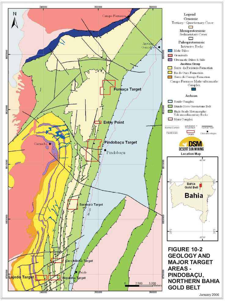

| Updated Resource & Reserve Estimate, Jacobina Dec 2005 |
| Pindobaçu |
| The Pindobaçu target, located 50km north of Jacobina, is accessible by paved road from Jacobina and is 2km west of the town of Pindobaçu. At Pindobaçu, there are a number of active garimpos (free miner workings) which extend along a strike length of 1.2km. Gold occurs as fine to locally coarse-grained native gold or associated with pyrite (or its weathered product, goethite) with tourmaline and fuchsite in quartz vein stockworks along low-angle thrust faults, high-angle reverse faults and fractures. The host rocks are metagraywacke, banded iron formation and metachert of the Archean Mundo Novo Formation and strongly silicified and fuchsitic, fine to coarse-grained quartzite with minor metaconglomerates lenses of the Paleoproterozoic Jacobina Group. Alteration and mineralization occur along the contact zones of these major rock units associated with fault structures of the regional Pindobaçu Fault system which forms the eastern margin of the Jacobina Basin. These faults are westerly-directed thrusts which also have some sinistral strike slip component of movement. Montana Minerals investigated this area during the mid-1980’s by trenching and some shallow diamond drilling. After Montana, a number of garimpeiros starting mining some of the mineralized outcrops and carried out shallow underground mining, an activity that is locally and currently underway. Only partial information on the results of the Montana work is available from a report filed with the Departamento Nacional da Produçâo Mineral (DNPM). Trenching and pitting by Montana was reported to outline a N10oE trending mineralized zone 18 metres thick with an average grade of 1.91 g Au/t over a strike length of 800m. According to the DNPM report, Montana completed 18 shallow diamond drill holes of which only partial results are included in the report from which samples from 13 of these holes were selected for metallurgical testing. The head grade of the composite of core samples was reported to be 4.52 g Au/t with recovery after a 30 day bottle roll test reported to be 82.1% . Geological mapping, IP surveys and rock/soil geochemical surveys by DSM indicates that the hydrothermal alteration zone is much more extensive than indicated by the previous work. The zone has been traced for at least 3.2km along strike at Pindobaçu and it likely extends a further 15km along strike to the north through Fumaça. The alteration zone is up to 100m wide with the most intense portion characterized by intense silicification and quartz-tourmaline veining. Results of diamond drilling at Pindobaçu are discussed in Section 11.5. |
| Fumaça |
| At Fumaça located 10km north of Pindobaçu, gold mineralization occurs in strongly silicified quartzites and minor metaconglomerates of the Jacobina Group in the western part of the area that are in fault contact with reddish clastic, chemical and pelitic metasediments and local pillowed basalt of the Archean Mundo Novo Group to the east. |
| 55 |

| Updated Resource & Reserve Estimate, Jacobina Dec 2005 |
| Soil geochemical sampling by DSM has identified several anomalies in the area with a collective strike length parallel to the main structural trend of 1.3km. An induced polarization geophysical survey by Fugro-LASA-Geomag in 2005 has outlined a linear zone of coincident chargeability and resistivity anomalies that extends over a strike length of 2 km, a width of approximately 300m and to an indicated depth extent of at least 200m. The strongest response is in a zone approximately 50m wide that is coincident with the Fumaça garimpo. Sampling from the garimpo by DSM returned 7.36 g Au/t over 4.5m including a very high grade bluish Results of diamond drilling at Fumaça are discussed in Section 11.5. |
| Entry Point |
| Dr. Paul Karpeta, an expert on Precambrian quartz pebble conglomerate-hosted gold deposits with extensive experience working on deposits in Witwatersrand, South Africa and Tarkwa, Ghana, was retained by DSM in 2005 to carry out a study of the Jacobina basin in an attempt to identify additional entry points outside of the Jacobina Mine area. Entry points are the areas in a basin where major streams carry and deposit sediments into the basin and are typically marked by the thickest conglomerates with the largest pebbles. This work, which was done in close collaboration with DSM personnel led by senior geologist Pedro Moura de Macedo, identified a significant area of Jacobina Group sediments with quartz pebble conglomerate layers which are exposed in a large tectonic window across an area 5,000m long by 900m wide about 5km northwest of Pindobaçu (see Fig. 10.2 ) . Gold garimpos (free miner workings) occur around this “window” near the contact with volcanic rocks of the Mundo Novo Formation which have been thrust over the conglomerates and then subsequently eroded. In contrast to the mine area, the sedimentary rocks here are relatively flat lying hence only a small portion of the overall stratigraphic sequence is actually exposed. Dr. Karpeta concluded that the Jacobina Basin has been subdivided by cross structures into major compartments, which controlled sedimentation in those compartments. One such cross structure is marked by a prominent lineament about 6km south of the town of Pindobaçu, north of which is the Pindobaçu Compartment and to the south is the Jacobina Compartment. Each of these compartments will have a different stratigraphy and hence different auriferous conglomerates. Typically, within each compartment there is usually one entry point marked by the thickest conglomerates with the biggest pebbles and typically are the richest conglomerates. Dr. Karpeta concluded that these entry points occur around the Jacobina Mine Area in the Jacobina Compartment and potentially around Mina Velha, 5km northwest of Pindobaçu, in the Pindobaçu Compartment (Figs. 9.1 and 10.2 ). Induced polarization (IP) surveys completed by Fugro-LASA-Geomag in this newly recognized area outlined targets that appear to be strongly silicified rocks with disseminated sulphides. A limited diamond drilling program was completed in 2005 to complete a section of holes across this area and to test several of the IP survey anomalies. Results of this drilling program are discussed in Section 11.5 below. |
| 56 |

| Updated Resource & Reserve Estimate, Jacobina Dec 2005 11.0 DRILLING |
| 11.1 JMC |
| The original database, from which JMC estimated the mineral resources at the Jacobina project in 1998 (Hennessey 2002, 2003b) is comprised of two types of samples: diamond drill core and chip/channel samples. Until the mid 1990’s, the database was strictly a paper one with holes and sample information plotted on plan, section and longitudinal sectional projections. JMC partially computerized the database after acquisition by William. DSM later completed a detailed verification of all the old drill holes including the checking of original drill logs, assay certificates, survey data and maps and sections. All holes have now been verified and entered into the electronic database by DSM. The drill holes in the JMC database are a mixture of BQ-sized (core diameter = 36.5 mm) and TT-sized (slightly smaller than BQ) core. The BQ core was drilled from company-owned surface exploration drill rigs and the TT core from underground. All drill hole setups were marked up underground, in paint, by a surveyor. The mark-up included a foresight and backsight in addition to the hole number, inclination and hole length. Drill holes were stopped by the driller at the specified footage, but the drill was not moved to the next hole without the permission of the geological technician in charge, who inspected the core prior to moving. In addition to drill hole logging and sampling, all development headings were mapped at 1:200 scale and sampled when in, or near, conglomerate. The mapping and chip channel sampling were plotted on plans and is available for interpretation purposes during resource estimation. The chip/channel sampling was also sometimes composited into pseudo drill holes for use in resource estimation. |
| 11.2 DESERT SUN |
| All DSM drilling was conducted by contract diamond drillers using modern wireline surface drill rigs. The drills were aligned using foresights and backsights set up by DSM geologists. All holes were stopped under geological control to ensure that target horizons had been reached. Several of the current DSM geological staff are former JMC employees. They are familiar with the local rock types, stratigraphic sequence, mineralization controls and rock codes previously used. Similar logging techniques and rock codes are being employed by DSM to allow for ease of use with the previous data. The lithologic codes were developed after extensive study by Anglo American geologists and sedimentologists. More extensive sampling has been performed however compared with historical sampling. In addition logging of hydrothermal alteration minerals, structural features and geotechnical data is routinely done. |
| 57 |

| Updated Resource & Reserve Estimate, Jacobina Dec 2005 |
| Logging was originally performed on paper and transferred to an Excel database. Gemcom was contracted to write a software entry program know as “Logger” for the electronic capture of data into a Gemcom format during logging. This program was tested and implemented in September 2003. The logging process was fully automated in 2004 with all data captured directly in the Logger program. |
| 11.3 | DRILL HOLE DATABASE |
| 11.3.1 | JACOBINAMINEAREA |
| There are 1,461 drill holes totalling 185,565m of drilling in the DSM database for the Jacobina Mine area as outlined in Table 11.1 below. This total includes all surface (approximately 50%) and underground (approximately 50%) diamond drill holes. Since commencing exploration in 2002, DSM has drilled a total of 447 drill holes totalling 65,538m of which the bulk were drilled in the 2004 and 2005 exploration campaigns. |
TABLE 11.1 SUMMARY OF DIAMOND DRILLING, JACOBINA MINE AREA (AS OF DECEMBER 31, 2005)
| Holes in Data Base | Old Drill Holes | New DSM Drill Holes | ||||
| Area | Number | Length | Number | Length | Number | Length |
| of Holes | (m) | of Holes | (m) | of Holes | (m) | |
| Campo Limpo | 9 | 1,744.23 | 9 | 1,744.23 | 0 | 0.00 |
| (CLP) | ||||||
| Canavieiras (CAN) | 208 | 26,207.13 | 107 | 11,330.27 | 101 | 14,876.86 |
| Rio Coxo (COX) | 2 | 189.18 | 0 | 0.00 | 2 | 189.18 |
| João Belo Norte | 537 | 47,193.12 | 340 | 29,780.17 | 196 | 17,412.95 |
| (JBA) | ||||||
| João Belo Sul (JBS) | 28 | 9,094.58 | 15 | 3,354.34 | 13 | 5,740.24 |
| Lagedo Preto (LGP) | 22 | 3,724.47 | 22 | 3,724.47 | 0 | 0.00 |
| Serra da Lagartixa | 1 | 740.42 | 1 | 740.42 | 0 | 0.00 |
| (LGX) | ||||||
| Morro do Vento | 113 | 19,730.98 | 88 | 11,209.88 | 25 | 8,521.10 |
| Extension (MCZ) | ||||||
| Morro da Viuva | 8 | 1,257.98 | 8 | 1,257.98 | 0 | 0.00 |
| (MVA) | ||||||
| Morro do Vento | 414 | 57,827.78 | 330 | 42,118.83 | 84 | 15708.95 |
| (MVT) | ||||||
| Serra Branca (SBC) | 7 | 2,050.71 | 7 | 2,050.71 | 0 | 0.00 |
| Serra do Córrego | 111 | 15,299.61 | 85 | 12,210.52 | 26 | 3,089.09 |
| (SCO) | ||||||
| Jacobina Sudeste | 1 | 505.36 | 1 | 505.36 | 0 | 0.00 |
| (JSE) | ||||||
| TOTAL | 1461 | 185,565.55 | 1013 | 120,027.18 | 447 | 65,538.37 |
| Note: 1) From 2005 to 2006, there were 3 drill holes in progress (JBA450, JBA484 and JBA485); | ||||||
| 2) Total for JBA includes drill holes for Mine evaluation; | ||||||
| 58 |

| Updated Resource & Reserve Estimate, Jacobina Dec 2005 |
| 3) Drill holes from João Belo Norte (JBA) and João Belo South (JBS) have been separated at coordinate N8,750,400; 4) Drill holes drilled from Morro do Vento to Basal Reef, FW Zone and MR Zone (Morro do Vento Extension Reefs) were located in Morro do Vento, see MVT374. |
| The total number of assay samples in the database is 209,032 as set out in Table 11.2 below. |
| TABLE 11.2 ASSAY SAMPLES IN DATABASE – JACOBINA MINE AREA (AS OF DECEMBER 31, 2005) |
| Samples from Old Drill Holes | 130,413 | |
| Samples from New Drill Holes - | 2002 | 2,840 |
| Samples from New Drill Holes - | 2003 | 14,261 |
| Samples from New Drill Holes - | 2004 | 29,443 |
| Samples from New Drill Holes - | 2005 | 32,075 |
| Total Samples in Data Base | 209,032 | |
| Results of from drilling in the 2005 exploration program are described below in Section 11.4 |
| 11.3.2 NORTHERNBAHIAGOLDBELT |
| There are 59 drill holes totalling 10,547m of drilling in the DSM database for Northern Bahia Gold Belt as outlined in Table 11.3 below. The number of assay samples in the database totals 12,823 as outlined in Table 11.4. |
| TABLE 11.3 SUMMARY OF DRILLING, NORTHERN BAHIA GOLD BELT (AS OF DECEMBER 31, 2005) |
| Number | Length | |
| Area | of Holes | (m) |
| 2005 DRILLING NORTHERN AREA | ||
| Pindobaçu | 37 | 5942.12 |
| Entry Point | 6 | 1608.20 |
| Fumaça | 5 | 995.95 |
| TOTAL | 48 | 8,546.27 |
| DRILLING BY TARGET AREA | ||
| 59 |

| Updated Resource & Reserve Estimate, Jacobina Dec 2005 |
| Number | Length | |
| Area | of Holes | (m) |
| Biquinha | 1 | 170.56 |
| Cahoeira dos Alves | 1 | 383.47 |
| Entry Point | 6 | 1608.20 |
| Fumaça Norte | 10 | 1575.60 |
| Pindobaçu | 39 | 6575.73 |
| Samburá | 1 | 198.91 |
| Santa Cruz | 1 | 34.94 |
| TOTAL | 59 | 10,547.41 |
| DRILLING BY YEAR | ||
| Drill Holes – 2004 | 12 | 2,000.69 |
| Drill Holes – 2005 | 47 | 8,546.72 |
| TOTAL | 59 | 10,547.41 |
TABLE 11.4
ASSAY SAMPLES IN DATABASE - NORTHERN BAHIA GOLD BELT (AS OF DECEMBER 31, 2005)
| ASSAY SAMPLES IN DATABASE | ||
| Samples from New Drill Holes - | 2004 | 2,091 |
| Samples from New Drill Holes - | 2005 | 10,732 |
| TOTAL | 12,823 | |
| 11.4 DRILLING RESULTS – JACOBINA MINE AREA Summary results of the targets tested in the Jacobina Mine area are provided in the sections below. Emphasis is on results from the 2005 drilling program however summaries of previous work especially the 2004 drilling program have been incorporated to present a full picture of all targets tested to date. Results of the 2002-2003 exploration programs are outlined in Hennessey (2003b) and for the 2004 program in Pearson and Tagliamonte (2005). |
| 11.4.1 CANAVIEIRAS |
| The former Canavieiras mine is located 3 km north of the processing plant and is located in a block bounded by faults that is approximately 1.2 km long and 400 metres wide. In contrast to |
| 60 |

| Updated Resource & Reserve Estimate, Jacobina Dec 2005 |
| the main conglomerate trend, Canavieiras is characterized by moderate folding. The high grades at Canavieiras compared to the other zones in the Jacobina mine area appears to results from a later stage of hydrothermal activity characterized by hematite-gold that is related to sinistral shearing. Past production, primarily from the Piritoso and Liberino reefs, in the Canavieiras Mine is reported by Anglo American to total 458,247 tonnes at a grade of 8.65 g Au/t. Hole CAN-13 drilled in 1997 by William Resources intersected 7.0 g Au/t over a true width of 24.0m in the MU reef below the old workings but no further followup drilling was done at that time. Work by DSM has focused on evaluating the full stratigraphic package hosting the favourable conglomerate beds which is estimated to be over 300m thick. During 2005, the workings including drifts, raises, stope limits, old drill holes and major faults in the old mine was re- surveyed to eliminate survey errors that were found during data compilation and modeling. A new cross-cut, 92 m long was also driven from an old stope in the southeastern part of the old workings to provide access to more effectively drill potential extensions to the east and south. In 2005, a total of 56 holes totalling 8,287.40 m were completed. The bulk of the program focussed on upgrading existing inferred mineral resources to the indicated category and exploring the potential extensions of the mineralized stratigraphy to the south and east. Several step out holes were completed up to 300m to the south of the old mine to explore the potential of the stratigraphy there. |
- Major targets at Canavieiras include:
- MU and LU reefs about 50m below the Canavieiras mine workings.
- Potential high grade extension in the Piritoso-Liberino reefs adjacent to the old stope inthe southern end of the mine.
- Hollandez-Maneira reefs above the old mine workings.
- Southern continuation of favourable mineralized stratigraphy based on geologicalcompilation work and induced polarization surveys.
| Figure 11.1 is a typical cross section at Canavieiras showing the major target reefs. Table 11.5 lists significant drilling results at Canavieiras from the 2005 program. The following section discusses the results from these major targets at Canavieiras including the step-out drill holes to the south that indicated a major extension to the known mineralized zone. The area was also surveyed using induced polarization and results of this survey were very important in defining the overall target zone. |
| 61 |
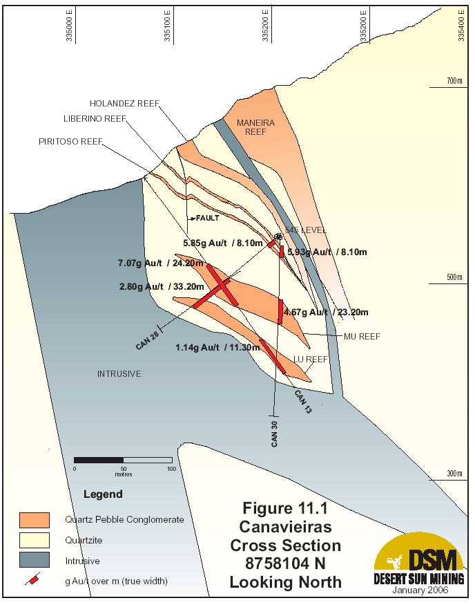
| Updated Resource & Reserve Estimate, Jacobina Dec 2005 |
| TABLE 11.5 | SIGNIFICANT DRILLING RESULTS, CANAVIEIRAS | |||||||
| Hole No.* | From (m) | To (m) | Gold | Interval | True | Reef | Depth Below | |
| (g/t) | (m) | Width | 570 Adit | |||||
| (m) | Level*** (m) | |||||||
| CAN-59** | N8758382 | E335062 | El 577 | |||||
| Dip -62º/Az 96° | no significant values | |||||||
| CAN-60** | N8758412 | E335060 | El 568 | |||||
| Dip -88º/Az62° | no significant values | |||||||
| CAN-61** | N8758.467 | E335045 | El 562 | |||||
| Dip -86º/Az217° | 0.00 | 1.25 | 4.72 | 1.25 | 1.2 | Piritoso | 7 | |
| CAN-62** | N8758468 | E335046 | El 564 | |||||
| Dip +46º/Az90° | 0.00 | 17.78 | 1.81 | 17.78 | 17.6 | N° 4? | 9 above | |
| incl. | 0.00 | 7.10 | 3.35 | 7.10 | 7.0 | N° 4? | 2 | |
| CAN-63** | N8758488 | E335036 | El 563 | |||||
| Dip -88º/Az226° | no significant values | |||||||
| CAN-64** | N8758506 | E335046 | El 556 | |||||
| Dip -86°/Az148° | 0.78 | 1.34 | 4.03 | 0.56 | 0.5 | Piritoso | 15 | |
| CAN-65** | N8758586 | E335040 | El 550 | |||||
| Dip -90º/Az194° | 0.00 | 5.13 | 1.15 | 5.13 | 4.8 | Piritoso | 23 | |
| incl. | 3.64 | 5.53 | 1.88 | 1.89 | 1.8 | Piritoso | 24 | |
| CAN-66** | N8758552 | E335.048 | El 547 | |||||
| Dip -90°/Az172° | no significant values | |||||||
| CAN-67** | N8758548 | E335053 | El 546 | |||||
| Dip -45°/Az144° | 1.20 | 2.41 | 7.62 | 1.21 | 1.1 | Piritoso | 26 | |
| CAN-68** | N8758586 | E335041 | El 548 | |||||
| Dip -41º/az=91º | 7.88 | 9.08 | 2.30 | 1.20 | 0.9 | Liberino | 15 | |
| CAN-69** | N 8758361 | E335111 | El 548 | |||||
| Dip -62º/az=80º | Hole stopped due to stability issues. Target not reached. | |||||||
| 63 | ||||||||

| Updated Resource & Reserve Estimate, Jacobina Dec 2005 |
| TABLE 11.5 | SIGNIFICANT DRILLING RESULTS, CANAVIEIRAS | ||||||
| Hole No.* | From (m) | To (m) | Gold | Interval | True | Reef | Depth Below |
| (g/t) | (m) | Width | 570 Adit | ||||
| (m) | Level*** (m) | ||||||
| CAN-70 | N 8758353 | E335112 | El 549 | ||||
| Dip +59°/Az76°/ | 19.28 | 38.70 | 2.65 | 19.42 | 18.3 | Liber+N°4+Pir | 3 above |
| Incl. | 27.46 | 38.70 | 4.32 | 11.24 | 10.6 | Liber + N°4 | 6 above |
| CAN-71** | N8758060 | E335196 | El 548 | ||||
| Dip -74º/Az=261º | 3.76 | 6.90 | 4.49 | 3.14 | 3.0 | Piritoso | 25 |
| 52.83 | 72.90 | 1.02 | 20.07 | 19.5 | MU | 80 | |
| Incl. | 65.87 | 72.90 | 1.70 | 7.03 | 6.8 | MU | 85 |
| 97.40 | 101.90 | 2.41 | 4.50 | 4.4 | LU | 115 | |
| CAN-72 | N8758148 | E335052 | El 596 | ||||
| Dip -66º/Az=90º | 76.48 | 105.3 | 1.87 | 28.82 | 23.6 | MU | 60 |
| Incl. | 76.48 | 91.3 | 2.4 | 14.82 | 12.2 | MU | 50 |
| Incl. | 96.2 | 105.3 | 1.93 | 9.10 | 7.5 | MU | 65 |
| CAN-73* | N8758101 | E335207 | El 547 | ||||
| Dip -74º/Az=261º | 4.77 | 15.32 | 3.90 | 10.55 | 10.3 | Lib + Piritoso | 32 |
| Incl. | 4.77 | 8.20 | 2.60 | 3.43 | 3.4 | Liberino | 30 |
| 12.09 | 15.32 | 16.52 | 3.23 | 3.2 | Piritoso | 35 | |
| 42.98 | 57.72 | 2.38 | 14.74 | 14.4 | MU | 70 | |
| Incl. | 42.98 | 50.90 | 3.64 | 7.92 | 7.8 | MU top | 64 |
| 109.35 | 110.38 | 2.12 | 1.03 | 1.0 | LU | 123 | |
| CAN-74 | N8758037 | E335191 | El 548 | ||||
| Dip 86º/Az=256º | |||||||
| 59.40 | 67.00 | 2.40 | 7.60 | 6.8 | MU | 82 | |
| 89.40 | 97.59 | 3.52 | 8.19 | 7.4 | MU | 110 | |
| CAN-75 | N8758195 | E335048 | El 596 | ||||
| Dip -66º/Az=90º | 83.74 | 84.21 | 2.08 | 0.47 | 0.5 | MU | 44 |
| 64 | |||||||

| Updated Resource & Reserve Estimate, Jacobina Dec 2005 |
| TABLE 11.5 | SIGNIFICANT DRILLING RESULTS, CANAVIEIRAS | ||||||
| Hole No.* | From (m) | To (m) | Gold | Interval | True | Reef | Depth Below |
| (g/t) | (m) | Width | 570 Adit | ||||
| (m) | Level*** (m) | ||||||
| 92.36 | 94.23 | 0.91 | 1.87 | 1.8 | MU | 55 | |
| CAN76 | N8758227 | E335043 | El 595 | ||||
| Dip -63º/az=92º | 93.92 | 97.78 | 2.31 | 3.86 | 3.1 | MU | 60 |
| CAN-77 | N8758088 | E335206 | El 546 | ||||
| Dip 69º/Az=267º | 4.95 | 15.04 | 4.07 | 10.09 | 9.9 | Lib + Piritoso | 30 |
| Incl. | 4.95 | 7.56 | 4.30 | 2.61 | 2.6 | Liberino | 20 |
| Incl. | 12.64 | 15.04 | 11.94 | 2.40 | 2.4 | Piritoso | 35 |
| 66.72 | 71.50 | 1.39 | 4.78 | 4.7 | MU | 86 | |
| 115.65 | 118.16 | 1.84 | 2.51 | 2.5 | LU | 133 | |
| CAN-78* | N8758074 | E335073 | El 607 | ||||
| Dip -75º/Az=90º | No significant values – MU and LU Reefs not intersected | ||||||
| CAN79 | N8758114 | E335061 | El 607 | ||||
| Dip -64º/Az=90º | 80.23 | 161.13 | 3.88 | 80.90 | 51.0 | LU +MU | 75 |
| Highs cut to 30 g/t | 3.52 | ||||||
| Incl. | 80.23 | 92.90 | 14.57 | 12.67 | 8.0 | MU | 40 |
| Highs cut to 30 g/t | 13.50 | 35 | |||||
| Incl. | 80.23 | 104.32 | 8.40 | 24.09 | 15.2 | MU | 58 |
| Highs cut to 30 g/t | 7.84 | 70 | |||||
| Incl. | 151.03 | 161.13 | 9.29 | 10.10 | 6.4 | LU | 105 |
| Highs cut to 30 g/t | 7.75 | ||||||
| CAN-80 | N8758124 | E335202 | El 547 | ||||
| Dip -60º/Az=269º | 4.00 | 8.3 | 4.82 | 4.30 | 4.0 | Piritoso | 25 |
| 31.99 | 67.00 | 2.05 | 35.01 | 32.9 | MU | 65 | |
| Incl. | 31.99 | 51.50 | 2.95 | 19.51 | 18.3 | MU | 55 |
| Incl. | 40.78 | 51.5 | 4.47 | 10.72 | 10.1 | MU | 60 |
| 100.67 | 102.1 | 3.03 | 1.43 | 1.3 | LU | 113 | |
| CAN-81 | N8758037 | E335191 | El 548 | ||||
| 65 | |||||||

| Updated Resource & Reserve Estimate, Jacobina Dec 2005 |
| TABLE 11.5 | SIGNIFICANT DRILLING RESULTS, CANAVIEIRAS | ||||||
| Hole No.* | From (m) | To (m) | Gold | Interval | True | Reef | Depth Below |
| (g/t) | (m) | Width | 570 Adit | ||||
| (m) | Level*** (m) | ||||||
| Dip 49º/Az=269º | 0.00 | 2.40 | 6.61 | 2.40 | 2.2 | Piritoso | 20 |
| 58.88 | 65.69 | 4.83 | 6.81 | 6.1 | MU | 70 | |
| CAN-82 | N 8758257 | E335041 | El 602 | ||||
| Dip -64º/Az=88º | 86.54 | 92.29 | 1.15 | 5.75 | 4.2 | MU | 46 |
| Incl. | 86.54 | 89.41 | 2.30 | 2.87 | 2.1 | MU | 45 |
| CAN-83 | N8758254 | E335161 | El 547 | ||||
| Dip -87º/az=89º | 17.20 | 17.72 | 2.35 | 0.52 | 0.5 | Piritoso | 40 |
| CAN-84 | N8758025 | E335181 | El 548 | ||||
| Dip -40º/az=268º | 0.00 | 10.11 | 7.04 | 10.11 | 9.9 | Lib + Pir | 26 |
| highs cut to 30g/t | 6.49 | ||||||
| incl. | 0.00 | 2.69 | 4.60 | 2.69 | 2.6 | Liberino | 25 |
| incl. | 7.47 | 10.11 | 21.62 | 2.64 | 2.6 | Piritoso | 30 |
| highs cut to 30g/t | 19.49 | ||||||
| 54.75 | 78.83 | 2.49 | 24.08 | 20.9 | MU | 68 | |
| CAN-85 | N8758091 | E335064 | El 607 | ||||
| Dip -65º/az=92º | 146.33 | 172.20 | 1.55 | 25.87 | 21.0 | MU +LU | 110 |
| incl. | 146.33 | 154.19 | 3.28 | 7.86 | 6.4 | MU | 100 |
| incl. | 166.83 | 168.77 | 2.21 | 1.94 | 1.6 | LU | 115 |
| CAN-86 | N8758003 | E 335178 | El 548 | ||||
| Dip-70º/az=270º | 1.23 | 2.14 | 1.99 | 0.91 | 0.9 | Piritoso | 20 |
| 48.82 | 53.38 | 2.44 | 4.56 | 4.4 | MU | 72 | |
| incl. | 48.82 | 50.86 | 5.17 | 2.04 | 2.0 | MU | 70 |
| CAN-87 | N 8758131 | E335052 | El 603 | ||||
| Dip -63º/Az=90º | 83.33 | 162.04 | 8.20 | 78.71 | 59.0 | MU + LU | 76 |
| Highs cut to 30 g/t | 5.52 | ||||||
| Incl. | 83.33 | 152.54 | 8.82 | 69.21 | 51.9 | MU total | 70 |
| Highs cut to 30 g/t | 5.92 | ||||||
| Incl. | 83.33 | 100.57 | 23.68 | 17.24 | 12.9 | MU top | 48 |
| 66 | |||||||

| Updated Resource & Reserve Estimate, Jacobina Dec 2005 |
| TABLE 11.5 | SIGNIFICANT DRILLING RESULTS, CANAVIEIRAS | ||||||
| Hole No.* | From (m) | To (m) | Gold | Interval | True | Reef | Depth Below |
| (g/t) | (m) | Width | 570 Adit | ||||
| (m) | Level*** (m) | ||||||
| Highs cut to 30 g/t | 14.66 | ||||||
| Incl. | 143.90 | 162.04 | 11.02 | 18.14 | 13.6 | MU base + LU | 105 |
| Highs cut to 30 g/t | 7.93 | ||||||
| Incl. | 156.83 | 162.04 | 2.63 | 5.21 | 3.9 | LU | 108 |
| CAN-88 | N8758309 | E335117 | El 548 | ||||
| Dip +49º/az=88º | 21.37 | 29.81 | 4.06 | 8.44 | 8.4 | Pir +Lib | 2 |
| incl | 21.37 | 22.41 | 1.66 | 1.04 | 1.0 | Piritoso | 5 |
| incl | 26.34 | 29.81 | 7.31 | 3.47 | 3.4 | Liberino | 1 |
| CAN-89 | N8758309 | E335116 | El 551 | ||||
| Dip +60º/az=271º | 11.58 | 13.89 | 18.12 | 16.35 | 2.3 | Piritoso | 10 |
| CAN-90 | N8758175 | E335050 | El 597 | ||||
| Dip -64º/az=90º | MU not intersected - faulted | ||||||
| 127.62 | 130.55 | 1.67 | 2.93 | 1.6 | LU | 83 | |
| CAN-91 | N8758253 | E335159 | El 546 | ||||
| Dip -53º/az=270º | 32.40 | 52.84 | 1.48 | 20.44 | 19.8 | MU | 57 |
| incl. | 28.90 | 36.90 | 3.16 | 8.00 | 7.8 | MU | 50 |
| incl. | 32.40 | 36.90 | 5.23 | 4.50 | 4.4 | MU | 52 |
| CAN-92 | N8758124 | E335202 | El 548 | ||||
| Dip -30º/az=265º | 3.50 | 7.66 | 2.77 | 4.16 | 2.7 | Piritoso | 20 |
| Incl. | 6.42 | 7.66 | 4.56 | 1.24 | 0.8 | Piritoso | 22 |
| 48.77 | 52.02 | 2.41 | 3.25 | 2.1 | MU | 45 | |
| 79.37 | 96.47 | 3.93 | 17.10 | 11.1 | MU | 60 | |
| 50.30 | 96.47 | 1.75 | 46.17 | 30.0 | MU Total | 56 | |
| 132.57 | 138.25 | 2.54 | 5.68 | 3.7 | LU | 90 | |
| 79.37 | 138.25 | 1.44 | 58.88 | 38.3 | LU+MU | 73 | |
| CAN-93 | N8758179 | E335193 | El 550 | ||||
| 67 | |||||||

| Updated Resource & Reserve Estimate, Jacobina Dec 2005 |
| TABLE 11.5 | SIGNIFICANT DRILLING RESULTS, CANAVIEIRAS | ||||||
| Hole No.* | From (m) | To (m) | Gold | Interval | True | Reef | Depth Below |
| (g/t) | (m) | Width | 570 Adit | ||||
| (m) | Level*** (m) | ||||||
| Dip -45º/az=268º | 48.20 | 67.56 | 1.86 | 19.36 | 17.6 | MU | 76 |
| incl. | 61.20 | 67.56 | 4.26 | 6.36 | 5.8 | MU | 70 |
| 90.75 | 94.20 | 4.95 | 3.45 | 3.1 | LU | 90 | |
| CAN-94 | N8758138 | E335199 | El 548 | ||||
| Dip -16º/az=270º | 5.60 | 7.99 | 17.57 | 2.39 | 1.4 | Piritoso | 25 |
| highs cut to 30g/t | 11.77 | ||||||
| 63.67 | 117.10 | 2.28 | 53.43 | 31.5 | MU | 45 | |
| highs cut to 30g/t | 1.96 | ||||||
| incl. | 91.06 | 117.10 | 3.97 | 26.04 | 15.4 | MU | 50 |
| highs cut to 30g/t | 3.31 | ||||||
| CAN-95 | N8758007 | E335217 | El 578 | ||||
| Dip -63º/az=236º | 30.99 | 51.00 | 4.67 | 20.01 | 17.8 | Lib + Pir | 30 |
| incl. | 30.99 | 35.85 | 4.62 | 4.86 | 4.3 | Liberino | 22 |
| incl. | 46.55 | 51.00 | 15.28 | 4.45 | 4.0 | Piritoso | 40 |
| MU/LU cut off by faults | |||||||
| CAN-96 | N8758197 | E335191 | El 547 | ||||
| Dip -72º/az=264º | 10.50 | 11.70 | 0.11 | 1.20 | 0.9 | Piritoso | 35 |
| 61.38 | 66.45 | 0.15 | 5.07 | 3.8 | MU | 80 | |
| CAN-97 | N8758009 | E335220 | El 578 | ||||
| Dip -80º/az=72º | 67.87 | 69.33 | 4.25 | 1.46 | 0.7 | Liberino | 60 |
| 156.32 | 168.50 | 1.43 | 12.18 | 6.1 | MU | 160 | |
| disrupted by faults and dykes | |||||||
| CAN-98 | N8758227 | E335179 | El 547 | ||||
| Dip -71º/Az=267º | 60.7 | 62.73 | 0.60 | 2.03 | 1.6 | MU | 80 |
| CAN-99 | N8758147 | E335198 | El 547 | ||||
| Dip -71º/Az=265º | 5.67 | 6.44 | 21.45 | 0.77 | 0.4 | Piritoso | 28 |
| 52.51 | 69.42 | 3.14 | 16.91 | 9.5 | MU | 80 | |
| Incl. | 58.39 | 69.42 | 4.44 | 11.03 | 6.2 | MU | 82 |
| 68 | |||||||

| Updated Resource & Reserve Estimate, Jacobina Dec 2005 |
| TABLE 11.5 | SIGNIFICANT DRILLING RESULTS, CANAVIEIRAS | ||||||
| Hole No.* | From (m) | To (m) | Gold | Interval | True | Reef | Depth Below |
| (g/t) | (m) | Width | 570 Adit | ||||
| (m) | Level*** (m) | ||||||
| 93.35 | 96.87 | 0.60 | 3.52 | 2.0 | LU | 110 | |
| CAN-100 | N8758021 | E335179 | El 548 | ||||
| Dip -54º/Az=268º | 0.00 | 1.40 | 1.49 | 1.40 | 1.1 | Piritoso | 20 |
| 46.00 | 50.91 | 11.72 | 4.91 | 3.9 | MU | 60 | |
| highs cut to 30 g/t | 9.68 | ||||||
| Incl. | 48.55 | 50.91 | 22.56 | 2.36 | 1.9 | MU | 63 |
| highs cut to 30 g/t | 18.32 | ||||||
| CAN-101 | N8758010 | E335218 | El 578 | ||||
| Dip -68/Az=330 | 7.91 | 8.9 | 1.21 | 0.99 | 0.4 | Holandêz | 5 |
| 40.72 | 50.93 | 1.89 | 10.21 | 4.5 | Liber+Piritoso | 37 | |
| Incl. | 40.72 | 41.62 | 10.29 | 0.90 | 0.4 | Liberino | 35 |
| Incl. | 49.16 | 50.93 | 3.76 | 1.77 | 0.8 | Piritoso | 43 |
| 105.36 | 109.89 | 0.15 | 4.53 | 2.0 | MU | 95 | |
| 146.40 | 146.91 | 0.01 | 0.51 | 0.2 | LU | 135 | |
| CAN-102 | N8758240 | E335187 | El 547 | ||||
| Dip --65º/Az=10º | no significant values | ||||||
| CAN-103 | N8758245 | E335177 | El 247 | ||||
| Dip -64º/Az=86º | 17.57 | 19.69 | 4.78 | 2.12 | 0.9 | Piritoso | 38 |
| Incl. | 19.10 | 19.69 | 17.05 | 0.59 | 0.2 | Piritoso | 40 |
| 96.30 | 101.00 | 2.32 | 4.70 | 1.9 | MU | 108 | |
| Incl. | 96.30 | 99.04 | 3.53 | 2.74 | 1.1 | MU | 110 |
| 128.42 | 129.50 | 2.65 | 1.08 | 0.4 | MU | 140 | |
| CAN-104 | N8757996 | E335251 | El 578 | ||||
| Dip -80º/Az=74º | 167.82 | 168.34 | 1.45 | 0.52 | 0.4 | MU | 159 |
| 236.50 | 237.02 | 2.32 | 0.52 | 0.4 | MU | 222 | |
| CAN-105 | N8757800 | E335163 | El 641 | ||||
| Dip -82/az=91 | 182.50 | 204.03 | 2.01 | 21.53 | 14.4 | Holandez | 120 |
| 69 | |||||||

| Updated Resource & Reserve Estimate, Jacobina Dec 2005 |
| TABLE 11.5 | SIGNIFICANT DRILLING RESULTS, CANAVIEIRAS | ||||||
| Hole No.* | From (m) | To (m) | Gold | Interval | True | Reef | Depth Below |
| (g/t) | (m) | Width | 570 Adit | ||||
| (m) | Level*** (m) | ||||||
| incl. | 182.50 | 195.10 | 2.53 | 12.60 | 8.4 | Holandez | 116 |
| incl. | 193.10 | 195.10 | 6.93 | 2.00 | 1.3 | Holandez | 122 |
| 229.57 | 237.04 | 2.46 | 7.47 | 5.0 | Lib + Pir | 160 | |
| incl. | 229.57 | 230.90 | 10.72 | 1.33 | 0.9 | Liberino | 157 |
| 253.06 | 261.00 | 11.71 | 7.94 | 5.3 | MU top | 185 | |
| highs cut to 30 g/t | 10.09 | ||||||
| 334.30 | 336.50 | 1.42 | 2.20 | 1.5 | MU | 260 | |
| 381.46 | 386.50 | 6.15 | 5.04 | 3.4 | LU | 310 | |
| CAN-106 | N8757730 | E335172 | El 645 | ||||
| Dip -79/az=89 | 82.90 | 91.30 | 2.60 | 8.40 | 5.3 | Holandez | 9 |
| 132.26 | 132.70 | 37.45 | 0.44 | 0.3 | Holandez | 55 | |
| 285.13 | 306.57 | 1.86 | 21.44 | 13.5 | Lib+Pir | 215 | |
| incl. | 285.13 | 294.47 | 3.20 | 9.34 | 5.9 | Liberino | 210 |
| incl. | 304.50 | 306.57 | 2.52 | 2.07 | 1.3 | Piritoso | 225 |
| 350.50 | 400.35 | 2.36 | 49.85 | 31.4 | MU total | 320 | |
| incl. | 350.50 | 368.50 | 2.92 | 18.00 | 11.3 | MU top | 280 |
| incl. | 350.50 | 358.90 | 5.00 | 8.40 | 5.3 | MU top | 278 |
| incl. | 385.10 | 400.35 | 3.94 | 15.25 | 9.6 | MU base | 311 |
| incl. | 395.50 | 400.35 | 7.02 | 4.85 | 3.1 | MU base | 317 |
| CAN-107 | N8758309 | E335119 | El 548 | ||||
| Dip -00º/Az=92º | No significant values | ||||||
| CAN-108 | N8757998 | E335248 | El 578 | ||||
| Dip -66º/Az=326º | 72.25 | 75.28 | 3.82 | 3.03 | 1.7 | Liberino | 60 |
| 80.50 | 83.24 | 1.72 | 2.74 | 1.5 | Piritoso | 67 | |
| 72.25 | 83.24 | 1.61 | 10.99 | 6.2 | Liber+Piritoso | 65 | |
| 169.16 | 171.68 | 1.05 | 2.52 | 1.4 | MU | 152 | |
| 193.00 | 194.50 | 0.85 | 1.50 | 0.8 | LU | 172 | |
| CAN-109 | N8758350 | E335113 | El 547 | ||||
| 70 | |||||||

| Updated Resource & Reserve Estimate, Jacobina Dec 2005 |
| TABLE 11.5 | SIGNIFICANT DRILLING RESULTS, CANAVIEIRAS | ||||||
| Hole No.* | From (m) | To (m) | Gold | Interval | True | Reef | Depth Below |
| (g/t) | (m) | Width | 570 Adit | ||||
| (m) | Level*** (m) | ||||||
| Dip -70º/Az=92º | 89.91 | 91.51 | 1.77 | 1.60 | 1.2 | MU | 92 |
| CAN-110 | Aborted Drill Hole – Stopped at 9.0 meters | ||||||
| *all holes are NQ diamond drill core size | |||||||
| ** holes are LTK48 diamond drill core size | |||||||
| *** depth calculated based on midpoint of intersection | |||||||
| Target Reefs below Old Workings (MU and LU Reefs) |
| The MU (Middle Unit) and LU (Lower Unit) reefs are about 50 to 100 metres below the old workings. Hole CAN-13, drilled in 1997, intersected 7.0 g Au/t over 24.0m true width in these reefs. Initial surface drilling 40m south of this hole by DSM in 2002-03 (CAN-14 and CAN-15) was not successful in confirming this intersection because of structural complications. However, once the mine was dewatered in late 2003 and underground drilling could be carried out, the results from MU and LU have been very positive in both the 2004 and especially, 2005, drill programs. The strike length of the MU and LU reefs is now at least 600 m with the zones open along strike to the south. Thickness of the MU reef ranges from 8.8m to 27.5m with an average of 21.9m and that of the LU reef, from 0.9m to 22.3m with an average of 5.2m. Stratigraphically the two reefs are very close in the southern holes but become progressively more separated to the north by an interbedded quartzite unit. In the northernmost hole to intersect MU/LU, the quartzite unit separating these reefs is about 12m thick. Drilling in 2005 intersected a number of very high grade intervals within the target reefs Highlights include: |
- 8.40 g Au/t (7.84 g Au/t with highs cut to 30 g Au/t) over 15.2 metres in the MU reefand the LU (Lower Unit) zone grading 9.29 g Au/t (7.75 g Au/t with highs cut to 30 gAu/t) over 6.4 metres in CAN-79.
- 23.88 g Au/t (14.66 g Au/t cut) over 12.9m in the top of the MU reef and 11.02g Au/t(7.93 g Au/t cut) over 13.6 in the base of the MU reef and the LU reef
- 4.47g Au/t over a true width of 10.1m within a 32.9m (true width) section grading2.05g Au/t in CAN-80
- 4.83g Au/t over 6.1m true width in CAN-81
- 3.52g Au/t over a true width of 7.4m in CAN-74
| 71 |

| Updated Resource & Reserve Estimate, Jacobina Dec 2005 |
- 3.97 g Au/t (3.31 cut) over 15.4m true width in 31.5m grading 2.28 g Au/t (1.96 cut)in CAN-94
- 2.49 g Au/t over a true width of 20.9m in CAN-84
- 4.26 g Au/t over a true width of 5.8m in CAN-93
- 5.23 g Au/t over a true width of 4.4m in CAN-91
- 3.28 g Au/t over a true width of 6.4m in CAN-85
| Figure 11.2 is a grade times thickness map of the MU reef showing the distribution of higher grade areas. There is a very clear southwesterly plunge to the mineralized trend with areas of very grade gold values such as in holes 79 and 87 within this zone. The high grade areas have significant visible gold and there is in general a strong association with hydrothermal hematite alteration. |
| Target Reefs extending zones previously mined (Piritoso and Liberino Reefs) |
| The Piritoso and Liberino reefs were previously mined at Canavieiras over a strike length of about 600m and these were the richest reefs in the camp. Piritoso is a very pyritic medium sized quartz pebble conglomerate reef that is from 0.1m to 5.6m thick averaging about 2.6m thick. Average grade in the reef mined was 9.5 g Au/t. The Liberino reef is about 10m stratigraphically above the Piritoso reef with a thickness ranging from 0.1m to 3.2m with an average thickness of 1.2. Pebble size in Liberino ranges from medium to large with less packing as compared to Piritoso. Average grade in the reef mined was 6.1 g Au/t. Highlights of drilling in 2005 in this target zone include: |
- 16.52g Au/t over 3.2m true width within 10.3m true width grading 3.90g Au/t inCAN-73
- 11.94g Au/t over 2.4m true width within 9.9m true width grading 4.07g Au/t inCAN-77
- 4.82g Au/t over a true width of 4.0m in CAN-80
- 6.61g Au/t over a true width of 2.2m in CAN-81
- 21.62g Au/t (19.49 highs cut to 30g/t) over 2.6m true width with in 9.9m (true widthsection) grading 7.04g Au/t (6.49 g Au/t with highs cut to 30 g/t) in CAN-84
- 15.28g Au/t over 4.0m true width in 17.8m true width grading 4.67g Au/t in CAN-95
- 18.12g Au/t over a true width of 2.3m in CAN-89
- 17.57g Au/t (11.77 cut) over a true width of 1.4m in CAN-94
- 4.06g Au/t over a true width of 8.4m in CAN-88
| 72 |

| Updated Resource & Reserve Estimate, Jacobina Dec 2005 |
| Results of the 2005 drilling are incorporated in the updated mineral resource estimate for these target reefs as outlined in Section 17.5 |
| Hollandez-Maneira Reefs |
| TheHollandez Reef is typically 15 to 20m thick, although in places is up to 40m thick, with significant gold mineralization occurring in the lower part of the reef. The reef extends along a north-south strike for at least 1km of which 500m of this strike length would be readily accessible from existing mine workings in the Canavieiras Mine. The most significant intersection in this reef in the old mine area was in Hole CAN-21, drilled in 2004, that intersected 8.47 g Au/t over a core length of 13.02m (8.07g Au/t with highs cut to 30 g/t; true width 5m – 10m) in a strongly silicified zone near the base of the Hollandez reef adjacent a steeply dipping fault zone filled with a mafic dyke. Mineralization occurs as disseminated pyrite and very fine native gold in a “silica gel” that is most likely the product of hydrothermal alteration. Hole CAN-88, drilled in 2005, that intersected 4.06g Au/t over 8.4 metres in the Piritoso and Liberino reefs is about 8 metres north of CAN-21. The mineralization in this hole also displays a classic hydrothermal silica texture with disseminated pyrite and very fine native gold. These results combined with high grade holes (CAN-79 and CAN-87) strongly suggest that there is a hydrothermal feeder system responsible for the high grade gold mineralization. This structure is likely steeply dipping with a southeasterly strike. Wherever this structure cuts the conglomerate stratigraphy, high grade gold mineralization is very likely to occur. TheManeira Reef, which is 30m stratigraphically above the Hollandez reef, comprises the upper sequence of conglomerates in the Serra do Córrego Formation. It is typically 70 metres thick dipping 55 degrees to the east, and comprises a very large quartz pebble conglomerate at the base which grades to a medium-sized quartz pebble conglomerate at the top. The conglomerates typically have a fuchsite-rich matrix, sometimes oxidized. Gold mineralization is presented at both the base and top. This reef was only tested in a few holes in the 2005 program because it is the highest reef in the stratigraphy and is usually exposed above most surface drill sites and well above underground drill sites. |
| Step Out Holes south of old Mine area (Hollandez, Piritoso, Liberino, MU and LU reefs) Historical diamond drilling, as summarized in Table 11.6 indicated that gold mineralized conglomerates were present on strike to the south of the old mine area however these holes did not test the full stratigraphic package and were drilled at less than favourable azimuths based on the new geological data generated by the drill program in the old mine area. The location of the collars of these holes is shown in Figure 11.2. |
| 74 |

| Updated Resource & Reserve Estimate, Jacobina Dec 2005 |
| TABLE 11.6 | SIGNIFICANT HISTORICAL DRILLING RESULTS, SOUTH | |||||
| EXTENSION AREA, CANAVIEIRAS | ||||||
| Hole No.* | From (m) | To (m) | Gold | Interval | True | Depth Below |
| (g/t) | (m) | Width | 640 Adit | |||
| (m) | Level** (m) | |||||
| El | ||||||
| CAN-5 | N8757853 | E335263 | 641m | |||
| Dip=-90º/Az=0º | 111.83 | 114.10 | 3.65 | 2.4 | 1.4 | 111 |
| 128.74 | 131.56 | 3.17 | 2.8 | 1.7 | 131 | |
| 309.57 | 324.79 | 1.91 | 15.2 | 7.6 | 315 | |
| El | ||||||
| CAN-5D(wedge) | N8757853 | E335263 | 641m | |||
| Dip=-90º/Az=0º | 296.78 | 308.38 | 2.13 | 11.6 | 5.8 | 300 |
| 115.54 | 117.22 | 3.48 | 1.7 | 0.8 | 108 | |
| 307.56 | 308.91 | 5.89 | 1.4 | 1.2 | 297 | |
| 377.08 | 383.68 | 3.14 | 6.6 | 3.3 | 377 | |
| El | ||||||
| CAN-7 | N335159 | E8757918 | 640m | |||
| Dip=-85º/Az=10º | 185.61 | 191.09 | 1.96 | 5.5 | 3.7 | 187 |
| 206.74 | 213.97 | 10.42 | 7.2 | 4.8 | 209 | |
| Highs cut to 30 g/t | 7.57 | |||||
| El | ||||||
| CAN-8 | N335165 | E8757787 | 640m | |||
| Dip=- | 70.78 | 77.21 | 2.12 | 6.4 | 3.2 | 63 |
| 60º/Az=168º | ||||||
| 283.72 | 289.87 | 2.33 | 6.2 | 3.1 | 247 | |
| 325.97 | 333.78 | 2.83 | 7.8 | 3.4 | 284 | |
| Incl. | 325.97 | 327.89 | 4.74 | 1.9 | 1.0 | 281 |
| * All drill holes BQ core size | ||||||
| * * depth calculated based on midpoint of intersection | ||||||
| Resampling of available core from the old drill holes as outlined in Table 11.7 below suggests that previous sampling may be underestimating grade. |
| 75 |

| Updated Resource & Reserve Estimate, Jacobina Dec 2005 |
| TABLE 11.7 RESULTS FOR RE-SAMPLING OF CORE FROM OLD DRILL HOLES | ||||||||
| AT CANAVIEIRAS | ||||||||
| Hole | From (m) | To (m) | Gold (g/t) Gold (g/t) | Interval | True | Reef | Depth | |
| No.* | New | Old | (m) | Width | below 570 | |||
| (m) | Adit Level | |||||||
| (m)** | ||||||||
| CAN-5 | N8757853 | E335262 | El 640 | |||||
| Dip -90/ | Maneira | |||||||
| az=0 | 0.19 | 4.31 | 1.68 | 1.31 | 4.12 | 2.8 | 70 above | |
| 110.52 | 131.90 | 1.24 | 0.89 | 21.38 | 14.8 | Holandêz | 50 | |
| incl. | 110.52 | 114.10 | 4.49 | 2.38 | 3.58 | 2.5 | Holandêz | 40 |
| incl. | 128.94 | 131.90 | 2.75 | 2.83 | 2.96 | 2.0 | Holandêz | 60 |
| 279.34 | 285.18 | 1.29 | 2.50 | 5.84 | 4.0 | Holandêz | 213 | |
| Liberino | ||||||||
| 309.57 | 324.47 | 3.44 | 1.91 | 14.90 | 10.3 | +Piritoso | 245 | |
| incl. | 309.57 | 314.41 | 5.46 | 4.37 | 4.84 | 3.3 | Liberino | 236 |
| incl. | 320.65 | 324.47 | 5.65 | 2.69 | 3.82 | 2.6 | Piritoso | 255 |
| CAN-8 | N8757787 | E335165 | El 640 | |||||
| Dip -60/ | Holandêz | |||||||
| az=0 | 285.46 | 290.81 | 3.09 | 2.25 | 5.35 | 2.7 | 180 | |
| 310.44 | 311.27 | 4.12 | 0.99 | 0.83 | 0.4 | Holandêz | 200 | |
| 325.55 | 327.89 | 2.97 | 4.02 | 2.34 | 1.2 | Liberino | 215 | |
| Note only partial core available from this hole | ||||||||
| * all holes are AQ diamond drill core size | ||||||||
| ** depth calculated based on midpoint of intersection | ||||||||
| Two step holes were completed in 2005 and both of these holes intersected high grade gold mineralization in the major reef targets (Hollandez, Piritoso-Liberino and MU and LU). The Maneira reef was not tested because it is exposed above where the holes were collared. Highlights from the two step-out holes are as follows. The locations of these holes are shown in Figure 11.2. Figure 11.3 is a photo of the coarse-grained native gold intersected in the Hollandez reef in hole CAN-106. |
| Hole CAN-105 | |
| * | 11.71g Au/t (10.09 g Au/t with highs cut to 30g Au/t) over a true width of 5.3m (MU |
| reef); | |
| * | 6.15g Au/t over 3.4m true width Lower Unit (LU) reef |
| * | 2.53g Au/t over a true width of 8.4m in a wider zone grading 2.01 g Au/t over a |
| 14.4m true width (Hollandez reef); | |
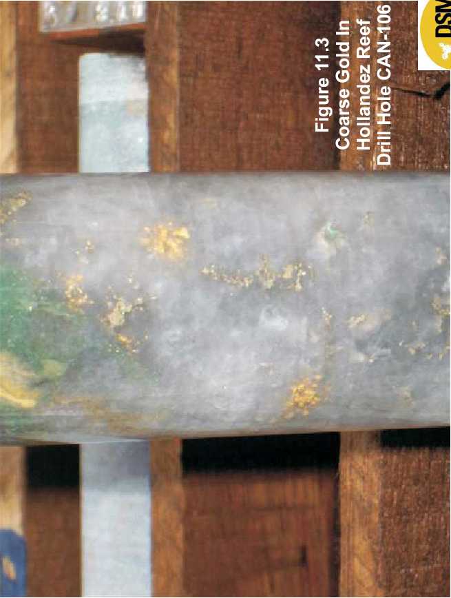
| January 2006 |

| Updated Resource & Reserve Estimate, Jacobina Dec 2005 |
| Hole CAN-106 |
- 3.94 g Au/t over a true width of 9.6m in a wider section grading 2.36 g Au/t over atrue width of 31.4m (MU reef) in CAN-106
- 3.20 g Au/t over a true width of 5.9m (Liberino reef); 2.60 g Au/t over 5.3m and37.45 over 0.3m true width (both Hollandez reef) in CAN-106
| Figure 11.2, previous, a plan showing grade times thickness contours of the MU reef indicates that there is a major southeasterly plunging high grade mineralized zone in the old mine area that is open to the east and south with a second major trend developing to the south of the mine as indicated by the step out holes. The plan map also shows the likely approximate limit of mineralization based on an interpretation of results of the recently completed induced polarization geophysical (IP) survey by John Buckle, P.Geo., consulting geophysicist for DSM. Figure 11.4 is a 3-D model of the IP chargeability prepared by Mr. Buckle that shows the outline of the anomalous area which extends in the north from the old mine area southwards for at least 1.6km. Holes CAN-105 and CAN-106 confirm the continuation of the mineralized reefs in the gap in IP coverage due to steep topography. The potential to outline substantial additional resources in this target area is excellent. A summary report by Mr. Buckle on the results of the IP survey is included with this report as Appendix II. In preparation for the 2006 drill program at Canavieiras, the old No. 6 adit located about 230m south of the south limit of the stoped area of the old mine was rehabilitated and services for drilling installed. Drilling from underground in the No. 6 adit will commence in January 2006. |
| 78 |
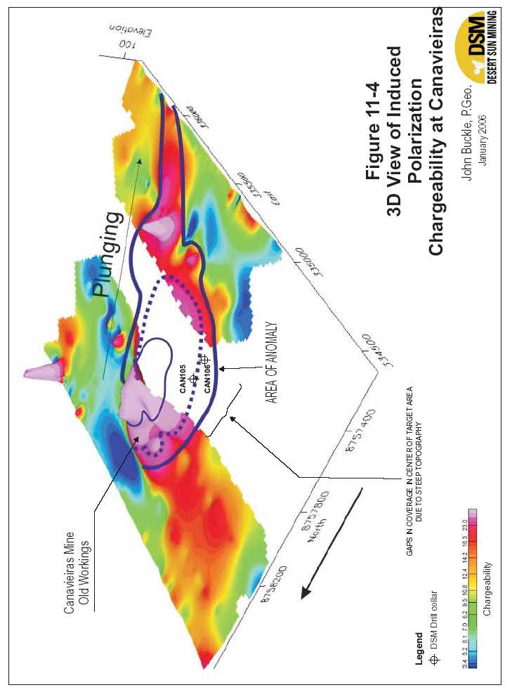

| Updated Resource & Reserve Estimate, Jacobina Dec 2005 |
| 11.4.2 MORRO DOVENTO EXTENSION |
| The Morro do Vento Extension target is located immediately north of the processing plant in the Jacobina Mine area. The former Itapicurú mine had workings in both the Morro do Vento and Morro do Vento Extension (Cuscuz) areas although most of the previous production came from the Basal and Main Reefs. These reefs are stratigraphically 350 m and 300 m, respectively, the Intermediate Reefs as shown in Figure 9.3. Previous mining and exploration focused on the high-grade zones in these reefs which were mined in stopes that were typically 2 to 2.5 m wide although the full width of the mineralized conglomerates is typically 10 to 15m wide. Past production from the Basal and Main Reefs in both the Morro do Vento and Morro do Vento Extension areas as reported by Anglo American data totalled 2,036,634 tonnes at a recovered grade of 4.14 g Au/tonne producing 271,046 ounces of gold. Of the total past production, about 72% came from the Main Reef zone, however no previous production is recorded from this reef in the Morro do Vento Extension area. Historic underground and surface diamond drill holes that tested the Basal Reef also intersected the Main Reef target zone area however most drill core in this zone was not previously assayed because of the predominantly structural style of the mineralization. This core was sampled as part of the current program. At the Morro do Vento Extension area located immediately north of the processing plant, 24 drill holes totaling 8,511 metres were completed in 2005. This drilling focused on testing the downdip continuation of the Basal and Main reefs in the Morro do Vento Extension area as well as the exploring the southern continuation of the Basal and Main reefs into the Morro do Vento area which has a potential strike length of at least 600m. The Main Reef, which is stratigraphically about 50 metres above the Basal Reef, is a major target that was intersected in the new drill holes and is the northern extension of the same reef in the Morro do Vento area that was previously mined. A limited underground drilling program was also carried out in the Morro do Vento Extension area from the 630-metre level to test the potential for the Main Reef at shallower levels. Surface drilling is continuing to complete drilling needed to outline additional indicated mineral resources and to continue to test the 600 metre long target area between the Morro do Vento Extension and the north end of Morro do Vento. |
| Highlights of drilling results are as follows: |
- Holes MCZ-88 and MCZ-85 returned significant intersections in the Main Reef of3.25 g Au/t over a true width of 17.8m and 3.71 g Au/t over 5.3m true width,respectively.
- 3.25g Au/t over 17.8m true width in Main Reef in MCZ-88
- 3.71g Au/t over 5.3m true width in Main Reef in MCZ-85
- 3.25 g Au/t over a true width of 17.8m in the Basal Reef in MCZ-88
- 3.21g Au/t over 7.4m true width in Main Reef and 2.88g Au/t over 8.8m true widthin Basal Reef in MCZ-89
| 80 |

| Updated Resource & Reserve Estimate, Jacobina Dec 2005 |
- 3.84g Au/t over a true width of 7.1m in 14.4m (true width) grading 2.54g Au/t inBasal Reef in MCZ-92
- 5.94g Au/t over 3.8m true width in Main Reef in MCZ-91
- 3.51g Au/t over 4.9m true width in Main Reef in MCZ-93
- 3.66g Au/t over a true width of 4.8m in 14.5m true width grading 1.99g Au/t in BasalReef in MCZ-95 (underground hole)
- 2.26 g Au/t over 7.6m true width in Basal Reef in MCZ-96
- 5.81g Au/t over 2.3 metres true width in the Main Reef and 4.47g Au/t over 1.8metres true width in the Basal Reef in MVT-371.
- 3.23 g Au/t over 3.5m true width in Basal Reef in MVT-373
| Significant drilling results from the 2005 program are listed in Table 11.8. These drill results have been incorporated in the updated resource estimate presented in Section 17.5. Figure 11.5 , a vertical longitudinal section of the Morro do Vento Extension/Morro do Vento area, shows the distribution of the grade times thickness contours for the Basal Reef zone. |
TABLE 11.8 SIGNIFICANT DRILLING RESULTS, MORRO DO VENTO EXTENSION (MAIN/BASAL REEF)
| Hole No.* | From (m) | To (m) | Gold | Interval | True | Reef | Depth 630 | |
| (g/t) | (m) | Width | Adit Level** | |||||
| (m) | (m) | |||||||
| MCZ-84 | N | 8755440 | E334866 | El 696 | ||||
| Dip -60º/Az=270º | 368.13 | 369.45 | 2.34 | 1.32 | 1.2 | Main Reef | 240 | |
| 398.50 | 409.02 | 1.40 | 10.52 | 9.6 | Main Reef-FW | 270 | ||
| Incl. | 398.50 | 402.10 | 2.26 | 3.60 | 3.3 | Main Reef-FW | 270 | |
| Basal Reef not intersected due to faulting | ||||||||
| MCZ-85 | N | 8755380 | E334870 | El 687 | ||||
| Dip -61º/Az=271º | 414.85 | 420.98 | 3.71 | 6.13 | 5.3 | Main Reef-FW | 270 | |
| 439.37 | 449.20 | 1.61 | 9.83 | 8.6 | Basal Reef | 300 | ||
| Incl. | 439.37 | 442.22 | 3.18 | 2.85 | 2.5 | Basal Reef | 300 | |
| MCZ-86 | N | 8755305 | E334879 | El 669 | ||||
| Dip -56º/Az=271º | 426.04 | 428.80 | 1.25 | 2.76 | 2.6 | Main Reef-FW | 315 | |
| 454.10 | 456.37 | 3.04 | 2.27 | 2.1 | Basal Reef | 335 | ||
| MCZ-87 | N | 8755305 | E334879 | El 669 | ||||
| Dip -67º/Az=265º | Main Reef – no significant values | |||||||
| 81 |

| Updated Resource & Reserve Estimate, Jacobina Dec 2005 |
| Hole No.* | From (m) | To (m) | Gold | Interval | True | Reef | Depth 630 |
| (g/t) | (m) | Width | Adit Level** | ||||
| (m) | (m) | ||||||
| Basal Reef – not intersected due to faulting | |||||||
| MCZ-88 | N8755260 | E334873 | El 661 | ||||
| Dip -53º/Az=269º | 427.61 | 446.95 | 3.25 | 19.34 | 17.8 | Main Reef-FW | 455 |
| Basal Reef – not intersected due to faulting | |||||||
| MCZ-89 | N8755333 | E334890 | El 673 | ||||
| Dip -51º/Az=269º | 398.50 | 406.50 | 3.21 | 8.00 | 7.4 | Main Reef-FW | 270 |
| 442.15 | 451.65 | 2.88 | 9.50 | 8.8 | Basal Reef | 305 | |
| MCZ-90 | N8755261 | E334873 | El 661 | ||||
| Dip -62º/az=270º | No significant values – Main Reef | ||||||
| Basal Reef - not intersected due to faulting | |||||||
| MCZ-91 | N8755110 | E334850 | El 639 | ||||
| Dip -55º/az=268º | 426.27 | 430.45 | 5.94 | 4.18 | 3.8 | Main | 330 |
| MCZ-92 | N8755412 | E334879 | El 690 | ||||
| Dip -56º/az=265º | 397.45 | 403.55 | 1.00 | 6.10 | 5.5 | FW | 259 |
| 418.25 | 434.25 | 2.54 | 16.00 | 14.4 | Basal | 285 | |
| Highs cut to 30 g/t | 2.50 | ||||||
| incl. | 426.35 | 434.25 | 3.84 | 7.90 | 7.1 | Basal | 280 |
| Highs cut to 30 g/t | 3.75 | ||||||
| MCZ-93 | N8755057 | E334789 | El 636 | ||||
| Dip -50º/az=269º | 299.96 | 316.74 | 1.55 | 16.78 | 15.8 | Main+FW | 120 |
| incl. | 299.96 | 305.15 | 3.51 | 5.19 | 4.9 | Main | 115 |
| incl. | 303.03 | 305.15 | 5.21 | 2.12 | 2.0 | Main | 115 |
| 365.20 | 372.60 | 2.19 | 7.40 | 7.0 | Basal | 154 | |
| incl. | 369.34 | 372.60 | 4.56 | 3.26 | 3.1 | Basal | 155 |
| MCZ-94 | Main Reef – no significant values | ||||||
| Basal Reef – no significant values | |||||||
| MCZ-95 | N8755343 | E334508 | El 630 | ||||
| Dip -59º/az=271º | 68.52 | 85.15 | 2.00 | 16.63 | 14.5 | Basal | 68 |
| incl. | 79.60 | 85.15 | 3.66 | 5.55 | 4.8 | Basal | 70 |
| MCZ-96 | N8755261 | E334874 | El 661 | ||||
| Dip -52º/az=262º | 433.02 | 444.75 | 1.76 | 11.73 | 10.9 | Basal | 295 |
| 82 | |||||||
| Updated Resource & Reserve Estimate, Jacobina Dec 2005 |
| Hole No.* | From (m) | To (m) | Gold | Interval | True | Reef | Depth 630 |
| (g/t) | (m) | Width | Adit Level** | ||||
| (m) | (m) | ||||||
| incl. | 436.62 | 444.75 | 2.26 | 8.13 | 7.6 | Basal | 297 |
| MCZ-97 | N8755343 | E334508 | El 662 | ||||
| Dip -76º/az=273º | 48.83 | 49.90 | 1.09 | 1.07 | 0.7 | Main Reef | 50 |
| 139.40 | 141.00 | 1.65 | 1.60 | 1.1 | Basal | 134 | |
| MCZ-98 | N8755341 | E334498 | El 663 | ||||
| FW/Main | |||||||
| 20 | |||||||
| Dip -18º/az=268º | 58.23 | 60.78 | 1.90 | 2.55 | 2.5 | Reef | |
| 79.75 | 85.25 | 3.51 | 5.50 | 5.3 | Basal | 25 | |
| MCZ-99 | N8755341 | E334513 | El 630 | ||||
| Dip -51º/az=202º | 93.85 | 95.05 | 1.32 | 1.20 | 1.1 | Basal | 75 |
| 111.50 | 115.12 | 1.17 | 3.62 | 3.4 | Basal | 85 | |
| MCZ-100 | N8755405 | E334490 | El 631 | ||||
| Dip -16º/az=273º | Basal Reef – no significant values | ||||||
| MCZ-101 | N8755226 | E334491 | El 630 | ||||
| FW/Main | |||||||
| 4 | |||||||
| Dip -21º/az=271º | 0.00 | 6.72 | 1.12 | 6.72 | 6.5 | Reef | |
| FW/Main | |||||||
| 3 | |||||||
| Incl. | 0.00 | 1.60 | 1.84 | 1.60 | 1.6 | Reef | |
| FW/Main | |||||||
| 6 | |||||||
| Incl. | 5.21 | 6.72 | 2.14 | 1.51 | 1.5 | Reef | |
| 54.24 | 56.92 | 2.84 | 2.68 | 2.6 | Basal | 32 | |
| MCZ-102 | N8755650 | E334432 | El 678 | ||||
| Dip -1º/az=88º | Basal Reef – no significant values | ||||||
| FW/Main | |||||||
| 48 above | |||||||
| 43.35 | 46.81 | 1.99 | 3.46 | 3.0 | Reef | ||
| MCZ-103 | |||||||
| Dip 0º/az=88º | N8755600 | E334417 | El 677 | ||||
| 0.00 | 16.50 | 1.65 | 16.50 | 14.4 | Basal | 47 above | |
| Incl. | 11.03 | 16.50 | 3.26 | 5.47 | 4.8 | Basal | 47 above |
| Incl. | 7.80 | 16.50 | 2.50 | 8.70 | 7.6 | Basal | 47 above |
| FW/Main | |||||||
| 47 above | |||||||
| 70.75 | 74.15 | 3.05 | 3.40 | 3.0 | Reef | ||
| 83 | |||||||

| Updated Resource & Reserve Estimate, Jacobina Dec 2005 |
| Hole No.* | From (m) | To (m) | Gold | Interval | True | Reef | Depth 630 |
| (g/t) | (m) | Width | Adit Level** | ||||
| (m) | (m) | ||||||
| HW/Main | |||||||
| 47 above | |||||||
| 98.05 | 100.15 | 2.91 | 2.10 | 1.8 | Reef | ||
| MVT-371 | N8755000 | E334860 | El 642 | ||||
| Dip -46º/az=270º | 360.87 | 363.27 | 5.81 | 2.40 | 2.3 | Main Reef | 250 |
| 424.35 | 432.40 | 1.84 | 8.05 | 7.7 | Basal Reef | 295 | |
| Incl | 424.35 | 425.90 | 3.35 | 1.55 | 1.5 | Basal Reef | 294 |
| Incl | 430.55 | 432.40 | 4.47 | 1.85 | 1.8 | Basal Reef | 296 |
| MVT-372 | N8754884 | E334897 | El 653 | ||||
| Dip -52º/az=254º | 417.30 | 430.77 | 1.19 | 13.47 | 12.7 | Main+FW | 298 |
| incl. | 417.30 | 418.50 | 2.84 | 1.2 | 1.1 | Main | 298 |
| incl. | 426.70 | 430.77 | 2.37 | 4.07 | 3.8 | FW | 306 |
| 497.05 | 501.80 | 1.69 | 4.75 | 4.5 | Basal | 360 | |
| incl. | 499.70 | 501.80 | 2.96 | 2.1 | 2.0 | Basal | 360 |
| MVT-373 | N8754938 | E334897 | El 649 | ||||
| 499.76 | 506.35 | 1.35 | 6.59 | 5.7 | FW/Main | 415 | |
| Dip -62º/az=267º | |||||||
| Reef | |||||||
| 504.44 | 506.35 | 2.13 | 1.91 | 1.6 | FW/Main | 420 | |
| Reef | |||||||
| 519.90 | 524.00 | 3.23 | 4.10 | 3.5 | Basal | 435 | |
| MVT374 | N8754710 | E334898 | El 670 | ||||
| FW+Main | |||||||
| Dip -57º/az=268º | 429.90 | 439.83 | 2.18 | 9.93 | 9.2 | Reef | 335 |
| Incl. | 429.90 | 431.40 | 7.26 | 1.50 | 1.4 | Main Reef | 330 |
| Basal Reef – no significant values | |||||||
| *all holes are NQ diamond drill core size | |||||||
| ** depth calculated based on midpoint of intersection | |||||||
| 84 | |||||||
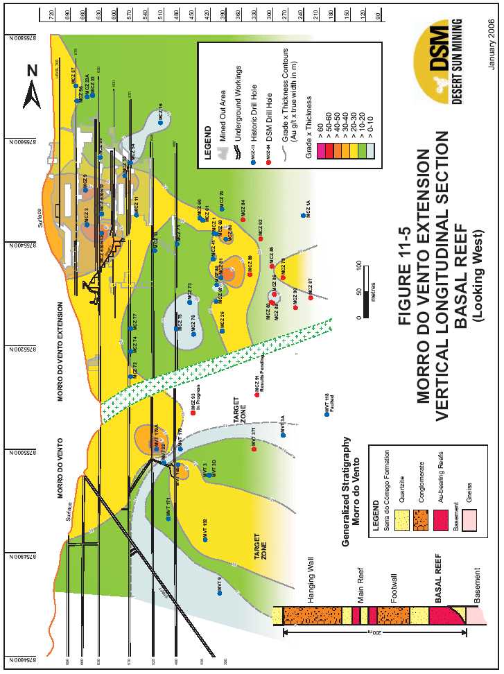

| Updated Resource & Reserve Estimate, Jacobina Dec 2005 |
| 11.4.3 JOAOBELOZONE Deep Drilling Program |
| A deep surface drilling program was initiated at the Jacobina Mine (João Belo Zone) to test the potential down dip extension of the ore zone to a depth of 600 metres the main haulage level and along strike to the south. A total of eight holes are planned totalling 6,700 metres of which two holes totalling 1,613 m were completed in 2005. The objective of this program is to significantly expand the inferred mineral resources. Historical and recent experience at the mine indicates that the conversion rate of inferred resources to indicated is generally very good. Knowledge the location and extent of the inferred resources will enable more effective mine exploration and development planning. Significant results from the two holes completed to date are summarized in Table 11.9. The results from these holes have been incorporated in the updated resource estimated as discussed in Section 17.5. Figure 11.6 is a vertical longitudinal section of the Joao Belo zone showing the approximately 50osoutherly plunge of the mineralization. |
| TABLE 11.9 | SIGNIFICANT RESULTS OF DEEP DRILLING AT THE JACOBINA | ||||||
| MINE (JOÃO BELO ZONE) | |||||||
| Hole No.* | From (m) | To (m) | Gold | Interval | True | Reef | Depth 670 |
| (g/t) | (m) | Width | Adit Level | ||||
| (m) | (m)* | ||||||
| JBA-370 | N 8750772 | E 334418 | El 834.3 | ||||
| Dip -82/az=267 | 583.83 | 598.78 | 2.77 | 14.95 | 9.4 | LMPC | 412 |
| 605.02 | 608.68 | 2.82 | 3.66 | 2.3 | MPC | 432 | |
| 628.49 | 635.25 | 2.64 | 6.76 | 4.3 | FW | 455 | |
| JBA-418 | N 8750482 | E 334450 | El 834.6 | ||||
| Dip -80/az=281 | 663.30 | 674.50 | 4.24 | 11.20 | 7.3 | LMPC | 484 |
| MPC reef appears to have merged with LMPC reef | |||||||
| FW Reef was not intersected due to faulting | |||||||
| * | all holes are NQ core size |
| ** | depth calculated based on midpoint of intersection |
| FW Reef |
| In November 2005, DSM announced the discovery of a new conglomerate reef the Foot Wall Reef (FW reef), located approximately 40 meters in the footwall of the ore zone that is currently being mined. The new reef was encountered during main access ramp development at the 555 meter level and the 530 meter level. Work has included development of two cross-cuts to fully expose the reef on the 530 and 555meter levels, channel sampling and diamond drilling. |
| 86 |
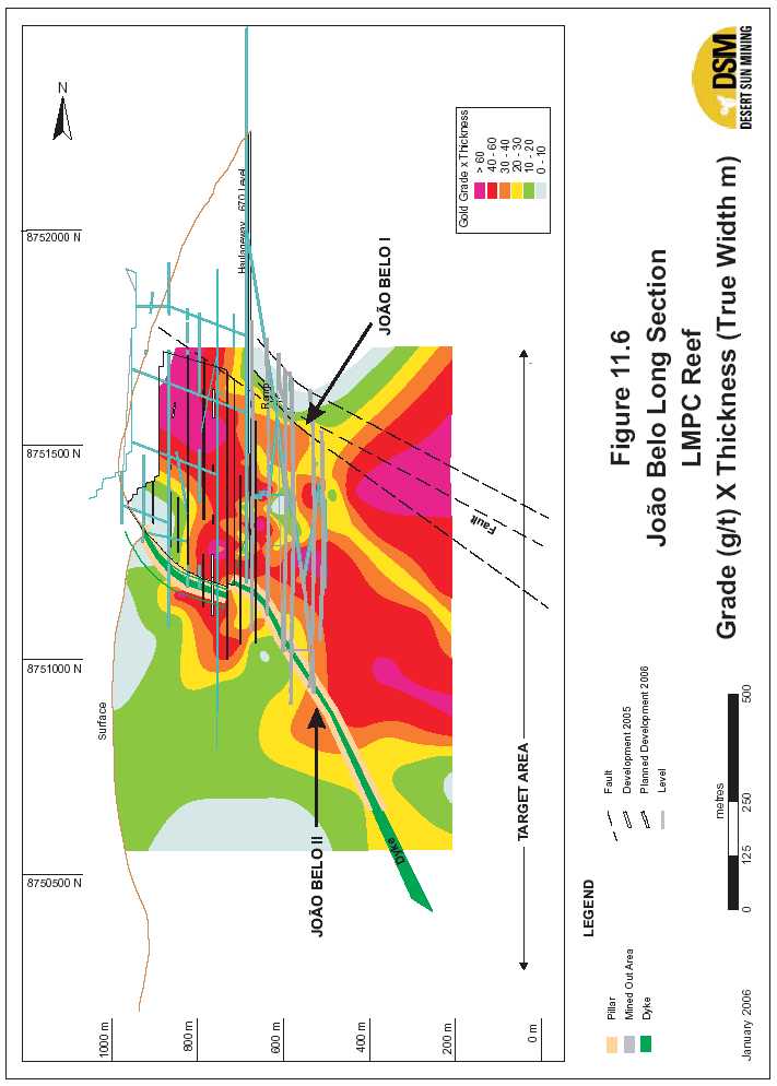

| Updated Resource & Reserve Estimate, Jacobina Dec 2005 |
| The ongoing development program has exposed the FW reef to date over a continuous strike length of 180 meters and a step-out drilling program is underway. Significant channel sampling results of 4.25g Au/t over a true width of 9.05m and 3.38g Au/t over a true width of 8.40m were returned in the 530 and 555 level cross cuts, respectively. Underground drill hole JBA-390 intersected 5.2g Au/t over 0.6m true width within a broader zone of low grade mineralization (0.58g Au/t over an 8.3m true width) in the FW reef 200 metres north of the 530 level cross cut, suggesting a potential strike length of over 300 metres. The deep surface drill holes also tested the potential downdip and along strike extension of the new conglomerate reef. Hole JBA-370 (see Table 11.9 above) intersected 2.64 g Au/t over a 4.3m true width. In Hole JBA-418, collared 300m south of JBA-370, it appears that the FW reef may have merged with the main LMPC reef as the FW Reef was not present as a distinct unit in this hole. Geological work by DSM mine staff and a recent review of the new zone by Dr. Paul Karpeta, a well known expert on Precambrian conglomerate-hosted gold deposits, indicates that the FW Reef is probably a north-south oriented gravel channel fill which likely lenses out laterally before it reaches the surface. The reef is typically a very coarse conglomerate with fracturing and widespread hematite alteration. There appears to be two stages of gold mineralization – an earlier pyrite-gold stage which has been overprinted by a later hydrothermal hematite-gold stage related to cross-cutting fractures; the latter appears to be responsible for the elevated grades seen in several areas. Dr. Karpeta commented “This is one of the conglomerate channels that trend along strike and hence do not necessarily crop out on surface. Where they are intersected by cross-cutting mineralizing fracture systems, they can be significantly upgraded. Other such “blind” conglomerate channels can be expected.” |
| 11.4.4 MORRO DOVENTO |
| The Morro do Vento target area is located about 1.5 km from the processing plant and approximately 9 km from the town of Jacobina. The Intermediate reef package here is consistently about 60-70m wide and extends along the full 2km strike length with extensive garimpos (free miners workings). This target was identified as a result of drilling in the adjacent Morro do Vento Extension (Cuscuz) area in 2002 and compilation of historical drilling data. The results of an induced polarization survey completed in 2003 at Morro do Vento indicated that the mineralized horizon likely extended over 400 metres down dip into the valley. The former Itapicurú mine had workings in the Morro do Vento and Morro do Vento Extension (Cuscuz) areas although most of the previous production came from the Basal and Main Reefs. Past production from the Intermediate Reefs at Morro do Vento was 413,974 tonnes grading 3.87 g Au/t from one conglomerate layer 1.9 m thick at the north end of the area. |
| 88 |

| Updated Resource & Reserve Estimate, Jacobina Dec 2005 |
| The Intermediate Reefs are stratigraphically 350 m and 300 m, respectively, above the Basal and Main Reefs as shown in Figure 9.3. The package is exposed on the east flank of the Morro do Vento hill. The slope of the hill is a dip slope averaging about 55º E dip. The reefs extend from the top of the hill, at elevation 1,000 m, to the valley, at elevation 630 m, where they are truncated by a steeply dipping mafic intrusive. There are numerous garimpos along the entire strike. The largest garimpo on the north end extends for 230 m along strike and is 10 to 20 m wide. At Morro do Vento, the Intermediate Reef package consists of quartz pebble conglomerate layers interbedded with quartzite that averages about 40 to 70 metres in width and extends along strike for 2 km. Conglomerates comprise approximately 25% to 40% of the package and have a distribution typical of a braided stream environment in contrast to the likely alluvial fan environment that the conglomerates in the main ore zone at the Jacobina mine were deposited in. Figure 11.7 is a surface geological plan map showing the typical distribution of the conglomerates and Figure 11.8 is a geological cross-section showing the principal mineralized reefs known from bottom to top as the LU, MU, LVLPC and SPC reefs. In 2003-2004, DSM drilled a total of 14,000m in 80 drill holes which outlined a new indicated resource of 5,016,000 tonnes grading 2.08 g Au/t containing 335,000 ounces of gold above the 800 level as outlined in Adams et al. (2005). The majority of mineral resources are hosted within the LU and MU reefs. Figures 11.9 and 11.10 are vertical longitudinal section of the MU and LU Reefs, respectively, showing grade times thickness contours. Details of drilling results at Morro do Vento are outlined in detail in Pearson and Tagliamonte (2005). An internal mining study by DSM in the first half of 2005 identified Morro do Vento as the next likely mine in the Jacobina mine area and concluded that development was best done from underground. A positive pre-feasibility study was subsequently completed on Morro do Vento in August 2005 by Devpro Mining (Adams et al., 2005) and slashing/development of the 720 level adit access had began in late 2005 with the LU and MU conglomerates expected to be intersected by the end of the year or in early January 2006. |
| 89 |
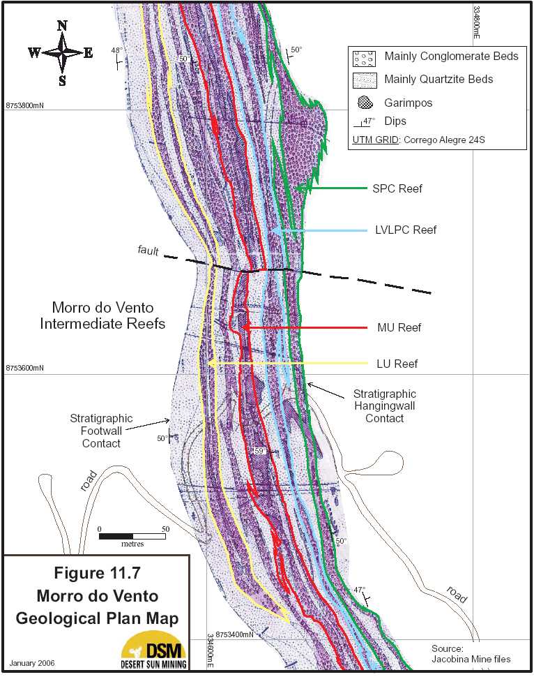

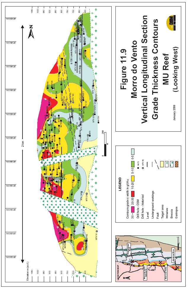

| Updated Resource & Reserve Estimate, Jacobina Dec 2005 |
| 11.4.5 SERRA DOCÓRREGO |
| The Serra do Córrego target area, located 2 kilometres north of the processing plant, is a 900 metre long target zone. Two reefs known as MU and LU which are equivalent to reefs of the same name in Morro do Vento to the south and Canavieiras to the north, are the principal targets. Extensive garimpos are found across the hillside following these conglomerates. The MU reef is best developed in the southern part of the target area and thins northward. In contrast, the LU reef continues across the majority of the hillside with characteristically deeply incised garimpos. DSM has carried out resampling of available old core in the vicinity of the MU and LU Reefs which suggests that there may, in places, be underestimation of grade in lower grade areas such as the quartzites between reefs. The drilling results have been incorporated into the mineral resource estimate completed in August 2003 reviewed by Hennessey (2003b) and discussed in Section 17.5. 11.4.6 OTHERTARGETS |
| Serra do Córrego – Maneira Reef |
| The Maneira reef is exposed at surface on the east side of the Serra do Córrego hillside for a strike length of about 700m. Inferred mineral resources in two blocks total 1,252,000 tonnes grading 3.53 g Au/t. Hole SCO-84 drilled in 2003 to followup a high grade intersection of 100 g Au/t over 2.0m in an old Anglo hole returned an excellent result of 4 g Au/t over 10.0m true width. Highlights from earlier Anglo holes also include 6.80 g Au/t over 5.70m true width in Hole SCO-55, 4.48 g Au/t over 5.81m true width in Hole SCO-57A and 3.36 g Au/t over a true width of 7.36 g Au/t in Hole SCO-54. This target is planned to be drilled in the 2006 program. |
| Serra do Córrego – Lagartixa/Viuva |
| This area is located on the west side of the Serra do Córrego hillside about 3 km (Lagartixa) to 4.5 km (Viuva) north of the processing plant. Geologically this is a complicated area with thrusting and repetition of stratigraphy. Lagartixa/Viuva appears to be potential extensions of the upper stratigraphy that hosts the gold-bearing conglomerates at Canavieiras. There is a 170m long garimpo in the Lagartixa portion of the target area. Limited drilling by Anglo at Viuva returned several significant intersections: Hole MVA intersected 12.00 g Au/t (10.38 g/t highs cut to 30 g/t) over a true width of 2.2m and Hole MVA-3A returned 12.25 g Au/t (7.49 g/t cut) over a true width of 1.8m. These two holes are about 50m apart along strike. Several other Anglo holes elsewhere in Viuva did not intersect significant values but this appears to reflect disruption of the mineralization by faulting. There is no previous drilling at Lagartixa. This target is planned to be drilled in the 2006 program. |
| Serra do Córrego – Maricota |
| At Maricota, which is located beside the main mine highway and entrance to the road to Serra do Córrego, garimpos have been mining high grade gold (5-6 g Au/t?) along fault structures cutting |
| 94 |

| Updated Resource & Reserve Estimate, Jacobina Dec 2005 |
| the Basal Reef very close to the basement contact. The target area here has at least a 100m strike length but may be more extensive. Two drill holes were completed in 2005 to test the potential of the Basal Reef here but both holes returned no significant results. |
| Joao Belo Sul |
| In 2003, two holes, totaling 266 metres, were drilled at Joao Belo Sul, located 2km south of the former Joao Belo Norte mine. Hole JBA-292 intersected 3.75 grams gold per tonne over a true width of 14.6 metres at a depth of about 69 metres surface. This intersection included a high- grade section of 10.62 grams gold per tonne over 3.6 metres true width. JBA-293 returned 1.69 grams gold per tonne over a true width of 11.4 meters at a depth of about 94 metres surface with a higher grade section of 3.68 grams gold per tonne over 2.8 metres true width. In 2004, 10 holes totaling 4,754m were completed to followup the favourable results from 2003. These holes were successful in outlining a shallow zone of mineralization that is estimated to contain an inferred mineral resource of 3,890,000 tonnes grading 1.67g Au/t. However, this drilling did not confirm the depth extent of mineralization although the favourable stratigraphy was intersected. Faulting may be complicating the distribution of mineralization. The mineralized horizons intersected in the holes at Joao Belo Sul continue to the south for an additional 9 km of strike length to the Campo Limpo area. |
| Campo Limpo |
| This target is situated 11 km to the south of the mine plant. A total of ten wide-spaced drill holes were previously completed in the area over a strike length of 800m. Significant assay results include 3.58 g Au/t over a true width of 9.06m in Hole CLP-01; 2.16 g Au/t over 3.5m true width in CLP-03 and 1.18 g Au/t over 14.8m true width in LGP-4. There is potential for an open pittable resource as there are numerous garimpos along the entire strike length. In 1997, JMC estimated an inferred resource at Campo Limpo of 1,165,050 tonnes grading 2.10 g Au/t. The average width was reported to be 8.6m. |
| Serra Branca |
| This area is located 12km along strike to the north from the plant. The two zones are garimpos within the same stratigraphic package - the Intermediate Reefs of the Serra do Córrego Formation. As indicated in Table F1 below, there are several higher grade intersections within the target area that have the potential to be expanded upon, creating an opportunity to develop an new open pittable resource. JMC in 1997 estimated an inferred resource of 1,476,702 tonnes grading 4.10 g Au/t with an average width of 1.60m but did not consider a wider, bulk mineable, zone at the time due to lack of drill information. Garimpeiros are currently actively mining at Pingadiera and at Edvaldo, a garimpo approximately 100m north of Americano. |
| 95 |

| Updated Resource & Reserve Estimate, Jacobina Dec 2005 |
| Rio Coxo |
| Rio Coxo is located 12 km north-northeast of the processing plant. Garimpeiros (free miners) are currently working at Rio Coxo in an area about 300m long using short adits and a decline. Two drill holes were completed in 2003 as well as a garimpo channel sampling program. Gold mineralization occurs in a shallowly dipping (25 to 40 degrees west dipping), north striking shear zone with highly altered ultramafics and quartz veins. Gold is hosted primarily within the quartz veins associated with pyrite. No significant values were obtained in the drill holes although the host structure was intersected in both holes. Two garimpo workings (Galleria 1 and Galleria 2) approximately 30 metres apart were channel sampled which returned 4.23 g Au/t (4.11 g Au/t with highs cut to 60 g Au/t) over an average true thickness of 1.65 metres and a 15 metre horizontal width at Galleria 1. Galleria 2 returned 7.23 g Au/t (4.66 g Au/t with highs cut to 60 g Au/t) over an average true thickness of 1.69 metres and a 17 metre horizontal width. |
| 11.5 DRILLING RESULTS – NORTHERN BAHIA GOLD BELT |
| The following sections outline drilling done in the Northern Bahia Gold Belt in 2005 and the latter part of 2004. The bulk of diamond drilling in the 2005 program was completed to test the Pindobaçu, Fumaça and Entry Point targets. A limited amount of drilling also tested other targets in the belt. |
| 11.5.1 PINDOBAÇU |
| A total of 36 holes totaling 5,942 m were completed in 2005 to test the Pindobaçu target area located 50km north of Jacobina. These holes tested the zone over strike length of 1200m. The latter series of holes (PB 21-35) focused on testing the core area that extends at least 700m along strike at deeper level (100m to 150m) than the original series of 100m spaced holes (50-80m). In addition to geological information from detailed mapping and drilling, locations of holes were also optimized using results of the recently completed induced polarization geophysical survey that has been analyzed by John Buckle, P.Geo., consulting geophysicist. Significant results from drilling at Pindobaçu are given in Table 11.10. Figure 11.11 is a geological plan map showing the locations of the drill hole collars and Figure 11.12 is a typical drill hole cross section. |
| Highlights from drilling at Pindobaçu are: |
- PB-02 which intersected 5.46 grams gold per tonne (g Au/t) over a true width of21.9m including higher grade portions grading 12.27 g Au/t over a true width of4.7m and 10.22 g Au/t over 5.5 m true width in PB-02;
- 1.46 g Au/t over a true width of 24.4m in PB-03;
- 7.20 g Au/t over a true width of 2.0m in PB-01
- 4.40 g Au/t over a true width of 3.4m in PB-21
- 2.61 g Au/t over a true width of 1.8m in PB-23
| 96 |

| Updated Resource & Reserve Estimate, Jacobina Dec 2005 |
- 23.63 (13.51 with highs cut to 30 g/t) over a true width of 2.5m in PB-30
- 3.11g Au/t over a true width of 8.0m in PB-27
- 3.02 g Au/t over a true width of 5.1m in PB-35
| In addition, assay results for chip sampling in a shaft located at N8,811,938/E348,876 in the Pindobaçu “garimpo” returned 3.27 g Au/t over 14.1m in a vertical section including 6.85 g Au/t over 5.0m. The deeper series of holes has confirmed that the strong alteration zone extends downdip to at least 150m with significant assays in holes PB-27 and PB-35 as noted above. The most intense portion of the alteration is widening with depth from about 10m in the shallower holes to 20m in the deeper holes. Overall there is also more consistency in gold grades in the deeper holes although the centre of the hydrothermal system as yet to be intersected. Based on drilling and detailed mapping at the Pindobaçu, Entry Point and Fumaça targets, which cover 18 km of strike length, a new model has been developed for the structural evolution and deposition of gold mineralization. Deformation is much stronger that previously recognized prior to drilling; gold mineralization occurs within fractured, faulted and brecciated quartzites in the hinge area of a major east dipping overturned anticline fold structure where the quartzites are capped by less permeable metavolcanic and metasedimentary rocks of the Archean Mundo Novo Formation. This folding occurred during a major tectonic event where rocks of the Mundo Novo Greenstone Belt were thrust westerly over quartzites and local conglomerates of the Jacobina Group which are equivalent in age to the quartzites and conglomerates of the Serra do Córrego Formation in the Jacobina mine area. The mineralogy and geochemistry of this system is remarkably similar to the gold mineralization in the quartz pebble conglomerates in the Jacobina mine area to the south. The regional Pindobaçu Fault system which forms the eastern boundary of the Jacobina Basin is most likely a major focus of hydrothermal alteration and mineralization. It is possible that there could be a series of hydrothermal centres with significant gold mineralization along this extensive structure. |
| 97 |

| Updated Resource & Reserve Estimate, Jacobina Dec 2005 |
| TABLE 11.10 | SIGNIFICANT DRILLING RESULTS, NORTHERN AREA, BAHIA | |||||
| GOLD BELT | ||||||
| Hole No.* | From (m) | To (m) | Gold | Interval | True | Depth Below |
| (g/t) | (m) | Width | Surface** | |||
| (m) | (m) | |||||
| Pindobaçu(50km north of Jacobina) | ||||||
| PB 01 | N8812051 | E348976 | El 597 | |||
| dip -50º/az=270º | 1.00 | 1.40 | 0.70 | 0.40 | 0.3 | 1 |
| 14.75 | 20.55 | 0.54 | 5.80 | 3.7 | 13 | |
| 98.55 | 101.60 | 7.20 | 3.05 | 2.0 | 81 | |
| 107.63 | 108.60 | 0.59 | 0.97 | 0.3 | 88 | |
| 113.58 | 115.35 | 0.43 | 1.77 | 1.1 | 91 | |
| 184.58 | 185.45 | 5.21 | 0.87 | 0.6 | 135 | |
| PB 02 | N8811930 | E348930 | El 628 | |||
| dip -50º/az=270º | 43.48 | 67.77 | 5.46 | 24.29 | 21.9 | 35 |
| incl. | 44.15 | 49.41 | 12.27 | 5.26 | 4.7 | 36 |
| incl. | 61.63 | 67.77 | 10.22 | 6.14 | 5.5 | 55 |
| 86.40 | 87.40 | 2.05 | 1.00 | 0.9 | 79 | |
| PB 03 | N8811676 | E348938 | El 649 | |||
| dip -50º/az=270º | 24.05 | 30.58 | 0.67 | 6.53 | 5.9 | 28 |
| 78.07 | 105.17 | 1.46 | 27.10 | 24.4 | 84 | |
| 145.00 | 146.90 | 1.03 | 1.90 | 1.7 | 134 | |
| PB-04 | N8811849 | E348920 | El 641 | |||
| Dip -50º/Az=272º | 43.07 | 62.50 | 0.51 | 19.43 | 15.9 | 47 |
| incl. | 43.07 | 46.07 | 1.30 | 3.00 | 2.5 | 39 |
| incl. | 61.13 | 62.50 | 1.38 | 1.37 | 1.1 | 59 |
| PB-05 | N8811952 | E348905 | El 633 | |||
| Dip -45º/'Az=268º | 28.98 | 47.30 | 0.78 | 18.32 | 18.1 | 32 |
| incl. | 28.98 | 32.70 | 1.00 | 3.72 | 3.7 | 25 |
| incl. | 40.90 | 47.30 | 1.17 | 6.40 | 6.3 | 37 |
| PB-06 | N8811952 | E348973 | El 618 | |||
| Dip -48º/Az=269º | 85.89 | 86.70 | 23.07 | 0.81 | 0.6 | 81 |
| 105.40 | 105.85 | 2.08 | 0.45 | 0.3 | 99 | |
| 118.56 | 122.85 | 4.16 | 4.29 | 3.0 | 113 | |
| incl. | 120.21 | 122.85 | 6.57 | 2.64 | 1.9 | 114 |
| Hole lost due to caving at 123.10 | ||||||
| PB-06A | N8811952 | E348973 | El 618 | |||
| Dip -50º/Az=270º | 86.17 | 86.62 | 1.57 | 0.45 | 0.3 | 81 |
| 98 |

| Updated Resource & Reserve Estimate, Jacobina Dec 2005 |
| Hole No.* | From (m) | To (m) | Gold | Interval | True | Depth Below |
| (g/t) | (m) | Width | Surface** | |||
| (m) | (m) | |||||
| 98.95 | 100.98 | 2.41 | 2.03 | 1.4 | 94 | |
| incl. | 99.99 | 100.98 | 4.72 | 0.99 | 0.7 | 94 |
| Hole lost due to caving at 114.00 | ||||||
| PB-06B | N8811952 | E348974 | El 619 | |||
| Dip 62º/az=270º | No significant values | |||||
| PB-07 | N8811950 | E349025 | El 595 | |||
| Dip -50º/Az=270º | 99.98 | 100.80 | 1.35 | 0.82 | 0.8 | 99 |
| 132.52 | 132.98 | 2.90 | 0.46 | 0.5 | 128 | |
| 141.38 | 145.80 | 2.65 | 4.42 | 4.4 | 138 | |
| 155.76 | 156.07 | 8.82 | 0.31 | 0.3 | 150 | |
| 172.80 | 182.26 | 0.52 | 9.46 | 9.4 | 170 | |
| PB-08 | N8812050 | E348928 | El 611 | |||
| Dip 50º/az=265º | 67.31 | 76.90 | 3.89 | 9.59�� | 9.0 | 58 |
| Incl. | 67.31 | 72.37 | 7.13 | 5.06 | 4.8 | 56 |
| PB-09 | N8812051 | E349034 | El 577 | |||
| Dip 50º/az=271º | 136.90 | 142.90 | 2.11 | 6.00 | 3.8 | 135 |
| Incl. | 139.90 | 142.90 | 4.08 | 3.00 | 1.9 | 136 |
| 154.90 | 156.23 | 0.66 | 1.33 | 0.9 | 149 | |
| 210.9 | 211.83 | 2.61 | 0.93 | 0.6 | 197 | |
| PB-10 | N8812001 | E348952 | El 613 | |||
| Dip 51º/az=269º | 110.68 | 113.94 | 0.65 | 3.26 | 3.1 | 100 |
| 112.80 | 113.94 | 1.13 | 1.14 | 1.1 | 100 | |
| PB-11 | N8811900 | E348913 | El 633 | |||
| Dip -51º/az=269º | 52.85 | 63.83 | 1.95 | 10.98 | 9.3 | 55 |
| incl. | 57.24 | 60.85 | 4.92 | 3.61 | 3.1 | 55 |
| PB-12 | N8811749 | E348926 | El 650 | |||
| Dip -51º/az=269º | 57.93 | 60.75 | 1.41 | 2.82 | 2.7 | 55 |
| 84.37 | 86.00 | 1.62 | 1.63 | 1.6 | 78 | |
| PB-13 | N8811552 | E348915 | El 657 | |||
| Dip -55º/az=270º | no significant values | |||||
| PB-14 | N8811451 | E348876 | El 658 | |||
| Dip -48º/az=271º | no significant values | |||||
| PB-15 | N8811450 | E348922 | El 639 | |||
| 99 |

| Updated Resource & Reserve Estimate, Jacobina Dec 2005 |
| Hole No.* | From (m) | To (m) | Gold | Interval | True | Depth Below | |
| (g/t) | (m) | Width | Surface** | ||||
| (m) | (m) | ||||||
| Dip | -48º/az=271º | 31.54 | 32.90 | 0.58 | 1.36 | 1.1 | 24 |
| 47.36 | 48.48 | 1.28 | 1.12 | 0.9 | 40 | ||
| 125.20 | 125.73 | 20.12 | 0.53 | 0.4 | 147 | ||
| PB-16 | N8811350 | E348927 | El 625 | ||||
| Dip | -51º/az=270º | 32.15 | 32.74 | 1.58 | 0.59 | 0.5 | 31 |
| 37.60 | 38.76 | 1.61 | 1.16 | 0.9 | 35 | ||
| PB-17 | N8811246 | E348847 | El 611 | ||||
| Dip | -49/az=268 | 103.87 | 107.99 | 0.85 | 4.12 | 2.3 | 104 |
| incl. | 103.87 | 104.73 | 1.89 | 0.86 | 0.5 | 102 | |
| PB-18 | N8811249 | E348928 | El 599 | ||||
| Dip | -47/az=272 | 8.80 | 17.50 | 0.89 | 8.70 | 8.4 | 9.5 |
| incl. | 12.70 | 16.89 | 1.49 | 4.19 | 4.1 | 11 | |
| PB-19 | N8811150 | E348849 | El 624 | ||||
| Dip | -50/az=270 | 136.17 | 138.55 | 1.81 | 2.38 | 1.0 | 122 |
| PB-20A | N8811049 | E348784 | El 602 | ||||
| Dip | -50/az=270 | 34.31 | 37.14 | 1.09 | 2.83 | 1.4 | 45 |
| PB-21 | N8812149 | E348945 | El 587 | ||||
| Dip | -50/az=270 | 61.70 | 65.35 | 4.04 | 3.65 | 3.4 | 55 |
| PB-22 | N8812250 | E348968 | El 558 | ||||
| Dip | -50/az=273 | No significant results | |||||
| PB-23 | N8812350 | E348997 | El 533 | ||||
| Dip | -50/az=270 | 76.00 | 76.92 | 1.69 | 0.92 | 0.8 | 64 |
| 84.08 | 86.23 | 2.61 | 2.15 | 1.8 | 71 | ||
| PB-24 | N8811552 | E349007 | El 619 | ||||
| Dip | -50/az=270 | 53.41 | 56.00 | 1.30 | 2.59 | 2.4 | 58 |
| 63.50 | 64.58 | 2.33 | 1.08 | 1.0 | 69 | ||
| PB-25 | N8811899 | E348978 | El 617 | ||||
| Dip | -50/az=270 | 95.00 | 96.64 | 0.91 | 1.64 | 1.5 | 92 |
| 101.84 | 102.75 | 2.32 | 0.91 | 0.8 | 98 | ||
| 115.32 | 116.00 | 2.03 | 0.68 | 0.6 | 109 | ||
| 122.42 | 123.40 | 2.05 | 0.98 | 0.9 | 117 | ||
| 100 |

| Updated Resource & Reserve Estimate, Jacobina Dec 2005 |
| Hole No.* | From (m) | To (m) | Gold | Interval | True | Depth Below | |
| (g/t) | (m) | Width | Surface** | ||||
| (m) | (m) | ||||||
| PB-26 | N8811800 | E348972 | El 612 | ||||
| Dip | -49/az=269 | 112.08 | 113.04 | 2.34 | 0.96 | 0.9 | 117 |
| 121.20 | 121.65 | 1.13 | 0.45 | 0.4 | 126 | ||
| PB-27 | N8811700 | E348972 | El 636 | ||||
| Dip | -50/az=270 | 93.97 | 102.60 | 3.11 | 8.63 | 8.0 | 92 |
| PB-28 | N8811602 | E348974 | El 637 | ||||
| Dip | -48/az=270 | 68.00 | 74.26 | 1.50 | 6.26 | 5.9 | 71 |
| 68.00 | 71.00 | 2.49 | 3.00 | 2.9 | 69 | ||
| PB-29 | N8811999 | E348999 | El 597 | ||||
| Dip | -50/az=269 | No significant results | |||||
| PB-30 | N8811603 | E348917 | El 661 | ||||
| Dip | -50/az=269 | 101.73 | 104.37 | 23.63 | 2.64 | 2.5 | 88 |
| Highs cut to 30 g/t | 13.51 | ||||||
| PB-31 | N8812100 | E348975 | El 585 | ||||
| Dip | -47/az=270 | 85.00 | 90.35 | 1.21 | 5.35 | 5.0 | 81 |
| PB-32 | N8812100 | E349027 | El 572 | ||||
| Dip | -50/az=270 | 137.67 | 138.62 | 2.03 | 0.95 | 0.9 | 131 |
| PB-33 | N8812150 | E349000 | El 572 | ||||
| Dip | -49/az=270 | 99.48 | 101.10 | 1.80 | 1.62 | 1.6 | 93 |
| 106.62 | 110.66 | 1.35 | 4.04 | 3.9 | 100 | ||
| incl. | 106.62 | 108.13 | 2.97 | 1.51 | 1.4 | 99 | |
| PB-34 | N8812200 | E349025 | El 558 | ||||
| Dip | -49/az=270 | 113.09 | 115.66 | 1.59 | 2.57 | 2.3 | 100 |
| PB-35 | N8812300 | E349025 | El 539 | ||||
| 114.98 | 120.88 | 3.02 | 5.90 | 5.1 | 96 | ||
| 1 all holes are NQ diamond drill core size; dip and azimuth is measured in degrees 2 depth calculated based on midpoint of intersection |
| 101 |
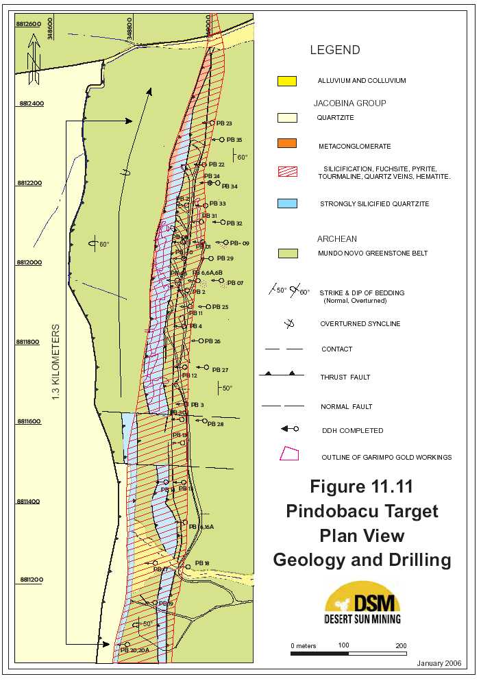

| Updated Resource & Reserve Estimate, Jacobina Dec 2005 |
| 11.5.2 FUMAÇA |
| At Fumaça, nine (9) holes totaling 1,575 m were completed to test several targets outlined by geological mapping/sampling, soil geochemical surveys and induced polarization surveys. Hole FN-01 tested below a garimpo where sampling by DSM had returned 7.36 g Au/t over 4.5m including a very high grade bluish-grey quartz vein 0.3m wide that returned 91 g Au/t. Although this hole intersected strongly silicified quartzites, it appears that faulting has offset the downdip extension of this zone. Hole FN-2A tested a coincident soil Au geochemical and geophysical anomaly and returned0.72 g Au/t over a true width of 10.1m including a higher grade portion grading 1.95 g Au/t over 2.2m. Hole FN-03, located 300m west of FN-04, tested a similar target but did not intersect any significant values. Hole FN-04 which tested a coincident soil and induced polarization anomaly located 700m east of Hole FN-1 returned 0.86 g Au/t over a true width of 1.0m. Hole FN-05 tested the downdip extension of the intersection previously obtained in Hole FN-2A (0.7 g Au/t over a true width of 10.0m) . This hole returned 1.37 g Au/t over 3.6m including a 1m interval grading 3.37 g Au/t. FN-06, 320m west of FN-02A on the same section returned 5.38 g Au/t over 1.4m true width. FN-07, 80m east of FN-02A, also on the same section, returned 1.53 g Au/t over a true width of 1.4m. |
| 104 |

| Updated Resource & Reserve Estimate, Jacobina Dec 2005 |
| TABLE 11.11 | SIGNIFICANT DRILLING RESULTS, FUMACA, NORTHERN AREA, | ||||||
| BAHIA GOLD BELT | |||||||
| Hole No.* | From (m) | To (m) | Gold (g/t) | Interval | True | Depth | |
| (m) | Width (m) | Below | |||||
| Surface** | |||||||
| (m) | |||||||
| Fumaça(10 km north of Pindobaçu) | |||||||
| FN-01 | N 8824660 | E 351374 | El 545 | ||||
| dip -50º/az=275º | No significant values | ||||||
| FN-02 | N 8823700 | E 351315 | El 681 | ||||
| dip -50º/az=275º | No significant values | ||||||
| FN-02A | N 8823700 | E 351316 | El 681 | ||||
| dip -60º/az=275º | 38.75 | 52.90 | 0.72 | 14.15 | 10.1 | 37 | |
| incl. | 38.75 | 41.90 | 1.95 | 3.15 | 2.2 | 37 | |
| 65.10 | 66.10 | 0.59 | 1.00 | 0.7 | 62 | ||
| FN 03 | N 8823801 | E 351001 | El 720 | ||||
| dip -50º/az=275º | No significant values | ||||||
| FN-04 | N 8824427 | E 352061 | El 540 | ||||
| Dip 50º/Az=275º | 126.60 | 127.60 | 0.86 | 1.00 | 1.0 | 97 | |
| FN-05 | N 8823700 | E 351350 | El 675 | ||||
| Dip 60º/Az=270º | 54.00 | 57.68 | 1.37 | 3.68 | 3.6 | 55 | |
| Incl. | 54.00 | 54.97 | 3.37 | 0.97 | 1.0 | 53 | |
| FN-06 | N8823700 | E350996 | El 727 | ||||
| Dip -50º/az=270º | 116.98 | 117.27 | 1.07 | 0.29 | 0.2 | 136 | |
| 125.20 | 127.26 | 5.38 | 2.06 | 1.4 | 147 | ||
| incl. | 125.20 | 125.73 | 20.12 | 0.53 | 0.4 | 147 | |
| FN-07 | N8823700 | E351396 | El 664 | ||||
| Dip -60º/az=270º | 68.05 | 69.50 | 1.53 | 1.45 | 1.4 | 68 | |
| FN-08 | N8823881 | E351268 | El 634 | ||||
| Dip -50º/az=270º | no significant values | ||||||
| FN-09 | N8823013 | E351299 | El 636 | ||||
| Dip -50º/az=270º | no significant values | ||||||
| 105 |

| Updated Resource & Reserve Estimate, Jacobina Dec 2005 |
| 11.5.3 ENTRYPOINT |
| The Entry Point Target is located 5.5 km north form the town of Pindobaçu, midway between the Pindobaçu (5 km south) and Fumaça (6 km north) targets. Six reconnaissance drill holes totaling 1,608 m were completed in 2005 to test the stratigraphy of the area and to test for the potential to host gold mineralization. Significant results from these holes are given in Table 11.12 below. Holes EP-01 and EP-02 as shown in Figure 11.13, drilled to lengths of 440 metres and 488 metres, respectively, intersected a package of interbedded pebbly quartzite and quartzite with several beds of conglomerates with small to medium-sized pebbles of quartz. Widespread hydrothermal alteration including fuchsite and silicification was present in both holes with local disseminated pyrite. Anomalous gold values typically ranging from 100 to 300 ppb were returned with a best result of 0.57 g Au/t over 0.59 metres in Hole EP-01 (see Table 11.12) . Hole EP-2 tested the area beneath a garimpos (local miner working area) and intersected a mafic dyke cut by quartz veins with geochemically anomalous (100-200 ppb) Au values. Holes EP-03 to EP-05 inclusive on the same section did not return any significant values. Hole EP-06, collared 900 m to the south, tested an area where surface channel sampling had returned 1.0 g Au/t over a strike length of 14.0m in quartz pebble conglomerate. This hole intersected a medium pebble conglomerate which returned 1.55g Au/t over 5.4m. The drill holes in the Entry Point area have confirmed the presence of quartz pebble conglomerates with hydrothermal alteration. The results from Hole EP-06 are the first significant quartz pebble conglomerate-hosted gold found outside the Jacobina mine area. The thin layers of conglomerate intersected in the holes indicate that the holes were likely drilled on the edge of the entry point system. Further work will focus on locating the centre of the entry point where the channels with the coarsest conglomerates that are the prime target for gold mineralization will likely be. Results of the IP surveys will also assist in locating this target. |
| 106 |

| Updated Resource & Reserve Estimate, Jacobina Dec 2005 |
| TABLE 11.12 | SIGNIFICANT DRILLING RESULTS, ENTRY POINT AREA, | |||||||
| NORTHERN AREA, BAHIA GOLD BELT | ||||||||
| Hole No.* | From (m) | To (m) | Gold (g/t) | Interval | True | Depth Below | ||
| (m) | Width | Surface** (m) | ||||||
| (m) | ||||||||
| Entry Point (5km north of Pindobaçu) | ||||||||
| EP-01 | N 8817800 | E 350275 | El 576 | |||||
| 109.23 | 109.82 | 0.58 | 0.59 | 0.59 | 100 | |||
| Dip | 50º/Az=270º | |||||||
| EP-02 | N 8817800 | E 349375 | El 807 | |||||
| Dip | 50º/Az=270º | No significant values | ||||||
| EP-03 | N8817738 | E349551 | El 756 | |||||
| Dip | -50º/az=270º | No significant values | ||||||
| EP-04 | N8818000 | E349364 | El 854 | |||||
| Dip | -51º/az=268º | No significant values | ||||||
| EP-05 | N8816881 | E349900 | El 654 | |||||
| Dip | -51º/az=º | No significant values | ||||||
| EP-06 | N8816882 | E349845 | El 670 | |||||
| Dip | -49º/az=268º | 180.30 | 186.27 | 1.55 | 5.39 | 5.4 | 160 | |
| Incl. | 180.30 | 183.52 | 2.40 | 3.22 | 3.2 | 160 | ||
| 107 |


| Updated Resource & Reserve Estimate, Jacobina Dec 2005 |
| 11.5.4 OTHERTARGETS |
| One drill hole was completed in each of two areas of garimpos 10km (Samburá) and 23km (Biquinha) south of Pindobaçu, respectively. Both of these areas are characterized by the presence of high grade (15-30 g Au/t) narrow (1-2cm wide) quartz veins cutting andalusite- graphite-quartz schists; neither hole returned significant values. Hole CA-01 tested the potential extension of the Serra do Córrego Formation conglomerates 10km north of Jacobina. This hole intersected green fuchsite-bearing conglomerates similar to those in the Jacobina mine area but did not return any significant values. |
| Other Targets | ||
| Samburá(10 km south of Pindobaçu) | ||
| SB 01 | N 8802260 E 345257 | El 729 |
| dip - | ||
| 50º/az=270º | No significant values | |
| Biquinha(23 km south of Pindobaçu) | ||
| BQ-01 | N 8789101 E 341655 | El 949 |
| dip - | ||
| 50º/az=270º | No significant values | |
| Serra do Córrego Extension(10 km north of Jacobina) | ||
| CA-01 | N 8774422 E 335664 | El 607 |
| dip - | ||
| 50º/az=270º | No significant values | |
| *all holes are NQ diamond drill core size and have been drilled+perpendicular to the | ||
| north-south strike of the zones. | ||
| ** depth calculated based on midpoint of intersection | ||
| 109 |

| Updated Resource & Reserve Estimate, Jacobina Dec 2005 12.0 SAMPLING METHOD AND APPROACH |
| 12.1 JMC EXPLORATION |
| JMC geologists lithologically logged and sampled all drill holes. Previous practice was to sample all conglomerates, but William staff changed this to a practice of sampling through the conglomerates into adjacent quartzites on both sides. Surface holes, which tend to be exploration drilling, were split, half-core sampled and then stored for future reference. Underground definition drill holes are whole-core sampled resulting in similar sample volumes to those taken from surface core. Generally, all samples were submitted to the mine’s assay laboratory but, in later years, William began submitting samples from exploration holes to an outside laboratory. JMC beat geologists collected chip panel samples at regular intervals from all underground development headings which were in, or near, mineralization. Samples were continuous chip/channel samples collected by hammer and moil onto a canvas mat. Historically the samples were collected over narrow widths, often less than 20 cm, however in 1996 this was modified to a standard 50 cm sample except when approaching a lithological contact when shorter samples were permitted. |
| 12.2 DSM EXPLORATION |
| DSM has followed similar drill core sampling procedures to those used by JMC with some modification. All drill core to be sampled was split in half and one half submitted for assay. In the early portions of the program a hand splitter was used. In the latter part, a diamond saw was obtained and sawing replaced most of the splitting except for lower priority samples. Sample lengths were selected based on lithology with the typical sample being about 0.5 m long and the longest being approximately 1.0 m. Much more extensive sampling of the surrounding quartzites is now being conducted because of the potential for low gold grades to affect potential open pit economics. All samples were tagged with the sample tag stapled to the core box at the start of the sample and a second tag with the same number placed in the sample bag. Care was taken to thoroughly clean the splitter after each sample to avoid contamination of subsequent samples. All drill core, with the exception of some sections of barren intrusive, was split and sent for assay. |
| 110 |

| Updated Resource & Reserve Estimate, Jacobina Dec 2005 |
| 13.0 SAMPLE PREPARATION, ANALYSES AND SECURITY |
| 13.1 JMC |
| During its operation the Jacobina mine had a relatively modern, well-equipped assay laboratory on site, near the plant and metallurgical facility at the Itapicurú mine. The laboratory was equipped for performing both fire assay (FA) and atomic absorption spectrophotometry (AAS) analyses. AAS determinations of precious metals at Jacobina were used only for process control samples which contain soluble gold. All samples from the geology department were analysed by the FA method with gravimetric finish. The sample preparation facility at the laboratory consisted of a sample drying and handling area and a crushing room. After drying, samples were crushed in stages using a jaw crusher and roll crusher. Samples were then split with a Jones riffle splitter to produce a large sample which was ground to minus 100 mesh pulp in a disk pulverizer. The final pulp was rolled on a rubber mat and then quartered. Sample increments were selected from opposite quarters to composite an analytical subsample or aliquot. This sample was then subjected to FA analysis. Historically JMC used 100-g aliquots for its fire assays. After a study performed in 1996, which compared 50 g and 100 g samples, it was decided that all FA aliquots at Jacobina would continue to be 100 g in size. In Micon’s experience this is a very large aliquot size and is likely to result in relatively little variability being introduced at the final sample preparation stage. The 100-g samples were fused in a single large crucible. Crucibles for metallurgical and geological samples were kept separate. Micon’s review in 1998 (Hennessey 1998) concluded that the sample preparation procedure described above is a conventional one used in the mining industry for decades. It was noted, however, that in recent years the use of disk pulverizers has been discouraged in the preparation of samples which may contain native gold, as these devices have a tendency to smear gold onto the plates and retain it, only to release the gold later in a following sample. Present best practice is considered to be a ring and puck (or puck and bowl) pulverizer. The practice of rolling a sample on a rubber mat was initiated to homogenize it before selecting a subsample for further preparation or analysis. In a situation where free gold grains exist in a matrix of pulverized silicate minerals, the extreme density contrast between them (19.3 for gold versus 2.7 to 3.1 for most minerals) means that the gold grains are very quickly sifted to the bottom of the pulp and left on the trailing edge as the sample is rolled. A sample processed this way has not been homogenized but, rather, has been segregated. As a result, adequate subsampling for analysis can become difficult. The practice of quartering the pulp to subsample, as used at Jacobina, tends to mitigate this effect somewhat. The preferred practice is to select multiple sample increments from a pulp, having disturbed it as little as possible, or to split a subsample using a very small riffle splitter. In 1998, Micon expressed its opinion that both of the items outlined above should be generally discouraged given that they are not best analytical practice and tend to magnify problems |
| 111 |

| Updated Resource & Reserve Estimate, Jacobina Dec 2005 |
| associated with nugget effect. Nevertheless, given the relatively low and even gold grades of the mineralization at Jacobina, and the general lack of coarse or even visible gold, Micon believed that they have had a very limited effect on the accuracy of the resource estimation. The discussion on data quality below tends to support this view. In Micon’s view the Jacobina mine laboratory at that time was generally well-operated. and exhibited a high degree of general cleanliness and good housekeeping. |
| 13.2 DSM 13.2.1 SECURITY |
| At the Jacobina mine, DSM maintains a large covered storage facility (roof only), with office, for logging and racking of core. This facility was protected by wire mesh and had a locked gate to prevent unauthorized access. It has power and water and was located behind the mine’s main gate. DSM maintains a 24hr security presence at the mine and this has been the case since closure of the mine in 1998. Old core retained by the previous operators is intact and in relatively good condition. Core is transported directly here, from the drill rigs, and is logged and sampled at the core logging facility. Bagged samples are stored in this secure environment at the mine until transported to the laboratory. |
| 13.2.2 SAMPLEPREPARATION ANDANALYSES SGS Lakefield Geosol |
| The primary analyses of all samples were performed by Lakefield Geosol Ltda. (Lakefield), an ISO 9001, 2000 certified laboratory located in Belo Horizonte, Brazil. Samples were routinely shipped each 2-3, in batches of 100 to 250, by truck to Salvador and then by air freight to Belo Horizonte. Turnaround time in the laboratory was approximately 7 to 10 days after receipt of samples. Lakefield regularly provides DSM with a detailed status of all samples shipped to the laboratory, when samples were received and when analytical work is planned to be completed. Lakefield Geosol employed the following method for sample preparation and analysis in Phase I: |
- Core samples are initially crushed using a jaw crusher and then 250 g is split andpulverized using a “ring and puck” pulverizer to 95% passing 150 mesh. (Note: thisprocedure was changed early in the Phase II program, see below.)
- Prior to processing of samples from new projects, pilot samples are analyzed to determinethe correct flux and flux composition for best analysis, as determined by the size of thelead button produced.
| 112 |
| Updated Resource & Reserve Estimate, Jacobina Dec 2005 |
- Fifty grams of pulverized material is weighed and transferred to plastic bags containing120 g (+/-) of the pre-mixed flux as indicated in the worksheet. The addition or omissionof other fluxes such as flour and nitre is based upon the sample appearance and/or datagleaned from the pilot samples.
- The sample and fluxes are mixed, inquarted with AgNO3 and fused for approximately 45minutes to 1 hour at 1,050°C.
- The samples are then removed from the furnace and poured into molds.
- Once cooled, the slag is separated from the lead button and the button is pounded into acube to remove all remaining attached slag. A button weighing approximately 28 g is theideal result. The button size is evaluated and any anomalies recorded.
- The buttons are then transferred to cupels that have been preheated for approximately 15minutes. The cupels are placed in the cupellation furnace for approximately 50 minutesat 950°C, ensuring that all the lead is oxidized.
- The cupels are removed from the furnace and the remaining precious metal beads/prillsseparated for parting and acid digestion.
- The beads are digested in aqua regia and bulked to a predetermined volume prior toanalysis by Atomic Absorption Spectrophotometer (AAS). All test tubes are calibrated toensure equal bulk up volumes.
- Fire assay trays hold 24 samples always including one in-house reference sample, ablank, and one duplicate.
- Samples solutions are read by AAS with the data captured directly into the LaboratoryInformation Management System (LIMS). All sample data along with QC data are storedin the LIMS with a secure paper trail for traceability.
- The detection limit for the AUFA50 procedure is 5 parts per billion (ppb).
| After completion of DSM’s 2003 exploration program an analysis of the QA/QC data was undertaken. Scatter plots of duplicate samples (both Lakefield vs. Lakefield and Lakefield vs. ALS Chemex) showed regression lines without strong biases but a lot of scatter within the data (see discussion in Section 14 below). A program of screen metallics fire assaying did not find any significant nugget effect so a “cluster nugget effect” problem was suspected. Cluster nugget effect is the tendency, in some deposits, of fine gold particles to be found near other fine gold particles, in small clusters, rather than more evenly distributed. If care is not taken in sample preparation this type of mineralization will behave like a nugget. The gold at Jacobina is known to be generally fine in size hence it was considered possible that there may be a “cluster nugget” effect. |
| 113 |

| Updated Resource & Reserve Estimate, Jacobina Dec 2005 |
| Generally, the most effective method of dealing with cluster nugget effect is to crush/pulverize to a finer size before any splitting of the sample is done. This separates the clusters of fine gold particles and distributes them more evenly through the sample before splitting. Additionally, a larger aliquot may be used for assaying. Micon recommended to DSM that it look into this phenomenon and a revised sample preparation protocol was introduced as of the end of April, 2004. One kilogram of sample was now pulverized (increased from 250 g) to 95% passing minus 200 mesh (increased from 150 mesh). Check samples on rejects assayed at the second laboratory used the same procedure. DSM has retained coarse sample rejects for the program so any necessary reassays can be easily completed. |
| ALS Chemex |
| For all batches of samples, 10% of the pulps and 5% of the rejects were routinely sent to a second laboratory, ALS Chemex (Chemex) in Vancouver, B.C. Selected pulps and rejects are sent to ALS Brasil by Lakefield Geosol. ALS Brasil rebags and numbers the pulps and pulverizes the rejects to 95% passing 150 mesh (changed to 95% passing 200 mesh in April, 2004 as described above). These samples are shipped to Vancouver for analysis. This check procedure was continued for the 2005 exploration program. Due to significant cost increases and the large number of checks already done which indicate good agreement between checks, the number of pulps being re-checked in the 2006 program will be reduced to 5% from 10% so that overall results of 10% of samples will be routinely checked. The fire assay procedure at Chemex is as follows: |
- A prepared sample is fused with a mixture of lead oxide, sodium carbonate, borax, silicaand other reagents as required, inquarted with 6 mg of gold-free silver and then cupelledto yield a precious metal bead.
- The bead is digested in 0.5 ml dilute nitric acid in a microwave oven.
- 0.5 ml concentrated hydrochloric acid is then added and the bead is further digested in themicrowave at a lower power setting.
- The digested solution is cooled, diluted to a total volume of 4 millilitres (ml) with de-mineralized water, and analyzed by AAS against matrix-matched standards. Thedetection limit is 5 ppb.
| Samples with greater than 10 parts per million (ppm) Au (10 g/t) are assayed by gravimetric finish as follows: |
- A prepared sample is fused with a mixture of lead oxide, sodium carbonate, borax, silicaand other reagents in order to produce a lead button.
| 114 |

| Updated Resource & Reserve Estimate, Jacobina Dec 2005 |
- The lead button containing the precious metals is cupelled to remove the lead.
- The remaining gold and silver bead is parted in dilute nitric acid, annealed and weighedas gold. Silver, if requested, is then determined by the difference in weights.
| Mine Laboratory |
| The mine laboratory in the Jacobina mine complex is operated for the mine under contract by SGS Lakefield. All core and rock samples from production drilling and channel sampling of development is analyzed on site by the mine laboratory. The laboratory also carries a number of analyses for process control in the plant as well as for environmental monitoring. The laboratory began operations on February 11, 2005. Gold is analyzed by the conventional fire assay process as follows: |
- Method: Gold in Solids / Fire Assay
- Parameter(s) measured: Gold
- Typical sample size: 30g, 50g
- Type of sample applicable (media): Ores, mill products, soils, and sediments
- Sample preparation technique used: Pilots
Pilot samples are analyzed to determine the correct flux and flux composition for bestanalysis as determined by the size of the lead button produced. - Weighing
- Sample weights are chosen based upon the known composition of the sample, pilotsample(s), and the required detection limit.
- Fusion and Cupelling
Transfer the samples to plastic bags containing 150 – 170 g of the pre-determined flux asindicated in the worksheet. Add the necessary quantities of flour and nitre based upon thedata gleaned from the pilots. Mix. Inquart with AgNO3. Fuse for approximately 1 hour at1050+/-25°C. Remove from the furnace and pour the samples into the molds. Separatethe slag from the lead button and pound the button into a cube. Transfer the buttons tocupels that have been heated for approximately 15 minutes. Place in the cupellationfurnace for approximately 1hour at 950+/-25°C making sure all the lead is oxidized.Remove from the furnace and separate the beads for acid digestion. - Acid Digestion and Quality Control
| 115 |

| Updated Resource & Reserve Estimate, Jacobina Dec 2005 |
- The beads are digested in HNO3 and HCl and bulked to predetermined volume prior toanalysis by AAS. Fire assay trays hold 50 samples always including one referencematerial, a blank, and usually two duplicates.
- Sample preservation required and holding time: No requirement
- Method of analysis used: Samples are analyzed by atomic absorption spectrophotometer.
- Data reduction by: Data is stored in the Laboratory Information Management Systemwith a secure paper trail for traceability.
- Figures of Merit: Limit of Detection: 10 ppb (30g) ,5 ppb (50g)
| External Reference Standards |
| In June 2004, DSM introduced three (3) external analytical standards developed by Ore Research & Exploration Pty Ltd. of Australia and marketed in Canada by Analytical Solutions Ltd. The standards, which come in sealed foil packages containing 50g of material, were inserted into batches of samples at the rate of 1 per 75 samples. SGS Lakefield Geosol also employs external standards and blanks in each batch of samples as part of their standard laboratory procedures. Results of the standards inserted by DSM were within acceptable analytical limits as shown in Figures 13.1, 13.2 and 13.3. Virtually all of the samples are with + or – 2 standard deviations of the recommended values and the Best Fit line in each graph is very close to the recommended value. In the event that there is a deviation greater than 3 standard deviations in any result on the independent standard, 25% of the batch is rerun with a representative range of assays being selected. In the cases where this problem has occurred, results from the re-run have confirmed the validity of the original assay results. In addition, the results outside the range are almost always on the low side. It appears that occasionally the standard sample does not fuse properly resulting in much lower results relative to the recommended standard value. |
| 116 |

| Updated Resource & Reserve Estimate, Jacobina Dec 2005 |
| Figure 13.1 Graph of Analytical Results at Lakefield for Standard OREAS 6Pb. |
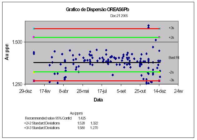
| 117 |

| Updated Resource & Reserve Estimate, Jacobina Dec 2005 |
| Figure 13.2 Graph of Analytical Results at Lakefield for Standard OREAS 7Pa. |
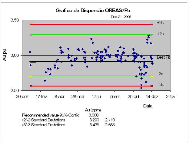
| 118 |

| Updated Resource & Reserve Estimate, Jacobina Dec 2005 |
| Figure 13.3 Graph of Analytical Results at Lakefield for Standard OREAS 53P. |
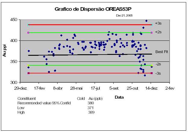
| 119 |

| Updated Resource & Reserve Estimate, Jacobina Dec 2005 14.0 DATA VERIFICATION |
| 14.1 JMC |
| The old Jacobina mine laboratory ran a quality assurance/quality control (QA/QC) program. This program consisted of introducing one sample duplicate and one blank sample with each tray of 35 fire assays. At the time of Micon’s first visit in 1998 it was William’s intention to expand the QA/QC program by purchasing and including an analytical standard and to involve the laboratory in a round-robin cross checking program with other laboratories in Brazil and/or elsewhere in South America. William also performed an initial statistical analysis of a portion of the Jacobina database after its acquisition of JMC. The data used for the estimation of the resource at João Belo were studied and this study was reviewed by Micon in 1998. Frequency histograms and log probability curves were plotted for the raw data. The plots of raw data from João Belo showed a single, lognormally distributed population from just above the 10th, out to beyond the 99th percentile, representing a gold grade range of about 0.1 to over 100 g Au/t. Below the 10th percentile, or approximately 0.1g Au/t, most of the data reported as having a value of 0.01 g Au/t. No analytical results were reported with values of 0.02 to 0.04 g Au/t and very few for 0.05 g/t to 0.09 g Au/t. This probably indicates an inability to discriminate between gold values in this concentration range and likely means that the mine laboratory has an accuracy of about ±0.1 g Au/t. The data also show very few outliers. Of the 39,664 assays in the database, only 32 were above 30.0 g Au/t. It was Micon’s opinion (Hennessey 2003b) that the portion of the database used by JMC to estimate the resources at João Belo was a “clean” and well-sampled one and was suitable for use in the accurate estimation of a resource. It is likely that the remainder of the database is of similar quality. |
| 14.1.1 PRODUCTIONRECONCILIATION |
| During its operation the Jacobina mine reconciled its annual production with the mineral resource estimates. Each year the portion of the mineral resource extracted by mining was determined and multiplied by planned recovery and dilution factors. The grade of this diluted mineral resource was reconciled to production figures, as determined by the mill, and a mine call factor (MCF) was calculated and used to adjust diluted resource grades to produce the reported mineral reserve grades. The MCF was calculated using the formula: |
| (Recovered Grade + Tails Grade)/Diluted Resource Grade |
| The MCF in use at mine closure was 0.954 indicating that the true head grade was 95.4% of the grade estimated from the mineral resources (prior to application of the MCF). Micon reviewed the methodology used for the resource reconciliation and found it to be appropriate. |
| 120 |

| Updated Resource & Reserve Estimate, Jacobina Dec 2005 |
| The results of the reconciliation show that the diluted resource estimates were predicting the head grade of mill feed to within a discrepancy of less than 5%. This indicates that the assay data produced by the mine were, on average, producing an acceptable level of accuracy for the resource estimates. Micon considered this to be within the normal range for mines and an acceptable level of reconciliation, particularly once the MCF was applied (Hennessey 2003b). At the time of preparing the year end 2005 mineral resource and mineral reserve update, the mine had only reached its full capacity of 4,200 tonnes per day by the end of the year. Mill reconciliation is currently being done based on comparison of results of daily belt feed samples and calculated head grade based on bullion produced and the grade of the tailings as determined by daily sampling. The initial data to the end of October 2005 indicated a very close agreement between belt sampling that predicted a plant head grade of 1.97 g/t versus an actual of 2.01 g/t, a difference of only 2% and a positive reconciliation. As mine production continues, reconciliation will continue to be done on a regular basis and it is expected that stoped areas will also be able to be reconciled to production in the near futures. Preliminary data indicates that the SG being used may be low but further data is required to confirm this. |
| 14.2 | DSM |
| 14.2.1 | QA/QC |
| In Hennessey (2003a) Micon discussed the QA/QC results for DSM’s Phase I exploration program. Micon noted that scatter plots of pulp and reject duplicate assays showed that Chemex was biased high relative to Lakefield. At the time Micon speculated that this bias was likely caused by a few of the higher-grade assays and may be the result of nugget effect. At the request of DSM, Lakefield carried out a test program of metallic screen assays where, following pulverizing, the samples were screened at 200 mesh and the resulting size fractions analyzed separately. The metallics assays at Lakefield essentially confirmed the original assays and did not detect a significant amount of coarse gold, a result consistent with visual observations. However, another effect was noted. Graphs for results on both pulps and rejects examined by Micon (Hennessey 2003a) showed a fair amount of scatter between 500 and 1,500 ppb, even though the regression line showed relatively little bias. Micon felt at the time that this type of behaviour suggested the possible existence of “cluster nugget effect”. As a consequence DSM instituted a modified sample preparation protocol designed to deal with the cluster nugget effect, as of the end of April, 2003. Micon concluded (Hennessey 2003a) that the new sample preparation protocols have successfully dealt with the earlier problems noted. Figures 14.1, 14.2 and 14.3 show results of check assay samples for all samples check, pulps only and rejects only, respectively for samples analyzed in the 2005 program. The results between the two laboratories compare within acceptable limits and there is no evidence of systemic bias from one laboratory to another. Samples which do not correlate very well are |
| 121 |

| Updated Resource & Reserve Estimate, Jacobina Dec 2005 |
| routinely checked and results indicate that this problem is usually due to the nugget effect or in a few cases, misnumbering of samples when they are sent out for checks. |
| Figure 14.1 | Comparison of All Check Assay Data, 2005 Exploration Program (3 graphs |
| with different scales showing the overall range of the data set) |
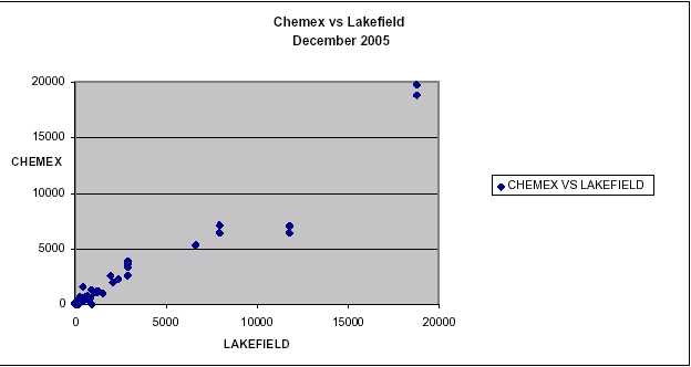
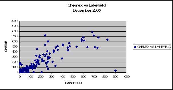
| 122 |
| Updated Resource & Reserve Estimate, Jacobina Dec 2005 |
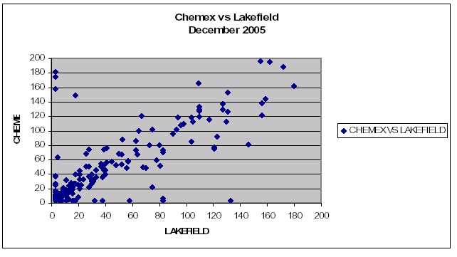
| 123 |

| Updated Resource & Reserve Estimate, Jacobina Dec 2005 |
| Figure 14.2 Comparison of Check Assay Data, 2005 Exploration Program – Lakefield versus Chemex Pulps. |
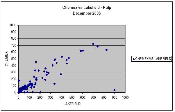
| 124 |

| Updated Resource & Reserve Estimate, Jacobina Dec 2005 |
| Figure 14.3 Comparison of Check Assay Data, 2005 Exploration Program – Lakefield versus Chemex Rejects. |
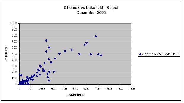
| 125 |

| Updated Resource & Reserve Estimate, Jacobina Dec 2005 |
| 14.2.2 DATABASECHECKS |
| All assay results are received electronically from the laboratories along with assay certificates, in paper form, which are mailed separately. These data are added into the Gemcom drill hole database as results become available. In the 2002 program drill hole logging was performed manually with information entered into Excel spreadsheets for importing into Gemcom. All JMC holes were also entered manually into spreadsheets. During 2003 exploration Gemcom was contracted to write a direct-entry software system which allowed data to be captured electronically as logging occurs. The logging software known as “Logger” was fully implemented in July, 2003. DSM felt it was necessary to fully check the manually entered database files for mistakes. For each drill log the original assay certificates were checked to ensure that the assays had been entered correctly. Data, once confirmed, were entered into a spreadsheet for importation into Gemcom. Once entry was complete, the spreadsheet was printed out and rechecked against the drill log. Survey data for the drill hole collars were also checked to ensure that they were located correctly. Once this stage of the checking was complete, plan maps and cross sections were plotted at the same scale as the historical archive. The new sections were overlain on the old and any discrepancies checked and corrected as necessary. DSM completed the data verification process for the historical data in July 2003 with every record checked. All data since that time has been directly entered digitally. |
| 126 |

| Updated Resource & Reserve Estimate, Jacobina Dec 2005 15.0 ADJACENT PROPERTIES |
| DSM controls most of the Bahia Gold Belt including exposures of the Serra do Córrego Formation in the entire Serra do Jacobina range with the exception of a few small garimpeiro reservations. There are no known adjacent properties whose description or mineralization materially affects the value of DSM’s land holdings. |
| 127 |

| Updated Resource & Reserve Estimate, Jacobina Dec 2005 |
| 16.0 MINERAL PROCESSING AND METALLURGICAL TESTING |
| 16.1 JACOBINA PROCESSING PLANT |
| The metallurgical process at the Jacobina Mine Complex uses a simple and efficient milling process. The process involves the following activities; Grinding of the run of mine material into a pulp, leaching the pulp in a conventional cyanide leaching process and then gold extraction of the enriched solution in a Carbon-In-Pulp (CIP) circuit. Achieved mill statistics for the operating year 2005 were 327,329 tonnes processed with mill recovery of 95.9% . A brief explanation of the metallurgical process used at the Jacobina Mine is explained below. The run of mine (ROM) material is hauled by trucks from the mine to the crushing facility adjacent to the processing plant. The ROM is initially sized by a 50 x 80 cm opening grizzly / rock breaker system located at the top of the primary jaw crusher. The primary jaw crusher, which is fed by an 80 tonne hopper, is 1,200 mm x 900 mm and has a 350 tonne per hour capacity. The product from the jaw crusher, which is <200 mm, is fed into two silo’s. The material is then feed into semi autogenous grinding mills and is ground to a size of 80% passing 200 mesh. The No.1 Mill has the dimensions of 3,658 mm x 6,706 mm and features a single 1,342 kW motor. The Mill No.2 is 4,572 mm x 9,144 mm and is equipped with two 1,342 kW motors. The pulp from the grinding circuit is pumped to the leaching tanks. The leaching circuit consists of four 9.5 m diameter x 10.25 m high mechanically agitated leach tanks and twelve 212 m3 Pachucas. The leach residence time is 24 hours. The pulp is then sent to the CIP circuit. The CIP circuit consists of six 5.6 m diameter x 7.8 m high, 180 m3 capacity mechanically agitated CIP tanks. The enriched carbon from the CIP circuit is removed and striped of its gold. From here, the pregnant solution is circulated through electro winning cells and a doré gold is produced consisting of 96% gold and 3% silver. The milling process is fully automated using modern Siemens instrumentation and automation technology for better process control. All environmental issues are strictly monitored. The Mill has “zero discharge” criteria for its effluent into the environment. All the water used in the milling process is recycled. Approximately 200 m3/hr of the 450 m3/hr make up water is reclaimed from the tailings pond. A new tailings pumping system was added to handle the increased throughput. There is an environmental engineer on staff who continually monitors and evaluates the mill and mines performance |
| 128 |

| Updated Resource & Reserve Estimate, Jacobina Dec 2005 |
| 16.2 MORRO DO VENTO TESTWORK |
| DSM carried out metallurgical tests on samples from diamond drill holes on the Morro do Vento target area. Morro do Vento is located about 1.5 km from the processing plant and existing mines, and approximately 9 km from the town of Jacobina. The metallurgical test work was conducted to determine recoveries using conventional milling. DSM is continuing further test work to determine the heap leach potential for Morro do Vento. SGS Lakefield Research Limited of Lakefield, Ontario completed the test work on six grade/ore type composites and one overall master composite prepared from rejects of diamond drill hole samples from the Morro de Vento project. Samples were selected by DSM to provide a representative range of grade and proportion of oxide/sulphide. Sample selection and the metallurgical test process was reviewed by Bruce Ferguson, P.Eng. consulting metallurgist of Kappes, Cassidy & Associates. All samples were originally prepared and tested for gold by fire assay by Lakefield Geosol in Brazil. The six grade/ore type composites and one overall Master Composite were crushed to -10 mesh. Metallurgical tests consisted of grinding tests on the Master Composite, followed by cyanidation tests on the Master Composite and the individual Grade/Ore Type composites. Averaged gold assay results for the individual composites ranged from 0.53 g Au/t for the Low Grade Oxide composite to 3.50 g Au/t for the High Grade Oxide composite. Direct assay of the Master composite by screened metallics indicated a grade of 1.73 g Au/t. SGS Lakefield reported that the overall gold extraction for the Master composite was 96.4% with a range of 95.7% to 97.0% . No significant difference in extraction was observed for the tests conducted at shorter, 12 hour, and longer, 48 hour, leach times. Cyanide and lime consumption for the Master Composite were found to be at 0.81 kg/t and 0.22 kg/t, respectively. Extractions for the individual grade/ore type composites ranged from 90.8% for Low Grade Oxide to 98.5% for High Grade Mixed. Tailings gold grades for these samples ranged from 0.02 to 0.07 g Au/t. Metallurgical tests were carried out by Lyn Jones, P.Eng., Project Metallurgist and Inna Dymov, P.Eng., Senior Metallurgist of SGS Lakefield Research in Lakefield, Ontario. Mr. Jones and Ms. Dymov are Qualified Persons as defined under National Instrument 43-101. Original sample preparation was carried out by Lakefield Geosol, an ISO 9001-2000 laboratory based in Brazil. Sample selection was done by DSM and reviewed by Mr. Bruce Ferguson, P.Eng. consulting metallurgist for DSM with Kappes, Cassidy & Associates. Mr. Ferguson is a Qualified Person as defined under National Instrument 43-101. |
| 16.2.1 PROPOSEDPLANTEXPANSION |
| DSM has commissioned AMEC Americas to complete a pre-feasibility study for the proposed plant expansion to 6,500tpd and 10,000tpd. Additional metallurgical testing of the ore is planned to determine how to best optimize the flow circuit in the expansion scenarios. It is anticipated that this study will be completed in mid-2006. |
| 129 |

| Updated Resource & Reserve Estimate, Jacobina Dec 2005 |
| 17.0 MINERAL RESOURCE AND MINERAL RESERVE ESTIMATES |
| 17.1 OVERVIEW DSM first estimated mineral resources for the Jacobina property in August 2003 and this estimate was subsequently updated in December 2004. Both of these estimates were reviewed and confirmed by B. Terrence Hennessey, P.Geo. of Micon International and outlined in the reports of Hennessey (2003b) and Pearson and Tagliamonte (2005). This present report provides an update of the mineral resources incorporating results of the 2005 diamond drilling as discussed in Section 11 above. The methodology employed in preparing the new estimation follows that outlined in Hennessey (2003b) and Pearson and Tagliamonte (2005) using the polygonal longitudinal method. Some geostatistical analysis has been completed on some of the zones and this work is continuing with intent of eventually moving to a block model methodology. However, past production indicates that the polygonal longitudinal method provides a reliable estimate of resources sufficient to provide the basis for mineral estimation. 17.2 MINERAL RESOURCE ESTIMATES 17.2.1 DATABASE The assay database, from which the mineral resources at the Jacobina project are estimated, is comprised of two sample types, drill core and chip/channel samples. All of the historical data has been verified and entered into the Gemcom digital database by DSM. New drill holes are logged and information entered directly in a digital database using the Logger program. As assays are received, they are loaded into the Gemcom database which automatically matches the assay results to the correct samples. Chip/channel samples have been entered as pseudo drill holes for use in the resource estimation. 17.2.2 SPECIFICGRAVITY JMC used a specific gravity (SG) of 2.70 for all resource estimation at the mine because the host rocks were composed dominantly of quartz and did not appear to be porous. This number appeared to be confirmed by initial physical property work for DSM by Buckle and Alikay (2002) who obtained an average SG of 2.68 from twelve hand specimen samples. However, as part of the feasibility study being conducted by SNC-Lavalin, DSM submitted 18 core samples for a “waxed core bulk density test”. The waxed core test returns a true bulk density allowing for porosity in the rock samples. The average result for the 18 bulk density tests was 2.62 with very little scatter to the data. As a consequence DSM has chosen to pursue a somewhat conservative course and use a bulk density of 2.60 tonnes per cubic metre for resource estimation. Micon concurred with the decision. |
| 130 |

| Updated Resource & Reserve Estimate, Jacobina Dec 2005 |
| 17.2.3 ESTIMATIONMETHODOLOGY |
| The estimation methodology utilized is the same as outlined in the Hennessey (2003b) and Pearson and Tagliamonte (2005) using the conventional polygonal method on vertical longitudinal sections. The only exception to this methodology is Canavieiras where a polygonal cross-sectional method has been used because of the flatter orientation. Geological interpretation of the extent of mineralization for each reef is plotted on the long sections after interpretation has been performed, using plans, drill sections and construction of a 3-D model in GEMCOM. Individual polygons are created around separate drill hole pierce points. This process is accomplished by plotting the halfway points between all drill holes which then become the vertices at which two, or more, lines of a polygon join. Polygons at the outer edge of the area drilled are terminated against bounding faults and dykes, projected to appropriate depth and terminated or finished against blank polygons around low grade drill holes. The interpreted extent of mineralization is also subdivided into separate blocks which overly the polygons. The blocks conform to, and are limited by, existing or projected development, as appropriate. These blocks represent individual mineable blocks or stopes or, in unplanned areas of the mine, reasonable projection distances for assay data. Polygons were done in AutoCAD and areas measured. The determination of volumes and conversion to tonnes was done by the following formula: Resource (tonne) = PLV (m²)* T. Width (m) * 2.6/ sin(d) Where: |
| PLV (m²) = area on vertical longitudinal plane T. Width (m) = true width of drill intersection 2.6 = Specific Gravity sin (d) = sin dip angle of the mineralized zone |
| High assays were cut to 30 g Au/t however this only affected a small number of assays. General economic criteria were applied to the resource estimation by DSM in that resource blocks had to meet the average cash cost cut off grade in order to remain in the published table of mineral resources. This was in practice about 1.4 – 1.5 g Au/t depending on the deposit. The polygonal method is a long established method of resource estimation which has been shown to be capable of producing accurate global grade estimates when properly used. Jacobina’s production grade reconciliations discussed in Section 14.1.1, below, have demonstrated that the mineral resource estimates have predicted mining block grades with reasonable accuracy. However, it is recognized by DSM that the polygonal method does have some drawbacks as pointed out by Hennessey (2003b). Individual polygon grades are based on single drill holes. The normal variability in sampling for gold makes it unlikely that individual polygon grades |
| 131 |

| Updated Resource & Reserve Estimate, Jacobina Dec 2005 |
| have been determined with great accuracy even if the average of a large number of polygons is accurate. Therefore using individual polygon grades to “high grade” or selectively mine a deposit is likely to lead to unachievable expectations. At Jacobina this side effect is of little material impact as the extents of the zones have generally been selected based on recognizable geological criteria and the extension of previous mining experience. As such the grades of each level of the mine or annual production can be predicted with some confidence. DSM is actively engaging experience geostatistical consultants to determine a more optimum grade interpolation method to provide better local grade estimates to facilitate mine planning. The updated resource estimate has been reviewed and confirmed by B. Terrence Hennessey, P.Geo. of Micon International. Mr. Hennessey, who is an independent qualified person as defined under National Instrument 43-101, visited the site from November 30 to December 2, 2004. His opinion letter is included in this report as APPENDIX III. |
| 17.2.4 RESOURCEESTIMATION |
| The mineral resource estimate reported here in which is an update of the December 2004 estimate was done in accordance with the standards of Canadian Institute of Mining, Metallurgy and Petroleum (CIM) Standards on Mineral Resources and Reserves Definitions and Guidelines adopted by CIM Council on August 20, 2000 and modified on December 11, 2005 (the CIM Code) and reportable under NI 43-101. B. Terrence Hennessey, P.Geo. of Micon visited the site from General economic criteria have been applied to the resource estimation in that blocks must meet the average cash cost cut off grade to remain in the published table of resources. The resources are classified into confidence categories of measured, indicated and inferred using the following criteria; |
| João Belo Area |
| * | Measured Resources are located between drifting on two underground levels and grades |
| are estimated from channel samples from development headings with maximum | |
| intervals of 5 m, cross cuts every 15m and drill holes every 20 m along the drifts. | |
| * | Indicated Resources are delimited by one underground drift along the strike of the zone |
| with similar sampling/drilling as in the measured resources. Below the drift the | |
| distance between the drill holes is variable with an average of 130 m along strike and | |
| 50 m vertically. In the southern extensions of the João Belo North block the limits | |
| are established by a higher drill hole density and the 730 level extension. In addition, | |
| the extensive mined out stopes to the north strongly support indicated mineral | |
| resources in this area. Development work and definition drilling at the Jacobina mine | |
| in 2005 has continued to confirm the excellent continuity of the ore zones along strike | |
| and downdip. | |
| 132 |
| Updated Resource & Reserve Estimate, Jacobina Dec 2005 |
- Inferred Resources have been estimated where wide spaced diamond drilling, surfacegeological data (including garimpos) and underground data indicate geologicalcontinuity. Inferred blocks are defined by at least one drill hole.
| Basal Reef, Main Reef, Serra do Córrego, Intermediate MVT Reefs, Canavieiras and Other Areas |
| * | Measured Resources are located between drifting on two underground levels. Grades are |
| determined from channel samples which were consistently taken from the face of the | |
| two on-reef drifts with a maximum interval of 5.0 m. | |
| * | Indicated Resources are defined by a high density of diamond drill holes with a |
| maximum spacing of 50 m (Basal Reef - 50 m horizontal by 40 m vertical; Serra do | |
| Córrego - 25 m horizontal by 30 m vertical; Intermediate MVT - 50 m horizontal by | |
| 50 m vertical and Canavieiras – 30 m horizontal in flat zone). Where the drilling | |
| density is not as high, extensive mined out stopes indicate continuity of structure and | |
| support grades estimated from adjacent drill holes. | |
| * | Inferred Resources have been estimated where wide spaced drilling, surface geological |
| data (including garimpos) and underground data indicates geological continuity. | |
| Inferred blocks are defined by at least one drill hole. | |
| 17.2.5 MINERALRESOURCES The mineral resources, as updated and determined by DSM and reviewed and confirmed by B. Terrence Hennessey, P.Geo. of Micon International (see opinion letter in APPENDIX III), are set out by area in Table 17.1 below. Measured and Indicated mineral resources for all zones at Jacobina now total27,900,000 tonnes grading 2.57g Au/t containing 2,311,000 ounces of gold. This is a significant increase of 261,000 ounces of gold compared to the December 2004 measured and indicated resource of 24,800,000 tonnes grading 2.53g Au/t containing 2,050,000 ounces of gold. Since the August 2003 resource estimate that formed the basis for the SNC-Lavalin feasibility study, exploration and development work by Desert Sun has increased Measured and Indicated mineral resources by 949,000 ounces of gold. At the Jacobina Mine, drilling and development has outlined sufficient new measured and indicated resources to replace 2005 production. Additionally, Inferred mineral resources in all zones now total33,600,000 tonnes grading 2.80g Au/t containing 3,029,000 ounces of gold.This a substantial addition of 1,129,000 ounces of gold compared to the December 2004 inferred mineral resource of 22,200,000 tonnes grading 2.61g Au/t containing 1,900,000 ounces of gold. This increase reflects major additions at the Jacobina Mine (João Belo zone) where inferred mineral resources now total 14,430,000 tonnes grading 2.66g Au/t containing 1,235,000 ounces of gold compared to the December 2004 inferred resource of 5,300,000 grading 2.33g Au/t containing 390,000 ounces of gold. The |
| 133 |

| Updated Resource & Reserve Estimate, Jacobina Dec 2005 |
| Inferred mineral resource at Canavieiras now totals 6,900,000 tonnes grading 3.29 g Au/t containing 730,000 ounces compared to the December 2004 Inferred mineral resource of 3,700,000 tonnes grading 2.41g Au/t containing 290,000 ounces of gold, an increase of 440,000 ounces. The following sections summarize the updated mineral resources for each of the major target areas and provide vertical longitudinal sections and plans showing the distribution of resource blocks in the principal areas. |
| TABLE 17.1 SUMMARY OF MINERAL RESOURCES UPDATED BY DSM AND REVIEWED AND CONFIRMED BY MICON AS OF DECEMBER 20, 2005 |
| Grade | Contained Gold | |||
| Category | Mine | Tonnes | ||
| (g/t Au) | (ounces) | |||
| Measured | João Belo | 3,100,000 | 2.35 | 234,000 |
| Morro do Vento - Basal/Main | 210,000 | 5.77 | 39,000 | |
| Morro do Vento Ext. – Basal/ | ||||
| 40,000 | 5.34 | 7,000 | ||
| Main | ||||
| Canavieiras | 60,000 | 6.73 | 13,000 | |
| Serra do Córrego | 10,000 | 7.50 | 2,000 | |
| Subtotal | 3,400,000 | 2.68 | 295,000 | |
| Indicated | João Belo | 10,570,000 | 2.29 | 780,000 |
| Morro do Vento-Intermediate | 5,800,000 | 2.18 | 407,000 | |
| Morro do Vento - Basal/Main | 1,010,000 | 4.83 | 157,000 | |
| Morro do Vento Ext - | ||||
| 3,530,000 | 2.87 | 325,000 | ||
| Basal/Main | ||||
| Canavieiras | 1,930,000 | 3.45 | 214,000 | |
| Serra do Córrego | 910,000 | 2.39 | 70,000 | |
| Joao Belo Sul | 770,000 | 2.55 | 63,000 | |
| Subtotal | 24,500,000 | 2.56 | 2,016,000 | |
| Total Measured | João Belo | 13,670,000 | 2.31 | 1,015,000 |
| and Indicated | ||||
| Morro do Vento-Intermediate | 5,800,000 | 2.18 | 407,000 | |
| Morro do Vento - Basal/Main | 1,220,000 | 4.99 | 195,000 | |
| Morro do Vento Ext - | ||||
| 3,560,000 | 2.89 | 332,000 | ||
| Basal/Main | ||||
| Canavieiras | 1,990,000 | 3.54 | 227,000 | |
| 134 |

| Updated Resource & Reserve Estimate, Jacobina Dec 2005 |
| Grade | Contained Gold | |||
| Category | Mine | Tonnes | ||
| (g/t Au) | (ounces) | |||
| Serra do Córrego | 920,000 | 2.44 | 72,000 | |
| Joao Belo Sul | 770,000 | 2.55 | 63,000 | |
| Total | 27,900,000 | 2.57 | 2,311,000 | |
| Inferred2 | João Belo | 14,430,000 | 2.66 | 1,235,000 |
| Morro do Vento-Intermediate | 2,460,000 | 2.42 | 191,000 | |
| Morro do Vento - Basal/Main | 1,920,000 | 3.78 | 233,000 | |
| Canavieiras | 6,900,000 | 3.29 | 730,000 | |
| Serra do Córrego | 1,350,000 | 3.51 | 152,000 | |
| Joao Belo Sul | 3,890,000 | 1.67 | 209,000 | |
| Other Areas | 2,680,000 | 3.23 | 279,000 | |
| Total | 33,600,000 | 2.80 | 3,029,000 | |
| 1Totals have been rounded 2There are no inferred resources at Morro do Vento Ext. - Basal/Main as the target has been completely drilled off |
| João Belo |
| Total measured and indicated mineral resources at Joao Belo are13,667,000 tonnes grading 2.31 g Au/t containing 1,015,000 ounces of goldas set out in Table 17.2 of which the bulk of mineral resources are in the LMPC Reef which is the main ore zone being mined . Inferred mineral resources as shown Table 17.3 total14,432,000 tonnes grading 2.66g Au/t containing 1,235,000 ounces of goldwhich is a substantial increase of 845,000 ounces from the December 2004 total of 5,300,000 tonnes grading 2.33 g Au/t containing 390,000 ounces of gold. The FW Reef is a new zone discovered in 2005 and has added 1,048,000 tonnes grading 2.84 g Au/t containing 95,700 ounces of gold to measured and indicated and 3,088,000 tonnes grading 2.55 g Au/t containing 253,200 ounces to the inferred category. Figure 17.1 is a vertical longitudinal section of Joao Belo (LMPC reef) showing the distribution of resource blocks and current development in the mine. The zone is open along strike and at depth. The outline of the mineral resource in the FW reef which is 40m below the LMPC reef is shown in a dashed line. |
| 135 |

| Updated Resource & Reserve Estimate, Jacobina Dec 2005 |
| TABLE 17.2 SUMMARY OF MEASURED AND INDICATED MINERAL RESOURCES, JOAO BELO ZONE AS OF DECEMBER 20, 2005 |
| JOÃO BELO | MEASURED | INDICATED | MEASURED + INDICATED | ||||
| Reef | Tonnes | Au | Tonnes | Au | Tonnes | Au | Contained |
| Grade | Grade | Grade | Oz. | ||||
| (g/t) | (g/t) | (g/t) | |||||
| LMPC - BLOCKS | 1,551,000 | 2.26 | 6,354,000 | 2.16 | 7,905,000 | 2.18 | 554,100 |
| LMPC - CROWN | 1,109,000 | 2.29 | 1,178,000 | 2.13 | 2,287,000 | 2.21 | 162,500 |
| PILLAR | |||||||
| LMPC-VERTICAL | 359,000 | 2.71 | 0 | 0.00 | 359,000 | 2.71 | 31,300 |
| PILLAR | |||||||
| LMPC- RIB | 0 | 0.00 | 909,000 | 2.13 | 909,000 | 2.13 | 62,300 |
| PILLAR | |||||||
| LMPC – OTHER | 0 | 0.00 | 582,000 | 2.21 | 582,000 | 2.21 | 41,400 |
| PILLARS | |||||||
| MPC REEF | 82,000 | 3.35 | 495,000 | 3.66 | 577,000 | 3.62 | 67,200 |
| FW REEF | 0 | 0.00 | 1,048,000 | 2.84 | 1,048,000 | 2.84 | 95,700 |
| LVL REEF | 0 | 0.00 | 0 | 0.00 | 0 | 0.00 | 0 |
| TOTAL | 3,101,000 | 2.35 | 10,566,000 | 2.29 | 13,667,000 | 2.31 | 1,015,000 |
| TABLE 17.3 SUMMARY OF INFERRED MINERAL RESOURCES, JOAO BELO ZONE AS OF DECEMBER 20, 2005 |
| JOÃO BELO | INFERRED | ||
| Reef | Tonnes | Au Grade | Contained Oz. |
| (g/t) | |||
| LMPC - BLOCKS | 10,297,000 | 2.57 | 850,800 |
| LMPC - CROWN | 0 | 0.00 | 0 |
| PILLAR | |||
| LMPC-VERTICAL | 0 | 0.00 | 0 |
| PILLAR | |||
| LMPC- RIB | 0 | 0.00 | 0 |
| PILLAR | |||
| LMPC – OTHER | 0 | 0.00 | 0 |
| PILLARS | |||
| MPC REEF | 930,000 | 3.82 | 114,200 |
| FW REEF | 3,088,000 | 2.55 | 253,200 |
| LVL REEF | 117,000 | 4.38 | 16,500 |
| TOTAL | 14,432,000 | 2.66 | 1,235,000 |
| 136 | |||
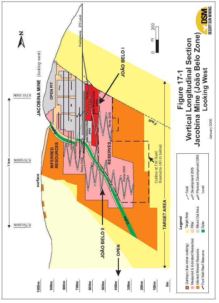

| Updated Resource & Reserve Estimate, Jacobina Dec 2005 |
| Morro do Vento - Intermediate Reefs |
| Total measured and indicated mineral resources at Morro do Vento in the Intermediate Reefs are 5,797,000 tonnes grading 2.18 g Au/t containing 407,000 ounces of gold as set out in Table 17.4. The bulk of these resources are in the MU and LU Reefs. Inferred mineral resources total 2,464,000 tonnes grading 2.42 g Au/t containing 191,000 ounces of gold (Table 17.5) . The resource estimate for Morro do Vento is unchanged from the December 2004 estimate as no further exploration drilling was done on this target in 2005. Figures 17.2 and 17.3 are vertical longitudinal sections of the MU and LU reefs, respectively, showing the distribution of resource blocks and current development in the mine. There is considerable potential to increase mineral resources in both zones below the 800 level as there has been only limited previous drilling below this level. |
| TABLE 17.4 | SUMMARY OF MEASURED AND INDICATED MINERAL | ||||||
| RESOURCES, MORRO DO VENTO ZONE, INTERMEDIATE REEFS | |||||||
| MORRO DO VENTO | MEASURED | INDICATED | MEASURED + INDICATED | ||||
| Intermediate Reefs | Tonnes | Au | Tonnes | Au | Tonnes | Au | Contained |
| Grade | Grade | Grade | Oz. | ||||
| (g/t) | (g/t) | (g/t) | |||||
| INTERMED. - LU REEF | 0 | 0.00 | 2,052,000 | 2.38 | 2,052,000 | 2.38 | 157,000 |
| INTERMED. MU REEF | 0 | 0.00 | 3,675,000 | 2.02 | 3,675,000 | 2.02 | 238,700 |
| INTERMED. LVLPC | 0 | 0.00 | 70,000 | 4.83 | 70,000 | 4.83 | 10,900 |
| REEF | |||||||
| INTERMED - SPC REEF | 0 | 0.00 | 0 | 0.00 | 0 | 0.00 | 0 |
| TOTAL | 0 | 0.00 | 5,797,000 | 2.18 | 5,797,000 | 2.18 | 407,000 |
TABLE 17.5 SUMMARY OF INFERRED MINERAL RESOURCES, MORRO DO VENTO ZONE, INTERMEDIATE REEFS
| MORRO DO VENTO | INFERRED | ||
| Intermediate Reefs | Tonnes | Au Grade | Contained |
| (g/t) | Oz. | ||
| INTERMED. - LU REEF | 696,000 | 2.58 | 57,700 |
| INTERMED. MU REEF | 1,385,000 | 2.46 | 109,500 |
| INTERMED. LVLPC | 131,000 | 2.29 | 9,600 |
| REEF | |||
| INTERMED - SPC REEF | 252,000 | 1.79 | 14,500 |
| TOTAL | 2,464,000 | 2.42 | 191,000 |
| 138 |
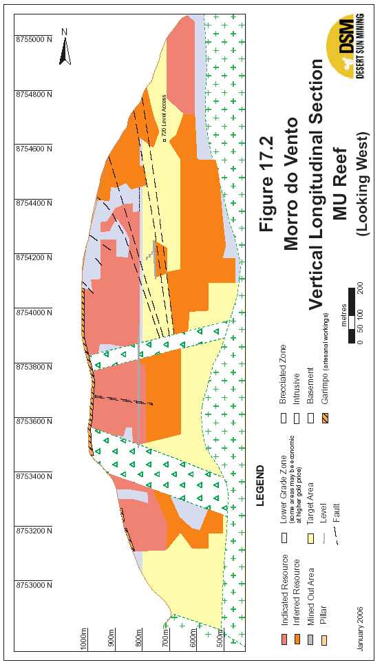
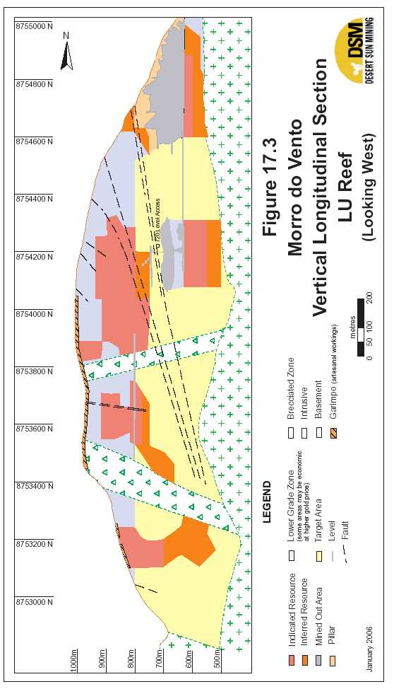

| Updated Resource & Reserve Estimate, Jacobina Dec 2005 |
| Morro do Vento – Basal and Main Reefs |
| Total measured and indicated mineral resources at Morro do Vento in the Basal and Main Reefs are1,217,000 tonnes grading 4.99 g Au/t containing 195,000 ounces of goldas set out in Table 17.6. These resources are based on past production and historic drilling above the 400 level. Inferred mineral resources (Table 17.7) total1,916,000 tonnes grading 3.78 g Au.t containing 233,000 ounces of gold. This is an approximately 50% increase over the inferred resources of December 2004. Figures 17.4 and 17.5 are vertical longitudinal sections of the Basal and Main reefs, respectively, in the Morro do Vento – Morro do Vento Extension areas showing the distribution of resource blocks and locations of old mine workings and stopes. There is good potential to increase mineral resources in both reefs in the Morro do Vento area below the 400 level. |
| TABLE 17.6 SUMMARY OF MEASURED AND INDICATED MINERAL RESOURCES, MORRO DO VENTO ZONE, BASAL AND MAIN REEFS |
| MORRO DO VENTO | MEASURED | INDICATED | MEASURED + INDICATED | ||||
| Basal/Main Reefs | Tonnes | Au | Tonnes | Au | Tonnes | Au | Contained |
| Grade | Grade | Grade | Oz. | ||||
| (g/t) | (g/t) | (g/t) | |||||
| BASAL REEF-OLD | 25,000 | 4.20 | 557,000 | 3.07 | 582,000 | 3.12 | 58,400 |
| BASAL REEF-NEW | 0 | 0.00 | 0 | 0.00 | 0 | 0.00 | 0 |
| MAIN REEF-OLD | 183,000 | 5.99 | 452,000 | 7.00 | 635,000 | 6.71 | 137,000 |
| MAIN REEF - NEW | 0 | 0.00 | 0 | 0.00 | 0 | 0.00 | 0 |
| TOTAL | 208,000 | 5.77 | 1,009,000 | 4.83 | 1,217,000 | 4.99 | 195,000 |
TABLE 17.7 SUMMARY OF INFERRED MINERAL RESOURCES, MORRO DO VENTO ZONE, BASAL AND MAIN REEFS
| MORRO DO VENTO | INFERRED | ||
| Basal/Main Reefs | Tonnes | Au Grade | Contained |
| (g/t) | Oz. | ||
| BASAL REEF-OLD | 150,000 | 3.29 | 15,900 |
| BASAL REEF-NEW | 1,184,000 | 2.28 | 86,800 |
| MAIN REEF-OLD | 350,000 | 8.48 | 95,400 |
| MAIN REEF - NEW | 232,000 | 4.66 | 34,800 |
| TOTAL | 1,916,000 | 3.78 | 233,000 |
| 141 |
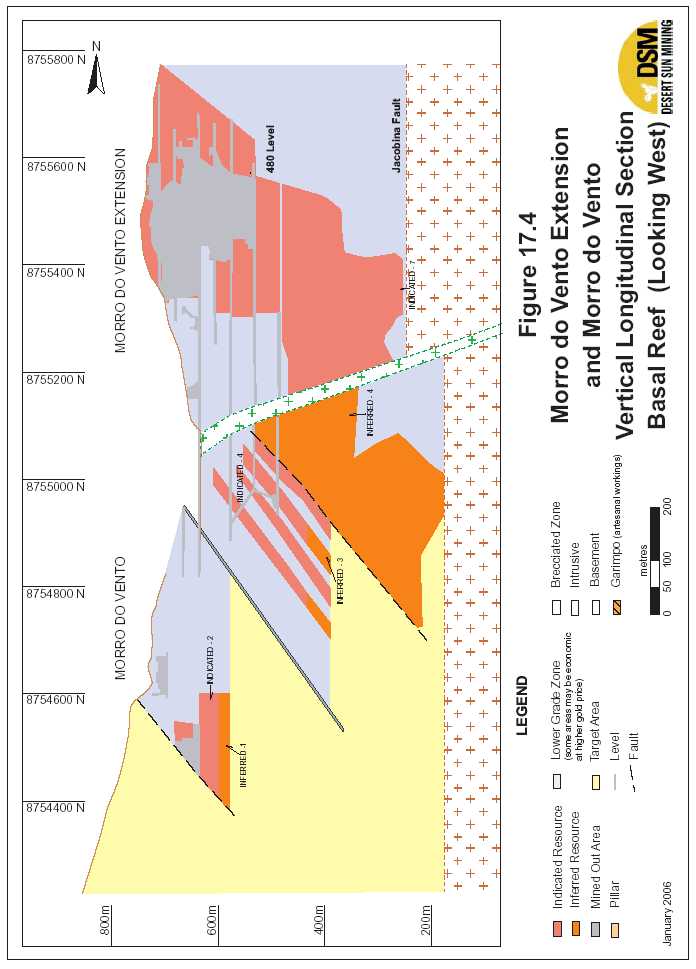

| Updated Resource & Reserve Estimate, Jacobina Dec 2005 |
| Morro do Vento Extension – Basal and Main Reefs Total measured and indicated mineral resources at Morro do Vento Extension in the Basal and Main Reefs are3,563,000 tonnes grading 2.89 g Au/t containing 332,000 ounces of goldas set out in Table 17.8. There are no inferred mineral resources as the target was completely drilled off in the 2005 program. Figures 17.4 and 17.5, previous, are vertical longitudinal sections of the Basal and Main reefs, respectively, in the Morro do Vento – Morro do Vento Extension areas showing the distribution of resource blocks and locations of old mine workings and stopes. While the targets in the Morro do Vento Extension target have been extensively drilled from surface hence there is limited potential to outline additional resources in this target area, there is considerable potential to outline additional resources in the same target reefs, in the Morro do Vento area to the south. |
| TABLE 17.8 SUMMARY OF MEASURED AND INDICATED MINERAL |
| RESOURCES, MORRO DO VENTO EXTENSION ZONE, BASAL AND MAIN REEFS |
| MORRO DO VENTO | MEASURED | INDICATED | MEASURED + INDICATED | ||||
| EXTENSION | |||||||
| Basal/Main Reefs | Tonnes | Au | Tonnes | Au | Tonnes | Au | Contained |
| Grade | Grade | Grade | Oz. | ||||
| (g/t) | (g/t) | (g/t) | |||||
| BASAL REEF MCZ - FW | |||||||
| MINED | 0 | 0.00 | 683,000 | 2.82 | 683,000 | 2.82 | 61,900 |
| BASAL REEF - MCZ - | |||||||
| OLD PILLARS | 0 | 0.00 | 120,000 | 2.93 | 120,000 | 2.93 | 11,300 |
| BASAL REEF - MCZ - | |||||||
| LATERAL | 0 | 0.00 | 51,000 | 2.22 | 51,000 | 2.22 | 3,600 |
| BASAL REEF - MCZ - | |||||||
| BLOCKS | 0 | 0.00 | 2,084,000 | 2.68 | 2,084,000 | 2.68 | 179,600 |
| MAIN REEF-OLD | 38,000 | 5.34 | 48,000 | 5.69 | 86,000 | 5.54 | 15,300 |
| MAIN REEF-NEW | 0 | 0.00 | 200,000 | 3.98 | 200,000 | 3.98 | 25,600 |
| MAIN REEF FW | 0 | 0.00 | 339,000 | 3.14 | 339,000 | 3.14 | 34,200 |
| TOTAL | 38,000 | 5.34 | 3,525,000 | 2.87 | 3,563,000 | 2.89 | 332,000 |
| Canavieiras |
| At Canavieiras, there are six (6) major mineralized reefs, from upper to lower, these are: Maneira, Hollandez, Liberino, Piritoso, MU and LU. The Maneira and Hollandez reefs are above the old mine workings, the Liberino and Piritoso reefs were previously mined and the MU and LU reefs are below the old workings. Total measured and indicated mineral resources at Canavieiras in all reefs are1,989,000 tonnes grading 3.54 g Au/t containing 227,000 ounces of goldas set out in Table 17.10. Inferred mineral resources total6,904,000 tonnes grading 3.29 oz. Au/t containing 730,000 ounces of gold (Table 17.11) . These resources are significantly |
| 144 |

| Updated Resource & Reserve Estimate, Jacobina Dec 2005 |
| increased from the December 2004 estimate of 900,000 tonnes grading 3.80 g Au/t containing 110,000 ounces of gold in measured and indicated and 3,700,000 tonnes grading 2.41 g Au/t containing 290,000 ounces of gold in inferred mineral resources. Figures 17.6, 17.7 and 17.8 are plan maps of the Piritoso, MU and LU reefs, respectively, showing the distribution of resource blocks. The location of the old mine workings and stopes (projected for the MU and LU maps) are shown on each map. There is excellent potential to outline additional resources to the south and east in all three of these reefs as well as in the other target reefs. |
| TABLE 17.9 | SUMMARY OF MEASURED AND INDICATED MINERAL | ||||||
| RESOURCES, CANAVIEIRAS | |||||||
| CANAVIEIRAS | MEASURED | INDICATED | MEASURED + INDICATED | ||||
| Reef | Tonnes | Au | Tonnes | Au | Tonnes | Au | Contained |
| Grade | Grade | Grade | Oz. | ||||
| (g/t) | (g/t) | (g/t) | |||||
| PIRITOSO REEF | 56,000 | 6.73 | 58,000 | 8.25 | 114,000 | 7.50 | 27,500 |
| LIBERINO REEF | 0 | 0.00 | 51,000 | 6.16 | 51,000 | 6.16 | 10,100 |
| INTERMED. MU - CAN | 0 | 0.00 | 1,492,000 | 3.27 | 1,492,000 | 3.27 | 156,900 |
| INTERMED. LU - CAN | 0 | 0.00 | 332,000 | 3.01 | 332,000 | 3.01 | 32,100 |
| HOLLANDEZ REEF | 0 | 0.00 | 0 | 0.00 | 0 | 0.00 | 0 |
| TOTAL | 56,000 | 6.73 | 1,933,000 | 3.45 | 1,989,000 | 3.54 | 227,000 |
| TABLE 17.10 SUMMARY OF INFERRED MINERAL RESOURCES, CANAVIEIRAS |
| CANAVIEIRAS | INFERRED | ||
| Reef | Tonnes | Au Grade | Contained |
| (g/t) | Oz. | ||
| PIRITOSO REEF | 352,000 | 4.66 | 52,700 |
| LIBERINO REEF | 503,000 | 3.84 | 62,100 |
| INTERMED. MU - CAN | 4,469,000 | 3.28 | 471,300 |
| INTERMED. LU - CAN | 1,039,000 | 3.20 | 106,900 |
| HOLLANDEZ REEF | 541,000 | 2.10 | 36,500 |
| TOTAL | 6,904,000 | 3.29 | 730,000 |
| 145 |
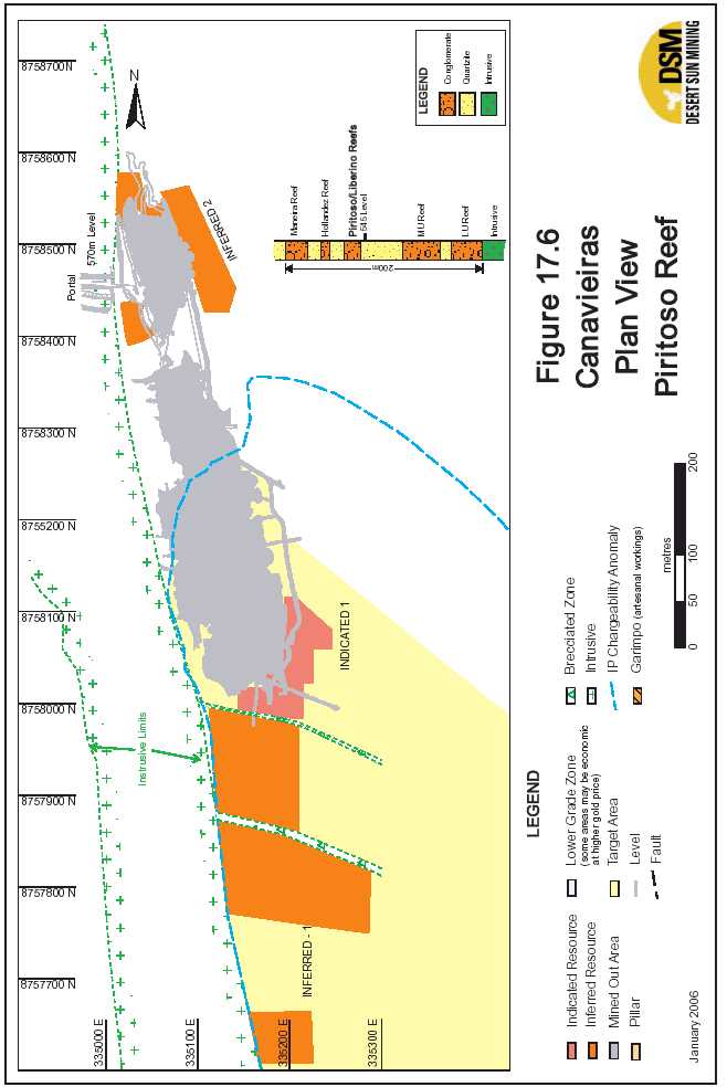
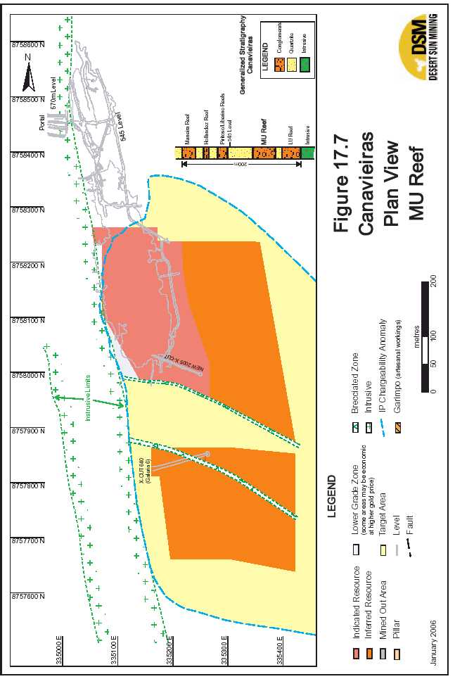


| Updated Resource & Reserve Estimate, Jacobina Dec 2005 |
| Serra do Córrego |
| Measured and indicated mineral resources at Serra do Córrego total919,000 tonnes grading 2.44 g Au/t containing 72,000 ounces of goldas set out in Table 17.12. All of these resources are in the MU and LU Reefs. Inferred mineral resources in all reefs total1,348,000 tonnes grading 3.51 g Au/t containing 152,000 ounces of gold (Table 17.13) . The resource estimate for Serra do Corrego is unchanged from the August 2003 and December 2004 estimate as no further exploration drilling was done on this target in 2004 and 2005. Figures 17.9 and 17.10 are vertical longitudinal sections of the MU and LU reefs, respectively, showing the distribution of resource blocks and current development in the mine. There is considerable potential to increase mineral resources in both zones along strike and down dip. |
| TABLE 17.11 | SUMMARY OF MEASURED AND INDICATED MINERAL | ||||||
| RESOURCES, SERRA DO CÓRREGO, INTERMEDIATE REEFS | |||||||
| CANAVIEIRAS | MEASURED | INDICATED | MEASURED + INDICATED | ||||
| Reef | Tonnes | Au | Tonnes | Au | Tonnes | Au | Contained |
| Grade | Grade | Grade | Oz. | ||||
| (g/t) | (g/t) | (g/t) | |||||
| LOWER UNIT (LU) | 10,000 | 7.50 | 582,000 | 2.15 | 592,000 | 2.24 | 42,600 |
| MIDDLE UNIT (MU) | 0 | 0.00 | 327,000 | 2.81 | 327,000 | 2.81 | 29,500 |
| MANEIRA SUL - SCO | 0 | 0.00 | 0 | 0.00 | 0 | 0.00 | 0 |
| MANEIRA NORTE - SCO | 0 | 0.00 | 0 | 0.00 | 0 | 0.00 | 0 |
| TOTAL | 10,000 | 7.50 | 909,000 | 2.39 | 919,000 | 2.44 | 72,000 |
TABLE 17.12 SUMMARY OF INFERRED MINERAL RESOURCES, SERRA DO CÓRREGO, INTERMEDIATE REEFS
| CANAVIEIRAS | INFERRED | ||
| Reef | Tonnes | Au Grade | Contained |
| (g/t) | Oz. | ||
| LOWER UNIT (LU) | 96,000 | 3.21 | 9,900 |
| MIDDLE UNIT (MU) | 0 | 0.00 | 0 |
| MANEIRA SUL - SCO | 341,000 | 3.53 | 38,700 |
| MANEIRA NORTE - SCO | 911,000 | 3.53 | 103,400 |
| TOTAL | 1,348,000 | 3.51 | 152,000 |
| 149 |


| Updated Resource & Reserve Estimate, Jacobina Dec 2005 |
| Joao Belo Sul |
| Total measured and indicated mineral resources at Joao Belo Sul, located 5.5 km south of the Jacobina Mine (see Fig. 7.4) are768,000 tonnes grading 2.55 g Au/t containing 63,000 ounces of gold.Inferred mineral resources total3,892,000 tonnes grading 1.67 g Au/t containing 209,000 ounces of gold.These resources are in the LMPC reef which is equivalent to the main reef zone being mined at the Jacobina Mine (Joao Belo zone). |
| Other Areas |
| Inferred mineral resources in other areas total33,640,000 tonnes grading 3.23 g Au/t containing 279,000 ounces of goldas outlined in Table 17.14. There are no measured and indicated mineral resources defined in these targets. The target areas in Jacobina Sul which are Campo Limpo and Lagedo Preto (Fig. 7.4), are located 8.5 km and 13.0 km, respectively south of the Jacobina mine. The Jacobina Norte area extends from just north of the city of Jacobina 5.0 km along strike to the north (Fig. 7.4) . Both of these areas have extensive garimpo (free miner) workings with limited historical drilling. |
TABLE 17.13 SUMMARY OF INFERRED MINERAL RESOURCES IN OTHER AREAS, JACOBINA MINE AREA
| OTHER AREAS | INFERRED | ||
| Reef | Tonnes | Au Grade | Contained |
| (g/t) | Oz. | ||
| JACOBINA SUL | |||
| CAMPO LIMPO | 1,122,000 | 2.10 | 75,800 |
| LAGEDO PRETO | 138,000 | 3.54 | 15,700 |
| SUBTOTAL | 1,260,000 | 2.26 | 91,500 |
| JACOBINA NORTE | |||
| SERRA BRANCA -1 | 241,000 | 4.21 | 32,600 |
| SERRA BRANCA -2 | 591,000 | 5.50 | 104,500 |
| SERRA BRANCA -3 | 590,000 | 2.64 | 50,100 |
| SUBTOTAL | 1,422,000 | 4.09 | 187,200 |
| TOTAL OTHER AREAS | 2,682,000 | 3.23 | 279,000 |
| 152 |
| Updated Resource & Reserve Estimate, Jacobina Dec 2005 |
| 17.3 MINERAL RESERVES |
| The updated mineral reserve estimate for the Jacobina mine area is set out in Table 1.2 below. Proven and probable mineral reserves in the Jacobina Mine (João Belo Zone) are13,220,000 tonnes grading 2.15 g Au/t containing 913,100 ounces of gold.Total Proven and Probable mineral reserves in all zones are21,580,000 tonnes grading 2.18 g Au/t containing 1,510,000 ouncesas summarized in Table 17.14 below. This is an increase of 310,000 ounces from the August 2005 reserve estimate (see press release August 11, 2005) The reserves were estimated using a gold price of US$400 per ounce and a block cutoff grade of 1.41 grams gold per tonne. Dilution and mining recovery rates appropriate for each zone were applied following established practices at the mine. Desert Sun has all operating permits in place for production. Peter Tagliamonte, P.Eng., Vice President Operations and COO for DSM supervised all aspects of the estimation of the updated mineral reserves. Mr. Tagliamonte is a Qualified Person (QP) as defined under National Instrument 43-101. |
| TABLE 17.14 | ESTIMATED MINERAL RESERVES AS OF DECEMBER 31, 2005, | ||||||
| JACOBINA MINE AREA | |||||||
| Mine/Area | Proven | Probable | Proven & Probable | ||||
| Ounces | |||||||
| Tonnes | g Au/t | Tonnes | g Au/t | Tonnes | g Au/t | ||
| Contained | |||||||
| Joao Belo2 | 3,007,000 | 2.18 | 10,215,000 | 2,14 | 13,220,000 | 2.15 | 913,000 |
| Morro do Vento4 | Nil | Nil | 4,672,000 | 1.95 | 4,672,000 | 1.95 | 292,000 |
| Morro do Vento | |||||||
| 3 | 58,000 | 3.57 | 2,712,000 | 2.68 | 2,770,000 | 2.69 | 240,000 |
| Ext. (Basal Reef | |||||||
| Serra de Córrego3 | Nil | Nil | 918,000 | 2.17 | 918,000 | 2.17 | 64.000 |
| Total5 | 21,580,000 | 2.18 | 1,510,000 | ||||
| 1Mineral reserves have been classified in accordance with CIM standards under NI 43-101. 2Desert Sun Mining mineral reserve estimate December 31, 2005 3Updated following original Dynatec mineral reserve estimation of September 2003 in the SNC Lavalin feasibility study (see DSM Press Release September 12, 2003). 4Desert Sun Mining mineral reserve estimate August 11, 2005 (reviewed by Devpro Mining Inc.) (see DSM Press Release August 11, 2005). 5Totals have been rounded. |
| 17.3.1 JACOBINAMINE(JOAOBELOZONE) |
| The mineral reserve estimate at the Jacobina Mine (Joao Belo zone) is based on the total measured and indicated mineral resources of13,667,000 tonnes grading 2.31g Au/t containing 1,015,000 ounces of gold. The proven and probable mineral reserve is 13,220,000 tonnes |
| 153 |

| Updated Resource & Reserve Estimate, Jacobina Dec 2005 |
| grading 2.15 g Au/t containing 913,100 ounces as set out in Table 17.15. Figure 17.11 is a vertical longitudinal section of the Joao Belo zone showing the location of reserve blocks and development. |
TABLE 17.15 MINERAL RESERVES, JACOBINA MINE (JOAO BELO ZONE) AS AT DECEMBER 31, 2005
| JOAO BELO MINERAL RESERVE | |||
| TONNES | GRADE | CONTAINED GOLD | |
| CATEGORY | |||
| (g Au/t) | (ounces) | ||
| Proven | 3,007,000 | 2.18 | 210,400 |
| Probable | 10,215,000 | 2.14 | 702,700 |
| Total Proven and Probable | 13,220,000 | 2.15 | 913,000* |
| * total rounded | |||
| The mineral reserve estimate is based on the updated mineral resource estimate which was prepared using a conventional polygonal technique on vertical longitudinal sections using the procedures as set out in the reports by Hennessey (2003b) and Pearson and Tagliamonte (2005). Key parameters for the determining the reserve estimate are as follows. |
| Specific Gravity |
| A specific gravity of 2.6 was used. This is same value that was used in the Micon report (Hennessey 2003b) based on tests by SGS Lakefield (SNC Lavalin 2003). A specific gravity of 2.6 was used in the estimate based on a “waxed core bulk density test” carried out in July 2003 by SGS Lakefield, as proposed by SNC-Lavalin; this lowered the specific gravity from earlier estimates of 2.7 that were previously used at the mine. |
| Geometry |
| The average dip of the mineralized ore body (LMPC reef) is 60°E. |
| 154 |
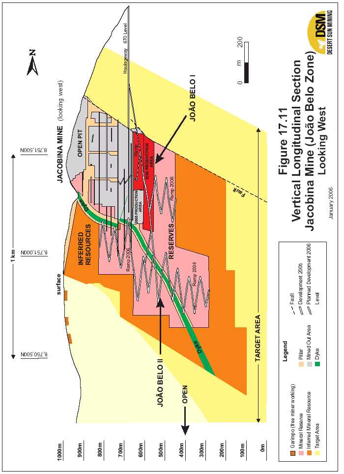

| Updated Resource & Reserve Estimate, Jacobina Dec 2005 |
| Methodology |
| The area of polygons was determined on vertical longitudinal section using AutoCAD. For volume and tonnage calculation the following formulae was used. |
| Reserve = Area of polygon (m2) x true width (m) x 2.6 / 0.87 |
| Mining Method |
| The mining method that is used at the Jacobina Mine is sub-level retreat open stoping method as shown in Figure 17.12. The ore reserve mine plan consists of stopes that approximately extend from Joao Belo I 605 meter level to 445 meter level (N 8751100 to N8751570) and Joao Belo II 820 meter level to 280 meter level from ( N8750650 to N 8751100). Pillars will be left based on the rock mechanics study done by MLF Geotecnica e Mechanicia de Roches Ltda (MLF). Rib pillars will be left along strike where required but optimized in sections of unpay or low grade zones within the ore body. Sill pillars and stope access pillars are temporary left and removed once the mining above has been completed. Mining recovery based on this application was calculated to be 88%, which is consistent with what is currently being achieved and also consistent similar sized ore bodies with excellent ground conditions and using Longhole mining methods. Generally, the layout provides for two parallel drill drives to be established in both the footwall contact and hanging wall contact at intervals that generally limit Longhole drilling to approximately 30 m. The drilling is by electric hydraulic tire-mounted, ITH hammer drill rigs and takes place from the sub-level to the drill drift or undercut drift. Drill patterns are based on what is currently being used and previous DSM experience with parallel holes. The parallel development drifts are established in both the footwall contact and hanging wall contact. This allows for parallel straight holes and pre-shearing holes to be drilled along both the footwall and hangingwall. Parallel holes in conjunction with pre-shearing holes are done with ITH electric hydraulic drills which significantly reducing drill hole deviation and the introduction of wall sloughing. Low energy ANFO will be the blasting agent used in the blast holes. Cartridges of emulsion type explosive will be used for drill holes when wet conditions are encountered. All production mucking will be performed by 15 tonne LHD’s (load-haul-dump) machines equipped with remote controls. Material haulage will be done with 35 tonne trucks. Haulage trucks will transport the ore from the underground on a dedicated haulage drift to the crusher plant or a surface stockpile. Once the trucks leave the underground they will travel on a high speed double lane hard pack haulage road and dump directly into the crusher plant or surface stockpile. |
| 156 |


| Updated Resource & Reserve Estimate, Jacobina Dec 2005 |
| Dilution |
| Dilution estimates for the 2006 reserves are based on actual reconciled results from the operating mine include an overall average of 10%. This was based on based on a continued dilution of 151 cm; 121 cm and 30 cm respectively from the combined hangingwall and footwall of the stopes for the mine. MLF Geotecnica e Mechanicia de Roches Ltda (MLF), a Brazilian-based geotechnical firm acts as a rock mechanics consultant for the Jacobina Mine and also participated in the 2003 feasibility study for SNC Lavalin, also provided information related to dilution in the form of estimated displacement and de-stressing around the stopes. Dilution was calculated based on ore width (m) according to drilling or channel sampling information plus 1.51 meters dilution; 1.51 meters on the hangingwall (HW) and 0.30 meters on the footwall (FW) as shown in Figure 17.13. The grade of dilution is summarized in Table 17.16. |
| 158 |

| Updated Resource & Reserve Estimate, Jacobina Dec 2005 |
| Figure 17.13 Schematic Diagram showing Typical Example of Dilution, Joao Belo Zone |
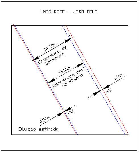
| The grade of dilution was estimated from diamond drill samples as follows: Dilution grade calculations were done on an individual mining block basis with hanging wall and foot wall grades initially kept separate. With known zone widths this was easily translated into a predicted thickness of hanging wall and foot wall rock which would comprise the dilution. All drill holes in each mining block were then queried for those intervals and their grades weight averaged. Hanging wall and foot wall were at first averaged separately, in case the grade of each needed to be known, but were later averaged together. Grades by zone were then averaged for each mining block. |
| 159 |

| Updated Resource & Reserve Estimate, Jacobina Dec 2005 |
| TABLE 17.16 | GRADE OF DILUTION, JOAO BELO ZONE | |
| True Width | Dilution Grade | |
| CATEGORY | ||
| (m) | (g Au/t) | |
| Footwall | ||
| Proven | 1.0 | 0.23 |
| Probable | 1.0 | 0.23 |
| Hangingwall | ||
| Proven | 1.0 | 0.53 |
| Probable | 1.0 | 0.53 |
| The following formula was used for diluted grade: |
| Diluted Grade = ((ore width x grade) + (1.21meters HW x HW grade) + (0.30 meters FW x FW grade)) / stoping width |
| The control of dilution is achieved by using modern art electric hydraulic ITH drill capable of drilling accurate straight holes up 50 meters. Development provides two parallel drill drives that are established in both the footwall contact and hanging wall contact at intervals that generally limit Longhole drilling to approximately 30 meters. The Drilling is done by the same electric hydraulic tire-mounted, ITH drill rigs and take place from the upper sub-level drill drift to the lower sub-level drift. The parallel drill drives to be established in both the footwall contact and hanging wall contact will allow for parallel straight holes and where required pre-shearing holes are drilled along both the footwall and hanging wall. Parallel holes in conjunction with pre-shearing holes done with ITH electric hydraulic drills significantly reducing drill hole deviation and the introduction of wall sloughing. The hanging wall development is guided by a good physical contact and precedes the footwall development. Diamond drilling is done from the leading hanging wall development on twenty (20) meter spacing to establish the footwall contact. This procedure allows astute determination of the actual footwall contact prior to the footwall development taking place. |
| Block Cut off Grade |
| The Block Cut Off Grade used was 1.41 g Au/t and was calculated from the Jacobina Mine Business Plan 2005 using a gold price of U$400/ounce and total operating costs of U$17.00/tonne. |
| 160 |

| Updated Resource & Reserve Estimate, Jacobina Dec 2005 |
| 17.3.2 MORRO DOVENTO |
| In August 2005, a positive pre-feasibility study on the Morro do Vento zone was completed by Devpro Mining (Adams et al., 2005). This study considered the indicated resource above the 800 level that totalled 5,016,000 tonnes grading 2.08 g Au/t containing 335,000 ounces of gold. The proven and probable mineral reserve at Morro do Vento is4,672,000 tonnes grading 1.95 g Au/t containing 292,000 ounces of gold as set out in Table 17.17. Figure 17.14 is a vertical longitudinal section of the Morro do Vento zone showing the location of reserve blocks and proposed development. |
| TABLE 17.17 | MINERAL RESERVES, MORRO DO VENTO ZONE | |||
| AS AT DECEMBER 31, 2005 | ||||
| MORRO DO VENTO MINERAL RESERVE | ||||
| CONTAINED | ||||
| TONNES | GRADE | |||
| CATEGORY | GOLD | |||
| (g Au/t) | (ounces) | |||
| Proven | 0 | 0 | 0 | |
| Probable | 4,672,000 | 1.95 | 292,000 | |
| Total Proven and Probable | 4,672,000 | 1.95 | 292,000 | |
| The mineral reserve estimate is based on the updated mineral resource estimate which was prepared using a conventional polygonal technique on vertical longitudinal sections using the procedures as set out in the reports by Hennessey (2003b) and Pearson and Tagliamonte (2005). Key parameters for the determining the reserve estimate are as follows. |
| Specific Gravity |
| A specific gravity of 2.6 was used based on tests previously carried out by SGS Lakefield for the SNC Lavalin feasibility study in August 2003. |
| Geometry |
| The average dip of the mineralized ore body (MU and LU reefs) is 50o. |
| Methodology |
| The area of polygons was determined on vertical longitudinal section using AutoCAD. For volume and tonnage calculation the following formulae was used. |
| Reserve = Area of polygon (m2) x true width (m) x 2.6 / 0.77 |
| 161 |
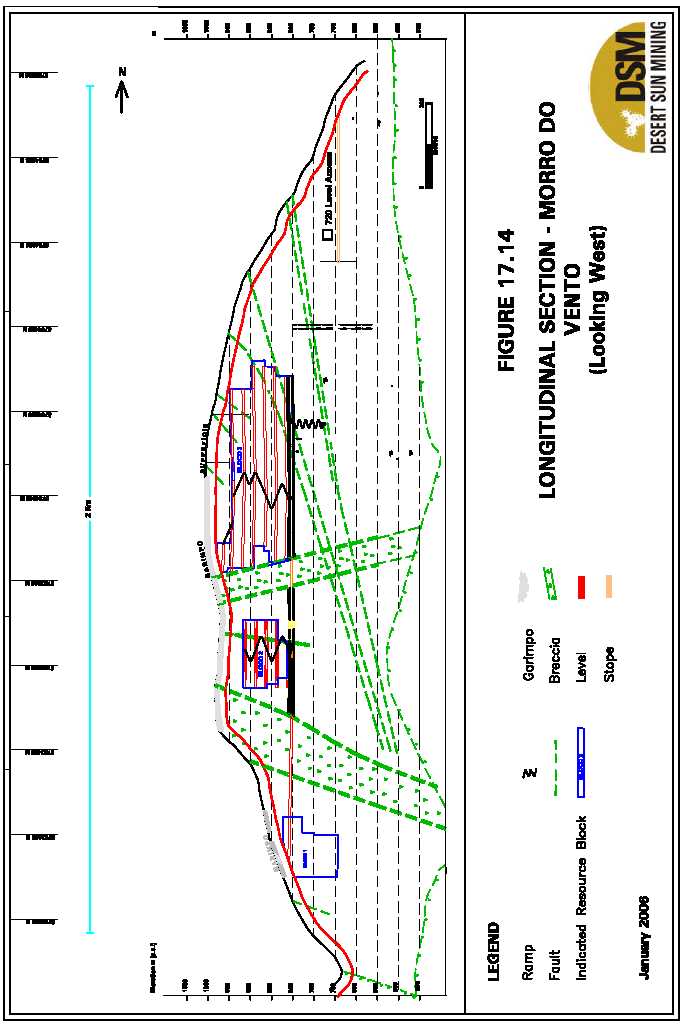
| Updated Resource & Reserve Estimate, Jacobina Dec 2005 |
| Mining Method |
| The mining method selected is longitudinal longhole open stoping. This method is identical to that used in the past and is currently utilized in other areas at the Jacobina Mine operations. This method of mining has proven successful and is therefore incorporated into the Devpro pre- feasibility study. Figure 17.15 is a typical stope cross section with level layouts. Figure 17.16 is a typical stope Longhole layout. For the purposes of the Devpro study, the drill level interval has been selected at 25 metres in order to limit the length of drill hole to approximately 27 metres. This length of drill hole is felt to be the limit for drilling accuracy using top hammer drilling equipment. Drilling accuracy is a key issue in limiting dilution in long hole open stoping and the same techniques used to minimize hole deviation at the Jacobina Mine will be used at Morro do Vento. |
| Dilution |
| Dilution was estimated by assuming that 0.5 m of wall rock from the hanging wall and footwall would be excavated with the ore. The grade attributed to the dilution tonnage was based on assays of drill holes for these intersections. The dilution tonnage amounted to 742,000 tonnes, or approximately 13 % of the total reserve tonnes, at an average grade of 0.38 grams per tonne. |
| Block Cut-off Grade |
| The estimated mineral reserves area based on a cut-off grade of 1.41 g Au/t which is increased slightly from the cut-off grade used in the Devpro report (1.3 g Au/t) reflecting increases in costs since the report was completed, however the gold price has been increased from US$350 to US$400 offsetting these increased costs. The cutoff grade was calculated from the Jacobina Mine Business Plan 2006 using a gold price of U$400/ounce and total operating costs of U$17.00/tonne. Since mining will be taking place in the same general geological and mining environment as the Jacobina Mine (João Belo Zone), it is felt that the cut-off grade is appropriate for mineral reserve estimation for the Morro Vento area. |
| 163 |


| Updated Resource & Reserve Estimate, Jacobina Dec 2005 |
| 17.3.3 MORRODOVENTOEXTENSION |
| The mineral reserve estimate at the Morro do Vento Extension is based on the total measured and indicated mineral resources of 3,560,000 tonnes grading 2.89g Au/t containing 332,000 ounces of gold. The proven and probable mineral reserve is2,770,000 tonnes grading 2.69 g Au/t containing 240,000 ounces as set out in Table 17.18. |
| TABLE 17.18 | MINERAL RESERVES, MORRO DO VENTO EXTENSION ZONE | |||
| AS AT DECEMBER 31, 2005 | ||||
| MORRO DO VENTO EXTENSION MINE | ||||
| MINERAL RESERVE | ||||
| TONNES | GRADE | CONTAINED GOLD | ||
| CATEGORY | ||||
| (g Au/t) | (ounces) | |||
| Proven | 58,000 | 3.57 | 6,700 | |
| Probable | 2,712,000 | 2.68 | 233,300 | |
| Total Proven and Probable | 2,770,000 | 2.69 | 240,000 | |
| Specific Gravity |
| A specific gravity of 2.6 was used based on tests previously carried out by SGS Lakefield for the SNC Lavalin feasibility study in August 2003. |
| Geometry |
| The average dip of the mineralized ore body (Basal reef) is 55o. |
| Methodology |
| The estimation process is similar to that at Joao Belo except that only larger mining blocks are created. No individual polygons are created around drill holes. The area of mining blocks is determined and converted to volumes using the average true width of all composites in block and the correction for dip. Grades are interpolated by taking the weighted average, by composite width, of all assay composites through the block. Assays are capped at 30 g Au/t. Due to a relative lack of intercepts in the upper part of the deposit, chip/channel composites are used more commonly; at deeper levels diamond drilling completed during 2004 and 2005 at approximately 50m centres has outlined the indicated resources used as the basis for the reserve estimation. The area of polygons was determined on vertical longitudinal section using AutoCAD. For volume and tonnage calculation the following formulae was used. |
| Reserve = Area of polygon (m2) x true width (m) x 2.6 / 0.82 |
| 166 |

| Updated Resource & Reserve Estimate, Jacobina Dec 2005 |
| Mining Method |
| The mining method will be Sub-level Open Stoping with drilling sublevels every 30m vertical distance. Production headings will have drawpoints located at 630 m, 525 m and 390 m levels. |
| Dilution |
| Dilution was estimated by assuming that 0.5 m of wall rock from the hanging wall and footwall would be excavated with the ore. The grade attributed to the dilution tonnage was based on assays of drill holes for these intersections. Dilution grade estimated was 0.21 g Au/t for hangingwall, 0.42 g Au/t for footwall and 0.30 g Au/t in total. |
| Block Cut-off Grade |
| Since mining will be taking place in the same general geological and mining environment as the Jacobina Mine (João Belo Zone), and Morro de Vento, the 1.41 g Au/t cut-off grade is appropriate for mineral reserve estimation for Morro do Vento Extension. |
| 17.3.4 SERRADOCORREGO |
| The mineral reserve estimate at Serra do Córrego is based on the total measured and indicated mineral resources of 920,000 tonnes grading 2.44g Au/t containing 72,000 ounces of gold. The proven and probable mineral reserve is918,000 tonnes grading 2.17 g Au/t containing 64,000 ounces of gold as set out in Table 17.20. This reserve estimate was prepared as part of the SNC Lavalin feasibility study completed in August 2003. A review of costs by DSM and in consideration of the increased revenues from a higher gold price used for this reserve update (US$400 versus $US350), indicate that this reserve estimate remains reasonable and appropriate. |
TABLE 17.19 MINERAL RESERVES, SERRA DO CÓRREGO ZONE AS AT DECEMBER 31, 2005
| SERRA DO CÓRREGO | |||
| MINERAL RESERVE | |||
| CATEGORY | TONNES | GRADE | CONTAINED GOLD |
| (g Au/t) | (ounces) | ||
| Proven | - | - | - |
| Probable | 918,000 | 2.17 | 64,000 |
| Total Proven and Probable | 918,000 | 2.17 | 64,000 |
| 167 |

| Updated Resource & Reserve Estimate, Jacobina Dec 2005 |
| Specific Gravity |
| A specific gravity of 2.6 was used based on tests previously carried out by SGS Lakefield for the SNC Lavalin feasibility study in August 2003. |
| Geometry |
| The average dip of the mineralized ore body (Mu and Lu reef) is 60o. |
| Methodology |
| The resources here in Serra do Córrego were estimated using a method similar to Joao Belo except that little previous development exists. The area of polygons was determined on vertical longitudinal section using AutoCAD. For volume and tonnage calculation the following formulae was used. |
| Reserve = Area of polygon (m2) x true width (m) x 2.6 / 0.87 |
| Mining Method |
| The mining method will be Sub-level Retreat Longitudinal Open Stoping with drilling sublevels every 30m vertical distance. Production headings with draw points located at 830m, and 784m levels. It is estimated that a nominal target of 400 tonnes per day would be an appropriate rate for an appropriate rate given the size of the deposit, mine layout and the allowable time for preproduction development. |
| Dilution |
| Dilution was estimated by assuming that 0.5 m of wall rock from the hanging wall and footwall would be excavated with the ore. The grade attributed to the dilution tonnage was based on assays of drill holes for these intersections: |
- Dilution grade estimated in MU zone 0.36 g Au/t for the hangingwall and 0.21 g Au/t forthe footwall.
- Dilution grade estimated in LU zone 0.16 g Au/t for hangingwall and 0.36 g Au/t for thefootwall.
| Block Cut-off Grade |
| Since mining will be taking place in the same general geological and mining environment as the Jacobina Mine (João Belo Zone), and Morro de Vento, the 1.41 g Au/t cut-off grade is appropriate for mineral reserve estimation for Serra do Córrego. |
| 168 |

| Updated Resource & Reserve Estimate, Jacobina Dec 2005 |
| 17.4 RESPONSIBILITY FOR ESTIMATION The mineral resource estimates were done DSM employees Anselmo Rubio, Carlos Barbosa and others under the direction of DSM’s in-house Qualified Person (QP) Dr. William N. Pearson, P.Geo. who accepts responsibility for the mineral resource estimate as DSM’s QP for geological and technical work, as required by NI 43-101 Mr. Rubio is a graduate of the school of geology at Universidade Federal Rural do Rio de Janeiro and has extensive experience at the Jacobina property having worked extensively on the original exploration, mine development and production over a period of almost 30 years. Mr. Barbosa is a graduate geological engineer from the Universidade Federal do Ouro Preto who is a computer specialist in the mining industry in Brazil. Both would be considered Qualified Persons except for the lack of membership in an appropriate self regulatory organization; such an organization is not in existence at this time in Brazil. B. Terrence Hennessey, P.Geo. (APGO membership #0038), the author of several independent reports on the project (Hennessey, 2003a, 2003b and 1998) has reviewed the resource estimation procedures and results on a regular basis at Jacobina. The mineral reserve estimate was completed by DSM Mine Department personnel under the supervision of Mr. Peter Tagliamonte, P.Eng., who accepts responsibility for the mineral reserves as DSM’s QP for mining and engineering work as required by NI 43-101. |
| 169 |

| Updated Resource & Reserve Estimate, Jacobina Dec 2005 |
| 18.0 OTHER RELEVANT DATA AND INFORMATION |
| There is no other relevant data and information. |
| 170 |

| Updated Resource & Reserve Estimate, Jacobina Dec 2005 19.0 INTERPRETATION AND CONCLUSIONS |
| Desert Sun owns 100% of the Jacobina property, which includes the Jacobina Gold Mine, the Morro do Vento project currently under development, additional projects in the mine area slated for near term development, and the associated 155-kilometer long Bahia Gold Belt. Since 2002, DSM has completed a three-stage development program as follows: |
- In the first stage (2002 - 2003), completed in September 2003, Desert Sun securedexclusive ownership of the Jacobina property and completed a feasibility study thatsupported the reopening of the Jacobina Mine.
- The second stage (2003 - 2005), completed in June 2005, involved bringing the JacobinaMine back into production in line within the proposals contained in the SNC Lavalinfeasibility study, as modified through the development process. Rehabilitation of theJacobina Mine started in earnest in April 2004. Existing facilities were refurbished andimprovements made in the mining and processing methods. The plant facilities werecompleted in February 2005, with a rated capacity of 4,200 tonnes per day and expectedannualized production of some 100,000 ounces. The first gold pour took place in March2005 and commercial production was declared as of July 1, 2005.
- With production at the Jacobina Mine approaching 100% of design capacity, theCompany has initiated the third stage (2005 - 2009) of its development program, the goalof which is the expansion of annual production through development of additional miningareas within the immediate vicinity of the existing plant facilities to over 250,000 ouncesper annum. Planning done to date has highlighted the potential for developing fouradditional mining areas over the next three to four years in order to successfully achievethis goal.
| DSM began exploring the property in September 2002 and has had on-going exploration programs ever since. Over the past three and one-half years to December 31, 2005, a total of 65,538m in 447 surface and underground diamond drill holes have been completed. Over this period exploration has resulted in the discovery and development of five development projects (Joao Belo II, Morro do Vento, Morro do Vento Extension, Serra do Corrego and Canavieiras). The 2005 exploration program was very successful in outlining new mineral resources as well as upgrading existing inferred mineral resources to the indicated category in the Jacobina mine area. Exploration by DSM in the northern Bahia Gold Belt near Pindobaçu, 50km north of Jacobina, has outlined a major area of gold mineralization with excellent potential to host economic orebody. New geological thinking arising from this exploration work focussing on the likely hydrothermal origin of the gold mineralization has expanded areas with opportunities to find significant deposits. |
| 171 |

| Updated Resource & Reserve Estimate, Jacobina Dec 2005 |
| 19.1 MINERAL RESOURCES |
| Measured and Indicated mineral resources for all zones at Jacobina now total 27,900,000 tonnes grading 2.57g Au/t containing 2,311,000 ounces of gold (Table 1.1) . This is a significant increase of 261,000 ounces of gold compared to the December 2004 measured and indicated resource of 24,800,000 tonnes grading 2.53g Au/t containing 2,050,000 ounces of gold. Since the August 2003 resource estimate that formed the basis for the SNC-Lavalin feasibility study, exploration and development work by Desert Sun has increased Measured and Indicated mineral resources by 949,000 ounces of gold at an average discovery cost of approximately US$10 per ounce. At the Jacobina Mine, drilling and development has outlined sufficient new measured and indicated resources to replace 2005 production. Additionally, Inferred mineral resources in all zones now total 33,600,000 tonnes grading 2.80g Au/t containing 3,029,000 ounces of gold. This a substantial addition of 1,129,000 ounces of gold compared to the December 2004 inferred mineral resource of 22,200,000 tonnes grading 2.61g Au/t containing 1,900,000 ounces of gold. This increase reflects major additions at the Jacobina Mine (João Belo zone) where inferred mineral resources now total 14,430,000 tonnes grading 2.66g Au/t containing 1,235,000 ounces of gold compared to the December 2004 inferred resource of 5,300,000 grading 2.33g Au/t containing 390,000 ounces of gold. The Inferred mineral resource at Canavieiras now totals 6,900,000 tonnes grading 3.29 g Au/t containing 730,000 ounces compared to the December 2004 Inferred mineral resource of 3,700,000 tonnes grading 2.41g Au/t containing 290,000 ounces of gold, an increase of 440,000 ounces. |
| TABLE 19.1 MINERAL RESOURCE SUMMARY FOR THE JACOBINA PROJECT AS OF DECEMBER 20, 2005 |
| Category | Tonnes | Grade | Contained |
| (g/t Au) | Gold | ||
| (ounces) | |||
| Measured | 3,400,000 | 2.68 | 295,000 |
| Indicated | 24,500,000 | 2.56 | 2,016,000 |
| Total Measured and | 27,900,000 | 2.57 | 2,311,000 |
| Indicated | |||
| Inferred | 33,600,000 | 2.80 | 3,029,000 |
| B. Terrence Hennessey, P.Geo., of Micon International reviewed the updated resource estimate and confirmed that this was estimated in accordance with the requirements of National Instrument 43-101 (see APPENDIX III). |
| 172 |
| Updated Resource & Reserve Estimate, Jacobina Dec 2005 |
| 19.2 MINERAL RESERVES |
| Proven and probable mineral reserves in the Jacobina Mine (João Belo Zone) are 13,220,000 tonnes grading 2.15 g Au/t containing 913,100 ounces of gold. Total Proven and Probable mineral reserves in all zones are 21,580,000 tonnes grading 2.18 g Au/t containing 1,510,000 ounces as summarized in Table 119.2 below. This is an increase of 310,000 ounces from the August 2005 reserve estimate (see press release August 11, 2005) This new reserve estimate is now being used in the Jacobina Mine development plan and increases mine life by over three years. A pre-feasibility study is currently in progress for the Canavieiras Mine, which has the potential to further increase reserves. The new estimate at João Belo contains a contribution from the newly discovered FW (Footwall) Reef in the main ore zone. The exploration drilling program at João Belo in 2005 also outlined inferred mineral resources totaling 1,235,000 ounces and the potential is very good that a significant portion of this resource can eventually be upgraded with further drilling to a reserve based on historical and recent experience. The mineral reserve estimate is set out in Table 1.2 below. The reserves were estimated using a gold price of US$400 per ounce and a block cutoff grade of 1.41 g Au/t. Dilution and mining recovery rates appropriate for each zone were applied following established practices at the mine. Desert Sun has all operating permits in place for production. |
| TABLE 19.2 | ESTIMATED MINERAL RESERVES AS OF DECEMBER 31, 2005, | ||||||
| JACOBINA MINE AREA | |||||||
| Mine/Area | Proven | Probable | Proven & Probable | ||||
| Ounces | |||||||
| Tonnes | g Au/t | Tonnes | g Au/t | Tonnes | g Au/t | ||
| Contained | |||||||
| Joao Belo2 | 3,007,000 | 2.18 | 10,215,000 | 2,14 | 13,220,000 | 2.15 | 913,000 |
| Morro do Vento4 | Nil | Nil | 4,672,000 | 1.95 | 4,672,000 | 1.95 | 292,000 |
| Morro do Vento | |||||||
| 3 | 58,000 | 3.57 | 2,712,000 | 2.68 | 2,770,000 | 2.69 | 240,000 |
| Ext. (Basal Reef | |||||||
| Serra de Córrego3 | Nil | Nil | 918,000 | 2.17 | 918,000 | 2.17 | 64.000 |
| Total5 | 21,580,000 | 2.18 | 1,510,000 | ||||
| 1Mineral reserves have been classified in accordance with CIM standards under NI 43-101. 2Desert Sun Mining mineral reserve estimate December 31, 2005 3Updated following original Dynatec mineral reserve estimation of September 2003 in the SNC Lavalin feasibility study (see DSM Press Release September 12, 2003). 4Desert Sun Mining mineral reserve estimate August 11, 2005 (reviewed by Devpro Mining Inc.) (see DSM Press Release August 11, 2005). 5Totals have been rounded. |
| 173 |

| Updated Resource & Reserve Estimate, Jacobina Dec 2005 |
| 19.3 EXPLORATION AND DEVELOPMENT A major exploration and development program collectively estimated to cost US$7.5 million is recommended for 2006 to followup on the success of 2005 as follows: |
- US$4.0 million exploration including 13,000m of diamond drilling
- US$1.5 million surface and underground drilling at Joao Belo
- US$1.5 million to drift 1500 metres and further drilling at Canavieiras
- US$0.5 million for an independent pre-feasibility study for a plant expansion,metallurgical tests for this study and geotechnical studies.
| These recommended expenditures are budgeted separately from the costs for operation of the Jacobina mine, development of the Morro do Vento mine and operation of the processing plant. The operations budget and program are not reviewed in this report. |
| 19.3.1 EXPLORATION |
| The recommended exploration program will focus on the major target areas at Canavieiras, Serra do Córrego and Pindobaçu as follows: |
| Canavieiras |
| The proposed exploration program at Canavieiras, which is budgeted at US$2.0 million, will focus on further extending the known mineralized reefs to the south and east. Downhole induced polarization (IP) surveys will be carried out to help define drill targets and give the wide spaced drill holes a greater area of influence in target generation. This survey, which will be carried out by JVX Limited under the supervision of John Buckle, P.Geo., consulting geophysicist, will also include historical holes where they can be accessed. Diamond drilling totalling 7,000 metres has been allocated for Canavieiras and will focus primarily on identifying new zones of gold mineralization and expanding inferred mineral resources. Initial diamond drilling will be from the No. 6 adit, 230m south of the old mine workings and then from surface. Depending on when the new drift is completed some of the drilling may be completed from this new drift. Dr. Paul Karpeta will carry out a structural study of the Jacobina area to better characterize the controls on gold mineralization, especially the late hematite-gold enrichment which is the source for the very high grade intersections in the deposit. |
| Serra do Córrego |
| The proposed exploration program at Serra do Córrego, which includes diamond drilling of 2,800m, will focus on the Maneira, Lagartixa and Viuva target areas which have potential to host higher grade gold mineralization similar to Canavieiras. This area will also be included in Dr. Karpeta’s structural study. The budget for the proposed exploration program at Serra do Córrego is $US1.0 million. |
| 174 |

| Updated Resource & Reserve Estimate, Jacobina Dec 2005 |
| Pindobaçu |
| Work in 2005 continued to demonstrate the excellent potential of the Pindobaçu area to host significant gold deposits. The recommended program, which is budgeted at US$1.0 million, includes 3,200m of drilling to test the strong hydrothermal alteration zone deeper. Downhole IP surveys will be completed at Pindobaçu to aid in location of drill holes. Exploration work including geological mapping and geochemical sampling will also continued to be carried out in the Entry Point area to better characterize the distribution of the conglomerates and locate the thickest sections of conglomerates. A regional mapping and prospecting program will also be completed in the 60km of property held by DSM north of Pindobaçu. |
| 19.3.2 DEVELOPMENT ANDEXPLORATION |
| A US$1.5 million surface and underground exploration program is recommended at Joao Belo to followup on the successful results from the 2005 program. Drilling of deep targets will be done from surface while shallower targets will be from underground. As underground development advances, more drilling will likely be done from underground. The exploration holes will test the full stratigraphic section. Total drilling will be in the order of 8,000m. The budget includes a provision for $US1.5 million to drift 1500 metres at Canavieiras to strategically place drill platforms to test extensions of known zones, reduce drill hole length thereby enabling more ground to be tested with the same amount of drilling and increase resources. In addition this underground development will allow the opportunity to drift through the MU and LU reefs to test mining conditions and continuity of grade in the zones. Planning of the development work is in progress and the amount of drilling that can be completed in 2006 in this program will depend on the final cost and rate at which development is completed. The budget of $US0.5 million for the independent pre-feasibility study for a plant expansion includes provisions for metallurgical tests for this study and geotechnical studies. This study will look at potential plant expansion scenarios to 6,500tpd and 10,000tpd. AMEC Americas has been selected to do this work. Metallurgical tests will include testing the variability of different ore feeds to the expanded plant, test work for a potential gravity circuit and test work to size the key components in the expanded plant such as crushers, grinding mills, and leach circuit. In addition, a geotechnical assessment will be carried out at Morro do Vento Extension and Canavieiras. |
| 175 |

| Updated Resource & Reserve Estimate, Jacobina Dec 2005 |
| 20.0 RECOMMENDATIONS |
| It is recommended that DSM carry out a major exploration and development program collectively estimated to cost US$7.5 million for 2006 to followup on the success of 2005 as follows: |
- US$4.0 million exploration including a total 13,000m of diamond drilling in theCanavieiras, Serra do Córrego and Pindobaçu target areas
- US$1.5 million surface and underground drilling at Joao Belo
- US$1.5 million to drift 1500 metres and further drilling at Canavieiras
- US$0.5 million for a pre-feasibility study and metallurgical tests for a plant expansion.
| These recommended expenditures are budgeted separately from the costs for operation of the Jacobina mine, development of the Morro do Vento mine and operation of the processing plant. The operations budget and program are not reviewed in this report. |
| (signed) | ||
| “William N. Pearson” | ||
| William N. Pearson, Ph.D., P.Geo. | ||
| Vice President, Exploration | ||
| (signed) | ||
| “Peter Tagliamonte” | ||
| Peter Wilson Tagliamonte M.B.A., P.Eng | ||
| Vice President, Operations and COO | January 20, 2006 | |
| 176 | ||

| Updated Resource & Reserve Estimate, Jacobina Dec 2005 21.0 REFERENCES |
| Adams, R, Hennessey, T., and Milbourne, J., 2005; Morro do Vento Project, Bahia, Brazil, Desert Sun Mining, Pre-Feasibility Study Report, a technical report filed on SEDAR www.sedar.com, 111p. Almeida, F.F.M., 1977, O Cráton do São Francisco: SBG. Rev. Bras. Geoc., São Paulo, v. 7, p. 349-364. Barnicoat, A. C., Henderson, I. H. C., Knipe, R. J., Yardley, B. W. D., Napier, R. W., Fox, N. P. C. et al. 1997, Hydrothermal gold mineralization in the Witwatersrand basin. Nature, 386, 820-824. BLM Service Group, 1997, Operational, Technical Review and Business Plan of the Jacobina Mine Operation, Brazil, prepared for William Resources Inc. Buckle, J and Alikaj, P, 2002, Physical Property Measurements of Rock Samples From the Jacobina Property, Bahia State, Brazil, An F1 Technical Report for Desert Sun Mining. Buckle, J, 2003, Processing, Map Production and Interpretation of Airborne Magnetic and Radiometric Data from the Jacobina Area of Brazil for Desert Sun Mining Corp., a technical report for Desert Sun Mining. Burke, K., Kidd, W.S.F., and Kusky, T.M., 1986, Archaean foreland basin tectonics in the Witwatersrand, South Africa: Tectonics, v. 5, p. 439-456. Couto, P.A., Sampaio, A.R., Gil, C.A.A., Loureiro, H.C., Arcanjo, J.B., Fernandes Filho, J.F., Guimarães, J.T., Melo, R.C., 1978, Projeto Serra de Jacobina: geologia e prospecção geoquímica, relatório final, Salvador: CPRM. Convênio DNPM-CPRM., 415 p. Coward, M.P., Spencer, R.M. and Spencer, C.E., 1995, Development of the Witwatersrand basin, South Africa, in: Coward, M.P., and Ries, A.C., eds, Early Precambrian Processes, Geol. Soc. London Spec. Pub., n. 95, p. 243-269. DSM, 2003; Desert Sun Mining Corporation website, press release page. Press release dated 4/1/2003, http://www.desertsunmining.com/website/docs/Newsroom/May1- SNCLavalintoCompleteBankableFeasibility1.htm Gibson, R.H., 1995, Selective fault reactivation during basin inversion: potential for fluid redistribution through fault-valve action, in Buchanan, J.G., and Buchanan, P.G., eds, Basin Inversion: Geol. Soc. London Special Pub., n. 88, p. 3-19. |
| Goldfields Website, 2005, Annual Report 2005 http://www.goldfields.co.za/ |
| 177 |

| Updated Resource & Reserve Estimate, Jacobina Dec 2005 |
| Gray, G.J., Lawrence, S.R., Kenyon, K., and Cornford, C., 1998, Nature and origin of “carbon” in the Archaean Witwatersrand basin, South Africa: Jour. Geol. Soc. London, v. 155, p. 39-59. Griffon, J.C., 1967, Apresentação do Mapa Geológico (1:100.000) da parte Central da Serra de Jacobina (Bahia), in: XXI Congresso Brasileiro de Geologia, Programa, Resumo das Comunicações, Roteiro das Excursões. SBG, Curitiba, p. 33-34. Hennessey, B. T., 2003a; A Review Of The Proposed Phase II Exploration Program For The Jacobina Property, Bahia State, Brazil, a technical report for Desert Sun Mining Corp., filed on SEDAR www.sedar.com. Hennessey, B. T., 2003b; A Mineral Resource Estimate for the Jacobina Property, Bahia State, Brazil, a technical report for Desert Sun Mining Corp., filed on SEDAR www.sedar.com. Hennessey, B. T., 2002 (Amended 2003); A Review of The Exploration Potential of, and A Proposed Exploration Program For, The Jacobina Property, Bahia State, Brazil”, a technical report for Desert Sun Mining Corp., filed on SEDAR www.sedar.com. Heylmun, Edgar B. 2000, International California Mining Journal, Gold Gravels in Gondwanaland. ICMJ, June 2000, http://www.icmj2.com/OtherRecentArticles/GondwanaGold.htm Horscroft, F.D., 1986, The occurrence of gold in quartz-pebble conglomerate at Jacobina, Bahia: Brazil. (Abs) Geocongress 86, Univ. of the Witwatersrand, p. 259-262. Horscroft, F.D.; Molinari, L.; Barbosa, C.C., 1989, The Jacobina gold mine,.in: 13th Int. Geochem. Symp. Excursions, SBGq-CPRM/DNPM., p. 57-61. Jolley, S.J., Freeman, S.R., Barnicoat, A.C., and others, 2004, Structural controls on Witwatersrand gold mineralization: Jour. Struct. Geol., v. 26, p. 1067-1086. Karpeta, W.P, 1994, Sea level changes and placer formation: The application of sequence stratigraphy to heavy mineral concentrations in fluvial settings. (Abs) High Resolution Sequence Stratigraphy: Innovations and Applications Conference, University of Liverpool, p. 316-319. Karpeta, W.P., Gendall, I.R., and King, J.A., 1991, Evidence for marine marginal and submarine canyon sedimentation in the Central Rand Group: Implications for the geometry of the Witwatersrand basin: (Abs) Precambrian Sedimentary Basins of Southern Africa Conference, Terra Abstracts, Suppl. 3, p. 16. |
| 178 |

| Updated Resource & Reserve Estimate, Jacobina Dec 2005 |
| Karpeta, W.P., Searra, J., Spathelf, P., Duvel, C., Woods, S., and Brown, A., 2002, The sedimentology and structural setting of the banket on Tarkwa Gold Mine, Ghana: (Abs) 11th IAGOD Symposium, Windhoek, Namibia, p. 4. Ledru, P., Milési, J.P., Johan, V., Sabaté, P., Maluski, H., 1997, Foreland basins and gold- bearing conglomerates: a new model for the Jacobina basin, São Francisco province, Brazil: Precambrian Res. v. 86, p. 155-176. Leo, G.W., Cox, D.P., Carvalho, J.P.P., 1964, Geologia da parte sul da Serra de Jacobina, Bahia, Brasil. Rio de Janeiro, DNPM/DGM. Boletim n. 209, 87 p. Mascarenhas, J.F., Conceição Filho, V.M., Griffon, J.C., 1992, Contribuição à geologia do Grupo Jacobina, região Jacobina/Pindobaçu, in: XXXVII Congresso Brasileiro de Geologia, SBG, Boletim de resumos expandidos, São Paulo, v. 2, p. 141-142. Mascarenhas, J.F., and Silva, E.F.A., 1994, Greenstone belt de Mundo Novo: caracterização e implicações metalogenéticas e geotectônicas no Cráton do São Francisco. Salvador: CBPM. Série Arquivos Abertos, v. 5, 32 p. Mascarenhas, J.F., Ledru, P., Souza, S.L. de, and others,1998, Geologia e recursos minerais do Grupo Jacobina e da parte sul do Greenstone belt de Mundo Novo. Salvador: CBPM. Série Arquivos Abertos, v. 13, 58 p. Melo JR., G., 1993, Gênese da mineralização aurífera de Jacobina, Bahia: Uma hipóstese alternativa. Anais do II Simpósio do CSF. Salvador, p. 334-336. Milesi, J.P., Ledru, P., Marcoux, E., Mougeot, R., Johan, V., Lerouge, C., Sabate, P., Bailly, L., Respaut, J.P. and Skipwith, P., 2002, The Jacobina Paleoproterozoic Gold-bearing Conglomerates, Bahia, Brazil; a “Hydrothermal shear-reservoir model”: Ore Geology Reviews 19 (2002), pp. 95-136. Minter, W.E.L., 1975, Sedimentological aspects of the Serra Do Córrego Formation with particular reference to the Main Reef unit at Cus-Cuz and Morro do Vento near Jacobina, Bahia, Brazil: 11 p. (unpublished report by Anglo American). Minter, W.E.L, and Loen, J.S., 1991, Palaeocurrent dispersal patterns of Witwatersrand gold placers: Trans. Geol. Soc. S. Afr., v. 95, p. 70-85. Molinari, L., 1982, Mineralizações auríferas em Jacobina, Bahia. I Simpósio de Ouro, Salvador, Bahia. Molinari, L., Gama, H.B., and Schettini, P., 1986, Estratigrafia do Grupo Jacobina, Min. Morro Velho, (unpublished report by Mineração Morro Velho). |
| 179 |

| Updated Resource & Reserve Estimate, Jacobina Dec 2005 |
| Molinari, L., and Scarpelli, W., 1988, Depósito de ouro de Jacobina Bahia, in: Principais Depósitos Minerais do Brasil, Coordenadores C. Schobbenhaus & C.E.S. Coelho. Brasília, DNPM/CPRM, v. III, p. 463-478. Oram, W.G., 1975, A Preliminary sedimentological study of the Serra do Córrego Formation at Jacobina, Brazil: 22 p. (unpublished Anglo report). Pacific Exchange Rate Service Website, 2003, http://pacific.commerce.ubc.ca/xr/ Pigois, J.P., Groves, D.I., Fletcher, N., McNaughton, N., and Snee, L.W., 2003, Constraints on the age of Birimian gold mineralization and source of the Tarkwaian palaeoplacers in Ghana: SHRIMP II U-Pb ages of detrital zircons and hydrothermal xenotime from the Tarkwa Damang gold district. Mineralium Deposita, v. 38, p. 695-714. Pearson, W., Moura de Macedo, P, Rubio, A., Lorenzo Lorenzo, C, and Karpeta, P., 2006; Geology and Gold Mineralization of the Jacobina Mine and Bahia Gold Belt, Bahia, Brazil; in Geological Society of Nevada Symposium Volume (in press) Pearson, W. and Tagliamonte, P., 2005; An Updated Mineral Resource and Mineral Reserve Estimate and Results of the 2004 Exploration Program for the Jacobina and Bahia Gold Property, Bahia State, Brazil, 126p. Reipas, K, 2003, Jacobina Production Rate Assessment, SRK Consulting, December 2003. Robb, L.J., and Meyer, F.M., 1995, The Witwatersrand basin, South Africa: geological framework and mineralization processes: Ore Geology Reviews, v. 10, p. 67-94. Rodgers, K. R. and Hennessey, B. T., 1998; Review of the Gold Mining Operations of Jacobina Mineração e Comércio Ltda., Bahia State, Brazil. A technical report by Micon International Limited for William Resources Limited. Rubio, A., Menchen, K. and Pearson, B., 2002, Summary Report, Geology and Exploration Potential, Jacobina Project, State of Bahia, Brazil: technical report for Desert Sun Mining Corp., August 30, 2002, 25p. filed on SEDAR as an appendix to Hennessey, (2002). Rubio, A., Menchen, K. and Pearson, B., 2003, Summary Report, Phase I Exploration Program, Jacobina Project, State of Bahia, Brazil: technical report for Desert Sun Mining Corp., April 16, 2002, 27p., Filed on SEDAR as an appendix to Hennessey, (2002). Sabaté, P., Marinho, M.M., Vidal, P.H., Caen-Vachette, M., 1990, The 2 Ga peralulminous magmatism of the Jacobina-Contendas-Mirante belts, Bahia, Brazil: geologic and isotopic constraints on the sources. Chem. Geol., 83, p. 325-338. |
| 180 |

| Updated Resource & Reserve Estimate, Jacobina Dec 2005 |
| Sabaté, P., Barbosa, J.S.F., Marinho, M.M., 1992, The São Francisco craton: a short outline. |
I.G.C.P. 280. The oldest Rocks on Earth, Review Article, Salvador, Brazil, p.1-6.
Sestini, G., 1973, Sedimentology of a palaeoplacer: the gold-bearing Tarkwaian of Ghana, in:
| Amstutz, G.C., and Bernard, A.J., eds, Ores in Sediments, Springer Verlag, Berlin, p. 275-305. |
| SNC Lavalin Engineers and Constructors Inc., 2003, Jacobina Gold Project, Jacobina, Bahia State, Brazil, Feasibility Report, September 2003 (Filed on SEDAR). Souza, S.L. de, Garrido, I.A. de A., Oliveira, N.S. de, Fróes, R.J.B., 2002, Projeto Greenstone Belt de Mundo Novo: Estudos Geológicos Regionais, SICM/CBPM, Salvador, 62 p. Strogen, P., 1988, The structure and sedimentology of the Tarkwaian and its relevance to gold mining, exploration and development: (Abs) International Conference and workshop on the Geology of Ghana with Special Emphasis on Gold, Accra, Ghana, p. 41 Strydom, P.M., and Minter, W.E.L., 1976, A Stratigraphic and sedimentological report of the Main Reef in the Itapicuru Prospect near Jacobina, Bahia, Brazil: 20 p. (unpublished Anglo report). Tainton, S., 1994, A review of the Witwatersrand basin and trends in exploration: Proc. XVth CMMI Congress, v. 3, SAIMM, p 19-45. Teixeira, J., de Souza, J., da Silva, M., Leite, C., Barbosa, J., Coelho, C., Abram, M., Filho, V., and Iyer, S., 2001, Gold Mineralization in the Serra de Jacobina region, Bahia Brazil: Tectonic Framework and Metallogenesis, Mineralium Deposita (2001) 36, pp. 332-344. Teixeira, J.B.G., Souza, J.A.B., Silva, M. da G. da, and others, 1999, Metalogênese dos depósitos auríferos na Região Central da Serra de Jacobina, Bahia: Rel. Téc. preparado para a William Resources Inc., Salvador, 39 p. Topitsch, W.M., 1993, Geoquímica e petrologia dos ultramafitos e mafitos da Serra de Jacobina/Bahia: Komatiítos, basaltos de alto Mg e toleítos numa bacia oceânica intracontinental, in: II Simpósio sobre o Cráton do São Francisco, Salvador, SBG, SGM, Anais, p. 109-111. Tunks, A.J., Selley, D., Rogers, J.R., and Brabham, G., 2004, Vein mineralization at the Damang Gold Mine, Ghana: Controls on mineralization: Jour. Struct. Geol., v. 26, p. 1257-1273. The Virtual Explorer Website, Geological Research for the Exploration Industry, 2002, Witwatersrand Gold Fields, South Africa page. http://www.virtualexplorer.com.au/VEexploration/VEorebodies/Witwatersrand/ |
| 181 |

| Updated Resource & Reserve Estimate, Jacobina Dec 2005 |
| The Weather Underground Website, Seasonal Average Weather Data http://www.wunderground.com Winter, H. de la Rey, 1987, A cratonic foreland basin model for the Witwatersrand basin development in a continental back-arc plate tectonic setting: S. Afr. Jour. Geol., v. 90, p. 409-427. |
| 182 |
| Updated Resource & Reserve Estimate, Jacobina Dec 2005 |
| 22.0 CERTIFICATE |
| CERTIFICATE – WILLIAM PEARSON |
| I, William Norman Pearson of Thornhill, Ontario, Canada, do hereby certify that: I hold the position of Vice President, Exploration with Desert Sun Mining Corporation and am responsible for directing all exploration work on the Jacobina and Bahia Gold Belt property. My principal responsibilities are to provide leadership and guidance to the geological team in Brazil, to maximize the results of exploration while maintaining good cost control. I also regularly liaise with geological personnel at the mine and review results of exploration and development. Additional responsibilities include preparation of reports for compliance, preparation of presentation and marketing materials and presentations to investors. My current office address is Suite 810 – 65 Queen Street West, Toronto, Ontario, Canada M5H 2M5 |
| 1. | (a) | I have the following degrees and qualifications: | |
| * | Bachelor of Science in Honours Geology, 1974, University of British Columbia | ||
| * | Masters of Science in Economic Geology, 1977, Queen’s University, Kingston, | ||
| Ontario | |||
| * | Doctor of Philosophy in Economic Geology, 1980, Queen’s University, Kingston, | ||
| Ontario | |||
| (b) | I hold the following registrations and memberships: | ||
| * | Member of Association of Professional Geoscientists of Ontario (P.Geo.), in good | ||
| standing | |||
| * | Member of Association of Professional Engineers and Geoscientists of British | ||
| Columbia (P.Geo.), in good standing | |||
| * | I have been practising as a professional geologist since 1974 | ||
| * | By reason of experience and education, I fulfill the requirements of a qualified person | ||
| as set out in National Instrument 43-101 (“NI 43-101”). | |||
| 2. | I have visited the Jacobina Mine site in person on a number of occasions. My most recent visit | ||
| was in December, 2005. | |||
| 3. | I have prepared the report titled “AN UPDATED MINERAL RESOURCE AND | ||
| MINERAL RESERVE ESTIMATE AND RESULTS OF 2005 EXPLORATION | |||
| 183 |

| Updated Resource & Reserve Estimate, Jacobina Dec 2005 |
| PROGRAM FOR THE JACOBINA AND BAHIA GOLD BELT PROPERTY, BAHIA STATE, BRAZIL |
| 4. | I have read NI 43-101 and Form 43-101F1. This technical report updating the mineral reserve and resource estimates has been prepared in compliance with NI 43-101 and Form 43-101F1. It may be used by Desert Sun Mining in support of offerings of securities in Canada. |
| 5. | As of the date of this Certificate, I am not aware of any material fact or change with respect to the subject matter of the Report which is not reflected therein, and which the omission to disclose would make the Report misleading. |
| 6. | By virtue of my employment with a Desert Sun Mining, I am not independent of Desert Sun Mining. I also beneficially own, directly or indirectly, securities in Desert Sun Mining. |
| Dated this 20th day of January, 2006. |
| (signed) |
| William Norman Pearson, Ph.D., P.Geo. |
| 184 |

| Updated Resource & Reserve Estimate, Jacobina Dec 2005 |
| CERTIFICATE – PETER TAGLIAMONTE |
| I, Peter Wilson Tagliamonte of North Bay, Ontario, Canada, do hereby certify that: I hold the position of Vice President and Chief Operating Officer with Desert Sun Mining Corporation and am responsible for the Jacobina Mineração e Comércio, a subsidiary of Desert Sun Mining (“Desert Sun”). I have been the Vice President Operations and responsible for the Jacobina Mine for two years. My current principal responsibilities are the operation and expansion of the Jacobina Mine and include providing leadership, guidance, and co-operation to department managers to ensure the production goals are achieved at optimum efficiency and minimum cost consistent with safe operating procedures, applicable laws, and sound business practices in a fashion consistent with the values and principals of the Company. I am responsible for all aspects of the Mine operations, including mining, geology, milling, maintenance, and engineering and reviewing the annual development, ore reserves, and mine business plans My current office address is Fazenda Itapucuru s/n , Jacobina , BA CEP 44.700 -000 |
| 1. | (a) | I have the following degrees and qualifications: | |
| * | Masters of Business Administration (M.B.A.) , 1993, University of Western Ontario | ||
| * | Bachelor of Engineering, 1987, Laurentian University | ||
| I hold the following registrations and memberships: | |||
| (b) | * | Member of Professional Engineers of Ontario, in good standing | |
| * | Canadian Institute of Mining and Metallurgy, in good standing | ||
| * | I have been practising as a professional mining engineer since 1989 | ||
| * | By reason of experience and education, I fulfill the requirements of a qualified person | ||
| as set out in National Instrument 43-101 (“NI 43-101”). | |||
| 2. | I am on site at the Jacobina Mine regularly. My most recent visit was in December, 2005. | ||
| 3. | I have prepared the report titled “AN UPDATED MINERAL RESOURCE AND | ||
| MINERAL RESERVE ESTIMATE AND RESULTS OF 2004 EXPLORATION | |||
| PROGRAM FOR THE JACOBINA AND BAHIA GOLD BELT PROPERTY, BAHIA | |||
| STATE, BRAZIL | |||
| 4. | I have read NI 43-101 and Form 43-101F1. This technical report updating the mineral reserve | ||
| and resource estimates has been prepared in compliance with NI 43-101 and Form 43-101F1. It | |||
| may be used by Desert Sun Mining in support of offerings of securities in Canada. | |||
| 185 |

| Updated Resource & Reserve Estimate, Jacobina Dec 2005 |
| 5. | As of the date of this Certificate, I am not aware of any material fact or change with respect to the subject matter of the Report which is not reflected therein, and which the omission to disclose would make the Report misleading. |
| 6. | By virtue of my employment with a Desert Sun Mining , I am not independent of Desert Sun Mining. I also beneficially own, directly or indirectly, securities in Desert Sun Mining. |
| Dated this 20th day of January, 2006. (signed) Peter Wilson Tagliamonte M.B.A., P.Eng |
| 186 |

| Updated Resource & Reserve Estimate, Jacobina Dec 2005 |
| APPENDIX I TITLE OPINION, LIST OF CLAIMS AND MAPS SHOWING LOCATION AND EXTENT OF CLAIMS |
| 187 |

| January 18, 2006. |
| TO DESERT SUN MINING CORP. Attn.: Mr. Bill Pearson |
| Title to the Jacobina Mine and Concessions |
| We have been acting as corporate local counsel to Jacobina Mineração e Comércio Ltda. (“Jacobina”) in the Federative Republic of Brazil and have been asked to render this opinion with respect to matters of Brazilian law only in connection with mining rights presently held by Jacobina in respect the Jacobina mine and concessions. Our firm has been rendering legal assistance to Canadian mining companies and we have advisedJacobina since 1996. We have also been involved in other transactions related to mining companies, rendering legal services to clients located inside and outside the Federative Republic of Brazil. Desert Sun Mining Corp. (“Desert Sun”) itself and through its subsidiary DSM Participações Ltda. is the beneficial owner of (100%) of the capital stock ofJacobina. In connection with the opinions hereinafter expressed, we have considered such questions of law and examined such public and corporate records, certificates and other documents and concluded such other examinations and obtained and relied on such information from officers ofJacobina as we have considered necessary for the purposes of the opinions hereinbelow stated. In such examinations, we have assumed the genuineness of all signatures and the authenticity of all documents submitted to us as originals and the conformity to authentic original documents of all documents submitted to us as certified, conformed, photostatic or facsimile copies. Based on the foregoing, we are of the opinion that: 1.Jacobina is a limited liability company duly organized and existing under the laws of the Federative Republic of Brazil and has requisite corporate power and authority to own, lease or operate its property and assets and to carry on its business as presently conducted.Jacobina is duly licensed or otherwise qualified as a company to conduct such |

| business in the Federative Republic of Brazil where the failure to be so licensed or otherwise qualified would have a material adverse effect on it. 2. All of the issued and outstanding quotas in the capital stock ofJacobina has been duly and validly issued and is outstanding as fully-paid and non-assessable. 3.Jacobina is being authorized by Departamento Nacional da Produção Mineral (“DNPM”) of the Federative Republic of Brazil to operate as a mining company and is duly registered with the Registry of Commerce of the State of Bahia (“Junta Comercial do Estado da Bahia”) of the Federative Republic of Brazil, under no. 292.019.036.73 dated 10.11.97. 4. The mining rights related toJacobina were granted according to the Brazilian Mining Code and, if applicable, by authorizations issued by the Ministry of Mines and Energy of the Federative Republic of Brazil. As per Brazilian mineral legislation and depending on the nature of the areas involved, these rights may take the form of (i) applications for prospecting, (ii) exploration permits or (iii) mining concessions. Applications for prospecting must be filed with DNPM in order to have granted to the interested party the right of preference in the exploration of the areas previously specified. 5. Pursuant to the laws of the Federative Republic of Brazil, mining companies may request to the DNPM the issuance of an exploration permit covering areas they intend to explore. The request must be supported by an exploration plan and comply with certain other requirements. Brazilian citizens are also eligible to hold exploration permits. Provided the area of interest is not already covered by a pre-existing application or exploration permit and that all requirements are met, DNPM shall then grant the permit on a first-come, first-served basis. Requests are sequentially numbered and dated upon filing at the DNPM to ensure fair treatment between the parties involved. Companies are given a period of sixty (60) days after filing the request in order to supply additional information that may be required. 6. Permits are granted for three (3) years, renewable upon request, and subject to an annual charge. Exploration is required to commence within sixty (60) days of the issuance of the permit and must not be interrupted for more than three (3) consecutive months – or one hundred and twenty (120) non-consecutive days – at the risk of cancellation of the permit. 7. Any changes in the exploration plan, including interruption of work, are required to be communicated to the DNPM. Upon conclusion of the exploration a final report must also be filed stating geological findings and an assessment of the economic feasibility of the areas. The DNPM has the right to inspect the area to confirm the report before accepting it. New permits shall not be issued to any company, which is in default of the requirements regarding such report. 8. Only companies may obtain mining concessions, having, therefore, one (1) year as from DNPM’s approval of their exploration report to request the mining concession for the intended area. Said request must include a mining plan, an economic feasibility analysis and shall demonstrate that funds are available to carry out the plan. The mining company has sixty (60) days after filing its application to answer DNPM’s eventual request for additional information. |

| 9. After the publishing of the concession in the Official Gazette the mining company has ninety (90) days to request the possession of the mineral lode or deposit to be mined and six (6) months to start the preparatory work foreseen in the mining plan. Such period may be extended in cases of force majeure. Once mining has started, it should not be interrupted for any period longer than six (6) consecutive months, under the penalty of having the concession revoked. The mining company is also required to file with DNPM annual, detailed statistical reports on mine’s performance. 10. A mining concession gives the mining company the right to extract and process the minerals contained in the corresponding deposit, in accordance with the plan approved by DNPM, and also to commercialize the mine production. Because mineral resources are considered by the Constitution of Federative Republic of Brazil (the “Constitution”) to be governmental property, the mining concession does not grant upon the mining company ownership of the mineral deposit. However, the mining company has ownership of the mine production as provided for by the Constitution (article 176), and the mining concession enables its holder to exploit the mine until is exhausted, with no fixed term, provided that the normal requirements laid down in the applicable mining laws are fulfilled. 11.To the best of our knowledge and according to the information we were provided by Jacobina´s officers, the mining rights as regards applications for prospecting, exploration permits and mining concessions granted by the authorities are currently in good standing and correspond to the descriptions and documents contained in Schedule “A” hereto. 12.Jacobina has full power and authority and has obtained all governmental and statutory approvals necessary to construct, operate and maintain their projects in good standing, as they are presently operated. 13.Jacobina complies with all legal and regulatory requirements to continue to carry on its activities as mining company, and corporate acts, up to the date hereof, and to the extent required by law, have been registered with and approved by DNPM, in accordance with article 79 et seq. of the Brazilian Mining Code. 14. There are no provisions under Brazilian law and pertinent regulations that may prevent mining companies from selling their respective mining production. We are lawyers qualified to carry on the practice of law in the Federative Republic of Brazil and we express no opinion as to any laws or any matters governed by any laws, other than the laws of the Federative Republic of Brazil applicable therein in effect as of the date hereof. |
| Yours very truly, |
| ______________________________________ Maria Raquel Sartori de Toledo Aguiar |
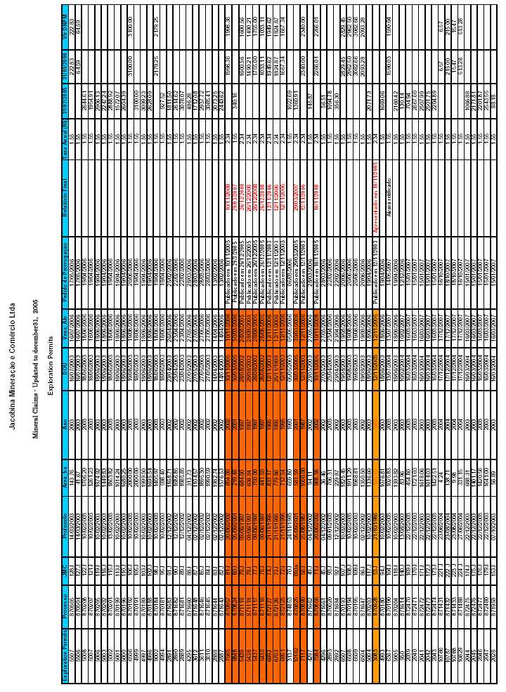


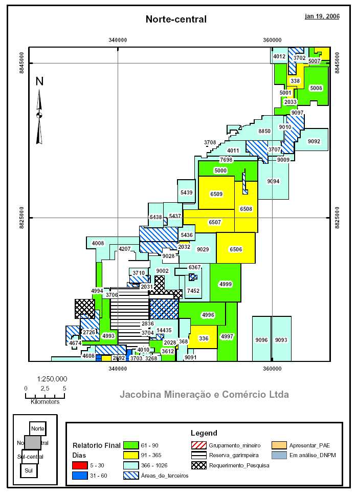
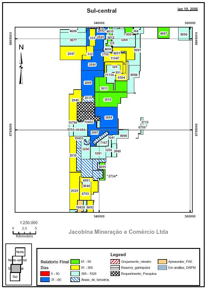
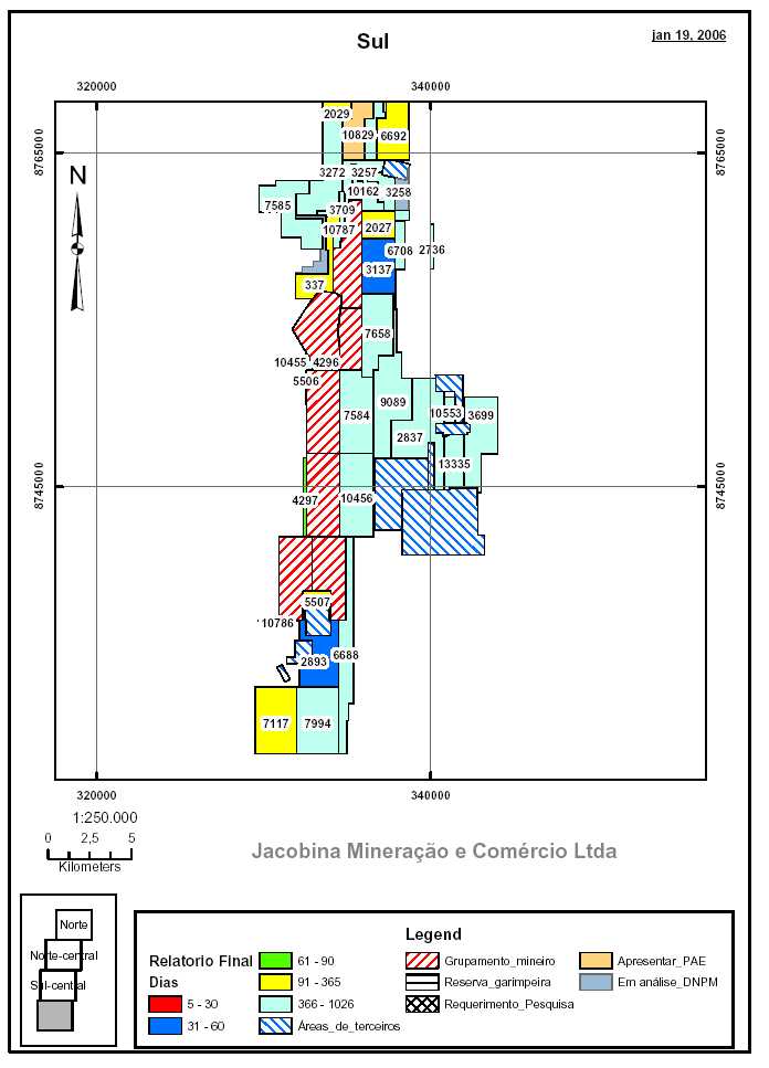

| Updated Resource & Reserve Estimate, Jacobina Dec 2005 |
| APPENDIX II INDUCED POLARIZATION SUMMARY REPORT FOR PINDOBAÇU |
| 188 |

| Updated Resource & Reserve Estimate, Jacobina Dec 2005 |
| Summary Report on ground Induced polarization at pindobacu and canavieiras |
| CLIENT: DESERT SUN MINING PROJECT: SERRA DO PINDOBACU DATE: APRIL - OCTOBER, 2005 |
| OBJECTIVES Review IP data and cross correlate with drillhole geological section Interpret geophysical responses in terms of rock units Recommend target anomalies WORKDONE Geological Solutions has reviewed the data from the Fugro ground IP survey at Pindobacu from the plan maps and dipole-dipole sections of chargeability, resistivity, cole-cole chargeability, metal factor, tau and inversion models for the section data. The data in the target were examined on the profiles to establish correlation between responses and to estimate conductivity, depth and association. GEOLOGICTARGET Gold in the Pindobacu garimpo is hosted in quartz veins and quartzites adjacent to the Pindobacu fault. The mineralization includes elevated disseminated pyrite content. The recent drilling interprets shallow angle thrust faults with INTERPRETATION The IP identified parallel trends of moderate chargeability extending north and south of the Pindobacu garimpo. High chargeability/low resistivity anomalies not associated with the gold bearing conglomerates are seen in the ultramafic intrusives and dyke, the metapelites, iron formation and in the Mundo Novo greenstone. CONCLUSIONS From examination of the Fugro data, The signature target zone is in the moderate range of chargeability and resistivity. This chargeability can be carefully isolated from the stronger surrounding responses. The resistivity is usefully in lithologic mapping to determine the stratigraphy. A thrust fault is interpreted running north-south along the Pindobacu trend seen in the resistivity data. There is an apparent folding of the mineralized unit to the west of the primary tend. Cross-cutting features have displaced large blocks of the Rio do Ouro formation to the west up to 200 meters. Near the northern end of the survey the block appears to be rotated as well. |
| 189 |

| Updated Resource & Reserve Estimate, Jacobina Dec 2005 |
| RECOMMENDATIONS Create a GEMCOM model of the IP chargeability results by removing the signal responses from the ultramafics, metapelites, iron formation and Mundo Novo |
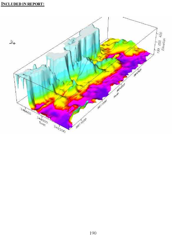

| Updated Resource & Reserve Estimate, Jacobina Dec 2005 |
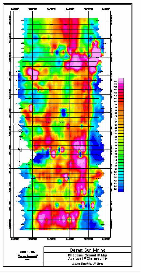

| Updated Resource & Reserve Estimate, Jacobina Dec 2005 |
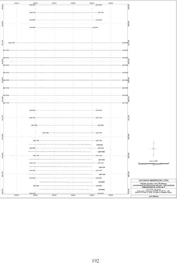
| Updated Resource & Reserve Estimate, Jacobina Dec 2005 |

| PROJECT: CANAVIEIRAS |
| DATE: NOVEMBER, 2005 |
| OBJECTIVES Process Induced Polarization survey data Create pseudosections and images for interpretation Interpret results Create 3D models of IP and Resistivity with interpretation for analysts presentation Provide anomaly target positions for further work WORKDONE Import raw data files and generate IP database. Edit topographic files and import into IP database. Produce pseudosections, plan maps 3D stacked sections, and 3d projection plan maps. GEOLOGICTARGET Disseminated sulphides in quartz pebble conglomerate and siliceous quartzite stratigraphy. Moderate sulphide content as finely disseminated pyrite in the conglomerate reefs is associated with gold mineralization. Silicification indicates hydrothermal alteration, mafic and ultramafic dykes cut across the stratigraphy. Cross cutting and offsetting faults are present. |
| 193 |

| Updated Resource & Reserve Estimate, Jacobina Dec 2005 |
| INTERPRETATION The major anomaly is a coincident chargeability and resistivity anomaly along the crest of the topographic high. The zone appears to be plunging and broadening to the east of the survey block. The low resistivity zone on the east side of the survey area is a broad near surface response. Anomalies are variable and not always coincident with resistivity anomalies. CONCLUSIONS A large and obvious chargeability anomaly is coincident with known zone of mineralization and the old mine workings. There is a large chargeability anomaly probably due to minor disseminated sulphides where the resistivity response is coincident with the chargeability. This zone is broadening and plunging to the east. On the north side several narrow and near vertical anomalies should be investigated as possible mineralized conglomerate reefs. An anomaly on the eastern slope is a good target due to the chargeability strength, and coincident resistivity anomalies, dips to the west into the slope at about 60o. Anomalies on the north-east corner of the survey area are inconclusive due to lack of data in this area. However, the interpretation suggests this is a lithologic target. Resistivity trends suggest a north-east south-west are seen along interpreted fault structures and at geological contacts where alteration is pervasive. Best responses are coincident, resistivity/chargeability anomalies indicating mineralization. RECOMMENDATIONS Thorough examination of pseudosections and inversions prior to drill targeting. Use the geophysical data in conjunction to the known and interpreted geology. Gemcom modeling is valuable for integrating the interpretation. CURRENT ANDFUTUREACTIVITIES Use the Gemcom model to predict zones of increased hydrothermal alteration and determine structural conduit relationships, if any. Reinterpret the airborne geophysical data to determine centers for alteration and for structural controls on mineralization. |
| REFERENCES: INCLUDED IN REPORT: 3D Resistivity map 3D Chargeability map Stacked Pseudosection plan map |
| 194 |

| Updated Resource & Reserve Estimate, Jacobina Dec 2005 |
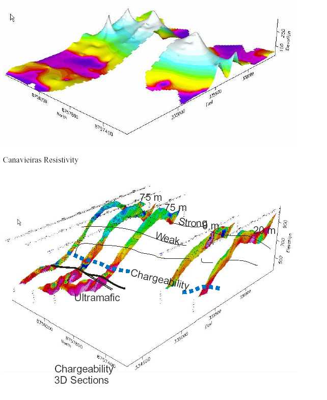
| 195 |

| Updated Resource & Reserve Estimate, Jacobina Dec 2005 |
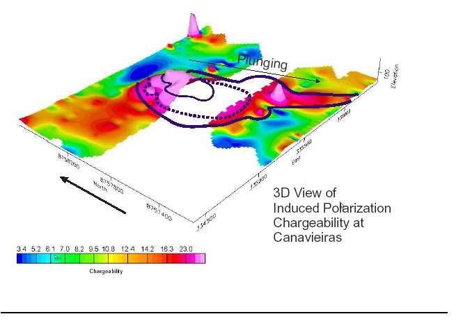
| PROJECT: PINDOBACU/CANAVIEIRAS |
| DATE: DECEMBER 2005 |
| OBJECTIVES Maximize the value of drilling by remotely detecting continuity of mineralization Provide evidence for geological model for resource prediction Create a 3D model with depth information to support the geological model Predict structural complexity Identify off-hole targets up to 100 meters from the borehole PROPOSEDWORK Borehole IP The induced polarization (I.P.) effect is seen primarily with metallic sulfides, graphite, and clays. For this reason, I.P. surveys have been used extensively in mineral exploration. As with electrical |
| 196 |

| Updated Resource & Reserve Estimate, Jacobina Dec 2005 |
| resistivity surveys, vertical or horizontal profiles can be generated using I.P. I.P. can also be used in borehole logging. Constraints: Good contact with the ground is required. I.P. is affected by changes in surface relief and lateral changes in resistivity. The electrode array length is about 10 times greater than investigation depth. Method: Induced polarization is the capacitance effect, or chargeability, exhibited by electrically conductive materials. Measurement of I.P. is done by pulsing an electric current into the earth at one or two second intervals through metal electrodes. Disseminated conductive minerals in the ground will discharge the stored electrical energy during the pause cycle. The decay rate of the discharge is measured by the I.P. receiver. The decay voltage will be zero if there are no polarizable materials present. Generally, both I.P. and resistivity measurements are taken simultaneously during the survey. Survey depth is determined by electrode spacing. The final report products are similar to those of resistivity surveys. IP Inversion IP and resistivity pseudosections can be difficult to interpret directly for complex geometries. Inversion techniques can provide objective earth models and resolve complex anomalies. |
| INTERPRETATION Measuring the resistivity and chargeability in the borehole will allow the resolution of narrow closely spaced pyrite bearing beds as we see in the conglomerates at Canavieiras and identify off-hole targets that can be seen up to 100 m from the hole. Continuity of IP anomalies between the boreholes will afford a ‘comfort level’ with the prediction of the continuity of gold bearing zones between holes without the necessity of tightly spaced drillholes. This will useful for preliminary resource estimates at Pindobacu. The borehole array can be arranged to target specific units at target depths to provide orientation information for future drill targeting. The results can be modeled and inverted to create a 3D block that can be ‘sliced’ at any level or section to give 3rd dimension to the geological model and identify structural offsets and/or discontinuity of zones. CONCLUSIONS Previous attempts to create effective borehole IP systems have been unreliable. The current version offered by JVX has overcome all of the shortfalls of previous systems through a combination of flexible current electrode arrays and high-level data processing and sophisticated inversion software. RECOMMENDATIONS Conduct a borehole IP survey in January and February 2006 at Pindobacu and Canavieiras. Borehole IP can be run effectively throughout the rainy season when surface IP cannot be used. |
| CURRENT ANDFUTUREACTIVITIES |
| 197 |

| Updated Resource & Reserve Estimate, Jacobina Dec 2005 |
| Solicit a borehole IP quote with DSM providing logistical support. Source local supply of necessary support equipment in Brazil |
| John Buckle, P.Geo. GEOLOGICAL SOLUTIONS |
| 198 |
| Updated Resource & Reserve Estimate, Jacobina Dec 2005 APPENDIX III YEAR END 2005 OPINION LETTER, MICON INTERNATIONAL |
| 199 |

| Updated Resource & Reserve Estimate, Jacobina Dec 2005 |
| December 30, 2005 Dr. William N. Pearson Vice President Exploration Desert Sun Mining Corp. 65 Queen Street West, Suite 810 Toronto, Ontario, M5H 2M5 |
| Re: Review of the Updated, Year-End 2005 Mineral Resource Estimate for the Jacobina Mine (All Mines and Advanced Exploration Projects) |
| Bill: |
| At the request of Desert Sun Mining Corp. (DSM) Micon International Limited (Micon) has reviewed a newly updated, in-house mineral resource estimate for the Jacobina mine and surrounding advanced exploration and development properties (see attached Tables 1 and 2). This estimate was prepared after completion of several new diamond drilling and/or underground development programs. New drilling, and/or changes to the previously estimated mineral resources, occurred principally at the João Belo, Morro do Vento, Morro do Vento Extension and Canavieiras deposits. Micon has been engaged in an ongoing assignment for DSM to review the mineral resources at Jacobina and to advise and comment on them. As part of the review process Micon conducted another site visit to the Jacobina mine in Brazil during the period from December 5 to December 9, 2005. This was Micon’s fourth visit to Jacobina for DSM and the fifth visit overall (a previous visit for William Resources was made in 1998). During the visit the resource estimation processes, as well as the new drill results and their interpretation, were examined. An underground visit to inspect recent development drifting at the João Belo mine was also made. Additionally, the locations of recent exploration drill programs in the “northern exploration areas”, around the town of Pindobaçu, were also visited. Earlier in 2005 Micon reviewed a new resource estimate for the Morro do Vento deposit and contributed to a pre-feasibility study completed in August, 2005. Micon has been reviewing the mineral resources at Jacobina for DSM since September, 2002. Micon has reviewed provided documentation describing and documenting the methods used for resource estimation at Jacobina as well as talking with the personnel involved. The documentation included a previous DSM memo, dated October 28, 2004, which outlined the methodology employed for the estimate at João Belo. Other documents provided included drilling cross sections, resource longitudinal sections, and Microsoft Excel spreadsheets showing the calculations made and the supporting quality assurance/quality control (QA/QC) program results from the period of time during which the most recent drilling took place. Previously |
| 1 |

| Updated Resource & Reserve Estimate, Jacobina Dec 2005 |
| Micon has reviewed other QA/QC data which included a newly implemented program of DSM- inserted analytical reference standards to check the laboratory for accuracy as well as the usual external check assays. This opinion letter should be read in conjunction with previous recent Technical Reports prepared by Micon, Devpro (The Morro do Vento Prefeasibility study) and DSM, the tables attached herein as well as the DSM press release dated December 20, 2005 announcing the year end resource estimates for the Jacobina mine. Micon has examined the data provided and performed the following reviews and checks: |
- Confirmed that methods similar to those employed in the past were used for the resourceestimation (generally a longitudinal polygonal method, except for Canavieras where across sectional polygonal method was used).
- Performed spot checks with a planimeter and/or scale to confirm the accuracy of the areasdetermined for the resource polygons.
- Compared tonnes and grade of the new estimate to previously reviewed estimates atJacobina.
- Reviewed QA/QC data.
- Examined the supporting calculation spreadsheets and spot checked the formulaeemployed therein.
- Examined a preliminary reconciliation of mine production to reserves for the first 8months of operation at the João Belo mine (March, 2005 to October, 2005).
- Visited the new mine laboratory, operated under contract by SGS Lakefield Geosol, andreviewed QA/QC methods.
| The review of the data described above has found that methods similar to those which were used in the previous resource estimates, and examined by Micon in its most recent NI 43-101 technical reports, were employed to estimate the 2004 updated resources. Commencing with the 2004 estimate, and contrary to past manual practices, the locations of diamond drill hole pierce points and their true widths are now calculated using Gemcom. All drill hole logging information is now captured electronically using the “Logger” program. The longitudinal sections are prepared, and polygon areas calculated as before, using AutoCAD. Micon has previously opined that these changes are likely only to increase the accuracy of the resource estimate. No material errors were found in the checks of any calculations made or in the final resource tabulation spreadsheet. |
| 2 |

| Updated Resource & Reserve Estimate, Jacobina Dec 2005 |
| The review of the QA/QC data for the João Belo drilling program showed the results to be generally acceptable, with similar limitations to those discussed in recent Micon technical reports. No material problems were seen with the final data used in the estimate. The QA/QC program can be seen to be functioning effectively as per its design. The new mineral resource estimate at Jacobina represents the upgrading of a moderate amount of indicated and inferred resources to the measured and indicated (M + I) categories, respectively, principally at João Belo, as a result of mine development, and at Morro do Vento, as a result of the drilling and prefeasibility study. João Belo has also seen a very large increase in inferred resources due to a deep drilling program and successful development drifting on the north end of the deposit and which has resulted in a structural reinterpretation. Significant new indicated and inferred resources have also been discovered at Canavieras as a result of this year’s drilling program. |
| Several observations can be made: |
- The general tonnage ranges presented are consistent with the gains and write downs asviewed on the longitudinal sections.
- The overall grade of the new M + I resource is similar, but slightly higher than the 2004estimate (2.57 g/t vs. 2.53 g/t). The grade of the new inferred resource estimate is also upslightly (from 2.61 g/t to 2.80 g/t).
- The contained metal in the M + I mineral resources is now over 2.3 million ounces(Moz). The contained metal in the inferred resource is an additional 3 Moz.
- The mineral reserve model for 2005 production to October predicted a plant head gradeof 1.97 g/t versus an actual of 2.01 g/t, a difference of only 2% and a positivereconciliation.
| It is Micon’s opinion that the mineral resource estimate presented is a reasonable one and its classification is consistent with practices previously applied at Jacobina and approved of by Micon. It is also consistent with the Canadian Institute of Mining, Metallurgy and Petroleum’s (CIM), CIM Standards on Mineral Resources and Reserves, Definitions and Guidelines prepared by the CIM Standing Committee on Reserve Definitions, adopted by CIM Council August 20, 2000 and modified on December 11, 2005. However, it has the same limitations on accuracy of local estimation of individual polygon grades as described in previous Micon reports. DSM is working on addressing this limitation with geostatistical studies and computerization of resource estimates. |
| Sincerely |
| MICON INTERNATIONAL LIMITED |
| 3 |
| Updated Resource & Reserve Estimate, Jacobina Dec 2005 |
| B. Terrence Hennessey, P.Geo. Vice President |
| 4 |

| Updated Resource & Reserve Estimate, Jacobina Dec 2005 |
| Table 1 | ||||
| Summary of Mineral Resources | ||||
| (Updated by DSM as of December 19, 2005*) | ||||
| Category | Mine | Tonnes | Grade | Contained Gold |
| (g/t Au) | (ounces) | |||
| Measured | João Belo | 3,100,000 | 2.35 | 234,000 |
| Morro do Vento - Basal/Main | 210,000 | 5.77 | 39,000 | |
| Morro do Vento Ext. - Basal/Main | 40,000 | 5.34 | 7,000 | |
| Canavieiras | 60,000 | 6.73 | 13,000 | |
| Serra do Córrego | 10,000 | 7.50 | 2,000 | |
| Subtotal | 3,400,000 | 2.68 | 295,000 | |
| Indicated | João Belo | 10,570,000 | 2.29 | 780,000 |
| Morro do Vento-Intermediate | 5,800,000 | 2.18 | 407,000 | |
| Morro do Vento - Basal/Main | 1,010,000 | 4.83 | 157,000 | |
| Morro do Vento Ext - Basal/Main | 3,530,000 | 2.87 | 325,000 | |
| Canavieiras | 1,930,000 | 3.45 | 214,000 | |
| Serra do Córrego | 910,000 | 2.39 | 70,000 | |
| Joao Belo Sul | 770,000 | 2.55 | 63,000 | |
| Subtotal | 24,500,000 | 2.56 | 2,016,000 | |
| Total | João Belo | 13,670,000 | 2.31 | 1,015,000 |
| Measured Plus Indicated | Morro do Vento-Intermediate | 5,800,000 | 2.18 | 407,000 |
| Morro do Vento - Basal/Main | 1,220,000 | 4.99 | 195,000 | |
| Morro do Vento Ext - Basal/Main | 3,560,000 | 2.89 | 332,000 | |
| Canavieiras | 1,990,000 | 3.54 | 227,000 | |
| Serra do Córrego | 920,000 | 2.44 | 72,000 | |
| Joao Belo Sul | 770,000 | 2.55 | 63,000 | |
| Total | 27,900,000 | 2.57 | 2,311,000 | |
| Inferred ** | João Belo | 14,430,000 | 2.66 | 1,235,000 |
| Morro do Vento-Intermediate | 2,460,000 | 2.42 | 191,000 | |
| Morro do Vento - Basal/Main | 1,920,000 | 3.78 | 233,000 | |
| Canavieiras | 6,900,000 | 3.29 | 730,000 | |
| Serra do Córrego | 1,350,000 | 3.51 | 152,000 | |
| Joao Belo Sul | 3,890,000 | 1.67 | 209,000 | |
| Other Areas | 2,680,000 | 3.23 | 279,000 | |
| Total | 33,600,000 | 2.80 | 3,029,000 | |
| * - Totals have been rounded | ||||
| ** - There are no inferred resources at Morro do Vento Ext. - Basal/Main as the target has been completely | ||||
| drilled off | ||||
| 5 |
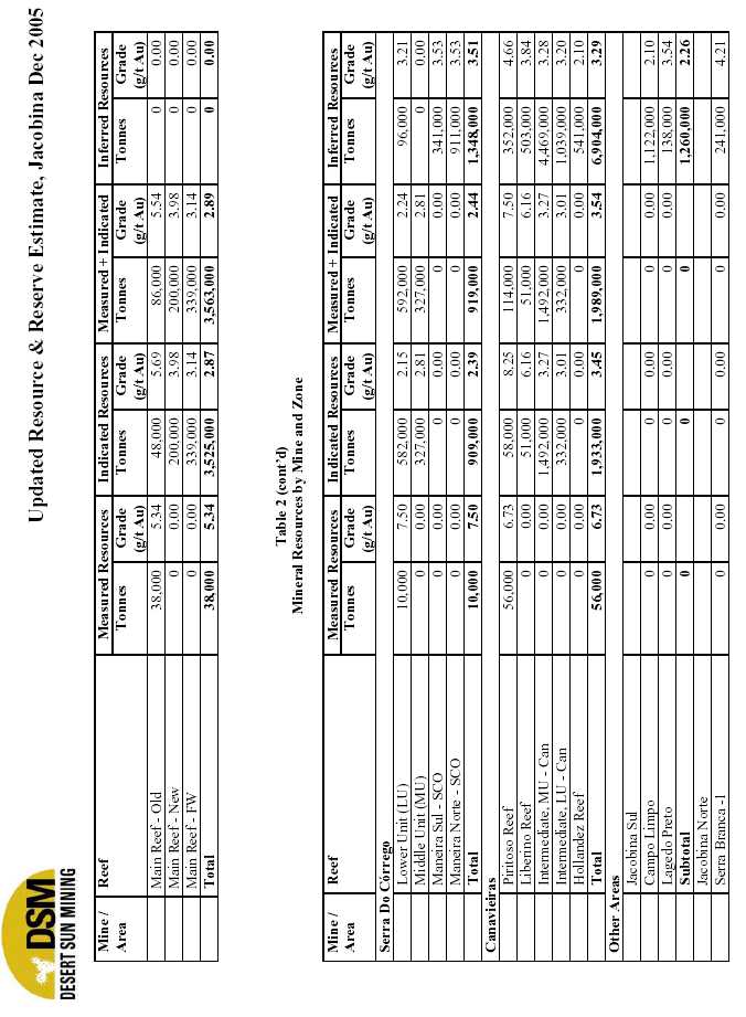
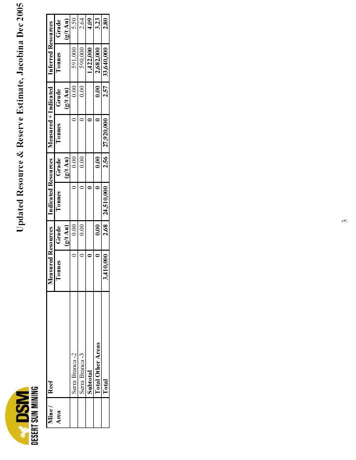
| SIGNATURE |
| Pursuant to the requirements of the Securities Exchange Act of 1934, the registrant has duly caused this Form 6-K to be signed on its behalf by the undersigned, thereunto duly authorized. |
Desert Sun Mining Corp.
(Registrant)
Dated: March 5, 2006 Signed:/s/ Tony Wonnacott
Tony Wonnacott, Corporate Secretary