EXHIBIT 99.1
DEREK MCBRIDE GEOLOGICAL and MANAGEMENT
SERVICES
20 Forsythia Dr.
West Hill, Ontario, M1E 1Y1
Phone 416-282-6580/ CELL 647-233-2416
Email: dmcbgms@excite.com
NI43-101 REPORT WITH RESOURCE CALCULATION ON
THE NUEVO MILENIO PROJECT, TEPIC AREA,
NAYARIT STATE, MEXICO
CREAM MINERALS LIMITED
| “Dr. Derek McBride P.Eng.” (signed) September 23, 2012 |
Table of Contents
| Title Page | |
| Table of Contents | i |
| Summary | iii |
| Introduction and Terms of Reference | 1 |
| Reliance on Other Experts | 1 |
| Disclaimer | 1 |
| Property Description and Location | 3 |
| Accessibility, Climate, Local Resources, Infrastructure, and | 4 |
| Physiography | |
| History | 6 |
| Geological Setting | 7 |
Regional Geology | 7 |
Property Geology | 9 |
| Deposit Types | 14 |
| Exploration | 14 |
| Drilling | 14 |
Dos Hornos 1 | 15 |
Dos Hornos 2 | 15 |
Veta Tomas | 15 |
Once Bocas North | 27 |
Once Bocas South | 28 |
Chacuaco | 32 |
Cafetal | 35 |
| Sampling Method and Approach | 36 |
| Sample Preparation, Analysis and Security | 38 |
| Data verification | 39 |
| Adjacent properties | 39 |
| Mineral processing and Metallurgy | 40 |
| Mineral Resource and Mineral Reserve Estimates | 41 |
| Interpretation and Conclusions | 43 |
| Recommendations | 43 |
| References | 46 |
| Date and Qualifications | 47 |
List of Photographs
| 1 | View of Area from Veta Tomas | 3 |
| 2 | Panorama of Project Area | 6 |
| 3 | Dod Hornos (Two furnaces) from Spanish Times | 7 |
| 4 | Typical Felsic Lapilli-Agglomerate | 12 |
| 5 | Capping Rhyolite Tuff | 12 |
| 6 | Basalt Flow West of Chacuaco | 13 |
| 7 | Vertically Dipping Basaltic Volcanic Tuffs | 13 |
| 8 | Main Vein in Dos Hornos 1 System | 19 |
| 9 | Mine Workings in Adit 4, Dos Hornos 1 | 19 |
| 10 | San Miguel Mine on Veta Tomas | 26 |
| 11 | Hill above San Miguel Mine Capped by Rhyolite Tuff | 26 |
| 12 | Stope on Once Bocas North | 28 |
| 13 | Interior Organization of Core Shack | 38 |
| 14 | Entrance to La Mina California | 40 |
List of Figures
| 1 | Location Map | 2 |
| 2 | Property Map | 5 |
| 3 | Regional Geology | 8 |
| 4 | Property Geology | 10 |
| 5 | Geological Sections across Property Geology | 11 |
| 6 | Dos Hornos 1 Drill Plan | 17 |
| 7 | Dos Hornos 1 Longitudinal Section | 18 |
| 8 | Dos Hornos 2 Drill Plan | 21 |
| 9 | Dos Hornos 2 Longitudinal Section | 22 |
| 10 | Veta Tomas Drill Plan | 24 |
| 11 | Veta Tomas Longitudinal Section | 25 |
| 12 | Once Bocas North Drill and Surface Plan | 29 |
| 13 | Once Bocas North East Vein Longitudinal Section | 30 |
| 14 | Once Bocas North West Vein Longitudinal Section | 31 |
| 15 | Once Bocas South Drill Plan | 33 |
| 16 | Chacuaco Drill Plan | 34 |
| 17 | Cafetal Drill Plan | 37 |
List of Tables
| 1 | Mineral Concession Nuevo Milenio | 4 |
| 2 | Dos Hornos 1 Drill Intersections | 16 |
| 3 | Dos Hornos 2 Drill Intersections | 20 |
| 4 | Veta Tomas Drill Intersections | 23 |
| 5 | Once Bocas North Drill Intersections | 28 |
| 6 | Once Bocas South Drill Intersections | 32 |
| 7 | Summary Intersections on Chacuaco | 35 |
| 8 | Summary of Intersections on Cafetal | 36 |
| 9 | Comparison of Original and Check Assays | 39 |
| 10 | Summary of Gold-Silver Resources | 42 |
| 11 | 2012 Proposed Budget | 45 |
EXECUTIVE SUMMARY
Introduction
The author was requested to carry out an independent resource calculation on the Company’s Nuevo Milenio Property near Tepic, Nayarit State, Mexico. The resource calculation required a follow up NI 43-101 and the author undertook this task. A seven day visit was made to the property from September 3rd to 9th during which the property geology, mineralization and historical mine workings were investigated. The author wanted to present an exploration model that would optimize future exploration.
Cream Minerals Limited owns the concession through its 100 percent owned Mexican subsidiary Cream Minerals de Mexico S.A de C.V. Some pre-existing Opal Lots occur with the concession; some have been either purchased or have agreements with the Company.
Geology
Mineralization at Nuevo Milenio is confined to a felsic lapilli-agglomerate of rocks that form a 200 to 200 metre thick sequence across most of the Property. To the west it terminates against vertically dipping basement basaltic volcanic rocks; to the east it is increasingly buried under a well bedded rhyolite tuff. Neither of these rocks is mineralized.
Mineralization
The felsic lapilli-agglomerate rocks are cut by steeply dipping quartz veins and stockworks of multiple veinlets which carry very fine sulphide minerals with gold and silver values. Historical mine working have been discovered on three main mineralized systems, the Dos hornos-Veta Tomas, Once Bocas and Chacuaco-Cafetal. An additional one, La Mina California occurs on one of the Opal Concessions within the Cream Property. These systems are continuous along strike for upwards of a kilometre or more and are separated by lower ground. The wide extent of the mineralization suggests that more parallel zones may have not been recognized and some may be hidden under the rhyolite cap.
Mineral Resource Estimate
Mineral resources have been calculated for the Dos Hornos-Veta Tomas and Once Bocas. The attached table gives a summary of the results. In the Dos Hornos-Veta Tomas System almost 3 million tonnes of measured and indicated resources have been outlined and in the Once Bocas System 3.5 million tonnes of inferred. Other targets such as Chacuaco-Cafetal and La Mina California remain to be systematically evaluated.
| RESOURCE SUMMARY NUEVO MILENIO 50G/T CUT-OFF | ||||||||||||||||||||
| Zone | Tonnes | Tonnes | Gold g/t | Silver g/t | Silver Eq. g/t | |||||||||||||||
| Dos Hornos-Veta Tomas | ||||||||||||||||||||
| Total Measured and Indicated | 2,829,000 | 0.53 | 79.79 | 107.34 | ||||||||||||||||
| Inferred | 500,000 | 0.50 | 71.69 | 97.53 | ||||||||||||||||
RESOURCE SUMMARY NUEVO MILENIO 160G/T CUT-OFF | ||||||||||||||||||||
| Zone | Gold g/t | Silver g/t | Silver Eq. g/t | |||||||||||||||||
| Dos Hornos-Veta Tomas | ||||||||||||||||||||
| Total Measured and Indicated | 803,000 | 1.17 | 170.54 | 231.22 | ||||||||||||||||
| Inferred | 64,700 | 1.03 | 178.70 | 229.98 | ||||||||||||||||
INFERRED RESOURCES | ||||||||||||||||||||
| Dos Hornos-Veta Tomas | 500,000 | 0.50 | 71.69 | 97.53 | ||||||||||||||||
| Open Pit potential 20g | ||||||||||||||||||||
| Once Bocas North | 2,145,000 | 0.20 | 40.67 | 50.67 | ||||||||||||||||
| Once Bocas South | 909,000 | 0.27 | 72.28 | 82.27 | ||||||||||||||||
| Total Inferred | 3,554,000 | 0.26 | 53.25 | 66.25 | ||||||||||||||||
Potential
Cream Minerals Limited’s Nuevo Milenio Property has been explored with 149 drill holes which has outlined three areas of significant mineralization and resources I an easily identifiable felsic lapilli-agglomerate volcanic sequence. Mineralization seems to be best developed on hills exposing the middle and upper sections of this sequence. The lateral distribution of the mineralization suggests that more parallel veins remain to be identified and that the existing ones may be extended. Within the known veins much infill drilling is required to fully outline their potential.
A two phase drilling program is recommended to test the vein systems with the goal of increasing the resources and secondly to search for systems indicated by the geological patterns. The budget for phase 1 is US$800.000 and Phase 2 US$3,000,000.
“Dr Derek McBride P. Eng” (signed).
DEREK MCBRIDE GEOLOGICAL and MANAGEMENT
SERVICES
20 Forsythia Dr.
West Hill, Ontario, M1E 1Y1
Phone 416-282-6580/ Cell 647-233-2416
Email: dmcbgms@excite.com
NI43-101 REPORT WITH RESOURCE CALCULATION ON THE NUEVO
MILENIO PROJECT, TEPIC AREA, NAYARITE STATE, MEXICO
CREAM MINERALS LIMITED
MILENIO PROJECT, TEPIC AREA, NAYARITE STATE, MEXICO
CREAM MINERALS LIMITED
Introduction and Terms of Reference
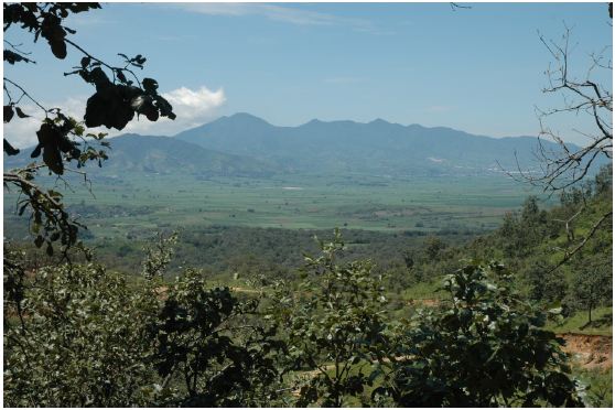
The author was requested by Mr. M. O’Connor, President of Cream Minerals Limited to complete an independent resource calculation on the Company’s Nuevo Milenio Property south of Tepic, Nayarit State, Mexico (Photo 1, Figure 1). The request to complete this NI 43 101 Report was made to support the August 12th resource calculation made on the property. A visit was made to the property from September 3 to 10, 2012 during which spent time checking the geology, drill core, and old mine workings.
Reliance on Other Experts
Mr. F. Holcapek has managed the project since its inception over 10 years ago. The author has dawn extensively from his work. That being said the author’s calculation of the mineral resource and field observations were made independently. Sr. G. Fransisco, the field geologist under Mr. Holcapek guided the author for his field visit. His knowledge of the property was extremely helpful.
Disclaimer The writer has received from Cream Minerals Ltd. information with respect to the concessions, titles and related ownership agreements, technical data concerning the mineral occurrences, geology and production history of past mining of the concessions and district. He undertook certain reviews and written affirmations of the client-provided concession titles and ownership agreements and believes the information presented herein is valid at the report date: however, this review does not represent a legal opinion.
Figure 1
Location Map
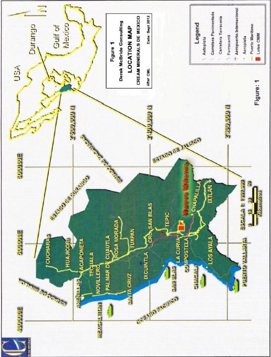
2
Photo 1
View from Near Veta Tomas Showing La Curva to the left and Tepic at Top of the Photo
Property Description and Location
The Nuevo Milenio Property of Cream Mineral Ltd. is held by its wholly owned Mexican subsidiary, Cream Minerals de Mexico S.A. de C.V. It is situated approximately 20 kilometres south southeast of Tepic in the Municipality of Xalisco. It consists of a single Mining Lot in good standing (Table 1, Figure 2). It was originally applied for on February 15, 2000 and granted on February 10, 2001. On November 10, 2005 an application to reduce this Exploration Lease and convert it to a Mining Concession was made. The new Mining Concession was granted on February 10, 2007. It remains in force subject to semi annual taxes payable by January 31 and July 31 each year (Holcapek, 2009). The last tax payment was made on July 31, 2012. Any work carried out must be reported on by May 31 of the following year.
Within the concession, older opal concessions are present that have the same mineral rights as the Company’s Mining Concession. They are excluded from the Company’s concession.
3
Table 1
Mineral Concession for Nuevo Milenio Project
| Mining Lot | Title No. | Type | Area | Dated |
| Nuevo Milenio Fracc 1 | 225967 | Mining Concession | 2,560.063 Ha | Feb 10, 2007 |
Accessibility, Climate, Local Resources, Infrastructure, and Physiography
Tepic is the major commercial centre of 300,000 persons and the capital of the state of Nayarit. It serves the large farming industry which is the main source of income for the local residents. The city is serviced by excellent highways including the autopista from Guadalajara to Mazatlan, a railway line and airport. Numerous businesses can supply most requirements for an exploration project. Assaying services through ALS Chemex and drilling services are available in Guadalajara or Inpsectorate Exploration and Mining Services preparation laboratory in Durango.
The Property is reached by traveling south on highway 200 from Tepic towards Puerto Vallarta and taking a secondary local road to La Curva. The property lies 3 kilometres east of La Curva along a dirt road on the eastern side of a northwest-southeast valley. Historical workings on the low hills outline the areas of mineralization.
The project district climate is temporal and is made up of a dry season and a wet season which extends from June to October. Annual precipitation is 900 millimetres. During this period working in the hills can be difficult due to landslides, flooding and severe weather. Temperatures average 32C in the day time. In the dry period; day time temperatures can reach the mid forties degrees C. Night time temperatures fall to 20 degrees C. in mid winter and may reach freezing in the higher country. This visit was made in the rainy season, but was not hindered because of the continuous road maintenance by the Company.
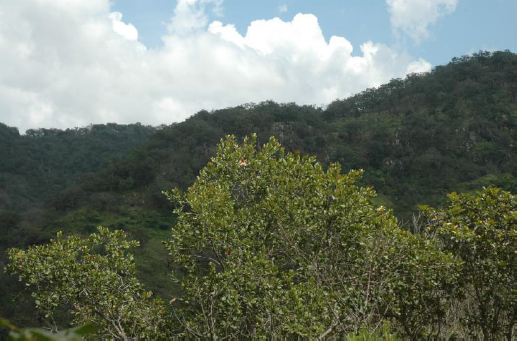
The concessions lie in youthful topography. Geologically the rocks are very young, flat lying basic to felsic volcanic sequences (Photo 2). About 25 kilometres to the south is the volcano Ceboruco which was last active approximately 200 years ago. Many other volcanic cones dot the nearby countryside. These represent eruptions much later than the mineralization.
4
Figure 2
Property Map
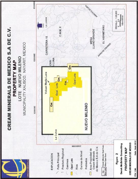
5
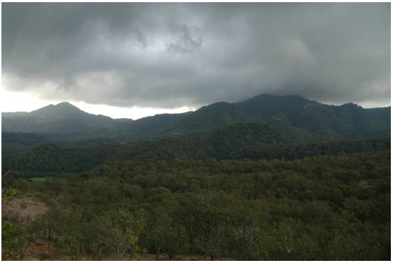
Photo 2
Panorama Showing the topography of the Mineralized Targets on the Property;
Chacuaco West and North are in the middle foreground, Once Bocas and Chacuaco North
in the Centre and Dos Hornos 1 and 2, Veta Tomas are Along the Ridge
Marking the Skyline from the Centre to Right
Chacuaco West and North are in the middle foreground, Once Bocas and Chacuaco North
in the Centre and Dos Hornos 1 and 2, Veta Tomas are Along the Ridge
Marking the Skyline from the Centre to Right
6.0 History (After Holcapek, 2008)
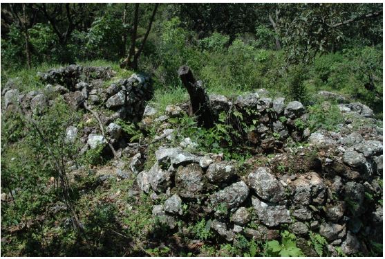
Spanish history began in 1534 with the arrival of Captain Francisco Cortez de San Buena Ventura at Tepic; over the next few years the Spanish consolidated their position and learned of gold and silver from the local indigenous peoples. Mining and exploration spread throughout the area. Remnants of this work are seen in pits, trenches and small shafts and adits which show pick marks for the hand chipping of these drives indicating that they predate blasting powder and drilled blast holes. Few records exist of these mining activities and boundaries of the active areas have changed, but mining activity was extensive throughout this part of Mexico from the very early days of colonization. The above workings likely date from the sixteenth century. No buildings remain but two old furnaces (hornos) are present (Photo 3).
In the last 20 years local people have attempted mining of a vein on the property between Dos Hornos 1 and 2 in a “transition zone” and one to the east. A mill was set up about 5 years ago to process mineralization east of Dos Hornos 1. The operation lasted two years and the mill sat idle until six months ago when it was removed.
6
Photo 3
Dos Hornos, Two furnaces from Spanish Times
Geological Setting
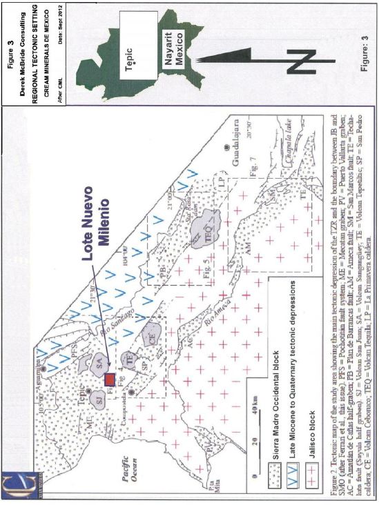
Regional Setting (Figure 3)
This part of Mexico is included in the Sierra Madre Occidental Geological Province which extends from the American border to Guadalajara as a series of young flat-lying volcanic rocks varying from basalts to rhyolites. Most seem to have been deposited on land and preserve depositional textures; obsidian is common. Near the project area, rock compositions include rhyolites, basalts and possibly some ultramafic rocks. The Sierra Madre Occidental Geological Province ends a short distance south against the east-west trending Trans-Mexican volcanic belt of similar age (Figure 3). It hosts many silver-gold deposits including the Minefinder’s Deloro, the Gammon Lake O’Campo and Stroud Resources Ltd’s Santo Domingo deposits. The author has worked on all these deposits and sees many common features between them and the present property which lies about 70 kilometres northwest of the Stroud Deposit. The mines have demonstrated tops and bottoms and the main mined area seem to be hosted by one rock type above a major change in rock type. This pattern is present on the Nuevo Milenio property,
7
Figure 3
Regional Geology
8
but the thick ash fall tuff units that form the hanging wall of the deposits are not displaced. To produce a fault pattern would require complicated cross faulting that is not seen in the surrounding well-exposed mountain ridges of the valley. Similarly the fresh, flat lying volcanic sequence eliminates the presence of shear zones.
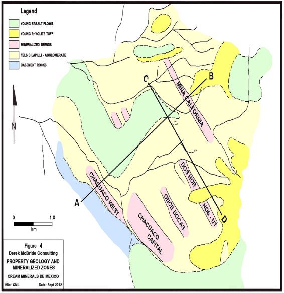
Property Geology and Mineralization (Figure 4 and 5)
Rock exposure is poor in spite of the youthful topography. Most exposures are found along creeks and roads constructed for drilling. Veins can be traced by residual quartz float. Most of the property is covered by a felsic lapilli-agglomerate tuff which is diagnostic by the lapilli sized clasts and some larger clasts up to 5 centimetres (Photo 4). Locally clasts to 20 centimetres were seen in the Once Bocas North. Bedding was not seen in this unit, but its overall distribution suggests a gentle north, westerly dip.
It is capped by a rhyolitic welded tuff unit with highly flattened fragments some 4 to 5 centimetres long parallel to bedding which itself is well developed in a 4 or 5 millimetre scale. In many areas it is resistive and forms cliffs (Photo 5). This rhyolitic tuff is barren of mineralization and is restricted to the eastern part of the property and at higher elevations. Its distribution suggests that it dips to the north and covers the favourable felsic lapilli-agglomerate at lower elevations there. North of Dos Hornos 1, it is capped by a thin younger basalt flow that extends north for a couple of kilometres. West of Cafetal, a similar basaltic sequence of flow, tuffs and agglomerates form a ridge that marks the limit of the Cafetal and Once Bocas North mineralized zones (Photo 6). Large blocks on the front of the ridge suggest that the last activity was a debris flow. Two drill holes at Cefetal contain weathered basaltic agglomerate at depth and possibly interlayered with the felsic lapilli-agglomerate.
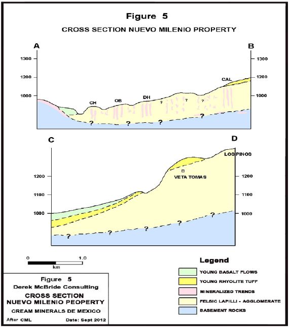
A barren low ridge marks the western limit of the property. It consists of thinly bedded mafic tuffs and flows that have been folded into a vertical position (Photo 7). These rocks were deformed and probably, deeply weathered prior to the deposition of the recent volcanic mineralized sequence described above. It probably forms the basement rocks in the Nuevo Milenio area. The cross sections in Figure 5 demonstrate these relationships as observed by the author in the field.
Mineralization is restricted to the felsic lapilli-agglomerate. None is reported from the overlying rhyolite and the base is unknown. The weathered surface of the deformed basement seems to dip gently under the younger rocks to the east. Each of the known mineralized zones can be traced for several hundred metres in a northwest-southeast direction and consists of narrow high grade veins with lower grade halos made up of veinlets forming a stockwork. The three known trends are known to have lengths of over a kilometre and widths of up to 200 metres; only part of the width is of economic interest which may be continuous for the length of the zone. Unexplored Chacuaco West suggests that more zones may be found in the lower ground.
9
Figure 4
Property Geology
10
Figure 5
Cross Sections Across the Property; The Intersection Point is the Silica Cap-Basal Tuff
Outcrop at the North End of Dos Hornos 1
Outcrop at the North End of Dos Hornos 1
11
Photo 4
Typical Felsic Lapilli Agglomerate in Trench at Dos Hornos 1 Number 5 Shaft
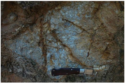
Photo 5
Capping Rhyolite Tuff Sequence Forming a Cliff East of Dos Hornos 1
12
Photo 6
Photo Showing the Basalt Flow to the West of Chacuaco-Cafetal Sloping to the Left
Across the Centre of the Photo from the Right, Chacuaco Ridge is in the Middle Background to the Left
Across the Centre of the Photo from the Right, Chacuaco Ridge is in the Middle Background to the Left
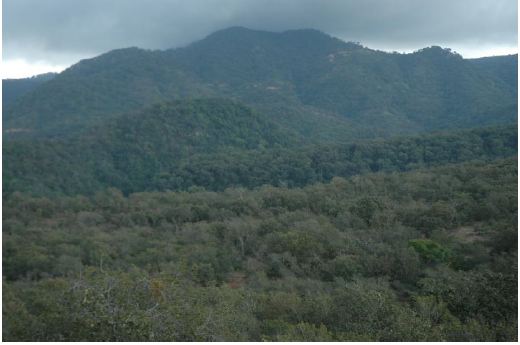
Photo 7
Vertically Dipping Mafic Volcanic Tuffs on the Western Margin of the property
13
Deposit Types
Mineralization is restricted to the felsic lapilli-agglomerate tuff. Quartz veins and quartz stockworks are concentrated within these rocks. Numerous vein systems have been identified and have been given names such as Dos Hornos 1 and 2, Veta Tomas, Once Bocas, Cafetal and Chacuaco. Mineralization is concentrated on northwest-southeast steeply dipping quartz vein systems and their halos (Photo 9). Observations of the vein textures show that they are commonly laminated and vuggy. The disseminated mineralization in the host rocks suggest fluids passing through or along accumulating surfaces at moderate temperatures. Deposition is in the form of fine-grained sulphides which give the rock a bluish or greyish colouration. The alteration minerals and the presence of silica show the influence of the hydrothermal solutions. These textures are interpreted as the product of a combination of near surface vein formation coupled with simultaneous sinter formation at the proximal surface. Metallic minerals seem to be deposited throughout this process but become depleted in sulphur higher in the system.
Oxide mineralization was seen in float at Dos Hornos 1. Similar oxide mineralization was seen by the author at the top of veins at Delores (Minefinders Corporation Ltd.) and at Santo Domingo (Stroud Resources Ltd). It may represent the final phase of the mineralizing system once the sulphides were depleted.
Vein development is restricted to the felsic lapilli agglomerate. Below the deformed basement basaltic tuffs are not considered to be the source for the economic metals because they were deposited, deformed and then weathered prior to the deposition of the flat-lying mineralized succession. Metallic minerals seem to have been deposited in the porous rhyolite agglomerate at and/or near the existing volcanic surface. The deposition was blocked by the rapid deposition of rhyolitic tuff deposits that form the top of the hills.
Exploration
In 2002 Sr. G. Francisco, performed geological mapping along creeks, hill sides and roads. His work formed the basis for the geological mapping shown on Figure 4. Prior to his employment extensive sampling of old showings, mine workings and surface outcrops had been carried out.
Soil geochemistry was performed over most of the property except to the west of Chacuaco West where security concerns limited the program. This survey outlines anomalies over the known mineralized zones. To the east its usefulness is limited due to the barren capping rhyolite tuff. Five diamond drill holes tested the zones at this time. Five holes were drilled in 2002; 2003-4 saw the drilling of 19 holes and a further drilling of 36 holes was carried out in 2006 -7. All these holes were surveyed. The most recent drilling phase in 2011 consisted of the drilling of 89 holes. These holes were measured off from the previous holes using a compass and chain.
14
Drilling
Cream drilled Nuevo Milenio in four campaigns from 2002 to 2011; during this period 149 holes were drilled for a total of 31537 metres. These holes are not described individually, but by the zone they tested.
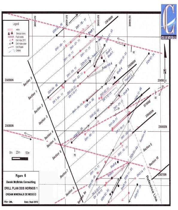
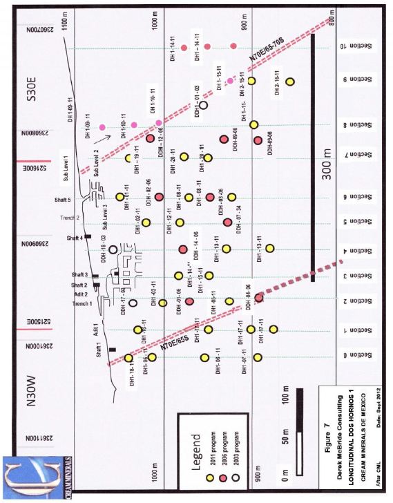
Dos Hornos 1 (Figure 6 and 7)
Dos Hornos 1 is at the north end of the Dos Hornos-Veta Tomas trend and occurs under a ridge capped by the rhyolite tuff. It has been tested over a strike length of approximately 300 metres by 35 holes; the results are shown on (Table 2, Figures 6 and 7). Mr Holcapek P. Eng. interprets this mineralization as vertically to steep south, westerly dipping. IT shows a mineralized system over the 200 metres vertical drilled and open at depth on approximately 50 metre sections. This mineralization is composed of a high grade linear core and flanking halo (Photos 8 and 9).
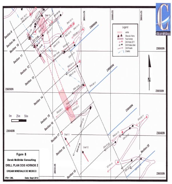
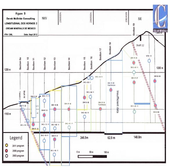
Dos Hornos 2 (Figures 8 and 9)
Dos Hornos 2 continues the trend to the southeast. It was tested on approximately 50 metre sections over 450 metres. Twenty eight holes intersected the zone and the results are shown on Table 3. They show that the mineralization is continuous, but the data are not dense enough to properly outline the zone. It is thought that Dos Hornos 1 and 2 are separated by a northeast fault with a horizontal displacement of approximately 100 metres. Adit 3 was driven between these zones on what is termed a” transition zone”. This seems to be an additional vein system between Dos Hornos 1 and 2 whose extent is unknown. It could add significant potential to the system.
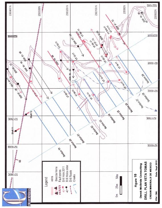
Veta Tomas (Figures 10 and 11)
Veta Tomas is the continuation of the Dos Hornos system to the southeast. It differs in that is it is interpreted as having a northeasterly dip. Recent analysis of the drill data suggests that the adjacent Dos Hornos 2 Zone also may have a vertical to northeasterly dip. Twenty holes have tested this zone and show mineralization that is continuous over a strike length of 300 metres and from surface down 100 metres below which the values decease and become spotty (Table 4). Veta Tomas was investigated by the San Miguel Adit (Photo 10) just below the rhyolite cap (Photo 11).
The mineralization continues southeast into the St. Gertrudis Mine and Los Pinos areas which have not been investigated in any detail.
15
Table 2
| Dos Hornos 1 Drill Intersections and Average Grades | ||||
| Section | Hole Number | Horizontal Thickness | Gold g/t | Silver g/t |
| 0 | DH-18-11 | 2.83 | 2.69 | 58.91 |
| DH1-06-11 | 2.47 | 0.33 | 59.37 | |
| 1 | DH1-16-11 | 2.83 | 151.00 | 41.70 |
| DH1-17-11 | 1.15 | 0.14 | 93.60 | |
| 2 | ADIT 1 | 5.00 | 2.48 | 324.23 |
| DDH-17-03 | 6.72 | 0.24 | 65.66 | |
| DH1-03-11 | 1.41 | 0.20 | 43.00 | |
| DDH-01-06 | 4.42 | 0.20 | 88.33 | |
| 3 | DH1-14-11 | 10.29 | 0.29 | 88.30 |
| DH1-15-11 | 2.57 | 0.07 | 53.54 | |
| DDH-18-03 | 9.90 | 0.29 | 42.30 | |
| DDH-14-06 | 9.90 | 0.33 | 71.14 | |
| 4 | DH1-13-11 | 14.90 | 0.10 | 49.85 |
| DH1-13-11 2ND | 2.30 | 0.14 | 49.40 | |
| TRENCH 2 | 6.00 | 3.27 | 50.97 | |
| DH1-02-11 | 6.10 | 1.60 | 454.69 | |
| 5 | DH1-12-11 | 11.00 | 0.37 | 155.00 |
| DDH-07-34 | 1.97 | 0.20 | 113.47 | |
| ADIT 4 | 7.20 | 2.03 | 142.90 | |
| SHAFT 3 | 1.22 | 3.27 | 141.66 | |
| 6 | DH1-01-11 | 11.03 | 0.27 | 36.65 |
| DDH-02-06 | 14.14 | 0.37 | 97.14 | |
| DH1-08-11 | 10.68 | 0.19 | 88.63 | |
| DH1-08-11 2ND | 4.20 | 0.30 | 56.97 | |
| DDH-03-06 | 1.40 | 0.18 | 58.00 | |
| 7 | DH1-19-11 | 2.83 | 0.56 | 34.55 |
| DH1-20-11 | 2.54 | 0.16 | 71.43 | |
| 7.5 | DDH-12-06 | 7.23 | 0.29 | 79.12 |
| DDH-09-06 | 1.40 | 0.17 | 43.00 | |
| DH1-09-11 | 11.80 | 0.45 | 59.60 | |
| DH1-10-11 | 33.70 | 0.22 | 52.13 | |
| 8 | DH1-11-11 | 4.82 | 0.21 | 40.85 |
16
Figure 6
Dos Hornos 1 Drill Plan
17
Figure 7
Dos Hornos 1 Longitudinal Section
18
Photo 8
Main Vein in Dos Hornos 1 System

Photo 10
Mine Working in Adit 4, Dos Hornos 1

19
Table 3
Dos Hornos 2 Intersections
| Section | Hole Number | Horizontal Thickness | Gold g/t | Silver g/t |
| 9 | DH2-15-11 | 7.72 | 0.888 | 163.43 |
| DH2-16-11 | 2 | 0.840 | 380.90 | |
| 9A | DDH-11-03 | 2.82 | 0.166 | 42.30 |
| 10 | TRENCH 3 | 10 | 4.060 | 199.82 |
| DH2-14-11 | 3.86 | 0.104 | 46.73 | |
| 11 | DDH-11-06 | 19.8 | 0.514 | 68.64 |
| DDH-11-06 2ND | 2.52 | 0.173 | 101.52 | |
| DH2-13-11 | 11.31 | 0.820 | 154.13 | |
| DDH-07-33 | 4.24 | 0.183 | 46.00 | |
| 12 | DDH-07-32 | 20.86 | 0.536 | 70.19 |
| DH2-12-11 | 2 | 0.119 | 80.00 | |
| DH2-10-11 | 5.3 | 0.415 | 40.57 | |
| 13 | DDH-15-06 | 7.07 | 0.394 | 82.58 |
| DH2-08-11 | 9.9 | 1.205 | 124.83 | |
| DH-07-31 | 2.82 | 1.893 | 8.70 | |
| DDH-07-31 2ND | 4.24 | 0.492 | 74.66 | |
| 14 | DDH-07-30 | Low Values | ||
| DH2-07-11 | Low Values | |||
| 15 | DDH-16-06 | 2.41 | 0.770 | 99.58 |
| DH2-06-11 | 6.77 | 0.382 | 72.00 | |
| 16 | DH2-03-11 | 9.19 | 0.231 | 42.67 |
| DH2-04-11 | 6.156 | 0.391 | 57.60 | |
| 17 | DDH-07-29 | Low Values | ||
| 18 | DDH-07-28 | Low values | ||
| 19 | DDH-07-26 | 4.24 | 0.800 | 35.50 |
| 5.51 | 0.643 | 45.45 | ||
| DDH-07-27 | 2.95 | 0.717 | 28.51 | |
| 2 | 0.148 | 56.50 | ||
| DH2-02-11 | 1 | 0.972 | 7.00 | |
| DH2-01-11 | Low Values |
20
Figure 8
Dos Hornos 2 Drill Plan
21
Figure 9
Dos Hornos 2 Longitudinal Section
22
Table 4
Veta Tomas Drill Intersections
| VETA TOMAS | ||||
| Section | Hole Number | Horizontal Thickness | Gold g/t | Silver g/t |
| 20 | VT-01-11 | 3.07 | 1.01 | 43.391 |
| 21 | DDH-20-06 | 8.48 | 1.177 | 110.38 |
| DDH-21-06 | LOW GRADE | 0 | ||
| 22 | VT-02-11 | LOW GRADE | ||
| 23 | DDH-19-03 | 1.41 | 0.877 | 18.2 |
| DDH-19-03 2ND | 5.66 | 0.408 | 102.88 | |
| VT-04-11 | 2.63 | 0.218 | 41.1 | |
| 23A | DDH-18-06 | 4.24 | 0.4786 | 52.6 |
| DDH-18-06 2ND | 12.8 | 0.56 | 54.1 | |
| DDH-19-03 | 1.41 | 0.877 | 18.2 | |
| VT-03-11 | 7.58 | 0.517 | 74.29 | |
| 24 | VT-15-11 | 9.19 | 0.213 | 81.84 |
| VT-15-11 2ND | 4.24 | 0.014 | 76.7 | |
| VT-12-11 | 18.81 | 0.115 | 48.14 | |
| 25 | DDH-07-24 | 11.57 | 0.128 | 69.26 |
| 26 | VT-08-11 | 5.38 | 0.722 | 168.8 |
| VT-09-11 | 1 | 0.054 | 54.5 | |
| VT-09-11 2ND | 1.33 | 0.0456 | 60.71 | |
| 27 | VT-05-11 | 1 | ||
| DDH-07-23 | 3.86 | 1.706 | 525.73 | |
| VT-06-11 | 2.88 | 3.212 | 268.78 | |
| 28 | VT-16-11 | 6.74 | 0.489 | 172.11 |
23
Figure 10
Veta Tomas Drill Plan
24
Figure 11
Veta Tomas Longitudinal Section
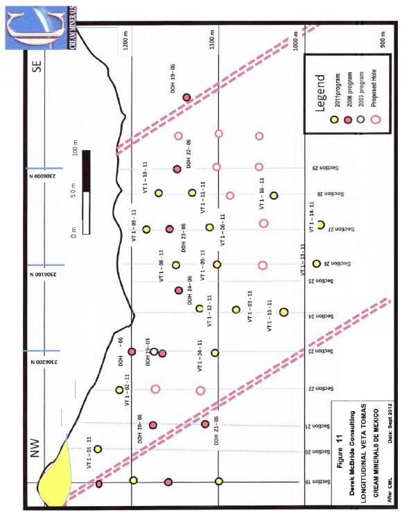
25
Photo 10
San Miguel Mine on Veta Tomas
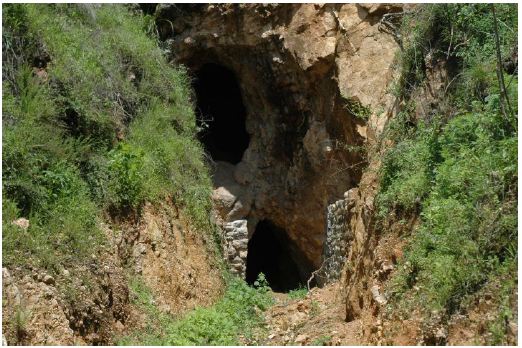
Photo 11
Hill above San Miguel Adit Capped by Rhyolite

26
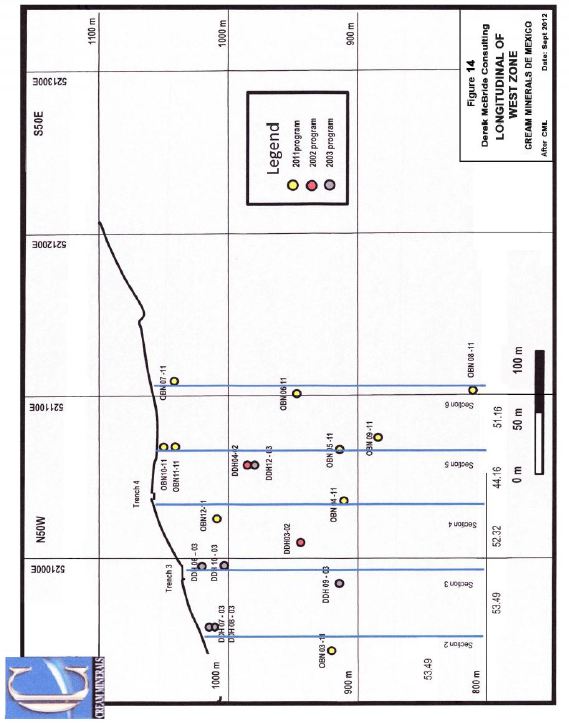
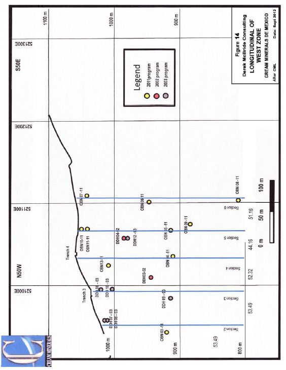
Once Bocas North (Figures 12, 13 and 14)
Parallel and southwest of the Dos Hornos-Veta Tomas Trend is the Once Bocas Trend composed of the Once Bocas North and South Zones. The North Zone has been tested with 20 drill holes over a strike length of 350 metres (Figure 12), which has identified two parallel bands of mineralization approximately 60 metres apart exposed on each side of an arroyo. The east one has been investigated by numerous shafts, adits and limited underground stoping (Photo 12); the west one has seen some underground workings. Together they formed the database for an open pit resource calculation (Table 5). These veins strike more easterly than those to the east and seem to strike about 120 degrees. The reason for this change could not be determined during the author’s visit.
Drilling has shown that the best intersections occur within 50 metres of surface; below the mineralization is quite weak. (Figures 13 and 14) the data are sufficient that a resource has been estimated for this zone.
Photo 12
Looking Down a Stope on the Once Bocas North East Mineralization
Worker is Entering a Small Crosscut to a Parallel Mined Vein

27
Table 5
Drill Intersections in the Once Bocas North Zone
| Once Bocas North | ||||
| Section | Hole Number | Horizontal Thickness | Gold g/t | Silver g/t |
| 1 | OBN-14-11 | LOW VALUES | ||
| ONB-16-11 | LOW VALUES | |||
| 2 | DDH-08-03 | 1.41 | 0.0643 | 26.90 |
| OBN-16-11 | 1.41 | 0.0820 | 45.60 | |
| DDH-07-03 | NO ASSAYS REPORTED | |||
| 3 | DDH-06-03 | 24.4 | 0.4100 | 44.85 |
| DDH-10-03 | 4.0 | 0.0800 | 21.28 | |
| DDH-09-03 | 24.0 | 0.1400 | 29.10 | |
| 3.5 | DDH-02-03 | 15.6 | 1.4200 | 47.20 |
| 4 | OBN-04-11 | 21.2 | 0.0500 | 15.04 |
| OBN-12-11 | 15.5 | 0.1700 | 19.16 | |
| 4.5 | DDH-12-03 | 49.6 | 0.2000 | 48.15 |
| DDH-04-03 | 38.2 | 0.1040 | 19.16 | |
| 5 | OBN-05-11 | 35.4 | 0.1430 | 24.79 |
| OBN-10-11 | 40.0 | 0.1240 | 25.60 | |
| OBN-11-11 | 58.0 | 0.1040 | 10.72 | |
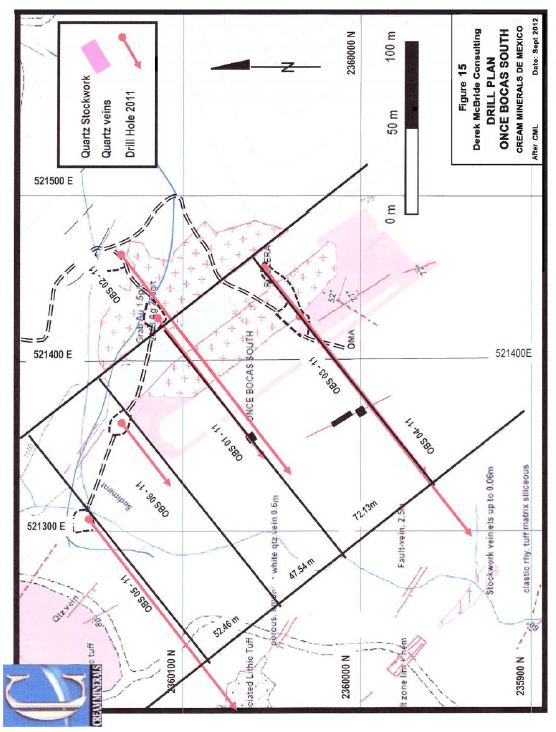
Once Bocas South (Figure 15, Table 6)
The Once Bocas South Prospect occurs on the next ridge to the southeast. It was tested with 6 holes in the 2011 drill program; all holes were drilled from northeast to southwest. The drill holes returned interesting, but scattered gold and silver with values of a few grams per tonne of silver as a background (Table 6).
Hole OBS-5-11 is the most northerly hole and is approximately 400 metres south of the most southerly hole in Once Bocas North. This hole carried 0.325g/t Au and 75.30 g/t Ag over 20 metre core length near at the top of the hole. Sampling was limited to the top section and there was not any below 59 metres. Mineralization continues through Hole OBS-05-11 100 metres to the southeast. Here an 8 metre length near the top of the hole ran 0.06g/t Au and 12.50g/t Ag. Only a part of the hole was sampled. 100 metres further southeast, holes OBS -01-11 and 02-11 targeted the zone. The westerly hole 01-11 has anomalous values for 16 metres followed by 27.14 metres averaging 0.30g/t Au and 85.26g/t Ag after a high silver value of 1252g/t had been cut to 500g/t. Unfortunately in the deeper hole 02-11 approximately 60 metres below, only intersected anomalous
28
Figure 12
Once Bocas North Drill and Surface Plan
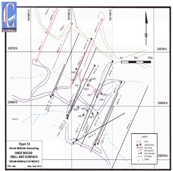
29
Figure 13
Once Bocas North East Vein Longitudinal
30
Figure 14
Once Bocas North West Vein Longitudinal
31
values. If the higher grade sections are correlated, they show a more easterly strike of 120 to 130 degrees. A similar trend is seen in the Once Bocas North mineralization.
The two holes to the south, OBS-03 and -04 -11, had narrow intersections of low to moderate values which are difficult to correlate. These values are encouraging as they suggest that the Once Bocas Trend extends further southeast.
Table 6
Principal Assays in Once Bocas South Holes
| ONCE BOCAS SOUTH DRILL INTERSECTIONS | ||||
| Section | Hole Number | Horizontal Thickness | Gold g/t | Silver g/t |
| 1 | OBS-05-11 | 12.63 | 0.258 | 59.72 |
| 2 | OBS-06-11 | 1.41 | 0.124 | 31.8 |
| 3 | OBS-01-11 | 11.66 | 1.021 | 120.04 |
| OBS-02-11 | Very Low Values | |||
| 4 | OBS-03-11 | 1.41 | 0.171 | 42.6 |
| OBS-04-11 | 1.41 | 0.101 | 95.1 | |
| 1.41 | 0.155 | 83.1 | ||
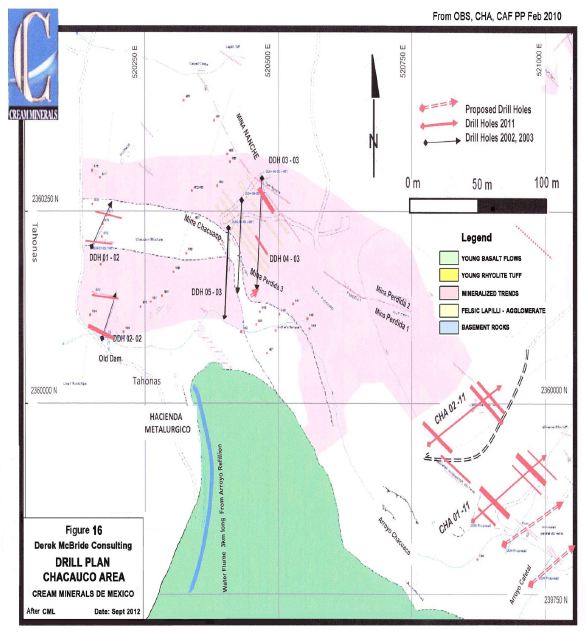
Chacuaco (Figure 16, Table 7)
The next ridge to the west hosts the Chacuaco Prospect which has been explored by numerous small workings including four mines. This ridge has a very steep west side that makes drilling difficult unless drilling can take place along the base. Drilling from this position was not possible in the past because of a hostile landowner. This person has left the area and future programs can better define this target. Past sampling has shown numerous veins and pits. Seven holes were drilled in the Chacuaco area from 2002 to 2011 (Table 7). Holes 1 and 2 were to the west, 3 to 5 tested the Mina Chacuaco-Mina Nanche Area and 2 the south eastern extension. Two interesting observations can be made from the data. First the drill values are lower than the surface and underground sampling which suggest that the system is better developed in the upper part of the felsic lapilli-agglomerate and secondly the silver gold ratio also increases upward.
32
Figure 15
Once Bocas South Drill Plan
33
Figure 16
Chacuaco Prospect Drill Plan
34
Table 7
| Summary Intersections Chacuaco | |||
| Hole Number | Core Length | Gold g/t | Silver g/t |
| DDH-01-02 | 15 | 0.214 | 13.14 |
| 0.4 | 0.676 | 38.6 | |
| DDH-02-02 | 23.5 | 0.242 | 13.28 |
| DDH-03-03 | 2 | 0.213 | 7.7 |
| 2 | 0.123 | 7 | |
| 2 | 0.125 | 10.5 | |
| 6 | 0.312 | 9.7 | |
| 2 | 0.42 | 1.6 | |
| DDH-04-03 | 4 | 0.182 | 76 |
| 2 | 0.11 | 9.9 | |
| 2 | 0.433 | 4.8 | |
| 2 | 0.169 | 6.3 | |
| DDH-05-03 | 4 | 0.349 | 3.6 |
| 2 | 0.129 | 9.9 | |
| CHA-01-11 | 2 | 0.061 | 15.6 |
| 2 | 0.301 | 6.6 | |
| 4 | 0.2 | 13.75 | |
| 10 | 0.143 | 30.2 | |
| 2 | 0.137 | 6.9 | |
| CHA-02-11 | 6 | 0.007 | 10.8 |
| 2 | 0.094 | 13.2 | |
| 6 | 0.131 | 23.6 | |
Further to the northwest lies the ChacuacoWest Area. Not much is known about this area. It lies in low ground and is near the contact with the old basement rocks and shows anomalous gold in the section covered in the soil geochemical survey.
Cafetal Prospect (Figure 17, Table 8)
The Cafetal Prospect is the south eastern extension of the Chacuaco Trend and is separated from it by low ground. Historically 10 holes tested this area in 2003 and 2011. Those in 2003, probed the area towards the overlying basalt to the southwest and the southeast end of the Olividada Vein. To the southwest the holes interested the felsic lapilli-agglomerate and intersected some mafic agglomerate bands which are weathered but not deformed like the basement rocks to the west. They indicate that the floor to the mineralized sequence may be basaltic volcanic rocks. In both these holes, the gold and silver values were anomalous. Younger basaltic tuff and flows encroach on this area from
35
the southwest and bury the favourable felsic lapilli-agglomerate in that direction. Hole, DDH-16- 03, was drilled near the capping rhyolite and returned good values (Table 8). In 2011 seven holes tested the Olividadas Vein and adjacent rocks with mixed results as shown on Table 8.
Table 8
Summary of Drill Results, Cafetal Area
| Hole Number | Core Length | Gold g/t | Silver g/t |
| DDH-14-03 | Low Values | ||
| DDH-15-03 | Low Values | ||
| DDH-16-03 | 8 | 0.161 | 31.18 |
| 10 | 0.127 | 51.32 | |
| CAF-01-11 | 2 | 0.150 | 98.00 |
| CAF-02-11 | 4 | 0.010 | 7.90 |
| CAF-03-11 | Low Values | ||
| CAF-04-11 | 4 | 0.125 | 43.25 |
| CAF-05-11 | 2 | 0.068 | 20.10 |
| 2 | 0.281 | 22.30 | |
| 10 | 0.245 | 40.10 | |
| CAF-06-11 | 6 | 0.103 | 17.17 |
| 2 | 0.643 | 139.90 | |
| CAF-07-11 | 8 | 0.161 | 31.18 |
| 10 | 0.127 | 51.32 | |
| 2 | 0.150 | 98.00 |
Sampling Method and Approach
All sampling for the last 8 years was supervised by Sr. German Francisco. During the author’s visit, Sr. Francisco was knowledgeable and well organized. Prior to Sr. Francisco, considerable work was carried using prospecting, chip and grab sampling. This work identified targets, located and evaluated many historical mine workings. These were subsequently cleaned out, stabilized and chip sampled. The control on this work is not known, but these data have not been used much since. A check of the field sample sites showed that they were well set up and one would assume that the sampling was of similar quality.
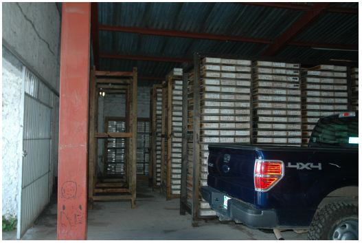
Sr. Francisco supervised the programs starting with the 2003 drill program. He has organized the drill core and sample material in a large core shack (Photo 13). The core was sampled under his direction and cut at the facility. From there it was taken by
36
Figure 17
Drill Plan Cafetal Area

37
commercial courier to the preparation laboratory of Inspectorate Exploration and Mining services in Durango for sample preparation. A small split of powdered sample was forwarded to Sparks, Nevada for analysis. Rejects were returned to the Company for storage. Every fifth sample was submitted separately to A.L.S. Chemex in Vancouver, Canada for a check analysis. Blanks or standard samples were not utilized in the programs.
Photo 13
Interior Organization of Core Shack
The author selected 13 samples to check on the assaying done by the Company. Eight samples were selected from the pulps returned from the Durango preparation facility. Approximately 150 grams was separated for the check assaying. Four samples were taken from the drill core; each retained core sample was quartered and one quarter was sent for assay. The last sample was a chip sample taken from Adit 4 in Dos Hornos 1 system. These samples were selected to represent a range of values and different sample procedures. Each sample was selected, and bagged by the author and transported by him to Vancouver where they were sent to A.L.S. Minerals for assay.
Sample Preparation, Analysis and security
All drill core samples were split and cut under the direction of Sr. Francisco; each was bagged and shipped by commercial courier to Inpsectorate Exploration and Mining Services preparation laboratory in Durango, Mexico. Once the sample preparation was
38
completed the samples were shipped to their Laboratory in Sparks, Nevada and analysed for gold and silver. Every fifth samples was sent to the A.L.S. Minerals laboratory in Vancouver B.C. for a check assay. These check samples showed a good correlation with the original assays.
Sr. Francisco oversaw the sample security during preparation and the subsequent independent service providers during their control of the samples.
Data Verification
The original results and check assays are shown on Table 9. The pulp samples show a good correlation and are within 10 percent. The quartered core samples show more variation and similar orders of magnitude. These differences are expected since samples are not duplicates, but are from the same core section. The single underground sample shows a significant drop in gold and silver values which may be explained by the chip sampling technique. It may also indicate that the original chip sampling is not as precise as required and that these results should be used with caution in any future resource calculation until they can be substantiated.
Table 9
Comparison of the Original and Check Assays, Nuevo Milenio
| Author's Check Samples Nuevo Milenio | |||||||
| Hole Number | Sample Number | Metres | Original Values | Check Values | |||
| From | To | Au g/t | Ag g/t | Au g/t | Ag g/t | ||
| Pulp Samples | |||||||
| DH1-02-11 | 51755 | 0.053 | 11.00 | 0.051 | 13.10 | ||
| 51773 | 6.21 | 1849.30 | 6.47 | 1925.0 | |||
| 51788 | 0.095 | 28.90 | 0.094 | 29.6 | |||
| 51782 | <0.005 | 0.60 | 0.006 | 1.40 | |||
| DH1-05-11 | 52183 | 0.011 | 4.80 | 0.014 | 1.00 | ||
| DH2-06-11 | 51289 | 1.356 | 218.90 | 1.295 | 236.0 | ||
| DH2-10.11 | 52216 | 0.486 | 108.20 | 0.451 | 99.0 | ||
| 52223 | 0.005 | 2.30 | 0.009 | 2.0 | |||
| Quartered Core samples | |||||||
| DH1-02-11 | 51775 | 66.00 | 66.82 | 0.664 | 162.50 | 0.576 | 132.0 |
| DH2-06-11 | 52189 | 129.60 | 131.60 | 1.356 | 218.90 | 1.51 | 220.0 |
| DDH-07-23 | 295759 | 80.60 | 82.60 | 4.350 | 1388.40 | 1.665 | 729.0 |
| OBN-01-11 | 52875 | 37.00 | 39.00 | 0.218 | 32.10 | 0.224 | 27.0 |
| Underground Chip samples | |||||||
| Dos Hornos 1 | 182194 | Adit 4 | 2 metres | 5.84 | 306.00 | 1.06 | 145.00 |
Adjacent properties
The author’s observations show the favourable rocks terminate near the west side of the property and no mineralization can be expected in the rocks to the west for some
39
distance. The potential to the east is demonstrated by La Mina California on the next ridge (Photo 14). This old mine was reopened about 5 years ago and was worked for three years. A small mill was built in the valley below but has not operated for 3 years and was recently removed. Production figures are not available. During the author’s visit, he investigated the underground workings. The recent operators had enlarged the tunnel
Photo 14
Entrance to La Mina California
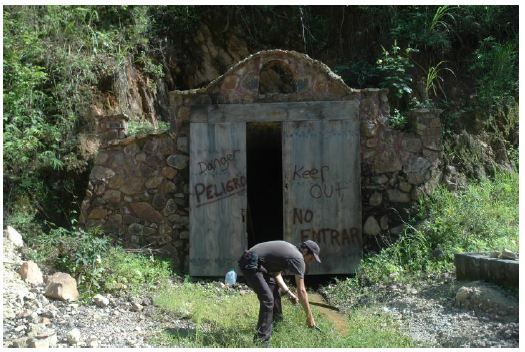
without stabilization and much of the back has fallen in and blocks the tunnel at approximately 100 metres. All the ventilation tubing and plastic supply lines remain. It appears that the mine was abandoned, possibly after a rock fall. The tunnel seemed to have followed the vein system which is in a very weak, almost a muddy rock.
Outside the “ore’ dump shows a similar felsic lapilli-agglomerate with clear quartz eyes and quartz vein mineralization with the same bluish colouration of the higher grade at Nuevo Milenio. Across the arroyo to the south this zone is covered by the same rhyolite tuff of the Nuevo Milenio Property.
Mineral processing and Metallurgy
Not Applicable
40
Mineral Resource and Mineral Reserve Estimates
The writer was asked, initially to audit the in-house mineral resource. The method was manual calculation using rectangular blocks from each data point whether the data point was a drill intersection or channel sample. All intersections were adjusted to horizontal width assuming the veins were presented as being vertical by Mr. F. Holcapek P. Eng.
The area of influence was half way to the next intersection and was classified by the distance from the data point in the following manner:
0 to 25 metres horizontally and vertically was a measured resource,
25 to 50 metres horizontally and vertically was an indicated resource,
50 to 75 metres horizontally and vertically an inferred resource and
metal prices of US$1500.00 per ounce gold and US$30.00 per ounce silver were applied to determine the gold-silver ratio
A 50 gram per tonne silver equivalent cut off grade was used; any mineralization beyond the main zones had to independently exceed the cut off grade to be included. A minimum width of 1 metre also was applied.
The calculation for the open pit potential of the Once Bocas North Zone a 20g/t cut off was applied. These are the same criteria that the author applied for the Stroud Resources Ltd. resource (McBride in Behre Dolbert, 2009).
A second calculation was made using the same criteria and a 160 gram per tonne cut off. The results are shown on Table 10 below.
The resources on the Nuevo Milenio property are centred on the Dos Hornos-Veta Tomas vein system. The 50 g/t cut off shows the broad zone of mineralization whereas the 160 g/t shows the higher grade core centred on the veins. This pattern seems typical of the other vein systems Once Bocas and Chacuaco-Cafetal. Neither of these systems has been evaluated in the same detail. Patterns within the drilling of the zones shows that they seem to be better developed higher in the system either on ridges or higher ground nearer the overlying rhyolite tuff.
This resource study indicates that substantial parallel mineralized vein systems may be present on the property and the pattern suggests where more parallel systems may be identified.
41
RESOURCE SUMMARY NUEVO MILENIO 50G/T CUT-OFF
| Zone | Tonnes Measured | Tonnes Indicated | Tonnes Meas. + Ind. | Tonnes Inferred | Gold g/t | Silver g/t | Silver Eq. g/t | Au oz |
| Dos Hornos 1 50g | 1,000,000 | 0.45 | 80.97 | 103.47 | 14643 | |||
| 278,000 | 0.33 | 71.98 | 88.63 | 2980 | ||||
| 1,278,000 | 0.42 | 79.41 | 100.24 | 17623 | ||||
| 133,000 | 0.21 | 59.50 | 73.53 | 920 | ||||
| Dos Hornos 2 50g | 526,000 | 0.73 | 74.60 | 118.18 | 12384 | |||
| 255,000 | 0.58 | 63.30 | 92.49 | 4792 | ||||
| 781,000 | 0.68 | 70.91 | 109.79 | 17176 | ||||
| 122,000 | 0.52 | 51.49 | 77.22 | 2027 | ||||
| Veta Tomas 50g | 430,000 | 0.55 | 95.09 | 122.52 | 7582 | |||
| 340,000 | 0.56 | 81.62 | 109.55 | 6104 | ||||
| 770,000 | 0.55 | 89.14 | 116.64 | 13686 | ||||
| 245,000 | 0.65 | 88.37 | 120.67 | 5087 | ||||
| Total Measured | 1,956,000 | 0.55 | 82.36 | 111.61 | 34609 | |||
| Total Indicated | 873,000 | 0.49 | 73.20 | 97.91 | 13876 | |||
| Total Measured and Indicated | 2,829,000 | 0.53 | 79.79 | 107.34 | 48435 | |||
| Inferred | 500,000 | 0.50 | 71.69 | 97.53 | 18773 | |||
| Inferred Resources | ||||||||
| Dos Hornos 1&2 and Veta Thomas | 500,000 | 0.50 | 71.69 | 97.53 | 18773 | |||
| Open Pit potential 20g | ||||||||
| Once Bocas North | 2,145,000 | 0.20 | 40.67 | 50.67 | 15840 | |||
| Once Bocas South | 909,000 | 0.27 | 72.28 | 82.27 | 8170 | |||
| Total Inferred | 3,554,000 | 0.26 | 53.25 | 66.25 | 42783 | |||
RESOURCE SUMMARY NUEVO MILENIO 160G/T CUT-OFF
| Zone | Tonne Measured | Tonnes Indicated | Tonnes Meas. + Ind. | Tonnes Inferred | Gold g/t | Silver g/t | Silver Eq.g/t | Au oz |
| Dos Hornos 1 160g | 287,000 | 1.18 | 174.30 | 233.70 | 10985 | |||
| 56,000 | 0.91 | 170.46 | 216.10 | 1636 | ||||
| 343,000 | 1.14 | 173.67 | 230.83 | 12621 | ||||
| 700 | 0.30 | 156.87 | 171.90 | 71 | ||||
| Dos Hornos 2 160g | 167,000 | 1.50 | 165.87 | 240.93 | 8045 | |||
| 69,000 | 1.04 | 151.05 | 203.17 | 2321 | ||||
| 236,000 | 1.36 | 154.87 | 229.88 | 10366 | ||||
| 15,000 | 1.01 | 174.88 | 225.31 | 500 | ||||
| Veta Tomas 160g | 159,000 | 1.01 | 181.27 | 231.60 | 5108 | |||
| 65,000 | 1.05 | 184.72 | 237.26 | 2206 | ||||
| 224,000 | 1.02 | 182.27 | 233.24 | 7314 | ||||
| 49,000 | 1.04 | 180.21 | 232.24 | 1626 | ||||
| Total Measured | 613,000 | 1.22 | 126.79 | 235.12 | 24138 | |||
| Total Indicated | 190,000 | 1.01 | 168.29 | 218.64 | 6163 | |||
| Total Measured and Indicated | 803,000 | 1.17 | 170.54 | 231.22 | 30301 | |||
| Inferred | 64,700 | 1.03 | 178.70 | 229.98 | 2197 | |||
42
Interpretation and Conclusions
The Nuevo Milenio Property contains three parallel mineralized systems which have seen exploration and 149 drill holes. These holes originally identified the zones and more recently followed up with systematic definition drilling which has defined resources at the Dos Hornos-Veta Tomas, Once Bocas North and South. Each vein system has a core of higher grade surrounded by lower grade as seen in the comparison of the resource calculations with the 50 g/t and 160g/t cut off.
The author’s property wide investigation has shown that the mineralization and vein systems are confined to a felsic lapilli-agglomerate unit which is approximately 200 to 300 metres thick. This sequence is floored by highly deformed basement rocks and capped by the rhyolite tuff. Within it steeply dipping veins and siliceous stockworks cross cut the unit carrying gold and silver. Only those that are exposed on hills have been investigated. The presence of La Mina California in an Opal Concession within the Property shows that parallel vein systems continue in this unit to the east. It seems that the felsic lapilli-agglomerate is the preferred host for the mineralization. Oxide minerals in the system near the top of the felsic lapilli-agglomerate suggest that the mineralizing solutions were becoming depleted in sulphur, gold and silver as they rose through the host rocks. The capping rhyolite tuff sealed the system and some workers have postulated that the opals in this unit were formed from the residual silica permeating these rocks.
The discovery of deformed basement rocks whose weathered surface dips under the property at a shallow angle, suggests that these rocks form the basement under the property. Any contribution of mineralizing fluids from this basement is extremely unlikely, however faulting within it probably opened up fractures for the more recent volcanism and its mineralizing fluids.
In conclusion it can be said that the vein systems follow preferred fractures over a limited time span. The mineralizing fluids probably are derived from a nearby volcanic source and deposited in the favourable porous felsic lapilli-agglomerate. Within this unit, the fluids formed extensive vein systems and stockworks. Three, Dos Hornos-Veta Tomas, Once Bocas and Chacuaco-Cafetal, are exposed on the property and another La Mina California, within its limits on an Opal Concession. Others are indicated by “transition zones” and unexplored area like Los Pinos, Santa Gertrudis and lower ground between the main vein systems. It seems that the felsic lapilli-agglomerate is mineralized throughout its extent and many more zones remain to be discovered. One prime target is under the rhyolite cap along the extension of La Mina California.
Recommendations
Previous drilling has been interpreted using considerable faulting and while some are seen in the field, the author suspects that the fault displacements are less important than presented. Possible extensions of zones across fault zones were noted during the resource calculation and these should be tested as they represent the potential to rapidly increase the resources.
43
A program of diamond drilling is proposed. Targets for this drilling include the Dos Hornos-Veta Tomas trend which may represent two parallel trends. Previous drilling on Dos Hornos 2 has left gaps in the database which have to be filled-in. The deeper holes on Veta Tomas showed weakening mineralization; thus the core should re-examined to see if a geological control for this change can be identified. Since the original field mapping was completed, many more outcrops have been exposed along roads. These need to be mapped for geological information and mineralization.
Once Bocas North is lacking in drilling between the east and west veins that is needed to test the open pit potential. In addition, the drill core from the 2011 program was only selectively sampled. Remaining sections within the projected pit limit should be sampled and assayed. There is a considerable gap between the Once Bocas North and South drilling which lies in lower ground. This area should be tested. Recent work on Once Bocas South suggests that the vein direction may be more easterly than used to plan the 2011 holes. This possibility should be investigated and tested by drilling.
Chacuaco North is a prominent ridge with west dipping veins. The few holes drilled give values that may be mineable in an open pit. Additional shallow drilling is required. The same can be said of Cafetal.
To provide a preliminary assessment of these targets a drill program of 2500 metres with the testing in between 15 and 20 holes is recommended. Target selection will be based on the updated database. The cost of this Phase 1 of this program is projected at US$800,000 and the follow up Phase 2 is US$ 3,000,000 for a total of US$ 3,800,000 is contingent on the results of Phase 1 (Table 11).
“Dr. Derek McBride P. Eng.” (signed)
44
Table 11
| 2012 Nuevo Milenio Budget | ||
| Item | Unit Cost | Cost |
| Phase 1 | ||
| 2500 metres drilling | $ 150.00 | $ 375,000.00 |
| 2000 samples assaying | $ 30.00 | $ 60,000.00 |
| Field Consumables | $ 20,000.00 | |
| Field Office and support staff | $ 100,000.00 | |
| Supervision | $ 50,000.00 | |
| Reporting | $ 20,000.00 | |
| head office overhead 15% | $ 100,000.00 | |
| Contingency10% | $ 75,000.00 | |
| Total $ 800,000.00 | ||
| Phase 2 | ||
| 10,000 metres drilling | $ 150.00 | $ 1,500,000.00 |
| 8000 samples assaying | $ 30.00 | $ 240,000.00 |
| Field consumables | $ 120,000.00 | |
| Field Office and support staff | $ 320,000.00 | |
| Supervision | $ 160,000.00 | |
| Reporting | $ 40,000.00 | |
| head office overhead 15% | $ 350,000.00 | |
| Contingency10% | $ 270,000.00 | |
| Total | $ 3,000,000.00 | |
| Grand Total | $ 3,800,000.00 | |
“Dr. Derek McBride P.Eng.” (signed)
45
References
Holacpek, F. 2005: Discussion Silver – Gold and Associated Bulk Tonnage Potential from Stockwork Zones and Zones of Dissemination, Application to Nuevo Milenio Project; Cream Company Report Minerals Ltd.
Holcapek, F. 2008: Evaluation Report Dos Honos and Veta Tomas Gold – Silver Structures, Nuevo Milenio Project, Municipality of Xalisco, State of Nayarit, Mexico, Latitude: 21 21 35 North, Latitude: 104 46 53 West, Dated January 30 2008 (“The Technical Report”); Cream Minerals Ltd .
Holcapek, F. 2102: Power Point Presentation on Nuevo Milenio, Dos Hornos 1, 2011 Fill-in Drilling, Drill Sections – Interpretation, Blocks of Mineral Resources 2012; Cream Company Report Minerals Ltd.
Holcapek, F. 2102: Power Point Presentation on Nuevo Milenio, Dos Hornos 2, Length of Mineral Blocks in Long Sections and Down Dip Extent in X-Sections; Company Report Cream Minerals Ltd.
Holcapek, F. 2102: Power Point Presentation on Nuevo Milenio, Once Bocas Sur: Company Report Cream Minerals Ltd.
Holcapek, F. 2102: Power Point Presentation on Nuevo Milenio, Once Bocas 2011 Fill-in Drilling: Company Report Cream Minerals Ltd.
Holcapek, F. 2102: Power Point Presentation on Nuevo Milenio, VetaTomas 2011 Fill-in Drilling: Company Report Cream Minerals Ltd.
Holcapek, F. 2102: Power Point Presentation on Nuevo Milenio, Chacuaco: Company Report Cream Minerals Ltd.
Holcapek, F. 2102: Power Point Presentation on Nuevo Milenio, Cafetal: Company Report Cream Minerals Ltd.
McBride, D. E. 2010 in Behre Dolbert de Mexico, 2010: Santo Domingo II and Nombre De Dios Concessions, Hostotipaquillo Area, State of Jalisco, NI 34-101 Technical Report, Santo Domingo Silver-Gold Exploration Project; prepared for Stroud Resources Ltd. www.sedar.com Website.
46
Statement of Qualifications, Date and Signature Page
| 1) | I, Dr. Derek McBride P.Eng. of 20 Forsythia Drive, West Hill, Ontario, M1E 1Y1, hold a Diploma of Mining Technology from the Haileybury School of Mines, B.Sc. Eng., M. Sc. Eng. Degrees from Queen’s University and a Doctoral Degree in Structural and Economic Geology from the University of New Brunswick. |
| 2) | I am the author of this report titled “NI 43-101 Report with Resource Calculation on the Nuevo Milenio Project, Tepic Area, Nayarit State, Mexico, Cream Minerals Limited.” dated effective September 23, 2012. |
| 3) | I am a Geological Engineer and a member of the Association of Professional Engineers of Ontario, membership number 29879012. My experience spans 40 years in mineral exploration and am attributed with the discovery of the Nugget Pond Gold Deposit in Newfoundland and the Reward Gold Deposit in N.S.W., Australia. My work has taken me to 17 different countries and I have a managed major exploration Projects in six of them. |
| 4) | I visited the Nuevo Milenio Property from September 3rd to 9th, 2012. |
| 5) | I am responsible for all sections of this report. |
| 6) | I have had no prior involvement with the Nuevo Milenio Property, and I have not nor do I expect to receive any interest in Cream Minerals Ltd. or the Nuevo Milenio Property. |
| 7) | I have read National Instrument 43-101 Standards of Disclosure for Mineral Projects (“NI 43-101”) and confirm that this report has been prepared in compliance with NI 43- 101. |
| 8) | I am a “qualified person” for the purposes of NI 43-101, and am independent of Cream Minerals Ltd. as described in section 1.5 of NI 43-101. |
| 9) | As of the date of this certificate, to the best of my knowledge, information and belief, the report contains all scientific and technical information that is required to be disclosed to make the report accurate and not misleading. |
“Dr. Derek McBride P. Eng.” (signed)
September 22, 2012
Effective Date
“Dr. Derek McBride P. Eng.” (signed)
September 23, 2012
Signature Date