Report to:
PACIFIC NORTH WEST CAPITAL CORP.

Technical Report and Resource
Estimate on the River Valley PGM
Project, Northern Ontario
Document No. 1193250100-REP-R0001-01

Report to:
PACIFIC NORTH WEST CAPITAL CORP.
TECHNICAL REPORT AND RESOURCE ESTIMATE
ON THE RIVER VALLEY PGM PROJECT,
NORTHERN ONTARIO
EFFECTIVE DATE: JUNE 13, 2012
Prepared by Todd McCracken, P.Geo.
330 Bay Street, Suite 900, Toronto, ON M5H 2S8
Phone: 416-368-9080 Fax: 416-368-1963
1193250100-REP-R0001-01
Report to:
PACIFIC NORTH WEST CAPITAL CORP.
TECHNICAL REPORT AND RESOURCE ESTIMATE
ON THE RIVER VALLEY PGM PROJECT,
NORTHERN ONTARIO
EFFECTIVE DATE: JUNE 13, 2012
| Prepared by | “Original document signed by
Todd McCracken, P.Geo.” | Date | June 13, 2012 |
| | Todd McCracken, P.Geo. | | |
| | | | |
| Reviewed by | “Original document signed by
Jeff Wilson, Ph.D., P.Geo.” | Date | June 13, 2012 |
| | Jeff Wilson, Ph.D., P.Geo. | | |
| | | | |
| Authorized by | “Original document signed by
Todd McCracken, P.Geo.” | Date | June 13, 2012 |
| | Todd McCracken, P.Geo. | | |
TM/vc
330 Bay Street, Suite 900, Toronto, ON M5H 2S8
Phone: 416-368-9080 Fax: 416-368-1963
1193250100-REP-R0001-01
REVISION HISTORY
| REV. NO | ISSUE DATE | PREPARED BY AND DATE | REVIEWED BY AND DATE | APPROVED BY AND DATE | DESCRIPTION OF REVISION |
| 00 | 2012/06/08 | Todd McCracken | Jeff Wilson | Todd McCracken | Draft to Client for review. |
| 01 | 2012/06/13 | Todd McCracken | Jeff Wilson | Todd McCracken | Final Report |
| | | | | | |
| | | | | | |
| | | | | | |
1193250100-REP-R0001-01
TABLE OF CONTENTS
| | ii | 1193250100-REP-R0001-01 |
LIST OF APPENDICES
LIST OF TABLES
| | iii | 1193250100-REP-R0001-01 |
LIST OF FIGURES
| | iv | 1193250100-REP-R0001-01 |
GLOSSARY
UNITS OF MEASURE
| above mean sea level | amsl |
| acre | ac |
| ampere | A |
| annum (year) | a |
| billion | B |
| billion tonnes | Bt |
| billion years ago | Ga |
| British thermal unit | BTU |
| centimetre | cm3 |
| cubic centimetre | cm |
| cubic feet per minute | cfm |
| cubic feet per second | ft3/s |
| cubic foot | ft3 |
| cubic inch | in3 |
| cubic metre | m |
| cubic yard | yd3 |
| Coefficients of Variation | CVs |
| day | d |
| days per week | d/wk |
| days per year (annum) | d/a |
| dead weight tonnes | DWT |
| decibel adjusted | dBa |
| decibel | dB |
| degree | ° |
| degrees Celsius | °C |
| diameter | ø |
| dollar (American) | US$ |
| dollar (Canadian) | Cdn$ |
| dry metric ton | dmt |
| foot | ft |
| gallon | gal |
| gallons per minute (US) | gpm |
| Gigajoule | GJ |
| gigapascal | GPa |
| gigawatt | GW |
| gram | g |
| grams per litre | g/L |
| grams per tonne | g/t |
| greater than | > |
| hectare (10,000 m2) | ha |
| hertz | Hz |
| horsepower | hp |
| hour | h |
| hours per day | h/d |
| hours per week | h/wk |
| hours per year | h/a |
| inch | in |
| kilo (thousand) | k |
| kilogram | kg |
| kilograms per cubic metre | kg/m3 |
| kilograms per hour | kg/h |
| kilograms per square metre | kg/m2 |
| kilometre | km |
| kilometres per hour | km/h |
| kilopascal | kPa |
| kilotonne | kt |
| | vi | 1193250100-REP-R0001-01 |
| kilovolt | kV |
| kilovolt-ampere | kVA |
| kilovolts | kV |
| kilowatt | kW |
| kilowatt hour | kWh |
| kilowatt hours per tonne | kWh/t |
| kilowatt hours per year | kWh/a |
| less than | < |
| litre | L |
| litres per minute | L/m |
| megabytes per second | Mb/s |
| megapascal | MPa |
| megavolt-ampere | MVA |
| megawatt | MW |
| metre | m |
| metres above sea level | masl |
| metres Baltic sea level | mbsl |
| metres per minute | m/min |
| metres per second | m/s |
| microns | µm |
| milligram | mg |
| milligrams per litre | mg/L |
| millilitre | mL |
| millimetre | mm |
| million | M |
| million bank cubic metres | Mbm3 |
| million bank cubic metres per annum | Mbm3/a |
| million tonnes | Mt |
| minute (plane angle) | ' |
| minute (time) | min |
| month | mo |
| ounce | oz |
| pascal | Pa |
| centipoise | mPa∙s |
| parts per million | ppm |
| parts per billion | ppb |
| percent | % |
| pound(s) | lb |
| pounds per square inch | psi |
| revolutions per minute | rpm |
| second (plane angle) | " |
| second (time) | s |
| short ton (2,000 lb) | st |
| short tons per day | st/d |
| short tons per year | st/y |
| specific gravity | SG |
| | vii | 1193250100-REP-R0001-01 |
| square centimetre | cm2 |
| square foot | ft2 |
| square inch | in2 |
| square kilometre | km2 |
| square metre | m2 |
| three-dimensional | 3D |
| tonne (1,000 kg) (metric ton) | t |
| tonnes per day | t/d |
| tonnes per hour | t/h |
| tonnes per year | t/a |
| tonnes seconds per hour metre cubed | ts/hm3 |
| volt | V |
| week | wk |
| weight/weight | w/w |
| wet metric ton | wmt |
ABBREVIATIONS AND ACRONYMS
| Activation Laboratories Ltd. | Actlabs |
| all-terrain vehicle | ATV |
| Anglo American Platinum Limited | Amplats |
| Canadian Institute of Mining, Metallurgy and Petroleum | CIM |
| cobalt | Co |
| copper | Cu |
| Derry Mitchener Booth and Wahl | DMBW |
| Electromagnetic | EM |
| Endurance Gold Corporation | Endurance Gold |
| GeoSim Consultants | GeoSim |
| gold | Au |
| induced polarization | IP |
| inductively coupled plasma | ICP |
| inductively coupled plasma-atomic emission spectroscopy | ICP-AES |
| International Organization for Standardization | ISO |
| inverse distance squared | ID2 |
| Kaymin Resources Ltd | Kaymin |
| Large Ion Lithophile | LIL |
| light detection and ranging | LiDAR |
| Michigan Technological University | MTU |
| Mount Logan Resources Ltd | Mount Logan |
| Mustang Minerals Corp | (Mustang) |
| National Instrument 43-101 | NI 43-101 |
| nearest neighbour | NN |
| nickel | Ni |
| North American Datum | NAD |
| ordinary kriging | OK |
| Pacific North West Capital Corp. | PFN |
| palladium equivalent | PdEq |
| | viii | 1193250100-REP-R0001-01 |
| palladium | Pd |
| platinum group elements | PGE |
| platinum | Pt |
| preliminary economic assessment | PEA |
| qualified person | QP |
| quality assurance/quality control | QA/QC |
| River Valley Project | the Project |
| River Valley Property | the Property |
| SGS Canada Inc | SGS |
| silver | Ag |
| Tetra Tech Wardrop | Tetra Tech |
| Universal Transverse Mercator | UTM |
| | ix | 1193250100-REP-R0001-01 |
1.0 SUMMARY
| | The River Valley Property (the Property) is a magmatic contact-hosted platinumpalladium-gold (platinum group elements (PGE)) project located in northeastern Ontario, approximately 60 km northeast of Sudbury. The Property claim group consists of 418 mining claims in 40 claim units that cover approximately 6,688 ha, and are centered at approximately 555371 mE and 5172514 mN (North American Datum (NAD) 83-Universal Transverse Mercator (UTM) Zone 17T). The claims are currently 100% owned by Pacific North West Capital Corp. (PFN). |
| | The Property has seen extensive exploration, which started in earnest in 1999 with work by PFN. To date a total of 596 boreholes have been completed on the Property. Tetra Tech Wardrop (Tetra Tech) has been commissioned to generate a new resource estimate and technical report. This report has been prepared in accordance with National Instrument 43-101 (NI 43-101) and the Form 43-101F1. |
1.1 GEOLOGY
| | The River Valley Project (the Project) is part of the Paleoproterozoic East Bull Lake Intrusive Suite, dated between 2491 and 2475 Ma, and consists of a total of eight distinct bodies of dominantly gabbronorite to gabbroic anorthosite. |
| | The East Bull Lake Suite Intrusions exhibit geochemical characteristics consistent with being derived from fractionated tholeiitic or high-alumina tholeiitic parental magmas. The estimated parental magma compositions for the East Bull Lake Suite Intrusives are thus broadly similar to those postulated for the intrusive suite in the world class Noril’sk-Talnahk nickel-copper-PGE camp in Siberia. |
| | The three largest and most economically interesting bodies of the East Bull Lake Suite Intrusives are the East Bull Lake and Agnew Intrusions (situated within the Sudbury Province) and the River Valley Intrusion (situated in the Grenville Front Tectonic Zone). The River Valley Intrusion, the largest of the East Bull Lake Intrusive Suite by area, covers an area of approximately 200 km2. |
| | The contact between the River Valley Intrusion and the Archean basement trends southeasterly for a distance of approximately 10 km. On the basis of surface mapping and diamond drilling the idealized sectional stratigraphy of the mineralized environment comprises five major units, from the layered rocks of the River Valley Intrusion in the west to the igneous basal contact of the intrusion to the east. |
| | The mineralized breccia unit occurring at the contact has been identified along most of this 10 km strike length. The contact is divided into several areas based on structural offsetting, alteration grades and grade distribution. |
Pacific North West Capital Corp.
Technical Report and Resource Estimate on the River Valley
PGM Project, Northern Ontario | 1 | 1193250100-REP-R0001-01 |
1.2 CONCLUSIONS
| | The Project database is up to date, and includes the results of the 2011 drilling program. The borehole database has been validated against the original drill logs and assay certificates. As a result, Tetra Tech is of the opinion that using all the diamond drilling is appropriate for any resource estimate. |
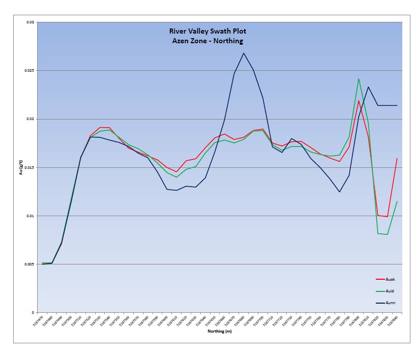
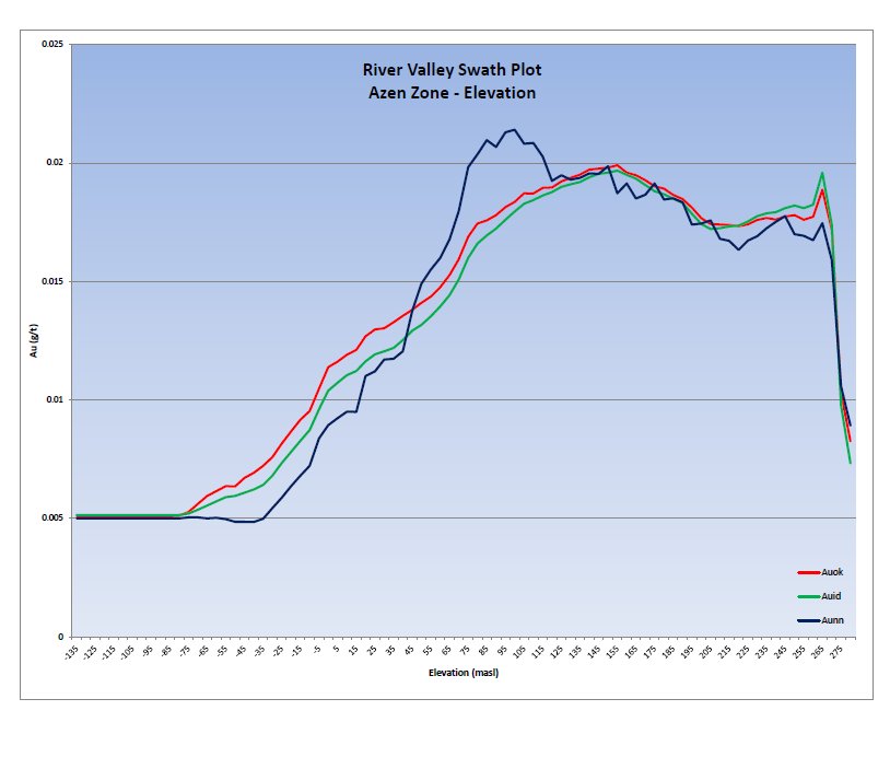
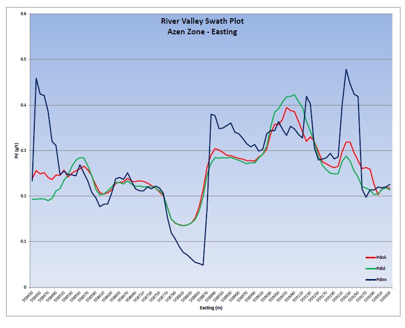
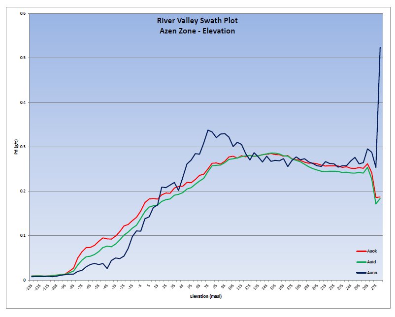
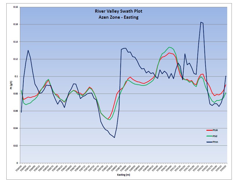
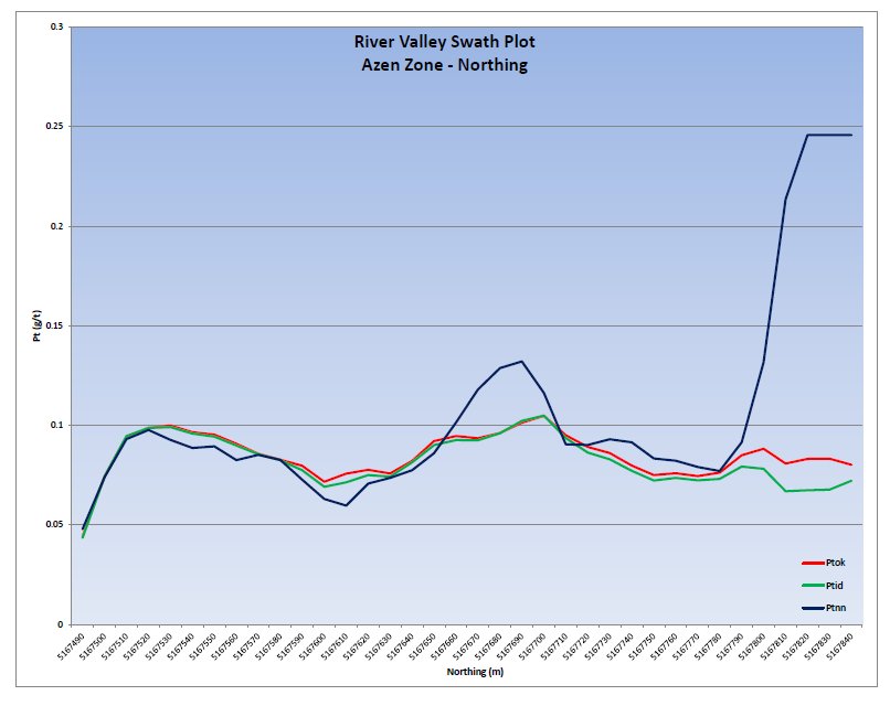
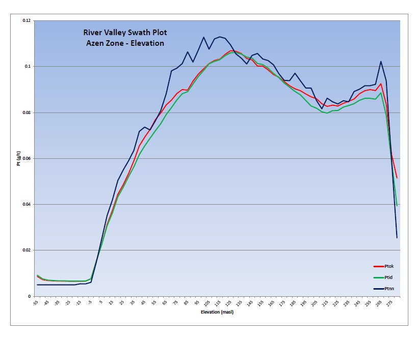
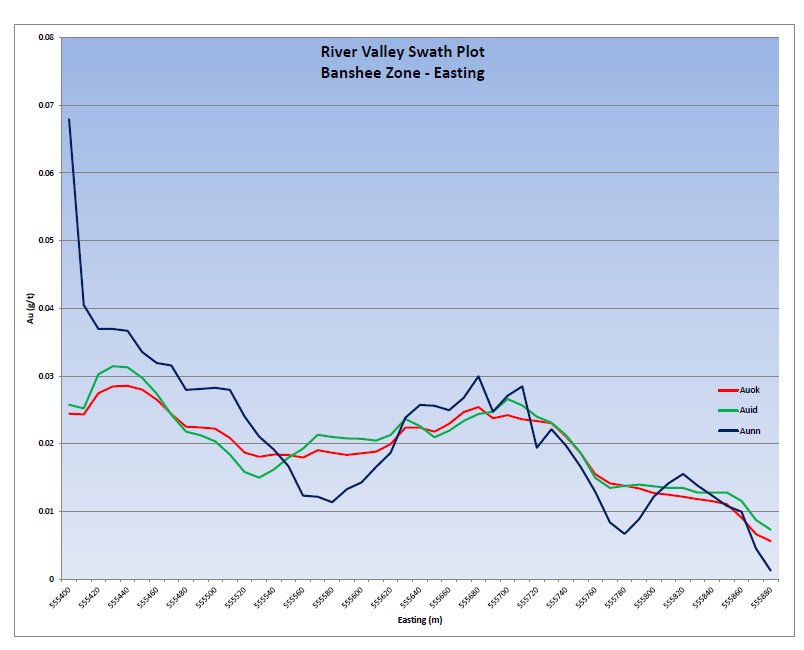
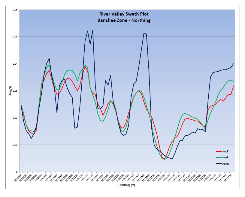
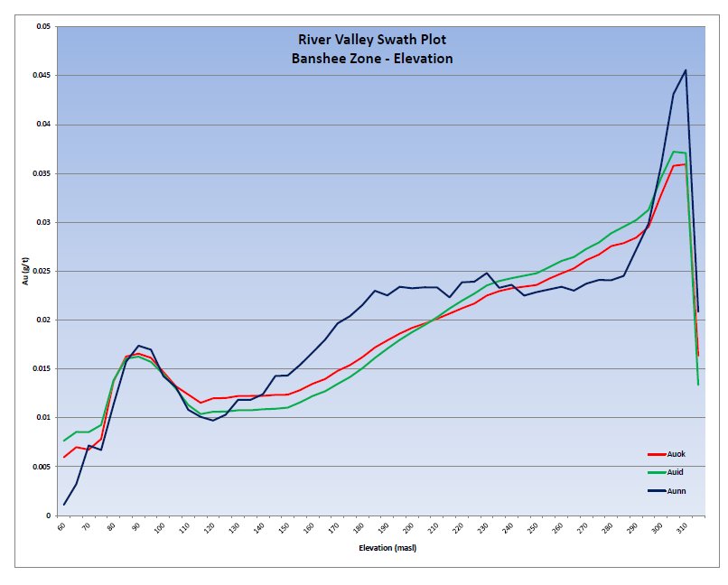
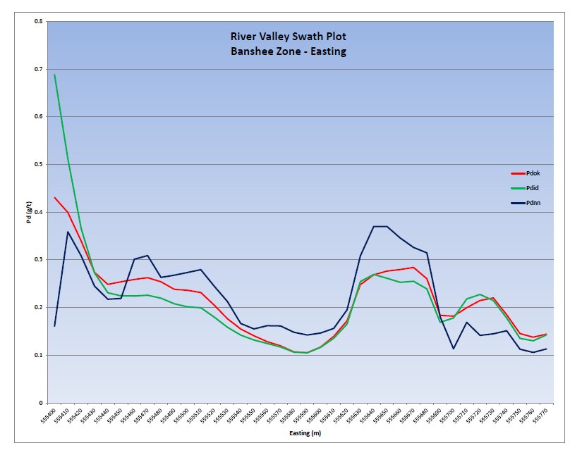
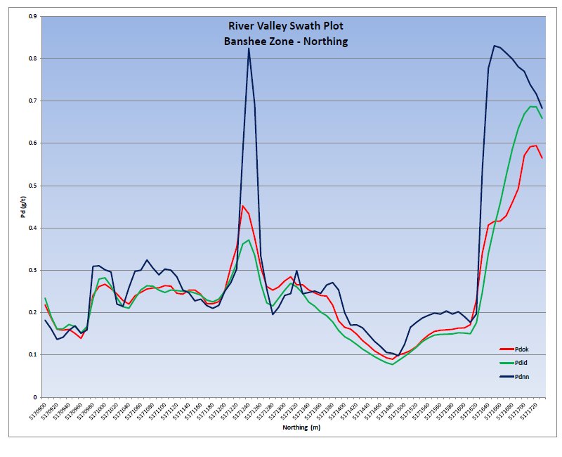
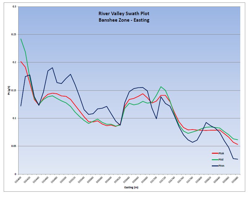
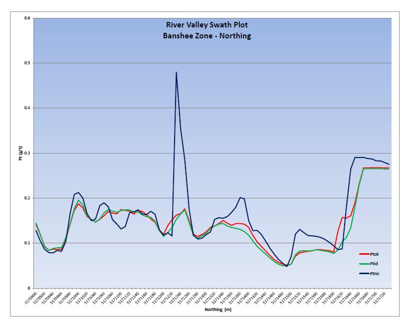
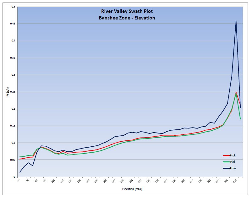
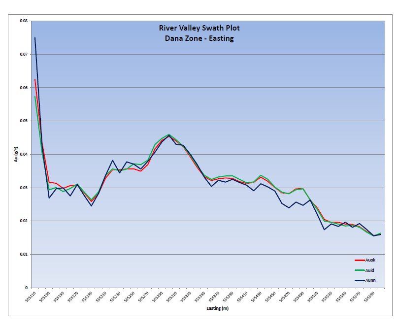
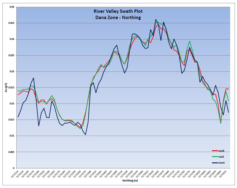
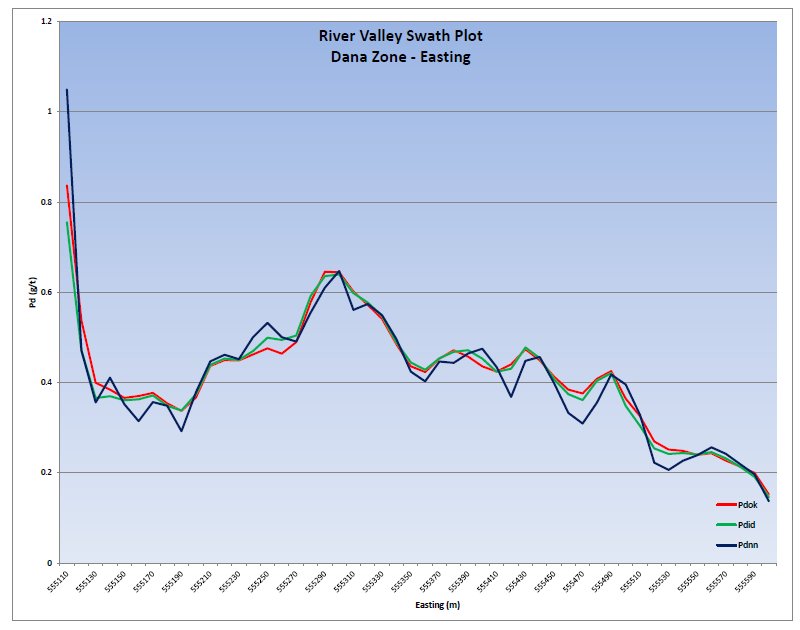
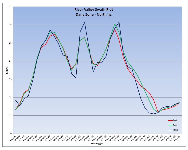
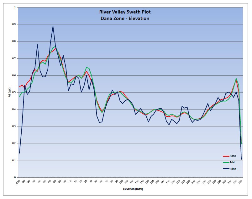
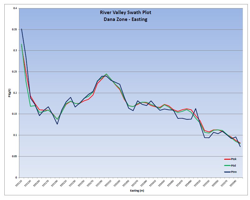
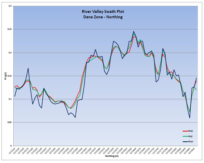
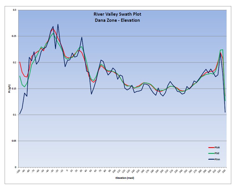
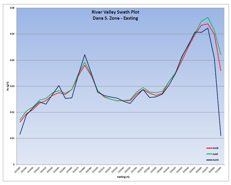
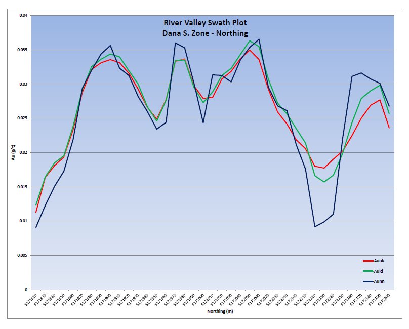
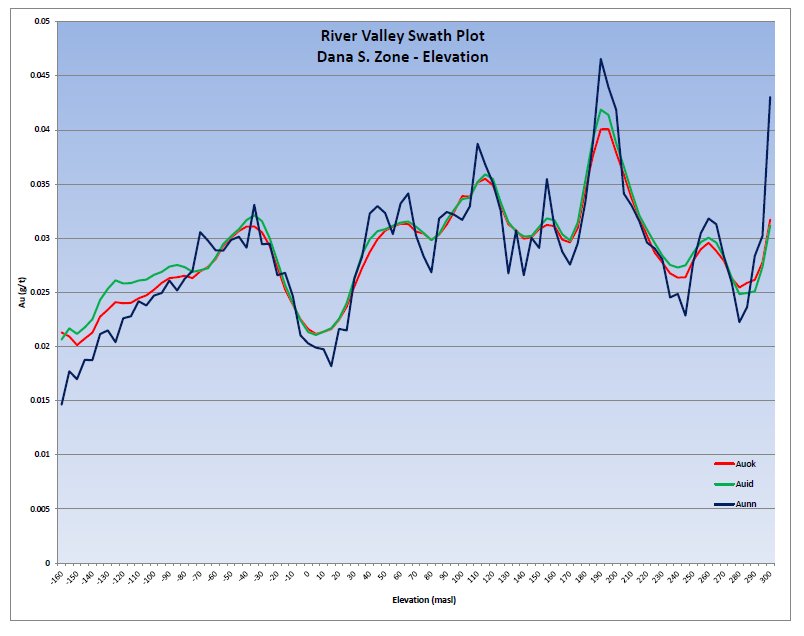
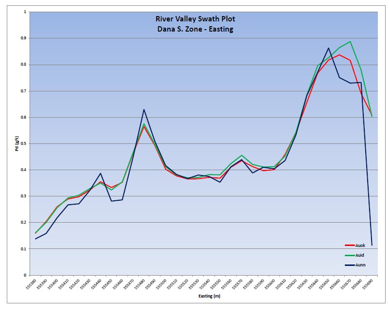
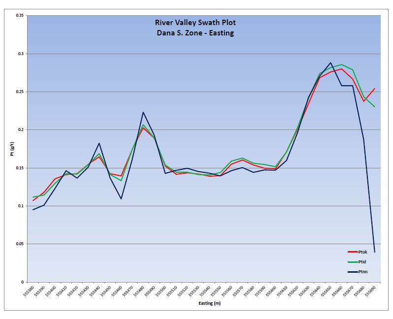
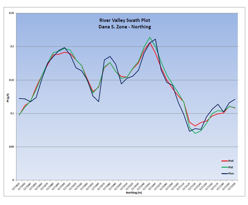
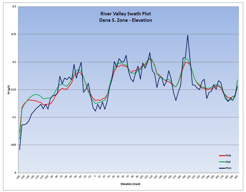
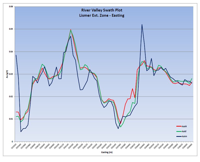
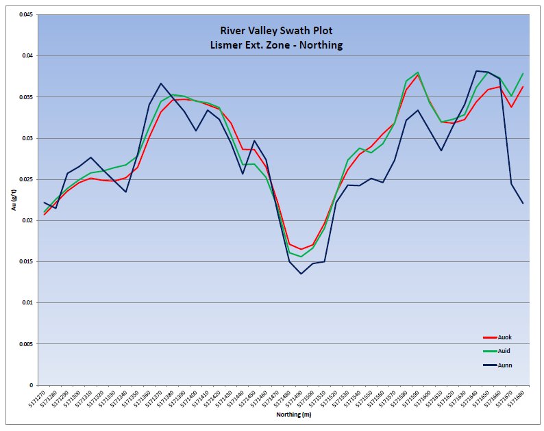
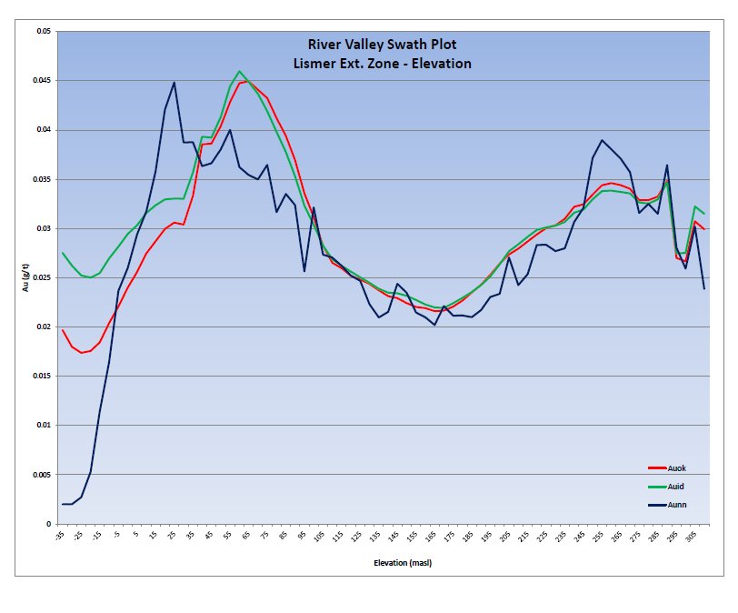
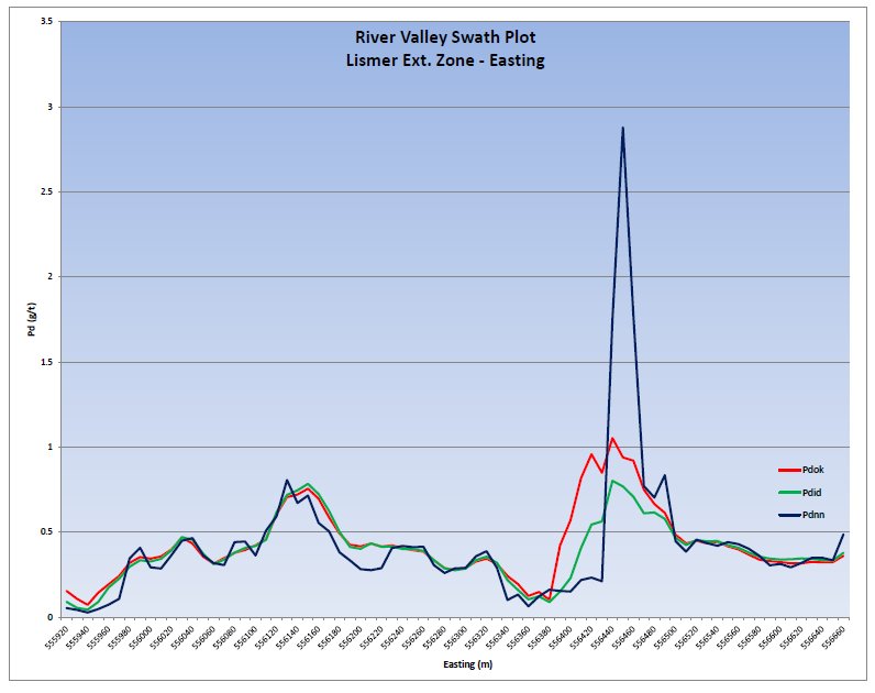
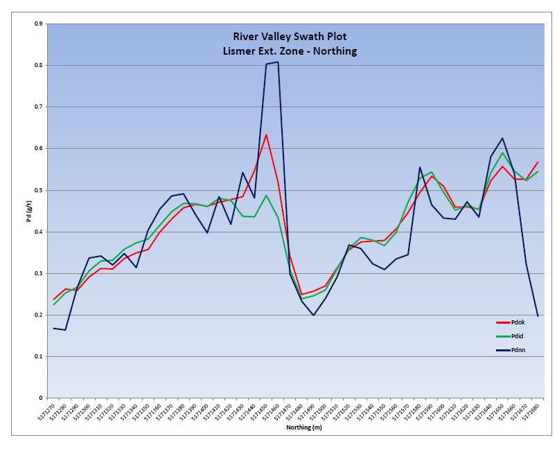
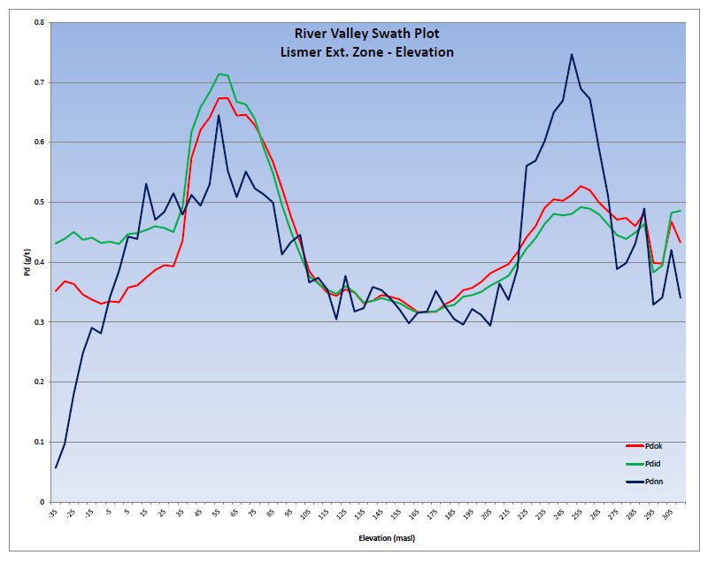
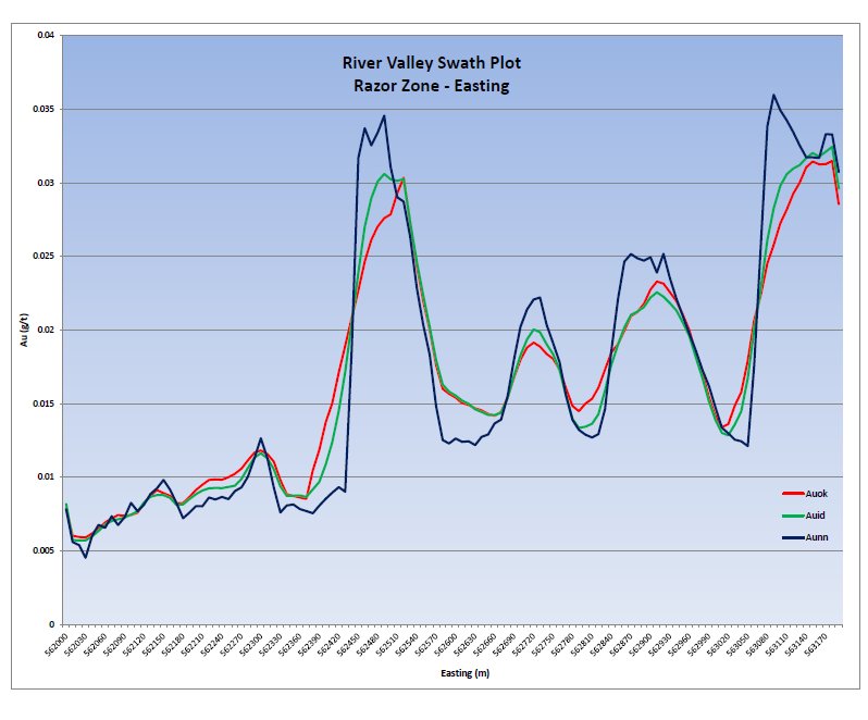
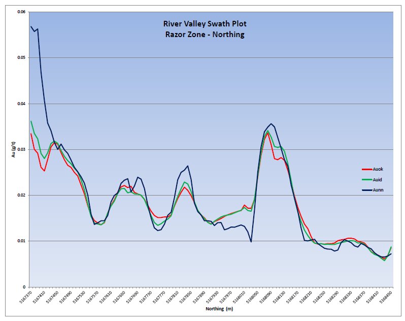
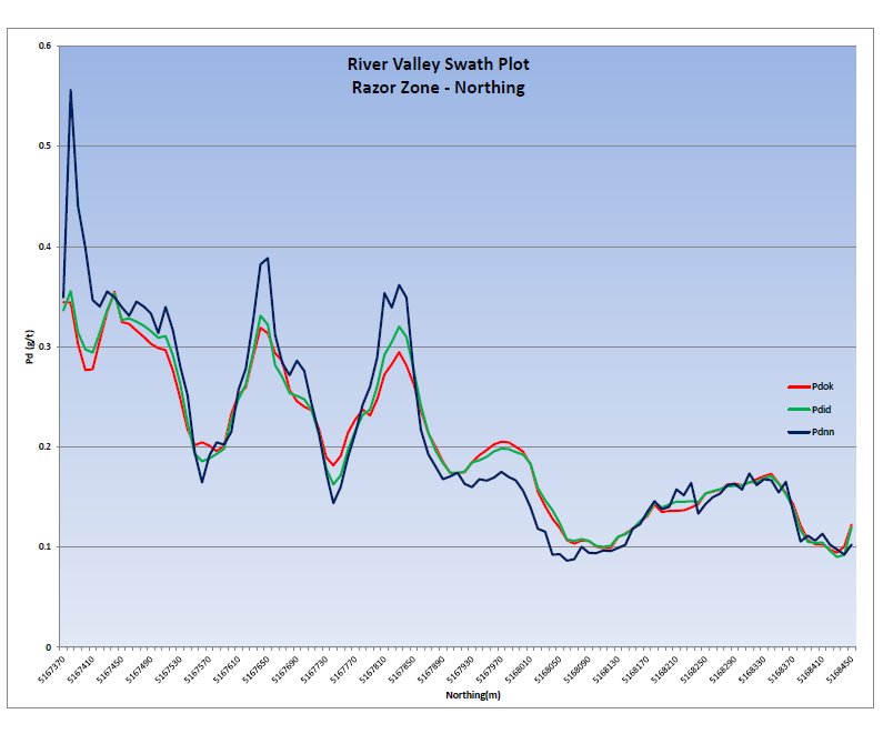
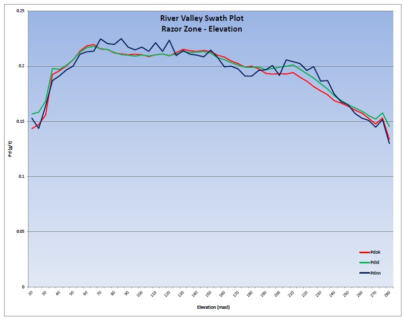
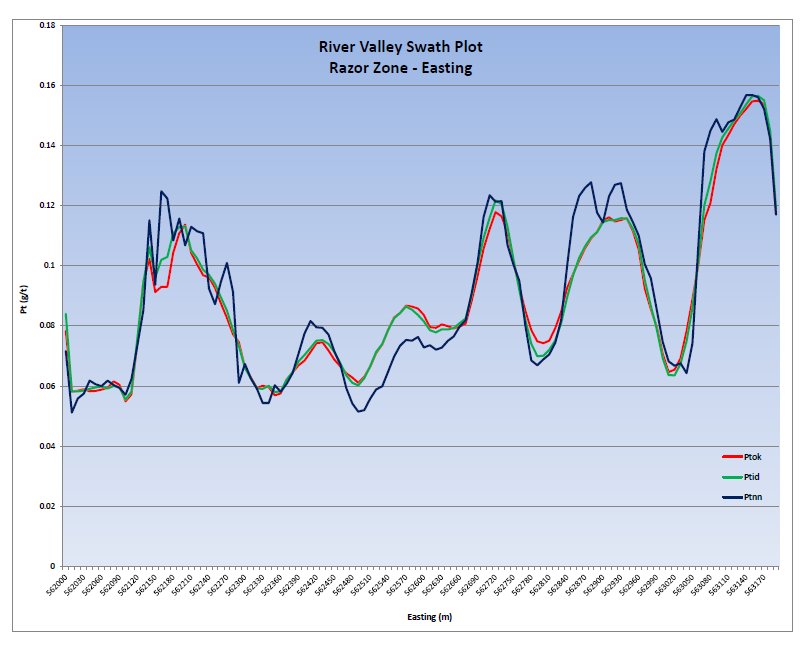
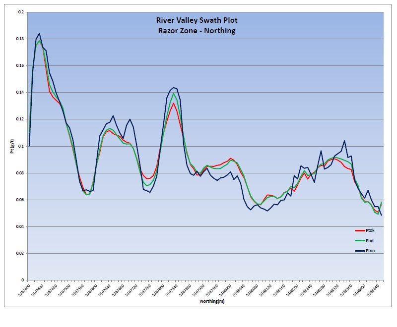
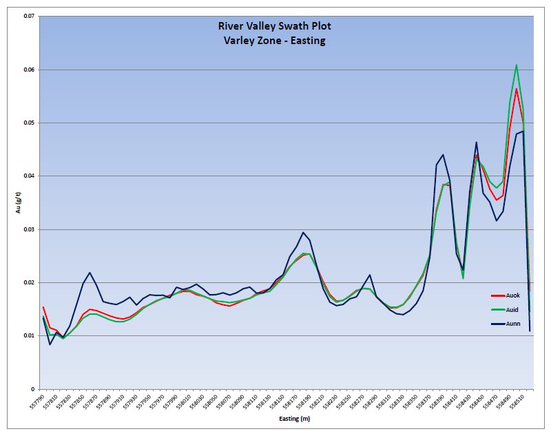
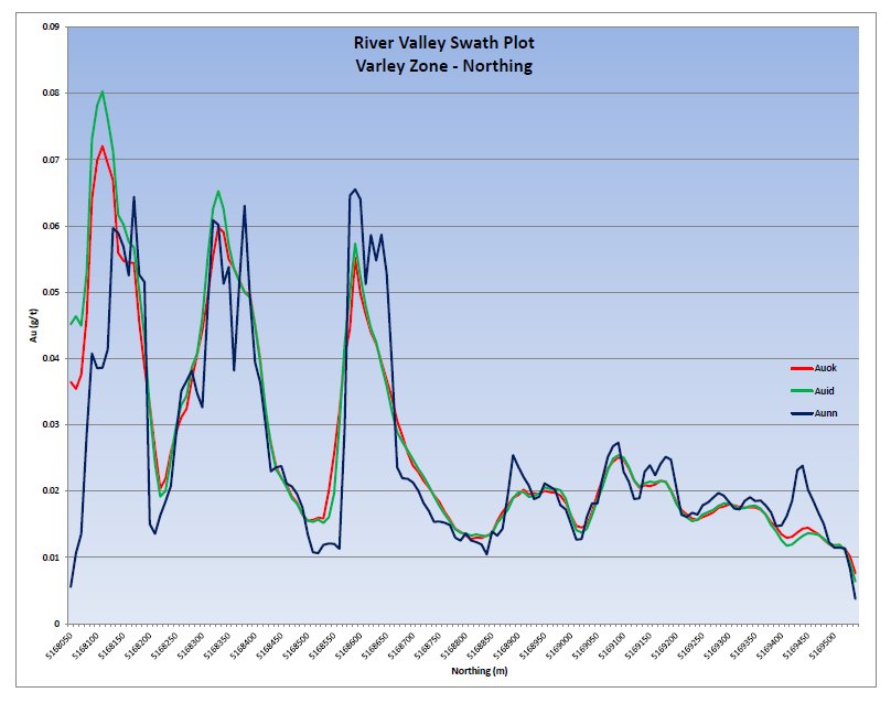
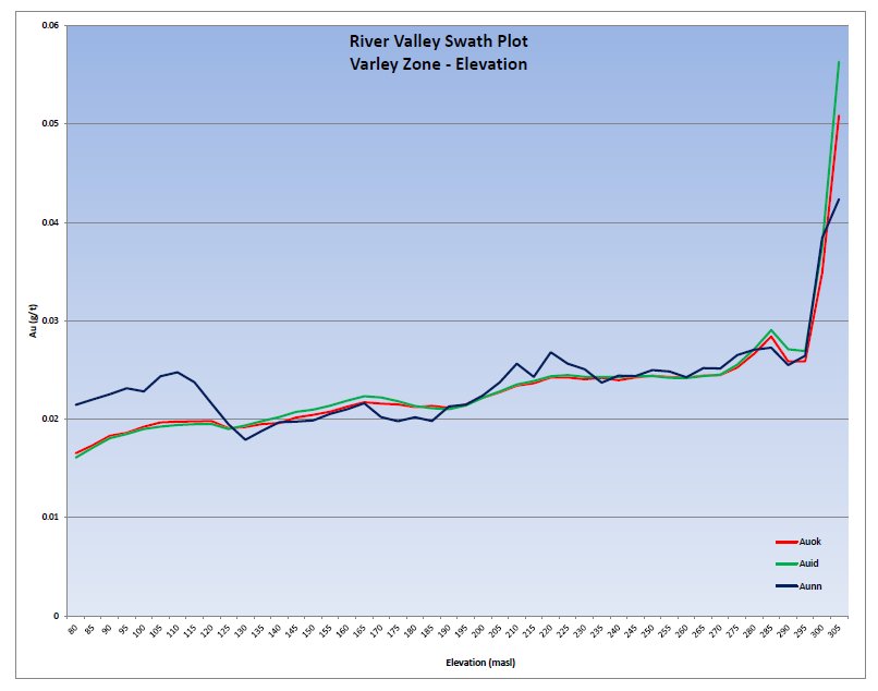
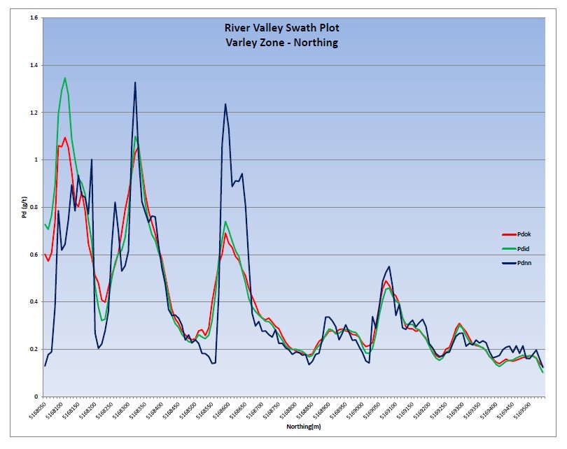
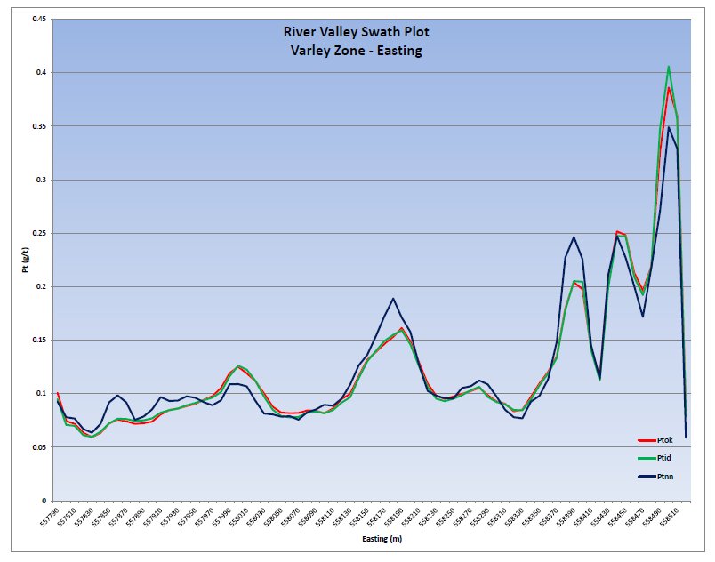
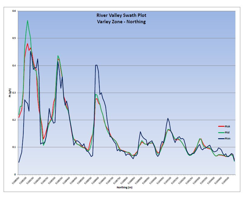
| | All the procedures implemented by PFN in regards to core logging, sample collection, sample analysis and quality assurance/quality control (QA/QC) meet industry standards. The data quality supports the resources estimate. The resource estimate update was completed on the Dana North, Dana South, Banshee, Lismer, Lismer Extension, Varley, Azen and Razor Zones, using the ordinary kriging (OK) methodology on an uncapped and composited borehole dataset consistent with industry standards. Validation of the results was conducted through the use of visual inspection, swath plots, and global statistical comparison of the model against an inverse distance squared (ID2) and nearest neighbour (NN) models. |
| | Table 1.1 summarizes the results of the resource estimation. |
| | Tetra Tech believes further exploration is warranted to advance the Project towards a preliminary economic assessment (PEA). |
Pacific North West Capital Corp.
Technical Report and Resource Estimate on the River Valley
PGM Project, Northern Ontario | 2 | 1193250100-REP-R0001-01 |
Table 1.1 River Valley Resource Summary (using 0.8 g/t PdEq Cut-off)
| Zone | Tonnes
(t) | Pd
(g/t) | Pt
(g/t) | Rh
(g/t) | Au
(g/t) | Ag
(g/t) | Cu
(%) | Ni
(%) | Co
(%) | PdEq
(g/t) |
| Measured |
| Azen | - | - | - | - | - | - | - | - | - | - |
| Banshee | - | - | - | - | - | - | - | - | - | - |
| Dana | 9,622,180 | 0.66 | 0.24 | 0.023 | 0.05 | 0.70 | 0.07 | 0.02 | 0.003 | 1.56 |
| Dana South | 5,980,550 | 0.79 | 0.26 | 0.027 | 0.05 | 0.56 | 0.06 | 0.01 | 0.003 | 1.68 |
| Lismer | 9,982,120 | 0.50 | 0.20 | 0.018 | 0.04 | 0.40 | 0.05 | 0.02 | 0.003 | 1.24 |
| Lismer Extension | - | - | - | - | - | - | - | - | - | - |
| Razor | - | - | - | - | - | - | - | - | - | - |
| Varley | - | - | - | - | - | - | - | - | - | - |
| Total Measured | 25,584,850 | 0.63 | 0.23 | 0.022 | 0.04 | 0.55 | 0.06 | 0.02 | 0.003 | 1.46 |
| Indicated |
| Azen | - | - | - | - | - | - | - | - | - | - |
| Banshee | - | - | - | - | - | - | - | - | - | - |
| Dana | 14,076,300 | 0.60 | 0.22 | 0.021 | 0.04 | 0.52 | 0.07 | 0.02 | 0.003 | 1.45 |
| Dana South | 8,040,000 | 0.70 | 0.24 | 0.024 | 0.04 | 0.59 | 0.05 | 0.01 | 0.003 | 1.49 |
| Lismer | 16,300,300 | 0.48 | 0.19 | 0.018 | 0.04 | 0.05 | 0.06 | 0.02 | 0.003 | 1.25 |
| Lismer Extension | 13,690,300 | 0.57 | 0.23 | 0.021 | 0.04 | 0.12 | 0.06 | 0.02 | 0.002 | 1.37 |
| Razor | - | - | - | - | - | - | - | - | - | - |
| Varley | 13,647,800 | 0.53 | 0.21 | 0.019 | 0.03 | 0.17 | 0.05 | 0.01 | 0.002 | 1.27 |
| Total Indicated | 65,754,700 | 0.56 | 0.21 | 0.020 | 0.04 | 0.26 | 0.06 | 0.02 | 0.003 | 1.35 |
table continues…
Pacific North West Capital Corp.
Technical Report and Resource Estimate on the River Valley
PGM Project, Northern Ontario | 3 | 1193250100-REP-R0001-01 |
| Zone | Tonnes
(t) | Pd
(g/t) | Pt
(g/t) | Rh
(g/t) | Au
(g/t) | Ag
(g/t) | Cu
(%) | Ni
(%) | Co
(%) | PdEq
(g/t) |
| Measured + Indicted |
| Azen | - | - | - | - | - | - | - | - | - | - |
| Banshee | - | - | - | - | - | - | - | - | - | - |
| Dana | 23,698,480 | 0.63 | 0.23 | 0.022 | 0.04 | 0.59 | 0.07 | 0.02 | 0.003 | 1.49 |
| Dana South | 14,020,550 | 0.74 | 0.25 | 0.025 | 0.04 | 0.58 | 0.05 | 0.01 | 0.003 | 1.57 |
| Lismer | 26,282,420 | 0.49 | 0.19 | 0.018 | 0.04 | 0.18 | 0.06 | 0.02 | 0.003 | 1.25 |
| Lismer Extension | 13,690,300 | 0.57 | 0.23 | 0.021 | 0.04 | 0.12 | 0.06 | 0.02 | 0.002 | 1.37 |
| Razor | - | - | - | - | - | - | - | - | - | - |
| Varley | 13,647,800 | 0.53 | 0.21 | 0.019 | 0.03 | 0.17 | 0.05 | 0.01 | 0.002 | 1.27 |
| Total Measured + Indicated | 91,339,550 | 0.58 | 0.22 | 0.021 | 0.04 | 0.34 | 0.06 | 0.02 | 0.003 | 1.38 |
| Inferred |
| Azen | 16,095,000 | 0.37 | 0.15 | 0.014 | 0.03 | 0.08 | 0.05 | 0.03 | 0.001 | 1.11 |
| Banshee | 3,320,000 | 0.35 | 0.19 | 0.015 | 0.03 | - | 0.05 | 0.01 | - | 1.00 |
| Dana | - | - | - | - | - | - | - | - | - | - |
| Dana South | - | - | - | - | - | - | - | - | - | - |
| Lismer | 303,000 | 0.31 | 0.13 | 0.012 | 0.03 | - | 0.06 | 0.02 | 0.002 | 0.92 |
| Lismer Extension | - | - | - | - | - | - | - | - | - | - |
| Razor | 16,163,000 | 0.36 | 0.12 | 0.013 | 0.02 | 0.16 | 0.06 | 0.03 | 0.003 | 1.05 |
| Varley | 30,000 | 0.30 | 0.15 | 0.012 | 0.03 | - | 0.07 | 0.01 | 0.002 | 0.94 |
| Total Inferred | 35,911,000 | 0.36 | 0.14 | 0.014 | 0.03 | 0.11 | 0.06 | 0.03 | 0.003 | 1.07 |
Note: PdEq – palladium equivalent
Pacific North West Capital Corp.
Technical Report and Resource Estimate on the River Valley
PGM Project, Northern Ontario | 4 | 1193250100-REP-R0001-01 |
1.3 RECOMMENDATIONS
| | It is Tetra Tech’s opinion that additional exploration expenditures are warranted to improve the viability of the project and advance the project towards a PEA. It is recommended that PFN undertake a two-stage exploration program focused on delineation and expansion drill programs that will concentrate on the open pit potential along strike and down-dip of the known resources. |
| | Each program can be carried out concurrently and independently of each other, as neither is contingent on the results of the other. |
1.3.1 PHASE 1 – HIGH -GRADE DOMAIN DELINEATION
| | The Phase 1 exploration program is planned to test the extension and continuity of high-grade domains in and adjacent to the Dana North and Dana South mineralized zones. The drill program should target potential extensions of high-grade domains along strike and across strike of Dana North, including the immediately adjacent River Valley Intrusion and country rocks. |
| | In addition, the drill program should test the continuity of metal grades internally within the Dana North and Dana South zones. One hole should be drilled obliquely down-dip within each of the two zones. After logging and sampling for assay, the core should be submitted for metal recovery testing at an independent laboratory. |
| | The estimated cost of the program is approximately $1.1 million. |
1.3.2 PHASE 2 – RESOURCE EXPANSION AND NEW RESOURCE IDENTIFICATION
| | The Phase 2 exploration program is planned to expand the resources and to increase the confidence of the resource by improving resource categories. The drill program should test targets adjacent to and down-dip of Dana South, Lismer Extension, Lismer Ridge, and Varley zones. The program should also advance the resources at Banshee from Inferred to Indicated, and better delineate the boundaries of that zone. |
| | Downhole induced polarization (IP) surveys should be carried out on selected deep drillholes for the detection of off-hole geophysical anomalies. Ground mapping and prospecting surveys should be carried out over airborne and ground geophysical anomalies. Anomalies of interest should be covered by ground geophysics for new drill targets. |
| | A high-resolution topographic survey, such as light detection and ranging (LiDAR), should be flown over the Property to allow for a topographic base leading into a PEA. |
| | The program is estimated to cost $6.9 million. |
Pacific North West Capital Corp.
Technical Report and Resource Estimate on the River Valley
PGM Project, Northern Ontario | 5 | 1193250100-REP-R0001-01 |
2.0 INTRODUCTION
| | The Property is a PGE-bearing intrusive system project located approximately 60 km northeast of Sudbury in northeastern Ontario. The claims are currently 100% owned by PFN. |
| | A significant amount of work has been conducted on the Property since 1960s, with the majority of the work conducted since 1999 by PFN. |
| | To date, PFN has delineated eight mineralized zones on the Property through the completion surface exploration and diamond drillholes. |
| | In June 2011, Tetra Tech was commissioned by PFN to complete a resource estimate update and technical report on the Property. The object of the report is to: |
| | - prepare a technical report on the Project in accordance with NI 43-101 summarizing land tenures, exploration history, and drilling
- disclose a current mineral resource on the Property
- provide recommendations and budget for additional work on the Property.
|
| | This report has been prepared in accordance with NI 43-101, Form 43-101F1 and Companion Policy 43-101CP. |
| | All data reviewed for the report was provided by PFN in digital format, with access to paper reports and logs when requested. The work completed by PFN encompasses exploration, primarily diamond drilling. Historical work conducted in the region has been compiled by PFN and was available for review. |
| | The author and qualified person (QP) of this report, Mr. Todd McCracken, P.Geo., is a professional geologist with 20 years of experience in exploration and operations, including several years working in magmatic PGE-nickel sulphide deposits. Mr. McCracken visited the Property on for one day on July 25, 2011. Mr. McCracken as accompanied by Mr. Richard Zemoroz, Project Geologist with PFN. |
| | Tetra Tech considers the site visit current, per Section 6.2 of NI 43-101CP, on the basis that the material work completed on the Property since the date of the site visit was partially reviewed during the initial site visit and all practices and procedures documented were adhered to. |
Pacific North West Capital Corp.
Technical Report and Resource Estimate on the River Valley
PGM Project, Northern Ontario | 6 | 1193250100-REP-R0001-01 |
3.0 RELIANCE ON OTHER EXPERTS
| | Tetra Tech has reviewed and analyzed data and reports provided by PFN, together with publicly available data, drawing its own conclusions augmented by direct field examination. |
| | Tetra Tech has relied on others for information in this report. Information from third party sources are quoted as a report or referenced. |
| | Tetra Tech is not qualified to provide extensive comment on legal issues, including status of tenure associated with the Property referred to in this report. A description of the Property and ownership found in Section 4.0 was provided by PFN and was sourced from the Government of Ontario website (http://www.mndm.gov.on.ca/mines/claimaps_e.asp) . The information is provided for general purpose only. |
Pacific North West Capital Corp.
Technical Report and Resource Estimate on the River Valley
PGM Project, Northern Ontario | 7 | 1193250100-REP-R0001-01 |
4.0 PROPERTY DESCRIPTION AND LOCATION
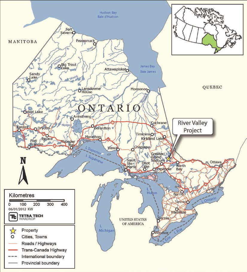
| | The Property lies within Dana and Pardo Townships and is located about 100 road kilometres (60 km direct) northeast of the City of Greater Sudbury, Ontario (Figure 4.1 and Figure 4.2), and centered at approximately 555371 mE and 5172514 mN (NAD83-UTM Zone 17T). The Property is accessed from Sudbury by traveling east along Highway 17 for 100 km to the town of Warren, at this point turn north onto Highway 539. Travel north along Highway 539 for 22 km to the junction of Highway 805. Travel northwest along Highway 805 from the village of River Valley, a distance of about 19.5 km from the Temagami River. Turn right onto a logging road, for about 800 m, then right at a fork in the road, and continue an additional 200 m. At this point several skidder roads and access trails lead south toward the mineralized zones. |
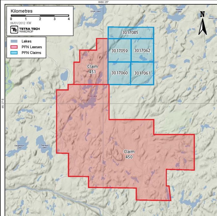
| | The Property claim group consists of 418 mining claims in 40 claim units that cover approximately 6,688 ha (Table 4.1). The majority of the claims are located in the Dana Township with only nine of the claim blocks being located immediately to the north in Pardo Township (Figure 4.3). The majority of the claim group is contiguous, with the exception of claim S-1229380 and claim S-3004262 which are located south of the main group in Dana Township. |
Pacific North West Capital Corp.
Technical Report and Resource Estimate on the River Valley
PGM Project, Northern Ontario | 8 | 1193250100-REP-R0001-01 |
Table 4.1 Provincial Location Map
Pacific North West Capital Corp.
Technical Report and Resource Estimate on the River Valley
PGM Project, Northern Ontario | 9 | 1193250100-REP-R0001-01 |
Figure 4.2 Location Map

Table 4.1 River Valley Mining Leases and Claims
Mining Lease/
Claims | Size
(ha) | Township | Recorded | Current
Expiry Date |
| CLM450 | 4,777.181 | Dana | 01-Nov-11 | 31-Oct-32 |
| CLM451 | 570.308 | Pardo | 11-Jan-12 | 28-Feb-33 |
| S 3017059 | 256.000 | Pardo | 08-Apr-04 | 05-Oct-12 |
| S 3017060 | 256.000 | Pardo | 08-Apr-04 | 05-Oct-12 |
| S 3017061 | 256.000 | Pardo | 08-Apr-04 | 05-Oct-12 |
| S 3017062 | 256.000 | Pardo | 08-Apr-04 | 05-Oct-12 |
| S 3017085 | 256.000 | Pardo | 08-Apr-04 | 05-Oct-12 |
Source: http://www.mndm.gov.on.ca/mines/claimaps_e.asp
Pacific North West Capital Corp.
Technical Report and Resource Estimate on the River Valley
PGM Project, Northern Ontario | 10 | 1193250100-REP-R0001-01 |
Figure 4.3 River Valley Lease and Claim Map
On April 7, 2011 PFN announced that they had closed the purchase of the remaining 50% interest in the unincorporated joint venture covering the Project from Anglo American Platinum Limited (Amplats) through its wholly-owned subsidiary, Kaymin Resources Ltd. (Kaymin). Pursuant to the terms of the agreement with Amplats and Kaymin, as announced in PFN’s news release of January 31, 2011, a total of 8,117,161 fully paid and non-assessable common shares of PFN (reflecting a 12% interest in PFN based upon the issued and outstanding common shares of PFN as of November 30, 2010 (67,643,008)) and three-year warrants to purchase up to 3,000,000 common shares of PFN at a price of Cdn$0.30 per common share have been issued to Kaymin for its 50% interest in the joint venture. The transaction provided PFN with an undivided 100% interest in the Project.
Land or work permits are not required at this stage of the Project.
Pacific North West Capital Corp.
Technical Report and Resource Estimate on the River Valley
PGM Project, Northern Ontario | 11 | 1193250100-REP-R0001-01 |
Initial contact and meeting has been made with aboriginal groups whose jurisdictions overlie the Property. These groups are the Temagami First Nation and the Metis Nation of Ontario. A site visit by representatives of the Temagami Nation has been planned, but not yet conducted at the time this report was published.
Pacific North West Capital Corp.
Technical Report and Resource Estimate on the River Valley
PGM Project, Northern Ontario | 12 | 1193250100-REP-R0001-01 |
5.0 ACCESSIBILITY, CLIMATE, LOCAL RESOURCES, INFRASTRUCTURE, AND PHYSIOGRAPHY
5.1 SITE TOPOGRAPHY, ELEVATION, AND VEGETATION
| | The Property lies at a mean elevation of about 325 masl. Relief is moderate and typical of Precambrian Shield topography. The eastern part around Azen Creek is lower and marshy. Forest cover is mainly poplar with about 25 to 33% white pine regrowth. |
| | Outcrop exposure on the Property is limited to about 20% with the remaining areas covered mostly by a thin (less than 1 m) veneer, yet locally reach 10s of metres of glacial till; gravel, outwash sand and silt. Most of the area around the Dana Lake Lismer Ridge, Casson, Varley and Azen Creek areas has been logged within the past 10 years and logging has been taking place in the Lismer Ridge area since the summer of 2003. |
5.2 ACCESS
| | The Property is accessed from Sudbury by travelling east along Highway 17 for 100 km to the town of Warren, at this point turn north onto Highway 539. Travel north along Highway 539 for 22 km to the junction of Highway 805. Travel northwest along Highway 805 from the village of River Valley, a distance of about 19.5 km from the Temagami River. Turn right onto a logging road, for about 800 m, then right at a fork in the road, and continue an additional 200 m. At this point several skidder roads and access trails lead south toward the mineralized zones. |
| | Lismer Zone can be accessed by all-terrain vehicle (ATV) trail from Highway 805 by turning east at a gravel pit at kilometre 14 (ATV trail at north edge of pit) and following the trail for about 6 km. |
| | The region is serviced by Highway 17, a part of the Trans-Canada Highway network and the Sudbury Regional Airport which has daily regional flights to Thunder Bay, Toronto, Timmins, and Ottawa. |
5.3 CLIMATE
| | There is no active weather station at the village of River Valley. The climate in the region is typical Canadian Shield summers and winter with temperatures averaging from 19°C in the summer to -13°C in the winter. Precipitation comes in the form of 30 to 64 cm of snow in the winter months and 77 to 101 mm of rain in the summer ( http://www.theweathernetwork.com/statistics/cl6068150 ). |
Pacific North West Capital Corp.
Technical Report and Resource Estimate on the River Valley
PGM Project, Northern Ontario | 13 | 1193250100-REP-R0001-01 |
| | Drilling and geophysical surveys can be carried out year round from skidder roads. Surface bedrock exploration can be done for about seven to eight months of the year. |
5.4 INFRASTRUCTURE
| | The City of Greater Sudbury, a major mining and manufacturing city, can provide all of the infrastructure and technical needs for any exploration and development work. |
| | A 230 kV transmission line is located passing through Warren, approximately 22 km from the Project. A 115 kV transmission line passes through the village of Field, located approximately 15 km to the east of the Project. |
| | Water is abundant in region from numerous lake and rivers to support exploration and mining activities. |
Pacific North West Capital Corp.
Technical Report and Resource Estimate on the River Valley
PGM Project, Northern Ontario | 14 | 1193250100-REP-R0001-01 |
6.0 HISTORY
| | The exploration history of the region dated back to the 1960s, with work on the Property starting in earnest in 1999. Table 6.1 summarizes the history of the Property and discloses historical estimates. Historical estimates within the table are considered relevant but not reliable. A QP has not done sufficient work to classify the historical estimate as a current mineral resource. PFN is not treating the historical estimates as current resources and the historical estimates should not be relied upon. |
| | A summary of the historic metallurgical studies are provided in Section 13.0. |
Table 6.1 History
| Year | Company | Activities | Historical Resource Estimate |
| 1963 | Tomrose Mines Ltd. | • Prospecting and trenching over Prospectus, furthering prospecting was recommended. | - |
| 1963 | Tomrose Mines Ltd. | • Diamond drill program on Tomlinson Property, additional work recommended. | - |
| 1964 | Tomrose Mines Ltd. | • Geochemical exploration of overburden areas recommended over Prospectus, several areas across Property were recommended for specific drilling targets. | - |
| 1965 | Falconbridge Ltd. | • An electromagnetic (EM) survey was conducted over Tomrose Option, no further work was recommended. | - |
| 1966 | Azen Mines Ltd. | • Magnetometer survey over Harper property. Further prospecting of anomalous areas was recommended. | - |
| 1968 | Kenco Exploration (Canada) Ltd. | • Airborne mag-EM survey over Janes, Davis, Henry, and Dana Townships. | - |
| 1969 | Kenco Exploration (Canada) Ltd. | • J.P. Patrie exposed mineralization in trenches and pits. | - |
| 1996 | WMC International | • Geological and geochemical exploration along the Project included: reconnaissance traversing, regional airborne geophysical survey, ground truthing of weak EM anomalies, and regional till-sampling program. | - |
| 1997 | Tenajon Resources | • Two phases of exploration; the first consisted of mapping/prospecting while the second included stripping, detailed mapping, and channel sampling focused on the Pardo property. | - |
| 1998 | Luhta, Bailey, and Orchard | • Prospecting and sampling on 18 contiguous claims in Pardo and Dana Townships. | - |
table continues…
Pacific North West Capital Corp.
Technical Report and Resource Estimate on the River Valley
PGM Project, Northern Ontario | 15 | 1193250100-REP-R0001-01 |
 | |  |
| Year | Company | Activities | Historical Resource Estimate |
| 1999 | Aquiline Resources | • Reconnaissance exploration fieldwork along the edges of intrusion. | - |
| 1999 | Mustang Minerals | • Prospecting and grab samples on Mustang South & North Grid (Dana Township), 78 km line cutting and magnetic surveying by Dan Patrie Exploration Ltd. | - |
| 2000 | Platinum Group Metals Ltd. | • Exploration along Brady Janes property included soil and rock samples, prospecting on claims at Henry Township and south-central James Township, geological mapping and geochemical sampling program over Henry Block. | - |
| 2000 | Mustang Minerals | • Geological exploration along Mustang North Grid which included mapping, sampling, prospecting, and a ground magnetic survey. | - |
| 2000 | Mustang Minerals | • Quantec Geoscience conducted IP/resistivity surveys along South Grid (Crera Township) and the North Grid (Dana and McWilliams Townships). | - |
| 2001 | Aquiline Resources | • Geological mapping and sampling on Anaconda Project. Ironbank International was commissioned to complete channel sampling across IP targets. JVX conducted IP/resistivity and magnetometer surveys on Dana North property. | - |
| 2001 | Mustang Minerals | • Second phase of mapping and sampling was conducted on three separate grids (North, Southeast, and Regional Central). Geophysical survey along Henry Grid, Diagonal Grid. Magnetometer and IP survey carried out on Mustang Mineral's Dana-McWilliams Property conducted by Vision Exploration. Line cutting in Upper Canada Claim Group by Vision. Quantec Geoscience conducted IP surveying on North Extension of the River Valley Property and Upper Canada Claim Property. Seventeen thousand metre diamond drill program designed and completed. | - |
| 2002 | Aquiline Resources | • JVX Ltd. refurbished gridlines and conducted IP/Resistivity and Magnetometer surveys on Anaconda Project, five IP anomalies identified. | - |
| 2002 | Mustang Minerals | • Vision Exploration conducted a Magnetometer Survey over Southeast Grid. Two target areas were drilled within the North Grid totalling nine holes. LG Property added to Mustang in 2001 and consisted of line cutting, ground magnetometer, IP survey, mapping, sampling, and prospecting. | - |
| 2003 | Aquiline Resources | • Ironbank International was commissioned for design and implementation a drilling program to test geophysical (IP) targets on Aquiline's AQI Project (formerly Anaconda). 15 holes were drilled, totaling 2,000 m. | - |
Pacific North West Capital Corp.
Technical Report and Resource Estimate on the River Valley
PGM Project, Northern Ontario | 16 | 1193250100-REP-R0001-01 |
6.1 HISTORICAL METALLURGICAL STUDY
| | Previous metallurgical studies completed on the Project must be classified as limited and selective. Testing has been done on high-grade sample of limited size and not all the zones were tested. |
| | In the fall of 1999, as part of a senior graduate course at Michigan Technological University (MTU) and sponsored in part by PFN and Amplats, Erik Luhta obtained a mini-bulk rock sample totalling 4,264 lb from the Dana Lake area. Specifically, the sample was collected (blasted) from the North Zone 2 (1,333.3 lb net crushed) and South Zone (2,197.0 lb net crushed) in areas that had relatively high PGM assays, as determined from 1999 detailed surface sampling (Luhta et al.1999). |
| | The specific gravity of the material was found to be 2.9. Pilot plant grinding and flotation tests resulted in recoveries of 81.4% copper, 73.4% gold, 68.5% platinum, 74.1% palladium, 27.5% rhodium, and 29.4% nickel. However, steady state was not achieved during this run due to the exhaustion of material after only a few hours of operation. |
| | The 2006 flotation test work on a sample from the Project, (Malysiak 2006) compared their results with previous test work by Hey and Plint in 2001. |
| | The 2006 tests were completed on a composite sample comprised of four samples in equal portions from Dana South Site A – MET 750, Dana South Site B – MET 751, Dana North Road Zone – MET 752, and Dana North Zone 2 – MET 753 while the 2001 testing was conducted on 13 borehole samples and consisted of the highest-grade intersections from each hole. |
| | The platinum and palladium recoveries were enhanced up to 10% by increasing the grind from 60% -75 μm to 80% -75 μm. Nevertheless, the overall flotation response was still low compared to a typical platinum operation. |
Pacific North West Capital Corp.
Technical Report and Resource Estimate on the River Valley
PGM Project, Northern Ontario | 17 | 1193250100-REP-R0001-01 |
7.0 GEOLOGICAL SETTING AND MINERALIZATION
7.1 REGIONAL GEOLOGY
| | The Paleoproterozoic East Bull Lake Intrusive Suite, dated between 2491 and 2475 Ma, consists of eight distinct bodies of dominantly gabbronorite to gabbroic anorthosite that occur in both the Southern and Grenville provinces between Elliot Lake and the Temagami River (Figure 7.1) (Easton 1999; James et al. 2002a). Intrusions of the East Bull Lake Intrusive Suite share a number of common characteristics in addition to lithology, including typically sill-like to lopolithic forms, igneous layering, and anomalous PGE content. The emplacement of the East Bull Lake Intrusive Suite bodies, the subsequent eruption of volcanic rocks belonging to the Huronian Supergroup, and the formation of the depositional basin filled by Huronian Supergroup sediments is attributed by most authors to a Paleoproterozoic intracontinental rifting event, which resulted from a mantle plume that was centered near Sudbury (Easton 2003; Easton et al. 2004). Rift-related magmatic activity is also manifested in the gabbroic rocks of the Hearst-Matachewan dyke swarm. |
| | The East Bull Lake Suite Intrusions exhibit geochemical characteristics (high aluminum, relatively low magnesium and Large Ion Lithophile (LIL)-enriched trace element profiles) consistent with being derived from fractionated tholeiitic or high-alumina tholeiitic parental magmas (Peck et al. 1993; Peck et al. 1995; Vogel et al. 1998). The estimated parental magma compositions for the East Bull Lake Intrusive Suite are thus broadly similar to those postulated for the intrusive suite in the world class Noril’sk-Talnahk nickel-copper-PGE camp in Siberia (Findlay 2001). |
| | The three largest and most economically interesting bodies of the East Bull Lake Intrusive Suite are the East Bull Lake and Agnew Intrusions (situated within the Sudbury Province) and the River Valley Intrusion (situated in the Grenville Front Tectonic Zone). Smaller bodies include the intrusions in Drury, Falconbridge, May, Street, and Wisner Townships (Easton et al. 2004). |
| | The most completely preserved of the three largest bodies is the Agnew Lake Intrusion with approximately 2 km of stratigraphy being preserved; while the East Bull Lake and River Valley Intrusions have roughly only 1 km. The significant volume of melanocratic norites and troctolites recognized in the River Valley Intrusion are not present in the intrusions west of the Grenville Front, and may indicate that the former represent a deeper part of the stratigraphy (Easton et al. 2004). |
Pacific North West Capital Corp.
Technical Report and Resource Estimate on the River Valley
PGM Project, Northern Ontario | 18 | 1193250100-REP-R0001-01 |
Figure 7.1 Regional Geology

| | An economically important feature commonly shared by the Agnew Lake, East Bull Lake, and River Valley Intrusions is the occurrence of a copper-nickel-PGE-bearing breccia unit situated at the base of the intrusions, where the footwall contact is preserved. The breccia units are characterized by inclusions of footwall and cognate mafic to ultramafic xenoliths and autoliths set within a gabbronorite to olivine-bearing gabbronorite matrix. Near the contact, marginal footwall breccias and zones of extensive footwall dikes may also be present. Blebby to disseminated chalcopyrite and pyrrhotite, typically in modal amounts from 0.5 to 2%, occur in the matrix of the marginal and brecciated rocks, and occasionally within the breccia’s more mafic fragments. This sulphide mineralization commonly contains between 1 g/t and 5 g/t combined platinum-palladium-gold, and remains the focus of current mineral exploration (James et al. 2002a; 2002b). |
7.2 PROPERTY GEOLOGY
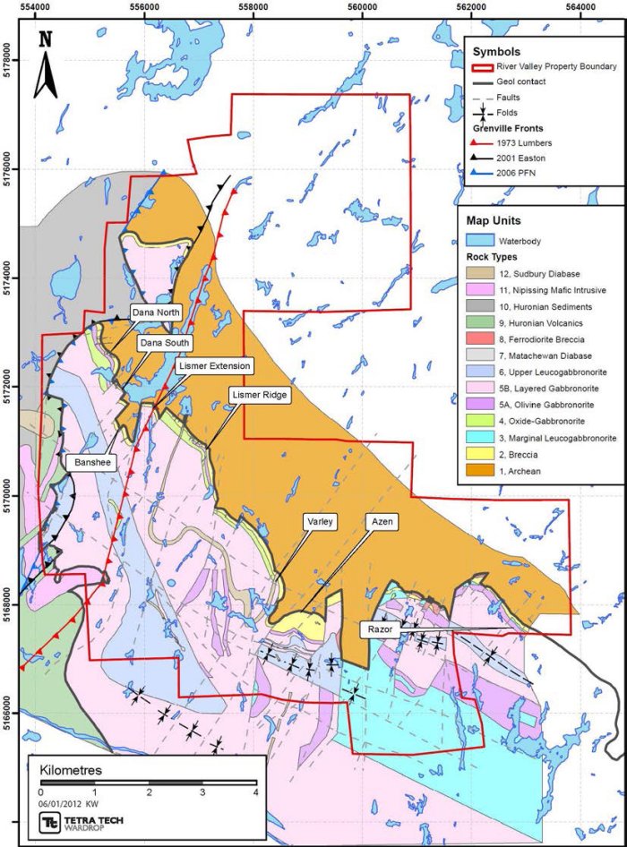
| | The River Valley Intrusion, the largest of the East Bull Lake Intrusive Suite by area, covers an area of approximately 200 km2 and underlies parts of Crerar, Dana, Henry, Janes, and McWilliams Townships. |
| | On the ground held by PFN, the contact between the River Valley Intrusion and the Archean basement trends south-easterly for a distance of approximately 10 km, from the northwest corner of Dana Township through to the south central Dana-McWilliams townships boundary. The mineralized breccia unit occurring at the contact has been identified along most of this 10 km strike length. The contact is |
Pacific North West Capital Corp.
Technical Report and Resource Estimate on the River Valley
PGM Project, Northern Ontario | 19 | 1193250100-REP-R0001-01 |
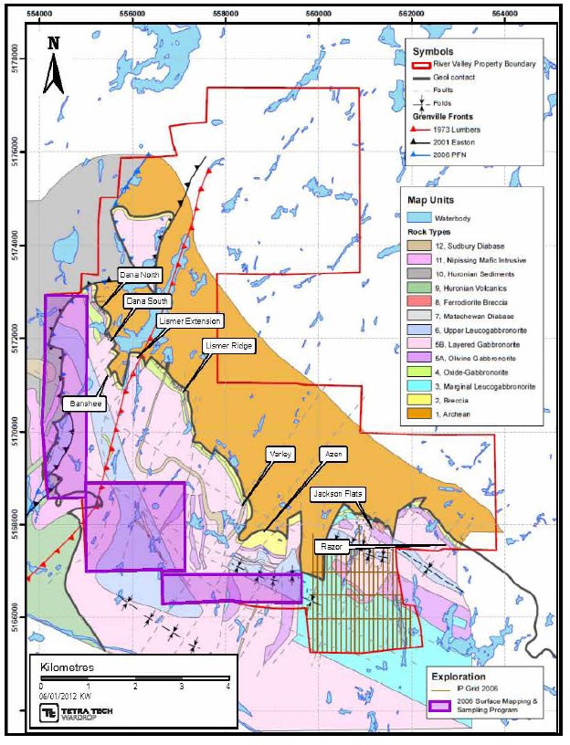
| | divided into several areas. Starting in the northwest and preceding to the southeastern extent of the Property these areas are: Dana North, Dana South, Banshee, Lismer Extension, Lismer Ridge, Varley, Azen, Jackson’s Flats, and Razor. Drill data suggests that the dip between the contact of the mineralized breccia and the Archean footwall gneiss ranges from about 65 to 75° west, toward the intrusion. The dip is however highly variable along strike, ranging from 65 to 85° west to 65 to 85° east. East of the Dana South area, drill data suggests that the Archean-River Valley Intrusion contact generally dips into the intrusion at 60 to 70°. |
| | Along the Grenville Front, in northwest Dana Township, the River Valley Intrusion is in thrust contact with quartzite of the Mississagi Formation (Davidson 1986). In west central and southwest Dana Township, the River Valley Intrusion forms a contact with mafic and felsic metavolcanic rocks of the lower Huronian Supergroup (Easton and Hrominchuk 1999). |
| | The River Valley Intrusion in Dana Township, north of the Sturgeon River Fault, shows an increase in metamorphic grade southeast away from the Grenville Front and into the main Grenville terrane. River Valley Intrusion rocks west of Dana Lake have a mid-to upper greenschist facies imprint. In the Lismer Ridge Zone metamorphic grade is lower amphibolite facies. East of Lismer, from the Varley to Razor areas, metamorphic grade is mid-to upper amphibolite. |
| | North of the Sturgeon River Fault in Dana Township, numerous northeast-trending discreet shears/faults transect the River Valley Intrusion and are interpreted to be synchronous with development of the Grenville Front Thrust and Grenville Thrust Boundary Fault. |
| | Two north-trending faults cut the River Valley Intrusion north of the Sturgeon River fault in Dana Township. These north-south faults (the Drop Zone West and Drop Zone East faults) occur approximately 500 m apart and bound a segment of the RVI intrusion that has an apparent displacement of 1.3 km to the south. It is possible that the West and East Drop Zone faults are part of the Upper Wanapitei River fault system, which has a protracted history dating back to at least 2170 Ma (Buchan and Ernst 1994 in Easton 2003). |
| | A zone of northwest-trending faults (Turtle Creek, Martin Creek and Cre-Mac Faults) transects the Property held by PFN, and parallel the Sturgeon River Fault. The Sturgeon River Fault is an important structural feature within the River Valley Intrusion, juxtaposing highly deformed and recrystallized River Valley Intrusion rocks of the Grenville Province in Crerar Township against River Valley Intrusion rocks of the Southern-Grenville Province Boundary Zone in Dana Township (Easton 2003). River Valley Intrusion rocks north of the Sturgeon River Fault generally are much less deformed and often exhibit preserved or partly preserved primary mineralogy. A northwest-trending syncline may form a major structure within the area currently owned by PFN. The syncline (referred to as the Turtle Creek syncline) trends northwest across the eastern portion of the Property. East of the Drop Zone East |
Pacific North West Capital Corp.
Technical Report and Resource Estimate on the River Valley
PGM Project, Northern Ontario | 20 | 1193250100-REP-R0001-01 |
| | Fault, the synclinal axis of the fold trends sub-parallel to the River Valley Intrusion- Archean contact (Figure 7.2). |
| | On the basis of surface mapping and diamond drilling, the idealized sectional stratigraphy of the mineralized environment comprises five major units, from the layered rocks of the River Valley Intrusion in the west to the igneous basal contact of the intrusion to the east (Figure 7.3): |
| | - Layered Sequence: units of massive pyroxenite to anorthosite, forming the bulk of the River Valley Intrusion; layering is poorly developed but where present is subvertical.
- Inclusion-bearing Zone: 1.65 to 98.50 m wide; scattered, elevated PGM values; mainly leucogabbro-gabbro fragments (less than 20% volume) with either fine-grained mafic matrix or medium-grained felsic matrix; fragments are generally larger (decimetre to metre scale) than those in the Breccia Zone.
- Breccia Zone: 11.50 to 193.05 m wide; elevated PGM values (Main Zone); mainly gabbro-melagabbro fragments (greater than 20% volume) with fine-to medium grained mafic matrix; fragments are generally small (centimetre to decimetre scale).
- Boundary Zone: 0 to 40 m wide; also referred to as footwall breccia; where present, consists of country rock (Archean paragneiss/migmatite) mixed with River Valley Intrusive rocks.
- Country Rock: Footwall or hanging wall Archean paragneiss-migmatitegabbro and possibly Huronian sedimentary rocks.
|
Pacific North West Capital Corp.
Technical Report and Resource Estimate on the River Valley
PGM Project, Northern Ontario | 21 | 1193250100-REP-R0001-01 |
Figure 7.2 Property Geology
Pacific North West Capital Corp.
Technical Report and Resource Estimate on the River Valley
PGM Project, Northern Ontario | 22 | 1193250100-REP-R0001-01 |
Figure 7.3 Stratigraphic Section
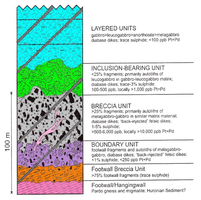
Source: Jobin-Bevans 2004
7.3 MINERALIZATION
| | An economically important feature commonly shared by the Agnew Lake, East Bull Lake and River Valley Intrusions is the occurrence of a copper-nickel-PGE bearing breccia unit situated at the base of the intrusions, where the footwall contact is preserved. The breccia units are characterized by inclusions of footwall and cognate mafic to ultramafic xenoliths and autoliths set within a gabbronorite to olivine-bearing gabbronorite matrix. Near the contact, marginal footwall breccias and zones of extensive footwall dikes may also be present. Blebby to disseminated chalcopyrite and pyrrhotite, typically in modal amounts from 0.5 to 2%, occur in the matrix of the marginal and brecciated rocks and occasionally within the breccia’s more mafic fragments. This sulphide mineralization commonly contains between 1 g/t and 5 g/t combined platinum-palladium-gold. On the basis of work completed to date, several |
Pacific North West Capital Corp.
Technical Report and Resource Estimate on the River Valley
PGM Project, Northern Ontario | 23 | 1193250100-REP-R0001-01 |
| | important observations and conclusions can be made regarding the geological environment of the contact-type PGM-copper-nickel sulphide mineralization on the Property: |
| | - The Breccia Zone (approximately 10 to 195 m intersections), which includes the main mineralized breccia or Main Zone, has relatively consistent, elevated PGM values. The Main Zone occurs within about 20 m of the intrusive contact with Archean paragneiss and migmatite.
- The Inclusion-Bearing Zone (approximately 1.0 to 100 m intersections) is variably mineralized and has scattered, elevated PGM values.
- Sulphide contents generally range from 1 to 5% total sulphide but can be as high as 10% when occurring as localized clusters of disseminated and bleb sulphide. There is a moderate correlation between PGM-bearing sulphide mineralization and patches of blue-grey quartz (referred to as cauliflower) and/or elevated biotite concentrations.
- The majority of sulphide mineralization occurs as magmatic sulphide grains that are primarily disseminated and bleb textured, with subordinate net-textures. Principal sulphide minerals are chalcopyrite, pyrrhotite, and pentlandite with subordinate pyrite, cubanite and bornite.
- Although the mineralized sections at the Dana Lake Area and Lismer Ridge are broadly similar, there are several notable differences. Mafic rocks at Lismer Ridge commonly develop a moderate foliation and tend to have a higher proportion of chlorite and biotite. There is also a higher proportion of visible chalcopyrite relative to pentlandite + pyrrhotite at Lismer Ridge and chalcopyrite is more commonly re-crystallized along foliations. At Lismer Ridge, blue quartz is not as prolific within the mineralized sections. These differences are likely the result of a slightly higher metamorphic grade at Lismer Ridge (mid-to upper-amphibolite facies), relative to the Dana Lake Area (greenschist facies).
|
| | Table 7.1 lists the typical minerals with economic potential that have been observed at the Project by x-ray diffraction and scanning electron microscope studies of hand samples. |
Table 7.1 Minerals
| Minerals | Formula |
| Chalcopyrite | CuFeS2 |
| Pyrrhotite | Fe(1-x)S |
| Pentlandite | (Fe, Ni)9S8 |
| Pyrite | FeS2 |
| Cubanite | CuFe2S3 |
| Bornite | Cu5FeS4 |
| Sperrylite | PtAs2 |
table continues…
Pacific North West Capital Corp.
Technical Report and Resource Estimate on the River Valley
PGM Project, Northern Ontario | 24 | 1193250100-REP-R0001-01 |
| Minerals | Formula |
| Mackinawite | (Fe, Ni)9S8 |
| Cubanite | CuFe2S3 |
| Arsenopyrite | FeAsS |
| | The zones of mineralized breccia starting in the northwest and proceeding to the southeastern extent of the contact on the Property are: Dana North, Dana South, Banshee, Lismer’s Extension, Lismer’s Ridge, Varley, Azen, Jackson’s Flats, and Razor (Figure 7.4) |
Figure 7.4 River Valley Mineral Zones

Pacific North West Capital Corp.
Technical Report and Resource Estimate on the River Valley
PGM Project, Northern Ontario | 25 | 1193250100-REP-R0001-01 |
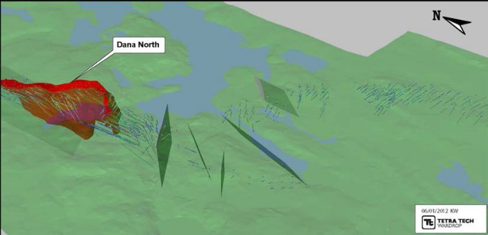
7.3.1 DANA NORTH
| | Dana North the most northwestern zone has a strike length of approximately 1000 m. The zone dips steeply to the west-southwest at 80 to 85°. The rocks have under gone lower to middle green schist facies metamorphism. This area exhibits little structural disturbance. The zone averages 50 m in width but varies greatly from hole to hole (Figure 7.5). |
Figure 7.5 Oblique Long Section Dana North
Note: Not to scale.
7.3.2 DANA SOUTH
| | Proceeding southeast, Dana South is approximately 500 m in length, dips at 80 to 85° to the west-southwest and varies greatly in width between holes and sections. The rocks here have under gone mid-to upper green schist metamorphism the southern extent of this zone exhibits structural disturbance due to the proximity of the Dana Lake Shear Zone (Figure 7.6). |
Pacific North West Capital Corp.
Technical Report and Resource Estimate on the River Valley
PGM Project, Northern Ontario | 26 | 1193250100-REP-R0001-01 |
Figure 7.6 Oblique Long Section Dana South
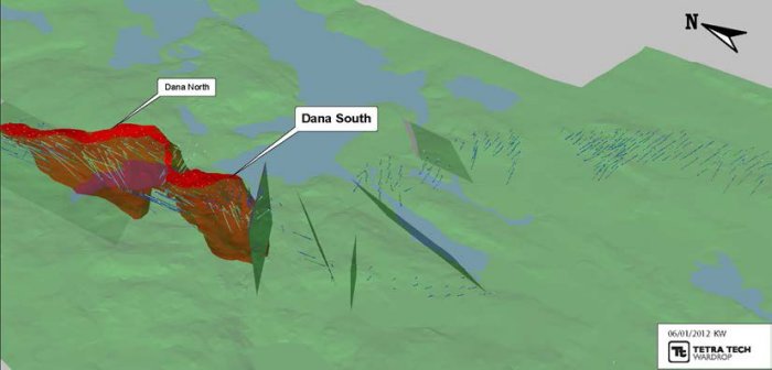
Note: Not to scale.
7.3.3 BANSHEE
| | The next zone further to the southeast is Banshee Lake which is a fault-offset band of marginal series rocks. This block of "breccia" has been displaced approximately 350 m to the southwest. The metamorphic grade of the rock here is lower amphibolite facies. The strike length of this zone is approximately 500 m and dips to the southwest at 60 to 70°. The rocks here show relatively more structural fabric in the way of fracture, shears, and foliation then at Dana (Figure 7.7). |
Figure 7.7 Oblique Long Section Banshee
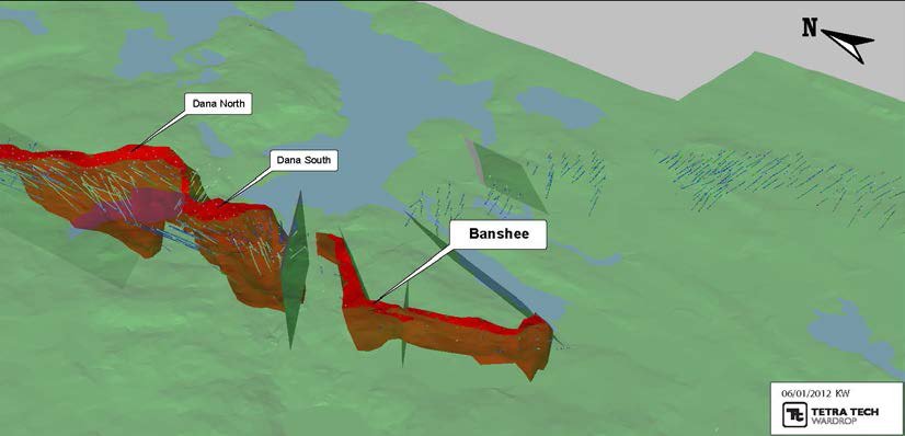
Note: Not to scale.
Pacific North West Capital Corp.
Technical Report and Resource Estimate on the River Valley
PGM Project, Northern Ontario | 27 | 1193250100-REP-R0001-01 |
7.3.4 LISMER RIDGE AND LISMER EXTENSION
| | The next two zones, which can be described together due to the proximity and identical geology, are Lismer Extension and Lismer Ridge. These zones have a combined strike length of approximately 2,400 m dip east-southeast at about 60 to 70°. These zones have a lower to mid-amphibolite grade metamorphic over print and exhibit a more penetrate structural fabric in the way of foliation thru out then the last zones. The rocks are more highly chloritized and carry more biotite relative to the other zones. The sulphides are composed of a higher percentage of chalcopyrite and are recrystallized along foliation planes (Figure 7.8). |
Figure 7.8 Oblique Long Section Lismer Ridge and Lismer Extension
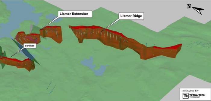
Note: Not to scale.
7.3.5 VARLEY
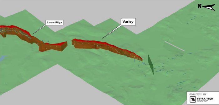
| | The next zone is Varley, which has strike length of approximately 2,500 m and dips to the west at approximately 60 to 70°. The rocks here have undergone lower to mid-amphibolite grade metamorphism, but display little structural deformation (Figure 7.9) . |
Pacific North West Capital Corp.
Technical Report and Resource Estimate on the River Valley
PGM Project, Northern Ontario | 28 | 1193250100-REP-R0001-01 |
Figure 7.9 Oblique Long Section Varley
Note: Not to scale.
7.3.6 AZEN
| | At this juncture the contact swings to the east from the previous northwest-southeast orientation and is where the Azen Zone is encountered. This zone has a strike length of approximately 1,300 m and dips 30 to 50° south. The rocks have a mid amphibolite facies over print (Figure 7.10). |
Figure 7.10 Oblique Long Section Azen

Note: Not to scale.
Pacific North West Capital Corp.
Technical Report and Resource Estimate on the River Valley
PGM Project, Northern Ontario | 29 | 1193250100-REP-R0001-01 |
7.3.7 RAZOR
| | The last zone to the east is Razor, with a strike length of approximately 1,400 m. This zone dips progressively steeper to the east from about 80° to the south to steeply north at the far eastern end. The rocks have under gone upper amphibolite grade metamorphism (Figure 7.11). |
Figure 7.11 Oblique Long Section Razor

Note: Not to scale.
Pacific North West Capital Corp.
Technical Report and Resource Estimate on the River Valley
PGM Project, Northern Ontario | 30 | 1193250100-REP-R0001-01 |
8.0 DEPOSIT TYPE
| | Two styles of mineralization have been observed at the Project; contact nickel-PGE mineralization (US Geological Survey #5b) and reef PGE mineralization (US Geological Survey #2b) ( http://pubs.usgs.gov/bul/b1693/html/bullfrms.htm ). |
| | The presence of several highly anomalous assays from rocks lying within higher portions of the River Valley Intrusion’s stratigraphy (i.e. Azen Creek Wonder Showing) suggests that there are opportunities for PGE mineralization such as reef-or stratabound-type targets or, narrow, high-grade breccia zones. |
8.1.1 CONTACT -STYLE PGM MINERALIZATION
| | Contact-style PGM mineralization develops as the result of sulphur-saturation brought on by the interaction of the fertile parental magma with the surrounding country rock lithologies. The contamination of the initial fertile parental magma by the addition of either silicon dioxide and/or sulphur can directly result in sulphur-saturation and the separation of a PGE-rich immiscible sulphide. The addition of silicon dioxide and/or sulphur is typically achieved by the assimilation of either local country rock lithologies and/or the assimilation of breccia fragments previously developed along the contact margin. Analogies for this model include Lac Des Iles (northwestern Ontario), the Platreef (South Africa), and Portimo Complex (Finland). |
| | Contact-style PGM mineralization is the most common form of PGM mineralization within the East Bull Lake Intrusive Suite. Mineralized zones are commonly restricted to within 200 to 300 m of the true footwall contact, and mineralized zones are commonly 20 to 100 m wide. Mineralization occurs typically as fine-to medium-grained disseminated to blebby chalocopyrite+pryrrhotite+pentlandite within a heterolithic gabbro to melagabbro breccia. |
8.1.2 REEF -STYLE PGM MINERALIZATION
| | Reef-style PGM mineralization is a strata-bound or strata-form style of mineralization that typically occurs higher up in the stratigraphy of the intrusion at the contact between two separate and distinct lithological units. Sulphur-saturation and therefore sulphide segregation can be the result of the interaction between distinctly different types of magma, with sulphur-saturation occurring at their interface. Geochemical evolution of the overlying magma can also cause sulphur-saturation and the separation of immiscible sulphides can accumulate between the two units. |
| | Due to the stratigraphic control and narrow target widths (1 to 10 m) of reef-style PGM mineralization, exploration programs must be focused entirely on the productive horizon. In order to identify the proper horizon, geochemical traverses are essential with the goal being to look for systematic changes in PGE and/or nickel- |
Pacific North West Capital Corp.
Technical Report and Resource Estimate on the River Valley
PGM Project, Northern Ontario | 31 | 1193250100-REP-R0001-01 |
| | copper tenors across lithological boundaries. Once the specific horizon is identified then grid sampling and ground-based geophysics should be used over the target area. |
Pacific North West Capital Corp.
Technical Report and Resource Estimate on the River Valley
PGM Project, Northern Ontario | 32 | 1193250100-REP-R0001-01 |
9.0 EXPLORATION
9.1 EXPLORATION PRIOR TO 2006
| | PFN has conducted exploration on the Property since 1999. A summary of the activities conducted by PFN and/or their joint venture partners is summarized below in Table 9.1. |
Table 9.1 Exploration Work Prior to 2006
| Year | Company | Activities |
| 1999 | PFN/Amplats | • With joint venture partner Amplats established a Phase 1 surface program which included: establishing detailed and regional exploration grids, regional prospecting and sampling, grid prospecting and sampling, preliminary geological grid mapping, stripping and cleaning of selected outcrops areas, detailed sampling, preliminary mapping, orientation biogeochemical survey, and orientation IP and ground magnetometer geophysical surveys. |
| 2000 | PFN/Amplats | • Phase 2 program surface consisted of; grid cutting, geophysical surveys, and regional mapping/prospecting and detailed mapping/sampling of new cleared areas over the Dana Lake Area and Lismer Ridge. |
| 2001 | PFN/Amplats | • Phase 3 surface program consisted of sample collections from the property with concentrations in the south eastern and western contact areas |
| 2002 | PFN/Amplats | • From period of October to December, Phase IV surface included; regional geological mapping and sampling, stripping, detailed mapping and sampling, and line cutting and IP and ground magnetometer geophysical surveys. |
| 2003 | PFN/Amplats | • SPECTREM Air flew airborne mag, EM, and radiometric surveys over the River Valley property. |
| 2004 | PFN/Amplats | • From period May to October, Phase VI surface included extensive geological mapping of the eastern portion of the property with the collection of samples |
| 2005 | PFN/Amplats | • From period December to October, a 35-40 t rock bulk sample was taken from four sites (two at Dana south, one at Road Zone, and one Dana North). Samples shipped to Amplats in South Africa for metallurgical testing. D.S. Dorland Ltd. surveyed the perimeter of the 33 claim block joint venture property in Dana and Pardo Townships. A trenching operation was undertaken on the northeast end of Lismer extension. Follow-up geological mapping and sampling was carried out |
Pacific North West Capital Corp.
Technical Report and Resource Estimate on the River Valley
PGM Project, Northern Ontario | 33 | 1193250100-REP-R0001-01 |
| | The information summarized in the table has not been reviewed by Tetra Tech and had been sources from various internal company reports and press releases available from PFN’s website. |
9.2 2006 SURFACE PROGRAM
| | The surface program carried out from May to November 2006 was designed to follow up on the 2004 and 2005 surface programs. Mapping and prospecting was also carried out in areas where previous work was lacking. |
| | The objectives of the surface program were as follows: |
| | - map and sample areas that contain concentrations of anomalous samples as identified in the 2005 surface program (Figure 9.1, Table 9.2, and Table 9.3)
- decipher the contact relations between the River Valley Intrusion and the adjacent Huronian sediments on the western edge of the Property and the River Valley Intrusion outlier in the Pardo area
- prospecting and map the magnetic anomalies in the River Valley Intrusion/Huronian contact area of the Property
- cut a grid of 50 line kilometres in the Jackson’s Flats south area and perform IP and magnetic surveys (Figure 9.2 and Figure 9.3)
- prospect and trace the Olivine gabbronorite units exposed along the road in Jackson’s Flats south where anomalous samples were yielded during the 2005 surface program
- perform gravity survey profiles along selected traverses across the regional stratigraphy to see if this method would be a viable exploration tool and/or reveals useful information about the nature of the River Valley Intrusion
- conduct mobile metal ion geochemical orientation surveys over areas of known mineralization to determine whether this method would be responsive in the River Valley Intrusion PGM environment. If good results were obtained, then surveys would be conducted over prospective areas lacking outcrop.
|
| | This program consisted of 2,432 grab and 341 channel samples being taken. |
Pacific North West Capital Corp.
Technical Report and Resource Estimate on the River Valley
PGM Project, Northern Ontario | 34 | 1193250100-REP-R0001-01 |
Figure 9.1 2006 Surface Exploration
Pacific North West Capital Corp.
Technical Report and Resource Estimate on the River Valley
PGM Project, Northern Ontario | 35 | 1193250100-REP-R0001-01 |
Table 9.2 Highlights of the Surface Sampling Program
Sample
No. | Au
(ppb) | Pt
(ppb) | Pd
(ppb) | Pt+Pd+Au
(ppb) | Pd:Pt | Ni
(ppm) | Cu
(ppm) |
| ND308-06 | 65 | 220 | 261 | 546 | 1.18636 | 204.0 | 61 |
| RZ159 | 5 | 300 | 261 | 566 | 0.87000 | 20.0 | 85 |
| RZ190 | 211 | 200 | 196 | 607 | 0.98000 | 2,030.0 | 331 |
| ND092-06 | 10 | 330 | 286 | 626 | 0.86667 | 52.9 | 23 |
| ND182-06 | 76 | 160 | 406 | 642 | 2.5375 | 197.0 | 94 |
| ND257-06 | 9 | 440 | 237 | 686 | 0.53864 | 141.0 | 12 |
| ND188-06 | 66 | 290 | 336 | 692 | 1.15862 | 664.0 | 50 |
| PW1286 | 64 | 240 | 391 | 695 | 1.62917 | 1,410.0 | 620 |
| SB100-06 | 57 | 230 | 413 | 700 | 1.79565 | 1,370.0 | 143 |
| ND184-06 | 10 | 400 | 360 | 770 | 0.90000 | 213.0 | 23 |
| ND298-06 | 57 | 470 | 314 | 841 | 0.66809 | 26.0 | 301 |
| SB139-06 | 89 | 610 | 162 | 861 | 0.26557 | 341.0 | 341 |
| ND237-06 | 341 | 260 | 287 | 888 | 1.10385 | 3,050.0 | 704 |
| PW558 | 17 | 660 | 226 | 903 | 0.34242 | 102.0 | 18 |
| ND075-06 | 320 | 320 | 269 | 909 | 0.84063 | 2,570.0 | 651 |
| ND323-06 | 18 | 320 | 670 | 1,008 | 2.09375 | 334.0 | 20 |
| RZ186 | 409 | 380 | 382 | 1,171 | 1.00526 | 3,700.0 | 209 |
| ND224-06 | 417 | 380 | 405 | 1,202 | 1.06579 | 3,430.0 | 872 |
| RZ188 | 425 | 460 | 442 | 1,327 | 0.96087 | 4,080.0 | 1,280 |
| PW1318 | 192 | 1,110 | 623 | 1,925 | 0.56126 | 1,680.0 | 68 |
| RZ160 | 16 | 910 | 1,020 | 1,946 | 1.12088 | 18.0 | 55 |
| ND076-06 | 850 | 550 | 553 | 1,953 | 1.00546 | 5,560.0 | 1,650 |
| PW415 | 8 | 1,920 | 787 | 2,715 | 0.40990 | 127.0 | 22 |
| ND183-06 | 142 | 1,790 | 1,390 | 3,322 | 0.77654 | 291.0 | 51 |
| ND175-06 | 90 | 2,160 | 2,990 | 5,240 | 1.38426 | 459.0 | 60 |
Table 9.3 Highlights of the Channel Sampling Program
Sample
No. | Au
(ppb) | Pt
(ppb) | Pd
(ppb) | Pt+Pd+Au
(ppb) | Pd:Pt | Ni
(ppm) | Cu
(ppm) |
| DR068 | 53 | 810 | 769 | 1,632 | 0.949 | 71 | 774 |
| DR283 | 21 | 580 | 859 | 1,460 | 1.481 | 31 | 287 |
| DR047 | 26 | 750 | 533 | 1,309 | 0.711 | 33 | 204 |
| DR152 | 40 | 690 | 559 | 1,289 | 0.810 | 18 | 228 |
| DR260 | 52 | 670 | 566 | 1,288 | 0.845 | 39 | 187 |
| DR230 | 26 | 900 | 335 | 1,261 | 0.372 | 20 | 200 |
| DR282 | 29 | 680 | 548 | 1,257 | 0.806 | 47 | 253 |
| DR048 | 46 | 580 | 542 | 1,168 | 0.934 | 36 | 123.0 |
| DR074 | 102 | 450 | 474 | 1,026 | 1.053 | 73 | 695.0 |
table continues…
Pacific North West Capital Corp.
Technical Report and Resource Estimate on the River Valley
PGM Project, Northern Ontario | 36 | 1193250100-REP-R0001-01 |
Sample
No. | Au
(ppb) | Pt
(ppb) | Pd
(ppb) | Pt+Pd+Au
(ppb) | Pd:Pt | Ni
(ppm) | Cu
(ppm) |
| DR186 | 43 | 550 | 364 | 957 | 0.662 | 17 | 156.0 |
| DR258 | 40 | 430 | 307 | 777 | 0.714 | 45 | 431.0 |
| DR042 | 101 | 380 | 280 | 761 | 0.737 | 53 | 723.0 |
| DR304 | 46 | 430 | 260 | 736 | 0.605 | 31 | 183.0 |
| DR075 | 33 | 440 | 252 | 725 | 0.573 | 30 | 254.0 |
| DR121 | 10 | 320 | 370 | 700 | 1.156 | 37 | 161.0 |
| DR078 | 42 | 330 | 305 | 677 | 0.924 | 25 | 439.0 |
| DR169 | 35 | 330 | 280 | 645 | 0.848 | 29 | 190.0 |
| DR079 | 43 | 330 | 265 | 638 | 0.803 | 35 | 543.0 |
| DR267 | 19 | 370 | 234 | 623 | 0.632 | 44 | 199.0 |
| DR044 | 53 | 320 | 241 | 614 | 0.753 | 47 | 428.0 |
| DR266 | 15 | 290 | 309 | 614 | 1.066 | 50 | 167.0 |
| DR229 | 11 | 380 | 207 | 598 | 0.545 | 21 | 77.5 |
| DR291 | 24 | 270 | 293 | 587 | 1.085 | 36 | 270.0 |
| DR072 | 15 | 220 | 334 | 569 | 1.518 | 33 | 346.0 |
| | During the 2006 mapping and prospecting campaign, several areas where identified in the interior of the River Valley Intrusion that returned anomalous assays for platinum+palladium+gold. These may be sites of possible reef style PGM mineralization and warrant further work and possibly a drilling program. The 2006 IP survey identified a number of chargeability anomalies, which were ground trued with inconclusive results. |
9.3 2007 SURFACE PROGRAM
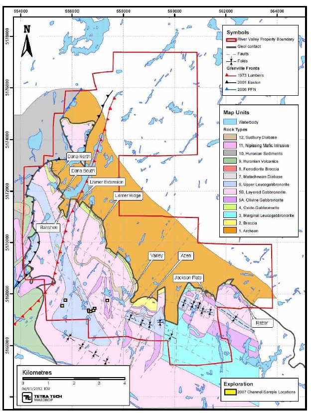
| | A power stripping and channel-sampling program was implemented in September and continued into November. The objective of this program was to sample more completely in and around prospective PGM zones and to determine whether there was any continuity and/or control of the PGE mineralization. Three hundred and seventy-one metres were stripped and 326 samples taken (Figure 9.2 and Table 9.4) . |
Table 9.4 Highlights from 2007 Channel Samples
Sample
No. | Lithology | Au
(ppb) | Pt
(ppb) | Pd
(ppb) | Pt+Pd+Au
(ppb) | Ni
(ppm) | Cu
(ppm) |
Dragon Zone
|
| DR350 | Melagabbro | 97 | 1,277 | 749 | 2,123 | 55 | 312 |
| DR351 | Melagabbro | 46 | 329 | 364 | 739 | 178 | 282 |
| DR352 | Melagabbro | 44 | 182 | 308 | 534 | 96 | 275 |
| DR353 | Melagabbro | 96 | 509 | 512 | 1,117 | 89 | 468 |
table continues…
Pacific North West Capital Corp.
Technical Report and Resource Estimate on the River Valley
PGM Project, Northern Ontario | 37 | 1193250100-REP-R0001-01 |
Sample
No. | Lithology | Au
(ppb) | Pt
(ppb) | Pd
(ppb) | Pt+Pd+Au
(ppb) | Ni
(ppm) | Cu
(ppm) |
| DR368 | Leucogabbro | 170 | 854 | 752 | 1,776 | 116 | 1,654 |
| DR370 | Leucogabbro | 76 | 333 | 360 | 765 | 80 | 1230 |
| DR378 | Foliated Mafic | 34 | 292 | 267 | 593 | 48 | 420 |
| DR379 | Foliated Mafic | 64 | 744 | 590 | 1,398 | 30 | 409 |
| DR409 | Leucogabbro | 287 | 1,190 | 1,136 | 2,613 | 127 | 1,191 |
| DR411 | Leucogabbro | 40 | 441 | 433 | 914 | 50 | 298 |
| DR412 | Melagabbro | 97 | 911 | 835 | 1,843 | 70 | 613 |
| DR413 | Melagabbro | 43 | 618 | 531 | 1,192 | 52 | 359 |
| DR414 | Melagabbro | 48 | 488 | 404 | 940 | 167 | 710 |
| DR417 | Gabbro | 31 | 414 | 267 | 712 | 38 | 136 |
| DR420 | Melagabbro | 37 | 378 | 378 | 793 | 31 | 124 |
| DR480 | Anorthosite | 81 | 301 | 342 | 724 | 44 | 323 |
| DR482 | Gabbro | 20 | 475 | 294 | 789 | 35 | 73 |
| DR493 | Mafic Gab | 5 | 948 | 108 | 1,061 | 49 | 157 |
| East Casson Area |
| DR512 | Anorthosite | 29 | 293 | 196 | 518 | 30 | 112 |
| DR594 | Melagabbro | 17 | 355 | 133 | 505 | 21 | 65 |
| Road Zone |
| DR601 | Nipissing Gabbro | 430 | 313 | 378 | 1,121 | 939 | 3,378 |
| DR602 | Nipissing Gabbro | 247 | 212 | 248 | 707 | 686 | 2,059 |
| DR603 | Nipissing Gabbro | 281 | 274 | 264 | 819 | 831 | 2,290 |
| DR604 | Nipissing Gabbro | 264 | 251 | 237 | 752 | 779 | 2,329 |
Pacific North West Capital Corp.
Technical Report and Resource Estimate on the River Valley
PGM Project, Northern Ontario | 38 | 1193250100-REP-R0001-01 |
Figure 9.2 2007 Channel Sample Location
Pacific North West Capital Corp.
Technical Report and Resource Estimate on the River Valley
PGM Project, Northern Ontario | 39 | 1193250100-REP-R0001-01 |
9.4 2008 SURFACE PROGRAM
| | Starting in April of 2008, Gord Trimble, an independent consultant, was brought in to conduct a study on Dana North and South. The main focus of the Dana North South Study (Trimble 2008) was the evaluation of the geological setting, the mineralization distribution, and a re-interpretation of the mineralized envelopes. |
| | During June and July, in conjunction with the Dana North South Study, 13 days were spent cutting channels sample across three stripped zones at the Dana Lake area of the Project. The reason for this was that this area was completed on a 2.5 m x 2.5 m sample spacing with short channel cuts taken. |
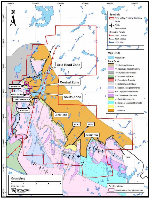
| | One hundred and twenty-nine samples were taken and all were approximately 0.35 m long. The old grab channel cuts in the vicinity of the new continuous channel were relabelled with metal tags. The new cuts were labelled by nailing a metal tag in an extra saw cut at the beginning of each sample. Sample descriptions were entered into a Microsoft Excel™ spreadsheet. The channel areas were mapped at a scale of 1:100 and extra care was taken to locate each old sample relative to each new sample for comparison purposes. The samples were delivered to SGS Canada Inc. (SGS) labs in Garson, Ontario on July 23, 2008 with a request for a 300 g pulp to be returned. Table 9.5 summarizes the significant results from the sampling program and Figure 9.3 provides the location of the sampling on the Property. |
Table 9.5 2008 Channel Sampling Dana Lake
| Area | 2008
Samples | Au
(ppb) | Pt
(ppb) | Pd
(ppb) | Pt+Pd+Au
(ppb) |
| Dana Lake | 08RZ001 | 121 | 470 | 1,540 | 2,131 |
| Road Zone | 08RZ002 | 102 | 600 | 1,860 | 2,562 |
| 08RZ003 | 116 | 790 | 2,340 | 3,246 |
| 08RZ004 | 151 | 730 | 2,470 | 3,351 |
| 08RZ005 | 146 | 470 | 1,400 | 2,016 |
| 08RZ009 | 127 | 610 | 1,990 | 2,727 |
| 08RZ013 | 146 | 790 | 2,720 | 3,656 |
| 08RZ014 | 130 | 820 | 2,320 | 3,270 |
| 08RZ015 | 130 | 780 | 2,170 | 3,080 |
| 08RZ016 | 156 | 660 | 2,070 | 2,886 |
| 08RZ018 | 139 | 820 | 2,910 | 3,869 |
| 08RZ019 | 257 | 1,270 | 4,080 | 5,607 |
| 08RZ020 | 200 | 720 | 2,520 | 3,440 |
| 08RZ021 | 244 | 1,440 | 5,030 | 6,714 |
| 08RZ022 | 171 | 750 | 2,380 | 3,301 |
| Dana Lake | 08SZ008 | 108 | 420 | 1,380 | 1,908 |
table continues…
Pacific North West Capital Corp.
Technical Report and Resource Estimate on the River Valley
PGM Project, Northern Ontario | 40 | 1193250100-REP-R0001-01 |
| Area | 2008
Samples | Au
(ppb) | Pt
(ppb) | Pd
(ppb) | Pt+Pd+Au
(ppb) |
| South Zone | 08SZ010 | 154 | 1,020 | 3,460 | 4,634 |
| 08SZ013 | 136 | 960 | 3,040 | 4,136 |
| 08SZ015 | 166 | 780 | 3,270 | 4,216 |
| 08SZ016 | 139 | 900 | 2,860 | 3,899 |
| 08SZ017 | 141 | 830 | 2,820 | 3,791 |
| 08SZ018 | 181 | 1,060 | 3,370 | 4,611 |
| 08SZ019 | 95 | 880 | 2,330 | 3,305 |
| 08SZ020 | 86 | 870 | 2,590 | 3,546 |
| 08SZ021 | 400 | 2,230 | 6,880 | 9,510 |
| 08SZ030 | 81 | 540 | 1,720 | 2,341 |
| 08SZ031 | 101 | 860 | 2,970 | 3,931 |
| Dana Lake | 08RZ039 | 68 | 480 | 1,520 | 2,068 |
| Road Zone | 08RZ040 | 123 | 940 | 2,870 | 3,933 |
| 08RZ041 | 117 | 740 | 2,440 | 3,297 |
| Dana Lake | 08SZ048 | 138 | 780 | 2,420 | 3,338 |
| South Zone | 08SZ049 | 173 | 1,540 | 4,370 | 6,083 |
| 08SZ050 | 135 | 740 | 2,580 | 3,455 |
| 08SZ051 | 186 | 1,150 | 3,830 | 5,166 |
| 08SZ054 | 89 | 690 | 2,210 | 2,989 |
| 08SZ055 | 109 | 510 | 1,870 | 2,489 |
| 08SZ058 | 134 | 960 | 2,680 | 3,774 |
| Dana Lake | 08CZ003 | 107 | 720 | 2,140 | 2,967 |
| Central Zone | 08CZ004 | 430 | 2,550 | 6,390 | 9,370 |
| 08CZ005 | 132 | 520 | 1,340 | 1,992 |
| 08CZ009 | 151 | 990 | 2,670 | 3,811 |
| 08CZ012 | 120 | 480 | 1,720 | 2,320 |
| 08CZ014 | 79 | 630 | 2,160 | 2,869 |
| 08CZ015 | 190 | 990 | 2,900 | 4,080 |
| 08CZ022 | 45 | 720 | 1,660 | 2,425 |
Pacific North West Capital Corp.
Technical Report and Resource Estimate on the River Valley
PGM Project, Northern Ontario | 41 | 1193250100-REP-R0001-01 |
Figure 9.3 2008 Channel Sample of Grid South, Grid Road, and Central Zone
Pacific North West Capital Corp.
Technical Report and Resource Estimate on the River Valley
PGM Project, Northern Ontario | 42 | 1193250100-REP-R0001-01 |
10.0 DRILLING
10.1 DIAMOND DRILLING PRIOR TO 2006
| | PFN has conducted diamond drilling on the Property since 2000. A summary of these activities conducted by PFN and/or their joint venture partners are summarized below in Table 10.1. |
Table 10.1 Diamond Drill Summary Prior to 2006
| Year | Company | Activities |
| 2000 | PFN/Amplats | • From February to March, Phase 1 drilling program included a total of 2,000 m of drilling in 13 holes with focus on the mineralization at the Dana Lake Area.
• From June to July, Phase 2 drill program entailed of total of 2,820.8 m of drilling in 14 holes with focus on the mineralization at the Dana Lake Area.
• In September, Phase 3 drill program consisted of 1,958.5 m in drilling in 10 drillholes at the Dana Lake Area and 3 holes at Lismer's ridge (13 holes total). |
| 2001 | PFN/Amplats | • From February to July Phase 4 drilling commenced; a total of 16,027 m drilled in 98 holes. |
| 2002 | PFN/Amplats | • From period of November to August, Phase V drilling resulted in a total of 83 holes with 22,319 assay samples from Lismer Ridge, Dana South, and Banshee Lake. |
| 2004 | PFN/Amplats | • From period November 2002 to May 2004, Phase VI drill program consisting of a total of 44,131 m of drilling from 208 holes at Dana Lake, Banshee Lake, Lismer Ridge, MacDonalds, Varley, Azen Creek, Razor, Jackson's flat, and Pardo. |
| 2005 | PFN/Amplats | • From period September to March Phase VII drilling consisted of 20,516.4 m of drilling in 103 holes with focus on Lismer Extension, Varley, Varley Extension/Azen, Pardo, Jackson's flat, and Casson. |
| 2005 | PFN/Amplats | • From period October to November, Phase VIII drill program consisted of 3,681.15 m drilled in 20 holes with focus on Spade Lake, Jackson's Flat South, Varley Extension/Azen Drop Zone, and Casson. |
| | The information summarized in the table has not been reviewed by Tetra Tech and had been sources from various internal company reports and press releases available from PFN’s website. |
| | The data from these diamond drill programs was validated against the original drill logs and assay certificates and were deemed to be suitable for the use in the resource estimate. |
Pacific North West Capital Corp.
Technical Report and Resource Estimate on the River Valley
PGM Project, Northern Ontario | 43 | 1193250100-REP-R0001-01 |
10.2 DIAMOND DRILLING
| | The 2011 drilling program carried out on the Property commenced on April 6, 2011 and was completed on January 13, 2012. |
| | Foraco Drilling Ltd., based out of North Bay, Ontario, was contracted to carry out the diamond drill program using a hydraulic VD 5000 diamond drill rig. A total of 46 holes were drilled during three phases of the program totalling 12,767 m of NQ sized core. Dip tests were taken approximately every 50 m with a FLEXIT and later a REFLEX tool. Holes varied in length from 75 to 690 m. |
| | This program was implemented over three stages with each stage having somewhat different but overlapping objectives. The diamond drill program was undertaken in the Dana area of the Property and completed between April 6 and mid-November 2011 (Table 10.2 and Figure 10.1). Main objectives were to: |
| | - improve the confidence of the resource estimates and grade calculations, as well as possibly improve on the existing computations
- test deeper lying portions of the contact for improved grades and widths.
|
Table 10.2 Drilling Collar
Drillhole
ID | Easting | Northing | Elevation
(m) | Azimuth
(°) | Dip
(°) | End-of-hole
(m) | Zone |
| DN001 | 555179 | 5172674 | 323.4 | 90 | -54 | 228 | Dana North |
| DN002 | 555179 | 5172674 | 323.5 | 90 | -45 | 255 | Dana North |
| DN003 | 555218 | 5172679 | 327.0 | 90 | -45 | 156 | Dana North |
| DN004 | 555250 | 5172673 | 331.7 | 90 | -45 | 102 | Dana North |
| DN005 | 555111 | 5172722 | 325.1 | 90 | -54 | 283 | Dana North |
| DN006 | 555110 | 5172722 | 325.3 | 90 | -45 | 234 | Dana North |
| DN007 | 555143 | 5172723 | 323.6 | 90 | -45 | 195 | Dana North |
| DN008 | 555197 | 5172725 | 323.5 | 90 | -45 | 132 | Dana North |
| DN009 | 555089 | 5172774 | 321.7 | 90 | -54 | 240 | Dana North |
| DN010 | 555090 | 5172774 | 321.6 | 90 | -45 | 261 | Dana North |
| DN011 | 555111 | 5172776 | 322.4 | 90 | -45 | 249 | Dana North |
| DN012 | 555147 | 5172781 | 322.4 | 90 | -45 | 216 | Dana North |
| DN013 | 555091 | 5172819 | 316.3 | 90 | -45 | 255 | Dana North |
| DN014 | 555446 | 5171793 | 301.0 | 45 | -60 | 444 | Dana North |
| DN015 | 555466 | 5171810 | 302.0 | 45 | -45 | 360 | Dana North |
| DN016 | 555466 | 5171810 | 302.0 | 90 | -60 | 366 | Dana North |
| DN017 | 555216 | 5172622 | 323.1 | 90 | -56 | 279 | Dana North |
| DN018 | 555217 | 5172622 | 323.3 | 90 | -45 | 252 | Dana North |
| DN019 | 555246 | 5172622 | 327.4 | 90 | -45 | 180 | Dana North |
| DN020 | 555285 | 5172622 | 326.0 | 45 | -45 | 141 | Dana North |
table continues…
Pacific North West Capital Corp.
Technical Report and Resource Estimate on the River Valley
PGM Project, Northern Ontario | 44 | 1193250100-REP-R0001-01 |
| | |
| Drillhole ID | Easting | Northing | Elevation
(m) | Azimuth
(°) | Dip
(°) | End-of-hole
(m) | Zone |
| DN021 | 555253 | 5172493 | 321.2 | 45 | -60 | 411 | Dana North |
| DN022 | 555254 | 5172493 | 321.0 | 45 | -51 | 330 | Dana North |
| DN023 | 555282 | 5172519 | 317.6 | 45 | -45 | 171 | Dana North |
| DN024 | 555307 | 5172543 | 311.3 | 45 | -45 | 144 | Dana North |
| DN025 | 555319 | 5172538 | 311.0 | 45 | -45 | 138 | Dana North |
| DN026 | 555319 | 5172485 | 308.9 | 45 | -63 | 249 | Dana North |
| DN027 | 555319 | 5172486 | 308.9 | 45 | -45 | 192 | Dana North |
| DN028 | 555337 | 5172504 | 309.3 | 45 | -45 | 141 | Dana North |
| DN029 | 555362.7 | 5172528 | 314.1 | 45 | -45 | 99 | Dana North |
| DN030 | 555395.5 | 5172533 | 321.5 | 45 | -45 | 75 | Dana North |
| DN031 | 555413.1 | 5172503 | 318.5 | 45 | -40 | 70 | Dana North |
| DN032 | 555238.2 | 5172460 | 318.3 | 45 | -59 | 543 | Dana North |
| DN033 | 555238.7 | 5172460 | 318.3 | 90 | -45 | 402 | Dana North |
| DN034 | 555125.5 | 5172826 | 319.9 | 90 | -45 | 318 | Dana North |
| DN035 | 555158.4 | 5172826 | 321.7 | 90 | -45 | 315 | Dana North |
| DN036 | 555187.1 | 5172828 | 321.5 | 90 | -45 | 210 | Dana North |
| DN037 | 555098.3 | 5172871 | 317.3 | 90 | -45 | 207 | Dana North |
| DN038 | 555135.7 | 5172873 | 318.4 | 90 | -45 | 272 | Dana North |
| DN039 | 555163.3 | 5172870 | 318.1 | 90 | -45 | 258 | Dana North |
| DN040 | 555096.3 | 5172892 | 314.2 | 90 | -45 | 214 | Dana North |
| DS001 | 555415 | 5171800 | 301.7 | 45 | -59 | 690 | Dana South |
| DS002 | 555416 | 5171802 | 301.3 | 45 | -47 | 390 | Dana South |
| DS003 | 555455 | 5171709 | 287.5 | 45 | -53 | 528 | Dana South |
| DS004 | 555497 | 5171701 | 296.8 | 45 | -45 | 469 | Dana South |
| DS005 | 555272 | 5172002 | 310.3 | 90 | -60 | 639 | Dana South |
| DS006 | 555515 | 5171581 | 308.5 | 90 | -52 | 466 | Dana South |
Pacific North West Capital Corp.
Technical Report and Resource Estimate on the River Valley
PGM Project, Northern Ontario | 45 | 1193250100-REP-R0001-01 |
Figure 10.1 Drill Collar Locations

10.2.1 DRILL RESULTS
| | Drilling continued to establish continuity between previously-identified mineralized intercepts on the deposit. At shallow to moderate depths, drilling encountered moderate-to high-grade gold mineralization in most of the holes drilled. Low-grade gold mineralization ranging 0.5 to 1.5 g/t was encountered over wide intersections in many of the holes ranging 8 to 25 m in length. In some holes, multiple wide low- grade zones were cored (Table 10.3). Figure 10.2 to Figure 10.5 are examples of some to the diamond drill results completed during the 2011 drill program. |
Pacific North West Capital Corp.
Technical Report and Resource Estimate on the River Valley
PGM Project, Northern Ontario | 46 | 1193250100-REP-R0001-01 |
Table 10.3 2011 Significant Diamond Drill Results
| Hole No. | From
(m) | To
(m) | Core
Length
of the
Intersect
(m) | Pt
(g/t) | Pd
(g/t) | Au
(g/t) | Rh
(g/t) | Pt+Pd +Au
(g/t) | Ni
(%) | Cu
(%) | Zone |
| DN001-2011 | 123 | 173 | 50 | 0.26 | 0.77 | 0.05 | - | 1.10 | 0.02 | 0.09 | Dana
North |
| Including | 123 | 134 | 11 | 0.37 | 1.11 | 0.07 | - | 1.55 | 0.02 | 0.09 |
| Including | 141 | 153 | 12 | 0.31 | 0.90 | 0.05 | - | 1.26 | 0.02 | 0.11 |
| Including | 159 | 173 | 13 | 0.28 | 0.83 | 0.06 | - | 1.18 | 0.03 | 0.12 |
| DN002-2011 | 114 | 179 | 65 | 0.32 | 0.95 | 0.06 | - | 1.30 | 0.02 | 0.10 | Dana
North |
| Including | 146 | 158 | 12 | 0.43 | 1.30 | 0.08 | - | 1.82 | 0.03 | 0.14 |
| Including | 173 | 179 | 6 | 0.74 | 2.34 | 0.12 | - | 3.20 | 0.02 | 0.12 |
| DN003-2011 | 50 | 115 | 65 | 0.42 | 1.29 | 0.08 | - | 1.80 | 0.03 | 0.13 | Dana
North |
| Including | 50 | 59 | 9 | 0.98 | 3.09 | 0.18 | - | 4.25 | 0.03 | 0.22 |
| Including | 72 | 84 | 12 | 0.59 | 1.76 | 0.11 | - | 2.47 | 0.04 | 0.16 |
| DN004-2011 | 29 | 63 | 34 | 0.66 | 2.00 | 0.12 | - | 2.80 | 0.03 | 0.16 | Dana
North |
| Including | 29 | 40 | 11 | 1.12 | 3.40 | 0.18 | - | 4.71 | 0.04 | 0.24 |
| Including | 43 | 47 | 4 | 0.69 | 2.06 | 0.11 | - | 2.86 | 0.03 | 0.16 |
| DN005-2011 | 201 | 209 | 8 | 0.44 | 1.04 | 0.07 | - | 1.55 | 0.02 | 0.12 | Dana
North |
| And | 250 | 256 | 6 | 0.41 | 1.11 | 0.07 | - | 1.60 | 0.03 | 0.14 |
| Including | 253 | 255 | 2 | 0.6 | 1.62 | 0.09 | - | 2.31 | 0.04 | 0.18 |
| DN006-2011 | 131 | 155 | 24 | 0.58 | 1.44 | 0.13 | - | 2.15 | 0.02 | 0.14 | Dana
North |
| Including | 131 | 137 | 6 | 0.92 | 2.30 | 0.19 | - | 3.41 | 0.02 | 0.13 |
| Including | 145 | 155 | 10 | 0.60 | 1.50 | 0.12 | | 2.22 | 0.03 | 0.17 |
| DN007-2011 | 33 | 79 | 46 | 0.46 | 1.10 | 0.08 | - | 1.65 | 0.02 | 0.11 | Dana
North |
| Including | 33 | 56 | 23 | 0.58 | 1.29 | 0.08 | - | 1.95 | 0.02 | 0.08 |
| Including | 60 | 62 | 2 | 0.65 | 1.53 | 0.18 | - | 2.36 | 0.03 | 0.28 |
| Including | 76 | 79 | 3 | 0.46 | 1.41 | 0.10 | - | 1.97 | 0.03 | 0.18 |
| DN008-2011 | 6 | 14 | 8 | 0.76 | 2.38 | 0.13 | - | 3.28 | 0.02 | 0.15 | Dana
North |
| Including | 9 | 14 | 5 | 1.03 | 3.24 | 0.18 | - | 4.45 | 0.03 | 0.18 |
| DN009 | 91 | 94 | 3 | 0.40 | 0.99 | 0.01 | 0.04 | 1.40 | 0.01 | 0.01 | Dana
North |
| DN010 | 223 | 241 | 18 | 0.35 | 1.18 | 0.06 | 0.03 | 1.59 | 0.03 | 0.10 | Dana
North |
| Including | 223 | 228 | 5 | 0.49 | 1.61 | 0.06 | 0.03 | 2.16 | 0.04 | 0.12 |
| And | 233 | 239 | 6 | 0.40 | 1.40 | 0.07 | 0.03 | 1.87 | 0.04 | 0.10 |
| Including | 233 | 235 | 2 | 0.64 | 2.38 | 0.12 | 0.03 | 3.14 | 0.04 | 0.15 |
table continues…
Pacific North West Capital Corp.
Technical Report and Resource Estimate on the River Valley
PGM Project, Northern Ontario | 47 | 1193250100-REP-R0001-01 |
| | |
| Hole No. | From
(m) | To
(m) | Core
Length
of the
Intersect
(m) | Pt
(g/t) | Pd
(g/t) | Au
(g/t) | Rh
(g/t) | Pt+Pd +Au
(g/t) | Ni
(%) | Cu
(%) | Zone |
| DN011 | 52 | 56 | 4 | 0.75 | 0.83 | 0.01 | 0.42 | 1.59 | 0.00 | 0.01 | Dana
North |
| And | 72 | 86 | 14 | 0.55 | 1.70 | 0.12 | 0.34 | 2.38 | 0.02 | 0.13 |
| Including | 72 | 76 | 4 | 0.97 | 2.93 | 0.18 | 0.95 | 4.09 | 0.02 | 0.12 |
| And | 134 | 187 | 53 | 0.83 | 2.52 | 0.15 | 3.34 | 3.50 | 0.03 | 0.18 |
| Including | 143 | 156 | 13 | 0.90 | 2.83 | 0.16 | 1.99 | 3.89 | 0.03 | 0.17 |
| Including | 171 | 182 | 11 | 1.82 | 5.83 | 0.35 | 1.32 | 8.00 | 0.07 | 0.38 |
| And | 223 | 231 | 8 | 0.39 | 1.26 | 0.07 | 0.45 | 1.72 | 0.04 | 0.12 |
| Including | 223 | 226 | 3 | 0.65 | 2.15 | 0.11 | 0.52 | 2.91 | 0.06 | 0.19 |
| DN012 | 38 | 65 | 27 | 0.49 | 1.58 | 0.08 | 0.06 | 2.16 | 0.02 | 0.12 | Dana
North |
| Including | 44 | 51 | 7 | 1.12 | 3.77 | 0.15 | 0.14 | 5.04 | 0.04 | 0.19 |
| And | 132 | 140 | 8 | 0.33 | 1.06 | 0.07 | 0.04 | 1.45 | 0.02 | 0.11 |
| DN013 | 172 | 174 | 2 | 0.47 | 1.55 | 0.04 | 2.05 | 2.06 | 0.02 | 0.13 | Dana
North |
| DN014 | 366 | 396 | 30 | 0.59 | 1.91 | 0.10 | 0.001 | 2.60 | 0.03 | 0.16 | Dana
North |
| Including | 366 | 368 | 2 | 1.50 | 4.78 | 0.17 | 0.001 | 6.44 | 0.05 | 0.26 |
| Including | 378 | 380 | 2 | 0.89 | 3.04 | 0.16 | 0.001 | 4.08 | 0.03 | 0.24 |
| DN015 | 254 | 261 | 7 | 0.92 | 2.38 | 0.10 | 0.001 | 3.39 | 0.02 | 0.12 | Dana
North |
| Including | 255 | 257 | 2 | 0.95 | 3.00 | 0.11 | 0.001 | 4.05 | 0.02 | 0.10 |
| Including | 258 | 261 | 3 | 1.00 | 2.92 | 0.14 | 0.001 | 4.06 | 0.03 | 0.19 |
| DN016-2011 | 294 | 303 | 9 | 0.99 | 3.20 | 0.13 | 0.012 | 4.32 | 0.02 | 0.16 | Dana
North |
| Including | 294 | 298 | 4 | 1.58 | 5.44 | 0.19 | 0.021 | 7.21 | 0.04 | 0.27 |
| And | 328 | 334 | 6 | 1.05 | 2.86 | 0.13 | 0.010 | 4.04 | 0.05 | 0.21 |
| DN017-2011 | 144 | 171 | 27 | 0.69 | 1.99 | 0.12 | 0.007 | 2.80 | 0.02 | 0.12 | Dana
North |
| Including | 150 | 162 | 12 | 0.91 | 2.57 | 0.14 | 0.009 | 3.62 | 0.04 | 0.20 |
| DN018-2011 | 132 | 151 | 19 | 0.50 | 1.56 | 0.09 | 0.005 | 2.15 | 0.03 | 0.13 | Dana
North |
| Including | 135 | 140 | 5 | 0.79 | 2.50 | 0.14 | 0.008 | 3.43 | 0.04 | 0.19 |
table continues…
Pacific North West Capital Corp.
Technical Report and Resource Estimate on the River Valley
PGM Project, Northern Ontario | 48 | 1193250100-REP-R0001-01 |
| | |
| Hole No. | From
(m) | To
(m) | Core
Length
of the
Intersect
(m) | Pt
(g/t) | Pd
(g/t) | Au
(g/t) | Rh
(g/t) | Pt+Pd +Au
(g/t) | Ni
(%) | Cu
(%) | Zone |
| DN019-2011 | 103 | 116 | 13 | 0.41 | 1.24 | 0.07 | 0.004 | 1.72 | 0.03 | 0.12 | Dana
North |
| Including | 105 | 109 | 4 | 0.41 | 1.27 | 0.08 | 0.003 | 1.76 | 0.02 | 0.11 |
| And | 129 | 137 | 8 | 0.30 | 0.90 | 0.04 | 0.002 | 1.24 | 0.02 | 0.07 |
| Including | 129 | 131 | 2 | 0.49 | 1.53 | 0.08 | 0.004 | 2.10 | 0.03 | 0.16 |
| DN020-2011 | 44 | 54 | 10 | 0.31 | 0.98 | 0.06 | 0.003 | 1.35 | 0.02 | 0.12 | Dana
North |
| Including | 51 | 53 | 2 | 0.46 | 1.50 | 0.07 | 0.005 | 2.03 | 0.02 | 0.13 |
| DN021-2011 | 214 | 249 | 35 | 0.58 | 1.77 | 0.12 | 0.006 | 2.47 | 0.02 | 0.15 | Dana
North |
| Including | 216 | 222 | 6 | 1.13 | 3.71 | 0.22 | 0.015 | 5.06 | 0.04 | 0.24 |
| Including | 226 | 231 | 5 | 0.72 | 2.25 | 0.16 | 0.007 | 3.12 | 0.03 | 0.20 |
| And | 304 | 323 | 19 | 0.47 | 1.45 | 0.09 | 0.004 | 2.01 | 0.04 | 0.17 |
| And | 331 | 339 | 8 | 0.59 | 1.72 | 0.08 | 0.006 | 2.39 | 0.04 | 0.19 |
| DN022-2011 | 214 | 249 | 35 | 0.42 | 1.27 | 0.88 | 0.004 | 2.57 | 0.03 | 0.13 | Dana
North |
| Including | 199 | 203 | 4 | 0.67 | 2.36 | 0.17 | 0.006 | 3.20 | 0.04 | 0.21 |
| Including | 208 | 218 | 10 | 0.64 | 1.96 | 0.12 | 0.006 | 2.71 | 0.04 | 0.17 |
| DN023-2011 | 68 | 110 | 42 | 0.53 | 1.65 | 1.00 | 0.005 | 3.18 | 0.02 | 0.13 | Dana
North |
| Including | 88 | 99 | 11 | 0.75 | 2.54 | 0.14 | 0.008 | 3.43 | 0.04 | 0.19 | |
| DN024-2011 | 25 | 37 | 12 | 0.68 | 2.08 | 0.12 | 0.007 | 2.88 | 0.03 | 0.16 | Dana
North |
| Including | 25 | 31 | 6 | 0.93 | 2.90 | 0.15 | 0.009 | 3.97 | 0.03 | 0.18 |
| And | 41 | 56 | 15 | 0.41 | 1.29 | 0.06 | 0.004 | 1.76 | 0.02 | 0.10 |
| Including | 47 | 50 | 3 | 0.71 | 1.98 | 0.08 | 0.006 | 2.77 | 0.04 | 0.14 |
| And | 61 | 72 | 11 | 0.41 | 1.41 | 0.08 | 0.004 | 1.90 | 0.03 | 0.15 |
| Including | 67 | 70 | 3 | 0.39 | 1.36 | 0.08 | 0.005 | 1.83 | 0.03 | 0.16 |
| DN025-2011 | 28 | 38 | 10 | 0.56 | 1.59 | 0.08 | 0.005 | 2.23 | 0.03 | 0.12 | Dana
North |
| Including | 30 | 33 | 3 | 1.10 | 2.78 | 0.13 | 0.009 | 4.01 | 0.03 | 0.15 |
| DN026-2011 | 99 | 112 | 13 | 0.40 | 1.40 | 0.08 | 0.004 | 1.88 | 0.02 | 0.14 | Dana
North |
| Including | 104 | 109 | 5 | 0.50 | 1.60 | 0.09 | 0.004 | 2.19 | 0.02 | 0.19 |
| And | 195 | 198 | 3 | 0.50 | 1.50 | 0.05 | 0.004 | 2.05 | 0.02 | 0.10 |
| DN027-2011 | 73 | 81 | 8 | 0.40 | 1.10 | 0.03 | 0.004 | 1.53 | 0.01 | 0.06 | Dana
North |
| Including | 73 | 76 | 3 | 0.70 | 2.00 | 0.06 | 0.007 | 2.76 | 0.02 | 0.09 |
| DN029-2011 | 22 | 32 | 10 | 1.00 | 3.30 | 0.20 | 0.011 | 4.50 | 0.07 | 0.28 | Dana
North |
| Including | 23 | 24 | 1 | 2.20 | 7.00 | 0.20 | 0.023 | 9.40 | 0.12 | 0.46 |
| Including | 24 | 32 | 8 | 0.90 | 2.70 | 0.20 | 0.009 | 3.80 | 0.06 | 0.27 |
| DN030-2011 | 3.5 | 18 | 14.5 | 0.70 | 2.10 | 0.10 | 0.008 | 2.90 | 0.04 | 0.17 | Dana
North |
| Including | 6 | 12 | 6 | 1.01 | 3.23 | 0.15 | 0.012 | 4.39 | 0.04 | 0.20 |
| DN032-2011 | 306 | 320 | 14 | 0.41 | 1.19 | 0.06 | 0.004 | 1.66 | 0.02 | 0.08 | Dana
North |
| Including | 312 | 314 | 2 | 0.76 | 2.56 | 0.08 | 0.008 | 3.40 | 0.02 | 0.08 |
| And | 325 | 358 | 33 | 0.48 | 1.54 | 0.09 | 0.004 | 2.11 | 0.02 | 0.12 |
| Including | 332 | 339 | 7 | 1.17 | 3.82 | 0.18 | 0.011 | 5.17 | 0.04 | 0.21 |
table continues…
Pacific North West Capital Corp.
Technical Report and Resource Estimate on the River Valley
PGM Project, Northern Ontario | 49 | 1193250100-REP-R0001-01 |
| | |
| Hole No. | From
(m) | To
(m) | Core
Length
of the
Intersect
(m) | Pt
(g/t) | Pd
(g/t) | Au
(g/t) | Rh
(g/t) | Pt+Pd +Au
(g/t) | Ni
(%) | Cu
(%) | Zone |
| DN033-2011 | 256 | 310 | 54 | 0.51 | 1.48 | 0.09 | 0.005 | 2.08 | 0.03 | 0.14 | Dana
North |
| Including | 262 | 274 | 12 | 0.83 | 2.37 | 0.15 | 0.009 | 3.35 | 0.05 | 0.24 |
| Including | 291 | 295 | 4 | 0.59 | 1.81 | 0.11 | 0.006 | 2.51 | 0.03 | 0.16 |
| Including | 306 | 309 | 3 | 0.93 | 2.83 | 0.13 | 0.011 | 3.89 | 0.02 | 0.15 |
| DN034-2011 | 5 | 15 | 10 | 0.59 | 1.42 | 0.10 | - | 2.11 | 0.03 | 0.13 | Dana
North |
| Including | 7 | 10 | 3 | 0.72 | 1.99 | 0.13 | - | 2.84 | 0.03 | 0.16 |
| And | 67 | 71 | 4 | 1.00 | 2.87 | 0.18 | - | 4.05 | 0.03 | 0.17 |
| And | 219 | 239 | 20 | 0.63 | 2.03 | 0.11 | - | 2.77 | 0.05 | 0.20 |
| Including | 229 | 233 | 4 | 1.26 | 4.22 | 0.24 | - | 5.72 | 0.08 | 0.38 |
| And | 281 | 297 | 16 | 0.51 | 1.47 | 0.08 | - | 2.06 | 0.03 | 0.15 |
| Including | 282 | 287 | 5 | 0.82 | 2.51 | 0.12 | - | 3.45 | 0.04 | 0.19 |
| DN035-2011 | 74 | 115 | 41 | 0.41 | 1.33 | 0.07 | - | 1.81 | 0.03 | 0.15 | Dana
North |
| Including | 90 | 102 | 12 | 0.67 | 2.20 | 0.12 | - | 2.99 | 0.47 | 0.22 |
| And | 209 | 223 | 14 | 0.75 | 2.25 | 0.11 | - | 3.11 | 0.03 | 0.16 |
| And | 249 | 269 | 20 | 0.37 | 1.11 | 0.06 | - | 1.54 | 0.03 | 0.12 |
| Including | 249 | 250 | 1 | 1.45 | 4.78 | 0.19 | - | 6.42 | 0.06 | 0.26 |
| DN038-2011 | 171 | 198 | 27 | 0.42 | 1.37 | 0.08 | - | 1.87 | 0.03 | 0.13 | Dana
North |
| Including | 171 | 175 | 4 | 0.64 | 2.20 | 0.11 | - | 2.95 | 0.03 | 0.17 |
| DS001-2011 | 368 | 401 | 33 | 0.51 | 1.53 | 0.06 | - | 2.10 | 0.02 | 0.09 | Dana
South |
| Including | 368 | 373 | 5 | 0.98 | 3.37 | 0.12 | - | 4.47 | 0.03 | 0.15 |
| Including | 377 | 382 | 5 | 1.32 | 3.53 | 0.13 | - | 4.98 | 0.03 | 0.16 |
| Including | 380 | 381 | 1 | 3.73 | 11.30 | 0.37 | - | 15.4 | 0.08 | 0.40 |
| And | 492 | 498 | 6 | 0.45 | 1.45 | 0.08 | - | 1.98 | 0.03 | 0.14 |
| DS003-2011 | 400 | 420 | 20 | 0.53 | 1.84 | 0.08 | - | 2.45 | 0.03 | 0.22 | Dana
South |
| Including | 409 | 419 | 10 | 0.82 | 2.99 | 0.13 | - | 3.94 | 0.05 | 0.36 |
| And | 446 | 461 | 15 | 0.64 | 2.19 | 0.11 | - | 2.94 | 0.04 | 0.22 |
| Including | 453 | 458 | 5 | 0.93 | 3.20 | 0.18 | - | 4.31 | 0.05 | 0.31 |
| DS004-2011 | 334 | 365 | 31 | 0.48 | 1.41 | 0.09 | 0.005 | 1.98 | 0.02 | 0.12 | Dana
South |
| Including | 336 | 339 | 3 | 0.98 | 2.97 | 0.16 | 0.009 | 4.11 | 0.02 | 0.13 |
Pacific North West Capital Corp.
Technical Report and Resource Estimate on the River Valley
PGM Project, Northern Ontario | 50 | 1193250100-REP-R0001-01 |
Figure 10.2 17-20 Cross-section
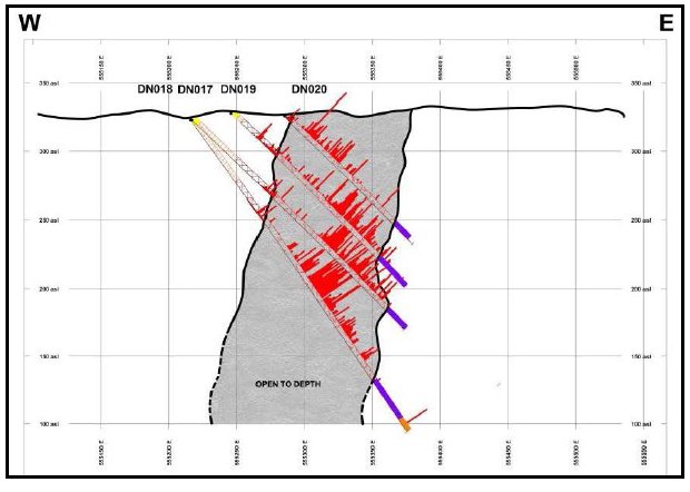
Figure 10.3 26-29 Cross-section – F
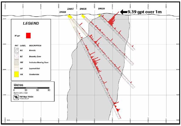
Pacific North West Capital Corp.
Technical Report and Resource Estimate on the River Valley
PGM Project, Northern Ontario | 51 | 1193250100-REP-R0001-01 |
Figure 10.4 DS1 and 2 Cross-sections
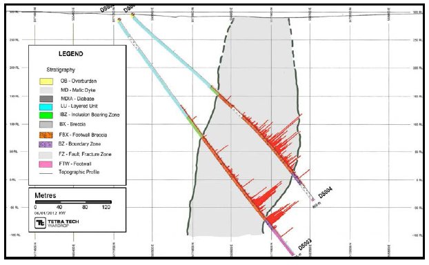
Figure 10.5 DS3 and 4 Cross-sections
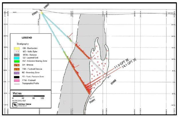
Pacific North West Capital Corp.
Technical Report and Resource Estimate on the River Valley
PGM Project, Northern Ontario | 52 | 1193250100-REP-R0001-01 |
11.0 SAMPLE PREPARATION, ANALYSES, AND SECURITY
11.1 CORE LOGGING AND SAMPLING PROCEDURES
| | Core logging and sampling were complete on a property located in the village of River Valley and rented by PFN. The sampling procedure consisted of the following: |
| | - Diamond drill core was delivered to the core logging facility on a daily basis
- The sections of core to be sampled were delimited with a grease pencil.
- The core was photographed and racked for sampling.
- The core was split using a diamond saw by a technician. Half the core was sent out for assay, the other half kept for reference.
- Sampling was done by a technician. Each sample was placed in a plastic bag with appropriately numbered tag corresponding to a sampling interval also placed in the bag. That same number was also printed on the outside of the bag as a cross check. The samples were then put in rice bags and shipped to SGS sample preparation facilities in Sudbury, Ontario.
- One standard and one blank were inserted into the sample stream every 40 samples.
- As an additional QA/QC procedure a second split was prepared from the pulp by the primary lab, at a 20-sample interval.
- The remaining half of the core was stored in a tagged core box indicating hole and box numbers as well as downhole metreage. The entire core from this phase of drilling is stored temporarily at the River Valley rental property.
- At some point it will have to transported and laid down in PFN’s core storage yard in River Valley (Figure 11.1).
|
Pacific North West Capital Corp.
Technical Report and Resource Estimate on the River Valley
PGM Project, Northern Ontario | 52 | 1193250100-REP-R0001-01 |
Figure 11.1 Core Storage Facility

11.2 SAMPLE PREPARATION
| | When sufficient samples have been accumulated, all samples, including standards and blanks, are put into rice bags and shipped to the SGS sample preparation facilities in Sudbury, Ontario. SGS has geochemical accreditation that conforms to the requirements of CAN-P-1559 and CAN-P-4E (International Organization for Standardization (ISO) 17025:2005). |
| | The following is a brief description of the sample preparations carried out on the samples submitted (prep code CRU25 and PUL45): |
| | - Samples are sorted and dried.
- Once dried, less than 3.0 kg of the sample is crushed to a 90% passing at 2 mm.
- The sample is split to get a 250 g sample for pulverizing.
- Two hundred and fifty grams of the crushed sample is then pulverized with chromium steel to allow 85% passing of 75 µm.
|
Pacific North West Capital Corp.
Technical Report and Resource Estimate on the River Valley
PGM Project, Northern Ontario | 54 | 1193250100-REP-R0001-01 |
11.3 SAMPLES ANALYSES
| | All samples were assayed for platinum, palladium, gold, copper and nickel and a 33 element inductively coupled plasma (ICP) suite. Concentrations of platinum, palladium, and gold were determined using standard lead fire assay (FAI313), followed by dissolution with aqua-regia, and measurement with an ICP finish. Lower and upper limits of each element are listed below within a 30 g sample (SGS 2012): |
| | - gold 1 ppb – 10,000 ppb
- platinum 10 ppb – 10,000 ppb
- palladium 1 ppb – 10,000 ppb.
|
| | Remaining elements were determined using ICP methods using a two-acid digest (a combination consisting of nitric acid and hydrochloric acid). Once the material is digested the solution is analyzed by inductively coupled plasma-atomic emission spectroscopy (ICP-AES). Two-acid digestion methods are the weakest of the digestions and silicate material is not affected, resulting in partial results for most elements (SGS 2012). |
| | The ICP14B method used is an aqua regia digest and is recommended for all samples which contain no organic material and are low in sulphide content. The combination is based on a 3:1 ratio of hydrochloric acid to nitric acid (SGS 2012). |
| | Concentrations of copper-nickel were determined by ICP methods with detection limit of 0.5 ppm for copper and 1 ppm for nickel; the upper limit for both copper and nickel is 1%. |
| | At no time was a PFN employee or designate of PFN involved in the preparation or analysis of the samples. |
11.4 QA/QC PROGRAM
| | PFN continues to maintain a QA/QC program that has been in place since 2002. The program is summarized below. |
| | Bulk material from the Property was collected for the purpose of creating internal standards that could be submitted in the sample stream as a quality control measure. Three standards were created: |
| | - a low-grade (approximately 500 ppb platinum-palladium-gold)
- a mid-grade (approximately 900 ppb platinum-palladium-gold
- a high-grade (approximately 2,000 ppb platinum-palladium-gold) sample.
|
| | In addition to the pulp blank, a coarse blank is submitted for every 20 samples to test sample preparation and for contamination. |
Pacific North West Capital Corp.
Technical Report and Resource Estimate on the River Valley
PGM Project, Northern Ontario | 55 | 1193250100-REP-R0001-01 |
| | One standard and one blank were inserted every 40 samples into the sample stream. These standards were manufactured from River Valley material using carefully chosen sections of PFN’s drill core. The standards were prepared for use prior to drilling. Five samples of each standard were sent to five separate accredited laboratories for a round robin analysis. The mean value for each standard was the determined to be the mean value between the five laboratories. |
| | The geologist would mark on the core where and what type of reference material was to be inserted. The insertion of the material into the sample steam was completed by a technician. |
| | As an additional QA/QC procedure, a second split was prepared from the pulp by the primary lab at a 20-sample interval. This split was sent to a second lab (Activation Laboratories Ltd. (Actlabs)) where a check assay was done. |
11.4.1 2011 RV-1 QA/QC RESULTS
| | RV-1 was the high-grade standard with expected values of 86.1 ppb gold, 486 ppb platinum and 1,525 ppb palladium (Figure 11.2 to Figure 11.4. |
| | There are periodic failures plotted on all three elements on the process performance chart. A one-time failure is not of concern. The moving range chart shows that there is not a lot of precision with the samples, as this measures the repeatability of the sample. |
Figure 11.2 RV-1 Gold Chart
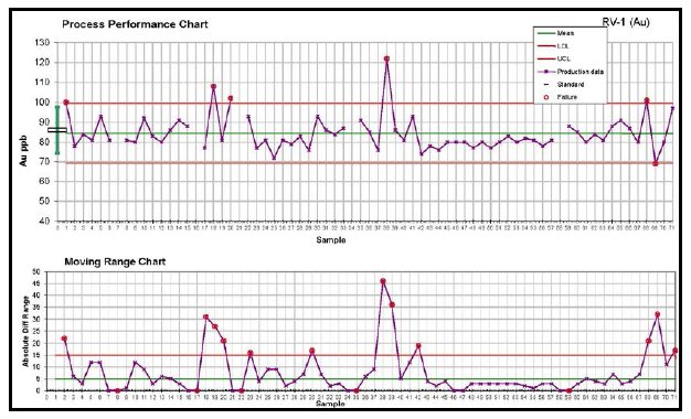
Pacific North West Capital Corp.
Technical Report and Resource Estimate on the River Valley
PGM Project, Northern Ontario | 56 | 1193250100-REP-R0001-01 |
Figure 11.3 RV-1 Platinum Chart

Figure 11.4 RV-1 Palladium Chart
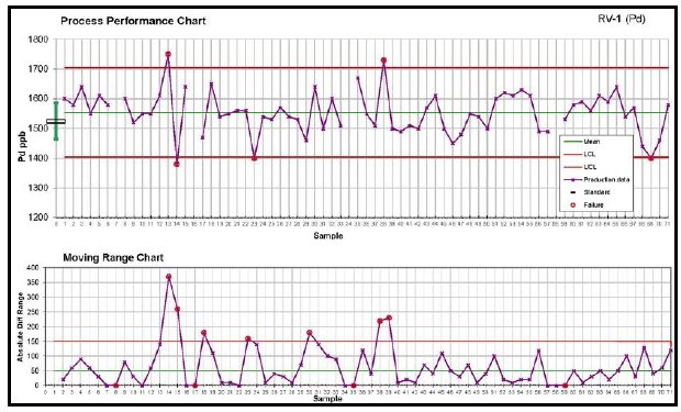
11.4.2 2011 RV-2 QA/QC RESULTS
| | RV-2 was the mid-grade standard with expected values of 53.7 ppb gold, 246 ppb platinum and 644 ppb palladium (Figure 11.5 to Figure 11.7). |
Pacific North West Capital Corp.
Technical Report and Resource Estimate on the River Valley
PGM Project, Northern Ontario | 57 | 1193250100-REP-R0001-01 |
| | All three charts display failures at the beginning of the program, which is typical. After about the 13th standard, the laboratory was able to get the system under control. |
Figure 11.5 RV-2 Gold Chart
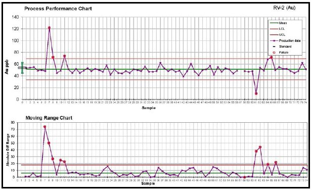
Figure 11.6 RV-2 Platinum Chart

Pacific North West Capital Corp.
Technical Report and Resource Estimate on the River Valley
PGM Project, Northern Ontario | 58 | 1193250100-REP-R0001-01 |
Figure 11.7 RV-2 Palladium Chart
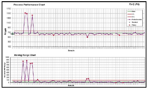
11.4.3 2011 RV-3 QA/QC RESULTS
| | RV-3 was the low-grade standard with expected values of 16.2 ppb gold, 160 ppb platinum and 327 ppb palladium (Figure 11.8 to Figure 11.10). |
| | All three charts display minimal failures during the program, but display a large variation between samples. This can be typical with low-grade samples. |
Pacific North West Capital Corp.
Technical Report and Resource Estimate on the River Valley
PGM Project, Northern Ontario | 59 | 1193250100-REP-R0001-01 |
Figure 11.8 RV-3 Gold Chart
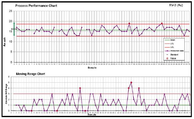
Figure 11.9 RV-3 Platinum Chart
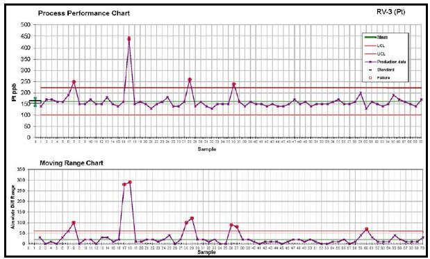
Pacific North West Capital Corp.
Technical Report and Resource Estimate on the River Valley
PGM Project, Northern Ontario | 60 | 1193250100-REP-R0001-01 |
Figure 11.10 RV-3 Palladium Chart
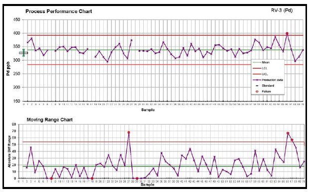
11.4.4 2011 BLANK QA/QC RESULTS
| | The gold and platinum blanks show minimal contamination. The palladium chart technically displays a significant number of failures. Over the course of the program, the frequency of the failures decreases, and this would indicate that there may be a process change at the laboratory. The end result is that at such a low detection limit it is expected to detect sample contamination in an environment with potentially mineable material (Figure 11.11 to Figure 11.13). |
| | Of the 214 samples submitted, the mean grade is 2.39 ppb palladium, with the highest value of 38 ppb. It is felt that although there is an apparent high failure rate, the issue is likely due the detection limit of palladium being used is for greenfields exploration and not for deposit delineation. Having the detection limit so low at 3 ppb palladium will inherently induce failures when used in an environment with the average palladium grade of the sample data base is 0.4 ppm (400 ppb). |
Pacific North West Capital Corp.
Technical Report and Resource Estimate on the River Valley
PGM Project, Northern Ontario | 61 | 1193250100-REP-R0001-01 |
Figure 11.11 Gold Blank Chart
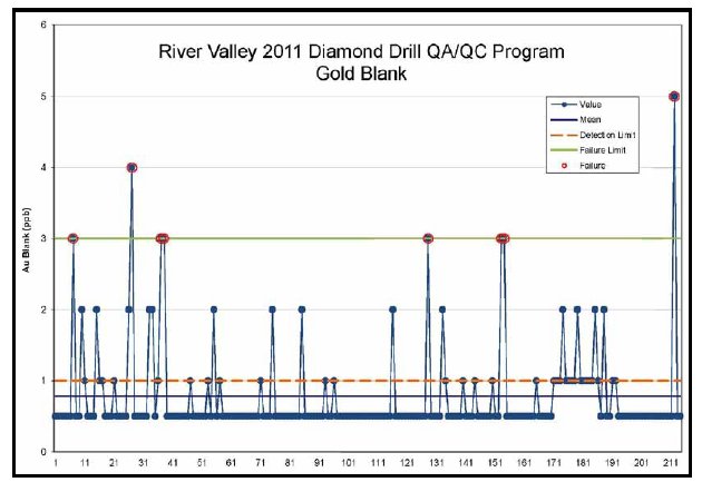
Figure 11.12 Platinum Blank Chart
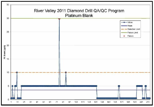
Pacific North West Capital Corp.
Technical Report and Resource Estimate on the River Valley
PGM Project, Northern Ontario | 62 | 1193250100-REP-R0001-01 |
Figure 11.13 Palladium Blank Chart

| | It is Tetra Tech’s opinion that the sample preparation, analytical procedures and QA/QC program meet industry standards and supports the resource estimation. |
Pacific North West Capital Corp.
Technical Report and Resource Estimate on the River Valley
PGM Project, Northern Ontario | 63 | 1193250100-REP-R0001-01 |
12.0 DATA VERIFICATION
| | Tetra Tech carried out an internal validation of the diamond drillhole data files against the original drillhole logs and assay certificates. The validation of the data files was completed on 60 of the 596 drillholes in the total database or 10% of the dataset. |
| | Data verification was completed on collar coordinates, end-of-hole depth, downhole survey measurements, from and to intervals, assay sample intervals, and analytical results. No errors were identified in the collar, survey, or lithology files. |
| | The assay file contained several drillhole entries where the assays for copper were in the nickel field, and the assays for zinc were in the copper field. This represents less than 0.1% errors within the entire assay dataset. Corrections were made to the data set. Table 12.1 summarizes the validation on the data set. All assays entered as zeros were converted to half the detection limit and were not considered to be errors in the data. |
Table 12.1 Database Validation Summary
| | Description | Value |
| Header | Number of Records | 596 |
| Number of Records Validated | 60 |
| Validation Rate | 10.1% |
| X Coordinate Error Rate | 0.0% |
| Y Coordinate Error Rate | 0.0% |
| Z Coordinate Error Rate | 0.0% |
| Hole Length Error Rate | 0.0% |
| Survey | Number of Records | 2584 |
| Number of Records Validated | 266 |
| Validation Rate | 10.3% |
| Distance Error Rate | 0.0% |
| Azimuth Error Rate | 0.0% |
| Dip Error Rate | 0.0% |
| Litho | Number of Records | 3,731 |
| Number of Records Validated | 159 |
| Validation Rate | 4.3% |
| From Error Rate | 0.0% |
| To Error Rate | 0.0% |
| Rockcode Error Rate | 0.0% |
table continues…
Pacific North West Capital Corp.
Technical Report and Resource Estimate on the River Valley
PGM Project, Northern Ontario | 64 | 1193250100-REP-R0001-01 |
| | Description | Value |
| Assay | Number of Records | 106,873 |
| Number of Records Validated | 10,001 |
| Validation Rate | 9.4% |
| From Error Rate | 0.0% |
| To Error Rate | 0.0% |
| Sample Number Error Rate | 0.0% |
| Au Error Rate | 0.0% |
| Pt Error Rate | 0.0% |
| Pd Error Rate | 0.0% |
| Ni Error Rate | 0.1% |
| Cu Error Rate | 0.1% |
| | The drillhole data was imported into the Datamine™ program, which has a routine that checks for duplicate intervals, overlapping intervals and intervals beyond the end-of-hole. Fifty-six errors were encountered with 38 being duplicate entries and 18 having overlapping intervals. The errors identified in the routine were checked against the original logs and corrected. |
| | It is Tetra Tech’s option that the data is of sufficient quality to support the resource estimation. |
Pacific North West Capital Corp.
Technical Report and Resource Estimate on the River Valley
PGM Project, Northern Ontario | 65 | 1193250100-REP-R0001-01 |
13.0 MINERAL PROCESSING AND METALLURGICAL TESTING
| | PFN has not conducted an independent certified metallurgical test on the Project. |
Pacific North West Capital Corp.
Technical Report and Resource Estimate on the River Valley
PGM Project, Northern Ontario | 66 | 1193250100-REP-R0001-01 |
14.0 MINERAL RESOURCE ESTIMATES
| | The effective date of the mineral resource estimate is May 1, 2012. |
14.1 DATABASE
| | PFN maintains all borehole data in a Microsoft Access™ database. Header, survey, assays, and lithology tables are saved on individual tabs in the database. The Microsoft Access™ database was provided to Tetra Tech by PFN on December 19, 2011. |
| | The database contains 596 boreholes with 103,583 assays records in the database. Table 14.1 summarizes the borehole database. |
Table 14.1 Borehole Database
| Records | Project
Total | Azen | Banshee | Dana
North | Dana
South | Lismer | Lismer
Extension | Razor | Varley |
| Collar Records | 596 | 13 | 22 | 143 | 85 | 95 | 56 | 25 | 58 |
| Assay Records | 103,583 | 1,123 | 1,676 | 19,898 | 14,908 | 14,321 | 4,617 | 2,331 | 3,122 |
| Lithology Records | 3,731 | - | - | - | - | - | - | - | - |
| Survey Records | 2,584 | - | - | - | - | - | - | - | - |
| | The non-assayed intervals within the database were assigned a void (-) value. Tetra Tech believes that non-assayed material should not be assigned a zero value, as this does not reflect the true value of the material. Sample intervals with values below detection limit (<) in the database were assigned half the detection limit. |
| | The resource estimation was conducted using Datamine™ Studio 3 (v. 3.19.3638.0). |
14.2 SPECIFIC GRAVITY MEASUREMENTS
| | There is limited specific gravity data available on the Project with only 432 samples which represents 0.4% of the total sample database. All the samples are from only three of the zones: Dana North, Dana South, and Lismer Ridge. Table 14.2 summarizes the statistics of the specific gravity measurements taken to date. |
Pacific North West Capital Corp.
Technical Report and Resource Estimate on the River Valley
PGM Project, Northern Ontario | 67 | 1193250100-REP-R0001-01 |
Table 14.2 Specific Gravity Summary
| Zone | No. of
Samples | Average | Minimum | Maximum |
| All | 432 | 2.94 | 2.61 | 3.26 |
| Dana North | 90 | 2.86 | 2.66 | 3.04 |
| Dana South | 6 | 2.88 | 2.82 | 2.95 |
| Lismer Ridge | 336 | 2.95 | 2.61 | 3.26 |
| | Tetra Tech reviewed the potential to generate a regression formula for specific gravity based on several other elements. Upon review, it was determined that currently a regression formula based on grades cannot be generated due to low correlation factors. |
| | Tetra Tech used a specific gravity of 2.94 for the resource estimate, which is the length-weighted average of 432 specific gravity samples. |
| | Tetra Tech recommends that PFN continue to collect specific gravity measurements from the various rocks types and grade distributions in order to build up the data set. At a minimum, 5% of the data set should have specific gravity measurements before an acceptable regression formula can be built. |
14.3 PALLADIUM EQUIVALENT FORMULA
| | All mineral wireframe interpretations and resource evaluations are based on a palladium equivalent formula, which includes grades, and metal pricing. Recovery factors are set at 100% as currently there are no valid metallurgical recoveries on record. |
| | PdEq=((Augrade*Au$*Factor1)+(Ptgrade*Pt$**Factor1)+(Pdgrade*Pd$*Factor1)+(Ni grade*Ni$*Factor2)+(Cugrade*Cu$*Factor2)+(Cograde*Co$*Factor3))/(Pd$*Factor1) |
| | - Au$ = US$1,271/oz
- Pt$ = US$1,885/oz
- Pd$ = US$896/oz
- Ni$ = US$9.7/lb
- Cu$ = US$3.00/lb
- Co$ = US$15.90/lb
- Factor1 = 0.0321508 (converts ounces to grams)
- Factor2 = 22.04622 (converts pounds to grade percent)
- Factor3 = 0.002205 (converts pounds to parts per million)
|
Pacific North West Capital Corp.
Technical Report and Resource Estimate on the River Valley
PGM Project, Northern Ontario | 68 | 1193250100-REP-R0001-01 |
14.4 GEOLOGICAL INTERPRETATION
| | Three-dimensional wireframe models of mineralization were developed in Datamine™ by Tetra Tech with approval of all shapes by PFN. The basic wireframe designs were based on design criteria that included a minimum downhole width of 2.0 m and a minimum grade of 0.3 g/t PdEq. |
| | Sectional interpretations were in Datamine™ Studio (v. 3.19.3638.0) software and these interpretations were linked with tag strings and triangulated to build three-dimensional solids. The solids were validated in Datamine™ and no errors were found. |
| | The zones of mineralization interpreted for each area were generally contiguous; however, due to the nature of the mineralization there are portions of the wireframe that have grades less than 0.3 g/t PdEq, yet are still within the mineralizing trend. |
| | Table 14.3 summaries the basic parameters of the various mineral wireframes used in this resource estimate. |
14.5 EXPLORATORY DATA ANALYSIS
14.5.1 ASSAYS
| | The portion of the deposit included in the mineral resource was sampled by 6,351 PdEq assays. The assay intervals within each zone were captured using a Datamine™ macro into individual borehole files. These borehole files were reviewed to ensure all the proper assay intervals were captured. Table 14.4 summarizes the basic statistics for the assays at River Valley as a whole and for each of the eight zones individually. |
Pacific North West Capital Corp.
Technical Report and Resource Estimate on the River Valley
PGM Project, Northern Ontario | 69 | 1193250100-REP-R0001-01 |
Table 14.3 Wireframe Summary
| Zone | Wireframe Dimensions (m) | Volume
(m3) |
Minimum
X | Maximum
X | Minimum
Y | Maximum
Y | Minimum
Z | Maximum
Z |
| Azen | 558,433.98 | 559,341.71 | 5,167,475.42 | 5,167,846.66 | (134.51) | 282.00 | 13,959,805.75 |
| Banshee | 555,406.63 | 555,881.58 | 5,170,899.39 | 5,171,733.29 | 58.82 | 320.00 | 7,096,289.08 |
| Dana North | 555,116.02 | 555,607.67 | 5,172,116.30 | 5,172,932.53 | (101.08) | 332.00 | 14,951,211.57 |
| Dana South | 555,379.68 | 555,694.72 | 5,171,821.88 | 5,172,209.03 | (160.22) | 306.00 | 10,410,276.97 |
| Lismer | 556,764.33 | 557,701.40 | 5,169,532.67 | 5,171,227.26 | (17.17) | 322.00 | 23,908,109.66 |
| Lismer Extension | 555,927.13 | 556,668.83 | 5,171,273.07 | 5,151,683.50 | (33.35) | 315.45 | 7,563,933.89 |
| Razor | 562,008.85 | 563,200.00 | 5,167,370.28 | 5,168,460.79 | 20.49 | 285.94 | 24,427,636.13 |
| Varley | 557,789.61 | 558,526.29 | 5,168,051.91 | 5,169,546.57 | 80.86 | 309.86 | 11,900,874.75 |
Pacific North West Capital Corp.
Technical Report and Resource Estimate on the River Valley
PGM Project, Northern Ontario | 70 | 1193250100-REP-R0001-01 |
Table 14.4 Borehole Statistics
| Field | No. of
Records | No. of
Samples | Samples
(%) | Minimum | Maximum | Mean | Standard
Deviation | Weight
Field |
| River Valley |
| Length | 64,336 | 64,336 | 100 | 0.02000 | 24.85 | 0.744 | 0.398 | Length |
| Augt | 64,336 | 64,046 | 100 | 0.00001 | 2.670 | 0.029 | 0.049 | Length |
| Ptgt | 64,336 | 64,046 | 100 | 0.00001 | 22.080 | 0.160 | 0.293 | Length |
| Pdgt | 64,336 | 64,046 | 100 | 0.00003 | 51.000 | 0.400 | 0.873 | Length |
| CuPer | 64,336 | 64,046 | 100 | 0.00003 | 1.020 | 0.043 | 0.063 | Length |
| NiPer | 64,336 | 64,046 | 100 | 0.00003 | 0.567 | 0.012 | 0.015 | Length |
| Fe-perc | 64,336 | 25,658 | 40 | 0.00500 | 2,450.000 | 5.017 | 59.372 | Length |
| Co-ppm | 64,336 | 25,658 | 40 | 0.50000 | 433.000 | 26.014 | 17.292 | Length |
| S-perc | 64,336 | 9,248 | 14 | 0.00500 | 3.210 | 0.177 | 0.207 | Length |
| Rh-ppb | 64,336 | 8,559 | 13 | 0.00000 | 873.000 | 18.980 | 30.749 | Length |
| Pdeq | 64,336 | 64,046 | 100 | 0.00000 | 100.360 | 0.983 | 1.678 | Length |
| Ag-ppm | 64,336 | 25,658 | 40 | 0.00000 | 50.100 | 0.625 | 1.190 | Length |
| Azen |
| Length | 1,123 | 1,123 | 100 | 0.10000 | 1.500 | 0.978 | 0.119 | Length |
| Augt | 1,123 | 1,123 | 100 | 0.00025 | 0.635 | 0.018 | 0.029 | Length |
| Ptgt | 1,123 | 1,123 | 100 | 0.00500 | 1.310 | 0.089 | 0.111 | Length |
| Pdgt | 1,123 | 1,123 | 100 | 0.00003 | 3.456 | 0.259 | 0.345 | Length |
| CuPer | 1,123 | 1,123 | 100 | 0.00049 | 0.443 | 0.049 | 0.053 | Length |
| NiPer | 1,123 | 1,123 | 100 | 0.00030 | 0.173 | 0.024 | 0.021 | Length |
| Fe-perc | 1,123 | 302 | 27 | 0.69000 | 5.560 | 2.016 | 0.857 | Length |
| Co-ppm | 1,123 | 302 | 27 | 5.00000 | 425.000 | 33.424 | 48.566 | Length |
| S-perc | 1,123 | 302 | 27 | 0.03000 | 1.240 | 0.223 | 0.222 | Length |
| Pdeq | 1,123 | 1,123 | 100 | 0.02230 | 8.560 | 0.776 | 0.826 | Length |
| Ag-ppm | 1,123 | 302 | 27 | 0.10000 | 50.100 | 1.934 | 8.040 | Length |
| Banshee |
| Length | 1,676 | 1,676 | 100 | 0.05000 | 1.500 | 0.775 | 0.257 | Length |
| Augt | 1,676 | 1,676 | 100 | 0.00025 | 0.439 | 0.024 | 0.035 | Length |
| Ptgt | 1,676 | 1,676 | 100 | 0.00003 | 12.772 | 0.134 | 0.306 | Length |
| Pdgt | 1,676 | 1,676 | 100 | 0.00003 | 18.920 | 0.220 | 0.529 | Length |
| CuPer | 1,676 | 1,676 | 100 | 0.00003 | 0.452 | 0.036 | 0.060 | Length |
| NiPer | 1,676 | 1,676 | 100 | 0.00003 | 0.093 | 0.007 | 0.010 | Length |
| Pdeq | 1,676 | 1,676 | 100 | 0.00000 | 46.410 | 0.670 | 1.210 | Length |
| Dana North |
| Length | 19,898 | 19,898 | 100 | 0.02000 | 18.650 | 0.764 | 0.397 | Length |
| Augt | 19,898 | 19,672 | 99 | 0.00025 | 1.552 | 0.032 | 0.050 | Length |
| Ptgt | 19,898 | 19,672 | 99 | 0.00003 | 5.280 | 0.173 | 0.274 | Length |
| Pdgt | 19,898 | 19,672 | 99 | 0.00003 | 16.550 | 0.434 | 0.833 | Length |
| CuPer | 19,898 | 19,672 | 99 | 0.00003 | 1.020 | 0.053 | 0.065 | Length |
| NiPer | 19,898 | 19,672 | 99 | 0.00003 | 0.156 | 0.013 | 0.012 | Length |
table continues…
Pacific North West Capital Corp.
Technical Report and Resource Estimate on the River Valley
PGM Project, Northern Ontario | 71 | 1193250100-REP-R0001-01 |
| | |
| Field | No. of
Records | No. of
Samples | Samples
(%) | Minimum | Maximum | Mean | Standard
Deviation | Weight
Field |
| Fe-perc | 19,898 | 10,253 | 52 | 0.00500 | 2,450.000 | 8.977 | 90.738 | Length |
| Co-ppm | 19898 | 10253 | 52 | 0.50000 | 259.000 | 28.113 | 15.709 | Length |
| S-perc | 19898 | 4960 | 25 | 0.00500 | 3.210 | 0.198 | 0.208 | Length |
| Rh-ppb | 19898 | 4684 | 24 | 0.00000 | 410.000 | 20.569 | 29.068 | Length |
| Pdeq | 19898 | 19672 | 99 | 0.00378 | 28.820 | 1.087 | 1.640 | Length |
| Ag-ppm | 19898 | 10253 | 52 | 0.10000 | 20.000 | 0.751 | 0.933 | Length |
| Dana South |
| Length | 14,908 | 14,908 | 100 | 0.05000 | 24.8500 | 0.774 | 0.522 | Length |
| Augt | 14,908 | 14,866 | 100 | 0.00025 | 1.396 | 0.032 | 0.055 | Length |
| Ptgt | 14,908 | 14,866 | 100 | 0.00003 | 6.730 | 0.177 | 0.340 | Length |
| Pdgt | 14,908 | 14,866 | 100 | 0.00003 | 18.030 | 0.483 | 1.127 | Length |
| CuPer | 14,908 | 14,866 | 100 | 0.00003 | 1.0001 | 0.037 | 0.067 | Length |
| NiPer | 14,908 | 14,866 | 100 | 0.00003 | 0.164 | 0.009 | 0.012 | Length |
| Fe-perc | 14,908 | 7,599 | 51 | 0.00500 | 10.8 | 2.471 | 1.101 | Length |
| Co-ppm | 14,908 | 7,599 | 51 | 0.50000 | 433 | 27.621 | 17.193 | Length |
| S-perc | 14,908 | 1,428 | 10 | 0.00500 | 1.58 | 0.143 | 0.189 | Length |
| Rh-ppb | 14,908 | 1,029 | 7 | 0.50000 | 280 | 15.000 | 27.557 | Length |
| Pdeq | 14,908 | 14,866 | 100 | 0.00000 | 36.24 | 1.071 | 2.058 | Length |
| Ag-ppm | 14,908 | 7,599 | 51 | 0.10000 | 10.00 | 0.604 | 0.560 | Length |
| Lismer |
| Length | 14,321 | 14,321 | 100 | 0.05000 | 5.5 | 0.633 | 0.266 | Length |
| Augt | 14,321 | 14,313 | 100 | 0.00025 | 2.430 | 0.025 | 0.041 | Length |
| Ptgt | 14,321 | 14,313 | 100 | 0.00003 | 5.630 | 0.140 | 0.234 | Length |
| Pdgt | 14,321 | 14,313 | 100 | 0.00003 | 14.990 | 0.320 | 0.636 | Length |
| CuPer | 14,321 | 14,313 | 100 | 0.00003 | 0.979 | 0.035 | 0.058 | Length |
| NiPer | 14,321 | 14,313 | 100 | 0.00003 | 0.567 | 0.011 | 0.017 | Length |
| Fe-perc | 14,321 | 4,170 | 29 | 0.01000 | 6.84 | 1.720 | 0.904 | Length |
| Co-ppm | 14,321 | 4,170 | 29 | 0.50000 | 222 | 23.703 | 17.694 | Length |
| Rh-ppb | 14,321 | 388 | 3 | 0.00000 | 160 | 15.024 | 24.704 | Length |
| Pdeq | 14,321 | 14,313 | 100 | 0.00000 | 27.15 | 0.824 | 1.268 | Length |
| Ag-ppm | 14,321 | 4,170 | 29 | 0.00000 | 4.2 | 0.440 | 0.471 | Length |
| Lismer Extension |
| Length | 4,617 | 4,617 | 100 | 0.02000 | 10.000 | 0.774 | 0.340 | Length |
| Augt | 4,617 | 4,612 | 100 | 0.00025 | 0.636 | 0.029 | 0.044 | Length |
| Ptgt | 4,617 | 4,612 | 100 | 0.00003 | 22.080 | 0.178 | 0.400 | Length |
| Pdgt | 4,617 | 4,612 | 100 | 0.00003 | 51.000 | 0.412 | 1.022 | Length |
| CuPer | 4,617 | 4,612 | 100 | 0.00003 | 1.000 | 0.046 | 0.063 | Length |
| NiPer | 4,617 | 4,612 | 100 | 0.00003 | 0.115 | 0.011 | 0.014 | Length |
| Fe-perc | 4,617 | 849 | 18 | 0.26000 | 6.690 | 1.545 | 0.835 | Length |
| Co-ppm | 4,617 | 849 | 18 | 0.50000 | 202.000 | 20.714 | 14.065 | Length |
| S-perc | 4,617 | 73 | 2 | 0.00500 | 0.970 | 0.196 | 0.189 | Length |
table continues…
Pacific North West Capital Corp.
Technical Report and Resource Estimate on the River Valley
PGM Project, Northern Ontario | 72 | 1193250100-REP-R0001-01 |
| | |
| Field | No. of
Records | No. of
Samples | Samples
(%) | Minimum | Maximum | Mean | Standard
Deviation | Weight
Field |
| Rh-ppb | 4,617 | 119 | 3 | 0.00000 | 873.000 | 31.878 | 81.545 | Length |
| Pdeq | 4617 | 4612 | 100 | 0.00000 | 100.36 | 1.022 | 2.005 | Length |
| Ag-ppm | 4617 | 849 | 18 | 0.10000 | 10 | 0.434 | 0.428 | Length |
| Razor |
| Length | 2,332 | 2,332 | 100 | 0.10000 | 4.000 | 0.990 | 0.120 | Length |
| Augt | 2,332 | 2,325 | 100 | 0.00025 | 0.956 | 0.016 | 0.034 | Length |
| Ptgt | 2,332 | 2,325 | 100 | 0.00500 | 3.060 | 0.086 | 0.132 | Length |
| Pdgt | 2,332 | 2,325 | 100 | 0.00003 | 3.470 | 0.191 | 0.300 | Length |
| CuPer | 2,332 | 2,325 | 100 | 0.00008 | 0.448 | 0.029 | 0.039 | Length |
| NiPer | 2,332 | 2,325 | 100 | 0.00070 | 0.243 | 0.020 | 0.024 | Length |
| Fe-perc | 2,332 | 1,312 | 56 | 0.28000 | 7.280 | 1.097 | 0.655 | Length |
| Co-ppm | 2,332 | 1,312 | 56 | 2.00000 | 118.000 | 14.669 | 13.262 | Length |
| S-perc | 2,332 | 1,312 | 56 | 0.01000 | 2.860 | 0.152 | 0.256 | Length |
| Pdeq | 2,332 | 2,325 | 100 | 0.03138 | 8.390 | 0.621 | 0.760 | Length |
| Ag-ppm | 2,332 | 1,312 | 56 | 0.10000 | 9.100 | 0.315 | 0.421 | Length |
| Varley |
| Length | 3,122 | 3,122 | 100 | 0.10000 | 15.000 | 0.990 | - | Length |
| Augt | 3,122 | 3,122 | 100 | 0.00025 | 0.626 | 0.026 | - | Length |
| Ptgt | 3,122 | 3,122 | 100 | 0.00500 | 5.383 | 0.148 | - | Length |
| Pdgt | 3,122 | 3,122 | 100 | 0.00003 | 14.160 | 0.376 | - | Length |
| CuPer | 3,122 | 3,122 | 100 | 0.00069 | 0.531 | 0.044 | - | Length |
| NiPer | 3,122 | 3,122 | 100 | 0.00050 | 0.138 | 0.013 | - | Length |
| Fe-perc | 3,122 | 1,173 | 38 | 0.44000 | 8.480 | 2.106 | - | Length |
| Co-ppm | 3,122 | 1,173 | 38 | 0.50000 | 117.000 | 19.198 | - | Length |
| S-perc | 3,122 | 1,173 | 38 | 0.00500 | 1.200 | 0.148 | - | Length |
| Pdeq | 3,122 | 3,122 | 100 | 0.02118 | 28.120 | 0.928 | - | Length |
| Ag-ppm | 3,122 | 1,173 | 38 | 0.10000 | 8.400 | 0.293 | - | Length |
| Dana Surface |
| Length | 1,681 | 1681 | 100% | 0.30000 | 0.3 | 0.300 | - | Length |
| Augt | 1,681 | 1681 | 100% | 0.00025 | 2.670 | 0.048 | 0.087 | Length |
| Ptgt | 1,681 | 1681 | 100% | 0.00003 | 3.904 | 0.226 | 0.344 | Length |
| Pdgt | 1,681 | 1681 | 100% | 0.00003 | 9.116 | 0.631 | 1.078 | Length |
| CuPer | 1,681 | 1681 | 100% | 0.00003 | 0.552 | 0.063 | 0.076 | Length |
| NiPer | 1,681 | 1681 | 100% | 0.00003 | 0.108 | 0.020 | 0.017 | Length |
| Rh-ppb | 1,681 | 1681 | 100% | 0.00000 | 384 | 11.477 | 27.341 | Length |
| Pdeq | 1,681 | 1681 | 100% | 0.00784 | 17.66 | 1.469 | 2.051 | Length |
| Dana South Surface |
| Length | 658 | 658 | 100% | 0.30000 | 0.3 | 0.300 | - | Length |
| Augt | 658 | 658 | 100% | 0.00001 | 0.375 | 0.046 | 0.062 | Length |
| Ptgt | 658 | 658 | 100% | 0.00001 | 3.900 | 0.227 | 0.428 | Length |
| Pdgt | 658 | 658 | 100% | 0.00003 | 12.38 | 0.709 | 1.446 | Length |
table continues…
Pacific North West Capital Corp.
Technical Report and Resource Estimate on the River Valley
PGM Project, Northern Ontario | 73 | 1193250100-REP-R0001-01 |
| Field | No. of
Records | No. of
Samples | Samples
(%) | Minimum | Maximum | Mean | Standard
Deviation | Weight
Field |
| CuPer | 658 | 658 | 100% | 0.00003 | 0.543 | 0.068 | 0.089 | Length |
| NiPer | 658 | 658 | 100% | 0.00003 | 0.156 | 0.025 | 0.019 | Length |
| Rh-ppb | 658 | 658 | 100% | 0.00000 | 343 | 21.117 | 44.806 | Length |
| Pdeq | 658 | 658 | 100% | 0.03902 | 21.36 | 1.593 | 2.657 | Length |
| | The correlation coefficients for the elements were reviewed prior to any capping and compositing to determine if the any correlation existed to allow similar variogram and estimation parameters to be used. Table 14.5 summarizes the correlation between the elements. |
Table 14.5 Correlation Coefficients
| | Au | Pt | Pd | Ni | Cu | Fe | Co | Ag | S | Mg | Rh |
| Au | 1.0000 | - | - | - | - | - | - | - | - | - | - |
| Pt | 0.7215 | 1.0000 | - | - | - | - | - | - | - | - | - |
| Pd | 0.7535 | 0.9474 | 1.0000 | - | - | - | - | - | - | - | - |
| Ni | 0.4140 | 0.3921 | 0.4328 | 1.0000 | - | - | - | - | - | - | - |
| Cu | 0.6311 | 0.5391 | 0.5871 | 0.7466 | 1.0000 | - | - | - | - | - | - |
| Fe | -0.0253 | -0.0212 | -0.0178 | -0.0338 | -0.0274 | 1.0000 | - | - | - | - | - |
| Co | 0.3620 | 0.3169 | 0.3413 | 0.7891 | 0.5395 | 0.0813 | 1.0000 | - | - | - | - |
| Ag | 0.1646 | 0.1463 | 0.1618 | 0.1567 | 0.2149 | 0.3210 | 0.1647 | 1.0000 | - | - | - |
| S | 0.4821 | 0.4374 | 0.4820 | 0.8047 | 0.6968 | 0.4186 | 0.6937 | 0.0415 | 1.0000 | - | - |
| Mg | 0.0550 | 0.0597 | 0.0585 | 0.3598 | 0.1023 | -0.0469 | 0.6135 | 0.0213 | 0.2152 | 1.0000 | - |
| Rh | 0.6501 | 0.8262 | 0.8589 | 0.5897 | 0.6775 | 0.1367 | 0.3825 | 0.1900 | 0.5525 | 0.6160 | 1.0000 |
14.5.2 GRADE CAPPING
| | Raw assay data for each element was examined individually to assess the amount of metal that is at risk from high-grade assays. The Datamine™ Decile function was used to assist in the determination if grade capping was required along with reviewing the cumulative frequency plots (Figure 14.1 to Figure 14.5) |
| | It was determined through the review that capping was not required on any element in the dataset. The potential of smearing high-grade samples will be controlled by the kriging process. |
Pacific North West Capital Corp.
Technical Report and Resource Estimate on the River Valley
PGM Project, Northern Ontario | 74 | 1193250100-REP-R0001-01 |
Figure 14.1 Cumulative Log Histogram – Gold
Figure 14.2 Cumulative Log Histogram – Platinum
Pacific North West Capital Corp.
Technical Report and Resource Estimate on the River Valley
PGM Project, Northern Ontario | 75 | 1193250100-REP-R0001-01 |
Figure 14.3 Cumulative Log Histogram – Palladium

Figure 14.4 Cumulative Log Histogram – Nickel

Pacific North West Capital Corp.
Technical Report and Resource Estimate on the River Valley
PGM Project, Northern Ontario | 76 | 1193250100-REP-R0001-01 |
Figure 14.5 Cumulative Log Histogram – Copper
14.5.3 COMPOSITING
| | Compositing of all the assay data was completed on various intervals lengths from 1 to 5 m honouring the interpretation of the geological solids Figure 14.6 to Figure 14.10. |
Figure 14.6 River Valley 1 m Composite Histogram
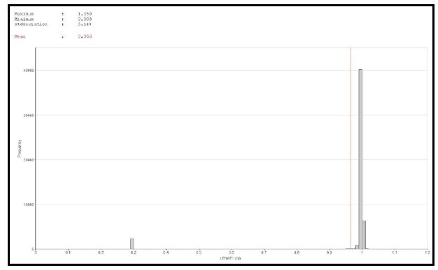
Pacific North West Capital Corp.
Technical Report and Resource Estimate on the River Valley
PGM Project, Northern Ontario | 77 | 1193250100-REP-R0001-01 |
Figure 14.7 River Valley 2 m Composite Histogram
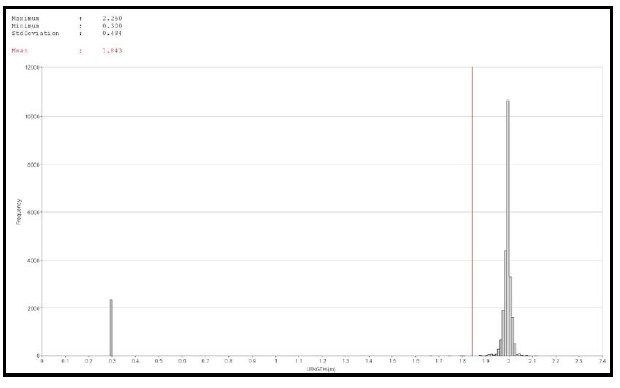
Figure 14.8 River Valley 3 m Composite Histogram

Pacific North West Capital Corp.
Technical Report and Resource Estimate on the River Valley
PGM Project, Northern Ontario | 78 | 1193250100-REP-R0001-01 |
Figure 14.9 River Valley 4 m Composite Histogram

Figure 14.10 River Valley 5 m Composite Histogram
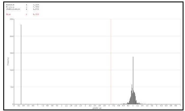
| | The 2 m composite was selected as it corresponds with approximately to one-half the cell widths to be used in the modelling process and displays the most consistent statistics. |
Pacific North West Capital Corp.
Technical Report and Resource Estimate on the River Valley
PGM Project, Northern Ontario | 79 | 1193250100-REP-R0001-01 |
| | The backstitching process was used in the compositing routine to ensure all captured sample material was included. The backstitching routine adjusts the composite lengths for each individual borehole in order to compensate for the last sample interval. The minimum composite length in all runs was set at 0.35 m to allow the small channel samples on surface to remain as individual composites. Table 14.6 summarizes the statistics for the boreholes after compositing. |
Table 14.6 River Valley Drillhole Composite Statistics
| Field | 1 m
Composite | 2 m
Composite | 3 m
Composite | 4 m
Composite | 5 m
Composite |
| Length | 0.966 | 1.843 | 2.649 | 3.380 | 4.069 |
| Augt | 0.029 | 0.029 | 0.029 | 0.029 | 0.029 |
| Ptgt | 0.160 | 0.160 | 0.160 | 0.160 | 0.160 |
| Pdgt | 0.400 | 0.399 | 0.399 | 0.399 | 0.399 |
| CuPer | 0.043 | 0.043 | 0.043 | 0.043 | 0.043 |
| NiPer | 0.012 | 0.012 | 0.012 | 0.012 | 0.012 |
| Fe-perc | 5.009 | 5.144 | 5.137 | 5.116 | 5.133 |
| Co-ppm | 26.014 | 26.048 | 26.048 | 26.039 | 26.043 |
| S-perc | 0.177 | 0.178 | 0.178 | 0.178 | 0.178 |
| Rh-ppb | 19.043 | 19.061 | 19.129 | 19.170 | 19.257 |
| Pdeq | 0.982 | 0.981 | 0.981 | 0.982 | 0.981 |
| Ag-ppm | 0.625 | 0.629 | 0.629 | 0.629 | 0.628 |
14.6 SPATIAL ANALYSIS
| | Variography, using Datamine™ Studio (v. 3.19.3638.0) software, was completed for all elements globally for all zones. Downhole variograms were used to determine nugget effect and then correlograms were modelled to determine spatial continuity in the zones. |
| | Table 14.7 summarizes results of the variography, while the correlograms for each of the elements and be found in Appendix A. |
Pacific North West Capital Corp.
Technical Report and Resource Estimate on the River Valley
PGM Project, Northern Ontario | 80 | 1193250100-REP-R0001-01 |

Pacific North West Capital Corp.
Technical Report and Resource Estimate on the River Valley
PGM Project, Northern Ontario | 81 | 1193250100-REP-R0001-01 |
14.7 RESOURCE BLOCK MODEL
| | Individual block models were established in Datamine™ for each of the eight zones using one parent model as the origin. The model was not rotated. Drillhole spacing is variable with the majority of the surface drilling spaced at 25 m sections and 25 to 75 m on sections. A block size of 10 m x 10 m x 5 m was selected in order to accommodate the nature of the mineralization and be amenable for the open pit potential. |
| | Sub-celling of the block model on a 1 x 1 x 1 pattern in the YZ plane allows the parent block to be split in each direction to more accurately fill the volume of the wireframes, thus more accurately estimate the tonnes in the resource. |
| | Table 14.8 summarizes details of the parent block model. |
Table 14.8 Parent Model Parameters
| Origin | Cell Size | Number of Cells |
| X Origin | Y Origin | Z Origin | XINC | YINC | ZINC | NX | NY | NZ |
| 555000 | 5167200 | -200 | 10 | 10 | 5 | 830 | 580 | 110 |
14.7.1 DYNAMIC ANISOTROPY
| | Due to the curved nature of the wireframes and the distribution of the mineralization within the zones, a single search ellipse would not be practical and would result in the smearing of grades in a direction that does not represent the true nature of the mineralization |
| | Dynamic anisotropy is an option in Datamine™ Studio 3 that allows the anisotropy rotation angles that define search volumes and variogram models to be defined individually for each cell in the model, thus allowing the search volume to be precisely oriented to follow the trend of the mineralization. Figure 14.11 is an example on how the orientation of the search ellipse will vary across the mineralized zone using dynamic anisotropy search compared an anisotropic search. |
| | Figure 14.12 displays how the dip direction of the search ellipse is varied at Dana North through the use of dynamic anisotropy. |
Pacific North West Capital Corp.
Technical Report and Resource Estimate on the River Valley
PGM Project, Northern Ontario | 82 | 1193250100-REP-R0001-01 |
Figure 14.12 Dana North Dynamic Anisotropy
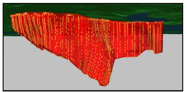
14.7.2 ESTIMATION CRITERIA
| | The interpolations of the zones were completed using the estimation methods: NN, ID2, and OK. The estimations were designed for three passes. In each pass a minimum and maximum number of samples were required as well as a maximum number of samples from a borehole in order to satisfy the estimation criteria. |
| | Table 14.9 and Table 14.10 summarize the interpolation criteria for the zones. |
Pacific North West Capital Corp.
Technical Report and Resource Estimate on the River Valley
PGM Project, Northern Ontario | 83 | 1193250100-REP-R0001-01 |
Table 14.9 Estimation Criteria
| Description | Estimation
Reference No. | VALUE_IN | VALUE_OU | Search
Reference No. | NUMSAM_F | SVOL_F | IMETHOD | VREFNUM |
| Pdnn | 1 | Pdgt | Pdnn | 1.000 | - | - | 1 | 3 |
| Pdid | 2 | Pdgt | Pdid | 1.000 | - | - | 2 | 3 |
| Pdok | 3 | Pdgt | Pdok | 1.000 | NUMSAMP | SVOL | 3 | 3 |
| Ptnn | 4 | Ptgt | Ptnn | 2.000 | - | - | 1 | 1 |
| Ptid | 5 | Ptgt | Ptid | 2.000 | - | - | 2 | 1 |
| Ptok | 6 | Ptgt | Ptok | 2.000 | - | - | 3 | 1 |
| Aunn | 7 | Augt | Aunn | 3.000 | - | - | 1 | 2 |
| Auid | 8 | Augt | Auid | 3.000 | - | - | 2 | 2 |
| Auok | 9 | Augt | Auok | 3.000 | - | - | 3 | 2 |
| Ninn | 10 | NiPer | Ninn | 4.000 | - | - | 1 | 4 |
| Niid | 11 | NiPer | Niid | 4.000 | - | - | 2 | 4 |
| Niok | 12 | NiPer | Niok | 4.000 | - | - | 3 | 4 |
| Cunn | 13 | CuPer | Cunn | 5.000 | - | - | 1 | 5 |
| Cuid | 14 | CuPer | Cuid | 5.000 | - | - | 2 | 5 |
| Cuok | 15 | CuPer | Cuok | 5.000 | - | - | 3 | 5 |
| Conn | 16 | Co-ppm | Conn | 6.000 | - | - | 1 | 6 |
| Coid | 17 | Co-ppm | Coid | 6.000 | - | - | 2 | 6 |
| Cook | 18 | Co-ppm | Cook | 6.000 | - | - | 3 | 6 |
| Rhok | 21 | Rh-ppb | Rhok | 7.000 | - | - | 3 | 7 |
| Mgok | 22 | Mg-perc | Mgok | 8.000 | - | - | 3 | 8 |
| Sok | 23 | S-perc | Sok | 9.000 | - | - | 3 | 9 |
| Feok | 24 | Fe-perc | Feok | 10.000 | - | - | 3 | 10 |
| Agok | 25 | Ag-ppm | Agok | 11.000 | - | - | 3 | 11 |
Pacific North West Capital Corp.
Technical Report and Resource Estimate on the River Valley
PGM Project, Northern Ontario | 84 | 1193250100-REP-R0001-01 |
Table 14.10 Search Criteria
| Element | SREFNUM | Search
Method | Search Distance
Along Strike (X) | Search
Distance
Down Dip (Z) | Search
Distance
Across
Strike (Y) | DA Angle
Z | DA Angle
Y | DA Angle
X |
| Pd | 1 | ellipse | 47 | 73 | 40 | TRDIPDIR | - | TRDIP |
| Pt | 2 | ellipse | 40 | 33 | 27 | TRDIPDIR | - | TRDIP |
| Au | 3 | ellipse | 60 | 66 | 47 | TRDIPDIR | - | TRDIP |
| Ni | 4 | ellipse | 66 | 73 | 39 | TRDIPDIR | - | TRDIP |
| Cu | 5 | ellipse | 53 | 66 | 40 | TRDIPDIR | - | TRDIP |
| Co | 6 | ellipse | 40 | 47 | 40 | TRDIPDIR | - | TRDIP |
| Rh | 7 | ellipse | 20 | 30 | 13 | TRDIPDIR | - | TRDIP |
| Mg | 8 | ellipse | 20 | 27 | 8 | TRDIPDIR | - | TRDIP |
| S | 9 | ellipse | 13 | 27 | 20 | TRDIPDIR | - | TRDIP |
| Fe | 10 | ellipse | 20 | 20 | 20 | TRDIPDIR | - | TRDIP |
| Ag | 11 | ellipse | 10 | 10 | 10 | TRDIPDIR | - | TRDIP |
Search
Volume 1 | Minimum No.
of Samples | Maximum No.
of Samples | Search
Volume 2 | Minimum No. of Samples | Maximum No.
of Samples | Search
Volume 4 | Minimum No.
of Samples | Maximum No
of Samples |
| 1 | 10 | 30 | 2 | 5 | 30 | 4 | 3 | 20 |
| Octant Method | Minimum No.
of Octant | Minimum/Octant | Maximum/Octant | Maximum
Samples/Borehole | | | | |
| 0 | 0 | 0 | 0 | 8 | | | | |
Pacific North West Capital Corp.
Technical Report and Resource Estimate on the River Valley
PGM Project, Northern Ontario | 85 | 1193250100-REP-R0001-01 |
14.8 RESOURCE CLASSIFICATION
| | Several factors are considered in the definition of a resource classification: |
| | - NI 43-101 requirements
- Canadian Institute of Mining, Metallurgy and Petroleum (CIM) guidelines
- the author’s experience with magmatic PGE-nickel deposits
- spatial continuity based on variography of the assays within the drillholes
- drillholes spacing and estimation runs required to estimate the grades in a block.
|
| | No environmental, permitting, legal, title, taxation, socio-economic, marketing or other relevant issues are known to Tetra Tech that may affect the estimate of mineral resources. Mineral reserves can only be estimated on the basis of an economic evaluation that is used in a preliminary feasibility study or a feasibility study of a mineral project; thus, no reserves have been estimated. As per NI 43-101, mineral resources, which are not mineral reserves, do not have to demonstrate economic viability. |
14.9 MINERAL RESOURCE TABULATION
| | The resource reported as of May 2012 has been tabulated in terms of a PdEq cut-off grade. The various mineral resource classifications for all the zones at River Valley are tabulated in Table 14.11 to Table 14.13 for the Measured, Indicated and Inferred Resources. Resources are stated as all blocks above the cut-off grade. The resources are tabulated using various cut-off grades to demonstrate the robust nature of the resource. |
Table 14.11 River Valley Measured Resource Cut-off
PdEq
Cut-off | Tonnes | Pd
(g/t) | Pt
(g/t) | Rh
(g/t) | Au
(g/t) | Ag
(g/t) | Cu
(%) | Ni
(%) | Co
(%) | PdEq
(g/t) |
| 0.30 | 52,189,120 | 0.40 | 0.16 | 0.015 | 0.03 | 0.47 | 0.04 | 0.01 | 0.003 | 0.99 |
| 0.40 | 47,291,470 | 0.43 | 0.17 | 0.016 | 0.03 | 0.48 | 0.04 | 0.01 | 0.003 | 1.06 |
| 0.50 | 40,576,180 | 0.48 | 0.18 | 0.017 | 0.03 | 0.49 | 0.05 | 0.01 | 0.003 | 1.16 |
| 0.60 | 34,485,180 | 0.53 | 0.20 | 0.019 | 0.04 | 0.51 | 0.05 | 0.01 | 0.003 | 1.26 |
| 0.70 | 29,734,810 | 0.58 | 0.21 | 0.021 | 0.04 | 0.53 | 0.06 | 0.01 | 0.003 | 1.36 |
| 0.80 | 25,584,850 | 0.63 | 0.23 | 0.022 | 0.04 | 0.55 | 0.06 | 0.02 | 0.003 | 1.46 |
| 0.90 | 21,950,430 | 0.68 | 0.25 | 0.024 | 0.05 | 0.56 | 0.06 | 0.02 | 0.003 | 1.56 |
| 1.00 | 18,785,450 | 0.74 | 0.26 | 0.026 | 0.05 | 0.58 | 0.07 | 0.02 | 0.003 | 1.67 |
| 1.10 | 16,070,350 | 0.79 | 0.28 | 0.027 | 0.05 | 0.60 | 0.07 | 0.02 | 0.003 | 1.77 |
| 1.20 | 13,791,240 | 0.85 | 0.30 | 0.029 | 0.05 | 0.62 | 0.07 | 0.02 | 0.003 | 1.87 |
| 1.30 | 11,873,550 | 0.90 | 0.31 | 0.031 | 0.06 | 0.63 | 0.08 | 0.02 | 0.003 | 1.97 |
table continues…
Pacific North West Capital Corp.
Technical Report and Resource Estimate on the River Valley
PGM Project, Northern Ontario | 86 | 1193250100-REP-R0001-01 |
PdEq
Cut-off | Tonnes | Pd
(g/t) | Pt
(g/t) | Rh
(g/t) | Au
(g/t) | Ag
(g/t) | Cu
(%) | Ni
(%) | Co
(%) | PdEq
(g/t) |
| 1.40 | 10,202,730 | 0.96 | 0.33 | 0.032 | 0.06 | 0.65 | 0.08 | 0.02 | 0.003 | 2.08 |
| 1.50 | 8,779,350 | 1.01 | 0.34 | 0.034 | 0.06 | 0.66 | 0.08 | 0.02 | 0.003 | 2.18 |
| 1.60 | 7,614,580 | 1.07 | 0.36 | 0.036 | 0.07 | 0.68 | 0.08 | 0.02 | 0.003 | 2.28 |
| 1.70 | 6,471,590 | 1.13 | 0.37 | 0.038 | 0.07 | 0.70 | 0.09 | 0.02 | 0.003 | 2.39 |
| 1.80 | 5,569,280 | 1.19 | 0.39 | 0.039 | 0.07 | 0.71 | 0.09 | 0.02 | 0.003 | 2.49 |
| 1.90 | 4,823,020 | 1.25 | 0.40 | 0.041 | 0.07 | 0.72 | 0.09 | 0.02 | 0.003 | 2.59 |
| 2.00 | 4,145,280 | 1.31 | 0.42 | 0.043 | 0.08 | 0.73 | 0.09 | 0.02 | 0.003 | 2.69 |
Table 14.12 River Valley Indicated Resource Cut-off
PdEq
Cut-off | Tonnes | Pd
(g/t) | Pt
(g/t) | Rh
(g/t) | Au
(g/t) | Ag
(g/t) | Cu
(%) | Ni
(%) | Co
(%) | PdEq
(g/t) |
| 0.30 | 141,557,300 | 0.36 | 0.15 | 0.014 | 0.03 | 0.20 | 0.04 | 0.01 | 0.002 | 0.93 |
| 0.40 | 132,716,200 | 0.38 | 0.15 | 0.014 | 0.03 | 0.21 | 0.05 | 0.01 | 0.002 | 0.97 |
| 0.50 | 114,501,900 | 0.42 | 0.16 | 0.016 | 0.03 | 0.22 | 0.05 | 0.01 | 0.002 | 1.05 |
| 0.60 | 95,735,500 | 0.46 | 0.18 | 0.017 | 0.03 | 0.23 | 0.05 | 0.01 | 0.002 | 1.15 |
| 0.70 | 80,445,500 | 0.51 | 0.20 | 0.019 | 0.03 | 0.24 | 0.06 | 0.02 | 0.002 | 1.24 |
| 0.80 | 65,754,600 | 0.56 | 0.21 | 0.020 | 0.04 | 0.26 | 0.06 | 0.02 | 0.002 | 1.35 |
| 0.90 | 53,225,100 | 0.62 | 0.23 | 0.022 | 0.04 | 0.27 | 0.06 | 0.02 | 0.002 | 1.47 |
| 1.00 | 43,959,900 | 0.68 | 0.25 | 0.024 | 0.04 | 0.29 | 0.07 | 0.02 | 0.002 | 1.58 |
| 1.10 | 36,780,800 | 0.73 | 0.27 | 0.026 | 0.05 | 0.30 | 0.07 | 0.02 | 0.002 | 1.68 |
| 1.20 | 30,943,200 | 0.78 | 0.29 | 0.027 | 0.05 | 0.32 | 0.07 | 0.02 | 0.002 | 1.78 |
| 1.30 | 25,948,500 | 0.84 | 0.30 | 0.029 | 0.05 | 0.34 | 0.08 | 0.02 | 0.002 | 1.89 |
| 1.40 | 21,704,500 | 0.89 | 0.32 | 0.031 | 0.06 | 0.35 | 0.08 | 0.02 | 0.002 | 1.99 |
| 1.50 | 18,160,300 | 0.95 | 0.34 | 0.032 | 0.06 | 0.37 | 0.08 | 0.02 | 0.002 | 2.10 |
| 1.60 | 15,202,500 | 1.01 | 0.36 | 0.034 | 0.06 | 0.38 | 0.08 | 0.02 | 0.002 | 2.20 |
| 1.70 | 12,899,700 | 1.06 | 0.37 | 0.036 | 0.06 | 0.40 | 0.08 | 0.02 | 0.002 | 2.30 |
| 1.80 | 10,991,500 | 1.11 | 0.39 | 0.038 | 0.07 | 0.41 | 0.09 | 0.02 | 0.002 | 2.40 |
| 1.90 | 9,329,900 | 1.17 | 0.41 | 0.039 | 0.07 | 0.42 | 0.09 | 0.02 | 0.002 | 2.49 |
| 2.00 | 7,811,200 | 1.22 | 0.43 | 0.041 | 0.07 | 0.43 | 0.09 | 0.02 | 0.002 | 2.60 |
Table 14.13 River Valley Inferred Resource Cut-off
PdEq
Cut-off | Tonnes | Pd
(g/t) | Pt
(g/t) | Rh
(g/t) | Au
(g/t) | Ag
(g/t) | Cu
(%) | Ni
(%) | Co
(%) | PdEq
(g/t) |
| 0.30 | 130,872,000 | 0.22 | 0.09 | 0.009 | 0.02 | 0.08 | 0.04 | 0.02 | 0.002 | 0.70 |
| 0.40 | 117,268,000 | 0.23 | 0.10 | 0.010 | 0.02 | 0.08 | 0.04 | 0.02 | 0.002 | 0.74 |
| 0.50 | 96,299,000 | 0.26 | 0.11 | 0.010 | 0.02 | 0.08 | 0.04 | 0.02 | 0.002 | 0.80 |
| 0.60 | 73,492,000 | 0.29 | 0.12 | 0.011 | 0.02 | 0.08 | 0.05 | 0.02 | 0.002 | 0.88 |
| 0.70 | 53,206,000 | 0.32 | 0.13 | 0.012 | 0.02 | 0.09 | 0.05 | 0.03 | 0.002 | 0.97 |
Pacific North West Capital Corp.
Technical Report and Resource Estimate on the River Valley
PGM Project, Northern Ontario | 87 | 1193250100-REP-R0001-01 |
PdEq
Cut-off | Tonnes | Pd
(g/t) | Pt
(g/t) | Rh
(g/t) | Au
(g/t) | Ag
(g/t) | Cu
(%) | Ni
(%) | Co
(%) | PdEq
(g/t) |
| 0.80 | 35,910,000 | 0.36 | 0.14 | 0.014 | 0.03 | 0.11 | 0.06 | 0.03 | 0.002 | 1.07 |
| 0.90 | 25,283,000 | 0.40 | 0.16 | 0.015 | 0.03 | 0.12 | 0.06 | 0.03 | 0.002 | 1.17 |
| 1.00 | 17,803,000 | 0.44 | 0.17 | 0.016 | 0.03 | 0.13 | 0.06 | 0.03 | 0.002 | 1.26 |
| 1.10 | 12,022,000 | 0.48 | 0.19 | 0.018 | 0.03 | 0.11 | 0.07 | 0.03 | 0.002 | 1.36 |
| 1.20 | 8,021,000 | 0.53 | 0.20 | 0.019 | 0.04 | 0.10 | 0.07 | 0.04 | 0.002 | 1.46 |
| 1.30 | 5,379,000 | 0.58 | 0.21 | 0.020 | 0.04 | 0.10 | 0.08 | 0.04 | 0.001 | 1.57 |
| 1.40 | 3,703,000 | 0.63 | 0.22 | 0.022 | 0.04 | 0.10 | 0.08 | 0.04 | 0.001 | 1.67 |
| 1.50 | 2,700,000 | 0.68 | 0.22 | 0.023 | 0.05 | 0.10 | 0.09 | 0.04 | 0.001 | 1.75 |
| 1.60 | 1,889,000 | 0.72 | 0.23 | 0.024 | 0.05 | 0.09 | 0.09 | 0.05 | 0.001 | 1.83 |
| 1.70 | 1,298,000 | 0.76 | 0.25 | 0.026 | 0.05 | 0.09 | 0.09 | 0.05 | 0.001 | 1.91 |
| 1.80 | 895,000 | 0.78 | 0.26 | 0.027 | 0.06 | 0.08 | 0.10 | 0.05 | 0.000 | 1.99 |
| 1.90 | 577,000 | 0.81 | 0.28 | 0.028 | 0.06 | 0.05 | 0.10 | 0.05 | 0.000 | 2.07 |
| 2.00 | 322,000 | 0.85 | 0.30 | 0.029 | 0.06 | 0.02 | 0.10 | 0.05 | 0.000 | 2.16 |
| | The corresponding grade-tonnage curves for the various resource categories are displayed in Figure 14.13 to Figure 14.15. |
Figure 14.15 River Valley Inferred Resource Grade-tonnage Curve
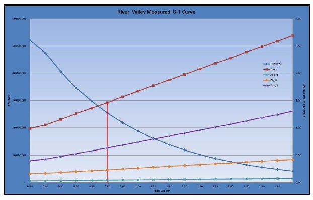
Pacific North West Capital Corp.
Technical Report and Resource Estimate on the River Valley
PGM Project, Northern Ontario | 88 | 1193250100-REP-R0001-01 |
Figure 14.14 River Valley Indicated Resource Grade-tonnage Curve
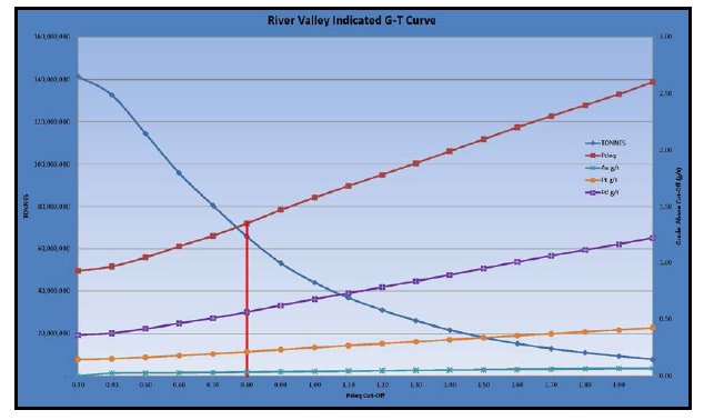
Figure 14.15 River Valley Inferred Resource Grade-tonnage Curve

| | Based on the similar PGM projects in Canada, a 0.8 g/t PdEq cut-off was used to tabulate the resource for the various zones and categories. |
| | Table 14.14 River Valley Mineral Resource Summary |
Pacific North West Capital Corp.
Technical Report and Resource Estimate on the River Valley
PGM Project, Northern Ontario | 89 | 1193250100-REP-R0001-01 |
Table 14.14 River Valley Mineral Resource Summary
| Zone | PdEq
Cut-off | Tonnes | Pd
(g/t) | Pt
(g/t) | Rh
(g/t) | Au
(g/t) | Ag
(g/t) | Cu
(%) | Ni
(%) | Co
(%) | PdEq
(g/t) |
| Measured |
| Azen | 0.80 | - | - | - | - | - | - | - | - | - | - |
| Banshee | 0.80 | - | - | - | - | - | - | - | - | - | - |
| Dana | 0.80 | 9,622,180 | 0.66 | 0.24 | 0.023 | 0.05 | 0.70 | 0.07 | 0.02 | 0.003 | 1.56 |
| Dana S | 0.80 | 5,980,550 | 0.79 | 0.26 | 0.027 | 0.05 | 0.56 | 0.06 | 0.01 | 0.003 | 1.68 |
| Lismer | 0.80 | 9,982,120 | 0.50 | 0.20 | 0.018 | 0.04 | 0.40 | 0.05 | 0.02 | 0.003 | 1.24 |
| Lismer Extension | 0.80 | - | - | - | - | - | - | - | - | - | - |
| Razor | 0.80 | - | - | - | - | - | - | - | - | - | - |
| Varley | 0.80 | - | - | - | - | - | - | - | - | - | - |
| Total Measured | - | 25,584,850 | 0.63 | 0.23 | 0.022 | 0.04 | 0.55 | 0.06 | 0.02 | 0.003 | 1.46 |
| Indicated |
| Azen | 0.80 | - | - | - | - | - | - | - | - | - | - |
| Banshee | 0.80 | - | - | - | - | - | - | - | - | - | - |
| Dana | 0.80 | 14,076,300 | 0.60 | 0.22 | 0.021 | 0.04 | 0.52 | 0.07 | 0.02 | 0.003 | 1.45 |
| Dana S | 0.80 | 8,040,000 | 0.70 | 0.24 | 0.024 | 0.04 | 0.59 | 0.05 | 0.01 | 0.003 | 1.49 |
| Lismer | 0.80 | 16,300,300 | 0.48 | 0.19 | 0.018 | 0.04 | 0.05 | 0.06 | 0.02 | 0.003 | 1.25 |
| Lismer Ext | 0.80 | 13,690,300 | 0.57 | 0.23 | 0.021 | 0.04 | 0.12 | 0.06 | 0.02 | 0.002 | 1.37 |
| Razor | 0.80 | - | - | - | - | - | - | - | - | - | - |
| Varley | 0.80 | 13,647,800 | 0.53 | 0.21 | 0.019 | 0.03 | 0.17 | 0.05 | 0.01 | 0.002 | 1.27 |
| Total Indicated | - | 65,754,700 | 0.56 | 0.21 | 0.020 | 0.04 | 0.26 | 0.06 | 0.02 | 0.003 | 1.35 |
table continues…
Pacific North West Capital Corp.
Technical Report and Resource Estimate on the River Valley
PGM Project, Northern Ontario | 90 | 1193250100-REP-R0001-01 |
| Zone | PdEq
Cut-off | Tonnes | Pd (g/t) | Pt (g/t) | Rh (g/t) | Au (g/t) | Ag
(g/t) | Cu
(%) | Ni
(%) | Co
(%) | PdEq
(g/t) |
| Measured + Indicated |
| Azen | 0.80 | - | - | - | - | - | - | - | - | - | - |
| Banshee | 0.80 | - | - | - | - | - | - | - | - | - | - |
| Dana | 0.80 | 23,698,480 | 0.63 | 0.23 | 0.022 | 0.04 | 0.59 | 0.07 | 0.02 | 0.003 | 1.49 |
| Dana S | 0.80 | 14,020,550 | 0.74 | 0.25 | 0.025 | 0.04 | 0.58 | 0.05 | 0.01 | 0.003 | 1.57 |
| Lismer | 0.80 | 26,282,420 | 0.49 | 0.19 | 0.018 | 0.04 | 0.18 | 0.06 | 0.02 | 0.003 | 1.25 |
| Lismer Ext | 0.80 | 13,690,300 | 0.57 | 0.23 | 0.021 | 0.04 | 0.12 | 0.06 | 0.02 | 0.002 | 1.37 |
| Razor | 0.80 | - | - | - | - | - | - | - | - | - | - |
| Varley | 0.80 | 13,647,800 | 0.53 | 0.21 | 0.019 | 0.03 | 0.17 | 0.05 | 0.01 | 0.002 | 1.27 |
| Total Measured + Indicated | - | 91,339,550 | 0.58 | 0.22 | 0.021 | 0.04 | 0.34 | 0.06 | 0.02 | 0.003 | 1.38 |
| Inferred |
| Azen | 0.80 | 16,095,000 | 0.37 | 0.15 | 0.014 | 0.03 | 0.08 | 0.05 | 0.03 | 0.001 | 1.11 |
| Banshee | 0.80 | 3,320,000 | 0.35 | 0.19 | 0.015 | 0.03 | - | 0.05 | 0.01 | - | 1.00 |
| Dana | 0.80 | - | - | - | - | - | - | - | - | - | - |
| Dana S | 0.80 | - | - | - | - | - | - | - | - | - | - |
| Lismer | 0.80 | 303,000 | 0.31 | 0.13 | 0.012 | 0.03 | - | 0.06 | 0.02 | 0.002 | 0.92 |
| Lismer Ext | 0.80 | - | - | - | - | - | - | - | - | - | - |
| Razor | 0.80 | 16,163,000 | 0.36 | 0.12 | 0.013 | 0.02 | 0.16 | 0.06 | 0.03 | 0.003 | 1.05 |
| Varley | 0.80 | 30,000 | 0.30 | 0.15 | 0.012 | 0.03 | - | 0.07 | 0.01 | 0.002 | 0.94 |
| Total Inferred | - | 35,911,000 | 0.36 | 0.14 | 0.014 | 0.03 | 0.11 | 0.06 | 0.03 | 0.003 | 1.07 |
Pacific North West Capital Corp.
Technical Report and Resource Estimate on the River Valley
PGM Project, Northern Ontario | 91 | 1193250100-REP-R0001-01 |
14.10 VALIDATION
| | The River Valley model was validated by three methods: |
| | - visual comparison of colour-coded block model grades with composite grades on section and plan
- comparison of the global mean block grades for OK, ID2, NN, and composites
- swath plots of the various zones in both plan and section views.
|
14.10.1 VISUAL VALIDATION
| | The visual comparisons of the block model grades with composite grades for each of the zones show a reasonable correlation between the values. No significant discrepancies were apparent from the sections reviewed, yet grade smoothing is apparent in some locations due to the distance between drill samples being broader in some regions. |
| | Figure 14.16 to Figure 14.23 displays the comparison between the block model and the composited drillholes. |
Pacific North West Capital Corp.
Technical Report and Resource Estimate on the River Valley
PGM Project, Northern Ontario | 92 | 1193250100-REP-R0001-01 |
Figure 14.16 Dana North Model vs. Diamond Drillhole Comparison
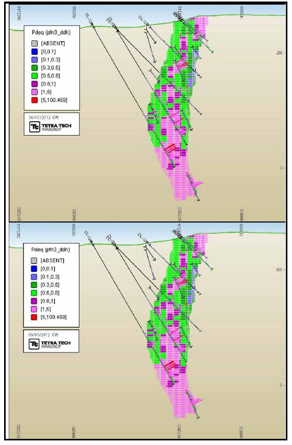
Pacific North West Capital Corp.
Technical Report and Resource Estimate on the River Valley
PGM Project, Northern Ontario | 93 | 1193250100-REP-R0001-01 |
Figure 14.17 Dana South Model vs. Diamond Drillhole Comparison

Figure 14.18 Banshee Model vs. Diamond Drillhole Comparison

Pacific North West Capital Corp.
Technical Report and Resource Estimate on the River Valley
PGM Project, Northern Ontario | 94 | 1193250100-REP-R0001-01 |
Figure 14.19 Lismer Model vs. Diamond Drillhole Comparison
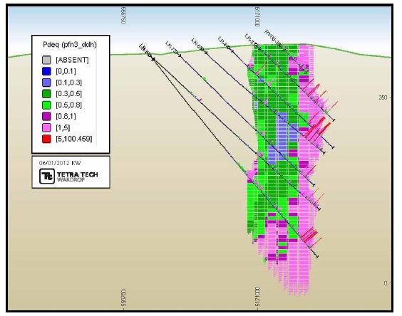
Figure 14.20 Lismer Extension Model vs. Diamond Drillhole Comparison
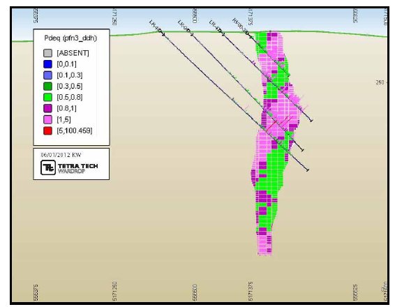
Pacific North West Capital Corp.
Technical Report and Resource Estimate on the River Valley
PGM Project, Northern Ontario | 95 | 1193250100-REP-R0001-01 |
Figure 14.21 Varley Model vs. Diamond Drillhole Comparison
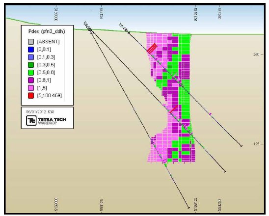
Figure 14.22 Azen Model vs. Diamond Drillhole Comparison
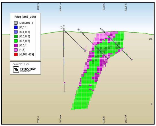
Pacific North West Capital Corp.
Technical Report and Resource Estimate on the River Valley
PGM Project, Northern Ontario | 96 | 1193250100-REP-R0001-01 |
Figure 14.23 Razor Model vs. Diamond Drillhole Comparison
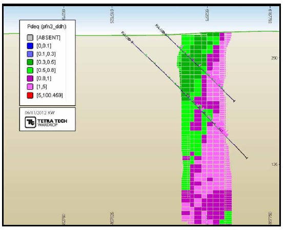
14.10.2 OVERALL COMPARISON
| | The overall block model statistics for the OK model were compared to the overall ID2 and NN model values as well as the composite capped drillhole data. Table 14.15 shows this comparison of the global estimates for the three estimation method calculations. In general, there is agreement between the OK model and ID2 model and NN model. Larger discrepancies are reflected as a result of lower drill density in some portions of the model. There is a degree of smoothing apparent when compared to the diamond drill statistics. Comparisons were made using all blocks at a 0 g/t cut-off. |
Pacific North West Capital Corp.
Technical Report and Resource Estimate on the River Valley
PGM Project, Northern Ontario | 97 | 1193250100-REP-R0001-01 |

Pacific North West Capital Corp.
Technical Report and Resource Estimate on the River Valley
PGM Project, Northern Ontario | 98 | 1193250100-REP-R0001-01 |
14.10.3 SWATH PLOTS
| | Swath plots of easting’s northing’s and elevations were generated for each mineralized zone respectively. These plots are comparing the OK estimates with the NN and ID2 estimates. The plots are illustrated Appendix B. |
14.11 PREVIOUS ESTIMATES
14.11.1 PREVIOUS ESTIMATIONS
| | PFN and their joint venture partner have completed four resource estimates prior to 2012. Table 14.16 summarizes the pervious results. Tetra Tech has not reviewed the models, yet considers the models to be material. The information summarized in the table has been sourced from various internal company reports and press releases available from PFN’s website. |
Table 14.16 Previous Resource Summary
| Year | Company | Activities | Results |
| 2001 | PFN/ Amplats | An Independent Mineral Resource Study was carried out by Derry Mitchener Booth and Wahl (DMBW) as of September 26, 2001 which incorporated Phase I to IV of drilling which amounted to 22,791.74 m in 138 holes. Report estimated an in situ resource at Dana Lake and Lismer Ridge. | 13 Mt (measured + indicated + inferred) at 0.35 g/t Pt, 1.04 g/t Pd , & 0.07 g/t Au using a 0.7 g/t Pt + Pd cutoff grade. This was non-compliant. |
| 2002 | PFN/ Amplats | DMBW completed a Revised Mineral Resource Estimate, as of September 13, 2002 to incorporate Phase V drill program for the Dana Lake and Lismer's Ridge deposit. A total of 42,627 m in 221 holes had been conducted in 5 phases of drill programs. | 18.1 Mt (measured + indicated) at 0.344 g/t Pt, 1.016 g/t Pd, & 0.063 g/t Au using a 0.7 g/t Pt+Pd cut-off grade. An additional 5.8 Mt added as inferred at 0.290 g/t Pt, 0.819 g/t Pd, & 0.050 g/t Au using a 0.7 g/t Pt+Pd cutoff grade |
| 2004 | PFN/ Amplats | DMBW completed a Revised Mineral Resource Estimate, as of April 30, 2004 to incorporate Phase VI drill program for the Dana Lake, Lismer's Ridge, and Varley deposits. A total of 83,838 m in 416 holes had been conducted in 6 phases of drill programs. | 25.4 Mt (measured + indicated) at 0.335 g/t Pt, 0.979 g/t Pd, & 0.061 g/t Au using a 0.7 g/t Pt+Pd cut-off grade. An additional 3.6 Mt added as inferred at 0.278 g/t Pt, 0.760 g/t Pd, & 0.049 g/t Au using a 0.7 g/t Pt+Pd cutoff grade. |
| 2006 | PFN/ Amplats | DMBW completed a Revised Mineral Resource Estimate, as of March 27, 2006 to incorporate Phase VI and VII drill program for the North Lismer and Varley Zones. A total of 83,838 m in 416 holes had been conducted in previous estimate in 2004, an additional 31 holes from Lismer's Ridge Zone and 70 core holes at Varley were utilized for the purpose of the Revised Mineral Resource Estimate. | 19.3 Mt (measured + indicated) at 0.395 g/t Pt, 1.181 g/t Pd, & 0.070 g/t Au using a 1.0 g/t Pt+Pd cut-off grade. An additional 881,000 t added as inferred at 0.465 g/t Pt, 1.356 g/t Pd, & 0.073 g/t Au using a 1.0 g/t Pt+Pd cutoff grade. |
Pacific North West Capital Corp.
Technical Report and Resource Estimate on the River Valley
PGM Project, Northern Ontario | 99 | 1193250100-REP-R0001-01 |
| | A detailed comparison of the 2006 resource estimate and the 2012 estimate are provided in Section 14.11.2 in order to provide context as to the nature of the change between the 2006 resource estimate and the 2012 resource estimate. |
14.11.2 COMPARISON OF CURRENT ESTIMATE WITH 2006 ESTIMATE
| | PFN commissioned GeoSim Consultants (GeoSim) to complete a revised resource estimate on the River Valley Property in 2006. A copy of “Revised Mineral Resource Estimate, Lismer’s North and Varley Areas (incorporating VII drilling), River Valley PGM Project, Ontario” prepared by GeoSim and John Londry, VP Exploration, Pacific North west Capital is available on SEDAR by searching Pacific North West Capital Corporation technical reports. |
| | Table 14.17 compares the basic parameters of the 2009 estimate with the current 2011 NI 43-101 resource. Table 14.18 illustrated the differences in the prior resource estimate with the current 2012 estimate. |
Table 14.17 Comparison of 2006 vs. 2012 Model Parameters
| | 2006 GeoSim Model | 2012 Tetra Tech Model |
| Number of Drill holes | 416 | 462 |
| Grade Capping | Variable by zone: Lismer – 3 g/t Pt & 9 g/t Pd Varley: 10 g/t Pd Dana North: no capping Dana South: no capping | Parrish Analysis No grade capping on any elements |
| Composite Length | 2.0 m average for all zones | 2.0 m average for all zones back stitching allows for "tail" material to be spread evenly over the entire hole composite |
| Cut-off Grade | 1.0 g/t Pt+Pd | 0.8 g/t PdEq |
| Number of Mineral Zones | 4 | 8 |
| Density | 2.89 (mean value of 96 samples) | 2.94 (length weighted mean of 432 samples) |
| Block Size | 5 x 5 x 5 (125 m3) -single subcell | 10 x 10 x 5 (500 m3) -single subcell |
| Estimation Method | Dana North and Dana South: Pt, Pd and Au estimated by OK with Ni and Cu estimated by ID2 Varley, Lismer and Lismer Extension all metals estimated with ID3 | OK with ID2 and NN validation |
Pacific North West Capital Corp.
Technical Report and Resource Estimate on the River Valley
PGM Project, Northern Ontario | 100 | 1193250100-REP-R0001-01 |
Table 14.18 Comparison of 2006 vs. 2012 Model Results
| Tonnes | Pd
(g/t) | Pt
(g/t) | Au
(g/t) | Cu
(%) | Ni
(%) | Co
(%) |
| 2006 GeoSim Model |
| Measured Resource @ 1.0 g/t Pt+Pd cut-off | 7,994,000 | 1.33 | 0.44 | 0.08 | 0.12 | 0.02 | - |
| Indicated Resource @ 1.0 g/t Pt+Pd cut-off | 11,309,000 | 1.08 | 0.37 | 0.07 | 0.10 | 0.02 | - |
| Inferred Resources @ 1.0 g/t Pt+Pd cut-off | 881,000 | 1.36 | 0.47 | 0.07 | 0.10 | 0.02 | - |
| 2012 Tetra Tech Model |
| Measured Resource @ 0.8 g/t PdEq cut-off | 25,584,850 | 0.63 | 0.23 | 0.04 | 0.06 | 0.02 | 0.003 |
| Indicated Resource @ 0.8 g/t PdEq cut-off | 65,754,700 | 0.56 | 0.21 | 0.04 | 0.06 | 0.02 | 0.002 |
| Inferred Resources @ 0.8 g/t PdEq cut-off | 35,911,000 | 0.36 | 0.14 | 0.03 | 0.06 | 0.03 | 0.002 |
| | The fundamental difference between the 2006 GeoSim resource and the 2012 Tetra Tech resource is that the 2006 GeoSim resource concentrated on the high-grade material using only a platinum+palladium cut-off from only four mineral zones. The Tetra Tech resource is targeting a large-tonnage low-grade open pit geological model, utilizing all the potential pay metals on eight mineral zones. |
| | A new specific gravity value based in a 77% increase in the number of samples resulted in a specific gravity value 2% higher than in the previous estimate. The higher specific gravity value combined with the larger mineral wireframe volume substantially impacts the tonnage reported in the new resource. |
| | Using this new geological model as well as with the inclusion of gold, copper, nickel and cobalt to a PdEq formula, which was not incorporated in the GeoSim model; drastically increases the volume of material in the resource estimation compared to the 2006 GeoSim resource. |
Pacific North West Capital Corp.
Technical Report and Resource Estimate on the River Valley
PGM Project, Northern Ontario | 101 | 1193250100-REP-R0001-01 |
15.0 ADJACENT PROPERTIES
| | Mustang Minerals Corp. (Mustang) has presently filled commitments to earn a 100% interest in claims on the southern of the River Valley Intrusive (Figure 15.1). The mining interest involves a title to option or stake unpatented mining claims. Currently, Mustang has sufficient assessment credits to keep River Valley in good standing (Mustang 2011). |
| | Ginguro Exploration Inc. entered in to a share purchase agreement with the shareholders of Mount Logan Resources Ltd. (Mount Logan) (Figure 15.1) which included the purchase of all outstanding shares of Mount Logan (Ginguro 2009). Mount Logan owned a 100% interest in 23 unpatented mining claims northeast of Sudbury and holds an option to acquire up to a 70% interest in a further 16 claims which are contiguous to the 23 claims in the same area known as the Pardo property (Ginguro 2009). Aggressive drilling programs have commenced from 2009 onwards on the Pardo property and the 2012 exploration program is currently in progress. Focus includes developing an understanding of the geological determination of the reef’s components within the Pardo sedimentary basin (Ginguro 2012). This will be followed by diamond drilling. Ginguro has entered a joint venture agreement with Endurance Gold Corporation (Endurance Gold), with Endurance Gold retaining a 45% participating interest in the Pardo property (Ginguro 2012). |
Pacific North West Capital Corp.
Technical Report and Resource Estimate on the River Valley
PGM Project, Northern Ontario | 102 | 1193250100-REP-R0001-01 |
Figure 15.1 Adjacent Properties

Pacific North West Capital Corp.
Technical Report and Resource Estimate on the River Valley
PGM Project, Northern Ontario | 103 | 1193250100-REP-R0001-01 |
16.0 OTHER RELEVANT DATA AND INFORMATION
| | There is no other relevant data or information on the Project. |
Pacific North West Capital Corp.
Technical Report and Resource Estimate on the River Valley
PGM Project, Northern Ontario | 104 | 1193250100-REP-R0001-01 |
17.0 INTERPRETATION AND CONCLUSIONS
| | Based on the review of the available information and observations made during the site visit, Tetra Tech concludes the following, in no particular order of perceived importance: |
| | - The Property is currently held 100% by PFN.
- The Property is analogous to contact-style PGM mineralization developed as the result of sulphur-saturation brought on by the interaction of the fertile parental magma with the surrounding country rock lithologies. This style of mineralization is present in other mineral resources in the region.
- The Property is associated with various phases of mafic to ultramafic intrusives with variable alteration, minor sulphide content.
- The breccia boundary with the Archean footwall is the primary target zone for PGE mineralization.
- PFN has a strong understanding of the regional and local geology to support the interpretation of the mineralized zones on the Property.
- Mineralization is currently defined in eight zones of various thicknesses over a strike length of approximately 8 km.
- New targets have been discovered on the Property with characteristics of reef-style mineralization that warrants further investigation.
- Drilling and sampling procedures, sample preparation, and assay protocols are generally conducted in agreement with best practices.
- Verification of the drillhole collars, surveys, assays, core and drillhole logs indicates the PFN data is reliable.
- Based on the QA/QC program, the data is sufficiently reliable to support the resource estimate generated for the eight zones on the Property.
- The mineral model has been constructed in conformance to industry standard practices.
- The geological understanding is sufficient to support the resource estimation.
- At a PdEq cut-off grade of 0.8 g/t, the combined Measured and Indicated Resource is 91.3 Mt with an average grade of 0.58 g/t palladium, 0.22 g/t platinum, 0.04 g/t gold, 0.06% copper, 0.02% nickel and 0.003% cobalt. The Inferred Resource totals 35.9 Mt with an average grade of 0.36 g/t palladium, 0.14 g/t platinum, 0.03 g/t gold, 0.06% copper, 0.03% nickel and 0.003% cobalt.
|
Pacific North West Capital Corp.
Technical Report and Resource Estimate on the River Valley
PGM Project, Northern Ontario | 105 | 1193250100-REP-R0001-01 |
| | - The Property contains resources that are comparable to other advanced PGM projects in the Province.
- The specific gravity value used to determine that tonnage was derived from limited samples, which may reflect a lack of precision with respect to the resource tonnages.
- The resource zones at the Property remain open in the down-dip directions.
|
Pacific North West Capital Corp.
Technical Report and Resource Estimate on the River Valley
PGM Project, Northern Ontario | 106 | 1193250100-REP-R0001-01 |
18.0 RECOMMENDATIONS
| | It is the author’s opinion that additional exploration expenditures are warranted to improve the viability of the Project and advance the Project towards a PEA. It is recommended that PFN undertake a two-stage exploration program focused on delineation and expansion drill programs that will concentrate on the open pit potential along strike and down-dip of the known resources. |
| | Each program can be carried out concurrently and independently of each other; neither is contingent on the results of the other. |
18.1 PHASE 1 – HIGH-GRADE DOMAIN DELINEATION
| | The Phase 1 exploration program is planned to test the extension and continuity of high-grade domains in and adjacent to the Dana North and Dana South mineralized zones. The drill program should target potential extensions of high-grade domains along strike and across strike of Dana North, including the immediately adjacent River Valley Intrusion and country rocks. |
| | In addition, the drill program should test the continuity of metal grades internally within the Dana North and Dana South zones. One hole should be drilled obliquely down-dip within each of the two zones. After logging and sampling for assay, the core should be submitted for metal recovery testing at an independent laboratory. |
| | The details of the Phase 1 exploration program are presented in Table 18.1. |
Table 18.1 Phase 1 Exploration Budget
| Project | Activity | Rate
($) | Units | Cost
($) |
| River Valley | Diamond Drilling (NQ) | 225 | 2,500 m | 562,500 |
| | Diamond Drilling (HQ) | 250 | 1,100 m | 275,000 |
| | Metallurgical Study | - | 1 | 300,000 |
| Total | - | - | - | 1,137,500 |
Note: Drilling cost includes salaries, all field costs, assays and consumables.
18.2 PHASE 2 – RESOURCE EXPANSION AND NEW RESOURCE IDENTIFICATION
| | The Phase 2 exploration program is planned to expand the resources and to increase the confidence of the resource by improving resource categories. The drill program should test targets adjacent to and down-dip of Dana South, Lismer Extension, Lismer Ridge, and Varley zones. The program should also advance the resources at Banshee from Inferred to Indicated, and better delineate the boundaries of that zone. |
Pacific North West Capital Corp.
Technical Report and Resource Estimate on the River Valley
PGM Project, Northern Ontario | 107 | 1193250100-REP-R0001-01 |
| | Downhole IP surveys should be carried out on selected deep drillholes for the detection of off-hole geophysical anomalies. Ground mapping and prospecting surveys should be undertaken over airborne and ground geophysical anomalies. Anomalies of interest should be covered by ground geophysics for new drill targets. |
| | A high-resolution topographic survey, such as LiDAR, should be flown over the Property to allow for a topographic base leading into a PEA. |
| | The details of the Phase 2 exploration budget are presented in Table 18.2. |
Table 18.2 Phase 2 Exploration Budget
| Project | Activity | Rate
($) | Units | Cost
($) |
| River Valley | Diamond Drilling (NQ) | 225 | 20,000 m | 4,500,000 |
| | Geophysics -Borehole | 45 | 10,000 m | 450,000 |
| | Geophysics -Ground | 2,500 | 500 km | 1,250,000 |
| | Mapping & Prospecting | - | 1 | 200,000 |
| | High Resolution Topography Survey | - | 1 | 500,000 |
| Total | - | - | - | 6,900,000 |
Note: Drilling cost includes salaries, all field costs, assays, and consumables.
18.3 OTHER RECOMMENDATIONS
| | The following recommendations are based on observations by Tetra Tech during the site visit or during the resource estimation process. These recommendations are suggestions for policy and procedures conducted by PFN to further enhance the potential viability of the Project. The recommendations are in no order of importance. |
18.3.1 SPECIFIC GRAVITY MEASUREMENTS
| | It is recommended that PFN increase the frequency of specific gravity measurements from drill core in order to build up the specific gravity database. The specific gravity database should represent at a minimum 5% of the total assay data set. In order to build the specific gravity data set quickly, measurements should be collected at 20 m intervals. |
| | Due to the low-sulphide content on the Property, a regression formula is unlikely to be successfully generated using assay data. The specific gravity data needs to be linked not only to the analytical results but with the lithology and alteration of the rocks. |
Pacific North West Capital Corp.
Technical Report and Resource Estimate on the River Valley
PGM Project, Northern Ontario | 108 | 1193250100-REP-R0001-01 |
18.3.2 RHODIUM AND SILVER ANALYSIS
| | It is recommended to continue to analyze a smaller subset of data for both rhodium and silver. Both minerals are potential pay metals, yet the cost of analysis can be prohibitive to assay every sample for both rhodium and silver. It is recommended to assay approximately 5% of the data with a good distribution between the samples spatially. |
18.3.3 SURFACE CONTACT BETWEEN FOOTWALL/BRECCIA ZONE
| | The contact between the footwall and breccia zone is a significant marker horizon. Where possible, this contact should be well mapped out and surveyed to be used in future geological models and resource updates. |
18.3.4 CHANNEL SAMPLING
| | When channel samples are being collected on surface, the channels should be cut as one continuous swath across the outcrop. The use of channel samples can be important is resource estimations as it provides data near-surface which is not available from diamond drillholes. |
18.3.5 METALLURGICAL RECOVERY
| | It is recommended for PFN to initiate a metallurgical program to determine the potential recoveries of all pay metals that may be obtained at River Valley. The program should be run under the guidance of a metallurgist to ensure the work is conducted in a fashion that with allow the results to be used in any future studies. |
18.3.6 STORAGE OF SAMPLE REJECTS AND PULPS
| | The current storage of course rejects and pulps is subject to contamination. The 45gallon barrels are placed in an upright position and the lids are rusting through. The barrels should be laid on the side and stacked appropriately, or the material placed inside larger storage containers such as shipping containers. |
18.3.7 GEOTECHNICAL DATA COLLECTION
| | Logging procedures should be modified to initiate the collection of more detailed geotechnical data prior to geological logging and sample for the purposes of rock mechanics and slope stability studies. A rock mechanics engineers can provide the basics of the data collection procedures. This data will form the basis to justify slope angles during any open pit optimization studies. |
18.3.8 SECURE DATABASE
| | All the data collected on the Project should be validated and then secured in a single master database system with set policies and procedures as to who has access to the data. A back-up copy of the database should be created weekly and placed in a separate storage location. |
Pacific North West Capital Corp.
Technical Report and Resource Estimate on the River Valley
PGM Project, Northern Ontario | 109 | 1193250100-REP-R0001-01 |
| | Validation of the data completed during this study identified several minor inconsistencies between the database and the logs. Corrections have been made, yet there may be further corrections to be made in the master file. |
18.3.9 NICKEL IN SULPHIDE ANALYSIS
| | Since nickel grades within the resource are low, it would be beneficial to conduct some nickel in sulphide tests to determine the contribution of nickel associated with sulphides compared to the nickel potentially locked within the silicate minerals. It is proposed to conduct a detailed nickel in sulphide test during any metallurgical program following a mineralogical study. |
18.3.10 DEVELOPMENT OF 3D GEOLOGICAL MODELLING CAPABILITIES
| | Tetra Tech recommends the acquisition of appropriate 3D geological software to allow PFN to develop a stronger geological model, in particular the footwall contact and faults zones. |
Pacific North West Capital Corp.
Technical Report and Resource Estimate on the River Valley
PGM Project, Northern Ontario | 110 | 1193250100-REP-R0001-01 |
19.0 REFERENCES
| | Booth D. & Wahl Consultants Ltd. 2001, Mineral Resource Estimate of the Dana Lake & Lismer's Ridge Deposits on the River Valley PGM Project, Ontario for Pacific North West Capital Corp. (As of September 26, 2001). |
| | Booth D. & Wahl Consultants Ltd. 2002, Revised Mineral Resource Estimate Dana Lake & Lismer’s Ridge Deposits (Incorporating Phase V Drilling) River Valley PGM Project, Ontario for Pacific North West Capital Corp. (As of September 13, 2002). |
| | Booth D. & Wahl Consultants Ltd. 2004, Revised Mineral Resource Estimate Dana Lake & Lismer’s Ridge Deposits (Incorporating Phase VI Drilling) River Valley PGM Project, Ontario for Pacific North West Capital Corp. (As of April 30, 2004). |
| | Booth D. & Wahl Consultants Ltd.. 2006, Revised Mineral Resource Estimate Lismer’s North and Varley areas (Incorporating VII Drilling) River Valley PGM Project, Ontario for Pacific North West Capital Corp. (As of March 27, 2006). |
| | Davidson, A. 1986. A new look at the Grenville Front in Ontario; Geological Association of Canada, Ottawa’86, Field Trip 15, Guidebook, 31p. |
| | Easton, R.M. 2003. Geology and Mineral Potential of the Paleoproterozoic River Valley Intrusion and related rocks, Grenville Province; Ontario Geological Survey, Open File Report 6123, 171p. |
| | Easton, R.M. and Hrominchuk, J. 1999. Geology and copper-platinum group element mineral potential of Dana and Crerar townships, River Valley area, Grenville Province; in Summary of Field Work and Other Activities1999, Ontario Geological Survey, Open File Report 6000, p.30-1 to 30-35. |
| | Easton, R.M., L.S. Jobin-Bevans and R.S. James, 2004. Geological Guidebook to the Paleoproterozoic East Bull Lake Intrusive Suite Plutons at East Bull Lake, Agnew Lake and River Valley, Ontario. Ontario Geological Survey, Open File Report 6135, 84p. |
| | Easton, R.M.1999. Platinum group elements, nickel, copper and chromium potential |
| | Findlay, J. 2001. Geological and geochemical report on the North Grid, River Valley Property, Dana and McWilliams townships, Ontario; unpublished internal company report prepared for Mustang Minerals Corp. (Assessment File Report 41I09NE2012). |
| | Ginguro Exploration Inc., 2009. Ginguro Announces Proposed Acquisition of Pardo Property and Non-brokered Private Placement. Retrieved May 31, 2012 from Ginguro Exploration. Website: |
| | http://www.ginguro.com/newsRelease/Ginguro_NR_090709.html |
Pacific North West Capital Corp.
Technical Report and Resource Estimate on the River Valley
PGM Project, Northern Ontario | 111 | 1193250100-REP-R0001-01 |
| | Ginguro Exploration Inc., 2012. Ginguro Initiates 2012 Exploration At Pardo. Retrieved May 31, 2012, from Ginguro Exploration. Website: http://www.ginguro.com/newsRelease/Ginguro_NR_120329.html |
| | Hey, P., and Plint, N.; 2001, A Mineralogical and Metallurgical Investigation of 13 Boreholes from the River Valley Deposit, Canada, Anglo Platinum Research Centre, Mineralogical Report No.: M/00/85. |
| | James, R.S., Easton, R., Peck, D.C. and Hrominchuk, J. 2002. The East Bull Lake intrusive suite: remnants of a ~2.48 Ga large igneous and metallogenic province in the Sudbury area of the Canadian Shield; Economic Geology, Vol. 97, p.15771606. |
| | James, R.S., Jobin-Bevans. S., Easton, R.M., Wood, P., Hrominchuk, J.L., Keays, |
| | Luhta, E., Boyd, P., Raber, E., Tervo, N., Wieland, J., Sabo, N., Botson, S., 2000; Metallurgical Feasibility Study of the Dana Lake PGE Area, River Valley, ON, MY406: Mechanics of Mill Practice, Michigan Technological University, Department of Metallurgical and Materials Engineering. |
| | Malysiak, V., 2006; Flotation Testwork on a Sample of River Valley Ore, Anglo Platinum Research Centre, Mineralogical Report No.: MP/11/06. |
| | Mustang Minerals Corp, 2011. River Valley PGM. Retrieved May 31, 2012, from Mustang Minerals Corp. Website: http://www.mustangminerals.com/projects/river-valley/ |
| | Ontario Ministry of Northern Development and Mines. CLAIMaps. Retrieved May 15, 2012, from Queen’s Printer For Ontario, 2010 website: http://www.mndm.gov.on.ca/mines/claimaps_e.asp |
| | Peck, D.C, James, R. and Chubb, P. 1993. Geological environments for PGE-Cu-Ni mineralization in the East Bull Lake Gabbro-Anorthosite Intrusion, Ontario; Exploration and Mining Geology, V. 2, p.85-104. |
| | Peck, D.C., James, R.S., Chubb, P.T. and Keays, R.R. 1995. Geology, metallogeny and petrogenesis of the East Bull Lake intrusion, Ontario; Ontario Geological Survey, Open File Report 5923, 117p. |
| | R.R. and Peck, D.C. 2002. Platinum group element mineralization in Paleoproterozoic basic intrusions in central and northeastern Ontario, Canada; in Geology, Geochemistry, Mineralogy and Mineral Beneficiation of Platinum Group Elements, Canadian Institute of Mining and Metallurgy, Special Publication Vol. 54, p.339-365. |
Pacific North West Capital Corp.
Technical Report and Resource Estimate on the River Valley
PGM Project, Northern Ontario | 112 | 1193250100-REP-R0001-01 |
| | Trimlbe, G., 2008. River Valley Dana North and South Evaluation. Internal Pacific North West Capital report. |
| | The Weather Network, 2012. Statistics: Sudbury A, ON, Canada. Retrieved May 15th, 2012, from The Weather Network Web Site: |
| | Vogel, D.C., Vuollo, J.I., Alapieti, T.T. and James, R.S. 1998. Tectonic, stratigraphic, and geochemical comparisons between ca. 2600-2440 Ma mafic igneous events in the Canadian and Fennoscandian Shields; Precambrian Research, v.92, p.89-116. |
| | Zemoroz, R. 2008, Summary of Exploration Activities to 2008 River Valley PGE-Cu-Ni Property Dana & Pardo Townships Sudbury Mining division, Ontario, Canada, dated February 13, 2008. |
| | http://pubs.usgs.gov/bul/b1693/html/bullfrms.htm |
| | http://www.theweathernetwork.com/statistics/cl6068150 |
Pacific North West Capital Corp.
Technical Report and Resource Estimate on the River Valley
PGM Project, Northern Ontario | 113 | 1193250100-REP-R0001-01 |
20.0 CERTIFICATE OF QUALIFIED PERSON
| | I, Todd McCracken, P.Geo., of Sudbury, Ontario, do hereby certify: |
| | - I am a Principal Geologist with Tetra Tech WEI Inc. with a business address at Suite 101, 957 Cambrian Heights, Sudbury, ON, P3C 5M6.
- This certificate applies to the technical report entitled Technical Report and Resource Estimate on the River Valley PGM Project, Northern Ontario dated June 13, 2012 (the “Technical Report”).
- I am a graduate of the University of Waterloo, (B.Sc. Honours, 1992). I am a member in good standing of the Association of Professional Engineers and Geoscientists of Ontario, License #0631. My relevant experience is 20 years of experience in exploration and operations, including several years working in nickel-PGE sulphide deposits. I am a “Qualified Person” for purposes of National Instrument 43-101 (the “Instrument”).
- My most recent personal inspection of the Property was on July 25, 2011.
- I am responsible for Sections 1-20 of the Technical Report.
- I am independent of Pacific North West Capital Corp. as defined by Section
- 1.5 of the Instrument.
- I have no prior involvement with the Property that is the subject of the Technical Report.
- I have read the Instrument and the Technical Report has been prepared in compliance with the Instrument.
- As of the date of this certificate, to the best of my knowledge, information and belief, the Technical Report contains all scientific and technical information that is required to be disclosed to make the Technical Report not misleading.
|
| | Signed and dated this 13th day of June, 2012 at Sudbury, Ontario. |
| | “Original document signed and sealed by
Todd McCracken, P.Geo.
________________________________________________
Todd McCracken, P.Geo.
Principal Geologist Tetra
Tech WEI Inc. |
Pacific North West Capital Corp.
Technical Report and Resource Estimate on the River Valley
PGM Project, Northern Ontario | 114 | 1193250100-REP-R0001-01 |
APPENDIX A
SPATIAL ANALYSIS VARIOGRAPHY
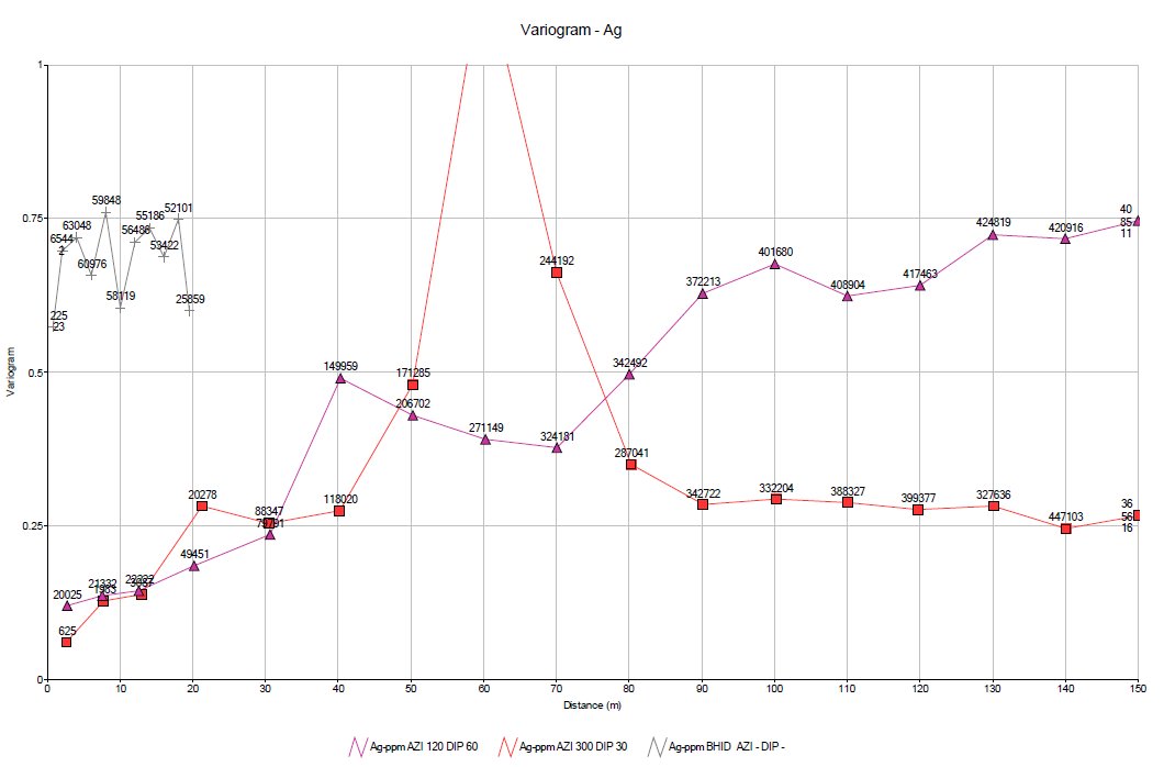
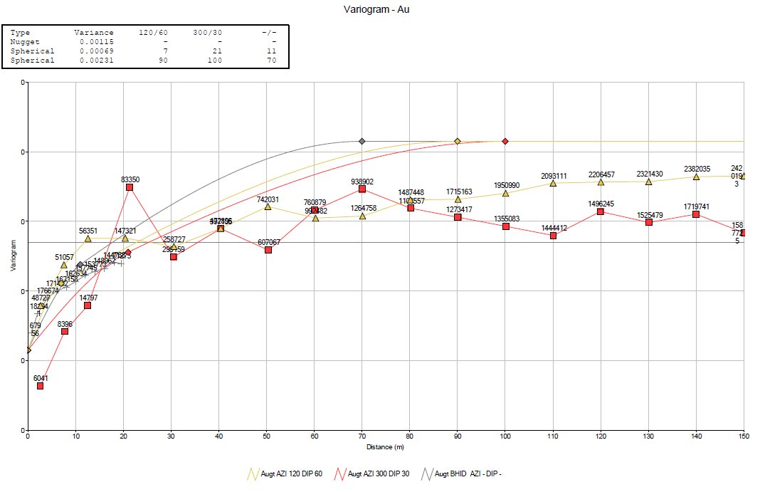

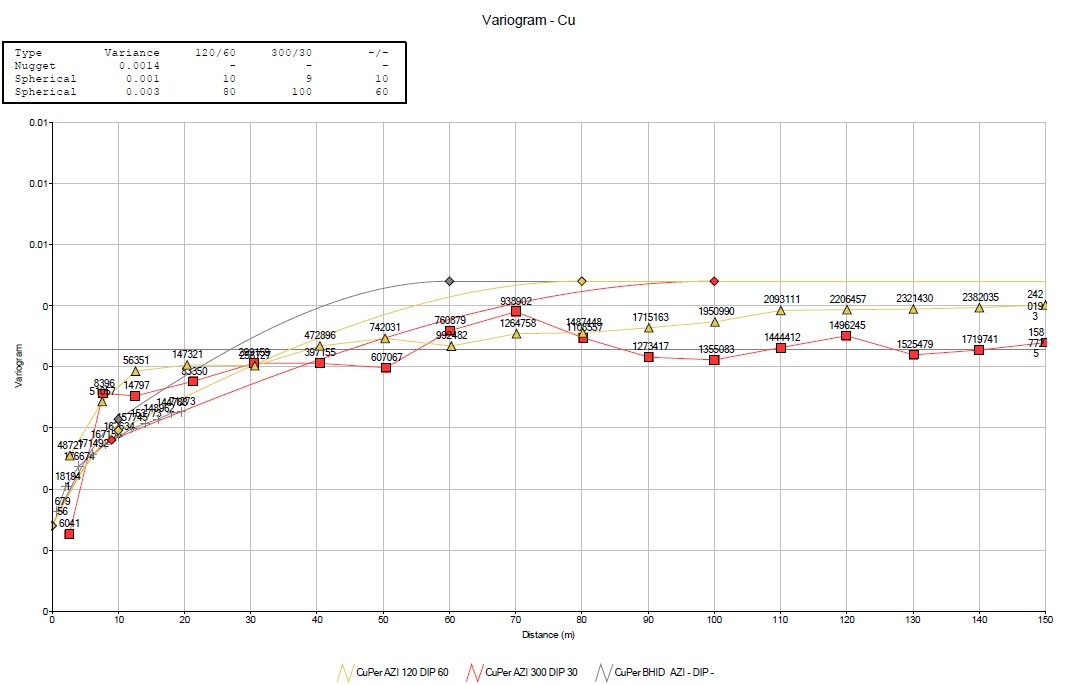
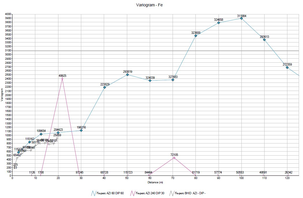
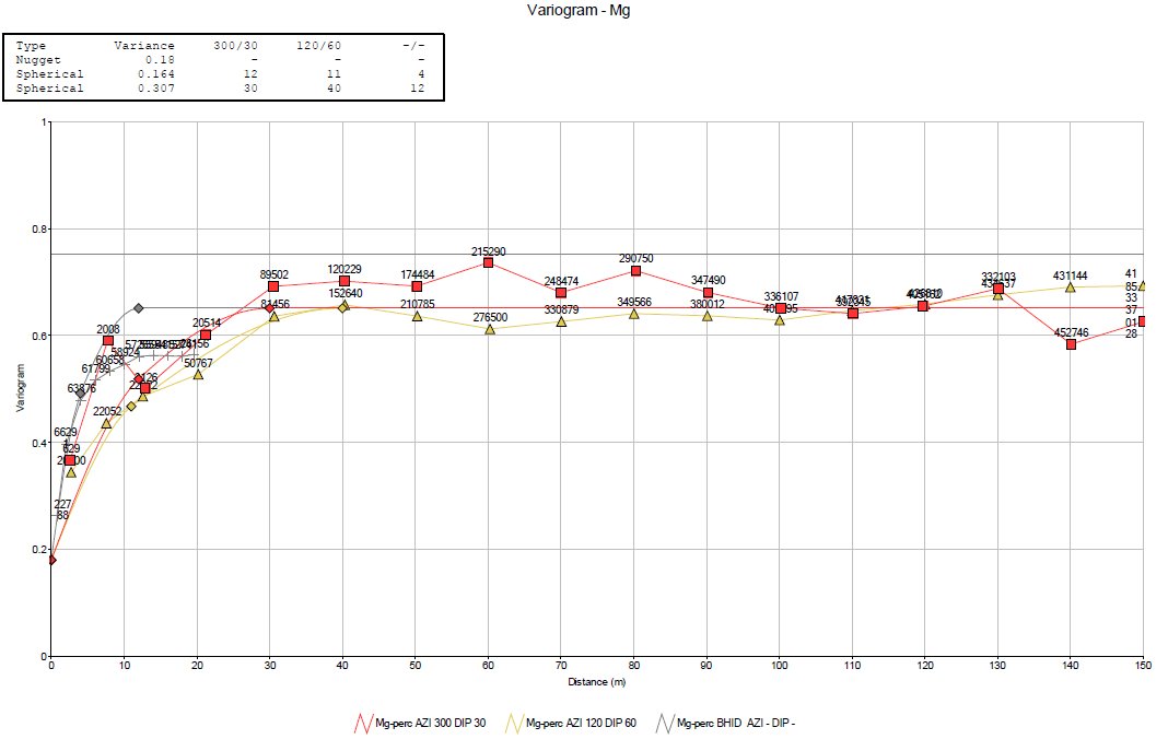
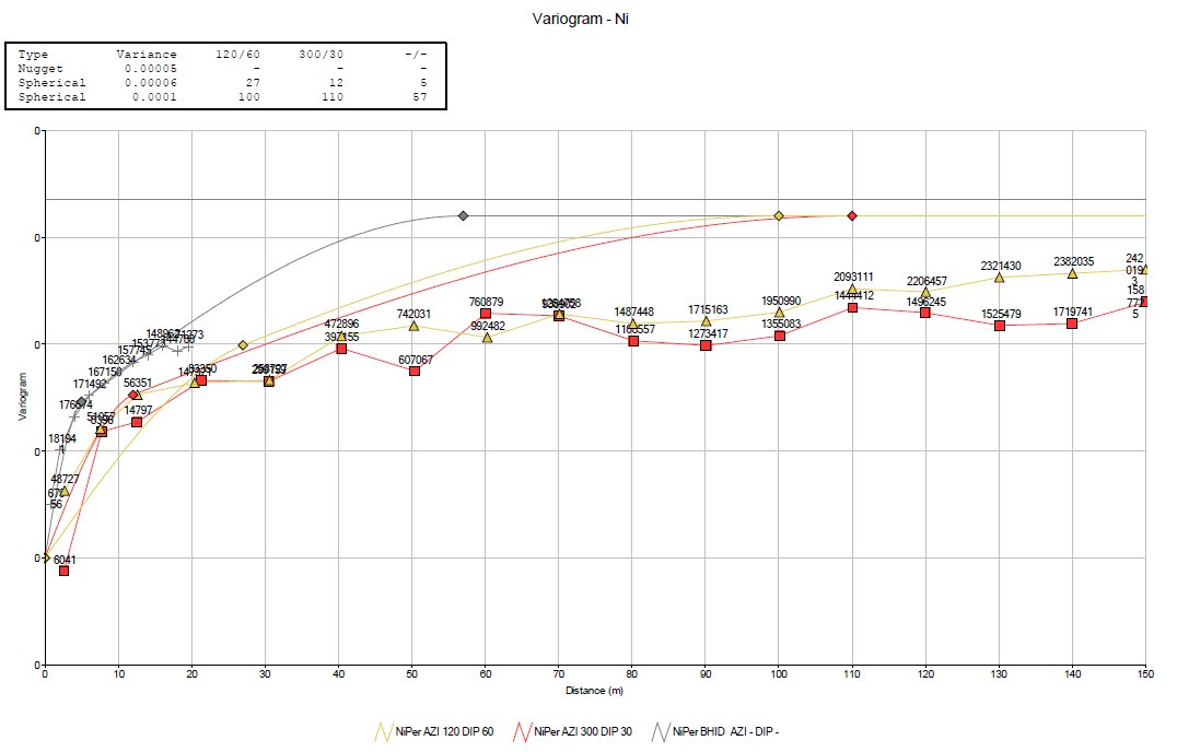

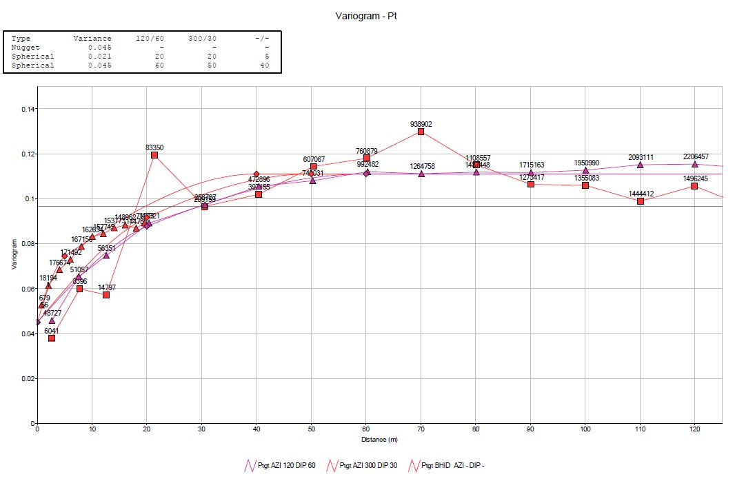
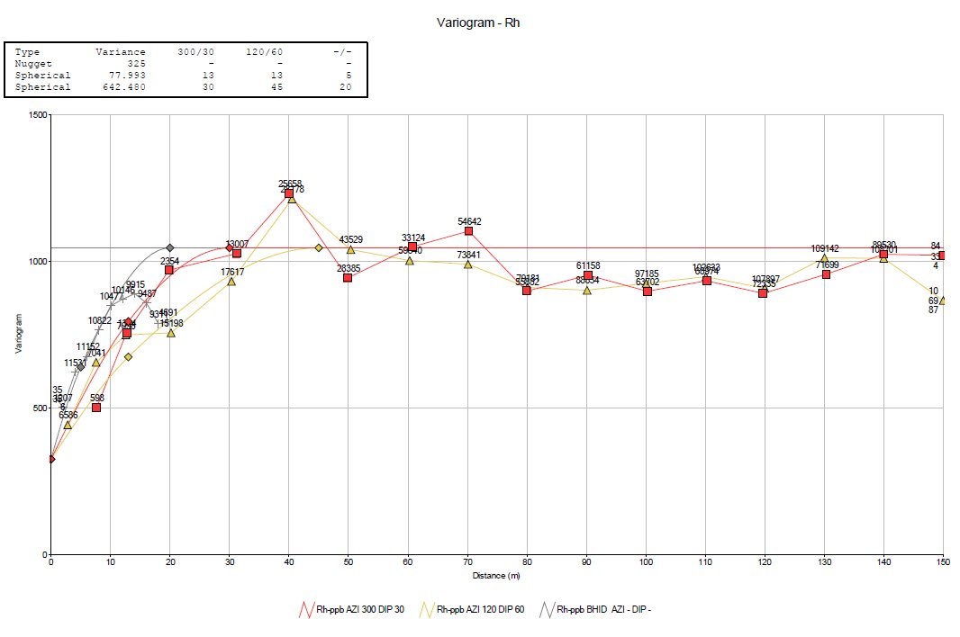
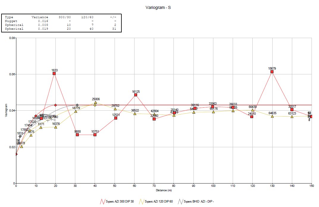
APPENDIX B
SWATH PLOTS