(EXHIBIT 99.1)
Renewal Annual Information Form
S o u t h w e s t e r n R e s o u r c e s C o r p .
For the year ended December 31, 2004
Dated as of March 21, 2005
![]()
COVER PAGE
TABLE OF CONTENTS
| COVER PAGE | I |
| TABLE OF CONTENTS | II |
| GLOSSARY OFTERMS | 1 |
| PRELIMINARYNOTES | 3 |
| FORWARD-LOOKINGSTATEMENTS | 3 |
| CORPORATE STRUCTURE | 4 |
| NAME, ADDRESS ANDINCORPORATION | 4 |
| INTERCORPORATERELATIONSHIPS | 4 |
| GENERAL DEVELOPMENT OF THE BUSINESS | 5 |
| THREEYEARHISTORY | 5 |
| DESCRIPTION OF BUSINESS | 6 |
| GENERAL | 6 |
| MINERALPROJECTS | 7 |
| RISKFACTORS | 27 |
| DIVIDENDS | 33 |
| DESCRIPTION OF CAPITAL STRUCTURE | 33 |
| GENERALDESCRIPTION OFCAPITALSTRUCTURE | 33 |
| MARKET FOR SECURITIES | 33 |
| TRADINGPRICE ANDVOLUME | 33 |
| DIRECTORS AND OFFICERS | 34 |
| NAME, OCCUPATION ANDSECURITYHOLDING | 34 |
| CONFLICTS OFINTEREST | 34 |
| AUDIT COMMITTEE | 35 |
| LEGAL PROCEEDINGS | 40 |
| LEGALPROCEEDINGS | 40 |
| INTEREST OF MANAGEMENT AND OTHERS IN MATERIAL TRANSACTIONS | 40 |
| INTEREST OFMANAGEMENT ANDOTHERS INMATERIALTRANSACTIONS | 40 |
| TRANSFER AGENTS AND REGISTRARS | 40 |
| TRANSFERAGENTS ANDREGISTRARS | 40 |
| MATERIAL CONTRACTS | 40 |
| MATERIALCONTRACTS | 40 |
| INTERESTS OF EXPERTS | 40 |
| NAMES OFEXPERTS | 40 |
| INTERESTS OFEXPERTS | 40 |
| ADDITIONAL INFORMATION | 41 |
| ADDITIONALINFORMATION | 41 |
Glossary of Terms
Aeromagnetic/Airborne Magnetic - Measurement of the earth's magnetic field from an aircraft for the purpose of recording the magnetic characteristics of rocks.
Assay - An analysis to determine the presence, absence or quantity of one or more chemical components.
Base Metal - A metal, such as copper, lead, nickel, zinc or cobalt.
Belt - A specific elongate area defined by unique geologic characteristics.
Breccia - Rock fragmented into angular components.
Carbonate - - A rock composed principally of calcium carbonate (CaCo3).
Claim/Concession (Mineral/Mining)– The area that confers mineral exploration/exploitation rights to the registered holder under the laws of the governing jurisdiction.
Copper– A ductile, malleable base metal with a myriad of uses in construction (piping, wire) and electronics due to its high electrical and thermal conductivity and good resistance to corrosion.
Diamond Drilling/Drill Hole - A method of obtaining a cylindrical core of rock by drilling with a diamond impregnated bit.
Dip - The angle at which a stratum is inclined from the horizontal.
Dyke - A tabular body of igneous rock cross cutting the host strata at a high angle.
Epithermal - A hydrothermal deposit formed close to surface at low temperature and pressure.
Fault - A fracture in a rock along which there has been relative movement between the two sides either vertically or horizontally.
Felsic - Igneous rock composed principally of feldspars and quartz.
Formation- A body of rock identified by lithological characteristics and stratigraphic position.
Gabbro – A fine to coarse, dark coloured crystalline igneous intrusive rock composed mainly of calcic plagioclase, clinopyroxene and sometimes olivine.
Geochemistry/Geochemical - Study of variation of chemical elements in rocks or soil.
Geology/Geological – Study of the Earth’s history and life, mainly as recorded in rocks.
Geophysics/Geophysical - Study of the earth by quantitative physical methods, either by surveys conducted on the ground, in the air (by fixed wing aircraft or helicopter) or in a borehole or drillhole.
Gold – A heavy, soft, ductile, malleable precious metal used in jewelry, dentistry, electronics and as an investment.
Grams per tonne (g/t)– A unit of measurement commonly used to quantify the concentration of precious metals.
Hectare - A square of 100 metres on each side.
Igneous– A classification of rocks formed from the solidification from a molten state.
Intrusive/Intrusions- Said of an igneous rock that invades older rocks.
Mafic-An igneous rock composed chiefly of dark iron and manganese silicate minerals.
Magnetic Survey - A geophysical survey conducted on the earth’s surface that measures variations in the earth's magnetic field caused by variations in rock type or geological structures.
Mapping – The art and science of recording geological observations on a map.
Metallurgical – The science and technology of extraction of metals from their ores and the refining of metals.
Metamorphism/Metamorphic - A process whereby the composition of rock is adjusted by heat and pressure/A class of rock affected by metamorphism.
Mineralization - The concentration of metals and their chemical compounds within a body of rock.
Ore - Rock containing mineral(s) or metals that can be economically extracted to produce a profit.
Orogen/Orogeny – A belt of deformed rocks through folding and faulting, in many places accompanied by metamorphic and intrusive rocks that form mountains/the process of mountain building.
Outcrop - An exposure of bedrock at the surface.
Porphyry - - A rock consisting of larger crystals embedded in a more compact finer grained groundmass.
Prospecting– The art and science of searching for mineral deposits.
Proterozoic - The youngest part of the Precambrian from 2450 - 570 million years ago.
Pyroxene– A calcium/sodium ferromagnesium silicate. One of the major rock forming minerals.
Quartz - A mineral composed of silicon dioxide.
Sediment- Solid material that has settled down from a state of suspension in a liquid. More generally, solid fragmental material transported and deposited by wind, water or ice, chemically precipitated from solution, or secreted by organisms, and that forms in layers in loose unconsolidated form.
Sedimentary-Pertaining to or containing sediment or formed by its deposition.
Shear - A planar zone of deformed rock caused by the movement of the rock.
Sill-A tabular body of igneous rock conforming to the last strata.
Soil Sampling - Systematic collection of soil samples at a series of different locations in order to study the distribution of soil geochemical values.
Strike - Direction or trend of a geologic structure.
Structure/Structural - Pertaining to geological structure, ie folds, faults, etc.
Sulphide/Sulphidation - A group of minerals in which one or more metals are found in combination with sulfur/rock that has been sulphidized.
Ultramafic – A dark coloured igneous rock containing less than 45% silica and characterized by mafic minerals, such as olivine, amphibole and pyroxene.
Vein- A thin sheet-like intrusion into a fissure or crack, commonly bearing quartz /a small vein or cluster of veins.
Volcanic - - Descriptive of rocks originating from volcanic activity.
Zinc – A lustrous, bluish-white base metal used primarily as an alloy of brass and bronze and galvanized steel in the automotive industry to protect from corrosion.
Preliminary Notes
The Annual Information Form (“AIF”) is prepared in the form prescribed by National Instrument 51-102F2 of the Canadian Securities Administrators and is hereby filed with the British Columbia, Alberta, Manitoba and Ontario Securities Commissions and The Toronto Stock Exchange.
All information in this AIF is as of March 21, 2005, unless otherwise indicated.
All information stated to be incorporated by reference in the Annual Information Form is filed on SEDAR website (www.sedar.com).
Forward-Looking Statements
This AIF contains certain forward-looking statements and information relating to the Company that are based on the beliefs of its management as well as assumptions made by and information currently available to the Company. When used in this document, the words “anticipate”, “believe”, “estimate” and “expect” and similar expressions, as they relate to the Company or its management, are intended to identify forward-looking statements. This AIF contains forward-looking statements relating to the business and affairs of the Company. Such statements reflect the current views of the Company with respect to future events and are subject to certain risks, uncertainties and assumptions. Many factors could cause the actual results, performance or achievements of the Company to be materially different from any future results, performance or achievements that may be expressed or implied by such forward-looking statements. Important factors are identified in this AIF under the heading “Description of Business -- Risk Factors”. Other factors include, among others both referenced and not referenced in this AIF, changes in general economic conditions and changes in business strategy. Should one or more of these risks or uncertainties materialize, or should underlying assumptions prove incorrect, actual results may vary materially from those described herein as anticipated, believed, estimated or expected, and the Company does not intend to, and does not assume any obligation to, update these forward-looking statements.
CORPORATE STRUCTURE
Name, Address and Incorporation
Southwestern Resources Corp. (“Southwestern” or the “Company”) was incorporated as "Southwestern Gold Corporation" under the Company Act (British Columbia) on June 18, 1990, by the registration of its Memorandum and Articles. The Company's name was changed in 2001 to its present name to more accurately reflect the nature of the Company's business.
The Company filed a transition application pursuant to the newBusiness Corporations Act(British Columbia) on April 23, 2004, whereupon its Memorandum and Articles became referred to as its Notice of Articles and Articles. On June 3, 2004, the Company amended its Notice of Articles to increase its authorized share capital to an unlimited number of common shares without par value and to remove certain pre-existing provisions of the Notice of Articles, the effect of which was to permit special resolutions of the Company to be passed by a two-thirds (instead of the previous three-quarters) majority of shareholders present in person or by proxy at a meeting. On the same date, the Company adopted new Articles which incorporated some of the more flexible provisions of the Business Corporations Act, including permitting directors to approve certain changes to the Notice of Articles, Articles and share structure and a change of the Company's name without requirement for shareholder approval. The amended articles also provide that shareholders’ meetings may be held by electronic means and in jurisdictions outside British Columbia if authorized by directors’ resolution. The quorum for shareholders’ meetings is one shareholder present in person or represented by proxy.
The address of the registered and records office, as well as the Company’s corporate head office and principal place of business is Suite 1650 - 701 West Georgia Street, Vancouver, British Columbia, Canada V7Y 1C6. The Company is a reporting issuer in British Columbia, Alberta, Manitoba and Ontario.
Intercorporate Relationships
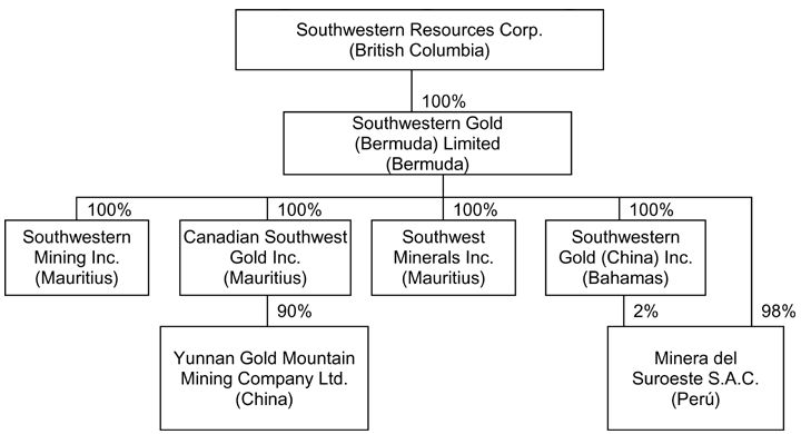
The corporate structure of Southwestern, its active subsidiaries, the percentage ownership in such subsidiaries as at the date of this AIF and the jurisdiction of incorporation of such corporations are set out in the following chart.
GENERAL DEVELOPMENT OF THE BUSINESS
Three Year History
Over the course of the past three years the Company has conducted its exploration activities principally in China and Peru.
During 2002, the Company wrote off $4.5 million in mineral property costs relating to projects that were abandoned in Peru and China.
In April 2002, the Company entered into an agreement to sell its 50% interest in the Poracota Property in Peru for US$4.5 million payable, in installments, by 2006. To date, all installments have been received with the final US$3.9 million due in February 2006.
In November 2002, the Company’s subsidiary, Canadian Southwest Gold Inc. (“CSG”) entered into an agreement (the “JV Contract”) with Brigade 209 of the Nuclear Industry of Yunnan Province, China (“Team 209”) regarding the Boka Gold Project in China. Pursuant to the JV Contract, CSG and Team 209 established a joint venture company (the “JV Company”) to own the exploration permits and mining permits and in order to conduct exploration of the Boka Gold Project. In 2004, CSG earned its 90% interest in the JV Company by contributing to that company US$4,010,000 and making a payment equivalent to US$1.7 million to Team 209. Team 209 retains a 10% carried interest in the JV Company. See “The Boka Gold Project” under the heading “Mineral Projects” in this AIF.
In August 2003 pursuant to an underwriting agreement with Raymond James and Octagon, the Company issued 1,532,375 Common Shares at a price of $10 per share for gross proceeds of $15,323,750. Proceeds from the financing were allocated to exploration of the Boka Gold Project and for general working capital.
In November 2003 the Company executed a joint venture agreement with Newmont Peru Limited Sucursal del Peru (“Newmont Peru”) pursuant to which Newmont can earn a 50% interest in the Company’s 100% owned Liam Core Zone by spending US$5 million over three years. See “The Liam Gold-Silver Project” in this AIF. In addition, Newmont Peru Limited (“Newmont Delaware”) and the Company executed the Liam Regional Joint Venture Agreement under which both parties contributed exploration concessions in Peru covering a total area of 81,789 hectares. This area has now been expanded to 91,195 hectares. Southwestern is the operator of the Regional Joint Venture and both parties are funding 50% of the initial US$5 million of exploration expenditures over a five year period.
Concurrently with the execution of the Newmont agreements, the Company also closed a non-brokered private placement with Newmont for the purchase of 450,000 common shares of the Company at $15 per share for proceeds of $6,750,000.
During 2004, the Company acquired 1.4 million shares of Maxy Gold Corp. pursuant to the exercise of 1.4 million warrants at a price of $0.40 per share at a total cost of $560,000 and 137,000 shares of Aurora Platinum Corp. (“Aurora”) pursuant to the exercise of 137,000 warrants at a price of $2.50 per share at a total cost of $342,500. The Company also acquired 1.5 million shares of Superior Diamonds Inc. (“Superior”) at a price of $0.40 per share at a total cost of $600,000.
In March 2004, the Company issued 1,150,000 common shares at a price of $35.50 per share and received gross proceeds of $40,825,000 pursuant to an underwriting agreement with Raymond James Ltd., Octagon Capital Corporation, Haywood Securities Inc. and National Bank Financial Inc. The Company is utilizing the proceeds to fund its exploration programs in China and Peru, to generate new projects and to supplement working capital.
In June 2004, the Company received shareholder and regulatory approval for a two-for-one stock split. All share issuances described above are on a pre-split basis. The shares commenced trading on a split basis on June 15, 2004.
In December 2004, the Company signed an option agreement with Anglo American Exploration Peru S.A. (“Anglo”) on Southwestern’s 100% owned Antay Project. Under the terms of the agreement, Anglo can earn 55% of the Antay Project by funding US$5 million in exploration expenditures over a five year period. Anglo has a further option to earn 70% of Antay by funding 100% of a bankable feasibility study. In a separate transaction which is subject to regulatory approval, Anglo American Exploration BV (“Anglo BV”) agreed to acquire US$5 million worth of Southwestern shares over a five year period payable in US$1 million increments. The first and second year subscriptions are a firm commitment. Anglo BV has the right to elect not to subscribe in respect of the third, fourth and fifth year subscriptions.
DESCRIPTION OF BUSINESS
General
Southwestern is a mineral exploration company engaged in the identification, evaluation, acquisition and exploration of mineral properties with the potential to host gold, silver and base metals. The Company holds interests in mineral properties in China and Peru.
The Company’s principal property in China is the Boka Gold Project in Yunnan Province, which covers an area of approximately 162 square kilometres of exploration concessions and mining leases located about 150 kilometres north of the capital city of Kunming in north central Yunnan Province. A drilling program, initiated in late 2002, is ongoing.
The Company’s principal property in Peru is the Liam Gold-Silver Project located 190 kilometres northwest of the city of Arequipa. The Liam Gold-Silver Project is comprised of the Liam Core Project, covering an area of 3,500 hectares and the Liam Regional Project which covers an area of 81,789 hectares.
Southwestern has also entered into other joint venture agreements with third parties including Anglo, Inco Limited and Southern Peru Copper Corporation, and holds directly other properties in the Tintaya-Bambas copper-gold skarn/porphyry belt of southern Peru.
The Company holds a 15.7% interest in Aurora, a TSX Venture Exchange listed company exploring for nickel-copper-platinum-palladium as well as other metals in Canada (Ontario and Québec).
The Company also became a direct shareholder of Superior when Superior acquired all of the issued and outstanding common shares of Canabrava Diamond Corporation (“Canabrava”) in November 2003 and the Canabrava shares which the Company held were exchanged for shares of Superior. The Company directly holds 19.8% of Superior.
In addition, the Company holds equity interests in a number of other mineral exploration companies all of which are listed on the TSX Venture Exchange.
All of the Company's properties are in the exploration stage without any assurances that commercially viable mineral deposits or reserves exist in any of the Company's properties until further work is done and a final evaluation concludes economic and legal feasibility of development.
The Company conducts its exploration independently as well as through option or joint venture agreements with third parties, referred to as joint ventures, whereby a third party earns an interest in the Company’s property by fulfilling terms as outlined in the agreement. The majority of joint venture agreements are structured in such a way as to allow an interested party to earn an interest in a project by making certain expenditures on the Company’s properties over a period of time. The Company is also involved in exploration through option or earn-in agreements whereby it makes option payments and/or provides 100% of the exploration funding in order to earn a controlling interest in a project owned by a third party.
The Company finances its activities with the proceeds from private offerings, public offerings, interest income and through joint ventures.
In order to carry out its business activities in Canada, Peru and China, the Company employs approximately 50 people on either a salaried or contract basis. The Company also engages various other independent contractors from time to time to supply work on specific projects and exploration programs.
Mineral Projects
The Boka Gold Project
Information on the Boka Gold Project, Yunnan Province, China set out herein has been obtained from the National Instrument 43-101F1 compliant technical report entitled “Technical Report, Southwestern Resources Corp., Boka Gold Project, Yunnan Province, China” by L.D.S. Winter, P.Geo., dated February 11, 2005.
PROJECT DESCRIPTION AND LOCATION
The Boka Gold Project covers an area of approximately 162 square kilometres of exploration concessions and mining leases located about 150 kilometres north of the capital city of Kunming in north central Yunnan Province, South China, at 26o-29'N latitude; 103o-02'E longitude (approximately 2,000 kilometres southwest of Beijing).
The Project comprises three Mining Permits (the "Mining Permits"), two of which are contiguous and the third is nearby, and three contiguous Exploration Permits (the "Exploration Permits”) covering an area within Dongchuan District (collectively, the Mining Permits and the Exploration Permits are referred to as the “Boka Property”). The Mining Permits were issued on March 5, 2003, two of the Exploration Permits were issued on April 10, 2003 and one Exploration Permit was issued on June 17, 2003. The three Mining Permits cover a total area of 4.9 km2 and the Exploration Permits cover an area of 157.5 square kilometres within an area of co-operation of 560 square kilometres.
A Letter Agreement was signed in 2002 between Team 209 and CSG. The Letter Agreement was subsequently formalized into the JV Contract.
Under the JV Contract, CSG will provide funds and cooperate with Team 209 in carrying out mineral resource exploration within a certain geographical area. In China, the right of mineral exploration and mining is conferred through the issuance of permits. Team 209 has acquired certain mining exploration permits for the purpose of carrying out mineral exploration within the area of cooperation.
Under the JV Contract, Team 209 and CSG have established the JV Company, a Sino-Foreign Cooperative Enterprise, Yunnan Gold Mountain Mining Co. Ltd. During the first phase, Team 209 transferred the Mining Permits and Exploration Permits to the JV Company to receive a 30% equity interest in the registered capital of the JV Company. Canadian Southwest Gold contributed US$3,010,000 to receive a 70% equity interest in the JV Company.
During the second phase Canadian Southwest Gold contributed an additional US$1,000,000 to the registered capital of the JV Company and paid Team 209 compensation totalling US$1,700,000 to earn its 90% interest. During the third phase (which has commenced, as announced in a press release dated December 10, 2004), any increase in the registered capital of the JV Company will be contributed 100% by Canadian Southwest Gold and Team 209 will not be required to make any contribution to the registered capital to retain its 10% of the registered capital and its 10% participation ratio of the JV Company. Canadian Southwest Gold will continue to have 90% of the registered capital and a 90% participation ratio regardless of increases in the registered capital of the JV Company.
Team 209 is presently dismantling the vat leach facilities at Boka and the final clean up will be inspected by the Ministry of Lands and Resources Environmental Division. Tunnel entrances have been sealed either by cementing the portals closed or installing metal doors.
The main zones of gold mineralization outcrop along the western edge of a north-south-trending plateau between approximately 1,600 metres to 1,850 metres elevation. The Chang Jiang (Yangze) River, which flows north at an elevation of about 900 metres, lies to the west of and at the base of the plateau. Gold mineralization is hosted within carbonaceous shales/slates, ductile-brittle deformation zones as well as associated structures. The mineralization extends for at least eight kilometres in a north-south direction and dips to the east in the order of 20oto 40o. Within this sector, three main areas of mineralization have been identified: Boka 11 to the north, Boka 1 North and South in the centre and Boka 7 in the south.
There are no mineral reserves or resources as yet defined for the Project. In all areas of mineralization, there are adits and associated stoped areas that have been excavated by local artisanal miners.
The Mining and Exploration Permits have been transferred to the JV Company. In 2003 the JV Company expanded its scope of business and a new business license was issued to permit the JV Company to explore, develop and mine for gold.
ACCESSIBILITY, CLIMATE, LOCAL RESOURCES, INFRASTRUCTURE AND PHYSIOGRAPHY
Access to the Boka Property is by road. The Property is approximately 280 kilometres north of Kunming, the provincial capital. From Kunming to Dongchuan takes about 2.5 hours on a paved highway.
From Dongchuan to the Property, the road initially follows the Xiaojiang River, then after about 20 kilometres, a series of switchbacks takes the road onto the plateau above the Xiaojiang River and an additional 10 kilometres leads to the Boka Property camp on the western side of the plateau.
The Project is approximately 40 kilometres north of Dongchuan (approximately 2.5 hours) with transport between the two areas being by vehicle.
The Boka area has a climate that varies from subtropical at the lower elevations to warm temperate at the higher elevations. Usually the winter months are cool and dry with precipitation amounting to 600 millimetres to 1,000 millimetres per year falling from April through October.
Southwestern has acquired a brick compound from Team 209 where all personnel are accommodated. Offices, eating facilities, etc. are available in the compound which is monitored by a security service. The compound and area have full electrical service, the Boka area is within the Chinese mobile phone network and Internet access is available in the compound.
The city of Dongchuan should be able to provide most of the services required by the Project. The Dongchuan copper deposit is close by and the city has provided service for the copper mining activities for many years.
The Project is at an early stage of exploration and as the work program progresses, the matters of access to surface rights, sufficient supplies of power and water as well as waste and tailings disposal areas and plant sites will need to be addressed.
The Boka Gold area is located in the Yunnan - Guizhou Plateau within the Chang Jiang (Yangze) drainage area. The major rivers are deeply incised and they appear, for the most part, to follow the major structural zones.
The area is bounded to the east by the Xiaojiang River and to the west by the Jin Sha Jiang River, the main upper tributary of the Chang Jiang (Yangze). These rivers occupy large, north-south trending valleys (faults) and are at an elevation of approximately 900 metres with the intervening central north-south-trending plateau in the Boka Property area being at about 1,900 metres. The east and west sides of the plateau are quite precipitous and steep east-west valleys add an additional degree of ruggedness to the area. The top of the plateau is relatively flat with relief being in the order of a few tens of metres. The top of the plateau and the upper parts of the slopes on the plateau edges are mainly under cultivation for grains, fruits and vegetables. All gentler slopes are terraced.
HISTORY
The Boka Gold Zone was discovered by Team 807 of the Yunnan Ministry of Geology and Mineral Resources by stream sediment sampling and soil geochemistry in 1999. Team 209 acquired the Project from Team 807 and in 2000, Team 209 set up a small mining operation. Team 209 produced about 150 kilograms of gold per year from a vat leaching operation situated adjacent to what is now the Southwestern compound. It is estimated that the average head grade of the ore that was processed was 5 to 10 grams per tonne gold. In early 2004 Southwestern bought out the Team 209 operation.
The Company did not acquire the Project from an informed person or promoter for the Company or an associated or affiliated person.
GEOLOGICAL SETTING
The project area lies in the western part of the Yangze Platform which contains Middle to Late Proterozoic eugeosynclinal sediments that were consolidated during the Jinningian Orogenic Movements at 850 million years. The platform received sediments throughout most of the Paleozoic with interruptions being due to Caledonian and Hercynian Tectonism and by the Indosinian Orogeny in Mid to Late Triassic time. From Devonian through Permian time, an extensive north-south zone of rifting (Panxi Rift) with associated flood basalts developed through the Yunnan - Sichuan Province area.
This sequence of geologic events produced the geological setting for the Boka gold deposits. The oldest units are the Middle to Late Proterozoic formations which in general trend north-south and exhibit gentle open folds. Unconformably overlying the Proterozoic units are Paleozoic sediments - Cambrian to Permian in age, followed by later Mesozoic sediments. The Permian Ermeishan flood basalts are extensively developed east of the area and the Xiaojiang Fault (River). The Xiaojiang Fault is one of the major structures of the Devonian - Permian rift zone, extends for 100's of kilometres and is still seismically active. The north-south section of the Jin Sha Jiang River immediately to the west of the Boka site is also considered to follow a branch of the rift zone.
The Boka Gold Project area is underlain by a sequence of essentially unmetamorphosed to lower greenschist facies Middle to Late Proterozoic eugeosynclinal sediments exposed in a window of "basement" rocks surrounded by Paleozoic sediments and Permian age Ermeishan basalts mainly to the south and east. The sequence from bottom to top commences with various sandstones followed by a chloritic slate, calcareous siltstones, carbonaceous slates, calcareous sandstones and dolomite at the top. These units are considered to be part of the Kunyang Group.
Geological mapping and compilation by Southwestern suggests that this sequence has been gently folded about north-south trending axes into broad open folds that may plunge at low angles to the south.
The sedimentary package has been affected by west-verging thrust faulting which appears to have been mainly confined to the less competent shale/slate horizons between the more competent dolomites and sandstone/siltstone units. These deformation zones exhibit ductile-brittle type deformation and are, at least in part, the locus for the gold mineralization. These thrusts may also have produced a tectonic thickening of the shale/slate sedimentary package.
At present, the main stratigraphic interval of interest is that which hosts the Boka 1 - Boka 7 -Boka 11 Mineralized Horizon. Additional mineralized horizons/structural domains have been recognized below this main horizon at both Boka 7 and Boka 11, however, only recently has work commenced evaluating the lower horizon at Boka 7. The situation at Boka 8 is unclear and further work is required to determine the structural/stratigraphic situation in this area.
Small bodies of gabbro as dykes and sills are intrusive into the thrust faults and cross-cutting structures.
Regional metamorphism is considered to be very limited with the Proterozoic units in the general Boka area showing lower greenschist grade metamorphism at best.
EXPLORATION
The JV Company is evaluating the project under the overall direction of John Paterson, president and CEO of Southwestern and a Qualified Person under the Member, Aus IMM designation. The on-site Project Manager is John Zhang.
The work completed and currently in progress consists of:
| - | detailed topographic surveying of the Boka 1 area, surveying of the Boka 7 and Boka 11areas and surveying of all drill hole locations. |
| - | identification and surveying of all the tunnels excavated by artisanal miners. |
| - | sampling of tunnels in all areas. |
| - | driving of six exploration tunnels. This work was under contract to Team 209. |
| - | Transient Electromagnetic (TEM) survey over the Boka 1 Zone. This survey traced theconductive horizon in the hangingwall of the Boka 1 Zone down-dip for over 1,500metres. |
| - | regional geological mapping and soil sampling. |
| - | diamond drilling. Currently seven drills are operating on the property under contractstotaling 40,000 metres. Approximately 26,578 metres has been drilled in the 70 holesthat have been completed (or abandoned) and five holes are now in progress. |
| - | a Scoping Assessment Report being prepared by Hatch Engineering. A Draft Report wasreceived in December 2004, however, after a review the Company expanded theparameters to include underground mining. |
The majority of the work has been carried out by the JV Company with tunnelling being done by Team 209 personnel and drilling by Edco Drilling, Huafeng Drilling Company and Yunnan Bradley Drilling Limited under contract.
It is considered that the work on the Property is being done in a professional and competent manner and that the results to date are a fair and reasonable representation of the actual situation.
MINERALIZATION
The thrust deformation has generally been localized within the carbonaceous shales/slates of the Middle Proterozoic eugeosynclinal sediment sequence. At Boka 1 (North and South), Boka 7 plus Boka 11, deformation occurs within an approximately 200 metres thick sequence of carbonaceous shales/slates overlain by massive dark grey dolomites and underlain by light grey sandstones. This 200 metres+thick zone is also the locus for the gold mineralization which appears to be concentrated within more limited "stratigraphic" intervals. In the following sections, the 200 metres "stratigraphic" interval to which the deformation and gold mineralization is generally confined will be referred to as the “Mineralized Horizon”. The narrower intervals that host significant amounts of quartz-carbonate veining and gold mineralization will be referred to as “Enriched Zones”. The work to date indicates that the Mineralized Horizon is comprised of higher grade Enriched Zones separated stratigraphically by lower grade intervals. These lower grade intervals, at least in some cases, may be made up of narrow, more competent sandstones or carbonates that have suffered only minor deformation. These less deformed/more competent intervals appear to carry gold values that vary from nil through a few hundred parts per billion to one or two grams per tonne gold.
As of mid-January 2005, seven drills are operating on the Property evaluating the potential of the Mineralized Horizon.
At Boka 1 North within the Mineralized Horizon, the interval of economic interest as indicated by 17 completed holes varies from 11.8 metres to 116.4 metres thick and has been traced down-dip for 500 metres and along strike (N20oW) for 700 metres. Gold values for the mineralized intervals range from 1.2 grams per tonne gold to 10.2 grams per tonne gold.
Thirty-one drill holes have been completed at Boka 1 South and have intersected mineralization over a N20oW strike length of 700 metres, for 750 metres down dip and across widths from 23.0 metres to 94.6 metres. Assay results show the mineralization to vary in grade from 1.3 grams per tonne gold to 9.3 grams per tonne gold.
In the Boka 7 area, 11 holes have been completed. The holes occur over a strike length of about 1,000 metres (N20oW), a down-dip extent of about 300 metres and show the width of the Mineralized Horizon to vary from 41.7 metres to 107.3 metres with grades in the 2.4 grams per tonne gold to 3.1 grams per tonne gold range.
All widths of mineralization are core lengths, however, since the holes are being drilled approximately perpendicular to the zone, the core lengths are approximately true widths.
The holes completed to date extend from hole B03-09b in the north to B03-10 in the south, a distance of 3.89 kilometres. Holes at Boka 1 North occur over a 700 metre strike length, at Boka 1 South over a 700 metre strike length and at Boka 7 over a 1,000 metre strike length for a total of about 2,400 metres or approximately two-thirds of the drilled strike length. Holes for which results are pending are being drilled at Boka 1 North and South.
The soil geochemical survey indicates anomalous gold, silver, arsenic, copper and nickel values from the Boka 11 area in the north to the southern property boundary about 775 metres south of drill hole B03-10.
DRILLING
The current drilling program is being carried out by Edco Drilling, a division of TVI Pacific, Huafeng Drilling Company and Yunnan Bradley Drilling Limited with a total of seven drill rigs on the Property. As at February 11, 2005, 70 holes were completed (six abandoned) for a total of 26,578 metres with five holes in progress.
The main unit being drilled is a fissile shale/slate, which in places has been subjected to folding and ductile/brittle deformation and has been invaded by intrusives and quartz-carbonate-sulphide veinlets. This combination of features may lead to difficult drilling conditions that consist of "blocky ground"; the grinding of core, caving of the hole, and loss of core as examples.
As is normal at the start of most drilling programs, core recovery problems were encountered, however, with more experience the core recovery estimated by the JV Company geologists for the current drill holes is considered to be in the order of 90%.
The core is placed in plastic trays at the drill site with plastic markers at the appropriate metrage. It is then transported by truck to the JV Company core storage facility, which is a concrete building that can be securely closed off. The core is logged by JV Company geologists into a computer logging system, sample intervals are marked and recorded and then the core is set aside for sampling. The core is split with one half being retained and one half is sent for analysis in security sealed sample bags to the assay laboratory of the Northwest Non-Ferrous Geology Research Institute (ISO 9002) located in Xian, Shaanxi Province, P.R.C. for sample preparation, after which a 500 gram, -10 mesh sample split is sent to IPL Labs or ALS Chemex Laboratories, Vancouver for analysis.
Seventeen holes have been drilled in the Boka 1 North sector evaluating the Mineralized Horizon over a strike length (north-northwest) of approximately 700 metres and for 500 metres down-dip to the east. Holes B02-01, B03-04, B03-07, B04-49, B04-46 and B04-70 were drilled along one section and illustrate the continuity of the Mineralized Horizon from surface, in tunnels PD-3 and PD-6 down-dip to the east at about 35° for 500 metres.
The mineralized intersections in the 13 holes in the Boka 1 North Zone for which results are available show mineralized core intervals varying from 11.8 metres to 116.4 metres. Apart from these two values the remaining core intervals fall in the interval 33.65 metres to 88.6 metres. The grades of the mineralized intervals fall in the range from 1.2 grams per tonne gold to 10.2 grams per tonne gold.
In the Boka 1 South area, 38 holes have been drilled with two holes abandoned. The results are available from 31 holes (29 complete and two abandoned) and results are pending for seven holes completed or in progress. The drilling indicates that the Mineralized Horizon in this area trends N20oW and dips at low to moderately steep angles to the east. The drilling has been over a strike length of approximately 700 metres (N20oW) and a down-dip extent of about 750 metres. The majority of the drilling has been concentrated in an area measuring about 300 metres, N20oW, by 550 metres, N80oE. In this smaller area, holes have been drilled on lines trending N80oE and spaced at 50 metres with holes at 50 metre intervals along these lines.
For the 31 holes completed at Boka 1 South and for which results are available, the gold mineralized zone has been intersected across core lengths from 23.0 metres to 94.6 metres. In some holes, more than one mineralized zone was intersected. Grades in these 33 holes vary from 1.3 grams per tonne gold to 9.3 grams per tonne gold across the mineralized zone.
Eleven drill holes have been completed at Boka 7 with all the results having been received. The 11 holes occur over a strike length (N20oW) of approximately 1,000 metres and over a dip extent of about 300 metres.
The results received to date at Boka 7 indicate mineralization over widths from 31.0 metres to 107.3 metres and with grades across the mineralized intervals from 2.4 grams per tonne gold to 3.2 grams per tonne gold. Hole B03-14 returned two intervals of interest separated by a 55.7 metre zone of anomalous to sub-economic mineralization. The upper interval from 166.8 metres to 197.8 metres (31.0 metres) averaged 3.2 grams per tonne gold while the lower interval of 31.9 metres starting at 253.5 metres assayed 2.9 grams per tonne gold. Three zones starting at depths of 117.0 metres, 222.8 metres and 287.1 metres were intersected in hole B04-36.
In summary, 70 holes have been completed (six abandoned) over a N20oW distance of four kilometres. Within this distance, three mineralized zones have been identified by drilling, Boka 1 North, Boka 1 South and Boka 7, with strike lengths (N20oW) of 700 metres, 700 metres and 1,000 metres respectively. At Boka 1 North, holes have been drilled on lines trending N80oE and spaced at 100 metres with some lines containing only one hole while other lines host more than one hole with hole spacing varying from 50 metres to 200 metres. For the most part, the Boka 1 South drilling has been on a grid with lines spaced at 50 metres and with hole spacings of 50 metres. At Boka 7, holes are more widely spaced with 11 holes drilled over an area measuring 1,000 metres north-south by 300 metres east-west.
It is considered that the drilling at Boka 1 North is showing good continuity to the mineralization over the 700 metre strike length and for 500 metres down-dip on the section drilled. The close spaced drilling at Boka 1 South shows continuity to the mineralization in the area tested. Holes B03-12 and B03-21 returned only low gold values, however, further drilling will be required to determine the structure/stratigraphic complexities in this area, which may be the cause of the low gold values. At Boka 7, although the holes are widely spaced, they show the presence of the Mineralized Horizon over an area of 1,000 metres by 300 metres with additional drilling required to determine the detailed nature of the mineralization in this area.
SAMPLING AND ANALYSIS
The initial work at the Boka Gold Project began in mid-October 2002 and since that time the sampling approaches and procedures have evolved as new information became available.
As a means of quickly evaluating the Mineralized Horizon and contained gold-bearing zones, the JV Company began a program of surveying and then sampling of the tunnels that had been driven by the artisanal miners. During the due diligence work vertical chip samples were taken, however, when the tunnel sampling program was started in October 2002, horizontal chip samples were taken along one wall of a tunnel for a predetermined sample interval that was usually in the 2 metres to 5 metres range. Prior to sampling, loose dirt was scraped from the wall as best as possible and then the horizontal sample was taken by chipping rock fragments from the tunnel wall into a cloth sample bag. The bag was then ticketed, closed, combined with other samples in a larger bag and sent to the Langfang Institute of Geochemical and Geophysical Exploration (1S0 9001 Certification), Langfang, Hebei Province, approximately 60 kilometres from Beijing.
It was recognized that the horizontal channel sampling procedure was prone to misrepresenting the value of the mineralization after the preliminary work showed that in general the gold-bearing mineralization trended north-south and dipped, on average, about 30o to the east with variations from horizontal to 60o. In these circumstances, a horizontal sample in a 30o dipping mineralized zone cuts the zone at a low angle and may give a sample value that overstates the "true" value. In contrast, a 30o dipping zone close to the floor or back of the tunnel, may not be sampled by a waist high horizontal channel sample, thus giving an understated assay value. To correct this situation, a panel sampling procedure was proposed whereby the tunnel wall would be sampled as a panel. The tunnels are on average 2 metres high, thus, for a 3 metres long (horizontal) panel, for example, the panel would be sampled by four lines of chips - top left to bottom right and top right to bottom left and top to bottom and left to right at mid-wall. The chips from these crosses would provide the sample.
As indicated above, the initial horizontal channel samples may have produced some non-representative values due to the bias introduced by the geometry of the sample relative to the geometry of the mineralization trend. However, in a large number of samples, it would appear that some samples would overstate the "true" value while others would understate it, with the result that the mean for a number of samples in a tunnel is probably a reasonable value for the total length of tunnel sampled, for example.
The sampling of the drill core presents similar problems to those encountered in sampling the tunnels. Specifically the drill core is a small sample of a host rock that has been subjected to at least two or three phases of deformation, has been altered and mineralized and most recently, may have been subjected to surface weathering and oxidation. As a result, sections of core are highly fractured and may be quite friable due to oxidation. This type of ground creates challenges for the drillers in order to maximize core recovery. It is considered that the most difficult sections in which to get 100% core recovery are oxidized, mineralized sections due to the vuggy to friable nature of the residual material. As a result, it is the writer's opinion that the gold values as reported from the drill core samples may understate the actual gold content of the sample.
Apart from the above consideration, it is considered that the current sampling procedures are appropriate. Due to the presence of coarse erratic gold concentrations in the mineralization, all drill core samples are now being treated using the Screen Fire Assay Method.
The tunnel sampling was undertaken to ascertain the grades of gold mineralization that might be encountered in the Boka Property. It was not undertaken to sample any specific unit or structure, however, as the situation has evolved it became evident that the tunnels contained zones of higher grade mineralization, associated with deformation zones, quartz-carbonate-sulphide veining and in some cases heavy sulphide mineralization, separated by less deformed zones containing low grade to anomalous levels of gold mineralization. Therefore, the tunnel samples must be considered to represent various types of materials exhibiting a wide range of values. Also, an individual tunnel should not be considered to expose the true width of the mineralization. Due to the limited stratigraphic interval exposed in any one tunnel or set of connected tunnels, it is considered that it is extremely difficult to state the true width of all the mineralized zones sampled to date in the tunnels. If the average dip of the mineralized zones is considered to be 30o east, then a "rule of thumb" at this time would be that the "true width" of a set of mineralization samples in a horizontal tunnel would be half (50%) of the horizontal length. The true width of the Mineralized Horizon and any contained gold-bearing zones can best be estimated from the drill holes currently being put down.
Economic grade gold values in the Mineralized Horizon vary in thickness from approximately 40 metres to over 100 metres and within this interval there are many combinations of carbonaceous black slate, siltstone, shear/fault zones, mineralized zones, veined zones, etc. Drill core is generally sampled in two metre intervals with the core being split longitudinally into two halves, one of which is retained in the core box while the other half is sent for assay. The results for each drill hole are reported as a combined weighted average for each drill hole.
Southwestern has been re-sampling drill core under the supervision of the Project Manager. Samples showing a range of values and from different holes have been selected.
The Boka Gold Project is using 16 Standard Samples obtained from Gannet Holdings Pty. Ltd. which cover the range of gold values from below the detection level of 5 parts per billion gold to 35.600 grams per tonne gold. These Standards are submitted along with the normal core, rock and soil samples, as a means of determining the accuracy of the gold values reported by the analytical laboratories. In addition, the Company, on a random basis, takes second or duplicate samples which are submitted for analysis for gold. To date, a total of 123 Standard Samples, four duplicate rock samples, 65 duplicate core samples and 23 duplicate soil samples have been analyzed for a total of 92 duplicates. (One hundred and seven additional Standard Samples and 107 additional duplicate samples have been submitted for analysis, however, the results are still outstanding.)
Accuracy is an indication as to how closely the determined value of a sample is to the "true" value of the sample. Precision is an estimate of the reproducibility of an analytical determination.
A total of 123 analyses were carried out on Standard Samples to determine the accuracy of the chemical analyses. Each analytical batch contained an equal number of standard and duplicate samples (for a total of 92). The additional 31 Standard Samples were from a separate set of analyzed Standard Samples.
With respect to the Boka Standard Samples, the data for the Standard Sample analytical values and the Standard Sample "True" Values indicates that the level of accuracy is acceptable at the 20% precision level. It is appropriate to note that even for Standards, that are generally considered to be quite homogeneous, the accuracy is at the 20% precision level. When the precision was calculated for the individual pairs of samples, the average for all the Standards was also 20%.
Sixty-five Duplicate and 65 Standard Samples were analyzed in 16 batches of drill core from the Boka Gold Project. The results for both the Standard Samples and the Original - Duplicate Sample Pairs indicated that the precision for the Standards varied from 103.21% to 4.13% and the precision for the Duplicates varied from 139.45% to 22.80%. The high values of precision for the most part are associated with Standards and Duplicates where the gold values are very low and close to the detection limits. When the two highest values for the precision of Standards are rejected, the remaining 14 batches give a very acceptable 14.7% value of precision. For the Original - Duplicate Sample Pairs when the 3 highest values are rejected, the level of precision is 47.0%. A graphical representation of the complete data set suggests a precision level of 50%, very close to that as calculated for the 13 batches.
Twenty-three soil sample Original - Duplicate Pairs indicate a precision of about 50% and the four Original - Duplicate Pairs of rock samples show a precision level of about 20%.
The work to date suggests that for low gold concentrations the level of precision cannot be expected to be much better than 50%. This is considered to be due to the greater chemical variance as the detection limit is approached. Also the 50% precision level is considered to be a function of the heterogeneity of natural materials such as sulphide or quartz-hosted gold.
In summary, it is considered that the analytical results from the Boka Gold Project core, rock and soil samples fall within normal and acceptable levels of accuracy and precision and can be considered to be representative of the naturally occurring mineralization.
It is considered that adequate quality control procedures are in place for this stage of the Projects. As the Project advances further quality control procedures will be required depending on the program.
SECURITY OF SAMPLES
Drill core samples consist mainly of two types of material, solid drill core and broken drill core which consists of broken pieces of core varying from sand size to 20 millimetres +/-. The core is sampled by splitting the material longitudinally into the required sample and half of the core is retained on site for review, resampling, etc. as required. The drill core samples are each placed in a sample bag, which is then sealed, and these are grouped into larger bags and then shipped directly in security sealed bags to the assay laboratory of the Northwest Non-Ferrous Geology Research Institute (ISO 9002) located in Xian, Shaanxi Province, P.R.C.
The core is currently stored in plastic trays in a secure concrete building.
At the Xian facility, the drill core samples are prepped to -10 mesh at which point a 500 gram sample split is taken. This material is sent to IPL Laboratories or to ALS Chemex Laboratories in Vancouver and the balance of the sample is stored. All drill core samples are being assayed using the Screen Fire Assay Method.
ALS Chemex is an ISO 9001: 2000 registered laboratory that is actively pursuing accreditation for ISO 17025 under CAN-P-1579 "Guidelines for Accreditation of Mineral Analysis Testing Laboratories". IPL Laboratories is an ISO 9002 registered laboratory.
The soil geochemical and exploration samples are assayed at the Langfang Institute of Geochemical and Geophysical Exploration in Beijing, an ISO 9001 registered lab. The samples are digested in aqua regia followed by analysis by atomic absorption techniques for gold, silver, copper, nickel, arsenic, antimony and bismuth.
The JV Company submits its own standards as a measure of the accuracy of the analysis. Field duplicates and pulp duplicates are being routinely analyzed for precision at ALS Chemex, Vancouver, British Columbia.
MINERAL RESOURCE AND MINERAL RESERVE ESTIMATES No mineral reserve or resource calculations have been undertaken. MINING OPERATIONS
The Project is at an early stage of exploration and, while there remain small adits and stopes developed by artisanal miners, there are no mining or processing facilities on the Property being operated by the JV Company.
EXPLORATION AND DEVELOPMENT
It is considered that the Boka gold mineralization was produced by a very large mineralizing system. Gold mineralization has been identified over a considerable area from Boka 8 and 11 in the north through Boka 1 North and South to south of Boka 7, a total north-south distance of approximately eight kilometres. The main north-south-trending east-dipping Mineralized Horizon, contained within a package of Middle Proterozoic age, eugeosynclinal sediments, consists of a stratigraphic interval of carbonaceous shales/slates with minor siltstone, mudstone and carbonate interbeds which shows evidence of multiple episodes of ductile-brittle deformation. The Mineralized Horizon hosts the main areas of known gold mineralization with Boka 1 North, Boka 1 South and Boka 7, currently being drilled.
The JV Company has embarked on additional engineering studies and has purchased the Team 209 Interest in the Boka Gold Project. The JV Company is in its Phase 3 exploration program, the budget for which is $3,806,500 and central to which is the completion of the 40,000 metres of diamond drilling. Upon completion of the Phase 3 program the JV Company plans to proceed with additional drilling to define areas of mineralization indicated by previous work and to enable resource estimates to be made for the Boka 1 North, Boka 1 South ad Boka 7 Zones. To take into account these expenditures, an additional budget has been proposed by the JV Company.
The Liam Gold-Silver Project
Information on the Liam Gold-Silver Project, Department of Cusco, Peru set out herein has been obtained from the National Instrument 43-101F1 compliant technical report entitled “Technical Report, Southwestern Resources Corp., Liam Gold-Silver Project, Department of Cusco, Peru” by L.D.S. Winter, P.Geo., dated February 23, 2005.
The Company's principal property in Peru is the Liam Gold-Silver Project (the “Liam Gold-Silver Project” and the “Project” are used interchangeably) located 190 kilometres northwest of the city of Arequipa. In late 2003 the Company signed an option agreement with Newmont Peru Limited Sucursal del Peru (“Newmont Peru”) regarding the core zone of the Liam Gold-Silver Project (the“Liam Core Zone” and the “Liam Core Project”). Newmont Peru Limited (“Newmont Delaware”) and the Company also entered into a joint venture agreement (the “Regional Joint Venture Agreement”) to explore various concessions owned by the two companies outside the Liam Core Zone (the “Liam Regional Zone” and the “Liam Regional Project”).
PROJECT DESCRIPTION AND LOCATION
The Liam Gold-Silver Project is comprised of three parts, the Liam Core Zone containing four concessions totalling 3,500 hectares, the Liam Regional Zone containing 110 concessions covering 89,395 hectares and the Area of Interest.
The Liam Gold-Silver Project is located in southern Peru, within the western slopes and the continental divide of the Cordillera Occidental (Western Cordillera) of the Peruvian Andes in the Department of Cusco at 14° 46’S latitude, 72° - 23’W longitude, approximately 190 kilometres northwest of the city of Arequipa.
The concessions in the two zones constitute the “Project Area” and are held by either Minera del Suroeste S.A.C. (“Misosa”) an affiliate of Southwestern or Newmont Peru Limited Sucursal del Peru (“Newmont Peru”), a branch of Newmont Peru Limited (“Newmont Delaware”). Both Misosa and Newmont Peru own or control mineral rights outside the Project Area but within the Area of Interest.
In late 2003, a letter of intent was executed between Newmont Delaware and Southwestern and was subsequently formalized in two agreements: (1) an Option Agreement dated November 14, 2003 between Misosa and Newmont Peru regarding the Liam Core Zone (the “Option Agreement”); and (2) a Joint Venture Agreement dated November 14, 2003 (the Regional Joint Venture Agreement) between Newmont Delaware and Southwestern, regarding the Liam Regional Zone (the Regional Joint Venture). Newmont Delaware and Newmont Peru are collectively referred to as Newmont.
Under the Option Agreement, Misosa granted Newmont Peru the option to earn an undivided 50% interest in the Liam Core Zone by spending a total of US$5 million over a three-year period, with a minimum annual expenditure of US$1 million, which must include 5,000 metres of drilling. After earning an undivided 50% interest Newmont Peru has the second option to earn an additional undivided 10% interest in the Liam Core Zone by producing a positive feasibility study. In addition, Newmont Peru has a third option to earn a further undivided 10% interest in the Liam Core Zone, thereby increasing its interest to an undivided 70% interest, by funding all costs incurred to commencement of commercial production of mineral products from the Liam Core Zone. If Newmont Peru elects the third option it will be entitled to receive 90% of distributable profits until it has been reimbursed for all costs incurred during the third option, while the remaining 10% of profits will be distributable to the parties pro rata.
Under the Regional Joint Venture Agreement, Southwestern and Newmont Delaware contributed certain mineral concessions and each has an undivided 50% participating interest in the Regional Joint Venture. The parties have agreed to spend a total of US$5 million in the Area of Interest over a five-year period, with Southwestern as exploration manager. If the Technical Committee formed under the Regional Joint Venture determines that any project within the Area of Interest, based on a preliminary scoping study of its tonnage, or grade, initial metallurgy or initial economic valuation, constitutes a viable exploration project then Newmont Delaware has the election to earn an additional 20% interest in that project by producing a feasibility study and funding all costs incurred to the commencement of commercial production. Newmont Delaware also has similar preferential rights to distributable profits as those specified for the Liam Core Zone.
Apart from the contractual terms set out above, there are no additional royalties, overrides, back-in-rights, payments or other agreements to which the Project is subject.
There are no known pre-existing environmental liabilities.
The Liam Gold-Silver Project is located within the western slopes and the continental divide of the Cordillera Occidental (Western Cordillera) at an altitude of 4,500 metres to 5,300 metres within the northwesterly-trending Southern Peru, Tertiary Volcanic Belt.
At Liam, within a large zone of argillic – siliceous alteration, the Liam gold-silver-bearing zone is considered to consist of three parts: Cerro Crespo butte to the south, an 800 metre diameter, maar-like crater immediately to the north and northeast, and the Queshca area on the north side of the maar-like crater. The area in which gold-silver values of economic interest have been obtained extends about 2.5 kilometres north-south from Queshca to Cerro Crespo and about 1.5 kilometres east-west. Four additional target areas within the Regional Zone area have been identified.
There are no defined mineral reserves or resources for the Liam Gold-Silver Project and there are no mine workings, tailing ponds, waste disposal areas or natural features of significance or improvements in the area.
The Liam Gold-Silver Project consists of three parts: the Liam Core Zone concessions, the Liam Regional Zone concessions and the Area of Interest. The concessions provide the operators with access to the mineral rights and the current drilling program is being carried out under a Category C Permit. Currently, within the Area of Interest are mineral rights owned or controlled by either Misosa or Newmont Peru, which will be maintained in good standing for the benefit of the Joint Venture as per the Option Agreement.
ACCESSIBILITY, CLIMATE, LOCAL RESOURCES, INFRASTRUCTURE AND PHYSIOGRAPHY
The Project can be reached by road from Arequipa via the communities of Puente Callari, Sibayo, Cailloma and Arcata. All access to the area is by vehicle or helicopter.
Apart from the small communities which provide accommodation and services to the mining operations at Orcopampa and Arcata there is limited infrastructure in the area.
The Project Area is above 4,000 metres and has a high altitude tundra-type climate. The rainy season, which is from December through March, hinders road access and work during this period. Snowfalls are not uncommon during the rainy season and on some of the higher peaks snow may remain for considerable periods of time.
The Project is at an early stage of exploration, however, as the Project progresses, the sufficiency of surface rights for mining operations, tailings or waste disposal, heap leach pods or processing plants will be addressed.
At present, there is no power available in the area. A small lake adjacent to Cerro Crespo has sufficient water for the drilling programs. Any future mining operations in the area would require that accommodations be built for the mine personnel.
The Project is located on the western slopes of, and on the continental divide of the Cordillera Occidental (Western Cordillera) of the Peruvian Andes. The area is well above tree line in the Altoplano which is an undulating high altitude plane of gentle to moderate slopes with elevations ranging from a high of 5,371 metres on Cerro Crespo in the west central part of the Liam Core Zone to a low of 4,470 metres along a creek to the northeast. The prominent Cerro Crespo butte which outcrops in the centre of the Core Zone has a flat top and very steep sides while at Queshca, to the north, the slopes are gentle to moderate with steeper sections between Cerro Crespo and Queshca.
There are no trees at this elevation and the only vegetation consists of alpine-type plants and grasses, which mainly grow in the valleys. Some of these areas may be used on a short-term basis for grazing llamas, alpacas and sheep.
HISTORY
The Liam concessions were initially acquired by the Soteco Joint Venture in January 1995 (Southwestern/Teck Corporation/Cominco Ltd.) with Minera Teck Peru S.A. (“Minera Teck”) being the operator.
1995 Programs
The Liam property was originally identified by Southwestern and staked based on a satellite image anomaly thought to represent hydrothermal alteration. Initial reconnaissance, 1:100,000 scale geological mapping and concurrent rock and stream sediment sampling were carried out by Minera Teck on the original two Liam claims, Liam II and III (totaling 1,600 hectares) in May 1995. Also during 1995, Cominco carried out a brief first-pass program on their superimposed 1,000 hectares La Francia claim. Their mapping outlined high-sulphidation alteration, consisting of vuggy silica, alunite and advanced argillic alteration and a 450 metres by 350 metres breccia zone in the Cerro Crespo area.
1996 Program
A second phase Minera Teck program consisting of 1:10,000 scale geological mapping and sampling was conducted in November 1996. The program outlined five alteration zones (A-E) with two zones containing anomalous gold in rock values. Hydrothermal alteration consisted of silicification and argillization. Both the zones contained coincident silver and epithermal indicator elements arsenic, antimony, bismuth and mercury as well as lead.
1997 Program
The June 1997 Minera Teck third phase program consisted of grid installation followed by 1:5,000 scale geological mapping with concurrent detailed grid rock and soil sampling and induced polarization (IP) and magnetic surveys. In October 1997, with the aid of a qualified mountain climber, detailed rock sampling was carried out over Cerro Crespo. Analyses of the 567 grid rock samples include 2> 500 parts per billion gold, 14> 200 parts per billion gold, 22> 100 parts per billion and 49> 50 parts per billion gold. Almost all of the anomalous gold values were restricted to the two anomalous zones and all had coincident silver and epithermal indicator elements (arsenic, antimony, mercury and bismuth) as well as lead anomalies.
A ground magnetic survey showed a central part of the grid that suggested a possible deep-rooted magnetic anomaly coincident with the central resistivity high. An IP survey suggested a central zone of high resistivity (centred over Cerro Crespo and gold zone “B”). This central zone of high resistivity was flanked by zones of high chargeability, often with associated high resistivities.
1998 Diamond Drilling Program
The 1998 drill program consisted of twelve HQ- and NQ-sized diamond drill holes totaling 1,781 metres. 1,638 metres was cored HQ and 143 metres was cored NQ.
A total of 747 core samples were collected during the 1998 drill program and analyzed by Chemex Labs in Vancouver, Canada for gold by fire assay and atomic absorption finish and silver, copper, lead, zinc, arsenic, molybdenum, bismuth and antimony by aqua regia digestion and ICP-AES (inductively coupled plasma-atomic emission spectrometry) finish. Mercury was analyzed by flameless atomic absorption spectroscopy. Anomalous gold (> 0.1 grams per tonne gold) values and weighted average gold and silver drill intersections were plotted on sections. In order to determine epithermal alteration zoning, PIMA (portable infrared mineral analyzers) spectral analysis study was completed on holes 1B, 2, 3, 4, 5B, 6, 7 and 8. Core recovery was generally good, however, in some sections poor recovery was encountered.
After Minera Teck decided not to contribute to the vigencia payments in June 2002, Misosa reviewed the results of the prior Liam Project work and concluded that it was still a target of merit and deserving of additional work.
The Liam Property was not acquired from an informed person or promoter of Southwestern or an associate or affiliate of an informed person or a promoter.
GEOLOGICAL SETTING
On a regional basis the Liam Gold-Silver Project is located in the central part of the northwest-trending Tertiary Volcanic Belt of southern Peru. The volcanic belt has been developed on top of older, mainly sedimentary, Paleozoic and Mesozoic units, which in general lie to the southwest and northeast of the volcanic belt. Northwest-trending, belt-parallel zones of Cretaceous to Tertiary age felsic intrusives lie to the southwest and northeast of the central part of the Tertiary Volcanic Belt.
Dominant structural trends are northeast, northwest and to a lesser extent north-south. Base metal mineralization generally occurs associated with the intrusives as porphyry and a skarn-type mineralization. Gold-silver mineralization, usually of the high or low sulphidation epithermal type, tends to occur within a northwest-trending, belt-parallel zone, centrally located in the Tertiary Volcanic Belt. Examples are the Madrigal, Caylloma, Suckuytan, Orcopampa, Poracota, Ares and Arcata mines and prospects to the south, and Santa Rose and Selene to the northwest of Liam.
Within the area of the Liam Regional and Liam Core Zones the oldest volcanic units are those of the Tacaza Formation which in turn are overlain by the Late Miocene Alpabamba volcanics consisting of bedded, felsic to andesitic tuffs and lavas and associated re-worked units. It is the Alpabamba units which host the Cerro Crespo-Queshca gold-silver mineralization. Following the formation of the Alpabamba units they were hydrothermally altered and mineralized. The Liam site is considered to have been a volcanic centre and the site of on-going cratering, brecciation, alteration and mineralization. Local structural trends appear to duplicate those that are present on a regional basis.
The unaltered andesitic Barroso Group volcanics of Pleistocene age were extruded over the argillically altered Alpabamba volcanics. Quarternary alluvial and glacial deposits occur throughout the lower areas and valleys.
Work by Misosa has indicated that the underlying units in the Cerro Crespo / Queshca area are flow-banded rhyolites, lapilli tuffs and dacitic crystal tuffs of the Miocene Alpabamba Formation. Rhyodacites were reported in the deeper parts of some of the Minera Teck drill holes at Cerro Crespo.
These units are considered to be localized in the central vent area of a large volcanic complex composed of one or more craters with an 800 metre diameter maar-like crater flanked by Cerro Crespo to the south and the larger Queshca crater to the north. These features are considered to occur in the central part of an extensive zone of high sulphidation argillic-siliceous alteration.
Cerro Crespo butte is a high-level, complex, hydrothermal vent system located on the southern side of the maar-like crater and exhibiting several felsic diatreme/brecciation events. At a depth of 150 metres to 200 metres some of these diatreme/breccia zones become narrow, fault-controlled feeder zones. The original rock textures have been almost completely destroyed by the hydrothermal and phreatomagmatic processes with three types of breccias currently being recognized: a hydrothermal breccia, a phreatomagmatic breccia and a weakly brecciated, very strongly silicified unit. In all these units silicification is pervasive, multi-episodic and associated with alunite.
On the lower southeast slope of Cerro Crespo are dacitic crystal tuffs intercalated with silica sinters and silicified ash flow tuffs and in places thin-bedded lacustrine sediments, which may have been deposited in small crater lakes. Lapilli tuffs have been mapped in contact with hydrothermal breccias in the northern, western and southwestern parts of Cerro Crespo and flow banded rhyolites occur on the northern end of Cerro Crespo. All these units are moderately to strongly silicified and argillized. In places limonite after sulphides is present and most units are strongly oxidized. These units appear to be sub-horizontal to north dipping (towards the maar-like crater). At Queshca, pyroclastic breccias and crystal tuffs dipping at low angles to the south (inwards) occur on the northern edge of the maar-like crater. Within the maar-like crater thin-bedded, crater-lake sediments and intrusive breccias have been mapped.
Preliminary structural interpretations by Misosa indicate the presence of northeast, north-south and northwest-trending structures. At Cerro Crespo, a set of east-west fault structures has been identified. These appear to generally have a left-handed displacement and to have produced five small fault blocks. These faults are syn-and post-mineral and have controlled the emplacement of feeder structures and the breccia zones.
In summary, the Liam area of mineralization is considered to be localized in a large volcanic complex consisting of several maar-like craters surrounded by sub-horizontal to inward dipping felsic volcaniclastics, flows and epiclastics which have been extensively faulted and fractured, pervasively silicified and argillized and intruded by multiple diatreme and hydrothermal breccias. Gold-silver mineralization appears to have been introduced in association with the introduction of the various breccia units.
EXPLORATION
The work from 1995 through 1998 was carried out by Minera Teck as operator of the Soteco Joint Venture. In 2002 Misosa took over as operator of the Property and carried out programs of geological mapping and sampling followed by a diamond drilling program at Cerro Crespo in which 19 holes totalling 3,198 metres were completed.
The initial work by the Soteco Joint Venture at Liam indicated the presence of a large epithermal, high-sulphidation type argillic alteration zone with anomalous gold and silver values at Cerro Crespo and Queshca.
The careful, detailed chip sampling as well as the drilling by Misosa indicated that Cerro Crespo hosts mineralized breccias with gold-silver values of economic interest in several zones over an area approximately 350 metres by 150 metres, trending northwest, and to a depth in the order of 150 metres.
Approximately 800 metres to the north is the Queshca area where six outcrop areas or zones have been mapped and sampled. Within these six zones, channel samples have yielded gold values from 0.03 grams per tonne gold (30 parts per billion) to 83.50 grams per tonne gold and 32.3 grams per tonne silver across 0.50 metres. Of the 215 samples collected at Queshca, 95 (44%) gave values equal to or greater than 1 gram per tonne gold. Sixty-eight samples (32%) returned values greater than 2 grams per tonne gold and 29 samples (13%) assayed better than 5 grams per tonne gold. This preliminary work indicated that the samples from the outcrops (Zones 1 and 2) at higher elevations gave lower gold values of 0.10 grams per tonne to 0.50 grams per tonne while those at lower elevations (Zone 6) returned the highest gold values. These gold values which occur over an area greater than 1,000 metres east-west by about 1,000 metres north-south lying 800 metres north of Cerro Crespo indicate an increase in grade with stratigraphic depth which may be the reflection of the porosity and permeability of the different volcanic units.
The results from five drill holes from Cerro Crespo and from 11 holes at Cerro Queshca drilled by Newmont were reported by Southwestern in a press release dated September 29, 2004. Two holes at Cerro Crespo identified a new mineralized zone on the northeast flank of the CerroCrespo butte (Li-23 and Li-24) and one hole from Cerro Queshca, QS-010, intersected 24.55 metres at 6.0 grams per tonne gold and 67.6 grams per tonne silver. This hole plus additional work at Cerro Queshca have indicated that the mineralization in this area is associated with a major, steeply-dipping, east-west-trending structure. Work in both areas is on-going.
The Liam Regional Zone concessions and Area of Interest cover additional areas of potential economic significance as indicated by regional studies and the field work carried out in 2004. This work has identified four high priority gold-bearing areas.
Interpretation of the Liam Core Zone exploration information is that of a large, high-sulphidation epithermal system within a large volcanic complex with extensive silicification, multiple stages of brecciation and gold-silver mineralization over an area measuring approximately 2.5 kilometres north-south by 1.5 kilometres east-west.
The Liam Regional Project represents a significant land position in a high interest area based on regional considerations and satellite imagery and in which four gold-bearing alteration zones have been identified.
It is considered that both the Liam Core Zone Project and the Liam Regional Zone Project are of considerable merit due to the results to date and because of the potential for additional epithermal gold-silver mineralization of economic significance.
The previous work on the Liam property was carried out under the direction of Minera Teck as operator. The geological field work and sampling in 2002 and 2003 has been carried out by Misosa personnel with the diamond drilling being done by Bradley Bros. Peru Ltda. Drill core logging and sampling was done by Misosa geologists and technicians. Within the Liam Core Zone, the 2004 work has been under the direction of Newmont and the 2004 work in the Regional Joint Venture under Misosa's direction.
The overall supervision of the programs completed by Misosa was by Javier Salas Tamayo, Exploration Manager for Misosa. The initial sampling program from September 4, 2002 to October 6, 2002 consisted of channel sampling Cerro Crespo at which time 325 samples were taken and analyzed for gold plus 34 elements.
Misosa carried out some initial check sampling in January 2003 on 10 channel samples from the 2002 program on Cerro Crespo. These 10 were chosen due to their high silver content. The initial samples were analyzed by ALS Chemex Laboratories with the re-assay of the reject pulps being by Actlabs Skyline Labs. It is the Company's opinion that the geological and sampling work carried out by Misosa was done in a very professional and competent fashion and that the results are a fair representation of the geological situation. The Misosa team has continued the work on the Regional Joint Venture.
MINERALIZATION
The Soteco Joint Venture initially identified the Liam area as a zone of high sulphidation epithermal gold-silver mineralization and in particular that the Cerro Crespo butte could represent a vent related diatreme-type body. Drilling at Cerro Crespo by Soteco was generally below the base of the butte (except for one, upward directed hole). The Soteco sampling showed that Cerro Crespo was anomalous in gold and silver, however, drilling marginal to and to some degree below Cerro Crespo produced only anomalous precious metal values.
Subsequently Misosa mapped and sampled in detail Cerro Crespo and Queshca and then carried out an initial diamond drilling program at Cerro Crespo. The following comments are mainly based on the work from mid-June 2002 to the end of 2003 completed by Misosa.
Detailed mapping and sampling from September 4, 2002 to June 9, 2003 resulted in the collection of 410 channel samples mainly on the top of Cerro Crespo and on its northern andeastern flanks. The mapping identified the various breccia units, while the sampling identified five areas, from northwest to southeast and referred to as Areas A, B, C, D, and E, of gold-silver mineralization with grades ranging from anomalous to being of economic interest.
Zone A - located in the northern part of Cerro Crespo and extends about 45 metres north-south by 40 metres east-west. Three geologic units are present: hydrothermal breccia, phreatomagmatic breccia and strongly silicified-weakly brecciated material.
Zone B - about 25 metres southeast of Zone A in strongly silicified and weakly brecciated rock, extends for about 100 metres in an east-west direction and is about 25 metres wide (north-south). The Zone B West hydrothermal breccia measures about 30 metres by 15 metres and the mean values of the 16 samples collected from this zone are 444 parts per billion gold and 295.6 parts per million silver.
Zone B East is an elongated east-west breccia body about 60 metres by 20 metres, also hosted in strongly silicified-weakly brecciated rock. This zone is very similar to Zone A and Zone B West. The 10 samples collected from this zone assayed 852 parts per billion gold and 322.1 parts per million silver.
The Hatun Curasma Vein is located immediately south of Zone A, extends to the west, and also to the eastern slope of Cerro Crespo. The vein consists of massive and vuggy quartz associated with goethite and barite. The mean values from five samples from this vein averaged 3,767 parts per billion gold and 461.1 parts per million silver.
Zone C - south of Zone B, is composed of strongly silicified rock which has three phreatomagmatic breccias as well as some small hydrothermal breccias. This is the highest part of Cerro Crespo at 5,371 metres. Forty-five channel samples averaged 244 parts per billion gold and 295.6 parts per million silver.
Zone D - east of Zones B and C; two outcrops of strongly oxidized hydrothermal breccia and strongly silicified-weakly brecciated rock.
Zone E - about 100 metres southeast of Zone D. Seventeen channel samples of strongly oxidized and brecciated rock with abundant limonite and sulphides plus late quartz veinlets and barite were collected.
Mapping and sampling in the southern part of Cerro Crespo in May – June 2003 indicated the presence mainly of diatreme breccia. Eighty-five channel samples were collected from this area, with the following conclusions:
| 1) | Cerro Crespo is a high level, complex volcanic hydrothermal vent system within an extensive high sulphidation alteration zone. |
| 2) | A significant gold-silver zone of mineralization is associated with the hydrothermal vent system. |
| 3) | High grade silver values with subordinate gold were found in Zones A, B and C in the upper part of the butte at elevations between 5,350 metres and 5,375 metres and also in Zone D at an elevation of 5,200 metres suggesting 150 metres to 175 metres of vertical continuity in the eastern part of the butte. In Zone E at 5,150 metres silver values decrease but copper increases. |
| 4) | The upper part of Cerro Crespo is strongly oxidized, however, Misosa geologists consider that silver migration is generally in the order of centimetres. |
In mid 2003 Misosa carried out two channel sampling programs at Queshca with the results being reported in press releases by Southwestern on September 23, 2003 and October 31, 2003. From the preliminary sampling it appears that the grade of the mineralization is increasing with depth in the stratigraphic sequence. The distribution of the gold and silver values in this area may be related to the porosity and permeability of the volcaniclastic/epiclastic units in this sector andpossibly the presence of more impermeable units, higher in the volcanic stratigraphy, which have produced a ‘cap rock’. Gold values ranged from 10 parts per billion to 13,720 parts per billion and silver ranged from 3.2 parts per million to 86.1 parts per million.
A second sampling campaign was undertaken to check the high gold values reported in the earlier sampling. This sampling program of 303 samples included the sampling of trenches 20 metres in length with individual channel samples being 2 metres in length. The assay results from this second set of samples confirmed the values obtained in the first sampling campaign.
In June 2003 Misosa commenced a drill program at Cerro Crespo which resulted in 19 holes totaling 3,198 metres being completed.
From the mapping at Cerro Crespo and the diamond drilling it is considered that the gold-silver mineralization at Cerro Crespo is confined to the brecciated and highly silicified zone of the butte, which is in turn surrounded by an argillic-siliceous alteration zone. The mineralized zone trends northwesterly, with a strike length in the order of 350 metres, a width of 125 metres – 150 metres and a vertical extent of 150 metres +/-. The zone of better grade mineralization appears to be “V” shaped in cross-section with the zone being wider at the top of the butte and diminishing in width at depth as it passes into the feeder zones. The main areas of mineralization are on the two arms of the “V” with smaller, discontinuous areas within the upper mouth of the “V”. This overall picture is distorted by the east-west faults and movement of the adjacent blocks.
The work by the Soteco Joint Venture initially, but more importantly, the work since June 2002 by Misosa has indicated the widespread presence of gold-silver high sulphidation epithermal mineralization of economic potential. The presently indicated area of interest extends from Queshca 6 Zone North to Cerro Crespo, a distance of approximately 2.5 kilometres north-south and from Queshca Zone 4 in the east for about 1.5 kilometres east-west.
In late April 2004, Newmont began a drilling program in the Liam Core Project area. This preliminary work has indicated the presence of a new zone of gold-silver mineralization on the northeast flank of the Cerro Crespo butte and has indicated that the best Cerro Queshca gold-silver mineralization is associated with a major, east-west, steeply-dipping shear zone.
Within the Liam Regional Program, regional rock and geochemical sampling has resulted in the discovery of four new gold-bearing zones; the A Zone, the B Zone, the Ibel Zone and the Teton Zone. The A Zone consists of an area of alteration, vuggy silica and breccias 600 metres by 400 metres and showing a thickness of at least 100 metres. Recently the A Zone has been renamed Astana and the B Zone has been renamed Farallon.
The Ibel Zone is a high sulphidation epithermal system covering an area 1,000 metres by 500 metres. An initial surface sampling and detailed trenching program of the breccias and vuggy silica has been completed. This work yielded anomalous gold and silver values. The Farallon and Teton Zones are more recent discoveries and to date only limited sampling has been carried out over these Zones.
DRILLING
There have been three drilling programs carried out on the Liam property, one in 1998 by the Soteco Joint Venture, a second in 2003 by Misosa and a third by Newmont on the Liam Core Project. Both the 1998 and 2003 programs were at Cerro Crespo. The Soteco drilling confirmed that the strong high sulphidation epithermal alteration zone observed on surface continued to depth, however, no intersections of economic widths of precious metal mineralization were encountered. As a result of the work done by Misosa at Cerro Crespo, it is now apparent that the Soteco drill holes were being drilled below the main zone of mineralization.
Misosa's drilling program consisted of taking a diamond drill to the top of Cerro Crespo and drilling 19 holes in six north-south sections. The sections were nominally spaced at 50 metres.
This work indicated the presence of a significant zone of gold-silver, high sulphidation-type epithermal mineralization with a strike length of about 350 metres, a width of 125 metres +/- and a vertical extent of 150 metres.
In late April 2004, Newmont Peru commenced a Phase 1 drilling program. In a press release dated September 29, 2004 Southwestern reported the results from five holes drilled at Cerro Crespo and 11 holes drilled at Cerro Queshca. Holes Li-21 and Li-22 drilled at Cerro Crespo were drilled 300 metres south of the butte but no significant gold or silver mineralization was intersected. Two holes, Li-23 and Li-24 identified a new gold-silver zone of mineralization on the northeast flank of Cerro Crespo butte. The zone requires additional drilling to define its limits.
Queshca drill holes QS-001 to QS-007 and QS-011 intersected anomalous sporadically distributed gold and silver values, however, QS-010 intersected 24.55 metres assaying 6.0 grams per tonne gold and 67.6 grams per tonne silver. The Cerro Queshca drilling has been very widely spaced, however, the initial results indicate that the better grade gold mineralization is controlled by a steeply-dipping, major, east-west-trending structure as indicated by hole QS-010.
All reported intersections are core intervals. Until the zones are better defined the true widths of the mineralization cannot be stated.
SAMPLING AND ANALYSIS
The surface sampling carried out by Misosa consisted of taking channel samples, which varied in length from 0.30 metres to 2.0 metres. Due to the strongly silicified nature of much of the rock at Cerro Crespo, the sample widths were generally in the 5 centimetres to 10 centimetres range and in the harder sections from 3 centimetres to 5 centimetres wide. As conditions permitted, samples were normally taken perpendicular to lithologic and/or structural trends.
Each sample was collected in a plastic bag, following which it was ticketed, security sealed and its location recorded.
All the drill hole core was split longitudinally with each sample generally being one metre in length. After the drill core was logged and sample intervals marked and recorded, the core was photographed then split or sawn longitudinally into two halves. One half was retained in the core box and stored on site while the second half was placed in a plastic sample bag with the appropriate ticket and then security sealed for shipment to the lab in Lima, Peru.
A second sampling campaign was undertaken to check the high gold values reported in the earlier sampling. This sampling program of 303 samples included the sampling of trenches 20 metres in length with individual channel samples being 2 metres in length. The assay results from this second set of samples confirmed the values obtained in the first sampling campaign.
Misosa personnel have followed the same sampling protocols in their work in 2004 in the Liam Regional Joint Venture work.
Misosa carried out some initial check sampling in January 2003 on 10 channel samples from the 2002 program on Cerro Crespo. These 10 were chosen due to their high silver content. The initial samples were analyzed by ALS Chemex Laboratories with the re-assay of the reject pulps being by Actlabs Skyline Labs (“Actlabs Skyline”).
Actlabs Skyline reported lower silver values for six samples, and higher silver samples for four samples than the original ALS Chemex results. On average, the Actlabs Skyline silver values are 2.4% lower for silver and 6.5% lower for gold. It is considered that there is a good correlation between the two sets of values and that the Actlabs Skyline results corroborate the ALS Chemex values.
Subsequently, 39 channel sample rejects with low, medium and high grades of gold and silver were selected from different zones and sent to the Actlabs Skyline laboratory to test for repeatability of the ALS Chemex gold and silver values. Also, four samples were assayed using the Neutron Activation Method.
The Actlabs Skyline results for gold are 3.7% less (15.6 parts per billion) than the ALS Chemex results and the Actlabs Skyline results for silver are 23.5% higher (33.7 grams per tonne) than the ALS Chemex results, however, it is considered that this is a very acceptable correlation and confirms the validity of the original ALS Chemex analyses.
The grades obtained using the Neutron Activation Method are 11.5% higher for gold and 15.6% higher for silver than the assay results originally reported by Actlabs Skyline.
In summary, it is considered that the check assaying as well as testing by a second technique has confirmed, within the limits of sampling and testing methods, the validity of the Cerro Crespo channel sampling.
As discussed above, there is a good correlation between the initial sampling and the check sampling values indicating that to date the sample values are a fair representation of the gold and silver values in the rock.
In general sample intervals were established to reflect the geological units being sampled with individual samples varying in length from one metre to two metres. As a result the two controls on the sampling were the width of the geological unit being sampled and within this interval the choice of sample length, i.e., one metre to two metres.
For the work being carried out by Misosa, the overall supervision of the program has been under the direction of Javier Salas Tamayo, Exploration Manager for Misosa. The initial sampling program from September 4, 2002 to October 6, 2002 consisted of channel sampling Cerro Crespo at which time 325 samples were taken and analyzed for gold plus 34 elements.
Misosa carried out some initial check sampling in January 2003 and the results of this check sampling as well as subsequent check sampling are presented above.
SECURITY OF SAMPLES
After collection, all sample bags were sealed with an individually numbered sample tie and then a number of bags were combined into one larger shipment to the ALS Chemex Lab in Lima, Peru (ISO 9002 registration). The samples were crushed to minus 80 mesh and pulverized to greater than 85% passing a 200 mesh screen. The sample pulp was then sent to the ALS Chemex, Vancouver lab for analysis. Samples were digested in an aqua regia acid digestion and then were analyzed for 34 elements using an ICP-AES (Inductively Coupled Plasma – Atomic Emission Spectrometry).
ALS Chemex, Vancouver is an ISO 9001:2000 registered laboratory and is preparing for ISO 17025 certification.
The check assays for the initial Cerro Crespo channel sampling by Misosa in 2002 and 2003 were done by Actlabs Skyline Labs Inc., Tucson, Arizona, U.S.A. This laboratory is part of the Actlabs Group of Companies, which is accredited to the ISO/IEC 17025 specification.
MINERAL RESOURCE AND MINERAL RESERVE ESTIMATES
No mineral resource or mineral reserve estimates have been made for any of the indicated gold-silver mineralization.
MINING OPERATIONS
The Project is at an early stage of exploration and there are no mining or metallurgical operations.
EXPLORATION AND DEVELOPMENT
Newmont will earn a 50% undivided interest in the Liam Core Zone Project by spending a cumulative total of US$5,000,000 within a three-year period with a minimum annual expenditure of US$1,000,000 which must include 5,000 metres of diamond drilling.
Newmont as operator of the Liam Core Zone Project has completed an induced polarization survey over the Project area and has completed their Phase 1 diamond drilling program.
The Regional Zone Project is being explored by a joint venture, with Misosa as operator, and in which Newmont and Southwestern each have a 50% interest and will be required to fund their respective interests. For the Regional Zone Project, a program of geological mapping and prospecting, trenching, sampling, regional and detailed geochemistry and geophysics is in progress.
Joint venture meetings are planned for both the Liam Core Project and the Liam Regional Project. At those meetings, decisions will be made as to the programs and budgets for both Projects for 2005.
Risk Factors
History of Net Losses; Uncertainty of Additional Financing
To date, the Company has had no revenue from the exploration activities on its properties. The Company has not yet found that development activity is warranted on any of its properties. Even if the Company does undertake development activity on any of its properties, there is no certainty that the Company will produce revenue, operate profitably or provide a return on investment in the future.
The Company has incurred losses in most years of its operations. The exploration of the Company’s properties therefore depends on the Company’s ability to obtain additional required financing. There is no assurance that the Company will be successful in obtaining the required financing, which could cause the Company to postpone its exploration plans or result in the loss or substantial dilution of its interest (as existing or as proposed to be acquired) in its properties as disclosed herein.
Possible Loss of Interests in Exploration Properties; Possible Failure to Obtain Mining Licenses
The agreements pursuant to which the Company acquired its interests in properties provide that the Company must make a series of cash payments over certain time periods, expend certain minimum amounts on the exploration of the properties or contribute its share of ongoing expenditures. If the Company fails to make such payments or expenditures in a timely fashion, the Company may lose its interest in those properties. Further, even if the Company does complete exploration activities, it may not be able to obtain the necessary licenses to conduct mining operations on the properties, and thus would realize no benefit from its exploration activities on the properties.
Mineral Exploration and Development Activities Inherently Risky
The business of mineral exploration and extraction involves a high degree of risk. Few properties that are explored are ultimately developed into production. At present, none of the Company’s properties has a known body of commercial ore. Unusual or unexpected formations, formationpressures, fires, power outages, labour disruptions, flooding, explosions, cave-ins, landslides and the inability to obtain suitable or adequate machinery, equipment or labour are other risks involved in extraction operations and the conduct of exploration programs. Although the Company carries liability insurance with respect to its mineral exploration operations, the Company may become subject to liability for damage to life and property, environmental damage, cave-ins or hazards against which it cannot insure or against which it may elect not to insure. There are also physical risks to the exploration personnel working in the rugged terrain of Peru and China, often in poor climate conditions.
Previous mining operations may have caused environmental damage at certain of the Company’s properties. It may be difficult or impossible to assess the extent to which such damage was caused by the Company or by the activities of previous operators, in which case, any indemnities and exemptions from liability may be ineffective.
If any of the Company’s properties is found to have commercial quantities of ore, the Company would be subject to additional risks respecting any development and production activities.
Company at Exploration Stage Only; No Experience in Placing Properties Into Production
The Company has no experience in placing mineral deposit properties into production, and its ability to do so will be dependent upon using the services of appropriately experienced personnel or entering into agreements with other major resource companies that can provide such expertise. At present, none of the Company’s personnel have any experience in actually operating mines. There can be no assurance that the Company will have available to it the necessary expertise when and if the Company places mineral deposit properties into production.
Repatriation of Earnings
Peru has no limitation on profit or capital remittances to foreign shareholders provided that all applicable Peruvian taxes have been paid. However, there can be no assurance that additional restrictions on the repatriation of earnings in Peru will not be imposed in the future.
Chinese regulations provide that, subject to payment of applicable taxes, foreign investors may remit out of China, in foreign exchange, profits or dividends derived from a source within China. Remittance by foreign investors of any other amounts (including, for instance, proceeds of sale arising from a disposal by a foreign investor of any of his investment in China) out of China is subject to the approval of the State Administration of Exchange Control or its local branch office. No assurance can be given that such approval would be granted if the Company disposes of all or part of its interest in the Boka Gold Project. Further, there can be no assurance that additional restrictions on the repatriation of earnings in China will not be imposed in the future.
Foreign Currency Fluctuations
The Company carries out exploration activities in Peru and China that render it subject to foreign currency fluctuations. While the Company minimizes the risks associated with foreign currency fluctuations by holding essentially all of its cash and short-term investments in U.S. and Canadian dollars rather than the local currencies, to the extent that its operations in those countries are carried out using the local currency, any appreciation of such local currency relative to the U.S. and Canadian dollar could have an adverse impact on the financial position of the Company. Since the Company’s financial results are reported in Canadian dollars, its financial position and results are impacted by exchange rate fluctuations between the Canadian and U.S. dollarsand, in particular, the current increase in the Canadian dollar relative to the U.S. dollar may have a negative impact however, such impact is not considered to be material.
Political Investment Risk; Political Instability in Developing Countries
The Company’s mineral interests are in countries that may be affected by varying degrees of political instability and the policies of other nations in respect of these countries. These risks and uncertainties include military repression, political and labour unrest, extreme fluctuations in currency exchange rates, high rates of inflation, terrorism, hostage taking and expropriation.
The Company’s mining, exploration and development activities may be affected by changes in government, political instability and the nature of various government regulations relating to the mining industry. Any changes in regulations or shifts in political conditions are beyond the control of the Company and may adversely affect its business and/or its holdings. Operations may be affected in varying degrees by government regulations with respect to restrictions on production, price controls, export controls, income taxes, expropriation of property, environmental legislation and safety factors. The Company’s operations in Peru and China entail significant governmental, economic, social, medical and other risk factors common to all developing countries. See “Economic Uncertainty in Developing Countries”. The status of Peru and China as developing countries may make it more difficult for the Company to obtain any required financing because of the investment risks associated with these countries.
Economic Uncertainty in Developing Countries
The Company’s operations in Peru and China may be adversely affected by economic uncertainty characteristic of developing countries. For example, Peru has experienced high rates of inflation for many years. There can be no assurance that any governmental action to control inflationary or deflationary situations will be effective in ensuring economic stability, or that future governmental actions will not trigger inflationary or deflationary cycles. Additionally, changes in inflation or deflation rates and governmental actions taken in response to such changes can also affect currency values in such countries. Any such changes could have a material adverse effect on the Company’s results of operations and financial condition.
Operations in China are subject to risks relating to China’s relatively recent transition to a market economy administered by a socialist government. While China has recently permitted private economic activities, the government of China has exercised and continues to exercise substantial control over virtually every sector of China’s economy through regulation and state ownership. The Company’s prospects, results of operations and financial condition may be adversely affected by political, economic and social uncertainties in China, changes in China’s leadership, diplomatic developments and changes or lack of certainty in the laws and regulations of China.
Operations in Peru are also subject to risk. Peru’s fiscal regime is generally favourable to the mining industry and has been relatively stable over the past ten years or so, but there is a risk that this could change in a relatively short period of time. In addition, labour in Peru is customarily unionized and there are risks that labour unrest or wage agreements may impact operations. The Company believes that the current conditions in Peru are relatively stable and conducive to conducting business, however, its current and future mineral exploration activities could be impacted by political or economic developments.
Current Mineral Exploration Conditions
The current infrastructure in China may not be adequate to support the Company’s planned activities. For example, water supply, electricity supply and transportation accessibility are presently satisfactory at the Boka Gold Project, however, their continued reliability, or the ability of the appropriate authorities to maintain these utilities, is undetermined. In addition, there could be technical risks associated with exploration at the Boka Gold Project, including, but not limited to, failure of the leach ponds and the system of tunnels excavated by previous mining operations. These risks could result in increased operating costs.
Similarly, in Peru, while the current infrastructure is adequate to support the Company’s present activities at its properties, the infrastructure at the Liam Property in particular will require augmentation if advanced exploration or development is undertaken.
Title Risks
The acquisition of title to resource properties or interests therein is a very detailed and time-consuming process. Title to and the area of resource concessions may be disputed. The Company has conducted an internal investigation of title to its significant resource properties. Based on a review of records maintained by the relevant government agencies in each country in which the Company has properties, and, based upon legal opinions prepared for the Company in the case of the Boka Gold Project and the Liam Gold-Silver Project, its resource properties or interests therein are registered or are in the process of being registered in the name of the Company, its appropriate joint venture partner, the property vendor, and in the case of the Boka Gold Project in the name of the JV Company, or a combination thereof. There is no guarantee of title to any of the Company’s properties. The properties may be subject to prior unregistered agreements or transfers and title may be affected by undetected defects. Title may be based upon interpretation of a country’s laws, which laws may be ambiguous, inconsistently applied and subject to reinterpretation or change. The Company has not surveyed the boundaries of any of its mineral properties and consequently the boundaries of the properties may be disputed.
Specific Risks Associated with Title to and Future Development of the Boka Gold Project
While the JV Company is authorized to explore for gold on the Boka Gold Project, it is required to obtain further approvals from regulatory authorities in China in order to explore for minerals other than gold or to conduct mining operations. The laws of China governing the establishment of joint venture companies are ambiguous, inconsistently applied and subject to reinterpretation or change. While the Company believes that the JV Company has been properly established and the Company has taken the steps necessary to obtain its interest in the Boka Gold Project, there can be no guarantee that such steps will be sufficient to preserve the Company’s interests in the project.
Risks Associated with Joint Venture Agreements
The Company operates in China through a joint venture with a government controlled entity. Although this connection benefits the Company in some respects, there is a substantial inequality with respect to the influence of the respective joint venture parties with the various levels of government. The government holds a substantial degree of subjective control over the application and enforcement of laws and the conduct of business. This inequality would become particularly detrimental if a business dispute arose between joint venture parties. The Company sought to mitigate this risk by including an international arbitration clause in the JV Contract and will endeavour to maintain positive relations with both its joint venture partner and local governments, but there can be no guarantee that these measures will be sufficient to protect the Company’s interests in China.
In addition to the risks inherent in doing business with government controlled entities, the Company’s interests in its various properties in China and Peru are also subject to the risks normally associated with the conduct of joint and cooperative ventures. The existence or occurrence of one or more of the following circumstances and events could have a material adverse impact on the Company’s profitability or the viability of its interests held through joint or cooperative ventures, which could have a material adverse impact on the Company’s business prospects, results of operations and financial condition: (i) disagreements with joint or cooperative venture partners on how to conduct exploration; (ii) inability of joint venture partners to meet their obligations to the joint venture or third parties; and (iii) disputes or litigation between joint venture partners regarding budgets, development activities, reporting requirements and other joint venture matters.
Third Party Reliance
The Company’s rights to acquire an interest in certain resource properties may have been granted by third parties who themselves hold only a lease or an option to acquire such properties. If such persons fail to fulfill their obligations, the Company could lose its interest in the property and may have no meaningful recourse, as it does not have any direct contractual arrangements with the underlying property holders. Where the Company’s interests in resource properties are managed or operated by third parties, the Company’s interests may be adversely affected in the event such third parties mismanage the operations being carried out on such properties.
Risks Relating to Statutory and Regulatory Compliance
The current and future operations of the Company, from exploration through development activities and commercial production, if any, are and will be governed by laws and regulations governing mineral concession acquisition, prospecting, development, mining, production, exports, taxes, labour standards, occupational health, waste disposal, toxic substances, land use, environmental protection, mine safety and other matters. Companies engaged in exploration activities and in the development and operation of mines and related facilities generally experience increased costs and delays in production and other schedules as a result of the need to comply with applicable laws, regulations and permits. The Company has received all necessary permits for the exploration work it is presently conducting, however such permits are, as a practical matter, subject to the discretion of government authorities and there can be no assurance that the Company will be successful in maintaining such permits. Further, there can be no assurance that all permits which the Company may require for future exploration, construction of mining facilities and conduct of mining operations, if any, will be obtainable on reasonable terms or on a timely basis, or that such laws and regulations would not have an adverse effect on any project which the Company may undertake.
Failure to comply with applicable laws, regulations and permits may result in enforcement actions thereunder, including the forfeiture of claims, orders issued by regulatory or judicial authorities requiring operations to cease or be curtailed, and may include corrective measures requiring capital expenditures, installation of additional equipment or costly remedial actions. The Company may be required to compensate those suffering loss or damage by reason of its mineral exploration activities and may have civil or criminal fines or penalties imposed for violations of such laws, regulations and permits. The Company is not currently covered by any form of environmental liability insurance. See “Insurance Risk”, below.
The implementation by the U.S. Securities and Exchange Commission of requirements for procedures regarding internal controls, pursuant to Section 404 of the Sarbanes-Oxley Act, imposes substantial obligations on the Company and there can be significant consequences of non-compliance.
Existing and possible future laws, regulations and permits governing operations and activities of exploration companies, or more stringent implementation thereof, could have a material adverse impact on the Company and cause increases in capital expenditures or require abandonment or delays in exploration.
Insurance Risk
No assurance can be given that insurance to cover the risks to which the Company’s activities are subject will be available at all or at commercially reasonable premiums. The Company currently maintains insurance within ranges of coverage which it believes to be consistent with industry practice for companies of a similar stage of development. The Company carries liability insurance with respect to its mineral exploration operations, but is not currently covered by any form of political risk insurance or any form of environmental liability insurance, since insurance against political risks and environmental risks (including liability for pollution) or other hazards resulting from exploration and development activities is prohibitively expensive. The payment ofany such liabilities would reduce the funds available to the Company. If the Company is unable to fully fund the cost of remedying an environmental problem, it might be required to suspend operations or enter into costly compliance measures.
Competition
Significant and increasing competition exists for mineral deposits in each of the jurisdictions in which the Company conducts operations. As a result of this competition, much of which is with large established mining companies with substantially greater financial and technical resources than the Company, the Company may be unable to acquire additional attractive mining claims or financing on terms it considers acceptable. The Company also competes with other mining companies in the recruitment and retention of qualified employees.
Fluctuation of Mineral Prices
Factors beyond the control of the Company may affect the marketability of any ore or minerals discovered at and extracted from the Company’s properties. Resource prices have fluctuated widely, particularly in recent years, and are affected by numerous factors beyond the Company’s control including international economic and political trends, inflation, currency exchange fluctuations, interest rates, global or regional consumption patterns, speculative activities and increased production due to new and improved extraction and production methods. The effect of these factors cannot accurately be predicted.
Dependence on Key Management and Employees
The Company’s development depends on the efforts of key members of management and employees. The Company does have consulting agreements with its key employees, which provide, among other things, that either party may terminate on 30 days notice. The Company does not have key man insurance with respect to any of its key employees.
Enforcement of Judgments
Since essentially all of the Company’s assets are located outside of Canada, there may be difficulties in enforcing any judgments obtained in Canadian courts.
Conflicts
Certain of the directors of the Company also serve as directors of other companies involved in mineral resource exploration and development and, to the extent that such other companies may participate in ventures in which the Company may participate, there exists the possibility for such directors to be in a position of conflict. The directors of the Company are required to act honestly, in good faith and in the best interests of the Company and in accordance with the laws of British Columbia.
Price Fluctuations: Share Price Volatility
In recent years, the securities markets in the United States and Canada have experienced a high level of price and volume volatility, and the market price of securities of many companies, particularly those considered development stage companies, including the Company, have experienced wide fluctuations in price which have not necessarily been related to the operating performance, underlying asset values or prospects of such companies. There can be no assurance that continual fluctuations in price will not occur.
Dividends Unlikely
The Company has not paid any dividends since the date of its incorporation, and it is not anticipated that dividends will be declared in the short or medium term.
DIVIDENDS
The Company has not, since its incorporation, paid any dividends on any of its shares and presently has no intention of paying dividends. The future dividend policy will be determined by the Board of Directors on the basis of earnings, financial requirements and other relevant factors.
DESCRIPTION OF CAPITAL STRUCTURE
General Description of Capital Structure
The authorized share capital of Southwestern consists of an unlimited number of common shares without par value. As of the date of this AIF, there are 43,006,174 common shares issued and outstanding.
The holders of common shares are entitled to one vote per common share at all meetings of shareholders, to receive dividends as and when declared by the directors, and to receive a pro rata share of the remaining property and assets of the Company in the event of liquidation, dissolution or winding up of the Company. The common shares have no pre-emptive, redemption, purchase or conversion rights. There are no sinking fund provisions in relation to the common shares and they are not liable to further calls or to assessment by the Company. TheBusiness Corporations Act (British Columbia) provides that the rights and provisions attached to any class of shares may not be modified, amended or varied unless consented to by special resolution passed by a majority of not less than two-thirds of the votes cast in person or by proxy by holders of shares of that class.
MARKET FOR SECURITIES
Trading Price and Volume
The following table sets out the high and low market prices and the volume traded of the common shares on The Toronto Stock Exchange for the most recently completed financial year:
HIGH $ | LOW $ | VOLUME | ||||
| January 2004 | 21.50* | 14.32* | 308,742* | |||
| February 2004 | 19.87* | 13.80* | 234,140* | |||
| March 2004 | 19.50* | 15.40* | 244,138* | |||
| April 2004 | 19.22* | 14.70* | 175,914* | |||
| May 2004 | 17.45* | 13.25* | 128,000* | |||
| June 2004 | 16.62* | 14.30* | 118,226* | |||
| July 2004 | 15.26 | 9.70 | 148,528 | |||
| August 2004 | 11.64 | 9.75 | 104,380 | |||
| September 2004 | 14.70 | 10.18 | 120,395 | |||
| October 2004 | 15.29 | 13.56 | 126,710 | |||
| November 2004 | 15.70 | 12.51 | 152,659 | |||
| December 2004 | 15.19 | 12.15 | 99,590 |
*On June 15, 2004 the Company’s common shares were split on a two-for-one basis. The high and low market prices and the volume traded as shown in the above table reflect this split.
DIRECTORS AND OFFICERS
The following table sets forth all current directors and executive officers as of the date of this AIF, with each position and office held by them in the Company and the period of service as such. Each director’s term of office expires at the next annual general meeting of shareholders, to be held on May 6, 2005.
Name, Occupation and Security Holding
Name & Residence | Position with the Company | Principal Occupation, Business or Employment | Director Since |
| John G. Paterson(1) Vancouver, B.C. | President, Chief Executive Officer & Director | President & Chief Executive Officer of theCompany; Director of Lake Shore Gold Corp.(public mineral exploration company),President, Chief Executive Officer & Directorof Superior Diamonds Inc. (public mineralexploration company); President of GlengarryResource Management Inc. (privateconsulting company). | 1991 |
| Daniel G. Innes West Vancouver, B.C. | Vice-President, Exploration & Director | Vice-President, Exploration of the Company;President & Director of Aurora Platinum Corp.;Director and Chair of Lake Shore Gold Corp.(public mineral exploration companies);President, D.G. Innes & Associates Ltd.(private consulting company). | 1993 |
| W. David Black(2)(3)(4) Vancouver, B.C. | Director | Associate Counsel, DuMoulin Black,Barristers and Solicitors, Vancouver B.C. | 2000 |
| James B. Hume(1)(2)(3)(4) Calgary, Alberta | Director | President and CEO of the Kahanoff Group ofcompanies based in Alberta. | 2002 |
| William D. McCartney(1)(2)(3)(4) Vancouver, B.C. | Director | President and CEO of Pemcorp ManagementInc. (private financial consulting company) | 2004 |
| Parkash K. Athwal Ladner, B.C. | Vice President, Finance and Chief Financial Officer | Vice President, Finance and CFO of theCompany and Aurora Platinum Corp.; ChiefFinancial Officer of Superior Diamonds Inc.and Lake Shore Gold Corp. | N/A |
| Thomas W. Beattie West Vancouver, B.C. | Vice President, Corporate Development and Corporate Secretary | Vice President, Corporate Development andCorporate Secretary of the Company andAurora Platinum Corp.; Director of SuperiorDiamonds Inc. and Vice President, CorporateDevelopment of Lake Shore Gold Corp.;President, Westvista Management Inc.(private consulting company). | N/A |
| (1) | Member of the Environment and Safety Committee. |
| (2) | Member of the Compensation Committee. |
| (3) | Member of the Corporate Governance and Nominating Committee. |
| (4) | Member of the Audit Committee. |
Conflicts of Interest
See “Interest of Management and Others in Material Transactions” and “Risk Factors-Conflicts”.
AUDIT COMMITTEE
Charter
General
The primary function of the Audit Committee is to assist the Board in fulfilling its oversight responsibilities by reviewing the financial information to be provided to the shareholders and others, the systems of internal controls and management information systems established by management and the Company’s internal and external audit process and monitoring compliance with the Company's legal and regulatory requirements with respect to its financial statements.
The Audit Committee is accountable to the Board. In the course of fulfilling its specific responsibilities hereunder, the Audit Committee is expected to attempt to maintain an open communication between the Company’s external auditors and the Board.
The responsibilities of a member of the Audit Committee are in addition to such member’s duties as a member of the Board.
The Audit Committee does not plan or perform audits or warrant the accuracy or completeness of the Company's financial statements or financial disclosure or compliance with generally accepted accounting procedures as these are the responsibility of management.
PROCEDURAL MATTERS
The Audit Committee shall be governed by the Terms of Reference for Committees adopted by the Board, save as modified by the following procedural requirements and powers. The Audit Committee:
| a) | shall meet at least four times per year, either by telephone conference or in person; |
| b) | may invite the Company's external auditors, the Chief Financial Officer, and such other persons as deemed appropriate by the Audit Committee to attend meetings of the Audit Committee; |
| c) | shall report material decisions and actions of the Audit Committee to the Board, together with such recommendations as the Committee may deem appropriate, at the next Board meeting; |
| d) | has the power to conduct or authorize investigations into any matter within the scope of its responsibilities. It has the right to engage independent counsel and other advisors as it determines necessary to carry out its duties and the right to set the compensation for any advisors employed by the Audit Committee; |
| e) | has the right to communicate directly with the CFO and other members of management who have responsibility for the internal and external audit process; and |
| f) | Has the right to pre-approve non-audit services, in accordance with the Committee’s pre-approval policies and procedures, to be performed by the external auditors. The Audit Committee may delegate certain pre-approval functions for non-audit services to one or more independent members of its Committee if it first adopts specific policies and procedures respecting same and provided such decisions are presented to the full Audit Committee for approval at its next meeting. |
RESPONSIBILITIES
The Audit Committee has primary responsibility for the selection, appointment, dismissal, compensation and oversight of the external auditors, subject to the overall approval of the Board. For this purpose, the Audit Committee may consult with management.
External Auditors
The responsibilities of the Audit Committee are to:
| a) | recommend to the Board: |
| i. | whether the current external auditor should be reappointed for the ensuing year and the amount of compensation payable; and |
| ii. | if the current external auditor is not to be reappointed, select and recommend a suitable alternative. |
| b) | oversee the work of the external auditors engaged for the purpose of preparing or issuing an auditors' report or performing other audit, review or attest services for the Company; |
| c) | resolve disagreements, if any, between management and the external auditors regarding financial reporting. It accomplishes this by querying management and the external auditors. The Audit Committee provides the Board with such recommendations and reports with respect to the financial statements of the Company as it deems advisable; |
| d) | take reasonable steps to confirm the independence of the external auditors, including but not limited to pre-approving any non-audit related services provided by the external auditors to the Company or the Company's subsidiaries, if any, with a view to ensuring independence of the auditors, and in accordance with any applicable regulatory requirements, including the requirements of The Toronto Stock Exchange with respect to approval of non-audit related services performed by the external auditors; |
| e) | obtain from the external auditors confirmation that the external auditors are a 'participating audit' firm for the purpose of National Instrument 52-108Auditor Oversightand are in compliance with governing regulations; |
| f) | review and evaluate the performance of the external auditors including the external auditors' internal quality-control procedures; and |
| g) | review and approve the Company’s hiring policy regarding partners, employees and former partners and employees of the Company’s external auditors. |
Audit and Review Process and Results
The Audit Committee has a duty to receive, review and make any inquiry regarding the completeness, accuracy and presentation of the Company’s financial statements to ensure that the financial statements fairly present the financial position and risks of the organization and that they are prepared in accordance with generally accepted accounting principles. To accomplish this, the Audit Committee is required to:
| a) | review annually the Company's internal system of audit and financial controls, internal audit procedures and results of such audits; |
| b) | prior to the annual audit by external auditors, consider the scope and general extent of the external auditors' review, including their engagement letter; |
| c) | ensure the external auditors have full, unrestricted access to required information and have the cooperation of management; |
| d) | review with the external auditors and, if necessary, legal counsel, any litigation, claim or contingency, including tax assessments, that could have a material effect upon the financial position of the Company and the manner in which these matters are being disclosed in the financial statements. Review the appropriateness and disclosure of any off-balance sheet matters. Review disclosure of related-party transactions; |
| e) | receive and review with the external auditors, the external auditors' audit report and the audited financial statements. Make recommendations to the Board respecting approval of the audited financial statements; |
| f) | meet with the external auditors separately from management to review the integrity of the Company’s financial reporting, including the clarity of financial disclosure and the degree of conservatism or aggressiveness of the accounting policies and estimates, performance of internal audit management, any significant disagreements or difficulties in obtaining information, adequacy of internal controls over financial reporting and the degree of compliance of the Company with prior recommendations of the external auditors. The Audit Committee shall direct management to implement such changes as the Audit Committee considers appropriate, subject to any required approvals of the Board arising out of the review; and |
| g) | meet at least annually with the external auditors, independent of management, and report to the Board on such meetings. |
Interim Financial Statements
The Audit Committee shall:
| a) | review on an annual basis the Company's practice with respect to review of interim financial statements by the external auditors; |
| b) | conduct all such reviews and discussions with the external auditors and management as it deems appropriate; and |
| c) | review the interim financial statements with the external auditors and make recommendations to the Board respecting approval of the interim financial statements. |
Involvement with Management
The Audit Committee has primary responsibility for overseeing the actions of management in all aspects of financial management and reporting. The Audit Committee:
| a) | shall review the Company’s public disclosure of financial information extracted from the Company's financial statements, if such financial statements have not previously been reviewed by the Committee, prior to such information being made public by the Company and for such purpose, the CFO assumes responsibility for providing the information to the Audit Committee for their review; |
| b) | review material financial risks with management, the plan that management has implemented to monitor and deal with such risks and the success of management in following the plan; |
| c) | consult annually and otherwise as required with the Company's CEO and CFO respecting the adequacy of the internal controls and review any breaches or deficiencies; |
| d) | obtain such certifications by the CEO and CFO attesting to internal controls, disclosure and procedures as deemed advisable; |
| e) | review management's response to significant written reports and recommendations issued by the external auditors and the extent to which such recommendations have been implemented by management; |
| f) | review as required with management the annual financial statements, the quarterly financial statements, Management Discussion & Analysis, Annual Information Forms, future-oriented financial information or pro-forma information and other financial disclosure in continuous disclosure documents; |
| g) | review with management the Company's compliance with applicable laws and regulations respecting financial matters; |
| h) | review with management proposed regulatory changes and their impact on the Company; and |
| i) | review with management and approve public disclosure of the Audit Committee Charter in the Company's Annual Information Form, Information Circular and on the Company's website. |
COMPLAINTS
The Audit Committee shall establish procedures for:
| a) | the receipt, retention and treatment of complaints received by the Company regarding accounting, internal accounting controls, or auditing matters; and |
| b) | the confidential, anonymous submission by employees of the Company of concerns regarding questionable accounting or auditing matters. |
Complaints regarding accounting, internal accounting controls, or auditing matters may be submitted as outlined in the Company’s Whistle Blower Policy - Accounting Matters. Complaints may be made anonymously and, if not made anonymously, the identity of the person submitting the complaint will be kept confidential.
Upon receipt of a complaint, the Chair will conduct or designate a member of the Audit Committee to conduct an initial investigation. If the results of that initial investigation indicate there may be any merit to the complaint, the matter will be brought before the Audit Committee for a determination of further investigation and action.
Records of complaints made and the resulting action or determination with respect to the complaint shall be documented and kept in the records of the Audit Committee for a period of three years.
The Audit Committee shall review the Whistle Blower Policy annually.
REPORTING
The Audit Committee shall report to the Board of Directors at its regularly scheduled meetings and shall report to the Corporate Governance and Nominating Committee for the Committee Annual Report.
EFFECTIVE DATE
This Charter was implemented by the Board on November 9, 2004.
Composition of Audit Committee
The Audit Committee is composed of three independent and financially literate directors of the Company, James B. Hume, William D. McCartney and W. David Black.
Relevant Education and Experience of Audit Committee
James B. Hume (Chair of the Audit Committee) is a Chartered Accountant and has worked as chief executive officer of various companies involved in financial investment and management for the past 20 years. He has the expertise to understand and evaluate financial statements that are prepared using both US and Canadian GAAP, the principles applied to natural resource companies’ financial statements and the internal controls required to accurately report the Company’s financial position. He currently serves as the audit committee chair of a major department store chain.
W. David Black (Chair of the Board of Directors), was called to the British Columbia bar in 1967, and practiced as a lawyer specializing in corporate and securities law until December 2003; he now serves as associated counsel. Mr. Black has served on the boards of numerous public and private companies in the natural resource sector. He has the business expertise to understand and evaluate financial statements that are prepared using both US and Canadian GAAP, the principles applied to natural resource companies’ financial statements and the internal controls required to accurately report the Company’s financial position.
William D. McCartney is a Chartered Accountant and was a founding partner of an accounting firm from 1984 to 1990. He is president of a management company involved with providing corporate finance and administrative management services to private and public companies. He currently serves as chair of the audit committee of a publicly traded pulp and paper company. He has the expertise to understand and evaluate financial statements that are prepared using both US and Canadian GAAP, the principles applied to natural resource companies’ financial statements and the internal controls required to accurately report the Company’s financial position.
Pre-Approval Policies and Procedures
The policies and procedures for the engagement of non-audit services is outlined above in this item under “Charter – Responsibilities – External Auditors (d)”.
Service Fees Paid to External Auditors
| 2004 | 2003 | ||||||
| a) Audit Fees | $ | 92,500 | $ | 87,300 | |||
| b) Audit Related Fees | $ | 6,400 | $ | 4,500 | |||
| c) Tax Fees | $ | 7,325 | $ | 48,000 | |||
| d) All other Fees | $ | -- | $ | -- | |||
The audit related fees paid in 2004 pertain to assistance with compliance with Section 302 of the Sarbanes-Oxley Act and review of the Company’s audit committee charter.
All off the fees paid to external auditors in 2004 were pre-approved by the audit committee.
LEGAL PROCEEDINGS
Legal Proceedings
The Company is not aware of any legal proceedings, actual or contemplated, to which the Company is a party or of which any of its property is the subject.
INTEREST OF MANAGEMENT AND OTHERS IN MATERIAL TRANSACTIONS
Interest of Management and Others in Material Transactions
The interest of management of the Company and others in material transactions and transactions involving remuneration for services is disclosed under the heading “Related Party Transactions” in the Company’s Management’s Discussion and Analysis, December 31, 2004. See “Additional Information”.
TRANSFER AGENTS AND REGISTRARS
Transfer Agents and Registrars
The registrar and transfer agent for the common shares in Canada is Computershare Trust Company of Canada at its principal offices in Vancouver and Toronto.
MATERIAL CONTRACTS
Material Contracts
The Company does not have any material contracts, other than those entered into in the ordinary course of business, that are material to the Company and that were entered into within the most recently completed financial year or contracts still in effect from prior years.
INTERESTS OF EXPERTS
Names of Experts
Lionel Donald Stewart Winter, P. Geo., an independent consulting geologist and a “qualified person” for the purposes of National Instrument 43-101, is the author responsible for the preparation of the technical reports titled “Technical Report for Southwestern Resources Corp. on the Boka Gold Project, Yunnan Province, China” dated February 11, 2005 and “Technical Report for Southwestern Resources Corp. on the Liam Gold-Silver Project, Department of Cusco, Peru” dated February 23, 2005.
Deloitte & Touche LLP are the auditors for the Company. Deloitte & Touche LLP provided the auditors’ report on the Company’s financial statements for the year ended December 31, 2004.
Interests of Experts
To the knowledge of the Company, the experts referred to under “Names of Experts” above do not hold, nor have they received, nor will receive any securities or other property in the Company.
ADDITIONAL INFORMATION
Additional Information
Additional information on the Company, including directors’ and officers’ remuneration and indebtedness, principal holders of the Company’s securities and securities authorized for issuance under equity compensation plans, is contained in the Company’s information circular for its most recent annual meeting of shareholders that involved the election of directors which may be found on the Company’s website at www.swgold.com or through a database search at SEDAR at www.sedar.com.
Incorporated by reference into this AIF is the Company’s Management’s Discussion and Analysis, December 31, 2004 which is filed on SEDAR.