P.O. Box 370
KIRKLANDLAKE, ON, P2N 3J7
| February 14, 2006 | Symbol – TSX & AIM: KGI |
Fourteen Gold Zones Now Identified in a New System South of Main
Break; Potential Dip Component of New South Zone Now 1300 Feet
Kirkland Lake Gold Inc. (the “Company”) is pleased to announce an update on exploration drilling to the south of the No. 3 shaft.
The Company has completed three additional drill holes on the New South Zone (see news releases dated July 11th, 2005, August 15th, 2005 and November 22nd, 2005), as follow-up to drill holes that had intersected 90.4 feet assaying 2.3 ounces (uncut) and 1.43 (uncut) ounces of gold per ton over 124.5 feet of core length (uncut) giving a combined 8 new gold zones.
“While we have been pleased with our success in developing reserves and resources in quartz vein hosted mineralization in the 04 and Main Break, the emergence of this new system of gold zones with sulphides to the south is a very exciting development for the Company,” said Harry Dobson, Company Chairman. “This is a new type of gold mineralization for the camp which is growing with large step out exploration holes that are often yielding multiple intersections.”
Highlights of the current results:
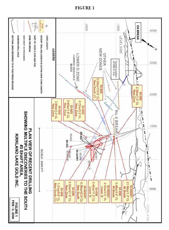
- A further eight (or more) mineralized zones have been identified (in addition to six other previously discovered mineralized zones) south of the mine workings. These zones are in the area encompassing the New South/LK Zone and have returned assays from drilling which include 21.98 ounces of gold per ton (opt gold) over 1.0 feet, 0.25 opt gold over 21.6 feet, 0.72 opt of gold over 3.3 feet, 3.85 opt gold over 3.3 feet and 2.26 opt gold over 1.5 feet (see figure 1).
- The latest drill hole (#50-696) has intersected mineralization assaying 1.31opt over 9.6 feet (core length or CL), within a wider 55.9 foot interval which assayed 0.32 opt gold, similar to the New South/LK Zone but 880 feet down dip of hole #50-666 and 628 feet down dip from the discovery hole #50-627 which assayed 2.3 opt gold over 90.4 feet of CL . This large step-out will require infill drilling to prove continuity.
- The intersection in drill hole #50-665 assayed 0.05 opt gold over 113.5 feet of CL and may represent a further up-dip extension of the New South/LK Zone. Although this intersection is not ore grade value, the widths and consistency of mineralization are significant, and present a potential dip component of 1,300 feet for the zone between the -5100 and -5500 elevations.
- Drill hole #50-669W1 assayed 0.38 opt gold over 42 feet of CL and intersected the New South/LK Zone 225 feet up-dip from the wedged hole #50-627W1 at the -5161 elevation, the highest level intersected to date with significant gold mineralization.
- Drill hole # 50-669W1 intersected 21.98 opt gold over a core length of 1.0 feet, and demonstrates continuity with the intersection in hole #50-696 which assayed 0.48 opt gold over 3.8 feet of CL, and previously released intersections in #50-666 which assayed 1.55 opt gold over 1.5 feet of CL, and #50-669 which assayed 0.32 opt gold over 1 feet of CL. The mineralization is associated with a strong structure and may be related to the #6 Break, dipping at approximately 47 degrees south, parallel to the `04 Break and footwall to the Lower D Zone.
- The new 5300 exploration drift has now been driven 380 feet to the south and the first drill bay is now being cut. Closer spaced drilling is expected to begin shortly to test the #6 Break and other mineralized zones discovered by KGI south of the mine workings over the previous two years.
- The new discoveries to the south generally are of a different style of mineralization comprising wide sulphide systems rather than the typical quartz vein mineralization on the Main Break, from which 24 million ounces of gold have been mined to date in the Camp. The newly-discovered, wide, hydrothermally-altered zones could represent a new plumbing system for a southern mineralized part of the Camp parallel to the Main Break, fed by a deep porphyry body. Renowned structural geologist, Dave Rhys (M.Sc., P.Geo) suggests that the orientation on the new discoveries to the south indicates the presence of a major steep-dipping ore-bearing structure further south, parallel to the ‘04/Main Break system. This structure may be related to the Amalgamated Break or possibly a new, as yet to be identified parallel break. This would be the conduit up which the mineralizing fluids fed the new zones from the porphyry below. Great exploration potential as there is no drilling between surface and the new discoveries (a mile below).
There is a strong possibility to discover additional parallel and stacked zones both above and below the new zones.
(The diagrams referred to in this release may be viewed at the Company’s website,www.klgold.comand will provide context to the above statements).
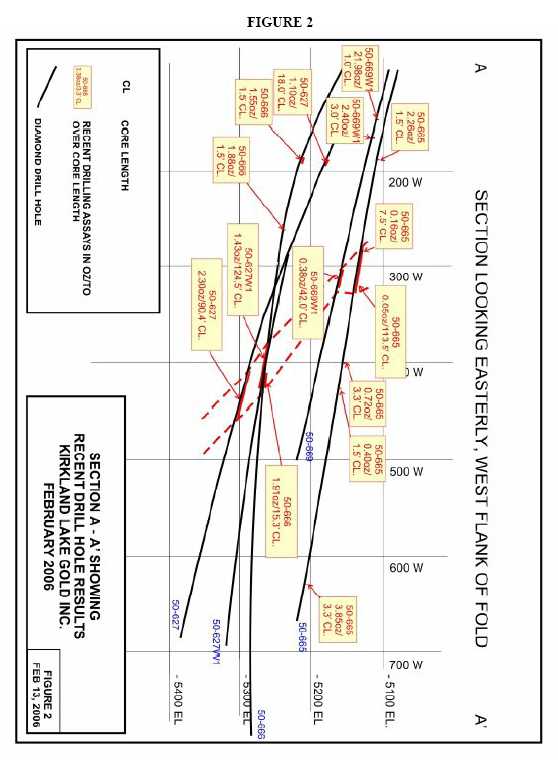
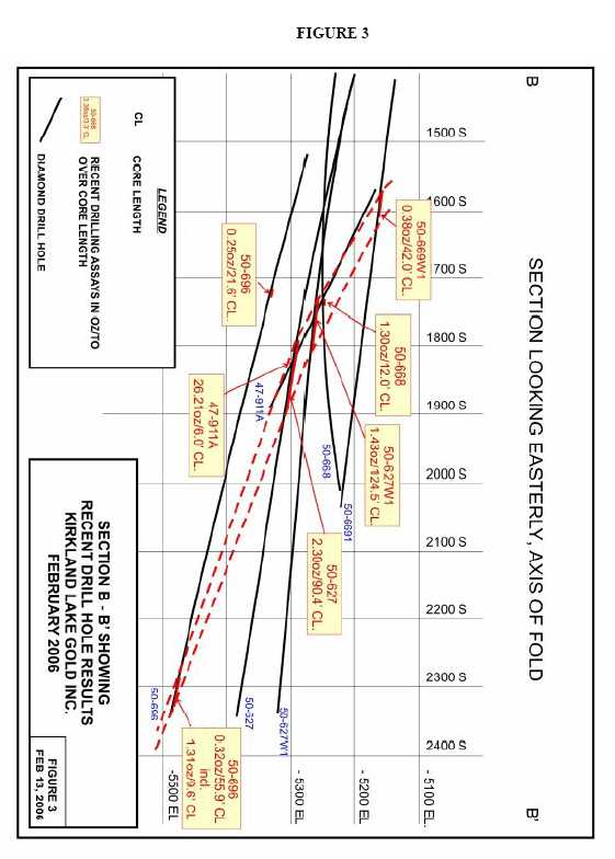
Figure #1 is a plan view showing the various zones south of the #3 shaft mine workings and the latest drill hole intersections. (seefigure 1). Figure #2 is a composite section through the west limb of the fold. (seefigure 2).Figure #3 is a composite section through the axis of the fold. (seefigure 3).
The following table summarizes the latest drilling program results.
DRILL | VEIN | FROM (feet) | TO (feet) | HOLEDIP (degrees) | AZIMUTH (degrees) | ASSAY (oz. per ton/feet) |
| 50-669W1 | #6 Break? Lower D North incl. New South Entire Zone High Grade Int. Low Grade Int. New | 809.0 870.5 870.5 1,346.0 1,346.0 1,388.0 1424.5 | 810.0 873.5 871.5 1,404.5 1,388.0 1,404.5 1426.0 | -9 | 121 | 21.98/1.0’ CL = 0.6’ TW, VG 2.40/3.0’ CL = 1.3’ TW, Uncut 1.37/3.0’ = 1.3’ TW, Cut 6.61/1.0’ = 0.4’ TW, VG 0.33/58.5’ CL = ~15.5’ TW 0.38/42.0’ CL = ~11.1’ TW, VG 0.20/16.5’ CL = ~4.4’ TW 0.47/1.5’ = TW?, VG |
| DRILL HOLE No. | VEIN | FROM (feet) | TO (feet) | HOLEDIP (degrees) | AZIMUTH (degrees) | ASSAY (oz. per ton/feet) |
| 50-696 | #6 Break? Lower D North Incl. New Incl. New South ? Entire Zone Incl. Low Grade Int. High Grade Int. | 883.5 1,089.8 1,099.0 1,468.5 1,487.8 2,227.1 2,227.1 2,274.4 | 887.3 1,101.1 1,101.0 1,490.1 1,490.1 2,284.0 2,274.4 2,284.0 | -14 | 129 | 0.48/3.8’ CL = 2.0’ TW, VG 0.49/11.2’ CL = 3.6’ TW, VG 1.23/2.0’ CL = 0.7’ TW 0.25/21.6’ CL = ?TW 1.55/2.3’ CL = ?TW 0.32/55.9’ CL = ?TW 0.12/47.3’ CL = ?TW 1.31/9.6’ CL = ?TW, VG, Tell |
| 50-665 | New Lower D North New South? Entire Zone Incl. and and New New New Incl. | 694.1 900.0 907.5 909.5 926.8 1,107.5 1,189.9 1,250.0 1,716.7 1716.7 | 695.6 907.5 1021.0 915.5 927.8 1,019.0 1,193.2 1,251.7 1,720.0 1,718.7 | -10 | 127 | 2.26/1.5’ CL = TW?, VG 0.16/7.5’ CL = 3.1’ TW 0.05/113.5’ CL = ~35.1’ TW 0.24/6.0’ CL = ~1.9’ TW 0.90/1.0’ CL = ~0.3’ TW, VG 0.30/1.5’ CL = ~0.5’ TW 0.72/3.3’ CL = TW? 0.40/1.5’ CL = TW? 3.85/3.3’ CL = TW? Uncut 2.20/3.3’ CL = TW? Cut 6.22/2.0’ CL = TW?, VG |
TW = True Width CL = Core Length VG = Visible Gold TELL = Tellurides CUT= cut to 3.50 oz/ton
The true widths for the New South/LK Zone intersections are an approximation based on an average 25 degree dip.
About the Company
The Company purchased the Macassa Mine and the 1,500 ton per day mill along with four former producing gold properties – Kirkland Minerals, Teck-Hughes, Lake Shore and Wright Hargreaves – in December 2001. These properties, which have historically produced some 22 million ounces of gold, extend over seven kilometres between the Macassa Mine on the east and Wright Hargreaves on the west and, for the first time, are being developed and explored under one owner. This camp is located in the Abitibi Southern Greenstone Belt of Kirkland Lake, Ontario, Canada.
The results of the Company’s underground diamond drilling program have been reviewed, verified (including sampling, analytical and test data) and compiled by the Company's geological staff (which includes a ‘qualified person’, Michael Sutton P.Geo., the Company’s Chief Geologist, for the purpose of National Instrument 43-101,Standards of Disclosure for Mineral Projects, of the Canadian Securities Administrators).
The Company has implemented a quality assurance and control (QA/QC) program to ensure sampling and analysis of all exploration work is conducted in accordance with the best possible practices. The drill core is sawn in half with half of the core samples shipped to the Swastika Laboratories in Swastika, Ontario or to the Macassa mine laboratory for analysis. The other half of the core is retained for future assay verification. Other QA/QC includes the insertion of blanks, and the regular re-assaying of pulps/rejects at alternate certified labs (Polymet, Accurassay). Gold analysis is conducted by fire assay using atomic absorption or gravimetric finish. The laboratory re-assays at least 10% of all samples and additional checks may be run on anomalous values.
The Company’s Kirkland Lake properties are the subject of a report prepared by Roland H. Ridler, B.A.Sc.(Hons.), M.A.Sc., Ph.D.(Econ.Geol.), P.D., entitledKirkland Lake Mineral Properties (Macassa Mine, Kirkland Lake Gold, Teck-Hughes, Lake Shore, Wright-Hargreavesdated November 30, 2001. The Company’s Macassa Mine Property is the subject of reserve report prepared by
- Glenn R. Clark, P. Eng., entitledReview of Resources and Reserves of Macassa Mine,Kirkland Lake, Ontariodated September 9. 2005.
All of these technical reports have been filed on SEDAR (www.sedar.com <http://www.sedar.com>).
For further information, please contact:
| Brian Hinchcliffe | Scott Koyich |
| President | Investor Relations |
| Phone 1 705 567 5208 | Phone 1 403 215 5979 |
| Fax 1 705 568 6444 | E-mail:info@klgold.com |
| E-mail:bhinchcliffe@klgold.com | |
| Website-www.klgold.com |
Neither the Toronto Stock Exchange nor the AIM Market of the London Stock Exchange
has reviewed and neither accepts responsibility for the adequacy or accuracy of this news release.