GMX RESOURCES INC.
NASDAQ GSM: GMXR
www.gmxresources.com
www.gmxresources.com

One Benham Place
9400 North Broadway, Suite 600
Oklahoma City, OK 73114
Ph 405.600.0711
Fax 405.600.0600
9400 North Broadway, Suite 600
Oklahoma City, OK 73114
Ph 405.600.0711
Fax 405.600.0600
November 16, 2007
Tracie Towner
Securities and Exchange Commission
Division of Corporation Finance
Securities and Exchange Commission
Division of Corporation Finance
| Re: GMX Resources Inc. Form 10-K for the year ended December 31, 2006; Commission File No. 001-32977 |
Dear Tracie:
This letter is in response to your September 25, 2007 follow up questions regarding GMX’s oil and gas reserves underlying its East Texas properties. The responses are keyed to your comments by the number assigned in the letter we received. The comments are repeated here for convenience.
Comment #1
We have reviewed your response to our prior comment two of your letter dated July 10, 2007, regarding the Cotton Valley reserves. Please provide graphs similar to those provided in your prior response, but only for Cotton Valley wells in which you have an ownership interest; include those GMX Cotton Valley wells that have not produced any liquids, as well as those GMX Cotton Valley wells that have produced liquids.
Response:
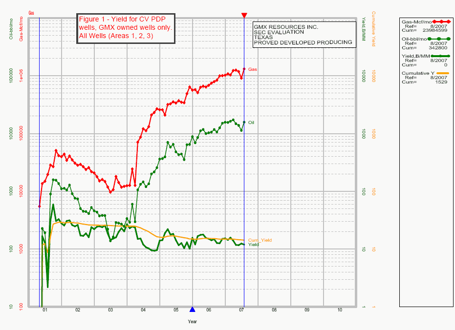
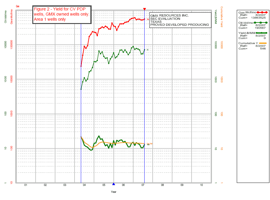
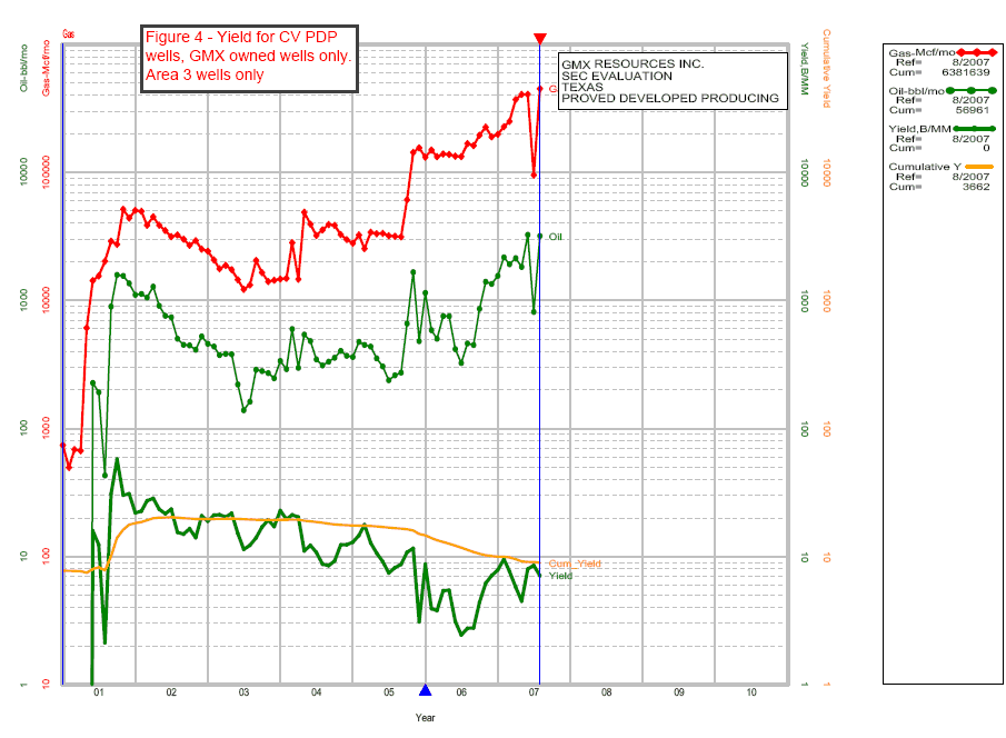
Only GMX wells were shown on Figures 1-4 in our prior response letter to the SEC dated August 13, 2007 (the “August 13 Letter”).
All of GMX’s Cotton Valley wells produce some liquids. There were some reporting/allocation issues on some of the wells shown in the year-end 2006 reserve report which, as Mr. Murphy noted in our October 9 phone call did not reflect historical oil production. In 2006, because some wells produced oil to a central gathering system where there was not separate production measurement equipment available for the individual wells. As a result, we were unable to separately allocate oil production to all wells. These reporting/allocation issues have been rectified.
Tracie Towner
Page 2
Page 2
The attached figures (Figures 1, 2, 3, 4) show the updated yields with all wells included. Figure 1 shows all wells together, while Figures 2, 3 and 4 show yields separately in each of GMX’s three sub-areas. All data shown on these four figures is for GMX wells only. There are some wells, particularly in Area 3, which are missing some oil production data for the first few months of the wells’ production. The curves ignore these missing data, and hence will be somewhat conservative in value.
In the 2006 year-end report, a constant value of 10 barrels oil per million cubic feet of gas was used (10 B/MM) for the economic predictions. The above mentioned figures demonstrate that this value is reasonable. For the year-end 2007 report, wells will be individually forecast based on their allocated oil production.
If needed, we can provide individual plots of the wells without recorded oil production in the 2006 reserve report with their corrected condensate yield plotted.
Comment #2
We have reviewed your response to prior comment three, concerning the difference between the Cotton Valley PDP and PUD reserves. As there does not appear to be a significant amount of proved behind-pipe reserves attributed to the Cotton Valley reservoir in your reserve report, and the wells that you cite are horizontal wells, explain how your assumptions are consistent with these observations. Also, as a reserve report is not a field study or basin study, please provide the same graph as shown in Figure 5 but only for Cotton Valley wells in which you have an ownership interest. Include those GMX Cotton Valley wells that have not produced any liquids as well as those GMX Cotton Valley wells that have produced liquids. Also provide production graphs of all GMX Cotton Valley wells that have actually exhibited the 3.5% terminal decline rate that you apparently utilize for all wells. Tell us how many GMX Cotton Valley wells exhibit a terminal decline rate greater than 3.5%.
Response:
The stated behind-pipe reserves at year end 2006 were understated compared to year end 2006 PUD reserves due to the absence of any specific plans at year end 2006 to complete a vast majority of the then existing wells in other productive intervals. Without those plans, it was felt that booking additional PDNP reserves for all PDP reserves was not appropriate. Work since then during 2007 has shown those 2006 PDP wells will have overall upward revisions at year end 2007. Our drilling plans for 2007 with respect to PUD locations specifically contemplated multiple Cotton Valley interval completions which accounts for some of the increased proved reserves through October 31, 2007. For example, through October 31, 2007 we have drilled and completed 89 gross Cotton Valley wells and through the same date 36 of those wells have been completed in both the lower Cotton Valley interval and in 64 upper Cotton Valley intervals. The multiple completion and commingling process is ongoing for the balance of these wells and expected additional wells.
Tracie Towner
Page 3
Page 3
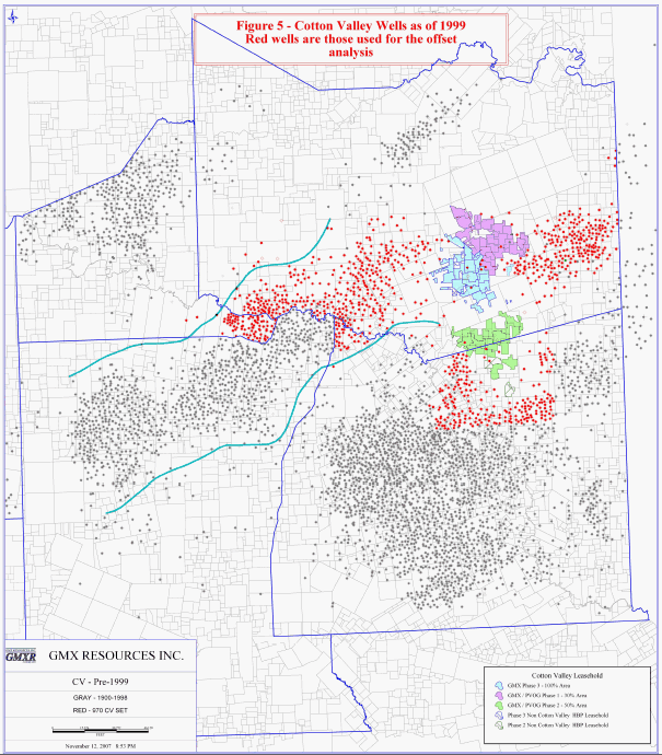
As discussed during our October 9, 2007 telephone call, GMX used information from 970 offset Cotton Valley producers listed in Appendix A to our August 13 Letter to create Figure 5 in our August 13 Letter to arrive at our 1,250 mcf EUR for our PUD’s. The specific locations of these wells are shown on the attached Figure 5. The reason for using these offsets was the maturity of the wells in contrast to the relatively new wells in which GMX owns an interest. These wells are all in close proximity to GMX’s acreage as shown in Figure 5. GMX believes that these wells provide a reasonable basis for the establishment of production trends on GMX’s property due to the historical characteristics of production from the Cotton Valley in this area as more fully discussed below. It is in our opinion more reliable to use data from mature wells from the same formation than to use data from existing producing GMX’s wells, most of which have been drilled since January 1, 2004 and have limited production histories to estimate a long lived well. We have also performed a more recent analysis of only GMX wells, which is also discussed below, and this analysis confirms that our EUR estimates derived from the offseting 970 wells is not only reasonable but possibly very conservative.
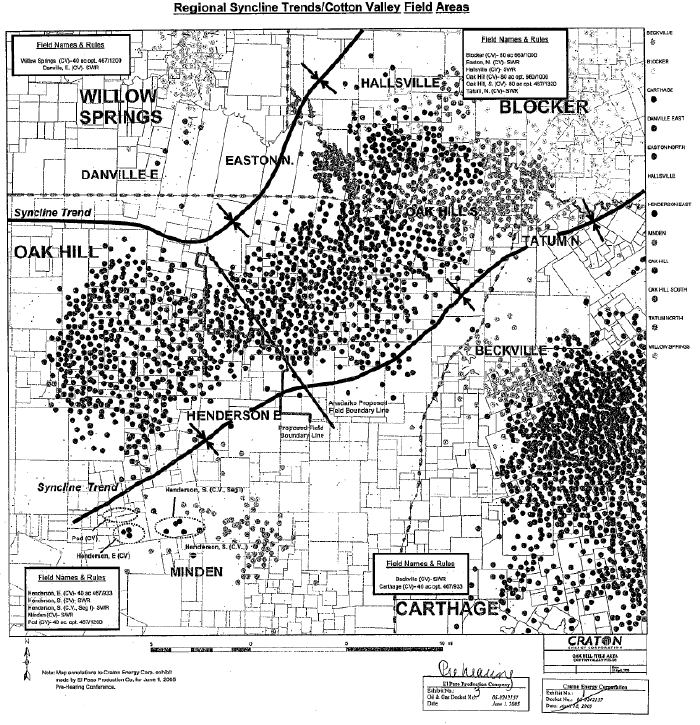
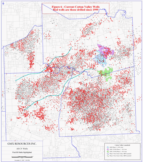
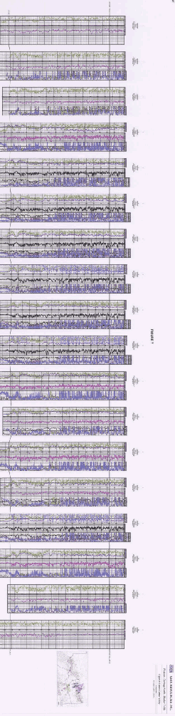
The vast majority of GMX’s reserves are in the Cotton Valley intervals and are located in a syncline trend running southwest to northeast from Oakhill to Waskom. Our acreage position and wells are concentrated and are consistent with the size and geographic scope of the syncline trend as is evident on Figures 5 and 6. The public data shows that at one point there were several different field names within this trend. The western part of this Cotton Valley syncline trend was the subject of significant Texas Railroad Commission (“RRC”) hearings held in 2005. The final order of the RRC in Oil and Gas Docket No. 06-0242157 took the somewhat unusual step of consolidating six formerly separate fields into one field over a length of approximately twenty miles. The findings stated that there was no structural or stratigraphic basis for those fields being separated. The companies involved in this order included several larger and knowledgeable companies, XTO Energy, Anadarko E & P, Newfield Exploration, BP America and El Paso. The RRC exhibits clearly show extension of the syncline trend into Blocker which is immediately adjacent to GMX’s acreage (to the west) 1 . Figure 6 shows the area of east Texas where GMX’s reserves are located. The light blue lines on this map approximate the synclinal trend identified in the RRC order. The gray wells in Figure 6 are pre-1999 wells, and the red wells are the post 1999 wells showing the continued extension of the limits of this trend to encompass GMX’s properties. This basin and in particular the syncline trend yields gas on a blanket basis making it very likely that all wells will be successful, which has been the case with GMX. Figure 7 is a regional cross section on the Cotton Valley showing the continuity of the reservoir over an approximate 400 square mile area, which includes GMX’s properties.
Further, there have been extensive professional publications regarding the Cotton Valley that support the relative predictability of reserves. It is described as a series of marine and lagoonal deposits overlying the gentle regional structure associated with the Sabine uplift. The Cotton Valley interval includes very fine-grained sandstones, siltstones, shales and limestones. Bounding shale laminae are lenticular and discontinuous with few stress barriers. Diagenesis in the form of calcite cementation and quartz overgrowth, combined with overburden pressure have dramatically reduced porosity and permeability. Sand porosities range from 2% to 12% with microdarcy-level permeabilities. In the late 1980’s the USGS published ‘typical estimates’ of 6-10% for porosity, permeabilities less than 0.1 md (10 microdarcies), and post-stimulation rates of 500 to 2500 mscfpd. This description is completely consistent with the log character seen in GMX’s acreage. Other publications note extended pressure buildups which indicate significantly higher gas-in-place in the reservoir than is suggested by flow data. Observations on the more mature producers suggest a very shallow decline and are consistent with the idea that ultimate reserves will be adjusted upwards as more technical analysis becomes available.
1 The original exhibits and text from the RRC hearing have also been filed as Appendix A for reference.
Tracie Towner
Page 4
Page 4
Because of the significant amount of drilling that has been done in the Cotton Valley and the RRC’s recognition of the geological similarity over a very large field, we believe the use of the data from our 970 well sample in Appendix A to our August 13 Letter is the most reliable method to estimate the EUR’s for our PUD’s (as well as PDP’s in the future). As noted earlier, we expect our PDP reserves for the wells completed in 2006 will also be revised upwards at year end 2007 to be consistent with our PUD reserve estimates based on more information being available as well as recompletion plans in 2008.
We have established a uniform gross 1,250 MMcf gas EUR for the year end 2006 PUD’s. Obviously, some wells will perform better or worse but given that our 147 PUD’s are all being drilled to the same formation in a very concentrated area where our ownership is uniform, we think the use of such an average is justified, especially given the significant number of wells proposed.
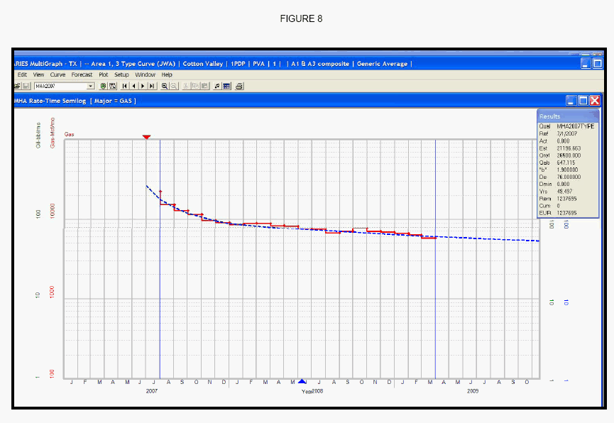
We have also done additional analysis of only GMX wells using the available production data up through approximately August or September of 2007 on Cotton Valley producing wells in GMX areas 1 and 3 2 with GMX ownership. A new type curve was constructed using time normalized gas production rates. This type curve is shown in Figure 8. Using this type curve, each of the GMX PDP wells in all areas (as of October 1, 2007) was reforecast to obtain an estimate of the ultimate reserves using applicable economic parameters. Behind pipe Cotton Valley reserves were added to each PDP well as applicable to obtain a total EUR. These values were then averaged to obtain an estimate of the expected average EUR over a sample set of many wells. A table of those results is shown below (all EURs are in MMCF, gas only).
| GMX Area | #Wells | Avg. EUR | ||||||
| Areas 1 and 3 | 126 | 1,262 | ||||||
| Area 2 | 36 | 1,616 | ||||||
| Both Areas Together | 162 | 1,340 | ||||||
These EUR’s demonstrate that our gross 1,250 MMcf gas estimated for PUD’s at year end 2006 may be too conservative.
2 We did not do the analysis on Area 2 due to a smaller number of wells, but the Area 2 wells have generally performed better than Areas 1 and 3. Using the Areas 1 and 3 analysis for Area 2 wells may be overly conservative.
Tracie Towner
Page 5
Page 5
As some additional background on the Cotton Valley, gas bearing Cotton Valley sands occur over a 1200 ft interval and are grouped into five (5) main sub-members. Every GMX well has been completed, initially, in the lowest most member (the Taylor or Lower Cotton Valley) with a 100% success completion history. In 2006, we recompleted in 125 Upper Cotton Valley intervals in 48 wells in existence at year end 2005. Many of the intervals added were not booked (as PDNP) in the 2005 year-end report and represented an attempt to extend the Upper Cotton Valley pay in the upper four (4) sub-intervals. Our experience in 2006 confirms the productivity of the additional intervals. The overwhelming characteristic of short-term well performance (in Cotton Valley wells) is early time dominance of stimulated and higher capacity layers. A recent SPE paper on tight reservoirs stated that “Long times, often years, are required to reach pseudo-steady state flow”.3
Responses to other parts of the Comment #2 follow:
| A) | Per our phone conversation of October 9, 2007, there were no horizontal wells cited in support of any of the comparisons or statistics done for vertical well EURs. | ||
| B) | There are no GMX wells that show the cited terminal decline rate of 3.5%, as none of the GMX wells is sufficiently mature enough to see the final decline. The value was estimated from other Cotton Valley wells nearby the GMX properties as described above. | ||
| C) | All Cotton Valley wells have produced liquid hydrocarbons along with the gas production. Where there is no recorded oil production in the year-end 2006 report, it is due to reporting issues. See response to Comment #1. |
Comment #3
We have reviewed your response to prior comment four, including your explanation of support for reserves associated with your Cadenhead 6H and 9H wells. We generally find that reserves are appropriately classified as proved developed reserves, using the definition in Rule 4-10(a)(3) of Regulation S-X, after the majority of development costs have been spent. If a well has been drilled but there are material amounts of development costs remaining, such as for large fracture treatments, compression or other reasons, reserves that are dependent on such future development should be classified no higher than proved undeveloped. To the extent a material portion of the Cadenhead reserves are dependent on additional development work and that work is a material portion of the total, please revise your document to include those reserves as proved undeveloped. If you believe the reserves are appropriately characterized as developed, describe further the nature of activity yet to be completed, in relation to the whole, and submit a schedule showing total estimated development costs for these wells, development costs incurred as of period-end, and development costs not yet incurred.
3 John Lee, SPE 108176 “Improving Reserve Estimates from Decline Curve Analysis of Tight Multilayer Gas Wells” 2007
Tracie Towner
Page 6
Page 6
Response:
Per our telephone conversation on October 9, 2007, GMX understands that as a general guideline, the SEC considers completion expenses in excess of approximately 10% of the total completed well costs sufficient to require a PUD designation for the behind pipe reserves. Given this restriction, the behind pipe reserves cited for the Cadenhead 6H and 9H wells would in fact be PUD reserves, as the costs to fracture stimulate the zones is in excess of the above limit. (The fracture treatments for these two wells were subsequently completed early in 2007).
The total reserves attributable to these two wells included in the proved developed category in the year end 2006 report were 7.5 Bcfe, representing less than 3% of total reserves of year end, and less than 10% of the 76.5 Bcfe proved developed reserves at year end. Given that the reclassifications from proved developed to proved undeveloped will not affect total proved reserves and also will not otherwise affect the present value, standardized measure or the income statement, we request the staff not require any amendment of the 2006 Form 10-K for this issue and we will note the staff’s position and prepare future reports accordingly.
Comment #4
We have reviewed your response to prior comment six, pertaining to your undeveloped Cotton Valley reserves. We note that in the list of 147 GMX Cotton Valley proved undeveloped wells provided in Appendix B, 54 are on leases where there are no other producing wells to which you have attributed proved reserves. We also note that another 43 of the wells in Appendix B are on leases where you estimate the currently producing wells to have an average ultimate recovery of less than 750 MMCF per well; and that only 19 of the wells in Appendix B are on leases where you estimate the currently producing wells to have an average ultimate recovery of greater than 1,200 MMCfe per well. Therefore, please provide additional support showing why you believe the 54 wells, having no apparent direct offsetting wells, meet the SEC definition of proved reserves, and explain why it is reasonably certain these, and the other 74 wells, will produce an estimated ultimate recovery of 1,250 MMCF of reserves per well.
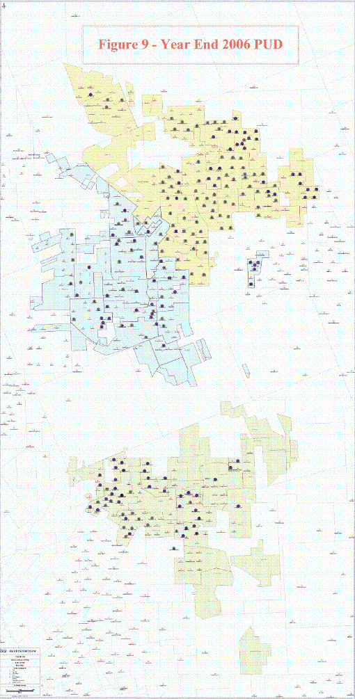
Response:
The attached Figure 9 shows a map of the proposed PUD locations from the year end 2006 report and their proximity to existing PDP wells. All Cotton Valley PUD locations included in the report were direct offsets to existing Cotton Valley producers.
The response to Comment #2 detailed information relating to the quantity of reserves booked for the PUD wells, and why the PDP wells did not show the same level of reserves. We did not feel that the geological and engineering data which we used at the end of 2006, lent itself to a credible stratification of expected recoveries for the PUD reserves, and, as noted above, we used an average for all wells for the reasons stated. In 2007, we expect PUD EUR’s will be more varied based on the additional information available from 2007 drilling, completion and production results.
Tracie Towner
Page 7
Page 7
In connection with responding to the SEC’s comments, the Company acknowledges that:
| • | The Company is responsible for the adequacy and accuracy of the disclosures in the filing; | ||
| • | Staff comments or changes to disclosure in response to staff comments do not foreclose the Commission from taking any action with respect to the filing; and | ||
| • | The Company may not assert staff comments as a defense in any proceeding initiated by the Commission or any person under the federal securities laws of the United States. |
Please feel free to contact me at 405-600-0711 (ext 316) or Jim Merrill at 405-600-0711 (ext 305) if you have any questions or need additional information.
| Sincerely, | ||
| /s/ Ken L. Kenworthy, Sr. | ||
| Ken L. Kenworthy, Sr | ||
| Chief Financial Officer |

APPENDIX A
RAILROAD COMMISSION OF TEXAS
OFFICE OF GENERAL COUNSEL
OFFICE OF GENERAL COUNSEL
| OIL AND GAS DOCKET | IN THE OAK HILL (COTTON VALLEY) | |
| NO. 06-0242157 | FIELD, GREGG, HARRISON, RUSK AND | |
| PANOLA COUNTIES, TEXAS |
FINAL ORDER
CONSOLIDATING FIELDS INTO
THE OAK HILL (COTTON VALLEY) FIELD AND
AMENDING FIELD RULES FOR OAK HILL (COTTON VALLEY) FIELD
- -GREGG, HARRISON, RUSK AND PANOLA COUNTIES, TEXAS
CONSOLIDATING FIELDS INTO
THE OAK HILL (COTTON VALLEY) FIELD AND
AMENDING FIELD RULES FOR OAK HILL (COTTON VALLEY) FIELD
- -GREGG, HARRISON, RUSK AND PANOLA COUNTIES, TEXAS
The Commission finds that after statutory notice in the above-numbered docket heard on April 18 and June 1, 2005, the presiding examiners have made and filed a report and proposal for decision containing findings of fact and conclusions of law, which was served on all parties of record; that the proposed application is in compliance with all statutory requirements; and that this proceeding was duly submitted to the Railroad Commission of Texas at conference held in its offices in Austin, Texas.
The Commission, after review and due consideration of the examiners’ report and proposal for decision, the findings of fact and conclusions of law contained therein, and any exceptions and replies filed thereto, hereby adopts as its own the findings of fact and conclusions of law contained therein, and incorporates said findings of fact and conclusions of law as if fully set out and separately stated herein.
Therefore, it is ordered by the Railroad Commission of Texas that the Easton, N. (Cotton Valley), Hallsville (Cotton Valley), Tatum, N. W. (Cotton Valley), Tatum, North (Cotton Valley) and Oak Hill, S. (Cotton Valley) Fields are hereby consolidated into the Oak Hill (Cotton Valley) Field.
It is further ordered that Rules 2 and 3 of the field rules adopted in Docket No. 6-67,176, effective May 31, 1977, as amended, for the Oak Hill (Cotton Valley) Field, are amended as hereafter set out:
RULE 2.: No well for gas shall hereafter be drilled nearer than FOUR HUNDRED SIXTY SEVEN (467) feet to any property line, lease line, or subdivision line and no well shall be drilled nearer than NINE HUNDRED THIRTY THREE (933) feet to any applied for, permitted or completed well in the same reservoir on the same lease, pooled unit or unitized tract. The aforementioned distances in the above rule are minimum distances to allow an operator flexibility in locating a well, and the above spacing rule and the other rules to follow are for the purpose of permitting only one well to each drilling and proration unit. Provided however, that the Commission will grant exceptions to permit drilling within
| OIL AND GAS DOCKET NO. 06-0242157 | PAGE 2 |
shorter distances and drilling more wells than herein prescribed whenever the Commission shall have determined that such exceptions are necessary either to prevent waste or to prevent the confiscation of property. When exception to these rules is desired, application therefor shall be filed and will be acted upon in accordance with the provisions of Commission Statewide Rules 37 and 38, which applicable provisions of said rules are incorporated herein by reference.
In applying this rule, the general order of the Commission with relation to the subdivision of property shall be observed.
RULE 3: The acreage assigned to the individual gas well for the purpose of allocating allowable gas production thereto shall be known as a proration unit. The standard drilling and proration units are established hereby to be ONE HUNDRED SIXTY (160) acres. No proration unit shall consist of more than ONE HUNDRED SIXTY (160) acres; provided that, tolerance acreage of ten (10) percent shall be allowed for each standard proration unit so that an amount not to exceed a maximum of ONE HUNDRED SEVENTY SIX (176) acres may be assigned. The two farthermost points in any proration unit shall not be in excess of FIVE THOUSAND FIVE HUNDRED (5,500) feet removed from each other. Each proration unit containing less than ONE HUNDRED SIXTY (160) acres shall be a fractional proration unit. All proration units shall consist of continuous and contiguous acreage which can reasonably be considered to be productive of gas. No double assignment of acreage will be accepted.
An operator, at his option, shall be permitted to form optional drilling units of FORTY (40) acres. A proportional acreage allowable credit will be given for a well on a fractional proration unit. The two farthermost points of a FORTY (40) acre fractional proration unit shall not be greater than TVVO THOUSAND ONE HUNDRED (2,100) feet removed from each other.
Operators shall file with the Commission certified plats of their properties in said field, which plats shall set out distinctly all of those things pertinent to the determination of the acreage credit claimed for each well; provided that if the acreage assigned to any proration unit has been pooled, the operator shall furnish the Commission with such proof as it may require as evidence that interests in and under such proration unit have been so pooled.
Each exception to the examiners’ proposal for decision not expressly granted herein is overruled. All requested findings of fact and conclusions of law which are not expressly adopted herein are denied. All pending motions and requests for relief not previously granted or granted herein are denied.
This order will not be final and effective until 20 days after a party is notified of the Commission’s order. A party is presumed to have been notified of the Commission’s order
| OIL AND GAS DOCKET NO. 06-0242157 | PAGE 3 |
three days after the date on which the notice is actually mailed. If a timely motion for rehearing is filed by any party at interest, this order shall not become final and effective until such motion is overruled, or if such motion is granted, this order shall be subject to further action by the Commission. Pursuant to TEX. GOV’T CODE §2001.146(e), the time allotted for Commission action on a motion for rehearing in this case prior to its being overruled by operation of law, is hereby extended until 90 days from the date the order is served on the parties.
Done this 27th day of September 2005.
| RAILROAD COMMISSION OF TEXAS | ||
| /s/ Victor G. Carrillo | ||
| Chairman Victor G. Carrillo | ||
| Recused | ||
| Commissioner Michael L. Williams | ||
| /s/ Elizath A. Jones | ||
| Commissioner Elizabeth A. Jones | ||
| ATTEST: | ||
/s/ Kim Williamson |
VICTOR G. CARRILLO,CHAIRMAN
MICHAEL L. WILLIAMS,COMMISSIONER
ELIZABETH A.JONES,COMMISSIONER
MICHAEL L. WILLIAMS,COMMISSIONER
ELIZABETH A.JONES,COMMISSIONER
LINDIL C. FOWLER, JR.,GENERAL COUNSEL
COLIN K LINEBERRY,DIRECTOR
HEARINGS SECTION
COLIN K LINEBERRY,DIRECTOR
HEARINGS SECTION
RAILROAD COMMISSION OF TEXAS
OFFICE OF GENERAL COUNSEL
OIL AND GAS DOCKET NO. 06-0242157
THE APPLICATION OF XTO ENERGY, INC. TO CONSOLIDATE THE .EASTON, N. (COTTON VALLEY) FIELD INTO THE OAK HILL (COTTON VALLEY) FIELD, AND TO AMEND THE FIELD RULES FOR THE OAK HILL (COTTON VALLEY) FIELD, GREGG, HARRISON, RUSK AND PANOLA COUNTIES, TEXAS
| Heard by: | Donna K. Chandler, Technical Examiner | |
| James M. Doherty, Hearings Examiner |
Procedural history:
| Application received: | March 9, 2005 | |
| Hearing held: | April 18, 2005 | |
| Transcript Issued: | May 6, 2005 | |
| Re-opened hearing: | June 1, 2005 | |
| PFD Issued: | July 27, 2005 |
| Appearances: | Representing: | |||||
| David Gross | XTO Energy, Inc. | |||||
| Rick Johnston | ||||||
| Ana Maria Marsland-Griffith | Anadarko E & P Company, LP | |||||
| Troy Johnson Jason Perkins | ||||||
| George Neale | Craton Energy Corp. | |||||
| Jack Trice | ||||||
| Bill G. Spencer | Verado Energy, Inc. | |||||
| George Neale | EXCO Resources, Inc. | |||||
| Daniel Johnson | ||||||
| Dale Miller | Newfield Exploration Company | |||||
1701 NORTH CONGRESS AVENUE * POST OFFICE BOX 12967 * AUSTIN, TEXAS 78711-2967 * PHONE: 512/463-6924
FAX: 5 12/463-6989 TDD 800-735-2989 OR TDY 512-463-7284 AN EQUAL OPPORTUNITY EMPLOYER http://www.rrc.state.tx.us
FAX: 5 12/463-6989 TDD 800-735-2989 OR TDY 512-463-7284 AN EQUAL OPPORTUNITY EMPLOYER http://www.rrc.state.tx.us
| OIL AND GAS DOCKET NO. 06-0242157 | Page 2 |
| Joe Holsen | The Houston Exploration Company | |||
| George Neale | EI Paso Production Company | |||
| Steve Biancadi | ||||
| Gary Griffith | ||||
| Cary McGregor | ||||
| Sandra Buch | BP America Production | |||
| Kerry Pollard | Mustang Drilling, Ltd. | |||
| David Alford | ||||
| Andy Mills | ||||
| John Hays |
EXAMINERS’ REPORT AND PROPOSAL FOR DECISION
STATEMENT OF THE CASE
XTO Energy, Inc. (“XTO”) originally requested that the Easton, N. (Cotton Valley) Field be consolidated into the Oak Hill (Cotton Valley) Field. Additionally, XTO requested that the field rules for the Oak Hill (Cotton Valley) Field be amended to provide for minimum lease line spacing of 467 feet and minimum between well spacing of 933 feet (467’-933’), with the addition of a provision for optional 40 acre density. The rules currently in effect for the field provide for 660’-1,000’, 160 acre gas units with optional 80 acre units, and allocation based on 95% acreage and 5% deliverability, and a correlative interval which includes both the Upper Cotton Valley and the Taylor.
Subsequent to the issuance of the Notice of Hearing, Anadarko E & P Company, LP (“Anadarko”) requested that the call of the hearing be expanded to also consider separation of the Oak Hill (Cotton Valley) Field into two fields: the (proposed) Oak Hill, NE (Cotton Valley) Field and the (proposed) Oak Hill, SW (Cotton Valley) Field. Anadarko further requested that the existing rules applicable to the Oak Hill (Cotton Valley) Field (160/optionaI80 acres) remain in effect for the Oak Hill, SW (Cotton Valley) Field and that the rules proposed by XTO (160/optional 40 acre density) be applied to the Oak Hill, NE (Cotton Valley) Field. BP America Production (“BP”) supported Anadarko’s position for the creation of two separate fields with corresponding separate rules. BP submitted its proposed dividing line after the hearing.
Based on evidence received at the hearing, the examiners re-opened the hearing to consider the consolidation of numerous other Cotton Valley fields into either the Oak Hill (Cotton Valley) Field, or one of the two new fields proposed by Anadarko. There was no objection by any party to inclusion of the Hallsville (Cotton Valley), Tatum, N.W. (Cotton Valley), Tatum, North (Cotton Valley) and Oak Hill, S. (Cotton Valley) Fields into the Oak Hill (Cotton Valley) Field, or into one of the two new fields proposed by Anadarko.
| OIL AND GAS DOCKET NO. 06-0242157 | Page 3 |
The only contested issue in the hearing is whether the Oak Hill (Cotton Valley) Field should be divided into the Oak Hill, NE (Cotton Valley) and Oak Hill, SW (Cotton Valley) Fields. Craton Energy Corp. (“Craton”) opposes the field split unless its acreage is placed in the Oak Hill, NE (Cotton Valley) Field, which would operate under rules allowing optional 40 acre density. Craton Energy Corp. (“Craton”) submitted an alternative dividing line for the field, if the Commission rules that a field division is appropriate.
DISCUSSION OF THE EVIDENCE
XTO Evidence
The Oak Hill (Cotton Valley) Field was discovered in 1977 and cumulative production from the field is 1,317 BCF of gas and 4.1 million BC. There are currently approximately 1,100 gas wells in the field which produce a total of 5-6 BCF per month. The allocation formula in the field has been suspended since 1996.
The first field rules for the field were adopted in 1977 and provided for 640 acre density. The rules have been amended over time and since1995, the rules have provided for 160 acre gas units with optional 80 acre units. The current spacing rule is 660’-1,000’.
The Easton, N. (Cotton Valley) Field has 42 producing wells and operates under Statewide Rules. Geographically, the wells carried in the Easton, N. (Cotton Valley) Field are adjacent to wells in the northern part of the Oak Hill (Cotton Valley) Field, with some overlap. Similarly, wells designated in the Hallsville (Cotton Valley), Tatum, N.W. (Cotton Valley), Tatum, North (Cotton Valley) and Oak Hill, S. (Cotton Valley) Fields are adjacent to and/or overlap wells in the Oak Hill (Cotton Valley) Field. The Hallsville (Cotton Valley), Tatum, N.W. (Cotton Valley) and Tatum, North (Cotton Valley) Fields operate under Statewide Rules and there are about 165 wells in these fields. The Oak Hill, S. (Cotton Valley) Field operates under rules providing for 160/optional 80 acre density with 467’-1,320’ well spacing. About 110 wells are carried in this field. All of these fields have “grown together” with development and wells in the fields produce from the same correlative interval comprising the Upper Cotton Valley and the Taylor. There was no objection from any party to consolidation of these fields.
XTO presented drainage area calculations for 10 wells in the Oak Hill (Cotton Valley) Field. Seven of the ten wells are in the area of the field proposed by Anadarko to be the Oak Hill, NE (Cotton Valley) Field. For these wells, ultimate recoveries range from less than 500 MMCF to over 7,000 MMCF and the wells are perforated in both the Upper Cotton Valley and Taylor. The calculated drainage areas for these wells range from 13 acres to almost 100 acres. The other three wells are in the area of the field proposed to be the Oak Hill, SW (Cotton Valley) Field. These three wells are perforated only in the Taylor and have drainage areas between 86 and 288 acres.
| OIL AND GAS DOCKET NO. 06-0242157 | Page 4 |
Anadarko Evidence
Anadarko presented evidence to support its contention that the Oak Hill (Cotton Valley) Field should be divided into two separate fields. Cross-sections across the area demonstrate that generally wells to the southwest of the proposed dividing line are perforated only in the Taylor interval of the Lower Cotton Valley. To the northeast of the proposed dividing line, wells are generally completed in both the Upper Cotton Valley and the Taylor.
Anadarko believes that the depositional environment of the Cotton Valley is such that the Upper Cotton Valley is more compartmentalized, with both lateral and vertical discontinuities. The Taylor is more continuous, being a barrier island type deposit.
As a further basis for field separation, Anadarko also relies on the results of a study of the Upper Cotton Valley in the Oak Hill area published in SPE Paper No. 38606 in 1997. This study concludes that the Upper Cotton Valley in the northern area of Oak Hill has a significant amount of natural fractures, with the most fracturing in the uppermost portion of the Upper Cotton Valley. The presence of more fractures in the Upper Cotton Valley increases productive capability of the sands.
The top of the Cotton Valley is structurally lower to the northwest and the southwest. Off-structure to the southwest, there are no gas shows indicated in the Upper Cotton Valley on the log of the V. Pool No.3. In contrast, the log of the Jones Alford Gas Unit No. 10 indicates gas shows throughout the Upper Cotton Valley and the Taylor. The No.10 well is higher on structure and in the far northeastern part of the field. Anadarko has completed both the Upper Cotton Valley and the Taylor in wells in the northeastern portion of the field. Anadarko has not successfully completed the Upper Cotton Valley in its wells in the southwestern portion of the field. This is consistent with the interpretation that the Cotton Valley was uplifted after deposition, resulting in fracturing of the Upper Cotton Valley to the northeast, higher on structure.
Anadarko believes that field separation is justified based on the difference in geology between the northeastern and southwestern areas of the field. Anadarko believes that additional drilling is necessary where the Upper Cotton Valley is productive in the northeastern area and that additional drilling is not necessary to the southwest where the Upper Cotton Valley is not as prolific, and the Taylor is more continuous and wells will drain larger areas.
Anadarko calculated drainage areas for nine wells in the southwestern portion of the field. These wells are completed only in the Taylor and have net pay ranging from 76 feet to 153 feet. The calculated drainage areas for the nine wells range from 42 acres to 177 acres. The average for the nine wells is 88 acres. Based on these calculations, Anadarko believes that retaining the 80 acre density in southwestern portion of the field is appropriate in order to prevent the drilling of unnecessary wells.
| OIL AND GAS DOCKET NO. 06-0242157 | Page 5 |
Craton Evidence
Craton does not object to the formation of two separate fields as proposed by Anadarko. However, the line proposed by Anadarko cuts through numerous lease and/or unit lines. Craton proposed an alternate line which follows lease boundaries and places all of Craton’s acreage to the northeast of the line. Craton objects to any line of separation which places its acreage in the southwestern field proposed by Anadarko.
BP Evidence
Subsequent to the re-opened hearing, BP submitted a map depicting a dividing line for the proposed two separate fields. BP believes that its dividing line better honors formation characteristics. BP circulated its proposal to all parties represented at the hearing and no objection was received. BP opposes adoption of a 40 acre optional field rule for the entire Oak Hill (Cotton Valley) Field.
EXAMINERS’ OPINION
The examiners recommend that the Easton, North (Cotton Valley), Hallsville (Cotton Valley), Tatum, N.W. (Cotton Valley), Tatum, North (Cotton Valley) and Oak Hill, S. (Cotton Valley) Fields be consolidated into the Oak Hill (Cotton Valley) Field and that the field rules for the Oak Hill (Cotton Valley) Field be amended to provide for 467’-933’ well spacing and 160/optional 40 acre density. The examiners further recommend that Anadarko’s application to divide the Oak Hill (Cotton Valley) Field into separate fields be denied.
It is uncontested that the five fields listed above should be consolidated. The fields have overlapped as development has occurred over the years.
The examiners believe that 40 acre optional density is appropriate for the entire Oak Hill (Cotton Valley) Field. Though there does appear to be some variation in the productivity of the Upper Cotton Valley in the southwestern area of the field, there is no distinct structural or stratigraphic separation on which to base a dividing line for two separate fields. Anadarko does not dispute that there is no specific geologic barrier to create separation. There are wells in the southwestern area which are completed in both the Upper Cotton Valley and the Taylor. Likewise, many wells in the northeastern area are completed only in the Taylor.
Anadarko’s own drainage calculations show that four of the nine wells analyzed in the southwestern area have drainage areas of less than 80 acres. The adoption of a 40 acre optional density rule provides only an option to drill on 40 acres if an operator elects to. Operators would not be required to develop on 40 acres.
| OIL AND GAS DOCKET NO. 06-0242157 | Page 6 |
FINDINGS OF FACT
| 1. | Notice of this hearing was given to all persons entitled to notice at least ten (10) days prior to the hearing. | ||
| 2. | The Oak Hill (Cotton Valley) Field was discovered in 1977 and cumulative production from the field is 1,317 BCF of gas and 4.1 million BC. There are currently approximately 1,100 gas wells in the field which produce a total of 5-6 BCF per month. | ||
| 3. | The allocation formula in the field has been suspended since 1996. | ||
| 4. | Field rules currently in effect for the Oak Hill (Cotton Valley) Field provide for 160 acre gas units with optional 80 acre units with 660’-1,000’ well spacing. | ||
| 5. | Wells in the Hallsville (Cotton Valley), Tatum, N.W. (Cotton Valley), Tatum, North (Cotton Valley), Oak Hill, S. (Cotton Valley) and Easton, N. (Cotton Valley) Fields are adjacent to wells in the Oak Hill (Cotton Valley) Field, with overlap in many areas. Wells in these fields produce from the same correlative interval comprising the Upper Cotton Valley and the Taylor. | ||
| 6. | There is no distinct structural or stratigraphic basis on which to divide the Oak Hill (Cotton Valley) Field into two separate fields. | ||
| 7. | There are wells throughout the Oak Hill (Cotton Valley) Field which will drain less than 80 acres. |
| a. | The calculated drainage areas for 10 wells analyzed by XTO range from 13 acres to 288 acres. | ||
| b. | For nine wells in the southwestern area of the field, Anadarko calculated drainage areas which range from 42 acres to 177 acres, with four wells draining less than 80 acres. |
| 8. | Amending the spacing rule for the Oak Hill (Cotton Valley) Field to provide for a minimum of 467 feet from lease lines and 933 feet between wells will accommodate development on 40 acre density. |
CONCLUSIONS OF LAW
| 1. | Proper notice was given to all parties entitled to notice as required by all applicable rules and applicable statutory and regulatory provisions. |
| OIL AND GAS DOCKET NO. 06 ·0242157 | Page 7 |
| 2. | All things necessary to give the Commission jurisdiction to decide this matter have been performed or have occurred. | ||
| 3. | Consolidation of the Hallsville (Cotton Valley), Tatum, N.W. (Cotton Valley), Tatum, North (Cotton Valley), Oak Hill, S. (Cotton Valley) and Easton, N. (Cotton Valley) Fields into the Oak Hill (Cotton Valley) Field will prevent waste and protect correlative rights. | ||
| 4. | Separation of the Oak Hill (Cotton Valley) Field into two separate fields is not necessary to prevent waste or protect correlative rights. | ||
| 5. | Amending the field rules for the Oak Hill (Cotton Valley) Field to include 40 acre optional units and 467’-933’ well spacing is necessary to prevent waste. |
EXAMINERS’ RECOMMENDATION
Based on the above findings and conclusions, the examiners recommend that the Hallsville (Cotton Valley), Tatum, N.W. (Cotton Valley), Tatum, North (Cotton Valley), Oak Hill, S. (Cotton Valley) and Easton, N. (Cotton Valley) Fields be consolidated into the Oak Hill (Cotton Valley) Field and that the rules for the Oak Hill (Cotton Valley) Field be amended to provide for 467’-933’ well spacing and optional 40 acre density.
Respectfully submitted,
/s/ Donna K. Chandler
Donna K. Chandler
Technical Examiner
Donna K. Chandler
Technical Examiner
/s/ James M. Doherty
James M. Doherty
Hearings Examiner
James M. Doherty
Hearings Examiner
RAILROAD COMMISSION OF TEXAS
OFFICE OF GENERAL COUNSEL
OFFICE OF GENERAL COUNSEL
| OIL AND GAS DOCKET | IN THE OAK HILL (COTTON VALLEY) | |
| NO. 06-0242157 | FIELD, GREGG, HARRISON, RUSK AND | |
| PANOLA COUNTIES, TEXAS |
FINAL ORDER
CONSOLIDATING FIELDS INTO
THE OAK HILL (COTTON VALLEY) FIELD AND
AMENDING FIELD RULES FOR OAK HILL (COTTON VALLEY) FIELD
GREGG, HARRISON, RUSK AND PANOLA COUNTIES, TEXAS
CONSOLIDATING FIELDS INTO
THE OAK HILL (COTTON VALLEY) FIELD AND
AMENDING FIELD RULES FOR OAK HILL (COTTON VALLEY) FIELD
GREGG, HARRISON, RUSK AND PANOLA COUNTIES, TEXAS
The Commission finds that after statutory notice in the above-numbered docket heard on April 18 and June 1, 2005, the presiding examiners have made and filed a report and proposal for decision containing findings of fact and conclusions of law, which was served on all parties of record; that the proposed application is in compliance with all statutory requirements; and that this proceeding was duly submitted to the Railroad Commission of Texas at conference held in its offices in Austin, Texas.
The Commission, after review and due consideration of the examiners’ report and proposal for decision, the findings off act and conclusions of law contained therein, and any exceptions and replies filed thereto, hereby adopts as its own the findings of fact and conclusions of law contained therein, and incorporates said findings of fact and conclusions of law as if fully set out and separately stated herein.
Therefore, it is ordered by the Railroad Commission of Texas that the Easton, N. (Cotton Valley), Hallsville (Cotton Valley), Tatum, N. W. (Cotton Valley), Tatum, North (Cotton Valley) and Oak Hill, S. (Cotton Valley) Fields are hereby consolidated into the Oak Hill (Cotton Valley) Field.
It is further ordered that Rules 2 and 3 of the field rules adopted in Docket No. 6-67,176, effective May 31, 1977, as amended, for the Oak Hill (Cotton Valley) Field, are amended as hereafter set out:
RULE 2: No well for gas shall hereafter be drilled nearer than FOUR HUNDRED SIXTY SEVEN (467) feet to any property line, lease line, or subdivision line and no well shall be drilled nearer than NINE HUNDRED THIRTY THREE (933) feet to any applied for, permitted or completed well in the same reservoir on the same lease, pooled unit or unitized tract. The aforementioned distances in the above rule are minimum distances to allow an operator flexibility in locating a well, and the above spacing rule and the other rules to follow are for the purpose of permitting only one well to each drilling and proration unit. Provided however, that the Commission will grant exceptions to permit drilling within
| OIL AND GAS DOCKET NO. 06-0242157 | PAGE 2 |
shorter distances and drilling more wells than herein prescribed whenever the Commission shall have determined that such exceptions are necessary either to prevent waste or to prevent the confiscation of property. When exception to these rules is desired, application therefor shall be filed and will be acted upon in accordance with the provisions of Commission Statewide Rules 37 and 38, which applicable provisions of said rules are incorporated herein by reference.
In applying this rule, the general order of the Commission with relation to the subdivision of property shall be observed.
RULE 3: The acreage assigned to the individual gas well for the purpose of allocating allowable gas production thereto shall be known as a proration unit. The standard drilling and proration units are established hereby to be ONE HUNDRED SIXTY (160) acres. No proration unit shall consist of more than ONE HUNDRED SIXTY (160) acres; provided that, tolerance acreage of ten (10) percent shall be allowed for each standard proration unit so that an amount not to exceed a maximum of ONE HUNDRED SEVENTY SIX (176) acres may be assigned. The two farthermost points in any proration unit shall not be in excess of FIVE THOUSAND FIVE HUNDRED (5,500) feet removed from each other. Each proration unit containing less than ONE HUNDRED SIXTY (160) acres shall be a fractional proration unit. All proration units shall consist of continuous and contiguous acreage which can reasonably be considered to be productive of gas. No double assignment of acreage will be accepted.
An operator, at his option, shall be permitted to form optional drilling units of FORTY (40) acres. A proportional acreage allowable credit will be given for a well on a fractional proration unit. The two farthermost points of a FORTY (40) acre fractional proration unit shall not be greater than TWO THOUSAND ONE HUNDRED (2,100) feet removed from each other.
Operators shall file with the Commission certified plats of their properties in said field, which plats shall set out distinctly all of those things pertinent to the determination of the acreage credit claimed for each well; provided that if the acreage assigned to any proration unit has been pooled, the operator shall furnish the Commission with such proof as it may require as evidence that interests in and under such proration unit have been so pooled.
Each exception to the examiners’ proposal for decision not expressly granted herein is overruled. All requested findings of fact and conclusions of law which are not expressly adopted herein are denied. All pending motions and requests for relief not previously granted or granted herein are denied.
This order will not be final and effective until 20 days after a party is notified of the Commission’s order. A party is presumed to have been notified of the Commission’s order
| OIL AND GAS DOCKET NO. 06-0242157 | PAGE 3 |
three days after the date on which the notice is actually mailed. If a timely motion for rehearing is filed by any party at interest, this order shall riot become final and effective until such motion is overruled, or if such motion is granted, this order shall be subject to further action by the Commission. Pursuant to TEX. GOV’T CODE §2001.146(e), the time allotted for Commission action on a motion for rehearing in this case prior to its being overruled by operation of law, is hereby extended until 90 days from the date the order is served on the parties.
Done this day of , 2005.
| RAILROAD COMMISSION OF TEXAS | ||
| Chairman Victor G. Carrillo | ||
| Commissioner Michael L. Williams | ||
| Commissioner Elizabeth A. Jones | ||
| ATTEST: | ||