Exhibit 99.1
RESOURCE ASSESSMENT REPORT OF
GROSS PROSPECTIVE RESOURCES
AS OF
SEPTEMBER 1, 2015
ATTRIBUTABLE TO CERTAIN INTERESTS
OWNED BY
ZION OIL & GAS, INC.
IN CERTAIN PROPERTIES
LOCATED IN
THE MEGIDDO-JEZREEL LICENSE AREA
ONSHORE ISRAEL
 | FORREST A. GARB & ASSOCIATES, INC. INTERNATIONAL PETROLEUM CONSULTANTS | |
FORREST A. GARB & ASSOCIATES, INC.
INTERNATIONAL PETROLEUM CONSULTANTS
5310 HARVEST HILL ROAD, SUITE 275, LB 152
DALLAS, TEXAS 75230 - 5805
(972) 788-1110 Telefax (972) 991-3160 (E MAIL) forgarb@forgarb.com
September 1, 2015
Mr. Victor G. Carrillo, CEO
Zion Oil & Gas, Inc.
6510 Abrams Road, Suite 300
Dallas, TX 75231
RE: Megiddo-Jezreel License Resource Assessment Report — Onshore Israel
Dear Mr. Carrillo:
At the request of Zion Oil & Gas, Inc. (Zion), Forrest A. Garb & Associates, Inc. (FGA), has prepared an independent, third-party resource assessment of the exploration project in the Megiddo-Jezreel License in Israel (the License). FGA has reviewed the Beit She'an Prospect Report (the Zion Report), dated July 6, 2015, prepared by Zion for the proposed drilling of the Megiddo-Jezreel #1 well (MJ #1). Objectives of MJ #1 include rocks of Mid-Cretaceous, Upper Jurassic, Mid-Jurassic, and Triassic ages. Our purpose in this study is to better understand the geology of this area and to apply this understanding to estimation of probabilistic factors that are used to estimate the quantities of prospective resources that may be discovered by drilling the MJ #1.
The License lies in a tectonically active region in East-Central Israel at the confluence of the Jezreel Valley and the Jordan River Valley. The prospect area is situated at the intersection of two significant tectonic provinces: the Dead Sea Rift Zone and the northeast, down-plunging end of the Faria Anticline. The proposed wellsite is west of the Jordan River, in the southeastern portion of the License, and approximately 30 miles south of the Sea of Galilee.
Oil and gas exploration wells and water wells have been drilled in an area surrounding the location of the proposed MJ #1 well. The closest of these wells, the Belvoir #1, is approximately 10 miles away to the north. Figure 1 presents the wells in the area which have evidence of oil shows, all of which were dry holes.
Zion has provided FGA with the limited information available on these wells, which includes copies of some of the open-hole logs for three of the wells, well completion reports prepared by various entities, and lithostratigraphic reports maintained by Israel's Ministry of National Infrastructures, Energy and Water Resources which show depths and thicknesses of significant geologic formations in drilled wells. The Belvoir #1 is the only well for which LAS files (a standardized digital log format) were provided. The three remaining well logs are scanned images and scanned images for the Belvoir #1 were provided, as well.
FORREST A. GARB & ASSOCIATES, INC.
In addition, Zion has provided Bell and Murphy & Associates, Inc. (BMA) with seismic data, and BMA has carried out an independent interpretation of these data. The specifics of this seismic data package and the interpretation work done with these data by Zion are discussed in the Zion Report. An illustrative rendition of the anticipated target zones and their respective rock types is shown in Figure 2. The Zion Report discusses each of the individual target horizons in more detail.
The prospective resource volumes shown in this report have been estimated using probabilistic methods and are dependent on a petroleum discovery being made. If a discovery is made, the probability that the recoverable volumes will equal or exceed the unrisked estimated amounts is 90 percent for the low estimate, 50 percent for the best estimate, and 10 percent for the high estimate. This report has been prepared using the definitions for oil and gas reserves described in the "Guidelines for Application of the Petroleum Resource Management System" available athttp://www.spe.org/industry/docs/PRMS_Guidelines_Nov2011.pdf. This evaluation was completed on September 1, 2015.
The estimated unrisked gross prospective resources in the four target horizons, as of September 1, 2015, are presented in Table 1 below:
TABLE 1: Prospective Resources
| Estimated Gross Prospective Resources1 (MBbl)2 | ||||||||||||
| Low Estimate | Mid Estimate | High Estimate | ||||||||||
| Resource Category | P90 | P50 | P10 | |||||||||
| Mid-Cretaceous | ||||||||||||
| OOIP3 | 44,998 | 136,628 | 422,370 | |||||||||
| Recoverable Oil | 8,133 | 27,774 | 100,068 | |||||||||
| Upper Jurassic | ||||||||||||
| OOIP3 | 27,093 | 89,510 | 258,211 | |||||||||
| Recoverable Oil | 5,023 | 18,345 | 60,048 | |||||||||
| Mid-Jurassic | ||||||||||||
| OOIP3 | 32,198 | 86,061 | 241,544 | |||||||||
| Recoverable Oil | 5,786 | 17,893 | 54,776 | |||||||||
| Triassic | ||||||||||||
| OOIP3 | 9,322 | 26,901 | 85,250 | |||||||||
| Recoverable Oil | 1,749 | 5,699 | 19,694 | |||||||||
1 The definitions for all reserves incorporated in this study have been set forth in this report.
2 MBbl = thousands of barrels.
3 OOIP = original oil-in-place.
| 2 |
FORREST A. GARB & ASSOCIATES, INC.
Unrisked prospective resources are estimated ranges of recoverable oil assuming a petroleum discovery is made and are based on estimated ranges of parameters used in volumetric calculations of resource volumes. In the probabilistic method, a full range of values that could reasonably occur for each unknown parameter is used to generate a full range of possible outcomes for the resource volume. A stochastic sampling (Monte Carlo simulation) is used to calculate a recoverable or in-place resource estimate.
Geologic risking of prospective resources assigns the probability of success for the discovery of oil and gas, without regard to the chance of development. The estimated risk elements for the four horizons are shown in Table 2 below.
TABLE 2: Geologic Risks
| Risk Elements | Probability of | |||||||||||||||||||
| Reservoir | Trap & | Reservoir | Source | Timing / Migration | Geological Success | |||||||||||||||
| Mid-Cretaceous | 0.40 | 0.75 | 0.75 | 0.70 | 0.16 | |||||||||||||||
| Upper Jurassic | 0.40 | 0.70 | 0.60 | 0.70 | 0.12 | |||||||||||||||
| Mid-Jurassic | 0.40 | 0.60 | 0.60 | 0.70 | 0.10 | |||||||||||||||
| Triassic | 0.40 | 0.55 | 0.65 | 0.70 | 0.10 | |||||||||||||||
In preparing this report FGA has relied upon, without independent verification, information furnished by or on behalf of Zion. This information included the property interests to be evaluated, subsurface data as it pertains to the target objectives, and various other information and technical data. All data were accepted as represented. Review and estimates of the prospective hydrocarbons are based on data available as of August 25, 2015. Any distribution of this report or any part thereof must include this letter and the General Comments in their entirety.
GEOPHYSICS DISCUSSION
BMA was supplied a copy of the Zion IHS-Kingdom project (a geophysical workstation interpretation of Zion geophysical data), the Zion Beit She'an Prospect Report, and "The Evaporitic Subsurface Body of Kinneret Basin Stratigraphy, Structure, Geohydrology" report which is a geologic study of the Kinneret Basin, Israel.
Using the Zion project as a base, six horizons were interpreted and mapped on the reprocessed Zion seismic data. Those horizons were the: Lower Pliocene, Top Cretaceous, Middle Cretaceous, Top Jurassic, Middle Jurassic and Top Triassic. The reprocessing of the Zion data by Eskaton Seismic, Garner of North Carolina greatly improved the quality of the seismic data.
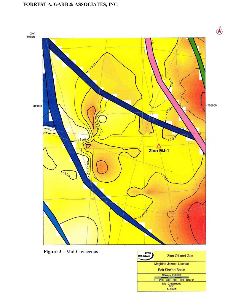
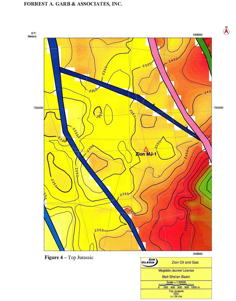
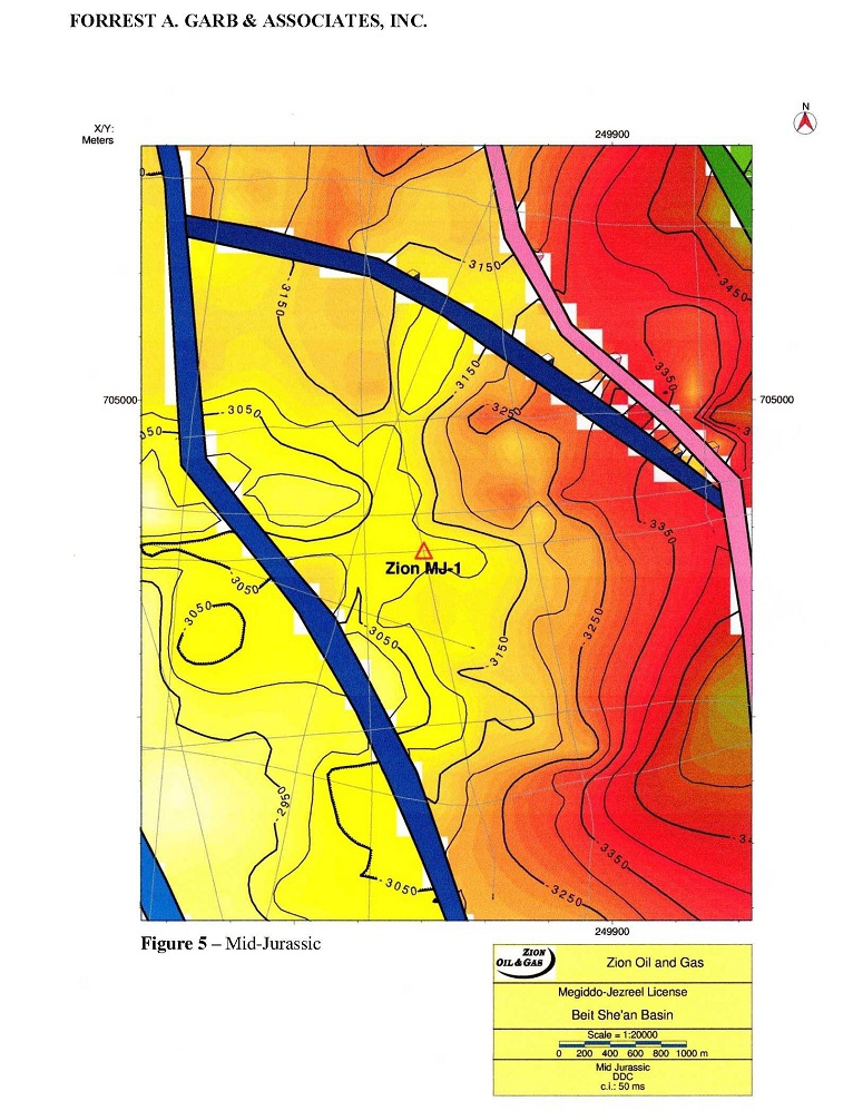
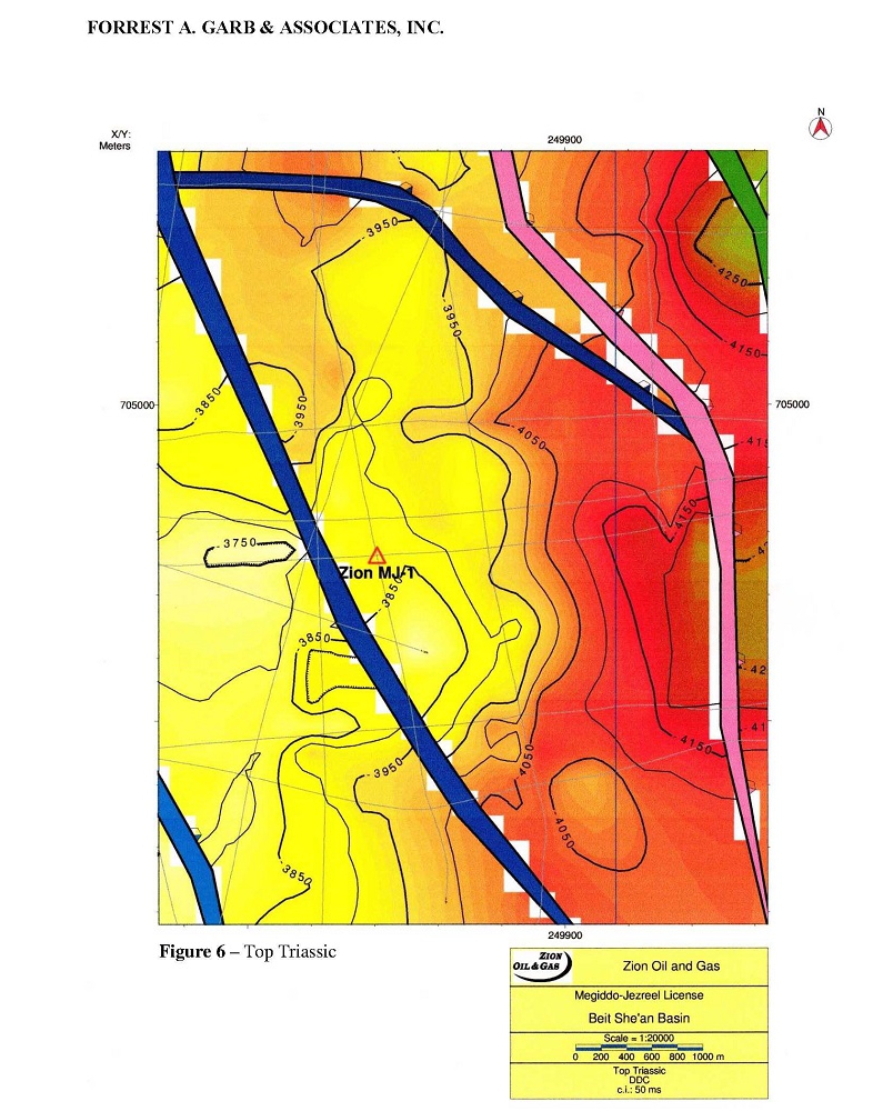
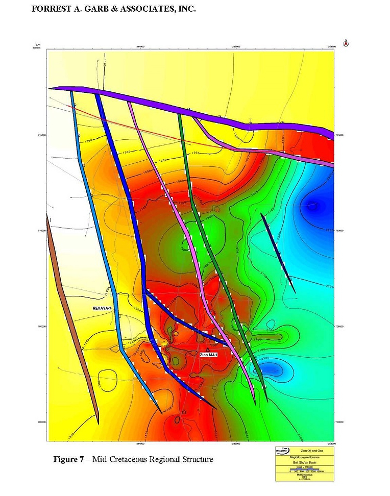
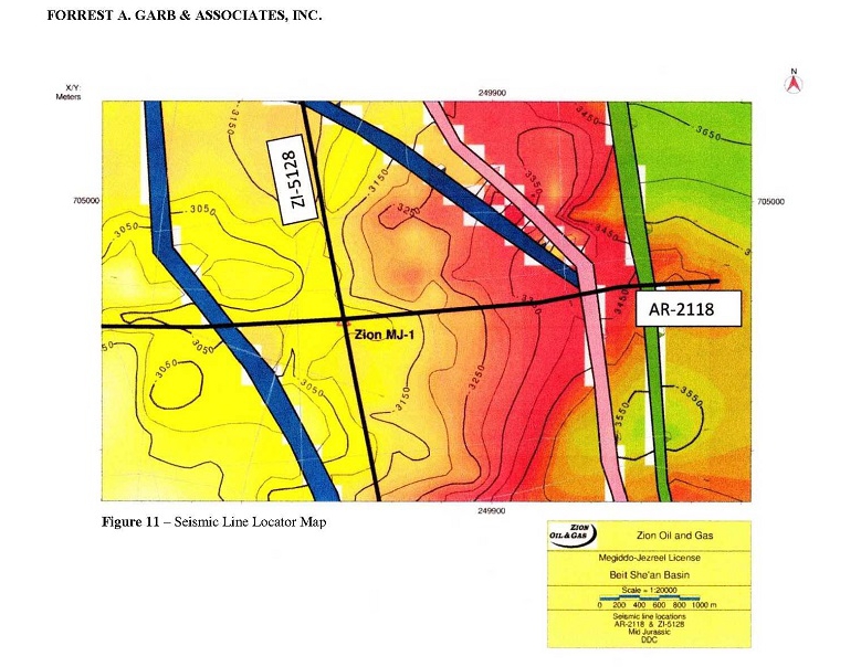
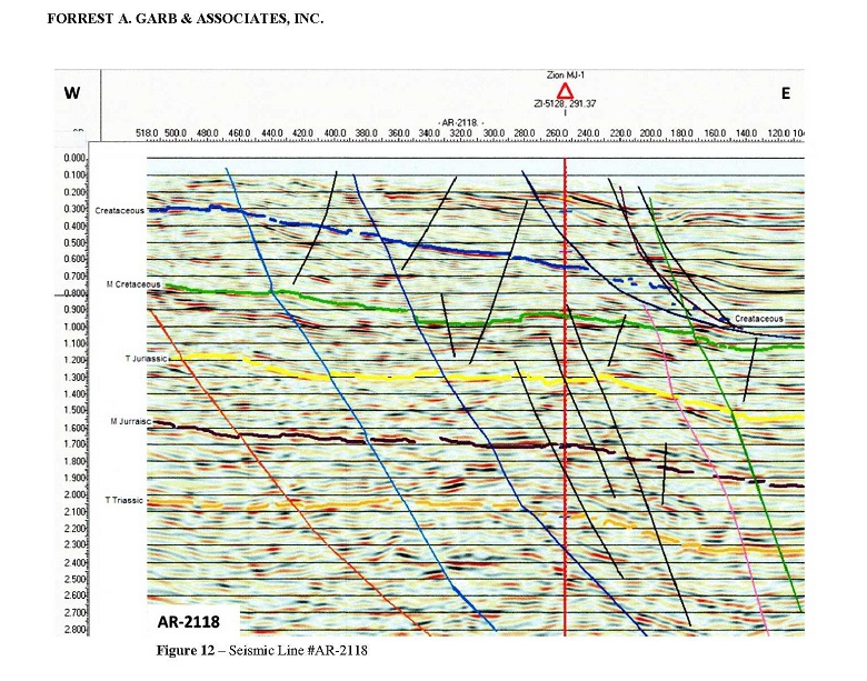
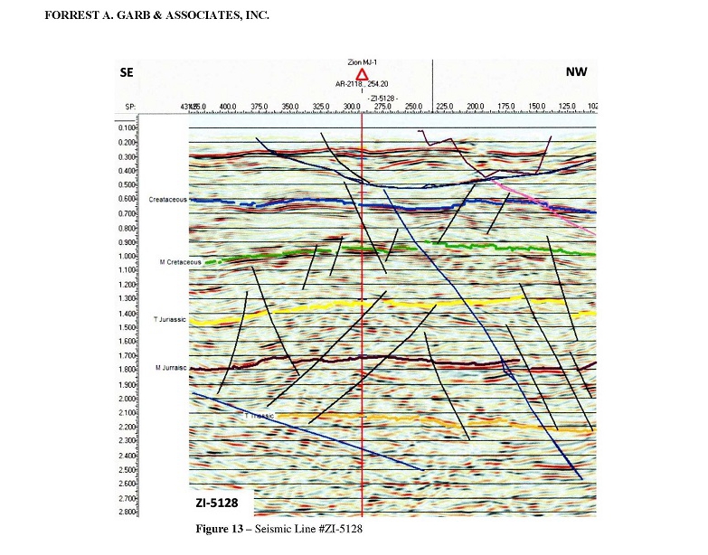
When time mapping of the above horizons was completed, BMA used the Sarid Zemah TD Extended time-depth chart to convert the time maps to depth gridded maps with the IHS-Kingdom "Dynamic Depth Conversion" program. This mapping was interpreted and supplied to FGA by BMA, using the IHS-Advanced Kingdom 8.8 software program. Maps for the four horizons are presented in Figures 3-10. Figures 3-6 show the primary fault block with the proposed well location, while Figures 7-10 are regional views of the structure. A seismic locator map and two seismic lines intersecting at the well location are presented in Figures 11-13.
| 3 |
FORREST A. GARB & ASSOCIATES, INC.
REVIEW OF SIGNIFICANT GEOLOGIC AND ENGINEERING PARAMETERS
Petroleum Sourcing
Seismic mapping indicates the presence of a deep basin (Dead Sea basin) along the Jordan River, which could serve as a hydrocarbon cooking pot for any potential source rocks that are present in the area. Upper Cretaceous rocks of Senonian age, the Mt. Scopus Group, are known to be the source of seeps on outcrops and shows in drilled wells, based on studies of its Type II kerogen. These rocks are known to be deeply buried in the Dead Sea basin. There are additional potential source rocks in Jurassic, Triassic, Permian, and Silurian rocks, at least some of which would likely be required in order to charge deeper reservoirs below Cretaceous age rocks. Maturity modeling was performed on these rocks, using the region's temperature gradient, total organic carbon (TOC) content of these rocks, and other coding and processes utilized in other known such studies. The results support possible or probable sourcing of hydrocarbons from all these rock sections under the assumptions applied.
Numerous shows of oil have been encountered in some of the wells drilled in the area:
| ● | Belvoir #1: Shows in Lower Cretaceous Zeweira Formation sandstone and in Upper Jurassic Haifa Formation porous limestone; | |
| ● | Deborah #2A: Shows in multiple intervals in Upper Jurassic Haifa Formation limestones and dolomites, Jurassic-Upper Triassic Asher Formation, dolomite, and black carbonates and shales with good TOC and vitrinite reflectance (Ro) values in multiple zones of Triassic rocks; | |
| ● | Sarid #1: Multiple shows in Jurassic Haifa Formation; | |
| ● | Zemah #1: Shows of light gas in shallow clastic and basaltic section and both dry and wet gas in deeper intervals; no formation name given; | |
| ● | Numerous water wells north of, and in the near vicinity of, the MJ #1 proposed location recorded possible source rock in various Cretaceous formations at depths from 58 meters to as deep as 987 meters. |
Trap
BMA has used the seismic data provided by Zion and constructed structure maps on four levels reflecting the four major targets for MJ #1 (Mid Cretaceous, Upper Jurassic, Mid Jurassic, and Top Triassic). The overall structure is a faulted, northeast-plunging anticline. The majority of the faults strike north-northwest, are downthrown to the east, and do not exhibit large displacement. Zion has focused its intent to drill on a roughly triangular feature bounded on the north by a northwest-striking fault, and on the west by a down-to-the-east normal fault, which strikes north-northwest. The result is a three-way closure against a normal fault, which is downthrown in the direction of the trap. BMA expresses confidence in their interpretation of these features, including the depth and area of this prospect feature.
| 4 |
FORREST A. GARB & ASSOCIATES, INC.
Migration
Once hydrocarbons are generated from source rocks, reservoirs are identified, and a trap recognized, it is necessary for those hydrocarbons to migrate into the reservoirs in that trap. We believe that the target zones have sufficient porous intervals so as to permit or positively influence hydrocarbon migration. The unanswerable question is whether or not any of the mapped fault planes are of such a nature as to allow the flow of hydrocarbons across them and into porous rocks in the trap. The risk then arises that sufficient sealing at fault planes may not exist to hold the hydrocarbons in a trap.
Trap Seal
Given the existence of a discernable structural feature, another very important consideration is trap seal, seal between individual layers into which hydrocarbons may have migrated at one time, and across the bounding fault planes that are part of the trap definition. The available well logs indicate that there are beds within the intervals planned for drilling that likely would be capable of acting as vertical seals under the right circumstances of fluid emplacement, but it is not possible to determine, given existing information, whether or not this will occur at this wellsite. The matter of sealing or non-sealing faults cannot be determined either; both types are known to exist in petroleum provinces all over the world. If a porous, oil-bearing bed is in fault contact with a non-permeable bed, then it is reasonable to expect a sealing-fault situation; and of course, the opposite also is likely. We have no data to enable determination for this planned well and our estimations of chance of sealing must rely on our own experience.
Trap Fill
In an ideal play a trap may be filled 100 percent to its spill point. This is not commonly the case. It is far more common to find a given trap filled to somewhere between 30 percent and 60 percent; and, indeed, some traps are filled to an even lesser extent.
Reservoir
The reservoir can be described best by its porosity, vertical and horizontal permeability, thickness, and areal extent. The seismic studies are understood to confirm the presence of the anticipated targets at the planned location of MJ #1, and these same studies also permit reasonable estimations of the thickness of each interval.
| 5 |
FORREST A. GARB & ASSOCIATES, INC.
As a result of diagenesis there usually are changes in the porosity of rocks from their original porosity when they were deposited to their current porosity. These changes can be constructive as well as destructive. Burial normally causes decrease in porosity, but burial commonly will decrease porosity in clastic reservoirs (sandstones) more than in carbonates (limestones and dolomites). Early migration of hydrocarbons into an established trap often preserves existing porosity at that time by preventing further diagenesis, either constructive or destructive. Clastic reservoirs typically have higher porosity than do carbonate reservoirs. The proximity of the Dead Sea Transform (DST), a major strike-slip fault zone, may add fracture porosity to the conventional porosity of these rocks; however it is not possible to accurately measure fracture porosity with the well logs we have. Carbonate reservoirs typically are subject to greater fracturing from tectonic stress than are clastic reservoirs because of their typically greater brittleness. Review of the porosity logs from the few wells we have in the surrounding area, even though most of them are not especially close, is the only practical way we have of arriving at reasonable, supportable estimations of porosities for the target zones.
Diagenesis can alter permeability also, both constructively and destructively. There is no accurate way to determine permeability from the well logs we have. As is the case with porosity, clastic reservoirs typically have higher permeability than do carbonate reservoirs. As is the case with porosity, the tectonic activity of the DST also may result in development of fracture permeability, and this effect likely could be greater in carbonate reservoirs than in clastic reservoirs because of their typically greater brittleness. It is not possible to make reasonable estimates of permeability with the data we possess.
Net-to-Gross Ratio
Target zones normally contain both reservoir-quality (porous and permeable) and non-reservoir-quality rock. The ratio of reservoir-quality rock to non-reservoir-quality rock is the Net-to-Gross ratio (NTG). The total thickness of the target zone is multiplied by this factor to yield the thickness of reservoir-quality rock in that target.
Water Saturation
Water saturation (Sw) is the percent of water within the pore spaces in the reservoir, which usually is salt water. Normally, the remainder of the pore space is occupied by hydrocarbons, if any are present. The value 1-Sw is used in resource calculations, along with the other relevant parameters, to determine the volume of hydrocarbons in the reservoir.
Formation Volume Factor
The formation volume factor (FVF) is a measure of the fluid shrinkage from the volume of the oil and its dissolved gas in the reservoir to the volume of the oil produced at the wellhead.
| 6 |
FORREST A. GARB & ASSOCIATES, INC.
This property is a function primarily of the compressibility of the oil and gas and its solution gas-oil ratio.
Recovery Factor
The recovery factor (RF) is the volume of recoverable oil divided by the volume of oil originally in place in the reservoir. This factor varies widely and is influenced by many factors, such as: reservoir pressure, drive mechanism (an active water drive usually is the best drive mechanism and normally will yield the best recovery factor), porosity and permeability of the reservoir, and oil viscosity.
FGA's estimates of these geologic and engineering probabilistic factors are presented in Attachment A.
Estimated Resources
FGA uses the Petroleum Resources Management System (SPE-PRMS), published by the Society of Petroleum Engineers/World Petroleum Congresses/American Association of Petroleum Geologists/Society of Petroleum Evaluation Engineers in November 2011, as the basis for its classification of hydrocarbon volumes. An abbreviated form of the SPE-PRMS is included as Attachment B. The SPE-PRMS definesprospective resourcesas "those quantities of petroleum estimated, as of a given date, to be potentially recoverable from undiscovered accumulations". The SPE-PRMS further states that these have an associated chance of discovery (geologic success) and a chance of development. Prospective Resources are exploratory in nature, carrying a high risk factor.It is FGA's opinion that the estimated hydrocarbon volumes studied in this prospect should be classified as Prospective Resources and, as such, carry a low level of confidence.
FGA estimated hydrocarbon volumes in the prospect using a probabilistic method, by defining the full range of possible values for each input parameter such as area, pay thickness, porosity, oil saturation, oil formation volume factor, and recovery factor. These possible values were then randomly sampled to compute a full range and distribution of potential outcomes using a Monte Carlo simulation model. Available well log data, along with geologic interpretations using 2-D seismic data, and additional reservoir and fluid properties data provided by Zion were used in establishing the range of input values. The methodology used to estimate oil volumes is an appropriate and generally accepted standard protocol for estimating resources in exploratory areas.It is FGA's opinion that the input parameters used are reasonable assumptions for this area based on the geologic and reservoir data currently available.
Due to the uncertainty of geologic and commercial success, the hydrocarbon volumes are classified as prospective resources. The possibility exists that future drilling will not result in a commercial discovery, in which case there would not be development and no future revenue. The possibility also exists that the target horizons are found to be primarily gas bearing or a small oil column with a gas cap. The hydrocarbon quantities recovered, should they be discovered and developed, may differ significantly from the estimates presented in this report.
| 7 |
FORREST A. GARB & ASSOCIATES, INC.
Estimated resource volumes are for the prospect in the Megiddo-Jezreel license area, which includes four target horizons in one major fault block (see Figures 3-6). Estimates of the original oil-in-place (OOIP) and recoverable oil, as of September 1, 2015, are summarized in Tables 3 through 6 and are expressed in thousands of barrels (MBb1). Following each table is a graph of the probability distribution of the estimated recoverable oil.
TABLE 3: Prospective Resources
Mid-Cretaceous Original Oil-in-Place (OOIP) and Recoverable Oil
as of September 1, 2015
| Target Horizon | Gross Prospective Resources | |||
| MBbl | ||||
| Low Estimate (P90) | Best Estimate (P50) | High Estimate (P10) | ||
Mid- Cretaceous | OOIP | 44,998 | 136,628 | 422,370 |
| Recoverable | 8,133 | 27,774 | 100,068 | |
Total Prospective Recoverable Oil

| 8 |
FORREST A. GARB & ASSOCIATES, INC.
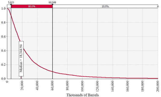
TABLE 4: Prospective Resources
Upper Jurassic Original Oil-in-Place (OOIP) and Recoverable Oil
as of September 1, 2015
| Target Horizon | Gross Prospective Resources | |||
| MBbl | ||||
| Low Estimate (P90) | Best Estimate (P50) | High Estimate (P10) | ||
| Upper Jurassic | OOIP | 27,093 | 89,510 | 258,211 |
| Recoverable | 5,023 | 18,345 | 60,048 | |
Total Prospective Recoverable Oil
| 9 |
FORREST A. GARB & ASSOCIATES, INC.
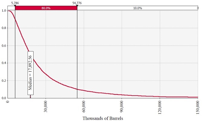
TABLE 5: Prospective Resources
Mid-Jurassic Original Oil-in-Place (OOIP) and Recoverable Oil
as of September 1, 2015
| Target Horizon | Gross Prospective Resources | |||
| MBbl | ||||
| Low Estimate (P90) | Best Estimate (P50) | High Estimate (P10) | ||
| Mid-Jurassic | OOIP | 32,198 | 86,061 | 241,544 |
| Recoverable | 5,786 | 17,893 | 54,776 | |
Total Prospective Recoverable Oil
| 10 |
FORREST A. GARB & ASSOCIATES, INC.
TABLE 6: Prospective Resources
Triassic Original Oil-in-Place (OOIP) and Recoverable Oil
as of September 1, 2015
| Target Horizon | Gross Contingent Resources | |||
| MBbl | ||||
| Low Estimate (P90) | Best Estimate (P50) | High Estimate (P10) | ||
| Triassic | OOIP | 9,322 | 26,901 | 85,250 |
| Recoverable | 1,749 | 5,699 | 19,694 | |
Total Prospective Recoverable Oil

| 11 |
FORREST A. GARB & ASSOCIATES, INC.
Risks and Mitigation
There are many risks and uncertainties associated with exploratory drilling for, and commercial exploitation of, oil and gas resources. Certain risks are, by their nature, defined principally by financial or legal uncertainties. Other components of risk are environmental, technological, or operational in nature. Some of these risks are completely beyond the control of the operator. However, some of these risks can be managed or influenced by the manner in which the operator conducts its business in the selection and evaluation of these prospects and in the conduct of its responsibilities in drilling and operating these properties.
The analysis and findings presented in this report represent FGA's informed judgments based on accepted standards of professional geological and engineering practice, but are subject to the generally recognized and unforeseen risks associated with the interpretation of geological, geophysical, and engineering data. The assumptions, data, methods, and procedures used in the preparation of this report are appropriate for the purpose served by the report.
Qualifications and Independence of Report Writer
Founded in 1988, Forrest A. Garb & Associates, Inc. (FGA) is an international petroleum consulting firm providing services to the upstream oil and gas industry. FGA's expertise includes petroleum reservoir evaluation and economic analysis, as well as geological services for exploration and exploitation projects. FGA restricts it business activities to consulting services only, and does not accept contingency fees. Because the company has no hydrocarbon production and because it has no outside ownership to dictate opinions, the determinations of the firm are independent. FGA's studies are without bias and are based on the best interpretation of all available data after processing with current methods and equipment. FGA does not own operating interests in any oil, gas, or mineral properties. The firm subscribes to a code of professional conduct, and its employees actively support their related technical and professional societies. This report is based on information compiled by professional staff members of FGA, as well as consultants providing services to FGA. Our company profile is included as Attachment C.
FGA staff who participated in the compilation of this report includes Mr. William D. "Donnie" Harris, III, P.E., Ms. Stacy M. Light, P.E., and Gerald K. Ebanks, CPG. All hold degrees in geoscience or petroleum engineering. FGA is a Texas Registered Engineering Firm # F-629. James A. Carroll, P.G. Managing Director, Bell & Murphy and Associates, LLC (BMA) evaluated the geophysical data supplied by Zion for FGA. BMA was formed April 1964 in Houston and moved to Dallas in 1964. The sole purpose is to provide geophysical interpretations for exploration, exploitation and production services to the petroleum industry. BMA is a registered firm preforming geoscience services in the State of Texas as a Texas Board of Professional Geoscientists Registered Firm # 50138.
Mr. Harris joined FGA as President in August 1998, and became Chief Executive Officer of Forrest A. Garb & Associates in January 2002. Previously, he was a Vice President of DeGolyer and MacNaughton where he prepared and supervised engineering and reserve studies, and appraisal reports for fields in many countries. Mr. Harris holds a B.S. in Petroleum Engineering from Texas A&M University and a M.B.A from Southern Methodist University. He is a registered professional engineer in the state of Texas, License # 75222, and is a member of the Society of Petroleum Engineers (SPE).
| 12 |
FORREST A. GARB & ASSOCIATES, INC.
Ms. Light joined FGA in May 2010, and is a Senior Vice President of Petroleum Engineering. Ms. Light previously worked for ARCO Oil and Gas as a reservoir/operations engineer and crude oil risk manager. She has performed detailed production, reservoir and economic analyses for both onshore and offshore properties domestically and internationally, and supervised engineers in the same capacity. She has also performed risk management duties, trading crude oil futures and options on the New York Mercantile Exchange. Ms. Light received a B.S. degree in Petroleum Engineering from Texas A&M University. She is a registered professional engineer in the state of Texas, License # 106726 and is a member of the Society of Petroleum Engineers (SPE).
Mr. Ebanks joined FGA in 1997 as a Senior Geologist. He received his M.A. degree in geology from the University of Texas at Austin and has 50 years of experience in petroleum geology. Previously he was employed with Mobil Oil Corporation, and subsequently with Ray Holifield and Associates, and PXI, Incorporated, in various geological positions. Mr. Ebanks is a member of the American Association of Petroleum Geologists, Dallas Geological Society, Houston Geological Society, and is a certified petroleum geologist.
Mr. Carroll is a Petroleum Exploration Geophysicist with over 44 years of active domestic and international experience in both onshore and offshore oil and gas producing provinces. James has been the Managing Director for BMA since 2001. Prior to joining BMA, he was with Santa Fe Minerals, Wessely Energy Company/TCPL Resources, Dome Petroleum, Gulf Oil Company, and Delta Exploration Company. Mr. Carroll received his B. S. degree from Colorado State University with postgraduate studies at the University of Houston. James is a licensed Professional Geoscientist in the State of Texas, License # 6432, and the State of Louisiana, License #563. He holds active memberships in the Society of Exploration Geophysicists, American Association of Petroleum Geologists and The International Society of Explosives Engineers.
Aside from providing independent interpretation services on a fee basis, FGA has no interest or commercial arrangement in connection with the areas that are the subject of this report. Neither FGA, its directors, employees, or company associates hold any commercial interest in Zion, nor have any vested interest or any rights to subscribe to any interest in any properties or concessions, or on any adjacent properties and concessions held by the client.
The only commercial interest FGA has in relation to Zion is the right to charge professional fees at normal commercial rates, plus normal overhead costs, for work carried out in connection with the investigations reported herein. The payment of these professional fees is not dependent either on listing success or any project fmancing.
All opinions, interpretations, and conclusions presented herein are opinions based on inferences from geological, geophysical, and other interpretations provided by Zion. The report represents FGA's best professional judgment and should not be considered a guarantee of results.
| 13 |
FORREST A. GARB & ASSOCIATES, INC.
FGA certifies that this report is accurate to the best standards of geological and engineering interpretation and analysis, given the limitations of the scope of this project. FGA assumes the information provided for review to be true and accurate. Our staff conducted no independent well tests, property inspections, or audits of completions as part of this review.
We appreciate this assignment. Should you have any questions, please do not hesitate to contact us.
| Sincerely, | |
 | |
| Forrest A. Garb & Associates, Inc. | |
| Texas Registered Engineering Firm F-629 |
GKE/SML/lam
| 14 |
FORREST A. GARB & ASSOCIATES, INC.
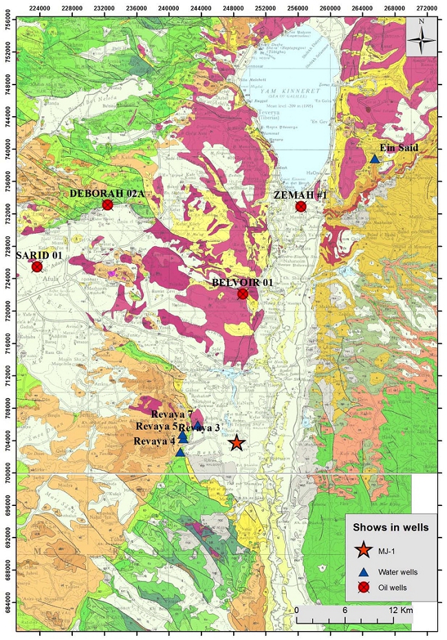
Figure 1—Map of oil (red circles) and water wells (blue triangles) with oil shows, in general vicinity of the MJ-1 well (red star). Background map - Geological map of Israel (Sneh et al., 1998).


FORREST A. GARB & ASSOCIATES, INC.
ATTACHMENTS
A. PROBABILISTIC FACTORS
B. DEFINITIONS FOR OIL AND GAS RESOURCES
C. CONSULTING FIRM PROFILE
FORREST A. GARB & ASSOCIATES, INC.
ATTACHMENT A
PROBABILISTIC FACTORS
ATTACHMENT A - 1
FORREST A. GARB & ASSOCIATES, INC.
ATTACHMENT B
DEFINITIONS FOR OIL AND GAS RESOURCES

Petroleum
Resources Management
System
Sponsored by:
Society of Petroleum Engineers (SPE)
American Association of Petroleum Geologists (AAPG)
World Petroleum Council (WPC)
Society of Petroleum Evaluation Engineers (SPEE)
ATTACHMENT B - 1

ATTACHMENT B - 2
| TERM | DEFINITION |
| Best Estimate | With respect to resource categorization, this is considered to be the best estimate of the quantity that will actually be recovered from the accumulation by the project. It is the most realistic assessment of recoverable quantities if only a single result were reported. If probabilistic methods are used, there should be at least a 50% probability (P50) that the quantities actually recovered will equal or exceed the best estimate. |
| High Estimate (Resources) | With respect to resource categorization, this is considered to be an optimistic estimate of the quantity that will actually be recovered from an accumulation by a project. If probabilistic methods are used, there should be at least a 10% probability (P10) that the quantities actually recovered will equal or exceed the high estimate. |
| Low/Best/High Estimates | The range of uncertainty reflects a reasonable range of estimated potentially recoverable volumes at varying degrees of uncertainty (using the cumulative scenario approach) for an individual accumulation or a project. |
| Low Estimate | With respect to resource categorization, this is considered to be a conservative estimate of the quantity that will actually be recovered from the accumulation by a project. If probabilistic methods are used, there should be at least a 90% probability (P90) that the quantities actually recovered will equal or exceed the low estimate. |
| Monte Carlo Simulation | A type of stochastic mathematical simulation that randomly and repeatedly samples input distributions (e.g., reservoir properties) to generate a resulting distribution (e.g., recoverable petroleum volumes). |
| Probability | The extent to which an event is likely to occur, measured by the ratio of the favorable cases to the whole number of cases possible. SPE convention is to quote cumulative probability of exceeding or equaling a quantity where P90 is the small estimate and P10 is the large estimate. (See also Uncertainty.) |
| Probabilistic Estimate | The method of estimation of Resources is called probabilistic when the known geoscience, engineering, and economic data are used to generate a continuous range of estimates and their associated probabilities. |
| Prospective Resources | Those quantities of petroleum that are estimated, as of a given date, to be potentially recoverable from undiscovered accumulations. |
| Recoverable Resources | Those quantities of hydrocarbons that are estimated to be producible from discovered or undiscovered accumulations. |
ATTACHMENT B - 3
FORREST A. GARB & ASSOCIATES, INC.
ATTACHMENT C
CONSULTING FIRM PROFILE
FORREST A. GARB & ASSOCIATES, INC.
INTERNATIONAL PETROLEUM CONSULTANTS
5310 HARVEST HILL ROAD, SUITE 275, LB 152
DALLAS, TEXAS 75230 — 5805
(972) 788-1110 Fax (972) 991-3160
E-Mail: forgarb@forgarb.com
Web Site: www.forgarb.com
We are pleased to present this profile of Forrest A. Garb & Associates, Inc. (FGA). FGA is an international petroleum engineering and geologic consulting firm staffed by experienced engineers and geologists. Collectively our staff has more than a century of world-wide experience. FGA has no outside ownership. And the firm has no direct or contingent participation in oil or gas ventures. There are no conflicts of interest or concerns about maintaining the confidentiality of our client's data. The company is dedicated to providing the highest level of integrity, technology, and service.
FGA expertise includes:
● Exploration and Prospect Evaluations
● Reserve Estimation and Evaluation Studies
● Fair Market Value Analyses
● Economic and Market Analyses
● Forensic Engineering and Expert Witness Testimony
● Reservoir Engineering
● Regional and Detailed Geological Studies
● Numeric Simulation Studies
● Special Computer Applications
● Pressure Transient Test Design, Supervision, and Evaluation
● Reservoir Characterization
● Geostatistical Studies
● Oil & Gas Production Environmental Studies
● Minerals Evaluations
● Petrophysical Analyses
OUR SENIOR STAFF
Mr. Forrest A. Garb, Founder, Chairman of the Board, and Chief Engineer Emeritus, with more than 50 years of practical petroleum industry experience, was a staff member and then a principal of a major consulting firm for over 30 years, serving as president and chief operating officer of this firm for the last 14 of those years. During his tenure, he supervised or prepared over 12,500 assignments varying from simple evaluations to complex reservoir simulations. Using this experience as a base, he assembled the best work system offered to the oil and gas industry. The use of state of the art computers and office equipment, together with an experienced staff, ensures economic service to the client.
ATTACHMENT C - 1
FORREST A. GARB & ASSOCIATES, INC.
Mr. William D. Harris III, P.E.,joined FGA in August 1998, and is now the Chief Executive Officer. Previously, he was a Vice President with DeGolyer and MacNaughton where he prepared and supervised engineering studies and reserve and appraisal reports for fields in many countries. Mr. Harris holds a BS degree in Petroleum Engineering from Texas A&M University and an MBA degree from Southern Methodist University. He is a member of the Society of Petroleum Engineers and is a registered professional engineer in the state of Texas.
Mr. John Cooper,Senior Geologist, joined FGA in 2007. Mr. Cooper received his Bachelor's degree in Geology from the University of Louisiana - Lafayette (formerly the University of Southwestern Louisiana) and holds an MBA degree from Tulane University. He was employed at Great Southern Oil and Gas, Timex Energy, and Hunt Petroleum in various geological and technical positions, and is experienced in log analysis, geological interpretations, and reserves evaluations using the latest technologies. Mr. Cooper is a member of the American Association of Petroleum Geologists, the Society of Economic Geophysicists, and the Dallas Geological & Geophysical Society.
Mr. Gerald K. Ebanks,Senior Geologist, received his MA degree in geology from the University of Texas at Austin and has more than 35 years of experience in petroleum geology. He was employed with Mobil Oil Corporation, and subsequently with Ray Holifield and Associates and PXI, Incorporated, in various geological positions. Mr. Ebanks is a member of the American Association of Petroleum Geologists, Dallas Geological Society, Houston Geological Society, and is a certified petroleum geologist.
Ms. Stacy M. Light, P.E.,Senior Vice President Petroleum Engineering, joined FGA in May 2010 as a reservoir engineer. Ms. Light previously worked for ARCO Oil and Gas as a reservoir/operations engineer and crude oil risk management director. She performed detailed production, reservoir, and economic analyses for both onshore and offshore properties, and supervised engineers in the same capacity. She also performed risk management duties, trading crude oil futures and options on the New York Mercantile Exchange. Areas worked include onshore and offshore Gulf Coast and the mid-continent area. Ms. Light received a BS degree in Petroleum Engineering from Texas A&M University. She is a registered professional engineer in the state of Texas and a member of the Society of Petroleum Engineers.
Mr. Claude M. (Mike) Rightmire,Senior Petroleum Engineering Consultant, joined FGA in December 2007 as a reservoir engineer. Mr. Rightmire previously worked for ARCO Alaska and ARCO Exploration & Production Technologies as a reservoir and operations engineer and most recently for Pinnacle Technologies as a senior engineer and project manager. His work experience includes over 30 years of operations and reservoir engineering assignments, reservoir engineering research and applications development work, and fracture stimulation engineering. Mr. Rightmire holds a BS in Petroleum Engineering from Texas A&M University, a BS in Biological Science from the University of Alaska Anchorage, and is a member of the Society of Petroleum Engineers.
ATTACHMENT C - 2
FORREST A. GARB & ASSOCIATES, INC.
THE COMPANY
Forrest A. Garb & Associates, Inc. is a consulting firm comprised of professional petroleum engineers, geologists, and technical support personnel with diversified backgrounds in all phases of the petroleum and energy industries. The group prides itself in offering the highest level of ethics, state of the art technology, and prompt dedicated service to our clients.
| FGA professionals have extensive experience in the world's important hydrocarbon producing areas, including North and South America, the Middle East, Australia, New Zealand, Indonesia, Turkey, North Africa, Russia, China, Thailand, Myanmar, West Africa, India, the North Sea, Alaska, and Mexico. |  |
The firm offers a complete range of geological and engineering services - from screening exploration prospects and designing development drilling projects to estimating reserves, forecasting future production, and presenting economic analyses. Major financial institutions accept the validity of our studies, particularly in the areas of reserve estimation and appraisal. The fair market value analysis technique developed by FGA is being applied by some of industry's largest players.
Major integrated and independent oil and gas companies have used our estimates of future production rates and available hydrocarbon resources to design facilities, and to establish contract terms.
FGA is a leader in the development and application of computers to the daily requirements of petroleum engineering. Mainframe programs, hand-held computer programs, and personal computer systems designed by Mr. Garb have been installed in many major integrated oil company offices around the world.
Associations with facilities design, seismic interpretation, petrology, and environmental firms, renowned in their own right, enable the FGA organization to offer a complete service to its clients under one master contract.
Because the company has no hydrocarbon production and because it has no outside ownership to dictate opinions, the determinations of the firm are independent. Its studies are without bias and are based on the best interpretation of all available data after processing with "state of the art" methods and equipment.
FGA restricts its activities exclusively to consultation; it does not accept contingent fees nor does it own operating interests in any oil, gas, or mineral properties. The firm subscribes to a code of professional conduct, and its employees actively support their related technical and professional societies.
The entire FGA staff is dedicated to providing each client with a personalized and cost-efficient approach to serve their individual needs.
ATTACHMENT C - 3