GEOPHYSICAL REPORT
ONA
MAGNETOMETER SURVEY
ONPORTIONSOFTHE
KRL3019642AND KRL3019643 CLAIMS
| FOR GARY SCHELLENBERG 5411 CALDERWOOD CRESCENT RICHMOND, B.C. V7C 3G2 CANADA |
Red Lake Mining District, Ontario NTS 52K14 (~500 51' N , 930 27'W)
| URVEY CONDUCTEDBY SJ GEOPHYSICS LTD. MAY 2007 |
EPORTBY
AARON SNIDER, B.SC.AND SHAWN RASTAD, B.SC.
| SJ GEOPHYSICS LTD. |
MAY 2007
| TABLE OFCONTENTS | ||||||||
| 1. | Introduction | 1 | ||||||
| 2. | Property Description and Ownership | 1 | ||||||
| 3. | Location and Access | 2 | ||||||
| 4. | Climate and Physiography | 4 | ||||||
| 5. | Property History | 4 | ||||||
| 6. | Regional Geology | 7 | ||||||
| 6.1. | Property Geology | 11 | ||||||
| 7. | Geophysical program – Technical Data and Results | 13 | ||||||
| 7.1. | Line and Grid Information | 13 | ||||||
| 7.2. | Field Work and Instrumentation | 14 | ||||||
| 8. | Geophysical Techniques | 16 | ||||||
| 8.1. | Ground Magnetics | 16 | ||||||
| 8.2. | Data Presentation and Results | 16 | ||||||
| 9. | Conclusions and Recommendations | 18 | ||||||
| Appendix 1: | Statement of Cost (Assessment purposes only) | 19 | ||||||
| Appendix 2: | Statement of Qualifications | 20 | ||||||
| Shawn Rastad | 20 | |||||||
| Aaron Snider | 21 | |||||||
| Appendix 3: | References | 22 | ||||||
| Appendix 4: | Instrument Specifications | 23 | ||||||
| GEM GSM-19 Magnetometers | 23 | |||||||
| Appendix 5- Magnetic Profiles | 24 | |||||||
| ILLUSTRATIONINDEX | ||||||
| Figure | 1: | Location map of area | 2 | |||
| Figure | 2: | Location of claims 3019642 and 3019643 | 3 | |||
| Figure | 3: | Regional geological map of the surrounding area and property. | 9 | |||
| Figure | 4: | Regional geological map of the area to the east of the property | 12 | |||
| Figure | 5: | Magnetic Survey Grid (UTM WGS84 Zone15) | 13 | |||
| Figure | 6: | Total Magnetic Field Intensity False Colour Contour Plot | 17 | |||
LISTOF PLATES/DIGITAL FILESON CD
| Digitally supplied as separate Pdf documents : |
| File Name | Description | |
| SurveyLocationMap_1-10000.pdf | Magnetic Survey Grid Map | |
| MagMap_1-5000_ReadingLabels.pdf | Total Magnetic Field Intensity False Colour Plots – with | |
| reading values | ||
| Total Magnetic Field Intensity False Colour Plots – | ||
| MagMap_1-5000.pdf | without reading values | |
| Listing of Locational data | ||
| RedLakeLocationData.txt | ||
| RedLakeMagData.txt | Listing of Magnetic data | |
| Profiles_pg(1-5).pdf | Profiles of individual lines | |
| RedLakeReportMay07v1.odt | Assessment Report | |
Geophysical Report: Red Lake Project: Magnetics
| 1. INTRODUCTION |
The following report, prepared by SJ Geophysics Ltd. for Gary Schellenberg, covers the geophysical work performed on the KRL3019642 and KRL3019643 claims. SJ Geophysics Ltd. services were acquired in May 2007 to gather ground magnetic data over the property. During a five day period 32 kilometres of data was gathered over the two claim blocks and then later processed by SJ Geophysics Ltd.'s office in Delta, BC. This report provides information on the location, and geological setting of the region plus presents the results of the magnetometer survey.
For assessment purposes a statement of costs has been included as Appendix 1 and the authors statement of qualifications can be found in Appendix 2.
2. PROPERTY DESCRIPTIONAND OWNERSHIP
The property consists of 2 claims, KRL3019643 and KRL3019642 located in the Red Lake Mining District, northwestern Ontario, 30km northwest of Ear Falls. Gary Schellenberg is the 100% registered owner of the claims. Below is a summary table of the claims.
| WORK | ||||||||||
| CLAIM NUMBER | UNITS | EXPIRY DATE | ||||||||
| REQUIREMENT | ||||||||||
| KRL3019643 | 16 | May | 20, | 2007 | $6400.00 | |||||
| KRL3019642 | 16 | May | 20, | 2007 | $6400.00 | |||||
Geophysical Report: Red Lake Project: Magnetics
| 3. LOCATIONAND ACCESS |
The claims are located approximately 30km northwest of Ear Falls on both sides of highway 105. Figure 1 shows a general location map, while Figure 2 shows a more detailed map of the claim sites. The property is approximately 497.2 hectares centering on 50° 51'N latitude and 93° 27' W longitude. Both grids are easily accessible year-round by vehicle since they border highway 105, although there are no access roads within the property. A high voltage transmission line runs through the southwest corner of KRL3019643.

| Geophysical Report: Red Lake Project: Magnetics |
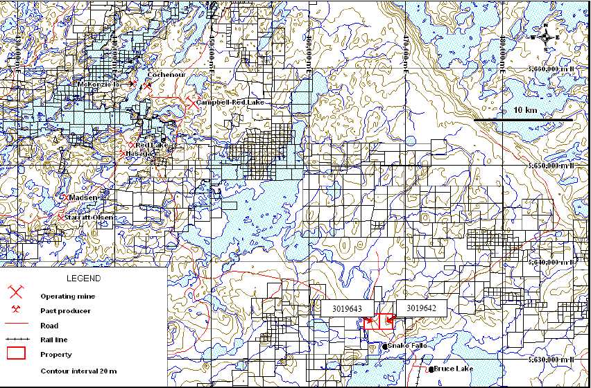
| Figure 2: Location of claims 3019642 and 3019643 |
Geophysical Report: Red Lake Project: Magnetics
| 4. CLIMATEAND PHYSIOGRAPHY |
Relief on the property is generally subdued, with scarce outcrop, generally covered with up to 20m of glacial till. Local relief is between 0 and 40 m, with drainage patterns trending south and southwest, in the direction of the last glacial movement in the area. Winters are typically cold, with temperatures down to -450 C with moderate snowfall, and warm summers up to 350 C.
Vegetation is typical boreal forest with higher ground generally being covered by black spruce, jackpine, poplar and aspen while the more prevalent flatter and boggy areas feature sparse spruce, tamarack and sphagnum mosses, with alders in narrow streams.
| 5. PROPERTY HISTORY |
The following section is an excerpt from a previous report written by B. Dewonck, P. Geo. on September 15, 2005. The authors of this report are unfamiliar with the history of these property claims. (References – Appendix 3) The claims are situated to the southeast of the world famous Red Lake gold mining camp, whose history dates back to 1897 when gold mineralization was first found on surface. It was not rich enough to pursue at the time and it took rumours of a silver occurrence to attract prospectors back in 1922. At that time, claims were staked which eventually became part of Mackenzie Red Lake Mines. The ensuing gold rush extended to the Birch-Uchi area, which lies to the northeast of the subject claims, by 1926. The Red Lake gold camp today is still divided into the Red Lake camp proper, southwest of Trout Lake, and the Birch-Uchi greenstone belt east and southeast of Trout Lake.
By 1929 several gold mines were under construction, the earliest being the Bobjo in the Birch-Confederation lakes area and the Howsey and Hasaga mines at Red Lake. The 1929 stock market crash dampened exploration but rising gold prices prompted a resumption of work by 1931. The early 1940’s saw the Uchi mine and adjacent properties producing 114,00 ounces of gold and 14,000 ounces of silver, remaining the largest recorded producer in the Birch-Uchi area. All activity ceased in 1943 due to World War II.
Activity resumed in 1949 with the Campbell mine as the first major success. Originally staked in 1926, production did not start until 1949 and to date the mine, owned 100% by Placer
Geophysical Report: Red Lake Project: Magnetics
Dome Inc., has produced in excess of 10 million ounces of gold at a grade of about 0.3 oz/ton. The proven and probable mineral reserves as of December 31, 2003 are estimated at 1,430,000 ounces of gold, and deep exploration and development is ongoing.
Other notable past producers include the McMarmac, Gold Eagle, Cochenour-Willams and Madsen Red Lake Mines. The latter closed in 1976, having produced 2.6 million ounces, but was acquired by Claude Resources in 1998 with measured and indicated reserves of 790,000 tonnes grading 11 g/t and inferred reserves of 740,000 tonnes grading 8.5 g/t. Placer Dome has since begun to earn an interest in the property, having completed two phases of work.
The jewel of the whole camp is Goldcorp’s Red Lake Mine (formerly known as the Dickenson Mine), which began operations in 1948 and is contiguous to the Campbell mine. Red Lake has produced over 4 million ounces of gold to date but still has reserves of 5.2 million ounces, thanks to the 1995 discovery of the new High Grade Zone at a depth and location previously thought to have no potential. In total the Red Lake and Birch-Uchi areas have produced over 20 million ounces of gold.
The subject claims are also situated at the southwest end of what is known as the Confederation Lakes area, which has seen base metal exploration since the 1950’s. This began in earnest in the late 1960’s when Selco Mining Corporation discovered the South Bay copper-zinc-silver volcanic hosted massive sulphide deposit. The deposit eventually developed into the South Bay Mine, producing 1.45 million tons of ore grading 2.3% copper, 14.7% zinc and 120 g/t silver between 1971 and 1981.
Selco’s success at South Bay led them to conduct a systematic evaluation of the belt by means of airborne electromagnetic surveys, resulting in the discovery of a number of shallow, small high grade copper-zinc deposits and prospects of which none were of economic interest. Others were also drawn to the area as a result of Selco’s activity, including such companies as Minnova, Rio Algom, Inco and Homestake to name a few, many using the then new Questor INPUT Mark IV AEM survey system.
Noranda began systematic exploration in 1987 using the Questor airborne system and developing a large regional database of lithogeochemical, geophysical and geological information. In 1996 they completed a GEOTEMDeep AEM survey to search for targets at depth not detected by previous survey, and since then have focused on exploring targets between 200
Geophysical Report: Red Lake Project: Magnetics
and 400m vertical depths using deep search geophysical techniques and lithogeochemical sampling to identify proximal VMS-type hydrothermal alteration.
Although South Bay was discovered at shallow depth, the best ore was subsequently identified at depths below 275 m, illustrating the concept of near-surface mineralization reflecting deeper-lying deposits. Many near surface zones have been identified but only South Bay has developed into a mine, emphasizing the need to look deeper into the belt. A new, deeper penetration geophysical technique known as the Titan-24, developed by Quantec Geoscience Inc. has been tested at deep mines such as Kidd Creek and Red Lake.
Tribute Minerals Inc., by virtue of a combination of claim staking and property options, has acquired an interest in a substantial part of the area and in 2002-2003 used the Titan-24 system to develop new exploration targets, identified as the Dixie, Fredart Lake, Copperlode-D-Zone, E-Zone and Hornet Zone, Garnet Lake and South Bay. Of these, the Dixie is the closest to the subject claims, being some 17 km to the northeast, and includes the Dixie 18 deposit with resources reported by Noranda of 110,000 tons grading 0.5% copper and 12.5 % zinc. Tribute has since conducted drilling programs to follow up targets, with the latest results issued in March 2004. Tribute intersected the zinc-copper-gold-silver mineralization of the Arrow zone within a sequence of felsic tuffs and pyroclastics. The drilling encountered massive, semi-massive and stringer sulphide zones, and up to 50 metres of intense footwall alteration.
The fourth hole (GL-2004-04) encountered the Arrow zone approximately 100 metres updip from drill hole 97-4 and approximately 100 metres west of Tribute's GL-2003-01. The drilling intersected a 4.25 m sulphide section containing sphalerite with minor chalcopyrite, pyrite, pyrrhotite and magnetite from 421.5 -425.75 m over an intensely altered footwall zone from 392.0 -421.0 metres with stringer zinc and copper mineralization. The 12.75 metre section from 413.0 -425.75 m reported 6.63% Zn, 0.31% Cu, 0.22 g/t Au and 13.20 g/t Ag. The high grade section from 421.5 -425.75 m reported 17.41% Zn, 0.68% Cu, 0.32 g/t Au and 28.00 g/t Ag, with a massive sulphide section from 423.5 -425.75 m containing Zn values to 40.02% and Cu values to 3.39% over 0.5 metre sampling intervals. The sulphide mineralization was similar in ore mineralogy, texture and grade, to intersections in previous holes.
Geophysical Report: Red Lake Project: Magnetics
| 6. REGIONAL GEOLOGY |
The following section is an excerpt from a previous report written by B. Dewonck, P. Geo. on September 15, 2005. The authors of this report are unfamilar with the geology of these property claims.
The Red Lake camp, in general terms, is underlain by Archean greenstone belts consisting of a thick accumulation of tholeiitic to komatiitic, mafic to ultramafic volcanic rocks (Figure 3). Past and present producing mines occur within and near the stratigraphic top of the tholeiitic sequence. Their location and that of other known mineralization defines an extensive area of highly altered rock which also appears to be situated within and near the top of the tholeiitic sequence. The predominantly tholeiitic sequence includes an accumulation of clastic and chemical sedimentary rocks to the southeast and a series of stratiform mafic to ultramafic intrusions in the northwest. The assemblage as a whole is bounded to the east by a large granitic batholith and on the west by a granodiorite intrusion known as the Dome Stock. Although the vast majority of gold production has come from the volcanic rocks, there are examples of deposits developed in granitic rocks similar to those in the Red Lake area, including the Red Lake Gold Shore mine in the Dome Stock, which produced 21,100 ounces of gold from 86,333 tons milled from 1936 to 1938.
Key elements of lode gold deposits in Red Lake, as identified in the known deposits, include:
- occurrence within the older Mesoarchean (older than 2.8 Ma) Balmer Assemblage
- localized along discreet structures
- occurs in proximity to belt scale unconformity separating Neo and Mesoarchean rocks –applies to late granitic rocks that have intruded near this unconformity
- associated with large areas of ferroan–dolomite alteration (particularly evident in themafic rocks but may be more subtle in the felsic rocks)
- grade appears to be related to contacts between tholeiitic and komatiitic basalts
- silicification as extension and fault-filled veins, breccia veins and open space fillingassociated with gold (arsenopyrite and other sulphides typically associated with siliciousgold mineralization)
Geophysical Report: Red Lake Project: Magnetics
The potential does exist for gold to be found in younger assemblages as is the case in the Rice Lake belt 100 km to the west of Red Lake.
Alteration is dominated by silicification, seritization and carbonatization, with silicification being the least common and perhaps more erratic. It results in significant bleaching and hardening of the rock, occurring as pervasive addition of quartz to the rock and the generation of numerous quartz veins. Sericitization appears largely lithologically controlled, mostly in felsic rock types although certain parts of pillow basalts can be affected. Ultramafic rocks, while moderately to highly serpentinized outside high alteration zones, exhibit extensively carbonatized and talcose (+ fuchsite) shear zones occurring within and along intrusive body contacts. The most characteristic alteration is intense, relatively pervasive iron-carbonatization in intense stringer systems, massive carbonate veins and pervasive addition of carbonate to massive rock. It appears to coincide with intense fracturing and small scale faulting of the altered rock.
Geophysical Report: Red Lake Project: Magnetics
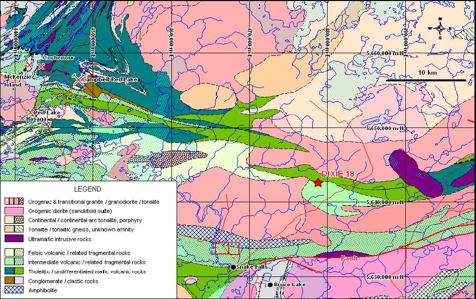
Figure 3: Regional geological map of the surrounding area and property.
Geological boundaries and units are from Sanborn-Barrie et al. (2004). Faults are marked by thick red lines, unconformities by thick black lines.
Geophysical Report: Red Lake Project: Magnetics
The structural framework of the Red Lake camp is complex. Here, one proposal is that a major antiform with a southwest trending axis developed, whose configuration is sympathetic to the general outline of a granitic body to the east, together with a northeast trending, left sinistral limb thrust fault. A third element is a prominent fabric trending southeast, manifested as both fracture cleavage and penetrative foliation. Projected southeastward, it reaches the western end of the Confederation Lakes area to the northeast of the subject claims. Major gold mines and deposits are aligned along a northeast trending array in the northwest limb of the antiform, as well as in a southeast trending array in the southwest limb.
The Confederation Lakes area, to which the subject claims are more closely located, features the Archean aged Birch Lake-Confederation Lake greenstone belt of rocks, which consist of a mixed submarine metavolcanic metasedimentary sequence (Figure 4). Exposure is poor in the area and current understanding of the geology is based largely on interpretation of airborne data and drill information. These rocks have been subdivided into three volcanic cycles or sequences, of which the uppermost is the only one with proven economic base metal mineralization as represented by the South Bay Mine. A number of sub-economic copper-zinc base metal deposits and prospects also occur in the sequence. At least two phases of deformation have affected the area of which the major one is interpreted to have folded the assemblage into a tight syncline. Stratigraphic tops are commonly difficult to determine and makes detailed interpretation on individual properties problematic.
Most of the base metal occurrences are typical volcanogenic massive sulphides localized along stratigraphic time breaks, with intense alteration in the footwall rocks and none in the hanging wall, which is often the only way of determining stratigraphic tops. The alteration suite consists of a chlorite-garnet-biotite + anthophyllite + andalusite + staurolite mineral assemblage.
Geophysical Report: Red Lake Project: Magnetics
| 6.1. PROPERTY GEOLOGY |
The authors are not aware nor were they provided with any current or historical geological information with respect to the specific area of the subject claims. The property, according to published regional mapping, appears to be underlain primarily by intermediate volcanic rocks and related fragmentals in contact with amphibolites occupying the northernmost part of the property. A review of available exploration data from public and private sources, in conjunction with the proposed work program, will be required to substantiate the current interpretation.
Geophysical Report: Red Lake Project: Magnetics
Figure 4: Regional geological map of the area to the east of the property.
Includes the Confederation Lake trend which hosts the past-producing South Bay Mine. Geological boundaries and units are from Sanborn-Barrie et al. (2004). Faults are marked by thick red lines, unconformities by thick black lines. (NAD83: zone15)
Geophysical Report: Red Lake Project: Magnetics
| 7. | GEOPHYSICAL PROGRAM– TECHNICALDATA ANDRESULTS |
| 7.1. LINE ANDGRIDINFORMATION | |
The proposed magnetics grid over claims KRL3019642 and KRL3019643 consisted of 32 NS oriented lines all of which were 1550m long with a station spacing of 12.5m. Based on budgetary and timing constraints a total of 19 of these N-S lines were surveyed during this program, as well as an E-W baseline along 3000N. There were no lines cut or pegged prior to the crew arriving, so the lines were roughly flagged using handheld GPS concurrent with the geophysical survey. Figure 5 below shows the survey grid and a summary of the grid is shown in the Table 1 below.
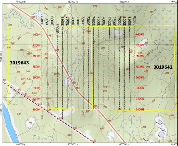
| Figure 5: Magnetic Survey Grid (UTM WGS84 Zone15) |
| Geophysical Report: Red Lake Project: Magnetics | ||||||
| Line | BOL | EOL | Distance (m) | |||
| 6400E | 3000N | 4550N | 1550 | |||
| 6500E | 3000N | 4500N | 1500 | |||
| 6600E | 3100N | 4550N | 1450 | |||
| 6700E | 3000N | 4400N | 1400 | |||
| 6800E | 2825N | 4550N | 1725 | |||
| 6900E | 3000N | 4550N | 1550 | |||
| 7000E | 3000N | 4550N | 1550 | |||
| 7100E | 3000N | 4550N | 1550 | |||
| 7200E | 3000N | 4550N | 1550 | |||
| 7300E | 3000N | 4550N | 1550 | |||
| 7400E | 3000N | 4550N | 1550 | |||
| 7500E | 3000N | 4550N | 1550 | |||
| 7600E | 3000N | 4550N | 1550 | |||
| 7700E | 3000N | 4550N | 1550 | |||
| 7800E | 3000N | 4550N | 1550 | |||
| 7900E | 3000N | 4550N | 1550 | |||
| 8000E | 3000N | 4550N | 1550 | |||
| 8100E | 3000N | 4550N | 1550 | |||
| 8200E | 3000N | 4550N | 1550 | |||
| 3000N (BL) | 6100E | 8400N | 2300 | |||
Table 1: Summary of Line Kilometres – Total of 30.275Km
| 7.2. FIELD WORKAND INSTRUMENTATION |
The SJ Geophysics Ltd. crew consisted of four SJ Geophysics employees: Alex Visser (Geophysical technician), Ashley Bezembinder, Walter Mainville, and Brent Forsyth (field assistants). Alex and Ashley mobilized by air from Vancouver to Winnipeg on Friday May 4, then drove to Kenora, Ontario where they met Walter and Brent who bused from Fort Frances. The crew then continued to drive to Ear Falls and arranged their accommodations.
The next day the crew conducted a safety meeting, tested and calibrated the magnetometer equipment, and started surveying on the lines closest to the highway (7200-7500E). Production
Geophysical Report: Red Lake Project: Magnetics
continued at a rate of roughly 6km per day for a total of five days. The crew demobilized from Ear Falls to Fort Frances on Thursday, May 10 to drop Brent and pick up some of Walter's gear. Alex, Ashley and Walter left Fort Frances very early Friday, May 11 to catch the return flight from Winnipeg to Vancouver.
Magnetic readings were taken at 12.5 metre stations along the traverses with two mobile units, both of which were Gem Systems GSM-19 magnetometers. The specifications for the GSM-19 magnetometers can be located in Appendix 4. A datum of 55,000nT was entered into the instrumentations (a more appropriate would have been 58,000nT). Each operator began the day by taking readings at a control point to ensure the consistency of the two instruments and the proper levelling of the data. A third Gem Systems GSM-19 magnetometer was used as a base station to collect continuous recordings at a stationary location to allow for diurnal corrections to be applied in post-processing.
Geophysical Report: Red Lake Project: Magnetics
| 8. | GEOPHYSICALTECHNIQUES |
| 8.1. GROUNDMAGNETICS | |
Measurements of magnetic intensity are collected at intervals along survey lines of a grid. Intervals are determined by the depth and size of exploration targets. The measurements are used to identify any mineralization related to magnetic materials, such as magnetite and/or pyrrhotite. The magnetic data also serves as a mapping tool, enabling the identification of faults, structure, bedding, and alteration zones.
A magnetic field has both an amplitude and a direction, both of which can be measured with available instrumentation. Commonly, only the amplitude of the field is measured using a proton precession magnetometer, which digitally records total magnetic field, survey line, station, and the time of day that each measurement was taken. At the end of the day this information is then downloaded to a computer and stored for further processing.
Due to the earth's continual changes in its magnetic field (diurnal variations), field measurements must be adjusted to account for these changes. Establishing a stationary base station magnetometer to record the magnetic field for the duration of the survey provides an accurate technique of correcting field data. Field units and the base station are time-synchronized and computer software is later applied to correct the field data for the diurnal variations.
| 8.2. DATA PRESENTATIONAND RESULTS |
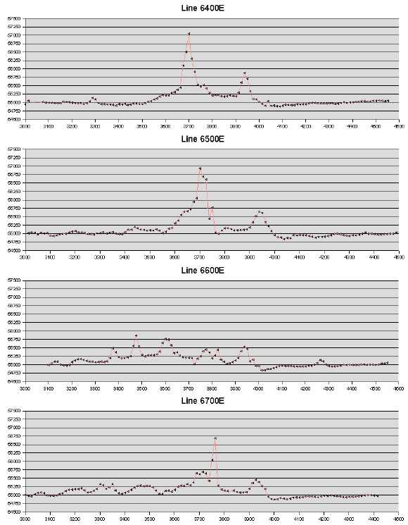
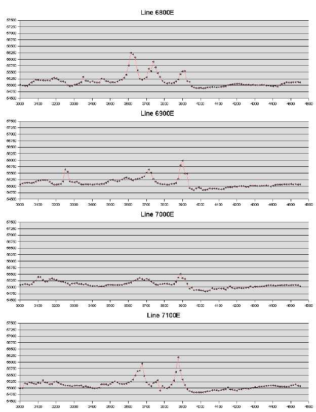
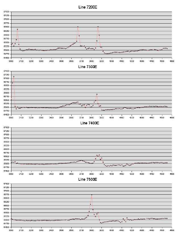
For the purposes of this report the magnetic data has been included in three formats: as individual profiles for each line (included in Appendix 5), a raw listing of all the data (supplied as individual text file) and as a false colour contour plan map (PDF Plates). Several prominent features are visible from this map.
A high-magnetic lineation is clearly visible striking roughly east to west across the central portion of the grid. This high amplitude/high gradient feature may indicate the presence of magnetite or pyrrhotite. The magnetic high forms a very sharp contact across the survey. The response, a slight increase in magnetic values to the south, a sharp magnetic gradient high and a low magnetic zone to the north suggest a dyke like feature. Within a distance of approximately
Geophysical Report: Red Lake Project: Magnetics
50 to 75m, the magnetic values change by over 2400 nT. North of this lineation, the magnetization increases gradually.
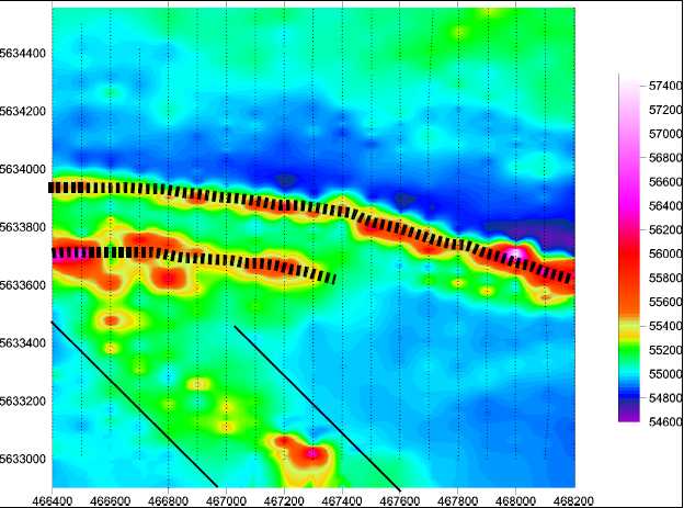
Figure 6: Total Magnetic Field Intensity False Colour Contour Plot Datum set to 55,000nT, UTM WGS84 Zone15
A second magnetic anomaly is located approximately 200m to the south of and parallels with the first lineation. It is not closed off the west, however it abruptly terminates on line 7300E. It is of similar amplitude suggesting a similar type to the main feature; however, is wider and more convoluted.
Finally, a broad zone of moderately high values strikes NW in the southwestern portion of the property. It is approximately 400m wide with magnetic values peaking near the central portion and tapering off slowly into the background.
Geophysical Report: Red Lake Project: Magnetics
9. CONCLUSIONSAND RECOMMENDATIONS
SJ Geophysics Ltd. acquired magnetic data over Gary Schellenberg's Red Lake property near Ear Falls, Ontario. From the gridded false colour contour map, the magnetic data indicates two strong magnetic anomalies striking approximately east-west across the grid. The first lineation (northern one) strikes across the entire survey grid; while the second one stops near Line 7400E. As little geology is known about these particular claims, it is recommended that a full data compilation of surrounding geological information should be conducted to determine what these high gradient lineations may be. Further analysis such as reduction to pole or magnetic inversion with the UBC-GIF inversion code is also warranted.
In addition, completion of the magnetometer survey to cover the entire claim region as well a horizontal loop em survey (MaxMin) over the the same region may provide more information about these lineations. The information gathered from this geophysical survey would possibly indicate the difference between magnetite and massive sulphides.
| Respectfully submitted, As per SJ Geophysics Ltd. |
| Shawn Rastad, B.Sc. (Geophysics) |
| Aaron Snider, B.Sc. (Geophysics) |
Geophysical Report: Red Lake Project: Magnetics
APPENDIX 1: STATEMENTOF COST (ASSESSMENTPURPOSESONLY)
For assessment purposes, none of the mobilization costs for the crew from Vancouver to Ontario were included in the following statement. All costs were incurred in Ontario, except for the cost of the preparation of this report. For this project, the work was split evenly between claims KRL3019642 and KRL3019643.
| Work Type | Units of | Cost per unit | Total Cost | |||
| work | ||||||
| Surveying and flagging in of lines | ||||||
| -2 helpers to survey line | 7 | $475.00 | $3,325.00 | |||
| Magnetometer Survey | ||||||
| - 1stMagnetometer operator + unit | 5 | $650.00 | $3,250.00 | |||
| - 2ndMagnetometer operator + unit | 5 | $550.00 | $2,750.00 | |||
| Associated Costs | ||||||
| - Accommodations and meals | expenses | $1522.68 | $1522.68 | |||
| - Transportation costs (ON only) | expenses | $1575.41 | $1575.41 | |||
| - Mobilization costs (ON only) | 2 | $900.00 | $1800.00 | |||
| AssessmentReport(Processing, Mapping, | ||||||
| flat | $3000.00 | $3000.00 | ||||
| and Technical Report) | ||||||
| Total Value of | ||||||
| Assessment | $17,223.09 | |||||
| Work | ||||||
Geophysical Report: Red Lake Project: Magnetics
APPENDIX 2: STATEMENTOF QUALIFICATIONS
| SHAWN RASTAD |
I, Shawn Rastad, of the city of Coquitlam, Province of British Columbia, hereby certify that:
1) I graduated from the University of British Columbia in 1996 with a Bachelor of Science degree majoring in geophysics.
| 2) | I have been working in mineral and oil exploration since 1997. |
| 3) | I have no interest in these claims or in any property within the scope of this report, |
nor do I expect to receive any.
4) My work has been reviewed by a registered Professional Geoscientist within British Columbia, namely Syd Visser
Signed by:
_________________________
Shawn Rastad, B.Sc. (Geophysics)
Date:
_________________________
Geophysical Report: Red Lake Project: Magnetics
AARON SNIDER
1) I graduated from Carleton University in 2005 with a Bachelor of Science in Computational Geophysics
| 2) | I have been working in mineral exploration since 2005. |
| 3) | I have no interest in these claims or in any property within the scope of this report, |
| nor do I expect to receive any. |
Signed by:
_________________________
Aaron Snider, B.Sc. (Computational Geophysics)
| Date: _________________________ Signed by: _________________________ |
Geophysical Report: Red Lake Project: Magnetics
| APPENDIX 3: REFERENCES |
Dewonck, Bernard, (September 2005): Report on KRL3019642 and KRL3019643 Claims, Red Lake Mining Districk, Ontario for First Corp. Ltd., Coast Mountain Geological Ltd.
Sanborn-Barrie, M., Rogers, N., Skulski, T., Parker, J., McNicoll, V. and Devaney, J. (2004): Geology and Tectonostratigraphic Assemblages, East Uchi Subprovince, Red Lake and Birch-Uchi belts, Ontario; Geological Survey of Canada, Open File 4256; Ontario Geological Survey Preliminary Map P.3460, scale 1:250 000.
Geophysical Report: Red Lake Project: Magnetics
APPENDIX 4: INSTRUMENT SPECIFICATIONS
GEM GSM-19 MAGNETOMETERS
| Resolution: | 0.01 nT, magnetic field and gradient. | |||
| Accuracy: | 0.2 nT over operating range. | |||
| Gradient Tolerance: | up to 5000 nT/metre. | |||
| Operating Interval: | 4 seconds minimum, faster optional. | |||
| Reading: | Initiated by keyboard depression, external trigger or | |||
| carriage return via RS-232C. | ||||
| Input/Output: | 6 Pin weatherproof connector, RS-232C, and optional | |||
| analog output | ||||
| Power Requirements: | 12v 300 mA peak(during polarization), | |||
| 35 mA standby, | ||||
| 600 mA peak in gradiometer | ||||
| Power Source: | Internal 12v, 1.9ah sealed lead-acid battery standard, other | |||
| optional | ||||
| External 12v power source can be used. | ||||
| Battery Charger: | Input: 110/220 VAC, 50/60 Hz and/or 12VDC. | |||
| Output: 12v dual level charging. | ||||
| Operating Ranges Temperature: | -40o C to +600 C | |||
| Battery Voltage: | 10v min. to 15v max. | |||
| Dimensions: | Console: | 223 x 69 x 240 mm. | ||
| Sensor staff: | 4 x 450 mm sections. | |||
| Sensor: | 170 x 71 mm diameter. | |||
| Weights: | Console: | 2.1 kg | ||
| Staff: | 0.9 kg. | |||
| Sensor: | 1.1 kg each. | |||
Geophysical Report: Red Lake Project: Magnetics
| APPENDIX 5- MAGNETIC PROFILES |
Geophysical Report: Red Lake Project: Magnetics
Geophysical Report: Red Lake Project: Magnetics
Geophysical Report: Red Lake Project: Magnetics

Geophysical Report: Red Lake Project: Magnetics