Exhibit 99.1
| TECHNICAL REPORT ON COAL RESOURCES AND RESERVES |
| CANADIAL COAL TRUST ELK VALLEY COAL |
| | | |
TECHNICAL REPORT ON COAL RESOURCES AND RESERVES OF THE ELKVIEW PROPERTY | | |
ELK VALLEY COAL CORP., FORDING CANADIAN COAL TRUST AND TECK COMINCO LTD. | | FEBRUARY 2008 |
| |
ITEM 1 TITLE PAGE
Title of Report
The title of this report isTechnical Report on Coal Resources and Reserves of the Elkview Property. This report was prepared for Elk Valley Coal Corporation, Fording Canadian Coal Trust (FCCT,) and Teck Cominco Limited (TCL.)
Project Location
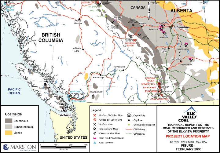
The Elkview Operation, operated by the Elkview Limited Partnership (ELP) of Elk Valley Coal Corporation (EVCC,) is located in the East Kootenay Region of British Columbia, Canada. The Elkview Operation is located approximately 3 kilometers (km) east of Sparwood, British Columbia as shown on Figure 1, Project Location Map.
Author
The author of the report is Marston Canada Ltd. (Marston,) a professional geological and mining engineering services firm based in Calgary, Alberta, Canada. Marston is registered to practice engineering under APEGGA Permit No. P-8327. Marston’s address is 2116 27th Avenue NE, Suite 220, Calgary, Alberta, Canada T2E 7A6.
Effective Date of Report
February 29, 2008
1-1
| | | |
TECHNICAL REPORT ON COAL RESOURCES AND RESERVES OF THE ELKVIEW PROPERTY | | |
ELK VALLEY COAL CORP., FORDING CANADIAN COAL TRUST AND TECK COMINCO LTD. | | FEBRUARY 2008 |
| |
ITEM 2 TABLE OF CONTENTS
| | | | | |
| ITEM 1 | | TITLE PAGE | | 1-1 |
| | | | | |
| ITEM 2 | | TABLE OF CONTENTS | | 2-1 |
| | | | | |
| ITEM 3 | | SUMMARY | | 3-1 |
| | | | | |
| ITEM 4 | | INTRODUCTION | | 4-1 |
| | | | | |
| ITEM 5 | | RELIANCE ON OTHER EXPERTS | | 5-1 |
| | | | | |
| ITEM 6 | | PROPERTY DESCRIPTION AND LOCATION | | 6-1 |
| | | | | |
| ITEM 7 | | ACCESSIBILITY, CLIMATE, LOCAL RESOURCES, INFRASTRUCTURE AND PHYSIOGRAPHY | | 7-1 |
| | | | | |
| ITEM 8 | | HISTORY | | 8-1 |
| | | | | |
| ITEM 9 | | GEOLOGICAL SETTING | | 9-1 |
| | | | | |
| ITEM 10 | | DEPOSIT TYPES | | 10-1 |
| | | | | |
| ITEM 11 | | MINERALIZATION | | 11-1 |
| | | | | |
| ITEM 12 | | EXPLORATION | | 12-1 |
| | | | | |
| ITEM 13 | | DRILLING | | 13-1 |
| | | | | |
| ITEM 14 | | SAMPLING METHOD AND APPROACH | | 14-1 |
| | | | | |
| ITEM 15 | | SAMPLE PREPARATION, ANALYSES AND SECURITY | | 15-1 |
| | | | | |
| ITEM 16 | | DATA VERIFICATION | | 16-1 |
| | | | | |
| ITEM 17 | | ADJACENT PROPERTIES | | 17-1 |
| | | | | |
| ITEM 18 | | MINERAL PROCESSING AND METALLURGICAL TESTING | | 18-1 |
| | | | | |
| ITEM 19 | | MINERAL RESOURCE ESTIMATES | | 19-1 |
| | | | | |
| ITEM 20 | | OTHER RELEVANT DATA AND INFORMATION | | 20-1 |
| | | | | |
| ITEM 21 | | INTERPRETATION AND CONCLUSIONS | | 21-1 |
| | | | | |
| ITEM 22 | | RECOMMENDATIONS | | 22-1 |
| | | | | |
| ITEM 23 | | REFERENCES | | 23-1 |
| | | | | |
| ITEM 24 | | DATE | | 24-1 |
| | | | | |
| ITEM 25 | | ADDITIONAL REQUIREMENT FOR TECHNICAL REPORTS ON DEVELOPMENT PROPERTIES AND PRODUCTION | | 25-1 |
| | | | | |
| ITEM 26 | | ILLUSTRATIONS | | 26-1 |
2-1
| | | |
TECHNICAL REPORT ON COAL RESOURCES AND RESERVES OF THE ELKVIEW PROPERTY | | |
ELK VALLEY COAL CORP., FORDING CANADIAN COAL TRUST AND TECK COMINCO LTD. | | FEBRUARY 2008 |
| |
LIST OF TABLES
| | | | | |
| Table 3.1 Elkview Property Estimated Coal Resources | | | 3-3 | |
| | | | | |
| Table 3.2 Elkview Property Estimated Coal Reserves | | | 3-4 | |
| | | | | |
| Table 3.3 Elkview Mine Targeted Product Specifications | | | 3-5 | |
| | | | | |
| Table 6.1 Elkview Permits | | | 6-5 | |
| | | | | |
| Table 6.2 Elkview Licenses | | | 6-1 | |
| | | | | |
| Table 8.1 Drilling, Sampling and Assay Information | | | 8-3 | |
| | | | | |
| Table 8.2 Exploration History | | | 8-4 | |
| | | | | |
| Table 8.3 Exploration Adits | | | 8-5 | |
| | | | | |
| Table 8.4 2001 Technical Report of Mineral Reserves | | | 8-8 | |
| | | | | |
| Table 8.5 Historical Production Data | | | 8-9 | |
| | | | | |
| Table 14.1 Summary of Seam Characteristics | | | 14-5 | |
| | | | | |
| Table 19.1 Coal Resource Categories | | | 19-2 | |
| | | | | |
| Table 19.2 Coal Seam Thickness Criteria | | | 19-3 | |
| | | | | |
| Table 19.3 Elkview Property Estimated Coal Resources | | | 19-4 | |
| | | | | |
| Table 19.4 Elkview Mining Costs for LG Analysis | | | 19-5 | |
| | | | | |
| Table 19.5 Elkview Property Estimated Coal Reserves | | | 19-6 | |
| | | | | |
| Table 25.1 Summary of Elkview Long Range Mine Plan | | | 25-2 | |
| | | | | |
| Table 25.2 Elkview Mine Targeted Product Specifications | | | 25-3 | |
| | | | | |
| Table 25.3 Elkview Simplified Cash Flow | | | 25-6 | |
| | | | | |
| Table 25.4 Summary of Sensitivity Analyses | | | 25-7 | |
2-2
| | | |
TECHNICAL REPORT ON COAL RESOURCES AND RESERVES OF THE ELKVIEW PROPERTY | | |
ELK VALLEY COAL CORP., FORDING CANADIAN COAL TRUST AND TECK COMINCO LTD. | | FEBRUARY 2008 |
| |
LIST OF FIGURES
| | | | | |
| Figure 1 Project Location Map | | | 26-2 | |
| | | | | |
| Figure 2 Regional Geology Map | | | 26-3 | |
| | | | | |
| Figure 3 Project Exploration and Mine Site Map | | | 26-4 | |
| | | | | |
| Figure 4 Generalized Stratigraphic Column | | | 26-5 | |
| | | | | |
| Figure 5 Local Geology Map | | | 26-6 | |
| | | | | |
| Figure 6a Measured, Indicated and Inferred Resource Areas | | | 26-7 | |
| | | | | |
| Figure 6b 10 Seam Drill Hole Locations and Reserve/Resource Map | | | 26-8 | |
| | | | | |
| Figure 7 Typical Geological Cross Sections | | | 26-9 | |
| | | | | |
| Figure 8 Pits, Dumps and Onsite Infrastructure | | | 26-10 | |
| | | | | |
| Figure 9 Simplified Process Flow Sheet | | | 26-11 | |
2-3
| | | |
TECHNICAL REPORT ON COAL RESOURCES AND RESERVES OF THE ELKVIEW PROPERTY | | |
ELK VALLEY COAL CORP., FORDING CANADIAN COAL TRUST AND TECK COMINCO LTD. | | FEBRUARY 2008 |
| |
LIST OF APPENDICES
Appendix 1 – Certificate of Authors
2-4
| | | |
TECHNICAL REPORT ON COAL RESOURCES AND RESERVES OF THE ELKVIEW PROPERTY | | |
ELK VALLEY COAL CORP., FORDING CANADIAN COAL TRUST AND TECK COMINCO LTD. | | FEBRUARY 2008 |
| |
ITEM 3 SUMMARY
Property Description, Location and Ownership
The Elkview property (Property) is operated by Elkview Limited Partnership (ELP). The Property consists of approximately 12,943 hectares (ha) in southeastern British Columbia just east of the town of Sparwood. The Property is readily accessible by Provincial Highway 3. The location of the Property is shown on Item 26 on Figure 1, Project Location Map and Figure 3, Project Exploration and Mine Site Map.
ELP owns the surface and surface rights to the Property. This land is referred to as Freehold or Fee Simple land. There are no royalties, licenses (land related) or leases required for Fee Simple land.
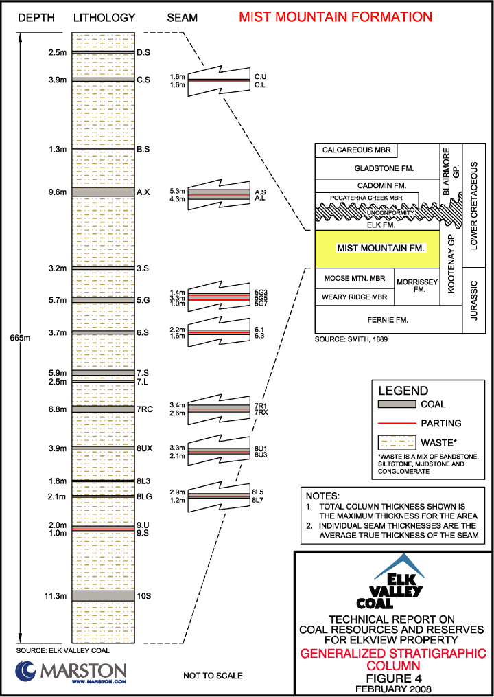
The coal resources on the Property are part of the Mist Mountain Formation of the Kootenay Group. This strata is of the Jurassic-Cretaceous period deposited approximately 120 to 150 million years ago. Economically the Mist Mountain formation is the most important formation of the Kootenay Group with coal seams up to 18m in thickness which range in rank from medium to high volatile bituminous coal in the ELP area. On the Property the Mist Mountain Formation averages over 600m in thickness and contains over 20 mineable coal seams, see Figure 4, Generalized Stratigraphic Column. The major structure of the Property is a southwest plunging syncline, known as the Sparwood (Michel) Syncline which contains numerous thrust faults that result in repeats and thickening of the 10 Seam. This is the primary seam at the Property and accounts for approximately 70 percent of clean coal production.
Exploration
The Property is a mature operation with more than 40 years of operating experience and exploration activity. The coal geology coal quality is well understood and documented. The current exploration database consists of 2,874 reverse circulation holes, 92 core holes along with over 100 adits and approximately 200 seam outcrop mappings. Shallow holes which are now mined out and outdated were also excluded from the database. Geophysical logging was performed on nearly all exploration holes. The exploration database includes 1,213 quality
3-1
| | | |
TECHNICAL REPORT ON COAL RESOURCES AND RESERVES OF THE ELKVIEW PROPERTY | | |
ELK VALLEY COAL CORP., FORDING CANADIAN COAL TRUST AND TECK COMINCO LTD. | | FEBRUARY 2008 |
| |
samples. Samples were taken for proximate, coking, petrographic and washability analysis. Coal quality sampling was performed to ASTM standards with some minor modifications using both EVCC’s internal laboratory and reputable outside laboratories. In general EVCC’s laboratory performed the proximate and FSI analysis and the outside laboratories performed coking, petrographic and washability analysis. ELP is continuing to drill exploration holes on the Property in order to verify structure and increase confidence.
Development and Operations
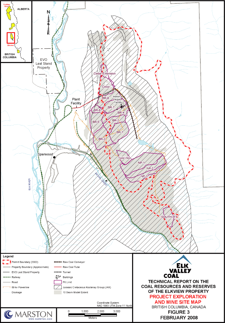
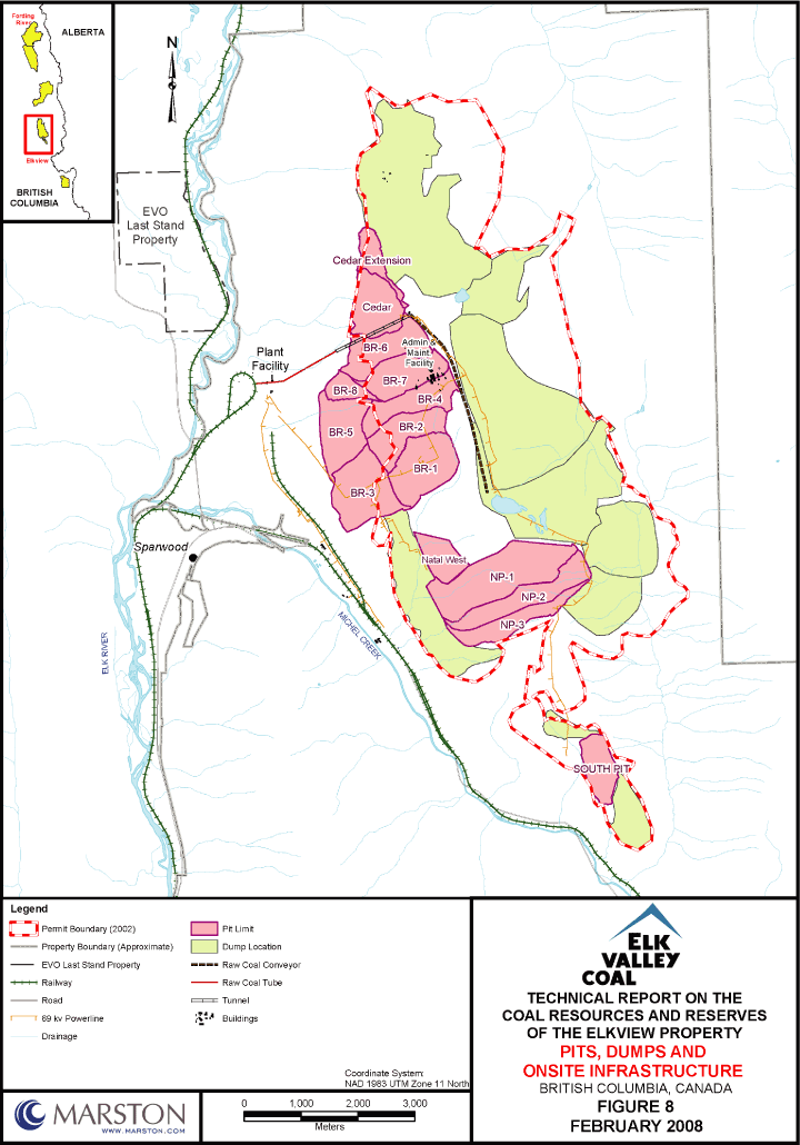
ELP is currently conducting open pit coal mining operations within the Property. ELP is a mature open pit operation which was developed in the 1960s with first coal production in 1970. The operation currently consists of four active pits: Natal West, Natal Phase 1, South Pit, and Baldy Cedar. For the past five years production has averaged 5.4 million tonnes of clean coal and 47 million bcm of waste annually. The Life-of-Mine-Plan (LOMP) provided to Marston shows that the mine will ramp up from the current production rate of approximately 5.6 Mtpa to 6.5 Mtpa with waste increasing from an average of 47 million bcm per year for the last 5 years to an average of 53 million bcm per year. The plan shows the development of 11 more pits over the mine life. An amendment to the current C2 permit will be required to allow for expansion to the west. This development will require the relocation of the mine offices and maintenance facilities. Mining to the ultimate limit of the Cedar pit may require the re-evaluation of the current coal tunnel running under the pit due to geotechnical concerns. Alternatives are under consideration and include relocating the coal conveyor to the west edge of the Property. See Figure 8, Pits, Dumps and Onsite Infrastructure.
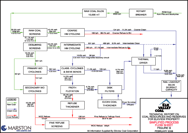
Coal is processed using standard coal washing techniques and equipment which include heavy media cyclones, water only cyclones, froth flotation and a thermal dryer. Clean coal is transported by rail to customers in North America or transported to ports in Vancouver for shipment overseas.
Conclusions and Recommendations
Based on the data available and the geological interpretation, Marston has determined that the tectonically thickened portions of the 10 Seam are of Complex geology type, and the remaining area is of Moderate geology type as defined in Paper 88-21 of the Geological Survey of
3-2
| | | |
TECHNICAL REPORT ON COAL RESOURCES AND RESERVES OF THE ELKVIEW PROPERTY | | |
ELK VALLEY COAL CORP., FORDING CANADIAN COAL TRUST AND TECK COMINCO LTD. | | FEBRUARY 2008 |
| |
Canada, entitled “A Standardized Coal Resource/Reserve Reporting System for Canada (GSC 88-21).” The Measured and Indicated resource estimates were developed, applying the GSC 88-21 standards required for the Complex and Moderate geology types.
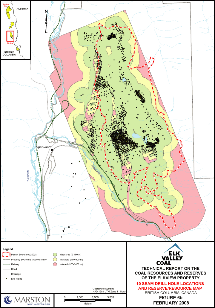
Marston estimated coal resources using Vulcan’s Lerchs-Grossman (LG) pit optimization package. The resources were calculated using an incremental cutoff ratio of 19.2 bcm per in situ tonne of coal. The use of this cutoff ration was based on review and acceptance of ELP methodology, review of current market prices and compliance with GSC Paper 88-21 which recommends a maximum incremental ratio of 20 bcm per in situ coal tonne. Marston’s Measured, Indicated and Inferred bituminous resource estimates are presented on Table 3.1, Elkview Property Estimated Coal Resources.The Measured and Indicated mineral resources are exclusive of those mineral resources modified to produce mineral reserves.
Table 3.1
Elkview Property Estimated Coal Resources
| | | | | | | | | | | | | |
| | | | | | | | | | | | | |
| | In Situ Coal Tonnes
(millions) | |
| | | | | | | | | | | | | |
| | | | | | | | | | | | | |
| | Measured | | | Indicated | | | Total | |
| | | | | | | | | | | | | |
| | | | | | | | | | | | | |
| | 443 | | | | 136 | | | | | 579 | | |
| | | | | | | | | | | | | |
| |
Marston estimated coal resources in the Inferred class of 119 million tonnes.
Based on the spacing of the available geological data and the limits of the estimated resources, Marston estimated that Elkview Measured and Indicated resources are 579 million tones (Mt). The resource estimates are classified as Measured, Indicated and Inferred according to the CIM Definition Standards on Mineral Resources and Mineral Reserves (CIMDS) prepared by the CIM Standing Committee on Reserve Definitions and adopted by the CIM Council, December 11, 2005, which are incorporated by reference in National Instrument
3-3
| | | |
TECHNICAL REPORT ON COAL RESOURCES AND RESERVES OF THE ELKVIEW PROPERTY | | |
ELK VALLEY COAL CORP., FORDING CANADIAN COAL TRUST AND TECK COMINCO LTD. | | FEBRUARY 2008 |
| |
43-101 (NI 43-101). For coal resource estimates, the CIMDS incorporates by reference the guidelines of GSC 88-21.
CIMDS defines mineral reserves as “the economically mineable part of a Measured or Indicated Mineral Resource demonstrated by at least a Preliminary Feasibility Study. This Study must include adequate information on mining, processing, metallurgical, economic and other relevant factors that demonstrate, at the time of reporting, that economic extraction can be justified. A Mineral Reserve includes diluting materials and allowances for losses that may occur when the material is mined.”
In accordance with CIMDS, Marston estimated the Project reserves based the designed pits provided by ELP, review of ELP’s LOMP, economics, and the application of GCS Paper 88-21 classifications of Proven and Probable Reserves. Based on the information supplied, the review performed, and the long term price of $85US and exchange rate of $0.91US = $1.00 CDN provided by EVCC, Marston concludes that the Elkview property is economic and will generate a positive NPV at a discount rate of 15%. Marston’s Proven and Probable bituminous reserve estimates are presented on Table 3.2, Elkview Property Estimated Coal Reserves.
Table 3.2
Elkview Property Estimated Coal Reserves
| | | | | | | | | | | | | | | |
| | Run of Mine Coal Tonnes
(millions) | | Total Coal
Reserves
(million tonnes) | | | Waste*
(million bcm) | | | Run of Mine Stripping
Ratio
(bcm/tonne) | |
| | Proven | | | Probable | | | | | | | |
| | | | | | | | | | | | | |
| | 290.2 | | | 85.9 | | | 376.1 | | | 1,885 | | | 5.0 | |
| | | | | | | | | | | | | | | |
| |
* Estimated total waste volumes include rehandled waste.
In accordance with CIMDS, the reserve estimates include adjustments to the in situ coal resource estimates for mining losses and out-of-seam dilution. No adjustments were made for in situ or ROM moisture.
3-4
| | | |
TECHNICAL REPORT ON COAL RESOURCES AND RESERVES OF THE ELKVIEW PROPERTY | | |
ELK VALLEY COAL CORP., FORDING CANADIAN COAL TRUST AND TECK COMINCO LTD. | | FEBRUARY 2008 |
| |
The saleable coal resulting from the processing of the Proven and Probable Reserves is estimated at 181.3 million tonnes and 53.7 million tonnes respectively for a total of 235.0 million tonnes at an average yield of 62 percent.
The targeted Coal quality specifications for the Elkview Property products are shown in Table 3.3, Elkview Mine Targeted Product Specifications.
Table 3.3
Elkview Mine Targeted Product Specifications
| | | | | | | | | | | | | | | | | | | | | |
| |
| | Quality Parameter | | | Units | | Coal Product |
| | | | | | High Ash | | | High Volatile | | | Mid Volatile | | | Low
Phosphorus | | | Standard Met | |
| | | | | | | | | | | | | | |
| | | | | | | | | | | | | | | | | | | | | |
| | Total Moisture | | | (Wt. %) | | | 8.5 | | | 8.5 | | | 8.5 | | | 8.5 | | | 8.5 | |
| | | | | | | | | | | | | | | | | | | | | |
| | | | | | | | | | | | | | | | | | | | | |
| | Residual Moisture | | | (Wt. % - adb) | | | 0.5 | | | 0.6 | | | 0.6 | | | 0.5 | | | 0.5 | |
| | | | | | | | | | | | | | | | | | | | | |
| | | | | | | | | | | | | | | | | | | | | |
| | Ash percent | | | (Wt. % - adb) | | | 10.5 + 0.5 | | | 8.5 + 0.5 | | | 8.8 + 0.5 | | | 9.5 + 0.5 | | | 9.5 + 0.5 | |
| | | | | | | | | | | | | | | | | | | | | |
| | | | | | | | | | | | | | | | | | | | | |
| | Volatile Matter | | | (Wt. % - adb) | | | 20.0 - 23.0 | | | 26.5 - 28.5 | | | 24.5 - 26.5 | | | 20.0 - 22.0 | | | 20.0 - 22.0 | |
| | | | | | | | | | | | | | | | | | | | | |
| | | | | | | | | | | | | | | | | | | | | |
| | Sulfur | | | (Wt. % - adb) | | | <0.50 | | | <0.50 | | | <0.50 | | | <0.45 | | | <0.45 | |
| | | | | | | | | | | | | | | | | | | | | |
| | | | | | | | | | | | | | | | | | | | | |
| | Free Swelling Index | | | | | | 6 - 8 | | | 6 - 8 | | | 6 - 8 | | | 6 - 8 | | | 6 - 8 | |
| | | | | | | | | | | | | | | | | | | | | |
| | | | | | | | | | | | | | | | | | | | | |
| | Phosphorus | | | (Wt. % - adb) | | | | | | | | | | | | <0.05 | | | | |
| | | | | | | | | | | | | | | | | | | | | |
| |
3-5
| | | |
TECHNICAL REPORT ON COAL RESOURCES AND RESERVES OF THE ELKVIEW PROPERTY | | |
ELK VALLEY COAL CORP., FORDING CANADIAN COAL TRUST AND TECK COMINCO LTD. | | FEBRUARY 2008 |
| |
ITEM 4 INTRODUCTION
This Technical Report on Coal Resources and Reserves of the Elkview Property was prepared for Elk Valley Coal Corporation (EVCC,) Fording Canadian Coal Trust (FCCT,) and Teck Cominco Limited. (TCL.) EVCC is a Canadian coal mining, exploration and development company headquartered in Calgary, Alberta. Ownership interests in EVCC consist of 100% ownership by Elk Valley Coal Partnership which, in turn, is controlled 60% by Fording Canadian Coal Trust and 40% by Teck Cominco Limited. Fording Canadian Coal Trust and Teck Cominco are listed on both the Toronto Stock Exchange and the New York Stock Exchange: Fording Canadian Coal Trust (TSX: FDG.UN / NYSE: FDG) and Teck Cominco Limited (TSX: TEK.MV.A / TEK.SV.B / NYSE: TCK).
EVCC operates six mature metallurgical coal mines in the Rocky Mountains of western Canada. The operations include Elkview, Fording River, Coal Mountain, Greenhills, Line Creek, and Cardinal River. Two of the properties, Fording River and Elkview, represent the majority of the companies’ productive capacity and remaining reserves. EVCC commissioned Marston to prepare a Technical Report (TR) for each property in accordance with the requirements of NI 43-101 Standards for Disclosure for Mineral Projects to disclose the resources’ and reserves for the Fording River and Elkview properties. This TR deals with disclosure information for the Elkview property.
All of the information described in this Report is based on information supplied by EVCC, which included reports prepared for EVCC by other professionals and technical sources as outlined in Item 23. This information includes primarily the Elkview exploration and quality databases, geological sections prepared by EVCC personnel, geotechnical reports, mapping and various analytical data, and cost data. Long-term price estimates for metallurgical, and exchange rates were provided by EVCC.
Marston relied heavily on work performed by Elkview personnel. Marston’s role was primarily of validation and compilation of data used to develop the 2007 reserve and resource reporting. This work included a review of the sectional geology provided and comparison to drill hole data, development of resource models based on the EVCC sectional data, coal quality data, and historical dilution and recovery factors, review of complex and moderate geology type, assigning
4-1
| | | |
TECHNICAL REPORT ON COAL RESOURCES AND RESERVES OF THE ELKVIEW PROPERTY | | |
ELK VALLEY COAL CORP., FORDING CANADIAN COAL TRUST AND TECK COMINCO LTD. | | FEBRUARY 2008 |
| |
level of assurance (Measured, Indicated or Inferred), review of mine costs, generation of Lerchs-Grossman economic pits, review of current Life-of-Mine Plan (LOMP) and estimate of reserves and resources.
Terms of Reference
EVCC engaged Marston Canada Ltd. (Marston) to validate the current resource model, review the properties life-of-mine-plan (LOMP) and economics and prepare a TR in accordance with National instrument 43-101 for the Elkview property for the purposes of disclosing resources and reserves.
For the Study, Marston was to perform the following scope of work:
| | a) | | Develop a resource model for the purposes of validating the EVO resource model. | |
| |
| | b) | | Review supporting data related to exploration and geology of the Property. | |
| |
| | c) | | Estimate mineral resources in accordance with NI 43-101 requirements. | |
| |
| | d) | | Review mine designs and production sequences from the 2007 Life-of-Mine-Plan (LOMP). | |
| |
| | e) | | Estimate Proven and Probable Coal Reserves based on the pit designs provided by EVO and the review of the associated costs and revenue. | |
Purpose
The purpose of this TR is to estimate resources and reserves for the Elkview property.
Key Sources of Information
| | • | | Audit of Resource and Reserve Determination Procedures for Elk Valley Coal Corporationby Marston Canada January 2008. | |
| |
| | • | | EVO electronic data of seam traces by section from EVO MineSight™ model. | |
4-2
| | | |
TECHNICAL REPORT ON COAL RESOURCES AND RESERVES OF THE ELKVIEW PROPERTY | | |
ELK VALLEY COAL CORP., FORDING CANADIAN COAL TRUST AND TECK COMINCO LTD. | | FEBRUARY 2008 |
| |
| | • | | EVO electronic coal quality database. | |
| |
| | • | | EVO costing and long term pricing data. | |
| |
| | • | | EVO long term exchange rate data. | |
| |
| | • | | EVO long range mine plan and costs – September 2007 Plan 6C | |
| |
| | • | | Discussion with key operating and technical personnel including Ross Pritchard, Eric Jensen, David Ayres, Pat Gilmar, David Endicott, Susan Bird, and Doug Fossen. | |
Site Visit
Edward Minnes, PE is an independent Qualified Person for Reserves for this TR. He visited the property in November 2007 and January of 2008. He observed the current mining activities, reviewed the current LOMP and cost model and oversaw the technical work performed by Marston.
Peter Mucalo, (Bc.S., MAusIMM) is an independent Qualified Person for Resources for this TR. He visited the Elkview Operations from November 26-29, 2007 and observed current mining and development activities which included conducting detailed assessment of geologic field and administrative procedures. Mr. Mucalo was not directly involved in field exploration or related activities at the Project site.
4-3
| | | |
TECHNICAL REPORT ON COAL RESOURCES AND RESERVES OF THE ELKVIEW PROPERTY | | |
ELK VALLEY COAL CORP., FORDING CANADIAN COAL TRUST AND TECK COMINCO LTD. | | FEBRUARY 2008 |
| |
ITEM 5 RELIANCE ON OTHER EXPERTS
For this TR, Marston has relied on the following information concerning legal, environmental, political or other relevant issues and factors.
Marston’s role in the preparation of the TR was validation and compilation of data made available by EVCC. Consequently, Marston relied heavily on work performed by EVCC personnel. This work included a sectional model of Elkview’s coal seams, LOMP and cost model. Marston validated the geological model with drill data provided, reviewed the LOMP and checked cost estimates against 2007 actual data but was not involved in the development of this work.
EVCC provided all Property boundary and land data regarding acquisitions and transfers of ownership.
EVCC provided all information related to findings and status of environmental studies, regulatory compliance and required permits for mining. Environmental liabilities were based on Elkview’s Annual Reclamation Report.
The projected coal price of US$85 and exchange rate of $0.91US = $1.00 CDN was provided by EVCC. Both the coal price and exchange rate are based on long term projections by EVCC.
5-1
| | | |
TECHNICAL REPORT ON COAL RESOURCES AND RESERVES OF THE ELKVIEW PROPERTY | | |
ELK VALLEY COAL CORP., FORDING CANADIAN COAL TRUST AND TECK COMINCO LTD. | | FEBRUARY 2008 |
| |
ITEM 6 PROPERTY DESCRIPTION AND LOCATION
Description and Location
EVCC’s Property consists of approximately 12,943 hectares (ha) in southeastern British Columbia just east of the town of Sparwood. The Elkview Mine located on the Property is run by ELP. The operations lie between 49° 48’N and 49° 41’N latitudes and 114° 46’W and 114° 53’W longitudes. See Figure 1, Project Location Map. The main area of current operations runs 13.5 km north to south and 4 km east to west.
Elkview’s mining operation is located in the East Kootenay Region in the southeastern corner of British Columbia, approximately 190 km southwest of Calgary, Alberta, Canada. The Property is situated in the Front Ranges of the Canadian Rockies and within the Elk River Valley, which is a part of the Columbia River Basin. It is bounded by the Elk River to the west, the Erickson and Harmer creeks to the east and the Michel Creek to the south. The property is about 1,150 km by rail from Vancouver area coal ports.
Title
ELP owns the surface and subsurface rights to the Property. This is referred to as Freehold or Fee Simple land. There is no obligation that must be met on the part of the landowner to retain the property. There are no royalties, licenses (land) or leases required for Fee Simple land. Coal measures on the Property are within Lot 1 of District Lot 4588 (Kootenay District Plan 9330), under the title xf3314 (Ref. Natal Ridge Mining Proposal Mar 27th, 1996).
Legal Survey of Property
The original mining operations had a number of different survey systems, some of which were based on above ground operations, others based on underground mining operations. In recognition of the need to integrate all the systems into one grid system, the decision was made to develop a local mine grid system based on the geology of the area (orientation of the Sparwood Syncline and strike and dip of the coal to be mined). A conversion system was written to convert the mine system to UTM NAD 83. Property boundaries were originally
6-1
| | |
| TECHNICAL REPORT ON COAL RESOURCES AND RESERVES OF THE ELKVIEW PROPERTY | | |
| ELK VALLEY COAL CORP., FORDING CANADIAN COAL TRUST AND TECK COMINCO LTD. | | FEBRUARY 2008 |
| |
surveyed using the chain and rod system. Subsequent to the original survey, ELP has identified four property boundary limits which are very similar on the north, east and south sides. The difference is around the town of Sparwood and along the rivers. ELP is in the process of determining the correct survey. See Figure 2, Project Exploration and Mine Site Map.
Property and Infrastructure
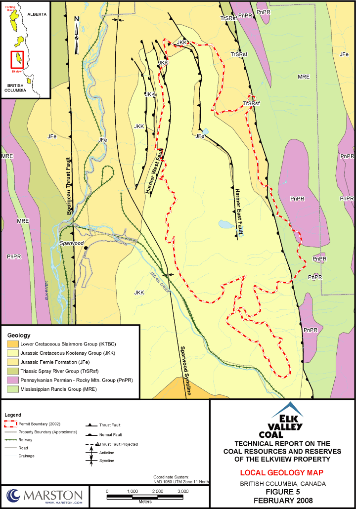
Based on the data provided to Marston, all known mine workings, existing tailings ponds, waste deposits, natural features and infrastructure for the property are shown in Figure 9, Pits, Dumps and Onsite Infrastructure. The extents of all mineralized zones are shown in Figure 5, Local Geology Map.
Adjacent Properties
Mineral holdings by EVCC extend to the south of Highway 3. Historically, the resource estimates of this area were reported with EVO resource statements. In 2007, EVCC decided to halt the practice of reporting the resources of this area in EVO statements. Based on discussion with ELP personnel, Marston understands that past production includes some minor amounts of underground mining in the property south of Highway 3 transferred to EVCC.
Cline Coal Corporation holds a mineral tenure located approximately 3 km northeast of Property boundary. Cline Coal Corporation has no production from the Property.
Royalties and Other Encumbrances
ELP owns the surface and subsurface rights to the Property which it is mining. This is referred to as Freehold or Fee Simple land. “Freehold Land” is a relatively rare occurrence in British Columbia, and refers to private ownership of both surface and mineral rights.
Environmental Liabilities
ELP has made provisions to limit environmental liability by reclaiming disturbed areas on an ongoing basis as it becomes available. ELP is required to reclaim all disturbed areas after the completion of mining activities. Short-term and long-term reclamation requirements are
6-2

| | |
| TECHNICAL REPORT ON COAL RESOURCES AND RESERVES OF THE ELKVIEW PROPERTY | | |
| ELK VALLEY COAL CORP., FORDING CANADIAN COAL TRUST AND TECK COMINCO LTD. | | FEBRUARY 2008 |
| |
reassessed annually, and an annual reclamation plan is submitted to the British Columbia government.
Per ELP Work System & Reclamation Permit C-2 and Approval Certificate M96-02, 2006 Annual Report (submitted March 2007), ELP’s mining and reclamation operations are carried out in accordance with the Ministry of Energy and Mines Permit and certificate identified above.
Timbered area in Elkview C-2 Mine and Reclamation Permit is classified as Class 1 elk winter habitat and Class 4 mule deer. Final land use for the mined property is wildlife habitat. Elkview application/permit states that mining will result in a loss of thermal cover which will be gradual and spread over 20 years. Revegetation of the lower terraces will replace forage values; thermal values will be lost for a period of time. This loss is not expected to impact the ungulate populations. In compliance with the C-2 Permit, the mine site will be reclaimed to final land use. To ensure this will be accomplished, ELP is revegetating, collecting and analyzing fecal material of the elk, deer and cougars to assure the health of the wildlife.
The Property has an active underground mine fire. The original fire was set by the disposal of waste in abandoned underground workings and subsequent incineration of the waste. After evaluating currently available methods of extinguishing, ELP has determined that the most prudent action is to allow the burn to continue and monitor the situation.
The Asset Retirement Obligation (ARO) for ELP was updated in December 2007. The environmental liability for ELP is $56.6 million (M). This includes reclaiming all disturbed land, decommissioning the plant and ancillary facilities.
Reclamation is considered complete once dozer work and seeding are finished. Planting, fertilizing and monitoring occur in the following years to ensure that the land use goals are attained.
Permits
ELP’s mining and reclamation operations are carried out in under a C-2 Permit issued by Energy and Mines (MEM). Environmental impacts were evaluated and approved by the Environmental Assessment Office under Project Approval Certificate M96-02.
6-3
| | |
| TECHNICAL REPORT ON COAL RESOURCES AND RESERVES OF THE ELKVIEW PROPERTY | | |
| ELK VALLEY COAL CORP., FORDING CANADIAN COAL TRUST AND TECK COMINCO LTD. | | FEBRUARY 2008 |
| |
To Marston’s knowledge, ELP has obtained the necessary permits and approvals to operate within the currently developed areas of the Property. Current permits and licenses are shown in Table 6.1, Elkview Permits and Table 6.2, Elkview Licenses.
ELP is currently in the process of permitting Baldy Ridge, an expansion area to the west of the permitted area. The projected application date is December 2008.
6-4
| | |
| TECHNICAL REPORT ON COAL RESOURCES AND RESERVES OF THE ELKVIEW PROPERTY | | |
| ELK VALLEY COAL CORP., FORDING CANADIAN COAL TRUST AND TECK COMINCO LTD. | | FEBRUARY 2008 |
| |
Table 6.1
Elkview Permits
| | | | | | | |
| | | | | | | |
| Description | | | Authority | | | Date |
| | | | | | | |
| | | | | | | |
| C.L. No. 40954 - Erickson Creek | | | Land & Water British Columbia, Inc | | | 1-Jun-73 |
| | | | | | | |
| C.L. No. 59997 - Erickson Creek | | | Land & Water British Columbia, Inc | | | 6-Dec-91 |
| | | | | | | |
| C.L. No. 35691 - Elk River | | | Land & Water British Columbia, Inc | | | 1-Jun-70 |
| | | | | | | |
| C.L. No. 49779 - Elk River. | | | Land & Water British Columbia, Inc | | | 1-Mar-78 |
| | | | | | | |
| C.L. No. 58255 - Sawmill Creek | | | Land & Water British Columbia, Inc | | | 15-Apr-83 |
| | | | | | | |
| C.L. No. 56022 | | | Land & Water British Columbia, Inc | | | 29-Nov-88 |
| | | | | | | |
| C.L. No. 53886 | | | Land & Water British Columbia, Inc | | | 3-Jul-80 |
| | | | | | | |
| C.L. No. 53336 - Six Mile Creek | | | Land & Water British Columbia, Inc | | | 31-Jan-80 |
| | | | | | | |
| C.L. No. 40628 - Harmer Creek | | | Land & Water British Columbia, Inc | | | 1-Apr-73 |
| | | | | | | |
| C.L. No. 34883 | | | Land & Water British Columbia, Inc | | | 1-Apr-73 |
| | | | | | | |
| C.L. No. 35073 - Baldy Creek (Bodie) | | | Land & Water British Columbia, Inc | | | 5-Jan-70 |
| | | | | | | |
| C.L. No. 52811 - Baldy Creek (Bodie) | | | Land & Water British Columbia, Inc | | | 20-Sep-79 |
| | | | | | | |
| C.L. No. 56441 - Bodie Creek | | | Land & Water British Columbia, Inc | | | 1-Feb-82 |
| | | | | | | |
| C.L. No. 52810 - Michael Creek | | | Land & Water British Columbia, Inc | | | 20-Sep-79 |
| | | | | | | |
| C.L. No. 107522 - Goddard Creek | | | | | | |
| | | | | | | |
| C.L. No. 107523 - Lindsay & Feltham Creek | | | | | | |
| | | | | | | |
| #11718-1-03.0 - Nuclear Substance & Radiation Devices | | | Federal Canadian Nuclear Safety Commission | | | |
| | | | | | | |
| #11718-4-03.1 - X-Ray Fluorescence Analysis Fixed Gauges | | | Federal Canadian Nuclear Safety Commission | | | |
| | | | | | | |
| 2003(03)-F374 - License to Manufacture Explosives | | | Natural Resources Canada-Explosives Regulatory Division to Mining Services Int. | | | |
| | | | | | | |
| 00001194- Boiler & Pressure Vessel Contractor License | | | BC Ministry of Municipal Affairs and Housing | | | |
6-5
| | |
| TECHNICAL REPORT ON COAL RESOURCES AND RESERVES OF THE ELKVIEW PROPERTY | | |
| ELK VALLEY COAL CORP., FORDING CANADIAN COAL TRUST AND TECK COMINCO LTD. | | FEBRUARY 2008 |
| |
Table 6.2
Elkview Licenses
| | | | | | |
| |
| | Description | | | Date | |
| | Permit Amendment – Baldy Mine Area Expansion approval | | | 21-Jun-05 | |
| | Permit Amendment- Approval of New Mine Access Road C-2 14675-35-04 Amendments | | | 13-May-05 | |
| | Rehabilitation of Lagoon D | | | 3-May-93 | |
| | Modify Goddard Coarse Refuse Dump | | | 19-May-93 | |
| | Temporary Permission to Operate Lagoon D | | | 25-May-93 | |
| | Permission to Operate Lagoon D | | | 8-Jul-93 | |
| | Permission to Flood Lagoon C | | | 8-Jul-93 | |
| | Amended Reclamation Program | | | 15-Jul-93 | |
| | Permission to Flood Lagoon C, Revision | | | 3-May-94 | |
| | Construction and Operation of Lagoon D | | | 1-Sep-94 | |
| | Lindsay Creek Coarse Coal Refuse Dump | | | 27-Jul-95 | |
| | South Pit Mining Area | | | 27-Jul-98 | |
| | Natal West | | | 7-Jan-99 | |
| | Construction of Waste Dump in Old 3 Seam Pit | | | 14-Jun-01 | |
| | Construction of Additional 15 Meter Life on the Bodie | | | 10-Sep-01 | |
| | Removal of Fine Coal Refuse from Lagoon C | | | 14-Nov-01 | |
| | Natal Development Area | | | 21-Nov-01 | |
| | Lagoon D Raise | | | 26-Mar-02 | |
| | Lagoon D Dam Raise to Elevation 1166 Metres | | | 13-Jan-03 | |
| | West Fork Tailings Storage Facility and Plant Refuse Dump Expansion | | | 29-Jul-04 | |
| | Approving New Mine Access Road | | | 13-May-05 | |
| | Approval to Construct Coal Haulage Road to Elk Pits | | | 24-Jul-97 | |
| | Erickson Valley Dump | | | 26-Nov-84 | |
| | 2000 Bodie North Dump Expansion | | | 27-Oct-00 | |
| | Elkview Coal-Bodie North Property | | | 11-Apr-02 | |
| | Elkview Coal Geotechnical Investigations | | | 20-Jan-05 | |
| | Exploration Activities – 10 Mile Road, Baldy 1 and Milligan Dump Exploration | | | 22-Jun-06 | |
| | Approval to construct coal haulage road to Elk Pit | | | 24-Jul-97 | |
| | Application for Approval Coal Road | | | 17-Jun-97 | |
| | Approval to construct Bodie Dump | | | 1-Mar-96 | |
| | EAO Project Approval Certificate | | | 1-Mar-96 | |
| | Approval of amended program (described in Agra report) Lindsay Creek Coarse Coal refuse Dump | | | 27-Jul-95 | |
| | Approval of Work Systems and Reclamation Program in name of Elkview coal Corporation | | | 21-Apr-93 | |
| | Bodie EAO Certificate | | | 23-Feb-96 | |
| | Mine Act Permit Amendment for Natal Ridge | | | 13-Dec-96 | |
| | Lindsay Creek Coarse Coal Refuse Dump | | | 27-Jul-95 | |
| | Operation & Construction of Lagoon D | | | 1-Sep-94 | |
| | Proposed sand and gravel test pit operation | | | 24-Jul-00 | |
| | Construction of Waste Dump in Old 3 Seam Pit | | | 14-Jun-01 | |
| | South Pit Poor Material Dump Area Approval | | | 31-May-00 | |
| | Bodie Dump Project | | | 27-Feb-96 | |
| | Freeboard, etc. | | | 21-Dec-95 | |
| | Goddard Creek Coarse Refuse Dump | | | 19-May-89 | |
| | Westar Mining Ltd, Elkview Plant-Lagoon D | | | 23-Jun-89 | |
| | Westar Surface Operations Baldy Ridge Proposal | | | 12-Dec-88 | |
| | Westar Mining Elkview Plant, Lagoon D | | | 9-Aug-88 | |
| |
6-1
| | |
| TECHNICAL REPORT ON COAL RESOURCES AND RESERVES OF THE ELKVIEW PROPERTY | | |
| ELK VALLEY COAL CORP., FORDING CANADIAN COAL TRUST AND TECK COMINCO LTD. | | FEBRUARY 2008 |
| |
Table 6.2
Elkview Licenses (cont.)
| | | | | | |
| |
| | Description | | | Date | |
| | Westar Mining, Elkview Plant, Raising Lagoon D Dyke to 1133m | | | 13-Aug-87 | |
| | Approval of Modifications to Mudflow Interceptor works at Six Mile alluvial fan | | | 29-Apr-85 | |
| | Approval for 83-88 Mine Plan (Dec 28, 1983) | | | 26-Nov-84 | |
| | Westar Mining- Balmer Operation, Application for Changes to Work System | | | 8-May-84 | |
| | Proposed Baldy Ridge No 10 Seam Mine | | | 2-Feb-84 | |
| | Application to Extend the Permissible Work Area at Balmer Surface Mining Operation | | | 28-Dec-83 | |
| | Permission to Implement Double Benching at Balmer Surface Mine | | | 17-Mar-83 | |
| | Double Benching Adit 40 FW Pit 5470 Bench | | | 13-May-83 | |
| | Application to Extend the Permissible Work Area at Balmer Surface Mining Operations | | | 20-Jul-83 | |
| | Kaiser Resources Ltd for work at Harmer 1, Dry Creek, Adit 29, Camp 8, 3, “C”, 7A, 7B, Balmer North, 10-6, Baldy, Balmer 4 | | | 20-Jan-70 | |
| | Renewal of Reclamation Permit No. 2 | | | 29-May-73 | |
| | Renewal of Reclamation Permit No. 80 | | | 28-Jun-74 | |
| | Renewal of Reclamation Permit No 2 | | | 14-Jul-76 | |
| | Approval for Hosmer-Wheeler portion of proposed 1976 Exploration Program | | | 27-Jul-76 | |
| | Permit No 2 Renewal- Kaiser | | | 23-Aug-76 | |
| | Approval of 1977 Exploration Programs for Greenhills, Taylor Mountain, Sparwood Ridge, Natal Ridge and Hosmer Ridge | | | 10-Jun-77 | |
| | Permit No. 2 Approval for Revised Permissible Surface Work Area | | | 30-Jun-77 | |
| | Permit C-80 Coal Exploration Kootenay Coal Block to permanent status | | | 30-May-78 | |
| | Amendment of Reclamation Permit C-2 (Westar) | | | 6-May-92 | |
| | Water Systems Permit 0120057 | | | 1-Nov-97 | |
| | Water Systems Permit 0120113 | | | 1-Jan-98 | |
| | Water Systems Permit 0120114 | | | 7-Jan-98 | |
| | Water Systems Permit 0120115 | | | 1-Jan-98 | |
| | Water Systems Permit 0120116 | | | 1-Jan-98 | |
| | Water Systems Permit 0120117 | | | 1-Jan-98 | |
| | Magazine Storage of Detonators | | | | |
| | Storage of Detonators | | | | |
| | Storage of Detonators | | | | |
| | CVF03099 - Annual Gas permit | | | | |
| | CVF03100 - Annual Gas permit | | | | |
| | IAC00346 - Annual Gas permit | | | | |
| | Permit PA-01807 (Permitted discharge contaminants to air from coal preparation plant)
Last Amendment | | | 23-Jul-75
1-Aug-94 | |
| | Permit PE-00425 (Permitted discharge effluent to tailings lagoons and creeks)
Last Amendment | | | 5-Aug-71
14-Jun-96 | |
| | Permit PR- 03821 (Permitted garbage disposal refuse from coal mining operations)
Last Amendment | | | 5-Sep-75
15-Mar-93 | |
| |
6-2
| | |
| TECHNICAL REPORT ON COAL RESOURCES AND RESERVES OF THE ELKVIEW PROPERTY | | |
| ELK VALLEY COAL CORP., FORDING CANADIAN COAL TRUST AND TECK COMINCO LTD. | | FEBRUARY 2008 |
| |
ITEM 7 ACCESSIBILITY, CLIMATE, LOCAL RESOURCES, INFRASTRUCTURE AND
PHYSIOGRAPHY
Access to northern and western portions of the Property is by way of Provincial Highway 43 and other logging, secondary roads and trails. Provincial Highway 3 provides access to the south portion of the Property. Rail access to the Vancouver ports is approximately 1,150 km and is provided by Canadian Pacific Rail (CPR). ELP constructed an 11 km gravel road from Provincial Highway 3 to the mine administration office (see Figures 1, Project Location Map and Figure 2, Project Exploration and Mine Site Map). A second road constructed to the mine administration office was constructed to replace the initial road which will be mined out with the advancing pits. Three local air strips located in Cranbrook, Fernie and at the Elk Valley Regional Airport just north of Sparwood provide air access to the Property.
The topography of the Kootenay Region is dominated by steep, heavily forested mountain canyons and valleys. Nearly all of the major tributaries to the river including the Elk River have very high channel gradients. The area within the Northern Rocky Mountain physiographic province is characterized by north to northwest trending mountain ranges separated by straight valleys that run parallel to the ranges.
The climate of British Columbia is determined by its continental location and mountainous topography. Winters are long and cold and summers short, cool and dry. Winter frontal systems moving easterly from the Pacific Coast bring maritime Arctic air into the region, which modifies temperatures and results in snowfall. Average July and January temperatures for Sparwood are reported to be 15°C and -7°C, respectively, although lower temperatures may be expected in the higher altitudes of the mine. During November through March, low temperatures will decline to lows of -30°C with periods of high winds on the higher altitudes. Sparwood averages 0.41 meters (m) of rainfall annually and 2.5 m of snowfall annually.
Operations may occasionally succumb to weather extremes (foggy conditions). Climate usually does not affect the mining operations. Winter precipitation in the form of snow cover assists in dust suppression. Elkview mining operations operate year round.
7-1
| | |
| TECHNICAL REPORT ON COAL RESOURCES AND RESERVES OF THE ELKVIEW PROPERTY | | |
| ELK VALLEY COAL CORP., FORDING CANADIAN COAL TRUST AND TECK COMINCO LTD. | | FEBRUARY 2008 |
| |
Vegetation varies with elevation. Valley bottoms are dominated by Ponderosa Pine, Rocky Mountain Douglas Fir, Lodgepole Pine and Trembling Aspen. Above the valley floor, from about 1,000 m to 2,200 m, forest cover includes Engelmann Spruce, Lodgepole Pine, Western Larch and Trembling Aspen. The main mining and exploration areas fall within a biogeoclimatic zone described as the Engelmann Spruce Alpine Fir Zone at elevations from 1,000 m to 2,200 m. The Engelmann Spruce – Subalpine Fir Zone occupies the highest forested elevations in British Columbia’s many mountain ranges. Steep, snow-covered mountain sides are blanketed with old-growth spruce and sub-alpine fir forests.
Treeless areas above 2,250 m are in the Alpine Zone. Slopes are steep and rugged. Soils are regosolic, acid brown and brown wooded and form a shallow mantle over bedrock or glacial till of varying depths.
Infrastructure on the property includes maintenance and warehousing facilities, processing plant, rail loadout, power line (BC Hydro), natural gas pipeline (Terasen Gas), tailings pond and other miscellaneous infrastructure (see Figure 9, Pits, Dumps and Onsite Infrastructure Map).
Mining personnel live in the surrounding areas including nearby towns. The nearest community to the property is Sparwood (3,900 population), located 3 km west of the mine at the junction between Provincial Highways 43 and 3. Other nearby towns include Fernie (5,000 population), Elkford (2,600 population), Cranbrook, (19,000 population), and Crowsnest (6,500 population). The mine employs in excess of 700 employees from the surrounding communities.
7-2
| | |
| TECHNICAL REPORT ON COAL RESOURCES AND RESERVES OF THE ELKVIEW PROPERTY | | |
| ELK VALLEY COAL CORP., FORDING CANADIAN COAL TRUST AND TECK COMINCO LTD. | | FEBRUARY 2008 |
| |
ITEM 8 HISTORY
Settlement in the East Kootenay Region is tied closely to resource development and construction of the railways through the area. The first major influx of people to the area was in the 1860s when gold was discovered on Findlay Creek. This lasted until the end of the decade. In the 1880s, development was spurred by mineral discoveries including silver, lead and coal, and the railway construction.
The discovery of coal in the Elk Valley is dated as far back as 1845 to Father Pierre-Jean DeSmet, a Belgian Jesuit missionary who worked with the Kootenay and Flathead Indians (Ktunaxa). DeSmet wrote to his bishop in New York that he had found a large piece of coal along a river he called Riviere des Chute (Elk River). Michael Phillips, discoverer of the Crowsnest Pass, made note in 1873 of the coal exposures. Later in 1886, Geological Survey of Canada geologist Dr. George M. Dawson mapped the formations encompassing most geological ages in parts of southeastern British Columbia and southwestern Alberta and published his findings.
Coal has been mined since circa 1897 and is the region’s leading mineral resource product. Most of the coal produced from EVCC mines is metallurgical grade coal. It is sold in North America and exported to Asia for use in steel production and other industrial uses. A small amount of thermal coal is produced for use by power utilities in Alberta, Saskatchewan, Ontario and the US. Most coal produced by EVCC is transported by rail to Roberts Bank, the largest coal exporting facility on the west coast of North America and then sent to overseas customers.
In 1969, Kaiser Resources Ltd. (Kaiser) started the Balmer Mine. By the first year of operation, 1.9 Mt were produced from both surface and underground operations. Surface mines took over underground operations in the 1970s.
In 1980, the Property was purchased by British Columbia Resources Investment Corporation, which formed British Columbia Coal Ltd. to operate the mine. The name of the operating company subsequently changed to Westar Mining, Ltd. Westar Mining Ltd. declared bankruptcy in August 1992 and Teck acquired the Property in December 1992.
8-1
| | |
| TECHNICAL REPORT ON COAL RESOURCES AND RESERVES OF THE ELKVIEW PROPERTY | | |
| ELK VALLEY COAL CORP., FORDING CANADIAN COAL TRUST AND TECK COMINCO LTD. | | FEBRUARY 2008 |
| |
Elk Valley Coal Partnership (EVCP) acquired the Property in 2003 during the Teck, Fording River and Luscar merger of metallurgical coal mines. In 2005 Elk Valley Coal contributed the Elkview operations to Elkview LP (ELP) for a direct and indirect 95 percent partnership interest and subsidiaries of Nippon Steel Corporation (NSC) and POSCO each acquired 2.5 percent limited partnership interest. ELP currently owns and operates the Property.
Exploration Work
The majority of exploration has been accomplished by reverse circulation (RC) drilling. Diamond drill holes are primarily used for geotechnical data. All exploration holes are geophysically logged. Most holes are logged by Elkview’s logging unit providing gamma log only. A smaller number of the holes have been geophysically logged by a contract logging company. These logs include density, caliper and neutron logs. Comparison between the suite of logs and gamma logs has shown that gamma logs are sufficient to select roof and floor coal intercepts.
Exploration Activities at ELP
ELP has collected a vast amount of drilling data over the past 60 plus years. The data consist of RC drilling, diamond drilling, adits, trench sampling and production drill holes. A summary of the exploration drilling is included as Table 8.1, Drilling, Sampling and Assay Information. Table 8.2, Exploration History, shows the exploration drill holes for the Property.
Coal quality is collected on selected samples. Typical sampling includes a proximate analysis, mini-wash analysis, total sulphur and Free Swelling Index (FSI). Table 8.3, Exploration Adits, shows the coal quality samples that were available for the 2007 reporting.
To the extent known by the Author, only one NI 43-101 document has been produced for the Property. This document was produced in 2001 by Norwest Corporation. The results of the 2001 Technical Report for the Property are summarized in Table 8.4, 2001 Technical Report of Mineral Reserves.
8-2
| | |
| TECHNICAL REPORT ON COAL RESOURCES AND RESERVES OF THE ELKVIEW PROPERTY | | |
| ELK VALLEY COAL CORP., FORDING CANADIAN COAL TRUST AND TECK COMINCO LTD. | | FEBRUARY 2008 |
| |
Table 8.1
Drilling, Sampling and Assay Information
| | | | | | | | | | |
Active Pits
|
| | | | | | | | | | |
| Zone/Area | | | Area | | Number | | Hole Spacing | | Coal Analysis |
| | | | | | | | | | |
| | | | (ha) | | of Holes | | meters | | |
| | | | | | | | | | |
| | | | |
| Cedar | | | 81.9 | | 161 | | 100 x 100 | | MiniWash-Full Analysis |
| | | | | | | | | | |
| Natal West | | | 111.6 | | 231 | | 100 x 100 | | MiniWash-Full Analysis |
| | | | | | | | | | |
| Natal Phase I | | | 189.2 | | 195 | | 100 x 100 | | MiniWash-Full Analysis |
| | | | | | | | | | |
| South Pit | | | 21.4 | | 160 | | 100 x 100 | | MiniWash-Full Analysis |
| | | | | | | | | | |
Pushback Zones
|
| Zone/Area | | | Area | | Number | | Hole Spacing | | Coal Analysis |
| | | | | | | | | | |
| | | | (ha) | | of Holes | | meters | | |
| | | | | | | | | | |
| | | | |
| Baldy Ridge | | | 686.4 | | 341 | | 200 x 200 variable | | MiniWash-Full Analysis |
| | | | | | | | | | |
| Natal Ridge | | | 184 | | 125 | | 200 x 200 variable | | MiniWash-Full Analysis |
8-3
| | |
| TECHNICAL REPORT ON COAL RESOURCES AND RESERVES OF THE ELKVIEW PROPERTY | | |
| ELK VALLEY COAL CORP., FORDING CANADIAN COAL TRUST AND TECK COMINCO LTD. | | FEBRUARY 2008 |
| |
Table 8.2
Exploration History
| | | | | | | | | | | | | | | | |
| Exploration | | | Rotary Drillholes | | | Diamond Drillholes | | | Total Drillholes |
| Year | | | Holes | | meters | | | Holes | | meters | | | Holes | | meters |
| | | | | | | | | | |
| 1964 | | | 1 | | 219 | | | 0 | | 0 | | | 1 | | 219 |
| 1965 | | | 17 | | 3,728 | | | 0 | | 0 | | | 17 | | 3,728 |
| 1966 | | | 0 | | 0 | | | 0 | | 0 | | | 0 | | 0 |
| 1967 | | | 34 | | 3,743 | | | 0 | | 0 | | | 34 | | 3,743 |
| 1968 | | | 110 | | 14,708 | | | 0 | | 0 | | | 110 | | 14,708 |
| 1969 | | | 105 | | 10,624 | | | 0 | | 0 | | | 105 | | 10,624 |
| 1970 | | | 27 | | 2,987 | | | 0 | | 0 | | | 27 | | 2,987 |
| 1971 | | | 42 | | 6,677 | | | 2 | | 206 | | | 44 | | 6,883 |
| 1972 | | | 4 | | 510 | | | 0 | | 0 | | | 4 | | 510 |
| 1973 | | | 9 | | 764 | | | 0 | | 0 | | | 9 | | 764 |
| 1974 | | | 26 | | 2,750 | | | 0 | | 0 | | | 26 | | 2,750 |
| 1975 | | | 58 | | 5,698 | | | 18 | | 4,221 | | | 76 | | 9,919 |
| 1976 | | | 0 | | 0 | | | 15 | | 6,734 | | | 15 | | 6,734 |
| 1977 | | | 23 | | 1,797 | | | 2 | | 1,205 | | | 25 | | 3,002 |
| 1978 | | | 85 | | 8,462 | | | 19 | | 3,328 | | | 104 | | 11,790 |
| 1979 | | | 5 | | 1,002 | | | 0 | | 0 | | | 5 | | 1,002 |
| 1980 | | | 52 | | 9,941 | | | 7 | | 3,545 | | | 59 | | 13,486 |
| 1981 | | | 31 | | 4,322 | | | 10 | | 4,368 | | | 41 | | 8,690 |
| 1982 | | | 17 | | 2,998 | | | 5 | | 2,721 | | | 22 | | 5,719 |
| 1983 | | | 74 | | 5,605 | | | 0 | | 0 | | | 74 | | 5,605 |
| 1984 | | | 114 | | 8,624 | | | 0 | | 0 | | | 114 | | 8,624 |
| 1985 | | | 79 | | 5,863 | | | 0 | | 0 | | | 79 | | 5,863 |
| 1986 | | | 40 | | 4,614 | | | 0 | | 0 | | | 40 | | 4,614 |
| 1987 | | | 103 | | 12,652 | | | 0 | | 0 | | | 103 | | 12,652 |
| 1988 | | | 146 | | 14,152 | | | 0 | | 0 | | | 146 | | 14,152 |
| 1989 | | | 115 | | 12,759 | | | 0 | | 0 | | | 115 | | 12,759 |
| 1990 | | | 129 | | 13,795 | | | 0 | | 0 | | | 129 | | 13,795 |
| 1991 | | | 137 | | 12,341 | | | 0 | | 0 | | | 137 | | 12,341 |
| 1992 | | | 88 | | 6,983 | | | 0 | | 0 | | | 88 | | 6,983 |
| 1993 | | | 96 | | 10,040 | | | 4 | | 372 | | | 100 | | 10,412 |
| 1994 | | | 25 | | 766 | | | 0 | | 0 | | | 25 | | 766 |
| 1995 | | | 99 | | 10,944 | | | 0 | | 0 | | | 99 | | 10,944 |
| 1996 | | | 153 | | 16,006 | | | 4 | | 765 | | | 157 | | 16,771 |
| 1997 | | | 128 | | 15,832 | | | 0 | | 0 | | | 128 | | 15,832 |
| 1998 | | | 101 | | 14,459 | | | 0 | | 0 | | | 101 | | 14,459 |
| 1999 | | | 66 | | 6,356 | | | 0 | | 0 | | | 66 | | 6,356 |
| 2000 | | | 92 | | 8,814 | | | 0 | | 0 | | | 92 | | 8,814 |
| 2001 | | | 75 | | 6,783 | | | 0 | | 0 | | | 75 | | 6,783 |
| 2002 | | | 58 | | 4,304 | | | 5 | | 381 | | | 63 | | 4,685 |
| 2003 | | | 44 | | 3,033 | | | 0 | | 0 | | | 44 | | 3,033 |
| 2004 | | | 59 | | 7,912 | | | 0 | | 0 | | | 59 | | 7,912 |
| 2005 | | | 55 | | 6,562 | | | 0 | | 0 | | | 55 | | 6,562 |
| 2006 | | | 43 | | 4,955 | | | 1 | | 47 | | | 44 | | 5,002 |
| 2007 | | | 109 | | 12,115 | | | 0 | | 0 | | | 109 | | 12,115 |
| | | | | | | | | | |
| Total | | | 2,874 | | 307,199 | | | 92 | | 27,893 | | | 2,966 | | 335,092 |
8-4
| | |
| TECHNICAL REPORT ON COAL RESOURCES AND RESERVES OF THE ELKVIEW PROPERTY | | |
| ELK VALLEY COAL CORP., FORDING CANADIAN COAL TRUST AND TECK COMINCO LTD. | | FEBRUARY 2008 |
| |
Table 8.3
Exploration Adits
| | | | | | | | | | | | | |
| Adit | | Seam | | | Northing | | Easting | | | Elevation | | Drilling Company |
| | | | | | | |
| ADIT100 | | 7RX | | | 51,717 | | 16,847 | | | 1,667 | | W2M |
| ADIT101 | | 8U1 | | | 51,595 | | 16,847 | | | 1,712 | | WML |
| ADIT103 | | 6.S | | | 48,012 | | 18,935 | | | 1,879 | | WML |
| ADIT104 | | 3.S | | | 48,012 | | 18,633 | | | 1,955 | | WML |
| ADIT105 | | 6.S | | | 48,062 | | 18,669 | | | 1,928 | | WML |
| ADIT106 | | A.X | | | 47,799 | | 18,754 | | | 1,993 | | KRL |
| ADIT107 | | 6 | | | 48,023 | | 19,012 | | | 1,865 | | WML |
| ADIT109 | | 6.S | | | 47,885 | | 17,642 | | | 1,658 | | WML |
| ADIT110 | | 7RC | | | 49,565 | | 16,251 | | | 1,423 | | WML |
| ADIT111A | | COAL | | | 50,590 | | 16,183 | | | 1,480 | | WML |
| ADIT111B | | COAL | | | 50,590 | | 16,183 | | | 1,480 | | WML |
| ADIT111C | | 9.U | | | 50,590 | | 16,183 | | | 1,480 | | WML |
| ADIT112A | | 7.U | | | 49,040 | | 20,199 | | | 1,618 | | WML |
| ADIT112B | | 7.S | | | 49,040 | | 20,199 | | | 1,618 | | WML |
| ADIT113 | | 3.U | | | 48,615 | | 20,026 | | | 1,685 | | WML |
| ADIT114 | | 3.U | | | 47,420 | | 19,794 | | | 1,578 | | WML |
| ADIT115 | | 4.S | | | 47,315 | | 19,815 | | | 1,555 | | WML |
| ADIT116 | | 3.U | | | 47,352 | | 20,005 | | | 1,496 | | WML |
| ADIT122A | | COAL | | | 50,656 | | 16,348 | | | 1,513 | | WML |
| ADIT123 | | COAL | | | 47,310 | | 20,128 | | | 1,488 | | WML |
| ADIT124 | | COAL | | | 47,366 | | 20,074 | | | 1,484 | | |
| ADIT125 | | COAL | | | 47,351 | | 20,138 | | | 1,464 | | |
| ADIT126 | | 8U1 | | | 52,932 | | 16,461 | | | 1,452 | | |
| ADIT127 | | 7RC | | | 52,938 | | 16,506 | | | 1,468 | | WML |
| ADIT128 | | 7.S | | | 52,922 | | 16,544 | | | 1,468 | | WML |
| ADIT129 | | 6.S | | | 52,906 | | 16,576 | | | 1,466 | | WML |
| ADIT12A | | 10S | | | 47,660 | | 13,567 | | | 1,613 | | |
| ADIT12B | | 10S | | | 47,660 | | 13,567 | | | 1,613 | | |
| ADIT12C | | 10S | | | 47,660 | | 13,567 | | | 1,613 | | |
| ADIT13 | | 10S | | | 46,680 | | 17,019 | | | 1,379 | | |
| ADIT130 | | 5.G | | | 52,893 | | 16,620 | | | 1,470 | | WML |
| ADIT131 | | 7.S | | | 48,517 | | 20,238 | | | 1,638 | | WML |
| ADIT132A | | COAL | | | 48,794 | | 20,152 | | | 1,673 | | WML |
| ADIT132B | | COAL | | | 48,794 | | 20,152 | | | 1,673 | | |
| ADIT133 | | COAL | | | 48,652 | | 20,073 | | | 1,681 | | |
| ADIT134 | | COAL | | | 48,768 | | 20,124 | | | 1,675 | | WML |
| ADIT135A | | 10S | | | 49,537 | | 19,124 | | | 1,499 | | WML |
| ADIT135B | | 10S | | | 44,367 | | 19,124 | | | 1,499 | | |
| ADIT136 | | A.X | | | 50,171 | | 18,457 | | | 1,453 | | WML |
| ADIT137 | | B.S | | | 50,176 | | 18,428 | | | 1,451 | | WML |
| ADIT138 | | 7.S | | | 47,044 | | 16,877 | | | 1,351 | | WML |
8-5
| | |
| TECHNICAL REPORT ON COAL RESOURCES AND RESERVES OF THE ELKVIEW PROPERTY | | |
| ELK VALLEY COAL CORP., FORDING CANADIAN COAL TRUST AND TECK COMINCO LTD. | | FEBRUARY 2008 |
| |
Table 8.3
Exploration Adits (cont.)
| | | | | | | | | | | | | |
| Adit | | Seam | | | Northing | | Easting | | | Elevation | | Drilling Company |
| | | | | | | |
| ADIT138 | | 7L1 | | | 47,044 | | 16,877 | | | 1,351 | | WML |
| ADIT139 | | C.S | | | 48,399 | | 18,697 | | | 1,786 | | WML |
| ADIT14 | | 10S | | | 47,148 | | 14,228 | | | 1,554 | | |
| ADIT140 | | A.X | | | 45,240 | | 18,846 | | | 1,699 | | WML |
| ADIT141 | | C.U | | | 49,947 | | 17,830 | | | 1,374 | | WML |
| ADIT142 | | C.L | | | 49,929 | | 17,840 | | | 1,374 | | WML |
| ADIT17A | | COAL | | | 49,018 | | 16,646 | | | 1,418 | | |
| ADIT17B | | 8L3 | | | 49,018 | | 16,646 | | | 1,418 | | |
| ADIT19 | | 10W | | | 52,450 | | 17,041 | | | 1,634 | | |
| ADIT2 | | A.X | | | 46,573 | | 17,754 | | | 1,652 | | |
| ADIT21 | | 7.S | | | 50,601 | | 17,063 | | | 1,702 | | |
| ADIT23 | | 10W | | | 53,657 | | 17,691 | | | 1,700 | | |
| ADIT26 | | 10W | | | 54,416 | | 18,040 | | | 1,784 | | |
| ADIT28A | | 7.L | | | 48,022 | | 16,913 | | | 1,416 | | |
| ADIT28B | | 7RC | | | 48,022 | | 16,913 | | | 1,416 | | |
| ADIT29 | | 10S | | | 52,177 | | 18,891 | | | 1,807 | | |
| ADIT30 | | 7.S | | | 50,258 | | 17,570 | | | 1,736 | | |
| ADIT31A | | 8LC | | | 48,007 | | 17,137 | | | 1,442 | | |
| ADIT31B | | 8LC | | | 48,007 | | 17,137 | | | 1,442 | | |
| ADIT33A | | 7.S | | | 48,166 | | 15,302 | | | 1,247 | | |
| ADIT33B | | 7.S | | | 48,166 | | 15,302 | | | 1,247 | | |
| ADIT34 | | 1.S | | | 47,891 | | 15,136 | | | 1,326 | | |
| ADIT35 | | 2.S | | | 47,911 | | 15,143 | | | 1,324 | | |
| ADIT36A | | 8U1 | | | 50,241 | | 16,498 | | | 1,492 | | |
| ADIT36B | | 8UX | | | 50,241 | | 16,498 | | | 1,492 | | |
| ADIT37 | | 10S | | | 54,285 | | 19,164 | | | 1,971 | | |
| ADIT39 | | 10S | | | 55,896 | | 19,304 | | | 2,023 | | |
| ADIT4 | | A.X | | | 46,813 | | 18,110 | | | 1,740 | | |
| ADIT40 | | 10S | | | 48,661 | | 19,418 | | | 1,376 | | |
| ADIT44 | | 10S | | | 50,853 | | 19,376 | | | 1,995 | | |
| ADIT46 | | 7.S | | | 49,964 | | 17,085 | | | 1,614 | | |
| ADIT50 | | 7.S | | | 47,901 | | 18,403 | | | 1,824 | | |
| ADIT53 | | 10S | | | 53,286 | | 19,418 | | | 1,669 | | |
| ADIT55 | | 10S | | | 50,077 | | 20,060 | | | 1,619 | | |
| ADIT56 | | 8LC | | | 50,432 | | 19,953 | | | 1,749 | | |
| ADIT57 | | 8LC | | | 48,599 | | 20,333 | | | 1,602 | | |
| ADIT59 | | 8UX | | | 49,774 | | 20,047 | | | 1,605 | | |
| ADIT59B | | COAL | | | 49,774 | | 20,047 | | | 1,605 | | |
| ADIT6 | | D.S | | | 46,293 | | 18,383 | | | 1,835 | | |
| ADIT60 | | 9.S | | | 50,660 | | 19,940 | | | 1,752 | | |
| ADIT61 | | 10S | | | 53,176 | | 19,366 | | | 1,639 | | |
8-6
| | |
| TECHNICAL REPORT ON COAL RESOURCES AND RESERVES OF THE ELKVIEW PROPERTY | | |
| ELK VALLEY COAL CORP., FORDING CANADIAN COAL TRUST AND TECK COMINCO LTD. | | FEBRUARY 2008 |
| |
Table 8.3
Exploration Adits (cont.)
| | | | | | | | | | | | | |
| Adit | | Seam | | | Northing | | Easting | | | Elevation | | Drilling Company |
| | | | | | | |
| ADIT62 | | 5.G | | | 48,011 | | 14,915 | | | 1,359 | | |
| ADIT62B | | 5.G | | | 48,011 | | 14,915 | | | 1,359 | | |
| ADIT62C | | 5.G | | | 48,011 | | 14,915 | | | 1,359 | | |
| ADIT63 | | 7.S | | | 48,228 | | 14,867 | | | 1,346 | | |
| ADIT63A | | 7.S | | | 48,228 | | 14,867 | | | 1,346 | | |
| ADIT65 | | 9.S | | | 48,629 | | 14,386 | | | 1,530 | | |
| ADIT66 | | 10S | | | 52,762 | | 19,545 | | | 1,658 | | |
| ADIT69 | | 10S | | | 49,005 | | 20,426 | | | 1,523 | | |
| ADIT70 | | 9.S | | | 48,709 | | 14,187 | | | 1,570 | | |
| ADIT71 | | 7.S | | | 50,706 | | 19,798 | | | 1,838 | | |
| ADIT74 | | 9.S | | | 47,513 | | 13,673 | | | 1,675 | | |
| ADIT75 | | 7.L | | | 47,384 | | 13,729 | | | 1,726 | | |
| ADIT81 | | 10S | | | 51,841 | | 19,245 | | | 1,959 | | |
| ADIT82 | | 10S | | | 50,267 | | 19,178 | | | 1,821 | | |
| ADIT82A | | COAL | | | 50,267 | | 19,178 | | | 1,821 | | |
| ADIT82B | | COAL | | | 50,267 | | 19,178 | | | 1,821 | | |
| ADIT83 | | 10S | | | 48,099 | | 19,599 | | | 1,700 | | |
| ADIT84 | | 8LC | | | 47,216 | | 19,370 | | | 1,671 | | |
| ADIT85 | | 8LC | | | 47,634 | | 20,347 | | | 1,512 | | |
| ADIT86 | | 10H | | | 50,400 | | 19,298 | | | 1,855 | | |
| ADIT86 | | 10S | | | 50,400 | | 19,298 | | | 1,855 | | |
| ADIT86 | | 10K | | | 50,400 | | 19,298 | | | 1,855 | | |
| ADIT88C | | 7.S | | | 51,558 | | 17,900 | | | 1,904 | | |
| ADIT88M | | 7.S | | | 51,533 | | 17,910 | | | 1,903 | | |
| ADIT88P | | 7.S | | | 51,503 | | 17,924 | | | 1,903 | | |
| ADIT90 | | 9.S | | | 56,157 | | 20,113 | | | 1,900 | | |
| ADIT91 | | 10W | | | 55,844 | | 18,298 | | | 1,739 | | |
| ADIT92 | | COAL | | | 49,574 | | 17,916 | | | 1,658 | | |
| ADIT92 | | 8UX | | | 49,574 | | 17,916 | | | 1,658 | | |
| ADIT93 | | 8U1 | | | 49,477 | | 17,930 | | | 1,700 | | |
| ADIT93 | | 8UX | | | 49,477 | | 17,930 | | | 1,700 | | |
| ADIT94 | | 8UX | | | 48,733 | | 17,740 | | | 1,647 | | |
| ADIT95 | | COAL | | | 48,738 | | 17,816 | | | 1,655 | | |
| ADIT96 | | D.S | | | 45,074 | | 17,820 | | | 1,626 | | |
| ADIT97 | | COAL | | | 50,193 | | 17,520 | | | 1,693 | | |
| ADIT97A | | 7RX | | | 50,193 | | 17,520 | | | 1,693 | | |
| ADIT98 | | 7.S | | | 51,427 | | 16,982 | | | 1,810 | | |
| ADIT99 | | 8UX | | | 50,160 | | 17,721 | | | 1,716 | | |
| ADIT99A | | 8LC | | | 50,160 | | 17,721 | | | 1,716 | | |
| ADIT99B | | 8U1 | | | 50,160 | | 17,721 | | | 1,716 | | |
8-7
| | |
| TECHNICAL REPORT ON COAL RESOURCES AND RESERVES OF THE ELKVIEW PROPERTY | | |
| ELK VALLEY COAL CORP., FORDING CANADIAN COAL TRUST AND TECK COMINCO LTD. | | FEBRUARY 2008 |
| |
Table 8.4
2001 Technical Report of Mineral Reserves
| | | | | | | | | | | | |
| |
| | | | | | | | | | | | |
| | Pit | | | Product Coal | | | Total Waste | | | Strip | |
| | Name | | | Tonnes | | | (bcm 000s) | | | Ratio | |
| | | | | (000s) | | | | | | (bcm/tonne) | |
| | | | | | | | | | | | |
| | Baldy Indigo | | | 5,498 | | | 38,895 | | | 7.1 | |
| | Elk | | | 9,225 | | | 20,832 | | | 2.3 | |
| | Natal West | | | 19,058 | | | 137,970 | | | 7.2 | |
| | South | | | 4,442 | | | 17,198 | | | 3.9 | |
| | Baldy Ridge | | | 145,162 | | | 1,247,883 | | | 8.6 | |
| | Natal Ridge | | | 82,199 | | | 653,070 | | | 7.9 | |
| | Adit | | | 33 | | | 7 | | | 0.2 | |
| | Total | | | 265,617 | | | 2,115,855 | | | 8.0 | |
| |
The 2001 report states that 173.4 Mt of the reserves stated were classified as Measured and 92.2 Mt of the stated reserves was classified as Indicated. The 2001 technical report is not consistent with current NI 43-101 reporting standards, which requires the reserve be stated in term of run-of-mine (ROM) tonnes. An additional 880 Mt of coal was classified as resources; however, the 2001 report did not state whether the resources stated were clean or in situ tonnes.
The reported coal tonnages for ELP in their annual year end report for December 2006 were 193 Mt of Proven and 46 Mt of Probable saleable coal products. Their reported resources for December 2006 were 1,317 Mt of Measured, 308 Mt of Indicated and 181 Mt of Inferred in situ coal tonnes.
From 1969 through 2007, ELP has produced a total of 174,573 kt of clean coal. A summary of historical production is included as Table 8.5, Historical Production Data.
8-8
| | |
| TECHNICAL REPORT ON COAL RESOURCES AND RESERVES OF THE ELKVIEW PROPERTY | | |
| ELK VALLEY COAL CORP., FORDING CANADIAN COAL TRUST AND TECK COMINCO LTD. | | FEBRUARY 2008 |
| |
Table 8.5
Historical Production Data
| | | | | | | | | | |
| | | | | | | | | | |
| | | | Product Coal | | | Total Waste | | | ROM Plant Feed Coal |
| Year(s) | | | | | | | | | |
| | | | (million tonnes) | | | (bcm 000s) | | | (million tonnes) |
| | | | | | | | | | |
| | | | | | | | | | |
| 1970 - 1974 | | | 3,901 | | | 26,165 | | | 5,115 |
| | | | | | | | | | |
| 1975 - 1979 | | | 5,377 | | | 26,337 | | | 6,980 |
| | | | | | | | | | |
| 1980 - 1984 | | | 5,597 | | | 27,173 | | | 7,337 |
| | | | | | | | | | |
| 1985 - 1989 | | | 5,310 | | | 29,369 | | | 8,327 |
| | | | | | | | | | |
| 1990 - 1994 | | | 3,395 | | | 23,788 | | | 5,563 |
| | | | | | | | | | |
| 1995 - 1999 | | | 2,889 | | | 27,088 | | | 4,397 |
| | | | | | | | | | |
| 2000 - 2004 | | | 5,283 | | | 42,516 | | | 7,460 |
| | | | | | | | | | |
| 2005 | | | 6,013 | | | 52,869 | | | 8,787 |
| | | | | | | | | | |
| 2006 | | | 4,748 | | | 43,203 | | | 7,228 |
| | | | | | | | | | |
| 2007 | | | 5,047 | | | 40,418 | | | 7,721 |
| | | | | | | | | | |
| | | | | | | | | | |
| | | | | | | | | | |
| Total | | | 174,573 | | | 1,152,825 | | | 249,636 |
Note: Production statistics are presented on an annual basis over the time periods specified.
8-9
| | |
| TECHNICAL REPORT ON COAL RESOURCES AND RESERVES OF THE ELKVIEW PROPERTY | | |
| ELK VALLEY COAL CORP., FORDING CANADIAN COAL TRUST AND TECK COMINCO LTD. | | FEBRUARY 2008 |
| |
ITEM 9 GEOLOGICAL SETTING
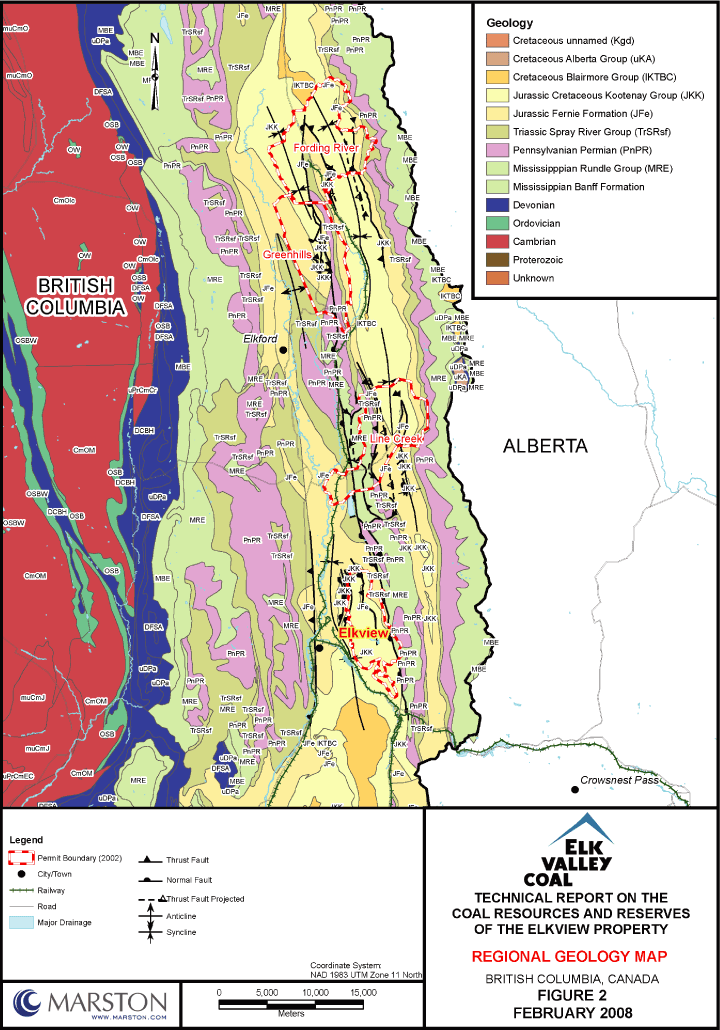
The Jurassic-Cretaceous Mist Mountain Formation (Kootenay Group), which contains the major coal deposits in the Front Ranges of southeastern British Columbia and southwestern Alberta, was deposited within a broad coastal plain environment as part of a north- to northeast-prograding clastic wedge along the western margin of the Jurassic epicontinental Fernie Sea. This region was subjected to two major episodes of the mountain building. The first period was the Columbian Orogeny which lasted from the late Jurassic to the early Cretaceous period and the second, known as the Laramide Orogeny period, lasted from the late Cretaceous to the early Eocene period.
Strata of the Jurassic-Cretaceous Kootenay Group (deposited approximately 120 – 150 million years ago) have long been of economic interest as a readily accessible source of thermal and metallurgical coal. The Kootenay Group, up to 1,112 m thick, comprises three formations which, in ascending order, are: the Morrissey, the Mist Mountain and the Elk Formation. The Morrissey formation ranges in measured thickness from 20 m to 80 m and comprises a massive cliff-forming succession of fine- to medium-grained sandstone. The Mist Mountain ranges in measured thickness from a minimum of 25 m in the eastern foothills of Alberta to a maximum of 665 m in the Greenhills Range of the front ranges near Elkford. It comprises an interbedded succession of predominantly nonmarine sandstone, siltstone, mudstone, rare conglomerate and economically important thin to thick seams of coal. The Elk Formation ranges in measured thickness from a zero erosional edge to 590 m and comprising an interbedded sequence of nonmarine sandstone, siltstone, mudstone, shale and, locally, chert-pebble conglomerate and thin seams of coal. The Morrissey Formation can be further subdivided throughout most of the area into the Weary Ridge (lower) and Moose Mountain members.
Economically, the Mist Mountain Formation is the most important formation of the Kootenay Group, containing coal seams up to 18 m thick, which range in rank from medium- to high-volatile bituminous in the south, to low-volatile bituminous to semi-anthracite in the north. Seams are thicker and more numerous in areas of the Fernie Basin and upper Elk River Valley. Coal seams in the Elk Formation are thin, less abundant, regionally discontinuous and generally lower in rank than those in the Mist Mountain Formation. Coal in the Morrissey Formation is rare and of no economic value.
9-1
| | |
| TECHNICAL REPORT ON COAL RESOURCES AND RESERVES OF THE ELKVIEW PROPERTY | | |
| ELK VALLEY COAL CORP., FORDING CANADIAN COAL TRUST AND TECK COMINCO LTD. | | FEBRUARY 2008 |
| |
The analysis of sedimentary facies, facies relationships, petrographic data, the presence or absence of characteristic megafossil, microfossil and microfloral assemblages suggest that strata of the Kootenay Group formed part of a major, prograding, clastic wedge, deposited within three major depositional environments. The Morrissey Formation is diagnosed as a beach, beach ridge and coastal dune depositional environment. The overlying Mist Mountain Formation is interpreted as a fluvial-deltaic-interdeltaic clastic succession, deposited in an environment largely unaffected by marine or brackish water inundations. The Elk Formation represents deposition within a major, coastal, fluvial-alluvial plain depositional environment. In the Front Ranges of the southern Rocky Mountains, the Elk Formation contains strata characteristic of a distal alluvial fan or braidplain depositional environment (Gibson, 1985).
Structural deformation of this coal sequence occurred during the Laramide Orogenic event that resulted in the formation of the Rocky Mountains. Northerly trending thrust faults associated with tectonism of this event have resulted in repeat of all or parts of the coal sequence. Thrust faults repeated coal seams and whole blocks of the coal bearing Mist Mountain Formation. Later formed northerly trending normal faults have also displaced and further divided the sequence. The East Kootenay coalfields lie on the Lewis Thrust Plate, within the Front Ranges of the Rocky Mountains. They are characterized by early compressional structures (folds and thrust faults) and late extensional structures (normal faults) (Bally et al., 1966). Some of the early thrust faults were later reactivated and formed the locus of normal fault movement.
Regional Geology
The East Kootenay coalfields comprise three separate fields extending from the Montana border northward and known respectively as Flathead, Crowsnest and Elk Valley coalfields in southeastern British Columbia. These are the most important coalfields of the province, having produced, since 1897, over 500 Mt of mainly metallurgical coal. All three fields contain the Jura-Cretaceous Kootenay Group, which contains from 100 m to 700 m thick coal-bearing Mist Mountain Formation. Coal seams are found throughout the formation though the thicker seams occur lower in the section. The formation contains approximately 30 seams, which make up from 8% to 12% of the thickness of the formation. Cumulative coal thickness ranges up to over 70 m. The area has experienced moderate to intense folding and thrust faulting, which has caused repetitions and structural thickening of seams. Rank varies from low- to high-volatile,
9-2
| | |
| TECHNICAL REPORT ON COAL RESOURCES AND RESERVES OF THE ELKVIEW PROPERTY | | |
| ELK VALLEY COAL CORP., FORDING CANADIAN COAL TRUST AND TECK COMINCO LTD. | | FEBRUARY 2008 |
| |
though most of the coal is medium-volatile bituminous and of metallurgical grade. Refer to Figure 3, Regional Geology Map.
The Mist Mountain Formation thins rapidly from west to east because of sedimentary thinning and/or erosional truncation by the overlying Cadomin Formation of the Blairmore Group. This unit is conformably overlain by strata of the Elk Formation in the eastern front ranges and westernmost foothills. The contact is placed at the base of the first major sandstone or conglomerate above the last or uppermost major coal seam in the Mist Mountain Formation. In the eastern foothills, the Mist Mountain is unconformably overlain by the Cadomin Formation of the Blairmore Group. The Mist Mountain is conformably but abruptly underlain by cliff forming sandstone of the Moose Mountain Member of the Morrissey Formation. The Mist Mountain is equivalent to the Adanac, Hillcrest and Mutz members of the Kootenay Formation as recognized by Norris (1959) in Grassy Mountain and in the Coleman-Blairmore area of Alberta (Gibson, 1977, 1979, 1985; Jansa, 1972 and Norris, 1959). Refer to Figure 4, Generalized Stratigraphic Column.
Property Geology
The Property consists of 12,943 hectares located just east of Sparwood, British Columbia. It is bounded by the Elk River to the west and Highway 3 to the south.
On the Property, the Mist Mountain Formation averages over 600 m in thickness and contains over 20 mineable coal seams, see Figure 4, Generalized Stratigraphic Column. Cumulative coal thickness is over 60 m. Seams range in rank from high- to low-volatile bituminous coal.
The Mist Mountain Formation consists of hard, competent, interbedded sandstones, siltstones, mudstones and coal seams. Strata consists of light to dark grey to grayish brown weathering siltstone, silty shale, mudstone, sandstone and thin to thick coal seams. Chert and quartzite pebble conglomerate and conglomeratic sandstone focally form conspicuous thin to thick interbeds in exposures near Sparwood. The sedimentary rocks contain well defined discontinuities in the form of bedding planes, faults, shears and joints. The bedding planes are the most continuous of the geological structures in the strata and typically exhibit persistence on the order of hundreds of meters. In general the bedding at the mine dips to the west and southwest at inclinations of 10º to 30º.
9-3
| | |
| TECHNICAL REPORT ON COAL RESOURCES AND RESERVES OF THE ELKVIEW PROPERTY | | |
| ELK VALLEY COAL CORP., FORDING CANADIAN COAL TRUST AND TECK COMINCO LTD. | | FEBRUARY 2008 |
| |
Seams are numbered from 10 at the base upwards to 1 with additional seams A-D at the top of the 600+ m thick stratigraphic column. The aggregate thickness of the coal seams in the active mining area is about 60 m. The most important seam groups are 10, 8 and 7 that occur in the lower part of the sequence. Coal measures within the Property are contained within four areas that are either actively being mined or which are immediate targets for development of surface mining pits: South Pit, Baldy Ridge, Baldy-Cedar and Natal Ridge.
The major structure of the Property is a southwest plunging syncline, known as the Sparwood (Michel) Syncline which contains numerous thrust faults that repeat the mineable coal sequences. The numerous thrust faults resulted in thickened coal strata by overlapping and drag folding. The tectonic thickening of the basal 10 Seam is an important factor in the mine planning and is discussed further below. Most of the coal measures in the mine plan dip to the southwest at less than 20º. The thrust faults generally dip west to southwest at inclinations of 20º to 50º. The faults generally consist of broad disturbed zones of broken rock with limited fault gouge. Refer to Figure 5, Local Geology Map.
Approximately 30 coal seams have been identified and named. Seams and partings may be discontinuous over the Property, and as a result, individual seams (i.e., coals in the 7 Seam package) have been further subdivided (i.e., 7S, 7L 7R1 and 7RX seams). Seams can vary in thickness from less than 1 m to over 15 m. The 10 Seam is nominally 15m thick and contributes about 60% of the in situ tonnage and 71% of the clean coal on the Property.
According to ELP and per the definitions of GSC Paper 88-21, approximately 95% the Property geological model would be classified as Moderate, while the remaining 5% of the property would be classified as Complex; refer to Figure 6a, Measured, Indicated and Inferred Resource Areas and Figure 6b, 10 Seam Drill hole Location and Reserve/Resource Map.
Moderate Geology Type Areas
| | | | | |
| | | • Seam Dip | | Bedding Inclinations generally less than 30º |
| | | | | |
| | | • Structure | | Characterized by broad open folds greater than 1.5 km |
| | | | | |
| | | | | Faulting is uncommon with displacements generally less than 10 m |
9-4
| | |
| TECHNICAL REPORT ON COAL RESOURCES AND RESERVES OF THE ELKVIEW PROPERTY | | |
| ELK VALLEY COAL CORP., FORDING CANADIAN COAL TRUST AND TECK COMINCO LTD. | | FEBRUARY 2008 |
| |
| | | | | |
| | | • All Resource Estimates | | Minimum seam thickness – 0.6 m |
| | | | | |
| | | • Measured Resources: | | Data point distance – Zero to 450 m |
| | | | | |
| | | • Indicated Resources: | | Data point distance – 450 to 900 m |
| | | | | |
| | | • Inferred Resources: | | Data point distance – 900 to 2,400 m |
Complex Geology Type Areas
| | | | | |
| | | • Seam Dip | | Bedding inclinations are steeply dipping or overturned |
| | | | | |
| | | • Structure | | Faults are present with large displacements |
| | | | | |
| | | • All Resource Estimates | | Minimum seam thickness – 0.6 m |
| | | | | |
| | | • Measured Resources: | | Section spacing of 150 m |
| | | | | |
| | | | | Maximum data point spacing along section 200 m |
| | | | | |
| | | | | Maximum mean spacing along section 100 m |
| | | | | |
| | | • Indicated Resources: | | Section spacing of 300 m |
| | | | | |
| | | | | Maximum data point spacing along section 400 m |
| | | | | |
| | | | | Maximum mean spacing along section 200 m |
| | | | | |
| | | • Indicated Resources: | | Section spacing of 600 m |
| | | | | |
| | | | | Maximum data point spacing along section 800 m |
| | | | | |
| | | | | Maximum mean spacing along section 400 m |
The complex areas were defined as those areas of the 10 Seam which had been faulted causing the seam to repeat and thicken. These “pods” of 10 Seam coal were classified as Complex. All other areas were classified as Moderate. See Figure 6a and Figure 6b, which shows the delineation of Moderate areas and Complex areas for the 10 Seam. Any modeled coal not meeting the Measured, Indicated or Inferred classification was considered speculative.
9-5
| | |
| TECHNICAL REPORT ON COAL RESOURCES AND RESERVES OF THE ELKVIEW PROPERTY | | |
| ELK VALLEY COAL CORP., FORDING CANADIAN COAL TRUST AND TECK COMINCO LTD. | | FEBRUARY 2008 |
| |
ITEM 10 DEPOSIT TYPES
The coal measures on the Property include up to 30 coal seams of high to low volatile bituminous metallurgical coal deposited as layers in sedimentary rock formations collectively known as the Kootenay Group. The Kootenay Group formed part of a major prograding, clastic wedge, deposited within three major depositional environments. The lower formation, the Morrissey Formation, has been interpreted as a beach, beach ridge and coastal dune depositional environment. The overlying Mist Mountain Formation is interpreted as a fluvial-deltaic-interdeltaic clastic succession, deposited in an environment largely unaffected by marine or brackish water inundations. The Elk Formation represents deposition within a major, coastal, fluvial-alluvial plain depositional environment. In the Front Ranges of the southern Rocky Mountains, the Elk Formation contains strata characteristic of a distal alluvial fan or braidplain depositional environment (Gibson, 1985).
The rock formations on the Property are faulted and folded due to post-depositional tectonic activity. Folds vary from broad and open to tight and overturned in minor isolated areas. The major structure of the Property is a southwest plunging syncline, known as the Sparwood (Michel) Syncline which contains numerous thrust faults that repeat the mineable coal sequences. These thrust faults result in thickened coal strata by overlapping and drag folding. The tectonic thickening of the basal 10 Seam is an important factor in the mine planning as it significantly increases the amount of coal. Most of the coal measures in the mine plan dip to the southwest at less than 20º. The thrust faults generally dip west to southwest at inclinations of 20º to 50º. The faults generally consist of broad disturbed zones of broken rock with limited fault gouge.
Per GSC Paper 88-21, the deposit type for this property is a surface mineable deposit. The coal is extracted by removal of overburden from the surface using truck/shovel mining techniques.
Under GSC Paper 88-21, the geology types for the deposits on the Property include Complex and Moderate portions. Complex geology type occurs in areas of tight folds with one or more steeply dipping limbs, and where faults have significantly displaced beds vertically or laterally. Moderate geology type occurs primarily as the limbs of broad, open folds with dips of less than 30º.
10-1
| | |
| TECHNICAL REPORT ON COAL RESOURCES AND RESERVES OF THE ELKVIEW PROPERTY | | |
| ELK VALLEY COAL CORP., FORDING CANADIAN COAL TRUST AND TECK COMINCO LTD. | | FEBRUARY 2008 |
| |
According to ELP and per the definitions of GSC Paper 88-21, approximately 95% of the Property geological model would be classified as Moderate, while the remaining 5% of the Property would be classified as Complex. See Figure 7 which shows the area of 10 Seam classified as complex on a typical section and Figure 6b which illustrates the extent of the complex area across the Property. These are the areas in which “pods” of the 10 Seam may be found due to the thrust fault thickening, and as such require an increased drilling density to maintain the geological assurance.
10-2
| | |
| TECHNICAL REPORT ON COAL RESOURCES AND RESERVES OF THE ELKVIEW PROPERTY | | |
| ELK VALLEY COAL CORP., FORDING CANADIAN COAL TRUST AND TECK COMINCO LTD. | | FEBRUARY 2008 |
| |
ITEM 11 MINERALIZATION
The East Kootenay coalfields comprise three separate fields extending from the Montana border northward. They are known respectively as Flathead, Crowsnest and Elk Valley coalfields in southeastern British Columbia. These are the most important coalfields of the province, having produced, since 1897, over 500 Mt of primarily metallurgical coal. All three fields contain the late Jurassic early Cretaceous Kootenay Group, which contains the thick coal-bearing Mist Mountain Formation. Coal seams are found throughout the formation though the thicker seams occur lower in the section. The formation contains approximately 30 seams, which make up from 8% to 12% of the thickness of the formation. Cumulative coal thickness ranges up to over 70 m. The area has experienced moderate to intense folding and thrust faulting, which has caused repetitions and structural thickening of seams. Most of the coal has a rank of medium-volatile bituminous but can vary from low- to high-volatile bituminous and produces a metallurgical grade product, see Figure 3, Regional Geology Map, Figure 4, Generalized Stratigraphic Column and Figure 5, Local Geology Map.
The Mist Mountain Formation is relatively continuous across the area. Discontinuities are due to geological structures such as faulting or changes in depositional environment that constrained or prevented peat formation.
Mist Mountain Formation coal seams are numbered from 10 at the base upwards to 1 with additional seams A-D at the top of the +600 m thick stratigraphic column. The aggregate thickness of the coal seams in the active mining area is about 60 m. The most important seam groups are 10, 8 and 7 that occur in the lower part of the sequence. Coal measures within the Property are contained within four areas that are either actively being mined or which are immediate targets for development of surface mining pits (South Pit, Baldy Ridge, Baldy-Cedar, and Natal Ridge).
Surface mapping, aerial photography, along with exploration rotary drill holes, diamond drill holes, adit samples and geophysical logging were used to verify and measure the thickness and characteristics of the seams at depth and to define regional and local structures controlling the formation and its coal seams.
11-1
| | |
| TECHNICAL REPORT ON COAL RESOURCES AND RESERVES OF THE ELKVIEW PROPERTY | | |
| ELK VALLEY COAL CORP., FORDING CANADIAN COAL TRUST AND TECK COMINCO LTD. | | FEBRUARY 2008 |
| |
ITEM 12 EXPLORATION
Of the 30 Mist Mountain coal seams described, ELP identified 11 principal seams (in order of increasing depth D, C, B, A, 3, 5, 6, 7, 8, 9 and 10) for mining purposes. Exploration is conducted to locate these seams and provide quality data. On the Property, exploration includes various methods such as surface mapping, trenching, adits, bulk sampling and drilling. Reverse Circulation (RC) drilling is the primary method used for the determination of coal tonnages and quality in resource and reserve calculations. Bulk sampling is also used where available to aid the resource and reserve calculations.
Elkview’s exploration contains 2,874 rotary holes, 92 diamond drill holes, over 100 coal adits and around 200 outcrop mapping points. RC drill holes are geophysically logged to provide detailed data on coal intercepts. Figure 6b, 10 Seam Drill Hole Location and Reserve/Resource Map shows the data points for the 10 Seam.
Exploration drilling occurs in several phases. Initially widely spaced drilling is conducted across the Property to obtain stratigraphic, structural and quality data. Follow up drilling is done with a program of shallower (200 m to 400 m) RC rotary holes spaced at 200 m along strike and 100 m downdip depending on the anticipated structural complexity of the area.
Although Marston did not observe the exploration work, the programs appear to have been carried out in a professional manner and to reasonable standards appropriate for delineation of coal resources and in accordance with standard mining industry practice. Some exploration holes were completed by a contractor (a new drilling contract is let every year). In-pit and blast hole drilling are completed by mine drill rigs.
Marston discussed with ELP personnel the programs and field procedures and found them to be reasonable. Marston’s Qualified Person visited the site in November 2007. Other Marston staff visited the coal testing laboratory (EVCC facility) in January 2008 and February 2008. Coal quality samples are analyzed by EVCC Central Laboratory and other reputable laboratories experienced and familiar with coal quality testing and standards. Laboratories utilized to perform the mini-wash and sample analysis include Birtley Lab, International Petrological
12-1
| | |
| TECHNICAL REPORT ON COAL RESOURCES AND RESERVES OF THE ELKVIEW PROPERTY | | |
| ELK VALLEY COAL CORP., FORDING CANADIAN COAL TRUST AND TECK COMINCO LTD. | | FEBRUARY 2008 |
| |
Solutions, Pearson and CANMET. Marston believes that the analyses of samples were run per the American Society for Testing and Materials (ASTM) procedures.
12-2
| | |
| TECHNICAL REPORT ON COAL RESOURCES AND RESERVES OF THE ELKVIEW PROPERTY | | |
| ELK VALLEY COAL CORP., FORDING CANADIAN COAL TRUST AND TECK COMINCO LTD. | | FEBRUARY 2008 |
| |
ITEM 13 DRILLING
Exploration on the Property includes various methods such as surface mapping, trenching, aditing, bulk sampling and drilling. Rotary drilling is the primary method used for the determination of coal tonnages in resource and reserve calculations. Bulk sampling supports drill sample analyses and is used to aid the quality determination of the coal. Exploration drilling occurs in several phases. Initial widely spaced drilling was conducted across the Property to obtain stratigraphic, structural and quality data. Follow-up exploration drilling is accomplished with a program of shallower reverse circulation rotary holes spaced at 200 m along strike and 100 m downdip, depending on the anticipated structural complexity of the area.
The current exploration database consists of 2,874 reverse circulation holes, 92 core holes along with over 100 adits and approximately 200 seam outcrop mappings. The database excluded holes in the area south of Highway 3 which was transferred to EVCC in 2007. Shallow holes which are now mined out and outdated and data were also excluded from the database. Geophysical logging was performed on nearly all exploration holes. The exploration database includes 1,213 quality samples. Samples were taken for proximate, coking, petrographic and washability analysis. Coal quality sampling was performed to ASTM standards using both EVCC’s internal laboratory and reputable outside laboratories. In general EVCC’s laboratory performed the proximate and FSI analysis and the outside laboratories performed coking, petrographic and washability analysis. ELP is continuing to drill exploration holes on the Property in order to verify structure and increase confidence.
Labs used to perform the mini-wash and sample analysis include the following: EVCC Central Lab, Birtley Lab, International Petrological Solutions, Pearson and CANMET. All samples do not get sent to every lab, but representative amounts are processed by each. ELP assays the cuttings collected from the exploration holes, production test holes and adits. Mini-wash is usually done on a drill sample (generally crushed to minus 8 mesh) at SG values of 1.35 and 1.50 to determine yield and ash.
ELP acquires coal intersection data through drilling to develop geological and mining models. Drill hole locations are staked and flagged by ELP geologists. Field technicians supervise heavy equipment to create the drill access roads and pads. After access is established, the site
13-1
| | |
| TECHNICAL REPORT ON COAL RESOURCES AND RESERVES OF THE ELKVIEW PROPERTY | | |
| ELK VALLEY COAL CORP., FORDING CANADIAN COAL TRUST AND TECK COMINCO LTD. | | FEBRUARY 2008 |
| |
is staked by survey crews and finally surveyed by real time kinetic differential GPS. Survey coordinates are provided in printed form to the geologist and are hand-entered into the database known as GEOL_Main. Coal intercept data, coal quality data and drill hole deviation data will also be placed into GEOL_Main database.
As the drill hole is advanced and when the coal zone is reached, down feed is stopped immediately, and the depth recorded to the nearest 0.5 m. This depth is the starting point for the first sample where 0.5 m to 1 m of coal is drilled, collected in pails and bagged in plastic or cloth bags. Rotary drill cuttings are collected in intervals of 1.0 m throughout the coal seam. Prior to progressing through the seam, the driller flushes the drill string to remove residual cuttings. The driller advances the bit and pauses at the base of each sample interval to collect the drilled material. The cuttings pass through the drill string to a cyclone which reduces velocity and allows cuttings to drop out and be separated. The cuttings pass out of the cyclones into a 60 mesh basket. If the samples are very fine, a 100 mesh is used. The sampling method is repeated through to the bottom of the coal seam.
An important goal of the drilling program is to identify the boundaries between physically oxidized coal (known as “bloom”) and chemically oxidized metallurgical coal (known as “oxide”) and unweathered coal or “met coal.” Oxidized coal was defined as that coal within 12m of the original topography. ELP determines the boundary between the grades of oxidized coal using a number of resources including historical adits, alkali extraction tests on RC coal cuttings, in-pit drill/blast hole observations and in-pit mapping. It should be noted that oxidized metallurgical coal is within 12 m of the surface but is also occasionally associated down dip of normal faults. In the latter instance, oxidized coal (via oxygenated water seeping along fault planes) is found underlying affected coal seams.
ELP RC rig does not always have sufficient capacity to penetrate the lowermost seams; for this reason, the lower seams are drilled once the pit has progressed to a level where the RC can penetrate the 10 Seam. All of the drill holes are geophysically logged.
Elkview Operations operates its own geophysical logging unit (Widco equipment) to obtain single run natural gamma-density logs on all drill holes. For deeper exploration drilling, ELP has contracted the geophysical logging (Century Geophysical) to obtain natural gamma, neutron, density, resistivity and down hole deviation (if the hole is greater than 150 m).
13-2
| | |
| TECHNICAL REPORT ON COAL RESOURCES AND RESERVES OF THE ELKVIEW PROPERTY | | |
| ELK VALLEY COAL CORP., FORDING CANADIAN COAL TRUST AND TECK COMINCO LTD. | | FEBRUARY 2008 |
| |
Logging occurs in two steps based on the condition of the drill hole. On drill holes where the driller indicates poor hole conditions, the holes are logged with a gamma probe in the drill rods. Contractors may also run neutron, density and deviation logs in the drill rods. Should the condition of the hole be acceptable, all logs are conducted in an “open hole” with the drill rods removed. Selected blast holes are geophysically logged and included in the geological database.
Information from the initial and follow-up drilling programs, along with topographic and other surface information, is used to construct geological cross sections and ultimately a MineSight® 3-D Block Model. Using the 3-D Block Model, an economic evaluation of the area is conducted and, if warranted, a preliminary mine plan can be completed. Once it has been determined that an area can be economically mined, more phases of pre-production exploration drilling is done. In-fill drilling provides geological and in situ coal quality information at sufficient detail to allow completion of the final mine design. Fill-in drill holes are typically shallow (100 m to 300 m) and closely spaced (50 m to 100 m along section) depending on local geological complexities.
13-3
| | |
| TECHNICAL REPORT ON COAL RESOURCES AND RESERVES OF THE ELKVIEW PROPERTY | | |
| ELK VALLEY COAL CORP., FORDING CANADIAN COAL TRUST AND TECK COMINCO LTD. | | FEBRUARY 2008 |
| |
ITEM 14 SAMPLING METHOD AND APPROACH
Sampling Methods
Drilling is used to locate, measure and collect samples from seams occurring at depth. ELP sampled the bituminous seams at the Property in five different ways to predict coal quality: rotary/reverse circulation drilling, blast hole drill samples, in-pit samples, adit and diamond drill samples. The Property, consisting of approximately 12,943 ha, has four general areas of mining/exploration activity which include Baldy, Cedar, Natal and South Pit along with the associated extensions.
ELP acquires coal quality and coal intersection data through drilling and sampling in order to develop geological and mining models. Drill hole locations are staked and surveyed by real time kinetic differential GPS. Survey coordinates are provided in printed form to the geologist and are hand-entered into the database known as GEOL_Main. Coal lithologic data, coal quality data and drill hole deviation data are also stored in this database.
As the drill hole is advanced and a coal seam reached, down feed is stopped immediately, and the depth recorded to the nearest 0.5 m. Prior to progressing through the seam, the driller flushes the drill string to remove residual cuttings. This depth is the starting point for the first sample where 0.5 m to 1 m of coal is drilled, collected in pails and bagged in plastic or cloth bags. Rotary drill cuttings are collected in intervals of 1.0 m throughout the coal seam. The driller advances the bit and pauses at the base of each sample interval to collect the drilled material. The cuttings pass through the drill string to a cyclone which reduces velocity and allows cuttings to drop out and be separated. The cuttings pass out of the cyclones into a 60 mesh basket. If the samples are very fine, a 100 mesh is used. The sampling method is repeated through to the bottom of the coal seam.
14-1
| | | |
TECHNICAL REPORT ON COAL RESOURCES AND RESERVES OF THE ELKVIEW PROPERTY | | |
ELK VALLEY COAL CORP., FORDING CANADIAN COAL TRUST AND TECK COMINCO LTD. | | FEBRUARY 2008 |
| |
Samples are tagged with the appropriate information and analyzed for raw ash and raw FSI and inherent moisture at the EVCC laboratory. After the geologist has correlated the seams and identified the mineable plies, the samples are composited into mineable seam samples which are then lab washed at predetermined gravities to determine:
| | • | | Clean ash |
| |
| | • | | FSI |
| |
| | • | | Volatile matter |
| |
| | • | | Clean yield |
Many of these mineable seam composites are then tested for:
| | • | | Sulphur |
| |
| | • | | Dilatation |
| |
| | • | | Fluidity |
| |
| | • | | Petrography |
| |
| | • | | Ash-mineral analysis |
Initial samples received from the field are sub-sampled by executing a series of scooping patterns over the sample after it is emptied into a tray. A reserve sample is stored in a freezer. Samples are tagged with a unique hole identifier, the name of the drilled location and sampled interval details. A sample request sheet for each hole is faxed to the lab rig field supervisor. Samples may sit for a few days to months before being analyzed.
The geologist reviews the initial ash samples and assigns one or more samples to be composited representing mineable zones. The lab then performs ash and FSI on the raw composite. These seam composites are then lab washed at pre-determined gravities to determine clean ash, FSI, volatile matter and clean yield. Many of these mineable seam composites are then tested for total sulphur, dilatation, fluidity, coking (outsourced), petrography (outsourced) and ash-mineral analysis. Total sulphur analyses on the samples are performed offsite in the lab at Greenhills operations.
Marston was not present to observe the sampling protocols, and as such is not able to discuss factors that could materially impact the accuracy and reliability of the results.
14-2
| | | |
TECHNICAL REPORT ON COAL RESOURCES AND RESERVES OF THE ELKVIEW PROPERTY | | |
ELK VALLEY COAL CORP., FORDING CANADIAN COAL TRUST AND TECK COMINCO LTD. | | FEBRUARY 2008 |
| |
Drilling, Sampling or Recovery Factors
An important goal of the drilling program is to identify the boundaries between physically oxidized coal (known as “bloom”) and chemically oxidized metallurgical coal (known as “oxide”) and unweathered coal or “met coal”. ELP determines the boundary between the grades of oxidized coal using a number of resources including historical adits, the alkali extraction tests on RC coal cuttings, in-pit drill/blast hole observations and in-pit mapping. Oxidized metallurgical coal is generally found within 12 m of the surface. Occasionally oxidized coal is found down dip of normal faults (occurs 1% of the time). In the latter instance, oxidized coal (via oxygenated water seeping along fault planes) is found underlying affected coal seams.
Sample Quality, Representativeness and Bias
ELP did not have available studies/documentation showing the differences between the analyses of cores seams with that of RC sample seams. Sample contamination is possible using the RC sampling method. (This is likely to be low and insignificant, considering the thickness and relatively high ash of the coal seams).
The labs participate in a QA round robin program called CANSPEX, operated by Quality Associates International Limited. Marston reviewed the spreadsheet of historical results of the labs participation in the International Canadian Coal Laboratories Round Robin Series (CANSPEX), which indicated the lab was within accuracy required. It is Marston’s opinion that the analyses are conducted per ASTM standards. Although the composite is washed, Marston is not aware if the clean quality is used for anything more than a reference in the geological and mining model. Samples at the lab are subject to long waits at ambient temperatures which may result in oxidation.
Analyses are done according to ASTM standards, which are referenced in the written procedures. Some modifications are made to standard procedures to increase the volume of sample throughput. For example, the lab performs a “Quick Ash” analysis which mostly conforms to ASTM with the exception of the starting temperature of the ashing oven. The lab does not let the furnace cool down to the prescribed temperature because it would slow testing down for subsequent sampling.
14-3
| | | |
TECHNICAL REPORT ON COAL RESOURCES AND RESERVES OF THE ELKVIEW PROPERTY | | |
ELK VALLEY COAL CORP., FORDING CANADIAN COAL TRUST AND TECK COMINCO LTD. | | FEBRUARY 2008 |
| |
Marston was not present to observe the sampling protocols, and as such, is not able to discuss whether the samples are representative and any factors that my have resulted in sample biases. Based on discussions with a ELP geologist and EVCC in-house laboratory, regarding sample quality, representativeness and bias, the samples appear to be representative.
Relevant Samples with Estimated True Widths
Estimated true thickness of the coal seams is calculated through the MineSight® based on the estimated dip and apparent thickness obtained from the utilities geophysical and geologic logging of the drill holes. Refer to Table 14.1, Summary of Seam Characteristics. The aggregate thickness of the coal seams in the active mining area is approximately 60m. Seams can vary in thickness from less than 1 m to over 15 m. The key mining seams are identified as principal seams.
14-4
| | | |
TECHNICAL REPORT ON COAL RESOURCES AND RESERVES OF THE ELKVIEW PROPERTY | | |
ELK VALLEY COAL CORP., FORDING CANADIAN COAL TRUST AND TECK COMINCO LTD. | | FEBRUARY 2008 |
| |
Table 14.1
Summary of Seam Characteristics
| | | | | | | | | | | | | | | | | | | | | | | | | | |
| | | |
| | | | | | | | | | | | | | | | | | |
| | | | | Quantity of | | | Principal
Seam Flag | | | Average True | | | Average Raw | | | Calculated | |
| | Seam | | | Undisturbed | | | | | Thickness | | | Ash Content | | | S.G. | |
| | | | | Intersections | | | | | (m) | | | (Wt. % - adb) | | | (adb) | |
| | | | | | | | | | | | | | | | | | | | | | | | | | |
| | | | | | | | | | | | | | | | | | |
| | D.S | | | 157 | | | | | | | | | 2.5 | | | | | 17.1 | | | | | 1.43 | | |
| | C.U | | | 84 | | | | | | | | | 1.6 | | | | | 20.8 | | | | | 1.47 | | |
| | C.S | | | 66 | | | | | | | | | 3.9 | | | | | 28.6 | | | | | 1.55 | | |
| | C.L | | | 82 | | | | | | | | | 1.6 | | | | | 18.1 | | | | | 1.44 | | |
| | B.S | | | 33 | | | | | | | | | 1.3 | | | | | 32.3 | | | | | 1.60 | | |
| | A.X | | | 378 | | | | | | | | | 9.6 | | | | | 39.7 | | | | | 1.70 | | |
| | A.S | | | 87 | | | | | | | | | 5.3 | | | | | 17.2 | | | | | 1.43 | | |
| | A.L | | | 76 | | | | | | | | | 4.3 | | | | | 25.6 | | | | | 1.52 | | |
| | 1.S | | | 56 | | | | | | | | | 1.7 | | | | | 21.8 | | | | | 1.48 | | |
| | 2.S | | | 70 | | | | | | | | | 1.7 | | | | | 22.5 | | | | | 1.48 | | |
| | 3.U | | | 101 | | | | | | | | | 4.9 | | | | | 29.3 | | | | | 1.56 | | |
| | 3.S | | | 304 | | | | | | | | | 3.2 | | | | | 19.5 | | | | | 1.45 | | |
| | 3.L | | | 62 | | | | | | | | | 1.9 | | | | | 21.8 | | | | | 1.48 | | |
| | 4.S | | | 99 | | | | | | | | | 5.2 | | | | | 19.0 | | | | | 1.45 | | |
| | 4.1 | | | 15 | | | | | | | | | 2.6 | | | | | 18.5 | | | | | 1.44 | | |
| | 5G7 | | | 42 | | | | | | | | | 1.1 | | | | | 25.9 | | | | | 1.52 | | |
| | 5G5 | | | 128 | | | | | | | | | 3.3 | | | | | 23.8 | | | | | 1.50 | | |
| | 5G3 | | | 60 | | | | | | | | | 1.4 | | | | | 35.0 | | | | | 1.63 | | |
| | 6.S | | | 137 | | | | | | | | | 3.7 | | | | | 24.2 | | | | | 1.50 | | |
| | 6.1 | | | 118 | | | | | | | | | 2.2 | | | | | 25.9 | | | | | 1.52 | | |
| | 6.3 | | | 107 | | | | | | | | | 1.6 | | | | | 32.2 | | | | | 1.60 | | |
| | 7RX | | | 491 | | | | * | | | | | 2.6 | | | | | 39.4 | | | | | 1.69 | | |
| | 7RC | | | 108 | | | | * | | | | | 6.8 | | | | | 32.3 | | | | | 1.60 | | |
| | 7R1 | | | 397 | | | | * | | | | | 3.5 | | | | | 34.1 | | | | | 1.62 | | |
| | | | | | | | | | | | | | | | | | | | | | | | | | |
| | | | | | | | | | | | | | | | | | |
14-5
| | | |
TECHNICAL REPORT ON COAL RESOURCES AND RESERVES OF THE ELKVIEW PROPERTY | | |
ELK VALLEY COAL CORP., FORDING CANADIAN COAL TRUST AND TECK COMINCO LTD. | | FEBRUARY 2008 |
| |
Table 14.1
Summary of Seam Characteristics (cont.)
| | | | | | | | | | | | | | | | | | | | | | |
| | | |
| | | | | | | | | | | | | | | | | | | | | | |
| | | | | Quantity of | | | Principal
Seam Flag | | | Average True | | | Average Raw | | | Calculated | |
| | Seam | | | Undisturbed | | | | | Thickness | | | Ash Content | | | S.G. | |
| | | | | Intersections | | | | | (m) | | | (Wt. % - adb) | | | (adb) | |
| | | | | | | | | | | | | | | | | | | | | | |
| | | | | | | | | | | | | | | | | | |
| | 7L3 | | | 85 | | | * | | | 0.9 | | | | 30.3 | | | | | 1.57 | | |
| | 7L1 | | | 48 | | | * | | | 2.1 | | | | 25.7 | | | | | 1.52 | | |
| | 7.T | | | 47 | | | * | | | 1.4 | | | | 40.5 | | | | | 1.71 | | |
| | 7.S | | | 472 | | | * | | | 5.9 | | | | 24.4 | | | | | 1.50 | | |
| | 7.L | | | 222 | | | * | | | 2.6 | | | | 31.2 | | | | | 1.58 | | |
| | 8UX | | | 607 | | | * | | | 3.9 | | | | 34.1 | | | | | 1.62 | | |
| | 8UC | | | 88 | | | * | | | 10.2 | | | | 29.3 | | | | | 1.56 | | |
| | 8U3 | | | 355 | | | * | | | 2.1 | | | | 46.5 | | | | | 1.80 | | |
| | 8U1 | | | 423 | | | * | | | 3.3 | | | | 25.9 | | | | | 1.52 | | |
| | 8LG | | | 217 | | | * | | | 2.1 | | | | 32.5 | | | | | 1.60 | | |
| | 8LF | | | 106 | | | * | | | 4.7 | | | | 29.7 | | | | | 1.57 | | |
| | 8LC | | | 145 | | | * | | | 10.7 | | | | 20.0 | | | | | 1.46 | | |
| | 8L7 | | | 288 | | | * | | | 1.3 | | | | 43.2 | | | | | 1.75 | | |
| | 8L5 | | | 428 | | | * | | | 2.9 | | | | 30.1 | | | | | 1.57 | | |
| | 8L3 | | | 366 | | | * | | | 1.8 | | | | 35.5 | | | | | 1.64 | | |
| | 9.U | | | 167 | | | | | | 2.0 | | | | 33.9 | | | | | 1.62 | | |
| | 9.S | | | 379 | | | | | | 1.0 | | | | 24.5 | | | | | 1.51 | | |
| | 10W | | | 167 | | | * | | | 10.0 | | | | 18.1 | | | | | 1.44 | | |
| | 10S | | | 1,978 | | | * | | | 11.3 | | | | 20.3 | | | | | 1.46 | | |
| | 10P | | | 109 | | | * | | | 2.5 | | | | 28.2 | | | | | 1.55 | | |
| | 10K | | | 747 | | | * | | | 4.7 | | | | 22.4 | | | | | 1.48 | | |
| | 10H | | | 731 | | | * | | | 9.3 | | | | 17.9 | | | | | 1.44 | | |
| | 10F | | | 205 | | | * | | | 12.5 | | | | 16.5 | | | | | 1.42 | | |
| | 10E | | | 66 | | | * | | | 9.2 | | | | 21.5 | | | | | 1.47 | | |
| | 10D | | | 92 | | | * | | | 15.6 | | | | 20.4 | | | | | 1.46 | | |
| | | | | | | | | | | | | | | | | | |
14-6
| | | |
TECHNICAL REPORT ON COAL RESOURCES AND RESERVES OF THE ELKVIEW PROPERTY | | |
ELK VALLEY COAL CORP., FORDING CANADIAN COAL TRUST AND TECK COMINCO LTD. | | FEBRUARY 2008 |
| |
ITEM 15 SAMPLE PREPARATION, ANALYSES AND SECURITY
Sample Preparation Personnel
ELP geologists perform or supervise all sampling. ELP geologists identify and log all sample intervals. ELP laboratory personnel prepare and analyze all coal samples or to oversee/supervise subcontract personnel in the preparation and analysis of coal samples. All coal samples are bagged and delivered to the EVCC Central laboratory by ELP geologists or EVCC Central laboratory staff. ELP directed the following laboratories to analyze the drill hole samples for petrography and coking, based on their qualifications and credentials: Birtley Lab, International Petrological Solutions, Pearson and CANMET. All samples were not sent to every lab, but representative amounts are processed by each.
Sample Preparation, Assaying and Analytical Procedures
ELP generally used recognized coal industry sample preparation and analysis methods during its exploration programs. The sample preparation begins at the drill site. As drilling proceeds and the coal zone is reached, down feed is stopped immediately; and the depth recorded to the nearest 0.5 m. This depth is the starting point for the first sample where 0.5 m to 1 m of coal is drilled, collected in pails and bagged in plastic or cloth bags. The sampling method is repeated through to the bottom of the coal seam. Samples are tagged with the appropriate information, and increment samples are analyzed for raw ash and raw FSI at the EVCC Central laboratory.
Initial samples received from ELP are split by EVCC Central laboratory staff by executing a series of scooping patterns over the sample after it is emptied into a tray. A reserve sample is stored in a freezer. Sample identification (sample tags) have a unique hole identifier plus the name of the drilled location and sampled interval details. A sample request sheet for each hole is faxed to the lab rig field supervisor. Samples may sit for a few days to months before being analyzed.
EVCC laboratory provides high quality analyses. Lab analyses are conducted to ASTM standards; there are some departures from the standards to increase speed. Some error in raw
15-1
| | | |
TECHNICAL REPORT ON COAL RESOURCES AND RESERVES OF THE ELKVIEW PROPERTY | | |
ELK VALLEY COAL CORP., FORDING CANADIAN COAL TRUST AND TECK COMINCO LTD. | | FEBRUARY 2008 |
| |
coal quality may be introduced due to sampling methodology, and assumptions about how samples intervals are represented.
Labs used to perform the mini-wash and sample analysis (coking and petrography) includes the following: EVCC Central Lab, Birtley Lab, International Petrological Solutions, Pearson and CANMET. All samples do not get sent to every lab, but representative amounts are processed by each.
Marston was not present to observe the sampling protocols, and as such is not able to discuss factors that could materially impact the accuracy and reliability of the results.
Nature and Extent of Quality Control Measures
The lab participates in a QA round robin program called CANSPEX, operated by Quality Associates International Limited. Marston reviewed the spreadsheet of historical results of the labs participation in CANSPEX, which indicated the lab was within required accuracy. It is Marston’s opinion that the analyses are conducted per ASTM standards, which are referenced in the written procedures. Some modifications are made to standard procedures to increase the volume of sample throughput. For example, the lab performs a “Quick Ash” analyses which mostly conforms to ASTM, with the exception of the starting temperature of the ashing oven. The lab does not let the furnace cool down to the prescribed temperature because it would slow testing down for subsequent sampling.
Marston was not present to observe the sampling protocols, and as such, is not able to discuss whether the samples are representative and any factors that may have resulted in sample biases. Based on discussions with a ELP geologist and the EVCC in-house laboratory, regarding sample quality, representativeness and bias, the samples appear to be representative.
Adequacy of Sample Preparation, Security and Analytical Procedures
Marston was not present to observe the sampling protocols, and as such is not able to discuss factors that could materially impact the accuracy and reliability of the results. However, ELP
15-2
| | | |
TECHNICAL REPORT ON COAL RESOURCES AND RESERVES OF THE ELKVIEW PROPERTY | | |
ELK VALLEY COAL CORP., FORDING CANADIAN COAL TRUST AND TECK COMINCO LTD. | | FEBRUARY 2008 |
| |
sampling, sample preparation, security and analytical procedures are reasonable. This opinion is based on:
| | a) | | the materials reviewed and data verification process conducted in the preparation of this Report; |
| |
| | b) | | the observations of Peter Mucalo and other Marston personnel during their site visits with Elkview personnel and sampling methods and procedures at the time; and, |
| |
| | c) | | ELP’s use of laboratories recognized for coal analytical work and high standards. |
15-3
| | | |
TECHNICAL REPORT ON COAL RESOURCES AND RESERVES OF THE ELKVIEW PROPERTY | | |
ELK VALLEY COAL CORP., FORDING CANADIAN COAL TRUST AND TECK COMINCO LTD. | | FEBRUARY 2008 |
| |
ITEM 16 DATA VERIFICATION
For the resource and reserve estimates in this Report, Marston has relied on digital data of topography and coal seam roofs and floors provided by ELP. Marston reviewed the coal seam roofs and floors on sections spaced at 150m. Roofs and floors were checked against the drill holes and the seam interpretations were determined to be accurate. This review included a comparison of the coal seam location, thickness and seam designation.
Marston performed a high level verification of the drilling data by examining 11 representative sections through the property. For each section holes which penetrated the basal 10 Seam were selected for validation. An average of four drill holes per section was reviewed. The geophysical logs were examined and compared to the seam roof and floor picks and seam correlations. Marston determined that the seam roof and floor picks were accurately made and that the seam correlations appeared to be correct. Marston also verified the ash in the drill hole database for the selected holes by comparing the original assay sheets to the calculated composite ash value for the individual seam intercepts in each hole. The ash values in the database were found to be representative of the information supplied in the assay sheets. A small fraction of the data had been lost and could not be verified. Marston did not verify the limit of oxidized coal however the 12 m offset from topography appears to a reasonable approximation.
The verified roofs and floors of the coal seams were used to create a 3 dimensional variable sized block model using Vulcan’s solids modeling and block modeling utilities. In situ ash values were then interpolated into the block model using the ash data provided by ELP. The model was then manipulated to calculate in situ tonnes, ROM tonnes, ROM ash, feed ash, and clean tonnes. For details on these calculations see Item 19. The results reconciled very well with the ELP model.
Marston reviewed the extent of the ultimate pits provide by ELP for the purposes of calculating reserves. Marston reviewed the cost data supplied for the LG pit generation and found them to be consistent with ELP actual costs incurred in 2007 and with similar properties in western Canada. Marston did not perform a market study but the long term coal price provided by ELP ($85US at an exchange rate of $0.91US = $1.00CDN) was considered reasonable. Marston
16-1
| | | |
TECHNICAL REPORT ON COAL RESOURCES AND RESERVES OF THE ELKVIEW PROPERTY | | |
ELK VALLEY COAL CORP., FORDING CANADIAN COAL TRUST AND TECK COMINCO LTD. | | FEBRUARY 2008 |
| |
used this information to generate LG pit shells which showed that the current ultimate pit design is based on sound economics.
Quality Control Measures and Data Verification Procedures
ELP has a number of quality control measures and data verification procedures in-place. The EVCC Central laboratory is ISO certified and participates in a quality assurance round robin program called CANSPEX which is operated by Quality Associated International Limited. Marston reviewed a spreadsheet of the historical results of the laboratories participation in CANSPEX which indicated the lab was within the accuracy required.
EVCC Central laboratory outsource some analyses (coking and petrology) to other laboratories (Birtley, Pearson, CANMET and International Petrologic Solutions). Birtley Laboratory adheres to ASTM and ISO preparation and testing specifications and has quality control processes in-place. It participates in CANSPEX since its inception; test results are consistently ranked in the preferred groupings. Pearson Laboratories use state-of-the-art sample preparation equipment for consistent ISO sample preparation to meet ASTM or ISO Standards. All laboratories participate in the US-based CPA quarterly round-robin analyses to assure quality consistency in operations; their petrographers possess ICCP Accreditation. CANMET Laboratories are accredited by the Standards Council of Canada to the ISO/IEC 17025 Standard and ISO 9002 registration. International Petrologic Solutions, located locally in Sparwood, British Columbia, follow ASTM protocols and standards for petrologic evaluation of coal samples.
Marston was not present to observe the sampling protocols, and as such is not able to discuss factors that could materially impact the accuracy and reliability of the results. However, in general, it is Marston’s opinion that the EVCC Central laboratory analyses are conducted to ASTM standards.
Failure to Verify Data
Verified data were limited to those items specifically noted above.
16-2
| | | |
TECHNICAL REPORT ON COAL RESOURCES AND RESERVES OF THE ELKVIEW PROPERTY | | |
ELK VALLEY COAL CORP., FORDING CANADIAN COAL TRUST AND TECK COMINCO LTD. | | FEBRUARY 2008 |
| |
ITEM 17 ADJACENT PROPERTIES
Disclosure by Owner
Limited information was available regarding adjacent properties. EVCC has recently hired a consultant, whose responsibility will be to acquire land related information and address other property issues.
The ELP property is bounded to the north by unknown property owners, to the west by Sparwood Municipal District, to the south by EVCC (Lot 4489) and to the east by Tembec Industries. Cline Mining Corporation, although not sharing a common border with ELP, has a mineral tenure approximately 3 km to the northeast. EVCC, Lot 4489, has not had any coal production since the 1960s; previous production south of Provincial Highway 3 (from the same seams as the north side of Highway 3) was unavailable at the time of the report.
Source of the Information
Information was obtained by EVCC, Cline Coal Corporation (NI 43-101 dated 2006), British Columbia MEM and Petroleum Resources, Canadian Geological Resources and Sparwood Municipal District.
Mineralization on Adjacent and Reported Properties
This report distinguishes between mineralization on adjoining properties and ELP property. Refer to Figure 5, Local Geology Map.
Nearby mineral resources include EVCC property immediately south of Provincial Highway 3. Cline Coal Corporation mineral tenure located approximately 3 km northeast of Elkview property boundary has no production from the property. EVCC property contains underground mine workings both north and south of Provincial Highway 3. Although locations of these workings are generally known, the underground mine workings have not been captured into Elkview’s GIS database. Previous production south of Provincial Highway 3 (from the same seams as the north side of Highway 3) was unavailable at the time of the report.
17-1
| | | |
TECHNICAL REPORT ON COAL RESOURCES AND RESERVES OF THE ELKVIEW PROPERTY | | |
ELK VALLEY COAL CORP., FORDING CANADIAN COAL TRUST AND TECK COMINCO LTD. | | FEBRUARY 2008 |
| |
Historical Estimates of Resources or Reserves
At the end of 2007, 873 M tonnes of reported coal resources were transferred from ELP to the EVCC Corporate Office.
17-2
| | | |
TECHNICAL REPORT ON COAL RESOURCES AND RESERVES OF THE ELKVIEW PROPERTY | | |
ELK VALLEY COAL CORP., FORDING CANADIAN COAL TRUST AND TECK COMINCO LTD. | | FEBRUARY 2008 |
| |
ITEM 18 MINERAL PROCESSING AND METALLURGICAL TESTING
ELP currently process all metallurgical coal in order to reduce ash to meet various targeted product specifications of 8.5 to 10.5% (adb). ELP produces at least five products of different ash contents using standard coal processing methods, heavy media cyclones for coarse coal and water only cyclones and froth flotation for fine and very fine coals. These products include standard, medium volatile, high volatile, low phosphorous and high ash coals designed for specific markets.
Yield Prediction Procedure
Coal yield, clean coal quality and such factors as dilution, loss, and breaker loss are based on bulk samples processed by EVCC laboratory. The results of this testing is a series of input parameters for specific seams in specific areas of the mine. These factors include coal loss thickness, dilution thickness, product ash and quality and input parameters for ash versus yield regression lines. These input parameters are stored in a continuously updated file called Seam44.xls. The data in this file is used for calculating ROM and clean coal in the resource model. Application of these factors is explained in further detail in Item 19. The yield factors in Seam44.xls generated results that were consistent with past production from the property and similar operations.
The qualities of the coal seams in the Mist Mountain Formation change with depth of burial and also along the strike of the deposit. ELP has determined the standard coal quality parameters required to establish blends for the individual products being produced for different customers.
The Elkview processing plant was designed to wash the 10 Seam to a 9.5% ash (adb). As a general rule, coals that lie between the 10 and 7 Seams are more difficult to clean and coals above the 7 Seam have a better washability than the 10 Seam. Exceptions to this are 7S, 7R1 and 8LG Seams.
The Elkview wash plant employs standard coal washing techniques and equipment which include heavy media cyclones, water only cyclones, froth flotation and a thermal dryer. See Figure 10, Simplified Process Flow Sheet. The coal is processed depending on the particle size.
18-1
| | | |
TECHNICAL REPORT ON COAL RESOURCES AND RESERVES OF THE ELKVIEW PROPERTY | | |
ELK VALLEY COAL CORP., FORDING CANADIAN COAL TRUST AND TECK COMINCO LTD. | | FEBRUARY 2008 |
| |
The coarse size fraction (+ 12.5 mm) is processed by heavy media cyclones. The intermediate size fraction is also processed by separate heavy media cyclones. The fines fraction (less than 0.6mm) is processed by water only cyclones and froth floatation. Intermediate and fine coals report to the thermal dryer. Twenty-two seams are used in different blends to produce the various coal products.
Marston reviewed average train assays over a five year period from January of 2003 through February of 2008. The reports confirmed that during this time period ELP shipped over 26 million tonnes of the various metallurgical coal products.
18-2
| | | |
TECHNICAL REPORT ON COAL RESOURCES AND RESERVES OF THE ELKVIEW PROPERTY | | |
ELK VALLEY COAL CORP., FORDING CANADIAN COAL TRUST AND TECK COMINCO LTD. | | FEBRUARY 2008 |
| |
ITEM 19 MINERAL RESOURCE ESTIMATES
Marston estimated resources for the Elkview Property based on information supplied by ELP. The Measured, Indicated and Inferred classifications are in accordance with the Canadian Institute of Mining Definition Standards (CIMDS,) which were approved in November 2004 by the CIM Council. CIMDS specifies that additional guidelines for coal resource estimates are set forth in Geologic Survey of Canada (GSC) Paper 88-21. The GSC Paper 88-21 guidelines essentially describe the data point density required to estimate Measured, Indicated and Inferred Resources given different coal deposit geology types. Marston applied the GSC Paper 88-21 guidelines to estimate the in situ coal resources for the Property.
Under CIMDS, a Mineral Resource is defined as “a concentration of natural, solid, inorganic or fossilized organic material in or on the Earth’s crust in such form and quantity and such a grade or quality that it has reasonable prospects for economic extraction. The location quantity, grade, geologic characteristics and continuity of a mineral Resource are known estimated or interpreted from specific geologic evidence and knowledge”. Mineral Resources are subdivided into classes of Measured, Indicated and Inferred, with the level of confidence reducing with each class. Coal resources are always reported as an in situ tonnage and are not adjusted for mining losses or recovery.
A Mineral Reserve is defined as “the economically mineable part of a Measured or Indicated Mineral Resource demonstrated by at least a Preliminary Feasibility Study. This study must include adequate information on mining, processing, metallurgical, economic and other relevant factors that demonstrate, at the time of reporting, that economic and other relevant factors that demonstrate, at the time of reporting, that economic extraction can be justified. A Mineral Reserve includes diluting material and allowances for losses that may occur when the mineral is mined.” A Mineral Reserve is subdivided into two classes, Proven and Probable, with the level of confidence reducing with each class, respectively. The CIMDS provides for a direct relationship between Measured Mineral Resources and Proven Reserves and between Indicated Resources and Probable Mineral Reserves. Inferred Resources cannot be combined or reported with other categories.
19-1
| | | |
TECHNICAL REPORT ON COAL RESOURCES AND RESERVES OF THE ELKVIEW PROPERTY | | |
ELK VALLEY COAL CORP., FORDING CANADIAN COAL TRUST AND TECK COMINCO LTD. | | FEBRUARY 2008 |
| |
CIMDS states that it is acceptable to use GSC Paper 88-21 as guidance for the development and categorization of coal resources and reserves. CIMDS also states that categories should be converted to the equivalent CIMDS categories for public reporting.
Marston applied the GSC 88-21 parameters of deposit type, geology type, coal thickness, overburden depth, distance from data point, and coal parting thickness to evaluate and classify reserves at the Elkview Property. Except as stated herein, Marston is not aware of any modifying factors exogenous to mining engineering considerations (i.e. competing interests, environmental concerns, socio-economic issues, legal issues, etc.) that would be of sufficient magnitude to warrant excluding reserve tonnage below design limitations or reducing reserve classification (confidence) levels from proven to probable or otherwise.
Resource Estimate
For the Elkview Property, the coal seams are of both Moderate and Complex geology types under GSC Paper 88-21. Therefore, Marston applied the categorization and seam thickness criteria shown in Tables 19.1 and 19.2 to the Elkview coal resource estimates.
Table 19.1
Coal Resource Categories
| | | | | | | | | | | | | | | |
| | | |
| | Geology Type | | | Criteria | | | Measured | | | Indicated | | | Inferred | |
| | | | | | | | | | | | | | | |
| | | | | | | | | | | | | | | |
| | | | | | | | | | | | | | | |
| | Moderate | | | Distance from Nearest Data
Point (m) | | | 0-450 | | | 450-900 | | | 900-2400 | |
| | | | | | | | | | | | | | | |
| | | | | | | | | | | | | | | |
| | | | | | | | | | | | | | | |
| | Complex | | | Cross-section Spacing (m) | | | 150 | | | 300 | | | 600 | |
| | | | | | | | | | | | | | |
| | | | | | | | | | | | | | |
| | | | | | | | | | | | | | |
| | | | Minimum Number of Data
Points per Section | | | 3 | | | 3 | | | 3 | |
| | | | | | | | | | | | | | |
| | | | | | | | | | | | | | |
| | | | | | | | | | | | | | |
| | | | Mean Data Point Spacing
Along Section (m) | | | 100 | | | 200 | | | 400 | |
| | | | | | | | | | | | | | |
| | | | | | | | | | | | | | |
| | | | | | | | | | | | | | |
| | | | Maximum Data Point
Spacing Along Section (m) | | | 200 | | | 400 | | | 800 | |
| | | | | | | | | | | | | | |
| | | | | | | | | | | | | | | |
19-2
| | | |
TECHNICAL REPORT ON COAL RESOURCES AND RESERVES OF THE ELKVIEW PROPERTY | | |
ELK VALLEY COAL CORP., FORDING CANADIAN COAL TRUST AND TECK COMINCO LTD. | | FEBRUARY 2008 |
| |
Table 19.2
Coal Seam Thickness Criteria
| | | | | | | | | | | | |
| | | |
| | | | | | | |
| | Deposit Type | | | Seam Thickness Criteria | | Geology Type |
| | | | | |
| | | | | | | | | | |
| | | | | | Moderate | | | Complex | |
| | | | | | | | | | | | |
| | | | | | | | | | | | |
| | | | | | | | | | | | |
| �� | Surface | | | Maximum rock parting thickness (m) | | | 0.3 | | | 0.6 | |
| | | | | | | | | | | |
| | | | | | | | | | | |
| | | | | | | | | | | |
| | | | Minimum coal bed thickness (m) | | | 0.5 | | | 0.6 | |
| | | | | | | | | | | |
| | | | | | | | | | | |
| | | | | | | | | | | |
| | | | Minimum aggregate seam thickness (m) | | | 0.5 | | | 1.0 | |
| | | | | | | | | | | | |
| | | | | | | | | | | | |
Using the ELP cross-sections containing seam geometries throughout the Property, Marston developed seam solids throughout the Property based on the extrusion method. These solids were used to generate a variable sized Vulcan block model. Using this block model, Marston generated a potential ultimate pit using the Lerchs-Grossman pit optimization module within the Vulcan software program. Keeping in mind the dictates of GSC Paper 88-21 where a resource is “of such a grade or quality that has reasonable prospects for economic extraction” Marston reported the resources based on December 31, 2007 topography and an incremental cut off strip ratio of 19.1:1 (bank cubic metres waste per tonne of in situ coal). This is within the GSC 88-21 strip ratio limit for resource reporting of 20:1. For the Elkview conceptual pit design, Marston used a pit slope of 45 degrees.
ELP provided extensive geotechnical documentation to support the proposed pit wall design criteria. The design factors are typical of surface coal mines in similar topographic and geologic configurations.
Based on the conceptual pit design for Elkview, the resulting coal resource estimates are presented in Table 19.3, Elkview Estimated Resources. In Table 19.3, the Measured and Indicated resource estimates are exclusive of the resources comprising the Proven and Probable reserve estimates described later in this section.
19-3
| | | |
TECHNICAL REPORT ON COAL RESOURCES AND RESERVES OF THE ELKVIEW PROPERTY | | |
ELK VALLEY COAL CORP., FORDING CANADIAN COAL TRUST AND TECK COMINCO LTD. | | FEBRUARY 2008 |
| |
Table 19.3
Elkview Property Estimated Coal Resources
| | | | | | | | | |
| | | |
| | | |
| | In Situ Coal Tonnes | |
| | (millions) | |
| | | |
| | | | | | | | | |
| | Measured | | | Indicated | | | Total | |
| | | | | | | | | |
| | | | | | | | | |
| | | | | | | | | |
| | 443 | | | 136 | | | 579 | |
| | | | | | | | | |
| | | | | | | | | |
Inferred resources were estimated to be 119 Mt.
Coal Reserve Estimates
Marston estimated coal reserves based on pit designs and a long range mine development plan provided by ELP. The extent of these pit designs were verified by Marston by independent analysis using the Vulcan LG optimization package. An ultimate pit shell was created based on long term product coal pricing and US dollar to Canadian dollar exchange rates as provided by ELP.
The coal pricing and exchange rate assumptions were:
| | | | | |
| | | Product coal price: | | US$85 per product coal tonne |
| | | | | |
| | | Currency exchange rate: | | US$0.91 = CDN$1.00 |
| | | | | |
| | | Resultant coal price (CDN$) | | $93.41 per product coal tonne |
The product coal price was reduced by offsite costs and plant costs totaling $39.62 to calculate effective coal pricing available at the mine, which totaled $53.79 (Canadian currency figures.) Projections of mining costs were provided by ELP, and subsequently verified by Marston through comparison with historical actual costs at ELP, as well as Marston archival data from
19-4
| | | |
TECHNICAL REPORT ON COAL RESOURCES AND RESERVES OF THE ELKVIEW PROPERTY | | |
ELK VALLEY COAL CORP., FORDING CANADIAN COAL TRUST AND TECK COMINCO LTD. | | FEBRUARY 2008 |
| |
similar operations. These costs were utilized for the LG analysis, and are summarized in Table 19.4.
Table 19.4
Elkview Mining Costs for LG Analysis
| | | | | | | | | |
| | | |
| | Cost / bcm | | | Waste | | | Coal | |
| | | | | | | | | |
| | Allocation | | | Cost | | | Cost | |
| | | | | | | | | |
| | | | | | | | | |
| | | | | | | | | |
| | Drill, Blast and Load | | | $1.21 | | | $0.74 | |
| | | | | | | | | |
| | General Mine Expense | | | $1.15 | | | $1.15 | |
| | | | | | | | | |
| | Sustaining Capital | | | $0.31 | | | $0.31 | |
| | | | | | | | | |
| | Processing | | | 0 | | | $6.12 | |
| | | | | | | | | |
| | Subtotal | | | $2.67 | | | $8.33 | |
| | | | | | | | | |
| | | | | | | | | |
| | | | | | | | | |
| | Variable Haulage Cost | | | Variable | | | Variable | |
| | | | | | | | | |
| | | | | | | | | |
| | | | | | | | | |
| | Total | | | Variable | | | Variable | |
| | | | | | | | | |
| | | | | | | | | |
The resulting LG pit was compared to the pit designed and used by ELP. The LG analysis verified the pit extent and depth as compared to the ELP design. Therefore, Marston applied the pit designs as provided by ELP for estimates of Property reserves. Note that ELP allows inferred coal to contribute the development of the ultimate pit shell, but does not include inferred resources in any reporting of reserves or during economic evaluations of proposed Life-of-Mine-Plans (LOMP).
Marston reviewed the life of mine plan provided by ELP to assess its suitability for supporting declarations of coal reserves. The work efforts are detailed later in this Item. The estimated coal reserves for the Elkview Property are listed in Table 19.5
19-5
| | | |
TECHNICAL REPORT ON COAL RESOURCES AND RESERVES OF THE ELKVIEW PROPERTY | | |
ELK VALLEY COAL CORP., FORDING CANADIAN COAL TRUST AND TECK COMINCO LTD. | | FEBRUARY 2008 |
| |
Table 19.5
Elkview Property Estimated Coal Reserves
| | | | | | | | | | | | | | | | | | | | | | | |
| | | |
| | | | | | | | | | | | | | | | | | | | | |
| | Run of Mine Coal Tonnes
(millions) | | | | | | | | | | | | Run of Mine | |
| | | Total Coal | | | Waste* | | | Stripping | |
| | | Reserves | | | (million bcm) | | | Ratio | |
| | Proven | | | Probable | | | (million tonnes) | | | | | | | | (bcm/tonne) | |
| | | | | | | | | | | | | | | | | | | |
| | | | | | | | | | | | | | | |
| | | | | | | | | | | | | | | | | | | | | | | |
| | 290.2 | | | | 85.9 | | | | | 376.1 | | | | | 1,885 | | | | | 5.0 | | |
| | | | | | | | | | | | | | | | | | | | | | | |
| | | | | | | | | | | | | | | |
The resulting product coal produced from the Proven and Probable reserves was 181.3 Mt and 53.7 Mt respectively at an average yield of 62 percent for a total of 235 Mt of product coal.Associated waste was estimated at 1,885 Mbcm for a clean coal strip ratio of 8.0 bcm per tonne.
Qualified Person
Marston Canada Ltd., the author of this Technical Report, is a Canada corporation and professional engineering firm registered as such in Alberta, Canada. Marston Canada is an affiliate of Marston & Marston, Inc., a professional mining engineering firm specializing in geological sciences, resource and reserve estimates and mining feasibility studies. Marston was formed in 1977 by professional mining engineers and currently consists of nearly 90 full-time employees including certified professional geologists, registered professional mining, civil and geological engineers, minerals economists and support staff.
Edward H. Minnes, P.E. (Missouri), is the Qualified Person responsible for the preparation of this Report. He is a professional mining engineer registered in Missouri, USA. He graduated from Queen’s University at Kingston, Ontario in 1984 with a B.Sc., Mining Engineering, and has 24 years of experience in coal mine geology, geological modeling and engineering, modeling, reserve estimating, mine design and planning.
19-6
| | | |
TECHNICAL REPORT ON COAL RESOURCES AND RESERVES OF THE ELKVIEW PROPERTY | | |
ELK VALLEY COAL CORP., FORDING CANADIAN COAL TRUST AND TECK COMINCO LTD. | | FEBRUARY 2008 |
| |
Quality
ELP produces bituminous coking coal for the global steel industry. It produces several different products which include a standard, medium volatile, high volatile, low phosphorous, and high ash coals designed for specific markets.
Key Assumptions, Parameters, and Methods Used to Estimate Mineral Resources
Marston created a three-dimensional digital geologic model of the ELP coal deposit. The basis for the Marston model was the ELP interpretation of the geologic structures which ELP used in the development of their own block model using the MineSight™ geologic and mine planning package.
Preparation of the Elkview block model begins with the cross-sectional interpretation of the coal seam floors and roofs by the Elkview geologist. This manual interpretation is compared with a computer generated roof using MineSight’s True Thickness Tool module, which calculates the coal seam true thickness and dip to generate the coal seam roof based on data in surrounding drill holes. It is Marston’s opinion that this is an excellent method of combining the knowledge and experience of the geologist along with validation via automated computer techniques. The interpretations are performed on 25m sections, which correspond to the associated block model cell plan extents. Consequently, a cross-section centerline passes through the centroid of each of the block model blocks containing coal.
The seam roof and floor cross-section coal polygons were exported from MineSight and imported into Marston’s Vulcan model. The geologic review involved manual and digital verifications of the provided cross-sections on 150m spacing, to ensure that a representative quantity of cross-sectional interpretations and associated drill hole data were reviewed. The review involved comparison of ELP coal seam roof and floor sectional interpretations with seam intercepts and structural control data (where available) in nearby drill hole data. No significant problems were identified. In general, the coal seam structure and interpretations were consistent with adjacent drill hole data.
The coal cross-sectional polygons were used to create solids by the extrusion method, which is a projection of the coal seam sectional areas midway to adjacent cross-sections. These solids,
19-7
| | | |
TECHNICAL REPORT ON COAL RESOURCES AND RESERVES OF THE ELKVIEW PROPERTY | | |
ELK VALLEY COAL CORP., FORDING CANADIAN COAL TRUST AND TECK COMINCO LTD. | | FEBRUARY 2008 |
| |
in tandem with area topography, were then used as control objects for the generation of a variable block sized (sub-celled) Vulcan block model.
Coal blocks within the block model were populated with raw ash content (RASH,) on an air-dried moisture content basis, and seam true thickness based on data provided in the ELP coal quality database. These values were interpolated into the block model using inverse distance power interpolations. A series of calculations, which are shown below, were performed to calculate clean coal product tonnes.
In situ Specific Gravity = 102 ÷ (80 - (rash * 0.5))
In situ Tonnes = Volume * In situ Specific Gravity
Coal Loss Volume = (Loss Thickness ÷ Coal Thickness) * Volume
where Loss Thickness is Variable Depending on Seam and Location
Coal Loss Tonnes = Coal Loss Volume * In situ Specific Gravity
Dilution Volume = (Dilution Thickness ÷ Coal Thickness) * Volume
where Dilution Thickness is Variable Depending on Seam and Location
Dilution Tonnes = Dilution Volume * 2.217
ROM Tonnes = (In situ Tonnes + Dilution Tonnes – Coal Loss Tonnes) * Recovery Factor
where Recovery Factor is Variable Depending on Seam and Location
| | | | | | | |
| ROM Ash | | = | | (In situ Tonnes * rash + Dilution Tonnes * 68 – Coal Loss Tonnes * rash) | | |
| | | | | (In situ Tonnes + Dilution Tonnes – Coal Loss Tonnes) | | |
Breaker Reject Tonnes = Dilution Tonnes * recovery Factor * 0.5 ÷ 100
Feed Tonnes = ROM Tonnes – Breaker Reject Tonnes
Feed Ash = (ROM Tonnes * ROM Ash – Breaker Reject Tonnes * 72) ÷ Feed Tonnes
19-8
| | | |
TECHNICAL REPORT ON COAL RESOURCES AND RESERVES OF THE ELKVIEW PROPERTY | | |
ELK VALLEY COAL CORP., FORDING CANADIAN COAL TRUST AND TECK COMINCO LTD. | | FEBRUARY 2008 |
| |
| | | | | |
| Yield | | = | | yld_1 + yld_2 * Feed Ash |
| | | | | where yld_1 and yld_2 are Regression Factors which vary depending on seam and location |
Clean Tonnes = Feed Tonnes * Yield ÷ 100
With the exception of the Clean Tonnes (Product Coal Tonnes,) the coal tonnage figures and ash contents are expressed on an air-dried moisture content basis. They are not converted to an as-received moisture content basis during the calculations of in situ and ROM coal. This procedure reportedly allows the use of the ELP regression factors for project plant yield. ELP states that these regressions are based on post breaker plant feed tonnes and ash content, both expressed on an air-dried moisture content basis, and the regression curves account for additional moisture in the clean coal product.
Mine Plan and Costs
In order to verify the feasibility of mine development plans and projected operating costs to support statements of coal reserves, Marston reviewed the life of mine plan (LOMP) for Elkview developed by ELP. The plan includes coal production levels of 5.6 million tonnes per annum (Mtpa) in 2008, ramping up to 6.5 Mtpa by 2013. The production rate of 6.5 Mtpa is maintained until 2022, after which production rates fluctuate around 6.5 Mtpa until mining ceases in 2043. Maps of mining and dump advance were reviewed, and appeared reasonable as compared to the proposed development sequence.
ELP developed a unit cost model for the purposes of estimating annual operating costs for the LOMP. Haulage costs were varied based on the estimated Effective Flat Haul (EFH). EFH refers to a conversion process designed to accommodate the effects of haul road grade through the addition of flat haul distance to any given haul road profile developed for waste or coal haul. Marston reviewed the unit costs, which were consistent with actual ELP operating costs reported for 2007.
The block model developed by Marston was used to estimate coal resources. Areas of Complex and Moderate geology types were identified in the geologic model, and Measured,
19-9
| | |
| TECHNICAL REPORT ON COAL RESOURCES AND RESERVES OF THE ELKVIEW PROPERTY | | |
| ELK VALLEY COAL CORP., FORDING CANADIAN COAL TRUST AND TECK COMINCO LTD. | | FEBRUARY 2008 |
| |
Indicated and Inferred resources were estimated for each geology type. The GSC Paper 88-21 guidelines for categorizations of Moderate and Complex geology are as follows:
Moderate Geology Type Areas
| | | | | |
| | | • Seam Dip | | Bedding Inclinations generally less than 30 degrees |
| | | | | |
| | | • Structure | | Characterized by broad open folds with wavelengths greater than 1.5 km |
| | | | | |
| | | | | Faulting is uncommon with displacements generally less than 10 m |
Complex Geology Type Areas
| | | | | |
| | | • Seam Dip | | Bedding inclinations are steeply dipping or overturned |
| | | | | |
| | | • Structure | | Faults are present with large displacements |
Requirements for exploration data availability and coal seam thickness criteria for each geology type are listed in Table 19.1 and 19.2, respectively, earlier in this item. Any modeled coal not meeting the Measured, Indicated, of Inferred classification was considered speculative.
Marston reviewed the identification of Complex and Moderate geology type areas as delineated by ELP on each of the geology cross-sections throughout the Elkview Property. The Complex areas were areas of the 10 Seam which had been subject to thrust faulting, resulting in “podding,” or substantial thickening of the coal. All other areas were classified as Moderate. See Figure 7 which shows the typical delineation of Moderate and Complex areas.
Discussion on Material Affects of Issues on Mineral Resource Estimates
A basic assumption of this Report is that the estimated coal resources for the Elkview Mine have a reasonable prospect for development under existing circumstances and assuming a reasonable outlook for all issues that may materially affect the mineral resource estimates.
Failure to achieve reasonable outcomes in the following areas could result in significant changes to reserves and or resources:
19-10
| | |
| TECHNICAL REPORT ON COAL RESOURCES AND RESERVES OF THE ELKVIEW PROPERTY | | |
| ELK VALLEY COAL CORP., FORDING CANADIAN COAL TRUST AND TECK COMINCO LTD. | | FEBRUARY 2008 |
| |
| | • | | ELP must continue to obtain customers and achieve the forecasted market price. | |
| |
| | • | | ELP must obtain the necessary mining and environmental permits to expand operations to the west beyond the currently permitted area to the currently defined ultimate pits. | |
| |
| | • | | Selenium is a growing concern at Elkview and other mining coal mining operations in BC. ELP is aware of this concern and is evaluating the selenium situation at the Property to determine if it represents a significant issue. | |
19-11
| | |
| TECHNICAL REPORT ON COAL RESOURCES AND RESERVES OF THE ELKVIEW PROPERTY | | |
| ELK VALLEY COAL CORP., FORDING CANADIAN COAL TRUST AND TECK COMINCO LTD. | | FEBRUARY 2008 |
| |
ITEM 20 OTHER RELEVANT DATA AND INFORMATION
There is no additional relevant information or data to be discussed.
20-1
| | |
| TECHNICAL REPORT ON COAL RESOURCES AND RESERVES OF THE ELKVIEW PROPERTY | | |
| ELK VALLEY COAL CORP., FORDING CANADIAN COAL TRUST AND TECK COMINCO LTD. | | FEBRUARY 2008 |
| |
ITEM 21 INTERPRETATION AND CONCLUSIONS
It is Marston’s opinion that the data provided through various exploration and bulk sampling programs combined with washability, infrastructure development and cost analysis are sufficient to support the associated reserves which were provided by EVCC. The data confirm that the Property’s ability to produce metallurgical coal with indicated qualities consistent with those being used in the production of steel. The data are of sufficient density and reliability to support the mineral resource and reserve definitions under CIMDS and NI 43-101.
Marston recommends that additional drilling and sampling programs be performed to solidify the geological interpretation in selected areas.
ELP’s geological and sampling program met its original objective, which was to delineate resources and reserves on the Property for mining purposes.
21-1
| | |
| TECHNICAL REPORT ON COAL RESOURCES AND RESERVES OF THE ELKVIEW PROPERTY | | |
| ELK VALLEY COAL CORP., FORDING CANADIAN COAL TRUST AND TECK COMINCO LTD. | | FEBRUARY 2008 |
| |
ITEM 22 RECOMMENDATIONS
Based on the findings contained in this Technical Report Marston recommends that EVO continue to develop and operate the Elkview Property.
Marston recommends that EVO re-evaluate the ultimate pit designs based on the current long term economic projections. EVCC’s current projection of higher long term coal prices indicates an opportunity to increase reserves. Without addition supporting work to develop a pre-feasibility level study for additional reserves the findings of this Report were limited to the current ultimate pit designs. As EVO has the requisite technical staff to complete this work, there should be no significant cost impacts.
Marston recommends that additional drilling and sampling be performed to ensure all coal within the current ultimate pit meet a minimum level of assurance classification of Indicated. As EVO has stated its intent to complete this work as part of its ongoing exploration efforts, there should be no significant cost impacts.
Marston recommends that EVO continue to evaluate alternatives for coal transport to the processing facility. As EVO has the requisite technical staff to complete this work, there should be no significant cost impacts.
22-1
| | |
| TECHNICAL REPORT ON COAL RESOURCES AND RESERVES OF THE ELKVIEW PROPERTY | | |
| ELK VALLEY COAL CORP., FORDING CANADIAN COAL TRUST AND TECK COMINCO LTD. | | FEBRUARY 2008 |
| |
ITEM 23 REFERENCES
The list of references includes the following:
| • | | Elk Valley Coal Corporation, Elkview Operations Quality System, Document 4.10.2.8L, Procedure for Testing of Pit Samples, May 15, 2007. | |
| |
| • | | Elk Valley Coal Corporation, Elkview Operations Quality System, Document 4.10.2.9L, Procedure for Testing of Miscellaneous Samples (M), May 15, 2007. | |
| |
| • | | Elk Valley Coal Corporation, Elkview Operations Quality System, Document 4.10.2.13L, Procedure for Testing of Bulk Simulator Samples, May 15, 2007. | |
| |
| • | | Elkview Internal Correspondence from Ross Pritchard, dated December 17, 2007, EVCC Resource Economics 2007- updated. | |
| |
| • | | Annual Mine Reclamation Report for 2006 – Permit C-3 & C-102. | |
| |
| • | | GEOL_Main, CMPRES, Seam44.cls databases. | |
| |
| • | | Technical Review of the Elkview Coal Mine for Teck Corporation by NorWest Mine Services, Ltd., June 12, 2001. | |
| |
| • | | All the permits and licenses available at the ELP. | |
| |
| • | | Marston & Marston Draft Audit of Resource and Reserve Determination Procedures Elk Valley Coal Corporation, January 2008. | |
| |
| • | | Sedimentology of the Coal-bearing Mist Mountain Formation, Line Creek, Southern Canadian Cordillera: Relationships to Coal Quality, S. J. Vessey, R. M. Bustin, 21 July 1999. | |
| |
| • | | Geological Atlas of the Western Canada Sedimentary Basin, Chapter 33, Coal Resources of the Western Canada Sedimentary Basin, G.G. Smith, A.R. Cameron, R.M. Bustin, 1991. | |
| |
| • | | Gibson, D. W., Sedimentary Facies in the Jura-Cretaceous Kootenay Formation, Crowsnest Pass Area, Southwestern Alberta and Southeastern British Columbia, Bull.Can.Petrol. Geol. V. 25, p 767-791, 1977. | |
| |
| • | | Gibson, D. W., The Morrissey and Mist Mountain Formations; Newly Defined Lithostratigraphic Units of the Jura-Cretaceous Kootenay Group, Alberta and British Columbia,Bull.Can.Petrol. Geol. V 27, p 183-208, 1979. | |
23-1
| | |
| TECHNICAL REPORT ON COAL RESOURCES AND RESERVES OF THE ELKVIEW PROPERTY | | |
| ELK VALLEY COAL CORP., FORDING CANADIAN COAL TRUST AND TECK COMINCO LTD. | | FEBRUARY 2008 |
| |
| • | | Gibson, D.W., Stratigraphy, Sedimentology and Depositional Environments of the Coal Bearing Jurassic-Cretaceous Kootenay Group, Alberta and British Columbia, Geol. Surv. Can, Bull 357, 1985. | |
| |
| • | | Jansa, L., Depositional History of the Coal Bearing Upper Jurassic-Lower Cretaceous Kootenay Formation, Southern Rocky Mountains, Canada Geol. Soc. Amer. Bull, v. 83, .p 3199-3222, 1972. | |
| |
| • | | Norris, D.K, Type Section of the Kootenay Formation, Grassy Mountain, Alberta, J Alberta Soc. Petrol. Geol. v. 7, p. 223-233, 1959. | |
| |
| • | | Government of B.C. Website,http://webmap.em.gov.bc.ca/mapplace/minpot/bcgs.cfm. | |
| |
| • | | Natural Resources Canada website,http://geoscan.ess.nrcan.gc.ca/. | |
| |
| • | | Elkview Operation’s website,http://www.fording.ca/. | |
| |
| • | | Elkview Operations Work System & Reclamation Permit C-2, Project Approval Certificate M96-02 2006 Annual Report. | |
| |
| • | | Elkview Operations 2008 Budget- Income from Operations and Operating Statistics. | |
| |
| • | | Government of B.C. Website,https://www.bconline.gov.bc.ca. | |
| |
| • | | Elkview Operations Geophysical Logs. | |
| |
| • | | Elkview Operations Coal Preparation Plan Block Diagram. | |
| |
| • | | Canadian Geological Survey, Paper 88-21, A Standardized Coal Resource/Reserve Reporting System for Canada, J.D. Hughes, L. Klatzel-Mudry, D.J. Nikols, 1989. | |
23-2
| | |
| TECHNICAL REPORT ON COAL RESOURCES AND RESERVES OF THE ELKVIEW PROPERTY | | |
| ELK VALLEY COAL CORP., FORDING CANADIAN COAL TRUST AND TECK COMINCO LTD. | | FEBRUARY 2008 |
| |
ITEM 24 DATE
The effective date of this Report is February 29, 2008.
24-1
| | |
| TECHNICAL REPORT ON COAL RESOURCES AND RESERVES OF THE ELKVIEW PROPERTY | | |
| ELK VALLEY COAL CORP., FORDING CANADIAN COAL TRUST AND TECK COMINCO LTD. | | FEBRUARY 2008 |
| |
ITEM 25 ADDITIONAL REQUIREMENT FOR TECHNICAL REPORTS ON DEVELOPMENT
PROPERTIES AND PRODUCTION
Mining Operations
Elk Valley Coal Corporation is currently producing coal from the Elkview mining operation. Elkview currently holds all the necessary environmental and mining permits for their current operation, but plans to expand to the west will require an amendment to the current C2 permit. ELP anticipates approval for the amendment in the near future.
The mine plan and production schedule provided by ELP was developed based on historic pit optimization work. Marston reviewed the current ultimate mining pit limits through independent Lerchs-Grossman (LG) analysis using pricing, exchange rate and operating cost data provided by ELP. The pricing and exchange rate assumptions were:
| | | |
| Product coal price: | | US$85 per product coal tonne |
| | | |
| Currency exchange rate: | | US$0.91 = CND$1.00 |
| | | |
| Resultant coal price (CND$) | | $93.41 per product coal tonne |
The proposed production schedule reviewed by Marston was developed in September of 2007 by ELP. The Life-of-Mine Plan (LOMP) for Elkview shows mine production rates of 5.6 million tonnes per annum (Mtpa) in 2008 ramping up to 6.5 Mtpa by 2013. Coal production is maintained at a rate of 6.5 Mtpa through 2022. Subsequently, annual production fluctuates around the 6.5 Mtpa level until the end of mine life in 2043. A summary of the LOMP is included as Table 25.1 — Summary of Elkview Long Range Mine Plan.
The operation is planned to continue to use surface open pit mining methods utilizing large electric mining shovels, rotary drills, rear-dump off-highway mine trucks and standard auxiliary equipment such as dozers, graders, fuel and lube trucks, maintenance trucks and other items.
25-1
| | |
| TECHNICAL REPORT ON COAL RESOURCES AND RESERVES OF THE ELKVIEW PROPERTY | | |
| ELK VALLEY COAL CORP., FORDING CANADIAN COAL TRUST AND TECK COMINCO LTD. | | FEBRUARY 2008 |
| |
Table 25.1
Summary of Elkview Long Range Mine Plan
| | | | | | | | | | | | | | | | | | | | | | | | |
| | | | | | | | | | | | | | | | | | | Plant Feed | | | | | | Clean |
| Schedule Year | | | In Situ | | | Rehandle | | | Total | | | ROM Coal | | | Coal (Post | | | Clean Coal | | | Stripping |
| | | Waste | | | Waste | | | Waste | | | | | | Breaker) | | | | | | Ratio |
| | | | | | | | | | | | | | | | | | | | | | | | | |
| From | | | To | | | (BCM | | | (BCM 000s) | | | (BCM 000s) | | | (tonnes | | | (tonnes | | | (tonnes | | | (BCM/tonne) |
| | | | | 000s) | | | | | | | 000s) | | | 000s) | | | 000s) | | |
| | | | | | | | | | | | | | | | | | | | | | | | | |
| 2008 | | | 2012 | | | 51,774 | | | 777 | | | 52,550 | | | 9,779 | | | 9,461 | | | 5,840 | | | 9.00 |
| | | | | | | | | | | | | | | | | | | | | | | | | |
| 2013 | | | 2017 | | | 51,572 | | | 774 | | | 52,346 | | | 9,356 | | | 9,116 | | | 6,500 | | | 8.05 |
| | | | | | | | | | | | | | | | | | | | | | | | | |
| 2018 | | | 2022 | | | 63,848 | | | 958 | | | 64,805 | | | 10,806 | | | 10,342 | | | 6,431 | | | 10.08 |
| | | | | | | | | | | | | | | | | | | | | | | | | |
| 2023 | | | 2027 | | | 54,014 | | | 810 | | | 54,824 | | | 10,136 | | | 9,829 | | | 6,505 | | | 8.43 |
| | | | | | | | | | | | | | | | | | | | | | | | | |
| 2028 | | | 2032 | | | 58,591 | | | 879 | | | 59,470 | | | 9,907 | | | 9,399 | | | 6,500 | | | 9.15 |
| | | | | | | | | | | | | | | | | | | | | | | | | |
| 2033 | | | 2037 | | | 57,392 | | | 861 | | | 58,253 | | | 10,932 | | | 8,484 | | | 6,500 | | | 8.96 |
| | | | | | | | | | | | | | | | | | | | | | | | | |
| 2038 | | | 2042 | | | 33,162 | | | 497 | | | 33,659 | | | 9,290 | | | 8,284 | | | 6,503 | | | 5.18 |
| | | | | | | | | | | | | | | | | | | | | | | | | |
| 2043 | | | End | | | 22,228 | | | 333 | | | 22,562 | | | 13,445 | | | 13,269 | | | 9,103 | | | 2.48 |
Note: Production statistics are presented on an annual basis over the time periods specified.
The strategic placement of backfill is an important component of the LOMP. The 10 Seam supplies approximately 70 percent of the clean coal production and is the basal seam for the operation. Consequently, once the 10 Seam has been removed from a mining pit, that pit is typically available for backfilling.
Recoverability
Coal recovery in the mining operation varies based on seam and location. In general, the thinner seams have lower associated mining recovery as losses at the seam roof and floor coal/waste contacts represent a greater proportion of the seam. ELP stated that the recovery factors for each of the coal seams were developed based on seam location, dip, thickness and historic mine performance.
25-2
| | |
| TECHNICAL REPORT ON COAL RESOURCES AND RESERVES OF THE ELKVIEW PROPERTY | | |
| ELK VALLEY COAL CORP., FORDING CANADIAN COAL TRUST AND TECK COMINCO LTD. | | FEBRUARY 2008 |
| |
All metallurgical grade coal will be transported to the preparation plant for processing. As with most coal preparation plants, this is a gravity based separation process that removes rock and non-carbonaceous material from run of mine coal. The preparation plant is designed to use standard coal washing and thermal drying technology to produce a suite of clean metallurgical coal products. Final target product specifications for various products are listed in Table 25.2.
Table 25.2
Elkview Mine Targeted Product Specifications
| | | | | | | | | | | | | | | | | | | | | |
| |
| | Quality
Parameter | | | Units | | Coal Product | |
| | | | | | High Ash | | | High Volatile | | | Mid Volatile | | | Low | | | Standard Met | |
| | | | | | | | | | | | Phosphorus | | | |
| | Total Moisture | | | (Wt. %) | | | 8.5 | | | 8.5 | | | 8.5 | | | 8.5 | | | 8.5 | |
| | Residual Moisture | | | (Wt. % - adb) | | | 0.5 | | | 0.6 | | | 0.6 | | | 0.5 | | | 0.5 | |
| | Ash percent | | | (Wt. % - adb) | | | 10.5 + 0.5 | | | 8.5 + 0.5 | | | 8.8 + 0.5 | | | 9.5 + 0.5 | | | 9.5 + 0.5 | |
| | Volatile Matter | | | (Wt. % - adb) | | | 20.0 - 23.0 | | | 26.5 - 28.5 | | | 24.5 - 26.5 | | | 20.0 - 22.0 | | | 20.0 - 22.0 | |
| | Sulfur | | | (Wt. % - adb) | | | <0.50 | | | <0.50 | | | <0.50 | | | <0.45 | | | <0.45 | |
| | Free Swelling Index | | | | | | 6 - 8 | | | 6 - 8 | | | 6 - 8 | | | 6 - 8 | | | 6 - 8 | |
| | Phosphorus | | | (Wt. % - adb) | | | | | | | | | | | | <0.05 | | | | |
| |
Tailings from the preparation plant are transported to designated storage areas on the mine site. Average projected clean coal yield is estimated at 62 percent.
A unit cost model was developed by ELP and used for the purposes of estimating annual cost for the LOMP. Haulage costs were varied based on the estimated Effective Flat Haul (EFH). The unit costs were reviewed and found to be consistent with actual costs reported for 2007, and reasonable in comparison with Marston file data for similar western Canadian Rocky Mountain surface coal mines.
25-3
| | | |
TECHNICAL REPORT ON COAL RESOURCES AND RESERVES OF THE ELKVIEW PROPERTY | | |
ELK VALLEY COAL CORP., FORDING CANADIAN COAL TRUST AND TECK COMINCO LTD. | | FEBRUARY 2008 |
| |
Markets for Elkview Coal
ELP produces bituminous coking coal for the global steel industry. It produces several different products which include a standard, medium volatile, high volatile, low phosphorous and high ash coals designed for specific markets. These markets include North America, South America Europe, and Asia.
Contracts
ELP has contracted for sale all of the current year’s production and one- to five-year term contracts have been agreed with customers for most of the planned quantity for the next five years. In export markets, metallurgical coal is typically sold under annual, and in some cases longer term, contracts. These typically include annual re-pricing mechanisms.
Environmental Considerations
ELP currently has bonds posted for the Elkview Mine amounting to $6 million. Current environmental liability is estimated at $56.6 million. A new bonding amount will be re-assessed by regulatory authorities. ELP will be required to post additional bonds as new mining areas are developed. As production progresses, remediation and reclamation of the site will be required in accordance with federal and provincial regulations. Required bonding amounts generally increase with disturbed area during the course of mining operations and eventually bonded amounts are released as reclamation is successfully completed.
As of the writing of this Report, all necessary permits and amendments are in place for current operations at ELP. An amendment to the current C2 permit will be required for the proposed expansion area on the western side of the Property.
Royalty and Tax Assumptions
ELP did not provide financial models representing after-tax cash flow, nor did Marston prepare an independent model for after-tax financial analysis. Rather, the economic analyses were compiled based on assessment of pre-tax cash flows. ELP is part of a complex organization
25-4
| | | |
TECHNICAL REPORT ON COAL RESOURCES AND RESERVES OF THE ELKVIEW PROPERTY | | |
ELK VALLEY COAL CORP., FORDING CANADIAN COAL TRUST AND TECK COMINCO LTD. | | FEBRUARY 2008 |
| |
with multiple mining operations consolidated for corporate tax reporting. As such, final effective corporate tax rates are difficult to estimate due to potential impacts from other operations.
The following information is an overview of the royalty and tax obligations of ELP under British Columbia and Canadian law. Corporate tax rates may vary and are dependent upon the ability to offset income with losses, specialized business credits, capital expenditures and other items. Provincial royalties are deducted for federal income tax purposes, but provincial taxes are non-deductible. The provincial income tax rate in British Columbia is 12 %.
Royalty costs reflect required payments to the province of British Columbia for the mining of coal on Crown-owned lands. According to the November 2004 edition of the British Columbia Ministry of Provincial Revenue “Mineral Tax Handbook,” provincial coal revenue liabilities consist of a Net Current Proceeds (NCP) tax and a Net Revenue Tax (NRT). Based on information contained in the “Mineral Tax Handbook,” NCP royalties were assessed as 2% of annual net revenue with net revenue defined as total gross revenue less cash operating costs exclusive of royalty payments. The NRT tax was calculated as 13% of profit in excess of a “normal return on investment over the life of the mine.”
Capital and Operating Costs
Marston utilized the unit cost model as developed by ELP for the purposes of estimating annual cost for the LOMP. In the model, haulage costs are variable based on annual estimated Effective Flat Haul (EFH). Capital expenditures averaged $32 M annually for first 20 years of operation the operation. This level of capital expenditure appears reasonable for the operation. The capital averaged $14 M annually for the remaining 16 years of operation. The final 16 years of the capital schedule appears to have been developed on a high level. A more detailed development of the capital schedule is likely to result in additional requirements.
The expected coal selling price was based on the FOB price of $93.40 less the offsite costs of $33.50, resulting in an estimated FOR price at the mine of $60 per clean tonne. Assessment of economic viability was performed via estimates of the Net Present Value of cash flows through the proposed mine plan. Note that one key assumption of this method is that the net book value of current assets represents sunk costs, and has not been included in evaluation of the economic viability of future operations.This simplified pre tax method is presented to
25-5
| | | |
TECHNICAL REPORT ON COAL RESOURCES AND RESERVES OF THE ELKVIEW PROPERTY | | |
ELK VALLEY COAL CORP., FORDING CANADIAN COAL TRUST AND TECK COMINCO LTD. | | FEBRUARY 2008 |
| |
validate reserve estimates and is not intended as supporting information for any estimates of value of the Property.
The results of the economic analysis are presented in Table 25.3, Elkview Simplified Cash Flow.
Table 25.3
Elkview Simplified Cash Flow
| | | | | | | | | | | | | | | |
| Schedule Year | | | Mine and
Process
Cost | | | Capital
Cost | | | FOR
Mine
Price | | | Pre-Tax
Cash
Flow |
| | | | | | | | |
| From | | | To | | | | | | | | |
| | | | | | | | | | |
| | | | | | | | | | | | | | | | |
| | | | | | | | | | | | | | | | |
| 2008 | | | 2012 | | | $1,362 | | | $261 | | | $60 | | | $88 |
| | | | | | | | | | | | | | | | |
| 2013 | | | 2017 | | | $1,395 | | | $136 | | | $60 | | | $374 |
| | | | | | | | | | | | | | | | |
| 2018 | | | 2022 | | | $1,538 | | | $137 | | | $60 | | | $209 |
| | | | | | | | | | | | | | | | |
| 2023 | | | 2027 | | | $1,437 | | | $131 | | | $60 | | | $338 |
| | | | | | | | | | | | | | | | |
| 2028 | | | 2032 | | | $1,548 | | | $166 | | | $60 | | | $191 |
| | | | | | | | | | | | | | | | |
| 2033 | | | 2037 | | | $1,486 | | | $166 | | | $60 | | | $252 |
| | | | | | | | | | | | | | | | |
| 2038 | | | 2042 | | | $1,177 | | | $166 | | | $60 | | | $562 |
| | | | | | | | | | | | | | | | |
| 2043 | | | 2043 | | | $198 | | | $33 | | | $60 | | | $302 |
| | | | | | | | | | | | | | | | |
The net present value of pre-tax cash flows using a discount rate of 15% is estimated to be $262 million.
Using the simplified cash flow Marston calculated the sensitivity to Operating Cost, Capital Cost and Price which are shown in Table 25.4.
25-6
| | | |
TECHNICAL REPORT ON COAL RESOURCES AND RESERVES OF THE ELKVIEW PROPERTY | | |
ELK VALLEY COAL CORP., FORDING CANADIAN COAL TRUST AND TECK COMINCO LTD. | | FEBRUARY 2008 |
| |
Table 25.4
Summary of Sensitivity Analyses
| | | | | | | | | |
Financial
Model | | | NPV of Pre-Tax Cash Flows at Parameter
Variance of: |
| | |
| Parameter | | | -10% | | | Base Case | | | 10% |
| | | | | | | | | | |
| | | | | | | | | | |
| Operating Costs | | | $444 | | | $262 | | | $80 |
| | | | | | | | | | |
| | | | | | | | | | |
| | | | | | | | | | |
| Capital Costs | | | $289 | | | $262 | | | $235 |
| | | | | | | | | | |
| | | | | | | | | | |
| | | | | | | | | | |
| Coal Price | | | $24 | | | $262 | | | $500 |
| | | | | | | | | | |
25-7
| | | |
TECHNICAL REPORT ON COAL RESOURCES AND RESERVES OF THE ELKVIEW PROPERTY | | |
ELK VALLEY COAL CORP., FORDING CANADIAN COAL TRUST AND TECK COMINCO LTD. | | FEBRUARY 2008 |
| |
ITEM 26 ILLUSTRATIONS
| | | | | |
| Figure 1 Project Location Map | | | 26-2 | |
| | | | | |
| Figure 2 Regional Geology Map | | | 26-3 | |
| | | | | |
| Figure 3 Project Exploration and Mine Site Map | | | 26-4 | |
| | | | | |
| Figure 4 Generalized Stratigraphic Column | | | 26-5 | |
| | | | | |
| Figure 5 Local Geology Map | | | 26-6 | |
| | | | | |
| Figure 6a Measured, Indicated and Inferred Resource Areas | | | 26-7 | |
| | | | | |
| Figure 6b 10 Seam Drill Hole Locations and Reserve/Resource Map | | | 26-8 | |
| | | | | |
| Figure 7 Typical Geological Cross Sections | | | 26-9 | |
| | | | | |
| Figure 8 Pits, Dumps and Onsite Infrastructure | | | 26-10 | |
| | | | | |
| Figure 9 Simplified Process Flow Sheet | | | 26-11 | |
26-1
| | |
| TECHNICAL REPORT ON COAL RESOURCES AND RESERVES OF THE ELKVIEW PROPERTY | | |
| ELK VALLEY COAL CORP., FORDING CANADIAN COAL TRUST AND TECK COMINCO LTD. | | FEBRUARY 2008 |
| |
APPENDIX
Certificate of Authors
Appendix - - 1
| | |
| TECHNICAL REPORT ON COAL RESOURCES AND RESERVES OF THE ELKVIEW PROPERTY | | |
| ELK VALLEY COAL CORP., FORDING CANADIAN COAL TRUST AND TECK COMINCO LTD. | | FEBRUARY 2008 |
| |
Edward H. Minnes, P.E.
Mining Consultant
Marston Canada, Ltd.
2116 – 27th Avenue NE Suite 220
Calgary, Alberta, Canada T2E 7A6
TEL: 403.262.7436
FAX: 403.262.7439
Email: tminnes@marston.com
CERTIFICATE of AUTHOR
I, Edward Minnes, P.E., do hereby certify that:
| 1. | | I am a Mining Consultant of: | |
| |
| | | Marston Canada, Ltd.
2116 – 27th Avenue NE Suite 220
Calgary, Alberta, Canada T2E 7A6 | |
| |
| 2. | | I graduated with a Bachelor of Science — Mining Engineering, from Queen’s University, Kingston, Ontario, in 1984. | |
| |
| 3. | | I am licensed as a professional engineer in Missouri, USA and am a practicing member of The Missouri Board for Architects, Professional Engineers and Professional Land Surveyors. | |
| |
| 4. | | I have worked as a mining engineer for a total of 24 years since graduation from Queen’s University. | |
| |
| 5. | | I have read the definition of “qualified person” as defined in National Instrument 43-101 (“NI 43-101”) and certify that by reason of my education, affiliation with a professional association (as defined in NI 43-101) and past relevant work experience, I fulfill the requirements to be a “qualified person” for the purposes of NI 43-101. | |
| |
| 6. | | I am responsible for the preparation of Items 1 through 26 of the technical report titledTechnical Report on Coal Resources and Reserves of the Elkview Property for Elk Valley Coal Corp., Fording Canadian Coal Trust and Teck Cominco Ltd. (Technical Report). I visited this property in November 2007. | |
| |
| 7. | | I have had no prior direct involvement with the property that is the subject of the Technical Report. | |
Appendix - - 2
| | |
| TECHNICAL REPORT ON COAL RESOURCES AND RESERVES OF THE ELKVIEW PROPERTY | | |
| ELK VALLEY COAL CORP., FORDING CANADIAN COAL TRUST AND TECK COMINCO LTD. | | FEBRUARY 2008 |
| |
| 8. | | I am not aware of any material fact or material change with respect to the subject matter of the Technical Report that is not reflected in the Technical Report, the omission to disclose which makes the Technical Report misleading. | |
| |
| 9. | | I am independent of the issuer applying all of the tests in section 1.5 of NI 43-101. | |
| |
| 10. | | I have read NI 43-101 and Form 43-101F1, and the Technical Report has been prepared in compliance with that instrument and form. | |
| |
| 11. | | I consent to filing of the Technical Report with any stock exchange and other regulatory authority and any publication by them for regulatory purposes including electronic publication in the public company files on their websites accessible by the public, of the Technical Report. | |
Dated this 29th Day of February, 2008.
| | | |
| | | |
| | | |
Signed by Edward H. Minnes Signature of Qualified Person | | |
| | | |
| | | |
Edward H. Minnes, P.E. Print name of Qualified Person | | |
Appendix - - 3
| | |
| TECHNICAL REPORT ON COAL RESOURCES AND RESERVES OF THE ELKVIEW PROPERTY | | |
| ELK VALLEY COAL CORP., FORDING CANADIAN COAL TRUST AND TECK COMINCO LTD. | | FEBRUARY 2008 |
| |
Peter S. Mucalo, B. Sc., MAusIMM
Geological Consultant
Marston Canada, Ltd.
2116 – 27th Avenue NE Suite 220
Calgary, Alberta, Canada T2E 7A6
TEL: 403.262.7436
FAX: 403.262.7439
Email: pmucalo@marston.com
CERTIFICATE of AUTHOR
I, Peter Mucalo, do hereby certify that:
| 1. | | I am a Geological Consultant of: | |
| |
| | | Marston Canada, Ltd.
2116 – 27th Avenue NE Suite 220
Calgary, Alberta, Canada T2E 7A6 | |
| |
| 2. | | I graduated with a Bachelor of Science — Geology, from the University of Auckland, New Zealand, in 1980. | |
| |
| 3. | | I am a member of the Australian Institute of Mining and Metallurgy | |
| |
| 4. | | I have worked as a geologist for a total of 21 years since graduation from the University of Auckland. | |
| |
| 5. | | I have read the definition of “qualified person” as defined in National Instrument 43-101 (“NI 43-101”) and certify that by reason of my education, affiliation with a professional association (as defined in NI 43-101) and past relevant work experience, I fulfill the requirements to be a “qualified person” for the purposes of NI 43-101. | |
| |
| 6. | | I am responsible for the preparation of Items 1 through 26 of the technical report titledTechnical Report on Coal Resources and Reserves of the Elkview Property for Elk Valley Coal Corp., Fording Canadian Coal Trust and Teck Cominco Ltd. (Technical Report). I visited this property in November 2007. | |
| |
| 7. | | I have had no prior direct involvement with the property that is the subject of the Technical Report. | |
| |
| 8. | | I am not aware of any material fact or material change with respect to the subject matter of the Technical Report that is not reflected in the Technical Report, the omission to disclose which makes the Technical Report misleading. | |
| |
| 9. | | I am independent of the issuer applying all of the tests in section 1.5 of NI 43-101. | |
Appendix - - 4
| | |
| TECHNICAL REPORT ON COAL RESOURCES AND RESERVES OF THE ELKVIEW PROPERTY | | |
| ELK VALLEY COAL CORP., FORDING CANADIAN COAL TRUST AND TECK COMINCO LTD. | | FEBRUARY 2008 |
| |
| 10. | | I have read NI 43-101 and Form 43-101F1, and the Technical Report has been prepared in compliance with that instrument and form. | |
| |
| 11. | | I consent to filing of the Technical Report with any stock exchange and other regulatory authority and any publication by them for regulatory purposes including electronic publication in the public company files on their websites accessible by the public, of the Technical Report. | |
Dated this 29th Day of February, 2008.
| | | |
| | | |
| | | |
Signed by Peter S. Mucalo Signature of Qualified Person | | |
| | | |
Peter S Mucalo, B. Sc., MAusIMM | | |
| Print name of Qualified Person | | |
Appendix - - 5