![]()
Forward Looking Statements
This Presentation may contain, in addition to historical information, forward-looking statements. Statements in this Presentation that are forward-looking statements are subject to various risks and uncertainties concerning the specific factors disclosed under the heading "Risk Factors” and elsewhere in the Company's periodic filings with the U.S. Securities and Exchange Commission. When used in this Presentation, the words such as "could," "plan", "estimate", "expect", "intend", "may", "potential“, "should", and similar expressions, are forward-looking statements. The risk factors that could cause actual results to differ from these forward-looking statements include, but are not restricted to the Company‘s limited operating history, uncertainties about the availability of additional financing, geological or mechanical difficulties affecting the Company's planned geological work programs, uncertainty of estimates of mineralized material, operational risk, environmental risk, financial risk, currency risk, and other statements that are not historical facts as disclosed under the heading "Risk Factors" in the Company's Annual Report on Form 10-K filing with the SEC and elsewhere in the Company's periodic filings with securities regulators in the United States. Copies of the Company's periodic reports are available on the SEC's website at http://www.sec.gov.
Overview
Columbus Project Mill-site Facility |
|

Location
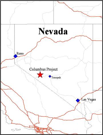 | TheColumbus Projectis located ~ halfway between Las Vegas and Reno, ~52 miles west of Tonopah, Nevada, USA. The Project is specifically located over the Columbus Salt Marsh in Esmeralda County, Nevada. |
Regional History
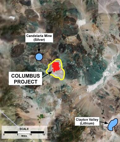 | Columbus Project is in a mineralized area :
|
Project Assets
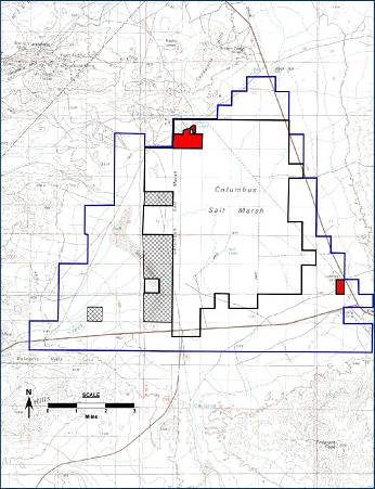 | The Columbus Project consists of : - ~ 19,300 acres of mineral claimson federal land administered by the BLM, with an option for an additional ~23,000 acres. - 380 acres permittedfor production of Calcium Carbonate (CaCO3) and precious mineral extraction (the Permitted Area) - 270 acre mine site - 80 acres of private land - Water usage rightsof aquifers in basin |
Technical Program Goals
Determine Project Resources
- Drilling and Sampling program to determine precious metals grade in project area
Determine Project Feasibility
- Operation of Pilot Plant to determine precious metal recovery rates, costs of recovery and capital costs
Technical Team
Retained independent engineering firms:
Permitting
- Lumos & Associates – based in Reno, NV
Project Resources
- McEwen Geological – Drill program
- Arrakis Inc. – Drill sample analysis
- AuRic Labs – Drill sample analysis
Project Feasibility
- Arrakis Inc. – Pilot Plant Operations
All reported work to date has been completed and performed under Chain of Custody (COC)
Project Resources
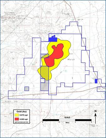 | Gold (Au) Anomaly Identified - Over 60 surface samples and 5 large bulk samples taken over an ~ 27,000-acre area at depths of 3’ to 20’ analyzed by Arrakis Inc. - Results of sediment analysis identified an ~5,000-acre area with samples of Au values of > 0.075 oz/t in the NW section of the basin (the Gold Anomaly) - Gold values from surface samples are in-situ grades; tonnages have yet to be proven - Gold is fine and entombed in clays. The challenge of the project will be to separate the Gold from these clays |
Drill Program Results
Drill Program Details -18 holes drilled to a maximum depth of 100 ft* in 380-acre Production Permitted Area Gold Results - 154 Sample Av. = 0.074 opt Au * Holes were drilled to 100 ft or shallower due to bed rock or drilling conditions |
Geology
Aeromagnetic Survey -High resolution aeromagnetic survey completed October 2007 -Mag Highs= Volcanics surrounding basin -Mag Lows= Young Sediments in basin and older sediments around basin - A large NW-SE fault structure enters basin from the NW and could be main aquifer feed to basin -Basin could be collapsed caldera or rift basin |
Potential of Mineralized Area
| Parameter | Area | Depth | Tons of Minable Material |
| Permitted Area | 320 Acres | 25 ft | 8.8 M |
Currently permitted to mine up to 790,000 tpy in a 320-acre area to a depth of 40 ft. (estimated mine life of over 17 years)
SRK Consulting, an independent engineering firm based in Reno estimated that the mineable tonnage in the 320-acre permitted mine area, to a depth of 25 feet, approximates 8.8 million tons
The Drilling Program completed within the permitted area indicates that the minable material extends below the currently permitted depth of 25 feet.
Permitted Area lies on northern edge of the identified Gold Anomaly
If the geology is consistent from the permitted area to the Gold Anomaly, the ~5,000- acres would contain a potential minable tonnage of>150 million tonsin the top 25 feet.
Project Feasibility
Prefeasibility Process -Currently operating processing 15 to 30 tons of material per day -Purpose: Determine initial gold recovery, operating costs and capital costs |
Project Photos
![]()
Recent Milestones
January - October 2008
-Completed Acquisition of Columbus Project
- Announced results of 18-hole drill program
-Received permits for 39-hole drill program to test the mineralization within the ~5,000 acre gold anomaly
- Completed upgrades to 15,000 ft2processing building
- Commenced operations of pilot plant for Pre-feasibility Testing
- Received amended production permits to 790,000 tpy and to a depth of 40 feet
Next Steps
Project Development – 2008
-Complete initial resource study to further define three-dimensional extent of potential resources
- Determine initial precious metal recovery rates, operating and full production capital costs through operation of the Pilot Production Plant
Columbus Project Budget
| October To December 31st2008 | |||
| Drilling and Analysis | $ | 250,500 | |
| Plant and Feasibility | $ | 602,750 | |
| Permits | $ | 4,500 | |
| $ | 857,750 | ||
| Contingency (10%) | $ | 85,775 | |
| Estimated Costs | $ | 943,525 |
Cash Position as at Sept 30, 2008 : $ 4,049,737
Budget Cash Position as at Dec 31 : $ 2,250,000
Monthly Run Rate : ~ $ 320,000
Summary
The Columbus Project represents a solid exploration and production opportunity: -Full permit for the extraction of Gold and Silver and the production of Calcium Carbonate -“Big Box Store” of mining operations: high volume and low cost -Near term production horizon |
Ireland Inc
Corporate Office:
2441 West Horizon Ridge Parkway, Suite 100
Henderson, NV, 89044
(702) 932-0353
info@irelandminerals.com
http://www.irelandminerals.com
Investor Relations Contact:
R. Jerry Falkner, CFA
RJ Falkner & Company, Inc.
125 Piper Lane
Spicewood, TX, 78669
Tel: 800-377-9893