EXHIBIT 99.2
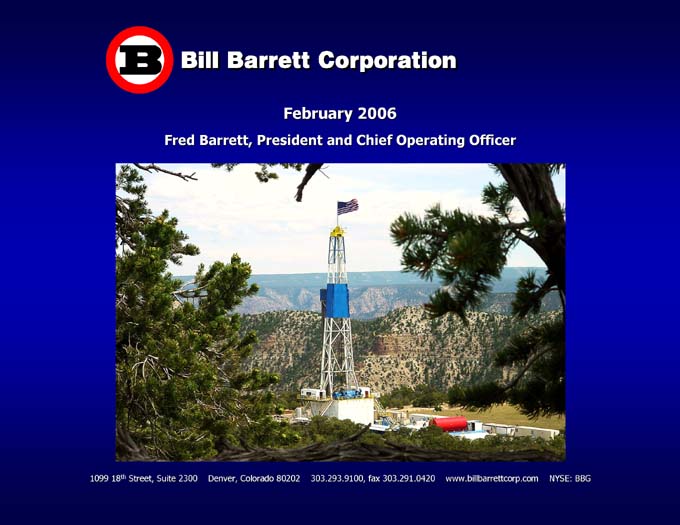
Bill Barrett Corporation
February 2006
Fred Barrett, President and Chief Operating Officer
1099 18th Street, Suite 2300 Denver, Colorado 80202 303.293.9100, fax 303.291.0420 www.billbarrettcorp.com NYSE: BBG
Forward-Looking Statements
Except for the historical information contained herein, the matters discussed in this presentation are forward-looking statements. These forward-looking statements reflect our current views with respect to future events, based on what we believe are reasonable assumptions. These statements, however, are subject to risks and uncertainties that could cause actual results to differ materially including, among other things, exploration results, market conditions, oil and gas price levels and volatility, the availability and cost of services and drilling rigs, the ability to obtain industry partners to jointly explore certain prospects, uncertainties inherent in oil and gas production operations and estimating reserves, unexpected future capital expenditures, competition, the success of our risk management activities, governmental regulations and other factors discussed in our definitive prospectus dated August 17, 2005 filed with the Securities and Exchange Commission (SEC). We refer you to the “Cautionary Note Regarding Forward-Looking Statements” and “Risk Factors” sections of that filing.
Key Highlights
Pure Rockies oil and gas exploration and production company
Time-Honored Strategy
Proven, experienced Rocky Mountain management team
and technical staff
Develop extensive multi-year development drilling inventory
Exposure to multiple high impact, high return exploration plays
Heavily weighted towards unconventional projects
Solid record of development growth and exploration discoveries
Strong balance sheet positioned for growth
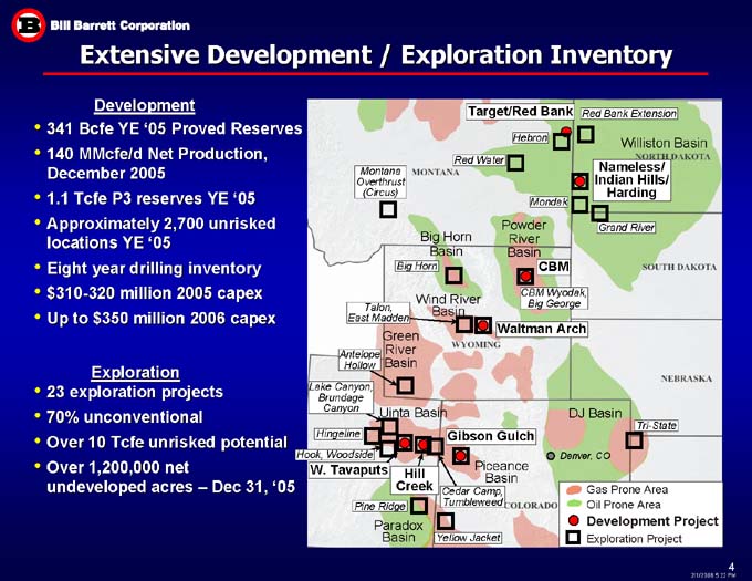
Extensive Development / Exploration Inventory
Development
341 Bcfe YE ‘05 Proved Reserves
140 MMcfe/d Net Production, December 2005
1.1 Tcfe P3 reserves YE ‘05
Approximately 2,700 unrisked locations YE ‘05
Eight year drilling inventory
$310-320 million 2005 capex
Up to $350 million 2006 capex
Red Bank Extension
Target/Red Bank Hebron Williston Basin Nameless/ Indian Hills/ Harding Red Water Montana Overthrust (Circus)
Mondak Grand River Powder River Basin Big Horn Basin Big Horn CBM Wind River Basin CBM Wyodak,
Big George Talon, East Madden Waltman Arch Green River Basin Antelope Hollow Exploration
23 exploration projects
70% unconventional
Over 10 Tcfe unrisked potential
Over 1,200,000 net
undeveloped acres – Dec 31, ‘05
Lake Canyon,
Brundage Canyon
DJ Basin
Uinta Basin
Tri-State
Gibson Gulch
Hingeline
Hook, Woodside
Denver, CO
W. Tavaputs
Hill Creek
Piceance
Basin
Cedar Camp,
Tumbleweed
Gas Prone Area
Oil Prone Area
Development Project
Pine Ridge
Paradox Basin
Yellow Jacket
Exploration Project
NORTH DAKOTA
SOUTH DAKOTA
WYOMING
NEBRASKA
COLORADO
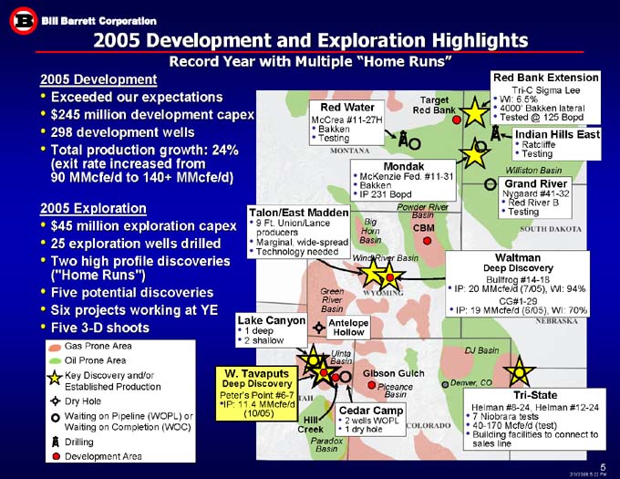
2005 Development and Exploration Highlights
Record Year with Multiple “Home Runs”
2005 Development
Exceeded our expectations
$245 million development capex
298 development wells
Total production growth: 24%
(exit rate increased from
90 MMcfe/d to 140+ MMcfe/d)
2005 Exploration
$45 million exploration capex
25 exploration wells drilled
Two high profile discoveries
(“Home Runs”)
Five potential discoveries
Six projects working at YE
Five 3-D shoots
Red Bank Extension
Tri-C Sigma Lee WI: 6.5% 4000’ Bakken lateral Tested @ 125 Bopd Target Red Bank Red Water McCrea #11-27H Bakken Testing
Indian Hills East Ratcliffe Testing Mondak McKenzie Fed. #11-31 Bakken IP 231 Bopd Mondak Williston Basin
Grand River Nygaard #41-32 Red River B Testing Talon/East Madden 9 Ft. Union/Lance producers Marginal, wide-spread
Technology needed Powder River Basin Big Horn Basin CBM Wind River Basin Waltman
Deep Discovery Bullfrog #14-18 IP: 20 MMcfe/d (7/05), WI: 94% CG#1-29 IP: 19 MMcfe/d (6/05), WI: 70%
Green River Basin Antelope Hollow Lake Canyon 1 deep 2 shallow
Gas Prone Area Oil Prone Area Key Discovery and/or Established Production Dry Hole Waiting on Pipeline (WOPL) or
Waiting on Completion (WOC)
Drilling
Development Area
Uinta Basin
DJ Basin
W. Tavaputs
Deep Discovery
Peter’s Point #6-7
IP: 11.4 MMcfe/d
(10/05)
Gibson Gulch
West Tavaputs
Piceance
Basin
Denver, CO
Tri-State
Helman #8-24, Helman #12-24
7 Niobrara tests
40-170 Mcfe/d (test)
Building facilities to connect to sales line
Cedar Camp
2 wells WOPL
1 dry hole
Hill Creek
Paradox Basin
MONTANA
WYOMING
TAH
COLORADO
NEBRASKA
SOUTH DAKOTA
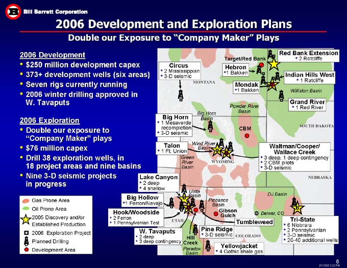
2006 Development and Exploration Plans
Double our Exposure to “Company Maker” Plays
2006 Development
$250 million development capex
373+ development wells (six areas)
Seven rigs currently running
2006 winter drilling approved in
W. Tavaputs
2006 Exploration
Double our exposure to
“Company Maker” plays
$76 million capex
Drill 38 exploration wells, in
18 project areas and nine basins
Nine 3-D seismic projects
in progress
Target/Red Bank
Red Bank Extension
Williston Basin
Powder River
Basin
Big Horn
Basin
CBM
Wind River Basin
Green
River
Basin
DJ Basin
Uinta Basin
Piceance
Basin
Gibson Gulch
Tri-State
W
Tavaputs
Hill Creek
Paradox Basin
Gas prone Area Oil Prone Area 2005 Discovery and/or Established Production 2006 Exploration Project Planned Drilling Development Area
Circus 2 Mississippian 3-D seismic
Big Horn 1 Mesaverde recompletion 3-D seismic
Talon 1Ft. Union
Lake Canyon 2 deep 4 shallow
Big Hollow 1 Ferron/Navajo
Hook/Woodside 2 Ferron 1 Pennsylvanian Test
W. Tavaputs 2 deep 3 deep contingency
Pine Ridge 3-D seismic
Yellojacket 4 Gothic shale gas
Tumbleweed
6 Niobrara 2 Pennsylvanian 3-D seismic 20-40 additional wells
NEBRASKA
Waltman/Cooper/ Wallace Creek 3 deep, 1 deep contigency 2 CBM pilots 3-D seismic
Grand River 1 Red River
Indian Hills West 1 Ratcliffe
2 Ratcliffe
Mondak 1 Bakken
Hebron 1 Bakken
CBM SOUTH DAKOTA WYOMING MONTANA
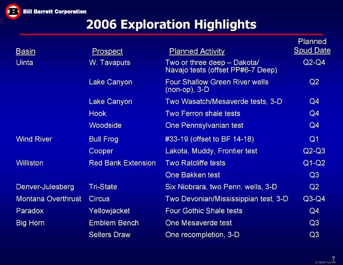
2006 Exploration Highlights Planned
Spud Date
Prospect
Basin
Planned Activity
Uinta
W. Tavaputs
Lake Canyon
Lake Canyon
Hook
Woodside
Two or three deep – Dakota/ Navajo tests (offset PP#6-7 Deep)
Four Shallow Green River wells (non-op), 3-D
Two Wasatch/Mesaverde tests, 3-D
Two Ferron shale tests
One Pennsylvanian test
Q2-Q4
Q2
Q4
Q4
Q4
#33-19 (offset to BF 14-18)
Lakota, Muddy, Frontier test
Two Ratcliffe tests
One Bakken test
Six Niobrara, two Penn. wells, 3-D
Two Devonian/Mississippian test, 3-D
Four Gothic Shale tests
One Mesaverde test
One recompletion, 3-D
Q1
Q2-Q3
Q1-Q2
Q3
Q2
Q3-Q4
Q4
Q3
Q3
Bull Frog
Cooper
Red Bank Extension
Tri-State
Circus
Yellowjacket
Emblem Bench
Sellers Draw
Wind River
Williston
Denver-Julesberg
Montana Overthrust
Paradox
Big Horn
Southern Division Update
Silt
Shooting 3-D Seismic - 25 sq mi
Gibson Gulch Unit
Mamm Creek
259 Bcfe
271 MMcfe/d
Scale:
640 ac
= 1 Mile
(with 10 ac grid)
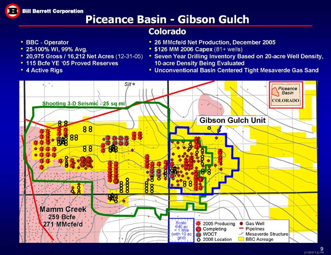
BBC - Operator
25-100% WI, 99% Avg.
20,975 Gross / 16,212 Net Acres (12-31-05)
115 Bcfe YE ‘05 Proved Reserves
4 Active Rigs
26 MMcfe/d Net Production, December 2005
$126 MM 2006 Capex (81+ wells)
Seven Year Drilling Inventory Based on 20-acre Well Density, 10-acre Density Being Evaluated
Unconventional Basin Centered Tight Mesaverde Gas Sand
COLORADO
Piceance
Basin
Gas Well
Pipelines
Mesaverde Structure BBC Acreage
2005 Producing
Completing
WOCT
2006 Location
Piceance Basin - Gibson Gulch
Colorado
Uinta Basin
$100 MM 2006 Capex (30+ wells, 1 recompletion)
40 MMcfe/d Net Production, December 2005
267,536 Net Undeveloped Acres (12-31-05)
83 Bcfe YE ‘05 Proved Reserves
Altamont/Bluebell
3.1 Tcfe
Uinta
Basin
Roosevelt, UT
3-D Seismic Survey
UTAH
Brundage Canyon
Monument Butte
289 Bcfe
Natural Butte
2 Tcfe
West Tavaputs
Lake Canyon
Garmesa
Garmesa
Price, UT
Drunkards
Wash
278 Bcfe
Trend
Tumbleweed
Hill Creek
BBC Acreage
Oil Field
Gas Field
Cedar Camp
San Arroyo
381 Bcfe
SCALE
1 Township
= 36 sq mi
West Tavaputs Project - Uinta Basin, Utah
Shallow - Wasatch/North Horn/Price River/Blackhawk
$68 MM 2006 Capex (22+ wells)
Conventional Structural Type Trap
52 mi. 2-D, 83 sq. mi. 3-D Seismic
Rough Topography (canyon)
BBC - Operator
46,774 Gross, 43,194 Net Acres (12-31-05)
100% WI; NRI 83%
26 MMcfe/d Net Production, December 2005
71 Bcfe YE ‘05 Proved Reserves
Questar interconnect
Uinta
Basin
Eight winter drilling locations
BLM approved
Compressor site
UTAH
Prickly Pear Area
Shallow
3-D
Four-way Closure
Peter’s Point Area
83 Sq Mile 3-D Survey
BBC Acreage
Seismic Option Acreage
Gas Well (Wasatch, North
Horn, Price River)
2005 Gas Well
(same formations)
Potential 160-acre Location
2006 Location
2006 Winter Drilling Location
Dry with Oil and Gas Show
Dry with Oil Show
Existing Pipeline
Proposed Pipeline
Scale: 640 ac = 1 Mile
(with 40 ac grid)
Deep W. Tavaputs – “Discovery of the Year”
(Hart’s Oil and Gas Investor)
Deep - Upper Cretaceous Dakota/Jurassic Entrada, Navajo
Ultra-Deep - Mississippian
$22 MM 2006 Capex (2+ Wells)
Conventional Structural Type Trap
52 mi. 2-D, 82 sq. mi. 3-D Seismic
Rough Topography (canyon)
BBC - Operator
46,774 Gross, 43,194 Net Acres (12-31-05)
100% WI; 83% NRI
9 MMcfe/d Net Production, December 2005
Peters Point #6-7 Deep Discovery
IP: 11.4 MMcfe/d (10/05)
100% WI, TD 15,349’
Dakota, Jurassic Entrada and Navajo
Questar interconnect
Uinta
Basin
Compressor site
UTAH
Prickly Pear Area
Area of Jurassic 3-D
Four-way Closure
Ultra-Deep
Mississippian Test
Deep Well
(1967)
Peter’s Point Area
BBC Acreage
Seismic Option Acreage
Gas Well
Dry with Gas Show
Potential 2006 Deep Location
Future Potential Deep Location
Existing Pipelines
Getty Deep Well (1980)
Tested: Dakota 315 Mcf
Entrada 1,800 Mcf
Area of Dakota Potential
Scale: 640 ac = 1 Mile
(with 40 ac grid)
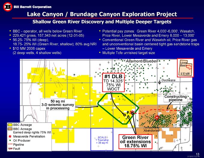
Lake Canyon / Brundage Canyon Exploration Project
Shallow Green River Discovery and Multiple Deeper Targets
BBC - operator, all wells below Green River
229,421 gross, 157,343 net acres (12-31-05)
56.25- 75% WI (deep),
18.75- 25% WI (Green River, shallow); 80% avg NRI
$10 MM 2006 capex
(2 deep wells, 4 shallow wells)
Potential pay zones: Green River 4,000’-6,000’, Wasatch, Price River, Lower Mesaverde and Emery 8,000 – 13,000’
Conventional Green River and Wasatch oil, Price River gas and unconventional basin centered tight gas sandstone traps – Lower Mesaverde and Emery
Multiple Tcfe unrisked target size
Altamont/Bluebell
Uinta
Basin
#1 DLB
TD 14,325’
75% WI WOCT
UTAH
Duchesne
Constructing pipeline
50 sq mi
3-D seismic survey
in processing
BBC Acreage
BBC Acreage
Earned deep rights 75% WI
Mesaverde Penetration
Oil Producer
Pipeline
Fault
Temporarily
Abandoned
SCALE
1 Township
= 36 sq mi
Green River
oil extensions
18.75% WI
Lake Canyon Multiple Pay Targets - Uinta Basin, Utah
KEY ANALOG AREAS
DEPTH
Brundage Canyon/
Monument Butte
(300 + Bcfe)
BBC WI: 18.75-25%
(Berry operates)
Altamont/
Bluebell
(3.1 Tcfe)
4,000 – 6,000’
Natural
Buttes
(2+ Tcfe)
BBC WI: 75%
(BBC operates)
8,000 – 13,000’
Productive in discreet areas
Large sand build up on western part of Lake Canyon with gas shows
13,000 – 20,000’
Mesaverde
Lower Upper
Green River Wasatch Price River Castlegate Blackhawk Emery Multiple Marine Sand Tongues Mancos
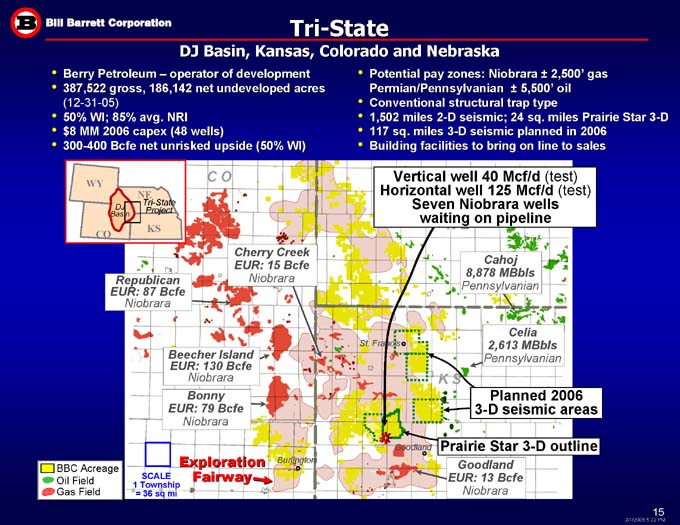
Tri-State
DJ Basin, Kansas, Colorado and Nebraska
Berry Petroleum – operator of development
387,522 gross, 186,142 net undeveloped acres (12-31-05)
50% WI; 85% avg. NRI
$8 MM 2006 capex (48 wells)
300-400 Bcfe net unrisked upside (50% WI)
Potential pay zones: Niobrara ± 2,500’ gas
Permian/Pennsylvanian ± 5,500’ oil
Conventional structural trap type
1,502 miles 2-D seismic; 24 sq. miles Prairie Star 3-D
117 sq. miles 3-D seismic planned in 2006
Building facilities to bring on line to sales
C O
Vertical well 40 Mcf/d (test)
Horizontal well 125 Mcf/d (test)
Seven Niobrara wells
waiting on pipeline
WY NE DJ Basin Tri-State Project KS N E CO
Cherry Creek EUR: 15 Bcfe
Niobrara
Cahoj
8,878 MBbls
Pennsylvanian
Republican
EUR: 87 Bcfe
Niobrara
Celia
2,613 MBbls
Pennsylvanian
St. Francis
Beecher Island
EUR: 130 Bcfe
Niobrara
K S
Bonny
EUR: 79 Bcfe
Niobrara
Planned 2006
3-D seismic areas
Prairie Star 3-D outline
Goodland
Exploration Fairway
Burlington
Goodland
EUR: 13 Bcfe
Niobrara
BBC Acreage
Oil Field
Gas Field
SCALE
1 Township
= 36 sq mi
Northern Division Update
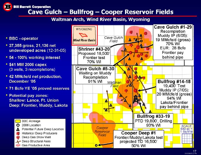
Cave Gulch – Bullfrog – Cooper Reservoir Fields
Waltman Arch, Wind River Basin, Wyoming
Cave Gulch #1-29
Recompletion
Muddy IP (6/05):
19 MMcfe/d (gross)
70% WI
EUR: 28 Bcfe
Frontier pay
behind pipe
WYOMING
Cave Gulch
Field
BBC - operator
27,355 gross, 21,136 net undeveloped acres (12-31-05)
54 - 100% working interest
$41 MM 2006 capex
(3 wells, 3 recompletions)
42 MMcfe/d net production, December ‘05
71 Bcfe YE ‘05 proved reserves
Potential pay zones:
Shallow: Lance, Ft. Union
Deep: Frontier, Muddy, Lakota
Wind River Basin
Shriner #43-20
Proposed 18,500’
Frontier test
70% WI
Cave Gulch #5-30
Waiting on Muddy Recompletion
91% WI
Bullfrog #14-18 19,400’ Test
Muddy IP (7/05):
20 MMcfe/d (gross)
94% WI
Lakota/Frontier
pay behind pipe
Waltman
Field
Bullfrog #33-19
PTD 19,800’, Drilling
93% WI
BBC Acreage
2006 Location
Potential Future Deep Location
Historical Deep Producers
Deep Gas Show Well
Deep Structural Axes
Gas Productive Area
SCALE
640 ac =
1 Sq Mile
Cooper Reservoir
Field
Cooper Deep #1
Frontier/Muddy/Lakota test
projected TD 16,500’
50% WI
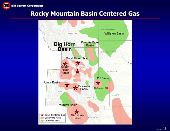
Rocky Mountain Basin Centered Gas
Williston Basin
Big Horn
Basin
Powder River
Basin
Wind River Basin
Green
River
Basin
DJ Basin
Uinta Basin
Piceance Basin
Paradox Basin
San Juan
Basin
MONTANA
NORTH DAKOTA
SOUTH DAKOTA
WYOMING
NEBRASKA
UTAH
Denever, Co
COLORADO
KANSAS
NEW MEXICO
Basin Centered Gas Gas Prone Area Oil Prone Area
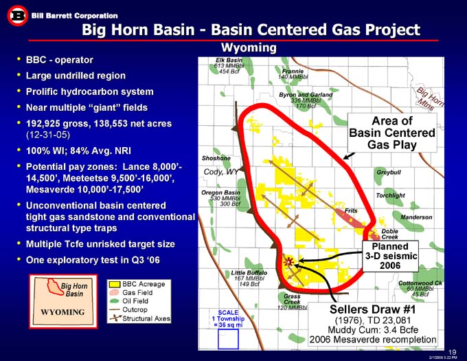
Big Horn Basin - Basin Centered Gas Project
Wyoming
BBC - operator
Large undrilled region
Prolific hydrocarbon system
Near multiple “giant” fields
192,925 gross, 138,553 net acres
(12-31-05)
100% WI; 84% Avg. NRI
Potential pay zones: Lance 8,000’-14,500’, Meeteetse 9,500’-16,000’, Mesaverde 10,000’-17,500’
Unconventional basin centered
tight gas sandstone and conventional structural type traps
Multiple Tcfe unrisked target size
One exploratory test in Q3 ‘06
Area of
Basin Centered
Gas Play
Planned
3-D seismic
2006
Big Horn Basin
BBC Acreage
Gas Field
Oil Field
Outcrop
Structural Axes
Sellers Draw #1
(1976), TD 23,081
Muddy Cum: 3.4 Bcfe
2006 Mesaverde recompletion
SCALE
1 Township = 36 sq mi
Eik Basin 613 MMBbl 454 Bcf
Frannie 140 MMBbl
Byron and Garland 336 MMBbl 170 Bcf
Big Horn Mtns
Shoshone Cody, WY
Oregon Basin 530 MMBbl 300 Bcf
Little Buffalo 167 MMBbl 149Bcf
Grass Creek 120 MMBbl
Cottonwood Ck 60 MMBbl 45 Bcf
Frits Greybull Torchlight Manderson Dobie Creek
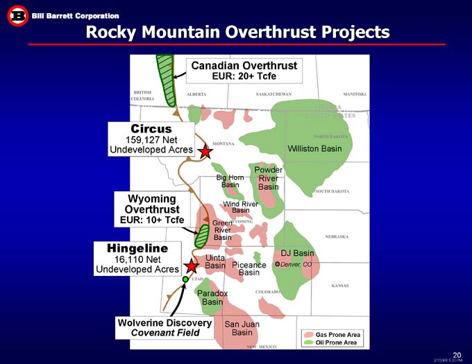
Rocky Mountain Overthrust Projects
Canadian Overthrust
EUR: 20+ Tcfe
Circus
159,127 Net Undeveloped Acres
Williston Basin
Powder River
Basin
Big Horn
Basin
Wyoming Overthrust
EUR: 10+ Tcfe
Wind River Basin
Green
River
Basin
Hingeline
16,110 Net Undeveloped Acres
DJ Basin
Uinta Basin
Piceance Basin
Denver, CO
Paradox Basin
San Juan
Basin
Wolverine Discovery
Covenant Field
Gas Prone Area
Oil Prone Area
BRITISH
COLUMBA
ALBERTA
MONTANA
WYOMIG
UTAH
COLORADO
KANASAS
NEBRASKA
SOUTH DAKOTA
NORTH DAKOTA
CANADA UNITED STATES
MANITOBA
SASKATCHEWAN
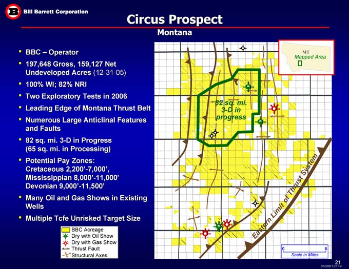
Circus Prospect
Montana
BBC – Operator
197,648 Gross, 159,127 Net Undeveloped Acres (12-31-05)
100% WI; 82% NRI
Two Exploratory Tests in 2006
Leading Edge of Montana Thrust Belt
Numerous Large Anticlinal Features and Faults
82 sq. mi. 3-D in Progress
(65 sq. mi. in Processing)
Potential Pay Zones:
Cretaceous 2,200’-7,000’,
Mississippian 8,000’-11,000’
Devonian 9,000’-11,500’
Many Oil and Gas Shows in Existing Wells
Multiple Tcfe Unrisked Target Size
MT
Mapped Area
82 sq. mi.
3-D in progress
of Thrust System
Eastern Limit
BBC Acreage
Dry with Oil Show
Dry with Gas Show
Thrust Fault
Structural Axes
6
0
Scale in Miles
Target/Red Bank/Red Bank Extension
Williston Basin, Montana & North Dakota
Horizontal Technology Play
Potential Pay Zones: Madison 9,000’, Bakken 10,600’
20 MMBoe Net Unrisked Target Size
88,237 Gross, 51,722 Net Acres (12-31-05)
$19 MM 2006 Capex (9 Wells)
MT
ND
#11-33H Picard
IP: 225 Bopd
Williston
Basin
N. D A K O T A
Ratcliffe location
M O N T A N A
#31-32H Picard
IP: 275 Bopd
SD
Mapped
Area
#24-28H Picard
IP: 75 Bopd
Target
85 -100% WI
Red Bank Extension
Project WI 60%
#31-16H State
IP: 70 Bopd
Bakken location
Scale: 640 ac
= 1 Mile
(with 40 ac grid)
#14-16H State
IP: 300 Bopd
Sigma Lee
#14-23
19,500’ MD Bakken test
172 Bopd & 117 BLW
BBC 6.25% WI
Pump testing after frac
BBC Acreage
Oil Well
BBC Operated Well
BBC 2006 Dev. Location
Horizontal Well
Exploratory Well
#24-24H Tininenko
IP: 70 Bopd
Red Bank
90 -100% WI
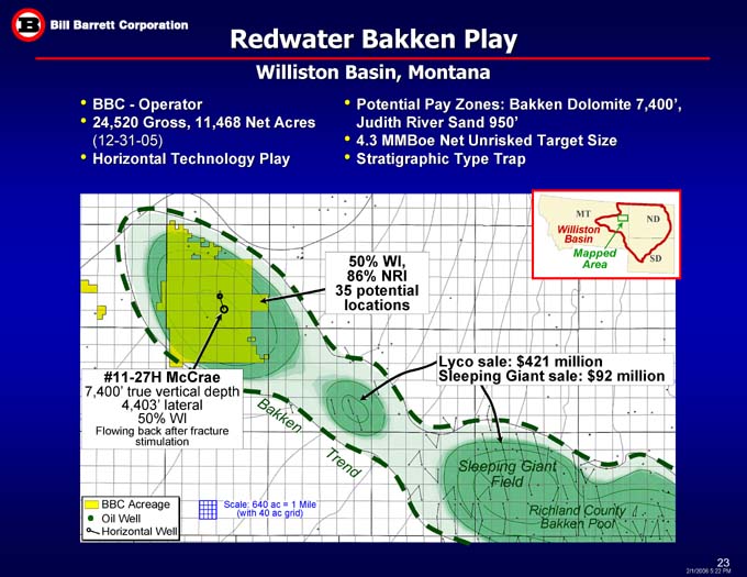
Redwater Bakken Play
Williston Basin, Montana
Potential Pay Zones: Bakken Dolomite 7,400’,
Judith River Sand 950’
4.3 MMBoe Net Unrisked Target Size
Stratigraphic Type Trap
BBC—Operator
24,520 Gross, 11,468 Net Acres
(12-31-05)
Horizontal Technology Play
MT
ND
Williston
Basin
50% WI,
86% NRI
35 potential locations
SD
Mapped
Area
Lyco sale: $421 million
Sleeping Giant sale: $92 million
#11-27H McCrae
7,400’ true vertical depth
4,403’ lateral
50% WI
Flowing back after fracture stimulation
Bakken
Sleeping Giant Field
Trend
BBC Acreage
Oil Well
Horizontal Well
Scale: 640 ac = 1 Mile
(with 40 ac grid)
Richland County Bakken Pool
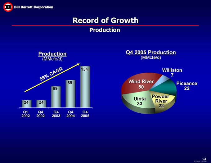
Record of Growth
Production
Q4 2005 Production
(MMcfe/d)
Production
(MMcfe/d)
134
Williston
7
58% CAGR
89
Wind River
50
Piceance
22
69
Uinta
33
Powder
River
22
24
24
Q4
2003
Q1
2002
Q4
2005
Q4
2004
Q4
2002
2002 2003 2004 2005E 2006E
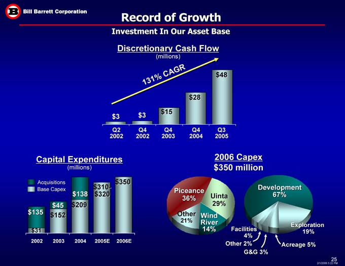
Record of Growth
Investment In Our Asset Base
Discretionary Cash Flow
(millions)
$48
131% CAGR
$28
$3
$15
$3
Q3 2005
Q4 2004
Q4 2002
Q2 2002
Q4 2003
Capital Expenditures
(millions)
2006 Capex
$350 million
$350
Acquisitions
Base Capex
Development
67%
Piceance
36%
$310-
$320
$138
Uinta
29%
$45
Exploration
$209
Other
21%
$152
$135
Wind
River
14%
Exploration
19%
$31
Facilities
4%
Other 2%
Acreage 5%
G&G 3%
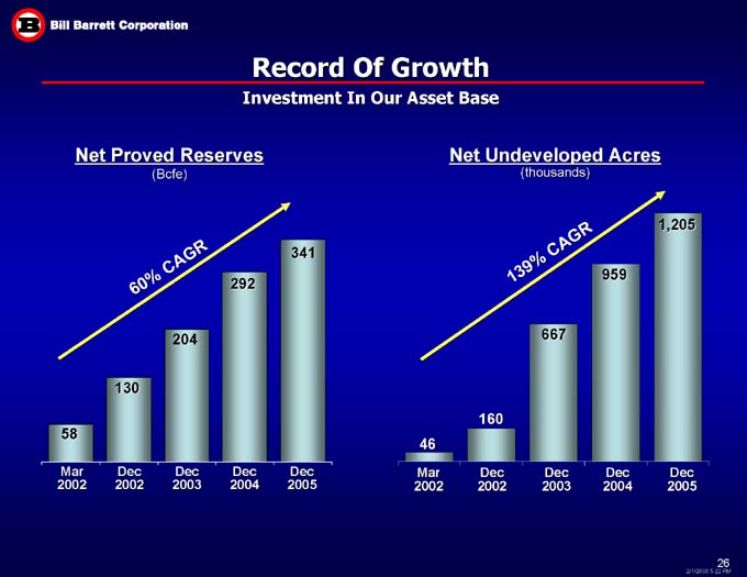
Record Of Growth
Investment In Our Asset Base
Net Undeveloped Acres
(thousands)
Net Proved Reserves
(Bcfe)
1,205
341
139% CAGR
60% CAGR
959
292
204
667
130
160
58
46
Dec
2004
Dec
2003
Dec
2002
Mar
2002
Mar
2002
Dec
2002
Dec
2003
Dec
2004
Dec
2005
Dec
2005
Appendix
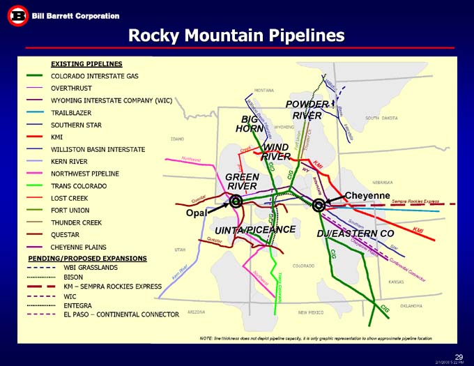
Rocky Mountain Pipelines
EXISTING PIPELINES
COLORADO INTERSTATE GAS
Williston MONTANA OVERTHRUST POWDER RIVER
WYOMING INTERSTATE COMPANY (WIC)
TRAILBLAZER Williston Basin Basin SOUTH DAKOTA SOUTHERN STAR BIG
HORN WYOMING Interstate KMI Interstate Thunder Ck Fort Union IDAHO WIND RIVER Creek
WILLISTON BASIN INTERSTATE
KERN RIVER
Northwest
KMI CIG
NORTHWEST PIPELINE
WY CIG GREEN
RIVER Lost
NEBRASKA
TRANS COLORADO
Interstate
Cheyenne
LOST CREEK
Questar
Sempra Rockies Express
FORT UNION
Opal
THUNDER CREEK
CIG
UINTA/PICEANCE
Southern
DJ/EASTERN CO
QUESTAR
KMI
Questar
CHEYENNE PLAINS
Star
Cheyenne Plains
CIG
UTAH
PENDING/PROPOSED EXPANSIONS
WBI GRASSLANDS
COLORADO
Kern River
BISON
Continental Connector
KANSAS
KM – SEMPRA ROCKIES EXPRESS
Northwest
Trans Colorado
WIC
ENTEGRA
OKLAHOMA
CIG
NEW MEXICO
EL PASO – CONTINENTAL CONNECTOR
ARIZONA
NOTE: line thickness does not depict pipeline capacity, it is only graphic representation to show approximate pipeline location
KMI CHEYENNE PLAINS WYOMING
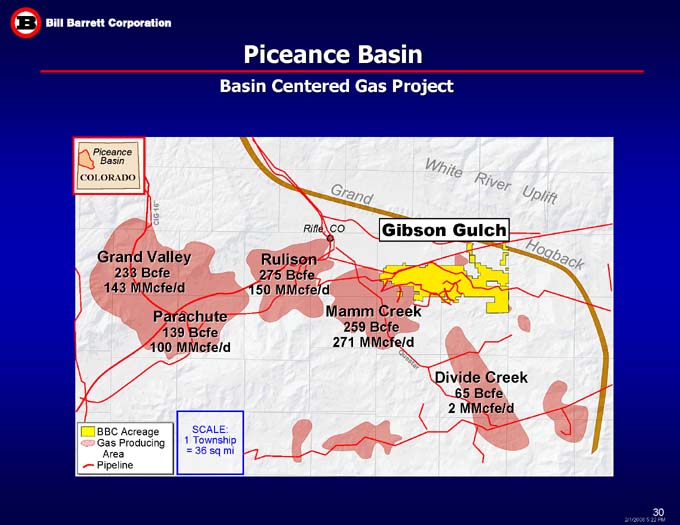
Piceance Basin
Basin Centered Gas Project
Piceance
Basin
White River Uplift
COLORADO
Grand
CIG 16”
Gibson Gulch
Rifle, CO
Grand Valley
233 Bcfe
143 MMcfe/d
Rulison
275 Bcfe
150 MMcfe/d
Hogback
Parachute
139 Bcfe
100 MMcfe/d
Mamm Creek
259 Bcfe
271 MMcfe/d
Questar
Divide Creek
65 Bcfe
BBC Acreage
Gas Producing
Area
Pipeline
SCALE:
1 Township = 36 sq mi
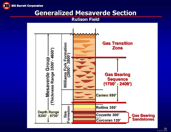
Generalized Mesaverde Section
Rulison Field
Gas Transition
Zone
Williams Fork Formation
(2800’- 3800’)
Gas Bearing
Sequence
(1700’ - 2400’)
Mesaverde Group
(Thickness Range 3500’- 4600’)
Cameo 850’
Rollins 350’
Iles
Formation
Depth Range
8200’ - 8700’
Cozzette 300’
Gas Bearing
Sandstones
Corcoran 120’
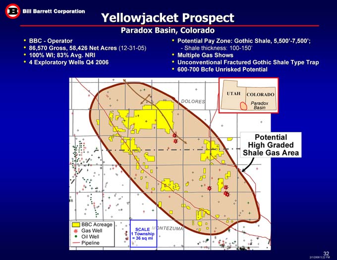
Yellowjacket Prospect
Paradox Basin, Colorado
BBC - Operator
86,570 Gross, 58,426 Net Acres (12-31-05)
100% WI; 83% Avg. NRI
4 Exploratory Wells Q4 2006
Potential Pay Zone: Gothic Shale, 5,500’-7,500’; - Shale thickness: 100-150’
Multiple Gas Shows
Unconventional Fractured Gothic Shale Type Trap
600-700 Bcfe Unrisked Potential
COLORADO
UTAH
Paradox
Basin
Potential
High Graded
Shale Gas Area
BBC Acreage
Gas Well
Oil Well
Pipeline
SCALE
1 Township = 36 sq mi
DOLORES
MONTEZUMA
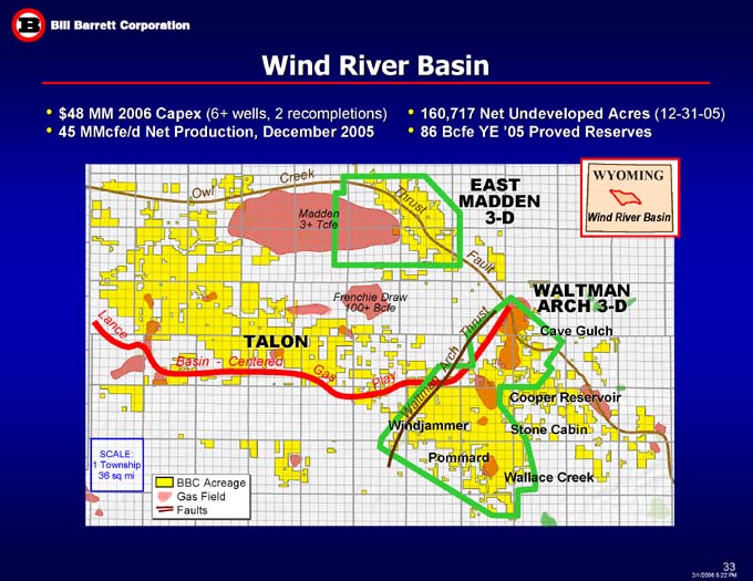
Wind River Basin
160,717 Net Undeveloped Acres (12-31-05)
86 Bcfe YE ‘05 Proved Reserves
$48 MM 2006 Capex (6+ wells, 2 recompletions)
45 MMcfe/d Net Production, December 2005
EAST MADDEN 3-D
Owl Creek
Thrust
Madden
3+ Tcfe
Fault
WALTMAN ARCH 3-D
Frenchie Draw
100+ Bcfe
Lance
Thrust
Cave Gulch
TALON
Basin - Centered
Arch
Gas
Play
Waltman
Cooper Reservoir
Stone Cabin
Windjammer
SCALE:
1 Township
36 sq mi
Pommard
Wallace Creek
BBC Acreage
Gas Field
Faults
WYOMING
WIND RIVER BASIN
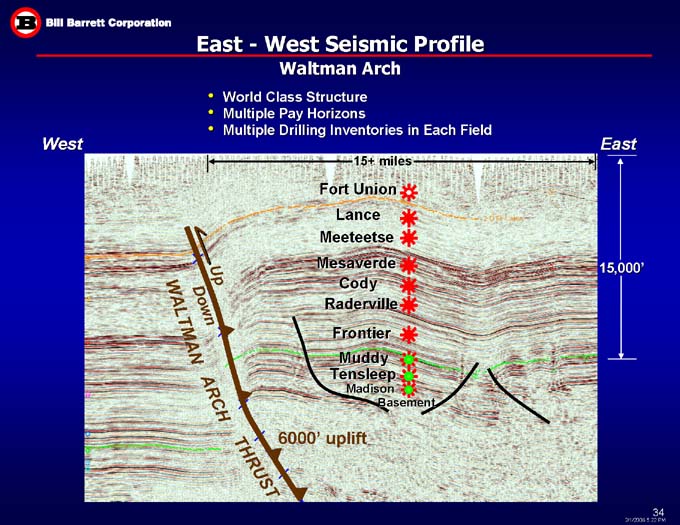
East - West Seismic Profile
Waltman Arch
World Class Structure
Multiple Pay Horizons
Multiple Drilling Inventories in Each Field
West
East
15+ miles
Fort Union
Lance
Meeteetse
15,000’
Mesaverde
Up
Cody
Down
Raderville
WALTMAN
Frontier
Muddy
Tensleep
Madison
ARCH
Basement
6000’ uplift
THRUST
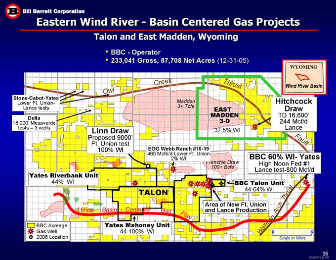
Eastern Wind River - - Basin Centered Gas Projects
Talon and East Madden, Wyoming
BBC - Operator
233,041 Gross, 87,708 Net Acres (12-31-05)
WYOMING
Owl Creek
Thrust
Wind River Basin
Stone-Cabot-Yates
Lower Ft. Union-Lance tests
Hitchcock Draw
TD 16,600’
244 Mcf/d Lance
Madden
3+ Tcfe
EAST MADDEN
3-D
Delta
18,000’ Mesaverde tests – 3 wells
Linn Draw
Proposed 9000’
Ft. Union test
100% WI
37.5% WI
Fault
EOG Webb Ranch #10-19
460 Mcfe/d Lower Ft. Union
2% WI
BBC 60% WI- Yates
High Noon Fed #1
Lance test-800 Mcf/d
Frenchie Draw
100+ Bcfe
Yates Riverbank Unit
44% WI
BBC Talon Unit
44-64% WI
Thrust
TALON
Arch
Area of New Ft. Union
and Lance Production
Lance
Gas
Basin - Centered
Play
Yates Mahoney Unit
44-100% WI
BBC Acreage
Gas Well
2006 Location
Waltman
6
0
Scale in Miles
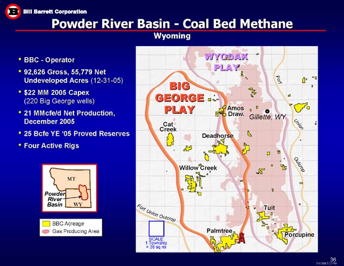
Powder River Basin - - Coal Bed Methane
Wyoming
WYODAK
PLAY
BBC - Operator
92,626 Gross, 55,779 Net Undeveloped Acres (12-31-05)
$22 MM 2005 Capex
(220 Big George wells)
21 MMcfe/d Net Production, December 2005
25 Bcfe YE ‘05 Proved Reserves
Four Active Rigs
BIG
GEORGE
PLAY
Fort
Amos
Draw
Gillette, WY
Cat
Creek
Union
Deadhorse
Willow Creek
Outcrop
MT
Powder
River
Basin
Tuit
WY
Fort
Union
BBC Acreage
Gas Producing Area
Outcrop
Palmtree
Porcupine
SCALE
1 Township
= 36 sq mi
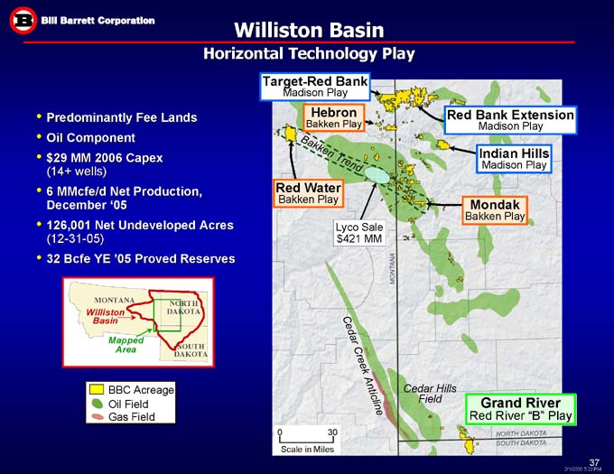
Williston Basin
Horizontal Technology Play
Target-Red Bank
Madison Play
Red Bank Extension
Madison Play
Predominantly Fee Lands
Oil Component
$29 MM 2006 Capex
(14+ wells)
6 MMcfe/d Net Production, December ‘05
126,001 Net Undeveloped Acres
(12-31-05)
32 Bcfe YE ‘05 Proved Reserves
Hebron
Bakken Play
Indian Hills
Madison Play
Bakken Trend
Red Water
Bakken Play
Mondak
Bakken Play
Lyco Sale
$421 MM
MONTANA
NORTH
DAKOTA
Williston
Basin
Mapped
Area
SOUTH
DAKOTA
Cedar Creek Anticline
Cedar Hills Field
BBC Acreage
Oil Field
Gas Field
Grand River
Red River “B” Play
30
0
Scale in Miles
MONTANA
NORTH DAKOTA
SOUTH DAKOTA
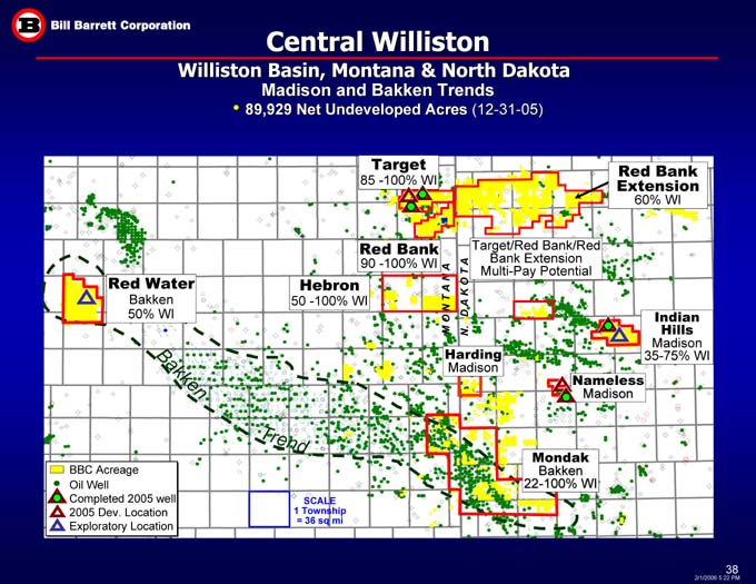
Central Williston
Williston Basin, Montana & North Dakota
Madison and Bakken Trends
89,929 Net Undeveloped Acres (12-31-05)
Red Bank Extension
60% WI
Target
85 -100% WI
Red Bank
90 -100% WI
Target/Red Bank/Red Bank Extension
Multi-Pay Potential
Red Water
Bakken
50% WI
Hebron
50 -100% WI
N. D A K O T A
M O N T A N A
Indian Hills
Madison
35-75% WI
Harding
Madison
Bakken
Nameless
Madison
Trend
Mondak
Bakken
22-100% WI
BBC Acreage
Oil Well
Completed 2005 well
2005 Dev. Location
Exploratory Location
SCALE
1 Township
= 36 sq mi

Grand River
Williston Basin, North & South Dakota
BBC – Operator
26,304 Gross, 11,805 Net Acres (12-31-05)
60% WI; 84% NRI
$1 MM 2006 Capex (1 Well)
10 MMBoe Net Unrisked Target Size
NORTH
DAKOTA
MONTANA
Williston
Basin
Horizontal
Red River “B” producer
Mapped
Area
SOUTH
DAKOTA
60% WI (84% NRI)
N O R T H D A K O T A
S O U T H D A K O T A
High potential
Red River “B” zone
Horizontal Exploration Trend
#14-32H Nygaard,
60% WI
9,200’ true vertical depth
5,000’ lateral
Pump testing
BBC Acreage
Oil Well
Luff operated Red River B Well
Horizontal Well
Exploratory Well
Scale: 640 ac = 1 Mile
(with 40 ac grid)
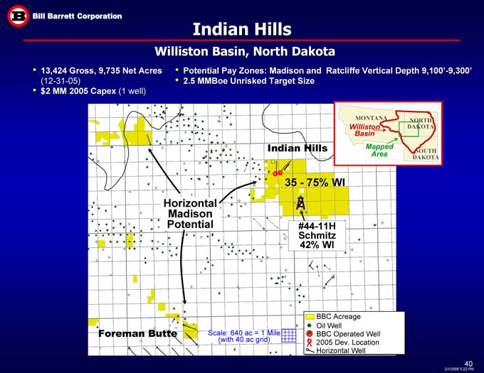
Indian Hills
Williston Basin, North Dakota
13,424 Gross, 9,735 Net Acres (12-31-05)
$2 MM 2005 Capex (1 well)
Potential Pay Zones: Madison and Ratcliffe Vertical Depth 9,100’-9,300’
2.5 MMBoe Unrisked Target Size
NORTH
DAKOTA
MONTANA
Williston
Basin
Mapped
Area
Indian Hills
SOUTH
DAKOTA
35 - 75% WI
Horizontal Madison Potential
#44-11H Schmitz
42% WI
BBC Acreage
Oil Well
BBC Operated Well
2005 Dev. Location
Horizontal Well
Foreman Butte
Scale: 640 ac = 1 Mile
(with 40 ac grid)
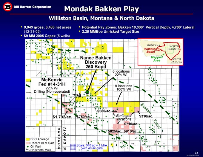
Mondak Bakken Play
Williston Basin, Montana & North Dakota
Potential Pay Zones: Bakken 10,300’ Vertical Depth, 4,700’ Lateral
2.25 MMBoe Unrisked Target Size
9,943 gross, 6,486 net acres (12-31-05)
$9 MM 2005 Capex (5 wells)
Barrett Operator, all wells below 6000’
234,973 Gross, 175,615 Net Acres
$8 MM 2005 Capex
Multiple Tcfe Unrisked Target Size
MONTANA
NORTH
DAKOTA
Williston
Basin
Total leasehold
Mapped
Area
Nance Bakken Discovery
250 Bopd
SOUTH
DAKOTA
6 locations
22% WI
McKenzie
Fed #14-31H
22% WI
Drilling (Non-operated)
9 locations
100% WI
Bakken
$580/ac.
$310/ac.
$1,792/ac.
$750/ac.
Burlington locations
Trend
$710/ac.
$825/ac.
$910/ac.
M O N T A N A
BBC Acreage
Recent BLM Sale
Oil Well
Horizontal Well
N. D A K O T A
Scale: 640 ac = 1 Mile
(with 40 ac grid)