Exhibit 96.1
Broadlands Mineral Advisory Services Ltd.
EIN: 27-0182628
TECHNICAL REPORT
RED ROCK CANYON GOLD PROPERTY
COCHISE COUNTY, ARIZONA
LATITUDE 31°39ʹ9.78ʺN LONGITUDE 110°0ʹ17,94ʺW
Jasperoid at Red Rock Canyon
Prepared FOR:
Liberty Star Minerals
Prepared By:
Bernard J. Guarnera, P.Eng., QP, CMA
Broadlands Mineral Advisory Services Ltd.
Effective Date:
1 July 2021
9213 Las Manaitas Avenue, #401, Las Vegas, NV 89144 +1.303.809.4265
guarnera@broadlandsadvisoryltd.com
Technical Report – Red Rock Canyon Gold Property 1 July 2021 |
Table of Contents
| 1.0 | SUMMARY | 1 |
| | 1.1 | LOCATION AND ACCESS | 1 |
| | 1.2 | HISTORIC MINING AND EXPLORATION ON THE RRC PROPERTY | 1 |
| | 1.3 | GEOLOGICAL SETTING, MINERALIZATION, AND DEPOSIT TYPES | 2 |
| | 1.4 | EXPLORATION UNDERTAKEN BY LIBERTY STAR MINERALS | 3 |
| | 1.5 | ENVIRONMENTAL, PERMITTING, SOCIAL, AND COMMUNITY IMPACT | 3 |
| | 1.6 | INTERPRETATION, CONCLUSIONS, AND RECOMMENDATIONS | 3 |
| | | | |
| 2.0 | INTRODUCTION | 4 |
| | 2.1 | PROFESSIONALS INVOLVED IN THE PREPARATION OF THIS TECHNICAL REPORT | 4 |
| | 2.2 | SOURCES OF INFORMATION AND DATA IN THE REPORT | 5 |
| | 2.3 | PURPOSE AND TERMS OF REFERENCE FOR THIS TECHNICAL REPORT | 5 |
| | 2.4 | COMPLIANCE WITH REPORTING REQUIREMENTS | 5 |
| | | | |
| 3.0 | RELIANCE ON OTHER EXPERTS | 7 |
| | | |
| 4.0 | PROPERTY DESCRIPTION AND LOCATION | 8 |
| | 4.1 | THE ARIZONA STATE TRUST LANDS | 9 |
| | 4.2 | ENVIRONMENTAL ISSUES, PERMITS, AND LIABILITIES | 10 |
| | 4.3 | RISK FACTORS AFFECTING THE RED ROCK CANYON PROPERTY | 10 |
| | | | |
| 5.0 | ACCESSIBILITY, CLIMATE, LOCAL RESOURCES, INFRASTRUCTURE, AND PHYSIOGRAPHY | 11 |
| | | |
| 6.0 | HISTORY | 12 |
| | 6.1 | HISTORIC RRC PROPERTY OWNERSHIP AND PRIOR WORK PERFORMED ON THE HAY MOUNTAIN/RED ROCK CANYON CLAIMS | 12 |
| | 6.1.1 | Phelps Dodge (PD) | 12 |
| | 6.1.2 | Energy Reserves Group | 13 |
| | 6.1.3 | Consolidated Paymaster/Goldsil Resources | 13 |
| | 6.1.4 | Wellington Financial | 13 |
| | 6.1.5 | Tempo Resources | 14 |
| | 6.1.6 | Primo Gold | 14 |
| | 6.1.7 | JABA Inc | 15 |
| 7.0 | GEOLOGICAL SETTING AND MINERALIZATION | 18 |
| | 7.1 | RRC/HAY MOUNTAIN GEOLOGIC SETTING | 18 |
| | 7.2 | THE LARAMIDE OROGENY | 19 |
| Liberty Star Minerals | i | Broadlands |
Technical Report – Red Rock Canyon Gold Property 1 July 2021 |
| | 7.3 | STRUCTURES AT THE RRC PROPERTY | 19 |
| | 7.4 | MINERALIZATION | 20 |
| | | | |
| 8.0 | DEPOSIT TYPES | 21 |
| | | |
| 9.0 | EXPLORATION UNDERTAKEN BY LIBERTY STAR MINERALS | 23 |
| | | |
| 10.0 | DRILLING | 24 |
| | | |
| 11.0 | SAMPLE PREPARATION, ANALYSES, AND SECURITY | 27 |
| | 11.1 | METHODOLOGY | 27 |
| | 11.2 | ANALYTICAL METHODS | 27 |
| | 11.3 | DUPLICATES AND QUALITY CONTROL | 27 |
| | | | |
| 12.0 | DATA VERIFICATION | 28 |
| | | |
| 18.0 | PROJECT INFRASTRUCTURE | 29 |
| | | |
| 20.0 | ENVIRONMENTAL, PERMITTING, SOCIAL, AND COMMUNITY IMPACT | 30 |
| | | |
| 23.0 | ADJACENT PROPERTIES | 31 |
| | | |
| 24.0 | OTHER RELEVANT DATA AND INFORMATION | 32 |
| | | |
| 25.0 | INTERPRETATION AND CONCLUSIONS | 33 |
| | | |
| 26.0 | RECOMMENDATIONS | 34 |
| | | |
| 27.0 | REFERENCES | 35 |
| APPENDIX 1.0 | RESUME FOR MR. BERNARD J. GUARNERA | 36 |
| APPENDIX 2.0 | OCTOBER 26, 2020 ASSAY RESULTS | 41 |
| APPENDIX 3.0 | JANUARY 11, 2021 ASSAY RESULTS | 48 |
| APPENDIX 4.0 | MAY 19, 2021 ASSAY RESULTS | 55 |
| Liberty Star Minerals | ii | Broadlands |
Technical Report – Red Rock Canyon Gold Property 1 July 2021 |
List of Tables
| Table 4-1 | List of Mining Claims | 10 |
| Table 10-1 | Clarification Information for Each Drill Hole | 25 |
| Liberty Star Minerals | iii | Broadlands |
Technical Report – Red Rock Canyon Gold Property 1 July 2021 |
List of Figures
| Figure 4-1. | Map showing location of Red Rock Canyon Claims | 8 |
| Photo 5-1. | Red Rock Canyon terrain | 11 |
| Figure 6-1. | Cross section across Red Rock Canyon with geophysical anomalies and gold occurrences | 16 |
| Figure 6-2. | Map of sampling sites, drill holes, and potential targets at Red Rock Canyon | 17 |
| Photo 7-1. | Calcite and jasperoid in colina limestone | 20 |
| Figure 8-1. | Epithermal Model for Red Rock Canyon gold deposits | 22 |
| Figure 10-1. | Drill holes in Section 28, T20S-R23E | 25 |
| Liberty Star Minerals | iv | Broadlands |
Technical Report – Red Rock Canyon Gold Property 1 July 2021 |
Abbreviations
| Acre | | A tract of land consisting of 43,500 square feet. |
| Alteration | | A change in the chemical nature of a rock due to its reaction to hydrothermal solutions. |
| Argillic Alteration | | Hydrothermal alteration of wall rock that introduces or alters other minerals to clay minerals. |
| Calcite | | A mineral with the chemical composition of calcium carbonate (CaCO3), which is the major constituent of limestone. |
| Caldera | | A large basin-shaped volcanic depression generally circular in form. The diameter of which is many times larger than the volcano within it. |
| Chalcopyrite | | Copper iron sulfide (CuFeS2), the most common ore of copper. |
| CIMM Best Practices | | Guidelines endorsed by the mineral industry and security entities for the reporting of exploration properties, Mineral Resources, and Mineral Reserves. |
| Controlled Source Audio- frequency Magnetotellurics | | A low impact, geophysical technique utilizing multiple frequencies to determine the conductivity or resistivity of subsurface materials. |
| Early-stage Exploration Property | | A property that has indications of hosting mineral deposits but has not defined Mineral Resources. |
| Epithermal Deposits | | Mineral deposits formed in and along fissures or other openings in rocks by deposition at shallow depths from hot solutions. |
| Feldspar | | A group of the most common rock forming minerals in the Earth’s crust with a broad range in composition. |
| Heap Leach | | A method of gold recovery that involves placing mined oxidized ore on a lined floor after crushing and irrigating the pile with a cyanide solution that directly leaches the gold from the rock. The pregnant leach is then piped to the processing plant and an ingot of gold mixed with other metals is produced and sent to a refinery for final processing. |
| Hectare | | A unit of land measurement equal to 2,471 acres. |
| Hematite | | Iron oxide (Fe2O3) often found in mineral deposits due to the oxidation of pyrite. |
| Hydrothermal Solutions | | Heated or hot magmatic emanations rich in water. |
| Induced Polarization | | A geophysical imaging technique used to identify the electrical chargeability of subsurface materials. |
| Jasperoid | | A rock consisting of crystalline silica formed by the replacement of other material, typically limestone or dolomite. |
| Liberty Star Minerals | v | Broadlands |
Technical Report – Red Rock Canyon Gold Property 1 July 2021 |
Abbreviations
(CONTINUED)
| Liberty Star Minerals | | A Nevada incorporated junior mining company that controls the mining claims in which the Red Rock Canyon mineralization is found. |
| Limestone | | A bedded deposit consisting of calcium carbonate (CaCO3). |
| Manto Deposit | | Flat-lying, pancake shaped to elongate mineral deposits of hydrothermal origin. |
| Mineral Reserve | | A mineral deposit where economic viability has been determined. Two categories of Mineral Reserves exist, which in order of assurance, are Probable and Proven. |
| Mineral Resource | | A mineral deposit where tonnages and grades have been defined but economic viability is not defined. Three categories of Mineral Resources exist, which in order of assurance, are Inferred, Indicated, and Measured. In declaring an Indicated or Measured Mineral Resource, a QP must believe that there is a reasonable expectation that economic viability will be demonstrated. |
| Molybdenite | | Molybdenum sulfide (MoS2), the principal ore of molybdenum that is used in steel manufacturing. |
| Niton XL5 XRF | | A portable X-ray refraction instrument that allows almost instantaneous readings of the quantities in parts per million of all elements present in a mineral sample. |
| Paleozoic Era | | One of the eras of geologic time ranging from ±540 million to ±250 million years ago consisting of the Cambrian, Ordovician, Silurian, Devonian, Mississippian, Pennsylvanian and Permian periods. |
| Pennsylvanian Period | | The sixth of the seven Periods in the Paleozoic Era noted for the numerous deposits of coal formed during that time. |
| Porphyry | | A rock with a fine ground mass in which larger, clearly defined phenocrysts (crystals) typically of feldspar are disseminated. |
| Porphyry Copper Deposits | | A porphyritic deposit with disseminated copper mineralization. |
| Pyrite | | Iron sulfide (FeS2), a common sulfide mineral often called “fool’s gold.” |
| Qualified Professional | | A professional certified to have a degree in the mineral industries with more than 10 years of post-degree experience. To act as a QP on an assignment, the professional must have at least 5 years of experience with the type and style of the mineral deposit being considered. |
| Reverse Circulation Drilling | | A method of drilling using dual wall drill rods consisting of an outer drill rod with an inner tube that allow the drill cuttings to be continuously returned to the surface. |
| Liberty Star Minerals | vi | Broadlands |
Technical Report – Red Rock Canyon Gold Property 1 July 2021 |
Abbreviations
(CONTINUED)
| Rhyolite | | A fine grained rock that is chemically and mineralogically equivalent to granite that can be volcanic or intrusive. |
| Section | | A land parcel consisting of 640 acres. |
| Shale | | A laminated sedimentary rock consisting mostly of clay. |
| Skarn | | Typically limestone or dolomite subjected to intense hot solutions leading to the replacement of the limestone by other minerals including ore-bearing minerals. |
| Technical Report | | A document that provides detailed information about a mineral property that is issued to provide shareholders and potential investors with a basis for making an investment decision. |
| Tertiary Era | | The current geologic era that started approximately 66 million years ago consisting from oldest to youngest of the Paleocene, Eocene, Oligocene, Miocene, and the current Pliocene periods. |
| Township | | A tract consisting of 36 sections. |
| Transient Electromagnetics | | A non-intrusive geophysical method for obtaining subsurface resistivity-conductivity data. |
| ZTEM | | Z-Tipper Axis Electromagnetic is an airborne electromagnetic survey system which detects anomalies in the earth’s natural magnetic field. These disruptions are caused by zones of rock that conduct or resist electrical current more than the surrounding rock, like ore deposits. |
| Liberty Star Minerals | vii | Broadlands |
Technical Report – Red Rock Canyon Gold Property 1 July 2021 |
Abbreviations, Acronyms, and
Units of Measurement Used
| Acre | | A measurement of area comprised of 43,560 square feet |
| Ag | | Silver |
| ALS USA | | A well-recognized mineral assay company with laboratories in the United States and Canada |
| Au | | Gold |
| Au-Gra21 | | A fire assay method to determine the amount of gold present in a sample |
| Ba | | Barium |
| CIMM | | Canadian Institute of Mining and Metallurgy |
| CP | | A Chartered Professional or Competent Person in Australasia |
| CSAMT | | Controlled Source Audio-frequency Magnetotellurics |
| Cu | | Copper |
| E | | East |
| GPT/gpt | | Grams per metric ton |
| Ha | | Hectare (2.47 acres) |
| IP | | Induced polarization |
| kg | | kilogram – 1 kilogram is equal to 2.205 pounds |
| LSM | | Liberty Star Minerals |
| ME-MS41 | | An assay method using atomic absorption to provide an estimate of the amounts of elements present in a sample |
| MEP | | State of Arizona Mineral Exploration Permit |
| Mo | | Molybdenum |
| N | | North |
| NE | | Northeast |
| NI-43-101 | | A Canadian regulation requiring conformance of information in Technical Reports for mineral properties that are issued for public consumption |
| NW | | Northwest |
| OPT/opt | | Ounces per ton of 2,000 pounds |
| PPM/ppm | | Parts per million (1 part per million equates to 1 gram per metric ton; 31.103 grams equate to 1 troy ounce) |
| QP | | A Qualified Professional or Qualified Person in the United States and Canada |
| RRC | | Red Rock Canyon property |
| S | | South |
| SE | | Southeast |
| S-K 1300 | | A U.S. Securities and Exchange Commission regulation requiring conformance of information in Technical Reports for mineral properties that are issued for public consumption |
| SW | | Southwest |
| TEM | | Transient Electromagnetic |
| Tonne | | A metric ton consisting of 2,204.623 pounds |
| W | | West |
| ZTEM | | Z-Tipper Axis Electromagnetic (Airborne Geophysical Survey) |
| Liberty Star Minerals | viii | Broadlands |
Technical Report – Red Rock Canyon Gold Property 1 July 2021 |
1.0 SUMMARY
The author of this Technical Report, Mr. Bernard J. Guarnera, is an independent director on Liberty Star Minerals (LSM) board of directors. Mr. Guarnera has extensive experience with both porphyry copper and gold deposits and is considered a Qualified Professional/Person in international venues. Accordingly, this Technical Report is written to conform to the format required by security entities. Since LSM has previously focused only on the porphyry copper potential at the Hay Mountain property, the purpose of this report is to provide board members, shareholders, and the investing public an informed discussion of the recently discovered gold potential that is present. The author has visited the property on one occasion in 2020 and twice in 2021. Each visit encompassed several days of in-field work.
The Red Rock Canyon (RRC) gold property is a part of LSM’s 17,000-acre Hay Mountain property in Cochise County, Arizona that was acquired for its potential hosting of a porphyry copper deposit based on geophysical and geochemical evidence. The RRC tract consists of 6,653 acres of State of Arizona Mineral Exploration Permits and 320 acres of Federal Lode Mining Claims. The tract has been segregated from the Hay Mountain block after the discovery of jasperoid bodies that displayed gold values.
The property is considered to be an Early-Stage Exploration Property and to comply with security laws the reader is advised that as such there is no assurance that Mineral Resources or Mineral Reserves will be defined and that the gold that is present will ever be mined.
1.1 LOCATION AND ACCESS
The RRC property is in Cochise County, Arizona and is 3 miles southeast of the town of Tombstone at an altitude of approximately 5,000 feet above sea level. The City of Tucson is approximately 70 miles away and has a major airport. Mining has historically occurred in the area with large open pit copper mines as well as silver, lead, and zinc mines. Thus, all requirements for a potential mining operation are available. While the RRC property is readily accessible, access on the property requires vehicles with off-road capability.
1.2 HISTORIC MINING AND EXPLORATION ON THE RRC PROPERTY
The Tombstone Mining District is one of 12 mining districts in Cochise County, Arizona. While copper, silver, lead, zinc, and minor amounts of gold have been mined in the District, no mining has occurred on the Hay Mountain property, and therefore, no mining on the RRC site. A review of documents in the Arizona Geological Survey files, however, reveals that multiple exploration programs have been conducted since the 1970s. These include airborne geophysical surveys (magnetics) and ground geophysical surveys (resistivity/conductivity), geochemical surveys, geobotanical surveys, and drilling.
| Liberty Star Minerals | 1 | Broadlands |
Technical Report – Red Rock Canyon Gold Property 1 July 2021 |
Significantly, each geochemical and drilling program revealed gold was present at grades that would now be considered as economic. Specifically,
| | ● | Phelps Dodge Corporation, 1970 and 1989 – In 1970, the company conducted ground resistivity surveys that the company correlated with possible gold mineralization. In 1989, rock chip sampling with samples returning grades of up to 1.6 ounces of gold per ton (opt). An internal memorandum noted: |
| | | This is potentially a large gold system. Surficial rock-chip sampling shows gold occurring over an arcuate area of 5 square miles so far. | |
| | ● | Energy Reserves Group, 1982-1983 – Geological mapping and geochemical sampling delineated a number of targets that were never tested. |
| | | |
| | ● | Consolidated Paymaster/Godsil Resources, 1983-1985 – Drilled 10 holes; all showed gold mineralization; one 20 feet grading 0.045 opt starting at a depth of 50 feet. |
| | | |
| | ● | Wellington Financial, 1985 – Offset the above cited drill hole and intercepted 30 feet grading 0.037 opt starting at the surface. |
| | | |
| | ● | Tempo Resources, 1988 – Conducted magnetic and resistivity surveys followed by four drill holes. Three showed significant alteration and two intercepted gold mineralization. |
| | | |
| | ● | Primo Gold, 1990 – Drilled nine drill holes, five reporting “significant” mineralization; one grading 0.102 opt over a 45-foot interval starting at surface. |
| | | |
| | ● | JABA Inc., 1997 – Press release citing: “…values as high as 1.5 ounces have been obtained from silicified zones at the surface in the limestone host rock….” |
1.3 GEOLOGICAL SETTING, MINERALIZATION, AND DEPOSIT TYPES
The relevant geologic formations at RRC are the Earp Formation and the overlying Colina Limestone. The Earp Formation is dominantly a limestone with areas of dolomite as well as interbeds of shale. The Colina Limestone is grayish to black and widely present on the property. Both are receptive to, and targets for, hosting gold deposits and both were affected by the Laramide Orogeny starting approximately 85 million years ago and ending 43 million years ago.
The multiple episodes of orogenic activity produced multiple episodes of volcanism accompanied by the emplacement of intrusions of porphyry copper deposits, accompanied by hydrothermal solutions that entered fractures in the rock formations and faults altering the surrounding rocks and upon cooling depositing minerals including gold. These epithermal deposits were emplaced in the receptive Earp Formation and Colina Limestone.
| Liberty Star Minerals | 2 | Broadlands |
Technical Report – Red Rock Canyon Gold Property 1 July 2021 |
The gold mineralization at RRC has been likened to the gold deposits at the Carlin Trend in Nevada. The mineralization at the Carlin Trend consists of sub-micron-sized gold, which appears to be similar to the gold at RRC as no gold is visible in the high-grade samples that were found.
Geophysical surveys have detected areas on the RRC property that show a magnetic high adjacent to a high conductivity zone. Such associations could indicate the presence of a skarn deposit and an associated gold deposit at depth. Only drilling could confirm this.
1.4 EXPLORATION UNDERTAKEN BY LIBERTY STAR MINERALS
Exploration work undertaken by LSM at Red Rock Canyon has consisted primarily of geochemical rock sampling and geochemical sampling of specific plants. Additional refinement of prior geophysical surveys has provided three-dimensional (3-D) views of the anomalies on the entire Hay Mountain tract. This work has identified the anomalous areas discussed in this Technical Report.
In 2020, LSM engaged a geologist to undertake an effort to identify alteration and veining to determine the extent of hydrothermal alteration and the timing of mineralization at the property. Additionally, LSM undertook the collection of 23 jasperoid samples for assaying of which 8 of the 23 samples assayed greater than 1 gram per tonne (0.03 ounces per ton) and only 4 had negligible amounts of gold (<0.05 grams per tonne). The samples were taken and followed a chain of custody that conformed to best industry practices.
It must be remembered that RRC property is considered an Early-Stage Exploration Property and requires significant additional work to progress. Continuing exploration activities will include further biogeochemical, X-ray fluorescence and rock-chip sampling, assaying, mapping, geophysical surveys, and drilling.
1.5 ENVIRONMENTAL, PERMITTING, SOCIAL, AND COMMUNITY IMPACT
There are no significant environmental permits required at this time. Prior to undertaking geophysical studies, such as induced polarization, an archeological study, and a botanical study, is made along the proposed traverse to assure no relics or threatened flora are present. Drilling on the property will require a special permit, including one for water use. As the project progresses, additional permits will be required.
Cochise County is the home of numerous open pit mines and the industry is a major factor in the area and a significant employer and contributor to the local economies. Development of a mine on the RRC property would result in a significant number of new jobs in the area.
1.6 INTERPRETATION, CONCLUSIONS, AND RECOMMENDATIONS
The RRC property is situated within a large area of hydrothermal alteration, which was likely produced by a projected deep porphyry copper deposit. The hydrothermal solutions invaded the Colina Limestone and Earp Formation, which, because of their chemical composition, were subject to deposition of, or replacement by, mineral deposits, including silver and gold within fractures and faults. At the RRC property, the intense hydrothermal activity is evidenced at the surface by jasperoid and calcite or silicates filling fractures in the Colina Limestone.
Prior exploration work for gold has demonstrated that gold of a grade that would currently be considered economic exists in several areas. Similar grades of gold have been detected by LSM in samples of the jasperoid and limestone collected in various areas of the RRC property. Past drilling and other exploratory work have identified areas of gold occurrences for future evaluation.
At this time, the RRC property is an Early-Stage Exploration Property. There is no doubt that gold of potentially economic grade exists at the RRC property. It is not known at this time, however, if gold is present on the RRC property in a deposit of a size and grade to be economically recovered. Thus, there is no certainty that a Mineral Resource will be defined, let alone developed at the RRC property. Given the known presence of gold at potentially economic grades in several areas on the RRC property, the author believes the RRC property is a “property of merit” that warrants further evaluation. A program of sampling, geophysics, and drilling is recommended. The cost of such an effort would be approximately $2.0 million.
| Liberty Star Minerals | 3 | Broadlands |
Technical Report – Red Rock Canyon Gold Property 1 July 2021 |
2.0 INTRODUCTION
The Red Rock Canyon Gold Property (“RRC” or the “Project”) lies within the Hay Mountain Project mining claims controlled by Liberty Star Minerals (LSM) in Cochise County, Arizona. The Hay Mountain Project covers approximately 17,000 acres under which geochemical and geophysical surveys have outlined anomalies that suggest a porphyry copper deposit is present. During surface sampling of rock outcrops, areas of jasperoid were located that yielded rock samples containing anomalous amounts of gold (Au) exceeding 1 part per million [(ppm)/1gram per tonne (gpt)/0.032 ounces per ton (opt)]. Additionally, prior work conducted by LSM and other mineral exploration work performed in the Project area, including drilling, confirmed the geologic environment was conducive for the formation of potentially economic gold mineralization and prospective areas have been defined. These factors have led LSM to separate the RRC property from the Hay Mountain Project.
2.1 PROFESSIONALS INVOLVED IN THE PREPARATION OF THIS TECHNICAL REPORT
The author, Bernard J. Guarnera, is an Independent Director of LSM and is considered as a Qualified Professional in preparing this report. Since joining LSM’s board, Mr. Guarnera has visited the property on three occasions, February 21 to 23, 2020, January 3 to 6, 2021 and April 29 to May 2, 2021. During each site visit, Mr. Guarnera spent several days in the field examining outcrops, reviewing sampling methods, previous drill sites, and prior reports on the Project.
Mr. Guarnera is a Certified Mineral Appraiser with the International Institute of Mineral Appraisers (1995-03); a Qualified Professional (QP) in Geology, Ore Reserves, and Mineral Deposit Valuation with the Mining and Metallurgical Society of America (01171QP); a Chartered Professional (CP) in Geology with the Australasian Institute of Mining and Metallurgy (204688); a Registered Professional Engineer (Geological) in Texas (41852); and a Registered Professional Geologist in Oregon (G70). He holds degrees in Geological Engineering and Economic Geology from what is now called Michigan Technological University. His résumé appears as Appendix 1.0 to this document.
In addition to being a member of LSM’s board of directors, Mr. Guarnera is currently president and owner of Broadlands Mineral Advisory Services, a mineral industry advisory firm. Accordingly, this report is prepared under the Broadlands name.
Mr. Guarnera’s recent expertise with deposits, similar to that at RRC, includes current work at such deposits in Alaska and Mexico, and work within the last 2 years on similar deposits in California, Colombia, and Romania. During his career, Mr. Guarnera has been involved in studies encompassing mineral deposits in more than 50 countries on every continent where mining occurs.
Mr. Guarnera has been supported and provided information by LSM’s professionals, specifically Mr. Jay Crawford, Field Operations Manager and Mr. Brett Gross, CEO.
| Liberty Star Minerals | 4 | Broadlands |
Technical Report – Red Rock Canyon Gold Property 1 July 2021 |
2.2 SOURCES OF INFORMATION AND DATA IN THE REPORT
This Technical Report is based upon information and field work undertaken over the years by LSM and other prior owners. The information consists of geologic, geochemical, and geophysical studies as well as drilling compiled from the work programs conducted by other firms. Former Technical Reports prepared by reputable consulting firms and professionals have been reviewed and significant portions of those reports are copied herein. Specifically, the Hay Mountain Exploration Report, Tombstone District, Arizona by SRK Consulting (U.S.), Inc. dated August 31, 2011 has been utilized and is integral to this document. The SRK report, as all other documents referenced, is available on the LSM website. Information copied or adapted from other sources are acknowledged and italicized. The LSM website can be accessed at https://www.lbsr.us.
2.3 PURPOSE AND TERMS OF REFERENCE FOR THIS TECHNICAL REPORT
The purpose of this Technical Report is to provide LSM’s Board of Directors, shareholders, and potential investors with information that is supplemental to SRK’s report that has been developed since 2011 about the Project and its potential. The Project is considered an Early-Stage Exploration Property and accordingly, there is no assurance or certainty that Mineral Resources or Mineral Reserves will be defined or that it will ever be developed into an operating mine. Sufficient technical information has been produced to make the RRC property a “Property of Interest” warranting further exploration.
While the 2011 SRK Technical Report is thorough and includes all pertinent information available at that time, the SRK report is highly focused on the porphyry copper potential of the Hay Mountain area and the occurrences of gold at RRC were given only minor discussion. Since 2011, LSM has undertaken additional work, which has resulted in additional significant information supporting SRK’s findings and has resulted in the location of previously undetected gold anomalies. This Technical Report, therefore, supplements the SRK report and incorporates the results of LSM’s work conducted post 2011 as well as the results of prior exploration for gold by other entities.
The author recognizes that some Technical Reports delve into detail that is difficult for non-mining professionals to grasp. This Technical Report is intended to provide the necessary information for an individual with no base of knowledge in geology or the mineral industry to understand the nature, status, potential, and the scope of work effort necessary to determine if such potential exists at the RRC property.
2.4 COMPLIANCE WITH REPORTING REQUIREMENTS
This report attempts to follow and conform to the outline of Technical Reports established by both Canadian National Instrument 43-101 (NI-43-101) and United States Security and Exchange Commission Regulation S-K 1300 (S-K 1300) as well as the Standards for Best Practices published by the Canadian Institute of Mining and Metallurgy (CIMM).
| Liberty Star Minerals | 5 | Broadlands |
Technical Report – Red Rock Canyon Gold Property 1 July 2021 |
After many years of requests by the United States mining industry, the U.S. Securities and Exchange Commission adopted Subpart 1300 of Regulation S-K to modernize the disclosure requirements for mining registrants. All registrants are required to comply with Regulation SK-1300 for fiscal years ending after January 1, 2021. Accordingly, mining companies must comply with Regulation SK-1300 for the fiscal year ending January 31, 2021.
Regulation SK-1300, as well as Canadian National Instrument 43-101, the Australasian JORC Code, etc., uses the Committee for Mineral Reserves International Reporting Standards (“CRIRSCO”) based classification system for Mineral Resources and Mineral Reserves, that includes definitions for Inferred, Indicated, and Measured Mineral Resources. LSM is an “Exploration Stage Issuer,” as defined in Subpart 1300. It currently has no Mineral Resources or Mineral Reserves to report, accordingly, no information, opinions, or data included in the website or in any public releases includes any information or disclosures regarding Mineral Resources or Mineral Reserves, as defined in Regulation SK-1300. As a result, the Company is not required, at this time, to obtain or provide a Technical Report Summary as defined in Regulation SK-1300. United States investors are cautioned not to rely upon or assume, for any purpose, that any part of the mineralized real property of LSM in these categories will ever be converted into Inferred, Indicated, and Measured Mineral Resources or Probable or Proven Mineral Reserves within the meaning of Regulation S-K 1300 and NI 43-101.
Since the RRC property is an Early-Stage Exploration Property, multiple sections of a typical Technical Report have been omitted, specifically:
| | ● | Section 13 – Mineral Processing and Metallurgical Testing |
| | ● | Section 14 – Mineral Resource Estimates |
| | ● | Section 15 – Mineral Reserve Estimates |
| | ● | Section 16 – Mining Methods |
| | ● | Section 17 – Recovery Methods |
| | ● | Section 19 – Market Studies and Contracts |
| | ● | Section 21 – Capital and Operating Costs |
| | ● | Section 22 – Economic Analysis |
| Liberty Star Minerals | 6 | Broadlands |
Technical Report – Red Rock Canyon Gold Property 1 July 2021 |
3.0 RELIANCE ON OTHER EXPERTS
In preparing this Technical Report, the author has reviewed and relied upon prior work performed by other consulting and mining firms, especially the 2011 Hay Mountain Exploration Report, Tombstone District, Arizona prepared by SRK Consulting (U.S.), Inc. and authored by Jan C. Rasmussen, PhD, R.G. and Corolla K. Hoag, R.G., C.P.G. The SRK Report was reviewed in detail by the author and deemed reliable. The author has worked with Ms. Hoag in the past and considers her highly qualified. The author has not met Dr. Rasmussen.
Reports prepared by Mr. Leroy Halterman, C.P.G. in 1988 for Tempo Resources Limited and in 1991 for Primo Gold Ltd. have also been relied upon and provided for the basis for statements regarding the presence of gold mineralization on the RRC property. Under current guidelines, these reports would be considered “historical.” Additional reports by reputable professionals have been quoted and relied upon in the preparation of this report. All such reports are referenced and can be found on LSM’s website.
Information gathered on technical efforts since the SRK report was published and has been reviewed by the author, and except where noted, is also considered valid.
When reviewing the land status of the Project in Section 4.0 of this report, the author has entirely relied on the management of LSM and management’s assurance that all mining claims are up to date, and all legal requirements of federal and state agencies have been met.
| Liberty Star Minerals | 7 | Broadlands |
Technical Report – Red Rock Canyon Gold Property 1 July 2021 |
4.0 PROPERTY DESCRIPTION AND LOCATION
The Hay Mountain project is located southeast of the Tombstone mining district in western Cochise County in southeastern Arizona (Figure 4-1). Tombstone is approximately 72 miles southeast of Tucson and 24 miles northwest of Bisbee, Arizona. The main Tombstone mining district is on the Tombstone USGS 15-minute quadrangle [SRK Report]. The RRC property is within LSM’s Hay Mountain project and occupies the northwestern quadrant of LSM’s Hay Mountain holdings, as presented in Figure 4-1.

Figure 4-1. Map showing location of Red Rock Canyon Claims
The center of the RRC property is at longitude 110°0ʹ17.94ʺW and latitude 31°39ʹ49.78ʺN and encompasses 6,883.44 acres, approximately 3 miles southeast of the town of Tombstone in Sections or portions of Sections 20, 21, 25, 26, 27, 28, 29, 30, 31, 32, 33, 34, 35, and 36 of Township 20 South, Range 23 East, Gila and Salt River Meridian. Essentially, the lands almost abut the Tombstone airport and are readily accessible by paved road. Travel on the claims requires vehicles suitable for off-road travel.
| Liberty Star Minerals | 8 | Broadlands |
Technical Report – Red Rock Canyon Gold Property 1 July 2021 |
The RRC property can be sub-divided into two segments: the central Red Rock Canyon and the southeasternmost Zebra zone. The latter name is derived from the banded jasperoid that is present.
4.1 THE ARIZONA STATE TRUST LANDS
The RRC Project area is composed of a combination of Arizona State Trust lands and federal mining claims, except for privately owned fee lands used for grazing cattle. LSM has an agreement, in principle, with the landowner. The private lands are shown in green on the map.
Arizona Mineral Exploration Permits (MEP) cost $500 per permit per year in non-refundable filing fees and are valid for 1 year and renewable for up to 5 years. The rental fee is $2.00 per acre for the first year, which includes the second year, and $1.00 per acre per year for years 3 through 5. The minimum work expenditure requirements are $10 per acre per year for years 1 and 2 and $20 per acre per year for years 3 through 5. If the minimum work expenditure requirement is not met, the applicant can pay the equal amount in fees to the Arizona State Land Department to keep the MEP permits current. The rental period begins on the date of acceptance for each permit. Rental payments are due by the first day of the rental period. Upon finding favorable exploration results, LSM can apply to the state land commissioner to convert the MEP to a lease. The annual rental for each lease will be based upon the appraised value of the property, excluding mineral value and not less than the average value the States of Colorado, New Mexico, and Utah ascribed per acre for state owned mineral rights. A royalty of not less than 2 percent is assessed against the gross value of the minerals produced and sold from the lease. The rate is to be based on the fair market value of the state’s interest as a lessor (Arizona Revised Statute 27-234).
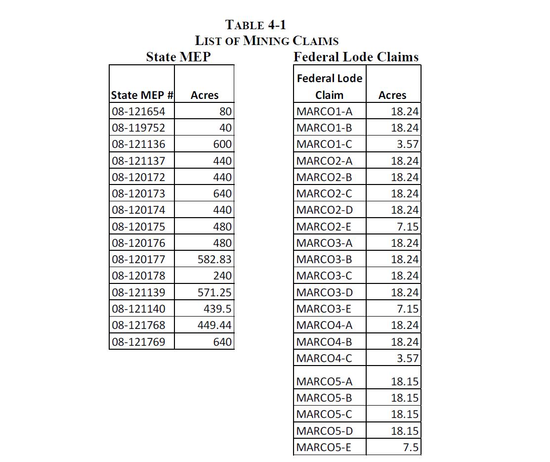
A list of the claims and their acreage is presented in Table 4-1 and is comprised of 6,563 acres of State of Arizona Mineral Exploration Permits and 320 acres of Federal Lode Claims. The author has been assured by LSM management that all MEPs and lode claims are currently valid.
| Liberty Star Minerals | 9 | Broadlands |
Technical Report – Red Rock Canyon Gold Property 1 July 2021 |
4.2 ENVIRONMENTAL ISSUES, PERMITS, AND LIABILITIES
LSM management has assured the author that no environmental liabilities are currently present on the RRC property. The author confirmed this on his site visits.
Prior to undertaking work on State Land, a Geologic Field Operation Plan (GFOP) must be filed and approved by the Arizona State Land Department. A prior archeological and plant survey is required prior to undertaking any activity that requires excavation or removal of vegetation or soil, including soil samples. When work involves drilling exploration holes, a permit must be obtained from the Arizona Department of Water Resources.
To LSM’s knowledge no Threatened or Endangered Species or significant archeological relics are present at the RRC property.
4.3 RISK FACTORS AFFECTING THE RED ROCK CANYON PROPERTY
The RRC property, at this stage, has no significant risks. As work continues, the possibility of intervention by antimining groups is possible, if not probable. Other than the aforementioned political risk, normal technical risks exist, e.g., equipment breakdowns and failures.
| Liberty Star Minerals | 10 | Broadlands |
Technical Report – Red Rock Canyon Gold Property 1 July 2021 |
5.0 ACCESSIBILITY, CLIMATE, LOCAL RESOURCES, INFRASTRUCTURE, AND PHYSIOGRAPHY
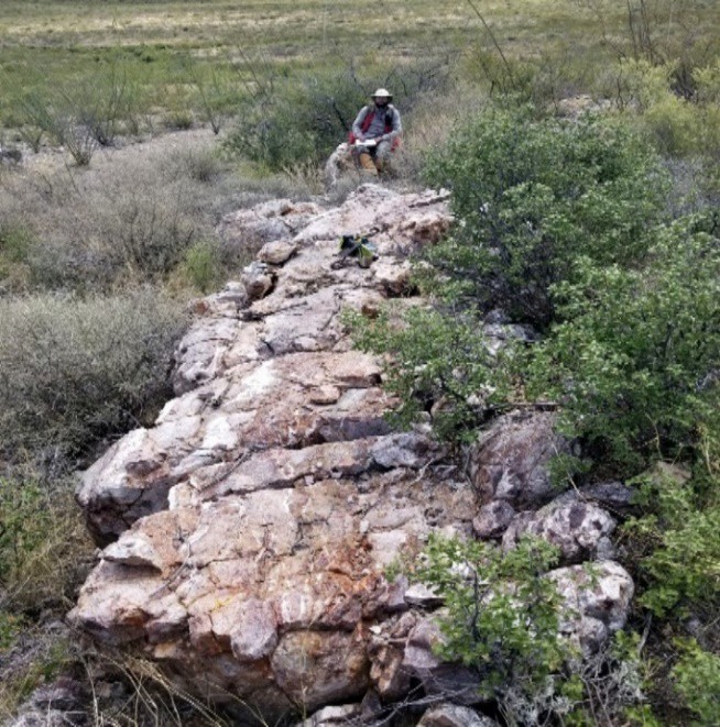
The project location in southern Arizona has good infrastructure and accessibility, with access to exploration and development service companies in the state that currently support active mining operations [SRK Report]. Photo 5-1 illustrates the nature of the terrain in the RRC area.

Photo 5-1. Red Rock Canyon terrain
The RRC property is readily accessible. The nearest major airport is in Tucson approximately 70 miles west-northwest of Tombstone via Interstate 10 and then U.S. 80. As noted, the RRC property almost abuts the Tombstone airport. Access is then by rutted roads with areas requiring four-wheel drive or all-terrain vehicles.
Elevations range between 4,500 and 5,400 feet above sea level. The area is typified by gentle hills above an alluvial plain, which is thought to cover the projected porphyry copper deposit. Outcrops of jasperoid and limestone are present within the alluvial area.
The climate is semi-arid and typical of the southwestern United States with annual temperatures ranging from 35°F to 95°F with precipitation averaging 13.8 inches per year [SRK Report, page 14]. At the RRC property, vegetation is largely creosote, white thorn acacia, ocotillo, mesquite, and other thorn-bearing bushes and trees.
Tombstone is now a tourist destination based upon the Wyatt Earp-O.K. Corral legacy. The towns of Sierra Vista, Benson, and Bisbee are within a 25-mile radius with access to all required facilities and utilities for professional, personal, educational, and medical needs. Sierra Vista has a population of over 40,000 people and is also a military base. The entire area has a long history of mining. Bisbee hosts a major copper mining operation and required supplies and services for exploration and mining are readily available locally or from Tucson.
| Liberty Star Minerals | 11 | Broadlands |
Technical Report – Red Rock Canyon Gold Property 1 July 2021 |
6.0 HISTORY
The Tombstone mining district has a long history (1877-present) of silver production, along with associated base metals. Exploration by major mining companies in the southern and eastern parts of the district has targeted gold mineralization, which is common in the outer zoning of porphyry copper deposits. The Tombstone mining district is one of 12 mining districts in Cochise County, Arizona. Copper, silver, zinc, lead, and gold were the principal metals produced from the different mines in Cochise county, most of which were from Bisbee and from polymetallic vein and replacement deposits [SRK Report, page 23].
The SRK Report details the history of mining in the Tombstone area from 1877 to 1985 and past production. Succinctly, although some prospecting has occurred through the 1980s and early 1990s, no production has been reported from the RRC lands or from the entire Hay Mountain claim area.
6.1 HISTORIC RRC PROPERTY OWNERSHIP AND PRIOR WORK PERFORMED ON THE HAY MOUNTAIN/RED ROCK CANYON CLAIMS
A review of documents in the files of the Arizona Geological Survey reveals that multiple programs have been conducted on the RRC property since the 1970s, which located what would now be considered economic grades of gold. These include drilling as well as geophysical surveys, geochemical surveys, and rock sampling programs. Companies that controlled the mineral rights and their programs are discussed below. For comparison purposes, the average price of gold in the relevant years, as stated by http://www:onlygold.com, is noted.
6.1.1 Phelps Dodge (PD)
In 1970, Phelps Dodge conducted a ground Induced Polarization (IP) survey and an airborne magnetic survey over most of the project area. The IP survey identified several IP and resistivity anomalies that PD correlated with possible gold mineralization. The airborne magnetic survey identified a magnetic high near the center of the project area that PD interpreted to represent an intrusive body at depth. The average price of an ounce of gold in 1970 was $38.90.
In 1989, PD was apparently contacted by an independent broker and returned to the area and conducted a reconnaissance rock chip sampling of jasperoid across the property, revealing several gold anomalies, with assays up to 50 ppm (50 gpt/1.6 opt). The majority of the gold anomalies were located around the Red Rock Canyon and Zebra Hills area. The Zebra Hills Area is incorporated in the RRC land position.
In an internal memorandum to his supervisor at PD, Mr. J. E. DuHamel wrote:
This is potentially a large gold system. Surficial rock-chip sampling shows gold occurring over an arcuate area of 5 square miles so far.
| Liberty Star Minerals | 12 | Broadlands |
Technical Report – Red Rock Canyon Gold Property 1 July 2021 |
The average price of an ounce of gold in 1989 was $401.
6.1.2 Energy Reserves Group
Energy Reserves Group work in 1982 and 1983 consisted of geological mapping and geochemical sampling, which delineated a number of targets, some of which were untested when they left the property. The average price of gold in 1982 was $447 per ounce and in 1983 it was $380 per ounce.
6.1.3 Consolidated Paymaster/Goldsil Resources
Consolidated Paymaster’s work during the 1983 to 1985 period consisted of a 10-drill hole program totaling 2,465 feet designed to test several of the surface anomalies located on what is the Zebra Zone of the RRC property. Seven of these holes were clustered in a 12-acre area in Section 34 of T20S-R23E and three were located in and near a rhyolite intrusive in Section 28. Overall, this program tested only a small percentage of the prospective area of the Zebra Zone. Most holes in the 1983 Paymaster program encountered minor mineralization with one drill hole, 28-3 in Section 28, encountering 20 feet of 0.045 ounces of gold per ton (opt) within 50 feet of the surface. Sample descriptions indicate this material to be oxidized and potentially heap leachable. The average price of an ounce of gold in 1983 was $380, in 1984 it was $308, and in 1985 it was
$327.
6.1.4 Wellington Financial
During 1985, Wellington Financial conducted a one-hole drilling program to test the continuity of the mineralization located by Paymaster/Goldsil hole 28-3. This offset drill hole, 28-4, intercepted mineralization at the surface grading 0.037 opt for 30 feet. The average price of an ounce of gold in 1985 was $327.
Wellington Financial apparently maintained their interest in the property beyond 1985 as Mr. Leroy Halterman prepared, in 1990, a report for the company titled Mineral Appraisal for the Zebra Property through his consulting firm MinSearch Inc. In that appraisal, he noted on page 31:
The recent drilling has tested only a small percentage of the prospect’s potential acreage in this area and then only that portion that lies within 200 feet of the surface. Detailed mapping and sampling from the 1990 program, combined with the theory that a large high grade manto deposit associated with the intrusive may occur at depth, have significantly increased the potential for an economic gold deposit in this area.
Mr. Halterman, as will be seen in the following work programs, maintained a long relationship with the RRC property and also issued reports on the mineral deposits for Tempo Resources and Primo Gold.
| Liberty Star Minerals | 13 | Broadlands |
Technical Report – Red Rock Canyon Gold Property 1 July 2021 |
6.1.5 Tempo Resources
In 1988, Tempo Resources Ltd. conducted magnetic and very low frequency (VLF) electromagnetic geophysical surveys and drilled an additional four shallow holes in a 12-acre area of Section 34, T20S-R23E. Three of the four holes intercepted significant amounts of alteration and two contain mineralization similar to the aforementioned earlier intercepts. During this program, Tempo also attempted to drill through unconsolidated sediments over a strong VLF anomaly in Section 34 but had to abandon the hole after several attempts. Tempo also drilled a 340-foot hole in the east central portion of Section 28 near some anomalous jasperoids. The hole intercepted thick zones of trace gold mineralization, which never exceeded 0.01 ounce per ton gold (Source – Halterman Report to Tempo Resources).
Mr. Leroy Halterman, in his 1988 report to Tempo Resources, noted that:
The mineralization in Section 28 apparently is associated with a feeder structure which strikes approximately north 40 degrees west and has a near vertical dip. Silicification associated with this structure has been sampled with two samples containing in excess of 2 ppm gold. The drill hole data indicates that the mineralization is not only continuous but also appears to dip, as a host bed would, in a direction and rate similar to those observed on the surface outcrop (page 8).
The magnetic survey indicated a magnetic high along the western part of Section 34. The magnetic high could, in this author’s opinion, be associated with a skarn deposit in the limestone potentially holding high-grade mineralization.
Mr. Halterman’s report is available on the LSM website. The average price of gold in 1988 was
$410.15 per ounce.
6.1.6 Primo Gold
In mid-1990, Primo Gold Ltd. conducted additional geological mapping and sampling to further define potential targets, which was followed by a 9-hole 1,235-foot drilling program. In late 1990 and January 1991, a combination of geophysical and geochemical soil sampling as well as a drill program was performed on the property. The geophysics consisted of IP, resistivity, Transient Electromagnetic (TEM), and Controlled Source Audio-frequency Magnetotellurics (CSAMT) and the soil geochemistry program totaled 323 samples, which were analyzed for gold, arsenic, and mercury.
The nine holes were drilled in Section 28 to test and extend the mineralization postulated by Mr. Halterman. Five of these holes intercepted significant mineralization, one hole, 90-02, reportedly grading 0.102 opt gold over a 45-foot interval starting at the surface. These results were combined with past drilling and delineated a small shallow mineral body. A mineral appraisal, prepared by MinSearch dated August 31, 1990, indicated that a total of 100,632 tons of gold mineralization has been delineated with an average grade of 0.091 opt gold and a stripping ratio (waste to mineral) of 1.4 to 1. This mineral body is still open in both directions on an apparent northeast-southwest trend.
| Liberty Star Minerals | 14 | Broadlands |
Technical Report – Red Rock Canyon Gold Property 1 July 2021 |
Cyanide leach re-assays of five drill intervals indicate that approximately 70 percent of the gold was recovered by this assay method indicating a heap-leachable, oxide ore was present. The average price of an ounce of gold was $386.20 and $353.15 in 1990 and 1991, respectively.
Other nearby mineralized areas, with lesser grade at the surface, have not been drill tested. Mr. Halterman’s report also provides recommendations to specific targets for further exploration.
6.1.7 JABA Inc.
JABA Inc. and Phelps Dodge Corporation formed a joint venture in December 1997 to explore and develop the Hay Mountain property. Drilling in the RRC area commenced in February 1998 (Source – JABA press release December 1, 1997). In a press release dated February 5, 1999, JABA stated:
1. There is a substantial aeromag high approximately 3.5 miles long, probably representing a porphyry copper-gold style intrusive at relatively shallow depth;
2. This hidden body is surrounded by a distal sub-micron gold halo symmetrically arranged around the magnetic high (values as high as 1.5 ounces have been obtained from silicified zones at the surface in the limestone host rock)…..
The average price for an ounce of gold in 1998 and 1999 was $288.70 and $290.25, respectively.
In 2004, JABA returned to the area and drilled several holes in Section 28 of Township 20 South – Range 23 East, Gila and Salt River Meridian. These drill holes showed several zones of gold mineralization in each hole drilled, confirming, in the author’s opinion, that the mineralizing fluids invaded fracture and shear zones and are probably outliers of a deeper-seated gold deposit.
Figure 6-1 from SRK’s report [SRK Report, Figure 10-13] presents a northeast-southwest cross section of the RRC property as well as projected geology and where geophysical anomalies are present. Note what are called the “very strong” IP anomalies on the southwest (left) side of the section could indicate the presence of mineral deposits in the receptive formations. SRK did not explain the notation, nor the source of the cross section, or of the 1.6 opt of gold citation, and the sketch of an open pit on the cross section.1 Succinctly, the cross section paints a highly positive picture of the potential for hosting a sizeable gold deposit. (The error in the spelling of the header on the cross section is not the authors.)
1The author believes the cross section and notations were prepared by JABA professionals.
| Liberty Star Minerals | 15 | Broadlands |
Technical Report – Red Rock Canyon Gold Property 1 July 2021 |
Figure 6-2 is a map demonstrating the strength of the gold anomalies in the rock and LAG (float) samples as well as targets for further development. The author would note the numerous samples exceeding 0.016 opt/0.50 gpt of gold. It is not known why JABA did not continue to explore and potentially develop the gold occurrences although the average gold price in 2004 was only $435.60 per ounce.
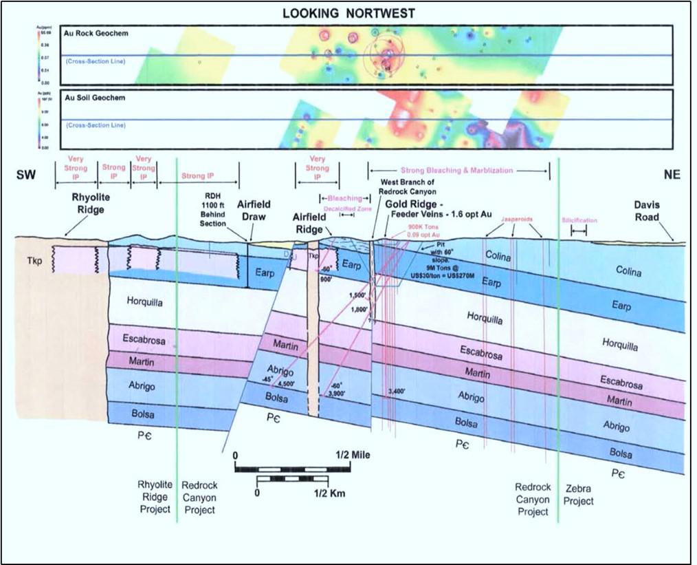
Figure 6-1. Cross section across Red Rock Canyon with geophysical anomalies and gold occurrences
| Liberty Star Minerals | 16 | Broadlands |
Technical Report – Red Rock Canyon Gold Property 1 July 2021 |
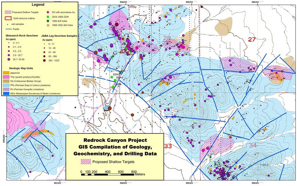
Figure 6-2. Map of sampling sites, drill holes, and potential targets at Red Rock Canyon
| Liberty Star Minerals | 17 | Broadlands |
Technical Report – Red Rock Canyon Gold Property 1 July 2021 |
7.0 GEOLOGICAL SETTING AND MINERALIZATION
SRK’s Technical Report presents a thorough and excellent review of the geologic maturation of the southern Arizona area starting at 1.8 billion years ago in the Proterozoic Epoch of the Precambrian. The reader is encouraged to review SRK’s Report for detailed information. The author summarizes below information deemed of import to LSM’s RRC property.
Succinctly, the geology and mineralization in the Tombstone area is the result of multiple orogenic (mountain building) episodes resulting from the subduction of the tectonic plates under what is now the North American plate. As the easterly moving tectonic plate subducted (sank) under what is now the westerly moving North American plate, pressure and temperatures rose and over the millions of years, due to folding and faulting, mountain ranges are formed. The pressure visibly releases in the form of earthquakes and the heat releases in the form of geysers and volcanoes, as is still occurring today at Yellowstone National Park and in the Cascade Mountains of California, Oregon, and Washington.
The heat and pressure also melt the subducting plate forming molten magmas that release hot hydrothermal solutions that, upon cooling, can deposit minerals in various forms in fractures or by dissolving and replacing reactive rocks. Relative to RRC are the mineralizing episodes occurring in the Laramide orogeny between 79 million and 43 million years ago. The Hay Mountain/RRC area was impacted primarily between 43 million and 55 million years ago.
7.1 RRC/HAY MOUNTAIN GEOLOGIC SETTING
The project is an area of low hills with mainly Late Paleozoic limestone bedrock outcrops of Permian Colina Limestone and the underlying Pennsylvanian-Permian Earp Formation. A few hills contain Permian Epitaph Dolomite overlying the Colina Limestone. The Colina Limestone is intruded by Tertiary rhyolitic sills or intrusions. A few outcrops of Cretaceous Bisbee Group sediments crop out on the east side of a north-striking fault. The valleys between the hills are composed of Quaternary-Tertiary gravels and weathered and altered limestone and clay. The depth to bedrock map of southeastern Arizona (Oppenheimer and Sumner, 1980) shows that the alluvium is relatively shallow under the valleys of the Hay Mountain project [SRK Report, page 56].
The Earp Formation is the oldest (Late Pennsylvanian age ±300 million years old) rock formation that outcrops in the RRC area. It is dominantly a limestone with some dolomite and shale and can be up to 1,000 feet in thickness.
Overlying the Earp Formation is the Colina Limestone of Permian age (±280 million years old) that is generally blackish in color and is widely present at the RRC property. The Colina Limestone and the Earp Formation are targets for hosting gold deposits. As noted above, in places, it is intruded by a younger igneous rock, rhyolite.
| Liberty Star Minerals | 18 | Broadlands |
Technical Report – Red Rock Canyon Gold Property 1 July 2021 |
In the author’s experience, the calcium carbonate composition of the Earp and Colina Formations make them especially susceptible to replacement or impregnation by mineral-bearing hot solutions. SRK Report [page 40] confirms this noting:
Limestone is generally reactive to hydrothermal solutions and, in the Tombstone Hills, was instrumental in trapping mineralized solutions.
7.2 THE LARAMIDE OROGENY
SRK, noted on page 43 of their report, that there were four phases of the Laramide orogeny:
| | ● | 85 to 80 million years ago in Arizona and New Mexico characterized by copper and gold mineralization; |
| | | |
| | ● | 79 to 67 million years ago in southern Arizona characterized by lead, zinc, and silver mineralization and formation of a caldera due to the volcanic activity; |
| | | |
| | ● | 66 to 55 million years ago in Arizona and New Mexico characterized by the porphyry copper deposits in the region; and |
| | | |
| | ● | 54 to 43 million years ago in southern Arizona characterized by tungsten mineralization. |
The projected porphyry copper deposit at Hay Mountain is associated with the middle Laramide period with rock dating of ±63 million years. The intersection of pyrite (FeS2), chalcopyrite (CuFeS2), and molybdenite (MoS2), minerals common in porphyry copper deposits in an old drill hole in the Robbers’ Roost area, several miles west of the RRC property, confirms that potential [SRK Report, page 49]. The author would note that gold is also associated with these minerals as part of the porphyry copper system.
7.3 STRUCTURES AT THE RRC PROPERTY
The multiple orogenic events in the entire Tombstone area will have created structures influencing any mineralization. SRK noted “The structure in the Tombstone mining district is complex” [page 52]. SRK further notes on the same page that:
regional structures that were emplaced during the Precambrian have a continuing influence on the loci of structures and the emplacement of ore deposits.
During his site visits, the author examined multiple areas of the Colina Limestone that displayed multiple fractures filled by calcite and jasperoid, as illustrated in Photo 7-1. There appears to be a general northwest-southeast orientation for the fractures. Importantly, the fracture fillings demonstrate the presence of hydrothermal solutions at depth.
| Liberty Star Minerals | 19 | Broadlands |
Technical Report – Red Rock Canyon Gold Property 1 July 2021 |
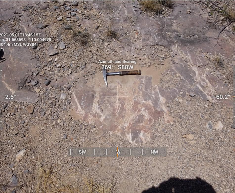
Photo 7-1. Calcite and jasperoid in colina limestone
7.4 MINERALIZATION
The RRC property is situated within an area of intense hydrothermal alteration produced by multiple episodes of volcanic and magmatic activity. Evidence from geophysical and geochemical samples supports the presence of a deeper porphyry copper deposit. Along with copper, such deposits yield associated deposits of lead and zinc, rare earth minerals, and gold.
The association of gold values in the Colina Limestone has led some to compare the RRC gold occurrences with those of the Carlin Trend in Nevada where the surface showings are heap- leachable oxide yielding at depth to high-grade sulfide hosted deposits. Energy Reserves Group and Cambior were two companies that pursued this concept, which this author believes is realistic. The gold at the Carlin deposits is sub-micron-size. This would account for the lack of visible gold in high gold content (+1 opt) samples found at RRC.
The nature of the deposit(s) will be resolved by future work. The actuality is that epithermal veins that host gold are present at the RRC property.
| Liberty Star Minerals | 20 | Broadlands |
Technical Report – Red Rock Canyon Gold Property 1 July 2021 |
8.0 DEPOSIT TYPES
Geochemical and geological analyses of the Tombstone district indicate that there are two deposit types and ages of mineralization. The early Laramide (74 million years ago) magmatism and mineralization is responsible for the past production of major amounts of silver in the polymetallic replacement deposits. The late Laramide (62-65 million years ago) magmatism and mineralization is responsible for the porphyry copper mineralization. Manganese occurrences and production are common in the outer zone of both the silver deposits and the porphyry copper mineralization. Other indications of porphyry copper mineralization are the typical porphyry copper geochemical and geophysical signatures in the southern and eastern parts of the Tombstone Hills. In addition, a granodiorite porphyry and alteration that is common to porphyry copper deposits was intersected in ASARCO drill holes in the Robbers’ Roost area in the southwestern Tombstone Hills [SRK Report, page 77].
In reference to the above, SRK focused on the porphyry copper potential on the property for which there is much evidence of such at depth in the Hay Mountain holdings. Generally ignored was the potential for intrusive-related epithermal gold deposits. As discussed in Section 6.0 of this document, Mr. Halterman, in 1988 and 1991, recognized the potential for epithermal gold deposits at the Zebra Zone of the RRC property.
Epithermal deposits are formed by hot solutions from the underlying intrusive flowing upward through a fracture or fault entering other fractures/joints, etc. as the solutions migrate toward the surface depositing precious metals as they cool. Typically, the deposition of the metals occurs when the intense pressure is released allowing the boiling point to be reached. Figure 8-1 from Halterman 1991 portrays the epithermal process he believes is present at the RRC property. Mr. Halterman’s 1988 and 1991 reports can be accessed at the LSM website.
During his site visits, the author noted multiple evidence of hydrothermal alteration. Calcite and jasperoid veining filling fractures in the Colina Limestone was seen in many places that is recognized to be a sign of hydrothermal alteration at depth. An example was previously shown in Photo 7-1.
| Liberty Star Minerals | 21 | Broadlands |
Technical Report – Red Rock Canyon Gold Property 1 July 2021 |
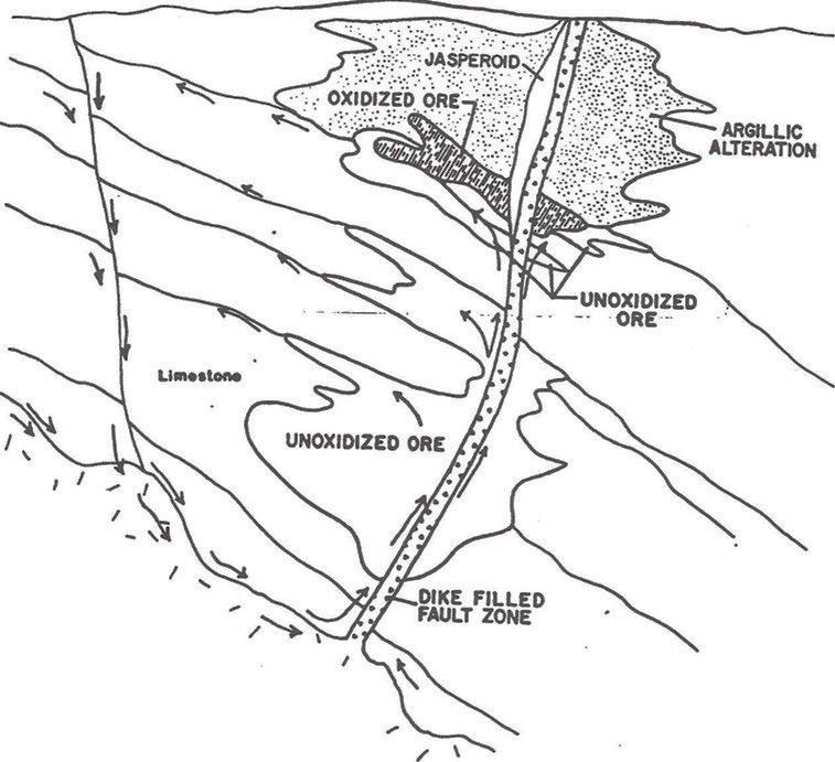
Figure 8-1. Epithermal Model for Red Rock Canyon gold deposits (Halterman, 1991)
| Liberty Star Minerals | 22 | Broadlands |
Technical Report – Red Rock Canyon Gold Property 1 July 2021 |
9.0 EXPLORATION UNDERTAKEN BY LIBERTY STAR MINERALS
Exploration work in Red Rock Canyon is in its early stages; therefore, these results are preliminary and subject to further investigation. Continuing exploration activities in this area will include further biogeochemical, XRF, and surface rock-chip sampling, assaying, mapping, geophysical surveys, and drilling. In addition, first and second derivative enhancement of existing ZTEM data and evaluation of alternative geophysical, magnetic, and gravity techniques to elucidate sub- surface extents and geometries of these outcrop features will be undertaken.
Mr. Daniel Koning, a consulting geologist, was commissioned in July 2020 by LSM to undertake a field mapping exercise to “identify alteration and veining associated with an inferred porphyry copper system at depth, determine the extent of hydrothermal alteration, and comment on the possible timing of mineralization.” Mr. Koning conducted the mapping from July 14th to August 5th, accompanied by LSM Field Operations Manager, Mr. Jay Crawford and for 3 days, CEO/President, Mr. Brett Gross. The 50-page report contains over 50 new maps and sample images. In his Hay Mountain Project July 2020 Field Mapping Report, Mr. Koning concludes:
Type 1 and type 2 veins are…interpreted as fluid escape structures representing the distal and possibly upper expression of a porphyry system at depth. The overall extent of type 1 and type 2 veining across the property could indicate significant skarn and CRD (carbonate replacement deposit) development at depth [SRK Report, page 48].
He further finds that his work
Correlates with the Cu, Mo, and Au biogeochemical anomalies identified by Dr. Pim van Geffen, and the magnetic and ZTEM anomalies identified by Alan King’s 3D model. Because of this, the center of the inferred porphyry system at Hay Mountain is interpreted to be southwest of the Zebra Hills under post-mineral cover [SRK Report, page 48].
It is important to note that Mr. Koning’s report focused on the porphyry copper potential of the Hay Mountain property, as a whole. Relevant to the RRC property, however, is the confirmation by Mr. Koning of the gold anomalies and the skarn potential that is present.
From September 14, 2020 through September 21, 2020, LSM collected 23 rock chip samples of jasperoid with the use of a Niton XL5 XRF analyzer from the RRC area. The samples collected were approximately 2 kg each and were submitted to ALS USA Inc. in Tucson, Arizona on September 22, 2020. The analytical procedures requested were Au-Gra21 fire assay for gold and ME-MS41 Aqua Regia for multi-element analysis. The assays were received on October 26, 2020 and are available as Appendix 2.0, notably 8 of the 23 samples assayed greater than 1 gram per tonne (0.03 ounces per ton), and 4 had negligible amounts of gold (<0.05 grams per tonne). The remaining 11 samples ranged from 0.07 gpt to 0.97 gpt. The samples were taken and followed a chain of custody that conformed to best industry practices.
From January 2, 2021 through January 9, 2021, and again from April 29 through May 2, 2021, LSM personnel, including Mr. Guarnera, returned to Red Rock Canyon to further evaluate and collect additional samples of the jasperoid and the outcrops.
A total of 28 samples, weighing approximately 2 kg, were collected during the January 2021 visit and a Niton XL5 XRF analyzer was used to identify critical elements; i.e., gold, barium, arsenic, antimony, molybdenum, etc. The samples were submitted to ALS USA Inc. in Tucson, Arizona on January 11, 2021 with the same analytical procedures requested previously in September 2020, Au-Gra21 fire assay for gold and ME-MS41 Aqua Regia for multi-element analysis. The assays were received on February 6, 2021 and are available as Appendix 3.0. The range of values had 6 samples above 1 gram per tonne (0.03 ounces per ton) and 10 samples had negligible amounts of gold (<0.05 grams per tonne). The remaining 12 assay values range from 0.05 gpt to 0.82 gpt. Copies of the actual assay results are presented as Appendix 3.0.
During the April-May 2021 site visit, previously drilled exploration holes were located, outcrops of jasperoid and silica-soaked rocks (silicification) examined, and 15 samples were collected for assay. The author would note that all samples were collected in accordance with standards of CIMM Best Practices. The assay results are attached as Appendix 4.0.
| Liberty Star Minerals | 23 | Broadlands |
Technical Report – Red Rock Canyon Gold Property 1 July 2021 |
10.0 DRILLING
The Hay Mountain project is an Early-Stage Exploration Property and no exploration drilling has been done by LSM. The following is derived from SRK’s Technical Report [page 118]. To the author’s knowledge, no drilling has occurred on the RRC property after 1999.
As was discussed in Section 6.0, a limited number of efforts to find a gold deposit occurred in the Zebra and Red Rock Canyon project areas. Reverse circulation drill holes were drilled in the Zebra project in 1989 in Sections 28 and 34, which intersected anomalous gold mineralization with a maximum value of 0.045 opt gold over a 20-foot interval (Halterman, 1989 and 1990). The drill program by Consolidated Paymaster consisted of 10 reverse circulation drill holes totaling 2,465 feet in Sections 34 and 28. These holes intersected minor gold mineralization near the surface. The Wellington Financial drill program in 1985 consisted of one drill hole, 28-4, and intersected argillically altered, hematite-stained limestone with a gold grade of 0.037 opt near the surface. The 1989 drill program by Tempo Resources on the Zebra property consisted of 7 drill holes (28-3, 28-4, 89-1, 89-2, 89-3, 89-4, 89-5, and 89-6) totaling 1,311 feet. These drill holes intersected gold mineralization, iron oxide alteration, or jasperoids (Halterman, 1990).
The 1983, 1985, and 1989 drill programs located an area of shallow gold mineralization in Section 28. The mineralization is disseminated through several receptive limestone intervals. In 1990, 9 reverse circulation angle holes (90-1, 90-2, 90-3, 90-4, 90-5, 90-6, 90-7, 90-8, and 90-9) were drilled in Section 28 on the Zebra project, with an average depth of 140 feet (Halterman, 1990). All but one drill hole contained anomalous gold (Halterman, 1990).
Figure 10-1 shows the location of drill holes drilled in 1989 and 1990. Below the circle indicating the drill hole are three numbers: the depth mineralization was encountered on the left, the thickness of the mineralization in the middle, and the grade over the interval in ounces of gold per ton on the right. Table 10-1 presents for clarification information for each drill hole.
Core drilling of 4 holes was undertaken by JABA in 2004. The results showed multiple intersections that had anomalous amounts of gold, some which would be considered ore grade at 2021 gold prices. These holes are shown in Figure 6-2 in Section 6.0 of this report.
| Liberty Star Minerals | 24 | Broadlands |
Technical Report – Red Rock Canyon Gold Property 1 July 2021 |
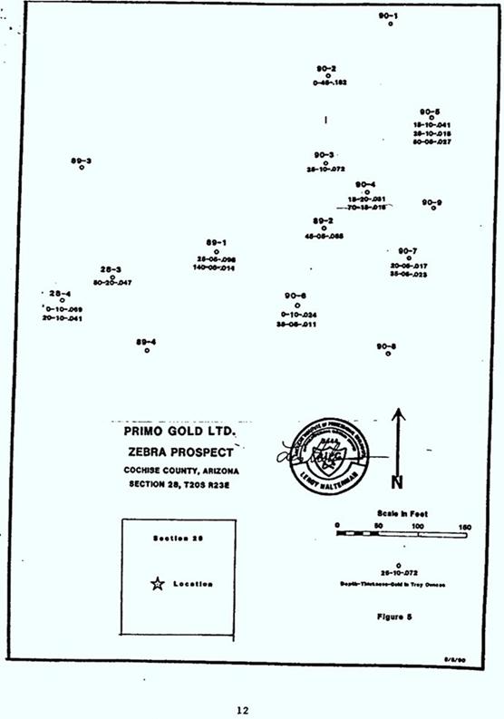
Figure 10-1. Drill holes in Section 28, T20S-R23E
| Liberty Star Minerals | 25 | Broadlands |
Technical Report – Red Rock Canyon Gold Property 1 July 2021 |
TABLE 10-1 clarification information for each drill hole |
| Drill Hole Number | | Depth of Mineralization (feet) | | Thickness (feet) | | Grade (Au-opt) |
| 89-1 | | 25 | | 5 | | 0.098 |
| | 140 | | 5 | | 0.011 |
| 89-2 | | 45 | | 5 | | 0.085 |
| 89-3 | | Barren | | | | |
| 89-4 | | Barren | | | | |
| 90-1 | | 0 | | 10 | | 0.008 |
| 90-2 | | Surface | | 45 | | 0.182 |
| 90-3 | | 25 | | 10 | | 0.077 |
| 90-4 | | 15 | | 20 | | 0.031 |
| | 70 | | 18 | | 0.016 |
| 90-5 | | 15 | | 10 | | 0.041 |
| | 25 | | 10 | | 0.015 |
| | 50 | | 5 | | 0.027 |
| 90-6 | | Surface | | 10 | | 0.024 |
| | 35 | | 5 | | 0.011 |
| 90-7 | | 20 | | 5 | | 0.017 |
| | 35 | | 5 | | 0.024 |
| 90-8 | | Barren | | | | |
| 90-9 | | 90 | | 5 | | 0.006 |
| 28-3 | | 50 | | 20 | | 0.047 |
| 28-4 | | Surface | | 10 | | 0.069 |
| | 20 | | 10 | | 0.041 |
To provide some context, at the date of this writing, many, if not most, operating heap leach surface operations consider 0.022 ounces of gold per ton (0.6 gpt) to be the break-even cost for operating. Twelve (12) of the 17 intercepts reported gold grades above that grade.
| Liberty Star Minerals | 26 | Broadlands |
Technical Report – Red Rock Canyon Gold Property 1 July 2021 |
11.0 SAMPLE PREPARATION, ANALYSES, AND SECURITY
Limited work has been performed related to gold on the RRC property since the 2011 SRK Technical Report was completed. A brief discussion follows below.
11.1 METHODOLOGY
The principal method used for sample collection was walking the project and taking rock and vegetation samples for analysis. More recently, a Niton XL5 XRF analyzer instrument has been used. The instrument focuses on a small area of rock outcrop and provides an almost instantaneous reading of the elements present and the amount of each in the area focused on. If anomalous, a 5-pound sample was taken, bagged in a secure manner, numbered, and catalogued.
The sample(s) were kept in a secure area and then delivered to ALS USA Inc. in Tucson, Arizona for analysis/assaying.
11.2 ANALYTICAL METHODS
Rock samples were initially fire assayed, which is considered to be the most accurate measurement of gold and other precious metals. Essentially, the process involves melting the rock sample in a crucible with a mixture of fluxes, e.g., silica and borax and lead along with a reducing agent. The rock was also analyzed by multi-spectrum inductively coupled plasma (ICP) with an acid finish. The ICP atomizes the sample, and the resulting ions of different elements are detected which can be measured. Experience has shown that fire assays will generally yield a more reliable result than ICP.
11.3 DUPLICATES AND QUALITY CONTROL
Duplicate sample assays have not been performed as some sample pulps are still at the laboratory. Quality Control procedures followed CIMM best practice guidelines.
| Liberty Star Minerals | 27 | Broadlands |
Technical Report – Red Rock Canyon Gold Property 1 July 2021 |
12.0 DATA VERIFICATION
The author has reviewed with LSM’s Field Operations Manager the steps taken to assure the integrity of the samples taken and sent for analysis. The author also witnessed the sampling process during his site visits and found them to be appropriate.
Since the property is at an early stage, no duplicate sample were taken or assayed to the author’s knowledge.
| Liberty Star Minerals | 28 | Broadlands |
Technical Report – Red Rock Canyon Gold Property 1 July 2021 |
18.0 PROJECT INFRASTRUCTURE
The RRC property has access to roads, power, water, and other major factors affecting infrastructure. Until a Mineral Resource is declared, project specific infrastructure cannot be considered.
| Liberty Star Minerals | 29 | Broadlands |
Technical Report – Red Rock Canyon Gold Property 1 July 2021 |
20.0 ENVIRONMENTAL, PERMITTING, SOCIAL, AND COMMUNITY IMPACT
There are no significant environmental permits required at this time. Prior to undertaking geophysical studies, such as IP, an archeological study and a botanical study is made along the proposed traverse to assure no relics or threatened flora are present. Drilling on the property will require a special permit including one for water use. As the project progresses, additional permits will be required.
Cochise County is the home of numerous open pit mines and the industry is a major factor in the area and a significant employer and contributor to the local economies. Development of a mine on the RRC property would result in a significant number of new jobs in the area.
Assuming the project progresses, it is likely that entities opposed to mining will try to delay the project. This can be alleviated by maintaining a continual dialog with local, county, and state officials.
| Liberty Star Minerals | 30 | Broadlands |
Technical Report – Red Rock Canyon Gold Property 1 July 2021 |
23.0 ADJACENT PROPERTIES
The Tombstone area has a history of silver mining of replacement-type silver properties. Additionally, the southern Arizona area is host to several porphyry copper operations, the closest being the Bisbee mine, which is approximately 20 miles to the south of Tombstone.
| Liberty Star Minerals | 31 | Broadlands |
Technical Report – Red Rock Canyon Gold Property 1 July 2021 |
24.0 OTHER RELEVANT DATA AND INFORMATION
All relevant information has been incorporated into this Technical Report and is available on LSM’s website. A more thorough information about the Hay Mountain area, of which RRC is a part, can be found in SRK’s 2011 report, which can be found on LSM’s website.
| Liberty Star Minerals | 32 | Broadlands |
Technical Report – Red Rock Canyon Gold Property 1 July 2021 |
25.0 INTERPRETATION AND CONCLUSIONS
The RRC property is situated within a large area of hydrothermal alteration, which was likely produced by a projected deep porphyry copper deposit. The hydrothermal solutions invaded the Colina Limestone and Earp Formation, which, because of their chemical composition, were subject to deposition of, or replacement by, mineral deposits including silver and gold within fractures and faults. At the RRC property, the intense hydrothermal activity is evidenced at the surface by jasperoid and calcite or silicates filling fractures in the Colina Limestone.
Prior exploration work for gold has demonstrated that gold of a grade that would currently be considered economic exists in several areas as has been noted in prior sections of this document. Similar grades of gold have been detected by LSM in samples of the jasperoid and limestone collected in various areas of the RRC property. Past drilling and other exploratory work have identified areas of gold occurrences for future evaluation.
At this time, the RRC property is an Early-Stage Exploration Property. There is no doubt that gold of potentially economic grade exists at the RRC property. It is not known at this time, however, if gold is present on the RRC property in a deposit of a size and grade to be economically recovered. Thus, there is no certainty that a Mineral Resource will be defined, let alone developed at the RRC property. Given the known presence of gold at potentially economic grades in several areas on the RRC property, the author believes that the RRC property is a “property of merit” that warrants further evaluation.
| Liberty Star Minerals | 33 | Broadlands |
Technical Report – Red Rock Canyon Gold Property 1 July 2021 |
26.0 RECOMMENDATIONS
An exploration program to determine the presence of an economic gold deposit is proposed with gradual phases. The first phase would be a combination of geophysical work, geochemical sampling, and limited drilling. The drilling would be conducted to confirm the drilling results previously reported by Tempo Resources and Primo Gold. The estimated cost of this effort is approximately $2.0 million. Assuming success in Phase 1, follow up work would primarily consist of further drilling with the intent to develop a Mineral Resource.
Costs of the Phase 1 program are estimated at $2.0 million, as presented below:
| 1. | | Claim maintenance and permits | | $ | 18,500 | |
| 2. | | Archeological and vegetation surveys | | $ | 10,000 | |
| 3. | | Brush cutting – 4 miles at $2,500 per mile | | $ | 10,000 | |
| 4. | | Geochemical rock and soil sampling on 200-foot intervals –labor and assays at $100 per sample | | $ | 20,000 | |
| 5. | | Induced Polarization (CSMAT) | | $ | 250,000 | |
| 6. | | Drill site preparation – 10 sites at $10,000 per site | | $ | 100,000 | |
| 7. | | Drilling – HQ diamond core | | $ | 1,250,000 | |
| 8. | | Assaying of core samples | | $ | 45,000 | |
| 9. | | Professional and technical personnel costs | | $ | 150,000 | |
| | | | | | | |
| 10. | | Core storage facility | | $ | 50,000 | |
| 11. | | Diamond saw for core cutting | | $ | 5,000 | |
| 12. | | Supplies and miscellaneous | | $ | 100,000 | |
| | | | | | | |
| Total Estimated Costs | | $ | 2,008,500 | |
| Liberty Star Minerals | 34 | Broadlands |
Technical Report – Red Rock Canyon Gold Property 1 July 2021 |
27.0 REFERENCES
All are available on the Liberty Star Minerals website.
| 1. | Halterman, MinSearch, 1988, The Zebra Property – A Gold Prospect, Cochise County, Arizona |
| 2. | Halterman, MinSearch, 1990, Mineral Appraisal for the Zebra Property, Cochise County, Arizona |
| 3. | Halterman, MinSearch, 1991, The Zebra Property – A Gold Prospect, Cochise County, Arizona |
| 4. | J.E. Duhamel, Phelps Dodge, 1989, Memo |
| 5. | Koning, 2020, Field Mapping Report, Hay Mountain |
| 6. | Rasmussen and Hoag, SRK, 2011, Hay Mountain Exploration Report, Tombstone District, Arizona |
| Liberty Star Minerals | 35 | Broadlands |
Technical Report – Red Rock Canyon Gold Property 1 July 2021 |
APPENDIX 1.0
RESUME FOR MR. BERNARD J. GUARNERA
| Liberty Star Minerals | 36 | Broadlands |
Technical Report – Red Rock Canyon Gold Property 1 July 2021 |
Broadlands Mineral Advisory Services Ltd.
EIN: 27-0182628
RESUME OF BERNARD J. (BARNEY) GUARNERA
Mr. Bernard John (Barney) Guarnera has more than 50 years of experience in the global mining industry. He is recognized for his expertise in the economic fundamentals of the industry, determining the feasibility of mineral property development, for his skills in the valuation of mineral deposits and mining companies, and the estimation of damage quantums. He has worked on every continent where mining occurs, and his experience spans most commodities, including ferrous and non-ferrous minerals, base and precious metals, coal and uranium, and industrial minerals.
Because of his knowledge of the global mining industry, Mr. Guarnera frequently lectures on and is interviewed about the global mineral economy, mineral resource/reserve reporting codes, valuation methodologies, and feasibility study issues. During his career, he has often acted as an advisor for mergers and acquisitions totaling multiple billions in value. Mr. Guarnera has also negotiated dozens of mineral leases, both as lessor and lessee, and joint venture agreements for mining and oil and gas development.
Mr. Guarnera’s valuation expertise includes the valuation of entire corporations for acquisitions and divestitures, the assessment of impairments or tax basis, and the valuation of individual mineral properties or mining companies. He frequently acts as an expert witness in disputes concerning valuations of and the feasibility of mining projects. He has testified multiple times at international arbitrations concerning such matters, including arbitrations before the International Centre for the Settlement of Investment Disputes. He also has lectured the Mining Engineering Group of the U.S. Internal Revenue Service on how to correctly value mineral properties.
Mr. Guarnera has also served on the boards of various mining associations and held the positions of chairman for the Colorado Mining Association, president of the Northwest Mining Association, president of the International Mining Professionals Society, and president of the Mining and Metallurgical Society of America. He has experience on public company boards and previously served on the boards of Canadian Royalties Inc., Golden Queen Mining Company, and United States Antimony Corporation. He currently serves on the boards of Great American Minerals Exploration, Ord Mountain Mining Company, and Behre Dolbear Group Inc., an internationally recognized mineral industry advisory. He also serves on the board of Liberty Star Minerals, a company listed on the OTC Markets, as well as the Colorado Mining Association.
Mr. Guarnera is recognized as a Qualified Professional/Competent Person in all international reporting jurisdictions.
9213 Las Manaitas Avenue, #401, Las Vegas, NV 89144 +1.303.809.4265
guarnera@broadlandsadvisoryltd.com
| Liberty Star Minerals | 37 | Broadlands |
Technical Report – Red Rock Canyon Gold Property 1 July 2021 |
CORPORATE EXPERIENCE
| 2013 – Present | | Broadlands Mineral Advisory Services Ltd., President Provision of technical and valuation advice to developers and operators of mineral projects, assisting and participating in fund raising, and evaluation of mineral development agreements. |
| | | |
| 2013 – Present | | Behre Dolbear Group Inc., Director, Senior Associate, Principal Valuator Work on selected assignments related to valuations, technical and economic feasibility, and litigation assignments. |
| | | |
| 1991 – 2013 | | Behre Dolbear Group Inc., Chairman and Chief Executive Officer Acquired and developed a renowned mineral industry advisory firm from a single office in New York City to a firm with multiple international offices and international acclaim. Services focused on valuations, advice on mineral development agreements, technical studies, optimization studies, abatement of environmental and social issues, mergers and acquisitions, and financing of projects. Revenues increased from $750,000 to $30,000,000 during the period he managed the company. When he left Behre Dolbear, work typically involved more than 200 projects a year in more than 60 countries a year. |
| | | |
| | | While at Behre Dolbear, Mr. Guarnera focused on valuation and technical feasibility of mineral projects and Mineral Resource and Mineral Reserve definition. He was heavily involved in working with both mining companies and sovereign governments in the negotiation of mineral development agreements, and securities agencies developing listing rules, including the Hong Kong and Singapore stock exchanges. He also actively participated in merger and acquisition transactions, most recently the acquisition of the London Metal Exchange by the Stock Exchange of Hong Kong. |
| | | |
| 1981 – 1990 | | Boise Cascade Corporation, Executive Manager of Mineral Resources Responsible for the development of mineral and oil and gas projects on the company’s +7.5 million acres of land, including mineral rights. Conducted exploration for various commodities on the company’s land base including acting as lessor and lessee to assure an appropriate land position. Managed dozens of leases to outside parties and obtained leases from more than 50 parties. Participated in and managed more than 30 joint ventures with mining and oil and gas companies. Ultimately, sold assets when the company decided to exit mineral commodities. Left the company with over 1 million acres of additional mineral rights than when he joined the firm. |
| | | |
| 1976 – 1980 | | Dames & Moore, Principal in Charge of Mining Group Responsible for undertaking technical and economic studies of mineral projects. Provided technical advice on acquisitions and mergers, and business development. Experience included iron ore, coal, uranium, base metals, and industrial minerals. |
| Liberty Star Minerals | 38 | Broadlands |
Technical Report – Red Rock Canyon Gold Property 1 July 2021 |
| 1968 – 1976 | | Texaco Inc., Regional Exploration Manager – Group Manager Initially in charge of mineral exploration for all eastern U.S. Exploration efforts focused on base metals, but as the energy crisis developed, the focus changed to energy minerals. Emphasis changed from domestic exploration to acquisitions and expanded to foreign countries. |
| | | |
| 1967 – 1968 | | AMAX Exploration, Project Leader Exploration for copper and nickel in Minnesota on the Duluth Gabbro. |
| | | |
| 1965 – 1967 | | Anaconda American Brass Ltd., Exploration Geologist and Party Chief Exploration for copper and nickel in Northern Ontario at the Lac des Iles project. |
| | | |
| 1964 – 1965 | | Quebec Cartier Mining Company Inc., Assistant Geologist and Mining Engineer |
| | | Work started in the Lac Jeanine open pit iron mine then shifted to exploration at the future Mt. Wright mine. |
PROFESSIONAL AFFILIATIONS
| | ● | Australasian Institute of Mining and Metallurgy – Fellow |
| | ● | Canadian Institute of Mining and Metallurgy – Fellow |
| | ● | Colorado Mining Association – Board Member and past Chairman |
| | ● | International Institute of Mineral Appraisers – Member |
| | ● | International Mining Professionals Society – Past President |
| | ● | Mining and Metallurgical Society of America – Past President |
| | ● | Society of Economic Geologists – Fellow |
| | ● | Society of Mining Engineers – Legion of Honor |
REGISTRATIONS/CERTIFICATIONS
| | ● | Australasian Institute of Mining and Metallurgy – Chartered Professional |
| | ● | International Institute of Mineral Appraisers – Certified Mineral Appraiser |
| | ● | Mining and Metallurgical Society of America – Qualified Professional |
| | ● | Registered Professional Geologist – Oregon |
| | ● | Registered Professional Engineer – Texas |
| Liberty Star Minerals | 39 | Broadlands |
Technical Report – Red Rock Canyon Gold Property 1 July 2021 |
EDUCATION
| | ● | Michigan Technological University, MSc Economic Geology – 1967 |
| | ● | Michigan College of Mining and Technology, BSc Geological Engineering (Mining Emphasis) – 1964 |
RECENT PUBLICATIONS
| | ● | 2012 and 2013 – Where Not to Invest – Ranking Countries for Mining Investments, an annual publication of the Behre Dolbear Group Inc. |
| | | |
| | ● | 2012 – Valuation of Mineral Properties – Mining Engineering Handbook, Society of Mining Engineers, Chapter 4.6. |
RECENT TESTIMONY
| ● | June 2009 – Ungava Mines vs Canadian Royalties Inc., arbitration as to the validity of a feasibility study for a lead-zinc deposit held in Montreal, Quebec, Canada. |
| | | |
| ● | October 28-29, 2013 – Quiborax vs Government of Bolivia – trial testimony at the International Centre for the Settlement of Investment Disputes, Paris, France regarding the value and technical aspects of a borate deposit. |
| | | |
| ● | November 5, 2013 – Mosaic vs Devon Energy – deposition in El Paso, Texas regarding damages incurred at a potash mine in New Mexico. |
| | | |
| ● | November 12-15, 2013 – Khan Resources vs Government of Mongolia – trial testimony at International Centre for the Settlement of Investment Disputes, Paris, France regarding technical and economic viability and value of a uranium deposit. |
| | | |
| ● | March 27-28, 2014 – Mosaic vs. Devon Energy – trial testimony in Carlsbad, New Mexico relating to damages incurred when Devon Energy drilled a gas well into Mosaic’s potash deposit note. |
| | | |
| ● | September 15-20, 2014 – Pacific Rim Resources vs Government of El Salvador – trial testimony at the International Centre for the Settlement of Investment Disputes, Washington, D.C. regarding the reliability of a technical study for a gold project. |
| | | |
| ● | May 22, 2016 – Lone Mountain Ranch vs Ortiz Mining – deposition in Albuquerque, New Mexico relating to social and environmental issues at a proposed open pit gold property and the responsibility of the surface rights owner vs the mineral rights owner. |
| | | |
| ● | June 10 – 14, 2019 – Dominion Minerals vs Government of Panama – trial testimony at the International Centre for the Settlement of Investment Disputes, Washington, D.C. regarding the technical viability and value of a copper deposit. |
| | | |
| ● | January 20 – 25, 2020 – Eco Oro Minerals Corporation vs Government of Colombia – trial testimony at the International Centre for the Settlement of Investment Disputes, Washington, D.C. regarding the technical aspects and value of a gold deposit. |
| | | |
| ● | September 26 – October 2, 2020 – Gabriel Mining vs Government of Romania – trial testimony before the International Centre for the Settlement of Investment Disputes, Paris, France regarding the technical and economic viability of a gold deposit. |
| | | |
| ● | Who’s Who Legal – Mining-2021 noted in the Expert section (page 24) “Barney Guarnera is a well-established player in the international consulting space, highlighted for his extensive expertise in the valuation of mineral properties and mining companies.” |
| Liberty Star Minerals | 40 | Broadlands |
Technical Report – Red Rock Canyon Gold Property 1 July 2021 |
APPENDIX 2.0
OCTOBER 26, 2020 ASSAY RESULTS
| Liberty Star Minerals | 41 | Broadlands |
Technical Report – Red Rock Canyon Gold Property 1 July 2021 |
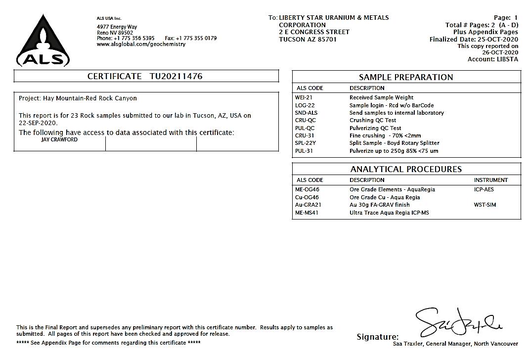
| Liberty Star Minerals | 42 | Broadlands |
Technical Report – Red Rock Canyon Gold Property 1 July 2021 |
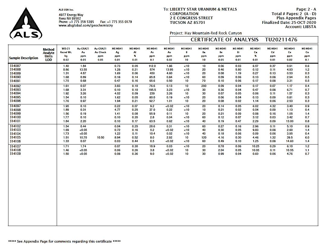
| Liberty Star Minerals | 43 | Broadlands |
Technical Report – Red Rock Canyon Gold Property 1 July 2021 |
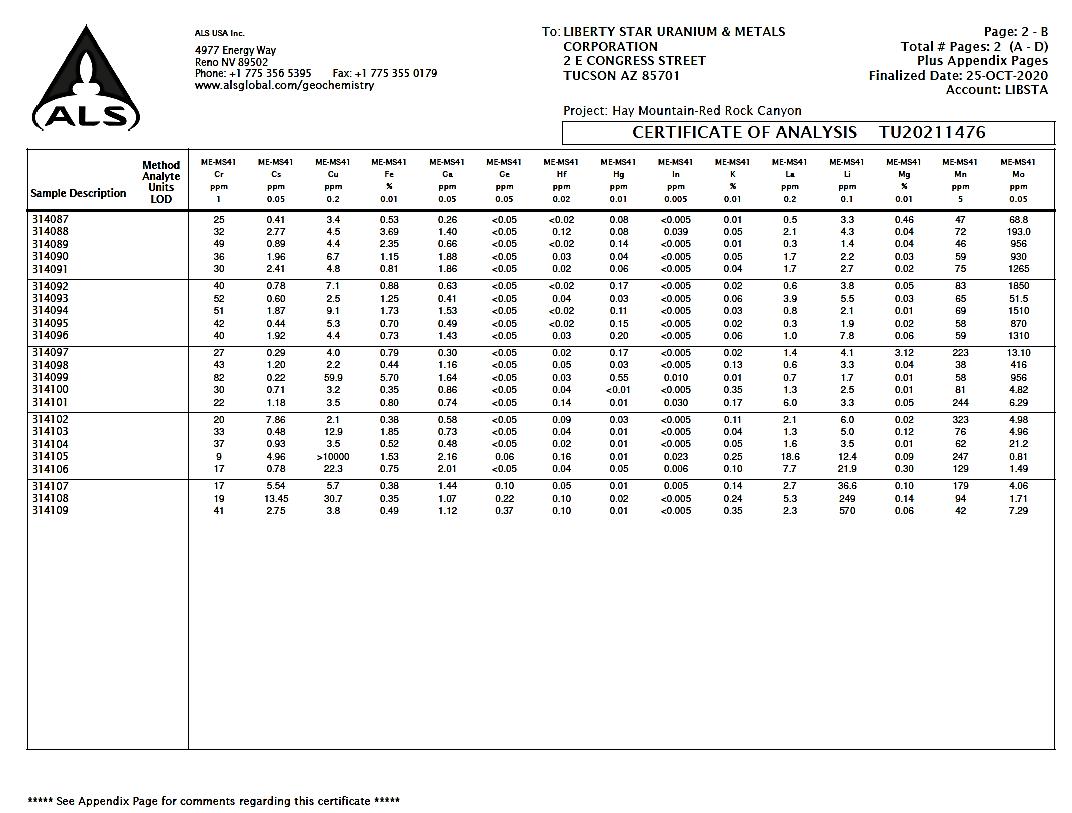
| Liberty Star Minerals | 44 | Broadlands |
Technical Report – Red Rock Canyon Gold Property 1 July 2021 |
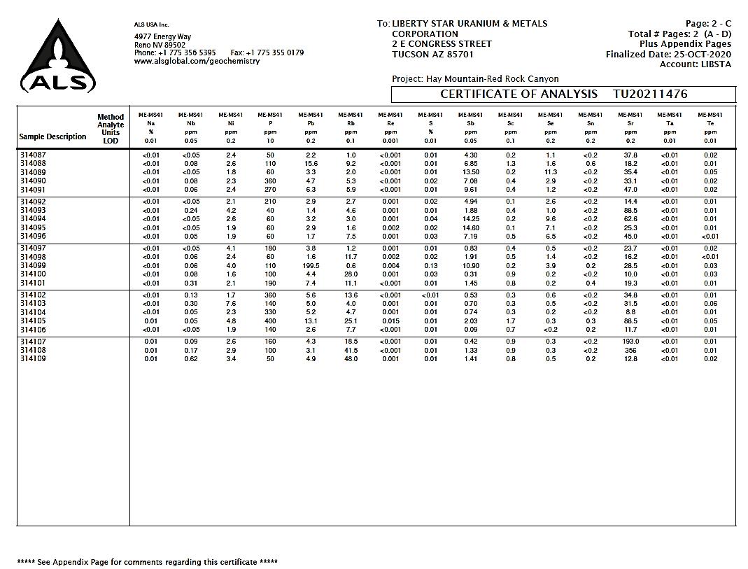
| Liberty Star Minerals | 45 | Broadlands |
Technical Report – Red Rock Canyon Gold Property 1 July 2021 |
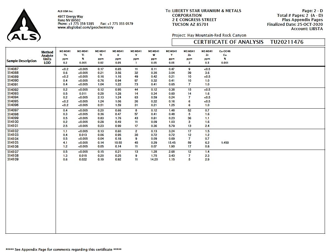
| Liberty Star Minerals | 46 | Broadlands |
Technical Report – Red Rock Canyon Gold Property 1 July 2021 |
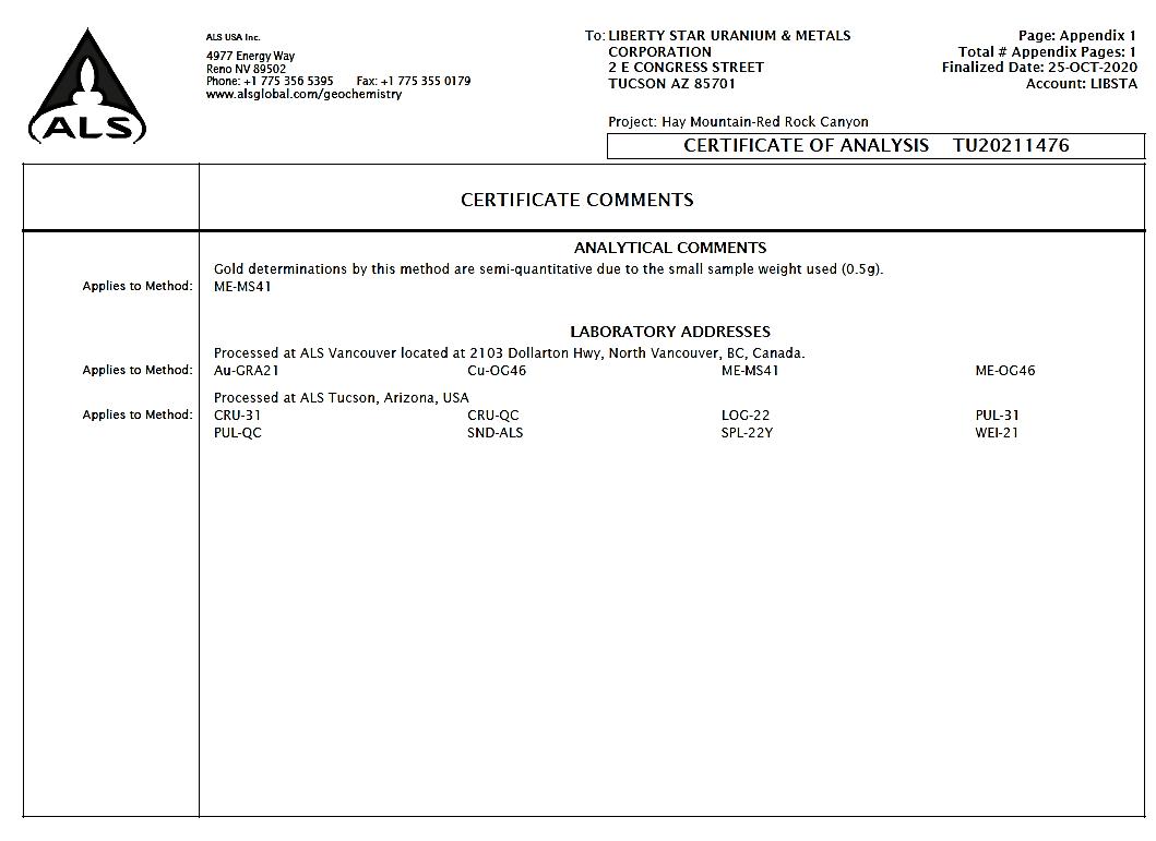
| Liberty Star Minerals | 47 | Broadlands |
Technical Report – Red Rock Canyon Gold Property 1 July 2021 |
APPENDIX 3.0
JANUARY 11, 2021 ASSAY RESULTS
| Liberty Star Minerals | 48 | Broadlands |
Technical Report – Red Rock Canyon Gold Property 1 July 2021 |
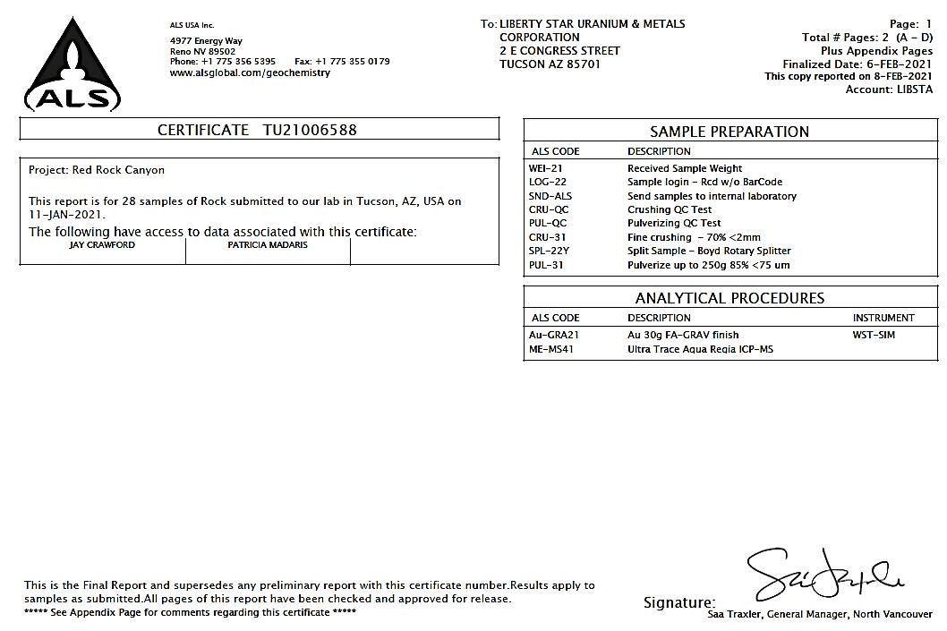
| Liberty Star Minerals | 49 | Broadlands |
Technical Report – Red Rock Canyon Gold Property 1 July 2021 |
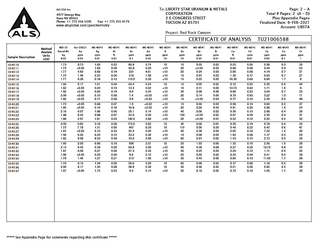
| Liberty Star Minerals | 50 | Broadlands |
Technical Report – Red Rock Canyon Gold Property 1 July 2021 |
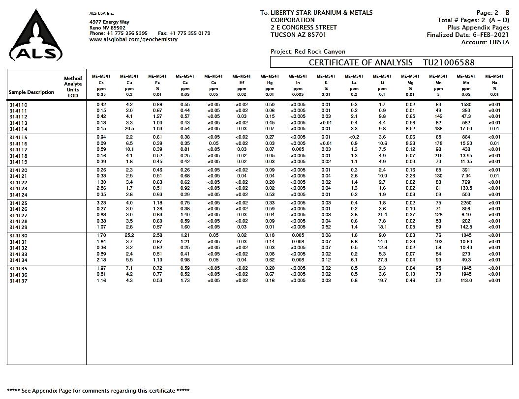
| Liberty Star Minerals | 51 | Broadlands |
Technical Report – Red Rock Canyon Gold Property 1 July 2021 |
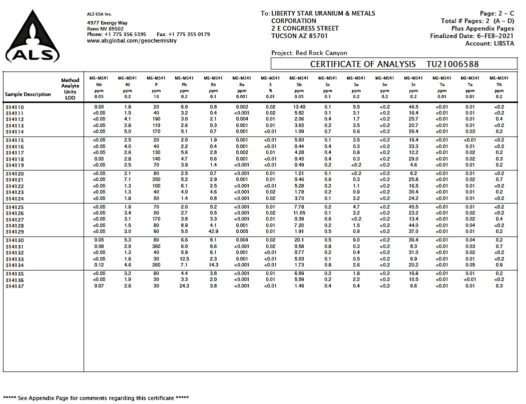
| Liberty Star Minerals | 52 | Broadlands |
Technical Report – Red Rock Canyon Gold Property 1 July 2021 |

| Liberty Star Minerals | 53 | Broadlands |
Technical Report – Red Rock Canyon Gold Property 1 July 2021 |
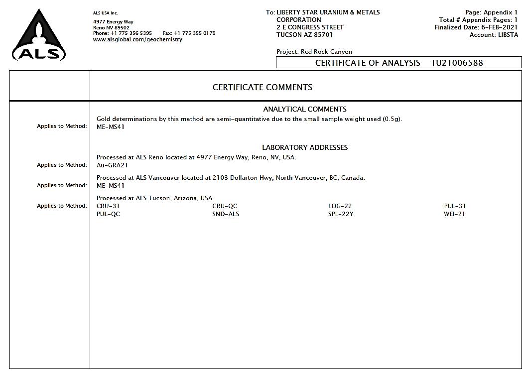
| Liberty Star Minerals | 54 | Broadlands |
Technical Report – Red Rock Canyon Gold Property 1 July 2021 |
APPENDIX 4.0
MAY 19, 2021 ASSAY RESULTS
| Liberty Star Minerals | 55 | Broadlands |
Technical Report – Red Rock Canyon Gold Property 1 July 2021 |
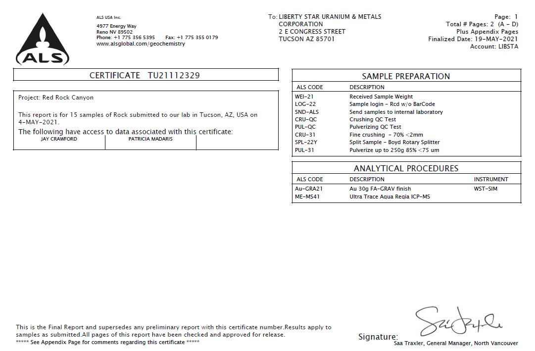
| Liberty Star Minerals | 56 | Broadlands |
Technical Report – Red Rock Canyon Gold Property 1 July 2021 |
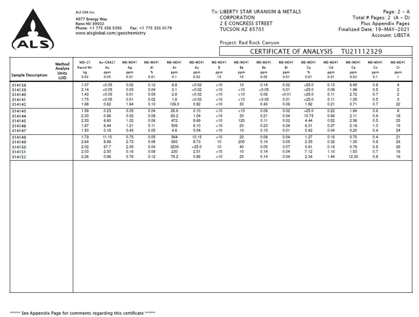
| Liberty Star Minerals | 57 | Broadlands |