EXHIBIT 99.1
| NovaGold Resources Inc. | i |
| Ambler Project | NI 43-101 Preliminary Econimic Assessment |
| SRK Consulting (U.S.), Inc. | May 9, 2011 |
| NI 43-101 Preliminary Econimic Assessment |
| NovaGold Resources Inc. | ii |
| Ambler Project | NI 43-101 Preliminary Econimic Assessment |
| SRK Consulting (U.S.), Inc. | May 9, 2011 |
| NI 43-101 Preliminary Econimic Assessment |
| NovaGold Resources Inc. | iii |
| Ambler Project | NI 43-101 Preliminary Econimic Assessment |
| SRK Consulting (U.S.), Inc. | May 9, 2011 |
| NI 43-101 Preliminary Econimic Assessment |
| NovaGold Resources Inc. | iv |
| Ambler Project | NI 43-101 Preliminary Econimic Assessment |
| SRK Consulting (U.S.), Inc. | May 9, 2011 |
| NI 43-101 Preliminary Econimic Assessment |
| NovaGold Resources Inc. | v |
| Ambler Project | NI 43-101 Preliminary Econimic Assessment |
| SRK Consulting (U.S.), Inc. | May 9, 2011 |
| NI 43-101 Preliminary Econimic Assessment |
| NovaGold Resources Inc. | vi |
| Ambler Project | NI 43-101 Preliminary Econimic Assessment |
| SRK Consulting (U.S.), Inc. | May 9, 2011 |
| NI 43-101 Preliminary Econimic Assessment |
| NovaGold Resources Inc. | vii |
| Ambler Project | NI 43-101 Preliminary Econimic Assessment |
| SRK Consulting (U.S.), Inc. | May 9, 2011 |
| NI 43-101 Preliminary Econimic Assessment |
| NovaGold Resources Inc. | viii |
| Ambler Project | NI 43-101 Preliminary Econimic Assessment |
| SRK Consulting (U.S.), Inc. | May 9, 2011 |
| NI 43-101 Preliminary Econimic Assessment |
| NovaGold Resources Inc. | I |
| Ambler Project | NI 43-101 Preliminary Econimic Assessment |
Summary (Item 3)
SRK Consulting (U.S.), Inc. (SRK) was commissioned by NovaGold Resources Inc. (NovaGold) and Alaska Gold Company (collectively “NovaGold”), a wholly-owned subsidiary of NovaGold, to prepare an independent Preliminary Economic Assessment (PEA) of the Ambler Project (the Project) in Alaska.
Project Overview
The Project is located in the Ambler District, in the southern Brooks Range of northwestern Alaska at geographic coordinates N67.17º latitude and W156.38º longitude, and is geographically isolated with no roads accessing the site and no existing power generating infrastructure in the region.
The Ambler property comprises 36,670ha (90,615 acres) of State of Alaska mining claims and Federal patented and unpatented mining claims in the Kotzebue Recording District. The Project land tenure consists of 1,230 contiguous claims, including 789 40-acre State claims, 347 160-acre State claims, 79 40-acre State select claims, 15 20-acre Federal claims, and 272 acres of Federal patented land.
The Ambler District has been the subject of various early stage exploration programs. However, there has been no mine development or production within the Project area boundaries, and therefore no mine workings or mill tailings are present on the property. NovaGold holds a current exploration permit in good standing with the Alaska DNR, and has done so each year since 2004. There are no indications of any known environmental impairment or enforcement actions associated with NovaGold’s activities to date.
Highlights:
● | Base case pre-tax NPV8% of US$718million with an IRR of 30%. At current metal prices pre-tax NPV8%, of US$2.2billion with an IRR of 59%. |
● | Base case post-tax NPV8% of US$505million with an IRR of 25%. At current metal prices post-tax NPV8% of US$1.6billion with an IRR of 50%; |
● | 25-year mine life processing 29.3Mt of resources at an average net smelter return (NSR) value of US$224/t using a US$90/t cutoff; |
● | Initial startup capital, including a 25% contingency (US$52million), totals US$262million. Sustaining capital of US$134million is primarily comprised of underground equipment and development, and tailings dam expansion throughout the mine life. The contingency on sustaining capital is US$34million.; |
● | Metal prices – Base case utilizes US$2.50/lb copper, US$1.05/lb zinc, US$1.00/lb lead, US$20/oz silver and US$1,100/oz gold; |
● | Access to the project via a 340km road constructed from Pump Station Number 5 at the Dalton Highway. The highway will be engineered and constructed by the State of Alaska. The estimated cost to the project for use of the access road is US$15million per year starting in project year seven(7) and capped at US$300million; |
● | The resource will be exploited using underground mining methods; |
● | A conventional flotation process flowsheet will be applied; |
| SRK Consulting (U.S.), Inc. | May 9, 2011 |
| NI 43-101 Preliminary Econimic Assessment |
| NovaGold Resources Inc. | II |
| Ambler Project | NI 43-101 Preliminary Econimic Assessment |
● | The mine will produce three concentrates: a copper concentrate with gold byproduct, a lead concentrate with silver and gold byproducts and a zinc concentrate with a silver byproduct; |
● | Variable production rate up to nominal 4,000t/d; |
● | Power assumed to be generated at site using a dedicated diesel generator power station. |
● | Summary project statistics are shown in Table 1 below. |
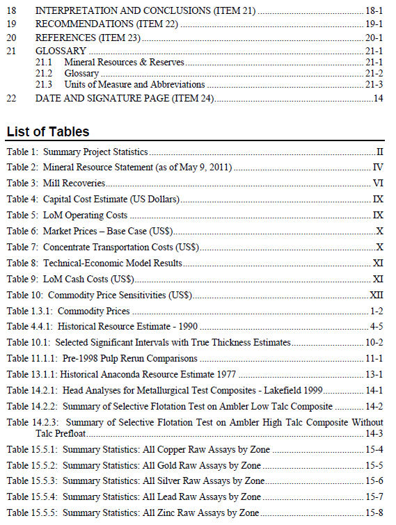
Table 1: Summary Project Statistics
| Description | Statistic |
| Material Processed | 29.3Mt |
| Average Annual Production | 1.17Mt |
| NSR | US$224/t-milled |
| Cash Operating Costs | US$2.74/lb.-Cu |
| Copper Cash Costs Net of By-Products | US$0.89/lb.-Cu |
| Mine Life | 25yrs |
| Pre-production capital costs | US$262million |
Pre-Tax NPV8% | US$718million |
Post-Tax NPV8% | US$505million |
| Pre-Tax IRR | 30% |
| Post-Tax IRR | 25% |
The Project is situated along the south side of the Brooks Range, one of the longest mountain ranges in Alaska separating the arctic region from the Alaskan interior. The deposit rests on the east side of Subarctic Creek straddling a 970m ridge between Subarctic Creek and the Kogoluktuk River Valley. Terrain is steep and rugged, with extreme topographic relief. Subarctic Creek is a tributary of the Shungnak River. The climate in the Ambler District is typical of a sub-arctic environment. The exploration season for the Project is from late May until late September.
Land tenure consists of 1,230 contiguous claims, including 789 40-acre State claims, 347 160-acre State claims, 79 40-acre State select claims, 15 20-acre Federal claims, and 272 acres of Federal patented land which hosts the current resource and immediate surrounding area.
Primary access is currently by air using both fixed wing aircraft and helicopters. There are four well-maintained 1,524m-long gravel airstrips capable of accommodating charter aircraft.
Due to the remote location of the Project, infrastructure, specifically transport of material and personnel to and from the Project and power, will require significant capital investment. There is no developed surface access to the Project area and no power infrastructure near the Project area.
SRK examined various methods for improved access to the Project area and transport of materials to construct and operate a mining operation. Of these various methods, the Project and this report focus on the use of a new road to the Dalton Highway. This road is approximately 340km long. NovaGold states that they have had constructive discussions with the State of Alaska regarding the concept of a public/private partnership for construction and operation of the road. At this point, the Project has assumed that the road would be designed and constructed by the State of Alaska. NovaGold would then reimburse the State a total of US$300million over the
| SRK Consulting (U.S.), Inc. | May 9, 2011 |
| NI 43-101 Preliminary Econimic Assessment |
| NovaGold Resources Inc. | III |
| Ambler Project | NI 43-101 Preliminary Econimic Assessment |
operating life of the mine. A similar arrangement exists between the State and the road and port facility used by the Red Dog mine in northwest Alaska.
Geology
The Ambler District occurs within an east–west trending zone of Devonian to Jurassic age submarine volcanic and sedimentary rocks. Volcanogenic massive sulfide (VMS) deposits and prospects are hosted in the Middle Devonian to Early Mississippian age Ambler Sequence, a group of metamorphosed bimodal volcanic rocks with interbedded tuffaceous, graphitic and calcareous volcanoclastic metasediments. The Ambler Sequence occurs in the upper part of the Anirak Schist, the thickest member of the Coldfoot subterrane. VMS mineralization can be found along the entire 110km strike length of the district. The 1,980m-thick Devonian age section of the Cosmos Hills, which includes the 915m-thick Bornite Carbonate Sequence, is equivalent in age to the Anirak Schist and was mineralized during the Ambler mineralizing event.
Rocks that form the Ambler schist belt consist of a lithologically diverse sequence of carbonate and siliciclastic strata with interlayered mafic lava flows and sills. The clastic strata, derived from terrigenous continental and volcanic sources, were deposited primarily by mass-gravity flow into the sub-wavebase environment of an extending marginal basin.
NovaGold’s work shows that the Ambler sequence underwent two periods of intense, penetrative deformation. Sustained upper greenschist-facies metamorphism with coincident formation of a penetrative schistosity and isoclinal transposition of bedding marks the first deformation period. Pervasive similar-style folds on all scales deform the transposed bedding and schistosity, defining the subsequent event. At least two later non-penetrative compressional events deform these earlier fabrics. NovaGold’s observations of the structural and metamorphic history of the Ambler District are consistent with current tectonic evolution models for the schist belt, based on the work of others elsewhere in southern Brooks Range.
Russell (1995) and Schmidt (1983) describe three mineralized horizons that comprise the Project: the Main Sulfide Horizon, the Upper South Horizon and the Warm Springs Horizon. The Main Sulfide Horizon was further subdivided into three zones: the southeast zone, the central zone and the northwest zone. Previous deposit modeling was grade-based resulting in numerous individual mineralized zones representing relatively thin sulfide horizons.
Work from the 2004 campaign suggests that mineralization at the Project can be explained using two locally folded and refolded mineralized horizons. The primary exception is in the area of Warm Springs and east of Warm Springs where mineralization occurs stratigraphically higher than anticipated using this model. Thrust faulting may have an effect on mineralized horizon geometry in this area.
The mineralization at the Project and within the Ambler District generally consists of Devonian to Mississippian age, polymetallic (Zn-Cu-Pb-Ag) VMS occurrences. Mineralization occurs as stratiform semi-massive to massive sulfide beds. The sulfide beds average 4m thick but vary from less than 1m up to 18m thick. The bulk of the mineralization is within four zones located between two thrust faults, the upper Warm Springs Thrust and the Lower Thrust. A smaller fifth zone is located below the Lower Thrust. All of these zones are within an area of roughly 1km2, with average zone length ranging from 850m to 600m and width ranging from 700m to 350m.
| SRK Consulting (U.S.), Inc. | May 9, 2011 |
| NI 43-101 Preliminary Econimic Assessment |
| NovaGold Resources Inc. | IV |
| Ambler Project | NI 43-101 Preliminary Econimic Assessment |
Depths of known mineralization extend to approximately 250m below the surface. Host rocks are primarily graphitic chlorite schists and fine-grained quartz sandstones.
Exploration on the Project was intermittent between its discovery in 1965 and 1998. From 1998 until 2003, there was no work performed on the Project. NovaGold entered into negotiations with Kennecott to explore its Ambler land position in mid-2003. Negotiations were completed and an exploration agreement signed on March 23, 2004. Since 2004, NovaGold has been performing project level and regional mapping, drilling, geophysics and geochemical surveys. NovaGold purchased Kennecott’s ownership in January 2010 and continues exploration activities at the Project.
Mineral Resource
The mineral resource was developed from a drillhole database consisting of 119 core holes, 96 of which intercepted significant mineralization. Of the 25,000m drilled within the Arctic deposit, 4,808 intervals were sampled representing 9,128m of sampled drilling.
Five mineralized massive sulfide zones have been defined along a northeasterly striking corridor, with all zones tending to dip moderately to the southwest. The mineralization within the Project occurs as massive sulfide lenses hosted within weakly to unmineralized schistose country rocks. Potentially economic mineralization is associated with coarse-grained sulfides.
The mineral resources have been classified according to the “CIM Standards on Mineral Resources and Reserves: Definitions and Guidelines” (November 2005). Resources are shown in Table 2. The preliminary assessment contained herein includes inferred mineral resources that are considered too speculative geologically to have the economic considerations applied to them that would enable them to be categorized as Mineral Reserves. There is no certainty that the preliminary assessment will ever be realized. Mineral resources that are not mineral reserves do not have demonstrated economic viability.
Table 2: Mineral Resource Statement (as of May 9, 2011)
| Resource Category | Zone | Tonnage (kt) | Metal Grades | Contained Metal | ||||||||
| Cu (%) | Au (g/t) | Ag (g/t) | Zn (%) | Pb (%) | Cu (klb) | Au (koz) | Ag (koz) | Zn (klb) | Pb (klb) | |||
| Indicated | 1 | 5,293 | 4.56 | 0.96 | 62.77 | 6.45 | 1.05 | 532,571 | 163 | 10,683 | 752,305 | 122,428 |
| 2 | 2,982 | 4.36 | 0.52 | 45.76 | 5.82 | 0.80 | 286,906 | 50 | 4,387 | 382,593 | 52,831 | |
| 3 | 1,964 | 3.66 | 0.52 | 51.02 | 5.98 | 0.93 | 158,357 | 33 | 3,222 | 259,080 | 40,173 | |
| 4 | 6,089 | 3.82 | 1.01 | 68.71 | 6.00 | 0.98 | 513,088 | 197 | 13,451 | 805,142 | 130,965 | |
| 11 | 517 | 4.16 | 0.25 | 32.86 | 3.32 | 0.34 | 47,400 | 4 | 546 | 37,854 | 3,859 | |
| All Zones | 16,845 | 4.14 | 0.83 | 59.62 | 6.02 | 0.94 | 1,538,322 | 447 | 32,289 | 2,236,974 | 350,255 | |
| Inferred | 0 | 1,191 | 2.18 | 0.34 | 4.17 | 2.24 | 0.70 | 57,114 | 13 | 159 | 58,716 | 18,474 |
| 1 | 3,166 | 3.91 | 0.76 | 54.98 | 5.74 | 0.93 | 273,161 | 77 | 5,596 | 400,765 | 64,808 | |
| 2 | 1,559 | 4.06 | 0.43 | 43.40 | 5.60 | 0.74 | 139,424 | 22 | 2,175 | 192,610 | 25,317 | |
| 3 | 1,307 | 3.83 | 0.44 | 48.08 | 5.13 | 0.63 | 110,404 | 18 | 2,020 | 147,864 | 18,292 | |
| 4 | 4,492 | 3.28 | 0.87 | 57.56 | 4.95 | 0.83 | 324,875 | 126 | 8,312 | 489,789 | 81,815 | |
| 11 | 373 | 4.25 | 0.29 | 33.65 | 3.30 | 0.35 | 34,945 | 3 | 404 | 27,137 | 2,905 | |
| All Zones | 12,087 | 3.53 | 0.67 | 48.04 | 4.94 | 0.79 | 939,923 | 260 | 18,667 | 1,316,882 | 211,610 | |
Notes:
1 - Mineral Resources are not Mineral Reserves and do not have demonstrated economic viability. There is no certainty that all or any part of the Mineral Resources will be converted into Mineral Reserves.
2 - Resources stated as contained within a potentially economically minable underground shapes above a US$75.00/t NSR cut-off
3 - NSR calculation is based on assumed metal prices of US$2.50/lb for copper, US$1,000/oz for gold, US$16.00/oz for silver, US$1.00/lb for zinc and US$1.00/lb. for lead. A mining cost of US$45.00/t and combined processing and G&A costs of US$31.00 were assumed to form the basis for the resource NSR cut-off determination. Note these metal prices and operating costs may differ from those used for the cash flow model.
4 - Mineral resource tonnage and contained metal have been rounded to reflect the accuracy of the estimate, and numbers may not add due to rounding
| SRK Consulting (U.S.), Inc. | May 9, 2011 |
| NI 43-101 Preliminary Econimic Assessment |
| NovaGold Resources Inc. | V |
| Ambler Project | NI 43-101 Preliminary Econimic Assessment |
The Project lies in a prospective trend, as highlighted by the Smucker and Sun deposits on either side of the Project. As is typical of VMS styled deposits, there are likely to be a number of mineralized deposits within this trend. The Project itself is fairly well-defined, although it is not constrained at depth, where the model suggests a further folded structure is possible.
Underground Mining
Underground mine design work presented in this PEA is based on Indicated and Inferred resources.
The available geotechnical information indicates that both non-entry longhole stope methods and man-entry room-and-pillar or drift-and-fill methods can be successfully applied to the deposit. Both fill and non-fill mining methods have been evaluated and a decision taken to use cemented paste backfill mining methods in this PEA for the following reasons:
● | Higher extraction ratio and greater potentially mineable resource quantity; |
● | Smaller tailings dam footprint requirement; and |
● | Potential for improved ground stability. |
An NSR block model was prepared for the deposit and an NSR cut-off was determined based on a site operating cost of US$90/t, which does not include the access road operating cost. The blocks above NSR cut-off were identified and used to guide the stope design process.
Primary access development was designed in the footwall of the deposit and included the following components:
● | Twin main access declines from the process plant location to a crusher situated 50m below the mineralized material at the approximate center of gravity of the deposit. A conveyor will be used to transport mill feed from the crusher to the process plant on surface; |
● | A system of ramps to provide primary access to all areas of the deposit. These main ramps are located approximately 30m below the lowest deposit; and |
● | Two additional portal accesses to the mine acting as secondary egress and ventilation routes. |
The stope design results in a potentially mineable resource of 29.3Mt at an average NSR value of US$224/t. The mineable resource differs from the 28.9Mt (Measured, Indicated and Inferred) Mineral Resource estimate shown in Table 2 due to exclusion of isolated or thinner pods of mineralization, mining recovery and internal dilution considerations applied in the mineable resource estimate.
The production schedule has been prepared based on average mineralization grade throughout the life of the operation. There is potential upside to be obtained by mining at a higher average grade during the early years of the Project.
Processing
SRK developed a conceptual process flowsheet to produce separate copper, lead and zinc flotation concentrates. This process flowsheet utilizes unit operations that are standard to the industry. The actual design parameters required to further develop this conceptual flowsheet
| SRK Consulting (U.S.), Inc. | May 9, 2011 |
| NovaGold Resources Inc. | VI |
| Ambler Project | NI 43-101 Preliminary Econimic Assessment |
must be developed through additional metallurgical testing that should be undertaken during the next phase of study. The proposed conceptual flowsheet includes the following unit operations:
● | Primary crushing; |
● | SAG-ball mill grinding; |
● | Talc flotation; |
● | Copper-lead rougher and cleaner flotation; |
● | Copper-lead regrinding; |
● | Copper-lead cleaner flotation; |
● | Copper-lead separation; |
● | Lead rougher flotation |
● | Lead cleaner flotation |
● | Copper rougher flotation |
● | Zinc rougher flotation; |
● | Zinc rougher concentrate regrinding; |
● | Zinc cleaner flotation; |
● | Concentrate thickening, filtering and drying; |
● | Tailings disposal; and |
● | Reagent handling and utilities. |
Life of mine (LoM) metallurgical recoveries are summarized in Table 3.
Table 3: Mill Recoveries
| Model Parameter | Zinc Concentrate | Lead Concentrate | Copper Concentrate |
| Mass Pull | 6.2% | 0.8% | 9.3% |
| Zinc | 81.1% | 1.1% | 5.7% |
| Copper | 0.8% | 2.7% | 86.8% |
| Lead | 1.9% | 68.1% | 9.8% |
| Gold | 3.6% | 48.7% | 10.9% |
| Silver | 1.8% | 47.3% | 14.5% |
Tailings
The proposed mill will treat approximately 29.3Mt of millable material, producing 24.6Mt (dry basis) of tailings. The tailings dam will contain 15.2Mt of waste and the balance of 9.4Mt will be used as paste backfill in the mine. The tailings storage facility (TSF) will be a fully lined facility consisting of a rockfill embankment constructed across the Arctic Creek drainage, creating an impoundment that will extend up the drainage. The rockfill embankment will be constructed to an ultimate crest elevation of 708amsl with the embankment being raised in stages to minimize the initial capital construction cost. During operations, tailings will be deposited from the crest of the embankment at select locations. Water reclamation from the facility will occur from the upper reaches of the basin to minimize the depth of water ponded against the embankment. To minimize the quantity of water stored within the TSF, outside stormwater runoff will be diverted away from the facility by a diversion channel positioned above the facility.
| SRK Consulting (U.S.), Inc. | May 9, 2011 |
| NovaGold Resources Inc. | VII |
| Ambler Project | NI 43-101 Preliminary Econimic Assessment |
Environmental Considerations
Development of the Project will be subject to extensive environmental baseline analyses, environmental impact assessment and evaluation, and associated permitting requirements reflective of the direct, indirect, and cumulative impacts associated with full project build-out, and the sensitive environment in which it is to be constructed. Development of the Project will include significant infrastructure development including the mine, mill, tailings impoundment and ancillary facilities, including on-site employee housing, as well as off-site infrastructure such as power generation and communications, and surface access. An existing year-round airstrip near the site capable of accommodating charter aircraft for a complete fly-in/fly out year-round operation will be used. The complexity of the environmental review and permitting the various facilities will be dependent on siting of facilities in relationship to the various river basins and valleys surrounding the Project development target areas. Further, the Project will be situated adjacent to a number of parks and protected areas, including Kobuk National Park located 80km west, the Great Kobuk Sand Dunes and the Kobuk Valley and Selawik Wilderness areas 30 to 40km west, Selawik National Wildlife Refuge 20 to 25km southwest and the Gates of the Arctic National Park and Preserve approximately 80km northeast.
In 2010, the Project initiated an assessment of baseline hydrology, water quality and aquatic life. Additional studies will be needed on the environmental resources of the Project area in order to adequately define and establish baseline conditions at the site. Other studies that have been performed are largely based on historical geological and geochemical data in order to characterize the rock mass. However, based on the rock mass characterization performed and summarized in these reports, acid rock drainage (ARD) will likely be an issue addressed during Project design in order to obtain operating permits. There is no assurance all approvals or required license and permits will be obtained.
The Project will require multiple permits from regulatory agencies and other entities at the Federal, State and local (Borough) levels. As a result of the remoteness of the Project and the lack of existing infrastructure, it is likely that a substantial environmental review and permitting effort will also be a part of the development of support infrastructure. Due to the preliminary stages of this Project, it is difficult to assess what specific permitting requirements will ultimately apply to the Project. It is possible that a legal challenge could be brought through one or more of these requirements or processes that could delay, increase costs, or require the suspension of one or more permits.
Infrastructure
Access to the Project is proposed to be via a road approximately 340km (211 miles) long, extending west from the Dalton Highway along generally level terrain to the village of Kobuk where it would connect with existing roads to Bornite and the proposed Project area. Two existing airports at Dahl Creek and Kobuk are suitable to support the fly in/fly out (FIFO) mine camp. Diesel powered generators located at the Project will provide electricity; SRK estimates the Project will require 10.2MW capacity. Materials and concentrate will travel by truck along the proposed road. Concentrate will be off-loaded onto rail in Fairbanks for transport to the nearest shipping port and subsequently to the contracted smelter.
| SRK Consulting (U.S.), Inc. | May 9, 2011 |
| NovaGold Resources Inc. | VIII |
| Ambler Project | NI 43-101 Preliminary Econimic Assessment |
Capital Costs
Initial start-up capital is US$262million including a contingency at 25% of US$52million. Sustaining capital of US$134million is primarily comprised of underground equipment and development, and tailings dam expansion throughout the mine life. The contingency on sustaining capital is US$34million. The total LOM capital cost estimate, accurate to ±30%, totals US$429million as shown in Table 4.
| SRK Consulting (U.S.), Inc. | May 9, 2011 |
| NovaGold Resources Inc. | IX |
| Ambler Project | NI 43-101 Preliminary Econimic Assessment |
Table 4: Capital Cost Estimate (US Dollars)
| Description | Initial (000) | Sustaining | LoM (000) |
| Mining Mobile Equipment | $10,937 | $63,664 | $74,601 |
| Fixed Equipment | $7,700 | $10,800 | $18,500 |
| Mine Development | $19,150 | $22,650 | $41,800 |
| subtotal Mining | $37,787 | $97,114 | $134,901 |
| Process & Tailings Power Plant | $19,786 | $0 | $19,786 |
| Process Plant Direct Costs | $47,557 | $0 | $47,557 |
| Indirect Costs | $41,079 | $0 | $41,079 |
| Tailings Dam | $2,865 | $19,927 | $22,793 |
| subtotal Process | $111,287 | $19,927 | $131,215 |
| Infrastructure - Air Strip | $0 | $0 | $0 |
| Access Road | $0 | $0 | $0 |
| Buildings & Structures | $20,820 | $0 | $20,820 |
| Mancamp | $16,500 | $0 | $16,500 |
| Utilities | $5,500 | $0 | $5,500 |
| Support Equipment | $2,970 | $6,272 | $9,242 |
| Off-Site Infrastructure | $925 | $560 | $1,485 |
| Owner Costs | $13,500 | $10,000 | $23,500 |
| subtotal Infrastructure | $60,215 | $16,832 | $77,047 |
| Capital Cost | $209,289 | $133,873 | $343,162 |
| Contingency @ 25% | $52,322 | $33,468 | $85,791 |
| Total Capital | $261,611 | $167,342 | $428,953 |
Operating Costs
SRK developed estimates of operating costs using first principles, and assumptions and productivities consistent with conditions, which will be encountered in the arctic environment. Based upon this work, a LoM operating cost of approximately US$99.32/t milled is anticipated. The assumed diesel price is US$5.00 per gallon delivered to site. Operating costs are shown in Table 5.
Table 5: LoM Operating Costs
| Item | Unit Cost (US$/t-Milled) | LoM Cost (US$000s) |
| Mining | $48.63 | $1,423,700 |
| Process | $29.74 | $870,634 |
| Access Road | $10.25 | $300,000 |
| G&A | $10.69 | $313,050 |
| Total | $99.32 | $2,907,384 |
Market Considerations
Market price assumptions as well as estimated concentrate freight and marketing assumptions are shown in Tables 6 and 7, respectively.
| SRK Consulting (U.S.), Inc. | May 9, 2011 |
| NovaGold Resources Inc. | X |
| Ambler Project | NI 43-101 Preliminary Econimic Assessment |
Table 6: Market Prices – Base Case (US$)
| Description | Value | Unit | |
| Zinc | $1.05 | US$/lb | |
| Copper | $2.50 | US$/lb | |
| Lead | $1.00 | US$/lb | |
| Gold | $1,100.00 | US$/oz | |
| Silver | $20.00 | US$/oz |
Table 7: Concentrate Transportation Costs (US$)
| Description | Value | Unit (wet) | |
| Trucking to Railhead (Fairbanks, AK) | $120.00 | US$/t | |
| Rail to Port (Seward, AK) | $34.41 | US$/t | |
| Transfer & Port Logistics | $16.47 | US$/t | |
| Umpire Sampling | $0.15 | US$/t | |
| Marketing | $0.05 | US$/t |
Indicative Economic Results
Economic results are summarized in Table 8. The project cash cost, defined as the sum of total smelter, operating, freight and marketing, and royalty costs, is estimated to be US$183.66/t-milled. Project value (NPV8%) on a pre-tax basis is US$718million with an IRR of 30%. Payback will occur in year 4 of operations. The project value on a post-tax basis is NPV8% of US$505million with an IRR of 25%.
| SRK Consulting (U.S.), Inc. | May 9, 2011 |
| NovaGold Resources Inc. | XI |
| Ambler Project | NI 43-101 Preliminary Econimic Assessment |
Table 8: Technical-Economic Model Results
| Description | Value (US$000s) | Unit Cost ($/t) | units | |
| NSR: Zinc Concentrate | $1,629,471 | $902.77 | per t-Conc. | |
| Lead Concentrate | $887,137 | $3,750.56 | per t-Conc. | |
| Copper Concentrate | $4,064,995 | $1,492.12 | per t-Conc. | |
| NSR | $6,581,603 | $224.83 | per t-milled | |
| Freight & Marketing | ($905,932) | ($30.95) | per t-milled | |
| Gross Revenue | $5,675,671 | $193.88 | per t-milled | |
| Royalty | ($56,757) | ($1.94) | per t-milled | |
| Net Revenue | $5,618,914 | $191.94 | per t-milled | |
| Operating Costs: Mining | $1,423,700 | $48.63 | per t-milled | |
| Processing | $870,634 | $29.74 | per t-milled | |
| Access Road | $300,000 | $10.25 | per t-milled | |
| G&A | $313,050 | $10.69 | per t-milled | |
| Total Operating | $2,907,384 | $99.32 | per t-milled | |
| Operating Margin | $2,711,530 | $92.63 | per t-milled | |
| Initial Capital | ($261,611) | |||
| LoM Sustaining Capital | ($167,342) | |||
| Income Tax | ($580,535) | |||
| Cash Flow | $1,702,042 | |||
| NPV 8% | $504,963 | |||
| IRR | 25% | |||
| Pre-tax Results | ||||
| Cash Flow | $2,282,577 | |||
| NPV 8% | $718,449 | |||
| IRR | 30% |
● | The economic analysis in this preliminary assessment contains inferred resources, which are considered too speculative geologically to have economic considerations applied to them that would enable them to be categorized as mineral reserves. There is no certainty that the preliminary assessment will ever be realized. |
● | Mineral resources that are not mineral reserves do not have demonstrated economic viability. |
Cash costs are summarized in Table 9. Over the LoM cash costs will total US$4.6billion, or US$2.74/lb-Cu. By-product credits for the production of zinc, lead gold and silver will average US$1.85/lb-Cu, resulting in a LoM cash cost net of by-product credits of US$1.5billion, or US$0.89/lb-Cu.
Table 9: LoM Cash Costs (US$)
| Description | LoM (US$000s) | Unit Cost ($/lb-Cu) |
| Smelter Costs | $750,300 | $0.445 |
| Freight & Marketing | $905,932 | $0.537 |
| Royalty | $56,757 | $0.034 |
| Mining | $1,423,700 | $0.844 |
| Process | $870,634 | $0.516 |
| Access Road | $300,000 | $0.178 |
| G&A | $313,050 | $0.186 |
| Cash Costs | $4,620,373 | $2.739 |
| By-Product Credits | ||
| Zinc | ($2,098,911) | ($1.244) |
| Lead | ($290,977) | ($0.173) |
| Gold | ($292,489) | ($0.173) |
| Silver | ($433,082) | ($0.257) |
| Cash Cost Net of By-Product Credits | $1,504,913 | $0.892 |
| SRK Consulting (U.S.), Inc. | May 9, 2011 |
| NovaGold Resources Inc. | XII |
| Ambler Project | NI 43-101 Preliminary Econimic Assessment |
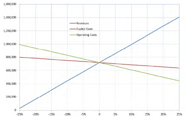
Sensitivity Analysis
The project Sensitivity Analysis is summarized in chart below. As presented, the project is most sensitive to market price followed by operating cost, and capital costs, respectively.
Sensitivity (NPV8%, US$000s)
A metal price sensitivity was also performed using downside and upside commodity prices. Downside pricing is consensus long term. Upside prices reflect current metals prices – as of March 2011. These prices are summarized in Table 10.
Table 10: Commodity Price Sensitivities (US$)
| Description | Downside | Upside | Unit | |
| Zinc | $0.75 | $1.20 | US$/lb. | |
| Copper | $2.25 | $4.31 | US$/lb. | |
| Lead | $1.00 | $1.20 | US$/lb. | |
| Gold | $950.00 | $1,425.00 | US$/oz | |
| Silver | $15.00 | $36.00 | US$/oz |
Given the price assumption shown in Table 9, pre-tax project results are:
● | Downside Case: NPV8%, US$279million; IRR, 18%; and |
● | Upside Case: NPV8%, US$2.2billion; IRR, 59%. |
| SRK Consulting (U.S.), Inc. | May 9, 2011 |
| NovaGold Resources Inc. | XIII |
| Ambler Project | NI 43-101 Preliminary Econimic Assessment |
A one percent change of discount rate was also evaluated. The base case scenario would have a present value of US$821million at NPV7% and US$630million at NPV9%.
During prefeasibility, the Project would benefit from a Real Options analysis that would permit modeling of future metal and consumable prices and operating costs.
Conclusions and Recommendations
The findings of this Preliminary Assessment provide compelling arguments to complete exploration and infill drilling on the Project, advance the evaluation of the Project to the pre-feasibility stage and complete a regional exploration program.
Exploration: The compelling economics derived in this assessment support drilling to upgrade existing inferred mineral resources and further exploration on the Project. The Project is in a prospective region for the discovery of additional resources. The proposed Project’s infrastructure could unlock the value of other similar types of deposits
Technical evaluation: Additional metallurgical testwork is needed to completely characterize the deposit and optimize both the process flowsheet and recoveries. Further studies are required to further assess infrastructure requirements and revise the mine plan based on additional exploration work completed.
There are opportunities to optimize the development economics with respect to the Ambler Project. Such opportunities include scheduling of higher grade material though the mill earlier in the project life, effecting the contractual $10 million repurchase of the 1% net smelter return royalty payable on the Ambler Project, assessing other power generating alternatives, and obtaining greater State support or shared users to reduce the assumed toll cost of the required access road.
Additional activities in support of a pre-feasibility assessment include the following, together with indicative costs:
● | Phase I Work (US$7million): |
| o | Engineering support- | US$1,000,000; |
| o | Environmental Baseline Work and Assessment- | US$250,000; |
| o | Exploration and Drilling- | US$5,750,000; |
● | Phase II Work (US$23million): |
| o | Exploration and Drilling- | US$17,000,000 |
| o | Metallurgical Testwork and Technical Evaluations- | US$1,000,000; |
| o | Environmental Baseline Work and Assessment- | US$1,000,000; |
| o | Pre-feasibility Report- | US$4,000,000. |
Phase II, prefeasibility work, is contingent upon the positive results of Phase I. Positive results of Phase II work will culminate into the recommendation to commence a Feasibility Study.
Given the amount of work performed on the project, activities are required to confirm previous work and further define the development scheme. A revised economic analysis should also be completed.
| SRK Consulting (U.S.), Inc. | May 9, 2011 |
| NovaGold Resources Inc. | 1-1 |
| Ambler Project | NI 43-101 Preliminary Econimic Assessment |
| 1 | Introduction and Terms of Reference (Item 4) |
| 1.1 | Project Overview |
SRK Consulting (U.S.), Inc. (SRK) was commissioned by NovaGold Resources Inc. (NovaGold) and Alaska Gold Company (collectively “NovaGold”), a wholly-owned subsidiary of NovaGold, to prepare an independent Preliminary Economic Assessment (PEA) of the Ambler Project (the Project) in Alaska. This report presents a preliminary view of a likely Project concept, including an indicative economic analysis. The PEA includes all Mineral Resources, including inferred mineral resource classification. Mineral resources that are not mineral reserves do not have demonstrated economic viability.
The Project is a volcanogenic massive sulfide (VMS) deposit located in the southern Brooks Range of northwestern Alaska in the Northwest Arctic Borough. The Project is geographically isolated with no roads accessing the site and no existing power generating infrastructure in the region. For the purposes of this report, the following project assumptions apply:
● | Power will be generated at site using a dedicated diesel generator power station; |
● | Access to the project via a 340km (211 mile) road constructed from Pump Station Number 5 at the Dalton Highway. The highway is proposed to be engineered and constructed by the State of Alaska. The estimated cost to the project for use of the access road is US$15million per year starting in project year six and capped at US$300million; |
● | The mine workforce will be housed locally at a mine camp and will rotate out on a scheduled basis; |
● | The resource will be extracted using underground mining methods; |
● | A conventional flotation process flowsheet; |
● | The mine will produce three concentrates: a copper concentrate with gold byproduct, a lead concentrate with silver and gold byproducts and a zinc concentrate with a silver byproduct; |
● | Variable production rate up to nominal 4,000t/d; |
● | 25-year mine life; and |
● | 16.8Mt of indicated resources containing 4.1% Cu, 6.0% Zn, 0.9% Pb, 60g/t Ag and 0.8g/t Au; and 12.1Mt of inferred resources containing 3.5% Cu, 4.9% Zn, 0.8% Pb, 48g/t Ag and 0.7g/t Au. |
| 1.2 | Terms of Reference and Purpose of the Report |
This PEA is intended for the use of NovaGold to further the evaluation of the Project by estimating resources in accordance with the Canadian Institute of Mining, Metallurgy and Petroleum (CIM) classification system and evaluating the property. The report includes the potential mining of inferred mineral resources that are considered too speculative, geologically, to have economic considerations applied to them. Therefore, this material cannot be classified as Mineral Reserves. Therefore, the term “mineable resource” is used in lieu of “reserves” to describe mineable quantities in this report.
| SRK Consulting (U.S.), Inc. | May 9, 2011 |
| NovaGold Resources Inc. | 1-2 |
| Ambler Project | NI 43-101 Preliminary Econimic Assessment |
NovaGold may also use the PEA for any lawful purpose to which it is suited. This Preliminary Economic Assessment has been prepared in general accordance with the guidelines provided by the National Instrument 43-101 (NI 43-101) Standards of Disclosure for Mineral Projects.
The metric (SI System) units of measure are used in this report unless otherwise noted. Analytical results are reported as a percentage of chemical element, grams per tonne (g/t) or as parts per million (ppm). The reader should note that 1ppm equals 1g/t.
A glossary of terms used in this report is provided in Section 21 of this report.
| 1.3 | Price Strategy and Currency |
The commodity prices used in the report are listed in Table 1.3.1. Unless otherwise stated, all references to currency in this report are 4Q 2010 U.S. dollars.
Table 1.3.1: Commodity Prices
| Description | Value | Unit | |
| Zinc | $1.05 | US$/lb | |
| Copper | $2.50 | US$/lb | |
| Lead | $1.00 | US$/lb | |
| Gold | $1,100.00 | US$/oz | |
| Silver | $20.00 | US$/oz |
| 1.4 | Qualifications of Consultant (SRK) |
The SRK Group comprises over 1,000 staff offering expertise in a wide range of resource engineering disciplines. The SRK Group’s independence is ensured by the fact that it holds no equity in any project and that its ownership rests solely with its staff. This permits SRK to provide its clients with conflict-free and objective recommendations on crucial judgment issues. SRK has a demonstrated record of accomplishment in undertaking independent assessments of Mineral Resources and Mineral Reserves, project evaluations and audits, technical reports and independent evaluations to bankable standards on behalf of exploration and mining companies and financial institutions worldwide. The SRK Group has also worked with a large number of major international mining companies and their projects, providing mining industry consultancy services.
This report has been prepared based on a technical and economic review by a team of consultants based principally from the SRK Group’s Denver, US office. These consultants are specialists in the fields of geology, exploration, mineral resource and mineral reserve estimation and classification, underground mining, mineral processing and mineral economics.
Neither SRK nor any of its employees and associates employed in the preparation of this report has any beneficial interest in NovaGold. SRK was paid a fee for this work in accordance with normal professional consulting practice.
The individuals who have provided input to this report have extensive experience in the mining industry and are members in good standing of appropriate professional institutions.
Russ White, P.Geo. visited the Project on May 16, 2007 and is the QP responsible for geology and the estimate of Mineral Resources. The site visit was conducted via Helicopter from Kotzebue and included stops at Kiana, where camp preparation was underway, Dahl Creek,
| SRK Consulting (U.S.), Inc. | May 9, 2011 |
| NovaGold Resources Inc. | 1-3 |
| Ambler Project | NI 43-101 Preliminary Econimic Assessment |
where some core samples from the Project were inspected, and the Ambler/Arctic property itself, on the ridge between Arctic and Sub-Arctic Creeks, where partially snow covered outcrops were viewed, and drill pads were inspected. No drilling or sampling was being conducted at the time of the visit, and the majority of the core was stored off-site in a Fairbanks warehouse.
Neal Rigby, CEng, MIMMM, PhD is the independent Qualified Person (QP) responsible for the preparation and overall content of this report. Dr. Rigby did not visit the Project. The Certificate of Author and Consent of each QP is provided in Appendix A.
| 1.5 | Reliance on Other Experts (Item 5) |
SRK’s opinion contained herein is based on information provided to SRK by NovaGold throughout the course of SRK’s investigations. The sources of information include data and reports supplied by NovaGold personnel as well as documents in Section 20.
For the purposes of the estimation of mineral resources for this PEA, SRK has relied on information and data compiled and provided by NovaGold.
The Qualified Persons have not relied on a report, opinion or statement of a legal or other expert, who is not a qualified person for information concerning legal, environmental, political or other issues and factors relevant to this PEA.
1.5.1 Sources of Information
The background studies and additional references for this Preliminary Assessment are listed in Section 20. SRK has reviewed the project data, previous cost estimates and previous operating modalities and, where appropriate, incorporated the results into this Preliminary Assessment. SRK used its experience to determine if the information from previous reports was suitable for inclusion in this Preliminary Assessment and adjusted information that required amending. Revisions to previous data were based on research, recalculations and information from other projects. The level of detail used was appropriate for this level of study.
| 1.6 | Effective Date |
The effective date of this report is May 9, 2011.
| SRK Consulting (U.S.), Inc. | May 9, 2011 |
| NovaGold Resources Inc. | 2-1 |
| Ambler Project | NI 43-101 Preliminary Econimic Assessment |
| 2 | Property Description and Location (Item 6) |
| 2.1 | Property Location |
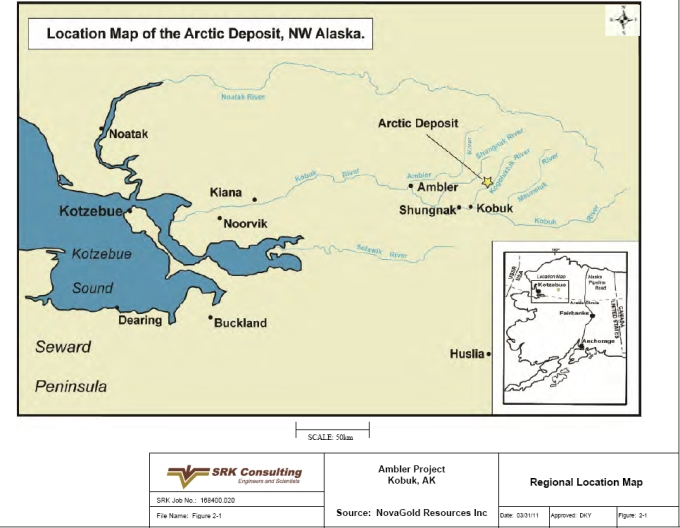
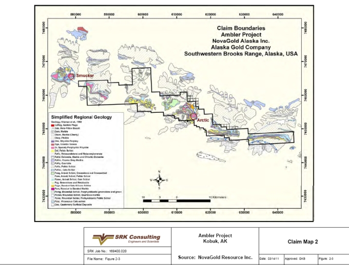
The Project is located in the Ambler District (Figure 2-1), in the southern Brooks Range of northwestern Alaska at geographic coordinates N67.17º latitude and W156.38º longitude. Work is performed at the site using Universal Transverse Mercator (UTM) North American Datum (NAD) 1927 Zone 4. The center of the Project area is 263km east of the town of Kotzebue, 29km north of the village of Kobuk, 260km west of the Dalton Highway and 480km northwest of Fairbanks. The current size of the property is approximately 65km long x 8km wide and comprises a total of 36,670ha.
| 2.2 | Mineral Tenure |
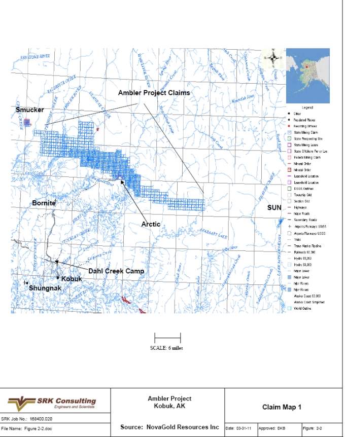
The Project comprises 36,670ha (90,615 acres) of State of Alaska mining claims and Federal patented and unpatented mining claims in the Kotzebue Recording District. The Project land tenure consists of 1,230 contiguous claims, including 789 40-acre State claims, 347 160-acre State claims, 79 40-acre State select claims, 15 20-acre Federal claims, and 272 acres of Federal patented land. These claims are shown in Figures 2-2 and 2-3 and are listed in Appendix B. These claims are listed and recorded in acres since this is the unit of land measure in the United States of America. Twenty acres is equivalent to 8ha, 40 acres is equivalent to 16ha and 160 acres is equivalent to 65ha. The Federal patented claim corners at the Project were located by U.S. Government Surveys (USGS). Rent for each State claim is paid annually to the Alaska Department of Natural Resources and for unpatented Federal claims to the Bureau of Land Management (BLM). There is no expiration date on State and federal claims. The Project is located near the southern edge of the center of the claim block. Mineralization is interpreted to extend west and east and potentially north of the project area and is covered by claims in these directions.
In 1971, the United States Congress passed the Alaska Native Claims Settlement Act (ANCSA) which settled land and financial claims made by the Alaska Natives and provided for the establishment of 13 regional corporations to administer those claims. These are known as the Alaska Native Regional Corporations (ANCSA Corporations). One of these 13 regional corporations is Northwest Alaskan Native Association (NANA) Regional Corporation. Lands controlled by NANA bound the southern border of the claim block. In addition, the northern property border is within 25km of National Park lands.
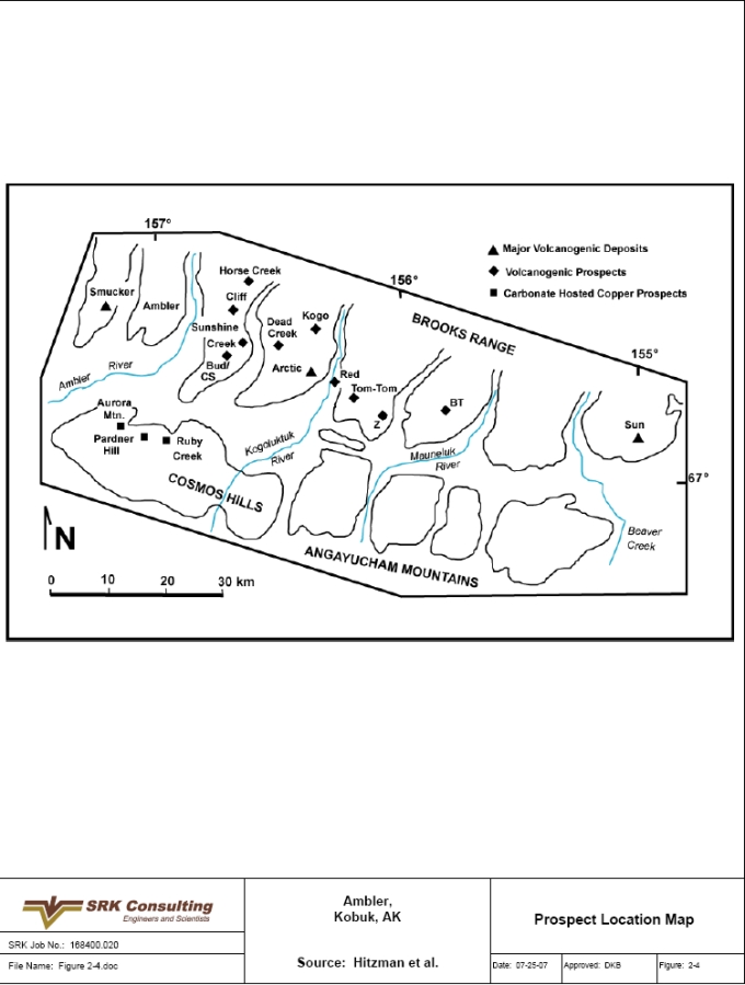
The Ambler District contains many mineralized prospects and two known significant deposits, in addition to the Project. The first prospect, located west of the Project, is the Smucker deposit. Smucker is owned by Teck Cominco Limited (Teck Cominco) and is currently in target delineation. The second prospect, the Sun deposit, is owned by Andover Ventures Inc. (Andover) and is in the process of resource definition. These two prospects are shown in Figure 2-4 where they are identified as Smucker and Sun. Figure 2-4 also shows the location of all the known prospects in the Ambler District including Sunshine Creek, CS, Bud, Horse Creek, Cliff, Dead Creek, Kogo, Red, BT and Tom Tom. The Ruby Creek deposit near Bornite located southwest of the Project is held by NANA.
| SRK Consulting (U.S.), Inc. | May 9, 2011 |
| NovaGold Resources Inc. | 2-2 |
| Ambler Project | NI 43-101 Preliminary Econimic Assessment |
2.2.1 Agreements
Under a purchase agreement dated December 18, 2009, between NovaGold and its wholly-owned subsidiary Alaska Gold Company, and Kennecott Exploration Company and Kennecott Arctic Company (collectively “Kennecott”), NovaGold agreed to pay Kennecott a total purchase price of US$29million for a 100% interest in the Project to be paid as: US$5million by the issuance of 931,098 NovaGold shares and two installments of US$12million each, due 12 months and 24 months, respectively, from the date of closing on January 7, 2010. The January 2011 payment was made. Kennecott retains a 1% NSR royalty that is purchasable at any time for a one-time payment of US$10million. The agreement terminated the exploration agreement between NovaGold and Kennecott dated March 22, 2004, as amended, under which NovaGold had the ability to earn a 51% interest in the property.
| 2.3 | Environmental Liabilities |
To date, the Ambler District has been the subject of various early stage exploration programs. However, there has been no actual mine development or production within the Project area boundaries, and therefore no known mine workings or mill tailings are present on the property.
In addition, there are no indications of any known environmental impairment or enforcement actions associated with NovaGold’s activities to date. As a result, NovaGold has not incurred any outstanding environmental liabilities in conjunction with its entry into the exploration agreement. Thus, further development of the Project would not be burdened with any legacy of environmental issues. Prior to approximately 1987, BCMC was the exploration subsidiary of Kennecott.
| 2.4 | Permits |
Various permits are required during the exploration phase of the Project. The permit for exploration on the property, the State of Alaska Annual Hardrock Exploration Permit, is initially obtained and thereafter renewed annually through the Alaska Department of Natural Resources – State Division of Mining, Land and Water (Alaska DNR). NovaGold holds a current exploration permit in good standing with the Alaska DNR, and has done so each year since 2004. In addition, since the property is situated within the Northwest Arctic Borough, a Title 9 permit is required for transportation of personnel by air over Borough lands. NovaGold held this permit in good standing during the 2004, 2005, and 2006 seasons and renewed this permit for the 2007 exploration season.
A number of statutory reporting and payments are required to maintain the claims in good standing on annual basis. Additional permits will be necessary to carry out environmental baseline studies and detailed engineering studies as the Project moves closer to development.
The Project will require multiple permits from regulatory agencies and other entities at the Federal, State and local (Borough) levels. As a result of the remoteness of the Project and the lack of existing infrastructure, it is likely that a significant permitting effort will also be a part of the development of support infrastructure. Due to the preliminary stages of this Project, it is difficult to assess what specific permitting requirements will ultimately apply to the Project. A more comprehensive outline of the Project and permitting requirements is discussed in Section 17.8 of this report.
| SRK Consulting (U.S.), Inc. | May 9, 2011 |
| NovaGold Resources Inc. | 2-3 |
| Ambler Project | NI 43-101 Preliminary Econimic Assessment |
Figure 2-1: Regional Location Map
| SRK Consulting (U.S.), Inc. | May 9, 2011 |
| NovaGold Resources Inc. | 2-4 |
| Ambler Project | NI 43-101 Preliminary Econimic Assessment |
Figure 2-2: Claim Map 1
| SRK Consulting (U.S.), Inc. | May 9, 2011 |
| NovaGold Resources Inc. | 2-5 |
| Ambler Project | NI 43-101 Preliminary Econimic Assessment |
Figure 2-3: Claim Map 2
| SRK Consulting (U.S.), Inc. | May 9, 2011 |
| NovaGold Resources Inc. | 2-6 |
| Ambler Project | NI 43-101 Preliminary Econimic Assessment |
Figure 2-4: Prospect Location Map
| SRK Consulting (U.S.), Inc. | May 9, 2011 |
| NovaGold Resources Inc. | 3-1 |
| Ambler Project | NI 43-101 Preliminary Econimic Assessment |
| 3 | Accessibility, Climate, Local Resources, Infrastructure and Physiography (Item 7) |
Accessibility is a major challenge to developing the Project. Currently the project does not have any access infrastructure. Numerous past studies have demonstrated that access infrastructure will be required to make this a viable project.
| 3.1 | Access to Property |
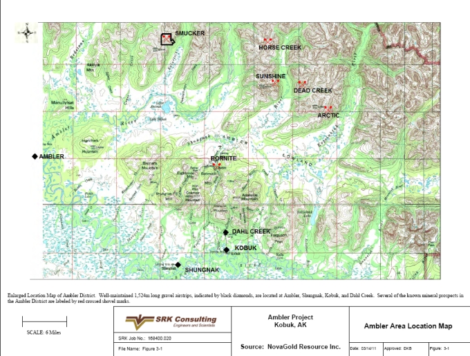
There is no developed surface access to the Project area. Primary access is by air using both fixed wing aircraft and helicopters. There are four well maintained, 1,524m-long gravel airstrips capable of accommodating charter aircraft. These airstrips are located 66km west at Ambler, 46km southwest at Shungnak, 36km southwest at Kobuk and 32km southwest at Dahl Creek (Figure 3-1). Additionally, there is a smaller and lesser-maintained dirt airstrip near the Bornite prospect. From these points of fixed wing access, helicopter use is required to access the Project site and transport personnel, equipment and supplies. A one-lane dirt track suitable for high-clearance vehicles or construction equipment links the project site to the Dahl Creek Camp (Figure 3-2).
River access to Ambler, Shungnak and Kobuk by barge is occasionally possible via the Kobuk River from Kotzebue Sound via Hotham Inlet (Figure 2-1). High water during seasonal runoff is necessary for successful navigation of this route since the Kobuk River is commonly shallow and impassible upstream of the village of Ambler.
The center of the Project area is 263km east of the town of Kotzebue, 36km northeast of the village of Kobuk, 260km west of the Dalton Highway, and 480km northwest of Fairbanks. All distances are direct by air. The current size of the property is approximately 65km long x 8km wide and comprises a total of 36,670ha. The village of Kobuk, population 111 (2003) is located 36km away and is accessible by fixed wing aircraft.
| 3.2 | Climate |
The climate in the Ambler District is typical of a sub-arctic environment. The exploration season for the Project is from late May until late September. Weather conditions change suddenly during the field season and can be vary significantly from year to year. During this time period average high temperatures range from 4 to 18°C, while average lows range from -2 to 10°C. Record high and low temperatures during these months are 29 and -17°C, respectively. Extended sunlight in late May and early June accelerates melting of the winter snow pack on the property. By late September or early October, poor weather prohibits safe helicopter travel to the property. Heavy rains and snow are also possible in August. The winter months are long and cold as the property is blanketed by snow and ice. During this time, snow cover allows for increased access to the property by snow machine, track vehicle or by fixed wing aircraft. Winter temperatures are routinely below -28°C and can exceed -51°C. Annual precipitation in the region is roughly 546.1mm with the most rainfall occurring from July through October and the most snowfall occurring from December through April (Alaska Climate Summaries, 2007).
| 3.3 | Physiography |
The Project is located along the south side of the Brooks Range, one of the longest mountain ranges in Alaska. The Brooks Range separates the arctic region from the Alaskan interior
| SRK Consulting (U.S.), Inc. | May 9, 2011 |
| NovaGold Resources Inc. | 3-2 |
| Ambler Project | NI 43-101 Preliminary Econimic Assessment |
(Climate of Alaska, 2007). The Project is located on the east side of Subarctic Creek straddling a 970m ridge between Subarctic Creek and the Kogoluktuk River Valley. Subarctic Creek is a tributary of the Shungnak River. The Project area is marked by steep and rugged terrain with extreme topographic relief. Elevations range from 30m above mean sea level (amsl) at Ambler, Alaska along the Kobuk River to 1,180mamsl on the peak immediately north of the project area. The divide between the Shungnak and Kogoluktuk Rivers in the Ambler Lowlands is just 220mamsl.
Nearby surface water includes Subarctic Creek, the Shungnak and Kogoluktuk Rivers, the Kobuk River, and numerous small lakes.
The Kobuk Valley marks the transition zone between boreal forest and arctic tundra. The area is near the northern limit for trees. Spruce, birch and poplar are found in better-drained portions of the valley, with lichen and moss covering the ground. Willow and alder thickets as well as isolated cottonwoods follow drainages, and alpine tundra are found on the higher slopes and ridges. Tussock tundra and low, heath-type vegetation covers most of the flat floor of the valley (Kobuk Valley National Park, 2007).
Permafrost is a layer of soil at variable depths beneath the surface where the temperature has been below freezing continuously from a few to several thousands of years. Permafrost exists where summer heating fails to penetrate to the base of the layer of frozen ground and occurs in most of the northern third of Alaska as well as in discontinuous or isolated patches in the central portion of the State (Climate of Alaska, 2007).
| 3.4 | Infrastructure |
Because of the remote location of the Project, infrastructure, specifically transport of material and personnel to and from the Project and power, are the largest cost items. There is no developed surface access to the Project area and no power infrastructure near the Project area.
SRK examined various methods for accessing the Project and transporting materials. Of these various methods, the Project and this report focus on the use of a new road to the Dalton Highway.
3.4.1 Road
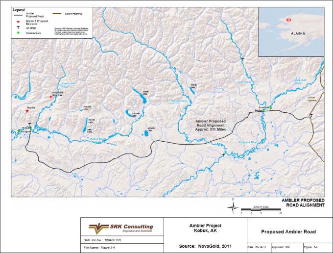
The proposed access road alignment is shown in Figure 3.4. The length of the proposed road is approximately 340km (211 miles). It extends west from the Dalton Highway along generally level terrain to the village of Kobuk where it would connect with existing roads to Bornite and the proposed mine area. The road alignment is consistent with alignments that the Alaska Department of Transportation (ADOT) has previously considered to access the overall Ambler Mining District as well as all of the western coast of Alaska. ADOT is currently undertaking a major planning study to further define access options, including detailed road alignment and engineering evaluations, for the Ambler Mining District.
The design parameters for a road suitable with the mine’s needs for transporting all materials and personnel to and from the area, and to service possible additional mining developments are shown below:
● | Roadway Surface Width = 30ft total width (24ft roadway with 3ft shoulders); |
● | Typical Section = 6ft total section, 8 inches of crushed aggregate surface over a 64 inch embankment; |
| SRK Consulting (U.S.), Inc. | May 9, 2011 |
| NovaGold Resources Inc. | 3-3 |
| Ambler Project | NI 43-101 Preliminary Econimic Assessment |
● | A 24 inch excavation; |
● | 4:1 side slopes, and |
● | Geogrid lining. |
In considering the proposed access road in this PEA, NovaGold assumes that it would be constructed and operated through a public/private partnership. As such, the PEA assumes that the State of Alaska would construct and maintain the road. NovaGold would pay an annual fee of US$15million per year for 20 years beginning in the sixth year of mine operations. NovaGold states that the State has expressed its willingness to support the concept of such a public/private partnership and to continue to work together with NovaGold and other interested parties to advance the concept as the mine proceeds further through the planning process.
3.4.2 Airport
The Project has elected to use two existing airports versus constructing and maintaining a dedicated airstrip. These are the Dahl Creek airport and the Kobuk airport, both are located southwest of the Project at 32km and 36km, respectively. Each has a maintained gravel runway suitable for personnel and cargo charter aircraft. There will be a requirement for only a few flights per week, generally crew-change related.
3.4.3 Electrical Power Supply
Currently, electrical power in the region is produced by local diesel generators as well as small wind generators in communities where wind power can be economically harnessed. There are no interconnections with other power grids in the State. SRK estimates the Project will require 10.2MW capacity for a nominal 4,000t/d mine operation. This capacity estimate is sufficient to meet the combined demand from the mine and process facilities, the support infrastructure, and the man-camp. SRK performed a trade-off evaluation between self-producing the power using diesel generators and constructing a power transmission line from the nearest power generating facility out of Fairbanks. The results favored self-generation through diesel generators. As such, the PEA assumes the site will generate all its power needs by using diesel generators.
3.4.4 Water Supply
Water supply for consumptive uses is assumed available both from groundwater and surface water and that its quality is acceptable. Makeup water will be treated by filtration and chlorination when used for potable and service water applications. Some water is required for a closed loop cooling system of the diesel generators. A raw water treatment and storage facility for the entire mine site will be required.
3.4.5 Material Transport
The transport of mine concentrates is to occur direct from the Project site in bulk form using container boxes hauled on tractor-trailers. The infrastructure incorporates a container loading facility as well as a truck staging and maintenance facility in a single structure. From here, the over-the-highway trucks will be loaded with filled containers, weighed and then driven to a rail site at Fairbanks using the new regional roadway and the existing Dalton Highway. An off-site support facility is planned at the Pump Station 5 intersect which includes a dormitory for rest and a light maintenance facility to handle unforeseen issues with the tractor-trailers. Once in
| SRK Consulting (U.S.), Inc. | May 9, 2011 |
| NovaGold Resources Inc. | 3-4 |
| Ambler Project | NI 43-101 Preliminary Econimic Assessment |
Fairbanks the concentrate-laden containers will be off-loaded from the trucks and loaded onto rail for transport to the nearest shipping port and subsequently to the contracted smelter.
3.4.6 Buildings and Ancillary Facilities
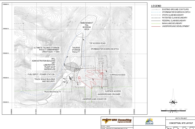
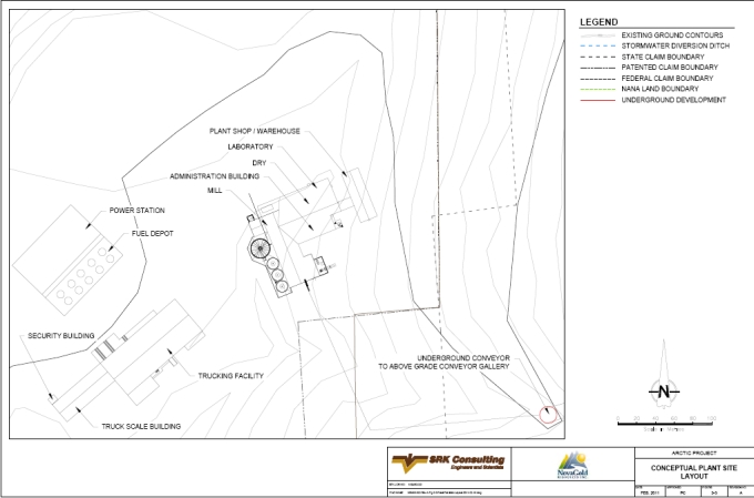
In addition to the previously mentioned truck staging facility, the Project requires the full assortment of support facilities including an administration building/offices, dry, laboratory, first aid clinic, lunch room, training room, process plant maintenance shop, warehouse and the mill building. Typically, these structures are individually located; however, they have been adjoined to minimize employee exposure to the elements when traveling between areas. The partition between the mill building and the administration building, dry and laboratory is considered either a concrete or a cinderblock wall to improve safety and sound control. Similarly, the plant shop/warehouse facility is adjoined to the main structure through an insulated walkway. The power station is its own dedicated facility located in close proximity to the fuel depot area. The main mine shop is assumed to be underground. Tailings disposal will be at the head of Subarctic Creek, as will the mill. Waste disposal facilities will be adjacent to the camp. A conceptual site layout is shown in Figures 3-2 and 3-3.
Camp facilities will be in close proximity to the mine site. The camp will accommodate at least 200 people at one time and include sleeping quarters, lavatories, a dining facility and recreational facilities. Additionally, Pump Station 5 facilities include a dormitory to facilitate the personnel located at this off-site location along with the passing truck drivers.
| 3.5 | Support Labor |
The total personnel requirements are estimated to be 420 workers. These labor requirements are comprised of approximately 250 mineworkers, 110 process staff and 60 infrastructure related workers. This figure includes the off-site personnel at Pump Station 5, but excludes any contract workers such as truck drivers or campsite support labor. Typically, the mine site crews will change on a standard fly-in-fly-out (FIFO) work schedule unless they normally live in the regional villages and towns.
The local workforce of the region could potentially be a source for mine personnel. In 2006, NovaGold hired local residents from Kobuk, Shungnak and Ambler to work on the Project. Employees were hired through NANA Management Services employee leasing, a division of NANA management. NovaGold employed more than 15 local residents on the Project, including one senior field coordinator, six geotechnicians, two cook’s assistants, two core splitters and four driller helpers.
| SRK Consulting (U.S.), Inc. | May 9, 2011 |
| NovaGold Resources Inc. | 3-5 |
| Ambler Project | NI 43-101 Preliminary Econimic Assessment |
Figure 3-1: Ambler Area Location Map
| SRK Consulting (U.S.), Inc. | May 9, 2011 |
| NovaGold Resources Inc. | 1 |
| Ambler Project | NI 43-101 Preliminary Econimic Assessment |
Figure 3-2: Conceptual Site Layout
| SRK Consulting (U.S.), Inc. | May 9, 2011 |
| NovaGold Resources Inc. | 3-6 |
| Ambler Project | NI 43-101 Preliminary Econimic Assessment |
Figure 3-3: Conceptual Plant Site Layout
| SRK Consulting (U.S.), Inc. | May 9, 2011 |
| NovaGold Resources Inc. | 3-7 |
| Ambler Project | NI 43-101 Preliminary Econimic Assessment |
Figure 3-4: Proposed Ambler Road
| SRK Consulting (U.S.), Inc. | May 9, 2011 |
| NovaGold Resources Inc. | 4-1 |
| Ambler Project | NI 43-101 Preliminary Econimic Assessment |
| 4 | History (Item 8) |
Prospectors came up the Kobuk River into the Ambler Lowlands and parts of the Brooks Range around 1900. Several small gold placer deposits in the Cosmos Hills were discovered and worked intermittently. A second wave of prospectors returned to the region after World War II looking for gold, uranium and copper. Copper mineralization was observed at Ruby Creek in 1905, but not much work occurred there until its rediscovery by Rhinehart Berg in the 1940s. By 1957, Berg exposed significant amounts of high-grade copper mineralization. At this time BCMC, the exploration subsidiary of Kennecott, optioned Ruby Creek from Mr. Berg (Kennecott, 1977, Hitzman et al., 1986). The project came to be known as Bornite. Kennecott later began underground development at Bornite, but an attempt to mine the discovery was short lived (Dodd et al., 2005).
The following is excerpted from NovaGold’s Ambler Project (1816) 2004 Summary Report. Standardizations have been made to suit the format of this report.
BCMC conducted regional exploration of the Cosmos Hills and the southern Brooks Range while drilling extensively at Ruby Creek. Stream silts sampling in 1963 revealed a 1,400ppm Cu anomaly in Arctic Creek. This anomaly contributed to discoveries of massive sulfide at Arctic and Dead Creeks in 1965 (Kennecott, 1977; Hitzman et al., 1986). In 1967, eight core holes were drilled at Arctic Creek yielding impressive massive sulfide intercepts over a strike length of 460m. This successful program resulted in the continuation of drilling over the next several seasons at the Project. In 1966 and 1967, BCMC drilled eight core holes at Dead Creek, also intercepting massive sulfide. Structural complexities at Dead Creek hindered progress and BCMC focused on the Arctic Creek area. BCMC intermittently conducted exploration programs on the Project from August 1967 to 1998. Over that span, 92 holes were drilled at the Project, including 14 large diameter metallurgical holes, totaling 17,572m. No drilling or additional exploration on the Project was conducted between 1998 and 2004.
In addition to drilling on the Project, BCMC continued their exploration of other prospects in the Ambler District. Competing companies, including Sunshine Mining Company, Anaconda, Noranda, Teck Cominco, Resource Associates of Alaska (RAA), Watts, Griffis and McOuat Ltd. (WGM), and Houston Oil and Minerals Company, entered into a claim staking war in the district in the early 1970’s. District exploration by Sunshine Mining Company and others resulted in two substantial discoveries at the Sun Prospect located 60km east of the Project and the Smucker Prospect located 40km west of the Project. District exploration continued until the early 1980s on the four larger deposits (the Project, Ruby Creek, Smucker and Sun) as well as many lesser-defined prospects within the district, including Sunshine Creek, CS, Bud, Horse Creek, Cliff, Dead Creek, Kogo, Red, BT and Tom Tom. No production has occurred at the Project.
In 1993, Kennecott Minerals, the successor of BCMC, began to re-evaluate the Project. This included a review of the deposit geology and the assembly of a computer database. A new computer-generated block model was constructed in 1990 and an updated resource was estimated from the block model. The result was an internal historical estimate of an inferred resource of 36.3Mt averaging 4.0% Cu, 5.5% Zn, 0.8% Pb, 54.9g/t-Ag and 0.7g/t-Au. Although believed by NovaGold management to have been relevant and reliable, this historical resource estimate predates the development of NI 43-101 reporting guidelines, was not estimated in compliance with NI 43-101 procedures and should not be relied on.
| SRK Consulting (U.S.), Inc. | May 9, 2011 |
| NovaGold Resources Inc. | 4-2 |
| Ambler Project | NI 43-101 Preliminary Econimic Assessment |
| 4.1 | Historical Testwork |
The first three test campaigns performed on the Project mineralized material were conducted at the Kennecott Research Center between 1968 and 1976. The focus was on selective flotation to provide separate copper, lead and zinc concentrates for conventional smelting.
The initial amenability testing was carried out in 1968 on individual samples and their composites made from cores from eight diamond drillholes. Core drilled prior to 1998 was drilled using NQ- and BQ-sized strings. An additional four samples were obtained from three holes and tested in 1972. Laboratory scale bench tests included a conventional selective flotation approach to produce three separate (copper, lead and zinc) concentrates. The major problems encountered were:
● | Difficult copper-lead separation, and |
● | Zinc deportment to the copper and the lead concentrates. |
The highest-grade copper concentrate contained over 30% Cu, 2 to 3% Zn and less than 1% Pb, but at a low copper recovery of less than 80%. The lead concentrate was low-grade 17 to 36% Pb and assayed 5 to 25% Cu. The subsequent sphalerite flotation was generally efficient. The zinc concentrate grade was 55% and the zinc recovery up to 70%, depending on how much zinc floated in the preceding copper and lead flotation. Silver generally followed galena.
During 1975, large diameter cores from 14 drillholes were used for more detailed testing to develop the concentrator flowsheet and process parameters. Two composites were prepared: No.1 (Eastern zone) and No.2 (Western zone). Most of the test work was conducted on the composite No.1, which represented 75% of the resources. The test program included mineralogical examinations, bench scale testing of various process parameters for each selective flotation step and locked cycle tests. Complete analyses were done on a number of concentrates to identify potential impurities. Preliminary tests for bulk flotation of all sulfides were also carried out.
Historical testing showed that a clear separation of various sulfide minerals is difficult because of fine interlocking of mineral grains. It showed that the economically most important minerals, chalcopyrite and sphalerite, could be recovered into selective copper and zinc concentrates with commercial concentrate grades and good recoveries. Lead and precious metals easily reported to the copper concentrate. The production of a selective high-grade lead concentrate was not successful. Only a low-grade, silver-bearing lead concentrate (17 to 36% Pb) was obtained, containing high amounts of iron, copper and zinc. Generally, the copper concentrate grade and recovery depended on the amounts of lead and zinc prevented from floating during copper flotation and cleaning. Production of two selective copper and zinc concentrates could be confidently projected, although additional testing would be required to optimize the flow sheet and all process parameters.
Testing indicated that the talc contained in the potential mill feed would have to be floated before selective flotation of sulfide minerals. The losses of base and precious metals to the talc concentrate were satisfactory and below 1% each.
Silver was mainly associated with galena. The highest silver recovery to copper concentrate was achieved when lead was recovered as well. If galena was rejected from the copper concentrate,
| SRK Consulting (U.S.), Inc. | May 9, 2011 |
| NovaGold Resources Inc. | 4-3 |
| Ambler Project | NI 43-101 Preliminary Econimic Assessment |
20 to 40% of the silver, associated with tetrahedrite and tennantite, remained in the copper concentrate.
Gold assaying was very sporadic during the three test campaigns and was not provided. It was noted, however, that at least 70% of the gold reported to the copper concentrate, although not enough testing was performed to predict gold recovery.
4.1.1 1995 Testwork
The 1976 conceptual study for the selection of the metallurgical process for the Project established that the Kennecott Sulfite Process (KSP) could be developed as an economic hydro metallurgical alternative to smelting. Bulk concentrate could be amenable for processing with this novel technology.
Metallurgical testing was carried out at Hazen Research in 1995 to:
● | Produce bulk concentrate for amenability testing; |
● | Determine technical viability of the key KSP process steps for processing of the Project bulk concentrate; and |
● | Optimize flow sheet and parameters for selective flotation, especially to improve selectivity among copper, lead, zinc and pyrite and obtain additional data on gold recovery. |
Samples used in the 1995 testwork were minus 10 mesh core rejects from the 1975 drilling, kept in storage since the 1976 testing. A composite No.lA was prepared, similar in composition to the 1976 composite No.1 using the samples from the same holes. Investigations at Hazen Research confirmed similar mineralogy for the 1976 and 1995 composites.
Initial selective flotation testing failed to reproduce the results obtained during the 1976 testing under the same process conditions. The surface deterioration of the samples during the long storage significantly affected the selectivity of the sulfide minerals and their separation into specific concentrates, even if the total recoveries to all concentrates had not been reduced. Further attempts to conduct testing to optimize selective flotation under those conditions were abandoned.
Bulk flotation was not significantly affected by deterioration of samples during storage. The bulk concentrate produced at Hazen Research contained 10.4% Cu, 2.2% Pb and 15.0% Zn and recovered 94% Cu, 92% Pb, 97% Zn, 87% Au and 95% Ag. Only the recovery of lead was slightly lower than obtained during earlier tests.
The testing of the key KSP process steps (roasting, leaching and copper reduction) did not demonstrate a “fatal flaw” and confirmed the technical viability of the concept. However, a more complex approach was indicated for zinc recovery from the bulk concentrate when compared to the lower zinc grade of the copper concentrate considered in the 1976 study. In addition, precious metals recoveries by cyanidation of the residue were disappointing and the potential recovery of lead from bulk concentrate in the commercial product was not attempted.
Substantial development work is still required to define each KSP process step and determine its design parameters, as well as to demonstrate the integrated process on a scale sufficient for a meaningful evaluation. The same applies to the emerging chloride-based Intec Ltd. copper process currently being developed for hydrometallurgical treatment of copper concentrates under
| SRK Consulting (U.S.), Inc. | May 9, 2011 |
| NovaGold Resources Inc. | 4-4 |
| Ambler Project | NI 43-101 Preliminary Econimic Assessment |
the Rio Tinto-Zinc Corporation participation in the sponsorship. Therefore, these hydrometallurgical options for processing bulk concentrate were not considered for this evaluation as alternatives to conventional smelting.
The optimization and further development of the flow sheet and process conditions for selective flotation at Hazen Research in 1995 was prevented by surface deterioration of the available samples. The test results from the 1968-1976 test work at the KRC were used for flow sheet development in this evaluation.
The selected process is conventional selective flotation to produce separate copper and zinc concentrates for shipment to existing smelters for treatment. Most of the lead and precious metals would report to the copper concentrate.
4.1.2 Historical Exploration
Exploration on the Project has been intermittent since the discovery of the Project in 1965. The Project was discovered during a routine follow up on a copper anomaly identified from a 1963 regional geochemical survey performed by BCMC. In 1965, BCMC geologists discovered sulfide minerals in an outcrop on Arctic Ridge while performing a follow-up investigation of a 1,400ppm Cu geochemical anomaly from sampling completed during a 1963 regional exploration program. This regional exploration program covered the Cosmos Hills and much of the southern Brook Range and included reconnaissance geological mapping and stream sediment sampling.
Since 1965, the project has undergone many different periods of exploration activity under two operators: Kennecott or its subsidiaries and NovaGold. Inaccessibility of the Ambler District, along with depressed metals prices, caused interest in the district to wane, and significant exploration in the Ambler District ended in 1985. Kennecott sold Bornite to NANA in 1986. Lack of road or rail access to the area has hindered development within the Ambler District.
In 1993, Kennecott began a re-evaluation of the Project. This included a review of the deposit geology and the assembly of a computer database. A new computer-generated block model was constructed in 1995 and an updated resource was calculated from the block model. The resulting estimated inferred resource totaled 36.3Mt averaging 4.0% Cu, 5.5% Zn, 0.8% Pb, 54.9g/t Ag and 0.7g/t Au. Although believed by NovaGold management to have been relevant and reliable, this historical resource estimate pre-dates the development of NI 43-101 reporting guidelines, was not estimated in compliance with NI 43-101 procedures and should not be relied on.
In September 1997, Kennecott located a total of 2,035 State mining claims covering most of the known Ambler schist belt. More drilling was performed and, in 1998, an updated resource estimate was completed using the 1995 model. Economic studies, based on the latest resource estimate, failed to produce a positive NPV and the project was suspended. No additional exploration on the Project was conducted between 1998 and 2004.
Kennecott reduced its land position in the southern Brooks Range to 829 State of Alaska claims. In addition to the Alaska State claims, Kennecott maintains 15 unpatented Federal mining claims surrounding 18 private patented claims.
| 4.2 | Historical Drilling |
Between 1967 to July 1985, 86 holes were drilled (including 14 large diameter metallurgical test holes) totaling 16,080m. In 1998, Kennecott drilled six core holes totaling 1,492m in the Arctic
| SRK Consulting (U.S.), Inc. | May 9, 2011 |
| NovaGold Resources Inc. | 4-5 |
| Ambler Project | NI 43-101 Preliminary Econimic Assessment |
deposit to test for extensions of the known resource, and to test for grade and thickness continuity. Drilling for all BCMC/Kennecott campaigns in the Arctic deposit area (1966–1998) totals 92 core holes for a combined 17,572m.
No drilling was performed on the project between 1998 and 2003. NovaGold took control of the company in 2004. The 2004–2006 and 2008 drill programs conducted by NovaGold are described in Section 9, Drilling.
| 4.3 | Historical Geophysics |
In 1998, an airborne geophysical survey of the entire claim block generated numerous electromagnetic anomalies. Additional geophysical surveys have been performed by NovaGold and will be discussed in Section 8, Exploration.
| 4.4 | Historical Resource Estimates |
A resource estimate was performed on Arctic deposit by Kennecott based on 70 holes. This resource estimate was performed in 1990 and is summarized in Table 4.4.1. This estimate is considered to be that of an inferred resource. Although believed by NovaGold management to be relevant and reliable, this historical resource estimate predates the development of NI 43-101 reporting guidelines, was not estimated in compliance with NI 43-101 procedures and should not be relied on (Randolf, 1990).
Table 4.4.1: Historical Resource Estimate - 1990
| Classification | Tonnes (kt) | Cu% | Zn% | Pb% | Ag_ppm | Au_ppm |
| Measured | 0 | 0.0 | 0.0 | 0.0 | 0.0 | 0.0 |
| Indicated | 0 | 0.0 | 0.0 | 0.0 | 0.0 | 0.0 |
| Measured and Indicated | 0 | 0.0 | 0.0 | 0.0 | 0.0 | 0.0 |
| Inferred | 36,300 | 4.0 | 5.5 | 0.8 | 54.9 | 0.7 |
| SRK Consulting (U.S.), Inc. | May 9, 2011 |
| NovaGold Resources Inc. | 5-1 |
| Ambler Project | NI 43-101 Preliminary Econimic Assessment |
| 5 | Geologic Setting (Item 9) |
| 5.1 | Regional Geology |
The Ambler District occurs within an east–west trending zone of Devonian to Jurassic age submarine volcanic and sedimentary rocks (Hitzman et al., 1986). VMS deposits and prospects are hosted in the Middle Devonian to Early Mississippian age Ambler Sequence, a group of metamorphosed bimodal volcanic rocks with interbedded tuffaceous, graphitic and calcareous volcanoclastic metasediments. The Ambler Sequence occurs in the upper part of the Anirak Schist, the thickest member of the Coldfoot subterrane (Moore et al., 1994). VMS mineralization can be found along the entire 110km strike length of the district. Hitzman notes that the 1,980m-thick Devonian age section of the Cosmos Hills, which includes the 915m-thick Bornite Carbonate Sequence, is equivalent in age to the Anirak Schist and was mineralized during the Ambler mineralizing event.
The Ambler District is characterized by a series of east–west trending belts of rocks of increasing metamorphic grade northward across the strike of the units. The structure of the district is isoclinally folded in the northern area and thrust faulted in the southern half (Schmidt, 1983). The Devonian to Mississippian age Angayucham basalt and the Triassic to Jurassic age mafic volcanic rocks are in low-angle thrust contact with various units of the Coldfoot subterrane along the northern edge of the Ambler Lowlands.
5.1.1 Terrane Descriptions
The terminology of terranes in southern Brooks Range evolved during the 1980s because of the region’s complex juxtaposition of rocks of various composition, age and metamorphic grade. Hitzman et al. (1986) divided the Ambler District into the Ambler and Angayucham terranes. Slightly more recent work (Till et al., 1988; Silberling et al., 1992; Moore et al., 1994) includes the rocks of the previously defined Ambler terrane as part of the regionally extensive schist belt or Coldfoot subterrane along the southern flank of the Arctic Alaska terrane (Figure 5-1) (Moore et al., 1994), which is the usage in this report. In general, the southern Brooks Range is composed of east–west trending structurally bound allochthons of variable metasedimentary and volcanogenic Paleozoic age rocks.
The Angayucham terrane, which lies along southern margin of the Brooks Range, is locally preserved as a klippen within the eastern Cosmos Hills and is composed of weakly metamorphosed to unmetamorphosed massive-to-pillowed basalt rocks with minor radiolarian cherts, marble lenses and isolated ultramafic rocks (Figure 5-2). This package of Devonian to Late Triassic age (Plafker and others, 1977) mafic and ultramafic rocks is interpreted to represent portions of an obducted and structurally dismembered ophiolite that formed in an ocean basin south of the present day Brooks Range (Hitzman et al., 1986; Gottschalk and Oldow, 1988). Locally, the Angayucham terrane overlies the schist belt to the north along a poorly exposed south-dipping structure.
Gottschalk and Oldow (1988) describe the schist belt as a composite of structurally bound packages composed of dominantly greenschist facies tectonite rocks, including pelitic to semi-pelitic quartz-mica schist with associated mafic schists, metagabbro and marbles. Locally, the schist belt includes the middle Devonian age Bornite carbonate sequence, the lower Paleozoic age Anirak pelitic, variably siliceous and graphic schists, and the mineralized Devonian age
| SRK Consulting (U.S.), Inc. | May 9, 2011 |
| NovaGold Resources Inc. | 5-2 |
| Ambler Project | NI 43-101 Preliminary Econimic Assessment |
Ambler sequence consisting of volcanogenic and siliciclastic rocks variably associated with marbles, calc-schists, metabasites and mafic schists (Figure 5-2) (Hitzman et al., 1982; Hitzman et al., 1986). The lithologic assemblage of the schist belt is consistent with an extensional, epicontinental tectonic origin.
Structurally overlaying the schist belt to the north is the Central belt. The Central belt is in unconformable contact with the schist belt along a north-dipping low-angle structure (Till et al., 1988). The Central belt consists of lower Paleozoic age metaclastic and carbonate rocks, and Proterozoic age schists (Dillon et al., 1980). Both the Central belt and schist belt are intruded by meta-to-peraluminous orthogneisses, which locally yield a slightly discordant U-Pb-TIMS zircon crystallization age of middle to late Devonian (Dillon et al., 1980; Dillon et al., 1987). This igneous protolith age is supported by Devonian orthogniess ages obtained along the Dalton Highway, 161km to the east of the Ambler District (Aleinikoff et al., 1993).
5.1.2 Regional Tectonic Setting
Rocks exposed along the southern Brooks Range consist of structurally bound, and possibly far traveled, imbricate allochthons that have experienced an intense and complex history of deformation and metamorphism. Shortening in the fold and thrust belt has been estimated to exceed 500km (Oldow et al., 1987) based on balanced cross sections across the central Brooks Range. In general, the metamorphic grade and tectonism in the Brooks Range increases to the south and is greatest in the schist belt. The tectonic character and metamorphic grade decreases south of the schist belt in the overlaying Angayucham terrane.
In the late Jurassic to early Cretaceous age, the schist belt experienced penetrative thrust-related deformation accompanied by recrystallization under high-pressure and low-temperature metamorphic conditions (Till et al., 1988). These north-directed compressional tectonics were likely related to crustal thickening caused by obduction of the Angayucham ophiolitic section over a south-facing passive margin. Thermobarometry of schists from the structurally deepest section of the northern schist belt yield relict metamorphic temperatures of 475 ± 35°C and pressures from 7.6 to 9.8kbar (Gottschalk and Oldow, 1988). Metamorphism in the schist belt grades from lowest greenschist facies in the southern Cosmos Hills to upper greenschist, locally overprinting blueschist mineral assembles in the northern belt (Hitzman et al., 1986).
Compressional tectonics, which typically place older rocks on younger, do not adequately explain the relationship of young, low-metamorphic-grade over older and higher-grade metamorphic rocks observed in the southern Brooks Range hinterland. Mull (1982) interpreted the schist belt as a late antiformal uplift of the basement to the fold and thrust belt. More recent models propose that the uplift of the structurally deep schist belt occurred along duplexed, north-directed, thin-skinned thrust faults, followed by post compressional south-dipping low angle normal faults along the south flank of the schist belt, accommodating for an over-steepened imbricate thrust stack (Figure 5-3) (Gottschalk and Oldow, 1988; Moore et al., 1994). Rapid cooling and exhumation of the schist belt began at the end of the early Cretaceous age at 105 to 103Ma, based on Ar40/Ar39 cooling ages of hornblende and white mica near Mt Igikpak, and lasted only a few million years (Vogl et al., 2002). Additional post extension compressive events during the Paleocene age further complicate the southern Brooks Range (Mull, 1985).
| SRK Consulting (U.S.), Inc. | May 9, 2011 |
| NovaGold Resources Inc. | 5-3 |
| Ambler Project | NI 43-101 Preliminary Econimic Assessment |
| 5.2 | District/Property Geology |
Rocks that form the Ambler schist belt consist of a lithologically diverse sequence of lower Paleozoic possibly Devonian age carbonate and siliciclastic strata with interlayered mafic lava flows and sills. The clastic strata, derived from terrigenous continental and volcanic sources, were deposited primarily by mass-gravity flow into the sub-wavebase environment of an extending marginal basin.
NovaGold’s work shows that the Ambler sequence underwent two periods of intense, penetrative deformation. Sustained upper greenschist-facies metamorphism with coincident formation of a penetrative schistosity and isoclinal transposition of bedding marks the first deformation period. Pervasive similar-style folds on all scales deform the transposed bedding and schistosity, defining the subsequent event. At least two later non-penetrative compressional events deform these earlier fabrics. NovaGold’s observations of the structural and metamorphic history of the Ambler District are consistent with current tectonic evolution models for the schist belt, based on the work of others elsewhere in southern Brooks Range (Gottschalk and Oldow, 1988; Till et al., 1988; Vogl et al., 2002).
5.2.1 General Description of the Stratigraphy of the District
The local base of the Ambler section consists of variably metamorphosed carbonates historically referred to as the Gnurgle Gneiss. NovaGold interprets these strata as calc-turbidites, perhaps deposited in a sub-wavebase environment adjacent to a carbonate bank. Calcareous schists overlie the Gnurgle Gneiss and host sporadically distributed mafic sills and pillowed lavas. These fine-grained clastic strata indicate a progressively quieter depositional environment up section, and the presence of pillowed lavas indicates a rifting, basinal environment. The overlying Arctic-sulfide host section consists mostly of fine-grained carbonaceous siliciclastics and indicates further isolation from a terrigenous source terrain. The section above the Arctic host contains voluminous reworked silicic volcanic strata with the Button Schist at its base. The paucity of volcanically derived strata below the Arctic host section and abundance above indicates that the basin and surrounding hinterlands underwent major tectonic reorganization during deposition of the Arctic section. Greywacke sands that NovaGold interpret as channeled high-energy turbidites occur throughout the section but concentrate high in the local stratigraphy.
Several rock units show substantial change in thickness and distribution between the Arctic Ridge, geographically above the Arctic deposit, and the Riley Ridge to the west. This distribution shows patterns that may have resulted from structural controls imposed on the basin during initial deposition:
● | The Gnurgle Gneiss is thickest in exposures along the northern extension of Arctic Ridge and appears to thin to the west; |
● | Mafic lavas and sills thicken from east to west. They show thick occurrences in upper Subarctic Creek and to the west, but are sparsely distributed to the east; |
● | The quartzite section within and above the Arctic sulfide does not occur in abundance east of Arctic Ridge; it is thicker and occurs voluminously to the west; |
● | Button Schist thickens dramatically to the west from exposures on Arctic Ridge; exposures to the east are virtually nonexistent; and |
| SRK Consulting (U.S.), Inc. | May 9, 2011 |
| NovaGold Resources Inc. | 5-4 |
| Ambler Project | NI 43-101 Preliminary Econimic Assessment |
● | Greywacke sands do not exist east of Subarctic Creek but occur in abundance as massive, channeled accumulations to the west, centered on Riley Ridge. |
These data are interpreted by NovaGold to define a generally north–northwest-trending depocenter through the central Ambler District. Diamictite occurrences described below in concert with these formational changes suggest that the depocenter had a fault-controlled eastern margin. The basin deepened to the west; the Riley Ridge section deposited along a high-energy axis, and the Center of the Universe (COU) section lies distally from a depositional energy point of view. This original basin architecture appears to have controlled mineralization of the sulfide systems at Ambler and Dead Creeks, concentrating fluid flow along the extensional structures in the eastern basin margin. Deposit and district geology is shown in Figure 5-4.
| 5.3 | Deposit Geology |
Russell (1995) and Schmidt (1983) describe three mineralized horizons that comprise the Project: the Main Sulfide Horizon, the Upper South Horizon and the Warm Springs Horizon. The Main Sulfide Horizon was further subdivided into three zones: the southeast zone, the central zone and the northwest zone. Previous deposit modeling was grade-based resulting in numerous individual mineralized zones representing relatively thin sulfide horizons.
Work from the 2004 campaign suggests that mineralization at the Project can be explained using two locally folded and refolded mineralized horizons. The primary exception is in the area of Warm Springs and east of Warm Springs where mineralization occurs stratigraphically higher than anticipated using this model. Thrust faulting may have an effect on massive sulfide horizon geometry in this area.
5.3.1 Local Lithology
Five lithologic groups and/or types described by URSA Engineering (1998) and Russell (1995) and found within the Project area include:
● | Metarhyolite: Includes the Button Schist, which is described as a porphyroblastic quartz feldspar porphyry. It also includes a variety of less porphyroblastic felsic schists considered as metamorphosed rhyolitic volcaniclastic and tuffaceous rocks. Members of this group occur both stratigraphically above and below the main mineralized sequence at the Project. These units have been interpreted as separate metavolcanics, though similarities occur between the basal Button Schist and the uppermost units described by Schmidt (1983); |
● | Quartz Mica Schist: Locally contains varying proportions of carbonate, chlorite, graphite and feldspar. Protolith for these rocks may have been tuffaceous sediments, volcaniclastics and dirty carbonates; |
● | Talc Schist: Highly talc chlorite altered products of metavolcanic or graphitic schist units with talc in excess of 30%. Original texture often destroyed by alteration; |
● | Graphitic Schist. Dark grey to black, fissile, well-foliated quartz-banded schist found throughout the deposit; and |
● | Base-Metal, Sulfide-Bearing Schist: This is the mineralized lithology at the Project. These contain highly-altered schists containing varying amounts of talc, chlorite, barite, quartz, muscovite, carbonate and massive, relatively non-schistose zones. |
| SRK Consulting (U.S.), Inc. | May 9, 2011 |
| NovaGold Resources Inc. | 5-5 |
| Ambler Project | NI 43-101 Preliminary Econimic Assessment |
Studies in 2004 suggest the base-metal, sulfide-bearing schist is more a product of alteration than primary lithology and, as a result, should be included in the quartz mica schist group.
5.3.2 Alteration
Schmidt (1988) defined three main zones of hydrothermal alteration occurring at the Project as:
● | A main chloritic zone occurring within the footwall of the deposit consisting of phengite and magnesium-chlorite; |
● | A mixed alteration zone occurring below and lateral to sulfide mineralization consisting of phengite and phlogopite along with talc, calcite, dolomite and quartz; and |
● | A pyritic zone overlying the sulfide mineralization. |
Portable Infrared Mineral Analyzer (PIMA) data collected from all 2004 and 2005 drillholes and select pre-2004 holes indicate talc and magnesium chlorite to be the dominant alteration products associated with the sulfide-bearing horizons. Talc alteration grades outward to mixed talc-magnesium chlorite with minor phlogopite, into zones of dominantly magnesium chlorite, then into mixed magnesium chlorite-phengite with outer phengite-albite zones of alteration. Thickness of alteration zones vary with stratigraphic interpretation, but tens of meters for the outer zones is likely, as seen in phengite-albite exposures on the east side of Arctic Ridge.
Talc has been recognized as a significant component of the mineralized assemblage at the Ambler deposit. Distribution is poorly understood at present though logging observations would suggest that the core of the antiform opening to the east or the footwall of the mineralized horizon has increased quantities. Along the mineralized horizon itself the upper limb of the antiform to the east appears to have the greatest quantity of talc and might in part be a guide to the fluid feeder of the system. Quantitative determinations of talc based on visual logging are extremely difficult due to the light green foliated texture of the talc which is difficult to discern from chlorite and muscovite species. Logging estimates are often based more on tactile characteristics of the core than visual characteristics.
Though significant work needs to be undertaken to adequately characterize the talc component during pre-feasibility some reasonable range estimates can be made for this study based on ICP data. MgO (wt %) values are available for the 569 mineralized intervals with greater than 1% Cu drilled by NovaGold. Simply assuming that all the available MgO is contained in talc yields an average value of just over 19% contained talc as the maximum potential quantity of talc. Using a more rigorous set of major element criteria that assumes available Al is contained in paragonite (Na muscovite) and muscovite (K muscovite) and that remaining Al and some Mg is contained in clinochlore (Mg chlorite) then talc can again be calculated. In this more reasonable scenario, talc is estimated to average just over 10.5%. This assumes that there are no Mg-bearing carbonates which would again overestimate the quantity of talc or any solid solution with Fe in clinochlore which would serve to underestimate it. Ankerite and dolomite are known to exist in the mineralized assemblage and there is some Fe solid solution in clinochlore.
Based on this discussion, talc has been very conservatively estimated at 20% throughout the deposit. With some detailed work further defining mineral assemblages specifically solid solution relationships in chlorites and carbonates, CO2 analyses to define total amounts of Mg bearing carbonates and added ICP analyses throughout the deposit to further define the overall distribution of Mg, a strongly quantitative estimate of talc can be made in the future. An added
| SRK Consulting (U.S.), Inc. | May 9, 2011 |
| NovaGold Resources Inc. | 5-6 |
| Ambler Project | NI 43-101 Preliminary Econimic Assessment |
point to grasp from the ICP analysis of talc is that high grade copper intervals contain less talc than low grade intervals.
| 5.4 | Structure |
Earlier studies (Russell 1977, 1995; Schmidt, 1983) concluded the mineralization at the Project was part of a normal stratigraphic sequence striking northeast and dipping 10º to 35º southwest. Structural interpretation concluded that the limits of the upper limb have been fairly well defined by existing drilling, but mineralization in the lower limbs remain open at depth.
Russell (1995) includes the following discussion on the structural setting surrounding the Arctic deposit area. “The structural geology of the Ambler District and the Arctic deposit is discussed in some detail by Hitzman et al. (1986) and Schmidt (1983, 1986). The present east–west trend of the structural grain in the Ambler District is due to the Jurassic to Cretaceous age Brooks Range Orogeny. The first deformational episode widely affecting the Ambler Sequence was an intense, tight to isoclinal, Jurassic(?) age event, which produced the Arctic Synform, an overturned syncline whose horizontal N70ºW axis lies a short distance north of the Arctic deposit. The parallel Kalurivik Arch, a relatively broad antiform, is the result of a Middle Cretaceous structural event that produced more open folds (Schmidt, 1983). Between these two major structural events were several more localized episodes. Any or all of these structural events could have had a major impact on the Devonian-age Arctic deposit.” This would suggest the possibility of a more complex setting at the Project than earlier proposed.
Subsequent reinterpretation by Kennecott in 1998 and 1999 suggests the entire sequence at Ambler may indeed be overturned. Proffett (1999) reviewed the Ambler geology and suggested a folded model, indicating potential for continued mineralization at depth associated with the overturned limb of a large recumbent fold, and proposed the mineralized sequence at the Project was part of an anticline opening to the east and closing to the west. Proffett’s interpretation is that this was an F2 fold superimposed on a broad north-trending F1 fabric.
Lindberg (2004) supports a folded model similar to Proffett, though he feels the main fold at the Project is northwest closing and southeast opening. Lindberg named this feature the Arctic Antiform, and interpreted this structure to be an F1 fold.
Intrafolial folding occurs throughout the property as documented in several previous reports, including Russell (1995). Folding is commonly observed in outcrop and drill core, both within lithologic units and massive sulfide zones. Lindberg believes the majority of folding within the mineralized horizons occurs in the central part of the deposit within a southwest plunging “cascade zone.” The increased thicknesses of mineralized intervals in this part of the property can in part be explained by the multiple folding of two main mineralized horizons as opposed to numerous individual mineralized beds as shown in the 1995 geologic model. The cascade zone appears to be confined to the upper sulfide limbs of the Arctic Antiform. An isopach map of the base of the lower limb sulfide bed shows little to no disruption, indicating a sheet-like morphology (Dodd et al., 2004). This is in contrast to an isopach map of the top of the upper limb sulfide bed, which shows a more disrupted surface plane and some indication of possible thrusting to the South (Dodd et al., 2004).
Drillholes south and east of the Arctic deposit failed to intersect the lower Button Schist where anticipated. Results of 2006 mapping at Ambler suggest that an F2 fold event may fold the
| SRK Consulting (U.S.), Inc. | May 9, 2011 |
| NovaGold Resources Inc. | 5-7 |
| Ambler Project | NI 43-101 Preliminary Econimic Assessment |
lower Button Schist back to the north under the deposit in this area (Otto, B.R., 2006). Some deep drilling in the deposit is necessary to test this concept.
Low-angle thrust faults extending into this area from the south may be responsible for some displacement observed at the Arctic deposit. Fault zones were observed in this area, but conclusions are mixed with limited drill data.
| SRK Consulting (U.S.), Inc. | May 9, 2011 |
| NovaGold Resources Inc. | 5-8 |
| Ambler Project | NI 43-101 Preliminary Econimic Assessment |
Figure 5-1: Terrain Map 1
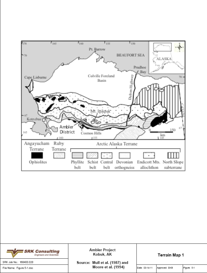
| SRK Consulting (U.S.), Inc. | May 9, 2011 |
| NovaGold Resources Inc. | 5-9 |
| Ambler Project | NI 43-101 Preliminary Econimic Assessment |
Figure 5-2: Terrain Map 2
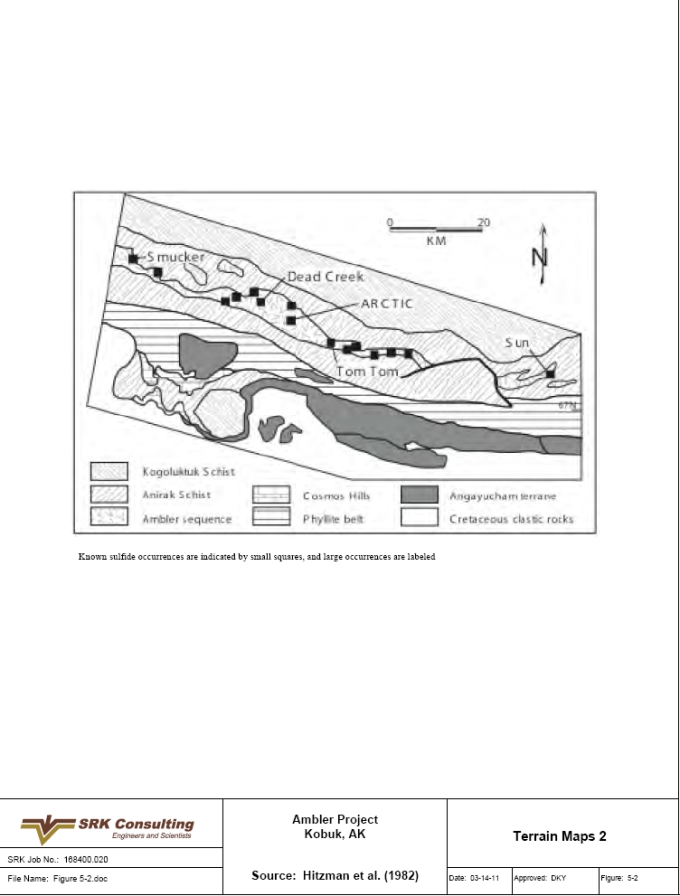
| SRK Consulting (U.S.), Inc. | May 9, 2011 |
| NovaGold Resources Inc. | 5-10 |
| Ambler Project | NI 43-101 Preliminary Econimic Assessment |
Figure 5-3: Tectonic Evolution
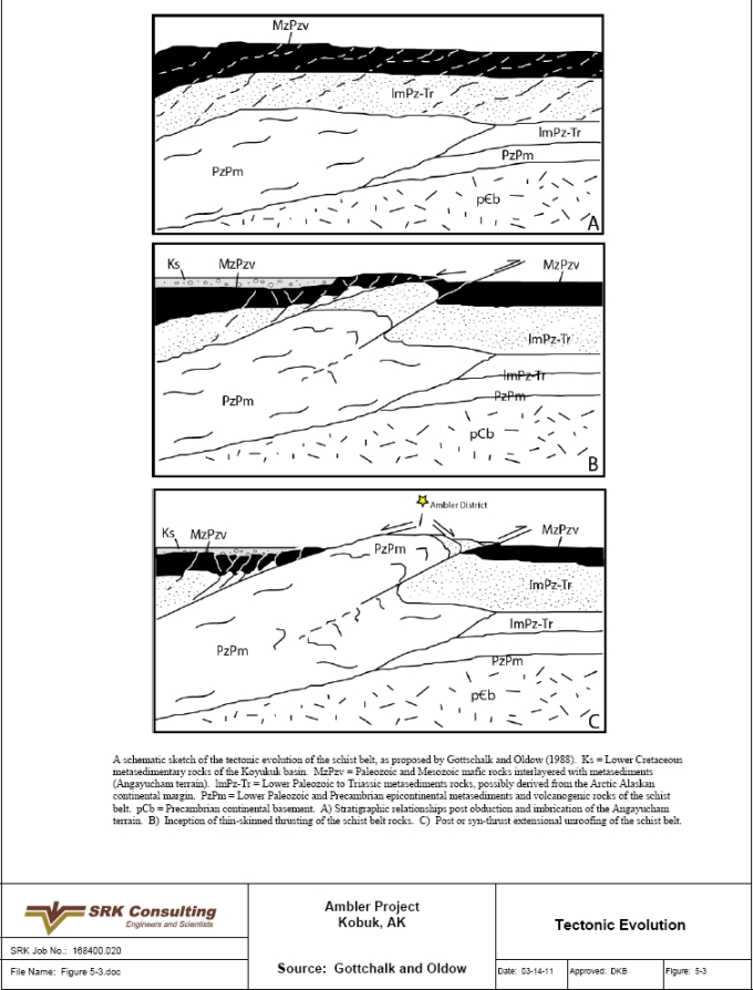
| SRK Consulting (U.S.), Inc. | May 9, 2011 |
| NovaGold Resources Inc. | 5-11 |
| Ambler Project | NI 43-101 Preliminary Econimic Assessment |
Figure 5-4: Geologic Map of the Project
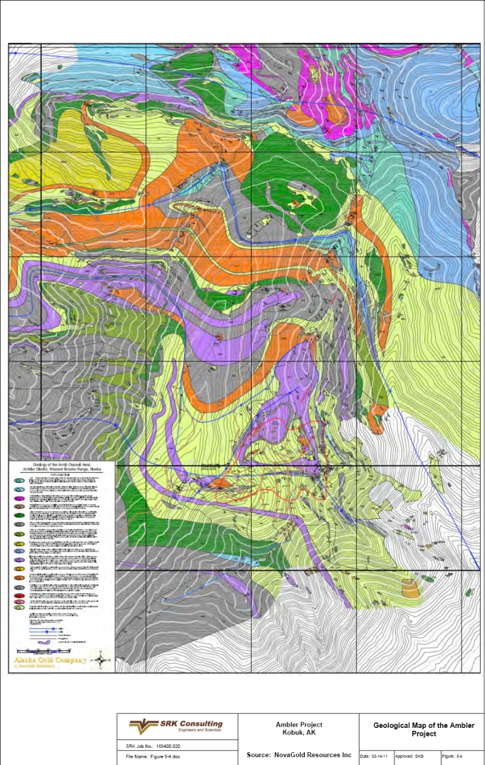
| SRK Consulting (U.S.), Inc. | May 9, 2011 |
| NovaGold Resources Inc. | 6-1 |
| Ambler Project | NI 43-101 Preliminary Econimic Assessment |
| 6 | Deposit Type (Item 10) |
The mineralization at the Project and within the Ambler District consists of Devonian age, polymetallic (Zn-Cu-Pb-Ag) VMS occurrences. VMS deposits are formed by and associated with sub-marine volcanic-related hydrothermal events. These events are related to spreading centers such as fore arc, back arc or mid-ocean ridges. VMS deposits are often stratiform accumulations of sulfide minerals that precipitate from hydrothermal fluids on or below the seafloor. These deposits are found in association with volcanic, volcaniclastic and/or siliciclastic rocks. They are classified by their depositional environment and associated proportions of mafic and/or felsic igneous rocks to sedimentary rocks. There are five general classifications based on rock type and depositional environment:
● | Mafic rock dominated often with ophiolite sequences, often called Cyprus type; |
● | Bimodal-mafic type with up to 25% felsic volcanic rocks; |
● | Mafic-siliciclastic type with approximately equal parts mafic and siliclastic rocks, which can have minor felsic rocks and are often called Beshi type; |
● | Felsic-siliclastic type with abundant felsic rocks, less than 10% mafic rocks and shale rich; and |
● | Bimodal-felsic type where felsic rocks are more abundant than mafic rocks with minor sedimentary rocks, also termed Kuroko type. |
Prior to any subsequent deformation and/or metamorphism, these deposits are often bowl- or mound-shaped with stockworks and stringers of sulfide minerals found near vent zones. These types of deposit exhibit an idealized zoning pattern as follows:
● | Pyrite and chalcopyrite near vents; |
● | A halo around the vents consisting of chalcopyrite, sphalerite and pyrite; |
● | A more distal zone of sphalerite and galena and metals such as manganese; and |
● | Increasing manganese with oxides such as hematite and chert. |
Alteration halos associated with VMS deposits often contain sericite, ankerite, chlorite, hematite and magnetite close to the VMS with weak sericite, carbonate, zeolite, prehnite and chert more distal. These alteration assemblages and relationships are dependent on degree of post deposition deformation and metamorphism. A modern analog of this type of deposit is found around fumeroles or black smokers in association with rift zones.
In the Ambler District, VMS mineralization occurs along the western schist belt over a strike length of approximately 100km. These deposits are hosted by a volcanogenic sequence consisting of volcaniclastic, siliciclastic and calcareous metasedimentary rocks interlayered with mafic and felsic metavolcanic rocks. Sulfide occurs above the mafic metavolcanic rocks but below the Button schist, which has been interpreted as a volcaniclastic rock. The presence of the mafic and felsic metavolcanic units is used as evidence to suggest formation in a rift-related environment, possibly proximal to a continental margin. A sulfide-smoker occurrence has been identified near Dead Creek northwest of the Project and suggests local hydrothermal venting during deposition. However, the lack of stockworks and stringer-type mineralization suggests that the Project is not a near-vent type VMS. Although this is a stratiform VMS, drill cores from
| SRK Consulting (U.S.), Inc. | May 9, 2011 |
| NovaGold Resources Inc. | 6-2 |
| Ambler Project | NI 43-101 Preliminary Econimic Assessment |
the 2004 and 2005 drilling programs within the deposit exhibit characteristics and textures common to replacement-style mineralization, and it is interpreted that at least some of this mineralization may have formed as diagenetic replacements.
At the Project, sulfides occur as semi-massive (10 to 30% sulfide) to massive (>30% sulfide) layers, typically dominated by pyrite with substantial disseminated sphalerite and chalcopyrite and trace amounts of galena. This sulfide accumulation at the Project is thought to be correlative to those seen at the Dead Creek and Sun deposits. The VMS deposits in the Ambler District are unusually sheet-like compared with other VMS deposits worldwide. This is likely a result of attenuation and folding of the section caused by high-pressure deformation during the late Jurassic to early Cretaceous age Brooks Range orogeny. This structural attenuation as well as metamorphic recrystallization makes it difficult to interpret the genesis of this deposit. However, the sulfide formation is not consistent with a specific type of VMS and may be a hybrid style of mineralization that formed in a magmatically active marginal rift basin.
There is also an occurrence of epithermal discordant vein and fracture hosted base metal (Pb-Zn-Cu) mineralization identified at the Red prospect in the Kogoluktuk Valley, east of the Project. This occurrence also contains substantial fluorite veins suggesting high temperature hydrothermal activity. Although not yet fully understood, the genesis of this occurrence is considered to be related to the regional system that formed the VMS deposits in the Ambler District.
Knowledge of the position and genetic relationship within the VMS system is important to targeting the richest zones. The information collected from mapping, sampling and geophysics at the Project and regional levels within the Ambler District is being used to define the position of Ambler relative to an ancient spreading center.
| 6.1 | Exploration Target |
While efforts during 2004 and 2005 were directed at drilling and delineating the Project, work in 2006 was focused on exploration for new, nearby resources within the claim block. These activities included mapping, drilling, regional geochemistry and geophysics at the COU, Sun, Dead Creek and Red prospects. This work was undertaken to expand the resource potential and to better understand the Project area. This exploration effort is focused both northwest and southeast of the Project, along structure, and covering approximately 18km. Drilling targets are chosen based on a combination of geophysics, geochemistry and mapping information.
| SRK Consulting (U.S.), Inc. | May 9, 2011 |
| NovaGold Resources Inc. | 7-1 |
| Ambler Project | NI 43-101 Preliminary Econimic Assessment |
| 7 | Mineralization (Item 11) |
Mineralization occurs as stratiform semi-massive to massive sulfide beds. The sulfide beds average 4m thick but vary from less than 1m up to 18m thick. The bulk of the mineralization is within four zones located between two thrust faults, the upper Warm Springs Thrust and the Lower Thrust. A smaller fifth zone is located below the Lower Thrust. All of these zones are within an area of roughly 1km2, with average zone length ranging from 850m to 600m and width ranging from 700m to 350m. Depths of known mineralization extend to approximately 250m below the surface. Host rocks are primarily graphitic chlorite schists and fine-grained quartz sandstones.
Marginal to the main deposit, mineralization is locally present as discontinuous thin, “wispy” sulfide bands. No stockworks or stringers in association with the mineralization have been observed. These features are common in near-vent VMS deposits. Much of the core from the 2004 and 2005 programs within the deposit exhibits characteristics and textures common to replacement-style mineralization.
Mineralization is predominately coarse-grained sulfides consisting mainly of chalcopyrite, sphalerite, galena, pyrite and pyrrhotite, and may or may not include tetrahedrite. Tetrahedrite-tennantite, electrum and enargite are also present in minor amounts. Pyrite is commonly associated with the massive sulfide horizons, and pyrrhotite and arsenopyrite are present in lesser amounts. Gangue minerals associated with the mineralized horizons include quartz, barite, white mica, black chlorite, calcite, dolomite and cymrite, while talc is common in the footwall.
| SRK Consulting (U.S.), Inc. | May 9, 2011 |
| NovaGold Resources Inc. | 8-1 |
| Ambler Project | NI 43-101 Preliminary Econimic Assessment |
| 8 | Exploration (Item 12) |
Exploration on the Project was intermittent between its discovery in 1965 and 1998. From 1998 until 2003, there was no work performed on the Project. NovaGold entered into negotiations with Kennecott to explore its Ambler land position in mid-2003. Negotiations were completed and an exploration agreement signed on March 23, 2004. Since 2004, NovaGold has been performing project level and regional mapping, drilling, geophysics and geochemical surveys. NovaGold purchased Kennecott’s ownership in January, 2010 and continues exploration activities at the Project.
| 8.1 | Drilling |
The 2004 drilling focused on the Project area and was principally designed to verify the grade and continuity of the mineralized intercepts encountered in the previous drill campaigns. Eleven holes totaling 2,996m were drilled in potential extensions of mineralization and on an adjacent geophysical anomaly. During 2005, approximately 3,030m of core drilling was completed, and in the 2006 field season an additional 3,010m of drilling in 12 drill holes was completed. The 2006 program focused on regional extensions and included drilling at the Dead Creek, Sunshine Creek, COU and Red prospects. The drilling was carried out by Boart Longyear, a contract diamond driller. NovaGold completed a 14 hole drill program totaling 3,306m in 2008. All holes were designed to infill within the currently defined resource area, and three holes were drilled for metallurgical testing purposes. None of the assay results were available at the time of construction the original 2008 resource model.
| 8.2 | Regional Mapping |
Regional mapping completed during the 2005 field season extended across Riley Ridge to Limestone Creek, with a limited amount of work completed on Dead Creek Ridge by Doyle Albers. From this work came recognition of the importance of the large airborne electromagnetic low resistivity anomaly west of Riley Ridge.
Local and regional mapping performed during the 2005–2006 mapping program enabled Paul Lindberg, contracted to NovaGold, to complete a model of an unfolded view of the Project geology. These results provide a good platform on which to build subsequent models of original zoning patterns, changing thicknesses and other laterally variable characteristics of the deposit.
| 8.3 | Regional Geochemistry |
A total of 2,106 stream silt and soil samples were collected during the 2004 mapping program as part of an effort to develop a regional geochemistry model for future district exploration. This program was carried out by NovaGold personnel and the model is still being developed.
| 8.4 | Geophysics |
During 2005, two Time Domain Electro-Magnetic (TDEM) induction ground surveys were performed at the Project and COU. COU is within the claim block and is a significant anomaly of similar size and tenor a few kilometers to the northwest of Ambler. The 2006 exploration program focused on a regional basis to extend existing mineralization and to identify new mineralized targets within the claim block, and included 13 TDEM surveys performed to enhance previous work performed by Kennecott in 1998. Data evaluation is ongoing.
| SRK Consulting (U.S.), Inc. | May 9, 2011 |
| NovaGold Resources Inc. | 8-2 |
| Ambler Project | NI 43-101 Preliminary Econimic Assessment |
| 8.5 | PIMA |
NovaGold personnel collected PIMA data from all 2004 drillholes as well as select pre-1998 drillholes. The data collection supplemented previous data collected from the 1998 Kennecott program. Data were collected on a sample interval basis for the 2004 core with a reading approximately every 0.5m. Readings on the pre-1998 core were taken on both sample intervals as well as drill run intervals where no assay sample was previously taken. Alteration mineral type and relative intensity was interpreted from the spectra and entered into the database. Evaluation of these data is ongoing.
| 8.6 | Oriented Core |
Oriented data were collected from select angle drillholes. The clay impression method was used to orient the core with data capture done using a circular protractor for beta values and a standard protractor for alpha values. The majority of oriented measurements were of foliation with a NW strike and a SW dip, similar to those observed on the surface.
Exploration activities at the Project have been performed within industry standards using appropriate models and techniques for a VMS target. SRK agrees with the techniques used at this project.
| SRK Consulting (U.S.), Inc. | May 9, 2011 |
| NovaGold Resources Inc. | 9-1 |
| Ambler Project | NI 43-101 Preliminary Econimic Assessment |
| 9 | Drilling (Item 13) |
| 9.1 | Drill Program and Objectives |
The 2004 drilling focused on the Project area and was principally designed to verify the grade and continuity of the mineralized intercepts encountered in the previous drill campaigns. Alternate geologic models for the Project were investigated through surface mapping, drill core re-logging and re-interpretation of previous drill results. Eleven holes totaling 2,996m were drilled. Significant mineralized intervals were encountered in eight of the eleven holes drilled in the program. The twin and infill drilling confirmed previously drilled intervals of base-metal mineralization.
Drilling in 2005 again focused on extending and confirming mineralization, particularly in the lower limb of the Arctic Antiform at the Project. Approximately 3,030m of core drilling was completed and, although good mineralization was encountered in several holes, structural discontinuities appear to limit expansion of mineralization to the south and east. Results suggest that the model remains open to the northeast and that the faulted off-root zone has yet to be identified. Drill spacing for all programs is dependent on the steep, rugged terrain for locating drill rigs; however, it varies from 90 to 120m. Sections have been drawn at 61m intervals.
During the 2006 field season, an additional 3,010m of drilling in 12 drillholes was completed. This drill program was focused on a more regional basis to extend existing mineralization and to identify new mineralized targets within the claim block.
NovaGold completed a 14 hole drill program totaling 3,306m in 2008. All holes were designed to infill within the currently defined resource area, and three holes were drilled for metallurgical testing purposes.
The drill programs used a single skid-mounted LF-70 core drill, drilling HQ core with Boart Longyear as the drill contractor. The drill was skidded to the various drill pads using a D-8 bulldozer located on site. The D-8 was also used in road and site preparation. Fuel, supplies and personnel were transported by helicopter.
Field collar surveys were done with an Ashtech GPS survey system using post-processing software to obtain survey coordinates. The Riley Vertical Angle Bench Mark was used as the base for all surveys in 2004. Final surveys are listed in the survey files. The majority of pre-2004 drill collars were also surveyed as part of data verification.
Downhole surveys were collected using a reflex camera. Individual survey readings were collected at the site; data was collected at 50m intervals from the bottom of the hole. Data were initially captured on paper and subsequently entered into an electronic spreadsheet. All data were incorporated into a single Access database.
All NovaGold drill core was logged, photographed and sawn, with half sent to the lab for analyses and half stored near the property. Core logging was done using metric measurements. Lithology and visual alteration features were captured on observed interval breaks. Mineralization data, including total sulfide (recorded as percent), sulfide type (recorded as a relative amount), gangue and vein mineralogy were collected for each sample interval with an average interval of approximately 2m. Structure data were collected as point data. Geotechnical data (core recovery, RQD) were collected along drill run intervals. Using the 2004 logging
| SRK Consulting (U.S.), Inc. | May 9, 2011 |
| NovaGold Resources Inc. | 9-2 |
| Ambler Project | NI 43-101 Preliminary Econimic Assessment |
procedure as a guide, data from the earlier campaigns were taken from those drill logs and entered into the database, with a focus on mineralization information.
The overall objectives of the three drill programs were:
● | Verification of mineralized intercepts from previous drill campaigns (twin holes); |
● | Continuity of higher grade intercepts in the central part of the resource area (infill holes); |
● | Exploring possible extensions of mineralized zones; and |
● | Recording data electronically and building a 3-D model of the deposit. |
| 9.2 | Drill Results |
Significant mineralized intervals were encountered in eight of the 11 holes drilled in 2004. Twin and infill drilling confirmed previously drilled intervals of high-grade base-metal mineralization. The results of the 2004 drilling program show a high degree of variability in thickness and grade within areas of the deposit.
Drillholes designed to test extension of the massive sulfide deposit failed to extend significant mineralization. Some holes encountered locally anomalous or lower grade material, possibly representing distal mineralization. An abrupt decrease in grade occurred in AR04-81 below a fault zone, suggesting that the mineralized zones may be offset or folded south of the known deposit. AR04-87 was abandoned due to an inability to penetrate a major fault zone, and was subsequently re-drilled as AR04-88. This hole ended at 387.6m in altered quartz muscovite schist, short of the targeted Button Schist.
For 2005, the highest priority objectives included:
● | Determining the limits of the deposit to the south and east of the known mineralization by drilling sufficiently deep holes to test extension of the lower, overturned limb of the deposit; and |
● | Gathering information useful for a new resource calculation and scoping study scheduled for 2006. |
In April 2005, NovaGold made plans to drill 3,000m on the south and east fringe of the deposit through the projected elevation of the lower sulfide limb, completing a downhole TDEM geophysical survey and extending the geologic mapping from the Project area northwest toward Dead Creek. Work completed toward extending the lower sulfide limb included nine holes totaling 3,030m. Of these, two failed to achieve their targeted depth.
Frontier Geosciences, Inc. was contracted to complete downhole probing of selected holes at the Project. They also completed a large loop TDEM survey over the Project area. Because mapping indicated permissive stratigraphy coincident with the airborne anomaly west of Riley Ridge, Frontier completed an additional TDEM loop survey over the anomaly core.
NovaGold geologists completed geochemical sampling of all NovaGold core and spot sampling of much of the historical BCMC/Kennecott Minerals Arctic core. This work is ongoing and will allow NovaGold to build a reasonably comprehensive lithogeochemical model of the Arctic deposit.
| SRK Consulting (U.S.), Inc. | May 9, 2011 |
| NovaGold Resources Inc. | 9-3 |
| Ambler Project | NI 43-101 Preliminary Econimic Assessment |
The 2006 drilling program completed 3,010m in 12 holes. This program was performed to test mineralization extensions and geophysical anomalies outside the immediate Project area, but within the claim block. These holes were drilled at the Dead Creek, Sunshine Creek, COU and Red prospects.
NovaGold completed a 14 hole drill program totaling 3,306m in 2008. All holes were designed to infill within the currently defined resource area, and three holes were drilled for metallurgical testing purposes.
At Dead Creek, the holes were located based on a combination of geophysics and geology. Each hole penetrated the targeted stratigraphy, and showed that the sulfide system diminishes to the north and east but remains open to the south and west. One of the Back-Door Creek holes penetrated an 8m zone that contained several 2 to 7cm-thick pyrrhotite bands, but with only a trace of chalcopyrite. This zone correlates stratigraphically with a mineralized interval in a nearby historical hole, suggesting metallic mineral zonation from pyrite and base-metal sulfide to pyrrhotite.
Drilling in the Sunshine Creek area tested the western extent of mineralization observed in historical drill holes, which is interpreted to be two sulfide-bearing horizons that lie sub-parallel to the stratigraphy, above a carbonate package. NovaGold interprets the two mineralized horizons as limbs of an F2 anticline. Drill intercepts from 2006 that correlate with these two horizons had significantly lower grade and were thinner than historical intercepts. Preliminary results indicate that the sulfide horizon becomes dominated by pyrrhotite to the west. NovaGold currently interprets this compositional change to represent a more distal portion of the mineralized system.
Drilling at COU was performed to investigate an electromagnetic anomaly and consisted of one hole. The source of this anomaly was a thick sequence of graphitic black schist that contained abundant continuous pyrrhotite bands. Downhole a few hundred meters it was recognized that the hole was still in the hanging wall to the stratigraphic package that hosts the Project. This resulted in extending the hole. The hole was stopped slightly above its target because of safety considerations. This hole has proven vital to NovaGold’s understanding of the regional F2 folds and to the stratigraphic stacking order in this area.
NovaGold drilled four holes into the Red prospect, located in the lowlands of the Kogoluktuk Valley, about 5km east of the Project. These holes tested an electromagnetic anomaly and intersected a sulfide vein system hosted by siltstone believed to underlie the Gnurgle Gneiss. The veins have a quartz-calcite-fluorite gangue, and their margins commonly contain concentrations of secondary brown biotite, suggesting an affinity to relatively high-temperature potassic alteration. The F1 structural fabric deforms the veins, suggesting that they are relatively old. The vein style of mineralization makes this occurrence unique in the district.
An ongoing effort to gather and compile data for a new resource model for the Project includes re-logging of historical drill core, detailed logging of individual mineralized intersections at 1:50 scale and work with hole-to-hole correlations.
Drilling at the Project has been performed within industry standards using appropriate methods and techniques for a VMS target. SRK agrees with the techniques used at this project.
| SRK Consulting (U.S.), Inc. | May 9, 2011 |
| NovaGold Resources Inc. | 9-4 |
| Ambler Project | NI 43-101 Preliminary Econimic Assessment |
Multiple drillhole intersections have resulted in a reasonably accurate knowledge of the orientation of the mineralization. Mineralization follows enclosing stratigraphic layering and is further defined, except where tightly folded, by bedding parallel to bedding subparallel foliation.
Most holes intersect the mineral zone nearly perpendicular to foliation and to the mineralization, so the intersections represent near true thickness. Exceptions are where mineralized zones wrap around tight fold hinges, but these instances are rare.
| SRK Consulting (U.S.), Inc. | May 9, 2011 |
| NovaGold Resources Inc. | 10-1 |
| Ambler Project | NI 43-101 Preliminary Econimic Assessment |
| 10 | Sampling Method and Approach (Item 14) |
The sampling protocol for all the NovaGold drill programs at the Project from 2004–2008 is the same. Core logging geologists mark the sample intervals, which range from 1 to 3m in length. Varying rock types, lithologic contacts and mineralized zones influence sample interval selection. Sample boundaries are placed at lithologic contacts. Each hole was sampled in its entirety, even in areas that encountered significant intervals of unmineralized core. Sample intervals of 2 to 3m are most common in weakly to unmineralized core, and sample intervals of 1 to 2m are more common in mineralized zones or areas of varying lithology. Sample intervals used are well within the width of the average mineralized zone in the resource area. This sampling approach is considered sound and appropriate for this style of mineralization and alteration. Core recovery was good to excellent, resulting in quality samples with little to no bias. There are no known drilling and/or recovery factors that could materially impact accuracy. ALS Chemex in Vancouver, B.C. was used for all analyses conducted by NovaGold.
Core drilling within the resource area was specifically targeted for geologic control and to best define zones of mineralization for the resulting resource estimate. Drilling outside of the resource area was focused to explore for additional mineralization and to gain a better understanding of the geologic controls to mineralization.
After logging, the core was digitally photographed and cut in half using diamond core saws. Specific attention to core orientation was maintained during core sawing to ensure the best representative sampling. One-half of the core was returned to the core box for storage on site and the other half was bagged and labeled for sample processing and analysis.
Sampling of drill core prior to 2004 by Kennecott and BCMC focused primarily on the mineralized zones. During the 1998 campaign, Kennecott did sample some broad zones of alteration and weak mineralization, but much of the unaltered and unmineralized rock remains unsampled. ALS Chemex was also used for analyses conducted by Kennecott.
Earlier BCMC sampling was even more restricted to mineralized zones of core. Intervals of visible sulfide mineralization were selected for sampling and analyses were conducted by Union Assay Office Inc. of Salt Lake City, Utah. Numerous intervals of weak to moderate mineralization remain unsampled in the historic drill care. NovaGold conducted some limited sampling of this historical drill core to gain a better understanding of trace element distribution around the Arctic deposit. During the relogging of much of this historical core, 1m intervals were selected over each 10m of unmineralized core. These 1m intervals were sawn in half, with one-half returned to the box and the other half placed in a bag, labeled and sent to the laboratory for analysis. This type of sampling was used to determine trace element distribution about the deposit; none of the mineralized zones were sampled in this way.
With the lack of outcrop in a folded metamorphic terrane, it is necessary to have a good understanding of the geologic model to predict positioning of the drill to get a sample of true thickness in the mineralized zone. NovaGold has been diligently relogging core and mapping the project to gain this understanding. The use of oriented core is very important to this interpretation. SRK has confidence that the samples collected at the Project are representative of the geometry of the mineralized zone.
| SRK Consulting (U.S.), Inc. | May 9, 2011 |
| NovaGold Resources Inc. | 10-2 |
| Ambler Project | NI 43-101 Preliminary Econimic Assessment |
Table 10.1: Selected Significant Intervals with True Thickness Estimates
| Hole ID | From | To | Assayed Length (m) | Cu_% | Au_g/t | Ag_g/t | Pb_% | Zn_% | True Thickness (m) |
| AR-72 | 183.18 | 198.73 | 15.55 | 2.368 | 0.774 | 49.80 | 0.92 | 4.77 | 14.09 |
| AR-72 | 137.92 | 154.69 | 16.77 | 5.832 | 2.036 | 66.24 | 2.21 | 7.87 | 15.76 |
| AR-60 | 194.46 | 205.80 | 11.34 | 4.043 | 0.620 | 81.90 | 0.94 | 6.20 | 10.95 |
| AR-51 | 39.47 | 46.48 | 7.01 | 3.84 | 8.806 | 54.06 | 1.92 | 7.38 | 6.67 |
| AR-44 | 184.65 | 210.49 | 25.84 | 1.833 | 0.845 | 43.85 | 0.63 | 3.47 | 24.71 |
| AR-44 | 132.83 | 148.44 | 15.61 | 2.476 | 0.720 | 47.27 | 0.54 | 5.02 | 15.27 |
| AR-40 | 75.47 | 83.33 | 7.86 | 6.203 | 3.164 | 74.04 | 0.94 | 6.57 | 7.48 |
| AR-39 | 148.13 | 156.58 | 8.45 | 5.741 | 8.735 | 198.94 | 1.53 | 5.90 | 7.32 |
| AR-34C | 166.12 | 182.61 | 16.49 | 4.288 | 0.514 | 53.58 | 0.57 | 5.72 | 14.95 |
| AR-26 | 28.04 | 51.21 | 23.17 | 4.543 | 0.192 | 53.11 | 1.17 | 4.40 | 14.89 |
| AR-22 | 278.59 | 292.61 | 14.02 | 5.751 | 0.608 | 69.81 | 0.75 | 4.14 | 13.71 |
| AR-16B | 154.47 | 172.12 | 17.65 | 3.717 | 0.967 | 58.84 | 1.11 | 8.51 | 17.05 |
| AR-14B | 166.66 | 173.77 | 7.11 | 4.895 | 1.988 | 106.95 | 2.00 | 11.29 | 7.00 |
| AR-14B | 148.01 | 160.72 | 12.71 | 4.233 | 0.772 | 56.17 | 1.28 | 7.12 | 12.66 |
| AR-14A | 148.35 | 159.53 | 11.18 | 3.723 | 1.084 | 41.43 | 1.19 | 6.20 | 10.51 |
| AR-14 | 146.79 | 161.39 | 14.60 | 4.416 | 0.725 | 62.60 | 1.73 | 7.19 | 14.10 |
| AR-12 | 204.83 | 215.59 | 10.76 | 6.629 | 1.180 | 98.69 | 0.93 | 6.26 | 10.52 |
| AR-12 | 158.92 | 175.41 | 16.49 | 4.367 | 0.150 | 23.60 | 0.30 | 2.08 | 16.49 |
| AR-11B | 146.30 | 158.83 | 12.53 | 4.954 | 0.724 | 65.20 | 1.12 | 8.02 | 12.10 |
| AR-11A | 148.22 | 154.84 | 6.62 | 7.874 | 1.481 | 98.62 | 1.34 | 10.92 | 6.22 |
| AR-11 | 170.08 | 189.37 | 19.29 | 2.623 | 0.539 | 49.70 | 0.55 | 2.48 | 19.00 |
| AR-07 | 125.27 | 135.48 | 10.21 | 3.804 | 0.757 | 79.85 | 1.36 | 7.53 | 10.21 |
| AR04-87 | 98.81 | 106.17 | 7.36 | 9.651 | 0.730 | 108.21 | 1.64 | 10.35 | 5.20 |
| AR04-86 | 218.67 | 231.12 | 12.45 | 3.759 | 0.910 | 52.36 | 0.58 | 6.01 | 11.70 |
| AR04-83 | 262.64 | 279.00 | 16.36 | 3.514 | 1.139 | 109.30 | 1.08 | 8.09 | 15.37 |
| AR04-83 | 174.34 | 190.62 | 16.28 | 4.023 | 0.162 | 27.49 | 0.55 | 2.86 | 14.75 |
| AR04-79 | 136.18 | 163.75 | 27.57 | 5.288 | 2.342 | 75.61 | 1.24 | 7.49 | 24.99 |
| AR04-78 | 231.00 | 247.00 | 16.00 | 3.073 | 1.256 | 59.55 | 0.72 | 4.81 | 13.11 |
| AR04-78 | 211.02 | 223.00 | 11.98 | 3.581 | 0.927 | 60.18 | 1.27 | 6.05 | 10.86 |
| SRK Consulting (U.S.), Inc. | May 9, 2011 |
| NovaGold Resources Inc. | 11-1 |
| Ambler Project | NI 43-101 Preliminary Econimic Assessment |
| 11 | Sample Preparation, Analyses and Security (Item 15) |
The core from the NovaGold programs was sawn in half, with half sent to labs in Fairbanks, AK for sample preparation and the other half returned to the core box for storage. Samples were crushed to 70% <2mm and a nominal 250g split was sent to Vancouver, B.C. for analysis by ALS Chemex. There the splits were pulverized to 85% <75um. Initial gold analysis was done by FA-AAA on a nominal 30g split of the pulp. Samples returning over limit gold values (>10ppm) were rerun using fire assay techniques. Initial results for all other elements (27) were done via four acid digestion ICP analysis on a nominal 25g split of the pulp. Samples with over limit values for copper (>10,000ppm), lead (>10,000ppm), zinc (>10,000ppm) or silver (>100ppm) were rerun using AA techniques.
Gold values for duplicate samples (both blind and laboratory) from 2004 and for those samples re-assayed from earlier programs locally showed high variability, indicating a possible nugget effect. As a result, a series of samples was selected for MSA analysis. Results are pending.
A QA/QC program was instituted for the 2004 drill program. Samples were broken into 20 sample batches that included three QA/QC samples. The QA/QC samples included one duplicate, one blank and one standard. Duplicate samples were prepared at the prep facility by taking a second split from the entire prepped sample. A local limestone source was used as the blank material. A series of samples taken from the source area and assayed confirm that the limestone is a suitable blank material. The standard material was obtained from WCM Minerals of Burnaby, B.C. A base-metal standard was selected that best represented the grade of the Ambler mineralization. Samples were either in the custody of NovaGold personnel or the assay labs at all times.
| 11.1 | Pre-1998 Assay Reruns |
A search was made through Kennecott’s Reno, NV warehouse for sample pulps from pre-1998 drill campaigns. A total of 290 pulps were located, mainly from the earliest drill programs, and sent to ALS Chemex Labs in Vancouver, B.C. for analysis. The samples were analyzed for gold by FA-AAA as well as 27 additional elements by ICP analysis (see analytical description). Samples were arranged in batches of approximately 20, each with inserted QA/QC samples.
A comparison of the average base and precious metal assay results for the 2004 assays versus those from previous drill campaigns is listed below (Table 11.1.1).
Table 11.1.1: Pre-1998 Pulp Rerun Comparisons
| Element | # Sample Pairs | Ave: Original Assays | Ave: Re-assays 2004 | % Diff.: 2004 vs. Orig. |
| Copper | 272 | 2.91% | 2.65% | -10.10 |
| Lead | 134 | 1.09% | 1.30% | +16.40 |
| Zinc | 199 | 5.00% | 4.80% | -4.11 |
| Silver | 212 | 54.15g/t | 55.05g/t | +1.63 |
| Gold | 119 | 0.802g/t | 0.767g/t | -4.65 |
Of the 290 total pulps, 11 contained insufficient volume for any analysis. The variable number of sample pairs is the result of either insufficient sample size for analysis of select elements in 2004 (mainly over limits) or because some elements were not selected for assay in earlier campaigns.
| SRK Consulting (U.S.), Inc. | May 9, 2011 |
| NovaGold Resources Inc. | 11-2 |
| Ambler Project | NI 43-101 Preliminary Econimic Assessment |
Zinc, silver and gold analyses all compared favorably. While lead showed the largest variability, the average grades are relatively low, thereby having little effect on the tonnage value. Copper values also had high variability and averaged 10% lower than the original values.
ALS Chemex has attained ISO 9001:2000 registration. In addition, the ALS Chemex Vancouver laboratory is accredited to ISO 17025 by Standards Council of Canada for a number of specific test procedures including fire assay Au by AA, ICP and gravimetric finish, multi-element ICP and AA Assays for Ag, Cu, Pb and Zn.
| 11.2 | Reliability of Results |
The apparently poor reproducibility of historic assay values is likely a sign of a highly variable deposit, and not an assaying issue. While sample assays are suitable for this preliminary assessment, further analysis and comparisons are recommended for prefeasibility.
The QA/QC data appears to be reasonable for a program of this scope, a few discrepancies exist which are normal. No formal assessment of the QA/QC data from the 2004-2005 data has been made. This should also be done before prefeasibility, and any significant problems addressed by re-assaying samples which had issues.
| SRK Consulting (U.S.), Inc. | May 9, 2011 |
| NovaGold Resources Inc. | 12-1 |
| Ambler Project | NI 43-101 Preliminary Econimic Assessment |
| 12 | Data Verification (Item 16) |
| 12.1 | Data Acquisition and Verification |
12.1.1 NovaGold Verification
NovaGold performed a review of existing Project data at the Kennecott offices in Salt Lake City, Utah with a focus on data relating to the Arctic deposit. Numerous reports and studies were scanned. All available assay certificates as well as the current database were copied and/or scanned.
All pre-2004 drill assay values in the database provided by Kennecott were compared to assay values from the original assay certificates. Local discrepancies, mainly associated with precious metal results, were identified and corrected.
12.1.2 SRK Verification
SRK was supplied with paper and scanned electronic certificates for the pre-2004 programs. Assay certificates for 472 samples out of 1,854 of these samples were unavailable for review. SRK checked 10% of pre-2004 assay certificates against the database. Only minor typographical discrepancies were found and corrected. All of the highest 5% grades of all five elements were checked where available.
SRK also received electronic certificates (CSV text files) for 2,612 assays (88% of the NovaGold Project samples) from the 2004–2005 drilling/sampling program, which also included numerous samples selected from previously drilled core. All of these assays were verified successfully with the provided database.
QA/QC data was also made available for the 2005 sampling program, consisting of 166 duplicate samples, 282 standards and 293 blanks. These samples were well within acceptable limits.
Although a few of the paper certificates were unavailable, the available certificates provided reasonable assurance that the database is accurate.
| SRK Consulting (U.S.), Inc. | May 9, 2011 |
| NovaGold Resources Inc. | 13-1 |
| Ambler Project | NI 43-101 Preliminary Econimic Assessment |
| 13 | Adjacent Properties (Item 17) |
There are three properties adjacent to Ambler: Sun, Smucker and Ruby Creek (Bornite). Sulfide systems similar in character to the Arctic deposit occur at the exploration properties of Sun and Smucker (Figure 2-4), held by Andover and Teck Cominco, respectively. Copper mineralization at Bornite, held by NANA, occurs with hydrothermal dolomitization of the Bornite carbonate sequence (Hitzman et al., 1986). The information for Sun, Smucker and Bornite, and the comparisons with Ambler, is in no way indicative that a mineral deposit of similar size or grade does occur or will be found at the Project. The qualified persons have been unable to verify the information on adjacent properties contained herein.
| 13.1 | Sun Prospect |
The Sun prospect is also referred to as the Hot prospect. It is described as a copper, zinc, lead and silver deposit and is east of the Project in the same terrane and lithologic sequence. The deposit is currently in reserve development and is being assessed as a potential open pit and underground mine site. Andover owns 100% of the property but former owner Hastings Base Metals Corporation retains a 1.5% NSR on production. A resource estimate was performed on Sun by Anaconda based on surface drilling programs. The resource estimate, summarized in Table 13.1.1, was performed in 1977, has been publicly disclosed and is considered to be inferred resources. This historical resource estimate pre-dates the development of NI 43-101 reporting guidelines, was not estimated in compliance with NI 43-101 procedures and should not be relied on (www.meg.com, 2007).
Table 13.1.1: Historical Anaconda Resource Estimate 1977
| Classification | Tonnes (kt) | Cu% | Zn% | Pb% | Ag_g/t |
| Measured | 0 | 0.00 | 0.00 | 0.00 | 0.0 |
| Indicated | 0 | 0.00 | 0.00 | 0.00 | 0.0 |
| Measured and Indicated | 0 | 0.00 | 0.00 | 0.00 | 0.0 |
| Inferred | 18,407 | 1.912 | 4.466 | 1.182 | 81.106 |
| 13.2 | Smucker Prospect |
This prospect is located west of the Project in the same terrane and lithologic sequence and is described as a copper, zinc, silver and lead prospect currently in target outline. Targeting is for a potential underground mine, but there are no published resource and reserve estimates for this project (www.meg.com, 2007).
| 13.3 | Bornite Property |
The Bornite property is also called Ruby Creek or Cosmos Creek. The property is currently held by NANA and has underground workings. It is described as being on care and maintenance and in target outline (www.meg.com, 2007). This property is a copper and cobalt deposit with both Mississippi Valley and Olympic Dam type deposit affinities. It is hosted by a tabular hydrothermal breccia in dolomite and limestone (Williams, 2000). Mineralization includes chalcopyrite, bornite, chalcocite, tennantite and galena with pyrite, pyrrhotite and dickite as gangue minerals (www.meg.com, 2007). The site currently has a flooded shaft and an unknown amount of underground workings. A resource was estimated by Hitzman (1986), which listed
| SRK Consulting (U.S.), Inc. | May 9, 2011 |
| NovaGold Resources Inc. | 13-2 |
| Ambler Project | NI 43-101 Preliminary Econimic Assessment |
the Ruby Creek deposit as 90Mt at 1.2% copper. This historical resource estimate pre-dates the development of NI 43-101 reporting guidelines, was not estimated in compliance with NI 43-101 procedures and should not be relied on. Hitzman is a highly respected geologist and the existence of a historical resource estimate in the region is encouraging in terms of regional prospectivity.
| SRK Consulting (U.S.), Inc. | May 9, 2011 |
| NovaGold Resources Inc. | 14-1 |
| Ambler Project | NI 43-101 Preliminary Econimic Assessment |
| 14 | Mineral Processing and Metallurgical Testing (Item 18) |
The Arctic deposit is a semi-massive sulfide intrusion in talc schists. The principal economic minerals are chalcopyrite, tetrahedrite, galena and sphalerite. The results of metallurgical studies on test composites from the Arctic deposit are presented in this section.
| 14.1 | Metallurgical Testing (1968 – 1976) |
Initial amenability testing was carried out by Kennecott at the Kennecott Research Center (KRC) between 1968 and 1976. The focus was on selective flotation to provide separate copper, lead and zinc concentrates for conventional smelting. Initial amenability testing in 1968 was conducted on core composites from eight diamond drill holes, and additional tests were conducted in 1972 on an additional four composites from three additional diamond core holes. The laboratory-scale tests conducted during this period included the conventional selective flotation approach to produce separate lead copper and zinc concentrates. The major problem encountered was the difficult lead-copper separation and the reduction of zinc deportment to the copper and lead concentrates. The highest grade copper concentrate contained 30% Cu, 2-3% Zn and less the 1% Pb, but at overall copper recoveries of less than 80%. The lead concentrates were low grade, averaging 17-36% Pb. Sphalerite flotation was generally efficient, with about 70% zinc recovery into zinc flotation concentrates grading about 55% Zn.
During 1975, large diameter cores from 14 drill holes were used for more detailed testing. Two composites were prepared, No. 1 (Eastern zone and No. 2 (Western Zone). The test program included mineralogical examinations, bench-scale testing of various process parameters for each selective flotation step and locked cycle tests. The results of this work demonstrated that a clean separation of the sulfide minerals was difficult due to fine grained mineral interlocking. It was determined that chalcopyrite and sphalerite could be recovered into separate commercial grade copper and zinc concentrates. However, the production of a selective high grade lead concentrate was not successful. Only a low grade silver-bearing lead concentrates were obtained.
| 14.2 | Metallurgical Testwork (1998-1999) |
In 1999 Kennecott commissioned Lakefield Research Limited (Lakefield) to conduct a metallurgical research program on test composites from the Arctic deposit (previously known as the Arctic Project by Kennecott), with the objective of confirming and improving upon the results of the work carried out by Kennecott in the 1970’s. This work was carried on test composites prepared from three separate drill holes. The head analyses for the respective resulting test composites are summarized in Table 14.2.1
Table 14.2.1: Head Analyses for Metallurgical Test Composites - Lakefield 1999
| Composite | Talc | Cu% | Zn% | Pb% | Fe% | ST % | Au g/t | Ag g/t |
| Hole 72 - Upper | low | 5.28 | 7.16 | 1.86 | 15.6 | 1.14 | 72.3 | 23.4 |
| Hole 72 - Lower | high | 2.68 | 5.85 | 1.34 | 13.0 | 1.60 | 75.9 | 16.9 |
| Hole 74 | high | 2.46 | 4.43 | 0.90 | 17.0 | 1.55 | 45.1 | 23.7 |
| Hole 75 | high | 2.35 | 8.36 | 1.95 | 15.7 | 1.23 | 77.3 | 21.8 |
| SRK Consulting (U.S.), Inc. | May 9, 2011 |
| NovaGold Resources Inc. | 14-2 |
| Ambler Project | NI 43-101 Preliminary Econimic Assessment |
The test composite from the upper portion of hole 72 has identified as being low in talc content, however, composites formulated for the lower portion of hole 72, as well as, holes 74 and 75 high in talc content.
14.2.1 Low Talc Composite Flotation
Lakefield conducted a series of five tests on the low talc mineralized composite (as represented by the upper zone of Hole 72). These tests were all done at a grind of about P80 53µm and included bulk copper/lead rougher flotation followed by zinc rougher flotation. The bulk copper/ lead concentrate was reground and subjected to two stages of cleaner flotation and one stage of copper/lead separation using zinc oxide and sodium cyanide to depress the copper while floating the lead. The resulting lead rougher concentrate was upgraded with two stages of cleaner flotation to produce the final lead concentrate. The lead rougher flotation tailing represented the final copper concentrate. The zinc rougher concentrate was reground and upgraded with two stages of cleaner flotation. The results of the best test with the low talc composite are summarized in Table 14.2.2, and demonstrate that 68% of the lead could be recovered into an upgraded flotation concentrate containing 58.8% Pb, and 86.8% of the copper could be recovered into a concentrate containing 29% Cu, and 81% of the zinc could be recovered into an upgraded zinc concentrate containing 59.1% Zn. No locked-cycle tests were conducted so the deportment of the intermediate cleaner tailing products remains to be defined.
Table 14.2.2: Summary of Selective Flotation Test on Ambler Low Talc Composite
| Assays %, g/t | Distribution % | ||||||||||
| Item | Wt % | Cu | Pb | Zn | Au | Ag | Cu | Pb | Zn | Au | Ag |
| Lead Conc | 2.22 | 6.5 | 58.8 | 3.43 | 38.9 | 1,703 | 2.7 | 68.1 | 1.1 | 48.7 | 47.3 |
| Copper Conc* | 15.76 | 29.1 | 1.2 | 2.61 | 1.23 | 73.5 | 86.8 | 9.8 | 5.7 | 10.9 | 14.5 |
| Zinc Conc | 9.91 | 0.44 | 0.36 | 59.1 | 0.65 | 14.7 | 0.8 | 1.9 | 81.1 | 3.6 | 1.8 |
| Zinc Tailing** | 61.6 | 0.11 | 0.13 | 0.22 | 0.4 | 3.47 | 1.2 | 4.3 | 1.9 | 13.7 | 2.7 |
| Head (Calc) | 100.0 | 5.28 | 1.92 | 7.21 | 1.78 | 80.1 | 100.0 | 100.0 | 100.0 | 100.0 | 100.0 |
Source: Lakefield Research Ltd, 1999
Note:
* Pb Ro. Tailing
** Does not include intermediate cleaner tailings
14.2.2 High Talc Composite Flotation
Lakefield conducted a flotation tests on each of the high talc composites using a test procedure that was essentially the same as the procedure used for the low talc composite, with the exception that carboxymethyl cellulose (CMC) was added as a depressant for talc. The average result of tests conducted on each of the high talc composites (Hole 72 low, Hole 74 and Hole 75) under similar test conditions is summarized in Table 14.2.3. The results of these tests demonstrated the significant negative impact that the presence of talc has on the selective flotation process. The average of these tests resulted in only 30.3% lead recovery into a lead cleaner flotation concentrate containing 35.3% Pb, and only 43.3% copper recovery into a copper concentrate containing 26.0% Cu. Zinc recovery was not influenced by the talc, with 81% of the zinc being recovered into a zinc cleaner flotation concentrate containing 53.4% Zn.
| SRK Consulting (U.S.), Inc. | May 9, 2011 |
| NovaGold Resources Inc. | 14-3 |
| Ambler Project | NI 43-101 Preliminary Econimic Assessment |
Table 14.2.3: Summary of Selective Flotation Test on Ambler High Talc Composite Without Talc Prefloat
| Assays %, g/t | Distribution % | ||||||||||
| Item | Wt % | Cu | Pb | Zn | Au | Ag | Cu | Pb | Zn | Au | Ag |
| Lead Conc | 1.05 | 8.01 | 35.3 | 3.36 | 34.7 | 1,670 | 3.6 | 30.3 | 0.6 | 41.1 | 30.9 |
| Copper Conc | 4.03 | 26.0 | 5.64 | 2.63 | 2.6 | 282 | 43.3 | 17.4 | 1.7 | 15.5 | 19.8 |
| Zinc Conc | 8.97 | 0.62 | 0.65 | 53.4 | 0.56 | 25.9 | 2.4 | 4.3 | 81 | 5.9 | 4.1 |
| Tailing* | 69.33 | 0.13 | 0.14 | 0.23 | 0.147 | 4.71 | 3.7 | 8.5 | 2.8 | 12.2 | 5.8 |
| Head (Calc) | 100.0 | 2.4 | 1.26 | 5.87 | 0.82 | 56.8 | 100.0 | 100.0 | 100.0 | 100.0 | 100.0 |
Source: Lakefield Research Ltd, 1999
Note:
* Does not include intermediate cleaner tailings
Recognizing that talc is a naturally floatable mineral, Lakefield investigated the effect of including talc flotation prior to sulfide flotation as a means of removing this deleterious contaminant prior before sulfide flotation. This work was conducted on a High Talc Composite that was formulated by blending equal weights of composites from Hole 72 L, Hole 74 and Hole 75. These tests were conducted at a somewhat coarser grind with two stages of talc rougher flotation using only methyl isobutyl carbinol (MIBC) as a frother. The resulting talc concentrate was then subjected to four stages of cleaner flotation to remove any sulfide minerals that had been entrained in the talc concentrate. Following talc flotation, the remaining sulfide minerals were conditioned and floated to produce separate lead, copper and zinc concentrates according the basic procedures employed by Lakefield in their previous testwork. The results of the best test using this talc prefloat procedure are summarized in Table 14.2.4, which shows that about 62% of lead was recovered in to a lead flotation concentrate containing 43.7% Pb, and 62% of the copper was recovered into a copper flotation concentrate containing 28.8% Cu. It should be noted that for some reason Lakefield elected not to include zinc flotation as part of this test series. It is anticipated, however, that zinc flotation would be very similar to the results shown in Tables 14.2.2 and14.2.3.
Table 14.2.4: Summary of Selective Flotation Test on Ambler High Talc Composite With Talc Prefloat
| Assays %, g/t | Distribution % | ||||||||||
| Item | Wt % | Cu | Pb | Zn | Au | Ag | Cu | Pb | Zn | Au | Ag |
| Lead Conc* | 1.72 | 8.21 | 43.7 | 5.9 | 40.1 | 1,737 | 5.8 | 62.1 | 1.7 | 68.7 | 56.1 |
| Copper Conc | 5.20 | 28.8 | 0.43 | 3.08 | 0.53 | 133 | 62 | 1.8 | 2.7 | 2.7 | 13.0 |
| Tailing** | 69.62 | 0.23 | 0.18 | 5.84 | 0.19 | 6.97 | 6.6 | 10.4 | 68.6 | 13.4 | 9.1 |
| Head (Calc) | 100.0 | 2.42 | 1.21 | 5.93 | 1.01 | 53.4 | 100.0 | 100.0 | 100.0 | 100.0 | 100.0 |
Source: Lakefield Research Ltd, 1999
Note:
*2nd Pb cleaner conc.
** Zinc Flotation was not conducted during this test, does not include intermediate cleaner tailings
SRK makes the following comments regarding metallurgical testing for the Project:
● | Separate lead, copper and zinc concentrates can be readily produced from low talc mill feed from the Arctic deposit; |
● | High talc mill feed will require the inclusion of talc flotation prior to sulfide flotation; |
| SRK Consulting (U.S.), Inc. | May 9, 2011 |
| NovaGold Resources Inc. | 14-4 |
| Ambler Project | NI 43-101 Preliminary Econimic Assessment |
| · | Continued metallurgical testwork will be required to confirm the ability to produce a marketable grade lead concentrate; |
| · | SRK views the metallurgical studies conducted by Lakefield to essentially be at an amenability level of study; and |
| · | During the next phase of study a methodical metallurgical program should be undertaken on representative mill feed samples to more thoroughly evaluate the process parameters required to produce marketable grade concentrates from both the low talc and high talc mill feed. |
| 14.3 | Process Design |
SRK has developed a conceptual process flowsheet to produce separate copper, lead and zinc flotation concentrates, which is presented in Figure 14-1. This process flowsheet utilizes unit operations that are standard to the industry. The actual design parameters required to further develop this conceptual flowsheet must be developed through metallurgical testing that should be undertaken during the next phase of study. The proposed conceptual flowsheet includes the following unit operations:
● | Primary crushing; |
● | SAG-ball mill grinding; |
● | Talc flotation; |
● | Copper-lead rougher and cleaner flotation; |
● | Copper-lead regrinding; |
● | Copper-lead cleaner flotation; |
● | Copper-lead separation; |
● | Lead rougher flotation; |
● | Lead cleaner flotation; |
● | Copper rougher flotation; |
● | Zinc rougher flotation; |
● | Zinc rougher concentrate regrinding; |
● | Zinc cleaner flotation; |
● | Copper concentrate thickening, filtering and drying; |
● | Lead concentrate thickening, filtering and drying; |
● | Zinc concentrate thickening, filtering and drying; |
● | Tailings disposal; and |
● | Reagent handling and utilities. |
A full description of the processing plant facilities is contained in Section 17.3.
| SRK Consulting (U.S.), Inc. | May 9, 2011 |
| NovaGold Resources Inc. | 14-5 |
| Ambler Project | NI 43-101 Preliminary Econimic Assessment |
Figure 14-1: Flow Sheet Ambler Mill Nominal 4,000t/d Capacity
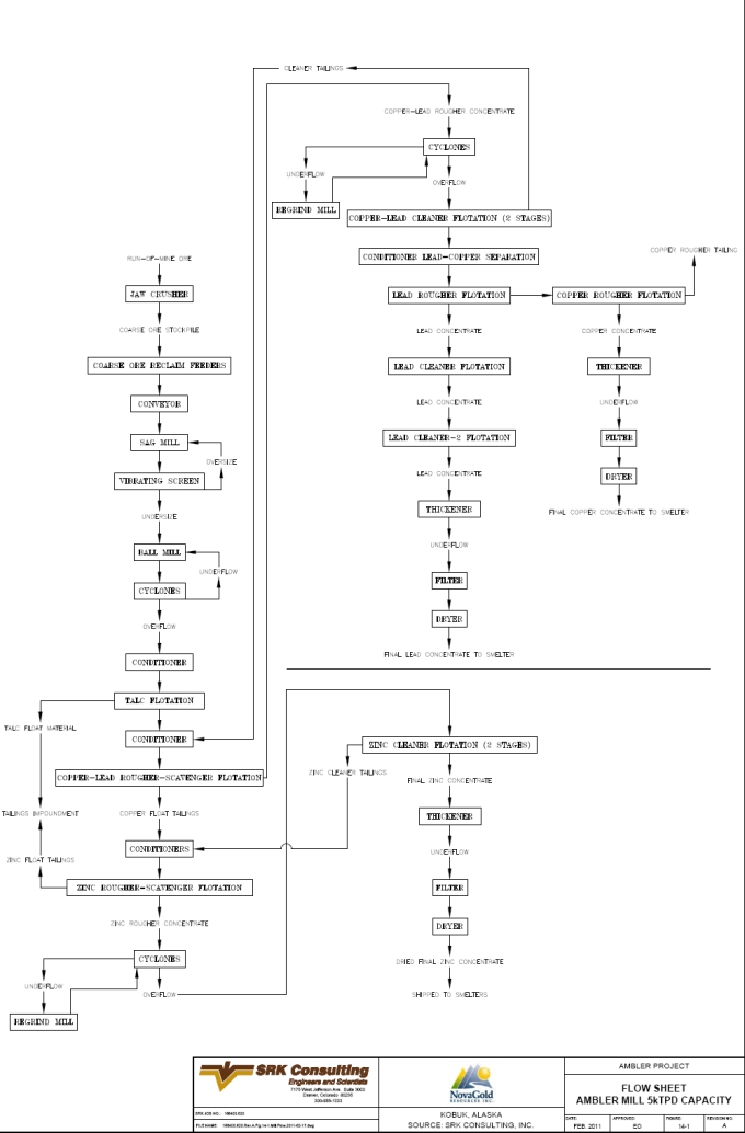
| SRK Consulting (U.S.), Inc. | May 9, 2011 |
| NovaGold Resources Inc. | 15-1 |
| Ambler Project | NI 43-101 Preliminary Econimic Assessment |
| 15 | Mineral Resource Estimate (Item 19) |
The mineral resource estimate was prepared by Russ White, P.Geo, Associate Resource Geologist at SRK Denver. Grade estimations were made using Ordinary Kriging based on a three-dimensional block model constructed using Vulcan® commercial mine planning software. The project limits are based on a UTM coordinate system (NAD 1927, Zone 24), and the block model is based on a parent block size of 5m X x 5m Y x 5m Z, with a sub-cell size of 5m X x 5m Y x 0.2m Z. Five mineralized massive sulfide zones have been defined along a northeasterly striking corridor, with all zones tending to dip moderately to the southwest. The mineralization at Arctic occurs as massive sulfide lenses hosted within weakly to unmineralized schistose country rocks. Potentially economic mineralization is associated with coarse-grained sulfides, For the resource estimation work, all of the massive sulfide zones are collectively referred to as the Arctic deposit.
The resource estimate has been generated from composites derived from drill hole sample assay results, and is constrained by manually interpreted sulfide bed boundaries constructed by SRK. No three dimensional geologic model was utilized to constrain the resource estimate. Grade interpolation parameters have been defined based largely on the geologic understanding of controls on mineralization, drillhole spacing and geostatistical analysis of the data. The resources have been classified by their proximity to the sample locations and number of drill holes used to inform the blocks. SRK finds the resource model and resource classification to be acceptable for resource reporting under CIM guidelines.
| 15.1 | Drillhole Database |
The drillhole database used for resource estimation consists of 119 core holes, 96 of which intercepted significant mineralization. Of the 25,000m drilled within the Arctic deposit, 4,808 intervals were sampled representing 9,128m of sampled drilling. Sample lengths vary from 0.1 to 12m, and average about 1.9m. Each interval contains assays for copper, zinc, lead, gold and silver, as well as codes for lithology and mineralized zone. Drillhole collars for the holes used in this estimate are listed in Appendix C, and their locations are shown in Figure 15-1. In 2008, NovaGold completed an additional 14 hole drill program totaling 3,306m. All holes were designed to infill within the currently defined resource area, and three holes were drilled for metallurgical testing purposes. None of the assay results were available at the time of construction the original 2008 resource model. SRK recommends that the results of this program be incorporated into the next resource model update.
A separate database table includes specific gravity (SG) measurements for 404 samples taken from 47 drillholes.
Downhole surveys were recorded in 50 to 150ft intervals for the majority of the drillholes. A standard “typical deviation” had been applied to 40 holes, which were unsurveyed. Due to the assumed regional structural fabric, this practice is reasonable, although the actual hole deviations may vary greatly depending on structures encountered, lithologic contacts, drilling rigs and drilling conditions. For a preliminary assessment, the sample locations are sufficient. SRK recommends that a detailed study of downhole surveys be performed to verify that a general artificial survey is appropriate for all parts of the deposit. In future, all holes require downhole surveys.
| SRK Consulting (U.S.), Inc. | May 9, 2011 |
| NovaGold Resources Inc. | 15-2 |
| Ambler Project | NI 43-101 Preliminary Econimic Assessment |
Zone codes were assigned to the drillhole database to match the modeled massive sulfide units as described below in Section 15.4. These were chosen based upon a combination of logged lithology and assayed grades and were coded based on the geometric relationship to the interpreted geology.
| 15.2 | Coordinate System |
All drilling data as well as the digital topographic surface and grade wireframes have been provided to SRK in a UTM coordinate system (NAD 27, Zone 4), and resource modeling and grade estimation work has been conducted in this coordinate space.
| 15.3 | Overburden and Topography Surface |
Overburden depth ranges between 0.9m and 22.9m, with an average depth of 6.2m. SRK was not provided with a three dimensional interpretation of base of overburden, and recommends that NovaGold geologists construct this surface to be used for the next phase of resource estimation.
A wireframe digital terrain model (DTM) surface of topography was provided to SRK by NovaGold. The source of these data is from a 1998 McElhanney photogrammetric interpretation of a McElhanney aerial survey conducted in 1975. A visual comparison between the drillhole collars and the provided topography shows very good agreement in most areas, and SRK considers that the topography over the deposit area as provided by NovaGold is appropriate for use in resource estimation.
| 15.4 | Geology and Zone Modeling |
Based upon cross sectional interpretations supplied by NovaGold, five zones representing massive sulfide lenses were modeled by SRK. Two of these represent the upper and lower limbs of a basic recumbent fold structure hinged to the NW and dipping to the SW roughly 20°, and two others are splayed horizons sandwiched between the main limbs. The fifth zone is a single limb NE and below the other zones across a fault referred to as the “Lower Thrust”. Previously existing Vulcan models supplied the basic geometries for this model but were not suitable for capturing data in an appropriate manner for estimation. These zones were modeled to fit this geometry using grid models of elevation and vertical thickness. The grid interpolation method used chosen intercepts as data points with both elevation and vertical thickness. These attributes were interpolated into 5m x 5m grid cells that were then manipulated to provide a top and bottom surface for each lens. An advantage of this method is that it does a very good job of respecting the locations of the original intercepts while maintaining a reasonable/logical geometry. Due to the sparse data that this is based upon, it has been assumed that more drilling data and further refinement of model will occur before final mine planning is done. These zones are coded in the block model and composite data as follows, and illustrated in Figures 15-2 and 15-3.
1 = Main upper limb;
2 = Intermediate upper lens;
3 = Intermediate lower lens
4 = Main lower limb;
11 = Lower thrust extension; and,
0 = All blocks external to modeled zones
| SRK Consulting (U.S.), Inc. | May 9, 2011 |
| NovaGold Resources Inc. | 15-3 |
| Ambler Project | NI 43-101 Preliminary Econimic Assessment |
Intervals of massive sulfide that could not be clearly correlated to this general interpretation were assigned a code of 5 or 6 so they could be easily identified in future attempts at correlation. Although the cross sectional interpretation clearly shows several faults cutting across the sulfide bodies, the sparsity of data supporting isolated blocks of sulfides led to the use of a simpler interpretation to reflect supportable volume estimates of sulfides. As more drilling information is gained these models should be revised.
These lenses were in general not extrapolated more than 50m beyond the edge of mineralized intercepts. In some areas the distance between intercepts internal to the mineralization exceeded 50m.
SRK notes that no three dimensional geology and structure model exists, and recommends that NovaGold geologists construct this model for the next stage of resource estimation.
| 15.5 | Exploratory Data Analysis |
Univariate statistics were calculated for copper, gold, silver, lead and zinc by individual zone and are provided in Tables 15.5.1 through 15.5.5, respectively. Based on this analysis, it can be observed that the majority of metal is contained in the Main Limb Upper and Main Limb Lower on a grade*thickness basis.
The global raw gold dataset was inspected for the presence of high-grade outlier values that could adversely impact grade estimation. SRK elected to review assay capping on a global basis, given the relatively statistically insignificant number of data in some of the zones. Subsequent to reviews of the Cumulative Distribution Function plots for the combined dataset for individual metals, assay caps were applied as summarized in Table 15.5.6. All raw data were capped prior to compositing. The log-probability plots that form the basis for grade capping determination are provided in Figures 15-4 through 15-8.
| SRK Consulting (U.S.), Inc. | May 9, 2011 |
| NovaGold Resources Inc. | 15-4 |
| Ambler Project | NI 43-101 Preliminary Econimic Assessment |
Table 15.5.1: Summary Statistics: All Copper Raw Assays by Zone
| Mineralized Zone | |||||||||||
| Cut-off (%) | Statistics Above Cut-off | Incremental Statistics Between Cut-offs | |||||||||
| Total | Incremental | Max Grade | Mean Grade | Grade-thk | Standard | Coeff.of | Total | Mean Grade | Grade-thk | ||
| (m) | (%) | (%) | (%) | (%-m) | Deviation | Variation | (m) | (%) | (%-m) | ||
| All Data | 0.10 | 3,053 | 43.58% | 19.60 | 1.69 | 5,154 | 2.26 | 1.34 | 1,330 | 0.20 | 261 |
| 0.50 | 1,723 | 13.25% | 2.84 | 4,893 | 2.44 | 0.86 | 404 | 0.72 | 292 | ||
| 1.00 | 1,318 | 34.12% | 3.49 | 4,600 | 2.45 | 0.70 | 1,042 | 2.48 | 2,581 | ||
| 5.00 | 276 | 9.05% | 7.31 | 2,020 | 2.11 | 0.29 | 276 | 7.31 | 2,020 | ||
| Main Upper Limb | 0.10 | 297 | 10.77% | 19.60 | 3.94 | 1,171 | 3.18 | 0.81 | 32 | 0.27 | 9 |
| 0.50 | 265 | 10.92% | 4.38 | 1,162 | 3.08 | 0.70 | 32 | 0.76 | 25 | ||
| 1.00 | 233 | 45.07% | 4.88 | 1,137 | 2.96 | 0.61 | 134 | 2.89 | 387 | ||
| 5.00 | 99 | 33.24% | 7.59 | 750 | 2.30 | 0.30 | 99 | 7.59 | 750 | ||
| Intermediate upper lens | 0.10 | 241 | 16.02% | 12.10 | 3.45 | 834 | 2.67 | 0.77 | 39 | 0.25 | 10 |
| 0.50 | 203 | 4.71% | 4.07 | 824 | 2.47 | 0.61 | 11 | 0.81 | 9 | ||
| 1.00 | 191 | 55.22% | 4.26 | 815 | 2.41 | 0.57 | 133 | 2.94 | 392 | ||
| 5.00 | 58 | 24.05% | 7.28 | 423 | 1.43 | 0.20 | 58 | 7.28 | 423 | ||
| Intermediate lower lens | 0.10 | 127 | 16.92% | 17.90 | 2.61 | 332 | 2.29 | 0.88 | 22 | 0.19 | 4 |
| 0.50 | 106 | 11.46% | 3.11 | 328 | 2.21 | 0.71 | 15 | 0.67 | 10 | ||
| 1.00 | 91 | 60.17% | 3.50 | 318 | 2.13 | 0.61 | 76 | 2.80 | 214 | ||
| 5.00 | 15 | 11.45% | 7.17 | 104 | 2.44 | 0.34 | 15 | 7.17 | 104 | ||
| Main Lower Limb | 0.10 | 312 | 7.65% | 10.70 | 3.16 | 985 | 1.94 | 0.61 | 24 | 0.24 | 6 |
| 0.50 | 288 | 5.28% | 3.40 | 979 | 1.82 | 0.53 | 16 | 0.65 | 11 | ||
| 1.00 | 272 | 72.90% | 3.56 | 969 | 1.74 | 0.49 | 227 | 3.00 | 681 | ||
| 5.00 | 44 | 14.17% | 6.50 | 287 | 1.10 | 0.17 | 44 | 6.50 | 287 | ||
| Lower Thrust Extension | 0.10 | 22 | 23.02% | 10.60 | 2.60 | 58 | 2.27 | 0.87 | 5 | 0.25 | 1 |
| 0.50 | 17 | 0.00% | 3.30 | 57 | 2.13 | 0.64 | 0 | 0.00 | 0 | ||
| 1.00 | 17 | 60.72% | 3.30 | 57 | 2.13 | 0.64 | 14 | 2.32 | 31 | ||
| 5.00 | 4 | 16.26% | 6.99 | 25 | 1.46 | 0.21 | 4 | 6.99 | 25 | ||
| Outside Wireframes | 0.10 | 2,053 | 58.90% | 18.00 | 0.86 | 1,774 | 1.47 | 1.70 | 1,209 | 0.19 | 231 |
| 0.50 | 844 | 16.06% | 1.83 | 1,543 | 1.91 | 1.04 | 330 | 0.72 | 238 | ||
| 1.00 | 514 | 22.26% | 2.54 | 1,305 | 2.16 | 0.85 | 457 | 1.91 | 875 | ||
| 5.00 | 57 | 2.78% | 7.54 | 430 | 2.65 | 0.35 | 57 | 7.54 | 430 |
| SRK Consulting (U.S.), Inc. | May 9, 2011 |
| NovaGold Resources Inc. | 15-5 |
| Ambler Project | NI 43-101 Preliminary Econimic Assessment |
Table 15.5.2: Summary Statistics: All Gold Raw Assays by Zone
| Mineralized Zone | |||||||||||
| Cut-off (%) | Statistics Above Cut-off | Incremental Statistics Between Cut-offs | |||||||||
| Total | Incremental | Max Grade | Mean Grade | Grade-thk | Standard | Coeff.of | Total | Mean Grade | Grade-thk | ||
| (m) | (%) | (g/t) | (g/t) | (g/t-m) | Deviation | Variation | (m) | (g/t) | (g/t-m) | ||
| All Data | 0.01 | 3,820 | 61.08% | 32.36 | 0.30 | 1,151 | 1.02 | 3.38 | 2,333 | 0.04 | 85 |
| 0.10 | 1,487 | 21.78% | 0.72 | 1,066 | 1.54 | 2.15 | 832 | 0.22 | 187 | ||
| 0.50 | 655 | 8.93% | 1.34 | 879 | 2.17 | 1.61 | 341 | 0.73 | 249 | ||
| 1.00 | 314 | 8.21% | 2.01 | 630 | 2.99 | 1.49 | 314 | 2.01 | 630 | ||
| Main Upper Limb | 0.01 | 264 | 0.00% | 24.14 | 1.28 | 337 | 2.87 | 2.25 | 0 | 0.00 | 0 |
| 0.10 | 264 | 39.97% | 1.28 | 337 | 2.87 | 2.25 | 106 | 0.36 | 38 | ||
| 0.50 | 158 | 31.58% | 1.89 | 299 | 3.58 | 1.89 | 83 | 0.69 | 58 | ||
| 1.00 | 75 | 28.45% | 3.22 | 242 | 4.86 | 1.51 | 75 | 3.22 | 242 | ||
| Intermediate upper lens | 0.01 | 334 | 34.14% | 3.14 | 0.42 | 140 | 0.46 | 1.11 | 114 | 0.06 | 6 |
| 0.10 | 220 | 31.19% | 0.61 | 133 | 0.47 | 0.78 | 104 | 0.26 | 27 | ||
| 0.50 | 116 | 24.08% | 0.92 | 106 | 0.45 | 0.50 | 80 | 0.70 | 56 | ||
| 1.00 | 35 | 10.59% | 1.41 | 50 | 0.55 | 0.39 | 35 | 1.41 | 50 | ||
| Intermediate lower lens | 0.01 | 151 | 21.99% | 1.32 | 0.39 | 59 | 0.38 | 0.97 | 33 | 0.05 | 2 |
| 0.10 | 118 | 47.17% | 0.49 | 57 | 0.38 | 0.77 | 71 | 0.22 | 15 | ||
| 0.50 | 46 | 22.79% | 0.90 | 42 | 0.25 | 0.28 | 34 | 0.77 | 27 | ||
| 1.00 | 12 | 8.05% | 1.26 | 15 | 0.05 | 0.04 | 12 | 1.26 | 15 | ||
| Main Lower Limb | 0.01 | 397 | 15.77% | 2.94 | 0.79 | 314 | 0.57 | 0.72 | 63 | 0.04 | 3 |
| 0.10 | 334 | 16.94% | 0.93 | 311 | 0.51 | 0.55 | 67 | 0.31 | 21 | ||
| 0.50 | 267 | 34.87% | 1.09 | 291 | 0.45 | 0.41 | 138 | 0.77 | 106 | ||
| 1.00 | 129 | 32.42% | 1.43 | 184 | 0.42 | 0.29 | 129 | 1.43 | 184 | ||
| Outside Wireframes | 0.01 | 2,870 | 75.56% | 3.87 | 0.10 | 290 | 0.23 | 2.28 | 2,168 | 0.03 | 74 |
| 0.10 | 701 | 21.92% | 0.31 | 216 | 0.40 | 1.29 | 629 | 0.20 | 127 | ||
| 0.50 | 72 | 1.53% | 1.23 | 89 | 0.72 | 0.58 | 44 | 0.80 | 35 | ||
| 1.00 | 28 | 0.99% | 1.90 | 54 | 0.76 | 0.40 | 28 | 1.90 | 54 |
Note: insufficient gold assay data exists in the Lower Thrust Extension Zone to be statistically meaningful
| SRK Consulting (U.S.), Inc. | May 9, 2011 |
| NovaGold Resources Inc. | 15-6 |
| Ambler Project | NI 43-101 Preliminary Econimic Assessment |
Table 15.5.3: Summary Statistics: All Silver Raw Assays by Zone
| Mineralized Zone | |||||||||||
| Cut-off (%) | Statistics Above Cut-off | Incremental Statistics Between Cut-offs | |||||||||
| Total | Incremental | Max Grade | Mean Grade | Grade-thk | Standard | Coeff.of | Total | Mean Grade | Grade-thk | ||
| (m) | (%) | (g/t) | (g/t) | (g/t-m) | Deviation | Variation | (m) | (g/t) | (g/t-m) | ||
| All Data | 0.01 | 9,590 | 62.86% | 660.30 | 8.57 | 82,192 | 24.27 | 2.83 | 6,028 | 0.29 | 1,730 |
| 1.00 | 3,561 | 20.86% | 22.59 | 80,463 | 35.68 | 1.58 | 2,000 | 3.39 | 6,789 | ||
| 10.00 | 1,561 | 10.03% | 47.20 | 73,674 | 42.66 | 0.90 | 961 | 23.12 | 22,223 | ||
| 50.00 | 600 | 6.25% | 85.81 | 51,451 | 46.07 | 0.54 | 600 | 85.81 | 51,451 | ||
| Main Upper Limb | 0.01 | 308 | 2.27% | 660.30 | 57.77 | 17,818 | 67.43 | 1.17 | 7 | 0.56 | 4 |
| 1.00 | 301 | 13.36% | 59.10 | 17,814 | 67.63 | 1.14 | 41 | 5.34 | 220 | ||
| 10.00 | 260 | 36.25% | 67.61 | 17,594 | 69.04 | 1.02 | 112 | 25.55 | 2,857 | ||
| 50.00 | 148 | 48.11% | 99.31 | 14,737 | 76.94 | 0.77 | 148 | 99.31 | 14,737 | ||
| Intermediate upper lens | 0.01 | 261 | 5.03% | 174.90 | 35.80 | 9,348 | 32.91 | 0.92 | 13 | 0.56 | 7 |
| 1.00 | 248 | 29.16% | 37.67 | 9,341 | 32.73 | 0.87 | 76 | 5.02 | 382 | ||
| 10.00 | 172 | 33.43% | 52.13 | 8,958 | 29.33 | 0.56 | 87 | 29.08 | 2,539 | ||
| 50.00 | 85 | 32.38% | 75.94 | 6,420 | 22.43 | 0.30 | 85 | 75.94 | 6,420 | ||
| Intermediate lower lens | 0.01 | 135 | 2.84% | 198.00 | 37.89 | 5,123 | 37.66 | 0.99 | 4 | 0.61 | 2 |
| 1.00 | 131 | 25.55% | 38.98 | 5,121 | 37.66 | 0.97 | 35 | 3.59 | 124 | ||
| 10.00 | 97 | 42.95% | 51.60 | 4,996 | 36.27 | 0.70 | 58 | 26.32 | 1,528 | ||
| 50.00 | 39 | 28.66% | 89.49 | 3,468 | 26.10 | 0.29 | 39 | 89.49 | 3,468 | ||
| Main Lower Limb | 0.01 | 327 | 4.72% | 232.10 | 58.12 | 18,991 | 38.45 | 0.66 | 15 | 0.34 | 5 |
| 1.00 | 311 | 6.58% | 60.98 | 18,986 | 37.12 | 0.61 | 22 | 5.31 | 114 | ||
| 10.00 | 290 | 30.40% | 65.11 | 18,871 | 35.11 | 0.54 | 99 | 30.09 | 2,989 | ||
| 50.00 | 191 | 58.31% | 83.36 | 15,882 | 28.73 | 0.34 | 191 | 83.36 | 15,882 | ||
| Lower Thrust Extension | 0.01 | 27 | 8.53% | 112.10 | 22.44 | 599 | 23.80 | 1.06 | 2 | 0.30 | 1 |
| 1.00 | 24 | 30.75% | 24.50 | 598 | 23.86 | 0.97 | 8 | 2.74 | 22 | ||
| 10.00 | 16 | 47.16% | 35.52 | 576 | 22.25 | 0.63 | 13 | 24.55 | 309 | ||
| 50.00 | 4 | 13.56% | 73.71 | 267 | 15.57 | 0.21 | 4 | 73.71 | 267 | ||
| Outside Wireframes | 0.01 | 8,531 | 70.17% | 290.40 | 3.55 | 30,314 | 11.83 | 3.33 | 5,987 | 0.29 | 1,710 |
| 1.00 | 2,545 | 21.32% | 11.24 | 28,604 | 19.63 | 1.75 | 1,819 | 3.26 | 5,926 | ||
| 10.00 | 726 | 6.94% | 31.24 | 22,678 | 27.89 | 0.89 | 592 | 20.26 | 12,000 | ||
| 50.00 | 134 | 1.57% | 79.84 | 10,677 | 30.55 | 0.38 | 134 | 79.84 | 10,677 |
| SRK Consulting (U.S.), Inc. | May 9, 2011 |
| NovaGold Resources Inc. | 15-7 |
| Ambler Project | NI 43-101 Preliminary Econimic Assessment |
Table 15.5.4: Summary Statistics: All Lead Raw Assays by Zone
| Mineralized Zone | |||||||||||
| Cut-off (%) | Statistics Above Cut-off | Incremental Statistics Between Cut-offs | |||||||||
| Total | Incremental | Max Grade | Mean Grade | Grade-thk | Standard | Coeff.of | Total | Mean Grade | Grade-thk | ||
| (m) | (%) | (%) | (%) | (%-m) | Deviation | Variation | (m) | (%) | (%-m) | ||
| All Data | 0.10 | 1,489 | 52.58% | 6.50 | 0.73 | 1,084 | 0.81 | 1.11 | 783 | 0.18 | 143 |
| 0.50 | 706 | 17.07% | 1.33 | 941 | 0.82 | 0.61 | 254 | 0.67 | 169 | ||
| 1.00 | 452 | 28.24% | 1.71 | 772 | 0.80 | 0.47 | 421 | 1.55 | 650 | ||
| 3.00 | 31 | 2.11% | 3.88 | 122 | 0.84 | 0.22 | 31 | 3.88 | 122 | ||
| Main Upper Limb | 0.10 | 232 | 29.84% | 5.10 | 1.11 | 258 | 0.87 | 0.78 | 69 | 0.22 | 15 |
| 0.50 | 163 | 13.70% | 1.49 | 243 | 0.77 | 0.52 | 32 | 0.73 | 23 | ||
| 1.00 | 131 | 54.41% | 1.68 | 220 | 0.75 | 0.45 | 126 | 1.57 | 198 | ||
| 3.00 | 5 | 2.05% | 4.51 | 21 | 0.79 | 0.17 | 5 | 4.51 | 21 | ||
| Intermediate upper lens | 0.10 | 180 | 34.01% | 5.00 | 0.87 | 157 | 0.72 | 0.83 | 61 | 0.21 | 13 |
| 0.50 | 119 | 21.79% | 1.21 | 144 | 0.67 | 0.55 | 39 | 0.59 | 23 | ||
| 1.00 | 80 | 42.82% | 1.52 | 121 | 0.62 | 0.41 | 77 | 1.44 | 111 | ||
| 3.00 | 2 | 1.38% | 4.00 | 10 | 0.80 | 0.20 | 2 | 4.00 | 10 | ||
| Intermediate lower lens | 0.10 | 91 | 44.21% | 4.70 | 0.95 | 87 | 1.01 | 1.06 | 40 | 0.16 | 7 |
| 0.50 | 51 | 19.55% | 1.58 | 80 | 0.97 | 0.61 | 18 | 0.72 | 13 | ||
| 1.00 | 33 | 33.13% | 2.04 | 68 | 0.92 | 0.45 | 30 | 1.81 | 55 | ||
| 3.00 | 3 | 3.11% | 4.51 | 13 | 0.54 | 0.12 | 3 | 4.51 | 13 | ||
| Main Lower Limb | 0.10 | 261 | 22.68% | 6.50 | 1.09 | 283 | 0.81 | 0.75 | 59 | 0.24 | 14 |
| 0.50 | 202 | 27.81% | 1.33 | 269 | 0.76 | 0.57 | 72 | 0.72 | 52 | ||
| 1.00 | 129 | 45.69% | 1.68 | 216 | 0.75 | 0.45 | 119 | 1.53 | 182 | ||
| 3.00 | 10 | 3.82% | 3.44 | 34 | 0.44 | 0.13 | 10 | 3.44 | 34 | ||
| Lower Thrust Extension | 0.10 | 15 | 96.49% | 1.70 | 0.30 | 4 | 0.29 | 0.96 | 14 | 0.25 | 4 |
| 0.50 | 1 | 0.00% | 1.70 | 1 | 0.00 | 0.00 | 0 | 0.00 | 0 | ||
| 1.00 | 1 | 3.51% | 1.70 | 1 | 0.00 | 0.00 | 1 | 1.70 | 1 | ||
| 3.00 | 0 | 0.00% | 0.00 | 0 | 0.29 | 0.00 | 0 | 0.00 | 0 | ||
| Outside Wireframes | 0.10 | 711 | 75.86% | 5.50 | 0.41 | 294 | 0.63 | 1.52 | 539 | 0.17 | 90 |
| 0.50 | 172 | 13.07% | 1.19 | 204 | 0.91 | 0.76 | 93 | 0.62 | 57 | ||
| 1.00 | 79 | 9.47% | 1.86 | 146 | 0.97 | 0.52 | 67 | 1.53 | 103 | ||
| 3.00 | 11 | 1.60% | 3.82 | 43 | 0.93 | 0.24 | 11 | 3.82 | 43 |
| SRK Consulting (U.S.), Inc. | May 9, 2011 |
| NovaGold Resources Inc. | 15-8 |
| Ambler Project | NI 43-101 Preliminary Econimic Assessment |
Table 15.5.5: Summary Statistics: All Zinc Raw Assays by Zone
| Mineralized Zone | |||||||||||
| Cut-off (%) | Statistics Above Cut-off | Incremental Statistics Between Cut-offs | |||||||||
| Total | Incremental | Max Grade | Mean Grade | Grade-thk | Standard | Coeff.of | Total | Mean Grade | Grade-thk | ||
| (m) | (%) | (%) | (%) | (%-m) | Deviation | Variation | (m) | (%) | (%-m) | ||
| All Data | 0.10 | 2,895 | 44.58% | 22.30 | 2.58 | 7,475 | 3.84 | 1.49 | 1,291 | 0.19 | 243 |
| 0.50 | 1,604 | 11.87% | 4.51 | 7,231 | 4.28 | 0.95 | 343 | 0.66 | 228 | ||
| 1.00 | 1,261 | 22.60% | 5.56 | 7,004 | 4.27 | 0.77 | 654 | 2.09 | 1,370 | ||
| 5.00 | 607 | 20.95% | 9.29 | 5,633 | 3.14 | 0.34 | 607 | 9.29 | 5,633 | ||
| Main Upper Limb | 0.10 | 299 | 18.31% | 20.90 | 5.64 | 1,685 | 4.83 | 0.86 | 55 | 0.25 | 13 |
| 0.50 | 244 | 5.18% | 6.85 | 1,671 | 4.53 | 0.66 | 15 | 0.72 | 11 | ||
| 1.00 | 229 | 25.51% | 7.26 | 1,660 | 4.38 | 0.60 | 76 | 2.35 | 179 | ||
| 5.00 | 152 | 51.01% | 9.72 | 1,481 | 3.17 | 0.33 | 152 | 9.72 | 1,481 | ||
| Intermediate upper lens | 0.10 | 227 | 12.90% | 18.30 | 5.11 | 1,159 | 4.51 | 0.88 | 29 | 0.22 | 7 |
| 0.50 | 198 | 9.00% | 5.83 | 1,153 | 4.40 | 0.75 | 20 | 0.60 | 12 | ||
| 1.00 | 177 | 36.48% | 6.43 | 1,140 | 4.25 | 0.66 | 83 | 2.59 | 215 | ||
| 5.00 | 94 | 41.62% | 9.80 | 926 | 2.90 | 0.30 | 94 | 9.80 | 926 | ||
| Intermediate lower lens | 0.10 | 119 | 14.20% | 18.30 | 5.13 | 608 | 4.98 | 0.97 | 17 | 0.20 | 3 |
| 0.50 | 102 | 10.69% | 5.94 | 604 | 4.92 | 0.83 | 13 | 0.70 | 9 | ||
| 1.00 | 89 | 35.27% | 6.69 | 595 | 4.82 | 0.72 | 42 | 2.33 | 98 | ||
| 5.00 | 47 | 39.85% | 10.54 | 498 | 3.31 | 0.31 | 47 | 10.54 | 498 | ||
| Main Lower Limb | 0.10 | 303 | 10.68% | 22.30 | 6.01 | 1,821 | 4.03 | 0.67 | 32 | 0.26 | 8 |
| 0.50 | 270 | 4.05% | 6.70 | 1,812 | 3.71 | 0.55 | 12 | 0.73 | 9 | ||
| 1.00 | 258 | 20.70% | 6.99 | 1,803 | 3.56 | 0.51 | 63 | 2.54 | 159 | ||
| 5.00 | 195 | 64.57% | 8.41 | 1,644 | 2.82 | 0.34 | 195 | 8.41 | 1,644 | ||
| Lower Thrust Extension | 0.10 | 21 | 13.11% | 12.00 | 2.32 | 49 | 2.24 | 0.97 | 3 | 0.26 | 1 |
| 0.50 | 18 | 13.82% | 2.63 | 48 | 2.25 | 0.86 | 3 | 0.77 | 2 | ||
| 1.00 | 15 | 66.50% | 2.98 | 46 | 2.29 | 0.77 | 14 | 2.30 | 32 | ||
| 5.00 | 1 | 6.57% | 9.85 | 14 | 1.64 | 0.17 | 1 | 9.85 | 14 | ||
| Outside Wireframes | 0.10 | 1,926 | 59.93% | 20.80 | 1.12 | 2,153 | 2.34 | 2.09 | 1,155 | 0.18 | 211 |
| 0.50 | 772 | 14.52% | 2.52 | 1,943 | 3.22 | 1.28 | 280 | 0.66 | 184 | ||
| 1.00 | 492 | 19.55% | 3.57 | 1,758 | 3.63 | 1.02 | 377 | 1.82 | 687 | ||
| 5.00 | 116 | 6.00% | 9.27 | 1,071 | 3.33 | 0.36 | 116 | 9.27 | 1,071 |
| SRK Consulting (U.S.), Inc. | May 9, 2011 |
| NovaGold Resources Inc. | 15-9 |
| Ambler Project | NI 43-101 Preliminary Econimic Assessment |
Table 15.5.6: Assay Capping Statistics: Global Raw Dataset
| Metal | Assay Cap (g/t or %) | Total Meters Capped | Percentile of Distribution | Reduction in Grade-Thickness (%) | CV - Uncapped | CV - Capped |
| Cu | 15.00 | 3.00 | 99.81 | 0.17 | 1.34 | 1.33 |
| Au | 7.00 | 7.00 | 99.52 | 7.81 | 3.38 | 1.92 |
| Ag | 190.00 | 9.00 | 99.90 | 1.37 | 2.83 | 2.6 |
| Zn | 18.00 | 9.00 | 99.67 | 0.21 | 1.49 | 1.49 |
| Pb | 4.00 | 14.00 | 99.19 | 0.95 | 1.11 | 1.06 |
| 15.6 | Compositing |
Composites were created in 1m downhole intervals, broken at zone boundaries. This length was used in order to capture short intervals that were typically sampled on massive sulfides, while still allowing high- and low-grade intervals to exist within the narrow lenses. Unsampled and unlogged intervals were assigned zero grades for all metals. SRK manually checked several of the computer generated composites at random, and found no errors. All raw assay grades were capped prior to compositing.
| 15.7 | Specific Gravity |
Previous resource estimations for the Project used an average SG of 3.48 for mineralized material. There is no documentation explaining how this number was derived. In 1998, Kennecott had SG analyses done on 38 core samples of which 22 were from mineralized zones and 16 from other lithologies. Analyses were split between Chemex Laboratories and Golder and Associates. Mineralized samples were defined for SG measurements as massive sulfide (>50% total sulfides) or semi-massive sulfide (<50% total sulfides). Lithologic samples were also collected, some of which contain up to 10% sulfides. The mineralized samples showed a large difference from the previous estimated density number used.
The following year, in 1999, Kennecott selected 231 samples from the pre-1998 drill campaigns for SG analysis. The samples were shipped to Anchorage but were not forwarded to a lab for analysis.
Due to the large discrepancy between previous SG measurements, a more extensive field SG program was implemented. In 2004, the 231 samples from the pre-1998 drill campaigns were collected from Kennecott’s Anchorage warehouse and sent to Chemex Laboratories for bulk density analysis. In addition to these 231 samples, 33 samples from the 2004 program were included, mainly to check field procedures.
Field SG measurements were collected using an Ohaus triple beam balance. Select core samples were first dried and then a weight-in-air value was obtained followed by a weight-in-water, with the sample suspended by a wire into a water-filled bucket. The density was calculated using the following formula:
Weight in air
[Weight in air – Weight in water]
A total of 127 usable field SG measurements were obtained.
The 2004 lab program produced significantly lower SG results for mineralized samples compared to the earlier programs. The average of the field results were within 1% of the lab
| SRK Consulting (U.S.), Inc. | May 9, 2011 |
| NovaGold Resources Inc. | 15-10 |
| Ambler Project | NI 43-101 Preliminary Econimic Assessment |
results, confirming the accuracy of the field procedures. In comparison to the earlier programs, the 2004 SG measurements were 7.4% lower for massive sulfide samples and 14.5% lower for semi-massive sulfide samples. The average of the lithology samples was similar in all programs. Table 15.7.1 shows the results obtained for these three programs.
Table 15.7.1: Historical Specific Gravity Data Statistics – Arctic Property: 1998–2004
| Program | MS (>50% sulfide) Average g/cm3 | No. of Samples | SMS (<50% sulfide) Average g/cm3 | No. of Samples | Other Lithologies Avg g/cm3 | No. of Samples |
| 1998 Lab (Chemex, Golder) | 4.37 | 15 | 4.02 | 7 | 2.84 | 16 |
| 2004 Field | 4.40 | 35 | 3.84 | 19 | 2.83 | 73 |
| 2004 Lab (Chemex) | 4.06 | 121 | 3.36 | 77 | 2.85 | 66 |
| All Programs | 4.16 | 171 | 3.49 | 103 | 2.84 | 155 |
The difference between the 2004 lab results and those from previous studies may be the result of selection bias in the earlier programs as well as mineralogy within individual samples. With the exception of the lithology samples, the averages from the earlier programs were obtained using fewer samples. Samples from the pre-1998 drill campaigns were from NQ- and BQ-sized core, while samples from the 1998 and 2004 drilling programs were collected from HQ-sized core. In addition, the length of sample taken from the pre-1998 averaged 7.27cm, whereas samples of 2004 core averaged 9.05cm. As a result, sample size may also be a factor in the SG variation from program to program. With more data, a better correlation between total estimated sulfide and SG may be defined. This could then be used in future resource estimations.
For the purpose of this resource estimate, the non-rejected SG measurements were categorized by rock type and vary from 2.62 to 4.87 with an average of 4.4 for massive sulfide (MS). The MS zones modeled are actually composed of a mixture of MS and semi-massive sulfide (SMS), and the combination of these samples have an average SG of 4.2 (Table 15.7.2). Actual values within each zone were used to interpolate SG into the block model using inverse distance squared, but where SG sample density was too sparse, a default value of 4.2 was used in the mineralized zones. A default of 2.9, the average SG of non-rejected quartz mica schist samples, was used for all host rock.
Table 15.7.2: Specific Gravity Measurements Categorized by Rock Type
| Rock Category | Count | Average | Max | Min |
| MS+SMS | 77 | 4.2 | 4.87 | 2.84 |
| Non-MS/SMS | 93 | 2.9 | 4.26 | 2.62 |
| 15.8 | Variogram Analysis and Modeling |
Due to the wide spacing of data and the complex geometry of the sulfide lenses, a thorough directional variogram study is impractical. General directional variograms were generated for each element and, due to the drill spacing and orientation, the best variograms are in the orientation of azimuth 150, plunge 30 (as shown in Appendix E). Ranges of 40 to 50m are observed in all elements but gold, which has a range of 25m.
The block model was defined with an orientation of 49° to parallel the trend of the dominant recumbent fold. Blocks are 5m x 5m in the X and Y dimensions, and variable to within the
| SRK Consulting (U.S.), Inc. | May 9, 2011 |
| NovaGold Resources Inc. | 15-11 |
| Ambler Project | NI 43-101 Preliminary Econimic Assessment |
closest 0.2m in the Z dimension in order to fit the volume of the narrow flat MS zones, as defined by the wireframe solid models.
| 15.9 | Block Model Limits |
A sub-celled block model was created in Vulcan™ software for the deposit area, using the parameters presented in Table 15.9.1.
Table 15.9.1: Arctic Block Model Specifications
| Model Origin (lower right) | Minimum (m) | Maximum (m) | Parent Block size (m) | Sub-cell Block size (m) | No. of Blocks |
| East | 613,100 | 614,400 | 5 | 5 | 260 |
| North | 7,452,100 | 7,453,210 | 5 | 5 | 220 |
| Elevation | 400 | 1,000 | 5 | 0.2 | 3000 |
The Model was rotated 49o anticlockwise about the lower right model origin
A parent block size of 5m X x 5m Y x 5m Z was chosen, with sub-cell dimensions of 5m X x 5m Y x 0.2m Z to properly fill the wireframe shapes. This is considered appropriate with respect to the current drill hole spacing, as well as the Selective Mining Unit (SMU) size typical of an underground operation of this type and scale. All blocks were assigned a zone code based on the constraining sulfide zone wireframes for retrieval during grade estimation.
| 15.10 | Grade Estimation |
Due to the convoluted, but narrow geometry of the sulfide zones, the estimation used a spherical search restricted within the zones. Multiple search passes were used at 50m, 100m and 150 in order to fill as many blocks as possible with the zones. The first search pass used a minimum of two samples, with no more than three from any one drillhole. Subsequent search passes omitted these restrictions. All elements were estimated simultaneously using the same parameters. Although gold variograms exhibited generally shorter ranges than the other elements, it is not a significant economic contributor to this model, so using a slightly longer range was not viewed as an issue. A summary of estimation parameters is provided in Table 15.10.1
Because some isolated massive intercepts were not easily correlated to the modeled zones, they remain outside of these zones. To associate a limited volume to these intercepts, a very narrow “pancake” search of 40m x 40m x 5m was used outside of the modeled zones (also referred to as “zone 0”). Two different generalized orientations were used to match the two dominant fabrics observed outside of the modeled zones. An “upper/South” limb orientation strikes 85°, dipping 22° to the South, and a lower/North limb orientation strikes 356°, dipping 32° West. Although these orientations may not always exactly match the local fabric, they allow these uncorrelated samples to represent a reasonable tonnage of inferred resource. After the metal grades were estimated, an NSR US$value/tonne was calculated for each block based on metal prices, smelter treatment and refining charges, metallurgical recoveries and payables/deducts (see Table 17.1.1). An additional nearest neighbor estimate was conducted for copper and gold, for use in model validation.
| SRK Consulting (U.S.), Inc. | May 9, 2011 |
| NovaGold Resources Inc. | 15-12 |
| Ambler Project | NI 43-101 Preliminary Econimic Assessment |
Table 15.10.1: Estimation Parameters
| Description | Type | Block Selection | Samp. Selec. | Estim. Flag | Samp. Lims. | DH Limit | Ellipse | Variogram | |||||||
| Test | Area | Zone | Zone | Min | Max | Use | Mx/Hole | Radii** | Rotation | Range | Nug. | SillDif. | |||
| MS Pass 1 | OK | * | * | 1 | 2 | 15 | y | 3 | 50 | 0 | 50 | 0.1 | 0.9 | ||
| MS Pass 2 | OK | flag<1 | * | * | 2 | 1 | 15 | y | 3 | 100 | 0 | 75 | 0.1 | 0.9 | |
| MS Pass 3 | OK | flag<1 | * | * | 3 | 1 | 15 | n | - | 150 | 0 | 75 | 0.1 | 0.9 | |
| Outside Zones | OK | topo>0 | Low | 0 | 5, 6, 0 | 4 | 2 | 6 | n | - | 40x5 | x140, y-12, z-18 | 40x5 | 0.1 | 0.9 |
| OK | topo>0 | Hi | 0 | 5, 6, 0 | 4 | 2 | 6 | n | - | 40x5 | x320, y25, z-20 | 40x5 | 0.1 | 0.9 | |
| SG | ID2 | topo>0 | * | * | 1 | 6 | n | - | 400x200 | 0 | - | - | - | ||
* For blocks in all modeled zones (1,2,3,4,11) each block used only samples from the same zone.
** Spherical search, or disk shaped search.
All elements estimated with identical parameters (Cu, Zn, Ag, Pb, Au).
| 15.11 | Model Validation |
Various measures have been implemented to validate the resultant block model. These measures include the following:
● | Comparison of drill hole composites with resource block grade estimates from all zones visually in plan and section; |
● | Statistical comparisons between block and composite data using histogram and cumulative distribution analysis; |
● | Generation of a comparative nearest neighbor model; and |
● | Swath plot analysis (drift analysis) comparing the Ordinary Krige (OK) model with the nearest neighbor model. |
15.11.1 Visual Inspection
Visual comparison between the block grades and the underlying composite grades in plan and section show close agreement, which would be expected considering the estimation methodology employed. An example cross section and level plan showing block and composite copper and gold grades are provided in Figures 15-9 through 15-12.
15.11.2 Block-Composite Statistical Comparison
SRK also conducted statistical comparisons between the OK sub-celled block metal grades (Indicated and Inferred material) and the underlying composite grades (Figures 15-13 through 15-17). This comparison shows that the model grade distribution is appropriately smoothed when compared with the underlying composite distribution, and that the comparison of average copper grades and percentages above incremental cut-offs show close agreement.
15.11.3 Comparison of Interpolation Methods
For comparative purposes, additional copper grades were estimated using nearest neighbor (NN) interpolation methods. The nearest neighbor model was estimated using the same boundary constraints as was applied to the OK model. The results of the NN models are compared to the OK model at a zero percent Cu cut-off grade in Tables 15.11.1 and 15.11.2 for Indicated and Inferred blocks, respectively. It can be observed that there is close agreement between average grade and contained metal above a zero Cu percent cut-off.
| SRK Consulting (U.S.), Inc. | May 9, 2011 |
| NovaGold Resources Inc. | 15-13 |
| Ambler Project | NI 43-101 Preliminary Econimic Assessment |
Table 15.11.1: Comparison of Tonnage and Grade Above Zero g/t Cu Cut-off: OK and Nearest Neighbor Sub-Celled Models: All Indicated Model Blocks – Zones 1 through 11
| Model | kt | Cu (%) | Cu (klb) |
| OK | 18,697 | 3.77 | 1,555,088 |
| NN | 18,697 | 3.70 | 1,526,959 |
| % Diff (OK-NN) | 0.00% | 1.81% | 1.81% |
Table 15.11.2: Comparison of Tonnage and Grade Above Zero g/t Cu Cut-off: OK and Nearest Neighbor Sub-Celled Models: All Inferred Model Blocks – Zones 1 through 11
| Model | kt | Cu (%) | Cu (klb) |
| OK | 11,972 | 3.40 | 897,846 |
| NN | 11,972 | 3.46 | 914,374 |
| % Diff (OK-NN) | 0.00% | -1.84% | -1.84% |
15.11.4 Swath Plots (Drift Analysis)
A swath plot is a graphical display of the grade distribution derived from a series of bands, or swaths, generated in several directions through the deposit. Copper and gold grade variations from the OK model are compared using the swath plot to the distribution derived from the (NN) grade model.
On a local scale, the NN model does not provide reliable estimations of grade, but on a much larger scale it represents an unbiased estimation of the grade distribution based on the underlying data. Therefore, if the OK model is unbiased, the grade trends may show local fluctuations on a swath plot, but the overall trend should be similar to the NN distribution of grade.
Swath plots have been generated in three orthogonal directions for both the distribution of copper and gold for all combined zones. Swath plots for copper along the EW, NS and vertical directions are shown in Figures 15-18 through 15-20. Swath plots for gold along the EW, NS and vertical directions are shown in Figures 15-21 through 15-23.
There is good correspondence between both models in all orthogonal directions. The degree of smoothing in the OK model is evident in the peaks and valleys shown in the swath plots, however, this comparison shows close agreement between the OK and NN models in terms of overall grade distribution as a function of X, Y and Z location.
| 15.12 | Resource Classification |
The mineral resources have been classified according to the “CIM Standards on Mineral Resources and Reserves: Definitions and Guidelines” (November 2005) as described in the Glossary (Section 21.1). The preliminary assessment contained herein includes inferred mineral resources that are considered too speculative geologically to have the economic considerations applied to them that would enable them to be categorized as mineral reserves. There is no certainty that the preliminary assessment will ever be realized. Mineral resources that are not mineral reserves do not have demonstrated economic viability.
Resources in the MS zones, which were estimated by the first (50m) search, were classified as indicated. This is roughly based on a distance that is twice the variogram range and within one
| SRK Consulting (U.S.), Inc. | May 9, 2011 |
| NovaGold Resources Inc. | 15-14 |
| Ambler Project | NI 43-101 Preliminary Econimic Assessment |
cross section distance inside a modeled shape, which is based on correlated intervals. All blocks outside of the MS zones, and all other estimated blocks too distant from the samples for the first pass, were classified as inferred. No resources were classified as measured. Inferred resources have a great amount of uncertainty as to their existence and as to whether they can be mined legally or economically. It cannot be assumed that all or any part of inferred resources will ever be upgraded to a higher category.
| 15.13 | Mineral Resource Statement |
The mineral resources for the Arctic deposit, located near Kobuk, Alaska, have been estimated by SRK at 16,845kt grading an average of 4.14% copper, 6.03% zinc and 0.94% lead 0.83g/t gold, 59.62g/t silver, classified as Indicated mineral resources, with an additional 12,087kt average of 3.53% copper, 4.94% zinc and 0.79% lead 0.67g/t gold, 48.04g/t silver, classified as Inferred mineral resources. The resource is stated above a US$75/t NSR cut-off and contained within potentially economically mineable massive sulfide zone solids.
The mineral resources are reported in accordance with Canadian Securities Administrators (CSA) National Instrument 43-101 (NI 43-101) and have been estimated in conformity with generally accepted Canadian Institute of Mining, Metallurgy and Petroleum (CIM) “Estimation of Mineral Resource and Mineral Reserves Best Practices” guidelines. Mineral resources are not mineral reserves and do not have demonstrated economic viability. There is no certainty that all or any part of the mineral resource will be converted into mineral reserves. The resource estimate was completed by Russ White, P.Geo, an Associate Resource Geologist with SRK. Mr. White has 24 years of operational and consulting experience in the minerals industry, specifically in mineral resource estimation, production geology, feasibility studies and economic evaluations. Mr. White has completed resource modeling work in the U.S., Canada, South America, Mongolia, Indonesia and Russia, on a variety of precious and base metal deposits. Mr. White is independent of the issuer and an independent Qualified Person, as this term is defined in NI 43-101. The effective date of this resource estimate is May 9, 2011 and is based on data received by SRK in January, 2007. The mineral resource statement for the Arctic copper-gold deposit is presented in Table 15.13.1.The resources for the Project are derived from the Vulcan block model using density values estimated from measurements as described in Section 15.7.
| SRK Consulting (U.S.), Inc. | May 9, 2011 |
| NovaGold Resources Inc. | 15-15 |
| Ambler Project | NI 43-101 Preliminary Econimic Assessment |
Table 15.13.1: Mineral Resource Statement (as of May 9, 2011)
| Resource Category | Zone | Tonnage (kt) | Metal Grades | Contained Metal | ||||||||
| Cu (%) | Au (g/t) | Ag (g/t) | Zn (%) | Pb (%) | Cu (klb) | Au (koz) | Ag (koz) | Zn (klb) | Pb (klb) | |||
| Indicated | 1 | 5,293 | 4.56 | 0.96 | 62.77 | 6.45 | 1.05 | 532,571 | 163 | 10,683 | 752,305 | 122,428 |
| 2 | 2,982 | 4.36 | 0.52 | 45.76 | 5.82 | 0.80 | 286,906 | 50 | 4,387 | 382,593 | 52,831 | |
| 3 | 1,964 | 3.66 | 0.52 | 51.02 | 5.98 | 0.93 | 158,357 | 33 | 3,222 | 259,080 | 40,173 | |
| 4 | 6,089 | 3.82 | 1.01 | 68.71 | 6.00 | 0.98 | 513,088 | 197 | 13,451 | 805,142 | 130,965 | |
| 11 | 517 | 4.16 | 0.25 | 32.86 | 3.32 | 0.34 | 47,400 | 4 | 546 | 37,854 | 3,859 | |
| All Zones | 16,845 | 4.14 | 0.83 | 59.62 | 6.02 | 0.94 | 1,538,322 | 447 | 32,289 | 2,236,974 | 350,255 | |
| Inferred | 0 | 1,191 | 2.18 | 0.34 | 4.17 | 2.24 | 0.70 | 57,114 | 13 | 159 | 58,716 | 18,474 |
| 1 | 3,166 | 3.91 | 0.76 | 54.98 | 5.74 | 0.93 | 273,161 | 77 | 5,596 | 400,765 | 64,808 | |
| 2 | 1,559 | 4.06 | 0.43 | 43.40 | 5.60 | 0.74 | 139,424 | 22 | 2,175 | 192,610 | 25,317 | |
| 3 | 1,307 | 3.83 | 0.44 | 48.08 | 5.13 | 0.63 | 110,404 | 18 | 2,020 | 147,864 | 18,292 | |
| 4 | 4,492 | 3.28 | 0.87 | 57.56 | 4.95 | 0.83 | 324,875 | 126 | 8,312 | 489,789 | 81,815 | |
| 11 | 373 | 4.25 | 0.29 | 33.65 | 3.30 | 0.35 | 34,945 | 3 | 404 | 27,137 | 2,905 | |
| All Zones | 12,087 | 3.53 | 0.67 | 48.04 | 4.94 | 0.79 | 939,923 | 260 | 18,667 | 1,316,882 | 211,610 | |
Notes:
1 - Mineral Resources are not Mineral Reserves and do not have demonstrated economic viability. There is no certainty that all or any part of the Mineral Resources will be converted into Mineral Reserves.
2 - Resources stated as contained within a potentially economically minable underground shapes above a US$75.00/t NSR cut-off
3 - NSR calculation is based on assumed metal prices of US$2.50/lb for copper, US$1,000/oz for gold, US$16.00/oz for silver, US$1.00/lb for zinc and US$1.00/lb. for lead. A mining cost of US$45.00/t and combined processing and G&A costs of US$31.00 were assumed to form the basis for the resource NSR cut-off determination. Note these metal prices and operating costs may differ from those used for the cash flow model.
4 - Mineral resource tonnage and contained metal have been rounded to reflect the accuracy of the estimate, and numbers may not add due to rounding
| 15.14 | Mineral Resource Sensitivity |
In order to assess the impact of NSR cut-off grade on contained metal, tonnage and grade were reported above a series of NSR US$/t cut-offs (Tables 15.14.1 and 15.14.2). As can be observed from these comparisons, the resource is relatively insensitive to NSR US$/t cut-off grade in the US$70.00/t to US$110/t NSR cut-off range, which is likely the cut-off grade range of economic interest.
| SRK Consulting (U.S.), Inc. | May 9, 2011 |
| NovaGold Resources Inc. | 15-16 |
| Ambler Project | NI 43-101 Preliminary Econimic Assessment |
Table 15.14.1: NSR (US$/t) CoG Sensitivity Analysis All Zones – Indicated Resources
| NSR Cut-off (US$/t) | Tonnage (kt) | Metal Grades | Contained Metal | |||||||||
| Cu (%) | Zn (%) | Pb (%) | Au (g/t) | Ag (g/t) | Cu (klb) | Zn (klb) | Pb (klb) | Au (koz) | Ag (koz) | |||
| >70 | 16,861 | 4.14 | 6.02 | 0.94 | 0.83 | 59.57 | 1,538,676 | 2,237,537 | 350,346 | 447 | 32,295 | |
| >75 | 16,845 | 4.14 | 6.02 | 0.94 | 0.83 | 59.62 | 1,538,322 | 2,236,974 | 350,255 | 447 | 32,289 | |
| >80 | 16,730 | 4.16 | 6.05 | 0.95 | 0.83 | 59.93 | 1,535,869 | 2,232,076 | 349,370 | 447 | 32,237 | |
| >85 | 16,554 | 4.20 | 6.09 | 0.95 | 0.84 | 60.44 | 1,532,856 | 2,222,830 | 347,327 | 445 | 32,166 | |
| >90 | 16,229 | 4.26 | 6.18 | 0.96 | 0.85 | 61.17 | 1,524,192 | 2,212,488 | 343,478 | 443 | 31,915 | |
| >95 | 16,151 | 4.27 | 6.20 | 0.96 | 0.85 | 61.37 | 1,522,082 | 2,208,863 | 342,892 | 443 | 31,869 | |
| >100 | 15,925 | 4.32 | 6.26 | 0.97 | 0.86 | 61.84 | 1,516,076 | 2,198,307 | 340,634 | 441 | 31,660 | |
| >105 | 15,798 | 4.34 | 6.29 | 0.98 | 0.87 | 62.12 | 1,512,148 | 2,192,148 | 339,663 | 441 | 31,550 | |
| >110 | 15,647 | 4.36 | 6.34 | 0.98 | 0.87 | 62.58 | 1,505,364 | 2,187,762 | 339,229 | 440 | 31,481 | |
Table 15.14.2: NSR (US$/t) CoG Sensitivity Analysis All Zones – Inferred Resources
| NSR Cut-off (US$/t) | Tonnage (kt) | Metal Grades | Contained Metal | ||||||||
| Cu (%) | Zn (%) | Pb (%) | Au (g/t) | Ag (g/t) | Cu (klb) | Zn (klb) | Pb (klb) | Au (koz) | Ag (koz) | ||
| >70 | 12,338 | 3.48 | 4.87 | 0.78 | 0.66 | 47.31 | 945,749 | 1,324,056 | 213,484 | 262 | 18,769 |
| >75 | 12,087 | 3.53 | 4.94 | 0.79 | 0.67 | 48.04 | 939,923 | 1,316,882 | 211,610 | 260 | 18,667 |
| >80 | 11,826 | 3.58 | 5.01 | 0.80 | 0.68 | 48.79 | 934,261 | 1,306,887 | 209,236 | 259 | 18,549 |
| >85 | 11,602 | 3.63 | 5.08 | 0.81 | 0.69 | 49.44 | 928,417 | 1,299,741 | 207,450 | 257 | 18,443 |
| >90 | 11,334 | 3.68 | 5.17 | 0.82 | 0.70 | 50.17 | 920,440 | 1,292,031 | 205,100 | 255 | 18,281 |
| >95 | 11,133 | 3.72 | 5.23 | 0.83 | 0.71 | 50.85 | 914,064 | 1,284,405 | 203,728 | 254 | 18,201 |
| >100 | 10,982 | 3.76 | 5.27 | 0.84 | 0.72 | 51.18 | 910,112 | 1,276,864 | 202,348 | 253 | 18,070 |
| >105 | 10,827 | 3.79 | 5.31 | 0.84 | 0.72 | 51.67 | 905,347 | 1,268,529 | 201,296 | 251 | 17,985 |
| >110 | 10,516 | 3.87 | 5.39 | 0.85 | 0.73 | 52.70 | 896,421 | 1,250,105 | 197,904 | 248 | 17,817 |
| 15.15 | Discussion and Conclusions |
There are many intercepts in the vicinity of the modeled zones that have not been correlated with this model. Infill drilling will undoubtedly increase the knowledge of how these intercepts fit the picture, and may potentially lead to an increase in the resources quantum.
The current resource is not completely closed off along strike and down-dip. Although the deposit is reasonably well drilled in its central area, drill spacing is considerably wider in the peripheral areas. SRK recommends additional step out drilling to extend the current resource base, as well as resource conversion drilling to convert Inferred to Indicated resources.
Given the complex controls on mineralization, SRK recommends that an updated geologic and structural model constructed. SRK also recommends that the current massive sulfide zone wireframes be recompleted and rectified in both plan and section.
| SRK Consulting (U.S.), Inc. | May 9, 2011 |
| NovaGold Resources Inc. | 15-17 |
| Ambler Project | NI 43-101 Preliminary Econimic Assessment |
Figure 15-1: Drillhole Location Map (Grid, 10m Contour)
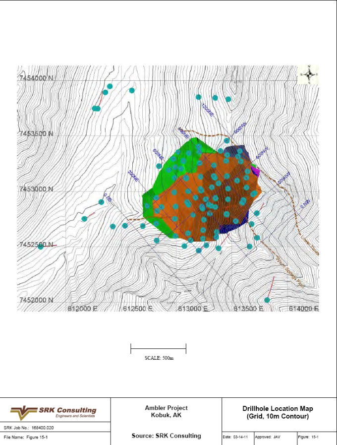
| SRK Consulting (U.S.), Inc. | May 9, 2011 |
| NovaGold Resources Inc. | 15-18 |
| Ambler Project | NI 43-101 Preliminary Econimic Assessment |
Figure 15-2: Typical Cross-Section Looking Northeast at XS600NE
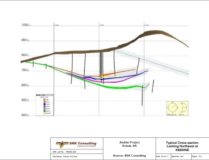
| SRK Consulting (U.S.), Inc. | May 9, 2011 |
| NovaGold Resources Inc. | 15-19 |
| Ambler Project | NI 43-101 Preliminary Econimic Assessment |
Figure 15-3: Typical Cross-Section Looking Northwest at XS600NW
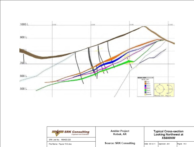
| SRK Consulting (U.S.), Inc. | May 9, 2011 |
| NovaGold Resources Inc. | 15-20 |
| Ambler Project | NI 43-101 Preliminary Econimic Assessment |
Figure 15-4: Cumulative Distribution Function (CDF) Plot for All Raw Copper Assays
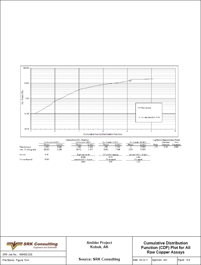
| SRK Consulting (U.S.), Inc. | May 9, 2011 |
| NovaGold Resources Inc. | 15-21 |
| Ambler Project | NI 43-101 Preliminary Econimic Assessment |
Figure 15-5: Cumulative Distribution Function (CDF) Plot for All Raw Gold Assays
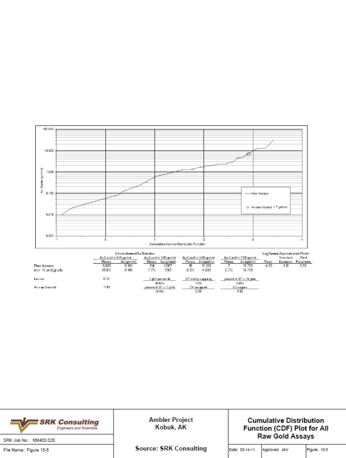
| SRK Consulting (U.S.), Inc. | May 9, 2011 |
| NovaGold Resources Inc. | 15-22 |
| Ambler Project | NI 43-101 Preliminary Econimic Assessment |
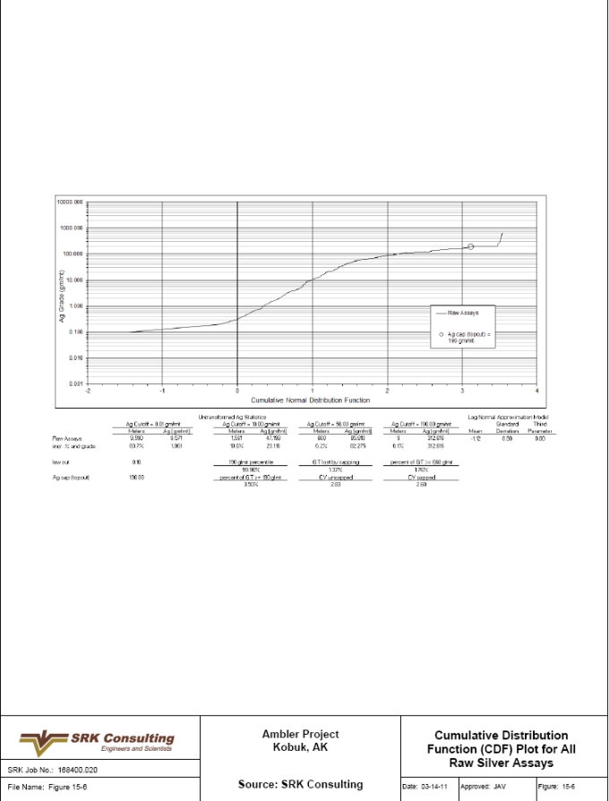
| SRK Consulting (U.S.), Inc. | May 9, 2011 |
| NovaGold Resources Inc. | 15-23 |
| Ambler Project | NI 43-101 Preliminary Econimic Assessment |
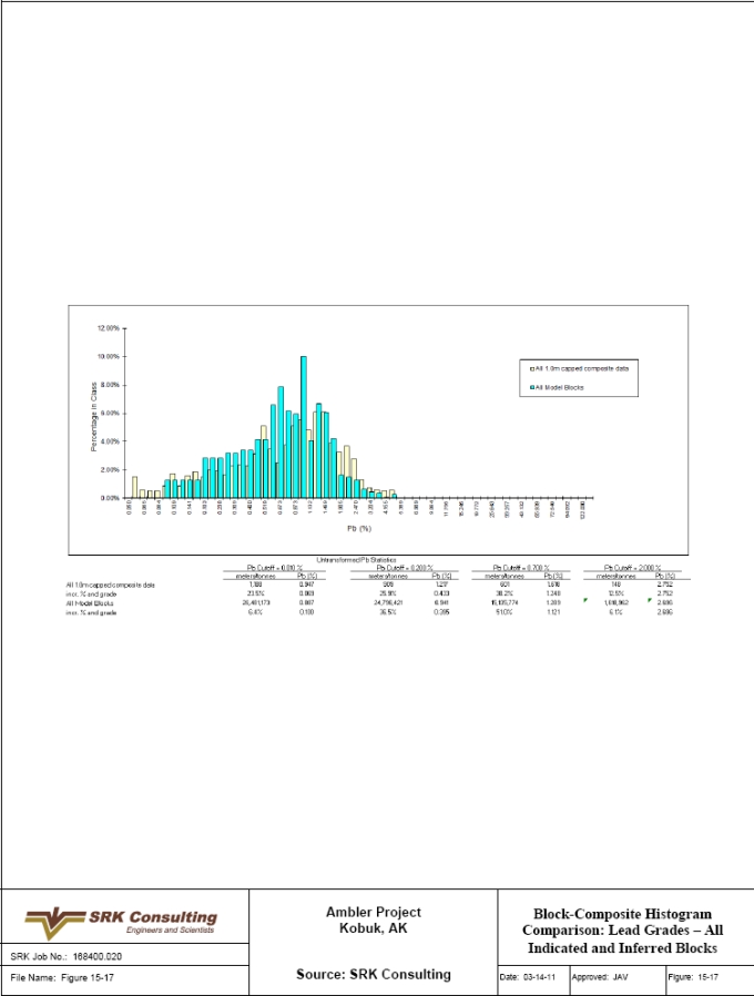
| SRK Consulting (U.S.), Inc. | May 9, 2011 |
| NovaGold Resources Inc. | 15-24 |
| Ambler Project | NI 43-101 Preliminary Econimic Assessment |
Figure 15-8: Cumulative Distribution Function (CDF) Plot for All Raw Lead Assays
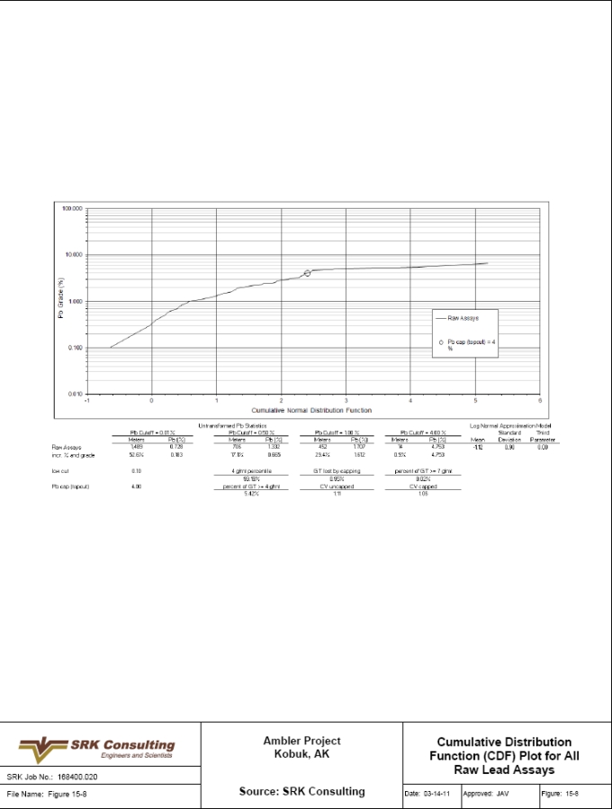
| SRK Consulting (U.S.), Inc. | May 9, 2011 |
| NovaGold Resources Inc. | 15-25 |
| Ambler Project | NI 43-101 Preliminary Econimic Assessment |
Figure 15-9: Example SE-NW Cross-Section, Showing Block and Composite Copper Grades, Sulfide Zone Boundaries and Structure
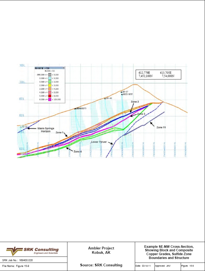
| SRK Consulting (U.S.), Inc. | May 9, 2011 |
| NovaGold Resources Inc. | 15-26 |
| Ambler Project | NI 43-101 Preliminary Econimic Assessment |
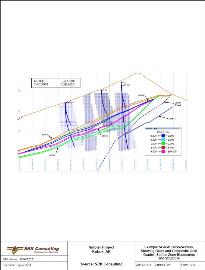
| SRK Consulting (U.S.), Inc. | May 9, 2011 |
| NovaGold Resources Inc. | 15-27 |
| Ambler Project | NI 43-101 Preliminary Econimic Assessment |
Figure 15-11: Example Level Plan at the 720m Elevation, Showing Block and Composite Copper Grades, Sulfide Zone Boundaries and Structure
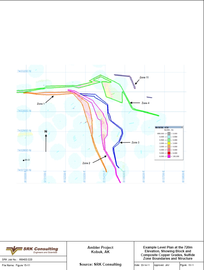
| SRK Consulting (U.S.), Inc. | May 9, 2011 |
| NovaGold Resources Inc. | 15-28 |
| Ambler Project | NI 43-101 Preliminary Econimic Assessment |
Figure 15-12: Example Level Plan at the 720m Elevation, Showing Block and Composite Gold Grades, Sulfide Zone Boundaries and Structure
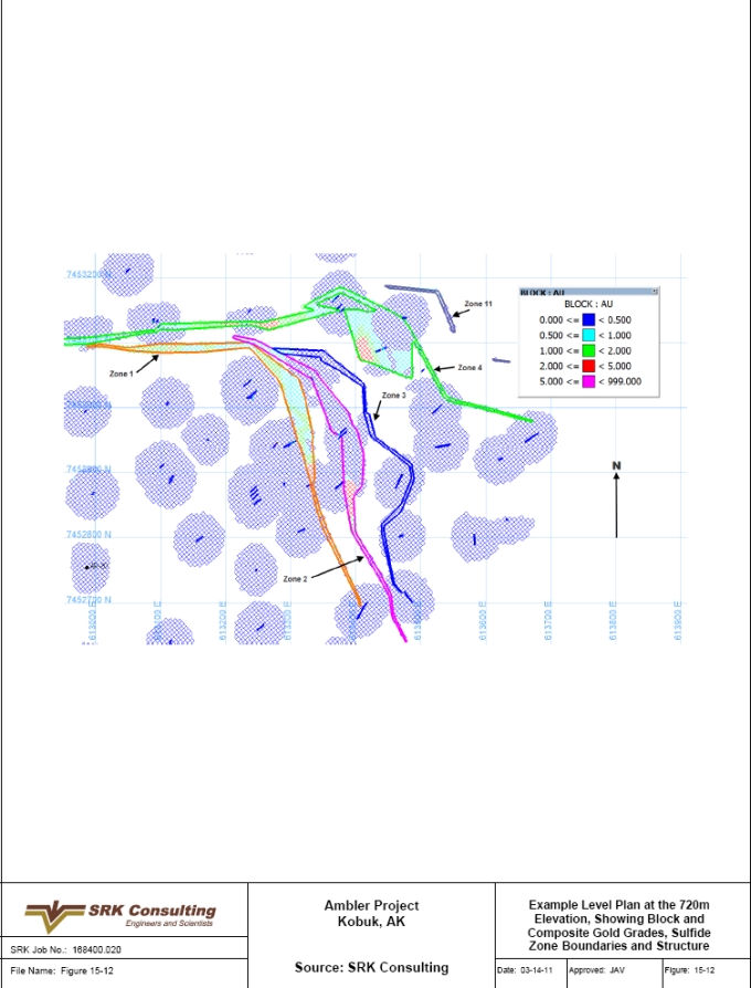
| SRK Consulting (U.S.), Inc. | May 9, 2011 |
| NovaGold Resources Inc. | 15-29 |
| Ambler Project | NI 43-101 Preliminary Econimic Assessment |
Figure 15-13: Block-Composite Histogram Comparison: Copper Grades – All Indicated and Inferred Blocks
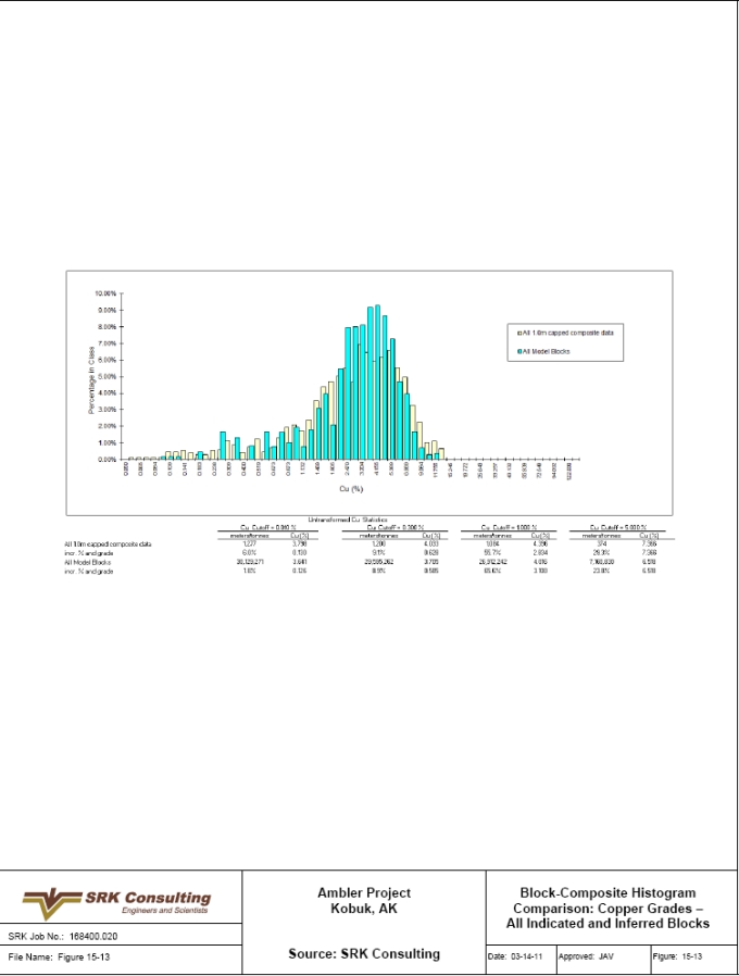
| SRK Consulting (U.S.), Inc. | May 9, 2011 |
| NovaGold Resources Inc. | 15-30 |
| Ambler Project | NI 43-101 Preliminary Econimic Assessment |
Figure 15-14: Block-Composite Histogram Comparison: Gold Grades – All Indicated and Inferred Blocks
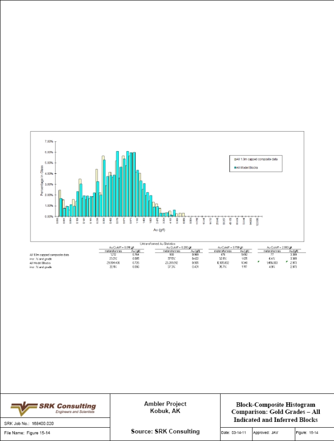
| SRK Consulting (U.S.), Inc. | May 9, 2011 |
| NovaGold Resources Inc. | 15-31 |
| Ambler Project | NI 43-101 Preliminary Econimic Assessment |
Figure 15-15: Block-Composite Histogram Comparison: Silver Grades – All Indicated and Inferred Blocks
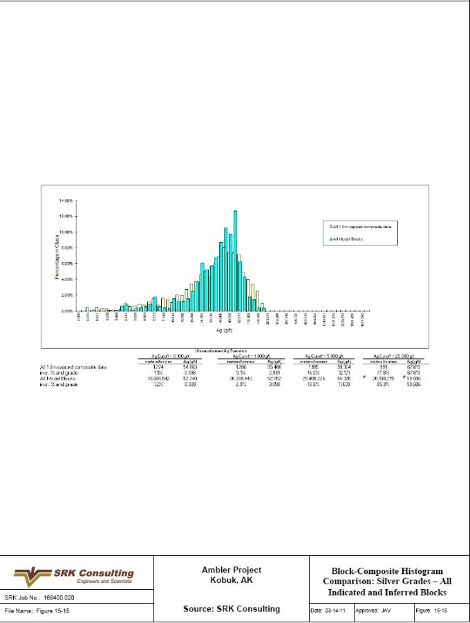
| SRK Consulting (U.S.), Inc. | May 9, 2011 |
| NovaGold Resources Inc. | 15-32 |
| Ambler Project | NI 43-101 Preliminary Econimic Assessment |
Figure 15-16: Block-Composite Histogram Comparison: Zinc Grades – All Indicated and Inferred Blocks

| SRK Consulting (U.S.), Inc. | May 9, 2011 |
| NovaGold Resources Inc. | 15-33 |
| Ambler Project | NI 43-101 Preliminary Econimic Assessment |
Figure 15-17: Block-Composite Histogram Comparison: Lead Grades – All Indicated and Inferred Blocks
| SRK Consulting (U.S.), Inc. | May 9, 2011 |
| NovaGold Resources Inc. | 15-34 |
| Ambler Project | NI 43-101 Preliminary Econimic Assessment |
Figure 15-18: North-South Swath Plot – Cu Inverse Distance and Nearest Neighbor Models
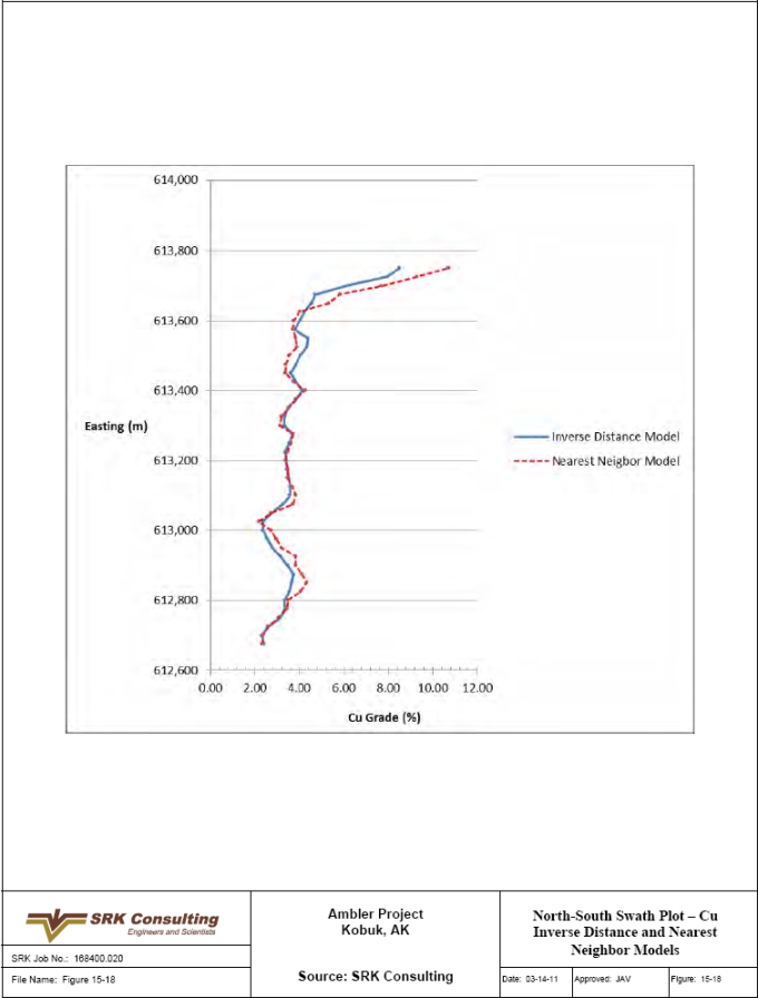
| SRK Consulting (U.S.), Inc. | May 9, 2011 |
| NovaGold Resources Inc. | 15-35 |
| Ambler Project | NI 43-101 Preliminary Econimic Assessment |
Figure 15-19: East-West Swath Plot – Cu Inverse Distance and Nearest Neighbor Models
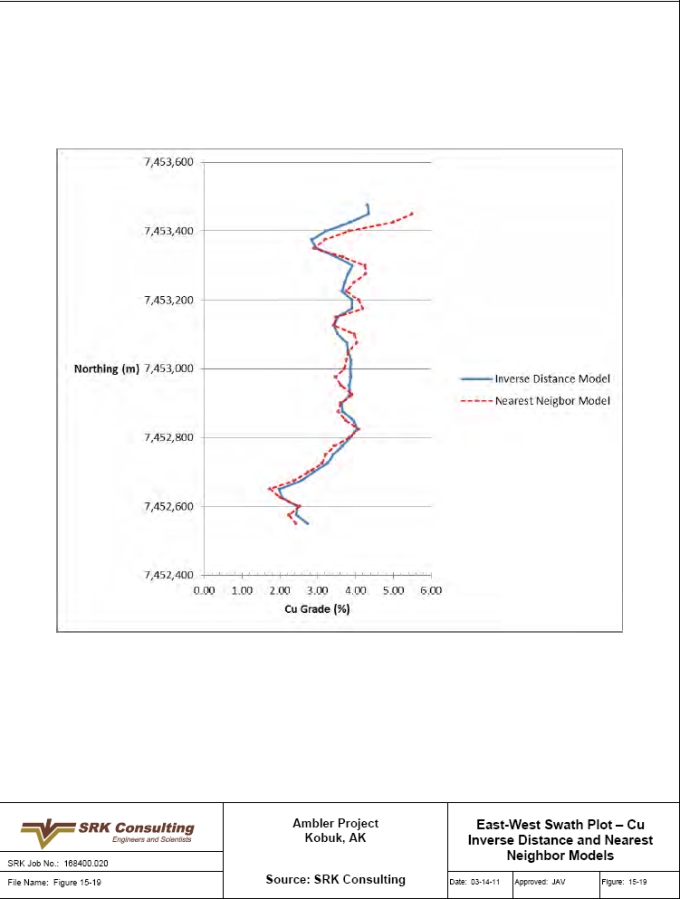
| SRK Consulting (U.S.), Inc. | May 9, 2011 |
| NovaGold Resources Inc. | 15-36 |
| Ambler Project | NI 43-101 Preliminary Econimic Assessment |
Figure 15-20: Vertical Swath Plot – Cu Inverse Distance and Nearest Neighbor Models
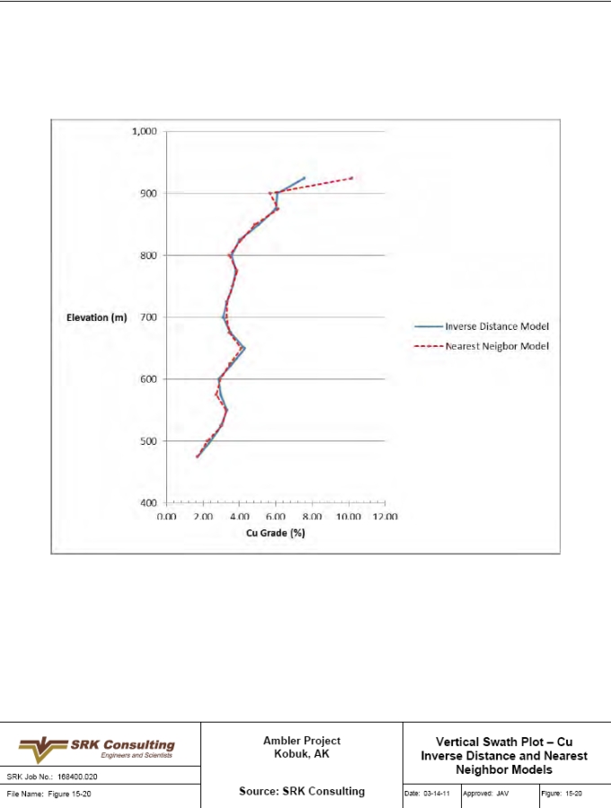
| SRK Consulting (U.S.), Inc. | May 9, 2011 |
| NovaGold Resources Inc. | 15-37 |
| Ambler Project | NI 43-101 Preliminary Econimic Assessment |
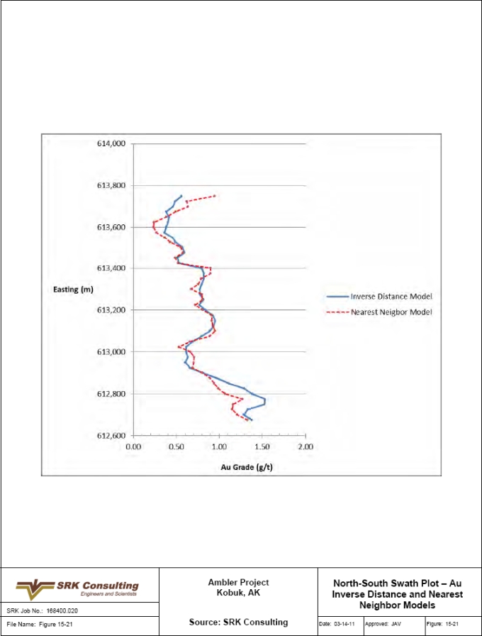
| SRK Consulting (U.S.), Inc. | May 9, 2011 |
| NovaGold Resources Inc. | 15-38 |
| Ambler Project | NI 43-101 Preliminary Econimic Assessment |
Figure 15-22: East-West Swath Plot – Au Inverse Distance and Nearest Neighbor Models
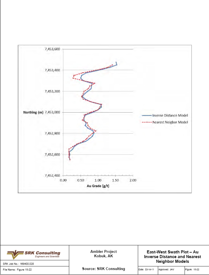
| SRK Consulting (U.S.), Inc. | May 9, 2011 |
| NovaGold Resources Inc. | 15-39 |
| Ambler Project | NI 43-101 Preliminary Econimic Assessment |
Figure 15-23: Vertical Swath Plot – Au Inverse Distance and Nearest Neighbor Models
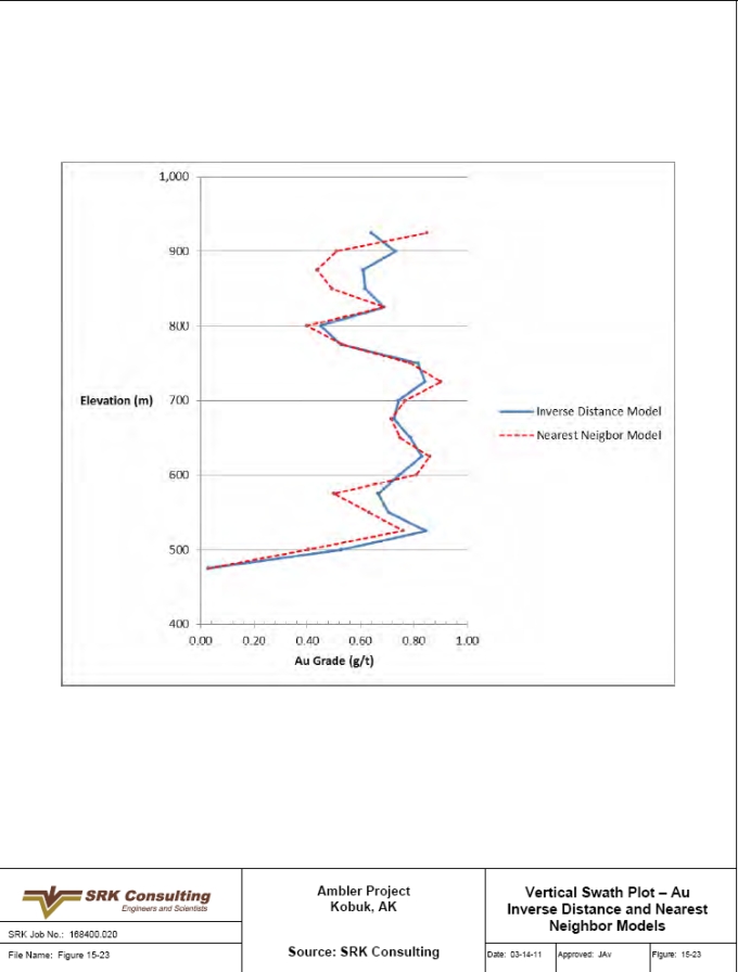
| SRK Consulting (U.S.), Inc. | May 9, 2011 |
| NovaGold Resources Inc. | 16-1 |
| Ambler Project | NI 43-101 Preliminary Econimic Assessment |
| 16 | Additional Requirements for Development and Production Properties (Item 25) |
There is no further information or data to the Project that has not been included in this Preliminary Assessment.
| SRK Consulting (U.S.), Inc. | May 9, 2011 |
| NovaGold Resources Inc. | 17-1 |
| Ambler Project | NI 43-101 Preliminary Econimic Assessment |
| 17 | Other Relevant Data and Information (Item 20) |
| 17.1 | Underground Mining |
17.1.1�� Introduction
The mineralization consists of five tabular layers of mineralization that formed within a synclinal structure plunging to the south-west at approximately 25°. The mineralized zones vary in thickness from 2m to 18m with spacing between the zones varying from zero to 100m. Open pit and underground mining methods were evaluated for exploiting the Arctic deposit. The open pit option was abandoned primarily because of the Potentially Acid Generating (PAG) issues associated with the exposure of large quantities of sulfide-bearing rock. Geotechnical analysis indicated that attainable pit wall angles would be relatively shallow, necessitating high waste stripping ratios.
Two underground mining methodologies have been evaluated:
● | Mining without backfill – room and pillar mining and longhole open stoping with pillars; and |
● | Paste backfill option – drift and fill mining and longhole open stoping with cemented paste fill; |
A trade-off study was conducted to compare the two methods at a high level in terms of the following parameters:
● | Extraction ratio; |
● | Dilution; |
● | Production rate; and |
● | Operating cost. |
The mine design process involved preparing mineable stope wireframes based on an economic cut-off value and an NSR block model. The stope wireframes were evaluated against the block model for volume, tonnage and grade. Dilution and recovery were added to the designed tonnage to account for unplanned stope dilution and pillar loss. The engineering mine design was carried out using Maptek Vulcan 8.0 software.
Access and infrastructure development was designed to support the stoping method.
17.1.2 Selection of Mining Method
Cut-off Estimate
An NSR methodology has been used to evaluate the economic portions of the deposit. Table 17.1.1 presents the prices, recoveries, payments and deductions used in the preparation of the NSR block model.
Note that there are differences between the NSR parameters presented here which were used for the mine design, compared to those used in the economic modeling presented in Section 17.9. It was decided following the completion of the mine design to add a lead concentrate process
| SRK Consulting (U.S.), Inc. | May 9, 2011 |
| NovaGold Resources Inc. | 17-2 |
| Ambler Project | NI 43-101 Preliminary Econimic Assessment |
stream to improve the payability of the concentrates. Based on grade/tonne information from the block model a small (i.e. 5%) change in NSR cut-off will have a minor effect on the mining area.
Table 17.1.1: Net Smelter Return Estimate Parameters
| Parameter | Value | Unit | |||
| Recoveries | Zn con | Au | 6 | % | |
| Ag | 4 | % | |||
| Zn | 90 | % | |||
| Cu con | Cu | 94 | % | ||
| Au | 65 | % | |||
| Ag | 70 | % | |||
| Pb | 88 | % | |||
| Payables | Zn con | Zn | 85% | % | |
| Ag | 90% | % | |||
| Au | 0% | % | |||
| Cu con | Au | 95% | % | ||
| Ag | 90% | % | |||
| Cu | 97% | % | |||
| Pb | 98% | % | |||
| Deductions | Zn con | Au | 0.00 | g/t | |
| Ag | 30.00 | g/t | |||
| Zn | 8.00 | % | |||
| Cu con | Au | 1.00 | g/t | ||
| Ag | 30.00 | g/t | |||
| Cu | 1.00 | % | |||
| Pb | 2.00 | % | |||
| Concentrate loss | 0.125 | % | |||
| Zn con treatment | 165 | US$/dmt con | |||
| Cu con treatment | 65 | US$/dmt con | |||
| Freight | 186.60 | US$/wmt con | |||
| Insurance | 0.0015 | US$/wmt con | |||
| Refining | Zn | 0.00 | US$/lb Zn | ||
| Cu | 0.07 | US$/lb Cu | |||
| Au | Zn con | 5.00 | US$/oz | ||
| Ag | Zn con | 0.35 | US$/oz | ||
| Au | Cu con | 5.00 | US$/oz | ||
| Ag | Cu con | 0.35 | US$/oz | ||
| Price | Zn | 1.00 | US$/lb | ||
| Cu | 2.50 | US$/lb | |||
| Au | 1,000 | US$/oz | |||
| Ag | 16.00 | US$/oz | |||
| Pb | 1.00 | US$/lb | |||
| Moisture content | 5 | % | |||
| SRK Consulting (U.S.), Inc. | May 9, 2011 |
| NovaGold Resources Inc. | 17-3 |
| Ambler Project | NI 43-101 Preliminary Econimic Assessment |
Projected mine operating costs define the break-even value and are presented on Table 17.1.2.
Table 17.1.2: Underground Break-even Cut-off Value Estimate
| Parameter | Amount | Unit |
| Mining cost | 50 | US$/t |
| Process and tailings cost | 29 | US$/t |
| Admin cost | 11 | US$/t |
| Total Cost | 90 | US$/t |
The mining cost estimate is based on a high extraction ratio mining method using paste backfill. The US$50/t value is based on benchmarking with comparable projects in similar environments.
The process costs are based on producing copper, zinc and lead concentrates.
The cut-off value applied to the NSR block model to determine potentially mineable resource is US$90/t, which does not include the access road operating cost.
Geotechnical Design
Geotechnical analysis has identified five major stratigraphic units within the potential mining area. These units are shown in Table 17.1.3.
Table 17.1.3: Major Stratigraphic Units with the Potential Ambler Mining Zone
| Geotechnical Unit | Formation | Description |
| Metarhyolite-HW | MRHW | Quartz and potassium feldspar phenocrysts in a fine grained matrix. Some chloritic or sulfide alteration. |
| Metarhyolite-FW | MRFW | Quartz and potassium feldspar phenocrysts in a fine grained matrix. Some chloritic or sulfide alteration. |
| Quartz-mica Schist | PQMS | Originated as tuffaceous sediments, volcanoclastics and dirty carbonates. Metamorphic may/may not be porphyritic, may/may not contain carbonate, chlorite, talc. |
| Graphic schist | GS | Well foliated quartz banded. Nearly a graphitic quartzite. |
| Sulfide schist | GS | Highly altered with various amounts of talc, chlorite, barite, quartz, muscovite and carbonate. Zones include massive, relatively non-schistose sulfide zones as well. |
| Talc Mica schist | TMS | Highly talc-chlorite altered product of metavolcanic or graphitic schist units. Talc >30%. |
Ambler Project Rock Mass Characterization - Ursa Engineering, 1998
Most of these units are of moderate strength, with the exception of the talc mica schist (TMS), which is a relatively weak unit with a compressive strength of approximately 28Mpa. The rock mass quality for the deposit has been estimated based on evaluation of core from four drill holes (Golder Associates, 2003). The Rock Mass Rating (RMR) averages 40 to 50 for most units, with the talc schist rating being approximately 30. Stability problems posed by the weaker stratigraphy should be manageable, with the best practice being to limit development and disturbance of these lower strength layers.
| SRK Consulting (U.S.), Inc. | May 9, 2011 |
| NovaGold Resources Inc. | 17-4 |
| Ambler Project | NI 43-101 Preliminary Econimic Assessment |
17.1.3 Stope Design
Table 17.1.4 presents the stope design parameters used in this preliminary assessment for both the no-backfill option and the cemented paste backfill option. These design parameters were used to undertake a trade-off study between the two methodologies.
Table 17.1.4: Mine Design Parameters
| Design Parameter | No backfill | Cemented paste backfill | |||||
| Method | Extraction Ratio | Dilution | Method | Extraction Ratio | Dilution | ||
| Stope Height (m) | 4 – 8 | Room and pillar | 75% | 5% | Drift and fill | 95% | 8% |
| 8 – 15 | Room and pillar with benching | 70% | 10% | Drift and fill with benching | 90% | 8% | |
| > 15 (ave. 25m) | LH open stoping | 60% | 15% | LH open stoping | 90% | 10% | |
| Mining recovery (regional pillars etc.) | 95% | 95% | |||||
| Production rate | 5,000t/d | 3,500t/d | |||||
The design parameters separate the mining methods into three categories based on mineralization width. At a mineralized width between 4m and 8m, mining would be either room-and-pillar or drift and fill based on whether backfill is used. Between 8m and 15m width, the same mining methods would be used with the addition of benching of the floor to increase the extraction height while working under a supported top cut. When the mineralized width increases to greater than 15m a longhole open stoping method would be employed, either with or without backfill.
The primary impact between mining with or without backfill is on the overall extraction ratio that can be obtained. Without fill the extraction ratio will vary between 60% and 75% dependent on the width of the deposit. Using backfill, this extraction ratio is increased to between 90% and 95%.
The mining recovery parameter relates to economic material that will be left in place in the form of permanent regional, barrier and fault protection pillars. At this stage of the design, it is assumed that the mining recovery is the same for both the backfill and non-backfill options.
Implementation of a paste backfill system throughout the mine will result in a lower production rate due to both operational issues and stope sequencing and access issues. It is assumed that 5,000t/d can be mined in a non-backfill method, but that this would drop to 4,000t/d if pastefill is implemented.
It is assumed that in a layered deposit a minimum middling between overlaying stopes of 10m will be required in order to limit stress interaction and to prevent ground control problems.
The mine design process involved preparing vertical sections through the deposit along the direction of plunge at 20m spacing between sections. On each section, the economic portion of the deposit above the cut-off value was outlined to define stope blocks. The stope block outlines were projected 10m each side of the section to create stope triangulations, which were then evaluated against the block model for grade and tonnage.
| SRK Consulting (U.S.), Inc. | May 9, 2011 |
| NovaGold Resources Inc. | 17-5 |
| Ambler Project | NI 43-101 Preliminary Econimic Assessment |
Figure 17-1 presents a typical section through the deposit showing the stope outlines developed according to NSR cut-off, mineralized thickness and waste middling dimensions.
Figure 17-2 shows a plan view of the stope blocks identified on the various mineralized horizons.
17.1.4 Mineable Resources
For the purpose of preparing the preliminary assessment the cemented paste backfill mining option was chosen for the following reasons:
● | Higher extraction ratio and greater potentially mineable resource quantity; |
● | Smaller tailings dam footprint requirement; and, |
● | Potential for improved ground stability. |
The mine design process for the paste backfill option results in a potentially mineable resource of 29.3Mt at an average NSR value of US$224/t. The mineable resource differs from the 28.9Mt (Measured, Indicated and Inferred) Mineral Resource estimate due to exclusion of isolated or thinner pods of mineralization, mining recovery and internal dilution considerations applied in the mineable resource estimate.
17.1.5 Development Design
Figures 17-3 and 17-4 show plan and isometric views of the primary access development in the footwall of the mineralized zone. Twin decline accesses are driven from the process plant location down to an underground crusher plant 50m below the deepest level of scheduled mining and at the approximate center of gravity of the deposit.
One of the declines will have a conveyor installed to transport mill feed from the crusher to the process plant. The other decline will be used as the primary access for equipment, material and personnel.
A system of access ramps and spirals are developed approximately 30m below the lowest mineralized horizon to gain access to the deposit across the entire strike and dip span. The North Ramp will provide secondary access to the mine at the East Portal. A tertiary access is provided at the South Portal where the development extends close to the surface to reach the deposit.
17.1.6 Mining Operations
Development
Development mining will be undertaken using twin boom jumbos and conventional face blasting techniques. Development mucking will utilize LHD’s dumping into haul trucks to remove waste to surface stockpiles.
Drilling
Drift-and-fill stopes will be mined using development jumbos and bench drilling rigs. Longhole stopes will be drilled with top hammer or ITH mobile drill rigs.
Blasting
Longhole stopes will be blasted using standard blasting techniques depending on the ground conditions, drill spacing and presence of ground water.
| SRK Consulting (U.S.), Inc. | May 9, 2011 |
| NovaGold Resources Inc. | 17-6 |
| Ambler Project | NI 43-101 Preliminary Econimic Assessment |
Mucking and Hauling
Stope mucking will be carried out using LHD’s, hauling to internal passes and/or trucks which will deliver mill feed to the underground crusher. From the crusher the mill feed will be transported by conveyor to the process plant on surface.
Backfill
Cemented paste backfill will be produced using tails from the process plant. The backfill plant will either be located close to the process plant with the fill being pumped to the stopes underground or the backfill plant will be located underground with the tails pumped to the plant. The pastefill will be batch mixed with cement prior to pumping and/or gravity feeding to the stope. A piping system will enable all stoping areas in the mine to be backfilled. Lined boreholes will be used for backfill where possible to reduce horizontal pipe runs in drifts and ramps.
17.1.7 Production Schedule
Table 17.1.5 presents the annual mining schedule. A LoM average grade was used to prepare the schedule. A pre-development period of one year is assumed with no mill feed production, followed by a two-year ramp up period to the 1.44Mt/yr full production rate. This rate is based on 4,000t/d over 360 days per year. From Year 7 the production rate reduces to 1.23Mt/yr (3,400t/d) and from Year 11 reduces to 1.12Mt/yr (3,100t/d). This reduction over time is premised on concentrating the production in wide orebody areas at the start of the project and moving out to narrower and more distal zones over time.
The development and capital equipment purchase schedules are provided in Section 17.9.
Table 17.1.5: LoM Production Schedule (NSR US$224/t)
| Year | Production (kt) | Copper (%) | Zinc (%) | Lead (%) | Gold (g/t) | Silver (g/t) | |
| 1 | 800 | 3.12% | 4.49% | 0.70% | 0.6 | 44.8 | |
| 2 | 1,440 | 3.12% | 4.49% | 0.70% | 0.6 | 44.8 | |
| 3 | 1,440 | 3.12% | 4.49% | 0.70% | 0.6 | 44.8 | |
| 4 | 1,440 | 3.12% | 4.49% | 0.70% | 0.6 | 44.8 | |
| 5 | 1,440 | 3.12% | 4.49% | 0.70% | 0.6 | 44.8 | |
| 6 | 1,440 | 3.12% | 4.49% | 0.70% | 0.6 | 44.8 | |
| 7 | 1,225 | 3.12% | 4.49% | 0.70% | 0.6 | 44.8 | |
| 8 | 1,225 | 3.12% | 4.49% | 0.70% | 0.6 | 44.8 | |
| 9 | 1,225 | 3.12% | 4.49% | 0.70% | 0.6 | 44.8 | |
| 10 | 1,225 | 3.12% | 4.49% | 0.70% | 0.6 | 44.8 | |
| 11 | 1,116 | 3.12% | 4.49% | 0.70% | 0.6 | 44.8 | |
| 12 | 1,116 | 3.12% | 4.49% | 0.70% | 0.6 | 44.8 | |
| 13 | 1,116 | 3.12% | 4.49% | 0.70% | 0.6 | 44.8 | |
| 14 | 1,116 | 3.12% | 4.49% | 0.70% | 0.6 | 44.8 | |
| 15 | 1,116 | 3.12% | 4.49% | 0.70% | 0.6 | 44.8 | |
| 16 | 1,116 | 3.12% | 4.49% | 0.70% | 0.6 | 44.8 | |
| 17 | 1,116 | 3.12% | 4.49% | 0.70% | 0.6 | 44.8 | |
| 18 | 1,116 | 3.12% | 4.49% | 0.70% | 0.6 | 44.8 | |
| 19 | 1,116 | 3.12% | 4.49% | 0.70% | 0.6 | 44.8 | |
| 20 | 1,116 | 3.12% | 4.49% | 0.70% | 0.6 | 44.8 | |
| 21 | 1,116 | 3.12% | 4.49% | 0.70% | 0.6 | 44.8 | |
| 22 | 1,116 | 3.12% | 4.49% | 0.70% | 0.6 | 44.8 | |
| 23 | 1,116 | 3.12% | 4.49% | 0.70% | 0.6 | 44.8 | |
| 24 | 1,116 | 3.12% | 4.49% | 0.70% | 0.6 | 44.8 | |
| 25 | 750 | 3.12% | 4.49% | 0.70% | 0.6 | 44.8 |
| SRK Consulting (U.S.), Inc. | May 9, 2011 |
| NovaGold Resources Inc. | 17-7 |
| Ambler Project | NI 43-101 Preliminary Econimic Assessment |
17.1.8 Mine Services
Ventilation
The main exhaust fan system will be located at the East Portal. Intake air will be drawn into the primary development via the West and South portals. A series of exhaust drifts and raises located primarily in the mineralized zones will provide the return airway from the individual mining areas to the East Portal.
Dewatering
Dewatering facilities will be provided to pump ground water and mine service water to the tailings impoundment. Underground settlers/sumps will ensure that the water pumped to surface is largely free of solids. Dewatering lines will be advanced with the main ramp development.
17.1.9 Manpower
Mine personnel will be on a FIFO rotation. Four crews will support a 24 hr/day, seven days/wk, 360 days/yr continuous operation. A 10% additional contingency has been added to the hourly workforce to cover vacation, absenteeism and turnover. Hourly mine personnel requirements are summarized in Table 17.1.6, with salary mine personnel summarized in Table 17.1.7.
Table 17.1.6: Mine Personnel Requirements - Hourly
| Description | No. |
| Mine Operations | |
| Drill Operators | 16 |
| Blasters | 16 |
| LHD Operators | 20 |
| Bolter Operators | 16 |
| Grader Operator | 4 |
| Haul Truck Driver | 28 |
| Mine Construction | 8 |
| Road Maintenance | 4 |
| Fuel / Lube Truck | 4 |
| Crusher Operator | 4 |
| Nipper | 4 |
| Sub total | 124 |
| 10% extra | 12 |
| Mine Operations Total | 136 |
| Mine Maintenance | |
| Electrician | 12 |
| HD Mechanic | 12 |
| LD Mechanic | 16 |
| Machinist / Welder | 8 |
| Crane Operator | 4 |
| Tire Man / Service | 12 |
| Sub Total | 64 |
| 10% extra | 6 |
| Mine Maintenance Total | 70 |
| Total Hourly | 206 |
| SRK Consulting (U.S.), Inc. | May 9, 2011 |
| NovaGold Resources Inc. | 17-8 |
| Ambler Project | NI 43-101 Preliminary Econimic Assessment |
Table 17.1.7: Mine Personnel Requirements - Salary
| Description | No. |
| Mine Superintendent | 2 |
| Mine General Foreman | 2 |
| Shift Foreman | 4 |
| Maintenance Superintendent | 2 |
| Maintenance General Foreman | 2 |
| Electrical Foreman | 4 |
| Maintenance Shift Forman | 4 |
| Maintenance Planner | 2 |
| Technical Services | |
| Engineering Manager | 1 |
| Senior Mine Engineer | 2 |
| Junior Mine Engineer | 4 |
| Planner | 2 |
| Senior Geologist | 2 |
| Mine Geologist | 4 |
| Geotechnical Engineer | 2 |
| Surveyors | 4 |
| Safety Engineer | 2 |
| Environmental Engineer | 2 |
| Total | 47 |
| 17.2 | Process Description |
SRK has developed a conceptual process flowsheet to produce separate copper, lead and zinc flotation concentrates, which is presented in Section 14 (Figure 14-1). This process flowsheet utilizes unit operations that are standard to the industry. The actual design parameters required to further develop this conceptual flowsheet must be developed through metallurgical testing that should be undertaken during the next phase of study. The proposed conceptual flowsheet includes the following unit operations:
● | Primary crushing; |
● | SAG-ball mill grinding; |
● | Talc flotation; |
● | Copper-lead rougher and cleaner flotation; |
● | Copper-lead regrinding; |
● | Copper-lead cleaner flotation; |
● | Copper-lead separation; |
● | Lead rougher flotation |
● | Lead cleaner flotation |
● | Copper rougher flotation |
● | Zinc rougher flotation; |
● | Zinc rougher concentrate regrinding; |
| SRK Consulting (U.S.), Inc. | May 9, 2011 |
| NovaGold Resources Inc. | 17-9 |
| Ambler Project | NI 43-101 Preliminary Econimic Assessment |
● | Zinc cleaner flotation; |
● | Copper concentrate thickening, filtering and drying; |
● | Lead concentrate thickening, filtering and drying; |
● | Zinc concentrate thickening, filtering and drying; |
● | Tailings disposal; and |
● | Reagent handling and utilities. |
The conceptual process design for the Project is based on a plant capacity of 3,500t/d, and equipment selection is based on a three-product flotation plant model provided by Western Mine Cost Services. A list of major equipment for the process plant is shown Table 17.2.1 and basic design criteria are provided in Table 17.2.2
Table 17.2.1: Basic Process Design Criteria
| Description | Value/Parameter | Unit | |
| General Process Capacity | |||
| Yearly Throughput | 1,225 | kt/y | |
| Daily Throughput | 3,500 | t/d | |
| Overall Plant Availability | 92 | % | |
| Nominal Throughput | 4,000 | t/d | |
| Run-of-Mine Mill Feed Characteristics | |||
| Mill Feed Physical Characteristics | |||
| Mill Feed Moisture Content | 3 | % wt. | |
| Run-of-Mine Mill Feed Top Size | 600 | mm | |
| Mill Feed Specific Gravity | 3.9 | t/m3 | |
| Mill Feed Bulk Density | 1.8 | ||
| Angle of Repose | 37 | º | |
| Angle of Drawdown | 60 | º | |
| Impact Work Index | 11.5 | kWh/t | |
| Bond Ball Mill Work Index | 14 | kWh/t |
17.2.1 Crushing
Run of mine (ROM) mill feed will be received from the mine in haulage vehicles and will be dumped directly into a 30in x 48in primary jaw crusher where it will be crushed to minus 150mm, and then conveyed to a crushed mill feed stockpile with approximately 5,000t of live storage. Mill feed will be reclaimed from the coarse material stockpile via a reclaim tunnel and conveyed directly to the grinding circuit.
17.2.2 Grinding
The grinding circuit will be a standard SAG mill–ball mill circuit. The mill feed will be fed directly into a 24ft x 8ft SAG mill from the SAG mill feed conveyor. The SAG mill discharge will be screened on a 6ft x 20ft vibrating screen with the oversize being recycled back to the SAG mill and the undersize advanced to a 16ft dia. x 30ft long ball mill, operating in closed circuit with two 26in diameter cyclones.
| SRK Consulting (U.S.), Inc. | May 9, 2011 |
| NovaGold Resources Inc. | 17-10 |
| Ambler Project | NI 43-101 Preliminary Econimic Assessment |
17.2.3 Talc Flotation
Talc flotation will be performed to enhance the effectiveness of copper, lead and zinc flotation downstream. Talc is naturally floatable and will be floated with the addition of methyl isobutyl carbinol (MIBC) to serve as a frothing agent. The talc rougher concentrate will then cleaned with three stages of cleaner flotation to remove metal values that may have been carried over in the initial rougher flotation concentrate. The final talc concentrate will be pumped to the tailings storage facility.
17.2.4 Copper- Lead Flotation
The tail from the talc flotation circuit will be conditioned and then advanced to the copper-lead rougher flotation circuit. The copper-lead rougher concentrate will then be reground to approximately P80 25µm and then upgraded in two stages of cleaner flotation prior to advancing to the copper-lead separation circuit.
17.2.5 Copper-Lead Separation
It is anticipated that copper-lead separation will be accomplished by conditioning the copper-lead concentrate with zinc oxide and sodium cyanide to depress the copper minerals and then advancing the conditioned concentrate to the lead rougher flotation circuit to float a lead rougher concentrate that will then be further upgraded by two stages of lead cleaner flotation. The tailing from the lead rougher flotation circuit will be floated in a copper rougher flotation circuit to produce a final copper concentrate. The final lead and copper concentrates will be thickened to about 55% solids, filtered, dried and packaged into bulk bags for shipping to an off-site smelter. The actual process parameters required to accomplish the copper-lead separation will be more thoroughly defined after more extensive metallurgical testing is completed in the next phase of metallurgical study.
17.2.6 Zinc Flotation
The tail from the copper-lead rougher flotation circuit will be pumped to a conditioner ahead of the zinc flotation circuit, where the slurry will be conditioned with lime, copper sulfate and xanthate prior to being advanced to zinc rougher flotation. The zinc rougher concentrate will be reground and then upgraded in two stages of zinc cleaner flotation to produce a marketable grade zinc concentrate. The final zinc concentrate will be thickened, filtered, dried and packaged into bulk bags for shipping to an off-site smelter.
17.2.7 Reagent Handling
Reagents, such as the flotation chemicals, and grinding media for the milling circuit will be stored on site within concrete containment areas. Chemicals will be brought to site dry whenever possible, to minimize the cost for freight, and are mixed in reagent mix tanks for weekly reagent consumption. All chemical handling facilities will be within lined containment areas. Metering pumps distribute the reagents to the grinding and flotation circuits via pipelines throughout the plant facilities.
17.2.8 Power Requirements
The majority of the electric power consumed at the Project will be for the crushing and grinding of the mill feed. The total average processing power demand will be approximately 5.7MW of which 4.0MW is required for milling the mineralized feed to 74µ. Power will be distributed
| SRK Consulting (U.S.), Inc. | May 9, 2011 |
| NovaGold Resources Inc. | 17-11 |
| Ambler Project | NI 43-101 Preliminary Econimic Assessment |
around the site at medium voltage (4,160V). Step-down transformers will be provided near locations where low voltage power (440V and below) is required.
17.2.9 Process Labor Requirements
Mill process operations will be on a 24hr/day, 7days/wk, 360days/yr basis. This schedule will be supported by four crews, with two crews onsite at any given time. The additional crews off-site are on days off rotation. Table 17.2.2 summarizes the labor requirements for the processing plant.
17.2.10 Process Operating Costs
The Project operating costs are substantially impacted by power costs. It has been assumed that on-site power generation will be used for the base case with process LoM average operating cost of US$29.74/t of mill feed. Operating labor and supply costs are shown in Tables 17.2.2 and 17.2.3, respectively. Costs shown in the tables represent steady-state operating costs and therefore vary slightly from the values presented in the economic model results, Sections 17.6 and 17.9.
Table 17.2.2: Process Labor
| Description | No. | Salary (US$/yr) | Hourly (US$/hr) | Burden (%) | Annual Cost (US$000s) |
| Management | |||||
| Plant Manager | 1 | $150,000 | - | 40% | $210 |
| Technical Superintendent | 1 | $125,000 | - | 40% | $175 |
| Chief Chemist | 1 | $100,000 | - | 40% | $140 |
| Metallurgical Engineers | 4 | $90,000 | - | 40% | $504 |
| Chemists | 3 | $80,000 | - | 40% | $336 |
| Laboratory & Samplers | 4 | - | $25.49 | 48% | $314 |
| Administrative | 2 | - | $25.49 | 48% | $157 |
| Subtotal Management | 16 | - | - | - | $1,836 |
| $/t-milled | $1.50 | ||||
| Operations | |||||
| Operations Superintendent | 1 | $125,000 | 40% | $175 | |
| Foremen | 5 | - | $28.96 | 48% | $446 |
| Operators | 28 | - | $27.96 | 48% | $2,410 |
| Support | 12 | - | $25.49 | 48% | $942 |
| Subtotal Operations | 46 | - | - | - | $3,972 |
| $/t-milled | $3.24 | ||||
| Maintenance | |||||
| Maintenance Superintendent | 1 | $125,000 | 40% | $175 | |
| Planning Engineers | 4 | $90,000 | 40% | $504 | |
| Foremen | 5 | - | $28.96 | 48% | $446 |
| Maintenance Personnel | 22 | - | $27.96 | 48% | $1,894 |
| Support | 12 | - | $25.49 | 48% | $942 |
| Subtotal Maintenance | 44 | - | - | $3,960 | |
| $/t-milled | $3.23 | ||||
| Total Labor | 106 | - | - | - | $9,768 |
| $/t milled | $7.97 |
| SRK Consulting (U.S.), Inc. | May 9, 2011 |
| NovaGold Resources Inc. | 17-12 |
| Ambler Project | NI 43-101 Preliminary Econimic Assessment |
Table 17.2.3: Process Operating Supplies
| Description | Consumption (kg/t-milled) | Unit Cost (US$/kg) | Opex (US$/t-milled) | Annual Cost (US$000s) |
| Grinding Media & Liners | ||||
| SAG Mill | 0.2514 | $1.55 | $0.39 | $476 |
| Ball Mill | 0.6857 | $1.55 | $1.06 | $1,298 |
| Regrind Mill | 0.2000 | $1.55 | $0.31 | $379 |
| Liners (45% of Ball Cost) | - | - | $0.79 | $968 |
| Subtotal Grinding | - | - | $2.55 | $3,121 |
| Reagents | ||||
| Collectors | 0.3017 | $0.88 | $0.27 | $327 |
| Frothers | 0.1006 | $0.78 | $0.08 | $96 |
| Sodium Sulfite | 0.0754 | $0.41 | $0.03 | $38 |
| Zinc Sulfate | 0.3771 | $1.19 | $0.45 | $550 |
| Copper Sulfate | 0.5029 | $1.19 | $0.60 | $734 |
| Lime | 2.5029 | $0.17 | $0.43 | $522 |
| Flocculant | 0.0503 | $2.04 | $0.10 | $126 |
| Other | - | - | $0.41 | $500 |
| Subtotal Reagents | - | - | $2.36 | $2,892 |
| Other Costs | ||||
| Water | $1.00 | $1,225 | ||
| General O&M | $1.75 | $2,144 | ||
| Building & Structures | $0.25 | $306 | ||
| Miscellaneous | $0.41 | $500 | ||
| Subtotal Other | - | - | $6.28 | $7,693 |
| Total Supplies | - | - | $11.19 | $13,705 |
Project electric power costs are based upon estimates of on-site diesel generators using a fuel cost of US$5.00/gal. Fixed and variable power cost is estimated to be US$0.369/kWh and will total US$19.30/t-milled as shown in Table 17.2.4. Project-wide power consumption is estimated to be 52.3kWh/t-milled.
Table 17.2.4: Project-Wide Power Cost
| Description | Consumption (kWh/t) | Opex (US$/t-milled) | Annual Cost (US$000s) |
| Mine | 13.7 | $5.06 | $6,193 |
| Process Plant | 24.8 | $9.15 | $11,210 |
| Infrastructure | 6.9 | $2.55 | $3,119 |
| Mine Camp | 6.9 | $2.55 | $3,119 |
| Total | 52.3 | $19.30 | $23,641 |
| 17.3 | Tailings Storage Facility |
The proposed mill will treat approximately 29.3Mt of mill feed, producing 24.6Mt (dry basis) of tailings. 15.2Mt of the tailings will be pumped to the tailings storage facility (TSF) at the head of Arctic Creek for disposal. 9.4Mtof the tailings will be pumped back to the mine as backfill.
The TSF will be a fully lined facility consisting of a rockfill embankment constructed across the Arctic Creek drainage, creating an impoundment that will extend up the drainage. The rockfill embankment will be constructed to an ultimate crest elevation of 708mamsl with the embankment being raised in stages to minimize the initial capital construction cost. During
| SRK Consulting (U.S.), Inc. | May 9, 2011 |
| NovaGold Resources Inc. | 17-13 |
| Ambler Project | NI 43-101 Preliminary Econimic Assessment |
operations, tailings will be deposited from the crest of the embankment at select locations. Water reclamation from the facility will occur from the upper reaches of the basin to minimize the depth of water ponded against the embankment. To minimize the quantity of water stored within the TSF, outside stormwater runoff will be diverted away from the facility by a diversion channel positioned above the facility.
Process solutions and precipitation within the TSF will be reclaimed and returned to the mill for recirculation and reuse in the processing of mill feed. Cost to operate the TSF is estimated at US$1.06/t milled at a nominal 4,000t/d underground operation.
If the TSF will be managed as a “zero discharge” operation, process water (i.e., tailings supernatant, stormwater run-off, etc.) will be collected and contained. However, should it be determined that zero discharge is not technically feasible or otherwise viable, the TSF will be managed as a treatment and discharge facility. If the TSF is maintained as a treatment and discharge facility, this infrastructure will have to be added to the facility.
Ambler is a VMS deposit, and preliminary data from historical reports indicate that waste rock and tailings could have Acid Generating Potential (AGP). As a result, the tailings will be discharged under water from the embankment crest and remain permanently submerged in order to reduce the potential for acid generation. Additional studies will be required to confirm the volume and AGP of the mill feed, waste rock and tailings. Potential requirement for comprehensive Acid Rock Drainage (ARD) management and mitigation programs will need to be part of the design of the TSF and will increase the capital cost.
17.3.1 Tailings and Waste Management
The proposed underground mining and processing operation will produce between 640kt and 750kt of tailings per year during a 25-year project life. The TSF will be required with a capacity of approximately 10.1Mm3 to accommodate the tailings at an assumed stored dry density of 1.5t/m3. The TSF will be sited as a staged rockfill embankment with an upstream geomembrane liner, downstream seepage collection toe drain, reclaim water pipeline and tailings delivery pipeline. The starter embankment will have a crest elevation of 676m and impound two years of mining production, which is approximately 2.8Mt of tailings. The assumptions on which the siting of the TSF is based are provided in this section, with a detailed discussion of the TSF features.
The proposed TSF, embankment fill borrow area, pipeline routing and plant site location is shown in Figure 17-5.
Project Assumptions
Assumptions for the Underground Mine TSF
● | Mill site elevation = 710m; |
● | Required tailings volume = 15.2Mt; |
● | Required operating pond depth = 3.5m (maximum); |
● | Freeboard = 1m; |
● | Stored density = 1.5t/m3; |
● | Tailings properties; |
| o | 50% solids content, and |
| o | 3.2 SG. |
| SRK Consulting (U.S.), Inc. | May 9, 2011 |
| NovaGold Resources Inc. | 17-14 |
| Ambler Project | NI 43-101 Preliminary Econimic Assessment |
● | Average production rate; |
| o | Nominal 4,000t/d. |
● | Rockfill embankment; |
| o | Contractor placed rockfill from borrow source, |
| o | Geomembrane liner on upstream face of embankment, |
| o | Geomembrane lined basin, |
| o | Two-year starter embankment, and |
| o | Phased construction – expansion every two years. |
● | Closure requirement; |
| o | 1m random fill/development rock cap over tailings, and |
| o | 30cm topsoil. |
● | Supernatant Reclaim; |
| o | 137m3/hour. |
● | Operating Costs; |
| o | Tailing deposition by gravity and/or pumped for life of facility, and |
| o | Tailings deposition operating cost captured by plant operating cost. |
TSF and Appurtenant Structures
The TSF will be a fully lined facility due to the potential for the tailings to generate acid drainage. Based on the limited geotechnical information available, it is expected that an insufficient quantity of suitable low permeable soils is available at the site; therefore, a geosynthetic lining system will be required. This system will be continuous, being installed both on the upstream slope of the embankment and throughout the impoundment.
The TSF embankment and impoundment area will be constructed in phases to minimize upfront capital costs. A starter facility with a two-year storage capacity will be constructed initially, with additional stages being constructed every other year. The following sections describe the design of the facilities required for the storage and containment of the tailings generated during the processing of the mill feed.
TSF Embankment
The TSF embankment has been designed as a staged rockfill structure founded on bedrock. The embankment has 2.5:1 (2.5 horizontal to 1 vertical) and 2:1 upstream and downstream slopes, respectively. The ultimate height of the embankment will be approximately 95m, measured from the downstream toe. The embankment is a homogeneous rockfill structure founded on bedrock present at the site. Zones of notably soft bedrock in the foundation areas will require removal to a depth where firm bedrock material is encountered. The side areas of removal will not exceed 1:1 in slope. Since underground mining will generate minimal waste rock, the majority of the rockfill material required for the embankment will be generated from a borrow pit developed above the TSF.
A geotextile material will be placed over the upstream slope of the rockfill embankment and below the geomembrane liner as a bedding layer. A protective layer may be required over the geomembrane liner, to prevent damage to the lining system from ice. This protective layer has not been incorporated into the scoping level design as it has been assumed the tailings deposition will form this protective layer. The TSF embankment sections can be referenced on Figure 17-6.
| SRK Consulting (U.S.), Inc. | May 9, 2011 |
| NovaGold Resources Inc. | 17-15 |
| Ambler Project | NI 43-101 Preliminary Econimic Assessment |
The geometries described above are dependent upon the strengths of the rockfill material within the embankment. The site-specific geotechnical data available for the proposed TSF site are limited. Furthermore, no information has been collected on suitable construction materials. However, from general experience on projects in Alaska, it is likely that the suitable materials will be available within the project area to construct the embankment as defined.
Tailings Impoundment
It has been assumed that low permeability soils do not naturally exist within the impoundment area of the TSF and a synthetic geomembrane lining system will be required. This system will tie into the geomembrane installed on the embankment, creating a fully lined facility. Construction of the impoundment area will consist of removing the topsoil and vegetation materials from the natural ground surface, compacting the exposed fine-grained soils and installing the geomembrane. Minimal regrading of the impoundment area is expected. A protective layer will be placed over the geomembrane to prevent damage to the liner.
Tailings Conveyance and Distribution System
The tailings will be conveyed via gravity and/or pumped as slurry (presently assumed to be at 50% solids content) from the mill, overland and through a pressure-rated 450mm diameter HDPE pipeline to the tailings impoundment. The conveyance pipeline will tie in to a distribution pipeline at the impoundment. At designated locations, the tailings will be single-point discharged directly into the impoundment. This will minimize the potential for pipeline freezing and reduce the maintenance required for the operation of the distribution system. Tailings will be deposited from the embankment crest and along the southern impoundment limits.
Reclaim Water System
Water liberated from the tailings will be collected in a free water pool or supernatant pond formed at the tailings beach/ground interface. This water will be pumped back to the mill for re-use. During operations, the tailings deposition from the embankment crest and southern limit of the impoundment will result in a supernatant pond located at the northern limits of the TSF.
Water from the supernatant water pond will be returned to the mill for re-use in the process via a floating barge pump-back system. The solution will be transferred to the mill via an overland HDPE pipeline. Details of the reclaim system are provided in Table 17.3.1.
Table 17.3.1: Reclaim Water System
| Description | Detail |
Reclaim Rate (m3/hr) | 137 |
| Length of Pipeline (m) | 2000 |
| Diameter of Pipeline (mm) | 250mm (10in) OD |
| Lift (m) | 70 - Starter 6 - Ultimate |
Seepage Collection Sump
The seepage collection sump will collect seepage from below the TSF embankment and impoundment for routing back to the supernatant reclaim pond. The conceptual design for the seepage collection sump is a vertical sump that is piped to embankment toe drains constructed
| SRK Consulting (U.S.), Inc. | May 9, 2011 |
| NovaGold Resources Inc. | 17-16 |
| Ambler Project | NI 43-101 Preliminary Econimic Assessment |
below the TSF embankment. Seepage will be collected in embankment toe drains, consisting of perforated pipes encapsulated in gravel, and conveyed to the sump where it will be pumped back into the TSF impoundment.
Development Rock Dump
Underground mining will not require a development rock dump as any development rock generated from the mine will be used in the TSF rockfill embankment.
Diversion Channels
Surface water diversion channels are required to direct surface water runoff around the TSF during the life of the project. A permanent channel would be required above the elevation of the ultimate TSF. This channel would direct stormwater runoff around the west side of the TSF and discharge downstream of the project facilities. Temporary channels could be constructed during operations to minimize stormwater run-on to site roads and mine facilities. These temporary channels would discharge into the permanent channel. Temporary designation refers to channels that will be removed with the construction of the mine facilities and structures.
The permanent channel may require armoring with riprap to prevent erosion of the channel. A maintenance road will be provided adjacent to the channel to allow access for repair of the erosion protection should it be required. The temporary channels will be removed over the life of the project. It is envisioned that armoring of these channels with riprap will not be required except at the tie-in to the permanent channel.
| 17.4 | Infrastructure |
Accessibility is a major challenge to developing the Project. Currently the project does not have any access infrastructure. Numerous past studies have demonstrated that access infrastructure will be required to make this a viable project. Because of the remote location of the Project, infrastructure, specifically power and transport of material and personnel to and from the Project, are the largest cost items. There is no developed surface access to the Project area and no power infrastructure near the Project area.
| 17.5 | Capital Costs |
The LoM estimate, accurate to ±30%, totals US$429million. Capital costs are shown in Table 17.5.1. Initial capital costs are estimated to be on the order of US$209million plus a contingency of 25%. Included are US$38million for mine equipment and development capital, US$20million for on-site diesel power generation, US$88million for the mill designed to produce 3 concentrates, US$3million for the first phase of the tailings dam, and US$60million for on- and off-site supporting infrastructure. A provision of contingency accounting for items not specifically estimated, will add an additional US$52million to the estimate.
Ongoing, sustaining capital, is estimated to add an additional US$134million. Approximately US$100million of this amount is for additional and replacement mine equipment and development capital. Ongoing tailings dam expansions are estimated to be US$20million. Replacement of support infrastructure (US$6.8million) and a US$10million provision for mine closure complete the estimate. A provision of contingency accounting for items not specifically estimated, will add an additional US$34million to the estimate.
| SRK Consulting (U.S.), Inc. | May 9, 2011 |
| NovaGold Resources Inc. | 17-17 |
| Ambler Project | NI 43-101 Preliminary Econimic Assessment |
Table 17.5.1: LoM Capital Costs (US Dollars)
| Description | Initial (US$000s) | Sustaining (US$000s) | LoM (US$000s) |
| Mining Mobile Equipment | $10,937 | $63,664 | $74,601 |
| Fixed Equipment | $7,700 | $10,800 | $18,500 |
| Mine Development | $19,150 | $22,650 | $41,800 |
| subtotal Mining | $37,787 | $97,114 | $134,901 |
| Process & Tailings Power Plant | $19,786 | $0 | $19,786 |
| Process Plant Direct Costs | $47,557 | $0 | $47,557 |
| Indirect Costs | $41,079 | $0 | $41,079 |
| Tailings Dam | $2,865 | $19,927 | $22,793 |
| subtotal Process | $111,287 | $19,927 | $131,215 |
| Infrastructure - Air Strip | $0 | $0 | $0 |
| Access Road | $0 | $0 | $0 |
| Buildings & Structures | $20,820 | $0 | $20,820 |
| Mancamp | $16,500 | $0 | $16,500 |
| Utilities | $5,500 | $0 | $5,500 |
| Support Equipment | $2,970 | $6,272 | $9,242 |
| Off-Site Infrastructure | $925 | $560 | $1,485 |
| Owner Costs | $13,500 | $10,000 | $23,500 |
| subtotal Infrastructure | $60,215 | $16,832 | $77,047 |
| Capital Cost | $209,289 | $133,873 | $343,162 |
| Contingency @ 25% | $52,322 | $33,468 | $85,791 |
| Total Capital | $261,611 | $167,342 | $428,953 |
| 17.6 | Operating Costs |
SRK developed estimates of operating costs using first principles, and assumptions and productivities consistent with conditions, which will be encountered in the arctic environment. Based upon this work, a LoM operating cost of approximately US$99.32/t milled is anticipated. Operating costs are shown in Table 17.6.1.
Table 17.6.1: LoM Operating Costs
| Item | Unit Cost (US$/t-Milled) | LoM Cost (US$000s) |
| Mining | $48.63 | 1,423,700 |
| Process | $29.74 | 870,634 |
| Access Road | $10.25 | 300,000 |
| G&A | $10.69 | 313,050 |
| Total | $99.32 | 2,907,384 |
| 17.7 | Markets |
Metal markets are mature, global markets with reputable smelters and refiners located throughout the world. Demand is presently high with prices showing remarkable increases during recent times. The 36-month average London PM gold price fix through February 2011 are summarized in Table 17.7.1.
| SRK Consulting (U.S.), Inc. | May 9, 2011 |
| NovaGold Resources Inc. | 17-18 |
| Ambler Project | NI 43-101 Preliminary Econimic Assessment |
Table 17.7.1: Historic Metal Prices
| Description | 36-Month Running Average | Unit | |
| Zinc | $0.86 | US$/lb. | |
| Copper | $3.03 | US$/lb. | |
| Lead | $0.90 | US$/lb. | |
| Gold | $1,049 | US$/oz | |
| Silver | $17.32 | US$/oz |
| 17.8 | Environmental Considerations |
Development of the Project will be subject to extensive environmental baseline analyses, environmental impact assessment and evaluation, and associated permitting requirements reflective of the direct, indirect and cumulative impacts associated with full project build-out, and the sensitive environment in which it is to be constructed. Development of the Project will include significant infrastructure development including the mine, mill, tailings impoundment and ancillary facilities, including on-site employee housing, as well as off-site infrastructure such as power generation and communications, and surface access. An existing year-round airstrip near the site capable of accommodating charter aircraft for a complete fly-in/fly out year-round operation will be used. The complexity of the environmental impact review and permitting the various facilities will be dependent on siting of facilities in relationship to the various river basins and valleys surrounding the Project development target areas. Further, the Project will be situated near a number of parks and protected areas, including Kobuk National Park located 80km west, the Great Kobuk Sand Dunes and the Kobuk Valley and Selawik Wilderness areas 30 to 40km west, Selawik National Wildlife Refuge 20 to 25km southwest and the Gates of the Ambler National Park and Preserve approximately 80km northeast.
In 2010, the Project initiated an assessment of baseline hydrology, water quality and aquatic life. Additional studies will be needed on the environmental resources of the Project area in order to adequately define and establish baseline conditions at the site. Other studies that have been performed are largely based on historical geological and geochemical data in order to characterize the rock mass. However, based on the rock mass characterization performed and summarized in these reports, ARD will likely be an issue addressed during Project design in order to get operating permits. There is no assurance all approvals or required license and permits will be obtained.
17.8.1 Regulatory Framework
The Project will require multiple permits from regulatory agencies and other entities at the Federal, State and local (Borough) levels. Due to the remoteness of the Project and lack of existing infrastructure, it is likely that a substantial environmental review and permitting effort will also be a part of the development of support infrastructure. Both mine and infrastructure-related environmental review and permitting efforts will be heavily focused toward water and air quality permits, specifically, how those permits could administer discharges, emissions and other waste management aspects associated with the operational facilities. Given the remoteness and environmentally sensitive location of the Project, the environmental review and permitting process may be protracted over that which would be expected at a similar facility in or near a more developed area. It is possible that a legal challenge could be brought through one or more
| SRK Consulting (U.S.), Inc. | May 9, 2011 |
| NovaGold Resources Inc. | 17-19 |
| Ambler Project | NI 43-101 Preliminary Econimic Assessment |
of these requirements or processes that could delay, increase costs or require the suspension of one or more permits.
The National Environmental Policy Act (NEPA) and the Council of Environmental Quality (CEQ) Regulations 40 CFR parts 1500–1508 will govern the Federal environmental permitting process for the Project. Issuance of permit(s) by a Federal agency constitutes a Federal action, which by law requires review through the NEPA process. Since development of the Project would require a number of Federal level permits, the Project will most likely be required to complete the NEPA process.
The NEPA process requires that all elements of a project and their direct, indirect and cumulative impacts be considered. A reasonable range of project alternatives are evaluated to assess their comparative environmental impacts, including consideration of feasibility and practicability. Typically, mining projects of this magnitude require the preparation of an Environmental Impact Statement (EIS). The Alaska Division of Environmental Conservation (“ADEC”) could act as the lead state agency with responsibility to coordinate the state permitting process. Upon completion of the NEPA process, it is anticipated that a Record of Decision (ROD) will be prepared by one or more agencies that presents the preferred alternative for the Project and the basis for the decision. Federal, state and local agencies needing to issue permits for the operation of the Ambler Project will then be able to take whatever steps are needed to complete the applicable permitting process and impose whatever restrictions or covenants may apply.
No assurance can be given that new laws and regulations will not be enacted or that existing laws and regulations will not be applied in a manner that could limit or curtail the Ambler Project. Amendments to current laws, regulations, licenses, and permits governing operations and activities of mining companies, or more stringent implementation thereof, could have a material adverse impact on the Ambler Project and cause increases in capital expenditures or production costs, or reduction in levels of production, or abandonment, or delays in the development of the business.
17.8.2 Project Permitting Considerations
Three key Project-specific permitting considerations will affect the overall permitting complexity and timeline associated with development. These three considerations include:
● | Land ownership; |
● | Sensitive environment and ecosystem areas; and |
● | Project definition. |
Land ownership permitting considerations for the Project depend on the final defined permit area or boundaries. If Project definition includes a combination of Federal, State and native corporation lands, each agency or stakeholder will have requirements for operations within its administered lands. These stakeholders and/or agencies may include BLM, U.S. Forest Service (USFS), National Parks, State mineral lands and NANA-owned surface rights. While designation of a lead agency for the Federal permitting action will greatly simplify the process, the localized presence of other federally administered lands will directly affect the overall permitting process within the context of stakeholder input. It is already recognized that it will be necessary to obtain an agreement with NANA in order to develop and establish the Project. Most likely, the NANA agreement will focus on mitigation of impacts to subsistence land uses,
| SRK Consulting (U.S.), Inc. | May 9, 2011 |
| NovaGold Resources Inc. | 17-20 |
| Ambler Project | NI 43-101 Preliminary Econimic Assessment |
as well as engagement of NANA-owned businesses and employment of NANA peoples. Further, it is likely that the NANA agreement will address transportation alternatives associated with Project development in the region.
Permitting considerations for sensitive environment and ecosystem areas for the Project stem from the Project’s proximity to a number of protected ecosystem areas. These include a national wildlife preserve, a national park, designated wilderness areas and other sites of a similar nature. It can be anticipated that all potential Project impacts will be closely scrutinized by various stakeholders. It is likely that emphasis will be on activities that may negatively impact fisheries, subsistence areas and wildlife habitat and migration corridors, and it can be anticipated that addressing these issues in a satisfactory manner may require or result in a protracted permitting timeline.
Project definition is the most important part of the permitting considerations. Due to the preliminary stages of this Project, it is difficult to assess what specific permitting requirements will ultimately apply to the Project. Therefore, it is equally difficult to fully assess the proper content of specific baseline data gathering programs and/or the scope of the environmental review and project alternatives. Specifically, there are differing impacts associated with each of the following:
● | AGP within mineralized material, waste rock and tailings; |
● | Tailings impoundment locations; and |
● | Camp siting, airstrip location, mill location, power generation facilities, mechanics shops, dry facilities and other necessary infrastructure. |
Until these aspects of the Project are defined and further refined, it is difficult to list what required permits are anticipated and what timelines might be involved to complete environmental reviews and permitting processes. While it is envisioned that the Project will operate as a “zero-discharge” facility, significant baseline conditions assessment and facilities and design engineering will be required to establish the viability of such. The duration of time required for full project refinement may evolve during the environmental review and permitting processes and will directly correlate with the overall permitting timeline which is unknown at this time. There can be no assurance that the Ambler Project will be able to obtain or maintain all necessary licenses or permits or that the Ambler Project will obtain and maintain such licenses or permits on terms that enable operations to be conducted at economically justifiable costs.
17.8.3 Regulatory Considerations
The Project will require multiple Federal, State and local permits; approvals, licenses and authorizations from various regulatory agencies and entities; and an agreement with NANA. Table 17.8.1 is an estimate of the permits required based on conditions at the time of this report. Due to the preliminary stage of the Project, it should be recognized that some of the listed permits might not be required while other additional permits may need to be added. One example is the Temporary Water Use Permit. This permit would not be required if the Water Rights Permit/Certificate to Appropriate Water was received, and vice versa. Therefore, this listing will be subject to modification as Project content and requirements become more fully defined.
| SRK Consulting (U.S.), Inc. | May 9, 2011 |
| NovaGold Resources Inc. | 17-21 |
| Ambler Project | NI 43-101 Preliminary Econimic Assessment |
Table 17.8.1: Project Permit Requirements
| Agency | Authorization |
| Federal | |
| Environmental Protection Agency (EPA) | Underground Injection Control Class V Wells |
| Storm Water Discharge Pollution Prevention Plan | |
Small Quantity Generator (hazardous waste) SPCC Plan (fuels transport and storage) | |
| U.S. Army Corps of Engineers (USA COE) | CWA Section 404 Permit (wetlands dredge and fill) Rivers and Harbors Act – Section 9 (dams, dikes in nav. waters) Rivers and Harbors Act – Section 10 (structures in nav. waters) |
| U.S. Bureau of Alcohol, Tobacco and Firearms | Permit and License for Use of Explosives License to Transport Explosives |
| U.S. Bureau of Land Management | BLM mining claim maintenance |
| U.S. Coast Guard | Rivers and Harbors Act – Section 9 (bridge across nav. waters) |
| U.S. Department of Transportation | Hazardous Materials Registration |
| U.S. Fish and Wildlife Service | Section 7 ESA Consultation (BA/BO) |
| Federal Aviation Administration (FAA) | Notice of Controlled Firing Area (Blasting) Structure Warning Lights Airstrip Licensing |
| State | |
| Office of Project Management and Permitting | Alaska Coastal Management Program Consistency Analysis |
| Alaska Coastal Management Program Consistency Applicability Determination | |
Department of Natural Resources Division of Mining, Land & Water | Annual Hardrock Exploration Application Plan of Operations |
| Reclamation Plan Approval | |
| Mining License | |
Reclamation Bond Land Use Permits and Leases | |
| Certificate of Approval to Construct a Dam | |
| Certificate of Approval to Operate a Dam | |
| Material Sale (for construction material borrow area) | |
| Temporary Water Use Permit (if not acquiring water rights) | |
| Water Rights Permit/Certificate to Appropriate Water (if not using temporary use permit) | |
| Title 41 Permits for Fish Habitat (includes streams crossings) | |
| Department of Environmental Conservation | NEPA lead agency Alaska Pollution Discharge Elimination System (APDES) Section 401 Water Quality Certification (CWA 404 permit) |
| Waste Management Permit (includes Solid Waste and Wastewater) | |
| Storm Water Discharge Pollution Prevention Plan | |
| Domestic Wastewater Disposal Permit | |
Approval to Construct and Operate a Public Water Supply System Solid Waste Landfill Permit | |
| Food Sanitation Permit | |
| Air Quality Construction Permit (first 12 months) | |
| Air Quality PSD Title V Operating Permit (after 12 months) | |
| Air Quality Permit to Open Burn | |
| Local | |
| Northwest Alaskan Native Association (NANA) | Memorandum of Understanding with Native Corporation |
| NW Arctic Borough | Zoning |
Land Use Title 9 – Personnel Transport License |
Since the Project will be remote, all aspects of site development, operation, closure and reclamation will be subject to access limitations and increased costs associated with these access limitations. While most incremental costs will be directly reflected in capital and operating costs, it is important to note that the facility closure and reclamation plan and associated bonding
| SRK Consulting (U.S.), Inc. | May 9, 2011 |
| NovaGold Resources Inc. | 17-22 |
| Ambler Project | NI 43-101 Preliminary Econimic Assessment |
will have to be developed on an independent third-party contractor basis. The implications are that reclamation planning will have to take into account all costs associated with the following:
● | Adequate staffing with provision for crew rotation and associated transport cost; |
● | Leasing of adequate construction equipment; |
● | Disassembly, transport inbound and reassembly of equipment; |
● | Disassembly, transport outbound and reassembly of equipment; |
● | Maintaining adequate camp facilities for crew; |
● | All aspects of site closure and reclamation; and |
● | Post-closure monitoring and maintenance. |
17.8.4 Risks
The development of the Project must meet strict environmental standards. Risks can be categorized under governmental, technical and scientific data, and community engagement and perceptions criteria.
Since limited work and data collection have been done on the environmental aspects of the Project, the following descriptions are intended to give the reader a brief overview of the work required should the Project proceed.
Governmental
Regulatory initiatives that are currently ongoing within the State of Alaska have the potential to influence the permitting process. These include:
● | Revision of the Alaska Mixing Zone Regulations which may be required in order to permit a mixing zone for discharge in Subarctic Creek although the Project assumes no discharge will be required. |
Additionally, shortage of qualified and experienced personnel in the Federal and State agencies to coordinate a State led joint EIS process could result in delays or inefficiencies. Backlog within the permitting agencies could affect the permitting timeline of the Project. With a number of large-scale projects currently in a more advanced stage of development, there is a moderate risk that these could slow down the review process. Another issue that could affect the permitting timeline is significant public response during the Project permitting phase. These risks are deemed moderate to high.
Quality of the Technical and Scientific Data
Facility Footprints: Much scientific and technical data still must be collected prior to the finalization of the Project definition. These include additional geochemical, geotechnical and environmental baseline studies. Additional studies may be required once the final footprints for the facilities have been established. The project approach should continue to be to minimize the footprints of the facilities and to site the facilities on upland areas outside of known wetlands. This will limit the amount of wetland impacts, and therefore limit mitigation that will be required. Mitigation options could include habitat restoration, wetland mitigation or compensation.
| SRK Consulting (U.S.), Inc. | May 9, 2011 |
| NovaGold Resources Inc. | 17-23 |
| Ambler Project | NI 43-101 Preliminary Econimic Assessment |
Socio-environmental Studies: Archeological, cultural resources, biological environmental (including wildlife migration, special status plants, and wildlife species) studies must be completed for the Project site, service and/or access road rights of way and any other facilities that may be located outside the immediate vicinity of the mine. As required by the NEPA process, a direct, indirect and cumulative affects assessment would need to be conducted. It is anticipated that the project will require preparation of an Environmental Impact Statement. Additional studies will be required to review project alternatives on minimization of impacts to reduce the potential mitigation required.
Acid Generating Potential: Preliminary data obtained from historic reports indicate that the waste rock and tailings could potentially exhibit AGP concerns. Additional studies will be required to confirm the volume and AGP of the mill feed, waste rock and tailings. The volume and sequencing of PAG material encountered may directly impact the Project footprint and the potential requirement for comprehensive ARD management and mitigation programs. This attribute will extend to post-closure considerations as well.
Effluent Management: It is envisioned that the facilities will be designed as zero-discharge facilities. As such, all process and waste streams will be managed within the internal process flow components, thus requiring the separation of process effluents and non-process flows. Non-process flows consist of water that is captured or re-routed prior to coming into contact with process components or facilities, the discharge of which can be authorized under the purview of a general stormwater permit. Under a zero discharge operational basis, process water (i.e., tailings supernatant, waste rock run-off, etc.) will require collection and containment. Various proven process water management alternatives can be employed to ensure that facilities are maintained as per the proposed zero discharge scenario. However, in the event it is determined that zero discharge is not technically feasible or otherwise viable, it is possible that treatment and discharge would likely be evaluated as an alternative. To the extent any treatment and discharge scenario is introduced, there would be significant capital and operating costs associated therewith, as well as a significant increase in permitting complexity and, likely, duration.
Stream Impact: There is a potential that Subarctic Creek and/or the associated riparian zone will be impacted by encroachment of Project facilities. Depending on the routing of access roads to and from the Project site, additional streams and/or surface water features may be impacted. Other potentially impacted waters could include the Kogoluktuk River, the Shungnak River and the Ambler Lowlands. The “taking” or placement of fill within areas designated as waters of the United States requires a 404 permit from the USA COE. Stream and wetland compensation will be required for those waterways affected by mine development. Optimization studies are required to limit stream and wetland impacts. The mitigation of these impacts will be addressed during the EIS process.
Hydrogeology: Additional technical analyses will be required to assess hydrogeological conditions, including groundwater flow and potential fate and transport analyses. These analyses will include all aspects of the Project life including development, operation and closure phases of the Project. The EIS process requires an assessment of cumulative impacts, which will be heavily focused on potential impacts and associated mitigation plans with respect to surface and groundwater resources at this site. Therefore, it is imperative that baseline and analytical studies be advanced in a timely manner if the permitting timeline is to be maintained.
| SRK Consulting (U.S.), Inc. | May 9, 2011 |
| NovaGold Resources Inc. | 17-24 |
| Ambler Project | NI 43-101 Preliminary Econimic Assessment |
Community Engagement and Perceptions: The potential for impacts real or perceived to the subsistence hunting and fishing opportunities for the local population could result in public opposition to the Project. Early and expanded community engagement and governmental affairs programs will aid in minimizing these anticipated risks. As part of the NEPA process, it is anticipated that there will be public involvement throughout the scoping process.
Subsistence Hunting/Fishing: The perceived impacts to the subsistence hunting and fishing opportunities for the local population could result in public opposition to the Project, resulting in additional environmental review, permitting requirements and/or delays. There are caribou migratory routes near the Project area and the tribal rights to hunt and gather food off the land and waterways is an important aspect that must be considered. Any perceived impact on this resource to the local population could broaden the interest in this Project and increase opposition. Additional opposition will result in permitting delays and added Project costs. Alternative studies will be required to determine preferred options. Expanded community engagement and governmental affairs programs will aid in minimizing these anticipated risks.
Affected Environment: Technical analyses on air quality and climate, topography, geology, geotechnical considerations, surface water quality and hydrology, ground water quality and hydrology, aquatic resources, soils, vegetation and wetland, wildlife, recreation, visual resources, land use, and noise will require further study.
| 17.9 | Taxes and Royalties |
NovaGold will be subject to the following taxes as they relate to the Project:
● | Federal income tax, and |
● | State income tax. |
In addition, the Project will also be subject to the following levies applicable in the State of Alaska:
● | Mining License tax, and |
● | Production Royalty. |
Corporate Federal income tax is determined by computing and paying the higher of a regular tax or a Tentative Minimum Tax (TMT). If the TMT exceeds the regular tax, the difference is called the Alternative Minimum Tax (AMT). Regular tax is computed by subtracting all allowable operating expenses, overhead, depreciation, amortization and depletion from current year revenues to arrive at taxable income. The tax rate is then determined from the published progressive tax schedule. An operating loss may be used to offset taxable income, thereby reducing taxes owed, in the previous three and following 15 years. The highest effective corporate income tax is 38%.
The AMT is determined in three steps. First, regular taxable income is adjusted by recalculating certain regular tax deductions, based on AMT laws, to arrive at AMT Income (AMTI). Second, AMTI is multiplied by 20% to determine TMT. Third, if TMT exceeds regular tax, the excess is the AMT amount payable in addition to the regular tax liability.
The State of Alaska corporate income tax rate is 9.4%. A deduction is allowed for depletion, but not for Federal income tax paid.
| SRK Consulting (U.S.), Inc. | May 9, 2011 |
| NovaGold Resources Inc. | 17-25 |
| Ambler Project | NI 43-101 Preliminary Econimic Assessment |
There is no property tax levied in Alaska, with the exception of taxes on oil and gas properties. There are no sales and use taxes.
The Mining License tax is levied on all mining production in Alaska at a rate of US$4,000 plus 7% of all net income above US$100,000. New mining operations are exempt from this tax for the first 3.5 years of operation.
Alaska levies a production royalty of 3% of net income for gold properties. There will be a 1% private royalty on the Project, subject to a buy-back right for US$10million
The statutory tax rate is therefore on the order of 44%, however, depletion allowance, tax loss carry-forwards and other financial tax aspects will result in a lower effective tax rate. For the purpose of this report, an effective tax rate of 25% is assumed.
| 17.10 | Economic Analysis |
Work completed by SRK forms the basis of the technical-economic results presented in this section. The economic analysis in this preliminary assessment contains inferred resources, considered too speculative geologically to have economic considerations applied to them that would enable characterization as mineral reserves. There is no certainty that the preliminary assessment estimates will be realized. Mineral resources that are not mineral reserves do not have demonstrated economic viability.
17.10.1 External Considerations
The Project assumes 100% equity to provide a clear picture of the technical merits of the project. Market prices assumptions, shown in Table 1.3.1 are based upon inputs provided by NovaGold. SRK considers these assumptions to be reasonable and consistent with current projections used by industry.
Smelter terms are based upon current surveys of North American smelters and are shown in Table 17.10.1. Given that the project in at preliminary assessment level, there are no smelter contracts in place.
Table 17.10.1: Typical Smelter Terms
| Description | Units | Cu Concentrate | Zn Concentrate | Pb Concentrate |
Deduction: Primary Metal | - | 1 unit-96.5% min. | 8 units 85% min. | 3 units-95% min. |
Gold | oz/t | 0.04 | 0.01 | 0.03 |
Au Pay For | % | 95% | 70% | 95% |
Silver | oz/t | 1.00 | 3.50 | 1.50 |
Ag Pay For | % | 90% | 65% | 95% |
Treatment Charge: | US$/t-conc. | $46.50 | $260.00 | $220.00 |
Refinery: Primary Metal | US$/lb. | $0.047 | - | - |
Gold | US$/oz | $5.00 | $6.00 | $6.00 |
Silver | US$/oz | $0.40 | $0.40 | $0.60 |
| Insurance: | % | 0.150% | 0.150% | 0.150% |
It is assumed that concentrate will be trucked from the site to a railhead in Fairbanks, Alaska. From there it will be railed to port at Seward, Alaska, where ownership will transfer to the buyer (smelter). This will be a year-round activity. Transportation costs are shown in Table 17.10.2 and are based upon current quotes, including fuel costs.
| SRK Consulting (U.S.), Inc. | May 9, 2011 |
| NovaGold Resources Inc. | 17-26 |
| Ambler Project | NI 43-101 Preliminary Econimic Assessment |
Table 17.10.2: Concentrate Transportation Costs (US$)
| Description | Value | Unit (Dry) | |
| Trucking to Railhead (Fairbanks, AK) | $120.00 | US$/t | |
| Rail to Port (Seward, AK) | $34.41 | US$/t | |
| Transfer & Port Logistics | $16.47 | US$/t | |
| Umpire Sampling | $0.15 | US$/t | |
| Marketing | $0.05 | US$/t |
Financial modeling assumptions, typical for similar project, are shown in Table 17.10.3. The analysis assumes 100% equity.
Table 17.10.3: Financial Inputs
| Description | Value | Unit | |
| Project Equity | 100.0% | - | |
| Working Capital Requirement | 20.0% | of cash costs | |
| Depreciation | 8yr | SL | |
| Discount Rate | 8.0% | - | |
| Effective Corporate Income Tax Rate | 25% | - | |
| Private Royalty | 1.0% | - |
17.10.2 Mine & Process Production Summary
LoM mine production is summarized in Table 17.10.4. Mineable material is based upon the resource summary presented in Section 15.1.8, and mining plan discussed throughout Section 17.1.
Table 17.10.4: Mine Production Summary
| Model Parameter | Value | Unit | |
| Tonnes Processed | 29,274 | kt | |
| Grade Zinc | 4.5% | - | |
| Copper | 3.1% | - | |
| Lead | 0.7% | - | |
| Gold | 0.62 | g/t | |
| Silver | 44.79 | g/t | |
| Contained Metal Zinc | 1,315 | kt | |
| Copper | 913 | kt | |
| Lead | 204 | kt | |
| Gold | 585 | koz | |
| Silver | 42,154 | koz |
The mill will produce zinc, lead, and copper concentrates, as described in Section 17.2. Mill recoveries based upon testwork discussed in Section 14.1 are shown in Table 17.10.5.
| SRK Consulting (U.S.), Inc. | May 9, 2011 |
| NovaGold Resources Inc. | 17-27 |
| Ambler Project | NI 43-101 Preliminary Econimic Assessment |
Table 17.10.5: Mill Recoveries
| Model Parameter | Copper Concentrate | Zinc Concentrate | Lead Concentrate |
| Mass Pull | 9.3% | 6.2% | 0.8% |
| Zinc | 5.7% | 81.1% | 1.1% |
| Copper | 86.8% | 0.8% | 2.7% |
| Lead | 9.8% | 1.9% | 68.1% |
| Gold | 10.9% | 3.6% | 48.7% |
| Silver | 14.5% | 1.8% | 47.3% |
Mill products produced over the LoM are shown in Table 17.10.6.
Table 17.10.6: Mill Production Summary
| Model Parameter | Unit | Copper Concentrate | Zinc Concentrate | Lead Concentrate |
| Concentrate Produced | kt-dry | 2,571 | 1,841 | 224 |
| Moisture Content: | % | 10.0% | 10.0% | 10.0% |
| Concentrate Grade: | % | 29.1% | 57.9% | 55.1% |
Gold | g/t | 0.65 | 0.40 | 38.3 |
Silver | g/t | 72.37 | 16.1 | 2,573 |
| Contained: Zinc | kt | 67 | 1,066 | 13 |
Copper | kt | 747 | 10 | 26 |
Lead | kt | 17 | 5 | 124 |
Gold | koz | 54 | 24 | 276 |
Silver | koz | 5,981 | 952 | 18,541 |
Payable metals quantities produced over the LoM are shown in Table 17.10.7
Table 17.10.7: Payable Metals
| Description | Quantity | Units | |
| Payable Metals | |||
Copper | 1,686,577 | klb | |
Zinc | 1,998,963 | klb | |
Lead | 290,977 | klb | |
Gold | 266 | koz | |
Silver | 21,654 | koz |
17.10.3 Economic Results
Technical-economic modeling parameters used on the analysis are shown in Table 17.10.8 and form the basis for project results.
Table 17.10.8: Basic Model Parameters
| Model Parameter | Technical Input |
| General Assumptions | |
| Pre-Production Period | 3 years |
| Mine Life | 25 years |
| Operating Days per year | 360 days/yr |
| Production Rate (average) | Nominal 4,000t/d |
| SRK Consulting (U.S.), Inc. | May 9, 2011 |
| NovaGold Resources Inc. | 17-28 |
| Ambler Project | NI 43-101 Preliminary Econimic Assessment |
Economic results are summarized in Table 17.10.9. The project cash cost, defined as the sum of total smelter, operating, freight and marketing, and royalty costs, is estimated to be US$183.66/t-milled. Project value (NPV8%) on a pre-tax basis is US$718million with an IRR of 30%. Payback will occur in year 4 of operations. The project value on a post-tax basis is NPV8% of US$505million with an IRR of 25%.
Table 17.10.9: Pre-tax Technical-Economic Model Results
| Description | Value (US$000s) | Unit Cost ($US/t) | units | |
| NSR: Zinc Concentrate | $1,629,471 | $902.77 | per t-Conc. | |
| Lead Concentrate | $887,137 | $3,750.56 | per t-Conc. | |
| Copper Concentrate | $4,064,995 | $1,492.12 | per t-Conc. | |
| NSR | $6,581,603 | $224.83 | per t-milled | |
| Freight & Marketing | ($905,932) | ($30.95) | per t-milled | |
| Gross Revenue | $5,675,671 | $193.88 | per t-milled | |
| Royalty | ($56,757) | ($1.94) | per t-milled | |
| Net Revenue | $5,618,914 | $191.94 | per t-milled | |
| Operating Costs: Mining | $1,423,700 | $48.63 | per t-milled | |
| Processing | $870,634 | $29.74 | per t-milled | |
| Access Road | $300,000 | $10.25 | per t-milled | |
| G&A | $313,050 | $10.69 | per t-milled | |
| Total Operating | $2,907,384 | $99.32 | per t-milled | |
| Operating Margin | $2,711,530 | $92.63 | per t-milled | |
| Initial Capital | ($261,611) | |||
| LoM Sustaining Capital | ($167,342) | |||
| Income Tax | ($580,535) | |||
| Cash Flow | $1,702,042 | |||
| NPV 8% | $504,963 | |||
| IRR | 25% | |||
| Pre-tax Results | ||||
| Cash Flow | $2,282,577 | |||
| NPV 8% | $718,449 | |||
| IRR | 30% |
● | The economic analysis in this preliminary assessment contains inferred resources, which are considered too speculative geologically to have economic considerations applied to them that would enable them to be categorized as mineral reserves. There is no certainty that the preliminary assessment will ever be realized. |
● | Mineral resources that are not mineral reserves do not have demonstrated economic viability. |
Cash costs are summarized in Table 17.10.10. Over the LoM cash costs will total US$4.6billion, or US$2.74/lb-Cu. By-product credits for the production of zinc, lead gold and silver will average US$1.85/lb-Cu, resulting in a LoM cash cost net of by-product credits of US$1.5billion, or US$0.89/lb-Cu.
| SRK Consulting (U.S.), Inc. | May 9, 2011 |
| NovaGold Resources Inc. | 17-29 |
| Ambler Project | NI 43-101 Preliminary Econimic Assessment |
Table 7.10.10: LoM Cash Costs (US$)
| Description | LoM (US$000s) | Unit Cost ($/lb-Cu) |
| Smelter Costs | $750,300 | $0.445 |
| Freight & Marketing | $905,932 | $0.537 |
| Royalty | $56,757 | $0.034 |
| Mining | $1,423,700 | $0.844 |
| Process | $870,634 | $0.516 |
| Access Road | $300,000 | $0.178 |
| G&A | $313,050 | $0.186 |
| Cash Costs | $4,620,373 | $2.739 |
| By-Product Credits | ||
| Zinc | ($2,098,911) | ($1.244) |
| Lead | ($290,977) | ($0.173) |
| Gold | ($292,489) | ($0.173) |
| Silver | ($433,082) | ($0.257) |
| Cash Cost Net of By-Product Credits | $1,504,913 | $0.892 |
Sensitivity Analysis
The project Sensitivity Analysis is summarized in chart below. As presented, the project is most sensitive to market price followed by operating cost, and capital costs, respectively.
Chart: Sensitivity (NPV8%, US$000s)
| SRK Consulting (U.S.), Inc. | May 9, 2011 |
| NovaGold Resources Inc. | 17-30 |
| Ambler Project | NI 43-101 Preliminary Econimic Assessment |
A metal price sensitivity was also performed using downside and upside market prices. Upside prices reflect current metals prices – as of March 2011. These prices are summarized in Table 17.10.11.
Table 17.10.11: Commodity Price Sensitivities (US$)
| Description | Downside | Upside | Unit | |
| Zinc | $0.75 | $1.20 | US$/lb. | |
| Copper | $2.25 | $4.31 | US$/lb. | |
| Lead | $1.00 | $1.20 | US$/lb. | |
| Gold | $950.00 | $1,425.00 | US$/oz | |
| Silver | $15.00 | $36.00 | US$/oz |
Given the price assumption shown in Table 17.10.11, pre-tax project results are:
● | Downside Case: NPV8%, US$279million; IRR, 18%; and |
● | Upside Case: NPV8%, US$2.2billion; IRR, 59%. |
A one percent change of discount rate was also evaluated. The base case scenario would have a present value of US$821million at NPV7% and US$630million at NPV9%.
During prefeasibility, the Project would benefit from a Real Options analysis that would permit modeling of future metal and consumable prices and operating costs.
| SRK Consulting (U.S.), Inc. | May 9, 2011 |
| NovaGold Resources Inc. | 17-31 |
| Ambler Project | NI 43-101 Preliminary Econimic Assessment |
Figure 17-1: Section Through Block Model Showing Stope Block Outlines (looking NW)
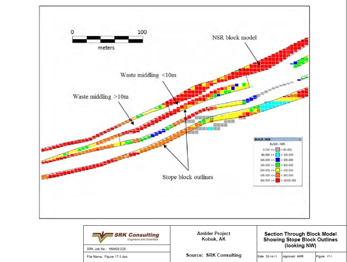
| SRK Consulting (U.S.), Inc. | May 9, 2011 |
| NovaGold Resources Inc. | 17-32 |
| Ambler Project | NI 43-101 Preliminary Econimic Assessment |
Figure 17-2: Plan View of Designed Stope Blocks
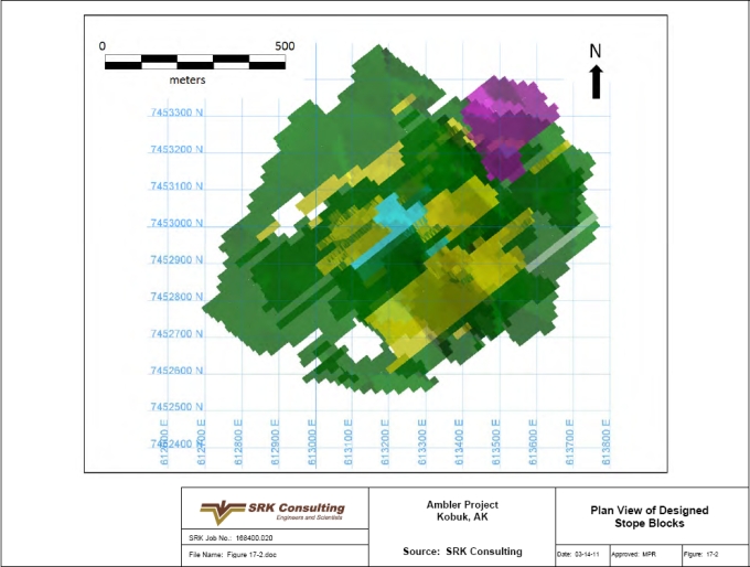
| SRK Consulting (U.S.), Inc. | May 9, 2011 |
| NovaGold Resources Inc. | 17-33 |
| Ambler Project | NI 43-101 Preliminary Econimic Assessment |
Figure 17-3: Plan View of Stoping and Primary Access Development in Footwall
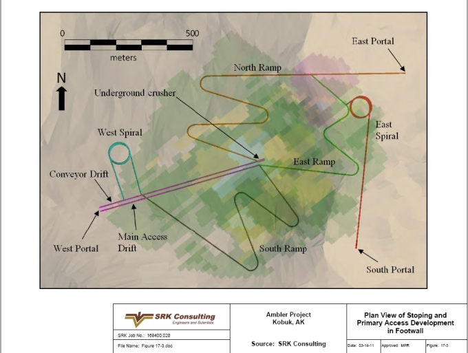
| SRK Consulting (U.S.), Inc. | May 9, 2011 |
| NovaGold Resources Inc. | 17-34 |
| Ambler Project | NI 43-101 Preliminary Econimic Assessment |
Figure 17-4: Isometric View of Stoping and Primary Access Development (looking NW)
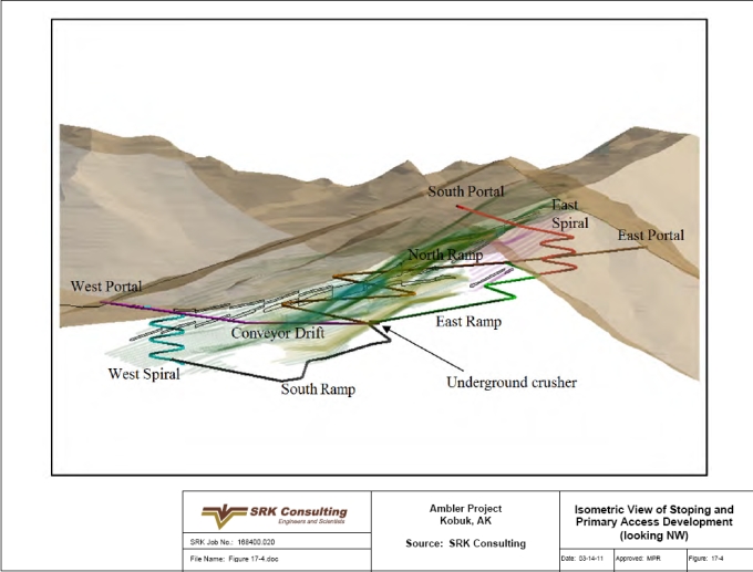
| SRK Consulting (U.S.), Inc. | May 9, 2011 |
| NovaGold Resources Inc. | 17-35 |
| Ambler Project | NI 43-101 Preliminary Econimic Assessment |
Figure 17-5: Plant Site and Tailings Storage Facility General Arrangement Underground Mine Alternative
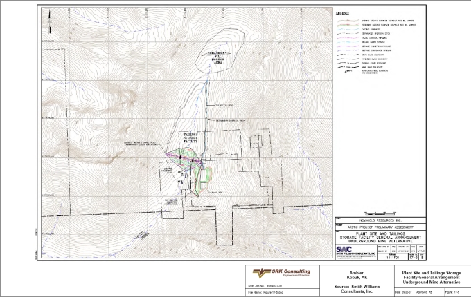
| SRK Consulting (U.S.), Inc. | May 9, 2011 |
| NovaGold Resources Inc. | 17-36 |
| Ambler Project | NI 43-101 Preliminary Econimic Assessment |
Figure 17-6: Tailing Storage Facility Typical Section Underground Mine Alternative
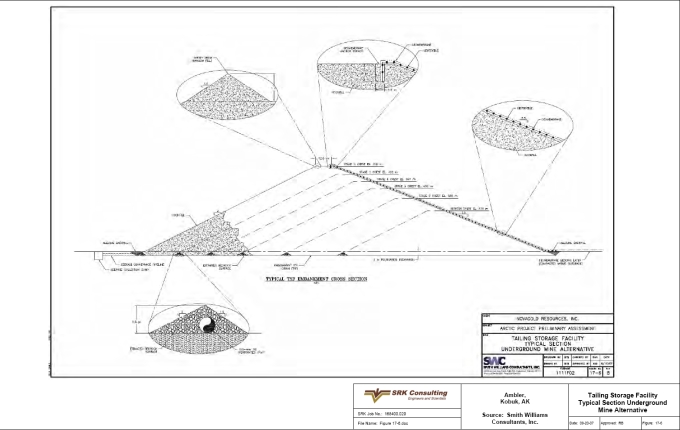
| SRK Consulting (U.S.), Inc. | May 9, 2011 |
| NovaGold Resources Inc. | 18-1 |
| Ambler Project | NI 43-101 Preliminary Econimic Assessment |
| 18 | Interpretation and Conclusions (Item 21) |
The Arctic deposit is a remote, high-grade, massive sulfide deposit with excellent potential but with significant logistical challenges.
The following presents the interpretations and conclusions of this PEA:
● | Geology: |
| o | Geologic interpretations by NovaGold geologists show a complexly folded and potentially faulted deposit. Based on the widely spaced data available, the currently modeled resource model omits these complexities due to lack of correlatable data. However, volumetrically this resource should be representative based on the available samples. The resource has been completed based on industry standards for this type of deposit with this level of sample spacing. |
● | Resource: |
| o | The mineral resources have been classified using logic consistent with the CIM definitions incorporated in NI 43-101. The of the Project satisfies sufficient criteria to be classified into Indicated and Inferred resource categories, and |
| o | Further exploration is required to upgrade the resources thus far identified. |
● | Mine Plan: |
| o | An underground mine plan has been conceptualized with ramp access, generally cut-and-fill stoping and truck haulage. |
● | Process: |
| o | A conventional flotation process flowsheet is proposed based on preliminary metallurgical testwork. Concentrates will be produced with a copper concentrate, a zinc concentrate, and a lead concentrate. |
● | Tailings: |
| o | 29.3Mt of tailings will be generated over the LoM. 15.2Mt (dry basis) of tailings will be pumped to the fully lined, rockfill embankment TSF facility, and the remaining 9.4Mt of tailings will be pumped back into the mine as paste backfill. |
● | Infrastructure: |
| o | Infrastructure is a requirement for the Projects development. In particular, access and power supply to the site. Though several options were examined, additional evaluation for the road development and power supply is recommended and costs for this effort have been included. |
● | Environmental and Permitting: |
| o | Development of the Project will be subject to extensive environmental baseline analyses, impact assessment and evaluation, and associated permitting requirements reflective of the cumulative impacts associated with full project build-out, and the sensitive environment in which it is to be constructed. |
| SRK Consulting (U.S.), Inc. | May 9, 2011 |
| NovaGold Resources Inc. | 18-2 |
| Ambler Project | NI 43-101 Preliminary Econimic Assessment |
● | Economics: |
| o | Notwithstanding the high infrastructure costs, an NPV8% of US$718million demonstrates an attractive project, and |
| o | The economic analysis in this preliminary assessment contains inferred resources, which are considered too speculative geologically to have economic considerations applied to them that would enable them to be categorized as mineral reserves. There is no certainty that the preliminary assessment will ever be realized. Mineral resources that are not mineral reserves do not have demonstrated economic viability. |
As discussed in the resources section, the resources are classified as inferred for reasons of data density, reliability and uncertainty.
| SRK Consulting (U.S.), Inc. | May 9, 2011 |
| NovaGold Resources Inc. | 19-1 |
| Ambler Project | NI 43-101 Preliminary Econimic Assessment |
| 19 | Recommendations (Item 22) |
The findings of this Preliminary Assessment provide compelling arguments to complete exploration and infill drilling on the Project, advance the evaluation of the Project to the pre-feasibility stage and complete a regional exploration program.
Exploration: The compelling economics derived in this assessment support drilling to upgrade existing inferred mineral resources and further exploration on the Project. The Project is in a prospective region for the discovery of additional resources. The proposed Project’s infrastructure could unlock the value of other similar types of deposits
Technical evaluation: Additional metallurgical testwork is needed to completely characterize the deposit and optimize both the process flowsheet and recoveries. Further studies are required to further assess infrastructure requirements and revise the mine plan based on additional exploration work completed.
There are opportunities to optimize the development economics with respect to the Ambler Project. Such opportunities include scheduling of higher grade material though the mill earlier in the project life, effecting the contractual $10 million repurchase of the 1% net smelter return royalty payable on the Ambler Project, assessing other power generating alternatives, and obtaining greater State support or shared users to reduce the assumed toll cost of the required access road.
Additional activities in support of a pre-feasibility assessment include the following, together with indicative costs:
| · | Phase I Work (US$7million): |
| o | Engineering support | US$1,000,000; |
| o | Environmental Baseline Work and Assessment | US$250,000; |
| o | Exploration and Drilling | US$5,750,000; |
| · | Phase II Work (US$23million): |
| o | Exploration and Drilling | US$17,000,000 |
| o | Metallurgical Testwork and Technical Evaluations | US$1,000,000; |
| o | Environmental Baseline Work and Assessment | US$1,000,000; |
| o | Pre-feasibility Report | US$4,000,000. |
Phase II, prefeasibility work, is contingent upon the positive results of Phase I. Positive results of Phase II work will culminate into the recommendation to commence a Feasibility Study.
Given the amount of work performed on the project, activities are required to confirm previous work and further define the development scheme. A revised economic analysis should also be completed.
| SRK Consulting (U.S.), Inc. | May 9, 2011 |
| NovaGold Resources Inc. | 20-1 |
| Ambler Project | NI 43-101 Preliminary Econimic Assessment |
| 20 | References (Item 23) |
Aleinikoff, J. N., Moore, T. E., Walter, M., and Nokleberg, W. J. (1993), U-Pb ages of zircon, monazite, and sphene from Devonian Metagranites and Metafelsites, Central Brooks Range, Alaska: U.S. Geological Survey Bulletin, v. B 2068, p. 59-70
Bearing Marine Lines (2007), Personal Communication with Company Representative
Dillon, J. T., Pessel, G. H., Chen, J. H., and Veach, N. C. (1980), Middle Paleozoicmagmatism and Orogenesis in the Brooks Range, Alaska: Geology, v. 8, p. 338-343
Dillon, J. T., Tilton, G. R., Decker, J., and Kelley, M. J. (1987), Resource Implications of Magmatic and Metamorphic Ages for Devonian Igneous Rocks in the Brooks Range, in Tailleur, I. L., and Weimer, P., Alaskan North Slope Geology, Pacific Section, Society of Economic Paleontologists and Mineralogists, p. 713-723
Dodd, S. P., Lindberg, P. A., Albers, D. F., Robinson, J. D., Prevost, R. (2004) Ambler Project, 2004 Summary Report, Unpublished Internal Report, Alaska Gold Company
Gottschalk, R. R., and Oldow, J. S. (1988), Low-angle Normal Faults in the South-central Brooks Range Fold and Thrust Belt, Alaska, Geology, 16, p. 395-399
Hitzman, M. W. (1982) Geology of the Ruby Creek Copper Deposit, Southwestern Brooks Range, Alaska: Economic Geology v. 81, p. 1644-1674
Hitzman, M. W., Smith, T. E., and Proffett, J. M. (1982), Bedrock Geology of the Ambler District, Southwestern Brooks Range, Alaska: Alaska Division of Geological and Geophysical Surveys Geologic Report 75, scale 1:250,000
Hitzman, M. W., Proffett, J. M., Schmidt, J. M., and Smith, T. E. (1986) Geology and Mineralization of the Ambler District, Northwestern Alaska: Economic Geology v. 81, p. 1592-1618
Kennecott Research Center (September 1968) Amenability Testing of Diamond Drill Core Samples from Arctic, Alaska Project, TR 68-20
Kennecott Research Center (August 1972) Amenability Testing of Samples from Bear Creek Mining Company’s Arctic Deposit, TR 72-12
Kennecott Research Center (September 1976) Recovery of Mineral Values Arctic Prospect, RTR 76-22
Kennecott (1977) Annual Report Arctic Deposit: Unpublished in-house report
Kennecott (1998) Arctic Deposit and Ambler District Field Report: Unpublished in-house report
Kennecott Research Center (January 1997) Process Selection for Arctic Deposit, Technical Report RTR 77-4
Kobuk Valley National Park (2007) National Park Service Inventory and Monitoring Program website, http://www.nature.nps.gov/im/units/arcn/park_detail.cfm?parkid=4
Lakefield Research Limited (January 7, 1999) An Investigation of the Recovery of Lead, Zinc & Precious Metals from Samples of the Arctic Project Ore submitted by Kennecott Minerals, Progress Report No.1
| SRK Consulting (U.S.), Inc. | May 9, 2011 |
| NovaGold Resources Inc. | 20-2 |
| Ambler Project | NI 43-101 Preliminary Econimic Assessment |
Lindberg, P. A. (2004) Structural Geology of the Arctic Cu-Zn-Pb-Ag Sulfide Deposit: Alaska Gold Company Unpublished Report
Michaelson, S. D. (March 11, 1970) Memo to H. L. Bauer
Moore, T. E., Wallace, W. K., Bird, K. J., Karl, S. M., Mull, C. G., and Dillon, J. T. (1994) Geology of Northern Alaska, in Plafker, G., and Berg, H. C., eds., The Geology of Alaska: Boulder, Colorado, Geological Society of America, The Geology of North America, v. G1, p. 49-140
Mull, C. G. (1982) Tectonic Evolution and Structural Style of the Brooks Range, Alaska; an Illustrated Summary, in Geologic Studies of the Cordilleran Thrust Belt, Rocky Mt. Assoc. Geol., Denver, CO, United States (USA), p. 1-45
Mull, C. G. (1985) Cretaceous Tectonics, Depositional Cycles, and the Nanushuk Group, Brooks Range and Arctic Slope, Alaska, U.S. Geol. Soc. Bull., 1614, p. 7-36
NANA/DOWL Engineers and CH2M Hill (March 2005) Ambler District Access Study, Phase I Summary Route Identification and Screening Analysis, p. 51
Nauman, C. R. (December 29, 1994) Memo Arctic: Status of Development of Ore Processing
Oldow, J. S., Seidensticker, C. M., Phelps, J. C., Julian, F. E., Gottschalk, R. R., Boler, K. W., Handschy, J. W., and Ave Lallemant, H. G. (1987) Balanced Cross Sections Through the Central Brooks Range and North Slope, Arctic Alaska, AAPG, p. 19, 8 plates
Otto, B. R. (2006) Personal Communication
Proffett, J. M. (1999) Summary of Conclusions on Geology of the Arctic Deposit, AK: Kennecott Minerals Company Unpublished Report
Randolph, M. P. (August 29, 1990) to T. J. Stephenson: Arctic Deposit, Internal Kennecott Memo
Robertson Geoconsultants Inc. (December 1998) Initial Assessment of Geochemical and Hydrological Conditions at Kennecott’s Arctic Project
Russell, R. H. (1977) (1976) Annual Report, Arctic Deposit: Bear Creek Mining Company Unpublished Report
Russell, R. H. (1995) Arctic Project 1995 Evaluation Report, Geologic Report: Kennecott Corporation Unpublished Report
Sawyer, Roger J. (January 15, 1999) Memo to J. Earnshaw, Kennecott Minerals, Arctic-Metallurgy Projections
Schmidt, J. M. (1983) Geology and Geochemistry of the Arctic Prospect, Ambler District, Alaska: Unpublished Ph.D. dissertation, Stanford University
Schmidt, J. M. (1986) Stratigraphic Setting and Mineralogy of the Arctic Volcanogenic Massive Sulfide Prospect, Ambler District, Alaska: Economic Geology v. 81. p. 1619-1643
Schmidt, J. M. (1988) Mineral and Whole Rock Compositions of Seawater-Dominated Hydrothermal Alteration at the Arctic Volcanogenic Massive Sulfide Prospect, Alaska: Economic Geology v.83, p. 822-842
| SRK Consulting (U.S.), Inc. | May 9, 2011 |
| NovaGold Resources Inc. | 20-3 |
| Ambler Project | NI 43-101 Preliminary Econimic Assessment |
Shaw, Stone & Webster Management Consultants, Inc. (2006) Mine Power Study Arctic Project – Ambler Mining District, Unpublished Report for Alaska Gold Company, p. 73
Till, A. B., Schmidt, J. M., and Nelson, S. W. (1988), Thrust Involvement of Metamorphic Rocks, Southwestern Brooks Range, Alaska: Geology, v. 16, p. 930-933
URSA Engineering (1998) Arctic Project Rock Mass Characterization, Prepared for: Kennecott Minerals, Co., Unpublished Report, p. 49
Vogl, J. J., Calvert, A. J., Gans, P. B. (2002) Mechanisms and Timing of Exhumation of Collision-Related Metamorphic Rocks, Southern Brooks Range, Alaska: Insights from Ar (40)/ Ar (39) Thermochronology, Tectonics, v 21, No 3, p. 1-18
Williams, A. (2000) Opportunities in the NANA Region, in: Mining Alaska National Interest Lands Conservation Act (ANILCA)-Twenty Years Later-Abstracts, Alaska Miners Association 2000 Annual Convention, p. 25
www.kobuk.valley.national-park.com/info.htm#env (2007), Kobuk Valley National Park
www.meg.com (2007)
www.wrcc.dri.edu/narratives/ALASKA.htm (2007), Climate of Alaska
www.wrcc.dri.edu/summary/climsmak.html (2007), Alaska Climate Summaries
Zieg, G. A., et al. (2005) Ambler Project 2005 Progress Report, Unpublished Internal Report, Alaska Gold Company
| SRK Consulting (U.S.), Inc. | May 9, 2011 |
| NovaGold Resources Inc. | 21-1 |
| Ambler Project | NI 43-101 Preliminary Econimic Assessment |
| 21 | Glossary |
| 21.1 | Mineral Resources & Reserves |
Mineral Resources
The mineral resources and mineral reserves have been classified according to the “CIM Standards on Mineral Resources and Reserves: Definitions and Guidelines” (November 2005). Accordingly, the Resources have been classified as Measured, Indicated or Inferred, the Reserves have been classified as Proven, and Probable based on the Measured and Indicated Resources as defined below.
A Mineral Resource is a concentration or occurrence of natural, solid, inorganic or fossilized organic material in or on the Earth’s crust in such form and quantity and of such a grade or quality that it has reasonable prospects for economic extraction. The location, quantity, grade, geological characteristics and continuity of a Mineral Resource are known, estimated or interpreted from specific geological evidence and knowledge.
An ”Inferred Mineral Resource” is that part of a Mineral Resource for which quantity and grade or quality can be estimated on the basis of geological evidence and limited sampling and reasonably assumed, but not verified, geological and grade continuity. The estimate is based on limited information and sampling gathered through appropriate techniques from locations such as outcrops, trenches, pits, workings and drillholes.
An ”Indicated Mineral Resource” is that part of a Mineral Resource for which quantity, grade or quality, densities, shape and physical characteristics can be estimated with a level of confidence sufficient to allow the appropriate application of technical and economic parameters, to support mine planning and evaluation of the economic viability of the deposit. The estimate is based on detailed and reliable exploration and testing information gathered through appropriate techniques from locations such as outcrops, trenches, pits, workings and drillholes that are spaced closely enough for geological and grade continuity to be reasonably assumed.
A ”Measured Mineral Resource” is that part of a Mineral Resource for which quantity, grade or quality, densities, shape, physical characteristics are so well established that they can be estimated with confidence sufficient to allow the appropriate application of technical and economic parameters, to support production planning and evaluation of the economic viability of the deposit. The estimate is based on detailed and reliable exploration, sampling and testing information gathered through appropriate techniques from locations such as outcrops, trenches, pits, workings and drillholes that are spaced closely enough to confirm both geological and grade continuity.
Mineral Reserves
A Mineral Reserve is the economically mineable part of a Measured or Indicated Mineral Resource demonstrated by at least a Preliminary Feasibility Study. This Study must include adequate information on mining, processing, metallurgical, economic and other relevant factors that demonstrate, at the time of reporting, that economic extraction can be justified. A Mineral Reserve includes diluting materials and allowances for losses that may occur when the material is mined.
| SRK Consulting (U.S.), Inc. | May 9, 2011 |
| NovaGold Resources Inc. | 21-2 |
| Ambler Project | NI 43-101 Preliminary Econimic Assessment |
A ”Probable Mineral Reserve” is the economically mineable part of an Indicated, and in some circumstances a Measured Mineral Resource demonstrated by at least a Preliminary Feasibility Study. This Study must include adequate information on mining, processing, metallurgical, economic, and other relevant factors that demonstrate, at the time of reporting, that economic extraction can be justified.
A ”Proven Mineral Reserve” is the economically mineable part of a Measured Mineral Resource demonstrated by at least a Preliminary Feasibility Study. This Study must include adequate information on mining, processing, metallurgical, economic, and other relevant factors that demonstrate, at the time of reporting, that economic extraction is justified.
| 21.2 | Glossary |
Table 21.2.1: Definitions of Terms
| Term | Definition |
| Assay | The chemical analysis of mineral samples to determine the metal content. |
| BQ Size | Letter name specifying the dimensions of bits, core barrels, and drill rods in the B-size and Q-group wireline diamond drilling system having a core diameter of 36.5mm and a hole diameter of 60mm. |
| Capital Expenditure | All other expenditures not classified as operating assets. |
| Cementitious | Of or relating to a chemical precipitate, especially of carbonates, having the characteristics of cement. |
| Composite | Combining more than one sample result to give an average result over a larger distance. |
| Concentrate | A metal-rich product resulting from a mineral enrichment process such as gravity concentration or flotation, in which most of the desired mineral has been separated from the waste material in the ore. |
| Crushing | Initial process of reducing ore particle size to render it more amenable for further processing. |
| Cut-off Grade (CoG) | The grade of mineralized rock, which determines as to whether or not it is economic to recover its gold content by further concentration. |
| Dilution | Waste, which is unavoidably mined with ore. |
| Dip | Angle of inclination of a geological feature/rock from the horizontal. |
| Fault | The surface of a fracture along which movement has occurred. |
| Flow Ore | A medium to fine grained, basal mafic volcanic rock which is generally located along the footwall of the deposit. |
| Footwall | The underlying side of an ore body or stope. |
| Gangue | Non-valuable components of the ore. |
| Gross Metal Value (GMV) | An estimate value per ton for each resource block, which considers only contained metal values at specified metal prices without consideration of recoveries or processing costs. |
| Grade | The measure of concentration of gold within mineralized rock. |
| Hangingwall | The overlying side of an ore body or slope. |
| Haulage | A horizontal underground excavation which is used to transport mined ore. |
| HQ | A letter name specifying the dimensions of bits, core barrels, and drill rods in the H-size and Q-group wireline diamond drilling system having a core diameter of 63.5 mm and a hole diameter of 96 mm. |
| Hydrocyclone | A process whereby material is graded according to size by exploiting centrifugal forces of particulate materials. |
| Igneous | crystalline rock formed by the solidification of magma. |
| Kriging | An interpolation method of assigning values from samples to blocks that minimizes the estimation error. |
| Level | Horizontal tunnel the primary purpose is the transportation of personnel and materials. |
| Lithological | Geological description pertaining to different rock types. |
| SRK Consulting (U.S.), Inc. | May 9, 2011 |
| NovaGold Resources Inc. | 21-3 |
| Ambler Project | NI 43-101 Preliminary Econimic Assessment |
Table 21.2.1: Definitions of Terms (Continued)
| Term | Definition |
| Material Properties | Mine properties. |
| Milling | A general term used to describe the process in which the ore is crushed and ground and subjected to physical or chemical treatment to extract the valuable metals to a concentrate or finished product. |
| Mineral/Mining Lease | A lease area of which mineral rights are held. |
| Mining Assets | The Material Properties and Significant Exploration Properties. |
| NQ Size | A letter name specifying the dimensions of bits, core barrels, and drill rods in the N-size and Q-group wireline diamond drilling system having a core diameter of 47.6mm and a hole diameter of 75.7mm. |
| Net Smelter Return (NSR) | An estimate value per ton for each resource block, which considers metal values, recoveries and processing costs. |
| Ongoing Capital | Capital estimates of a routine nature which is necessary for sustaining operations. |
| Operating Costs | Sum of cost of mining, beneficiation, and administration gives the operating cost of the mine. |
| Ore Reserve | See Mineral Reserve. |
| Pillar | Rock left behind to help support the excavations in an underground mine. |
| Sedimentary | Pertaining to rocks formed by the accumulation of sediments, formed by the erosion of other rocks. |
| Shaft | An opening cut downwards from the surface for transporting personnel, equipment, supplies, ore and waste. |
| Sill | A thin, tabular, horizontal to sub-horizontal body of igneous rock formed by the injection of magma into planar zones of weakness. |
| Smelting | A high temperature pyrometallurgical operation conducted in a furnace, in which the valuable metal is collected to a molten matte or doré phase and separated from the gangue components that accumulate in a less dense molten slag phase. |
| Specific Gravity (SG) | The weight of a substance compared with the weight of an equal volume of pure water at 4ºC. |
| Stratigraphy | The study of stratified rocks in terms of time and space. |
| Stope | Underground void created by mining. |
| Strike | Direction of line formed by the intersection of strata surfaces with the horizontal plane, always perpendicular to the dip direction. |
| Sulfide | A sulfur bearing mineral. |
| Tailings | Finely ground waste rock from which valuable minerals or metals have been extracted. |
| Thickening | The process of concentrating solid particles in suspension. |
| Total Expenditure | All expenditures including those of an operating and capital nature. |
| Variogram | A statistical representation of the characteristics (usually grade) |
| Zone | Modeled 3D shape representing correlateable intercepts of massive sulfide material in shallowly dipping lenses. |
| 21.3 | Units of Measure and Abbreviations |
The metric system is used throughout this report with the exception of gold and silver quantities, which are reported in troy ounces, or unless otherwise stated. All currency is in US dollars. Abbreviations used in this report are shown in Table 21.3.1.
| SRK Consulting (U.S.), Inc. | May 9, 2011 |
| NovaGold Resources Inc. | 21-4 |
| Ambler Project | NI 43-101 Preliminary Econimic Assessment |
Table 21.3.1: Units of Measure and Abbreviations
| Abbreviation | Unit or Term |
| AGP | Acid Generating Potential |
| Amsl | above mean sea level |
| AMT | Alternative Minimum Tax |
| AMTI | Alternative Minimum Tax Income |
| ANCSA | Alaska Native Claims Settlement Act |
| ANCSA Corporations | Alaska Native Regional Corporation |
| ANFO | ammonium nitrate fuel oil (explosive) |
| ARD | Acid Rock Drainage |
| BCMC | Bear Creek Mining Company |
| BE | Breakeven |
| BLM | Bureau of Land Management |
| Bt | billion tonnes |
| ºC | degrees centigrade |
| CAA | Clean Air Act |
| CEQ | Council of Environmental Quality |
| Cm | centimeter |
| CoG | cut-off grade |
| CWA | Clean Water Act |
| DIES | Draft Environmental Impact Statement |
| dia. | diameter |
| Dmt | Dry metric tons |
| EIS | Environmental Impact Statement |
| EM | Electromagnetic |
| FIFO | Fly-In-Fly-Out |
| G | Gravity |
| g | gram |
| g/t | grams per metric ton |
| GMV | Gross Metal Value |
| GPS | Global Positioning System |
| GVEA | Golden Valley Electric Association |
| GRTS | GR Technical Services |
| Ha | hectare (10,000m2) |
| HDPE | high density polyethylene |
| IFR | Instrument Flight Rules |
| kg | kilogram (1,000g) |
| IK | indicator kriging |
| kL | kilo liters |
| km | kilometer (1,000m) |
| KRC | Kennecott Research Center |
| KSP | Kennecott Sulfite Process |
| kV | kilovolt (1,000V) |
| kW | kilowatt (1,000W) |
| kWh | kilowatt-hour |
| kWh/t | kilowatt-hours per metric ton |
| LoM | life-of-mine |
| L | liter |
| LCRS | leak collection and recovery system |
| Lps | liters per second |
| LRP | Long Range Plan |
| m | meter |
m2 | square meter |
m3 | cubic meter |
| mamsl | meters above mean sea level |
| SRK Consulting (U.S.), Inc. | May 9, 2011 |
| NovaGold Resources Inc. | 21-5 |
| Ambler Project | NI 43-101 Preliminary Econimic Assessment |
Table 21.3.1: Units of Measure and Abbreviation (Continued)
| Abbreviation | Unit or Term | |
| ML | million liters | |
| mm | millimeter | |
| Mpa | Mega Pascals | |
| MS | Massive Sulfide | |
| Mt | million metric tonnes | |
| MVA | Million Volt Amperes | |
| MW | mega-watt | |
| NANA | Northwest Alaskan Native Association | |
| NAG | non acid generating | |
| NEPA | National Environmental Policy Act | |
| NMS | NANA Management Services | |
| NPV | Net Present Value | |
| NSR | net smelter return | |
| oz | troy ounce (31,1035g) | |
| PAG | potentially acid generating | |
| PIMA | Portable Infrared Mineral Analyzer | |
| POX | pressure oxidation | |
| QA/QC | quality assurance/quality control | |
| QP | Qualified Person | |
| RC | rotary circulation (drilling) | |
| ROD | Record of Decision | |
| RoM | run-of-mine | |
| RMR | Rock Mass Rating | |
| RTZ | Rio Tinto-Zinc Corporation | |
| SG | Specific Gravity | |
| SMS | Semi-massive Sulfide | |
| t | metric ton, or tonne | |
| TDEM | Time Domain ElectroMagnetic | |
| TMT | Tentative Minimum Tax | |
| t/h | metric tonnes per hour | |
| t/d | metric tonnes per day | |
| t/y | metric tonnes per year | |
| TMS | Talc Mica Schist | |
| TSF | tailings storage facility | |
| µm | micron or microns | |
| USFS | United States Forest Service | |
| USACOE | United States Army Corps of Engineers | |
| USEPA | United States Environmental Protection Agency | |
| VAT | Vacation, Absenteeism and Turnover | |
| VMS | Volcanogenic Massive Sulfide | |
| WGM | Watts, Griffis and McOuat Ltd. | |
| SRK Consulting (U.S.), Inc. | May 9, 2011 |
Appendix A
Certificates of Author
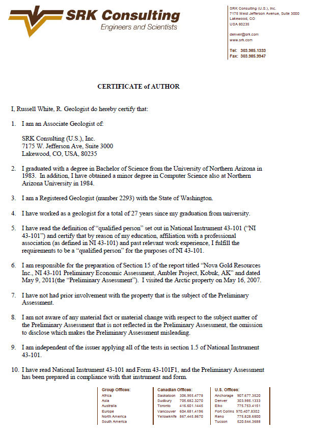

Appendix B
Ambler Project Claims
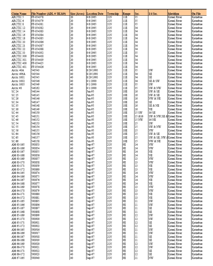
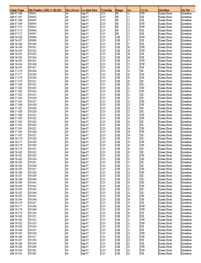
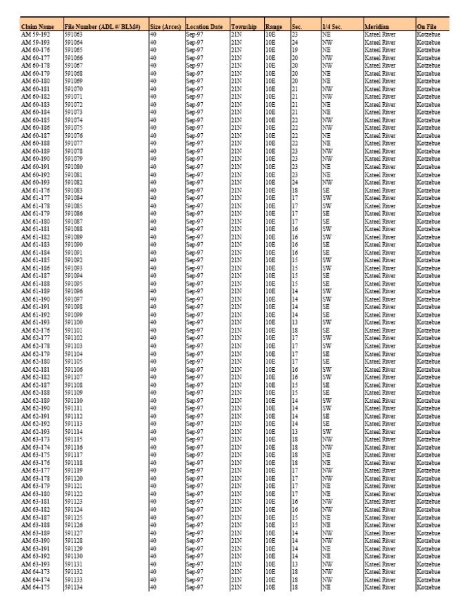
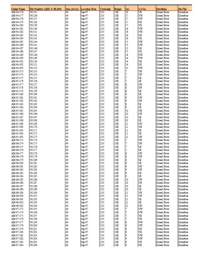
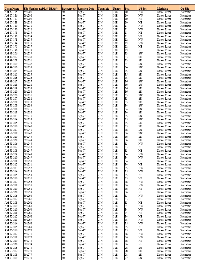
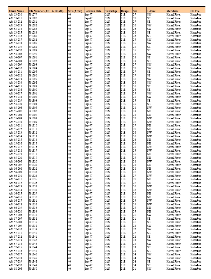
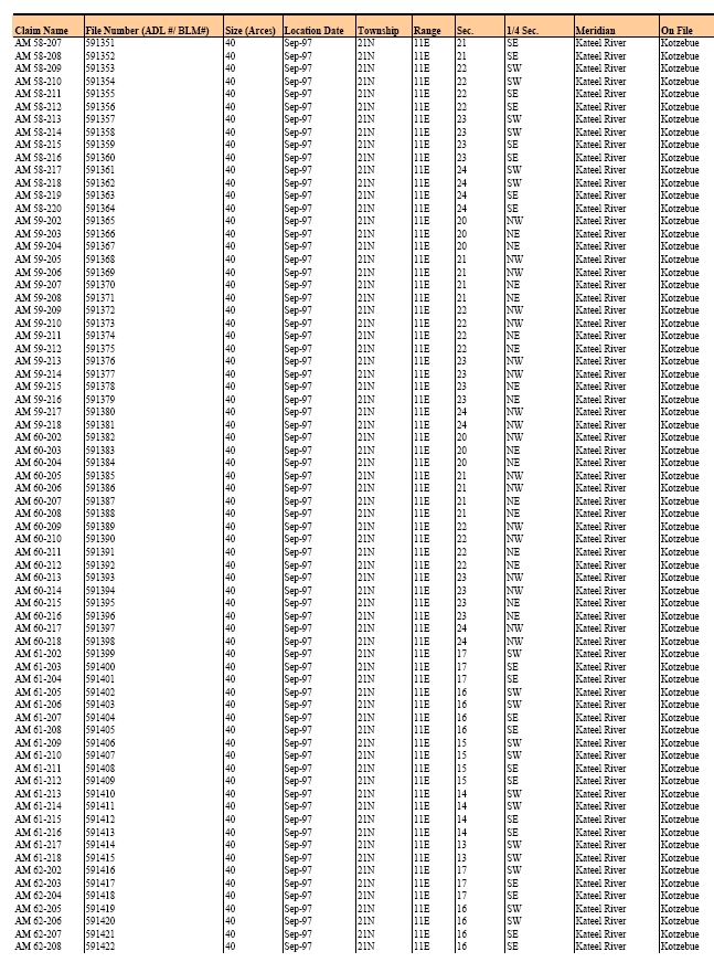

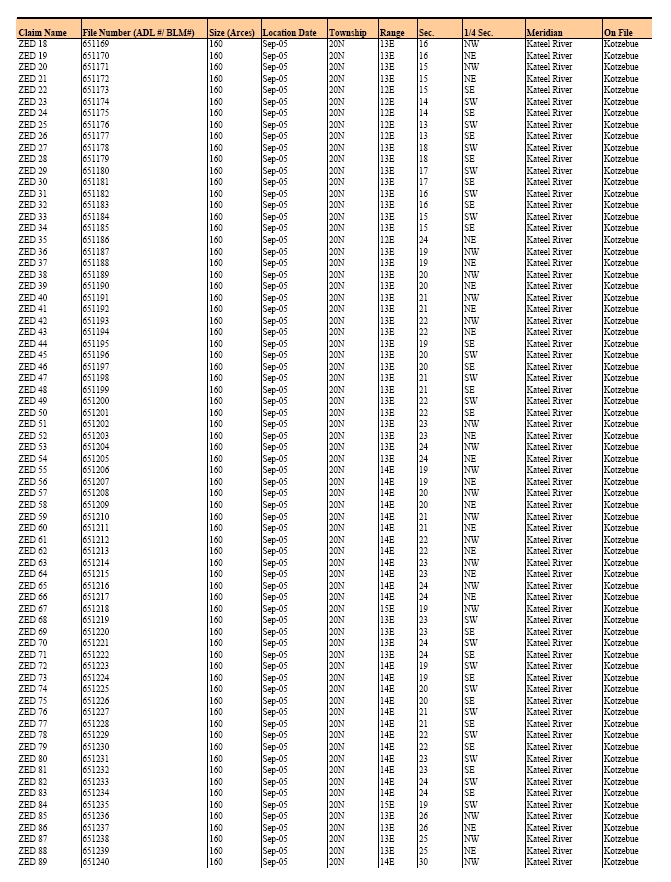
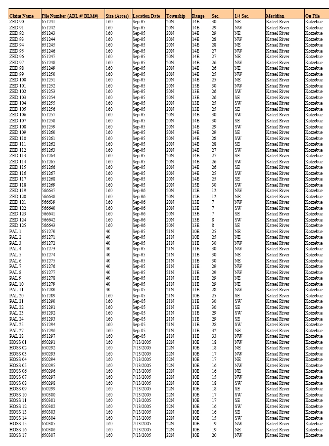
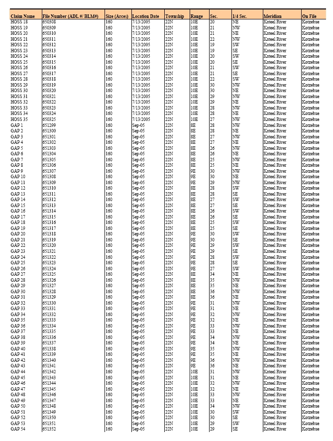
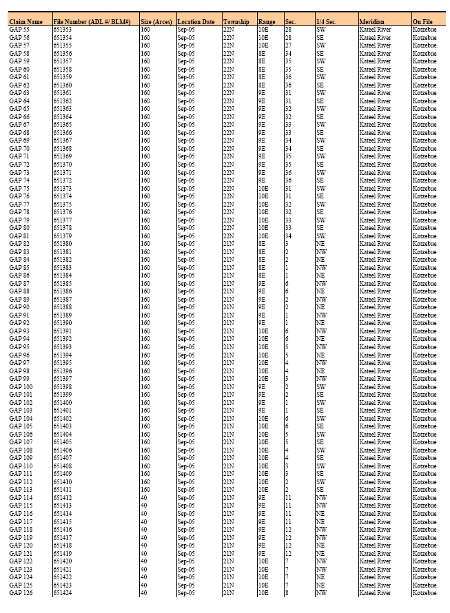
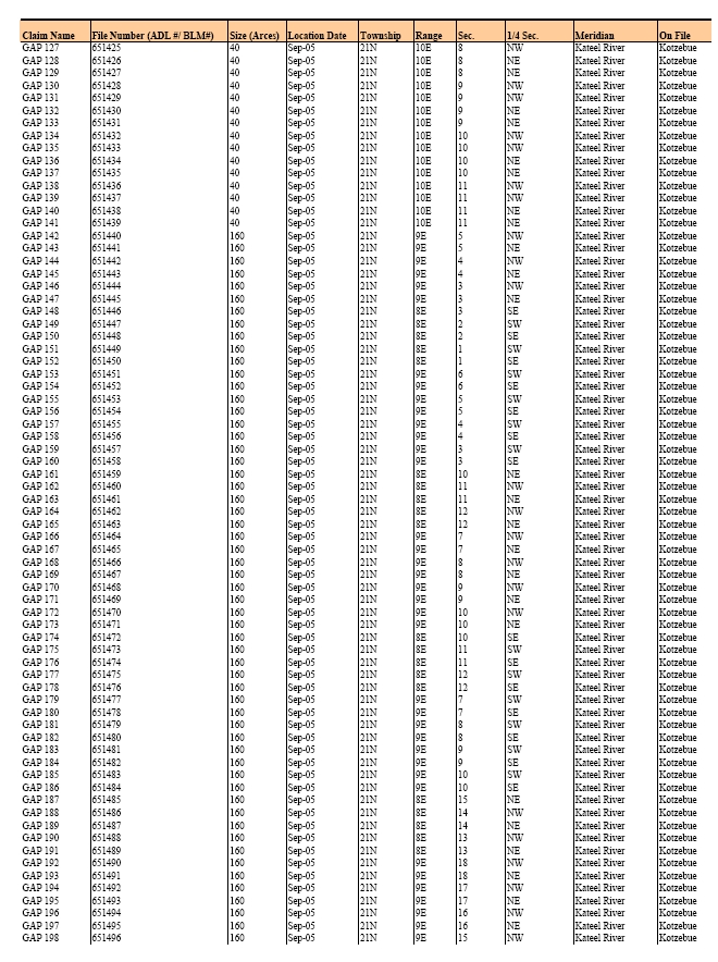

Appendix C
Drillhole Collars
| Hole ID | Program | Type | Area | UTM East | UTM North | Elevation | Azimuth | Dip | Depth |
| AR-01 | 1966 BCMC | Core | Ambler | 613643.31 | 7453181.73 | 918.21 | 49.0 | -90.0 | 32.00 |
| AR-02 | BCMC | Core | Ambler | 613582.16 | 7453270.84 | 944.36 | 49.0 | -90.0 | 93.88 |
| AR-03 | BCMC | Core | Ambler | 613573.56 | 7453365.16 | 927.63 | 88.7 | -90.0 | 182.88 |
| AR-04 | BCMC | Core | Ambler | 613631.98 | 7453125.00 | 944.94 | 49.0 | -90.0 | 86.87 |
| AR-05 | BCMC | Core | Ambler | 613556.86 | 7453316.86 | 947.75 | 49.0 | -90.0 | 127.10 |
| AR-06 | BCMC | Core | Ambler | 613632.95 | 7453036.21 | 980.97 | 49.0 | -90.0 | 86.87 |
| AR-07 | BCMC | Core | Ambler | 613455.04 | 7453138.11 | 944.42 | 49.0 | -90.0 | 142.04 |
| AR-08 | BCMC | Core | Ambler | 613692.14 | 7452975.08 | 981.06 | 49.0 | -90.0 | 53.95 |
| AR-09 | BCMC | Core | Ambler | 612843.16 | 7453228.85 | 736.98 | 49.0 | -90.0 | 204.22 |
| AR-10 | BCMC | Core | Ambler | 613467.36 | 7453026.47 | 933.21 | 49.0 | -90.0 | 209.40 |
| AR-11 | BCMC | Core | Ambler | 613337.50 | 7453140.58 | 906.81 | 49.0 | -90.0 | 207.26 |
| AR-11A | 1975 BCMC | Core | Ambler | 613349.09 | 7453124.22 | 906.66 | 49.0 | -90.0 | 200.56 |
| AR-11B | 1975 BCMC | Core | Ambler | 613344.76 | 7453128.78 | 906.38 | 49.0 | -90.0 | 199.61 |
| AR-12 | BCMC | Core | Ambler | 613355.28 | 7452937.65 | 876.27 | 49.0 | -90.0 | 221.28 |
| AR-12A | 1975 BCMC | Core | Ambler | 613354.33 | 7452942.68 | 876.67 | 49.0 | -90.0 | 215.80 |
| AR-13 | BCMC | Core | Ambler | 613209.77 | 7453257.06 | 872.55 | 49.0 | -90.0 | 236.83 |
| AR-14 | BCMC | Core | Ambler | 613226.18 | 7453011.90 | 847.40 | 99.7 | -90.0 | 526.08 |
| AR-14A | 1975 BCMC | Core | Ambler | 613216.77 | 7453023.58 | 846.86 | 49.0 | -90.0 | 174.04 |
| AR-14B | 1975 BCMC | Core | Ambler | 613226.12 | 7453007.44 | 847.22 | 49.0 | -90.0 | 177.09 |
| AR-15 | BCMC | Core | Ambler | 612820.25 | 7452710.71 | 704.61 | 49.0 | -90.0 | 225.55 |
| AR-16 | BCMC | Core | Ambler | 613111.17 | 7452886.94 | 790.83 | 49.0 | -90.0 | 205.44 |
| AR-16A | 1975 BCNC | Core | Ambler | 613100.00 | 7452900.00 | 791.00 | 0.0 | -90.0 | 122.53 |
| AR-16B | 1975 BCMC | Core | Ambler | 613110.27 | 7452881.42 | 790.93 | 49.0 | -90.0 | 176.17 |
| AR-16C | 1975 BCMC | Core | Ambler | 613096.58 | 7452904.81 | 791.63 | 49.0 | -90.0 | 181.48 |
| AR-17 | BCMC | Core | Ambler | 613218.69 | 7453133.36 | 865.57 | 49.0 | -90.0 | 166.73 |
| AR-18 | BCMC | Core | Ambler | 613606.09 | 7452924.13 | 975.60 | 49.0 | -90.0 | 102.41 |
| AR-19 | BCMC | Core | Ambler | 613352.58 | 7452860.31 | 869.35 | 49.0 | -90.0 | 222.50 |
| AR-20 | BCMC | Core | Ambler | 612986.85 | 7452753.97 | 733.90 | 49.0 | -90.0 | 212.75 |
| AR-21 | BCMC | Core | Ambler | 612981.32 | 7452992.23 | 767.88 | 49.0 | -90.0 | 153.01 |
| AR-22 | BCMC | Core | Ambler | 613242.15 | 7452652.54 | 824.03 | 49.0 | -90.0 | 307.24 |
| AR-23 | BCMC | Core | Ambler | 612991.97 | 7452598.34 | 758.01 | 49.0 | -90.0 | 317.91 |
| AR-24 | BCMC | Core | Ambler | 612867.03 | 7452861.29 | 717.01 | 49.0 | -90.0 | 143.56 |
| AR-25 | BCMC | Core | Ambler | 612735.79 | 7452871.60 | 689.70 | 49.0 | -90.0 | 118.87 |
| AR-26 | BCMC | Core | Ambler | 613679.95 | 7452707.31 | 871.55 | 49.0 | -90.0 | 73.76 |
| AR-27 | BCMC | Core | Ambler | 613202.72 | 7452467.43 | 845.79 | 49.0 | -90.0 | 484.02 |
| AR-28 | BCMC | Core | Ambler | 613728.24 | 7452583.04 | 833.41 | 49.0 | -90.0 | 153.92 |
| AR-29 | BCMC | Core | Ambler | 612694.57 | 7452688.05 | 696.32 | 173.2 | -90.0 | 217.93 |
| AR-30 | BCMC | Core | Ambler | 613363.81 | 7452636.33 | 896.84 | 74.7 | -90.0 | 272.80 |
| AR-31 | BCMC | Core | Ambler | 612823.28 | 7452558.76 | 777.54 | 23.2 | -90.0 | 340.46 |
| AR-32 | BCMC | Core | Ambler | 613466.91 | 7452929.78 | 925.37 | 49.6 | -90.0 | 256.64 |
| AR-33 | BCMC | Core | Ambler | 612167.71 | 7452753.46 | 588.36 | 64.6 | -90.0 | 406.60 |
| AR-34 | BCMC | Core | Ambler | 613238.31 | 7452845.82 | 823.94 | 47.6 | -90.0 | 256.64 |
| AR-34A | 1975 BCMC | Core | Ambler | 613234.16 | 7452852.49 | 824.20 | 49.0 | -90.0 | 229.58 |
| AR-34B | 1975 BCMC | Core | Ambler | 613232.18 | 7452857.98 | 823.94 | 49.0 | -90.0 | 221.59 |
| AR-34C | 1975 BCMC | Core | Ambler | 613231.26 | 7452863.85 | 824.21 | 49.0 | -90.0 | 218.24 |
| AR-35 | BCMC | Core | Ambler | 613454.50 | 7452791.89 | 913.97 | 49.0 | -90.0 | 300.53 |
| AR-36 | BCMC | Core | Ambler | 613727.05 | 7452805.21 | 896.60 | 64.6 | -90.0 | 288.95 |
| Hole ID | Program | Type | Area | UTM East | UTM North | Elevation | Azimuth | Dip | Depth |
| AR-37 | BCMC | Core | Ambler | 613381.45 | 7452488.94 | 912.05 | 35.6 | -90.0 | 397.76 |
| AR-38 | BCMC | Core | Ambler | 613536.88 | 7452732.49 | 955.46 | 44.6 | -90.0 | 213.36 |
| AR-39 | BCMC | Core | Ambler | 613450.42 | 7453276.37 | 977.01 | 39.6 | -90.0 | 282.24 |
| AR-40 | BCMC | Core | Ambler | 613603.41 | 7452918.68 | 976.18 | 83.6 | -90.0 | 293.83 |
| AR-41 | BCMC | Core | Ambler | 613643.31 | 7453181.73 | 918.21 | 84.6 | -90.0 | 285.29 |
| AR-42 | BCMC | Core | Ambler | 613339.19 | 7453236.90 | 926.84 | 55.6 | -90.0 | 242.32 |
| AR-43 | BCMC | Core | Ambler | 613548.57 | 7453098.16 | 976.12 | 92.6 | -90.0 | 301.75 |
| AR-44 | BCMC | Core | Ambler | 613381.29 | 7453073.54 | 906.02 | 78.6 | -90.0 | 257.25 |
| AR-45 | BCMC | Core | Ambler | 613455.88 | 7453457.47 | 964.14 | 25.6 | -90.0 | 206.04 |
| AR-46 | BCMC | Core | Ambler | 613088.19 | 7453122.49 | 827.17 | 4.6 | -90.0 | 142.04 |
| AR-46A | 1975 BCMC | Core | Ambler | 613089.77 | 7453117.78 | 827.20 | 49.0 | -90.0 | 103.33 |
| AR-46B | 1975 BCMC | Core | Ambler | 613086.19 | 7453125.51 | 827.29 | 49.0 | -90.0 | 107.59 |
| AR-47 | BCMC | Core | Ambler | 613399.00 | 7453365.69 | 964.94 | 56.6 | -90.0 | 180.44 |
| AR-48 | BCMC | Core | Ambler | 613064.38 | 7453272.34 | 813.76 | 49.0 | -90.0 | 78.03 |
| AR-48A | 1975 BCMC | Core | Ambler | 613063.92 | 7453274.79 | 814.03 | 49.0 | -90.0 | 43.89 |
| AR-48B | 1975 BCMC | Core | Ambler | 613063.82 | 7453278.71 | 813.91 | 49.0 | -90.0 | 46.02 |
| AR-49 | BCMC | Core | Ambler | 613151.88 | 7452791.78 | 789.40 | 53.6 | -90.0 | 254.81 |
| AR-50 | 1976 BCMC | Core | Ambler | 613111.93 | 7453345.79 | 830.52 | 81.5 | -90.0 | 49.68 |
| AR-51 | 1976 BCMC | Core | Ambler | 613043.65 | 7453206.12 | 806.04 | 45.5 | -90.0 | 102.11 |
| AR-52 | 1976 BCMC | Core | Ambler | 612983.17 | 7453123.47 | 790.29 | 27.5 | -90.0 | 76.20 |
| AR-53 | 1976 BCMC | Core | Ambler | 613208.57 | 7453358.10 | 867.19 | 49.5 | -90.0 | 84.12 |
| AR-54 | 1976 BCMC | Core | Ambler | 612990.06 | 7453219.83 | 789.22 | 75.5 | -90.0 | 44.44 |
| AR-55 | 1976 BCMC | Core | Ambler | 612972.43 | 7453294.20 | 780.59 | 71.5 | -90.0 | 35.30 |
| AR-56 | 1976 BCMC | Core | Ambler | 613017.43 | 7453355.50 | 787.91 | 41.5 | -90.0 | 45.72 |
| AR-57 | 1976 BCMC | Core | Ambler | 612931.11 | 7453192.85 | 766.79 | 31.5 | -90.0 | 39.62 |
| AR-58 | 1977 BCMC | Core | Ambler | 612994.15 | 7452864.89 | 752.85 | 37.5 | -90.0 | 192.94 |
| AR-59 | 1977 BCMC | Core | Ambler | 612819.71 | 7452944.29 | 720.82 | 29.5 | -90.0 | 100.89 |
| AR-60 | 1979 BCMC | Core | Ambler | 613267.15 | 7452931.28 | 843.79 | 87.4 | -90.0 | 230.12 |
| AR-61 | 1979 BCMC | Core | Ambler | 612827.00 | 7452825.54 | 695.97 | 25.4 | -90.0 | 140.82 |
| AR-62 | 1977 BCMC | Core | Ambler | 613107.54 | 7453001.93 | 814.27 | 30.4 | -90.0 | 202.69 |
| AR-63 | 1981 BCMC | Core | Ambler | 613818.50 | 7452022.06 | 551.25 | 24.3 | -90.0 | 457.81 |
| AR-64 | 1982 BCMC | Core | Ambler | 613458.75 | 7453329.39 | 985.39 | 44.2 | -90.0 | 256.03 |
| AR-65 | 1982 BCMC | Core | Ambler | 613270.81 | 7452514.80 | 856.70 | 37.2 | -90.0 | 94.49 |
| AR-66 | 1982 BCMC | Core | Ambler | 613706.35 | 7452984.73 | 976.34 | 82.2 | -86.0 | 45.72 |
| AR-67 | 1982 BCMC | Core | Ambler | 613073.56 | 7452508.01 | 803.00 | 4.2 | -90.0 | 97.54 |
| AR-68 | 1983 BCMC | Core | Ambler | 613660.81 | 7452504.22 | 885.44 | 0.0 | -90.0 | 153.01 |
| AR-69 | 1984 BCMC | Core | Ambler | 613200.71 | 7453405.97 | 865.63 | 49.0 | -90.0 | 48.46 |
| AR-70 | 1984 BCMC | Core | Ambler | 612533.16 | 7452691.80 | 662.94 | 49.0 | -90.0 | 204.22 |
| AR-71 | 1986 BCMC | Core | Ambler | 612424.33 | 7452684.57 | 624.48 | 0.0 | -90.0 | 184.40 |
| AR-72 | 1998 | Core | Ambler | 613319.89 | 7453038.75 | 878.94 | 0.0 | -90.0 | 263.35 |
| AR-73 | 1998 | Core | Ambler | 613248.65 | 7452746.37 | 820.68 | 0.0 | -90.0 | 301.75 |
| AR-74 | 1998 | Core | Ambler | 613291.56 | 7452883.10 | 846.69 | 0.0 | -90.0 | 263.65 |
| AR-75 | 1998 | Core | Ambler | 613174.16 | 7452944.89 | 821.62 | 0.0 | -90.0 | 242.93 |
| AR-76 | 1998 | Core | Ambler | 611773.01 | 7452502.28 | 593.84 | 80.0 | -45.0 | 192.18 |
| AR-77 | 1998 | Core | Ambler | 611772.01 | 7452502.23 | 593.90 | 80.0 | -70.0 | 258.78 |
| AR04-0078 | 2004 | Core | Ambler | 613302.22 | 7452802.65 | 842.32 | 0.0 | -90.0 | 284.37 |
| AR04-0079 | 2004 | Core | Ambler | 613265.55 | 7452930.27 | 843.93 | 0.0 | -90.0 | 226.61 |
| Hole ID | Program | Type | Area | UTM East | UTM North | Elevation | Azimuth | Dip | Depth |
| AR04-0080 | 2004 | Core | Ambler | 613203.03 | 7453401.70 | 863.78 | 0.0 | -90.0 | 49.68 |
| AR04-0081 | 2004 | Core | Ambler | 613455.06 | 7452796.27 | 913.58 | 160.0 | -55.0 | 270.35 |
| AR04-0082 | 2004 | Core | Ambler | 613454.69 | 7452796.74 | 913.57 | 0.0 | -90.0 | 153.31 |
| AR04-0083 | 2004 | Core | Ambler | 613452.99 | 7452798.41 | 913.59 | 340.0 | -65.0 | 340.46 |
| AR04-0084 | 2004 | Core | Ambler | 612288.03 | 7453746.90 | 684.33 | 20.0 | -70.0 | 434.64 |
| AR04-0085 | 2004 | Core | Ambler | 613107.22 | 7452624.43 | 778.46 | 30.0 | -75.0 | 322.17 |
| AR04-0086 | 2004 | Core | Ambler | 613315.86 | 7452870.86 | 855.20 | 0.0 | -90.0 | 261.51 |
| AR04-0087 | 2004 | Core | Ambler | 613592.84 | 7452895.88 | 975.54 | 160.0 | -65.0 | 265.32 |
| AR04-0088 | 2004 | Core | Ambler | 613590.58 | 7452895.36 | 975.54 | 195.0 | -65.0 | 387.55 |
| AR05-0089 | 2005 | Core | Ambler | 613129.00 | 7452561.00 | 799.00 | 0.0 | -90.0 | 373.98 |
| AR05-0090 | 2005 | Core | Ambler | 613241.00 | 7452575.00 | 830.50 | 0.0 | -90.0 | 416.66 |
| AR05-0091 | 2005 | Core | Ambler | 613361.13 | 7452589.57 | 913.58 | 0.0 | -90.0 | 465.43 |
| AR05-0092 | 2005 | Core | Ambler | 613456.54 | 7452796.62 | 913.50 | 0.0 | -90.0 | 167.03 |
| AR05-0093 | 2005 | Core | Ambler | 613455.63 | 7452794.60 | 913.50 | 0.0 | -90.0 | 369.72 |
| AR05-0094 | 2005 | Core | Ambler | 613605.68 | 7452910.56 | 980.00 | 0.0 | -90.0 | 444.39 |
| AR05-0095 | 2005 | Core | Ambler | 613466.88 | 7452929.78 | 930.00 | 39.9 | -69.5 | 321.86 |
| AR05-0096 | 2005 | Core | Ambler | 612320.00 | 7452905.00 | 600.00 | 0.0 | -90.0 | 154.83 |
| AR05-0097 | 2005 | Core | Ambler | 613457.20 | 7453139.70 | 930.00 | 0.0 | -90.0 | 316.38 |
| EC-01 | 1976 Anaconda | Core | Ambler | 613351.72 | 7453844.07 | 959.26 | 0.0 | -90.0 | 148.74 |
| EC-02 | 1977 Anaconda | Core | Ambler | 613200.60 | 7453850.82 | 893.98 | 0.0 | -90.0 | 340.16 |
| EC-03 | 1976 Anaconda | Core | Ambler | 613469.69 | 7453831.95 | 1004.40 | 0.0 | -90.0 | 178.00 |
| EC-04 | 1979 Anaconda | Core | Ambler | 612259.67 | 7453749.00 | 701.89 | 0.0 | -90.0 | 214.58 |
| EC-05 | 1980 Anaconda | Core | Ambler | 612356.05 | 7453893.46 | 694.21 | 45.0 | -55.0 | 182.88 |
| EC-06 | 1981 Anaconda | Core | Ambler | 612397.15 | 7453947.73 | 691.50 | 45.0 | -58.0 | 174.04 |
| EC-07 | 1982 Anaconda | Core | Ambler | 612595.60 | 7453910.91 | 655.56 | 0.0 | -90.0 | 182.88 |
Appendix D
Drillhole Assay Statistics
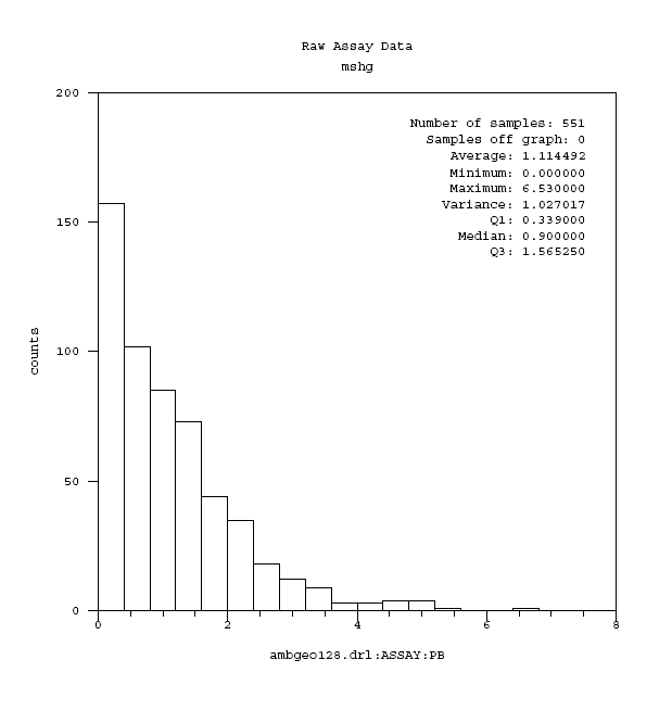
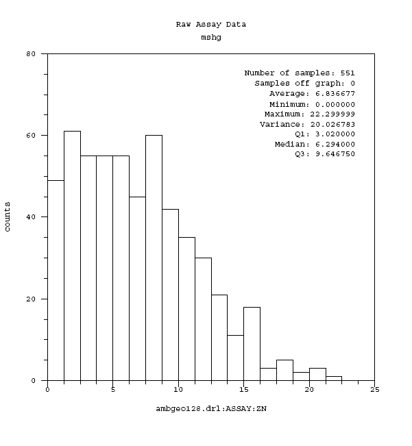
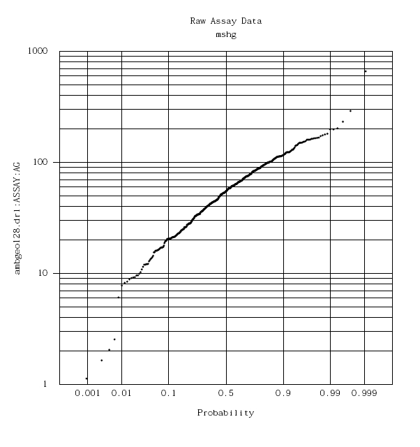
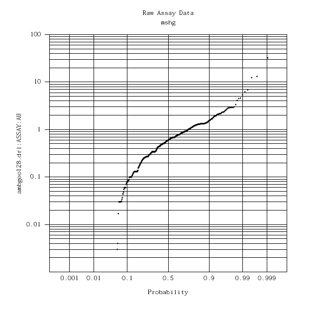
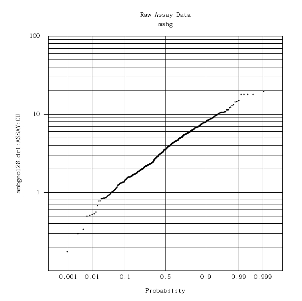
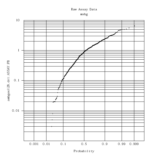
Appendix E
Variograms
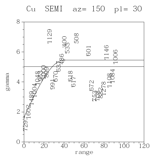
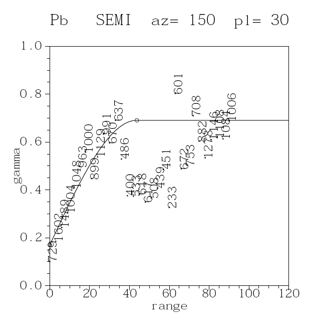
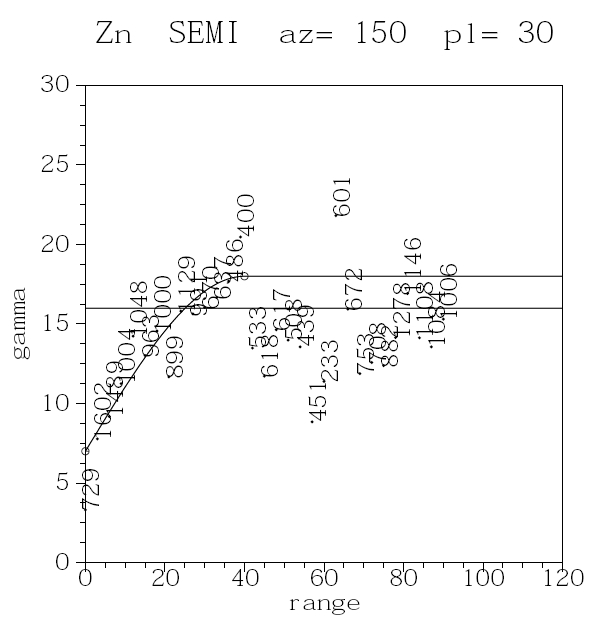
| 22 | Date and Signature Page (Item 24) |
The undersigned have duly executed the NovaGold Resources Inc., NI 43-101 Preliminary Economic Assessment, Ambler Project, Kobuk, AK with an Effective Date of May 9, 2011.
Dated this 9th Day of May, 2011.
“Signed”
_______________________________
Dr. Neal Rigby, CEng, MIMMM, PhD
Qualified Person
“Signed”
_______________________________
Russ White, P.Geo.
Qualified Person