Idaho-Maryland Mine Project, Grass Valley CA
Technical Report
Prepared for Emgold Mining Corporation
Prepared by Robert C. Pease, P.G.
Effective Date: December 8, 2009

EMGOLD MINING CORPORATION
IDAHO-MARYLAND TECHNICAL REPORT
CONTENTS
1.0
SUMMARY
1-1
1.1
Location and Ownership
1-2
1.2
Geology and Mineralization
1-2
1.3
Exploration
1-3
1.4
Metallurgical Testing
1-5
1.5
Resources
1-5
1.6
Permitting and Environmental
1-8
1.7
Conclusions
1-8
1.8
Recommendations
1-11
2.0
INTRODUCTION
2-1
2.1
Terms of Reference
2-1
3.0
RELIANCE ON OTHER EXPERTS
3-1
4.0
PROPERTY DESCRIPTION & LOCATION
4-1
4.1
Location of Surface Rights
4-1
4.2
Mineral Rights
4-4
4.3
Key Permitting and Environmental Laws
4-9
4.4
Permitting History – County Process (1993-1999)
4-10
4.5
Permitting History - City Process and DEIR Preparation (2002-2009)
4-10
4.6
Current Environmental Status (As of August 2009)
4-13
5.0
ACCESSIBILITY, CLIMATE & PHISIOGRAPHY
5-1
6.0
HISTORY
6-1
7.0
GEOLOGICAL SETTING
7-1
7.1
Regional Geology
7-1
7.2
Property Geology
7-6
7.3
Property Structural Geology
7-10
8.0
DEPOSIT TYPES
8-1
9.0
MINERALIZATION
9-1
9.1
Gold-Quartz Veins
9-1
9.2
Mineralized Black Slate Deposits
9-3
9.3
Mineralized Diabasic Slabs
9-3
9.4
Mineralized Phyllonites
9-5
10.0
EXPLORATION
10-1
10.1
Data
10-1
10.2
Data Review Results
10-2
10.3
Exploration After 2004
10-3
11.0
DRILLING
11-1
11.1
Historic Drilling
11-1
11.2
2003 / 2004 Drilling
11-1
12.0
SAMPLING METHOD & APPROACH
12-1
13.0
SAMPLE PREPARATION, ANALYSES & SECURITY
13-1
13.1
2003 – 2004 Gold Exploration Samples
13-1
13.2
Historic Gold Samples
13-3
14.0
DATA VERIFICATION
14-1
14.1
Historic Data
14-1
14.2
2003 and 2004 Data
14-1
14.3
Data Review In 2009
14-1
15.0
ADJACENT PROPERTIES
15-1
16.0
MINERAL PROCESSING & METALLURGICAL TESTING
16-1
16.1
Metallurgical Performance History
16-1
16.2
Metallurgical Testing Since 2004
16-2
17.0
MINERAL RESOURCE & MINERAL RESERVE ESTIMATES
17-1
17.1
Geologic Data Review
17-1
17.2
Resources Developed In 2007
17-8
17.3
Resource Classification and Summary
17-9
18.0
OTHER RELEVANT DATA & INFORMATION
18-1
19.0
INTERPRETATION AND CONCLUSIONS
19-1
20.0
RECOMMENDATIONS
20-1
21.0
REFERENCES
21-1
22.0
DATE & SIGNATURE PAGE
22-1
TABLES
Table 1-1:
Idaho-Maryland Project Mineral Resource Summary, March 1, 2007
1-7
Table 4-1 Summary Information From the Quit Claim Deed on Ten Parcels
4-5
Table 5-1:
Grass Valley Climatology by Month (minimum period of 30 years)
5-2
Table 11-1:
Idaho-Maryland Project 2003 and 2004 Drill Holes
11-2
Table 11-2:
Significant Gold Mineralized Intersections, 2003 – 2004 Drill Campaigns
11-4
Table 17-1:
Idaho-Maryland Project Gold Mineral Resource Summary, March 1, 2007
17-10
FIGURES
Figure 4-1:
Project Location Map
4-2
Figure 4-2 Mine Location Map
4-3
Figure 5-1:
Grass Valley Temperature Ranges (minimum period of record: 30 years)
5-2
Figure 5-2:
Grass Valley Precipitation by Month
5-3
Figure 7-1:
Regional Geology
7-2
Figure 7-2:
Regional Lithologic Units
7-3
Figure 7-3: Property Structural Geology - Plan View
7-12
Figure 7-4: Geologic Cross Section – Section No. 20 E, Looking West, Sections C - C1
7-15
Figure 7-5: Idaho Deformation Corridor
7-16
Figure 8-1:
Idaho-Maryland Mineralization Types
8-1
Figure 9-1:
Mineralized Black Slate Deposits – Br 16 Vein Area
9-4
Figure 11-1:
Drill Hole Cross Section – Looking S40E
11-6
Figure 13-1:
Sample Preparation and Assay Procedure Flowchart, Primary Laboratory
13-1
Figure 17-1:
Idaho-Maryland Project Gold Resource Locations, March 1, 2007
17-3
1.0
SUMMARY
This Technical Report on the Idaho-Maryland Mine project has been prepared for Emgold Mining Corporation (“Emgold” or “Company”) by Mr. Robert Pease, Chief Geologist for Idaho-Maryland Mining Corporation (a 100% owned subsidiary of Emgold). Mr. Pease is a Qualified Person, as defined by National Instrument 43-101, for Idaho-Maryland Mining Corporation. He is not independent but serves as the Qualified Person on the Idaho-Maryland Mine Project. The purpose of this updated Technical Report is to support information of a scientific and technical nature contained in Emgold’s annual information form. This updated Technical Report has been written to comply with disclosure and reporting requirements defined in National Instrument 43-101, Standards of Disclosure for Mineral Projects, and in compliance with Form 43-101F1 (the "Technical Reports") and Companion Policy 43-101CP (BCN).
This technical report updates and relies on two prior reports prepared for the Idaho-Maryland Mine project. The first was a Technical Report completed by Stephen Juras, Qualified Person for AMEC, in November 2002 that described the geology and gold resources of the Idaho-Maryland Mine Project. The second was a Preliminary Economic Assessment completed by Stephen Juras for AMEC in November 2004 outlining an industrial mineral resource for an industrial minerals mine and ceramics manufacturing facility as part of the Idaho-Maryland Mine Project. The ceramics project and associated ceramics resource estimate have not changed since preparation of that Preliminary Assessment, and Emgold intends to treat the ceramics project separately in a future technical report. The 2004 report also described a small increase in gold resources, updating the 2002 Technical Report.
This 2009 Technical Report updates the gold resources and other aspects of the Idaho-Maryland Mine Project since the 2004 report but does not address the industrial minerals resource or the ceramics facility. Also, this Technical Report does not include an economic assessment of either the ceramics or gold resources. Since 2004, minor changes have occurred to the Idaho-Maryland Mine Project as described in this summary and in sections of this report, including a small increase in gold resources and an update of the permitting process to reopen the Idaho-Maryland Mine through its 100% owned subsidiary, Idaho-Maryland Mining Corporation. Information and data for this report were obtained from the Idaho-Maryland project site in Grass Valley California. The past technical reports are available on SEDAR and Emgold’s website at www.emgold.com.
1.1
Location and Ownership
The Idaho-Maryland project is located 1.5 miles (2.4 km) east of Grass Valley, Nevada County, within the State of California. This property comprises approximately 2,800 acres (1,113 ha) of mineral rights and 145 acres (59 ha) of surface rights. The surface rights consist of37 acres (15 ha) of surface rights centered around the New Brunswick shaft (part of a lease option to purchase with the BET Group), 101 acres (41 ha) of surface rights west of the historic Idaho shaft (45 acres (18 ha) as part of a lease option to purchase with the BET Group and 55 acres (22 ha) owned), and 7 acres (3 ha) of surface rights centered around the Round Hole Shaft.
The majority of the mineral rights are defined as subparcels in a Quit Claim Deed. The mineral rights are restricted to a variable depth from surface and in general, are contiguous below 200 ft (60m) from surface. Emgold has an agreement with the mineral rights holders (BET Group) that includes a mining lease and option to purchase certain property rights and mineral rights as outlined above. The term of the lease agreement was originally five years commencing on June 1, 2002. The lease was extended by two years in 2007 and by a further two years in 2009. The current lease expires on February, 2011 at which time Emgold has the right to purchase the property with payments occurring over a four year period. During the term of the lease agreement, any production from the property will be subject to a 3% Net Smelter Royalty (NSR). After purchase of the property, the NSR no longer applies.
In 2005, through its subsidiary Idaho-Maryland Mining Corporation, Emgold acquired 30 acres of underground mineral rights adjacent to the mineral rights under the lease option to purchase agreement with the BET Group. These properties consist of the Golden Gate West and Golden Gate East claims, and the remaining interests in the Dana and Christopher Columbus Claim that the company did not already own.
1.2
Geology and Mineralization
The Idaho-Maryland project is a structurally controlled, mesothermal gold deposit situated in the northern portion of the Sierra Nevada Foothills Gold Belt. This belt averages 50 miles in width and extends for 320 miles in a north-northwest orientation along the western slope of the Sierra Nevada range.
The rock units underlying the Idaho-Maryland mine property include early Jurassic meta-sediments of the Fiddle Creek Complex; early Jurassic meta-volcanics and interflow sediments of the Lake Combie Complex; middle Jurassic ophiolitic assemblage of the Spring Hill Tectonic Mélange; later Jurassic Tectonic Mélange of the Weimar Fault Zone; and late Jurassic dioritic intrusives. The most important of these units for gold exploration is the Spring Hill Tectonic mélange.
Emgold developed a comprehensive geological model for the Idaho-Maryland project which was reviewed by Stephen Juras, Qualified Person for AMEC, in 2002 and again in 2004. The property hosts a structurally controlled deformation zone terminated at its eastern end by a regional fault. Within this deformation corridor, large dismembered clasts of predominantly ophiolitic igneous origin are present in a foliated serpentinite melange matrix (Spring Hill Tectonic Mélange unit). These large clasts are referred to as slabs in Idaho-Maryland company reports. Identified slabs consist of albitized (sausserite) meta-gabbro, massive antigorite serpentinite, meta-diabase, meta-diorite, slates, and basaltic to dacitic meta-volcanics. The largest slab of metavolcanic rocks on the property is the Brunswick Slab, which is 1.5 miles in length, approximately 0.6 miles in width, elongated in an eastward direction, and open at depth. This slab is interpreted to be derived from the Lake Combie Complex. All of the significant gold production from the Idaho-Maryland Mine was localized within the matrix and tectonic slabs of Spring Hill Mélange unit. Gold production in the New Brunswick Mine occurred primarily in the Brunswick Slab.
The varying styles of mineralization present at the Idaho-Maryland Project are typical of those commonly found in mesothermal lode gold deposits worldwide. At least four basic types of mineralization have been recognized to contain significant gold deposits. In order of importance, these include (1) gold-quartz veins, (2) mineralized black slate bodies, (3) mineralized diabasic slabs, and (4) altered, mineralized ultramafic schists. The veins consist primarily of quartz, which is milky white, massive to banded, sheared, and brecciated. Gold occurs as native gold, ranging from very fine grains within the quartz to leaves or sheets along fractures.
1.3
Exploration
The Idaho-Maryland Mine was discovered in 1851. During the period of 1862 to 1956, the mine produced 2.4 million ounces of gold at a grade of 0.43 opt gold grade. The mine shut down in 1956 due to the fixed price of gold at U.S. $35 per ounce and rising labor and supply costs post World War II. The mine had workings to a depth of 3,280 feet. Adjacent to the Idaho-Maryland Mine is the Empire Mine, which produced 5.8 million ounces from 1850 and 1956 and had workings exceeding 5,000 feet vertically in depth. The Grass Valley District produced in excess of 17 million ounces of gold.
The gold exploration programs were reviewed by Stephen Juras for AMEC in 2002 and 2004. The initial program consisted of an extensive geologic evaluation of the historical mine records plus additional diamond drilling from surface, made possible by the excellent and comprehensive preservation of the historical Idaho-Maryland mine and mill records. This data was used to generate a consistent, property-wide structural geology model and vein set definition and chronology. Unmined mineralization was identified along underground workings and in historical diamond drill holes. Interpretation of the updated geologic model defined new vein sets and extensions of known vein sets. These were categorized for mineral resource estimates, future exploration, and expansion. Emgold implemented many of the recommendations outlined in both AMEC reports when project funding was available.
The database to support the Idaho-Maryland mineral resource estimate contains over 36,000 gold assays, the majority of which were taken from underground samples (mostly channel samples) as part of the historic operations. Those from diamond drill holes comprise only a minor portion of the assay database. The assay data reside as handwritten entries on assay plans (1" to 50 ft) for all mine levels along with a small number recently found in log books. Drillhole assay data accompany the intercepts on these plan maps, and copies of assay certificates also are present for the final 10 years of production.
The historic samples were fire-assayed at former mine site laboratories. No records exist of any historic QA/QC program. Sample quality was inferred by the reconciliation of historic production records to underground sample data. These studies, as well as an investigation on mill-to-resource prediction completed by AMEC showed that the resource or reserve estimates consistently underestimated the amount of gold produced by milling, a discrepancy most likely reflective of sample size influence rather than laboratory technique. High nugget value deposits with coarse gold areas are best sampled with large sizes, which was not common practice at the time. Therefore, any estimates made using this historic data should include comparisons with values unadjusted and adjusted for the regular underreporting of grade (i.e., “call factor”).
In 2002, Juras stated that the comprehensive set of assay plans, supported by records of muck car stope samples and mapped geology data, as well as the detailed historical production records, all support the integrity of the assay data for the Idaho-Maryland project. These data were deemed suitable for use in mineral resource estimation. Juras also checked data transcription onto assay plans from copies of original assay certificates and from assay plan to mineral resource worksheets and concluded that the data are sufficiently free of error to be adequate for resource estimation.
In 2003-2004 surface exploration drilling programs were conducted to test the geologic model and explore the veins of the Idaho-Maryland Mine. The methods and results were reviewed by Juras for AMEC and disclosed in their 2004 report.
Since 2004 Emgold has continued evaluate the property geology and model historic data. The surface geology of the property was mapped and computerized for use in geologic modeling. The historic assay database was computerized to use in geostatistical modeling and further delineation of mineralized zones. A stope model of the location and shape of historic stopes was also completed. This information will be utilized in the next phase of work along with the vein model, which is in progress but not yet complete.
Also since 2004, new gold exploration blocks were delineated. These were exploration targets that did not meet all the criteria of resources but would be areas of potential exploration. A cutoff grade of 0.10 oz/ton Au was used to define these targets. No additional drilling has been conducted since the 2003-2004 surface drilling programs.
1.4
Metallurgical Testing
In 2006, preliminary gravity and cyanide tests were conducted using a composite of small samples of drill core rejects from the 2003-2004 surface drilling programs. Results suggested that gold recoveries would be consistent with historic mill recoveries, which were above 95 percent. In 2006 and 2007, preliminary gravity, flotation and cyanide leach tests were conducted on small samples of historic mine tailings. Gravity results indicated that gold recoveries of up to 25 percent could be attained from these pulverized mill tailings. The results of initial flotation tests suggested that 26 percent of the gold would be recovered. Cyanide soluble leach test results on the tailings varied from 47-53 percent. In 2004, gravity separation tests of old tailings and waste rock yielded gold recoveries of 70-80 percent.
1.5
Resources
In 2002, the gold mineral resources for the Idaho-Maryland property were estimated using traditional longitudinal sections and 3-D geologic models with commercial mine planning software. Juras validated the evidence for the pertinent vein/structural interpretation data support and consistency. All examples based on the underground data demonstrated good data back-up and sound projection limits. The interpretations covering the drillhole intercepts also were felt to be sound and reasonably projected. However, the latter is hampered by the uncertainty in spatial location of the drillhole intercept due to the holes not having been down-hole surveyed. Juras also checked numerous resource blocks for correct tabulation of sample values, reasonable projection limits, and volumetric and trigonometric calculations, and stated that the checked blocks were properly constructed and calculated. Specific criteria were established for mineralized blocks to be classified as resources. Those included: a) minimum true thickness of three feet for resource blocks, b) cutoff grade of 0.1 opt Au, c) mine call factor not applied to any blocks developed from muck car samples or drillholes (historic or recent), and d) mineral resources outlined by single drill hole intercepts as Inferred Resources.
In 2004, the gold mineral resource for the Idaho-Maryland property was increased slightly. The estimate used the same criteria that had been previously established and disclosed. Juras again reviewed the results for AMEC.
In 2007, the NI 43-101-compliant gold mineral resource was increased by approximately three percent, and it remains the same now. This estimate also used the same criteria that had been previously established and disclosed.
The current classified measured, indicated and inferred mineral resources are shown in Table 1-1. The Idaho-Maryland mineral resource was reported using a 0.10 oz/ton Au cut-off grade. All estimated resource blocks equal to or greater than 0.10 oz/ton Au are tabulated in the summary.
Table 1-1:
Idaho-Maryland Project Gold Mineral Resource Summary, March 1, 2007
| | | | | | |
| True Thickness
(ft) | Tonnage
(tons) | Gold Grade
(oz/ton) | Gold
(oz) | Gold Grade
(oz/ton)
1.44 MCF | Gold
(oz)
1.44 MCF1 |
Eureka Group2 | | | | | | |
Measured Mineral Resource | 6.5 | 17,000 | 0.18 | 3,000 | 0.29 | 5,000 |
Indicated Mineral Resource | 5.7 | 41,000 | 0.27 | 11,000 | 0.37 | 15,000 |
Measured + Indicated Mineral Resources | 5.9 | 58,000 | 0.24 | 14,000 | 0.34 | 20,000 |
Inferred Mineral Resources A | 9.0 | 393,000 | 0.21 | 81,000 | 0.30 | 117,000 |
Inferred Mineral Resources B | 4.8 | 49,000 | 0.37 | 18,000 | - | - |
New Inferred Mineral Resource (A) | 4.4 | 5,000 | 0.15 | 1,000 | 0.22 | 1,000 |
Idaho Group |
|
| |
| |
|
Measured Mineral Resource | 17.5 | 129,000 | 0.24 | 31,000 | 0.34 | 44,000 |
Indicated Mineral Resource | 10.6 | 209,000 | 0.42 | 88,000 | 0.60 | 125,000 |
Measured + Indicated Mineral Resources | 13.3 | 338,000 | 0.35 | 119,000 | 0.50 | 169,000 |
Inferred Mineral Resources | 10.0 | 838,000 | 0.25 | 212,000 | 0.37 | 307,000 |
New Inferred Resource (A) | 4.1 | 38,000 | 0.71 | 27,000 | 1.02 | 39,000 |
Dorsey Group |
|
| |
| |
|
Measured Mineral Resource | 11.6 | 61,000 | 0.23 | 14,000 | 0.33 | 20,000 |
Indicated Mineral Resource | 6.4 | 131,000 | 0.33 | 43,000 | 0.46 | 60,000 |
Measured + Indicated Mineral Resources | 8.0 | 192,000 | 0.30 | 57,000 | 0.42 | 80,000 |
Inferred Mineral Resources | 9.5 | 955,000 | 0.30 | 288,000 | 0.43 | 413,000 |
New Inferred Resource (B) | 3.0 | 5,000 | 2.05 | 10,000 | 2.05 | 10,000 |
Brunswick Group |
|
| |
| |
|
Measured Mineral Resource | 8.0 | 64,000 | 0.17 | 11,000 | 0.25 | 16,000 |
Indicated Mineral Resource | 6.2 | 108,000 | 0.28 | 30,000 | 0.40 | 43,000 |
Measured + Indicated Mineral Resources | 6.9 | 172,000 | 0.24 | 41,000 | 0.34 | 59,000 |
Inferred Mineral Resources | 7.3 | 291,000 | 0.23 | 67,000 | 0.33 | 97,000 |
Waterman Group |
|
| |
| |
|
Measured Mineral Resource | 70.7 | 831,000 | 0.15 | 127,000 | - | - |
Indicated Mineral Resource | 30.5 | 75,000 | 0.21 | 16,000 | - | - |
Measured + Indicated Mineral Resources | 67.3 | 906,000 | 0.16 | 144,000 | - | - |
Idaho-Maryland Project3 |
|
| |
| |
|
Measured Mineral Resource1 | 13.3 | 271,000 | 0.22 | 59,000 | 0.31 | 85,000 |
Measured Mineral Resource2 | 70.7 | 831,000 | 0.15 | 127,000 | 0.15 | 127,000 |
Indicated Mineral Resource | 8.1 | 489,000 | 0.35 | 172,000 | 0.50 | 243,000 |
Measured + Indicated Mineral Resources | 41.1 | 1,666,000 | 0.22 | 375,000 | 0.28 | 472,000 |
Inferred Mineral Resources | 9.3 | 2,526,000 | 0.26 | 666,000 | 0.38 | 952,000 |
New Inferred Resource A | 4.2 | 42,000 | 0.65 | 27,000 | 0.94 | 40,000 |
New Inferred Resource B | 3.0 | 5,000 | 2.05 | 10,000 | 2.05 | 10,000 |
Inferred Mineral Resource Total | 9.1 | 2,573,000 | 0.27 | 703,000 | 039 | 1,002,000 |
|
|
| |
| |
|
1. MCF = Mine Call Factor (not applicable to Waterman Group resources). 2. Inferred resources are divided intoA (historic data and mine call factor applied) andB (from 2003-2004 data and no mine call factor applied). 3. Idaho-Maryland measured resources are split into two categories: 1. the Eureka, Idaho, Dorsey, and Brunswick Groups, and 2. the Waterman Group (stockwork/slate type ore). 4. New inferred resources included 40,000 ounces with MCF (A) and 10,000 ounces with MCF (B).
1.6
Permitting and Environmental
The project is currently in the permitting process under the California Environmental Quality Act (CEQA) and the California Surface Mining and Reclamation Act (SMARA). The scope of the project being permitted includes dewatering, rehabilitation, exploration, operation, and reclamation of the mine. The City of Grass Valley is the Lead Agency in the permitting process and is developing an Environmental Impact Report (EIR) for the project. A Draft Environmental Impact Report (DEIR) has been completed and is being revised. It is expected the EIR will be completed near the end of 2009, subject to funding and other constraints. Subsequent to completion of the EIR, the Grass Valley City Council will vote to certify the EIR as complete and vote on a Conditional Use Permit for the project.
1.7
Conclusions
The conclusions of this updated Technical Report are as follows:
1.
Property and mineral rights purchases and changes occurred after release of the 2004 report. In 2005 Emgold acquired 30 acres of underground mineral rights, while the lease option agreement with the BET Group for mineral rights was modified. Seven acres of surface rights are being purchased. All of these changes should benefit the Idaho-Maryland Mine Project.
2.
The Idaho-Maryland Mine Project is in the process of permitting. A predecessor company had received permits to dewater and conduct underground exploration in 1996, but was not able to start due to funding problems. Emgold applied for permits in 2005 to dewater, explore and mine the property. A draft environmental impact report was prepared in 2008, reviewed by the public, and is currently undergoing revision. Presumably it will be re-circulated for public review, so finalization of this report might take another year. Once that is done, the City of Grass Valley will vote to certify the EIR, and then vote on whether or not to approve a conditional use permit for the project, which could occur before the end of year 2010.
3.
Most of the future exploration work for the Idaho-Maryland Project will take place from underground drill stations and will include geologic mapping, channel sampling of veins, and bulk sampling. Planned access for drilling would be from an exploration decline and from the New Brunswick Shaft. AMEC’s review of the geology and geotechnical drilling in 2004 concluded that the rock types in the Brunswick Slab would support a decline.
4.
The lode gold deposits on the Idaho-Maryland property are structurally controlled. Brittle-ductile contact zones, faults and tectonic slabs exist that have created conduits for mineralizing fluids and areas favorable to the deposition of gold. Historic data along with results of the 2003-2004 surface drilling programs suggests that additional gold mineralization exists on the property.
5.
In response to a recommendation in the 2002 Technical Report, surface drilling programs were conducted in 2003 and 2004 to test the geologic model on the west end of the Idaho Deformation Corridor. The results, summarized in the 2004 Preliminary Assessment Technical Report, supported the model.
6.
To assess the gold exploration potential of the Idaho-Maryland project, Juras conducted extensive reviews of pertinent geological, mining, and metallurgical data in 2002, and 2004. Unless otherwise stated, the technical conclusions of AMEC listed in the 2002 and 2004 reports remain valid for this updated Technical Report.
7.
The geologic and resource model is in the process of being updated to use in future exploration and mine planning, which will encompass geostatistical modeling. Toward this goal, the assay database has been computerized, the historic stopes have been modeled, and computer modeling of veins is in progress. This work is being done with assistance and technical review by AMEC. This work is necessary to determine which veins have sufficient mineralization and volume to be explored and developed.
8.
The geology of the Idaho-Maryland structurally-controlled gold mineralization is well understood. With the use of an extensive historic database, a comprehensive geological model for the project area has been defined. The Juras reviews in 2002 and 2004 confirmed the proper use of this geological knowledge in defining the vein sets, estimating the mineral resources, and outlining new target areas for exploration.
9.
The database to support the Idaho-Maryland mineral resource estimate contains over 36,000 gold assays, the majority of which were taken from underground samples (mostly channel samples). Those from diamond drill holes comprise a minor portion of the assay database. The assay data reside as handwritten entries on scale assay plans (1" to 50 ft) for all mine levels. AMEC had recommended that Emgold capture this assay data into electronic form (database or spreadsheet, or both) so it could be easily reproduced and/or used for comprehensive data analyses. Emgold has since completed this work.
10.
In 2009 two log books of assays were found that contain assays not listed on mine maps. They would add approximately 2000 new assays (or about 5 percent of the total). One book pertained to samples taken from the Idaho-Maryland and the other was for samples taken from the Brunswick Mine. Most assays not listed on maps appear to be footwall and hangingwall assays. The new assays have not been used in any resource calculations, however, prior to using the data, an independent review will be needed to determine if it is usable, to verify the accuracy of those specific assays listed on the maps.
11.
Because high nugget value deposits with coarse gold areas are best sampled with large samples, which was not common practice at the time the Idaho-Maryland Mine was in operation, any estimates made using this historic data should include comparisons with values unadjusted and adjusted for the regular underreporting of grade (i.e., call factor). Juras believed that the comprehensive set of assay plans, supported by records of muck car stope samples and mapped geology data, as well as the detailed historical production records, all supported the integrity of the assay data for the Idaho-Maryland project. These data were deemed suitable for use in mineral resource estimation. Juras checked the transcription of data onto assay plans and mineral resource worksheets and concluded that the data were sufficiently free of error to be adequately used for resource estimation.
12.
It was also recommended that Emgold design and carry out a program of metallurgical testwork. Using small samples of drill cores from the 2003-2004 surface drilling programs and samples of historic mine tailings, Emgold completed preliminary tests on gold recovery using gravity concentration, flotation, and cyanide. Although of limited value due to the small sample size and not representing all mineralized areas, results were in agreement with historic mill recoveries, with overall gold recoveries using gravity, flotation and cyanide being above 95 percent. Further extensive testing will have to wait until the mine is dewatered and there is access to obtain samples for metallurgical test work.
13.
AMEC had recommended that Emgold initiate a program to obtain bulk density measurements of various lithologic types and ore types as part of any planned exploration work. This work was partially completed in 2004 using representative samples that were available. Surface drill samples of Brunswick Slab meta-volcanic rocks were analyzed and had an average bulk density value (or tonnage factor) of 11.4. However, this would not be applicable to all rock types or veins on the property. Once the mine is dewatered and there is access to obtain samples for metallurgical test work, an extensive program will be required.
14.
Juras (AMEC) conducted a reconnaissance review of the distribution of gold mineralization at Idaho-Maryland. The observed distribution on cumulative probability plots showed typical lognormal trends. Each vein system does appear to have a unique grade distribution, and the higher-grade distributions (greater than 1 oz/ton (34 g/t) Au values) are an integral part of a system's population. AMEC recommended that Emgold conduct a more detailed statistical review of the gold assay data. The review, by vein system and mineralization type, would assist in future grade interpolation and in the selection of appropriate gold capping levels. Emgold staff has computerized the assay database and is continuing to model the geology. Once finished, the company will be able to complete the geostatistical analyses recommend by AMEC.
15.
The 2002 and 2004 mineral resource estimates were made using traditional longitudinal sections and 3-D geologic models created using commercial mine planning software (Vulcan® and MineSight®). Juras validated the evidence for pertinent vein/structural interpretation data support and consistency and stated that all examples based on the underground data demonstrated good data back-up and sound projection limits. The interpretations of the drillhole intercepts were also considered sound and reasonably projected. AMEC also checked numerous resource blocks for correct tabulation of sample values, reasonable projection limits, and volumetric and trigonometric calculations, and concluded that the checked blocks were properly constructed and calculated. The gold resources added in 2007 followed the same criteria previously established by Juras. All gold resources in this report are compliant with National Instrument 43-101.
16.
Only data that could be reconciled to a geologically consistent interpretation was included in the 2002 resource estimate. As a result about 25% of the data was excluded because it was not supported by a coherent interpretation. AMEC recommended that Emgold continue to work on geological interpretations in areas hosting the excluded material, which will require an ongoing effort.
17.
According to Juras (for AMEC), the mineral resource classification of the Idaho-Maryland deposits used logic that is consistent with the CIM definitions referred to National Instrument 43-101. The mineral resources were classified into measured, indicated and inferred resource categories. AMEC assessed the criteria used by Emgold for this classification and generally agreed with them. Emgold's classification protocol was amended to classify mineral resources outlined by single drillhole intercepts as inferred mineral resources and to downgrade any resource blocks that demonstrate a degree of uncertainty in the grade estimate due to the presence of numerous +1 oz/ton Au assayed samples (mostly originally measured mineral resources downgraded to indicated mineral resources). In the case of the latter condition, those blocks will remain in the downgraded resource category until such time that a proper investigation is carried out on setting appropriate grade capping levels at Idaho-Maryland.
1.8
Recommendations
The current phase of work on the Idaho-Maryland Mine Project consists of gold exploration and mine development planning using historic data. The following updated recommendations for the project address the needs to complete this phase of work:
1.
The general geologic model of the Idaho-Maryland and New Brunswick gold deposits is well understood and will be a useful exploration and development guide. Using this model and the historic data, Emgold should assess the inter-relationships of the primary and secondary veins and other mineralized zones in more detail than has been done before. This information could then be used for mine development planning. This work may take approximately three months to complete and would be accomplished by Emgold employees.
2.
Emgold’s geology staff has been preparing a computerized geologic model of the Idaho-Maryland and New Brunswick gold deposits using historic data. It is estimated that the current vein model is approximately 60 percent complete. Emgold should complete this computerized geologic model to include veins, stringer zones, mineralized wall rocks, faults, lithologic units and alteration zones, for use in mine development and exploration planning. This work could take an estimated two years to complete and would be accomplished by Emgold employees.
3.
The existing gold resource blocks and exploration targets that have been defined within the Idaho-Maryland and New Brunswick gold deposits will be very useful to guide future exploration but many (particularly above the Idaho 2000 level) are scattered throughout the deposits and therefore may not be contiguous enough for mine development. Emgold’s geology staff has been updating and computerizing the gold resource model and is currently modeling the veins, stringer zones, and mineralized wall rocks around the veins with the intent of developing a revised NI-43101-compliant gold resource estimate. One goal of the next technical report should be to delineate new and contiguous gold resource blocks within individual vein systems for use in mine planning. This report would utilize geostatistical analysis to assign grades to the veins and stringer zones, and to classify the resources as measured, indicated, and inferred. Most work can be accomplished by Emgold employees although independent consultants would be used to review and assist with the evaluation and preparation of the resource estimate and technical report.
4.
Following modeling of historic data, environmental studies and permitting, Emgold’s next phase of work would be to conduct underground exploration drilling and sampling. In preparation for this, and after completion of a new gold resource estimate and technical report, Emgold should develop a Preliminary Economic Assessment Report for a potential underground gold development and mining project. Although based on historic data, this report would provide preliminary costs on project details such as construction and/or repair of shafts and development drifts, plus exploration/development drilling and sampling. Some of the work would be accomplished by Emgold employees but independent consultants would review and assist with the preparation of the assessment. The combined reports, including both the technical report and preliminary economic assessment, would take approximately four months to complete at an estimated cost of $250,000.
5.
Emgold should continue to define gold resource blocks from historic mine and drill data to use as future exploration targets. This task would be separate from the updated resource modeling described above, because that work would be used for mine planning purposes. This exploration-focused resource definition should assume the same criteria including thickness and cutoff grade that was used in the 2002 technical report. This work would be ongoing and would be accomplished by Emgold’s technical staff.
6.
The assay log books reviewed in 2009 contain additional data not listed on assay maps. This new data has not yet been used in any resource calculations, and prior to using this data, an independent review should be conducted to determine if it is usable. At the same time independent review would verify the accuracy of those specific assays listed on the maps. This study would take approximately 80 hours to complete at an estimated cost of $10,400.
2.0
INTRODUCTION
This Technical Report has been prepared for Emgold Mining Corporation (Emgold) to support information of a scientific and technical nature contained in Emgold’s annual information form. This Technical Report is an update of information compiled in a 2002 Technical Report and a 2004 Preliminary Economic Assessment, both completed by Stephen Juras for AMEC. Since then, minor changes have occurred to the project and are described in each section of this report. The primary changes include a small increase by approximately three percent to the gold resources and progress in the project permitting. The 2004 report contained a preliminary assessment of a ceramics project in addition to definition of gold resources. The ceramics has been omitted from this report because of Emgold’s decision to treat that subject separately in a future technical report, and its intention to separate and independently finance its 100% owned subsidiary, Golden Bear Ceramics Company as a separate and independently financed company. This updated 2009 Technical Report has been written to comply with disclosure and reporting requirements defined in National Instrument 43-101, Standards of Disclosure for Mineral Projects, Companion Policy 43-101CP, and Form 43-101F1.
2.1
Terms of Reference
This report has been prepared by Robert Pease, an employee of Emgold’s subsidiary company, Idaho-Maryland Mining Corporation. Mr. Pease is also Chief Geologist and Qualified Person, as defined by National Instrument 43-101, for Idaho-Maryland Mining Corporation. He is not independent but serves as the Qualified Person on the Idaho-Maryland Project.
Information and data for the review and report preparation were obtained from the Idaho-Maryland project site where information is located and the Qualified Person is employed. Mr. Pease has access to the project data daily, and has inspected and used the historic data needed for preparation of this report. The primary sources of information are the 2002 Technical Report and the 2004 Preliminary Economic Assessment prepared by AMEC under the direction of Stephen Juras, Qualified Person for AMEC.
Permitting and land status information in Section 4 of this report were provided by the following people who are Qualified Persons and are not independent. The author is familiar with these issues and feels that the descriptions contained in Section 4 are accurate. Those people who assisted are:
·
David Watkinson, Professional Engineer (Ontario), President of Emgold Mining Corporation, provided the property description and information on the status of the permitting of the project.
·
Patricia Nelson, Registered Environmental Assessor (California), investigated and reviewed matters pertaining to permitting in the State of California.
The Idaho-Maryland project is located in Grass Valley, California. The primary standard of measurement used in this report is the U.S. Standards of Measurement, as defined by the United States Department of Commerce, National Institute of Technology (NIST), in accordance with Appendix C of NIST Handbook 44. Appropriate metric conversions have been provided in parentheses. All grades are expressed in ounces per ton using the conversion factor 1 oz/ton = 34.287 g/tonne.
3.0
RELIANCE ON OTHER EXPERTS
This review of the Idaho-Maryland project relies on the following reports, which were prepared by geological consultants who were also independent Qualified Persons:
·
Juras, Stephen, 2004, Preliminary Assessment Technical Report Idaho-Maryland Mine, Grass Valley California. AMEC report, effective date 22 November 2004.
·
Juras, Stephen, 2002, Idaho-Maryland Mine Technical Report. AMEC report, effective date November 2002.
AMEC used Information from the following reports under the assumption they were prepared by Qualified Persons:
·
James Askew Associates, Inc. (1991): Idaho-Maryland Mine, Nevada County, California – Technical Assessment.
·
D.D.H Geomanagement Ltd. (1996): Report on the Exploration Potential of the Idaho-Maryland Mine Project.
A legal report entitled "Legal Title Opinion prepared for the Core Area Properties of the Idaho-Maryland Mine Project, Grass Valley Mining District, Nevada County, California" (Galati & Associates, 1997) was relied upon for its review of title and mineral rights.
Permitting and land status information in Section 4 of this report were provided by the following people who are Qualified Persons and are not independent. The author is familiar with these issues and feels that the descriptions contained in Section 4 are accurate. Those people who assisted are:
·
David Watkinson, Professional Engineer (Ontario), President of Emgold Mining Corporation, provided the property description and information on the status of the permitting of the project.
·
Patricia Nelson, Registered Environmental Assessor (California), investigated and reviewed matters pertaining to permitting in the State of California.
4.0
PROPERTY DESCRIPTION & LOCATION
4.1
Location of Surface Rights
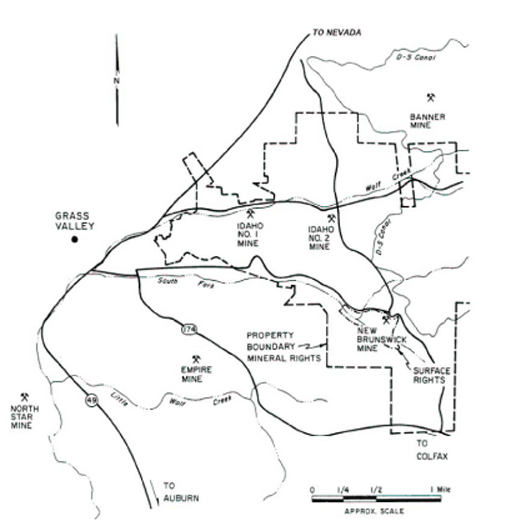
The Idaho-Maryland project property is located 1.5 miles east of the center of the City of Grass Valley, Nevada County, in the State of California (see Figures 4-1 and 4-2). The property lies primarily between the Idaho-Maryland Road, Brunswick Road, and State Route 174 and consists of
·
37 acres (15 ha) of surface rights centered around the New Brunswick Shaft (New Brunswick site),
·
101 acres (41 ha) of surface rights west of the historic Idaho #1 Shaft (Idaho-Maryland site), and
·
7 acres (3 ha) of surface rights centered around the Round Hole Shaft (also know as the Idaho #2 shaft). This property is currently being purchased.
The 101 acres (14 ha) of surface rights collectively named the Idaho-Maryland site includes a 56 acre (23 ha) parcel and an adjoining 45 acre (18 ha) parcel lying immediately to the east. The 7 acres (3 ha) at the Round Hole site are in the process of being purchased by Idaho-Maryland Mining Corporation while 56 acres (23 ha) at the Idaho-Maryland site are owned by Idaho-Maryland Mining Corporation. The 37 acres (15 ha) at the New Brunswick site and 45 acres (18 ha) at the Idaho-Maryland site are owned by the BET Group and subject to a lease option to purchase agreement between the BET Group and Idaho-Maryland Mining Corporation (see Section 4.2).
Figure 4-1:
Project Location Map
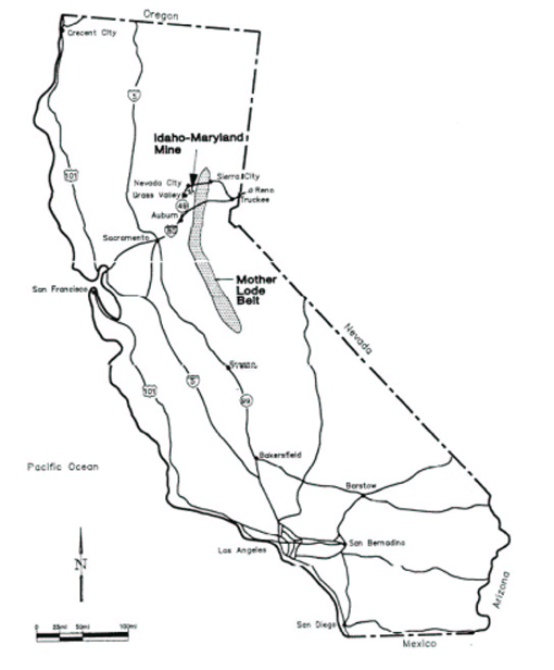
Figure 4-2: Mine Location Map
The New Brunswick Shaft at 39° 12' 42.5" N latitude and 121° 01' 03" W longitude marks the approximate center of the property. The U.T.M. coordinates of the shaft are 4,342,024 m north and 671,144 m east.
4.2
Mineral Rights
The mineral rights controlled by Emgold comprise portions of Sections 19, 29, 30, and 31 in T16N R9E and portions of Sections 23, 24, 25, 26, 36 in T16N R8E. The majority of the mineral rights are defined as sub-parcels in a Quit Claim Deed and are restricted to a variable depth from surface. In general, the rights are contiguous below 200 ft from surface. Emgold has an agreement with the mineral rights holders (BET Group) that includes a mining lease and option to purchase the 45 and 37 acre surface properties outlined in Section 4.1 and about 2,750 acres of mineral rights.
In 2005, through its subsidiary Idaho-Maryland Mining Corporation, Emgold acquired 100 percent of the 30 acres of underground mineral rights adjacent to the BET Group mineral rights. These properties consist of the Golden Gate West and Golden Gate East claims, and the remaining interests in the Dana and Christopher Columbus Claim that the Company did not already own.
The Idaho-Maryland property thus consists of approximately 2,750 contiguous acres (1,133 ha) of mineral rights. The mineral rights are defined as subparcels in a Quit Claim Deed. The subparcels are listed and described briefly in Table 4.1.
The mineral rights are severed from the surface rights at a variable depth from surface, with all mineral rights being contiguous below 200 ft (60 m) from surface.
The parcels and subparcels have been legally surveyed a number of times since the early 1900s. Emgold plans to resurvey the exterior of the claim boundary as part of the construction activities for the mine.
The lease option to purchase agreement with the BET Group was originally signed in 2002. The agreement was extended by two years in 2007 and by a further 2 years in 2009. The lease portion of the agreement expires in February 2011. At that time, the purchase part of the agreement commences, and the property can be purchased over a four year period. Lease payments in 2009 are US $30,000 per quarter. Lease payments in 2010 to the end of the lease portion of the agreement in 2011 are US $60,000 per quarter. The expected purchase price in 2011 is estimated to be approximately US $5 million.
Table 4-1 Summary Information From the Quit Claim Deed on Ten Parcels
Source: Exhibit “A”, Vol. 337, pp. 175-196 of the Official Records, Nevada County, California, as filed on June 12, 1963.
| |
Parcel No. 1: | Pertains to all minerals, gas, oil and mineral deposits of every kind and nature below a depth of 200 ft (60 m) beneath the surface except where noted. |
Reference No.:
Name: | QC 1.1 or Quit Claim, Parcel 1, subparcel 1
J.M. English Quartz Mine, Lot No. 54, SE1/4 Sec. 25, T 16 North, R 8 East, MDB&M |
Reference No.:
Name: | QC 1.2 (Parcel 1, subparcel 2).
Lucky or Agnes Quartz Mine, Lot No. 129, Sec. 25 & 36, T 16 North, R 8 East, MDB&M |
Reference No.:
Name: | QC 1.3 (Parcel 1, subparcel 3).
Union Hill Quartz Mine, Lot No. 59, Sec. 25 & 36, T 16 N, R 8 E, MDB&M |
Reference No.:
Name: | QC 1.4 (Parcel 1, subparcel 4).
Centennial Quartz Lode Mining Claim, Lot No. 106, Sec. 25, T 16 N, R 8 E, MDB&M |
Reference No.:
Name: | QC 1.5 (Parcel 1, subparcel 5).
Halphene Quartz Lode Mining Claim, Lot No. 202, Sec. 25, T 16 N, R 8 E, MDB&M |
Reference No.:
Name: | QC 1.6 (Parcel 1, subparcel 6).
”Dorothy D” Lode Mining Claim, Survey No. 5628, Sec. 25, T 16 N, R 8 E, MDB&M |
Reference No.:
Name: | QC 1.7 (Parcel 1, subparcel 7).
Morning Dew Quartz Lode Mining Claim, Lot No. 130, Sec. 25, T 16 N, R 8 E, MDB&M |
Reference No.:
Name: | QC 1.8 (Parcel 1, subparcel 8).
Howard Hill Lode Mining Claim, survey No. 4613, Sec. 25, T 16 N, R 8 E, MDB&M |
Reference No.:
Name: | QC 1.9 (Parcel 1, subparcel 9).
(portion of) Hoxie Placer Mining Claim, Lot No. 6, Sec. 25, T 16 N, R 8 E, MDB&M |
Reference No.:
Name: | QC 1.10 (Parcel 1, subparcel 10).
Cambridge Quartz Mine, Lot No. 128, Sec. 36, T 16 N, R 8 E, MDB&M |
Reference No.:
Name: | QC 1.11 (Parcel 1, subparcel 11).
Gold Blossom Quartz Mine, Lot No. 3697, Sec. 36, T 16 N, R 8 E, MDB&M |
Reference No.:
Name: | QC 1.12 (Parcel 1, subparcel 12).
(name not listed), Lots No. 1, 2, 3, 4 and 5. NE1/4 of Sec. 36, T 16 N, R 8 E, MDB&M |
Reference No.:
Name: | QC 1.13 (Parcel 1, subparcel 13).
(name not listed), Fractional west half of NE1/4 of Sec. 36, T 16 N, R 8 E, MDB&M |
Reference No.:
Name: | QC 1.14 (Parcel 1, subparcel 14).
(name not listed) NW1/4 of Sec. 31, T 16 N, R 9 E, MDB&M |
Reference No.:
Name: | QC 1.15 (Parcel 1, subparcel 15).
(name not listed) SW1/4 of Sec. 31, T 16 N, R 9 E, MDB&M |
Reference No.:
Name: | QC 1.16 (Parcel 1, subparcel 16).
Eureka Gold Mining Co.’s Claim, Lot No. 41, Sec. 26, T 16 N, R 8 E, MDB&M |
Reference No.:
Name: | QC 1.17 (Parcel 1, subparcel 17).
Tracy Quartz Lode Mining Claim, Lot No. 193, Sec. 25, T 16 N, R 8 E, MDB&M |
Reference No.:
Name: | QC 1.18 (Parcel 1, subparcel 18).
Independence Quartz Lode Mining Claim, Lot No. 120, Sec. 25, T 16 N, R 8 E, MDB&M |
| |
Reference No.:
Name: | QC 1.19 (Parcel 1, subparcel 19).
Alpha Quartz Lode Mining Claim, Lot No. 66, Sec. 25 & 26, T 16 N, R 8 E, MDB&M |
Reference No.:
Name: | QC 1.20 (Parcel 1, subparcel 20).
Black Hawk Extension Lode Mining Claim, Lot No. 4218 Sec. 25 & 26, T 16 N, R 8 E, MDB&M |
Reference No.:
Name: | QC 1.21 (Parcel 1, subparcel 21).
A.B.C. Mine, Lot No. 167 and OK Mine, Lot No. 168, Sec. 25 & 26, T 16 N, R 8 E, MDB&M |
Reference No.:
Name: | QC 1.22 (Parcel 1, subparcel 22).
Gamblers Gold and Silver Lode Mine, Survey No. 4217, Sec. 26, T 16 N, R 8 E, MDB&M |
Reference No.:
Name: | QC 1.23 (Parcel 1, subparcel 23).
(name not listed) (a) S1/2 of SE1/4; (b) NW1/4 of SE1/4; (c) S1/2 of SW1/4 and (d) NW1/4 of SW1/4 All in Sec. 24, T 16 N, R 8 E, MDB&M |
Reference No.:
Name: | QC 1.24 (Parcel 1, subparcel 24).
(name not listed) (a) N1/2 of NE1/4; (b) NE1/4 of NW1/4; (c) Lot 1 of NW1/4 of NW1/4 Sec. 25, T 16 N, R 8 E, MDB&M |
Reference No.:
Name: | QC 1.25 (Parcel 1, subparcel 25).
Kentucky Quartz Mine, Lot No. 133, Sec. 25 & 26, T 16 N, R 8 E, MDB&M |
Reference No.:
Name: | QC 1.26 (Parcel 1, subparcel 26).
Idaho No. 1, Idaho No. 2, Idaho No. 3, Idaho No. 5, Idaho No. 6, Idaho No. 7, Idaho No. 11, Idaho No. 12, Maryland No. 22, Maryland No. 23, Maryland No. 24, Maryland Fraction, Maryland Extension Fraction, Gold Point Fraction and Gold Point Extension Lode Mining Claims, Survey No. 5514, Sec. 25 & 26, T 16 N, R 8 E, MDB&M |
Reference No.:
Name: | QC 1.27 (Parcel 1, subparcel 27).
(name not listed) (a) SW1/4 of NE1/4, (b) SE1/4 of NE1/4, Sec. 25, T 16 N, R 8 E, MDB&M |
Reference No.:
Name: | QC 1.28 (Parcel 1, subparcel 28).
Baby Lode Claim and Pinafore Lode Claim, Survey No. 4216, Sec. 25, T 16 N, R 8 E, MDB&M |
Reference No.:
Name: | QC 1.29 (Parcel 1, subparcel 29).
Maryland Consolidated Quartz Mining Claim comprising Maryland Lode, Lot No. 144, Maryland Extension Location Lode, Lot No. 145 and Maryland Extension Mill Site Claim, Lot No. 146, Survey No. 2535, Sec. 25, T 16 N, R 8 E, MDB&M |
Reference No.:
Name: | QC 1.30 (Parcel 1, subparcel 30).
Maryland Extension Quartz Mine Lode, Survey 3679, NE1/4 of SE1/4 of Sec. 25, T 16 N, R 8 E, MDB&M |
Reference No.:
Name: | QC 1.31 (Parcel 1, subparcel 31).
Gold Point Consolidated Gold and Silver Mining Company’s Lode Mining Claim, Lot No. 107, survey No. 1892, Sec. 25, T 16 N, R 8 E, MDB&M |
Reference No.:
Name: | QC 1.32 (Parcel 1, subparcel 32).
Idaho Mill Site Claim, Lot No. 138, Sec. 26, T 16 N, R 8 E, MDB&M |
Reference No.:
Name: | QC 1.33 (Parcel 1, subparcel 33).
East Eureka Lode Mining Claim, survey No. 5515, Sec. 25 & 26, T 16 N, R 8 E, MDB&M |
Reference No.:
Name: | QC 1.34 (Parcel 1, subparcel 34).
Idaho Mining Company’s Claim, Lot No. 38, Survey No. 24, Sec. 26, T 16 N, R 8 E, MDB&M |
Reference No.:
Name: | QC 1.35 (Parcel 1, subparcel 35).
(name not listed), Lot No. 13, Sec. 25, T 16 N, R 8 E, MDB&M |
| |
Reference No.:
Name: | QC 1.36 (Parcel 1, subparcel 36).
Grant Quartz Mine Claim, Lot No. 62, Survey No. 634, Sec. 25 & 26, T 16 N, R 8 E, MDB&M |
Reference No.:
Name: | QC 1.37 (Parcel 1, subparcel 37).
(portion of) Hoxie Placer Mining Claim, Lot No. 5, SE1/4 of Sec. 25, T 16 N, R 8 E, MDB&M |
Reference No.:
Name: | QC 1.38 (Parcel 1, subparcel 38).
Roannaise Lode, Lot No. 116, Sec. 23 & 26, T 16 N, R 8 E, MDB&M |
Reference No.:
Name: | QC 1.39 (Parcel 1, subparcel 39).
Schofield Lode, Lot No. 37, Sec. 25 & 26, T 16 N, R 8 E, MDB&M |
Reference No.:
Name: | QC 1.40 (Parcel 1, subparcel 40).
Morehouse Quartz Mine, Lot No. 53, Sec. 26, T 16 N, R 8 E, MDB&M |
Reference No.:
Name: | QC 1.41 (Parcel 1, subparcel 41).
”Lot Numbered Three” in NE1/4 and “Lot Numbered Seventeen” in NW1/4 of Sec. 26, T 16 N, R 8 E, MDB&M |
Reference No.:
Name: | QC 1.42 (Parcel 1, subparcel 42).
Lots Numbered 5 & 7 in NE1/4 of Sec. 26, T 16 N, R 8 E, MDB&M |
Reference No.:
Name: | QC 1.43 (Parcel 1, subparcel 43).
(name not listed), Lot No. 9 of NE1/4 of SW1/4 and portion of NW1/4 of SE1/4 of Sec. 26, T 16 N, R 8 E, MDB&M |
Reference No.:
Name: | QC 1.44 (Parcel 1, subparcel 44).
strip of land 40 ft on either side of centerline of Nevada County Narrow Gauge Railway, NE1/4 of SW1/4 of Sec. 26, T 16 N, R 8 E, MDB&M |
Reference No.:
Name: | QC 1.45 (Parcel 1, subparcel 45).
(name not listed), area is in NW1/4 of Sec. 25, T 16 N, R 8 E, MDB&M |
Reference No.:
Name: | QC 1.46 (Parcel 1, subparcel 46).
(name not listed), Lot 3, NW1/4 of Sec. 25, T 16 N, R 8 E, MDB&M |
Reference No.:
Name: | QC 1.47 (Parcel 1, subparcel 47).
(name not listed), SE1/4 of SE1/4 of NE1/4 of Sec. 26, T 16 N, R 8 E, MDB&M |
Reference No.:
Name: | QC 1.48 (Parcel 1, subparcel 48).
(name not listed), Lot 1, portions of NE1/4 of NE1/4 and N1/2 of NE1/4 of Sec. 30, T 16 N, R 9 E, MDB&M |
Reference No.:
Name: | QC 1.49 (Parcel 1, subparcel 49).
(name not listed), Lot 4 in SW1/4 and SE1/4 of SW1/4 of Sec. 19, T 16 N, R 9 E, MDB&M |
Reference No.:
Name: | QC 1.50 (Parcel 1, subparcel 50).
(name not listed), Lot 2 of NW1/4 and SE1/4 of NW1/4; Lots 3 & 4 in SW1/4, NE1/4 of SW1/4 and W1/2 of SE1/4 of SW1/4, N1/2 of SE1/4 and S1/2 of NE1/4, all in Sec. 30, T 16 N, R 9 E, MDB&M |
Reference No.:
Name: | QC 1.51 (Parcel 1, subparcel 51).
Reservoir Site, area of SW corner of Sec. 30, T 16 N, R 9 E, MDB&M |
Reference No.:
Name: | QC 1.52 (Parcel 1, subparcel 52).
portion of Biggs Placer, Lot No. 46, Survey No. 283, Sec. 36, T 16 N, R 8 E, MDB&M |
Reference No.:
Name: | QC 1.53 (Parcel 1, subparcel 53).
Champion Lode Mining Claim, Survey No. 4826, in Sec. 1, T 15 N, R 8 E, and Sec. 35, T 16 N, R 8 E, MDB&M |
| |
Reference No.:
Name: | QC 1.54 (Parcel 1, subparcel 54).
Josephine Lode Mining Claim, Survey No. 4638, in Sec. 1, T 15 N, R 8 E, and Sec. 35, T 16 N, R 8 E, MDB&M |
Reference No.:
Name: | QC 1.55 (Parcel 1, subparcel 55).
Christopher Columbus Consolidated Quartz Mining Claim,
An undivided 3/10th interest, Lots 224 & 225, Survey No. 3399, Sec. 25 & 26, T 16 N, R 8 E, MDB&M |
Parcel No. 2: | Lots 2, 4A and 4B, Block 9, Townsite of East Grass Valley; mineral rights below 100 ft except Lot 4B, Block 9 which has mineral rights below 35 ft from surface. |
Parcel No. 3: | Portion of NE1/4 of SW1/4 of Sec. 26, T 16 N, R 8 E, MDB&M; mineral rights below 100 ft from surface. |
Parcel No. 4: | W1/2 of SW1/4 of SE1/4 of Sec. 30, T 16 N, R 9 E, MDB&M; mineral rights below 75 ft from surface. |
Parcel No. 5: | S1/2 of SW1/4 of Sec. 29, and SE1/4 of SE1/4 of Sec. 30, T 16 N, R 9 E, MDB&M; mineral rights below 75 ft from surface. |
Parcel No. 6: | E1/2 of NW1/4 of NE1/4 and E1/2 of N1/2 of SW1/4 of NE1/4 of Sec. 31, T 16 N, R 9 E, MDB&M; mineral rights below 75 ft from surface. |
Parcel No. 7: | N1/2 of Lots 7 & 8 and Lots 9 & 10 in Sec. 6, T 15 N, R 9 E, and E1/2 of SE1/4 of Sec. 36, T 16 N, R 8 E, MDB&M; mineral, gas and oil rights below 100 ft from surface. |
Parcel No. 8: | Portion of Lot 46 on Survey 283 (Biggs Placer Mining Claim) on portions of Sec. 35 & 36, T 16 N, R 8 E, and on Sec. 1, T 15 N, R 8 E, MDB&M; an undivided 3/5th interest in mineral rights below 100 ft from surface. |
Parcel No. 9: | NW1/4 of SW1/4 of Sec. 36, and NE1/4 of SE1/4 of Sec. 35, T 16 N, R 8 E, MDB&M; an undivided 3/10th interest in all gold and precious metal rights below 100 ft from surface. |
Parcel No. 10: | SE1/4 of SE1/4 and SW1/4 of SE1/4 of Sec. 36, T 16 N, R 8 E, MDB&M; an undivided 9/35th interest in all gold and precious metal rights below 100 ft from surface. |
Note: Variations in the crown pillar for the subparcels of Parcel 1 are not included in the table. They are as follows: 1, 6, 9, 18, 37: surface rights to 75 ft • 1, 6, 9: surface rights to 75 ft • 1, 6, 9, 14, 15, 18, portion of 26: to 75 ft • 1, 6, 9, 12: surface rights to 75 ft • 3, 5, 12: surface rights to 75 ft • 14: not to interfere with agricultural use • 14: surface rights to 75 ft • 15: no mineral rights to Nevada Irrigation Dist • 15, 50: surface rights to 75 ft • 15: surface rights to 75 ft • 15: surface rights to 75 ft • 19, 23, 24, 25: surface rights to 75 ft • 16, 38, 41, 42 (Lot 5): surface rights to 75 ft • 17, 21, part 26, 28: mineral rights to surface • 20, 21, 22, part 26, 39, 42, 43, 44, 46, 47: surface right to 100 ft but with right to mine mineral without disturbing the surface • 22, part 26: mineral rights to surface • 23: surface rights to 75 ft • 23: surface rights to 75 ft without disturbing the surface • 23: surface rights to 75 ft • 24, 25: surface rights to 75 ft • part 26: mineral rights to surface • 33: surface rights to 75 ft • 38: surface rights to 75 ft • 38: surface rights to 75 ft • 40, 42 (Lot 5): mineral rights to surface • 41: mineral rights to surface • 41: change of surface owner • 42: surface rights to 75 ft • 43: mineral rights to surface • 43: change of surface owner • 44: surface rights to 50 ft but with right to mine without disturbing surface • 48: surface rights to 75 ft but with the right to explore and mine with the surface owner’s permission • 50: surface rights to 75 ft but with the right to explore and mine with the surface owner’s permission • 50: defines a 385.316 acre block • 9, 18, 37: surface rights to 75 ft but with the right to explore and mine with the surface owner’s permission • 55: surface rights to 50 ft for (a); 75 ft for (b) and 75 ft for (c) • 55: that portion of Christopher Columbus Treasury Lode Claim No. 225 that may overlap Alpha Quartz Lode Mining Claim, Lot No. 66 • 1, 2, 3, 4, 5, 10, 12, 14, 26: mineral rights to surface.
Note 2: For parcels and subparcels where no name is listed, these are generally patented lands other than mining claims, and no mining claim name has ever been given to them.
4.3
Key Permitting and Environmental Laws
The following environmental regulations are applicable to the proposed project: the California Environmental Quality Act (CEQA, 1970), Surface Mining and Reclamation Act (SMARA, 1975), Clean Water Act (CWA, 1972), and Clean Air Act (CAA, 1972). These laws, their respective purposes, and their applicability to the project are briefly described below.
California Environmental Quality Act (CEQA)
CEQA is regarded as the foundation of environmental law, regulation and policy in California. Its primary objectives are to disclose to decision-makers and the public the significant environmental effects of a proposed development and identify ways to avoid, reduce or mitigate environmental impacts.
Surface Mining and Reclamation Act (SMARA)
SMARA was enacted to respond to the need for a continuing supply of mineral resources, while preventing damage from mining activities to public health, property, and the environment. The following activities are subject to SMARA: prospecting and exploratory activities, dredging and quarrying, streambed skimming, borrow pitting, and stockpiling of mined materials.
Mining may begin after a lead agency approves the mining permit and a plan for returning the land to a usable condition; this plan is referred to as aReclamation Plan and is required for surface and subsurface mining operations. In addition, a prerequisite to mining activities is the applicant’s proof of financial assurances to guarantee costs of reclamation (e.g., surety bonds, irrevocable letters of credit, or trust funds).
Clean Air Act (CAA)
The CAA was first passed to improve the air quality in the United States and has subsequently been amended to set limits on the discharges of certain pollutants. The CAA includes a permit program for larger stationary or point sources that release pollutants into the air. Permits to Construct and Permits to Operate will be required for stationary and point sources of emissions for exploration and mining.
Clean Water Act (CWA)
CWA was enacted to restore and maintain the quality of US waterways. The General Permit includes provisions for developing a Storm Water Pollution Prevention Plan (SWPPP) to maximize the potential benefits of pollution prevention and sediment and erosion control measures at construction sites. An NPDES (National Pollution Discharge Elimination System) Permit will also be required to allow discharge of treated mine water from the site.
4.4
Permitting History – County Process (1993-1999)
Emgold first became involved in the Idaho-Maryland Project in 1993. The current project is a successor to a project that was originally proposed by Emperor Gold Corporation (Emperor), a publicly listed, Canadian company. Emperor changed its name to Emgold Mining Corporation in August 1997. The prior project included dewatering and gold exploration activities at the Idaho-Maryland Mine which were proposed to occur from the New Brunswick site and use the nearby Sierra Pacific Industries, Inc. property as part of the infrastructure for the project. After completion and certification of the Final Environmental Impact Report for that project in October 1995, the County approved the project and issued to Emperor a Conditional Use Permit (CUP) in January 1996.
Following the issuance of the CUP, Emgold worked to obtain a National Pollution Discharge Elimination System (water discharge) permit and other operating permits required to implement the prior project. During this period the world gold price began to fall as central banks elected to sell their gold reserves and purchase U.S. Treasury bonds. The price of gold fell from around $400 per ounce in 1996 to a low of about $260 per ounce in 2001 due to the influx of gold into the world market. As a result, the project was put in care and maintenance for several years hoping gold prices would recover. In 1999, with a continuing decline in the price of gold and the collapse of capital markets, the company dropped its lease option to purchase the property and temporarily abandoned the project until gold prices recovered and a revised option agreement with the BET Group could be renegotiated.
4.5
Permitting History - City Process and DEIR Preparation (2002-2009)
In 2002, with a return of the price of gold, Emgold, through its 100%-owned subsidiary Idaho-Maryland Mining Corporation, acquired a revised lease option to purchase the Idaho-Maryland and New Brunswick sites, including 2,750 acres of subsurfacemineral rights. In 2003, Emgold initiated a new permit process with the City of Grass Valley (“City”) for the Idaho-Maryland project.
In July 2004, after conferring with the City and Nevada County government officials, Emgold submitted a Conceptual Development Review Application with the City so that initial concerns and considerations about the project could be addressed. The following five applications were submitted in April 2005: Formal Development Review, Mineral Project Application (prepared in accordance with the SMARA, General Plan Amendment, Rezone/Prezone, and Annexation. These applications were accepted as complete by the City in May 2005. The acceptance of the applications meant that the City could proceed with the applications’ evaluation in accordance with the California Environmental Quality Act (CEQA) and Surface Mining and Reclamation Act (SMARA).
In July 2005, the City approved reimbursement agreements with Emgold to allow independent consultants to be retained by the City to assist and to advise them in the preparation of the EIR and also to reimburse the City’s administrative costs associated with EIR development. In November, 2005, Environmental Science Associates (ESA) and other specialized consultants were retained by the City to prepare the EIR under the direction of City staff. The City elected to divide the permitting process into three phases:
1)
Master Environmental Assessment (MEA)
2)
Initial Study (IS), and
3)
EIR
The City and County entered into a Memorandum of Understanding (MOU) in May 2006. Under the MOU, the City is the Lead Agency for CEQA and SMARA compliance and has primary responsibility for completing and certifying the EIR, approving the reclamation plan, issuing the Conditional Mine Use Permit, and approving the entitlements for the project.
The CEQA Guidelines Section 15169 defines the general purpose of an MEA as an informational document which may contain an inventory or database for all or a portion of the territory for which a public agency has control, and which may be used or referenced in EIRs or Negative Declarations. An MEA is typically completed for projects affecting a regional area or area of the State, however, CEQA does not specify requirements for the content, format, or procedures for development of an MEA. The MEA for this project was an additional step required by the City to enable public scoping of potential environmental impacts associated with the project prior to the EIR being prepared.
The MEA process included identification and gathering of existing information and reports. As the lead consultant, ESA and its sub-consultants conducted an independent peer review of the IMMC permit application documents, 1995 Project EIR and supporting technical information from which data gaps were identified and information was requested from the applicant to address these gaps. During this review phase, an inventory of regulatory requirements and a review of applicable City and County plans and policies were also performed. In addition, local, state, and federal agencies were contacted and requested to participate in the MEA process so their comments could be addressed in the IS and EIR.
The MEA was prepared in the format of an “expanded” IS using the Environmental Checklist found in Appendix G of the CEQA Guidelines. For each resource area, the potential impacts of the proposed project were assessed using the existing application documents and other available data and studies. For some resource areas (e.g., biological resources, cultural resources, noise, etc.), limited field reconnaissance and/or other analyses were conducted to support the IS or to determine if additional studies would be required to support the CEQA process. The MEA, published in June 2006, outlined items to be addressed in the EIR as well areas where additional information was necessary to support development of the EIR.
Upon review of the MEA, Emgold elected to make revisions to its project applications to address community and agency comments received from the Emgold community workshops and lessen or avoid potentially significant impacts identified in the City’s MEA process. In May 2007, the revised project applications were submitted to the City and in June 2007, the documents were accepted by the City as complete. In July 2007 the City began developing the IS.
An IS was prepared to focus on analysis of the revised project description and application documents, including additional supporting technical documents. On September 7, 2007, pursuant to the CEQA (Public Resources Code Section 21080.4) and the State CEQA Guidelines (Section 15082(a)), the City provided a Notice of Preparation (NOP) for the proposed project to inform responsible and trustee agencies as well as other interested parties that an EIR would be prepared for the proposed project. The NOP and IS were released concurrently and available for public review and comment for 33-days from September 7, 2007 to October 9, 2007.
The EIR process for the proposed project commenced in October, 2007. During the EIR process, the City conducted four pubic workshops for the purpose of scoping project issues. On December 12, 2007, the City conducted a public workshop on geology, groundwater, and general project considerations. On January 23, 2008, the City conducted a public workshop on water quality, hazardous materials, public services, and general questions. On February 13, 2008, the City conducted a public workshop on reclamation plans, financial assurances, and general questions. Finally, on March 12, 2008, the City conducted a public workshop on traffic, project alternatives, cumulative impacts, and general questions.
In October, 2008, the City approved a new Public Outreach Policy for large projects, such as the proposed project. The Policy outlined a the number and types of meetings to consider large projects to go through the Planning Commission and City Council, which would be in addition to those already conducted for the proposed project, prior to certification of an EIR or approval of entitlements.
The Draft EIR for the project was completed in October, 2008. The public comment period for the Draft EIR commenced October 30, 2008 and was completed January 20, 2009. The public comment period was extended by the City from 45 days to 87 days to ensure adequate time was given for public comment. The extended timeframe took into account the Christmas and New Years holiday and allowed sufficient time for new City Council members and Planning Commissioners to assume their positions and become familiar with the proposed project after the November 4, 2008 election.
As part of the review of the Draft EIR, the Planning Commission completed its second site visit to the Idaho Maryland project on October 12, 2008. The site visit was attended by approximately 75 members of the public and representatives of IMMC.
On November 12, 2008, a joint study session was completed between the Planning Commission and City Council to provide an informal overview of the Draft EIR, summarize key public issues, and discuss public outreach steps. On November 28th, a public workshop/informal open house was conducted. Also on November 28, 2008, a formal public meeting was held to provide a formal presentation on the EIR and answer questions from the public.
On January 6 and January 20, 2009, the Planning Commission conducted formal public meetings to take comment on the Draft EIR. The public comment period was formally closed on January 20, 2009.
4.6
Current Environmental Status (As of August 2009)
The City, its consultants, and Emgold are currently reviewing the comments obtained during the public comment period for the Draft EIR. Meetings are being held with applicable state, local, and federal agencies to address any concerns they expressed in the public comment period. Responses to comments are being generated. Plans are to finalize the Draft EIR or alternatively complete a Revised Draft EIR and recirculate it for comment prior to moving forward. Following this, the EIR would eventually be certified and the City would vote on a Conditional Mine Use Permit for the project. If granted, Emgold could then move forward with final accessory permitting and engineering for dewatering, rehabilitation, exploration, and operation of the mine.
5.0
ACCESSIBILITY, CLIMATE & PHISIOGRAPHY
The Idaho-Maryland project is located in western Nevada County, east of the City of Grass Valley and south of Nevada City. Grass Valley and Nevada City are Sierra Nevada foothill communities located approximately 20 miles (32 km) north of Auburn and approximately 55 miles (89 km) northeast of Sacramento. State highways 174, 49 and 20 connect the Grass Valley/Nevada City area regionally.
The Idaho-Maryland property is located 1.5 miles from the center of Grass Valley, Nevada County, in north central California. The property comprises approximately 2,800 acres of mineral rights and 145 acres of surface rights. State Highway 20/49 passes approximately 1 mile to the west and northwest of the property.
The Idaho-Maryland property is at an elevation of approximately 2,650 ft above mean sea level. The area is in the foothills of the Sierra Nevada range and the project site exhibits moderate topographic relief.
Streams include Wolf Creek which flows from east to west along the northern boundary of the property, and South Fork of Wolf Creek, which runs from east to west along the southern edge of the property.
The Grass Valley/Nevada City area enjoys a mild climate year round. January average daytime and night-time temperatures are 54 and 32°F respectively, and the July average daytime and night-time temperatures are 90°F and 57°F respectively. Annual precipitation averages 53" with most of the rainfall occurring between November and March. Monthly average temperature and precipitation data is presented in Table 5-1 and Figures 5-2 and 5-3. Snow occurs only two to four times each winter, with accumulations of 2" to 12" per event and rarely remains for more than three or four days.
The Idaho-Maryland site is mostly wooded with some open grassy areas. The Round Hole site is mostly wooded while the New Brunswick site is partially wooded with open grassy areas. The primary vegetation in the area includes Madrone, Western Red Cedar, Douglas Fir, Bigleaf Maple, Black Oak, Manzanita, California Coffeeberry, Currant, and Honeysuckle. Vegetation in the wet meadow areas includes Bromegrass, Yellow foxtail, rye, beak rush, fescue, bulrush, rush, smooth brome, and Orchard grass.
An electric transmission line belonging to the Pacific Gas and Electric Company traverses the South Fork valley.
Table 5-1:
Grass Valley Climatology by Month (minimum period of 30 years)
| | | | | |
| Temperature | Average | Cumulative |
| Average | Average | Mean | Precipitation | Precipitation |
Month | High (°F) | Low (°F) | (°F) | (inches) | (inches) |
January | 53 | 42 | 42 | 9.86 | 9.86 |
February | 55 | 44 | 44 | 9.21 | 19.07 |
March | 57 | 46 | 46 | 8.52 | 27.59 |
April | 63 | 51 | 51 | 3.69 | 31.28 |
May | 70 | 58 | 58 | 1.97 | 33.25 |
June | 79 | 65 | 65 | 0.62 | 33.87 |
July | 87 | 71 | 71 | 0.18 | 34.05 |
August | 86 | 70 | 70 | 0.23 | 34.28 |
September | 81 | 65 | 65 | 1.10 | 35.38 |
October | 71 | 57 | 57 | 2.72 | 38.10 |
November | 58 | 47 | 47 | 7.08 | 45.18 |
December | 53 | 31 | 42 | 7.89 | 53.07 |
Average | 68 | 54 | 55 | 4.42 |
|
Total | | | | 53.07 |
|
Figure 5-1:
Grass Valley Temperature Ranges (minimum period of record: 30 years)
![[technical004.gif]](https://capedge.com/proxy/20-F/0001137171-13-000218/technical004.gif)
Figure 5-2:
Grass Valley Precipitation by Month
![[technical006.gif]](https://capedge.com/proxy/20-F/0001137171-13-000218/technical006.gif)
6.0
HISTORY
Gold was discovered on the Idaho-Maryland property in 1851. Mining started in 1862, and gold production continued with few interruptions until closure in 1954. From 1954 to 1957, gold mining was replaced by government-subsidized tungsten production. The mine produced a total of 2,383,000 oz of gold from 5,546,000 tons of ore for an average grade of 0.43 oz/ton. Idaho-Maryland remains the second-largest historical underground producer of gold in California.
The Grass Valley Mining district has been the most productive gold area in the State of California. The mines in the district were known in California as the “Northern Mines” because they were not considered part of the Mother Lode gold belt. The first and second largest underground gold producing mines in the state, the Empire and Idaho-Maryland, are located about 2 miles (3 km) apart within the district.
The original claim on the Idaho-Maryland property was staked in 1851. High-grade gold mineralization was discovered in 1861 with the commencement of mining in 1862. All production during this time was from a single vein referred to as the Idaho Number 1 Vein. Production from 1862 to 1893 produced 1.0 million ounces of gold from 1.0 million tons of ore. Fire destroyed the Idaho mine hoist in 1894, which caused the lower mine workings to flood. The period from 1894 to 1914 saw intermittent gold production (approximately 75,000 ounces).
The claims around the deposit were consolidated in 1915 to form the Idaho-Maryland Mine. Metals Exploration Company of New York acquired control of the property, dewatered the mine, deepened the Idaho shaft to 2,000 ft (610 m) and moved the Union Hill stamp mill to the Idaho shaft area. Full production, however, was never achieved (only 27,000 ounces gold recovered). Control over the property changed in 1926 when Errol MacBoyle and Edwin Oliver created holdings that included the Idaho-Maryland, Brunswick, and Morehouse mines. Production commenced the same year.
From 1926 to 1942 the Idaho Mine produced 650,000 ounces of gold from 1.1 million tons of ore. The Brunswick Mine restarted production in 1934 after deepening its shaft to 3,460 ft and constructing a 750 t/d mill. Production from 1934 to 1955 consisted of 810,000 ounces of gold from 3.6 million tons of ore.
The mines were closed in 1942, due to the enactment of the Federal War Production Boards Limitation Order L-208, and were reopened again in 1945. Production was hampered by depleted operating funds, rising costs, skilled labor shortages, and negligible exploration and underground development work. Gold mining ceased in
1954, being briefly replaced by government-subsidized tungsten production until 1957. Mining activity stopped altogether in 1957.
Two mills were operated on the property in the 1930s through 1950s, the Idaho mill and the New Brunswick mill. Both incorporated crushing, grinding, gravity separation, sulfide flotation, and gold smelting/refining. The Idaho mill also had a cyanidation plant and Merrill-Crowe recovery circuit to treat flotation concentrates and flotation tails sands. Flotation concentrate from the New Brunswick mill was also processed in the Idaho cyanidation circuit.
Historical production records from the 1930s and 1940s indicate overall gold recoveries ranging from 93.8% to 97.2% using gravity recovery, flotation of gravity tails, and cyanidation of flotation concentrate and flotation tails sands. Of the total gold produced during this period, recovery in the gravity circuit ranged from 61% to 69%. In the flotation circuit, recoveries ranged from 30% to 37%. Approximately 1.3% of the total gold recovered was via sands cyanidation. Gravity recovery methods used at the time included riffles, amalgamation plates and barrels, shaking tables, vanners, and jigs.
The “million ounce” stope in the Idaho No. 1 Vein was mined between 1862 and 1893 and reportedly required heavy timbering for support due to problematic ground conditions. Much better ground conditions were experienced at the Brunswick mine, where the primary mining method was shrinkage stoping. At Brunswick, the stopes were developed by drifting on ore for their entire length, and then draw raises were developed upwards for approximately 20 ft and coned out to connect them together. Chutes were installed in the throat of the raises to load ore directly into the mine cars. Where ground support was required within the stopes, small pillars either were left in place or strategically placed timber posts were used. Flat-lying stopes were mined using the room-and-pillar method, and scraper hoists were used to transport ore to the track drift horizon.
In 1991, the three-compartment, 3,460 ft deep New Brunswick vertical shaft was inspected throughout its entire length by remote underwater cameras and probes. The timbers appeared to be in reasonable condition, except for the sections above the waterline. This shaft provided access to the Idaho-Maryland’s 34 working levels. Most access drifts were 5 ft x 7 ft in cross-section, while the main haulage drifts were 6 ft x 8 ft. Hoisting is reported to have been accomplished with 6-ton skips.
The Round Hole shaft is a vertical, 5 ft diameter circular shaft, core-drilled to a vertical depth of 1,125 ft. This shaft was used for ventilation and to transport men and mine supplies, and is thought to still be open.
Significant volumes of sand tailings were placed underground in the New Brunswick Mine as hydraulic backfill. Information from Idaho-Maryland Mine Monthly Mining and Development reports from years 1949 through 1950 and Clark (2005) indicate that 5,400 tons of hydraulic sand backfill was deposited in the New Brunswick Mine in the year 1946, and 99,000 tons was pumped underground through February, 1950. According to a former employee who worked at the mine for many years prior to closure, the backfill was used to fill various open stopes so that overlying ore could be accessed and mined. Stope productivity was reported to be low, on the order of 3 tons to 4 tons per shift.
Surface tailings were contained in shallow ponds typically 5-10 feet deep and most were deposited directly over native soil. It appears that most of these ponds were situated on the western side of the property. The largest of the known tailings impoundments was situated adjacent to Wolf Creek, and covered an area of approximately nine acres.
Mining activities were curtailed in 1956 as labor costs were rising and the price of gold was fixed at $35/oz.
More recent exploration at the Idaho-Maryland project conducted over the period of 1993 through to 2009 has consisted of an extensive geologic evaluation program and core drilling. This geologic data evaluation program was possible because of the excellent and comprehensive preservation of the Idaho-Maryland mine and mill records. These data are exhaustive and essentially complete, and were used to generate a consistent, property-wide structural geology model and vein set definition and chronology.
The available key historic data consisted of:
·
3,200 mine maps and drawings, including 1,257 linen maps (1" = 50 ft assay plans, geology plans and stope plans, 1" = 100 ft geologic cross-sections), with exploration drill hole geology and assays plotted
·
1,100 photographs (surface and underground)
·
monthly development reports for 1921 to 1956
·
monthly geological summary reports for 1936 to 1942
·
eight ledgers of development and stope sampling assays
·
assay reports of diamond drilling, channel samples, and muck car samples
·
general manager's and mine superintendent's reports for 1947 to 1953
·
mill production reports and cost summaries for 1934 to 1956.
At the time of closure, the mine was owned by Idaho-Maryland Industries, Inc. In 1963 Idaho-Maryland Industries executed a Quit Claim Deed to William and Marian Ghidotti. Ownership of the mineral rights eventually passed to Mary Bouma, Erica Erickson, and William Toms (referred to as the BET Group) in 1983.
Emperor Gold Corporation (Emperor), a publicly listed, Canadian company became involved in the property in 1993. Emperor changed its name to Emgold Mining Corporation in August 1997. The prior project included dewatering and ore exploration activities at the Idaho-Maryland Mine which were proposed to occur from the New Brunswick site and use the nearby Sierra Pacific Industries, Inc. property as part of the infrastructure for the project. After completion and certification of the Final Environmental Impact Report for that project in October 1995, the County approved the project and issued to Emperor a Conditional Use Permit (CUP) in January 1996. In 1999, with a continuing decline in the price of gold, the Company dropped its lease option to purchase the property and temporarily abandoned the project until gold prices recovered. Then, in 2002, Emgold re-acquired the mineral and property rights to the Idaho-Maryland Project with an agreement with the BET Group, and formed Idaho-Maryland Mining Corporation.
Idaho-Maryland Mining Corporation conducted two gold exploration drilling programs in 2003 and 2004, resulting in a small increase in resources. A geotechnical drill program was also undertaken in 2004, during which industrial minerals resources were also defined. The results of the drilling programs were summarized in the 2004 AMEC Preliminary Assessment Technical Report by Stephen Juras, Qualified Person for AMEC.
7.0
GEOLOGICAL SETTING
7.1
Regional Geology
The Idaho-Maryland Mine and the Grass Valley Mining District are situated in the northern portion of the Sierra Nevada Foothills Gold Belt. This belt averages 50 miles in width, and extends for 320 miles in a north-northwest orientation along the western slope of the Sierra Nevada range (see Figure 7-1). The extent of the Sierra Nevada Foothills Gold Belt coincides closely with the outcrop area of the Sierra Nevada Foothills Metamorphic Belt.
The Sierra Nevada Foothills Metamorphic Belt comprises a complex collage of lithologic units formed as a result of northward lithospheric plate subduction and transpression at a collisional plate boundary during the late Jurassic to early Cretaceous Nevadan Orogeny (see Figure 7-2). The basement rocks of the belt are submarine meta-volcanics, meta-sediments, and oceanic crustal rocks of Ordovician to Jurassic age. The north-northwest structural grain is defined by a series of sub-parallel, right-lateral wrench faults that represent deep-seated suture zones. These structural breaks separate individual accreted terranes. Discontinuous belts of alpine-type ultramafic intrusions (serpentinites), and serpentinite-matrix tectonic mélange, both mark the trace of the deep-seated structural breaks that border individual lithotectonic terranes. Subduction-related, late Jurassic to Cretaceous composite batholiths and plutons of dominantly granodioritic composition subsequently intruded the collage of basement rocks.
The basement rocks of the Sierra Nevada Foothills Metamorphic Belt are divisible into three discrete north-northwest-trending belts separated by first-order, right-lateral wrench faults of great linear extent. Mesothermal lode gold mineralization occurs in all three belts, but the belt that yielded the majority of gold production was the Central Metamorphic Belt. The Grass Valley Mining District lies within this principal belt.
Individual accreted terranes within the Central Metamorphic Belt are of diverse origin and composition. The terranes are comprised of thick Triassic to Jurassic submarine meta-volcanic and meta-sedimentary accumulations deposited on oceanic crust. Individual accreted terranes situated in the western half of the Central Metamorphic Belt include Jurassic volcanic-plutonic arc sequences (Lake Combie Complex, Slate Creek Complex), late Triassic to early Jurassic accretionary prism (Fiddle Creek Complex), and Jurassic serpentinite-matrix tectonic mélange containing large fragments of all the above-mentioned units (Sierra Foothills Mélange). The tectonic mélange units developed along deep-seated crustal breaks bounding the relatively intact terranes (Duffield and Sharp 1975). The volcanic-plutonic arc sequences were deposited atop early Jurassic oceanic crust (ophiolite) in a supra-subduction zone fore arc basin setting. The accretionary prism and sediment-matrix mélange was deposited atop older oceanic crust (ophiolite) of upper Paleozoic age bordering the early Jurassic fore arc basin (Day, 1997; Ash, 2001). The individual terranes vary both in their degree of deformation and metamorphic grade. The regional metamorphic grade of individual terranes ranges from lower greenschist facies to high-pressure blueschist facies.
Figure 7-1:
Regional Geology
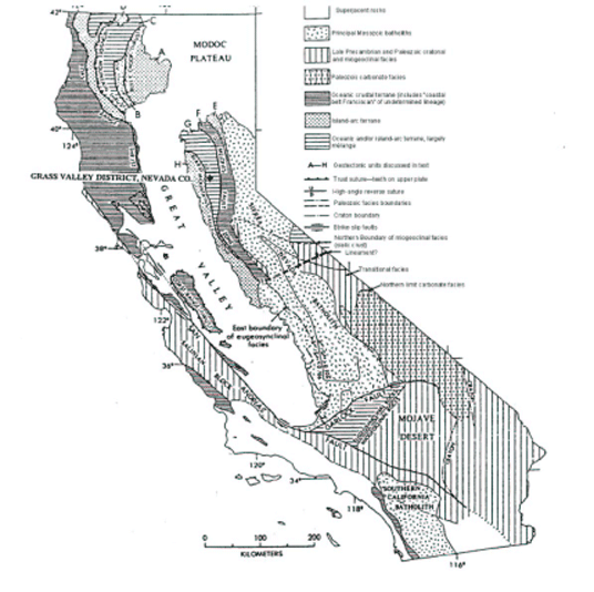
Figure 7-2:
Regional Lithologic Units

The Grass Valley Mining District occurs in the western half of the Central Metamorphic Belt where it consists of an 8-mile wide north-trending assemblage bound on its west and east sides by regional-scale tectonic suture zones. The Wolf Creek Fault Zone, which bounds the western side of the Central Metamorphic Belt, ranges from 500 ft to 2,000 ft wide in the Grass Valley area and encloses tectonic mélange slabs of meta-sedimentary rock. The Gillis Hill Fault/Melones Fault bounds the eastern side of the Central Belt in the district and can be traced for over 100 miles southward, where it hosts the Mother Lode Gold Belt.
Preliminary studies have demonstrated that the gold mineralizing event defining the Sierra Nevada Foothills Gold Belt appears to post-date peak regional metamorphism and pre-date intrusion of the Sierra Nevada batholith. The gold deposits of the Sierra Nevada Foothills Gold Belt are found in linear belts conspicuously associated with the network of deep-seated structures bounding and/or dissecting lithotectonic terranes within the Central Metamorphic Belt.
7.1.1
Structural Setting
The Sierra Nevada Foothills Metamorphic Belt has a strong north-westerly-oriented structural grain. During the Jurassic Nevadan Orogeny, compression and horizontal shortening was directed east-northeast, imparting a strong structural grain to the region. The Nevadan Orogeny was a result of alternating periods of east-northeast lithospheric subduction of the Kula plate, and right-lateral, transcurrent-compressional strike-slip motion along transform faults in the North American plate. The unique geology along the western coast of North America is thought to be a product of this unusual oblique subduction (Schweickert, 1981). There is evidence to indicate the subduction zone locked up periodically, and transpressional fault movement along a great number of deep-seated faults was the strain-releasing mechanism between the two colliding lithospheric plates. It is this system of deep-seated faults that has localized the gold deposits of the Sierra Nevada Foothills.
A minimum of three deformation episodes are recognized in the mining districts of the Sierra Nevada Foothills. The first is related to the alternating oblique subduction and transpressional faulting during the Nevadan Orogeny that generated north-northwest-oriented isoclinal folding in the zones of high strain, and open-type folds in the areas of lower strain. The folds plunge at shallow angles northerly and southerly. This is not considered to be a result of subsequent cross-folding, but to have occurred concurrently with the north-northwest-oriented folding event coincident with regional-scale boudinage structures (Payne, 2000; Tuminas, 1983). In the high-strain zones, a pervasive northwest-oriented axial planar cleavage was developed during that event. The second episode of deformation is related to the forceful intrusion of late syn-orogenic granodiorite to diorite plutons, which pre-date the emplacement of the Andean-type Sierra Nevada Batholith (Ash, 2001). The final episode is related to the gold mineralization events of the Sierra Nevada Foothills Gold Belt, approximately 5 to 10 million years after the syn-orogenic intrusion event, depending on location (Ash, 2001; Day, 1997; Bohlke and Kistler, 1986).
The most productive gold districts in the Sierra Nevada Foothills Gold Belt are associated with regional-scale boudinage neck features in conjunction with deep-seated crustal breaks. In the Grass Valley region, the western half of the Central Metamorphic Belt has necked-down to an 8 mile width from its typical 12 mile width. Similarly, many of the productive nodes along the 100 mile length of the Mother Lode Gold Belt are coincident with similar structural situations (Payne, 2004, pers. comm.; Payne, 2000).
The gold deposits in the Sierra Nevada Foothills are concentrated along numerous north to northwest-trending corridors of high strain related to second-order fault structures. The second-order faults branch from the first-order regional breaks that border the individual accreted terranes. Dilational jogs and pronounced bends in first-order fault zones can be points where favorable second-order branch faults develop. Favorable second-order faults can also occur where rock competency contrasts develop pressure shadows adjacent to first-order faults. Many important gold deposits are located in third- and fourth-order faults, with poor mineralization occurring in the second-order structures. Dilational jogs, bends, and pressure shadows in or adjacent to second-order faults can localize mineralization within favorable third- and fourth-order faults. At all scales, the corridors of high strain demonstrate a braided character, with high-strain zones encompassing lensoid or rhomboid domains of lesser strain.
Regional faults that traverse the Grass Valley area include the Weimar Fault, a 50-mile long regional fault that trends along the eastern edge of the mine. It is referred to as the 6-3 Fault in historic mine records on some historical documentation, specifically in relation to the Idaho-Maryland mine workings and associated structural geology. The Grass Valley Fault is situated west of the Idaho-Maryland deposit.
7.2
Property Geology
The rocks underlying the Idaho-Maryland Mine property are divisible into four separate units, ranging in age from early to middle Jurassic:
1.
Early Jurassic metasediments of the Fiddle Creek Complex, situated east of the Weimar Fault, in the lower plate of the Clipper Creek Thrust.
2.
Early Jurassic volcanic-plutonic arc sequence and ophiolitic basement rocks of the Lake Combie Complex situated east of the Weimar Fault, in the upper plate of the Clipper Creek Thrust.
3.
Middle Jurassic Spring Hill Tectonic Mélange, which contains heterolithic chaotic slabs correlative with the ophiolitic basement and volcanic-plutonic rocks of the Lower Volcanic Unit of the Lake Combie Complex, incorporated into a sheared serpentinite-matrix derived from probable upper mantle harzburgite tectonite (Payne, 2000).
4.
Middle Jurassic tectonic mélange of the Weimar Fault Zone.
7.2.1
Fiddle Creek Complex
The portion of the Fiddle Creek Complex underlying the project area is an early Jurassic accretionary sedimentary prism related to a submarine subduction complex. It is a highly disrupted sedimentary and volcanic sequence that exhibits a higher degree of metamorphism than adjacent units. The Fiddle Creek Complex outcrops east of the Weimar Fault Zone, exposed as isolated windows of limited size in the lower plate of the Clipper Creek Thrust (Tuminas, 1983; Edelman et al, 1989; Loyd et al, 1990; Saucedo et al, 1992; and Payne, 2000). The isolated outcrops of this sequence on the Idaho-Maryland property are tentatively correlated with the early Jurassic Clipper Gap Formation, the uppermost unit of the Fiddle Creek Complex (Tuminas, 1983). This unit is poorly studied and its age is uncertain.
Outcropping windows of Clipper Gap Formation immediately east of the Weimar Fault Zone are a highly disrupted assemblage of interbedded chert and argillite. The unit exhibits poorly developed stratification that has been tilted to near-vertical attitudes (Lindgren, 1896, p.79). Locally, the chert-argillite sequence is interpreted to have been tectonically intermixed within a slate matrix to form a sediment-matrix tectonic mélange in a subduction complex (Tuminas, 1983). Portions of the chert-argillite sequence may have been deposited as well-stratified olistostromes in perched basins atop the chaotically accumulating subduction complex. The Clipper Gap Formation is best exposed underground in the 8 Crosscut on the Brunswick 1100 Level, east of the Weimar Fault. The chert-argillite sequence is folded into a synform striking 300°. Black carbonaceous argillites dominate the sequence with interbedded dark gray chert, and minor beds of calcareous muddy sandstone (Farmin, March 1939b, June 1940b). Hard chert interbedded with sandstone and calcareous mud layers were encountered east of the Weimar Fault in the 13 Crosscut on the Idaho 1000 Level (Farmin, July 1937a).
7.2.2
Lake Combie Complex
The early Jurassic Lake Combie Complex is a fault-bounded tectonostratigraphic unit more than 40,000 ft thick, representing intact fore arc basin oceanic crust (ophiolite) and overlying volcanic-plutonic arc sequence (Tuminas, 1983). The structurally lowest unit in the Lake Combie Complex is the serpentinized ultramafic basement, cumulate gabbro-diorite, and diabasic-sheeted dike complex comprising the oceanic crustal basement (ophiolite). The overlying volcanic-plutonic arc sequence is comprised of three map units (lower, middle, and upper). All of the volcanic units are intricately intruded by hypabyssal and plutonic rocks of gabbroic, dioritic and diabasic composition that represent 20% to 50% of the volcanic section by volume. The Lake Combie Complex is presently found in the upper plate of the Clipper Creek Thrust as nappes. The Weimar Fault divides the nappe into two structural blocks. The Chicago Park Nappe is exposed on the east side of the Weimar Fault, the Lake Combie Nappe on the west. An intact portion of the Chicago Park Nappe, representing a portion of the Lower Volcanic Unit of the Lake Combie Complex, underlies the property east of the Weimar Fault.
The Lower Volcanic Unit (LVU) is comprised predominantly of andesitic to basaltic flows and flow breccia units intruded by discordant diabase, diorite, and gabbro bodies (Tuminas, 1983). The discordant plutonic rocks increase in abundance toward the bottom contact of the LVU. Lesser units (less than 15% of the LVU) include pyroclastic breccia deposits and interbedded tuff and interflow sedimentary layers.
7.2.3
Spring Hill Tectonic Mélange
The middle Jurassic Spring Hill Melange comprises a chaotic assemblage of clasts dismembered from the early Jurassic Lake Combie Complex, which are enclosed in a sheared serpentinite matrix. The Spring Hill Melange was recently identified as a mappable lithotectonic unit in 1995 (Payne et al, 1997). It is a district-scale structure, which underlies a 4 mi² area and dominates the property geology. The mélange unit is 4,200 ft wide, extends for 4 miles in a 300° orientation, and crosscuts the regional structural grain. The mélange is localized within an apparent district-scale boudinage neck (Payne, 2000). The mélange is defined by the Grass Valley Fault at its southern margin and the Olympia Fault on the north (Loyd and Clinkenbeard, 1990). All of the significant gold production from the Idaho-Maryland Mine was localized entirely within the matrix and tectonic slabs at the eastern end of this unit.
The Spring Hill Mélange consists of a sheared, well-foliated, highly deformed serpentinite matrix enclosing a chaotic arrangement of tectonic clasts. The serpentinite matrix is considered to be serpentinized upper mantle harzburgite tectonite which has subsequently undergone retrograde metamorphic re-equilibration to yield a rock composed predominantly of lizardite, the low-temperature serpentinite mineral (J. Post, 2004, personal comm.). No pre-serpentinization igneous textures are preserved in the matrix material. In outcrop, hard clasts with rounded to rod-shaped morphology have an appearance and arrangement similar to augen within schist. The tectonic clasts or fragments incorporated into the mélange range from fist-sized clasts to mega-clasts up to 1.5 x 0.6 miles in dimension. The mega-clasts will be referred to as “tectonic slabs” when discussed in this report.
TheBrunswick Slab is the largest and economically most important of the tectonic slabs. It borders the southern side of the Idaho-Maryland mine workings, extending eastward for 1.5 miles, and encompasses the Brunswick and Union Hill mine workings. The Brunswick Slab is a fault-bounded fragment correlative with a portion of the Lower Volcanic Unit of the Lake Combie Complex. It includes a thick stratigraphic sequence of intermediate to mafic meta-volcanic flows, flow breccias, lesser tuffs, and minor interflow sedimentary units, all cut by a discordant suite of igneous plutonic to hypabyssal rocks representing feeders for volcanics higher in the sequence (not represented in the slab). The western 25% of the Brunswick Slab is nearly all discordant plutonic intrusives with only minor wedges of the volcanic stratigraphy remaining. The interflow meta-sedimentary units include red to green cherts, black carbonaceous slates to wackes, and rare marl beds. The contacts of the slab dip toward the center, indicating diminishing size with depth. The Brunswick Slab hosts the Brunswick and Dorsey Vein Sets and provides important controls for the Idaho and Morehouse Vein Sets.
TheMaryland Slab is a fault-bounded cumulate gabbro fragment of ophiolitic affinity. The slab is elongated in a west-northwest orientation and outcrops in the Round Hole shaft area, directly north of the Brunswick Slab, within the Idaho Deformation Corridor. The Maryland Slab measures approximately 3,200 ft in a WNW-orientation, 750 ft north-south; the Round Hole Shaft was collared in the slab but broke out of it into serpentinite mélange matrix at 180 ft vertical depth (Newsom et al, 1956). The Maryland Vein Set is localized well beneath the keel of this shallowly southeast-plunging slab.
TheFulton Slab is a large fragment preserving interbedded sediments and volcanics, possibly correlative with the Middle Volcanic Unit of the Lake Combie Complex. The Fulton Slab shows promise that it may be a large and important ore control below the present depth of development in the mine. The slab does not outcrop and is located 200 ft WNW beyond the western terminus (keel) of the Brunswick Slab, lying parallel to, and beneath it. The slab was accidentally discovered in 1923 when the Idaho No.1 Shaft was sunk into its northeast contact. A horizontal core hole drilled in 1933 penetrated a 650 ft thick sequence of carbonaceous black slate to wacke with interbeds of black to gray fragmental volcanics. Also in 1933, a crosscut was driven from the Idaho No.1 Shaft on the 1500 Level, which extended to reach the north contact of the Fulton Slab. Unlike the adjacent Brunswick Slab, the Fulton Slab contacts diverge away from one another, indicating this is the top of a much larger slab extending to depth. The Fulton and Morehouse Vein Sets are localized in, or adjacent to, the Fulton Slab.
TheSealy Slab is a relatively small monolithologic clast of sheeted diabasic dike complex located within the Idaho Deformation Corridor. It is worthy of mention due to its excellent outcrop exposure in a cut bank. It is the type area for the Spring Hill Mélange unit. Evidence of its ophiolitic affinity and faulted contact with the sheared serpentinite mélange matrix are nicely exposed. The Sealy Slab is located 300 ft southward from the East Eureka shaft collar.
TheAlpha Slab is a rounder, boulder-like slab, which outcrops within the Idaho Deformation Corridor approximately 300 ft east of the old Maryland Shaft. The Alpha Slab is a strongly pyritic dacite tuff breccia containing angular to subangular volcanic bomb-sized fragments of leucocratic diorite and gabbro. The Alpha Slab measures 52 ft across in an East-West orientation and is accompanied by several smaller slabs of identical composition.
TheBeechel Slab is a large meta-volcanic fragment discovered at the 1200 Level in the Idaho workings while developing the Idaho 2 and 116 Veins. The Idaho 116 Vein lies along the north contact of the slab and the Idaho 122 Vein is hosted along a flow contact within the slab. The Beechel Slab is situated within the Idaho Deformation Corridor, in the hanging wall of the Idaho 2 Vein and G Fault.
TheGreenhorn Slab is composed of diabase and was discovered by a fan of core holes drilled northward, horizontally from the Brunswick 3300 Level. The Greenhorn Slab hosts gold-quartz vein mineralization at both its north and south contacts. The important L Fault lies along the north contact of the slab. The extent of this slab and associated gold mineralization are unknown.
7.2.4
Tectonic Mélange – Weimar Fault Zone
Highly deformed serpentinite occurs discontinuously along the 40-mile trace of the Weimar Fault Zone. The serpentinite fault matrix hosts numerous exotic slabs, with the largest one named the Green Slab. The Green Slab is a large basaltic to andesitic volcanic slab intersected in the 11 Crosscut on the Brunswick 1300 Level. It is 330 ft wide and hosts high-grade mineralization in the Washington 2 Vein. The slab is situated east of the New Brunswick vertical shaft and is not exposed at the surface.
7.2.5
Dioritic Intrusions
Minor dioritic intrusions are scattered across the Idaho-Maryland property, many of which are too small to map. The largest dioritic intrusion is a 1,300 x 900 ft mass underlying an isolated, ellipsoid-shaped hill in the far northern tip of the property, adjacent to the west of Brunswick Road. It intrudes the far northeastern portion of the Spring Hill Mélange unit. Another small, dark gray dioritic dike outcrops at Idaho-Maryland Road and extends southward onto the eastern edge of the Morehouse patented claim. It is fresh, unaltered, and undeformed. This dike is 13 ft thick and contains abundant anhedral accessory pyrite.
7.3
Property Structural Geology
Regional-scale structures that provide important controls for mineralization on the property or provide important structural geologic context for mine-scale structures on the property include:
1.
the apparent boudinage neck structure in the western half of the Central Metamorphic Belt
2.
the paired Lake of the Pines Synform and Greenhorn Antiform, developed west of and east of the Weimar Fault, respectively
3.
the Lake Combie and Chicago Park Nappes, developed west of and east of the Weimar Fault, respectively.
The shape of the Idaho-Maryland gold ore deposit is controlled by the regional-scale Weimar Fault and the district-scale Spring Hill Tectonic Melange Zone. The tectonic mélange units of both major structural elements were discussed previously in the stratigraphy portion of this report. The Weimar Fault is a NNW-trending right-lateral wrench fault that transects an accreted terrane along its 50-mile course. The fault cuts the late Paleozoic to Triassic Fiddle Creek Complex and an overlying nappe of Jurassic Lake Combie Complex rocks. It is a second-order fault that is of a younger age than the first-order suture zones, which bound the accreted terranes. The Weimar Fault is considered to be the source conduit for the gold-bearing fluids for the Idaho-Maryland deposit.
7.3.1
Weimar Fault Zone (6-3 Fault)
The Weimar Fault truncates all structures of the Idaho-Maryland Mine and forms the blunt eastern termination of the wedge-shaped gold deposit. The fault likewise truncates the eastern end of the Spring Hill Mélange unit. The Weimar Fault strikes 330° to 350°, dipping 70° NE through the eastern side of the property. It is poorly exposed due to the gouge and highly comminuted nature of the rocks within the fault zone. The surface trace of the Weimar Fault, near the Brunswick Shaft, was a serpentinite gouge with the consistency of modeling clay, according to Jack Clark, Mine Superintendent from 1954-56 (pers. comm., 1994). Clark further stated that the Weimar Fault intersected the New Brunswick vertical shaft just above the 580 Level station. Underground, the Weimar Fault was intersected in many crosscuts and core holes. In all cases, the fault zone displayed strong shearing and gouge development. The Weimar Fault has not been noted to host economic gold mineralization anywhere within the district. In the underground workings, drifting along the fault exposed small quantities of highly-sheared, crushed, dismembered quartz lenses containing trace to 0.10 oz/ton gold. Within the Grass Valley district, gold deposits are arrayed adjacent to the Weimar Fault along its length.
7.3.2
Spring Hill Mélange
The Spring Hill Mélange unit (see Figure 7-3) is a dominant structural feature at the Idaho-Maryland Mine. A large portion of the mineral rights area is underlain by this unit. In the geological context of the Grass Valley Mining District, the Spring Hill Mélange and the Idaho-Maryland ore deposit cut the structural grain of the district at an obtuse angle. The Spring Hill Mélange unit is elongated in a 300° direction, extending for 4 miles, with an average width of 0.87 miles. It has a pervasive fabric plunging 30° SE at all scales. It is confined on its southern and northern boundaries by the Grass Valley and Olympia Faults, respectively. The matrix of the mélange is sheared serpentinite enclosing large exotic slabs correlative with Lake Combie Complex meta-volcanics and various components of its underlying oceanic crust. The internal structural elements within the mélange control the locations of mineralization in the mine. Individual tectonic slabs have shown important controls localizing individual vein sets and the Idaho Deformation Corridor. The eastern end of the Spring Hill Mélange is notably-slab-rich, whereas the western portion of the mélange is a serpentinite matrix nearly devoid of exotic slabs.
Figure 7-3: Property Structural Geology - Plan View
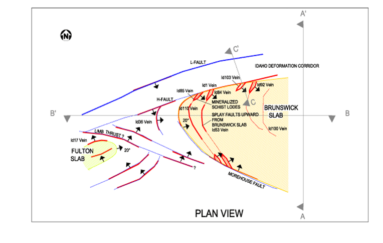
7.3.3
Idaho Deformation Corridor
The Idaho Deformation Corridor (Figures 7-3, to 7-5) is a braided zone of high strain that extends along the entire northern side of the wedge-shaped Idaho-Maryland deposit. The corridor averages 500 ft in width and is traceable for 2.0 miles along a 275° to 290° strike. The zone dips 60° to 70° south and extends to the deepest levels of the mine at 0.62 miles. The Brunswick Slab defines the southern boundary of the high-strain zone for nearly its entire length. The L Fault forms the northern boundary of the corridor. The prominent faults in the corridor exhibit a dominant reverse vertical displacement with a much weaker component of right-lateral horizontal displacement. Post-mineral reactivation of the same faults show 50 ft of normal displacement in some cases. The stretch elongation lineation fabric within the corridor rakes southeastward at shallow to moderate angles.
The Idaho Deformation Corridor is comprised of both linear and non-linear fault members. Both fault members show development of strong deformational fabric, gouges, and host the large, high-grade oreshoots of the mine. The linear faults include, from south to north, the Idaho, Q, F, G, 89, H, K, M, and L Faults. Non-linear link faults include the Idaho 2 Vein, Idaho 4 Vein, Eureka, and Hammill Link Faults. The link faults are sigmoidal and trend northeasterly, dipping 20° to 40° SE. The link faults developed at points of dislocation along the contact of the Brunswick Slab. Large tabular plates of the slab were sheared off and displaced downward along the footwall of the fault bounding the corridor on its south side.
For example, at the Idaho 2000 level, the Idaho Fault follows the contact of the Brunswick Slab eastward from the area of the Idaho #1 Shaft to the area of the 30 Winze. It separates meta-volcanics of the Brunswick Tectonic Slab from serpentinite mélange matrix. Near the 30 Winze, the 70° S dipping Idaho Fault crosses the contact of the Brunswick Slab, slicing into it at an acute angle. From that point eastward, the Idaho Fault has meta-volcanics of the Brunswick Slab along its hanging and footwalls. At this same location, the Idaho 2 Vein extends from its junction with the Idaho Fault northeastward in a sigmoidal path. The Idaho 2 Vein now defines the contact between the meta-volcanics and serpentinites, with serpentinite at its footwall. The Idaho 2 Vein converges with the H Fault. The H Fault then defines the contact between the meta-volcanic slab and the serpentinite mélange matrix eastward toward the Weimar Fault.
In the above example, the linear fault members such as the Idaho and H Faults serve as the glide planes along which sheared plates of meta-volcanic rock slid upward. The link faults, such as the Idaho 2 Vein, are actually the preserved segments of the meta-volcanic/serpentinite contact on the individual sheared plates. The ramp-like link faults may extend along their course upward through the serpentinites beyond the extent of the sheared plates of meta-volcanic slab. The points of dislocation marked by link faults along the contact of the Brunswick Slab are an important locus for the development of individual vein sets. The Maryland Vein Set is a prime example. The entire arrangement of faults and sheared plates of the Brunswick Slab suggest a fault duplex coupled with attenuation and incipient boudinage development.
7.3.4
Morehouse Fault
The Morehouse Fault (Figure 7-3) branches from the hanging wall of the Idaho Deformation Corridor and follows the footwall contact of the Brunswick Tectonic Slab in a great arc. Mine development at the keel of the Brunswick Slab on the Idaho 1500, 2000, and 2400 levels has suggested that dislocations may occur in a pattern along the bottom contact (keel) of the slab. This has been interpreted from the outside of the slab (Morehouse Vein Set). Ramp-like dislocations along the contact, with fault structures extending into the slab, may explain the development of isolated groups of veins within the Brunswick Slab in the deeper developments of the mine. Vein set development outside of the slab along its keel may be associated with the same fault structures extending outward into the serpentinites from the dislocation site.
For example, at the Idaho 2000 level, the Idaho 110 Vein was developed in a 10° SE dipping fault plane within the Brunswick Slab. A new vein structure was encountered in the drift southward along the contact of the slab, localized at a point of dislocation in the slab contact. This new vein matches closely in orientation and attitude with the Idaho 110 Vein. It is worthy of note that the cross cut driven eastward into the slab connecting the Idaho 16 Vein hanging wall with the 110 Vein intersected a large body of mineralized rock. This mineralized body is described as a mass of quartz stringers cutting mineralized diabase. Assays from an interval of mineralized rock without quartz stringers yielded 0.19 oz/ton (6.5 g Au/t). The structural conditions at this location are presently unclear, but imply that large bodies of gold mineralization may exist in association with the Morehouse Fault.
7.3.5
Intersection of Idaho and Morehouse Faults
The importance of the intersection of the Idaho and Morehouse faults has long been recognized by company geologists. Recently referred to as a “keel” zone, Beechel (1955) described it as a “large fault trough” with a southeasterly plunge and suggested the Idaho veins were situated peripherally to it. The intersection showed some mineralization in historic mine development, and thus remains an important exploration target.
Figure 7-4: Geologic Cross Section – Section No. 20 E, Looking West, Sections C - C1
![[technical010.gif]](https://capedge.com/proxy/20-F/0001137171-13-000218/technical010.gif)
Figure 7-5: Idaho Deformation Corridor
![[technical012.gif]](https://capedge.com/proxy/20-F/0001137171-13-000218/technical012.gif)
7.3.6
The Brunswick 20 Series Faults
At the eastern end of the large Brunswick Slab, a series of dislocation planes called the 20 Faults occur. The 20 Faults are sub-parallel to, and found within 1,000 ft of the Weimar Fault. The member faults dip steeply west to near-vertical. The individual faults converge upward into the Weimar Fault. Their course in plan view is 330° to 350° and they are notably sinuous. The 20 Faults cut the volcanic stratigraphy and Brunswick Vein Set at an obtuse angle. Relative displacement of individual Brunswick quartz veins bearing 275° to 290° is approximately 6.6 ft in a right-lateral sense. Members of this family include the 20, 21, 21a, 21b, 22, and 23 Faults.
The 20 series of faults exert locally important controls on oreshoots in the Brunswick Vein Set. The crossing of Brunswick Veins by members of the 20 Fault set can limit oreshoots in some cases. The 20 Faults, in conjunction with a Brunswick vein crossing a bed of interflow graphitic meta-sediments, results in a black slate-type oreshoot of large dimensions. Adjacent Brunswick veins are relatively unaffected in comparison. The 20 Faults locally contain discontinuous low-grade mineralized vein quartz in a similar fashion to that noted in the Weimar Fault.
7.3.7
The Brunswick Stacked Faults
At the northeastern corner of the Brunswick Slab is a stacked series of shallowly northeast-dipping fault/veins. They are associated with the junction of the Weimar Fault and the Idaho Deformation Corridor and are most commonly found within 1,000 ft of that wedge area. Well-known members of this vein/fault array are the Brunswick 4, 11, 34, 36, 41, and 48 Veins. Members of this fault set exert important controls on the location of high-grade oreshoots and large stockwork-veined deposits. Both deposit types occur where members or swarms of stacked faults disrupt the steep Brunswick Veins. Oreshoots in Brunswick veins continued upward through an intersection of this type. It is consistently noted that strong gold mineralization proliferated outward from the steep vein into the shallow dipping vein for distances of 50 to 100 ft laterally. Where the arrangement of steep Brunswick veins is close, this can result in large areas of stockwork veining that mimic the shape of the flatter structures. The intersection of the shallow-dipping Brunswick 4 Vein with the steep 7 and 17 Veins resulted in a shallow-dipping stope 200 x 400 ft in an area with a maximum true width of 50 ft. Similarly, the Waterman Resource is situated at the intersection of the Brunswick 4 vein with the steep 10, 31, 35, and 131 veins resulting in a shallow-dipping zone of quartz stock work veins with dimensions of 250 ft along strike, 950 ft along the dip, and an average true thickness of 75 ft.
8.0
DEPOSIT TYPES
The Idaho-Maryland Mine is a structurally controlled, mesothermal lode gold deposit for which Emgold has developed a revised, comprehensive deposit model. This model identifies structural features that act as potential hosts to auriferous vein sets and account for the varied deposit types and vein arrays that can occur within any individual vein set. This model is schematically shown in Figure 8-1.
Figure 8-1:
Idaho-Maryland Mineralization Types
![[technical014.gif]](https://capedge.com/proxy/20-F/0001137171-13-000218/technical014.gif)
The development of mineralized vein sets is controlled by four structural features. These are:
·
mine-scale boudinage neck features developed within the serpentinite matrix of the Spring Hill Mélange unit
·
contact areas of the tectonic slabs within the serpentinite matrix of the Mélange unit
·
local flexures and irregularities in the plane of the Weimar Fault Zone can create quartz stockwork zones
·
high-grade vein arrays localized in association with bench-like dislocations along the Brunswick Slab contact.
The mineralization is further controlled in veins of a particular vein set by any one of six structural settings. They are:
·
Rock competency contrast areas: development of an oreshoot along the contact between soft, ductile serpentinite and hard, brittle tectonic slabs at bends along the contact, at dilational jogs, or at offsets/benches in contact associated with incipient attenuation and boudinage
·
Wedge-shaped areas between intersecting faults: stacked arrays of shallowly dipping veins can comprise large bulk mineable deposits containing free gold
·
Simple concave or convex bends along fault planes
·
Vein splits, which are usually manifested at bends along fault planes
·
Drag folding of vein structures associated with cross faulting, resulting in vein horsetails and/or mirror-image oreshoots localized in the vein on both sides of a cross fault
·
Intersection of steep and shallowly dipping vein members of any vein sets.
Lithology of the vein-hosting units can also be important in localizing mineralization within vein sets. Three lithologic controls are identified:
·
Highly graphitic fault planes or partings within interflow sedimentary units. These are found within tectonic slabs composed of intermediate volcanic/volcaniclastic rocks.
·
Competent/incompetent rock unit contacts.
·
Iron-enriched mafic lithologies. These would include pyritized, chloritized diabasic slabs.
9.0
MINERALIZATION
The veins consist primarily of quartz, which is milky white, massive to banded, sheared, and brecciated. Gold occurs as native gold, ranging from very fine grains within the quartz to leaves or sheets along fractures measurable in feet (Glen Waterman, pers. comm. 1996; Jack Clark, pers. comm. 1994; Leland Hammill, pers. comm. 1995). Other constituents occur in minor to trace amounts and comprise carbonates, sericite, chlorite, mariposite, albite, and scheelite. Sulfide minerals are ubiquitous in the quartz veins (1 to 4 visual percent) and consist primarily of pyrite. In order of abundance, galena, chalcopyrite, and various tellurides are present in trace concentrations. Recent electron microprobe studies of ore specimens collected in the 1940s have identified telluride minerals including hessite, petzite, and coloradoite. Sphalerite and arsenopyrite are rarely observed.
The varying styles of mineralization present at the Idaho-Maryland Project are typical of those commonly found in mesothermal lode gold deposits worldwide. At least four basic types of mineralization have been recognized to contain significant gold deposits. In order of importance, these include (1) gold-quartz veins and vein arrays, (2) mineralized black slate bodies, (3) mineralized diabasic slabs, and (4) altered, mineralized phyllonites. These are discussed in more detail below.
9.1
Gold-Quartz Veins
9.1.1
Quartz Veins & Immediate Wallrocks
Quartz veins and their immediate wallrocks (Figures 7-3 and 8-1) have produced over 80% of the gold at the Idaho-Maryland Mine. The gold-bearing quartz veins are structurally complex, strike in all compass directions, and have attitudes that range from horizontal to vertical. The economic veins ranged from 1 to 25 ft in thickness. The largest vein ore shoot was 650 ft in vertical extent and plunged continuously at a shallow angle for 5,600 ft.
The morphology of the veins varied from tabular veins and stringer zones, to oblique-extension veins exhibiting exotic centipede structures. The veins are generally tabular, ribboned to massive quartz, and contain minor gangue and accessory minerals. Vein gangue includes minor carbonate phases along selvages (ankerite, calcite, dolomite, and ferrodolomite), sericite, chlorite, and albite. Pyrite, the dominant accessory mineral, constitutes 1% to 2% of the vein mineralization. The schistose vein wallrock commonly contains gold mineralization up to 10 ft into either or both walls of the vein. The mineralized wallrock is strongly carbonate altered. Accessory pyrite was reported in the wallrocks at similar concentrations to those found in the vein. Gold tenor of the quartz vein deposits ranged from 0.10 to 10.00 oz/ton for individual stopes.
9.1.2
Large Quartz Stockwork Vein Deposits
This type of mineralization consists of a reticulated mass of steep and shallowly dipping quartz veins and veinlets in the Waterman Resource. Vein quartz constitutes 20% to 80% of the mineralized rock by volume. The overall shape of the zone mimics the orientation of the shallowly dipping veins in the set. The dimensions of this body are 250 ft in strike length, 950 ft in dip length, with an average true thickness of 75 ft. The maximum true thickness is 122 ft.
The quartz stockwork veined mineralization shares common characteristics with the other Idaho-Maryland mineralization types. The intermediate meta-volcanic host rocks are bleached and pervasively ankerite + sericite + chlorite + pyrite altered. Coarse particulate free gold was present, but occurred less frequently in stockwork ores compared to all other mineralization types. Gold tenor for stockwork veined material is in the range of 0.10 to 0.20 oz/ton. The stockwork zone has irregular walls caused by the degree of shattering and the intensity of subsequent vein filling. The primary control for stockwork veined bodies was related to bends in the plane of the adjacent Weimar Fault.
9.1.3
Tensional Vein Arrays
Tensional vein arrays localized in wedge areas between intersecting faults have contributed an unknown percentage of the gold production at the mine. Stacked arrays of shallow-dipping quartz veins can constitute large, potentially bulk mineable deposits. Known examples have plan dimensions of 50 x 50 ft to 50 x 220 ft with the down rake projection being the long axis of the deposits. An extreme example is the mineralized wedge at the Id2 and 3 Vein junction, which has been documented on seven mine levels from the Idaho 1600 to 3000 levels, suggesting a rake length of over 3,300 ft. Other examples include mineralized wedges at the following junctions: Id 3 Vein-25 Vein, ld 109 Vein-177, Br9 Vein-10 Vein, Br2 Vein-6 Vein, and Br2 Vein-32 Vein. The ore minerals, gangue minerals, accessory minerals, and alteration types are all similar to those described for the stockwork vein mineralization type, and coarse free gold is also present. Expected gold tenor of mineralized wedge ores is in the range of 0.10 to 0.40 oz/ton. Visual estimation of vein density determines the boundaries. Variations in the plunge inclination have been assumed to control the fracture intensity and economic boundaries.
9.2
Mineralized Black Slate Deposits
Graphitic black slate bodies (see Figure 9-1) have produced approximately 5% of the gold at the Idaho-Maryland Mine. The mineralized black slate bodies develop exclusively out into the hanging wall of a tabular quartz vein, coincident with an important set of northwest-trending, steeply dipping cross faults. Three known mineralized slate bodies range from 20 ft to 100 ft in thickness and constitute large bulk-mineable oreshoots in the mine. The maximum dimensions are 300 ft in vertical height and horizontal length. Very coarse gold is contained within a stacked array of highly graphitic flat fault planes of 0.2" to 2.0" thick, flat quartz veinlets that cut the steeply dipping meta-sediments. The host rock ranges from slate to medium-grained wacke. The only reported gangue mineral was trace vein carbonate. Accessory fine-grained pyrite occurred in minor amounts up to 1%. The ore mineral was coarse particulate free gold. Flat plates up to 3" x 4" in dimension without vein quartz were found "puddle" in low spots along highly graphitic flat planes. The gold tenor of this ore averaged 0.20 to 0.25 oz/ton. Mill records indicate that recoveries of gold from black slate ores averaged 80%, the highest for all the mineralization types.
9.3
Mineralized Diabasic Slabs
Mineralized diabasic slabs (see Figure 8-1) have produced approximately 3% of the gold mined from the Idaho-Maryland deposit. The mineralized diabasic bodies are elongate melange slabs that have no predictable occurrence within the mine. They were generally discovered in exploratory core drilling and crosscuts. Mineralized diabasic slabs range from 3 to 36 ft in thickness, with a maximum length of 400 ft measured along the shallow plunge of the body. Diabasic slabs occur throughout the Idaho Deformation Corridor but only become mineralized where they are cut by strong faults on their bottom end or have strong faults along their footwall contacts.
Mineralized versus unmineralized diabase bodies are easily distinguished. The diabase is visually massive and the igneous textures are holocrystalline and well-preserved where unmineralized. Igneous textures become vague and chlorite content increases as a ground mass constituent imparting a green color to the mineralized diabase. The chlorite can have a preferred orientation, which can impart a faint foliation to the massive diabase (Schlberg, 1936). Pyrite is ubiquitous in mineralized diabase as subhedral to euhedral cubes with a unique embayed “moth-eaten” appearance. Regardless of grade, gold occurs in coarse pieces in this mineralization type. In some cases, the gold particles can be nearly the entire width of the thin quartz veinlet hosting it. Quartz veinlets displaying slip planes on one or both sides are considered favorable, demonstrating the presence of episodic fault displacement.
Figure 9-1:
Mineralized Black Slate Deposits – Br 16 Vein Area
![[technical016.gif]](https://capedge.com/proxy/20-F/0001137171-13-000218/technical016.gif)
Stringer zones of quartz veinlets can constitute up to 10% of the volume. Gangue minerals included abundant carbonate phases, chlorite, and sericite. Euhedral cubic pyrite was the only reported accessory mineral, and gold was the only ore mineral. The gold tenor of mineralized diabase was 0.10 to 1.00 oz/ton for individual bodies. Large resources of this type remain in place at the Idaho-Maryland with most grading 0.10 to 0.22 oz/ton.
9.4
Mineralized Phyllonites
Mineralized phyllonites are laminar to braided, carbonate-sericite-chlorite-pyrite altered proto-mylonites hosted within the serpentinite melange matrix or mafic meta-volcanics. At the Idaho 2000 Level, the Idaho 3 Vein showed rapid gradation from a vein quartz lode to a mineralized schist lode, with stringer zones of quartz veinlets constituting 0% to 10% of the volume. Gangue minerals include abundant carbonate, chlorite, and sericite. The lone accessory mineral is disseminated euhedral porphyroblastic pyrite. The gold tenor of the mineralized schists averaged 0.10 to 1.0 oz/ton in individual stopes.
10.0
EXPLORATION
Exploration at the Idaho-Maryland project has consisted of an extensive geologic evaluation program during 1994 through to 2002, surface diamond drilling during 2003 and 2004, surface mapping and sampling in (and since) 2004, and continued computerization of historic data.
The geologic evaluation was possible because of the excellent and comprehensive preservation of the Idaho-Maryland mine and mill records. These records are essentially complete, and were used to generate a consistent, property-wide structural geology model and vein set stratigraphy. Unmined mineralization was identified along underground workings and in historical diamond drill holes. Interpretation of the updated geologic model defined new vein sets and extensions of known vein sets. These were categorized for mineral resource estimates and future exploration.
Surface diamond drill programs were executed in 2003 and 2004 to test the structural geologic model and near surface gold mineralization targets, and in 2004 for access ramp geotechnical information and ceramics feedstock confirmation. The drill programs and results are discussed in Section 11.
Surface mapping and sampling conducted in 2004 consisted of a traverse over the meta-volcanic and intrusive units that comprise the Brunswick slab in support of the ceramics feedstock resource estimate. This task also produced additional information on rock types within the slab for use in geologic modeling.
10.1
Data
The available key historic data consisted of:
·
3,200 mine maps and drawings, including 1,257 linen maps (1" = 50 ft assay plans, geology plans and stope plans, 1" = 100 ft geologic cross sections), including exploration drill hole geology and assays plotted on maps.
·
1,100 photographs (surface and underground)
·
monthly development reports for 1921 to 1956
·
monthly geological summary reports for 1936 to 1942
·
eight ledgers of development and stope sampling assays
·
assay reports of diamond drilling, channel samples and muck car samples
·
general manager's and mine superintendent's reports for 1947 to 1953
·
mill production reports and cost summaries for 1934 to 1956.
·
petrographic studies of 70 wallrock and gold mineralized samples.
Since 2002 major components of the geological effort and exploration completed by Emgold have been the evaluation and interpretation of the main underground levels, winzes and quartz veins that were measured and input into a 3-D wireframe computer model using Vulcan® and MineSight®.
10.2
Data Review Results
Emgold evaluated the historic data and produced a comprehensive geological model for the Idaho-Maryland project. Key results previously developed by AMEC continue to be valid, and are:
·
Barren blooms of intense carbonate-sericite-chlorite alteration leakage extend for several hundred feet upward from all of the known, large, high-grade oreshoots developed at the Idaho-Maryland mine. However, the ankerite rock unit associates with mineralization.
·
The recognition of tectonic fragments or slabs within the Spring Hill Tectonic Mélange to explain location, arrangement, and variability in strike and dip of veins.
·
Consistent structural interpretation, on both a property and local (stope) scale. Key in this interpretation is the Idaho Deformation Corridor and its make-up of a braided network of high-strain zones, and definition of the Morehouse Fault as an arcuate structure along the Brunswick tectonic slab contact.
·
Definition of the L Fault as the north boundary of the Idaho-Deformation Corridor, generator of numerous, blind high-grade oreshoots which branch downward into the hanging wall, and the possible connection at depth of the L Fault and projected north contact of the deep Fulton Slab.
·
Development of productive, high-grade gold-quartz vein sets in bowtie arrays at and adjacent to bench dislocations in the Brunswick Slab contact.
·
Development of a deposit type definition for the Idaho-Maryland that forms the basis for the positive exploration potential of new mineralized veins or structures. Four structural features are defined as potential hosts to mineralized vein sets (Figures 7-3 and 8-1):
1.
Boudinage neck features in the serpentinite matrix of the mélange unit
2.
Tectonic slabs in the serpentinite matrix of the mélange unit
3.
Flexures and irregularities in the plane of key fault zones that create shattered, quartz stockwork zones which can host large, more homogeneous, lower grade blocks
4.
High-grade vein arrays localized in association with bench-like dislocations along the meta-volcanic Brunswick Slab-serpentinite mélange matrix contact
The Idaho-Maryland geologic model was reviewed by Stephen Juras, Qualified Person for AMEC, in 2002 and again in 2004, who felt it would be valuable for exploration success. He indicated that multiple drillhole programs would be necessary because of the complex geology and variable geometry of the mineralized veins.
Exploration targets and the potential for new discoveries at the Idaho-Maryland project can be divided into seven large groups according to the dominant structure controlling mineralization. Those structural features, listed in order of decreasing importance, are: (1) the Idaho Deformation Corridor, (2) large individual mélange slabs, (3) Weimar Fault, (4) Morehouse Fault, (5) Clipper Creek Thrust, (6) Golden Gate Antiform, and (7) the Grass Valley Fault. Each structural feature has specific targets in known veins and further conceptual geological targets.
10.3
Exploration After 2004
Further surface geologic mapping was conducted after disclosure of the 2004 AMEC report by Emgold geologists to identify rock types, explore for vein outcrops, and confirm fault locations. This resulted in the first updated geologic map of the property in 60 years. This updated mapping has been computerized to be used as part of the geologic model.
Since 2004 the historic assay database was computerized to use in geostatistical modeling and further delineation of mineralized zones. A stope model of the location and shape of historic stopes was also completed. These results will be utilized in the next phase of work along with the vein model, which is in progress but not yet complete.
Also since 2004, new gold exploration targets were delineated. These were exploration blocks that did not meet all the criteria to be qualified as resources but would be areas of potential exploration. A cutoff grade of 0.10 oz/ton Au was used to define these targets along with an understanding of the mineralized zone geology. These targets were identified from the historic assays and geologic map data. Some targets were extensions of veins on mine levels that were developed but not stoped, and others were from drillhole intercepts. A total of 512 individual exploration targets were identified on Idaho veins in and near existing mine workings from the Idaho 600 to the Idaho 2400 mine levels.
11.0
DRILLING
11.1
Historic Drilling
During mining of the Idaho-Maryland deposits, exploratory and delineation diamond drilling regularly took place. Eleven hundred holes totalling 230,000 ft were diamond drilled, commonly to a 0° dip (horizontal). Core diameter was ⅞" (E-size). Hole traces were put onto the assay, stope, and various geology plans, as was all other information. No drill logs were observed.
Down hole surveys were not conducted, and deviation of the drill holes was common. Recorded in the geology monthly reports were experiences such as driving an underground heading on a drill hole only to find that the hole soon curved significantly from the planned orientation. The deviation was not consistent, and so could not be predicted. This observation was one of the main reasons AMEC recommended that mineral resources defined by historic drilling alone should be classified as inferred mineral resources (see Section 17).
No core was preserved from past mining operations at the Idaho-Maryland Mine.
11.2
2003 / 2004 Drilling
Diamond drill holes have become the principal source of geological and grade data for the Idaho-Maryland project. Drilling from surface sites commenced in three phases: summer 2003 (gold targets), spring 2004 (gold targets) and summer 2004 (geotechnical data). Drilling totalled 21,335 ft in 31 drill holes for gold exploration and 3,537 ft in seven drill holes for the geotechnical and ceramics feedstock work. A list of the project drill holes, together with their coordinates and lengths, is provided in Table 11-1 from Juras (in the 2004 AMEC report).
Drilling was done by wireline method with H-size (HQ, 2.5 in nominal core diameter) equipment using a single drill rig. Collar locations of the core holes were surveyed by Idaho-Maryland staff with a Trimble GeoXT GPS unit. Downhole surveys of all core holes were conducted at 100 ft intervals with a Reflex E-Z Shot digital instrument. Additionally, the geotechnical drill holes were drilled using oriented core (EZ Mark oriented core device). Upon completion, the collar and anchor rods were removed and the hole was abandoned to California regulation standards, and the site rehabilitated.
Standard logging and sampling conventions were used to capture information from the drill core. The core is logged in detail onto electronic MS Access logging "sheets", and the data was then transferred into the project database. The core was digitally photographed before being sampled.
Table 11-1:
Idaho-Maryland Project 2003 and 2004 Drill Holes
| | | | | | | | |
Drill Hole No. | Easting
(ft) | Northing
(ft) | Collar Elevation
(ft) | Total
(ft) | Depth
(m) | Azimuth | Dip | Target |
IDH001 | 3770.7 | 9657.5 | 12495 | 592.5 | 180.6 | 50 | -59 | Au |
IDH002 | 3770.7 | 9657.5 | 12495 | 319.0 | 97.2 | 88 | -45 | Au |
IDH003 | 3770.7 | 9657.5 | 12495 | 668.0 | 203.6 | 90 | -26 | Au |
IDH004 | 3770.7 | 9657.5 | 12495 | 940.0 | 286.5 | 71 | -26 | Au |
IDH005 | 5332.1 | 9256.8 | 12522 | 757.0 | 230.7 | 2 | -76 | Au |
IDH006 | 5367.5 | 9275.0 | 12522 | 1706.0 | 520.0 | 226 | -45 | Au |
IDH007 | 5403.5 | 9283.0 | 12522 | 139.0 | 42.4 | 38 | -69 | Au |
IDH008 | 5405.0 | 9284.5 | 12522 | 678.0 | 206.7 | 39 | -56 | Au |
IDH009 | 5408.0 | 9294.0 | 12522 | 603.0 | 183.8 | 358 | -60 | Au |
IDH010 | 5418.0 | 9293.0 | 12522 | 747.0 | 227.7 | 326 | -59 | Au |
IDH011 | 5419.0 | 9291.0 | 12522 | 1248.0 | 380.4 | 334 | -74 | Au |
IDH012 | 5458.0 | 9312.0 | 12522 | 302.0 | 92.0 | 64 | -53 | Au |
IDH013 | 5459.0 | 9313.0 | 12522 | 293.0 | 89.3 | 64 | -70 | Au |
IDH014 | 5349.0 | 9273.0 | 12522 | 406.0 | 123.7 | 353 | -79 | Au |
IDH015 | 5349.0 | 9272.0 | 12522 | 483.0 | 147.2 | 316 | -61 | Au |
IDH016 | 3682.0 | 9674.0 | 12495 | 1087.0 | 331.3 | 64 | -65 | Au |
IDH017 | 3683.8 | 9674.8 | 12495 | 1038.0 | 316.4 | 63 | -49 | Au |
IDH018 | 3684.7 | 9675.3 | 12495 | 887.0 | 270.4 | 67 | -41 | Au |
IDH019 | 3683.5 | 9675.3 | 12495 | 807.0 | 246.0 | 57 | -55 | Au |
IDH020 | 3684.5 | 9676.8 | 12495 | 596.0 | 181.7 | 58 | -40 | Au |
IDH021 | 3682.4 | 9674.4 | 12495 | 799.0 | 243.5 | 60 | -70 | Au |
IDH022 | 3682.4 | 9675.8 | 12495 | 767.5 | 233.9 | 17 | -55 | Au |
IDH023 | 3682.7 | 9676.8 | 12495 | 607.0 | 185.0 | 12 | -41 | Au |
IDH024 | 3681.9 | 9674.4 | 12495 | 758.0 | 231.0 | 13 | -70 | Au |
IDH025 | 3680.8 | 9676.6 | 12495 | 466.0 | 142.0 | 329 | -44 | Au |
IDH026 | 3681.2 | 9675.7 | 12495 | 530.0 | 161.5 | 342 | -65 | Au |
IDH027 | 3681.7 | 9674.2 | 12495 | 428.0 | 130.5 | 339 | -77 | Au |
IDH028 | 3681.5 | 9675.5 | 12495 | 434.1 | 132.3 | 350 | -45 | Au |
IDH029 | 3681.6 | 9674.3 | 12495 | 576.1 | 175.6 | 349 | -59 | Au |
IDH030 | 3681.6 | 9674.3 | 12495 | 817.0 | 249.0 | 117 | -60 | Au |
IDH031 | 3681.6 | 9674.3 | 12495 | 857.0 | 261.2 | 117 | -55 | Au |
| | | | | | | | |
IDH032 | 6166.5 | 8050.5 | 12587 | 707.0 | 215.5 | 39 | -44 | Geotech |
IDH033 | 6128.9 | 7628.8 | 12580 | 708.0 | 215.8 | 129 | -45 | Geotech |
IDH034 | 5729.3 | 8031.0 | 12574 | 706.0 | 215.2 | 256 | -40 | Geotech |
IDH035 | 5735.5 | 8018.0 | 12572 | 519.3 | 158.3 | 256 | -40 | Geotech |
IDH036 | 6092.3 | 8011.9 | 12585 | 387.4 | 118.1 | 271 | -44 | Geotech |
IDH037 | 4480.3 | 8257.6 | 12531 | 307.0 | 93.6 | 111 | -40 | Geotech |
IDH038 | 4479.8 | 8256.8 | 12527 | 203.0 | 61.9 | 297 | -44 | Geotech |
Juras reviewed the core logging procedures at site and the drill core was found to be well handled and maintained. Material was stored under cover (in a secure warehouse facility) in core racks. Data collection was competently done. Idaho-Maryland maintained consistency of observations from hole to hole and between different loggers by conducting regular internal checks. Core recovery in the mineralized units was excellent, usually between 95% and 100%. Very good to excellent recovery was observed in the mineralized intrusive sections checked by Juras and AMEC. Juras stated that overall, the Idaho-Maryland drill program and data capture were performed in a competent manner.
11.2.1
Findings from Surface Drilling
Key observations and findings from the surface drilling programs, as summarized by Juras (2004) were:
·
Confirmation of the serpentinite – matrix tectonic melange zone geologic model for the Idaho-Maryland Mine. The localization of gold-quartz veining along melange slab contacts and in association with bench dislocations along the Brunswick Slab contact was also corroborated.
·
Nearly all gold is coarse particulate in nature and confined directly to vein quartz and phyllonites of the vein shears. Values were tightly confined to structures with little or no dispersion of gold into the wall rock. Coarse particulate gold was also identified within micro-fractured diabase and serpentinite adjacent to very strong mineralized faults. Chloritization, the associated destruction of the crystalline igneous textures, and development of porphyroblastic pyrite overgrowths were diagnostic for the auriferous diabase.
·
In 2003, the drilling intersected high-grade mineralization at depth in the Idaho 120 Vein, several hundred feet beneath an outcropping barren carbonate alteration bloom (see Figure 11-1). Drillhole IDH001 cut 10.1 ft @ 0.93 oz/t Au in a complex vein structure. In 2004, follow up drilling tested westward and at higher elevations from the high-grade intercept. Evidence of old mining was seen at higher elevations whereas the mineralization quickly pinched off to the west. The drill position would not allow testing to depth and eastward thus the target remained open along strike and down rake to the east.
·
Drilling revealed that the keel of the Brunswick Slab is shaped different than anticipated. Drillhole IDH006 did not intersect the Idaho 1 Vein at the keel of the Brunswick Slab, where it was projected to occur at 1,000 ft depth. This implies a steeper plunge for the keel from surface to 1,100 ft depth and a considerable flattening of the plunge below 1,100 ft depth, and extending eastward toward the Idaho 1500 Level.
Significant intervals intersected in the 2003 and 2004 drill campaigns testing gold mineralization potential are shown in Table 11-2.
Table 11-2:
Significant Gold Mineralized Intersections, 2003 – 2004 Drill Campaigns
| | | | | | | | | |
Hole | From
(ft) | To
(ft) | Interval (ft) | Au oz/ton | From
(m) | To
(m) | Interval
(m) | Au
(g/t) | Comments |
IDH001 | 528.2 | 538.3 | 10.1 | 0.93 | 161.0 | 164.1 | 3.1 | 31.9 | free gold |
IDH003 | 482.5 | 483.4 | 0.9 | 0.21 | 147.1 | 147.4 | 0.3 | 7.2 | free gold |
IDH009 | 130.8 | 133.8 | 3.0 | 0.17 | 39.9 | 40.8 | 0.9 | 5.8 | - |
| 187.0 | 193.0 | 6.0 | 0.17 | 57.0 | 58.8 | 1.8 | 5.8 | free gold |
IDH011 | 213.0 | 216.0 | 3.0 | 0.17 | 65.8 | 66.7 | 0.9 | 5.8 | - |
IDH017 | 862.5 | 866.0 | 3.5 | 0.26 | 263.0 | 264.1 | 1.1 | 8.9 | - |
IDH019 | 556.3 | 562.3 | 6.0 | 0.05 | 169.6 | 171.4 | 1.8 | 1.7 | free gold |
IDH022 | 369.0 | 375.0 | 6.0 | 0.05 | 112.5 | 114.3 | 1.8 | 1.7 | free gold |
IDH024 | 395.0 | 398.0 | 3.0 | 0.31 | 120.4 | 121.3 | 0.9 | 10.6 | free gold |
11.2.2
Geotechnical Drilling
Geotechnical drilling was conducted to obtain ground stability data for a proposed mine access ramp. Holes were angled downward at 40° to 45° from the horizontal to maximize the areas examined in the directions of the decline route. All drilling was contained in the Brunswick Slab.
The dominant rock types intersected were andesite volcanic flows, flow breccia, and hypabyssal feeder units intruded by diabase intrusive units. Gabbro was intersected around the proposed portal area but otherwise only constitutes a minor component of the drilled region. In all the drill holes (outside the surface weathered zone) is the general absence of any broken core and/or gouge intervals, foliated or sheared zones, and fractured or veined areas. The core area of the Brunswick Slab is shown to be a massive, undeformed, essentially monolithic unit of mafic composition.
AMEC’s assessment of the geotechnical drilling program in 2004 indicated that a decline could be situated in rock with RQD values in excess of 85 percent and that ground conditions in the Brunswick Slab appeared to be very good.
Figure 11-1:
Drill Hole Cross Section – Looking S40E
![[technical018.gif]](https://capedge.com/proxy/20-F/0001137171-13-000218/technical018.gif)
12.0
SAMPLING METHOD & APPROACH
In the 2003-2004 surface drilling programs, sampling of the half cores was performed by Idaho-Maryland staff in a secure core logging and storage facility. Sample size was critical due to the coarse particulate nature of the gold (The sample size was optimized to allow for multiple check assays, if required, as the use of large assay pulps was necessary). The target sample size was 3 ft, with the minimum being 2.5 ft, and 3.3 ft the maximum.
The core ends were matched through all of the boxes, and fractured sections wrapped in duct tape to preserve geological information and reduce core loss during the cutting process. Core was halved with a wet saw, using continually running fresh water, and cut along the same line of orientation, which provided excellent angular relationship data for structural geologic interpretation. When strongly mineralized sections of core were cut, a plastic tray was inserted into the saw pan and saw cuttings were collected and panned. The pannings were helpful in alerting staff to the presence of coarse gold and assisted in the review of assay and check assay results.
The half cores within a marked sample interval were put in a sample bag, tagged, and loaded into 55lb (25 kg) shipping sacks and secured. The samples from the split core remained in the logging facility until shipped to the assay laboratory. Samples were shipped in one of two manners. Idaho-Maryland staff transported samples to the assay laboratories in Nevada or the representatives from the assay laboratory came to the Idaho-Maryland facility to pick up samples, depending on the sizes of the shipments. Samples used for check assays were sent to a different lab than the primary contract assay laboratory.
13.0
SAMPLE PREPARATION, ANALYSES & SECURITY
13.1
2003 – 2004 Gold Exploration Samples
In the 2003-2004 surface drilling programs, procedures were established to minimize assay inconsistencies caused by the presence of coarse gold. Historic records for the Idaho-Maryland mine noted coarse gold in all ore types, thus Idaho-Maryland chose to be conservative and have all samples analyzed using screened metallics fire assay methods. The flowchart of the preparation and analysis process is shown in Figure 13-1. The laboratory prepared two pulps from each sample. One 500 g sample was for fire assay analysis and a 100 g pulp was prepared and returned to Idaho-Maryland for gold panning. Panning of the 100 g pulp by Idaho-Maryland staff provided (1) a cursory check on the lab, (2) allowed collection of gold particle size, shape, and population information, and (3) helped direct the ongoing core drilling program when lab analysis turn-around time was slow. The 500 g pulp was analyzed for gold only, utilizing screened metallics fire assay methods. All pulps and coarse rejects were saved by the lab and delivered back to the Idaho-Maryland core facility.
Figure 13-1:
Sample Preparation and Assay Procedure Flowchart, Primary Laboratory
![[technical020.gif]](https://capedge.com/proxy/20-F/0001137171-13-000218/technical020.gif)
A rigorous QA/QC program was developed and utilized at the Idaho-Maryland Project. Extra precautions were taken by Idaho-Maryland staff to mitigate the potential for assay variability due to the frequent coarse gold occurrence in the mineralization. The program used Standard Reference Materials (SRMs), blank samples (made from barren massive antigorite serpentinite), coarse reject and pulp duplicate samples and third party laboratory check assays. Insertion rate of SRMs and duplicates was about 1 in 20 samples. Blanks were only inserted immediately following mineralized intervals.
The SRMs were prepared from gold mineralized material of varying grades, collected from a nearby gold mine to formulate bulk homogenous material. Two groups of material were collected: one with a mean certified value of 0.21 oz/ton Au and the other with a mean certified value of 0.17 oz/ton Au. These materials were used to successfully control the assay quality process.
Juras (2004) stated that blank sample results showed no evidence of gold contamination during sample preparation. Duplicate performance was good to fair, reflecting the coarse particulate nature of the gold mineralization. Performance was worse closest to the detection limit. Patterns on control charts were symmetric about zero, suggesting no bias in the assay process.
Four criteria were used in selection of samples for third party laboratory check assays. These were (i) all assays equal to or greater than 0.01 oz/ton Au, (ii) all samples with free gold panned from 100 g pulp sample regardless of assay value, (iii) all samples with visual similarity to ore types regardless of assay value, and (iv) 5% of the remaining sample population selected randomly. Results mirrored the primary laboratory duplicate analyses.
Juras reviewed Idaho-Maryland’s QA/QC procedures on site and found them to have been strictly followed. The gold assay process for the 2003 and 2004 drill campaigns were shown to be in control. The rigorous assaying methodology employed during the these phases of drilling identified mineralization types which will require screened metallics fire assaying in future work. These ore types include samples containing (i) over ten percent vein quartz, (ii) green chloritized diabase with porphyroblastic pyrite overgrowths, (iii) phyllonites with porphyroblastic pyrite overgrowths, and (iv) about 3 feet of wall rock immediately preceding and after any of the first three types.
The methods established during the surface drilling programs formed a foundation for accurate sampling of mineralized rocks. Similar assaying procedures would be utilized during future surface or underground sampling at Idaho-Maryland.
13.2
Historic Gold Samples
This project contains an historic database with over 36,000 assays. The assays, which are almost exclusively for gold, were done on samples taken from underground workings (walls and backs from drifts and crosscuts, walls from raises). Many are channels samples; fewer are muck car samples and grab samples. Those from diamond drill holes comprise only a minor portion of the assay database.
The assay data reside as handwritten entries on scale assay plans (1" to 50 ft) for all mine levels. Drillhole assay data accompany the intercepts on these plan maps, and copies of assay certificates are present for the final 10 years of production.
The samples were fire-assayed at former mine site laboratories. No records exist of any QA/QC program. Sample quality can still be inferred, however, by the reconciliation of historic production records to underground sample data. These studies, as well as a recent investigation on mill-to-resource prediction (see Section 17), showed that the resource or reserve estimates consistently underestimated the amount of gold produced by milling, a discrepancy most likely reflective of sample size influence rather than laboratory technique. Gold deposits with coarse gold areas are best sampled with large sizes, which was not common practice at the time the Idaho-Maryland Mine was in operation. Therefore, any estimates made using this historic data should include comparisons with values unadjusted and adjusted for the regular underreporting of grade (i.e., call factor).
AMEC stated that the comprehensive set of assay plans, supported by records of muck car stope samples and mapped geology data, as well as the detailed historical production records, all supported the integrity of the assay data for the Idaho-Maryland Mine, and they concluded that the data were suitable for use in mineral resource estimation.
14.0
DATA VERIFICATION
14.1
Historic Data
Data used in the Idaho-Maryland mineral resource estimate reside on assay plans. Juras conducted two data transcription checks: one which compared assay values in resource block calculation sheets to the source plan map for various resource blocks throughout the property; and the other which reviewed copies of assay certificates (1946 to 1948) for the Idaho No.1 vein along 2400 Level. In the review of assay values, only five errors were found, but the overall error rate was near zero. No errors were observed in the assay plans.
14.2
2003 and 2004 Data
Data compiled during the 2003 and 2004 drill campaigns were checked by Juras during two site visits. Random database entries were compared to original source documents; no errors were observed. The 2004 AMEC report concluded that the assay and location data used were sufficiently free of error and adequate for resource estimation for the Idaho-Maryland project.
14.3
Data Review In 2009
In 2009 two log books of assays were found that contain assays not listed on mine maps. They would add approximately 2000 new assays (or about 5 percent of the total). One book pertained to Idaho-Maryland Mine samples taken from the 1500-3280 levels, and the other was for sampling in the Brunswick Mine on the 900-1880 levels. These assays include those listed on maps along with additional assays that were described as footwall and hangingwall assays. Based on the logs, the sample locations were measured distances from spads.
The new assays have not been used in any resource calculations, however, prior to using this data, an independent review should be conducted to determine if it is usable, to verify the accuracy of those specific assays listed on the maps.
15.0
ADJACENT PROPERTIES
This section is not relevant for the Idaho-Maryland Mine project.
16.0
MINERAL PROCESSING & METALLURGICAL TESTING
There exists extensive background information on the metallurgical performance of the ores processed at the Idaho-Maryland and Brunswick properties, as summarized in the 2002 AMEC report. Each property had a milling circuit that incorporated crushing, grinding, gravity separation, sulfide flotation, and gold smelting/refining unit operations. In addition, the Idaho-Maryland mill contained a cyanidation plant with Merrill-Crowe recovery, and a smelting/refining circuit that treated flotation concentrates and sands from both mills. No milling facilities remain from past operations. An illustration and description of the Idaho-Maryland milling circuit is presented in Taggart (1954).
Since 2004, Emgold conducted metallurgical testing of drill cores and historic tailings.
16.1
Metallurgical Performance History
In the 2002 Technical Report, AMEC reviewed the mill operating statistics for 1934, 1936, 1937, 1938, 1941, and 1947. Results indicated stable overall gold recoveries and metallurgical response to gravity, flotation, and cyanidation:
·
Overall gold recoveries ranged from 93.8% to 97.2%.
·
Gold production using gravity recovery methods ranged from 61% to 69%, averaging approximately 65.4%.
·
The ore contains approximately 1.5% to 2% sulfides. Gold produced via flotation of the sulfides ranged from 30.3% to 36.9% with an average of 33.4%.
Following flotation, the concentrate was reground to further liberate the gold. The remaining 1.2% of the total gold produced was achieved by treating the sands or coarse fraction from the flotation circuit tailings using cyanidation.
Graphite and scheelite containing ore zones have been encountered in the orebody. In the milling circuit, graphite reported to the flotation circuit and was successfully depressed using flotation reagents. Scheelite was recovered using gravity and flotation methods in the 1950s.
Juras and AMEC (2004) stated that overall gold recovery using modern technology would result in gold recoveries consistent with those achieved in the early milling circuits at the Idaho-Maryland mill. They also stated that gold recovery using current gravitational equipment may exceed the recoveries attained (i.e., average 65%) in the 1930s and 1940s. Testwork to determine the maximum gold recovery potential using gravity separation and concentration was recommended by AMEC.
16.2
Metallurgical Testing Since 2004
In 2006, preliminary gravity and cyanide tests were conducted on small samples of drill core rejects to gain some understanding of the potential gold recoveries from mineralized veins (Kappes, Cassiday and Associates, 2006). Nine mineralized pulps from the 2003-2004 surface drilling programs were composited into one sample (with a weighted average head grade of 0.065 oz Au/st) and a gravity concentration test was performed with a Model SB40 Falcon Concentrator. Following this bottle roll cyanide tests were conducted. The combined results of both tests were of limited value because they came from small samples, but indicated that 98 percent of the gold may be recovered. Although these tests produced useful information, additional metallurgical testwork would be required using larger samples to fully characterize the veins and to accurately determine gold recoveries, cyanide consumption, and obtain other metallurgical information from drill cores or channel samples.
In 2006 and 2007, preliminary gravity separation, flotation and cyanide leach tests were conducted on small samples of historic mine tailings to gain some understanding of the potential gold recoveries from old tailings (Kappes, Cassiday and Associates, 2006). Gravity results using a Model SB40 Falcon Concentrator indicated that gold recoveries of up to 25 percent could be attained from pulverized tailings that were very fine- grained (80 percent by weight minus 200 Tyler mesh size) and had head grades of 0.128 oz Au/st. The results of initial flotation tests using a Denver D-1 Flotation machine suggested that 26 percent of the gold would be recovered from the flotation circuit. Cyanide soluble leach test results varied from 41-53 percent and provided some preliminary information on lime and cyanide consumption. A separate cyanide leach test on two samples of historic tailings produced gold recoveries of 50-60 percent (Dawson Metallurgical Laboratories, Inc. 2007). Although these tests produced useful information, additional sampling would be required to accurately predict the gold recoveries from historic mine tailings.
In 2004, preliminary gold recovery gravity tests utilizing both Knelson and Falcon lab concentrators were performed on bulk samples of old Idaho-Maryland tailings and highly mineralized material found on waste rock dumps (Grewal, 2004). Test recoveries using only gravity separation were generally in the range of 70% to 80%. This gravity testwork is of interest because it indicates that new gravity technology may be more efficient than the methods used during the historical operation; however, it is not possible to accurately correlate the origin of the samples with respect to the mine workings, and so the value of these initial results is limited. Once a gold resource is defined, additional gravity and general metallurgical testwork would be required to fully characterize the metallurgical response and properly estimate gold recovery. It is anticipated that gold recovery using modern technology should be either the same or better than historical recoveries.
17.0
MINERAL RESOURCE & MINERAL RESERVE ESTIMATES
The NI-43101 compliant gold resources for the Idaho-Maryland property were previously estimated under the direction of Idaho-Maryland Qualified Person Mr. Mark Payne, and audited by AMEC Qualified Person Mr. Stephen Juras. The results were summarized in Juras’ 2002 Technical Report (for AMEC) and updated in the AMEC 2004 Preliminary Technical Assessment Report. A small increase of 50,000 ounces (or three percent) of inferred resources has been added since submittal of the 2004 AMEC report, which was estimated by Idaho-Maryland Qualified Person Mr. Robert Pease in March, 2007. All mineral resources, including those of 2007, were estimated using traditional longitudinal sections and 3-D geologic models with commercial mine planning software (MineSight®) or (Vulcan®). The same criteria, originally established by Stephen Juras for AMEC in 2002, were utilized in delineating the resources in 2007.
17.1
Geologic Data Review
Gold mineralization at the Idaho-Maryland property resides in 11 discrete vein sets hosting at least four types of mineralization (see descriptions in Sections 7, 8, and 9). The mineralization was organized into five groups for resource estimation: Eureka, Idaho, Dorsey, Brunswick, and Waterman, (see Figure 17-1).
A review of the historic data was conducted by Juras in 2002 and again in 2004 to outline areas of remaining gold mineralization, including a structural geological analysis to assign a particular mineralization type to a structure and/or vein. Only data that could be reconciled to a geologically consistent interpretation was included in the resource estimate. About 20% of the data identified as remaining and undeveloped was excluded because it was not supported by a coherent interpretation. The AMEC report stated that this approach is consistent with best practice guidelines in resource estimation.
Juras examined numerous areas of potential resource-bearing material, which generally fell into two categories: those based on underground development information, and those based on diamond drill hole intercepts (historic and 2003/2004). Evidence for the pertinent vein/structural interpretation was examined for data support and consistency. All examples based on the underground data demonstrated good data back-up and sound projection limits. Mineralization types were not mixed, and if multiple types occurred in proximity to each other, each was modeled separately. The interpretations based on the drillhole intercepts were also sound and reasonably projected. Historic data were hampered by the uncertainty in spatial location of the drillhole intercept, as they were not down-hole surveyed. In addition, most drill hole areas are defined by widely spaced data (200 ft and greater), thus all resources based on single drill hole intercepts were classified as Inferred Resources.
Figure 17-1:
Idaho-Maryland Project Gold Resource Locations, March 1, 2007
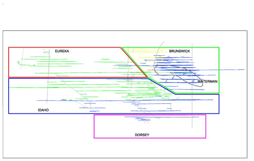
Thickness calculations of numerous mineralized intervals were also checked and the logic and geometric calculations applied were found to be correct. Because of the variable dips that occur in a structure and among mineralization types, Idaho-Maryland was also encouraged to express future work in horizontal or vertical thicknesses. This would enable mineralized regions to be easily compared and would provide a basis for mine planning work.
17.1.1
Structural and Mineralization Continuity
Continuity of geology and mineralization is a key component in a resource estimate, although it is usually based on data configuration and density in undeveloped properties. Past production data of the Idaho-Maryland Mine allow a more exact analysis to be undertaken, based on transcribing stope outlines from mined areas in various vein and structural zones to longitudinal sections.
This type of analysis was done by JAA for their 1991Technical Assessment Study (see Section 3). AMEC reviewed their findings and concurred with the method employed and the results obtained. The JAA analysis confirmed that the Idaho-Maryland vein systems demonstrate high horizontal and vertical structural/vein continuity, with horizontal lengths ranging from 150 ft to 1,690 ft to a maximum of 5,600 ft, and averaging 885 ft for the vein systems reviewed. JAA also assessed vertical geologic continuity by examining the mined areas between levels 3280 and 580. Vertical extent ranged from 100 ft to 2,700 ft, averaging 615 ft.
To assess gold mineralization distribution, JAA investigated the presence of a mineralized and non-mineralized vein or structural material (defined at a threshold of 0.07 oz/ton Au) along a horizontal or vertical stope length. The assumption was that a stope defined a mineralized entity that was extracted as "ore." No further selection was done to optimize grade during extraction. The JAA analysis revealed that in any given stope, about 45% of the length contains mineralization above the threshold value. The remainder would represent internal dilution.
17.1.2
Data Analysis
Assay plan maps were inspected to review the gold data. Additionally, four sets of underground sample data taken from four different vein systems (the Idaho No.1, Idaho No.2, Dorsey veins (60 winze area) and Brunswick veins (1948 sampling)) were statistically analyzed. The mineralization systematically contained high to very high-grade pods along a horizontal or vertical length. Previous reviews by JAA and Drummond (1996) concluded that a high nugget effect is present, and an evaluation of the high-grade distribution can only be done on data from extensive underground sampling.
Juras and AMEC analyzed the data sets for the 2002 Technical Report and again in 2004. With respect to extreme grades, the distributions generally indicated unique high-grade discontinuity patterns. The trends defined in cumulative probability plots begin to become discontinuous around the 98th to 99th percentile levels. If a cap grade was to be chosen based on these results, it would vary by vein system. Past mineral resource estimates used arbitrary cap values of 1 oz/ton Au, which is too low for the Idaho-Maryland gold mineralization. It was recommended that Idaho-Maryland conduct a more detailed statistical review of the underground data. The review, by vein system and mineralization type, would allow appropriate gold capping levels to be selected. Until such an analysis is undertaken, the resource estimates were to be reported using uncapped grades, according to Juras. Exposure to extreme grades was evaluated by resource block and dealt with through classification.
Bulk density was assigned a tonnage factor of 12 for all stopes, resources and historic production. AMEC commented that this value is generally suitable for global usage. However, Juras felt that locally the bulk density is too low, particularly around the Brunswick veins where scheelite is a ubiquitous component and for diabase hosted mineralization in the Idaho systems.
17.1.3
Mine Call Factor
Historically the planned mill feed tonnage and gold grade rarely matched the actual results. This was a result of a variety of factors that could be resolved by adjusting the planned production by a constant number. This number or factor is called the multiplier factor or mine call factor. Commonly, these deposit types typically under-predict the gold produced. Causes include poor sampling of high-grade material, inconsistent assaying procedures for the high-grade samples and, in places, the use of too low a bulk density number.
JAA conducted a detailed investigation into historic mine-mill reconciliation at the Idaho-Maryland. JAA selected data from later years (1950 to 1952), where the records of mine and mill production were kept in some detail and were traceable to parts of the mine. Two factors were calculated: a "model" (underground sampling) to "mine" (muck car sampling) factor, equal to 1.21, and a "mine" to "mill" factor, calculated to be 1.19. The total Mine Call Factor is equal to 1.44. AMEC reviewed the work done by JAA and agreed with their results. The use of the Mine Call Factor was allowed to be used to establish a relationship between the historic underground channel samples and expected production. The factor was only to be used on the vein system data.
The more homogeneous slate hosted mineralization could not be factored at any resource category. Nor was the factor applied to any results from the 2003-2004 drill campaigns or to the historic drilling. The same restrictions were applied to the additional inferred resources announced in 2007.
17.1.4
Resource Estimation
Estimation of grade and tonnage consisted of two processes: one based on underground samples (channel samples) and adjacent drill hole data (if present) and the other solely using drillhole data.
Resource Blocks – Underground Samples and Adjacent Drill Holes
The process for underground sample based resource blocks included drawing the hosting vein or structure in longitudinal section, averaging the underground sample assays along the vein or structure, and calculating a true thickness for the resource block (map data and trigonometric solutions using interpreted vein or structure morphology). Underground samples commonly included a vein assay, footwall, and less commonly a hanging wall assay for each face. These were combined into width x assay "composites" (utilizing a minimum 3 foot total width), summed, and the total divided by the sum of all sample widths. This produced a weighted grade for the resource block. Low-grade zones constrained the strike extent for many of these blocks. Dip projections depended on where the remaining material lay (e.g., below the level) and were drawn honoring the interpreted geological shapes. Measurements of the shapes in longitudinal section gave the block areas, which, together with the average true thickness, determined the volumes. Mined areas were outlined from stope plans and sections, and subtracted where applicable from the resource estimate.
Juras checked numerous underground resource blocks for compatibility with the local, interpreted vein or structural geology, correct tabulation of underground sample values, reasonable projection limits and volumetric and trigonometric calculations. The checked blocks were properly constructed and calculated.
Brunswick No. 4 and No. 16 blocks comprise resources outlined in quartz stockwork areas and black slate bodies. They are characterized by widespread lower grade gold mineralization, especially the stockwork bodies. They contain numerous development headings (drifts, raises, minor crosscuts) and stoped areas. Assay data comprise underground channel samples (drifts and raises) and stope muck samples. Distribution of the gold values is more uniform than in the traditional vein systems but of lower grade and limited nugget-like values (i.e. defined as greater than 1 oz/ton Au). Grade estimation for these blocks consisted of global weighted averages.
Resource Blocks – Drill Holes Only
Drill hole based blocks mostly consist of single intercepts defining the respective grade and thickness values. Block areas are defined by a box outline, conforming to the interpreted morphology. The size of the outline is governed by the protocol established for the resource classification and historic stope lengths. Grades are calculated by summing interval length x gold value "composites," and dividing the total by the full interval length. The interval length was then calculated to the vein's true width. A minimum true width equal to 3 ft was used.
Blocks defined by multiple drill holes and/or samples from a nearby underground working follow a similar process for grade and thickness estimates. The area outline for these resource blocks are governed by projection within the plane of the vein or structure. Limits were set according to the classification protocol described below.
Juras reviewed all resource blocks that were based on drillhole data because these blocks defined the majority of total tons and gold ounces at Idaho-Maryland. Grades and thicknesses were properly assigned. Outlines around drillhole intercepts were adjusted to revised distances described below. The revision adjusted the strike projection towards the intercept to prevent the over extrapolation of grade (drillhole data alone does not have the effect of low grade dilution included in similar systems using underground samples and adjacent drill holes).
17.1.5
Resource Classification and Summary
The mineral resource classification of the Idaho-Maryland gold mineralization used logic consistent with the CIM definitions referred to in National Instrument 43-101. Measured mineral resources are supported only in areas exposed by underground development and estimated from detailed underground sampling. The projection volume from a mined opening was up to 50 ft along the plunge or rake direction of the mineralized zone. In the case of resource block Brunswick No. 4, the entire volume was deemed to meet the definition of measured resources because of the numerous penetrations by drifts and sub-drifts, stopes, raises and lesser crosscuts more or less uniformly throughout the mineralized body.
Indicated mineral resource category is used to classify mineralization that surrounds measured mineral resources around underground openings and around drill intercepts within resource blocks that contain multiple drill holes and evidence of the hosting vein or structure in a nearby underground working within 200 ft. The projection volume was up to +100 ft. Also, this category included blocks that would have been classified as measured mineral resources but demonstrate a degree of uncertainty in the grade estimate due to the presence of numerous plus 1 oz/ton Au assayed samples. These blocks will remain in the indicated resource category until such time that a proper investigation is carried out on setting appropriate grade capping levels at Idaho-Maryland.
The majority of the Idaho-Maryland mineral resource is classified as Inferred Mineral Resources. This includes all resources outlined by single drillhole intercepts. Here the projection was up to 100 ft along the strike and up to 200 ft up or down the plunge or rake. Around underground workings, the projection was limited to 200 ft from the working.
17.2
Resources Developed In 2007
Gold resources developed since 2004 totalled 50,000 ounces and were all classified as inferred. This added a minor amount of three percent to all categories of resources, or five percent to the total inferred resources. This by itself is not enough of an increase in resources to trigger the need for a new technical report. The mineral resources were estimated using longitudinal sections and 3-D geologic models with commercial mine planning software (MineSight®). The resources were developed using the same criteria established by Stephen Juras of AMEC in 2002 and 2004. The criteria included: a) minimum true thickness of three feet for resource blocks, b) cutoff grade of 0.1 opt Au, c) mine call factor not applied to any blocks developed from muck car samples or drillholes (historic or recent), and d) mineral resources outlined by single drill hole intercepts as Inferred Resources. The location and totals of the Inferred Resources was as follows:
| | | |
Location: | Tons: | Grade: Oz/ton | ContainedOunces Au: |
Eureka Group | 5,000 | 0.22 | 1,000 |
Idaho Group | 38,000 | 1.02 | 39,000 |
Dorsey Group | 5,000 | 2.05 | 10,000 |
Total | 48,000 | 1.04 | 50,000 |
Of the 2007 resources, 28,000 ounces were estimated from samples taken from drillholes and muck car samples. No mine call factor was applied to those resources. The remaining 22,000 ounces came from channel samples from drifts, which included the mine call factor.
17.3
Resource Classification and Summary
The current NI 43-101-compliant gold mineral resources are shown in Table 17-1. They are classified as Measured, Indicated and Inferred Mineral Resources. The total gold resources of the Idaho-Maryland project prior to that, as of 20 September 2004, was classified as 472,000 ounces of Measured plus Indicated Resources, and 952,000 ounces of Inferred Mineral Resources. The increase developed in March, 2007 kept the total of Measured plus Indicated Resources the same (at 472,000 ounces), but increased the total of Inferred Mineral Resources to 1,002,000 ounces. All Idaho-Maryland gold mineral resources were reported at a 0.10 oz/ton Au cutoff grade. All estimated resource blocks equal to or greater than 0.10 oz/ton Au were tabulated in the summary.
Table 17-1:
Idaho-Maryland Project Gold Mineral Resource Summary, March 1, 2007
| | | | | | |
| True Thickness
(ft) | Tonnage
(tons) | Gold Grade
(oz/ton) | Gold
(oz) | Gold Grade
(oz/ton)
1.44 MCF | Gold
(oz)
1.44 MCF1 |
Eureka Group2 | | | | | | |
Measured Mineral Resource | 6.5 | 17,000 | 0.18 | 3,000 | 0.29 | 5,000 |
Indicated Mineral Resource | 5.7 | 41,000 | 0.27 | 11,000 | 0.37 | 15,000 |
Measured + Indicated Mineral Resources | 5.9 | 58,000 | 0.24 | 14,000 | 0.34 | 20,000 |
Inferred Mineral Resources A | 9.0 | 393,000 | 0.21 | 81,000 | 0.30 | 117,000 |
Inferred Mineral Resources B | 4.8 | 49,000 | 0.37 | 18,000 | - | - |
New Inferred Mineral Resource (A) | 4.4 | 5,000 | 0.15 | 1,000 | 0.22 | 1,000 |
Idaho Group |
|
| |
| |
|
Measured Mineral Resource | 17.5 | 129,000 | 0.24 | 31,000 | 0.34 | 44,000 |
Indicated Mineral Resource | 10.6 | 209,000 | 0.42 | 88,000 | 0.60 | 125,000 |
Measured + Indicated Mineral Resources | 13.3 | 338,000 | 0.35 | 119,000 | 0.50 | 169,000 |
Inferred Mineral Resources | 10.0 | 838,000 | 0.25 | 212,000 | 0.37 | 307,000 |
New Inferred Resource (A) | 4.1 | 38,000 | 0.71 | 27,000 | 1.02 | 39,000 |
Dorsey Group |
|
| |
| |
|
Measured Mineral Resource | 11.6 | 61,000 | 0.23 | 14,000 | 0.33 | 20,000 |
Indicated Mineral Resource | 6.4 | 131,000 | 0.33 | 43,000 | 0.46 | 60,000 |
Measured + Indicated Mineral Resources | 8.0 | 192,000 | 0.30 | 57,000 | 0.42 | 80,000 |
Inferred Mineral Resources | 9.5 | 955,000 | 0.30 | 288,000 | 0.43 | 413,000 |
New Inferred Resource (B) | 3.0 | 5,000 | 2.05 | 10,000 | 2.05 | 10,000 |
Brunswick Group |
|
| |
| |
|
Measured Mineral Resource | 8.0 | 64,000 | 0.17 | 11,000 | 0.25 | 16,000 |
Indicated Mineral Resource | 6.2 | 108,000 | 0.28 | 30,000 | 0.40 | 43,000 |
Measured + Indicated Mineral Resources | 6.9 | 172,000 | 0.24 | 41,000 | 0.34 | 59,000 |
Inferred Mineral Resources | 7.3 | 291,000 | 0.23 | 67,000 | 0.33 | 97,000 |
Waterman Group |
|
| |
| |
|
Measured Mineral Resource | 70.7 | 831,000 | 0.15 | 127,000 | - | - |
Indicated Mineral Resource | 30.5 | 75,000 | 0.21 | 16,000 | - | - |
Measured + Indicated Mineral Resources | 67.3 | 906,000 | 0.16 | 144,000 | - | - |
Idaho-Maryland Project3 |
|
| |
| |
|
Measured Mineral Resource1 | 13.3 | 271,000 | 0.22 | 59,000 | 0.31 | 85,000 |
Measured Mineral Resource2 | 70.7 | 831,000 | 0.15 | 127,000 | 0.15 | 127,000 |
Indicated Mineral Resource | 8.1 | 489,000 | 0.35 | 172,000 | 0.50 | 243,000 |
Measured + Indicated Mineral Resources | 41.1 | 1,666,000 | 0.22 | 375,000 | 0.28 | 472,000 |
Inferred Mineral Resources | 9.3 | 2,526,000 | 0.26 | 666,000 | 0.38 | 952,000 |
New Inferred Resource A | 4.2 | 43,000 | 0.65 | 27,000 | 0.94 | 40,000 |
New Inferred Resource B | 3.0 | 5,000 | 2.05 | 10,000 | 2.05 | 10,000 |
Inferred Mineral Resource Total | 9.1 | 2,573,000 | 0.27 | 703,000 | 039 | 1,002,000 |
|
|
| |
| |
|
1. MCF = Mine Call Factor (not applicable to Waterman Group resources). 2. Inferred resources are divided intoA (historic data and mine call factor applied) andB (from 2003-2004 data and no mine call factor applied). 3. Idaho-Maryland measured resources are split into two categories: 1. the Eureka, Idaho, Dorsey, and Brunswick Groups, and 2. the Waterman Group (stockwork/slate type ore). 4. New inferred resources included 40,000 ounces with MCF (A) and 10,000 ounces without MCF (B).
17.3.1
Resource Classification Definitions
The following definition of mineral resources is taken from the Canadian Institute of Mining (CIM) standards.
Inferred Mineral Resource
An Inferred Mineral Resource is that part of a Mineral Resource for which quantity and grade or quality can be estimated on the basis of geological evidence and limited sampling and reasonably assumed, but not verified, geological and grade continuity. The estimate is based on limited information and sampling gathered through appropriate techniques from locations such as outcrops, trenches, pits, workings and drill holes.
Indicated Resource
An Indicated Mineral Resource is that part of a Mineral Resource for which quantity, grade or quality, densities, shape and physical characteristics can be estimated with a level of confidence sufficient to allow the appropriate application of technical and economic parameters, to support mine planning and evaluation of the economic viability of the deposit. The estimate is based on detailed and reliable exploration and testing information gathered through appropriate techniques from locations such as outcrops, trenches, pits, workings and drill holes that are spaced closely enough for geological and grade continuity to be reasonable assumed.
Measured Resource
A Measured Mineral Resource is that part of a Mineral Resource for which quantity, grade or quality, densities, shape, and physical characteristics are so well established that they can be estimated with confidence sufficient to allow the appropriate application of technical and economic parameters, to support production planning and evaluation of the economic viability of the deposit. The estimate is based on detailed and reliable exploration, sampling and testing information gathered through appropriate techniques from locations such as outcrops, trenches, pits, workings and drill holes that are spaced closely enough to confirm both geological and grade continuity.
18.0
OTHER RELEVANT DATA & INFORMATION
This section is not applicable to the Idaho-Maryland Mine project.
19.0
INTERPRETATION AND CONCLUSIONS
The following are conclusions of this updated Technical Report:
1.
Property and mineral rights purchases and changes occurred after release of the 2004 report. In 2005 Emgold acquired 30 acres of underground mineral rights, while the lease option agreement with the BET Group for mineral rights was modified. Seven acres of surface rights are being purchased. All of these changes should benefit the Idaho-Maryland Mine Project.
2.
The Idaho-Maryland Mine Project is in the process of permitting. A predecessor company had received permits to dewater and conduct underground exploration in 1996, but was not able to start due to funding problems. Emgold applied for permits in 2005 to dewater, explore and mine the property. A draft environmental impact report (EIR) was prepared in 2008, reviewed by the public, and is currently undergoing revision. Presumably it will be re-circulated for public review, so finalization of this report might take another year. Once that is done, the City of Grass Valley will vote to certify the EIR, and then vote on whether or not to approve a conditional use permit for the project, which could occur before the end of year 2010.
3.
Most of the future exploration work for the Idaho-Maryland Project will take place from underground drill stations and will include geologic mapping, channel sampling of veins, and bulk sampling. Planned access for drilling would be from an exploration decline and from the New Brunswick Shaft. AMEC’s review of the geology and geotechnical drilling in 2004 concluded that the rock types in the Brunswick Slab would support a decline.
4.
The lode gold deposits on the Idaho-Maryland property are structurally controlled. Brittle-ductile contact zones, faults and tectonic slabs exist that have created conduits for mineralizing fluids and areas favorable to the deposition of gold. Historic data along with results of the 2003-2004 surface drilling programs suggests that additional gold mineralization exists on the property.
5.
In response to a recommendation in the 2002 Technical Report, surface drilling programs were conducted in 2003 and 2004 to test the geologic model on the west end of the Idaho Deformation Corridor. The results, summarized in the 2004 Preliminary Assessment Technical Report, supported the model.
6.
To assess the gold exploration potential of the Idaho-Maryland project, Juras conducted extensive reviews of pertinent geological, mining, and metallurgical data in 2002, and 2004. Unless otherwise stated, the technical conclusions of AMEC listed in the 2002 and 2004 reports remain valid for this updated technical report.
7.
The geologic and resource model is in the process of being updated to use in future exploration and mine planning, which will encompass geostatistical modeling. Toward this goal, the assay database has been computerized, the historic stopes have been modeled, and computer modeling of veins is in progress. This work is being done with assistance and technical review by AMEC. This work is necessary to determine which veins have sufficient mineralization and volume to be explored and developed.
8.
The geology of the Idaho-Maryland structurally-controlled gold mineralization is well understood. With the use of an extensive historic database, a comprehensive geological model for the project area has been defined. The Juras reviews in 2002 and 2004 confirmed the proper use of this geological knowledge in defining the vein sets, estimating the mineral resources, and outlining new target areas for exploration.
9.
The database to support the Idaho-Maryland mineral resource estimate contains over 36,000 gold assays, the majority of which were taken from underground samples (mostly channel samples). Those from diamond drill holes comprise a minor portion of the assay database. The assay data reside as handwritten entries on scale assay plans (1" to 50 ft) for all mine levels. AMEC had recommended that Emgold capture this assay data into electronic form (database or spreadsheet, or both) so it could be easily reproduced and/or used for comprehensive data analyses. Emgold has since completed this work.
10.
In 2009 two log books of assays were found that contain assays not listed on mine maps. They would add approximately 2000 new assays (or about 5 percent of the total). One book pertained to samples taken from the Idaho-Maryland and the other was for samples taken from the Brunswick Mine. Most assays not listed on maps appear to be footwall and hangingwall assays. The new assays have not been used in any resource calculations, however, prior to using the data, an independent review will be needed to determine if it is usable, to verify the accuracy of those specific assays listed on the maps.
11.
Because high nugget value deposits with coarse gold areas are best sampled with large samples, which was not common practice at the time the Idaho-Maryland Mine was in operation, any estimates made using this historic data should include comparisons with values unadjusted and adjusted for the regular underreporting of grade (i.e., call factor). Juras believed that the comprehensive set of assay plans, supported by records of muck car stope samples and mapped geology data, as well as the detailed historical production records, all supported the integrity of the assay data for the Idaho-Maryland project. These data were deemed suitable for use in mineral resource estimation. Juras checked the transcription of data onto assay plans and mineral resource worksheets and concluded that the data were sufficiently free of error to be adequately used for resource estimation.
12.
It was also recommended that Emgold design and carry out a program of metallurgical testwork. Using small samples of drill cores from the 2003-2004 surface drilling programs and samples of historic mine tailings, Emgold completed preliminary tests on gold recovery using gravity concentration, flotation, and cyanide. Although of limited value due to the small sample size and not representing all mineralized areas, results were in agreement with historic mill recoveries, with overall gold recoveries using gravity, flotation and cyanide being above 95 percent. Further extensive testing will have to wait until the mine is dewatered and there is access to obtain samples for metallurgical test work.
13.
Juras (AMEC) had recommended that Emgold initiate a program to obtain bulk density measurements of various lithologic types and ore types as part of any planned exploration work. This work was partially completed in 2004 using representative samples that were available. Surface drill samples of Brunswick Slab meta-volcanic rocks were analyzed and had an average bulk density value (or tonnage factor) of 11.4. However, this would not be applicable to all rock types or veins on the property. Once the mine is dewatered and there is access to obtain samples for metallurgical test work, an extensive program will be required.
14.
Juras (AMEC) conducted a reconnaissance review of the distribution of gold mineralization at Idaho-Maryland. The observed distribution on cumulative probability plots showed typical lognormal trends. Each vein system does appear to have a unique grade distribution, and the higher-grade distributions (greater than 1 oz/ton (34 g/t) Au values) are an integral part of a system's population. AMEC recommended that Emgold conduct a more detailed statistical review of the gold assay data. The review, by vein system and mineralization type, would assist in future grade interpolation and in the selection of appropriate gold capping levels. Emgold staff has computerized the assay database and is continuing to model the geology. Once finished, the company will be able to complete the geostatistical analyses recommend by AMEC.
15.
The 2002 and 2004 mineral resource estimates were made using traditional longitudinal sections and 3-D geologic models created using commercial mine planning software (Vulcan® and MineSight®). Juras validated the evidence for pertinent vein/structural interpretation data support and consistency and stated that all examples based on the underground data demonstrated good data back-up and sound projection limits. The interpretations of the drillhole intercepts were also considered sound and reasonably projected. AMEC also checked numerous resource blocks for correct tabulation of sample values, reasonable projection limits, and volumetric and trigonometric calculations, and concluded that the checked blocks were properly constructed and calculated. The gold resources added in 2007 followed the same criteria previously established by Juras. All gold resources in this report are compliant with National Instrument 43-101.
16.
Only data that could be reconciled to a geologically consistent interpretation was included in the 2002 resource estimate. As a result about 25% of the data was excluded because it was not supported by a coherent interpretation. AMEC recommended that Emgold continue to work on geological interpretations in areas hosting the excluded material, which will require an ongoing effort.
17.
According to Juras (for AMEC), the mineral resource classification of the Idaho-Maryland deposits used logic that is consistent with the CIM definitions referred to National Instrument 43-101. The mineral resources were classified into measured, indicated and inferred resource categories. AMEC assessed the criteria used by Emgold for this classification and generally agreed with them. Emgold's classification protocol was amended to classify mineral resources outlined by single drillhole intercepts as inferred mineral resources and to downgrade any resource blocks that demonstrate a degree of uncertainty in the grade estimate due to the presence of numerous +1 oz/ton Au assayed samples (mostly originally measured mineral resources downgraded to indicated mineral resources). In the case of the latter condition, those blocks will remain in the downgraded resource category until such time that a proper investigation is carried out on setting appropriate grade capping levels at Idaho-Maryland.
20.0
RECOMMENDATIONS
The current phase of work on the Idaho-Maryland Mine Project consists of gold exploration and mine development planning using historic data. The following updated recommendations for the project address the needs to complete this phase of work:
1.
The general geologic model of the Idaho-Maryland and New Brunswick gold deposits is well understood and will be a useful exploration and development guide. Using this model and the historic data, Emgold should assess the inter-relationships of the primary and secondary veins and other mineralized zones in more detail than has been done before. This information could then be used for mine development planning. This work may take approximately three months to complete and would be accomplished by Emgold employees.
2.
Emgold’s geology staff has been preparing a computerized geologic model of the Idaho-Maryland and New Brunswick gold deposits using historic data. It is estimated that the current vein model is approximately 60 percent complete. Emgold should complete this computerized geologic model to include veins, stringer zones, mineralized wall rocks, faults, lithologic units and alteration zones, for use in mine development and exploration planning. This work could take an estimated two years to complete and would be accomplished by Emgold employees.
3.
The existing gold resource blocks and exploration targets that have been defined within the Idaho-Maryland and New Brunswick gold deposits will be very useful to guide future exploration but many (particularly above the Idaho 2000 level) are scattered throughout the deposits and therefore may not be contiguous enough for mine development. Emgold’s geology staff has been updating and computerizing the gold resource model and is currently modeling the veins, stringer zones, and mineralized wall rocks around the veins with the intent of developing a revised NI 43-101-compliant gold resource estimate. One goal of the next technical report should be to delineate new and contiguous gold resource blocks within individual vein systems for use in mine planning. This report would utilize geostatistical analysis to assign grades to the veins and stringer zones, and to classify the resources as measured, indicated, and inferred. Most work can be accomplished by Emgold employees although independent consultants would be used to review and assist with the evaluation and preparation of the resource estimate and technical report.
4.
Following modeling of historic data, environmental studies and permitting, Emgold’s next phase of work would be to conduct underground exploration drilling and sampling. In preparation for this, and after completion of a new gold resource estimate and technical report, Emgold should develop a Preliminary Economic Assessment Report for a potential underground gold development and mining project. Although based on historic data, this report would provide preliminary costs on project details such as construction and/or repair of shafts and development drifts, plus exploration/development drilling and sampling. Some of the work would be accomplished by Emgold employees but independent consultants would review and assist with the preparation of the assessment. The combined reports, including both the technical report and preliminary economic assessment, would take approximately four months to complete at an estimated cost of $250,000.
5.
Emgold should continue to define gold resource blocks from historic mine and drill data to use as future exploration targets. This task would be separate from the updated resource modeling described above, because that work would be used for mine planning purposes. This exploration-focused resource definition should assume the same criteria including thickness and cutoff grade that was used in the 2002 technical report. This work would be ongoing and would be accomplished by Emgold’s technical staff.
6.
The assay log books reviewed in 2009 contain additional data not listed on assay maps. This new data has not yet been used in any resource calculations, and prior to using this data, an independent review should be conducted to determine if it is usable. At the same time independent review would verify the accuracy of those specific assays listed on the maps. This study would take approximately 80 hours to complete at an estimated cost of $10,400.
21.0
REFERENCES
Ash, C. (2001),Ophiolite-Related Gold Quartz Veins in the North American Cordillera: British Columbia Ministry of Energy, Mines, and Petroleum, Bulletin No. 108.
Bass, Ronald E., Herson, Albert I., and Bogdan, Kenneth M. ( 2000),CEQA Deskbook1999 Edition: Solano Press Books, Point Arena, California.
Bateman, A.M. (1948),Report on Geology and Structure of the Idaho-Maryland Mine, Grass Valley, California: unpublished private report for the Idaho-Maryland Mines Corp., 18 pp.
Beechel, G.R. (1949),Preliminary Report on the Idaho-Maryland Fault Systems: unpublished private report for the Idaho-Maryland Mines Corp., 6 pp.
Beechel, G.R. (1955),Geological Report on the Tungsten Exploration of the Brunswick Mine: Exploration Project Contract Idm-E-750 Docket No. DMEA 3347 Idaho Maryland Mines Corporation Brunswick Mine, Grass Valley, Calif., 7 pp.
Bohlke, J.K, and R.W. Kistler (1986),Rb-Sr, K-Ar, and Stable Isotope Evidence for the Ages and Sources of Fluid Components of Gold-Bearing Quartz Veins in the Northern Sierra Nevada Foothills Metamorphic Belt, California: Economic Geology, Vol. 81. p. 296-322.
California Department of Conservation, Mining in California,An Introduction to the Reclamation Provisions of the Surface Mining and Reclamation Act, 2002, Sacramento, California.
CELSOC (2002), Land Use Laws2001: CELSOC, Sacramento, California.
CELSOC (2002), Planning and Zoning Law2001: CELSOC, Sacramento, California.
City of Grass Valley (2008),Public Outreach Policy for Significant Development Projects: City Council, City of Grass Valley, CA.
Clark, J. (2005),Gold in Quartz The Legendary Idaho Maryland Mine: Comstock Bonanza Press.
Consulting Engineers and Land Surveyors of California (CELSOC) (2002),CaliforniaEnvironmental Quality Act and CEQA Guidelines, 2001: CELSOC, Sacramento, California.
Dawson Metallurgical Laboratories, Inc. (2007),Results of Cyanide Leach Tests on Two Plant Tailings Samples: Proj. No.P-3019, unpublished report for Idaho-Maryland Mining Corp.
Day, H.W. (1997),Tectonic Setting and Metamorphism of the Sierra Nevada, California: in M. Erskine, D. Lawler (Eds.), Northern California Geological Society: Northern Sierra Nevada Region Geological Field Trip Guidebook, 18 pp.
Drummond, A.D. (1996),Report on the Exploration Potential of the Idaho-Maryland Mine Project, Grass Valley Mining District, Nevada County, California, USA: unpublished private report for Emperor Gold Corp. 20February 1996.
Duffield, W.A., and Sharp, R.V. (1975),Geology of the Sierra Foothills Melange and Adjacent Areas, Amador County, California: U. S. Geological Survey Professional Paper No. 827, 30 pp, Scale 1=24,000.
Edelman. S.H., Day, H.W., Moores, E.M., Zigan, S.M., Murphy, T.P., and Hacker B.R. (1989),Structure Across a Mesozoic Ocean-Continent Suture Zone in the Northern Sierra Nevada, California: Geological Society of America Special Paper No. 224, pp. 1-56.
Environmental Science Associates (2006),Idaho-Maryland Mine Project - Master Environmental Assessment: Rept. prepared for the City of Grass Valley, CA.
Environmental Science Associates (2008),Idaho-Maryland Mine Project Draft Environmental Impact Report: Rept. prepared for the City of Grass Valley, CA.
Farmin, R. (1934a-1948a),Monthly Development Reports: unpublished reports for Idaho-Maryland Mines Corp.
Farmin, R. (1936b-1942b),Monthly Geologic Summaries of Mine Development: unpublished reports for Idaho-Maryland Mines Corp.
Galati and Assoc. (1997),Legal Title Opinion Prepared for the Core Area Properties of the Idaho-Maryland Mine Project, Grass Valley Mining District, Nevada County, California: unpublished report for Emperor Gold Corp.
Graham, T.A., Nelson, P.L. (2004),Wetland Assessment, Idaho-Maryland Mining Corporation, Nevada County, California, Idaho-Maryland Mine Project: MACTEC Engineering and Consulting, Inc., MACTEC Report No. 4085040502 01A.
Grant, W. H. (1920),Geological report for the Idaho Mine, Idaho-Maryland Mines Company, Grass Valley, Nevada County, California: unplublished private report, 01 May 1920, 15 pp.
Grewal, I. (2004),Metallurgical Test Report Knelson Research and Technology Centre Proj. No. KRTS 20073: unpublished report for Emgold Mining Corp.
Idaho-Maryland Mining Corporation (2005),Idaho-Maryland Mine Project Formal Development Review, Mineral Project, General Plan Amendment, Rezone/Prezone, and Annexation Applications and Expanded Environmental Assessment, Grass Valley, CA.
Idaho-Maryland Mining Corporation (2007),Revised Formal Development Review, Mineral Project, General Plan Amendment, Rezone/Prezone, and Annexation Application, Grass Valley, CA.
James Askew Assoc. (1991),Idaho-Maryland Mine, Nevada County, CaliforniaTechnical Assessment: unpublished private report, May 1991, James Askew Assoc. Inc., Englewood, Colorado.
Johnston, W.D. Jr. (1940),The Gold Quartz Veins at Grass Valley, California: U. S. Geological Survey Professional Paper no. 194, 101 pp.
Juras, S.J. (2002),Idaho-Maryland Mine Technical Report, November 2002: unpublished NI 43-101 report by AMEC. www.sedar.com
Juras, S.J. (2004),Idaho-Maryland Mine Preliminary Assessment Technical Report, November 2004: unpublished NI 43-101 report by AMEC. www.sedar.com
Kappes, Cassiday and Associates (2006),Metallurgical Test Work on a Composite of Drill Core Pulp Rejects: unpublished report for Idaho-Maryland Mining Corp.
Kappes, Cassiday and Associates (2006),Gravity and Flotation Test Work: unpublished report for Idaho-Maryland Mining Corp.
Lindgren, W.W. (1896a),The Gold-Quartz Veins of Nevada City and Grass Valley Districts, California: 17thAnnual Report of the US Geological Survey, part 2, 262 pp.
Lindgren, W.W. (1896b),Geologic Atlas of the United States, Nevada City Special Folio: US Geological Survey Folio no. 29, scale 1:14,000.
Loyd, R., and J. Clinkenbeard (1990),Mineral Land Classification of Nevada County, California: California Division of Mines and Geology, Special Report no. 164, scale 1:48,000, 94 pp.
Nelson, P.L. (2004),Idaho-Maryland Mine Project, Conceptual Development Review Application: MACTEC Engineering and Consulting, Inc., MACTEC Report No. 4085040502 04.
Newsom, J.B., and Jackson, C.F. (1936),Shaft Sinking With a Shot Drill, Idaho-Maryland Mine, Grass Valley, California: U. S. Bureau of Mines Information Circular No. 6923, 11 pp.
Payne, M.H. (2000),Geology of the Grass Valley Mining District, Nevada County, California: in D.R. Shaddrick (ed), Geological Society of Nevada 2000 Fall Field Trip Guidebook, Special Publication no. 32, p. 125-136.
Payne, M.H. and R. Guenther (1997),The Idaho-Maryland Mine, Nevada County, California: in Erskine, M., and D. Lawler (eds), Northern California Geological Society, Northern Sierra Nevada Region, Geological Field Trip Guidebook, Part 1, Economic Geology of Northern Sierra Nevada Lode Gold Deposits, June 14-15, 1997, 11 pp.
Post, J. L., Giese, R. F. Jr. and F. T. Madsen (1997),Quantitative Determination and Chemical Composition of Mineral Components Comprising Serpentine Deposits in California in Relation to Fibrous Morphology: in Clays For Our Future Proceedings of the 11th International Clay Conference Ottawa, Canada, ICC97 Organizing Committee.
Saleeby, J.B. (1979),Kaweah Serpentinite Mélange, Southwest Sierra Nevada Foothills, California: Geological Society of America Bulletin, Part 1, vol. 90, p. 26-46.
Saleeby, J.B. (1981),Ocean Floor Accretion and Volcano-Plutonic Arc Evolution in the Mesozoic Sierra Nevada, California: in Ernst, W.G. (Ed), The Geotectonic Development of California, Prentice-Hall, Englewood Cliffs, N.J., p. 132-181.
Saucedo, G.J., and D.L. Wagner (1992),Geologic Map of the Chico Quadrangle, California: California Division of Mines and Geology, Regional Geologic Map Series no. 7A, scale 1:250,000, 5 maps.
Schweickert, R.A. (1981),Tectonic Evolution of the Sierra Nevada Range: in W.G. Ernst (Ed), The Geotectonic Development of California, Rubey Volume 1, Prentice-Hall, p. 87-131.
Schlberg R.G. (1936),Microscopic Study and Determination of Rock Specimens from the Idaho-Maryland, Brunswick and Neighboring Mines, M. S. Thesis, Stanford University, Stanford, California, 151 pp.
State of California (January 2000), Surface Mining and Reclamation Act Policies and Procedures 2000,Sacramento, California.
Taggart, A.F. (1954),Handbook of Mineral Dressing: John Wiley & Sons, Inc.
Tolman, C.F. (1937),Idaho-Maryland Mine, Geological and Development Report for 1936: unpublished private report for the Idaho-Maryland Mines Corp., 9 pp.
Tuminas, A.C., (1983),Structural and Stratigraphic Relations in the Grass Valley - Colfax Area of the Northern Sierra Nevada Foothills, California: PhD dissertation, University of California Davis, Davis, California, scale 1:24,000, 415 pp.
Walraven, M. H., Lieberman, G. A. (2004),Due Diligence Site Investigation Emgold (US) Corporation Former Lausman Property 11352 Bennett Road, Grass Valley, California: MACTEC Engineering and Consulting, Inc. MACTEC Project No. 4085040502-07.
Walraven, M. H., Lieberman, G. A. (2004),Phase I Environmental Assessment Emgold (US) Corporation, WestBET Property, Centennial Drive and Whispering Pines Lane, Grass Valley, California: MACTEC Engineering and Consulting, Inc. MACTEC Project No. 4085040502-08.
Willdan Associates/PMC (1995),Final Environmental Report Idaho-Maryland Mine Dewatering and Exploration Project: Rept. prepared for County of Nevada, CA.
Zimmerman, J.E. (1983),The Geology and Structural Evolution of a Portion of the Mother Lode Belt, Amador County, California:M. S. Thesis, Univ. of Arizona, Tempe, AZ, 138 pp.
22.0
DATE & SIGNATURE PAGE
CERTIFICATE OF QUALIFIED PERSON
I, Robert C. Pease P. G., do hereby certify that I am currently employed as Chief Geologist for Idaho-Maryland Mining Corporation (a 100% owned subsidiary of Emgold Mining Corporation) 179 Clydesdale Court and P. O. Box 1836 Grass Valley California 95945.
This certificate applies to the technical report titledIdaho-Maryland Mine Project, Grass Valley CA Technical Report, dated December 8, 2009.
I graduated with a Bachelor of Science degree in Geology from the University of Nevada, Reno in 1976, and a Master of Science degree in Geology from the University of Nevada, Reno in 1979. I have practiced my profession as a geologist continuously for 30 years since obtaining my Master of Science degree.
I am a Registered Professional Geologist (No. 7006) in the state of California. I am also a Certified Professional Geologist (No. 10382) with the American Institute of Professional Geologists.
I have read the definition of Qualified Person as set forth in National Instrument 43-101 and certify that based on my education, registration, affiliation with a professional association, and professional experience, I am a Qualified Person as defined in National Instrument 43-101.
I am employed as the Chief Geologist for Idaho-Maryland Mining Corporation in Grass Valley, California where the Idaho-Maryland Mine Project is located. I am responsible for management of the geology department, which includes interpretation and modeling of geologic data, and resource estimation. I have worked for this company since 2004 both as a consultant and employee and have been Chief Geologist since 2005. Therefore I am not independent as defined in National Instrument 43-101 with regards to the Idaho-Maryland Mine Project.
I was responsible for preparation of this report titled Idaho-Maryland Mine Project, Grass Valley CA Technical Report.
I have read National Instrument 43-101 and Form 43-101FI and this report has been prepared in compliance with this Instrument.
To the best of my knowledge, information and belief, the data, descriptions, conclusions and recommendations contained in this report are accurate, and this Technical Report contains all scientific and technical information that is required to be disclosed to make this technical report not misleading.
I consent to the filing of this Technical Report with regulatory authorities, and also to publication on the public company websites.
Dated in Grass Valley, California, on December 8, 2009.
|
“Robert Pease” |
Robert C. Pease, P. G. |