Exhibit 1 | ||
A TECHNICAL REPORT ON THE | ||
SADIOLA GOLD MINE, MALI | ||
Prepared For:
IAMGOLD CORPORATION
Toronto, Ontario
Canada
May 31st, 2004
Prepared By:
IAMGOLD CORPORATION
Toronto, Ontario
Canada
TABLE OF CONTENTS
| i | ||
| 1 | ||
| 2 | ||
| 3 | ||
| 3 | ||
| 4 | ||
| 10 | ||
| 10 | ||
| 10 | ||
| 14 | ||
| 23 | ||
| 25 | ||
| 26 | ||
| 27 | ||
| 28 | ||
| 30 | ||
| 30 | ||
| 31 | ||
| 32 | ||
| 33 | ||
| 34 |
LIST OF TABLES
| Table 1: | Break down of drilling prior to November 1992 | 10 | |
| Table 2: | Break down of drilling during 1996 | 11 | |
| Table 3: | Break down of drilling during 1998 | 11 | |
| Table 4: | Total meterage used in the Sadmar99 resource model | 11 | |
| Table 5: | Break down of drilling during 2000 | 12 | |
| Table 6: | Break down of drilling during 2000 | 12 | |
| Table 7: | Break down of 2002 drilling program | 12 | |
| Table 8: | Summary of total metres available for the 2003 resource model | 13 | |
| Table 9: | Sulphide drilling results from Phases I to IV | 16 | |
| Table 10: | Sadiola Sulphide Drilling Phase V Results | 19 | |
| Table 11: | Inferred Hard Sulphides at Sadiola (as of December 31, 2002) | 21 | |
| Table 12: | Summary of Assay Laboratories Used for the Various Drilling Campaigns | 26 |
LIST OF FIGURES
| Figure 1: | Location Map | 2 | |
| Figure 2: | Geological Setting | 5 | |
| Figure 3: | Sadiola Structural History | 7 | |
| Figure 4: | Plan of the 110 bench showing high grade distribution against principal structures and lithology at depth | 8 | |
| Figure 5: | Interpreted Geology along the Sadiola Fractured Zone | 9 | |
| Figure 6: | Interpreted Grade Distribution at depth along the SFZ and associated NNE splays | 9 | |
| Figure 7: | Sadiola 2003 collar locations | 13 | |
| Figure 8: | Sadiola Sulphide Drilling Phase V | 21 | |
| Figure 9: | Sadiola Sulphide Drilling Section 5600 | 22 | |
| Figure 10: | Phase VI Drill Target | 23 | |
| Figure 11: | SEMOS exploitation area anomaly locality plan | 24 | |
| Figure 12: | Sadiola Plant Flow Sheet | 28 |
· | Societe d’Exploitation des Mines d’Or de Sadiola S. A. (“SEMOS”) is the joint venture company which holds the Sadiola Mining Permit, owns the Sadiola Gold Mine and carries out exploration activities within the Sadiola Mining Permit. The Sadiola Mining Permit covers an area of 302 square kilometres (‘‘km2’’). The shareholders of SEMOS are IAMGold Corporation (“IMGold”), which indirectly owns 38%, AngloGold Ashanti Limited (“AngloGold Ashanti”) (On April 26, 2004, the company formerly known as AngloGold Limited, became AngloGold Ashanti Limited), the operator, which indirectly owns 38%, the Government of Mali, which owns 18%, and the International Finance Corporation (‘‘IFC’’), a member of the World Bank Group, which owns 6%. |
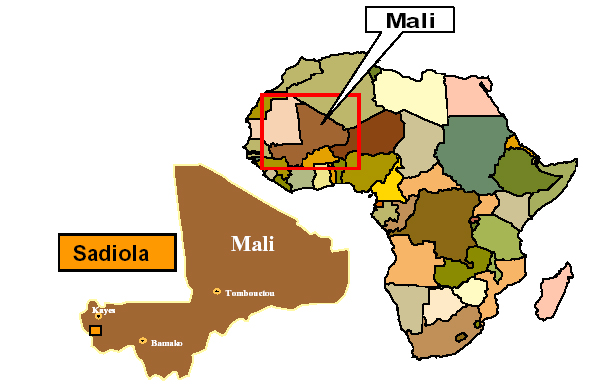
· | The Sadiola area is located in the west of the Republic of Mali, West Africa near the Senegal/Mali border, approximately 70 km south of Kayes, the regional capital. Access to the Sadiola Gold Mine from Kayes is by a regional all-weather road. There is an airstrip at the Sadiola Gold Mine capable of handling light aircraft. |
· | The Sadiola deposit is located within the Malian portion of the Kenieba - Kedougou window, a major early Proterozoic – Birimian inlier along the north east margin of the Kenema – Man shield. The Sadiola deposit is hosted by sediments of the Kofi formation and occurs along the Sadiola fracture zone (“SFZ”). The gold mineralization occurs over a drilled strike length of approximately 2500 metres, and is associated with both arsenic and antimony dominated sulphide assemblages. |
· | As at December 31st, 2003 the mineral reserve at the Sadiola Gold Mine was: |
Category | Tonnes (millions) | Grade (g/t gold) | ContainedGold (000’s oz) |
| Proved | 6.5 | 1.9 | 405 |
| Probable | 19.9 | 3.6 | 2,289 |
| Total mineral reserves | 26.4 | 3.2 | 2,694 |
(see explanatory notes page 29) |
As at December 31st, 2003 the Measured and Indicated mineral resource (including proved and probable ore reserves) at the Sadiola Gold Mine was:
Category | Tonnes (millions) | Grade (g/t gold) | Contained Gold (000’s oz) |
Sadiola Open Pit | |||
| Measured | 15.9 | 1.6 | 818 |
| Indicated | 22.6 | 2.6 | 1,904 |
| Total O/P (M&I) | 38.5 | 2.2 | 2,722 |
Deep Sulphides | |||
| Measured | 1.0 | 3.0 | 92 |
| Indicated | 0.1 | 2.1 | 4 |
| Total Deep Sulphides (M&I) | 1.1 | 2.9 | 95 |
Satellite oxide deposits | |||
| Measured | 0.3 | 1.9 | 21 |
| Indicated | 3.8 | 2.7 | 328 |
| Total Satellite Oxide (M&I) | 4.1 | 2.6 | 349 |
Total M&I | 43.7 | 2.2 | 3,166 |
(see explanatory notes page 29) |
| i | ||
· | As at December 31st, 2003 the Inferred mineral resource at the Sadiola Gold Mine was: |
Category | Tonnes (millions) | Grade (g/t gold) | Contained Gold (000’s oz) |
| Sadiola Open Pit | 1.8 | 1.2 | 72 |
| Deep Sulphides | 130.0 | 1.8 | 7,532 |
| Satellite oxide deposits | 12.5 | 1.3 | 533 |
| Total Inferred | 144.3 | 1.8 | 8,137 |
· | The oxide and sulphidic saprolite ores are being exploited by open pit mining techniques. The pit is currently designed to be approximately 2,000m in length with a maximum width and depth of 700 m and 150 m, respectively. |
· | The process plant consists of two identical parallel circuits collectively capable of treating approximately 5.3 million tonnes of saprolite ores per year. |
· | A conceptual model, which was based on projections and assumptions made by the mine site technical staff, indicated that there was potential for a substantial amount of hard sulphide mineralization below the soft saprolitic oxide ore body presently being mined, and that at a gold price of US$325 per ounce, this mineralization might be economically mined and possibly extend the life of mine by up to 4 years. It was stressed at the time, and it is re-stressed here, that this conceptual model was not to be confused with a resource calculation and that the validity of the model was to be tested by drilling programs. The testing of these deep sulphides is now at Phase VII of drilling. This drilling is expected to be completed by October 2004 and a preliminary feasibility on the deep sulphides is expected by the end of the first quarter 2005. |
| ii | ||
INTRODUCTION AND TERMS OF REFERENCE
This technical report is a compilation of various reports, studies and analyses conducted by SEMOS on various aspects of the operations at the Sadiola Gold Mine over the past few years. It has been prepared in the form required by Canadian National Instrument 43-101.
The scope of work presented in this report involves the following aspects of the Sadiola Gold Mine:
| · | Operating Environment |
| · | Geology |
| · | Mining Operations |
| · | Processing Operations |
| · | Mineral Reserves/Resources |
| · | Environmental |
All units in this report generally conform to metric usage except where stated otherwise. Gold weight is presented in grams or ounces (31.10348g/oz). Currencies are expressed in United States Dollars (US$).
Annual periods in this report generally refer to the twelve month period ending December 31 except where otherwise stated.
The information contained within is based on: (1) historic data, (2) information developed by SEMOS in the normal course of operating the Sadiola Gold Mine, (3) the Sadiola Hill Gold Mine Business Unit Plan (internal report), dated June 2003, (4) the Sadiola – Identified Mineral Resource Statement 2003 (internal report), prepared by SEMOS, and (5) Sadiola Resources and Reserves 2003 (internal report).
Field Involvement (Competent Persons)
Tom Gell is the Evaluation Manager for AngloGold Ashanti Mali. Mineral resources for the Sadiola Gold Mine were prepared under the supervision of, or reviewed by, Mr Gell. In turn the Mineral Resources were audited from a corporate perspective by Mr. Vaughan Chamberlain for AngloGold Ashanti. Mineral reserves were prepared under the supervision of Mr. David Worrall for AngloGold Ashanti.
Dennis Robertson, author of this 43-101 report, is a senior geologist employed by IAMGold. Mr. Robertson has visited the Sadiola Gold Mine on behalf of IAMGold on numerous occasions.
| 1 | ||
Disclaimer, Limitations and Cautionary Statement
The information contained herein with respect to reserves and resources at the Sadiola Gold Mine is based on the mine’s December 2003 declaration. The information reflects the various technical and economic conditions at that time and given the nature of mining operations, these conditions can change significantly over relatively short periods of time.
The Life of Mine (“LOM”) plans and the technical economic projections contain forward-looking statements that are not historical facts and are required in accordance with the reporting requirements of the Ontario Securities Commission. Since forward-looking statements address future events and conditions, by their very nature, they involve inherent risks and uncertainties that could cause actual results to differ materially from those currently anticipated in the LOM plans.
The Sadiola Gold Mine consists of an open pit mining operation exploiting the Sadiola gold deposit, associated carbon-in-pulp processing plant, townsite and infrastructure at Sadiola, in Mali. The Sadiola Gold Mine is owned by SEMOS, which holds the mining rights for gold, silver (and related substances) and platinoids on the Sadiola Mining Permit. The Sadiola Mining Permit was granted December 22, 1994, for an initial term of 30 years, and covers an area of 302 km2. The shareholders of SEMOS are IAMGold, which indirectly owns 38%, AngloGold Ashanti, the operator, which indirectly owns 38%, the Government of Mali, which owns 18%, and the International Finance Corporation (‘‘IFC’’), a member of the World Bank Group, which owns 6%.
The Sadiola Gold Mine is located in western Mali, close to the Senegal border (Figure 1).
| 2 | ||
ACCESSIBILITY, CLIMATE, LOCAL RESOURCES, INFRASTRUCTURE AND PHYSIOGRAPHY
The Sadiola area is located in the west of the Republic of Mali, West Africa near the Senegal/Mali border, approximately 70 km south of Kayes, the regional capital. Access to the Sadiola Gold Mine from Kayes is by a regional all-weather road. There is an airstrip at the Sadiola Gold Mine capable of handling light aircraft. Kayes is serviced by rail, road and air from Bamako, the capital of Mali, and from Dakar, the capital of Senegal. Bamako has an international airport with daily flights to many other West African and European destinations. There are return flights twice a week between Bamako and Kayes. Dakar is a major port of entry to West Africa by sea and air.
The Sadiola Mining Permit is for an initial term of 30 years, expiring in 2024, and may be extended by order of the President of Mali if mining operations are ongoing.
The Sadiola Gold Mine is located in a remote part of Mali with almost no infrastructure. The operation of the mine and process plant required upgrading of the regional gravel road linking the mine to Kayes.
A 57 km pipeline from the Senegal River, the only reliable source of water in the region, was built to provide approximately 8 million m3 per year of process water in order to ensure that the Sadiola Gold Mine does not impact on local water resources. Potable water for both the mine operation and the mine townsite is supplied from the pipeline and treated prior to distribution.
Electrical power is provided through Sadiola’s diesel powered generating sets which are capable of meeting an average demand of 16.7 megawatts and a peak demand of 17.7 megawatts. Approximately 2.7 million litres of diesel fuel per month for power generation and mining are being supplied under a contract with Total/ELF. The seven million litre national strategic fuel depot in Kayes is used as back-up storage in case of major road and/or rail disruptions.
A townsite has been established to the northeast of the Sadiola Gold Mine and provides housing, a primary school, a medical clinic, a park and recreation facilities for mine employees and their dependants, guest accommodation, a post office, a supermarket, sewage treatment facilities and other amenities. There are more than 1,000 employees, including those employed by outside contractors, at the Sadiola Gold Mine. A microwave telephone system tied to the national grid at Kayes and satellite phones link the mine with the outside world.
The terrain around the Sadiola Mine is generally flat at an elevation of 125 m above sea level.
The climate is subtropical-to-arid with a dry and a rainy season. The dry season is warm from November to February (15 to 300C) and hot from March to June (25 to 450C). The rainy season lasts from July to October. Annual rainfall is in excess of 1,000 mm and evaporation is twice the precipitation rate.
The Sadiola deposit was identified as a favourable exploration area, particularly for gold, based upon the widespread evidence of artisanal gold workings, and small scale mining by locals. Written records of mining at Sadiola reportedly date back 250 years and the extent of the old workings suggests that the mining could have occurred over 1,000 years ago.
| 3 | ||
From October 1987 to August 1989, a large regional geochemical survey, called Mali-Ouest 1, was carried out for the Government of Mali by Klockner INA (“Klöckner”) of Germany, as part of an aid program financed by the European Development Fund. In addition to the 48,000 samples collected during this first-pass regional program, detailed geochemical sampling near the village of Sadiola and Dinnguilou confirmed high gold, arsenic and antimony anomalies defined by the reconnaissance survey in this area.
In January 1990 exploration rights in respect of the Sadiola area were granted by the Government of Mali. Klöckner was hired to conduct a large scale gold exploration program at Sadiola consisting of geological mapping, geophysical surveys, pitting, and core drilling. This work identified the presence of a significant oxide gold deposit.
In 1991 Watts, Griffis and McOuat (“WGM”), was retained by IAMGold to review the work of Klöckner, to prepare a preliminary economic assessment of the Sadiola prospect, and to make recommendations for further work. The preliminary feasibility study was positive and WGM recommended a large exploration program with emphasis on drilling to delineate and confirm the mineral resource at Sadiola.
During 1991 and 1992 WGM assumed responsibility of the ongoing exploration effort. In December 1992 WGM estimated a probable reserve of 22.3 million tonnes of oxide mineralization grading 3.3 g/t gold.
In October 1992, a joint-venture agreement with Anglo American (“AAC”) was signed for the construction and management of any mine developed at Sadiola. A feasibility study, dated December 1993, on the Sadiola gold deposit, prepared by AAC, was presented to the Government of Mali. August 1994 the Government of Mali issued an exploitation permit (the “Sadiola Mining Permit”).
SEMOS was incorporated on December 14th, 1994 as the joint venture company to hold the Sadiola Mining Permit, to exploit the Sadiola gold deposit and to carry out exploration activities within the Sadiola area.
By January 1995, a total financing package for the mine of US$303 million was completed, with the IFC’s project financing of $160 million being supplemented by $143 million from Anglo American in the form of subordinated loans.
The Sadiola Gold Mine poured its first gold bar on December 20th, 1996. Since start-up, the mine has produced 3,587,024 ounces to the end of March 31, 2004.
AngloGold Ashanti, through its wholly-owned subsidiary AngloGold Ashanti Mali S.A. (‘‘AngloGold Mali’’), is the operator of the Sadiola Gold Mine. In consideration for its services, AngloGold Ashanti Mali is entitled to receive a management fee of 1% of revenue derived from operations at the Sadiola Gold Mine.
The Sadiola deposit is located within the Malian portion of the Kenieba - Kedougou window, a major early Proterozoic – Birimian inlier along the north east margin of the Kenema – Man shield (Figure 2). The Birimian of the window can be interpreted as a collage of at least two N-S trending terrains of different nature. To the west an older ( 2.2 Ga) tholeitic mafic volcanic unit with island arc type volcanics and intruded by a major calc-alkaline batholith, belongs to the Saboussire formation. It is separated from the dominantly sedimentary sequence of the Kofi formation by a major north to northeast trending shear zone. This sedimentary domain is significantly younger and itself intruded by calc-alkaline batholiths dated at 2.0 – 2.05 Ga. Metamorphic grade attains greenschist facies, with formation of metamorphic biotite and locally amphibolite grade near m ajor intrusions. The Kofi formation is obliquely cut by the approximately N-S to N10º trending Senegalo-Malian shear zone which is punctuated by several gold deposits along its splays (Sadiola, Yatela, Loulo, Yalea).
| 4 | ||

The Sadiola deposit is located in the north of the window and is hosted by sediments of the Kofi formation, which have been intruded by numerous felsic intrusives. The sediments dominantly consist of fine grained greywacke, probably distal turbidites and impure carbonates with minor tuffs and acid volcanics. At Sadiola, the intensely folded impure carbonate packages consist of an alternation of limestone beds, a few millimetre to several decimetres thick, with thinner more detritic beds.
The Sadiola deposit conspicuously occurs along the N 10º striking Sadiola fracture zone (“SFZ”), which is thought to be a brittle-ductile splay off the Senegalo-Mali shear at a sinistral releasing bend. The SFZ follows the steeply westerly dipping contact between greywacke to the west and impure carbonate to the east. Along the SFZ both the greywacke and impure carbonate are transposed. The SFZ and its wallrock are injected by discontinuous diorite dikes, which may show a weak mineral foliation and rarely intense ductile deformation. Silicified quartz-feldspar-porphyry (QFP) dikes often intrude along later steep west dipping, N 20º striking structures. The QFP’s crosscut the diorites and may show brittle fracturing. Post mineralization deformation has complicated structural relationships in the deposit.
| 5 | ||
At Sadiola, gold mineralization occurs along the SFZ over a drilled strike length of approximately 2500 m and remains open to the north and south. N 20º trending fault splays off the SFZ are also well mineralized.
The mine geological and grade block model indicates the presence of 20º to 25º south dipping ore shoots within the plane of the SFZ. Mineralization occurs in all of the four major rock types (marble, greywacke, diorite, and quartz-feldspar porphyry) and is spatially associated with a complex alteration pattern. Drilling of the (unweathered) primary mineralization has allowed detailed investigation of major and minor hydrothermal alteration processes that were active during the formation of the deposit. Alteration assemblages identified to date include: calc-silicate, potassic, chlorite–calcite, carbonate and silicification. Gold is associated with both arsenic and antimony dominated sulphide assemblages including arsenopyrite, pyrrhotite, pyrite, stibnite and gudmuntite.
At Sadiola, the geometry of the extensive soft ‘saprolitic’ oxide deposit relates almost exclusively to the supergene weathering history of the primary mineralization. The permeability of the rock formation, controlled mainly by faulting, shearing and porosity, allowed the deep penetration of ground water causing oxidation of primary sulphides. Oxidation of pyrite (and other sulphide species) results in the formation of sulphuric acid further promoting the downward argillization of the bedrock to form the clay rich assemblages present in the saprolite. The irregular, ‘karst’ like (trough and crest) soft rock/hard rock contacts can in many cases be related to the extent of faulting and the original sulphide content of the overlying profile.
The observed alteration assemblages in the primary mineralization point to a mesothermal origin for the gold deposit at Sadiola. This is in line with genetic concepts for other gold mineralization in the Birimian of West Africa. The role that supergene weathering processes have contributed to the current disposition of the Sadiola deposit cannot be underestimated. A reduction in density and relative gold enrichment caused by the iso-volumetric weathering of the primary mineralization at Sadiola has been the principal mechanism for producing the deeply weathered saprolite deposit currently being mined.
The recently revised structural study indicates that one of the major primary controls on the localization of mineralization at Sadiola is the basal contact of a diorite body that acted as a cap to mineralizing fluids. It appears that the diorite was intruded along the Sadiola fracture zone (SFZ) and folded with the SFZ and plunges to the south at an average dip of 15-20°. Gold was introduced to the host rock(s) via the NS trending SFZ and related subsidiary thrust fault planes.
| 6 | ||
A simplified structural history for Sadiola is as follows:
See Figure 3 – I
| · | Thrust faulting / Sadiola Fracture Zone (SFZ) Initiation (Ductile dominated). |
| · | Diorite emplacement. |
See Figure 3 – II
| · | Main mineralization event. |
| · | Continued movement on SFZ. |
See Figure 3 – III
| · | NE-NNE Extensional ‘E’ faulting (Brittle offsetting of orebody). |
| · | Very late WNW ‘B’ faults. |
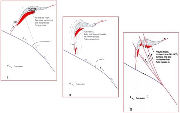
The Sadiola Fracture Zone
The main control on the mineralization is the SFZ. It is a north south oriented splay of the regional Senegalo-Malian shear. This fault system constitutes a plumbing system for gold- bearing fluids.
It is clearly evident that the main mineralization follows a north-south trend (Figure 4). This trend occurs as a 200 m wide corridor with high gold grades distributed along elongated, north-south oriented patches. The high grade lenses are wide, continuous and sharply defined in the marble but are thin and continuous in the diorite. High grade lenses are thin and discontinuous in the greywacke.
| 7 | ||
The Southern Diorite Body
In the southern part of the ore body a south dipping diorite capping is interpreted as intrusive into the SFZ and subsequently folded. The sub horizontal fold axis plunges 15° south.
It can be seen that:
| · | The main mineralized zone occurs sub horizontally (15° southern dip) below the diorite and remains parallel to the diorite. |
| · | The mineralization is located predominantly in the highly reactive marble footwall. |
| · | Mineralization also crosscuts the diorite body following a north-south trend that marks the southern continuation of the SFZ. Minor NNE trending high grades lenses also occur stratigraphically above the diorite. |
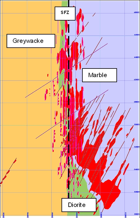 |
The NNE structures constitute the other structural control on mineralization. From the high grade contour map of the 110 level it is seen that:
· | The NNE structures are linear mineralized structures and therefore pre-date the main mineralization event. |
· | Higher density of NNE structures result in more intense mineralization. |
Mineralization Potential at Depth
Previously interpreted as steeply dipping planar, the SFZ now displays an important flexure at depth. This jog constitutes another major control on the mineralization and from sections it can be seen that other mineralization occurs at depth associated with the flexure (Figure 5 and 6).
| 8 | ||
| 9 | ||
The flexure introduces geometric irregularities along the SFZ. During movement (vertical, with or without strike slip component) zones of more intense compression and decompression were generated. The decompressed zones will be the locus of more intense fluid flow and associated mineralization. In addition, extensional locations, especially on SFZ-NNE intersections, appear to have produced very high grade pods within this zone of deep mineralization.
The classification of the Sadiola Deposit as ‘Mesothermal-Shear Hosted’ has many implications regarding the distribution of mineralization and resource potential. Deposits of this type world-wide exhibit good continuity of mineralization both along strike and extend to great depth. Structurally controlled, high grade ‘pay shoots’ typically occur within a more pervasive lower grade halo in these types of deposit. At Sadiola, the location and geometry of high grade mineralization appears to be controlled by the confluence of the SFZ with the N20º splays resulting in steeply to vertically plunging zones within the plan of the SFZ. Further drilling and underground development will be required prior to development of these resources.
Pervasive gold mineralization ranging in grade from 2 g/t to 20 g/t occurs along the SFZ over a strike length of more than 2 kilometers. The mineralization is mainly contained in altered carbonates and to a lesser extent in greywacke, diorite and occasionally in quartz-feldspar porphyry. Gold is associated with both arsenic and antimony dominated sulphide assemblages including arsenopyrite, pyrrhotite, pyrite, stibnite and gudmuntite. Primary gold is extremely fine grained, dominantly less than 15 microns, with rare grains approaching 50 microns.
The deposit has been subjected to intense and deep weathering to variable depths that reach 220 metres (‘‘m’’) along the SFZ structure. Weathering results in enhanced gold grades in the low-density saprolitic ore (specific gravity of 1.7). In the deeper portion of saprolite, sulphide mineralization still occurs. The transition from sulphidic saprolite to mineralized hard rock is abrupt.
AAC’s evaluation program commenced in November 1992 and culminated with the preparation of the SADMAR95 resource model in March 1995. A summary of the drilling completed on the deposit and used in that modelling exercise is tabulated below:
Company | Type | No. of Holes | Metres |
| Klöckner | Diamond | 80 | 1,752 |
| WGM | Diamond | 37 | 5,020 |
| Anglo American Corp. | Diamond | 378 | 37,132 |
| AAC | Reverse-Circulation (RC) | 281 | 13,255 |
| TOTAL | 776 | 57,159 |
During 1996 an additional reverse circulation (“RC”) program was conducted to sample the northern end of the Sadiola deposit, the "Farabakouta" area. Drilling totals for this campaign are documented in Table 2.
| 10 | ||
Type | No. of Holes | Metres |
| RC | 105 | 3,185 |
| TOTAL | 105 | 3,185 |
Between April and December 1998 an infill RC drilling program was conducted in and around the limits of the Sadiola open pit. The program was designed to infill those areas planned to be mined within 2 years to a 25m x 25m grid spacing. To complement the RC infill program a diamond drill program was completed around the Sadiola open pit between February and May 1998.The program had two primary objectives, firstly, to increase the drilling density in the southern down plunge saprolite extension to the open pit (drilling at 100m x 50m) and secondly, to further define erratic mineralization in the "Farabakouta" area.
Table 3 below provides a summary of the drilling metres for the 1998 campaigns.
Type | No. of Holes | Metres |
| RC | 517 | 25,084 |
| Diamond | 41 | 7,724 |
| TOTAL | 558 | 32,809 |
In addition to the evaluation RC and diamond drilling, the SADMAR99 resource evaluation model included all grade control RC data available up to December 1998. Inclusion of the grade control data was for the purposes of providing measured resources in advance of 1999 production. The total drilling metres on the Sadiola deposit used in the calculation of the SADMAR99 resource estimates are summarized in the following table:
Type | Metres |
| RC - Evaluation | 41,524 |
| RC - Grade Control | 417,157 |
| Diamond | 51,628 |
| TOTAL | 510,039 |
The 2000 drilling campaign commenced in October 1999 and a drill cut off for modelling of April 2000 was applied. The primary focus of the programs was to add additional oxide ore tonnes in near surface, pit contiguous areas. One of the drilling programs, the southern pit inferred program, intended to bring both oxide and sulphide into the resource base. Some four areas were targeted for drilling, a fifth (southern trough extension) was completed post the modelling exercise. Summary statistics for the four areas drilled prior to the May modelling exercise are documented below:
| 11 | ||
Project Name | No. of Holes | No. of Metres | Intension |
| Eastern Margin | 35 | 3,270 | Inferred to indicated |
| NE Structures | 130 | 7,373 | Pre-inferred to indicated |
| Farabakouta | 102 | 6,503 | Pre-inferred and inferred to indicated |
| Southern Pit Inferred - RC | 10 | 990 | Inferred to indicated |
| - Diamond Tail | 9 | 1,644 | Inferred to indicated |
| Metallurgical Test Holes - RC | 6 | 339 | Metallurgical test work |
| - Diamond Tail | 5 | 639 | Metallurgical test work |
| TOTAL | 297 | 20,758 |
The 2001 drilling campaign commenced in October 2000 and a drill cut off of end May 2001 was applied. Similar to the 2000 program its primary purpose was to add additional oxide resources to the near pit environment. Some eight programs were completed during this time period, two of which (trough definition and geotechnical definition) were aimed at increasing geological boundary confidence.
Metres | |||||||
RC | Diamond | Total | |||||
Hard | Soft | Hard | Soft | Hard | Soft | Total All | |
| Farabakouta | 3,001 | 6,686 | 103 | 67 | 3,104 | 6,753 | 9,858 |
| E Margin | 942 | 2,294 | 0 | 0 | 942 | 2,294 | 3,236 |
| NE Structures | 2,562 | 5,122 | 0 | 0 | 2,562 | 5,122 | 7,684 |
| NE Structures West | 2,966 | 3,172 | 0 | 0 | 2,966 | 3,172 | 6,138 |
| Geotech | 98 | 486 | 0 | 0 | 98 | 486 | 584 |
| Sulphide Drilling Phase 3 | 801 | 624 | 4,678 | 0 | 5,478 | 624 | 6,102 |
| Southern Trough | 388 | 898 | 136 | 71 | 524 | 969 | 1,493 |
| Trough Definition | 426 | 772 | 946 | 596 | 1,372 | 1,368 | 2,741 |
| Total All | 11,184 | 20,054 | 5,864 | 734 | 17,048 | 20,788 | 37,836 |
No. Holes | ||
RC | Diamond | |
| Farabakouta | 121 | 1 |
| E Margin | 36 | 0 |
| NE Structures | 114 | 0 |
| NE Structures West | 86 | 0 |
| Geotech | 15 | 0 |
| Sulphide Drilling Phase 3 | 13 | 13 |
| Southern Trough | 11 | 3 |
| Trough Definition | 13 | 13 |
| Total All | 409 | 30 |
The 2002 pit drilling programs concentrated on 4 areas, 3 of which aimed at increasing resources, and one (trough definition) on defining the hard/soft contact within the depths of the trough. The northern SFZ and East and South Margin programs were drilled to a 25m x 25m resolution while the Farabakouta extension was drilled to a 25x50m resolution. The trough definition program targeted holes where needed. Statistics for these programs are presented in the Table 7 below.
Project | Total Metres (all RC) | No. of Holes |
| NE Structures (H2 2001 campaign) | 5,496 | 77 |
| Eastern margin (H2 2001 campaign) | 3,190 | 31 |
| East and Southern Margin (H1 2002) - phase 1 | 7,280 | 64 |
| Northern Sadiola Fracture Zone | 6,034 | 76 |
| Trough Definition | 506 | 9 |
| Total (2002) | 13,800 | 149 |
Some 15,010 m of RC (kit bit or face sampling hammer) drilling was undertaken in the Sadiola pit between November 2002 and February 2003. The primary objective of this drilling was to
| 12 | ||
increase confidence in the lower order indicated material, termed locally as “Geologically indicated”. This drilling dominantly took place south of line 6000N (see Figure 7 Sadiola 2003 collar locations).In total, some 152 boreholes were drilled (according to the pit borehole numbering sequence the borehole names were in the range R-1911 to R-2111).All holes, except R-1929 and R-1930, where assayed at the Semos laboratory using fire assay with atomic absorption finish (Fire AA) on a 40g aliquot. Any initial results that assayed greater than 7 g/t were completed using a gravimetric finish. Holes R-1929 and R-1930 were assayed at Analabs Kayes using Fire AA (30g aliquot). Quality control samples were inserted as per Semos procedures (see later section “Sampling and Analysis”).
The total metres of drilling available for pit modeling is documented in Table 8
Year | Metres | Total | |
RC | DD | ||
| 1991/92 | 6,772 | 6,772 | |
| 1993 | 37,132 | 37,132 | |
| 1994 | 13,255 | 13,255 | |
| 1996 | 3,185 | 3,185 | |
| 1996-98 (Grade Control) | 417 | 417,157 | |
| 1998 | 25,084 | 7,724 | 32,808 |
| 2000 | 18,475 | 2,283 | 20,758 |
| 2001 | 31,238 | 6,598 | 37,836 |
| 2002 | 13,800 | 13,800 | |
| 2003 | 15,010 | 15,010 | |
Total (excluding 1996-1998 Grade Control) | 120,047 | 60,509 | 180,556 |
| 13 | ||
The Deep Sulphides constitute the unweathered material immediately below the main Sadiola ore body. The major structure is a horsetail system which strikes NNE. From west to east, the faults to the west are dipping to the east (500-550) becoming sub-vertical and gently dipping west in the east. These NNE structures seem to join together at depth and cross-cut the Sadiola Fracture Zone. From the core logging it was not possible to clearly establish the existence of a major shear at the contact between the marble and the greywacke as logged in the pit. Movement can be clearly observed but could be due to a rheological contact between the two major units.
NW-SE faults were observed the length of the pit but with a major expression between lines 5800N to 6000N. These faults conjugate with the NNE structures resulting in a zone of weakness and could be responsible for failures. It is believed that these faults do not extend at depth and have only a local effect on the stability. For a more detailed account of the Sadiola ore body please refer to the relevant section in this document.
In 1997 Phase I of the deep sulphide diamond drilling program was completed at Sadiola. Eleven angled (600 E) diamond drill holes totalling 5,770 metres were put down along 500m of strike length of the orebody. All holes intersected broad zones of mineralization and all except one contained significant intersections averaging more than 3 g/t gold. Seven of the holes contained intersects which averaged at least 3 g/t gold over lengths of 15m or more and five of these holes contained greater than 3 g/t intersections over 30m or more. The most notable intersection was 49m at 4.0 g/t gold in SSD - 011. Importantly, higher grade (greater than or equal to 4 g/t gold) intersections were also encountered in 10 of the 11 holes, ranging up to 8.9 g/t gold over 7m in SSD - 011.
The Phase 1 drilling confirmed that a broad envelope of sulphide mineralization, often with a true width of more than 50m, extends below the oxide orebody to a drill-proven depth of more than 400m (in one case to 520m) below surface.
Phase II of the deep sulphide drilling program was completed June 1998. A total of eleven additional holes were drilled totaling 7035 metres.
Phase I & II were mainly reconnaissance drilling programs. The 22 holes drilled were beneath the oxide ore zone. The drill spacing was 200m by 100m. After Phase I & II, it was apparent that the main sulphide ore potential was between 5000N and 6200N and the subsequent phases were to focus between these limits.
Phase III of the Sadiola deep sulphide drilling program was concluded in January 2001 with the completion of 6,210m of drilling in 13 holes including a geotechnical hole (RC collars and diamond drill tails). The objective of this program was to test the potential of possibly deepening the Sadiola open pit. The Phase III holes intersected several broad zones of + 3 g/t gold mineralization, including some narrower higher grade zones, which gave early encouragement to the concept of deepening the pit below the then planned depth of 140m.
| 14 | ||
The Phase IV deep sulphide drilling program consisted of 22 holes totalling 7,288m. Drilling was aimed at exploring the sulphide ore potential below the north end of the Sadiola pit and at further defining grade and continuity of the known sulphide mineralization below the core of the deposit in the central and southern part of the pit. Integration of these results with previously acquired data and a revised map of pit geology indicated that the deposit is divided in two by a major NNE striking fault. North of this fault, shallow oxide and sulphide mineralization is underlain by intensely hydrothermally altered rock from which drill holes have intersected narrow zones of gold mineralization. In the southern part of the deposit, the oxide ore is underlain by deeply rooted sulphide mineralization. Broad mineralized zones confirming the continuity of this mineralization were intersected despite some structural complication.
Table 9 lists drill results from these earlier programs (Phases I to IV) that have been reported in press releases dated November 11, 1997, August 5, 1998, November 4, 1998, February 14, 2001 and February 22, 2002. These releases can be found on IAMGold’s website at www.iamgold.com.
Phase III and IV objectives were to reduce the drilling grid from 200x100m to 100x100m. In addition the Phase IV objectives were to verify structural models generated during previous phases of drilling and to test mineralization potential towards the north (north of 5800N).
| 15 | ||
Table 9: Sulphide drilling results from Phases I to IV
SADIOLA SULPHIDE DRILLING RESULTS FROM PHASES I TO IV | ||||
Hole no. | From (m) | To (m) | Length (m) | Grade (g/t Au) |
| SD-01 | 334 | 358 | 24 | 4.0* |
| - including | 340 | 345 | 5 | 8.5 |
| 433 | 449 | 16 | 3.8 | |
| - including | 441 | 449 | 8 | 5.2 |
| 584 | 599 | 15 | 3.5 | |
| SD-02 | 238 | 248 | 10 | 2.4 |
| SD-03 | 225 | 249 | 24 | 2.8 |
| - including | 239 | 248 | 9 | 4.7 |
| 280 | 328 | 48 | 3.0 | |
| - including | 281 | 291 | 10 | 6.0 |
| SD-04 | 352 | 382 | 30 | 3.0 |
| -including | 359 | 376 | 17 | 4.0 |
| -including | 366 | 370 | 4 | 6.1 |
| SD-05 | 319 | 337 | 18 | 4.2 |
| SD-06 | 207 | 247 | 40 | 3.4 |
| - including | 207 | 230 | 23 | 4.9 |
| - including | 207 | 215 | 8 | 5.1 |
| - including | 224 | 230 | 6 | 7.7 |
| SD-07 | 320 | 323 | 3 | 5.2 |
| 399 | 406 | 7 | 7.1 | |
| SD-08 | 230 | 290 | 60 | 3.6* |
| - including | 244 | 290 | 46 | 4.1 |
| - including | 252 | 260 | 8 | 7.6 |
| - including | 281 | 290 | 9 | 7.1 |
| SD-09 | 218 | 233 | 15 | 3.4 |
| 261 | 269 | 8 | 3.5 | |
| 301 | 314 | 13 | 3.3 | |
| 353 | 357 | 4 | 5.9 | |
| SD-10 | 307 | 319 | 12 | 5.3 |
| 343 | 385 | 42 | 2.3 | |
| - including | 352 | 358 | 6 | 7.7 |
| 411 | 428 | 17 | 3.3 | |
| 422 | 428 | 6 | 5.1 | |
| SD-11 | 438 | 487 | 49 | 4.0 |
| - including | 439 | 446 | 7 | 8.9 |
| - including | 458 | 463 | 5 | 5.7 |
| - including | 468 | 477 | 9 | 5.2 |
| SD-12 | 750 | 767 | 17 | 4.6* |
| SD-13 | 567 | 585 | 18 | 4.2 |
| SD-16 | 52 | 66 | 14 | 3.6 |
| SD-17 | 611 | 660 | 49 | 3.1* |
| SD-20 | 298 | 317 | 19 | 3.2 |
| SD-21 | 444 | 449 | 5 | 5.5 |
| SD-22 | 299 | 375 | 76 | 6.9 |
| SD-23 | 442 | 453 | 11 | 3.6 |
| 473 | 559 | 86 | 3.1 | |
| - including | 522 | 533 | 11 | 5.7 |
| - including | 540 | 559 | 19 | 4.7 |
| - including | 549 | 557 | 8 | 6.4 |
| SD-24 | 273 | 295 | 22 | 3.6 |
| SD-25 | 238 | 354 | 116 | 3.3 |
| -including | 248 | 258 | 10 | 7.3 |
| - including | 301 | 316 | 15 | 5.3 |
| SD-26 | 452 | 531 | 79 | 3.0 |
| - including | 499 | 510 | 11 | 4.4 |
| - including | 516 | 534 | 18 | 5.0 |
| SD-27 | 381 | 425 | 44 | 3.9 |
| - including | 405 | 410 | 5 | 8.8 |
| - including | 412 | 417 | 5 | 7.8 |
| SD-28 | 544 | 594 | 50 | 3.0 |
| - including | 582 | 594 | 12 | 5.2 |
| 16 | ||
SADIOLA SULPHIDE DRILLING RESULTS FROM PHASES I TO IV | ||||
Hole no. | From (m) | To (m) | Length (m) | Grade (g/t Au) |
| SD-29 | 328 | 339 | 11 | 3.0 |
| SD-30 | 536 | 573 | 37 | 8.0 |
| SD-31 | 212 | 269 | 57 | 3.2 |
| SD-32 | 304 | 353 | 49 | 4.2 |
| -including | 339 | 349 | 10 | 8.8 |
| SD-34 | 405 | 436 | 31 | 4.3 |
| - including | 421 | 429 | 8 | 8.0 |
| SD-35 | 251 | 269 | 18 | 5.7 |
| - including | 262 | 268 | 6 | 11.9 |
| 281 | 295 | 14 | 10.5 | |
| - including | 289 | 295 | 6 | 15.9 |
| 331 | 351 | 20 | 4.5 | |
| SD-37 | 191 | 216 | 25 | 3.3 |
| - including | 210 | 215 | 5 | 5.5 |
| SD-38 | 44 | 94 | 50 | 4.9 |
| - including | 61 | 93 | 32 | 6.8 |
| SD-40 | 154 | 157 | 3 | 11.2 |
| SD-41 | 134 | 139 | 5 | 4.0 |
| SD-43 | 121 | 130 | 9 | 9.2 |
| 147 | 154 | 7 | 5.7 | |
| SD-46 | 261 | 264 | 3 | 16.9 |
| SD-51 | 194 | 198 | 4 | 3.7 |
| 246 | 276 | 30 | 3.1 | |
| - including | 248 | 254 | 6 | 5.6 |
| 295 | 309 | 14 | 4.4 | |
| SD-52B | 125 | 129 | 4 | 3.7 |
| 199 | 251 | 52 | 3.6 | |
| - including | 213 | 223 | 10 | 7.7 |
| SD-53B | 281 | 288 | 7 | 3.7 |
| 310 | 315 | 5 | 3.0 | |
| SD-54 | 263 | 272 | 9 | 4.9 |
| 290 | 311 | 21 | 3.9 | |
| - including | 295 | 310 | 15 | 4.6 |
| SD-55 | 245 | 249 | 4 | 3.5 |
| 291 | 391 | 28 | 1.7 | |
| SD-56 | 183 | 188 | 5 | 3.4 |
| 249 | 288 | 39 | 3.2 | |
| - including | 280 | 288 | 8 | 6.7 |
* Includes one metre sample cut back to 30 g/t |
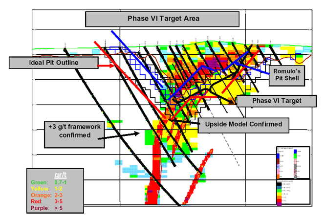
In June 2002, a conceptual study was carried out by Romulo Sanhueza, a mining engineer employed by AngloGold Ashanti Limited, for the Sadiola Deep Sulphide based on an “upside” model. The upside model was conceptual in nature.
| 17 | ||
The results from the earlier drill programs (Phases I through IV) were used to build a digital geological model, which was data-constrained, because of the relatively modest number of drill holes that existed in the two kilometre-long zone of mineralization. In order to assess the potential, which might exist, in the sulphide mineralization, the geological model was expanded to build an “upside” model by the mine site technical staff. This was achieved by incorporating material which the mine geologists interpreted as having a high probability of being mineralized, based on information from nearby holes and on the enhanced knowledge of the controls and continuity of the mineralization. The improved level of confidence that existed in the geological modeling of the Sadiola deep sulphide mineralization was based on detailed structural, lithological and alteration mapping of both the open pit, which was exposed over a length of more than two kilometres and down to a depth of 80 metres, and the boreholes.
The conceptual model, which was based on projections and assumptions made by the mine site technical staff, indicated that there was potential for a substantial amount of hard sulphide mineralization below the soft saprolitic oxide and sulphide ore body presently being mined, and that at a gold price of US$325 per ounce, this mineralization might be economically mined and possibly extend the life of mine by up to 4 years. It was stressed at the time, and it is re-stressed here, that this conceptual model was not to be confused with a resource calculation and that the validity of the model was to be tested by the Phase V drilling program.
Although the upside model cannot be equated to resources as defined by the CIM standards on mineral resources and reserves, the AngloGold Ashanti preliminary analysis of the model provide, for the first time in the on-going hard sulphide drilling program, a conceptual assessment of the potential quality of the target that the primary mineralization represents at Sadiola. The validity of this conceptual model was tested by Phase V drilling.
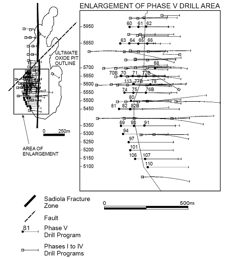
Phase V of the Sadiola deep sulphide drilling consisted of 40 holes, totaling 15,904 metres. The objective of this phase of drilling was to further define the sulphide-associated gold mineralization encountered in earlier drill programs and effectively bring the density of drilling to approximately 50 metres by 50 metres on the main ore zone between 5050N to 6000N. In addition the drilling was to test the viability of the “upside” conceptual geological model for the deep sulphide mineralization as part of an on-going process of verifying that the exploitation of these sulphides can be effected by substantially deepening the Sadiola open-pit beyond its present planned depth of 150 metres.
The results from Phase V drilling were very supportive of the conceptual model by generally confirming the location and the grades of the previously interpreted mineralization. The Phase V drill results were consistent with earlier drill programs in demonstrating the presence of broad zones of mineralization, often measured in several tens of meters, averaging above 3 g/t gold.
A compilation of the Phase V results are presented in Table 10.
| 18 | ||
SADIOLA SULPHIDE DRILLING PHASE V RESULTS (> 3 g/t GOLD) | ||||||
| Section | Hole Id | From (m) | To (m) | Length (m) | Grade (g/t) | |
| 5950 | SD-060 | 320 | 344 | 24 | 3.9 | |
| 379 | 397 | 18 | 3.1 | |||
| SD-061 | 211 | 218 | 7 | 3.0 | ||
| 225 | 253 | 28 | 3.2 | |||
| 261 | 269 | 8 | 3.5 | |||
| 304 | 307 | 3 | 3.0 | |||
| 310 | 313 | 3 | 3.4 | |||
| SD-062 | 175 | 231 | 56 | 3.3 | ||
| 223 | 231 | 8 | 8.1 | |||
| Incl. | 224 | 230 | 6 | 10.4 | ||
| 5850 | SD-063 | 334 | 372 | 38 | 3.0 | |
| 375 | 386 | 11 | 3.0 | |||
| 392 | 402 | 10 | 4.2 | |||
| 411 | 420 | 9 | 3.0 | |||
| SD-064 | 290 | 299 | 9 | 4.3 | ||
| Incl. | 294 | 296 | 2 | 9.0 | ||
| SD-065 | 249 | 274 | 25 | 3.9 | ||
| Incl. | 264 | 268 | 4 | 8.7 | ||
| SD-066 | 193 | 279 | 86 | 4.0 | ||
| Incl | 221 | 227 | 6 | 8.0 | ||
| Incl. | 244 | 255 | 11 | 8.2 | ||
| Incl. | 248 | 252 | 4 | 17.9 | ||
| Incl. | 264 | 266 | 2 | 11.9 | ||
| Incl. | 275 | 278 | 3 | 11.2 | ||
| 5700 | SD-068 | 151 | 197 | 46 | 3.2 | |
| Incl | 193 | 195 | 2 | 9.6 | ||
| 5650 | SD-070 | 110 | 115 | 5 | 4.7 | |
| SD-070B | 269 | 274 | 5 | 3.1 | ||
| 347 | 369 | 22 | 3.1 | |||
| Incl | 360 | 377 | 17 | 3.0 | ||
| 421 | 454 | 33 | 3.0 | |||
| 478 | 486 | 8 | 3.8 | |||
| SD-071 | 270 | 275 | 5 | 3.1 | ||
| 291 | 301 | 10 | 3.0 | |||
| Incl. | 325 | 327 | 2 | 8.6 | ||
| 307 | 333 | 26 | 3.1 | |||
| 344 | 357 | 13 | 3.2 | |||
| Incl | 354 | 357 | 3 | 8.4 | ||
| SD-072B | 224 | 255 | 31 | 3.0 | ||
| 285 | 291 | 6 | 3.7 | |||
| Incl. | 289 | 291 | 2 | 8.5 | ||
| 5600 | SD-077B | 272 | 275 | 3 | 3.3 | |
| 287 | 293 | 6 | 4.1 | |||
| Incl. | 291 | 293 | 2 | 9.7 | ||
| 302 | 316 | 14 | 3.1 | |||
| 354 | 357 | 3 | 3.1 | |||
| SD-078 | 181 | 209 | 28 | 3.2 | ||
| Incl | 201 | 203 | 2 | 9.0 | ||
| SD-113 | 321 | 381 | 60 | 3.1 | ||
| Incl | 362 | 364 | 2 | 9.3 | ||
| 355 | 381 | 26 | 4.2 | |||
| Incl. | 376 | 380 | 4 | 8.2 | ||
| 396 | 399 | 3 | 3.5 | |||
| 19 | ||
SADIOLA SULPHIDE DRILLING PHASE V RESULTS (> 3 G/T GOLD) | ||||||
| Section | Hole Id | From (m) | To (m) | Length (m) | Grade (g/t) | |
| 5550 | SD-074 | 16 | 18 | 2 | 17.1 | |
| 34 | 36 | 2 | 23.9 | |||
| 347 | 370 | 23 | 3.3 | |||
| 375 | 431 | 56 | 3.1 | |||
| Incl. | 392 | 394 | 2 | 8.7 | ||
| SD-075 | 319 | 331 | 12 | 3.5 | ||
| 341 | 346 | 5 | 3.0 | |||
| 348 | 350 | 2 | 3.3 | |||
| 365 | 377 | 12 | 4.8 | |||
| Incl. | 372 | 377 | 5 | 9.7 | ||
| SD-076B | 236 | 240 | 4 | 3.0 | ||
| 5500 | SD-080 | 350 | 359 | 9 | 3.1 | |
| 365 | 369 | 4 | 3.0 | |||
| 377 | 407 | 30 | 3.1 | |||
| Incl. | 388 | 390 | 2 | 9.8 | ||
| 5450 | SD-081 | 4 | 10 | 6 | 5.1 | |
| Incl | 8 | 10 | 2 | 9.7 | ||
| 154 | 157 | 3 | 11.7 | |||
| 352 | 367 | 15 | 3.5 | |||
| Incl | 359 | 364 | 5 | 8.3 | ||
| 376 | 436 | 60 | 3.2 | |||
| Incl. | 413 | 418 | 5 | 9.9 | ||
| 449 | 454 | 5 | 3.2 | |||
| SD-082B | 332 | 353 | 21 | 3.9 | ||
| Incl. | 346 | 353 | 7 | 8.2 | ||
| 5350 | SD-089 | 422 | 445 | 23 | 3.0 | |
| 454 | 470 | 16 | 3.0 | |||
| 478 | 486 | 8 | 3.1 | |||
| SD-090 | 347 | 363 | 16 | 3.0 | ||
| 383 | 387 | 4 | 3.3 | |||
| 394 | 397 | 3 | 10.4 | |||
| SD-091 | 212 | 224 | 12 | 3.0 | ||
| 250 | 262 | 12 | 3.23 | |||
| 284 | 288 | 4 | 3.2 | |||
| 329 | 338 | 9 | 3.0 | |||
| 377 | 389 | 12 | 4.0 | |||
| 5300 | SD-094 | 436 | 509 | 73 | 3.3 | |
| Incl. | 438 | 448 | 10 | 8.2 | ||
| Incl. | 464 | 466 | 2 | 10.1 | ||
| 5250 | SD-097 | 430 | 469 | 39 | 3.0 | |
| 479 | 483 | 4 | 3.1 | |||
| 533 | 536 | 3 | 4.0 | |||
| 5200 | SD-101 | 381 | 405 | 24 | 3.0 | |
| 417 | 420 | 3 | 3.0 | |||
| 440 | 458 | 18 | 3.5 | |||
| Incl. | 441 | 445 | 4 | 8.6 | ||
| 488 | 494 | 6 | 5.4 | |||
| Incl | 489 | 492 | 3 | 9.5 | ||
| 5150 | SD-106 | 371 | 401 | 30 | 3.1 | |
| 439 | 444 | 5 | 2.9 | |||
| 450 | 454 | 4 | 3.2 | |||
| SD-107 | 254 | 278 | 24 | 3.0 | ||
| 325 | 341 | 16 | 3.6 | |||
| Incl. | 325 | 327 | 2 | 10.6 | ||
| 387 | 390 | 3 | 4.1 | |||
| 420 | 428 | 8 | 3.0 | |||
| 5100 | SD-110 | 250 | 253 | 3 | 3.1 | |
| 283 | 286 | 3 | 3.1 | |||
| 299 | 317 | 18 | 7.1 | |||
| Incl | 302 | 311 | 9 | 11.7 | ||
| 336 | 375 | 39 | 3.0 | |||
| Incl | 370 | 375 | 5 | 10.5 | ||
| 420 | 426 | 6 | 3.2 | |||
| 20 | ||
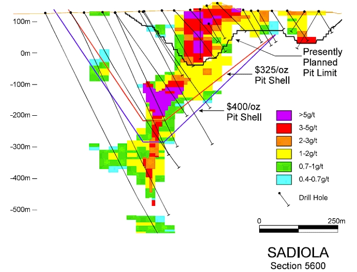
At the end of December 2002, the inferred resource of hard sulphides at Sadiola was 122.6 tonnes averaging 2.3 g/t for a contained gold content of 8.9 million ounces gold (Table 11). This resource calculation, carried out by AngloGold Ashanti did not utilize any data from Phase V drill holes. The cut-offs used for the resource estimate are for the purpose of establishing a “wire-frame” around the mineralized body and they are not representative of economically mineable grades at the proposed pit depth and the present gold price.
Category | Tonnes(Mt) | Grade(g/t) | Gold (t) | Gold(Moz) |
| Above US$400/oz pit @ 0.7 g/t cut-off | 93.2 | 2.1 | 195.0 | 6.3 |
| Below US$400/oz pit @ 1.4 g/t cut-off | 29.4 | 2.8 | 81.4 | 2.6 |
| Total | 122.6 | 2.3 | 276.4 | 8.9 |
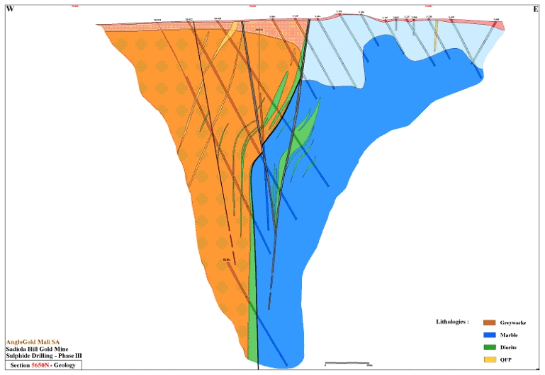
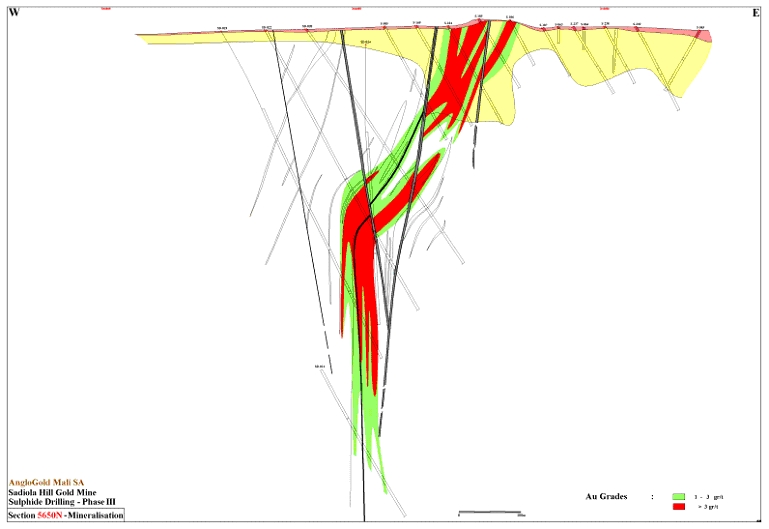
When the well-mineralized zones shown in Table 10 are referenced to drill hole locations shown in Figure 8, it is seen that there is continuity from section to section for about one kilometre of strike length. Deep sulphide mineralization does continue for at least another kilometre to the north but drilling density is lower and so the continuity of mineralization has not been established.
A typical cross section of the main zone of mineralization is shown in Figure 9. The section illustrates the presently planned ultimate pit depth to about 150m as well as the pit shells for gold prices of US$325 and US$400 per ounce. The section indicates that there might be a possibility of deepening the open pit to 250m below surface at a gold price of US$325 per ounce and to 300m, double the presently planned depth, at a gold price of US$400 per ounce. A much more detailed economic study has to be carried out to confirm this. A revision to the 2002 conceptual study which motivated the Phase V drilling, using much more detailed and updated economic parameters, commenced in 2003.
| 21 | ||
In September 2003 Romulo Sanhueza revisited the Sadiola Deep Sulphide conceptual study taking into account the results from the Phase V drilling. A number of mining and milling options were considered which resulted in the conclusion that it might be feasible to deepen the existing open pit but further drilling was required to upgrade the resources.
Phase VI of the sulphide drill program was drilled through 2003, being 91 drill holes totaling 21,998 metres with the objective of testing the footwall bands of mineralization, related to the NNE structures, as well as south and north extensions.
Phase VII drilling commenced in January 2004 and the planned program of 80 holes totaling 30,000 metres is expected to be completed in October 2004. The objective of Phase VII is resource conversion (Inferred to Indicated) on the main zone of mineralization. This is infill to approximately 50m x 25m (50m along strike) from the previous 50m x 50m density. A preliminary feasibility study is expected to be completed by the end of the first quarter of 2005.
| 22 | ||
Exploration for near surface oxide ores close to the Sadiola plant commenced in 1998 targetting potentially large tonnage oxide (open pit exploitable) deposits with similar geometry and grade characteristics to the main Sadiola ore body.
The initial work consisted of geochemical surveys and regolith mapping. During 1999, exploration programs undertaken over five anomalies (TS-1, FE-3, FE-4, FN-3, and Neteko, Figure 11) generated global resources classified as “Inferred” containing some 39.8 t of gold (at a cut-off grade of 0.4 g/t Au). In addition, mineralization at FE-3 (east) and FE-2 were estimated to potentially contain resources (on the basis of drilling results available at the time) of some 4.1 t of contained Au (0.4 g/t cut-off). During the last quarter of the 1999 program, reconnaissance RC drilling was undertaken between the southern current open pit limits and the Tambali South 1 anomaly (TS-1), and on the eastern flank of the Farabakouta East 3 (FE-3) anomaly.
| 23 | ||
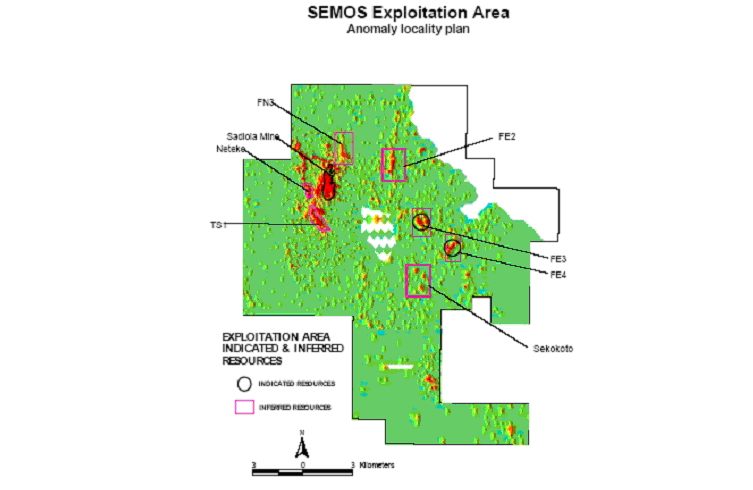
The primary aim of the 2000 exploration program was the acceleration of oxide resource delineation and a rapid reconnaissance assessment of the numerous targets generated from the integration of geochemical and geophysical datasets. This acceleration was achieved primarily through increased RC and RAB drilling programs as well as trenching and data obtained from a gravity survey. By the end of 2000, 29 targets were identified for follow-up exploration. The main focus of the accelerated program was aimed at increasing the confidence level of the resources at FE-3 and FE-4 to an indicated resource. FE-3 was handed over to the mining department at the beginning of 2001 and mining commenced during the first quarter.
During 2001, exploration drilling programs were undertaken over 14 anomalies. The discovery of high-grade mineralization 20m below surface at FE-4 occurred in 2001. Positive results were achieved from reconnaissance exploration at FE-2 and FN-Extension. Resource delineation drilling results at FN-3, FE-2 and Sekokoto deposits were promising. Sekokoto and FE-2 were modeled and included in the 2001 resource statement.
The discovery of medium to high-grade mineralization 10m below surface at FE-3 extension was the result of the 2002 reconnaissance work. Positive results were achieved at TS-1. Follow-up drilling at FN-2 and resource delineation drilling results at TS-1, FN-E, FN-3 and FE-2 deposits were also promising. Tambali South 1, Farabakouta North Extension and Farabakouta North 3 were modeled and included in the 2002 resource statement. In addition, FE-2 was remodeled after June 2002.
The highest potential oxide targets during 2003 were FE-2, FE-3, and FE-4. Resource development and pit contiguous expansion programs on the known FE-3 and FE-4 reserves are ongoing.
| 24 | ||
SAMPLING AND ANALYSIS
The collection and processing of all grade control and exploration samples prior to dispatch to the SEMOS laboratory is carried out by employees of SEMOS. Blind quality control sample trays are given to the SEMOS laboratory containing 2.9% pulp repeats, 2.9% blanks and 2.9% standard material. Coarse blanks are submitted at an approximate rate of 5%. No field duplicates are submitted. The SEMOS laboratory processes principally all the grade control samples for the mine.
In combination with the SEMOS laboratory, Analabs (in Kayes) processes the samples from exploration and the deep sulphide project. Blind quality control sample trays are given to Analabs containing 10% pulp repeats, 3% blanks and 7% standard material. Coarse blanks are submitted at an approximate rate of 5%. No field duplicates are submitted. Approximately 10% of a drill project’s well mineralized intersections is submitted to an external laboratory (generally ALS Chemex in Canada) for check assay.
Logging
All logging is undertaken using a standardized system designed to facilitate ease of computer data capture and manipulation without any loss of geological detail. The system allows for consistency between the large numbers of geological personnel responsible for the collection of this data. The entire database, including holes drilled prior to implementation of the system (pre-1992) has been converted into this format. Logging codes provide for description of major units, sub-units within these major intervals and unrestricted intervals such as alteration, mineralization and weathering styles.
Sub-sampling techniques and sample preparation
Diamond drill core is halved using a diamond saw. The half core is sampled over 1m intervals, honouring geological boundaries. During the feasibility study, sample preparation was undertaken on site utilizing conventional jaw crusher and Keegor milling technology prior to transport to the relevant laboratories. RC rock chip samples were collected over 2m intervals down the hole and split using a stacked riffle splitter (Jones Riffler). Samples were submitted for analysis following initial crushing and pulverizing. Grade Control RC samples were collected over 2.5m intervals prior to 1998 (practice was changed to 3.33m intervals in 1999).Prior to mid 2002 the rock chip samples are split automatically on the rig by a Vezin rotary splitter to between 1 and 3 kg and post this by a stacked rifle splitter with dump and catch box designed by Metalcraft (Australia).
Drill sample recovery
The recovery of diamond drilling samples to date has been calculated at 82%. Statistical analysis of these core recoveries indicates that no bias is apparent using samples with recoveries less than 100%. The recovery for the diamond drill programs during 2000 was 74% and it was 95% (non sulphide drilling) for 2001. There was no pit diamond drilling in 2002 and 2003.
Within the Sadiola Main pit, FE-3 and FE-4 deposits a total of 1,702,458 m of grade control drilling (162,205 boreholes) have been drilled. SEMOS resource drilling totals 758 diamond drill holes (123,168 m), 532 RAB holes (20,377 m), and 4,921 RC holes (301,509 m).
| 25 | ||
Quality of assays and laboratory tests
All samples have been analyzed for gold content by conventional Fire Assay techniques with either a Gravimetric, AA or ICP finish. Summary table of Assay Laboratories used:
Drilling Campaign | Laboratory |
| Pre-1992, WGM Drilling | Chemex (Canada) |
| November 1992 to 1995 | AARL (South Africa) |
| 1996 RC Campaign | AARL (South Africa) |
| 1998 RC Drilling | SEMOS/Chemex |
| 1998 Diamond Drilling | SEMOS/ITS - Analabs/Chemex |
| Grade Control Drilling | SEMOS |
| 2000 Drilling Campaign | SEMOS |
2001 Drilling Campaign Phase 3 Drilling | ITS - Analabs/SEMOS ITS - Analabs |
| 2002 Pit Drilling Campaign | SEMOS |
| 2003 Pit Drilling Campaign | Dominantly SEMOS. Minor assays at Analabs Kayes |
Database
SEMOS resource drilling uses a custom designed SQL relational database. The database is marketed by Century Systems (Canada). The system has been pre-designed to check for errors, so as to prevent geological overlapping and incorrect sample intervals. The system utilizes user security levels to prevent unauthorized access to data as well as data corruption by simultaneous multiple user use. The database is audited from time to time.
Resource modeling is undertaken by a dedicated team of on site personnel. Datamine is used to construct geological and grade models, while Istatis software is used for Uniform Condition to estimate recoverable resources.
Reconciliations
Reconciliations are carried out on grade, tonnage and contained metal between the individual anomaly resource models and grade control models on a monthly basis (for anomaly where mining has taken place). In addition, reconciliations between plant and resource models are also carried out monthly. Daily and monthly comparison of called mining grade and received plant grade are also undertaken.
The oxide and sulphidic saprolite ores are being exploited by open pit mining techniques. The main pit is currently designed to be approximately 2,000 m in length with a maximum width and depth of 700 m and 150 m, respectively. Mining operations are carried out by Moolman Brothers, a mining contractor from South Africa with extensive open pit experience. Due to the predominantly unconsolidated nature of the material in the pit, drilling and blasting operations are relatively infrequent as most of the material is dug out directly by hydraulic shovels. Grade control is effected by drilling 10 m long vertical holes on a ten by five metre grid. Ore is transported to the ore stockpile, located about 1 km from the pit, and waste is disposed of in dumps adjacent to the pit with minimal haul distances, usually less than 0.5 km. The ore stockpiling facility is located between the pit and the process plant and its purpose is two-fold. Primarily, the area allows stockpiles of ore with differing gold grades, viscosity levels (resulting not only from variable clay contents but also from differing clay minerals) and grit contents to be laid down. Ore is reclaimed from the stockpiles and fed into the process plant on a blended basis, thereby contributing to the efficiency of the process plant and maximizing the recovery of gold. The second function of the stockpile is to provide a reserve of ore to feed the process plant at times when pit operations are temporarily affected by external factors such as heavy rains.
| 26 | ||
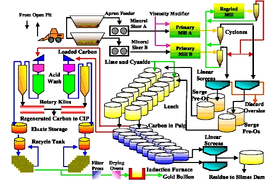
The process plant for the Sadiola Gold Mine was designed to treat four million tonnes of ore per year but is now treating 5.3 million tonnes of ore per year. The Sadiola Gold Mine commenced commissioning in November 1996 (15 months after the start of construction), poured its first gold in December 1996, concluded the commissioning phase in mid-February 1997 and started commercial production on March 1, 1997.
The process plant consists of two identical parallel circuits collectively capable of treating approximately 5.3 million tonnes of saprolite ores per year (Figure 12). This twin-stream design not only allows for a degree of flexibility in plant operation but also facilitates the maintenance of a reasonable level of production in the event that a significant item of equipment fails, as such a failure would usually only affect one circuit. This latter consideration is important in a country, such as Mali, where local infrastructure support is virtually non-existent.
As described above, most of the ore is delivered from the pit to a stockpile/reclaim area, adjacent to the process plant site. The ore blend is reclaimed from the stockpile and, with the ore sourced directly from the pit, is fed to two surge bins located ahead of the two parallel mineral sizers, a type of crusher designed to handle the softer ores which are found at the Sadiola Gold Mine. Once lumps have been broken down by the mineral sizer, the ore passes to two semi-autogenous grinding (“SAG”) mills. A single regrind mill is incorporated, serving both circuits, to further grind the grit fraction contained in the output from the SAG mills.
The discharge from the mills is fed to cyclones, the overflow from which goes to the leach circuit where the pulp is subject to cyanide leaching while the underflow goes to the regrind mills. Following leaching, the pulp is fed to carbon-in-pulp adsorption tanks where the gold is absorbed onto activated carbon. This ‘‘loaded’’ carbon is stripped of its gold and the gold-bearing solution is pumped to storage tanks. The stripped carbon is regenerated in an oil-fired kiln and then re-used.
The gold is recovered from the solution by electroplating onto stainless steel wool cathodes. The cathodes are washed and the gold-bearing sludge dried and placed in an induction furnace for smelting to produce gold bullion. The barren slurry, after removal of the gold, is pumped to the tailings dam, located approximately 3 km to the southeast of the process plant, for final disposal.
In July 2001, the economic viability of modifying the existing Sadiola plant at an estimated capital cost of US$13.7 million to increase the recovery on the sulphidic saprolite ore from approximately 65% to 75% was confirmed. This program was approved by SEMOS and successfully commissioned in March 2002. The plant modifications provides for pre-oxidation of the slurry feed followed by oxygen enriched high-cyanide leaching. An oxygen enrichment plant provides the oxygen required. Two new generator sets were also installed to provide the incremental power required for the modifications
| 27 | ||
On-going test work indicated that plant modifications could be expected to achieve a 76% recovery at a cyanide addition rate of 1 kilogram per tonne of ore processed and up to 79% at a cyanide addition rate of 1.5 kilograms per tonne of ore.
At December 31, 2003 and using a pit optimized and designed using a US$325/oz gold price, the proved and probable ore reserves at the Sadiola Gold Mine were 26.4 million tonnes grading 3.2 grams per tonne (‘‘g/t’’) of gold for an in situ content of 2.7 million ounces (‘‘oz’’) of gold.
The following table sets forth the estimated ore reserves for the Sadiola Gold Mine as of December 31, 2003:
Category(1) | Tonnes (Mt) | Grade (g/t) | Gold (000’s oz) | |||
| Proved | 6.5 | 1.9 | 405 | |||
| Probable | 19.9 | 3.6 | 2,289 | |||
Total mineral reserves(2)(3)(4)(5) | 26.4 | 3.2 | 2,694 | |||
| (1) | Using the JORC Code. Pit optimized and designed at a US$325/oz gold price and cut-off grade. |
| (2) | IAMGOLD has a 38% interest in these ore reserves. |
| (3) | Plant recovery is assumed to be 95% for oxides and 82% for sulphides. |
| (4) | All the reserves classified as “Proved” are stockpile material. All the ore reserves classified as “Probable” are in-pit material. |
| (5) | Rounding of figures may result in computational discrepancies. |
| 28 | ||
The following table sets forth the estimated measured and indicated mineral resources (which include ore reserves) for the Sadiola Gold Mine as of December 31, 2003, as calculated by the mine operator:
Category | Tonnes (Mt) | Grade (g/t) | Gold (000’s oz) | |||
Sadiola open pit and periphery(1) | ||||||
Measured(2) | 15.9 | 1.6 | 818 | |||
| Indicated | 22.6 | 2.6 | 1,904 | |||
| Total “pit” measured & indicated mineral resources | 38.5 | 2.2 | 2,722 | |||
Deep sulphide(1) | ||||||
Measured(2) | 1.0 | 3.0 | 92 | |||
| Indicated | 0.1 | 2.1 | 4 | |||
| Total “deep sulphide” measured & indicated mineral resources | 1.1 | 2.9 | 95 | |||
Satellite oxide deposits(1) | ||||||
| Measured | 0.3 | 1.9 | 21 | |||
| Indicated | 3.8 | 2.7 | 328 | |||
| Total “satellite” measured & indicated mineral resources | 4.1 | 2.6 | 349 | |||
Total measured and indicated mineral resources(3)(4) | 43.7 | 2.2 | 3,166 | |||
| (1) | A cut-off grade of 0.7 g/t was used within a US$400/oz pit shell. |
| (2) | Measured resources include soft oxide, hard oxide, soft sulphide, mixed stockpiles and hard sulphide stockpiles above a cut-off grade of 0.7 g/t gold. |
| (3) | Measured and indicated mineral resources include proved and probable ore reserves. IAMGOLD has a 38% interest in these mineral resources. |
| (4) | Rounding of figures may result in computational discrepancies. |
In addition to the measured and indicated mineral resources, the Sadiola Gold Mine has inferred mineral resources, estimates of which are set forth in the following table, as of December 31, 2003, as calculated by the mine operator:
Category(1) | Tonnes (Mt) | Grade (g/t) | Gold (000’s oz) | |||
Sadiola open pit and periphery(1) | 1.8 | 1.2 | 72 | |||
Deep sulphide(1) | 130.0 | 1.8 | 7,532 | |||
Satellite deposits(1)(2) | 12.5 | 1.3 | 533 | |||
Total inferred mineral resources(3)(4) | 144.3 | 1.8 | 8,137 | |||
| (1) | A cut-off grade of 0.7 g/t was used within a US$400/oz pit shell except where stated. |
| (2) | The inferred mineral resources for satellite deposits FE-2, FN-3, FE-4, Tambali South and Sekokoto were calculated at a cut-off of 0.7 g/t with no limiting shell. |
| (3) | IAMGOLD has a 38% interest in these mineral resources. |
| (4) | Rounding of figures may result in computational discrepancies. |
Based on the ore reserves existing at the end of December 2003, the Sadiola Gold Mine is expected to continue in operation until the end of 2008.
| 29 | ||
Under the concession agreement with the Government of Mali, SEMOS is obligated to minimize the environmental impact of mining activities and is required to rehabilitate the mine site once the mine permanently ceases operation. A baseline program monitors seasonal differences in climatic data, water quality for surface and groundwater, groundwater levels, water usage by villages, and dust and noise. There is also an integrated environmental management system (‘‘EMS’’) for the Sadiola Gold Mine. The EMS ensures that disturbance to the environment is minimal and that environmental policies are adhered to. An annual independent environmental audit of the Sadiola Gold Mine is conducted focusing in particular on the EMS, community relations and closure/rehabilitation.
Initially, the two principal environmental concerns were the use of cyanide and the potential disruption to human and animal movement as a result of the water pipeline. Cyanide is used in the gold extraction process and the issue of residual cyanide content of the tailings has been addressed. The gold plant and tailings dam are managed as a closed system with water flow being strictly controlled and recycled to the maximum possible extent. Any spillage of contaminated process water inside the plant is contained in a concrete bounded area, from where the water is pumped back into the treatment plant process. The tailings dam is fenced and access to the area is strictly controlled. To eliminate pipeline disruption to animal movements and grazing paths in the region, the pipeline was buried over its total length, which enables animals to freely cross the pipeline at all poin ts.
Two issues now receiving attention are the closure plan and environmental issues associated with the processing of the sulphidic saprolites ore. An environmental impact assessment (‘‘EIA’’) was prepared as an integral component of the plant modification program in 2002 to address, among other things, acid mine drainage issues due to the resultant exposure of sulphide bearing material in the pit and placement of such material on waste rock dumps, ore stockpiles and the tailings dam. The recommendations of the EIA have been adopted and the EMS is being revised as appropriate to address all sulphide related impacts.
CAPITAL COSTS AND FINANCING
The total capital cost associated with the development of the Sadiola Gold Mine was US$295 million, excluding capitalized interest during the construction period.
Mining Taxation and Exchange Regulations
Net mining profits, as calculated under the Malian Mining Code, are taxable at the rate of 35%. SEMOS was exempt from such taxation prior to March 1, 2002. All operating costs, depreciation and financing charges are deducted in calculating net profits. A customs services tax of 3% based on the export value of gold production and an ad valorem tax of 3% payable on the value of products sold to refineries or any other buyer less any refining expenses are paid to the Government of Mali. When mining operations cease, SEMOS may not dispose of its plant and equipment until having provided the Government of Mali priority in acquiring them at their then estimated value.
| 30 | ||
Exploration continues for near surface satellite oxide ore close to the Sadiola plant in order to add to the resources discovered by the successful programs of previous years. During 2003, infill resource delineation recommenced at FE-3 and FE-4. Density of drilling is 25x25m and 25x50m respectively. FE-3 and FE-4 are the only two deposits that contribute to the measured and indicated categories in the stated satellite oxide deposit resource numbers.
FE-4, FE-2, FN-3, Sekokoto and Tambali South deposits have seen additional drilling, and the resources calculated for these deposits are classified as inferred due to a lack of information.
Future exploration will be focused to improve the resource classification from inferred to indicated. Additional infill drilling will be required.
The Deep Sulphide project is the key to the continued operation of Sadiola past 2008. Phase VII drilling commenced in January 2004 and the planned program of 80 holes totaling 30,000 metres is expected to be completed in October 2004. The objective of Phase VII is resource conversion (Inferred to Indicated) on the main zone of mineralization. This is infill to approximately 50m x 25m (50m along strike) from the previous 50m x 50m density. The drill program involves a $9 million expenditure. Additional metallurgical testing will be completed. The results of a preliminary feasibility study are expected at the end of the first quarter of 2005.
| 31 | ||
SEMOS S. A. (internal document)
“Sadiola – Identified Mineral Resource Statement 2003”
SEMOS S.A. (internal document)
“Sadiola Hill Gold Mine Business Unit Plan Levels 1, 2, & 3, June 5th, 2003”
AngloGold Ashanti (internal document)
“Sadiola Deep Sulphide Conceptual Study – June 2002”
IAMGold Corporation and Wheaton River Minerals Limited
“Joint Management Information Circular, April 30th, 2004”
| 32 | ||
I, Dennis Robertson, P. Geo. do hereby certify that:
| 1. | I am currently employed as a Senior Geologist by: |
| IAMGOLD Corporation | |
| 220 Bay Street, 5th Floor | |
| Toronto, Ontario, Canada | |
| M5J 2W4 | |
| 2. | I graduated with a Hons.B.Sc. (Geology) from the University of Windsor in 1973, and M.Sc. (Geology) from Laurentian University in 1977. |
| 3. | I am a Fellow of the Geological Association of Canada, member of CIM, member of PDAC and Association of Professional Geoscientists of Ontario |
| 4. | I have worked as a geologist for a total of 28 years since my graduation from university. |
| 5. | I have read the definition of "qualified person" set out in National Instrument 43-101 ("NI 43-101 ") and certify that by reason of my education, affiliation with a professional association (as defined in NI 43-101) and past relevant work experience, I fulfill the requirements to be a "qualified person" for the purposes of NI 43-101. |
| 6. | I am responsible for the preparation of the technical report titled “A Technical Report On The Sadiola Gold Mine, Mali”, dated May 31st, 2004 (the "Technical Report") relating to the Sadiola Gold Mine. I have visited the Sadiola Gold Mine on several occasions, as part of my involvement in West African exploration activities. |
| 7. | I am not aware of any material fact or material change with respect to the subject matter of the Technical Report that is not reflected in the Technical Report, the omission to disclose which makes the Technical Report misleading. |
| 8. | I am not independent of the issuer applying all of the tests in section 1.5 of National Instrument 43-101. I have been employed by IAMGOLD since February 1996. |
| 9. | I have read National Instrument 43-101 and Form 43-101F1, and the Technical Report has been prepared in compliance with that instrument and form. |
| 10. | I consent to the filing of the Technical Report with any stock exchange and other regulatory authority and any publication by them, including electronic publication in the public company files on their websites accessible by the public, of the Technical Report. |
Dated this 31st day of May, 2004.
[Seal or Stamp of QP]
| /s/ Dennis Robertson | |
| Signature of Qualified Person | |
| Dennis Robertson | |
| Print name of Qualified Person |
| 33 | ||
 | ||
TO: | Ontario Securities Commission |
| British Columbia Securities Commission | |
| Alberta Securities Commission | |
| Saskatchewan Securities Commission | |
| Manitoba Securities Commission | |
| Nova Scotia Securities Commission | |
| Commission des valeurs mobilieres du Quebec | |
| Office of the Administrator of Securities, Government of New Brunswick | |
| Registrar of Deeds, Companies & Securities, Government of Newfoundland and Labrador | |
| Department of Justice, Corporations Division, Government of Prince Edward Island | |
| Registrar of Securities, Government of the Northwest Territories | |
| Registrar of Securities, Government of Nunavut | |
| Department of Consumer and Corporate Affairs, Government of Yukon Territory |
I, Dennis Robertson, do hereby consent to the filing, with the regulatory authorities referred to above, of the technical report titled A Technical Report On The Sadiola Gold Mine and dated May 31st, 2004 (the "Technical Report") and to the written disclosure of the Technical Report and of extracts from or a summary of the Technical Report in the written disclosure in the AIF of IAMGold Corporation being filed.
I also certify that I have read the written disclosure being filed and I do not have any reason to believe that there are any misrepresentations in the information derived from the Technical Report or that the written disclosure in the AIF of IAMGold Corporation contains any misrepresentation of the information contained in the Technical Report.
Dated this 31st day of May, 2004.
[Seal or Stamp of QP]
| /s/ Dennis Robertson | |
| Signature of Qualified Person | |
| Dennis Robertson | |
| Print name of Qualified Person |
| 34 | ||