The Geology and Exploration Potential of the Don Fippi Property Batopilas District Chihuahua, Mexico Technical Report
| |
Prepared for Mega Capital Investments Inc.
November 19, 2002 9355.00b
|

| The Geology and Exploration Potential of | Denver |
| The Don Fippi Property | |
| Batopilas District | |
| Chihuahua, Mexico | |
| Jersey City | |
| Prepared for | |
| Mega Capital Investments Inc. | |
| November 19, 2002 | |
9355.00b | Lima |
| Prepared by | |
| Pincock, Allen & Holt | |
| Santiago | |
| Clancy J. Wendt, P.G. | |
| Principal Geologist | |
| Seattle | |
| A Division of Hart Crowser | Vancouver, B.C. |
274 Union Boulevard, Suite 200 | |
Lakewood, Colorado 80228-1835 | |
| Fax 303.987.8907 | |
| Tel 303.986.6950 |
| CONTENTS | Page | |||
| 1.0 | EXECUTIVE SUMMARY | 1.1 | ||
| 2.0 | INTRODUCTION AND TERMS OF REFERENCE | 2.1 | ||
| 2.1 | Units and Measures | 2.1 | ||
| 2.2 | Geographic Terms | 2.1 | ||
| 3.0 | DISCLAIMER | 3.1 | ||
| 4.0 | PROPERTY DESCRIPTION AND LOCATION | 4.1 | ||
| 4.1 | The Qualifying Transaction | 4.1 | ||
| 5.0 | ACCESS, CLIMATE, LOCAL RESOURCES, INFRASTRCUTURE AND | |||
| PHYSIOGRAPHY | 5.1 | |||
| 6.0 | HISTORY | 6.1 | ||
| 6.1 | Literature Resources | 6.2 | ||
| 7.0 | GEOLOGICAL SETTING | 7.1 | ||
| 7.1 | Regional Geology | 7.1 | ||
| 7.2 | Batoplias District Geology | 7.1 | ||
| 8.0 | DEPOSIT TYPES | 8.1 | ||
| 8.1 | Regional Deposit Types | 8.1 | ||
| 8.2 | Batoplias District Deposit Types | 8.1 | ||
| 9.0 | MINERALIZATION AND ALTERATION | 9.1 | ||
| 9.1 | Batoplias District Silver Mineralization | 9.1 | ||
| 9.1.1 Specific Vein Systems | 9.1 | |||
| 9.1.1.1 Todos Santos-Roncesvalles (TSR Zone | ||||
| West of the River | 9.1 | |||
| 9.1.1.2 San Miguel-Nevada (SMN Zone East of the River) | 9.2 | |||
| 9.1.1.3 Caballo-Camuchin Group | 9.3 | |||
| 9.1.1.4 Descubridora-El Triunfo Group | 9.3 | |||
| 9.2 | Alteration | 9.3 | ||
Pincock, Allen & Holt &nbs p; Page i
9355.00b November 19, 2002
| CONTENTS (Continued) | Page | ||
| 10.0 | EXPLORATION | 9.1 | |
| 10.1 Historic Exploration | 10.1 | ||
| 10.2 Minera Bugambilias Exploration | 10.1 | ||
| 10.2.1 Data Acquisition and Geologic Mapping | 10.1 | ||
| 10.2.2 Geochemistry | 10.1 | ||
| 10.2.3 Geophysics | 10.1 | ||
| 10.2.4 Environmental Surveys | 10.2 | ||
| 11.0 | DRILLING | 11.1 | |
| 12.0 | FIELD SAMPLING METHODS AND APPROACH | 12.1 | |
| 13.0 | SAMPLE PREPARATION, ANALYSES AND SECURITY | 13.1 | |
| 14.0 | DATA VERIFICATION | 14.1 | |
| 15.0 | ADJACENT PROPERTIES | 15.1 | |
| 16.0 | METALLURGICAL TESTWORK | 16.1 | |
| 17.0 | MINERAL RESOURCE AND MINERAL RESERVE ESTIMATES | 17.1 | |
| 18.0 | INTERPRETATION AND CONCLUSIONS | 18.1 | |
| 18.1 Major Targets | 18.2 | ||
| 18.2 Secondary Targets | 18.3 | ||
| 19.0 | RECOMMENDATIONS | 19.1 | |
| 20.0 | EXPLORATION PROGRAM AND TECHNIQUES | 20.1 | |
| 21.0 | CERTIFICATE OF QUALIFICATION | 21.1 | |
| 22.0 | REFERENCES | 22.1 | |
Pincock, Allen & Holt &nbs p; Page ii
9355.00b November 19, 2002
| CONTENTS (Continued) | Page | ||
| TABLES | |||
| 4-1 | Concession Summary | 4.4 | |
| 20-1 | Phase 1 Exploration Budget Summary | 20.2 | |
| FIGURES | |||
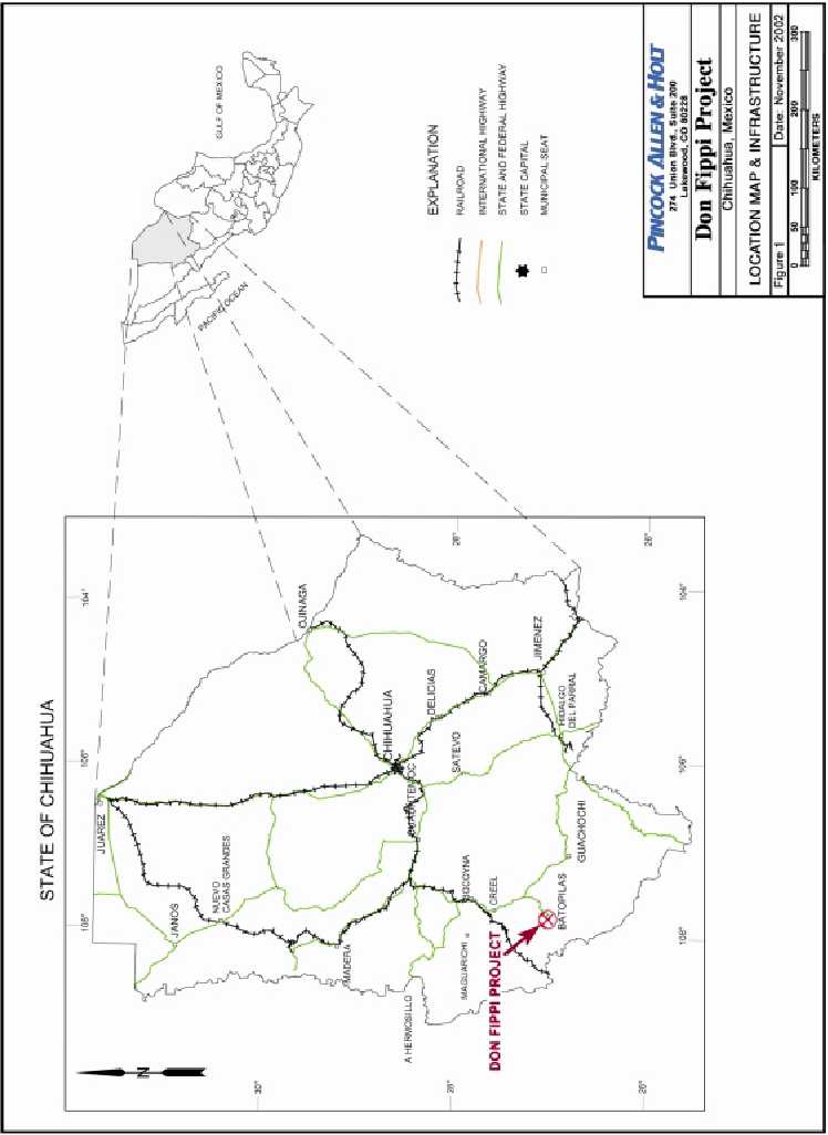
| 1 | Location Map and Infrastructure | 4.5 | |
| 2 | Batopilas District Geography and Major Vein Zones | 4.6 | |
| 3 | Claim Map | 4.7 | |
| 4 | General Mexico Geology and Mineral Occurrences | 5.2 | |
| 4b | District Geologic Map | 7.2 | |
| 5 | Schematic Stratigraphic Section for the Batopilas District | 7.3 | |
| 6 | Principal Veins and Claim Boundaries | 7.4 | |
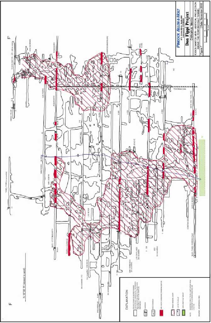
| 7 | Todos Santos Vein – Vertical Projection Above the Porfirio Diaz Tunnel | 7.5 | |
Pincock, Allen & Holt &nbs p; Page iii
9355.00b November 19, 2002
1.0 EXECUTIVE SUMMARY
Mega Capital Investments Inc. (MGII) engaged Pincock Allen & Holt (PAH) to undertake an evaluation and review of the previous work on the Don Fippi claim Batopilas, Chihuahua State, Mexico. The purpose of this review was to:
- Evaluate the work that has been completed previously on the property;
- Examine the data from historic work generated on the property;
- Make recommendations for exploration and evaluation;
- Complete a site visit to review the work.
Clancy J. Wendt, Principal Geologist, reviewed the data for the project at the Minera Cascabel Office in Tucson, Arizona and read previous reports, along with various published articles. He visited the property on September 7th, 2002. His review of the data included discussions with the geologist in charge of exploration.
The Don Fippi Project, located in southwestern Chihuahua State, Mexico, covers the majority of the historic Batopilas Silver District. It was productive during both the Spanish Colonial era and from1860 to 1914. Silver mineralization in the Batopilas District occurs as pods of crystalline native silver irregularly distributed along persistent structures over a vertical distance of over 700 meters. Few other metals are present and the gangue is almost exclusively calcite. These features are distinct from the typical epithermal vein deposits of the region, which are characterized by polymetallic, vertically limited, and zoned orebodies hosted in quartz-rich veins. The differences are substantial enough to indicate that the Batopilas district must be explored in the perspective of its distinct characteristics.
Historically, exploration and exploitation at Batopilas was by exploration and mining within known mineralized structures. A series of these structures, known to be productive, were followed simultaneously until a new Bonanza ore grade pod was encountered. This led to brief periods of fantastic production followed by more exploration causing an irregular cash-flow problem. Notably however, when pursued, the veins yielded orebodies on a regular basis for nearly 300 years. Many of these veins were heavily exploited, but the bottom of mineralization has never been found and the lateral potential for mineralization on many of the exploited veins remains open. In addition, many veins exploited in the near-surface zone during the Spanish Colonial era were not pursued at depth by the Batopilas Mining Company during the district’s last major mining phase (1880-1914) and their tunnelling efforts revealed numerous native silver-bearing calcite veinlets that were not exploited or exp lored.
Pincock, Allen & Holt &nbs p; Page 1.1
9355.00b November 19, 2002
The district’s geology and history indicates that more mineralization remains to be discovered at Batopilas (Wilkerson and others, 1988). However, modern mining realities will not support mining without an adequate reserve inventory, which opens the question of whether it is possible to find Batopilas style orebodies efficiently through application of modern exploration concepts and technology. The following suggests that this should be possible:
| 1. | The district has seen little modern geologic investigation or exploration, and what has been done did not include the type of detailed structural analysis that is required for exploring a vein system. Good surface and underground access will facilitate gathering the needed data. |
| 2. | The fractionated claim situation impeded district-scale exploration thinking and application of specific exploration concepts outside of limited areas. The consolidated Bugambilias land package obviates this problem. |
| 3. | The native silver ores and certain alteration styles should be strong conductors to modern electrical geophysical techniques. This includes modern metal detectors that can be used to trace mineralization as surface float trails and in veins underground. |
| 4. | Modern mining technology will allow affordable deep mining. |
The high-grade bonanza ores should be the primary exploration focus with the expectation that significant amounts of low-grade (250 g/mt Ag) ores will be found in concert. Geological and geophysical techniques must be tested and applied to find oreshoots efficiently. There are several types of targets available in the district, some immediate and some longer term. All the targets require detailed geologic mapping and geophysical definition. Many of these targets should be testable through surface drilling or by drilling relatively short holes from existing underground workings and/or new headings.
A staged exploration program to develop high quality drill targets is proposed and should cost C$483,000. Intensive drilling should be undertaken as a second phase after this is accomplished.
Pincock, Allen & Holt &nbs p; Page 1.2
9355.00b November 19, 2002
2.0 INTRODUCTION AND TERMS OF REFERENCE
PAH visited the site on September 7th, 2002 and completed a field and information review at the Minera Cascabel office. The report is based on the author’s personal examination of the property, review of exploration data generated by Minera Cascabel S.A. de C.V., and the published mining and scientific literature.
This report was prepared at the request of Dave Pearce, President of Mega Capital Investments Inc.. It is intended to summarize a proposed exploration program for the Don Fippi Claims, Batopilas, Chihuahua, Mexico optioned by Mega Capital Corporation, through their Mexican subsidiary Minera Lagartos S.A. de C.V., from Minera Bugambilias S.A. de C.V. of Hermosillo, Sonora, Mexico. Details of the exploration option-to-purchase agreement are on file with the TSXV.
2.1 Units and Measures
All units are in the metric system, C$ refers to Canadian dollars, Spanish place names are used where appropriate, MGII refers to Mega Capital Investments Inc., PAH refers to Pincock Allen & Holt, m refers to meters, km refers to kilometers, g/mt refers to grams per tonne, tpd refers to standard tons per day, oz/mt is ounces per tonne, mm is millimeters, TSR means Todos Santos-Roncesvalles, Peñoles is Industrias Peñoles S.A., SMN is San Miguel-Nevada, PDT is Profirio Diaz Tunnel, and RFZ is the Roncesvalles Fault Zone.
2.2 Geographic Terms
The following geographic areas and features are briefly described for orientation with respect to the text and figures.
Batopilas: The town of Batopilas lies along the western bank of the Rio Batopilas and extends about 3 kilometers from just north of the portal of the Porfirio Diaz Tunnel to about 1 kilometer north of Satevo.
Satevo: The village of Satevo lies on the river about 1.5 kilometers south of the Plaza of Batopilas. Satevo was the first settlement in the area (Wilkerson, 1998). The northern fringes of the Corralitos Porphyry underlie Satevo.
Roncesvalles---Pastrana---Todos Santos Vein Group (TSR): The principal group of veins on the western bank of the Rio Batopilas. Accessed by the Porfirio Diaz Tunnel.
San Miguel---Santo Domingo –Nevada Vein Group (SMN): The principal vein group on the eastern bank of the Rio Batopilas.
Caballo---Camuchin Vein Group: The western-most silver vein group of the district.
Pincock, Allen & Holt &nbs p; Page 2.1
9355.00b November 19, 2002
Descubridora---El Triunfo Vein Group: The southwestern-most silver vein group in the district. Poorly known because access is bad.
Animas Group: The vein group lying north of the Roncesvalles-Pastrana-Todos Santos vein group. Dominantly exploited during the Spanish Colonial era.
Hacienda San Miguel (aka “Shepherd’s Castle): The metallurgical plant and living quarters for the salaried employees of the Batopilas Mining Company. Occupies a large portion of land on the eastern bank of the Rio Batopilas, just across from the portal of the Porfirio Diaz Tunnel.
Pincock, Allen & Holt &nbs p; Page 2.2
9355.00b November 19, 2002
3.0 DISCLAIMER
All information and the conclusions drawn therefrom are based on the author’s knowledge and review of the previous exploration of the Don Fippi Project. Where possible, historic data have been verified and only those previous data believed to be accurate have been included. Figures are from previous reports and modified to support this work. PAH has not reviewed the legal title of the land holdings of MGII or the joint venture agreements.
Pincock, Allen & Holt &nbs p; Page 3.1
9355.00b November 19, 2002
4.0 PROPERTY DESCRIPTION AND LOCATION
The Don Fippi Project comprises seven exploration claims covering 3,511 hectares centered on the historic Batopilas Mining District in southwestern Chihuahua State (Figures 1 through 3) (Table 4-1). The original Don Fippi claim was titled to Minera Bugambilias S.A. de C.V. on October 24, 1997, and the balance of the claims are internal to Don Fippi. Internal claims were acquired as older claims expired and were liberated under the Mexican Mining Law. On August 1, 2002, Mega Capital Corporation announced their purchase of 98 percent of Minera Lagartos S.A. de C.V., and on November 18, 2002 announced the execution of an exploration option-to-purchase agreement with Minera Bugambilias S.A. de C.V. for their combined Don Fippi Properties.
4.1 The Qualifying Transaction
Pursuant to an arm's length agreement dated as of November 18, 2002 between the Company, Lagartos and Bugambilias (the "Don Fippi Agreement"), Bugambilias granted to Lagartos an option (the "Don Fippi Option") to acquire a 100 percent interest in the Don Fippi Property located in the Batopilas, Chihuahua district of Mexico. In order to exercise the Don Fippi Option, Lagartos must:
| (a) | pay to Bugambilias an aggregate of US$550,000 plus VAT (the "Don Fippi Payments") on the following basis: | ||
| (i) | US$50,000 plus VAT within five business days after the date the Don Fippi Agreement is accepted by the Exchange (the " DF Effective Date"); | ||
| (ii) | US$50,000 plus VAT on or before the date that is 12 months following the DF Effective Date; | ||
| (iii) | US$100,000 plus VAT (the "Third DF Payment") on or before the date that is 24 months following the DF Effective Date, provided that if during the ten trading days prior to the date the Third DF Payment is due the average closing price of the Common Shares of the Company on the Exchange is more than US$0.50, the Third DF Payment is waived by Bugambilias and need not be made; | ||
| (iv) | US$150,000 plus VAT (the "Fourth DF Payment") on or before the date that is 36 months following the DF Effective Date, provided that if during the ten trading days prior to the date the Fourth DF Payment is due the average closing price of the Common Shares of the Company on the Exchange is more than US$0.50, the Fourth DF Payment is waived by Bugambilias and need not be made; and | ||
Pincock, Allen & Holt &nbs p; Page 4.1
9355.00b November 19, 2002
| (v) | US$200,000 plus VAT (the "Fifth DF Payment") on or before the date that is 48 months following the DF Effective Date, provided that if during the ten trading days prior to the date the Fifth DF Payment is due the average closing price of the Common Shares of the Company on the Exchange is more than US$0.50, the Fifth DF Payment is waived by Bugambilias and need not be made; | ||
| (b) | incur expenditures on the Don Fippi Property in the amount of at least US$4,000,000 (the "Don Fippi Expenditures") on the following basis: | ||
| (i) | US$250,000 within 12 months following the DF Effective Date, of which US$15,000 must be spent by December 31, 2002 (which has been spent); | ||
| (ii) | the cumulative amount of US$1,000,000 within 24 months following the DF Effective Date; | ||
| (iii) | the cumulative amount of US$2,000,000 within 36 months following the DF Effective Date; | ||
| (iv) | the cumulative amount of US$3,000,000 within 48 months following the DF Effective Date; and | ||
| (v) | the cumulative amount of US$4,000,000 within 60 months following the DF Effective Date; | ||
| (c) | allot and issue to Bugambilias an aggregate of up to 2,100,000 Common Shares of the Company (the "Don Fippi Shares") on the following basis: | ||
| (i) | 100,000 Common Shares within five business days of the DF Effective Date; and | ||
| (ii) | commencing eight months after the DF Effective Date, one Common Share for each US dollar expended by Lagartos as described in paragraph (b) above, up to a maximum of 2,000,000 Common Shares. | ||
Provided that Lagartos has expended a cumulative minimum of US$1,000,000 of Don Fippi Expenditures within 24 months following the DF Effective Date as required by section (b)(ii) above, Lagartos may, at its sole option, elect to not incur any further Don Fippi Expenditures or make any further Don Fippi Payments or issue any further Don Fippi Shares under the Don Fippi Agreement and to enter into a joint venture with Bugambilias in respect of the Don Fippi Property in which Lagartos is immediately vested with a 50 percent interest and Bugambilias will hold a 50 percent interest and Bugambilias will be the initial operator of the Don Fippi Property under the joint
Pincock, Allen & Holt &nbs p; Page 4.2
9355.00b November 19, 2002
venture and Lagartos and Bugambilias have agreed to enter into a joint venture agreement setting out the terms of such joint venture and including such other terms as are standard in the industry.
Provided that Lagartos has expended a cumulative minimum of US$2,000,000 of Don Fippi Expenditures within 36 months following the DF Effective Date as required by section (b)(iii) above, Lagartos may, at its sole option, elect to not incur any further Don Fippi Expenditures or make any further Don Fippi Payments or issue any further Don Fippi Shares under the Don Fippi Agreement and to enter into a joint venture with Bugambilias in respect of the Don Fippi Property in which Lagartos is immediately vested with a 60 percent interest and Bugambilias will hold a 40 percent interest and Lagartos will have the option to be the initial operator of the Don Fippi Property under the joint venture and Lagartos and Bugambilias have agreed to enter into a joint venture agreement setting out the terms of such joint venture and including such other terms as are standard in the industry. In the event that Lagartos elects to be the operator of the Don Fippi Property, but fails for a period of a t least six months to advance any exploration or development of the Don Fippi Property, Bugambilias shall have the option to become the operator of the Don Fippi Property.
Lagartos also agreed to pay to Bugambilias a 4.5 percent NSR unless a joint venture is entered into.
Alternatively, the Don Fippi Option may be exercised at any time by Lagartos by paying such amount as is required to make the total payments to Bugambilias aggregate US$550,000, and by issuing to Bugambilias an aggregate of 2,100,000 Don Fippi Shares.
All properties acquired by Lagartos, Bugambilias or any of their affiliates within the borders of the Don Fippi Property shall become part of the Don Fippi Property and be included under the Don Fippi Agreement.
Lagartos may terminate the Don Fippi Agreement at any time by providing Bugambilias with 60 days notice and failing to make any payment or incur any Don Fippi Expenditure when due, but must pay the applicable taxes for the following semester.
Lagartos has a right of first refusal in the event that Bugambilias wishes to dispose of its interest in the Don Fippi Agreement or NSR, except for transfers of interests in the NSR to Bugambilias' shareholders or heirs which are permitted without restriction.
Pincock, Allen & Holt &nbs p; Page 4.3
9355.00b November 19, 2002
| TABLE 4-1 | ||||||||
| Mega Capital Investments Inc. | ||||||||
| Don Fippi Property | ||||||||
| Concession Summary |
| CONC. | APPLICATION | TITLE | ISSUE | EXPIRATION | SIZE IN | ||
| CLAIM NAME | TYPE | NUMBER | NUMBER | DATE | DATE | HECTARES | |
| DON FIPPI PROJECT | |||||||
| DON FIPPI | Exploration | 10/22430 | 205962 | 24-Oct-1997 | 23-Oct-2003 | 3,181.57 | |
| SANTO DOMINGO | Exploration | 16/29872 | 214671 | 30-Oct-2001 | 29-Oct-2007 | 26.61 | |
| SAN MARTIN | Exploration | 16/29873 | 214672 | 30-Oct-2001 | 29-Oct-2007 | 2.15 | |
| DON FIPPI 2 | Exploration | 16/30103 | 215474 | 22-Feb-2002 | 21-Feb-2008 | 152.02 | |
| DON FIPPI 3 | Exploration | 16/30953 | 215481 | 22-Feb-2002 | 21-Feb-2008 | 56.00 | |
| DON FIPPI 4 | Exploration | 16/30952 | 217251 | 2-Jul-2002 | 1-Jul-2008 | 10.00 | |
| PASTRANA | Exploration | 16/31077 | 217467 | 16-July-2002 | 15-July-2008 | 82.68 | |
| TOTAL | 3,511.03 |
NOTE: The description of the mineral titles is not a legal opinion, but is based on written information provided by Minera Cascabel S.A. de C.V.
The claims are “exploration claims” as defined by the Mexican Mining Law and cover 95 percent of the Batopilas Silver District. The Minera Bugambilias/Don Fippi claim group is current with respect to both tax and "comprobaciones de obra" (annual work expenditures required under Mexican Mining Law) to the end of 2002. There are seven claims within Don Fippi held by other parties totaling approximately 222.5 hectares. These range in size from 6 to 95.8 hectares and are scattered across the district. The Los Corralitos and Rosalinda claims abut the Don Fippi claim to the south and cover the Corralitos Porphyry area.
Surface ownership in the area is held by the Batopilas Ejido and various private owners (Ejidos are communal farms where individuals have title to specific plots of land, but most land-use decisions must be made by the community as a whole). The Ejido has granted verbal permission to explore the Don Fippi claim. There are no known cultural restrictions on exploration activity other than the need to respect some of the historic mining ruins. There seems to be no formal status or protection for these and most have already been heavily vandalized. Documenting their condition before building roads or drilling would be prudent.
Pincock, Allen & Holt &nbs p; Page 4.4
9355.00b November 19, 2002


5.0 ACCESS, CLIMATE, LOCAL RESOURCES, INFRASTRUCTURE AND PHYSIOGRAPHY
Don Fippi/Batopilas lies in the topographically rugged central spine of the Sierra Madre Occidental, the range of high volcanic mountains that follows the Pacific coast and extends from the US/Chihuahua or Sonora border to the Trans-Mexico Volcanic Belt (Figure 4). The Sierra Madre Occidental is a high volcanic plateau, with mean elevations generally above 2,200 meters, dissected by deeply incised canyons that go as deep as the 500-meter elevation level. Vegetation is dominated by pine forests in the highest elevations and cacti mixed with tropical flora in the canyon bottoms. Intermediate slopes are covered with manzanita, scrub oak, various thorny plants, and grasses. The climate is temperate at the higher elevations and warm and humid in the canyons. The average annual temperature ranges from 20 oC (range of -10o to 35oC) in the upper elevations to 23oC (range of 0o to 45oC) in the canyon bottoms. Precipitation averages 3,000 mm per year. The bulk of the rain falls during the summer and winter rainy seasons with an occasional extra storm from Pacific Ocean hurricanes. Snowfalls of up to 10 centimeters commonly occur in the upper elevations. The Rio Batopilas is the major drainage in the area and always contains significant amounts of water. Water is abundant at depth in the mines and water rights for mine development should be available to the mineral rights.
The Don Fippi Project Area is roughly centered on the town of Batopilas which lies in the bottom of the deep canyon of the Rio Batopilas at about 600 meters elevation. The Project area encompasses the river and surrounding mountains and canyons (Figure 2). The famous Barrancas del Cobre (Copper Canyon) lie just to the north. Until 1977 there was no road access to the district, but there is now a good quality 70 km unpaved road connecting Batopilas to the paved highway that leads to Creel and thence to La Junta, Cuauhtemoc, and Chihuahua City 300 km to the east. There is also a small airstrip in the bottom of Batopilas Canyon at which only very experienced pilots are willing to land. Helicopter transport into the area is intermittently available from Creel. Francisco Gold based their exploration of the nearby Sauzal property from Batopilas, so the helicopter contractors, hotels, labor pool etc. are familiar with the needs of an exploration group. Chihuahua City, the largest popu lation center in the region, has a population of over 1,500,000 and is a major industrial and mining center. Chihuahua International Airport receives numerous daily flights from the United States and Mexico. Driving time from Chihuahua International Airport to Batopilas is about 8 hours. ALS-Chemex Laboratories operate a drop facility in Chihuahua, from which they fly samples to Guadalajara for preparation. Samples are then flown to Vancouver for analysis.
Road access within Don Fippi is fair. The main road runs along the river and is in very good condition through the town. Conditions deteriorate south of the town, but the road is passable south to Satevo and west to Camuchin. A few spur roads run from the main road to the area above the Porfirio Diaz Tunnel. Access to the balance of the area is by foot or horseback. Underground access is extensive through the Santo Domingo, San Miguel, Peñasquito, and Pastrana mines. The Porfirio Diaz Tunnel is caved about 1.5 kilometers from the portal, leaving the back 2.5 kilometers accessible only through stopes leading from the Peñasquito level. Locals note that the tunnel has caved in the same place before and that past rehabilitation efforts have taken only a few days.
Pincock, Allen & Holt &nbs p; Page 5.1
9355.00b November 19, 2002

6.0 HISTORY
High-grade native silver outcrops in the Batopilas district were discovered around 1630 and production records begin in 1632 (Dahlgren, 1882, Brodie, 1909). The district contains between 65 and 300 mines (Dahlgren, 1882; Brodie, 1909, Wilkerson and others, 1988; Wilson and Panczner, 1986) developed during three major periods of mining activity: 1632 to 1732, 1790 to 1819, and 1862 to 1914. An estimated total of 200,000,000 to 300,000,000 ounces of silver have been produced from the district, although pre-1880 records are poor (Wilson and Panczner, 1986). 30,000,000 ounces of silver were produced by the Batopilas Mining Company between 1880 and 1914, and are well documented (Shepherd, 1935).
The Spanish era (1632-1732) was the most productive (Dahlgren, 1882, Brodie, 1909), but the last period (1862 to 1914) was the most sophisticated and organized. A.R. Shepherd, former mayor of Washington DC, formed the Batopilas Mining Company and worked the mines on a systematic basis from 1880 to 1914. The company invested heavily in district-scale engineering projects such as the Porfirio Diaz Tunnel and a hydroelectric system to provide pumping power for deep mining (Shepherd, 1938). A.R. Shepherd died in 1902 and his sons ran the mines until 1914 when Pancho Villa’s troops arrived and devastated the area. Villa’s revolutionaries wrecked the hydroelectric plant and drove the Americans from the district.
Attempts were made to put the mines back into production after the Revolution, but the destruction of the power plant made it impossible to pump out the deep workings. Shepherd's sons attempted to revive the Batopilas Mining Company in the mid 1930’s but were unsuccessful because of attitudes towards investment in Mexico following the 1936 expropriation of the oil industry. Government statistical publications show almost no production for the district for the period 1920 through 1975 so it is reasonable to infer that whatever work was undertaken during this period consisted largely of minor high-grading around existing workings.
In the late 1970’s-early 1980’s, local miners reopened the New Nevada Mine and hit a high-grade breccia pipe that yielded a significant amount of native silver and some high-quality mineral specimens (Wilson and Panczner, 1986). This development ended when the silver price dropped in 1983. An under-funded, but well-directed program in the early 1980’s drove into the hangingwall of the Roncesvalles fault from the Porfirio Diaz Tunnel and hit a vein carrying native silver ore (Wilkerson and others, 1988). This was the first discovery of mineralization in the immediate hangingwall (NW side) of this structure, but it was not systematically followed up. No exploration or mining activity of note has occurred since 1983.
Recent activity (Figures 2 and 4) in the area has included Francisco Gold (operating as Minas de Alta Pimeria) and Peñoles unsuccessful exploration programs for bulk-mineable gold at Cerro Colorado, 6 kilometers north of Batopilas. Francisco Gold subsequently explored the Corralitos Porphyry area 3-5 kilometers south of Batopilas in joint venture with Phelps Dodge as an auriferous copper porphyry target, but the drilling results were unfavorable. Phelps Dodge concurrently
Pincock, Allen & Holt &nbs p; Page 6.1
9355.00b November 19, 2002
explored the Tres Hermanos gold vein 5 kilometers east of Batopilas, but quickly abandoned the property. The major recent discovery in the region is Francisco Gold's El Sauzal gold deposit, which lies 20 kilometers northwest of Batopilas. This property is now part of the 2002 Glamis-Francisco merger and is moving towards production (Northern Miner, October 2002). Batopilas was the base camp for El Sauzal exploration until Francisco Gold built an access road from the west. Batopilas is no longer involved in Sauzal support activity.
6.1 Literature Resources
The published and archive literature on Batopilas is dominated by mining-related studies dating from the Shepherd era. The most important contain data concerning the general geological comportment of the ore shoots, mining methods, and production data (c.f. Todd, 1907, Brodie, 1909 and 1917, and A. Shepherd Jr., 1935.) Little technical work follows these reports until the 1980’s except Krieger's (1935) detailed study of the native silver and related ore minerals. Grant Shepherd's 1938 book, The Silver Magnet is an engaging history of the Shepherd era and how it came to flower and bust.
Wilkerson’s (1983) doctoral study, undertaken at the University of Texas at El Paso and later summarized in Economic Geology (Wilkerson et al, 1988), provides the first modern district-wide geological and laboratory data. This work includes mine maps for all the then-accessible workings with geologic and some geochemical data. Wilson and Panczner (1986) published an excellent layman's overview of the district focused on the mining history and mineral specimens produced from the ores. The most recent publication on the district is Goodell (1995) who examined the regional occurrence of small porphyry copper systems, including the Corralitos porphyry, which may be related to Batopilas style silver mineralization.
In addition to the published literature, Minera Bugambilias has accumulated a large number of unpublished company studies on the district performed over the last 150 years. Some of these include useful mine maps and assay data.
Pincock, Allen & Holt &nbs p; Page 6.2
9355.00b November 19, 2002
7.0 GEOLOGICAL SETTING
7.1 Regional Geology
The Batopilas District lies in the heart of the Sierra Madre Occidental magmatic province. Geologically, this province consists of two thick Tertiary volcanic sequences deposited on a basement of Mesozoic sediments, metasediments, and intrusive rocks (Figures 4 and 4b). The lower part of the volcanic sequence, referred to as the "lower volcanic complex" (McDowell and Clabaugh, 1979) is composed dominantly of andesite tuffs and flows with lesser dacites and rhyolites. This lower complex was tilted, locally folded, and deeply eroded before the deposition of the upper sequence. The upper volcanic sequence, referred to as the "upper volcanic supergroup" (McDowell and Clabaugh, 1979) is dominantly composed of welded rhyolite ash-flow tuffs with lesser andesites, dacites, and basalts erupted from caldera complexes. These are mostly flat-lying and form most of the high plateau into which the deep canyons of the Barranca country have been carved. Numerous intrusions, mostly subvolcanic equivalents to the extrusive volcanic units, cut the basement rocks and the lower part of the volcanic sequence.
7.2 Batopilas District Geology
Batopilas District mineralization is hosted entirely within the lower volcanic complex which here consists of intermediate composition intrusive rocks, dominantly dacites and diorites, and extrusive rocks, dominantly andesite tuffs, flows, and volcaniclastic sediments. Rhyolite ash-flows of the upper volcanic supergroup form the prominent mesas that rim the canyon several hundreds to thousands of meters above the vein system.
Figures 4b, 5, 6, and 7 are respectively a geologic map, stratigraphic section, vein map, and cross-section of a typical vein for the district modified from Wilkerson and others (1988). The oldest exposed rocks, and hosts to the majority of mineralization, are the sequentially emplaced Pastrana Dacite (85+ Ma), Dolores Microquartz Diorite (52 Ma), and Tahonas granodiorite (undated, probably about 45 Ma). Some of these intrusive units may have vented to surface. The Los Corralitos Granodiorite porphyry lies 2 km south of the main silver zone and is apparently roughly contemporaneous to the Tahonas (Goodell, pers. comm.). The Corralitos porphyry appears to be the center of district-scale metal zonation and was interpreted as the source of mineralization by Wilkerson (1983). The intrusive episode was followed by prolonged erosion that completely unroofed these intrusions. Andesitic volcanism, related to the lower volcanic complex, followed with the deposition of the San Jose, Aren al, and Casas Coloradas flow breccias. Erosion occurred between each of these volcanic events and rhyolite, basalt, and andesite dikes were emplaced at various times during this period. All of these older units were then subjected to the tectonic uplifts and erosion that characterize the break between the lower volcanic complex and the upper volcanic supergroup. The upper volcanic supergroup in the area is represented by the massive rhyolite ash-flow tuffs of the Yerbanis Formation.
Pincock, Allen & Holt &nbs p; Page 7.1
9355.00b November 19, 2002
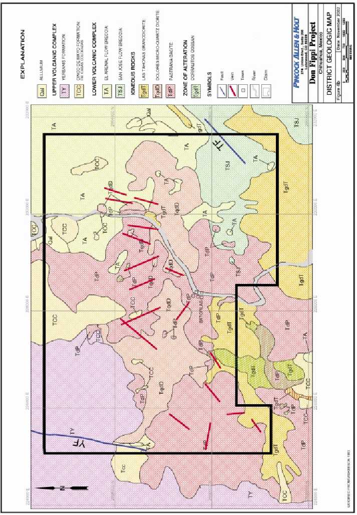
Figure 5. Schematic Stratigraphic Section for the Batopilas District.
| Unit | Age | Thickness | Mineralization or | |
| Name | Ma | in meters | Lithotype | Alteration |
| Yerbanis Rhyolite | 25-30 Ma | 700 | Rhyolite Welded | None |
| Ash-Flow Tuffs | ||||
| Cinco de Mayo | >35 Ma | 100 | Conglomerate | None |
| Casa Colorada | 40 Ma? | 100 | Rhyolite tuff and | Veins |
| flow breccia | ||||
| El Arenal | 40 Ma? | 200 | Andesite and | Veins |
| Volcaniclastics | ||||
| San Jose | 40 Ma | 200 | Andesite and | Veins |
| Volcaniclastics | ||||
| Corralitos Porphyry | 45 approx | 0-300 | Granodiorite | Porphyry Cu, Mo |
| porphyry | ||||
| Tahonas Granodiorite | 45 approx | 0-500 | Granodiorite | Veins |
| porphyry | ||||
| Dolores Microquartz | 51.1 | 0-500 | Diorite porphyry | None |
| Diorite | ||||
| Pastrana Dacite | >85 Ma | 0-600 | Dacite porphyry | Veins |
(Modified from Wilkerson and others, 1988)
Most structures in the district are faults, trending N30E to N30W. The major ore-controlling structures trend N-S to N30E (Figure 6) and dip from 50N to vertical. Some steepen systematically to the east. Much ore was found at vein intersections and along inflections or irregularities along the vein structures. However, in many cases the structural controls for oreshoots have not been discerned. Most of the veins show evidence for pre and intra mineral movements, and many show evidence of post-mineral offsets. Most of the faults are normal faults, but some, including the important Roncesvalles fault, appear to be strike-slip faults with a significant reverse component. It has been suggested (Wilkerson, 1983) that some of the mineralized veins are tension gashes related to these oblique reverse faults. Others (Wisser, undated, unpublished data) felt that the apparent reverse component was minor and that these features were formed by intrusion-doming extension and represent large sigmoid loops where the hangingwall was buttressed and could not subside as freely as the central slice. Wisser further hypothesized that the system forms a graben and that south-dipping complements to the Roncesvalles-Todos Santos structures should exist farther to the north. Still others (Goodell, pers. comm) feel that the strike-slip reverse faults are dominantly post-mineral features that have reactivated earlier, ore-containing, normal faults.
More detailed descriptions of the ore-related structural environment is presented below in the discussion of the individual vein sets.
There are not enough field data to adequately address many exploration related geologic questions for the district. Additional geologic mapping and analysis will be necessary from the earliest phases of exploration.
Pincock, Allen & Holt &nbs p; Page 7.3
9355.00b November 19, 2002

8.0 DEPOSIT TYPES
8.1 Regional Deposit Types
Regionally, the Sierra Madre Occidental in the Batopilas area is host to a multitude of epithermal gold-silver vein systems of the style modeled by Buchanan (1981). These veins tend to have restricted vertical ranges for precious metals deposition, and grade downward into base-metal dominated systems. Most are overwhelmingly dominated by massive quartz vein filings and wallrock silicification. The region also hosts lesser numbers of porphyry copper deposits (Wilkerson, 1988; Goodell, 1995), and high-sulfidation gold deposits (Wilkerson, 1988; Chairest and Castaneda, 1997). The latter include El Sauzal, a major gold discovery of the mid-1990s. The region also hosts two examples of a distinctive style of calcite-native silver veins: Batopilas and Morelos (Wilkerson, 1988; Garcia, 1927).
Mineralization in the Batopilas and Morelos Districts is dominated by crystalline native silver, with virtually no gold. The vein filling is dominantly calcite, but is only present in significant amounts in the ore shoots. They have little or no associated quartz, and silicification is patchy. In addition, these systems do not appear to be vertically zoned. The base of the Batopilas vein silver zones has apparently never been reached: grades, metal contents, and mineralogy apparently varied little over the 650 meter vertical depth of exploitation (Kreiger, 1935, Wilkerson, 1983; Wilson and Panczner, 1986). In short, the Batopilas and Morelos deposits appear to be fundamentally different from the typical epithermal veins in the area and should not be evaluated using the same criteria.
8.2 Batopilas District Deposit Types
There are several deposit types in the Batopilas District: Porphyry copper, base metal veins, silver-calcite veins, and Auriferous pyritic breccias. These types appear to be centered on the Corralitos porphyry copper system (Figures 4b and 6) (Wilkerson and others, 1988). The Corralitos porphyry is a quartz-sericite-pyrite altered granodiorite, oxidized to a gossan, with local copper-oxide efflorescences. Quartz-chalcopyrite-molybdenite veinlets can locally be found beneath the iron oxide cap. Surrounding the Corralitos porphyry is a zone of quartz with base metal veins, in some areas, of limited economic interest. This zone is in turn flanked by the broad zone of native silver bearing calcite veins that are the focus of this report. There are four major groups of silver veins (Figure 6): 1. Pastrana or Todos Santos-Roncesvalles, 2. San Miguel-Nevada (or San Miguel-Santo Domingo), 3. Caballo-Camuchin, and 4. Descubridora-El Triunfo. A few showings of quartz-galena-pyrite veins occur peripheral to the native silver zone, but it is not clear that these adequately define a zone. More recently, two quartz-pyrite bearing breccia pipes have been identified within the outer portion of the silver zone (Goodell, pers. comm.). These bodies are about 100m in diameter and reconnaissance surface sampling has yielded several 2 to 3 g/mt Au values.
Pincock, Allen & Holt &nbs p; Page 8.1
9355.00b November 19, 2002
9.0 MINERALIZATION AND ALTERATION
9.1 Batopilas District Silver Mineralization
Mineralization in the silver zone dominantly occurs in the Pastrana dacite, but some occurs in the Tahonas granodiorite and Dolores microdiorite. Pre-mineral quartz-porphyry and post-intra-mineral basalt dikes in veins are mineralized and locally altered to serpentinite. Mineralization throughout the silver zone overwhelmingly consists of crystallized native silver in calcite gangue. A few Ag, Pb, Zn, As, Cu, and Co-bearing sulphides have been reported from these ores (Krieger, 1935), but are of vanishingly small volume. The silver ores were high grade: ranging from the Batopilas Mining Company’s 1880-1913 average direct-smelting grade of 8,000 g/mt (257 oz/mt) to extremely high-grade pods carrying up to 75 percent Ag. The Batopilas Mining Company also produced a significant tonnage of “milling ore” grading 265 g/mt (8.5 oz/mt). Oreshoots typically are 15 to 80 meters long, 0.5 to 4.6 meters wide, (1 m average) and up to 350 meters down plunge (Figure 7). Shoots are connected by up to 90 meters of barren calcite veinlets, often only 1 to 3 millimeters wide. Veins have little filling outside of the oreshoots, so they have a very weak surface expression. Over the period 1880-1913, the Batopilas Mining Company mined an average of 100 standard tons per day (tpd) of ore: approximately 10 tpd of smelting grade and 95 tpd of milling grade. These figures are averaged over 30 years and it must be remembered that between bonanzas, the mines were in development for months at a time without extracting any significant amounts of ore. When they were in bonanza, daily ore production was several hundred standard tons per day.
9.1.1 Specific Vein Systems
There are four major groups of silver veins (Figure 6): 1. Pastrana or Todos Santos-Roncesvalles; 2. San Miguel-Nevada (or San Miguel-Santo Domingo); 3 Caballo-Camuchin; and 4. Descubridora-El Triunfo,
9.1.1.1 Todos Santos-Roncesvalles (TSR Zone West of the River)
The major veins of the TSR trend N-S to N20E and most are vertical to steeply north dipping. The important Todos Santos vein and numerous sub-parallel neighbors are truncated by, or terminate against, the Roncesvalles fault (Figures 6 and 7). The Roncesvalles fault appears to have had oblique reverse strike-slip movement that brought the hangingwall up about 250 meters and westward about 160 meters. Mineralization in the Roncesvalles is erratic, poddy and brecciated. Stopes are few along its length.
Wilkerson (1983) suggested that the ore veins in this area are tension features related to shear development of the Roncesvalles, so that the Roncesvalles was largely closed to the entrance of ore fluids. Alternatively, Wisser (unpublished data) suggested that the Roncesvalles and the other veins form a series of sigmoid loops and that the Roncesvalles was buttressed and held closed preventing entry of ore fluids. He further hypothesized that the TSR is the north-dipping boundary fault of a
Pincock, Allen & Holt &nbs p; Page 9.1
9355.00b November 19, 2002
graben and its south-dipping complement should lie farther to the north. Further, Goodell (pers. comm.) believes that movement on the Roncesvalles is dominantly post mineral and that the mineralization in it was dragged in from the veins that it cut and offset.
Two lines of evidence support this latter hypothesis.
| 1. | The Roncesvalles fault was explored for 200 meters to the east of the Santo Tomas vein, but it contained no mineralization. The Santo Tomas is the eastern-most of the TSR veins, so there is no known source further east of the Santo Tomas for ore to be dragged into the left-lateral Roncesvalles fault. |
| 2. | Ore pods throughout the district were consistently found within 90 meters of each other and twice that distance was covered in the drift without encountering mineralization. |
Regardless of the structural interpretation of the TSR, the hangingwall of the Roncesvalles fault is favorable exploration ground that has never been systematically explored. The Batopilas Mining Company put in one short crosscut that hit nothing. In 1983, an 80 meter crosscut, the Contrapozo Caliente, was driven into the hangingwall farther to the west. This hit a native silver body, the best of which is thought by some local miners to still be in place. Numerous others have suggested exploration of this area near the south end of the Roncesvalles workings would be productive, but it has never been done.
9.1.1.2 San Miguel-Nevada (SMN Zone East of the River)
The San Miguel-Nevada group is second in importance to the TSR group and is characterized by two horsetailing groups of N20W to N30E trending veins that intersect towards the southeast (Figure 6). This vein set generally dips to the north and many of these veins are cut off by post-mineral faults. Considerable exploration potential exists across these faults if the relative movement can be established through detailed geological studies. Wisser also considered this zone to have significant potential at depth.
The New Nevada mine produced a good sized ore pod in the late 1970’s and early 1980’s from an elliptical pipe 15 by 40 meters in plan and mined for over 100 meters vertically. The down dip extension of this orebody was never pursued, reportedly because of the difficulty of underhand stoping. In addition to the possible downward extension of this orebody, there may be potential for additional virgin breccia pipes of this type in the area farther east towards Cerro San Nestor.
The Santo Domingo mine is one of the northernmost historic workings of this eastern group of mines. At least six or more important N-S veins were intersected in the principal E-W oriented haulage level. These are probably some of the same structures exploited in the San Miguel mine to the south
Pincock, Allen & Holt &nbs p; Page 9.2
9355.00b November 19, 2002
9.1.1.3. Caballo-Camuchin Group
The Caballo-Camuchin group veins trend respectively from NNW to EW to around N30E and dip steeply to the north (Figures 2, 4b and 6). They are less extensively exploited than the RV-TS group and show much stronger argillic alteration around the veins. Limited work is currently going on at the Camuchin which has made at least one of these mines accessible for the first time in many years.
9.1.1.4. Descubridora-El Triunfo Group
The Descubridora-El Triunfo system also trends dominantly N30E (Figure 6). It is very poorly known and virtually forgotten by explorationists because it lies on the remote southwest corner of the district. Mines here reportedly produced good silver grades along with some minor copper and other base metals, but not much more is known.
9.2 Alteration
Wallrock alteration in the silver zone consists of:
| 1. | Chlorite-actinolite, locally with grey-green argillization and/or pyrite. This is most often spatially associated with silver mineralization; |
| 2. | Silicification, locally extending up to 9 meters from the veins. It is only locally developed adjacent to silver mineralization, so a genetic relationship is unclear; |
| 3. | Pyritization, either by itself or in combination with chlorite-actinolite alteration. This affects the Pastrana dacite most widely, but is also developed in the other intrusions. It appears best developed around the silver veins that lie close to the Corralitos porphyry zone; and |
| 4. | Argillization, best developed in the Camuchin area where it extends up to 15 meters from the silver veins. It is important to note that most, but not all, orebodies in each area have adjoining alteration halos. |
Pincock, Allen & Holt &nbs p; Page 9.3
9355.00b November 19, 2002
10.0 EXPLORATION
10.1 Historic Exploration
Historically, exploration at Batopilas consisted of mining and hoping to find more ore by following a structure (even if it was only a few millimeters wide) and waiting for it to blossom out again. Because oreshoots at Batopilas are typically separated by up to 90 meters of barren structure, with enough headings new bonanzas were encountered regularly despite the erratic ore distribution. Over the period 1880 to 1913, The Batopilas Mining Company averaged 100 tpd of ore production, but between bonanzas the mines were in development for months at a time without extracting any significant amounts of ore (Shepherd, 1938).
10.2 Minera Bugambilias Exploration
10.2.1 Data Acquisition and Geologic Mapping
Minera Bugambilias began their exploration with a comprehensive literature search and data acquisition phase. The resulting data have been compiled, digitized, and registered to a common UTM grid and elevation model. These data have been synthesized (Sanchez and Lopez, 2001) to define preliminary 2D and 3D target areas. This process has highlighted several areas of mismatch that will require some surface and underground surveying to resolve.
Much of the historic data were incorporated into a mapping contract done by Minera Cascabel S.A. de C.V. (parent company of Minera Bugambilias) for the Mexican Mineral Resources Council (COREMI) in 2000. This project was a study of the entire Batopilas 1:50,000 quadrangle including geology, stream sediment geochemistry, and satellite image analysis. These data remain confidential until their public release during the next 6 months. Given the scale of the COREMI program, it is unlikely that it will have major impact on specific exploration in Batopilas proper.
10.2.2 Geochemistry
Wilkerson (1983) reports some lithogeochemistry from his underground mapping work. He obtained significant silver grades in several places, but nothing approaching the historic grades. This is not surprising given the bonanza grades of good ores and the years of “high-grading” the district has endured. Surface based sampling is limited to a few grab samples of the Peñasquito Breccia taken by Dr. Philip C. Goodell of the University of Texas at El Paso (UTEP), and regional stream sediment geochemistry performed in the process of the COREMI mapping project
10.2.3 Geophysics
No geophysics has been conducted over the district.
Pincock, Allen & Holt &nbs p; Page 10.1
9355.00b November 19, 2002
10.2.4 Environmental Surveys
Old workings and prospect pits dot the surface of the property. Most dumps, and all tailings were originally deposited on the banks of the Rio Batopilas, and 80 years of flooding have long since carried them away.
No environmental surveys have been done in the district by Minera Bugambilias. Phelps Dodge probably did an environmental assessment when they obtained permits to drill the nearby Corralitos Porphyry in joint-venture with Francisco Gold in 1996, but these reports have not been made available.
Pincock, Allen & Holt &nbs p; Page 10.2
9355.00b November 19, 2002
11.0 DRILLING
No surface drilling has been done within Don Fippi proper but limited underground diamond drilling was attempted in local areas over the years. Most of this was probably production-oriented, but the results of these programs are unknown. The only known surface drilling in the district is the 1996-1997 Phelps Dodge-Francisco Gold joint-venture work on the Corralitos porphyry. Specific results are unknown and they have abandoned the property.
Pincock, Allen & Holt &nbs p; Page 11.1
9355.00b November 19, 2002
12.0 FIELD SAMPLING METHODS AND APPROACH
No systematic rock chip or dump sampling has been done to date.
Pincock, Allen & Holt &nbs p; Page 12.1
9355.00b November 19, 2002
13.0 SAMPLE PREPARATION, ANALYSES AND SECURITY
No samples have been taken.
Pincock, Allen & Holt &nbs p; Page 13.1
9355.00b November 19, 2002
14.0 DATA VERIFICATION
Geologic data has been field checked systematically throughout the district. Since there are few quantitative data, no checking of them has been done.
Pincock, Allen & Holt &nbs p; Page 14.1
9355.00b November 19, 2002
15.0 ADJACENT PROPERTIES
The Batopilas District is surrounded by mineralization on all sides, although the claim packages related to these neighboring districts do not necessarily abut Don Fippi (Wilkerson, 1988). The Corralitos copper porphyry lies immediately to the south. It was held by Francisco Gold via their Minas de Pimeria Alta subsidiary in 1996-1998, it is believed to have been abandoned, but the actual status is unknown. The Tres Hermanos gold vein system lies about 5 kilometers to the east. This was optioned by Phelps Dodge in 1998, but has been returned to the Mexican owners. The Cerro Colorado Gold-Silica deposit lies 6 kilometers north of Batopilas. This deposit was explored by Francisco Gold in 1995-1996, and subsequently by Peñoles. Extensive sampling and limited drilling accompanied these unsuccessful programs. The most important mineralization in the Batopilas area is Francisco Gold-Glamis Gold’s El Sauzal gold deposit. This is a high sulfidation gold system discovered in 1996. It is currently moving towards production (Northern Miner, October 2001), which should improve infrastructure in the region substantially.
Pincock, Allen & Holt &nbs p; Page 15.1
9355.00b November 19, 2002
16.0 METALLURGICAL TESTWORK
No metallurgical studies have been undertaken. Historically, silver was recovered through stamp mills and gravity or amalgamation (Brodie, 1909, Shepherd, 1935).
Pincock, Allen & Holt &nbs p; Page 16.1
9355.00b November 19, 2002
17.0 MINERAL RESOURCE AND MINERAL RESERVE ESTIMATES
The property remains at an early exploration stage. No data have yet been generated from which to estimate resources and reserves.
Pincock, Allen & Holt &nbs p; Page 17.1
9355.00b November 19, 2002
18.0 INTERPRETATION AND CONCLUSIONS
The silver mineralization of the Batopilas District occurs as pods of crystalline native silver irregularly distributed along persistent structures over a vertical distance of over 700 meters. Few other metals are present and the gangue is almost exclusively calcite. These features are distinct from the typical epithermal vein deposits of the region, which are characterized by polymetallic, vertically limited, and zoned orebodies hosted in quartz-rich veins. The differences are substantial enough to indicate that the Batopilas district must be explored in the perspective of its distinct characteristics.
Historically, exploration and exploitation at Batopilas was “stope and hope”. A series of structures, known to be productive, were followed simultaneously until a new Bonanza ore pod was encountered. This led to “feast or famine” production and an irregular cash-flow. Notably however, when pursued, the veins yielded orebodies on a regular basis for nearly 300 years. Many of these veins were heavily exploited, but the bottom of mineralization has never been found and the lateral potential for mineralization on many of the exploited veins remains open. In addition, many veins exploited in the near-surface zone during the Spanish Colonial era were not pursued at depth by the Batopilas Mining Company during the district’s last major mining phase and their tunnelling efforts revealed numerous native silver-bearing calcite veinlets that were not exploited or explored.
The district history indicates that more mineralization remains to be discovered at Batopilas (Wilkerson and others, 1988). However, modern mining realities will not support mining without an adequate reserve inventory, which opens the question of whether it is possible to find Batopilas style orebodies efficiently through application of modern exploration concepts and technology. The following combine to suggest that this should be possible;
| 1. | The district has seen little modern geologic investigation or exploration, and what has been done did not include the type of detailed structural analysis that is required for exploring a vein system. Good surface and underground access will facilitate gathering the needed data. |
| 2. | The fractionated claim situation impeded district-scale exploration thinking and application of specific exploration concepts outside of limited areas. The consolidated Bugambilias land package obviates this problem. |
| 3. | The native silver ores and certain alteration styles should be strong conductors to modern electrical geophysical techniques. This includes modern metal detectors that can be used to trace mineralization as surface float trails and in veins underground. |
| 4. | Modern mining technology will allow affordable deep mining. |
Pincock, Allen & Holt &nbs p; Page 18.1
9355.00b November 19, 2002
18.1 Major Targets
The geologic and historical data combine to indicate the following major targets for immediate exploration focus.
| 1. | The northwest side of Roncesvalles fault. This area has never been explored except for a barren 25 meters crosscut and an 80 meter crosscut, which hit high-grade Ag in the Contrapozo Caliente. As discussed above, this entire hangingwall area has excellent exploration potential for additional virgin veins from the surface to depth. Access to this area is best obtained through the 2.5 km long Porfirio Diaz Tunnel (PDT) which runs along the Roncesvalles fault for over 1.2 km. The PDT is caved about 1 km from the portal at some ore-chutes near the intersection with the RFZ, but the collapse is accessible from both sides. The cave is not very wide and should be able to be cleaned up cheaply and easily as it has in the past. There are other minor caved zones along the Roncesvalles fault that will need to be cleaned up, especially on some of the higher levels for performing some of the underground geophysical work proposed below. |
| 2. | All mines that were being worked at depth when mining stopped in 1914 and the pumps were shut off. This includes the deep portions of the Todos Santos-Roncesvalles Group and the San Miguel Group. Based on geologic and geochemical data indicating that Batopilas is not a typical epithermal vein system, including the overall vertical extent of mineralization (>700m), there is reason to believe that ores should continue below these areas. Their existence should be easy to test and readily produced if the mines are not too badly caved. |
| 3. | Additional New Nevada type breccia pipes east of San Miguel. Surface outcrops indicate these may be present, but the entire area requires detailed mapping and sampling. |
| 4. | Targets in the eastern-most San Miguel Group where veins are cut off by postmineral faults. The Batopilas Mining Company was apparently in the process of pursuing these targets when the Revolution started. These can be tested by driving the San Miguel or Santo Domingo adits farther to the east or seeking them from surface. |
| 5. | A low-grade mineralization has been projected for the four major mine groups based on a 1970’s sampling and mapping compilation (Anonymous, 1977). The full report is missing, but the inventory exists and can be checked quickly for accuracy once underground access is re-established. Note that this kind of low-grade ore should not be a principal exploration objective, but should be investigated as a possible source for future milling ore. Because of the lack of access and hard data, no number is proposed. |
| 6. | The quartz-pyrite breccia pipes that lie above the TSR group are approximately 100 meters in diameter and have reconnaissance gold sample results of up to 2 to 3 g/mt. These should be systematically sampled on surface. Their projection at depth lies within 100 meters of the Porfirio Diaz Tunnel and the down dip extension of these bodies could be tested by relatively short underground holes drilled from the PDT. |
Pincock, Allen & Holt &nbs p; Page 18.2
9355.00b November 19, 2002
| 7. | N-NE-Trending calcite (plus or minus native silver) veinlets cut in the Porfirio Diaz Tunnel and other underground workings. The known mineralized veins pinch down to 1 to 3 mm of calcite between oreshoots and there are a number of narrow calcite veinlets exposed in the underground workings. The major cross-cut tunnels (PDT, San Miguel Adit, Santo Domingo Adit, Nevada Adit) intersect many such veinlets that have never been traced. If the proposed geophysical techniques work to find native silver pods, it should reveal blind orebodies along these structures as well. |
18.2 Secondary Targets
| 1. | The New Nevada breccia-pipe between the road level and bottom of mined zone. The mined portion was an elliptical pipe 15 by 40 meters in plan and mined for over 100 meters vertically above the adit level. The down dip extension of the orebody was never pursued because of the necessity of underhand stoping. This body was rich enough that it ought to respond well to the proposed AMT electrical geophysical method. This area could be an ideal test area for an orientation survey. |
| 2. | The Camuchin Mine was producing small amounts of good grade ore associated with abundant pyrite and argillization in 1997, but is shut down now. The abundant pyrite and argillization suggests that this area should also respond well to AMT. The Porfirio Diaz tunnel terminates about 2 km short of reaching the Camuchin vein but if mineralization can be located in this area it could be trammed out through an extension of this tunnel. This could also create an exploration opportunity for seeking blind veins west of the Roncesvalles fault. |
ZONGE Geophysical’s Audio Magneto Telluric techniques (CSAMT or NSAMT Controlled Source or Natural Source Audio Magneto Tellurics) may be viable remote sensing tools for the district. AMT detects a range of electrical frequencies passing through the ground (either transmitted, in CSAMT, or natural in NSAMT) and measures conductivity contrasts in the ground it passes through on the way to the receivers. In the appropriate environment, the technique is good for finding high-angle structures (such as veins), and conductors such as argillically altered ground, pyritized zones, and massive sulphides. In theory, native silver should be highly conductive to the AMT signals and give very strong anomalies. One of the strengths of AMT, as opposed to other electrical techniques, is that depth of penetration is independent of receiver spacing. It is possible to penetrate to depths of over 2,000 meters while maintaining tight resolution (how tight depends on the receiver spacings). It also may be possible to modify the receiver geometry to view laterally for several hundreds of meters, if a proposed surface layout works as expected. The technique can also be run underground. ZONGE Engineering Research personnel feel that Batopilas type targets should be excellent targets for AMT.
Several features should contribute to AMT effectiveness in the district:
| 1. | Native silver should be a very strong conductor, and historic reports indicate that the high-grade orebodies are interconnected metallic masses. |
Pincock, Allen & Holt &nbs p; Page 18.3
9355.00b November 19, 2002
| 2. | The Roncesvalles fault zone can be accessed on three levels with a minimum of effort. This should facilitate exploration for hangingwall veins in that area. |
| 3. | The angle of intersection between the Roncesvalles fault and the known Todos Santos vein group is such that, if the hangingwall veins have similar strike, the orebodies will present a broadside view to the receivers along the Roncesvalles fault, greatly increasing the cross-sectional view for detection. |
| 4. | The technique may be able to detect orebodies believed to have been abandoned in the lower flooded levels of the mines and in the extensions of the Pastrana mine to the north. |
| 5. | If the technique works, orebodies should be sought along previously overlooked veins. |
| 6. | Native silver mineralization may be present immediately under the New Nevada breccia and this could be tested as an orientation study. If the body continues to be as large as it was in the upper reaches, it should give a very good response at depth. |
District exploration will be greatly facilitated if these techniques work.
Pincock, Allen & Holt &nbs p; Page 18.4
9355.00b November 19, 2002
19.0 RECOMMENDATIONS
The high-grade bonanza ores should be the primary exploration focus with the expectation that significant amounts of low-grade (250 g/mt Ag) ores will be found in concert. Geological and geophysical techniques must be tested and applied to find oreshoots efficiently. There are several types of targets available in the district, some immediate and some longer term. All the targets require detailed geologic mapping and geophysical definition. Many of these targets should be testable through surface drilling or from underground by relatively short holes from existing workings and/or new headings.
Registering all the old workings to the same 3D space through GPS, underground surveying, GIS database development, and Gemcom 3D visualization will undoubtedly highlight areas that remain under-evaluated. For example, a first pass AutoCAD rendering clearly indicates untested ground exists between the independently operated historic and highly productive Santo Domingo and San Miguel mines on the east of the river (Sanchez and Lopez, 2001).
Pincock, Allen & Holt &nbs p; Page 19.1
9355.00b November 19, 2002
20.0 EXPLORATION PROGRAM AND TECHNIQUES
In general, the proposed exploration program has the principal goal of determining whether new geologic information and modern remote sensing techniques can locate blind high-grade native silver pods. The old system of blind mining should not be necessary, although some of the targets mentioned above could be tested by direct mining regardless of the geophysical results.
A two-stage pre-drilling exploration program should be undertaken:
The first stage should begin with continued acquisition and compilation of available data for the district. This should include careful structural analysis using data in Wilkerson and some of the older reports. This should be followed by detailed surface and underground geologic mapping and analysis. Engaging Dr. Phil Goodell and Greg Wilkerson as consultants with special knowledge of the Batopilas would be advisable.
The field priorities are:
| 1. | Accurately locate as many old workings as possible with GPS and underground surveying for integration into a district-scale GIS database. |
| 2. | Detailed surface mapping of the area above the Roncesvalles fault should be conducted, to get a better idea of it’s offset. |
| 3. | Map and sample the quartz-pyrite breccia pipes and evaluate the gold potential. |
| 4. | Map the surface expression of the New Nevada breccia pipe and its possible analogs to the east. |
| 5. | Visit Camuchin and Descubridora areas to determine level of interest and priorities for acquisition and work in those areas. |
The surface work should be complemented by underground mapping and sampling. Some areas in the district will require some minor mine rehabilitation and mucking out of minor caved areas to ensure access. The Porfirio Diaz tunnel should be cleaned up and re-opened to the back of the Roncesvalles fault zone to re-establish flow-through ventilation and allow the mine to “breathe” before working in the deepest accessible areas such as the Contra Pozo Caliente. This will be especially important because much subsequent exploration will be underground from the PDT using either drilling or direct heading. There are experienced miners remaining in the area who know the mine and ground conditions intimately. Examination of the upper levels along the Roncesvalles in order to evaluate the difficulty of rehabilitation should be done once the PDT is reopened.
Pincock, Allen & Holt &nbs p; Page 20.1
9355.00b November 19, 2002
Phase One should result in definition and refinement of major exploration targets in the district. These should then be tested with orientation geophysical surveys, followed by more intensive geophysical investigation of the best anomalies developed by the orientation work.
| TABLE 20-1 | ||
| Mega Capital Investments Inc. | ||
| Don Fippi Property | ||
| Phase 1 Exploration Budget Summary | ||
| Phase 1 | ||
| Item | Cost (C$) | |
| Logistics: Miscellaneous Support Expenses and Equipment | ||
| (Including two metal detectors) | 15,000 | |
| Mine Rehabilitation | 37,500 | |
| Geologic Mapping (4-man teams for 100 days @ $1,200/day) | 120,000 | |
| Air Photo Acquisition | 37,500 | |
| Geochemical Sampling | 25,000 | |
| Orientation Geophysical Survey | 165,000 | |
| Final Report and Ongoing Qualifying Reports | 20,000 | |
| Phase 1 Subtotal | 420,000 | |
| Value Added Tax (IVA) 15% | 63,000 | |
| Phase 1 Total | 483,000 |
Funds for acquiring/optioning additional claims would be additional.
Pincock, Allen & Holt &nbs p; Page 20.2
9355.00b November 19, 2002
CERTIFICATE OF QUALIFICATION
I, Clarence J. Wendt, P. Geo., do hereby certify that:
1. I reside at 5004 East Albuquerque Road, Reno, Nevada, 89511
2. I graduated from San Diego State University with a Bachelor of Science degree in Geology in 1967, and the University of Arizona with a Master of Science degree in Geology in 1978 and have practiced my profession continuously since that time.
3. I am a Non-Resident Professional Geoscientist in the Province of British Columbia (N1712), a Registered Geologist in the State of Arizona (18283), and a Registered Professional Geologist with the American Institute of Professional Geologists (4966).
4. I hold membership in the following mineral industry technical societies:
- A.I.M.E. (Fellow),
- Society of Economic Geologists (Fellow),
- AusIMM (Fellow)
- American Association of Petroleum Geologists,
- Geological Society of Nevada,
- Arizona Geological Society, and
- Northwest Mining Association
5. I have practiced my profession continually for 33 years.
6. I have read the definition of “qualified person” set out in National Instrument 43-101 (“NI 43-101”) and certify that by reason of my education, affiliation with a professional association (as defined in NI 43-101) and past relevant work experience, I fulfill the requirements to be a “qualified person” for the purposes of NI 43-101.
7. I am responsible for the preparation of the technical report titled “The Geology and Exploration Potential of the Don Fippi Property, Batopilas District, Chihuahua, Mexico” dated November 19th, 2002. I visited the Don Fippi property on September 7th, 2002 for one day.
8. I have not had prior involvement with the property that is subject of the Technical Report.
9. I am not aware of any material fact or material change with respect to the subject matter of the Technical Report that is not reflected in the Technical Report, the omission to disclose which makes the Technical Report misleading.
10. I am independent of Mega Capital Investments applying all the tests in Section 1.5 of National Instrument 43-101.11. I have read National Instrument 43-101 and Form 43-101F1, and the Technical Report has been prepared in compliance with that instrument and form.
Pincock, Allen & Holt &nbs p; Page 21.1
9355.00b November 19, 2002
12. I consent to the filing of the Technical Report with any stock exchange and other regulatory authority and any publication by them for regulatory purposes, including electronic publication in the public company files on their websites accessible by the public, or the Technical Report.
Signed and Dated this 19th Day of November, 2002
”Clarence J. Wendt”______
Clarence J. Wendt Reno, Nevada
[SEALED]
Pincock, Allen & Holt &nbs p; Page 21.2
9355.00b November 19, 2002
22.0 REFERENCES
Anonymous, 1977?, Inventory of “milling-grade” ores in the Batopilas Mining District: Source and author unknown.
Brodie, W.M., 1909, History of the Native Silver Mines of Batopilas, Mining World, v. 30, # 24, p.1105-1110.
Brodie, W.M., 1909, Metallurgy of Native Silver ores of southwestern Chihuahua (Batopilas): Mining World vol. 31, no. 1, p. 48-54
Buchanan, L.J., 1981, Precious metal deposits associated with volcanic environments in the southwest- in Dickinson, W.R., and Payne, W.D., eds., Arizona Geological Society Digest No. 14, p. 237-262.
Chairest, A., and Castaneda, J., 1997, Geologia y modelo yacimiento de oro de Sauzal, Chihuahua: Memorias Tecnicas, XXII Convencion Nacional de la Asociacion de Ingenieros de Minas, Metalurgistas y Geologos de Mexico A.C. (A.I.M.M.G.M), 1997 Meeting, Acapulco, Guerrero, Mexico, p. 137-148.
Dahlgren, C.V., 1883, The Historic Mines of Mexico: New York, 220 p.
Garcia, J.A., 1927, La Region Auroargentifera de Morelos, Chihuahua: Boletin Minero, Tomo 23, p. 19-21.
Goodell, P.C., 1995, Porphyry Copper Deposits along the Batopilas Lineament, Chihuahua, Mexico- in, Pierce, F.W., and Bolm, J.G., eds, Porphyry Copper Deposits of the American Cordillera, Arizona Geological Society Digest #20, p. 544
Goodell, P.C., 1996, The golden gossan fake-out or, the origin of the pre-1632 cathedral at Satevo, Chihuahua (Batopilas): a theory: in, Goodell, P.C., Reyes-Cortes, I.A., Reyes-Cortes, M., and Carreon M., P.J. eds., Conferencia Internacional de Mineria, Excursion geologica al Cenozoico de Chihuahua, Chihuahua-Batopilas, del 6 al 9 de Octubre de 1996, p. 241-242
Krieger, P., 1935, Primary native Silver ores at Batopilas and
Bullard's Peak, New Mexico.- American Mineralogist, vol. 20, p. 715723
Pincock, Allen & Holt &nbs p; Page 22.1
9355.00b November 19, 2002
McAnulty, W.N., Jr., 1996, Cerro Colorado, Municipality of Batopilas Chihuahua, Mexico: in, Goodell, P.C., Reyes-Cortes, I.A., Reyes-Cortes, M., and Carreon-M., P.J. eds., Conferencia Internacional de Mineria, Excursion geologica al Cenozoico de Chihuahua, Chihuahua- Batopilas, del 6 al 9 de Octubre de 1996, p. 287-296.
Northern Miner, 2002, Study clears hurdle for Glamis’s El Sauzal: Northern Miner, v. 88, no. 33, p.1, 14.
Sanchez-G., R., and Lopez-N., F., 2001, Informe geologico-minero, Proyecto Don Fippi, Municipio Batopilas, Chihuahua, Mexico: Proprietary report to Minera Cascabel S.A. de C.V., November, 2001, 21p.
Shepherd, A.R. Jr., 1935, A summary of the Batopilas Native Silver Mines, their past production and outlook for future yield. Unpublished report, University of Arizona Library (rare books collection)
Shepherd, G., 1938, The Silver Magnet, 50 years in a Mexican Silver Mine (Batopilas, Chih)- E.P. Dutton, New York, 302p.
Todd, S., 1907, History and Development of Batopilas Mine-. Mining World, v. 26, no. 1 8, p. 566-568, v. 27, no. 17, p 729-731
Wilkerson, G., 1983, Geology of the Batopilas mining district,
Chihuahua, Mexico- Unpublished Ph.D. Dissertation, University of Texas 2 volumes, 970 p.
Wilkerson, G., 1988, The Cerro Colorado, Satevo and La Bufa Mining Districts, Chihuahua, Mexico in Clark, K.F., Goodell, P.C., and Hoffer, J.M., eds., Stratigraphy, Tectonics and Resources of Parts of the Sierra Madre Occidental Province, Mexico: El Paso Geological Society, Field Trip Guidebook (1988), p. 309-318.
Wilkerson, G., Deng, Q., Llavona, R. and Goodell, P.C., 1988, Batopilas mining district, Chihuahua.: Economic Geology, v. 83, no. 8, p. 1721-1736
Wilson, W.E. and Panczner, W.D., 1986, Famous mineral localities; the Batopilas District, Chihuahua, Mexico.: Mineralogical Record, v. 17, no. 1, p. 61-80.
Wisser, E., undated, Proprietary report to U.S. Smelting and Refining Co., 23 p.
Pincock, Allen & Holt &nbs p; Page 22.2
9355.00b November 19, 2002