QuickLinks -- Click here to rapidly navigate through this documentExhibit 99.1
YAMANA GOLD INC.
RENEWAL ANNUAL INFORMATION FORM
FOR THE FISCAL YEAR ENDED DECEMBER 31, 2005
March 20, 2006
150 York Street, Suite 1902
Toronto, Ontario M5H 3S5
YAMANA GOLD INC.
RENEWAL ANNUAL INFORMATION FORM FOR THE
FISCAL YEAR ENDED DECEMBER 31, 2005
TABLE OF CONTENTS
DESCRIPTION
| | PAGE NO.
|
|---|
| ITEM 1 — INTRODUCTORY NOTES | | 2 |
| ITEM 2 — CORPORATE STRUCTURE | | 3 |
| ITEM 3 — GENERAL DEVELOPMENT OF THE BUSINESS OF THE COMPANY | | 5 |
| | Overview of Business | | 5 |
| | Three Year History | | 5 |
| | Acquisitions and Dispositions | | 7 |
| ITEM 4 — NARRATIVE DESCRIPTION OF THE BUSINESS | | 8 |
| | Principal Products | | 8 |
| | Competitive Conditions | | 8 |
| | Operations | | 8 |
| | Risks of the Business | | 11 |
| | Technical Information | | 18 |
| | Mineral Projects | | 19 |
| ITEM 5 — DIVIDENDS | | 81 |
| ITEM 6 — DESCRIPTION OF CAPITAL STRUCTURE | | 82 |
| ITEM 7 — MARKET FOR SECURITIES | | 82 |
| ITEM 8 — DIRECTORS AND OFFICERS | | 83 |
| | Corporate Cease Trade Orders, Bankruptcies, Penalties or Sanctions | | 86 |
| | Conflicts of Interest | | 87 |
| ITEM 9 — PROMOTER | | 87 |
| ITEM 10 — LEGAL PROCEEDINGS | | 87 |
| ITEM 11 — INTEREST OF MANAGEMENT AND OTHERS IN MATERIAL TRANSACTIONS | | 87 |
| ITEM 12 — AUDITORS, TRANSFER AGENT AND REGISTRAR | | 88 |
| ITEM 13 — MATERIAL CONTRACTS | | 88 |
| ITEM 14 — AUDIT COMMITTEE | | 88 |
| ITEM 15 — INTERESTS OF EXPERTS | | 90 |
| ITEM 16 — ADDITIONAL INFORMATION | | 91 |
| SCHEDULE "A" — AUDIT COMMITTEE CHARTER | | 92 |
ITEM 1
INTRODUCTORY NOTES
Cautionary Note Regarding Forward-Looking Statements
This annual information form contains "forward-looking statements" that involve a number of risks and uncertainties. Forward-looking statements include, but are not limited to, statements with respect to the future price of gold, the estimation of mineral reserves and resources, the realization of mineral estimates, the timing and amount of estimated future production, costs of production, capital expenditures, costs and timing of the development of new deposits, success of exploration activities, permitting time lines, currency fluctuations, requirements for additional capital, government regulation of mining operations, environmental risks, unanticipated reclamation expenses, title disputes or claims, limitations on insurance coverage and timing and possible outcome of pending litigation. Often, but not always, forward-looking statements can be identified by the use of words such as "plans", "expects", or "does not expect", "is expected", "budget", "scheduled", "estimates", "forecasts", "intends", "anticipates", or "does not anticipate", or "believes", or variations of such words and phrases or state that certain actions, events or results "may", "could", "would", "might" or "will" be taken, occur or be achieved. Forward-looking statements are based on the opinions and estimates of management as of the date such statements are made, and they involve known and unknown risks, uncertainties and other factors which may cause the actual results, performance or achievements of the Company to be materially different from any other future results, performance or achievements expressed or implied by the forward-looking statements. Such factors include, among others: the actual results of current exploration activities; actual results of current reclamation activities; conclusions of economic evaluations; changes in project parameters as plans to continue to be refined; future prices of gold; possible variations in ore grade or recovery rates; failure of plant, equipment or processes to operate as anticipated; accidents, labour disputes and other risks of the mining industry; delays in obtaining governmental approvals or financing or in the completion of development or construction activities, fluctuations in metal prices, as well as those risk factors discussed or referred to in this annual information form under the heading "Risk Factors" and in the Company's annual Management's Discussion and Analysis filed with the securities regulatory authorities in all provinces of Canada and available at www.sedar.com. Although the Company has attempted to identify important factors that could cause actual actions, events or results to differ materially from those described in forward-looking statements, there may be other factors that cause actions, events or results not to be anticipated, estimated or intended. There can be no assurance that forward-looking statements will prove to be accurate, as actual results and future events could differ materially from those anticipated in such statements. The Company undertakes no obligation to update forward-looking statements if circumstances or management's estimates or opinions should change. Accordingly, readers are cautioned not to place undue reliance on forward-looking statements.
Cautionary Note to United States Investors Concerning Estimates of Measured, Indicated and Inferred Resources:This annual information form uses the terms "Measured", "Indicated" and "Inferred" Resources. United States investors are advised that while such terms are recognized and required by Canadian regulations, the United States Securities and Exchange Commission does not recognize them. "Inferred Mineral Resources" have a great amount of uncertainty as to their existence, and as to their economic and legal feasibility. It cannot be assumed that all or any part of an Inferred Mineral Resource will ever be upgraded to a higher category. Under Canadian rules, estimates of Inferred Mineral Resources may not form the basis of feasibility or other economic studies. United States investors are cautioned not to assume that all or any part of Measured or Indicated Mineral Resources will ever be converted into Mineral Reserves. United States investors are also cautioned not to assume that all or any part of an Inferred Mineral Resource exists, or is economically or legally mineable.
Currency Presentation And Exchange Rate Information
This renewal annual information form contains references to both US dollars and Canadian dollars. All dollar amounts referenced, unless otherwise indicated, are expressed in United States dollars and Canadian dollars are referred to as "Canadian dollars" or "Cdn$".
2
The closing, high, low and average exchange rates for the US dollar in terms of Canadian dollars for the years ended December 31, 2005, December 31, 2004 and February 29, 2004 as reported by the Bank of Canada, were as follows:
| | Year-Ended December 31,
2005
| | Year Ended December 31,
2004
| | Year Ended February 29,
2004
|
|---|
| Closing | | $ | 1.17 | | $ | 1.20 | | $ | 1.33 |
| High | | | 1.27 | | | 1.39 | | | 1.49 |
| Low | | | 1.14 | | | 1.17 | | | 1.27 |
| Average(1) | | | 1.21 | | | 1.30 | | | 1.37 |
- (1)
- Calculated as an average of the daily noon rates for each period.
On March 20, 2006, the Bank of Canada noon rate of exchange was US$1.00 = Cdn$1.16 or Cdn$1.00 = US$0.86.
ITEM 2
CORPORATE STRUCTURE
Yamana Gold Inc. (the "Company" or "Yamana") was continued under theCanada Business Corporations Act by Articles of Continuance dated February 7, 1995. On February 7, 2001, pursuant to Articles of Amendment, the Company created, and authorized the issuance of a maximum of 8,000,000, first preference shares, Series 1. On July 30, 2003, pursuant to Articles of Amendment, the name of the Company was changed from Yamana Resources Inc. to Yamana Gold Inc. On August 12, 2003, the authorized capital of the Company was altered by consolidating all of the then issued and outstanding common shares of the Company on the basis of one new Common Share for 27.86 existing common shares.
The Company's head office is located at 150 York Street, Suite 1902, Toronto, Ontario M5H 3S5 and its registered office is located at 2100 Scotia Plaza, 40 King Street West, Toronto, Ontario M5H 3C2. As of April 1, 2006, the head office will move suites at 150 York Street, to Suite 1102.
The following chart illustrates the Company's principal subsidiaries (collectively, the "Subsidiaries"), together with the jurisdiction of incorporation of each company and the percentage of voting securities beneficially owned or over which control or direction is exercised by the Company. As used in this annual information form, except as otherwise required by the context, reference to the "Company" or "Yamana" means Yamana Gold Inc. and the Subsidiaries.
3
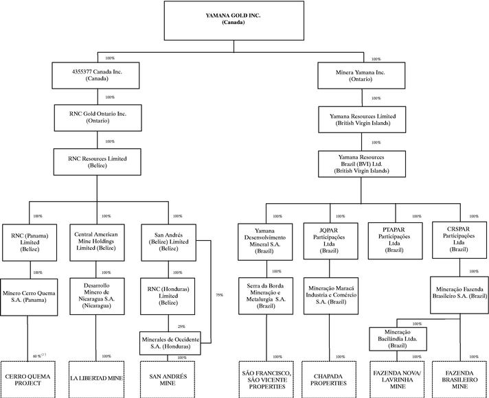
Note:
- (1)
- Balance of 40% is held in escrow pursuant to an escrow agreement dated April 5, 2004 to be transferred to RNC (Panama) Limited in the event that the mine is constructed and put into production by February 2007.
4
ITEM 3
GENERAL DEVELOPMENT OF THE BUSINESS OF THE COMPANY
Overview of Business
The Company is engaged in the acquisition, exploration, development and operation of mineral properties in Brazil and Central America. In August 2003, the Company acquired the São Francisco, São Vicente and Fazenda Nova/Lavrinha properties (the "Santa Elina Properties") and the Chapada copper-gold project (the "Chapada Properties") in Brazil from Santa Elina Mines Corporation ("Santa Elina") and the Fazenda Brasileiro gold mine (the "Fazenda Brasileiro Mine") in Brazil from Companhia Vale do Rio Doce ("CVRD"). These acquisitions resulted in the Company becoming a significant gold producer in Brazil and one of Brazil's largest gold exploration landholders.
In February 2006, through its acquisition of RNC Gold Inc. ("RNC"), the Company acquired two producing mines, La Libertad in Nicaragua and San Andrés in Honduras, to add to its existing mineral projects. The Company also acquired the Cerro Quema project in Panama, a development stage property, and prospective exploration ground surrounding RNC's Hemco mine in Nicaragua, with a two-year option to purchase the Hemco mine. See "Acquisitions and Dispositions".
The Company is currently completing an acquisition of Desert Sun Mining Corp. ("DSM"), which owns the Jacobina gold mine in Brazil. This transaction is expected to be completed in April 2006. Upon completion of this acquisition, Yamana will further strengthen its position as an intermediate gold producer. See "Acquisitions and Dispositions".
Three Year History
As part of its developing emphasis on Brazil, in early 2003, Yamana began discussions with Santa Elina. From April to July 2003, Yamana and Santa Elina negotiated the terms of the acquisition of the Santa Elina Properties and the Chapada Properties from Santa Elina and the acquisition of the Fazenda Brasileiro Mine from CVRD. The Chapada Properties are composed of the Chapada copper-gold project and other exploration lands in northern Goiás State, Brazil. The Santa Elina Properties include São Francisco project and São Vicente property and two advanced pre-production gold projects, the Fazenda Nova Mine and the Lavrinha property, as well as some exploration projects, claims and concessions in Brazil. The pre-production projects were all in advanced stages of permitting and licensing. The Fazenda Nova Mine and the Lavrinha property are located in the Goiás Mineral District in central Goiás State, while São Vicente and São Francisco are located approximately 50 kilometres apart along the Santa Elina Gold Belt in west central Mato Grosso State near the Bolivian border.
On July 31, 2003, the Company closed a private placement for gross proceeds of Cdn.$55.5 million to fund the acquisition of the Fazenda Brasileiro Mine and the development of the Santa Elina Properties.
In connection with the acquisition of the Santa Elina Properties, the Chapada Properties and the Fazenda Brasileiro Mine, in August 2003 the Company's board of directors was reconstituted.
On December 23, 2003, Yamana closed a public offering for gross proceeds of Cdn.$27.7 million to fund the advancement of the Company's mineral projects, potential acquisitions and general corporate purposes.
In January 2004, the Company commenced construction at its Fazenda Nova Mine, which was completed in the second half of 2004. The decision to construct the mine was based on a feasibility study dated November 2003 prepared by Kappes Cassiday & Associates. Commercial production at the mine commenced on May 1, 2005.
On October 15, 2004, the Company secured a $100 million debt financing commitment from Amulet Limited ("Amulet"), a private investment fund advised by Amaranth Advisors (Canada) ULC, and entered into a subscription agreement with Amulet dated as of October 15, 2004 (the "Subscription Agreement") whereby Amulet agreed to subscribe for $100 million of senior secured notes of the Company ("Senior Secured Notes"). The proceeds from the issue and sale of the Senior Secured Notes are being used to fund construction of the Chapada Project.
5
The Senior Secured Notes have a six year term with principal repayable in full at maturity. The Senior Secured Notes bear interest at the rate of 10.95% per annum and interest is payable semi-annually. At the option of the Company, interest may be accrued during the first two years, in which case the interest rate will be 12.45%. The Company has the right, but not the obligation, to pay interest (but not principal) in common shares, subject to the Company obtaining all necessary regulatory approvals, based on the prevailing market price of the common shares at the time. The Senior Secured Notes are secured against all of the assets of the Company and its material subsidiaries and guaranteed by certain subsidiaries of the Company, including each of its material subsidiaries. The Company may redeem the Senior Secured Notes at any time after three years from the date of issue at a redemption price, payable in cash, of the principal amount plus a premium and any accrued but unpaid interest.
The Senior Secured Notes are governed pursuant to an amended and restated trust indenture (the "Trust Indenture") between the Company and BNY Trust Company of Canada as of April 19, 2005, as supplemented and amended. On April 29, 2005, the Company drew down under the loan facility and Amulet advanced funds. Upon drawdown, the funds were deposited in escrow for the benefit of the Company pending perfection and registration of security interests and receipt of certain authorizations, approvals and opinions relating to the perfection and registration of such security interests. On August 8, 2005, the first $70 million was released to the Company from escrow. The remaining $30 million was released on October 7, 2005.
On November 9, 2004, Yamana closed a public offering of 26,377,000 common shares for gross proceeds of Cdn.$91 million to fund the advancement of the Company's mineral projects, potential acquisitions and general corporate purposes.
In December 2004, the Company made a formal construction decision at its Chapada Property, based on the results of an updated feasibility study on the property completed in August 2004. The Company is currently constructing the Chapada copper-gold mine and expects to commence mining operations by the fourth quarter of 2006.
In November 2004, the Company made a formal construction decision at is São Francisco gold project, upon the completion of a final feasibility study for São Francisco, and construction was commenced shortly thereafter. The open pit pre-strip at São Francisco is complete and the mining of ore commenced in December 2005. Ore is being loaded onto the heapleach pads. The primary, secondary and tertiary crushing circuits as well as the gravity processing circuit are operational. The gravity heap leach project is expected to be operational before the end of the first quarter of 2006. Heap leaching of ore also commenced in March 2006. Commercial production is expected to commence during the second quarter of 2006.
As of July 29, 2005, the Company effected an amendment of the terms of its 40,567,656 listed common share purchase warrants (the "Warrants") in order to encourage the early exercise of the Warrants, each of which was exercisable to purchase one common share of the Company at a price of Cdn.$1.50 until July 31, 2008. A total of 39,866,635 Warrants were exercised and an aggregate of 41,285,875 common shares were issued. The remaining 701,021 Warrants were automatically exchanged, without payment of the exercise price, into an aggregate of 476,198 common shares. The Company realized net proceeds of approximately Cdn$58 million in connection with the Warrant transaction.
In October 2005, Yamana closed a public offering of 26,000,000 common shares for gross proceeds of Cdn. $130,000,000 to fund the advancement of its mineral projects, potential acquisition and general corporate purposes.
6
Acquisitions and Dispositions
Santa Elina Properties
On August 12, 2003, Yamana acquired (i) a 100% interest in Mineração Bacilândia Ltda., the holder of the Fazenda Nova/Lavrinha properties; (ii) a 100% economic interest in Santa Elina Desenvolvimento Mineral S.A., the holder of the São Francisco and São Vicente properties, from Santa Elina in exchange for 14,677,380 common shares and 7,338,690 warrants. In order to comply with legal restrictions applicable to border areas, 49% of the common shares of Serra de Borda Mineração e Metallurgia S.A. are held by Yamana Desenvolvimento Mineral S.A. FTFPAR Participações Ltda. holds 51% of the common shares of Serra de Borda Mineração e Metallurgia S.A. Pursuant to a share purchase option agreement dated August 20, 2004 between Yamana Desenvolvimento Mineral S.A. and FTFPAR Participações Ltda., Yamana Desenvolvimento Mineral S.A. has an option to purchase 4,031 preferred shares class A and 4,031 preferred shares class B of Serra de Borda Mineracao e Metallurgia S.A. from FTFPAR Participações Ltda. Pursuant to a shareholders agreement dated August 23, 2004 among Yamana Desenvolvimento Mineral S.A., FTFPAR Participações Ltda. and Serra de Borda Mineracao e Metallurgia S.A., FTFPAR Participações Ltda. has agreed to vote its shares of Serra de Borda Mineracao e Metallurgia S.A. in accordance with the instructions of Yamana Desenvolvimento Mineral S.A.
Chapada Properties
On August 12, 2003, Yamana, through a wholly-owned subsidiary, acquired all of the shares of Mineração Maracá Industria e Comércio S.A. ("Mineração Maracá"), an affiliate of Santa Elina and the holder of the Chapada Properties from Santa Elina for $24,250,000, payable by the issue of 20,208,333 common shares and 10,104,166 warrants.
Fazenda Brasileiro Mine
On August 12, 2003, Yamana acquired all of the shares of Mineração Fazenda Brasileiro S.A. ("Mineração Brasileiro"), an affiliate of Santa Elina. On August 15, 2003, pursuant to an agreement (the "Fazenda Brasileiro Acquisition Agreement") entered into among Santa Elina, Mineração Brasileiro and CVRD dated June 17, 2003, Mineração Brasileiro acquired the Fazenda Brasileiro Mine for $20.9 million in cash.
Acquisition of RNC
On February 28, 2006, Yamana acquired all of the outstanding shares of RNC in exchange for approximately 4.9 million common shares of Yamana (based on an exchange ratio of 0.12 of a Yamana common share for each RNC common share exchanged). Prior to the completion of this acquisition, Yamana advanced a senior secured a loan of approximately $18.9 million to RNC to facilitate RNC's purchase of a 75% interest in the San Andrés gold mine in Honduras. Upon the closing of acquisition, Yamana exercised RNC's option to acquire the remaining 25% interest in the San Andrés gold mine for consideration equal to $4 million which was paid through the issuance of 872,093 Yamana common shares. The purchase price for the acquisition totalled approximately $49 million, comprised of $28 million in common shares of Yamana, $18.9 million in the form of the senior secured loan noted above and $2.1 million of other transaction costs and adjustments. See also "Narrative Description of the Business".
Acquisition of DSM
On February 21, 2006, Yamana entered into an acquisition agreement (the "DSM Acquisition Agreement") whereby it agreed to acquire all of the issued and outstanding shares of DSM, subject to receipt of all requisite court shareholder, regulatory and third party approvals. The transaction is expected to be completed in April 2006. Pursuant to the terms of the proposed acquisition, Yamana will issue 0.6 of a common share in exchange for each DSM common share. Upon completion of the acquisition, Yamana will issue an aggregate of approximately 63.1 million common shares in exchange for common shares of DSM and approximately 17.1 million common shares of Yamana will be reserved for issuance upon the exercise of outstanding warrants and options of DSM. Upon completion of the DSM Acquisition, it is anticipated that Bruce Humphrey (President and Chief Executive Officer of DSM) and Stan Bharti (Chairman of DSM) will be appointed as directors of Yamana. This acquisition will add a producing mine, the Jacobina mine in Brazil, to Yamana's existing mineral projects. In addition, Yamana will own the Morro do Vento, Morro do Vento extension and Canaveiras projects and exploration projects in the Baihia goldbelt.
7
Other Acquisitions and Dispositions
On February 28, 2006, Yamana sold its interests in certain exploration gold properties in the eastern part of Santa Cruz Province in the Patagonia region of Argentina to Hidefield Gold plc through the sale of its wholly-owned Argentine subsidiary, Recursos Yamana S.A. ("RYSA"). Hidefield Gold plc paid to Yamana $350,000 and delivered 8,000,000 common shares and a warrant to acquire 4,000,000 common shares of Hidefield Gold plc. Additional consideration will be paid to Yamana in late 2006. Such deferred consideration will consist of either of the following at the option of Hidefield Gold plc: (i) $1.6 million, 10 million common shares and 5 million warrants of Hidefield Gold plc, or (ii) $800,000, 5 million common shares and 2.5 million warrants of Hidefield Gold plc. Consideration also includes a royalty of any and all ounces mined, produced or otherwise recovered from the properties, limited to an aggregate of $2 million. As a result of this transaction, Yamana no longer holds any interests in properties in Argentina.
ITEM 4
NARRATIVE DESCRIPTION OF THE BUSINESS
Yamana is engaged in the acquisition, financing, exploration, development and operation of precious metal mining properties in Brazil and Central America.
Principal Products
The Company's principal product is gold, with gold production forming a significant part of revenues. There is a global gold market into which Yamana can sell its gold and, as a result, the Company will not be dependent on a particular purchaser with regard to the sale of the gold that it produces.
The Company expects to begin producing copper in 2007, which is expected to add to the revenues and cash flow generated from its gold production.
Competitive Conditions
The precious metal mineral exploration and mining business is a competitive business. The Company competes with numerous other companies and individuals in the search for and the acquisition of attractive precious metal mineral properties. The ability of the Company to acquire precious metal mineral properties in the future will depend not only on its ability to develop its present properties, but also on its ability to select and acquire suitable producing properties or prospects for precious metal development or mineral exploration.
Operations
Employees
As at December 31, 2005, the Company has approximately 1,265 employees. In addition to this, the Company employs approximately 1,248 contractors at its operations.
Foreign Operations
All of the Company's mineral projects are located in Brazil and Central America. The Company currently owns the Fazenda Brasileiro Mine, the São Francisco Mine, the Fazenda Nova Mine and the Chapada Project and significant exploration properties in Brazil, the San Andrés Mine in Honduras, the Libertad Mine in Nicaragua, a 60% interest in the Cerro Quema Project in Panama and at 75% interest in the Picachos properties in Mexico. Any changes in regulations or shifts in political attitudes in Brazil, Honduras, Nicaragua or the other jurisdictions in which Yamana has projects from time to time are beyond the control of the Company and may adversely affect its business. Future development and operations may be affected in varying degrees by such factors as government regulations (or changes thereto) with respect to the restrictions on production, export controls, income taxes, expropriation of property, repatriation of profits, environmental legislation, land use, water use, land claims of local people and mine safety. The effect of these factors cannot be accurately predicted.
8
Brazil
Brazil is one of the ten largest economies in the world, and South America's largest country in population and area. It is a constitutional democracy with a strong national policy encouraging foreign investment.
Brazil ranks as one of the world's leading jurisdictions for mining investment. The country offers extensive infrastructure, a large pool of skilled technical and professional personnel, and an established legal system. Mineral resources are defined and mining rights guaranteed under Brazil's Federal Constitution, Federal Mining Code and various Executive Laws. The Federal Government collects royalties on mineral production. In addition to the government royalty, there is also a royalty to the surface landowner.
Brazilian Mining Laws
Under the Brazilian Constitution, mineral deposits represent a property interest separate from the surface rights and belong to the federal government. The prospecting and mining of mineral resources in Brazil may be carried out by Brazilians or by companies duly incorporated in Brazil, which hold a license or concession granted by the federal government.
Certain royalties are levied on mineral production in accordance with Brazilian law. The current statutory royalty imposed by the federal government on gold properties is 1% of sales proceeds, sales tax, transportation and insurance costs may be discounted. Of this 1% royalty, 65% is payable to the municipality, 23% is payable to the state government, and 12% is payable to the federal government. The statutory royalty for copper properties is 2%.
The DNPM. In Brazil, mining activity requires the grant of licenses and concessions from the Departamento Nacional da Produção Mineral (the "DNPM"), an agency of the Brazilian federal government responsible for controlling and enforcing the Brazilian Mining Code. Agreements with landowners are also required. Government concessions consist of: (i) applications for exploration licenses; (ii) exploration licenses; and (iii) mining concessions. The area covered by mineral rights is limited to 10,000 hectares but may be smaller in area depending upon the region where the concession is situated.
Applications for Exploration Licenses. An application for an exploration license must be supported by a location map, exploration plan and motivation report, and must comply with certain other requirements. Provided the area of interest is not already covered by a pre-existing application or exploration license and that all requirements are met, the DNPM would normally grant the licence on a priority of application basis. Applications are sequentially numbered and dated on filing with the DNPM.
Exploration Licenses. An exploration license entitling the holder to prospect must be requested in an exploration application addressed to the DNPM which, when registered, guarantees the applicant priority if the prospect applied for is not already covered by a geological reconnaissance permit, exploration license, mining concession or mine manifest in favour of others, and if no prior application has been filed for authorization to prospect in the same area. An exploration license from the DNPM specifies the properties included within the area of prospecting and defines the latter by locality, boundaries and surface area.
An exploration license is valid for up to three years, can be renewed for a further period under special conditions and may be transferred. Exploration must begin within 60 days of the issuance of the license and must not be suspended for more than three consecutive months or 120 non-consecutive days. Otherwise, the DNPM has the discretion to terminate the license. Within the term of an exploration license, the holder of an exploration license must carry out the work necessary to determine the existence and extent of a mineral deposit and to assess its exploitability in economical and technical terms. In addition, the holder of an exploration license must submit to the DNPM an annual report on exploration expenditures and a full report of exploratory work done within the terms of the licence. Upon submission of the full exploration report, the DNPM has the right to inspect the area to confirm the accuracy of the report and shall approve the report when the existence of a mineral resource has been confirmed. Upon approval of that report, the holder of the license has one year to apply for a mining concession. In exceptional cases the extraction of mineral substances in authorized areas may be permitted before the granting of a mining concession, subject to the prior authorization of the DNPM.
9
Mining Concessions. An application for a mining concession must be addressed to the Brazilian Mining Ministry by the holder of an approved exploration license, supported by information regarding the plan for economic development of the deposit, including a description of the mining plan, the processing plants, proof of the availability of funds or existence of financial arrangements for carrying out the economic development plan and operation of the mine.
A mining concession will not be granted unless an environmental licence is issued by the environmental authority, an entity separate from the DNPM. In order to obtain an environmental licence, in most cases, the concession holder must produce an environmental impact assessment, an environmental protection plan and a revegetation plan and go through public hearings. The environmental licence, once granted, will contain terms and conditions such as those related to contamination of soil and ground water, drainage, tailings, revegetation and reforestation. Terms relating to environmental matters may include employment conditions for employees working with hazardous materials (such as periodic employee rotation), a code for mine construction (as may be necessary, for example, to avoid contamination of soil and ground water, for proper drainage and to limit erosion), tailings disposal guidelines, procedures and timetables for revegetation and reforestation, and the plan for reclamation once mining is completed.
Site visits by governmental authorities to properties where mining concessions are granted occur on a regular basis (generally, the frequency of visits will depend upon the nature of the work being undertaken and the length of the prior visit) and annual progress or status reports must be submitted by the mining company that holds the mining concession. Those visits or reports may require a mining company to adopt changes to the mining plan based on the recommendations made by governmental authorities.
The holder of an approved Brazilian mining concession must, among other things, start working within six months after publication of the mining concession. The mining work, once commenced, cannot be interrupted for more than six consecutive months except for proven reasons of force majeure, otherwise the concession may be revoked. The mining company is also required to file with the DNPM annually, detailed statistical reports on the mine's performance. Mining concessions are not limited in time and will remain valid until full depletion of the mineral deposit. Mining concessions can be transferred between parties qualified to hold them. The holder of a mining concession is entitled to sell or lease the concession subject to the approval of the appropriate governmental authority which will be granted if the conditions provided for in the applicable legislation are met. Once a mining concession is granted, a mining company is required to obtain an operating permit for each mine that is operated. The operating permit is renewed annually subject to compliance the conditions set forth therein and with environmental laws and regulations.
No significant fees or other payments are required to be paid in connection with the issuance of an exploration licence, an application for an exploration license or mining concession, or a mining concession itself. However, surface owners must be compensated for disturbance of their farming and other activities. If compensation cannot be resolved by negotiation between the parties, then any such dispute will be resolved by the courts. The Mining Code sets the limits of the compensation to be paid to the surface owner.
Foreign Investment Controls. In accordance with Brazilian laws and regulations, foreign investment must be registered at the Central Bank of Brazil (the "Central Bank"). Such registration is electronic, and no preliminary official authorization is required for equity investment. The investment to subscribe for capital or to buy a stake in an existing Brazilian company can be remitted to Brazil through any banking establishment authorized to deal in foreign exchange. However, closing of the exchange contract is conditional on the existence of an Electronic Declaratory Registry (RDE) registration number for the foreign investor and the Brazilian investee. The RDE is part of the Central Bank Information System (SISBACEN). The registration of investments as foreign capital, as evidenced by the appropriate Central Bank electronic registration, grants the foreign investor the right to repatriate the registered investments and to remit after-tax earnings attributable to such investments. These earnings may be reinvested in Brazil, either through their capitalization in the entity which produced the earnings or their investment in another Brazilian entity. Such capitalized earnings may then be registered as foreign capital with the Central Bank in foreign currency.
10
On the ultimate sale of an investment in Brazil, current Brazilian regulations provide that the foreign investor may remit the proceeds of the sale free of withholding tax up to the amount of the registered foreign capital of the remitter.
Environmental Policy
Yamana has implemented an environmental health and safety policy that is fundamental to its mining operations. The Company, in its extraction and production of gold, is guided by principals of sustainable growth and development assuming the following commitments:
- (1)
- to reduce pollution and environmental, health and safety risks, and obey all applicable environmental, health and safety laws wherever the Company operates;
- (2)
- to develop efficient, safer and pollution-minimizing technology, and to maximize environmental protection with technologies that improve our processes, products, and the services of our supplies and contractors;
- (3)
- to train, educate and motivate employees and contractors, to work safely and in an environmentally responsible manner;
- (4)
- to create a healthy and safe working environment, and make it the responsibility of all employees and consultants to maintain it;
- (5)
- to establish environmental, health and safety objectives and goals, and ensuring that they are periodically reviewed and improved;
- (6)
- to actively encourage our suppliers and contractors to have environmental, health and safety policies, and to consider the expectations of clients, employees, shareholders and the community; and
- (7)
- to build and operate facilities according to international standards for environmental compliance.
Risks of the Business
The operations of the Company are speculative due to the high-risk nature of its business which is the acquisition, financing, exploration, development and operation of mining properties. These risk factors could materially affect the Company's future operating results and could cause actual events to differ materially from those described in forward-looking statements relating to the Company.
Exploration, Development and Operating Risks
Mining operations generally involve a high degree of risk. Yamana's operations are subject to all the hazards and risks normally encountered in the exploration, development and production of gold and copper, including unusual and unexpected geologic formations, seismic activity, rock bursts, cave-ins, flooding pit wall failure and other conditions involved in the drilling and removal of material, any of which could result in damage to, or destruction of, mines and other producing facilities, damage to life or property, environmental damage and possible legal liability. Although adequate precautions to minimize risk will be taken, milling operations are subject to hazards such as equipment failure or failure of retaining dams around tailings disposal areas which may result in environmental pollution and consequent liability.
11
The exploration for and development of mineral deposits involves significant risks which even a combination of careful evaluation, experience and knowledge may not eliminate. While the discovery of an ore body may result in substantial rewards, few properties that are explored are ultimately developed into producing mines. Major expenses may be required to locate and establish mineral reserves, to develop metallurgical processes and to construct mining and processing facilities at a particular site. It is impossible to ensure that the exploration or development programs planned by Yamana will result in a profitable commercial mining operation. Whether a mineral deposit will be commercially viable depends on a number of factors, some of which are: the particular attributes of the deposit, such as size, grade and proximity to infrastructure; metal prices that are highly cyclical; and government regulations, including regulations relating to prices, taxes, royalties, land tenure, land use, importing and exporting of minerals and environmental protection. The exact effect of these factors cannot be accurately predicted, but the combination of these factors may result in Yamana not receiving an adequate return on invested capital.
There is no certainty that the expenditures made by Yamana towards the search and evaluation of mineral deposits will result in discoveries or development of commercial quantities of ore.
Insurance and Uninsured Risks
Yamana's business is subject to a number of risks and hazards generally, including adverse environmental conditions, industrial accidents, labour disputes, unusual or unexpected geological conditions, ground or slope failures, cave-ins, changes in the regulatory environment and natural phenomena such as inclement weather conditions, floods and earthquakes. Such occurrences could result in damage to mineral properties or production facilities, personal injury or death, environmental damage to the Company's properties or the properties of others, delays in mining, monetary losses and possible legal liability.
Although Yamana maintains insurance to protect against certain risks in such amounts as it considers to be reasonable, its insurance will not cover all the potential risks associated with a mining company's operations. Yamana may also be unable to maintain insurance to cover these risks at economically feasible premiums. Insurance coverage may not continue to be available or may not be adequate to cover any resulting liability. Moreover, insurance against risks such as environmental pollution or other hazards as a result of exploration and production is not generally available to Yamana or to other companies in the mining industry on acceptable terms. Yamana might also become subject to liability for pollution or other hazards that may not be insured against or that Yamana may elect not to insure against because of premium costs or other reasons. Losses from these events may cause Yamana to incur significant costs that could have a material adverse effect upon its financial performance and results of operations.
Environmental Risks and Hazards
All phases of the Company's operations are subject to environmental regulation in the various jurisdictions in which it operates. Environmental legislation is evolving in a manner that will require stricter standards and enforcement, increased fines and penalties for non-compliance, more stringent environmental assessments of proposed projects and a heightened degree of responsibility for companies and their officers, directors and employees. There is no assurance that existing or future environmental regulation will not materially adversely affect the Company's business, financial condition and results of operations. Environmental hazards may exist on the properties on which the Company holds interests that are unknown to the Company at present and that have been caused by previous or existing owners or operators of the properties.
Government approvals and permits are currently, or may in the future be, required in connection with the Company's operations. To the extent such approvals are required and not obtained, the Company may be curtailed or prohibited from proceeding with planned exploration or development of mineral properties.
Failure to comply with applicable laws, regulations and permitting requirements may result in enforcement actions thereunder, including orders issued by regulatory or judicial authorities causing operations to cease or be curtailed, and may include corrective measures requiring capital expenditures, installation of additional equipment, or remedial actions. Parties engaged in mining operations, including the Company, may be required to compensate those suffering loss or damage by reason of the mining activities and may have civil or criminal fines or penalties imposed for violations of applicable laws or regulations.
Amendments to current laws, regulations and permits governing operations and activities of mining companies, or more stringent implementation thereof, could have a material adverse impact on the Company and cause increases in exploration expenses, capital expenditures or production costs, reduction in levels of production at producing properties, or abandonment or delays in development of new mining properties.
12
Infrastructure
Mining, processing, development and exploration activities depend, to one degree or another, on adequate infrastructure. Reliable roads, bridges, power sources and water supply are important determinants, which affect capital and operating costs. Unusual or infrequent weather phenomena, sabotage, government or other interference in the maintenance or provision of such infrastructure could adversely affect the Company's operations, financial condition and results of operations.
Uncertainty in the Estimation of Mineral Reserves and Mineral Resources
The figures for Mineral Reserves and Mineral Resources contained in this annual information form are estimates only and no assurance can be given that the anticipated tonnages and grades will be achieved, that the indicated level of recovery will be realized or that Mineral Reserves could be mined or processed profitably. There are numerous uncertainties inherent in estimating Mineral Reserves and Mineral Resources, including many factors beyond the Company's control. Such estimation is a subjective process, and the accuracy of any reserve or resource estimate is a function of the quantity and quality of available data and of the assumptions made and judgments used in engineering and geological interpretation. Short-term operating factors relating to the Mineral Reserves, such as the need for orderly development of the ore bodies or the processing of new or different ore grades, may cause the mining operation to be unprofitable in any particular accounting period. In addition, there can be no assurance that gold recoveries in small scale laboratory tests will be duplicated in larger scale tests under on-site conditions or during production.
Fluctuation in gold prices, results of drilling, metallurgical testing and production and the evaluation of mine plans subsequent to the date of any estimate may require revision of such estimate. The volume and grade of reserves mined and processed and recovery rates may not be the same as currently anticipated. Any material reductions in estimates of Mineral Reserves and Mineral Resources, or of the Company's ability to extract these Mineral Reserves, could have a material adverse effect on the Company's results of operations and financial condition.
Need for Additional Reserves
Because mines have limited lives based on proven and probable reserves, the Company must continually replace and expand its reserves as its mines produce gold. The life-of-mine estimates included in this annual information form may not be correct. The Company's ability to maintain or increase its annual production of gold will be dependent in significant part on its ability to bring new mines into production and to expand reserves at existing mines.
Land Title
The acquisition of title to mineral properties is a very detailed and time-consuming process. Title to, and the area of, mineral concessions may be disputed. Although the Company believes it has taken reasonable measures to ensure proper title to its properties, there is no guarantee that title to any of its properties will not be challenged or impaired. Third parties may have valid claims underlying portions of the Company's interests, including prior unregistered liens, agreements, transfers or claims, including native land claims, and title may be affected by, among other things, undetected defects. In addition, the Company may be unable to operate its properties as permitted or to enforce its rights with respect to its properties.
Competition
The mining industry is intensely competitive in all of its phases and the Company competes with many companies possessing greater financial and technical resources than itself. Competition in the precious metals mining industry is primarily for mineral rich properties that can be developed and produced economically; the technical expertise to find, develop, and operate such properties; the labour to operate the properties; and the capital for the purpose of funding such properties. Many competitors not only explore for and mine precious metals, but conduct refining and marketing operations on a global basis. Such competition may result in the Company being unable to acquire desired properties, to recruit or retain qualified employees or to acquire the capital necessary to fund its operations and develop its properties. Existing or future competition in the mining industry could materially adversely affect the Company's prospects for mineral exploration and success in the future.
13
Additional Capital
The exploration and development of the Company's properties, including continuing exploration and development projects, and the construction of mining facilities and commencement of mining operations, will require substantial additional financing. Failure to obtain sufficient financing will result in a delay or indefinite postponement of exploration, development or production on any or all of the Company's properties or even a loss of a property interest. The only source of funds now available to the Company is through the sale of equity capital, properties, royalty interests or the entering into of joint ventures. Additional financing may not be available when needed or if available, the terms of such financing might not be favourable to the Company and might involve substantial dilution to existing shareholders. Failure to raise capital when needed would have a material adverse effect on the Company's business, financial condition and results of operations.
Commodity Prices
The profitability of the Company's operations will be dependent upon the market price of mineral commodities. Mineral prices fluctuate widely and are affected by numerous factors beyond the control of the Company. The level of interest rates, the rate of inflation, the world supply of mineral commodities and the stability of exchange rates can all cause significant fluctuations in prices. Such external economic factors are in turn influenced by changes in international investment patterns, monetary systems and political developments. The price of mineral commodities has fluctuated widely in recent years, and future price declines could cause commercial production to be impracticable, thereby having a material adverse effect on the Company's business, financial condition and results of operations.
Furthermore, reserve calculations and life-of-mine plans using significantly lower gold prices could result in material write-downs of the Company's investment in mining properties and increased amortization, reclamation and closure charges.
In addition to adversely affecting the Company's reserve estimates and its financial condition, declining commodity prices can impact operations by requiring a reassessment of the feasibility of a particular project. Such a reassessment may be the result of a management decision or may be required under financing arrangements related to a particular project. Even if the project is ultimately determined to be economically viable, the need to conduct such a reassessment may cause substantial delays or may interrupt operations until the reassessment can be completed.
Currency Fluctuations
Currency fluctuations may affect the costs that the Company incurs at its operations. Gold is sold throughout the world based principally on a U.S. dollar price, but a portion of the Company's operating expenses are incurred in Brazilian reais. The appreciation of the reais against the U.S. dollar would increase the costs of gold production at such mining operations which could materially and adversely affect the Company's earnings and financial condition.
Litigation Risks
All industries, including the mining industry, are subject to legal claims, with and without merit. The Company is currently involved in litigation of a non-material nature and may become involved in legal disputes in the future. Defence and settlement costs can be substantial, even with respect to claims that have no merit. Due to the inherent uncertainty of the litigation process, there can be no assurance that the resolution of any particular legal proceeding will not have a material effect on the Company's financial position or results of operations.
14
Use of derivatives
From time to time Yamana uses or may use certain derivative products to manage the risks associated with changes in copper prices, interest rates, foreign currency exchange rates and energy prices. The use of derivative instruments involves certain inherent risks including: (a) credit risk — the risk of default on amounts owing to Yamana by the counterparties with which Yamana has entered into such transaction; (b) market liquidity risk — risk that Yamana has entered into a derivative position that cannot be closed out quickly, by either liquidating such derivative instrument or by establishing an offsetting position; (c) unrealized mark-to-market risk — the risk that, in respect of certain derivative products, an adverse change in market prices for commodities, currencies or interest rates will result in Yamana incurring an unrealized mark-to-market loss in respect of such derivative products.
If the copper price rises above the price at which future production has been committed under Yamana's fixed-price copper forward sales hedge program, Yamana may have an opportunity loss. However, if the copper price falls below that committed price, revenues will be protected to the extent of such committed production. There can be no assurance that Yamana will be able to achieve in the future realized prices for copper that exceed the fixed-price copper forward sales hedge program.
Acquisitions and integration
From time to time Yamana examines opportunities to acquire additional mining assets and businesses. Any acquisition that Yamana may choose to complete may be of a significant size, may change the scale of Yamana's business and operations, and may expose Yamana to new geographic, political, operating, financial and geological risks. The Company's success in its acquisition activities depends on its ability to identify suitable acquisition candidates, negotiate acceptable terms for any such acquisition, and integrate the acquired operations successfully with those of Yamana. Any acquisitions would be accompanied by risks. For example, there may be a significant change in commodity prices after Yamana has committed to complete the transaction and established the purchase price or exchange ratio; a material orebody may prove to be below expectations; Yamana may have difficulty integrating and assimilating the operations and personnel of any acquired companies, realizing anticipated synergies and maximizing the financial and strategic position of the combined enterprise, and maintaining uniform standards, policies and controls across the organization; the integration of the acquired business or assets may disrupt Yamana's ongoing business and its relationships with employees, customers, suppliers and contractors; and the acquired business or assets may have unknown liabilities which may be significant. In the event that the Company chooses to raise debt capital to finance any such acquisition, Yamana's leverage will be increased. If Yamana chooses to use equity as consideration for such acquisition, existing shareholders may suffer dilution. Alternatively, Yamana may choose to finance any such acquisition with its existing resources. There can be no assurance that Yamana would be successful in overcoming these risks or any other problems encountered in connection with such acquisitions.
Governmental Regulation of the Mining Industry
The mineral exploration activities of the Company are subject to various laws governing prospecting, development, production, taxes, labour standards and occupational health, mine safety, toxic substances and other matters. Mining and exploration activities are also subject to various laws and regulations relating to the protection of the environment. Although the Company believes that its exploration activities are currently carried out in accordance with all applicable rules and regulations, no assurance can be given that new rules and regulations will not be enacted or that existing rules and regulations will not be applied in a manner that could limit or curtail production or development of the Company's properties. Amendments to current laws and regulations governing the operations and activities of the Company or more stringent implementation thereof could have a material adverse effect on the Company's business, financial condition and results of operations.
15
Foreign Operations
The Company's operations are currently conducted in Brazil and Central America and, as such, the Company's operations are exposed to various levels of political, economic and other risks and uncertainties. These risks and uncertainties vary from country to country and include, but are not limited to, terrorism; hostage taking; military repression; extreme fluctuations in currency exchange rates; high rates of inflation; labour unrest; the risks of war or civil unrest; expropriation and nationalization; renegotiation or nullification of existing concessions, licences, permits and contracts; illegal mining; changes in taxation policies; restrictions on foreign exchange and repatriation; and changing political conditions, currency controls and governmental regulations that favour or require the awarding of contracts to local contractors or require foreign contractors to employ citizens of, or purchase supplies from, a particular jurisdiction.
Changes, if any, in mining or investment policies or shifts in political attitude in Brazil or Central America may adversely affect the Company's operations or profitability. Operations may be affected in varying degrees by government regulations with respect to, but not limited to, restrictions on production, price controls, export controls, currency remittance, income and other taxes, expropriation of property, foreign investment, maintenance of claims, environmental legislation, land use, land claims of local people, water use and mine safety.
Failure to comply strictly with applicable laws, regulations and local practices relating to mineral right applications and tenure, could result in loss, reduction or expropriation of entitlements, or the imposition of additional local or foreign parties as joint venture partners with carried or other interests.
The occurrence of these various factors and uncertainties cannot be accurately predicted and could have an adverse effect on the Company's operations or profitability.
Labour and Employment Matters
While the Company has good relations with both its unionized and non-unionized employees, production at its mining operations is dependant upon the efforts of the Company's employees. In addition, relations between the Company and its employees may be affected by changes in the scheme of labour relations that may be introduced by the relevant governmental authorities in whose jurisdictions the Company carries on business. Changes in such legislation or in the relationship between the Company and its employees may have a material adverse effect on the Company's business, results of operations and financial condition.
Foreign Subsidiaries
The Company is a holding company that conducts operations through Brazilian, Honduran, Nicaraguan, Panamanian and Mexican subsidiaries and substantially all of its assets are held in such entities. Accordingly, any limitation on the transfer of cash or other assets between the parent corporation and such entities, or among such entities, could restrict the Company's ability to fund its operations efficiently. Any such limitations, or the perception that such limitations may exist now or in the future, could have an adverse impact on the Company's valuation and stock price.
Market Price of Common Shares
The Common Shares are listed on the Toronto Stock Exchange (the "TSX"), the American Stock Exchange ("Amex") and the London Alternative Investment Market ("AIM"). The Company's share price is likely to be significantly affected by short-term changes in gold prices or in its financial condition or results of operations as reflected in its quarterly earnings reports. Other factors unrelated to the Company's performance that may have an effect on the price of the Common Shares include the following: the extent of analytical coverage available to investors concerning the Company's business may be limited if investment banks with research capabilities do not continue to follow the Company's securities; the lessening in trading volume and general market interest in the Company's securities may affect an investor's ability to trade significant numbers of Common Shares; the size of the Company's public float may limit the ability of some institutions to invest in the Company's securities.
As a result of any of these factors, the market price of the Common Shares at any given point in time may not accurately reflect the Company's long-term value. Securities class action litigation often has been brought against companies following periods of volatility in the market price of their securities. The Company may in the future be the target of similar litigation. Securities litigation could result in substantial costs and damages and divert management's attention and resources.
16
Dividend Policy
No dividends on the Common Shares have been paid by the Company to date. The Company currently anticipates that it will retain future earnings and other cash resources for the operation and development of its mineral projects. The Company does not currently intend to declare or pay any cash dividends. Payment of any future dividends will be at the discretion of the Company's board of directors after taking into account many factors, including the Company's operating results, financial condition and current and anticipated cash needs.
Dilution to Common Shares
During the life of the warrants, options and other rights, the holders are given an opportunity to profit from a rise in the market price of the Common Shares with a resulting dilution in the interest of the other shareholders. The Company's ability to obtain additional financing during the period such rights are outstanding may be adversely affected and the existence of the rights may have an adverse effect on the price of the Common Shares. The holders of the warrants, options and other rights may exercise such securities at a time when the Company would, in all likelihood, be able to obtain any needed capital by a new offering of securities on terms more favourable than those provided by the outstanding rights.
The increase in the number of Common Shares in the market and the possibility of sales of such shares may have a depressive effect on the price of the Common Shares. In addition, as a result of such additional Common Shares, the voting power of the Company's existing shareholders will be diluted.
Future Sales of Common Shares by Existing Shareholders
Sales of a large number of Common Shares in the public markets, or the potential for such sales, could decrease the trading price of the Common Shares and could impair the Company's ability to raise capital through future sales of Common Shares. Substantially all of the Common Shares not held by affiliates of the Company can be resold without material restriction either in the United States, in Canada or both.
Dependence Upon Key Management Personnel and Executives
The Company is dependent upon a number of key management personnel. The loss of the services of one or more of such key management personnel could have a material adverse effect on the Company. The Company's ability to manage its operating, development, exploration and financing activities will depend in large part on the efforts of these individuals. The Company faces intense competition for qualified personnel, and there can be no assurance that the Company will be able to attract and retain such personnel. The Company has entered into employment agreements with certain of its key executives.
Possible Conflicts of Interest of Directors and Officers of the Company
Certain of the directors and officers of the Company also serve as directors and/or officers of other companies involved in natural resource exploration and development and consequently there exists the possibility for such directors and officers to be in a position of conflict. The Company expects that any decision made by any of such directors and officers involving the Company will be made in accordance with their duties and obligations to deal fairly and in good faith with a view to the best interests of the Company and its shareholders, but there can be no assurance in this regard. In addition, each of the directors is required to declare and refrain from voting on any matter in which such directors may have a conflict of interest with or which are governed by the procedures set forth in theCanada Business Corporations Act and any other applicable law.
17
Copper Supply Industry Subject to World-Wide Antitrust Investigation
The Company expects to begin producing copper in 2007. There is currently a multijurisdictional and industry-wide investigation relating to the competition practices in the copper concentrate market. The Company cannot determine the impact, if any, this investigation will have on operations, the copper industry, copper prices or the Company's ability to profit from the production of copper.
Technical Information
The estimated mineral reserves and mineral resources for the Fazenda Brasileiro Mine, the Fazenda Nova Mine, the São Francisco property, the São Vincente property and the Chapada property have been calculated in accordance with the Canadian Institute of Mining, Metallurgy and Petroleum ("CIM") Council Standards on Mineral Resources and Reserves Definitions and Guidelines adopted by the CIM Council on August 20, 2000 (the "CIM Standards"). The following definitions are reproduced from the CIM Standards:
The term "Mineral Resource" means a concentration or occurrence of natural, solid, inorganic or fossilized organic material in or on the Earth's crust in such form and quantity and of such grade or quality that it has reasonable prospects for economic extraction. The location, quantity, grade, geological characteristics and continuity of a Mineral Resource are known, estimated or interpreted from specific geological evidence and knowledge. Mineral Resources are sub-divided, in order of increasing geological confidence, into Inferred, Indicated and Measured categories.
The term "Inferred Mineral Resource" means that part of a Mineral Resource for which quantity and grade or quality can be estimated on the basis of geological evidence and limited sampling and reasonably assumed, but not verified, geological and grade continuity. The estimate is based on limited information and sampling gathered through appropriate techniques from locations such as outcrops, trenches, pits, workings and drill holes.
The term "Indicated Mineral Resource" means that part of a Mineral Resource for which quantity, grade or quality, densities, shape and physical characteristics, can be estimated with a level of confidence sufficient to allow the appropriate application of technical and economic parameters, to support mine planning and evaluation of the economic viability of the deposit. The estimate is based on detailed and reliable exploration and testing information gathered through appropriate techniques from locations such as outcrops, trenches, pits, workings and drill holes that are spaced closely enough for geological and grade continuity to be reasonably assumed.
The term "Measured Mineral Resource" means that part of a Mineral Resource for which quantity, grade or quality, densities, shape, physical characteristics are so well established that they can be estimated with confidence sufficient to allow the appropriate application of technical and economic parameters, to support production planning and evaluation of the economic viability of the deposit. The estimate is based on detailed and reliable exploration, sampling and testing information gathered through appropriate techniques from locations such as outcrops, trenches, pits, workings and drill holes that are spaced closely enough to confirm both geological and grade continuity.
The term "Mineral Reserve" means the economically mineable part of a Measured or Indicated Mineral Resource demonstrated by at least a Preliminary Feasibility Study. This study must include adequate information on mining, processing, metallurgical, economic and other relevant factors that demonstrate, at the time of reporting, that economic extraction can be justified. A Mineral Reserve includes diluting materials and allowances for losses that may occur when the material is mined.
The term "Probable Mineral Reserve" means the economically mineable part of an Indicated Mineral Resource and, in some circumstances, a Measured Mineral Resource demonstrated by at least a Preliminary Feasibility Study. This study must include adequate information on mining, processing, metallurgical, economic and other relevant factors that demonstrate, at the time of reporting, that economic extraction can be justified.
The term "Proven Mineral Reserve" means the economically mineable part of a Measured Mineral Resource demonstrated by at least a Preliminary Feasibility Study. This study must include adequate information on mining, processing, metallurgical, economic and other relevant factors that demonstrate, at the time of reporting, that economic extraction is justified.
18
Cautionary Note to United States Investors Concerning Estimates of Measured, Indicated and Inferred Resources
This section uses the terms "Measured", "Indicated" and "Inferred" Resources. United States investors are advised that while such terms are recognized and required by Canadian regulations, the United States Securities and Exchange Commission does not recognize them. "Inferred Mineral Resources" have a great amount of uncertainty as to their existence, and as to their economic and legal feasibility. It cannot be assumed that all or any part of an Inferred Mineral Resource will ever be upgraded to a higher category. Under Canadian rules, estimates of Inferred Mineral Resources may not form the basis of feasibility or other economic studies.United States investors are cautioned not to assume that all or any part of Measured or Indicated Mineral Resources will ever be converted into Mineral Reserves. United States investors are also cautioned not to assume that all or any part of an Inferred Mineral Resource exists, or is economically or legally mineable.
Average Total Cash Costs
"Average total cash costs" figures are calculated in accordance with a standard developed by The Gold Institute, which was a worldwide association of suppliers of gold and gold products and included leading North American gold producers. The Gold Institute ceased operations in 2002, but the standard is the accepted standard of reporting cash costs of production in North America. Adoption of the standard is voluntary and the cost measures presented herein may not be comparable to other similarly titled measures of other companies. Costs include mine site operating costs such as mining, processing, administration, royalties and production taxes, but are exclusive of amortization, reclamation, capital, development and exploration costs. These costs are then divided by ounces sold to arrive at the total cash costs of sales. The measure, along with sales, is considered to be a key indicator of a company's ability to generate operating earnings and cash flow from its mining operations. This data is furnished to provide additional information and is a non-GAAP measure. It should not be considered in isolation as a substitute for measures of performance prepared in accordance with GAAP and is not necessarily indicative of operating costs presented under GAAP.
Mineral Projects
Fazenda Brasileiro Mine
The disclosure under the heading "Narrative Description of the Business — Mineral Projects — Fazenda Brasileiro Mine" has been derived, in part, from a technical report dated July 4, 2003 entitled "A Technical Review of the Fazenda Brasileiro Gold Mine and Adjacent Exploration Property in Bahia State, Brazil for Santa Elina Mines Corporation" prepared by John R. Sullivan, P.Geo., Senior Associate Geologist, G. Ross MacFarlane, P.Eng., Senior Associate Metallurgical Engineer, and Velasquez Spring, P.Eng., Senior Geologist, of Watts, Griffis and McOuat Limited ("WGM"), each of whom is a "qualified person" as defined in National Instrument 43-101. Certain disclosure has also been derived from an estimate of mineral reserves dated December 31, 2005 prepared by Porfirio Cabeleiro Rodriguez, Geostatitician, and reviewed by Evandro Cintra, Vice President, Exploration of Yamana, as a "qualified person" as defined in National Instrument 43-101.
19
Property Description and Location
The Fazenda Brasileiro property includes a producing gold mine and approximately 197,000 hectares of adjacent exploration properties. It is located in northeast Brazil in the eastern portion of Bahia state, 180 kilometres NNW of the state capital city of Salvador. The property, all of which is within the Rio Itapicuru Greenstone Belt ("RIGB"), can be roughly divided into two parts. One part covers the east-west trending Weber Belt, which hosts the mine, operating open pits and areas of immediate exploration potential. The other part covers large portions of the north-south trending portion of the RIGB and several exploration permits southwest of the mining area. The Weber Belt area is comprised of 15 contiguous tenements at various stages of the Brazilian tenure process, totalling approximately 12,000 hectares. The remaining area is comprised of 148 blocks, many of which are contiguous and all at various stages of the tenure process, totalling approximately 184.500 hectares in area.
Accessibility, Climate, Local Resources, Infrastructure and Physiography
The Fazenda Brasileiro site is accessed from Salvador via 180 kilometres of paved roads, including two-lane and four-lane highways and secondary paved highways to the town of Teofilandia, which is 15 kilometres by road southeast of the mine. This road from Teofilandia to the mine is unpaved but of good quality. There are numerous direct flights daily from Salvador to São Paulo and other major Brazilian cities from which connections are available to a variety of international destinations.
The climate is semi-arid and seasonal variations are minimal but rain is more prevalent between November and January. Average annual rainfall, measured on the site, is around 500 millimetres. Average annual temperature is approximately 24° Celsius with virtually no month-to-month variation.
The town of Teofilandia serves as the main community for workers at the mine. The local population is approximately 15,000 people, the vast majority of whom live in Teofilandia. Teofilandia is a full service town and it and the mine are served by the national power grid and highways. The general area of the exploration properties is inhabited largely by subsistence farmers and garimpeiros.
Mine site infrastructure includes a 470 metre vertical shaft; a series of underground ramps; a 960,000 tonnes per year carbon-in-pulp ("CIP") milling facility; a series of plastic lined tailings disposal ponds; a warehouse and maintenance shops; drill core logging, splitting and storage facilities; a sample preparation facility and assay laboratory; a cafeteria; a helicopter landing pad from which gold bullion is shipped off site and several office complexes. In addition, the mine has a water system consisting of a well field located east of Teofilandia, a buried pipeline and a pumping system to provide potable and processing water to Teofilandia and the mine.
Topography is gently rolling with elevations of 300 to 500 metres above mean sea level. Relief is generally 50 to 100 metres although there are occasional hills and series of hills rising 200 to 300 metres. Vegetation is generally sparse. Plant cover is composed of rough, low grasses, algaroba (mesquite-like) trees and sisal plants. There are very few flowing water courses in the area.
History
The Fazenda Brasileiro mine began production in 1984 as an open pit, heap leach operation. In 1988, production began from underground operations with processing in the newly constructed CIP plant and has been continuous since such time. Total production at the end of 2005 was over 2,314,000 ounces. Heap leach and CIP mill recoveries have averaged 75% and 95% respectively. CIP throughput and grade have been very consistent on a year-by-year basis.
20
Geological Setting
The RIGB is of early Proterozoic age and is generally divided into three lithologic domains: (i) a mafic volcanic domain of pillowed and massive tholeitic basalts; (ii) a felsic volcanic domain of calc-alkaline andesites, rhyodacites and pyroclastics; and (iii) a sedimentary domain of fine-grained clastics and conglomerates of volcanic origin, portions of which are intercalated with the volcanic sequences. All these domains are intruded by Proterozoic granitoids and the belt is underlain by Archean basement gneisses and migmatites. Most of the belt was metamorphosed to middle greenschist facies, except where amphibolite facies metamorphism developed around intrusions.
Outcrop is sparse both regionally and locally throughout the project area. Most of the detailed geological information is obtained from surface trenching, which is routinely used as a mapping tool. Other detailed information is obtained from drill holes (diamond and percussion) and underground mapping.
The Weber Belt is a ten-kilometre long east-west trending south dipping shear zone, which abruptly turns towards the south near its western extremity. A similar southern bend may occur at its eastern extremity as Weber Belt stratigraphy has been intersected by drilling in this area, south of the main trend. The Weber Belt is host to the most significant gold mineralization in the RIGB, including the Fazenda Brasileiro mine. The Weber Belt also hosts the Barrocas Oeste, Papagaio, Lagoa do Gato and Canto satellite zones, all of which are either in small-scale production or have been in production from small tonnage open pits.
The Weber Belt has been grouped into the following four distinct overturned sequences from south to north:
- 1.
- the Riacho do Incó unit, which is mainly composed of carbonate-chlorite schist with minor intercalations of carbonaceous schist lenses. The protolith of this rock is assumed to be basaltic lava;
- 2.
- the Fazenda Brasileiro unit, which is dominated by felsic and mafic schists. This unit contains the dominant gold concentrations and is subdivided into three units, namely:
- (i)
- the graphitic schist ("GRX"), which forms the hanging wall of the main Fazenda Brasileiro mine ore zone. Due to its lateral persistence and distinctive character, it is considered a marker horizon;
- (ii)
- the magnetic quartz-chlorite schist ("CLX"), which consists of two major layers of 20 metre and 3 metre average thickness. Part of this unit is situated at the contact with the GRX and hosts the main ore shoot; and
- (iii)
- the Intermediate Sequence, which is composed of sericite-chlorite-carbonate schist ("CAX") and plagioclase-actinolite schist ("PAX"). The latter are weakly altered gabbroic bodies which show ophitic to subophitic textures and occur disseminated within the CAX and sometimes within the CLX units. The CAX rocks represent less mafic surrounding basalts. Researchers feel that the Fazenda Brasileiro unit as a whole represents a mafic sill, emplaced between metabasalts and turbidites. The intrusion is differentiated into metagabbro (PAX and CAX), grading to metaferrogabbro (CLX), and even into meta-anorthosite (quartz-feldspathic breccia) at the top. Such a pattern, however, appears inconsistent with the reverse dip of the unit. An alternative interpretation suggests that the gabbro was restricted to the PAX lithologies and that the CLX consisted of differentiated tholeiitic basalts;
- 3.
- the Canto unit, which consists of fine-grained carbonaceous sediments (pelites and rhythmically banded pelites and psammites), volcanic layers and an agglomeratic pyroclastic sequence. The pyroclastic sequence is the main host rock for the Canto mineralization; and
21
- 4.
- the Abóbora unit, which is located in the northernmost part of the Weber Belt. It comprises a thick sequence of basalt flows with local, narrow sedimentary intercalations.
Deformation along the main east-west shear zone has destroyed most of the original features in the rocks of the mine area.
The structural history of the area is complex, with at least three phases of ductile and ductile-brittle deformation followed by late brittle faulting which latterly offset the Fazenda Brasileiro ore shoots (referred to as "orebodies" in some papers and reports) by up to 100 metres. The main mineralization, in the form of sulphide bearing quartz veining, is associated with the second phase.
Mineralization within the magnetic schist (CLX unit), host to the vast majority of the deposit, exhibits a hydrothermal alteration zoning affecting single veins and entire ore shoots. Three types of quartz veins are recognized, simple quartz veins, quartz-carbonate-biotite veins and quartz-albite-sulphide veins. Simple quartz veins are composed of recrystalized quartz and minor calcite and the host CLX has alteration haloes with sericite, chlorite and occasionally biotite a few centimetres thick. The quartz-carbonate-biotite veins are composed of carbonate with interstitial quartz and brown biotite. Surrounding alteration consists of carbonate, biotite and rare pyrite and pyrrhotite. The quartz-albite-sulphide veins, host to the high grade mineralization, are composed of quartz, albite, pyrite and arsenopyrite. Pyrite and arsenopyrite concentrate at the contacts with the adjacent altered CLX. In general, alteration zones form centimetric to decimetric bands parallel to vein margins. Since most ore shoots are formed by several generations of crosscutting veins, alteration bands related to each generation of veins are superimposed and form a coarse-grained brecciated rock composed of quartz, albite, carbonate and sulphides. The CLX alteration is characterized by a major decrease in chlorite content along with increases in albite, calcite, pyrite and arsenopyrite.
Exploration
Mine exploration is primarily concentrating on the F, G, E-east and E-deep ore bodies. Fan diamond drilling on 25 by 10 metre grids from footwall drifts has been conducted as part of the stope definition process. This zone hosts the bulk of the Proven and Probable Mineral Reserves and nearly all of the present underground production comes from it. This is routine drilling designed to upgrade Indicated Mineral Resources to the Measured Mineral Resources category.
In 2000, a deep diamond drilling program began from hanging wall access drifts just below the bottom of the 470 metre shaft. Holes were drilled over a 2.6 kilometre strike length from 500 metres to 1,000 metres below surface on a nominal 100 metre horizontal by 25 metre vertical grid (increasing to 50 metres with depth). In 2001, significant results were obtained about 300 metres below the CE zone. Nine holes intersected typical CLX unit related mineralization over a 1 kilometre strike length now known as the "E-Deep zone". In 2005, 2,326 metres were drill in 15 holes, revealing a larger orebody than expected, which resulted in indicated resources of 857, 500 tonnes grading 3.88 grams per tonne gold, totalling 107,000 contained ounces and additional inferred resources of 442,000 tonnes grading 5.30 grams per tonne gold. Infill drilling to update resources into reserves is planned for 2006.
Since August 2003, Yamana has conducted an exploration and infill drilling program at the Fazenda Brasileiro Mine designed to upgrade the current probable mineral reserves to proven mineral reserves and replace mined mineral reserves and a deeper drilling program designed to extend the mine's underground mineral resources at depth and to the east. Drilling has been focused on underground orebodies adjacent to the mine, underground orebodies at or near the level of existing mine workings and orebodies beneath the existing mine workings. In 2005, Yamana had completed over 129,000 metres of drilling from 3,783 holes, which drilling was aimed at exploration and development at the Fazenda Brasileiro Mine, as well as near mine target evaluation.
In early June 2005, the Company announced the discovery of a new mineralized zone within the Fazenda Brasileiro mine in Bahia State, Brazil. Results for the first seven of 22 drill holes were provided and all seven holes hit high grade intercepts starting at 48 metres depth and located generally within 50 metres of existing mine workings. This C-Quartz discovery cross cuts the mine sequence and represents an entirely new target type for the mine. The C-Quartz structure is currently being explored with a two-phase drilling program. In 2005, 18,073 metres were drilled in 153 core holes resulting in 38,200 ounces of gold as proven and probable reserves and an additional 20,200 ounces as measured and indicated resources. The orebody is still opened to the east and west extensions, which will be drill during 2006.
22
Although exploration near the Fazenda Brasileiro Mine has included several targets and properties, the main focus of this exploration has been on the Canto, Pau-a-pique, Barrocas Oeste, Papagaio and Lagoa do Gato properties.
Pau-a-Pique
This property is located four kilometres west of the mine, and represents the south-western continuity of the Weber belt. Within the main shear zone, the CLX (ore host) shows a higher metamorphic grade, expressed by amphibole, chlorite, pyrrhotite, asenopyrite and garnet. In 2004, core drilling totalled 7,050 metres in 28 holes, which was aimed at investigating the continuity of the orebodies below old open pits. This drilling program has resulted in additional indicated mineral resources of 493,000 tonnes grading 2.91 grams of gold per tonne. In 2005, further drilling will be conducted to upgrade, and likely increase, the mineral resources at Pau-a-Pique.
Barrocas Oeste
This property is situated on the western extension of the Weber belt, where it bends to the south immediately adjacent to and west of a major north-south fault. The property has seen mining of oxide material (174,000 tonnes grading 2.82 grams of gold per tonne) from three open pits, the last of which ceased production in April 2003. Mineralization strikes northeast, dips at 45o to the southeast and plunges 10o northeast, and is geologically similar to that of Fazenda Brasileiro, although it is more complex structurally. The mineralization is known to continue with a gentle plunge to the northeast along strike. There has been no resource estimate prepared for Barrocas Oeste to date and, while its potential is good, there is not enough data available to allow for an estimate. Any resource outlined would require development of a ramp. The Company is determining the feasibility of the underground resource and additional diamond drilling will be required prior to making such determination.
Papagaio
This property is located six kilometres east of the mine within the Weber Belt stratigraphy. Three small open pits have yielded 80,000 tonnes grading 3 grams of gold per tonne. Mineralization consists of gold associated with quartz veins, albite, pyrrhotite, arsenopyrite and pyrite veins hosted by the CLX unit within a shear zone at an altered basalt/sediment contact. Mining at the property has been completed and the property is now in reclamation.
Rufino
This property is located fourteen kilometres northeast of the mine, and consists of felsic volcanic rocks interlayered with sheared metabasalts, highly silicified. This target was formerly defined by CVRD through a discrete gold colour count anomaly found in the soil. In 2004, Yamana sampled 22 trenches and drilled 157 rotary air blast (RAB) holes, which resulted in the discovery of a 1.3 kilometre long anomaly containing over 0.4 grams of gold per tonne. The assays from the RAB samples showed an increase in the gold grade at depth, which demonstrated the significance of the shear zone as a system feeder. High grade drill intercepts (e.g. six metres at 3.03 grams of gold per tonne and five metres at 5.79 grams of gold per tonne) indicate the possibility of orebodies with weak expression on the surface. Diamond drilling is planned for 2006 in order to confirm, and possibly extend, the results of the RAB drilling.
23
Lagoa do Gato
This property is located seven kilometres east-northeast of the mine and covers a portion of a quartz porphyry subvolcanic intrusive in the northern portion of the Weber Belt. East-west trending shear zones 100 to 200 metres wide cut the intrusive. They host sericite schists occasionally carrying auriferous disseminated pyrite and are being mined in a series of very small open pits. Grade is 1.2 to 1.5 grams of gold per tonne and the mined material is heap leach processed. The main feature of this property is a very strong colour count (pan concentrate) anomaly approximately two kilometres by 300 metres is size. The property has been mined and is now in the reclamation phase.
Regional Exploration — Rio Itapicuru Greenstone Belt
Exploration, largely in the form of diamond, RC and RAB drilling was executed in the Maria Preta, Mandacaru, Mari, Sapateira and Encantado properties.
Maria Preta
Maria Preta properties comprise 7,000 hectares and are characterized by six under-explored gold anomalous trends:
- 1.
- C-1 Santa Luz — Advanced target, potential to increase the C-1 Santa Luz resource through infill program (feasibility) and deep drilling extension program. See "Narrative Description of the Business — Mineral Projects — Other Properties".
- 2.
- Mansinha (MP) — Advanced target, 10 km mineralized trend with 5 old open pits with significant remaining resources. Potential for similar resources of C-1 Santa Luz.
- 3.
- Vereda Grande (MP) — High anomalous gold area with large amount of garimpos with coarse gold. Significant hydrothermal alteration zone associated with extensional zones. Potential for discovery of significant deposit.
- 4.
- Riacho do Miguel (MP) — Located between Vereda and C-1 trends, has significant gold anomalies and several garimpos.
- 5.
- Cubango (MP) — Grassroot target, Parallel trend with Mansinha with consist of an intrusive 8 km long diorite body in sediments. Significant gold anomalies occur.
- 6.
- Target 36 (MP) — Porphyry intrusion with high grade shear zones.
Fourteen small shallow pits were mined between 1987 and 1995 in those concessions by CBPM (Companhia Baiana de Produção Mineral) and produced together 65,000 ounces, with the most significant being the C-1 Santa Luz (north continuity of CVRD Antas 1), and M11 (at Mansinha trend) orebodies which together have produced 50,000 ounces. Proven mineralization (confirmed by drilling) remains underneath and along the plunge in some those pits as confirmed at C-1 Santa Luz and Mansinha trend, which are the most developed targets. Drilling results to date (RC, RAB and Diamond) are also encouraging in the remaining trends. Gold occurs in variety of host rocks: subvolcanic intrusives (including porphyries), granites, basalts, BIFs and silicified breccias in volcanic sediments.
Mandacaru
Mandacaru is a 17 kilometre long geochemical anomaly over a 'meta-diorite', in contact with clastic volcanics, pelitic and chemical sediments, including meta-limestones, exhalative cherts and BIF. An intensive follow-up program was undertaken, including detailed geological mapping, soil sampling, trenching, RAB drilling and diamond drilling. Trenches opened in the north part of the anomaly have returned high grade intervals, including one metre at 381 grams per tonne gold and one metre at seven grams of gold per tonne, which are associated with quartz veinlets in coarse-grained zones of the 'meta-diorite'. RAB drill holes near those trenches show repetition of mineralized zones parallel to those intercepted by trenches with grades over one metre sections of 1.6, 2.4, 5.4 and 7.4 grams per tonne gold, however the 2005 diamond drilling results showed a discontinuous and not clearly controlled mineralization, which put this target in a low priority position.
24
Mari
Mari was a CVRD Mine operated till 20m deep where resources remain bellow the pits, mainly along the plunge, and in the surrounding area which was confirmed by 2005 drilling campaign (Diamond, RC and RAB) as example hole MARC27: 27 metres at 3.1 grams per tonne gold (up to 220 metres) or MA019: 11.5 metres at 3.4 grams per tonne gold (up to 98 metres). Mineralization is characterized by a quartz veining zone in contact between a dioritic intrusion and volcanoclastics metassediments, which is the northern continuity of Mansinha trend.
Sapateira
Sapateira Block is located at the western border of the widest portion of greenstone belt. A quick field reconnaissance indicated that the majority of the anomalies in the western part of the block is concentrated at the hinge of a major fold, within an extensive carbonate alteration zone. The axial plane of this fold coincides with a major structural line that marks the footwall of Antas I mine (CVRD). Two sets of veinlets could be recognized; the first set is sub-vertical, crosscutting the main foliation (Type 1), with the dominant direction N70E; and the second set is sub-parallel to the main foliation (Type 2). At the intersection of the two types of veins, the Type 2 vein is folded with the axis steeply plunging to the west. Both types of veins should produce roughly east-west oriented geochemical anomalies, and in fact, the existing geochemical survey suggests some east-west trending anomalies. However, the orientation of sampling is east-west, which is not adequate to define nearly east-west anomalies. Mapping indicates that target area bedrock and structure are similar to the Fazenda Brasileiro Mine. Additionally, surface geochemical data shows that the target, as currently mapped, is only a small part of a 17 kilometre long anomaly, open both to the north and to the south. This area is comparable in size to Fazenda Brasileiro.
Encantado
Encantado Block is located in the northwest part of the greenstone belt, within the Mafic Volcanic Domain. In the northern section of the Encantado Block, which corresponds to CVRD's Palestina target, previous soil geochemistry has defined a north-south trending arsenic anomaly, which extends almost continuously for 4 kilometres and is open to the north. Within the arsenic anomalies, there are several discontinuous gold anomalies. The southern section of the Encantado Block shows some remarkable differences when compared to the northern section. Soil anomalies are more consistent and continuous, extending for approximately four kilometres in a north-south direction, still open to the north and south. There are also some high grade veins that have been mined by Garimpeiros.
Rio do Peixe-Treado
Rio do Peixe-Treado is characterized by small high grade mined out orebodies (Treado — 8,500 tonnes at 2.8 grams per tonne gold, and Rio do Peixe — 3,200 tonnes at 19.5 grams per tonne gold) not investigated at depth along the plunge. The area contains several unexplained colour count anomalies associated to "Garimpos" (northeast to southwest and north to south trends).
Mineralization
Fazenda Brasileiro is an epigenetic, structurally controlled and hydrothermally altered, Precambrian quartz-vein hosted lode gold deposit that has been subjected to greenschist facies metamorphism. There is some suggestion of a partial syngenetic origin for the gold because of the anomalous gold content (0.05 to 0.10 grams of gold per tonne) throughout visibly unmineralized CLX.
Hydrothermal alteration and the style of veining are typical of well studied greenschist facies deposits such as Sigma and Kerr-Addison in the Canadian Archean and the Hunt Mine in Western Australia.
25
Underground Mine
Gold mineralization within the mine area is related to multi-phase quartz veining events. At the mine, the gold occurs in at least three textural settings; as particles attached to sulphide grains, as particles within fractures in sulphide grains and as particles within fractures in quartz/albite gangue. Gold grains typically contain less than 5% silver. The bulk of the mineralization is hosted by quartz-albite-sulphide veins within the magnetic schist (CLX) unit. Veins (often multiple) vary from one to four centimetres thick, have irregular margins and are typically oriented sub-parallel to the predominant east-west trend of the mine package. These multiple vein systems vary in true width from 1.5 metres to 40 metres and horizontal mining widths vary from a minimum 3 metres to 40 metres. They are generally 40o to 70o south dipping, with a shallow to moderate east plunge although this is quite variable, having a slight westerly plunge in the presently being mined CE area and a flat to gently westerly plunge in the areas known as the F and G zones.
Open Pit
The Canto I and II properties are located at the footwall of the Weber belt, which hosts the main orebody of the underground mine. The Canto sequence is composed of metatuffs, volcanic agglomerates, felsic volcanics, metabasalts and metasediments.
The Canto I and II properties are immediately adjacent to the mine, to the north and northeast, and are underlain by the northern portion of the Weber Belt stratigraphy. Shear zone quartz vein mineralization is hosted by metasediments and agglomerates. It is east-west striking, dips approximately 45o south and has an undulating gentle plunge to the west. Coarse grained gold occurs in quartz veins within the volcanic agglomerates and metatuffs along five shear zones, which extend for three kilometres towards the east. Ore from the Canto properties accounted for 25% of the tonnage mined out at Brasileiro in 2004, which came mostly from open pits.
The Company completed mining at the Canto I and Canto II properties in December 2005, and the properties are now in the early stages of reclamation.
Drilling
Historically, the initial search for new ore shoots has been conducted by surface diamond drilling. The initial surface diamond drilling is followed by 100 by 50 metre grid underground fan drilling using B-sized core (36.4 millimetre diameter) to establish Indicated Mineral Resources. Fan drilling consisting of A-sized core (27.0 millimetre diameter) on a 25 by 10 metre grid pattern is then used to upgrade from Indicated to Measured Mineral Resources. Finally, blast holes are drilled on 12.5 metre centres between the 25 metre fan drilling sections to complete the stope definition process. Generally A-sized coring is done with mine machines and crews while B-sized and N-sized (47.6 millimetre diameter) coring (both on surface and underground) is done by contractors.
Geologists use a standard core logging form introduced in 2001 and record lithology, foliation angle, vein type, percent quartz veining, presence and type of ore gangue, alteration and mineralization (arsenopyrite, pyrrhotite, pyrite, chlorite, magnetite, etc.), fault angles and fault type. This information is not entered directly into the database but is used by the geologists to interactively model boundaries of ore shoots in Vulcan software.
A-sized core is not split and the whole core is sent for assay. It is not photographed. B-sized and N-sized core is diamond sawed with one half split sent for assay and the other half archived.
Geotechnical logging is carried out on all underground and some surface holes, with recovery, lithology, alteration grade (1 to 5) and fracture information collected and RQDs and an internal rock mass quality (Q-index) calculated. Core recoveries average 95% with some losses occurring in the graphitic horizons. Point load and uniaxial stress tests have been carried out in the past.
Specific gravity ("SG") measurements are taken on a ten centimetre sample from each lithology encountered and on a 10 centimetre sample from each one-metre assay interval in each core hole. SG measurements are determined by a water displacement method as follows: The sample is coated in Vaseline and weighed. It is then placed in a graduated water filled cylinder and the amount of water displaced is measured. The SG is then calculated as the weight of the sample divided by the volume of water displaced. AMEC has questioned the fact that the samples are not dried first but a 2001 test of 12 dry versus wet samples showed that there was only an insignificant difference (0.001 grams per cubic centimetre) in the results. This SG determination method is an accepted industry practice although the use of melted wax to coat the samples is more common. WGM approves of this practice and believes that the resulting SG information is accurate and can be used in subsequent Mineral Resource estimates.
26
Sampling and Analysis
Surface trenches are routinely used as a mapping tool. They are about 0.5 metres wide by 1 metre deep and often up to 1 kilometre long. These are chip sampled after mapping and then backfilled.
A-sized underground diamond drill core assay samples are of whole core, generally 1 metre in length and sampling is carried out by technicians on intervals designated by the geologist in the drill log. B-sized and N-sized underground core sampling is handled in the same manner except that it is diamond sawed; only half the core is assayed and the other half is archived.
Chips and sludge from the 12.5 metre spaced blast holes are sampled and assayed over their entire length on 1.8 metre (rod length) intervals.
Development headings are sampled every round for daily grade control purposes. This sampling is of jumbo drill hole sludge.
All samples are coarse crushed to 80% minus 6.4 millimetres then the entire sample is roll crushed to 80% minus 6 mesh (3.35 millimetres). Industry standard practice is 90% passing 10 mesh (1.75 millimetres). Roller crusher specifications are checked every five days. This material is passed through a Jones (riffle) splitter and a 125 gram aliquot taken and pulverized to 95% minus 20 mesh. Procedure protocols and manuals are provided for each step in sample preparation. Crushing and grinding equipment is cleaned with compressed air after each sample and silica sand is passed through the equipment prior to running batches of samples that are likely to be of significantly different grade than the previous batch. Dust control is good although dust is not fully captured during the compressed air cleanings.
Gold determinations are carried out on 50 gram samples by fire assay with an atomic absorption ("AA") finish. Assaying for other metals and elements in samples submitted by the geological, environmental and processing departments is carried out by AA and the lab does some wet analyses. At present the laboratory, which has a capacity of 27,000 samples per month on a two shift basis, is assaying approximately 25,000 samples per month running two shift per day, seven days per week.
In 2000, the Fazenda Brasileiro laboratory took part in an AngloGold audit of Brazilian labs and was given the highest rating, that being "satisfactory", and since then it has taken part of inter-laboratorial checks on monthly basis. Early in 2005, a revamp on the preparation facility and fire assay sector was concluded, including acquisition of new equipment such as bond crushers, puck and ring pulverizers, rotary splitters and gas furnaces, under the instructions of Francis Pitard, sampling consultant. Internal quality control has been improved and external quality control was introduced, leading the laboratory to a level of quality comparable to the best commercial laboratories in Brazil. The regional exploration samples have been analyzed at SGS-Lakefield laboratory in Belo Horizonte, Minas Gerais State.
Security of Samples
There are no specific sample security procedures in place during sample preparation and transportation. Archived drill core and sample rejects and pulps are stored at the mine site.
27
Mineral Resources and Mineral Reserves
The following table sets forth the estimated Mineral Reserves for the Fazenda Brasileiro property as at December 31, 2005.
Proven and Probable Mineral Reserves(1)(2)(3)
| | Tonnes (000s)
| | Grade
(grams of gold per tonne)
| | Ounces of Gold
(000s)
|
|---|
| Proven Reserves | | | | | | |
| | Underground | | 1,100 | | 3.10 | | 109.9 |
| | Open Pit | | 249 | | 2.42 | | 19.3 |
| Probable Reserves | | | | | | |
| | Underground | | 969 | | 2.49 | | 77.5 |
| | Open Pit | | — | | — | | — |
| Proven and Probable Reserves | | | | | | |
| | Underground | | 2,069 | | 2.81 | | 187.4 |
| | Open Pit | | 249 | | 2.42 | | 19.3 |
| | |
| |
| |
|
| Total Proven and Probable | | 2,318 | | 2.77 | | 206.6 |
- (1)
- The Mineral Reserves for the Fazenda Brasileiro property set out in the table above have been prepared by Porfirio Cabeleiro Rodriquez, Geostatistician, of Geoexplore Consultoria e Servicos Ltd. and reviewed by Evandro Cintra, Vice President, Exploration, as a "qualified person", as such term is defined in NI 43-101. The Mineral Reserves are classified as Proven Mineral Reserves and Probable Mineral Reserves and are based on the CIM Standards.
- (2)
- The Mineral Reserves were estimated using a cut-off grade of 1.5 grams of gold per tonne. The gold price for the Mineral Reserve estimation is $425 per ounce.
- (3)
- Dilution and mining losses are incorporated in the Mineral Reserves through grade and tonnage corrections calculated for individual stopes. Mining recoveries average about 90% and dilution about 15% at a grade of about 0.50 grams of gold per tonne.
The following table sets forth the Mineral Resources for the Fazenda Brasileiro property as at December 31, 2005.
Measured and Indicated Mineral Resources(1)(2)(3)
(Including Mineral Reserves)
| | Tonnes (000s)
| | Grade
(grams of gold per tonne)
| | Ounces of Gold
(000s)
|
|---|
| Measured Resources | | | | | | |
| | Underground | | 1,158 | | 3.14 | | 116.9 |
| | Open Pit | | 249 | | 2.42 | | 19.3 |
| Indicated Resources | | | | | | |
| | Underground | | 2,722 | | 2.99 | | 261.2 |
| | Open Pit | | 937 | | 1.55 | | 46.8 |
| Measured and Indicated Resources | | | | | | |
| | Underground | | 3,880 | | 3.03 | | 378.1 |
| | Open Pit | | 1,185 | | 1.73 | | 66.1 |
| | |
| |
| |
|
| Total Proven and Probable | | 5,065 | | 2.73 | | 444.2 |
28
Inferred Resources(1)(2)
| | Tonnes (000s)
| | Grade
(grams of gold per tonne)
| | Ounces of Gold
(000s)
|
|---|
| Inferred Resources | | | | | | |
| | Underground | | 780 | | 4.28 | | 107.4 |
| | Open Pit | | — | | — | | — |
| | |
| |
| |
|
| Total Inferred Resources | | 780 | | 4.28 | | 107.4 |
- (1)
- The Mineral Resources for the Fazenda Brasileiro property set out in the table above have been prepared by Porfirio Cabeleiro Rodriquez, Geostatistician, of Geoexplore Consultoria e Servicos Ltd. The Mineral Resources are classified as Indicated Mineral Resources and Inferred Mineral Resources and are based on CIM Standards.
- (2)
- The Mineral Resources were estimated using a cut-off grade of 1.5 grams of gold per tonne. The gold price used for the Mineral Resource estimation is $425 per ounce.
Mining Operations
Mining at Fazenda Brasileiro began from shallow open pits and a heap leach operation, progressing to an underground operation with ramp access developed from the surface. Mine production is now primarily from underground, supplemented by open pit operations at a total production rate of approximately 75,000 tonnes to 95,000 tonnes per month. A CIP milling operation began following the development of the higher grade underground operation in 1988. The mill is a conventional CIP circuit with 960,000 tonnes per year capacity and a carbon absorption circuit to recover gold from the heap leach operation. As underground mining progressed to depth a shaft was developed. Currently the operation is being sustained by the underground operations with a variable open pit contribution to the CIP plant.
A total of 74,570 ounces of gold were produced from Fazenda Brasileiro during 2005 at an average cost of $320 per ounce. The Company anticipated processing lower grade ore at the Fazenda Brasileiro Mine prior to gaining access to higher grade ore bodies and areas beneath the existing mine workings for further drilling and exploration. Mining of lower grade material will continue throughout 2006 as development work continues in higher grade lower areas at E-Deep.
Mining of the C-Quartz ore body commenced lat in the fourth quarter of 2005 and is expected to account for approximately 20% of ore production in 2006 at grades that exceed current levels. The benefits of higher grades are expected after the first quarter of 2006.
Target production for 2006 is 80,000 ounces. Fazenda Brasileiro will be operated at a comparatively lower production rate to allow for cost reductions pending development of E-Deep. Moreover, as E-Deep is developed, further reductions are expected to occur in maintenance costs in particular as equipment and the trucking fleet are updated.
Underground Operations
The main access to the underground operations is by ramp. Over the life of the operations, four main ramps, the C, E, F and G, have been developed along the strike of the mineralization. The C, E and G ramps have surface portals and the F ramp was developed from an underground split from the G ramp. Initial underground production was sustained by ramp haulage to the surface crushing plant. When underground operations in the C and E ramps progressed deeper, a central shaft of 470 metres and underground crushing plant were installed for handling both ore and waste. Current underground production is being sustained by operations from the E ramp extension below the shaft bottom and both ore and waste are hoisted to the surface. The majority of waste is stores underground in the mined out stopes.
29
Underground mining employs blast hole stoping from sub-levels developed in the footwall of the mineralization. The stoping areas are accessed initially from the main haulage ramp developed in the footwall and diamond drilling is carried out from the ramp at 25 metre intervals to define the location of the mineralization. The stoping areas are accessed initially from the main haulage ramp developed in the footwall and diamond drilling is carried out from the ramp at 25 metre intervals to define the location of the mineralization. Sub-levels are then developed into the stoping areas and fan drilling of blast holes into the mineralization is used to further define the boundaries of the mineralization and design the blast patterns. Remote control equipment is used to load and haul the ore from the stoping areas into articulated haulage trucks at loading points in the sub-levels. The ore is hauled to the underground crusher. The near surface material is hauled to the surface and fed to the surface primary crusher.
Future operations in the deeper areas of the E ramp will have higher haulage costs that will be partially offset by the shorter underground haulage in the F and G ramps.
The underground workings have good ground conditions that do not require any special support to ensure stable openings. Development headings are typically scaled and bolted using a combination of hand and single boom scaler with rock bolts installed by single boom bolters. Cable bolts are used to secure the hanging wall in the rib pillar area at the entrance of the stoping areas from the sub-levels.
Open Pit Mining Operations
Over the operating life of Fazenda Brasileiro there have been several shallow open pits near the current ramp portals as well as several pits in the nearby area. Typically these pits have been 30 to 50 metres deep with mining by air track drilling, backhoe loading and highway type truck haulage to the mill or heap leach site. Pre-strip and waste material from the pits is set aside and used for backfilling the pit upon completion of mining.
Mine Equipment
Ramp and sub-level development is carried out using two-boom electric hydraulic jumbos. Blasthole drilling is carried out with single-boom electric fan drills. Stope mucking and transportation is carried out with remote control front-end loaders and articulated 25 and 35 tonne trucks. The mine employs an equipment monitoring and control system located on surface that tracks and dispatches the mobile equipment to the various workplaces as required. The dispatch works with daily plans as well as ongoing progress and availability of equipment to optimize the allocation.
Mine Ventilation
The mine is primarily ventilated by a series of ventilation raises that exhaust air to surface and the ramps and shaft provide the fresh air intake. The raises are connected to the main ramp in the active mining areas and secondary ventilation fans and tubing are used to transport the fresh air into individual stoping areas.
In May 2005, the mine development and stoping activity at the main underground production area of the E-deep zone were hampered by delays in the delivery of the equipment because of Brasilian customs and a number of minor failures of the raise boring equipment.
Mine Dewatering
Mine dewatering is carried out with a series of pump stations in the main ramps to the bottom of the central ventilation raise. Water is then pumped to surface through two additional pump stations. The mine produces very little water and most of the pumping requirements arise from the drilling activity.
Mine Maintenance
Apart from minor repairs, maintenance of mobile equipment is carried out in a surface shop located near the C ramp portal. This contributes to increased downtime due to the ever-increasing distance of the mining faces from the repair facility. The operation is considering more extensive mobile maintenance capability and ways to complete equipment service and maintenance underground.
30
The practice of the maintenance group at the mine is to complete certain component rebuilds on site. Experience at MFB has shown that it is more cost effective to perform the maintenance with an owner's crew than utilize the equipment supplier. Due to the age of the equipment, delays in the acquisition of spare parts has increased the downtime of the equipment.
Mine Workforce and Shift Schedule
The mine workforce is made up of contractors and company employees and the split in responsibilities is primarily based on the job skills required with high skill jobs being handled by Yamana employees. The mine operates on a three shift per day, eight hours per shift basis, six days per week. Yamana employees carry out the drilling, blasting, mucking, shaft operation and haulage operations. The contractors carry out all open pit mining, underground face marking, raise boring and mine service operations.
The open pits operate on a three shift per day, eight hours per shift basis. The effective working time underground is five hours per shift. Alternative schedules have been considered by Yamana but it has been concluded that the end of shift blasting requirements and the peak power shutdown requirements between 5:30 p.m. and 8:30 p.m. makes alternative schedules unattractive.
Mill Operations
The Fazenda Brasileiro mill is a conventional CIP plant which has achieved an average recovery ranging from approximately 85% to 94.6% over the past 10 years. The flowsheet employs two-stage crushing and ball milling with a gravity circuit incorporated in the grinding classification circuit to recover the coarse gold. Gravity concentrate is upgraded from 0.6% gold to approximately 10% gold on shaking tables located in the secure refinery area.
The remaining gold in the mill circuit is subjected to cyanidation in mechanically agitated tanks with forced air systems. The loaded carbon is transferred from the leach tanks to a strip circuit to recover the gold. Two leach and CIP circuits operate as separate parallel circuits. The activated carbon is loaded to 1,000 grams of gold per tonne and subjected to acid washing, pressure stripping and electrowinning to recover the gold. Refining of the gravity concentrates and gold from electrowinning is carried out in induction furnaces. The carbon circuit has carbon and furnace regeneration for the reactivation of the carbon.
The mill has historically processed 960,000 tonnes per year with operations shutdown daily during the three-hour peak power consumption cost period. In 2002, the mining operations were unable to fully supply the mill capacity. This shortfall extended into the first half of 2003. The Company increased underground development efforts and development is now fully up to date such that development is not a production constraint.
In the first quarter of 2003, CVRD decided to accelerate open pit operations and divert lower grade ore into the milling circuit to more fully utilize the milling capacity. This was justified on an incremental milling cost basis and the mine plan projects a restoration of 80,000 tonnes per month underground mining production in July 2003.
The heap leach operation has produced 76,414 ounces over the past 10 years of operation at an average recovery of 78%. In 2002, production fell to 2,408 ounces at a recovery of 70.8% and the heap leach operation has been stopped. Open pit production continued to decline to a level of 4,500 tonnes in April 2004. The Company extracted ore from the Canto and Papagaio open pits.
Heap leach ore was crushed to a partical size of minus 20 millimetres and agglomerated with cement. The ore was leached on multi-layer heaps (3 to 6 metre layers) near the C ramp portal and mill. The gold bearing solution from the heap was pumped to the carbon absorption circuit at the mill for gold recovery and accounted for separately from the mill operation based on the solution volume and grade. The leach grade time is varied by material type, generally between 60 and 90 days.
The mill tailings are discharged to a lined impounded area and the supernatant is reclaimed for use in the mill circuit. The system is operated as a zero discharge system and water inventories are kept low for the rainy season. Although the mill has a cyanide destruction circuit as a backup, the operation is able to keep the water inventory levels low in the tailings ponds. The impounded area consists of three lined ponds for containment of solids and a solution holding pond, which have sufficient capacity for the operation until 2006. In 2006, the impoundment capacity will be increased by raising the dam height.
31
Life of Mine Operating Plan
Currently, the mine has about four years of mine life. The exploration programs have been successful and have replaced the extracted and increased the mineable reserves. However, based on the historical rate of upgrading resources to reserves (about 80%), Yamana anticipates production from the Fazenda Brasileiro operation to continue for at least another four years. The mine has also reduced the in-stope cut-off recently and this has had the effect of extending the projected mine life.
The Company believes the life of the mine can be further extended by initiating a dedicated drilling program at the mine site and satellite zones with a view to increasing the mineral reserves and extending the mine life beyond 2009. Recent drilling results support the view of continuing mine life.
Environmental, Health and Safety Matters
The mine has industry standard environmental, occupational health and safety plans in place. There is a comprehensive mine closure plan in place. An environmental audit of the mine site was recently conducted, concluding that closure would not present major problems and the net present value of the reclamation cost would be in the order of $4,375,000 including ordinary course mine site closure costs. The Fazendo Brasileiro operations have achieved the ISO14001 certification.
Taxes
The Fazenda Brasileiro Mine is subject to two federal taxes, corporate taxes and the social contribution tax. The respective general rates for these are 25% and 9% of net income before taxes (defined as gross revenues less all operating costs, provincial taxes and depreciation), generating a theoretical composite tax rate of 34%. The effective composite rate of 17% used by WGM in its economic analysis of the mine is significantly lower due to the tax benefits from interest and capital repayment on participating and other intercorporate obligations. Any losses may be carried forward indefinitely but are limited to 30% per year of taxable income.
São Francisco Project
The disclosure under the heading "Narrative Description of the Business — Mineral Projects — São Francisco Project" has been derived, in part, from a technical report dated November 2004 entitled "São Francisco Technical Report for an Open Pit Gravity Concentration and Heap Leach Project in Brazil" (the "São Francisco Report") prepared by Melvin L. Klohn, Geologist Consultant, Mario E. Rossi, Principal Geostatistician of GeoSystems International ("GSI"), Michael Hester, Vice President of Independent Mining Consultants, Inc. and Michael W. Cassiday, Vice President of Kappes, Cassiday & Associates ("KCA"), each of whom is a "qualified person" as defined in National Instrument 43-101, and in part from a technical report dated July 4, 2003 entitled "A Preliminary Feasibility Study of the Santa Elina Gold Project Composed of the São Francisco, São Vicente and Fazenda Nova/Lavrinha Properties in Brazil for Santa Elina Mines Corporation" prepared by Velasquez Spring, P.Eng., Senior Geologist, G. Ross MacFarlane, P.Eng., Senior Associate Metallurgical Engineer, John R. Sullivan, P.Geo., Senior Associate Geologist, and Michael W. Kociumbas, B.Sc., Vice-President and Senior Geologist, of WGM (the "WGM Report"), each of whom is a "qualified person" as defined in National Instrument 43-101, which is referenced in the São Francisco Report. The updated resource estimate was prepared by Mario E. Rossi, Principal Geostatistician of GeoSystems International ("GSI"). The reserve update was prepared by Carlos Guzman, Mine Engineer of NCL Brasil Ltda.. The resource and reserve estimate updates have been reviewed by Evandro Cintra, Vice President Exploration of Yamana Gold, a "qualified person" as defined in National Instrument 43-101.
32
Property Description and Location
The São Francisco project is located in the extreme western portion of Mato Grosso State in west central Brazil, very close to the Bolivian frontier some 560 kilometres west of the capital city of Cuiaba. São Francisco consists of four contiguous exploration permits totalling 35,446 hectares in area granted between 1980 and 1982 by the Departamento Nacional da Produção Mineral, Brazil's department of national mineral production. The permitting process for the construction of the São Francisco project has been completed and a license for construction has been granted.
A substantial amount of environmental study, analysis and regulatory review has also been performed in support of the São Francisco project. These activities have focused on collecting environmental baseline information for an EIS and evaluation of Brazilian environmental law, regulations and technical standards that are applicable to the project. Although the project lies within the surface area of two cattle ranches (Fazenda Eunice and Fazenda Cachoeira), there are no villages or cattle grazing in the immediate area.
Field studies of vegetation, wildlife, culture, archaeology and hydrology, among other natural resources, were carried out in order to obtain site-specific data. Samples of surface water, soil, aquatic biologic, fish, etc., were collected for an EIS which was prepared and submitted to FEMA-MT in November 1997. A public meeting was held in June 1998. An Environmental Control Plan, based on FEMA-MT requirements was issued in December 2001 and, as FEMA-MT requirements were met, the project was granted a series of three construction licenses starting in 2001 through 2004. The latest construction license expires in August 2005. An application must be made for an Operating License and studies prepared regarding acid rock drainage potential and other heap leach related issues. In addition, one condition of the Construction License is the preparation of a reclamation/closure plan.
Accessibility, Climate, Local Resources, Infrastructure and Physiography
There are several daily commercial flights linking Cuíaba to major Brazilian cities. From Cuíaba access is by road or by charter flights to an airstrip at São Francisco. There is a gravel airstrip at São Francisco. The São Francisco airstrip will require upgrading to enable safe and reliable regular service. São Francisco is accessible via a 58-kilometre gravel road from São Vicente. This road will require upgrading to be serviceable on a regular year-round basis.
The climate of the area is tropical to semi-tropical with hot rainy summers, daily maximums in the range of 30° Celsius to 35° Celsius, and cooler dry winters with daily maximums in the range of 16° Celsius to 20° Celsius. The summer rainy period starts in December and continues through March. The dry season is from May to September.
No national electrical service is available at São Francisco. The closest national grid power source is at Pontes e Lacerda approximately 50 kilometres from São Francisco. As part of the São Francisco Project development, a power line will be constructed to connect the project to the national grid. Sufficient water to supply the proposed mining operations is available at São Francisco from streams and groundwater. Water for the São Francisco Project will be from dams constructed on the Cesarão Creek and on the Longa Vida Creek. Water use permits for the Casarão Creek are covered by the construction permit and an extension to cover Longa Vida Creek has been submitted to FEMA-MT.
The physiography of the São Francisco project is characterized by a mountain range, part of the Aguapei Mobile Belt and Mafic Arc, which follows the Brazil-Bolivia border. The range, in the vicinity of the projects, forms a prominent ridge some 800 metres in elevation that strikes approximately N30°W and is some 20 kilometres wide. The ridge stands out from the plains with a gentle slope on the western side towards Bolivia with the east side forming a prominent vertical, to near vertical, cliff-like escarpment that extends for more than 200 kilometres within the Aguapei Mobile Belt.
The São Francisco deposits occurs on gentle slopes of São Vicente ridge, a subdued hill surrounded by a broad, flat plain drained by a few major creeks. Vegetation consists of mixed forest, savannah, and open fields. The proposed tailings storage and waste disposal sites at São Francisco are on the flat plain adjacent to São Vicente ridge and they offer ample room to meet the needs of the planned future mining operations as well as ample room for the planned heap leach pads. Sufficient surface and groundwater are available to supply the planned mining and processing operations. Surface rights for both São Francisco are owned by Santa Elina Desenvoluimento Mineral S.A.
33
History
Gold was first discovered in the area in the 1700s and mining at São Francisco began with black African slaves. The area became the first significant gold mining district in Brazil, and the nearby settlement Villa Bela was at that time named the capital of Mato Grosso State. The district reportedly produced and shipped to Portugal some 60 to 70 tonnes of gold between 1720 and 1830. Remnants of this period of mining activity can be seen on the São Francisco property in the old building foundations, the ruins of a church and a water dam and aqueducts used to transport water for the placer mining operations. A portion of the São Francisco concession area has been set aside as a national archaeological site.
In the mid-1970s, garimpo (artisanal mining) activity began in the area, and, in 1977, Santa Elina began acquiring property in the Santa Elina gold belt and commenced dredging/placer mining in 1983.
In 1996, Echo Bay purchased 43% of Santa Elina and jointly Echo Bay and Santa Elina carried out a number of exploration programs including more detailed diamond core drilling and reverse circulation drilling of the São Francisco deposit. Mineral resource/mineral reserve estimations and associated preliminary feasibility studies were subsequently carried out.
In 1998, the ongoing metallurgical tests for heap leach processing were completed that indicated the process to be viable. In 2002, Santa Elina re-examined the 1997 studies for each property. That resulted in the capital expenditure estimates being significantly reduced for each deposit, in large part because of currency devaluation.
In 2003, Watts, Griffis and McOuat Limited (WGM) compiled a Preliminary Feasibility Study dated July 4, 2003 on three properties controlled by Yamana including São Francisco.
In 2004, Yamana contracted Kappes, Cassiday & Associates (KCA) of Reno, Nevada, USA to complete a Feasibility Study for the Project. Based on the positive result of this Feasibility Study completed in November 2004, Yamana decided to construct the mine, which commenced in April 2005. The production is expected to commence in early 2006.
Geological Setting
São Francisco is a shear hosted lode gold deposit. It is epigenetic, structurally controlled, and composed of narrow, 1 centimetre to 5 centimetres wide, quartz veins containing free gold. The veins and vein systems/stockworks both parallel and crosscut the bedding planes and appear to represent separate but closely related mineralizing events.
The regional geological setting for the São Francisco project and numerous other gold occurrences that comprise the Santa Elina gold belt of central west Brazil and east central Bolivia is the Aguapei Mobile and Mafic Arc Belt. This belt follows a major crustal-scale break or shear zone separating the Amazon Craton of Archean-age (3,800 to 2,500 million years ago) on the east from the Paragua Craton of Proterozoic-age (2,500 to 1,600 million years ago) on the west. The belt extends more than 600 kilometres in a NNW-SSE direction and is characterized by a prominent mountain range made up of a 1,200 metre thick sequence of Proterozoic-age sedimentary rocks known as the Aguapei Group. The Aguapei Group, the host rocks for the gold mineralization, is a sequence of texturally and mineralogically supermature detrital sediments made up of braided river facies, eolian (wind-deposited) dunes, and shallow marine platform facies. Southward along the belt, the lower part of the Aguapei Group contains interbedded volcanic units and basic sills and dykes (that may be thrusted from the east).
34
The Aguapei Group overlies the central part of the Amazon Craton (Brazilian Precambrian Shield), locally known as the Xingu Complex. The complex contains lower Proterozoic volcano-sedimentary belts elongated in a NW-SE direction and surrounded by Archean metamorphic rock masses. The volcano-sedimentary belts and the Xingu Complex have both been intruded by large bodies of granitic rock. The flat area surrounding the mountain range is believed to be mainly underlain by the Xingu Complex but most of the area is covered by residual soils with few outcrops and poorly known geology. Prolonged and deep erosion of this continental mass during Proterozoic time was accompanied by the development of basins in which were deposited the 1,200 metre thick Aguapei Group of sediments. These sediments, now metamorphosed, have been mapped over a 300 kilometre strike length in Brazil, continues southwards into Bolivia for at least another 200 kilometres, and then passes again into Brazil.
Structurally, the Aguapei Group rocks have been subjected to a NW-SE compression that folded the eastern edge of the belt into a series of broad to tight folds. These folds form NNW-SSE ridges that run parallel to the axis of the mobile belt. Faulting, fracturing and shearing have also developed some running parallel to the axis but with at least one well-developed NE-SW fracture system that crosscuts the regional trend. The mountain range is bounded on both sides by faults, with the fault on the east dipping away from the range at a shallow angle. This fault separates the Archean basement on the east from the Proterozoic metamorphosed sediments on the west. The internal part of the Aguapei Mobile Belt away from the mountain front contains extensive plateaus of Aguapei Group rocks that show little or no deformation.
The known bedrock gold deposits and occurrences in Mato Grosso State are separated into two districts: the São Vicente Borda district and the Pontes e Lacerda district (to the south of São Francisco).
The local host rocks consist of fine- to coarse-grained meta-arenites (metamorphic sandstones), with locally reddish-coloured meta-pelites (metamorphic mudstones) and occasionally meta-conglomerates (old pebble beds) of the Fortuna Formation, the basal unit of the Aguapei Group. The meta-conglomerates are composed of quartz pebbles and grains set in a siliceous sandy matrix. Primary sedimentary structures such as cross-bedding, graded bedding and ripple marks are commonly observed.
The rock units are folded into a series of broad folds that can be traced over several kilometres. The folds trend NNW-SSE and plunge NW. They are faulted and sheared, generally parallel to the folding, and crosscut by fractures that strike WSW-ENE. All rocks at São Francisco have been subjected to low-grade metamorphism.
Mineralization is enclosed by a hydrothermal alteration zone ("HAZ"). The HAZ occurs as a regular steeply dipping tabular zone; the depth of the HAZ has yet to be defined by drilling. Alteration associated with mineralization in the HAZ consists of silicification and occasional sericite and chlorite.
Exploration
Exploration work was conducted on both properties between 1985 and 1997 by Santa Elina or companies working for or with Santa Elina. There were no exploration activities from 1998 to late 2003.
Exploration at São Francisco resumed in November 2003 and continued until June 2004. During this time, a total of 49 diamond drill holes, a 150 metre vertical shaft and 107 metres of underground drifts were completed. In addition, an extensive metallurgical testing program was conducted at the KCA Reno facilities, large pilot-sized column leach tests on São Francisco material were conducted at the São Vicente facility and pilot-plant sized gravity concentration circuit tests were conducted on-site at São Francisco.
The 49 diamond core holes drilled during this period (15,030 metres total) covered the entire mineralized area. Of the 49 holes, 44 were vertical and 5 were inclined.
The shaft and drift excavations were conducted to: (i) access deep mineralization delineated by the previous drilling program; (ii) generate bulk samples to determine the effect of coarse gold on the grade of the deposit; (iii) provide ROM ore for column leach tests, and (iv) obtain a better understanding of the geology of the mineralized zone.
The coarse gold present in the São Francisco deposit makes it difficult to obtain drill assays that accurately and reliably represent the overall grade of the deposit. Evidence indicates that a significant portion of the coarse gold present is not being captured by the small volume (8 kilogram) drill samples. An independent sampling consultant, Francis Pitard of Francis Pitard Sampling Consultants of Broomfield, Colorado, evaluated the occurrence of coarse gold at São Francisco and recommended procedures to obtain better grade estimations. He concluded that bulk sampling would greatly improve the accuracy and reliability of grade determinations. He additionally concluded that the actual grade of the deposit would probably be higher than the grade indicated by the drilling.
35
A bulk sampling program was undertaken from December 2003 to June 2005 to more accurately assess the gold grade as compared to nearby drill holes. The program consisted of nine large trenches (each about 100 metres long X 4 metres wide X 2.5 metres deep) across strike of the deposit, a vertical 2 metre diameter shaft sunk to a depth of 150 metres near the center of the deposit, and 107 metres of drifts from the bottom of the shaft driven in both directions along strike of the deposit.
Bulk samples obtained from the shaft and drift materials were classified as "Marginal or ROM Ore", "Average Grade Ore", and "High-grade Ore", based on the geological logging and gold grades of a vertical hole that was drilled as a pilot hole for the shaft. The "Marginal Ore" bulk samples were sent to São Vicente facilities, where the material was leached in four large columns of 1.8 metres in diameter and 10 metres high (about 40 tonnes of ore each). Shaft samples from depths of 25 to 57 metres and 103 to 130 metres were classified as "Average Grade Ore". The ore type of the top interval was PDC while the lower interval was classified as FOX-1. Samples taken from the 130 to 150 metre interval were classified as FOX-1 and "High-grade Ore" (>3 gpt Au). All of the "Average Grade Ore" or "High-grade Ore" bulk samples — and all of the bulk samples from the three trenches — were fed to an on-site pilot gravity concentration plant.
The on site pilot gravity plant was used to separate and recover the coarse gold particles in the bulk samples. The bulk samples, ranging in weight from 100 kilograms to more than a thousand tonnes each, were crushed and pulverized to minus 2 millimetres. Gold was mechanically concentrated using jigs, a Knelson centrifugal concentrator, and sluices. The concentrate was then screened and panned and the coarsest gold visually separated, with any remaining gold removed from the concentrate by amalgamation. This gravity-recovered gold constitutes the "coarse gold fraction" of each bulk sample. The "fine gold fraction" of the sample, carried in the gravity tails, was analyzed by standard fire assay at the Lakefield or SGS laboratories in Belo Horizonte. The grade of the total sample is the sum of the grades separately represented by the "coarse" and "fine" gold fractions.
Bulk samples from the nine surface trench sites ranged from 265 tonnes to 2,208 tonnes each, with an effort made to separately sample and analyze any lateritic material present from underlying saprolitized bedrock material. The gold grade for each trench was estimated in advance of the bulk sampling using assays of samples composited from small volume core samples of holes previously drilled along the trench sites (from 4 to 6 holes at each site). In all cases, the grades of the bulk samples were higher than the drill-estimate grades. The grade of the bulk sample coarse gold fraction alone exceeded the drill grades.
The 2 metre diameter vertical shaft was sunk near the centre of the deposit about 300 metres from a decline sunk during an earlier bulk-sampling campaign in the 1990's. The shaft is 150 metres deep and was sampled continuously at 2 to 4 metre intervals. An additional 107 metres of underground drifts were developed at the bottom of the shaft in both directions along the strike of the orebody. The shaft follows a vertical NQ (47.6 millimetre diameter) core hole which served as pilot hole for the shaft development.
Gold grades of the shaft bulk sample, weighing from 13 to 38 tonnes each, were compared directly against assays of the 2 metre interval drill core samples from the shaft pilot hole, approximately 8 kilograms each. Without exemption, these comparisons show that the bulk samples contain significantly more gold than the equivalent drill hole intervals. This disparity is especially significant in the higher grade zones, for example from 124 metres to 150 metres depth where bulk sampling shows the 26 metre interval to contain an average of 3.88 grams per tonne gold, as compared with the drill-indicated grade of 0.70 grams per tonne gold.
In 2005, 10,231 metres were drilled in 104 holes to upgrade inferred resources into indicated and create the basis for a reserve update.
Mineralization
Gold mineralization in the folded Aguapei Group metasediments at São Francisco occurs in epigenetic, quartz-filled shear zones generally along the foliation that is oriented parallel, or subparallel and proximal, to the axis of the folds and in later, flat to shallow dipping quartz veins and infilled shear zones that cut the primary bedding of the host rocks. The gold occurs always as free gold, frequently as coarse nuggets measuring several millimetres in diameter within the quartz, as laminations along the fracture planes, and within limonite boxwork after pyrite and arsenopyrite. Pyrite and arsenopyrite commonly occur at depth and form the gangue minerals in the unweathered sulphide horizons. A significant "nugget" effect is present.
36
Within the deposit two zones are recognized. The Upper Zone occurs from surface to 130 metres vertical with mineralization grading approximately 0.90 grams of gold per tonne. The grades are regularly distributed within meta-arenites containing abundant interbeds of meta-pelite. The Lower Zone is a higher grade zone below the Upper Zone within meta-arenites having lesser meta-pelite interbeds. Grades range from 1.86 to 58.0 grams of gold per tonne.
Higher grade gold mineralization also occurs where narrow 1 to 5 centimetres wide quartz veining is intense and cross-cuts the bedding (possible extensional fractures), producing a stockwork-like appearance. Four sets of vein systems have been identified.
The major shear zones provided the conduits for the gold solutions that were then trapped in the flanks of the anticline (saddle and leg reefs) or at contacts of contrasting permeability. These major shear zones have played an important role in the deposition of the gold as shown by the close proximity of gold to these structures in near vertical bodies along the major alteration zones.
The HAZ that contains the mineralization is a relatively regular, steeply dipping tabular zone which extends to levels below the drilling performed to date. Within the HAZ, mineralization is localized by: tensional and shear quartz veins; mylonite bands with sulphides; macroscopic folds (i.e. visible in hand specimen without a microscope); and strain softening zones.
The highest elevation of the mineralization is 800 metres above mean sea level and the lowest 450 metres above mean sea level. It is 1,800 metres long, 150 metres wide and 350 metres deep (still open at depth).
Drill hole data from a 2003-2005 Santa Elina Desenvolvimentos Mineral S.A. ("SEDM") drilling program, and the mineralization exposed in the shaft, have led to a refined São Francisco geological model. This model defines three main zones: (i) a saprolite zone; (ii) a higher grade zone that encloses the core of the deposit extending from the saprolite zone at the surface downward to depth; and (iii) a broad hydrothermal alteration envelope encompassing extensive areas of erratic and mostly lower grade mineralization as well as the zones of higher grade mineralization. The higher grade zone is fairly continuous along the northwest-southwest strike direction, dips about 65 degrees to the northeast and plunges at a low angle towards the northwest.
The frequency of visible gold, observed in 50% of the holes inside the main high-grade zone, is significant. Visible gold signifies the presence of coarse gold, resulting in an accentuated nugget effect which may cause the analyses of small volume samples, such as those generated by drilling, to probably not be truly representative of the mineralization present in these zones. Careful logging of drill core during the 2003-2005 SEDM drilling program verified that it is possible to visually identify the main high-grade zone of the deposit. This zone is distinct and marked by the combination of quartz veins and pyrite (either fresh or oxidized/leached). An increase in the volume concentration of these readily identifiable and quantifiable elements is directly associated with a concentration of visible gold and consequent increase in gold grade. The holes at the extreme northwest and southeast ends of the deposit show a larger frequency of fresh pyrite than holes drilled in the central part where the rock is more heavily fractured and oxidation persists to greater depth. An orange-to-red color acquired by the host rock in the areas of larger sulfides concentration is another distinctive feature of the higher grade zones.
Information from the 2003-2005 SEDM drilling program helped confirm the mineralization model fashioned during the previous drilling programs. In this model, the hydrothermal alteration envelope enclosed the enriched central zone (or feeder), whose shape is defined by the principal gold-bearing quartz veins which dip consistently to the northeast. The veins within this zone are thicker (up to 40 centimetres) and accompanied by a greater abundance of pyrite.
Drilling
All drilling to date, including reverse circulation and diamond drilling, has totalled approximately 75,470 metres in 488 holes.
37
From 1990 through 1997, a total of 50,917 metres in 334 drill holes were completed by Santa Elina on the deposit and immediate area. All diamond drill core was either NQ (47.6 millimetre diameter) or HX (76.2 millimetre diameter) in size and core recoveries were above 95%. Reverse circulation drilling accounts for 8,951 metres of total, and six of the core holes were drilled for metallurgical purposes. The resource area was drilled on a 25 metre by 25 metre grid. The drill holes are a combination of vertical and northeast and southwest inclined holes (mostly at an angle of 60°). Drilling was carried out by a variety of Brazilian contractors.
Specific gravities were calculated in the classic manner of weighing in air and weighing in water of a paraffin coated section of core.
Core recoveries, measurements of RQD, and geologic descriptions (including lithology, alteration and mineralization) were all made before the core was sampled.
Five lithological units have been identified at São Francisco; however, it is believed that they play a relatively minor role in the mineralization and grade distribution in the deposit. The one important distinction is to separate out the saprolite (highly weathered and decomposed bedrock) material from the rest of the units. By far the greatest control over the mineralization is the identification of a HAZ. The basic separation had been to flag assays as being either inside or outside of this zone. The HAZ was digitized into the model in previous resource estimates and a 3-D triangulated solid was generated and used as boundaries for grade interpolations. This separation of inside and outside the HAZ was done to ensure that information from holes outside the HAZ was not used to interpolate grades inside the HAZ during the block modelling process and to ensure that grades were not interpolated into areas with limited drilling information. The gold grade of the mineralization is about 15 times higher inside the HAZ than outside.
Other major logged attributes such as alteration, sulphide content, presence of gold nuggets, occurrence of sericite, kaolin and hematite and the abundance of quartz were looked at in detail recently (2003) by FSS Canada Consultants Inc. ("FSS") to determine their impact on grade distribution, particularly within the HAZ. The presence of one or more of these attributes almost always indicates a higher gold grade and these subdivisions within the HAZ were used in the grade interpolation.
Five geologic zones with distinct gold grade distributions were identified and studied with variography by FSS; four of these were within the HAZ and one was outside the HAZ. Each drill hole sample interval was assigned to one of the five zones and this information was used to provide a 3-D prediction of the location of the geologic zones. The conclusion was that all four HAZ zones do have spatial continuity, indicating that geologic zones, defined largely on statistical grounds, should be correlatable and a sectional geological interpretation of these zones should be possible. These zones should also be separable during mining in the open pit. A better definition of the zones will improve the local accuracy of the resource estimate, which is essential when completing the final mine plan. WGM audited the work completed by FSS and agreed with its conclusions and the parameters used.
A diamond drilling program was conducted at the São Francisco Project from November 2003 to March 2004, which was the first drilling on the project since 1997. The main objective of this drilling program was to verify the continuity of the deep high-grade zones encountered in the previous São Francisco drilling programs.
A total of 49 core holes averaging 300 metres in depth were drilled in 38 sections covering the entire mineralized strike of the deposit, being a distance of 1,850 metres. Drilling was done by two contract Longyear LF-44 drill rigs. Of the 49 holes drilled in the program, 44 were vertical and 5 were inclined.
For the first half of the drilling program (25 holes totalling 7,400 metres), the upper parts of the drill holes, where soils and saprolites are present, were started with HQ (63.5 millimetre diameter) core with the major parts of the holes in fresher rock at depth drilled with reduced size NQ (47.6 millimetre diameter) core. For the second half of the program (24 holes totalling 7,630 metres), the entire length of each hole was drilled with HQ (63.5 millimetre diameter) core. The mid-program change to HQ (63.5 millimetre diameter) core was mandated by the need to obtain larger-volume drill samples that might more fairly represent the actual in-situ gold grades.
38
Core recovery averaged 95% with losses confined to the shallow soil and saprolite zones. Even in these zones core recoveries were never less than 80%.
A total of 104 vertical core holes averaging 100 metres in depth added 10,231 metres of drilling in 2005 with the purpose of converting inferred blocks in the southern and northern edge of the designed final pit into indicated resources.
Sampling and Analysis
Prior to 2003, similar sampling procedures were carried out at São Francisco and São Vicente.
Samples from São Francisco are predominantly drill core (HX-size 76.2 millimetre diameter or NQ-size 47.6 millimetre diameter) with a lesser number of chip samples from reverse circulation drill holes. At São Francisco, 334 holes were drilled and sampled. Holes in the resource areas were drilled on 25 metre × 25 metre grids. Core recoveries averaged better than 95%.
The HX-sized core was split and 11 kilogram samples collected at 2 metre intervals from one-half the core. The NQ-sized core was also sampled at 2 metre intervals but the entire core was used in order to provide an adequate sample size.
Concerns about the gold nugget effect in sampling led Santa Elina to develop specific sampling protocols. From 1990 to 1997, samples were taken at 2 metre intervals from one-half of the diamond-sawed core. Samples were crushed on site to quarter-inch and pulverized to minus 2 millimetres in a hammer mill. A fraction of this was saved for ore characterization, the rest was panned to remove the so-called "gravity" gold (+150 mesh), which was then amalgamated and assayed at the São Vicente mine laboratory facilities. The heavies that remained after amalgamation were assumed to contain no gold but were captured and saved. The entire pan tailings were collected, dried, and split to a 1.8 kilogram sample and shipped to the NOMOS laboratory in Rio de Janeiro for gold analysis of a 50 gram sample by fire assay with an AA finish. The value obtained from this assay was termed the fine or "chemical" gold assay. Therefore, each 2 metre interval has two assays, gravity and chemical, and the sum of them is the total gold grade.
The reverse circulation drill holes were also taken at 2 metre intervals. Sample collection was done using a cyclone installed at the drill rig. One of two splitting devices was set under the cyclone: a "Jones" splitter was used for dry samples, and a rotating hydraulic splitter for wet samples. Both splitters provided for 100% capture of cuttings with division of sample product handled automatically. A portion of this sample was dried and sent to NOMOS and a portion retained on site.
Past sampling procedures were audited in 1997 by an independent geochemical consultant, Kenneth Lovstrom of Tucson, Arizona. Lovstrom in general found no fault with past procedures, but for the subsequent 1997 drilling program he recommended a more industry standard protocol consisting of new preparation and analytical methods and a system of check sampling.
At the site, NOMOS set up a preparation and analytical lab. Assaying was done on entire samples using fire assay with an AA finish. In this sample stream there was no "gravimetric" gold assay. Almost two thousand 1997 samples were analyzed using both pre-1997 and 1997 protocols. It was concluded that results were comparable, that the pre-1997 sampling data were reliable, and that, by inference, the "gravimetric" step was not necessary. Some doubt has recently been cast on this conclusion.
Check assaying was carried out for Santa Elina by Bondar-Clegg in Vancouver and GeoLab in Brazil. The check assay system consisted of the introduction of blanks and standards each 26 samples, duplicates each 10 samples and checks of 5% of the pulps at a second lab. Four of the standards were prepared by Bondar-Clegg in a round robin process with material from Santa Elina's Fazenda Nova project. Mr. Lovstrom concluded at the end of the program in January 1998 that the assay data were acceptable for use in resource estimates.
In their 2003 Preliminary Feasibility Study report, WGM note that data obtained after January 1998 indicate some further investigation is required regarding the earlier sampling results. A 50 sample set of pulps was subjected to a metallic sieve assaying method followed by fire assay and an AA finish. These results were compared with the historic results using the pre-1997 Santa Elina procedures and the procedures introduced following the quality control audit noted above. Although the small sample population does not allow for definite conclusions, there appears to be a large discrepancy between the metallic sieve assay results and the historic ones — with the metallic sieve assay grades being much higher. In addition, the same data notes that the pre-1997 Santa Elina procedures included deducting 8% from the gravimetric gold assay to account for silver amalgamated with the gold, but earlier reports neglected to mention this step. Based on this information, Yamana believes it is possible the earlier reported grades might be understated.
39
Security of Samples
For the pre-2003 work done, there is no information available regarding specific sample security procedures during sample preparation, analysis and/or transportation. Remaining drill core from São Francisco is stored under cover at the São Vicente project site, as are the sample pulps and rejects.
For the year 2003-2004 SEDM program at São Francisco, samples were collected, prepared and analyzed using stringent protocols, import established by Francis Pitard, a sampling consultant from Broomfield, Colarado.
Drill core was photographed in its entirety prior to splitting or sampling and then logged in detail. Samples were collected at 2 metre intervals continuously for the full length of the core. The NQ (47.6 millimetre diameter) drill core produced during the first half of the drilling program was submitted in its entirety for sample analysis to maximize sample size, approximately 8 kilograms per each 2 metre sample. This was considered necessary to alleviate some of the coarse gold nugget effect which is accentuated with small samples. During the second half of the program, all drilling was done with HQ (63.5 millimetre diameter) core. This core was sawed in half using a diamond rock saw and one-half of the core submitted for sample analysis and one-half retained for future reference. Each 2 metre interval of HQ half-core yielded samples weighing approximately the same as the 2 metre intervals of NQ whole-core (i.e., 8 kilograms).
The 2 metre core samples were carefully labelled using replicate tear-off control tags and sealed in secure plastic bags for shipment to independent analytical laboratories. Blank samples and standard samples were inserted for control purposes for every 20 samples submitted for analysis. All sampling and bagging was personally carried out or closely supervised by a senior Yamana geologist.
Samples were then transported by a commercial trucking contractor directly to Laboratorio Lakefield-Geosol or SGS do Brasil Ltda. Independent certified analytical laboratories located in or near Belo Horizonte in Minas Gerais state, Brazil. Upon receipt of the samples, the laboratories were instructed to report any apparent tampering or inconsistencies in sample numbering to Yamana; however, no discrepancies or tampering were encountered.
Of the 369 blank samples inserted in the drill samples at the project site for QA/QC control, the laboratories detected small amounts of detectable gold in fewer than 5 percent of these blanks. This indicates that minor contamination of samples occurred in both laboratories on infrequent occasions, but appears to not be a significant problem in either laboratory. Similarly, assays of the 228 standards inserted in drill samples submitted to Lakefield and the 137 standards inserted in the samples submitted to SGS show a range of reported assay values generally within acceptable analytical error with perhaps a slight basis on the low side from both laboratories, especially Lakefield. There are no obvious "red flags" in either the blank or standard results to suggest any significant problems with the drill sample assays.
40
Mineral Resources and Mineral Reserves
The following table sets forth the estimated Mineral Reserves for the São Francisco property as at December 31, 2005.
Proven and Probable Mineral Reserves(1)(2)(3)
| | Tonnes
(000s)
| | Grade
(grams of gold per tonne)
| | Ounces of Gold
(000s)
|
|---|
| Proven Reserve | | | | | | |
| | Main Ore | | 7,830 | | 1.21 | | 303.6 |
| | ROM Ore | | 12,291 | | 0.23 | | 92.5 |
| Probable Reserve | | | | | | |
| | Main Ore | | 19,661 | | 1.23 | | 775.6 |
| | ROM Ore | | 24,224 | | 0.25 | | 190.8 |
| Proven and Probable Reserves | | | | | | |
| | Main Ore | | 27,491 | | 1.22 | | 1,079.2 |
| | ROM Ore | | 36,515 | | 0.24 | | 283.3 |
| | |
| |
| |
|
| Total Proven and Probable | | 64,006 | | 0.66 | | 1,362.5 |
| | |
| |
| |
|
- (1)
- The Mineral Reserves for the São Francisco property set out in the table above have been prepared by NCL Brasil Ltda. The Mineral Reserves are classified as Proven Mineral Reserves and Probable Mineral Reserves and are based on CIM Standards.
- (2)
- The Mineral Reserves were estimated using a cut-off grade of 0.40 grams of gold per tonne for main ore and a range of 0.13 grams of gold per tonne to 0.40 grams of gold per tonne for run of mine ("ROM") ore. The gold price used for the Mineral Reserve estimation is $425 per ounce. The cut-off grade is based upon historical metal recovery from the property together with an average life of mine operating cost estimate of US$3.58 per tonne of ore (main ore and ROM ore).
- (3)
- Dilution and mining losses are incorporated in the Mineral Reserves through the cut-off grade employed.
The following table sets forth the estimated Mineral Resources for the São Francisco property as at December 31, 2005.
Measured, Indicated and Inferred Mineral Resources(1)(2)
(Including Mineral Reserves)
| | Tonnes
(000s)
| | Grade
(grams of gold per tonne)
| | Ounces of Gold
(000s)
|
|---|
| Measured Resources | | | | | | |
| | Main Ore | | 9,142 | | 1.22 | | 358.2 |
| | ROM Ore | | 15,255 | | 0.23 | | 113.0 |
| | |
| |
| |
|
| Indicated Resources | | | | | | |
| | Main Ore | | 23,360 | | 1.24 | | 929.1 |
| | ROM Ore | | 32,213 | | 0.24 | | 250.2 |
| | |
| |
| |
|
| Measured and Indicated Resources | | | | | | |
| | Main Ore | | 32,502 | | 1.23 | | 1,287.3 |
| | ROM Ore | | 47,468 | | 0.24 | | 363.2 |
| | |
| |
| |
|
| Total Measured and Indicated Resources | | 79,970 | | 0.64 | | 1,650.5 |
| | |
| |
| |
|
| Inferred Resources | | | | | | |
| | Main Ore | | 11,891 | | 1.43 | | 546.7 |
| | ROM Ore | | 48,604 | | 0.21 | | 332.4 |
| | |
| |
| |
|
| Total Inferred Resources | | 60,495 | | 0.45 | | 879.1 |
| | |
| |
| |
|
- (1)
- The Mineral Resources for the São Francisco property set out in the table above have been prepared by GeoSystems International, Inc. The Mineral Resources are classified as Measured, Indicated and Inferred Mineral Resources and are based on CIM Standards.
- (2)
- The Mineral Resources were estimated using a cut-off grade of 0.40 grams of gold per tonne for main ore and a range of 0.13 grams of gold per tonne to 0.40 grams per tonne of ROM ore. The gold price used for the Mineral Resource estimation is $425 per ounce. The cut-off grade is based upon historical metal recovery from the property together with an average life of mine operating cost estimate of $3.58 per tonne.
41
The mineral reserves and resources for São Francisco have been defined entirely by drilling. A previous bulk sample completed by Santa Elina shows grades that are greater than the grades used to calculate the mineral reserves. Yamana intends to conduct a further drilling program of the higher grade deeper zones and the results of that drilling program are expected to provide a better understanding of the overall deposit.
Although the tonnages are fairly similar compared to previous estimates, the estimated grade for the end of 2005 model is significantly higher. This is the result of a smaller SMU (the open pit mine is assumed to be more selective, an assumption validated by current pit practices observed by GSI in December, 2005), and confirmation from in-fill drilling of the gold grades in the main ore zones, plus additional resources to the south and north of the deposit. Approximately 73% of the overall resources are classified as Measured and Indicated, with the remaining resources being classified as Inferred.
Mining Operations
São Francisco is in the normal start up phase of a mine. The Company expects to begin commercial production at São Francisco in the second quarter of 2006. Construction of a 10 year operation at São Francisco was recently completed. The open pit pre-strip is complete and the mining of ore commenced in December 2005. As at December 31, 2005, ore was being loaded onto the heap leach pads. The primary, secondary and tertiary crushing circuits as well as the gravity processing circuit are operational. The gravity heap leach project is expected to be 80% to 100% operational by the end of the first quarter of 2006. Heap leaching of ore also commenced in March 2006.
Total construction expenditures as at December 31, 2005 were $64 million or R$150.7 million (including amounts payable). Almost all of the capital costs for the construction of São Francisco have been committed to date. Construction in reais denominated expenditures are forecast to be 14% over budget. This increase of 14% was largely due to higher steel prices, an extension of the power line and an increase in materials related to the intermediate stockpile for the crusher plan which was not contemplated in the feasibility study.
Average gold production from São Francisco is estimated at approximately 1.064 million ounces over an approximate mine life of 7.5 years. This is based on the proven and probable mineral reserve estimates and 80% gold recovery on crushed ore and 71% on run of ROM ore.
A small-scale demonstration plant was been constructed to process the tailings from the Portuguese operations of the 1700s. The operation has processed the Portuguese tailings in a hammer mill followed by a sluice or Knelson concentrator to collect a gravity concentrate for amalgamation. The operation is expected to produce 10 kilograms or approximately 320 ounces of gold per month to help offset the interim site maintenance costs as well as support some of the process design criteria for the full scale operation that is planned.
As of the date of the São Francisco Report of November 2004, based on the Whittle pit design developed from the May 2003 resource block model, the São Francisco operation was expected to mine and process over a mine life of nine years 28,800,000 tonnes at 0.81 grams of gold per tonne. The overall stripping ratio was expected to be 1.71. The pit design incorporated a pit slope of 42° in the upper oxidized zone increased to 60° in the unweathered rock, based on previous studies of slope stability. The mine design called for 5 metre benches in the ore. The mine plan for São Francisco is currently being reviewed by the Company and is anticipated to change based on the updated mineral reserve and resource estimates as at December 31, 2005.
The mining operation will be carried out with hydraulic excavators and 30 tonne haulage trucks with typical pit support equipment to sustain the operation.
The proposed flowsheet includes crushing to a maximum size of 36 millimetres, followed by agglomeration, then heap leaching with a 90-day leach time. The heap leach layers will require surface grading and covering with PVC during the wet season to divert excess rain water. The proposed heap leach cycle time is 120 days. Also, a dump leach operation is proposed for pit material at a cut-off grade of 0.18 grams of gold per tonne that is estimated at an average grade of 0.24 grams per tonne. The proposed heap leach cycle time is 120 days. However, no testwork has been done to support this dump leach operation.
42
The Company will require an operating license from the Brazilian Departmento Nacional da Produçaõ Mineral (the "DNPM") to operate a mine in Brazil. An operating license will only be issued by the DNPM to the Company after construction of each mine is completed. In some cases, the DNPM will grant a temporary operating license during the period in which an application for an operating license is pending. However, there is no assurance that permanent operating licenses will be issued to the Company in connection with the São Francisco gold mine. Yamana operates under ordinary course licences and the formal operating licence for São Francisco, which has only recently been completed, is pending.
Chapada Property
The disclosure under the heading "Narrative Description of the Business — Mineral Projects — Chapada Property" has been based, in part, on a technical report dated August 2004 entitled "Chapada Copper-Gold Project, Goiás State, Brazil — Technical Report pursuant to National Instrument 43-101 of the Canadian Securities Administrators" (the "Chapada Technical Report") prepared by John Wells, Consultant of Mineral Processing of Hatch Ltd. ("Hatch") and by Michael G. Hester, Vice-President and Principal Mining Engineer of Independent Mining Consultants, Inc. ("IMC"). The Chapada Technical Report references certain disclosure in a technical report dated July 2003 entitled "Technical Report on the Chapada Copper Gold Property, Goiás State, Brazil" prepared by B. Terrence Hennessey, P. Geo., D. William Hooley, B.Sc., FAusIMM, and Christopher R. Lattanzi, P.Eng., of Micon International Limited ("Micon"), and updates a technical report dated February 2004 entitled "Chapada Copper — Gold Project, Goiás State, Brazil — Technical Report pursuant to National Instrument 43-101 of the Canada Securities Administrators" (the "IMC Report") prepared by John M. Marek, P.E. and Michael G. Hester of IMC.
IMC's scope of work in connection with the preparation of the Chapada Technical Report included mining reserves, production, capital and operating costs (mining development, mine infrastructure, mining equipment and mining operation). Hatch's scope of work included concentrator plant and general plant indirect capital and operating costs. Owner's costs are as provided by the Company. Hatch and IMC each reviewed and analyzed data provided by the Company, the previous property holder (Santa Elina) and consultants retained to perform studies (carried out over approximately the past 10 years).
Property Description and Location
Mineração Maracá controls the Chapada property through a series of mining and exploration licences totaling 8,389 hectares. The mining licence covering the Chapada deposit was granted in 1979 and has been renewed periodically.
Mineração Maracá controls of surface rights in the area of the Chapada deposit covers the sites proposed for all project buildings and fixed installations, as well as the areas proposed for waste dumps and tailings disposal for the first eight years of the potential mine life. Yamana believes that it can acquire the right to dispose of waste rock and tailings on additional surface property, if and when required. Mineração Maracá's land ownership is registered with the Registrar of Real Estate in Mara Rosa, Goiás.
Other than statutory royalties which would be payable to the Brazilian government in the event of commercial mineral production, the Company is not aware of any rights, agreements or encumbrances to which the Chapada property is subject, which would adversely affect the value of the property or Mineração Maracá's ownership interest therein. The Company is not aware of any environmental liabilities to which the property is subject.
Accessibility, Climate, Local Resources, Infrastructure and Physiography
The Chapada property is located in northern Goiás State, Brazil, approximately 320 kilometres north of the state capital Goiânia and 270 kilometres northwest of the national capital of Brasilia. The property is accessible via the paved federal road BR-153. The town of Alto Horizonte, which has a dirt airstrip suitable for small aircraft, is within 10 kilometres of the property, while the towns of Campinorte and Nova Iguacu are within 6 to 30 kilometres and Uruaçu is within 50 kilometres. A proposed new rail line, which is currently being built, will pass within 25 kilometres of the property. Adequate asphalted transportation routes are available for the delivery of supplies to the site and for the transportation of mineral concentrates to various ports and smelters.
43
The average elevation of the property is approximately 300 metres above sea level and the topography is characterized by low rolling hills, with large contiguous flat areas. Suitable sites have been identified for all required waste disposal, processing and ancillary project facilities. Annual temperatures typically range from a minimum of about 4° Celsius to a maximum of about 45° Celsius. Average annual rainfall is approximately 1,500 millimetres. Climatic conditions permit year-round open pit mining operations.
Electricity is available from the Brazilian national grid. There are several potential connecting points to the grid but current planning envisages the construction of a 230 kilovolt transmission line, approximately 85 kilometres long, from the Itapaci substation to the property. Adequate water resources are available locally. Consideration had been given to obtaining water by damming a local river, but more recent studies suggest that project requirements could be met entirely from groundwater sources, including drainage water from the open pit.
History
Anomalous copper values were first detected in the Chapada area in 1973, during regional stream sediment surveys undertaken by a Brazilian subsidiary of Inco Ltd. ("Inco"). The Chapada deposit itself was identified in 1975, following detailed stream sediment surveys, soil geochemistry, geophysics, trenching and pioneer drilling. Inco then proceeded with widely-spaced drilling on approximately a 500-metre by 2,000-metre grid. In 1976, Eluma, a Brazilian copper company, acquired a 50% interest in the property and, between 1976 and 1979, Inco and Eluma completed systematic drilling of the deposit on a 100-metre by 200-metre grid. An exploration shaft was sunk to a depth of 92 metres and 255 metres of cross-cuts were driven for underground exploration and metallurgical testing purposes. In December 1979, a mining license covering 3,000 hectares was issued for the property. Additional drilling, including geotechnical drilling at potential facility sites, was undertaken between 1979 and 1981, and a further six holes were drilled in 1989.
In May 1994, Santa Elina acquired the Chapada deposit. In July 1994, Echo Bay Mines Ltd. ("Echo Bay") acquired an initial 3% interest in Santa Elina. In 1996, Echo Bay increased its interest in Santa Elina to 43%. Additional drilling was completed in 1995 and 1996 and, in 1995, WGM completed a prefeasibility study on the property. An environmental impact study was completed in 1996 by Geomina Consultants of Goiânia.
In December 1997, IMC completed an evaluation of the resources contained within the Chapada deposit and developed open pit mining plans. In January 1998, Kilborn International, Inc. ("Kilborn") (now SNC Lavalin) published a feasibility study, based on open pit mining in accordance with the plans developed by IMC, followed by flotation of a gold-bearing copper concentrate which would be sold to commercial smelters. The Kilborn study concluded that, at metal prices of $1.00 per pound for copper and $350 per ounce for gold, development of the Chapada deposit would yield a net present value of $53 million at a discount rate of 10% per year, and an internal rate of return of 17% per year. The design open pit for the Kilborn feasibility study contained a "mineable resource" of 216 million tonnes, at an average grade of 0.365% copper and 0.289 grams of gold per tonne.
In 1999, the current shareholders of Santa Elina re-acquired the shares of Santa Elina held by Echo Bay and regained 100% ownership of Santa Elina and the Chapada property.
In mid-2000, IMC developed a series of revised ultimate pit designs, based on the updated cost estimates and a range of metal prices. In February 2004, IMC completed a technical report on the Chapada deposit and updated the mining portion of the Chapada property study by updating the studies performed by IMC during 1997 and 2000.
44
In June 2004, IMC revised the pit studies and reported the potential mineable reserves as the following, which are reflected in the Chapada Technical Report:
| Measured + Indicated Resource | | 246,698 ktonnes |
| Stockpile Reclaim (Indicated) | | 50,450 ktonnes |
| | |
|
| Total Mineable Reserve | | 297,148 ktonnes |
| | |
|
In February 2006, IMC updated the pit studies and reports the potential mineable reserves using expected long term costs and metal prices, increasing the total reserve up to 310.5 million tonnes.
Geological Setting
Northern Goiás State, in which the Chapada deposit is located, is a significant mineral producing state, hosting a number of mines producing gold, nickel, phosphate and asbestos.
The regional geology of the Chapada area is composted of Proterozoic greenstones made up of volcanic and sedimentary sequences which have been locally cross cut by granitic intrusions. The greenstones have been metamorphosed to Biotite and Amphibolite schist in the Chapada mineralized area.
The Chapada area is located between the Amazonian craton to the northwest and the San Francisco craton to the southeast. This area is part of a large system of mobile belts that have a complex, multi-phased history of deformation. The component units vary widely in age.
In the immediate area of the Chapada deposit, the biotite and amphibolite schist units have been folded into a broad anticline with a northeasterly fold axis. The two limbs of the anticlinal structure dip to the northwest and southeast. There is a minor secondary synclinal fold of the major antiform so that the northeast and southwest ends are somewhat higher than the central zone of the structure in the middle of the deposit. This combination of folds gives the deposit a broad "saddle" shape.
The Chapada mineralization is hosted in the biotite and amphibolite schists described above. The best grade of the deposit appears to be located at the axis of the anticline indicating that perhaps the structural preparation associated with folding provided better conduits for hydrothermal fluids. There are intrusive pegamatites within the deposit that are essentially barren.
The bedrock schists are overlain by approximately 25 metres of saprolite material. There is a minor lateritic component near the top of the saprolite zone. Within that laterite component there is a "Ferricrete" or Iron Shot zone at surface that will be useful as road base and provides a sound initial working surface in the mine area.
Exploration
Anomalous copper values were first discovered in the Chapada area in 1973, during a regional program of stream sediment sampling. The Chapada deposit was identified during follow-up work that was conducted in 1974 and 1975, and included detailed stream sediment surveys, soil geochemistry, geophysics, trenching and broadly spaced initial target drilling. Additional copper-gold anomalies have been identified along the general trend defined by the northwest strike of the Chapada deposit. Exploration of the approximately 50 kilometre trend has been undertaken by Yamana predecessors with geophysical, geochemical and drill sampling means with some success.
Due to the presence of a ubiquitous lateritic-saprolitic soil cover, outcrops in the Chapada area are sparse. The available outcrops have been mapped and a generalized geological map has been prepared to show large-scale lithological and structural features. Geological interpretation on a smaller scale, however, is difficult and of limited use in guiding exploration. Airborne and ground geophysics have contributed to the geological knowledge of the area but, since the mid-1970s, the primary exploration tool has been diamond drilling. Several drilling campaigns, which are discussed below, have resulted in the delineation of a deposit containing substantial resources of copper-gold mineralization. The data obtained from the drilling campaigns are considered to be reliable and representative of the deposit being tested, although, as discussed subsequently, there are some indications that the average copper assay may be slightly biased on the high side.
45
The Chapada deposit is a construction stage project which is currently being built as laid out in the feasibility study dated June 2004. There has been a large amount of exploration work conducted on the deposit and elsewhere on the property over the project life, as described above.
The Chapada deposit is the principal asset at the Chapada property discovered during a regional stream sediment survey. The survey defined a strong copper geochemical anomaly over 50 kilometres in length encompassing multiple gold and copper prospects and former garimpo mining areas including the Chapada deposit. In 1996, Echo Bay/Santa Elina conducted other exploration work on targets in the vicinity of the main deposit. So far only limited exploration has been carried out along the soil anomaly trend except for the zones close to the Chapada deposit.
The zones on which the exploration was conducted were the C1-W, Cl-E/Mário Cabrito, João Severino, Suruca and C4 zones. The C4 target is outside of Santa Elina's exploration licences, however, it is affected by the proposed tailings pond and will need to be evaluated with some urgency. The exploration work performed included grid cutting (100 metres × 25 metres), soil sampling (analysis for gold, copper, lead, zinc and arsenic), geologic mapping, ground geophysics (ground magnetics and Max-Min electromagnetic surveys) and diamond core drilling. In total 4,315 soil samples were collected, 86 kilometres of ground magnetics surveys and 27.4 kilometres of Max Min surveys were completed and 3,497 metres of core were drilled with 2,805 samples sent in for assay.
The exploration work carried out in 1996 was aimed at suspected gold and copper mineralization in the target areas listed above. It has revealed that the volcano-sedimentary sequence that hosts the Chapada deposit mineralization occurs in the studied areas, showing a wider occurrence than previously known and a similar copper-gold association with apparent vertical zoning.
Mineralization
The primary copper-gold mineralization at Chapada is epigenetic. Copper is principally present as chalcopyrite with minor bornite. Fine-grained gold is closely associated with the sulphide mineralization and was likely contemporaneous with copper. The shearing and the metasomatic event resulted in the appearance of at least two tabular zones of biotite schist which host the disseminated mineralization.
Copper mineralization occurs as finely disseminated crystals, elongated pods, lenses along foliation, crosscutting stringers and coarse clots in occasional late stage quartz veins or pegmatites. The copper mineralization and grade are somewhat better in the central zone of the deposit along the anticline axis than in the surrounding anticlinal limbs. However, copper mineralization is pervasive over a broad area. Gold mineralization is more uneven spatially and may have been remobilized by post mineral low temperature alternation events.
Drilling
Between 1976 and 1996, 856 diamond core drill holes totalling 67,315 metres of drilling and 47,939 sample intervals were completed in the vicinity of the Chapada deposit, in several campaigns.
Diamond drilling to date has delineated the main deposit areas at a spacing of 100 metres by 50 metres, with a tighter 50-metre pattern in the central portion of the deposit. Although drilling has been conducted intermittently over a period of 20 years, the bulk of the drilling was performed in 1995 and 1996. The 416 holes drilled in 1995, to an average depth of about 16 metres, were designed to test the overlying saprolitic horizon. The 264 deeper holes (average depth: 142 metres) drilled in 1996 tested the full thickness of the mineralized zone. All holes drilled in 1995 and 1996 were NQ or NX in size.
Average core recovery has been 95%, with a 10% coefficient of variation. Collar locations of all holes have been surveyed. Down-hole surveys, using a Tropari instrument, were performed only on inclined drill holes, which represent approximately 5% of all of the holes which were drilled into bedrock.
46
The Chapada deposit is essentially flat lying and the holes are mostly vertical. Thus, for the most part, the mineralized intersection encountered in drilling fairly represents true thickness. Holes are drilled on section lines oriented perpendicular to the strike of the deposit. Given the extent of metamorphism, alteration and deformation which have affected the area, correlation of the lithologies between drill holes is frequently uncertain. Generally speaking, however, there is good correlation of mineralization between adjacent holes and adjacent sections. Santa Elina reports that channel sampling and bulk sampling from the underground openings also confirmed the continuity of mineralization in the area tested.
The diamond drilling conducted to date on the Chapada property has outlined a zone of continuous copper-gold mineralization approximately 3,500 metres long by 900 metres wide, with a depth of up to 220 metres.
Sampling Method and Approach
During the most recent drilling campaigns in 1995 and 1996, all core drilled by Santa Elina was logged, with both geological and geotechnical information being recorded. The data recorded on the logs include rock type, degree of oxidation, degree of alteration, estimated percentage of sulphide minerals and the presence of additional minerals.
The most common sample length is 1.5 metres, but there is considerable variation since samples were selected to honour lithological contacts or other geological features. The Micon Report states that overall core recovery averaged 95%, although IMC has not reviewed the core recovery data.
Micon considers that the sampling procedures used by Santa Elina have provided representative samples of the deposit being tested. Micon is not aware of any drilling, sampling or recovery factors that could materially affect the accuracy of the results obtained.
Sample Preparation, Analyses and Security
Sampled core is sawn in half, with one half being retained for reference and the other being submitted for sample preparation and assay. The entire half-core submitted for analysis is first reduced in size to minus1/4 inch in a jaw crusher, and is then further reduced to minus one millimetre in a roll crusher. The crushed product is split into three portions, two of which are retained. The third portion is pulverized to minus 150 mesh to provide 500 grams of the final pulp.
The gold analysis utilized a 30 gram sample that was fire assayed with an atomic absorption determination. The total copper analysis utilized a 0.25 gram sample that was dissolved with a four acid digestion (hydrochloric, nitric, hydrofluoric and perchloric). This was evaporated and dissolved with hydrochloric acid with the copper determination by atomic absorption.
The principal assay laboratory used by Yamana is Geolab, located in Belo Horizonte, Brazil, although another Brazilian laboratory, Nomos, was used to analyze samples obtained from the shallow saprolite drilling conducted in 1995. Geolab was founded in 1967 and is now part of the ALS Chemex laboratories group, although it was not in 1996. It is Micon's understanding that the ALS Chemex laboratories group has obtained ISO 9002 certification. Usually the jaw crushing and roll crushing were done at the Chapada sample preparation facility at Alto Horizonte. During times of peak drilling, however, some half core samples were sent to Geolab.
It is reported that the chain of custody of drill core samples is as follows. Core was placed in wooden storage boxes at the drill rig under the supervision of geotechnicians. The core boxes were transported to the secure sample preparation facility in Alto Horizonte (an office-warehouse-bunkhouse complex in a walled compound), where the core was logged for geotechnical characteristics and is scribed longitudinally prior to being sawn in half. Sawing took place at a separate location, two blocks from the sample preparation facility, because of noise considerations in the surrounding residential area. The sawn core was then replaced in the core boxes and returned to the sample preparation facility, where it was logged geologically by geologists. The core was then divided into individual sample lengths for the sample preparation procedures described above.
47
After logging, the half-core selected for assay for each sample interval undergoes the sample preparation procedure described above. The sample preparation facility located at Alto Horizonte is capable of preparing about 400 samples per week. The sample pulps prepared are transported to the Geolab laboratory in Belo Horizonte for assay. During periods of peak drilling, the number of half-core samples submitted for preparation exceeds the capacity of the sample preparation facility. At such times, either: (i) complete half-core which is in excess of the capacity of the preparation facility is sent to Geolab for both sample preparation and assaying; or (ii) half-core is crushed to only minus 10 mesh at Chapada, before being forwarded to Geolab for final sample preparation.
The sample preparation and assaying have been performed using procedures that are accepted as standard in the mining industry. The security procedures are also reasonable given the high volume of samples and relatively low mineral concentrations of the samples.
As of August 2004, the half core, course rejects, and pulps from the 1995-1996 drilling campaigns are still located at the core storage facility at Alto Horizonte. The sample preparation equipment has been removed. It was reported to IMC that the sample preparation personnel at the site were under contract from the Geolab Laboratory and were not Santa Elina personnel.
It is the opinion of IMC that the sampling, sample preparation and assaying procedures, have resulted in representative samples of the Chapada deposit.
Data Verification
The following three basic techniques of data verification have been employed, which are all practices which are generally accepted within the industry: (i) the insertion of standards, blanks and duplicates into the stream of samples submitted for assay; (ii) the submission of duplicate samples to a second laboratory; and (iii) reviews by independent consultants of the quality assurance-quality control procedures employed, and also of the accuracy of the assay database.
Standards, Blanks and Duplicates
Yamana submits to a second laboratory duplicates of 5% of the samples obtained from the zone of potentially economic mineralization. The Cone laboratory in Colorado is used for this purpose. On average, the copper assays reported by Cone were 7% lower than the Geolab assays, while, for gold, Cone was 2% higher than Geolab. The discrepancy in the average duplicate copper assay is regarded by Micon as being marginally beyond the generally accepted limits of reasonable agreement. In an overall economic sense, however, the effect of this discrepancy is somewhat offset by the difference in the average gold assay, which is in the opposite direction to the difference in average copper assay.
The following independent reviews have been conducted on the sampling and/or data verification procedures:
- •
- The Winters Company ("Winters") visited the Chapada site while the 1996 drilling program was in progress, in order to review drilling and sampling procedures, and the geological interpretations being made by the project staff. The Winters report made a number of recommendations in all areas, including drilling, sampling, sample preparation and geological interpretation. Santa Elina reports that it addressed most of these recommendations. In general, however, Winters expressed reasonable satisfaction with all of the procedures being followed by Santa Elina.
- •
- Also in 1996, K. A. Lovstrom ("Lovstrom"), a consulting geochemist of Tucson, Arizona, reviewed Santa Elina's quality assurance-quality control program with respect to sampling and assaying procedures. Lovstrom's ultimate conclusion was that, based on Lovstrom's evaluation of quality control data provided by Chapada project staff, the database is of sufficient quality for a bankable feasibility study. In February 2004, IMC reviewed several reports from Lovstrom, including the data file of all of the quality control assays. IMC concluded that the quality control program was sufficient to ensure consistent and relatively high quality assays for the Chapada project.
48
- •
- In 1997, IMC reviewed the Chapada database and Santa Elina's data verification procedures, as part of its overall assignment to review the Chapada block model and develop open pit mining plans. IMC concluded that the database is of sufficient quality for a feasibility level study. Upon further review in 2004, IMC confirmed its 1997 conclusion.
Mineral Resources and Mineral Reserves
The following tables set forth the estimated Mineral Reserves for the Chapada deposit as at December 31, 2005.
Proven and Probable Mineral Reserves(1)(2)(3)
| |
| | Grade
| | Contained Metal
|
|---|
| | Tonnes
(000s)
| | Copper
(%)
| | Gold
(grams per tonne)
| | Copper
(lbs)
| | Ounces of Gold
(000s oz.)
|
|---|
| Proven Reserves | | 18,379 | | 0.42 | | 0.33 | | 169.6 | | 194.4 |
| Probable Reserves | | 292,135 | | 0.34 | | 0.25 | | 2,180.1 | | 2,353.1 |
| | |
| |
| |
| |
| |
|
| Total Proven and Probable Reserves | | 310,514 | | 0.34 | | 0.26 | | 2,349.7 | | 2,547.5 |
- (1)
- The Mineral Reserves for the Chapada deposit set out in the table above have been prepared by IMC. The Mineral Resources are classified as Measured, Indicated and Inferred Mineral Resources and have been prepared in compliance with CIM Standards.
- (2)
- The Mineral Reserves were estimated using an internal NSR cut-off of $2.20 and a strip ratio of 0.68 to 1 (tonnes waste per tonne ore). The metal prices used for the Mineral Reserve estimation are $1.00 per pound for copper and $425 per ounce for gold.
- (3)
- Dilution and mining losses are incorporated in both the proven and probable Mineral Reserves.
The following tables set forth the estimated Mineral Resources for the Chapada deposit as at December 31, 2005.
Measured, Indicated and Inferred Mineral Resources(1)(2)
(Including Mineral Reserves)
| |
| | Grade
| | Contained Metal
|
|---|
| | Tonnes
(000s)
| | Copper
(%)
| | Gold
(grams per tonne)
| | Copper
(lbs)
| | Ounces of Gold
(000s oz.)
|
|---|
| Measured Resources | | 25.2 | | 0.34 | | 0.30 | | 188.9 | | 243.1 |
| Indicated Resources | | 396.2 | | 0.30 | | 0.22 | | 2,620.4 | | 2,802.4 |
| | |
| |
| |
| |
| |
|
| Total Measured and Indicated Resources | | 421.4 | | 0.30 | | 0.22 | | 2,809.3 | | 3,045.5 |
| | |
| |
| |
| |
| |
|
| Inferred Resources(3) | | 250.9 | | 0.25 | | 0.15 | | 1,393.7 | | 1,226.0 |
- (1)
- Measured and Indicated Mineral Resources for the Chapada deposit set out in the table above have been prepared by IMC. The Mineral Resources are classified as Measured, Indicated and Inferred Mineral Resources and have been prepared in compliance with CIM Standards.
- (2)
- The Mineral Resources were estimated using a cut-off grade of 0.15% copper equivalent.
- (3)
- The estimate of Inferred Mineral Resources was prepared by Micon International Limited in a NI 43-101 compliant technical report dated July 2003. IMC estimated inferred mineral resources in their report dated February 2004 at 68 million tonnes grading 0.20% copper and 0.14 grams of gold per tonne.
Mineral Processing and Metallurgical Testing
A significant amount of metallurgical testwork has been performed on samples taken from the Chapada deposit, with the first preliminary work being conducted in 1975. The testwork, which has used samples representative of all of the major mineralized rock types, has included: mineralogical examinations; grindability testing and the determination of Bond work indices; studies of the relationship between grind size and metallurgical recovery, including an evaluation of regrinding the rougher flotation concentrate; flotation testwork, including evaluation of reagents, pulp density, pH and residence time; and settling tests.
49
The testwork has indicated that a readily-saleable gold-bearing copper concentrate can be produced by flotation, with overall average recoveries of approximately 89% of the copper and 55% of the gold contained in the mill feed. The flotation concentrate is projected to contain 26% to 28% copper and 16 to 20 grams of gold per tonne, with no material presence of deleterious impurities.
In the Kilborn Report, Kilborn selected a process flowsheet consisting of the following principal elements:
- •
- Crushing of run-of-mine material to minus 165 millimetres in a gyratory crusher, at a design feed rate of 35,300 tonnes per day or 12.7 million tonnes per year.
- •
- Two stages of grinding, with a SAG mill and a ball mill arranged in series. The ball mill will operate in closed-circuit with cyclones, to produce a product with a design size of 80% passing 150 microns.
- •
- A flotation circuit consisting of rougher/scavenger flotation cells, a regrind tower mill, cleaner flotation cells, a second cleaner column flotation cell, and cleaner/scavenger flotation cells. The regrind mill is designed to treat the rougher/scavenger concentrate, the cleaner scavenger concentrate and the second cleaner tail. The regrind mill will operate in closed-circuit with cyclones, producing a product with a design size of 80% passing 45 microns. The regrind cyclone overflow is fed to the first cleaner flotation cells. The rougher/scavenger tailings are discharged to the final tailings sump, as are the tailings from the cleaner scavenger circuit.
- •
- Concentrate thickening and filtration facilities.
- •
- An impoundment for the storage of tailings, and facilities for the recycling of process water.
Micon is of the opinion that the Kilborn report has demonstrated the technical feasibility of producing a saleable copper concentrate from the Chapada deposit.
Capital and Operating Costs
The following table summarizes the pre-production capital costs as of December 2005 in raeis.
Summary of Chapada Project Capital Costs
Category
| | Amount
|
|---|
| | ($R in millions)
|
|---|
| Mining | | 64.6 |
| Processing Plant | | 180.5 |
| Tailings Disposal | | 50.5 |
| Utilities & Services | | 54.4 |
| General Facilities | | 27.9 |
| Concentrate Handling | | 2.7 |
| Miscellaneous | | 11.3 |
| | |
|
| Total Direct Cost | | 391.9 |
| | |
|
| Indirect Cost (including contingency) | | 142.0 |
| | |
|
| Total Project Cost | | 533.9 |
| | |
|
- (1)
- Based on the prevailing exchange rate at the time of feasibility, total projected capital costs in United States dollars were $178 million.
50
Total construction costs as at December 31, 2005 were $91.3 including capitalized items. Approximately 61% of total budget costs were committed as at December 31, 2005. Additional commitments and expenditures of R$20 million and R$330 million, respectively, are expected through to completion of the project. Total construction expenditures as at December 31, 2005 were $86 million or R$202 million. Total construction costs in reais are expected to be on budget at R$534 million but over budget in U.S. dollar terms due to the strengthening of the Real to the U.S. dollar.
The following table summarizes the total life of project operating costs for the Chapada Project as outlined in the June 2004 feasibility study, which information is as of June 2004. Hatch has not updated the study since June 2004. The project implementation strategy has changed from that which was contemplated in the study as at such date, which will impact the accuracy and overall relevance of the Hatch estimate. The cost estimates noted below are based on certain other qualifications, assumptions and exclusions that are set out in the study and should be read in the context of the entire study.
Summary of Chapada Project Operating Costs
Description
| | Per Tonne
of Ore
| | Per Year
|
|---|
| | ($/tonne)
| | ($ in millions)
|
|---|
| Mining | | 0.759 | (1) | 11.880 |
| Processing | | 1.773 | | 27.729 |
| General, Administrative, Indirect & Technical Services | | 0.307 | | 4.801 |
| Environmental Operations | | 0.015 | | 0.235 |
| | |
| |
|
| Sub-total — site operating costs | | 2.855 | | 44.644 |
| Contingency on site operating costs | | 0.143 | | 2.232 |
| Total Site Operating Cost | | 2.998 | | 46.876 |
| | |
| |
|
- (1)
- The mining cost is per tonne of ore, not per tonne total of material. This is consistent with the cost per tonne of material and average strip ratio during commercial production.
As shown above, life of mine site operating costs were estimated to be approximately $3.00 per tonne of ore. Average annual site operating costs during the 19 years of operation were estimated to be approximately $47 million.
Mine Production
A formal construction decision for the Chapada Project was made in December 2004 and construction of Chapada commenced in 2005. Mining and commencement of mining operations is expectd to start in the fourth quarter of 2006, as compared to the first quarter of 2007 as contemplated in the original construction schedule. The revised schedule assumes construction progress continues in line with the current progress. The mine plan contemplates average annual production of approximately 130 million pounds of payable copper and approximately 134,000 ounces of payable gold per year in concentrate for each of the first five years of operation. A mine life of 19 years in contemplated for total production of about 2.0 billion pounds of recoverable copper and about 1.3 million ounces of recoverable gold. Copper production at Chapada for 2006 and 2007 is expected to be 15 million pounds and 128 million pounds, respectively.
The pre-production period requires the mining of 27 million tonnes of total material to expose sufficient ore to make it a reliable ore source for the start of commercial production in the first year of commercial production. The pre-production period will continue for approximately one more year, with commercial production expected to commence in early 2006, which will allow for a ramp-up of mining capacity. The peak material movements during commercial production is 33 million tonnes of total material per year.
51
Environmental Studies
In 1996, environmental baseline studies were carried out in the Chapada area. Studies of acid rock drainage potential and the quality of the liquid portion of the tailings stream were performed in 1996 and 1997. Generally, these studies indicated that:
- •
- waste rock from the open pit has sufficient effective neutralizing capacity to consume any acid generated and, hence, that selective waste handling requirements are likely to be minimal;
- •
- unprocessed mill feed material has significant acid rock drainage potential, but five of the seven samples tested exhibited excess neutralization capacity;
- •
- solid mill tailings are likely to be acid generating if exposed to air because of the presence of residual sulphides; and
- •
- the quality of the liquid tailings effluent was good, with all parameters tested meeting Brazilian standards after a settling time of 30 days. Some parameters exceeded surface water quality standards at settling times less than 30 days.
In November 1996, Geomina Consultants of Goiânia compiled an environmental impact report. As reported to Yamana, the environmental impact report received the full support of the local community during a public meeting and was then approved by the state environmental agency. Further, Yamana understands that Santa Elina reported that the initial environmental licence for the Chapada project was approved in November 1999, and that the construction licence was issued in April 2001. A third license, the operations license is issued during construction. Project construction licenses are valid until April 29, 2006.
As part of the recent study, an environmental impact study was carried out by Geomina Assessoria e Prestacao de Servicio aos Setores Mineral e Ambiental.
Environmental and socioeconomic characterization of the project influence area was done by using exiting available data, and by obtaining site-specific information. No ethnic minorities or tribal groups are identified in the project area of influence.
A non-intervening archeological inspection, developed in May 2004, led to the identification and registration of eight and nine archeological sites and occurrences, respectively. The potential rescue of identified sites and/or occurrences will be decided in coordination with the authorities during an additional specific site inspection to be developed by Yamana specialists to confirm the preliminary results.
A site vegetation survey identified 113 species of six types of vegetation, reinforcing the tropical characteristics of the natural vegetative covers. Three protected species were found. Deforestation licenses were approved. Two forest reservations (186 and 234 hectares) will be created according to law to balance deforestation at the mine and tailing dam areas.
Fauna studies identified a total of 127 species, six of them being protected. According to the environmental impact study, minimal impacts to these species are expected.
An environmental characterization test program was conducted on the unprocessed rock and mill products during year 1997 by using Environmental Protection Agency standards and protocols. The results have suggested low ARD potential. Aluminum, iron and manganese observed in leachates are within concentrations detected in the local groundwater.
Surface water background concentrations are higher than expected discharges and Yamana is clarifying Class 2 water quality compliance. Effluent physicochemical treatment facilities include a specific pond for tailing dam overflow and/or contaminated excess pit water. A monitoring program will assure water quality compliance. Yamana will perform a water sampling and laboratory test program during first months of engineering, including water availability assessments.
52
Storm water runoff and hazardous liquids handling will be adequately addressed using Best Management Practices. Sewage treatment consists of septic tank facilities. Sanitary and industrial solid wastes will be disposed of at the Chapada facilities and in Alto Horizonte landfill, respectively.
Closure and reclamation plan will return the land to its pre-mining use, while protecting environmental and human life, reducing long-term monitoring, maintenance, and potential liabilities. An amount of $9,524,360 was estimated for closure and abandonment costs.
San Andrés Project
The summary of technical information on the San Andrés Project in the following section is based on and is, in some cases, a direct excerpt of the technical report (the "Technical Report") entitled "Technical Report, San Andrés Project, Honduras" prepared for RNC Gold Inc. (now 4355377 Canda Inc., a wholly owned subsidiary of Yamana) on October 21, 2005 by Dr. George A. Armbrust of Chlumsky, Armbrust and Meyer, LLC ("CAM"), who is a qualified person as defined in National Instrument 43-101.
At the request of RNC, CAM has conducted a reserve audit of the San Andrés Project located in the Department of Copan, Honduras. The review is for the East Ledge deposit, currently being mined, and the Twin Hills project, for which a feasibility report dated July 2003 has been prepared by Bikerman Engineering & Technology Associates Inc. on behalf of Minerales de Occidente, S.A. de C.V. ("MINOSA").
CAM's scope of work for the reserve audit focused on a detailed review of the geological interpretation, exploration program and data compilation, and resource/reserve estimation methods, including quality assurance/quality control ("QA/QC") procedures, variography, and construction of the geologic and block models of the deposit. CAM has not prepared an independent reserve estimate for the project, but has reviewed the cost and recovery parameters used by MINOSA in preparing the reserve estimate.
Property Description and Location
The San Andrés Project is located in the Department of Copan in the interior highlands of western Honduras approximately 150 kilometres from San Pedro Sula within the Municipality of La Union. The property lies in the Trifmio District, a 7,500 square kilometre area that straddles the borders between Honduras, El Salvador and Guatemala known for its gold, silver, antimony, copper, lead, zinc and iron resources (Nelson, 1990). The property is centered on latitude 14.76° North (UTM 1,632,640 m North) and longitude 88.94° West (UTM 291,085 in East).
MINOSA holds mineral tenure to the San Andrés Project pursuant to a gold and silver exploitation concession called "San Andrés" covering a total of 399.09 hectares about 4.0 square kilometres. All mining claims are granted for a period of 40 years with a later possible extension of an additional 20 years.
In May 2002, MINOSA submitted applications for four additional mining concessions; San Andrés II (900 hectares), San Andrés III (869 hectares), San Andrés IV (999 hectares) and San Andrés V (1,000 hectares). The current mining law (1999, Decree No. 292-98) states that all mining concessions must be between 100 and 1,000 hectares in size and that production must begin no later than the eighth year after approval in order to avoid fees. To date, approval of the MINOSA applications remain pending and all are in various stages of the application process. The concessions are contiguous and surround the existing San Andrés mining concession. Neighboring the San Andrés concession to the south and east is the La Fuente concession which has been held by Minera Energetica Centro Americana ("MECA") since 1995. In June 2002, MINOSA entered into a lease contract with MECA which includes a purchase option for the mining rights to the La Fuente concession. In 2004, the La Fuente concession 1, 2.033 hectares) was broken into three smaller areas (totaling 2,033 hectares) in order to comply with the new mining law. To date, the approval of these new applications also remains pending.
MINOSA is owned 75% by San Andrés (Belize) Limited and 25% by RNC (Honduras) Limited ("RNC Honduras"), each wholly-owned subsidiaries of Yamana.
53
Terra Mining Inc. holds a net smelter return royalty ("NSR") on the production at the San Andrés Project. The NSR is 1% on the first $20.0 million of annual revenue and 0.5% on all annual revenue in excess of $20 million, subject to a cumulative maximum payment of $1.5 million.
A net 1.0% royalty is required by law to be paid to the local municipality "La Union" on gross production revenues. The government is currently reviewing the royalty and may increase it to 2.5%.
At San Andrés, except for the crusher and leach pads, all current development work and mining activities occur within the San Andrés mining concession. Forty percent (40%) of the surface rights on the mining concession are held by MINOSA. The other 60% percent of the concession is "crown land" whereby MINOSA is provided access rights under the provisions of the mining concession. MINOSA privately owns the surface rights for the portion of the land occupied by the leach pads and the crusher facilities that are outside the mining concession.
MINOSA consults with and at times compensates the local communities affected by the operation of the mine. The villages of San Andrés, San Miguel, Planatares and Azacualpa, located within the mining concession.
Accessibility, Climate, Local Resources, Infrastructure and Physiography
Access to the property is via paved highways for about 200 kilometres from San Pedro Sula or 415 kilometres from the capital city of Tegucigalpa. Both cities are serviced by international airports with daily flights to the continental United States and to other cities in Latin America. San Pedro Sula is 40 kilometres from Puerto Cortes, the major Honduran seaport on the Caribbean Sea.
The property is approximately 18 kilometres due west of the town of Santa Rosa de Copan, the capital of the Department of Copan. The town site and property of San Andrés is reached via a 28-kilometre paved highway from Santa Rosa de Copan, and thereby a 22-kilometre improved gravel road from the turn-off at the town of Cueuyagua.
The project elevation ranges between 750 and 1,300 metres in a region of very steep slopes, but moderate topographic relief.
The climate of San Andrés is temperate, with a distinct rainy season from May to November. Monthly rainfall data was collected at San Andrés from 1947 to 1995. Total annual rainfall during this period averaged 1,626.3 mm. The driest months were February and March (26.3 and 22.9 mm, respectively). Wettest months were June and September (306.3 and 303.6 mm, respectively). Average monthly temperatures have been recorded at Santa Rosa de Copan for the period 1953 to the present. Typically, December and January are the coolest months, with average daily temperatures of 17.9° C and 17.8° C, respectively. April and May are typically the warmest months with average temperatures of approximately 22° C.
The San Andrés Project has been an operation since 1983, and as such, has a well developed infrastructure which includes powered water supply, warehouses, maintenance facilities, assay laboratory, and on-site camp facilities for management, staff and contractors. On-site communication includes radio and telephone services.
The administration and accounting office is located in Santa Rosa de Copan. This office complex houses the general, operations and administration managers, as well as certain accounting, engineering, geology, human resources and safety and environmental staffs. Two maintenance shops for mine equipment are located in the mine area. The assay lab is equipped to run both fire assay and atomic absorption analyses.
Process water is supplied by rainwater run-off collected in the surge pond and by direct pumping from a pump station in the perennial Rio Lara adjacent to the absorption-desorption-recovery plant. Flow measurements of feeder streams indicate that the Rio Lara flow rate is in excess of 100 cubic metres per hour at the driest time of the year.
Power is generated by 3 Caterpillar 3516 generators producing 1.75 MW each and a smaller 1.00 MW generator. Operations are run with one of the 3516 and the smaller unit to minimize fuel costs. When the crushing circuit is not running, the 1.00 Mw generator is used. The two other 1.75 Mw generators are for back up and maintenance purposes. Bulk fuel is trucked to the power plant where it is unloaded into two 10,000 gallon fuel storage tanks. Fuel from this site is also be used for light vehicles. All tanks have concrete containment areas to prevent ground spillage in the event of leakage. Bulk lubricants are also stored within a protected area.
54
History
The San Andrés property was explored in the 1930's and 1940's by numerous companies including Gold Mines of America and the New York and Honduras-based Rosario Mining Company ("Rosario"). Gold Mines of America and Rosario developed more than 3,140 metres of underground drifts and cross-cuts in a zone of epithermal quartz veins and quartz stockworks. One cross-cut, driven perpendicular to an epithermal quartz vein, reportedly cut 100 metres grading 8.3 g/t gold. Several other cross-cuts intersected from 30 to 90 metres grading 2.4 to 6.2 g/t gold. Gold Mines of America operated a small amalgamation plant in 1936 and 1937 to exploit these gold reserves.
In 1945, the property was acquired by the San Andrés Mining Company and purchased by the New Idria Company ("New Idria"). A 200-ton-per-day cyanide circuit was installed in 1948. Approximately 300,000 tons of surface and 100,000 tons of underground ore averaging 5.8 g/t gold were mined and milled by New Idria.
In 1969, the Honduran Government, in association with the United Nations, restricted exploration in a 10,800 square kilometre area of western Honduras for study purposes. This area included the San Andrés property. The area remained inactive until it was reopened in 1974.
In 1974, an exploration permit was granted to Minerales, S.A. de c.v. ("MINSA"), a Noranda subsidiary. MINSA then joint-ventured the property with Rosario and exploration efforts consisted of soil sampling, mapping and trenching with the purpose of exploring for a large, disseminated, open pitable gold deposit.
Unfavorable changes in the Honduran tax law forced MINSA to drop the concession in 1976. Compañia Minerales de Copán, S.A. de C.V. ("Minerales de Copán") acquired the property in 1983 following an improvement in the Honduran tax laws. A 60 short ton per day heap-leach operation was installed and 170 locals employed on a basic, shovel-and-wheel-barrow operation. Minerales de Copán conducted mining operations at San Andrés from 1983 to 1997. Between 350 and 500 short tons per day of gold-silver ore were mined from exposed mineralized conglomerates. In 1993, Fischer-Watt acquired an option from Minerales de Copán to further explore the property. They conducted additional mapping and sampling programs with promising results.
The Minerales de Copán option was acquired by Greenstone Resources Ltd. ("Greenstone") from Fischer-Watt in 1994. The option was exercised in 1996 and Greenstone subsequently acquired Minerales de Copán. Feasibility studies began in 1996, and in 1997 Greenstone completed a feasibility study that evaluated mining of the Water Tank Hill deposit. The project involved an expansion of the existing open pit mine within the concession area and the development of new heap leach processing facilities on adjacent land to the south. Other components included a conveyor system to transport the ore to the processing facilities, a waste rock disposal area, a spoil pile, access/haul roads, an on-site landfill, and the relocation of the village of San Andrés. Proposed production was 2.1 million tonnes per year (Mtpy) and mine life estimated at 7 years. The facilities were constructed to handle in excess of 3.5 Mtpy.
Operations associated with the Minerales de Copán mine were suspended in May 1997, pending the activities associated with the proposed project. To meet the mining construction schedule, access road improvements and construction of the leach pad, spoil pile and new village began in July 1997 under the approval of the Honduran Ministry of the Environment (the Secretaria de Estado en el Despacho del Ambiente or SEDA). Following review and approval of the Environmental Impact Assessment (ElA) for the project, Greenstone received a mining permit on December 9, 1998 and began mining in early 1999.
Mining and crushing operations ceased at San Andrés in December 1999. A small crew remained to manage leaching operations, maintain the site and perform the actions required under the site permits.
MINOSA resumed mining operations in early August 2000.
55
Geology
Regional Geology
Honduras can be divided into three morphotectonic zones. The Cordillera del Norte comprises the northern third of the country and generally consists of Permian metamorphic rocks ranging in age from 280 to 225 million years old. Gold mineralization in this zone is predominantly associated with bull quartz veins hosted by schists. Gold is locally mined from the quartz veins as well as from placer deposits derived from these deposits.
The Cordillera Central covers the central third of the country and embodies Cretaceous sedimentary rocks ranging in age from 136 to 65 million years old. These rock/are host to numerous large and small mineralized systems including: stratigraphic controlled deposits (e.g. El Mochito); vein deposits (e.g. El Rosario Mine); manto deposits; skarn systems (e.g. Minas de Oro); porphyry deposits (e.g. Quitagana) and epithermal stockwork vein deposits (e.g. Tatumbla). The Twin Hills deposit is an epithermal stockwork vein deposit and lies in the Cordillera Central.
The third morphotectonic zone is called Cordillera del Sur and covers the southern third of the country. This zone consists of Tertiary volcanic rocks that range in age from 65 to 2 million years old. Mineralization in these rocks generally consists of high-grade epithermal veins. Several of these vein systems are currently being mined.
Local and Property Geology
The oldest rocks recognized at San Andrés are Permian metasediments which are grey green to locally black in color and appear to be a thick sequence of metamorphosed shales, sandstones and arkosic sands. The metasediments (phyllites) are exposed on the north, or footwall side of the San Andrés fault, located immediately to the north and northwest of the Water Tank Hill pit and mine area.
The phyllites are overlain by porphyritic andesites of the Tertiary Matagalpa Formation. This unit underlies much of the San Andrés Mine, the Cerro Cortez Hill area, and extends eastward to the Quebrada del Agua Caliente. The extrusive phase of the andesites consists of agglomerates, flows and tuff breccias. Locally, the andesite appears to have intruded into the overlying sandstone and conglomerate rock units. The andesiteconglomerate contact is often very irregular in form and typically exhibits shearing. There are zones of mixed rock along the contact where angular fragments of andesite porphyry are found in a matrix of conglomerates and sands. In places, the andesite is grayish green in color and consists of moderately abundant plagioclase and hornblende phenocrysts in a felsic to glassy matrix. Fine-grained andesite dikes and small sills are found in phyllite along a road-cut north of the San Andrés Fault. Overlying the andesites are a thick red bed sequence of quartz conglomerates, medium to fine sands and silts. These rocks are believed to be the Tertiary Subinal Formation.
The youngest rock units present in the area are Quaternary and recent alluvial and colluvial deposits which fill canyon bottoms and stream valleys and occur locally as slope cover.
The San Andrés mine area is dominated by a series of sub-parallel and widely spaced east to northeast-striking faults that are typically steeply dipping to the south and by numerous north to northwest-striking faults that dip moderately to steeply to the east and to the west. One of the most prominent and important faults is the San Andrés Fault which strikes east to east-northeast and dips steeply south. This fault forms a major boundary between the metasediments to the north (footwall) and the host rocks for the San Andrés mine which includes the andesite, conglomerates and rhyolite tuff units on the south (hanging wall side). All faults mapped to date in the district are normal but probably have an extensive strike-slip component.
Deposit Type and Mineralization
The style of gold mineralization and hydrothermal alteration at San Andrés is typical of the hot springs epithermal environments associated with these types of deposits and is zoned to structurally-controlled feeder conduits.
56
At San Andrés, gold and silver mineralization is associated with a high level epithermal, quartz carbonateadularia system consisting of veins, stockworks and disseminations. In the andesite, overlying conglomerate and rhyodacite, the quartz veins are typically composed of banded chalcedony and fine grained white quartz which has replaced calcite. The bladed calcite texture seen/m veining is ubiquitous and the quartz replacement is almost always complete.
The rock formations and structural setting of the East Ledge zone are the same as that seen in the Water Tank Hill Pit only 200 metres to the west. Gold was deposited in several sub-parallel faults which strike north to north-northwest that occur south of the San Andrés Fault and appear to be conjugate to the latter.
At Twin Hills, one kilometre southeast of Water Tank Hill, gold and silver occur in a more widespread, disseminated pattern with less veining and structural/control within a zone more than 75 metres thick, in the Padre Miguel Group rhyolite tuffs. Within the underlying conglomerates and andesite, the gold is associated with stockwork veining and discreet through-going veins.
Exploration and Data Compilation
The primary sources of information for CAM's review of the exploration programs and database compilation are reports entitledResource and Reserve Modeling of Mina San Andrés, East Water Tank Hill deposit (East Ledge),Honduras, prepared by Bikerman Engineering & Technology Associates, Inc., dated January 2003, andFeasibility Study of the Twin Hills Project, Department of Copán, Honduras, prepared by Bikerman Engineering & Technology Associates, Inc., dated July 2003. Electronic copies of the database and Medsystem run-files, and selected assay certificates also were examined. Geologic and block-model sections and bench plans were examined on site, and the geologic interpretation and exploration methods were discussed with the project geologist.
The San Andrés property was flown for aerial photography in 1996. A total of 24, 1:15,000 scale color photographs were taken over a total of three flight lines. These aerial photos were later ortho-corrected and topographic maps with two metre contour intervals were created. The topographic survey is centered on the old San Andrés town site and covers approximately 25 square kilometres.
This digital topography has been used by MINOSA in the design of the East Ledge and Twin Hills block models and resulting pit designs. Survey data collected by MINOSA during the advance of mining at Water Tank Hill and later with East Ledge has been combined into the topographic survey where mining has since changed the relief.
MINOSA's survey data has been collected and incorporated by qualified survey engineers using modem electronic total stations and AutoCAD software.
Geologic mapping at a scale of 1:1000 was conducted on the 1150 bench level of the Water Tank Hill pit in 2001 Geologic mapping of the East Ledge pit highwall was conducted between the 1120 and 1060 elevations (11 benches) as the East Ledge pit was advanced in 2004. Geologic monitoring and mapping continues to date.
During 1997 and 1998, geologic mapping and sampling programs undertaken by Greenstone over Twin Hills and surrounding areas involved the collection of nearly 1,700 bedrock channel samples from all significant road cut and outcrop exposures on the property. The mapping and channel sampling programs helped to define targets for drilling, zone definition and in the development of the geologic model. These samples were not used for grade estimation in the calculating, of resource. A geologic outcrop-style map covering most of the San Andrés concession area was prepared in 1997 and is available in digital format.
Between December 1997 and February 1998, was conducted an Induced Polarization (IP) and Magnetometre geophysical survey covering an area from Water Tank Hill, south to Twin Hills and east over Cortez Ridge within the San Andrés concession. Approximately 27.7 line kilometres were covered with readings taken every 12.5 metres along lines spaced 50 metres apart, oriented at N65°E. Previously mapped structures were delineated geophysically with the intention of locating other similar structures in covered areas.
57
Interpretation of the data identified four structurally favorable zones, three in the north-south corridor between Cerro Cortez and Twin Hills and the forth south-west of the School House Hill, just south of the Water Tank Hill resource area.
Drilling
MINOSA has two hydraulic percussion drills for blasthole drilling. MINOSA also has a reverse circulation ("RC") drill used in exploration that is used for back up in production drilling if required.
The drilling is done normally on a 4 metre by 4 metre (spacing and burden) pattern with a depth of 6.6 metres. The bench height is 6 metres and 0.6 metres for subdrilling. There are locations where the pattern is required to be tightened to 3.5 metres by 3.5 metres in order to obtain the required fragmentation.
Drilling at East Ledge and Twin Hills has been conducted by several companies from 1992 to 2005. Most of this drilling has been RC drilling.
In 2006, the Company plans to drill approximately 14,000 metres with the goal of expanding the resources in the Twin Hills and East Ledge pits.
East Ledge
The earliest exploration work in the East Ledge zone consisted of surface geologic mapping and outcrop sampling, followed with three drill holes by Fischer-Watt Gold during a 1991-1992 exploration program, and some limited drilling on the peripheries of the zone by Greenstone during their development drilling on the Water Tank Hill deposit in 1998. Despite the known existence of mineralization in the area, the geologic interpretations of the area precluded the possibility of a significant mineable gold deposit.
MINOSA RC drill tested the East Ledge area in March 2001 while evaluating several areas around the Water Tank Hill pit for additional waste dump sites. The 2001 drilling was originally planned for three holes to condemn the area for a waste dump site. The drill program was expanded to 15 holes as the first holes encountered significant mineralization that was not foreseen. The final 12 holes total 1,368 metres and the average hole depth was 114 metres.
A development RC drilling program to evaluate mineralization in the East Ledge zone began in February 2002. Since then, approximately of 6,143.5 metres have been drilled in 47 drill sites with an average hole depth of 131 metres.
Twin Hills
Mineralization was discovered at Twin Hills as a result of two exploration drill holes (SA-56 & SA-57) collared during Greenstone's 1994-1995 RC drill program.
A total of 13,494 metres in 106 drill holes have now been collared in the Twin Hills area. Of this total, 97 (12,216 metres) were RC holes and 9 (1,278 metres) were core holes for a total of 9,219 samples and 8,813 assays. The deposit has also been extensively channel sampled, however, only the drill assay results are used in the resource and reserve calculations at Twin Hills.
Sampling Method and Approach
The sampling method and approach for exploration drilling at the East Ledge and Twin Hills areas was the same.
All core produced from the core holes was logged, photographed and then split either by a hydraulic splitter or diamond saw. One half of the core was submitted for assay and the other half was kept for storage at the onsite sample storage facilities. Sample intervals were defined by a geologist based on changes in lithology and mineralized zones and generally ranged between 1 and 3 metres in length. RC drill cuttings were collected from the cyclone discharge at the rig into 5-gallon plastic buckets. Each sample represented 5 feet or 1.5 metres of drilling. The volume of the chips collected in the buckets was measured and recoveries estimated from number of buckets filled per 1.5-metres or 5-foot sample interval.
58
When drilling dry, the recovered sample was passed from the bucket through a Gilson splitter and reduced to two samples of about five kilograms each. One sample ("primary sample") was shipped to the assay lab for analysis. The other sample ("library sample") remained on site in storage. When drilling wet, a rotary wet splitter was used to produce the two samples. The wet samples were passed through the Gilson splitter if further size reduction was necessary.
In addition to the primary and library samples collected at every sample interval, a third sample ("duplicate sample") was split off from the sample stream approximately 15 percent of the time. The duplicate samples were collected at random intervals, labeled with a special code and submitted along with the primary samples to the assay lab for check assay purposes.
In an effort to retain more of the sample fines from being lost to the overflow when drilling wet, the sample collection methodology was changed in April 1997. The new method involved the collection of the wet sample into two 25-gallon drums placed in series before the 5-gallon plastic bucket. The sample slurry would cascade and collect into all three containers. Even when the volume of water was very high and overflow occurred at the last container, overall sample recovery was improved as the new method promoted the decanting and settling of the sample fines. The rest of the sample collection and preparation procedures at the rig generally remained the same throughout all the drill programs.
Sample Preparation, Analysis and Security
East Ledge
All samples from MINOSA's 2001 and 2002 East Ledge drilling campaigns were assayed at the San Andrés mine laboratory. The mine laboratory used the same procedure for sample prep and analysis, as was the practice for blast hole drill samples.
All samples were analyzed for gold (and most samples for silver) by fire assay methods with an atomic absorption spectroscopy finish.
Sample preparation and analyses procedures generally-follow industry standards.
Twin Hills
Several different North American assay labs were utilized for the San Andrés samples. Fischer-Watt used American Assay Lab in Sparks, Nevada, United States during their 1992 drilling program. Greenstone started out by using Chemex Labs located in Mississauga, Ontario, Canada but switched to Barringer Assay Lab in Reno, Nevada, United States in January 1998 (starting with RC hole SA-232 and core hole SC-5).
In April 1997, a new procedure was initiated where all samples were submitted first to McClelland labs in Tegucigalpa, Honduras for partial sample preparation. At McClelland, the 5-kilogram samples were dried, crushed to minus 10-mesh and a 800 to 1,000-gram sub-sample produced. The sub-sample was then forwarded to a North American assay lab for final sample preparation and assay analysis. This procedure was implemented to reduce the air freight costs.
All samples were analyzed for gold (and most samples for silver) by fire assay methods with an A. A. finish using a 29.162 gram (1 assay-ton) sample. Except for the very early work (i.e. Fischer-Watt program), metal values were reported in grams per tonne. All original assay certificates are on file on site.
59
Sample preparation and analyses procedures at both McClelland and the North American assay labs follow industry standards.
Data Verification
MINOSA's data verification program included: (i) verification of the survey and topographic data; (ii) verification of the assay data and (iii) verification of the geologic data.
Verification of Survey and Topography Data
Beginning with the 1996 RC drill program, drill hole collars were surveyed using modern, electronic survey equipment. The 1997-1998 program utilized a Topcon FC/48GX total station instrument from drill hole SA 149 onwards. About 1 in 15 holes were randomly selected and re-surveyed to check the quality of the survey results. It is not exactly known how the drill holes were surveyed prior to 1996. However, various surveyed reference points were known to exist around the WTH area as far back as the 1992 Fischer-Watt program. The exploration personnel used these surveyed points to identify the drill-hole collar coordinates in the early programs. It is possible that some of the final coordinates of these holes were determined by Brunton and tape methods.
Before being entered into the database, all survey and collar information was converted from a mine grid coordinate system to UTM coordinates. All drill holes drilled prior to 1996 were in mine grid coordinates and had to be converted to the UTM coordinate system. Those holes that were still locatable in the field were resurveyed into UTM's directly. Those that were no longer locatable were converted arithmetically into UTMs based on their original mine grid coordinates and a mine grid to UTM conversion factor. Down-the-hole surveys were performed on 14 core holes (SC-12, 14, 16-18, 20, 21, 23-27, 31 & 32) using a Sperry Sun single shot instrument. No factor was applied to the orientation of any of the un-surveyed holes.
Verification of Assay data and Check Assays Programs
East Ledge
For the 2002 drill campaign, all assay results were sent electronically from the assay lab and downloaded directly into the database to prevent data entry errors. All assay results from the prior drill program were entered manually. This data was all verified against the original hand-written assay results before modeling was initiated.
Two separate check-assay programs were run on the reverse-circulation drill samples in 2002. the first program ("Check Assay Program #1") was performed by sending a sample split to the laboratory at the same time as the primary sample. This was performed for all 47 drill holes of the 2002 drill campaign.
The second program ("Check Assay Program #2") was initiated after the drilling of the first 4 holes had been completed and the sample assay results from these holes were known. It was noticed that the check assay results for samples submitted at the same time as the primary sample showed good correlation /whereas check samples submitted at a later date had poorer correlation. As such, starting on the 15th hole of the 2002 drill campaign, a second duplicate sample was submitted at least two days after the primary sample and the first duplicate were submitted.
In October 2003 MINOSA initiated an internal check assay program to confirm the reliability of the assaying procedures in the San Andrés mine laboratory. The results of this internal analysis are used as a guide as to the general performance of the mine laboratory. All results to date have been satisfactory.
Twin Hills
During the 1997-1998 drill programs all assay results were sent electronically from the assay lab and downloaded directly into the database to prevent data entry errors. All assay results from the prior drill programs were entered manually. This data was all verified against the original assay certificates before modeling was initiated. The assays were also reviewed for the potential of down-the-hole contamination. Mine Development Associates ("MDA") of Reno, Nevada, United States performed an audit and each hole was checked statistically for contamination at rod changes. They also performed grade decay analysis to check for overall contamination.
60
Check assay programs on the drill data was conducted in four phases. A check-assay program was run on the reverse-circulation drill samples in 1995. The Check Assay Program #1 occurred while drilling was in progress. Duplicate assays correlate very well with the original assays. A second check assay program for Twin Hills was instituted in early 1998 on 1,544 duplicate samples from 136 drill holes (SA-149 through SA-285). The results show that the correlation between the original assays and the duplicates taken at the drill are excellent. As part of Check Assay Program #4, 86 pulp samples from Chemex were sent to Barringer, and 92 pulps were sent from Barringer to Chemex. The procedure was implemented as a means of checking the variability between labs. Also, 118 coarse rejects were sent from McClelland labs in Tegucigalpa to CAS labs in Tegucigalpa, and assayed by both Barringer and CAS. Results showed a good correlation coefficient for gold (r = 0.950 - 0.997) between labs and confirm that the assay results are indeed reproducible within industry standards.
A resource and reserve review of the San Andrés deposits was conducted by MDA in April 1999. The salient points of the MDA correlation study (geological features vs. precious metal grade) are summarized below:
- •
- precious metal grades are positively related to quartz veins in all rock types with minor variations;
- •
- precious metal grades are related to quartz after calcite with minor variations;
- •
- calcite veining does not form a definitive relationship with grade;
- •
- in general, there is an increase in grade with an increase in hematite/limonite;
- •
- silicification and grade is positively correlated;
- •
- oxidation does not form a relationship with grade; and
- •
- propylitic alteration is inversely related to grade.
MDA then coded the gold assays by geological zone and performed a similar study. It was found that the geological zones honored the grade-geology relationship described above.
Data Verification by CAM
Check of Assay Certificates against Database Entries
Approximately 80% of the drill hole assay data was transferred electronically from the laboratory and was entered directly into the database minimizing the chance for any data-entry errors. For the other 20 percent of the drill holes (8 out of 86 holes at East Ledge and 29 out of 97 holes at Twin Hills), assays were manually entered into the database. As a check for possible data entry errors, CAM requested assay certificates for seven holes which had been entered manually and checked the data from the certificates against the data in the database. No errors were found.
Exploration Assay Database
CAM was provided with the exploration databases as a series of spreadsheets, Medsystem files and data in other formats. The two models and databases have been developed over several years by various people and a number of files provided to CAM are apparently intermediate work products which were not used in preparation of the current model. Initially, some legacy Medsystem files provided to CAM were not consistent with the current model. CAM recommends that RNC review the exploration database and cull those files which are no longer useful.
After the current exploration data sets were obtained, CAM ran its standard check procedure on the exploration databases. This check procedure includes:
- •
- Check for duplicate collars.
- •
- Check for twin holes.
- •
- Check for statistically anomalous downhole surveys.
- •
- Review of assay statistics by grade class.
- •
- Review of assay statistics by length class.
- •
- Check for assay values successively the same.
- •
- Check for assay spikes.
- •
- Check for downhole contamination by decay analysis.
- •
- Check of total grade thickness by hole.
61
A few anomalies were noted, but the number and type of anomalies were within industry norms for databases of this size, and do not effect the overall resource estimate. On the basis of these statistical checks, and the checks of data entry discussed previously, CAM believes that the exploration database has been prepared according to industry norms and is suitable for the development of geological and grade models.
QA/QC Data
CAM reviewed the QA/QC data on the latest round of drilling provided with the East Ledge resource and reserve report. There are 552 duplicate # 1 and 293 duplicate #2 assay results.
There was a more or less uniform dispersion about the 45° line and a tendency towards greater variability at the low end. The plot also seems to show two different dispersions about the 45° line. While there is no statistical evidence of bias in the data, CAM notes that at least four of the highly anomalous data values are symmetric about the 45° line which may be indicative of some type of sample mix-up.
To further investigate the possibility of two different dispersions, CAM constructed a cumulative frequency plot of the ratio of duplicate #1 to original on a log basis discarding all composites less than 0.04 g/t Au (values less than 0.04 were discarded to eliminate the greater dispersion which is almost always observed for low value assays). About 73% of the duplicates having a dispersion between a factor of 0.667 and 1.5, and the remaining 27 percent having a dispersion outside that range. For precious metals duplicate assays, CAM prefers that less than 5 percent of the duplicates fall in the higher dispersion group and that the range of dispersion in the lower dispersion group be between 0.83 and 1.20. The facts that there are more high dispersion samples and the variance of the low dispersion group are higher than are usual for the industry indicates that there may be an opportunity to obtain more precise (less dispersion) assays by some combination of greater sample size, finer sample grind or better sample mixing prior to assay. Despite these opportunities for improvement, CAM believes that the QA/QC program, and by inference the entire assay program, has produced a database of acceptable quality for use in a resource estimate.
Mineral Resource and Mineral Reserve Estimates
The resource estimate for the East Ledge deposit is based on drilling by Fischer-Watt (1992), Greenstone (1998) and MINOSA (2001-2002) and the resource estimate for Twin Hills is based on drilling by Greenstone (1997-1998). No additional drilling by MINOSA was used in the resource estimate for Twin Hills.
The following table sets forth the estimated mineral resources for the East Ledge area as at January 1, 2005.
Indicated and Inferred Mineral Resources(1)
| | Tonnes (000s)
| | Grade (grams of gold per tonne)
| | Ounces of Gold (000s)
|
|---|
| Indicated Resources | | | | | | |
| | East Ledge | | 14,460 | | 0.71 | | 333.08 |
| | Twin Hills | | 20,503 | | 0.74 | | 502.0 |
| | |
| |
| |
|
| | Total Indicated Resources | | 35,063 | | 0.74 | | 835.08 |
| | Twin Hills Inferred Resources(2) | | 29,700 | | 0.65 | | 625.0 |
- (1)
- The Mineral Resources were estimated using a cut-off of 0.4 grams of gold per tonne. The gold price used for the Mineral Resources estimation is $400 per ounce.
- (2)
- The Inferred Resources were estimated using a cut-off of 0.35 grams of gold per tonne
62
Probable Mineral Reserves(1)(2)
| | Tonnes (000s)
| | Grade (grams of gold per tonne)
| | Ounces of Gold (000s)
|
|---|
| Probable Resources | | | | | | |
| | East Ledge | | 6,118 | | 0.90 | | 177.0 |
| | Twin Hills | | 11,222 | | 0.83 | | 300.0 |
| | |
| |
| |
|
| Total Probable Resources | | 17,340 | | 0.86 | | 477.0 |
| | |
| |
| |
|
- (1)
- The gold price used for the Mineral Reserve estimate is $400.
- (2)
- Mining recoveries average about 75%.
Mining Operations
Mining of the East Ledge and for the proposed Twin Hills deposits are and will be by open-pit methods utilizing large-scale earthmoving equipment. Feasible pit shapes complete with haul-road design have been modeled for the Twin Hills deposit based on the disposition of grade values in the resource model; economic parametres such as gold price and mining and operating costs and; technical parametres such as pit slopes and gold recovery. Silver values were not taken into consideration in the mine model.
Mining activities conducted at the San Andrés project are done by SOCOCO de Costa Rica S.A. "SOCOCO"), a Costa Rican Mining contractor. SOCOCO is responsible for all of the material movement within the pit and surrounding areas. Ore is processed through a two-stage crushing circuit and transported by conveyors and stacked on the leach pads.
The mining departments work a schedule of six days per week, two shifts a day at 12 hours per shift. Mining and crushing departments are shut down on Sunday for a weekly scheduled maintenance shift.
Mine Life and Production
CAM estimates a total mine life of five years for San Andrés, with an assumed gold recovery of 75 percent to recoverable gold estimated at 299,532 ounces, with an average of 72,860 recoverable ounces from 2006 through 2009.
Metallurgical Testwork
East Ledge
Upon completion of MINOSA's 2001 exploration drilling campaign, standard bottle roll tests were performed on drill cuttings at the San Andrés mine laboratory. Thirty-five individual samples from 5 different drill holes (MO-01-004, -006, -008, -009, and - -Oil) were received by the laboratory. Each composite was mixed and split into four parts for completion of the following test work: assay, bottle roll test of course ore (~6 mesh), bottle roll test of pulverized ore (-200 mesh), along with size fraction analysis. The test were done using a concentration of 0.4 kg/t of sodium cyanide, 45 percent solid, 10 kg/t of cement for both 24 and 48 hour residence times. Upon completion of the 2002 East Ledge drill campaign further bottle roll test work was performed at the San Andrés mine laboratory. These tests were run using the same parametres as those for the 2001 drill samples with results being measured after 48 hours. Fraction analysis was not performed on the 2002 bottle roll samples.
Twin Hills
Metallurgical testing has been performed on samples of bulk ore and ore composites from the Twin Hills deposit. Twin Hills composite ore samples were amenable to direct agitated cyanide treatment and resulted in gold recoveries that ranged from 63.0% to 93.5% (average of 78.3%) and 73W% to 96.6% (average of 89.4%) for 80% passing 10 and 200 mesh samples, respectively, after 144 hours of leaching. One composite (out of a total of 10) was not amenable to cyanide treatment at either crush size and not included/in the averages. Gold recovery rates were rapid and extraction essentially complete within 24 hours. Minor "pre-robbing" was noted in four of the composites after 24 to 48 hours; however, the "preg-robbing" was not typical of ores containing carbonaceous material and more likely caused by clays absorbing dissolved gold values for a short time during the leaching.
63
The Twin Hills column leach tests resulted in gold recoveries of 86.5%, 87.5% and 87.2% percent for 80% passing 3-inch, 1-inch and 14-inch crush sizes, respectively, in 6Jrdays (leaching and rest cycles). The ore is not sensitive to crush size for the three crush sizes evaluated. Recovery rates were fairly rapid for all feed sizes, and extraction was essentially complete in 10-15 days of leaching. With the exception of one of the composites, cyanide consumption was low and averaged 0.19 kg/t (10 mesh bottle rolls). Consumption was higher for the 200 mesh bottle rolls (averaged 0.7 kg/t). Cyanide consumption the column leach tests ranged from 0.3 to 0.6 kg/t and increased with decreasing crush size. The 5 kg cement/t of ore added to the 1-inch and l/2-inch feeds during the agglomeration pretreatment was sufficient to produce strong and stable agglomerates and to maintain protective alkalinity throughout the leach cycle. Lime requirements were also generally low. The 2.5 kg lime/t ore added to the 3-inch dry ore charge before leaching was sufficient to maintain protective alkalinity throughout the leach cycle. Gold recovery for feasibility-purposes is 70% for Twin Hills ore. Cement requirements of 9 kg/tonne are expected for the project based op the column tests.
Environmental
CAM did not conduct an environmental audit of the San Andrés Project; however, during the site visit for the reserve audit, CAM noted that MINOSA appeared to be operating the project in an environmentally responsible manner. The site is orderly and clean, and on-going dump reclamation is in progress.
The Technical Report contains detailed information on environmental standards, existing site conditions, and MINOSA's environmental management plan which was provided by MINOSA and has not been modified by CAM.
Environmental Impact Assessment
SRK Inc. ("SRK") completed an Environmental Impact Assessment (ElA) in April 1998, following the completion of baseline studies and a review of Greenstone's 1996 project feasibility study. The EIA was the source document used to create the Environmental Management Plan used for all permitting and compliance monitoring at San Andrés. The EIA concluded that there are no serious long-term environmental hazards that would exist or be created by the operation as designed, considering that all reclamation and control programs were completed and are currently applied.
Since 1998, two further EIA reports have been completed; one in 2002 (ECADEH, Environmental Impact Assessment for the extension of Water Tank Hill pit) to license the East Ledge. The Environmental License was issued in 2002. A second additional EIA to the first prepared by SRK was issued by ECOSERVISA (Ecoservisa, 2004, Environmental Impact Assessment for the development of Twin Hills and Cerro Cortez pits) resulting in an Environmental License issued in 2005.
MINOSA and the General Department of Environmental Evaluation and Control ("DECA") have entered into Mitigation Measures Contracts (the "MMCs"). These contracts include "'compensatory measures" which consist in reforestation of municipal or private land outside the concession area similar in extension to those cut cleaned for the projects development.
Environmental Audits
SRK has conducted two Environmental Audits on the property in 2001 and 2002.
In both cases SRK issued a series of recommendations; in the first audit SRK (2001) recommended the attention to items related to good housekeeping, the need to update some programs inside the Environmental Management Plan and other related to slope stability in waste dumps. MINOSA followed most recommendations which were complied with.
64
On the second audit (2002), SRK reviewed those previous recommendations and issued other recommendations primarily to update all of the programs enclosed in the Environmental Management Plan. The 2002 audit also evaluated the performance derived from recent changes in the site environmental management. The overall qualification in both internal audits was satisfactory and most of the recommended items have been successfully complied with.
Two Honduran regulatory government agencies perform external audits to check compliance with the MMCs and the Honduran environmental and mining laws.
Recent bimonthly inspections performed by the Executive Direction to Foment Mining ("DEFOMIN") gave San Andrés a qualification of full or nearly full compliance.
Environmental Management Plan
The management plan was formulated at the request of the government of Honduras and takes the commitments made within the three EIA, the MMCs and recommendations issued by DEFOMIN.
Overall, the plan outlines the commitments made to the Honduran government and to shareholders for the protection of the environment and for mitigation of the environmental impacts that will be caused by the construction and operation of the San Andrés project.
Closure and Reclamation
Closure and reclamation activities are divided into (i) mine and mine waste reclamation; (ii) heap leach reclamation; (iii) community education programs in preparation for mine closure; (iv) process and auxiliary facility demolition or detoxification; and (v) post-reclamation monitoring and maintenance. The total closure and reclamation costs for San Andrés are estimated to be US$546,254.
Exploration and Development
The vast majority of exploration drilling to date at San Andrés has focused on the definition of the three known resource areas: Water Tank Hill, Twin Hills and East Ledge. Very little drilling has been completed on established nearby exploration targets. RNC believes that several of these drill targets have a high probability of containing economic mineralization and exist near the current mining operations.
The first such target is the southern extension of the East Ledge zone. This zone is defined by a 200 metrewide north north-west trending shear and fault system whose southern terminus coincides with the western portion of the Twin Hills deposit, approximately 260 metres to the south-east of the existing East Ledge pit.
Initial reverse circulation exploration drilling in 2005 within this zone (4 drill holes completed to date) has returned positive results and continues to lend support to the idea that economic mineralization extends south from the East Ledge pit towards the Twin Hills resource.
A second target, located 200 metres to the north-east of the East Ledge pit, is Cerro Cortez which is comprised of a thick package of tuffaceous volcaniclastic sediments underlain by andesite. Silicification and quartz veming can be found along north north-east and north north-west trends coinciding with similar trending near vertical fault structures. Results from surface geochemistry (trench, rock and soil sampling) along with limited air track drilling, have defined a zone averaging 0.77 g/t Au on surface at Cerro Cortez.
The full dimensions of the Twin Hills deposit have not yet been defined, and there is excellent potential for resource expansion here especially along the southern and north-western limits. All pre-2005 drilling completed at Twin Hills contains ore intersections that have been incorporated into the Twin Hills reserve model; however, the current resource estimation terminates at these southern drill holes as no further information was available south of these points. Preliminary reverse circulation exploration drilling began in 2005 to explore south of the existing Twin Hills resource limits with positive success.
65
Other areas of interest in close proximity to current mining operations are Banana Ridge, the southern extension of Fault A, and the School House Hill target. These three targets are comprised of south south-east trending, sub-parallel mineralized structures that extend south out of the old Water Tank Hill resource area and, in the case of Fault A, can be traced in outcrop for nearly 500 metres beyond the old pit limits.
In addition to the numerous targets in close proximity to the current mining infrastructure, two interesting targets exist along the eastern limit of the San Andrés concession, near the Quebrada Agua Caliente, approximately 1 kilometre north-east of the East Ledge pit. These targets are referred to as the Buffa zone and the Agua Caliente zone and have been identified through mapping, geochemical sampling and trenching.
The Buffa zone covers an area defined by trenching along the north bank of Quebrada San Andrés and is hosted by phyllite north of the San Andrés fault. Individual trench samples up to 15.1 g/t Au over 1.2 metres have been collected from quartz, chalcedony and quartz after calcite veins in this zone. The Agua Caliente zone is marked by clay altered and silicified andesite and conglomerate cut by quartz after calcite veins seen in exposures along the north-south road paralleling Quebrada Agua Caliente up to its confluence with Quebrada San Andrés. Limited trenching has also been completed over this area revealing individual quartz chalcedony veins up to 1.6 metres in width with samples up to 31 g/t Au.
RNC had proposed an exploration drilling program and associated expenditures for 2005-2006 in the six areas described above. The work program has been divided into Priority 1 and Priority 2, Priority 2 being dependent on successful results from Priority 1 drilling. The program consisted of 99 drill holes for 12,990 metres at a total cost of $643,773.
CAM has reviewed the plans for the proposed exploration program. It is CAM's opinion that the program has been well-organized and is appropriate to accomplish the stated objectives. The character of the property is of sufficient merit to justify the current exploration program and budget.
Yamana intends to review the proposed exploration program and currently anticipates budgeting approximately $1.5 million.
La Libertad Mine
The summary of technical information on the La Libertad Mine in the following section is based on and is, in some cases, a direct excerpt of the technical report dated March 23, 2005 entitled "Mineral Reserves and Resources as of December 31, 2004 and the 2004 Exploration Activities on the La Libertad and Hemco Mineral Concessions, Nicaragua, the Cerro Quema Mineral Concession, Panama, and the Picachos and Tango Mineral Concessions, Mexico, Properties of RNC Gold Inc." prepared for RNC Gold Inc. (now 4355377 Canada Inc., a wholly-owned subsidiary of Yamana) by Denis Francoeur, M.Sc., P.Geo., then Senior Geologist and Vice President of RNC Gold Inc., who is a "qualified person" as defined in National Instrument 43-101.
Property Description and Location
The La Libertad mine is located approximately 110 kilometres due east of Managua, the capital city of Nicaragua. The property is situated in the La Libertad-Santo Domingo Region of the Chontales Department in Central Nicaragua.
Desminic holds one exploitation concession located near the town of La Libertad in the Department of Chontales, Republic of Nicaragua, covering the Cerro Mojón area (10,950 hectares) granted in August 31, 1994 for a term of 40 years. The principal obligations under the Ministerial Accord include the paying of surface taxes (approximately $85,600 per year), and a minimum tax calculated as a 3.0% royalty on gross production revenues. A royalty interest was granted to a corporation formed by the La Libertad workers (IMISA). The Royalty Contract dated September 25, 1996 grants to IMISA a royalty on net smelter returns equal to 2% of the total production of gold and silver from the La Libertad Exploitation Concession. Desminic has an exploration concession, called La Buenaventura, which consists of three blocks (Buenaventura I, 2,350 hectares; Buenaventura II, 2,350 hectares; and Buenaventura III, 2,000 hectares) for a total area of 6,700 hectares. The exploration concessions were granted in July 2002 for a period of 25 years. Annual fees escalate from $0.25 per hectare to $8.00 per hectare over the first 10 years, and are $12.00 per hectare thereafter. Taxes for the exploration concession amounted to $7,537.00 in 2004. The exploitation and exploration concessions form one contiguous block.
66
Accessibility, Climate, Local Resources, Infrastructure and Physiography
Access to the property is by paved road from Managua to Juigalpa (138 kilometres), the capital city of the Department of Chontales. From Juigalpa, a well-maintained unsurfaced road leads northeast for 32 kilometres to the town of La Libertad.
The area is characterized by hilly terrain ranging in elevation from 400 to 835 metres above sea level. The Mojón ore body is the highest point in the immediate area at approximately 630 metres above sea level. The surrounding topography is characterized by gently sloping terrain, reaching a low of about 500 metres above sea level. Vegetative cover is primarily second growth shrubs, small trees, and grasses.
The most salient climatic characteristic of the region is a pronounced wet and dry season. The wet season occurs in May through to November with the highest precipitation occurring usually in September and October. Average monthly rainfall during these months is about 270 millimetres.
Engineering firm Chlumsky Armbrust & Meyer (CAM) has reviewed the current infrastructure facilities in place including power, water supply, access road, power distribution around the site, and roads around the site, and it is CAM's opinion that all these facilities are adequate for the operation of the planned mining and leaching operations at Cerro Mojón. In CAM's opinion the amount and cost of the reagents and consumables represent the true nature of the operation.
History
Since the last century, large companies, small local ventures and individual miners have developed mines in the La Libertad-Santo Domingo area. Individually, the local miners and prospectors are known as güiriseros or small miners. In the past, both large and small mine operations typically employed stamp mills and arrastras for processing ore, and mercury amalgamation techniques to recover the gold. In the mid 1950's, larger scale mining companies located near La Libertad began to use more conventional milling and gravity separation techniques and cyanide to recover the gold. When MINISA, a company comprised of Grenica (a subsidiary of Greenstone Resources), and IMISA (the United Mine Workers of Nicaragua), arrived on the site in 1994, the small miners were still processing their gold using arrastras and mercury amalgamation.
Larger scale mining operations at La Libertad started in the middle of the last century. From 1900 to 1935, approximately 200,000 tonnes of ore, with an average grade of 15 grams per tonne was mined by British companies from at least six vein systems in the area. The ore was processed at a rate of 20 to 40 tonnes per day using a stamp mill. Gold was recovered by mercury amalgamation techniques. Large-scale mining operations in the area were suspended in November 1979 until the mining industry was nationalized in 1981. In 1982, mining resumed under INMINE (Instituto Nicaraguense de la Mineria). From 1984 to 1989, a crushing and grinding facility was installed to process ore from the Santa Elena deposit and the capacity of the mill increased from 40 to 120 short tons per day, using the same flotation/cyanidation technology for gold recovery. Tailings were being dumped directly into the Río El Tigre until a tailings dam was constructed northeast of the mill in 1988. Mining operations at Santa Elena were suspended in 1991 and the San Juan vein became the main source of ore.
On April 11, 1994, a Presidential Decree was issued authorizing the privatization of the La Libertad mining assets. Effective August 26, 1994, an agreement between Greenstone de Nicaragua S.A. (Grenica), a wholly-owned subsidiary of Greenstone Resources Ltd., and Inversiones Mineras S.A. ("IMISA"), a company owned by the members of the mine workers' union, resulted in the formation of a new company called Minera Nicaragüense S.A. ("MINISA"). On August 26, 1994 Greenstone Resources Canada Ltd. was appointed operator of the La Libertad project by MINISA and assumed operation of the mine and mill. The operations inherited by MINISA were based at the La Libertad mine, where gold ore was extracted by opencut methods. Ore bodies being exploited were the San Juan, Los Angeles and El Tigre zones. Under MINISA, the la Libertad mine site was rehabilitated and operations continued until October 1996 when MINISA shut down operation to prepare for the Mojon heap leach operation.
67
In September 1996, Grenica acquired the minority interest from IMISA through the acquisition of all the shares of MINISA held by IMISA. Greenstone suffered financial difficulties, and Leslie Coe, an individual investor, acquired MINISA by repaying Greenstone's debt to vendors. The company was renamed Desarrollo Minero de Nicaragua, S.A. (Desminic). In February 2002, Leslie Coe sold 50% of Desminic to RNC Resources Limited and 40% to Auric Resources Corp. and Leslie Coe retained a 10% interest. On July 25, 2003, RNC Resources Limited acquired Auric Resources Corp.'s interest and on September 17, 2003 RNC Resources Limited acquired Leslie Coe's remaining 10% interest.
In February 2001, Desminic, the current operator and a wholly-owned subsidiary of the company, rehabilitated the heap leach operation at la Libertad. Since then, Desminic has been extracting ore from the Mojon open pit deposit with temporary shut-downs for maintenance purposes, but has been operating continuously since March 2003.
Effective April 16, 2004, RNC acquired the exploration and exploitation rights associated with the Santo Domingo concession which is located within the eastern portion of the main La Libertad concession and comprises 650 hectares. RNC paid the local small miners co-operative $230,000 and must pay an additional $130,000 upon commencement of production as well as a 2% net smelter royalty on production from the Santo Domingo concessions.
Geological Setting
The La Libertad mining district covers an area of about 140 square kilometres, and lies within a broad belt of Tertiary volcanic rocks differentiated into a sequence of Oligocene to Miocene intermediate to felsic pyroclastics (the Matagalpa Group) and younger unconformably overlying Miocene-aged mafic lavas (the Coyol unit). The rocks of the Lower Coyol unit host the goldbearing quartz veins in the La Libertad district.
On the Cerro Mojón property, epithermal gold-silver deposits are hosted by andesitic volcanic rocks of late Miocene age. Gold mineralization is associated with steeply dipping, structurally controlled quartz veins found within the andesitic rocks over an area of at least 12 square kilometres. The Mojón deposit is best classified as a low sulfidation, adularia-sericite epithermal, fissurevein type of deposit.
Exploration
The Company controls 18,300 hectares of property around the mine site. The Company's objective is to maintain the La Libertad reserve base through a drilling program on areas in close proximity to the existing mine.
In 2004, the regional digital data base retrieved from Greenstone Resources, was incorporated into a geographic information system (GIS) to help the elaboration of a regional exploration program as well as defining priority targets close to the mine operation. Field work was limited to mapping, prospecting, trenching and sampling. The Santo Domingo mining concession was acquired from the cooperative of small miners in Santo Domingo and the work permitting process was initiated.
The La Libertad drill hole data base consisting of 666 drill holes (mostly reverse circulation holes) including 80,720 gold analyses and matching geological records used in the estimation of the mine's resources was reviewed in detail. The use of computer technology specifically designed for the manipulation of drill hole data provided the geological exploration staff with greater ability to manipulate, interpret and evaluate the resource potential in the immediate vicinity of the deposit area, between the proposed pits and along strike.
The first phase of an exploration program proposed for 2005 was not initiated by RNC due to lack of exploration funding.
68
In 2004, exploration work at Santo Domingo was limited to the field inspection and sampling of the small miners active workings to produce a qualified inventory of the workings. Analysis of 91 rock samples has confirmed the presence of highgrade gold mineralization of up to 70 g/t gold in several of the veins including the Veta Cuatro, San Sebastien, Sedan, Zomporera, Amparo and La Chispa. Preliminary contacts were also made with the owners of the surface rights. An environmental impact study initiated by an independent consultant was completed in early 2005. The document is under review and Government approval is pending. The 2005 work program envisaged surface trenching, sampling, ground geophysics. Until all necessary permits are obtained, the Company can only perform a limited amount of drilling on the property.
Regional exploration includes the Carmen, Escandolo and Jabali occurrences located to the west and south of the Santo Domingo concession, the Los Angeles and San Jan properties immediately to the east and southeast of the Mojon deposit area, and the El Tope, San Antonio and El Gallo targets to the southwest and south of the Mojon deposit area. All the currently targeted regional plays are situated within the mineral and mining concessions of Desminic within a 20 km radius centered on the Mojon deposit. Significant gold mineralization is encountered in all areas. The proposed 2005 work program, consisting of surface mapping and prospecting, geochemical sampling, trenching, and follow-up drilling, was not initiated by RNC due to lack of exploration funding. The area of San Antonio, El Gallo and El Tope requires a separate environmental impact study.
Mineralization
Gold mineralization occurs in vein sets along two, parallel trends separated by about 500 metres: the Mojón-Crimea Trend, and the Santa Maria-Esmeralda Trend. The Mojón-Crimea Trend is over 3,500 metres long, strikes N60°E and dips 80 degrees to the SE. The massive quartz veins and adjacent mineralized stockwork zones average 25 metres in width, narrowing to 15 metres at depth.
The Santa Maria-Esmeralda Trend is discontinuous, with the Santa Maria and Esmeralda veins separated by about 1,000 metres. The Esmeralda Vein, located at the SW end of the trend, is about 20 metres wide near surface and pinching to less than 10 metres at depth, and is over 1,600 metres long. The Santa Maria vein, located at the NE end of the trend, averages 10 metres wide and is about 525 metres long, is near vertical, and does not have a strong stockwork halos.
Gold mineralization occurs as free particles up to 40 µm in diameter. Average grain sizes are 3 to 15 metres in diameter. Gold has a close affinity with pyrite and occurs as both a nucleus for pyrite crystallization and as a coating on pyrite crystals. Subsequent oxidation has destroyed the pyrite and freed the gold to depths of up to 150 metres below surface. Mineralization also occurs as native silver and electrum, a gold-silver alloy. The mineral reserves are in the oxidized portion of the deposit.
Drilling
There was no drilling in 2004, except for the blast hole drilling conducted in the Mojón pit for mining purposes.
Sampling and Analysis
All the La Libertad exploration samples were analyzed for gold and silver at the CAS Laboratories in Honduras by AA (Atomic Absorption) fire assays using 30 gram split samples. Samples with gold content above 1 gram per tonne were re-assayed using a gravimetric finish.
Data Verification
In 2003, Consulting Firm Chlumsky, Armbrust and Meyer, LLC (CAM) performed a Mineral Reserve Audit on the Desminic and Cerro Quema data and stated: "CAM Believes that Desminic/MINISA personnel were diligent in checking and correcting errors in the database, and the quality of the exploration database is suitable for resource estimation. In addition to the checks conducted by MINISA, CAM ran its standard drill hole checking program which checks for assay spikes, assay values successively the same, and statistically anomalous single assay values in the database and found no unusual anomalies.
69
In 2004, the chips from the La Libertad deposit reverse circulation holes were re-examined the exploration staff of RNC Gold Inc., for specific areas of the deposit in order to avoid potential sulfide problems in future pits like that encountered in Mojon Central. The Santa Elena, Esmeralda pits areas were found exempt of significant sulfides. Santa Maria, however, may be problematical and deserves a more in depth study.
Mineral Reserves and Resources
The following table sets forth the estimated Mineral Reserves for La Libertad as at December 31, 2004.
Proven and Probable Mineral Reserves(1)(2)(3)
| | Tonnes
(000s)
| | Grade
(grams of gold per tonne)
| | Ounces of Gold
(000s)
|
|---|
| Proven Reserves | | | | | | |
| | Mojon Pit | | 1,817 | | 1.82 | | 106.5 |
| | Crimea Pit | | 803 | | 2.65 | | 68.5 |
| | Santa Maria Pit | | 456 | | 3.28 | | 48.1 |
| | Esmeralda Pit | | 393 | | 1.92 | | 24.3 |
| Probable Reserves | | | | | | |
| | Mojon Pit | | 1,767 | | 1.72 | | 97.5 |
| | Crimea Pit | | 1,202 | | 2.22 | | 85.8 |
| | Santa Maria Pit | | 448 | | 2.90 | | 41.7 |
| | Esmeralda Pit | | 446 | | 1.57 | | 22.4 |
| Proven and Probable Reserves | | | | | | |
| | Mojon Pit | | 3,584 | | 1.77 | | 204.1 |
| | Crimea Pit | | 2,005 | | 2.39 | | 154.3 |
| | Santa Maria Pit | | 905 | | 3.09 | | 89.8 |
| | Esmeralda Pit | | 840 | | 1.73 | | 46.8 |
| | |
| |
| |
|
| Total Proven and Probable Reserves | | 7,335 | | 2.10 | | 495.1 |
- (1)
- The Mineral Reserves were estimated using a cut-off of 0.57 grams of gold per tonne.
- (2)
- A mining dilution factor is not applied to estimate mineral reserves as mineralized zones are generally wide, therefore dilution is low.
- (3)
- The gold price used for the Mineral Reserve estimate is $400 per ounce.
The following table sets forth the estimated Mineral Resources for La Libertad as at December 31, 2004.
Measured and Indicated and Inferred Mineral Resources(1)(2)
(Including Probable Mineral Reserves)
| | Tonnes
(000s)
| | Grade
(grams per tonne)
| | Ounces of Gold
(000s)
|
|---|
| Measured Resources | | 14,815 | | 1.19 | | 568.4 |
| Indicated Resources | | 22,479 | | 1.04 | | 758.1 |
| | |
| |
| |
|
| Total Measured and Indicated Resources | | 37,295 | | 1.11 | | 1,327.3 |
| Inferred Mineral Resources | | 5,132 | | 0.93 | | 152.7 |
- (1)
- The Mineral Resoures were estimated using a cut-off of 0.30 grams of gold per tonne.
- (2)
- The gold price used for the Mineral Resource estimate is $400 per ounce.
70
Mining
Mining is by open-pit methods utilizing mid-size earth moving equipment. The mining activities at Cerro Mojón require the appropriate separation of ore and waste. Due to the tight structural controls inherent to the mineralization, relatively small equipment has been selected to move the ore in order to maximize grade control. Caterpillar 988 front-end loaders with 6 cubic-metre buckets are used for ore and waste loading. A Caterpillar 350L excavator with a 0.9 cubic-metre bucket can be used to mine narrow-width high-grade splits if necessary. Ore and waste haulage is accomplished utilizing Caterpillar D250 ad D400 articulated and rigid frame Cat 769C haul trucks.
Previous owners of the la Libertad mine constructed 8 heap leach pads. Currently, five of the cells are in use. The height of each heap is approximately 6.0 metres. Average cell tonnage based on a 6 metre lift height is approximately 85,000 dry metric tonnes using a density factor of 1.17 tonnes per cubic metre for the crushed ore being stacked.
The planned production rate is 125,000 tonnes of ore per month for 1,500,000 tonnes per year at an initial strip ratio of 4.03 increasing to 7.05 in the final years of production. The Company is currently updating the reserves and resources at La Libertad but, based on the views of the previous owners, the expected mine life with the current reserves was at least 5 years.
Other Properties
São Vicente Property
The disclosure under the heading "Narrative Description of the Business — Mineral Projects — São Vicente Property" has been derived, in part, from a technical report dated June 16, 2005 entitled "São Vicente Gold Project, Mato Grosso State, Brazil — Technical Report pursuant to National Instrument 43-101 of the Canadian Securities Administrator" prepared by Michael G. Hester, Vice President and Principal Mining Engineer of Independent Mining Consultants Inc. ("IMC") and by Ivan C. Machado, P.Eng., Principal of TechnoMine Services, LLC, each of whom is a qualified person as defined in National Instrument 43-101, and in part from a technical report dated November 2004 entitled "São Francisco Technical Report for an Open Pit Gravity Concentration and Heap Leach Project in Brazil" (the "São Francisco Report") prepared by Melvin L. Klohn, Geologist Consultant, Mario E. Rossi, Principal Geostatistician of GeoSystems International ("GSI"), Michael Hester, Vice President of Independent Mining Consultants, Inc. and Michael W. Cassiday, Vice President of Kappes, Cassiday & Associates ("KCA"), each of whom is a "qualified person" as defined in National Instrument 43-101, and in part from a technical report dated July 4, 2003 entitled "A Preliminary Feasibility Study of the Santa Elina Gold Project Composed of the São Francisco, São Vicente and Fazenda Nova/Lavrinha Properties in Brazil for Santa Elina Mines Corporation" prepared by Velasquez Spring, P.Eng., Senior Geologist, G. Ross MacFarlane, P.Eng., Senior Associate Metallurgical Engineer, John R. Sullivan, P.Geo., Senior Associate Geologist, and Michael W. Kociumbas, B.Sc., Vice-President and Senior Geologist, of WGM (the "WGM Report"), each of whom is a "qualified person" as defined in National Instrument 43-101, which is referenced in the São Francisco Report. The updated resource estimate was prepared by Mario E. Rossi, Principal Geostatistician of GeoSystems International ("GSI"). The reserve update was prepared by Carlos Guzman, Mine Engineer of NCL Brasil Ltda. The resource and reserve estimate updates have been reviewed by Evandro Cintra, Vice President Exploration of Yamana Gold, a "qualified person" as defined in National Instrument 43-101.
Property Description and Location
The São Vicente property is located in the extreme western portion of Mato Grosso State in west central Brazil, very close to the Bolivian frontier some 560 kilometres west-northwest of the capital city of Cuiaba. It is approximately 58 kilometres north of São Francisco. São Vicente consists of three contiguous mining permits totalling 28,980 hectares in area.
71
Accessibility, Climate, Local Resources, Infrastructure and Physiography
There are several daily commercial flights linking Cuíaba to major Brazilian cities. From Cuíaba access is by road or by charter flights to an airstrip at Sao Vicente. There is a 1,250 metre paved runway at São Vicente. São Vicente is accessible by a 125 kilometre long road (90 kilometres are paved) from the town of Pontes e Lacerda that is in turn linked to Cuíaba. São Vicente is accessible via a 58-kilometre gravel road from São Francisco. Access is year round and freight and other material can be brought in relatively inexpensively.
Santa Elina has permits in place for water use at São Vicente.
Sixty homes, dormitories, a school and other basic facilities remain on site at São Vicente from the previous mining operation and are in serviceable condition but will be subject to certain rehabilitation work. A small number of care and maintenance personnel live at the townsite. It is proposed that the São Vicente site infrastructure serve the combined São Francisco-São Vicente operation with daily travel to and from São Francisco. The property has an airstrip for small planes.
Since the suspension of São Vicente operations in 1997, some of the site production facilities have been removed to other projects. The jigs, thickener, and carbon circuit from the milling operation remain on site from the previous mining operations. At the townsite, there are a maintenance garage, limited pilot test facilities and a laboratory, all of which will require upgrading to support future operations.
Additional information concerning climate, local resources, infrastructure and physiography for the São Vicente property is effectively the same as that described for the São Francisco. See "São Francisco Project" Project.
History
Gold was first discovered in the area in the 1700s. The area became the first significant gold mining district in Brazil, and the nearby settlement Villa Bela was at that time named the capital of Mato Grosso State. The district reportedly produced and shipped to Portugal some 60 to 70 tonnes of gold between 1720 and 1830. In the mid-1970s, garimpo (artisanal mining) activity began in the area, and, in 1977, Santa Elina began acquiring property in the Santa Elina gold belt and commenced dredging/placer mining in 1983. Approximately 76,000 ounces of gold were produced by placer mining at São Vicente. Hard rock mining at São Vicente produced an additional 110,810 ounces of gold by flotation and gravity methods in the period from 1995 to 1997.
Most recently, Minerconsult Engenharia Ltra. ("Minerconsult"), from Belo Horinzonte, was commissioned to prepare an updated feasibility study for the Sao Vicente Project. This study was an update to a study done by Minerconsult in 1997 and was completed in April 2005.
The information concerning activities in 1996 and 1998 for São Vicente is effectively the same as that disclosed for the São Francisco Project. See "São Francisco Project".
Geological Setting
The geological setting for the São Vicente property is effectively the same as that described for the São Francisco Project.
Exploration
Exploration work was conducted on Sao Vicente between 1985 and 1997 by Santa Elina or companies working for or with Santa Elina. A considerable amount of diamond drilling was carried out during the period of mining operations at the site. The database used for geological modelling contained 224 diamond drill holes totalling 30,672 metres. Reserve circulation drilling totalled two holes and 318 metres.
72
During 1994, the gravity plant tailings area was tested by 100 by 25 metre spaced drill holes.
In the period between 1996 and 1997, resource and reserve estimates were undertaken with the assistance of outside consultants and Echo Bay personnel. Concurrently, metallurgical testing (largely by KCA, with some by Santa Elina itself and some by METAGO) was carried out and a preliminary feasibility study produced. Echo Bay was involved in selecting consultants and provided certain in-house proficiencies for portions of the study. Minerconsult Engenharia Ltda. ("Minerconsult"), from Belo Horizonte, was also responsible for several aspects of the study.
In 2005, a new exploration effort was commenced early in the year to (i) develop approximately 850 metres of underground drift to collect bulk samples from the Deep South orebody and also to establish drill stations for 4,500 metres of underground drilling, and (ii) drill 4,000 metres of deep surface drilling to investigate potential gold mineralization in the contact between the metasediments and the volcano-sedimentary basement, below the pit and Deep South orebody. In late 2004, a drift excavation was initiated in the Deep South zone targeting bulk sampling and underground drilling of the high grade ore body. This program was completed in late 2005 with 931 metres of drift having been completed, 86 bulk samples collected and 3,318 metres drilled in 28 holes.
The exploration program for 2005 included: (i) a program of surface drilling under which 9,165 metres were drilled in 36 holes aimed at investigating the high grade mineralization in the contact between the metasediments and the basement; (ii) drift excavation and bulk sampling; (iii) and underground drilling from drill stations established from the drift and extending into the ore body. Sao Vicente has a significant coarse gold effect similar to Sao Francisco and as such bulk sampling and underground drilling were undertaken to better understand the true grade. Evidence from bulk samples to date suggests grades that will exceed drill indicated and reserve grades. In addition, drilling and bulk sampling results continue to support the view of a larger open pit operation than contemplated in the original feasibility study compelted in May 2005. There is also the possibility for a new concurrent underground operation. The initial plan for Sao Vincente contemplated treating Sao Vicente and Sao Francisco on a combined basis; however, the results of the feasibility study support the Company's later conclusion that Sao Vicente can be constructed as a stand alone project. Based on positive results to date from continuing exploration at Sao Vicente, the Company has decided to defer a formal construction decision pending further exploration results and further feasibility evaluation to optimize the project. The development plan for Sao Vicente contemplates a feasibility study (including a new reserve estimate) in 2006 and (assuming a positive feasibility study) the potential commencement of construction in early to mid 2007.
Mineralization
Gold mineralization at São Vicente occurs for more than 1,000 metres in two parallel northwest trending zones along the flanks of an anticline (convex-upward fold). These zones are within a larger regional area of shearing — 10 kilometres long by 2 kilometres wide — and characteristically proximal to the major regional shear zones.
Most of the gold occurs in millimetre to several centimetre-thick quartz veins that cut the host rocks in two prominent directions. One is sub-vertical in association with mylonite shear zones sub-parallel to foliation in the meta-arenite host rocks. The other is flat to shallow dipping and cross-cuts the foliation and bedding of the host rocks. The concentration of gold is directly related to the frequency of the two structures. Gold is closely associated with quartz, to a lesser extent pyrite, and to a very small extent, arsenopyrite. Sericite and minor chlorite are common accessory minerals. Throughout the deposit, free gold is common and is visible as fine to coarse grains, some up to 10 millimetres in diameter. This gold is commonly described as "gravimetric gold" because of the historic gravimetric method used during the assaying for gold and for the mining method used to recover it. The fine gold that occurs in sericite, sulphides and silicates is collectively described as "chemical gold". A significant "nugget" effect is present. The contact between weathered (oxide-bearing) and unweathered (sulphide-bearing) rocks is highly irregular due to locally deep penetration of surface waters along major structural breaks.
The 2005 drilling campaign and bulk sampling from the underground drifts provide evidence of the continuity of the mineralization, particularly to the south, confirming the extension of the Deep South zone, and also the poor representativity of the drill hole information. In general, new drill holes have confirmed the characteristics of the mineralization, and increased the confidence in its continuity along strike and down-dip.
73
Drilling
Santa Elina drilled 30,990 metres in 226 drill holes at São Vicente between 1990 and 1997. Part of this work was in support of ongoing production. Yamana drilled an additional 12,483 metres in 64 holes for a total of 43,473 metres drilled in 290 holes. All the drilling was carried out on the deposit or the possible immediate extensions of it and the drill core was either NQ (47.6 millimetre diameter) or HX (76.2 millimetre diameter) in size. The drill holes are predominantly inclined holes (paralleling the cross section lines) at various dips from both directions, and many of the deeper holes have been drilled as a fan from a single set-up location. Core recoveries were above 95%. Drilling was carried out by Brazilian contractors.
Core recoveries, measurements of rock quality determination ("RQD"), and geologic descriptions (including lithology, alteration and mineralization) were all made before the core was sampled.
The geology and controls on gold mineralization are similar to the São Francisco deposit. Although six structural/lithological domains were identified, the definition of the HAZ outline was considered to be the most important feature controlling the gold mineralization. As with São Francisco, the HAZ boundaries were initially digitized into the model and a 3-D triangulated solid was generated and used to constrain the grade interpolation. For the final resource estimate, Lynn Canal Geological Services used an indicator method to define the HAZ ore shell. The basic separation was to flag assays as being either inside or outside of this zone to generate an envelope of continuous mineralization and to ensure that information from holes outside was not used to interpolate grades inside the shell. This also limits the potential for smearing and diluting of grade inside the HAZ.
Sampling and Analysis
Similar sampling procedures were carried out at São Vicente and at São Francisco. All sampling information used to develop the São Vicente resource block model was from 226 drill holes. There were no surface, trench or channel samples from the underground openings included.
All of the HQ-size core produced during the 2005 program was sawed in half using a diamond rock saw, with one-half of the core submitted for sample analysis and one-half retained for future reference. Each two-metre interval of NQ core or HQ half-core yielded samples weighing about 8 kilograms. The two-metre core samples were carefully labeled using replicate tear-off control tags and then sealed in secure plastic bags for shipment to independent analytical laboratories. Blank samples and standard samples were inserted for control purposes for every 20 samples submitted for analysis. Samples were transported by a commercial trucking contractor directly to Laboratorio Lakefield-Geosol or SGS do Brasil Ltda, independent certified analytical laboratories which are located in or near Belo Horizonte in Minas Gerais state, Brazil. The gold content of each drill sample was determined using metallic screen analyses. This procedure is commonly used when a sample is known or suspected to contain coarse gold. Metallic screen analyses give more reliable and consistent results when compared to ordinary straight fire assays. The procedure utilized for the São Vicente drill samples is summarized as follows:
- •
- Each sample (about 8 kilograms) was crushed and then pulverized to 0.10 mm (150 mesh).
- •
- The sample was then screened at 0.15 mm (100 mesh) with the weights of each fraction recorded.
- •
- The gold content of the plus 0.15 mm (+100 mesh) fraction was determined by fire assaying this entire fraction (minimum of 30 grams).
- •
- The gold content of the minus 0.15 mm (-100 mesh) fraction was determined by taking three 50-gram splits of this fraction and fire assaying each portion.
- •
- The assay for the whole sample was then calculated by combining the results of the two fractions.
As reported previously, São Vicente have shown a significant coarse gold problem. Any attempt at estimating the resources for the São Vicente deposit has to deal with the very significant coarse gold issue. At São Vicente, a significant number of bulk samples have been obtained from drifts and cross cuts that targeted the Deep South zone, and sampled mostly along the core of the deposit. The 88 bulk samples confirm again that the drill holes, in areas where there is coarse gold, significantly under-represent in-situ grade. The recovered grade from bulk sampling is consistently higher than the total gold grade predicted from drill holes, often twice or more as high. It should be noted that the bulk samples are generally taken from areas of the deposit with better grade mineralization.
74
Additional information concerning sampling and analysis for São Vicente is effectively the same as that described for the São Francisco project. See "São Francisco Project".
Security of Samples
The São Vicente sampling database was developed prior to 1997 and there is no information available regarding specific sample security procedures during sample preparation, analysis and/or transportation. Remaining drill core from São Vicente is stored under cover at the São Vicente project site, as are the sample pulps and rejects.
Mineral Resources and Mineral Reserves
The following table sets forth the estimated Mineral Reserves for the São Vicente property as at December 31, 2005.
Proven and Probable Mineral Reserves(1)(2)(3)
| | Tonnes
(000s)
| | Gold
(grams per tonne)
| | Ounces of Gold
(000s)
|
|---|
| Proven Reserves | | | | | | |
| | Main Ore | | 6,101 | | 1.23 | | 241.8 |
| | ROM Ore | | 9,106 | | 0.23 | | 68.3 |
| Probable Reserves | | | | | | |
| | Main Ore | | 3,356 | | 1.11 | | 119.5 |
| | ROM Ore | | 5,322 | | 0.24 | | 40.3 |
| Proven and Probable Reserves | | | | | | |
| | Main Ore | | 9,457 | | 1.19 | | 361.3 |
| | ROM Ore | | 14,428 | | 0.23 | | 108.6 |
| | |
| |
| |
|
| Total Proven and Probable Reserves | | 23,885 | | 0.61 | | 469.9 |
| | |
| |
| |
|
- (1)
- The Mineral Reserves for the São Vicente property set out in the table above have been prepared by NCL Brasil Ltd. The Mineral Reserves are classified as Probable Mineral Reserves and are based on CIM Standards.
- (2)
- The Mineral Reserves were estimated using a cut-off grade of 0.44 and 0.11 grams of gold per tonne for Main ore and ROM ore respectively. The gold price used for the Mineral Reserve estimation is $425 per ounce.
- (3)
- Dilution and mining losses are incorporated in the Mineral Reserves through the cut-off grade employed.
75
The following table sets forth the estimated Mineral Resources for the São Vicente property as at December 31, 2005.
Measured and Indicated and Inferred Mineral Resources(1)(2)
(Including Mineral Reserves)
| | Tonnes
(000s)
| | Gold
(grams per tonne)
| | Ounces of Gold
(000s)
|
|---|
| Measured Resources | | | | | | |
| | Main Ore | | 7,669 | | 1.19 | | 292.2 |
| | ROM Ore | | 13,117 | | 0.23 | | 95.4 |
| Indicated Resources | | | | | | |
| | Main Ore | | 5,424 | | 1.12 | | 194.5 |
| | ROM Ore | | 10,804 | | 0.23 | | 78.4 |
| Measured and Indicated Resources | | | | | | |
| | Main Ore | | 13,093 | | 1.16 | | 486.0 |
| | ROM Ore | | 23,921 | | 0.23 | | 173.0 |
| | |
| |
| |
|
| Total Measured and Indicated Resources | | 37,014 | | 0.56 | | 660.5 |
| Inferred Resources | | | | | | |
| | Main Ore | | 1,887 | | 1.40 | | 84.0 |
| | ROM Ore | | 3,771 | | 0.22 | | 26.0 |
| | |
| |
| |
|
| Total Inferred Resources | | 5,658 | | 0.61 | | 111.0 |
| | |
| |
| |
|
- (1)
- The Mineral Resources for the São Vicente property set out in the table above have been prepared by Geosystems International and reviewed by Evandro Cintra, Vice President, Exploration of Yamana as a *qualified person as such term is defined in NI 43-101. The Mineral Resources are classified as Indicated and Inferred Mineral Resources and are based on CIM Standards.
- (2)
- The Mineral Resources were estimated using a cut-off grade of 0.44 and 0.11 grams of gold per tonne for Main ore and ROM ore respectively. The gold price used for the Mineral Resource estimation is $425 per ounce.
Mining Operations
The Company completed an updated feasibility study in April 2005, and is currently working on a revised feasibility study based on recent resource updates. Depending on the development of the Sao Vicente reserves and resources, Sao Vicente is likely to be constructed as a stand alone operation.
As outlined in the June 2005 Technical Report, a mine plan was developed for the São Vicente Project to leach 1.8 million tonnes of crush/jig/leach ore per year with a peak total material rate of 5.5 million tonnes per year. The mine is scheduled to work six days a week or 313 days per year. Each day will consist of two 10 hour shifts. Two mining crews will cover the operations. Each person will be scheduled to work 60 hours per week. Six waste storage areas have also been designed for the São Vicente Project.
A preliminary feasibility study was completed in 1997 to re-establish an operation at the São Vicente site. The 1997 study was updated in 2002 to reflect the devaluation of the Brazilian currency to the US dollar and changed due to increased ore reserves, and new estimates for capital and operating costs and new quotations benchmarked from similar operations.
Fazenda Nova Mine and the Lavrinha Property
The disclosure set forth below has been derived, in part, from a technical report dated December 22, 2003 entitled "Fazenda Nova Technical Report for an Open Pit/Heap Leach Gold Project in Brazil" prepared by Michael W. Cassiday, AusIMM, Vice President of Kappes, Cassiday & Associates and Melvin L. Klohn, P.Geo, prior Vice-President, Exploration of the Company, each of whom is a "qualified person" as defined in National Instrument 43-101.
76
Property Description and Location
The Fazenda Nova Mine and the Lavrinha property are located in the centre of the State of Goiás in central Brazil, some 15 kilometres west of the town Fazenda Nova, or approximately 225 kilometres west of the city of Goiânia, the capital city of Goiás.
The project consists of five mining concessions (two are contiguous) containing several gold zones and exploration targets covering a total 3,108.69 hectares. Two of the gold targets, Lavrinha and Vital, have received most of the exploration and are the most advanced. Lavrinha and Vital are located on one mining concession which was recently awarded to Yamana.
The one mining concession was optioned from Mineração Bacilândia-METAGO ("METAGO"), the Goiás State mining company, which retains a 1.5% NSR. The remaining four concessions were optioned from Western Mining Corporation ("WMC") who retain a sliding scale/gold price royalty ranging from a 1.0% to 1.5% NSR. Exploration rights for an initial three-year period were granted in February 2002 on the four original WMC concessions.
The surface rights for the Lavrinha and Vital deposits have been leased from local landowners (farmers). Rent on the leases total about US$500 per month. Under Brazilian law, the landowners will also receive a 0.5% NSR royalty on mineral production from their properties.
On June 24, 2002 an EIS License was issued by the Goiás State Environmental Agency ("AGMAR"). The permitting process was subsequently completed and a Construction License was granted. After the construction and fulfilling the EIS License and Construction License requirements, Yamana obtained an Operating Licence.
Accessibility, Climate, Local Resources, Infrastructure and Physiography
The Fazenda Nova Mine and the Lavrinha property are readily accessible by road, some 210 kilometres from Goiânia to the village of Fazenda Nova over a paved road and from Fazenda Nova to the project, an additional 15 kilometres over a well maintained gravel road. Goiânia is serviced by several daily scheduled air flights from major Brazilian cities. An unpaved airstrip suitable for small aircraft is located in the village of Fazenda Nova.
The climate of the area is classified as wet tropical (Köppen classification) with hot, rainy summers from October to March and dry winters from April to September. The average annual temperature is 24.7° Celsius and the average annual rainfall is 1,630 millimetres.
The Fazenda Nova Mine and the Lavrinha property are located in a farming and cattle raising community. Modern educational, medical, shopping and banking facilities are available in the nearby towns of Fazenda Nova, Jussara, Bacilândia and Israelândia. Goiás has several operating mines with numerous personnel well trained in mining.
Complete support facilities will be required including warehouse, administration offices, maintenance shops and assay laboratory, cafeteria and clinic. Housing will not be required given the towns nearby within a 40 kilometre distance.
Electrical power (69 kilovolts) is readily available some 6.5 kilometres from a national grid powerline. Water for the project (process make up, fire protection and potable water) can be obtained from the Pilões River, the Rio das Pilões.
Surface rights covering the project areas have been leased from the local landowners. The flat country offers ample sites for waste disposal areas, heap leach pads, and for operating and processing facilities. Surface and groundwater are readily available for mining and processing operations.
77
History
The Fazenda Nova/Lavrinha prospect was discovered by WMC during a 1991 to 1992 regional exploration program. WMC terminated exploration in the area in 1992 and thereafter METAGO continued to work on the Lavrinha anomaly. In 1993, METAGO was awarded a temporary mining permit. Over a 13-month period in 1993 and 1994, METAGO developed a small, open pit-heap leach gold operation, mining and processing the gold-bearing saprolite. Although initial gold recovery of the run-of-the-mine heap leach operation was reportedly approximately 85%, poor agglomeration and poor heap leach construction practices resulted in reduced recoveries and the eventual closure of the mine.
After Santa Elina acquired the property in 1995, it decided to focus on delineating further gold mineralization and carried out a drilling program.
Geological Setting
The Fazenda Nova Mine and the Lavrinha property are underlain primarily by rocks of Precambrian-age (4,500 to 543 million years) and secondarily by rocks of Paleozoic-age (543 to 248 million years) in four lithologic-tectonic domains. Outcrops of bedrock are rare as a thick residual soil known as "laterite" covers the area. The laterite soil, leached of silica and enriched in iron oxide, commonly has a "pisolitic" or hardened layer at approximately 5 to 6 metres depth. Weathering commonly extends to approximately 50 metres depth together with extensive formation of thoroughly decomposed, chemically weathered bedrock known as "saprolite." The most prominent geological feature of the regional area is the northwest trending Fazenda Nova-Israelândia-Ipora lineament. This major regional feature is a shear zone some 5 to 10 kilometres wide, containing severely crushed and granulated ("cataclastic") rocks. It forms the boundary between a domain of metamorphic weakly-foliated granite-like ("gneissic") rocks to the east and a volcano-sedimentary sequence to the west. The "gneissic" rocks are of uncertain age but are intruded by upper Precambrian-age granitic bodies and are overlain to the east by metamorphic sedimentary rocks of Neo-Proterozoic age (900 to 543 million years). The Lavrinha regional project geology is totally masked by the residual laterite soil.
Mineralization
Gold occurs as very small (less than 20 microns) free grains, commonly associated with fine grained arsenopyrite. The mineralization resulted from ascending hydrothermal fluids infilling a network of fractures and zones of weakness to form a "stockwork" system. The hydrothermal fluids are composed of carbonates (mainly the iron-rich varieties known as siderite and ankerite) and arsenopyrite, with gold accompanying the arsenopyrite commonly in areas associated with carbonate-quartz veinlets. Gold is localized along the margins of dikes that cut a diorite body; the dikes trend about N20°W and dip 75° to the northeast.
The mineralization examined in detail to date — and the only mineralization considered in the 2003 report by WGM — is the oxidized material occurring as "saprolite." Primary mineralization known at depth beneath the "saprolite" has not been evaluated. During preliminary work, high grade discontinuous zones were intercepted in eleven deep holes drilled in an open grid in a centre portion of the area. These holes indicate the presence of mineralization to a depth of 170 metres and two to 20 metres wide grading from 2 to 8 grams of gold per tonne, such as 21.9 metres interception at 5.04 grams of gold per tonne grade or 9 metres at 8.3 grams of gold per tonne. A ground EM survey indicated an extensive conductive zone with depths to 200 metres.
Drilling
A total of 36,069 metres of drilling was carried out by Santa Elina on the project. Drill hole spacing in the main portion of Lavrinha and North Lavrinha is 25 metres; in the fringe areas and at Vital the drill hole spacing is roughly 50 metres. Most drill holes are inclined at 45° to 60° and drilled in a S70°W direction. A few vertical holes and some holes in the opposite direction (N70°E) were also drilled. Core recoveries generally exceeded 90%.
The most important controlling feature in the Lavrinha area is a diorite dike complex that intrudes the dacite host rocks. The gold mineralization is commonly associated with arsenopyrite and quartz-carbonate veinlets and tends to follow the N20°W strike (75° northeast dip) of the diorite, as the contacts of the dike were the main conduits for the mineralizing fluids. The drilling is perpendicular to these contacts. The mineralization is not limited to a single rock type, but the diorite appears to have the highest assays.
78
Mineral Resources and Mineral Reserves
The following table sets forth the Mineral Reserves for the Fazenda Nova Mine as at December 31, 2005.
Probable Mineral Reserves(1)(2)(3)
| | Tonnes
(000s)
| | Grade
(grams of gold per tonne)
| | Ounces of Gold
(000s)
|
|---|
| Probable Reserves | | 3,330 | | 0.86 | | 92.3 |
- (1)
- The Mineral Reserves for Fazenda Nova Mine were updated by NCL Brasil Ltda. and reviewed by Evandro Cintra, Vice President, Exploration, as a "qualified person", as such term is defined in NI 43-101. The Mineral Reserves are classified as Probable Mineral Reserves and are based on CIM Standards.
- (2)
- The Mineral Reserves were estimated using a cut-off grade of 0.24 grams gold per tonne. The gold price for the Mineral Reserve estimation is $500 per ounce.
- (3)
- Dilution and mining losses are incorporated in the Mineral Reserves through grade and tonnage corrections.
The following table sets forth the estimated Mineral Resources for Fazenda Nova as at December 31, 2005 are outlined as follows:
Indicated and Inferred Mineral Resources(1)(2)
(including Mineral Reserves)
| | Tonnes
(000s)
| | Grade
(grams of gold per tonne)
| | Ounces of Gold
(000s)
|
|---|
| Indicated Resources | | 4,226 | | 0.84 | | 114.2 |
| Inferred Resources | | 95.0 | | 0.50 | | 1.5 |
- (1)
- The Mineral Resources for the Fazenda Nova Mine set out in the table above have been prepared by Moreno & Associados and reviewed by Evandro Cintra, Vice President, Exploration, as a "qualified person", as such term is defined in NI 43-101. The Mineral Resources are classified as Indicated Mineral Resources and Inferred Mineral Resources and are based on CIM Standards.
- (2)
- The Mineral Resources were estimated using a cut-off grade of 0.24 grams of gold per tonne. The gold price used for the Mineral Resource estimation is $500 per ounce. The cut-off grade is based upon historical metal recovery from the property together with operating cost estimates of $4.24 per tonne.
Mining Operations
Construction of the Fazenda Nova Mine began in January 2004 and was completed during the rainy season of fiscal December 2004. Since then, the Company has undertaken measures to accommodate a heavier than normal rainfall and implemented operational modifications to improve efficiency and reduce costs. The construction costs of the mine approximated the Company's original capital expenditure estimate of $6.6 million.
The Fazenda Nova Mine is a shallow open-pit heap leach mine, with initial pits to a depth of 50 to 60 metres in saprolite ore. Gold production began in late 2004 and 2005 was the first full year of production at the Fazenda Nova Mine. Annual gold production at the Fazenda Nova Mine is expected to average approximately 30,000 to 33,000 ounces per year, for a total of 120,000 to 130,000 ounces of gold produced in the initial phase of the mine life of greater than four years. Production estimates are based on feasibility study parameters and actual production may vary from these estimates.
The Company intends to complete a drilling program to determine whether or not the mine life can be extended.
79
C-1 Santa Luz
Located near Maria Preta which was a series of open pit head leach operations before the Company acquired the area and began exploration, C-1 Santa Luz is one of eight (and the most advanced) of the priority targets on the Company's 180,000 hectares of mineral claims on the Rio Itapicuru Greenstone Belt approximately 60 kilometres north of the Fazenda Brasileiro Mine. C-1 Santa Luz is a breccia-hosted gold deposit structurally controlled by a major reverve listric-detachment fault that forms a continuous mineralized layer that dips downward at 33 to 55 degrees.
In December 2005, the Company announced the results of a Phase 1 scoping study for C-1 Santa Luz. The purpose of the study was to provide an initial economic assessment of the project and assess the merits of undertaking a formal feasibility study. The results were positive and the Company is continuing to assess the development of the project as a stand alone mine. In 2005, Yamana drilled 8,800 metres in 50 holes, in addition to 42 old holes, resulting in an indicated resource of 18.4 million tonnes grading 1.66 grams per tonne of gold totalling 982,400 contained ounces of gold and additional 2 million tonnes grading 3.09 grams per tonne of gold as inferred resources. The Company is continuing to drill on the project and believes that it can add to the current resource base and ultimately prove the feasibility of an open pit and underground operation. In 2006 a 15,000 metre drilling program is planned to infill and extend the current indicated resource. The conceptual mine plan contemplates a stand-alone mine and plant although certain administrative, accounting and personnel functions would be carried out at Fazenda Brasileiro thereby reducing operating costs at C-1 Santa Luz. The development plan for C-1 Santa Luz contemplates a feasibility study in 2006 and (assuming a positive feasibility study) potential commencement of construction in 2007.
Ernesto
Ernesto is a priority target on the Company's 450,000 hectares of mineral claims on the Santa Elina Gold Belt. Resource estimates at Ernesto demonstrate measured and indicated resources of 842,000 tonnes at 5.24 grams per tonne gold with 141,800 ounces of gold and an inferred resource of 483,000 tonnes at 4.6 grams per tonne gold with 71,400 ounces of gold.
A current drilling program supports the potential for Ernesto to become a stand-alone mine. Ernesto is located approximately 65 kilometres south of the Sao Francisco project. The Company believes Ernesto has the potential to be a high grade, very shallow underground mine. The gold mineralization is associated with low angle shear zones at the base of the pile of metasediments in the contact with the volcano-sedimentary basement. The development plan for Ernesto contemplates a pre-feasibility study will be in place in 2006 to 2007 and potential commencement of construction in 2007 or 2008.
Longa Vida
The regional program for the Santa Elina gold belt so far has focused on exploration of the areas between São Francisco and São Vicente and Ernesto, located in the south. Longa Vida is a two kilometre target, just 800 metres from the São Francisco mine. Longa Vida is a 1 kilometre breccia-quartz vein system in the eastern limb of São Francisco anticline. Two chip sample programs were performed, followed by detailed geological mapping. The first chip sample program returned values up to 600 grams of gold per tonne, and highlighted several veins with visible gold. The second program, taking 182 larger chip samples submitted to screen-fire assay, confirmed positive results over 1.25 kilometre of quartz veins, including 4.82, 9.7 and 46 grams of gold per tonne. Bulk sample results obtained to date show a range of 0.32 grams per tonne gold up to 3.03 grams per tonne gold in six trenches. A follow-up drilling program of 1,682 metres in 15 inclined holds returned low grade results probably due to the coarse gold effect in drill dore sampling, which must be confirmed by underground bulk sampling.
80
Cerro Quema Project
The Cerro Quema Project is located on the Azuero Peninsula in Los Santos Province of southwestern Panama, about 45 kilometres southwest of the provincial city of Chitré and about 190 kilometres southwest of Panama City. There are three exploitation concessions totaling surface area of approximately 14,893 hectares. The possessory rights of 13 properties have been purchased by the project totaling approximately 806 hectares. Three mineralized areas have been located on the property: La Pava, Quemita and Quema. The three areas are cut by sets of north, northwest, and northeast trending faults, generally with indeterminate attitudes. Geological mapping has identified silica-pyrite; clay-pyrite; and propylitic alteration on the property, which are believed to reflect surface oxidation of quartz-rich epithermal vein-breccia systems. Previous exploration has consisted of extensive soil grid sampling which defined a broad alteration envelope using a 0.2 grams per tonne gold contour and the ore-grade mineralization using a 0.5 grams per tonne gold contour. A stream sediment survey conducted in1992 outlined a widespread copper gold anomaly south of the main belt of alteration. A radiometric survey conducted in 1995 identified areas of potassic alteration. Total proven and probable minable reserves at Cerro Quema total 10.48 million tonnes of ore at an average grade of 1.10 grams per tonne, containing 378,487 ounces of gold. The estimate is based on fully diluted, proven and probable reserves using internal cut-off grades of 0.43 grams per tonne gold for La Pava and 0.53 grams per tonne gold for Quemita. The reserves have been calculated using a gold price of $400 and gold recoveries of 80%.
Picachos Property
The Picachos property, situated in the southwest part of the state of Durango, Mexico, consists of two mineral concessions known as the Picachos claim and the Camargo claim. The claims are centered about 100 kilometres west-southwest of the state capital Durango. The Picachos claim consists of a surface area of 4,225.4414 hectares and the Camargo claim, which is adjoining and to the southeast of the Picachos claim, consists of a surface area of 2,577.4599 hectares. The exploration licence for the Camargo claim expires in July 2008 and the exploration license for Picachos will be converted into a 50 year mining concession prior to its expiry in April 2006. Mineralization on the property has the characteristics of a volcanic hosted low sulphidation epithermal system, with the presence of vein adularia and sericite.. These types of deposits are typically characterized by structurally complex volcanic environments occurring at deeper levels of an epithermal system.
The two claims are held by Minera Tango S.A. de C.V. ("Minera Tango"), a subsidiary in which Yamana holds a 75% majority interest and Minera Camargo holds a 25% participating interest. Yamana has the option to acquire the remaining 25% interest by expending an additional Cdn$1.5 million on the property on or before December 31, 2006. Minera Camargo would retain a 2.5% net smelter return royalty ("NSR") subject to a capital recovery provision and a gold price provision. Fifty percent of the NSR can be purchased for $1.0 million. Yamana is party to an option agreement with Northwestern Mineral Ventures Inc. ("NWT") pursuant to which NWT is required to invest Cdn$1.5 million in exploration expenditures on the property prior to December 30, 2006 and prepare a bankable feasibility study. Upon completion of a bankable feasibility study, NWT will earn 50% of the property. Yamana is the operator of the exploration program and will remain the operator of any mine developed. Exploration by the previous operator, RNC Gold Inc., and Minera Camargo since the optioning of the Picachos property has focused on the El Pino vein system and, to a limited extent, on the Los Cochis, Los Rincones and Guadalupe vein systems. Drilling on the property has been limited to two surface holes sunk in February 2003, with 416 metres of diamond drilling to test the Catalina and Breccia Madre vein breccias, the two principal silver-gold veins of the El Pino epithermal system. The two holes have confirmed the presence of the two vein structures 60 metres and 100 metres below surface.
ITEM 5
DIVIDENDS
The Company has never paid a dividend on the Common Shares and does not expect to do so in the foreseeable future. The actual timing, payment and amount of any dividends paid by the Company will be determined by the Board from time to time based upon, among other things, the cash flow, results of operations and financial condition of the Company, the need for funds to finance ongoing operations and such other business considerations as the Board considers relevant.
81
ITEM 6
DESCRIPTION OF CAPITAL STRUCTURE
Authorized Capital
The Company is authorized to issue an unlimited number of Common Shares and an unlimited number of first preference shares, Series 1 (the "Preference Shares") of which there were 199,403,427 Common Shares and no Preference Shares issued and outstanding as of March 20, 2006.
Common Shares
Holders of Common Shares are entitled to receive notice of any meetings of shareholders of the Company, to attend and to cast one vote per Common Share at all such meetings. Holders of Common Shares do not have cumulative voting rights with respect to the election of directors and, accordingly, holders of a majority of the Common Shares entitled to vote in any election of directors may elect all directors standing for election. Holders of Common Shares are entitled to receive on a pro-rata basis such dividends, if any, as and when declared by the Company's board of directors at its discretion from funds legally available therefor and upon the liquidation, dissolution or winding up of the Company are entitled to receive on a pro-rata basis the net assets of the Company after payment of debts and other liabilities, in each case subject to the rights, privileges, restrictions and conditions attaching to any other series or class of shares ranking senior in priority to or on a pro-rata basis with the holders of Common Shares with respect to dividends or liquidation. The Common Shares do not carry any pre-emptive, subscription, redemption or conversion rights, nor do they contain any sinking or purchase fund provisions.
Preference Shares
Upon a consolidation, merger, or amalgamation of the Company with or into any other corporation, holders of Preference Shares who have not exercised their right of conversion at the date of the consolidation, merger, or amalgamation are entitled to receive upon the exercise of their conversion right, after the effective date of the consolidation, merger, or amalgamation, the aggregate number of shares or securities or property of the Company resulting from the consolidation, merger, or amalgamation, the holder would have been entitled to receive if they had at the effective date of the consolidation, been the registered holder of such number of common shares. Holders of Preference Shares are also entitled to receive, in the event of liquidation, dissolution or winding up of the Company, an amount equal to US$0.125 in respect of each of Preference Share held and all unpaid cumulative dividends before any distribution of the assets of the Company among holders of the Common Shares or any other class of shares.
ITEM 7
MARKET FOR SECURITIES
Price Range and Trading Volume
Common Shares
The Common Shares are listed and posted for trading on the TSX under the symbol "YRI", on Amex under the symbol "AUY" and on AIM under the symbol "YAU". The following table sets forth information relating to the monthly trading of the Common Shares on the TSX for the fiscal year ended December 31, 2005.
Period
| | High
| | Low
| | Volume
|
|---|
| | (Cdn.$)
| | (Cdn.$)
| |
|
|---|
| January 2005 | | 3.90 | | 3.33 | | 12,240,500 |
| February 2005 | | 4.55 | | 3.67 | | 11,044,100 |
| March 2005 | | 4.47 | | 3.65 | | 23,020,200 |
| April 2005 | | 4.15 | | 3.38 | | 6,127,700 |
| May 2005 | | 4.10 | | 3.37 | | 9,425,000 |
| June 2005 | | 4.89 | | 4.01 | | 19,108,500 |
| July 2005 | | 5.01 | | 4.47 | | 12,514,500 |
| August 2005 | | 4.97 | | 4.35 | | 11,067,100 |
| September 2005 | | 5.60 | | 4.46 | | 19,750,400 |
| October 2005 | | 5.03 | | 4.30 | | 14,176,900 |
| November 2005 | | 5.95 | | 4.41 | | 13,725,800 |
| December 2005 | | 7.88 | | 5.57 | | 29,817,600 |
82
ITEM 8
DIRECTORS AND OFFICERS
The following table sets forth the name, province or state and country of residence, position held with the Company and period(s) during which each director of the Company has served as a director, the principal occupation of each director and executive officer of the Company. All directors of the Company hold office until the next annual meeting of shareholders of the Company or until their successors are elected or appointed.
Name and Municipality
of Residence
| | Position with the Company and
Period(s) Served as a Director
| | Principal Occupation
|
|---|
Victor H. Bradley(1)(4)
California, United States | | Chairman of the Board and a Director since February 7, 1995 | | President and Chief Executive Officer of Aura Gold Inc. |
Peter Marrone(2)
Ontario, Canada | | Chief Executive Officer and a Director since July 31, 2003 | | President and Chief Executive Officer of the Company |
Patrick J. Mars(1)(3)(4)
Ontario, Canada | | Director since August 16, 2001(5) | | President of P.J. Mars Investments Limited |
Juvenal Mesquita Filho
São Paulo, Brazil | | Director since July 31, 2003 | | President of Mineracao Santa Elina S/A |
Nigel Lees(1)
Ontario, Canada | | Director since June 16, 2005 | | President of C.N. Lees Investments Limited |
Dino Titaro(3)
Ontario, Canada | | Director since August 5, 2005 | | President and Chief Executive Officer of Carpathian Gold Inc. |
Antenor F. Silva, Jr.
Rio de Janeiro, Brazil | | Chief Operations Officer and a Director since July 31, 2003 | | Chief Operations Officer of the Company |
Charles Main
Ontario, Canada | | Vice President, Finance and Chief Financial Officer | | Vice President, Finance and Chief Financial Officer |
Greg McKnight
Ontario, Canada | | Vice President,
Business Development | | Vice President,
Business Development |
Evandro Cintra
Sao Paulo, Brazil | | Vice President, Exploration | | Vice President, Exploration |
Daniel Kivari
Belo Horizonte, Brazil | | Vice President, Operations | | Vice President, Operations |
Jacqueline Jones
Ontario, Canada | | General Counsel | | General Counsel |
Mark T. Bennett
Ontario, Canada | | Corporate Secretary | | Partner at Cassels Brock & Blackwell LLP |
- (1)
- Member of the Audit Committee.
- (2)
- Member of the Compensation Committee.
- (3)
- Member of the Sustainability Committee.
- (4)
- Member of the Corporate Governance and Nominating Committee.
- (5)
- Mr. Mars also served as a director of the Company between February 7, 1995 and February 18, 1999.
83
The principal occupations, businesses or employments of each of the Company's directors and executive officers within the past five years are disclosed in the brief biographies set out below.
Victor H. Bradley — Director. Mr. Bradley joined Yamana in February 1995 as President and Chief Executive Officer, which position he held until July 2003, at which time he became Chairman of Yamana. Mr. Bradley is currently the President and Chief Exectuive Officer of Aura Gold Inc. and also works as a mining consultant and sits on the board of Frontier Pacific Mining Corporation. Mr. Bradley is a Chartered Accountant with over 40 years of experience in the minerals industry. For 30 of those years, Mr. Bradley held senior financial and management positions with a wide range of mining and exploration companies.
Peter Marrone — President and Chief Executive Officer. Mr. Marrone joined Yamana as President and Chief Executive Officer of Yamana in July 2003, and was instrumental in the creation of the Company and organizing it as a significant gold producer in Brazil. Prior to joining Yamana, Mr. Marrone was Executive Vice President and Managing Director, Investment Banking of Canaccord Capital Corporation from 2001 to July 2003, and prior thereto was a partner at the law firm of Cassels Brock & Blackwell LLP, where he practiced in the area of securities law with a strong focus on mining and international transactions. Mr. Marrone has more than 20 years of business and capital market experience and has been on the boards of a number of public companies and advised companies with a strong Brazilian presence. Mr. Marrone is a Faculty Scholar and holds a Bachelor of Laws degree.
Patrick J. Mars — Director. Mr. Mars is currently the President of P.J. Mars Investments Limited, a private investment company, the Chairman of Aura Gold Inc. and also works as a mining consultant and serves as a director of several resource companies, including Glencairn Gold Corporation, Endeavour Mining Capital Corp., SAGE Gold Inc., Carpathian Gold Inc., First Point Minerals Corp., Manicouagan Minerals Inc., Aura Gold Inc. and Pacifica Resources Ltd. During the period of January 1999 to May 2001, Mr. Mars was Chairman and director of First Marathon Securities (UK) Ltd. prior to such company being acquired by National Bank of Canada, after which time Mr. Mars was director of NBC Financial (UK). Mr. Mars is a Certified Financial Analyst with over 40 years experience in the finance industry.
Juvenal Mesquita Filho — Director. Mr. Mesquita is currently the President of Mineração Santa Elina S/A, in Brazil, as well as a director of Santa Elina Mining Corporation since September 1994.
Nigel Lees — Director. Mr. Lees has over 25 years experience in the investment banking industry in Canada and the United Kingdom. He is currently the President of C.N. Lees Investments Limited, a private investment and consulting company, and President and Chief Executive Officer of SAGE Gold Inc., a public precious metals exploration company. Mr. Lees was also President and Chief Executive Officer of Sunblush Technologies Corporation from 1994 to 2002. Mr. Lees is also a director of URSA Major Minerals Incorporated, which is a TSX Venture Exchange-listed mineral exploration company.
Dino Titaro — Director. Mr. Titaro is currently the President and Chief Executive Officer of Carpathian Gold Inc., a public mineral exploration company listed on the TSX Venture Exchange. From 1986 to 2003, Mr. Titaro was the President and Chief Executive Officer of A.C.A. Howe International Limited, a geological and mining consulting firm. Mr. Titaro is also a director of each of Plata Peru Resources Inc., a TSX Venture Exchange-listed company, Richview Resources Inc. and Cogient Corp.
84
Antenor F. Silva — Chief Operating Officer. Mr. Silva joined Yamana as Chief Operating Officer in July 2003. Mr. Silva has approximately 40 years of experience in the mining and chemical industries, and has provided technical consultation and training in development, construction, start-up, operation, strategic planning and productivity for various mining, hydropower and industrial companies. During this time, Mr. Silva has been instrumental in researching and developing metallurgical and engineering processes for mill plants in mining projects in Brazil, and implementing metallurgical processes which contributed to the development of mines in Tunisia, Africa and Togo, Africa. Mr. Silva has gained significant experience in senior management at various engineering companies and mining, petroleum and chemical companies. Prior to joining Yamana, Mr. Silva acted as Chief Operating Officer of Santa Elina Mines Corporation. Mr. Silva has also served as a director on the boards of several engineering, mining and aluminum extrusion companies. Mr. Silva holds a Bachelor of Science degree in in Mining and Metallurgical Engineering from the Universidade do Estado de São Paulo in São Paulo, Brazil.
Charles B. Main — Vice President, Finance and Chief Financial Officer. Mr. Main joined Yamana as Vice President, Finance and Chief Financial Officer in August 2003, with over 20 years of experience in the finance and mining industries. Prior to joining Yamana, Mr. Main held the principal positions of Director of Corporate Development of Newmont Capital Corporation, Vice President of Normandy Mining Limited and Chief Financial Officer and a director of Banff Resources Ltd. from March 2000 until July 2003, and was Vice President, Finance with TVX Gold Inc. from 1999 to 2000, which company was acquired by Kinross Gold Corporation in 2003. Mr. Main is a Chartered Accountant and a member of the Ontario and Canadian Institutes of Chartered Accountants. Mr. Main holds a Bachelor of Commerce degree from McGill University.
Greg McKnight — Vice President, Business Development. Greg McKnight joined Yamana as Vice President, Business Development in February 2004. Mr. McKnight has approximately 15 years of investment banking and corporate experience during which he has focused almost entirely on the mining sector. Prior to joining Yamana, Mr. McKnight was a director in the investment banking division of Canaccord Capital Corporation, a position he held since December 2001. From 1997 through 2001, Mr. McKnight held the position of Director, Investment Banking Mining at TD Securities Inc. and HSBC Securities Inc. During the year prior to joining Yamana, Mr. McKnight was instrumental in his capacity as an investment banker in structuring the transaction and raising the equity for Yamana that enabled the Company to complete the acquisition of substantially all of the Brazilian mining assets that it currently owns. Mr. McKnight holds a Bachelor of Commerce degree from the University of Toronto and a Masters of Business Administration from the Ivey School of Business at the University of Western Ontario.
Evandro Cintra — Vice President, Exploration. Mr. Cintra is currently Vice President, Exploration, of Yamana. Prior to assuming this position, he was Exploration Director for Yamana from 2003 until 2005, and Ore Reserves manager for Santa Elina Mines Corporation from 1998 to 2003.
Daniel Kivari — Vice President, Operations. Mr. Kivari is currently the Project manager, Director of Operations and Vice President, Operations of Yamana Desenvolvimento Mineral S.A., which positions he has held since 2004. Prior to such time, Mr. Kivari was Area Manager, Extraction for Colt Engineering Corporation, an engineering contractor in the design of hydrocarbon process facilities, from 2002 to 2004, and was General Manager of Mining Projects for Kellogg, Brown and Root (now KBR), an American engineering and construction company, from 1999 to 2002.
Jacqueline Jones — General Counsel. Ms. Jones joined Yamana as General Counsel in May 2005. Prior to joining Yamana, Ms. Jones held the position of Counsel — Securities at Nortel Networks from July 1999 to January 2005. Prior to that time, Ms. Jones articled, and was an associate, at the law firm Smith, Lyons from 1993 to 1999 where she worked in the securities law department. Ms. Jones holds a Bachelor of Arts from Dartmouth College and a Juris Doctorate from Columbia University School of Law. She is called to the bar in the Province of Ontario, the District of Columbia, and the State of New York. Ms. Jones is a member of The Law Society of Upper Canada, the American Bar Association, the New York Bar Association and the District of Columbia Bar Association.
85
Mark T. Bennett — Corporate Secretary. Mr. Bennett was appointed as Yamana's Corporate Secretary in August 2003. Mr. Bennett is a Partner of Cassels Brock & Blackwell LLP, and has practiced law with Cassels Brock since 1995. Mr. Bennett practices in the area of corporate and securities law with an emphasis on mining, corporate finance and merger and acquisition transactions. Mr. Bennett acts both for underwriters and issuers in a variety of industries including a number of publicly traded mining companies. Mr. Bennett also advises public companies and their boards of directors on various aspects of securities law compliance and corporate governance. Mr. Bennett has a Bachelor of Laws degree the University of Toronto and is a member of the Canadian Bar Association, the Law Society of Upper Canada and the Rocky Mountain Mineral Law Foundation.
As of March 20, 2006, the directors and executive officers of the Company, as a group, beneficially owned, directly or indirectly, or exercised control or direction over approximately 3,089,203 Common Shares, representing approximately 1% of the total number of Common Shares outstanding.
Corporate Cease Trade Orders, Bankruptcies, Penalties or Sanctions
Other than as disclosed below, no director or executive officer of the Company, or a shareholder holding a sufficient number of securities of the Company to affect materially the control of the Company:
- (a)
- is, as at the date hereof, or has been, within the 10 years before the date hereof, a director or executive officer of any company that, while that person was acting in such capacity:
- (i)
- was the subject of a cease trade or similar order or an order that denied the relevant company access to any exemption under securities legislation, for a period of more than 30 consecutive days, other than Mr. Dino Titaro who is a director of Plata Peru Resources Inc., which company was cease traded in 2002 pending a corporate reorganization, which remains subject to shareholder approval. Mr. Titaro was also a director of Compressario Corp. at the time it was cease traded in 2003, which company is now insolvent and inactive;
- (ii)
- was subject to an event that resulted, after the director or executive officer ceased to be a director or executive officer, in the company being the subject of a cease trade or similar order or an order that denied the relevant company access to any exemption under securities legislation, for a period of more than 30 consecutive days;
- (iii)
- or within a year of that person ceasing to act in that capacity, became bankrupt, made a proposal under any legislation relating to bankruptcy or insolvency or was subject to or instituted any proceedings, arrangement or compromise with creditors, or had a receiver, receiver manager or trustee appointed to hold its assets, other than Mr. Patrick Mars who was President and Chief Executive Officer of a mining company when it made a voluntary arrangement with creditors in 1998; or
- (b)
- has, within the 10 years before the date hereof, become bankrupt, made a proposal under any legislation relating to the bankruptcy or insolvency, or become subject to or instituted any proceedings, arrangement or compromise with creditors, or had a receiver, receiver manager or trustee appointed to hold the assets of the director, officer or shareholder.
86
No director or executive officer of Yamana, or a shareholder holding sufficient number of securities of the Company to affect materially the control of the Company, has been subject to:
- (a)
- any penalties or sanctions imposed by a court relating to securities legislation or by a securities regulatory authority or has entered into a settlement agreement with a securities regulatory authority; or
- (b)
- any other penalties or sanctions imposed by a court or regulatory body that would likely be considered important to a reasonable investor in making an investment decision.
Conflicts of Interest
To the best of the Company's knowledge, and other than as disclosed herein, there are no known existing or potential conflicts of interest between the Company and any directors or officers of the Company, except that certain of the directors and officers serve as directors, officers, promoters and members of management of other public companies and therefore it is possible that a conflict may arise between their duties as a director or officers of the Company and their duties as a director, officer, promoter or member of management of such other companies.
The directors and officers of the Company are aware of the existence of laws governing accountability of directors and officers for corporate opportunity and requiring disclosures by directors of conflicts of interest and the Company will rely upon such laws in respect of any directors' and officers' conflicts of interest or in respect of any breaches of duty by any of its directors or officers. All such conflicts will be disclosed by such directors or officers in accordance with theCanada Business Corporations Act and they will govern themselves in respect thereof to the best of their ability in accordance with the obligations imposed upon them by law.
ITEM 9
PROMOTER
No person or company has within the three most recently completed financial years, or is during the current financial year, been a promoter of Yamana or a subsidiary thereof.
ITEM 10
LEGAL PROCEEDINGS
The Company is not a party to, nor is any of its property the subject of, any legal proceedings or any pending legal proceedings, or, to the Company's knowledge, contemplated legal proceedings, the outcome of which could have a material adverse effect on the Company.
ITEM 11
INTEREST OF MANAGEMENT AND OTHERS IN MATERIAL TRANSACTIONS
Other than as described below or as disclosed elsewhere herein, none of the directors, executive officers or principal shareholders of the Company and no associate or affiliate of the foregoing persons has or has had any material interest, direct or indirect, in any transaction within the past three years or in any proposed transaction that has materially affected or will materially affect the Company or any of its subsidiaries.
In connection with the resignation of Victor Bradley, the Chairman of the Company and the former President and Chief Executive Officer of the Company, effective July 31, 2003, the Company paid him $50,000 and issued 350,000 Common Shares to Mr. Bradley in lieu of any and all amounts that may be owing to Mr. Bradley pursuant to the terms of his employment agreement with the Company.
On July 31, 2003, the Board approved, subject to receipt of all regulatory and shareholder approvals, a resolution authorizing subscriptions for the issuance of an aggregate of 808,000 Common Shares to certain employees of the Company at an issue price of Cdn$1.67 per share. The share subscription agreements received TSX approval on August 20, 2003, subject to shareholder approval which was received on June 24, 2004. The employees of the Company and the number of Common Shares issued to such persons are set forth in the following table:
87
Name
| | Number of Common Shares
|
|---|
| Peter Marrone | | 217,391 |
| Antenor Silva | | 208,695 |
| Charles Main | | 68,870 |
| Juvenal Mesquita Filho | | 208,695 |
| Greg McKnight | | 69,565 |
| Seiti Nakamura | | 17,392 |
| Evandro Cintra | | 17,392 |
| Total: | | 808,000 |
ITEM 12
TRANSFER AGENTS AND REGISTRAR
The transfer agent and registrar for the Common Shares and the warrant agent for the common share purchase warrants of the Company is CIBC Mellon Trust Company at its principal offices in Toronto, Ontario.
ITEM 13
MATERIAL CONTRACTS
The only contracts entered into by the Company, other than a contract entered into in the ordinary course of business, that is material to the Company and that was entered into within the most recently completed financial year, or since January 1, 2002 but is still in effect, are as follows:
- 1.
- The DSM Acquisition Agreement dated as of February 22, 2006 herein referred to under the heading "General Development of the Business of the Company — Three Year History — Acquisitions and Dispositions — Acquisition of DSM".
- 2.
- The Trust Indenture dated as of April 19, 2005, as supplemented and amended, herein referred to under the heading "General Development of the Business of the Company — Three Year History".
ITEM 14
AUDIT COMMITTEE
The Audit Committee is responsible for monitoring the Company's systems and procedures for financial reporting and internal control, reviewing certain public disclosure documents and monitoring the performance and independence of the Company's external auditors. The committee is also responsible for reviewing the Company's annual audited financial statements, unaudited quarterly financial statements and management's discussion and analysis of financial results of operations for both annual and interim financial statements and review of related operations prior to their approval by the full Board of Directors.
The Audit Committee's charter sets out its responsibilities and duties, qualifications for membership, procedures for committee member removal and appointment and reporting to the Board of Directors. A copy of the charter is attached hereto as Schedule "A".
During the year ended December 31, 2005, the Audit Committee was comprised of three directors, all of whom were independent directors: Victor H. Bradley (Chair), Patrick J. Mars and Nigel Lees. In addition to being independent directors as described above, all members of the Company's Audit Committee must meet an additional "independence" test under Multilateral Instrument 52-110, "Audit Committees" in that their directors' fees are the only compensation they, or their firms, receive from the Company and that they are not affiliated with the Company. Each member of the Audit Committee is financially literate within the meaning of Multilateral Instrument 52-110.
88
The Audit Committee met 6 times during the most recently completed financial year, of which Mr. Bradley attended 6 and, Mr. Mars attended 5. Mr. Lees was appointed to the Audit Committee on June 16, 2005, and attended 4 out of 4 meetings held following his appointment.
Relevant Educational Experience
Set out below is a description of the education and experience of each of the Company's three current audit committee members, which is relevant to the performance of his responsibilities as an audit committee member.
Victor H. Bradley — Mr. Bradley is a Chartered Accountant and possesses over 40 years of experience in the minerals industry. Mr. Bradley has held various senior financial positions with a wide range of mining and exploration companies.
Patrick J. Mars — Mr. Mars is a Chartered Financial Analyst and has extensive experience in the finance industry. Mr. Mars previously served as the Chairman and a director of First Marathon Securities (UK) Ltd., prior to the company's acquisition by National Bank of Canada, and subsequently served as a director of NBC Financial (UK) Ltd. following the acquisition. From 1965 to 1994, Mr. Mars worked as a financial analyst and from 1981 through 1994 was President of Alfred Bunting/Bunting Warburg. Mr. Mars is currently President of P.J. Mars Investments Limited, a private investment company, and also works a mining consultant and sits on the boards of various resource companies. Mr. Mars holds a Bachlor of Commerce and a Masters of Business Administration.
Nigel Lees — Mr. Lees has over 25 years experience in the investment banking industry in Canada and the United Kingdom. Mr. Lees previously worked as a research analyst for RBC Dominion Securities and has served on the audit committees of several public companies, including TVX Gold Inc. and Patricia Mining Corp., as well acting in the capacity of Chief Executive Officer to several publicly listed companies. Mr. Lees is currently a member of the audit committee of Ursa Major Minerals Incorporated.
Pre-Approval Policies and Procedures
The Audit Committee's charter sets out responsibilities regarding the provision of non-audit services by the Company's external auditors. This policy encourages consideration of whether the provision of services other than audit services is compatible with maintaining the auditor's independence and requires Audit Committee pre-approval of permitted audit and audit-related services.
External Auditor Service Fees
Audit Fees
The aggregate audit fee billed by the Company's external auditors for the year ended December 31, 2005 were $509,640 (December 31, 2004 — $271,900). The audit fees relate to the audit of consolidated financial statements, quarterly reviews of interim financial statements, and other statutory and regulatory filings, including procedures performed in connection with the Company's short-form prospectus filings.
Audited-Related Fees
There were no audit-related fees billed by the Company's external auditors for the year ended December 31, 2005 (December 31, 2004 -$8,500). The audit-related fees for fiscal 2004 were for various review and audit services performed in connection with proposed business transactions by the Company as well as advising management, securities regulators and legal counsel.
89
Tax Fees
There were no tax fees in respect of tax compliance, tax advice and tax planning billed by the Company's external auditors for the years ended December 31, 2005 or December 31, 2004.
All Other Fees
There were no other fees billed by the Company's external auditors in the past two fiscal years.
ITEM 15
INTERESTS OF EXPERTS
John R. Sullivan, P. Geo., Senior Associate Geologist, G. Ross MacFarlane, P. Eng., Senior Associate Metallurgical Engineer and Valasquez Spring, P. Eng., Senior Geologist, each of Watts, Griffis and McOuat Limited are the authors of the technical report dated July 4, 2003 entitled "A Technical Review of the Fazenda Brasileiro Gold Mine and Adjacent Exploration Property in Bahia State, Brazil for Santa Elina Mines Corporation", referred to herein under the heading "Narrative Description of the Business — Mineral Projects — Fazenda Brasileiro Mine", and each is a "qualified person" as defined in National Instrument 43-101. Neither Mr. Sullivan, Mr. MacFarlane nor Mr. Spring has any interest in any securities or other property of the Company or its associates or affiliates, nor do they expect to receive or acquire any such interests. The December 31, 2005 statement of estimated mineral reserves for the Fazenda Brasileiro property referred to under "Narrative Description of the Business — Mineral Projects", was prepared by Porfirio Cabeleiro Rodriguez, Geostatistician, and reviewed by Evandro Cintra, Vice President, Exploration of Yamana, as a "qualified person" as defined in National Instrument 43-101. Mr. Cintra's interest in the securities of the Company represents less than one percent of the Company's outstanding securities and he has no interest in other property of the Company or its associates or affiliates, nor does he expect to receive or acquire any such interests.
Melvin L. Klohn, Geologist Consultant, Mario E. Rossi, Principal Geostatistician of GeoSystems International, Michael Hester, Vice President of Independent Mining Consultants, Inc. and Michael W. Cassiday, Vice President of Kappes, Cassiday & Associates are the authors of a technical report dated November 2004 entitled "São Francisco Technical Report for an Open Pit Gravity Concentration and Heap Leach Project in Brazil" referred to under the heading "Narrative Description of the Business — Mineral Projects — São Francisco Project", and each is a "qualified person" as defined in National Instrument 43-101. None of Messrs. Rossi, Hester or Cassiday has any interest in securities or other property of the Company or its associates or affiliates, nor do they expect to acquire any such interest. Mr. Klohn's interest in the securities of the Company represents less than one percent of the Company's outstanding securities and he has no interest in other property of the Company or its associates or affiliates, nor does he expect to receive or acquire any such interest.
John Wells, Consultant of Mineral Processing of Hatch Limited and Michael G. Hester, Vice-President and Principal Mining Engineer of Independent Mining Consultants Inc. are the authors of the technical report dated August 2004 entitled "Chapada Copper-Gold Project, Goias State, Brazil — Technical Report pursuant to National Instrument 43-101 of the Canadian Securities Administrators", referred to herein under the heading "Narrative Description of the Business — Mineral Projects — Chapada Property", and each is a "qualified person" as defined in National Instrument 43-101. Neither Mr. Wells nor Mr. Hester has any interest in any securities or other property of the Company or its associates or affiliates, nor do they expect to receive or acquire any such interest.
Michael W. Cassiday, AusIMM, Vice President of Kappes, Cassiday & Associates and Melvin L. Klohn, P. Geo., Geologist Consultant, are the authors of the technical report dated December 22, 2003 entitled "Fazenda Nova Technical Report for an Open Pit/Heap Leach Gold Project in Brazil", referred to herein under the heading "Narrative Description of the Business — Other Properties — Fazenda Nova Mine and the Lavrinha Property", and each is a "qualified person" as defined in National Instrument 43-101. Mr. Cassiday does not have any interest in the securities of the Company or in any other property of the Company or its associates or affiliates, nor does he expect to receive or acquire any such interests. Subsequent to co-authorizing the technical report dated December 22, 2003, Mr. Klohn was appointed as Vice President, Exploration of the Company. Mr. Klohn has since resigned from his position with the Company and is now a Geological Consultant. Mr. Klohn's interest in the securities of the Company represents less than one percent of the Company's outstanding securities and he has no interest in other property of the Company or its associates or affiliates, nor does he expect to receive or acquire any such interest.
90
Dr. George A. Armbrust, Ph.D, CPG, Principal Geologist of Chlumsky, Armbrust and Meyer, LLC is the author of a technical reported dated October 21, 2005 entitled "Technical Report, San Andrés Project, Honduras" prepared for RNC Gold Inc. (now 4355377 Canada Inc., a wholly-owned subsidiary of Yamana), and Dr. Armbrust is a "qualified person" as defined in National Instrument 43-101. Dr. Arnbrust does not have any interest in any securities or other property of the Company or its associates or affiliates, nor does he expect to receive or acquire any such interest.
Ivan C. Machado, P. Eng., Principal of TechnoMine Services, LLC and Michael G. Hester, Vice-President and Principal Mining Engineer of Independent Mining of Independent Mining Consultants, Inc. are the authors of the technical report dated June 2005 entitled "São Vicénte Gold Project, Mato Grasso State, Brazil — Technical Report pursuant to National Instrument 43-101 of the Canadian Securities Administrators", referred to herein under the heading "Narrative Description of the Business — Other Properties — São Vicénte Property", and each is a "qualified person" as defined in National Instrument 43-101. Neither Mr. Machado nor Mr. Hester has interest in any securities or property of the Company or its associates or affiliates, nor do they expect to receive or acquire any such interest.
Denis Francoeur, M.Sc., P. Geo., then Senior Geologist and Vice-President Exploration of RNC Gold Inc., is the author of the technical report dated March 23, 2005 entitled "Mineral Reserves and Resources as of December 31, 2004 and the 2004 Exploration Activities on the La Libertad and Hemco Mineral Concessions, Nicaragua, the Cerro Quema Mineral Concession, Panama, and the Picachos and Tango Mineral Concessions, Mexico, Properties of RNC Gold Inc." referred to herein under the heading "Narrative Description of the Business — Mineral Projects — La Libertad Mine", and is a "qualified person" as defined in National Instrument 43-101. Mr. Francoeur's interest in securities of Yamana represents less than one percent of the Company's outstanding securities and he has no other interest in other property of the Company or its associates or affiliates, nor does he expect to receive or acquire any such interest.
Evandro Cintra, Vice President, Exploration of Yamana, as a "qualified person" as defined in National Instrument 43-101, reviewed the updated mineral reserves and mineral resources for the Fazenda Brasileiro Mine, the São Francisco Mine and the Fazenda Nova Mine disclosed under "Narrative Description of the Business — Mineral Projects". Mr. Cintra's interest in securities of the Company represents less than one percent of the Company's outstanding securities and he has no other interest in other property of the Company or its associates or affiliates, nor does he expect to receive or acquire any such interest.
ITEM 16
ADDITIONAL INFORMATION
Additional information, including directors' and officers' remuneration and indebtedness, principal holders of the Company's securities and securities authorized for issuance under equity compensation plans, as applicable, is contained in the Company's management information circular dated March 20, 2006. Additional financial information is provided in the Company's financial statements and managements' discussion and analysis for the fiscal year ended December 31, 2005. Additional financial information relating to the Company may also be found at www.sedar.com.
91
SCHEDULE "A"
AUDIT COMMITTEE CHARTER
CHARTER OF THE AUDIT COMMITTEE
OF THE BOARD OF DIRECTORS
I. PURPOSE
The Audit Committee shall provide assistance to the Board of Directors of Yamana Gold Inc. (the "Company") in fulfilling its financial reporting and control responsibilities to the shareholders of the Company and the investment community. The external auditors will report directly to the Audit Committee. The Audit Committee's primary duties and responsibilities are to:
- •
- Oversee the accounting and financial reporting processes of the Company, and the audit of its financial statements, including: (i) the integrity of the Company's financial statements; (ii) the Company's compliance with legal and regulatory requirements; and (iii) the independent auditors' qualifications and independence.
- •
- Serve as an independent and objective party to monitor the Company's financial reporting processes and internal control systems.
- •
- Review and appraise the audit activities of the Company's independent auditors.
- •
- Provide open lines of communication among the independent auditors, financial and senior management, and the Board of Directors for financial reporting and control matters, and meet periodically with management and with the independent auditors.
II. COMPOSITION
The Audit Committee shall be comprised of at least three directors. Each Committee member shall be an "independent director" within the meaning of Multilateral Instrument 52-110 — Audit Committees ("MI 52-110"), as may be amended from time to time. Pursuant to MI 52-110, a member will be considered "independent" if he has no direct or indirect, material relationship with the Company. MI 52-110 sets forth certain relationships which deem one not to be independent. In addition, the composition of the Audit Committee shall comply with the rules and regulations of the Toronto Stock Exchange and any other stock exchange on which the shares of the Company are listed, subject to any waivers or exceptions granted by such stock exchange.
In addition, a director shall not be qualified to be a member of the Audit Committee if such director (i) is an "affiliated person" or (ii) receives (or his/her immediate family member or the entity for which such director is a director, member, partner or principal and which provides consulting, legal, investment banking, financial or other similar services to the Company), directly or indirectly, any consulting, advisory, or other compensation from the Company other than compensation for serving in his or her capacity as member of the Board and as a member of Board committees. An "affiliated person" means a person who directly or indirectly controls the Company, or a director, executive officer, partner, member, principal or designee of an entity that directly, or indirectly through one or more intermediaries, controls, or is controlled by, or is under common control with, the Company.
All members shall, to the satisfaction of the Board of Directors, be financially literate in accordance with the requirements of the MI 52-110 (i.e. will have the ability to read and understand a set of financial statements that present a breadth and level of complexity of accounting issues that are generally comparable to the breadth and complexity of the issues that can reasonably be expected to be raised by the Company's financial statements). At least one member shall have accounting or related financial management expertise to qualify as a "financial expert". A person will qualify as "financial expert" if he or she possesses the following attributes:
- 1.
- an understanding of financial statements and generally accepted accounting principles used by the Company to prepare its financial statements;
92
- 2.
- an ability to assess the general application of such principles in connection with the accounting for estimates, accruals and reserves;
- 3.
- experience preparing, auditing, analyzing or evaluating financial statements that present a breadth and level of complexity of accounting issues that are generally comparable to the breadth and complexity of issues that can reasonably be expected to be raised by the Company's financial statements, or experience actively supervising one or more persons engaged in such activities;
- 4.
- an understanding of internal controls and procedures for financial reporting; and
- 5.
- an understanding of audit committee functions.
The Committee members will be elected annually at the first meeting of the Board of Directors following the annual general meeting of shareholders.
Quorum for the transaction of business at any meeting of the Committee shall be a majority of the number of members of the Committee or such greater number as the Committee shall be resolution determine.
III. RESPONSIBILITIES AND POWERS
Responsibilities and powers of the Audit Committee include:
- •
- Annual review and revision of this Charter as necessary with the approval of the Board of Directors provided that this Charter may be amended and restated from time to time without the approval of the Board of Directors to ensure that that the composition of the Audit Committee and the Responsibilities and Powers of the Audit Committee comply with applicable laws and stock exchange rules.
- •
- Making recommendations to the Board of Directors regarding the selection, the appointment, evaluation, fees and compensation and, if necessary, the replacement of the independent auditors, and assisting in resolving any disagreements between management and the independent auditors regarding financial reporting.
- •
- Approving the appropriate audit engagement fees and the funding for payment of the independent auditors' compensation and any advisors retained by the Audit Committee.
- •
- Ensuring that the auditors report directly to the Audit Committee and are made accountable to the Board and the Audit Committee, as representatives of the shareholders to whom the auditors are ultimately responsible.
- •
- Confirming the independence of the auditors, which will require receipt from the auditors of a formal written statement delineating all relationships between the auditors and the Company and any other factors that might affect the independence of the auditors and reviewing and discussing with the auditors any significant relationships and other factors identified in the statement. Reporting to the Board of Directors its conclusions on the independence of the auditors and the basis for these conclusions.
- •
- Overseeing the work of the independent auditors engaged for the purpose of preparing or issuing an audit report or performing other audit, review or attest services.
- •
- Ensuring that the independent auditors are prohibited from providing the following non-audit services and determining which other non-audit services the independent auditors are prohibited from providing:
- •
- bookkeeping or other services related to the accounting records or financial statements of the Company;
- •
- financial information systems design and implementation;
93
- •
- appraisal or valuation services, fairness opinions, or contribution-in-kind reports;
- •
- actuarial services;
- •
- internal audit outsourcing services;
- •
- management functions or human resources;
- •
- broker or dealer, investment adviser or investment banking services;
- •
- legal services and expert services unrelated to the audit; and
- •
- any other services which the Public Company Accounting Oversight Board determines to be impermissible.
- •
- Pre-approving all audit services, internal control related services and approving any permissible non-audit engagements of the independent auditors, in accordance with applicable legislation.
- •
- Meeting with the auditors and financial management of the Company to review the scope of the proposed audit for the current year, and the audit procedures to be used.
- •
- Reviewing with management and the independent auditors:
- •
- the Company's annual financial statements (and interim financial statements as applicable) and related footnotes, management's discussion and analysis and the annual information form, for the purpose of recommending approval by the Board of Directors prior to its release, and ensuring that:
- •
- management has reviewed the audited financial statements with the audit committee, including significant judgments affecting the financial statements
- •
- the members of the Committee have discussed among themselves, without management or the independent auditors present, the information disclosed to the Committee
- •
- the Committee has received the assurance of both financial management and the independent auditors that the Company's financial statements are fairly presented in conformity with Canadian GAAP in all material respects
- •
- Any significant changes required in the independent auditors' audit plan and any serious issues with management regarding the audit.
- •
- the Company's internal controls report and the independent auditors' certification of the report, and review disclosures made to the Committee by the CEO and CFO about any significant deficiencies in the design or operation of internal controls or material weaknesses therein and any fraud involving management or other employees who have a significant role in the Company's internal controls.
- •
- Other matters related to the conduct of the audit that are to be communicated to the Committee under generally accepted auditing standards.
- •
- Satisfying itself that adequate procedures are in place for the review of the Company's public disclosure of financial information extracted or derived from the Company's financial statements, other than the public disclosure described in the preceding paragraph, and assessing the adequacy of such procedures periodically.
94
- •
- Reviewing with the independent auditors and management the adequacy and effectiveness of the financial and accounting controls of the Company.
- •
- Establishing procedures: (i) for receiving, handling and retaining of complaints received by the Company regarding accounting, internal controls, or auditing matters, and (ii) for employees to submit confidential anonymous concerns regarding questionable accounting or auditing matters.
- •
- Reviewing with the independent auditors any audit problems or difficulties and management's response and resolving disagreements between management and the auditors and reviewing and discussing material written communications between management and the independent auditors, such as any management letter of schedule of unadjusted differences.
- •
- Making inquires of management and the independent auditors to identify significant business, political, financial and control risks and exposures and assess the steps management has taken to minimize such risk to the Company.
- •
- Making inquires of management and the independent auditors to identify significant business, political, financial, litigation and control risks and exposures and assess the steps management has taken to minimize such risk to the Company.
- •
- Assessing the overall process for identifying principal business, political, financial, litigation and control risks and providing its views on the effectiveness of this process to the Board.
- •
- Ensuring that the disclosure of the process followed by the Board of Directors and its committees, in the oversight of the Company's management of principal business risks, is complete and fairly presented.
- •
- Obtaining reports from management, the Company's independent auditors that the Company is in conformity with legal requirements and the Company's Code of Business Conduct and Ethics and reviewing reports and disclosures of insider and affiliated party transactions.
- •
- Discussing any earnings press releases, as well as financial information and earnings guidance provided to analysts and rating agencies.
- •
- Ensuring adequate procedures are in place for review of the Company's disclosure of financial information and assess the adequacy of these procedures at least once per year.
- •
- Reviewing of confirmation of compliance with the Company's policies on internal controls, conflicts of interests, ethics, foreign corrupt practice, etc.
- •
- Ensuring that the Company's Annual Information Form and the Company's Management Information Circular contains the disclosure as required by law, including that required by MI 52-110.
- •
- Reviewing with financial management and the independent auditors interim financial information, including interim financial statements, management discussion and analysis and financial press releases for the purpose of recommending approval by the Board of Directors prior to its release.
- •
- At least annually obtaining and reviewing a report prepared by the independent auditors describing (i) the auditors' internal quality-control procedures; (ii) any material issues raised by the most recent internal quality-control review, or peer review, of the auditors, or by any inquiry of investigation by governmental or professional authorities, within the preceding five years, respecting one or more independent audits carried out by the auditors, and any steps taken to deal with any such issues; and (iii) all relationships between the independent auditors and the Company (to assess auditors' independence).
- •
- Reviewing and approving hiring policies for employees or former employees of the past and present independent auditors.
95
- •
- Engaging independent counsel and other advisors if the Committee determines such advisors are necessary to assist the Committee in carrying out its duties and setting and paying for any counsel or advisors employed by the Audit Committee.
- •
- Discussing with the Company's legal counsel legal matters that may have a material impact on the financial statements or of the Company's compliance policies and internal controls.
- •
- Reporting annually to the shareholders in the Company's Annual Information Form on the carrying out of its responsibilities under this charter and on other matters as required by applicable securities regulatory authorities.
IV. MEETINGS
The Audit Committee will meet regularly at times necessary to perform the duties described above in a timely manner, but not less than four times a year and any time the Company proposes to issue a press release with its quarterly or annual earnings information. Meetings may be held at any time deemed appropriate by the Committee.
The Audit Committee shall meet periodically in separate executive sessions with management (including the Chief Financial Officer), the internal auditors and the independent auditor, and have such other direct and independent interaction with such persons from time to time as the members of the Audit Committee deem appropriate. The Audit Committee may request any officer or employee of the Company or the Company's outside counsel or independent auditor to attend a meeting of the Committee or to meet with any members of, or consultants to, the Committee.
The independent auditors will have direct access to the Committee at their own initiative.
The Chairman of the Committee will report periodically the Committee's findings and recommendations to the Board of Directors.
96
QuickLinks
YAMANA GOLD INC. RENEWAL ANNUAL INFORMATION FORM FOR THE FISCAL YEAR ENDED DECEMBER 31, 2005TABLE OF CONTENTSITEM 1 INTRODUCTORY NOTESITEM 2 CORPORATE STRUCTUREITEM 3 GENERAL DEVELOPMENT OF THE BUSINESS OF THE COMPANYITEM 4 NARRATIVE DESCRIPTION OF THE BUSINESSITEM 6 DESCRIPTION OF CAPITAL STRUCTUREITEM 7 MARKET FOR SECURITIESITEM 8 DIRECTORS AND OFFICERSITEM 9 PROMOTERITEM 10 LEGAL PROCEEDINGSITEM 11 INTEREST OF MANAGEMENT AND OTHERS IN MATERIAL TRANSACTIONSITEM 12 TRANSFER AGENTS AND REGISTRARITEM 13 MATERIAL CONTRACTSITEM 14 AUDIT COMMITTEEITEM 15 INTERESTS OF EXPERTSITEM 16 ADDITIONAL INFORMATIONSCHEDULE "A" AUDIT COMMITTEE CHARTER CHARTER OF THE AUDIT COMMITTEE OF THE BOARD OF DIRECTORS