Exhibit 4.5
ANNUAL INFORMATION FORM

OSISKO MINING CORPORATION
For the Fiscal Year Ended December 31, 2013
March 24, 2014
TABLE OF CONTENTS
GLOSSARY | 1 |
1. CORPORATE STRUCTURE | 4 |
CORPORATE OVERVIEW | 4 |
2. GENERAL DEVELOPMENT OF THE BUSINESS | 6 |
2.1 | THREE-YEAR HISTORY AND OUTLOOK FOR 2014 | 6 |
2.2 | SIGNIFICANT ACQUISITIONS | 14 |
2.3 | SUBSEQUENT EVENT - UNSOLICITED TAKE-OVER BID BY GOLDCORP | 14 |
3. DESCRIPTION OF THE BUSINESS | 16 |
3.1 | GENERAL | 16 |
3.2 | 2013 GOLD PRODUCTION | 17 |
3.2.1 | Mining | 18 |
3.2.2 | Production | 19 |
3.2.3 | Gold Marketing and Distribution | 20 |
3.2.4 | Taxation | 21 |
3.2.5 | Competitive Conditions | 21 |
3.3 | MINERAL PROPERTIES | 21 |
3.3.1 | Canadian Malartic Mine | 21 |
Technical Information Notice | 21 |
Property Location and Description | 22 |
Mining Titles | 22 |
Rights and Obligations Associated with Mining Titles | 22 |
Agreements and Encumbrances | 23 |
Environmental Exposures Related to Past Activities | 24 |
Environmental Approvals and Permits | 24 |
Accessibility, Climate, Local Resources, Infrastructure and Physiography | 27 |
Accessibility | 27 |
Climate | 27 |
Local Resources | 27 |
Infrastructure | 27 |
Physiography | 28 |
History | 28 |
Prior and Current Ownership | 28 |
Exploration History | 30 |
Historic Drilling | 30 |
Production History | 31 |
Geological Settings | 32 |
Mineralization | 33 |
Canadian Malartic | 33 |
South Barnat | 33 |
Drilling | 34 |
Database | 34 |
Drilling completed since the Canadian Malartic Updated Report | 34 |
Core and Casing | 34 |
Collar Surveying | 34 |
Downhole Surveying | 34 |
Sample Preparation, Analytical Procedures and Security | 35 |
Sampling Approach and Methodology | 35 |
Core Sampling, Security and Chain-of-Custody | 35 |
Analytical Laboratories | 36 |
Sample Preparation and Analytical Procedures | 36 |
Security and QA/QC procedures | 37 |
Mineral Resource and Reserve Estimates | 38 |
NI 43-101 Estimates and Reports | 41 |
| | | | |
Mining operations | 41 |
Annual Mine Production Plan | 41 |
Mineral Processing | 43 |
Development | 43 |
Mining Activities Development | 43 |
Community Relations | 43 |
Environment | 44 |
Health and Safety | 44 |
3.3.2 | Hammond Reef Project | 45 |
Technical Information Notice | 45 |
Property Location and Description | 45 |
Mining Titles | 45 |
Rights and Obligations Associated with Mining Titles | 46 |
Surface Rights | 46 |
Description of Property and Encumbrances | 46 |
Environmental Exposures | 48 |
Environmental Approvals and Permits | 49 |
Accessibility, Climate, Local Resources, Infrastructure and Physiography | 49 |
Accessibility | 49 |
Climate | 49 |
Local Resources | 50 |
Infrastructure | 50 |
Physiography | 50 |
History | 51 |
Prior and Current Ownership | 51 |
Exploration and Drilling History | 51 |
Production History | 53 |
Geological Settings | 53 |
Mineralization | 53 |
Drilling | 55 |
Database | 55 |
Additional Drilling | 55 |
Core and Casing | 56 |
Collar Surveying | 56 |
Downhole Surveying | 56 |
Sample Preparation, Analytical Procedures and Security | 57 |
Sampling Approach and Methodology | 57 |
Core Sampling, Security and Chain-of-Custody | 57 |
Analytical Laboratories | 57 |
Sample Preparation and Analytical Procedures | 58 |
Security and QA/QC procedures | 58 |
Mineral Resource Estimates | 59 |
NI 43-101 Estimates and Reports | 62 |
Development | 62 |
Impairment | 62 |
Community Relations | 63 |
Health and Safety | 63 |
3.3.3 | Upper Beaver Project | 64 |
Technical Information Notice | 64 |
Property Location and Description | 64 |
Mining Titles | 64 |
Rights and Obligations Associated with Mining Titles | 64 |
Surface Rights | 65 |
Agreements and Encumbrances | 65 |
Environmental Exposures | 65 |
Environmental Approvals and Permits | 66 |
Accessibility, Climate, Local Resources, Infrastructure and Physiography | 67 |
Accessibility | 67 |
Climate | 67 |
Local Resources | 67 |
Infrastructure | 67 |
Physiography | 67 |
| | | |
ii
History | 67 |
Prior and Current Ownership | 67 |
Exploration and Production History | 68 |
Geological Settings | 69 |
Mineralization | 70 |
Drilling | 70 |
Database | 70 |
Additional Drilling | 71 |
Core and Casing | 71 |
Collar Surveying | 71 |
Downhole Surveying | 71 |
Sample Preparation, Analytical Procedures and Security | 71 |
Sampling Approach and Methodology | 71 |
Core Logging and Chain-of-Custody | 72 |
Analytical Laboratories | 72 |
Sample Preparation and Analytical Procedures | 72 |
Security and QA/QC procedures | 73 |
Mineral Resource Estimates | 74 |
NI 43-101 Estimates and Reports | 75 |
Development | 75 |
Exploration | 75 |
Environment | 76 |
Community Relations | 76 |
Health and Safety | 76 |
3.4 | EXPLORATION—OTHER PROJECTS | 76 |
New transactions | 76 |
Exploration work | 77 |
3.5 | RISK FACTORS | 78 |
Financial Risk | 79 |
Commodity Prices | 79 |
Currency Fluctuations May Affect the Costs of Doing Business | 79 |
Risk Linked with Industry Conditions | 79 |
Risk Related to Mineral Reserve and Resource Estimates | 80 |
Risk of Project Delay | 80 |
Operational Risk | 80 |
Risk Linked to Community Relations | 80 |
Risk Linked with Government Regulation | 81 |
Environmental Risk | 81 |
Insurance Risks | 82 |
Risk on the Uncertainty of Title | 82 |
Risk Linked to Conflict of Interest | 82 |
Human Resource Risk | 82 |
Reputational Risk | 83 |
Geopolitical and Security Risks | 83 |
4. DIVIDENDS | 83 |
5. DESCRIPTION OF CAPITAL STRUCTURE | 84 |
6. MARKET FOR SECURITIES | 85 |
6.1 | TRADING PRICE AND VOLUME | 85 |
6.2 | PRIOR SALES | 85 |
7. DIRECTORS AND OFFICERS | 86 |
7.1 | NAME, OCCUPATION AND COMMON SHARES/DSU/RSU HOLDING | 86 |
7.2 | CEASE TRADE ORDERS, BANKRUPTCIES, PENALTIES OR SANCTIONS | 93 |
7.3 | CONFLICTS OF INTEREST | 94 |
8. LEGAL PROCEEDINGS | 94 |
iii
9. INTEREST OF MANAGEMENT AND OTHERS IN MATERIAL TRANSACTIONS | 95 |
10. AUDITORS, TRANSFER AGENT AND REGISTRAR | 95 |
11. MATERIAL CONTRACTS | 95 |
12. INTERESTS OF EXPERTS | 95 |
12.1 | NAME OF EXPERTS | 95 |
12.2 | INTERESTS OF EXPERTS | 96 |
13. ADDITIONAL INFORMATION | 97 |
13.1 | AUDIT COMMITTEE | 97 |
Composition of the Audit Committee as of March 20, 2014 | 98 |
Relevant Education and Experience | 98 |
External Auditor Service Fees | 99 |
13.2 | ADDITIONAL INFORMATION | 99 |
| | | | |
iv
Explanatory Notes
1. In this annual information form for the fiscal year ended December 31, 2013 (the “Annual Information Form”), “Osisko” and the “Corporation” refer to Osisko Mining Corporation, unless otherwise indicated or the context otherwise requires. All information contained herein is as at December 31, 2013, unless otherwise indicated.
2. All dollar amounts presented in this Annual Information Form are expressed in Canadian Dollars, unless otherwise indicated.
3. The information in this Annual Information Form is complemented by the Corporation’s Audited Consolidated Financial Statements for the year ended December 31, 2013 and the management discussion and analysis thereon, copies of which are available on the SEDAR website (www.sedar.com) or on the Corporation’s website (www.osisko.com).
CAUTION REGARDING FORWARD LOOKING STATEMENTS
Certain statements contained in this Annual Information Form constitute forward-looking statements. These statements relate to future events or the Corporation’s future performance, business prospects or opportunities. All statements other than statements of historical fact may be forward-looking statements. Forward-looking statements are often, but not always, identified by the use of words such as “seek”, “anticipate”, “plan”, “continue”, “estimate”, “expect”, “may”, “will”, “project”, “predict”, “potential”, “targeting”, “intend”, “could”, “might”, “should”, “believe” and similar expressions. These forward- looking statements include statements regarding the future price of gold and silver, the timing and amount of estimated future production, costs of production, currency fluctuations, capital expenditures, permitting timelines, the requirements of future capital, drill results and the estimation of mineral resources and reserves. These statements involve known and unknown risks, uncertainties and other factors that may cause actual results or events to differ materially from those anticipated in such forward-looking statements. The Corporation believes that the expectations reflected in those forward-looking statements are reasonable, but no assurance can be given that these expectations will prove to be correct and such forward-looking statements contained in this report should not be unduly relied upon. These statements speak only as of the date of this report. Actual results and developments are likely to differ, and may differ materially, from those expressed or implied by the forward-looking statements contained in this report. Such statements are based on a number of assumptions which may prove to be incorrect, including, but not limited to, assumptions about:
· general business and economic conditions;
· the supply and demand for, deliveries of, and the level and volatility of prices of gold and silver as well as petroleum products;
· impact of change in foreign currency exchange rates and interest rates;
· the timing of the receipt of regulatory and governmental approvals for the Corporation’s development project and other operations;
· the availability of financing for the Corporation’s development for future projects;
· the Corporation’s estimation of its costs of production, expected production, capital expenditure requirements, and productivity levels;
· power prices;
· the ability to procure equipment and operating supplies in sufficient quantities and on a timely basis;
· the ability to attract and retain skilled staff;
v
· engineering and construction timetables and capital costs for the Corporation’s development project;
· market competition;
· the accuracy of the Corporation’s estimate of reserves and resources (including, with respect to size, grade and recoverability) and the geological, operational and price assumptions on which it is based;
· change in governments regulations and policies, including change in tax benefits and tax rates;
· environmental risks including increased regulatory constraints;
· the ability to deviate Québec’s highway 117 to allow for the mining of the South Barnat deposit
in Malartic;
· the Corporation’s ongoing relations with its employees, its business partners and the communities and aboriginal groups related to its exploration and mining activities;
· the obtaining of the requested precisions and amendments of its Canadian Malartic Mine operating permits in a timely manner, further to discussions with the Ministère du Développement durable, de l’Environnement de la Faune et des Parcs (“MDDEFP”); and
· the robustness of the Corporation process to pursue value maximizing alternatives.
Factors that could cause actual results to differ materially include, but are not limited to, the risk factors incorporated by reference herein. For additional risk factors described in more detail see “3.5 Risk Factors”. The Corporation cautions that the foregoing list of important factors is not exhaustive. Investors and others who base themselves on the Corporation’s forward-looking statements should carefully consider the above factors as well as the uncertainties they represent and the risk they entail. The Corporation also cautions readers not to place undue reliance on these forward-looking statements. Moreover, these forward-looking statements may not be suitable for establishing strategic priorities and objectives, future strategies or actions, financial objectives and projections other than those mentioned above. The forward-looking statements contained in this Annual Information Form are expressly qualified by this cautionary statement.
vi
GLOSSARY
In this Annual Information Form, unless there is something in the subject matter or context inconsistent therewith, the following terms shall have the respective meanings set out below:
“Au” means gold;
“BQ diameter” means diamond drill core with diameter of 36.5 mm;
“CAPEX” or “Capital Expenditures” means all expenditures not classified as operating costs;
“CL” means Claim;
“cm” means centimetre;
“deposit” means a mineralized body which has been physically delineated by sufficient drilling, trenching and/or underground work and found to contain a sufficient average grade of metal or metals to warrant further exploration and/or development expenditures; a deposit does not qualify as a commercially mineable ore body or as containing mineral reserves until certain legal, technical and economic factors have been resolved;
“Feasibility Study” means a comprehensive study of a deposit in which all geological, engineering, legal, operating, economic, social, environmental and other relevant factors are considered in sufficient detail that it could reasonably serve as the basis for a final decision by a financial institution to finance the development of the deposit for mineral production;
“g” means grams;
“g/t” means grams per tonne;
“ha” means hectare, a unit of area equal to 10,000 square metres;
“Indicated Mineral Resources” means that part of a Mineral Resource for which quantity, grade or quality, densities, shape and physical characteristics can be estimated with a level of confidence sufficient to allow the appropriate application of technical and economic parameters, to support mine planning and evaluation of the economic viability of the deposit. The estimate is based on detailed and reliable exploration and testing information gathered through appropriate techniques from location such as outcrops, trenches, pits, workings and drill holes that are spaced closely enough for geological and grade continuity to be reasonably assumed;
“Inferred Mineral Resources” means that part of a Mineral Resource for which quantity and grade or quality can be estimated on the basis of geological evidence and limited sampling and reasonably assumed, but not verified, geological and grade continuity. The estimate is based on limited information and sampling gathered through appropriate techniques from locations such as outcrops, trenches, pits, workings and drill holes;
“kg” means kilogram;
“km” means kilometre;
“kt” means kilotonne;
“m” means metre;
“M” means million;
“MC” means Mining Concession;
“MDC” means Map Designated Claim;
“Measured Mineral Resources” means that part of a mineral resource for which quantity, grade or quality, densities, shape, physical characteristics are so well established that they can be estimated with confidence sufficient to allow the appropriate application of technical and economic parameters, to support production planning and evaluation of the economic viability of the deposit. The estimate is based on detailed and reliable exploration, sampling and testing information gathered through appropriate techniques from locations such as outcrops, trenches, pits, workings and drill holes that are spaced closely enough to confirm both geological and grade continuity;
“Mineral Reserve” means the economically mineable part of a Measured or Indicated Mineral Resource demonstrated by at least a preliminary feasibility study. This study must include adequate information on mining, processing, metallurgical, economic and other relevant factors that demonstrate, at the time of reporting, that economic extraction can be justified. A mineral reserve includes diluting materials and allowances for losses that may occur when the material is mined;
“Mineral Resource” means a concentration or occurrence of diamonds, natural solid inorganic material, or natural solid fossilized organic material including base and precious metals, coal, and industrial minerals in or on the Earth’s crust in such form and quantity and of such a grade or quality that it has reasonable prospects for economic extraction. The location, quantity, grade, geological characteristics and continuity of a Mineral Resource are known, estimated or interpreted from specific geological evidence and knowledge;
“Mineralization” means the concentration of potentially economic minerals within a body of rock;
“ML” means Mining Lease;
“mm” means millimetre;
“National Instrument 43-101” or “NI 43-101” means National Instrument 43-101 Standards of Disclosure for Mineral Projects established by the Canadian Securities Administrators or Regulation 43-101 respecting Standards of Disclosure for Mineral Projects in Québec;
“National Instrument 51-102” or “NI 51-102” means National Instrument 51-102 Continuous Disclosure Obligations established by the Canadian Securities Administrators or Regulation 51-102 respecting Continuous Disclosure Obligations in Québec;
“NSR” means Net Smelter Return royalty, which means the amount actually paid to the mine owner from the sale of ore, minerals or concentrates mined and removed from mineral properties, net of expenditures such as transportation of the product sold, smelting and refining charges;
“NQ diameter” means diamond drill core with a diameter of 60.0 mm;
“ounce” or “oz” means troy ounce, a unit of weight equivalent to 31.1035 g when referring to gold or silver;
2
“Probable Mineral Reserve” means the economically mineable part of an Indicated Mineral Resource and, in some circumstances, a Measured Mineral Resource demonstrated by at least a preliminary feasibility study. This study must include adequate information on mining, processing, metallurgical, economic and other relevant factors that demonstrate, at the time of reporting, that economic extraction can be justified;
“Proven Mineral Reserve” means the economically mineable part of a Measured Mineral Resource demonstrated by at least a preliminary feasibility study. This study must include adequate information on mining, processing, metallurgical, economic and other relevant factors that demonstrate, at the time of reporting, that economic extraction is justified;
“QA/QC” means Quality Assurance/Quality Control;
“SEDAR” means the System for Electronic Document Analysis and Retrieval of the Canadian Securities Administrators;
“t” or “tonne” means metric unit of weight equivalent to 1,000 kg;
“t/m3” means tonnes per cubic meter;
“ton” or “st” means a short ton of weight equivalent to 2000 pounds (or 907.18474 kg);
“tpd” means tonnes per day.
3
1. CORPORATE STRUCTURE
Corporate Overview
Osisko was incorporated pursuant to the Canada Business Corporations Act (the “Act”) on February 18, 1982 under the name “Ormico Exploration Ltée”. Osisko subsequently amended its articles on September 24, 1998, to change its corporate name to “Osisko Exploration Ltée”. On the same date, the Corporation also consolidated its common shares on the basis of one new common share for each two issued common shares and amended its articles in order to change the location of its registered office from Québec to Montréal. On June 21, 2007, the Corporation completed a two-for-one stock-split whereby each shareholder received one additional share for every share owned as of the record date. Outstanding warrants and options were adjusted accordingly. Osisko amended its articles on May 15, 2008, to change its corporate name to “Osisko Mining Corporation” and, on September 27, 2013, to provide for the appointment by the Board of Directors of additional directors in accordance with subsection 106(8) of the Act, which may not exceed one third of the number of directors elected at the previous annual meeting of shareholders.
The Corporation is focused on acquiring, exploring, developing and mining gold properties in the Americas, with the aim of becoming a leading mid-tier gold producer. Its flagship asset is the Canadian Malartic gold mine located in the Abitibi mining district (the “Canadian Malartic Property” or “Canadian Malartic Mine”). The Canadian Malartic Property currently represents one of the largest gold reserves in production in Canada with Proven and Probable Mineral Reserves of 9.37 million ounces of gold (see “3.3 Mineral Properties”). Since the beginning of commercial production, the Canadian Malartic Mine has produced 1,140,653 ounces of gold (including the months of January and February 2014). In 2013, the Canadian Malartic Mine produced 475,277 ounces and 422,619 ounces of silver (see “3.2 2012 Gold Production”).
The Corporation is pursuing exploration on a number of properties, including the Upper Beaver project in Northeastern Ontario (the “Upper Beaver Property” or “Upper Beaver Project”), which is part of the 230 km2 mineral exploration holdings in the historic Kirkland Lake gold camp held by Osisko Mining Ltd. (“OML”), a wholly-owned subsidiary of the Corporation. Based on underground mining scenario, the Indicated and Inferred Mineral Resources for the Upper Beaver Property are respectively 1.46 and 0.71 million ounces of gold at a cut-off grade of 2.0 g/t Au (see “3.3 Mineral Properties”).
The Corporation is also the owner of the advanced stage Hammond Reef project in Northern Ontario (the “Hammond Reef Property” or “Hammond Reef Project”), which is the principal asset of Osisko Hammond Reef Gold Ltd. (“OHRG”), a wholly-owned subsidiary of the Corporation. The total in-pit Measured and Indicated Mineral Resources for the Hammond Reef Property is 5.31 million ounces of gold at an average undiluted grade of 0.72 g/t Au (see “3.3 Mineral Properties”). Based on preliminary feasibility results and current market conditions in the gold sector, the Corporation determined in 2013 that an impairment charge of $487.8 million, net of a deferred tax recovery of $43.1 million, was necessary (see “3.3 Mineral Properties”).
Osisko’s operations, development projects and exploration activities are mostly concentrated on its wholly-owned Canadian Malartic Mine, its advanced stage Upper Beaver and Hammond Reef Projects (see “3.3 Mineral Properties”), and its Kirkland Lake and Mexico exploration properties.
4
The Corporation’s holdings in significant mineral properties are represented by the following chart:
CORPORATE AND PROPERTIES CHART(1)
as of December 31, 2013
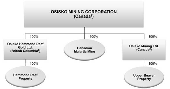
(1) This chart does not include all subsidiaries or affiliates of the Corporation.
(2) Jurisdiction of incorporation.
The Corporation’s head and registered office is located at 1100 av. des Canadiens-de-Montréal, Suite 300, P.O. Box 211, Montreal, Québec, H3B 2S2.
5
2. GENERAL DEVELOPMENT OF THE BUSINESS
In 2013, the Corporation produced 475,277 ounces of gold at its Canadian Malartic Mine, established a quarterly gold production record of 137,321 ounces in the fourth quarter, and, through its continuing modifications and optimization work, reached close to the throughput nameplate design capacity of 55,000 tonnes per day (95%) on an operating day basis for the year. The Corporation focussed its exploration activities on the Kirkland Lake and Mexico properties, and continued the development of its advanced stage projects through the pursuit of permitting activities (Hammond Reef Project) and the review of its construction and development approach (Upper Beaver Project).
2.1 Three-Year History and Outlook for 2014
Event | | Date | | Details Three-Year History | |
| | | | | |
CORPORATE DEVELOPMENT | | | | | |
| | | | | |
- Acquisition of Queenston Mining Inc. (“QMI”) (now OML) | | December 28, 2012 (following a friendly offer dated November 12, 2012) | | On December 28, 2012, Osisko completed the acquisition of all common shares of QMI pursuant to a court-approved plan of arrangement. This transaction provided Osisko with a highly strategic land package, including the Upper Beaver Property, in another prolific Canadian gold camp. Based on an underground mining scenario, the Indicated and Inferred Mineral Resources for the Upper Beaver Property are respectively at 1.46 and 0.71 million ounces of gold at a cut-off grade of 2.0 g/t Au. For more details, see “3.3 Mineral Properties”. | |
| | | | | |
- Launch of a hostile take-over bid by Goldcorp Inc. (“Goldcorp”) against the Corporation | | January 14, 2014 | | On January 14, 2014, Goldcorp launched a hostile take-over bid for Osisko’s shares, which was announced the day before. The Board of Directors of the Corporation has unanimously recommended that Osisko shareholders REJECT the hostile take-over bid initiated by Goldcorp and NOT TENDER their Osisko shares to the Goldcorp Offer. The Osisko Board determined that the Goldcorp offer fails to adequately compensate Osisko shareholders for, among others things, the strategic value of Osisko’s world-class asset base, the significant upside potential of Osisko’s Canadian Malartic Mine, or the increased risk inherent in Goldcorp common shares. The full basis for the Osisko Board’s recommendation is available in a Directors’ Circular, a copy of which is available online at www.osisko.com. See “2.3 Subsequent Event - Unsolicited take-over bid by Goldcorp”. | |
6
Event | | Date | | Details Three-Year History | |
| | | | | |
GOVERNANCE DEVELOPMENT | | | |
| | | | | |
- Amendment of the general by-laws of the Corporation to increase quorum at shareholders’ meeting | | February 25, 2011 | | On February 25, 2011, the Board of Directors of the Corporation adopted a resolution to amend the general by-laws in order to provide that the presence of two (2) persons present in person or by proxy, holding or representing by proxy twenty five percent (25%) of the voting shares constitute a quorum of any meeting of shareholders, unless a different number of shareholders and/or a different number of shares are required to be represented by the Act or by the articles or by any other by-law. The resolution was ratified by 99.9 % of shareholders at the annual and special meeting of the Corporation on May 12, 2011. | |
| | | | | |
- Adoption of a Majority Voting Policy for Election of Directors | | April 3, 2011 | | On April 3, 2011, the Board of Directors of the Corporation adopted a Majority Voting Policy for the Election of Directors in uncontested elections, a copy of which is available on the Corporation’s web site at www.osisko.com. Under that policy, if a nominee does not receive the affirmative vote of at least the majority of votes cast at the meeting of shareholders, the director shall promptly tender his or her resignation within 60 days of said election for consideration by the Governance/Nomination Committee and the Board. | |
| | | | | |
- Adoption of a Deferred Share Unit Plan (the “DSU Plan”) and a Restricted Share Unit Plan (“RSU Plan”) | | August 11, 2011 | | On August 11, 2011, the Corporation adopted DSU and RSU Plans to enhance, without any dilution for Osisko shareholders, the Corporation’s ability to attract and retain talented individuals to serve as members of the Board of Directors or as officers and executives of the Corporation and to promote alignment of interests of such individuals with that of shareholders of the Corporation. Annual option grants to Directors were replaced with deferred share unit grants. | |
| | | | | |
- Adoption of an advance notice by-law | | December 21, 2012 | | On December 21, 2012, the Board of Directors of the Corporation adopted a modification to its by-laws to include advance notice provisions, the purpose of which is to require advance notice be provided to the Corporation in circumstances where nominations of persons for election to the Board are made by shareholders of the Corporation other than pursuant to a requisition of a meeting of shareholders or a shareholder proposal made pursuant to the provisions of the Canada Business Corporations Act. The resolution was ratified by 66.11% of shareholders at the annual and special meeting of the Corporation on May 9, 2013. | |
7
Event | | Date | | Details Three-Year History | |
| | | | | |
- Ratification of the continued existence of the Shareholder Rights Plan (the “SRP”) | | May 9, 2013 | | On May 17, 2010, the Board of Directors of the Corporation adopted a SRP which was ratified by 94.1% of shareholders at the annual and special meeting of the Corporation on June 30, 2010. The purpose of the SRP is to provide the board of directors and shareholders with sufficient time to properly consider any takeover bid made for the corporation and to allow for competing bids and alternative proposals to emerge. The continued existence of the SRP was ratified by 97.86% of shareholders at the annual and special meeting of the Corporation on May 9, 2013. | |
| | | | | |
DEVELOPMENT OF MINING PROPERTIES | | | |
| | | | | |
- Construction program completed at the Canadian Malartic Property | | February, 2011 | | The construction program was completed at the end of February 2011, 18 months after construction release. The construction project was three months ahead of schedule and was recognized by the Association of Québec Contractors as the “Major Project of the Year”. | |
| | | | | |
- 1% royalty interest buy back on Canadian Malartic Property | | March 28, 2011 | | The Corporation purchased back a 1% royalty interest from RG Exchangeco Inc. for US$1.5 million. This royalty was encumbering certain claims included in the Canadian Malartic Property. | |
| | | | | |
- Updated resource and reserve estimates for the Canadian Malartic Mine | | March 31, 2011 | | This estimate was based on the combined resources of the Canadian Malartic and South Barnat deposits. The open pit reserve increased to 10.71 million ounces gold at an average fully-diluted grade of 0.97 g/t., a 1.74 million ounce or 19.3 percent increase relative to the previously-published estimate of 8.97 million ounces (see February 10, 2010). See “3.3 Mineral Properties”. | |
| | | | | |
- First gold pour at the Canadian Malartic Mine | | April 13, 2011 | | The first gold pour occurred on April 13, 2011, following the introduction of ore into the mill in late March 2011. | |
| | | | | |
- First day of commercial production at the Canadian Malartic Mine | | May 19, 2011 | | On June 21, 2011, the Corporation declared commercial production at the Canadian Malartic Mine, as the gold milling plant processed an average of 33,300 tonnes per day during the 30-day period ending June 17, 2011. Accordingly, the first day of commercial production was May 19, 2011. | |
| | | | | |
- 1% royalty interest buy back on Canadian Malartic Mine | | July 12, 2011 | | On July 12, 2011, the Corporation purchased back a 1% royalty interest from Géoconseils Jack Stoch Limitée in consideration for the issuance of 460,000 common shares of Osisko. This royalty was encumbering a portion of the Canadian Malartic and Barnat deposits and is part of a 2.5% gross metal royalty interest that was granted as a result of the acquisition of certain claims of the Canadian Malartic Property in March 2006. The remaining 1.5% royalty interest was assigned to Franco-Nevada Corporation. | |
8
Event | | Date | | Details Three-Year History | |
| | | | | |
- Updated global Inferred Mineral Resources estimate for the Hammond Reef Property | | November 7, 2011 | | SGS Canada Inc. has estimated a global Inferred Mineral Resource at 10.52 million ounces gold based on 0.30 g/t Au lower cut-off, an increase of 65% or 4.16 million new ounces from the total resources previously released by Brett Resources Inc. (“Brett”) (now OHRG) in 2009. The in-pit inferred resource was estimated at 6.86 million ounces at a diluted grade of 0.63 g/t Au, based on a Whittle-optimized pit shell using a gold price of US$1,200 per ounce, a corresponding lower cut-off grade of 0.28 g/t Au and a waste/ore strip ratio of 1.25. This represented an increase of 25% or 1.36 million ounces gold above the previous in-pit resource estimate released by Brett in 2009. See “3.3 Mineral Properties”. | |
| | | | | |
- Completion of a new relocation program as part of noise mitigation measure | | December 22, 2011 | | In 2011, the Corporation received 21 notices of violation mainly caused by exceeding noise levels and blast-induced vibrations. The Corporation implemented several mitigating measures to reduce the impact on the Malartic community, one of which was a new relocation program which increased the buffer zone between the pit crest and the Malartic residents. The relocation program was consistent with the modified decree issued on April 13, 2011 by the Québec Government for the Canadian Malartic Property and the new zoning by-law adopted by the City of Malartic on July 12, 2011, which together increased the noise level parameters under which the mine can operate. | |
| | | | | |
- Modifications to the crushing circuit at the Canadian Malartic Mine | | March, August and December 2012 | | The Corporation completed the addition of two new large cone crushing units in March and August 2012 and, in December 2012, finalized the installation of a second pebble crusher. These modifications were an important step towards the completion of the Canadian Malartic Mine ramp-up phase. | |
| | | | | |
- Fire at the Canadian Malartic Mine milling plant | | May 9, 2012 | | Operations at the Canadian Malartic Mine were affected by a fire that occurred on May 9, 2012 to the number four cyclone area that forced the shutdown of the mill for six days. This shutdown was followed by four days of lower production and the mill returned to its full operations on May 19, 2012. | |
| | | | | |
- Updated reserve and resource estimate for the Hammond Reef Property | | January 28, 2013 | | The global Measured and Indicated Mineral Resources at the Hammond Reef Property currently stand at 5.43 million ounces gold at an average grade of 0.86 g/t Au and the global Inferred Mineral Resource stands at 1.75 million ounces gold at an average grade of 0.72 g/t Au (based on 0.50 g/t Au lower cut-off). See “3.3 Mineral Properties”. | |
9
Event | | Date | | Details Three-Year History | |
| | | | | |
- New operating parameters for the Canadian Malartic Mine | | February 13, 2013 | | On February 13, 2013, the Québec Government issued a new decree allowing the Corporation to increase access to the northern portion of the Canadian Malartic Mine and to improve the framework for the execution of its blasting operations. This decree resolved most interpretation issues with the MDDEFP regarding blasting operations. These interpretation issues were the source of 14 of the 37 notices of non-compliance received by the Corporation in 2012 and at the main origin of the searches conducted by the MDDEFP at the Canadian Malartic Mine during the second semester of 2012. | |
| | | | | |
- Updated reserve and resource estimate for the Canadian Malartic Property | | February 19, 2013 | | Under this update, the in-pit Proven and Probable Mineral Reserves (using US$1,475 gold) stood at 10.1 M ounces at a fully diluted average gold grade of 1.01 g/t Au, following total production of 588,615 ounces of gold since beginning of operations in 2011. Global Measured and Indicated Mineral Resources above a cut-off grade of 0.31 (South Barnat) to 0.34 g/t Au (Canadian Malartic and satellites) stood at 11.70 M ounces gold, and global Inferred Mineral Resources stood at 1.20 M ounces gold. The global in situ Mineral Resources included Mineral Reserves but excluded production. See “3.3 Mineral Properties”. | |
| | | | | |
- Implementation of a capital expenditure reduction program | | April 29, 2013 | | Due to volatility in the gold price and financial markets, the Corporation reviewed its rate of discretionary spending in exploration and advancing new projects and, as a result, announced on April 29, 2013 the implementation of a $80 million capital expenditure reduction program for 2013. The Corporation finally achieved a total reduction of $96.3 million, $16.0 million over the initial objective. | |
| | | | | |
- Study reporting local and regional economic impact of the Canadian Malartic Mine | | July 10, 2013 | | On July 10, 2013, the Corporation filed with the MDDEFP a study conducted by the independent consulting firm KPMG-SECOR on Canadian Malartic Mine’s local and regional economic impact. The study shows that Canadian Malartic: supports nearly 1,600 jobs in Abitibi-Témiscamingue, including 635 direct jobs at the mine site; supports a payroll of more than $100 million through direct and indirect jobs; pays $61.6 million in direct wages, with an average salary of $87,000, 66% higher than the average in the Vallée-de-l’Or Regional County Municipality; makes purchases of over $290 million annually in Abitibi-Témiscamingue; and improves Malartic’s quality of life and revitalizes its community and business assets. | |
10
Event | | Date | | Details Three-Year History | |
| | | | | |
- Impairment charge on the Hammond Reef Project | | August 1, 2013 | | On August 1, 2013, the Corporation announced that, based on preliminary feasibility results and market conditions in the gold sector, it had undertaken a review of its Hammond Reef Project since the end of the second quarter of 2013. The impairment testing conducted in conformity with IFRS practices determined that an impairment charge of $487.8 million, net of a deferred tax recovery of $43.1 million, was necessary. Accordingly, the project value recorded on the Corporation’s books was reduced to nil in the second quarter of 2013. The Corporation continues to pursue low-cost permitting activities in the near-term, monitor market conditions, and review optimization scenarios (see “Environmental Approvals and Permits” under “3.3.2 Hammond Reef Project”). | |
| | | | | |
- Production of millionth ounce at the Canadian Malartic Mine | | November, 2013 | | On November 21, 2013, the Corporation was very proud to announce that it had produced its 1,000,000th ounce of gold from its flagship Canadian Malartic Mine. | |
| | | | | |
- Receipt of 27 statements of offence related to the construction of the “green wall” in 2010 | | November 28, 2013 | | On November 28, 2013, the Corporation received 27 statements of offence relating to building activities carried out in 2010 in connection with the construction of its “green wall” in the Town of Malartic. Uncontested, the statements would total approximately $389,000 in imposed fines. On November 29, 2013, the Corporation appeared and pleaded not guilty to all charges. The Corporation firmly believes that all construction activity related to the green wall was carried out under best practices to minimize the impact of the construction on the residents of Malartic. | |
| | | | | |
- New modifications to the Canadian Malartic Mine operating decree and new mining lease (ML) for the exploitation of the Gouldie zone | | February, 2014 | | On February 26, 2014, the Québec Government issued a new decree allowing the exploitation of the Gouldie zone. Few days earlier, on February 18, 2014, the Ministère des Ressources naturelles (“MRN”) granted Osisko a ML having an approximate total area 66 ha. As per these documents, Osisko has 30 months to mine the Gouldie zone and shall not exceed a daily production rate of 6,990 t of ore and a daily extraction rate of 30,000 t of ore, waste and over-burden. | |
| | | | | |
- Updated reserve and resource estimate for the Canadian Malartic Property | | March 12, 2014 | | Under this new estimate, the open pit Proven and Probable Mineral Reserves now stand at 9.37 M ounces at a fully diluted average gold grade of 1.04 g/t Au, following total 2013 production of 475,277 ounces of gold. Using a 12% lower gold price (US$1300 versus US$1475), the net difference from the 2013 estimate of 10.1 million ounces is only 235,000 fewer ounces (2%), once 2013 production (before recovery) is taken into account. Total precious metal production from the beginning of operations in April 2011 to December 31, 2013 was 1,044,388 ounces gold and 753,776 ounces silver. Global Measured and Indicated Mineral Resources now stand at 11.10 M ounces gold, and global Inferred Mineral Resources now stand at 1.16 M ounces gold. The global in situ 2014 Mineral Resources include Mineral Reserves but exclude production. See “3.3 Mineral Properties”. | |
11
Event | | Date | | Details Three-Year History | |
| | | | | |
- Updated annual mine production plan for the Canadian Malartic Mine | | March 20, 2014 | | Under this new annual mine production plan, the mine life is now estimated at 14.2 years based on a 55,000 tpd milling rate, assuming 92% availability. Average gold production is now estimated at 610,000 ounces per year over the next five years (2014-2018) at cash costs of US$516 per ounce and at 597,000 ounces per year over life of mine at cash costs of US$525 per ounce. See “3.3 Mineral Properties”. | |
| | | | | |
FINANCIAL TRANSACTIONS | | | | | |
| | | | | |
- Non-brokered private placements of flow-through shares | | May 2011 | | The Corporation closed a non-brokered private placement with funds, certain accredited investors, Directors, employees and officers. The Corporation issued 934,915 flow-through shares at a price of $17.50 per share for gross proceeds of $16,361,000. | |
| | | | | |
- Increase in Caterpillar finance lease | | August 9, 2011 | | The Corporation entered into an agreement with Caterpillar Financial Services Corporation to increase its equipment leasing facility by US $56.3 million. The facility will be used to acquire additional mobile mining equipment fleet to develop the Canadian Malartic Mine and the Barnat gold deposit. | |
| | | | | |
- Non-brokered private placements of flow-through shares | | September 2011 | | The Corporation closed a non-brokered private placement with funds, certain accredited investors, Directors, employees and officers. The Corporation issued 889,053 flow-through shares at a price of $18.00 per share for gross proceeds of $16,003,000. | |
| | | | | |
- Amendment of the credit facility agreement with CPPIB Credit Investments Inc. (“CPPIB”) | | June 29, 2012 | | The Corporation completed an Amended and restated loan agreement with CPPIB to (a) delay by one year the first reimbursement of capital (the first payment being postponed to the third quarter of 2013); (b) make available to the Corporation up to $100,000,000 under a delay-draw term loan at a rate of 7.5% with a maturity of December 31, 2013; and (c) amend the outstanding warrants originally issued when the loans were initially drawn (exercise prices of the warrants issued in September 2009 and March 2010 are respectively reduced from $10.75 and $19.25 to $10.00). | |
| | | | | |
- Receipt of a final $30 million payment from Kirkland Lake Gold Inc. | | July, 2013 | | The Corporation received the final $30 million payment from Kirkland Lake Gold Inc. (“KL Gold”) under a property sale agreement between KL Gold and QMI (now OML), pursuant to which QMI had agreed to sell to KL Gold its 50% interest in properties held under a joint venture located in Teck Township for $60 million cash and a royalty. The royalty gives Osisko the right to receive $15 per ounce on any gold produced from the sold properties after the first 1.3 million ounces of gold have been produced, for the next 1 million ounces produced; and $20 per ounce on any gold produced thereafter. | |
12
Event | | Date | | Details Three-Year History | |
| | | | | |
- Non-brokered private placements of flow-through shares | | December, 2013 | | The Corporation closed a non-brokered private placement with funds, certain accredited investors, Directors, employees and officers. The Corporation issued 1,416,400 flow-through shares at a price of $6.25 per share for gross proceeds of $8,852,500. | |
| | | | | |
- Modifications to long-term debt terms | | December, 2013 | | In July 2013, the Corporation entered into preliminary agreements with CPPIB, the Caisse de dépôt et placement du Québec (“CDPQ”) and Ressources Québec (“RQ”), a subsidiary of Investissement Québec, to amend certain elements related to its loans. The final agreements were executed in December 2013, effective October 1, 2013. The repayment schedule of the $150 million CPPIB facility and the $75 million convertible debentures has been modified and the CPPIB credit facility and the convertible debentures now bears a fixed rate of interest of 6.875%, compared to 7.5% previously. The 12.5 million warrants held by CPPIB will now expire on September 30, 2017, with an exercise price of $6.25 (previously $10.00). The exercise of the warrants may be accelerated at the Corporation’s option if the Osisko shares trade at a price above $8.15 for 15 consecutive days. The $100 million delayed drawdown facility established in May 2012 with CPPIB has been terminated as previously agreed. The convertible debentures held by CDPQ and RQ will now become due in November 2017. The debentures will be convertible into Osisko shares at any time prior to the due date at the price of $6.25 per share (previously $9.18). | |
| | | | | |
SUSTAINABLE DEVELOPMENT AND ENVIRONMENT | | | |
| | | | | |
- Deposit of the first tranche of the financial guarantee covering the entire cost of rehabilitating the Canadian Malartic Mine site | | October 12, 2011 | | On October 12, 2011, the Corporation deposited an amount of $22.1 million with the Québec Government to cover the entire estimated future cost of rehabilitating the Canadian Malartic Mine site, which amount to $46.4 million. | |
| | | | | |
- Signing of a Memorandum of Understanding (“MOU”) between OHRG and the Métis Nation of Ontario (“MNO”) | | March 6, 2012 | | The MOU sets out the way in which the local Métis communities will be consulted regarding the development of the Hammond Reef Project and commits the parties to working together to address any potential impacts the project may have on Métis rights, interests and way of life. | |
| | | | | |
- Deposit of the second tranche of the financial guarantee covering the entire cost of rehabilitating the Canadian Malartic Mine site | | October 3, 2012 | | On October 3, 2012, the Corporation deposited an amount of $12.7 million with the Québec Government. The Corporation intends to deposit an additional $11.6 million in 2013, thereby completing its commitment to deposit in the first years of operations the entire financial guarantee covering the total costs of the environmental rehabilitation of its Canadian Malartic Mine. | |
13
Event | | Date | | Details Three-Year History | |
| | | | | |
- Fifth annual sustainability report of the Corporation | | July 2013 | | The Corporation published in July its fifth annual sustainability report. The report covers the 2012 activities and is available on Osisko’s website at www.osisko.com. | |
| | | | | |
- Deposit of the final tranche of the financial guarantee covering the entire cost of rehabilitating the Canadian Malartic Mine site | | July 5, 2013 | | On July 5, 2013, the Corporation deposited an amount of $11.6 million with the Québec Government, representing the balance of the total guarantee required to cover the entire future costs of rehabilitating the Canadian Malartic Mine site. The aggregate deposits for the Government of Québec amount to $46.4 million. | |
Outlook for 2014
The Canadian Malartic Mine continues to establish new records in 2014. Gold production for the first two months of 2014 reached 96,265 ounces at average cash costs per ounce of US$585.
Mill throughput is expected to stabilize at approximately 55,000 tonnes per day in 2014 with the completion of optimization programs currently in progress. Together with increased contribution from higher grade material in the now accessible northern pit wall, it is anticipated that gold production for the current year will increase to between 525,000 to 575,000 ounces (an increase of between 11% and 21% over record 2013 production of 475,277 ounces gold).
Cash costs per ounce are estimated between $580 and $635, a 24% to 16% reduction in costs from 2013. Cash costs per ounce in US dollars are estimated at US$527 to US$577 using an exchange rate of 1.10.
Capital expenditures for 2014 are estimated at $148 million:
(In millions of dollars)
Canadian Malartic(1) | | 125.9 | |
Exploration and evaluation - capitalized | | 22.2 | |
Capital expenditures | | 148.0 | |
(1) Includes $65.6 million related to stripping and pit preparation activities.
2.2 Significant Acquisitions
There was no significant acquisition completed by Osisko during the financial year ended December 31, 2013.
2.3 Subsequent Event - Unsolicited take-over bid by Goldcorp
On January 13, 2014, Goldcorp announced an unsolicited take-over bid to acquire all of the outstanding common shares of Osisko Mining Corporation in exchange for $2.26 in cash plus 0.146 of a Goldcorp common share (the “Unsolicited take-over bid”). The Unsolicited take-over bid was originally valid until February 19, 2014.
The Board of Directors of Osisko recommended that Osisko shareholders reject Goldcorp’s Unsolicited take-over bid and, on January 29, 2014, filed and mailed to Osisko shareholders the Director’s Circular.
14
As described in the Director’s Circular, the Goldcorp offer is not a permitted bid under the Osisko’s Shareholder Rights Plan. As a result, the Board of Directors, in accordance with the Shareholder Rights Plan, has deferred the rights issuable under Osisko’s Shareholder Rights Plan until such later date as is determined by the Board of Directors.
On January 29, 2014, Osisko announced that it had commenced a legal proceeding against Goldcorp in the Québec Superior Court. In the proceeding, Osisko alleged that, in making its Unsolicited take-over bid for Osisko, Goldcorp misused confidential information and otherwise acted in a manner not permitted by the confidentiality agreement between the parties. Osisko also alleged that Goldcorp acted in bad faith and in a manner contrary to applicable law, in actions taken by Goldcorp prior to launching its Unsolicited take-over bid. Accordingly, Osisko sought an order enjoining the Unsolicited take-over bid and further conduct by Goldcorp that Osisko alleges is in breach of the confidentiality agreement.
On February 4, 2014, Goldcorp announced that it would not take up and pay for Osisko shares until Québec Superior Court judgement and extended its Unsolicited take-over bid to March 10, 2014. The Québec Superior Court had scheduled a hearing from March 3, 2014 to March 5, 2014.
On March 3, 2014, Osisko reached an agreement with Goldcorp to settle the proceeding that Osisko had commenced against Goldcorp in the Québec Superior Court. Pursuant to the settlement, Goldcorp has agreed not to take up and pay for any shares deposited to its Unsolicited take-over bid prior to April 15, 2014. In return, Osisko has agreed to waive the application of its shareholder rights plan on the earlier to occur of April 15, 2014, and the date Osisko enters into any third party transaction, to provide Goldcorp access to due diligence materials beginning on the earlier to occur of April 1, 2014 and the date that Osisko enters into any third party transaction, and to terminate its court proceeding against Goldcorp. The settlement also contemplates that no alternative transaction can be closed prior to April 15, 2014.
Osisko is continuing to manage a robust process to aggressively pursue a range of value maximizing alternatives that are in the best interests of Osisko, the Osisko shareholders and other stakeholders. The settlement contemplates that the deadlines described above may be abbreviated if Osisko announces a value maximizing alternative to Goldcorp’s Unsolicited take-over bid prior to April 15, 2014. While Osisko is engaged in a process to pursue value maximizing alternatives, there can be no assurance that an alternative transaction will arise.
In relation with the Unsolicited take-over bid, Osisko is incurring significant expenses that cannot be fully estimated at this time for financial and legal advisors. The Corporation would be required to pay, on the date of the change of control, termination payments to officers and certain employees, all outstanding share options, restricted and deferred shares units would vest, the loans and convertible debentures may become payable at the discretion of the lenders and FSTQ could elect to convert its remaining loan into shares.
The Board of Directors of the Corporation has formed a Special Independent Committee including five independent members. The Special Independent Committee has retained Stikeman Elliott LLP as its legal adviser. BMO Capital Markets and Maxit Capital LP are acting as financial advisers to the Corporation. Canadian legal counsel to the Corporation is Bennett Jones LLP and U.S. counsel is Skadden, Arps, Slate, Meagher & Flom LLP.
15
3. DESCRIPTION OF THE BUSINESS
3.1 General
Osisko is focused on acquiring, exploring, developing and mining gold properties, with the aim of becoming a leading mid-tier gold producer.
The Corporation’s flagship asset is the Canadian Malartic Mine located in the Abitibi Gold Belt, immediately south of the town of Malartic and approximately 25 kilometres west of the city of Val-d’Or, Québec. The Canadian Malartic deposit was acquired in late 2004, with drilling commencing in March 2005. Following an intensive drilling program, a $1 billion capital construction project was completed in early 2011 with the first gold poured in April 2011. The Canadian Malartic Mine reached commercial production on May 19, 2011 and currently has an estimated 9.37 million ounces in Proven and Probable Mineral Reserves (See “3.3 Mineral Properties”). In 2013, the Corporation produced 475,277 ounces of gold (See “3.2 2013 Gold Production”).
Osisko acquired two advanced exploration projects, Hammond Reef (2010) and Upper Beaver (2012). The Hammond Reef Project is located in the Sawbill Bay-Marmion Reservoir area of the Thunder Bay Mining District, approximately 170 km west of Thunder Bay, Ontario, and roughly 23 km northeast of the town of Atikokan, Ontario (See “3.3 Mineral Properties”). The Upper Beaver Property, which is part of the 230 km2 mineral exploration holdings in the historic Kirkland Lake gold camp held by OML, is located in north-eastern Gauthier Township and north-western McVittie Township in the Larder Lake mining division in north-eastern Ontario (See “3.3 Mineral Properties”).
The Corporation and its subsidiaries also maintain operation, exploration, and development activities on the following gold exploration properties which are not presently considered material projects:
Properties | | No. of Titles | | Interest | | Planned Work
(for 2014) | |
Black Hills, South Dakota | | 206 | | 100% Option | | Geophysics | |
Guerrero, Mexico | | 27 | | 100%(1)(2) | | Geological mapping, sampling, drilling | |
Kirkland Lake, Ontario, Canada | | | | | | | |
Amalgamated Kirkland | | 1 | | 100% | | Nil | |
Lebel (Bidgood) | | 69 | | 100% | | Drilling | |
Canadian Kirkland (Munro) (3) | | 44 | | 100% | | Drilling | |
Upper Canada | | 62 | | 100% | | Resource estimate | |
Others | | 950 | | Various | | Drilling | |
| | | | | | | |
Malartic CHL, Québec, Canada | | 10 | | 70% | | Drilling | |
(1) Eighteen (18) titles are in application stage and four (4) titles are subject to option agreements with different owners.
(2) Mining titles were acquired by another corporation on behalf of Osisko.
(3) At the end of 2013, an intensive drilling program has been initiated and, in February 2014, Osisko announced the discovery of a potentially large, bulk tonnage disseminated gold deposit on its 100% owned Kirkland Lake property. This discovery, named the “Canadian Kirkland” zone (formerly the Munro property), consists of a previously unreported type of mineralization in this world-class gold camp. For more information, please refer to Osisko’s press release dated February 21, 2014, New Discovery Named “Canadian Kirkland” Confirms Potential for Bulk Tonnage Gold in Kirkland Camp, available on Osisko’s website at www.osisko.com.
16
Employees
As of December 31, 2013, Osisko and its wholly-owned subsidiaries, OHRG and OML, employed a total of 770 individuals:
Employer | | Employees
(December 31, 2013) | | Employees
(December 31, 2012) | |
Osisko Mining Corporation | | | | | |
- Montreal and Toronto offices | | 52 | | 55 | |
- Canadian Malartic Mine | | 677 | | 642 | |
- Exploration | | 10 | | 26 | |
Subtotal | | 737 | | 723 | |
Osisko Hammond Reef Gold Ltd. (Hammond Reef Project) | | 3 | | 25 | |
Osisko Mining Ltd. (Upper Beaver Project) | | 28 | | 64 | |
Total | | 770 | | 812 | |
3.2 2013 Gold Production
The Canadian Malartic Mine is a large open pit operation. Following a two-year construction period program, which necessitated an investment of approximately $1 billion, the mine reached commercial production on May 19, 2011.
Similarly to many large new mining projects, the Canadian Malartic Mine has faced challenges since commencement of commercial production. The Corporation has continued to intensively work on various initiatives to optimize its operations at the Canadian Malartic Mine. Osisko’s optimization program initiatives and substantial results are as follow:
· Increase throughput rate to name plate capacity of 55,000 tonnes per day:
· Add crushing capacity with the addition of two large cone crushing units, a second pebble crusher and modifications to the ore conveying system which were completed in 2012.
· Improve mill availability
Results: at the end of 2013, the mill was at near name plate capacity (98%) on an operating day basis (95% for the year).
· Improve mining activities:
· Gain flexibility by developing additional working areas
· Improve drilling and blasting procedures
· Increase equipment availability
· Improve productivity over old-mine working areas
· Gain access to higher grade materials
Results: for the year 2013, tonnes moved per day reached an average of 179,000, a 12% increase over the year 2012.
17
· Optimize costs:
· Reduce the use of contractors
· Improve utilization of supplies and materials
· Reduce cost of materials through better procurement and logistics
Results: in 2013, cash costs per ounce(1) were reduced by 11% compared to the year 2012.
Several of these initiatives have been completed and are contributing to improve effectiveness. The Corporation is maintaining its continuous improvement efforts to optimize operations and is pursuing cost reductions with its suppliers. It anticipates that it will gain further benefits over the upcoming quarters, which should favorably impact production costs.
3.2.1 Mining
In 2013, approximately 58.4 million tonnes of ore and waste and 6.9 million tonnes of re-handling from stockpiles were moved during 2013 (179,000 tonnes/day), compared to 50.7 million tonnes of ore and waste and 8.0 million tonnes of re-handling from stockpiles during 2012 (160,000 tonnes/day). The fourth quarter was challenging for the mine after a record of tonnes moved in the third quarter. However, the last three blasts over a surface pillar were successfully executed during the fourth quarter which will improve mining operations going forward. These blasts required special procedures to ensure the safety of Osisko’s employees and the community and impacted productivity adversely.
Mining operations continued to be adversely affected in 2013 due to noise and weather constraints. As the mine is located in an urban area, the utilization of the mining fleet is occasionally reduced due to wind conditions to meet the noise-level restrictions. Operating procedures restrict blasting activities when winds are from the southerly direction as a precautionary measure to protect the community from potential NOx emissions. The mine staff continues to work at increasing productivity over the old mine workings and in the northern part of the deposit while ensuring workers safety. Higher grade materials were accessible in greater quantities in the fourth quarter and going forward.
The 2013 quarterly mine production is as follows:
| | Ore
(t) | | Waste(1)
(t) | | Total Mined
(t) | | Re-handling
(t) | | Total Moved
(t) | | Overburden
(t) | |
Q4 2013 | | 4,905,712 | | 9,907,438 | | 14,813,150 | | 1,419,571 | | 16,232,721 | | 159,592 | |
Q3 2013 | | 4,423,224 | | 11,334,861 | | 15,758,085 | | 1,767,602 | | 17,525,687 | | 304,535 | |
Q2 2013 | | 3,604,314 | | 10,009,579 | | 13,613,893 | | 2,036,802 | | 15,650,695 | | 870,567 | |
Q1 2013 | | 4,090,870 | | 10,157,993 | | 14,248,863 | | 1,626,651 | | 15,875,514 | | 1,783,318 | |
YTD 2013 | | 17,024,120 | | 41,409,871 | | 58,433,991 | | 6,850,626 | | 65,284,617 | | 3,118,012 | |
Q4 2012 | | 3,553,080 | | 7,846,981 | | 11,400,061 | | 2,121,248 | | 13,521,309 | | 627,476 | |
Q3 2012 | | 4,852,977 | | 9,215,070 | | 14,068,047 | | 1,976,746 | | 16,044,793 | | 1,408,530 | |
Q2 2012 | | 3,234,013 | | 9,545,522 | | 12,779,535 | | 2,460,224 | | 15,239,759 | | 1,739,705 | |
Q1 2012 | | 4,037,282 | | 8,457,681 | | 12,494,963 | | 1,405,929 | | 13,900,982 | | 1,954,030 | |
Total 2012 | | 15,677,352 | | 35,065,254 | | 50,742,606 | | 7,964,147 | | 58,706,753 | | 5,729,741 | |
(1) Including topographic drilling of 4.9 million tonnes in 2013 and 2.5 million tonnes for the year 2012.
(1) Non-IFRS financial performance measures have no standard definition under IFRS. See “Non-IFRS Financial Performance Measures” section of the Management’s Discussion and Analysis for the fiscal year ended December 31, 2013, which can be found on the SEDAR website at www.sedar.com.
18
During 2013, a total of 18,830 equipment hours were lost due to noise and weather constraints compared to 14,840 equipment hours in 2012. Quarterly statistics are as follows:
| | Number of Hours Lost | | (%) | |
Q4 2013 | | 7,670 | | 6.3 | |
Q3 2013 | | 5,180 | | 4.3 | |
Q2 2013 | | 4,470 | | 3.9 | |
Q1 2013 | | 1,510 | | 1.4 | |
Q4 2012 | | 2,840 | | 2.5 | |
Q3 2012 | | 5,830 | | 5.3 | |
Q2 2012 | | 4,510 | | 4.6 | |
Q1 2012 | | 1,660 | | 1.9 | |
On February 13, 2013, the Québec Government approved a new decree which modified the operating parameters of the Canadian Malartic Mine. Changes included extending the duration of blasts, increasing the time period during which blasts can be executed, and provided greater access to the northern part of the deposit. The modified parameters provide greater flexibility in day-to-day operations (see “Environmental Approvals and Permits” under “3.3.1 Canadian Malartic Mine”).
3.2.2 Production
Following continued improvement in mill availability and throughput rates, the mine established a quarterly gold production record of 137,321 ounces in the fourth quarter of 2013. Average daily throughput reached 54,043 tonnes, in line with the third quarter of 2013 and a 17% increase over the corresponding period in 2012. Throughput rate progressed favorably in 2013 with seven quarterly increases since the end of 2011, averaging 52,350 tonnes per operating day for the year 2013. In coordination with the technical advisors, the Canadian Malartic team continues to work on improving the mill throughput and enhancing operating efficiencies.
For the year-ended December 31, 2013, the Corporation produced 475,277 ounces of gold and 464,991 ounces of silver. Production statistics for the year 2013 are as follows:
| | 2013 | |
| | Q4 | | Q3 | | Q2 | | Q1 | | Total | |
Tonnes milled (t) | | 4,647,677 | | 4,682,530 | | 4,444,042 | | 4,234,001 | | 17,024,120 | |
| | | | | | | | | | | |
Grade (g/t Au) | | 1.04 | | 0.90 | | 0.87 | | 0.88 | | 0.92 | |
Recovery Au (%) | | 88.6 | | 89.2 | | 89.7 | | 88.0 | | 88.9 | |
Gold ounces produced (oz) | | 137,321 | | 120,208 | | 111,701 | | 106,047 | | 475,277 | |
Gold ounces sold (oz) | | 136,826 | | 123,151 | | 109,503 | | 95,511 | | 464,991 | |
| | | | | | | | | | | |
Grade (g/t Ag) | | 1.06 | | 1.09 | | 1.12 | | 0.86 | | 1.04 | |
Recovery Ag (%) | | 72.9 | | 68.4 | | 69.5 | | 71.5 | | 70.5 | |
Silver ounces produced (oz) | | 115,562 | | 112,637 | | 110,823 | | 83,597 | | 422,619 | |
Silver ounces sold (oz) | | 106,907 | | 117,750 | | 95,205 | | 73,683 | | 393,545 | |
Cash costs per ounce(2) in 2013 stood at $760, compared to $849 in 2012 and cash costs per ounce for the fourth quarter amounted to $713. The improvement is mainly the result of increased throughput and gold production, improved efficiencies and reduction in contractors’ costs. As the operations at the Canadian Malartic Mine are further optimized, the operating costs should continue their downward trend.
(2) Non-IFRS financial performance measures have no standard definition under IFRS. See “Non-IFRS Financial Performance Measures” section of the Management’s Discussion and Analysis for the fiscal year ended December 31, 2013, which can be found on the SEDAR website at www.sedar.com.
19
3.2.3 Gold Marketing and Distribution
Gold is a metal that is traded on world markets, with benchmark prices generally based on the London Bullion market. Gold has two principal uses: product fabrication and bullion investment. Within the fabrication category, there are a wide variety of end uses, the largest of which is the manufacture of jewelry. Other fabrication purposes include official coins, electronics, miscellaneous industrial and decorative uses, dentistry, medals and medallions. Gold bullion is held primarily as a store of value and a safeguard against devaluation of paper assets denominated in fiat currencies.
In 2013, precious metals have been under pressure for most of the year and the fourth quarter gold price averaged at US$1,276/oz, the lowest quarterly price since the third quarter of 2010. During the fourth quarter, the price trended lower for the second time in 2013 towards a low of US$1,192/oz before rebounding at the start of 2014. After rising for 12 consecutive years, gold price closed US$453 or 27% lower than the 2012 close at US$1,205/oz and averaged for the year at US$1,411/oz, down 15% from 2012 average of US$1,669/oz.
The market was under pressure and mainly driven by the following developments during the year:
· Eroding demand for bullion as a store value was driven by the strength of the global equities;
· The absence of growing inflation;
· Signs of U.S. recovery fuelling speculations that the Federal Reserve would finally start tapering;
· Exchange-traded fund redemption that has fallen more than 30% in 2013 suggesting that institutional investors remain bearish in the face of rising U.S. government bond yields; and
· Good physical demand from Asia especially from China.
The following table outlines the gold price trading range for the past five years:
(US$/ounce) | | High | | Low | | Average | | Close | |
2013 | | 1,694 | | 1,192 | | 1,411 | | 1,205 | |
2012 | | 1,792 | | 1,540 | | 1,669 | | 1,658 | |
2011 | | 1,895 | | 1,319 | | 1,572 | | 1,531 | |
2010 | | 1,421 | | 1,058 | | 1,225 | | 1,406 | |
2009 | | 1,213 | | 810 | | 972 | | 1,088 | |
The Corporation believes that despite the decrease in the gold price in 2013, the fundamentals of the gold market remains well in place, namely:
· Expansionary monetary policies and continued effects of the economic problems around the world;
· High level of government indebtedness;
· Diversification of central bank currency holdings, particularly in emerging markets;
· Continued geo-political instability.
Global gold mine production continues to be relatively stable. The challenges of new production discoveries, high capital costs, suspension of major projects and permitting issues lead Osisko to believe that global production will remain stable or decline in the near/medium term.
The gold produced at the Canadian Malartic Mine is refined to market delivery standards by the Royal Canadian Mint in Ottawa. The gold is sold to various banks at market prices. The Corporation believes that, because of the availability of alternative refiners, no material adverse effect would result if the Corporation lost the services of its refiner.
In 2013, total precious metal sales of the Corporation amounted to $675.7 million, comprising of 464,991 ounces of gold and 393,545 ounces of silver, compared to precious metal sales of $665.4 million in 2012,
20
which included 394,603 ounces of gold and 225,531 ounces of silver. The Canadian Malartic Mine generated operating earnings of $190.3 million, compared to $259.1 million in 2012. The decrease in profit from mine operations is mainly due to a 14% decline in the US$ price realized on the sale of gold and higher depreciation charges as a result of higher gold output.
The Corporation’s gold production is completely unhedged.
3.2.4 Taxation
The Canadian Malartic Mine is subject to a combined federal and provincial statutory income tax rate of 26.90 %. Additionally, it is subject to a mining tax from the Province of Québec at a statutory tax rate of 16 %. On November 12, 2013, the Québec government introduces amendments to Québec’s Mining Tax Act under Québec Bill 55. The Bill introduces a new method for computing mining tax, among other changes. The new regime is scheduled to come into effect as of January 1st, 2014. However, pursuant to an order of the Government of Québec issued on March 5, 2014 a general election will be held in Québec on April 7. As such, the Bill 55 may or may not be re-introduced in the Québec National Assembly after the election depending on the outcome of the election.
3.2.5 Competitive Conditions
The gold exploration and mining business is a competitive business. The Corporation competes with numerous other companies in the search for and the acquisition of attractive precious metal mineral properties. The ability of the Corporation to replace or increase its mineral reserves and resources in the future will depend not only on its ability to develop its present mineral properties, but also on its ability to select and acquire suitable producing properties or prospects for precious metal development or mineral exploration.
3.3 Mineral Properties
The Corporation’s material mineral properties are Canadian and include the Canadian Malartic Mine, located in the Province of Québec, and the Hammond Reef and Upper Beaver Projects, located in the province of Ontario.
3.3.1 Canadian Malartic Mine
Technical Information Notice
Part of the following disclosure relating to the Canadian Malartic Property has been derived from:
(1) an independent technical report (herein referred to as the “Canadian Malartic Report”) on the Canadian Malartic Property entitled “Feasibility Study — Canadian Malartic project (Malartic, Québec)” dated December 2008 compiled by BBA Inc. (“BBA”), with the collaboration of MICON International Limited (“MICON”), Belzile Solutions Inc. (“Belzile Solutions”), G Mining Services Inc. (“G Mining”), Genivar Limited Partnership (“Genivar”), Golder Associates Limited (“Golder”) and the Osisko technical group. Messrs. David Runnels, Eng. (BBA), B. Terrence Hennessey, P. Geo. (MICON), Elzéar Belzile, Eng. (Belzile Solutions), Louis-Pierre Gignac, Eng. (G Mining), André-Martin Bouchard (Genivar) and Michel R. Julien, Eng., Ph.D. (Golder) are “qualified persons” within the meaning of NI 43-101, and are independent of the Corporation. The Canadian Malartic Report is available for inspection during regular business hours at the corporate head office of the Corporation and may also be reviewed under the Corporation’s profile on the SEDAR website (www.sedar.com); and
21
(2) an independent technical report (herein referred to as the “Canadian Malartic Updated Report”) on the Canadian Malartic Property entitled “Updated resource and reserve estimates for the Canadian Malartic project (Malartic, Québec)” dated May, 2011 by Belzile Solutions, G Mining. Messrs. Elzéar Belzile, Eng. (Belzile Solutions) and Louis-Pierre Gignac, Eng. (G Mining) are “qualified persons” within the meaning of NI 43-101 and are independent of the Corporation. The Canadian Malartic Updated Report is available for inspection during regular business hours at the corporate head office of the Corporation and may also be reviewed under the Corporation’s profile on the SEDAR website (www.sedar.com).
Unless otherwise indicated, technical information which has been disclosed since the release of the Canadian Malartic Updated Report has been prepared under the supervision of Robert Wares, Hon. D.Sc., P. Geo. and Senior Vice President, Exploration and Resource Development of the Corporation, Luc Lessard, Ing., Senior Vice President and Chief Operating Officer of the Corporation, and Donald Gervais, P. Geo, Technical Services Director at the Canadian Malartic Mine, who are “qualified person” within the meaning of NI 43-101.
Property Location and Description
The Canadian Malartic Property is located in the Abitibi region of north-western Québec. It lies entirely within Fournière Township, immediately south of the town of Malartic, about 25 km west of Val-d’Or, Québec and about 550 km northwest of Montréal, Québec. The Canadian Malartic Property also covers the southern portion of the town of Malartic itself.
Mining Titles
The Canadian Malartic Property is comprised of 119 contiguous mining titles: 107 MDC’s, seven (7) CL’s, one (1) MC and four (4) ML’s covering a total of approximately 5, 287 ha. During 2009, the Corporation was granted two surface leases covering 1,856 ha for its tailings and milling plant. On November 25, 2009, the MRN granted Osisko a ML having a total area of approximately 189 ha. In addition, two (2) ML, together representing approximately 12 ha, were granted by the MRN during the second quarter of 2011 regarding the southern portion of the town of Malartic, which was subject of the relocation program. More recently, on February 18, 2014, the MRN granted Osisko a new ML having a total area of approximately 66 ha for the exploitation of the Gouldie zone (accordingly, three (3) MDC’s will be canceled or reduced). Application for another ML related to the South Barnat deposit is currently under review by the MRN (accordingly, six (6) MDC’s have been suspended).
Exploration rights immediately north of the Canadian Malartic Property are owned by the Corporation (East Amphi property) and by Niogold Mining Corp. Rights to the east are owned by 9265-9911 Québec inc. and NSR Resources. The Malartic CHL property is owned by Abitibi Royalties Inc., successor to Golden Valley Mines Ltd., with respect to which the Corporation exercised an option to earn a 70% interest; the Corporation received the confirmation of said exercise on September 7th, 2011. Rights to the south and southeast of the Canadian Malartic Property are owned by an individual prospector and C2C Inc.
Rights and Obligations Associated with Mining Titles
A ML entitles the holder to mine and remove minerals from the land forming part of such ML. A mining lease is granted for an initial term of 20 years and is renewable up to three times, each for a 10-year term. The holder of a mining lease shall pay an annual rent which is prescribed by mining regulations.
A claim (CL or MDC) provides the owner with a two-year exclusive right to explore the designated territory for any mineral substances with certain exceptions. After the two-year period, claims can be
22
renewed for an additional two-year term on certain conditions including that sufficient assessment work is done. A claim provides a right of access, though not surface rights, to a designated parcel of land on which exploration work may be undertaken. Access to land that has been granted, alienated or leased by the Crown for non-mining purposes requires the permission of the current surface rights-holder. Additionally, claims that lie within town boundaries or lands identified as state reserves may be subject to further conditions and obligations concerning the work to be performed on the claim. Expiration dates for the various mining titles of the Canadian Malartic Property vary between February 10, 2015 and February 18, 2034. Incurred exploration expenditures on the Canadian Malartic Property currently exceed the minimum expenditures required to maintain the claims in good standing.
A MC provides the owner with mining rights and some surface rights limited to those necessary for mining activities. There is no obligation or work requirement needed to maintain the concession other than the payment of an annual fee based on the size of the concession.
Each of the two surface leases was granted in 2009 for a one-year term, renewable on a yearly basis. Starting in 2011, these leases have been renewed for a five-year term, with the possibility of further renewals, each time for a five-year period.
On December 10, 2013, the Québec Government adopted a new mining legislation including requirements for public hearings on mining projects in excess of 2,500 tonnes per day, formation of monitoring committees to promote local benefits and increase disclosure on mining taxes paid and extraction rates from deposits. The new legislation is not expected to have a negative impact on Osisko’s activities.
Agreements and Encumbrances
The Canadian Malartic Property was acquired by the Corporation in stages from 2004 to 2009. The majority of the mining titles of the Canadian Malartic Property were map-staked by the Corporation or its appointed intermediaries, and are not subject to any encumbrances. Others were purchased outright from independent parties, without royalties or other obligations. Of all the mining titles that comprise the Canadian Malartic Property, 21 are subject to agreements as presented in the following table:
Mining Titles* | | Agreements and Encumbrances | |
| | | |
MC 226 CL 3941621, CL 3941633 CL 3941634, CL 3941635 CL 3950771, CL 3950772 | | Mining titles 100% owned by Osisko. The claims were purchased from McWatters Mining Inc. (“McWatters”) liquidating trustee in consideration of a cash payment. The claims were subject to a sliding 2% - 3% NSR payable to Barrick, which was subsequently sold by Barrick to RG Exchangeco Inc., a wholly-owned subsidiary of Royal Gold, Inc. The royalty rate is tied to the price of gold, with the higher rate taking effect if the gold price is greater than US$350/oz. On March 28, 2011, Osisko purchased back half of the royalty for US$1.5 million and, as a result, said claims are now subject to a sliding 1% - 1.5% NSR payable to RG Exchangeco Inc. | |
| | | |
CL 5144234, CL 5144235 CL 5144236, CL 5144237 CL 5144238, CL 5144239 | | Mining titles 100% owned by Osisko. The claims were acquired from Dianor Resources Inc. (“Dianor”) and Threegold Resources Inc. (“Threegold”) (formerly a subsidiary of Dianor) in consideration of cash and shares. The claims are subject to a 2% NSR payable to a private individual. The entire royalty may be purchased back by Osisko for $2,000,000. | |
23
Mining Titles* | | Agreements and Encumbrances | |
| | | |
MDC 72271 | | Mining title 100% owned by Osisko. Claim purchased from Abitibi Royalties Inc., successor of Golden Valley Mines Ltd. in the property, for a cash consideration. The claim is subject to a 2% NSR payable to Abitibi Royalties Inc. | |
| | | |
MDC 2000854, MDC 2000855 MDC 2000856, MDC 2000857 MDC 2000858, MDC 2000859 | | Mining titles 100% owned by Osisko. The claims were purchased from a private individual representing J. Stoch, in consideration of a cash payment. The claims were subject to a 2.5% Gross Overriding Metal Royalty. On July 12, 2011, the Corporation purchased back a 1% royalty interest from Géoconseils Jack Stoch Limitée in consideration for the issuance of 460,000 common shares of Osisko. The remaining 1.5% royalty interest was assigned to Franco-Nevada Corporation. | |
| | | |
MDC 2001055 | | Mining title 100% owned by Osisko. The claim was purchased from a private individual in consideration of a cash payment. The claim is subject to a 2.5% Gross Overriding Metal Royalty. | |
*Certain MDC or CL listed above may have been replaced in part or in whole by a ML for exploitation purpose. However, each encumbrance continues to apply to the mining titles as identified and defined at the time of the relevant agreement.
Environmental Exposures Related to Past Activities
The Corporation is not aware of any environmental liabilities, obligations or responsibilities associated with the Canadian Malartic Property, other than the adherence to the regulations of the MDDEFP concerning exploration activities. Several non-remediated tailings ponds of the past-producing East Malartic mine occur on the Canadian Malartic Property but as long as these are covered by exploration rights (MDCs), the environmental liabilities related to these ponds are the responsibility of the MRN. As provided in the formal agreement entered into with the MRN on March 16, 2010, the environmental liability related to past producing mines will remain with the MRN while any new environmental obligations which will derive from mining of the Canadian Malartic Property will be the sole responsibility of Osisko.
Environmental Approvals and Permits
On September 4, 2008, the Corporation filed the Environmental Impact Study for the Canadian Malartic project with the MDDEFP. The Environmental Impact Study was reviewed and accepted by Québec governmental authorities who established its compliance with MDDEFP guidelines. The formal process of the Bureau d’audiences publiques sur l’environnement (“BAPE”) commenced on March 11, 2009 and, on July 9, 2009, the MDDEFP published the report on the public inquiry and hearings. The report concluded that the Canadian Malartic project could be authorized under certain conditions including (i) certain follow-up programs; and (ii) the deposit of financial guarantees sufficient to ensure that the Canadian Malartic project could be carried out in a sustainable development perspective. On August 20, 2009, the Conseil des ministres du Québec approved the order in council (“Decree No. 914-2009”) authorizing the construction of the Canadian Malartic Mine.
As of December 31, 2010, the Canadian Malartic Mine had received all formal governmental permits required for its construction and related activities, with the exception of the mill and mine operations authorization. The official mill/operations certificate of authorization was granted on March 31st, 2011, at which point the Canadian Malartic Mine was fully permitted.
24
Given the proximity of the mine site to the residents of Malartic, mining operations at the Canadian Malartic Mine are subject to a monitoring program defined by regulatory authorities. As part of the monitoring program, the mine is required to collect environmental data and provide it to the MDDEFP on a regular basis. The MDDEFP then compares the data to regulatory requirements, and in case of an exceedance, issues notices of non-compliance to the Corporation or, if deemed appropriate, administrative monetary penalties or statements of offence. Contrary to administrative monetary penalties and statements of offence, notices of non-compliance do not include fines and are only issued to inform the Corporation of non-compliance situations and to require corrective measures. A non-compliance notice does not necessary imply that the Corporation’s activities have resulted in an impact on the environment. The following table provides an overview of regulatory compliance with the MDDEFP and efforts of the Canadian Malartic Mine to minimize the impact of its activities on the environment and more particularly on the Town of Malartic:
| | NOTICES OF NON-
COMPLIANCE
IN 2013 | | NOTICES OF NON-
COMPLIANCE
(FROM 2009 TO 2013) | | ADMINISTRATIVE
MONETARY
PENALTIES
(FROM 2009 TO 2013) | | STATEMENTS OF
OFFENCE
(FROM 2009 TO 2013) | |
| | 16 | | 44 | | 0 | | 0 | |
| | |
BLASTING (including surpassing limits for over pressure and vibrations, NOx emissions and/or blasting parameters) | | PRINCIPAL MITIGATION MEASURES SINCE BEGINNING OF OPERATIONS · Execution of blasting activities only when the wind is not from the South (e.i. in the direction of the Town of Malartic); · Test of alternative blasting methods and explosive products that may be more effective from an environmental point of view; and · Regular meetings with the contractor in charge of the execution of blasting activities for environmental improvement purpose. OTHER RELEVANT INFORMATION Fourteen (14) notices of non-compliance received by the Corporation in 2012 were related to interpretation issues between the Corporation and the MDDEFP regarding blasting operations. These interpretation issues are at the center of searches conducted by the MDDEFP at the Canadian Malartic Mine during the second half of 2012 and explain the delay to proceed with a special blast of approximately 940,000 tonnes over previously mined out areas providing access to the higher-grade zones of the main deposit (the “Special Blast”). The Special Blast was eventually authorized on October 18, 2012 by the Québec Government, pursuant to an order in council (“Decree No. 964-2012”) modifying the Decree No. 914-2009. On February 13, 2013, the Québec Government approved another order in council (“Decree No. 98-2013”) modifying the operating parameters of the Decree No. 914-2009 and allowing the Corporation greater access to the northern portion of the Canadian Malartic Mine and to improve the framework for the execution of its blasting operations. The Decree No. 98-2013 resolved most interpretation issues with the MDDEFP regarding blasting operations. The notice of non-compliance received by the Corporation with respect to NOx emissions have been issued on the basis of assessment by the MDDEFP of the color of emissions released during blast activities. It is important to note that the NOx approved sensors installed by Osisko in the Town of Malartic have never detected concentrations of NOx equal or greater than the limit permitted by the regulations. Indeed, the concentrations measured in town have always been well below this threshold. |
25
| | 6 | | 11 | | 0 | | 0 | |
| | |
DUST | | PRINCIPAL MITIGATION MEASURES SINCE BEGINNING OF OPERATIONS · Enclosure of buildings where dust is generated; · Use of dust suppressant systems on roads; · Establishment of an early warning system and modulation of activities ; · Establishment of an internal committee to find more effective technical solutions; and · Test of alternative dust suppressant products and methods that may be more effective from an environmental point of view. OTHER RELEVANT INFORMATION Health authorities have conducted studies on dust emissions in the Town of Malartic. No major health issues were identified in their conclusions, and the health authorities are continuing their studies to further inform the local residents. |
| | 14 | | 39 | | 0 | | 0 | |
| | |
NOISE | | PRINCIPAL MITIGATION MEASURES SINCE BEGINNING OF OPERATIONS · Modification of the equipment fleet, addition of newly developed “quiet packages” on the Caterpillar 240-ton truck fleet, noise reduction measures on the drilling equipment, and implementation of a research and development noise reduction plan for mobile equipment; · Relocation of an additional 60 families from an area adjacent to the ‘green wall’, thereby increasing the buffer zone between mining operations and the residents; · Modulation of mining activities during night operations to comply with noise standards; · Development of a sound prediction system correlating weather conditions and noise dispersion; recording of data has started and modeling will require at least 6 months of data to establish correlation; and · Installation of insulated walls (containers) along ramp and transport roads. OTHER RELEVANT INFORMATION On April 13th, 2011, the Conseil des ministres du Québec approved an order in council (“Decree No. 405-2011”) modifying the operating parameters of the Decree No. 914-2009. The new Decree was granted in connection with the increased buffer zone and a municipal zoning by-law proposal for the future recreational park area, which was adopted by the City of Malartic on July 12, 2011. Together, the Decree No. 405-2011 and the new zoning by-law increased the noise parameters under which the mine can operate to 50 dBA at night and 55 dBA during the day. However, the MDDEFP is of the opinion that noise parameters in certain sectors of the Town of Malartic remain lower (40/45 dBA at night and 45/50 dBA during the day). Legal opinions obtained by the Corporation on the interpretation of the Decree No. 405-2011 differ from this point of view and consider that the current noise parameters under the Decree No. 405-2011 are 50 dBA at night and 55 dBA during the day. Accordingly, since the issuance of the Decree No. 405-2011, the notices of non-compliance related to noise have essentially reported “noise exceedances” below the 50/55 dBA parameters. |
| | 4 | | 4 | | 2 | | 0 | |
| | |
WATER | | PRINCIPAL MITIGATION MEASURES SINCE BEGINNING OF OPERATIONS · Use of SO2 cyanide detoxification system to reduce levels in the tailings prior to discharge to the tailings containment facility; · Constant monitoring of water bodies and closing of final effluent discharge when cyanide levels may exceed regulatory limits; and · Use of sprinklers to facilitate the degradation of cyanide. OTHER RELEVANT INFORMATION In 2013, the Corporation received two administrative monetary penalties (each of $2,500$) for surface water and final effluent non-compliance. |
26
| | 1 | | 11 | | 0 | | 27 | |
| | |
OTHERS | | PRINCIPAL MITIGATION MEASURES SINCE BEGINNING OF OPERATIONS The notices of non-compliance that do not relate to noise, dust or blasting activities generally focus on specific issues, which have been resolved by implementing appropriate corrective measures. OTHER RELEVANT INFORMATION On November 28, 2013, the Corporation received 27 statements of offence relating to construction activities carried out in 2010 in connection with the construction of the “green wall” in the Town of Malartic. Uncontested, the statements would total approximately $389,000 in imposed fines. On November 29, 2013, the Corporation appeared and pleaded not guilty to all charges. The Corporation firmly believes that all construction activity related to the green wall was carried out under best practices to minimize the impact of the construction on the residents of Malartic. |
All notices of non-compliance are investigated and formal responses are filed with the regulatory agency. Periodically, environmental monitoring results are reviewed with the Monitoring Committee and the community.
Accessibility, Climate, Local Resources, Infrastructure and Physiography
Accessibility
The northern extents of the Canadian Malartic Property can be accessed directly from Highway 117. A paved road running north-south from the town of Malartic towards Lake Mourier cuts through the central area of the Canadian Malartic Property. The Canadian Malartic Property is further accessible by a series of logging roads and trails, as well as by a network of gravel roads associated with the past-producing mines. Malartic is also serviced by a rail-line which cuts through the middle of the town. The nearest large airport is located in Val-d’Or, about 25 km east of Malartic.
Climate
Mean annual temperature for the Val-d’Or/Malartic area is 1.2°C, with average daily temperatures ranging from -17.2°C in January to 17.2°C in July. The average total annual precipitation is 914 mm, peaking in September (102 mm) and at a minimum in February (40.5 mm). Snow falls between October and May, with most occurring between November and March. Peak snowfall occurs in December, averaging 610 mm, equivalent to 54 mm of water. Winds are generally from the south or southwest from June through January, and mainly from the northwest from February through May. Average wind velocities are in the order of 11 to 14 km/h.
Local Resources
The Canadian Malartic Property is located in the southern portion of the town of Malartic. The town has a population of around 3,500 people and hosts a variety of commercial and institutional establishments, including day cares, an adult learning center, a cultural center, a long term elderly care facility, a hospital, motels, restaurants, service suppliers, retailers and a community health clinic, as well as elementary and high schools. The city of Val-d’Or, some 25 km east of Malartic, hosts a large number of manufacturers and suppliers who serve the mining industry.
Infrastructure
Local manpower trained in heavy equipment/industrial operations is available in Malartic. Skilled workers may also be available from the areas within an approximate 35-km radius of Malartic,
27
specifically Cadillac to the west and Val-d’Or to the east, where a number of mines are still in operation. It should be noted, however, that the recent increase in mining activity in the Abitibi region may result in a temporary shortage of certain classes of experienced mining personnel.
Physiography
The Canadian Malartic Property is situated in the Abitibi lowlands and is relatively flat, consisting of plains with a few small hills. The topographic relief on the Canadian Malartic Property is subtle, with a difference of about 95 m between maximum and minimum elevations. Most of the area is sparsely wooded with secondary growth black spruce, larch and birch as the dominant species. The central, east-central and west-central parts of the Canadian Malartic Property are cut by a number of small streams, generally oriented east-west and connecting bogs or swampy areas. The south eastern extremity of the Canadian Malartic Property partially overlaps onto Lake Fournière, which covers about 28 km2.
Overburden is characteristically a thin layer of till, typically only a few metres thick, with local development of organic-rich boggy material. Outcropping exposures are relatively rare, generally restricted to localized zones in which the lithology is silica-altered and more resistant to erosion.
History
Prior and Current Ownership
Gold was first discovered in the Malartic area in 1923 by the Gouldie Brothers at what is now designated the Gouldie Zone. In 1925, a new showing was discovered and staked by an Ottawa-based prospecting syndicate, located about 1.6 km northwest of the Gouldie prospect. This property was sold to the newly-incorporated Malartic Gold Mines in 1927. Malartic Gold Mines undertook drilling, trenching and limited underground development on the deposit until 1929, when the project was suspended following the stock market crash.
In 1933, the original Canadian Malartic Gold Mines Ltd. took possession of the Malartic Mines property as well as the claims covering the Gouldie prospect. Production at the original Canadian Malartic Mine began in 1935 and continued uninterrupted until 1965. The original Canadian Malartic success prompted additional exploration, discovery and development immediately to the east. The Barnat/Sladen Mines and East Malartic Mine independently went into production in 1938 and continued with only minor interruptions until 1970 and 1983, respectively.
In 1964, Falconbridge Nickel Ltd. purchased the original Canadian Malartic Mine and, following cessation of gold production in 1965, refurbished the mill to process nickel ore from its Marbridge Mine. These operations ceased in 1968, after which the original Canadian Malartic mill was decommissioned and removed.
In 1974, the mining titles covering a portion of the historic Canadian Malartic holdings were purchased by East Malartic Gold Mines. The rest of the gold camp, covering the balance of the original Canadian Malartic ground, as well as the past-producing Barnat/Sladen and East Malartic Mines, was acquired in 1979 by Long Lac Exploration Ltd. These two companies, as well as a third Ontario-based company, merged in 1982 to form Lac Minerals ltd. (“Lac Minerals”), which continued to explore the property over the next decade with the objective of defining a near-surface gold resource amenable to open-pit mining methods.
Control of the property fell to Barrick Gold Corporation (“Barrick”) in 1994 when it acquired Lac Minerals. Barrick did not explore the property but completed a number of environmental and stope-stability studies during the 1990’s. Barrick’s principal activity was to process pyrite-rich ore from its
28
Bousquet Mine at the East Malartic mill, which lasted until 2002 and resulted in the production of acid-generating mill tailings. Barrick sold all of its interests in the Malartic camp, including environmental and reclamation liabilities, to McWatters in February, 2003.
In November 2004, Osisko, through an intermediary, purchased a 100% interest in six claims and one MC covering the past-producing original Canadian Malartic Mine. The mining titles were purchased from the McWatters liquidation trustee, following the bankruptcy of McWatters earlier in 2004. The claims were subject to a sliding 2% - 3% NSR payable to Barrick, which was subsequently sold by Barrick to RG Exchangeco Inc., a wholly-owned subsidiary of Royal Gold, Inc. The royalty rate is tied to the price of gold, with the higher rate taking effect if the gold price is greater than US$350/oz. On March 28, 2011, Osisko purchased back half of the royalty for US$1.5 million and, as a result, said claims are now subject to a sliding 1% - 1.5% NSR payable to RG Exchangeco Inc. The titles have been transferred, and are registered with 100% ownership in favour of Osisko. Osisko elected not to purchase the MC covering the past producing Barnat, Sladen and East Malartic Mines from the liquidation trustee, due to concerns over acquired environmental liabilities. Control of this portion of the property was assumed by the Québec Government (MRN) in December 2004, after the liquidation trustee failed to find a buyer.
On December 29, 2004, Osisko announced the signing of a letter of intent with Dianor and its wholly-owned subsidiary Threegold to acquire a 100% interest in a block of six claims to the southwest of, and contiguous with, the property purchased from the McWatters trustee. These claims are subject to a 2% NSR payable to a private individual, but the royalty may be purchased for $2.0 million. Official documents for the transfer of these claims were filed on December 29, 2005, and the claims are now registered with 100% ownership in favour of Osisko.
Between February and June 2005, 92 additional claims were staked by Osisko or its appointed intermediaries, surrounding the original block of seven mining titles and the Dianor block. In December, 2005, Osisko staked six more claims along the southern margin of the property. The transfer of these claims has been processed, and all are now registered with 100% ownership in favour of Osisko.
On February 3, 2006, Osisko announced the signing of a letter of intent with Golden Valley Mines to purchase a 100% interest in a single claim contiguous to the property. The claim is subject to a 2% NSR payable to Abitibi Royalties Inc., a successor of Golden Valley Mines. The finalization of the agreement was announced on June 21, 2006. The transfer of this claim has been processed and is now registered with 100% ownership in favour of Osisko.
In late 2005, the Québec Government cancelled the mining concessions and claims covering the portion of the McWatters property that was transferred from the McWatters liquidation trustee and converted the area to 16 MDCs. The conversion of mining titles to MDCs effectively freed any eventual owner of the titles of the associated environmental liabilities and encumbrances.
The claims were made available through the Québec Government electronic map staking system, and eight separate parties simultaneously submitted applications for the titles. The ownership situation was resolved by a claim-by-claim lottery conducted on February 15, 2006. Osisko succeeded in acquiring two of the claims at the lottery. On March 2, 2006, Osisko announced that it had signed letters of intent with a group of four independent parties to purchase 100% interest in the remaining 14 titles. Seven of these titles were purchased outright from two individuals, without additional encumbrance. The remaining seven claims were purchased from two other individuals and are subject to a 2.5% gross overriding royalty. The transfer documents for these claims have been processed, and all are now registered with 100% ownership in favour of Osisko.
29
Exploration History
The past-producing Canadian Malartic, Barnat/Sladen and East Malartic gold mines located on Osisko’s property went into production between 1935 and 1938, and ceased production in 1965, 1970 and 1983, respectively. Relatively little exploration work was done before development began on those deposits and, during mining operations, essentially all reports of geological work, drilling, development and production were internal, unpublished documents. The collective archives of the past-producing mines were acquired by Lac Minerals at the time it took control of the property, and stored in the administrative offices of the East Malartic Mine. The mine office and the archives fell under the control of the Québec Government (MRN) when it assumed responsibility for that portion of the property from the McWatters liquidation trustee.
The first geological maps of the Malartic area (Fournière township) were produced by the Geological Survey of Canada. Geological reports, including detailed mapping in the area of the Canadian Malartic Mine, were produced in 1928 by Canadian Malartic Mines Ltd. The Québec Mines Service remapped the Canadian Malartic area in 1935 at a detailed scale, and provided the first petrographic descriptions of the mineralized rocks. Several geoscientific reports on the Malartic gold camp were subsequently published by the Geological Survey of Canada and the Ministère des Richesses Naturelles du Québec between 1940 and 2000.
After the closing of the East Malartic Mine, Lac Minerals continued exploration work on the property, including the drilling of approximately 500 surface drill holes on or near the Canadian Malartic deposit in various campaigns dating from 1981 to 1985. Several other drill campaigns were completed on the Barnat/Sladen and East Malartic portions of the property until 1990 when Lac Minerals discontinued exploration on the property. Most of the drill data generated by Lac Minerals was filed for assessment with the Québec Government and is publicly available.
Lac Minerals undertook limited ground geophysical (induced polarization, magnetic and electromagnetic) surveys on the property between 1980 and 1983, but results were poor or inconclusive and no geophysical response could be correlated to known mineralization.
Given the poor response of the various geophysical survey techniques, Lac Minerals targeted its exploration drilling program based on results of historic drilling, underground development and surface geological mapping. This approach led to the discovery of a new mineralized zone (the Charlie Zone), located under the tailings to the south of the Sladen mine.
During the time Barrick owned the property (1994 - 2003), no exploration work was done. Efforts focused on partial recompilation of historical data for resource estimate purposes, and on stope stability and environmental assessment. Barrick drilled a limited number of geotechnical holes to determine the thickness and stability of crown pillars of the Canadian Malartic Mine, in the area underlying houses in the southern part of the town of Malartic. After the 2003 acquisition, there is no public record of McWatters performing any exploration work on the property.
Historic Drilling
The vast majority of historic drilling on the property was undertaken by the past-producing Canadian Malartic, Barnat/Sladen and East Malartic gold mines during development and production. Drill records for these operations were mostly internal, unpublished documents. A subset of these historic archives has been compiled by Osisko, pertaining to the ground covered by the Canadian Malartic deposit.
Two distinct phases of historical drilling have occurred on the Canadian Malartic deposit. During the first phase, from 1928 to 1963 by Canadian Malartic Mines Ltd., records indicate that over 5,000 surface and
30
underground holes were drilled on this portion of the property. These holes were predominantly drilled from underground as grade control drilling. The surviving archives only include data for about 4,000 of these holes (Canadian Malartic S-series and U series holes), from which a total of 3,838 drill holes (159,056 m of drilling) were included in Osisko’s digital database. The remainder was discarded as data were incomplete, illegible or had unreliable collar location information. There are no descriptions of the drill procedures, equipment employed, core diameter or drilling quality available in the documents. Orientation data on drill holes are limited to sporadic acid tests for dip. Data for drilling in the areas of the past-producing Barnat/Sladen and East Malartic Mines have been compiled by Osisko for inclusion in the resource update.
Lac Minerals drilled approximately 502 surface holes (43,495 m of drilling) on the Canadian Malartic Property between 1981 and 1985. Drill logs indicate the core was BQ diameter, but information pertaining to drilling procedures, drill equipment is not available. Orientation data on drill holes are limited to sporadic acid tests for dip and rare measurements of azimuth and dip using unspecified instrumentation
Production History
The Canadian Malartic Property includes four past-producing gold mines. Three of these, the Canadian Malartic, Sladen and East Malartic Mines, are portions of a 3,000 m-long, continuous mineralized system, exploited from west to east respectively. The Barnat Mine is part of the Malartic gold camp but is considered a separate series of deposits located within the Cadillac Fault Zone. During the period from 1935 to 1983, these mines produced a total of 159,451 kg (5,126,462 oz) of gold, mostly from underground operations. Three small open pits (Buckshot and Mammoth zones) were excavated at the Barnat and East Malartic Mines, to recover mineralization from crown pillars after the backfilling of underground stopes.
The Canadian Malartic Mine operated between 1935 and 1965. The deposit was mined mostly by underground long-hole stoping methods, making it the only underground bulk tonnage gold mine in Québec. Mining was limited to higher grade (greater than 3 g/t Au) mineralized zones within a larger, lower grade mineralized envelope, along nine levels extending to a depth of approximately 350 m. Development continued along four additional levels (to level 13) but there is no evidence of production at these deeper levels. A total of 9,931,376 tonnes of ore at an average grade of 3.37 g/t Au were extracted, for an aggregate production of 33,468.3 kg of gold (1.076 million ounces of gold). Mineralization occurs as finely disseminated native gold within altered sediments and porphyry, and was recovered by standard milling and cyanide-leaching techniques with an 89.4% average recovery reported over the mine life.
The ore from the Canadian Malartic Mine was also anomalously rich in silver relative to the rest of the Malartic gold camp, with gold to silver ratios ranging from about 4:1 to 1:1. Total silver output was approximately 20,000 kg (643,000 oz).
The Barnat/Sladen Mine comprised several ore bodies. The Barnat Mine worked at least three separate ore zones located in tectonized porphyry/diorite masses within the Cadillac Tectonic Zone, while the Sladen Mine, located south of the fault zone, operated within the Pontiac Subprovince along the same mineralized trend as the Canadian Malartic Mine to the west. Production began at the Barnat/Sladen Mines in 1938 and continued until 1970. A total of 8,454,032 tonnes of ore were processed at an average grade of 4.46 g/t Au, yielding a total of 37,743.5 kg of gold (1.213 million ounces of gold). The Barnat/Sladen ore also averaged a little more than 1 g/t silver, yielding a total of approximately 9,000 kg of silver (289,000 oz of silver).
The East Malartic Mine began production in 1935, operated semi-continuously until 1983, and represents the largest historic producer in the Malartic gold camp. Over the lifetime of the mine, a total of
31
17,948,457 tonnes of ore were extracted, at an average grade of 4.92 g/t Au, yielding 88,239.1 kg of gold (2.837 million ounces of gold).
Geological Settings
The majority of the Canadian Malartic Property is underlain by metasedimentary units of the Pontiac Group, lying immediately south of the Cadillac Tectonic Zone. The north-central portion of the property covers an approximately 3.5-km-long section of the fault corridor and is underlain by mafic-ultramafic metavolcanic rocks of the Piché Group cut by porphyritic intrusions, as well as metasedimentary rocks of the Cadillac Group to the north of the fault zone. At the point where the Cadillac Tectonic Zone transects the town of Malartic, it is oriented N320°E, whereas further east it is oriented at N280°E - N290°E. The rapid change in the direction of the fault corridor has been interpreted as a bifurcation of the fault zone. The portion of the fault zone oriented N280°E - N290°E has been referred to as the Malartic Tectonic Zone; it extends about 9 km along strike with a width of 600 to 900 m. The Malartic Tectonic Zone includes many subordinate faults with orientations varying from sub-vertical to sub-horizontal.
The portion of the Piché Group volcanic belt that transects the Canadian Malartic Property is about 650 m wide. Two major structures, the Malartic (Cadillac) and Sladen faults, define the northern and southern boundaries of the tectonic zone in the immediate Malartic area. As it occurs on the property, the Malartic fault is oriented N260°E - N280°E and dips 75° to the north, whereas the Sladen fault is oriented N090°E - N100°E and dips variably from 70°S to sub-vertical. The Piché Group ultramafic metavolcanic rocks do not crop out anywhere on the property, and are known from historic records, underground workings and drilling. The Piché Group rocks are typically bluish-grey, pervasively foliated with numerous talc-carbonate veinlets. Less altered variants occur as massive, aphanitic to fine grained serpentinized ultramafic rock.
The Pontiac Group metasedimentary rocks on the property comprise turbiditic greywacke, mudstone and minor siltstone, generally rhythmically banded with beds of variable thickness ranging from about one millimetre to one metre. The sediments typically have a well-developed foliation and are dark grey to black, occasionally exhibiting a brownish tint caused by development of biotite through metamorphism and/or potassic alteration proximal to porphyritic felsic intrusions.
The rocks of the Pontiac and Piché groups are intruded by a number of epizonal felsic porphyritic bodies, variously described as syenites, quartz syenites, quartz monzonites, granodiorites and tonalites. The geometries of these felsic intrusions are highly variable, and occur on the property as sills, dykes, discontinuous lenses or small isolated stocks.
The porphyries are all feldspar-phyric (1- to 5- mm wide phenocrysts) with fine-grained to aphanitic, medium to light grey matrices. Within the Pontiac Group, the porphyritic intrusions are particularly abundant within an area bounded to the south by the Raymond Fault. South of the Raymond Fault, a swarm of ultramafic sills (possibly komatiitic flows) occur in the metasedimentary rocks in the southwestern portion of the Canadian Malartic Property. The Fournière granodiorite/tonalite pluton touches the southeastern extremity of the property.
Surface drilling by Lac Minerals in the 1980’s defined several near-surface mineralized zones, all expressions of the larger, continuous mineralized system at depth. In addition to these, the Gouldie and Charlie mineralized zones occur approximately 1.2 km southeast of the main deposit, although the relationship between these zones and the main deposit is presently unknown. Within the Cadillac Tectonic Zones, several near-surface mineralized zones have been documented (South Barnat, Buckshot), all generally associated with shattered felsic intrusions.
32
Mineralization
Canadian Malartic
Mineralization in the Canadian Malartic deposit occurs as a continuous shell of 1 to 5% disseminated pyrite with fine native gold and traces of chalcopyrite, sphalerite and tellurides. It is mostly hosted by altered clastic sedimentary rocks of the Pontiac Group (turbiditic greywacke, mudstone and minor siltstone) overlying an epizonal dioritic porphyry intrusion. Mineralization also occurs in the upper portions of the porphyry body. The porphyry intrusion pinches out in the Sladen Malartic Mine and disseminated mineralization continues in the silicified greywacke, forming a subvertical tabular body that is truncated by the Cadillac fault at the western extremity of the East Malartic Mine.
Alteration in the metasedimentary rocks consists of biotite-sericite-carbonate (potassic alteration) overprinted by cryptocrystalline silica-carbonate. Carbonates include calcite and minor ankerite. Highly silicified zones adopt a “cherty” texture and are commonly brecciated. Potassic alteration in the porphyry consists mostly of alkali-feldspar replacement of plagioclase that is contemporaneous with minor quartz veining. Cryptocrystalline quartz replacement with minor carbonate also overprints potassic alteration in the porphyry. Late, coarse-grained, quartz-feldspar-muscovite veins mineralized with native gold form relatively small, higher grade stockworks along the northern edge of the deposit. Retrograde chlorite-calcite alteration of the previous assemblages, particularly the biotite, is ubiquitous throughout the deposit but is particularly intense along ductile shear zones, forming chlorite-calcite schists.
The close spatial association between voluminous, low-grade, disseminated gold mineralization and an epizonal, intermediate porphyry intrusion, as well as the presence of widespread potassic alteration throughout the system, suggests that the Canadian Malartic deposit may be an Archaean porphyry gold system.
South Barnat
Mineralization in the South Barnat zone is located to the north and south of the old Barnat and East Malartic mine workings, largely along the southern edge of the Cadillac fault. The disseminated/stockwork gold mineralization strikes NW-SE and is hosted both in silicified greywackes of the Pontiac Group (south of the fault contact) and in potassic-altered porphyry dykes and schistose, carbonatized and biotitic ultramafic rocks (north of the fault contact). Subvertical porphyry dykes on both sides of the fault, but especially abundant on the north side, contain disseminated mineralization as well as late quartz veins locally containing visible gold. Mineralization hosted by silicified sediments on the south side of the fault represents the Sladen (eastern) Extension of the Canadian Malartic deposit that has been deflected and possibly dismembered along the fault zone. Current modelling suggests that gold mineralization in the South Barnat zone may extend further east along the north and south walls of the past-producing East Malartic mine.
33
Drilling
Database
Three distinct phases of historical drilling have occurred at the project. A total of 3,838 drillholes for 159,056 m of drilling was completed during the first phase, from 1928 to 1963 by Canadian Malartic Mines Ltd. These drillholes were predominantly drilled from underground as grade control drilling. From 1987 to 1990, Lac Minerals completed 629 drillholes for 69,449 m of drilling. These drillholes were drilled from surface and defined shallower resources (mostly less than 200 m below surface). From 2005 to the end of January 2011, Osisko completed a total of 2,750 drillholes for 636,198 m of NQ diamond drill core.
The database used for the Canadian Malartic Updated Report contained, as of the end of January 2011, data from 7,217 diamond drill holes, representing a total of 864,703 metres of core. The combined database was reviewed and validated prior to being finalized into an appropriate format for resource estimation.
Drilling completed since the Canadian Malartic Updated Report
In 2011, Osisko completed a total of 182 drill holes for 35,441 m of drilling on the Canadian Malartic Property, in all categories, including 25 holes for 5,572 m on the Canadian Malartic deposit, 50 holes for 10,383 m on the South Barnat zone and 25 holes for 2,961 m on the Gouldie zone. In 2012, Osisko completed a total of 35 drill holes for 6,281 m of drilling on the Canadian Malartic Property, in all categories, including 12 holes for 2,829 m on the Canadian Malartic deposit and 23 holes for 3,452 m on the South Barnat zone. In 2013 Osisko did not complete any exploration drilling on the Canadian Malartic Property.
The Corporation has completed 106 drill holes for 24,882 m of drilling on the Western Porphyry zone and its adjacent East Amphi property since 2011.
Core and Casing
NQ-diameter core is placed in standard wooden core boxes at the drill rig and a cover is affixed. The core is then delivered each shift to the Osisko core logging facility at the Malartic field offices.
In almost all cases, the drill casing is left in-ground after holes are completed and down-hole surveys have been performed, so that collar position can be precisely measured, and the hole can be extended, if necessary. Casings are plugged with a wooden stopper to keep debris out of the hole and large wooden posts are planted to mark the casing location.
Collar Surveying
With few exceptions, planned hole locations are established and the positions of completed holes are measured using a Sokkia Radian IS real-time-kinetic differential GPS system. Planned hole locations are marked by a steel rod, and at least two offset pickets along UTM north or south of the rod. Completed holes are resurveyed using the DGPS equipment.
Downhole Surveying
Procedures for down-hole surveying have changed over the evolution of the project. Initially, down-hole dip-deviation data was acquired by acid-tests performed at approximately 100 m intervals. The drill
34
contractor has since acquired a Flexit tool for measuring down-hole deviation. Holes are routinely surveyed immediately after they are completed. The initial series of holes were resurveyed.
The Flexit probe is a self-contained unit, including batteries, control and synchronizing electronics, internal radio link antenna, three orthogonally mounted accelerometers, three orthogonally mounted magnetometers and a temperature sensor. The probe simultaneously measures azimuth (± 0.3°), inclination (± 0.2°), total magnetic field (± 50 nT), magnetic dip (± 0.3°) and hole temperature (± 0.2°C). Data from the probe are transferred to a mobile data collection unit, and then downloaded to a computer for incorporation into drill logs.
Sample Preparation, Analytical Procedures and Security
Sampling Approach and Methodology
Sampling of gold mineralization from the Canadian Malartic Property has been essentially limited to the collection of samples of diamond drill core. A limited amount of surface sampling on the property was performed by independent consulting geologists during the summers of 2005 and 2007; these samples were submitted for assay using the same general protocol as that employed for core samples.
All samples are analyzed for gold by ALS Minerals in Val-d’Or, Québec, a laboratory which is certified ISO 9001:2000. Samples are analyzed by standard 50 g fire assay with atomic absorption finish and any samples yielding greater than 10 g/t Au are reanalyzed with a gravimetric finish. Density measurements are performed on one in twenty-five of the assayed samples.
All aspects of the sampling method and approach were reviewed by MICON during its site visit for the Canadian Malartic Report and by Belzile Solutions during its site visits for the Canadian Malartic Updated Report. The QA/QC procedures for ensuring the security of core samples, the integrity of chain-of-custody for samples and the accuracy of laboratory analyses are in line with current industry practice.
Core Sampling, Security and Chain-of-Custody
Core samples collected at the drill site are stored in closed core boxes sealed with fibre tape and are delivered to the exploration offices at shift change. All core logging, sampling and storage takes place at the new regional exploration office located beside the Canadian Malartic Mine complex. The compound is surrounded by chain-link fence and monitored by closed-circuit video cameras. During the night and week-ends, the compound is monitored every hour by the Canadian Malartic Mine’s security guards.
Following the logging and core marking procedures described above, the core passes to the sampling facility. At this point, the core is no longer handled by on-site geologists. Core sampling is performed by qualified technicians and quality control is maintained through regular verification by on-site geological technicians and the core shack supervisor.
Core is broken, as necessary, into manageable lengths. Pieces are removed from the box without disturbing the sample tags, cut in half lengthwise with a diamond saw, and then both halves are carefully repositioned in the box. When a complete hole has been processed in this manner, one half of the core is collected for assay while the other half remains in the core box as a witness.
The technician packs one half of the split core sample intervals into vinyl sample bags that are sequentially numbered to match the serial number sequences in the tag booklets used by the core-logging geologists. The blank portion of the triplicate sample tag is placed in the bag with the sample, while the portion marked with the sample interval is stapled into the bottom of the core box at the point where the sample interval begins. Sample bags are sealed with tamper-proof, serially numbered, yellow plastic
35
security tags. The technician notes the beginning and end of the security tag sequence for a particular sampling run, and reports this to the quality/control geological technician so that the drill logs can be finalized.
Sealed sample bags are packed into sturdy plastic barrels with locking lids or in large weaved nylon shipping bags. When full, the barrels or shipping bags are sealed with tamper-proof, serially numbered, red plastic security tags. Barrels/bags are assigned sequential numbers which are matched against the security tags and loaded on sequentially numbered, plastic-wrapped wood pallets. This information is also forwarded to the core shack supervisor.
Aluminum tags embossed with the hole number, box number and box interval (from/to) are prepared and stapled onto the ends of each core box. Core boxes are then moved to permanent on-site storage in steel core racks. Rejects and pulps from the laboratory are sent back to the Canadian Malartic site and stored in large domed structures with limited access.
The core shack supervisor prepares the sample submission form for the assay laboratory. This form identifies the barrels/shipping bags by number and security tag number, as well as the sequence of samples packed in each. Couriers from Chemex arrive once or twice per week at the core-processing facility to transport the pallets of sealed barrels/bags directly back to the laboratories. Once at the laboratory, a manager checks the barrel and security tag numbers against those that are on the submission form, and initializes each if the corresponding numbers are correct. Copies of these forms are then returned to the exploration offices for verification, and any discrepancy is investigated and corrected as necessary.
Based on the foregoing, the Corporation’s independent consultants have expressed the opinion that the logging and sampling protocols used at the Canadian Malartic Property are conventional industry standard protocols conforming to generally regarded best practices.
Analytical Laboratories
All primary and duplicate assay work for the Canadian Malartic Property has been performed by ALS Minerals in either Val d’Or, Québec or Reno, Nevada. To facilitate turnaround time of the large volume of submitted samples, sample pulverizing is done primarily at ALS Mineral’s preparation facility in Timmins, Ontario.
All ALS Minerals laboratories are certified ISO 9001:2000 for the “supply of assays and geochemical analysis services” by BSI Quality Registrars. Certification for ISO 9001:2000 requires evidence of a quality management system covering all aspects of the organization. ALS Minerals also takes part in the “Proficiency Testing Program - Minerals Analysis Laboratories” and holds a certificate demonstrating its success in the program for analysis of gold, silver, copper, zinc, lead, nickel and cobalt. Samples for umpire assaying were submitted to Accuracy Laboratories in Thunder Bay, Ontario or Acme Laboratories in Vancouver, British Colombia.
Sample Preparation and Analytical Procedures
All samples received by ALS Minerals are processed through a sample tracking system that is an integral part of that company’s Laboratory Information Management System (LIMS). This system uses bar coding and scanning technology that provides complete chain-of-custody records for every stage in the sample preparation and analytical process and limits the potential for sample switches and transcription errors.
Samples are dried and then crushed to 70% passing -10 mesh (1.7 mm). A 250 g subsample is split off the crushed material and pulverized to 85% passing -200 mesh (75 microns). A 50 g split of the pulp is used
36
for assay. Crushing and pulverizing equipment is cleaned with barren wash material between sample preparation batches and, where necessary, between highly mineralized samples. Sample preparation stations are also equipped with dust extraction systems to reduce the risk of sample contamination.
As part of the standard internal quality control procedures used by the laboratory, each batch of 84 fire-assay crucibles includes one blank, two internal (laboratory-generated) standards and three duplicate samples along with 78 client samples. In the event that any reference material or duplicate result falls outside the established control limits, an error report is automatically generated. This ensures that the person evaluating the sample set for data release is made aware that a problem may exist with the dataset and an investigation can be initiated.
Pulps and coarse rejects from the samples are returned to the Malartic exploration offices on a regular basis. These materials are securely stored in a locked facility for future reference.
Prepared samples are analyzed by fire assay with atomic absorption finish. Samples returning assays in excess of 10 g/t Au are re-analyzed with a gravimetric finish.
The Lac Minerals samples were assayed at the Bousquet Mine site assay laboratory with a detection limit of 0.069 g/t Au reported in the database with 0.034 g/t Au precision steps. The results were originally reported in ounces/short ton. The majority of the Lac samples have been reassayed by Osisko as described previously.
The original Canadian Malartic samples were assayed by fire assay although details of the approach are unknown. The original data were recorded in pennyweights (dwt) with a detection limit of 0.2 dwt (approximately 0.34 g/t Au). Data precision steps are approximately 0.17 g/t Au.
A total of 3,109 density measurements were done on core from Canadian Malartic deposit at ALS Minerals laboratories for samples of the 2006 and 2007 drilling campaigns while 400 density measurements were done on core for South Barnat deposit from samples of the 2008 drilling campaign. For bulk, non-porous material, a piece of the sample is weighed, and its volume determined by immersion. Porous materials tested in this way are treated with a coat of paraffin wax to seal them prior to testing.
Security and QA/QC procedures
Accuracy and potential contamination of the analytical procedure at the laboratory are monitored by the introduction of blanks and blind certified reference standards into the sample stream by Osisko. For Osisko’s quality assurance/quality control (QA/QC) program at Canadian Malartic and South Barnat deposits, seventeen different Rocklabs certified reference standards were used, ranging from 0.583 g Au/t to 8.573 g Au/t. The bulk standards were split into 120 g bags on site with different internal codes for introduction into the sample stream. Blanks consist of locally purchased decorative marble stone purchased in 30 kg bags. One standard or one blank is assayed per 18 to 20 samples in a batch. The protocol for QA-QC that was implemented for South Barnat program consisted of:
1. Duplicate assaying of 1 in 20 rejects from the entire sample stream, performed automatically at ALS Minerals laboratories (CD sample series).
2. Umpire assaying of pulps from 1 above.
3. Introduction of 1 in 20 blind certified standards or blanks into the entire sample stream.
Osisko staff monitor the results of the duplicate, blank and reference standard assay results visually looking for significant discrepancies in duplicate results, anomalously high values for the blank samples or sample results and significant deviations from the accepted values for the standards and using the 95%
37
confidence limits provided by Rocklabs as a guideline. Any anomalous result is followed up with the laboratory and a significant amount of re-assaying has been conducted in order to produce the final database.
It is the opinion of Belzile Solutions’ that the current QA-QC procedures for ensuring the security of core samples, the integrity of the chain-of-custody for samples and the accuracy of laboratory analyses are in line with current industry practices. Following the recommendations of Belzile Solutions, (i) the results of the blank, standard and duplicate samples are now also monitored by means of control charts in addition to the visual monitoring and (ii) renumbered rejects and pulps are now re-submitted to the first assay lab for more external control data.
Mineral Resource and Reserve Estimates
On December 2008, Osisko filed the Canadian Malartic Report on SEDAR (its 43-101 compliant Feasibility Study for the project). The Canadian Malartic Report was compiled by BBA, with the collaboration of MICON, G Mining, Genivar, Golder and the Osisko technical group. The Feasibility Study included modeling of an optimized engineered pit that resulted in a Proven and Probable Mineral Reserves estimate of 6.28 million ounces of gold, which represents an 82% conversion rate relative to the global 7.7 million ounces of gold Measured and Indicated Mineral Resources estimate. The Canadian Malartic Report showed that on its own, the main deposit provides strong returns in the current economical environment. The Canadian Malartic Report is available on the Corporation’s website at www.osisko.com and on the SEDAR website at www.sedar.com.
On December 14, 2009, Osisko announced an updated resource estimate for the Canadian Malartic Property. Belzile Solutions estimated a global Measured and Indicated Mineral Resource of 11.20 million ounces of gold at an average undiluted grade of 1.10 g/t Au, with an additional 0.47 million ounces of gold at an average grade of 0.73 g/t Au in the Inferred category, based on a lower cut-off grade of 0.34 g/t Au. This estimate included the combined, previously-reported resources of the Canadian Malartic deposit and the South Barnat deposit, as well as additional resources defined from ongoing drilling within the previously estimated pit shells and immediately southeast of the pit shells.
On February 10, 2010, Osisko announced an updated reserve and resource estimate for its project. Belzile Solutions, in collaboration with G Mining, estimated a combined previously-reported in-pit Measured and Indicated Mineral Resources within a single Whittle-optimized pit shell using a base case gold price of US$825 per ounce. The combined in-pit Measured and Indicated Mineral Resources for the Canadian Malartic and South Barnat deposits were 9.17 million ounces of gold at an average undiluted grade of 1.20 g/t Au, with an additional 0.11 million ounces of gold at an average grade of 0.90 g/t Au in the inferred category, based on a derived lower cut-off grade of 0.34 g/t Au. According to this estimate, the mine life increased by 25 percent to 12.2 years based on a milling rate of 55,000 tpd and the open pit reserve increased to 8.97 million ounces of gold at an average fully diluted grade of 1.13 g/t Au, representing a 2.69 million ounces or 42.8 percent increase relative to the Canadian Malartic Report.
On March 31, 2011, Osisko announced an updated reserve and resource estimate for its project. This estimate, calculated at US$1,000 gold, combined the previously-reported US$825 reserves and resources of the Canadian Malartic and South Barnat deposits (see the February 10, 2010 press release) with new resources defined from the ongoing drill program, including the Barnat extension and Gouldie zones. Belzile Solutions and G Mining estimated an in-pit Measured and Indicated Mineral Resources within a single Whittle-optimized pit shell using a base case gold price of US$1,000 per ounce. The total in-pit Measured and Indicated Mineral Resources for the Canadian Malartic Property is 10.63 million ounces of gold at an average undiluted grade of 1.08 g/t Au, with an additional 0.20 million ounces gold at an average grade of 0.68 g/t Au in the inferred category, based on a derived lower cut-off grade of 0.32 g/t Au for the Canadian Malartic portion of the pit and a derived lower cut-off grade of 0.30 g/t Au for the
38
South Barnat portion of the pit. According to this estimate, recoverable gold increased by 1.47 M ounces to 9.19 M ounces (at 85.8% recovery) from 7.72 M ounces (at 86.1% recovery; see February 10, 2010 press release).
On February 19, 2013, Osisko announced an updated reserve and resource estimate for its Canadian Malartic Property. This estimate, calculated at a gold price of US$1,475 per ounce, combined the Mineral Reserves and Resources of the main Canadian Malartic and South Barnat deposits with those defined from satellite deposits. Under this estimate, the open pit Proven and Probable Mineral Reserves stood at 10.1 M ounces at a fully diluted average gold grade of 1.01 g/t Au following total production of 588,615 ounces of gold since beginning of operations in 2011. The global Measured and Indicated Mineral Resource was 11.70 million ounces of gold at an average undiluted grade of 1.05 g/t Au, with an additional 1.20 million ounces of gold at an average grade of 0.75 g/t Au in the Inferred category, based on a lower cut-off grade of 0.31 to 0.34 g/t Au. The global resources included Mineral Reserves but excluded past production.
On March 12, 2014, Osisko announced updated reserve and resource estimate for its Canadian Malartic Property. This new estimate, calculated using a price of US$1,300 per ounce of gold, combines the Mineral Reserves and Resources of the main Canadian Malartic, the South Barnat deposit and the defined satellite deposits. This update reports reserves as well as global resources in all categories as of January 1, 2014. The open pit Proven and Probable Mineral Reserves now stand at 9.37 M ounces at a fully diluted average gold grade of 1.04 g/t Au, following total 2013 production of 475,277 ounces of gold. Total precious metal production from the beginning of operations in April 2011 to December 31, 2013 was 1,044,388 ounces gold and 753,776 ounces silver.
Mineral Reserve estimates using base case US$1,300 engineered pit design with lower cut-off grade of 0.33 g/t Au
Sector | | Tonnes (M) | | Grade (g/t) | | Au (M oz) | |
Canadian Malartic | | | | | | | |
Proven Reserves | | 45.5 | | 0.85 | | 1.25 | |
Probable Reserves | | 140.0 | | 1.02 | | 4.60 | |
Proven & Probable Reserves | | 185.5 | | 0.98 | | 5.85 | |
Barnat* | | | | | | | |
Proven Reserves | | 12.1 | | 1.35 | | 0.52 | |
Probable Reserves | | 69.8 | | 1.20 | | 2.70 | |
Proven & Probable Reserves | | 81.9 | | 1.22 | | 3.22 | |
Gouldie + Jeffrey* | | | | | | | |
Proven Reserves | | 5.88 | | 0.70 | | 0.13 | |
Probable Reserves | | 5.41 | | 0.73 | | 0.13 | |
Proven & Probable Reserves | | 11.3 | | 0.71 | | 0.26 | |
Stockpiles | | | | | | | |
Proven Reserves | | 2.47 | | 0.52 | | 0.04 | |
Probable Reserves | | 0.00 | | 0.00 | | 0.00 | |
Proven & Probable Reserves | | 2.47 | | 0.52 | | 0.04 | |
TOTAL | | | | | | | |
Proven Reserves | | 65.9 | | 0.92 | | 1.94 | |
Probable Reserves | | 215.3 | | 1.07 | | 7.43 | |
Proven & Probable Reserves | | 281.2 | | 1.04 | | 9.37 | |
*Barnat and Jeffrey represent portions owned by the Corporation
39
For the purpose of the reserve estimate, the optimal Whittle pit shell was used as a guideline for the manual design of the engineered pit, and only the in-pit measured and indicated resources were considered. Due to constraints on capital expenditures in 2013, no attempt was made to convert out-of-pit resources to additional reserves. The strip ratio in the main pit is estimated at 2.10 with average diluted grade of 1.05 g/t Au based on a calculated dilution of 8%.
The global Measured and Indicated Mineral Resources (M&I) is now 11.10 million ounces of gold at an average undiluted grade of 1.06 g/t Au, with an additional 1.16 million ounces gold at an average grade of 0.75 g/t Au in the Inferred Mineral Resources category, based on a lower cut-off grade of 0.263 to 0.332 g/t Au. The global Mineral Resources include the above-stated Mineral Reserves but exclude past production. The tables below summarize the estimates per deposit:
Canadian Malartic Updated Global Mineral Resources Estimate
| | Measured | | Indicated | | | | Total M&I | |
Deposit | | Grade
(g/t) | | Tonnes
(M) | | Au
(M oz) | | Grade
(g/t) | | Tonnes
(M) | | Au
(M oz) | | Cut-off
(g/t) | | Grade
(g/t) | | Tonnes
(M) | | Au
(M oz) | |
CM + Barnat* | | 1.01 | | 57.0 | | 1.85 | | 1.10 | | 243.5 | | 8.61 | | 0.33 | | 1.08 | | 300.5 | | 10.46 | |
Gouldie | | 0.78 | | 7.7 | | 0.19 | | 0.78 | | 12.4 | | 0.31 | | 0.26 | | 0.78 | | 20.1 | | 0.50 | |
Jeffrey* | | — | | — | | — | | 0.67 | | 6.4 | | 0.14 | | 0.30 | | 0.67 | | 6.4 | | 0.14 | |
Western Porphyry | | — | | — | | — | | — | | — | | — | | — | | — | | — | | — | |
TOTAL | | 0.98 | | 64.7 | | 2.04 | | 1.07 | | 262.3 | | 9.06 | | | | 1.06 | | 327.0 | | 11.10 | |
*Barnat and Jeffrey represent portions owned by the Corporation
| | Inferred | |
Deposit | | Grade (g/t) | | Tonnes
(M) | | Au
(M oz) | | Cut-off
(g/t) | |
CM + Barnat* | | 0.82 | | 28.4 | | 0.74 | | 0.33 | |
Gouldie | | 0.66 | | 5.5 | | 0.12 | | 0.26 | |
Jeffrey* | | 0.90 | | 0.3 | | 0.01 | | 0.30 | |
Western Porphyry | | 0.65 | | 13.9 | | 0.29 | | 0.32 | |
TOTAL | | 0.75 | | 48.1 | | 1.16 | | | |
*Barnat and Jeffrey represent portions owned by the Corporation
Due to the uncertainty that may be attached to Inferred Mineral Resources, it cannot be assumed that all or any part of an Inferred Mineral Resource will be upgraded to an Indicated or Measured Mineral Resource as a result of continued exploration. Also, Mineral Resources that are not Mineral Reserves do not have demonstrated economic viability.
These reserve estimates assume that all necessary authorizations will be obtained in order to begin mining activities on the South Barnat portion of the deposit. The current mining permit does not include South Barnat, nor does it include authorization to deviate Highway 117. The Corporation continues to work with Québec’s Ministry of Transport and the Town of Malartic on the deviation of a highway to gain access to
40
the higher grade Barnat deposit. It is now anticipated that the final layout and the environmental impact study will be completed by the beginning of the second quarter of 2014 and a request for public hearings will be made. It is expected that the Barnat deposit will provide higher ore grade mill feed. Although Osisko has taken all possible measures to ensure majority community support for the deviation of Highway 117, there is no guarantee that the Corporation will obtain the permits for such project.
NI 43-101 Estimates and Reports
Relevant NI 43-101 compliant estimates and reports for the Canadian Malartic Property are the followings:
· a NI 43-101 compliant, 6.3 million ounces of gold reserve estimate and Feasibility Study on the main Canadian Malartic gold deposit was released on November 25, 2008 and has been filed on SEDAR;
· a NI 43-101 compliant, 2.2 million ounces of gold measured and indicated global resource estimate (2.0 million ounces of gold measured and indicated in-pit resource) on the South Barnat gold deposit was released on June 2, 2009 and has been filed on SEDAR;
· a NI 43-101 compliant, 11.2 million ounces of gold measured and indicated global resource estimate (9.2 million ounces of gold measures and indicated in-pit resource) on the combined Canadian Malartic and South Barnat gold deposit was released on December 14, 2009, and a NI 43-101 compliant report on this resource estimate as well as the updated reserve estimate herein has been filed on SEDAR on March 23, 2010;
· a NI 43-101 compliant, 11.80 million ounces of gold measured and indicated global resource estimate (10.71 million ounces of open pit Proven and Probable Mineral Reserve) on the combined Canadian Malartic and South Barnat gold deposit, including the Barnat extension and Gouldie zones, was released on March 31, 2011, and a NI 43-101 compliant report on this resource estimate as well as the updated reserve estimate herein has been filed on SEDAR on May 19, 2011;
· a NI 43-101 compliant, 11.70 million ounces of gold measured and indicated global resource estimate (10.1 million ounces of open pit Proven and Probable Mineral Reserve) on the combined Canadian Malartic and South Barnat gold deposit, including satellite deposits, was released on February 19, 2013 and has been filed on SEDAR; and
· a NI 43-101 compliant, 11.10 million ounces of gold measured and indicated global resource estimate (9.37 million ounces of open pit Proven and Probable Mineral Reserve) on the combined Canadian Malartic and South Barnat gold deposit, including satellite deposits, was released on March 12, 2014 and has been filed on SEDAR.
Mining operations
Annual Mine Production Plan
On April 28, 2011, the Corporation released a revised summary of the annual mine production plan. G Mining is the Corporation’s independent consultant which authorized such release. This plan was based on the $US1,000 gold reserve estimate of 10.71 M ounces of gold disclosed in the March 31, 2011 press release. Under the revised plan, the mine life was estimated at 16 years.
In 2013, the Corporation revised its annual mine production plan in order to reflect the challenges it faced during the extended ramp-up period of the Canadian Malartic Mine and to take account of the operating flexibility it received in February 2013 from the Québec Government with the Decree 98-2013 (see “Environmental Approvals and Permits” under “3.3.1 Canadian Malartic Mine”). On March 20, 2014, the Corporation released an updated summary of the annual mine production plan, based on the disclosed Mineral Reserve estimate of 9.37 M ounces gold using a gold price of US$1,300 per ounce (see Osisko March 12, 2014 press release). Highlights of the updated annual mine production plan include:
41
· Canadian Malartic Property Mineral Proven and Probable in-pit Reserves of 9.37 M ounces;
· mine life of 14.2 years based on a 55,000 tpd milling rate;
· average gold production of 610,000 ounces per year over the next five years (2014-2018) at cash costs of US$516 per ounce;
· average of 597,000 ounces per year gold production over life of mine at cash costs of US$525 per ounce;
· average head grade of 1.09 g/t Au over the next five years, and 1.03 g/t Au over the mine life;
· average metallurgical recovery of 89.2% over the mine life;
· recoverable gold of 8.4 M ounces over the mine life;
· additional capital expenditures of C$1.05 billion, inclusive of capitalized stripping and all development activities over life of mine; and
· discounted after-tax net cash flows of C$3,141 M over life of mine.
All Canadian dollar figures are based on an exchange rate of 1.10.
A summary of the annual mine production plan is outlined in the following table:
Updated Annual Mine Production Estimates*
Period | | Ore
Mined
(Kt) | | Waste
Mined
(Kt) | | Strip
Ratio | | Ore
Milled
(Kt) | | Grade
(Au g/t) | | Attributable
Processed
Gold
(Koz) | | Recovery
(%) | | Attributable
Recovered
Gold
(Koz) | |
2014 | | 20,153 | | 53,884 | | 2.67 | | 18,533 | | 1.00 | | 598 | | 89.0 | % | 532 | |
2015 | | 24,495 | | 54,003 | | 2.20 | | 20,075 | | 1.04 | | 669 | | 88.5 | % | 592 | |
2016 | | 27,021 | | 52,339 | | 1.94 | | 20,130 | | 1.09 | | 708 | | 89.1 | % | 631 | |
2017 | | 26,475 | | 48,982 | | 1.85 | | 20,075 | | 1.05 | | 664 | | 88.6 | % | 588 | |
2018 | | 23,586 | | 46,148 | | 1.96 | | 20,075 | | 1.24 | | 785 | | 89.7 | % | 704 | |
2019 | | 25,450 | | 36,430 | | 1.43 | | 20,075 | | 1.06 | | 687 | | 89.5 | % | 615 | |
2020 | | 20,589 | | 40,977 | | 1.99 | | 20,130 | | 0.89 | | 576 | | 88.4 | % | 509 | |
2021 | | 17,195 | | 42,279 | | 2.46 | | 20,075 | | 1.01 | | 650 | | 88.9 | % | 578 | |
2022 | | 23,618 | | 38,027 | | 1.61 | | 20,075 | | 0.95 | | 613 | | 89.0 | % | 546 | |
2023 | | 20,990 | | 38,966 | | 1.86 | | 20,075 | | 1.34 | | 857 | | 88.9 | % | 762 | |
2024 | | 14,270 | | 42,384 | | 2.97 | | 20,130 | | 1.01 | | 644 | | 89.7 | % | 578 | |
2025 | | 14,676 | | 40,966 | | 2.79 | | 20,075 | | 1.04 | | 670 | | 89.8 | % | 602 | |
2026 | | 14,810 | | 40,760 | | 2.75 | | 20,075 | | 1.08 | | 697 | | 90.3 | % | 629 | |
2027 | | 7,469 | | 11,606 | | 1.55 | | 20,075 | | 0.78 | | 504 | | 88.6 | % | 447 | |
2028 | | — | | — | | — | | 3,594 | | 0.44 | | 51 | | 85.5 | % | 44 | |
Total/avg | | 280,797 | | 587,751 | | 2.09 | | 283,267 | | 1.03 | | 9,373 | | 89.1 | % | 8,356 | |
* Mill feed in a given year may include stockpiled ore. Exclusive of Abitibi Royalties’ attributable portions of Barnat and Jeffrey, representing 44koz of processed gold.
As indicated in the Corporation’s March 12, 2014 press release, gold production is now estimated between 525,000 — 575,000 ounces for 2014.
42
Mineral Processing
The Canadian Malartic Mine plant is a conventional cyanidation and carbon-in-pulp plant with a nominal throughput capacity of 55,000 tpd (20M tonnes per annum) based on 92% plant availability. The plant design was based on numerous tests that were conducted at various laboratories, including SGS Lakefield located in Lakefield, Ontario.
As part of the strategy to minimize the environmental impact of the mine, tailings are thickened prior to being discharged from the mill. The primary environmental benefits of the thickened tailings are a reduction in the size of the tailings area, reduced infiltration rates, and a decrease in the amount of feed water required for the mill. The tailings are treated to reduce cyanide levels prior to being discharged into containment cells located over the former East Malartic tailings and sedimentation pond areas. Excess water from the cells is collected and routed to the south-east basin, thus, there is minimal ponded water contained within the tailings facility. Water contained the south-east basin is either re-used in the mill, or when excess water is present, discharged to the polishing pond for supplementary treatment prior to being discharged to the receiving environment.
Development
Mining Activities Development
The Corporation declared that Canadian Malartic Mine had commenced commercial production effective May 19, 2011. The construction of the mill was completed in the first quarter 2011 and the processing plant was transferred from the construction team to the operations team on March 18, 2011. Ore was introduced to the mill in late March 2011 following a water and waste rock testing period. The first gold pour occurred on April 13, 2011. In 2013, the Corporation produced 475,277 ounces of gold at its Canadian Malartic Mine, established a quarterly gold production record of 137,321 ounces in the fourth quarter, and, through its continuing modifications and optimization work, reached close to the throughput nameplate design capacity of 55,000 tonnes per day (95%) on an operating day basis for the year (See “3.2 2012 Gold Production”).
Community Relations
The Corporation maintains an active stakeholder program to secure and retain its social license to operate. The program includes maintaining active dialogue with the various parties including governments, participating in community social and economic development projects, as well as funding various initiatives in health, education and sport.
Since December 2012, the Corporation has been working with an independent consultant and various stakeholders to re-launch the Canadian Malartic Monitoring Committee (the “Monitoring Committee”). The Monitoring Committee is a key link between the residents and the management team of the Canadian Malartic Mine to monitor compliance to commitments and to provide a formal vehicle for dialogue between the parties. Following the review of the situation, the consultant provided a plan to reactivate the Monitoring Committee, and participated in the selection of a new president and the appointment of six new members. In addition, new non-voting members were appointed from the Town of Malartic, various governmental agencies and the Canadian Malartic Mine. Several meetings were held by the new committee and two public meetings were held to discuss the 117 highway deviation and the various potential health concerns with the regional health authorities. No major health issues were identified, and the health authorities are continuing their studies to inform the local residents.
As part of its outreach program, the Canadian Malartic Mine in cooperation with the Malartic Mineralogy Museum hosted formal tours of the operations for the third consecutive year. A record of 3,500 visitors
43
participated between the mid-June to mid-September tourist season. The families of Canadian Malartic Mine employees were hosted on site and 950 people participated at the open-house events.
The Corporation is actively involved in the Malartic community through different initiatives. In 2013, Osisko committed $500,000 to the expansion of the day-care center in Malartic (Centre de la Petite Enfance Bambin & Calin), $450,000 for the construction of affordable housing, $250,000 for the celebrations of the 75th anniversary of the Town of Malartic and contributed $206,000 to the sustainable fund “Fonds Essor Malartic Osisko (FEMO)” for several local and regional projects. The Corporation is also committed to issue 300,000 common shares to FEMO. In addition, Osisko, in collaboration with the Town of Malartic, participated in the establishment of a regional training site for first responders.
The Corporation published in late July its fifth annual sustainability report. The report covers the 2012 activities and is available on Osisko’s website at www.osisko.com.
Environment
On July 5, 2013, Osisko deposited $11.6 million for the Government of Québec, representing the balance of the total guarantee required to cover the entire future costs of rehabilitating the Canadian Malartic Mine site. The aggregate deposits for the Government of Québec amount to $46.4 million. Osisko is the first mining company in Québec to deposit its full financial guarantee at commencement of operations, exceeding the legislation in force at that moment in the Province of Québec.
The Corporation has received 41 notices of non-compliance in 2013 for its Canadian Malartic operations. The Corporation received two administrative monetary penalties (each of $2,500$) for surface water and final effluent non-compliance in 2013 as well as 27 statements of offences relating to the construction of the “green wall” and which, if uncontested, would total approximately $389,000 in regulatory fine. The Corporation is contesting the latter allegation and the regulatory fine. The Corporation also responds to complaints/inquiries raised by the residents of Malartic. In 2013, some 203 complaints (2012: 457) were filed. The notices of non-compliance and the complaints/inquiries relate to noise, dust, blast suppressions, and NOx emissions during blasting. All notices of non-compliance are investigated and formal responses are filed with the regulatory agency. Periodically, environmental monitoring results are reviewed with the Monitoring Committee and the community (see “Environmental Approvals and Permits” under “3.3.1 Canadian Malartic Mine”).
The Corporation continues to fund various research and development programs at universities and research facilities with particular focus on the application of thickened tailings and re-vegetation of waste dumps and tailings areas. The research and development should reduce the impact of mining on the environment and the surrounding communities.
Health and Safety
The Corporation established a health and safety program applicable to all employees of the Corporation and to those of its contractors working on the Canadian Malartic Site. The Corporation regularly monitors compliance to the program and provides regular training sessions. There were no lost time accidents for Osisko employees from 2008 to 2011. However, the Corporation recorded two lost-time accidents in 2012 and two others in 2013.
44
3.3.2 Hammond Reef Project
Technical Information Notice
Part of the following disclosure relating to the Hammond Reef Property has been derived from:
· an independent technical report (herein referred to as the “Hammond Reef Report”) on the Hammond Reef Property entitled “Preliminary Assessment of the Hammond Reef Gold Project, Atikokan, Ontario, Canada” dated November 27, 2009 by Scott Wilson Roscoe Postle Associates Inc. (“Scott Wilson RPA”). Messrs David W. Rennie, P.Eng., Richard J. Lambert, P.E., and Holger Krutzelmann, P.Eng. are “qualified persons” within the meaning of NI 43-101 and are independent of the Corporation. The Hammond Reef Report is available for inspection during regular business hours at the corporate head office of the Corporation and may also be reviewed on SEDAR; and
· an independent technical report (herein referred to as the “Hammond Reef Second Report”) on the Hammond Reef Property entitled “Technical Report on the Hammond Reef Gold Property, Atikokan area, Ontario” dated December 20, 2011 by SGS Canada Inc. (“SGS”) and G Mining. Messrs Damir Cukor, P. Geo., Louis-Pierre Gignac, Eng. and Michel Dagbert, Eng. are “qualified persons” within the meaning of NI 43-101 and are independent of the Corporation. The Hammond Reef Second Report is available for inspection during regular business hours at the corporate head office of the Corporation and may also be reviewed on SEDAR.
Unless otherwise indicated, technical information which has been disclosed since the release of the Hammond Reef Second Report, has been prepared under the supervision of Robert Wares, Hon. D.Sc., P. Geo. and Senior Vice President, Exploration and Resource Development of the Corporation, Louis-Pierre Gignac, Eng. and Michel Dagbert, Eng., who are “qualified persons” within the meaning of NI 43-101.
Property Location and Description
The Hammond Reef Property is located in the Sawbill Bay-Marmion Reservoir area of the Thunder Bay Mining District, approximately 170 km west of Thunder Bay, Ontario, and roughly 23 km northeast of the town of Atikokan, Ontario.
Mining Titles
The Hammond Reef Property comprises properties located in the Thunder Bay Mining Division of Ontario. The core of the Hammond Reef Property consists of 122 unpatented mineral claims (3,440 ha) and eight patented and lease claims (304 ha) purchased from Kinross Gold Corporation (“Kinross”), for a total land holding of 3,744 ha. The acquisition of the core of the Hammond Reef Property was completed on August 1, 2008. OHRG is the sole owner of the Hammond Reef Property.
An additional 25,178 ha, outside the core property, were either staked on behalf of OHRG or acquired through a number of options. This additional land holding includes ground staked by OHRG (96 claims), for a total of 19,072 ha, and options on:
· Manley patented claims (3 claims, 90 ha);
· Sande/Steward unpatented claims (10 claims, 176 ha);
· Bjorkman unpatented claims, comprising the Hawk Bay (4 claims, 1,024 ha), Jack Lake (4 claims, 944 ha) and Golden Winner (5 claims, 1,184 ha), for a total of 3,120 ha; and
· Bjorkman/Fenwick unpatented claims (16 claims) for a total of 2,720 ha.
All of these options were duly completed in January 2011 and a 100% interest in these titles was duly
45
transferred to OHRG in 2011. OHRG’s total current land position including the core of the Hammond Reef Property and the surrounding properties totals 28,955 ha.
Rights and Obligations Associated with Mining Titles
An unpatented mining claim is a parcel of Crown land staked in accordance with the Ontario Mining Act and usually provides the claim holder with an exclusive right to explore the designated territory for any mineral substances with certain exceptions. A claim holder is not required to complete any assessment work within the first year of recording a mining claim but, for each subsequent year, a minimum of $400 of assessment work per 16 ha claim unit is required. Such assessment work is to be reported until a lease is applied for. Incurred exploration expenditures on the Hammond Reef Property currently exceed the minimum expenditures required to maintain the claims in good standing. Assessment credits may be applied to a maximum of 5 years into the future on any unpatented claim.
A patented claim (or lease) provides the owner with the right to produce a mineral product for sale. A mining lease is issued for twenty-one year terms and may be renewed indefinitely for further 21-year periods based on evidence that work has continued towards mineral development. Leases can be issued for surface and mining rights, mining rights only or surface rights only. Once issued, the lessee pays an annual rent to the province.
Expiration dates for the various mining titles of the Hammond Reef Property vary between May 31st, 2014 and November 21th, 2017.
Surface Rights
Excluding the power line which will feed the project, all infrastructures will be located on the Hammond Reef Property. As holder of patented claims, OHRG already holds surface rights for the core of the project. In order to obtain all other necessary surface rights, the conversion of relevant OHRG’s unpatented claims into mining lease has been initiated with the Ministry of Northern Development and Mines.
OHRG has also initiated with the Ministry of Natural Resources the process to obtain the rights required for the construction of the power line and to improve the public road that provides access to the site.
Description of Property and Encumbrances
The majority of the mining titles for the Hammond Reef Property were acquired from 2008 to 2010 and are subject to royalties or other obligations. Out of the 276 mining titles that comprise the Hammond Reef Property, 180 are subject to agreements as presented in the following table:
46
Mining Titles | | Agreements and Encumbrances |
| | |
Patented claims X-337 (FF1259), R-612 (FF1260), X-316 (FF1261), X-321 (FF1262), X-317 (FF1270), X-338 (FF1267), X-319 (FF1263) Lease 1063RRL Unpatented claims 778720, 778721, 778722, 778723, 778724, 802474, 802475, 802476, 802478, 802485, 802486, 802494, 802495, 802499, 802500, 802502, 802503, 802504, 802505, 802506, 802507, 802508, 802518, 802519, 802520, 802521, 802522, 802523, 802524, 802525, 802527, 802528, 802529, 802530, 802531, 802532, 802533, 802534, 802535, 802536, 802537, 802538, 802540, 819354, 819355, 819356, 819357, 819358, 819359, 819360, 819361, 819362, 819363, 819364, 819365, 819366, 819367, 819368, 819369, 819370, 819379, 819380, 819381, 819382, 819383, 819384, 819385, 819386, 819387, 819388, 819389, 819390, 819391, 819392, 819393, 819394, 819395, 819396, 819397, 854787, 854788, 854789, 854790, 854791, 854792, 854793, 854794, 854795, 854796, 854797, 854798, 895928, 895929, 895930, 895931, 895933, 895934, 1025179, 1025180, 1025181, 1025182, 1025183, 1025184, 1025185, 1025186, 1025187, 1025188, 1025189, 1025190, 1025191, 1025192, 1025193, 1025194, 1025195, 1025196, 1216093, 1216102, 1216103, 1216104, 1216105, 1216424, 1216425 | | Mining titles 100% owned by OHRG. These mining titles were purchased from Kinross. The mining titles are subject to a 2% NSR royalty in favor of Kinross. This NSR royalty is subject to a right of first refusal. |
| | |
Unpatented claims 4215818 to 4215825 inclusive | | Part of OHRG staked claims, 100% owned by OHRG These mining titles are subject to a 2% NSR royalty in favor of Kinross. This NSR royalty is subject to a right of first refusal. |
| | |
Unpatented claims 4250547, 4250640, 4250641, 4250642, 3016827, 3016843, 3016850, 3016851, 3016852, 4250543, 4249680, 4254989, 4254990, 4254991, 4254992, 4257151, 3016882, 4219012, 4219013, 4219014, 4229106, 4229107, 4254993, 4254994, 3016769, 3016777, 3016809, 3016812, 3016816, 3016819, 3016821, 3016822, 3016825, 3016828, 3016844, 3016845, 3016848, 3016849, 3016853, 3016854, 3016856, 3016861, 3016874, 3016875, 3016876, 3016877, 3016878, 3016879, 3016880, 3016881, 3016883, 4211645, 4219015, 4229108, 4242298, 4244240, 4244570, 4249641, 4249642, 4249643, 4249644, 4249645, 4249646, 4249647, 4249648, 4249649, 4249650, 4249651, 4249652, 4249653, 4249654, 4249655, 4249656, 4249657, 4249658, 4249659, 4249660, 4249661, 4249662, 4249663, 4249664, 4249665, 4249666, 4249667, 4249668, 4249669, 4250545, 4250546 | | Part of OHRG staked claims, 100% owned by OHRG These claims are not subject to any NSR royalty. |
| | |
Patented claims X-313, X-314 and X-323 | | Manley Option (duly completed). Mining titles 100% owned by OHRG. These claims are subject to a 2% NSR royalty in favor of Kinross. Wilderness Canada Trips Incorporated is the owner of the surface rights over the patents X-313 and X-323. On March 11, 2013, Wilderness Canada Trips Incorporated transferred to OHRG the surface rights over the patent X-314. |
47
Mining Titles | | Agreements and Encumbrances |
| | |
Unpatented claims 4208720, 4208721, 4219055, 4219056 | | Jack Lake Option (duly completed). Mining titles 100% owned by OHRG. The claims are subject to a 2.5% NSR royalty and annual advance royalty payments of $10,000 in favor of K. Bjorkman and K. Fenwick. Up to 1.5 percentage point of the NSR can be purchased back for a price of $500,000 for each half percentage point of the NSR royalty. |
| | |
Unpatented claims 3008246, 4211642, 4211708, 4211709, 4212032, 4212033, 4212029, 4212030, 4212031, 4212070, 4212137, 4212138, 4212139, 4212140, 4208722, 4208723 | | Bjorkman-Fenwick Option (duly completed). Mining titles 100% owned by OHRG. The claims are subject to a 2.5% NSR royalty and annual advance royalty payments of $20,000 in favor of K. Bjorkman, K. Fenwick and D. Devereaux. Up to 1.5 percentage point of the NSR can be purchased back for a price of $500,000 for each half percentage point of the NSR royalty. |
| | |
Unpatented claims 4212142, 4212143, 4219053, 4219054 | | Hawk Bay Option (duly completed). Mining titles 100% owned by OHRG. The claims are subject to a 2.5% NSR royalty and annual advance royalty payments of $10,000 in favor of K. Bjorkman and K. Fenwick. Up to one (1) percentage point of the NSR can be purchased back for a price of $500,000 for each half percentage point of the NSR royalty. |
| | |
Unpatented claims 4212095, 4212096, 4212097, 4212099, 4212100 | | Golden Winner Option (duly completed). Mining titles 100% owned by OHRG. The claims are subject to a 2.5% NSR royalty and annual advance royalty payments of $10,000 in favor of K. Bjorkman. Up to 1.5 percentage point of the NSR can be purchased back for a price of $500,000 for each half percentage point of the NSR royalty. |
| | |
Unpatented claims 1196879, 1196880, 875440, 875442, 919977, 919978, 968047, 968051, 968053, 968054 | | Sande & Stewart Option (duly completed). Mining titles 100% owned by OHRG. The claims are subject to a 2% NSR royalty in favor of E. Stewart and D. Sande. Up to one (1) percentage point of the NSR can be purchased back for a price of $500,000 for each half percentage point of the NSR royalty. |
Environmental Exposures
The Corporation is not aware of any environmental liabilities, obligations or responsibilities associated with the Hammond Reef Property, other than the adherence to Ontario and federal regulations.
48
Environmental Approvals and Permits
Permitting of the Hammond Reef Project is subject to both approvals from Federal (Canadian Environmental Assessment Agency) and Provincial (Ministry of the Environment, Environmental Approvals Branch) authorities. The Ontario Minister of Environment approved the terms of reference for the environmental assessment (“EA”) in July of 2012 while the Canadian Environmental Assessment Agency finalized the environmental impact statement (“EIS”) guidelines in October of 2011. One (single) final EA/EIS report was prepared to meet both Federal and Provincial requirements and was distributed for public comment on January 17, 2014.
The EIS/EA report provides a detailed description of the project and the existing social and natural environment within which it is planned to take place. An assessment of potential social and environmental effects is undertaken and a plan is outlined to mitigate identified negative effects that could result. The EIS/EA report also includes a record of consultation that has taken place with government, public and Aboriginal stakeholders.
Based on the findings of the environmental assessment and planned mitigation measures the Hammond Reef Project can be developed such that there is no significant residual impact to the biophysical environment. Furthermore, it is considered that the project provides substantial socio-economic benefits to Aboriginal people, the local community and the region and has garnered significant community support through ongoing partnerships and information sharing.
Key aspects of the project that were considered with respect to the environmental assessment include, a tailings management facility, a mine with two open pits, an ore processing facility which includes a processing plant, a waste rock management facility, linear infrastructure including an access road and a transmission line, a water management system, draining of the Mitta Lake, and supporting infrastructure that includes an accommodation camp for workers.
Accessibility, Climate, Local Resources, Infrastructure and Physiography
Accessibility
The quickest access to the property from Atikokan is from an improved road departing from Highway 622 about 24 km north of Atikokan and then proceeding on the west side of Finlayson Lake on the Hardtack Lake/Sawbill Lake road for 23 km to the OHRG camp. Access to the site is also possible from the Premier Lake Road, a gravel forest road branching north off Highway 11 at Sapawe Lake. Following this road to the north and west for 53 km leads to the Hammond Reef camp at the northern end of Sawbill Bay. It is 10 km from the OHRG camp at Sawbill Bay to the centre of the Hammond Reef Property. In summer, the property is also accessible via water from the southwest end of Marmion Reservoir just north of Highway 622. Other options for long-term access roads include improving the Raft Lake road and putting in a bridge across the Marmion/Raft cut.
Climate
The climate in this region of Ontario can be classified as modified continental due to the moderating effects of the Great Lakes. Temperatures in the Atikokan region range from average highs of 24.7°C in July to -24.9°C in January, with a mean annual temperature of 1.6°C. The annual precipitation is 739.6 mm, with rainfall accounting for 568.3 mm. Most of the rainfall occurs between June and September (292.8 mm). The average snow depth in winter is 26 cm, with a peak average snowfall in November of 42.8 cm. The average number of days per year with precipitation is 160 (Canadian Climate Normals 1971 to 2000, Environment Canada, Atikokan, Ontario).
49
Local Resources
In 2011, the population of Atikokan was 2,787 (Statistics Canada). It is serviced by rail but does not have scheduled air service. The local economy is based on forestry, a thermal power generating station, government services, retail services, tourism, and light manufacturing.
For over 30 years, Atikokan was home to two mining companies, Steep Rock Iron Mines Limited and Caland Ore Company. Development of the local mines necessitated the 16-km diversion of the Seine River, followed by damming and draining of Steep Rock Lake. Production from the Steep Rock pits totalled more than 63 million tons of iron ore. Both mines were closed by 1980 due to newer, cheaper ore processing technologies that improved the quality of steel produced from taconite. In 1994, a 10 MW hydroelectric generating station (Valerie Falls Power) was developed on the Seine River diversion.
Other sources of supply are available in Thunder Bay, 195 km due east of Atikokan on Highway #11. Thunder Bay has a population of 122,910 and is home to an international airport with daily scheduled jet service, rail service, and port facilities on Lake Superior.
Infrastructure
Current infrastructure on the Hammond Reef Property is restricted to access roads described above and local infrastructure at the permanent 200-person camp on Sawbill Bay. Power is supplied by a diesel generator; water is pumped from the adjacent Sawbill Bay for camp purposes, and sewage is treated in on-site septic facilities (biowheel technology is employed). Communications, comprising satellite phone and internet are available in camp. Two-way radios are used for safety communications on company roads and for general links with field personnel; a radio tower near camp provides generally good coverage through the exploration area.
The nearest power transmission line runs just south of the southwest end of the property, near Highway 622. Nearby power generation facilities are the Atikokan Generating Station, a thermal power plant with a 230MW capacity, located 8km north of Atikokan on Highway 622 and the Valerie Falls Generating Station, a hydroelectric project built in 1994 with a 10MW capacity, near the site of the historic Steep Rock Iron Mine.
For potential future mine construction and mining, a larger camp will be needed. Approximately 35 km of power line will be needed to meet milling and processing requirements.
Physiography
The physiography of the Atikokan area is moderately rugged, with numerous ridges, gullies, lakes, and rivers. Topographic relief is moderate, with low, glaciated hill tops, and thin soil, consisting of unstratified, bouldery till that is a mixture of clay, silt, and gravel. The regional shallow groundwater flows in an east-west direction. Atikokan is in the Arctic Watershed, 70 km west of the Arctic/Atlantic watershed divide. Atikokan lies in the Boreal Forest Zone, close to the transition with the Great Lakes — St.Lawrence Forest Region. The major tree species are black spruce, jack pine, balsam fir, white birch and balsam poplar.
50
History
Prior and Current Ownership
The Sawbill Bay Gold District has been the locus of intermittent gold exploration since the original discovery of gold in 1895 at the “reef” by a man named Kabascong (Joe Mistahasen), and the discovery of a mineralized vein (the Sawbill Mine) by the Wiley brothers on what is now the Manley patents.
In 1896, the property was acquired by a Thunder Bay (Fort William) hotel owner, James Hammond, and his partner Henry Folger. The Hammond Reef Consolidated Mining Co. Ltd. was formed in 1898, but the fire destroyed the mill in 1900. The property was then successively acquired by Copper Zinc Mines of Sudbury Ltd. (1928), Frobisher Exploration Co. Ltd. (1944) and Ventures Claims Ltd. (1960).
On the Manley patents, the Sawbill Lake Gold Mining Company Ltd. was incorporated in 1896, but mining operation ceased two years later. Upper Seine Gold Mines Ltd. was formed in 1937, assuming ownership of the property, which included the Manley patents and the Sawbill Mine. Operations resumed in 1938 until both mine and mill shut down in September 1941.
In 1962, Falconbridge Nickel Mines Ltd. absorbed Ventures Claims Ltd. and, from 1984 to 1988, acquired additional claims. Following an amalgamation between Kinross and Falconbridge Gold Corporation, the property was acquired by Kinross in 1994. From 1994 to 1997, Pentland Firth Ventures Ltd., a public company in which Kinross was a major shareholder, explored Hammond Reef for gold. In 2006, Brett formed a joint venture with Kinross and, in 2008, acquired the Hammond Reef property.
On March 22, 2010, the Corporation announced a friendly take-over bid (the “Offer”) to acquire all of the outstanding common shares of Brett on the basis of 0.34 of an Osisko common share and $0.0001 in cash for each common share of Brett. The consideration under the Offer represented a premium of 52.5% using the 20-day volume weighted average prices of Osisko and Brett quoted on the Toronto Stock Exchange and TSX Venture Exchange, respectively, for the 20 trading day period ending March 16, 2010. On May 19, 2010, a total of 88,295,814 common shares of Brett were validly deposited at the expiry time of the Offer representing approximately 77% of Brett’s issued and outstanding common shares. Osisko acquired the remaining common shares by way of a statutory plan of arrangement (the “Arrangement”) under the Business Corporations Act (British Columbia). Further to the issuance by the Supreme Court of British Columbia of the final order approving the Arrangement, it became effective on August 13, 2010. The common shares of Brett were then de-listed from the TSX Venture Exchange a few business days after. Brett ceased to be a reporting issuer and its name was changed to “Osisko Hammond Reef Gold Ltd.” On October 6, 2010.
Exploration and Drilling History
No extensive exploration was undertaken on the property before 1984, when Falconbridge commenced its first exploration program of linecutting, geological mapping, soil geochemistry, airborne and ground geophysics (magnetometer, induced polarization (IP) and very low frequency EM (VLF)), trenching, channel sampling, leach testing and diamond drilling (4,061 m in 21 holes). The IP survey was a small orientation survey done around the old Hammond Reef mine, and was considered ineffective.
A few years before, the Ontario Geological Survey had conducted a regional airborne electromagnetic (EM) and total intensity magnetic survey, along with lake sediment geochemical surveys, all of which were published in 1980. The geophysics work is reported as Map 80 513 (scale 1:20 000) and the lake sediment geochemistry as Map M80 426 to Map M80 441 (with a separate map for each element analyzed).
51
In 1990, Falconbridge completed an additional diamond drill program (10,359 m in 46 holes) on the main trend, covering what is now defined as the “A” and “41” zones. A geological resource of 33.5 Mt @ 1.8 g/t Au (uncut) was estimated based on an underground bulk-mining scenario. (Note: this estimate is not compliant with NI 43-101 and is provided here for historical reference only. Estimates of Mineral Resources or Reserves that are not compliant with NI 43-101 should not be relied upon.)
Between 1994 and 1996, Clark-Eveleigh Consulting of Thunder Bay, Ontario, was contracted by Pentland Firth Ventures Ltd. to complete an exploration program comprised of prospecting, grab sampling, and linecutting. A limited trenching program was also accomplished. In 1997, Pentland Firth Ventures Ltd. completed a winter drilling program of 3,640.8 m in 16 diamond drill holes. Encouraged by the continuity of the large low-grade gold system, contiguous ground was staked and optioned. Extensive trenching and channel sampling were undertaken on the main Hammond Reef property to prove continuity of the gold system between zones and on strike. Detailed prospecting was carried out on adjoining properties. Based on previous Falconbridge drilling and the 1997 Pentland Firth Ventures Ltd drilling, a non-NI 43-101 compliant resource estimate for Hammond Reef was published on July 14, 1997, and audited by Roscoe Postle Associates Inc. The estimate is based on the cross-section method and includes the main A and 41 mineralized zones.
Following the 1997 field season, during which approximately 2,000 one-metre channel samples were cut on the A, 41 and Mitta Lake Zones, an updated resource estimate was prepared as summarized below in Table 6-1. The resource is non-NI 43-101-compliant, and should be considered a historical resource.
PENTLAND FIRTH VENTURES LTD. MINERAL RESOURCE ESTIMATE
Hammond Reef Project, Ontario
Zone | | Grade
(g/t Au) | | 1997
(t) | | Total 1997
(Au oz) | | 1998
(t) | | 1998
(Au Oz) | | Au Oz
Difference | |
41 Zone | | 1.07 | | 15,535,328 | | 534,423 | | 16,680,499 | | 573,817 | | 39,394 | |
A Zone | | 0.90 | | 70,519,465 | | 2,040,481 | | 71,266,090 | | 2,065,454 | | 24,973 | |
Total | | 0.93 | | 86,054,793 | | 2,574,904 | | 87,948,587 | | 2,639,271 | | 64,367 | |
The following parameters were used for the resource estimate:
· Individual assays were cut to 15 g/t Au.
· A 25 metre area of influence around drill holes was used in the 41 Zone, and 50 m area of influence around the A Zone drill holes.
· The area of influence was extended to halfway between holes on section.
· A weighted average grade of 0.40 g/t Au over a minimum core length of 3.0 m was deemed to be a “resource” and included in the estimate.
· Zones were separated by a minimum 5.0-m core length of “waste” (i.e., <0.40 g/t Au over 5.0 m core length).
· Zones of resource were terminated at the first individual assay < 0.20 g/t Au encountered up and down the hole, and if further assays did not make the cut-off grade of 0.40 g/t Au.
· A specific gravity of 2.7 t/m3 was used to approximate low sulphide, altered granite.
The estimate was based on original sampling by Pentland Firth Ventures Ltd. in the PH-series holes, and original Falconbridge sampling of the HR-series holes.
52
Production History
The Sawbill/Upper Seine mine located on Osisko Hammond Reef Property was in operation for only six years, from 1897 to 1898 and from 1938 to 1941. The unconfirmed total production from the Sawbill/Upper Seine mine is reported to be 5,368 st (4,868.9 t) valued at $21,785.
The Hammond Reef mine was in operation between 1898 and 1900. The operations were suspended due to lower than expected grades. The total production from two years of operations is reported to be 2,283 st at 0.21 oz Au/st.
Geological Settings
The Hammond Reef Property is predominantly underlain by the Marmion granitoid suite characterized by fresh to intensely altered tonalite-trondhjemite; subordinate, unaltered granitoid gneiss; and minor mafic lenses (typically highly altered). Minor pegmatite dykes and pegmatite segregation are present. A quartz stockwork overprints all phases but is only weakly developed in the mafic lenses. The quartz stockwork hosts the gold mineralization. This stockwork is confined to a broad, anastomosing envelope of alteration measuring up to 6,000 m wide on surface exposures and has a northeast strike over a length of approximately 40 km. The trend of the alteration system, major quartz veins, gneissic enclaves, and mafic lenses parallels the dominant east-northeast regional fabric. This alteration comprises a gradual increase in thicknesses of halos of saussurite surrounding fractures. The gradually coalescing halos of alteration with increased frequency of quartz veining control the development of pervasively altered granitoid. Gold values show a gradual increase once weak but continuous areas of veining and alteration are observed.
Strong alteration and foliation develops into a schist zone without appreciable veining (Hammond Reef Schist Zone-HRSZ). A discrete zone of strongly foliated Fe-carbonate with variable amounts of sericite, chlorite, hematite, limonite, and pyrite lenses is easily mapped and has previously been described as highly foliated, tectonized granitoid breccia or breccia zone.
Veining can be grouped into two styles—the first being 5- cm to 50- cm-wide, straight and generally undeformed “leader” veins, and the second millimetre- to centimetre-thick, densely spaced, randomly oriented “stockwork” veins—and suggests extensional dilation during formation. The veins are coeval, with no clear crosscutting features or consistent overprinting observed.
Mineralization
Quartz is by far the most common vein-filling mineral, followed by lesser percentages of chlorite, calcite, sericite and less than 1% pyrite, occasionally accompanied by trace galena, chalcopyrite, sphalerite, pyrrhotite, bornite, chalcocite, or native gold. In addition, various researchers have noted the presence of telluride, stromeyerite and molybdenite.
The presence of a grey metallic mineral as local grey stains and smears, especially in leader veins, is thought to be an excellent indicator for the presence of gold. A Scanning Electron Microprobe (SEM) study on of a small portion of this material by the OGS (M. Smyk, Ref. No. 96-BBN-01) identified a bismuth telluride, possibly comprising tellurobismuthite (Bi2Te3) and tetradymite (Bi2Te2S).
Anomalous gold mineralization at Hammond Reef is found in all lithological phases, except gneiss. Examples of >0.4 g/t Au drill intersections and channel samples from granitoid, mafic dyke, pegmatite and quartz vein are ubiquitous. Victorian workings were confined to leader veins, where grades of >5 g/t Au were mined. Gold mineralization in sericitized, stockwork-veined granitoid was not economically viable using the stamp mill technology of the era. The restricted strike length (<50 m) and consistent
53
narrow width (<0.5 m) of individual leader veins also contributed to rendering the underground, narrow-vein mining method unprofitable.
Site-specific controls on gold mineralization are not evident when comparing highly altered, sericite-carbonate schist (which contains relatively small amounts of quartz veining) and the moderately altered and barely foliated granitoids hosting stockwork veining. Gold is hosted within any lithology exhibiting an appropriate concentration of brittle micro- to macrofractures. While the presence of stockwork and leader veins does not always guarantee significant values, the gold content of these drill core sections and surface channel assays is generally consistent with areas of >0.4 g/t Au. No correlation between high-grade assays and veins at a singular attitude can be established (Barclay, 1996).
A petrographic study by Lakefield Research, commissioned by Falconbridge Ltd in 1988 (Lakefield, 1988), indicated gold grains to be preferentially sited on pyrite aggregate grain boundaries. The gold grains ranged in size from <1 μm to a maximum of 30 μm x 70 μm, with most grains less than 15 μm. Late porosity, such as microfractures, shear planes and quartz-carbonate veins were the preferred structural sites of gold deposition on specific grain boundaries (pyrite > silica > other sulphides > carbonate).
More recently, Terra Mineralogical Services (Terra) conducted a study of seven mineralized intersections, from five drill holes to characterize Hammond Reef mineralization. Work continues but preliminary results were reported in a memorandum dated April 23, 2009, and are summarized below.
HAMMOND REEF DRILL CORE SAMPLES
DDH | | Depth (m) | | Sample Number | | Zone | | Easting |
BR88 | | 220 | | G140530 | | A Zone | | 1420E |
BR88 | | 220.5 | | G140530 | | A Zone | | 1420E |
BR102 | | 134 | | G136485 | | A Zone | | 1670E |
BR102 | | 134.5 | | G136485 | | A Zone | | 1670E |
BR68 | | 203 | | 350879 | | A Zone | | 1820E |
BR22 | | 133 | | 201752 | | 41 Zone | | 3270E |
BR02 | | 161 | | G1378881 | | 41 Zone | | 3470E |
Gold samples were observed in six of the seven samples, with native gold and electrum identified as the two gold-bearing minerals. Grain size is described by Terra as very fine to extremely fine grained (<25 μm, mainly <10 mm).
Gold grains are predominately associated with sulphides, with native gold associated with pyrite and very minute electrum grains commonly associated with galena. Some Au-Pb tellurides may also be present in association with galena. Particles occur as inclusions or at grain boundaries. Native gold particles are pale yellow in colour, which suggests a lower degree of fineness (85% - 92%).
Other sulphides present in the samples commonly include chalcopyrite and galena. Less commonly, sphalerite and traces of pyrrhotite and bornite occur.
Common alteration assemblages associated with gold-sulphide mineralization consist of quartz, carbonate, and minor chlorite (Terra, 2009).
54
Additional mineralogical work was conducted in 2010 and 2011 to characterize the various ore-alteration types that make up the deposit. This work will help optimize metallurgical performance and the OHRG ore processing.
Drilling
Database
Drilling comprises campaigns by Falconbridge between 1984 and 1990 (14,180 metres in 68 BQ drill holes), Pentland Firth in 1997 (3,640 metres in 16 NQ drill holes), Brett between 2006 and 2010 (281 NQ drill holes totalling 84,310 metres plus 7 PQ holes totalling 1760 metres) and OHRG from May 19, 2010 to December 15, 2012 (2006 NQ holes totalling 256,343 metres, 4 PQ holes totalling 468 m, 5 HQ holes totalling 1308 m and 300 BTW holes totalling 46,674 m). The Falconbridge and Pentland Firth drilling is considered historic for the purposes of resource estimation. With the exception of inclusion of the historic data for geological modelling, the historic drilling assay data has not been used for the Hammond Reef Mineral Resource estimation.
For all drill campaigns targeting the main resource area (A, 41, Mitta, South A, South Mitta, 41 Extension and RAB zones), drill collar site selection was planned on an expanded grid, established originally by Falconbridge, with a line direction of 327º. Line spacing is 25 metres. Drillholes were generally oriented parallel to the grid direction on a fence pattern, with dips regularly designed to cut the mineralized shears at perpendicular directions.
Additional Drilling
In 2012, OHRG has successfully completed its resource definition drilling program and a condemnation drilling program. On the main resource program, much of the deposit has now been sampled with 25 by 25 meter spaced holes. All resource drilling in 2012 was concentrated on improving the confidence level of the data within the limits of the proposed open pit design. A series of exploration holes was also drilled with the goal of locating extensions of the known mineralization.
Hammond Reef Project — 2012 Drilling
Program | | Number of Holes | | Total Length (m) | |
| | | | | |
Condemnation | | 124 | | 18,673 | |
Resource definition | | 804 | | 162,873 | |
Exploration | | 11 | | 5,662 | |
The majority of the resource drilling in 2012 was located in the A and 41 zones. Areas with grades greater than 1 g/t and within the limits of the proposed open pit were targeted. The closely spaced drillholes will allow the mineral resource estimation to be improved from inferred to measured and indicated catagories.
44 holes, totalling 11,711 m were drilled in 2012 on barge mounted drill rigs in Mitta Lake. In previous years it was possible to drill on the lake from the ice, however the winters have become unpredictable and proper conditions cannot be relied upon.
The condemnation drilling program covered areas that have been proposed for use in mine infrastructure. Drilling was conducted on a 300 m square grid over these areas and consisted of 152 m vertical holes. All holes were logged and sampled in entirety. OHRG is satisfied that this program would detect any mineral deposit of a sufficient size that is close enough to surface to be amenable to open pit mining. No new deposits were located by this program.
55
No drilling activities were conducted on the Hammond Reef Property in 2013.
Core and Casing
Core is placed in wooden core trays at the drill, and the ends of runs are marked on wooden blocks by the driller’s helper. Each core tray is sealed at the drill with fiber tape. The core tray fiber tape seals are inspected, and the core is brought into the logging facility.
In almost all cases, the drill casing is left in-ground after holes are completed and down-hole surveys have been performed, so that collar position can be precisely measured, and the hole can be extended, if necessary. Casings are plugged with a wooden stopper or an aluminum cap to keep debris out of the hole and large wooden posts are planted to mark the casing location. The posts and aluminum caps are labeled with the hole number.
Collar Surveying
For the majority of the project, drill hole collar positions were determined using Trimble SPS881 real-time differential GPS systems with Trimble R8-3 base stations, offering sub-centimeter accuracy under good conditions. The drill casings were left in the ground when the holes were completed. Whenever possible, each casing was sealed with a cap engraved with the Hole-ID number and a 4 by 4 inch post was erected next to the hole to permanently mark its location. The collar locations were surveyed by specialized technicians and the data was uploaded directly to the project database.
During ice and barge drilling operations, the collars were surveyed while the drill was still present.
Earlier in the project the collar surveying was conducted using a GPS unit with post-processed differential correction. This method was abandoned due to difficulty of use.
A set of 45 drill hole collars were inspected and surveyed with a hand-held GPS during the field visit of SGS and G Mining to Hammond Reef Property. The majority of the collars surveyed had a difference between the differential GPS used by OHRG and Brett and the hand-held GPS used by SGS of less than 5m; two of the collars surveyed exceeded the 5m difference threshold. The average horizontal difference is 2.7 m, and vertical is 2.6 m. The methodology for identifying the collars was to use UTM coordinates from the database to identify several collars without field labels; labelling should be maintained consistently from the time of drilling forward.
In the opinion of SGS and G Mining, the collar survey data was deemed suitable for purposes of resource estimation.
Downhole Surveying
Downhole surveys were conducted using solid state, single shot survey instrument such as Reflex EZ-shot or FlexIT SmartTool. The surveys were conducted by the drilling contractors and inspected by project geologists. Surveys were taken at a nominal distance of 50m, shortened to 30 m during tightly spaced drilling.
56
Sample Preparation, Analytical Procedures and Security
Sampling Approach and Methodology
Sampling has been conducted by Pentland Firth, Brett and OHRG for complete drill hole lengths. The deposit comprises several mineralizing styles, divided into several ore zones based on structure and alteration; some of the mineralization occurs in zones of very subtle alteration, difficult to discern during core logging, thus the need for sampling complete holes. For Brett and OHRG era drilling, samples are generally taken at regular 1.5 m intervals, with sample interval shortened to a minimum of 1 m, or lengthened to a maximum of 2 m at obvious geologic/alteration/mineralization contacts.
Under OHRG, all core samples were cut in the core cutting facility with automatic-feed diamond core saws; during the Brett era, core appearing unaltered, was split using a hydraulic core splitter, with the visually-altered core cut with manual-feed diamond core saws.
Core Sampling, Security and Chain-of-Custody
In the past, under Brett, the core was delivered in sealed core boxes to the logging/sampling/core storage facilities on the property, and unloaded in front of the logging shack. Core boxes were unsealed and brought into the logging shack, where core processing and logging were performed. Core boxes were transferred from the logging shack to the sampling shack for splitting/cutting and sampling. Samples were packed in standard heavy poly bags, tagged, and the bags clearly marked. Samples were then packed in rice-bags and temporarily stored in locked sample crates. Sample shipments were made by Brett staff, generally senior and intermediate geologists, and dropped off at the ALS sample preparation laboratory in Thunder Bay; shipments were documented by standard ALS sample shipping forms. The exception to the use of ALS Laboratories was for drill holes BR-0001 to BR-0043, BR-0045 to BR-0056 and BR-0059, where Accurassay Laboratories in Thunder Bay was utilized.
Under OHRG, core was delivered by a dedicated flat-bed truck from the Hammond Reef Property to the core logging and sampling facility in the Atikokan Osisko Hammond Reef Gold complex in sealed core boxes. Core was unloaded into racks inside the building, in preparation to core processing and logging, also done in the same building. In preparation for sampling, core boxes were loaded onto pallets and transported to the adjacent fenced core sampling and core storage facility; core was either loaded into racks inside the sampling building or is temporarily stored in the fenced compound. Samples were all cut by diamond core-cutting saws and were tagged and packed in clearly labelled poly bags, secured by zip-ties. Individual samples were packed together in woven fabric ‘rice bags’, and then into plywood sample crates, which were manifested and sealed (by securely screwing down the lids and affixing tamper-proof security tags), and transported by commercial carrier to the ALS Thunder Bay sample preparation facility. Each hole was manifested separately on ALS shipping sheets.
In the opinion of SGS and G Mining, chain of custody is, and has been maintained throughout both the current OHRG and the past Brett processes to, or exceeding industry standards, and is suitable for resource estimation purposes.
Analytical Laboratories
Chemical analysis of core samples, except for early Brett-era drilling has been carried out by ALS Minerals, in their North Vancouver facility. Exceptions were 48 early Brett-era holes (BR-0001 to BR-0043, BR-0045 to BR-0056 and BR-0059), where Accurassay Laboratories in Thunder Bay was utilized.
57
In the opinion of SGS and G Mining, the laboratories used for sample preparation, assaying and metallurgical testing are accredited and methods employed are deemed to be appropriate for the purposes of resource estimation.
Sample Preparation and Analytical Procedures
At Accurassay, sample preparation consisted of jaw crushing the core samples to 90% passing 8 mesh, splitting out a 250 g to 450 g subsample using a Jones Riffle and grinding this to 90% passing 150 mesh using a ring and puck pulverizer. Accurassay reported that silica cleaning between each sample was performed to prevent cross-contamination. Prior to analysis, samples were matted to homogenize them, and a 30g FA subsample was taken. Analyses were FA with AA finish, with results greater than 10 g/t Au rerun using gravimetric finish.
ALS samples are all prepared in the Thunder Bay preparation laboratory. Samples are: routinely logged in; bar-coded; dried; crushed with jaw crusher to 70% of the coarse crushed material passing a 2mm sieve; split (first 250g then 1kg); pulverized with puck-and-ring pulverizer to 85% of pulp passing through a 75 micron sieve. Finally, a shipping pulp of 100g is split and shipped to the ALS lab in North Vancouver for analysis.
OHRG core sample assay and overlimit protocols at ALS lab are: routine assaying using fire assay with AA finish on 50g beads; samples exceeding 5g/t are then re-assayed by fire assay with gravimetry finish on 50g beads; samples exceeding 10g/t are assayed by screened-metallics. Assays are entered into the database as best gold value with respect to the above limits (AA to 5g/t Au; gravimetrics between 5 and 10g/t Au and screened-metallics above 10g/t).
Security and QA/QC procedures
The QA/QC methodology has evolved over the course of the Hammond Reef drilling and sampling program. A rigorous quality control system has been employed at the project since it was acquired by Osisko. Current methodology includes the cyclical use of three certified standards, aggregate blank material and half-core duplicates.
Results for 147,239 gold analyses were added to the drilling database in 2012 and early 2013. All quality control data available to January 2013 has been scrutinized using the current performance criteria. Any quality control sample result that fell outside of the accepted range of values was resubmitted to the lab along with an envelope of surrounding regular samples. The samples were re-analyzed until acceptable values were returned.
Six standards were inserted into the sample stream per 100 regular samples. The accepted values of these standard materials are determined by round robin testing at accredited laboratories. Any standard result falling outside of three standard deviations from the accepted value was deemed to have failed quality control.
One blank sample was inserted into the sample stream per 100 regular samples. The results of the blank samples are monitored for values greater than five times the detection limit of the method of analysis. Any blank sample result exceeding this threshold was deemed to have failed quality control.
One duplicate sample was inserted into the sample stream per 100 regular samples. The remaining half core was used for this purpose. Also, one sample in twenty was analyzed a second time at the lab as a client requested duplicate from the coarse crushing stage.
58
The remaining half core from 43 holes drilled in 2006-2007 was resubmitted to the lab for reanalysis to validate early results for which there is limited quality control data. These samples were packaged and sent to the lab along with quality control samples as per normal procedures. The results of the re-sampling program were compared to the original data by Osisko staff and by the authors of the current technical report at SGS Geostat and found to be in good agreement.
Also, seven holes from early in the program were twinned by re-drilling the hole at the same location with the same specifications. The results of the twin holes were found to be in good agreement with the original data. The twin hole data was used in the final resource estimation and the original data was rejected from the database.
Mineral Resource Estimates
A Mineral Resource estimate was prepared for the Hammond Reef Property in October 2008. The estimate was completed by independent consultant, John Zbeetnoff, P. Geo., and audited by Scott Wilson RPA. At that time (2008), the estimate totaled 142 Mt of Inferred Mineral Resources grading 1.05 g/t Au. The cut-off grade was 0.60 g/t Au. Brett completed additional diamond drilling and updated the Mineral Resource estimate. The additional drilling, plus a minor change to the estimation parameters, resulted in a modest increase in tonnage with virtually no change in grade. In Scott Wilson RPA’s opinion (based on the 223 drillholes prior to the Hammond Reef Report and the 2010 drilling), the updated estimate is not materially different from the original, and does not require an independent Technical Report under NI 43-101. Scott Wilson RPA has, however, audited the new estimate, checked the new data, and confirmed that the estimation parameters and methodology are appropriate. The updated Mineral Resource estimate (2009) is summarized in the following table. A cut-off grade of 0.3 g/t Au was used for the final Mineral Resource statement.
INFERRED MINERAL RESOURCES — JULY 2009
Hammond Reef Property
Cut-off
Au g/t | | Tonnes
(000,000) | | Grade
Au g/t | | Au Oz
(000,000) | |
1.00 | | 60.2 | | 1.46 | | 2.83 | |
0.90 | | 77.1 | | 1.35 | | 3.34 | |
0.80 | | 98.4 | | 1.24 | | 3.93 | |
0.70 | | 124.6 | | 1.14 | | 4.56 | |
0.60 | | 155.0 | | 1.04 | | 5.19 | |
0.50 | | 188.5 | | 0.95 | | 5.78 | |
0.40 | | 227.0 | | 0.87 | | 6.34 | |
0.30 | | 259.4 | | 0.80 | | 6.70 | |
0.20 | | 281.9 | | 0.76 | | 6.89 | |
Notes:
1. CIM definitions were followed for Mineral Resources.
2. A final Mineral Resource statement was estimated at a cut-off grade of 0.3 g/t Au.
3. A minimum mining width of 3 m was used.
Due to the uncertainty that may be attached to Inferred Mineral Resources, it cannot be assumed that all or any part of an Inferred Mineral Resource will be upgraded to an Indicated or Measured Mineral Resource as a result of continued exploration. Also, Mineral Resources that are not Mineral Reserves do not have demonstrated economic viability.
A comparison of the 2008 and 2009 Mineral Resource estimates is shown below.
59
INFERRED MINERAL RESOURCE COMPARISON
Hammond Reef Property
Year | | Cut-off
Au g/t | | Tonnes
(000,000) | | Grade
Au g/t | | Au Oz
(000,000) | |
2009 | | 0.60 | | 155.0 | | 1.04 | | 5.19 | |
2008 | | 0.60 | | 141.5 | | 1.05 | | 4.79 | |
Change | | | | 13.5 | | -0.01 | | 0.40 | |
On November 7, 2011, the Corporation released an updated Inferred Mineral Resource estimate for the Hammond Reef Property. SGS and G Mining are the independent resource estimate consultants who have authorized the release of this update. SGS estimated a global Inferred Mineral Resource at 10.52 million ounces of gold at an average undiluted grade of 0.62 g/t Au (based on a lower cut-off grade of 0.30 g/t Au), an increase of 65% or 4.16 million new ounces from the total resources previously released by Brett in 2009. G Mining and SGS also estimated an in-pit Inferred Mineral Resource within a single Whittle-optimized pit shell using a base case gold price of US$1200 per ounce and a dilution factor of 5%. The in-pit Inferred Mineral Resource for the Hammond Reef gold deposit was 6.86 million ounces of gold at an average diluted grade of 0.63 g/t Au, based on a derived lower cut-off grade of 0.28 g/t Au. This represented an increase of 25% or 1.36 million ounces gold above the previous in-pit resource estimate released by Brett in 2009.
On January 28, 2013, the Corporation released an updated resource estimate for the Hammond Reef Property. SGS and G Mining are the independent resource estimate consultants who have authorized the release of this estimate. Additional drilling by Osisko has allowed for upgrading the bulk of the resource to the Measured and Indicated Mineral Resources categories, which will lead to conversion to reserves once the ongoing feasibility is completed. Highlights of this updated resource estimate included:
· global Measured and Indicated Mineral Resources standing at 5.43 million ounces of gold at an average grade of 0.86 g/t Au and the global Inferred Mineral Resource standing at 1.75 million ounces of gold at an average grade of 0.72 g/t Au (based on 0.50 g/t Au lower cut-off; see table below);
· global Measured and Indicated Mineral Resources standing at 7.47 million ounces gold at an average grade of 0.65 g/t Au and the global Inferred Mineral Resource standing at 3.12 million ounces of gold at an average grade of 0.52 g/t Au, based on a 0.30 g/t Au lower cut-off; see table below);
· the in-pit Measured and Indicated Mineral Resources is now 5.31 million ounces at an undiluted grade of 0.72 g/t Au, based on a Whittle-optimized pit shell using a gold price of US$1,400 per ounce. The in-pit Inferred Mineral Resource adds 0.28 million ounces of gold at an undiluted grade of 0.65 g/t Au. Overall pit parameters include an average lower cut-off grade of 0.32 grams per tonne gold and a low waste/ore strip ratio of 1.01;
· at US$2,000 per ounce of gold, the in-pit Measured and Indicated Mineral Resources increase to 7.87 million ounces and the Inferred Mineral Resource increases to 2.12 million ounces of gold at an average grade of 0.56 g/t Au; and
· the A (Main) and Mitta Zones form a contiguous deposit (west pit), while the 41 zone is separate (east pit). The system was modeled as two pits with a total strike length of 2500 metres (sections 870E to 3370E). Exploration drilling around the Mitta and A zones has been successful in extending the deposit in the down-dip (southeast) direction, to a maximum distance (along dip) of 850 metres.
60
SGS estimated the global Measured and Indicated Mineral Resources at 5.43 million ounces of gold at an average grade of 0.86 g/t Au and a global Inferred Mineral Resource at 1.75 million ounces of gold at an average grade of 0.72 g/t Au. The table below summarizes the SGS estimates using variable lower cut-off grades:
Hammond Reef Global Resource Estimates
Category | | Grade (g/t) | | Tonnes (M) | | Cut-off (g/t) | | Oz (M) | |
| | | | | | | | | |
Measured | | 0.67 | | 212.9 | | 0.2 | | 4.60 | |
Indicated | | 0.44 | | 268.7 | | 0.2 | | 3.84 | |
M+I | | 0.54 | | 481.6 | | 0.2 | | 8.44 | |
Inferred | | 0.44 | | 271.8 | | 0.2 | | 3.80 | |
| | | | | | | | | |
Measured | | 0.74 | | 184.7 | | 0.3 | | 4.38 | |
Indicated | | 0.55 | | 174.4 | | 0.3 | | 3.09 | |
M+I | | 0.65 | | 359.1 | | 0.3 | | 7.47 | |
Inferred | | 0.52 | | 185.2 | | 0.3 | | 3.12 | |
| | | | | | | | | |
Measured | | 0.90 | | 123.5 | | 0.5 | | 3.59 | |
Indicated | | 0.78 | | 72.9 | | 0.5 | | 1.83 | |
M+I | | 0.86 | | 196.4 | | 0.5 | | 5.43 | |
Inferred | | 0.72 | | 75.7 | | 0.5 | | 1.75 | |
| | | | | | | | | |
Measured | | 1.09 | | 76.8 | | 0.7 | | 2.70 | |
Indicated | | 1.03 | | 32.3 | | 0.7 | | 1.07 | |
M+I | | 1.07 | | 109.2 | | 0.7 | | 3.77 | |
Inferred | | 0.96 | | 27.4 | | 0.7 | | 0.84 | |
| | | | | | | | | |
Measured | | 1.29 | | 46.8 | | 0.9 | | 1.94 | |
Indicated | | 1.28 | | 16.0 | | 0.9 | | 0.66 | |
M+I | | 1.28 | | 62.8 | | 0.9 | | 2.59 | |
Inferred | | 1.22 | | 11.0 | | 0.9 | | 0.43 | |
| | | | | | | | | |
Measured | | 1.39 | | 36.2 | | 1.0 | | 1.61 | |
Indicated | | 1.40 | | 11.6 | | 1.0 | | 0.52 | |
M+I | | 1.39 | | 14.7 | | 1.0 | | 2.13 | |
Inferred | | 1.35 | | 7.5 | | 1.0 | | 0.32 | |
Due to the uncertainty that may be attached to Inferred Mineral Resources, it cannot be assumed that all or any part of an Inferred Mineral Resource will be upgraded to an Indicated or Measured Mineral Resource as a result of continued exploration. Also, Mineral Resources that are not Mineral Reserves do not have demonstrated economic viability.
G Mining, in collaboration with SGS, also estimated resources within a Whittle-optimized pit shell using a base case gold price of US$1,400 per ounce and pit limits that are unconstrained by lakeshores. The optimization yielded two distinct pits separated by approximately 200 metres with an average strip ratio of 1.01. The total in-pit Measured and Indicated Mineral Resource for the Hammond Reef Project is 5.31 million ounces of gold at an average undiluted grade of 0.72 g/t Au, based on a derived lower cut-off grade of 0.31 g/t Au (west pit) and 0.33 g/t Au (east pit).
61
Hammond Reef Undiluted Resource Estimates within US$1,400 Whittle pit shell
Pit Area | | Category | | Grade (g/t) | | Tonnes (M) | | Cut-off (g/t) | | Oz (M) | |
| | | | | | | | | | | |
West | | Measured | | 0.75 | | 151.2 | | 0.31 | | 3.63 | |
West | | Indicated | | 0.58 | | 44.7 | | 0.31 | | 0.83 | |
West | | M+I | | 0.71 | | 195.9 | | 0.31 | | 4.46 | |
West | | Inferred | | 0.65 | | 13.1 | | 0.31 | | 0.27 | |
| | | | | | | | | | | |
East | | Measured | | 0.80 | | 24.1 | | 0.33 | | 0.62 | |
East | | Indicated | | 0.75 | | 9.43 | | 0.33 | | 0.23 | |
East | | M+I | | 0.79 | | 33.6 | | 0.33 | | 0.85 | |
East | | Inferred | | 0.50 | | 0.27 | | 0.33 | | 0.01 | |
| | | | | | | | | | | |
All | | Measured | | 0.75 | | 175.3 | | 0.32 | | 4.25 | |
All | | Indicated | | 0.61 | | 54.1 | | 0.32 | | 1.06 | |
All | | M+I | | 0.72 | | 229.5 | | 0.32 | | 5.31 | |
All | | Inferred | | 0.65 | | 13.3 | | 0.32 | | 0.28 | |
Due to the uncertainty that may be attached to Inferred Mineral Resources, it cannot be assumed that all or any part of an Inferred Mineral Resource will be upgraded to an Indicated or Measured Mineral Resource as a result of continued exploration. Also, Mineral Resources that are not Mineral Reserves do not have demonstrated economic viability.
NI 43-101 Estimates and Reports
NI 43-101 compliant estimates and reports released by the Corporation for the Hammond Reef Property are the followings:
· a NI 43-101 compliant, 10.52 million ounces of gold global Inferred Mineral Resources estimate (6.86 million ounces of Inferred in-pit Mineral Resource) on the Hammond Reef gold deposit was released on November 7, 2011, and a NI 43-101 compliant report on this resource estimate has been filed on SEDAR on December 20, 2011; and
· a NI 43-101 compliant, 5.43 million ounces of global Measured and Indicated Mineral Resources estimate (6.86 million ounces of Inferred in-pit Mineral Resource) on the Hammond Reef gold deposit was released on January 28, 2013 and this press release was filed on SEDAR.
Development
Impairment
Osisko’s technical team is progressing on the feasibility study of the project. Due to significant inflation in the mineral industry over the past few years, the preliminary estimate of capital cost for a 60,000 tonnes per day operation ranges between $1.5 and $1.8 billion. Gold output is estimated to average 400,000 ounces per annum at a production cost of $800 to $850 per ounce. The mine life is estimated at 12 years for a total of 4.3 million ounces to be recovered. The group is continuing to review alternatives to optimize capital and operating costs and improve the returns. Under the current project scope, the Hammond Reef Project requires higher gold prices to justify the investment.
Based on preliminary feasibility results and current market conditions in the gold sector, the Corporation undertook a review of its project at the end of the second quarter of 2013. The Corporation conducted impairment testing of the Hammond Reef Project in conformity with IFRS practices and determined that an impairment charge of $487.8 million, net of a deferred tax recovery of $43.1 million, was necessary. Accordingly, the project value recorded on the Corporation’s books was reduced to nil in the second quarter of 2013. The inflation-adjusted post-tax discount rate used in the calculation was 7.55%.
62
The Corporation will continue to pursue low-cost permitting activities in the near-term, monitor market conditions, and review optimization scenarios (see “Environmental Approvals and Permits” under “3.3.2 Hammond Reef Project”).
Community Relations
On December 10, 2010, the Fort Frances Chiefs Secretariat, Lac Des Mille Lacs First Nation, the Corporation and OHRG signed a Resource Sharing Agreement, creating a commitment by all parties to engage in active consultation and collaboration, as part of the Corporation’s continued gold exploration activities at their Hammond Reef advanced gold project. The agreement came into effect on September 26, 2011, upon ratification by the members of all signing communities.
Since the ratification, measures have been taken by all the signing parties to ensure that commitments included in the agreement are being executed in a timely and efficient manner. Important commitments to mention are:
· creation of several committees to facilitate information gathering, and maintaining open and transparent lines of communication;
· creation of employment and training opportunities to members of the participating communities; and
· creation of operating trusts that will be able to receive training and educational funding from OHRG, as well as shares of Osisko Mining Corporation to be issued as milestones in exploration and development are reached.
Achieving steady progress in each of these areas will enable mutually beneficial development and operation of the Hammond Reef Project.
In addition, OHRG signed on March 6, 2012 a Memorandum of Understanding with the Métis Nation Of Ontario Secretariat Inc. and four regional Métis Communities providing for the funding of a Traditional Knowledge study and to ensure proper consultation in connection with the Hammond Reef Project. In 2013, the Corporation commenced the negotiation of a Shared Interest Agreement with the Métis Nation of Ontario.
Health and Safety
OHRG established a health and safety program applicable to all employees of OHRG working on the Hammond Reef Property site. OHRG regularly monitors compliance to the program and provides regular training sessions. OHRG recorded no accident with lost time in 2013.
63
3.3.3 Upper Beaver Project
Technical Information Notice
Part of the following disclosure relating to the Upper Beaver Property has been derived from an independent technical report (herein referred to as the “Upper Beaver Report”) on the Upper Beaver Property entitled “Technical Report on the Upper Beaver Gold-Copper Project, Ontario, Canada” dated November 5, 2012 by SRK Consulting (Canada) Inc. (“SRK”). Messrs Sébastien B. Bernier, P.Geo., Glen Cole, P.Geo., Alfred S. Hayden, P. Eng., David Orava, M. Eng., P. Eng., James L. Pearson, P. Eng. and Eugene J. Puritch, P. Eng. are “qualified persons” within the meaning of NI 43-101 and are independent of the Corporation. The Upper Beaver Report is available for inspection during regular business hours at the corporate head office of the Corporation and may also be reviewed on SEDAR.
Unless otherwise indicated, technical information which has been disclosed since the release of the Upper Beaver Report, has been prepared under the supervision of Robert Wares, Hon. D.Sc., P. Geo. and Senior Vice President, Exploration and Resource Development of the Corporation, who is a “qualified person” within the meaning of NI 43-101.
Property Location and Description
The Upper Beaver Project is a pre-development, gold-copper exploration project located near Kirkland Lake in Ontario, Canada.
Mining Titles
The project is located in the Gauthier and McVittie townships.
The Upper Beaver Property includes 38 patented claims covering approximately 631 hectares. Thirty-three (32) of these claims retain surface rights and one lease (three claims) covering approximately 54 hectares includes surface and mining rights. The mineral rights are owned 100 percent by OML with certain claims subject to royalties to other parties. There are 25 unpatented mining claims (81 units) covering 1,262 hectares. In total, the Upper Beaver Project covers an area of approximately 1,893 hectares.
All patented claims and leases have been legally surveyed as they are titled properties filed with the Ontario Land Titles office. The unpatented claims have not been surveyed, but are all currently in good standing. OML has sufficient assessment credits to maintain title to the unpatented claims for the foreseeable future.
Rights and Obligations Associated with Mining Titles
An unpatented mining claim is a parcel of Crown land staked in accordance with the Ontario Mining Act and usually provides the claim holder with an exclusive right to explore the designated territory for any mineral substances with certain exceptions. A claim holder is not required to complete any assessment work within the first year of recording a mining claim but, for each subsequent year, a minimum of $400 of assessment work per 16 ha claim unit is required. Such assessment work is to be reported until a lease is applied for. Unpatented claims of the Upper Beaver Property are in good standing depending on the claims and are renewable through assignment of work credits from the claim itself or from other contiguous claims where exploration is done on the Upper Beaver Property. Assessment credits may be applied to a maximum of 5 years into the future on any unpatented claim.
64
A patented claim (or lease) provides the owner with the right to produce a mineral product for sale. A mining lease is issued for twenty-one year terms and may be renewed indefinitely for further 21-year periods based on evidence that work has continued towards mineral development. Leases can be issued for surface and mining rights, mining rights only or surface rights only. Once issued, the lessee pays an annual rent to the Province. On January 13, 2014, OML received a letter from the Ministry of Northern Development and Mines (“MNDM”) confirming the renewal of the Gauthier lease L106884 for 21 years.
Expiration dates for the unpatented claims of the Upper Beaver Property vary between June 4th, 2014 and October 30th, 2016.
Surface Rights
Some surface rights ownership over unpatented claims and some mineral patents belonging to OML are held by various third party owners.
Agreements and Encumbrances
Out of the 63 mining titles that comprise the Upper Beaver Property, 37 are subject to agreements as presented in the following table:
Mining Titles | | Agreements and Encumbrances |
| | |
Patented claims LS339; LS340; L2586; L2587; L2588; L2589; L2601; L2602; L6246; L6247; L7055; L7056; L7934; L9150; L9151; L9152; L9153; L9154; L9155; L9178; L9179; L9180; L9545; L9546; L9551; L9552; L9553; L9554; L9555; L9556; L9557; L35279 Leased L106884 (claims L67180, L67288 and L72883) | | Mining titles 100% owned by OML. Contact Diamond Mines Corp., formerly Sudbury Contact Mines Ltd., holds 100 percent of the diamond rights over 33 patents and one lease. |
| | |
Patent claims L2648 and L2649 (mining rights only) | | Mining titles 100% owned by OML. Timmins Forest Products (“TFP”) holds a 2% NSR royalty. OML has the right to purchase 50 percent of the royalty, at any time, for $1,000,000 and retains a first right of refusal on any third party offer to purchase the royalty. TFP retains surface rights. |
| | |
Patent claim L4397 (mining rights only) | | Mining title 100% owned by OML. This claim is not subject to any NSR royalty. |
| | |
Unpatented claims 1217495; 3003814; 3003815; 3004567; 4202508 4202509; 4210194; 4210195; 4210196; 4211817; 4211819; 4217463; 4271074; 4271075; 4271076; 4271077; 4271078; 4240175; 4266584; 4266585; 4266586; 4266587; 4272960; 4272990; 4273039 | | Mining titles 100% owned by OML. These claims are not subject to any NSR royalty. |
Environmental Exposures
There are limited environmental liabilities associated with past exploration and mining activities on the property. There are some mill tailings from 1920 era stamp mills, but their extent is unknown due to the
65
re-vegetation of the mine site. The last production (1965—1972) from the property was trucked to the Upper Canada mill located 7 kilometres to the southwest and tailings were stored at this operation.
Three shafts are located on the property. Shaft #3 on the west shore of York Lake was the main production shaft for the previous underground operation. It extends to a depth of 605 feet (184 metres), with an internal winze from the 500 to the 1,250-foot level. Levels are established at 80, 200, 350 and 500 feet and at 125-foot intervals from the 500-foot level to 1,250 feet (381 metres). The shaft is capped. A waste pile from the early 1919—1935 underground development is located east of Shaft #3 at the edge of York Lake. This waste material is non-acid generating and about 60 percent of it was used in 2003 and 2012 to local build roads. Shaft #1 is located further east, on the east shore of York Lake. It is 102 feet (31 metres) deep and waste rock filled. Less is known about Shaft #2, but historic plans show it to be 68 metres south-southwest of Shaft #3 at the northern end of the G Vein. The shaft (estimated at 15 metres deep) is now incorporated into the G Vein open cut, which is backfilled with waste rock.
In addition to the three shafts, two adits dating to 1912—1919 on the H and K veins are present at surface. Both are backfilled. As noted above, an open cut on the G Vein was backfilled with mine rock, along with capping of various raises, and refurbishment of the fencing and timber at the remaining hazards between 2001 and 2004.
Environmental Approvals and Permits
Prior to commencement of an advanced exploration project, the Government of Ontario requires a closure plan to be developed and filed with the MNDM. The MNDM coordinates the reviews and responses to the plan from various government agencies regarding the operation of the project. The plan includes an operating plan, baseline environmental conditions, a plan and budget to close the operation and financial assurance to guarantee closure. The closure plan and underlying baseline information was prepared by Story Environmental Inc. with support of OML staff and other specialists. The MNDM filed a closure plan submitted by OML for the Upper Beaver Project in September 2012. OML has provided financial assurance to the MNDM in the amount of $1.4 million to cover the cost of closure activities under the advanced exploration closure plan.
In addition, drilling permits must be obtained from MNDM for drilling activities conducted on crown land. Aboriginal consultation is a required component of the exploration permitting process. OML has already commenced aboriginal consultation, and plans to continue to work cooperatively with aboriginal communities as the project scope, impacts and benefits become better understood both at the exploration and project planning phases.
On August 1, 2013, a notice of project status was filed with MNDM to move the project into temporary suspension and to allow for the review of the construction and development approach with the aim of reducing the capital outlays (see “Development” under “3.3.2 Upper Beaver Project”).
66
Accessibility, Climate, Local Resources, Infrastructure and Physiography
Accessibility
The Upper Beaver Property is accessible from Highway 66 via a paved road to the village of Dobie, which is located 11 kilometres west of the town of Larder Lake. From the village of Dobie, the Beaverhouse Road travels approximately 6 kilometres northeast to Beaverhouse Lake. The historic Upper Beaver East and West mines and the new advanced exploration project site are each located within 200 metres of the Beaverhouse Road. The nearest large town, Kirkland Lake, lies approximately 25 kilometres to the west. Kirkland Lake is a historic and active gold mining town with an approximate population of 10,000.
Climate
The region has a mid-latitude continental climate, with temperatures ranging from 30 degrees Celsius in the summer to -35 degrees Celsius in the winter. Winters are long and cold, with mean monthly temperatures below freezing for five months of the year (November to March). Annual precipitation is about 975 millimetres, with half of that in the summer months. The winter snow pack averages 50 centimetres to 90 centimetres. Lake ice forms by mid-November and usually melts by mid-April. Field operations are possible year round with the exception of limitations imposed by lakes and swamps and the periods of break-up and freeze-up. Vegetation is mixed bush with spruce, fir, larch, jack pine, poplar, birch, ash, and alders. The patented claims were recently logged. Soil conditions and drainage tend to dictate the type of vegetation from open wet swamps to bare outcrop scarps.
Local Resources
The Upper Beaver Property is located approximately 25 kilometres east of the town of Kirkland Lake, Ontario. Kirkland Lake is the main commercial centre for the north part of the Timiskaming District and it has skilled and capable workforce with experience in mining and mineral exploration.
Infrastructure
There is no electrical power into the property. The closest power line from which adequate power for mine operations is available is located 7 kilometres to the south-southwest near the Upper Canada mine site at Dobie, Ontario.
Water is available from rivers, lakes, and creeks within the Upper Beaver Property.
Physiography
The topography is hummocky. Relief is in the order of 50 metres from lakes, rivers and alder swamps at waterway margins, to higher outcrop knobs with local jack pine. Overburden depths ranges from absent up to 30 metres of clay till. Outcrop exposure averages 10 to 15 percent from low-lying exposures to more prominent knobs.
History
Prior and Current Ownership
The Upper Beaver Property (patented claims) were acquired by Upper Canada Gold Mines Inc., a predecessor company to QMI in 1965 and the property was mined by Upper Canada Mines until the Upper Canada mine closed in 1971. All Upper Canada mining assets, including Upper Beaver, were
67
transferred to QMI in the 1970s as a result of corporate consolidation. In 1989, QMI formed a joint venture (Beaverhouse Resources) with Pamorex Minerals Inc., and subsequently with Pamorex Inc. successor of Royal Oak Mines Ltd. This joint venture continued exploration activities until 1997, discovering four new gold zones. In 2000, Royal Oak withdrew from the joint venture and QMI regained a 100 percent interest in the property. QMI subsequently acquired two additional patented claims located on the west side of the property from a private interest.
Exploration and Production History
There is a relatively continuous history of mining and mineral exploration in the region of the Upper Beaver Project. Work is known to have occurred in the 100 square kilometre Gauthier Township as early as 1912 and National Air Photos from the 1920s show the Beaverhouse Lake Road, on which the project is located, as the only road access in the area in that period, presumably servicing the early mine operations.
Shaft sinking on many mine properties began as early as 1912 at Upper Beaver and in the late 1920s and early 1930s at Anoki, Oriole, Queenston, Upper Canada, and Brock. Most underground production ceased in the early 1970s.
Gold was discovered west of Beaverhouse Lake in 1912 by Alfred Beauregard. Past gold and copper production is summarized in the following table:
Summary of Historic Mine Production – Upper Beaver Mine (Lovell et al., 1979)
Period | | Source | | Production |
| | | | |
1912–1944 | | La Mine of d’ Huronia, Argonaut Gold Mines Limited and Toburn Mines | | 38,347 ounces of gold and 1,030,783 pounds of copper from 119,372 tonnes grading 9.99 grams of gold per tonne and 0.39 percent copper. |
| | | | |
1965–1971 | | Upper Canada/Upper Beaver Mines | | 102,362 ounces of gold and 10,924,529 pounds of copper from 407,306 tonnes grading 7.82 grams of gold per tonne and 1.22 percent copper. |
| | | | |
Total | | | | 140,709 ounces of gold and 11,955,312 pounds of copper from 526,678 tonnes grading 8.31 grams of gold per tonne and 1.03 percent copper. |
A summary of previous work on the Upper Beaver Property is given in the following table:
68
Summary of Historical Exploration /
Mining at the Upper Beaver Gold-Copper Project Between 1912 and 1995
(modified from Watts, Griffis and McOuat Limited, 2011)
Company | | Period | | Exploration Activity |
Mines D’Or Huronia | | 1912 – 1919 | | · Sinking of Shafts #1 and #3, development and production and · Ten mine levels developed up to 1,250 feet below surface |
| | | | |
Argonaut Gold Mines Limited | | 1919 – 1928 | | · Gold production under lease agreement; · 200 tonnes per day mill construction; and · Mine closed in 1928 due to insufficient ore in lower levels. |
| | | | |
Beaverhouse Lake Mines | | 1935 | | · Property acquisition; and · Surface exploration program, new gold bearing veins discovered |
| | | | |
Toburn Mines | | 1937 – 1939 | | · Property option; and · Underground development and mining to 350 feet level. |
| | | | |
Ventures Limited | | 1939 | | · Mine dewatered to 500 feet level; and · 800 feet of new lateral development. |
| | | | |
Toburn Mines | | 1951 | | · Geological mapping and surface drilling program. |
| | | | |
Augustus Exploration Limited | | 1961 | | · Mine dewatering; · Surface drilling program; and · Underground drilling program. |
| | | | |
Upper Canada Mines | | 1964 1965 – 1971 1974 | | · Property acquisition; · Airborne electromagnetic survey; and · Geological mapping program. · Mine dewatering and underground development; · Mining rate of 750 tonnes per day, ore trucked to Upper Canada mill; · Geophysical test surveys, magnetometer, self-potential and vertical loop electromagnetic, horizontal loop electromagnetic, Induced polarization surveys; and · Surface drilling of four core boreholes (71-1 to 71-4) · Mine closed in 1971. · Surface drilling of two core boreholes; · Magnetometer, horizontal loop electromagnetic and very-low frequency electromagnetic surveys. |
| | | | |
Queenston Gold Mines Limited | | 1985 | | · Detailed surface mapping; · Rock geochemical survey; · Limited stripping; and · Magnetometer survey. |
| | | | |
Pamorex Minerals Inc. / Queenston Mining Inc. | | 1989 – 1990 | | · Joint venture formed; · Detailed geological mapping and sampling; · Overburden stripping and trenching; · Various geophysical surveys; and · 12 core boreholes and two wedges drilled, 20,844 feet of drilling. |
| | | | |
Beaverhouse Resources Limited / Queenston Mining Inc. | | 1991 1995 | | · 17 core boreholes program, 24,693 feet of drilling. · 10 core boreholes program, 12,833 feet of drilling; and · Included polarization and downhole electromagnetic surveys. |
Geological Settings
The Upper Beaver Property lies in the eastern portion of the Kirkland Lake gold camp of northern Ontario, within part of the southern Abitibi Greenstone Belt of the Superior Province of the Canadian Shield. The area is underlain by a succession of Archean supracrustal rock assemblages that from oldest to youngest are represented by the Tisdale, Blake River, and Timiskaming assemblages, which are in turn intruded by a series of syenitic intrusions.
69
The Upper Beaver Property is underlain by volcanic, volcaniclastic, and epiclastic rocks of the Gauthier (Upper Tisdale) and Lower Blake River Groups. On the project scale, rocks of the Gauthier Group are represented by intermediate to felsic ash, lapilli tuff, chert, and minor carbonaceous sedimentary rocks, which occupy the north limb of the east-west trending, easterly plunging Spectacle Lake Antiform. These are overlain by the volcanic rocks of the Blake River Group, which are represented by pillowed to massive iron-rich tholeiites with lesser magnesium-rich tholeiites and related interflow clastic sedimentary rock. The geology of the Upper Beaver Property is lithologically complex with a wide variety of rock types intersected by core drilling. Outcrop exposures on the property are relatively sparse. The Upper Beaver intrusive complex is a roughly circular polyphase intrusion measuring approximately 1 kilometre in diameter, consisting of a main igneous body with associated dikes emplaced within mafic volcanic rocks of the Blake River Group.
Mineralization
The gold-copper mineralization at the Upper Beaver Property is mainly hosted in the Upper Beaver intrusive complex. It is associated with disseminated sulphide (mainly pyrite and chalcopyrite) and magnetite-sulphide veining in strongly sodic-altered rock. The copper mineralization is often associated with gold, but also occurs separately. The controls on the distribution of the copper mineralization remain poorly understood. It is an atypical association for the gold mineralization of the Kirkland Lake district. Drilling data has defined six steeply dipping zones (200, North Contact, Porphyry East, Porphyry West, Q, and Syenite Breccia) as steeply dipping vein and fracture systems; and one shallow dipping zone, which consists of replacement style mineralization (South Contact).
Drilling
Database
In 2000, QMI initiated reconnaissance drilling in order to confirm gold mineralization within the Upper Beaver project area. Between 2005 and 2012, various phases of resource delineation drilling were completed. Since 2000, QMI had drilled 353 core boreholes and wedge cuts (222,524 metres) in the vicinity of the Upper Beaver Project to explore and define the gold and copper mineralization.
Summary of Core Drilling Completed by QMI on the Upper Beaver Project
(as of August 16, 2012)
Year | | Number of
Boreholes | | Total Length
(metres) | |
2000 | | 1 | | 596 | |
2005 | | 33 | | 16,647 | |
2006 | | 43 | | 32,410 | |
2007 | | 53 | | 42,602 | |
2008 | | 23 | | 21,461 | |
2009 | | 44 | | 20,986 | |
2010 | | 42 | | 22,931 | |
2011 | | 66 | | 38,772 | |
2012 | | 48 | | 26,119 | |
Total | | 353 | | 222,524 | |
The Upper Beaver exploration database was audited by SRK. The current drilling information is sufficiently reliable to interpret with confidence the boundaries of the gold mineralization and that the assaying data is sufficiently reliable to support mineral resource estimation. The exploration database contains information for 353 inclined NQ core boreholes (222,524 metres). SRK considered assay data
70
available to August 16, 2012. SRK has not reviewed pre-2000 drilling on the property except for what is listed in the history section of the Upper Beaver Report. No pre-2000 boreholes inform the mineral resource model discussed in the Upper Beaver Report.
Additional Drilling
In 2012, the QMI team completed a total of 124 drill holes for 70,910 m of drilling on the Upper beaver Property in all categories. In 2013, the OML team completed a total of 81 drill holes for 37,850 m of drilling on the Upper beaver Property in all categories
Core and Casing
After pulling the rods, the core is placed in wooden core boxes by the drillers. The boxes are collected by OML technicians at the drill site every morning and delivered to the core logging facility at the former Upper Canada mine site.
OML uses a well-designed procedure for logging the borehole core and the subsequent integration of this information into the exploration database. Core logging is recorded digitally using standardized Géotic software that ensures that all relevant information is captured. Various levels of descriptive input are recorded, with appropriate validation procedures in place.
All borehole core is routinely photographed. The standardized logging procedures include collection of lithological, structural, mineralization and alteration features and geotechnical parameters such as rock quality designation (RQD), joint/fracture analyses, material type, and rock strength.
Collar Surveying
For all drilling, borehole collars are spotted using global positioning system (GPS) and the north-trending (100-metre spaced lines) cut grid on the property, using NAD 83 UTM co-ordinates and geodetic elevation.
Downhole Surveying
Down-hole attitude surveys are acquired using mostly Reflex EZ-SHOT technology.
Sample Preparation, Analytical Procedures and Security
Sampling Approach and Methodology
Sampling of cores carried out by OML technical personnel. Borehole core is sampled in 0.5 to 1.0 metre intervals from top to bottom. The samples are marked by the geologist and sample tickets are inserted in the core box. Samples are bagged, labeled, and sent to AlS Minerals (or Accurassay) Laboratories for preparation. Upon receipt, the sample labels are compared with the master shipping list to ensure all samples are accounted for and correctly labeled.
71
Core Logging and Chain-of-Custody
The samples are entered on the borehole logs and for each sample the percentage of quartz- carbonate veining, percent pyrite/pyrrhotite, percent magnetite and percent chalcopyrite are estimated and entered on the log. After logging is completed, the core is photographed and the boxes returned to the racks. Digital photographs are stored in folders by borehole along with the digital logs. The samples are then cut in half by an OML technician using a diamond core saw.
Half the core is placed in a plastic bag with a sample ticket and the other half is put back in the box with a duplicate sample ticket at the end of the sampled interval. Samples with visible gold have blanks inserted following the sample and are flagged for the core cutter to take special care to clean the saw blade after cutting the potentially high grade sample in order to avoid contamination of the next sample. The bagged samples are placed in rice bags, a laboratory work order is prepared and the samples are delivered by truck to Swastika Laboratories Ltd. (Swastika) of Swastika, Ontario. The assay laboratory is also advised of visible gold samples to avoid batch contamination.
Metal tags with the borehole number and the depth of the borehole for the contained core interval are nailed onto the end of each core box. The boxes with core from mineralized zones may be placed in racks for future reference including a few uncut boxes of core above and below the sampled zone. Boxes which have not been sampled are stored on pallets. Over the long term all boreholes are stacked on wooden pallets in a core farm and covered.
Analytical Laboratories
QMI/OML used Swastika Laboratories, Inc. of Swastika, Ontario as the primary laboratory for preparing and assaying all samples from the Upper Beaver Project, except for the period of March to July 2011 when Accurassay Laboratories of Thunder Bay, Ontario acted as the primary laboratory for the project. At both laboratory facilities, samples are prepared and assayed for gold using standard lead fusion fire assay procedure with atomic absorption or gravimetric finish. For copper assays, samples are digested by aqua regia and assayed using an atomic absorption spectroscopy finish.
In addition, a number of laboratory facilities have been used by QMI as check laboratories. During the period from 2005 to 2008, check assays were sent to Polymet Labs of Cobalt, Ontario and Laboratoire Expert of Rouyn-Noranda, Quebec. In 2009, SGS Laboratories, Inc. was used as the check laboratory, and in 2010 Laboratoire Expert was again utilized. The check assay program conducted in 2011 was undertaken by AGAT Laboratories of Sudbury, Ontario. SGS Laboratories and AGAT Laboratories are fully accredited by the Standards council of Canada to conform to the requirements of CAN-P-1579 and CAN-P-4E (ISO/IEC 17025:2005). Laboratoire Expert and Polymet Labs have certificates of laboratory proficiency issued by the Standards Council of Canada and participate in the Proficiency Testing Program for Mineral Analysis Laboratories (PTP-MAL) but are not accredited to ISO 17025:2005 by the Standards Council of Canada.
In late 2013, OML switched to ALS Minerals laboratories in Val d’Or, Quebec, an accredited ISO 17025:2005 facility.
Sample Preparation and Analytical Procedures
At both Swastika and Accurassay Laboratories, samples are prepared using a standard rock preparation procedure. The entire sample is dried and crushed to a quarter inch in a Rhino jaw crusher. The crusher is cleaned between each sample using an air compressor. The crusher is cleaned with sterile equipment between sample batches. The sample is then further crushed to 10-mesh size in a roll crusher. The crusher
72
is cleaned between each sample using an air compressor and a wire brush. The crusher is cleaned with sterile media between sample batches.
The first sample of each batch is sieved to 10-mesh to determine if 90 percent passes 10-mesh. If not, the roll crusher is adjusted and another test performed. A sample of 400 grams is then separated from the entire crushed sample using a Jones-type splitter and this portion is pulverized to 100-mesh using a ring and puck pulveriser. The sprayer is cleaned between each sample using an air compressor. The sprayer is cleaned with silica between sample batches. The remaining portion of the 10-mesh sample is saved in the original sample bag is the “coarse reject.”
The first sample of each batch is screened to 100-mesh. If 90 percent does not pass, the sputtering time is increased and then another test is performed. The rejects are sent back to QMI for storage at the Upper Canada mine site. All assay values determined by both Swastika and Accurassay Laboratories used a fire assay methodology with an atomic absorption spectroscopy finish on 30-gram subsamples. On samples found to have assay values greater than 1.0 gram per tonne (gpt) gold a fire assay is repeated with a gravimetric finish. For copper assays, sample digestion was by aqua regia (nitric and hydrochloric acids) in a hot water bath until the pulp is fully dissolved. Samples which on initial assay returned greater than 1 percent (10,000 ppm) copper are re-assayed using a smaller charge.
Security and QA/QC procedures
QMI implemented a quality assurance and quality control program at the Upper Beaver Project in January 2007, commencing with Borehole UB07-75.
QMI relied partly on the internal analytical quality control measures implemented by Swastika and Accurassay Laboratories. In addition, Queenston implemented external analytical control measures on all sampling. This consisted of using control samples in all sample batches submitted for assaying.
Eleven commercially certified gold standard reference materials sourced from Rocklabs Ltd. of New Zealand and one commercially certified copper standard reference material sourced from Natural Resources Canada’s CANMET Mining and Mineral Services Laboratories in Canada were used on sampling.
Blanks consist of the half of a BQ diameter core taken from visually barren (although there is a natural variance in the background gold content) mafic volcanic, basaltic flows rocks from past exploration drilling programs on QMI projects. Secondary vein material is removed as much as possible from the sample set.
A blank and a gold standard are inserted into the sampling stream every 25 samples, while copper standards are randomly inserted, particularly following zones that contain appreciable copper mineralization. Blanks are also inserted into the sample stream immediately following a sample with visible gold identified.
Gold standards are alternated between a lower gold grade standard (typically around 1 gpt gold) and higher gold grade standard (about 5 gpt gold). The actual gold standard varies over time due to the availability from the manufacturer.
Check assaying was completed on at least 5 percent of rejects and or pulps once to twice a year.
In the opinion of SRK, the exploration data from the Upper Beaver Project were acquired using sampling preparation, security, and analytical procedures that are consistent with, and often exceed, generally accepted industry best practices and are, therefore, adequate for a resource delineation exploration
73
property. After review, SRK considers that the sampling approach used by QMI did not introduce a sampling bias.
Mineral Resource Estimates
A Preliminary Economic Assessment (“PEA”) was completed on the Upper Beaver Project in early 2012 (QMI press release, February 16, 2012). The PEA studied the economics of building a 2,000 tonne per day mine/mill complex at the Upper Beaver Project that would produce on average 120,000 oz of gold and 5.3 million pounds of copper annually with first production targeted in 2016. The permit to sink a new 1,300 m deep advanced exploration shaft was received in September 2012 and detailed engineering, procurement and shaft collar excavation have commenced. The PEA incorporated the May 2011 Mineral Resource estimate for the Upper Beaver Project, containing 3,074,000 t averaging 7.0 g/t Au (690,000 oz) with 0.5% Cu (36.6 M lbs) (Indicated Mineral Resource) and 3,093,000 t averaging 6.2 g/t Au (616,000 oz) with 0.4% Cu (28.0 M lbs) (Inferred Mineral Resource) (QMI press release, May 4, 2011).
An updated resource estimate was announced on September 2012, increasing the Indicated Mineral Resource by 112% to 6,870,000 t averaging 6.6 g/t Au (1,461,000 oz) and 0.37% Cu (56 M lbs), and increasing the Inferred Mineral Resource by 16% to 4,570,000 t averaging 4.9 g/t Au (712,000 oz) and 0.32% Cu (32 M lbs) (QMI press release, September 26, 2012). The NI 43-101 compliant report on this resource estimate, the Upper Beaver Report, was filed on SEDAR on November 9, 2012. The cut-off grade was based on a gold price of US$1,300, a copper price of US$3.00, and metallurgical recoveries of 98% for gold and 90% for copper. This new estimate is summarized in the following table:
Mineral Resource Estimate, Upper Beaver Gold-Copper Project
| | Tonnes | | Au | | Cu | | Contained Au | | Contained Cu | |
Category | | (000’s) | | (g/t) | | (%) | | (000’s ounces) | | (000’s pounds) | |
Indicated | | 6,870 | | 6.62 | | 0.37 | | 1,461 | | 56,006 | |
Inferred | | 4,570 | | 4.85 | | 0.32 | | 712 | | 32,218 | |
Mineral Resources at Upper Beaver Property are sensitive to the selection of cut-off grade. The following table presents classified resource model quantities and grade estimates at a variety of cut-off grades. The reader is cautioned that the figures presented in this table, other than the 2.0 g/t Au scenario, are not a Mineral Resource statement and only show the sensitivity of the block model estimates to the selection of a cut-off grade:
74
Indicated and Inferred Mineral Resources at Various Cut-Off Grades
Cut-Off (Au g/t) | | Resource
Category | | Tonnage | | Gold
Grade
(g/t) | | Copper
Grade
(%) | | Contained
Ounces Au | | Contained
Pounds Cu | |
1.5 | | Indicated | | 7,946,209 | | 5.96 | | 0.34 | | 1,522,640 | | 59,562,462 | |
| | Inferred | | 5,364,400 | | 4.39 | | 0.31 | | 757,141 | | 36,662,037 | |
2.0 | | Indicated | | 6,865,883 | | 6.62 | | 0.37 | | 1,461,320 | | 56,005,653 | |
| | Inferred | | 4,566,828 | | 4.85 | | 0.32 | | 712,111 | | 32,217,985 | |
2.5 | | Indicated | | 5,844,715 | | 7.38 | | 0.40 | | 1,386,790 | | 51,541,502 | |
| | Inferred | | 3,757,143 | | 5.41 | | 0.35 | | 653,501 | | 28,990,754 | |
3.0 | | Indicated | | 5,007,955 | | 8.16 | | 0.42 | | 1,313,837 | | 46,370,679 | |
| | Inferred | | 2,964,078 | | 6.12 | | 0.38 | | 583,220 | | 24,831,729 | |
4.0 | | Indicated | | 3,814,795 | | 9.63 | | 0.47 | | 1,181,105 | | 39,527,815 | |
| | Inferred | | 1,948,255 | | 7.51 | | 0.43 | | 470,410 | | 18,469,196 | |
5.0 | | Indicated | | 3,121,552 | | 10.77 | | 0.51 | | 1,080,880 | | 35,097,363 | |
| | Inferred | | 1,270,159 | | 9.14 | | 0.46 | | 373,246 | | 12,881,002 | |
Due to the uncertainty that may be attached to Inferred Mineral Resources, it cannot be assumed that all or any part of an Inferred Mineral Resource will be upgraded to an Indicated or Measured Mineral Resource as a result of continued exploration. Also, Mineral Resources that are not Mineral Reserves do not have demonstrated economic viability.
NI 43-101 Estimates and Reports
All compliant NI 43-101 estimates and reports on the Upper Beaver have been released prior the acquisition of QMI by the Corporation on December 28, 2012 and are available on SEDAR under QMI’s profile.
Development
Exploration
Following the PEA’s recommendations, QMI approved a shaft sinking advanced exploration program at the Upper Beaver Project in 2012. Detailed engineering for hoist, shaft and head frame began immediately to facilitate the ordering of long lead items for full sinking operations scheduled in 2013. The order for the hoist motors was placed mid 2012 with full sinking operations anticipated in late 2013.
During 2012, key project personnel for the Upper Beaver Project were added. Operational professionals in project management, contract administration, electrical engineering, health and safety, mine site construction coordination and management were hired to develop the project. At the end of 2012, engineering of hoisthouse, collarhouse and headframe passed the 60 percent engineering mark.
In 2013, the work at Upper Beaver focused on drilling deep holes to test extensions of known zones. OML has completed approximately 37,850 meters of drilling since January 1, 2013. Work is currently limited to completion of current holes and compiling information generated during the drilling phase to date, and on conducting basic geological review and interpretation over the land package held in the area.
The shaft collar work was completed. Construction of the head frame and surface facilities has been delayed, as well as the shaft sinking. The pause in the project execution plan allows for the review of the construction and development approach with the aim of reducing the capital outlays. This reassessment
75
period resulted in a deferral of approximately $61.5 million of the planned Upper Beaver outlays of $70 million for 2013.
Environment
Environmental baseline studies to support the advanced exploration project permitting process and permit applications are underway. The terms of reference for the environmental assessment of the proposed producing mine and mill have yet to be established.
The current development plan envisions the expansion of an historic tailings impoundment site in order to support future mining. Testing to date indicates that the Upper Beaver mill tailings would be non-acid generating. The Upper Beaver Project would be developed, operated and closed in accordance with environmental and health and safety regulatory requirements.
Community Relations
OML is continuing to engage with First Nations and the Métis Nation of Ontario. OML will continue to work cooperatively with aboriginal communities as the project’s scope, impacts and benefits become better understood both at advance exploration and production stages.
Health and Safety
OML established a health and safety program applicable to all employees of OML working on the Upper Beaver Property site. OML regularly monitors compliance to the program and provides regular training sessions. OML recorded no accident with lost time in 2013.
3.4 Exploration – Other projects
New transactions
Osisko seeks various investments opportunities as part of its corporate development activities. During 2013, the Corporation has studied various opportunities and concluded, among other things, the following transaction:
Black Hills Property (Gold Finders LLC)
On March 28, 2013, Osisko Mining (USA) Inc. (“OMUSA”), a wholly-owned subsidiary of the Corporation, and Gold Finders LLC (“GF”) entered into an Option Agreement (the “Agreement”) whereby GF granted to OMUSA the right to earn 100% interest by funding exploration on the Black Hills property and making cash payments to GF, as per the following schedules:
Schedule of expenditures:
· US$400,000 before the first anniversary of the agreement (firm commitment);
· an additional US$500,000 before the second anniversary of the Agreement;
· an additional US$750,000 before the third anniversary of the Agreement;
· an additional US$1,000,000 before the fourth anniversary of the Agreement;
· an additional US$1,000,000 before the fifth anniversary of the Agreement; and
· an additional US$3,000,000 before the sixth anniversary of the Agreement.
76
Schedule of cash payments:
· US$40,000 after execution of the Agreement;
· US$40,000 on or before the first anniversary of the Agreement;
· US$40,000 on or before the second anniversary of the Agreement;
· US$70,000 on or before the third anniversary of the Agreement;
· US$70,000 on or before the fourth anniversary of the Agreement;
· US$100,000 on or before the fifth anniversary of the Agreement; and
· US$2,640,000 on or before the sixth anniversary of the Agreement;
OMUSA is the operator of the project during the option and can accelerate cash payments and expenditures in order to complete the option sooner. At the exercise of the option, GF shall retain a 2% NSR royalty on the property, which can be purchased back by OMUSA for US$5,000,000 at any time.
The Black Hills property is located in South Dakota, USA, approximately 25 kilometers south of the city of Lead and the former Homestake mine (production between 1878 and 2000 is about 38 million ounces of gold). The property consists of approximately 200 standard lode mineral claims, although additional claims are being considered and will be included into the agreement.
Exploration work
During 2013, the Corporation continued its exploration work on many mineral properties outside of its principal assets, which are mainly located in the provinces of Québec and Ontario.
The Corporation has also been active in Mexico in acquiring prospective ground to conduct grassroots activities. To date, the Corporation has acquired approximately one million hectares in the prolific Guerrero Gold Belt. Osisko continues to pursue initial grassroots activities including trenching and sampling, studying geochemistry and geophysical data, identifying drill targets and conducting initial drilling. Efforts were hampered by adverse weather conditions, which severely impacted local infrastructures. Osisko is working with various communities to repair the infrastructures and the exploration program has resumed in October 2013.
The 2013 exploration activities on non-material mineral properties are summarized in the following table:
77
PROPERTIES | | WORK DONE IN 2013 | | HOLES
DRILLED | | METRES
DRILLED | |
Atikokan West, Ontario (1) | | Sampling | | 0 | | 0 | |
AU33, Québec (2) | | Nil | | 0 | | 0 | |
Black Hills, South Dakota (USA) | | Geophysics, soil geochemistry | | 0 | | 0 | |
Casault, Québec (2) | | Drilling | | 15 | | 2,994 | |
Courville, Québec (2) | | Drilling | | 7 | | 1,539 | |
East Amphi, Québec | | Drilling | | 3 | | 1,002 | |
GSC properties, Nevada (USA) | | | | | | | |
Tokop (2) | | Drilling | | 7 | | 1419 | |
Excelsior(2) | | Nil | | 0 | | 0 | |
Lone Mtn(2) | | Nil | | 0 | | 0 | |
Bartlett(2) | | Nil | | 0 | | 0 | |
Orovada(2) | | Nil | | 0 | | 0 | |
Guerrero, Mexico | | Geological mapping and sampling, Drilling | | 27 | | 7,675 | |
Kirkland Lake, Ontario | | | | | | | |
Amalgamated Kirkland | | Drilling | | 12 | | 3,941 | |
Lebel (Bidgood) | | Drilling | | 51 | | 12,735 | |
Upper Canada | | Drilling | | 31 | | 16,605 | |
Others | | Drilling | | 7 | | 2,430 | |
Malartic CHL, Québec | | Nil | | 0 | | 0 | |
Red Lake, Ontario(2) | | Nil | | 0 | | 0 | |
(1) This option agreement was terminated in 2014.
(2) This option agreement was terminated in 2013.
3.5 Risk Factors
The Corporation is a gold producer that operates in an industry that is dependent on a number of factors that include environmental, legal and political risks, the discovery of economically recoverable reserves, and the ability of the Corporation to maintain an economic production. An investment in the Corporation’s common shares is subject to a number of risks and uncertainties. An investor should carefully consider the risks described below and the other information filed with the Canadian securities regulators before investing in the Corporation’s common shares. If any of the following risks occur, or if others occur, the Corporation’s business, operating results and financial condition could be seriously harmed and investors may lose a significant proportion of their investment.
The following discussion reviews a number of important risks which management believes could impact the Corporation’s business. There are other risks, not identified below, which currently, or may in the future, exist in the Corporation’s operating environment.
78
Financial Risk
The Corporation became a producing company in 2011 and only has a recent history of profitability. The Corporation pursues its growth through acquisition and development of exploration projects. If additional funds are required, the source of funds that may be available to the Corporation, in addition to cash flows, is through the sale of additional equity capital or borrowings. There is no assurance that such funding will be available to the Corporation. Furthermore, even if such financing is available, there can be no assurance that it will be obtained on terms favourable to the Corporation or provide the Corporation with sufficient funds to meet its objectives, which may adversely affect the Corporation’s business and financial condition.
In addition, failure to comply with financial covenants under the Corporation’s current or future debt agreements or to make scheduled payments of the principal of, or to pay interest on its indebtedness, would likely result in an event of default under the debt agreements and would allow the lenders to accelerate the debt under these agreements, which may affect the Corporation’s financial condition.
Commodity Prices
Precious metal prices, such as gold prices, fluctuate widely and are affected by various factors beyond the Corporation’s control, including but not limited to: the sale or purchase of metals by various central banks and financial institutions, inflation or deflation, fluctuation in the value of the United States dollar, and global political and economic conditions. Declines in the prices of gold may adversely affect the Corporation’s development and mining activities, common shares price, financial results, life-of-mine plans and viability of mining projects. Although the Corporation believes that the fundamentals of supply and demand will remain robust in the future and participants in various sectors will continue to support the gold price despite uncertainties in the global economy, there is no guarantee that the gold price will not materially decrease. For the year ended December 31, 2013, the Corporation did not utilize any hedging programs to mitigate the effect of commodity price movement.
Currency Fluctuations May Affect the Costs of Doing Business
The Corporation’s main activities and offices are currently located in Canada and the costs associated with the Corporation’s activities are in majority denominated in Canadian dollar. However, the Corporation’s revenues from the sale of gold and silver are in U.S. dollars and some of the costs associated with the Corporation’s activities in Canada are denominated in currencies other than the Canadian dollar. Any appreciation of the Canadian dollar vis-à-vis these currencies could increase the Corporation’s cost of doing business, mainly by reducing its revenues in Canadian dollars. For the year ended December 31, 2013, the Corporation did not utilize any hedging programs to mitigate the effect of currency movement.
Risk Linked with Industry Conditions
In order to pursue its growth, the Corporation must acquire and develop exploration and development projects, as well as renew its reserves at Canadian Malartic. Mineral exploration and development is extremely competitive and involves a high degree of risk. The Corporation must compete with a number of other companies that have greater technical and financial resources. It involves many risks which even a combination of experience, knowledge and careful evaluation may not be able to overcome. Most exploration programs do not result in the discovery of significant mineralization and any mineralization discovered may not be of sufficient quantity or quality to be profitably mined. Commercial viability of exploiting any deposits encountered depends on a number of factors including infrastructure, commodity prices, energy costs, inflation, interest rates, financial market conditions, potential litigation, availability of qualified labour and governmental regulations, in particular those in relation to price, taxes, royalties,
79
land use, governmental involvement in the project, importation and exportation duties. Although substantial benefits may be derived from the discovery of a major mineralized deposit, no assurance can be given that minerals will be discovered of sufficient quantity, quality, size and grade on any of the Corporation’s exploration properties to justify commercial operations nor that any exploration property will be brought into production.
Risk Related to Mineral Reserve and Resource Estimates
Mineral reserve and resource estimates are based on assumptions such as metal prices, operating costs, drilling information and assays. Material and prolonged changes in metal prices can have an impact on the recoverability of the reserves and resources. Mineral resource evaluations may also be affected due to variances in geological conditions of a property due to erroneous geological data. Therefore, mineral reserve and resource estimates should be viewed as estimates only with no assurance of achieving the expected tonnages, grades and recovery levels.
Risk of Project Delay
There is significant risk involved in the development of advanced projects such as the Hammond Reef project and the Upper Beaver project. There could be project delays due to circumstances beyond the Corporation’s control. Risks include but are not limited to delays in acquiring all of the necessary mining and surface rights, project economics, capital funding, delays in obtaining environmental and construction authorizations and permits, as well as unforeseen difficulties encountered during the development process including labour disputes.
Operational Risk
In the course of its mining operations, the Corporation may be faced with various operational risks which may affect the production and financial performance of the mining unit. The risks include workforce availability and stoppages, mechanical breakdown, environmental incidents or adverse environmental conditions, parts and supplies availability, dilution, flooding, availability of process water, power outages, and theft.
Risk Linked to Community Relations
The Corporation’s principal asset, the Canadian Malartic mine, is located adjacent to the community of Malartic. Commercial open-pit production of the deposit requires not only the collaboration and support of the town council and residents of Malartic, but also the relocation of a portion of Highway 117, for which permits have not yet been obtained. Although the Corporation has taken all possible measures to ensure majority community support for the project, there is no guarantee that the Corporation will continue to retain the social contract during commercial production of the deposit.
The Hammond Reef Property is located within the traditional territory of regional Aboriginal communities. Development of the Hammond Reef Property requires the collaboration and support of these Aboriginal Communities. On December 10, 2010, the Seven First Nation Communities of the Rainy River District forming the Fort Frances Chiefs Secretariat, Lac Des Mille Lacs First Nation, the Corporation signed a resource sharing agreement, creating a commitment by all parties to engage in active consultation and collaboration, as part of the Corporation’s continued gold exploration and development activities at its Hammond Reef advanced gold project. The agreement came into effect once it had been ratified by the members of the signing communities. Although the ratification process was completed on September 26, 2011, there is no guarantee that the Corporation will continue to retain the social contract necessary for the development of the project.
80
On March 6, 2012, the Corporation signed a Memorandum of Understanding with the Métis Nation Of Ontario Secretariat Inc. and four regional Métis Communities providing for the funding of a Traditional Knowledge study and to ensure proper consultation in connection with the Hammond Reef project. In 2013, the Corporation commenced the negotiation of a Shared Interest Agreement with the Métis Nation of Ontario.
The Corporation’s Upper Beaver project and other exploration projects may also be impacted by relations with various community stakeholders. Although the Corporation continues to maintain an ongoing consultation process with various stakeholders and provides the framework for building a partnership based on transparency and respect, the Corporation’s ability to develop its mining assets may still be affected by unforeseen outcomes from such community relations.
Risk Linked with Government Regulation
The Corporation’s activities entail compliance with the applicable legislation or review processes and the obtaining of land use and all other permits, and similar authorizations of future overall mining operations are subject to the constraints contained in such legislation. The Corporation believes that it is in compliance in all material respects with such existing laws. Changing government regulations may, however, have an adverse effect on the Corporation.
In particular, the Corporation is conducting exploration activities in Québec which might be affected by the new Mining Act adopted by the Québec National Assembly on December 10, 2013. Although the Corporation continues to ensure that its exploration activities receive support from concerned municipals authorities and other stakeholders, amendments to the Mining might affect its exploration projects.
In addition, current political and social debate on the distribution of mining wealth in Québec and elsewhere may result in increased mining taxes and royalties, which could adversely affect the Corporation’s business and mining operations.
Environmental Risk
All phases of the Corporation’s operations are and will be subject to federal, provincial and local environmental regulation in the various jurisdictions in which the Corporation operates. These regulations mandate, among other things, the maintenance of air and water quality standards, land use standards, land reclamation and labour standards. They also set forth limitations on the generation, transportation, storage and disposal of solid, liquid and hazardous waste. Environmental legislation is evolving in a manner which will require, in certain jurisdictions, stricter standards and enforcement, increased fines and penalties for non-compliance, more stringent environmental assessments of proposed projects and a heightened degree of responsibility for companies and their officers, directors and employees. No certainty exists that future changes in environmental regulation, if any, will not adversely affect the Corporation’s operations. Environmental hazards may exist on the Corporation’s properties which are unknown to management at present and which have been caused by previous owners or operators of the properties.
Failure to comply with applicable laws, regulations and permitting requirements may result in enforcement actions, including orders issued by regulatory or judicial authorities causing operations to cease or be curtailed, and may include corrective measures requiring capital expenditures, installation of additional equipment, or remedial actions. Parties engaged in mining operations or in the exploration or development of mineral properties may be required to compensate those suffering loss or damage by reason of the activities and may have civil or criminal fines or penalties imposed for violations of applicable laws or regulations.
81
In 2013, the Corporation received 41 notices of non-compliance pertaining to exceeding noise level parameters, NOx gas production and surpassing limits for over pressure and vibrations during blasting operations, exceeding noise levels and blast-induced vibrations. Although the Corporation has diligently implemented several mitigating measures to reduce the impact on the Malartic community and continues its efforts to monitor and improve its environmental compliance, the Corporation may face administrative fines or penal charges in connection with its mining activities.
Insurance Risks
Although the Corporation maintains industry standard insurances to protect against certain risks, the Corporation’s insurance does not cover all the potential risks associated with a mining company’s operations. Moreover, insurance against risks such as environmental pollution or other hazards as a result of production is not generally available to the Corporation or to other companies in the mining industry on acceptable terms. The Corporation might also become subject to liability for pollution or other hazards which may not be insured against or which we may elect not to insure against because of high premium costs. Losses from these events may cause the Corporation to incur significant costs that could have a material adverse effect upon its financial condition and results of operations.
Risk on the Uncertainty of Title
Although the Corporation has obtained title opinions with respect to its key properties and has taken all possible measures to ensure proper title to its properties, including filing of necessary documents and payment of rents to local regulatory authorities, there is no guarantee that the title to any of its properties will not be challenged. Third parties may, unbeknownst to the Corporation, have valid claims underlying portions of the Corporation’s interests.
Risk Linked to Conflict of Interest
Certain directors and officers of the Corporation may also serve as directors and/or officers of other public and private companies and devote a portion of their time to manage other business interests. Furthermore, certain directors and officers of the Corporation may also serve as directors of other companies involved in mineral exploration and development. Consequently, the possibility of conflict of interest exists at several levels.
To the extent that such other companies may participate in ventures in which the Corporation is also participating, or participate in business transactions with the Corporation, such directors and officers may have a conflict of interest in negotiating and reaching an agreement with respect to the extent of each company’s participation. Canadian law and Corporation policy require the directors and officers of the Corporation to act honestly, in good faith, and in the best interests of the Corporation and its shareholders. However, in conflict of interest situations, our directors and officers may owe the same duty to another company and will need to balance the competing obligations and liabilities of their actions, or declare and refrain from voting on any matters in which such directors have a conflict of interest.
Human Resource Risk
The Corporation is dependent on its ability to attract, retain and develop highly skilled and experienced workforce and key management employees. The loss of these employees may adversely affect its business and operations. To this effect, the Corporation offers competitive remuneration and benefits and it also implemented regular training sessions to improve general and specific skills of its work force. As part of its succession planning, the Corporation also identified a limited number of high potential employees whose development aims at making them key managers within a short to medium term.
82
Reputational Risk
The consequence of reputational risk is a negative impact to the Corporation’s public image, which may influence its ability to acquire future mining projects and retain or attract key employees. Reputational risk may arise under many situations including, among others, cyber-attacks and media crisis. Prior to acquire a particular project, the Corporation mitigates reputational risk by performing due diligence, which includes a review of the mining project, the country, the scope of the project and local laws and culture. Once the decision to participate in a mining project has been taken, the Corporation continues to assess and mitigate reputational risk through regular Board and Board’s Committees reviews.
Geopolitical and Security Risks
Some exploration projects of the Corporation such as the Guerrero project are located in jurisdictions where presence of social and political violence, criminal organizations, political changes and tensions, and governmental actions such as expropriation and increase taxation may have a material adverse effect on activities carried out by the Corporation.
The Corporation strives to create and maintain good relationships with governments and stakeholders and continue to monitor political, social and legal changes in the regions where it operates. The Corporation ensures that its management has a good understanding of political and security issues in order to make appropriate decisions. Despite these efforts, no assurance can be given that projects located in jurisdictions affected by geopolitical or security risks may be timely or successfully developed.
4. DIVIDENDS
The Corporation has not declared or paid any cash dividends on any of its issued shares since its inception. Once adopted, as applicable, the Corporation’s dividend policy will be reviewed from time to time by the board of directors of the Corporation in the context of the Corporation’s earnings, financial condition, capital requirements and other relevant factors. The Corporation’s lending agreements restrict the Corporation’s ability to pay dividends.
83
5. DESCRIPTION OF CAPITAL STRUCTURE
The Corporation is authorized to issue an unlimited number of common shares without nominal or par value. The holders of the common shares are entitled to vote at all shareholder meetings and to receive such dividends as the Board of Directors, in its discretion, shall declare and, upon the liquidation, dissolution or winding up of the Corporation, the holders of the common shares are entitled to receive, on a pro-rata basis, the net assets of the Corporation after payment of debts and other liabilities, in each case subject to the rights, privileges, restrictions and conditions attaching to any other series or class of shares ranking senior in priority to or on a pro-rata basis with the holders of Common Shares with respect to dividends or liquidation. As at March 20, 2014, the capital structure was as follows:
Common shares issued and outstanding: 439,636,358.
Common share purchase warrants outstanding: 12,500,000.
Expiry Date | | Number of Warrants | | Exercise Price ($) | |
| | | | | |
| June 2017 | | 12,500,000 | | 6.25 | |
| | | | | | |
Options outstanding: 20,687,040, including 42,501 replacement options related to the acquisition of Brett (“BRO”) and 2,214,905 replacement options related to the acquisition of QMI (“QRO”).
Expiry Date | | Number of Options | | Exercise Price ($) | |
| March 2014 | | 2,000 | | 5.61 | |
| March 2014 (QRO) | | 342,160 | | 6.38 | |
| March 2014 (QRO) | | 152,750 | | 7.32 | |
| March 2014 (QRO) | | 30,550 | | 8.99 | |
| March 2014 (QRO) | | 131 365 | | 9.07 | |
| April 2014 | | 52,000 | | 5.20 | |
| April 2014 (QRO) | | 165,000 | | 7.32 | |
| May 2014 | | 50,000 | | 5.88 | |
| May 2014 (QRO) | | 9,165 | | 7.32 | |
| June 2014 | | 150,000 | | 6.72 | |
| June 2014 (QRO) | | 12,220 | | 2.05 | |
| September 2014 (QRO) | | 9,165 | | 7.32 | |
| October 2014 (QRO) | | 18,330 | | 7.32 | |
| October 2014 (QRO) | | 15,275 | | 9.07 | |
| November 2014 | | 2,197,800 | | 7.80 | |
| November 2014 (QRO) | | 18,330 | | 7.32 | |
| November 2014 (QRO) | | 18,330 | | 9.07 | |
| January 2015 (BRO) | | 42,501 | | 6.59 | |
| January 2015 (QRO) | | 201,630 | | 8.99 | |
| February 2015 | | 59,000 | | 8.70 | |
| April 2015 (QRO) | | 274,950 | | 7.32 | |
| April 2015 (QRO) | | 274,950 | | 9.07 | |
| May 2015 | | 30,000 | | 10.56 | |
| June 2015 | | 116,000 | | 11.87 | |
| July 2015 | | 4,400,834 | | 11.12 | |
| November 2015 | | 70,000 | | 14.08 | |
| December 2015 | | 40,000 | | 14.98 | |
| January 2016 (QRO) | | 226,070 | | 9.07 | |
| February 2016 | | 95,000 | | 13.69 | |
| May 2016 | | 205,000 | | 12.98 | |
| August 2016 | | 1,882,100 | | 13.75 | |
| September 2016 | | 125,000 | | 14.55 | |
| March 2017 (QRO) | | 314,665 | | 7.32 | |
| June 2017 | | 3,272,100 | | 8.06 | |
| August 2017 | | 378,700 | | 9.69 | |
| November 2017 | | 13,400 | | 9.82 | |
| May 2018 | | 5,089,500 | | 4.53 | |
| July 2018 | | 201,200 | | 4.28 | |
| | | 20,687,040 | | | |
84
6. MARKET FOR SECURITIES
Osisko graduated from the TSX Venture to the TSX on November 15, 2007. The Corporation is also listed on the Frankfurt Deutsche Boerse in Germany (symbol EWX). Since March 23, 2009, the Corporation is included on the S&P/TSX Composite Index as well as the S&P/TSX Global Gold Index and the S&P/TSX Global Mining Index.
6.1 Trading Price and Volume
The following table provides the historical monthly trading price ranges and volume for the common shares during the most recently completed financial year ended December 31, 2013.
Month | | High
($) | | Low
($) | | Volume
(#) | |
| | | | | | | |
January | | $ | 8.32 | | $ | 6.53 | | 87,914,426 | |
February | | $ | 7.09 | | $ | 5.68 | | 85,010,982 | |
March | | $ | 6.40 | | $ | 5.56 | | 57,251,646 | |
April | | $ | 6.06 | | $ | 3.40 | | 144,963,754 | |
May | | $ | 4.87 | | $ | 3.80 | | 132,597,446 | |
June | | $ | 4.84 | | $ | 2.98 | | 85,933,150 | |
July | | $ | 4.53 | | $ | 3.06 | | 86,340,257 | |
August | | $ | 5.83 | | $ | 3.88 | | 104,969,073 | |
September | | $ | 5.77 | | $ | 4.66 | | 127,811,789 | |
October | | $ | 5.82 | | $ | 4.87 | | 114,816,046 | |
November | | $ | 5.05 | | $ | 3.95 | | 93,447,033 | |
December | | $ | 4.83 | | $ | 3.82 | | 100,772,855 | |
6.2 Prior Sales
The Corporation did not issue any securities not listed or quoted on a marketplace during the year ended on December 31, 2013.
85
7. DIRECTORS AND OFFICERS
7.1 Name, Occupation and Common Shares/DSU/RSU Holding
The following tables set out the names, provinces and countries of residence of the directors and officers of the Corporation, their positions and offices within the Corporation, their principal occupations during the five preceding years and their current common shares holding and, as applicable, Deferred Share Units (“DSU”) or Restricted Share Units (“RSU”) holding as of March 20, 2014.
Each of the directors has been elected to serve until the next annual meeting of the shareholders of the Corporation.
Directors
BRADLEY, Victor H.(1)(3)
Age: 77 Monte Carlo, Monaco Director since: November 2006 | | DIRECTOR AND CHAIR OF THE BOARD OF DIRECTORS Mr. Bradley brings over 45 years of experience in the international mining sector. He is currently Chair of the Board of Director of Osisko. A Chartered Professional Accountant, he began his career with positions such as Chief Financial Officer at a number of mining companies. In 1994, he founded Yamana Gold Inc. and worked as CEO, Director, Chairman and Lead Director. Mr. Bradley was a director of Rio Verde Development Corp. (formerly known as EM Resources Inc.) until March 2013 and currently serves on the board of directors of Nevada Copper Corp. Over the last five years, Mr. Bradley was a Director of mining companies including AIM Resources Limited (now Blackthorn Resources Limited), Aura Minerals Inc., Castillian Resources Corp., Frontier Pacific Mining Corporation, Meridian Gold Inc., Nevoro Inc. and Nortec Minerals Corp. Educated in England, Mr. Bradley began his professional career as a member of the Québec institute of Chartered Accountants in 1960. |
Common shares | | DSUs | | Total Common shares and DSUs | |
30,000 | | 70,400 | | 100,400 | |
BURZYNSKI, John Age: 50 Ontario, Canada Director since: May 2013 | | DIRECTOR AND VICE-PRESIDENT, CORPORATE DEVELOPMENT Mr. Burzynski is one of the three founders of Osisko, and was the Chief Geological Consultant and Vice President Exploration for the Company from June 2003 to March 2006 and has been Vice President, Corporate Development of Osisko since March 2006. Mr. Burzynski is a founding member of Eurasia Holdings AG - a European based venture capital fund which is a shareholder of Osisko. Mr. Burzynski is Chairman of the Board of Directors of Braeval Mining Corporation and serves as a director of Condor Petroleum Inc., both TSX listed companies. |
Common shares | | RSUs | | Total Common shares and RSUs | |
245,300 | | 286,000 | | 531,300 | |
86
CÔTÉ, Marcel(4)(5) Age: 71 Québec, Canada Director since: June 2010 | | DIRECTOR AND VICE-CHAIR OF THE BOARD OF DIRECTORS Mr. Côté is the founder of Secor Inc., one of Canada’s largest management consulting firm, where he was a senior partner until July 31, 2012, when it merged with KPMG Canada. Mr. Côté currently serves as consultant of the firm. Mr. Côté was appointed Vice-Chair of the Board of Directors of the Corporation in December 2012. He has taught at University of Sherbrooke and Université du Québec à Montréal before founding Secor in 1975. A native of Malartic, where he grew up, Mr. Côté brings over 40 years of experience in business and has a wide exposure to a variety of issues and several industries. Mr. Côté is currently a director of Alphinat. He previously served as Chairman of Engenuity Technologies Inc. and as a director of Intact Financial Corporation and Empire Company Limited and of several other public corporations. Over his career, Mr. Côté has also been involved in the public policy arena as an economist. He has worked as a senior aide in both the Prime Minister’s Office in Ottawa and the Premier Office in Québec City. Active in community affairs, Mr. Côté serves on the Board of the Montreal Symphony Orchestra, the McCord Museum, the National Art Center and Compagnie de danse Marie Chouinard, which he chairs. In the past, he has served on the Boards of various public policy think tanks and has chaired the Board of the Public Policy Forum and of the Greater Montreal Community Foundation. |
Common shares | | DSUs | | Total Common shares and DSUs | |
220,830 | | 55,000 | | 275,830 | |
DARLING, Michèle(3)(7) Age: 60 Ontario, Canada Director since: May 2012 | | DIRECTOR Ms. Darling has over thirty years of global business experience with particular expertise in Human Resources Management and Corporate Governance. She is the President of Michele Darling and Associates Inc. and provides human resources and strategic planning consulting services to Canadian and American businesses. Prior to establishing her consulting practice, Ms. Darling was the Executive Vice President, Corporate Governance with Prudential Financial, Inc. from 1996-2002. She played a very significant role in the transformation of Prudential Financial from a mutual company into a public company, and was honored as Human Resources Executive of the Year in 2000. From 1991-1996 she was the Executive Vice President Human Resources at Canadian Imperial Bank of Commerce, having joined the bank in corporate banking. Ms. Darling also held various Human Resources positions during her ten years with The Oshawa Group Limited. Ms. Darling is currently a member of the Board of Advisors for Hewitt Equipment Limited, The Denihan Hospitality Group (New York). She is the Chair of Trillium Health Partners Foundation, and is the Founder and Chair of The Halo Foundation. She is the Benefactor of The Darling Home For Kids, and is a Governor of The Shaw Festival Theatre. She is a graduate of the Director Education Program of the Rotman School of Business. |
Common shares | | DSUs | | Total Common shares and DSUs | |
40,000 | | 56,400 | | 96,400 | |
87
FERSTMAN, Joanne(1) Age: 46 Ontario, Canada Director since: May 2013 | | DIRECTOR Ms. Ferstman is a corporate director, sitting on both public and private company boards. Ms. Ferstman was most recently the President and Chief Executive Officer of Dundee Capital Markets Inc., a full service investment dealer with principal businesses that include investment banking, institutional sales and trading and private client financial advisory. Prior to taking this position on January 31, 2011, Ms. Ferstman was Vice-Chair and Head of Capital Markets of DundeeWealth Inc., a diversified wealth management public company that managed and advised over $75 billion of assets under management and administration, including the Dynamic Funds family, at the time it was sold to the Bank of Nova Scotia in early 2011. Prior to 2009, Ms. Ferstman was Executive Vice President and Chief Financial Officer of DundeeWealth Inc. and Executive Vice President, Chief Financial Officer and Corporate Secretary of Dundee Corporation. In these senior financial roles, Ms. Ferstman was intimately involved in all corporate strategy, including acquisitions and financings, and had ultimate responsibility for all public financial reporting. Additionally, Ms. Ferstman was regularly Dundee’s nominee on investee company boards and audit committees in both the resources and real estate sectors. Over the past 18 years, Ms. Ferstman has held a variety of executive positions with the Dundee group of companies until her retirement in June 2012 and in early 2009, assumed leadership of Dundee Capital Markets. Prior to joining the Dundee Group of companies, Ms. Ferstman spent four years as Chief Financial Officer for a national securities firm and five years at a major international accounting firm. Ms. Ferstman serves on the board of Excellon Resources Inc. since April 2013 and also serves as the Chair of Dundee Industrial Real Estate Investment Trust, a director of Dundee Real Estate Investment Trust, and a director of Aimia Inc., where she is Chair of the Human Resources and Compensation Committee and a member of the Audit Committee. |
Common shares | | DSUs | | Total Common shares and DSUs | |
25,000 | | 47,500 | | 72,500 | |
LEAVENWORTH BAKALI, Staph(5) Age: 52 London, United Kingdom Director since: March 2006 | | DIRECTOR Mr. Leavenworth Bakali has over 23 years of global business experience and is now President and Chief Operating Officer of Clinton Health Access Initiative since May 2012. Prior to May 2012, he was Chief Business Officer and a member of the Management Board of Intercell AG, having also served formerly as a Director of Intercell’s Supervisory Board. He is the co-founder and currently a member of the Advisory Board of LeapFrog Investments. Mr. Leavenworth Bakali previously was the President and Chief Executive Officer of Genocea Biosciences from February 2009 to September 2010, and currently is an advisor and member of Genocea’s Board. From 2004 to 2006 he was the Chief Operating Officer of ID Biomedical, where he played a significant role in transforming the company from an R&D organization into a fully-integrated biotech company and its subsequent acquisition by GlaxoSmithKline. Mr. Leavenworth Bakali was also formerly Chief Operating Officer of PowderJect Pharmaceuticals plc, Director of Worldwide Sales and Marketing of Chiron Corporation’s Vaccines Division and member of the Supervisory Board of Napo Pharmaceutical Inc. |
Common shares | | DSUs | | Total Common shares and DSUs | |
100,000 | | 55,000 | | 155,000 | |
88
MACKINNON, William A.(2) Age: 67 Ontario, Canada Director since: June 2010 | | DIRECTOR Mr. MacKinnon is the former Chief Executive Officer of KPMG Canada, serving from April 1999 to December 31, 2008. Mr. MacKinnon is currently a Director of Telus Corporation, PSP Investments, Novadaq Technologies Inc. and Pioneer Petroleum (a private gasoline retail company). He also serves as a Board member for several non-profit organizations. Mr. MacKinnon was Chairman of The Canadian Institute of Chartered Accountants and was Vice Chairman from September 2008 to October 2010. He is currently serving as Chairman of the Toronto East General Hospital and as Director of the Roy Thomson Hall since June 2009 and the Toronto Community Foundation since August 4, 2009. |
Common shares | | DSUs | | Total Common shares and DSUs | |
56,000 | | 55,000 | | 111,000 | |
PAGE, Charles E.(7) Age: 62 Ontario, Canada Director since: February 2013 | | DIRECTOR Mr. Page was appointed to the Board of Directors of Osisko on February 21, 2013. Prior to his appointment, he was the President and Chief Executive Officer of Queenston Mining Inc. until its acquisition by the Corporation. He has over 30 years experience in the mineral exploration and mining industry. Mr. Page also sits on the Board of Directors of Unigold Inc. He also served as a director of Thundermin Resources Inc. until May 2011 and Alexandria Minerals Corporation until February 2014. |
Common shares | | DSUs | | Total Common shares and DSUs | |
552,149 | | 48,944 | | 601,093 | |
ROOSEN, Sean Age: 50 Québec, Canada Director since: September 2003 | | DIRECTOR, PRESIDENT AND CHIEF EXECUTIVE OFFICER Mr. Roosen is President and Chief Executive Officer of the Corporation since August 2006. He has led the transition of Osisko from a junior exploration company to a leading intermediate gold producer. He is responsible for leading the strategic development of the Corporation and was instrumental in securing the necessary financing to fund the development of the $1 billion Canadian Malartic Mine, the Corporation’s flagship asset. Mr. Roosen is a founding member of Eurasia Holdings AG - a European based venture capital fund which is a shareholder of Osisko. He is a Supervisory Board member of Eurasia Holdings AG and Eurasia Resource Holdings AG. He also served on the Board of Directors of Rio Novo Gold Inc. until June 2012. Mr. Roosen currently serves on the Board of Directors of the following publicly listed companies — Astur Gold Corporation, Bowmore Exploration Ltd., Condor Petroleum Inc. and Dalradian Resources Inc. |
Common shares | | RSUs | | Total Common shares and RSUs | |
810,093 | | 495,800 | | 1,305,893 | |
89
SUGAR, Gary A.(1) (6) Age: 65 Ontario, Canada Director since: March 2012 | | DIRECTOR Mr. Sugar has recently retired as a Managing Director, Investment Banking at RBC Capital Markets, where he worked since 1979. He specialized in the mining sector, particularly in equity and debt financings, mergers and acquisitions and other advisory services for a wide range of Canadian and international mining companies. Mr. Sugar serves on the Board of Directors of Romarco Minerals Inc. and Stillwater Mining Company. He also served on the Board of Directors of Patagonia Gold PLC until February 2013. |
Common shares | | DSUs | | Total Common shares and DSUs | |
10,000 | | 55,000 | | 65,000 | |
VÉZINA, Serge(8) Age: 71 Québec, Canada Director since: September 2007 | | DIRECTOR Mr. Vézina is a Professional Engineer and has been a mining consultant since June 2006. From March 1988 to June 2006, he served as Vice-President of Industrial Engineering and Environment of Cambior Inc. Mr. Vézina is currently Director of Stornoway Diamond Corp. He is a member of the Ordre des ingénieurs du Québec, a member of the American Society for Mining, Metallurgy and Exploration, a former Chairman of the Québec Mining Association, a former Chairman of the board of COREM and a member of numerous advisory panels and professional bodies within the Canada and Québec mining industry. |
Common shares | | DSUs | | Total Common shares and DSUs | |
50,000 | | 55,000 | | 105,000 | |
(1) Members of the Audit Committee
(2) Chair of the Audit Committee
(3) Members of the Human Resources Committee
(4) Chair of the Human Resources Committee
(5) Members of the Governance / Nomination Committee
(6) Chair of the Governance / Nomination Committee
(7) Members of the Environment, Health and Safety Committee
(8) Chair of the Environment, Health and Safety Committee
The directors shall hold their office until the close of the next annual meeting of the shareholders of the Corporation.
Executive Officers
BURZYNSKI, John Ontario, Canada Officer since: June 2003 | | DIRECTOR AND VICE PRESIDENT, CORPORATE DEVELOPMENT Mr. Burzynski is one of the three founders of Osisko, and was the Chief Geological Consultant and Vice President Exploration for the Company from June 2003 to March 2006 and has been Vice President, Corporate Development of Osisko since March 2006. Mr. Burzynski is a founding member of Eurasia Holdings AG - a European based venture capital fund which is a shareholder of Osisko. Mr. Burzynski is Chairman of the Board of Directors of Braeval Mining Corporation and serves as a director of Condor Petroleum Inc., both TSX listed companies. |
Common shares | | RSUs | | Total Common shares and RSUs | |
245,300 | | 286,000 | | 531,300 | |
90
CIMON, Denis Québec, Canada Officer since: January 2013 | | VICE PRESIDENT, TECHNICAL SERVICES Mr. Cimon was appointed Vice President, Technical Services in January 2013. Prior to his appointment, he was General Manager of the Canadian Malartic Mine and responsible for overseeing the design of the mill, selection of processing equipment and mill and tailings operations. Mr. Cimon has more than 25 years of professional experience in design and operating of large gold extractions plants and was recently involved in the design, start-up and successful operations of the Rosebel Mine in Suriname. |
Common shares | | RSUs | | Total Common shares and RSUs | |
6,116 | | 119,900 | | 126,016 | |
COATES, Bryan A. Québec, Canada Officer since: May 2007 | | VICE PRESIDENT, FINANCE AND CHIEF FINANCIAL OFFICER Mr. Coates is the Vice President Finance and Chief Financial Officer of the Corporation. Prior to joining the executive team of the Corporation, Mr. Coates was Vice President Finance and Chief Financial Officer of Cambior Inc. from July 2001 until November 2006 and of IAMGOLD Corporation from November 2006 until February 2007. Mr. Coates was appointed as a member of the Board of Directors of Golden Queen Mining Co. Ltd. in January 2013 and currently serves as a director for U308 Corp. From May 2007 to May 2011 he was a Director of Semafo Inc. |
Common shares | | RSUs | | Total Common shares and RSUs | |
506,235 | | 311,900 | | 818,135 | |
LE BEL, André Québec, Canada Officer since: November 2007 | | VICE PRESIDENT, LEGAL AFFAIRS AND CORPORATE SECRETARY Mr. Le Bel is the Vice President Legal Affairs and Corporate Secretary of Osisko since November 2007. Previously, he was Senior Legal Counsel for Cambior Inc. since July 1997, and was promoted to Vice President Legal Affairs of IAMGOLD Corporation following its acquisition of Cambior Inc. He served as a Director of Threegold Resources Inc. until June 20, 2013. Mr. Le Bel is also a Founder and Director of RedQuest Capital Corp, a capital pool company. |
Common shares | | RSUs | | Total Common shares and RSUs | |
41,293 | | 113,000 | | 154,293 | |
LESSARD, Luc Québec, Canada Officer since: November 2007 | | SENIOR VICE PRESIDENT AND CHIEF OPERATING OFFICER Mr. Lessard is Senior Vice President and Chief Operating Officer of Osisko. He was Vice President Engineering and Construction of Osisko from October 2007 to February 1st, 2011. From January 2000 to November 2006, Mr. Lessard was General Manager, Project and Construction for Cambior Inc. and, following the acquisition of Cambior Inc. by IAMGOLD Corporation in November 2006 until September 2007, he was Vice President Engineering and Construction of IAMGOLD Corporation. Mr. Lessard was appointed to the Board of Directors of Nighthawk Gold Corp. on July 15, 2013. |
Common shares | | RSUs | | Total Common shares and RSUs | |
257,403 | | 311,900 | | 569,303 | |
91
LÉVESQUE, Elif Québec, Canada Officer since: October 2010 | | VICE PRESIDENT AND CONTROLLER Ms. Lévesque is the Vice president and Controller of Osisko since May 2011. From October 2010 to May 2011 she was Controller and from October 2009 to October 2010 she was Finance Manager and has worked as a consultant for Osisko from December 2008 to October 2009. Previously she was Finance Manager of Cambior Inc. where she worked since 2002 and continued her functions until February 2008 following IAMGOLD Corporation’s acquisition of Cambior Inc. in November 2006. |
Common shares | | RSUs | | Total Common shares and RSUs | |
3,092 | | 101,100 | | 104,192 | |
MAILHOT, Robert Québec, Canada Officer since: May 2009 | | VICE PRESIDENT, HUMAN RESOURCES Mr. Mailhot is the Vice President, Human Resources of Osisko since May 2009. He has over 20 years of experience in human resources. Prior to joining Osisko, he was general manager of industrial relations for Télébec-NorthernTel from May 2002 to April 2009 and Director, Human Resources for Falconbridge Mine Raglan. Mr. Mailhot has also held similar responsibilities in the food-processing industry. |
Common shares | | RSUs | | Total Common shares and RSUs | |
8,178 | | 109,900 | | 118,078 | |
ROOSEN, Sean Québec, Canada Director since: September 2003 | | DIRECTOR, PRESIDENT AND CHIEF EXECUTIVE OFFICER Mr. Roosen is President and Chief Executive Officer of the Corporation since August 2006. He has led the transition of Osisko from a junior exploration company to a leading intermediate gold producer. He is responsible for leading the strategic development of the Corporation and was instrumental in securing the necessary financing to fund the development of the $1 billion Canadian Malartic Mine, the Corporation’s flagship asset. Mr. Roosen is a founding member of Eurasia Holdings A.G. - a European based venture capital fund which is a shareholder of Osisko. He is a Supervisory Board member of Eurasia Holdings A. G. and Eurasia Resource Holdings A.G. He also served on the Board of Directors of Rio Novo Gold Inc. until June 2012. Mr. Roosen currently serves on the Board of Directors of the following publicly listed companies — Astur Gold Corporation, Bowmore Exploration Ltd., Condor Petroleum Inc. and Dalradian Resources Inc. |
Common shares | | RSUs | | Total Common shares and RSUs | |
810,093 | | 495,800 | | 1,305,893 | |
92
WALLIN, Ruben Québec, Canada Officer since: August 2013 | | VICE PRESIDENT, ENVIRONMENT AND SUSTAIBLE DEVELOPMENT Mr. Wallin is Vice President, Environment and Sustainable Development of Osisko Mining Corporation since August 2013. In his 23 years of progressive experience in the mining industry, including major companies such as Barrick Gold Corporation and IAMGOLD Corporation, he has worked on mining projects located throughout the world in environmental impact assessments, environmental approvals and permitting, environmental and social management systems, First Nations consultation and government consultation. Mr. Wallin holds Bachelor degrees in Microbiology and in Environmental Engineering, and a Master in Geological Engineering. He is a member of the Association of Professional Engineers and Geoscientists of British Columbia and the Association of Professional Engineers of Ontario. |
Common shares | | RSUs | | Total Common shares and RSUs | |
— | | 59,100 | | 59,100 | |
WARES, Robert Québec, Canada Officer since: February 2014 | | SENIOR VICE PRESIDENT, EXPLORATION AND RESOURCE DEVELOPMENT Mr. Wares is one of the three founders of Osisko and is responsible for the discovery of the Canadian Malartic gold deposit, the Corporation’s flagship asset. Mr. Wares was President of Osisko from 1998 to 2006 and retired as Executive Vice President, Exploration and Resource Development in October 2012. On February 18, 2014, Mr. Wares returned from retirement and was re-appointed by the Board of Directors of the Corporation to hold the position of Senior Vice President, Exploration and Resource Development. Mr. Wares has over 30 years of experience in the mineral exploration industry and is currently the President of l’Ordre des géologues du Québec (Quebec Professional Geologist Association). He is also a member of the Board of Directors of Augusta Resource Corporation, Braeval Mining Corporation, Bowmore Exploration Ltd., Komet Resources Inc. and Wildcat Silver Corporation. He is a member of various industry and research organizations within the mineral industry. |
Common shares | | RSUs | | Total Common shares and RSUs | |
1,125,700 | | 211,300 | | 1,337,000 | |
As of March 20, 2014, the directors and officers hold, directly and indirectly, 3,727,210 common shares representing 0.85 % of all the issued and outstanding shares of the Corporation.
7.2 Cease Trade Orders, Bankruptcies, Penalties or Sanctions
To the Corporation’s knowledge, no director or executive officer of the Corporation is, as at the date of this Annual Information Form, or was, within 10 years before the date of the Annual Information Form, a director, chief executive officer or chief financial officer of any company that (i) was subject to an order that was issued while the director or executive officer was acting in the capacity as director, chief executive officer or chief financial officer, or (ii) was subject to an order that was issued after the director or executive officer ceased to be a director, chief executive officer or chief financial officer and which resulted from an event that occurred while that person was acting in the capacity as director, chief executive officer or chief financial officer, state the fact and describe the basis on which the order was made and whether the order is still in effect.
To the Corporation’s knowledge, no director or executive officer of the Corporation or a shareholder holding a sufficient number of securities of the Corporation to affect materially the control of the
93
Corporation is, as at the date of this Annual Information Form, or has been within 10 years before the date of the Annual Information Form, a director or executive officer of any company that, while that person was acting in that capacity, or within a year of that person ceasing to act in that capacity, became bankrupt, made a proposal under any legislation relating to bankruptcy or insolvency or was subject to or instituted any proceedings, arrangement or compromise with creditors or had a receiver, receiver manager or trustee appointed to hold its assets.
In addition, to the knowledge of the Corporation, no director or executive officer of the Corporation or a shareholder holding a sufficient number of securities of the Corporation to affect materially the control of the Corporation has, within the 10 years before the date of this Annual Information Form, become bankrupt, made a proposal under any legislation relating to bankruptcy or insolvency, or become subject or instituted any proceedings, arrangement or compromise with creditors, or had a receiver, receiver manager or trustee appointed to hold the assets of the director, executive officer or shareholder.
Furthermore, to the knowledge of the Corporation, no director or executive officer of the Corporation or a shareholder holding a sufficient number of securities of the Corporation to affect materially the control of the Corporation has been subject to any penalties or sanctions imposed by a court relating to securities legislation or by a securities regulatory authority or has entered into a settlement agreement with a securities regulatory authority, or has been subject to any other penalties or sanctions imposed by a court or regulatory body that would likely be considered important to a reasonable investor in making an investment decision.
7.3 Conflicts of Interest
The Corporation’s directors and officers may serve as directors or officers of other resource companies or have significant shareholdings in other resource companies and, to the extent that such other companies may participate in ventures in which the Corporation may participate, the directors of the Corporation may have a conflict of interest in negotiating and concluding terms respecting the extent of such participation.
In the event that such a conflict of interest arises at any meeting of the Corporation’s directors, a director who has such a conflict will be required to disclose its interests and abstain from voting for or against the approval of such participation or such terms. From time to time, several companies may participate in the acquisition, exploration and development of natural resource properties thereby allowing for their participation in larger programs, permitting involvement in a greater number of programs and reducing financial exposure in respect of any one program. It may also occur that a particular corporation will assign all or a portion of its interest in a particular program to another of these companies due to the financial position of the Corporation making the assignment. The directors of the Corporation are required to act honestly, in good faith and in the best interests of the Corporation. In determining whether or not the Corporation will participate in a particular program and the interest therein to be acquired by it, the directors will primarily consider the degree of risk to which the Corporation may be exposed and its financial position at that time.
8. LEGAL PROCEEDINGS
The Corporation is not party to any material legal proceedings and is not aware of any imminent material legal proceedings.
94
9. INTEREST OF MANAGEMENT AND OTHERS IN MATERIAL TRANSACTIONS
No director, executive officer or principal shareholder of the Corporation, or associate or affiliate of any of the foregoing, has had any material interest, direct or indirect, in any transaction within the preceding three years or in any proposed transaction that has materially affected or will materially affect the Corporation or any subsidiary of the Corporation.
Related party transactions occurred in the normal course of business and were considered non material by the Corporation.
10. AUDITORS, TRANSFER AGENT AND REGISTRAR
The auditors of the Corporation are PricewaterhouseCoopers LLP, 1250 René-Lévesque Boulevard West, Suite 2800, Montreal, Québec H3B 2G4.
The transfer agent and registrar of the Corporation is CST/Trust Company, 2001 University, Suite 1600, Montreal, Québec, H3A 2A6.
11. MATERIAL CONTRACTS
Except for the agreement listed below, the Corporation has not entered into any material contract in 2013, other than in the ordinary course of business:
· a Second Amended and Restated Loan Agreement between the Corporation and CPPIB, dated as of October 1, 2013 ( see. 2.1 Three-Year History — Financial Transactions); and
· an Amended Subscription agreement dated December 10, 2013 between Osisko, RQ and CDPQ in connection with the following senior non-guaranteed debentures:
· a Senior Non-Guaranteed Convertible Debenture between the Corporation and CDPQ, dated as of December 10, 2013 ( see. 2.1 Three-Year History — Financial Transactions); and
· a Senior Non-Guaranteed Convertible Debenture between the Corporation and RQ, dated as of December 10, 2013 ( see. 2.1 Three-Year History — Financial Transactions).
12. INTERESTS OF EXPERTS
12.1 Name of Experts
The following persons have prepared or certified reports included or described in a filing made under National Instrument 51-102 — Continuous Disclosure Obligations or in Québec, Regulation 51-102 respecting Continuous Disclosure Obligations during the Corporation’s most recently completed financial year:
Richard Gowans, P.Eng. MICON International Limited Suite 900, 390 Bay Street Toronto, Ontario, Canada | PricewaterhouseCoopers LLP 1250 René-Lévesque Boulevard, Suite 2800 Montreal, Québec, Canada |
95
David Runnels, Eng. BBA Inc. 630, boulevard René-Levesque Ouest, Suite 2500 Montreal, Québec, Canada | Louis-Pierre Gignac, Eng. G Mining Services Inc. 8250 Racine Brossard, Québec, Canada |
| |
B. Terrence Hennessey, P.Geo. MICON International Limited Suite 900, 390 Bay Street Toronto, Ontario, Canada | André-Martin Bouchard. P. Eng. Genivar Limited Partnership 1600, boulevard René-Levesque, 16th floor Montreal, Québec, Canada |
| |
Elzéar Belzile, Eng. Belzile Solutions Inc. 399, Montée du Sourire, Rouyn-Noranda, Québec, Canada | Michel R. Julien, Eng., Ph.D. Golder Associates Limited 9200, boulevard de l’Acadie Montreal, Québec, Canada |
| |
David W. Rennie, P.Eng. Roscoe Postle Associates, Inc. 1130 West Pender Street, Suite 388 Vancouver, British Columbia, Canada | Richard J. Lambert, P.E. Roscoe Postle Associates, Inc. 55 University Ave., Suite 501 Toronto, Ontario, Canada |
| |
Holger Krutzelmann, P.Eng. Roscoe Postle Associates, Inc. 55 University Ave., Suite 501 Toronto, Ontario, Canada | Damir Cukor, P.Geo. SGS Canada Inc. 50 - 655 West Kent Avenue North Vancouver, British Columbia, Canada |
| |
Michel Dagbert, Eng. SGS Canada Inc. — Geostat 10 boul. de la Seigneurie Est, Suite 203 Blainville, Québec, Canada | Sébastien B. Bernier, P.Geo. SRK Consulting (Canada) Inc. Suite 101, 1984 Regent St. South Sudbury, Ontario, Canada |
| |
Glen Cole, P.Geo. SRK Consulting (Canada) Inc. Suite 101, 1984 Regent St. South Sudbury, Ontario, Canada | Alfred S. Hayden, P. Eng., P&E Mining Consultants Inc. 2 County Court Blvd., Suite 202 Brampton, Ontario, Canada |
| |
David Orava, M. Eng., P. Eng. P&E Mining Consultants Inc. 2 County Court Blvd., Suite 202 Brampton, Ontario, Canada | James L. Pearson, P. Eng. P&E Mining Consultants Inc. 2 County Court Blvd., Suite 202 Brampton, Ontario, Canada |
| |
Eugene J. Puritch, P. Eng. P&E Mining Consultants Inc. 2 County Court Blvd., Suite 202 Brampton, Ontario, Canada | |
12.2 Interests of Experts
Information of a scientific or technical nature regarding the Canadian Malartic Property is included in this Annual Information Form based upon the Canadian Malartic Report and the Canadian Malartic Updated Report. BBA, MICON, Belzile Solutions, G Mining, Genivar, Golder and each of the authors and of the
96
Canadian Malartic Report and the Canadian Malartic Updated Report are independent of the Corporation or its subsidiaries within the meaning of NI 43-101 and do not have an interest in the Canadian Malartic Property. Each of these authors’ interest in the securities of Osisko represents less than one per cent of Osisko’s outstanding common shares. Information of a scientific or technical nature regarding the Canadian Malartic Property or the South Barnat deposit which has arisen since the Canadian Malartic Report or the Canadian Malartic Updated Report have been prepared under the supervision of Robert Wares, Hon. D.Sc., P. Geo. and Senior Vice President, Exploration and Resource Development of the Corporation Luc Lessard, Ing., Senior Vice President and Chief Operating Officer of the Corporation, and Donald Gervais, P. Geo, Technical Services Director at the Canadian Malartic Mine, who are “qualified person” within the meaning of NI 43-101. Each of these authors’ interest in the securities of Osisko represents less than one per cent of Osisko’s outstanding common shares.
Information of a scientific or technical nature regarding the Hammond Reef Property is included in this Annual Information Form based upon the Hammond Reef Report and the Hammond Reef Second Report. Scott Wilson Roscoe Postle Associates Inc., Belzile Solutions and G Mining and each of the authors of the Hammond Reef Report and Hammond Reef Second Report are independent of the Corporation or its subsidiaries within the meaning of NI 43-101 and do not have an interest in the Hammond Reef Property. Each of these authors’ interest in the securities of Osisko represents less than one per cent of Osisko’s outstanding common shares. Information of a scientific or technical nature regarding the Hammond Reef Property which has arisen since the Hammond Reef Second Report has been prepared under the supervision of Robert Wares, Hon. D.Sc., P. Geo. and Senior Vice President, Exploration and Resource Development of the Corporation, Louis-Pierre Gignac, Eng. and Michel Dagbert, Eng., who are “qualified persons” within the meaning of NI 43-101. Each of these authors’ interest in the securities of Osisko represents less than one per cent of Osisko’s outstanding common shares.
Information of a scientific or technical nature regarding the Upper Beaver Property is included in this Annual Information Form based upon the Upper Beaver Report. SRK and each of the authors of the Upper Beaver Report are independent of the Corporation or its subsidiaries within the meaning of NI 43-101 and do not have an interest in the Upper Beaver Property. Each of these authors’ interest in the securities of Osisko represents less than one per cent of Osisko’s outstanding common shares. Information of a scientific or technical nature regarding the Upper Beaver Property which has arisen since the Upper Beaver Report has been prepared under the supervision of Robert Wares, Hon. D.Sc., P. Geo. and Senior Vice President, Exploration and Resource Development of the Corporation, who is a “qualified person” within the meaning of NI 43-101. Mr. Wares’ interest in the securities of Osisko represents less than one per cent of Osisko’s outstanding common shares.
PricewaterhouseCoopers LLP, a partnership of chartered professional accountants, are independent in accordance with auditor’s rules of professional conduct of the Ordre des comptables agréés du Québec.
13. ADDITIONAL INFORMATION
13.1 Audit Committee
The purpose of the Audit Committee of the Corporation’s Board of Directors is to provide assistance to the Board of Directors of the Corporation in fulfilling its legal and fiduciary obligations with respect to matters involving accounting, auditing, financial reporting, internal control and legal compliance functions of the Corporation. It is the objective of the Audit Committee to maintain communication among the Board of Directors of the Corporation, the external auditor and the senior management of the Corporation. The full text of the Charter of the Audit Committee is included as Schedule “A” to this Annual Information Form.
97
Composition of the Audit Committee as of March 20, 2014
Name | | Independent | | Financially Literate |
| | | | |
William A. Mackinnon (Chair) | | Yes | | Yes |
Johanne Fertsman | | Yes | | Yes |
Victor H. Bradley | | Yes | | Yes |
Gary A. Sugar | | Yes | | Yes |
The Audit Committee is currently comprised of four directors, all of whom are independent under Regulation 52-110 respecting Audit Committees.
Relevant Education and Experience
All four members of the Audit Committee as it was constituted on December 31, 2013 have the ability to read and understand financial statements that present a breadth and level of complexity of accounting issues that are generally comparable to the breadth and complexity of issued that can be reasonably be expected to be raised by the Corporation’s financial statements.
The following sets out the education and experience of the members of the Audit Committee as it is constituted presently:
Mr. MacKinnon (Chair) is the former Chief Executive Officer of KPMG Canada, serving from April 1999 to December 31, 2008. Mr. MacKinnon is currently a Director of Telus Corporation, PSP Investments, Novadaq Technologies Inc. and Pioneer Petroleum (a private gasoline retail company). He also serves as a Board member for several non-profit organizations. Mr. MacKinnon was Chairman of The Canadian Institute of Chartered Accountants and was Vice Chairman from September 2008 to October 2010. He is currently serving as Chairman of the Toronto East General Hospital and as Director of the Roy Thomson Hall since June 2009 and the Toronto Community Foundation since August 4, 2009. He holds a Bachelor of Commerce from the University of Manitoba in 1967 and became a chartered accountant in 1971 and obtained his FCA designation from the Institute of Chartered Accountants of Ontario in 1994.
Mr. Bradley (member) brings over 45 years of experience in the international mining sector. He is currently Chair of the Board of Directors of Osisko. A Chartered Professional Accountant, he began his career with positions such as Chief Financial Officer at a number of mining companies. In 1994, he founded Yamana Gold Inc. and worked as CEO, Director, Chairman and Lead Director. Mr. Bradley was a director of Rio Verde Development Corp. (formerly known as EM Resources Inc.) until March 2013 and currently serves on the board of directors of Nevada Copper Corp. Over the last five years, Mr. Bradley was a Director of mining companies including AIM Resources Limited (now Blackthorn Resources Limited), Aura Minerals Inc., Castillian Resources Corp., Frontier Pacific Mining Corporation, Meridian Gold Inc., Nevoro Inc. and Nortec Minerals Corp. Educated in England, Mr. Bradley began his professional career as a member of the Quebec institute of Chartered Accountants in 1960.
Ms. Ferstman (member) is a corporate director, sitting on both public and private company boards. She was most recently the President and Chief Executive Officer of Dundee Capital Markets Inc., a full service investment dealer with principal businesses that include investment banking, institutional sales and trading and private client financial advisory. Prior to taking this position on January 31, 2011, Ms. Ferstman was Vice-Chair and Head of Capital Markets of DundeeWealth Inc., Executive Vice President and Chief Financial Officer of DundeeWealth Inc. and Executive Vice President, Chief
98
Financial Officer and Corporate Secretary of Dundee Corporation. In these senior financial roles, Ms. Ferstman was intimately involved in all corporate strategy, including acquisitions and financings, and had ultimate responsibility for all public financial reporting. Over the past 18 years, Ms. Ferstman has held a variety of executive positions with the Dundee group of companies until her retirement in June 2012 and in early 2009, assumed leadership of Dundee Capital Markets. Prior to joining the Dundee Group of companies, Ms. Ferstman spent four years as Chief Financial Officer for a national securities firm and five years at a major international accounting firm. Ms. Ferstman serves on the board of Excellon Resources Inc. since April 2013 and also serves as the Chair of Dundee Industrial Real Estate Investment Trust, a director of Dundee Real Estate Investment Trust, and a director of Aimia Inc., where she is Chair of the Human Resources and Compensation Committee and a member of the Audit Committee. Ms. Ferstman holds a Bachelor of Commerce and a Graduate degree in Public Accountancy from McGill University and is a Chartered Professional Accountant.
Mr. Sugar (member) has recently retired as a Managing Director, Investment Banking at RBC Capital Markets, where he worked since 1979. He specialized in the mining sector, particularly in equity and debt financings, mergers and acquisitions and other advisory services for a wide range of Canadian and international mining companies. Mr. Sugar serves on the Board of Directors of Romarco Minerals Inc. and Stillwater Mining Company. He also served on the Board of Directors of Patagonia Gold PLC until February 2013.Mr. Sugar graduated in 1971 from University of Toronto with a Bachelor of Science in Geological Sciences and obtained his Master’s degree in Business Administration also from the University of Toronto in 1973.
External Auditor Service Fees
The fees charged to the Corporation by its external auditor in each of the last two fiscal years are as follows:
| | 2013 Fiscal Year ($) | | 2012 Fiscal Year ($) | |
Audit Fees | | 366,513 | | 290,511 | |
Audit Related Fees | | 95,256 | | 137,432 | |
Tax Fees | | 51,750 | | 56,367 | |
Other | | — | | 15,266 | |
Total | | 513,519 | | 499,576 | |
The services corresponding to the audit-related fees are assurance services or other services traditionally performed by an independent auditor, including quarterly review of the financial reports and general advices on accounting standards.
Other fees are related to internal control advices.
13.2 Additional Information
Additional information about Osisko Mining Corporation is available through regular filings of documentation that can be found on SEDAR or on the Corporation’s website at www.osisko.com.
Additional financial information about the Corporation is provided in the audited consolidated financial statements, the notes thereto and the report of the Corporation’s auditor thereon, as well as Management’s Discussion and Analysis for the fiscal year ended December 31, 2013.
99
Additional information, including directors’ and officers’ remuneration and indebtedness, principal shareholders and securities authorized for issuance under equity compensation plans is contained in the Corporation’s management proxy circular for its most recent annual meeting of shareholders.
Copies of these documents, together with copies of this Annual Information Form and copies of any documents or the pertinent pages of any documents referred to in this Annual Information Form, are available upon request to the Corporation’s Corporate Secretary at 1100 av. des Canadiens-de-Montréal, Suite 300, Montreal, Québec, H3B 2S2, provided that the Corporation may require payment of a reasonable charge if the request is made by a person who is not a security holder of the Corporation.
100
SCHEDULE “A”
AUDIT COMMITTEE CHARTER
OSISKO MINING CORPORATION
I. PURPOSES OF THE AUDIT COMMITTEE
The purposes of the Audit Committee are to assist the Board of Directors:
1. in its oversight of the Company’s accounting and financial reporting principles and policies and internal audit controls and procedures;
2. in its oversight of the integrity and transparency of the Company’s financial statements and the independent audit thereof;
3. in selecting, evaluating and, where deemed appropriate, replacing the external auditors;
4. in evaluating the independence of the external auditors;
5. in its oversight of the Company’s risk identification, assessment and management program; and
6. in the Company’s compliance with legal and regulatory requirements in respect of the above.
The function of the Audit Committee is to provide independent and objective oversight. The management of the Company is responsible for the preparation, presentation and integrity of the Company’s financial statements. Management is responsible for maintaining appropriate accounting and financial reporting principles and policies and internal controls and procedures that provide for compliance with accounting standards and applicable laws and regulations. The external auditors are responsible for planning and carrying out a proper audit of the Company’s annual financial statements and other procedures. In fulfilling their responsibilities hereunder, it is recognized that members of the Audit Committee are not full-time employees of the Company and are not, and do not represent themselves to be, accountants or auditors by profession or experts in the fields of accounting or auditing including in respect of auditor independence. As such, it is not the duty or responsibility of the Audit Committee or its members to conduct “field work” or other types of auditing or accounting reviews or procedures or to set auditor independence standards, and each member of the Audit Committee shall be entitled to rely on (i) the integrity of those persons and organizations within and external to the Company from which it receives information, (ii) the accuracy of the financial and other information provided to the Audit Committee by such persons or organizations absent actual knowledge to the contrary (which shall be promptly reported to the Board of Directors) and (iii) representations made by management as to non-audit services provided by the auditors to the Company.
The external auditors are ultimately accountable to the Board of Directors and the Audit Committee as representatives of shareholders. The Board of Directors, with the assistance of the Audit Committee, has the ultimate authority and responsibility to select, evaluate and, where appropriate, replace the external auditors.
The external auditors shall submit annually to the Company and the Audit Committee, as representatives of the shareholders of the Company, a formal written statement delineating all relationships between the external auditors and the Company (“Statement as to Independence”).
101
The external auditors shall submit annually to the Company and the Audit Committee a formal written statement of the fees billed in compliance with the disclosure requirements of Form 52-110F1 of National Instrument 52-110.
II. COMPOSITION OF THE AUDIT COMMITTEE
The Audit Committee shall be comprised of three or more independent directors as defined under applicable legislation and stock exchange rules and guidelines and are appointed by the Board of Directors. Determination as to whether a particular director satisfies the requirements for membership on the Audit Committee shall be made by the Board of Directors.
All members of the Committee shall be financially literate (able to read and understand a set of financial statements that present a breadth and level of complexity of accounting issues that are generally comparable to the breadth and complexity of the issues that can reasonably be expected to be raised by the Company’s financial statements), and at least one member of the Committee shall have accounting or related financial expertise or sophistication as such qualifications are interpreted by the Board of Directors in light of applicable laws and stock exchange rules. The later criteria may be satisfied by past employment experience in finance or accounting, requisite professional certification in accounting, or any other comparable experience or background which results in the individual’s financial sophistication, including being or having been a chief executive officer, chief financial officer or other senior officer of an entity with financial oversight responsibilities.
III. MEMBERSHIP, MEETINGS AND QUORUM
The Audit Committee shall meet at least four times annually or more frequently if circumstances dictate, to discuss with management the annual audited financial statements and quarterly financial statements, and all other related matters. The Audit Committee may request any officer or employee of the Company or the Company’s external counsel or external auditors to attend a meeting of the Audit Committee or to meet with any members of, or consultants to, the Audit Committee.
Proceedings and meetings of the Audit Committee are governed by the provisions of General By-law no. 2005-1 relating to the regulation of the meetings and proceedings of the Board of Directors as they are applicable and not inconsistent with this Charter and the other provisions adopted by the Board of Directors in regards to committee composition and organization.
The quorum at any meeting of the Committee is a majority of members in office.
IV. DUTIES AND POWERS OF THE AUDIT COMMITTEE
To carry out its purposes, the Audit Committee shall have unrestricted access to information and shall have the following duties and powers:
1. with respect to the external auditor,
(i) to review and assess, annually, the performance of the external auditors, and recommend to the Board of Directors the nomination of the external auditors for appointment by the shareholders, or if required, the revocation of appointment of the external auditors;
102
(ii) to review and approve the fees charged by the external auditors for audit services;
(iii) to review and pre-approve all services other than audit services to be provided by the Company’s external auditors to the Company or to its subsidiaries, and associated fees and to ensure that such services will not have an impact on the auditor’s independence. The Audit Committee may delegate such authority to one or more of its members, which member(s) shall report thereon to the committee;
(iv) to ensure that the external auditors prepare and deliver annually a Statement as to Independence (it being understood that the external auditors are responsible for the accuracy and completeness of such statement), to discuss with the external auditors any relationships or services disclosed in the Statement as to Independence that may impact the objectivity and independence of the Company’s external auditors and to recommend that the Board of Directors take appropriate action in response to the Statement as to Independence to satisfy itself of the external auditors’ independence;
(v) to instruct the external auditors that the external auditors are ultimately accountable to the Audit Committee and the Board of Directors, as representatives of the shareholders; and
2. with respect to financial reporting principles and policies and internal controls,
(i) to advise management that they are expected to provide to the Audit Committee a timely analysis of significant financial reporting issues and practices;
(ii) to ensure that the external auditors prepare and deliver as applicable a detailed report covering 1) critical accounting policies and practices to be used; 2) material alternative treatments of financial information within generally accepted accounting principles that have been discussed with management, ramifications of the use of such alternative disclosures and treatments, and the treatment preferred by the external auditors; 3) other material written communications between the external auditors and management such as any management letter or schedule of unadjusted differences; and 4) such other aspects as may be required by the Audit Committee or legal or regulatory requirements;
(iii) to consider any reports or communications (and management’s responses thereto) submitted to the Audit Committee by the external auditors, including reports and communications related to:
· deficiencies noted following the audit of the design and operation of internal controls;
· consideration of fraud in the audit of the financial statement;
· detection of illegal acts;
· the external auditors’ responsibilities under generally accepted auditing standards;
· significant accounting policies;
· management judgements and accounting estimates;
· adjustments arising from the audit;
· the responsibility of the external auditors for other information in documents containing audited financial statements;
· disagreements with management;
103
· consultation by management with other accountants;
· major issues discussed with management prior to retention of the external auditors;
· difficulties encountered with management in performing the audit;
· the external auditors judgements about the quality of the entity’s accounting principles; and
· reviews of interim financial information conducted by the external auditors;
(iv) to meet with management and external auditors:
· to discuss the scope of the annual audit;
· to discuss the audited financial statements, including the accompanying management’s discussion and analysis;
· to discuss the unaudited interim quarterly financial statements, including the accompanying management’s discussion and analysis;
· to discuss the appropriateness and quality of the Company’s accounting principles as applied in its financial reporting;
· to discuss any significant matters arising from any audit or report or communication referred to in item 2 (iii) above, whether raised by management or the external auditors, relating to the Company’s financial statements;
· to resolve disagreements between management and the external auditors regarding financial reporting;
· to review the form of opinion the external auditors propose to render to the Board of Directors and shareholders;
· to discuss significant changes to the Company’s auditing and accounting principles, policies, controls, procedures and practices proposed or contemplated by the external auditors or management, and the financial impact thereof;
· to review any non-routine correspondence with regulators or governmental agencies and any employee complaints or published reports that raise material issues regarding the Company’s financial statements or accounting policies;
· to review, evaluate and monitor the Company’s risk management program including the revenue protection program. This function should include:
· risk assessment;
· quantification of exposure;
· risk mitigation measures; and
· risk reporting;
· to review the adequacy of the resources of the finance and accounting group, along with its development and succession plans;
· to monitor and review communications received in accordance with the Corporation’s Internal Whistle Blowing Policy;
(v) to discuss with the Chief Financial Officer any matters related to the financial affairs of the Company;
(vi) to discuss with the Company’s Vice President Legal Affairs and Corporate Secretary any significant legal matters that may have a material effect on the
104
financial statements, the Company’s compliance policies, including material notices to or inquiries received from governmental agencies;
(vii) to review, and discuss with the Company’s Chief Executive Officer and Chief Financial Officer the procedure with respect to the certification of the Company’s financial statements pursuant to National Instrument 52-109 Certification of Disclosure in Issuer’s Annual and Interim Filings and any other applicable law or stock exchange rule.
3. with respect to reporting and recommendations,
(i) to prepare/review any report or other financial disclosures to be included in the Company’s annual information form and management information circular;
(ii) to review and recommend to the Board of Directors for approval, the interim and audited annual financial statements of the Company, management’s discussion and analysis of the financial conditions and results of operations (MD&A) and the press releases related to those financial statements;
(iii) to review and recommend to the Board of Directors for approval, the annual report, management’s assessment on internal controls and any other like annual disclosure filings to be made by the Company under the requirements of securities laws or stock exchange rules applicable to the Company;
(iv) to review and reassess the adequacy of the procedures in place for the review of the Company’s public disclosure of financial information extracted or derived from the Company’s financial statements, other than the public disclosure referred to in paragraph 3(ii) above;
(v) to review this Charter at least annually and recommend any changes to the Board of Directors;
(vi) to review and reassess the adequacy of the Specific Code of Ethics governing Financial Reporting Officers at least annually or otherwise, as it deems appropriate, and propose recommended changes to the Board of Directors, and monitor compliance to said Code; and
(vii) to report its activities to the Board of Directors on a regular basis and to make such recommendations with respect to the above and other matters as the Audit Committee may deem necessary or appropriate;
4. to review, discuss with management, and approve all related party transactions;
5. to establish and reassess the adequacy of the procedures for the receipt and treatment of any complaint regarding accounting, internal accounting controls or auditing matters, including procedures for the confidential anonymous submissions by employees of concerns regarding questionable accounting or auditing matters in accordance with applicable laws and regulations;
6. set clear hiring policies regarding partners, employees and former partners and employees of the present and, as the case may be, former external auditor of the Company; and
7. review the organizational structure, the qualifications, the development program and the succession planning of the Company’s financial group.
V. RESOURCES AND AUTHORITY OF THE AUDIT COMMITTEE
The Audit Committee shall have the resources and authority appropriate to discharge its responsibilities, as it shall determine, including the authority to engage external auditors for special audits, reviews and other procedures and to retain special counsel and other experts or consultants.
105
This Charter was approved by the Board of Directors on February 20, 2008. The Audit Committee annually reviews the Charter for recommendation to the Board of Directors. The Charter was last reviewed and amended on December 12, 2013.
106