ANNUAL INFORMATION FORM
OF
FRONTEER DEVELOPMENT GROUP INC.

Suite 1650, 1055 West Hastings Street
Vancouver, B.C.
Canada
V6E 2E9
1 (604) 632-4677
For the fiscal year ended December 31, 2009
Dated March 29, 2010
TABLE OF CONTENTS
| PRELIMINARY NOTES | 1 |
| | |
| CURRENCY | 1 |
| | |
| CAUTIONARY STATEMENT REGARDING FORWARD-LOOKING STATEMENTS | 1 |
| | |
| CAUTIONARY NOTE CONCERNING ESTIMATES OF MEASURED, INDICATED AND INFERRED RESOURCES | 2 |
| | |
| CORPORATE STRUCTURE OF THE CORPORATION | 3 |
| | |
| Name and Incorporation | 3 |
| Intercorporate Relationships | 4 |
| | |
| GENERAL DEVELOPMENT OF THE BUSINESS | 6 |
| | |
| Three Year History | 6 |
| | |
| DESCRIPTION OF THE BUSINESS | 9 |
| | |
| Employees | 10 |
| Competitive Conditions | 10 |
| | |
| RISK FACTORS | 11 |
| | |
| MINERAL PROPERTIES | 21 |
| | |
| Northumberland Property | 21 |
| Long Canyon Project, Nevada | 29 |
| Sandman Property, Nevada | 38 |
| Zaca Property, California | 46 |
| Halilaga Property, Turkey | 52 |
| CMB Uranium Property, Labrador, Canada | 57 |
| Agi Dagi and Kirazli Properties, Turkey | 68 |
| | |
| DIVIDENDS | 69 |
| | |
| DESCRIPTION OF CAPITAL STRUCTURE | 69 |
| | |
| MARKET FOR SECURITIES | 69 |
| | |
| PRIOR SALES | 70 |
| | |
| DIRECTORS AND OFFICERS | 70 |
| | |
| Name, Address, Position and Occupation | 70 |
| Aggregate Ownership of Securities | 72 |
| | |
| CEASE TRADE ORDERS, BANKRUPTCIES, PENALTIES OR SANCTIONS | 73 |
| | |
| CONFLICTS OF INTEREST | 74 |
| | |
| LEGAL PROCEEDINGS AND REGULATORY ACTIONS | 74 |
| | |
| INTEREST OF MANAGEMENT AND OTHERS IN MATERIAL TRANSACTIONS | 75 |
| | |
| Restructuring Agreements | 75 |
| Acquisition of Aurora | 76 |
| | |
| REGISTRAR AND TRANSFER AGENT | 76 |
- i -
- ii -
PRELIMINARY NOTES
�� Throughout this Annual Information Form (“AIF”), Fronteer Development Group Inc. is referred to as “Fronteer” or the “Corporation”. All information contained herein is as at December 31, 2009, unless otherwise stated.
CURRENCY
All dollar amounts referenced, unless otherwise indicated, are expressed in Canadian dollars.
CAUTIONARY STATEMENT REGARDING FORWARD-LOOKING STATEMENTS
This AIF contains “forward-looking information” and “forward-looking statements” which include, but are not limited to, statements or information concerning the future financial or operating performance of the Corporation and its business, operations, properties and condition, the future price of uranium, iron oxide, copper, gold and other metal prices, the estimation of mineral resources or potential expansion of mineralization, the realization of mineral resource estimates, the timing and amount of estimated future production, costs of production and mine life of the various mineral projects of Fronteer, the timing and amount of estimated capital, operating and exploration expenditures, costs and timing of the development of new deposits and of future exploration and development activities, estimated exploration budgets and timing of expenditures and community relations activities, requirements for additional capital, government regulation of mining operations, environmental risks and reclamation expenses, title disputes and other claims or existing, pending or threatened litigation or other proceedings, limitations of insurance coverage and the timing and possible outcome of regulatory and permitting matters and any other statement that may predict, forecast, indicate or imply future plans, intentions, levels of activity, results, performance or achievements, and involve known and unknown risks, uncertainties and other factors which may cause the actual plans, intentions, activities, results, performance or achievements of Fronteer to be materially different from any future plans, intentions, activities, results, performance or achievements expressed or implied by such forward-looking statements and information. Except for statements of historical fact, information contained herein or incorporated by reference herein constitutes forward-looking statements and forward-looking information. Often, but not always, forward-looking statements and forward-looking information can be identified by the use of words such as “plans”, “expects”, “is expected”, “budget”, “scheduled”, “estimates”, “forecasts”, “intends”, “anticipates”, “will”, “projects”, or “believes” or variations (including negative variations) of such words and phrases, or statements that certain actions, events, results or conditions “may”, “could”, “would”, “might” or “will” be taken, occur or be achieved. Forward-looking statements and forward-looking information are based upon a number of estimates and assumptions of management at the date the statements are made, and are inherently subject to significant business, social, economic, political, regulatory, competitive and other risks and uncertainties, contingencies and other factors that could cause actual performance, achievements, actions, events, results or conditions to be materially different from those projected in the forward-looking statements and forward-looking information. Many assumptions are based on factors and events that are not within the control of Fronteer and there is no assurance they will prove to be correct. Such factors include, among others: general business, economic, competitive, political, regulatory and social uncertainties; the actual results of current exploration activities; actual results of reclamation activities; conclusions of economic evaluations; fluctuations in the value of Canadian and United States dollars relative to each other; changes in project parameters as plans continue to be refined; changes in labour costs or other costs of production; future prices of uranium, iron oxide, copper, gold and other metal prices; changes in the worldwide price of other commodities such as coal, fuel, electricity and fluctuations in resource prices, currency exchange rates and interest rates; possible variations of mineral grade or recovery rates; failure of plant, equipment or processes to operate as anticipated; accidents, labour disputes and other risks of the mining industry, including but not limited to environmental risks and hazards, cave-ins, pit-wall failures, flooding, rock bursts and other acts of God or natural disasters or unfavourable operating conditions and losses; political instability, hostilities, insurrection or acts of war or terrorism; delays in obtaining governmental approvals or financing or in the completion of exploration, development or construction activities; changes in government legislation and regulation; changes in ownership interest in any project; increased infrastructure and/or operating costs; Fronteer’s ability to renew existing licenses and permits or obtain required licenses and permits; changes or disruptions in market conditions; variations in ore grade or recovery rates; risks relating to international operations and joint ventures; changes in project parameters; disruptions or changes in the credit or securities markets and market fluctuations in prices for Fronteer’s securities; inflationary or deflationary pressures; the need to obtain and maintain licenses and permits and comply with laws and regulations or other regulatory requirements; the speculative nature of mineral exploration and development, including the risk of diminishing quantities or grades of mineralization; contests over title to properties; operating or technical difficulties in connection with mining or development activities; employee relations and shortages of skilled personnel and contractors; the risks involved in the exploration, development and mining business generally; and the factors discussed in the section entitled “Risk Factors” in this AIF. Although the Corporation has attempted to identify important factors that could cause actual performance, achievements, actions, events, results or conditions to differ materially from those described in forward-looking statements or forward-looking information, there may be other factors that cause performance, achievements, actions, events, results or conditions to differ from those anticipated, estimated or intended.
- 2 -
Forward-looking statements and forward-looking information contained herein are made as of the date of this AIF and the Corporation disclaims any obligation to update any forward-looking statements or forward-looking information, whether as a result of new information, future events or results or otherwise , except as required by applicable law. There can be no assurance that forward-looking statements will prove to be accurate, as actual results and future events could differ materially from those anticipated in such statements. Accordingly, readers should not place undue reliance on forward-looking statements or forward-looking information.
CAUTIONARY NOTE CONCERNING ESTIMATES OF MEASURED, INDICATED AND INFERRED RESOURCES
Information in this AIF, including any information incorporated by reference, and disclosure documents of Fronteer that are filed with Canadian and United States securities regulatory authorities concerning mineral properties have been prepared in accordance with the requirements of securities laws in effect in Canada, which differ from the requirements of United States securities laws.
Without limiting the foregoing, these documents use the terms “measured resources”, “indicated resources” and “inferred resources”. Shareholders in the United States are advised that, while such terms are recognized and required by Canadian securities laws, the United States Securities and Exchange Commission (the “SEC”) does not recognize them. Under United States standards, mineralization may not be classified as a “reserve” unless the determination has been made that the mineralization could be economically and legally produced or extracted at the time the reserve determination is made. United States investors are cautioned not to assume that all or any part of measured or indicated resources will ever be converted into reserves. Further, inferred resources have a great amount of uncertainty as to their existence and as to whether they can be mined legally or economically. It cannot be assumed that all or any part of the inferred resources will ever be upgraded to a higher resource category. Under Canadian rules, estimates of inferred mineral resources may not form the basis of feasibility, pre-feasibility or other technical reports or studies, except in rare cases. Therefore, United States investors are also cautioned not to assume that all or any part of the inferred resources exist, or that they can be mined legally or economically. Disclosure of contained ounces is permitted disclosure under Canadian regulations; however, the SEC normally only permits issuers to report resources as in place tonnage and grade without reference to unit measures. Accordingly, information concerning descriptions of mineralization and resources contained in these documents may not be comparable to information made public by United States companies subject to the reporting and disclosure requirements of the SEC.
- 3 -
National Instrument 43-101 —Standards of Disclosure for Mineral Projects (“NI 43-101”) is a rule developed by the Canadian Securities Administrators, which has established standards for all public disclosure an issuer makes of scientific and technical information concerning mineral projects. Unless otherwise indicated, all resource estimates of Fronteer contained in this AIF, including any information contained in certain documents referenced in this AIF, have been prepared in accordance with NI 43-101 and the Canadian Institute of Mining, Metallurgy and Petroleum Classification System.
The individuals named throughout this AIF are the “Qualified Persons”, as defined under NI 43-101, who supervised the preparation of the scientific and technical information contained in the applicable technical reports referenced in this AIF, which form the basis for the scientific and technical information reproduced in this AIF, as applicable.
CORPORATE STRUCTURE OF THE CORPORATION
Name and Incorporation
Fronteer Development Group Inc. (“Fronteer” or the “Corporation”) was incorporated under the name 1334970 Ontario Inc. under theBusiness Corporations Act (Ontario), as amended or supplemented, on January 11, 1999. On February 2, 1999, the Corporation filed Articles of Amendment to change its name to “Fronteer Development Group Inc.”.
The registered office of the Corporation is located at 40 King Street West, 2100 Scotia Plaza, Toronto, Ontario M5H 3C2, and the head office and principal place of business of the Corporation is located at Suite 1650, 1055 West Hastings Street, Vancouver, British Columbia V6E 2E9.
Fronteer is a reporting issuer in each of the Provinces of British Columbia, Alberta, Saskatchewan, Manitoba, Ontario, Québec, New Brunswick, Nova Scotia, Prince Edward Island and Newfoundland and Labrador. The Fronteer common shares (the “Common Shares”) are listed and posted for trading on the Toronto Stock Exchanged (the “TSX”) and the NYSE Amex (the “NYSE Amex”) under the symbol “FRG”.
Fronteer currently proposes to seek approval from its shareholders to amend the Articles of the Corporation to effect a change of name of the Corporation to “Fronteer Gold Inc.”, or any such other name as the Board of Directors of the Corporation (the “Board”), in its discretion, may approve, and the TSX, the NYSE Amex, and the regulatory authorities under the applicable corporate laws may permit. The proposed name change has been approved by resolutions of the Board and is believed by the Board to be in the best interests of the Corporation to help clarify for investors the primary focus of the Corporation, as it focuses its efforts on becoming a gold producer. In anticipation of the proposed name change, the Corporation has also applied to register “Fronteer Gold Inc.” as a trade-mark owned by the Corporation throughout Canada and the United States, which trade-mark application is pending. The Corporation does not intend to change the ticker symbol (FRG) under which the Common Shares are currently listed on the TSX and the NYSE Amex. Further details concerning the proposed name change are contained in the Corporation’s management information circular dated March 25, 2010, a copy of which is available on SEDAR atwww.sedar.com.
For further information regarding Fronteer, reference is made to Fronteer’s filings with the Canadian securities regulatory authorities available on SEDAR atwww.sedar.com and Fronteer’s filings with the SEC available atwww.sec.gov.
- 4 -
Intercorporate Relationships
The following chart sets forth the names of the significant subsidiaries and investments under significant influence of the Corporation as at December 31, 2009, the percentage of ownership of each such company by the Corporation (directly or indirectly) and the respective jurisdictions of incorporation of each such company:
- 5 -

| 1. | As discussed in this AIF further below under “General Development of the Business – Three Year History”, subsequent to December 31, 2009, Fronteer sold 100% of its interest in Fronteer Eurasia Madencilik Anonim Sirketi (“Fronteer Eurasia”) to Alamos Gold Inc. |
- 6 -
GENERAL DEVELOPMENT OF THE BUSINESS
Three Year History
On December 1, 2006, the Corporation completed the acquisition by way of private placement of 5,310,000 units, consisting of one common share (each an “LA Share”) and one half of one common share purchase warrant, of Latin American Minerals Inc. (“LA”), a public corporation listed on the TSX Venture Exchange. In April 2007, the Corporation acquired a further 900,000 LA Shares directly from an LA shareholder at a price of $0.45 per share. In June 2007, Fronteer acquired a further 2,000,000 units (the “2007 Units”) of LA at a price of $1.00 per 2007 Unit as part of a larger private placement of 12,000,000 2007 Units by LA. Each 2007 Unit was comprised of one common share in the capital of LA and one-half of one common share purchase warrant. Each whole warrant entitled Fronteer to acquire one additional LA Share at a price of $1.25 for a period of 12 months from closing of the offering. The Corporation’s entire investment in LA was sold in March 2008 for $0.65 per share for aggregate proceeds of $5,295,450.
On March 15, 2007, the Corporation announced it had closed a short form prospectus offering pursuant to which the Corporation issued 4,100,000 Common Shares at a price of $14.75 per share to raise gross proceeds of $60,475,000. The over-allotment option granted by the Corporation in connection with this offering was subsequently partially exercised on April 5, 2007, pursuant to which the Corporation issued an additional 398,000 Common Shares at a price of $14.75 per share to raise additional aggregate gross proceeds of $5,870,500.
On and as of June 30, 2005, a U.S. Delaware corporation, WSMC Gold Corp. (“WSMC”), a wholly-owned subsidiary of Western States Minerals Corporation (“Western States Minerals”), consolidated the rights to possess, explore, develop and mine the precious metals mineral interests (collectively, the “Mineral Interests”) of Western States Minerals, Zaca Resources Corp. (“Zaca Resources”) and 26 Ranch Inc. (“Ranch” and together with Western States Minerals and Zaca Resources, the “Safra Companies”). In addition, Western States Royalty Corporation (“Western States Royalty”), an affiliate of WSMC, acquired a portfolio of royalties (the “Mineral Royalties”) on the properties of NewWest Gold Corporation (“NewWest”), subject to the right of Zaca Resources to retain a 3% royalty on one of those properties as a lessor (the “Zaca Royalty”).
As part of various transactions completed prior to or as of July 5, 2006 (the “Pre-IPO NewWest Restructuring”), such Mineral Interests and Mineral Royalties (including the Zaca Royalty) were sold or contributed to four new Delaware limited liability corporations as follows: NWG Royalty LLC, NewWest Gold LLC, Nevada Western Gold LLC and Zaca Mining LLC (collectively, the “LLCs”). The LLCs were in turn sold to a Barbados company, NWG Investments Inc. (“NWG”) that is, indirectly, wholly-owned by Mr. Jacob Safra. Following these transactions, pursuant to a contribution agreement amongst NewWest and NWG (the “LLC Purchase Agreement”), NWG and therefore indirectly Mr. Jacob Safra, acquired all of the issued and outstanding shares of NewWest in exchange for the acquisition by NewWest of a 100% interest in each of the LLCs. Under a further contribution agreement (the “LLC Sale Agreement”), NewWest acquired all of the issued and outstanding shares of a newly formed Delaware corporation, NewWest Gold USA Inc. (“NewWest USA”), in exchange for the acquisition by NewWest USA of 100% of NewWest’s interests in the LLCs. In October 2006, NewWest Gold LLC and Zaca Mining LLC were merged into NewWest USA. After giving effect to these transactions and Fronteer’s subsequent acquisition of NewWest described below, Fronteer acquired and continues to hold all Mineral Interests through Fronteer Development (USA) Inc. (“Fronteer USA”) (formerly NewWest USA) andFronteer Gold LLC (formerlyNevada Western Gold LLC), and holds all Mineral Royalties (including the Zaca Royalty)through Fronteer Royalty LLC (formerly NWG Royalty LLC). See also “Interest of Management and Others in Material Transactions”. On August 29, 2006, NewWest completed an initial public offering after which Mr. Safra’s indirect interest in NewWest was reduced to approximately 86%.
- 7 -
On September 24, 2007, Fronteer announced that it had closed its acquisition of 100% of the common shares of NewWest. As part of the acquisition agreement, the Corporation exchanged 0.26 of a Common Share of Fronteer for each NewWest share acquired. As a result of this acquisition, Fronteer presently holds 100% of the common shares of NewWest. Upon completion of the acquisition of all of the issued and outstanding shares of NewWest by the Corporation as discussed above, Mr. Safra, primarily through NWG, currently owns approximately 10.8% of all of the issued and outstanding Common Shares of Corporation as of the date of this AIF according to Mr. Safra’s insider reports on file with the System for Electronic Data on Insiders (“SEDI”). For further details of this acquisition, please refer to the Business Acquisition Report of the Corporation dated November 7, 2007, a copy of which is available on SEDAR atwww.sedar.com.
On February 6, 2008, Fronteer announced that Newmont Mining Corporation (“Newmont”) notified the Corporation that it would not be fulfilling its earn-in obligation at the Northumberland project. As a result, the Corporation regained 100% control of Northumberland. Newmont agreed to grant the Corporation a free license to use Newmont’s patented N2TEC flotation process technology. In return,Fronteer has granted Newmont preferential ore processing rights for any ore developed from Northumberland. On February 6, 2008, the Corporation also announced that it had signed a letter of intent with Newmont outlining terms with respect to a new joint venture on the Corporation’s Sandman project. This letter of intent was subsequently replaced by a definitive option and joint venture agreement between Fronteer and Newmont dated June 1, 2008. For further details, please see the section of this AIF entitled “Material Contracts” below. Under the terms of this agreement, Newmont may earn an initial 51% interest in the Sandman project within 36 months by:
| | 1. | Spending a minimum US$14,000,000 on exploration; |
| | | |
| | 2. | Making a production decision supported by a bankable feasibility study; |
| | | |
| | 3. | Reporting reserves; |
| | | |
| | 4. | Making a commitment to fund and construct a mine; |
| | | |
| | 5. | Advancing the necessary permits; and |
| | | |
| | 6. | Contributing an adjacent mineral interest to the joint venture. |
Newmont may earn an additional 9% interest in the Sandman project by spending a further US$9,000,000 on development. Fronteer retains a 2% net smelter return royalty on production of the first 310,000 ounces at the Sandman project. Fronteer can also elect to have Newmont arrange financing for its 40% share of development costs. To date, Newmont has met its ongoing obligations under this agreement.
For further details, please refer to the material change report of the Corporation dated February 6, 2008, a copy of which is available on SEDAR atwww.sedar.comand on the Corporation’s Form 6K filed on the same date with the SEC and available atwww.sec.gov.
As discussed in greater detail below under the section entitled “Mineral Properties – Long Canyon Project, Nevada”, Fronteer indirectly acquired it’s right to earn a 51% interest in the Long Canyon Project pursuant to a joint venture agreement between AuEx Ventures, Inc. (“AuEx”) and Fronteer USA (formerly NewWest USA) in 2006. In September 2008, the Corporation announced that it had completed its expenditure requirement on the Long Canyon Project, thereby earning a 51% interest. The Corporation is now the manager of the joint venture with AuEX pursuant to the joint venture agreement and both parties contribute their proportionate share of the funding for the Long Canyon Project to maintain their percentage interest.
On April 8, 2008, Aurora Energy Resources Inc. (“Aurora”), then a public company with its common shares listed and posted for trading on the TSX and in which Fronteer then held an approximate 42.3% interest, announced that the Nunatsiavut Government voted eight to seven in favour of implementing a three-year moratorium on uranium mining on Labrador Inuit Lands, but will continue to allow uranium exploration. Aurora reported that it believed the basis for the mining moratorium is to allow time for the Nunatsiavut Government and the Government of Newfoundland and Labrador, through the Regional Planning Authority, to formulate a Land Use Plan as required by the Labrador Inuit Land Claims Agreement.
- 8 -
On December 22, 2008, the Corporation announced its intention to make an offer (the “Offer”) to acquire all of the issued and outstanding common shares of Aurora, other than common shares already owned by Fronteer, including common shares that became issued and outstanding after the date of the Offer but before the expiry time of the Offer upon the conversion, exchange or exercise of options or other securities of Aurora that are convertible into or exchangeable or exercisable for common shares of Aurora (the “Aurora Shares”) on the basis of 0.825 of a Fronteer Common Share for each Aurora Share. Fronteer formally commenced its Offer by mailing a take-over bid circular to Aurora shareholders on January 23, 2009.
In connection with the Offer, certain institutional shareholders of Aurora entered into lock-up agreements pursuant to which they agreed, subject to certain exceptions, to deposit under the Offer and not withdraw Aurora Shares representing in the aggregate 19,234,700 Aurora Shares representing approximately 26% of the then issued and outstanding Aurora Shares.
On March 2, 2009, the expiry date of the Offer, Fronteer took up and accepted for payment a total of approximately 36,526,336 Aurora Shares. As of that date, Fronteer increased its ownership interest from approximately 42.3% to approximately 92.1% of the issued and outstanding Aurora Shares. Fronteer issued 30,134,229 common shares as payment for the Aurora Shares acquired under the Offer. Subsequently, in April 2009, Fronteer completed the acquisition of all of the remaining outstanding Aurora Shares pursuant to a second step amalgamation transaction, whereby all of the remaining outstanding Aurora Shares not acquired under the Offer were acquired for the same consideration as offered by Fronteer under its Offer. Subsequent to the amalgamation transaction, Aurora ceased to be a reporting issuer and the Aurora Shares were delisted from the TSX. Aurora is now a 100% wholly-owned subsidiary of Fronteer. For further details of this acquisition, please refer to the Business Acquisition Report of the Corporation dated June 9, 2009, a copy of which is available on SEDAR atwww.sedar.com.
On June 10, 2009, Fronteer announced its intention to subscribe for six million units of East Asia Minerals Corporation (“East Asia”) through participation in a non-brokered private placement of 9.1 million units. The 6,000,000 units of East Asia were acquired at a price of $0.51 per unit. Each unit was comprised of one common share in the capital of East Asia and one-half of one common share purchase warrant. Each whole warrant entitled Fronteer to acquire one common share of East Asia at an exercise price of $0.75 for a period of 2.5 years from the closing of the private placement. Fronteer’s acquisition represented approximately 9.3% of the then issued and outstanding common shares of East Asia. During 2009, Fronteer disposed of all of the common shares of East Asia, realizing a gross profit of approximately $9,562,000. Subsequent to December 31, 2009, Fronteer exercised the warrants and sold the additional 3,000,000 common shares acquired pursuant to such exercise for further gross proceeds of approximately $12,150,000.
On September 8, 2009, Fronteer announced the results of a positive preliminary economic assessment (“PEA”) for the Michelin Uranium Property owned by Aurora. The PEA, prepared by AMEC Americas Limited, supports a financially robust open-pit and underground uranium mining operation at the Michelin and Jacques Lake deposits, and a milling facility at the Michelin site capable of processing approximately 10,000 tonnes of mineralization per day, which will produce up to 7.3 million pounds of U3O8per annum. Direct cash costs are estimated at US$28.57 per pound of U3O8over the expected 17-year mine life. Based on the results of the PEA, at an 8% discount rate, the Project’s pre-tax net present value is approximately US$914 million with a pre-tax internal rate of return of 19.2% on an unlevered 100% equity basis, and a pay-back period of 4.7 years. See “Mineral Properties - CMB Uranium Property, Labrador, Canada” below for further details.
- 9 -
On September 22, 2009, Fronteer, Teck Cominco Arama ve Madencilik Sanayi Ticaret (“TMST”) and Alamos Gold Inc. (“Alamos”), entered into a letter agreement (“MOU”) proposing terms on which Alamos would acquire 100% of the Agi Dagi and Kirazli gold projects from TMST (60%) and Fronteer (40%) through the acquisition of certain Turkish subsidiaries held directly by TMST and Fronteer through its wholly-owned subsidiary, Fronteer Eurasia. Subsequently, pursuant to the terms of the MOU, Fronteer, TMST and Alamos entered into a share purchase agreement dated December 7, 2009 in respect of the proposed sale of the projects to Alamos. Further details are set out below under “Material Contracts”. On January 5, 2010, the conditions precedent to closing the sale transaction were satisfactorily completed and the purchase price was paid by Alamos in exchange for the shares in the Turkish subsidiaries. The Agi Dagi and Kirazlí projects were sold to Alamos for US$40 million in cash and the issuance of 4 million Alamos common shares to TMST (as to 60%) and Fronteer (as to 40%). Immediately following the closing, certain corporate law requirements were undertaken in Turkey to document the transfer of the shares and to replace the boards of the Turkish subsidiaries. These requirements were completed early on January 6, 2010. See “Mineral Properties - Agi Dagi and Kirazli Properties” below for further details.
On December 1, 2009, Fronteer announced the results of a positive PEA for the Long Canyon Project, owned 51% and managed by the Corporation pursuant to its joint venture with AuEx, located in Nevada, USA. The PEA, prepared by Mine Development Associates (MDA) of Reno, Nevada, and reviewed by AMEC Americas Limited, supports a financially robust open-pit, run-of-mine (ROM), heap-leach operation. Based on the results of the PEA, at a 5% discount rate, and US$800/oz gold price, the project’s pre-tax net present value (NPV) is approximately US$145 million with a pre-tax internal rate of return (IRR) of 64% on an unleveraged 100% equity basis, and a pay-back period of 1.3 years. See “Mineral Properties – Long Canyon Property” below for further details.
On December 4, 2009, Fronteer announced the results of an independent Economic Impact Assessment of the Michelin Uranium Project which indicated significant long-term economic benefits to regional governments and communities in Labrador, Canada.
The study estimates the Michelin Project would generate the following combined benefits for the communities and governments of Nunatsiavut and Newfoundland and Labrador (using data taken from the Michelin PEA):
- - 31,200 person years of employment
- - $2.9 billion in business and individual income
- - $1.8 billion in tax revenues
Over the life of the mine, the Project would also provide significant benefits to other Canadian provinces and the federal government, including a combined $2.9 billion in income and $2.3 billion in tax revenues. The study was conducted by Strategic Concepts, Inc. (SCI) and Wade Locke Economic Consulting, experienced consulting firms specializing in Canadian resource-based economic impact assessments, with particular expertise in Newfoundland and Labrador projects. The purpose of the study was to measure the economic impacts of the Michelin Project on governments and economies locally and across Canada.
DESCRIPTION OF THE BUSINESS
The Corporation is principally engaged in the acquisition, exploration and development of mineral properties or interests in corporations controlling mineral properties of interest to the Corporation. The Corporation began concentrating its efforts in the area of mineral exploration in June of 2001. Prior to that, it was involved in the development, building and marketing of residential real estate properties, primarily in the Province of Ontario. Fronteer’s principal exploration properties are currently located in Nevada, U.S.A. and in the Biga region of northwestern Turkey, and it holds additional properties in California, U.S.A. Through its ownership of Aurora, Fronteer also has exposure to uranium projects in Newfoundland and Labrador, Canada (including the Michelin uranium deposit, the Jacques Lake deposit and four other deposits (known as the Gear, Nash, Inda and Rainbow deposits)). The Corporation has on occasion, sold interests in mineral properties or corporations controlling mineral properties when they no longer fit the Corporation’s growth strategy.
- 10 -
Fronteer is focused on discovering and advancing deposits with strong production potential, with a particular focus on building low-cost gold production from projects that it controls and operates. Fronteer’s vision is to advance a robust pipeline of projects stretching from exploration through to production. In particular, Fronteer has an interest in several major gold projects throughout Nevada, United States and a copper-gold project in northwest Turkey. Among its large portfolio of precious metal mineral rights in Nevada, Fronteer’s key projects include a 100% interest in Northumberland, one of the largest undeveloped Carlin-style gold deposits in the state; a 51% interest in Long Canyon as part of its joint venture with AuEx Ventures Inc., a discovery defining an entirely new gold trend in the Eastern Great Basin; and Sandman, a property in which Newmont Mining Corporation has the option to acquire up to a 60% interest by advancing the project to a production decision by 2011. In Turkey, as part of a joint venture with a subsidiary of Teck Resources Ltd. (“Teck”), Fronteer has built and retains a 40% interest in the Halilaga project that includes a copper-gold porphyry deposit. Two gold projects also built by the Corporation in this same area of Turkey and also jointly held with Teck, were sold to Alamos in early January 2010, as discussed above.
As none of Fronteer’s properties are currently in production, it is not currently distributing any minerals in the market. In the event that one or more of Fronteer’s properties move into production, it is anticipated that gold and other metals can be readily sold on numerous markets throughout the world and it would not be difficult to ascertain the market price of such metals at any particular time.
Fronteer has no debt and is not invested in any short-term commercial paper or asset-backed securities. Fronteer has approximately $168,100,000 in cash and short term deposits primarily held with large Canadian and US commercial banks and 22,900,000 in the approximate fair value of available for sale investments. For further details concerning the Corporation’s material mineral properties, please see “Mineral Properties” below.
Employees
As at March 29, 2010, the Corporation and its subsidiaries had 57 employees.
Competitive Conditions
The mineral exploration and mining business is competitive in all phases of exploration, development and production. The Corporation competes with a number of other entities in the search for and the acquisition of potentially productive mineral properties. As a result of this competition, the majority of which is with companies with greater financial resources than the Corporation, the Corporation may be unable to acquire attractive properties in the future on terms it considers acceptable. The Corporation also competes with other resource companies, many of whom have greater financial resources and/or more advanced properties, in attracting equity and other capital necessary for the Corporation to advance the exploration and development of its mineral properties.
The ability of the Corporation to acquire additional properties depends on, among other things, its available working capital, its ability to explore and develop its existing properties, its ability to attract and retain highly-skilled employees, and on its ability to select, acquire and bring to production suitable properties or prospects for mineral exploration and development. Factors beyond the control of the Corporation may affect the marketability of minerals mined or discovered by the Corporation. Mineral prices have historically been subject to fluctuations and are affected by numerous factors beyond the control of the Corporation. See “Risk Factors” for further details concerning various factors that may cause Fronteer’s actual performance, achievements, actions, events, results or conditions to differ materially from those anticipated, estimated or intended.
- 11 -
RISK FACTORS
An investment in securities of the Corporation involves a significant degree of risk and should be considered speculative due to the nature of the Corporation’s business and the present stage of its development. In addition to the other information set forth elsewhere in this AIF, the following risk factors should be carefully reviewed by prospective investors. These risks may not be the only risks faced by Fronteer. Risks and uncertainties not presently known by Fronteer or which are presenting considered immaterial may also adversely affect Fronteer’s business, properties, results of operations and/or condition (financial or otherwise). All references to “Fronteer” or the “Corporation” in this section entitled “Risk Factors” include Fronteer and its subsidiaries and joint ventures, except where the context otherwise requires
Exploration, Development and Operating Risks
The exploration for and development of mineral deposits involves significant risks which even a combination of careful evaluation, experience and knowledge may not eliminate. While the discovery of precious metals and other minerals may result in substantial rewards, few properties which are explored are ultimately developed into producing mines. Major expenses may be required to locate and establish mineral resources and reserves, to develop metallurgical processes, and to construct mining and processing facilities at a particular site. It is impossible to ensure that the exploration or development programs currently planned by the Corporation will result in a profitable commercial mining operation. Whether a mineral deposit will be commercially viable depends on a number of factors, some of which include: the particular attributes of the deposit, such as quantity and quality of the minerals and proximity to infrastructure; mineral prices, which are highly cyclical and subject to fluctuation; actual costs required to bring a deposit into production; and government regulations, including regulations relating to prices, taxes, royalties, land tenure, land use, permitting, importing and exporting of minerals, and environmental protection and reclamation. The exact effect of these factors cannot be accurately predicted but could have a material adverse effect upon the Corporation’s properties and operations.
Mining operations generally involve a high degree of risk. The operations of the Corporation are subject to all the hazards and risks normally encountered in the exploration, development and production of precious metals and other minerals, including unusual and unexpected geologic formations, seismic activity, rock bursts, cave-ins, flooding and other conditions involved in the drilling and removal of material, any of which could result in damage to, or destruction of, mines and other producing facilities, damage to life or property, environmental damage and possible legal liability. Although adequate precautions to minimize risk will be taken, milling operations are subject to hazards such as equipment failure or the failure of retaining dams around tailings disposal areas, which may result in environmental pollution and consequent liability.
There is no certainty that the expenditures made by the Corporation towards the search and evaluation of precious metals and other minerals will result in discoveries of mineral resources, mineral reserves or any other mineral occurrences.
- 12 -
Reliability of Resource Estimates
Calculations of mineral reserves and mineral resources and metal recovery are estimates only. There is no certainty that any of the mineral resources identified on any of the Corporation’s properties to date will be realized. Until a deposit is actually mined and processed the quantity of mineral resources and grades must be considered as estimates only. In addition, the quantity of mineral resources may vary depending on, among other things, precious metal prices. Any material change in quantity of mineral resources, grade, or stripping ratio may also affect the economic viability of any project undertaken by the Corporation. In addition, there can be no assurance that metal recoveries in small scale laboratory tests will be duplicated in a larger scale test under on-site conditions or during production.
Fluctuations in gold, uranium and other precious or base metal prices, results of drilling, metallurgical testing and production and the evaluation of studies, reports and plans subsequent to the date of any estimate may require revision of such estimate. Any material reductions in estimates of mineral resources could have a material adverse effect on the Corporation’s properties, results of operations and financial condition.
Environmental Risks and Hazards
All phases of the Corporation’s operations are subject to environmental regulation in the various jurisdictions in which it operates. These regulations mandate, among other things, the maintenance of air and water quality standards and land reclamation. They also set forth limitations on the generation, transportation, storage and disposal of solid and hazardous waste. Environmental legislation and international standards are evolving in a manner which will require stricter standards and enforcement, increased fines and penalties for non-compliance, more stringent environmental assessments of proposed projects, and a heightened degree of responsibility for companies and their officers, directors and employees. There is no assurance that future changes in environmental regulation and standards, if any, will not adversely affect the Corporation’s business, condition or operations. Environmental hazards may exist on the properties on which the Corporation holds interests which are unknown to the Corporation at present and which have been caused by previous or existing owners or operators of the properties.
Government approvals, approval of aboriginal people and other members of surrounding communities and licenses and permits are currently and will in the future be required in connection with the operations of the Corporation. To the extent such approvals are required and not obtained, the Corporation may be curtailed or prohibited from continuing its mining operations or from proceeding with planned exploration or development of mineral properties.
Failure to comply with applicable laws, regulations and permitting requirements may result in enforcement actions thereunder, including orders issued by regulatory or judicial authorities causing operations to cease or be curtailed, and may include corrective measures requiring capital expenditures, installation of additional equipment, or remedial actions. Parties engaged in mining operations or in the exploration or development of mineral properties may be required to compensate those suffering loss or damage by reason of the mining activities and may have civil or criminal fines or penalties imposed for violations of applicable laws or regulations.
Amendments to current laws, regulations and permits governing operations and activities of mining and exploration companies, or more stringent implementation thereof, could have a material adverse impact on the Corporation and cause increases in exploration expenses, capital expenditures or production costs, or reduction in levels of production at producing properties, or require abandonment or delays in the development of new mining properties.
- 13 -
Permits and Licenses
The Corporation cannot be certain that it will receive the necessary permits and licenses or on acceptable terms required to conduct further exploration and to develop its properties and bring them into production. The failure to obtain such permits or licenses, or delays in obtaining such permits or licenses, could increase the Corporation’s costs and delay its activities, and could adversely affect the properties, business or operations of the Corporation.
Government approvals, approval of aboriginal people and other members of surrounding communities and permits and licenses are currently and will in the future be required in connection with the operations of the Corporation. To the extent such approvals are required and not obtained, the Corporation may be curtailed or prohibited from continuing its mining operations or from proceeding with planned exploration or development of mineral properties. In October 2007, the Nunatsiavut Government initiated the next steps towards formulating its policy on uranium mining on Labrador Inuit Lands, and struck a committee to further study the issue. In March 2008, Aurora reported that the Nunatsiavut Assembly passed on first reading a bill to institute a three-year moratorium on uranium mining and milling. In April 2008, the bill was considered again on second reading by the Assembly, at which time the Nunatsiavut Government approved a three year moratorium on mining of uranium, but continues to allow uranium exploration at this stage. As a result, Aurora dramatically altered its development schedule and scaled back operations in Labrador. Fronteer, through Aurora, continues to actively engage the local community in Labrador, and continues to assess the impact this legislation would have on its exploration and development schedule. However, any amendments to this legislation or an extension to the moratorium could have a material adverse effect on Aurora and its operations and, therefore, on the business and operations of Fronteer.
The Corporation has also experienced past permitting delays on the Halilaga Property in Turkey. Currently, the Turkish government is not issuing new forestry permits, which may be required to conduct exploration of the Halilaga Property that is not yet subject to a valid forestry permit. Mining legislation in Turkey is also subject to change as the forestry permit issue continues to be addressed.
Government Regulation
The mining, processing, development and mineral exploration activities of the Corporation are subject to various laws, rules and regulations governing prospecting, development, production, taxes, employment and labour standards and occupational health, mine safety, toxic substances, land use, water use, land claims of local people, and other matters. Although the Corporation believes its exploration and development activities are currently being carried out in accordance with all applicable material rules and regulations, no assurance can be given that new rules and regulations will not be enacted or that existing laws, rules and regulations will not be applied in a manner which could limit or curtail exploration, production or development. Amendments to current laws, rules and regulations governing operations and activities of mining and milling or more stringent implementation thereof could have a substantial adverse impact on the Corporation.
No History of Mineral Production
The Corporation has never had any interest in mineral producing properties. There is no assurance that commercial quantities of minerals will be discovered at any of the properties of the Corporation or any future properties, nor is there any assurance that the exploration programs of the Corporation thereon will yield any positive results. Even if commercial quantities of minerals are discovered, there can be no assurance that any property of the Corporation will ever be brought to a stage where mineral resources can profitably be produced thereon. Factors which may limit the ability of the Corporation to produce mineral resources from its properties include, but are not limited to, the price of the mineral resources which are currently being explored for, availability of additional capital and financing, the actual costs of bringing properties into production, and the nature of any mineral deposits.
- 14 -
Competition from Other Energy Sources and Public Acceptance of Nuclear Energy
Nuclear energy competes with other sources of energy, including oil, natural gas, coal and hydroelectricity. These other energy sources are to some extent interchangeable with nuclear energy, particularly over the longer term. Lower prices of oil, natural gas, coal and hydro-electricity may result in lower demand for uranium concentrate and uranium conversion services. Furthermore, the growth of the uranium and nuclear power industry beyond its current level will depend upon continued and increased acceptance of nuclear technology as a means of generating electricity. Because of unique political, technological and environmental factors that affect the nuclear industry, the industry is subject to public opinion risks which could have an adverse impact on the demand for nuclear power and increase the regulation of the nuclear power industry. As a result, the interest of the Corporation in the CMB Uranium Property, which is engaged primarily in uranium exploration, may be materially adversely affected.
Current Global Financial Conditions
Current global financial conditions have been subject to increased volatility and numerous financial institutions have either gone into bankruptcy or have had to be rescued by governmental authorities. Access to public financing has been negatively impacted by both sub-prime mortgages and the liquidity crisis affecting the asset-backed commercial paper market. As such, the Corporation is subject to counterparty risk and liquidity risk. These factors may impact the ability of the Corporation to obtain equity or debt financing in the future and, if obtained, on terms favourable to the Corporation. If these increased levels of volatility and market turmoil continue, the Corporation’s operations could be adversely impacted and the value and the price of the Common Shares and other securities could continue to be adversely affected. In addition, these factors may impact the ability of the Corporation to obtain loans and other credit facilities in the future and, if obtained, on terms favourable to the Corporation. If these increased levels of volatility and market turmoil continue, the Corporation’s planned growth could be adversely impacted.
Trends
There are significant uncertainties regarding the price of metals and resources and the availability of equity financing for the purposes of mineral exploration and development. The price of metals and resources has been and continues to be volatile and financial markets have deteriorated to the point where it remains extremely difficult for companies to raise new capital. The Corporation’s future performance is largely tied to the development of its current mineral properties and the overall financial markets. Current financial markets are likely to continue to be volatile in Canada for the remainder of the calendar year and potentially into 2011, reflecting ongoing concerns about the stability of the global economy and weakened global growth prospects. As well, concern about global growth has led to sustained drops in the commodity markets. Unprecedented uncertainty in the credit markets has also led to increased difficulties in borrowing/raising funds. Companies worldwide have been affected particularly negatively by these trends. As a result, the Corporation may have difficulties raising equity financing for the purposes of mineral exploration and development, particularly without excessively diluting present shareholders of the Corporation. In addition, with continued market volatility and slower worldwide economic growth, the Corporation’s strategy is to continue to build community support and advance exploration and development of its properties until such time as the capital markets stabilize.These trends may limit the Corporation’s ability to develop and/or further explore its mineral properties.
- 15 -
Insurance and Uninsured Risks
The business of the Corporation is subject to a number of risks and hazards generally, including adverse environmental conditions, industrial accidents, labour disputes, unusual or unexpected geological conditions, ground or slope failures, cave-ins, changes in the regulatory environment and natural phenomena such as inclement weather conditions, floods and earthquakes. Such occurrences could result in damage to mineral properties or production facilities, personal injury or death, environmental damage to properties of the Corporation or others, delays in mining, monetary losses and possible legal liability.
Although the Corporation may maintain insurance to protect against certain risks in such amounts as it considers to be reasonable, such insurance will not cover all the potential risks associated with a mining corporation’s operations. The Corporation may also be unable to maintain insurance to cover these risks at economically feasible premiums. Insurance coverage may not be available or may not be adequate to cover any resulting liability. Moreover, insurance against risks such as environmental pollution or other hazards as a result of exploration, development and production is not generally available to the Corporation or to other companies in the mining industry on acceptable terms. The Corporation might also become subject to liability for pollution or other hazards which it may not be insured against or which the Corporation may elect not to insure against because of premium costs or other reasons. Losses from these events may cause the Corporation to incur significant costs that could have a material adverse effect upon its business, financial performance and results of operations.
Infrastructure
Mining, processing, development and exploration activities depend, to one degree or another, on the availability of adequate infrastructure. Reliable roads, bridges, power sources, fuel and water supply and the availability of skilled labour and other infrastructure are important determinants, which affect capital and operating costs. Unusual or infrequent weather phenomena, sabotage, government or other interference in the maintenance or provision of such infrastructure could adversely affect the business, operations, condition and results of operations of the Corporation.
In particular, water rights and access to water at the Long Canyon Property is important for the ongoing success of the project. The Great Basin area of Nevada has many competing demands for water and access to sufficient water will need to be negotiated by the Corporation, often with a number of different water rights holders. There is no guarantee that the Corporation will secure these water and access rights going forward or on reasonable terms.
Land Title
Title insurance generally is not available, and the ability of the Corporation to ensure that it has obtained secure claim to individual mineral properties or mining concessions may be severely constrained. Furthermore, the Corporation has not conducted surveys of the claims in which it holds interests and, therefore, the precise area and location of such claims may be in doubt or challenged. Accordingly, the Corporation’s properties may be subject to prior unregistered liens, agreements, transfers or claims, and title may be affected by, among other things, undetected defects which could have a material adverse impact on the Corporation’s properties and business operations, condition and results of operations. In addition, the Corporation may be unable to operate its properties as permitted or to enforce its rights with respect to its properties.
- 16 -
Costs of Land Reclamation
It is difficult to determine the exact amounts which will be required to complete all land reclamation activities in connection with the properties in which the Corporation holds an interest. Reclamation bonds and other forms of financial assurance represent only a portion of the total amount of money that will be spent on reclamation activities over the life of a mine. Accordingly, it may be necessary to revise planned expenditures and operating plans in order to fund reclamation activities. Such costs may have a material adverse impact upon the business, financial condition and results of operations of the Corporation.
Competition
The mining industry is competitive in all of its phases. The Corporation faces strong competition from other mining companies in connection with the acquisition of properties producing, or capable of producing, precious metals. Many of these companies are larger and have greater financial resources, operational experience and technical capabilities than the Corporation. As a result of this competition, the Corporation may be unable to maintain or acquire attractive mining properties on terms it considers acceptable or at all. Consequently, the revenues, operations and financial condition of the Corporation could be materially adversely affected. See also the section of this AIF entitled “Competitive Conditions” above.
Subsidiaries and Joint Ventures
The Corporation operates the Long Canyon Property and the Halilaga Property through joint ventures with AuEx and Teck, respectively, and operates other of its properties through subsidiaries. The Corporation is therefore subject to the typical risks associated with the conduct of joint ventures, including disagreement on how to develop, operate or finance the project. In addition, any limitation on the transfer of cash or other assets between the Corporation and such entities, or among such entities, could restrict the Corporation’s ability to fund its operations efficiently. Any such limitations, or the perception that such limitations may exist now or in the future, could have an adverse impact on the Corporation’s valuation and stock price.
Hedging
The Corporation does not have a hedging policy and has no current intention of adopting such a policy. Accordingly, the Corporation has no protections from declines in mineral prices.
Additional Capital
The exploration and development of the Corporation’s properties will require substantial additional financing. Failure to obtain sufficient financing may result in the delay or indefinite postponement of exploration, development or production on any or all such properties or even a loss of property interest. There can be no assurance that additional capital or other types of financing will be available if needed or that, if available, the terms of such financing will be favourable to the Corporation. In addition, any future financing may be dilutive to existing shareholders of the Corporation.
Acquisitions and integration
From time to time, the Corporation examines opportunities to acquire additional mining assets and businesses. Any acquisition that the Corporation may choose to complete may be of a significant size, may change the scale of the Corporation’s business and operations, and may expose the Corporation to new geographic, political, operating, financial and geological risks. The Corporation’s success in its acquisition activities depends on its ability to identify suitable acquisition candidates, negotiate acceptable terms for any such acquisition, and integrate the acquired operations successfully with those of the Corporation.
- 17 -
Any acquisitions would be accompanied by risks. For example, there may be a significant change in commodity prices after the Corporation has committed to complete the transaction and established the purchase price or exchange ratio; a material ore body may prove to be below expectations; the Corporation may have difficulty integrating and assimilating the operations and personnel of any acquired companies, realizing anticipated synergies and maximizing the financial and strategic position of the combined enterprise, and maintaining uniform standards, policies and controls across the organization; the integration of the acquired business or assets may disrupt the Corporation’s ongoing business and its relationships with employees, customers, suppliers and contractors; and the acquired business or assets may have unknown liabilities which may be significant. In the event that the Corporation chooses to raise debt capital to finance any such acquisition, the Corporation’s leverage will be increased. If the Corporation chooses to use equity as consideration for such acquisition, existing shareholders may suffer dilution. Alternatively, the Corporation may choose to finance any such acquisition with its existing resources. There can be no assurance that the Corporation would be successful in overcoming these risks or any other problems encountered in connection with such acquisitions.
Fluctuations in Metal Prices
There can be no assurance that metal prices received, if any, will be such that any property of the Corporation can be mined at a profit. The price of the Common Shares, and the financial results and exploration, development and mining activities of the Corporation may in the future be significantly and adversely affected by declines in the price of uranium, iron oxide, copper, gold and other minerals and base metals. The price of uranium, iron oxide, copper, gold and other minerals and base metals fluctuates widely and is affected by numerous factors beyond the control of the Corporation, including but not limited to, the sale or purchase of commodities by various central banks and financial institutions, interest rates, exchange rates, inflation or deflation, fluctuation in the value of the Canadian and United States dollars and foreign currencies, global and regional supply and demand, the political and economic conditions and production costs of major mineral-producing countries throughout the world, and the cost of substitutes, inventory levels and carrying charges. With respect to uranium, such factors include, among other things, the demand for nuclear power, political, social and economic conditions and governmental regulation in uranium producing and consuming countries, uranium supply from secondary sources, uranium production levels and costs of production. Future price declines in the market value of uranium, iron oxide, copper, gold and other minerals and base metals could cause development of and commercial production from the Corporation’s properties to be impracticable. Depending on the price of uranium, iron oxide, copper, gold and other minerals and base metals, cash flow from mining operations may not be sufficient and the Corporation could be forced to discontinue production and may lose its interest in, or may be forced to sell, some of its properties. Future production from the Corporation’s mining properties, if any, is dependent upon the prices of uranium, iron oxide, copper, gold and other minerals and base metals being adequate to make these properties economic.
In addition to adversely affecting any resource and reserve estimates of the Corporation and its financial condition, declining commodity prices can impact operations by requiring a reassessment of the feasibility of a particular project. Such a reassessment may be the result of a management decision or may be required under financing arrangements related to a particular project. Even if a project is ultimately determined to be economically viable, the need to conduct such a reassessment may cause substantial delays or may interrupt operations until the reassessment can be completed.
Exchange Rate Fluctuations
Exchange rate fluctuations may affect the costs that the Corporation incurs in its operations. Precious metals and other minerals are generally sold in US dollars and the costs of the Corporation are generally incurred in Canadian dollars, Mexican Pesos and Turkish Lira. The appreciation of non-US dollar currencies against the US dollar can increase the cost of exploration and production in US dollar terms, which could materially and adversely affect the Corporation’s profitability, results of operations and financial condition.
- 18 -
In addition, the Corporation has a significant US dollar denominated future income tax liability that, when translated to Canadian dollars, can result in significant swings to the foreign exchange gain or loss on the Corporation’s statement of operations. This future income tax liability, primarily relates to the difference between the accounting and tax values of the assets acquired upon Fronteer’s prior acquisition of NewWest. The Corporation does not have any immediate plans to reduce this liability and as a result the swings in foreign exchange gain or loss may continue.
The size of the future income tax liability is also affected by the recognition of future income tax assets, primarily relating to loss carryforwards. There is uncertainty whether the losses will expire, unused, which may affect the amount of the future income tax liability realized.
Future Sales of Common Shares by Existing Shareholders
In addition to more global changes or disruptions in economic and market conditions which impact the liquidity and trading price of the Corporation’s Common Shares and are outside of the control of the Corporation, sales of a large number of Common Shares of the Corporation in the public markets, or the potential for such sales, could decrease the trading price of such Common Shares and could impair the ability of the Corporation to raise capital through future sales of such Common Shares. The Corporation has previously issued Common Shares at an effective price per share which is lower than the current market price of its Common Shares. Accordingly, a significant number of shareholders of the Corporation have an investment profit in such Common Shares that they may seek to liquidate.
Litigation
Defense and settlement costs of legal claims can be substantial, even with respect to claims that have no merit. Fronteer is currently subject to threatened litigation and may be involved in disputes with other parties in the future which may result in litigation or other proceedings. The results of litigation or any other proceedings cannot be predicted with certainty. If Fronteer is unable to resolve these disputes favourably, it could have a material adverse effect on our financial position, results of operations or the Corporation’s property development. See “Legal Proceedings and Regulatory Actions” below for further details.
Passive Foreign Investment Company (“PFIC”)
The Corporation is in the process of determining whether it meets the definition of PFIC, within the meaning of Sections 1291 through 1298 of the USInternal Revenue Code of 1986, as amended, for the 2009 tax year. For the 2008 and 2007 tax years, the Corporation determined that it was a PFIC. The Corporation may or may not be a PFIC in the future, depending on changes in its assets and business operations. A US shareholder who holds stock in a foreign corporation during any year in which such corporation qualifies as a PFIC is subject to numerous special US federal income taxation rules, which may have adverse tax consequences to such shareholder and such shareholder may elect to be taxed under two alternative tax regimes. A US shareholder should consult its own US tax advisor with respect to an investment in the Corporation’s Common Shares and to ascertain which of the alternative tax regimes, if any, might be beneficial to the US shareholder’s own facts and circumstances.
- 19 -
Foreign Private Issuer Status
In order to maintain the Corporation’s current status as a “foreign private issuer,” as such term is defined in Rule 3b-4 under the USSecurities Exchange Act of 1934, as amended, for US securities law purposes, the Corporation must not have any of the following as of the last business day of its most recently completed second fiscal quarter (as assessed in accordance with SEC requirements): (i) a majority of its executive officers or directors are US citizens or residents, (ii) more than 50% of its assets are located in the US, or (iii) the business of the Corporation is principally administered in the US. The Corporation may in the future lose its foreign private issuer status if it fails to meet any of the aforementioned criteria.
The regulatory and compliance costs to the Corporation under US securities laws as a US domestic issuer may be significantly more than the costs the Corporation incurs as a Canadian foreign private issuer eligible to use the Multi-Jurisdictional Disclosure System (“MJDS”). If the Corporation is not a foreign private issuer, it would not be eligible to use MJDS or other foreign issuer forms and would be required to file periodic and current reports and registration statements on US domestic issuer forms with the SEC, which are more detailed and extensive than the forms available to a foreign private issuer. In addition, the Corporation may lose the ability to rely upon exemptions from the NYSE Amex (previously American Stock Exchange) corporate governance requirements that are available to foreign private issuers. Further, if the Corporation engages in capital raising activities after losing its foreign private issuer status, there is a higher likelihood that investors may require the Corporation to file resale registration statements with the SEC as a condition to any such financing.
Key Executives and Employees
The Corporation and its ability to achieve its future goals and objectives is dependent, in part, upon the services of key executives, including the directors of the Corporation, and a small number of highly skilled and experienced executives and personnel. Due to the relatively small size of the Corporation, the loss of these persons or the inability of the Corporation to attract and retain additional highly-skilled employees may adversely affect its business and future operations.
Comprehensive Environmental Response, Compensation and Liability Act
TheComprehensive Environmental Response, Compensation and Liability Act (“CERCLA”) in the United States imposes strict, joint and several liability on parties associated with releases or threats of releases of hazardous substances. Liable parties include, among others, the current owners and operators of facilities at which hazardous substances were disposed or released into the environment and past owners and operators of properties who owned such properties at the time of such disposal or release. This liability could include response costs for removing or remediating the release and damages to natural resources. Since early 1999, the United States Forest Service (“USFS”) has been conducting a CERCLA remediation action at the Corporation’s Zaca Property under its Interdepartmental Abandoned Mine Lands Watershed Cleanup Initiative (“IAMLWCI”) program. The focus of the cleanup efforts is on relatively low-volume acid mine drainage from historic mine tunnels, a portion of which are on patented lands owned by one of the Safra Companies, and tailings on land at the Zaca Property, all of which pre-date the Corporation’s acquisition of its leasehold interest in the Zaca Property. The cleanup efforts are being administered by the USFS. To date, the USFS has not sought contribution from the Corporation, WSMC or any of the Safra Companies for the cleanup. However, the Corporation cannot rule out the possibility that the Corporation, WSMC or any of the Safra Companies or any of their respective successors may be held liable to contribute to the USFS’s remediation or other CERCLA response costs at some time in the future. Any liability could adversely affect the Corporation’s properties, financial condition and results of operations.
- 20 -
Political Stability and Government Regulation Risks
Some of the operations of the Corporation are currently conducted in Turkey and the Corporation may acquire or invest in additional properties located in less stable jurisdictions in the future and, as such, the operations of the Corporation are and may increasingly be exposed to various levels of political, economic and other risks and uncertainties. These risks and uncertainties vary from country to country and include, but are not limited to: terrorism; hostage taking; military repression; fluctuations in currency exchange rates; high rates of inflation; labour unrest; the risks of war or civil unrest; expropriation and nationalization; renegotiation or nullification of existing concessions, licenses, permits and contracts; illegal mining; changes in taxation policies; and changing political conditions and governmental regulations, including changing environmental legislation.
Changes, if any, in mining or investment policies or shifts in political attitudes in Turkey or other jurisdictions in which the Corporation holds properties or assets may adversely affect the operations or profitability of the Corporation. Operations may be affected in varying degrees by government regulations with respect to, but not limited to, restrictions on operations, income taxes, expropriation of property, maintenance of claims, environmental legislation, land use, land claims of local people, water use and mine safety.
Failure to comply strictly with applicable laws, regulations and local practices relating to mineral right applications and tenure could result in loss, reduction or expropriation of entitlements, or the imposition of additional local or foreign parties as joint venture partners with carried or other interests.
The occurrence of these various factors and uncertainties cannot be accurately predicted and could have an adverse effect on the properties, business, operations or financial condition of the Corporation.
Price and Volatility of Public Stock
The market price of securities of Fronteer has experienced wide fluctuations which may not necessarily be related to the financial condition, operating performance, underlying asset values or prospects of Fronteer. It may be anticipated that any market for Common Shares will be subject to market trends generally and the value of Common Shares on the TSX and/or the NYSE Amex may be affected by such volatility.
Enforcement of Civil Liabilities
The Corporation is a corporation existing under thelaws of the Province of Ontario, Canada. Some of the Corporation’s assets are located outside the United States and many of its directors and officers are residents of countries other than the United States. As a result, it may be difficult for investors to effect service of process within the United States upon the Corporation and its directors and officers, or to realize in the United States upon judgments of courts of the United States predicated upon civil liability of the Corporation and its directors and officers under United States federal securities laws.
Internal Controls
�� Internal controls over financial reporting are procedures designed to provide reasonable assurance that transactions are properly authorized, assets are safeguarded against unauthorized or improper use, and transactions are properly recorded and reported. A control system, no matter how well designed and operated, can provide only reasonable, not absolute, assurance with respect to the reliability of financial reporting and financial statement preparation.
- 21 -
Conflicts of Interest
Certain of the directors and officers of the Corporation also serve as directors and/or officers of other companies involved in natural resource exploration and development and, consequently, there exists the possibility for such directors and officers to be in a position of conflict. Any decision made by any of such directors and officers involving the Corporation should be made in accordance with their duties and obligations to deal fairly and in good faith with a view to the best interests of the Corporation and its shareholders. In addition, each of the directors is required to declare and refrain from voting on any matter in which such directors may have a conflict of interest in accordance with the procedures set forth in theBusiness Corporations Act (Ontario) and other applicable laws, as amended or supplemented from time to time. The Corporation has also adopted a formal code of ethics to govern the activities of its directors, officers and employees.
Dividend Policy
No dividends on the Common Shares of the Corporation have been paid by the Corporation to date. Payment of any future dividends, if any, will be at the discretion of the Corporation’s board of directors after taking into account many factors, including the Corporation’s operating results, financial condition, and current and anticipated cash needs.
Investment Company Act Status
The Corporation could become subject to regulation as an “investment company” under theUnited States Investment Company Act of 1940, as amended (“Investment Company Act”) in the future. If the Corporation becomes subject to regulation under the Investment Company Act and an exemption from such regulation is not available, the consequences to the Corporation and its operations could be material and adverse. In addition, the costs associated with the Corporation avoiding any such regulation under the Investment Company Act could be significant and result in a material change in the operations of the Corporation.
MINERAL PROPERTIES
As at March 29, 2010, the Corporation holds an interest in six (6) mineral properties that are considered to be material within the meaning of applicable Canadian securities laws: (i) the Northumberland Property; (ii) the Long Canyon Property; (iii) the Sandman Property; (iv) the Zaca Property; (v) the Halilaga Property; and (vi) the CMB Uranium Property. At December 31, 2009, the Company held an interest in the Agi Dagi Property and the Kirazli Property, in Turkey. While the Agi Dagi and Kirazlí Properties would have constituted material mineral properties of Fronteer as of December 31, 2009, as discussed above under “General Development of the Business – Three Year History”, these properties were subsequently sold by Teck and Fronteer to Alamos and, accordingly, as of the date of this AIF, Fronteer no longer holds any interest in such properties.
Northumberland Property
Except as otherwise stated herein, the following disclosure relating to the Northumberland Property is based on information derived from the technical report entitled“Technical Report on the Northumberland Project, Nye County, Nevada, USA: Resource Update 2008”, dated July 28, 2008 and Amended August 8, 2008, prepared by Christopher Lee, P.Geo. and Jim Ashton, P.Eng., of Fronteer (the “Northumberland Technical Report”). Christopher Lee, P.Geo., Chief Geoscientist for Fronteer], is the designated “Qualified Person” (as defined under NI 43-101) for the Northumberland Technical Report upon which the scientific and technical information reproduced in this AIF is based. Readers are directed to and encouraged to review the Northumberland Technical Report, which can be reviewed in its entirety on SEDAR at www.sedar.com and which qualifies the following disclosure. The following summary is not exhaustive. The Northumberland Technical Report is intended to be read as a whole, and sections should not be read or relied upon out of context. The Northumberland Technical Report contains the expression of the professional opinion of the Qualified Person based upon information available at the time of preparation of the Northumberland Technical Report. The following disclosure, which is derived from the Northumberland Technical Report, is subject to the assumptions and qualifications contained in such report.
- 22 -
The Northumberland project is located near the geographic centre of Nevada in northern Nye County, approximately 300-road miles northwest of Las Vegas and 250-road miles east-southeast of Reno. Northumberland can be accessed from State Highway 376 on the western margin of Big Smoky Valley by way of a well-maintained dirt road through West Northumberland Canyon. This dirt road intersects Highway 376 eighteen-road miles south of State Highway 50, and 85-road miles north of State Highway 6.
The climate at the project site is typical of central Nevada’s mid-latitude high-desert environment with warm dry summers and relatively cold winters. Average temperatures range from 74ºF in July to 30ºF in January. Precipitation is generally less than 12 inches per year with the bulk of it accumulating during winter storms and summer thunderstorms. Annual snowfall varies from year to year depending on the intensity and severity of individual storms. Vegetation ranges from sagebrush and grass at the Lower Site to juniper, pinion, and mountain cedar at the Upper Site.
The topography is moderately rugged with elevations across the property ranging from approximately 7,700 feet to 9,165 feet at Mount Gooding. The Cyprus and WSMC open pits in the Upper Site are at about 8,600 feet.
The town of Austin, located approximately 53-road miles to the northwest of Northumberland, and the Round Mountain area, located about 25-road miles to the south, are the nearest population centres to the project. The Round Mountain (comprised of Hadley and Carvers) and Tonopah communities currently support mining operations at the Round Mountain gold mine. A 230 kV transmission line that traverses Big Smoky Valley is the nearest power line to the project. It is situated at the eastern edge of the Lower Site, approximately 11 miles from the Upper Site. Power for the Cyprus and WSMC mining and processing activities at the Upper Site was provided by on-site generators. The private lands in the Upper and Lower Sites provide sufficient space for mining infrastructure required for extraction of the currently defined resources. There is sufficient space in the area of the resources to allow the construction of necessary mining infrastructure.
The Northumberland project is comprised of approximately 45,467 acres (18,399 hectares (“ha”)) including 2,230 unpatented lode claims, 9 patented mining claims, 63 patented mill site claims, and fee lands, all of which are owned or controlled by Fronteer Development LLC (formerly Nevada Western Gold LLC), a wholly-owned subsidiary of Fronteer USA (formerly NewWest USA), which is in turn indirectly wholly-owned by Fronteer. The Northumberland Property includes 209 unpatented claims totaling 4,307 acres (1,743 ha) controlled by Fronteer by means of a lease agreement with Sterling Gold Mining Corporation. The lands 100%-owned by Fronteer were acquired by staking and through a series of purchases and agreements. The fee lands include two blocks: the Upper Site and Lower Site. The Upper Site is entirely surrounded by lands administered by the USFS and the Lower Site is surrounded by public lands administered by the US Bureau of Land Management. All mining activities have taken place at the Upper Site, while some of the processing and other mining infrastructure from modern mining operations is located at the Lower Site. The unpatented claims are held in three discrete blocks, the largest of which surrounds the fee lands at the Upper Site. All of the current “Mineral Resources” (as defined under NI 43-101) at Northumberland are contained within the fee lands owned by Fronteer. Title to the property was verified in an independent title report that was completed in June 2005, supplemented in July 2007, and most recently updated in November 2009.
- 23 -
A small portion of the mineral resources (less than 1%) summarized below are subject to a 1% net smelter return (“NSR”) royalty on production payable to the Kohlmoos family. Other royalty obligations on the property are not relevant to the current mineral resources and are summarized in the following table:
| Property Type | | Number | | Approximate | | Approximate | | Annual Holding | | Royalty |
| | | | | Area (acres) | | Area (hectares) | | Costs | | Obligations |
| | | | | | | | | | | |
| | | 1,932 | | 35,661 | | 14,431 | | $1290,766 | | – |
| | | | | | | | | | | |
| 100%-Owned Unpatented Claims | | 15 | | 297 | | 120.2 | | $2,257.50 | | 1% of gross
revenue3 |
| | | | | | | | | | | |
| | | 73 | | 1,296 | | 524 | | $10,986.50 | | 1% NSR |
| | | | | | | | | | | |
| | | 1 | | 20.65 | | 8.4 | | $150.50 | | 1.5% NSR |
| | | | | | | | | | | |
| Leased Unpatented Claims (Sterling or “Hoodoo”) | | 209 | | 4,307 | | 1,743 | | $31,454.50 | | 4% NSR |
| | | | | | | | | | | |
| Patented Claims | | 9 | | 184.47 | | 74.65 | | | | – |
| | | | | | | | | | | |
| Patented Millsite Claims | | 63 | | 315.00 | | 127.5 | | | | – |
| | | | | | | | | | | |
| Fee Lands | | | | 3,385.53 | | 1,370.12 | | $5,120.49 | | 1% NSR on
some portions |
Totals | | 2,302
claims | | approx.
45,466.65acres | | Approx. 18,398.87
hectares | |
$259,689 | |
|
Notes:
The approximate area figures assume each claim covers 20 acres (with the exception of the 27 Can claims): actual acreage may vary. Annual holding costs include $125 Federal claim-holding fees, $10.50 County filing fees, lease or advance royalty payments, and county taxes.
The 1% of gross revenue noted in Column 6 applies to gold and silver; a 1% NSR applies to other minerals.
On March 1, 2010 the Nevada Legislature passed Assembly Bill 6 (BDR 31-4), in which mining claims fees are to be dramatically increased for those companies and individuals holding more than 1,300 claims. The fee for these claimholders will jump from the current US$10.50 to US$195 per claim.
The Federal annual mining claim maintenance fees for the annual assessment year from September 1, 2009, to September 1, 2010, have been properly and timely paid. According to the BLM mining claim records, the Claims are active and in good standing until September 1, 2010. Fronteer must pay the Federal annual mining claim maintenance fees to BLM on or before September 1, 2010.
Current reclamation bonding with the Nevada Division of Environmental Protection, Bureau of Mining Regulation and Reclamation (“NDEP”), the United States Forest Service (“USFS”), and the Bureau of Land Management (the “BLM”) to cover disturbances at the Northumberland project stands at US$2,545,307. This amount includes two approved Reclamation Permit bonds held by NDEP, which covers mine site reclamation and exploration activities on the Northumberland fee lands. The mine site reclamation is covered under Permit #0028 and the Gooding Exploration (Northumberland fee lands) is approved under Permit #0230. The Gooding Exploration Permit was transferred from Newmont to NewWest Gold USA Inc. (now Fronteer USA) and approved by the Nevada Bureau of Mining Regulation and Reclamation (“BMRR”) in May 2008. The Gooding Exploration Permit allows for exploration activities on Northumberland fee lands with up to 200 acres of disturbance.
In 2005, the USFS approved four plan-of-operation (“POO”) permits to cover anticipated exploration within the project area, including the Rim, Orocopter, Wilson, and Ziggurat targets. Associated with each POO is an approved Reclamation Permit held by NDEP. The USFS holds the reclamation bonds for each of these POO. The Ziggurat POO was closed and the bond released by the USFS in 2008. The remaining three permits were transferred to Fronteer USA in 2009. Also in 2009, a water pollution control permit and a reclamation permit were approved for a proposed exploration and development decline. A reclamation bond of US$256,728 will need to be placed with NDEP prior to the onset of any construction activities. A small exploration drilling program took place on BLM ground on the southern portion of the project area. A notice-of-intent was approved by the BLM and an acceptable bond was put in place. Fronteer believes that all necessary permits are current at Northumberland and that the required reclamation bonds are in place to cover disturbances within the project area.
- 24 -
There are ongoing environmental liabilities at the Northumberland Property that are primarily related to prior mining activities. The most important of these environmental liabilities include the closure of the heaps, process ponds, and sites with hydrocarbon-impacted soils. During 2009, re-grading on the historic heaps continued and is roughly 80% complete. The large overflow pond was re-lined with a new 60 milimetre HDPE liner and the area known as “Cow Pond” was backfilled, scarified and reseeded. As part of the final closure plan for the site, the overflow pond and adjacent small pregnant pond will be converted into an evapotranspiration basin. Much of the remaining scrap iron and debris were cleaned up and sold to a recycler. In addition to the environmental liabilities attributable to past mining activities at Northumberland, there are lesser liabilities related to both prior and ongoing exploration activities, including drill access roads and drill sites.
The regional geology of Northumberland consists of Paleozoic sedimentary rocks and Mesozoic plutons exposed in an erosional window through Tertiary rhyolitic ash-flow tuff in the central portion of the Toquima Range, in which Northumberland is situated near the centre. A number of Jurassic plutons have also been identified and dated in the Northumberland area. Oligocene and Miocene tuffs, welded tuffs, and tuffaceous lacustrine sediments unconformably overlie the Paleozoic and Mesozoic units. These Tertiary rocks appear to have been deposited in part after the precious metal deposits were emplaced. Tertiary mega-breccias that may have been landslide and talus deposits are exposed west of the divide between East and West Northumberland canyons. Folding and faulting, probably part of the Paleozoic Antler Orogeny, have complexly deformed the Paleozoic rocks in the Toquima Range. Paleozoic sedimentary and the Jurassic intrusive rocks have been folded and cut by high-angle normal, high-angle oblique-slip and low-angle thrust and bedding-plane faults. Tertiary and younger rocks were subjected to block faulting, which produced moderate tilting of the bedded Tertiary units. In addition, there are prominent volcanic structures, such as the partially collapsed Northumberland caldera, which lies on the western flank of the range.
The local geology in the area that includes the Northumberland open pits and gold deposits is underlain by lower Paleozoic sedimentary and metasedimentary rocks exposed in an erosional window through Tertiary volcanic rocks. In general, the Paleozoic stratigraphic units occur within a folded low-angle shear zone. The area includes upper plate Zanzibar Formation consisting of cherty silty limestone with alternating bands of chert and argillaceous limestone and siltstone at its base, lower plate Roberts Mountains Formation consisting of limy shale with a cherty dolostone bed at its base, and underlying Hanson Creek Formation consisting of a carbonate assemblage with upper dolostone and lower limestone members. The Paleozoic rocks have been intruded by the Jurassic Mount Gooding pluton and related apophyses, dikes and sills. Tertiary intrusive rocks are also present in the Northumberland mine area, while a thick sequence of volcanic rocks is exposed west of the Northumberland Paleozoic window.
- 25 -
The Northumberland mineralization occurs as stacked, sediment-hosted, finely disseminated, Carlin-type gold-silver deposits. Intrusive rocks also host significant mineralization. This deposit type and the overall geologic setting of the mineralization are quite similar to the Goldstrike deposit of the northern Carlin Trend. The gold-silver mineralization at Northumberland occurs in a cluster of eight more-or-less spatially distinct deposits that form an arcuate belt approximately 1.6 miles long in an east-west direction and 0.3 miles wide. The deposits are generally stratiform and follow three low-angle tectono-stratigraphic host horizons at the crest and within the west limb of the Northumberland anticline. The host horizons are structural discontinuities that include the intersection zone of the Prospect and Mormon thrusts and two bedding-plane faults. The overall geometry of the deposits and the higher-grade zones within the deposits appear to be locally influenced by east-trending high-angle structures in the area of the crest of the anticline.
Gold occurs as micron- to sub-micron-size particles that are intimately associated with sulfides. The gold is disseminated primarily within sedimentary units, although intrusive rocks host a significant portion of the mineralization. Silver occurs in a complex assemblage of copper-antimony sulfides and arsenic sulfosalts. The total sulfide content is less than five percent; pyrite, arsenopyrite, and marcasite are the most abundant species present. The mineralization is associated with both silicification and decalcification of carbonate hosts, and quartz-illite-pyrite alteration of igneous hosts.
The Northumberland Property was in production under the operatorship of Northumberland Mining Company from 1939 to 1942, Cyprus Mining Company (“Cyprus”) from 1981 to 1984, and WSMC from 1985 to 1990. The Northumberland Mining Company production details are not known. Cyprus and WSMC mined over seven-million tons of ore from several open pits and produced over 230,000 ounces of gold and 485,000 ounces of silver by heap leaching of oxidized and partially oxidized ore that was either crushed or run-of-mine. Gold recoveries for crushed oxide ore and run-of-mine and partially oxidized ore from these operations has been estimated at approximately 75% and 50%, respectively.
WSMC’s interests in the Northumberland project were held by Nevada Western, its then wholly-owned subsidiary. Nevada Western entered into a joint venture with Newmont on the Northumberland project in December 2003. Through a series of transactions, Nevada Western became a wholly-owned subsidiary of NewWest in 2005 (and NewWest was subsequently acquired by Fronteer in 2007). Newmont, as operator of the joint venture from December 2003 to 2007, conducted exploration work and completed soil geochemical sampling, geological mapping, geophysical surveys, metallurgical testing and drilling. From 2004 through 2007, Newmont spent US$8,700,000 exploring the Northumberland property
In 2004, Newmont compiled all available geological, geochemical, geophysical, and drilling data, defined drilling targets, and drilled 26 reverse circulation (“RC”) holes for a total of 32,595 feet. All 2004 drilling was completed in and around the area of the currently known deposits. In 2005, Newmont drilled 20 RC drill holes totaling 22,200 feet. In 2006, Newmont drilled 48 holes totaling 53,691 feet. In 2007, Newmont drilled 22 holes totaling 27,748 feet. Most of Newmont’s 2005, 2006, and 2007 drilling was completed in and around the existing resource area. Newmont’s drilling better defined deposit geometries, demonstrated consistency within the Zanzibar and other deposits, and added to the understanding of some district targets. The drilling also provided samples for metallurgical and waste characterization test work.
From 2004 through 2007, Newmont collected soil samples and retrieved and re-assayed certain assay pulps from WSMC soil samples. Multi-element geochemical analyses were completed on all of the geochemical samples. Based on a detailed analysis of the results of the soil sampling in and around the deposit area, in 2004 the Northumberland system was described as being characterized by strong enrichment of elements known to be associated with Carlin deposits on the Carlin Trend and exhibiting many of the element zonation relationships observed on the Trend.
- 26 -
A 200-sample stream-sediment survey was conducted in the various drainages within the Northumberland caldera northwest of the Northumberland deposit area in 2004. Additional stream sediment sampling was undertaken in 2005 to infill and follow-up results obtained in the 2004 survey. Detailed geological mapping was also completed over about 10-square miles that included the fee ground and USFS lands south to the property boundary. Preliminary mapping was also completed at specific target areas. A total of 301 ten-foot channel samples were collected from certain trenches; these samples, as well as road-cut samples from the same area, were used to identify drill targets for potential drill testing. Newmont also conducted a reconnaissance gravity survey over much of the property, and an infill gravity survey was also completed to attempt to define the eastern margin of the Northumberland caldera and improve the resolution around the Mount Gooding pluton. A five-line Controlled Source Audio Magneto Telluric (CSAMT) survey, which measures the electrical resistivity of the bedrock, was completed over the Mount Gooding intrusion and an Induced Polarization survey, which measures the electrical conductivity of the bedrock, in the Ziggurat target area was completed to infill existing data. Newmont also conducted a district-scale ground gravity survey in 2007 and a helicopter magnetic and radiometric survey. These surveys helped form the basis for the drilling targets defined by Newmont and the subsequent drilling activities undertaken.
From 2004 through 2006, Nevada Western and Fronteer incurred costs of approximately US$506,000 in connection with the exploration of the Northumberland Property. While Newmont incurred costs of approximately US$8,700,000 in connection with the exploration of the Northumberland Property between 2004 and 2007, it failed to meet all of its earn-in obligations. In February 2008, Fronteer and Newmont entered into a letter of intent (which was subsequently replaced by a definitive option and joint venture agreement effective June 1, 2008) on the Sandman Property, which saw Newmont return a 100%-interest in Northumberland to Fronteer and granted Fronteer a right to Newmont’s proprietaryN2TECprocessing technology for future processing of Northumberland ore in exchange for Newmont obtaining the first right to process ores developed from Northumberland in exchange for credit of its expenditures on Northumberland against the right to earn a 60% interest in the Sandman Property. Details concerning the option and joint venture agreement between Fronteer and Newmont are set out below under “Material Contracts”.
Following Northumberlands return to the Corporation after the departure of Newmont in 2008, the Northumberland gold (“Au”) and silver (“Ag”) resources were re-estimated in April and May 2008 by Fronteer (see table below). Resource cut-off grades were chosen to define material that might have a reasonable prospect of economic extraction under the following scenarios: open-pit mining and heap leaching of oxide mineralization (0.3 g/t Au cut-off), open-pit mining and treatment of sulfide material (1.0 g/t Au cut-off), and underground mining and processing of sulfide material (2.5 g/t Au cut-off). Only silver lying within the modeled gold zones was tabulated. Silver resources are compiled from all modeled blocks that exceed the gold cut-offs; no silver cut-off is applied.
The Northumberland resource estimate contains approximately 27 million tonnes of mineralized material at a grade of 1.77 g/t Au, or approximately 1.5 millions ounces Au, that was formerly assigned to the “Measured Mineral Resource” category (as defined under NI 43-101) to reflect the high confidence levels in that portion of the resource. However, due to less rigorous sampling of the silver contained in these blocks, the silver grade estimates do not meet the requirements of a “Measured Mineral Resource” classification and the combined gold-silver resource has been amended and re-classified as an “Indicated Mineral Resource” (as defined under NI 43-101). Fronteer is currently collecting the necessary information to reinstate the combined gold-silver resource in the “Measured Mineral Resource” category.
- 27 -
Northumberland Classified Gold and Silver Resources (August 2008)
| | | | | INDICATED |
| Resource Type | Cut-off Grade | Tonnes | | Gold | | | Silver | | Gold Equivalent* |
| (Au g/t) | (Au opt) | g/t | opt | oz | g/t | opt | oz | oz |
| Open Pit Oxide | 0.3 | 0.01 | 13,627,000 | 1.23 | 0.036 | 538,000 | 7.31 | 0.213 | 3,202,000 | 602,000 |
| Open Pit Sulfide | 1.0 | 0.03 | 22,575,000 | 2.32 | 0.068 | 1,687,000 | 8.01 | 0.234 | 5,815,000 | 1,803,000 |
| Underground | 2.5 | 0.07 | 316,000 | 3.35 | 0.098 | 34,000 | 4.43 | 0.129 | 45,000 | 35,000 |
| TOTAL | | | 36,518,000 | 1.92 | 0.06 | 2,259,000 | 7.72 | 0.23 | 9,062,000 | 2,440,000 |
| | | | INFERRED |
| Resource Type | Cut-off Grade | Tonnes | | Gold | | | Silver | | Gold Equivalent* |
| (Au g/t) | (Au opt) | g/t | opt | oz | g/t | opt | oz | oz |
| Open Pit Oxide | 0.3 | 0.01 | 17,000 | 2.38 | 0.069 | 1,300 | 10.98 | 0.320 | 6,000 | 1,400 |
| Open Pit Sulfide | 1.0 | 0.03 | 1,335,000 | 2.59 | 0.075 | 111,000 | 7.69 | 0.224 | 330,000 | 118,000 |
| Underground | 2.5 | 0.07 | 5,574,000 | 3.70 | 0.108 | 664,000 | 5.95 | 0.174 | 1,067,000 | 685,000 |
| TOTAL | | | 6,926,000 | 3.49 | 0.10 | 776,300 | 6.30 | 0.18 | 1,403,000 | 804,400 |
*AuEq calculated at a Au:Ag ratio of 50:1, and assumes 100% recovery of both metals.
Mineral Resources and Mineral Reserves are subject to risks related to metallurgical, environmental, permitting, legal, title, taxation, socio-economic, marketing, political and other relevant issues, that are beyond the control of the company. Mineral Resources are not Mineral Reserves and there is no guarantee that a Mineral Resource will ever become a Mineral Reserve. However, based on historic work and prior economic studies, we currently anticipate that a good portion of the resource should be converted to reserves.
Fronteer has no information concerning the RC and rotary sampling methods or approaches used by operators at Northumberland prior to WSMC in 1989, other than the sample lengths stored in the master digital database, or on the sample handling, security, or preparation for operators prior to WSMC’s work in 1989. Essentially, prior rotary and air-track samples were taken from 5-foot or 10-foot intervals, while drill holes in the Northumberland database are predominantly vertical, and sample intervals are usually within the range of five to 10 feet. Fronteer believes the orientation and length of these samples are appropriate for the style of mineralization at Northumberland.
Documentation reviewed by Fronteer indicates that the drill-hole database was audited, corrected and updated several times by WSMC. Drill sample assays (based on rotary, RC and core drilling) from several major mining companies are included in the assay database, including assays from all the Newmont holes, and these companies used multiple recognized assay laboratories. Samples were typically picked up by the respective laboratories for transport directly to the lab for analysis. Occasionally, the operators would deliver the samples themselves to expedite turn-around. Fronteer believes the samples to have been secure at all times and has no reason to suspect otherwise. The assay data from these operators are consistent with the results generated by the WSMC drilling programs. Fronteer’s personnel are very familiar with the Northumberland project and have actively participated in every facet of exploration and related work and believe the data to be satisfactory and up to industry standards.
Systematic, consistently implemented data checks and validation procedures appear to be lacking in many of the prior drilling programs conducted at Northumberland. While this may be partially due to the inability of WSMC to obtain all of the data from previous operators, many quality assurance and quality control (“QA/QC”) procedures were either not commonly followed or not completely documented prior to WSMC’s acquisition and during early WSMC exploration programs. While the available check assays do not indicate serious problems with the assay database, more check data are needed before definitive conclusions can be made. Selected pulps and rejects from those that remain in WSMC storage should be re-assayed in order to augment the existing check-assay database. The early WSMC drilling data, in particular, warrant careful review and further verification by check assaying.
- 28 -
All further drilling programs at Northumberland will continue to follow a sound QA/QC procedure. Older drill holes have been entirely removed from the database due to sample quality and assay reliability issues. The quality assurance procedures and assay protocols used by Fronteer in connection with drilling and sampling on the Northumberland Property conform to industry accepted quality control methods.
Current metallurgical studies indicate that differences in the amenability of the Northumberland mineralization to direct cyanidation are primarily due to the degree of oxidation, as opposed to deposit-specific characteristics or crush size. Oxide material appears to be amenable to direct cyanidation by heap leaching, while sulfide mineralization requires oxidation prior to cyanidation. Sulfide mineralization is refractory due the close association of micron-size gold with sulfides and the relatively minor presence of preg-robbing carbonaceous material. Fronteer currently believes that processing of oxide material would likely include both crush and run-of-mine heap leach. Reviews of existing metallurgical tests suggest several processing alternatives for the sulfide ores, including autoclaving combined with carbon-in-leach (“CIL”) cyanidation and N2TEC flotation combined with oxidation of flotation concentrates.
In the spring and summer of 2008, Fronteer conducted an exploration and development drilling program to explore for additional shallow oxide mineralization adjacent to the existing Chipmunk pit, and to explore for additional high grade sulfide mineralization in the Zanzibar and Rockwell zones. Fronteer also drilled six metallurgical core holes and two water level monitoring wells to support engineering studies. The 2008 program consisted of 27 drill holes totaling 17,642 feet of RC and 11,278 feet of core drilling, for a grand total of 28,920 feet. Total expenditure by Fronteer for 2008 was approximately US$4,810,000.
In 2009, Fronteer conducted a nine-hole development RC and geotechnical core drilling program in the Zanzibar Deposit totaling 5,373 feet, which confirmed grade continuity in a shallower high-grade zone within 150 metres of surface. The holes tested a zone of higher grade gold mineralization that is at least 225 metres long, up to 60 metres wide and 30 metres thick. Two of the three development core holes were logged for geotechnical information. This zone remains open to the northwest and is now thought to be one of multiple parallel high-grade zones that characterize the western half of the deposit area. This work was part of an ongoing comprehensive program that will allow Fronteer to select the most viable, near-term development approach for the project.
An additional 1,853 feet of core was drilled in two geotechnical holes in 2009. Total resource area development and engineering drilling totals 7,227 feet in 11 holes.
One district anomaly, Hill Top, was also drilled in 2009 with four RC holes totaling 3,980 feet. All four holes encountered a large area of hydrothermal alteration and deep surface oxidation.
Five district geochemical anomalies located, in part, on newly located claims on the northeast side of the project were geologically mapped and sampled to develop drill targets in the Fall of 2009. These anomalies include Wildcat Peak, Copper Mine Spring, Water Canyon, Raptor, and Saw Log. A total of 792 soil and 644 rock samples were collected and analyzed for gold and multi-element geochemistry.
A number of metallurgical tests have been conducted on mineralized sulfide samples and mixed oxide/sulfide samples during the period from 1990 to 2008, primarily by Dawson Metallurgical Laboratories. Tests included various pre-treatments of mineralized material followed by cyanidation, microscopy, flotation tests, neutral autoclaving tests followed by CIL cyanide leaching, the effect of grind size on flotation response, bulk sulfide flotation tests, tests on the effects of roasting, preliminary bio-oxidation tests and direct cyanide leaching. Other tests include screen-fraction analysis at -1 inch, -10 mesh, and -200 mesh with standard cyanidation bottle-roll tests without charcoal addition at the three different size fractions, and column cyanide-leach tests of the same size fractions. A single metallurgical test was conducted by an independent laboratory in 1996 by Western States using Newmont’s proprietary N2TEC flotation technology. The results indicated a 90% recovery of gold in a flotation concentrate.
- 29 -
In 2009, Fronteer commissioned Dawson Metallurgical Laboratories to undertake a phased refractory material metallurgical test program, designed by GL Simmons Consulting, LLC (GLSC). Initial results from the first series of tests indicate that:
the refractory nature of the mineralized material is not due to preg-robbing characteristics but were generally due to association with sulfide;
treatment of the mineralized sulphide material normally considered refractory in nature using alkaline pressure oxidation (“POX”) followed by standard carbon-in-leach (“CIL”) techniques resulted in a significant increase of gold extraction, up to 87%, and some increases in silver extraction;
transitional material yielded 89% recoveries, while oxidized material returned 93%; and
POX treatment under alkaline conditions indicated that oxidation of the sulfides in the mineralized material increased as the grind fineness was increased.
Mine reclamation activities also continued in 2009, which activities are discussed further above.
The total expenditure by Fronteer for 2009 on the Northumberland Project was approximately US$3,797,881.
The potential to find additional gold resources at Northumberland is considered to be excellent, both within the deposit area and in other portions of the large property holdings. The possibility of high-grade gold mineralization within structurally controlled zones in the core areas of the deposits warrants careful evaluation and drill testing. There is also potential to discover additional mineralization in the general area of the deposits in geologic settings similar to the known deposits. There are a number of targets well beyond the limits of the mineral resources that are defined by soil and/or rock gold anomalies and favorable geology. Fronteer currently plans to drill test a number of targets within, and outside, the main resource area.
Plans for 2010 at Northumberland are to continue ongoing resource development, which will include ongoing engineering and metallurgical work. Defined district drill targets will be permitted in 2010, and other priority anomalies will be advanced to drill-stage. Resource exploration and development drilling will focus on discovering and developing high-grade zones. A structural geology study, which began in 2009 and is ongoing, will focus on defining and predicting structural controls. Engineering and metallurgical work will focus on resource, mine, and process optimization for both open pit and underground mine scenarios. Reclamation of the historic mine facilities will be ongoing. The budget for the 2010 program is currently estimated at approximately US$4,100,000.
Long Canyon Project, Nevada
Except as otherwise stated herein, the following disclosure relating to the Long Canyon Property is based on information derived from the technical report entitled updated technical report entitled“Updated Technical Report on the Preliminary Economic Assessment of the Long Canyon Project, Elko County, Nevada, USA”, dated December 11, 2009, prepared by Moira Smith, P.Geo. of Fronteer, Michael M. Gustin, P.Geo. of Mine Development Associates Inc. ("MDA"), Thomas Dyer, P.Eng.of MDA and Gary L. Simmons, of G.L. Simmons Consulting LLC (the “PEA Technical Report”). Each of Moira Smith, Michael Gustin, Thomas Dyer and Gary Simmons, is a designated “Qualified Person” (as defined under NI 43-101) for the PEA Technical Report upon which the scientific and technical information reproduced in this AIF is based. Readers are directed to and encouraged to review the PEA Technical Report, which can be reviewed in its entirety on SEDAR at www.sedar.com and which qualify the following disclosure. The following summary is not exhaustive. The PEA Technical Report is intended to be read as a whole, and sections should not be read or relied upon out of context. The PEA Technical Report contains the expression of the professional opinion of the Qualified Persons based upon information available at the time of preparation of such report. The following disclosure, which is derived from the PEA Technical Report, is subject to the assumptions and qualifications contained in such report.
- 30 -
Fronteer is currently in the process of completing an updated NI 43-101-compliant resource estimate in respect of the Long Canyon Property, which will be released in accordance with NI 43-101 during the second quarter of 2010. It is not expected that the results of the updated resource estimate will result in a material change in the scientific and technical information contained in this AIF in respect of the Long Canyon Property, however, as the updated resource estimate is still in the process of being prepared, there can be no assurance that the results of the updated resource estimate will not result in material changes to the information contained herein. Accordingly, readers of this AIF are urged to read the updated resource estimate once it becomes available on SEDAR, for full and up-to-date information concerning the Long Canyon Property.
The Long Canyon Project is located in Elko County, northeast Nevada, on the east flank of the Pequop Mountains, approximately 37 kilometres southeast of the town of Wells, Nevada. The approximate geographic centre of the Long Canyon Property gold exploration drilling is located at 40° 58' 23.70" North Latitude and 114° 31' 52.33" West Longitude.
The project may be accessed via the Oasis exit on Interstate Highway 80, proceeding thereafter approximately six kilometres south on a county-maintained all-weather gravel road. Several short, unimproved dirt roads exist to provide access to the drill grid area. Elevations in the project area range from 1,650 metres above sea level in the valleys to elevations of over 2,700 metres on the ridge tops. Elevations for Long Canyon exploration drill hole collars range from 1,890 to 2,040 metres. The lower slopes of the project area are covered by sage brush, progressing up-slope to Pinion Pine and Juniper woodlands typical of high desert mountain vegetation in northeast Nevada. Locally scattered Sub-Alpine Fir, Limber Pine, and Mountain Mahogany woodland stands are present at higher elevations, giving way to sage brush and grasses on ridge tops. The majority of the Long Canyon exploration activities to date have been in tree-covered (pinion pine and juniper) areas on the lowermost, eastern slopes of the range.
Climate is typical for the high desert regions of northeastern Nevada with hot, dry summers and cold, snowy winters. Summer high temperatures range from 30º C to 37º C, with winter low temperatures typically between -17º C to -10º C, and winter high temperatures of 0º C to 4º C. Most of the precipitation in the region falls as snow in the winter months with lesser precipitation as rain in the spring and as thunderstorms during the late summer. Winter storms can deposit many feet of snow in the upper mountains with elevations above 2,100 metres being continually snow covered from November through April. The highest elevations can have snow accumulations of up to 10 metres.
A typical exploration-operating season for the Long Canyon Project is from mid-April through late November. Drilling activities are commonly conducted from June through October. Improved road access and road maintenance/snow removal equipment could extend the exploration-operating season through the winter months if necessary, although winter operations must comply with winter mule deer habitat protection requirements.
At present, service providers, lodging, and supply vendors for the Long Canyon Project are located in the nearby communities of Elko, Wells, and West Wendover, Nevada and are able to provide the equipment, technical personnel, and other necessary support required for the exploration activities. Should an economic gold deposit be delineated on the Long Canyon Project area, experienced mining personnel and equipment suppliers are available in Elko as well as elsewhere in Nevada. Electric power (for domestic use) extends to the neighbouring Big Spring Ranch. The nearest major power grid is near an east-west rail line located approximately 16 kilometres north of the Long Canyon Project, north of Interstate Highway 80. Water for drilling at Long Canyon is available from a privately-owned well at the Oasis freeway interchange approximately six kilometres to the north. Fronteer USA has an agreement in place with the owner to obtain water and to use his property for a field office. Project infrastructure in this location consists of a fenced yard with three trailers for project activities, as well as access to water, power, electrical, phone and high-speed internet access.
- 31 -
The Long Canyon Project is an advanced-stage gold exploration property, on which potentially economic grade gold mineralization has been encountered in both surface outcrops and in exploration drill holes to relatively shallow depths of 300 metres vertically. The Long Canyon Property is categorized as an advanced-stage exploration property by virtue of the following: approximately US$23,000,000 in exploration expenditures to-date, extensive surface geological/geochemical work, 469 drill holes completed, preparation of a 43-101 compliant resource estimate, and a completed Preliminary Economic Assessment (PEA). Gold mineralization is oxidized and hosted in decalcified, silicified and hematitic limestone. Mineralization is focused on the edges of 100-metre thick dolomite “megaboudins” as well as boudin necks, forming elongate, shallowly northeast-plunging zones of mineralization. Gold mineralization has been encountered in drilling over a width of up to 400 metres and down-plunge direction of approximately 2,600 metres.
The property consists of approximately 46 square kilometres of unpatented federal lode claims and private land. A total of 304 unpatented claims are held by Pittston Nevada Gold Company (“PNGC”), a wholly-owned subsidiary of AuEx Ventures, Inc. (AuEx), a Nevada corporation, subject to completion of a Members’ Interest Purchase Agreement dated August 18, 2004. A total of 134 claims are held by Fronteer USA, for a total of 438 claims. Approximately 32 claims in two parcels within the Joint Venture area of interest were not included in the above-mentioned Members’ Interest Purchase Agreement. An agreement with Pittston Mineral Ventures has been completed and these claims are included in the Joint Venture.
As of March 1, 2010, the Long Canyon Venture holds a total of 477 mining claims in the Joint Venture area of interest. The Federal annual mining claim maintenance fees for the annual assessment year from September 1, 2009, to September 1, 2010, have been properly and timely paid. According to the BLM mining claim records, the Claims are active and in good standing until September 1, 2010. Fronteer must pay the Federal annual mining claim maintenance fees to BLM on or before September 1, 2010. On March 1, 2010, the Nevada Legislature passed Assembly Bill 6 (BDR 31-4), in which mining claims fees are to be dramatically increased for those companies and individuals holding more than 1,300 claims. The fee for these claimholders will jump from the current US$10.50 to US$195 per claim.
A small parcel of private land, totalling 4.5 acres was purchased in February, 2010 by the Joint Venture. It is located on the western edge of the Big Spring Ranch, adjacent to the south end of the Long Canyon drill grid, and is expected to be used in the future to house infrastructure and weather and air quality monitoring stations.
On July 15, 2009 Fronteer completed the purchase of 11,805 acres of ranch lands, which included 1657 acre feet of water rights zoned quasi-municipal. The property was known as the M & N Ranch and is located immediately east of the Big Spring Ranch and consists of sections checkerboarded with BLM sections similar to the Big Spring Ranch / BLM checkerboard ownership.
A Joint Venture agreement (the “Venture Agreement”) was signed, effective May 23, 2006, between AuEx and Fronteer USA. At that time, Fronteer USA held 36 unpatented mining claims and fee mineral rights that were included in the Venture Agreement. The Venture Agreement had the following key components:
- 32 -
each party retains a 3% NSR (Net Smelter Receipt) royalty on the respective lands contributed to the Venture Agreement;
to maintain a 51% interest in the Long Canyon Property, Fronteer USA was required to expend the first US$5,000,000 on the joint properties, which was completed in September 2008
Fronteer USA was required to accrue a minimum annual expenditure of $250,000 in project expenditures during the earn-in period;
the Joint Venture will remain a 51% Fronteer / 49% AuEX Joint Venture unless the respective interest of either party is diluted for failure to participate in funding an approved program; and
Gold production from Long Canyon is subject to the State of Nevada Net Proceeds of Mine Tax, which is limited to 5% of the production net proceeds (similar to a 5% net profits tax). This tax is levied by the State of Nevada on all mine production in the state.
Fronteer USA has operated and has conducted all exploration expenditures on the Long Canyon Property since May 23, 2006. In September 2007, the Corporation acquired its interest in the Long Canyon Property through its acquisition of NewWest Gold Corporation, which in turn owned 100% of NewWest USA (now Fronteer USA).
Two NDEP permits and one BLM permit obtained from the BLM and the BMRR currently govern exploration activity at the Long Canyon Property. These permits authorize an aggregate of approximately 100 acres (40 hectares) of surface disturbance on various portions of the project area. At present, reclamation bonds in the aggregate amount of approximately US$398,000 are in place in respect to these surface disturbance activities.
Fronteer USA submitted a draft plan of operations for expanded exploration activities on federal lands at Long Canyon in mid-2007 and a final plan of operations in August 2008. Approval by the BLM was received on September 15, 2008. Fronteer USA submitted an amendment to the state permit for work on private mineral lands on February 9, 2009, which the BMRR approved in March 2009. Fronteer USA filed an amendment to expand the project boundary for the plan of operations in the spring of 2009. The BLM approved this amendment in July 2009. Fronteer USA holds all of the required permits for its current exploration drilling program but plans to submit another amendment to expand the plan of operations in 2010 in order to permit additional disturbance pursuant to future drilling and exploration.
Environmental liabilities at the Long Canyon Project are limited to reclamation of disturbed areas resulting from exploration work conducted by PNGC, AuEx and Fronteer USA since 2005. Evidence of previous mineral exploration activity consists of several small, widely-spaced shallow prospect pits of unknown origin and age. Class III cultural resource surveys, conducted in 2000, 2006, 2007, 2008 and 2009, recorded some prehistoric and historic artefact sites within the project area. In accordance with applicable permits, exploration activities will either avoid or mitigate cultural resources.
The Pequop Mountains comprise an uplifted block of regionally east-dipping, Paleozoic carbonates and siliciclastic rocks. Of particular interest to the Long Canyon Project are the Cambrian Notch Peak Formation massive limestone and dolomite and the overlying Pogonip Group. The lower part of the Pogonip Group comprises mainly thin bedded to laminated, variably cherty, silty limestone. These rocks were metamorphosed, likely during the mid-Jurassic Elko Orogeny, which imparted a foliation, northwest-southeast stretching lineation, thrust faults, attenuation faults and northeast-plunging upright folds. In the Long Canyon area, a dolomite horizon at the top of the Cambrian section deformed brittlely, resulting in a series of northeast-elongate “megaboudins” that strongly control the distribution of mineralization at the Long Canyon deposit. Subsequent deformation was more brittle in nature, and includes high angle reverse faults and folds (Cretaceous) as well as manifestations of Tertiary extension, including large, low angle, west-dipping normal faults and basin-and-range faulting evident on the eastern side of the project area.
- 33 -
Gold mineralization at Long Canyon occurs mainly along the Cambro-Ordovician contact between the extended and boudinaged dolomite horizon at the top of the Notch Peak Formation and the overlying silty limestone of the Pogonip Formation. Mineralization is focused along boudin block margins and in boudin neck areas. Significant karsting, likely both meteoric and hydrothermal in origin, is localized along boudin margins, boudin necks and west-dipping brittle normal faults, resulting in large, silt-filled collapse cavities. Much of the higher-grade mineralization at Long Canyon is hosted in the hematitic matrix of dissolution collapse breccias.
Mineralized areas discovered to-date are almost entirely oxidized. Alteration associated with mineralization includes:
Decalcification in limestone/sanding in dolomite;
Hematite and goethite, including stratabound hematite, breccia matrix, and fracture hosted;
Scorodite, mainly late and overprinting pervasive hematite alteration;
Silica, as pervasive partial replacement of limestone;
Jasperoid, along structures;
Argillic alteration, zoned from dickite in core areas, through sericite, illite and kaolinite in distal areas; and
Calcite in late veins and breccia cement.
Gold mineralization is associated with elevated Arsenic(As), Mercury (Hg), Thallium (Tl) and Antimony (Sb).
Alteration, mineralization and geochemistry at the Long Canyon deposit are similar in nature to “Carlin type” sediment-hosted gold deposits. Attributes of Long Canyon mineralization typical of this deposit type include decalcification, gold-bearing arsenical rims on pyrite, gold-bearing jasperoid, similar host rocks (silty carbonates) and geochemical association of gold with As, Sb, Hg and Tl. One distinct difference is that nearly all “Carlin type” deposits are located well to the west of Long Canyon in continental slope and platform margin facies rocks, whereas the Long Canyon deposit is hosted in platform carbonate rocks.
Gold mineralization is present in at least two forms at Long Canyon: 1) as submicron particles associated with arsenical rims on pyrite, and 2) as discrete, two to five micron grains often associated with oxidized pyrite grains.
Aside from a few, small, historical lead-zinc prospects located to the north of the Long Canyon project, there is no evidence of any historical mineral prospecting, mining or modern-day mineral exploration until 1999 when mineralization in the form of gold-bearing jasperoids, was discovered by PNGC (then a subsidiary of Pittston Mineral Ventures before subsequently being acquired by AuEx) through follow-up of bulk leach extractable gold (“BLEG”) stream sediment anomalies. A soil grid over the Long Canyon project area revealed a 1,400-metre-long by 300-metre-wide area with gold in soil greater than 25 parts per billion (ppb). Seven drill holes tested the soil anomaly in 2000; one returned in excess of two grams per tonne (g/t) over 26.7 metres. No further work was done until 2005, when AuEx acquired the claims.
- 34 -
They drilled seven additional holes, of which six contained significant mineralization. The Venture Agreement was signed in 2006 with Fronteer USA when it was discovered that some of the claims owned by AuEX were invalid and that Fronteer USA owned the mineral rights in these areas. Fronteer USA completed approximately 7,300 metres of drilling in 2006 and 2007 in connection with earning its 51% interest in the project. In late 2007, NewWest Gold was acquired by Fronteer. Fronteer USA drilled over 24,400 metres in 2008, completing their earn-in in September 2008.
In 2009, surface exploration and sampling activities by Fronteer USA included: (1) rock chip surface sampling, (2) two grid-based soil sampling programs totaling 1,948 samples, with samples taken at 61 metre by 61 metre intervals, (3) detailed and reconnaissance mapping of the remaining bedrock areas of the property not covered by mapping in 2008, (4) ridge and soil sampling and prospecting, the purpose of which was to obtain baseline geochemical data for previously unsampled areas located in the southwest part of the property, to prospect certain areas of interest identified by the mapping program discussed above, and to uncover new areas of alteration or mineralization.
Three ground-based geophysical surveys were completed in 2008, including a gravity survey carried out by Zonge Geophysical (“Zonge”) and two IP/Resistivity surveys undertaken by Quantec Geoscience (“Quantec”) and Zonge. The gravity survey was useful in identifying large scale structures on the property, including a potential range front fault approximately 2.5 kilometres east of the Discovery Zone at surface. The resistivity data also appears to map bedrock structure and stratigraphy in the deposit area and the IP (chargeability) anomalies show a good correlation with known areas of mineralization.
Concurrently with the surface exploration program, Fronteer USA carried out a drilling program employing both RC (Reverse Circulation) and core drilling techniques. This program included: 52 RC drill holes totaling 34,745 feet (10,590.28 metres); six RC drill holes dedicated to hydrological purposes totaling 5,260 feet (1,603.25 metres); 44 large diameter core (PQ) holes for metallurgical purposes, totaling 10,412 feet (3,174 metres); 138 HQ and NQ core holes totaling 61,386 feet (18,710.45 metres); four HQ core holes for geotechnical purposes, totaling 2,223 feet (677 metres)
RC holes were drilled wet, with collection of samples of appropriate size (5 – 10 kg) over 1.52 metre intervals obtained through the use of a rotary splitter. The chips were logged into a digital template, recording lithology, alteration, mineralogy and other parameters. Samples were collected from the drill sites by ALS Chemex Labs for sample preparation and analysis. All samples were subject to fire assay with AA finish using a 30 gram pulp and multiple element ICP-MS. In addition, all samples returning >5,000 ppb gold were subject to fire assay with gravimetric finish and all samples ≥300 ppb gold were assayed for cyanide soluble gold.
Core holes were subject to geological and geotechnical logging, using a digital template, photographed and marked for cutting in the field. Sample intervals were generally 1.52 metres unless geological breaks dictated otherwise. Samples were transported to Fronteer USA’s Elko warehouse for sawing, with one half sent to ALS Chemex Labs for preparation and analysis and the other retained at the warehouse. These sample collection procedures are consistent with industry standard practices. Sample security was maintained from sample collection in the field to delivery of samples to the various analytical labs relied on by Fronteer USA.
Fronteer USA applied strict quality control and data verification techniques including the insertion of check assays, standards and blank samples at regular intervals. The quality assurance procedures and assay protocols used by Fronteer USA in connection with drilling and sampling on the Long Canyon Property conform to industry accepted quality control methods.
- 35 -
Since initial drilling in 2000, and renewed drilling from 2005 to present, 469 drill holes have been completed, for a total of 67,060 metres. Drill depths range from 30 metres to 370 metres and average 143 metres for the 469 drill holes. There are 222 RC drill holes for 37,164 metres, and 247 core drill holes for 29,896 metres. Drilling is normally on a 50-metre spaced grid, with lines oriented northwest-southeast, perpendicular to the plunge of the zone.
Mineralization is open along strike and at depth. Within the framework of the megaboudins, mineralization appears to be controlled by both structural (faults and breccias), and stratigraphic elements (bedding plane replacement and bedding contacts). Drilling has extended mineralization over 500 metres to the northeast, beyond the anomalous surface gold values. The zone of gold mineralization is still open to the northeast.
Overall, the 2009 surface exploration program was helpful in defining new targets for follow-up (especially in the northern and southwestern area of the property), while the drilling program has assisted Fronteer USA in identifying several mineralized gold zones with strongly anomalous to high-grade gold mineralization and potentially economic gold intersections in both RC and core drilling. In particular, widely-spaced RC holes in the northeastern part of the drill grid returned excellent widths and grades, and will be followed up with infill drilling to better define zones of mineralization in 2010.
In early 2009, the RC drilling results were compared with those obtained by core drilling. The results indicate that the sampling methods used by Fronteer USA were appropriate for the style of mineralization and the drilling conditions, but that some holes showed evidence of down-hole contamination. In 2009, the Corporation incorporated a higher percentage of core holes into the drill program, in part, to mitigate these potential sample integrity issues that sometimes accompany the use of RC drilling. Additional protocols, such as specialized drill mud and face-return hammers, were also experimented with during RC drilling in an attempt to curb or eliminate down-hole contamination problems. The results of these various measures are currently being evaluated.
Fronteer USA is currently in the process of implementing a metallurgical testing program for the Long Canyon deposit. In 2008, four grab samples from surface road cuts were collected, screened into +0.6 centimetre and -0.6 centimetre size fractions, and subjected to cyanide bottle roll testing. These samples indicated that gold at Long Canyon is readily cyanide soluble will be amenable to extraction cyanidation. Further metallurgical testing in the form of column leach tests on four large (1.5 tonne) samples collected from surface road cuts was also completed in 2009. Column leach tests on -25 mm and -75 mm crush sizes yielded gold recoveries ranging from 84.2 to 96.6 per cent, and averaging 90%. Recovery was rapid, with gold extraction being substantially complete in 10-15 days of leaching. Additional metallurgical testing took place in 2009 with collection and sampling of 44 large-diametre (PQ) core holes. The results of the 2009 metallurgical test work will be incorporated into an updated mineral resource estimate currently in progress and to be described in the new NI 43-101 technical report. An additional phase of bulk sampling and very large diameter core drilling will be undertaken in 2010.
In the first quarter of 2009, a project-first resource estimate was prepared for Fronteer by MDA in Reno, Nevada, the results of which are contained in the PEA Technical Report. The resource estimate includes an “Indicated Mineral Resource” (as defined under NI 43-101) at a cutoff grade of 0.30 g Au/ton of 4,808,000 tonnes with an average grade of 2.35 grams per tonne, for a total of 363,000 ounces, and an “Inferred Mineral Resource” (as defined under NI 43-101) of 8,780,000 tonnes with an average grade of 1.63 grams per tonne, for a total of 459,000 ounces.1
_____________________________________
1 The results are from the Long Canyon Technical Report.
- 36 -
Mineral Resources and Mineral Reserves are subject to risks related to metallurgical, environmental, permitting, legal, title, taxation, socio-economic, marketing, political and other relevant issues, that are beyond the control of the company. Mineral Resources are not Mineral Reserves and there is no guarantee that a Mineral Resource will ever become a Mineral Reserve. However, based on experience and prior economic studies, we currently anticipate that a good portion of the resource should be converted to reserves.
During 2009, a Preliminary Economic Assessment (PEA) was prepared by MDA of Reno, Nevada, and Moira Smith of Fronteer and Gary Simmons of G.L. Simmons Consulting LLC and reviewed by AMEC Americas Limited. The PEA supports a financially robust open-pit, run-of-mine (ROM), heap-leach operation. At a 5% discount rate, and US$800/oz gold price, the project's pre-tax net present value (NPV) is US$145 million with a pre-tax internal rate of return (IRR) of 64% on an unleveraged 100% equity basis, and a pay-back period of 1.3 years. Highlights of the PEA are tabulated below2:
| Total gold produced | 565,000 ounces |
| Average gold grade | 2.15 g/t |
| Average annual gold production | 93,000 ounces |
| Peak annual production | 132,000 ounces |
| Life of mine | 6 years |
| IRR (pre-tax) | 64% |
| NPV (pre-tax) | $145 million |
| Discount rate | 5% |
| Pay-back period | 1.3 years |
| Net cumulative cash flow (pre-tax) | $181 million |
| Direct cash costs | $351/oz |
| Initial capital expenditures including mining pre-strip, equipment, process, infrastructure & buildings, owners and miscellaneous costs | $66 million |
| Metallurgical recovery rate | 87% |
| Long-term gold price | $800/oz |
Note: This PEA is preliminary in nature as it includes Inferred Mineral Resources that are considered too speculative geologically to have the economic considerations applied to them that would enable them to be categorized as Mineral Reserves at this time and as such there is no certainty that the preliminary assessment and economics set forth in the PEA will be realized. Mineral Resources that are not Mineral Reserves do not have demonstrated economic viability.
The PEA contemplates development of the Long Canyon project as an open-pit mine and ROM heap-leach operation. The pit is developed in five phases designed to provide sufficient ore for leaching and exploitation of Whittle pit shells that maximize the NPV of the deposit. Material grading better than the internal cut-off grade of 0.22 g/t gold was considered for open-pit mining.
The forecast mine life is six years, during which time 9.4 million tonnes of ore will be mined and placed on the leach pad and 81.3 million tonnes of waste will be trucked to a waste dump. Throughout the life-of-mine, an estimated 565,000 ounces are produced at an average grade of 2.15 g/t gold. Better than average grades and more than 100,000 ounces per year are expected to be recovered in years one, two and five, with peak production of 131,000 and 132,000 ounces per year in years two and five.
_____________________________________________
2 The results of the PEA are from the PEA Technical Report.
- 37 -
All mineralized material classified as Indicated and Inferred Mineral Resources was considered in the optimization and mine plan.
The metallurgical component of the PEA was supervised by G.L. Simmons and supported by work carried out by McClelland Laboratories in Nevada. Gold production was estimated based on ultimate recovery and lagged recovery on an annual basis. Ultimate recoveries used are 88% and 80% for material grading above and below 1.25 g/t gold, respectively. Total gold recovery from the leach pads was estimated to average 87% during the life-of-mine.
The PEA outlines the project’s infrastructure and building requirements, which will include a single-use leach pad, carbon columns and electrowinning circuits, water wells, a waste-rock dump, access and haul roads, office buildings, shop & warehouse, and explosives magazine. A 69 KV power transmission line must also be built connecting the mine site to existing power north of the mine.
Based on the PEA, the initial project capital costs of the Long Canyon project are estimated to be $66.0 million, primarily based on mining equipment and infrastructure. Sustaining capital through the life of mine would be an additional $6.0 million, which would be derived from cash flow and primarily (~75%) used for leach-pad expansions.
The following life-of-mine costs are expected for the operating phase of the project:
| Items | Cost per tonne processed | Cost per ounce |
| Mining cost | $15.58 | $259.45 |
| Processing and refining cost | $2.21 | $36.81 |
| G&A (transport included) | $2.57 | $42.76 |
| Reclamation | $0.71 | $11.78 |
The following sensitivity table demonstrates that the project has robust economics across a range of gold-price scenarios:
| Gold price | IRR (pre-tax) | NPV (5%, pre-tax) | Pay back |
| $700 | 45% | $96 million | 1.5 years |
| $800 (base case) | 64% | $144 million | 1.3 years |
| $900 | 82% | $193 million | 1.1 years |
| $1000 | 100% | $241 million | 1.0 years |
Fronteer’s 2009 exploration/development work-plan includes recently completed infill and step-out drilling, as well as ongoing engineering, environmental, hydrological, metallurgical, land and legal programs. Subsequent work activities will lead to continued refinement of project input parameters in the resource, geotechnical, processing and permitting areas.
The Joint Venture has approved a 2010 exploration program with a budget of approximately US$20,125,000. Such a program would encompass approximately 30,800 metres of core drilling, 14,700 metres of RC drilling, ongoing geological mapping, further rock, soil and road cut sampling and continued efforts pursuant to refining the Long Canyon Property geological model and geological controls on mineralization. Fronteer USA will carry out this program along with AuEx on a 51% / 49% basis, respectively.
- 38 -
Sandman Property, Nevada
Except as otherwise stated herein, the following disclosure relating to the Sandman Property is based on information derived from the updated technical report entitled“Updated Technical Report, Sandman Gold Project, Humboldt County, Nevada, USA”, dated November 1, 2007, prepared by Michael M. Gustin, R.P.Geo., of MDA and George Lanier and Jim Ashton, P.Eng. both of Fronteer (the “Sandman Technical Report). M. Gustin, George Lanier and Jim Ashton, are the designated “Qualified Persons” (as defined under NI 43-101) upon which the scientific and technical information reproduced in this AIF is based. Readers are directed to and encouraged to review the Sandman Technical Report, which can be reviewed in its entirety on SEDAR atwww.sedar.com and which qualifies the following disclosure. The following summary is not exhaustive. The Sandman Technical Report is intended to be read as a whole, and sections should not be read or relied upon out of context. The Sandman Technical Report contains the expression of the professional opinion of the Qualified Persons based upon information available at the time of preparation of the Sandman Technical Report. The following disclosure, which is derived from the Sandman Technical Report, is subject to the assumptions and qualifications contained in such report.
The Sandman Property is located south of the Slumbering Hills and west of the Ten Mile Hills, approximately 13 air miles northwest of the town of Winnemucca, Nevada. The southern limits of the Sandman project are accessed by driving west from Winnemucca on Jungo Road for approximately nine miles. A network of dirt roads provides access within the property boundaries. These unimproved dirt roads would have to be upgraded for regular access during any future mining operations.
Maximum daytime summer temperatures at the project site are generally below 100º F with nighttime temperatures usually exceeding 40º F. Winter temperatures generally range between highs up to 60º F and lows below 0º F. Precipitation averages six to 10 inches annually, with most occurring as winter snows, and to a lesser extent summer thunder showers. Vegetation is sparse due to the very sandy, loose and unstable surface soils, and the aridity of the property area. Areas of drifting sand are common. Sagebrush and bunchgrasses are the characteristic plants with cheat grass especially common in areas that were burned in the past.
The project site lies in an area of moderate relief west of the Ten Mile Hills feature. The terrain ranges from flat valleys to rolling hills to somewhat mountainous ranges with an elevation range of 3,500 to 5,000 feet. Common landscape features include basalt-capped hills, angle-of-repose talus slopes and sand dunes.
The town of Winnemucca is the nearest centre for servicing mine-related activities. Winnemucca has approximately 10,000 inhabitants, is located on Interstate Highway 80, and services mining operations at Newmont’s Twin Creek open pit gold mine. A power line, not likely of sufficient capacity to use for mining, traverses the Sandman project, and a natural gas line passes south of the property limits. The topography within the property area includes plentiful flat-lying areas that would be favourable for the siting of mining facilities. The Sandman property includes sufficient surface rights for all necessary mining infrastructure. There are no permanent or perennial streams at Sandman. There is a well on Fronteer’s Ten Mile property to the east of Sandman that could potentially be used as a water source, although mining operations would probably require the purchase of water rights from one or more ranchers in the area and the installation of a production well on the property. At the Southeast Pediment deposit, the west dipping andesite porphyry forms an aquifer that might be used as a source of water for a mining operation.
Sandman consists of 624 unpatented lode mining claims owned by NewWest, which is in turn owned by Fronteer, and 6,720 acres (2,720 ha) of fee lands subleased by NewWest from Newmont, for a total of approximately 19,200 acres (7,770 ha). NewWest obtained its interests in Sandman in 2006 by means of a series of transactions with WSMC, a privately-owned Utah corporation, and related companies. See “General Development of the Business — Three Year History” above for further details. Of the 624 unpatented claims, 510 were staked by WSMC or NewWest and are not subject to third-party royalties.
- 39 -
The private lands, which are subleased by NewWest from Newmont, and the remaining 114 unpatented claims are subject to net smelter return production royalties of 1% on the first 200,000 ounces of gold production and 5% on all production exceeding 300,000 ounces of gold. Title to the property was verified in an independent title report that was completed in June 2005, and supplemented in each of May, July and August 2006 and in July 2007.
The annual payments required to the US BLM and County for Sandman and a nearby smaller property called the Ten Mile Property total approximately US$96,399, which includes an annual US$125 per claim maintenance fee, plus related filing and recording fees, applicable to the Corporation’s unpatented mining claims. Under a sublease from Newmont, the Corporation was required to pay annual advance royalty payments of approximately US$67,200 from 2008 through to 2012, and approximately US$134,400 starting in 2013. The Newmont sublease has a primary term of ten years and may be extended for an additional ten years by payment of annual advance royalties. Commercial production is required to extend the term of the Newmont sublease beyond 2017. Under a separate lease with Northern Nevada Gold Company for the Ten Mile Property,the Corporation is required to make annual lease payments of US$24,000 reducing to US$20,000 from 2009 through to 2014. As a result of the Sandman letter of intent and subsequent agreement (discussed below), these lease payments and annual BLM and County fees will be paid by Newmont during the term of the parties’ agreement.
The Federal annual mining claim maintenance fees for the annual assessment year from September 1, 2009, to September 1, 2010, have been properly and timely paid. According to the BLM mining claim records, the Claims are active and in good standing until September 1, 2010. Fronteer must pay the Federal annual mining claim maintenance fees to BLM on or before September 1, 2010.
On March 1, 2010, the Nevada Legislature passed Assembly Bill 6 (BDR 31-4), in which mining claims fees are to be dramatically increased for those companies and individuals holding more than 1,300 claims. The fee for these claimholders will jump from the current US$10.50 to US$195 per claim.
Developing a mining and processing project at Sandman will require a number of federal, state and local permits and authorizations. Permitting this type of project in Nevada is a comprehensive process that involves the submission of a plan of operations/reclamation permit to the BLM and Nevada Division of Environmental Protection, Bureau of Mining Regulation and Reclamation (“BMRR”), as well as a Water Pollution Control Permit application to BMRR. In order to prepare these permit applications, the Corporation and Newmont will need to perform numerous environmental, technical, and engineering studies, some of which are already underway.
As part of the permitting process, the BLM will have to prepare aNational Environmental Policy Act (“NEPA”) environmental analysis, which will involve public scoping, consultation with Native American tribes, and coordination with other federal agencies. The Corporation currently anticipates that the BLM will most likely prepare an Environmental Impact Statement to satisfy this NEPA obligation for the Sandman project.
The private grounds at the Sandman project site are split-estate lands in which the mineral estate is subleased from Newmont (as described above). Developing a mining project will require ongoing management of these split-estate lands to minimize potential conflicts with current and future landowners to ensure that the development of the surface estate does not unreasonably interfere with development of the mineral resources.
In February 2008, the Corporation and Newmont signed a letter of intent (“LOI”), which was subsequently replaced by the definitive option and joint venture agreement between the Corporation and Newmont dated June 1, 2008 discussed further below under “Material Contracts”, whereby Newmont may earn an initial 51% interest in Sandman within 36 months by: spending a minimum US$14,000,000 on exploration; making a production decision supported by a bankable feasibility study; reporting reserves; making a commitment to fund and construct a mine; advancing the necessary permits; and contributing an adjacent mineral interest to the joint venture. Newmont may earn an additional 9% interest in Sandman by spending a further US$9,000,000 on development. The Corporation retains a 2% NSR royalty on production of the first 310,000 ounces at Sandman. The Corporation can also elect to have Newmont arrange financing for up to 40% of development costs. As a result of the parties’ agreement, future exploration, development, and feasibility studies will be managed by Newmont as operator.
- 40 -
No historic mining activities are known to have taken place within the Sandman project limits, although approximately 5,000 ounces of gold are reported to have been produced from an underground mine at the Ten Mile Property. The Ten Mile Property is located immediately adjacent to the Sandman project and is also controlled by the Corporation.
Modern exploration of the Sandman project began in 1987 when Kennecott Exploration Company (“Kennecott”) geologists discovered gold in outcrop at North Hill. Kennecott and Santa Fe Pacific Gold Corporation (“Santa Fe”) formed a joint venture to explore the property later that year and the joint venture conducted geologic mapping, surface sampling, geophysical surveying, trenching, drilling, and metallurgical testing through to 1994. The joint venture drilled 275 RC drill holes and three diamond drill core (“core”) holes in this period, as well as 4,000 shallow auger holes to sample bedrock beneath the extensive sand cover. A block of claims staked by U.S. Borax(now Rio Tinto Minerals)was acquired by the joint venture in 1989. U.S. Borax had drilled 37 RC drill holes within these claims.
The work of companies that controlled the Sandman project prior to the Corporation led to the discoveries and partial definitions of the Southeast Pediment, Silica Ridge, North Hill and Abel Knoll gold deposits, as well as the identification of the Adularia Hill, Basalt Hills, Sandbowl, Windmill, and other exploration target areas.
Kennecott and Santa Fe terminated their joint venture and conveyed their individual holdings at Sandman to WSMC in 1997. WSMC and NewWest subsequently conducted extensive exploration of the property, including rock chip and soil sampling, geophysical surveying, trenching, drilling, and metallurgical testing. WSMC also excavated a test pit at the Southeast Pediment measuring approximately 200-ft long by 50-ft wide by 15-ft deep. A 1,067-ton bulk sample of relatively high-grade mineralization was mined and shipped to the Twin Creeks mine of Newmont for milling and leaching. Over 95% of the gold in the 1,067 ton sample was recovered, which is consistent with the bottle roll results generated from other samples from the Southeast Pediment pulverized to -100 mesh.
The Sandman project is located in a region characterized by Jurassic compressional tectonics and Tertiary extension. Basement rocks are Late Triassic to Early Jurassic metasedimentary units of the Jungo terrane, part of the Fencemaker Thrust allochthon, which was thrust to the southeast in Jurassic time. The Jungo Terrane includes relatively continuous and thick sequences of fine-grained, basinal, terrigenous clastic rocks that were regionally metamorphosed to greenschist facies to form mainly phyllite and orthoquartzite. Mesozoic granodioritic intrusions ranging in age from 175 Ma to 71 Ma are exposed throughout northwestern Nevada and likely include the small plutons mapped in the Sandman area that intrude the metasedimentary units. Tertiary volcanism and high-angle faulting characterize the north-northwest trending Sleeper Rift.
The area around and including the Ten Mile Hills is underlain primarily by Upper Triassic metasedimentary rocks that are overlain by a Tertiary volcanic section of tuffaceous rocks and basaltic flows. The oldest of the Triassic metasedimentary rocks belong to the Winnemucca Formation, which is present at Winnemucca Mountain east of Sandman and at Little Tabletop Mountain just south of Sandman. The Winnemucca Formation at Winnemucca Mountain consists of calcareous shale, thin-bedded to massive carbonates, calcareous sandstone, shale and slate, and feldspathic quartzite. At Little Tabletop Mountain it includes limestone, phyllite, sandstone, and quartzite.
- 41 -
An unnamed unit overlies the Winnemucca Formation and consists of quartzite, phyllite and phyllitic shale. It is characterized by a lack of calcareous beds and may correlate with the O’Neill Formation as described below.
Above this unnamed unit in the western Krum Hills and Ten Mile Hills lies the Upper Triassic Raspberry Formation, which in this area is made up of phyllitic shale with subordinate feldspathic quartzite and carbonate beds plus rare chloritized volcanic rocks. In the Krum Hills, the Raspberry Formation is at least 7,000 to 8,000 feet thick. Overlying the Raspberry Formation in parts of Ten Mile Hills and Krum Hills is the pre-Late Tertiary, possibly early Tertiary, Pansy Lee Conglomerate, which includes pebble conglomerate and sandstone with subordinate cobble conglomerate, sandstone, and siltstone. The formation is 400 to 500 feet thick at the crest of the Krum Hills. Granodioritic intrusions are present in the region but are undated. They are thought to be Cretaceous and/or Tertiary in age, but gneissic textures in some of the stocks indicate that at least some of the intrusions may have been syn-tectonic. Diorite east of Sandman on Winnemucca Mountain and gabbro southwest of Sandman at Blue Mountain are thought to be Jurassic-Cretaceous in age. Tertiary basalt and andesite with local rhyolite or sedimentaryrocks at the base make up much of the area between the Krum Hills on the east and Blue Mountain on the west of Sandman.
The earliest positively identified deformation in the Krum Hills/Ten Mile Hills area is tight isoclinal folding and thrust faulting with overturning folds toward the southeast. Younger high-angle faulting offsets the Tertiary rocks.
Sandman lies along the north-northwest-trending eastern margin of the Sleeper or King River Rift. The Sleeper Rift consists of a regional aeromagnetic and gravity linear that extends from the Idaho border to the Sleeper gold mine, located 14 miles north-northwest of Sandman, through Sandman and the Goldbanks gold deposit, which lies 30 miles to the south-southeast of Sandman. Much of the property area is covered by windblown sand deposits and Late Tertiary to Quaternary basalt. Mapping, exploration drilling, and extensive shallow auger drilling through the sand indicate that most of the sand and basalt in the project area are underlain by a section of Tertiary tuffaceous rocks and andesite, which in turn overlie Late Triassic to early Jurassic metasedimentary clastic and subordinate carbonate rocks.
The Southeast Pediment, Silica Ridge, North Hill, and Abel Knoll gold-silver mineralization at Sandman are classified as low-sulfidation epithermal deposits. The mineralization is hosted by Tertiary volcanic rocks, primarily in tuffaceous units, andesite porphyry, tuffaceous sedimentary units, and basalt. Northwestern Nevada contains a number of similar middle Miocene gold-silver deposits that occur in silicic volcanic or sub-volcanic rocks, including the Sleeper, Ten Mile, National and Hog Ranch deposits. The abundance of adularia and relative paucity of silicification associated with much of the Sandman mineralization compares more closely to the mineralization type at the Round Mountain mine located to the south in Nye County, Nevada.
The mineralization at the Southeast Pediment is controlled by a north-striking and moderately west-dipping fault, the contacts of an andesite porphyry body, and shallowly dipping porous beds of tuffaceous rocks. Adularia-quartz zones with high-grade gold mineralization grade outward into lower-grade zones with argillic alteration. Mineralization at Silica Ridge is hosted by tuffaceous rocks, basalt, and andesite and is associated with quartz-adularia-pyrite alteration that grades outward to argillic alteration with anomalous gold. A north-striking east-dipping fault and the contacts of an andesitic dike appear to be the principal controls of the gold mineralization. At North Hill, the primary controls of mineralization are low-angle contacts between andesite porphyry sills and tuffaceous wall rocks. Additional mineralization is associated with high-angle andesite porphyry dikes. Abel Knoll mineralization is hosted in a polylithic breccia, interpreted to be a steeply plunging diatreme, and its tuffaceous wall rock. Higher-grade gold mineralization at Sandman typically occurs in structurally controlled lens-shaped pods, while lower-grade mineralization displays good continuity.
- 42 -
Gold resources at the Southeast Pediment, Silica Ridge, North Hill and Abel Knoll deposits were estimated in May 2007. Since that time, approximately 30 holes have been drilled by Fronteer at Abel Knoll, and Newmont has drilled 69 holes at Southeast Pediment and 53 holes at Silica Ridge. These new data will be used for future resource and feasibility studies. The current NI 43-101 mineral resources on the property are summarized as follows:
Sandman Gold Resources – May 2007
| DEPOSIT | MEASURED | INDICATED | MEASURED & INDICATED |
| Tonnes | Grade
(g Au/t) | Au
Ounces | Tonnes | Grade
(g Au/t) | Au
Ounces | Tonnes | Grade
(g Au/t) | Au
Ounces |
| Southeast Pediment Total | 584,000 | 2.41 | 45,300 | 1,179,000 | 1.18 | 44,500 | 1,763,000 | 1.58 | 89,800 |
| North Hill | 351,000 | 1.28 | 14,400 | 2,435,000 | 1.00 | 78,400 | 2,786,000 | 1.04 | 92,800 |
| Silica Ridge | 463,000 | 1.08 | 16,200 | 1,254,000 | 0.97 | 39,000 | 1,717,000 | 1.00 | 55,200 |
| Abel Knoll | 152,000 | 1.27 | 6,200 | 868,000 | 1.00 | 27,900 | 1,020,000 | 1.04 | 34,100 |
| TOTALS | 1,550,000 | 1.65 | 82,100 | 5,736,000 | 1.03 | 189,800 | 7,286,000 | 1.16 | 271,900 |
| DEPOSIT | | INFERRED | |
| Tonnes | Grade
(g Au/t) | Au
Ounces |
| Southeast Pediment Total | 99,000 | 0.88 | 2,800 |
| North Hill | 267,000 | 0.72 | 6,200 |
| Silica Ridge | 470,000 | 0.49 | 7,400 |
| Abel Knoll | 451,000 | 1.49 | 21,600 |
| TOTALS | 1,287,000 | 0.92 | 38,000 |
| Note: | 0.34 g Au/t cutoff for Abel Knoll, North Hill, and Silica Ridge. |
| | 0.34 g Au/t cutoff for Southeast Pediment above 1,280 m elevation. |
| | 0.69 g Au/t cutoff for Southeast Pediment below 1,280 m elevation. |
A cutoff of 0.34 g Au/t was chosen to reflect mineralization potentially available to open-pit extraction and heap-leach processing, and MDA believes that this cutoff is reasonable for the reporting of the Southeast Pediment mineral resources above an elevation of 1,280 metres, as well as all of the Silica Ridge, North Hill and Abel Knoll resources. Southeast Pediment mineral resources below 1,280 metres may be subject to higher extraction costs, or lower recoveries, and therefore are reported at a cutoff of 0.69 g Au/t.
Mineral Resources and Mineral Reserves are subject to risks related to metallurgical, environmental, permitting, legal, title, taxation, socio-economic, marketing, political and other relevant issues, that are beyond the control of the company. Mineral Resources are not Mineral Reserves and there is no guarantee that a Mineral Resource will ever become a Mineral Reserve. However, based on historic work and prior economic studies, we currently anticipate that a good portion of the resource should be converted to reserves.
In 2006, the Corporation completed a drilling program at the Sandman Property at a total cost of approximately US$2,000,000. The drilling expanded mineralization at the Southeast Pediment, Silica Ridge and North Hill deposits, both laterally and at depth. Additionally, there was a new discovery of high-grade gold mineralization at Abel Knoll. The drilling program included 170 holes with total footage exceeding 60,000 feet. The 2006 program advanced the Sandman Property to four deposits with quantifiable resources and significant upside potential.
The Abel Knoll deposit was discovered in 2006 with vertical hole AK06-2, which encountered 420 feet of continuous gold mineralization from 245 to 655 feet with an average grade of 2.98 g/t Au. This interval includes two higher grade zones of 13.61 g/t Au between 350 and 375 feet and 6.58 g/t Au between 535 and 635 feet. Drilling advanced the Abel Knoll target to a deposit with a quantifiable resource with some upside potential. The drilling revealed a steeply-dipping, pipe-shaped mineralized breccia body that is roughly 400 feet long in an east-west direction, 250 feet wide in a north-south direction, and 600 feet deep. Near the end of the 2006 drilling program, holes tested an inferred east-west structural trend to the east of the mineralized breccia body. The holes encountered mineralization and discovered a new and apparently separate mineralized zone. The 2007 drilling program at Abel Knoll focused on defining this eastern zone.
- 43 -
In 2007, 28 RC drill holes with a total footage of 16,115 feet, and one 639-foot deep core hole were drilled, mostly in the eastern zone. At the end of the 2007 program, drilling indicated that the zone is at least 700 feet long east-west, 500 feet wide north-south, and has a drilled depth range locally from the surface to over 500 feet. Mineralization is hosted in Tertiary volcanic rocks and the underlying Triassic phyllite and feldspathic quartzite section. The eastern zone contains numerous thick low-grade drill intercepts approaching 100 feet with local thin intercepts of high grade. Towards the end of the 2007 program, an area was tested with continuous higher grade zones. Angle hole AK07-41 encountered 50 feet of 3.36 g/t Au between 115 and 165 feet. Hole AK07-48 encountered 100 feet of 1.71 g/t Au between 255 and 355 feet. None of the 2007 drill holes at Abel Knoll are included in the current mineral resource estimate for the property.
A total of 22 RC drill holes with a total footage of 8,540 feet were also drilled in 2007 to test district targets, mostly in the Windmill Hill area and at the Sandbowl anomaly. Fifteen of the holes were drilled in the Windmill Hill area where the location of andesite dikes correspond with anomalous gold soil anomalies. All 15 of the holes encountered strongly anomalous gold mineralization. The best results are from the South Windmill target. Hole SW07-1 intercepted 15 feet of 2.06 g/t Au at the bottom of the hole between 420 and 435 feet. This mineralization is hosted in an andesite dike. Hole SW07-3 intercepted 10 feet of 0.82 g/t Au between 205 and 215 feet, also hosted in andesite dike. Hole SW07-2 intercepted 10 feet of 0.45 g/t Au between 10 and 20 feet hosted in tuffaceous rock. Four holes were drilled at the Sandbowl target, and all encountered strongly anomalous gold mineralization. Hole SB07-1 intercepted five feet of 0.56 g/t Au between 205 and 210 feet, SB07-3 intercepted five feet of 0.38 g/t Au between 275 and 280 feet, and SB07-4 intercepted five feet of 0.99 g/t Au between 195 and 200 feet.
Exploration on the Sandman project was initiated in February 2008 by Newmont to continue developing and exploring the Sandman project under the terms of the LOI (discussed above). The project had a 2008 budget of US$3,000,000 to be partitioned as to US$2,000,000, to development drilling on primarily the Southeast Pediment and Silica Ridge Resource areas, and as to US$1,000,000, to exploration. The exploration program included comprehensive airborne and ground geophysics as well as geology, rock and soil geochemistry to fill in areas and expand upon historical work of the Corporation and NewWest. The final joint venture agreement between Newmont and the Corporation was signed on June 1, 2008. For further details concerning this agreement, please see the section entitled “Material Contracts” below.
Newmont also completed a total of 37 diamond drill core holes which were distributed as 34 holes totaling 2,546 metres at Southeast Pediment and three drill holes totaling 290 metres at Silica Ridge. These holes were drilled as PQ and HQ sized and whole core was assayed at American Assayers in Reno, Nevada. The large sized core was used to facilitate confirmation and continuing metallurgical studies on the low sulfidation quartz-adularia style of gold mineralization hosted in these deposits. The drilling was successful in intersecting medium- to high-grade gold mineralization at the Southeast Pediment. Significant assays include 26.19 - -metre grading 2.58 g/t gold, including 1.68 -metre grading 25.78 g/t gold and 12-metre grading 2.24 g/t gold including 1.43 -metre grading 10.55 g/t gold. Initial cyanidation of equivalent metallic screened gold fire assay intervals indicates a gold solubility of approximately 80% to 95%.
Except as noted below, Fronteer does not possess any meaningful information regarding the sampling methods and sample handling employed during the various drilling campaigns at the Sandman Property prior to 2000. Additionally, Fronteer is unaware of the details regarding core sampling methods and core recoveries prior to 2006.
- 44 -
RC samples from all Sandman drilling programs were collected at five foot intervals with the exception of five Kennecott holes and three WSMC holes. These holes were either drilled outside of the three Sandman deposit areas, or in areas where no significant mineralization was thought to occur, and were sampled at 10 foot intervals. With respect to core drilling conducted following 2006, Kennecott core was sampled at an average length of 5.1 feet, while WSMC core holes were sampled at 2.1 foot intervals, on average.
Information on RC sampling methods employed prior to 2000 is restricted to WSMC’s 1996 and 1997 drilling programs. A total of 227 RC holes were completed in this time period with more than half of the RC holes drilled in the Southeast Pediment, Silica Ridge, and North Hill deposit areas. Cuttings from this drilling were collected over 5 foot intervals by the drillers. An independent consultant was solicited to investigate sample splitting size at the drill rig and to investigate sample preparation and assaying techniques in mid-1996. The resulting study indicated that a 1/8th split at the drill rig should sufficiently represent the interval. Two five- to 10-pound sample splits were collected at the drill rig; one sample was sent for assaying and the other was retained by WSMC as a reject sample. A rotary splitter was used for wet drilling intervals. Each assay interval was logged by a geologist, who recorded information such as rock type, alteration, and degree of sulfide oxidation.
The WSMC and NewWest 2000 through 2007 drilling programs used essentially the same drilling and sampling procedures. The holes were started by drilling dry with water injection initiating immediately after the hole was successfully collared in order to conform with air quality regulations. Most of the drill samples were therefore derived from wet drilling and were split using a rotary splitter. The wet-sample splitting was designed to fill 20 x 24 inch cloth bags without overflow. A backup (rig-duplicate) split was collected in 10 x 17 inch olefin bags through 2005; all later rig splits were collected in 20 x 24 inch cloth bags. The few dry samples collected were split using a Jones splitter to fill two 10 x 17 inch bags. Gel and/or bentonite were added to the water injection when high-water flows were encountered near the bottom of some holes as well as in broken ground to stabilize some holes. Sample recovery was reported by WSMC to be generally good except for certain (relatively few) intervals, in respect of which “very-poor” or “poor recovery” was recorded in the logs.
The possibility of contamination of drill samples with mineralized material from higher in the hole is a concern with some of the RC drilling at Sandman, especially in cases such as the Southeast Pediment and Abel Knoll where some mineralized intervals lie below the ground water table. While certain indications of down-hole contamination have been shown to be present in a total of six holes, definitive RC contamination is difficult to establish at the Southeast Pediment, as the geology of the suspected high-grade source of contamination is in many cases the same as the possible contaminated interval. Recent core drilling by Newmont at Southeast Pediment and Silica Ridge will help to resolve these questions.
Few details with respect to the sample preparation and analyses are known regarding pre-2000 drilling programs carried out at Sandman. Based on available drill hole logs and assay certificates, it is known that certain samples obtained during this period were assayed by various independent laboratories. Each of these parties primarily relied on the use of fire assaying techniques with an AA or gravimetric finish. Certain selected samples were also subjected to cyanide soluble assays of varying lengths. In addition, one laboratory analyzed samples from 12 WSMC holes by use of screen-fire assaying methods, two-hour cyanide shake tests and two-acid digestion silver analyses. Four-acid digestion silver analyses were also run on at least one hole for each deposit. Check assaying was performed by another laboratory on samples from the 2002 to 2006 programs.
While unaware of the operative sample security protocols associated with any drilling programs prior to 2000, the Corporation does have some knowledge with respect to operations conducted between 2000 and 2007 by predecessor companies. During this time period, the Corporation understands that certain specified security control protocols were adhered to, and is unaware of any security problems during the drilling programs. Since the signing of the joint venture and option agreement with Newmont in June 2008, the sample security protocols for Sandman have now become the responsibility of Newmont as the project operator.
- 45 -
As reported to the Corporation by Newmont, all recent drill composites are now calculated using a cut-off of 0.30 grams per tonne, all drill intersections are reported as drilled thicknesses, all reverse circulation cuttings were sampled at 5.0 foot (1.52 metre) intervals, and all core is sampled at geologically selected intervals. All drill samples are assayed by an independent laboratory in Sparks, Nevada, for gold by fire assay of a 30 gram (1 assay ton) charge with an AA finish, or if over 10.0 grams per tonne Au, such samples are re-assayed and completed with a gravimetric finish. For these samples, the gravimetric data is utilized in calculating gold intersections. QA/QC includes the insertion of numerous standards and blanks into the sample stream, and the collection of duplicate samples at random intervals within each batch. Selected holes are also analyzed for a 72-element geochemical suite by ICP-MS. All data, as reported to the Corporation by Newmont including sampling, analytical and test data, has been reviewed by the Corporation’s designated “Qualified Persons” for the project.
Historical metallurgical studies at Sandman, from 1987 to 2007, focused primarily on Southeast Pediment and Silica Ridge, with limited information on North Hill and Abel Knoll deposits. Bottle roll and column leach tests undertaken on trench and drill-hole samples indicate that the gold mineralization tested is amenable to direct cyanidation. The data consistently show that cyanide extractions increase with decreasing particle size for the samples tested. Samples that were pulverized to -100 mesh yielded an average gold extraction of approximately 94.3%, while RC drilling chip samples tested at the ‘as-received’ size and samples crushed to -0.25 -inch yielded an average gold extraction of approximately 77.8% . There is no clear relationship between the cyanide extractions and gold grades of the head samples, although there is some evidence that samples with higher head grades require a longer leach time to achieve comparable extractions. Cyanide consumptions and lime requirements are low to moderate. Limited gravity concentration testing suggests that it is not a viable, stand-alone alternative for Sandman project beneficiation.
Based on the success of the 2008 program, a 2009 budget of US$5,000,000 was designed and approved for continued exploration and was initiated in early January 2009. Newmont went on to complete 9,043.3 feet of PQ sized core drilling in 38 holes at Southeast Pediment, 13,243.0 feet of PQ sized core drilling in 50 holes at Silica Ridge, and 7,743.8 feet of reverse circulation drilling in eleven exploration holes spotted greater than 500 feet from any defined resource shell. The core from this PQ (3.25 inch diameter) sized core drilling was geologically logged and photographed in Winnemucca, Nevada by Newmont staff geologists. Sample intervals (1.0 to 5 feet) were then selected and sent to Reno for assay using the Metallic Screen Fire Assay technique. Ongoing metallurgical work utilized the remainder of the core with none being left for reference. In addition to drilling, 555 surface soil samples and 292 rock samples were collected throughout the property, by Fronteer and 610 gravity measurement sites, contracted out to Tom Carpenter, and 8 miles of CSMAT geophysics in eight east-west lines were completed over the Southeast Pediment areas.
Recent geophysical surveys conducted at Sandman include: gravity measurements over 610 sites across the property, collected by Tom Carpenter (2007 and 2008), for Fronteer, and by Magee Geophysical Services (2009), for Newmont; 8 miles of CSMAT by Zonge Geophysical (2009), for Newmont, were completed along eight east-west lines over the Southeast Pediment areas; and a NewTEM survey flown by Newmont in 2008 covered the entire Sandman property except the Tenmile area.
The 2009 results continue to highlight the high-grade nature of near-surface gold mineralization at Sandman with recent drilling at the Southeast Pediment and Silica Ridge deposits returning more bonanza-grade gold intercepts with high values up to 90.28 grams per tonne gold and 126.54 g/t silver over 3.47 metres in NSM-142 at Silica Ridge. Both zones remain open for expansion in all directions.
Unaudited expenditures supplied by Newmont for the 2009 calender year include US$3,998,630 for development, US$1,268,325 for exploration and US$566,801.07 in surface right acquisition costs for a year-to-date total of US$5,831,756.07. With the previous 2008 expenditures stated to be US$2,933,301.63, the grand total spent by Newmont to date is US$8,765,057.70.
- 46 -
Newmont submitted a new plan of operations for the Sandman project in November 2009 to encompass 44 square miles of surface area for exploration purposes. Once this is approved, exploration is expected to continue on the northern targets and expand upon existing ones.
In 2010, exploration expenditures by June 1, 2010 are scheduled to amount to US$7.0 million in development costs and US$1 million in exploration costs.The 2010 work will continue to focus on ongoing development drilling at the Southeast Pediment and Silica Ridge, and new drilling at the North Hill target and other regional anomalies. As noted above, an updated resource estimate for the project is expected to be completed in the first half of 2010 to incorporate the results of the post-2006 drill programs at Abel Knoll, the Southeast Pediment and Silica Ridge.
Reclamation of surface disturbance created in the course of mineral exploration is the only environmental liability at the Sandman project. The gentle topography at Sandman allows for access to most drill sites by overland travel; and road and drill pad construction is not necessary at most sites. Sumps to contain drill cuttings and fluids have been excavated at each drill site. Other exploration surface disturbances include several exploration trenches and a small test pit at the Southeast Pediment deposit.
Financial assurance has been provided to the BLM by Newmont to cover the costs to reclaim these sites. The aggregate reclamation bond for the exploration surface disturbance in the four deposits and at other mineral targets within the Sandman project on public land is US$75,875, which has been funded by Newmont. Assurance in the amount of US$85,000has also been provided by the Corporation to the BMRR to cover the costs of reclaiming the Southeast Pediment test pit and the other exploration features on private land at this deposit, and US$17,000 for reclamation of the exploration features on private land at the Abel Knoll deposit.
Zaca Property, California
Except as otherwise stated herein, the following disclosure relating to the Zaca Property is based on information derived from the updated technical report entitled“Updated Technical Report of the Zaca Project, Alpine County, California, USA”, dated November 1, 2007, prepared by David J. Griffith, P.Geo., R.G., and Steven Ristorcelli, R.P.Geo., of MDA for Fronteer (the “Zaca Technical Report”). David Griffith and Steve Ristorcelli, are the designated “Qualified Persons” (as defined under NI 43-101) for the Zaca Technical Report upon which the scientific and technical information reproduced in this AIF is based. Readers are directed to and encouraged to review the Zaca Technical Report, which can be reviewed in its entirety on SEDAR atwww.sedar.com and which qualifies the following disclosure. The following summary is not exhaustive. The Zaca Technical Report is intended to be read as a whole, and sections should not be read or relied upon out of context. The Zaca Technical Report contains the expression of the professional opinion of the Qualified Persons based upon information available at the time of preparation of the Zaca Technical Report. The following disclosure, which is derived from the Zaca Technical Report, is subject to the assumptions and qualifications contained in such report.
The Zaca Property is located in Alpine County, California, about 70 miles south of Reno, Nevada in the Toiyabe National Forest. Access to the Zaca Property from Markleeville is via California State Highway 89 and the Loope Canyon Road, which provide access to an extensive network of USFS roads and company drill roads that traverse the entire property.
The project area has a climate typical of the east slope of the Sierra Nevada. The bulk of the precipitation falls as snow (approximately 70% to 80%) and averages 35 inches per year at Markleeville (elevation 5,500 feet), and 16 inches per year at Woodfords (elevation 5,700 feet). There is no specific data available for the project area. Operations can take place throughout the year, but leaching may be hampered or slowed because of freezing temperatures. Snow removal is necessary during winter months, especially in north-facing areas, and both the Monitor Pass and Highway 4 are often closed during the winter months. Vegetation is relatively sparse and consists predominately of scattered pine, juniper, fir and sagebrush.
- 47 -
Elevations in Alpine County range from 5,000 to 11,000 feet above sea level. Colorado Hill, where the Zaca project site is located, ranges in elevation from 6,000 to 7,000 feet.
The town of Markleeville, located approximately 4.5 miles to the northwest of Zaca, is the nearest population centre to the project. According to a report generated prior to Fronteer’s acquisition of its interest in the Zaca Property, there is sufficient room for a mining operation, although power is not currently available on the property. Water for any mining operation would have to be developed from groundwater resources or purchased from downstream users. Although there may be some people within the confines of Alpine County that may be interested in seeking employment with a future mining operation at Zaca, the majority of employees would need to come from the Minden-Gardnerville area or Carson City, Nevada, due to a shortage of affordable housing alternatives in Alpine County. There are currently no mining facilities on the Zaca Property.
The Zaca project consists of 177 contiguous unpatented lode mining claims covering 2,834 acres and four patented mining claims covering 153 acres. Title to the property was verified in an independent title report that was commissioned by NewWest, completed in June 2005, and supplemented most recently in July 2007. The Federal annual mining claim maintenance fees for the annual assessment year from September 1, 2009, to September 1, 2010, have been properly and timely paid. Fronteer must pay the Federal annual mining claim maintenance fees to BLM on or before September 1, 2010.
The project is held 100% by New Zaca LLC, a wholly-owned subsidiary of Western States Minerals Corporation, and is in turn leased to the Corporation on an annual basis. The project is also subject to three underlying royalty agreements. There is a 5% NSR royalty payable to Kennecott on the Loope claims, with the exception of the Loope 143 to 146 claims, on which the royalty payable to Kennecott is a 2.5% NSR royalty. The combined royalty payable to Kennecott is capped at US$2,000,000. In the event that the Corporation abandons any of the original Loope claims and Kennecott does not exercise its option to retain them, if the Corporation re-stakes the ground within five years of giving Kennecott notice, the royalty will apply to the new claims. There is also a 5% NSR royalty payable to US Precious Metals, Inc. (previously Baker Resources USA, Inc.) on the Flint patent, the Jean claims #1 to 10 and the Red Gap, Red Gap No. 1, Red Gap No. 2 and Red Gap Annex claims. This royalty applies after all acquisition, exploration and development costs are recovered. The mineral resources reported in this section of the AIF lie on lands that are also subject to the 3% NSR royalty payable to Zaca Resources discussed elsewhere in this AIF.
The Zaca project lies in the Monitor-Mogul Mining District, which is located in the north-trending Monitor Range. The range is at the western edge of the Basin and Range Province, bounded to the west by the Sierra Nevada Province. The district falls within a large block of volcanic and shallow intrusive rocks. The volcanic rocks are dominantly andesite flows, and intrusive stocks and pipes of rhyolite, andesite and dacite have been emplaced within the flows. The oldest of the andesitic flows has been dated at approximately 12.5 million years. These flows are in excess of 4,000 feet thick and lie directly on the granitic rocks of the Sierra Nevada Batholith in a fault block that has been dropped down on the east side of the Sierra Nevada.
Defined gold resources lie within Colorado Hill, which is in an area dominated by a group of four subvolcanic rhyolite pipes. The pipes have a north-south alignment and intrude Late Miocene Goskey Canyon Andesite. The most prominent pipe is the Pliocene Zaca Rhyolite, which occurs as a composite pipe of flow-banded rhyolite partially surrounded by locally stratified tuff breccia. The Zaca Rhyolite and breccias are hydrothermally altered.
- 48 -
The main zone of gold and silver mineralization and essentially all of the defined resources at the Zaca project lie within the Zaca Rhyolite. The mineralization and alteration in the Zaca deposit are typical of intermediate-sulphidation epithermal systems. The precious metals mineralization has 2,000 feet of known vertical extent and is open at depth. The predominant metal-bearing minerals are pyrite, argentite, freibergite, proustite-pyrargyrite, sphalerite, huebnerite, galena and electrum. Free gold (electrum) occurs as grains averaging five microns in diameter and is found mainly in fractures associated with pyrite, proustite-pyrargyrite, or freibergite. The gold is rarely surrounded by silica minerals. Although the structures within the Zaca Rhyolite do not show major offset, they do partially control the mineralization. Red and brown clay similar to that found in these structures is present in many near surface fractures and open spaces within the Zaca Rhyolite. The West Fault has a known strike length of over 1,000 feet through surface and underground mapping and drilling. All of the past production at Zaca has come from the east side of this fault, whereas most of the mineralization defined by recent drilling of the Zaca deposit is on the west side. The East Fault is the only one of these major structures that extends to the rhyolite contact, offsetting it 25 to 30 feet. The Stewart Fault is continuous for at least 650 feet within the Zaca deposit and forms a “hanging wall fault” to some of the mineralization. These three main structures in the Zaca Rhyolite are characterized by two to six inches of white, brown or red clay filings (possibly illite).
The most common mode of mineral occurrence is as fracture fillings (about 1/16 inches wide), most of which are cooling joints. Additional modes of occurrence include wider, irregular veins; disseminations in the rhyolite; in pockets, chimneys and clay (possibly illite) seams; and in fold-like contortions of the foliated rhyolite. Apart from some of the high-grade pockets and chimneys, grade is believed to be controlled primarily by fracture density and the thickness and contents of the fractures.
Kaolinite in unoxidized rock forms a halo or cap associated with the mineralization. Quartz-sericite-illite alteration is most intimately associated with the mineralization. Quartz and locally sericite are present as gangue in mineralized fractures. Alteration envelopes of quartz and sericite, typically several inches wide, may be present adjacent to some of the wider mineralized fractures.
Mineralization within the Zaca deposit is localized: (1) in and adjacent to clay-filled (possibly illite) faults/cooling joints; (2) in bulges in the rhyolite contact; and (3) in association with multiple chill margins. By far, the majority of the mineralization is found as large, irregularly-shaped zones adjacent to clay-filled faults/cooling joints. The high-grade production from the 1960s and 1970s was dominantly mined from irregular, near-vertical to steeply-inclined slopes. The main mineralized body is football to cylinder-shaped, is roughly 2,000 feet long, and plunges 45º towards 140º. There is one principal mineralized zone within the Zaca deposit, and two significantly smaller satellite zones.
- 49 -
Silver was discovered in Monitor Canyon in 1857. Many of the mines in the district were located and commenced operations in the four to six years following the discovery. The mines were operated intermittently by a number of different owners until 1921. Siskon Corporation began to consolidate the district and reactivated some of the old mines for a short period of time during the 1930s. The various mines on Colorado Hill became known collectively as the Zaca mine. Between the late 1950s and 1981, the property was leased to a small miner who maintained intermittent production. Companies involved in exploration of Colorado Hill and the surrounding district in the 1960s to 1980s included W. S. Moore Co., Parnasse Co., Standard Slag Company, Bear Creek Mining Corporation, Homestake Mining Company, FMC Corp., California Silver, Ltd. (and its US subsidiary California Silver, Inc.) (“California Silver”) and Baker Resources USA, Inc. (later US Precious Metals, Inc.) (“Baker Resources”). Their activities included mapping surface geology, geochemistry, geophysics, core and reverse circulation drilling, reopening of underground workings for sampling and mapping, environmental assessment studies, a pre-feasibility study, and a 1,500-ton pilot heap-leach amenability test. The reliability of data and results generated by certain of these previous exploration activities is in many cases insufficiently reliable for Fronteer’s purposes, and in such cases Fronteer has not relied on the data and results. Furthermore, in many cases these activities were undertaken in areas distinct from the current deposit area under exploration and are thus of limited utility.
Records of the production from the Zaca mine are not complete, although a compilation of known data from the State of California, the US Bureau of Mines, and other reports show production of 97,810 tons containing 16,404 oz Au and 728,275 oz Ag, which give average grades of 0.168 oz Au/ton and 7.45 oz Ag/ton, respectively.
WSMC entered an earn-in option with California Silver in 1989. WSMC subsequently acquired the remaining interest of California Silver in 1990, as well as Baker Resources’ interest. WSMC conducted certain RC drilling activities on Colorado Hill in 1990. A small drilling program was also conducted on the Morning Star Mine area in 1995. WSMC assigned its entire interest in the project to an associated company, Zaca Resources Corp. (“Zaca Resources”), in 1995. During 1996 and 1997, significant RC drilling programs were completed by Zaca Resources on Colorado Hill and a few additional holes were also drilled in outlying target areas.
Previous drilling operation undertaken by California Silver included 99 RC drill holes and 44 diamond drill core holes. The RC drill holes were generally 5 to 5 1/2 inches in diameter and were drilled dry whenever possible. None of the RC holes encountered significant quantities of water, however, the clay content occasionally required the injection of water during drilling. During California Silver’s drill programs the collar locations of all drill holes were transit surveyed and, where possible, down-hole surveys of the deeper holes were made. No written procedures for the drilling and logging by WSMC or Zaca Resources have been found.
In respect of the RC drilling undertaken by WSMC, drill bits were generally 4 to 4 ½ inches in diameter. Despite the lack of written documentation, because of the general agreement between WSMC/Zaca Resources, RC drill holes and nearby California Silver holes, Fronteer and the third-party consultants retained thereby are of the opinion that the WSMC and Zaca Resources drilling programs sufficiently complied with industry standard practices and that the data generated by WSMC and Zaca Resources are sufficiently reliable. There is no written documentation as to how WSMC and Zaca Resources established drill hole collar locations. WSMC and Zaca Resources reportedly established a network of surveyed stations on Colorado Hill using a professional surveyor and the geologist used a Lietz T1 surveying instruments to locate the location of the collar with respect to the nearest survey station. Fronteer is of the opinion that the locations of the drill holes can be relied on. Down-hole surveys were done on some of the deepest holes.
- 50 -
Both California Silver and WSMC/Zaca Resources performed metallurgical test-work on the Zaca deposit between 1981 and 1997. Some of the work was done by independent labs under contract and some of it was done in-house. Much of the sampling and assaying on the Zaca Property was done prior to the adoption of requirements for formal QA/QC by securities regulatory authorities. Nevertheless, much of the sampling and assaying of the Zaca deposit was done using sound and documented engineering practice and procedures that (subject to the exceptions noted) has been relied on confidently by Fronteer and third-party contractors retained thereby.
For RC drilling, California Silver’s sample procedures generally encompassed sampling intervals of five feet wherever possible, although in suspected unmineralized areas this was increased to 10 feet. This practice was based on standard industry practice at the time. Samples were generally passed through a cyclone and split, with 1/8th of a sample being collected for assay purposes. Typically, samples were retained at the core shack located on the property and given an opportunity to dry if necessary.
Apart from two holes in which RC sample contamination may have occurred, no significant problems were identified with samples derived from RC drilling operations.
For diamond drilling a geologist logged the core and designated the sample interval for assaying based on geology. Sample intervals were generally less than 10 feet. The core was then split lengthwise with a knife-type core splitter, and half was placed in a sample bag for assay. The other half was put back in the core box and kept as a permanent record, unless it was later needed for metallurgical testing.
Certain underground samples were taken from pre-existing workings, with the relevant sample interval generally being five feet. Most samples were taken from the ribs of existing workings, however occasionally back samples were collected. Samples collected included chip samples (obtained by use of pneumatic chipper) and muck/face samples where appropriate.
During 2004 to 2005, a soil-sampling program was undertaken on the Zaca site, with five to 10 pound samples being taken using a small spade from below the organic horizon on a nominal 300 x 700 feet grid.
Although there have been a few tests to determine the technical feasibility of recovering the gold and silver values by flotation, the majority of the test-work has been directed to determining and optimizing the parameters to recover the values using heap leaching. Metallurgical test-work culminated in a pilot-scale heap-leach test on a 1,500 ton bulk sample, the results of which were as follows:
For material crushed to -1/4 inch, gold recovery is expected be approximately 65% and silver recovery is expected to be approximately 45%. High-grade silver values (many ounces/ton) may have different mineralogy and the silver recovery may be significantly lower, but additional test-work on fresh samples would be necessary to determine what recovery should be expected. This potential problem, which affects a small portion of the deposit, may be compounded by the presence of manganese in the form of rhodochrosite.
Preliminary tests show that gold recoveries may be significantly improved through the use of a Barmac crusher or high-pressure grinding rolls, which are more effective at liberating the mineralization. Additional test-work including a bulk sample test would be necessary to confirm this.
There is no written documentation in respect of the sample preparation procedure used by the independent commercial labs that performed the assaying relating to the California Silver, WSMC or Zaca Resources drilling and sampling programs. Notwithstanding this lack of documentation, Fronteer and MDA view the assay data retrieved from these sampling operations as sufficiently reliable. Assaying procedures for all drilling used in the resource estimation generally entailed initial fire extraction followed by a nitric acid digestion of the bead and an AA determination. In some cases where values >0.100 oz Au/t were obtained by this method, the sample was rerun using a fire extraction followed by a gravimetric determination.
- 51 -
Core samples obtained by California Silver were secured in a locked core shack, that was also behind a locked gate. Certain RC drill samples obtained by California Silver were temporarily stored outside of the core shack in order to dry, and in many cases these samples would be returned to the core shack at the termination of each shift.
The security protocols of WSMC and Zaca Resources are not known. However, Fronteer and MDA are of the opinion that the results associated with the drilling by these companies are sufficiently reliable.
Where possible, data verification procedures including database audits, check samples, check assays, twin hole/nearby sample comparisons and sample recovery analysis, were implemented in conjunction with previous sampling activities. In no instances did these procedures bring to light any material deficiencies with the data relied upon by Fronteer and MDA.
The estimated Measured, Indicated, Measured and Indicated, and Inferred Resources (as defined under NI 43-101) based on gold equivalent cutoffs at Zaca are given below.3 MDA has tabulated the resource based on a calculated gold equivalent grade to fairly represent thein situ metal content from the two overlapping metal distributions. The silver to gold ratio is 67 or the equivalent of a $400 gold price and $6.00 silver price. No metallurgical recoveries were used to modify the ratio. There is no guarantee that any or all of the resources will be converted to reserves, and various metallurgical, environmental, permitting, legal, title, taxation, socio-economic, marketing, political or other factors could affect the likelihood of any conversion. However, based on historic work and prior economic studies, we currently anticipate that a good portion of the resource should be converted to reserves.
Zaca Classified Gold and Silver Resources (November 1, 2007)
Measured Resources
| Cutoff | Tons | Grade | Ounces | Grade | Ounces | Grade | Ounces |
| (oz AuEq/t) | | (oz AuEq/t) | Gold Eq. | (oz Au/t) | Gold | (oz Ag/t) | Silver |
| 0.010 | 8,097,000 | 0.029 | 236,000 | 0.019 | 151,000 | 0.704 | 5,700,000 |
Indicated Resources
| Cutoff | Tons | Grade | Ounces | Grade | Ounces | Grade | Ounces |
| (oz AuEq/t) | | (oz AuEq/t) | Gold Eq. | (oz Au/t) | Gold | (oz Ag/t) | Silver |
| 0.010 | 18,730,000 | 0.025 | 464,000 | 0.014 | 266,000 | 0.707 | 13,242,000 |
Measured & Indicated Resources
| Cutoff | Tons | Grade | Ounces | Grade | Ounces | Grade | Ounces |
| (oz Au/t) | | (oz Au/t) | Gold Eq. | (oz Au/t) | Gold | (oz Ag/t) | Silver |
| 0.010 | 26,827,000 | 0.026 | 700,000 | 0.016 | 417,000 | 0.706 | 18,942,000 |
Inferred Resources
| Cutoff | Tons | Grade | Ounces | Grade | Ounces | Grade | Ounces |
| (oz AuEq/t) | | (oz AuEq/t) | Gold Eq. | (oz Au/t) | Gold | (oz Ag/t) | Silver |
| 0.010 | 329,000 | 0.033 | 11,000 | 0.018 | 6,000 | 1.033 | 340,000 |
______________________________________________
3 Mineral resources have been estimated by MDA in accordance with the standards adopted by the Canadian Institute of Mining, Metallurgy and Petroleum (“CIM”) Council in August 2000, as amended, and prescribed by the Canadian Securities Administrators’ NI 43-101. Gold equivalent calculated at gold-silver ratio of 67:1. The cut-off grade for the Zaca project Measured, Indicated and Inferred Resources is 0.01 ounces of gold equivalent per ton.
- 52 -
From 2004 through 2006, costs of approximately US$264,000 were incurred in connection with the exploration of the Zaca Property. These costs were associated with the limited soil sampling program conducted in 2004 to 2005. Minimal work was carried out in 2007 and 2008.
The USFS is currently conducting a CERCLA “non-time critical removal (remediation) action” at the Zaca Property under its Interdepartmental Abandoned Mine Lands Watershed Cleanup Initiative program for an estimated cost of between US$1.5 million to US$2.0 million. The focus of the cleanup efforts is on relatively low-volume acid mine drainage from historic mine tunnels and tailings on land at the Zaca Property, all of which pre-date the Corporation’s acquisition of a leasehold interest in the property. The cleanup efforts are being administered by the USFS. To-date, the USFS has not sought contribution from the Corporation and the Corporation currently does not believe it will do so. There is a limited possibility that the USFS may, at some point in the future, request Fronteer to contribute to the remediation costs associated with an infiltration basin and water retention structure built on lands over which the USFS was granted an easement by NewWest in March 2007. There are currently no known environmental liabilities on the property.
Minimal exploration or development work was conducted at the Zaca Property during 2009, as the Corporation concentrated on its three other gold projects. A total of approximately US$0.1 million, mainly consisting of holding costs, was incurred by the Corporation in respect of the Zaca Property in 2009, and a comparable sum will be allocated for 2010. There remain many untested targets on the Zaca property and the mineral potential is believed to be strong; however, Fronteer will be focusing our efforts and resources on our other above-noted gold projects in 2010.
Halilaga Property, Turkey
Except as otherwise stated herein, the following disclosure relating to the Halilaga Property is based on information derived from the updated technical report entitled“Technical Report on the Halilaga Exploration Property, Çanakkale, Western Turkey”, dated March 30, 2009, prepared by Peter Grieve, M.Sc., M.A.I.G. of Geology and Resource Solutions Limited (the “Halilaga Technical Report”). Peter Grieve, is the designated “Qualified Person” (as defined under NI 43-101) for the Halilaga Technical Report upon which the scientific and technical information reproduced in this AIF is based. Readers are directed to and encouraged to review the Halilaga Technical Report, which can be reviewed in its entirety on SEDAR atwww.sedar.com and which qualifies the following disclosure. The following summary is not exhaustive. The Halilaga Technical Report is intended to be read as a whole, and sections should not be read or relied upon out of context. The Halilaga Technical Report contains the expression of the professional opinion of the Qualified Person based upon information available at the time of preparation of the Halilaga Technical Report. The following disclosure, which is derived from the Halilaga Technical Report, is subject to the assumptions and qualifications contained in such report.
The Halilaga Property is located about 45 kilometres southeast of Çanakkale and 25 kilometers west-southwest of the town of Çan on the Biga Peninsula of Northwestern Turkey. Halilaga is also located approximately midway between Biga and Bayramiç sub-provinces. Access to the property is afforded by a series of good forestry roads from both of these neighbouring towns. The exploration project is operated from a year-round camp in the village of Etili located on the main highway in between Biga and Bayramiç sub-provinces.
Infrastructure for the area is excellent. The distance to the Çanakkale Airport, which is open for 12 months of the year, is about 80 kilometres and Çanakkale harbour is 85 km away. The Bandirma harbor, the major export/import harbour of Turkey, is only 140 kilometres away from the project area. There is power within the property and the property is only 20 km away from the Çan Coal Power Plant, which started to generate power last year.
- 53 -
The Halilaga Property is situated on a topographic high trending in an east-west direction for a distance of four kilometres with the Kestane porphyry located on the northern flank of the hill. The highest elevations on the property are around 550 metres with the Kestane zone occurring at an elevation of approximately 350 metres.
The Biga Peninsula has fertile soils and a Mediterranean climate with mild, wet winters and hot, dry summers. The average annual temperature is 17.6ºC, and the annual rainfall is approximately 700 millimeters. Population and agricultural activity is concentrated in the valleys, while most areas of active exploration are located in highlands which are predominately forested and owned by the state. There is sufficient space in the area of the resources to allow the construction of necessary mining infrastructure.
Year-round access to the Halilaga Property for field exploration is unrestricted due to weather. However, snow-falls during winter may restrict vehicle movement. Local labour for exploration activities is employed from villages located near the property. No assessment of the sufficiency of surface rights for mining operations, the availability and sources of power, water, mining personnel, potential tailings storage areas, potential waste disposal areas, heap leach pad areas and potential processing plant sites has yet been undertaken with respect to the property.
The Halilaga Property consists of approximately 7,230 hectares of mineral tenure in licenses. Fourteen licenses related to the Halilaga Property are held in the name of Truva Bakir Maden Isletmeleri A.S. (“Truva Bakir”), which is the legal joint venture entity established by Fronteer Eurasia Madencilik Anonim Sirketi (formerly Fronteer Eurasia Madencilik Limited Sirketi) (“Fronteer Eurasia”) and Teck Madencilik Sanayi Ticaret A.S (“TMST”) (formerly Teck Cominco Arama Madencilik Sirketi) to hold the property. One tenement is held by TMST. This tenement is at the conversion stage from exploration to exploitation stage and will be transferred to Truva Bakir after completion of the conversion process. Fronteer Investments Inc., a wholly-owned subsidiary of Fronteer, owns 40% of the share capital of Truva Bakir, and TMST owns the remaining 60%. The license AR-83814 reached its five year anniversary as an exploration license on November 12, 2007 and applications to convert this license to the exploitation stage were submitted to the Bureau of Mines in 2007 by TMST. The exploitation license was issued in mid 2009.
Eight licenses will complete their five year anniversaries as exploration licenses in 2010 starting on April 8, and applications to convert those licenses to the exploitation stage will be submitted to Mining Bureau before their due dates. Exploitation stage licenses are valid for a minimum of 10 years and renewable for up to 60 years. An EIA must be filed for mining operations at Operation Stage Licenses within the following classes of land: forestry areas, hunting areas, special protection areas, national parks, agricultural areas, cultural protection areas, coastal areas, and tourism areas. The Halilaga property lies within forestry land and an EIA is not required to be lodged until after the drilling stage. Drilling, as defined by the relevant environmental regulations, does not require EIA reporting. The current forestry permits for drilling, are sufficient to complete the current proposed drill program at Halilaga.
Fronteer and TMST signed an agreement on October 19, 2004 whereby Fronteer could earn a 100% interest in Halilaga and three other properties (collectively known as the “Biga Properties”) by spending US$2,000,000 on exploration over four years, with a first year firm commitment of US$200,000. TMST notified Fronteer of its decision to exercise its right to earn back its 60% interest in Halilaga (and Pirentepe, TV Tower and Dede Dagi) on November 30, 2006, prior to Fronteer completing its earn-in requirements, and TMST completed its earn-back requirements by December 1, 2007, giving TMST a 60% interest in the property. TMST was granted an extension to January 31, 2010 on its election whether to earn an additional 10% interest in the property. TMST announced their decision to stay at a 60% level of interest in the project on January 29, 2010.
The Halilaga Property is located in the south central part of the Biga Peninsula inNorthwestern Turkey. Basement rocks of the Biga Peninsula consist of Paleozoic metamorphic rocks and Mesozoic mélanges of eclogites, clastic and carbonate lithologies. Examples of these lithologies occur within, or immediately outside, the mapped areas.
- 54 -
Granitic and granodiorite intrusives cut the basement rocks and are overlain by calc-alkaline and alkaline volcanics ranging in age from 45 to 20.3 Ma. The region is dominated by a Miocene andesitic volcanic suite, which includes andesite, latite, dacite, rhyodacite lava dome facies, and volcaniclastic sequences, including ignimbrites, all related to partial melting of the crust during north-south compression and crustal thickening, and later extension. At Halilaga, the andesites are interpreted to be volcanic to sub-volcanic, with an overlying and intercalated sheet, or sheets, of varying tuff units, now present only as silicified cap remnants at higher elevations.
The Halilaga area is mainly underlain by post-basement volcano-sedimentary sequences of Oligo-Miocene age. The basement consisting of schists and carbonates outcrop in the southeast of Bakirlik area. The grandioritic batholith intrudes into the basement rocks including carbonates and generates metasomatism and skarnification. Kestane porphyry emplaced into volcano-sedimentary sequence meanwhile causes hornfels halos around the Kestane area. Geological units detected on the Halilaga Property include colluvium, polymict-conglomerates, quartz porphyry, volcanics/subvolcanics, andesitic tuffs, quartzites and carbonates, and schistose basic volcanics and sediments. Alteration on the site includes propylitic/sub-propylitic, argillic, advanced argillic (quartz-alunite), silica-pyrite, silicic, phyllic and potassic.
Three major structural trends for the region are; Northeast-Southwest, East-West, and Northwest-Southeast. Northeast-Southwest fault zones are horsetail splays of the right lateral North Anatolian Fault System. In the Biga region, the splays also exhibit a component of vertical movement and form Horst and Graben features. East-West and Northwest-Southeast faults appear to have the dominant structural control on the Halilaga mineralization.
The Halilaga Property is interpreted to be a single widespread mineralized system containing porphyry-related high-sulphidation style gold and copper-gold mineralization. The key feature of the property is an 8-kilometre long arcuate magnetic high anomaly with coincident gold/copper in soil/rock anomalies and IP/Resistivity anomalies. This magnetic feature is host to the Kestane Porphyry target (an outcropping mineralized Cu-Au porphyry identified by Fronteer geologists in 2005 following up on surface soil anomalies), along with the Bakirlik, Kumlugedik, Kunk Tepe and Madendere targets. At Kunk Tepe, east-northeast and east-southeast trending ridges are capped by extensive areas of silicified volcanic rocks. These “lithocaps” are formed by massive to vuggy silica (quartz alunite), extensive areas of strong limonitic breccias, and argillic to advance argillic alteration, which are the host for high sulphidation gold mineralization. At Bakirlik, copper-bearing garnet skarn is present. It occurs in carbonaceous limestone near the contact with a quartz monzonite intrusion.
The Cu-Au porphyry mineralization at Kestane was validated in discovery hole HD-01 in November 2006, which returned 0.50 g/t Au and 0.53% copper (“Cu”) over it’s entire length of 298.2 metres, including 1.03 g/t Au and 1.03% Cu over 105.4 metres (both intervals start from surface). HD-01 was collared in the central part of the Kestane target in a stockwork veined porphyritic quartz monzonite. Alteration and mineralization is consistent with that of typical porphyry deposits with mineralization occurring as chalcopyrite associated with pyrite and magnetite in quartz stock works and as disseminations in the wall rock. The zone is also characterized by an enriched supergene zone overlying the primary sulphide mineralization, a peripheral biotite-magnetite hornfels zone developed in the sedimentary rocks and the andesite, which is partially overprinted by a barren pyritic halo. Mineralized calcic skarn is also locally developed in the northeastern part of the Kestane target.
Fronteer is not aware of any prior ownership of the Kestane Zone at the Halilaga Property, or of any previous mineral resource or reserve estimates or mineral production from the property. The only known old workings are the historical copper mining at the Bakirlik Zone. Copper rich slag piles were found at Bakirlik Zone and those old workings may be older than 200 years and mined for copper. The government General Directorate of Mineral Research and Exploration of Turkey conducted regional-scale exploration activities over the Biga Peninsula between 1988 and 1991. Certain activities undertaken near the Halilaga village detected zones of silification and argillic alteration. Two core holes were drilled to test a geochemical anomaly identified by rock-chip sampling, with narrow gold mineralization being intersected in one hole, and no significant mineralization in the other at Halilaga North Zone.
- 55 -
In 1997, TMST collected several rock chip samples near Halilaga North and Kumlugedik Hill where numerous gold anomalies had been detected. A further 293 soil samples were collected from the Kunk-Kumlugedik lithocap in 1998.
During 2005 to 2006, Fronteer/TMST conducted an exploration program consisting of mapping, surface geochemical sampling, a pole-dipole IP survey and ground magnetic surveying. This included a total of 42.7 line-kilometres of IP and 43.5 line-kilometres of ground magnetic surveys at the Halilaga and Halilaga North sites.
Subsequent drilling in late 2006 and 2007 on the Halilaga Property resulted in a total of 23 holes totaling 6,052.20 metres. 15 diamond drill core holes and 2 RC drill holes totaling 4,462 metres targeted the Kestane Zone and 5 diamond drill core holes and 1 RC drill hole totaling approximately 1,589.90 metres targeted the Kunk Tepe high sulphidation epithermal prospect on the topographic high to the south of Kestane.Results from the Phase 1 Kestane drilling were very encouraging with 12 drill holes defining a sizeable Cu-Au mineralized porphyry system called the Central Zone with dimensions of at least 1,000 meters in length and up to 400 meters in width, with average mineralized intervals of greater than 200 meters in thickness. Reference is made to Fronteer’s press release entitled“Ongoing Drill Results Strengthen Significance of Halilaga Copper-Gold Porphyry” dated November 23, 2007 for further details, a copy of which is available on SEDAR atwww.sedar.com. The Central Zone still remains open to the north, south and east.
In addition to the drilling campaign in 2006, a total of 63 line kilometres of pole-dipole IP and ground magnetic survey were also completed. The most significant anomaly is the Central Zone within the Kestane porphyry with coincident high chargeability and high magnetic anomalies. The IP chargeability profile across the Kestane Zone also shows a chargeability anomaly associated with the mineralized quartz porphyry with a depth profile in excess of 200 metres. In addition to these survey activities, geological mapping of the Central Zone was completed, along with extensive soil, rock, chip and silt orientation sampling programs. These efforts indicated that strong surface geochemical anomalies are not restricted to the Kestane Area, but also occur to the southeast at Bakirlik and in the central and southern parts of the property.
Additional pole-dipole IP and ground magnetic surveying activities were undertaken in 2007. A total of 63.45 line-kilometres of IP and 263.20 line-kilometres of ground magnetic surveys were completed. The most significant anomaly detected was the coincident high chargeability and high magnetic anomalies associated with the Kestane Zone porphyry copper-gold mineralization. High resistivity maps the silica rocks along the top of the ridge line. Additionally, an intriguing semi-circular magnetic high feature along the low-land areas within which several “bulls eye” magnetic highs are found was detected.
Initial stage metallurgical test work was conducted in March 2007 by TMST on reject samples from the top 200 meters of diamond drill holes HD-01 and HD-04. These samples were sent to G&T Metallurgical Services Ltd. in Kamloops, B.C., Canada for flotation tests and follow up mineralogy. The initial tests concluded that ore samples from holes HD-01 and HD-04 in the Halilaga deposit respond well to flotation. Copper and gold were effectively recovered using a simple flotation flowsheet. A final concentrate grade of 35% to 40% copper with 85% to 90% overall copper recovery is achievable with these ores using three stages of cleaning. Gold grades in the final concentrate should be about 25 to 30 g/t Au with overall gold recovery in the range of 65% to 70%.
- 56 -
Variability testing has shown that the Halilaga ores have a consistent metallurgical response to flotation with depth. TMST recommended that additional drill hole samples from Halilaga be tested using the flow sheet developed in this program to verify that they have a similar metallurgical response to the samples from holes HD-01 and HD-04.
As a follow-up to the 2007 work program, TMST launched a comprehensive 2008 program and conducted detailed outcrop mapping to define structural trends at Kestane, collected 566rock samples from south of Kestane and from trenches on the Kumlugedik target, and completed 21 drill holes totaling approximately 4,051 metres to test the Bakirlik and Kumlugedik targets in an effort to identify additional porphyry resources within the Halilaga Property. At Bakirlik, skarn-type mineralization was intersected in five holes with highlights including: 1.64% Cu, 0.93 g/t Au, and 23.97 g/t Ag over 17 metres in hole HD-25; and 2.63% Cu, 0.47 g/t Au, and 12.38 g/t Ag over four metres in hole HD-21. Nine samples obtained from these holes were petrographically and mineralogically analyzed. The mineralogical and textural assemblages were defined, and minerals were identified microscopically. Data was then interpreted to infer a possible dominant alteration. Generally, the samples were subjected to Ca-Fe alteration (calc-silicitate), silification, potassic alteration, sericitization, kaolinization and chloritization.
In 2009, after receiving exploitation stage licenses from the General Directorate of Mining Bureau, forestry permits for the 2009 drill program were obtained from the Ministry of Forest and Environment in the second part of 2009. The 2009 drill program commenced on September 28, 2009 with two diamond rigs at Kestane Zone, and the drill program was completed on February 2, 2010. During this phase, 18 holes (including re-drills) totaling 5,742 metres were completed. A total of 2,988 core samples were taken and core from HD-02 core (350 samples) was re-analyzed as well. A total of 20.8 line kilometres of IP survey over Kestane Zone was also completed in late 2009 along with 20 surface rock samples. Final assays from two holes are still pending, but highlights from some of the holes received to date include:
0.72 g/t Au and 0.67% Cu over 180.0 metres, including 1.11 g/t Au and 1.25% Cu over 43.4 metres, in HD-37;
0.4 g/t Au and 0.70% Cu over 103.0 metres, including 0.62 g/t Au and 1.92% Cu over 22.3 metres, in HD-38;
0.25 g/t Au and 0.27% Cu over 401.9 metres, in HD-40;
0.59 g/t Au and 0.50% Cu over 159.5 metres, including 0.86 g/t Au and 0.83% Cu over 35.0 metres, in HD-41;
0.28 g/t Au and 0.31% Cu over 253.3 metres, including 0.43 g/t Au and 1.29% Cu over 19.8 metres, in HD-50.
Four of the above intercepts start within 10 metres of surface and reinforce the occurrence of shallow, high-grade supergene mineralization that locally reaches 40 metres in thickness. Copper-gold mineralization in the Kestane Zone now extends over a strike length of 1,200 metres and a width of 400 metres, with thicknesses ranging from 100 to 400 metres.
To date, 61 drill holes (including re-drills) totaling 16,140.70 metres have been drilled on the Halilaga Property.
All samples collected by Fronteer/TMST during drill programs on the Halilaga Property were subjected to a quality control procedure that ensured best practice in the handling, sampling, analysis and storage of the drill core. All drill holes were sampled and assayed continuously. Sample intervals were selected on a geological basis and were typically approximately 2.0 metres in length. Core was split length-wise, with one half of the samples being submitted for assaying. A detailed summary of the sampling and drilling protocols used by Fronteer/TMST is provided as an appendix to the Halilaga Technical Report.
- 57 -
Fronteer/TMST have employed the use of purchased standards, blanks and duplicate samples to test the accuracy of assay results and to monitor the consistency of those external laboratories relied upon to analyze samples from the Halilaga Property. Any anomalous results generated in respect of these standards and blanks have been investigated to the satisfaction of Fronteer.
A protocol was initiated in 2005 to send 5% of all assayed sample pulps to a second laboratory for analysis. Check samples were sent to ACME Laboratories for analysis (the laboratory analysis report has not been verified by the technical report author). Au was determined by fire assay fusion with atomic absorption spectography. ICP analysis has also been conducted. This practice has changed in 2010 to the use of ACME Laboratories as the primary laboratory and ALS Chemex as the secondary laboratory for check analysis.
Fronteer believes that all measures taken with respect to sample transport and security with respect to samples obtained from the Halilaga Property conform to industry-accepted standards. Exploration activities at the Halilaga Property are subject to numerous environmental guidelines relating to exploration activities generally. To its knowledge, Fronteer is in compliance with applicable regulations, and no material environmental liabilities over and above those generally applicable to a gold exploration property have been discovered to date.
Final estimated budgets and programs for 2010 are still pending from TMST; however, a minimum 5,000-metre drill program is currently being planned for the Kestane Zone to run from April to June. The program will be revised in mid-year and additional budgets may be allocated by TMST.
CMB Uranium Property, Labrador, Canada
Except as otherwise stated herein, the following disclosure relating to the CMB Uranium Property is based on information derived from the updated technical report entitled“Michelin Uranium Project, Labrador, Canada, NI 43-101 Technical Report on Preliminary Assessment”, dated October 23, 2009, prepared by Mark Hertel, P.Geo., Margaret Podhorski-Thomas, P.Eng., Keith Durston, P.Geo.., Charles Edwards, P.Eng., and Simon Allard, P.Eng., of AMEC Americas Limited (AMEC) (the “CMB Technical Report”). Mark Hertel, Margaret Podhorski, Keith Durston, Charles Edwards and Simon Allard, are the designated “Qualified Persons” (as defined under NI 43-101) for the CMB Technical Report upon which the scientific and technical information reproduced in this AIF is based. Readers are directed to and encouraged to review the CMB Technical Report, which can be reviewed in its entirety on SEDAR atwww.sedar.com and which qualifies the following disclosure. The following summary is not exhaustive. The CMB Technical Report is intended to be read as a whole, and sections should not be read or relied upon out of context. The CMB Technical Report contains the expression of the professional opinion of the Qualified Persons based upon information available at the time of preparation of the CMB Technical Report. The following disclosure, which is derived from the CMB Technical Report, is subject to the assumptions and qualifications contained in such report.
The CMB Uranium Property is located near the coast of Labrador on the East coast of Canada. It is near the community of Postville, which lies within Kaipokok Bay.
The CMB Uranium Property is held by Fronteer through its wholly-owned subsidiary, Aurora. The Property consists of approximately 93,550 hectares comprising 38 licenses. This includes 32 mineral licenses totaling 91,500 hectares and 6 quarry licenses totaling 2,050 hectares. Most of the licenses are contiguous and cover much of the historical Kitts-Michelin uranium district in the eastern part of the Central Mineral Belt. The licenses were originally subject to a letter of agreement between Fronteer and Altius Minerals Corporation (“Altius”) dated February 5, 2003 regarding an area of interest including the current location of the CMB Uranium Property. This agreement formed the basis of a 50:50 alliance between Fronteer and Altius, and the licenses were subsequently transferred by Fronteer and Altius to Aurora pursuant to a June 3, 2005 agreement. Through a series of transactions subsequent to this transfer, Fronteer held an approximate 42.3% interest in the outstanding shares of Aurora. As discussed above under “General Development of the Business – Three Year History”, in 2009, Fronteer subsequently acquired 100% of the outstanding Aurora Shares, which is now its wholly-owned subsidiary. Aurora remains the registered holder of the licenses, and the project remains subject to a 2% NSR royalty on precious and base metals and a 2% net sales royalty from uranium produced by the project.
- 58 -
Mineral exploration licenses are issued for a term of 5 years, but can be renewed for a total of 4 terms. The licenses carry increasingly higher carrying costs ($25-100) and required expenditures ($200-1,200) per mineral claim the longer the license is held. Following three years of assessment work the licence area, or a portion thereof, may be converted to a mining lease, valid for up to 25 years, extendable for 10 years.
The project is not subject to any environmental liabilities.
Future permitting requirements associated with any potential mining operation will be dependent on the outcome of the ongoing review of mineral land use policies by the Nunatsiavut government. A draft Land Use Plan, released on January 28th, 2010, indicates that the Michelin and Jacques Lake deposits are within areas that can be designated for mining. Fronteer will endeavour to comply with any permitting requirements associated with its ongoing exploration activities and any potential future mining operations.
The community of Postville lies approximately 4 kilometres west of the project boundary, and Happy Valley-Goose Bay lies approximately 180 kilometres southwest of Postville. Access to the project is best gained by way of a short helicopter flight from Postville, which itself can be reached via local regional passenger service flights departing from Happy Valley-Goose Bay. Additionally, access can be gained by way of coastal supply-ferry boat service during ice-free periods (June to October), and float plane/boat plane access may also be suitable where camps have been established to support major drilling programs.
The climate of Labrador is more Arctic than Atlantic because of its location on the eastern side of the continent and experiences strong seasonal contrasts. Winters are very cold lasting almost eight months. The CMB property is located in a rugged wilderness area of generally moderate gently rolling relief ranging to about 700 metres above sea level. Vegetation is sparse, with areas of outcrop flanked by glacial till, and in turn by minor amounts of glacial outwash in major drainages, with most terrain being covered by sheets of glacial boulders.
Local infrastructure is limited to facilities located in Postville and the nearby community of Makkovik. Postville is a clean and progressive village with rental space suitable for the establishment of an exploration base.
The area including the CMB Uranium Property was first explored by British Newfoundland Exploration Limited (“Brinex”) in 1955 following the discovery of encouraging signs by prospectors. A program of drilling and underground development by means of an adit was commenced on the Kitts deposit in 1957. However, issues relating to the availability of Atomic Energy Commission of Canada supply contracts led to the suspension of these activities.
No further exploration was carried out until 1966 when Brinex entered into a joint venture with Metallgesellschaft A.G. covering a portion of the area of Brinex’s licenses. Exploration carried out under this joint venture resulted in the discovery of the Michelin deposit, as well as the Gear, Inda and Nash prospects from 1966 to 1969. Each of these resulted from ground follow-up activities carried out following airborne gamma-ray spectrometer surveys in 1967. Throughout the 1970s, property scale exploration of the Kitts and Michelin deposits and extensive exploration of other radiometric anomalies occurred.
- 59 -
Brinex completed a plan to commence mining operations encompassing the Michelin and Kitts deposits following these exploration efforts. However, the project was cancelled in the early 1980s due to a collapse in uranium prices. By way of separate cessions of its licenses in 1980 and 1985, Brinex ceded its interest in the project.
The CMB Uranium Property is located within a larger area of Archean to Mesoproterozoic crust located in Eastern Labrador as part of the northeastern Laurentian Shield. This area contains portions of the Nain, Makkovik and Churchill tectonic provinces and has been overprinted in the south by the Exterior Thrust Belt of the Grenville Province. This larger area comprises a series of six Proterozoic supracrustal sequences, intrusive suites of various stages and adjacent Archean rocks.
The Makkovik Province consists of the Kaipokok, Aillik and Cape Harrison tectonic domains. The Kaipokok shear zone which defines the boundary between the Kaipokok and Aillik domains also marks the southern limit of Archean crust in the Makkovik Province. The Cape Harrison domain has been interpreted as a magmatic arc developed near the Makkovik continental margin.
The Aillik domain is underlain by strata of the Paleoproterozoic Post Hill and Aillik groups as well as extensive granitoid terrain comprised of several intrusive suites. The stratigraphy of the Post Hill and Aillik groups and the distribution of intrusive suites within the Aillik domain are not well defined. A number of uranium occurrences are located along the Nakit Slide (a strand of the Kaipokok shear zone) which is a tectonic contact between lithologies of the Post Hill Group and Aillik Group. The Post Hill Group is an approximately 2,700 metre thick sequence of metamorphosed-siliceous clastic metasedimentary strata and mafic metavolcanic rocks in tectonic contact with Archean gneiss. The group occurs as highly strained amphibolites and gneiss in thrust sheets near Kaipokok Bay. The Aillik Group is made up of a 5,000 metre thick succession of metasedimentary rocks, bimodal metavolcanic rocks (dominantly felsic), subvolcanic intrusive and diabase dykes.
Mineralization on the CMB Uranium Property is hosted by Paleoproterozoic supracrustal sequences of the Post Hill and Aillik Groups and is represented by approximately 40 uranium showings, including six currently known, significant uranium deposits (Michelin, Jacques Lake, Rainbow, Inda, Gear and Nash). The uranium mineralization is typically hosted within strongly foliated, pelitic metasedimentary rocks of the Post Hill Group or fine-grained felsic to intermediate metavolcanic rocks of the Aillik Group. Uranium mineralization is associated with magnetite, actinolite, calcite, pyrite veining and strong to intense shearing and pervasive hematite alteration (+/- magnetite). The six significant deposits are described individually below:
- Michelin Deposit: This deposit consists of several groups of sub-parallel mineralized zones along a strike length of 1,200 metres to local depths of 900 metres and is open in all directions. The mineralization is largely confined to a 150 to 200 metre thick zone of visibly discernible hematite alteration within, or adjacent to, a coarse feldspar porphyritic unit. The zones have an average grade of 0.12% U3O8, strike approximately 60°, dip approximately 55° southeast, and contain higher grade shoots which plunge steeply to the south-southwest. The most consistently mineralized material occurs within a 65-metre thick interval located near the upper part of the lower half of the alteration zone. This interval contains up to three higher- grade sub intervals, separated by lower grade or essentially un-mineralized material. The alteration zone is marked by gradational replacement of biotite and chlorite by hornblende, and more proximal to mineralization, by pyroxene and actinolite. There is also an increase in calcite and gypsum, although these are still only present in very minor quantities. Drilling by Aurora in 2005 to 2007 was successful in confirming the known mineralization above 250 metres and extending the zone down-plunge to a vertical depth of 900 metres.
- 60 -
Jacques Lake Deposit: This deposit consists of three mineralized zones along a strike of about 1,000 metres. The deposit has been drilled to approximately 600 metres depth, and remains open for expansion. Mineralization is similar to the Michelin deposit in grade (average 0.08% U3O8), host rocks (felsic to intermediate volcanics) and alteration.
Rainbow Deposit: This zone occurs as a stratiform lens within Aillik Group feldspathic tuff and tuff breccias. Mineralization with an average grade of 0.15% U3O8occurs over a strike length of 290 metres and widths up to 15 metres. The mains lens, as inferred by drilling, is 140 metres long by two to 15 metres wide by 79 metres deep and is open in all directions.
Gear Deposit: Mineralization has been detected within sheared metasedimentary rocks over a strike length of 120 metres. An average grade of 0.165% U3O8was obtained for a zone of mineralization 30 metres long by 4.9 metres wide as outlined to a depth of 70 metres.
Inda Deposit: Mineralization has been found to occur on the upper, south-eastern limb of a north-easterly trending anticline which is overturned to the north-west. The mineralization occurs as a footwall lens and three hanging wall lenses along a strike length of 1.1 kilometres between Inda and Knife Lakes.
Nash Deposit: Three zones of mineralization within a shear zone called the Nakit Slide have been detected. A dip of 60º east and average width of 1.85 metres were reported for the zone.
Following a brief site visit by Aurora in 2003, a more extensive 2004 exploration program was conducted and primarily consisted of a 12,800 line-kilometre, high resolution airborne magnometer and gamma-ray spectrometer survey by Fugro Airborne Surveys Corporation. This survey generated several target areas with potential to host bulk tonnage volcanic-hosted uranium.
Exploration activities completed in 2005 included: (1) 5,783 line-kilometres of detailed airborne magnetic and radiometric surveying over the Michelin, Jacques Lake, Otter Lake, Melody Hill and Inda Lake Trend target areas (Fugro), (2) IKONOS air photo imagery capture along with geological mapping, geochemical sampling, scintillometer surveys (grid and boulder) and track etch surveying by Aurora, and (3) a 9,402 metre 27 hole diamond drill program with particular focus on the Michelin, Otter and Jacques Lake target areas, also conducted by Aurora. This 2005 program was highly successful in extending both the known zone of mineralization at the historic Michelin Uranium Deposit and also discovering new zones in the CMB district area through the application of modern ideas and exploration technologies. Additionally, this program provided Aurora staff with a high level of confidence in the caliber of work carried out by Brinex due to a strong correlation between results obtained and those reported for previous holes drilled.
As a follow-up to encouraging exploration results obtained during the period from 2003 to 2005, a $14.5 million budget was proposed by Aurora for 2006 to further evaluate key targets within the CMB Uranium Property. This proposal included 40,000 metres of diamond drilling at the Michelin, Michelin East, Jacques Lake, White Bear Lake, Otter Lake, Melody Hill, and Inda Lake Trend (Gear, Inda, Nash) target areas, a ground gravity survey at Melody Hill, and preliminary resource, metallurgical, environmental and engineering studies.
An initial gravity survey was completed by GeoScott Exploration Consultants Inc. on the ice of Melody Lake during April 2006 and on land in August/September 2006 with the goal of identifying possible sources for the uraniferous boulder train. The survey was successful in identifying a series of discrete gravity anomalies coincident with lake bottom sediment uranium anomalies beneath Melody Lake and nearby Jameson Lake.
- 61 -
Diamond drilling commenced in May 2006 and was completed in November 2006. 120 drill holes totaling 46,077.74 metres were completed on the Michelin Main, Jacques Lake, White Bear, Rainbow, Gear, Inda, and Nash targets. Results were very positive with the best results extending the Michelin deposit down plunge, and a new deposit emerging at the Jacques Lake target area with comparable grades and widths of uranium mineralization to that of Michelin.
In 2007, a budget of $21,250,000 was proposed by Aurora to further evaluate key targets within the CMB Uranium Property. This proposal included 75,000 metres of diamond drilling at the Michelin, Jacques Lake, Melody Hill, Aurora Corridor and Inda Trend (Gear, Inda and Nash) target areas, a ground geophysical survey at the Michelin deposit, and ongoing resource, metallurgical, environmental and engineering studies. A total of 141 drill holes totaling 49,793 metres were completed. Results were very positive with the best results further extending the Michelin deposit, continued strong results at the Jacques Lake deposit, encouraging intercepts at depth at the historic Gear and Inda deposits, and new exploration discoveries along the Aurora Corridor (including Burnt Brook, Gayle and Kathi).
The 2008 Phase I Work Program was to be initiated during the fourth quarter of 2007 and continued through to the first quarter of 2008. It included: partial completion of a planned infill drilling program to convert inferred resource blocks to indicated resource blocks at the Michelin and Jacques Lake deposits; ongoing environmental baseline work; metallurgical testing of the Michelin and Jacques Lake deposits; and the initiation of geotechnical studies.
On April 8, 2008, the Nunatsiavut Government (Labrador) Assembly voted eight to seven in favour of implementing a three-year moratorium on uranium mining on Labrador Inuit Lands, but would continue to allow uranium exploration. The rationale for this decision was to allow time for the Nunatsiavut Government and the Government of Newfoundland and Labrador, through the Regional Planning Authority, to formulate a Land Use Plan as required by the Labrador Inuit Land Claims Agreement, a draft of which was issued in early 2010. The Nunatsiavut Government did indicate that they were supportive of natural resource development and open to evaluating ongoing project information but needed additional time to prepare for significant developments like the Michelin Project. The current draft Land Use Plan issued for comment by the Nunatsiavut indicates that resource development will be permitted within designated areas of the Labrador Inuit Settlement area, including the area where the Michelin and Jacques Lake deposits are located.
Aurora revised its 2008 work programs and budgets to focus on building community support and resource value for Michelin. The revised budget for the remainder of 2008 was adjusted to $20,100,000, representing a reduction of 47% from the originally planned expenditure of $38,000,000 for the same period.
The resulting 2008 phase II exploration program focused on infill-drilling of the Michelin and Jacques Lake deposits, but the planned program was only partially completed. Aurora spent a total of $17,240,983 on exploration in 2008 with a total of 23,658 metres drilled. A prospecting program, which followed the drilling program, was designed to access previously untested geophysical and geochemical anomalies and to advance exploration targets to develop future drill targets in the search for other deposits within the Central Mineral Belt. During 2008, Aurora’s exploration expenditures included $7,287,191 spent on the Michelin deposit, which resulted in 15,422 metres of drilling, and $5,526,035 was spent on the Jacques Lake deposit, which resulted in 10,152 metres of drilling.
The Newfoundland and Labrador government require that any company owning mineral rights to a mineral license is required to complete a minimum amount of work on that license. The amount is published as a regular yearly schedule. Failing to complete the work a company has the right to post a bond in lieu of the work until the work is complete and an assessment report submitted to the government.
- 62 -
The Newfoundland and Labrador government also only allows up to nine years of expenditures to be carried forward to meet the assessment amount required. Any money carried longer than nine years is not credited to the license. It is, however, possible to spread excess assessment credit from one license to an adjacent license as long as the adjacent license is not held by a bond.
By the end of the first quarter of 2009, Aurora had $2.33 million held in bond with the government. It also had excess assessment credit on several licenses. The focus of the exploration team in 2009 was to retrieve the bonds by completing a cash neutral program that enabled retrieval of the bonds and the gathering of useful exploration data. With this complete, excess assessment credit could be spread to adjacent licenses such that there is no obligation on the company to spend money on exploration and development until the moratorium on uranium mining and milling is removed.
Two approaches were used to retrieve bonds. The first was to reassess all work that Aurora had completed over the previous two years in the engineering and environment fields and to claim these expenditures towards the bonds. The second was to develop an appropriate exploration program on specific licenses, which were held by a bond. The result of these two approaches resulted in the reclamation of $2.07 million in bond from the government. The remaining $264,100.00 is mostly held as environmental bonds held in support of existing infrastructure for the project
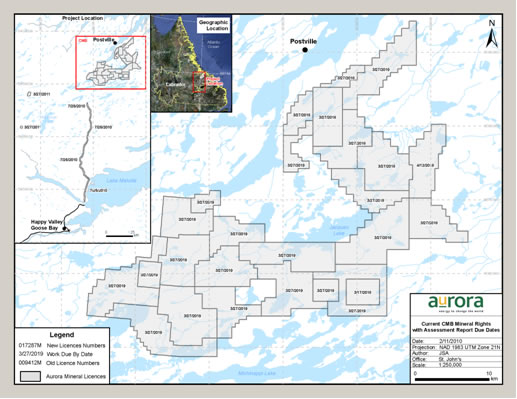
The above figure illustrates the final configuration of licenses and the years in which further exploration will be required. Note that all licenses are held in good standing until at least 2018 with most until 2019.
In 2009, Aurora conducted a $500,000 program aimed at further target generation, prospecting and evaluation on 13 of the Aurora licenses throughout the CMB Uranium Property. Data from recent and historical work, including geophysical surveys (airborne radiometric, magnetic and gravity) and geochemical data (rock sampling, lake sediment surveys) were compiled and evaluated. This program was successful in identifying new targets throughout the belt with signatures similar to those of known areas of mineralization.
- 63 -
Field work consisting of prospecting, geological mapping, soil surveys and a lake sediment survey commenced on August 16, 2009 and was completed on August 31, 2009. A total of 65 rock samples were collected for geochemical analysis over the course of the program from a total of seven licenses across the claim block as well as from the Croteau and Storm properties. Two soil surveys were carried out, one over the East Micmac Lake property with 34 sites sampled and one over the Pond of Islands Lake property with 59 sites sampled. A total of 152 lake sediment samples were collected over three licenses, Pond of Islands Lake, Porcupine Lake North and Porcupine Lake South. Results have been positive with the discovery of new showings on the Tom Hill Pond and Croteau properties and highest assay results in outcrop at Croteau, up to 0.92% U3O8.
All samples collected during drill programs were subjected to industry best practice procedures for quality control, handling, sample security, analyses and storage. Drill core sampling proceeded on the basis of visual indications of mineralization and zones of anomalous radioactivity. Generally, intervals greater than 300 cps in hand were sampled, with sample intervals being predominantly in the range of 0.5 to 1.0 metres (except through areas of homogeneous lithology, where adjusted sample intervals were used). It is believed that the orientation and length of these samples are appropriate for the style of mineralization in the CMB.
After splitting, drill core samples were placed in sealed sample bags, delivered by helicopter to either Postville or Witchdoctor Lake, whereupon they were placed in sealed pails and shipped by plane to Happy Valley-Goose Bay to be delivered to the facilities of an independent laboratory. Chain-of-custody procedures consist of filling out sample submittal forms that are sent to the laboratory with sample shipments to make certain that all samples are received by the laboratory Processing and analysis of samples was conducted at these facilities and check samples have also been analyzed by the Saskatchewan Research Council.
Samples were generally subjected to delayed neutron counting analysis, along with ICP/OES aqua regia chemical digestion testing. Aurora employs the use of blank, standard and quarter-split duplicates to ensure the reliability of all sample results. Upon receipt of analytical data, these blanks, standards and duplicates are examined for evidence of laboratory contamination, analytical error, calibration errors, assay reproducibly and other signs of unusual processing. Any signs of such factors results in an investigation and, if necessary, samples are re-tested until control material passes. In addition, approximately 5% of all samples are subjected to a check assay. To Fronteer’s knowledge, the quality assurance procedures and assay protocols used by Aurora in connection with drilling and sampling on the CMB Uranium Property conform to industry standard guidelines.
In August 2009, Fronteer announced that Aurora had completed a Preliminary Economic Assessment (PEA) of the Michelin Project, which is described in the CMB Technical Report and is available on SEDAR atwww.sedar.com. AMEC independently verified and re-estimated Aurora’s CMB Mineral Resources for use in the PEA. Their updated Mineral Resources for the project are tabulated below.
Mineral Resources Estimate, Effective August 1, 2009
| | | | Underground | | | Open Pit | |
| | | | | | | | | | |
| | | | | % | Pounds | Cut--off | | | Pounds |
| Deposit | Classification | Cut-off Grade | Tonnes | U3O8 | U3O8 | Grade | Tonnes | % U3O8 | U3O8 |
| | | 0.05% U3O8 | | | | 0.02% U3O8 | | | |
| Michelin | Measured | | 1,289,000 | 0.12 | 3,310,000 | | 5,783,000 | 0.080 | 9,755,000 |
| | Indicated | | 16,170,000 | 0.13 | 44,582,000 | | 6,839,000 | 0.060 | 9,480,000 |
| Jacques | | | | | | | | | |
| Lake | Measured | | 103,000 | 0.08 | 176,000 | | 755,000 | 0.090 | 1,471,000 |
| | Indicated | | 1,661,000 | 0.08 | 2,809,000 | | 4,374,000 | 0.070 | 6,731,000 |
| Rainbow | Measured | | - | - | - | | 211,000 | 0.090 | 426,000 |
- 64 -
| | | | Underground | | | Open Pit | |
| | | | | | | | | | |
| | | Cut-off | | % | Pounds | Cut--off | | | Pounds |
| Deposit | Classification | Grade | Tonnes | U3O8 | U3O8 | Grade | Tonnes | % U3O8 | U3O8 |
| | | 0.05% U3O8 | | | | 0.02% U3O8 | | | |
| | Indicated | | 26,000 | 0.06 | 34,000 | | 735,000 | 0.090 | 1,409,000 |
| Inda | Measured | | - | - | - | | - | - | - |
| | Indicated | | 214,000 | 0.07 | 324,000 | | 985,000 | 0.070 | 1,497,000 |
| Nash | Measured | | - | - | - | | - | - | - |
| | Indicated | | 152,000 | 0.06 | 214,000 | | 527,000 | 0.090 | 1,029,000 |
| Gear | Measured | | - | - | - | | - | - | - |
| | Indicated | | 303,000 | 0.08 | 532,000 | | 48,000 | 0.060 | 63,000 |
| Totals | Measured and Indicated | 19,919,000 | 0.01 | 51,981,000 | | 20,258,000 | 0.070 | 31,860,000 |
| | | | | | | | | | |
| Michelin Jacques | Inferred | | 12,577,000 | 0.12 | 33,647,000 | | 3,393,000 | 0.030 | 2,442,000 |
| Lake | Inferred | | 2,149,000 | 0.08 | 3,672,000 | | 5,953,000 | 0.040 | 5,373,000 |
| Rainbow | Inferred | | 365,000 | 0.08 | 624,000 | | 546,000 | 0.080 | 1,005,000 |
| Inda | Inferred | | 1,183,000 | 0.07 | 1,724,000 | | 2,077,000 | 0.070 | 3,064,000 |
| Nash | Inferred | | 369,000 | 0.07 | 580,000 | | 138,000 | 0.070 | 228,000 |
| Gear | Inferred | | 273,000 | 0.10 | 596,000 | | 30,000 | 0.030 | 19,000 |
| Totals | Inferred | | 16,917,000 | 0.11 | 40,843,000 | | 12,137,000 | 0.050 | 12,130,000 |
Note: Mineral resources are not mineral reserves and do not have demonstrated economic viability. Mineral resources were reportedusing a U3O8price of $US85/lb.
Mineral Resources and Mineral Reserves are subject to risks related to metallurgical, environmental, permitting, legal, title, taxation, socio-economic, marketing, political and other relevant issues, that are beyond the control of the company. Mineral Resources are not Mineral Reserves and there is no guarantee that a Mineral Resource will ever become a Mineral Reserve. However, based on historic work and prior economic studies, we currently anticipate that a good portion of the resource should be converted to reserves.
- 65 -
The PEA study supports a financially robust open-pit and underground uranium mining operation at Michelin and Jacques Lake, and a milling facility at the Michelin site capable of processing 10,000 tonnes of mineralization per day, which will produce up to 7.3 million pounds of U3O8 per annum. Direct cash costs are estimated at US$28.57per pound of U3O8 over the 17-year mine life. At an 8% discount rate, the Project’s pre-tax net present value (NPV) is US$914 million with a pre-tax internal rate (IRR) of return of 19.2% on an unlevered 100% equity basis, and a pay-back period of 4.7 years. The economic highlights of the study are listed below.
Highlights of Preliminary Economic Assessment
| Total U3O8produced | 96.9 million pounds |
| Average grade (U3O8) | 0.09% |
| Average annual production of U3O8 | 5.7 million pounds |
| Life of mine | 17 years |
| IRR (pre-tax) | 19.2% |
| NPV (pre-tax) | $914 million |
| Discount rate | 8% |
| Pay-back period | 4.7 years |
| Net cumulative cash flow | $3.038 billion |
| Direct cash costs | $28.57/lb U3O8 |
| Initial capital expenditures including mine, mill, infrastructure (port, road, grid power, etc.) tailings management, environmental, owners costs, decommissioning and engineering, procurement, construction management | $984 million
(including $132
million contingency) |
| Metallurgical recovery rate | 87.5% |
| Long term exchange rate | C$1 = US$0.88 |
| Long term uranium price | $75/lb U3O8 |
Note: The mine production estimates and resulting economic analyses are based on a Preliminary Economic Assessment level of cost estimates and engineering design. Additional study is required before a production decision can be made. The PEA is preliminary in nature and includes Inferred Mineral Resources that are considered too speculative geologically to have the economic considerations applied to them that would enable them to be categorized as Mineral Reserves. There is no certainty that the Preliminary Economic Assessment will be realized.
The PEA calls for a processing plant throughput rate of 3.65 million tonnes per year, assuming 6,500 tonnes per day from underground and 3,500 tonnes per day from open-pit sources.
The forecast production life of the mine is 17 years, with the planned 3.65 million tonnes per year rate achieved in Year 2 of production, and maintained until Year 15. Production begins with 2.5 million pounds U3O8produced in Year 1, followed by ramp up to a production rate of 7.03 million pounds in Year 4. During Years 4 through 12, the production rate will vary between 6.3 million pounds U3O8and 7.3 million pounds of U3O8per year (average of 6.9 million pounds U3O8 per year). From Years 13 through 17 production declines on an annual basis, with 3.0 million pounds being produced in Year 16.
The plan assumes that both the open-pit and underground operations will start simultaneously at Michelin, followed by Jacques Lake, commencing in Year 12. There is an overlap in open-pit production in Years 9 to 12, which allows for a production ramp up at Jacques Lake, and production of sufficient tonnes to supplement Jacques Lake underground mining.
The open-pit production schedule is based on ultimate pit shells derived from Whittle Optimization Software. All of the mineralized material classified as measured, indicated and inferred mineral resources was considered in the optimization and the mine plan. AMEC did not phase the pit at this study stage. It could be expected that with a starter pit and several push-backs, the NPV would be higher due to mining higher U3O8grades earlier in the schedule.
- 66 -
Material grading better than 0.06% U3O8was considered for underground mining at Michelin. The total mineral resource considered for underground mining is 26.6 million tonnes at an overall grade of 0.13% U3O8. The total mineral resource considered for underground mining at Jacques Lake is 2.6 million tonnes at an overall grade of 0.09% U3O8.
Open-pit mining at Michelin is planned to a depth of approximately 175 metres. The Michelin underground mine would extend to a depth of 850 metres, using a combination of longitudinal and transverse stoping with stopes backfilled with rockfill.
The mine plan includes underground access both through a vertical shaft and a decline from surface, both located outside of the pit. It is planned that the shaft will be approximately 850 metres deep and equipped for hoisting rock, personnel and supplies. The decline will be located in the footwall of the Main Zone and provide access to footwall sub-levels developed at 25-metre vertical intervals and to ventilation, back fill and rock pass raise systems. The decline and shaft will both be located outside of the pit limits. Raises bored from surface will provide the primary ventilation routes, two for intake and two for exhaust, and a transfer raise for stope fill waste rock. Two rock pass systems will also be bored between the main underground levels.
Open-pit mining at Jacques Lake is planned to a depth of approximately 200 metres. Most of the currently identified material above the underground mining cut-off grade appears to be between 150 metres and 300 metres below surface with two areas extending to approximately 400 metres.
The Jacques Lake mine plan includes underground access through two declines, one from within the open-pit mine. The declines will be located in the footwall of the mineralized zone and provide access to footwall sub-levels developed at 25-metre vertical intervals and to ventilation and a back fill raise system. The main connections between the two declines will be on the -25 metre and -150 metre levels.
The underground mining will advance to the pit floor following completion of open-pit mining and no crown pillar will be necessary with longhole stoping as the likely mining technique.
The metallurgical component, adopted by AMEC, was supervised by J.R. Goode and Associates and carried out with laboratory and pilot plant test work performed by SGS Lakefield Research Limited. The metallurgical component of the Michelin Project is significantly advanced. Highlights from the pilot plant and bench scale test work indicate that the Michelin Project mineralization is predicted to yield an average uranium recovery of 87.5% . The proposed milling process for the Michelin Project is an effective method for treating the Michelin Project mineralization. There will only be a modest consumption of energy and consumables, and the tailings test results meet Canadian environmental standards.
The Project’s infrastructure and transportation requirements will include a 140-kilometre road linking the mine sites with North West River, as well as a road to the proposed port site near Postville for delivery of bulk materials and consumables such as cement, sulfur, limestone and fuel. The road will provide year-round access for delivery of product to the market, to receive supplies and for movement of personnel.
An electrical transmission line is also required to provide reliable and clean grid power from the Newfoundland and Labrador hydro-electric system to the mine site.
An additional infrastructure requirement is the establishment of an accommodation facility suitable for 400 people at the mine site, as well as warehouses, administration and mine services facilities required to run a mine and mill operation.
- 67 -
The capital costs of the Michelin Project are expected to be $983.6 million, while sustaining capital would be $317.5 million, which would be derived from cash flow. The following capital costs are expected:
| Items | Capital costs (millions) |
| Mining (underground & open pit) | $246.8 |
| Process plant | $187.4 |
| Infrastructure and tailing management | $274.9 |
| Other (owners’ cost, EPCM, indirect costs, etc.) | $142.5 |
| Contingency | $132 |
| Total | $983.6 |
The following life of mine costs are expected for the operating phase of the Project:
| Items | Cost per tonne |
| Mining cost | $26.71 |
| Processing cost | $14.01 |
| G&A (transport included) | $8.31 |
The following sensitivity table demonstrates that the Project has robust economics across a range of reasonable uranium-price scenarios:
| U3O8Price/lb | IRR (pre-tax) | NPV (8%, pre-tax) | Pay back |
| $65 | 14.8% | $502 million | 5.7 years |
| $75 (base case) | 19.2% | $914 million | 4.7 years |
| $90 | 25.2% | $1,531 million | 3.7 years |
Aurora has been actively building industry awareness of the Michelin Project for several years with investors, nuclear utility companies and others. The Project is viewed favourably by uranium consumers as the significant size and technical simplicity of the Michelin deposit, combined with its location in a low-risk geo-political environment, make it a desirable addition to a supply portfolio.
Several major North American and European utilities have visited Michelin. Discussions have also been held with utilities in North America, Europe and Asia Pacific. The scope of discussions has ranged from interest in participation in the Project to purchasing uranium under long-term contracts. Although the Project is still in the development stage, the Corporation receives unsolicited “requests for proposals” for the supply of uranium from utilities. Fronteer continues to evaluate options to maximize value under various market and development scenarios.
Aurora is making progress on environmental baseline studies focused on identifying the pre-development environmental conditions in the area. Key aspects of the studies are fisheries and aquatic life, air quality monitoring, wildlife studies, terrestrial habitat quantification, and water quality and quantity studies. Aurora is also advancing the selection of tailings management options and the assessment of local land and resource use patterns. All these studies are part of the comprehensive environmental review that all major resource development projects must complete as part of the regulatory approval process.
- 68 -
Fronteer, through Aurora, has undertaken an extensive community engagement initiative to build understanding around mining and the benefits communities can expect to derive from the Michelin Project. The initiative includes: holding open houses in all North Coast Labrador communities; conducting small group and one-on-one meetings; meeting local government representatives; opening information centres in Aurora’s Postville and Makkovik offices; and developing a targeted youth and elder information program. Responses to these community initiatives have been very positive, with high attendance and growing interest. Community consultations with Labrador residents will continue, with a focus on the environmental health and safety aspects of the Michelin Project and long-term economic benefits. Meetings with the Michelin Project Community Panel are part of this ongoing consultation.
Fronteer recently commissioned an independent Economic Impact Assessment of the Michelin Project, which identifes significant long-term economic benefits to regional governments and communities. The study estimates that 31,200 person years of employment, $2.9 billion in business and individual income, and $1.8 billion in tax revenues would be generated by the project over its life of mine. Significant benefits to other Canadian provinces and the federal government include a combined $2.9 billion in income and $2.3 billion in tax revenues.
Consultations with the Government of Newfoundland and Labrador and Government of Canada have also been undertaken regarding the regulatory requirements for the Project, and will continue to update the project registration document to ensure it is ready to be filed with the Federal, Provincial and Nunatsiavut regulators.
At present, Aurora is revising its critical path schedule for the CMB Uranium Project, including feasibility studies, construction schedule, engineering, environmental assessment and permitting.
Agi Dagi and Kirazli Properties, Turkey
On September 22, 2009, Fronteer, Teck and Alamos (and certain of Fronteer’s and Teck’s subsidiaries) entered into a letter agreement (“MOU”) proposing the terms on which Alamos would acquire 100% of the Agi Dagi and Kirazli gold projects from Teck and Fronteer through the acquisition of certain Turkish subsidiaries held directly by Teck (60%) and indirectly by Fronteer (40%) through its wholly-owned subsidiary Fronteer Eurasia. Fronteer and Teck agreed to negotiate exclusively with Alamos for a 60-day period. Alamos agreed to pay a total of US$40 million and issue a total of 4 million shares to the Teck group (as to 60%) and the Fronteer group (as to 40%) in consideration for acquiring these two projects. The obligation of Alamos to enter into definitive agreements for the purchase and sale was subject to a 30-day due diligence period and the approval of Alamos’ board of directors and the TSX. The completion of the purchase of sale transaction was subject to customary conditions of closing and the approval of the TSX.
On November 19, 2009, the MOU was amended to allow Alamos to continue its due diligence until December 7, 2009 and to extend the exclusivity period to the same date.
On December 7, 2009, the definitive share purchase agreement was signed and closing was scheduled to occur sometime between December 17, 2009 and January 29, 2010 to allow for the satisfaction of certain conditions precedent negotiated into the definitive agreement.
On January 5, 2010, the conditions precedent to closing the sale transactions were satisfactorily completed and the purchase price was paid by Alamos in exchange for the shares in the Turkish subsidiaries (which included shares of Fronteer Eurasia). Immediately following the closing, certain corporate law requirements were undertaken in Turkey to document the transfer of the shares and to replace the boards of the Turkish Subsidiaries. These requirements were completed early on January 6, 2010. Accordingly, Fronteer no longer holds any direct or indirect interest in the Agi Dagi and Kirazlí projects. Further details are set out below under “Material Contracts”.
- 69 -
DIVIDENDS
There are no restrictions that prevent the Corporation from paying dividends. However, the Corporation has not paid any dividends on its Common Shares since incorporation. At present, all available funds are invested to finance the growth of the Corporation and the exploration and development of its mineral properties. Any decision to pay dividends on its Common Shares in the future will be made by the board of directors of the Corporation from time to time, in its discretion, on the basis of many factors, including Fronteer’s earnings, operating results, financial condition and anticipated cash needs and other conditions existing at such time.
DESCRIPTION OF CAPITAL STRUCTURE
The Corporation is authorized to issue an unlimited number of Common Shares. There are 119,938,359 Common Shares issued and outstanding as of March 29, 2010. Holders of Common Shares of the Corporation are entitled to receive notice of any meetings of shareholders of the Corporation, and to attend and to cast one vote per Common Share at all such meetings. Holders of Common Shares of the Corporation are entitled to receive on a pro rata basis such dividends on such Common Shares, if any, as and when declared by the Corporation’s board of directors at its discretion from funds legally available therefor, and, upon the liquidation, dissolution or winding up of the Corporation, are entitled to receive on a pro rata basis the net assets of the Corporation after payment of debts and other liabilities, in each case subject to the rights, privileges, restrictions and conditions attaching to any other series or class of shares ranking senior in priority to or on a pro rata basis with the holders of Common Shares with respect to dividends or liquidation. The Common Shares of the Corporation do not carry any pre-emptive, subscription, redemption, retraction, surrender or conversion or exchange rights, nor do they contain any sinking or purchase fund provisions.
MARKET FOR SECURITIES
The Common Shares of the Corporation are listed for trading on the TSX and the NYSE Amex under the symbol “FRG”.
The following table sets forth, for the periods indicated, the reported high and low daily trading prices and the aggregate volume of trading of the Fronteer Common Shares on the TSX during the year ended December 31, 2009:
Period
| Volume
| High
($) | Low
($) |
| December 2009 | 4,652,587 | 4.64 | 3.91 |
| November 2009 | 6,160,979 | 4.76 | 3.98 |
| October 2009 | 5,998,637 | 4.92 | 4.03 |
| September 2009 | 6,619,773 | 4.94 | 4.35 |
- 70 -
Period
| Volume
| High
($) | Low
($) |
| August 2009 | 4,854,353 | 4.75 | 3.93 |
| July 2009 | 4,610,175 | 4.38 | 3.61 |
| June 2009 | 10,336,714 | 4.60 | 3.71 |
| May 2009 | 10,350,898 | 4.09 | 2.88 |
| April 2009 | 9,129,634 | 3.05 | 2.48 |
| March 2009 | 6,659,363 | 3.30 | 2.57 |
| February 2009 | 4,738,154 | 3.33 | 2.55 |
| January 2009 | 7,702,805 | 2.93 | 2.26 |
PRIOR SALES
The Corporation issued the following non-trading securities (stock options to acquire Common Shares) during the financial year ended December 31, 2009:
Date of Grant | Number of
Stock Options
Issued |
Exercise Price
($) |
Expiry Date |
| 23-Feb-09 | 2,330,000 | $3.09 | 23-Feb-19 |
| 18-Mar-09 | 30,000 | $2.89 | 18-Mar-19 |
| 12-May-09 | 210,000 | $3.48 | 12-May-19 |
| 21-Jul-09 | 100,000 | $4.35 | 21-Jul-19 |
DIRECTORS AND OFFICERS
Name, Address, Position and Occupation
The name, province or state and country of residence, position or office held with the Corporation and principal occupation for the immediately preceding five years of each of the directors and executive officers of the Corporation are as follows:
Name and Residence
| Position with
Corporation | Principal Occupation for Five Preceding Years
| Director Since
|
Oliver Lennox-King(5)
Ontario, Canada | Chairman and
Director | Chairman and Director of Fronteer (2004 to present), Chairman and Director of Aurora (2006 - 2009) a mineral exploration company. | November 2003 |
Mark O’Dea(5)(6)
British Columbia, Canada | President, Chief Executive Officer and Director | President and Chief Executive Officer of Fronteer (2001 to present).
President and Chief Executive Officer of Aurora (2006 to 2009), a mineral exploration company. | May 2001 |
Donald McInnes(2)(3)(5)
British Columbia, Canada
| Director | Vice Chairman and Chief Executive Officer and former President of Plutonic Power Corporation (June, 1999 to present), an emerging power producer.
President of Blackstone Ventures Inc. (January 1995 to March 2008), a mineral exploration company.
President of Western Keltic Mines Inc. (June 1993 to 2006), a mineral exploration company. | June 2001 |
- 71 -
Name and Residence
| Position with
Corporation | Principal Occupation for Five Preceding Years
| Director Since
|
George Bell(1)(2)
Ontario, Canada
| Director
| President and Chief Executive Officer of Unor Inc. (March 2004 to February 2010) a uranium exploration company.
Chairman and Director of Norsemont Mining Inc. (2007 to present), a copper development company. Director of North Atlantic Resources Ltd. (2008 to present), a gold development company.
Director, Weda Bay Minerals Inc. (2005 to 2006), a nickel development company. Director, Southern Cross Resources Inc. (2003 to 2005), a mineral exploration company. | December 2003
|
Lyle R. Hepburn(1)(3)
Ontario, Canada | Director | Partner in the Toronto law firm of Beach, Hepburn LLP (1985 to present). | April 2004 |
Jo Mark Zurel(1)(2)(4)
Newfoundland and Labrador,
Canada | Director
| President, Stonebridge Capital Inc. (2006 to present), an investment company.
Senior Vice-President and Chief Financial Officer of CHC Helicopter Corporation (1998 to 2006), a helicopter services company. | December 2006
|
Scott Hand(2)(3)(4)
Ontario, Canada
| Director
| Chairman of Royal Nickel Corporation (2009 to present), a nickel development Company.
Co-Chairman of Juno Special Situations Corporation (2008 to Present), a mineral resources investment company.
Director of Manulife Financial Corporation (• to Present), a financial services, insurance and wealth management company.
Former Chairman and Chief Executive Officer of Inco Limited (2001 to 2006), a mining company. | May 2007
|
Troy Fierro
Aurora, Colorado
| Chief Operating
Officer
| Chief Operating Officer of Fronteer (April 2009 to present).
Owner Fierro Consulting LLC, a mining consulting firm (October 2008 to April 2009).
Vice President, Operations, Metallica Resources Inc., a mining company (April 2006 to August 2008).
Chief Operating Officer, Rimcon LLC, a mining consulting company, (November 2004 to March 2006). | N/A
|
Sean Tetzlaff(7)
British Columbia, Canada
| Chief Financial,
Officer, Vice President, Finance
and Corporate Secretary | Chief Financial Officer, Vice President, Finance
and Corporate Secretary of Fronteer (2005 to
present). Chief Financial Officer and Corporate Secretary of Aurora (2005 to 2008), a mineral exploration company.
| N/A
|
- 72 -
Name and Residence
| Position with
Corporation | Principal Occupation for Five Preceding Years
| Director Since
|
John Dorward
British Columbia, Canada
| Vice President,
Business
Development
| Vice President, Business Development, Fronteer (July 2009 to present).
Chief Financial Officer, Mineral Deposits Limited (2006 to 2009), an Australian mining company.
Chief Financial Officer and Company Secretary of Leviathon Resources Limited (2004 to 2006), an Australian mining company. | N/A
|
Christopher Lee
British Columbia, Canada
| Chief Geoscientist
| Chief Geoscientist of Fronteer (2007 to present).
Prior Chief Geoscientist and subsequent provision of Chief Geoscientist services to Aurora (January 2007 to present), a mineral exploration company.
Principal Geologist of SRK Consulting Inc. (2000 to 2006), an engineering consulting firm. | N/A
|
Ian Cunningham-Dunlop(7)
British Columbia, Canada
| Vice President,
Exploration
| Vice President, Exploration of Fronteer (2004 to present).
Vice President, Exploration of Aurora (2006 to 2008), a mineral exploration company. | N/A
|
Jim Lincoln(7)
Nevada, USA
| Vice President,
Operations
| Vice President, Operations of Fronteer (2006 to present).
Chief Operating Officer of Aurora (2006 to 2008).
Vice President, Corporate Development of Jinshan Gold Mines Inc. (2005 to 2006), a mining corporation.
Principal of Lincoln Associates Inc. (2004 to 2005), an international mineral resource consulting corporation. | N/A
|
Notes:
| (1) | Member of the Audit Committee. |
| (2) | Member of the Compensation Committee. |
| (3) | Member of the Corporate Governance and Nominating Committee. |
| (4) | Member of the Special Option Committee. |
| (5) | Member of the Health, Safety and Environment Committee. |
| (6) | Mr. O'Dea is also a director of Aurora, NewWest Gold Corporation, Fronteer Holdings Inc., Fronteer Investment Inc. and Agola Madencilik Limited Sirketi, all wholly owned subsidiaries of the Corporation |
| (7) | Mr. Cunningham Dunlop and Mr. Tetzlaff are directors of NewWest Gold Corporation. Mr. Tetzlaff is also a director of Aurora. Mr. Lincoln is a director of Fronteer Development USA Inc., Fronteer Development LLC and Fronteer Royalty LLC. These companies are all wholly owned subsidiaries of the Corporation. |
The term of office of each of the Corporation’s directors expires at the Corporation’s next annual general meeting at which directors are elected for the upcoming year or until his successor is duly elected or earlier in accordance with the by-laws of the Corporation.
Aggregate Ownership of Securities
As at December 31, 2009, the directors and executive officers of the Corporation, as a group, beneficially owned, directly or indirectly, or exercised control or direction over, an aggregate of 1,326,327 Common Shares of the Corporation representing approximately 1.11% of the issued and outstanding Common Shares of the Corporation as of such date.
- 73 -
CEASE TRADE ORDERS, BANKRUPTCIES, PENALTIES OR SANCTIONS
Save for as set out below:
| 1. | no director or executive officer of Fronteer is, as at the date of this AIF, or has been, within 10 years before the date of this AIF, a director, chief financial officer or chief executive officer of any company that: |
| | | |
| (a) | was subject to a cease trade or similar order or an order that denied the relevant company access to any exemption under securities legislation, in each case that was in effect for a period of more than 30 consecutive days (any such order, an “Order”) that was issued while that person was acting in that capacity; or |
| | | |
| (b) | was subject to an Order that was issued after that person ceased to act in such capacity and which Order resulted from an event that occurred while that person was acting in that capacity; and |
| | | |
| 2. | no director, executive officer or shareholder of the Corporation holding a sufficient number of securities of the Corporation to materially affect its control (a “Significant Shareholder”): |
| | | |
| (a) | is, at the date of this AIF, or has been within 10 years before the date of this AIF, a director or executive officer of any company that, while that person was acting in that capacity, or within a year of that person ceasing to act in that capacity, became bankrupt, made a proposal under any legislation relating to bankruptcy or insolvency or was subject to or instituted any proceedings, arrangement or compromise with creditors or had a receiver, receiver manager or trustee appointed to hold its assets; or |
| | | |
| (b) | has, within the 10 years before the date of this AIF, become bankrupt, made a proposal under any legislation relating to bankruptcy or insolvency, or become subject to or instituted any proceedings, arrangement or compromise with creditors, or had a receiver, receiver manager or trustee appointed to hold his or her assets; and |
| | | |
| 3. | no director, executive officer or Significant Shareholder of the Corporation has been subject to: |
| | | |
| (a) | any penalties or sanctions imposed by a court relating to securities legislation or by a securities regulatory authority or has entered into a settlement agreement with a securities regulatory authority; or |
| | | |
| (b) | any other penalties or sanctions imposed by a court or regulatory body that would likely be considered important to a reasonable investor making an investment decision. |
Mr. Lennox-King was previously a director of Unisphere Waste Conversion Ltd. (TSXV: UCB). He resigned as a director of Unisphere Waste Conversion Ltd. on February 9, 2005, immediately before a subsidiary of Unisphere Waste Conversion Ltd. filed a Notice of Intention to make a proposal to its creditors under theBankruptcy and Insolvency Act(Canada).
In 2002, Mr. Lincoln was employed by North Star Exploration, Inc. (“North Star”) as Senior Vice President and Chief Operating Officer. North Star was a wholly-owned subsidiary of EMEX Corporation (“EMEX”), a NASDAQ listed company. EMEX was controlled by a New York Banking Family Trust (the “Trust”).
- 74 -
Over a six year period from late 1996 through to late 2002, EMEX invested approximately US$30,000,000 in North Star and another EMEX subsidiary. The funds were supplied by the Trust in the form of secured loans to EMEX. In late 2002, the Trustees of the Trust decided that the investment was not going to be paid back in any reasonable time. The Trust chose to end its business endeavors by declaring Chapter 11 bankruptcy under the applicable US bankruptcy laws. In December 2002, EMEX filed for Chapter 11 bankruptcy in the Bankruptcy Court of Denver, Colorado. The bankruptcy proceedings were completed in the Denver Bankruptcy Court in late 2003. In November 2002, upon learning of the intent of the parent company to file for bankruptcy, Mr. Lincoln resigned as an officer and board member from North Star.
The above and below information as to ownership of securities of the Corporation, corporate cease trade orders, bankruptcies, penalties or sanctions, and existing or potential conflicts of interest, not being within the knowledge of the Corporation, has been provided by each insider of the Corporation individually.
CONFLICTS OF INTEREST
Except as disclosed herein, to the knowledge of management of the Corporation, there are no existing or potential material conflicts of interest between the Corporation or any of its subsidiaries and any director or officer of the Corporation. Directors and officers of the Corporation may serve as directors and/or officers of other companies or have significant shareholdings in other resource companies and, to the extent that such other companies may participate in ventures in which the Corporation or any of its subsidiaries may participate, the directors of the Corporation may have a conflict of interest in negotiating and conducting terms in respect of such participation. In the event that such conflict of interest arises at a meeting of the Corporation’s board of directors, a director who has such a conflict is required to disclose such conflict and abstain from voting for or against the approval of such participation or such terms.
LEGAL PROCEEDINGS AND REGULATORY ACTIONS
The Corporation is not currently, and has not at any time during its most recently completed financial year, been a party to, nor has any of its property been the subject of, any material legal proceedings or regulatory actions. Except as described below, the Corporation is not aware of any such proceedings or actions threatened or known to be contemplated.
On January 29, 2009, the Corporation received a letter from New York counsel to NWG Investments Inc. (“NWG”), demanding the rescission of the share exchange transaction between the Corporation and NewWest, which was concluded in September 2007. The letter alleges that the Corporation fraudulently induced NWG to transfer its NewWest shares through misrepresentations and omissions of material fact regarding the ability of Aurora to commence uranium mining operations in Labrador, Canada. In April 2008, the Nunatsiavut Government imposed a three-year moratorium on mining of uranium on its lands in Labrador. NWG alleges that Fronteer knew about the moratorium prior to the conclusion of the NewWest share exchange in September 2007 and did not disclose this information to NWG. The letter also advises Fronteer that NWG is exploring an oppression claim against Fronteer and other unidentified persons in Ontario. As of March 29, 2010, no claim has been filed with any court. The Corporation’s counsel have performed a detailed review of the Corporation’s communications and disclosure of this matter and as a result, the Corporation believes that the threatened claims have no merit and plans to vigorously defend itself should any claim be filed. No amounts have been accrued for any potential loss under this complaint.
- 75 -
In December 2007, the Corporation received a letter from Siskinds LLP, a law firm in Ontario, Canada, alleging that certain stock options granted by Fronteer were implicitly in the money at the time of grant. The board of Fronteer immediately struck an independent committee (the “Special Option Committee”) to review the Corporation’s stock option granting practices and past option grants. The Special Option Committee hired independent counsel to assist with the review. Based on the investigation conducted by and the advice of independent counsel, the Special Option Committee concluded, among other things, that it did not believe that Fronteer had looked back for dates that would give a grantee a better price than was available on the date of grant. The Corporation has complied with all of its reporting obligations in respect of this matter. The Special Option Committee’s independent counsel discussed the review with the TSX and has been advised that the TSX has closed it’s file on this matter. In addition, the Special Option Committee has been advised by it’s independent counsel that the administration of it’s stock option policy complies with it’s stock option plan, with TSX requirements and with current best practice standards. On the recommendation of the Special Option Committee, the Board has adopted a stock option policy that sets out the basis on which options are granted.As of March 29, 2010, no claim has been filed with any court.
The Corporation believes that the threatened claims have no merit and will vigorously defend itself and its directors should any claim be filed. No amounts have been accrued for any potential loss under the foregoing complaints.
On March 5, 2010 Fronteer USA filed a complaint (the "Complaint") initiating an action against Big Spring Ranch LLC, Star Living Trust, Fred Sadri, Elias Abrishami, Ray Koroghly and Gholamreza Zandian Jazi, Jerry Goodwin, Black Stone Minerals Company L.P. and all other persons unknown claiming right, title, estate, lien or interest in the real property described in the complaint. The complaint was filed in the Fourth District Court of the State of Nevada in and for the County of Elko. In addition, Fronteer filed a Motion for Order Permitting Immediate Occupancy the same day to secure areas where immediate and continuous access is necessary to the Long Canyon Project.
The filing seeks to verify Fronteer’s use of certain surface rights under and in connection with its Mineral Reservation at the Long Canyon Project; and also, to condemn certain interests in Big Spring Ranch surface lands overlying Fronteer’s dominant mineral rights and Big Spring Ranch Fee land for access for hydrology and engineering drilling and testing. A ruling by the court in favor of Fronteer’s condemnation claims would require reimbursement to the Big Spring Ranch and others for the fair market value of any rights condemned as determined by the Court. Under Fronteer's Mineral Reservation, it has the right to use of the surface as necessary for exploration, developing, producing, transporting, and processing minerals and any of their by-products.
All defendants with an interest in the land sought to be condemned were served with the Summons, Complaint, and Motion for Immediate Occupancy between March 8 and March 12, 2010. There has been no response filed by Defendants per the date of this AIF.
INTEREST OF MANAGEMENT AND OTHERS IN MATERIAL TRANSACTIONS
Other than as described below and elsewhere in this AIF, no director, executive officer, or person or company that beneficially owns, or controls or directs, directly or indirectly, more than 10% of the outstanding Common Shares, or any associate or affiliate of any of the foregoing, has or has had any material interest, directly or indirectly, in any transaction involving the Corporation within the three most recently completed financial years or during the current financial year that has materially affected or will materially affect the Corporation.
Restructuring Agreements
On and as of June 30, 2005, WSMC, a wholly-owned subsidiary of Western States Minerals, consolidated the rights to possess, explore, develop and mine the Mineral Interests of the Safra Companies.
- 76 -
In addition, Western States Royalty, an affiliate of WSMC, acquired the Mineral Royalties on the properties of NewWest, subject to the right of Zaca Resources to retain the Zaca Royalty.
As part of the various Pre-IPO NewWest Restructuring completed prior to or as of July 5, 2006 discussed elsewhere in this AIF, such Mineral Interests and Mineral Royalties (including the Zaca Royalty) were sold or contributed to the LLCs. The LLCs were in turn sold to NWG, a company that is indirectly, wholly-owned by Mr. Jacob Safra. Following these transactions, pursuant to the LLC Purchase Agreement, NWG and therefore indirectly, Mr. Safra, acquired all of the issued and outstanding shares of NewWest in exchange for the acquisition by NewWest of a 100% interest in each of the LLCs. Under the LLC Sale Agreement, NewWest acquired all of the issued and outstanding shares of NewWest USA, in exchange for the acquisition by NewWest USA of 100% of NewWest’s interests in the LLCs. In October 2006, NewWest Gold LLC and Zaca Mining LLC were merged into NewWest USA. After giving effect to these transactions and Fronteer’s subsequent acquisition of NewWest, NewWest acquired and continues to hold all Mineral Interests through Fronteer USA (formerly NewWest USA) andFronteer Gold LLC (formerly Nevada Western Gold LLC), and holds all Mineral Royalties (including the Zaca Royalty) through NWG Royalty LLC. On August 29, 2006, NewWest completed an initial public offering after which Mr. Safra’s indirect interest in NewWest was reduced to approximately 86%. Upon completion of the acquisition of all of the issued and outstanding shares of NewWest by the Corporation as discussed above, Mr. Safra, primarily through NWG, currently owns approximately 10.8% of all of the issued and outstanding Common Shares of Corporation as of the date of this AIF.
Acquisition of Aurora
As described elsewhere in this AIF, on January 23, 2009, Fronteer commenced its Offer by way of take-over bid to acquire all of the outstanding Aurora Shares not already owned by Fronteer. Subsequently, in April 2009, Fronteer acquired the remaining outstanding Aurora Shares that it had not acquired under its Offer by way of a subsequent amalgamation transaction. For further details, see the section of this AIF entitled “General Development of the Business – Three Year History” above. Each of Oliver Lennox-King, the Chairman and a Director of Fronteer, and Mark O’Dea, the President and Chief Executive Officer and a Director of Fronteer, were also directors on the board of Aurora (Mr. Lennox-King was the Chairman of the Aurora board and Mr. O’Dea was the Deputy Chairman of the Aurora board), at the time the Offer and the subsequent amalgamation transaction were completed with Aurora. In connection with the Offer, the board of directors of Aurora struck a special committee comprised of independent directors and, accordingly, neither Mr. Lennox-King nor Mr. O’Dea participated in deliberations by the board of Aurora in respect of the Offer. In addition, each such individual, along with certain other directors and executive officers of Fronteer, held Aurora Shares and/or options to acquire Aurora Shares at the time of the Offer and the subsequent amalgamation transaction.
REGISTRAR AND TRANSFER AGENT
The Corporation has co-transfer agents being Equity Transfer & Trust Company at its principal office in Toronto, Ontario, Canada and the Registrar and Transfer Company at its principal office in Cranford, New Jersey, USA.
MATERIAL CONTRACTS
The only material contracts entered into by the Corporation, other than in the ordinary course of business, during the most recently completed financial year of the Corporation or before the most recently completed financial year of the Corporation but which are still in effect, are as follows:
- 77 -
| 1. | The Option Agreement dated April 27, 2004 between the Corporation and Teck Madencilik Sanayi Ticaret A.S. (formerly Teck Cominco Arama ve Madencilik Sanayi Ticaret) (“TMST”), pursuant to which TMST and the Corporation acquired their 60% and 40% interests, respectively, in the Agi Dagi Property, and the Option Agreement dated May 6, 2004 between the Corporation and TMST, pursuant to which TMST and the Corporation acquired their 60% and 40% interests, respectively, in the Kirazlí Property (collectively, the “TMST Option Agreements”). Under the TMST Option Agreements, TMST was entitled to certain back-in rights in respect of each project, which rights were subsequently exercised by TMST as discussed elsewhere in this AIF. As a result of electing to exercise its back-in rights, TMST’s royalty rights in respect of the Agi Dagi and Kirazlí projects provided for under the Option Agreements no longer apply. Under the TMST Option Agreements, Fronteer and TMST held their interests in the two properties through two Turkish corporations. TMST controlled both Turkish corporations and was operator of the project for as long as TMST’s interest exceeded 50%. In consideration of the preliminary ounces then- outlined on the properties, Fronteer was required to pay TMST, within 60 days following commencement of commercial production, a production bonus of US$10 per ounce for every ounce, up to a maximum of 600,000 ounces on Agi Dagi and 250,000 ounces on Kirazlí, produced from within the then-defined resource areas. As described elsewhere in this AIF, each of TMST and Fronteer subsequently sold their respective interests in the Agi Dagi and Kirazlí projects in January 2009 to Alamos for US$40 million in cash and the issuance of 4 million Alamos common shares to TMST (as to 60%) and Fronteer (as to 40%). |
| | |
| 2. | The Option Agreement dated October 19, 2004 between the Corporation and TMST, pursuant to which the Corporation was granted an option to acquire a 100% interest in a group of properties known as the Biga Properties (which includes the Halilaga Property) and TMST was granted certain back-in rights. Under the terms of the Option Agreement, TMST and Fronteer earned a 60% and 40% interest, respectively, in the Halilaga Property and four other designated properties (together the “Designated Properties”). |
| | |
| 3. | Agreement Respecting Further Exploration of Area of Interest dated February 28, 2006 between the Corporation, Altius and Aurora, whereby the Corporation and Altius agreed to contribute to Aurora any future lands acquired within an area of interest in the Central Mineral Belt, Labrador, or within the currently exempt mineral lands in Labrador. This Agreement also terminated the former alliance between the Corporation and Altius upon the initial public offering of Aurora, pursuant to which each of Fronteer and Altius acquired an equity interest in Aurora in consideration for contributing their respective lands in the Central Mineral Belt, Labrador, to Aurora. As disclosed elsewhere in this AIF, pursuant to a take-over bid and subsequent amalgamation transaction, Aurora ceased to be a public company and is now a 100% wholly- owned subsidiary of Fronteer. |
| | |
| 4. | Joint Venture Agreement between NewWest Gold USA Inc. (now Fronteer USA) and Pittston Nevada Gold Company, a wholly-owned subsidiary of AuEX Ventures, Inc. (“AuEX”) dated December 22, 2006 and effective May 23, 2006, to allow Fronteer to earn up to a 65% interest in the Long Canyon Project. Under the Joint Venture Agreement, each party retains a 3% NSR royalty on respective lands contributed to the joint venture. To maintain a 51% interest in the Long Canyon Property, Fronteer USA was required to expend the first US$5,000,000 on the joint properties, which was completed in September 2008. Fronteer USA elected not to earn an additional 14% by completing all subsequent expenditures through to completion of a feasibility study. The joint venture will therefore remain a 51% Fronteer/49% AuEX joint venture unless the respective interest of either party is diluted for failure to participate in funding an approved program. Details concerning this joint venture arrangement are described elsewhere in this AIF. |
| | |
| 5. | Arrangement Agreement between Fronteer and NewWest dated July 27, 2007, pursuant to which Fronteer acquired 100% of NewWest. Pursuant to the Arrangement Agreement, Fronteer agreed to exchange 0.26 of a Fronteer Common Share for each NewWest share acquired. In addition, all of the outstanding options of NewWest were exchanged for replacement options of Fronteer and became exercisable to acquire that number of Common Shares determined by reference to the exchange ratio. The completion of the arrangement was subject to a number of customary conditions precedent, including that it be approved by 66 2/3% of the votes cast by NewWest’s shareholders and optionholders at a special meeting, which approval was subsequently obtained. The Arrangement Agreement also contained certain representations and warranties by the parties. The acquisition of NewWest by Fronteer pursuant to the terms of the Arrangement Agreement was completed on September 24, 2007. |
- 78 -
| 6. | Option and Joint Venture Agreement between Fronteer and Newmont Mining Corporation (“Newmont”) dated June 1, 2008, with respect to the terms of a joint venture on the Sandman Property, which Agreement replaced the LOI between Fronteer and Newmont, as it relates to the Sandman project, described elsewhere in this AIF. Under the terms of the Agreement, Newmont may earn up to a 60% interest in the Sandman project by investing $23,000,000 in advancing the project. As part of the Agreement, Newmont contributed over eight new sections of adjacent mineral interests to the Sandman Property. Under the terms of the two-phase agreement, Newmont may earn an initial 51% interest in Sandman within 36 months by: (i) spending an initial US$14,000,000 on exploration (US$3,000,000, US$5,000,000 and US$6,000,000 in years one, two and three, respectively), (ii) making a production decision supported by a bankable feasibility study, (iii) making a commitment to fund and construct a mine, and (iv) reporting reserves. As part of Phase 2, Newmont may then earn an additional 9% interest in Sandman by spending a further US$9,000,000 on development. Fronteer can also elect to have Newmont arrange financing for its 40% of ongoing development costs at the lesser of (i) the London Interbank Offered Rate (LIBOR) plus 4%, or Fronteer’s then-current borrowing rate. Newmont must obtain repayment of the amount advanced, plus interest, solely from up to 80% of Fronteer’s share of production, less production costs. Provided that Newmont completes its Phase 2 earn-in requirements, Newmont is entitled to recover an additional sum of US$3,750,000 from 90% of the Corporation’s share of production (net of costs) until that amount is recovered in full. Fronteer retains a 2% NSR royalty on production of the first 310,000 ounces at Sandman. Pursuant to the Agreement, Newmont also returned a 100%-interest in the Northumberland Property to Fronteer USA and granted the Corporation a right to Newmont’s proprietary N2TEC processing technology for future processing of Northumberland ore in exchange for Newmont obtaining the first right to process ores developed from Northumberland, in exchange for credit of its expenditures on Northumberland against the right to earn an initial 51% interest, and up to a total 60% interest, in the Sandman Property. Under the Agreement, Newmont has the right to process ores from Northumberland upon the occurrence of certain events and in accordance with the process and procedures described in the Agreement between the parties. |
| | |
| 7. | Share Purchase Agreement dated December 7, 2009, between Fronteer, Alamos, Teck, TMST, Fronteer Investment Inc. and Fronteer Eurasia whereby Alamos agreed to acquire 100% of the Agi Dagi and Kirazlí gold projects from Teck and Fronteer through the acquisition of certain Turkish subsidiaries held directly by Teck (60%) and Fronteer’s investment in Fronteer Eurasia (40%) which was indirectly held by Fronteer through a wholly-owned subsidiary. Alamos agreed to pay a total of US$40 million and issue a total of 4 million shares to the Teck group (as to 60%) and the Fronteer group (as to 40%) in consideration for acquiring these subsidiaries. On January 5, 2010, the conditions precedent to the closing of the transaction were satisfactorily completed and the purchase price was paid by Alamos. The closing of the sale transaction occurred on January 6, 2010. The common shares of Alamos were issued on a private placement basis and subject to a four-month hold period. |
Copies of each of the material contracts described above have been filed with the applicable Canadian securities regulatory authorities and are available on SEDAR atwww.sedar.com.
- 79 -
INTERESTS OF EXPERTS
Names of Experts
PricewaterhouseCoopers LLP, Independent Registered Chartered Accountants, provide auditors’ reports with respect to the audited financial statements of the Corporation.
The individuals named below have each prepared technical reports for the Corporation with respect to the Corporation’s mineral properties referenced in this AIF and from which certain scientific and technical information contained in this AIF has been derived:
| | (a) | Christopher Lee, P. Geo., co-author of the technical report entitled “Technical Report on the Northumberland Project, Nye County, Nevada, USA: Resource Update 2008” dated July 28, 2008 and Amended August 8, 2008; |
| | | |
| | (b) | Peter Grieve, M.Sc., M.A.I.G., author of the technical report entitled “Technical Report on the Halilaga Exploration Property, Çanakkale, Western Turkey” dated March 30, 2009; |
| | | |
| | (c) | Michael M. Gustin, R.P. Geo., of MDA, co-author of the updated technical report entitled “Updated Technical Report, Sandman Gold Project, Humboldt County, Nevada, USA” dated November 1, 2007; co-author of the technical report entitled “Technical Report on the Long Canyon Project, Elko County, Nevada, USA” dated April 24, 2009 and effective April 17, 2009; and co-author of the technical report entitled “Updated Technical Report on the Preliminary Economic Assessment of the Long Canyon Project, Elko County, Nevada, USA” dated December 11, 2009; |
| | | |
| | (d) | George Lanier, co-author of the technical report entitled “Updated Technical Report, Sandman Gold Project, Humbolt County, Nevada, USA” dated November 1, 2007; |
| | | |
| | (e) | Steven Ristorcelli, R.P. Geo., of MDA, co-author of the technical report entitled “Updated Technical Report of the Zaca Project, Alpine County, California, USA” dated November 1, 2007; |
| | | |
| | (f) | David Griffith, P. Geo., of MDA, co-author of the technical report entitled “Updated Technical Report of the Zaca Project, Alpine County, California, USA” dated November 1, 2007; |
| | | |
| | (g) | Jim Ashton, P. Eng., co-author of the updated technical report entitled “Technical Report on the Northumberland Project, Nye County, Nevada, USA: Resource Update 2008” dated July 28, 2008 and Amended August 8, 2008; and co-author of the technical report entitled “Updated Technical Report, Sandman Gold Project, Humbolt County, Nevada, USA” dated November 1, 2007; |
| | | |
| | (h) | Mark Hertel, P.Geo, co-author of the technical report entitled “Michelin Uranium Project, Labrador, Canada, NI 43-101 Technical Report on Preliminary Assessment” dated October 23, 2009; |
| | | |
| | (i) | Margaret Podhorski-Thomas, P.Eng., co-author of the technical report entitled “Michelin Uranium Project, Labrador, Canada, NI 43-101 Technical Report on Preliminary Assessment” dated October 23, 2009; |
- 80 -
| | (j) | Keith Durston, P.Eng., co-author of the technical report entitled “Michelin Uranium Project, Labrador, Canada, NI 43-101 Technical Report on Preliminary Assessment” dated October 23, 2009; |
| | | |
| | (k) | Charles Edwards, P.Eng., co-author of the technical report entitled “Michelin Uranium Project, Labrador, Canada dated, NI 43-101 Technical Report on Preliminary Assessment” October 23, 2009; |
| | | |
| | (l) | Simon Allard, P.Eng., co-author of the technical report entitled “Michelin Uranium Project, Labrador, Canada, NI 43-101 Technical Report on Preliminary Assessment” dated October 23, 2009; |
| | | |
| | (m) | Moira Smith, P. Geo, co-author of the technical report entitled “Technical Report on the Long Canyon Project, Elko County, Nevada, USA” dated April 24, 2009 and effective April 17, 2009; and co-author of the technical report entitled “Updated Technical Report on the Preliminary Economic Assessment of the Long Canyon Project, Elko County, Nevada, USA” dated December 11, 2009; |
| | | |
| | (n) | Thomas L. Dyer, P.Eng., co-author of the technical report entitled “Updated Technical Report on the Preliminary Economic Assessment of the Long Canyon Project, Elko County, Nevada, USA” dated December 11, 2009; and |
| | | |
| | (o) | Gary Simmons, co-author of the technical report entitled “Updated Technical Report on the Preliminary Economic Assessment of the Long Canyon Project, Elko County, Nevada, USA” dated December 11, 2009. |
Interests of Experts
As of the date of this AIF, PricewaterhouseCoopers LLP have reported that they are independent in accordance within the Rules of Professional Conduct of the Institute of Chartered Accountants of British Columbia and within the meaning of the Securities Act administered by the SEC and the requirements of the Public Company Accounting Oversight Board.
Except as noted below, none of the other experts named under “Names of Experts,” above, either as of the date when they prepared the statement or report, or anytime thereafter to the date hereof had or received any registered or beneficial interests, direct or indirect, in any securities or other property of the Corporation (based on information provided to the Corporation by the experts).
Each of Ms. Smith and Messrs. Lee, Ashton, and Lanier are, as of the date of this report or were, as of the date of his or her report or statement above, employees of the Corporation. As of the date hereof, the registered or beneficial interests, direct or indirect, in any securities of the Corporation, held by each of Ms. Smith and Messrs. Lee, Ashton, and Lanier constitute less than 1% of the Corporation’s outstanding securities. None of the other experts holds an interest, either direct or otherwise, in any securities or other property of the Corporation.
PROMOTERS
Each of Mark O’Dea, President and Chief Executive Officer of the Corporation, and Sean Tetzlaff, Chief Financial Officer and Corporate Secretary of the Corporation, were involved in the founding and organizing of Fronteer and its subsidiary Aurora and, accordingly, are considered “promoters” pursuant to applicable Canadian securities laws.
- 81 -
Mr. O’Dea beneficially owns, or controls and directs, 265,743 Common Shares representing approximately 0.22% of the issued and outstanding Common Shares. Mr. Tetzlaff beneficially owns, or controls and directs, 40,000 Common Shares representing approximately 0.03% of the issued and outstanding Common Shares. Each of Mr. O’Dea and Mr. Tetzlaff also previously received, in connection with performance of their duties and responsibilities during their prior employment with Aurora, options to acquire Aurora Shares. Mr. O’Dea currently holds 869,600 options to acquire Aurora Shares, while Mr. Tetzlaff currently holds 377,500 options to acquire Aurora Shares. Each Aurora option is convertible into 0.825 of a Fronteer Common Share, upon exercise.
AUDIT COMMITTEE INFORMATION
Audit Committee Charter
The Corporation’s Audit Committee has a written charter (the “Audit Committee Charter”), a copy of which is attached to this AIF as Schedule “A.”
Composition of the Audit Committee
The following are the members of the Corporation’s Audit Committee:
| Jo Mark Zurel (Chairman) | Independent(1) | Financially literate(1) |
| George Bell | Independent(1) | Financially literate(1) |
| Lyle R. Hepburn | Independent(1) | Financially literate(1) |
Note:
| | (1) | As defined by National Instrument 52-110 -Audit Committees(“NI 52-110”). |
Relevant Education And Experience
The following is a description of the education and experience of each Audit Committee member that is relevant to the performance of his or her responsibilities as an Audit Committee member:
Jo Mark Zurel
Mr. Zurel holds a Bachelor of Commerce degree from Dalhousie University and is a Chartered Accountant. From 1998 to 2006, Mr. Zurel was Senior Vice-President and Chief Financial Officer of CHC Helicopter Corporation. Mr. Zurel is currently the President of Stonebridge Capital Inc., an investment company with a diverse portfolio of investments in private and public companies. As a result of this past experience, Mr. Zurel has extensive experience preparing and evaluating financial statements with a breadth and level of complexity similar to those of the Corporation. He currently also serves on the audit committee of Major Drilling International Inc. and Newfoundland Power Inc.
George Bell
Mr. Bell has a Bachelor of Science in Business Administration from the University of North Dakota. He has over 40 years of experience working in various roles within the mineral resource and forestry industries. From 2004 to 2010, Mr. Bell was an officer of Unor Inc., an uranium exploration company. From 1997 to 2003, Mr. Bell was an officer and director of eSpatial Solutions Limited, a Dublin-based software developer. Mr. Bell was a member of the audit committee of Southern Cross Resources Limited, a former TSX-listed company from 2003 to 2006 and Weda Bay Minerals Inc., another former TSX-listed company from 2005 to 2006. As a result of this past experience, Mr. Bell has extensive experience evaluating financial statements with a breadth and level of complexity similar to those of the Corporation.
- 82 -
Lyle R. Hepburn
Mr. Hepburn is a partner in the Toronto law firm of Beach, Hepburn LLP. Since co-founding Beach, Hepburn LLP in 1985, Mr. Hepburn’s practice has been focused primarily on advising and representing public mining and mineral exploration companies. Mr. Hepburn is a director of Gitennes Exploration Inc. and North Atlantic Resources Ltd., mineral exploration companies listed on the TSX Venture Exchange and First Nickel Inc., a mineral exploration company listed on the TSX, and the Corporate Secretary of Harry Winston Diamond Corporation, a diamond specialist corporation listed on the TSX and NYSE. As a result of this past experience, Mr. Hepburn has extensive experience evaluating financial statements with a breadth and level of complexity similar to those of the Corporation. Mr. Hepburn also serves on the audit committee of First Nickel Inc.
The Corporation has not relied on any exemptions in NI 52-110 regarding constitution of the Audit Committee or otherwise in 2009 or 2008.
Audit Committee Oversight
At no time since the commencement of the year ended December 31, 2009 was a recommendation of the Audit Committee to nominate or compensate an Independent Registered Chartered Accountant not adopted by the board of directors of the Corporation.
Pre-Approval Policies and Procedure
The Audit Committee has adopted specific policies and procedures for the engagement of non-audit services as set out in the Audit Committee Charter attached as Schedule “A” hereto.
Independent Registered Chartered Accountants Services Fees (By Category)
The aggregate fees billed by the Corporation’s Independent Registered Chartered Accountants in the years ended December 31, 2009 and 2008 are as follows:
| | | Audit-Related | | | |
| | Audit Fees | Fees | Tax Fees | All Other Fees | Total Fees |
| 2008 | $210,000 | $Nil | $20,741 | $Nil | $231,741 |
| | | | | | |
| 2009 | $218,710 | $157,200 | $13,720 | $Nil | $389,630 |
The nature of each category of fees is as follows:
Audit Fees:
Audit fees were paid for professional services rendered by the auditors for the audit of the Corporation’s annual financial statements, reviews of the Corporation’s interim financial statements and attestation services provided in connection with statutory and regulatory filings or engagements. Audit fees increased over 2008 due to the increased complexity of the Corporation and the need for the auditors to attest to management’s assessment of the effectiveness of internal controls.
- 83 -
Audit-Related Fees:
Audit-related fees are defined as the aggregate fees billed for assurance and related services that are reasonably related to the performance of the audit or review of the Corporation’s financial statements and are not reported under the Audit Fees item above, including review of the Aurora takeover bid circular and related documents.
Tax Fees:
Tax fees were paid for tax compliance, tax advice and tax planning professional services related to payroll matters in respect of employees who are US residents or Canadian residents working in the US.
All Other Fees:
There were no other fees paid.
ADDITIONAL INFORMATION
Additional information relating to the Corporation is available on SEDAR under the Corporation’s profile atwww.sedar.com. Additional information, including with respect to directors’ and officers’ remuneration and indebtedness, principal holders of the Corporation’s securities, and securities authorized for issuance under equity compensation plans, where applicable, is contained in the Corporation’s information circular for its most recent annual general meeting of security holders involving the election of directors. Additional financial information is provided in the Corporation’s audited consolidated financial statements and management’s discussion and analysis for the Corporation’s most recently completed financial year. A copy of such documents and of this Annual Information Form may be obtained upon request from the Corporate Secretary of the Corporation. The Corporation may require payment of a reasonable charge if the request is made by a person who is not a holder of securities of the Corporation.
SCHEDULE “A”
Charter of the Audit Committee of the Board of Directors of
Fronteer Development Group Inc.
Purpose
The Audit Committee (the “Committee”) is appointed by and reports to the Board of Directors (the “Board”) of Fronteer Development Group Inc. (the “Corporation”). The Committee assists the Board in fulfilling its oversight responsibilities relating to financial accounting and reporting process and internal controls for the Corporation. The Committee’s primary duties and responsibilities are to:
conduct such reviews and discussions with management and the external auditors relating to the audit and financial reporting as are deemed appropriate by the Committee;
assess the integrity of internal controls, disclosure controls and financial reporting procedures of the Corporation and ensure implementation of such controls and procedures;
ensure that there is an appropriate standard of corporate conduct including, if necessary, adopting a corporate code of ethics for senior financial personnel;
review the quarterly and annual financial statements and management’s discussion and analysis of the Corporation’s financial position and operating results and report thereon to the Board for approval of same;
review the Annual Report on Form 20-F or the Annual Information Form and Form 40-F, if applicable, and report to the Board for approval of the same;
recommend to the Board for approval by the shareholders the Corporation’s external auditors;
monitor the independence and performance of the Corporation’s external auditors, including attending private meetings with the external auditors and reviewing and approving all renewals or dismissals of the external auditors and their remuneration;
establish procedures for the receipt of complaints and submissions relating to accounting matters;
except as set forth below, pre-approve all audit and non-audit services provided by the Corporation’s external auditors; and
provide oversight of related party transactions entered into by the Corporation and other matters involving conflicts of interest.
Resources and Authority
| 1. | The Committee has the authority to conduct any investigation appropriate to its responsibilities, and it may request the external auditors as well as any officer of the Corporation, or outside counsel for the Corporation, to attend a meeting of the Committee or to meet with any members of, or advisors to, the Committee. |
- A-2 -
| 2. | The Committee shall have unrestricted access to the books and records of the Corporation. |
| | |
| 3. | The Committee has the authority to retain, at the expense of the Corporation, special legal, accounting, or other consultants or experts to assist in the performance of the Committee’s duties. |
Composition
| 4. | The Committee and its membership shall meet all applicable legal, regulatory and listing requirements, including, without limitation, those of the Ontario Securities Commission (“OSC”), the Toronto Stock Exchange, theBusiness Corporations Act(Ontario), the United States Securities and Exchange Commission (the “SEC”), the NYSE Amex Exchange and all applicable securities regulatory authorities. |
| | |
| 5. | The Committee members will be elected annually at the first meeting of the Board following the annual general meeting of shareholders. |
| | |
| 6. | The Committee shall be composed of three or more directors as shall be designated by the Board from time to time. The members of the Committee shall appoint from among themselves a member who shall serve as Chair. |
| | |
| 7. | Each member of the Committee shall be “independent” and financially literate (as such terms are defined under applicable securities laws and exchange requirements for audit committee purposes). Each member of the Committee must not have participated in the preparation of the financial statements of the Corporation or its current subsidiaries at any time during the past three years. Each member of the Committee shall be able to read and understand fundamental financial statements, including a company’s balance sheet, income statement and cash flow statement. Also, at least one member of the Committee shall meet the requirements of an “audit committee financial expert” (as such term is defined in Form 20-F or Form 40-F, as applicable). |
| | |
| 8. | A member of the Committee may not, other than in his or her capacity as a member of the Committee, the Board or any other Board committee, (i) accept directly or indirectly any consulting, advisory, or other compensatory fee from the Corporation or any subsidiary thereof or (ii) be an affiliated person of the Corporation or any subsidiary thereof, subject to certain exceptions under Rule 10A-3 of the Securities Exchange Act of 1934. |
Meetings
| 9. | The Committee shall meet at least quarterly, at the discretion of the Chair or a majority of its members, as circumstances dictate or as may be required by applicable legal or listing requirements. The attached Appendix A sets out certain items to be addressed in regularly scheduled meetings of the Committee. |
| | |
| 10. | A majority of the members of the Committee present either in person or by telephone shall constitute a quorum. |
| | |
| 11. | If and whenever a vacancy shall exist, the remaining members of the Committee may exercise all of its powers and responsibilities so long as a quorum remains in office. |
- A-3 -
| 12. | The time and place at which meetings of the Committee shall be held, and procedures at such meetings, shall be determined from time to time by, the Committee. A meeting of the Committee may be called by letter, telephone, facsimile, email or other communication equipment, by giving at least 48 hours notice, provided that no notice of a meeting shall be necessary if all of the members are present either in person or by means of conference telephone or if those absent have waived notice or otherwise signified their consent to the holding of such meeting. |
| | |
| 13. | Any member of the Committee may participate in the meeting of the Committee by means of conference telephone or other communication equipment, and the member participating in a meeting pursuant to this paragraph shall be deemed, for purposes hereof, to be present in person at the meeting. |
| | |
| 14. | The Committee shall keep minutes of its meetings which shall be submitted to the Board. The Committee may, from time to time, appoint any person who need not be a member, to act as a secretary at any meeting. |
| | |
| 15. | The Committee may invite such officers, directors and employees of the Corporation and its subsidiaries, and other persons, as the Committee may see fit, from time to time, to attend at meetings of the Committee. |
| | |
| 16. | Any matters to be determined by the Committee shall be decided by a majority of votes cast at a meeting of the Committee called for such purpose. Actions of the Committee may be taken by an instrument or instruments in writing signed by all of the members of the Committee, and such actions shall be effective as though they had been decided by a majority of votes cast at a meeting of the Committee called for such purpose. |
| | |
| 17. | The Chair of the Committee shall report periodically the Committee’s findings and recommendations to the Board. |
Resources and Authority
| 18. | The Committee shall have the authority to: |
| | | |
| (a) | engage independent counsel and other advisors as it determines necessary to carry out its duties; |
| | | |
| (b) | set and give direction for payment of compensation for advisors employed by the Committee; and |
| | | |
| (c) | communicate directly with the internal and external auditors. |
Chair
| 19. | The Chair of the Committee: |
| | | |
| (a) | provides leadership to the Committee with respect to its functions as described in this Charter and as otherwise may be appropriate, including overseeing the logistics of the operations of the Committee; |
- A-4 -
| | (b) | chairs meetings of the Committee, unless not present (including in camera sessions), and reports to the Board of Directors following each meeting of the Committee on the findings, activities and any recommendations of the Committee; |
| | | |
| | (c) | ensures that the Committee meets on a regular basis and at least four times per year; |
| | | |
| | (d) | in consultation with the Lead Director and the Committee members, establishes a calendar for holding meetings of the Committee; |
| | | |
| | (e) | establishes the agenda for each meeting of the Committee, with input from other Committee members, the Lead Director (if an individual other than the Chair) and any other parties, as applicable; |
| | | |
| | (f) | ensures that Committee materials are available to any Director on request; |
| | | |
| | (g) | acts as liaison and maintains communication with the Lead Director (if an individual other than the Chair) and the Board to optimize and coordinate input from Board Members, and to optimize the effectiveness of the Committee. This includes reporting to the full Board on all proceedings and deliberations of the Committee at the first meeting of the Board after each Committee meeting and at such other times and in such manner as the Committee considers advisable; |
| | | |
| | (h) | reports annually to the Board on the role of the Committee and the effectiveness of the Committee in contributing to the objectives and responsibilities of the Board as a whole; |
| | | |
| | (i) | ensures that the members of the Committee understand and discharge their duties and obligations; |
| | | |
| | (j) | fosters ethical and responsible decision making by the Committee and its individual members; |
| | | |
| | (k) | together with the Corporate Governance and Nominating Committee, oversees the structure, composition, membership and activities delegated to the Committee from time to time; |
| | | |
| | (l) | ensures that resources and expertise are available to the Committee so that it may conduct its work effectively and efficiently and preapproves work to be done for the Committee by consultants; |
| | | |
| | (m) | facilitates effective communication between members of the Committee and management; and |
| | | |
| | (n) | attends each meeting of shareholders to respond to any questions from shareholders as may be put to the Chair; and |
| | | |
| | (o) | performs such other duties and responsibilities as may be delegated to the Chair by the Board of Directors from time to time. |
- A-5 -
Responsibilities
20. The Committee shall:
Financial Accounting and Reporting Processes and Internal Controls
| | (a) | Review the annual audited financial statements to satisfy itself that they are presented in accordance with applicable generally accepted accounting principles (“Canadian GAAP”) and report thereon to the Board and recommend to the Board whether or not same should be approved prior to their being filed with the appropriate regulatory authorities. The Committee shall discuss significant issues regarding accounting principles, practices, and judgments of management with management and the external auditors as and when the Committee deems it appropriate to do so. The Committee shall satisfy itself that the information contained in the annual audited financial statements is not significantly erroneous, misleading or incomplete and that the audit function has been effectively carried out. |
| | | |
| | (b) | Review and approve the interim financial statements prior to their being filed with the appropriate regulatory authorities. |
| | | |
| | (c) | Review the Annual Report on Form 40-F to satisfy itself that it is presented in accordance with applicable US federal securities laws and regulations and report thereon to the Board and recommend to the Board whether or not same should be approved prior to being filed with the appropriate regulatory authorities. |
| | | |
| | (d) | Review any internal control reports prepared by management and the evaluation of such reports by the external auditors, together with management’s response. The Committee shall assess the integrity of internal controls and financial reporting procedures and ensure implementation of such controls and procedures. |
| | | |
| | (e) | Satisfy itself that adequate procedures are in place for the review of the Corporation’s public disclosure of financial information extracted or derived from the Corporation’s financial statements, management’s discussion and analysis and interim earnings press releases, and periodically assess the adequacy of these procedures. |
| | | |
| | (f) | Approve management’s discussion and analysis relating to interim financial statements and any other public disclosure documents, that are required to be reviewed by the Committee under any applicable laws before the Corporation publicly discloses this information. Review and recommend to the Board for approval of management’s discussion and analysis relating to annual financial statements and any other public disclosure documents, that are required to be approved by the Board under any applicable laws before the Corporation publicly discloses this information. |
| | | |
| | (g) | Meet no less frequently than annually with the external auditors and the Chief Financial Officer or, in the absence of a Chief Financial Officer, with the officer of the Corporation in charge of financial matters, to review accounting practices, internal controls and such other matters as the Committee, Chief Financial Officer or, in the absence of a Chief Financial Officer, the officer of the Corporation in charge of financial matters, deem appropriate. |
- A-6 -
| | (h) | Inquire of management and the external auditors about significant risks or exposures, both internal and external, to which the Corporation may be subject, and assess the steps management has taken to minimize such risks. |
| | | | |
| | (i) | Review the post-audit or management letter (if one is issued) containing the recommendations of the external auditors and management’s response and subsequent follow-up to any identified weaknesses. |
| | | | |
| | (j) | Oversee the Corporation’s plans to adopt changes to accounting standards and related disclosure obligations. |
| | | | |
| | (k) | Ensure that there is an appropriate standard of corporate conduct including, if necessary, adopting a corporate code of ethics for senior financial personnel. |
| | | | |
| | (l) | Establish procedures for: |
| | | | |
| | | (i) | the receipt, retention and treatment of complaints received by the Corporation regarding accounting, internal accounting controls or auditing matters; and |
| | | | |
| | | (ii) | the confidential, anonymous submission by employees of the Corporation of concerns regarding questionable accounting or auditing matters. |
| | | | |
| | (m) | Provide oversight to related party transactions and other matters involving conflicts of interests entered into by the Corporation. |
Independent Auditors
| | (n) | Recommend for approval by the shareholders a firm of external auditors and shall set the compensation for the external auditors, provide oversight of the external auditors and shall ensure that the external auditors report directly to the Committee. |
| | | |
| | (o) | Ensure that in compliance with applicable law, the lead audit partner at the external auditors is replaced every five years. |
| | | |
| | (p) | Be directly responsible for the appointment, compensation, retention and oversight of the work of the external auditors, including the resolution of disagreements between management and the external auditors regarding financial reporting. |
| | | |
| | (q) | Except as set forth below, pre-approve all audit and non-audit services not prohibited by Canadian and United States securities laws and regulations to be provided by the external auditors. |
| | | |
| | (r) | Monitor, support and assure the independence and objectivity of the external auditors. |
| | | |
| | (s) | Prior to the audit, review the external auditors’ audit plan, including the scope, procedures, timing and staffing of the audit. |
| | | |
| | (t) | Review the results of the annual audit with the external auditors, including matters related to the conduct of the audit. |
| | | |
| | (u) | Obtain timely reports from the external auditors describing critical accounting policies and practices, alternative treatments of information within Canadian GAAP that were discussed with management, their ramifications, and the external auditors’ preferred treatment and material written communications between the Corporation and the external auditors. |
- A-7 -
| | (v) | Review fees paid by the Corporation to the external auditors and other professionals in respect of audit and non-audit services on a quarterly basis. |
| | | |
| | (w) | Directly review and approve the Corporation’s hiring of partners, employees and former partners and employees of the present and former auditors of the Corporation. |
| | | |
| | (x) | Monitor and assess the relationship between management and the external auditors and ensure its receipt from the external auditor of a formal written statement delineating all relationships between the auditor and the Corporation consistent with United States Independence Standards Board Standard 1. Actively engage in a dialogue with the external auditor with respect to any disclosed relationships or services that may impact the objectivity and independence of the auditor. Take, or recommend that the Board take, appropriate action to oversee the independence of the external auditor. |
| | | |
| | (y) | Provide for appropriate funding, as determined by the Committee, for payment of ordinary administrative expenses of the Committee that are necessary or appropriate in carrying out its duties. |
Other Responsibilities
| | (z) | Perform any other activities consistent with this Charter and governing law, as the Committee or the Board deems necessary or appropriate. |
| | | |
| | (aa) | Review and assess the adequacy of this Charter annually and submit any proposed revisions to the Governance and Nominating Committee for approval. |
- A-8 -
FRONTEER DEVELOPMENT GROUP INC.
Procedures for Receipt of Complaints and Submissions
Relating to Accounting Matters
| 1. | The Corporation shall inform employees by e-mail that is disseminated to all employees at least annually, of the individual (the “Complaints Officer”) designated from time to time by the Committee to whom complaints and submissions can be made regarding accounting, internal accounting controls or auditing matters or issues of concern regarding questionable accounting or auditing matters. |
| | |
| 2. | The Complaints Officer shall be informed that any complaints or submissions so received must be kept confidential and that the identity of employees making complaints or submissions shall be kept confidential and shall only be communicated to the Committee or the Chair of the Committee. |
| | |
| 3. | The Complaints Officer shall be informed that he or she must report to the Committee as frequently as such Complaints Officer deems appropriate, but in any event no less frequently than on a quarterly basis prior to the quarterly meeting of the Committee called to approve interim and annual financial statements of the Corporation. |
| | |
| 4. | Upon receipt of a report from the Complaints Officer, the Committee shall discuss the report and take such steps as the Committee may deem appropriate. |
| | |
| 5. | The Complaints Officer shall retain a record of a complaint or submission received for a period of six years following resolution of the complaint or submission. |
- A-9 -
FRONTEER DEVELOPMENT GROUP INC.
Procedures for Approval of Non-Audit Services
| 1. | The Corporation’s external auditors shall be prohibited from performing for the Corporation the following categories of non-audit services: |
| | | |
| (a) | bookkeeping or other services related to the Corporation’s accounting records or financial statements; |
| | | |
| (b) | financial information systems design and implementation; |
| | | |
| (c) | appraisal or valuation services, fairness opinion or contributions-in-kind reports; |
| | | |
| (d) | actuarial services; |
| | | |
| (e) | internal audit outsourcing services; |
| | | |
| (f) | management functions; |
| | | |
| (g) | human resources; |
| | | |
| (h) | broker or dealer, investment adviser or investment banking services; |
| | | |
| (i) | legal services; |
| | | |
| (j) | expert services unrelated to the audit; and |
| | | |
| (k) | any other service that the Canadian Public Accountability Board, the United States Public Company Oversight Board or any other applicable regulatory authority determines is impermissible. |
| | | |
| 2. | In the event that the Corporation wishes to retain the services of the Corporation’s external auditors for tax compliance, tax advice or tax planning, the Chief Financial Officer of the Corporation shall consult with the Chair of the Committee, who shall have the authority to approve or disapprove on behalf of the Committee, such non-audit services in accordance with the requirements set forth under the “de minimis exception”provided by Section (c)(7)(i)(C) of Rule 2-01 of Regulation S-X. All other non-audit services shall be approved or disapproved by the Committee as a whole as set forth herein. |
| | | |
| 3. | The Chief Financial Officer of the Corporation shall maintain a record of non-audit services approved by the Chair of the Committee or the Committee for each fiscal year and provide a report to the Committee no less frequently than on a quarterly basis. |
Updated December 15, 2009
- A-10 -
APPENDIX A
MEETING AGENDA ITEMS
| | | | Q1 | Q2 | Q3 | Q4 |
| 1. | Committee Mandate | | | X | |
| •
| Review the mandate of the Committee annually including the accompanying pre-approval of audit and non-audit services policy, for submission to the Governance and Nominating Committee
|
|
|
|
|
| 2. | Interim Financial Reports | | | | |
| | • | Review and approval of interim financial statements, MD&A and earnings press releases prior to their release to the public. | X | X | X | |
| | | | | | | |
| 3. | Annual Financial Reports | | | | |
| • | Review and approval for submission to the Board of Directors of annual financial statements, MD&A and earnings press releases prior to their release to the public.
|
|
|
| X
|
| | • | Discuss in detail the financial statements and the auditors’ report on the financial statements with the Chief Financial Officer and the external auditors. Review the post audit or management letter (if issued) containing the recommendations of the external auditors and management’s response and subsequent follow up to any identified weaknesses. | | | | X |
| 4. | Other Annual Financial Information | | | | |
| • | Review the annual report and other annual public information documents (for example, the AIF, 40-F and MD&A) prior to release. Make recommendation to the Board whether or not the same should be approved prior to be filed with the appropriate regulatory authorities. |
|
|
| X
|
| | | | | | | |
| 5. | External Audit Terms of Reference and Planning | | | | |
| • | Review the terms of the engagement of the external auditors, and the audit plan and estimated fees for the current year. |
|
| X
|
|
| • | Review the final audit fee of the previous year and pre-approve the fees for the current year. |
|
| X
|
|
| • | Review the annual audit plan prior to the audit with the auditors. |
|
| X
|
|
- A-11 -
| | | | Q1 | Q2 | Q3 | Q4 |
| 6. | Internal Control Systems | | | | |
| | | | | | | |
| | • | Review any internal control reports prepared by management and the evaluation of such reports by external auditors, together with management’s assessment of internal controls. Assess the integrity of internal controls and financial reporting procedures of the Corporation and insure implementation of such controls and procedures. | | | | X |
| | • | Periodically assess the adequacy of the Corporation’s procedures surrounding the Corporation’s public disclosure of financial information extracted or derived from the Corporation’s financial statements, MD&A, and interim earnings press releases. | | | X | |
| •
| Review the status of management’s response to the previous year’s audit findings letter from the external auditors and the Corporation responses to the issues raised. | X
|
|
|
|
| | • | Enquire as to the proposed wording of the CEO and CFO quarterly and annual certifications filed with regulators and assess adequacy. | X | X | X | X |
| 7. | Conduct of the Annual External Audit or Quarterly Review (ifapplicable) | | | | |
| •
| Discuss matters affecting the conduct of the audit or review and other corporate matters with the external auditors. Provide for a private discussion with the auditors. |
|
|
| X
|
| | • | Submit a recommendation to the Board of Directors regarding the retention or replacement of the external auditors. | | | | X |
| | • | Set the compensation for external auditors and, provide oversight of the external auditors and ensure the external auditors report directly to the Committee. | | | X | |
| | • | Resolve any disputes or disagreements between management and the external auditors regarding financial reporting. | X | X | X | X |
| •
| Directly review and approve the Corporation’s hiring of partners and other professionals in respect of audit and non-audit services.
| X
| X
| X
| X
|
| | • | Review the fees paid to the external auditors and other professionals in respect of audit and non-audit services. | X | X | X | X |
| 8. | Policy Review | X | | | |
| | • | Review the Corporation’s Whistle Blower Policy. | | | | |
| | • | Review and assess the adequacy of the Corporation’s Disclosure Controls and Procedures Policy and submit changes to the Governance and Nominating Committee for approval. | | | X | |
- A-12 -
| | | | Q1 | Q2 | Q3 | Q4 |
| 9. | External Auditor Services | | | | |
| | • | Pre-approve audit and non-audit services to be provided by the Corporation’s external auditors. | | | | X |
| | • | Monitor and assess the relationship between management and the external auditors. Support and assure independence and objectivity of external auditors. | X | X | X | X |
| | • | Obtain timely reports from the external auditors describing critical accounting policies and practices, alternative treatments of information within Canadian GAAP that were discussed with management, their ramifications, and the external auditors’ preferred treatment and material written communications between the Corporation and the external auditors. | | | | X |
| | • | Receive from the external auditor a formal written statement delineating all relationships between the auditor and the Corporation consistent with United States Independence Standards Board Standard 1 | | | | X |
| 10. | Risk Exposures | | | | |
| | • | Review significant risk exposures with management and external auditors, both internal and external and assess steps management has taken to minimize such risks. | | | | X |
| 11. | Related Party Transactions | | | | |
| | • | Review related party transactions and other matters involving conflicts of interest and provide oversight as appropriate. | X | X | X | X |
| 12. | Review of Complaint Submissions | X | X | X | X |
| | • | Review of any complaints relating to accounting matters received by the Complaints Officer and report from the Complaints Officer. | | | | |