
Updated Technical Report on the Long Canyon Project
Elko County, Nevada, USA
Prepared by:
FRONTEER GOLD, INC.
Suite 1650, 1055 West Hastings Street
Vancouver, BC, Canada V6E 2E9
Telephone: 604-632-4677
Report Date: February 25th, 2011
Effective Date:December 15, 2010
Moira Smith, Ph.D., P.Geo.
James Gray, P.Geo.
Christopher Lee, M.Sc., P.Geo.
Gary Simmons

This page left intentionally blank
TABLE OF CONTENTS
| February 25, 2011 | Page iii |
This page left intentionally blank
FIGURES
| February 25, 2011 | Page vii |
| February 25, 2011 | Page viii |
TABLES
| Fronteer Gold Inc. |
| Long Canyon Project, Elko County, Nevada |
| Updated Technical Report and Interim Resource Estimate |
| 1 | SUMMARY |
| | |
| Fronteer Gold, Inc . has prepared this technical report on the Long Canyon gold project, Nevada, USA, to provide an update to the technical report entitled “Updated Technical Report on the Long Canyon Project Elko County, Nevada, USA” (Gustin,et al, 2010). This updated technical report includes an interim update of the project mineral resources, as well as updates with respect to metallurgy, permitting, and drilling. This resource was produced for the purpose of supplying updated information for strategic planning and engineering studies, and does not include the results of 31 step out holes drilled late in the season. This report was written in compliance with disclosure and reporting requirements set forth in the Canadian Securities Administrators’ National Instrument 43-101, Companion Policy 43-101CP, and Form 43-101F1. The Long Canyon project has been previously described in a 2006 technical report (Griffith, 2006) prepared for NewWest Gold Corporation, a 2008 technical report issued by AuEx Ventures (Moran, 2008), and technical reports prepared for Fronteer Development Group and AuEx Ventures in 2009 and 2010 (Gustin and Smith, 2009, Gustinet al, 2009 and Gustinet al,2010). |
| | |
| Fronteer Gold, Inc . holds its interest in Long Canyon through its wholly owned subsidiary Fronteer Development (USA) Inc. Fronteer Development (USA) Inc.’s interests in the Long Canyon project are derived from the acquisition of NewWest Gold Corporation by Fronteer Gold in September 2007, and acquisition of AuEx Ventures, Inc. on November 2, 2010. Fronteer Gold, Fronteer Development (USA) Inc., and NewWest Gold Corporation are collectively referred to herein as “Fronteer”. |
| | |
| Long Canyon, an advanced-stage exploration project, is located in Elko County in northeastern Nevada, on the east flank of the Pequop Mountains, approximately 37 kilometres southeast of the town of Wells. The project is controlled 100% by Fronteer. |
| | |
| The main portion of the property consists of approximately 49 square kilometres of unpatented federal lode mining claims and private mineral lands; additional surface and water rights are also held by Fronteer. The mineral resources reported herein are subject to the State of Nevada Net Proceeds of Mine Tax, which is limited to 5% of the production net proceeds (similar to a 5% net profits tax) . This tax is levied by the State of Nevada on all mine production in the state. |
| | |
| The Effective Date of this report is December 15, 2010 unless otherwise noted. |
| | |
| 1.1 | Geology and Mineralization |
| | |
| The Pequop Mountains comprise an uplifted block of regionally east -dipping Paleozoic carbonate and siliciclastic rocks. Rocks of particular interest to the project include limestone and dolomite of the Cambrian Notch Peak Formation and limestone of the overlying Ordovician Pogonip Group. At Long Canyon, the dolomite horizon at the top of the Notch Peak Formation has been dismembered into a series of northeast- elongated “megaboudins” that strongly control the distribution of gold at the project . Gold mineralization at Long Canyon occurs mainly within limestones along dolomite boudin margins and in boudin neck areas. Significant karsting, likely of both meteoric and |
| Fronteer Gold Inc. |
| Long Canyon Project, Elko County, Nevada |
| Updated Technical Report and Interim Resource Estimate |
hydrothermal origin, is localized along the boudin margins and boudin necks, resulting in large, solution-collapse cavities. Much of the higher-grade mineralization at Long Canyon is hosted within the hematitic matrix of these collapse breccias, as well as in adjacent zones of stratabound mineralization characterized by strong decalcification.
The alteration, mineralization, and geochemistry of the Long Canyon deposit are similar in nature to Carlin-type sediment-hosted gold deposits. The mineralization discovered to date is almost entirely oxidized.
| 1.2 | Exploration and Mining History |
| | |
| Historic mining activities at Long Canyon appear to be limited to several small prospect pits. |
| | |
| Gold-bearing jasperoids were discovered at Long Canyon in 1999 by Pittston Nevada Gold Company (“Pittston”) as a result of follow-up work on stream-sediment anomalies defined by Pittston earlier in the year. Pittston staked claims in the area and outlined a 1400 by 300 metres gold-in-soil anomaly, which led to the drilling of seven reverse - circulation (“RC”) holes in 2000; one of these holes returned a significant gold intercept. AuEx acquired the project in 2005 and drilled seven additional RC holes, six of which intersected significant mineralization. The Fronteer-AuEx Joint Venture was formed later in 2006 when it was discovered that some of the AuEx claims were actually located over private mineral rights held by Fronteer and therefore were invalid. The Joint Venture subsequently completed 756 drill holes from 2006 through November 2, 2010. Fronteer completed an additional 31 holes through the effective date of this report, which were not included in the resource estimate. |
| | |
| 1.3 | Drilling and Sampling |
| | |
| A total of 343 drill holes (76,797 metres), including 132 RC holes and 211 diamond- core holes, were completed at the Long Canyon Project area in 2010, for exploration, metallurgical or hydrological purposes; the results from 296 of these holes were used in the resource estimation discussed in this report. Assays from 31 step-out holes drilled late in the season were not available before the effective date. Down- hole drill depths range from 18 to 429 metres, with an average depth of approximately 231 metres. The drilling was completed on a nominal 50- metre spaced grid, with the drill sections oriented northwest -southeast. Seventeen holes were drilled for hydrological purposes. Six holes lay within the drill grid or were located within a short distance of it. These holes penetrated bedrock and were assayed; they are included in the database for resource estimation. An additional 11 were not assayed and are not included in the database as they penetrated only surface alluvium. A total of 801 holes have been drilled on the Project since its inception in 2000. |
Drilling at Long Canyon has been successful in defining potentially economic gold mineralization within at least nine sub-parallel zones along a strike extent of approximately 3,000 metres. The mineralized zones at Long Canyon coalesce in various locations to form a continuous body of mineralization that plunges about ten degrees to the northeast. The mineralization has an apparent dip of five to ten degrees to
| Fronteer Gold Inc. |
| Long Canyon Project, Elko County, Nevada |
| Updated Technical Report and Interim Resource Estimate |
the southeast in sections cut across the plunge direction, reflecting the control exerted by the upper and lower contacts of the dolomite horizon. Internal to these deposit-scale geometries, boudin noses, joints, and normal faults form sub-vertical to moderately dipping controls to the mineralization that dip to the northwest or southeast. In addition, stratigraphic intervals immediately above and below the dolomite slab exert significant control on mineralization.
An analysis of the Quality Control/Quality Assurance data collected during the AuEx, Joint Venture and Fronteer drilling programs did not identify any serious issues with the sample preparation and analyses of the drill samples. The drill data do indicate the presence of down-hole contamination in some portion of the pre-2009 RC sample database, as well as a few 2010 drill holes. This issue was mitigated to a large extent by removing suspect intervals from the resource modeling, but some uncertainty in the remaining RC data persists. Measures to mitigate down-hole contamination at the drilling stage were implemented in 2009 and 2010.
| 1.4 | Mineral Processing and Metallurgical Testing |
| | |
| Metallurgical testing at Long Canyon has been completed on four surface bulk samples and samples of core from approximat ely 50 drill holes. This work generally characterizes the Long Canyon mineralization as being amenable to extraction of gold by cyanidationviaoxide milling or heap leaching methods. An additional 18 composites from drill core, as well as four large surface bulk samples and one sample derived from five large-diameter core holes are currently undergoing testing. |
| | |
| 1.5 | Mineral Resource Estimate |
| | |
| The resource model was constructed using a new and more geostatistically-driven approach than has been used in previous Long Canyon resource estimates, and was designed to capture the combined structural and stratigraphic nature of gold mineralization. The model is based on manually- digitized 3 dimensional geological solids for 10 different lithological units and 20 different structural domains that were used to constrain the interpolation of high and low grade indicator probability shells. Gold grades were then estimated for each 5x10x5 metre block inside these probability shells by inverse-distance-cubed interpolation. Finally, each block was diluted using grades from adjacent blocks and outlying blocks were manually removed to ensure that the criteria of ‘reasonable expectations for economic extraction' have been met. Classification of the resource is based on the strength of the geological understanding of the deposit, combined with relatively conservative search parameters, such as the number of, and average distances to, nearest drill holes. This updated Mineral Resource estimate is quoted at a cutoff grade of 0.20 g/t gold to be consistent with the internal cutoff defined by Long Canyon's initial Preliminary Economic Assessment (Gustinet al2009). |
| | |
| The Long Canyon Resources are presented in Table 1-1. |
| Fronteer Gold Inc. |
| Long Canyon Project, Elko County, Nevada |
| Updated Technical Report and Interim Resource Estimate |
Table 1-1: Long Canyon Gold Resource Estimate
| COG | Measured | Indicated | | Measured + Indicated | | Inferred |
| (g/t) | Tonnes | Grade | Ounces | Tonnes | Grade | Ounces | | Tonnes | Grade | Ounces | | Tonnes | Grade | Ounces |
| | (1,000s) | (g Au/t) | (1,000s) | (1,000s) | (g Au/t) | (1,000s) | | (1,000s) | (g Au/t) | (1,000s) | | (1,000s) | (g Au/t) | (1,000s) |
| 0.2 | 762 | 2.91 | 71 | 17,609 | 2.34 | 1,324 | | 18,371 | 2.36 | 1,396 | | 11,170 | 2.24 | 803 |
| 0.3 | 693 | 3.18 | 71 | 15,775 | 2.58 | 1,310 | | 16,467 | 2.61 | 1,380 | | 10,209 | 2. 42 | 796 |
| 0.5 | 594 | 3.64 | 69 | 13,098 | 3.03 | 1,276 | | 13,692 | 3.06 | 1,345 | | 8,617 | 2. 80 | 776 |
| 1.0 | 458 | 4.51 | 66 | 9,286 | 3.98 | 1,187 | | 9,744 | 4.00 | 1,254 | | 5,990 | 3. 70 | 713 |
| 1.5 | 362 | 5.37 | 63 | 6,885 | 4.93 | 1,092 | | 7,247 | 4.96 | 1,155 | | 4,276 | 4. 69 | 645 |
| 3.0 | 218 | 7.53 | 53 | 3,848 | 7.21 | 892 | | 4,067 | 7.22 | 944 | | 2,250 | 7. 09 | 513 |
| 5.0 | 136 | 9.65 | 42 | 2,592 | 8.80 | 733 | | 2,728 | 8.84 | 775 | | 1,534 | 8. 56 | 422 |
| 10.0 | 42 | 15.36 | 21 | 743 | 13.28 | 317 | | 786 | 13.39 | 338 | | 423 | 12. 52 | 170 |
| A cutoff of 0.20 g Au/t was used to tabulate the gold resources. This cutoff was chosen to capture mineralization potentially available to open-pit extraction and heap- leach processing. The block-diluted resources are also tabulated at additional cutoffs in order to provide grade -distribution information, as well as to cover economic conditions other than envisioned by the 0.2 g Au/t cutoff. |
| | |
| 1.6 | Summary and Conclusions |
| | |
| The Long Canyon deposit consists primarily of high grade, oxidized gold mineralization. Gold is localized along the favourable intersections of permissive stratigraphy and low- angle to high-angle structures. The gold endowment continues to grow with each subsequent drill campaign and resource estimate . The limits of gold mineralization are not fully delineated, with potential for significant additions to the resource particularly down- plunge to the northeast. There is also excellent potential for the discovery of new, parallel, flanking zones of mineralization to the southeast and northwest. |
| | |
| Rock chip and soil sample results have proven to be direct guides to the definition of shallow drill targets at Long Canyon. Property-wide, several attractive geochemical anomalies within permissive geologic settings have been defined and remain to be tested. |
| | |
| The purchase of the surface and mineral rights associated with the Big Spring Ranch in 2010 increase the range of alternatives with regard to siting mine facilities on private surface. The purchase of Joint Venture partner AuEx Ventures, Inc. in 2010 consolidates ownership of the property within a single company. |
| | |
| 1.7 | Recommendations |
| | |
| Significant, relatively shallow, oxide resources have been outlined at Long Canyon that show potential to be economically viable. These resources remain open, with substantial additions likely. Beyond the extensions of known zones of mineralization, there is excellent potential for the discovery of new mineralized zones. It is clear that the Long Canyon project warrants significant additional expenditures. |
| | |
| Fronteer approved a 2011 exploration and engineering program with a budget of US $29,800,000 for Long Canyon. The budget includes up to 100,000 metres of core and RC drilling to be directed toward resource definition and expansion, as well as a |
| Fronteer Gold Inc. |
| Long Canyon Project, Elko County, Nevada |
| Updated Technical Report and Interim Resource Estimate |
continuation of the ongoing geological mapping program, further rock, soil, and road cut sampling, continued efforts pursuant to refining the Long Canyon geological model and geological controls on mineralization, and the continuation of various engineering, metallurgical, and environmental investigations.
| Fronteer Gold Inc. |
| Long Canyon Project, Elko County, Nevada |
| Updated Technical Report and Interim Resource Estimate |
This page left intentionally blank.
| 2 | INTRODUCTION |
| | |
| Fronteer Gold, Inc . has prepared this technical report on the Long Canyon gold project, located in the state of Nevada, for the purpose of updating the resource estimate using drill data generated in 2010 through December 15. This report was written in compliance with disclosure and reporting requirements set forth in the Canadian Securities Administrators’ National Instrument 43- 101, Companion Policy 43-101CP, and Form 43-101F1 (“NI 43- 101”). |
| | |
| Fronteer Gold, Inc ., listed on the Toronto Stock Exchange (“TSX”) and the New York Stock Exchange (NYSE Amex), holds its interest in Long Canyon through its wholly owned subsidiary Fronteer Development (USA) Inc., a Delaware corporation. |
| | |
| The Long Canyon project has been previously described in technical reports by Griffith (2006), Moran (2008), Gustin and Smith (2009), which includes the first mineral resource estimate at Long Canyon, Gustinet al.(2009), which includes a preliminary economic assessment (the “2009 PEA”), and Gustinet al. (2010), which updated the resource estimate through incorporation of 2009 drill data. Reports authored by M. Gustin were prepared through Mine Development Associates (MDA) of Reno, Nevada. This technical report relies heavily on previous information compiled in these reports by MDA, with updates where appropriate . |
| | |
| For the purposes of this report, Fronteer Gold, Fronteer Development (USA) Inc., Fronteer Development Group and NewWest Gold Corporation (“NewWest”; acquired by Fronteer Gold in September 2007) will be referred to interchangeably as “Fronteer” . |
| | |
| 2.1 | Project Scope and Terms of Reference |
| | |
| The purpose of this report is to provide an updated technical summary of the Long Canyon project, including an interim mineral resource estimate that incorporates all available drill data through December 15, 2010. This resource was produced for the purpose of supplying updated information for strategic planning and engineering studies, and does not include the results of 31 step out holes drilled late in the season. The mineral resources herein were estimated and classified by James Gray, Fronteer Director of Mineral Resources, and reviewed at a high level by Harry Parker, P.Geo., Technical Director, AMEC, and Georges Verly, P.Eng., Chief Geostatistician, AMEC (Verly and Parker, 2011). The 2009 PEA, which is only summarized herein, was completed by Thomas L. Dyer, Senior Engineer for MDA. Gary L. Simmons of GL Simmons Consulting, LLC supervised the completion of Section 16.0 (Mineral Processing and Metallurgical Testing). Mr. Dyer and Mr. Simmons are qualified persons under NI 43- 101 and have no affiliations with Fronteer except that of independent consultant/client relationships. The mineral resources reported herein for the Long Canyon project are estimated following the standards and requirements stipulated in NI 43-101. |
The scope of this report includes updates of the general setting, geology, project history, exploration activities and results, methodology, quality assurance, interpretations, drilling programs, and metallurgy, much of which remain unchanged from Gustin,et al (2010); other significant references are cited in the text and listed in
| Fronteer Gold Inc. |
| Long Canyon Project, Elko County, Nevada |
| Updated Technical Report and Interim Resource Estimate |
Section 21.
Dr. Smith has worked extensively at Long Canyon and provided most of the detailed geologic descriptions, as well as the geological model, described in the report. Mr. Simmons visited the Long Canyon project site and Fronteer’s Elko office most recently on January 13, 2011 to review the metallurgical program, and made numerous visits in 2009 and 2010 to review maps, inspect metallurgical drill core, observe drilling and core handling, and inspect site conditions in general. James Gray spent significant time at the property in 2010 reviewing geology, models and drilling procedures, and worked closely with Dr. Smith during the modeling exercise. Christopher Lee has been involved in geological and resource oversight since 2007, and is responsible for Sections 12 through 14.
The Effective Date of this updated technical report is December 15, 2010, unless otherwise stated.
| 2.2 | Definitions and frequently used acronyms and abbreviations |
| | |
| Measurements are generally reported in metric units in this report . Where information was originally reported in English units, conversions have been made according to the formulas shown below; discrepancies may result in slight variations from the original data in some cases. |
| | |
| Frequently used acronyms and abbreviations AA atomic absorption spectrometry |
| | Ag | silver |
| | AOI | Fronteer – AuEx Joint Venture area of interest |
| | Au | gold |
| | As | arsenic |
| | BLM | United States Department of the Interior, Bureau of Land Management |
| | BMRR | Nevada Bureau of Mining Regulation and Reclamation |
| | °C | centigrade degrees |
| | cm | centimetre = 0.3937 inch |
| | COG | cutoff grade |
| | Gpm | gallons per minute |
| | g/t | grams per tonne = 34.2857 ppm = 0.0292 oz/ton |
| | ha | hectare = 2.471 acres |
| | Hg | mercury |
| | ICP | inductively coupled plasma |
| | K | thousand |
| | Kg | kilogram = 2.205 pounds |
| | km | kilometre = 0.6214 mile |
| | l | liter = 1.057 US quarts |
| | lpm | liters per minute |
| | Ma | million years old |
| | µm | micron = one millionth of a metre |
| | m | metre = 3.2808 feet |
| | Ma | million years |
| Fronteer Gold Inc. |
| Long Canyon Project, Elko County, Nevada |
| Updated Technical Report and Interim Resource Estimate |
| | NDEP | Nevada Department of Environmental Protection |
| | NSR | Net Smelter Royalty |
| | oz | troy ounce (12 oz to 1 pound) |
| | ppm | parts per million |
| | ppb | parts per billion |
| | R | range |
| | RC | reverse-circulation drilling method |
| | SEM | Scanning electron microscope |
| | Sb | antimony |
| | t, tonne | metric ton = 1.1023 short tons |
| | T | township |
| | Tl | thallium |
| | USGS | United States Geologic Survey |
CurrencyUnless otherwise indicated, all references to dollars ($) in this report refer to currency of the United States.
| Fronteer Gold Inc. |
| Long Canyon Project, Elko County, Nevada |
| Updated Technical Report and Interim Resource Estimate |
This page left intentionally blank.
| Fronteer Gold Inc. |
| Long Canyon Project, Elko County, Nevada |
| Updated Technical Report and Interim Resource Estimate |
| 3 | RELIANCE ON OTHER EXPERTS |
| | | |
| The authors are not experts in legal, tenure, environmental, permitting, geotechnical or waste rock characterization matters, and have relied on information and opinions of legal advisors and consultants with regard to the following: |
| | | |
| • | Section 4.3 pertaining to royalties on private lands was reviewed by Laura K. Granier, Esq., Attorney with Lionel Sawyer & Collins, Reno, Nevada . |
| | | |
| • | Portions of Sections 4. 2 and 4.3 pertaining to land tenure, private mineral rights and private surface rights were prepared by Mike Perry, consulting landman and member of the Nevada Landman Association. |
| | | |
| • | Sections 4.5, 4.6 and 4.7 pertaining to environmental and permitting were prepared by Dan Anderson, Fronteer employee responsible for permitting and environmental compliance. |
| | | |
| • | Section 18.2 pertaining to geotechnical and pit slope analysis is summarized from work conducted by Golder and Associates (2010). |
| | | |
| • | Section 18.3 pertaining to waste rock characterization is summarized from work by SRK Consultants (2010). |
| Fronteer Gold Inc. |
| Long Canyon Project, Elko County, Nevada |
| Updated Technical Report and Interim Resource Estimate |
This page left intentionally blank.
| Fronteer Gold Inc. |
| Long Canyon Project, Elko County, Nevada |
| Updated Technical Report and Interim Resource Estimate |
| 4 | PROPERTY DESCRIPTION AND LOCATION |
| 4.1 | Property Location |
| | |
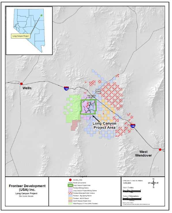
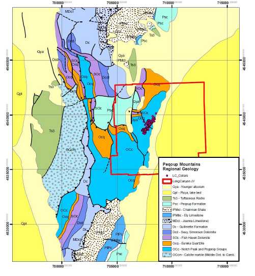
| The Long Canyon project is located in the Pequop Mountains, Elko County, northeastern Nevada, approximately 37 kilometres by road southeast from the town of Wells, Nevada, and approximately 6 kilometres south of Interstate Highway 80. The main area of the Project is defined to include approximately 49 square kilometres of land that is located on the east side of the range (Figure 4-1); additional surface and water rights are also held by Fronteer (discussed below). The approximate geographic centre of the Long Canyon project resources is 40° 58′23.70″N latitude and 114° 31′52.33″W longitude. |
| 4.2 | Land Area |
| | |
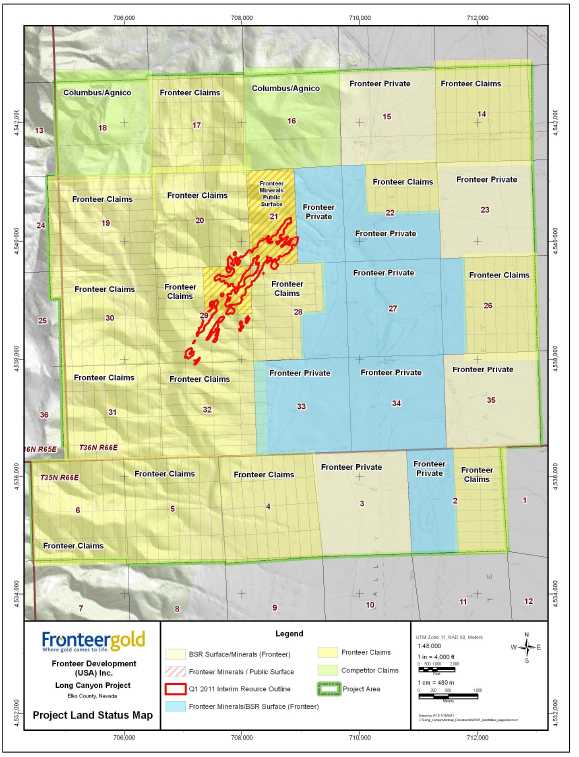
| The Long Canyon Project is controlled 100% by Fronteer. The Project area is defined for the purpose of this report as the former Joint Venture Area of Interest (AOI) boundary (Gustin and Smith, 2009) and includes 477 unpatented mining claims (approximately 3,322 ha) and approximately 1,578 hectares of private mineral rights held by Fronteer or its wholly-owned subsidiary Pittston Nevada Gold Company that lie in portions or all of Sections 14, 17, 19 through 22, and 26 through 34, T36N, R66E and Sections 2, 4, 5 and 6, T35N, R66E, Mount Diablo Baseline and Meridian (Figure 4-2). These claims and mineral rights form a contiguous block of ground. The Project area also includes a few contiguous blocks of third-party claims not controlled by Fronteer (identified as “Columbus” on Figure 4-2), as well as surface and mineral rights owned by Fronteer known as the Big Spring Ranch. |
| | |
| Prior to October 29, 2010, the Project was controlled by a 51%-49% Joint Venture between Fronteer Gold, Inc . and AuEx Ventures, Inc. On October 29, 2010, Fronteer Gold, Inc. acquired AuEx Ventures, Inc. Under the agreement, AuEx shareholders received 0.645 of a Fronteer common share, CDN $0.66 in cash and 0.5 of a Renaissance Gold, Inc. share. Renaissance Gold, Inc . received all properties owned by AuEx outside of the northern Pequop Mountains and CDN$5 million in cash. The fully diluted equity value of the transaction was valued at CDN$280.8 million. After the transaction, former AuEx shareholders held 18.6% of outstanding shares of Fronteer, while Fronteer held 9.9% of Renaissance Gold Shares. The agreement gave Fronteer 100% ownership of the Long Canyon Property, a 49% carried interest (in Joint Venture with Agnico Eagle Mines) of the West Pequop Property, located to the west of Long Canyon, 100% interest in the Pequop South Property located to the southwest of Long Canyon, subject to a 70% earn- in agreement with Golden Dory, Inc. and title to two square miles of unpatented claims located immediately south of the Long Canyon Project area. |
| | |
| Unpatented Claims. The numbers of claims reported in this section are current as of December 15, 2010 and are listed in Appendix A. |
| | |
| The unpatented claims within the project are located in the field with wooden posts that meet Nevada regulations. The validity and location of unpatented mining claims staked |
| Fronteer Gold Inc. |
| Long Canyon Project, Elko County, Nevada |
| Updated Technical Report and Interim Resource Estimate |
prior to 2006 have not been independently verified in the field. A review is currently underway involving field examination and surveying of section corners and selected claims. Claims staked subsequent to 2006 were located using a differential GPS system accurate to within 10 centimetres. Fronteer represents that the list of unpatented claims in Appendix A is complete and accurate as of December 15, 2010 and that all claims are valid through August 31, 2011.
Ownership of unpatented mining claims is in the name of the holder (locator), subject to the paramount title of the United States of America, under the administration of the U.S. Bureau of Land Management (“BLM”). Under the Mining Law of 1872, which governs the location of unpatented mining claims on Federal lands, the locator has the right to explore, develop, and mine minerals on unpatented mining claims without payments of production royalties to the U.S. government, subject to the surface management regulation of the BLM. It should also be noted that in recent years there have been efforts in the U.S. Congress to change the 1872 Mining Law to include, among other items, a provision of production royalties to the U.S. government. Currently, annual claim maintenance fees are the only federal payments related to unpatented mining claims. Nevada BLM records of mining claims can be searched on-line atwww.nv.blm.gov/lr2000/. The holding costs of the unpatented mining claims in 2011 are estimated at about $127,081.50 (Table 4-1).
Table 4-1: Unpatented Mining Claims: 2011 Filing and Holding Costs
| BLM Maintenance Fee Payment | $66,780.00 |
| Elko County Annual Filing | $5,016.50 |
| Nevada new fee as per legislature1 | $55,285.00 |
| Total Filing and Holding Cost | $127,081.50 |
1The Nevada legislature recently enacted a one-time fee of $195.00 per claim for companies holding more than 1,299 claims.
| Fronteer Gold Inc. |
| Long Canyon Project, Elko County, Nevada |
| Updated Technical Report and Interim Resource Estimate |
Figure 4-1: Long Canyon Project Location Map
| Fronteer Gold Inc. |
| Long Canyon Project, Elko County, Nevada |
| Updated Technical Report and Interim Resource Estimate |
Figure 4-2: Long Canyon Project Property Map
(resource outline shown in red)
| Fronteer Gold Inc. |
| Long Canyon Project, Elko County, Nevada |
| Updated Technical Report and Interim Resource Estimate |
Private Mineral Rights. Fronteer owns the right to metalliferous minerals in the private mineral estate beneath the Big Spring Ranch surface lands, including Sections 21, 28, and 33, T36N R66E within the defined Long Canyon Project area, as well as areas to the east of the Project area. Fronteer enjoys a broad right to use the surface of the land for exploration and mineral development purposes as successor in interest to the mineral estate reserved pursuant to the mineral reservation in the officially recorded Grant, Bargain, and Sale Deed to Joint Tenants dated October 18, 1946. This mineral reservation reserves to the owner of the mineral estate, (i.e., Fronteer) “...all right, title and interest, to coal, oil, gas and other minerals of every kind and within said lands, including the right to the use of so much of the surface thereof as may be required in prospecting for, in locating, developing, producing and transporting said coal, oil, gas or minerals and any of their byproducts thereof.”
Fronteer acquired these private mineral rights through a series of transactions. Western States Minerals Corporation acquired from its affiliate, Stampede Investments Inc., the private mineral interests of the Bernard H. Grube estate underlying a large part of northeastern Nevada, which Stampede acquired on May 3, 1994. This includes a 75% interest in the mineral rights underlying a portion of the Big Springs Ranch. The additional 25% was acquired from Mobil Exploration and Producing North America Inc. NewWest acquired the metalliferous mineral rights of Western States Minerals Corporation in August 2006 and contributed these mineral rights to the Joint Venture when it was formed in 2006. Fronteer acquired NewWest in 2007. Fronteer acquired the mineral rights underlying the remainder of the Big Spring Ranch when the ranch was purchased on August 19, 2010.
Private Surface Rights.Except for the NE ¼ of Section 29 and the W ½ of Section 21, T36N, R66E, Fronteer owns the surface rights overlying Fronteer’s private minerals throughout the Big Spring Ranch area. The surface estate in the NE ¼ of Section 29 and the W1/2 of Section 21, T36N, R66E is public land managed by BLM. This land, which was formerly part of the Big Spring Ranch, is now BLM-administered public land by virtue of a land exchange with the Big Spring Ranch that closed on May 20, 1999 and was recorded on May 26, 1999.
On July 15, 2009, Fronteer completed the purchase of 47.8 square kilometres of surface rights known as the M&N Ranch, located five to ten kilometres east of the Long Canyon Project area. This acquisition includes 1,657 acre feet of water rights zoned quasi-municipal. Fronteer owns the mineral rights under all of these acquired surface rights. This land was amalgamated into the Big Spring Ranch property.
The surface estate on a small parcel of private land, totaling 4.5 acres, was purchased from the Beaumont Trust in February 2010 by the Joint Venture. Fronteer already owned the mineral rights to this parcel. This parcel was conveyed 100% to Fronteer as part of the acquisition of AuEx, and was amalgamated into the Big Spring Ranch.
On August 19, 2010, Fronteer completed arrangements to purchase the adjacent Big Spring Ranch, including surface rights totaling 37,540 acres , all mineral rights not previously held and some water rights.
| Fronteer Gold Inc. |
| Long Canyon Project, Elko County, Nevada |
| Updated Technical Report and Interim Resource Estimate |
| 4.3 | Agreements and Encumbrances |
| | |
| The Long Canyon Project was formerly subject to a May 23, 2006 Joint Venture agreement between Fronteer and AuEx, whereby Fronteer contributed its private mineral and surface rights and AuEx contributed its federal lode claims. The agreement required Fronteer to earn- in to 51% of the project by spending 5 million dollars (requirement met in September, 2008), after which both companies contributed toward exploration expenses on a 51%/49% basis, with Fronteer as operator of the Joint Venture. Both companies retained a 3% net smelter return (NSR) royalty on their respective lands contributed to the Joint Venture. The Joint Venture, as well as all obligations associated with it, was dissolved on November 2, 2010, when Fronteer purchased AuEx. |
| | |
| Gold production from Long Canyon is subject to the State of Nevada Net Proceeds of Mine Tax, which is limited to 5% of the production net proceeds (similar to a 5% net profits tax). This tax is levied by the State of Nevada on all mine production in the state. |
| | |
| Mobil Exploration and Producing North America Inc . reserved and retained a production royalty of 0.625 percent NSR on certain lands hosting a portion of the Long Canyon Deposit. There is an advance payment of royalty identified in the deed as $350,000 at that time. There appear of record six oil and gas royalties on the production of oil and gas and arguably certain other minerals that purport to burden some of the land. |
| | |
| 4.4 | Location of Mineralization |
| | |
| The gold mineralization identified and drilled thus far on the Long Canyon project is located on both the private land holdings of Fronteer and on public lands, as shown in Figure 4-3. |
| | |
| 4.5 | Environmental Permits and Licenses |
| | |
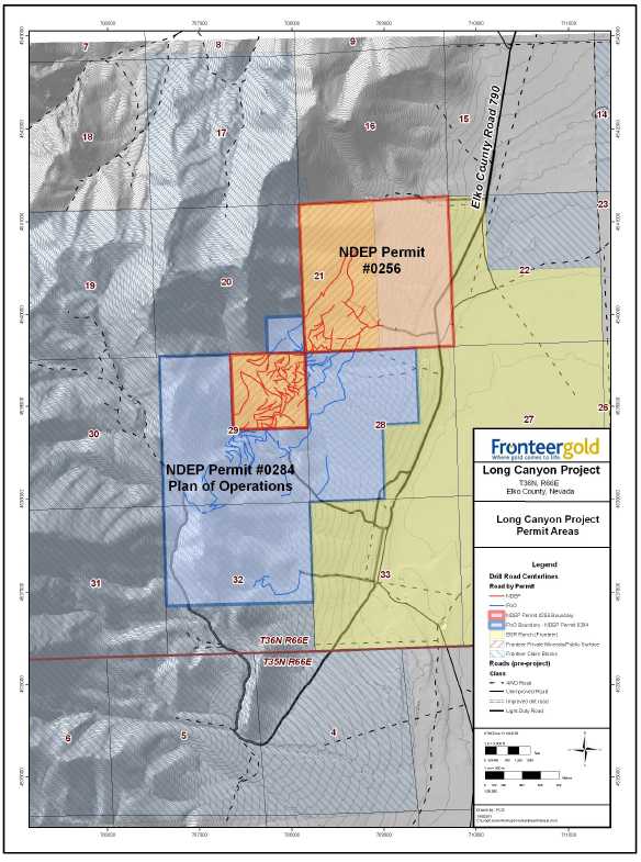
| Fronteer has acquired all of the state and federal regulatory approvals and permits required for the 2011 exploration program. Three permits currently govern exploration activity at Long Canyon: NDEP/BMRR Reclamation Permit No. 0256, NDEP/BMRR Reclamation Permit No. 0284, and BLM Plan of Operations NVN-82445 (Table 4-2). |
| | |
| In March 2010, a Plan Amendment was submitted in accordance with the BLM’s 43 CFR 3809 regulations and the Bureau of Mining Regulation and Reclamation’s (BMRR) Nevada Administrative Code (NAC) 519A regulations. The 2010 Plan Amendment proposal will authorize 69.43 acres of additional disturbance for a total of 114.36 acres of permitted surface disturbance on public lands open to location over a period of ten years. |
| | |
| An Environmental Assessment (EA) was prepared by a third party contractor as required by the National Environmental Policy Act (NEPA) to analyze potential environmental resource impacts associated with the proposed action. The Administrative Draft EA was issued September 2010. A Record of Decision is expected in the 2ndquarter of 2011. |
A Minor Modification application to Reclamation Permit #0256 was prepared and submitted to NDEP-BMRR in December 2010. The permit modification requests
| Fronteer Gold Inc. |
| Long Canyon Project, Elko County, Nevada |
| Updated Technical Report and Interim Resource Estimate |
approval to increase the total permitted surface disturbance covered under this permit by 13.7 acres, from 54.93 acres to 68.63 acres.
Table 4-2: Permits Covering Operations at Long Canyon
| Permit | Land Status | Land Areas | Approval Date | BondAmount | AuthorizedDisturbance | CurrentDisturbance | NewDisturbanceProposed in2010 | Comment |
| NDEP/BMRR Reclamation Permit No. 0256 (amended) | Public and Private Surface & Private Mineral Lands | NE1/4 Section 29, Section 21, T36N, R66E | 19-Mar-09 | $228,200 | 54.93 acres (22.22 ha) | 53.84 acres (21.79 ha) | 13.7 acres 5.54 ha) | Original Permit No. 0256 granted in 2006; amended to authorize additional disturbance in 2009 |
| NDEP/BMRR Reclamation Permit No. 0284/BLM Plan of Operations NVN-82445 (amended) | Public Surface - Mining claims over Public Minerals | Sections 28,29, and 32, SE1/4, SE1/4 Section 20, T36N, R66E, | Permit 0284:
8/28/08 Plan
of Ops:
9/15/2008 | $169,644; secured with $500,000 statewide bond | 44.93 acres (18.18 ha) | 32.31 acres (13.07 ha) | 69.43 acres (28.09 ha) | 44.88 acres (18 .00 ha) of disturbance currently bonded |
| Fronteer Gold Inc. |
| Long Canyon Project, Elko County, Nevada |
| Updated Technical Report and Interim Resource Estimate |
Figure 4-3: Fronteer Claims and Private Mineral Rights Within Drill Area
| Fronteer Gold Inc. |
| Long Canyon Project, Elko County, Nevada |
| Updated Technical Report and Interim Resource Estimate |
Disturbance on Unpatented Mining Claims on Public Lands. BLM Plan of Operations NVN-82445 and the corresponding Nevada Division of Environmental Protection/Bureau of Mining Regulation and Reclamation (“NDEP/BMRR”) Reclamation Permit No. 0284 (the "Plan of Operations") authorizes 44.93 acres (18.18 ha) of surface disturbance in Sections 28, 29, and 32, T36N, R66E, which together form the eastern and central portion of the unpatented mining claims on Federal lands. This disturbance is associated with exploration work that will be conducted in two or more phases over a period of five years. Phase 1 authorized 19.60 acres (7.93 ha) of new surface disturbance, which required a bond of $131,964. Fronteer provided the BLM with a $500,000 Statewide bond to satisfy the $131,964 reclamation bond requirement. Fronteer applied for permission to commence Phase 2 disturbance on a total of 44.88 of the 44.93 acres authorized under the Plan of Operations in July 2009 and received permission on July 10, 2009. Prior to commencing Phase 2, Fronteer provided the BLM with additional financial assurance from the Statewide bond to secure the increased bonding obligation ($169,644). In June 2009, Fronteer filed for an amendment to expand the project boundary of the Plan of Operations to include 40 acres in the extreme southeast corner of Section 20. The BLM approved this amendment in July 2009. No additional bonding was needed, as the total amount of permitted disturbance remained unchanged at 40 acres. A total of 32.31 acres (13.07 ha) had been disturbed under Permit No. 0284 as of December 15, 2010.
Fronteer received new permits to govern the installation of seventeen monitoring wells within the Project Area. These holes, along with the existing six monitoring wells, are designed to test and characterize the aquifer as to water depth, quality, and gradients. Additionally, these holes will give other information with respect to the structural and rock-permeability controls of the aquifer. These holes will also assist in the geotechnical engineering, site characterization, facilities layout, and future permitting activities for the project.
Disturbance on Private Mineral Lands. The Nevada Division of Environmental Protection/Bureau of Mining Regulation and Reclamation (“NDEP/BMRR”) approved an amendment to Reclamation Permit No. 0256 on March 19, 2009, which increases the authorized surface disturbance for exploration activities on private mineral lands to 54.93 acres (22.22 ha). Reclamation Permit No. 0256 governs the exploration activities on the private mineral lands in the NE ¼ of Section 29 and all of Section 21, T36N, R66E, which together form the northwestern part of the area of private mineral rights owned by Fronteer (Figure 4-2). Fronteer provided a reclamation bond in the amount of $228,200 to NDEP/BMRR on April 16, 2009. With this permit in hand, Fronteer extended the road network and drilling effort to the northeast to allow for testing of extensions of the presently identified mineralized zones. As of De ce mb er 15 , 2010, a total of 53. 84 acres (21.79 ha) had been disturbed on private mineral lands subject to NDEP/BMRR Permit No. 0256.
Hydrologic Investigations. In 2009, in order to satisfy a permit condition in the Plan of Operations, Fronteer drilled a supplemental water production well for the cities of Wendover, Utah and West Wendover, Nevada (Cit ies) to address the cities’ concerns about potential impacts from exploration drilling to the nearby Johnson Springs, one of the Cities’ water sources. The well (known as Shafter # 6), wa s completed and tested
| Fronteer Gold Inc. |
| Long Canyon Project, Elko County, Nevada |
| Updated Technical Report and Interim Resource Estimate |
at 530 gallons per minute (33.5 liters per second) continual pumping for 48 hours. The water quality meets all drinking water standards. A well house, pumping and piping facilities, and supplemental power were completed and commissioned in April 2010.
Following completion and testing of the Shafter # 6 well, the Cities and BLM approved a request by Fronteer to allow exploration drilling below the level of the of the Johnson Springs water table (an elevation of 1,731 metres).
In addition to working together on the supplemental well, Fronteer and the Cities have entered into a conceptual Memorandum of Understanding (“MOU”) establishing a mutually beneficial public-sector, private-sector working relationship to characterize and develop groundwater resources that will support future municipal growth and mineral development. Recognizing the importance of these key stakeholders, Fronteer is continuing to work closely with the Cities to enhance all stakeholders’ understanding of the hydrology of the area.
Hydrologic investigations were ongoing in 2010 with the planning, development, and implementation of a large scale aquifer test program. Fronteer worked closely with the Cities to develop a testing program that would provide data and information on the local and regional groundwater aquifer to further advance Fronteer’s mine planning and design. The program includes stressing the aquifer by pumping 2,000 gpm for up to 72 hours continuously, from a large diameter production well while measuring the effects of this pumping on monitoring wells throughout an area of influence.
One test was conducted in 2010 on an existing irrigation well (BSR #1) located south of the project area and east of the range front fault. This test was designed to measure the effects on the Goshute Valley alluvial aquifer. Three monitoring wells were installed near the BSR test well and fitted with continuously recording transducers to record static water levels during the test. Three additional monitoring wells were installed for the test, also fitted with transducers, which will serve as long term environmental monitoring points.
A second test was designed to measure the deep bedrock aquifer in the near vicinity of the ore body. Preparations for this test were not yet completed as of December 15 but included a 1,500 foot, 19-inch diameter production well and three 1500 foot, dual-completion monitoring wells. Other monitoring wells were installed to measure potential effects over a larger area up gradient in the ore zone.
Groundwater discharged from these tests was directed to Fronteer’s BSR Ranch irrigation pastures under a permit issued by NDEP-Bureau of Water Pollution Control (BWPC).
The flow and turbidity measurements at Big Springs and the Johnson Springs complex were a key monitoring parameter of both tests. The Cities and Fronteer developed a target monitoring and termination protocol should the test cause an impact to the base flow of Big Springs. The BSR test had no effect on Big Springs.
| Fronteer Gold Inc. |
| Long Canyon Project, Elko County, Nevada |
| Updated Technical Report and Interim Resource Estimate |
| 4.6 | Environmental Considerations |
| | |
| Environmental liabilities at the Long Canyon Project are limited to the reclamation of disturbed areas resulting from exploration work conducted by Pittston, AuEx, and Fronteer since 2000. Evidence of previous mineral exploration activity consists of several small, widely spaced, shallow prospect pits of unknown origin and age. Class III cultural resource surveys, providing sufficient detail to satisfy the regulatory agencies, were conducted in 2000, 2006, 2007, 2008, and 2009, primarily by ASM Affiliates of Reno, Nevada . These studies recorded some prehistoric and historic artifact sites within the project area. In accordance with applicable permits, exploration activities will avoid or mitigate cultural resources. Mitigation of some cultural sites in the Long Canyon deposit area will be carried out in 2011. |
| | |
| 4.7 | Meteorological and Air Monitor Stations |
| | |
| IML Air Science, a division of Inter- Mountain Laboratories, Inc., (IML) completed the procurement, integration and installation of a solar-powered meteorological monitoring system and third-party monitoring of meteorological data for the project . The system measures wind speed, wind direction, standard deviation of horizontal wind direction, precipitation, relative humidity temperature at two and ten metres, solar radiation, and evaporation. |
| | |
| Fronteer has purchased an air quality monitoring station capable of monitoring both PM2.5 and PM10. Air Sciences Inc . has been retained to procure approvals for the siting and installation of the station and the preparation, submission, and approval of a Quality Assurance Project Plan. |
| Fronteer Gold Inc. |
| Long Canyon Project, Elko County, Nevada |
| Updated Technical Report and Interim Resource Estimate |
This page left intentionally blank.
| Fronteer Gold Inc. |
| Long Canyon Project, Elko County, Nevada |
| Updated Technical Report and Interim Resource Estimate |
| 5 | ACCESSIBILITY, CLIMATE, LOCAL RESOURCES, INFRASTRUCTURE AND PHYSIOGRAPHY |
| | |
| 5.1 | Access to Property |
| | |
| Access to the Long Canyon Project is via Interstate Highway 80 to exit 378 (the Oasis exit), 42 kilometres east of Wells, Nevada, then proceeding 6.4 kilometres south on Elko County Road 790, which is an all-weather gravel road to the Big Spring Ranch. |
| | |
| In April 2009, Fronteer entered into a five- year road maintenance agreement with Elko County. Under the terms of this agreement, Elko County and Fronteer now share the responsibility to maintain County Road 790. Although this road proceeds through the Big Spring Ranch and provides public access to points south of the Ranch, exploration traffic uses a dirt by-pass road that AuEx constructed and improved in 2005. The bypass road circumnavigates the Ranch headquarters on the uphill side. From the by-pass road, several short, unimproved dirt roads access the drill grid area. The drill grid area is located approximately 1.6 kilometres west of the Big Spring Ranch (Figure 5-1) . |
| | |
| 5.2 | Climate |
| | |
| Climate is typical for the high-desert regions of northeastern Nevada with hot, dry summers and cold, snowy winters. Summer high temperatures range from 30°to 38°C, with winter low temperatures typically -20°to -10°C and winter high temperatures of 0°to 5°C. Most of the precipitation in the region falls as snow in the winter months, with lesser precipitation as rain in the spring and thunderstorms during the late summer. Winter storms can deposit several metres of snow, with elevations above 2100 metres being continually snow covered from November through April. |
| | |
| In the absence of all-weather road access to drill sites, a typical exploration-operating season for the Long Canyon project is from mid- May through early November. Improved road access and road maintenance/snow removal equipment could extend the exploration operating season through the winter months if necessary, although winter operations must comply with winter mule deer habitat protection requirements. |
| Fronteer Gold Inc. |
| Long Canyon Project, Elko County, Nevada |
| Updated Technical Report and Interim Resource Estimate |
Figure 5-1: Long Canyon Project Access

| Fronteer Gold Inc. |
| Long Canyon Project, Elko County, Nevada |
| Updated Technical Report and Interim Resource Estimate |
| 5.3 | Physiography |
| | |
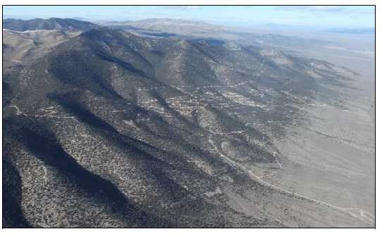
| The Long Canyon project lies in the Basin and Range physiographic province of Nevada and western Utah. The project site is located on the eastern side of the Pequop Mountains in northeastern Nevada, which has elevations ranging from 1675 metres in valley bottoms to over 2750 metres on the ridge tops. Elevations for Long Canyon exploration drill-hole collars range from 1900 to 2050 metres. |
| | |
| The lower slopes of the project area are covered by sagebrush, progressing up-slope to piñon and juniper woodlands typical of high-desert mountain vegetation in northeast Nevada. Locally scattered subalpine fir, limber pine, and mountain mahogany are present at higher slope elevations, giving way to sagebrush and grasses on ridge tops. The majority of the Long Canyon exploration activities to date have been in tree-covered (piñon and juniper) areas on the lowermost, eastern slopes of the range. The resource area lies on moderate to steep slopes that require road construction to develop drill sites and access. |
| | |
| 5.4 | Local Resources and Infrastructure |
| | |
| Reverse circulation (“RC”) and diamond core drilling (“core”) contractors, heavy equipment contractors, and field technical personnel to support continued exploration activities are all available from service companies and contractors in Elko, Nevada. Should an economic gold deposit be delineated on the Long Canyon project, experienced mining personnel and equipment suppliers are available in Elko as well as elsewhere in Nevada. |
| | |
| Electric power for domestic use extends to the Big Spring Ranch. The nearest major power grid is near an east-west rail line located approximately 15 kilometres north of the Long Canyon project, north of Interstate 80. |
| | |
| Water for drilling at Long Canyon is available from a well at the Oasis Truck Stop located 6.4 kilometres north of the project. Fronteer has a five-year lease with the owner of the truck stop to use water from the well to support the exploration activities. Fronteer has also obtained a temporary waiver from the Nevada Division of Water Resources authorizing the use of water from the Oasis well for mineral exploration drilling and dust control at the Long Canyon project . The agreement with Oasis also allows Fronteer to lease land for the purpose of establishing a field headquarters to support the Long Canyon project. Infrastructure at this location consists of a fenced yard with three trailers utilized for project activities, as well as access to water, power, electricity, phone, and high-speed internet. |
| | |
| Accommodations for field personnel are available in Wells, Nevada, the nearest town to provide food and lodging (Figure 4-1). The town of Wendover, located approximately 48 kilometres to the east on Interstate 80, is another alternative used by drilling contractors. There is no campsite or other housing facilities on the project . |
| Fronteer Gold Inc. |
| Long Canyon Project, Elko County, Nevada |
| Updated Technical Report and Interim Resource Estimate |
��
This page left intentionally blank.
| Fronteer Gold Inc. |
| Long Canyon Project, Elko County, Nevada |
| Updated Technical Report and Interim Resource Estimate |
| 6 | HISTORY |
| | |
| This section describes work conducted prior to formation of the Fronteer-AuEx Joint Venture in 2006, and briefly summarizes work conducted by the Joint Venture through 2009. Some specifics of the Pittston exploration program were provided by S. Green and S. Mason, former Pittston employees. |
| | |
| Aside from a few, small, historical lead-zinc prospect pits within the Long Canyon Project area, there is no evidence of any historical mining production. |
Pittston conducted the first known modern gold exploration within the Pequop Mountains in 1994 when it conducted a regional Bulk Leach Extractable Gold (“BLEG”) sampling program. This program returned anomalous gold from dry washes draining the western flanks of the Pequop Mountains. Pittston expanded this program to include the Long Canyon project area on the east side of the range in 1999. A number of BLEG samples in the Long Canyon region yielded anomalous gold (Figure 6-1).
Figure 6-1: Pittston BLEG Anomalies, 2000 Soil Anomalies, and Drill-Hole Collars

The detailed BLEG sampling was followed by prospecting up drainage and the discovery of gold- bearing jasperoids. Ridge-and-spur soil sampling followed, as well as soil sampling on a 61 metres x 61 metres grid up drainage from anomalous BLEG
| Fronteer Gold Inc. |
| Long Canyon Project, Elko County, Nevada |
| Updated Technical Report and Interim Resource Estimate |
| samples and over areas that yielded gold-bearing jasperoids. Pittston staked the first claims of record at Long Canyon in 2000. The soil sampling yielded a >25ppb soil anomaly over 1.5-kilometre long, elongate in a northeast direction (Figure 6-1). In addition to gold, multi-element ICP geochemical analyses showed anomalous arsenic, antimony, and mercury to be present in areas of anomalous gold. Rock chip sampling and road cut sampling were also done in advance of drilling. |
| | |
| Later in 2000, Pittston drilled seven RC holes, for a total of 1148 metres, to test the far northeastern portion of the soil anomaly. Five holes encountered weak gold mineralization, but the discovery hole, LC-03, encountered 21 metres averaging 2.7 g Au/t, including 3 metres averaging 5 g Au/t . |
| | |
| Pittston terminated exploration activities in the U.S. in December 2000. AuEx acquired Pittston in August 2004 and renewed exploration at Long Canyon in 2005, including mapping, surface sampling, road- cut sampling, and drilling. The drill program consisted of seven RC holes for a total of 768 metres. Significant gold mineralization was encountered in six of the seven holes. |
| | |
| In November 2005, NewWest Gold recognized that some of the claims controlled by AuEx at Long Canyon covered public surface lands but were underlain by private mineral rights owned by NewWest Gold and therefore were not open to mineral entry and staking. As a result, a Joint Venture agreement for the Long Canyon project was drafted between NewWest Gold and AuEx, with NewWest contributing private mineral lands and AuEx contributing federal lode claims. |
| | |
| NewWest operated the Joint Venture and conducted all exploration at Long Canyon property between May 23, 2006 and September, 2007, at which point Fronteer purchased NewWest Gold and assumed its interest and earn- in commitment in the Long Canyon project. In September, 2008, Fronteer completed its earn-in to a 51% interest in the Project . A total of 132 holes (20,400 m) were drilled between 2006 and September of 2008. Subsequently, the Project was operated as a Joint Venture with Fronteer as operator through November 2, 2010. On that date, Fronteer assumed a 100% interest in the Project through a buy-out of AuEx Ventures. Fronteer completed 624 holes between the earn-in date and the effective date of this report, and completed resource estimates in March, 2009 and May, 2010. Work completed by Fronteer for the Joint Venture is described in subsequent sections of this report. |
| | |
| 6.1 | Historic Mineral Resource and Reserve Estimates/Production |
| | |
| There is no known historical mineral production from, or resource or reserve estimate for, the project or immediately adjacent properties. |
| Fronteer Gold Inc. |
| Long Canyon Project, Elko County, Nevada |
| Updated Technical Report and Interim Resource Estimate |
| 7 | GEOLOGIC SETTING |
| | |
| 7.1 | Regional Geology |
| | |
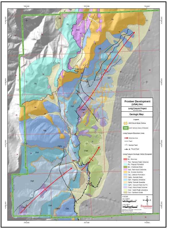
| Most of northeast Nevada is underlain by carbonate and siliciclastic rocks that record a passive margin setting throughout most of the Lower Paleozoic, transitioning to a more active continental margin from the mid-Paleozoic onward. A major east -trending, crustal- scale fault known as the Wells Fault of unknown (post mid-Paleozoic) age, separates primarily platform and platform margin rocks on the south side of the fault (including most of the Pequop Mountains, shown in Figure 7-1) from platform margin and slope facies to the north. This separation suggests considerable (tens of kilometres) right-lateral offset across the fault (Thormanet al., 1992). In the Long Canyon project area, Cambrian and Ordovician rocks record many cycles of sea level rise and fall, with periods of low sea level marked by dolomite horizons and sheets of cross -bedded orthoquartzite . |
| | |
| To the north of the Wells Fault, the Paleozoic section records the mid-Paleozoic Antler Orogeny in the form of the Roberts Mountains thrust fault and emplacement of deeper- water siliciclastic rocks of the Roberts Mountains allochthon over platform and slope facies rocks. To the south of the Wells Fault, the Antler Orogeny is manifested by thick accumulations of foreland-basin sediments of Early Mississippian age that were shed eastward off the Roberts Mountains allochthon. |
| | |
| In Jurassic time, rocks throughout northeastern Nevada and easternmost Utah were affected by the Elko Orogeny (Thormanet al.,1992). The Elko Orogeny resulted in metamorphism and plastic deformation of primarily Lower Paleozoic strata over a large area. Manifestations include weak to strong, near- bedding-parallel foliation, northeast -trending folds, east -southeast-trending stretching lineations, and older-over- younger and younger- over-older layer-parallel faults (attenuation faults). Metamorphic effects are strong in the Wood Hills to the west of the Pequop Mountains, weaker in the western Pequop Mountains, and weaker still in the Long Canyon project area. The Elko Orogeny is presumed to be approximately coeval with Jurassic plutonism in eastern Nevada. |
| | |
| The Tertiary Period includes a number of episodes of extension in the Great Basin, including Eocene volcanism and normal faulting and mid-Tertiary low-angle listric normal faulting. The latter includes periods of “hyperextension” from approximately 33 to 20 Ma, including the formation and unroofing of the Ruby Mountains Core Complex, located approximately 80 kilometres to the west . Rocks as young as 10 Ma in the eastern Great Basin are tilted up to 50°to the east, suggesting that low-angle normal faulting continued until fairly recently. High-angle basin and range faulting, resulting in the familiar pattern of mountain ranges and valleys, continues to the present . Most ranges, including the Pequop Mountains, are bounded by steep faults on one or both sides. |
Gold occurrences in the eastern Great Basin are widely spaced and generally small, but most appear to be of the sediment-hosted type that is more prolific and well
| Fronteer Gold Inc. |
| Long Canyon Project, Elko County, Nevada |
| Updated Technical Report and Interim Resource Estimate |
documented in the Carlin and Cortez Trends in the central Great Basin. Mineralization of this type was emplaced approximately 38 - 40 million years ago throughout the region, more or less coeval with two phases of felsic to intermediate volcanism in the region. Some examples are present in the vicinity of the Pequop Mountains, including the Tug and KB deposits, located to the northeast. Gold is also associated with mid-Jurassic intrusions in the region, including some or all of the mineralization at Bald Mountain, located to the southwest of Long Canyon.
The following discussion of property geology is based primarily on the mapping and interpretation of Smith (2009), which built upon earlier efforts by AuEx and Pittston. The reader is referred to unpublished company reports by consulting stratigrapher Jon Thorson (2007, 2008) for more details on the stratigraphy of the Notch Peak Formation and Pogonip Group. Previous mapping in the Long Canyon area was carried out by Thorman (1970), Camillari (1994), Coolbaugh (2006), and Pittston geologists, who provided a framework for subsequent work. Thompson (2009) mapped portions of the Long Canyon project area in 2009.
Figure 7-1: Regional Geologic Map of Long Canyon Area
| Fronteer Gold Inc. |
| Long Canyon Project, Elko County, Nevada |
| Updated Technical Report and Interim Resource Estimate |
| 7.2.1 | Project-Scale Lithology |
| | |
| The Pequop Mountains are underlain primarily by Paleozoic carbonate rocks and lesser siliciclastic rocks representing a transition from slope through platform facies over time (Figure 7-2). The Long Canyon project is underlain primarily by the Notch Peak Formation and the Ordovician Pogonip Group and Eureka Quartzite, with younger rocks (Fish Haven Dolomite, Chainman Shale, and Pequop Formation) mapped on the northern boundary of the project area. On a property- wide scale, stratigraphic units presented in this report (Figure 7-3) reflect mappable subdivisions defined by Smith (2009) for regional mapping efforts. Additional stratigraphic detail at the top of the Notch Peak Formation and the base of the Pogonip Group is also described below, as these units appear to significantly influence the distribution of gold mineralization at Long Canyon. |
Cambrian Candland Shale. Thinly bedded calcareous siltstone and silty limestone are exposed at the extreme south end of Long Canyon ridge. The strata, as well as the contact with the overlying Notch Peak Formation, are highly strained, but the contact appears to be depositional. These strata are tentatively assigned to the Candland Shale (Ccs) mapped elsewhere in the region based on discussions with Jon Thorson (pers. comm., 2008.)
Cambrian Notch Peak Formation. Cambrian carbonate rocks are widely distributed in the region, but are mostly referred to as “undifferentiated”. The name “Notch Peak Formation” is used to describe mainly massive limestone and/or dolomite in adjacent ranges to the east, and has been adopted here.
The lowest mappable unit in the Notch Peak (Cnp1) consists of a massive dolomite horizon approximately 20 to 30-metres thick exposed in the extreme south end of Long Canyon ridge. Overlying the massive dolomite unit in the southern part of the project area is a unit of unknown thickness (probably up to a few hundred metres thick) of fairly massive dolomite and limestone with 3 to 5-centimetres thick chert ribbons and nodules (Cnp2). Dolomite is suspected to be a secondary feature (late diagenetic, metamorphic, or possibly hydrothermal).
The Cnp2 unit grades upward into mainly limestone (Cnp3). This unit consists of an amalgamation of at least four shallowing-upward depositional cycles. Overall, however, the unit can be characterized by the predominance of fairly massive, medium- to thick-bedded, medium to pale grey, sparsely fossiliferous, finely crystalline limestone with areas of thinner, silty interbeds. Small-scale depositional features, including fossil hash, oolitic and oncolitic horizons, and rarely mudcracks, are noted locally. Several small dolomite lenses have also been mapped within the Cnp3 unit. Some appear to be derived from primary dolomitic deposits, while others appear to be related to alteration along fault zones or fold hinges.
The highest unit in the Notch Peak Formation consists of a thick (approximately 75 metres) sequence of massive dolomite (Cnp4). This unit ranges from light to dark grey in
| Fronteer Gold Inc. |
| Long Canyon Project, Elko County, Nevada |
| Updated Technical Report and Interim Resource Estimate |
colour, from coarse to (rarely) fine grained, and from massive to (rarely) well bedded, probably reflecting varying degrees of secondary recrystallization.
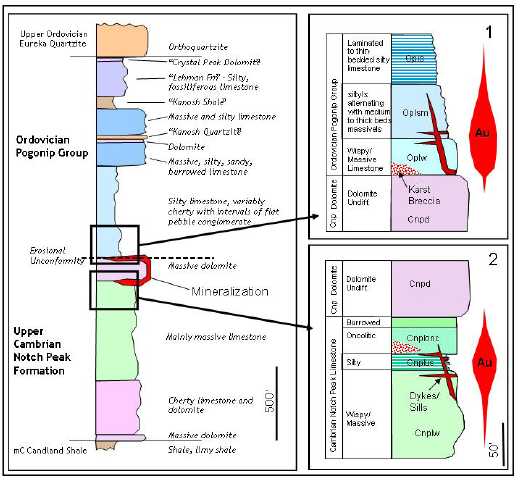
Ordovician Pogonip Group. Following the deposition of the Notch Peak Formation, there was likely an emergent period (global sea level low-stand) spanning up to several million years, represented by an erosional unconformity and local areas where a paleosol and/or breccias are present between the top of the Notch Peak Formation and the base of the Pogonip Group.
The Pogonip Group in the map area is suspected to be up to 600 metres thick, and on the scale of the mapping for this report, is comprised of six main units and several sub-units. Nomenclature varies considerably throughout the region, likely a result of facies changes and the formation’s broad regional extents (from eastern California to western Utah). Thorman (1970), following Hintze (1951), divided the Pogonip Group in the Wood Hills and Pequop Range into four formations, which include (from lowest to highest) the Wahwah and Juab Limestone, Kanosh Shale, Lehman Formation and Crystal Peak Dolomite. The Wahwah and Juab Formations are also known as the Garden City Formation in the Toano Range. In the Toano Range, a quartzite referred to as the Swan Peak Quartzite occurs between the Lehman Formation and the Crystal Peak Dolomite. Smith (2009) used a numbering system based on units felt to be consistently and reliably applicable in the field at the scale of mapping (approximately 1:2400).
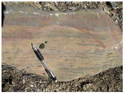
The basal unit of the Pogonip Group in the Long Canyon area (Op1) is the host for much of the mineralization in the Long Canyon deposit, and consists of recessive, thin-bedded, silty limestone (Figure 7-4) with thicker (up to one metre thick) interbeds and areas of more massive limestone. Limestone ranges from medium grey to buff and typically weathers in a platy, rounded habit. Chert (probably diagenetic) comprises approximately 5% of the lower part of this unit. Thicker beds are often conglomeratic, with tabular limestone clasts in a sandy (grainstone) matrix. Near the top of the section in the north, Op1 is very recessive and poorly exposed, covered by an apron of talus from the overlying, cliff forming unit Op2.
Unit Op2 is a massive, cliff-forming unit exposed mainly in the northern part of the map area. The unit consists of massive beds of heavily burrowed limestone. Burrow fill consists of tan-weathering, partly dolomitic, silty, buff-coloured, partially silicified limestone, giving the rock a “net-textured” or nodular appearance.
Unit Op3 consists of approximately 15 metres of white, cross-bedded quartz arenite. In the Wood Hills, this quartzite is named the “Kanosh Quartzite” by Thorman (1970). This unit is flanked by dolomitic sandy limestone in some areas.
| Fronteer Gold Inc. |
| Long Canyon Project, Elko County, Nevada |
| Updated Technical Report and Interim Resource Estimate |
Figure 7-2: Long Canyon Project Geologic Map (after Smith,2009).
| Fronteer Gold Inc. |
| Long Canyon Project, Elko County, Nevada |
| Updated Technical Report and Interim Resource Estimate |
Figure 7-3: Stratigraphic column of the lower Pogonip Group and upper Notch Peak Formation
(after Smith, 2009; Thorson, 2007, 2008)

| Fronteer Gold Inc. |
| Long Canyon Project, Elko County, Nevada |
| Updated Technical Report and Interim Resource Estimate |
Figure 7-4: Silty, Thin-bedded to Laminated Limestone of Lower Pogonip Group (Op1)
Unit Op4 is similar in nature to unit Op2, consisting of fairly massive, burrowed, “net textured” to nodular, silty limestone, as well as massively bedded limestone with minor wispy silt laminae, cherty limestone, and grainstone.
Unit Op5 consists of a very recessive weathering shale horizon, known regionally as the “Kanosh Shale”. The Kanosh Shale is rarely exposed, and is usually defined by a zone of grey- to olive- weathering shale and thin-bedded silty limestone float with very minor outcrop of thin-bedded, silty limestone. Shale typically displays a slaty cleavage at low angles to bedding.
Unit Op6 consists mainly of massive grey limestone with 20% to 70% buff to red silt “wisps”. Silt wisps were likely continuous silty beds, which have been deformed into a series of rootless isoclinal folds on a centimetre scale. In some areas, this unit is overlain by the Crystal Peak Dolomite, a thin, highly fossiliferous stratigraphic unit.
Ordovician Eureka Quartzite.The Ordovician Eureka Quartzite caps the higher ridges above and to the north and west of the Long Canyon deposit. The Eureka quartzite consists of white to pale grey, hard, massive, variably cross-bedded orthoquartzite, and exceeds 100 metres in thickness in this area. The contact with the underlying Pogonip Group is usually covered by thick talus. Where exposed, quartzite near the base of the unit is often brecciated and re-healed with silica, suggesting the bottom contact may be modified by low-angle, layer-parallel faulting.
Units present in the Long Canyon project area above the Eureka Quartzite include the Late Ordovician to Silurian Fish Haven Dolomite, Mississippian Chainman Shale, and the Permian Pequop Formation.
| Fronteer Gold Inc. |
| Long Canyon Project, Elko County, Nevada |
| Updated Technical Report and Interim Resource Estimate |
| Lamprophyre Sills and Dikes. Thin lamprophyric sills and dikes are present throughout the map area, usually as rubble trains. Most of the sills and dikes are less than one- metre thick. The rock is fine to medium grained and variably porphyritic. Whole-rock data from variably altered samples shows silica content as low as 38% and elevated Ni, Cr, Co, K, V, Ba, and P. They are invariably altered, with alteration ranging from propylitic (chlorite- muscovite -phlogopite) to argillic and/or phyllic altered in mineralized zones. Secondary biotite is suspected in some areas. Sills range from nearly undeformed to strongly foliated. Examination of dikes and sills in road cuts suggests that they crosscut second-phase folds and are thus post -metamorphic. The foliation is largely internal to the dikes, which suggests that it is formed by squeezing the phyllosilicate-rich rocks between rigid buttresses of limestone. Lamprophyre dikes and sills may be found throughout the deposit, but appear to concentrate in linear, northeast -trending swarms that closely (but not exactly) parallel boudin margins. |
| | |
| Nannie’s Peak Volcanic Rocks. Felsic volcanic and/or shallow intrusive rocks are noted in two locations on the property, one at the bottom of Long Canyon and a second near the northern property boundary. The rock most often is massive and crowded with quartz, feldspar, and biotite phenocrysts. The Nannie’s Peak volcanic rocks have been dated as approximately 41 Ma. |
| | |
| Quaternary/Holocene Unconsolidated Deposits. Lower elevations of the map area are covered by alluvium, characterized by the presence of relatively rounded boulders (up to several metres in diameter) of Eureka Quartzite, as well as a diverse range of other lithologies. IP resistivity data suggest that the alluvial deposits thicken gradually basinward, and then thicken abruptly on the east side of a high- angle Basin and Range fault . |
| | |
| 7.2.2 | Deposit Scale Lithology |
| | |
| Additional core drilling in 2009 made it possible to break out distinct lithologic units above and below the Notch Peak Dolomite (Figure 7-5 and Figure 7-6). These units appear to control the distribution of mineralization to a degree not recognized in previous drilling. From approximately 100 metres below the top of the Cnp3 unit, progressing up section, the following units were broken out: |
| | |
| Cnplw: “Wispy Massive Limestone”A unit of variable thickness comprised of laminated to thin beds of limestone and silty limestone to siltstone or shale. This unit is variably bioturbated, with coarser, cleaner limestone filling burrows. This activity, as well as ductile strain, parsed the silty laminations into discontinuous small lenses or “wisps”. In some areas, thin to medium beds of sand-sized bioclastic material is also present. This unit grades down into bioclastic to oolitic limestone, and up into Cnplus. |
| | |
| Cnplus: “Upper Siltstone”The upper siltstone unit is made up of alternating 1 to 2 metre thick intervals of thin-bedded to laminated silty limestone, siltstone, and shaly limestone with 1 to 3 metre- thick intervals of massive oncolitic limestone (Figure 7-7). Silty intervals are dark grey fresh, but are very prone to alteration/oxidation and typically appear tan, orange, or red where mineralized (Figure 7-7 and Figure 7-8). |
| Fronteer Gold Inc. |
| Long Canyon Project, Elko County, Nevada |
| Updated Technical Report and Interim Resource Estimate |
Oncolitic horizons are typically medium grey. Oncolites often contain grainy brown dolomite rhombs. The unit as a whole ranges from a few metres to approximately 12 metres thick depending on degree of strain (which is quite variably close to the Notch Peak Dolomite), layer parallel attenuation faulting, and other factors.
Cnplonc: “Oncolitic Limestone”The upper siltstone is bounded on the top by a thick horizon of massive oncolitic limestone, which was originally identified in 2008 field mapping. It is identical to the oncolitic limestone interlayered with siltstone in the Cnplus unit, but lacks the siltstone horizons. It is of variable thickness, but typically 10 to 12-metres thick. It is notably thinned in areas of high ductile strain, such as near or within boudin neck areas. The Cnplonc unit is gradational upward into unit Cnplbu.
Figure 7-5: Stratigraphy Immediately Above and Below the Notch Peak Dolomite
| Fronteer Gold Inc. |
| Long Canyon Project, Elko County, Nevada |
| Updated Technical Report and Interim Resource Estimate |
Figure 7-6: Altered Stratigraphic Equivalents Immediately Below the Notch Peak Dolomite
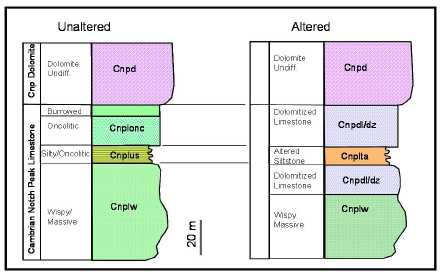
Figure 7-7: Relatively Unaltered Cnplus “Upper Siltstone” Unit
(Massive oncolitic limestone (pale grey) interlayered with intervals of silty limestone
(dark grey)).
| Fronteer Gold Inc. |
| Long Canyon Project, Elko County, Nevada |
| Updated Technical Report and Interim Resource Estimate |
Figure 7-8: Dolomite-Altered Equivalent of the Cnplus “Upper Siltstone” Unit
(Tan areas (Cnplt) are after the silty limestone, grey areas are dolomitized oncolitic
limestone (protolith textures are preserved).
Cnplbu: “Burrowed Limestone”A massive unit consisting of bioturbated/burrowed limestone lies above the Cnplonc. Overall, the unit is very massive, and has a distinctive mottled, light to medium grey appearance. Some oncolites may be present near the base of this unit. The unit is probably over 20-metres thick, but is only rarely seen in its entirety due to variable degrees of dolomitization at the base of the Notch Peak Dolomite.
Together, these newly-defined units form a distinctive package that has proved useful in defining the structural setting and alteration in and around the base of the Notch Peak Dolomite. For example, the oncolitic limestone unit proves to be very robust in terms of recognizing protolith types despite profound dolomitization. The Cnplus unit is also a useful marker in dolomitized areas (see below). Finally, the Cnplus unit is the most important unit at the top of the Notch Peak Formation from an economic standpoint, as it appears to be the best conduit and host for gold mineralization.
The lowermost portion of the Pogonip Group (unit Op1 of Smith, 2009) was also examined in some detail during core logging. While not as precisely defined as the upper portion of the Notch Peak Limestone, there is still a crude stratigraphy that can be discerned in it.
Oplw: “Wispy Massive Limestone”This unit is very similar in nature to unit Cnplw, consisting of massive, pale to medium grey limestone with silt wisps defined by silt/shale laminations, dismembered by burrowing activity and ductile strain (Figure 7-9). This unit averages approximately 10 to 12 metres thick, and directly overlies the Notch
| Fronteer Gold Inc. |
| Long Canyon Project, Elko County, Nevada |
| Updated Technical Report and Interim Resource Estimate |
Peak Dolomite on a sharp contact. This unit is where most of the solution breccia-hosted gold mineralization in the Pogonip Group is hosted (Figure 7-5, Figure 7-10).
Figure 7-9: Relatively Unaltered “Wispy Massive” Limestone (Oplw)
Figure 7-10: Mineralized Equivalent of the Oplw Unit
| Fronteer Gold Inc. |
| Long Canyon Project, Elko County, Nevada |
| Updated Technical Report and Interim Resource Estimate |
Opsm: “Silty/Massive Limestone”Above unit Oplw, there is a zone of alternating, approximately one metre thick beds of massive limestone, alternating with approximately one metre thick intervals of laminated to thin-bedded silty limestone, limy siltstone and shaly limestone (Figure 7-11). This unit is of variable thickness but probably averages approximately 10 to 20 metres thick. It bears a superficial resemblance to unit Cnplus, the upper siltstone unit in the Notch Peak Limestone, but lacks oncolites in the massive beds. This unit is gradational into gradually thinner, thick to medium beds of massive limestone alternating with intervals of laminated to thin bedded silty limestone, eventually giving way upwards into predominantly laminated to thin bedded silty limestone, limy siltstone, and shaly limestone.
Figure 7-11: Opsm Unit
Alternating Massive (grey) and Weakly-Altered Laminated/Thinly Bedded Limestone
(orange)
| 7.2.3 | Structure |
| | |
| The structural history of the Long Canyon area was elucidated primarily through geological mapping, examination of drill core, and research. |
| | |
| The structural history of the Long Canyon area is complex, with at least four deformational events. These events are generally not well described or dated in the eastern Great Basin, but some tentative correlations can be made between regional and local events. Strata throughout the area are characterized by a penetrative fabric at low angles to bedding, local areas of tight to isoclinal, intrafolial folds on a centimetre scale, development of a southeast -plunging stretching lineation, northeast -trending folds, and boudinage, on a regional scale, of brittle dolomite units. The ductile deformation event |
| Fronteer Gold Inc. |
| Long Canyon Project, Elko County, Nevada |
| Updated Technical Report and Interim Resource Estimate |
that created these structures is attributed to the Jurassic Elko Orogeny.
Northeast-trending folds include open to tight and upright to overturned folds. All fold the foliation, but some appear to be fairly ductile in nature, while others range from tight folds to kink folds. A northeast- plunging crenulation lineation is present locally. Two roughly coaxial phases of folding are suspected.
Faults range from early, ductile, older-over-younger and younger-over-older low-angle faults, to more brittle low-angle to moderate-angle reverse and normal faults, to late brittle northwest- and northeast- striking faults.
The deformational history is described below in a spectrum from older, more ductile deformation to younger, more brittle deformation.
Jurassic(?) Ductile Deformation. The Jurassic Elko Orogeny was defined by Thormanet al. (1991), although the existence of ductilely deformed rocks in the eastern Great Basin has been documented for several decades by many different researchers. The lines of evidence that are most compelling in terms of documenting a mid-Mesozoic orogenic event in the eastern Great Basin are: 1) ductile folds and other fabrics in rocks as young as early Mesozoic are crosscut by approximately 155 Ma intrusive rocks in several mountain ranges; and 2) the presence of the Morrison Formation, comprising one thousand metres or more of terriginous sediment of mid- to Late Jurassic age, in Utah and Colourado, interpreted as foreland-basin sediments shed off the Elko orogenic highland.
The earliest deformation documented in the Long Canyon area is manifested by variable development of a penetrative cleavage or foliation in all calcareous or dolomitic rocks. Foliation is defined by a slaty to phyllitic cleavage in silty or shaly rocks, or by recrystallization of calcite or dolomite in more massive rocks. The foliation typically is parallel to or slightly discordant to bedding in thin-bedded, shaly or silty units, and refracts and is more discordant in massive or thick-bedded units. It is only weakly developed in dolomite, and is absent in quartzite. Locally, such as along the lower contact of the dolomite unit (Cnp4), the foliation is particularly strongly developed. This deformation is locally accompanied by a NW-SE to WNW-ESE stretching lineation in the plane of the foliation.
The most profound manifestation of the Elko Orogeny in the Long Canyon area consists of boudinage of the thick, brittle dolomite horizon at the top of the Notch Peak Formation. The development of these dolomite boudins created structural/stratigraphic settings that were critical to the localization of the Long Canyon mineralization. The boudinage is interpreted by examination of mapped outcrops, drill intercepts, and observation of bedding and foliation directions both internal and external to the boudins. At the top or the bottom of a boudin, bedding in the dolomite and overlying or underlying limestone is parallel or subparallel, and generally dips gently to the southeast (Figure 7-12). Along a block nose (the terminated end of a boudin), the bedding/foliation in the enveloping limestone wraps around the nose and may be vertical or locally overturned, whereas the bedding in the dolomite remains unchanged
| Fronteer Gold Inc. |
| Long Canyon Project, Elko County, Nevada |
| Updated Technical Report and Interim Resource Estimate |
(Figure 7-13 and Figure 7-14). Bedding in the dolomite unit is difficult to discern close to a block nose as the dolomite is typically recrystallized, strongly jointed, and locally brecciated.
Boudins are irregular in shape, although boudin necks (the area between adjacent boudins) generally trend north to northeast, perpendicular to the stretching lineations. The thin-bedded basal Pogonip limestones are often highly folded and contorted along the limestone-on-limestone contacts in the boudin neck areas. Where the boudins are covered by the Pogonip Group, boudin necks in the subsurface can be traced for some distance by mapping of north- to northeast-trending synclines in the lowermost Pogonip Group rocks.
Folding associated with the Elko Orogeny in the Long Canyon area appears to be in large part controlled by the megaboudinage of the Notch Peak dolomite. The largest folds in the area occur in the Notch Peak Formation limestone, where boudin necks accommodate the limestone by formation of open, ductile, upright anticlines, and to a lesser extent in the overlying Pogonip Group, where boudin necks accommodate the limestone by formation of upright synclines. Hinge areas are rounded and tend to be massive. Bedding and foliation are difficult to discern, possibly due to recrystallization. The foliation is folded, suggesting that the folding event happened later than initial foliation of the rocks. No secondary axial planar cleavage is discernable in these folds.
Figure 7-12: Top of Dolomite Boudin Block
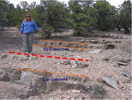
(Note that bedding and foliation (orange) are parallel to the contact between the Cnp and Op)
| Fronteer Gold Inc. |
| Long Canyon Project, Elko County, Nevada |
| Updated Technical Report and Interim Resource Estimate |
Figure 7-13: Dolomite Boudin Nose/Edge
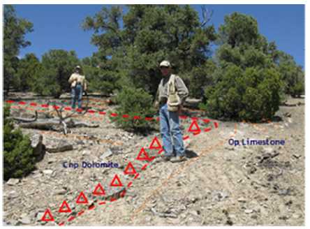
(Bedding in the Cnp dolomite is truncated, whereas bedding/foliation in the Op limestone is folded over the boudin nose.)
Figure 7-14: Dolomite Boudin-Nose Contact
(Op limestone is highly strained, with near-vertical orientation of foliation.)
The basal part of the Pogonip Group in the boudin necks and along boudin noses is characterized by tight folding on a centimetre scale, with the foliation axial planar to the folds.
| Fronteer Gold Inc. |
| Long Canyon Project, Elko County, Nevada |
| Updated Technical Report and Interim Resource Estimate |
Open upright folds and intrafolial folds described above are affected by a later, roughly coaxial phase of folding that is more brittle in nature. These folds, which occur primarily in units immediately above and below the Notch Peak dolomite, have more angular hinge areas than the early, open folds, and a weakly developed axial planar cleavage. These folds may in part represent “tightening” of the axial areas of earlier folds as deformation progressed. The late fold set is also manifested as a northeast-trending crenulation lineation locally visible in the plane of foliation where the foliation is developed in silty rocks.
Bedding-parallel thrust faults and attenuation faults have also been noted within the project area.
Post – Jurassic Deformation. Structures attributed to post-Jurassic tectonism are generally brittle in nature. These may be in part associated with the Late Cretaceous Sevier Orogeny. Structures noted in the project area include:
| | • | Moderate-angle, west -northwest-dipping reverse faults; |
| | • | Low to moderate -angle, west -dipping normal faults; |
| | • | Tight folds with northeast -plunging axes and variously oriented axial planes; |
| | • | Northeast -trending, high-angle breccia zones. |
Brittle structures noted within the drilled area are described below.
North- to northwest-trending high-angle faults are believed to be common in the map area, although they tend to occupy gullies and rarely outcrop. These faults can be observed primarily on ridges with good exposures or where they cut either the Kanosh Quartzite or Eureka Quartzite, in which cases offsets can be mapped and the fault planes are silicified and/or contain quartzite clasts. Offset along the faults is variable, but rarely over a few tens of metres. The North Fault, mapped on surface and in drill holes, may be affiliated with other northwest- to north trending faults in the area. This fault exhibits down-to- the-east displacement of a few tens of metres as measured by offset of one of the dolomite blocks. It is believed to be post-mineralization.
The latest phase of faulting in the Long Canyon area is represented by a large, north-trending, range- bounding normal fault along the eastern edge of the project area. The existence of this fault is inferred by: 1) the presence of a large basin; 2) a linear trend of artesian springs; and 3) gravity and IP data suggesting a dramatic thickening of basinal sediments over a short distance.
Two major joint sets are evident in the region: northeast-trending and steep, approximately parallel to the axial planes of most folds in the region, and northwest-trending and steep, parallel to northwest- trending high-angle faults in the region. The former joint set is essentially parallel to weakly developed axial planar cleavage in second-phase folds, as well as northeast-trending faults/breccia zones.
Pressure solution features (stylolites) are noted throughout the region. They are most noticeable in drill core from deformed areas in the Notch Peak Limestone, such as fold
| Fronteer Gold Inc. |
| Long Canyon Project, Elko County, Nevada |
| Updated Technical Report and Interim Resource Estimate |
| hinges. In these areas, stylolites concentrate hematitic silt and are very irregular in orientation. The presence of stylolites in otherwise fairly massive limestones suggests appreciable volume loss and deformation due to pressure solution. Multiple phases of stylolite formation are likely represented and could be of any age(s). |
| | |
| 7.3 | Karst Breccias |
| | |
| Evidence for control of mineralization in and around dissolution collapse features is substantial and deserves special mention. Karst is generated by chemical erosion of limestone by slightly to strongly acidic water that can be meteoric or hydrothermal in origin. It can result in the formation of extremely irregular topography, sink holes on a metre to kilometre scale, and elaborate cave systems that can stretch for tens of kilometres. Karst terrain and caves can be highly irregular in form, although most are at least partially controlled by structures (joints, faults,etc.) and/or stratigraphy. |
| | |
| Idealized dissolution collapse features, which are believed to be present at Long Canyon, are shown in Figure 7-15. |
Figure 7-15: Idealized Cross Section of a Karst Cave
with Dissolution Collapse Breccia (after Loucks, 1999)
In the case of Long Canyon, the distribution of caves (or cave fill/dissolution breccias) appears to be largely controlled by the dolomite boudin margins, limestone-on-limestone contacts in the boudin necks, low to high-angle normal faults, joints (Figure 7-16), and kink fold axes. Evidence for meteoric and hydrothermal karsting and dissolution collapse breccias at Long Canyon is well documented. Karsted areas may have one or more of the following characteristics:
| Fronteer Gold Inc. |
| Long Canyon Project, Elko County, Nevada |
| Updated Technical Report and Interim Resource Estimate |
| | • | Crackle breccias (monomictic, angular, usually calcite cemented, and “jigsaw fit” breccias). |
| | • | Dissolution collapse breccias. |
| | • | Polymictic to monomictic breccia types. |
| | • | Matrix supported breccias. |
| | • | Range from nearly 100% coarse calcite cement to nearly 100% matrix hematitic silt/clay material, rarely silicified. |
| | • | Clasts (particularly massive limestone) variably rounded and embayed, suggesting erosion by acidic fluids. |
| | • | Clasts ranging from virtually unaltered to strongly decalcified and hematitic . |
| | • | Matrix ranging from foliated and fairly well indurated (indicating that some karsting predated metamorphism) to unconsolidated mud. |
| | • | Fine-grained cave fill (clay to silt, hematitic, rare laminations or speleothems), ranges from uncemented (basically mud) to calcite or silica cemented. |
Figure 7-16: Core Photo of Solution Breccia Developed Along Joint with Slight Offset

Figure 7-17 shows a cross section through a dissolution collapse-breccia system (karst) as illustrated with selected drill core from Long Canyon (different holes represented).
| Fronteer Gold Inc. |
| Long Canyon Project, Elko County, Nevada |
| Updated Technical Report and Interim Resource Estimate |
Figure 7-17: Core Representing Mineralized Dissolution Collapse-Breccia System
| Fronteer Gold Inc. |
| Long Canyon Project, Elko County, Nevada |
| Updated Technical Report and Interim Resource Estimate |
| 8 | DEPOSIT TYPE |
| | | |
| The gold mineralization at Long Canyon is best described as sediment -hosted, Carlin- type gold mineralization. Carlin-type gold deposits are a class of gold deposits that are not unique to Nevada, but exist in far greater numbers and total resource size in northern Nevada than elsewhere in the world. They are characterized by concentrations of very finely disseminated gold in silty, carbonaceous, calcareous rock. The gold is present as micron-size to sub-micron-size disseminated grains, often internal to iron- sulfide minerals (arsenical pyrite is most common) or with carbonaceous material in the host rock. Free particulate gold, and particularly visible free gold, is not a common characteristic of these deposits; significant placer alluvial concentrations of gold are therefore not commonly produced when Carlin-type gold deposits are eroded. |
| | | |
| All the Carlin-type deposits in Nevada have some general characteristics in common, although there is a wide spectrum of variants. Anomalous concentrations of arsenic, antimony, and mercury are typically associated with the gold mineralization; thallium, tungsten, and molybdenum may also be present in trace amounts. Alteration of the gold-bearing host rocks of Carlin-type deposits is typically manifested by decalcification of the host, often with the addition of silica, addition of fine-grained disseminated sulfide minerals, remobilization and/or the addition of carbon to the rock, and late- stage barite and/or calcite veining. Small amounts of white clays (illite) can also be present. Decalcification of the host produces volume loss, with incipient collapse brecciation, which enhances the fluid channel ways of the mineralizing fluids. Due to the lack of free particulate gold, Carlin-type deposits generally do not have a coarse-gold assay problem common in many other types of gold deposits. |
| | | |
| Deposit configurations and shapes are quite variable. Carlin-type deposits are typically somewhat stratiform, with mineralizing characteristics being best exhibited in specific stratigraphic units, although steeply dipping faults can host high-grade gold mineralization. Fault and solution breccias can also be primary hosts to mineralization. |
| | | |
| The mineralization identified at Long Canyon shares many of the characteristics of Carlin-type gold mineralization, including: |
| | | |
| • | Stratigraphic control on mineralization - mineralization is hosted primarily in limestone, particularly in silty, thin-bedded units; |
| • | Structural control on mineralization - mineralization occurs in karstic cavities, collapse breccias, and anticlinal fold hinges; |
| • | Geochemical association - elevated arsenic, mercury, antimony, and thallium accompany the gold mineralization, while silver and base -metal concentrations are low; and |
| • | Alteration - mineralization is associated with decalcification, silicification/jasperoid, oxidized variants of pyrite and arsenical pyrite or arsenopyrite, and clay alteration. |
The Long Canyon project also displays some characteristics that are unlike typical Carlin-type gold deposits. The prevalent association of hematite with gold
| Fronteer Gold Inc. |
| Long Canyon Project, Elko County, Nevada |
| Updated Technical Report and Interim Resource Estimate |
mineralization at Long Canyon is not a common characteristic among all Carlin-type deposits, although this phenomenon is associated with weathered/ oxidized portions of some of the deposits. The general location of the project is outside the well-known major gold deposit trends in Nevada. Host rocks are Cambrian-Ordovician platform to platform margin carbonates, whereas the majority of Nevada Carlin-type deposits are in Ordovician-Devonian platform margin and slope rocks. Finally, mineralization is hosted in plastically deformed rocks and is associated with boudinage structures.
| Fronteer Gold Inc. |
| Long Canyon Project, Elko County, Nevada |
| Updated Technical Report and Interim Resource Estimate |
| 9 | MINERALIZATION |
| | |
| Nine northeast-trending zones of mineralization have been identified to date at Long Canyon (Figure 9.1), each corresponding to a particular dolomite-boudin environment . These include the Discovery, West, Shadow, and Syncline zones, which are related to boudin necks. A broad area consisting of parallel, narrow, northeast-trending zones of mineralization in the northeast extension of the deposit area is apparently related to steep “cracks” in the dolomite horizon (as opposed to well-defined boudin necks) and consists of the In-between, Crevasse Zones, Syncline and RC Crack zones (Figure 9-2). The latter is also associated with an east -west-trending “cross crack”. Surface and shallow mineralization in the Jasperoid Zone, located in the extreme southwestern portion of the deposit area, was recently tested with drilling. |
| | |
| 9.1 | Zone Descriptions |
| | |
| TheDiscovery Zone(Figure 9-3 and Figure 9-4) outcrops in the southeastern limits of the resource area and extends 1,100 metres to the northeast . To the northeast, this zone narrows with the closing of a boudin neck, then is assigned to the Crevasse Zone, where the boudin neck closes. Mineralization remains open to the southwest . In the southern portion of the Discovery Zone, mineralization is spatially related to a thin, north-trending dolomite block, although there is some indication that the mineralization trends across the block in a more northeasterly fashion in two discrete zones. In the northern half of the Discovery Zone, mineralization is associated with the eastern nose area of a boudin neck and to some extent with the western nose area. As the boudin neck narrows to the northeast, mineralization completely spans the gap between the two noses in a continuous zone of mineralization. Secondary controls on high-grade mineralization include moderate- to high-angle, northwest -dipping normal faults and stratigraphy, with alternating massive limestone and siltstone in units Opsm and Cnplus providing the most favourable hosts. |
| | |
| TheWest Zone(Figure 9-3) has a strike length of up to 600 metres at present and consists of mineralization spatially associated with the east-facing nose of the westernmost boudin block encountered to date in surface mapping and drilling. The nose of the boudin block is associated with a southeast-dipping, northwest-vergent thrust fault at the base of the dolomite block (Figure 9-3). High- grade mineralization in this zone is primarily related to a northeast -trending zone of lamprophyric dikes and sills which form a favourable host environment . Low-grade mineralization is hosted in silty limestone, as well as dolomite-altered rocks at the base of the boudin block. The zone is presently defined by 50-metre fences of holes over a length of approximately 600 metres. |
The north to northeast-trendingShadow Zone (Figure 9-4) is located west of the northern part of the Discovery Zone. A boudin neck starts abruptly at its southern end in a northwest-trending gully that appears to represent an old fault zone, trends northward for 300 metres, and then assumes a more northeasterly orientation for at least an additional 300 metres. The zone is open-ended to the northeast. Like the Discovery Zone, the Shadow Zone mineralization is related to a boudin neck and associated boudin noses. Secondary control appears to be related to a low- to moderate-angle west-dipping
| Fronteer Gold Inc. |
| Long Canyon Project, Elko County, Nevada |
| Updated Technical Report and Interim Resource Estimate |
normal fault that trends from the upper portion of the east boudin nose to the lower portion of the west boudin nose.
Figure 9-1: Simplified Geological Map Showing Drill Holes and Mineralized Zones
| Fronteer Gold Inc. |
| Long Canyon Project, Elko County, Nevada |
| Updated Technical Report and Interim Resource Estimate |
Figure 9-2: 3-D model of dolomite with gold assays, view to NNE
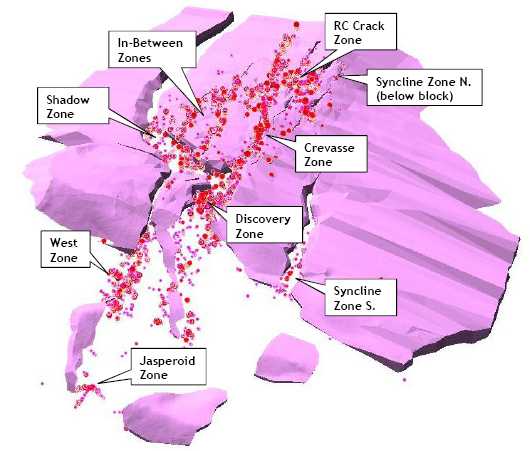
Figure 9-3: Section 11450 Showing the West Zone
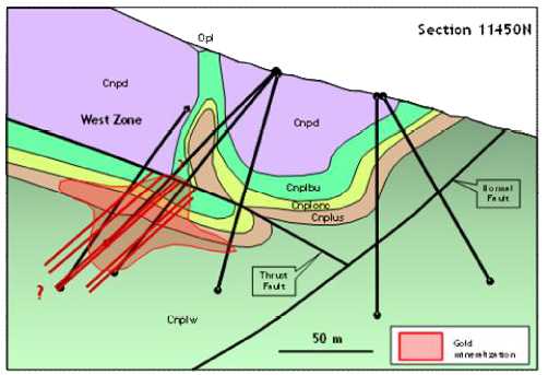
| Fronteer Gold Inc. |
| Long Canyon Project, Elko County, Nevada |
| Updated Technical Report and Interim Resource Estimate |
Figure 9-4: Section 11900 Showing the Shadow and Discovery Zones (Rhys and Ross, 2009)

Figure 9-5: Section 12400 Showing the Crevasse and In-Between Zones
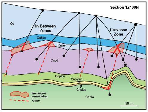
| Fronteer Gold Inc. |
| Long Canyon Project, Elko County, Nevada |
| Updated Technical Report and Interim Resource Estimate |
Figure 9-6: Section 12800 Showing the Crevasse and RC Crack Zones
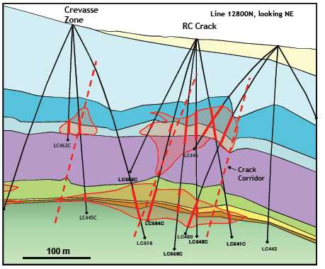
The northeast-trendingSyncline Zone was mapped on surface in 2008 and tested with drill holes in 2009. This zone comprises a narrow boudin neck located approximately 300 metres to the southeast of, and parallel to, the Discovery Zone. An area approximately 300 metres long has been tested with 100- metre-spaced fences of RC holes. To date, most of the mineralization encountered has been relatively low grade, although some 2 to 6 g Au/t assays were returned from suspected lamprophyre dikes. On trend, 1400 m to the north, drilling encountered an incipient boudin neck with low-grade mineralization at the top of the dolomite and high-grade mineralization (7.6 metres at an average grade of 15.6 g Au/t in hole LC402) at the bottom of the dolomite. Other holes drilled to the southeast failed to return significant mineralization at the top of the dolomite horizon, although exceptionally strong goethite alteration, anomalous geochemistry, and decalcification were noted in chips. Drilling in 2010 will attempt to penetrate to the bottom of the dolomite in this area to ascertain whether mineralization extends to the southeast and joins the southern portion of the Syncline Zone.
TheCrevasse Zone was discovered in 2009 and tested by a limited number of holes. Mineralization (Figure 9-5and Figure 9-6) was interpreted to be related to a north-trending incipient boudin, where the dolomite block was broken but not completely separated. Additional drilling in 2010 suggests that the Crevasse Zone extends several hundred metres to the north of the last drilling in 2009. At least two additional, parallel, northeast-trending zones of mineralization lying northwest of the Crevasse Zone were discovered in 2010, named the“In-Between” Zones (the zones lay between the northern Shadow and Crevasse zones). The various zones are tested with a limited number of
| Fronteer Gold Inc. |
| Long Canyon Project, Elko County, Nevada |
| Updated Technical Report and Interim Resource Estimate |
holes that penetrate to the bottom of the dolomite slab; there is some indication that zones on the top of the slab correspond to mineralization at the bottom of the slab that is offset slightly to the northwest.
TheRC Crack Zone was discovered in 2010, and lies in the area between the Crevasse Zone and northern Syncline Zone (Figure 9-6). At least two discreet, parallel, northeast-trending cracks are present in this area, as well as one or more east-west-trending “cross cracks” (Figure 9-2). The convergence of cracks and cross-cracks in this area appears to favour the development of solution collapse breccias over broad areas on the top and the bottom of the dolomite horizon, with very high grades and thicknesses in drill holes (e.g., 50 m of 12 g Au/t in hole LC577C).
TheJasperoid Zone lies on a southeast-trending ridge top located approximately 400 metres southwest of the southern end of the Discovery Zone. Due to erosion, only portions of the roots of the dolomite slab remain in this area. Mineralization is located on surface and at very shallow depths, hosted in the Notch Peak limestone and in lamprophyre dykes. Mineralization in the Jasperoid Zone is located along trend with either or both of the West Zone and Discovery zones; drilling in the intervening area may link the Jasperoid Zone with these zones.
In summary, geological controls on mineralization are stratigraphic, structural, and alteration-related. The primary control on mineralization consists of the dolomite/ limestone contacts at the margins of boudin blocks, especially at and near the noses of the boudins (see discussion of boudinage formation in Section 7.2.3), and near “cracks” or incipient boudins. In addition, the contact between the thinly bedded silty limestone (Op1) of the lowermost Pogonip Group and thin-bedded limestone of the uppermost Notch Peak Formation, where these units have been brought into structural juxtaposition by removal of the dolomite unit along the boudin necks, is often well mineralized.
Secondary controls to the Long Canyon mineralization include:
| | • | Stratigraphic: Stratabound mineralization localized within favourable silty limestone bed(s) in the upper Notch Peak Formation (unit Cnplus) and lowermost Pogonip Group (unit Opsm). |
| | • | Stratigraphic: Solution- breccia-hosted mineralization hosted in mainly massive limestone units adjacent to the dolomite contacts (units Cnplonc and Oplw) |
| | • | Stratigraphic: High-grade mineralization preferentially hosted in lamprophyre dikes. |
| | • | Alteration: Low-grade mineralization often hosted in dolomitized limestone . |
| | • | Structural: Mineralization in boudin neck areas concentrated along late, primarily northwest-dipping normal faults. |
| | • | Structural: Mineralization concentrated along northeast -trending cracks or joint sets where they intersect the top and bottom dolomite contacts. |
| | • | Structural: Solution breccias and associated mineralization localized along joints and faults (Figure 7-16 and Figure 7-17) |
| Fronteer Gold Inc. |
| Long Canyon Project, Elko County, Nevada |
| Updated Technical Report and Interim Resource Estimate |
| Significant karsting, likely both meteoric and hydrothermal in origin, is localized primarily in the limey units at their contacts with dolomite at boudin margins, noses, and necks, in some areas resulting in large, silt- filled collapse cavities (see Section 7.3). Much of the higher-grade mineralization at Long Canyon is hosted in the hematitic matrix of dissolution collapse breccias associated with karst processes. Mineralization is often stratiform when not hosted within solution collapse breccias. |
| | |
| Lamprophyre sills and dykes are commonly associated with mineralization in some areas, although they likely are older than the gold mineralization and act as receptive host rocks. |
| | |
| Thin sections of mineralized Notch Peak Formation show gold occurring as submicron particles at the margins of oxidized pyrite grains suspected to be authigenic in origin. Some gold grains were observed encapsulated in silica. Gold was also detected by an SEM (scanning electron microscope) analysis of an arsenical rim on one pyrite grain. |
| | |
| 9.2 | Alteration |
| | |
| Principal alteration minerals that are directly associated with gold mineralization include hematite, scorodite, silicification, dickite, and illite. Decalcification is also closely related to the mineralization and ranges from strong to weak. Rocks in the deposit area are essentially entirely oxidized, so inferences regarding the nature of primary alteration and mineralization must be made based on examination of oxidized rock. |
| 9.2.1 | Pre -Mineral Alteration |
| | |
| Regional metamorphic minerals include chlorite and sericite/muscovite . |
| | |
| Dolomitization. Medium-grained, dark-grey, massive dolomite after limestone has been noted along a number of fault zones. The dolomitization process frequently obliterates primary textures. Dolomitized rocks along fault zones often exhibit a distinctive “pebbly” texture, suggesting brecciation. Dolomite alteration is also manifested in primary (diagenetic) dolomites as areas of light grey, medium grey, and coarse white “zebra” dolomite. Regardless of appearance, no dolomite alteration appears to be temporally or genetically related to gold mineralization, although it does appear to share a spatial relationship suggesting that both dolomite alteration and mineralization shared similar conduits and structures at different times. |
| | |
| 9.2.2 | Syn-Mineral Alteration |
| | |
| Decalcification. Decalcification shares a strong spatial association with mineralization. Decalcification is preferentially developed in silty, thin-bedded to laminated strata in the lowermost Pogonip Group, but may also be present locally in the Notch Peak Formation. Decalcification imparts a buff colour and soft, chalky appearance to the rock. Some “sanding” observed in dolomite may represent decalcification of limy matrix to dolomite grains. |
| | |
| Silicification. Evidence from examination of a limited number of polished thin sections and whole-rock geochemical data suggest that weak, pervasive silicification is an |
| Fronteer Gold Inc. |
| Long Canyon Project, Elko County, Nevada |
| Updated Technical Report and Interim Resource Estimate |
important alteration type at the Long Canyon project, and is associated with gold mineralization. Silicification of this type is not obvious in hand sample. Silicification is present as small, ragged grains in limestones, with up to 50% of the rock replaced by silica.
Jasperoid. Jasperoid is relatively rare and largely restricted to the West Zone and the as yet untested South Zone. Jasperoid occurs in zones or lenses up to a few metres wide consisting of massive or “net- textured” silica after limestone, and ranges from pale- to medium-grey and very fine grained to dark- brown and grainy (Figure 9-6). The latter type may also contain vugs with linings of white drusy quartz. In a few drill holes, silica-cemented breccias with silica fragments (after limestone) have been noted. Silicified areas, particularly the brown jasperoids, contain unoxidized pods with very fine-grained disseminated pyrite, and most contain gold.
Figure 9-7: Jasperoid
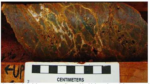
(Weakly brecciated, dark brown, vuggy jasperoid with hematite and drusy quartz in breccia matrix.)
Calcite. Fine-grained calcite is ubiquitous with quartz and hematite within breccia matrices, as discrete, coarse-grained veins, and as coarse-grained fill in solution cavities.
Argillization. Study of mineralized and altered rock using a Terraspec hyper-spectral analyzer (Rhys and Ross, 2009) reveals the presence of a zoned suite of argillic and advanced argillic alteration associated with the Long Canyon deposit. Clays are zoned from dickite and rarely muscovite in core areas of high-grade mineralization through sericite, illite, and kaolinite in altered but generally unmineralized areas. Concentration of clays overall is generally low. Smectite was noted in weakly altered rocks peripheral to the deposit in Pogonip Group strata.
Iron Oxides. Iron oxides are common at Long Canyon and include limonite, hematite, and goethite. Yellow staining of decalcified or intact silty limestones, bedding planes, tectonic breccias, and (rarely) solution breccias is given the field name “limonite”. Yellow, limonitic rocks typically occur in a “halo” over hematite zones, as well as
| Fronteer Gold Inc. |
| Long Canyon Project, Elko County, Nevada |
| Updated Technical Report and Interim Resource Estimate |
intermixed with goethite. Limonite-only stained rocks rarely contain gold, but are usually anomalous in arsenic, and thus are generally a good indicator of nearby gold mineralization.
Hematite and goethite are ubiquitous throughout mineralized areas of the deposit. Detailed analysis of orange to red iron oxides with a Terraspec analyzer suggests that goethite is distal to mineralization, whereas hematite is more often associated with significant gold mineralization. Empirical observations suggest that goethite is more orange in colour, whereas hematite is generally brick red in colour; this distinction may help differentiate gold-bearing strata in core and RC chips prior to assaying. Both iron-oxide types are present as orange or red staining of decalcified silty limestones (Figure 9-7), bedding planes, tectonic breccias, and solution breccias (particularly matrix material).
Hematite may have been derived from several sources, including:
| | • | Oxidized wind-blown silt incorporated into shaly or silty limestone progenitors, particularly along bedding planes; |
| | • | Oxidized silt originating from the surface and deposited in karst caverns; |
| | • | Oxidized silt originating from weathering of silty limestones and ponding in surface karst areas |
| | • | (“terra rosa”); |
| | • | Oxidized silt liberated from limestones through decalcification; |
| | • | Weathering of authigenic or hydrothermal pyrite; and |
| | • | Primarily hydrothermal processes (thought to be unlikely). |
Figure 9-8: Hematite Alteration in Basal Pogonip Group
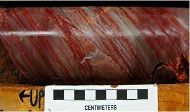
Scorodite. Yellowish-green staining is observed along some fractures and fracture selvages and sometimes coalesces into pervasive patchy alteration where fracture density is high. High concentrations of arsenic associated with this type of alteration, which overprints hematite alteration (Figure 9-9), suggests that it may be partly composed of scorodite (FeAsO4-2H2O). Scorodite is nearly always present in high-grade gold intervals.
| Fronteer Gold Inc. |
| Long Canyon Project, Elko County, Nevada |
| Updated Technical Report and Interim Resource Estimate |
Figure 9-9: Hematite Overprinted by Scorodite

| 9.3 | Veins |
| | |
| Quartz Veins. Quartz veining is relatively common throughout the drill area. Hairline quartz veinlets are ubiquitous in the Notch Peak dolomite, particularly near the margins of boudin blocks, such that they are diagnostic of dolomite in the field. Larger quartz veins (rarely up to one-metre thick) are present in both limestone and dolomite in fold axes, along high-angle faults, and occasionally along dolomite block margins. These quartz veins are generally relatively coarse grained, white, and are barren of sulfides. Some large, coarse quartz veins in and around the central Discovery Zone contain minor galena, sphalerite, and copper oxides. |
| | |
| Calcite/Aragonite Veins. Coarse calcite veins are relatively common throughout the drill grid. They tend to be small and erratic in orientation and shape . Coarse calcite also commonly cements dissolution breccia zones. Calcite veins are thought to be syn-, late-, and post-mineralization, related to both decalcification and meteoric processes. |
| | |
| Aragonite veining is common locally, including an area approximately 1.5 kilometres southeast of the drill grid. Aragonite veins are white to pale yellow, comb- like, and range from 1 centimetre to (rarely) 20 centimetres in width. They appear to be relatively late and unrelated to mineralization. |
| Fronteer Gold Inc. |
| Long Canyon Project, Elko County, Nevada |
| Updated Technical Report and Interim Resource Estimate |
| 10 | EXPLORATION |
| | |
| Joint Venture a nd subse que nt exploration activities at Long Canyon include surface rock-chip sampling of road cuts, grid-based soil sampling, ridge -and-spur soil sampling, prospecting, a gravity survey, an IP/resistivity survey, geological mapping, and drilling. Exploration activities prior to the Joint Venture work (prior to May 2006) are described in Section 6. 0. Joint Venture and subsequent drilling is discussed in Section 11.0. |
| | |
| 10.1 | Geologic Mapping |
| | |
| Geological mapping was conducted in 2006 by Coolbaugh (2006), primarily in the drill grid area. Mapping of contacts between the Notch Peak dolomite and overlying and underlying units was carried out using a sub-metre Trimble GPS unit with a base station. Mapping of road cuts in the drill grid area was carried out at a scale of 1 inch = 20 feet (1:240) and included the collection of bedding orientations, rock types, fracture orientations, and other data. |
| | |
| Geological mapping over a larger area in the central part of the Project Area was carried out on a part-time basis over a four- month period from June to September 2008 by Moira Smith. Contacts and structures previously mapped by AuEx were verified, and mapping was extended to other areas of the property. Approximately 1500 structural measurements, including bedding, foliation, joints, lineations,etc., were collected. Results of this work are discussed in Section 7.2. |
| | |
| Geological mapping over the rest of the Project Area, with the exception of an area in the extreme northwest corner, was carried out by consultant Warren Thompson in 2009. This map was merged with the 2008 mapping to produce a map of the Long Canyon property. Additional mapping was conducted in 2010 but had not been compiled into the database as of the effective date of this report . |
| | |
| 10.2 | Surface Sampling |
In 2005 through 2006, 580 samples were systematically collected as three-metre chip channels on all road-cut exposures, including both unaltered and altered rock. In 2006, a total of 61 rock grab samples were collected in the course of mapping by Coolbaugh (2006) and analyzed for gold by fire assay and trace elements by ICP. Gold values returned by these samples were generally low, with the exception of samples in and around the existing drill grid. In addition, 507 road-cut channel samples on approximately three-metre intervals were collected in 2006, targeting primarily areas with visible alteration. This sampling clearly outlined surface mineralization in both the West Zone and the southern portion of the Discovery Zone, with samples ranging up to 21 g Au/t and a discrete population of samples >8 g Au/t (Moran, 2008.)
A total of 187 rock grab samples were collected in 2007 during prospecting traverses within the Project Area, and 198 road-cut channel samples were taken on approximately three-metre intervals from within the drill grid area. As with sampling in 2006, regional prospecting samples generally returned low values for gold, and road-cut channel sampling returned significant gold in hematite-altered road cuts.
| Fronteer Gold Inc. |
| Long Canyon Project, Elko County, Nevada |
| Updated Technical Report and Interim Resource Estimate |
A total of 345 rock chip samples from road cuts were collected in 2008; results are discussed in Fronteer press releases and the Fronteer corporate website (www.fronteergold.com). The samples have variable lengths, most commonly three metres, and were collected as continuous chips across altered rock units in road-cut embankments. The visual guide to mineralization is oxidation of the rocks, exhibited as hematite staining and coatings on fractures. A total of 49 rock grab samples were collected in 2008, primarily during the course of a ridge-and-spur soil-sampling program.
Rock sampling in 2009 totaled 276 grab samples, including sampling in the course of geological mapping and soil sampling, as well as grab samples from selected road cuts. Above-detection gold was encountered in samples from new road cuts in the West Zone, Syncline Zone, and northern Discovery Zone. Most samples from the northernmost Au-in-soil anomaly in Section 17 (see below) returned detectable gold, with values up to several hundred ppb. Most of these samples were obtained from breccias and shear zones. Most of the samples obtained from the southwestern part of the Project area did not return detectable gold, although some samples were elevated in arsenic and antimony.
Rock sampling in 2010 totaled 129 grab samples from throughout the property. Above detection gold was noted in rock samples from the northernmost soil anomaly in Sections 17 and 20 and from an area of anomalous gold identified in 2010 immediately west of the Long Canyon deposit (see below).
Two grid-based soil-sampling programs were carried out at Long Canyon in 2008 that extended the existing (2000) soil grid to the north (990 samples) and south (153 samples). Samples were collected from C-horizon soil (there is relatively little development of A and B soil horizons at Long Canyon) and analyzed for gold by fire assay with AA finish and for other elements by ICP. Samples were taken at 61 metre by 61-metre intervals.
Five grid-based soil sampling programs were carried out at Long Canyon in 2009, including two programs contiguous with the existing grid to the south (609 samples) and west (247 samples), two to the north (163 and 394 samples), and one to the northwest (269 samples), for a total of 1682 soil samples. Samples were collected from C-horizon soil and analyzed for Au by FAA and for other elements by ICP-MS at ALS Chemex ( ALS) Laboratory in Reno, Nevada. Data were merged with previous soil surveys and Ridge and Spur traverses to produce a comprehensive map consisting of all soil data for the property.
Soil samples were obtained from six areas in 2010, mainly from the western and southern parts of the Project area. In these areas, a total of 2187 soil samples on 200 foot centers were taken by Fronteer Gold staff and contractors, as well as contractors from Rangefront Consulting. A follow-up program was completed later in the year by Fronteer staff. This program consisted of 183 samples, and in-filled the gold-in-soil anomaly identified west of the deposit to 100’ spacing.
The combined 2000, 2008 and 2009 soil data show that gold forms a tight cluster in the area where mineralization is exposed on surface over the south end of the Long Canyon
| Fronteer Gold Inc. |
| Long Canyon Project, Elko County, Nevada |
| Updated Technical Report and Interim Resource Estimate |
deposit (Figure 10-1). New areas of anomalous gold geochemistry were generated by the 2009 and 2010 programs, including two broad areas in the northern part of the grid area in sections 17 and 20, as well as two areas to the immediate west of the deposit. The anomalies in sections 17 and 20 are underlain by the Fish Haven Dolomite, Eureka Quartzite, and Pequop Formation, and present new targets for further exploration. The anomalies located to the west of the deposit are hosted in the upper Pogonip Group, and are associated with anomalous jasperoidal float samples. A tight cluster of anomalous gold values is present in the northeast area of the grid, corresponding to an area underlain by Pogonip Group limestone and dolomite. Antimony highlights similar areas, as well as a large, low intensity anomaly over much of the southwestern extension of the soil grid. Mercury forms a very tight pattern over exposed areas of the Long Canyon deposit and it is not seen elsewhere, with the exception of a tight cluster of samples over the gold anomaly in the northeastern part of the grid. Arsenic has a distribution similar to antimony, with wide dispersion of low-level arsenic values observed around the deposit. Arsenic is also associated with the gold anomalies in the northern part of the soil grid and with the antimony anomaly in the southwestern extension of the grid (Figure 10-2). Zinc is anomalous in the northwestern part of the grid area, corresponding to the underlying Pequop Formation limestone. A band of anomalous samples trending northeasterly in the northeast portion of the grid may be structurally controlled, as it appears to track a west-dipping reverse fault. Another northeast-trending zone of anomalous zinc is present in the southwest part of the sampled area. Lead shows a similar, although more restricted, distribution pattern to zinc. Nickel and copper also exhibit similar distributions.
Ridge-and-spur soil sampling and prospecting programs were carried out in 2008 and 2009. The purpose of the survey was to obtain baseline geochemical data for areas primarily in the western portion of the property that had not been sampled previously, to prospect some areas of interest identified during the 2008-mapping program, and to uncover new areas of alteration or mineralization. A total of 273 C- horizon samples were collected in 2008 and 266 samples in 2009. Some low-level arsenic and antimony anomalies are indicated, although gold is generally absent. A total of 30 grab and chip rock samples were collected concurrently with the soil samples in areas with hematite or other alteration; the samples contained only low levels of gold.
| Fronteer Gold Inc. |
| Long Canyon Project, Elko County, Nevada |
| Updated Technical Report and Interim Resource Estimate |
Figure 10-1: Gold-in-Soil Results through 2010
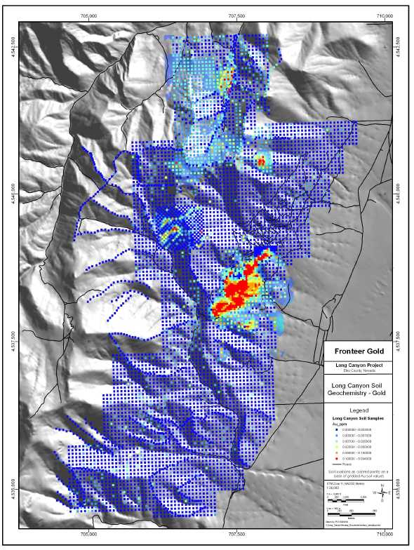
| Fronteer Gold Inc. |
| Long Canyon Project, Elko County, Nevada |
| Updated Technical Report and Interim Resource Estimate |
Figure 10-2: Arsenic-in-Soil Results through 2010
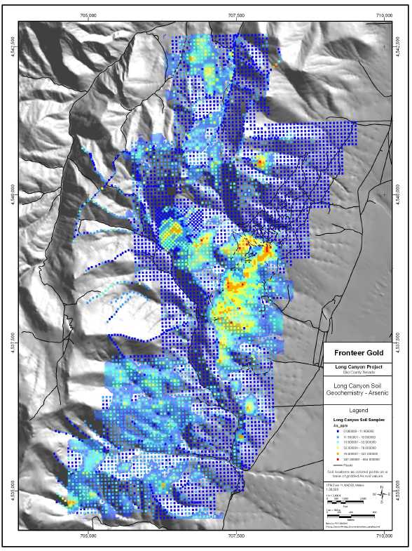
10.3 Geophysics
| Fronteer Gold Inc. |
| Long Canyon Project, Elko County, Nevada |
| Updated Technical Report and Interim Resource Estimate |
No geophysical surveys were carried out in 2006, 2007, 2009 or 2010. Three ground-based geophysical surveys were completed in 2008, including a gravity survey carried out by Zonge Geophysical (“Zonge”) and two IP/resistivity surveys undertaken by Quantec Geoscience (“Quantec”) and Zonge.
Gravity. A ground gravity survey was carried out by Zonge on a 100 metre by 100-metre grid that covered the northern half of the drill grid, as well as areas to the northeast. The reduced-to-pole total Bouguer anomaly map shows a gradient from relatively high gravity in the west to low in the east, consistent with the location of the survey on a mountain front adjacent to a gravel-filled, fault-bounded basin. Two roughly north-trending linear features evident on the horizontal gradient map are interpreted to be range-front faults. A first-vertical-derivative map delineates an additional steep gradient, as well as showing a northwest-trending fabric in the northern project area that may be evidence of northwest- trending faults.
Ground-based gravity surveys, at least on the scale carried out at Long Canyon, can identify large structures, but do not appear to be useful for identifying potential areas of mineralization.
IP/Resistivity. Two dipole/dipole IP/resistivity surveys were carried out by Quantec (5 lines) and Zonge (10 lines) over the drill grid and areas to the northeast and southwest. Lines were oriented northwest- southeast and spaced 200 metres apart for the twelve southern lines and 300 metres apart for the three northern lines. The southern lines used an A-spacing of 125 metres in order to collect high-resolution data down to approximately 250 metres. An A-spacing of 150 metres was used on the northern lines to attempt to see deeper into the section. The data were subjected to a 2D inversion and presented on sections, with corresponding pseudo-sections, and plotted as a series of approximate depth maps in plan at 50-metre intervals from 100 to 300 metres.
The resistivity data show an abrupt break in the resistivity from high in the west to low in the east at approximately the same location as the steep gradient modeled in the gravity. This likely corresponds to the abrupt thickening of the basin fill that corresponds to the interpreted Basin and Range fault. Lower resistivity response is also evident along the western edge of the grid, corresponding to middle and upper Pogonip Group strata in the hanging wall of the major low-angle normal fault and stratigraphically above and to the west of the lower Pogonip Group strata in the northern part of the survey area. The most resistive areas correspond to Notch Peak strata exposed on surface; this response is more subdued to the north where the lower Pogonip Group is exposed on surface.
Modeled IP (chargeability) data show a more varied response than the resistivity data, the latter of which can be clearly tied to surface geology. An anomaly was detected in the extreme northwest part of the survey area, corresponding to surface exposures of the upper part of the Pogonip Group. Other anomalous areas were also identified.
Although the source of the IP anomalies is uncertain, there is a good correlation between mineralization and anomalous IP, as evidenced by the distribution of anomalies relative to drill-tested areas.
| Fronteer Gold Inc. |
| Long Canyon Project, Elko County, Nevada |
| Updated Technical Report and Interim Resource Estimate |
| 11 | DRILLING |
| | |
| 11.1 | Summary |
| | |
| The mineral resources discussed in this report were estimated using the data provided by core and reverse -circulation drilling completed by Pittston, AuEx, and the Fronteer- AuEx Joint Venture through to December 15, 2010. |
| | |
| Drilling at Long Canyon has been successful in defining potentially economic gold mineralization in numerous drill holes that have delineated a minimum of nine sub- parallel zones along a strike extent of approximately 3,000 metres. The limits of the gold mineralization are not fully outlined and they remain open along strike and at depth within the presently defined zones; there is also excellent potential for the discovery of new zones of mineralization. |
A total of 768 exploration drill holes were completed through 2010 and evaluated for use in the Long Canyon resource estimation (Table 11-1); 292 of these holes were completed in 2010, totaling 65,969 metres. Down-hole drill depths range from 8 to 429 metres, with an average depth of 172 metres. This drilling was pri mar ily completed on a nominal 50-metre spaced grid, with the drill sections oriented northwest-southeast.
Table 11-1: Long Canyon Mineral Resource Database Summary1,2
| Company | Year | HoleNumbers | Core | RC | Total |
| # | Metres | # | Metres | # | Metres |
| Pittston | 2000 | LC001-
LC007 | 0 | 0 | 7 | 1,147.6 | 7 | 1,147.6 |
| AuEx | 2005 | LC008-
LC014 | 0 | 0 | 7 | 786.1 | 7 | 786.1 |
Fronteer-
AuEx JV | 2006-
2008 | LC015-
LC229C
LCMW3-4 | 61 | 7,320.8 | 156 | 24,612.6 | 217 | 31,933.4 |
Fronteer-
AuEx JV | 2009 | LC230-
LC417
LCG01-
LCG04
LCM1-
LCM37 | 185 | 22,550.9 | 53 | 10,864.0 | 238 | 33,414.9 |
Fronteer-
AuEx JV | 2010 | LC418-
LC737C | 185 | 39,411 | 114 | 26,558 | 299 | 65,969 |
| Total | | | 431 | 69,282.7 | 337 | 63,968.3 | 768 | 133,251.0 |
| | 1. | AuEx operated the Joint Venture drilling of LC015 to LC030, while Fronteer was the operator through hole LC737C. |
| | 2. | Certain holes drilled in 2010 were not included in this table, including 13 hydrological holes that did not penetrate the bedrock contact, as well as 31 holes for which assays were unavailable prior to the December 15, 2010 effective date. |
The nine defined mineralized zones at Long Canyon coalesce in various locations to form a continuous body of mineralization that plunges approximately ten degrees to the
| Fronteer Gold Inc. |
| Long Canyon Project, Elko County, Nevada |
| Updated Technical Report and Interim Resource Estimate |
northeast. The mineralization has an apparent dip of five to ten degrees to the southeast in sections cut across the plunge direction, reflecting the control exerted by the upper and lower contacts of the dolomite boudin blocks. Internal to these deposit-scale geometries, boudin noses form sub-vertical controls to the mineralization that dip to the northwest or southeast depending on the boudin-termination facing orientation.
Drill-hole orientations vary somewhat at Long Canyon (Figure 11-1), due to both the early-stage nature of some of the holes, which were drilled before the geometry of the mineralization was understood, and the varying orientations of the controls to the mineralization. There are a relatively small number of holes that are therefore poorly oriented with respect to the mineralization encountered, which leads to exaggerated lengths of the down-hole intercepts. This is mitigated by the resource modeling techniques employed, which constrain all intercepts to lie within explicitly interpreted domains that appropriately respect the geologic controls.
| 11.2 | Pittston 2000 Drilling |
| | |
| Eklund Drilling Company, Inc . of Elko, Nevada (“Eklund”; subsequently acquired by Boart Longyear Drilling of Elko, Nevada) was the drill contractor and used a Drill Systems MPD 1500 track rig for the seven Pittston RC holes. The drill logs indicate that the hole diameters were 5 inches (13 centimetres). |
| | |
| 11.3 | AuEx 2005 Drilling |
| | |
| The RC drilling contractor used by AuEx in 2005 was Layne-Christensen Company (“Layne- Christensen”), who drilled 5 ¼-inch (13.3 centimetres) diameter holes using a Foremost Prospector W-750 buggy rig. Stratex six-inch (15 centimetres) surface casing was used for all of the holes to depths ranging from three to six metres. |
| Fronteer Gold Inc. |
| Long Canyon Project, Elko County, Nevada |
| Updated Technical Report and Interim Resource Estimate |
Figure 11-1: Location Map of Drill Holes Utilized in Resource Estimation

| Fronteer Gold Inc. |
| Long Canyon Project, Elko County, Nevada |
| Updated Technical Report and Interim Resource Estimate |
| 11.4 | Fronteer-AuEx Joint Venture 2006-2010 Drilling |
| | |
| The RC drilling contractor used by Fronteer in 2006 and 2007 was Layne -Christensen, while Eklund drilled the 2008 through 2010 RC holes. Small samples of the RC cuttings from each sample interval were washed and put into numbered chip trays for logging. The RC chips were logged on-site into a custom-designed Excel spreadsheet for the project. Logging was aided by use of a binocular microscope. Data recorded included dominant lithologies, colour, alteration characterization, dominant structural evidence (e.g. brecciated, fault gouge), veining type, and density. |
| | |
| The core -drilling contractor for the six core holes drilled in 2007 was DOSECC Inc . of Salt Lake City, Utah. The 2008 through 2010 core holes were drilled by Major Drilling America, Inc. of Salt Lake City, Utah and Elko, Nevada. Most Long Canyon core holes were drilled with HQ-sized core (6.4-centimetre diameter). Three holes were drilled using NQ core, in an attempt to ascertain whether drilling the smaller diameter core was feasible. While excellent recoveries were achieved, the NQ tools did not perform well in extremely broken rock and the use of NQ core was abandoned. Forty- four PQ holes were drilled for the primary purpose of obtaining larger samples for metallurgical column tests. The core was logged directly into digital files by Fronteer geologists. The digital logs included fields for rock type, colour, alteration, mineralization, and structural data, with a separate log for breccia descriptions. Rock Quality Designation (“RQD”) was also captured in the logs. The logs capture data largely in numerical or letter code format. Completed and validated logs were imported into an Access database . |
| | |
| The 2010 drilling program commenced on April 4, and utilized three diamond-core drills and two RC drills throughout most of the season, which concluded in early December. Drilling focused on infill and step-out drilling in the northeastern portion of the deposit, with some exploratory drilling in the southwestern, southeastern and western portion of the deposit. Drilling in November and December focused almost exclusively on step-out drilling in the northeastern portion of the deposit area. A number of holes were drilled for hydrological testing, ranging from single or dual completion monitoring wells to two large diameter wells constructed for aquifer pump testing. In addition, five large diameter core holes were drilled within the resource area to obtain material for metallurgical testing. The 2010 drilling program is summarized in Table 11-2. |
| Fronteer Gold Inc. |
| Long Canyon Project, Elko County, Nevada |
| Updated Technical Report and Interim Resource Estimate |
Table 11-2: Long Canyon 2010 Drilling Program Summary1
| | Core | RC | Total |
| Purpose | No. | Meters | No. | Meters | No . | Meters |
| Exploration - HQ/NQ and RC . | 206 | 46,577.9 | 115 | 26,918.0 | 321 | 73,496.0 |
| Metallurgical Holes - PQ/HQ | 5 | 174. 0 | _ | _ | 5 | 1,74.0 |
| Hydrological Holes | _ | _ | 17 | 3,127.0 | 17 | 3,127.0 |
| Total | 211 | 46,751.9 | 132 | 30,045.0 | 343 | 76,797.0 |
1. This table includes all holes drilled within or immediately adjacent to the Project area in 2010 regardless of purpose or location within or outside of the resource area. 31 exploration holes reported in this table were not assayed prior to the effective date of this report and were not used in the resource calculation.
Core is examined and logged on site into a digital logging sheet, with lithology, alteration, mineralization, and structural characteristics recorded. The core is photographed both wet and dry for archival and geotechnical purposes. Approximately three samples per drill hole are collected for specific-gravity determinations; a range of rock types and both mineralized and unmineralized rock are selected for these measurements.
Results for the 2010 drilling can be found in press releases available at the Fronteer website(http://www.fronteergold.com/).
| 11.5 | Drill-Hole Collar Surveys |
| | |
| The drill-hole collars have been surveyed at different times by different contractors. In an effort to standardize the survey data, the collars from all holes, including those from the 2000 through 2007 programs that could be identified in the field were surveyed at the end of the 2008 drilling program by All Points North Surveying and Mapping of Elko, Nevada (“All Points North”). Although the collars are marked in the field after completion with a cement plug, wire, and metal tag, subsequent traffic on the drill pads destroyed the evidence of the collars in some cases. All Points North also surveyed 2009 drill holes at regular intervals throughout the 2009 season. |
| | |
| The 2008 through 2010 survey programs were completed using a geodetic survey-grade Trimble 4000-series GPS receiver with a base station for real-time correction. Accuracy of the measurements is+2 centimetres in the easting and northing directions and+3 centimetres in elevation. |
| | |
| A total of 43 holes in the sequence LC001 through LC067C (representing holes drilled through the end of 2007) could not be located and surveyed by All Points North. With respect to these 43 holes, older survey data were utilized for 34 holes, including 27 holes surveyed by M. Coolbaugh (AuEx project geologist) in September 2007 using a Trimble backpack GPS unit with sub-metre accuracy. An additional five holes (LC031 through 036) were surveyed by Carlin Trend Surveying of Elko, Nevada using a |
| Fronteer Gold Inc. |
| Long Canyon Project, Elko County, Nevada |
| Updated Technical Report and Interim Resource Estimate |
| Trimble GPS with differential correction (sub-metre accuracy), and two holes (LC063C and 067C) were surveyed by project geologists using a standard handheld GPS receiver (+15 metres accuracy). Drill collars for LC007, 010, 011, 013, 014, and 027 through 030 could not be found and therefore were approximately located, but locations are thought to be within 15 metres (the size of the pad) with higher accuracy in the vertical direction. All stated accuracies assume proper techniques employed in open areas with uninhibited access to satellites; accuracies were obtained fromwww.kowoma.de/en/gps/accuracy. htm. Accuracies for elevation may be greater than stated. |
| | |
| With respect to holes drilled during the 2009 season, locations were based on the physical presence of a casing pipe or, lacking this, a cement plug. With five holes (LC394C, LC383C, LC396, LC390C, and LC399C) neither the casing nor the plug could be located. In these cases, hole locations were estimated using the following criteria: apparent location of the drill rig; location of the sump; angle and dip of the hole; and location of nearby holes on the same pad. The location of these holes, while approximate, is assumed to be within 2 to 3 metres of the actual location, with higher accuracy for elevation. One hole, LC355CA, was abandoned prior to the target depth and was not surveyed. Hole 355CB was located at the same collar and was surveyed. |
| | |
| In 2010, the same methods and caveats applied in 2009 were used for locating and surveying drill hole collars. With eleven holes (LC445C, LC452C, LC462C, LC510C, LC607C, LC624C, LC627C, LC633C, LC645C, LC650C and LC670C), neither the casing nor the plug could be located. In these cases, the center of the pad was surveyed as the X, Y coordinate and assumed to be within 3 meters of the actual location, with higher accuracy in the Z direction. |
| | |
| 11.6 | Down-Hole Surveys |
| | |
| Down-hole surveys for the holes drilled by Pittston (LC001 through LC007) were completed by Silver State Surveys, Inc .; the survey equipment used is not known. No down- hole surveys were conducted on the AuEx holes (LC008 through LC014), although averaged deviations were added to the database. All subsequent holes, with the exception of LC032, 049, 052, 057, 062C, 066C, 085, 126, and 169C, have down-hole survey information in the database . Fronteer holes through 2008 and the first half of 2009 were surveyed using a Surface Reading Gyroscope by International Directional Services (IDS) of Elko, Nevada. After noting that deviations in core holes were very small, and beginning roughly midway through the 2009 drilling program, a Reflex E-Z Shot electronic solid-state single-shot down-hole instrument was employed for core holes. Readings were taken at the collar and at approximately 45-metre intervals down hole. |
| | |
| The same approach was used in 2010, with Gyroscope surveys by IDS for the RC holes and a single-shot down-hole camera used to survey the core holes. |
| Fronteer Gold Inc. |
| Long Canyon Project, Elko County, Nevada |
| Updated Technical Report and Interim Resource Estimate |
| 12 | SAMPLING METHOD AND APPROACH |
| | |
| The Long Canyon database includes assay data from both RC and core drill holes. Fronteer believes that the RC and core sampling procedures provided samples that are sufficiently representative and of sufficient quality for use in the Mineral Resource estimation discussed in Section 17.0. While RC down-hole contamination does present a sample integrity issue in some holes, techniques employed in the field since the start of the 2009, through 2010, seasons, as well as the recognition and exclusion of contaminated intervals during resource modeling, have adequately addressed the problem. |
| | |
| 12.1 | Surface Sampling Methods |
| | |
| Rock chip sampling was conducted as random chip sampling, random grab sampling of selective rock outcroppings, and continuous chip samples along the outcrop or road-cut exposures. Various sample intervals were used, although three-metre samples were standard for road cut chip sampling. |
| | |
| 12.2 | Drill Sampling Methods |
| | |
| Pittston. The following description of the Pittston RC sampling procedures is taken from the Long Canyon technical report prepared for AuEx (Moran, 2008). |
| | |
| According to the former Pittston drill project coordinator, RC drill samples were collected at 5 foot (1.52 metres) intervals by Pittston staff as splits from a rotary wet splitter attached to the cyclone sample -collector discharge. Secondary splits of the RC samples were not collected. |
| | |
| AuEx. AuEx used sample collection procedures similar to those described above for Pittston (pers. comm., Eric Struhsacker, US Exploration Manager for AuEx, 2009). |
| | |
| Fronteer. The Fronteer RC drilling was completed with the injection of water to reduce dust at the drill site for health reasons. Samples of RC cuttings were collected every 5 feet (1.52 metres) after passing through a rotary wet splitter. The split samples weighed approximately 4.5 to 9 kilograms. |
After logging of the drill core at the Fronteer field office at the Big Spring Ranch, then the Oasis trailer site in 2010, the drill core was marked for cutting, photographed, and transported by Fronteer personnel to Elko, or Wells in 2010. Visibly altered rock is sampled on nominal 1.52 -metre intervals, unless geological contacts dictate otherwise. Sampled intervals through 2008 vary from 0.15 to 3.05 metres and average 1.40 metres. The marked core was cut into halves with a diamond saw by American Assay Laboratories through to mid-2008, after which a core cutting facility at the Fronteer field office in Elko, then Wells in 2010, was put into service. Half-core samples were sent for assaying, with the remaining half stored in the Fronteer Elko warehouse. The contents of the Elko warehouse, as well as the core cutting facilities, were moved to the Hart building in Wells in June 2010. For PQ core, quarter-core samples were utilized for assaying. Long Canyon core holes through 2009 have average core recovery and rock quality
| Fronteer Gold Inc. |
| Long Canyon Project, Elko County, Nevada |
| Updated Technical Report and Interim Resource Estimate |
designation (“RQD”) values of 97% and 42%, respectively. Including only those intervals coded to the mineral domains used in the previous resource estimation (Gustinet al., 2010), these averages change to 97% and 46%, respectively.
Gustinet al. (2010) compared gold grades composited over the core recovery and RQD intervals to the geotechnical data within the modeled mineral domains (Figure 12-1 and Figure 12-2, respectively).
Figure 12-1: Core Recoveryvs. Gold Grade

Figure 12-2: Core RQDvs. Gold Grade
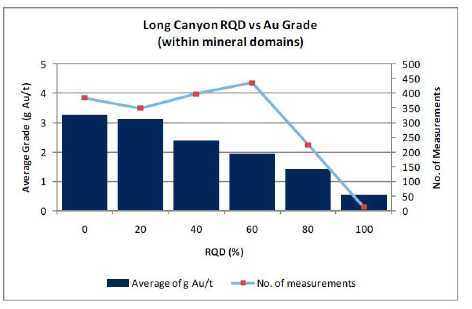
There is no direct correlation between core recovery and gold grade. The highest mean
| Fronteer Gold Inc. |
| Long Canyon Project, Elko County, Nevada |
| Updated Technical Report and Interim Resource Estimate |
grade is found in the 60 to 80% core recovery interval, but too few of the 1,803 drill intervals within the mineral domains have recoveries lower than the 60% to form definitive conclusions.
There is a strong relationship between increasing gold grades and decreasing RQD values (Figure 12-2). This negative correlation is not surprising, as higher gold values at Long Canyon often occur within breccias formed from decalcification, which tend to be more broken than relatively weakly mineralized limy units.
The RC data are similarly compared in Figure 12-3. Although direct measurements of recovery are difficult with RC drilling, dry sample weights, as measured by the analytical laboratory, provide a qualitative measure of recovery, assuming the samples were split consistently at the RC rig.
Figure 12-3: RC Sample Weightvs. Gold Grade
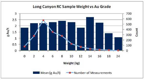
| Similar to the core recovery data, no relationship is evident between the gold grades and relative RC recoveries. |
| | |
| 12.3 | Reverse-Circulation Sample Contamination |
| | |
| Due to the nature of RC drilling, the possibility of contamination of drill cuttings from intervals higher in the hole is a concern, especially when groundwater is encountered or fluids are added during drilling. Only one hole intersected groundwater at Long Canyon, but water was injected during the drilling of all of the Fronteer RC holes and at least some of the AuEx and Pittston holes. |
| | |
| Down-hole contamination can sometimes be detected by careful inspection of the RC drill results in the context of the geology, by comparison with adjacent core holes, and by examining down-hole grade patterns. |
| Fronteer Gold Inc. |
| Long Canyon Project, Elko County, Nevada |
| Updated Technical Report and Interim Resource Estimate |
A number of the Long Canyon RC holes drilled prior to 2009 clearly exhibit cyclic down-hole patterns in the gold assays. These are detected by examining the gold results of each set of four samples derived by the drilling of the same 20-foot (6.1 metres) drill rod. In a classic case, the first sample of the drill rod will have the highest grade, while the following three samples will gradually decrease in grade. This classic ‘decay’ pattern in grade is caused by the accumulation of mineralized material (present at some level higher in the hole) at the bottom of the hole as the drilling pauses and a new drill rod is added to the drill string. When drilling resumes, the first sample has the greatest amount of contamination, and the successive samples are gradually ‘cleaner’ as the accumulated contamination is removed and the continuing contamination experienced during the drilling is overwhelmed by the material being drilled. This decay pattern is usually possible to detect only while drilling barren or very weakly mineralized rock. Even in cases where this cyclic gold contamination is of such low grade as to have minimal impact on resource estimation, its presence suggests that similar, and possibly more serious, contamination is occurring higher in the hole within mineralization, where the contamination is impossible to recognize.
The geologic context can also be used to detect contamination. The dolomite boudins themselves are only locally mineralized, with mineralization usually restricted to brecciation in and around the boudin noses. Core results indicate that even where mineralized, the mineralization in the dolomite boudins is quite thin and is typically restricted to the first metre or so at limestone/dolomite contacts. Highly mineralized intersections within the dolomite boudins that lie immediately down-hole of strong mineralization in the limestones in contact with the boudins must therefore be considered as possible candidates for contamination.
In 2009, particularly since the start of drilling below the water table in early October, a number of protocols were implemented in the RC drilling program to mitigate down-hole contamination, including:
| | • | Use of a centre -return hammer bit on one RC rig to test its feasibility for continued use in the program. The centre-return hammer performed well and it will be used in the future on all rigs; |
| | • | Requesting the drillers to refrain from commencing drilling after a drill-rod change until virtually all loose material is removed from the hole and there is negligible material entering the cyclone splitter while full air pressure is employed; and |
| | • | Visually confirming that little or no mineralized material is being incorporated into otherwise unmineralized sample intervals below the mineralization. |
Table 12-1 lists holes that contribute assays to the mineral resource estimation described herein that were identified by MDA (pre-2010: Gustinet al., 2010) and Fronteer (this study) as having probable intervals of down-hole contamination. The mineral domains modeled herein, as part of the resource estimation process, exclude all zones of probable contamination identified in these holes.
| Fronteer Gold Inc. |
| Long Canyon Project, Elko County, Nevada |
| Updated Technical Report and Interim Resource Estimate |
Table 12-1: Contamination by Drilling Program
| Year | No. Mineralized RC Holes | No. With Evidence of Contam. | Percent |
| 2000 | 5 | 0 | 0% |
| 2005 | 7 | 3 | 43% |
| 2006 | 23 | 5 | 22% |
| 2007 | 17 | 2 | 12% |
| 2008 | 72 | 14 | 19% |
| 2009 | 25 | 0 | 0% |
| 2010 | 33 | 3 | 9% |
There are seven sets of RC-core holes at Long Canyon that are sufficiently close to be considered twin holes. Figure 12-4 compares each of these twin sets using down-hole gold plots for each hole and relevant statistics. The statistical data include mean and median grades and lengths of intervals depicted by the horizontal lines at the top of the graphs. The collar elevations in some of the twin sets were adjusted so that the geology of both holes matches.
Figure 12-4: RC-Core Twin-Hole Comparisons
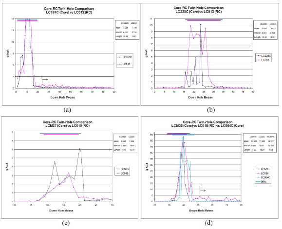
| Fronteer Gold Inc. |
| Long Canyon Project, Elko County, Nevada |
| Updated Technical Report and Interim Resource Estimate |
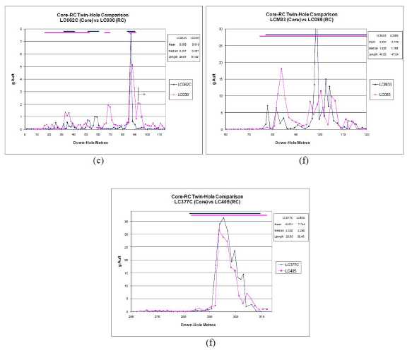
Three out of the seven twin sets have clear down-hole cyclic patterns of spikes in RC gold values that correlate with rod changes, without corresponding patterns in the core holes (Figure 12-4 a, d, and e; the beginning of the cyclic down-hole contamination patterns are shown on the graphs with lines and arrows). In each case, these patterns initiate immediately down-hole of significant gold mineralization, which is the obvious candidate as the source of the contamination. The suspect gold values within the cyclic patterns spike significantly above the resource cutoff of 0.2 g Au/t in each of the three cases, with the values in LC018 spiking to 4 g Au/t (in this case, the down-hole contamination occurs within dolomite that is presumed to be unmineralized). The modeled mineral domains exclude these intervals of clear down-hole contamination, as shown by the lines at the top of the graphs.
The down-hole plots on Figure 12-4 b and c suggest that the RC and core holes sampled different geology, and are therefore poor choices for statistical comparisons. For example, in the case of Figure 12-4 c, the RC hole penetrates the edge of a high-grade zone, while the core hole lies solidly within the mineralized zone. Similarly, the morphologies of the plots in Figure 12-4 e suggest that the holes are not a good match until the deep high-grade zone is intersected. The two holes are 12 metres apart within this high-grade zone, which negates these intervals for use as twin data.
| Fronteer Gold Inc. |
| Long Canyon Project, Elko County, Nevada |
| Updated Technical Report and Interim Resource Estimate |
Excluding the three twin sets that are unlikely to sample comparable geology, the modeled mineralization in the twinned core and RC holes are compared in Table 12-2. The data compare reasonably well, although they are not of sufficient quantity to make definitive conclusions.
Table 12-2: Statistical Comparison of RC-Core Twin Holes
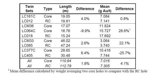
The twin-hole data, in addition to careful inspection of all of the RC gold data, have clearly identified down-hole contamination of gold in a portion of the Long Canyon RC drill samples, and the potentially suspect data are material to the resource estimation. In recognition of this, the mineral domain modeling used in the resource estimation described in Section 17.0 has excluded the mineralized samples suspected of being contaminated. Gustinet al. (2010) not ed, and Fronteer concurs, however, that the identification of suspect assays is interpretational; we believe it is possible that some relatively small amount of the excluded mineralization is ‘real’, and, conversely, it is likely that some mineralized samples included in the resource estimation are affected by contamination.
| Fronteer Gold Inc. |
| Long Canyon Project, Elko County, Nevada |
| Updated Technical Report and Interim Resource Estimate |
This page left intentionally blank.
| Fronteer Gold Inc. |
| Long Canyon Project, Elko County, Nevada |
| Updated Technical Report and Interim Resource Estimate |
| 13 | SAMPLE PREPARATION, ANALYSES, AND SECURITY |
| | |
| The analytical laboratories used by Pittston, AuEx, and Fronteer (American Assay Laboratories, ALS Chemex (“ALS”) and Inspectorate Laboratories), as well as the analytical procedures used by the laboratories to obtain the gold assays for Long Canyon, are well recognized and widely used in the minerals industry. After an audit of all preparatory laboratories in Nevada by Barry Smee in March 2009, ALS was selected as the primary assay lab and Inspectorate Laboratories of Sparks, Nevada as the secondary lab. |
| | |
| 13.1 | Sample security |
| | |
| The Pittston RC samples were transported by Pittston personnel to a staging area at the project site. AuEx and the Fronteer-AuEx Joint Venture left their RC drill samples at the drill- site locations. In all cases up to November 2008, American Assay Laboratories of Sparks, Nevada (“AAL”) picked up the drill samples and transported them to their sample preparation facility in Elko, Nevada. Joint Venture RC samples generated after November 2008 were picked up by either AAL or ALS of Reno, Nevada. All samples generated after March, 2009 were picked up by ALS. Some of the coarse rejects from the Pittston drill samples were retained by Pittston and are now in the possession of Fronteer. Fronteer has retrieved all rejects from the laboratories and placed them in marked barrels that now reside at Fronteer’s Oasis storage site . |
| | |
| Prior to 2009, Joint Venture drill-core samples were collected at the drill site by Fronteer personnel and transported to a secure trailer at Big Spring Ranch. Beginning in 2009, the core samples were taken to a secure trailer in a fenced yard at the Oasis office and logging facility. In either case, the core was then logged, marked for sampling, and photographed. When these tasks were completed, the core was transported by Fronteer to the AAL preparation facility in Elko for sawing, sampling, and sample preparation until mid-2008. Core boxes with the remaining half core were transported by Fronteer from the AAL facility to Fronteer’s secure warehouse in Elko . In the latter half of 2008, Fronteer brought the core from the on-site trailer to their secure office in Elko, where the core was cut and sampled before transport by Fronteer personnel to the Elko sample preparation facilities of either AAL or ALS. The remaining half core was retained by Fronteer in Elko. In 2009, all core was cut in Fronteer’s Elko sample preparation facilities and transported to the ALS prep lab in Elko. |
| | |
| In 2010, Fronteer leased a large warehouse in Wells, and moved all core sample preparation activities and storage to this warehouse . Samples are transported to the facility, cut, archived and transported to ALS’s prep lab in Elko while continuously under the supervision of Fronteer personnel and contractors. |
| | |
| Following preparation of the drill samples in the Elko labs, AAL and ALS shipped the sample splits to their facilities in Sparks and Reno, respectively, for assaying. |
| | |
| Joint Venture coarse rejects from drill samples analyzed by AAL or ALS currently reside at Fronteer’s Wells warehouse. Pulps are stored at Fronteer’s Wells warehouse. |
| Fronteer Gold Inc. |
| Long Canyon Project, Elko County, Nevada |
| Updated Technical Report and Interim Resource Estimate |
| 13.2 | Sample Preparation and Analysis |
| | |
| Until November 2008, all samples generated from surface sampling and drilling programs at Long Canyon were prepared and analyzed by AAL. Beginning in November 2008, core samples and some RC samples were sent to ALS for sample preparation and analysis due to a significant backlog at AAL’s Elko sample preparation laboratory. Holes assayed in part by both ALS and AAL include LC139C, 142C, 143C, 146C, 148C, 155C, 157C, 160C, 161C, and 164C. Holes assayed entirely by ALS include LC180C, 182C, 187C, 190C, 192C, 195C, 196C, 201C, 202C, 203C, 206C, 208C, 223, 224, 225, 226, 227, 228C, 229C, MW3, and MW4. All 2009 and 2010 drill holes were analyzed by ALS. |
| | |
| All samples submitted for assaying were analyzed for gold, and the majority of holes have samples with multi- element ICP analyses (30, 69, or 72 elements; ICP-MS employed in 2009 and 2010). AAL and ALS employed standard sample preparation procedures that included crushing the entire sample to 8 to 10 mesh and splitting the material to 1/8 to 1/16 volume in a riffle splitter. The splits were pulverized to a nominal 150 mesh. The standard gold assay for the Long Canyon drill samples used a 30-gram charge fire assay with an atomic absorption spectroscopy (“AAS”) finish. AAL and ALS standard assays that returned values of 10 g Au/t or higher were re- analyzed by fire assay with a gravimetric finish on all samples. At the suggestion of consultant Barry Smee, all samples that returned values of 5 g Au/t or higher were re- analyzed by gravimetric methods commencing in 2009. |
| | |
| AAL and ALS also completed cyanide-soluble analyses on most samples with reported values of 0.3 g Au/t or higher . AAL placed 30.0 ± 0.1 grams of sample pulp into a 150-millilitre bottle with 60. 0 ± 0.1 millilitres of 0.30% NaCN. The bottles were tumbled end over end for 60 minutes at room temperature. After allowing it to settle for two hours, the solution was analyzed for gold by AAS with a background correction. ALS used their “Au-AA13” analytical method. A nominal 30 grams of sample pulp was continually rolled and leached for one hour at room temperature in a 60- millilitres solution of 0. 25% NaCN, maintained at a pH of 11 to 12. Gold was analyzed by AAS. Discrepancies between labs with respect to expected results noted during analysis of metallurgical and AuCN data led to reassay of all AAL AuCN samples at AAL. Following the recognition in the 2009 Long Canyon PEA (Gustinet al., 2009) that a lower cut-off grade of 0.2 g Au/t may be more appropriate, all samples exceeding this threshold in the 2010 program were subject to the Au-AA13 cyanide -soluble analyses. In addition, all pulps from previous drill campaigns that exceeded the new threshold were pulled and similarly analyzed for cyanide solubility. |
| | |
| Select pulps from 25 sample intervals from the 2008 drilling were analyzed by AAL by standard fire- assay methods on +150 mesh and -150 mesh screen-size fractions (known as “metallic sieve” or “screen-fire” analyses). |
| | |
| All data from logging and assaying are verified on site and uploaded to a database maintained on the Fronteer Reno server. The data are then imported into GEMS® for generation of sections and three- dimensional modeling. |
| Fronteer Gold Inc. |
| Long Canyon Project, Elko County, Nevada |
| Updated Technical Report and Interim Resource Estimate |
| 14 | DATA VERIFICATION |
| | |
| 14.1 | Fronteer-AuEx Joint Venture Quality Assurance/Quality Control Results |
| | |
| The Joint Venture Quality Assurance/Quality Control (“QA/QC”) program included analyses of standard reference materials (“standards”), blanks, field duplicates, and duplicate pulps, as well as check assays by umpire laboratories. The program was designed to ensure that at least one standard, blank, or field duplicate was inserted into the drill-sample stream for every 30 drill samples, which are the number of samples in each ALS analytical batch. In addition, a quartz wash protocol was established for used in obviously mineralized zones where blank contamination was a concern. |
| | |
| Certified Standards – 2006 through 2008 Drilling Programs. Standards are used to evaluate the analytical accuracy and precision of the assay laboratory during the time the drill samples were analyzed. |
| | |
| Fronteer acquired four certified reference standards from Rocklabs of Auckland, New Zealand, and one from Minerals Exploration and Environmental Geochemistry of Reno, Nevada (“MEG”) for use in their 2006-2008 Long Canyon drilling programs (Table 14-1). These standards have a range of certified gold values that is representative of the deposit. Three standards created by Pittston were also used early in the project (Table 14-2). Pittston contracted AAL to prepare standards from RC rejects from holes drilled at a project on the western side of the Pequop range . These standards did not undergo round- robin testing by multiple laboratories, and the accepted values are not certified. |
The standards were assigned sample numbers in-sequence with their accompanying drill samples and were inserted into the drill-sample stream of most holes from LC042 through to LC417. MDA compiled 986 analyses of these standards, which were inserted into the sample sequence of all except four of the holes drilled by the Joint Venture through 2008, which equates to an insertion rate of one standard for every 38 drill samples. Analyses were completed by AAL and ALS.
Table 14-1: Certified Standards – 2006 through 2008 Joint Venture Drilling Programs

| Fronteer Gold Inc. |
| Long Canyon Project, Elko County, Nevada |
| Updated Technical Report and Interim Resource Estimate |
Table 14-2: Uncertified Standards – Joint Venture Program
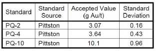
The following discussion of the standard results includes graphical representations of the data. These graphs show the dates of the assay certificates ordered along the x-axis, the gold grade of the standard assays on the y-axis, the certified or expected values of the standards as red lines, and+ two and+ three standard-deviation limits of the standards as blue and green lines, respectively. AAL analyses are shown as blue dots, while ALS analyses are yellow dots.
In the case of normally distributed data (note that most assay datasets from metal deposits are positively skewed), 95% of the standard analyses should lie within the two standard deviation limits of the certified/accepted value, while only 0.3% of the analyses should lie outside of the three standard deviation limits. As it is statistically unlikely that two consecutive samples would lie outside of the two standard deviation limits, such samples are considered failures unless further investigation proves otherwise. All samples outside of the three standard deviation limits are considered to be failures. Failures should trigger laboratory notification of potential problems and a re-run of all samples included with the failed standard result.
The 448 assays from the Rocklabs standards are presented in Figure 14-1. These standards were submitted with samples from all holes in the sequence LC068 through LC229C, as well as LCMW3 and LCMW4.
Figure 14-1: Rocklabs Standard Results
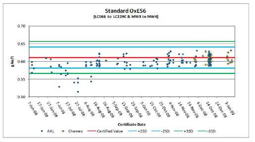
| Fronteer Gold Inc. |
| Long Canyon Project, Elko County, Nevada |
| Updated Technical Report and Interim Resource Estimate |
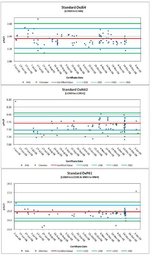
| Fronteer Gold Inc. |
| Long Canyon Project, Elko County, Nevada |
| Updated Technical Report and Interim Resource Estimate |
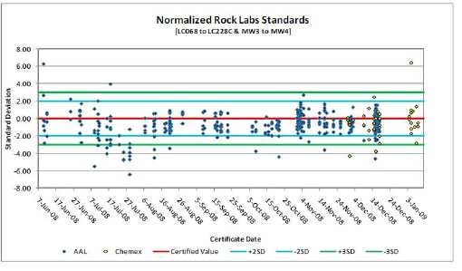
The AAL results for standard OxE56 have a clear low bias with respect to the certified value from the initiation of its use through to October 2008, while a slight low bias is evident after October 2008. The overall mean of the AAL analyses is 2.5% lower than the certified value. Twelve results lie outside of the three standard deviation limits, although four lie just outside of the three standard-deviation limits; all of these failures occurred in the period of July through August 2008. All of the jobs including these failures were rerun. The mean of the ALS analyses of the OxE56 standard is 0.5% lower than the certified value, with no failures.
Although the mean of the AAL analyses of standard OxJ64 is only 0.9% lower than the certified value, a pattern can be discerned in the plot (Figure 14-1), whereby the data points define a serpentine relationship with respect to the certified value. Although the certified values of OxE56 and OxJ64 are quite different, the variations between the AAL analyses and the certified values over time are very similar. One AAL analysis of OxJ64 is a failure, and the job was rerun. One ALS sample (7.49 g Au/t) is removed from the graph due to a presumed misidentification problem (likely OxN62). The single remaining ALS analysis of this standard is almost identical to the certified value.
There are ten AAL failures for standard OxN62. Six of the failed assay jobs were rerun; the job for one of the other failures was not rerun due to low grades in the drill samples. The mean of the AAL analyses is 1.3% lower than the certified value. There are only eight ALS analyses of the standard, one of which was a failure (the job was not rerun).
The AAL analyses of standard OxP61 average 1% lower than the certified value. The nine ALS analyses also average about 1% lower than the certified value. There are two failures each for the ALS and AAL standards; two of the jobs that include the failures were rerun.
In order to examine all of the data simultaneously, the AAL and ALS analyses were normalized based on their position relative to the certified values, expressed in standard
| Fronteer Gold Inc. |
| Long Canyon Project, Elko County, Nevada |
| Updated Technical Report and Interim Resource Estimate |
deviation units (see final graph of Figure 14-1). The standard analyses have a suggestion of a serpentine pattern, which evidences some analytical drift in the AAL analyses over the time period of the Joint Venture analyses. The 405 AAL analyses of the standards exhibit a slight low bias overall; the standard assays average 0.7 standard deviation units below the normalized certified value. The analyses were particularly low, with many failures, mid-July to the end of the month (six holes within the sequence of LC071 through LC094). The 42 ALS analyses (excluding the one analysis that was likely mislabeled) average 0.4 standard deviations below the normalized certified value.
There are 64 analyses of the MEG standard, which was inserted with the drill samples from 40 holes within the sequence LC015 through LC064C (Figure 14-2). Excluding one 3 g Au/t analysis, which is likely a misidentified standard, the mean of the AAL standard assays is 0.5% lower than the certified value. This is entirely due to analyses of standards submitted with holes LC015 through LC037 (August 2006 through January 2007), however, as all of these analyses are lower than the certified value, with numerous failures. The previous operators did not re-assay batches related to standard failures.
Figure 14-2: MEG Standard Results
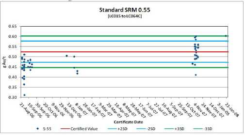
Uncertified Standards. A total of 73 AAL analyses of the three Pittston standards accompany drill samples from holes 47 holes in the sequence LC015 through LC067C (Figure 14-3). Seven of the analyses are failures, one of which triggered re-assaying of the associated drill samples. The results for standards PQ-2 and PQ-4 average 6% and 2% higher than the certified values, respectively. There are insufficient analyses of PQ-10 for meaningful comparisons. When considering the results of the Pittston standards, it is important to remember the standards did not undergo round-robin testing and are not certified.
| Fronteer Gold Inc. |
| Long Canyon Project, Elko County, Nevada |
| Updated Technical Report and Interim Resource Estimate |
Figure 14-3: Pittston Analytical Standard Results

Figure 14-4: Pittston Analytical Standard Results (cont.)
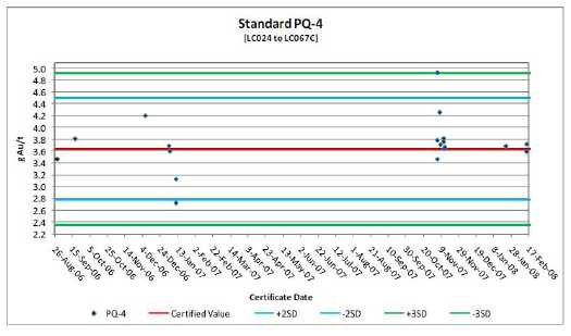
| Fronteer Gold Inc. |
| Long Canyon Project, Elko County, Nevada |
| Updated Technical Report and Interim Resource Estimate |
Pittston Analytical Standard Results (cont.)
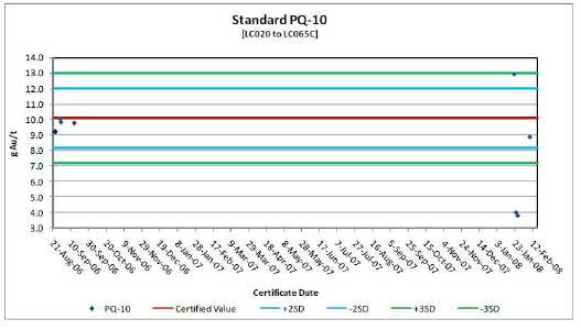
Certified Standards – 2009 and 2010 Drilling Programs. During the 2009 season, results for standards inserted into the sample stream were reviewed by Fronteer immediately upon receipt. Individual standards falling beyond three standard deviations from the expected value triggered a re-run of the assay batch, with two successive standards falling beyond two standard deviations from the expected value also considered to constitute a failure. Some discretion was used in application of these criteria, as failures from standard analyses that fall entirely within an unmineralized batch did not necessarily trigger a re-analysis. Standards were also graphed in order to chart systematic drift or bias in the results. On a number of occasions, the laboratory was contacted when repeated failures appeared to signal a low or high bias in the analyses. These concerns were usually addressed promptly by the lab.
Five standards were prepared by MEG and certified by consultant Barry Smee for use in the 2009 and 2010 drilling programs, utilizing both high and low-grade mineralized material from the Long Canyon deposit (Table 14-3).
Table 14-3: Certified Standards Prepared from Long Canyon Mineralized Material
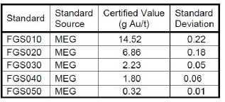
| Fronteer Gold Inc. |
| Long Canyon Project, Elko County, Nevada |
| Updated Technical Report and Interim Resource Estimate |
MDA examined the results of 401 assays of Long Canyon custom standards (Figure 14-5). Details of their analysis are described in Gustinet al. (2010), and only the summary plot of the normalized results of all standards is reproduced here.
Figure 14-5: Long Canyon Standard Results for 2009 Drilling
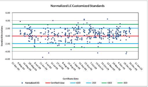
This summary plot indicates a slight but consistent high bias in the standard analyses from about September through the end of 2009. The standard assays average 0.45 standard deviation units above the normalized certified value. There are 10 high-side failures (analyses greater than three standard deviations from the mean), including one extreme failure (beyond the limit of the graph), and six low-side failures.
The 2010 drill program used the same suite of custom standards to monitor assay accuracy for drill holes from LC418C to LC737C. A total of 916 standards were inserted into the sample stream for 317 drill holes, supporting 37,000 samples. The results are plotted on individual charts for each standard in Figure 14-6, and include the results of the Round Robin analyses for comparison.
The high grade standard, FGS010, performed very well with no failures and only one sample falling outside the +/-2 standard deviation limit, on the low side. Overall, there appears to be a marginally low bias for this standard, with the average grade of all FGS010 analyses being about 0.4% below the certified value.
The medium grade standard, FGS020, was also quite consistent, but with two low failures and a single high failure. One of the low failures occurred in barren rock and no action was taken. The other low failure occurred within a very high grade interval, but the hole was lost and re-drilled/re-assayed, so no action taken. The high failure (off the chart in Figure 14-6) was inside a high grade interval and the entire batch was re-run. The results of this standard have an overall low bias of approximately 1% below the certified value.
| Fronteer Gold Inc. |
| Long Canyon Project, Elko County, Nevada |
| Updated Technical Report and Interim Resource Estimate |
Figure 14-6: Long Canyon Custom Standard Results for 2010 Drilling
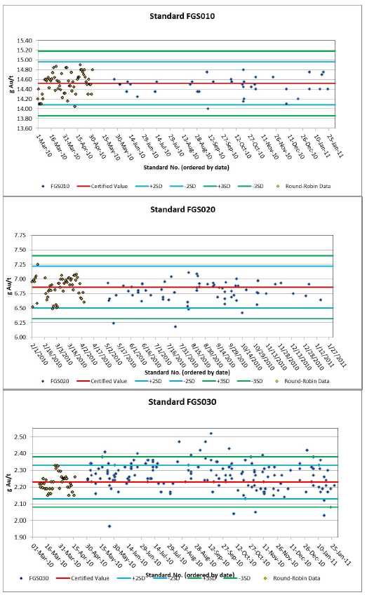
| Fronteer Gold Inc. |
| Long Canyon Project, Elko County, Nevada |
| Updated Technical Report and Interim Resource Estimate |

| Fronteer Gold Inc. |
| Long Canyon Project, Elko County, Nevada |
| Updated Technical Report and Interim Resource Estimate |
The two standards in the 2 g Au/t range both have a clear high bias, particularly from April to September in FGS030: 2.5% high, on average, compared to 0.2% from October to December, and 1.5% high for the year. FGS040 was 3.3% high, on average, for the year. FGS030 had 13 high failures and 6 low failures; however, only 7 of these failures occurred in mineralized rock and were re-run. FGS040 had 7 high failures and 1 low; only 1 occurred in mineralization and was re-run. FGS040 had an irregularly high number of “NSS” results (5) from the lab indicating internal lab failures and re-runs, but adjacent samples had certified results so the issue was not investigated further. Notably, ALS results in the Round Robin analyses were consistently on the high side for both of these standards: on average, 0.4% and 2.7% for FGS030 and FGS 040, respectively. Therefore, it seems likely that this apparent bias is a result of inter-laboratory variance, as opposed to any analytical inaccuracies. Should ALS continue to be used as the primary lab, a minor upward adjustment to the certified value should be evaluated.
The low grade standard, FGS050, performed very well with only a very slight low bias (-6%) compared to its certified value; although the results exhibit a greater range of variability than indicated by the Round Robin results. This standard had 8 high failures and 4 low, and only 3 required a re-run – all others were in barren rock.
The last plot shows all standard results normalized to standard deviation units above and below their mean (SD = 0). This plot shows that the results are well-behaved overall with only a slight positive bias of approximately 0.24 standard deviation units, which improves after late September.
Overall, the standard results indicate that the Long Canyon assay database is sufficiently accurate to be used for resource estimation.
Fire-Assay Pulp Checks. A total of 393 original AAL pulps from the 2006 through 2008 drilling programs were sent to ALS for check assaying of the fire-assay gold determinations. The pulps were derived from drill samples from 113 of the holes in the sequence LC031 through LC220.
Figure 14-7 is a graph that shows the difference, plotted on the y-axis, of each check assay relative to the original assay. The x-axis of the graph plots the means of the paired data, with each pair consisting of an original-assay and the corresponding check assays. The red line is a moving average and provides a visual guide to the trend of the relative differences. The graph shows high variability in the data up to about 0.09 g Au/t, which is expected due to the lack of analytical precision at lower gold concentrations. The check assays compare well with the original assays at higher grades.
Descriptive statistics of the paired data are summarized in Table 14-4. The check assays compare very well with the original assays throughout a range of cutoffs.
| Fronteer Gold Inc. |
| Long Canyon Project, Elko County, Nevada |
| Updated Technical Report and Interim Resource Estimate |
Figure 14-7: ALS Checks Relative to Original AAL Assays – 2006-2008

Table 14-4: ALS Checksvs.AAL Original Assays – 2006-2008
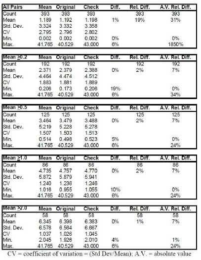
| Fronteer Gold Inc. |
| Long Canyon Project, Elko County, Nevada |
| Updated Technical Report and Interim Resource Estimate |
ALS assayed the primary drill samples from some of the late-2008 holes. A total of 69 of the original ALS pulps were sent to AAL for check assaying (Figure 14-8 and Table 14-5).
Figure 14-8: AAL Checks Relative to ALS Original Assays – 2006-2008
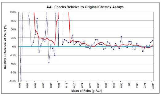
Table 14-5: AAL Checksvs.Original ALS Assays – 2006-2008
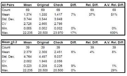
The mean of AAL check assays is 7% higher than the mean of the original ALS analyses, although the difference drops to 1% higher if the two highest-grade sample pairs are removed. There are insufficient pairs at grades of interest (>0.2 g Au/t) for definitive conclusions to be drawn, however.
A total of 369 original ALS pulps from the 2009 drill program were sent to Inspectorate for check assaying (Figure 14-9 and Table 14-6; eleven outlier pairs are removed, with no material impact to the statistics). While the means of the original and check assays compare very well at various cutoff grades, a systematic high bias is evident from
| Fronteer Gold Inc. |
| Long Canyon Project, Elko County, Nevada |
| Updated Technical Report and Interim Resource Estimate |
about 0.1 to 1.5 g Au/t. The mean of the Inspectorate check assays is six percent higher than the mean of the original ALS assays in this grade range.
Figure 14-9: Inspectorate Checks Relative to Original ALS Assays – 2009

Table 14-6: AAL Checksvs.Original ALS Assays – 2009
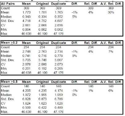
A total of 300 pulps were selected from the 2010 samples for check assaying at Inspectorate Labs, but the results were not yet available at the time of writing.
| Fronteer Gold Inc. |
| Long Canyon Project, Elko County, Nevada |
| Updated Technical Report and Interim Resource Estimate |
Cyanide-Soluble Pulp Checks. As part of the fire-assay pulp-check program for the 2006 to 2008 drill samples, ALS also performed cyanide-soluble check analyses on 147 samples (Figure 14-10 and Table 14-7). The ALS check analyses are systematically higher (~7%) than the original AAL cyanide-soluble assays. The determination methods of the two laboratories are not identical, which is the likely cause of at least part of the discrepancy.
Figure 14-10: ALS Cyanide-Soluble Checks Relative to Original AAL Assays – 2006-2008
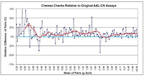
Table 14-7: ALS Cyanide-Soluble Checksvs.AAL Original Assays – 2006-2008

There are 192 original ALS cyanide-soluble – Inspectorate check pairs from the 2009 drill data (Table 14-8 and Figure 14-11). The Inspectorate check analyses are systematically lower, with the average relative difference being 12% lower. This systematic difference is consistent with the pre-2009 data discussed above, and strongly suggests there are differences in the cyanide-soluble methodologies between the two laboratories.
Table 14-8: Inspectorate Cyanide-Soluble Checksvs.ALS Original Assays – 2009
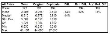
| Fronteer Gold Inc. |
| Long Canyon Project, Elko County, Nevada |
| Updated Technical Report and Interim Resource Estimate |
Figure 14-11: Inspectorate Cyanide-Soluble Checks Relative to Original ALS Assays – 2009
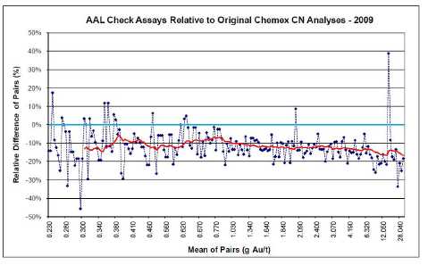
Duplicate Pulps. Duplicate pulps, also referred to as preparation duplicates, are new pulps prepared from splits of the original coarse rejects created during the first crushing and splitting stage of the primary drill samples. Duplicate-pulp data provide information about the sub-sampling variance introduced during this stage of sample preparation.
The duplicate-pulp samples from the 2006 to 2008 drill programs are derived from the coarse rejects of samples from 44 holes in the sequence LC037 to LC118.
Comparisons of the AAL analyses of these duplicate pulps relative to the original AAL assays are shown in Figure 14-12 and Table 14-9.
Figure 14-12: AAL Duplicate Pulps Relative to Original AAL Assays – 2006-2008
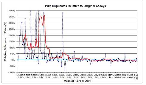
| February 25, 2011 | Page 100 |
| Fronteer Gold Inc. |
| Long Canyon Project, Elko County, Nevada |
| Updated Technical Report and Interim Resource Estimate |
Table 14-9: AAL Duplicate Pulpsvs.AAL Original Assays – 2006-2008
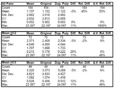
The descriptive statistics indicate that the duplicate-pulp assays are slightly lower than the assays of the original pulps, with the relative difference plot showing that this discrepancy is due to a low bias that is prevalent at grades greater than about 0.35 g Au/t.
The 2009 duplicate-pulp data were generated by ALS. A total of 222 duplicate pulp – original pulp pairs are compared in Figure 14-13 and Table 14-10. A total of 87 pairs are excluded where both the duplicate and original analyses returned values less than the detection limit, and four additional outlier pairs are also excluded.
Figure 14-13: ALS Duplicate Pulps Relative to Original ALS Assays – 2009
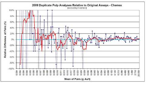
| February 25, 2011 | Page 101 |
| Fronteer Gold Inc. |
| Long Canyon Project, Elko County, Nevada |
| Updated Technical Report and Interim Resource Estimate |
Table 14-10: ALS Duplicate Pulpsvs.Original ALS Assays – 2009
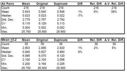
While there are insufficient data at meaningful grades to formulate definitive conclusions, the 2009 duplicate pulp analyses compare reasonably well with the original pulp assays.
In 2010, ALS was instructed to analyze a total of 514 core prep duplicates (Figure 14-14 and Table 14-11) and 363 RC prep duplicates (Figure 14-15 and Table 14-12), by creating a second pulp from the same coarse reject used for the original assay. The results show the expected variability at low concentrations close to the limit of detection, but are very well matched at and exceeding concentrations around 0.1 g Au/t.
Figure 14-14: ALS Prep Duplicates Relative to Original ALS Assays from Core – 2010
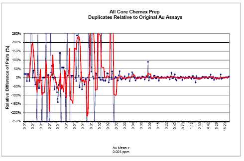
| February 25, 2011 | Page 102 |
| Fronteer Gold Inc. |
| Long Canyon Project, Elko County, Nevada |
| Updated Technical Report and Interim Resource Estimate |
Table 14-11: ALS Duplicate Pulps versus Original ALS Assays from Core – 2010
| All Pairs | Mean | Original | Duplicate | Diff. | Rel. Diff. | A. V. Re l. Diff. |
| Count | 514 | 514 | 514 | | 514 | 514 |
| Mean | 0.665 | 0.664 | 0.665 | 0% | 10% | 45% |
| Std. Dev. | 2.595 | 2.583 | 2.609 | | | |
| CV | 3.905 | 3.889 | 3.923 | | | |
| Min. | 0.003 | 0.003 | 0.003 | 0% | | 0% |
| Max. | 20.750 | 20.500 | 21.400 | 4% | | 1500% |
| | | | | | | |
| Mean>0.2 | Mean | Original | Duplicate | Diff. | Rel. Diff. | A. V. Re l. Diff. |
| Count | 79 | 79 | 79 | | 79 | 79 |
| Mean | 4.248 | 4.246 | 4.249 | 0% | 0% | 5% |
| Std. Dev. | 5.378 | 5.341 | 5.420 | | | |
| CV | 1.266 | 1.258 | 1.276 | | | |
| Min. | 0.203 | 0.204 | 0.202 | -1% | | 0% |
| Max. | 20.750 | 20.500 | 21.400 | 4% | | 28% |
| | | | | | | |
| Mean>0.5 | Mean | Original | Duplicate | Diff. | Rel. Diff. | A. V. Re l. Diff. |
| Count | 60 | 60 | 60 | | 60 | 60 |
| Mean | 5.488 | 5.486 | 5.489 | 0% | -1% | 5% |
| Std. Dev. | 5.633 | 5.587 | 5.687 | | | |
| CV | 1.027 | 1.018 | 1.036 | | | |
| Min. | 0.561 | 0.570 | 0.552 | -3% | | 0% |
| Max. | 20.750 | 20.500 | 21.400 | 4% | | 28% |
| | | | | | | |
| Mean>1.0 | Mean | Original | Duplicate | Diff. | Rel. Diff. | A. V. Re l. Diff. |
| Count | 48 | 48 | 48 | | 48 | 48 |
| Mean | 6.666 | 6.663 | 6.669 | 0% | -1% | 5% |
| Std. Dev. | 5.722 | 5.666 | 5.787 | | | |
| CV | 0.858 | 0.850 | 0.868 | | | |
| Min. | 1.115 | 1.110 | 1.115 | 0% | | 0% |
| Max. | 20.750 | 20.500 | 21.400 | 4% | | 28% |
| | | | | | | |
| Mean>2.0 | Mean | Original | Duplicate | Diff. | Rel. Diff. | A. V. Re l. Diff. |
| Count | 40 | 40 | 40 | | 40 | 40 |
| Mean | 7.727 | 7.718 | 7.736 | 0% | 0% | 5% |
| Std. Dev. | 5.703 | 5.640 | 5.774 | | | |
| CV | 0.738 | 0.731 | 0.746 | | | |
| Min. | 2.010 | 1.930 | 1.995 | 3% | | 0% |
| Max. | 20.750 | 20.500 | 21.400 | 4% | | 18% |
CV = coefficient of variation = (Std Dev/Mean); A.V. = absolute value
Figure 14-15: ALS Duplicate Pulps Relative to Original ALS Assays from RC – 2010
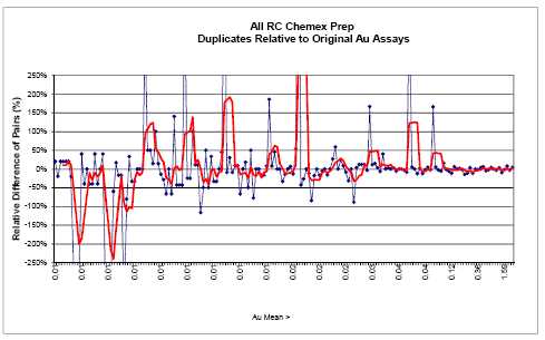
| February 25, 2011 | Page 103 |
| Fronteer Gold Inc. |
| Long Canyon Project, Elko County, Nevada |
| Updated Technical Report and Interim Resource Estimate |
Table 14-12: ALS Duplicate Pulps versus Original ALS Assays from RC – 2010
| All Pairs | Mean | Original | Duplicate | Diff. | Rel. Diff. | A.V. Rel. Diff. |
| Count | 363 | 363 | 363 | | 363 | 363 |
| Mean | 0.064 | 0.064 | 0.065 | 1% | 9% | 46% |
| Std. Dev. | 0.342 | 0.340 | 0.345 | | | |
| CV | 5.314 | 5.302 | 5.328 | | | |
| Min. | 0.003 | 0.003 | 0.003 | 0% | | 0% |
| Max. | 4.255 | 4.170 | 4.340 | 4% | | 1140% |
| | | | | | | |
| Mean>0.2 | Mean | Original | Duplicate | Diff. | Rel. Diff. | A.V. Rel. Diff. |
| Count | 19 | 19 | 19 | | 19 | 19 |
| Mean | 1.009 | 1.007 | 1.010 | 0% | -2% | 5% |
| Std. Dev. | 1.162 | 1.149 | 1.176 | | | |
| CV | 1.152 | 1.140 | 1.164 | | | |
| Min. | 0.224 | 0.239 | 0.208 | -13% | | 1% |
| Max. | 4.255 | 4.170 | 4.340 | 4% | | 15% |
| | | | | | | |
| Mean>0.5 | Mean | Original | Duplicate | Diff. | Rel. Diff. | A.V. Rel. Diff. |
| Count | 10 | 10 | 10 | | 10 | 10 |
| Mean | 1.610 | 1.603 | 1.617 | 1% | 0% | 4% |
| Std. Dev. | 1.358 | 1.342 | 1.377 | | | |
| CV | 0.844 | 0.837 | 0.851 | | | |
| Min. | 0.562 | 0.568 | 0.555 | -2% | | 1% |
| Max. | 4.255 | 4.170 | 4.340 | 4% | | 10% |
| | | | | | | |
| Mean>1.0 | Mean | Original | Duplicate | Diff. | Rel. Diff. | A.V. Rel. Diff. |
| Count | 4 | 4 | 4 | | 4 | 4 |
| Mean | 2.962 | 2.935 | 2.989 | 2% | 2% | 4% |
| Std. Dev. | 1.193 | 1.183 | 1.207 | | | |
| CV | 0.403 | 0.403 | 0.404 | | | |
| Min. | 1.588 | 1.600 | 1.575 | -2% | | 2% |
| Max. | 4.255 | 4.170 | 4.340 | 4% | | 8% |
| | | | | | | |
| Mean>2.0 | Mean | Original | Duplicate | Diff. | Rel. Diff. | A.V. Rel. Diff. |
| Count | 3 | 3 | 3 | | 3 | 3 |
| Mean | 3.420 | 3.380 | 3.460 | 2% | 3% | 5% |
| Std. Dev. | 0.935 | 0.954 | 0.923 | | | |
| CV | 0.273 | 0.282 | 0.267 | | | |
| Min. | 2.410 | 2.320 | 2.500 | 8% | | 3% |
| Max. | 4.255 | 4.170 | 4.340 | 4% | | 8% |
CV = coeffic ient of variation = (Std Dev/Mean); A.V. = a bsolut e value
Field Duplicates. Field duplicates are secondary splits of drill samples. In the case of core drilling, field duplicates are obtained by re-splitting the core remaining after the primary samples have been taken. The RC field duplicates are splits of the cuttings collected at the drill rig at the same time as the primary samples. Field duplicates are mainly used to assess inherent geologic variability and sampling variance.
RC duplicate data analyzed by AAL are available for holes drilled in the 2007 through 2008 programs. These data are compared to the original AAL analyses in Figure 14-16 and Table 14-13 after the removal of 17 outlier pairs and 62 cases where both the original and duplicate analyses are less than the detection limit. The exclusion of the outlier pairs does not affect the statistical comparisons.
The mean of the RC field duplicates is 4% lower than the mean of the original analyses, although more data at meaningful grades are needed to establish statistically meaningful conclusions.
| February 25, 2011 | Page 104 |
| Fronteer Gold Inc. |
| Long Canyon Project, Elko County, Nevada |
| Updated Technical Report and Interim Resource Estimate |
Figure 14-16: 2007-2008 RC Field Duplicates Relative to Original Assays – AAL
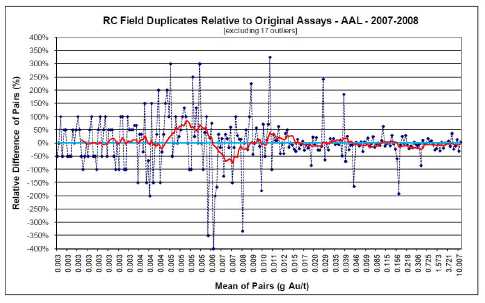
Table 14-13: 2007-2008 RC Field Duplicatesvs.Original Assays – AAL

The AAL analyses of core duplicates are compared to the original AAL assays in Figure 14-17 and Table 14-14 after the removal of two outlier pairs and 14 pairs where both analyses are less than the detection limit.
| February 25, 2011 | Page 105 |
| Fronteer Gold Inc. |
| Long Canyon Project, Elko County, Nevada |
| Updated Technical Report and Interim Resource Estimate |
Figure 14-17: 2007-2008 Core Field Duplicates Relative to Original Assays – AAL
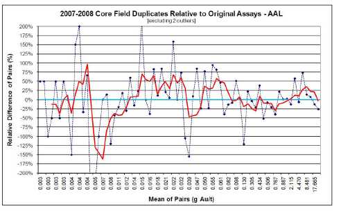
Table 14-14: 2007-2008 Core Field Duplicatesvs.Original Assays – AAL
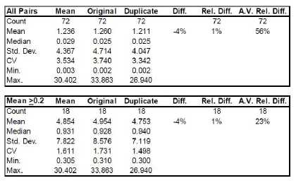
The mean of the duplicate core analyses is 4% lower than the mean of the original assays of the primary core samples, but there are far too few samples at meaningful grades to make firm conclusions. To illustrate this point, if the highest-grade pair is removed, the duplicate-core mean becomes 6%higherthan the mean of the analyses of the primary sample split.
There are 65 ALS analyses of field duplicates from 2008 and 2009 RC drill holes in which analyses of both the duplicate and primary sample splits are over the detection limit (Figure 14-18 and Table 14-15).
| February 25, 2011 | Page 106 |
| Fronteer Gold Inc. |
| Long Canyon Project, Elko County, Nevada |
| Updated Technical Report and Interim Resource Estimate |
Figure 14-18: 2008-2009 RC Field Duplicates Relative to Original Assays – ALS
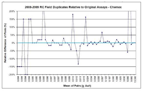
Table 14-15: 2008-2009 RC Field Duplicatesvs.Original Assays – ALS
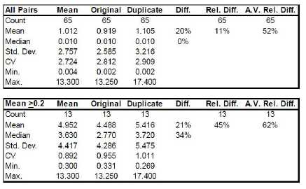
While the mean of the RC field duplicates is much higher than the mean of the original samples, the data are not sufficient for statistically meaningful conclusions at meaningful grades. If the two most extreme outlier pairs are removed (one is a high-grade pair and the other a very low-grade pair), the mean of the RC field duplicates is 5%lowerthan the analyses of the primary sample splits. Exclusive of the pairs with relative differences in excess of about+50%, the duplicate and original data compare well.
After removal of 95 pairs where both analyses are less than the detection limit and
| February 25, 2011 | Page 107 |
| Fronteer Gold Inc. |
| Long Canyon Project, Elko County, Nevada |
| Updated Technical Report and Interim Resource Estimate |
five outlier pairs, there are 194 duplicate – original core-split pairs (Figure 14-19 and Table 14-16).
Figure 14-19: 2008-2009 Core Field Duplicates Relative to Original Assays – ALS
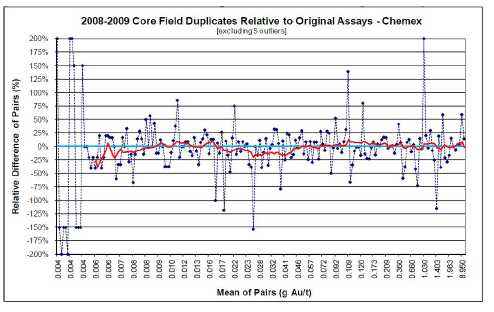
Table 14-16: 2008-2009 Core Field Duplicatesvs.Original Assays – ALS

Once again, there are insufficient pairs at meaningful grades to draw conclusions (the mean of the core duplicates becomes 2% lower than the mean of the originals if the two highest-grade pairs are removed). However, the relative difference plot does not suggest there are major issues.
In the 2010 drill program, 526 field duplicates from core and 364 field duplicates from RC chips were collected by Fronteer. The core field duplicates compare extremely well at
| February 25, 2011 | Page 108 |
| Fronteer Gold Inc. |
| Long Canyon Project, Elko County, Nevada |
| Updated Technical Report and Interim Resource Estimate |
Figure 14-20: ALS Field Duplicates for Core Compared to Original ALS Assays – 2010
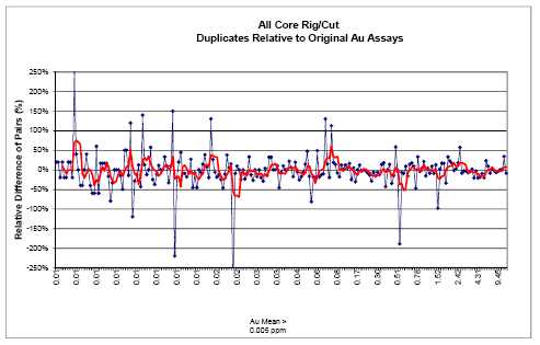
Table 14-17: 2010 Core Field Duplicates vs. Original Assays – ALS
| All Pairs | Mean | Original | Duplicate | Diff. | Rel. Diff. | A.V. Rel. Diff. |
| Count | 526 | 526 | 526 | | 526 | 526 |
| Mean | 0.379 | 0.379 | 0.378 | 0% | -3% | 19% |
| Std. Dev. | 1.467 | 1.467 | 1.470 | | | |
| CV | 3.867 | 3.867 | 3.886 | | | |
| Min. | 0.003 | 0.003 | 0.003 | 0% | | 0% |
| Max. | 11.950 | 11.950 | 11.650 | -3% | | 278% |
| | | | | | | |
| Mean>0.2 | Mean | Original | Duplicate | Diff. | Rel. Diff. | A.V. Rel. Diff. |
| Count | 70 | 70 | 70 | | 70 | 70 |
| Mean | 11.445 | 2.776 | 2.757 | -1% | -4% | 18% |
| Std. Dev. | 59.320 | 3.125 | 3.132 | | | |
| CV | 5.183 | 1.126 | 1.136 | | | |
| Min. | 0.204 | 0.212 | 0.196 | -8% | | 0% |
| Max. | 11.950 | 12.450 | 11.650 | -6% | | 189% |
| | | | | | | |
| Mean>0.5 | Mean | Original | Duplicate | Diff. | Rel. Diff. | A.V. Rel. Diff. |
| Count | 56 | 56 | 56 | | 56 | 56 |
| Mean | 3.371 | 3.379 | 3.362 | 0% | 0% | 19% |
| Std. Dev. | 3.213 | 3.225 | 3.231 | | | |
| CV | 0.953 | 0.954 | 0.961 | | | |
| Min. | 0.502 | 0.388 | 0.285 | -27% | | 0% |
| Max. | 11.950 | 12.450 | 11.650 | -6% | | 189% |
| | | | | | | |
| Mean>1.0 | Mean | Original | Duplicate | Diff. | Rel. Diff. | A.V. Rel. Diff. |
| Count | 42 | 42 | 42 | | 42 | 42 |
| Mean | 4.273 | 4.282 | 4.265 | 0% | 0% | 15% |
| Std. Dev. | 3.241 | 3.256 | 3.263 | | | |
| CV | 0.758 | 0.760 | 0.765 | | | |
| Min. | 1.028 | 0.930 | 1.000 | 8% | | 0% |
| Max. | 11.950 | 12.450 | 11.650 | -6% | | 98% |
| | | | | | | |
| Mean>2.0 | Mean | Original | Duplicate | Diff. | Rel. Diff. | A.V. Rel. Diff. |
| Count | 28 | 28 | 28 | | 28 | 28 |
| Mean | 5.691 | 5.705 | 5.677 | -1% | 0% | 11% |
| Std. Dev. | 3.106 | 3.121 | 3.146 | | | |
| CV | 0.546 | 0.547 | 0.554 | | | |
| Min. | 1.968 | 1.815 | 2.120 | 17% | | 0% |
| Max. | 11.950 | 12.450 | 11.650 | -6% | | 57% |
CV = coefficient of variation = (Std Dev/Mean ); A.V. = absolute value
| February 25, 2011 | Page 109 |
| Fronteer Gold Inc. |
| Long Canyon Project, Elko County, Nevada |
| Updated Technical Report and Interim Resource Estimate |
Figure 14-21: ALS Field Duplicates for RC Chips Compared to Original ALS Assays – 2010
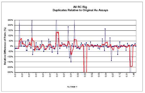
Table 14-18: 2010 RC Chips Field Duplicates vs. Original Assays – ALS
| All Pairs | Mean | Original | Duplicate | Diff. | Rel. Diff. | A.V. Rel. Diff. |
| Count | 364 | 364 | 364 | | 364 | 364 |
| Mean | 0.057 | 0.057 | 0.058 | 3% | -4% | 28% |
| Std. Dev. | 0.295 | 0.282 | 0.309 | | | |
| CV | 5.131 | 4.981 | 5.313 | | | |
| Min. | 0.003 | 0.003 | 0.003 | 0% | | 0% |
| Max. | 3.050 | 3.060 | 3.390 | 11% | | 1460% |
| | | | | | | |
| Mean>0.2 | Mean | Original | Duplicate | Diff. | Rel. Diff. | A.V. Rel. Diff. |
| Count | 15 | 15 | 15 | | 15 | 15 |
| Mean | 1.050 | 1.031 | 1.069 | 4% | -48% | 64% |
| Std. Dev. | 1.063 | 0.992 | 1.148 | | | |
| CV | 1.013 | 0.962 | 1.074 | | | |
| Min. | 0.253 | 0.279 | 0.093 | -67% | | 0% |
| Max. | 3.050 | 3.060 | 3.390 | 11% | | 792% |
| | | | | | | |
| Mean>0.5 | Mean | Original | Duplicate | Diff. | Rel. Diff. | A.V. Rel. Diff. |
| Count | 7 | 7 | 7 | | 7 | 7 |
| Mean | 1.813 | 1.725 | 1.901 | 10% | 0% | 10% |
| Std. Dev. | 1.165 | 1.099 | 1.240 | | | |
| CV | 0.643 | 0.637 | 0.652 | | | |
| Min. | 0.528 | 0.504 | 0.551 | 9% | | 0% |
| Max. | 3.050 | 3.060 | 3.390 | 11% | | 26% |
| | | | | | | |
| Mean>1.0 | Mean | Original | Duplicate | Diff. | Rel. Diff. | A.V. Rel. Diff. |
| Count | 5 | 5 | 5 | | 5 | 5 |
| Mean | 2.308 | 2.198 | 2.418 | 10% | 9% | 9% |
| Std. Dev. | 0.980 | 0.912 | 1.065 | | | |
| CV | 0.425 | 0.415 | 0.440 | | | |
| Min. | 1.038 | 1.035 | 1.040 | 0% | | 0% |
| Max. | 3.050 | 3.060 | 3.390 | 11% | | 26% |
| | | | | | | |
| Mean>2.0 | Mean | Original | Duplicate | Diff. | Rel. Diff. | A.V. Rel. Diff. |
| Count | 3 | 3 | 3 | | 3 | 3 |
| Mean | 3.015 | 2.850 | 3.180 | 12% | 12% | 13% |
| Std. Dev. | 0.056 | 0.187 | 0.185 | | | |
| CV | 0.019 | 0.066 | 0.058 | | | |
| Min. | 2.950 | 2.700 | 3.040 | 13% | | 1% |
| Max. | 3.050 | 3.060 | 3.390 | 11% | | 26% |
CV = coefficient of variation = (Std Dev/Mean); A .V. = absolute value
| February 25, 2011 | Page 110 |
| Fronteer Gold Inc. |
| Long Canyon Project, Elko County, Nevada |
| Updated Technical Report and Interim Resource Estimate |
all cut-offs from 0-2 g Au/t. This indicates a much higher than expected precision for the 2010 core assay results, especially compared to the precision achieved in previous programs. On the other hand, the variability of the RC results is considerably higher, with a slight high bias for the duplicate analyses, but still within the expected range for this type of data and comparable to previous year’s results.
Preparation Blanks. Preparation blanks are coarse samples of barren material that are used to detect possible laboratory contamination, which is most common during sample-preparation stages. In order for analyses of blanks to be meaningful, therefore, they must be sufficiently coarse to require the same crushing stages as the drill samples. It is also important for blanks to be placed in the sample stream immediately after mineralized samples (which would be the source of most cross-contamination issues). Blank results that are greater than five times the detection limit (.025 g Au/t based on a 0.005 g Au/t ppb detection limit, or 0.015 g Au/t based on a .003 g Au/t detection limit) are typically considered failures that require further investigation and possible re-assay of associated drill samples.
Fronteer used coarse blank material from a bulk sample of barren rhyolite originally acquired by AuEx from MEG. Figure 14-22 displays the 574 analyses of preparation blank samples submitted with the drill samples from all Joint Venture holes drilled through 2008 except for LC164C. The blanks are coloured to identify the assay laboratory and are ordered by date of analysis on the x- axis. There are 13 failures out of 523 AAL analyses and two ALS failures out of 51 analyses.
Figure 14-22: Blank Analyses – 2006-2008
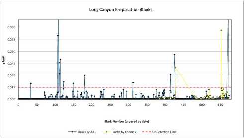
The 2009 coarse blank and previous sample results from ALS are shown in Figure 14-23. Nine blank analyses exceed the threshold and therefore qualify as failures; seven of these samples were preceded by strongly mineralized samples. There are only 24 samples that preceded blanks that returned gold values in excess of 1 g Au/t, and the blanks following seven of these samples returned anomalously high gold values.
| February 25, 2011 | Page 111 |
| Fronteer Gold Inc. |
| Long Canyon Project, Elko County, Nevada |
| Updated Technical Report and Interim Resource Estimate |
In the 2009 drilling program, blanks that returned greater than 0.015 g Au/t within mineralized intervals triggered a re-run of the associated drill samples. In some cases, blanks inserted after a well-mineralized interval, particularly if the material contained a significant amount of red hematitic residual material, returned repeated failures, indicating that the contamination occurred in the initial crushing stage. This problem could not be rectified without quartering the remaining core in the core library and submitting this new core sample for analysis. Recognition of this problem led to the establishment of a protocol that requires insertion of clean sand into the crusher between every sample in suspected high grade/high hematite residua samples. This step alleviated most of the blank contamination problems.
It is important to note that only one of the seven blank failures returned a gold value of significance (greater than 0.1 g Au/t).
Figure 14-23: ALS Blank Analysesvs.Grade of Previous Sample – 2009
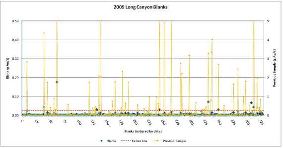
During the 2010 program, Fronteer documented 42 blank failures out of 993 blanks (4%), using a failure threshold of 0.025 g Au/t. Most of these failures occurred within high grade sample streams – 25 out of the 42 failures followed samples grading more than 5 g Au/t and 34 followed samples with more than 1.0 g Au/t (Figure 14-24). Investigation of these failures revealed that: (i) ALS was not being consistent with their implementation of a silica sand wash between samples and (ii) the mass of the blanks was small relative to the samples.
Prior to August (see Figure 14-24: #0-400) the silica wash protocol was used sporadically and of the 20 failures during this period, only 6 blanks were preceded by a silica wash. In addition, the only failures with contamination greater than 0.1 g Au/t occurred during this period. Subsequent follow-up with ALS resulted in stricter adherence to Fronteer’s requested wash protocol and Fronteer increased the mass of the blanks. This clearly reduced the levels of contamination observed in the blanks (see Figure 14-24: #400-993),
| February 25, 2011 | Page 112 |
| Fronteer Gold Inc. |
| Long Canyon Project, Elko County, Nevada |
| Updated Technical Report and Interim Resource Estimate |
although the frequency of contamination remained the same.
Early in the season, failed blanks within mineralization would trigger a re-split and prep of a new sample for every sample in the batch and re-assay. However, it was found that in most cases, the re-run would return comparable grades for the samples, but the blank would fail again, simply due to the high grade nature of the sample stream and consequent difficulty of controlling small amounts of contamination. As a result, blank failures where silica wash had been used and were within a stream of high grade mineralization were documented, but not re-run.
Figure 14-24: ALS Blank Analyses vs. Grade of Previous Sample - 2010

| 14.2 | Discussion of QA/QC Results |
| | |
| The 2006-2008 AAL analyses of the various certified reference standards inserted by the Fronteer are generally 1 to 3% lower than the certified values. The late-2008 ALS analyses of the same standards are also lower, although slightly less so than AAL, but there are insufficient data to form definitive conclusions. ALS check analyses of the pulps from the 2006-2008 drilling programs agree well with the original AAL fire assays. |
| | |
| ALS analyses of the custom Long Canyon standards inserted into the 2009 drill- sample stream often show a slight high bias with respect to the certified values, but AAL check assays of original 2009 ALS pulps are approximately 7% higher than the ALS analyses in the analytical range of about 0.1 to 1. 5 g Au/t. Also, the ALS Round Robin |
| February 25, 2011 | Page 113 |
| Fronteer Gold Inc. |
| Long Canyon Project, Elko County, Nevada |
| Updated Technical Report and Interim Resource Estimate |
| results were among the highest of all of the labs, so the high bias is likely a result of inter- laboratory variance, rather than any analytical inaccuracies. |
| | |
| Other than the strong suggestion of analytical drift in the 2006-2008 AAL analyses, there is no evidence of significant problems with the Long Canyon gold fire-assay database. |
| | |
| While no serious issues are indicated by the duplicate pulp and field-duplicate data, these should continue to be routinely collected. The field-duplicate data require additional sample pairs to allow for meaningful statistical analyses. The 2006-2008 duplicate -pulp analyses are slightly, but systematically, lower than assays of the original pulps, while no problems are evident in the 2009 duplicate-pulp analyses. Additional data at meaningful grades should help in identifying any issues. |
| | |
| The preparation blank dataset has identified a cross contamination issue with the ALS analyses. While no contamination of gold of significant magnitude has been identified, Fronteer has changed the sample preparation protocols in an attempt to address the issue. |
| | |
| There are limited QA/QC data available from the Pittston and AuEx drilling programs. A check- assaying program using available pulps and coarse rejects from these programs should be considered. |
| | |
| 14.3 | Assay Database Audit |
| | |
| MDA obtained original digital assay certificates directly from AAL and ALS for all Fronteerand AuEx holes drilled at Long Canyon, and these data were imported into the project database using non- manual methods. MDA used paper copies of the original assay certificates from the seven Pittston holes to manually enter the data, as digital assay certificates were not available. The manually entered data were then compared against the Pittston assays in Fronteer’s project database, in which the data were also entered by hand, and the resulting discrepancies were resolved. |
| February 25, 2011 | Page 114 |
| Fronteer Gold Inc. |
| Long Canyon Project, Elko County, Nevada |
| Updated Technical Report and Interim Resource Estimate |
| 15 | ADJACENT PROPERTIES |
| | |
| The West Pequop Project is immediately adjacent to and contiguous with the Long Canyon project. Until November 2, 2010, the West Pequop Project was controlled by a 4 9% / 5 1% joint venture between AuEx and Agnico-Eagle Mines Limited, with Agnico as operator. With the purchase of AuEx, Fronteer became a 49% partner in the West Pequop Project. Agnico is currently sole funding the project in order to earn an additional 19% interest, for a total of 70% of the property. The Project hosts an indicated resource of 64,138 ounces at an average grade of 1.63 grams/tonne (1,227,000 tonnes) and an inferred resource of 249,441 ounces at an average grade of 1.41 grams/tonne (5,504,000 tonnes), hosted in three zones (Section 34, Acrobat and Mountain Top; Moran, 2009). Gold mineralization is similar to Long Canyon in geochemical signature, host rocks and structural settings. |
| | |
| In the AuEx transaction, Fronteer also gained a 100% interest in the South Pequop Project, subject to an earn-in to a 70% interest in the property by Golden Dory. This property is located to the southwest along trend with Long Canyon, and contains areas of hematized solution breccia and jasperoids with anomalous gold values. The alteration is hosted primarily in Devonian rocks. The property has not been drill tested. |
| | |
| A number of public sections to the north and south of the Long Canyon Project area are controlled by a joint venture between Agnico-Eagle and Columbus Gold. Of note is Section 16, located immediately north of Section 21 in the Project Area (Figure 4-2), which is on trend with mineralization at Long Canyon. Agnico- Eagle drilled three holes in the southern portion of Section 16 in late 2008, and reported low but anomalous gold values in a recent press release. An additional three holes were drilled in 2010, but the results of this drilling have not been released. |
| February 25, 2011 | Page 115 |
| Fronteer Gold Inc. |
| Long Canyon Project, Elko County, Nevada |
| Updated Technical Report and Interim Resource Estimate |
This page left intentionally blank.
| February 25, 2011 | Page 116 |
| Fronteer Gold Inc. |
| Long Canyon Project, Elko County, Nevada |
| Updated Technical Report and Interim Resource Estimate |
| 16 | MINERAL PROCESSING AND METALLURGICAL TESTING |
| | |
| 16.1 | Summary |
| | |
| Three separate metallurgical testing programs have been completed, by McClelland Labs Inc., in Reno, Nevada, on Long Canyon oxide resource materials: |
| | 1. | Bulk Samples: Four (4) bulk samples excavated from road cuts were collected in early 2008 for testing. |
| | | |
| | 2. | Phase 1: Twenty-one (21) met composites were compiled from a total of 14-PQ and 5-HQ metallurgical core holes drilled at Long Canyon in early 2009. |
| | | |
| | 3. | Phase 2: Twenty-eight (28) met composites were compiled from a total of 25-PQ metallurgical core holes drilled at Long Canyon in late 2009 and early 2010. |
| The metallurgical core holes were drilled on several widely spaced section lines through the deposit and cover roughly 75% of the known strike length of the mineralization at the time of this report. |
| | |
| Metallurgical work is being conducted under the supervision of consulting metallurgist Gary Simmons. |
| | |
| Data from all test programs are summarized below. |
| | |
| Results from test data presently available suggest that Long Canyon mineralized material is amenable to extraction of gold by cyanidation via conventional oxide milling or heap leaching methods. The information and conclusions presented below are used to support the Mineral Resource cutoff grade and gold recovery estimates. |
| | |
| 16.2 | Bulk Sampling Program |
| | |
| Four bulk samples of surficial mineralized material were collected in twenty 55-gallon drums from road cuts. These samples, representing both breccia and stratiform mineralization that is hosted in limestone and dolomite, were sent to McClelland for preliminary metallurgical testing in early 2009. |
| | |
| 16.2.1 | Head Assays |
| | |
| Sample splits from the four bulk samples were submitted to ALS for assay using conventional fire-assay fusion procedures to determine gold and silver content . Composite head samples were submitted for cyanide (CN) soluble gold, total sulfur (S), sulfide sulfur, arsenic, organic carbon (C), carbonate, mercury, ICP, and whole rock analyses. Select analyses are presented in Table 16-1. |
| February 25, 2011 | Page 117 |
| Fronteer Gold Inc. |
| Long Canyon Project, Elko County, Nevada |
| Updated Technical Report and Interim Resource Estimate |
Table 16-1: Head Assay Results on Long Canyon Bulk Samples
Bulk
Sample # |
Sample
Description |
Au
(g/t) |
AuCN
(g/t) | AuCN1
Solubility
(%) |
Ag
(g/t) |
S (total)
(%) |
C (organic)
(%) |
#1 | Cnpl(bx) - Notch Peak
Limestone (Breccia) |
18.55 |
17.70 |
95.4 |
0.60 |
<0.01 |
0.07 |
#2 | Cnpl(bx) - Notch Peak
Limestone (Breccia) |
2.42 |
2.36 |
97.5 |
0.12 |
<0.01 |
0.05 |
#3 | Cnpl -Notch Peak
Limestone (Stratiform) |
14.80 |
14.50 |
98.0 |
0.14 |
<0.01 |
0.09 |
#4 | Opl -Pogonip Limestone
(Stratiform) |
1.82 |
1.84 |
100.0 |
0.05 |
<0.01 |
0.06 |
1. AuCN Solubility = AuCN/Au, expressed as percent.
| 16.2.2 | Bottle -Roll Tests |
| | |
| Direct agitated cyanidation (bottle roll) tests were conducted on the Long Canyon bulk samples at feed sizes of 80% -180 and -106-micron feed sizes to determine gold recovery, recovery rate, and reagent requirements. Sample charges were stage ground to the desired feed sizes using laboratory steel ball mills. Milled feeds were settled in grinding water to achieve 40 weight percent solids, and natural pulp pH was measured on each sample. Lime was added to adjust the pH of the pulps to between 10.5 and 11.0, and sodium cyanide, equivalent to 0. 5 g NaCN/l of solution, was then added to the alkaline pulps. Leaching was conducted by rolling the pulps in bottles on the laboratory rolls for 72 hours. Overall metallurgical results from the direct agitated bottle roll tests are provided in Table 16-2 and Table 16-3. Corresponding gold leach-rate profiles are shown graphically in Figure 16-1 and Figure 16- 2. |
| | |
| Table 16-2: Overall Bottle -Roll Test Results - Bulk Samples #1 and #2 |
Metallurgical Result | Bulk Sample #1 | Bulk Sample #2 |
| P80 = 180µm | P80 = 106µm | P80= 180µm | P80 = 106µm |
| Extraction: % of total Au | | | | |
| In 24 hours | 81.1 | 87.9 | 89.0 | 92.0 |
| In 36 hours | 85.0 | 89.9 | 89.5 | 92.1 |
| In 48 hours | 88.8 | 91.7 | 90.9 | 93.0 |
| In 72 hours | 87.1 | 91.9 | 90.0 | 93.2 |
| Calculated Head (g Au/t) | 17.58 | 17.83 | 2.51 | 2.51 |
| Assay Head (g Au/t) | 18.55 | 18.55 | 2.42 | 2.42 |
| NaCN Consumed (kg/t) | <0.07 | <0.07 | <0.07 | <0.07 |
| Lime Added (kg/t) | 1.3 | 1.1 | 1.1 | 1.2 |
| February 25, 2011 | Page 118 |
| Fronteer Gold Inc. |
| Long Canyon Project, Elko County, Nevada |
| Updated Technical Report and Interim Resource Estimate |
Figure 16-1: Bottle Roll Leach-Rate Profiles - Bulk Samples #1 and #2
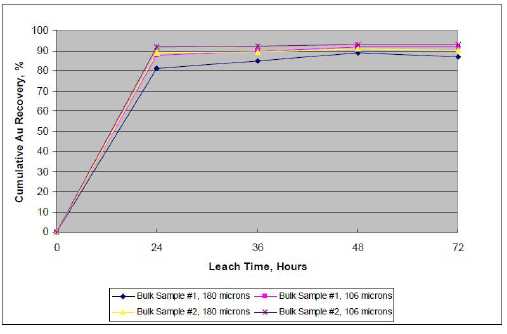
Table 16-3: Overall Bottle-Roll Test Results - Bulk Samples #3 and #4
Metallurgical Result | Bulk Sample #3 | Bulk Sample #4 |
| P80 = 180µm | P80 = 106µm | P80= 180µm | P80 = 106µm |
| Extraction: % of total Au | | | | |
| In 24 hours | 89.4 | 95.2 | 84.8 | 89.0 |
| In 36 hours | 91.0 | 96.3 | 85.8 | 88.5 |
| In 48 hours | 91.4 | 97.1 | 85.7 | 89.1 |
| In 72 hours | 91.4 | 97.0 | 85.3 | 89.6 |
| Calculated Head (g Au/t) | 15.44 | 14.34 | 1.91 | 1.82 |
| Assay Head (g Au/t) | 14.80 | 14.80 | 1.82 | 1.82 |
| NaCN Consumed (kg/t) | <0.07 | <0.07 | <0.07 | <0.07 |
| Lime Added (kg/t) | 1.2 | 1.1 | 1.5 | 0.7 |
| February 25, 2011 | Page 119 |
| Fronteer Gold Inc. |
| Long Canyon Project, Elko County, Nevada |
| Updated Technical Report and Interim Resource Estimate |
Figure 16-2: Bottle Roll Leach-Rate Profiles - Bulk Samples #3 and #4
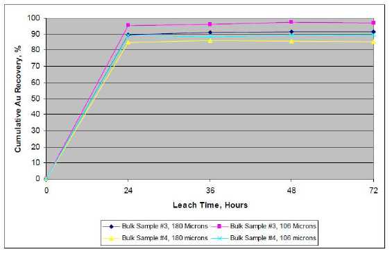
| Metallurgical results show that the Long Canyon bulk samples are readily amenable to direct agitated cyanidation treatment at the 80% -180 and -106-micron feed sizes. Gold recovery rates were rapid for all samples. |
| | |
| Cyanide consumptions were very low for all samples (<0.07 kg NaCN/t). Lime requirements were low, ranging from 0. 7 kg/t to 1.5 kg/t . |
| | |
| 16.2.3 | Agglomerate Strength Testing |
| | |
| Prior to column-leach testing, agglomerate strength and stability tests were conducted on Bulk Sample #1 at the - 25 millimeter feed size to optimize agglomerating conditions for the Long Canyon bulk samples. Bulk Sample #1 was selected as a “worst-case” sample for agglomeration testing, because it had higher fines content (22.9% -150 microns) than the other samples. |
| | |
| Agglomeration test results showed that, of the binder additions evaluated, addition of 3.0 kg/t of cement to Bulk Sample #1 was optimum for agglomeration; agglomerates produced using lower cement or lime additions lacked sufficient strength to bind the fines in the mineralized sample. All four bulk samples were agglomerated with 3.0 kg/t cement, as a precautionary measure, to insure that no complications with solution percolation or compaction would be encountered during column leaching. |
| | |
| Even though the bulk sample column- leach test program employed agglomeration ahead of column leaching, there is no indication that commercially mined mineralization at Long Canyon will require agglomeration pre -treatment . |
| February 25, 2011 | Page 120 |
| Fronteer Gold Inc. |
| Long Canyon Project, Elko County, Nevada |
| Updated Technical Report and Interim Resource Estimate |
| 16.2.4 | Column Leach Testing |
| | |
| Column percolation-leach tests were conducted on the four surficial Long Canyon bulk samples at 100% -75 and -25- millimetre feed sizes to determine gold recovery, recovery rate, and reagent consumptions under simulated heap leaching conditions. |
| | |
| Column charges were agglomerated with 3.0 kg/t of cement . Leaching was conducted by applying cyanide solution (0.5 g NaCN/l) over the charges at a rate of 0.20 lpm/m2 of column cross sectional area. Pregnant solutions were collected at 24- hour intervals, weighed, and assayed for gold and silver. Pregnant solutions were pumped through a three-stage carbon circuit for adsorption of precious metal values. Barren solutions, with appropriate make-up reagents, were recycled to the columns. |
| | |
| After leaching, fresh water rinsing was conducted to remove residual cyanide. Moisture required to saturate the column charges and retain moistures were determined. After rinsing, leached residues were air dried, blended, and split to obtain samples for triplicate tail assay. |
| | |
| Results of the column leach testing are summarized in Table 16-4, Table 16-5, Figure 16-3, and Figure 16-4. |
| | |
| Table 16-4: Overall Column Leach Test Results - Bulk Samples #1 and #2 |
Metallurgical Result | Bulk Sample #1 | Bulk Sample #2 |
| -75mm | -25mm | -75mm | -25mm |
| Extraction: % of total Au | | | | |
| 1st Effluent | 10.3 | 2.0 | 18.9 | 5.8 |
| In 5 days | 76.3 | 84.3 | 75.4 | 86.0 |
| In 10 days | 86.2 | 87.5 | 84.7 | 88.4 |
| In 15 days | 87.7 | 87.9 | 86.2 | 88.8 |
| In 20 days | 88.4 | 88.1 | 87.2 | 89.1 |
| In 30 days | 89.1 | 88.3 | 88.0 | 89.3 |
| In 40 days | 89.2 | 88.5 | 88.2 | 89.4 |
| In 50 days | 89.2 | 88.6 | 88.2 | 89.6 |
| In 60 days | 89.4 | 88.6 | 88.4 | 89.6 |
| End of Leach/Rinse | 89.4 | 88.7 | 88.4 | 89.8 |
| Calculated Head (g Au/t) | 19.69 | 18.39 | 2.51 | 2.54 |
| Assay Head (g Au/t) | 18.55 | 18.55 | 2.42 | 2.42 |
| NaCN Consumed (kg/t) | 0.45 | 0.67 | 0.47 | 0.45 |
| Cement Added (kg/t) | 3.00 | 3.00 | 3.00 | 3.00 |
| Leach/Rinse Cycle (days) | 62 | 69 | 67 | 61 |
| February 25, 2011 | Page 121 |
| Fronteer Gold Inc. |
| Long Canyon Project, Elko County, Nevada |
| Updated Technical Report and Interim Resource Estimate |
Figure 16-3: Column Leach-Rate Profiles - Bulk Samples #1 and #2
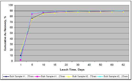
Table 16-5: Overall Column Leach Test Results - Bulk Samples #3 and #4
Metallurgical Result | Bulk Sample #3 | Bulk Sample #4 |
| -75mm | -25mm | -75mm | -25mm |
| Extraction: % of total Au | | | | |
| 1st Effluent | 11.7 | 0.3 | 28.6 | 24.6 |
| In 5 days | 82.5 | 92.7 | 70.9 | 65.8 |
| In 10 days | 93.2 | 95.4 | 78.4 | 77.2 |
| In 15 days | 94.6 | 95.7 | 81.2 | 80.4 |
| In 20 days | 95.1 | 95.8 | 82.2 | 81.9 |
| In 30 days | 96.1 | 96.1 | 83.3 | 83.5 |
| In 40 days | 96.4 | 96.2 | 83.6 | 84.7 |
| In 50 days | 96.4 | 96.2 | 83.9 | 84.8 |
| In 60 days | 96.5 | 96.2 | 84.2 | 85.3 |
| End of Leach/Rinse | 96.6 | 96.3 | 84.2 | 85.6 |
| Calculated Head (g Au/t) | 14.87 | 13.25 | 2.03 | 2.02 |
| Assay Head (g Au/t) | 14.80 | 14.80 | 1.82 | 1.82 |
| NaCN Consumed (kg/t) | 0.40 | 0.59 | 0.25 | 0.48 |
| Cement Added (kg/t) | 3.00 | 3.00 | 3.00 | 3.00 |
| Leach/Rinse Cycle (days) | 65 | 69 | 60 | 69 |
| February 25, 2011 | Page 122 |
| Fronteer Gold Inc. |
| Long Canyon Project, Elko County, Nevada |
| Updated Technical Report and Interim Resource Estimate |
Figure 16-4: Column Leach Rate Profiles - Bulk Samples #3 and #4
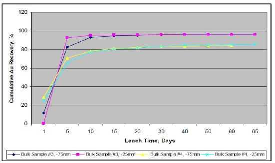
| The Long Canyon bulk samples are amenable to simulated heap-leach cyanidation treatment at both feed sizes evaluated. Gold recovery rates for all samples were rapid, and gold extraction was substantially complete in 10 to 15 days of leaching. |
| | |
| Cyanide consumptions were low. The average cyanide consumptions for the -75 and - 25-millimetre feeds were 0. 39 and 0.55 kg NaCN/t, respectively. Column-test cyanide consumptions are usually higher than experienced in commercial production. It is expected that commercial heap- leach cyanidation consumption for the mineralization types represented by the Long Canyon samples probably would not exceed 0. 3 kg NaCN/t. The cement added during agglomeration (3.0 kg/t) was sufficient for maintaining protective alkalinity during leaching. No solution percolation, fines migration, or solution channeling problems, were encountered during column leaching. |
| | |
| 16.3 | Phase 1 Metallurgical Testing From Drill Core Composites |
| 16.3.1 | Long Canyon Phase 1 Composites |
| | |
| A total of 19 barrels and 7 buckets of broken (-100 mm) half-split drill core samples from Fronteer’s Long Canyon project were sent to McClelland for metallurgical testing. Testing parameters included: |
1. Sample preparation, standard assays for gold, cyanide-soluble gold, and silver, as well as whole rock and ICP analyses;
2. Bottle roll testing at (80% passing) P80 = 37, 75 and 1700 microns;
3. Column leach testing at (80% passing) P80 = 12.5, 25 and 50 mm sizes;
| February 25, 2011 | Page 123 |
| Fronteer Gold Inc. |
| Long Canyon Project, Elko County, Nevada |
| Updated Technical Report and Interim Resource Estimate |
4. Load permeability testing on 17 column-leach residue samples;
5. Flotation and gravity testing on four composite samples; and
6. Comminution testing on six selected composites.
The results of direct head assays on the 21 composites are shown in Table 16-6. Re-logged geology/alteration descriptions are provided in the tables throughout the report.
Table 16-6: Head Assay Results - Long Canyon Phase 1 Metallurgical Composites
| | | | Head Grade |
| Comp No. | Zone/X- | Re-logged Geology | Au | AuCN | AuCN/Au | Ag | S= |
| | Section | | (g/t) | (g/t) | (%) | (g/t) | (%) |
| Comp #1 | WZ 11,150N | Cnpdz/ l/w/(bx ) | 0.52 | 0. 47 | 90.4% | 1.3 | 0.02 |
| Comp #2 | WZ 11,150N | Cnplw(m assiv e)/w/(bx )/onc+Lamp | 0.46 | 0. 41 | 89.1% | 1.0 | 0.01 |
| Comp #3 | WZ 11,150N | Lamp | 2.39 | 2. 21 | 92.5% | 1.0 | 0.01 |
| Comp #4 | WZ 11,150N | Cnplw(bx )/ (jsp)+Lamp | 8.06 | 7. 72 | 95.8% | 2.0 | <.01 |
| Comp #5 | SZ 12,000N | Cnplw(m assiv e)/w/(bx ) | 0.58 | 0. 51 | 87.9% | 1.3 | 0.01 |
| Comp #6 | SZ 12,000N | Cnpd(bx)/z | 1.08 | 0. 87 | 80.6% | 1.0 | 0.02 |
| Comp #7 | SZ 12,000N | Cnplw(bx )/onc/w (Silic ified) | 3.88 | 3. 41 | 87.9% | 1.3 | <.01 |
| Comp #8 | SZ 12,000N | Oplw(bx)/w | 2.65 | 2. 46 | 92.8% | 1.3 | 0.01 |
| Comp #9 | SZ 12,000N | Cnplus+(bx ) | 4.61 | 4. 36 | 94.6% | 1.3 | 0.01 |
| Comp #10 | DZ 12,000N | Cnplonc/us/w/(bx) | 0.75 | 0. 63 | 84.0% | 1.6 | 0.02 |
| Comp #11 | DZ 12,000N | Oplw(cavn)/(bx)/w/sm (bx ) | 0.54 | 0. 47 | 87.0% | 3.0 | 0.01 |
| Comp #12 | DZ 12,000N | Cnpd(bx) | 0.23 | 0. 20 | 87.0% | 0.9 | N/S |
| Comp #13 | DZ 11,150N | Oplw(bx)/sm/sm(bx ) | 5.17 | 4. 95 | 95.7% | 1.0 | 0.01 |
| Comp #14 | DZ 11,150N | Cnplw(m assiv e)/(jsp)/(bx)/onc/w | 1.11 | 1. 00 | 90.1% | 1.0 | <.01 |
| Comp #15 | DZ 11,150N | Cnplw(c av n)/onc/(jsp)/(bx ) | 2.84 | 2. 63 | 92.6% | 1.0 | 0.01 |
| Comp #16 | DZ 11,150N | Lamp+Cnplw/(jsp) | 7.87 | 7. 10 | 89.9% | 1.4 | N/S |
| Comp #17 | DZ 11,150N | Cnplus/ (bx )/onc+Lamp | 8.43 | 8. 01 | 95.0% | 0.9 | 0.01 |
| Comp #18 | CZ 12,400N | Oplw/sm&(bx)+Opl&(bx)+Cnpdl | 0.73 | 0. 68 | 93.2% | 0.9 | 0.02 |
| Comp #19 | CZ 12,400N | Oplsm&(bx ) | 4.25 | 4. 07 | 95.8% | 0.9 | 0.02 |
| Comp #20 | CZ 12,400N | Oplw&(bx)+Lamp+Oplsm | 6.39 | 6. 24 | 97.7% | 0.9 | 0.02 |
| Comp #21 | CZ 12,400N | Cnpdl | 1.26 | 1. 21 | 96.0% | 0.9 | N/S |
| | | | | | | | |
| The head analysis show that the Long Canyon deposit can be characterized as having high gold cyanide solubility (AuCN/Au >80.6%), low silver grade, and very low sulfide sulfur content (<0.02%). Whole rock and ICP analyses were performed on all composites and these are provided in the body of the McClelland report. |
| | |
| 16.3.2 | Bottle Roll Test Procedures and Results |
| | |
| Direct agitated cyanidation bottle roll tests were conducted on 21 Long Canyon drill core composites at 80% passing 1.7 mm, 75 micron, and 37-micron feed sizes to determine gold recovery, recovery rate, reagent requirements, and sensitivity to feed size. |
| | |
| Milling cyanidation (75 and 37 micron) feeds were stage ground using a laboratory steel |
| February 25, 2011 | Page 124 |
| Fronteer Gold Inc. |
| Long Canyon Project, Elko County, Nevada |
| Updated Technical Report and Interim Resource Estimate |
ball mill. Material charges were mixed with water to achieve 40% solids. Natural pHs were measured. Lime was added to adjust the pH of the pulps to between 10.5 and 11.0 before adding cyanide. Sodium cyanide, equivalent to 1.0 gram per liter of solution, was added to the alkaline pulps.
Leaching was conducted by rolling the pulps in bottles for 72 hours (75 and 37-micron samples) to 96 hours (1.7 -millimetre samples). Rolling was briefly suspended after 2, 6, 24, 48, 72, and 96 hours to allow the pulps to settle so samples of pregnant solution could be measured and sampled. Cyanide concentration and pH were determined for each solution sample. Make-up water, equivalent to that withdrawn, was added to the pulps. Lime was added, when necessary, to maintain the leaching pH at between 10.5 and 11.0. Rolling was then resumed.
After 72 or 96 hours, the pulps were filtered to separate liquids and solids. Final pH and cyanide concentrations were determined. Leached residues were washed, dried, weighed and assayed in triplicate to determine residual precious metal content. Overall metallurgical results from the bottle-roll test program are provided in Table 16-7.
Table 16-7: Phase 1 - Bottle Roll Test Results
| | | | Bottle Rolls - Au Recovery% |
| | | | Head Grade | | | |
| Comp. No. | Zone/x-Section | Re-logged Geology | Au (gpt) | 37 µ | 75 µ | 1700 µ |
| | | | | | | |
| Comp #1 | WZ 11,150N | Cnpdz/l/w/(bx) | 0.52 | 93.0 | 90.9 | 81.0 |
| Comp #2 | WZ 11,150N | Cnpl w(massi ve)/w/(bx)/onc+Lamp | 0.46 | 89.7 | 88.1 | 82.0 |
| Comp #3 | WZ 11,150N | Lamp | 2.39 | 92.9 | 92.5 | 89.2 |
| Comp #4 | WZ 11,150N | Cnpl w(bx)/(jsp)+Lamp | 8.06 | 93.2 | 92.6 | 89.9 |
| Comp #5 | SZ 12,000N | Cnpl w(massi ve)/w/(bx) | 0.58 | 83.6 | 80.0 | 68.5 |
| Comp #6 | SZ 12,000N | Cnpd(bx)/z | 1.24 | 84.0 | 82.4 | 72.7 |
| Comp #7 | SZ 12,000N | Cnpl w(bx)/onc/w (Silicified) | 3.88 | 82.8 | 78.6 | 73.6 |
| Comp #8 | SZ 12,000N | Opl w(bx)/w | 2.65 | 94.0 | 92.9 | 88.1 |
| Comp #9 | SZ 12,000N | Cnplus+(bx) | 4.61 | 96.2 | 95.8 | 94.5 |
| Comp #10 | DZ 12,000N | Cnpl onc/us/w/(bx) | 0.75 | 90.3 | 90.3 | 89.0 |
| Comp #11 | DZ 12,000N | Opl w(cavn)/(bx)/w/sm(bx) | 0.54 | 88.7 | 87.3 | 83.1 |
| Comp #12 | DZ 12,000N | Cnpd(bx) | 0.23 | 81.0 | 81.0 | 60.9 |
| Comp #13 | DZ 11,150N | Oplw(bx)/sm/sm(bx) | 5.17 | 94.3 | 92.5 | 91.0 |
| Comp #14 | DZ 11,150N | Cnpl w(massi ve)/(jsp)/(bx)/onc/w | 1.11 | 86.4 | 83.8 | 75.6 |
| Comp #15 | DZ 11,150N | Cnpl w(cavn)/onc/(jsp)/(bx) | 2.84 | 92.5 | 91.1 | 87.5 |
| Comp #16 | DZ 11,150N | Lamp+Cnplw/(jsp) | 7.87 | 95.8 | 95.7 | 95.9 |
| Comp #17 | DZ 11,150N | Cnpl us/(bx)/onc+Lamp | 8.43 | 95.7 | 95.6 | 92.0 |
| Comp #18 | CZ 12,400N | Oplw/sm&(bx)+Opl&(bx)+Cnpdl | 0.73 | 91.1 | 91.1 | 86.4 |
| Comp #19 | CZ 12,400N | Opl sm&(bx) | 4.25 | 94.0 | 92.9 | 89.4 |
| Comp #20 | CZ 12,400N | Oplw&(bx)+Lamp+Oplsm | 6.39 | 91.9 | 90.2 | 86.1 |
| Comp #21 | CZ 12,400N | Cnpdl | 1.26 | 86.6 | 83.9 | 59.2 |
| | - Low Grade Samples (<1. 26 g/t Au) | WZ = West Zone, SZ = Shadow Zone |
| | - Medium Grade Samples (>1.26, <5. 0 g/t Au) | DZ = Discovery Zone, CZ = Crevasse Zone |
| | - High Grade Samples (>5.0 g/t Au) | |
Bottle roll cyanide consumptions were very low, ranging from <0.07 - 0.15 kg NaCN/t of solids. Lime consumptions were also low, ranging from 0.7 – 5.5 kg/t, with the higher consumptions being attributed to the 37-micron bottle roll samples.
Gold recovery kinetic rates were fast for all of the 75 and 37-micron bottle roll tests, with kinetic rates reaching a plateau by the six-hour sampling period. A typical medium gold grade kinetic-rate curve is provided for composite #3, in Figure 16-5.
| February 25, 2011 | Page 125 |
| Fronteer Gold Inc. |
| Long Canyon Project, Elko County, Nevada |
| Updated Technical Report and Interim Resource Estimate |
Figure 16-5: Interim Gold Bottle-Roll Leach Rate Profiles - Composite #3
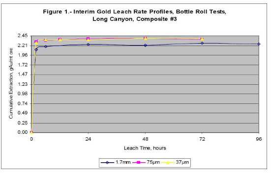
| 16.3.3 | Column Leach Test Procedures and Results |
| | |
| Column percolation-leach tests were conducted on 18 of the 21 Long Canyon core composite samples at 80% passing 12.5 mm, five composites at 80% passing 25 mm, and seven of the 21 composites at 80% passing 50- millimetre feed sizes to determine gold recovery, recovery rate, and reagent requirements under simulated heap leach conditions. |
| | |
| Leaching was conducted by applying cyanide solutions (0.5 g NaCN/l) over the charges at a rate of 0.20 lpm/m2 of column cross -sectional area. Pregnant solutions were collected each 24-hour period. Pregnant solution volumes were measured by weighing, and samples were taken for gold and silver analysis using conventional A. A. methods. Cyanide concentration and pH were determined for each pregnant solution sample. Pregnant solutions were pumped through a three-stage carbon circuit for adsorption of dissolved precious metal values. Barren solution, with appropriate make-up reagent, was applied to the column charges daily. |
| | |
| After leaching, freshwater rinsing was conducted to remove residual cyanide and to recover any remaining dissolved precious metals values. Moisture required to saturate the charges (in-process solution inventory) and retained moistures were determined. Apparent bulk densities were measured before and after leaching. |
| | |
| After leaching, rinsing, and draining, residues were removed from the columns and moisture samples immediately taken. Remaining residues were air dried, blended, and split to obtain samples for triplicate tail assay. Head and tail screen-assay results and recovery by size fraction data were tabulated for each column charge . |
| February 25, 2011 | Page 126 |
| Fronteer Gold Inc. |
| Long Canyon Project, Elko County, Nevada |
| Updated Technical Report and Interim Resource Estimate |
Overall metallurgical balance summaries are provided in Table 16-8. The average gold head grade, reported in Table 16-8 is the average of all calculated heads (if more than one column leach test was performed) from column tests performed on each respective composite.
Table 16-8: Column Leach Test Results
| | | | Column Leach - Au Recovery% |
| | | | Avg Head | Nominal | Nominal | Nominal |
| Comp. No. | Zone/x-Section | Re-logged Geology | Grade Au(gpt) | P80=12.5 mm | P80=25mm | P80=50 mm |
| | | | | | | |
| Comp #1 | WZ 11,150N | Cnpdz/l/w/(bx) | 0.55 | 75.9 | 76.8 | N/S |
| Comp #2 | WZ 11,150N | Cnplw(m assive)/w/(bx)/onc+Lamp | 0.63 | 77.6 | N/S | 61.0 |
| Comp #3 | WZ 11,150N | Lamp | 2.60 | 89.2 | N/S | N/S |
| Comp #4 | WZ 11,150N | Cnplw(bx)/(jsp)+Lamp | 7.08 | 87.3 | N/S | N/S |
| Comp #5 | SZ 12,000N | Cnplw(massive)/w/(bx) | 0.60 | 64.7 | N/S | 51.0 |
| Comp #6 | SZ 12,000N | Cnpd(bx)/z | 1.25 | 65.6 | N/S | N/S |
| Comp #7 | SZ 12,000N | Cnplw(bx)/onc/w (Silicified) | 3.59 | 69.6 | N/S | 62.5 |
| Comp #8 | SZ 12,000N | Oplw(bx)/w | 2.77 | 82.3 | N/S | N/S |
| Comp #9 | SZ 12,000N | Cnplus+(bx) | 6.58 | 93.6 | 93.4 | N/S |
| Comp #10 | DZ 12,000N | Cnplonc/us/w/(bx) | 0. 83 | 89.2 | N/S | N/S |
| Comp #11 | DZ 12,000N | Oplw(cavn)/(bx)/w/sm(bx) | 0. 77 | 78.2 | 78.7 | N/S |
| Comp #12 | DZ 12,000N | Cnpd(bx) | N/S | N/S | N/S | N/S |
| Comp #13 | DZ 11,150N | Oplw(bx)/sm/sm(bx) | 4.94 | 89.5 | N/S | 88.9 |
| Comp #14 | DZ 11,150N | Cnplw(m assive)/(jsp)/(bx)/onc/w | 0.92 | 70.8 | N/S | 67.0 |
| Comp #15 | DZ 11,150N | Cnplw(cavn)/onc/(jsp)/(bx) | 3.22 | 83.9 | N/S | 82.0 |
| Comp #16 | DZ 11,150N | Lamp+Cnplw/(jsp) | N/S | N/S | N/S | N/S |
| Comp #17 | DZ 11,150N | Cnplus/(bx)/onc+Lamp | 12.08 | 95.2 | N/S | N/S |
| Comp #18 | CZ 12,400N | Oplw/sm&(bx)+Opl&(bx)+Cnpdl | 0.76 | 78.6 | N/S | 74.1 |
| Comp #19 | CZ 12,400N | Oplsm&(bx) | 4.67 | 85.4 | 86.3 | N/S |
| Comp #20 | CZ 12,400N | Oplw&(bx)+Lamp+Oplsm | 6.78 | 81.9 | 80.2 | N/S |
| Comp #21 | CZ 12,400N | Cnpdl | N/S | N/S | N/S | N/S |
| | - Low Grade Samples (<1. 26 g/t Au) | WZ = West Zone, SZ = Shadow Zone |
| | - Medium Grade Sampl es (>1. 26, <5. 0 g/t Au) | DZ = Discovery Zone, CZ = Crevasse Zone |
| | - High Grade Samples (>5. 0 g/t Au) | |
The Long Canyon core samples are amenable to simulated heap-leach cyanidation treatment at all feed sizes evaluated.
Column leach kinetics for gold was rapid for the overwhelming majority of samples tested. Time under leach varied from approximately 50 to 100 days, including a complete rinse/drain down cycle. The majority of gold leaching (>80% leachable gold) occurred within a 10 to 40 day period, with the coarser columns typically taking a little longer than the finer crushed columns. A typical, medium gold grade (3.22 g/t) leach kinetic curve is provided for composite #15 in Table 16-8.
| February 25, 2011 | Page 127 |
| Fronteer Gold Inc. |
| Long Canyon Project, Elko County, Nevada |
| Updated Technical Report and Interim Resource Estimate |
Figure 16-6: Gold Column Leach Rate Profiles - Composite #5
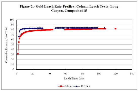
| Cyanide consumptions were modest . The average cyanide consumption for the 80% passing 50- mm columns ranged from 0.27 - 0.88 kg NaCN/t, the 80% passing 25- millimetre columns ranged from 0.20 – 0.73 kg NaCN/t, and the 80% passing 12.5- millimetre columns ranged from 0.38 - 1. 7 kg NaCN/t. Commercial-scale cyanide consumptions are typically expected to be in the range of one-half of the laboratory column-leach consumptions. |
| | |
| Lime additions were low. The lime addition was the same for all the 80% passing 50- millimetre columns at 1.0 kg Ca(OH)2/t, for the 80% passing 25-millimetre columns lime addition ranged from 1.0 – 1.5 kg Ca(OH)2/t, and for the 80% passing 12.5- millimetre columns lime addition ranged from 1.0 – 1.5 kg Ca(OH)2/t. Commercial -scale lime additions are expected to be similar to laboratory requirements. |
| | |
| No cement additions, binders, or agglomeration techniques were used in the column test program. No fines migration was observed and none of the columns experienced any plugging. |
| | |
| Due to the low silver grades of the Long Canyon composites, silver recoveries are not reported for the bottle roll and column leach tests. |
| | |
| 16.3.4 | Hydraulic Conductivity Testing Results |
| | |
| Samples were transported from McClelland’s Lab in Reno, Nevada to AMEC Earth & Environmental, Inc. in Reno for hydraulic conductivity testing on the 80% passing 12.5-millimetre column leach residues from composites 1, 2, 4, 5, 6, 7, 8, 9, 10, 11, 13, |
| February 25, 2011 | Page 128 |
| Fronteer Gold Inc. |
| Long Canyon Project, Elko County, Nevada |
| Updated Technical Report and Interim Resource Estimate |
14, 15, 17, 18, 19 and 20, in order to measure hydraulic conductivity rates under imposed (simulated) progressive heap loading heights of 0, 20, 40, 60, 80 and 100 metres. Hydraulic conductivity measurements for each simulated heap loading height are summarized in Table 16-9.
Table 16-9: Load Permeability Test Results, Hydraulic Conductivity (cm/sec) at Load
| Column ID | Composite | 0 m | 20 m | 40 m | 60 m | 80 m | 100 m |
| P10 | #1 | 1.90 * 10-1 | 1.65 *10-1 | 1.44 * 10-1 | 1.38 *10-1 | 1.31 * 10-1 | 1.29 *10-1 |
| P11 | #2 | 1.52 * 10-1 | 1.36 *10-1 | 1.24 * 10-1 | 1.20 *10-1 | 1.14 * 10-1 | 1.13 *10-1 |
| P13 | #4 | 9.52 * 10-2 | 5.75 *10-2 | 5.71 * 10-2 | 5.00 *10-2 | 4.24 * 10-2 | 3.45 *10-2 |
| P14 | #5 | 1.63 * 10-1 | 1.43 *10-1 | 1.38 * 10-1 | 1.31 *10-1 | 1.21 * 10-1 | 1.20 *10-1 |
| P15 | #6 | 1.18 * 10-1 | 9.81 *10-2 | 9.48 * 10-2 | 9.46 *10-2 | 9.06 * 10-2 | 9.04 *10-2 |
| P16 | #7 | 8.54 * 10-2 | 6.68 *10-2 | 6.24 * 10-2 | 5.62 *10-2 | 5.27 * 10-2 | 5.06 *10-2 |
| P17 | #8 | 1.02 * 10-1 | 8.36 *10-2 | 7.84 * 10-2 | 7.25 *10-2 | 7.01 * 10-2 | 6.85 *10-2 |
| P18 | #9 | 9.24 * 10-2 | 7.08 *10-2 | 5.98 * 10-2 | 5.89 *10-2 | 4.95 * 10-2 | 4.35 *10-2 |
| P19 | #10 | 1.42 * 10-1 | 1.25 *10-1 | 1.18 * 10-1 | 1.14 *10-1 | 1.09 * 10-1 | 1.09 *10-1 |
| P20 | #11 | 1.59 * 10-1 | 1.43 *10-1 | 1.29 * 10-1 | 1.24 *10-1 | 1.17 * 10-1 | 1.16 *10-1 |
| P21 | #13 | 8.19 * 10-2 | 6.51 *10-2 | 5.82 * 10-2 | 5.25 *10-2 | 4.09 * 10-2 | 4.08 *10-2 |
| P22 | #14 | 1.20 * 10-1 | 1.05 *10-1 | 9.31 * 10-2 | 9.07 *10-2 | 8.60 * 10-2 | 8.56 *10-2 |
| P23 | #15 | 7.74 * 10-2 | 6.51 *10-2 | 6.01 * 10-2 | 5.26 *10-2 | 4.61 * 10-2 | 4.58 *10-2 |
| P24 | #17 | 1.03 * 10-1 | 8.04 *10-2 | 7.26 * 10-2 | 6.49 *10-2 | 5.84 * 10-2 | 5.39 *10-2 |
| P25 | #18 | 6.13 * 10-2 | 4.95 *10-2 | 4.66 * 10-2 | 4.27 *10-2 | 3.84 * 10-2 | 3.29 *10-2 |
| P26 | #19 | 1.57 * 10-1 | 1.33 *10-1 | 1.25 * 10-1 | 1.16 *10-1 | 1.09 * 10-1 | 1.06 *10-1 |
| P27 | #20 | 1.07 * 10-1 | 8.57 *10-2 | 8.33 * 10-2 | 7.85 *10-2 | 7.38 * 10-2 | 7.26 *10-2 |
| Hydraulic conductivity measurements ranged from 1. 02 x 10-1 to 9.81 x 10⁻² cm/sec. Laboratory (and typical commercial) heap percolation rates of 0.20 lpm/m2equates to a hydraulic conductivity of 3.4 x 10 -4 cm/sec (two orders of magnitude lower than the lowest hydraulic conductivity measurement by AMEC), indicating that no solution- flow problems are anticipated for simulated heap loading heights up to 100 metres for any of the composites tested. |
| | |
| 16.3.5 | Flotation Testing Test Procedures and Results |
| | |
| Bulk sulfide flotation tests were conducted on three Long Canyon high-grade composites (composite #4, #17, and #20) and one mid-grade composite (composite #7) at 80% passing 75-micron feed size to determine the response of the Long Canyon mineralization to concentration by conventional flotation methods. |
| | |
| Flotation feeds were ground using a laboratory steel ball mill to 80% passing 75 microns. Flotation was conducted using a Denver laboratory flotation machine at 1,200 rpm. Each sample was slurried with water to 30% solids and was conditioned for 10 minutes with 0.25 kg CuSO4/t of solids. Flotation was conducted in five stages, with incremental additions of 0.005 kg/t of solids of potassium amyl xanthate (PAX) collector and AERO 208 promoter. Total addition of each reagent was 0. 025 kg/t. AEROFROTH 65 was used as the frothing agent. The pulps were floated at natural pH. The five stages of concentrate were combined into a single rougher concentrate for cleaning. Rougher concentrate was cleaned one time to produce a cleaner concentrate and cleaner tail. No |
| February 25, 2011 | Page 129 |
| Fronteer Gold Inc. |
| Long Canyon Project, Elko County, Nevada |
| Updated Technical Report and Interim Resource Estimate |
additional reagent was added during cleaner flotation. The cleaner concentrate products were dried, weighed, examined under a microscope, and assayed in entirety to determine precious metal content. The flotation rougher tailings were dried, weighed, and assayed in triplicate to determine residual precious metal content.
Overall metallurgical results for the flotation tests are provided in Table 16-10.
Table 16-10: Flotation Concentration Test Results
| Comp ID | Flotation Product | Wt (%) | Cum Wt (%) | Assay (g/t) | Au Distribution (%) |
| Comp #4 | Cl. Conc. | 2.6 | 2.6 | 47 .0 | 1 | 16 | 16 |
| Cl. Tail | 5.1 | 7.7 | 29 .5 | 7 | 19 .8 | 35.8 |
| Ro. Tail | 92 .3 | 100.0 | 5.30 | 2 | 64 .2 | 100.0 |
| | | | | | | | |
| Comp #7 | Cl. Conc. | 0.5 | 0.5 | 95 .0 | <1 | 12 .8 | 12.8 |
| Cl. Tail | 1.5 | 2.0 | 46 .9 | 9 | 19 .0 | 31.8 |
| Ro. Tail | 98 .0 | 100.0 | 2.58 | 1 | 68 .2 | 100.0 |
| | | | | | | | |
| Comp #17 | Cl. Conc. | 0.5 | 0.5 | 396.0 | 13 | 24 .1 | 24.1 |
| Cl. Tail | 1.3 | 1.8 | 181.5 | 5 | 28 .7 | 52.8 |
| Ro. Tail | 98 .2 | 100.0 | 3.95 | 1 | 47 .2 | 100.0 |
| | | | | | | | |
| Comp #20 | Cl. Conc. | 0.6 | 0.6 | 222.0 | 1 | 21 .5 | 21.5 |
| Cl. Tail | 2.1 | 2.7 | 95 .7 | <5 | 32 .5 | 54.0 |
| Ro. Tail | 97 .3 | 100.0 | 2.92 | 1 | 46 .0 | 100.0 |
| None of the Long Canyon composites responded favorably to flotation testing. Gold distribution into the first cleaner concentrate was poor for all samples tested and can be attributed to the totally oxidized nature of the composites and lack of any significant elemental gold (see gravity test results below) . No follow-up flotation work is planned. |
| | |
| 16.3.6 | Gravity Testing Procedures and Results |
Gravity concentration tests were conducted on three Long Canyon high-grade composites (composite #4, #17, and #20) and one mid-grade composite (composite #7) at an 80% passing 212-micron feed size to determine the response of the Long Canyon mineralization to concentration by gravity methods.
Each charge (~10 kg) was ground using a laboratory steel ball mill to 80% passing 212 microns in size. Rougher gravity concentration was conducted by passing each milled feed through a Knelson (KC- MD3) centrifugal gravity concentrator. The resulting rougher concentrate was cleaned by hand panning to produce a gravity concentrate and cleaner tailings. The gravity concentrate products were dried, weighed, and assayed in entirety to determine precious metal content. The gravity rougher tailings were dried, weighed, and assayed in triplicate to determine residual precious metal content.
Overall metallurgical results for the gravity concentration tests are provided in Table 16-11.
| February 25, 2011 | Page 130 |
| Fronteer Gold Inc. |
| Long Canyon Project, Elko County, Nevada |
| Updated Technical Report and Interim Resource Estimate |
Table 16-11: Gravity Concentration Test Results
| Comp ID | Gravity
Product | Wt (%) | CumWt
(%) | Assay (g/t) | Au Distribution (%) |
| Comp #4 | Cl. Conc. | 0.1 | 0.1 | 25.0 | 49 | 0.3 | 0.3 |
| Cl . Tail | 0.7 | 0.8 | 5.17 | 9 | 0.5 | 0.8 |
| Ro. Tail | 99.2 | 100.0 | 7.47 | 3 | 99.2 | 100.0 |
| | | | | | | | |
| Comp #7 | Cl. Conc. | 0.1 | 0.1 | 3.00 | <1 | 0.1 | 0.1 |
| Cl . Tail | 0.7 | 0.8 | 3.27 | <5 | 0.8 | 0.9 |
| Ro. Tail | 99.2 | 100.0 | 2.82 | 1 | 99.1 | 100.0 |
| | | | | | | | |
| Comp #17 | Cl. Conc. | 0.1 | 0.1 | 9.00 | <1 | 0.1 | 0.1 |
| Cl . Tail | 0.7 | 0.8 | 5.13 | <5 | 0.4 | 0.5 |
| Ro. Tail | 99.2 | 100.0 | 8.20 | 1 | 99.5 | 100.0 |
| | | | | | | | |
| Comp #20 | Cl. Conc. | 0.5 | 0.5 | 5.00 | <1 | 0.4 | 0.4 |
| Cl . Tail | 10.2 | 10.7 | 3.63 | <5 | 6.6 | 7.0 |
| Ro. Tail | 89.3 | 100.0 | 5.87 | 1 | 93.0 | 100.0 |
| The Long Canyon composites did not respond well to concentration using conventional gravity concentration methods. First gravity cleaner concentrates contained less than 1% of the total gold contained in the feed. No follow up gravity concentration testing is planned. |
| | |
| 16.4 | Phase 2 Metallurgical Testing From Drill Core Composites |
| 16.4.1 | Long Canyon Phase 2 Composites |
| | |
| A total of 25 barrels and 13 buckets of broken (-100 mm) half-split drill core samples from Fronteer’s Long Canyon project were sent to McClelland Labs in Sparks, Nevada for metallurgical testing. Testing parameters included: |
1. Sample preparation, standard assays for gold, cyanide-soluble gold, and silver, as well as whole rock and ICP analyses;
2. Bottle roll testing at (80% passing) P80 = 37, 75 and 1700 microns;
3. Column leach testing at (80% passing) P80 = 12.5, 25 and 50 mm sizes; and
4. Comminution testing on eighteen (18) selected composites.
The results of direct head assays on the 28 composites are shown in Table 16-12. Logged geology/alteration descriptions are provided in the tables throughout the report.
| February 25, 2011 | Page 131 |
| Fronteer Gold Inc. |
| Long Canyon Project, Elko County, Nevada |
| Updated Technical Report and Interim Resource Estimate |
Table 16-12: Head Assay Results - Long Canyon Phase 2 Metallurgical Composites
Comp No.
| Zone/X- Section
| Re-logged Geology
| Au (g/t)
| AuCN
(g/ t) | AuCN
Sol (%) | Ag
(g/t) | S=
(%) |
| Comp #25 | S.E. DZ 10,950N | Cnplw/lamp- LG Master | 1.04 | .98 | 94.2 | 0.7 | <0.01 |
| Comp #26 | S.E. DZ 10,950N | Cnpl/l amp-MG Mast er | 2.73 | 2.60 | 95.1 | <0.5 | <0.01 |
| Comp #27 | S.E. DZ 10,950N | Lamp/Cnplonc/us/w/Jsp-HG | 8.36 | 7.87 | 94.1 | 0.7 | <0.01 |
| Comp #28 | S.W. DZ 10,950N | Cnplus/onc/w-LG | 0.50 | 0.49 | 98.0 | 0.7 | <0.01 |
| Comp #29 | S.W. DZ 10,950N | Cnplonc/us/w/ba/lamp-MG Master | 1.88 | 1.68 | 89.1 | <0.5 | <0.01 |
| Comp #30 | S. WZ 10,950N | Cnpl ta/z-LG | 0.39 | 0.34 | 87.2 | <0.5 | 0.01 |
| Comp #31 | S. WZ 10,950N | Cnplonc/bx/ta/w&Cnpdl-LG Master | 0.76 | 0.73 | 96.1 | <0.5 | <0.01 |
| Comp #32 | S. WZ 10,950N | Cnpdbx/z-LG | 0.44 | 0.39 | 88.6 | <0.5 | <0.01 |
| Comp #33 | S. WZ 10,950N | Cnpdbx/Cnplbx-MG | 2.83 | 2.68 | 94.7 | <0.5 | <0.01 |
| Comp #34 | S. WZ 10,950N | Cnpdlbx-MG | 3.15 | 2.84 | 90.2 | <0.5 | <0.01 |
| Comp #35 | S. WZ 10,950N | Cnpbx/lamp/ Jsp-HG | 16.05 | 15.30 | 95.3 | 0.6 | 0.02 |
| Comp #36 | S. WZ 10,950N | Cnpl w/bx/us/cavn/Jsp-LG Master | 1.01 | 0.93 | 92.2 | 0.6 | <0.01 |
| Comp #37 | N. WZ 11,450N | Cnpdlta/lamp/Jsp-MG | 2.95 | 2.58 | 87.5 | 0.6 | 0.01 |
| Comp #38 | N. WZ 11,450N | Cnpl/Lamp/bx-MG | 1.60 | 1.54 | 96.3 | 1.1 | 0.01 |
| Comp #39 | DZ 11,150N | Cnplus/bx/w/onc- LG Master | 0.84 | 0.82 | 97.6 | <0.5 | <0.01 |
| Comp #40 | DZ 11,150N | Oplbx/ oplw-LG | 0.97 | 0.88 | 90.7 | <0.5 | <0.01 |
| Comp #41 | DZ 11,150N | Cnplbx/onc/w/Cnpdl bx-MG | 1.40 | 1.28 | 91.3 | <0.5 | <0.01 |
| Comp #42 | DZ 11,500N | Cnpdz- LG | 0.54 | 0.53 | 98.1 | 0.8 | 0.01 |
| Comp #43 | DZ 11,500N | Lamp/Cnplw/onc-HG | 8.58 | 7.53 | 87.8 | <0.5 | <0.01 |
| Comp #44 | DZ 11,500N | Lamp/Cnpdbx-HG | 8.72 | 8.38 | 96.1 | <0.5 | <0.01 |
| Comp #45 | DZ 11,500N | Lamp/Jsp/Cnpdl+bx-HG | 5.89 | 5.39 | 91.5 | <0.5 | 0.01 |
| Comp #46 | DZ 11,700N | Cnpdlbx -HG | 10.50 | 9.91 | 94.4 | <0.5 | 0.01 |
| Comp #47 | DZ 11,700N | Cnpdlbx/Jsp/cavn&Oplwbx&Cnplbx -MG Master | 2.42 | 2.14 | 88.6 | <0.5 | <0.01 |
| Comp #48 | DZ 11,700N | Cnplus+bx/w/cavn/us- LG Master | 1.11 | 1.06 | 95.7 | <0.5 | <0.01 |
| Comp #49 | DZ 11,700N | Lamp/Cnpl w/bx/cavn-HG | 7.00 | 6.52 | 93.1 | <0.5 | <0.01 |
| Comp #50 | DZ 11,700N | Oplsm+bx/cavn/ sm-MG | 1.91 | 1.73 | 90.6 | <0.5 | <0.01 |
| Comp #51 | DZ 11,700N | Oplbx/sm&Opdlbx-HG | 11.75 | 11.33 | 96.5 | <0.5 | <0.01 |
| Comp #52 | DZ 11,700N | Oplsmbx/sm&Oplwbx-MG | 2.11 | 1.98 | 93.8 | <0.5 | <0.01 |
| The head analysis show that the Long Canyon deposit can be characterized as having high gold cyanide solubility (AuCN/AuFA >87.2%), low silver grade, and very low sulfide sulfur content (<0.02%). Whole rock and ICP analyses were performed on all composites and these are provided in the body of the McClelland report. |
| | |
| 16.4.2 | Bottle Roll Test Procedures and Results |
| | |
| Direct agitated cyanidation bottle roll tests were conducted on 28 Long Canyon Phase 2 drill core composites at 80% passing 1.7 mm, 75 micron, and 37-micron feed sizes to determine gold recovery, recovery rate, reagent requirements, and sensitivity to feed size. |
| | |
| Milling cyanidation (75 and 37 micron) feeds were stage ground using a laboratory steel ball mill. Material charges were mixed with water to achieve 40% solids. Natural pHs were measured. Lime was added to adjust the pH of the pulps to between 10.5 and 11. 0 before adding cyanide. Sodium cyanide, equivalent to 1.0 gram per liter of solution, was |
| February 25, 2011 | Page 132 |
| Fronteer Gold Inc. |
| Long Canyon Project, Elko County, Nevada |
| Updated Technical Report and Interim Resource Estimate |
added to the alkaline pulps.
Leaching was conducted by rolling the pulps in bottles for 72 hours (75 and 37-micron samples) to 96 hours (1.7 mm samples). Rolling was briefly suspended after 2, 6, 24, 48, 72, and 96 hours to allow the pulps to settle so samples of pregnant solution could be measured and sampled. Cyanide concentration and pH were determined for each solution sample. Make-up water, equivalent to that withdrawn, was added to the pulps. Lime was added, when necessary, to maintain the leaching pH at between 10.5 and 11.0. Rolling was then resumed. After 72 or 96 hours, the pulps were filtered to separate liquids and solids. Final pH and cyanide concentrations were determined. Leached residues were washed, dried, weighed and assayed in triplicate to determine residual precious metal content. Overall metallurgical results from the bottle-roll test program are provided in Table 16-13.
Gold extraction from eight (8) of the twenty-eight (28) composites exhibited sensitivity toparticle size at a particle size P80 = 1.7 mm, achieving gold extractions <75.0 %. Five were low-grade (<1.04 gpt) and three were medium grade (>1.04 and <3.2 gpt gold) composites. Due to the significant gold extraction difference between the 1.7 mm and 75 microns particle sizes, the medium-grade composites should be considered for milling rather than heap leaching. The majority of the particle size sensitive samples, tested in Phase 2, appear to be located on the western and or south end of the deposit.
Table 16-13: Phase 2 - Bottle Roll Test Results
| | | | Bottle Rolls - Au Recovery % |
| | | | Head Grade | | | |
| Comp. No. | Zone/x-Section | Re-logged Geology | Au(gpt) | 37µ | 75µ | 1700 µ |
| Phase II Composites | | | | | |
| Comp #25 | SE-DZ10,950N | Cnplw/Lamp | 1.04 | 86.9 | 87.4 | 76.6 |
| Comp #26 | SE-DZ10,950N | Lamp/Cnplonc/us/jsp/w/(sil) | 2.73 | 92.8 | 92.6 | 86.6 |
| Comp #27 | SE-DZ10,950N | Lamp/Cnplonc/us/Jsp/w | 8.36 | 94.5 | 94.0 | 90.8 |
| Comp #28 | SW- DZ10,920N | Cnplus(bx)/onc/w | 0.50 | 80.0 | 80.0 | 58.5 |
| Comp #29 | SW- DZ10,920N | Cnplonc/us/w/(bx)/Lamp | 1.88 | 84.5 | 84.3 | 71.6 |
| Comp #30 | S-W Z10,950N | Cnpdlta/z | 0.39 | 94.4 | 94.6 | 86.1 |
| Comp #31 | S-W Z10,950N | Cnplonc/(bx)/ta/w & Cnpdl | 0.76 | 81.7 | 81.3 | 58.4 |
| Comp #32 | S-W Z10,950N | Cnpdbx/z | 0.44 | 83.3 | 76.2 | 46.3 |
| Comp #33 | S-W Z10,950N | Cnpdl(bx) & Cnplbx | 2.83 | 88.1 | 86.3 | 74.4 |
| Comp #34 | S-W Z10,950N | Cnpl(bx) | 3.15 | 81.7 | 79.4 | 64.2 |
| Comp #35 | S-W Z10,950N | Cnpl(bx)/us/jsp/Lamp | 16.05 | 91.4 | 92.5 | 87.0 |
| Comp #36 | S-W Z10,950N | Cnplw/(bx)/cavn/Jsp/us/onc | 1.01 | 87.3 | 83.8 | 71.4 |
| Comp #37 | N-W Z11,450N | Lamp/Cnpdlta/Jsp | 2.95 | 77.2 | 77.0 | 75.4 |
| Comp #38 | N-W Z11,450N | Lamp/Cnpdlta/(bx) | 1.60 | 94.2 | 94.2 | 90.0 |
| Comp #39 | DZ11,500N | Cnplus/(bx)/w/onc | 0.84 | 89.0 | 87.2 | 78.6 |
| Comp #40 | DZ11,500N | Opl(bx)/Oplw | 0.97 | 89.2 | 86.9 | 79.1 |
| Comp #41 | DZ11,500N | Cnpl(bx)/onc/w & Cnpdl(bx) | 1.40 | 89.9 | 84.9 | 77.4 |
| Comp #42 | DZ11,500N | Cnpdz | 0.50 | 83.0 | 82.0 | 62.7 |
| Comp #43 | DZ11,500N | Lamp/Cnplw/onc | 8.58 | 92.0 | 90.7 | 87.5 |
| Comp #44 | DZ11,500N | Lamp/Cnpd(bx) | 8.72 | 95.0 | 91.6 | 90.4 |
| Comp #45 | DZ11,500N | Lamp/Jsp/Cnpdl+bx | 5.89 | 93.0 | 91.5 | 84.8 |
| Comp #46 | DZ11,700N | Cnpdl(bx) & Cnpl(bx) | 10.50 | 90.7 | 91.0 | 87.3 |
| Comp #47 | DZ11,700N | Cnpdl(bx)/cavn & Oplw(bx)/jsp & Cnpl(bx) | 2.42 | 87.4 | 83.4 | 73.3 |
| Comp #48 | DZ11,700N | Cnplus/(bx)/w/cavn/us | 1.11 | 91.4 | 89.7 | 84.7 |
| Comp #49 | DZ11,700N | Lamp/Cnplw/(bx)/cavn/jsp | 7.00 | 94.2 | 92.4 | 88.8 |
| Comp #50 | DZ11,700N | Oplsm+bx/(bx)/cavn | 1.91 | 94.0 | 92.8 | 91.2 |
| Comp #51 | DZ11,700N | Opl(bx)/sm & Opdl(bx) | 11.75 | 95.5 | 94.0 | 93.2 |
| Comp #52 | DZ11,700N | Oplsm(bx)/sm & Oplw(bx) | 2.11 | 90.6 | 87.3 | 85.3 |
| | | | | | | |
| | - Low Grade Samples (<1.50 g/t Au) | WZ = West Zone, SZ = Shadow Zone |
| | - Medium Grade Samples (>1.50, <3.50 g/t Au) | DZ = Discovery Zone, CZ = Crevasse Zone |
| | - High Grade Samples (>3.5 g/t Au) | |
| February 25, 2011 | Page 133 |
| Fronteer Gold Inc. |
| Long Canyon Project, Elko County, Nevada |
| Updated Technical Report and Interim Resource Estimate |
Table 16-14: Phase 2 – Particle Size Sensitive Composites
| Composite ID | Zone of Mineralization | Avg Head Grade | Gold Extraction, % |
| Au (gpt) | 1.7 mm | 75 microns |
| Comp #28 | S. W. Discovery Zone | 0.52 | 58.8 | 80.0 |
| Comp #31 | South – West Zone | 0.76 | 58.4 | 81.3 |
| Comp #32 | South – West Zone | 0.43 | 46.3 | 76.2 |
| Comp #33 | South – West Zone | 2.88 | 74.4 | 86.3 |
| Comp #34 | South – West Zone | 3.17 | 64.2 | 79.4 |
| Comp #36 | South – West Zone | 1.04 | 71.4 | 83.8 |
| Comp #42 | Discovery Zone | 0.53 | 62.7 | 82.0 |
| Comp #47 | Discovery Zone | 2.40 | 73.3 | 83.4 |
Phase 2 bottle roll cyanide consumptions were low, ranging between <0.07 – 0.15 kg NaCN/t of solids. Lime consumptions were low to moderate, ranging from 0.7 – 5.4 kg/t.
Gold recovery kinetic rates were rapid for all feed sizes and extraction was essentially complete in 24 hours of leaching. Typical low, medium and high-grade gold kinetic-rate curves are provided below, in Figure 16-7– Figure 16-9.
Figure 16-7: Low-Grade Gold Bottle-Roll Leach Rate Profiles - Composite #25
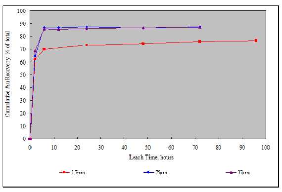
| February 25, 2011 | Page 134 |
| Fronteer Gold Inc. |
| Long Canyon Project, Elko County, Nevada |
| Updated Technical Report and Interim Resource Estimate |
Figure 16-8: Medium-Grade Gold Bottle-Roll Leach Rate Profiles - Composite #36
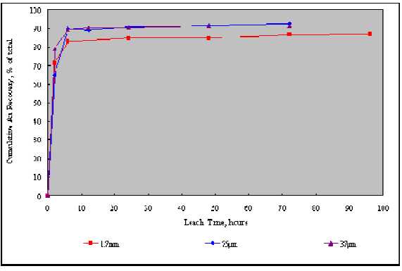
Figure 16-9: High-Grade Gold Bottle-Roll Leach Rate Profiles - Composite #51
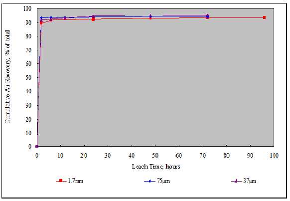
| February 25, 2011 | Page 135 |
| Fronteer Gold Inc. |
| Long Canyon Project, Elko County, Nevada |
| Updated Technical Report and Interim Resource Estimate |
| 16.4.3 | Column Leach Test Procedures and Results |
| | |
| Column percolation-leach tests were conducted on the Long Canyon Phase 2 drill core composite at various feed sizes to determine gold recovery, recovery rate, and reagent requirements and sensitivity to feed size under simulated heap leach conditions. A total of six composites were evaluated the 80% -50mm feed size, 10 at the 80% -25mm feed size and 20 at the 80% -12.5 mm feed size. |
| | |
| Lime was mixed with the dry charges before loading the columns. Lime additions were based on bottle roll test lime requirements. Charges were placed into the columns in a manner to minimize particle segregation and compaction. |
| | |
| Leaching was conducted by applying cyanide solutions (0.5 g NaCN/l) over the charges at a rate of 0.20 lpm/m2 of column cross-sectional area for most of the tests. The application rate was decreased for composites #41, #43, #44, and #50 (12.5 mm feeds) after solution ponding was observed on top of the columns. Pregnant solutions were collected each 24-hour period. Pregnant and barren solution volumes were measured by weighing, and samples were taken for gold and silver analysis using conventional A.A. methods. Cyanide concentration and pH were determined for each pregnant solution sample . Pregnant solutions were pumped through a three-stage carbon circuit for adsorption of dissolved precious metal values. Barren solution, with appropriate make- up reagent, was applied to the column charges daily. After leaching, a one liter sample of the final pregnant solution was taken from select columns tests and submitted to Western Environmental Testing (WET) Laboratory for a Profile II (water quality panel) analysis. |
| | |
| After leaching was complete, freshwater rinsing was conducted to remove residual cyanide and to recover any remaining dissolved precious metals values. Moisture required to saturate the charges (in-process solution inventory) and retained moistures were determined. Apparent bulk densities were measured before and after leaching. |
| | |
| For select column tests, the rinse effluent was analyzed for WAD cyanide to assist in determining the rinse down characteristics of the leached residues. Fresh water was applied at the same rate used for leaching, until the effluent WAD cyanide concentration of less than 0. 20 mg/L was achieved. A one liter sample of the final rinse effluent from the column was taken and submitted to WET Lab for Profile II (water quality panel) analysis. |
| | |
| After leaching, rinsing, and draining, residues were removed from the columns and moisture samples immediately taken. Remaining residues were air dried, blended, and split to obtain samples for tail screen analysis. Head and tail screen-assay results and recovery by size fraction data were tabulated for each column charge . For select columns, a split of the column leached residue was taken for Mod ABA and MWMP tests. |
| | |
| Overall metallurgical balance summaries are provided in Table 16-15. The average gold head grade, reported in Table 16-15 is the average of all calculated heads (if more than one column leach test was performed). |
| February 25, 2011 | Page 136 |
| Fronteer Gold Inc. |
| Long Canyon Project, Elko County, Nevada |
| Updated Technical Report and Interim Resource Estimate |
The Long Canyon core samples are amenable to simulated heap-leach cyanidation treatment at all feed sizes evaluated.
Column leach kinetics for gold was rapid for the majority of samples tested. Time under leach varied from approximately 50 to 130 days and includes a complete rinse/drain down cycle for all columns tested.
Table 16-15: Column Leach Tests Results
|
|
| Column Leach - Au Recovery
% |
Phase II
Composites
| Zone/x-Section
| Re-logged Geology
| Avg Head
Grade
Au(gpt) | Nominal
P80=12.5 mm
| No minal
P80=25 mm
| Nominal
P80=50 mm |
| | | | | | | |
| Comp #25 | SE-DZ10,950N | Cnplw/Lamp | 1.06 | 69.8 | | |
| Comp #26 | SE-DZ10,950N | Lamp/Cnplonc/us/jsp/w/(sil) | 2.75 | 87.7 | 86. 4 | |
| Comp #27 | SE-DZ10,950N | Lamp/Cnplonc/us/Jsp/w | 8.37 | | 90. 8 | |
| Comp #28 | SW-DZ10,920N | Cnplus(bx)/onc/w | 0.51 | 51.0 | | |
| Comp #29 | SW-DZ10,920N | Cnplonc/us/w/(bx)/Lamp | 1.89 | 67.7 | 63. 0 | |
| Comp #30 | S-WZ10,950N | Cnpdlta/z | 0.34 | | 82. 4 | |
| Comp #31 | S-WZ10,950N | Cnplonc/(bx)/ta/w & Cnpdl | 0.71 | | 54. 9 | |
| Comp #32 | S-WZ10,950N | Cnpdbx/z | 0.40 | | 37. 5 | |
| Comp #33 | S-WZ10,950N | Cnpdl(bx) & Cnplbx | 2.92 | | 69. 9 | |
| Comp #34 | S-WZ10,950N | Cnpl(bx) | 3.42 | 53.8 | | |
| Comp #35 | S-WZ10,950N | Cnpl(bx)/us/jsp/Lamp | 15.22 | 86.2 | | |
| Comp #36 | S-WZ10,950N | Cnplw/(bx)/cavn/Jsp/us/onc | 0.99 | 63.2 | 63. 7 | |
| Comp #37 | N-WZ11,450N | Lamp/Cnpdlta/Jsp | 2.29 | 86.0 | | |
| Comp #38 | N-WZ11,450N | Lamp/Cnpdlta/(bx) | 1.56 | 90.4 | | |
| Comp #39 | DZ11,500N | Cnplus/(bx)/w/onc | 1.25 | | | 68.60 |
| Comp #40 | DZ11,500N | Opl(bx)/Oplw | 1.58 | | | 70.90 |
| Comp #41 | DZ11,500N | Cnpl(bx)/onc/w & Cnpdl(bx) | 1.53 | 77.2 | | 69.40 |
| Comp #42 | DZ11,500N | Cnpdz | 0.56 | 60.7 | | |
| Comp #43 | DZ11,500N | Lamp/Cnplw/onc | 8.53 | 86.3 | | |
| Comp #44 | DZ11,500N | Lamp/Cnpd(bx) | 8.62 | 90.8 | | |
| Comp #45 | DZ11,500N | Lamp/Jsp/Cnpdl+bx | 5.57 | 86.4 | | |
| Comp #46 | DZ11,700N | Cnpdl(bx) & Cnpl(bx) | 10.84 | 88.9 | | |
| Comp #47 | DZ11,700N | Cnpdl(bx)/cavn & Oplw(bx)/jsp & Cnpl(bx) | 2.40 | | 69. 6 | |
| Comp #48 | DZ11,700N | Cnplus/(bx)/w/cavn/us | 1.08 | 78.8 | | 75.70 |
| Comp #49 | DZ11,700N | Lamp/Cnplw/(bx)/cavn/jsp | 8.08 | 86.9 | | |
| Comp #50 | DZ11,700N | Oplsm+bx/(bx)/cavn | 1.91 | 90.6 | 88. 4 | |
| Comp #51 | DZ11,700N | Opl(bx)/sm & Opdl(bx) | 12.22 | 87.4 | 90. 3 | |
| Comp #52 | DZ11,700N | Oplsm(bx)/sm & Oplw(bx) | 2.09 | 80.9 | | |
| | | | | | | |
| | - Low Grade Samples (<1.50 g/t Au) | WZ = West Zone, SZ = Shadow Zone |
| | - Medium Grade Samples (>1.50, <3.50 g/t Au) | DZ = Discovery Zone, CZ = Crevasse Zone |
| | - High Grade Samples (>3.5 g/t Au) | |
South East Discovery Zone (S. E. DZ 10,950N Composites)Overall metallurgical results show that the Long Canyon S.E. Discovery Zone (10950N) composites (Comps. #25 through #27) were readily amenable to simulated heap leaching treatment at the feed sizes evaluated. Gold recoveries increased slightly as the grade of the material increased. Gold recovery obtained from composite #25 (LG) at 80%-12.5mm feed size was 69.8% in 108 days of leaching and rinsing. Gold recoveries obtained from composite #26 (MG) at 80%-25mm and 12.5mm feed sizes were 86.4% and 87.7%, respectively, in 99 to 108 days of leaching and rinsing. Gold recovery obtained from composite #27 (HG) at 80%-25mm feed size was 90.8% in 116 days of leaching and rinsing.
| February 25, 2011 | Page 137 |
| Fronteer Gold Inc. |
| Long Canyon Project, Elko County, Nevada |
| Updated Technical Report and Interim Resource Estimate |
Gold recovery rates were fairly rapid, and extraction was substantially complete in 20 days.
Cyanide consumptions ranged from 0.77 to 1.37 kg NaCN/t. The 1.0 kg lime/t added to the charges before leaching was sufficient to maintain protective alkalinity throughout the leach cycles.
South West Discovery Zone (S.W. DZ 10,920N Composites)Overall metallurgical results show that the Long Canyon S.W. Discovery Zone (10920N) composite #28 (LG) was moderately amenable to simulated heap leach cyanidation treatment at an 80%-12.5mm feed size. A gold recovery of 51.0% was obtained in 107 days of leaching. Bottle roll test recoveries obtained from the same composite at feed sizes of 1.7mm (58.5%) and 75µm (80.0%) indicate that milling/cyanidation treatment would probably be required to significantly increase gold recovery by cyanidation. However, because of the low grade of the material, milling/cyanidation may not be an economical option.
Column test results showed that the Long Canyon S.W. Discovery Zone composite #29 (MG) was amenable to simulated heap leach cyanidation treatment at 25mm and 12.5mm feed sizes, and was somewhat sensitive to feed size with respect to gold recovery. Gold recoveries obtained at 80%-25mm and 12.5mm feed sizes were 63.0% and 67.7%, respectively, in 99 to 117 days of leaching and rinsing. Comparative bottle roll test gold recoveries indicate that finer crushing would not be effective for significantly improving gold recovery and that milling would be required to maximize gold recovery by cyanidation.
Gold recovery rates were fairly rapid, and extraction was substantially complete in 40 days.
Cyanide consumptions ranged from 0.70 to 1.13 kg NaCN/t. The lime added to the charges before leaching was sufficient to maintain protective alkalinity throughout the leach cycles.
South West Zone (S. WZ 10,950N Composites)Overall metallurgical results show that Long Canyon South - West Zone (10950N) composites #30 (LG) and #35 (HG) were readily amenable to simulated heap leach cyanidation treatment at the 80%-25mm and 12.5mm feed sizes, respectively. Gold recoveries achieved from composites #30 (25mm feed) and #35 (12.5mm feed) were 82.4% and 86.2% respectively, in 88 to 121 days of leaching and rinsing.
Overall metallurgical results show that the Long Canyon South - West Zone composite #31 (LG) was marginally amenable to simulated heap leach cyanidation treatment at the 80%-25mm feed size. The gold recovery achieved from composite #31 at the 25 mm feed size was 54.9%, in 85 days of leaching and rinsing. Bottle roll test recoveries at feed sizes of 1.7mm (58.4%), 75µm (81.3%) and 37µm (83.5%) indicate finer crushing would not be effective for significantly increasing gold recovery. Milling/cyanidation would be required to maximize gold recovery by cyanidation. However, because of the low grade of the material, milling/cyanidation may not be an economical option.
| February 25, 2011 | Page 138 |
| Fronteer Gold Inc. |
| Long Canyon Project, Elko County, Nevada |
| Updated Technical Report and Interim Resource Estimate |
Overall metallurgical results show that the Long Canyon South - West Zone composite #32 (LG) was not amenable to simulated heap leach treatment at the 80%-25mm feed size. The gold recovery achieved from composite #32 at the 25 mm feed size was 37.5%, in 85 days of leaching and rinsing. Bottle roll test recoveries obtained from the same composite at feed sizes of 1.7mm (46.3%), 75µm (76.2%) and 37µm (83.3%) indicate that milling/cyanidation treatment would be required to maximize gold recovery by cyanidation. However, because of the low grade of the material, milling/cyanidation may not be an economical option.
Overall metallurgical results show that Long Canyon South - West Zone composites #33 and #36 are amenable to direct agitated cyanidation treatment at all feed sizes evaluated. The gold recovery achieved from composite #33 at 80%-25mm feed size was 69.9%, in 89 days of leaching and rinsing. Gold recoveries achieved from Composite #36 at 80%-50mm and 12.5mm feed sizes were 63.7% and 63.2%, respectively, in 105 to 108 days of leaching and rinsing.
Overall metallurgical results show that the Long Canyon South - West Zone composite #34 (MG) was marginally amenable to simulated heap leach cyanidation at the 80%-12.5mm feed size. The gold recovery achieved from composite #34 at the 12.5 mm feed size was 53.8%, in 116 days of leaching and rinsing. Bottle roll test recoveries at feed sizes of 1.7mm (64.2%), 75µm (79.4%) and 37µm (81.7%) indicate that finer crushing would not be effective in significantly increasing gold recovery. Milling/cyanidation would be required to maximize gold recovery by cyanidation.
Gold recovery rates were fairly rapid, and extraction was substantially complete in 40 days.
Cyanide consumptions ranged from 0.18 to 1.38 kg NaCN/t. The very low cyanide consumptions were obtained from composites #30 through #33. Each of these column test were conducted at a high pH (>12) and for a short period of time (>90 days). The lime added to the charges before leaching was sufficient to maintain protective alkalinity throughout the leach cycles.
North West Zone (N. WZ 11,450N Composites)Overall metallurgical results show that the Long Canyon North - West Zone (11450N) composites, #37 (MG) and #38 (MG), were readily amenable to simulated heap leaching treatment at the feed sizes evaluated. Gold recovery obtained from composite #37 at 80%-50mm feed size was 86.0% in 138 days of leaching and rinsing. Gold recovery obtained from composite #38 at 80%-12.5mm feed size was 90.4% in 114 days of leaching and rinsing.
The gold recovery rate for composite #37 was fairly rapid, and extraction was substantially complete in 20 days. The gold recovery rate for composite #38 was slightly slower.
Cyanide consumptions for composites #37 and #38 were 0.82 and 0.73 kg NaCN/t, respectively. The lime added to the charges before leaching was sufficient to maintain protective alkalinity throughout the leach cycles.
Discovery Zone (DZ 11,150N Composites)Overall metallurgical results show that the Long Canyon Discovery Zone (11150N) composites (comps. #39 through #41) were
| February 25, 2011 | Page 139 |
| Fronteer Gold Inc. |
| Long Canyon Project, Elko County, Nevada |
| Updated Technical Report and Interim Resource Estimate |
amenable to simulated heap leaching treatment at the feed sizes evaluated. Gold recoveries obtained from composites #39 (LG) and #40 (LG) at 80%-50mm feed size were 68.8% and 70.9%, respectively, in 88 to 90 days of leaching and rinsing. Gold recoveries obtained from composite #41 (MG) at 80%-50mm and 12.5mm feed sizes were 70.4% and 77.2%, respectively, in 88 to 108 days of leaching and rinsing. Average bottle roll test recoveries obtained from these same composites at feed sizes of 1.7mm (78.4%), 75µm (86.3%) and 37µm (89.4%) indicate that fine grinding would be necessary to maximize gold recovery by cyanidation treatment. However, because of the low grade of composites #39 and #40, milling/cyanidation may not be an economical option.
Solution percolation problems were encountered and solution ponding was observed during column leaching of composite #41 at the 12.5 mm feed size. Decreasing solution application rate by half was effective in mitigating this problem. While the problems encountered did not appear to adversely affect gold recoveries obtained during column testing, they indicate marginal ore permeability which may cause problems during commercial heap leaching. Ore blending, agglomeration pretreatment, or other mitigating measures should be considered for commercial heap leaching of ores represented by these samples. Milling/cyanidation of this material should also be considered.
Gold recovery rates were fairly rapid, and extraction was substantially complete in 40 days.
Cyanide consumptions ranged from 0.18 to 0.83 kg NaCN/t. The lower cyanide consumptions were obtained from the column tests with the shorter (<90 day) leach cycle. The lime added to the charges before leaching was sufficient to maintain protective alkalinity throughout the leach cycles.
Discovery Zone (DZ 11,500N Composites)Overall metallurgical results show that the Long Canyon Discovery Zone (11500N) composite #42 (LG) was amenable to simulated heap leach treatment at 80%-12.5mm feed size, The gold recovery achieved from the 12.5mm feed was 60.7% in 107 days of leaching and rinsing. Bottle roll test recoveries obtained from the same composite at feed sizes of 1.7mm (62.7%), 75µm (82.0%) and 37µm (83.0%) indicate that milling/cyanidation treatment would be required to maximize gold recovery by cyanidation. However, because of the low grade of the material, milling/cyanidation may not be an economical option.
Overall metallurgical results show that the Long Canyon West Zone composites #43 (HG), #44 (HG) and #45 (HG) were readily amenable to simulated heap leach cyanidation treatment at 80%-12.5mm feed size. Gold recoveries achieved from composites #43, #44 and #45 were 86.3%, 90.8% and 86.4%, respectively, in 111 to 118 days of leaching and rinsing.
Solution percolation problems were encountered, and solution ponding was observed during column leaching of composites #43 and #44 at the 12.5mm feed size. Decreasing solution application rate by half was effective in mitigating those problems for composite #44. The solution application rate was incrementally decreased for composite #43 to 1/8
| February 25, 2011 | Page 140 |
| Fronteer Gold Inc. |
| Long Canyon Project, Elko County, Nevada |
| Updated Technical Report and Interim Resource Estimate |
of the original flow rate. Intermittent ponding was still observed even at this low flow rate. Head screen analysis showed the composite contained greater than 23% -150µm material. While the problems encountered did not appear to adversely affect gold recoveries obtained during column testing, they indicate marginal ore permeability which may cause problems during commercial heap leaching. Ore blending, agglomeration pretreatment, or other mitigating measures should be considered for commercial heap leaching of ores represented by these composites. Milling/cyanidation of these high grade composites should be considered if proven an economical option.
Gold recovery rates were fairly rapid, and extraction was substantially complete in 40 days.
Cyanide consumptions ranged from 0.42 to 1.08 kg NaCN/t. The lime added to the charges before leaching was sufficient to maintain protective alkalinity throughout the leach cycles.
Discovery Zone (DZ 11,700N Composites)Overall metallurgical results show that the Long Canyon Discovery Zone (11700N) composites (Comps. #46 through #52) are readily amenable to simulated heap leaching treatment at the feed sizes evaluated. Gold recoveries obtained from composites #46 (HG), #49 (HG) and #52 (MG) at 80%-12.5mm feed size were 88.9%, 86.9% and 80.9%, respectively, in 14 to 122 days of leaching and rinsing. Gold recoveries obtained from composite #47 (MG) at 80%-25mm and 12.5mm feed sizes were 69.6% and 72.5%, respectively, in 99 to 118 days of leaching and rinsing. Gold recoveries obtained from composite #48 (LG) at 80%-50mm and 12.5mm feed sizes were 75.7% and 78.8%, respectively, in 103 to 108 days of leaching and rinsing. Gold recoveries obtained from composite #50 (MG) at 80%-25mm and 12.5mm feed sizes were 88.4% and 90.6%, respectively, in 88 to 116 days of leaching and rinsing. Gold recoveries obtained from composite #51 (HG) at 80%-25mm and 12.5mm feed sizes were 90.3% and 87.4%, respectively, in 102 to 106 days of leaching and rinsing.
Gold recovery rates were fairly rapid, and extraction was substantially complete in 40 days.
Cyanide consumptions ranged from 0.18 to 0.1.31 kg NaCN/t. The lower cyanide consumptions were obtained from the column tests where the pH of the column effluent was high (>90 day) during the majority of the leach cycle. The lime added to the charges before leaching was sufficient to maintain protective alkalinity throughout the leach cycles.
Solution percolation problems were encountered and solution ponding was observed during column leaching of composite #50 (MG) at the 12.5mm feed size. Decreasing solution application rate by half was effective in mitigating this problem. While the problems encountered did not appear to adversely affect gold recoveries obtained during column testing, they indicate marginal ore permeability which may cause problems during commercial heap leaching. Ore blending, agglomeration pretreatment, or other mitigating measures should be considered for commercial heap leaching of ores represented by these samples. Milling/cyanidation of this material may also be considered.
| February 25, 2011 | Page 141 |
| Fronteer Gold Inc. |
| Long Canyon Project, Elko County, Nevada |
| Updated Technical Report and Interim Resource Estimate |
| 16.5 | Comminution Testing Results |
| | |
| Six composites from Phase 1 testing and eighteen composites from Phase 2 were subjected to semi-autogenous (“SAG”) mill testing (“SMC”), Bond ball mill work index testing (“BWi”), and Bond abrasion index (“Ai”) testing. |
| | |
| The SMC test was developed by SMC Testing Pty Ltd (“SMCT”) to provide a cost- effective means of obtaining drop-weight parameters form drill core samples, as well as in situations where limited quantities of material are available. The results of the evaluations were sent to SMCT to determine the JKSimMet parameters using their database. Table 16-16 is a summary of the parameters determined by SMCT from results of the SMC evaluation on the samples. |
| | |
| Table 16-16: Summary of SMC Breakage Evaluations |
Composite
ID | SMC Parameters |
| sg | A | b | A x b | DWikWh/m3 | DWi% | MiakWh/t | MihkWh/t | MickWh/t | ta |
| | | | | | | | | | | |
| Comp 3 | 2.62 | 58.8 | 1.28 | 75.3 | 3.47 | 21 | 11.9 | 7.7 | 4.0 | 0.75 |
| Comp 6 | 2.63 | 69.1 | 1.20 | 82.9 | 3.16 | 18 | 10.9 | 7.0 | 3.6 | 0.82 |
| Comp 7 | 2.66 | 68.2 | 0.95 | 64.8 | 4.11 | 28 | 13.4 | 9.0 | 4.6 | 0.63 |
| Comp 13 | 2.62 | 61.0 | 1.06 | 64.7 | 4.05 | 28 | 13.4 | 9.0 | 4.6 | 0.64 |
| Comp 15 | 2.65 | 63.1 | 1.02 | 64.4 | 4.11 | 29 | 13.4 | 9.0 | 4.6 | 0.63 |
| Comp 20 | 2.64 | 71.2 | 0.68 | 48.4 | 5.46 | 47 | 16.9 | 12.0 | 6.2 | 0.47 |
| Comp 26 | 2.60 | 52.9 | 1.01 | 53.4 | 4.87 | 38 | 15.7 | 10.9 | 5.6 | 0.53 |
| Comp 29 | 2.68 | 57.8 | 0.93 | 53.8 | 4.99 | 40 | 15.5 | 10.8 | 5.6 | 0.52 |
| Comp 31 | 2.69 | 63.2 | 0.96 | 60.7 | 4.45 | 33 | 14.1 | 9.6 | 5.0 | 0.58 |
| Comp 33 | 2.63 | 65.1 | 0.91 | 59.2 | 4.46 | 33 | 14.4 | 9.8 | 5.1 | 0.58 |
| Comp 34 | 2.56 | 58.3 | 1.06 | 61.8 | 4.16 | 29 | 14.0 | 9.4 | 4.9 | 0.62 |
| Comp 36 | 2.66 | 54.3 | 1.12 | 60.8 | 4.37 | 32 | 14.0 | 9.5 | 4.9 | 0.59 |
| Comp 37 | 2.76 | 66.8 | 0.65 | 43.4 | 6.32 | 59 | 18.2 | 13.3 | 6.9 | 0.41 |
| Comp 38 | 2.58 | 57.5 | 1.13 | 65.0 | 3.99 | 27 | 13.5 | 9.0 | 4.6 | 0.65 |
| Comp 39 | 2.69 | 49.0 | 1.19 | 58.3 | 4.61 | 35 | 14.5 | 9.9 | 5.1 | 0.56 |
| Comp 40 | 2.64 | 49.7 | 1.12 | 55.7 | 4.73 | 37 | 15.0 | 10.4 | 5.4 | 0.55 |
| Comp 41 | 2.56 | 62.0 | 0.82 | 50.8 | 5.04 | 41 | 16.3 | 11.4 | 5.9 | 0.51 |
| Comp 43 | 2.66 | 49.7 | 1.08 | 53.7 | 4.95 | 40 | 15.5 | 10.8 | 5.6 | 0.52 |
| Comp 45 | 2.72 | 63.4 | 0.86 | 54.5 | 5.01 | 40 | 15.3 | 10.7 | 5.5 | 0.52 |
| Comp 46 | 2.78 | 59.9 | 1.08 | 64.7 | 4.31 | 31 | 13.3 | 9.0 | 4.7 | 0.6 |
| Comp 47 | 2.68 | 63.1 | 1.25 | 78.9 | 3.40 | 20 | 11.4 | 7.4 | 3.8 | 0.76 |
| Comp 48 | 2.65 | 53.9 | 1.24 | 66.8 | 3.96 | 27 | 13.0 | 8.7 | 4.5 | 0.65 |
| Comp 49 | 2.59 | 51.0 | 1.50 | 76.5 | 3.38 | 20 | 11.7 | 7.6 | 3.9 | 0.77 |
| Comp 52 | 2.63 | 54.7 | 1.10 | 60.2 | 4.38 | 32 | 14.2 | 9.7 | 5.0 | 0.59 |
The A x b (overall AG-SAG Hardness) numbers, ranging from 43.4 – 82.9, are considered to be modest and do not indicate any problems in using conventional SAG or SAG/Ball Mill circuit designs for Long Canyon.
The Bond Ball Mill Work Index (BWi) and Bond Abrasion Index (Ai) results are summarized in Table 16-17. A complete set test data and reports are appended to the McClelland Reports.
| February 25, 2011 | Page 142 |
| Fronteer Gold Inc. |
| Long Canyon Project, Elko County, Nevada |
| Updated Technical Report and Interim Resource Estimate |
Table 16-17: Summary of BWi and Ai Results
Composite
ID | Bond Parameters |
BWi
kWh/t | Ai
gms |
| | | |
| Comp 3 | 7.2 | 0.0029 |
| Comp 6 | 8.3 | 0.0657 |
| Comp 7 | 7.6 | 0.0180 |
| Comp 13 | 10.4 | 0.0452 |
| Comp 15 | 9.7 | 0.0302 |
| Comp 20 | 9.5 | 0.0455 |
| Comp 26 | 11.5 | 0.0020 |
| Comp 29 | 10.1 | 0.0064 |
| Comp 31 | 9.1 | 0.0071 |
| Comp 33 | 10.2 | 0.0425 |
| Comp 34 | 8.8 | 0.0133 |
| Comp 36 | 10.3 | 0.0516 |
| Comp 37 | 10.3 | 0.0960 |
| Comp 38 | 9.8 | 0.0627 |
| Comp 39 | 9.1 | 0.0212 |
| Comp 40 | 9.4 | 0.0135 |
| Comp 41 | 9.5 | 0.0077 |
| Comp 43 | 8.1 | 0.0120 |
| Comp 45 | 8.0 | 0.0050 |
| Comp 46 | 10.5 | 0.0104 |
| Comp 47 | 8.7 | 0.0408 |
| Comp 48 | 8.6 | 0.0027 |
| Comp 49 | 8.6 | 0.0057 |
| Comp 52 | 9.1 | 0.0390 |
| Bond Ball Mill Work Index (BWi) and Bond Abrasion Index (Ai) numbers are in the lower spectrum for hardness and abrasion, as compared to the majority of gold milling operations, processing whole rock material, around the world. Low energy input and low material wear rates are expected for any crushing and/or milling option specified for processing all or a portion of the Long Canyon resource. |
| | |
| 16.6 | Gold Recovery Projections |
| | |
| Bottle roll and column-leach gold extraction data were mathematically modeled for all completed phases of test work. The lower-grade (<3. 0 g Au/t) bottle roll and column leach, grind vs. recovery data, was modeled for the resource and is shown in Table 16-18. The high-grade (>3.0 g Au/t) material data has been similarly modeled and is shown in Table 16-19. |
| | |
| The mathematical models for the low-grade and high- grade resources are shown in Figure 16-10. The equations provided can be used to calculate (estimate) gold extraction at any P80particle size selected for evaluation. |
| February 25, 2011 | Page 143 |
| Fronteer Gold Inc. |
| Long Canyon Project, Elko County, Nevada |
| Updated Technical Report and Interim Resource Estimate |
Table 16-18: Summary - Predicted Gold Recovery (%), Low-Grade - All Ore Type
| | | Cyanide Solubility % | Modeled Mill - Au Recovery % | Modeled Heap Leach - Au Recovery % |
| | | | Column | Head Grade | | | | Head Grade | | | | |
| Comp. No | Zone/x-Section | BR Heads | Heads | Au(g/t) | 37 | 75 | 1700 | Au(g/t) | 12500 | 25000 | 50000 | 150000 |
| Low-Grade (<3 .0 gpt) -All Met Types | | | | | | | | | | |
| BS#2 | 11,450N | 97.5% | 97.5% | 2.42 | 93.0 | 92 .5 | 90.8 | 2. 53 | 89 .6 | 89 .2 | 88.8 | 88.2 |
| BS#4 | 11,650N | 101.1% | 101. 1% | 1.82 | 89.4 | 88 .9 | 86.8 | 2. 03 | 85 .4 | 85 .0 | 84.5 | 83.7 |
| Comp #1 | WZ 11,150N | 97.1% | 94.8% | 0.52 | 93.0 | 90 .9 | 81.0 | 0. 55 | 77 .0 | 75 .1 | 73.3 | 70.3 |
| Comp #2 | WZ 11,150N | 89.7% | 90.6% | 0.58 | 89.7 | 88 .1 | 82.0 | 0. 63 | 72 .0 | 69 .7 | 67.4 | 63.6 |
| Comp #3 | WZ 11,150N | 92.5% | 96.2% | 2.39 | 92.9 | 92 .5 | 89.2 | 2. 36 | 87 .8 | 87 .2 | 86.6 | 85.7 |
| Comp #5 | SZ 12,000N | 88.7% | 87.3% | 0.53 | 83.6 | 80 .0 | 67.3 | 0. 60 | 59 .7 | 56 .9 | 54.1 | 49.5 |
| Comp #6 | SZ 12,000N | 87.1% | 89.0% | 1.24 | 84.2 | 82 .4 | 72.3 | 1. 25 | 65 .8 | 63 .6 | 61.4 | 57.9 |
| Comp #8 | SZ 12,000N | 92.8% | 92.5% | 2.65 | 94.0 | 92 .9 | 88.1 | 2. 77 | 83 .0 | 81 .6 | 80.3 | 78.1 |
| Comp #10 | DZ 12,000N | 89.3% | 92.5% | 0.75 | 90.3 | 90 .3 | 89.0 | 0. 83 | 88 .9 | 88 .8 | 88.6 | 88.4 |
| Comp #11 | DZ 12,000N | 89.1% | 91.4% | 0.64 | 88.9 | 86 .9 | 83.1 | 0. 77 | 79 .2 | 78 .1 | 76.9 | 75.1 |
| Comp #12 | DZ 12,000N | 86.6% | 86.6% | 0.23 | 81.0 | 81 .0 | 59.1 | 0. 23 | 47 .3 | 43 .1 | 38.9 | 32.1 |
| Comp #14 | DZ 11,150N | 86.3% | 90.5% | 0.80 | 86.4 | 83 .8 | 75.0 | 0. 92 | 70 .4 | 68 .6 | 66.7 | 63.8 |
| Comp #18 | CZ 12,400N | 97.8% | 87.2% | 0.90 | 91.1 | 91 .1 | 86.4 | 0. 74 | 78 .2 | 76 .5 | 74.8 | 72.1 |
| Comp #21 | CZ 12,400N | 96.0% | 96.0% | 1.26 | 86.6 | 83 .9 | 59.2 | 1. 26 | 44 .7 | 39 .6 | 34.5 | 26.2 |
| Comp #25 | SE-DZ10,950N | 94.2% | 89.4% | 1.04 | 88.2 | 86 .0 | 76.3 | 1. 06 | 70 .1 | 68 .0 | 65.8 | 62.3 |
| Comp #28 | SW -DZ10,920N | 98.0% | 89.6% | 0.50 | 81.4 | 77 .6 | 60.7 | 0. 51 | 49 .9 | 46 .1 | 42.4 | 36.3 |
| Comp #30 | S-WZ10,950N | 87.2% | 97.3% | 0.39 | 94.9 | 93 .5 | 87.2 | 0. 34 | 83 .3 | 81 .9 | 80.5 | 78.3 |
| Comp #31 | S-WZ10,950N | 96.1% | 97.1% | 0.76 | 81.7 | 78 .5 | 64.3 | 0. 71 | 55 .3 | 52 .1 | 49.0 | 43.9 |
| Comp #32 | S-WZ10,950N | 88.6% | 97.6% | 0.44 | 80.8 | 75 .7 | 53.4 | 0. 40 | 39 .1 | 34 .1 | 29.1 | 21.1 |
| Comp #48 | DZ11,700N | 95.5% | 90.5% | 1.11 | 91.6 | 90 .1 | 83.4 | 1. 08 | 79 .1 | 77 .6 | 76.2 | 73.8 |
| Comp #15 | DZ 11,150N | 91.3% | 90.6% | 2.88 | 92.5 | 91 .1 | 87.5 | 3. 22 | 84 .0 | 83 .0 | 82.0 | 80.4 |
| Comp #26 | SE-DZ10,950N | 95.2% | 94.5% | 2.73 | 92.6 | 91 .9 | 88.8 | 2. 75 | 86 .7 | 86 .0 | 85.3 | 84.2 |
| Comp #29 | SW -DZ10,920N | 89.4% | 87.3% | 1.88 | 85.4 | 83 .0 | 72.6 | 1. 89 | 65 .9 | 63 .5 | 61.2 | 57.5 |
| Comp #33 | S-WZ10,950N | 94.7% | 99.3% | 2.83 | 87.8 | 85 .7 | 76.6 | 2. 92 | 70 .7 | 68 .7 | 66.7 | 63.4 |
| Comp #37 | N-WZ11,450N | 87.5% | 84.2% | 2.95 | 75.6 | 76 .4 | 79.9 | 2. 29 | 82 .1 | 82 .9 | 83.7 | 84.9 |
| Comp #38 | N-WZ11,450N | 96.3% | 91.4% | 1.60 | 94.2 | 93 .7 | 91.2 | 1. 56 | 89 .6 | 89 .1 | 88.5 | 87.6 |
| Comp #47 | DZ11,700N | 88.4% | 96.4% | 2.42 | 85.8 | 84 .0 | 76.1 | 2. 40 | 71 .0 | 69 .3 | 67.5 | 64.7 |
| Comp #50 | DZ11,700N | 90.6% | 93.1% | 1.91 | 93.7 | 93 .2 | 91.1 | 1. 91 | 89 .7 | 89 .3 | 88.8 | 88.0 |
| Comp #52 | DZ11,700N | 93.8% | 95.6% | 2.11 | 89.7 | 88 .7 | 84.3 | 2. 09 | 81 .4 | 80 .4 | 79.4 | 77.8 |
| Wt. Averages | | 92.0% | 92. 5% | 1.41 | 89.1 | 87.3 | 81.0 | 1.41 | 76 .7 | 75 .2 | 73.7 | 71.4 |
| February 25, 2011 | Page 144 |
| Fronteer Gold Inc. |
| Long Canyon Project, Elko County, Nevada |
| Updated Technical Report and Interim Resource Estimate |
Table 16-19: Summary - Predicted Gold Recovery (%), High-Grade: All Ore Types
| | | Cyanide Solubility % | Modeled Mill - Au Recovery % | Modeled Heap Leach - Au Recovery % |
| | | | Column | Head Grade | | | | Head Grade | | | | |
| Comp. No | Zone/x-Section | BR Heads | Heads | Au(g/t) | 37 | 75 | 1700 | Au(g/t) | 12500 | 25000 | 50000 | 150000 |
| High-Grade (>3. 0 gpt) - All Met types | | | | | | | | | | |
| BS#1 | 11,250N | 95.4% | 95.4% | 18.56 | 90.9 | 90.7 | 89.8 | 19. 04 | 89.2 | 89.0 | 88.8 | 88.5 |
| BS#3 | 11,500N | 98.0% | 98.0% | 14.80 | 94.5 | 94.5 | 94.1 | 14. 06 | 93.9 | 93.8 | 93.7 | 93.6 |
| Comp #4 | WZ 11,150N | 95.8% | 94.5% | 8.06 | 93.2 | 92.6 | 89.9 | 7.14 | 87.0 | 86.3 | 85.5 | 84.3 |
| Comp #7 | SZ 12,000N | 91.0% | 87.9% | 3.88 | 82.8 | 78.6 | 73.6 | 3.53 | 67.4 | 65.7 | 63.9 | 61.1 |
| Comp #9 | SZ 12,000N | 94.5% | 95.9% | 5.46 | 96.2 | 95.8 | 94.5 | 6.58 | 93.6 | 93.3 | 93.0 | 92.6 |
| Comp #13 | DZ 11,150N | 95.7% | 96.2% | 5.17 | 94.3 | 92.5 | 91.0 | 4.94 | 89.7 | 89.2 | 88.7 | 88.0 |
| Comp #16 | DZ 11,150N | 95.7% | 95.7% | 7.90 | 95.8 | 95.7 | 95.9 | 7.90 | 96.0 | 96.0 | 96.0 | 96.1 |
| Comp #17 | DZ 11,150N | 92.0% | 96.5% | 8.43 | 95.7 | 95.6 | 92.0 | 12. 08 | 93.7 | 93.6 | 93.4 | 93.1 |
| Comp #19 | CZ 12,400N | 95.8% | 92.9% | 4.25 | 94.0 | 92.9 | 89.4 | 4.68 | 86.3 | 85.4 | 84.5 | 83.0 |
| Comp #20 | CZ 12,400N | 95.5% | 90.4% | 6.71 | 91.9 | 90.2 | 86.1 | 6.78 | 81.9 | 80.8 | 79.6 | 77.7 |
| Comp #27 | SE-DZ10,950N | 94.1% | 94.4% | 8.36 | 94.2 | 93.8 | 91.9 | 8.37 | 90.6 | 90.2 | 89.8 | 89.1 |
| Comp #34 | S-WZ10,950N | 90.2% | 89.7% | 3.15 | 82.2 | 78.8 | 63.7 | 3.42 | 54.0 | 50.7 | 47.3 | 41.9 |
| Comp #35 | S-WZ10,950N | 95.3% | 96.8% | 16.05 | 92.1 | 91.3 | 87.8 | 15. 22 | 85.6 | 84.8 | 84.8 | 82.8 |
| Comp #43 | DZ11,500N | 87.8% | 88.4% | 8.58 | 91.6 | 91.0 | 87.9 | 8.53 | 86.0 | 85.3 | 84.6 | 83.5 |
| Comp #44 | DZ11,500N | 96.1% | 94.2% | 8.72 | 93.5 | 93.0 | 91.2 | 8.62 | 90.1 | 89.7 | 89.3 | 88.6 |
| Comp #45 | DZ11,500N | 91.5% | 98.7% | 5.89 | 92.3 | 91.4 | 87.3 | 5.57 | 84.7 | 83.8 | 83.0 | 81.5 |
| Comp #46 | DZ11,700N | 94.4% | 94.6% | 10.50 | 92.0 | 91.5 | 89.3 | 10. 84 | 87.8 | 87.3 | 86.8 | 86.0 |
| Comp #49 | DZ11,700N | 93.1% | 96.4% | 7.00 | 93.7 | 92.9 | 89.1 | 8.08 | 86.7 | 85.8 | 85.0 | 83.7 |
| Comp #51 | DZ11,700N | 96.4% | 98.3% | 11.75 | 95.3 | 94.7 | 91.6 | 12. 22 | 89.7 | 89.0 | 88.4 | 87.3 |
| Wt. Averages | | 94.6% | 95.1% | 8.59 | 92.9 | 92.2 | 89.6 | 8.82 | 88.1 | 87.5 | 87.0 | 86.0 |
| February 25, 2011 | Page 145 |
| Fronteer Gold Inc. |
| Long Canyon Project, Elko County, Nevada |
| Updated Technical Report and Interim Resource Estimate |
Figure 16-10: Modeled Gold Recovery by Particle Size and Gold Grade Range
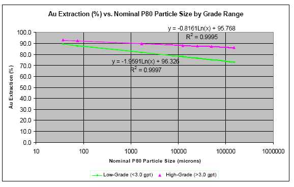
| February 25, 2011 | Page 146 |
| Fronteer Gold Inc. |
| Long Canyon Project, Elko County, Nevada |
| Updated Technical Report and Interim Resource Estimate |
| 17 | MINERAL RESOURCE ESTIMATE |
| | |
| 17.1 | Introduction |
| | |
| Mineral resources described in this report for the Long Canyon project have been estimated in accordance with standards adopted by the Canadian Institute of Mining, Metallurgy and Petroleum (“CIM”) in August 2000, as amended, and prescribed by Canadian Securities Administrators’ NI 43-101 (“NI 43-101”). |
| | |
| No historical resource or reserve estimations had been completed at Long Canyon prior to the mineral resource estimate reported in the 2009 Technical Report (Gustin and Smit h, 2009). This estimate reported 4,808,000 tonnes at an average grade of 2.35 grams/tonne (363,000 ounces) in the indicated category and 8,780,000 tonnes at an average grade of 1.63 grams/tonne (459,000 ounces) in the inferred category, at a 0.30 g/t cutoff grade. |
| | |
| An updated Technical Report including a Preliminary Economic Assessment was released late in 2009 (Gustinet al, 2009). The PEA assumes open-pit mining using conventional trucks and shovels and run-of- mine leaching of the Indicated and Inferred resources summarized above. A gold price of $800 per ounce was used for the economic evaluation. |
| | |
| The resource estimate was updated in May, 2010 (Gustinet al, 2010) to 12,240,000 tonnes at an average grade of 1.71 grams/tonne (672,000 ounces) in the measured/indicated category and 10,394,000 tonnes at an average grade of 1.65 grams/tonne (552,000 ounces) in the inferred category, at a 0.20 g/t cutoff. |
| | |
| The current resource update marks a distinct change in the modeling approach. Specifically, the grade domaining applied for estimation has been established using a probabilistic method instead of the deterministic grade shells used previously. Rock type and structural controls have distinct, quantitative impacts on grade interpolation, instead of simply influencing the geometrical interpretation of manually-digitized, sectional, grade polygons. Adoption of this revised modeling technique was mainly predicated on the desire to remove the manual aspect, and therefore potential bias, of resource model creation. Also, the Long Canyon project is at the point where on-going and frequent resource updates will be required as it moves toward production and a reproducible data- driven methodology is more efficient. |
| | |
| 17.2 | Available Data |
| | |
| This resource update is based on assay data available to December 15, 2010 and includes results of an additional 295 holes beyond those available for the June, 2010 resource estimate completed by MDA. Of these additional holes, 178 were core holes and 117 RC. Figure 17-1 shows the distribution of 2010 drilling compared to previous drill holes used in the MDA estimate. The block model geometry is shown in Figure 17-1 and described in Table 17-1. |
| February 25, 2011 | Page 147 |
| Fronteer Gold Inc. |
| Long Canyon Project, Elko County, Nevada |
| Updated Technical Report and Interim Resource Estimate |
Figure 17-1: Available Drilling and Block Model Outline
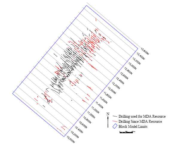
Table 17-1: Resource Block Model Setup
| Block: | X | Y | Z |
| origin(1) | 707,659.625 | 4,536,880. 157 | 2,400 |
| size | 10 | 5 | 5 |
| nblk | 360 | 420 | 190 |
Rotation: 50° counter-clockwise about origin
28,728,000 blocks
(1)SW model top, block edge
MDA and Fronteer have assessed RC assay results looking for evidence of down-hole sample contamination, as discussed in Section 12.3. This resulted in the exclusion of assay data from 29 entire and three partial holes for this resource estimate. In total 81,026 composites were included from 741 drill holes: 373 core and 368 RC holes.
Sample data was composited to a down-hole length of 1.52 metres (5 feet) to normalize the data for estimation purposes. This length was chosen since it is the standard sample
| February 25, 2011 | Page 148 |
| Fronteer Gold Inc. |
| Long Canyon Project, Elko County, Nevada |
| Updated Technical Report and Interim Resource Estimate |
length (80% of assay intervals) and therefore closely reflects actual sample variability. Composites of less than one half of the standard composite interval were not used in the estimation of this resource.
Intervals within unsampled portions of holes were assigned a grade of 0.001 g/t. This very low value was used instead of zero for reasons associated with controlling the estimation process. Summary statistics for assays compared to composites are presented in Table 17-2. The assay portion of the table includes unsampled intervals at 0.001 g/t, as does the composite set; however, the assay mean and CVs are somewhat skewed by the inclusion of these potentially very long intervals. Length weighted means are directly comparable to the composite statistics.
Table 17-2: Gold Grade Statistics
| ASSAYS | | | | | | | |
| | | | Length | | Au (g/t) | | |
| Rock Type | | | (metres) | Mean | Max | CV | lw-Mean(1) |
| 3 | | opls | 31,130 | 0.01 | 4. 29 | 11.4 | 0.00 |
| 4 | | oplsm | 14,950 | 0.49 | 72. 60 | 5.4 | 0.42 |
| 5 | | oplw | 11,202 | 0.90 | 53. 19 | 3.5 | 0.81 |
| 6 | | cnpd | 23,384 | 0.04 | 17. 00 | 10.0 | 0.02 |
| 7 | | cnplbu | 8,683 | 0.17 | 56. 40 | 9.0 | 0.14 |
| 8 | | cnplonc | 3,128 | 0.38 | 24. 06 | 4.3 | 0.35 |
| 9 | | cnplus | 4,023 | 0.97 | 45. 70 | 3.9 | 0.88 |
| 10 | | cnplw | 27,852 | 0.22 | 51. 73 | 6.6 | 0.18 |
| Total | | | 124,352 | 0.32 | 72. 60 | 6.2 | 0.22 |
(1) length weighted
COMPOSITES
| Rock Type | | | Length | | Au (g/t) | | |
| | | | (metres) | Mean | Max | CV | |
| 3 | | opls | 29,703 | 0.01 | 5. 22 | 14.0 | |
| 4 | | oplsm | 15,543 | 0.40 | 72. 60 | 5.5 | |
| 5 | | oplw | 11,342 | 0.80 | 45. 13 | 3.4 | |
| 6 | | cnpd | 22,263 | 0.02 | 15. 47 | 11.5 | |
| 7 | | cnplbu | 9,551 | 0.13 | 43. 60 | 8.4 | |
| 8 | | cnplonc | 3,240 | 0.32 | 24. 00 | 4.2 | |
| 9 | | cnplus | 4,031 | 0.89 | 45. 50 | 3.9 | |
| 10 | | cnplw | 27,811 | 0.18 | 37. 50 | 6.2 | |
| Total | | | 123,484 | 0.22 | 72. 60 | 6.8 | |
| 17.3 | Geologic Model |
| | |
| The geological block model was based on sectional interpretations that were continuously updated by Long Canyon geology staff as the drilling proceeded. The interpretation was carried out on northeast -looking vertical sections, spaced 50 metres apart. Detailed geological unit descriptions are provided in Section 7 of this report. |
| | |
| Grade interpolation was designed to reflect both the stratigraphic and structural controls on mineralization observed at Long Canyon. Lithology polygons, interpreted on site, were used to construct 10 three dimensional solids (Table 17-3), for each stratigraphic domain used in the interpolation. Stratigraphic control was applied by lithology or as location relative to the dolomite unit (Cnpd). |
| February 25, 2011 | Page 149 |
| Fronteer Gold Inc. |
| Long Canyon Project, Elko County, Nevada |
| Updated Technical Report and Interim Resource Estimate |
Table 17-3: Geologic Model Stratigraphy
| Rock Code | Rock Type | Proportion | | Description |
| 1 | Qal(1) | 7% | | quaternary alluvium and pad fill |
| 2 | Op -sw(1) | 13% | | Pogonip group above nor ma l fault along north model edge |
| 3 | Opls | 10% | | general Pogonip limestone |
| 4 | Oplsm | 4% | | silt y-massive Pogonip liimestone |
| 5 | Oplw | 2% | | wispy -massive Pogonip lime st one |
| 6 | Cnpd | 7% | | Notch Peak diagenetic dolomite |
| 7 | Cnplbu | 2% | | Notch Peak 'burrowed' limestone |
| 8 | Cnplonc | 1% | | Notch Peak oncolitic limest one |
| 9 | Cnplus | 1% | | Notch Peak upper siltstone |
| 10 | Cnplw | 54% | | lower wispy -massive Notch Peak limestone |
(1) grade not estimated
Dolomite alteration zones were also interpreted on cross-section and coded into the block model. The presence of dolomite alteration has a positive correlation with specific gravity, but does not have any other impact on the resource estimate
Structural domains for grade estimation were constructed using interpreted mineralized normal faults and “cracks” (inferred structures believed to be healed incipient boudin necks). These structures are interpreted to be the primary plumbing system for mineralization and therefore concentrate the highest grades, with grade dissipating as a function of distance away from the structure. This relationship was tested by examining the correlation between grade and orthogonal distance to the nearest structure for the 20 structural surfaces modeled. This analysis indicates that a distance of ±25m generally separates grades strongly associated with a specific structure from “background” average grades of individual rock types. Figure 17-2 shows example plots illustrating the strong spatial correlation of gold grade with proximity to modeled structures.
Figure 17-2: Grade versus Distance to Structure
Figure 17-3 and Figure 17-4 illustrate the geologic controls utilized for estimation.
| February 25, 2011 | Page 150 |
| Fronteer Gold Inc. |
| Long Canyon Project, Elko County, Nevada |
| Updated Technical Report and Interim Resource Estimate |
Figure 17-3: 3D view to North

Figure 17-4: Typical Cross-section through Geologic Model
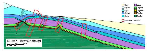
| February 25, 2011 | Page 151 |
| Fronteer Gold Inc. |
| Long Canyon Project, Elko County, Nevada |
| Updated Technical Report and Interim Resource Estimate |
| 17.4 | Grade Domain Modeling |
| | |
| Coefficients of variation (CVs) were reviewed by rock type within and among the various structural corridors to evaluate the effectiveness of the domaining process. This review returned CVs in the range of 4 to 7, an indication that composite grades were still too variable to be interpolated by standard geostatistical (ordinary kriging) or geometrical (inverse-distance weighting) techniques which are generally suited to CVs of up to 2. As a result, further domaining within grade ranges was deemed appropriate, as described below. |
| | |
| Evaluation of composite grade statistics led to the decision to divide the grade distribution into three ranges. Composites with grades of less than 0.15 g/t comprise approximately 93% of the population and represent an essentially unmineralized, background value. The main mineralized zone ranges in grade from 0.15 to 3.5 g/t and amounts to 5% of composite data. High grades of >3.5 g/t represent approximately the upper 2% of the composite grade distribution. High-grade zones closely follow the predominantly northeasterly trending structures where gold mineralization is associated with zones of intense hematitic alteration, brecciation and decalcification (Figure 17-5). |
| | |
| Figure 17-5: 1.52m Composite Grade Distribution |
Grade domain volumes were constructed probabilistically using an indicator approach. Low and high indicators were set at the two grade thresholds and were interpolated separately by inverse-distance cubed weighting within each structural and stratigraphic domain. These interpolations resulted in four probability values for each block in the model: low-grade stratigraphic, low-grade structural, high-grade stratigraphic and high-grade structural. The search and interpolation parameters are presented in Table 17-4.
| February 25, 2011 | Page 152 |
| Fronteer Gold Inc. |
| Long Canyon Project, Elko County, Nevada |
| Updated Technical Report and Interim Resource Estimate |
Table 17-4: Grade Domain Indicator Estimation Parameters
| | Interpolation | | Number Samples | Rock type | Search X/Y/Z | Orientation X/Y/Z |
| | | | min /max/mph(1) | Control | metres | dip>dip direction |
| | Structural | above dolomite | 1 / 4 / -- | soft above dolomite | 100/30/15 | structure bfp(2) |
| | | below dolomite | 1 / 4 / -- | soft below dolomite | 100/30/15 | same |
| | | dolomite | not estimated with structurally oriented search |
| | | | | | | |
| | Stratigraphic | non-dolomite(3) | 3 / 12 / -- | hard per lithology | 150/100/50 | 12°>033°/3°>123°/78°>228° |
| | | dolomite | 3 / 12 / -- | dolomite comps only | 25/5/10 | same |
| | (1) | mph=maximum number of samples per hole |
| | (2) | bfp=best-fit plane of each struct ure; X axis along structure, Y axis down struct ure, Z axis perpendicular to structure |
| | (3) | beyond 40 m into Cnplw search reduced to 60/15/20 metres |
The structural estimation parameters were designed to reflect the variability in grade with proximity to the structures, and therefore used relatively few samples within a narrow (Z) search and a pronounced X-direction anisotropy. The estimation of structural indicators was carried out with soft boundaries between units, above and below the Cnpd unit, but there was no structural estimate within or across the Cnpd unit.
Stratigraphic indicator estimation used hard boundaries for each of the ten lithologies to reflect the variable character of mineralization within the different units. The stratigraphic search was oriented parallel to the general trend of rock units with a relatively strong X-Y anisotropy, and a substantial Z search distance to account for the non-planarity of the modeled units. There was no stratigraphic indicator estimated within the Opls unit due to its tendency to be unmineralized. A reduced search was used in the Cnpd based on its tendency to be only locally mineralized. A reduced search was also applied beyond 40 metres into the lower-most Cnplw unit to prevent ‘blow-outs’ in areas with limited data, particularly at the bottom of holes.
The four probability variables were used to assign each block to a low, medium or high-grade domain. Inside structural corridors, where both structural and stratigraphic indicators were estimated, the higher of the two values was chosen as the final probability to be used in the assignment of grade domains.
The selection of probabilities above which blocks would be assigned to a corresponding domain was calibrated using a nearest neighbour (NN) model. The NN model was estimated based on 5 metre composites (reflecting the block size) using the same rock type control and search parameters as listed in Table 17-4. Plots of volume (block count) versus distance to closest composite for the NN model were compared against the probability models at various probability thresholds. The goal was to select the probability that best fit the NN plot, particularly within 50 metres of a composite. For both the low and high-grade indicators, a threshold of 0.500 gives the best fit probability model (Figure 17-6).
| February 25, 2011 | Page 153 |
| Fronteer Gold Inc. |
| Long Canyon Project, Elko County, Nevada |
| Updated Technical Report and Interim Resource Estimate |
Figure 17-6: Indicator Probability Calibration
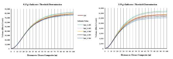
The final assignment of grade domains (AuDomain) was a sequential process applied to all blocks below topography:
| | • | blocks were initialized as low-grade (1) |
| | • | blocks were reset to medium-grade (2) if 0.15 g/t indicator≥0.5 |
| | • | blocks were reset to high-grade (3) if 3.5 g/t indicator≥0.5 |
| If a similar technique is used for future resource estimates, it is recommended that the thickness of structural corridors be reinvestigated. Once more drilling is available it may be possible to more explicitly model individual corridors or categorize mineralization style associated with types of structures – for example, faults versus cracks. |
| | |
| 17.5 | Grade Capping and Restriction |
| | |
| Grade capping was applied to composited values. Composites were analyzed statistically by rock type within the three AuDomains tagged from the block model. Capping levels were determined based on gold grade histograms and probability plots. Summary statistics are presented in Table 17-5. |
| | |
| In general, capping did not have a large impact on the average grade in any of the AuDomains. Capping was not required in the high-grade zone based on the continuous distribution of the data observed on probability plots and the low CVs of all rock types. The mean grade of AuDomain 2 was lowered slightly and CVs were reduced to more reasonable levels for interpolation. The variability of grades in AuDomain 1 coupled with the general lack of long range continuity of the highest grades led to the decision to employ a high-grade restriction in each of the grade domains. Metal removed by the capping process amounted to 1% overall. |
| | |
| High grades were restricted in terms of the distance over which they were interpolated. A ‘high-grade’ value and anisotropic search distance was specified for each grade domain, whereby, a sample is included at its capped value up to the given distance and, beyond which, it is included at the ‘high-grade’ value. Details of this outlier restriction are included in Table 17-6. The grade considered ‘high’ was determined for each AuDomain based on their cumulative probability distributions. The maximum distance was based on |
| February 25, 2011 | Page 154 |
| Fronteer Gold Inc. |
| Long Canyon Project, Elko County, Nevada |
| Updated Technical Report and Interim Resource Estimate |
assessment of several factors including: review of the average distance at various thresholds, reported in the population of the NN model and visual assessment of sections and plans. Metal removed by the outlier restriction process amounted to 10%. It is recommended that future estimates include a more in-depth review of the spatial correlation of the high grades; once more closely-spaced sample data is available.
Table 17-5: Composite Statistics
| AuDomain | Rock Type | | Count | | Au (g/t) | | Capped Au (g/t) |
| | | | | Mean | Min | Max | CV | Cap | #Cap | Mean | CV |
| 1 | 1 | qal | 2,142 | 0.00 | 0.00 | 0.71 | 8.2 | N/A | not interpolated |
| | 2 | op-sw | 961 | 0.00 | 0.00 | 0.44 | 4.6 | | | | |
| | 3 | opls | 19,406 | 0.00 | 0.00 | 1.76 | 7.7 | 0.25 | 5 | 0.00 | 3.7 |
| | 4 | oplsm | 9,148 | 0.01 | 0.00 | 5.64 | 10.0 | 2.00 | 5 | 0.01 | 7.6 |
| | 5 | oplw | 5,743 | 0.05 | 0.00 | 21.82 | 9.6 | 6.00 | 8 | 0.05 | 7.4 |
| | 6 | cnpd | 14,337 | 0.01 | 0.00 | 3.88 | 6.8 | 1.50 | 8 | 0.01 | 5.5 |
| | 7 | cnplbu | 5,719 | 0.02 | 0.00 | 3.74 | 4.8 | 1.50 | 6 | 0.02 | 3.7 |
| | 8 | cnplonc | 1,724 | 0.04 | 0.00 | 11.09 | 7.0 | 1.50 | 3 | 0.04 | 3.0 |
| | 9 | cnplus | 1,962 | 0.05 | 0.00 | 3.63 | 3.8 | 1.50 | 5 | 0.04 | 3.0 |
| | 10 | cnplw | 16,357 | 0.03 | 0.00 | 15.80 | 6.6 | 1.50 | 12 | 0.03 | 2.8 |
| | Total | | 77,499 | 0.02 | 0.00 | 21.82 | 10.2 | | 52 | 0.02 | 6.9 |
| 2 | 3 | opls | 83 | 0.73 | 0.00 | 5.22 | 1.2 | -- | | | |
| | 4 | oplsm | 676 | 1.38 | 0.00 | 18.93 | 1.5 | -- | | | |
| | 5 | oplw | 1,139 | 1.34 | 0.00 | 27.80 | 1.5 | 20.00 | 1 | 1.33 | 1.5 |
| | 6 | cnpd | 250 | 0.52 | 0.00 | 15.47 | 2.7 | 3.50 | 3 | 0.43 | 1.5 |
| | 7 | cnplbu | 494 | 0.69 | 0.00 | 9.73 | 1.6 | 4.50 | 7 | 0.66 | 1.4 |
| | 8 | cnplonc | 356 | 1.03 | 0.00 | 18.64 | 1.8 | 5.50 | 8 | 0.90 | 1.3 |
| | 9 | cnplus | 533 | 1.41 | 0.00 | 27.33 | 2.0 | 10.00 | 10 | 1.26 | 1.5 |
| | 10 | cnplw | 1,657 | 0.87 | 0.00 | 29.54 | 1.9 | 10.00 | 8 | 0.84 | 1.6 |
| | Total | | 5,188 | 1.07 | 0.00 | 29.54 | 1.8 | | 37 | 1.03 | 1.6 |
| 3 | 3 | opls | 1 | 1.00 | 1.00 | 1.00 | 0.0 | -- | | | |
| | 4 | oplsm | 375 | 8.14 | 0.01 | 72.60 | 1.0 | -- | | | |
| | 5 | oplw | 560 | 7.34 | 0.00 | 45.13 | 0.9 | -- | | | |
| | 6 | cnpd | 21 | 3.26 | 0.02 | 12.34 | 1.1 | -- | | | |
| | 7 | cnplbu | 54 | 6.84 | 0.02 | 43.60 | 1.3 | -- | | | |
| | 8 | cnplonc | 46 | 5.26 | 0.13 | 24.00 | 0.9 | -- | | | |
| | 9 | cnplus | 150 | 10.12 | 0.06 | 45.50 | 0.9 | -- | | | |
| | 10 | cnplw | 235 | 5.80 | 0.04 | 37.50 | 1.0 | -- | | | |
| | Total | | 1,442 | 7.44 | 0.00 | 72.60 | 1.0 | | 0 | | |
| 17.6 | Grade Interpolation |
| | | |
| Gold grades were interpolated by inverse-distance cubed weighting using an anisotropic search and a two pass approach. The first pass was designed to reflect the short-range variability of the deposit; the second pass targeted the filling of blocks beyond the limits that would ultimately be classified as inferred. The estimate was controlled by combinations of: |
| | | |
| • | composites back-tagged with the AuDomain block values (1 of 3) |
| | | |
| • | composites tagged with lithology from solids (1 of 10) |
| | | |
| • | composites tagged with structural domain solids (1of 20) |
| | | |
| Table 17-6 lists the grade interpolation parameters. Like the indicator interpolation process, grades were estimated using a structural, followed by a stratigraphic, search strategy. The structural component of grade estimation was carried out using 20 search orientations corresponding to the different structural corridors. The stratigraphic component employed a single best -fit orientation for the entire sequence. |
| February 25, 2011 | Page 155 |
| Fronteer Gold Inc. |
| Long Canyon Project, Elko County, Nevada |
| Updated Technical Report and Interim Resource Estimate |
Analysis of grade trends across lithology contacts within AuDomains showed no abrupt changes, with the exception of the Cnpd unit. This led to the use of soft boundaries between all stratigraphic units and hard boundaries around the the Cnpd unit. Also, no mixing was allowed between units above and below the Cnpd unit. The stratigraphic interpolation above the dolomite excluded the uppermost unit, Opls, as this unit is essentially unmineralized, unless truncated by a structure. Stratigraphic estimation of the lowermost unit, Cnplw, was generally restricted to a zone within 40 metres of its upper contact. Mineralized zones below the 40 m limit were estimated with maximum ranges of 60x15x20 m. These conditions were imposed to control the unreasonable spreading of grade, particularly beyond the ends of drill holes. The 40 metre distance was determined from plots of grade versus distance into the Cnplw unit.
Table 17-6: Gold Grade Estimation Parameters

| 17.7 | Density Assignment |
| | |
| A total of 1,399 dry bulk specific gravity measurements from drill core were used in the assignment of density to the resource block model. Core logging procedures call for one sample to be selected for SG determination per lithologic unit and/or mineralized zone. Analyses were by AAL and ALS using the water displacement method with core coated in wax as required. |
| | |
| Density was determined to correlate not only with lithology but also with the presence of dolomite alteration and inversely with gold grade . Assignment of block values was as follows: |
| | • | density initialized based on rock type assignment from solids |
| | • | density factored up by 3.8% if dolomite altered (non-dolomite blocks) |
| | • | density adjusted based on interpolated gold grade |
The density per rock type was determined by removing dolomite altered samples and those with grades above 0.15 g/t and calculating the averages listed in Table 17-7.
| February 25, 2011 | Page 156 |
| Fronteer Gold Inc. |
| Long Canyon Project, Elko County, Nevada |
| Updated Technical Report and Interim Resource Estimate |
Table 17-7: Average Rock Type Density
| Rock Type | | Density t/m3 |
| Count | | | |
| | | | mean | min | max |
| 1 | Qal(1) | | 1. 80 | | |
| 2 | Op -sw | 10 | 2. 56 | 2.27 | 2. 74 |
| 3 | Opls | 138 | 2. 66 | 1.94 | 2. 73 |
| 4 | Oplsm | 181 | 2. 65 | 2.38 | 3. 03 |
| 5 | Oplw | 137 | 2. 65 | 2.21 | 2. 94 |
| 6 | Cnpd | 171 | 2. 79 | 2.13 | 2. 93 |
| 7 | Cnplbu | 17 | 2. 69 | 2.50 | 2. 77 |
| 8 | Cnplonc | 16 | 2. 63 | 1.95 | 2. 79 |
| 9 | Cnplus | 36 | 2. 65 | 2.44 | 2. 83 |
| 10 | Cnplw | 205 | 2. 68 | 2.11 | 2. 83 |
| | | 911 | 2. 68 | 1.94 | 3. 03 |
(1) density assigned arbitrarily
There were 227 SG samples tagged from the sectional interpretation as being dolomite altered. Comparing the average density of these samples with the other 985 non-dolomite samples showed an increase in density of 3.8% . This factor was applied to all (non-dolomite) blocks falling within the interpreted zones of dolomite alteration.
The last adjustment to a block’s density was based on its interpolated grade. Based on the calculated linear correlation of all SG samples≥0.15 g/t, block densities were reduced by 0.0068 times the estimated grade. See Figure 17-7.
Figure 17-7: Density Variation with Grade
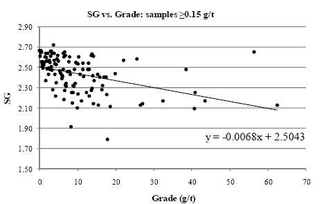
| February 25, 2011 | Page 157 |
| Fronteer Gold Inc. |
| Long Canyon Project, Elko County, Nevada |
| Updated Technical Report and Interim Resource Estimate |
17.8Model Validation
The estimation process was validated as it progressed through geologic model creation, indicator grade domain estimation and grade estimation. Validation of the geologic model was carried out by reviewing the solids in 3D and by comparison to the sectional interpretation. Final solids were checked for ‘validity’ in the Gemcom software package.
Validation of grade domains, established through the indicator estimation process, was largely visual. Parameters were determined iteratively through a review process that included site geology staff. Ultimately, the selection of the 0.5 indicator threshold, through calibration to the NN model, led to the conclusion that the technique had resulted in appropriate volumes being assigned to each of the three grade bins.
The grade model was validated to ensure internal consistency with supporting data. Visual inspection of block values compared to drill composite data showed good correlation. Statistical checks by rock type and AuDomains indicated good global agreement. Swath plots of the final grade model against the NN model also showed good local correlation in model X, Y and Z directions; see Figure 17-8
Figure 17-8: Swath Plots Comparing ID Cubed and NN Estimates
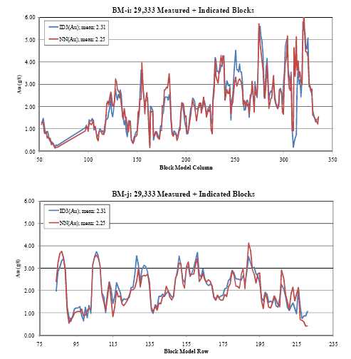
| February 25, 2011 | Page 158 |
| Fronteer Gold Inc. |
| Long Canyon Project, Elko County, Nevada |
| Updated Technical Report and Interim Resource Estimate |

The grade model was checked in terms of its variability by comparing the estimate to the volume-variance corrected NN model; the indirect lognormal correction was applied. This check indicated that, in the range of the expected mining cutoff grade of approximately 0.2 g/t, at an SMU size of 5x10x5 metres, the variability of the estimate is appropriate. See Figure 17-9.
Figure 17-9: Estimate Compared to NN Model Adjusted for Change of Support
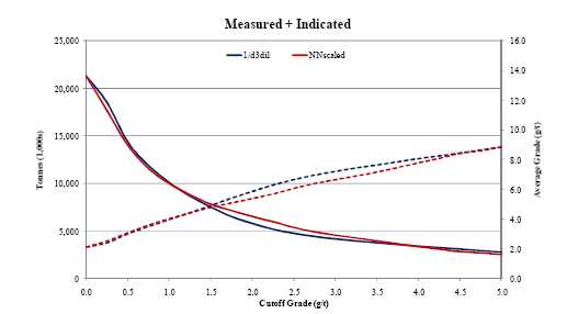
An external check of the grade estimate was conducted in the southwestern portion of the deposit (SW of 12,000 N), where there was little new drilling. In this area the resource was compared against the June, 2010 update by MDA. Results compared reasonably closely between the two models that were estimated by very different techniques. The MDA model used grade polygons, hand-digitized on each 10 metre block section. Polygons were hand-drawn at cutoffs of 0.15, 1.5 and 3.5 g/t as opposed to the data-driven probabilistic approach used to separate the grade ranges for this estimate. At a 0.2 g/t cutoff, the new model reports less tonnage at a slightly higher grade for 11% less metal overall (Table 17-8). Figure 17-10 compares the two models at a series of cutoff grades and again the models agree closely in this area of comparison.
| February 25, 2011 | Page 159 |
| Fronteer Gold Inc. |
| Long Canyon Project, Elko County, Nevada |
| Updated Technical Report and Interim Resource Estimate |
Table 17-8: Grade Model Comparison with June 2010 MDA Model
| | Measured + Indicated Southwest of 12,000N at 0.2 g/t Cutoff |
| Resource | Tonnes | Grade | Ounces | Difference |
| | (1,000s) | (g/t) | (1,000s) | Tonnes | Grade | Ounces |
| 2010 Fronteer Update | 8,160 | 1.55 | 407 | | | |
| | | | | -13% | 2% | -11% |
| MDA June 2010 | 9,367 | 1.52 | 456 | | | |
Figure 17-10: Grade Model Comparison by Cutoff
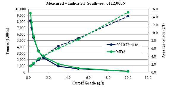
| As a final validation step the Mineral Resource estimation methodologies were independently reviewed at a high level, and were deemed to meet CIM Definition Standards for Mineral Resources and Mineral Reserves (2010), by Harry Parker, P.Geo., Technical Director, AMEC, and Georges Verly, P.Eng., Chief Geostatistician, AMEC (Verly and Parker, 2011). |
| | |
| 17.9 | Resource Classification and Tabulation |
| | |
| Measures were taken to ensure the resource meets the condition of “reasonable prospects of economic extraction” as dictated under NI 43-101. Grades were diluted with blocks to the north, south, east and west by blending 80% of the block estimated grade with a 5% grade contribution from each of the four adjacent blocks. This process smoothes the grades slightly inside the resource, and integrates some degree of edge dilution along the margins of mineralization. |
| | |
| In order to restrict the reported resource to a potentially mineable shape, and exclude outlying blocks, a pseudo -pit shell was manually digitized to constrain the resource tabulation. This surface was manually digitized on two set of orthogonal sections to approximate a pit shell with an overall wall slope of≤45°. The resource in Table 17-10 below includes only those blocks with≥50% above that surface and in this way limits the |
| February 25, 2011 | Page 160 |
| Fronteer Gold Inc. |
| Long Canyon Project, Elko County, Nevada |
| Updated Technical Report and Interim Resource Estimate |
tabulation to blocks that can be expected to fall within an open pit mining scenario. At a cutoff grade of 0.2 g/t, the total resource inside this pseudo-pit shell has a strip ratio of 20:1.
The 2010 estimate was classified based on spatial parameters related to available composite data. These parameters are: (i) the minimum number of holes used to estimate grade and (ii) the average distance to sample data; see Table 17-9. The distance parameters were derived primarily from visual assessment of drill data. Variography played some role in the distance determination but, in general, variograms were of limited use due mainly to the spatial and statistical truncation of the grade distribution resulting from the domaining that was employed in the estimate.
Table 17-9: Resource Classification Criteria
| Category | No. Holes | Average Distance |
| | min. | max. - metres |
| Measured | 2 | 12.5 |
| | | |
| Indicated | 2 | 35 |
| | 1 | 17.5 |
| | | |
| Inferred | 2 | 50 |
| | 1 | 25 |
Table 17-10: Long Canyon 2010 Year-End Gold Resource Estimate*
| COG | Measured | Indicated | | Measured + Indicated | | Inferred |
| (g/t) | Tonnes | Grade | Ounces | Tonnes | Grade | Ounces | | Tonnes | Grade | Ounces | | Tonnes | Grade | Ounces |
| | (1,000s) | (g Au/t) | (1,000s) | (1,000s) | (g Au/t) | (1,000s) | | (1,000s) | (g Au/t) | (1,000s) | | (1,000s) | (g Au/t) | (1,000s) |
| 0.2 | 762 | 2.91 | 71 | 17,609 | 2.34 | 1,324 | | 18,371 | 2.36 | 1,396 | | 11,170 | 2.24 | 803 |
| 0.3 | 693 | 3.18 | 71 | 15,775 | 2.58 | 1,310 | | 16,467 | 2.61 | 1,380 | | 10,209 | 2. 42 | 796 |
| 0.5 | 594 | 3.64 | 69 | 13,098 | 3.03 | 1,276 | | 13,692 | 3.06 | 1,345 | | 8,617 | 2. 80 | 776 |
| 1.0 | 458 | 4.51 | 66 | 9,286 | 3.98 | 1,187 | | 9,744 | 4.00 | 1,254 | | 5,990 | 3. 70 | 713 |
| 1.5 | 362 | 5.37 | 63 | 6,885 | 4.93 | 1,092 | | 7,247 | 4.96 | 1,155 | | 4,276 | 4. 69 | 645 |
| 3.0 | 218 | 7.53 | 53 | 3,848 | 7.21 | 892 | | 4,067 | 7.22 | 944 | | 2,250 | 7. 09 | 513 |
| 5.0 | 136 | 9.65 | 42 | 2,592 | 8.80 | 733 | | 2,728 | 8.84 | 775 | | 1,534 | 8. 56 | 422 |
| 10.0 | 42 | 15.36 | 21 | 743 | 13.28 | 317 | | 786 | 13.39 | 338 | | 423 | 12. 52 | 170 |
*Resources are reported at 0.2 g/t Au cut-off to agree with economic parameters determined in the Long Canyon Preliminary Assessment summarized in Section 18.
The resource tabulation shown here includes inferred material out to a maximum average distance of 50 metres from the closest two drill holes. By comparison, the most recent prior estimate (Gustinet al., 2010) included all estimated blocks, not classified as measured or indicated, as inferred, out to a maximum distance of 175 metres. Evaluation of the sensitivity to this maximum range for inferred resources in the current estimate showed that an increase to only 70 metres yielded an additional 0.5 million ounces in the inferred class. It is therefore recommended that classification parameters be revisited as more drilling becomes available to assess grade correlation and spatial variability.
| February 25, 2011 | Page 161 |
| Fronteer Gold Inc. |
| Long Canyon Project, Elko County, Nevada |
| Updated Technical Report and Interim Resource Estimate |
This page left intentionally blank.
| February 25, 2011 | Page 162 |
| Fronteer Gold Inc. |
| Long Canyon Project, Elko County, Nevada |
| Updated Technical Report and Interim Resource Estimate |
| 18 | OTHER RELEVANT DATA AND INFORMATION |
| | |
| The following subsections summarize the results of a preliminary economic assessment (the 2009 PEA) undertaken using the 2009 Long Canyon resource model (which has been superseded by two subsequent estimates including this study), geotechnical and waste-rock characterization studies completed subsequent to the PEA, and the installation of meteorological and air monitoring stations. |
| | |
| MDA is not aware of any other information relevant to this technical report on the Long Canyon project that is not discussed herein. |
| 18.1 | 2009 Preliminary Economic Assessment |
| | |
| MDA completed the 2009 PEA for the Long Canyon deposit using the May 2009 resource model (Gustinet al., 2009). The 2009 PEA was not based on the current mineral resources discussed herein, which exceed those reported in 2009 by more than 160%, and therefore only a summary of the results are included below. |
| | |
| The 2009 PEA assumed open-pit mining, using conventional trucks and shovels, and run-of-mine leaching of the 2009 Indicated and Inferred gold resources. A gold price of $800 per ounce was used for the economic evaluation. Economic highlights included: |
| | |
| • | Life-of- mine pre-tax cash flow of US$181 million |
| • | Net present value (5% discount rate) of US$145 million |
| • | Internal rate of return of 64% |
| • | Payback period of 1.3 years |
| • | Life-of- mine cash cost of $351 per ounce of gold |
| • | Total pre-tax cost of $479 per ounce of gold |
| • | Pit designs contain 651,000 ounces of gold |
| • | 565,000 ounces of gold recovered. |
| | | |
| 18.2 | Geotechnical Pit-Slope Study |
| | |
| In early July 2009, Golder Associates (“Golder”) began an extensive program of field investigation and geotechnical characterization to support pre -feasibility level pit -slope design recommendations. Golder representatives Graeme Major, Principal Geotechnical Engineer, and Joe Blaylock, Project Geologist, began the investigation by reviewing all available data, which included NI 43-101 reports, geological model, surface mapping of outcrops and major structures, surface structural data (1,121 data points), geological database, RQD database, and preliminary pit designs developed by MDA. Golder reviewed representative core and completed a site reconnaissance visit where they viewed the geological model and drilling data at the site office. Following the review, Golder and Fronteer personnel selected four sites for geotechnical core holes at locations that are considered representative of the highest (west) pit slopes. The core- drilling program started in early July and was completed in mid- August of 2009. A total of 677.4 metres of geotechnical core were drilled. All geotechnical core logging and data collection (point load tests) were completed at the drill rig while the core was still in split tubes of the triple -tube coring system. Collection of these data |
| February 25, 2011 | Page 163 |
| Fronteer Gold Inc. |
| Long Canyon Project, Elko County, Nevada |
| Updated Technical Report and Interim Resource Estimate |
enables the calculation of a quantitative Rock Mass rating (“RMR”) value, which is a number between 0 and 100 and is a measure of rock mass quality. Based on the geotechnical core logging data, Pogonip rocks in the project area have an RMR value of 43, which ranks the rock quality as “fair”, while the Notch Peak units have an RMR average value of 60, which ranks the rock quality as “fair” to “good”.
Each geotechnical core hole was surveyed upon completion of drilling by Colog, of Lakewood, Colorado, using optical and acoustic televiewers. The digital raw image files of the surveys were used to reconcile the image with the physical core and geotechnical logging. The televiewer data are input into the WellCAD software, which assembles the raw data and properly rotates the selected structures to true orientations.
General conclusions from the geotechnical investigation show the rock quality and structural conditions to be favourable for the development of moderately steep to steep inter-ramp slopes within the competent limestone bedrock (Figure 18-1). The competent rock mass should preclude the development of rock mass failures. Bench-face angles are expected to be controlled by operating practices throughout most pit slopes, with bedding plane structures controlling crest stability if blasting practices are poor. Specific conclusions supported by the characterization and data analysis include:
| | • | Rock mass stability analysis indicate adequate factor-of-safety with respect to overall rock mass failure; |
| | • | There is no extensive clay alteration, and significant potential for clay alteration appears to be limited to dike margins; |
| | • | Since the pit is above the groundwater table, groundwater will not influence slope stability and no slope dewatering will be required; |
| | • | Kinematic stability analyses indicate significant potential for planar failures of bench-scale and multi- bench slopes only in the southeast sectors of the pits; and |
| | • | Steep bench-face angles should generally be achievable with careful blasting, excavation, and scaling. |
Figure 18-1: Bench and Inter-Ramp Slope Configuration
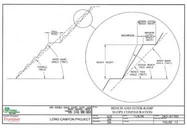
| February 25, 2011 | Page 164 |
| Fronteer Gold Inc. |
| Long Canyon Project, Elko County, Nevada |
| Updated Technical Report and Interim Resource Estimate |
For bedrock slopes where there is indicated to be little potential for rock mass or structural control of overall or inter-ramp slope angles, pit-slope angles will be determined by the bench configurations that can be developed and maintained safely. Bench configurations are defined by production bench height, achievable bench-face angle, and catch-bench width, all of which combine to define the inter-ramp angle. Golder’s recommended bench configurations are shown in Table 18-1.
Table 18-1: Bench Configuration Recommendations
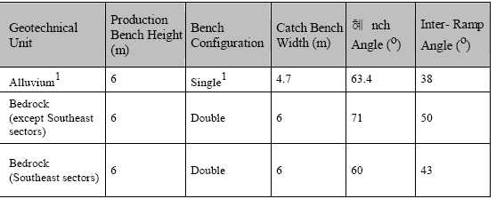
| 1Incorporate a catch bench at base of alluvium to facilitate drainage and cleanup |
| | |
| It is important to note that these recommendations were provided subsequent to the 2009 PEA study and therefore they were not incorporated into the pit designs. |
| | |
| 18.3 | Waste-Rock Characterization |
| | |
| SRK Consulting was contracted in 2009 to prepare a study regarding waste rock characterization, including a summary of the Acid Base Accounting (“ABA”) and Net Acid Generation (“NAG”) potential of waste rock (SRK, 2010). SRK performed a field and office review, including examination of representative core. They then collected nine large samples representing four general rock types (Pogonip and Notch Peak limestones, Notch Peak Dolomite, and lamprophyre) in various states of alteration. Samples were submitted to McClelland Laboratory for preparation and testing, including assay, multi-element ICP-MS, ABA, NAG, and Meteoric Water Mobility Procedure (“MWMP”) testing. |
| | |
| The ABA method includes laboratory analysis and theoretical calculations based on acidification potential (“AP”) and neutralization potential (“NP”). The neutralization potential ratio (“NPR”; ratio of NP to AP) is calculated and plotted against the Net Neutralization Potential (“NNP”; the difference between NP and AP). NPR values greater than three and NNP values less than 20 eq. kg CaCO3/ton are generally indicative of acid neutralizing rocks. The results for all samples collected at Long Canyon showed significant neutralization potential, with the highest neutralizing potential in rocks of the Notch Peak Formation and lowest neutralizing potential in samples of lamprophyre dike material. |
| February 25, 2011 | Page 165 |
| Fronteer Gold Inc. |
| Long Canyon Project, Elko County, Nevada |
| Updated Technical Report and Interim Resource Estimate |
NAG potential was investigated by subjecting samples to a weak hydrogen peroxide solution in order to induce oxidation. Resultant NAG pH was greater than 7.5 for all Long Canyon samples, confirming the ABA test results and indicating that no acid generation would be predicted for the Long Canyon deposit. As a result, no further testing of acid-generating potential (humidity cells, etc.) was recommended by SRK for Long Canyon. Further test work was recommended to investigate the potential for metal leaching under high pH conditions using MWMP testing. This testing is currently in progress.
| February 25, 2011 | Page 166 |
| Fronteer Gold Inc. |
| Long Canyon Project, Elko County, Nevada |
| Updated Technical Report and Interim Resource Estimate |
| 19 | INTERPRETATION AND CONCLUSIONS |
| | |
| Gold mineralization has been defined within a 3.0 kilometre- long northeast-trending area that is up to 500 metres wide on the Long Canyon property. Mineralization is of the sediment - hosted gold type and is present in both surface outcrops and in exploration drill holes. |
| | |
| The primary structural/stratigraphic controls of the Long Canyon mineralization are related to the development of mega- boudins and incipient boudins (“cracks”) within the uppermost dolomite unit in the Notch Peak Formation. Gold occurs in silty limestones along the margins of the boudins (especially at and near the boudin noses), within boudin necks and along crack “corridors” above and below the dolomite horizon. These patterns are enhanced by high- to low-angle, west-dipping, brittle normal faults. High- grade gold occurs within solution-collapse breccias, zones of strong decalcification and lamprophyre dykes and sills within these structural/stratigraphic settings. |
| | |
| Long Canyon mineralization is generally characterized as being highly oxidized and non preg-robbing, with high cyanide solubility of gold. Results from the testing performed on both bulk surficial materials and drill core suggest that this mineralization is amenable to extraction of gold by cyanidation via oxide milling or heap leaching methods. |
| | |
| A total of 768 exploration drill holes were completed through 2010 and evaluated for use in the Long Canyon resource estimation; 292 of these holes were completed in 2010, totaling 65,969 metres. This drilling was pr imar ily completed on a nominal 50- metre-spaced grid, with the drill sections oriented northwest-southeast . |
| | |
| An analysis of the QA/QC data collected during the AuEx and Joint Venture drilling programs did not identify any serious issues with the sample preparation and analyses of the drill samples. The drill data do indicate the presence of down-hole contamination in some portion of the RC sample database, however. This issue was mitigated to a large extent by removing suspect intervals from the resource modeling, but some uncertainty in the remaining RC data, in the form of unrecognized contamination, persists. |
| | |
| The Long Canyon resource estimate has been prepared using a less manual method than has been carried out in the past . The current technique has advantages in terms of the ease of resource update, due to its data -driven nature, as well as being less deterministic and therefore less subjective and more vulnerable to interpretive bias. Model validation indicates that this resource estimate is well founded and fairly states the Long Canyon Gold Resource. |
| | |
| The Long Canyon gold resources are tabulated at a cutoff grade of 0.20 g Au/t to capture the oxidized mineralization potentially available for open-pit extraction. Measured and Indicated resources total 18.371 million tonnes averaging 2.36 g Au/t (1,396,000 ounces), with an additional 11.170 million tonnes averaging 2. 24 g Au/t (803,000 ounces) assigned to the Inferred category. |
| | |
| Results of a preliminary economic assessment, completed on the earlier 2009 resource model, indicated that Long Canyon is a deposit of merit and has the potential to yield a |
| February 25, 2011 | Page 167 |
| Fronteer Gold Inc. |
| Long Canyon Project, Elko County, Nevada |
| Updated Technical Report and Interim Resource Estimate |
robust return on capital.
Drilling at Long Canyon was successful in outlining potentially economic gold mineralization in numerous drill holes. The limits of the gold mineralization are not fully delineated, however, and the deposit remains open along strike, particularly to the northeast. There is also excellent potential for the discovery of new, parallel zones of mineralization related to dolomite boudins and incipient boudins that have yet to be identified. An east-west-trending corridor containing higher-grade material identified in 2010 drilling has not been fully tested along strike to the east and west, and the potential remains for discovery of other, similar structural intersections.
Rock chip and soil sample results, as well as mapping of favourable stratigraphic and structural environments, have proven to be direct guides to the definition of shallow drill targets at Long Canyon. Programs of mapping and sampling elsewhere on the property have defined a number of drill targets on this basis.
| February 25, 2011 | Page 168 |
| Fronteer Gold Inc. |
| Long Canyon Project, Elko County, Nevada |
| Updated Technical Report and Interim Resource Estimate |
| 20 | RECOMMENDATIONS |
| | |
| Significant, relatively shallow oxide mineral resources have been outlined at Long Canyon. These resources remain open, with substantial additions conceivable . Beyond the extensions of known zones of mineralization, there is excellent potential for the discovery of new mineralized zones. It is clear that the Long Canyon project warrants significant additional expenditures. |
| | |
| Further drilling at Long Canyon should focus on three objectives: (i) the expansion of resources by drilling open-ended extensions of the eight mineralized zones; (ii) the identification of additional zones of mineralization within new structural/stratigraphic settings; and (iii) continued upgrading of the resource classification through infill drilling. |
| | |
| Diamond-core drilling methods will be used to complete the majority of infill drilling at Long Canyon. Core drilling provides higher-quality samples that will allow for the definition of Measured resources. RC drilling will be largely confined to the testing of new exploration targets, as well as the initial testing of the extensions of presently defined zones of mineralization. The geologic model should continue to be refined as new drill data are received. |
| | |
| Recommendations related to tuning the resource estimation parameters and methods as the deposit understanding evolves, are embedded in Section 17. The structural nature of the highest grade mineralization illustrates the importance of the geologic framework on which the resource estimation is built . As the project moves into feasibility stage evaluation it would be advisable to carry out conditional simulation studies, into both the underlying geology as well as grade estimation, to ensure that resource variability and uncertainty is adequately portrayed by estimation. |
| | |
| Significant exploration drilling is justified. While several areas beyond the limits of Long Canyon deposit have already been outlined for drill testing, additional detailed geologic mapping, systematic sampling of road cuts along new access roads, extensions of the existing soil grid, and geophysical surveys should be used to identify new targets. |
| | |
| Fronteer approved a 2011 exploration program with a budget of US$29,800,000 program for Long Canyon. The budget includes 100,000 metres of core and RC drilling pursuant to defining additional resources contiguous with the existing deposit as well as infill, geotechnical, hydrological, reconnaissance/exploration and condemnation drilling. The budget would also support various engineering, metallurgical, hydrological and environmental investigations, as well as trade-off studies and an update to the Preliminary Economic Analysis. |
| February 25, 2011 | Page 169 |
| Fronteer Gold Inc. |
| Long Canyon Project, Elko County, Nevada |
| Updated Technical Report and Interim Resource Estimate |
This page left intentionally blank.
| February 25, 2011 | Page 170 |
| Fronteer Gold Inc. |
| Long Canyon Project, Elko County, Nevada |
| Updated Technical Report and Interim Resource Estimate |
| 21 | REFERENCES |
| | |
| AuEx, 2008, various project digital files, drill-hole database information, QA/QC assays, assay certificates from ALS-Chemex and AAL, and photographs of core, maps, and sections. |
| | |
| Camilleri, P. A., 1994, Mesozoic and Cenozoic tectonic and metamorphic evolution of the Wood Hills and Pequop Mountains, Elko County, Nevada: Ph.D. dissertation, Univ. of Wyoming, Laramie, WY, 196 p. |
| | |
| Coolbaugh, M., 2006,Geologic map of a portion of the Long Canyon Joint Venture area: unpublished map prepared in digital format for the Fronteer-AuEx Joint Venture . |
| | |
| Doolin, Michael, 2009, Report on metallurgical testing – Long Canyon grab samples, MLI Job No.3316: metallurgical report prepared for Fronteer Development (USA) Inc. by McClelland Laboratories, Inc ., 8 p. plus appendices. |
| | |
| Doolin, Michael, 2009,Report on heap leach cyanidation testing – Long Canyon bulk samples, MLI Job No. 3316: metallurgical report prepared by McClelland Laboratories, Inc. for Fronteer Development (USA) Inc ., 25 p. plus appendices. |
| | |
| Golder Associates, 2010,Long Canyon Project, Elko County, Nevada: Report on Pre- Feasibility Level Pit Slope Evaluation: report prepared by Golder Associates for Fronteer Development (USA) Inc ., 34 p. plus tables, figures and appendices. |
| | |
| Gustin, Michael M. and Smith, Moira, 2009,Technical Report on the Long Canyon Project, Elko County, Nevada, USA: NI 43-101 technical report prepared by Mine Development Associates for Fronteer Development Group Inc. and AuEx Ventures, Inc., 102 p. plus appendices. |
| | |
| Gustin, Michael M., Smith, Moira, Dyer, Thomas L., and Simmons, Gary L ., 2009,Updated Technical Report on the Preliminary Economic Assessment of the Long Canyon Project, Elko County, Nevada, USA: NI 43-101 technical report prepared by Mine Development Associates for Fronteer Development Group Inc. and AuEx Ventures, Inc., 145 p. plus appendices. |
| | |
| Gustin, Michael M., Smith, Moira and Simmons, Gary L ., 2010,Updated Technical Report on the Long Canyon Project, Elko County, Nevada, USA: NI 43-101 technical report prepared by Mine Development Associates for Fronteer Development Group Inc. and AuEx Ventures, Inc., 137 p. plus appendices. |
| | |
| Griffith, David J., 2006,Technical Report, Great Basin East Properties, Elko County, Nevada and Box Elder County, Utah USA: NI 43-101 technical report prepared by Mine Development Associates for NewWest Gold Corporation, 112 p. plus appendices. |
| | |
| Harrison, S., 2001,Pequop Prospect – Final Geochemical Report: internal Pittston Nevada Gold Company report, 51p. |
| February 25, 2011 | Page 171 |
| Fronteer Gold Inc. |
| Long Canyon Project, Elko County, Nevada |
| Updated Technical Report and Interim Resource Estimate |
Hintze, L.F., 1951,Lower Ordovician detailed stratigraphic sections of western Utah: Utah Geological and Mineralogical Survey Bulletin 39, 99 p.
Larson, Lawrence T., April, September, and October 2000, correspondences with Robert Felder of Pittston Nevada Gold Company, with discussion of petrography, from internal Fronteer Group (USA) Inc. files.
Loucks, R.G., 1999, Paleocave carbonate reservoirs: origins, burial-depth modifications, spatial complexity, and reservoir implications: Journal of Sedimentary Research, v. 83, 1795-1834.
McCollum, L. B., and Miller, D. M., 1991, Cambrian Stratigraphy of the Wendover area, Utah and Nevada: U.S. Geological Survey Bulletin 1948, 43 p.
Moran, A.V. 2005,NI-43-101 technical report, Pequop exploration property, Nevada, USA: NI 43-101 technical report prepared by SRK Consulting for AuEx Ventures, Inc.
Moran, Allan V., 2008,NI 43-101 technical report, Long Canyon gold exploration project, Nevada,USA: NI 43-101 technical report prepared by SRK Consulting for AuEx Ventures, Inc., 86 p. plus appendices.
Moran, A. V., 2009,NI 43-101 Technical Report on Resources, West Pequop Gold Exploration Project, Nevada, USA: NI 43-101 technical report prepared by SRK Consulting for AuEx Ventures, Inc., 131 p. plus appendices.
Pittston Nevada Gold Company, Ltd., 2000,Pequop Project 2000 Exploration Program Technical Report and Recommendations; internal Pittston Nevada Gold Company report, 27 p.
Rhys, D. and Ross, K., 2010,Structural and mineralization study of the Long Canyon Deposit, northern Nevada – final synthesis: unpublished report prepared for Fronteer Development (USA) Inc., 42 p. plus appendices
Smith, M.T., 2008,Geologic map of a portion of the Long Canyon Joint Venture area: unpublished map prepared in digital format for the Fronteer-AuEx Joint Venture.
Smith, M.T., 2009, Summary of geology and presentation of a geological model for Long Canyon, with emphasis on field surveys: Fronteer Gold internal report, 98 p.
Smith, M.T. and Thompson, W.T., 2009,Geologic map of the Long Canyon Joint Venture area: unpublished map prepared in digital formal for the Fronteer-AuEx Joint Venture.
Smith, M.T., 2010,Geological update on the Long Canyon Project:Fronteer Gold internal report, 71 p.
SRK Consulting, 2010, Phase 1 Results and Proposed Additional Testing; internal memo to Fronteer Development (USA) Inc. regarding waste-rock characterization.
| February 25, 2011 | Page 172 |
| Fronteer Gold Inc. |
| Long Canyon Project, Elko County, Nevada |
| Updated Technical Report and Interim Resource Estimate |
Thompson, T. B., November 2, 2000,Summary Notes on the Pequop Property: internal Pittston Nevada Gold Company document, 2 p.
Thorman, C.H., 1970, Metamorphosed and non-metamorphosed Paleozoic rocks in the Wood Hills and Pequop Mountains, northeastern Nevada: Geological Society of America Bulletin, v. 81, p. 2417-2448.
Thorman, C.H., Brooks, W.E., Ketner, K.B., Snee, L.W., and Zimmerman, 1991,Late Mesozoic- Cenozoic tectonics in northeastern Nevada, in G.L. Raines, R.E. Lisle, R.W. Schafer, and W.H. Wilkinson, eds., Geology and ore deposits of the Great Basin: Symposium proceedings, Geological Society of Nevada, p. 25-45.
Thorson, J.P. 2007,Long Canyon project, measured section of the Notch Peak Formation: Unpublished consulting report for Fronteer Gold.
Thorson, J.P. 2008,Long Canyon project, measured section of the Pogonip Group: Unpublished consulting report for Fronteer Gold.
Verly, G. and Parker, H., 2011, Internal letter of opinion from AMEC Americas Ltd. to Fronteer Gold Inc., January 12, 2011, 6p.
| February 25, 2011 | Page 173 |
| Fronteer Gold Inc. |
| Long Canyon Project, Elko County, Nevada |
| Updated Technical Report and Interim Resource Estimate |
This page left intentionally blank.
| February 25, 2011 | Page 174 |
| Fronteer Gold Inc. |
| Long Canyon Project, Elko County, Nevada |
| Updated Technical Report and Interim Resource Estimate |
| 22 | DATE AND SIGNATURE PAGE |
| | | |
| | Effective Date of report: | December 15, 2010 |
| | Completion Date of report: | February 25, 2011 |
 | February 25, 2011 |
| James Gray, P. Geo. | Date Signed |
 | February 25, 2011 |
| Moira Smith, P.Geo. | Date Signed |
 | February 25, 2011 |
| Christopher Lee, P.Geo. | Date Signed |
 | February 25, 2011 |
| Gary L. Simmons | Date Signed |
| February 25, 2011 | Page 175 |
| Fronteer Gold Inc. |
| Long Canyon Project, Elko County, Nevada |
| Updated Technical Report and Interim Resource Estimate |
This page left intentionally blank.
| February 25, 2011 | Page 176 |
| Fronteer Gold Inc. |
| Long Canyon Project, Elko County, Nevada |
| Updated Technical Report and Interim Resource Estimate |
| 23 | CERTIFICATES OF AUTHORS |
| | |
| JAMES N. GRAY, P.GEO. |
| | |
| I,James N. Gray, P. Geo., do hereby certify that: |
| | 1. | I am a geologist residing at 11076 238thStreet, Maple Ridge, BC and employed by Fronteer Gold, Inc., as Director, Mineral Resources . |
| | 2. | I am a graduate of the University of Waterloo, with a B.Sc. in Geology in 1985. I have practiced my profession continuously since 1985. |
| | 3. | I am a Professional Geoscientist registered in good standing with the Association of Professional Engineers and Geoscientists of British Columbia (#27022). |
| | 4. | I visited the Long Canyon project site most recently on August 31, 2010. |
| | 5. | I have read the definition of “qualified person” set out in National Instrument 43-101 (“NI 43-101”) and certify that by reason of my education, affiliation with professional associations (as deemed in NI 43-101) and past relevant work experience, I fulfill the requirements to be a “qualified person” (QP) for the purposes of NI 43-101. |
| | 6. | I was responsible for the preparation of Section 17 of the report entitled “Updated Technical Report on the Long Canyon Project, Elko County, Nevada”, dated February 25th, 2011, (the “Technical Report”) relating to the Long Canyon property. |
| | 7. | As of December 1 5t h, 2010, and to the best of my knowledge, information and belief, the Technical Report contains all scientific and technical information that is required to be disclosed to make the technical report not misleading and I have read the disclosure being filed and it fairly and accurately represents the information in the Technical Report that supports the disclosure. |
| | 8. | I am not aware of any material fact or material change with respect to the subject matter of the Technical Report that is not reflected in the Technical Report, the omission to disclose which make the Technical Report misleading. |
| | 9. | I am not independent of the issuer applying all the tests in Section 1.5 of NI 43-101 and acknowledge that I hold securities of Fronteer Development Group, Inc. in the form of stock and stock options. |
| | 10. | I have read NI 43-101 and Form 43-101F1, and the Technical Report has been prepared in compliance with that instrument and form. |
| | 11. | I consent to the filing of the Technical Report with any stock exchange and other regulatory authority and any publication by them, including electronic publication in the public company files on their websites accessible by the public, of the Technical Report. |
Dated this 25th day of February 2011 in Vancouver, British Columbia

| February 25, 2011 | Page 177 |
| Fronteer Gold Inc. |
| Long Canyon Project, Elko County, Nevada |
| Updated Technical Report and Interim Resource Estimate |
MOIRA T. SMITH, P.GEO.
I,Moira T. Smith, P. Geo., do hereby certify that:
| | 1. | I am a geologist residing at 928 Hardrock Place, Spring Creek, NV89815, and employed by Fronteer Development USA, Inc., as Chief Geologist, Nevada. |
| | 2. | I am a graduate of Pomona College, with a B.A in Geology in 1983 . I obtained a M.Sc. in Geology from Western Washington University in 1986, and a Ph.D. in Geology from University of Arizona in 1990. I have practiced my profession continuously since 1990. |
| | 3. | I am a Professional Geoscientist registered in good standing with the Association of Professional Engineers and Geoscientists of British Columbia (#122720); |
| | 4. | I have worked on the property continuously since May 15th, 2008 and have relevant experience having led or participated in geological studies supporting 6 advanced exploration and development projects and/or operations, in 4 different countries. |
| | 5. | I have read the definition of “qualified person” set out in National Instrument 43-101 (“NI 43-101”) and certify that by reason of my education, affiliation with professional associations (as deemed in NI 43-101) and past relevant work experience, I fulfill the requirements to be a “qualified person” (QP) for the purposes of NI 43-101. |
| | 6. | I was responsible for the preparation of Sections 4 - 10 of the report entitled “Updated Technical Report on the Long Canyon Project, Elko County, Nevada”, dated February 25th, 2011 (the “Technical Report”) relating to the Long Canyon property. |
| | 7. | As of December 15th, 2010, and to the best of my knowledge, information and belief, the Technical Report contains all scientific and technical information that is required to be disclosed to make the technical report not misleading and I have read the disclosure being filed and it fairly and accurately represents the information in the Technical Report that supports the disclosure. |
| | 8. | I am not aware of any material fact or material change with respect to the subject matter of the Technical Report that is not reflected in the Technical Report, the omission to disclose which make the Technical Report misleading. |
| | 9. | I am not independent of the issuer applying all the tests in Section 1.5 of NI 43-101 and acknowledge that I hold securities of Fronteer Gold, Inc. in the form of stock and stock options . |
| | 10. | I have read NI 43-101 and Form 43-101F1, and the Technical Report has been prepared in compliance with that instrument and form. |
| | 11. | I consent to the filing of the Technical Report with any stock exchange and other regulatory authority and any publication by them, including electronic publication in the public company files on their websites accessible by the public, of the Technical Report. |
Dated this 25th day of February, 2011 in Elko, Nevada
Moira Smith
Chief Geologist, Nevada
Fronteer Development USA, Inc.
| February 25, 2011 | Page 178 |
| Fronteer Gold Inc. |
| Long Canyon Project, Elko County, Nevada |
| Updated Technical Report and Interim Resource Estimate |
CHRISTOPHER LEE, P.GEO.
I, Christopher Lee, P. Geo., do hereby certify that:
| | 1. | I am a geologist residing at 901 Weldon Court, Port Moody, BC, V3H 1H3, and employed by Fronteer Gold Inc. as Chief Geoscientist. |
| | 2. | I am a graduate of the University of Waterloo, with an Honours B.Sc. Co-op in Geology, 1991, and I obtained a M.Sc. in Geology from the Memorial University of Newfoundland in 1994. I have practiced my profession continuously since 1991; |
| | 3. | I am a Professional Geoscientist registered in good standing with the Association of Professional Engineers and Geoscientists of British Columbia (#29049); |
| | 4. | I have actively supervised work on the Long Canyon project, including: all aspects of data QAQC, geological interpretation and modeling, and resource estimation, since November 2007. I most recently visited the property on August 31st, 2010. |
| | 5. | I have read the definition of “qualified person” set out in National Instrument 43-101 (“NI432-101”) and certify that by reason of my education, affiliation with professional associations (as deemed in NI43-101) and past relevant work experience, I fulfill the requirements to be a “qualified person” for the purposes of NI 43-101. |
| | 6. | I am responsible for Sections 12, 13 and 14 of this report entitled “Updated Technical Report on the Long Canyon Project, Elko County, Nevada”, dated February 25th, 2011 (the “Technical Report”) relating to the Long Canyon property. |
| | 7. | As of December 15th, 2010, and to the best of my knowledge, information and belief, the Technical Report contains all scientific and technical information that is required to be disclosed to make the technical report not misleading and I have read the disclosure being filed and it fairly and accurately represents the information in the Technical Report that supports the disclosure. |
| | 8. | I am not aware of any material fact or material change with respect to the subject matter of the Technical Report that is not reflected in the Technical Report, the omission to disclose which make the Technical Report misleading. |
| | 9. | I am not independent of the issuer applying all the tests in Section 1.5 of National Instrument 43-101 and acknowledge that I hold securities of Fronteer Gold Inc. in the form of stock and stock options. |
| | 10. | I have read National Instrument 43-101 and Form 43-101F1, and the Technical Report has been prepared in compliance with that instrument and form. |
| | 11. | I consent to the filing of the Technical Report with any stock exchange and other regulatory authority and any publication by them, including electronic publication in the public company files on their websites accessible by the public, of the Technical Report. |
Dated this 25th day of February 2010, in Vancouver, B.C.
| February 25, 2011 | Page 179 |
| Fronteer Gold Inc. |
| Long Canyon Project, Elko County, Nevada |
| Updated Technical Report and Interim Resource Estimate |
GARY L. SIMMONS, METALLURGICAL ENGINEER
I,Gary L. Simmons, do hereby certify that I am currently a Metallurgical Engineering Consultant and owner of G. L. Simmons Consulting, LLC, 105 Chapel Road, Clyde Park, Montana 59018 and:
| | 1. | I graduated with a Bachelor of Science degree in Metallurgical Engineering from the Colorado School of Mines in 1973. I have worked as a metallurgical engineer in the mining industry for more than 30 years. I am a member of the Mining and Metallurgical Society of America (MMSA) and a Qualified Professional (QP) Member with special expertise in Metallurgy – Member Number—01013QP. I am also a member of the Society for Mining, Metallurgical and Exploration, Inc. (SME). |
| | | |
| | 2. | I have read the definition of “qualified person” set out in National Instrument 43-101 (“NI 43-101”) and certify that by reason of my education, affiliation with a professional association (as defined in NI 43-101), and past relevant work experience, I fulfill the requirements to be a “qualified person” for the purposes of NI 43-101. |
| | | |
| | 3. | I am independent of Fronteer Gold, Inc., and all of each of their subsidiaries, as defined in Section 1.4 of NI 43-101 and in Section 3.5 of the Companion Policy to NI 43-101. |
| | | |
| | 4. | I visited the Long Canyon project site most recently on May 25-26, 2010. |
| | | |
| | 5. | I am responsible for Section 16.0 (Mineral Processing and Metallurgical Testing) in this report titled, “Updated Technical Report on the Long Canyon Project, Elko County, Nevada”, dated February 25th, 2011 (the “Technical Report”). |
| | | |
| | 6. | I have had no prior involvement with the property or project, other than on-going consulting activities for Fronteer that are the subject of the Technical Report . |
| | | |
| | 7. | As of the date of the certificate, to the best of my knowledge, information, and belief, this Technical Report contains all the scientific and technical information that is required to be disclosed to make this technical report not misleading. |
| | | |
| | 8. | I have read NI 43-101 and Form 43-101F1, and the Technical Report has been prepared in compliance with that instrument and form. |
Dated this 25th day of February, 2011 in Denver, Colorado.
Gary L. Simmons
| February 25, 2011 | Page 180 |
| Fronteer Gold Inc. |
| Long Canyon Project, Elko County, Nevada |
| Updated Technical Report and Interim Resource Estimate |
APPENDIX A: List of Claims
Long Canyon Project
Elko County, Nevada
Township 35 North, Range 66 East, Sections 1-8, 11, 12
Township 36 North, Range 66 East, Sections 8, 14, 16-20, 22, 26, 28-32
Township 36 North, Range 65 East, Sections 24, 25, 36
Total Claims: 477
Long Canyon JV Claims in Fronteer Development (USA) Inc.'s name at BLM
EXHIBIT 1A
| Elko | County | Nevada |
| | | |
| TOWNSHIP: | Township 35 North, Range 66 East, Sections2 and 6; Township 36 North, Range 66 East,sections 14, 19, 22, and 26 |
| | | |
| | TOTAL | 134 |
| | CLAIMS: | |
| | | | | | |
| Claim | Location | Filed | Document | Filed BLM | BLM Serial |
| Name | Date | County | No | | No |
| | | | | | |
| | | | | | |
| PQ 231 | 13/Sep/2006 | 20/Oct/2006 | 561980 | 23/Oct/2006 | NMC937215 |
| PQ 232 | 13/Sep/2006 | 20/Oct/2006 | 561981 | 23/Oct/2006 | NMC937216 |
| PQ 263 | 13/Sep/2006 | 20/Oct/2006 | 561982 | 23/Oct/2006 | NMC937217 |
| PQ 264 | 13/Sep/2006 | 20/Oct/2006 | 561983 | 23/Oct/2006 | NMC937218 |
| LC 1 | 09/May/2007 | 11/Jun/2007 | 574736 | 10/Jul/2007 | NMC960073 |
| LC 2 | 09/May/2007 | 11/Jun/2007 | 574737 | 10/Jul/2007 | NMC960074 |
| LC 3 | 09/May/2007 | 11/Jun/2007 | 574738 | 10/Jul/2007 | NMC960075 |
| LC 4 | 09/May/2007 | 11/Jun/2007 | 574739 | 10/Jul/2007 | NMC960076 |
| LC 5 | 09/May/2007 | 11/Jun/2007 | 574740 | 10/Jul/2007 | NMC960077 |
| LC 6 | 09/May/2007 | 11/Jun/2007 | 574741 | 10/Jul/2007 | NMC960078 |
| LC 7 | 09/May/2007 | 11/Jun/2007 | 574742 | 10/Jul/2007 | NMC960079 |
| LC 8 | 09/May/2007 | 11/Jun/2007 | 574743 | 10/Jul/2007 | NMC960080 |
| LC 9 | 09/May/2007 | 11/Jun/2007 | 574744 | 10/Jul/2007 | NMC960081 |
| LC 10 | 09/May/2007 | 11/Jun/2007 | 574745 | 10/Jul/2007 | NMC960082 |
| LC 11 | 09/May/2007 | 11/Jun/2007 | 574746 | 10/Jul/2007 | NMC960083 |
| LC 12 | 09/May/2007 | 11/Jun/2007 | 574747 | 10/Jul/2007 | NMC960084 |
| LC 13 | 09/May/2007 | 11/Jun/2007 | 574748 | 10/Jul/2007 | NMC960085 |
| LC 14 | 09/May/2007 | 11/Jun/2007 | 574749 | 10/Jul/2007 | NMC960086 |
| LC 15 | 09/May/2007 | 11/Jun/2007 | 574750 | 10/Jul/2007 | NMC960087 |
| LC 16 | 09/May/2007 | 11/Jun/2007 | 574751 | 10/Jul/2007 | NMC960088 |
| LC 17 | 09/May/2007 | 11/Jun/2007 | 574752 | 10/Jul/2007 | NMC960089 |
| February 25, 2011 | Page 181 |
| Fronteer Gold Inc. |
| Long Canyon Project, Elko County, Nevada |
| Updated Technical Report and Interim Resource Estimate |
| LC 18 | 09/May/2007 | 11/Jun/2007 | 574753 | 10/Jul/2007 | NMC960090 |
| LC 19 | 09/May/2007 | 11/Jun/2007 | 574754 | 10/Jul/2007 | NMC960091 |
| LC 20 | 09/May/2007 | 11/Jun/2007 | 574755 | 10/Jul/2007 | NMC960092 |
| LC 21 | 09/May/2007 | 11/Jun/2007 | 574756 | 10/Jul/2007 | NMC960093 |
| LC 22 | 09/May/2007 | 11/Jun/2007 | 574757 | 10/Jul/2007 | NMC960094 |
| LC 23 | 09/May/2007 | 11/Jun/2007 | 574758 | 10/Jul/2007 | NMC960095 |
| LC 24 | 09/May/2007 | 11/Jun/2007 | 574759 | 10/Jul/2007 | NMC960096 |
| LC 25 | 09/May/2007 | 11/Jun/2007 | 574760 | 10/Jul/2007 | NMC960097 |
| LC 26 | 09/May/2007 | 11/Jun/2007 | 574761 | 10/Jul/2007 | NMC960098 |
| LC 27 | 09/May/2007 | 11/Jun/2007 | 574762 | 10/Jul/2007 | NMC960099 |
| LC 28 | 09/May/2007 | 11/Jun/2007 | 574763 | 10/Jul/2007 | NMC960100 |
| LC 29 | 09/May/2007 | 11/Jun/2007 | 574764 | 10/Jul/2007 | NMC960101 |
| LC 30 | 09/May/2007 | 11/Jun/2007 | 574765 | 10/Jul/2007 | NMC960102 |
| LC 31 | 09/May/2007 | 11/Jun/2007 | 574766 | 10/Jul/2007 | NMC960103 |
| LC 32 | 09/May/2007 | 11/Jun/2007 | 574767 | 10/Jul/2007 | NMC960104 |
| LC 50 | 04/Dec/2008 | | 609325 | | NMC1003791 |
| LC 52 | 04/Dec/2008 | | 609327 | | NMC1003793 |
| LC 54 | 04/Dec/2008 | | 609329 | | NMC1003795 |
| LC 56 | 04/Dec/2008 | | 609331 | | NMC1003797 |
| LC 58 | 04/Dec/2008 | | 609333 | | NMC1003799 |
| LC 60 | 04/Dec/2008 | | 609335 | | NMC1003801 |
| LC 62 | 04/Dec/2008 | | 609337 | | NMC1003803 |
| LC 67 | 04/Dec/2008 | | 609342 | | NMC1003808 |
| LC 69 | 04/Dec/2008 | | 609344 | | NMC1003810 |
| LC 71 | 04/Dec/2008 | | 609346 | | NMC1003812 |
| LC 73 | 04/Dec/2008 | | 609348 | | NMC1003814 |
| LC 75 | 04/Dec/2008 | | 609350 | | NMC1003816 |
| LC 77 | 04/Dec/2008 | | 609352 | | NMC1003818 |
| LC 79 | 04/Dec/2008 | | 609354 | | NMC1003820 |
| LC 86 | 04/Dec/2008 | | 609361 | | NMC1003827 |
| LC 88 | 04/Dec/2008 | | 609363 | | NMC1003829 |
| LC 90 | 04/Dec/2008 | | 609365 | | NMC1003831 |
| LC 92 | 04/Dec/2008 | | 609367 | | NMC1003833 |
| LC 94 | 04/Dec/2008 | | 609369 | | NMC1003835 |
| LC 99 | 04/Dec/2008 | | 609374 | | NMC1003840 |
| LC 101 | 04/Dec/2008 | | 609376 | | NMC1003842 |
| LC 103 | 04/Dec/2008 | | 609378 | | NMC1003844 |
| LC 105 | 04/Dec/2008 | | 609380 | | NMC1003846 |
| LC 107 | 04/Dec/2008 | | 609382 | | NMC1003848 |
| LC 33A | 19/Mar/2009 | 10/Jun/2009 | 613900 | 10/Jun/2009 | NMC1007013 |
| LC 34A | 19/Mar/2009 | 10/Jun/2009 | 613901 | 10/Jun/2009 | NMC1007014 |
| LC 35A | 19/Mar/2009 | 10/Jun/2009 | 613902 | 10/Jun/2009 | NMC1007015 |
| LC 36A | 19/Mar/2009 | 10/Jun/2009 | 613903 | 10/Jun/2009 | NMC1007016 |
| LC 37A | 19/Mar/2009 | 10/Jun/2009 | 613904 | 10/Jun/2009 | NMC1007017 |
| LC 38A | 19/Mar/2009 | 10/Jun/2009 | 613905 | 10/Jun/2009 | NMC1007018 |
| LC 39A | 19/Mar/2009 | 10/Jun/2009 | 613906 | 10/Jun/2009 | NMC1007019 |
| LC 40A | 19/Mar/2009 | 10/Jun/2009 | 613907 | 10/Jun/2009 | NMC1007020 |
| February 25, 2011 | Page 182 |
| Fronteer Gold Inc. |
| Long Canyon Project, Elko County, Nevada |
| Updated Technical Report and Interim Resource Estimate |
| LC 41A | 19/Mar/2009 | 10/Jun/2009 | 613908 | 10/Jun/2009 | NMC1007021 |
| LC 42A | 19/Mar/2009 | 10/Jun/2009 | 613909 | 10/Jun/2009 | NMC1007022 |
| LC 43A | 19/Mar/2009 | 10/Jun/2009 | 613910 | 10/Jun/2009 | NMC1007023 |
| LC 44A | 19/Mar/2009 | 10/Jun/2009 | 613911 | 10/Jun/2009 | NMC1007024 |
| LC 45A | 19/Mar/2009 | 10/Jun/2009 | 613912 | 10/Jun/2009 | NMC1007025 |
| LC 46A | 19/Mar/2009 | 10/Jun/2009 | 613913 | 10/Jun/2009 | NMC1007026 |
| LC 47A | 19/Mar/2009 | 10/Jun/2009 | 613914 | 10/Jun/2009 | NMC1007027 |
| LC 48A | 19/Mar/2009 | 10/Jun/2009 | 613915 | 10/Jun/2009 | NMC1007028 |
| LC 49A | 19/Mar/2009 | 10/Jun/2009 | 613916 | 10/Jun/2009 | NMC1007029 |
| LC 51A | 19/Mar/2009 | 10/Jun/2009 | 613917 | 10/Jun/2009 | NMC1007030 |
| LC 53A | 19/Mar/2009 | 10/Jun/2009 | 613918 | 10/Jun/2009 | NMC1007031 |
| LC 55A | 19/Mar/2009 | 10/Jun/2009 | 613919 | 10/Jun/2009 | NMC1007032 |
| LC 57A | 19/Mar/2009 | 10/Jun/2009 | 613920 | 10/Jun/2009 | NMC1007033 |
| LC 59A | 19/Mar/2009 | 10/Jun/2009 | 613921 | 10/Jun/2009 | NMC1007034 |
| LC 61A | 19/Mar/2009 | 10/Jun/2009 | 613922 | 10/Jun/2009 | NMC1007035 |
| LC 63A | 19/Mar/2009 | 10/Jun/2009 | 613923 | 10/Jun/2009 | NMC1007036 |
| LC 64A | 19/Mar/2009 | 10/Jun/2009 | 613924 | 10/Jun/2009 | NMC1007037 |
| LC 65A | 19/Mar/2009 | 10/Jun/2009 | 613925 | 10/Jun/2009 | NMC1007038 |
| LC 66A | 19/Mar/2009 | 10/Jun/2009 | 613926 | 10/Jun/2009 | NMC1007039 |
| LC 68A | 19/Mar/2009 | 10/Jun/2009 | 613927 | 10/Jun/2009 | NMC1007040 |
| LC 70A | 19/Mar/2009 | 10/Jun/2009 | 613928 | 10/Jun/2009 | NMC1007041 |
| LC 72A | 19/Mar/2009 | 10/Jun/2009 | 613929 | 10/Jun/2009 | NMC1007042 |
| LC 74A | 19/Mar/2009 | 10/Jun/2009 | 613930 | 10/Jun/2009 | NMC1007043 |
| LC 76A | 19/Mar/2009 | 10/Jun/2009 | 613931 | 10/Jun/2009 | NMC1007044 |
| LC 78A | 19/Mar/2009 | 10/Jun/2009 | 613932 | 10/Jun/2009 | NMC1007045 |
| LC 80A | 19/Mar/2009 | 10/Jun/2009 | 613933 | 10/Jun/2009 | NMC1007046 |
| LC 81A | 19/Mar/2009 | 10/Jun/2009 | 613934 | 10/Jun/2009 | NMC1007047 |
| LC 82A | 19/Mar/2009 | 10/Jun/2009 | 613935 | 10/Jun/2009 | NMC1007048 |
| LC 83A | 20/Mar/2009 | 10/Jun/2009 | 613936 | 10/Jun/2009 | NMC1007049 |
| LC 84A | 20/Mar/2009 | 10/Jun/2009 | 613937 | 10/Jun/2009 | NMC1007050 |
| LC 85A | 20/Mar/2009 | 10/Jun/2009 | 613938 | 10/Jun/2009 | NMC1007051 |
| LC 87A | 20/Mar/2009 | 10/Jun/2009 | 613939 | 10/Jun/2009 | NMC1007052 |
| LC 89A | 20/Mar/2009 | 10/Jun/2009 | 613940 | 10/Jun/2009 | NMC1007053 |
| LC 91A | 20/Mar/2009 | 10/Jun/2009 | 613941 | 10/Jun/2009 | NMC1007054 |
| LC 93A | 20/Mar/2009 | 10/Jun/2009 | 613942 | 10/Jun/2009 | NMC1007055 |
| LC 95A | 20/Mar/2009 | 10/Jun/2009 | 613943 | 10/Jun/2009 | NMC1007056 |
| LC 96A | 20/Mar/2009 | 10/Jun/2009 | 613944 | 10/Jun/2009 | NMC1007057 |
| LC 97A | 20/Mar/2009 | 10/Jun/2009 | 613945 | 10/Jun/2009 | NMC1007058 |
| LC 98A | 20/Mar/2009 | 10/Jun/2009 | 613946 | 10/Jun/2009 | NMC1007059 |
| LC 100A | 20/Mar/2009 | 10/Jun/2009 | 613947 | 10/Jun/2009 | NMC1007060 |
| LC 102A | 20/Mar/2009 | 10/Jun/2009 | 613948 | 10/Jun/2009 | NMC1007061 |
| LC 104A | 20/Mar/2009 | 10/Jun/2009 | 613949 | 10/Jun/2009 | NMC1007062 |
| LC 106A | 20/Mar/2009 | 10/Jun/2009 | 613950 | 10/Jun/2009 | NMC1007063 |
| LC 108A | 20/Mar/2009 | 10/Jun/2009 | 613951 | 10/Jun/2009 | NMC1007064 |
| LC 109A | 20/Mar/2009 | 10/Jun/2009 | 613952 | 10/Jun/2009 | NMC1007065 |
| LC 110A | 20/Mar/2009 | 10/Jun/2009 | 613953 | 10/Jun/2009 | NMC1007066 |
| LC 111A | 13/May/2009 | 10/Jun/2009 | 613954 | 10/Jun/2009 | NMC1007067 |
| February 25, 2011 | Page 183 |
| Fronteer Gold Inc. |
| Long Canyon Project, Elko County, Nevada |
| Updated Technical Report and Interim Resource Estimate |
| LC 112A | 21/Mar/2009 | 10/Jun/2009 | 613955 | 10/Jun/2009 | NMC1007068 |
| LC 113A | 13/May/2009 | 10/Jun/2009 | 613956 | 10/Jun/2009 | NMC1007069 |
| LC 114A | 21/Mar/2009 | 10/Jun/2009 | 613957 | 10/Jun/2009 | NMC1007070 |
| LC 115A | 13/May/2009 | 10/Jun/2009 | 613958 | 10/Jun/2009 | NMC1007071 |
| LC 116A | 21/Mar/2009 | 10/Jun/2009 | 613959 | 10/Jun/2009 | NMC1007072 |
| LC 117A | 13/May/2009 | 10/Jun/2009 | 613960 | 10/Jun/2009 | NMC1007073 |
| LC 118A | 21/Mar/2009 | 10/Jun/2009 | 613961 | 10/Jun/2009 | NMC1007074 |
| LC 119A | 13/May/2009 | 10/Jun/2009 | 613962 | 10/Jun/2009 | NMC1007075 |
| LC 120A | 21/Mar/2009 | 10/Jun/2009 | 613963 | 10/Jun/2009 | NMC1007076 |
| LC 121A | 13/May/2009 | 10/Jun/2009 | 613964 | 10/Jun/2009 | NMC1007077 |
| LC 122A | 21/Mar/2009 | 10/Jun/2009 | 613965 | 10/Jun/2009 | NMC1007078 |
| LC 123A | 13/May/2009 | 10/Jun/2009 | 613966 | 10/Jun/2009 | NMC1007079 |
| LC 124A | 21/Mar/2009 | 10/Jun/2009 | 613967 | 10/Jun/2009 | NMC1007080 |
| LC 125A | 13/May/2009 | 10/Jun/2009 | 613968 | 10/Jun/2009 | NMC1007081 |
| LC 126A | 21/Mar/2009 | 10/Jun/2009 | 613969 | 10/Jun/2009 | NMC1007082 |
| LC 127A | 13/May/2009 | 10/Jun/2009 | 613970 | 10/Jun/2009 | NMC1007083 |
| LC 128A | 21/Mar/2009 | 10/Jun/2009 | 613971 | 10/Jun/2009 | NMC1007084 |
| LC 129A | 13/May/2009 | 10/Jun/2009 | 613972 | 10/Jun/2009 | NMC1007085 |
| LC 130A | 21/Mar/2009 | 10/Jun/2009 | 613973 | 10/Jun/2009 | NMC1007086 |
Long Canyon JV Claims in Pittston Nevada Gold Co Ltd's name at BLM
EXHIBIT 1B
| Elko | County | Nevada |
| | | |
| TOWNSHIP: | Township 35 North, Range 66 East, Sections4-6; Township 36 North, Range 66 East,Sections 17, 19, 20, 28-32 |
| | | |
| TOTAL CLAIMS: | 343 | |
| | | | | | |
| Claim | Location | Filed | Document | Filed BLM | BLM Serial |
| Name | Date | County | No | | No |
| | | | | | |
| | | | | | |
| PNG-293 | 14/Sep/1996 | 12/Dec/1996 | 399634 | 12/Dec/1996 | NMC757013 |
| PNG-294 | 14/Sep/1996 | 12/Dec/1996 | 399635 | 12/Dec/1996 | NMC757014 |
| PNG-295 | 14/Sep/1996 | 12/Dec/1996 | 399636 | 12/Dec/1996 | NMC757015 |
| PNG-296 | 14/Sep/1996 | 12/Dec/1996 | 399637 | 12/Dec/1996 | NMC757016 |
| PNG-297 | 14/Sep/1996 | 12/Dec/1996 | 399638 | 12/Dec/1996 | NMC757017 |
| PNG-298 | 14/Sep/1996 | 12/Dec/1996 | 399639 | 12/Dec/1996 | NMC757018 |
| PNG-299 | 14/Sep/1996 | 12/Dec/1996 | 399640 | 12/Dec/1996 | NMC757019 |
| PNG-300 | 14/Sep/1996 | 12/Dec/1996 | 399641 | 12/Dec/1996 | NMC757020 |
| PNG-301 | 14/Sep/1996 | 12/Dec/1996 | 399642 | 12/Dec/1996 | NMC757021 |
| PNG-302 | 14/Sep/1996 | 12/Dec/1996 | 399643 | 12/Dec/1996 | NMC757022 |
| February 25, 2011 | Page 184 |
| Fronteer Gold Inc. |
| Long Canyon Project, Elko County, Nevada |
| Updated Technical Report and Interim Resource Estimate |
| PNG-303 | 14/Sep/1996 | 12/Dec/1996 | 399644 | 12/Dec/1996 | NMC757023 |
| PNG-304 | 14/Sep/1996 | 12/Dec/1996 | 399645 | 12/Dec/1996 | NMC757024 |
| PNG-305 | 14/Sep/1996 | 12/Dec/1996 | 399646 | 12/Dec/1996 | NMC757025 |
| PNG-306 | 14/Sep/1996 | 12/Dec/1996 | 399647 | 12/Dec/1996 | NMC757026 |
| PNG-307 | 14/Sep/1996 | 12/Dec/1996 | 399648 | 12/Dec/1996 | NMC757027 |
| PNG-308 | 14/Sep/1996 | 12/Dec/1996 | 399649 | 12/Dec/1996 | NMC757028 |
| PNG-309 | 14/Sep/1996 | 12/Dec/1996 | 399650 | 12/Dec/1996 | NMC757029 |
| PNG-310 | 14/Sep/1996 | 12/Dec/1996 | 399651 | 12/Dec/1996 | NMC757030 |
| PNG-311 | 14/Sep/1996 | 12/Dec/1996 | 399652 | 12/Dec/1996 | NMC757031 |
| PNG-313 | 14/Sep/1996 | 12/Dec/1996 | 399654 | 12/Dec/1996 | NMC757033 |
| PNG-315 | 14/Sep/1996 | 12/Dec/1996 | 399656 | 12/Dec/1996 | NMC757035 |
| PNG-317 | 14/Sep/1996 | 12/Dec/1996 | 399658 | 12/Dec/1996 | NMC757037 |
| PNG-319 | 14/Sep/1996 | 12/Dec/1996 | 399660 | 12/Dec/1996 | NMC757039 |
| PNG-321 | 14/Sep/1996 | 12/Dec/1996 | 399662 | 12/Dec/1996 | NMC757041 |
| PNG-323 | 14/Sep/1996 | 12/Dec/1996 | 399664 | 12/Dec/1996 | NMC757043 |
| PNG-325 | 14/Sep/1996 | 12/Dec/1996 | 399666 | 12/Dec/1996 | NMC757045 |
| PNG-327 | 14/Sep/1996 | 12/Dec/1996 | 399668 | 12/Dec/1996 | NMC757047 |
| PNG-365 | 16/Sep/1996 | 12/Dec/1996 | 399706 | 12/Dec/1996 | NMC757085 |
| PNG-366 | 16/Sep/1996 | 12/Dec/1996 | 399707 | 12/Dec/1996 | NMC757086 |
| PNG-367 | 16/Sep/1996 | 12/Dec/1996 | 399708 | 12/Dec/1996 | NMC757087 |
| PNG-368 | 16/Sep/1996 | 12/Dec/1996 | 399709 | 12/Dec/1996 | NMC757088 |
| PNG-369 | 16/Sep/1996 | 12/Dec/1996 | 399710 | 12/Dec/1996 | NMC757089 |
| PNG-370 | 16/Sep/1996 | 12/Dec/1996 | 399711 | 12/Dec/1996 | NMC757090 |
| PNG-371 | 16/Sep/1996 | 12/Dec/1996 | 399712 | 12/Dec/1996 | NMC757091 |
| PNG-372 | 16/Sep/1996 | 12/Dec/1996 | 399713 | 12/Dec/1996 | NMC757092 |
| PNG-373 | 16/Sep/1996 | 12/Dec/1996 | 399714 | 12/Dec/1996 | NMC757093 |
| PNG-374 | 16/Sep/1996 | 12/Dec/1996 | 399715 | 12/Dec/1996 | NMC757094 |
| PNG-375 | 16/Sep/1996 | 12/Dec/1996 | 399716 | 12/Dec/1996 | NMC757095 |
| PNG-376 | 16/Sep/1996 | 12/Dec/1996 | 399717 | 12/Dec/1996 | NMC757096 |
| PNG-377 | 16/Sep/1996 | 12/Dec/1996 | 399718 | 12/Dec/1996 | NMC757097 |
| PNG-378 | 16/Sep/1996 | 12/Dec/1996 | 399719 | 12/Dec/1996 | NMC757098 |
| PNG-379 | 16/Sep/1996 | 12/Dec/1996 | 399720 | 12/Dec/1996 | NMC757099 |
| PNG-380 | 16/Sep/1996 | 12/Dec/1996 | 399721 | 12/Dec/1996 | NMC757100 |
| PNG-381 | 16/Sep/1996 | 12/Dec/1996 | 399722 | 12/Dec/1996 | NMC757101 |
| PNG-382 | 16/Sep/1996 | 12/Dec/1996 | 399723 | 12/Dec/1996 | NMC757102 |
| PNG-383 | 16/Sep/1996 | 12/Dec/1996 | 399724 | 12/Dec/1996 | NMC757103 |
| PNG-384 | 16/Sep/1996 | 12/Dec/1996 | 399725 | 12/Dec/1996 | NMC757104 |
| PNG-385 | 16/Sep/1996 | 12/Dec/1996 | 399726 | 12/Dec/1996 | NMC757105 |
| PNG-386 | 16/Sep/1996 | 12/Dec/1996 | 399727 | 12/Dec/1996 | NMC757106 |
| PNG-387 | 16/Sep/1996 | 12/Dec/1996 | 399728 | 12/Dec/1996 | NMC757107 |
| PNG-388 | 16/Sep/1996 | 12/Dec/1996 | 399729 | 12/Dec/1996 | NMC757108 |
| PNG-389 | 16/Sep/1996 | 12/Dec/1996 | 399730 | 12/Dec/1996 | NMC757109 |
| PNG-390 | 16/Sep/1996 | 12/Dec/1996 | 399731 | 12/Dec/1996 | NMC757110 |
| PNG-391 | 16/Sep/1996 | 12/Dec/1996 | 399732 | 12/Dec/1996 | NMC757111 |
| PNG-392 | 16/Sep/1996 | 12/Dec/1996 | 399733 | 12/Dec/1996 | NMC757112 |
| PNG-393 | 16/Sep/1996 | 12/Dec/1996 | 399734 | 12/Dec/1996 | NMC757113 |
| PNG-394 | 16/Sep/1996 | 12/Dec/1996 | 399735 | 12/Dec/1996 | NMC757114 |
| February 25, 2011 | Page 185 |
| Fronteer Gold Inc. |
| Long Canyon Project, Elko County, Nevada |
| Updated Technical Report and Interim Resource Estimate |
| PNG-395 | 16/Sep/1996 | 12/Dec/1996 | 399736 | 12/Dec/1996 | NMC757115 |
| PNG-396 | 16/Sep/1996 | 12/Dec/1996 | 399737 | 12/Dec/1996 | NMC757116 |
| PNG-397 | 16/Sep/1996 | 12/Dec/1996 | 399738 | 12/Dec/1996 | NMC757117 |
| PNG-398 | 16/Sep/1996 | 12/Dec/1996 | 399739 | 12/Dec/1996 | NMC757118 |
| PNG-399 | 16/Sep/1996 | 12/Dec/1996 | 399740 | 12/Dec/1996 | NMC757119 |
| PNG-400 | 16/Sep/1996 | 12/Dec/1996 | 399741 | 12/Dec/1996 | NMC757120 |
| SM-289 | 05/Jan/2000 | 17/Mar/2000 | 456321 | 17/Mar/2000 | NMC814578 |
| SM-290 | 05/Jan/2000 | 17/Mar/2000 | 456322 | 17/Mar/2000 | NMC814579 |
| SM-291 | 05/Jan/2000 | 17/Mar/2000 | 456323 | 17/Mar/2000 | NMC814580 |
| SM-292 | 05/Jan/2000 | 17/Mar/2000 | 456324 | 17/Mar/2000 | NMC814581 |
| SM-293 | 05/Jan/2000 | 17/Mar/2000 | 456325 | 17/Mar/2000 | NMC814582 |
| SM-294 | 05/Jan/2000 | 17/Mar/2000 | 456326 | 17/Mar/2000 | NMC814583 |
| SM-295 | 05/Jan/2000 | 17/Mar/2000 | 456327 | 17/Mar/2000 | NMC814584 |
| SM-296 | 05/Jan/2000 | 17/Mar/2000 | 456328 | 17/Mar/2000 | NMC814585 |
| SM-297 | 05/Jan/2000 | 17/Mar/2000 | 456329 | 17/Mar/2000 | NMC814586 |
| SM-298 | 05/Jan/2000 | 17/Mar/2000 | 456330 | 17/Mar/2000 | NMC814587 |
| SM-299 | 05/Jan/2000 | 17/Mar/2000 | 456331 | 17/Mar/2000 | NMC814588 |
| SM-300 | 05/Jan/2000 | 17/Mar/2000 | 456332 | 17/Mar/2000 | NMC814589 |
| SM-301 | 04/Jan/2000 | 17/Mar/2000 | 456333 | 17/Mar/2000 | NMC814590 |
| SM-302 | 04/Jan/2000 | 17/Mar/2000 | 456334 | 17/Mar/2000 | NMC814591 |
| SM-303 | 04/Jan/2000 | 17/Mar/2000 | 456335 | 17/Mar/2000 | NMC814592 |
| SM-304 | 04/Jan/2000 | 17/Mar/2000 | 456336 | 17/Mar/2000 | NMC814593 |
| SM-305 | 04/Jan/2000 | 17/Mar/2000 | 456337 | 17/Mar/2000 | NMC814594 |
| SM-306 | 04/Jan/2000 | 17/Mar/2000 | 456338 | 17/Mar/2000 | NMC814595 |
| SM-307 | 04/Jan/2000 | 17/Mar/2000 | 456339 | 17/Mar/2000 | NMC814596 |
| SM-308 | 04/Jan/2000 | 17/Mar/2000 | 456340 | 17/Mar/2000 | NMC814597 |
| SM-309 | 04/Jan/2000 | 17/Mar/2000 | 456341 | 17/Mar/2000 | NMC814598 |
| SM-310 | 04/Jan/2000 | 17/Mar/2000 | 456342 | 17/Mar/2000 | NMC814599 |
| SM-311 | 04/Jan/2000 | 17/Mar/2000 | 456343 | 17/Mar/2000 | NMC814600 |
| SM-312 | 04/Jan/2000 | 17/Mar/2000 | 456344 | 17/Mar/2000 | NMC814601 |
| SM-313 | 04/Jan/2000 | 17/Mar/2000 | 456345 | 17/Mar/2000 | NMC814602 |
| SM-314 | 04/Jan/2000 | 17/Mar/2000 | 456346 | 17/Mar/2000 | NMC814603 |
| SM-315 | 04/Jan/2000 | 17/Mar/2000 | 456347 | 17/Mar/2000 | NMC814604 |
| SM-316 | 04/Jan/2000 | 17/Mar/2000 | 456348 | 17/Mar/2000 | NMC814605 |
| SM-317 | 04/Jan/2000 | 17/Mar/2000 | 456349 | 17/Mar/2000 | NMC814606 |
| SM-318 | 04/Jan/2000 | 17/Mar/2000 | 456350 | 17/Mar/2000 | NMC814607 |
| SM-319 | 04/Jan/2000 | 17/Mar/2000 | 456351 | 17/Mar/2000 | NMC814608 |
| SM-320 | 04/Jan/2000 | 17/Mar/2000 | 456352 | 17/Mar/2000 | NMC814609 |
| SM-321 | 04/Jan/2000 | 17/Mar/2000 | 456353 | 17/Mar/2000 | NMC814610 |
| SM-322 | 04/Jan/2000 | 17/Mar/2000 | 456354 | 17/Mar/2000 | NMC814611 |
| SM-323 | 04/Jan/2000 | 17/Mar/2000 | 456355 | 17/Mar/2000 | NMC814612 |
| SM-324 | 04/Jan/2000 | 17/Mar/2000 | 456356 | 17/Mar/2000 | NMC814613 |
| SM-325 | 05/Jan/2000 | 17/Mar/2000 | 456357 | 17/Mar/2000 | NMC814614 |
| SM-326 | 05/Jan/2000 | 17/Mar/2000 | 456358 | 17/Mar/2000 | NMC814615 |
| SM-327 | 05/Jan/2000 | 17/Mar/2000 | 456359 | 17/Mar/2000 | NMC814616 |
| SM-328 | 05/Jan/2000 | 17/Mar/2000 | 456360 | 17/Mar/2000 | NMC814617 |
| SM-329 | 05/Jan/2000 | 17/Mar/2000 | 456361 | 17/Mar/2000 | NMC814618 |
| February 25, 2011 | Page 186 |
| Fronteer Gold Inc. |
| Long Canyon Project, Elko County, Nevada |
| Updated Technical Report and Interim Resource Estimate |
| SM-330 | 05/Jan/2000 | 17/Mar/2000 | 456362 | 17/Mar/2000 | NMC814619 |
| SM-331 | 05/Jan/2000 | 17/Mar/2000 | 456363 | 17/Mar/2000 | NMC814620 |
| SM-332 | 05/Jan/2000 | 17/Mar/2000 | 456364 | 17/Mar/2000 | NMC814621 |
| SM-333 | 05/Jan/2000 | 17/Mar/2000 | 456365 | 17/Mar/2000 | NMC814622 |
| SM-334 | 05/Jan/2000 | 17/Mar/2000 | 456366 | 17/Mar/2000 | NMC814623 |
| SM-335 | 05/Jan/2000 | 17/Mar/2000 | 456367 | 17/Mar/2000 | NMC814624 |
| SM-336 | 05/Jan/2000 | 17/Mar/2000 | 456368 | 17/Mar/2000 | NMC814625 |
| SM-337 | 05/Jan/2000 | 17/Mar/2000 | 456369 | 17/Mar/2000 | NMC814626 |
| SM-338 | 05/Jan/2000 | 17/Mar/2000 | 456370 | 17/Mar/2000 | NMC814627 |
| SM-339 | 05/Jan/2000 | 17/Mar/2000 | 456371 | 17/Mar/2000 | NMC814628 |
| SM-340 | 05/Jan/2000 | 17/Mar/2000 | 456372 | 17/Mar/2000 | NMC814629 |
| SM-341 | 05/Jan/2000 | 17/Mar/2000 | 456373 | 17/Mar/2000 | NMC814630 |
| SM-342 | 05/Jan/2000 | 17/Mar/2000 | 456374 | 17/Mar/2000 | NMC814631 |
| SM-343 | 07/Jan/2000 | 17/Mar/2000 | 456375 | 17/Mar/2000 | NMC814632 |
| SM-344 | 07/Jan/2000 | 17/Mar/2000 | 456376 | 17/Mar/2000 | NMC814633 |
| SM-345 | 07/Jan/2000 | 17/Mar/2000 | 456377 | 17/Mar/2000 | NMC814634 |
| SM-346 | 07/Jan/2000 | 17/Mar/2000 | 456378 | 17/Mar/2000 | NMC814635 |
| SM-347 | 07/Jan/2000 | 17/Mar/2000 | 456379 | 17/Mar/2000 | NMC814636 |
| SM-348 | 07/Jan/2000 | 17/Mar/2000 | 456380 | 17/Mar/2000 | NMC814637 |
| SM-349 | 07/Jan/2000 | 17/Mar/2000 | 456381 | 17/Mar/2000 | NMC814638 |
| SM-350 | 07/Jan/2000 | 17/Mar/2000 | 456382 | 17/Mar/2000 | NMC814639 |
| SM-351 | 07/Jan/2000 | 17/Mar/2000 | 456383 | 17/Mar/2000 | NMC814640 |
| SM-352 | 07/Jan/2000 | 17/Mar/2000 | 456384 | 17/Mar/2000 | NMC814641 |
| SM-353 | 07/Jan/2000 | 17/Mar/2000 | 456385 | 17/Mar/2000 | NMC814642 |
| SM-354 | 07/Jan/2000 | 17/Mar/2000 | 456386 | 17/Mar/2000 | NMC814643 |
| SM-355 | 07/Jan/2000 | 17/Mar/2000 | 456387 | 17/Mar/2000 | NMC814644 |
| SM-356 | 07/Jan/2000 | 17/Mar/2000 | 456388 | 17/Mar/2000 | NMC814645 |
| SM-357 | 07/Jan/2000 | 17/Mar/2000 | 456389 | 17/Mar/2000 | NMC814646 |
| SM-358 | 07/Jan/2000 | 17/Mar/2000 | 456390 | 17/Mar/2000 | NMC814647 |
| SM-359 | 07/Jan/2000 | 17/Mar/2000 | 456391 | 17/Mar/2000 | NMC814648 |
| SM-360 | 07/Jan/2000 | 17/Mar/2000 | 456392 | 17/Mar/2000 | NMC814649 |
| SM-361 | 06/Jan/2000 | 17/Mar/2000 | 456393 | 17/Mar/2000 | NMC814650 |
| SM-362 | 06/Jan/2000 | 17/Mar/2000 | 456394 | 17/Mar/2000 | NMC814651 |
| SM-363 | 06/Jan/2000 | 17/Mar/2000 | 456395 | 17/Mar/2000 | NMC814652 |
| SM-364 | 06/Jan/2000 | 17/Mar/2000 | 456396 | 17/Mar/2000 | NMC814653 |
| SM-365 | 06/Jan/2000 | 17/Mar/2000 | 456397 | 17/Mar/2000 | NMC814654 |
| SM-366 | 06/Jan/2000 | 17/Mar/2000 | 456398 | 17/Mar/2000 | NMC814655 |
| SM-367 | 06/Jan/2000 | 17/Mar/2000 | 456399 | 17/Mar/2000 | NMC814656 |
| SM-368 | 06/Jan/2000 | 17/Mar/2000 | 456400 | 17/Mar/2000 | NMC814657 |
| SM-369 | 06/Jan/2000 | 17/Mar/2000 | 456401 | 17/Mar/2000 | NMC814658 |
| SM-370 | 06/Jan/2000 | 17/Mar/2000 | 456402 | 17/Mar/2000 | NMC814659 |
| SM-371 | 06/Jan/2000 | 17/Mar/2000 | 456403 | 17/Mar/2000 | NMC814660 |
| SM-372 | 06/Jan/2000 | 17/Mar/2000 | 456404 | 17/Mar/2000 | NMC814661 |
| SM-373 | 06/Jan/2000 | 17/Mar/2000 | 456405 | 17/Mar/2000 | NMC814662 |
| SM-374 | 06/Jan/2000 | 17/Mar/2000 | 456406 | 17/Mar/2000 | NMC814663 |
| SM-375 | 06/Jan/2000 | 17/Mar/2000 | 456407 | 17/Mar/2000 | NMC814664 |
| SM-376 | 06/Jan/2000 | 17/Mar/2000 | 456408 | 17/Mar/2000 | NMC814665 |
| February 25, 2011 | Page 187 |
| Fronteer Gold Inc. |
| Long Canyon Project, Elko County, Nevada |
| Updated Technical Report and Interim Resource Estimate |
| SM-377 | 06/Jan/2000 | 17/Mar/2000 | 456409 | 17/Mar/2000 | NMC814666 |
| SM-378 | 06/Jan/2000 | 17/Mar/2000 | 456410 | 17/Mar/2000 | NMC814667 |
| SM 425 | 08/Apr/2000 | 30/Jun/2000 | 459723 | 29/Jun/2000 | NMC816759 |
| SM 426 | 08/Apr/2000 | 30/Jun/2000 | 459724 | 29/Jun/2000 | NMC816760 |
| SM 427 | 08/Apr/2000 | 30/Jun/2000 | 459725 | 29/Jun/2000 | NMC816761 |
| SM 428 | 08/Apr/2000 | 30/Jun/2000 | 459726 | 29/Jun/2000 | NMC816762 |
| SM 429 | 08/Apr/2000 | 03/Jun/2000 | 459727 | 29/Jun/2000 | NMC816763 |
| SM 430 | 08/Apr/2000 | 03/Jun/2000 | 459728 | 29/Jun/2000 | NMC816764 |
| SM 431 | 08/Apr/2000 | 03/Jun/2000 | 459729 | 29/Jun/2000 | NMC816765 |
| SM 432 | 08/Apr/2000 | 03/Jun/2000 | 459730 | 29/Jun/2000 | NMC816766 |
| SM 433 | 08/Apr/2000 | 03/Jun/2000 | 459731 | 29/Jun/2000 | NMC816767 |
| SM 434 | 08/Apr/2000 | 03/Jun/2000 | 459732 | 29/Jun/2000 | NMC816768 |
| SM 435 | 08/Apr/2000 | 03/Jun/2000 | 459733 | 29/Jun/2000 | NMC816769 |
| SM 436 | 08/Apr/2000 | 03/Jun/2000 | 459734 | 29/Jun/2000 | NMC816770 |
| SM 437 | 08/Apr/2000 | 03/Jun/2000 | 459735 | 29/Jun/2000 | NMC816771 |
| SM 438 | 08/Apr/2000 | 03/Jun/2000 | 459736 | 29/Jun/2000 | NMC816772 |
| SM 439 | 08/Apr/2000 | 03/Jun/2000 | 459737 | 29/Jun/2000 | NMC816773 |
| SM 440 | 08/Apr/2000 | 03/Jun/2000 | 459738 | 29/Jun/2000 | NMC816774 |
| SM 441 | 08/Apr/2000 | 03/Jun/2000 | 459739 | 29/Jun/2000 | NMC816775 |
| SM 442 | 08/Apr/2000 | 03/Jun/2000 | 459740 | 29/Jun/2000 | NMC816776 |
| SM 443 | 08/Apr/2000 | 03/Jun/2000 | 459741 | 29/Jun/2000 | NMC816777 |
| SM 444 | 08/Apr/2000 | 03/Jun/2000 | 459742 | 29/Jun/2000 | NMC816778 |
| SM 445 | 08/Apr/2000 | 03/Jun/2000 | 459743 | 29/Jun/2000 | NMC816779 |
| SM 446 | 08/Apr/2000 | 03/Jun/2000 | 459744 | 29/Jun/2000 | NMC816780 |
| SM 447 | 08/Apr/2000 | 03/Jun/2000 | 459745 | 29/Jun/2000 | NMC816781 |
| SM 448 | 08/Apr/2000 | 03/Jun/2000 | 459746 | 29/Jun/2000 | NMC816782 |
| PQ 112 | 18/Oct/2005 | 22/Dec/2005 | 545912 | 11/Jan/2006 | NMC917832 |
| PQ 113 | 18/Oct/2005 | 22/Dec/2005 | 545913 | 11/Jan/2006 | NMC917833 |
| PQ 114 | 18/Oct/2005 | 22/Dec/2005 | 545914 | 11/Jan/2006 | NMC917834 |
| PQ 115 | 18/Oct/2005 | 22/Dec/2005 | 545915 | 11/Jan/2006 | NMC917835 |
| PQ 116 | 18/Oct/2005 | 22/Dec/2005 | 545916 | 11/Jan/2006 | NMC917836 |
| PQ 117 | 18/Oct/2005 | 22/Dec/2005 | 545917 | 11/Jan/2006 | NMC917837 |
| PQ 118 | 18/Oct/2005 | 22/Dec/2005 | 545918 | 11/Jan/2006 | NMC917838 |
| PQ 119 | 18/Oct/2005 | 22/Dec/2005 | 545919 | 11/Jan/2006 | NMC917839 |
| PQ 120 | 18/Oct/2005 | 22/Dec/2005 | 545920 | 11/Jan/2006 | NMC917840 |
| PQ 121 | 18/Oct/2005 | 22/Dec/2005 | 545921 | 11/Jan/2006 | NMC917841 |
| PQ 221 | 09/Nov/2005 | 22/Dec/2005 | 545922 | 11/Jan/2006 | NMC917842 |
| PQ 222 | 09/Nov/2005 | 22/Dec/2005 | 545923 | 11/Jan/2006 | NMC917843 |
| PQ 122 | 31/Oct/2005 | 22/Dec/2005 | 545925 | 11/Jan/2006 | NMC917844 |
| PQ 123 | 31/Oct/2005 | 22/Dec/2005 | 545926 | 11/Jan/2006 | NMC917845 |
| PQ 124 | 31/Oct/2005 | 22/Dec/2005 | 545927 | 11/Jan/2006 | NMC917846 |
| PQ 125 | 31/Oct/2005 | 22/Dec/2005 | 545928 | 11/Jan/2006 | NMC917847 |
| PQ 126 | 31/Oct/2005 | 22/Dec/2005 | 545929 | 11/Jan/2006 | NMC917848 |
| PQ 127 | 31/Oct/2005 | 22/Dec/2005 | 545930 | 11/Jan/2006 | NMC917849 |
| PQ 128 | 31/Oct/2005 | 22/Dec/2005 | 545931 | 11/Jan/2006 | NMC917850 |
| PQ 129 | 31/Oct/2005 | 22/Dec/2005 | 545932 | 11/Jan/2006 | NMC917851 |
| PQ 130 | 31/Oct/2005 | 22/Dec/2005 | 545933 | 11/Jan/2006 | NMC917852 |
| February 25, 2011 | Page 188 |
| Fronteer Gold Inc. |
| Long Canyon Project, Elko County, Nevada |
| Updated Technical Report and Interim Resource Estimate |
| PQ 131 | 31/Oct/2005 | 22/Dec/2005 | 545934 | 11/Jan/2006 | NMC917853 |
| PQ 132 | 31/Oct/2005 | 22/Dec/2005 | 545935 | 11/Jan/2006 | NMC917854 |
| PQ 133 | 31/Oct/2005 | 22/Dec/2005 | 545936 | 11/Jan/2006 | NMC917855 |
| PQ 134 | 31/Oct/2005 | 22/Dec/2005 | 545937 | 11/Jan/2006 | NMC917856 |
| PQ 135 | 31/Oct/2005 | 22/Dec/2005 | 545938 | 11/Jan/2006 | NMC917857 |
| PQ 136 | 31/Oct/2005 | 22/Dec/2005 | 545939 | 11/Jan/2006 | NMC917858 |
| PQ 137 | 31/Oct/2005 | 22/Dec/2005 | 545940 | 11/Jan/2006 | NMC917859 |
| PQ 138 | 31/Oct/2005 | 22/Dec/2005 | 545941 | 11/Jan/2006 | NMC917860 |
| PQ 139 | 31/Oct/2005 | 22/Dec/2005 | 545942 | 11/Jan/2006 | NMC917861 |
| PQ 140 | 31/Oct/2005 | 22/Dec/2005 | 545943 | 11/Jan/2006 | NMC917862 |
| PQ 141 | 31/Oct/2005 | 22/Dec/2005 | 545944 | 11/Jan/2006 | NMC917863 |
| PQ 142 | 31/Oct/2005 | 22/Dec/2005 | 545945 | 11/Jan/2006 | NMC917864 |
| PQ 143 | 31/Oct/2005 | 22/Dec/2005 | 545946 | 11/Jan/2006 | NMC917865 |
| PQ 144 | 31/Oct/2005 | 22/Dec/2005 | 545947 | 11/Jan/2006 | NMC917866 |
| PQ 145 | 31/Oct/2005 | 22/Dec/2005 | 545948 | 11/Jan/2006 | NMC917867 |
| PQ 146 | 31/Oct/2005 | 22/Dec/2005 | 545949 | 11/Jan/2006 | NMC917868 |
| PQ 147 | 31/Oct/2005 | 22/Dec/2005 | 545950 | 11/Jan/2006 | NMC917869 |
| PQ 148 | 31/Oct/2005 | 22/Dec/2005 | 545951 | 11/Jan/2006 | NMC917870 |
| PQ 149 | 31/Oct/2005 | 22/Dec/2005 | 545952 | 11/Jan/2006 | NMC917871 |
| PQ 150 | 31/Oct/2005 | 22/Dec/2005 | 545953 | 11/Jan/2006 | NMC917872 |
| PQ 151 | 31/Oct/2005 | 22/Dec/2005 | 545954 | 11/Jan/2006 | NMC917873 |
| PQ 152 | 31/Oct/2005 | 22/Dec/2005 | 545955 | 11/Jan/2006 | NMC917874 |
| PQ 153 | 31/Oct/2005 | 22/Dec/2005 | 545956 | 11/Jan/2006 | NMC917875 |
| PQ 154 | 31/Oct/2005 | 22/Dec/2005 | 545957 | 11/Jan/2006 | NMC917876 |
| PQ 155 | 31/Oct/2005 | 22/Dec/2005 | 545958 | 11/Jan/2006 | NMC917877 |
| PQ 156 | 31/Oct/2005 | 22/Dec/2005 | 545959 | 11/Jan/2006 | NMC917878 |
| PQ 157 | 31/Oct/2005 | 22/Dec/2005 | 545960 | 11/Jan/2006 | NMC917879 |
| SM 416A | 12/Nov/2005 | 22/Dec/2005 | 546025 | 11/Jan/2006 | NMC917943 |
| SM 418A | 12/Nov/2005 | 22/Dec/2005 | 546026 | 11/Jan/2006 | NMC917944 |
| SM 420A | 12/Nov/2005 | 22/Dec/2005 | 546027 | 11/Jan/2006 | NMC917945 |
| SM 422A | 12/Nov/2005 | 22/Dec/2005 | 546028 | 11/Jan/2006 | NMC917946 |
| SM 424A | 12/Nov/2005 | 22/Dec/2005 | 546029 | 11/Jan/2006 | NMC917947 |
| PQ 233 | 08/Feb/2006 | 23/Feb/2006 | 549185 | 22/Feb/2006 | NMC920835 |
| PQ 234 | 08/Feb/2006 | 23/Feb/2006 | 549186 | 22/Feb/2006 | NMC920836 |
| PQ 235 | 08/Feb/2006 | 23/Feb/2006 | 549187 | 22/Feb/2006 | NMC920837 |
| PQ 236 | 08/Feb/2006 | 23/Feb/2006 | 549188 | 22/Feb/2006 | NMC920838 |
| PQ 237 | 08/Feb/2006 | 23/Feb/2006 | 549189 | 22/Feb/2006 | NMC920839 |
| PQ 238 | 08/Feb/2006 | 23/Feb/2006 | 549190 | 22/Feb/2006 | NMC920840 |
| PQ 239 | 08/Feb/2006 | 23/Feb/2006 | 549191 | 22/Feb/2006 | NMC920841 |
| PQ 240 | 08/Feb/2006 | 23/Feb/2006 | 549192 | 22/Feb/2006 | NMC920842 |
| PQ 241 | 08/Feb/2006 | 23/Feb/2006 | 549193 | 22/Feb/2006 | NMC920843 |
| PQ 242 | 08/Feb/2006 | 23/Feb/2006 | 549194 | 22/Feb/2006 | NMC920844 |
| PQ 243 | 08/Feb/2006 | 23/Feb/2006 | 549195 | 22/Feb/2006 | NMC920845 |
| PQ 244 | 08/Feb/2006 | 23/Feb/2006 | 549196 | 22/Feb/2006 | NMC920846 |
| PQ 245 | 08/Feb/2006 | 23/Feb/2006 | 549197 | 22/Feb/2006 | NMC920847 |
| PQ 246 | 08/Feb/2006 | 23/Feb/2006 | 549198 | 22/Feb/2006 | NMC920848 |
| PQ 247 | 08/Feb/2006 | 23/Feb/2006 | 549199 | 22/Feb/2006 | NMC920849 |
| February 25, 2011 | Page 189 |
| Fronteer Gold Inc. |
| Long Canyon Project, Elko County, Nevada |
| Updated Technical Report and Interim Resource Estimate |
| PQ 248 | 08/Feb/2006 | 23/Feb/2006 | 549200 | 22/Feb/2006 | NMC920850 |
| PQ 249 | 08/Feb/2006 | 23/Feb/2006 | 549201 | 22/Feb/2006 | NMC920851 |
| PQ 250 | 08/Feb/2006 | 23/Feb/2006 | 549202 | 22/Feb/2006 | NMC920852 |
| PQ 251 | 08/Feb/2006 | 23/Feb/2006 | 549203 | 22/Feb/2006 | NMC920853 |
| PQ 252 | 08/Feb/2006 | 23/Feb/2006 | 549204 | 22/Feb/2006 | NMC920854 |
| PQ 253 | 08/Feb/2006 | 23/Feb/2006 | 549205 | 22/Feb/2006 | NMC920855 |
| PQ 254 | 08/Feb/2006 | 23/Feb/2006 | 549206 | 22/Feb/2006 | NMC920856 |
| PQ 265 | 14/Jan/2006 | 23/Feb/2006 | 549217 | 22/Feb/2006 | NMC920867 |
| PQ 266 | 14/Jan/2006 | 23/Feb/2006 | 549218 | 22/Feb/2006 | NMC920868 |
| PQ 267 | 14/Jan/2006 | 23/Feb/2006 | 549219 | 22/Feb/2006 | NMC920869 |
| PQ 268 | 14/Jan/2006 | 23/Feb/2006 | 549220 | 22/Feb/2006 | NMC920870 |
| PQ 269 | 08/Feb/2006 | 23/Feb/2006 | 549221 | 22/Feb/2006 | NMC920871 |
| PQ 270 | 08/Feb/2006 | 23/Feb/2006 | 549222 | 22/Feb/2006 | NMC920872 |
| PQ 271 | 08/Feb/2006 | 23/Feb/2006 | 549223 | 22/Feb/2006 | NMC920873 |
| PQ 272 | 08/Feb/2006 | 23/Feb/2006 | 549224 | 22/Feb/2006 | NMC920874 |
| PQ 273 | 08/Feb/2006 | 23/Feb/2006 | 549225 | 22/Feb/2006 | NMC920875 |
| PQ 274 | 08/Feb/2006 | 23/Feb/2006 | 549226 | 22/Feb/2006 | NMC920876 |
| PQ 275 | 08/Feb/2006 | 23/Feb/2006 | 549227 | 22/Feb/2006 | NMC920877 |
| PQ 276 | 08/Feb/2006 | 23/Feb/2006 | 549228 | 22/Feb/2006 | NMC920878 |
| PQ 277 | 08/Feb/2006 | 23/Feb/2006 | 549229 | 22/Feb/2006 | NMC920879 |
| PQ 278 | 08/Feb/2006 | 23/Feb/2006 | 549230 | 22/Feb/2006 | NMC920880 |
| PQ 279 | 08/Feb/2006 | 23/Feb/2006 | 549231 | 22/Feb/2006 | NMC920881 |
| PQ 280 | 08/Feb/2006 | 23/Feb/2006 | 549232 | 22/Feb/2006 | NMC920882 |
| PQ 281 | 08/Feb/2006 | 23/Feb/2006 | 549233 | 22/Feb/2006 | NMC920883 |
| PQ 282 | 08/Feb/2006 | 23/Feb/2006 | 549234 | 22/Feb/2006 | NMC920884 |
| PQ 283 | 08/Feb/2006 | 23/Feb/2006 | 549235 | 22/Feb/2006 | NMC920885 |
| PQ 284 | 08/Feb/2006 | 23/Feb/2006 | 549236 | 22/Feb/2006 | NMC920886 |
| PQ 285 | 08/Feb/2006 | 23/Feb/2006 | 549237 | 22/Feb/2006 | NMC920887 |
| PQ 286 | 08/Feb/2006 | 23/Feb/2006 | 549238 | 22/Feb/2006 | NMC920888 |
| PQ 460 | 16/Jan/2006 | 06/Apr/2006 | 550876 | 06/Apr/2006 | NMC923331 |
| PQ 461 | 16/Jan/2006 | 06/Apr/2006 | 550877 | 06/Apr/2006 | NMC923332 |
| PQ 462 | 16/Jan/2006 | 06/Apr/2006 | 550878 | 06/Apr/2006 | NMC923333 |
| PQ 463 | 16/Jan/2006 | 06/Apr/2006 | 550879 | 06/Apr/2006 | NMC923334 |
| PQ 464 | 16/Jan/2006 | 06/Apr/2006 | 550880 | 06/Apr/2006 | NMC923335 |
| PQ 465 | 16/Jan/2006 | 06/Apr/2006 | 550881 | 06/Apr/2006 | NMC923336 |
| PQ 466 | 15/Jan/2006 | 06/Apr/2006 | 550882 | 06/Apr/2006 | NMC923337 |
| PQ 467 | 15/Jan/2006 | 06/Apr/2006 | 550883 | 06/Apr/2006 | NMC923338 |
| PQ 468 | 15/Jan/2006 | 06/Apr/2006 | 550884 | 06/Apr/2006 | NMC923339 |
| PQ 469 | 15/Jan/2006 | 06/Apr/2006 | 550885 | 06/Apr/2006 | NMC923340 |
| PQ 470 | 15/Jan/2006 | 06/Apr/2006 | 550886 | 06/Apr/2006 | NMC923341 |
| PQ 471 | 15/Jan/2006 | 06/Apr/2006 | 550887 | 06/Apr/2006 | NMC923342 |
| PQ 472 | 15/Jan/2006 | 06/Apr/2006 | 550888 | 06/Apr/2006 | NMC923343 |
| PQ 473 | 15/Jan/2006 | 06/Apr/2006 | 550889 | 06/Apr/2006 | NMC923344 |
| PQ 474 | 15/Jan/2006 | 06/Apr/2006 | 550890 | 06/Apr/2006 | NMC923345 |
| PQ 475 | 15/Jan/2006 | 06/Apr/2006 | 550891 | 06/Apr/2006 | NMC923346 |
| PQ 476 | 15/Jan/2006 | 06/Apr/2006 | 550892 | 06/Apr/2006 | NMC923347 |
| PQ 477 | 15/Jan/2006 | 06/Apr/2006 | 550893 | 06/Apr/2006 | NMC923348 |
| February 25, 2011 | Page 190 |
| Fronteer Gold Inc. |
| Long Canyon Project, Elko County, Nevada |
| Updated Technical Report and Interim Resource Estimate |
| PQ 478 | 15/Jan/2006 | 06/Apr/2006 | 550894 | 06/Apr/2006 | NMC923349 |
| PQ 479 | 15/Jan/2006 | 06/Apr/2006 | 550895 | 06/Apr/2006 | NMC923350 |
| PQ 480 | 15/Jan/2006 | 06/Apr/2006 | 550896 | 06/Apr/2006 | NMC923351 |
| PQ 481 | 15/Jan/2006 | 06/Apr/2006 | 550897 | 06/Apr/2006 | NMC923352 |
| PQ 516 | 16/Jan/2006 | 06/Apr/2006 | 550898 | 06/Apr/2006 | NMC923353 |
| PQ 517 | 16/Jan/2006 | 06/Apr/2006 | 550899 | 06/Apr/2006 | NMC923354 |
| PQ 518 | 16/Jan/2006 | 06/Apr/2006 | 550900 | 06/Apr/2006 | NMC923355 |
| PQ 519 | 16/Jan/2006 | 06/Apr/2006 | 550901 | 06/Apr/2006 | NMC923356 |
| PQ 520 | 16/Jan/2006 | 06/Apr/2006 | 550902 | 06/Apr/2006 | NMC923357 |
| PQ 521 | 16/Jan/2006 | 06/Apr/2006 | 550903 | 06/Apr/2006 | NMC923358 |
| PQ 522 | 16/Jan/2006 | 06/Apr/2006 | 550904 | 06/Apr/2006 | NMC923359 |
| PQ 523 | 16/Jan/2006 | 06/Apr/2006 | 550905 | 06/Apr/2006 | NMC923360 |
| PQ 524 | 15/Jan/2006 | 06/Apr/2006 | 550906 | 06/Apr/2006 | NMC923361 |
| PQ 525 | 15/Jan/2006 | 06/Apr/2006 | 550907 | 06/Apr/2006 | NMC923362 |
| PQ 526 | 15/Jan/2006 | 06/Apr/2006 | 550908 | 06/Apr/2006 | NMC923363 |
| PQ 527 | 15/Jan/2006 | 06/Apr/2006 | 550909 | 06/Apr/2006 | NMC923364 |
| PQ 528 | 15/Jan/2006 | 06/Apr/2006 | 550910 | 06/Apr/2006 | NMC923365 |
| PQ 529 | 15/Jan/2006 | 06/Apr/2006 | 550911 | 06/Apr/2006 | NMC923366 |
| PQ 530 | 15/Jan/2006 | 06/Apr/2006 | 550912 | 06/Apr/2006 | NMC923367 |
| PQ 531 | 15/Jan/2006 | 06/Apr/2006 | 550913 | 06/Apr/2006 | NMC923368 |
| PQ 532 | 15/Jan/2006 | 06/Apr/2006 | 550914 | 06/Apr/2006 | NMC923369 |
| PQ 533 | 15/Jan/2006 | 06/Apr/2006 | 550915 | 06/Apr/2006 | NMC923370 |
| PQ 534 | 15/Jan/2006 | 06/Apr/2006 | 550916 | 06/Apr/2006 | NMC923371 |
| PQ 535 | 15/Jan/2006 | 06/Apr/2006 | 550917 | 06/Apr/2006 | NMC923372 |
| PQ 500 | 02/Jul/2006 | 08/Aug/2006 | 558065 | 10/Aug/2006 | NMC932047 |
| PQ 501 | 02/Jul/2006 | 08/Aug/2006 | 558066 | 10/Aug/2006 | NMC932048 |
| PQ 502 | 02/Jul/2006 | 08/Aug/2006 | 558067 | 10/Aug/2006 | NMC932049 |
| PQ 503 | 02/Jul/2006 | 08/Aug/2006 | 558068 | 10/Aug/2006 | NMC932050 |
| PQ 504 | 02/Jul/2006 | 08/Aug/2006 | 558069 | 10/Aug/2006 | NMC932051 |
| PQ 505 | 02/Jul/2006 | 08/Aug/2006 | 558070 | 10/Aug/2006 | NMC932052 |
| PQ 506 | 02/Jul/2006 | 08/Aug/2006 | 558071 | 10/Aug/2006 | NMC932053 |
| PQ 507 | 02/Jul/2006 | 08/Aug/2006 | 558072 | 10/Aug/2006 | NMC932054 |
| PQ 508 | 02/Jul/2006 | 08/Aug/2006 | 558073 | 10/Aug/2006 | NMC932055 |
| PQ 509 | 02/Jul/2006 | 08/Aug/2006 | 558074 | 10/Aug/2006 | NMC932056 |
| PQ 510 | 02/Jul/2006 | 08/Aug/2006 | 558075 | 10/Aug/2006 | NMC932057 |
| PQ 511 | 02/Jul/2006 | 08/Aug/2006 | 558076 | 10/Aug/2006 | NMC932058 |
| PQ 512 | 02/Jul/2006 | 08/Aug/2006 | 558077 | 10/Aug/2006 | NMC932059 |
| PQ 513 | 02/Jul/2006 | 08/Aug/2006 | 558078 | 10/Aug/2006 | NMC932060 |
| PQ 514 | 02/Jul/2006 | 08/Aug/2006 | 558079 | 10/Aug/2006 | NMC932061 |
| PQ 515 | 02/Jul/2006 | 08/Aug/2006 | 558080 | 10/Aug/2006 | NMC932062 |
| PQ 516A | 02/Jul/2006 | 08/Aug/2006 | 558081 | 10/Aug/2006 | NMC932063 |
| PQ 517A | 02/Jul/2006 | 08/Aug/2006 | 558082 | 10/Aug/2006 | NMC932064 |
| PQ 518A | 02/Jul/2006 | 08/Aug/2006 | 558083 | 10/Aug/2006 | NMC932065 |
| PQ 519A | 02/Jul/2006 | 08/Aug/2006 | 558084 | 10/Aug/2006 | NMC932066 |
| PQ 520A | 02/Jul/2006 | 08/Aug/2006 | 558085 | 10/Aug/2006 | NMC932067 |
| PQ 521A | 02/Jul/2006 | 08/Aug/2006 | 558086 | 10/Aug/2006 | NMC932068 |
| PQ 522A | 02/Jul/2006 | 08/Aug/2006 | 558087 | 10/Aug/2006 | NMC932069 |
| February 25, 2011 | Page 191 |
| Fronteer Gold Inc. |
| Long Canyon Project, Elko County, Nevada |
| Updated Technical Report and Interim Resource Estimate |
| PQ 523A | 02/Jul/2006 | 08/Aug/2006 | 558088 | 10/Aug/2006 | NMC932070 |
| PQ 524A | 02/Jul/2006 | 08/Aug/2006 | 558089 | 10/Aug/2006 | NMC932071 |
| PQ 536 | 23/May/2006 | 11/Aug/2006 | 558245 | 14/Aug/2006 | NMC932340 |
| PQ 537 | 23/May/2006 | 11/Aug/2006 | 558246 | 14/Aug/2006 | NMC932341 |
| February 25, 2011 | Page 192 |