Exhibit 99.1
AMC Consultants Pty Ltd ABN 58 008 129 164 4 Greenhill Road WAYVILLE SA 5034 T +61 8 8201 1800 F +61 8 8201 1899 E amcadelaide@amcconsultants.com.au |  |
Technical Report 2013
on the
Lookout Hill Property
Ömnögovi, Mongolia
Entrée Gold Inc.
Vancouver, BC

813001
March 2013
ADELAIDE +61 8 8201 1800 | BRISBANE +61 7 3839 0099 | MELBOURNE +61 3 8601 3300 | PERTH +61 8 6330 1100 | TORONTO +1 416 640 1212 | VANCOUVER +1 604 669 0044 | MAIDENHEAD +44 1628 778 256 |
www.amcconsultants.com
ENTRÉE GOLD INC Lookout Hill Property, Southern Mongolia Technical Report | |
IMPORTANT NOTICE
This notice is an integral component of the Technical Report 2013 on the Lookout Hill Property attached and should be read in its entirety and must accompany every copy made of the Technical Report 2013 on the Lookout Hill Property. The Technical Report 2013 on the Lookout Hill Property has been prepared using the Canadian National Instrument 43-101 Standards of Disclosure for Mineral Projects.
The Technical Report 2013 on the Lookout Hill Property has been prepared for Entrée Gold Inc (Entrée) by AMC Consultants Pty Ltd (AMC). The Technical Report 2013 on the Lookout Hill Property is based on information and data supplied to AMC by Entrée and other parties and where necessary AMC has assumed that the supplied data and information are accurate and complete.
The conclusions and estimates stated in the Technical Report 2013 on the Lookout Hill Property are to the accuracy stated in the Technical Report 2013 on the Lookout Hill Property only and rely on assumptions stated in the Technical Report 2013 on the Lookout Hill Property. The results of further work may indicate that the conclusions, estimates and assumptions in the Lookout Hill Property Technical Report 2013 need to be revised or reviewed.
AMC has used its experience and industry expertise to produce the estimates and approximations in the Technical Report 2013 on the Lookout Hill Property. Where AMC has made those estimates and approximations, it does not warrant the accuracy of those amounts and it should also be noted that all estimates and approximations contained in the Lookout Hill Property Technical Report 2013 will be prone to fluctuations with time and changing industry circumstances.
The Technical Report 2013 on the Lookout Hill Property should be construed in light of the methodology, procedures and techniques used to prepare the Technical Report 2013 on the Lookout Hill Property. Sections or parts of the Technical Report 2013 on the Lookout Hill Property should not be read or removed from their original context.
The Technical Report 2013 on the Lookout Hill Property is intended to be used by Entrée, subject to the terms and conditions of its contract with AMC. Recognizing that Entrée has legal and regulatory obligations, AMC has consented to the filing of the Technical Report 2013 on the Lookout Hill Property with Canadian Securities Administrators and its System for Electronic Document Analysis and Retrieval ("SEDAR"). Except for the purposes legislated under provincial securities laws, any other use of this report by any third party is at that party's sole risk.
AMC 813001 : March : 2013
1
ENTRÉE GOLD INC Lookout Hill Property, Southern Mongolia Technical Report | |
| Title Page | |
| Project Name: | Lookout Hill Property |
| Title: | Technical Report 2013 on the Lookout Hill Property |
| Location: | Ömnögovi Aimag, Mongolia |
| Effective Dates: | |
| Effective Date of Technical Report: | 28 March 2013 |
| Effective Date of Mineral Reserves: | 25 March 2013 |
| Effective Date of Mineral Resources: | |
| Hugo North and Hugo North Extension | 20 February 2007 |
| Heruga | 30 March 2010 |
Qualified Persons:
| · | Bernard Peters, BEng (Mining), FAusIMM (201743), employed by AMC Consultants Pty Ltd as Manager, Mining, was responsible for the overall preparation of the Technical Report 2013 on the Lookout Hill Property and, the Mineral Reserve estimates of the Technical Report 2013 on the Lookout Hill Property. |
| · | Scott Jackson, BSc (Hons), CFSG, FAusIMM (201735), employed by Quantitative Geoscience Pty Ltd (trading as “Quantitative Group” and “QG”) as Principal Consultant, was responsible for preparation of the Mineral Resources estimates. |
| · | Robert M. Cann., P.Geo., employed by Entrée Gold Inc. as Vice President, Exploration , was responsible for preparation of all sections related to the Shivee West Property. |
| · | Malcolm Bridges, BSc (Hons), FAusIMM (102216), employed by AMC Consultants Pty Ltd as Principal Geomechanics Consultant, was responsible for the preparation of the Geotechnical Sections. |
| · | Alan Riles, BMetallurgy (Hons Class I), MAIG (4820), employed by AMC Consultants Pty Ltd as Associate Principal Metallurgical Consultant, was responsible for the preparation of the Processing Sections. |
AMC 813001 : March : 2013
2
ENTRÉE GOLD INC Lookout Hill Property, Southern Mongolia Technical Report | |
Signature Page
| Effective Dates: | |
| Effective Date of Technical Report 2013 on the Lookout Hill Property: | 28 March 2013 |
| Effective Date of Mineral Reserve Estimates: | 25 March 2013 |
| Effective Dates of Mineral Resource Estimates: | |
| Hugo North and Hugo North Extension | 20 February 2007 |
| Heruga | 30 March 2010 |
Overall Preparation of the Technical Report 2013 on the Lookout Hill Property and Mineral Reserve Estimates
/s/Bernard Peters
Bernard Peters, BEng (Mining), FAusIMM (201743), AMC Consultants Pty Ltd
Mineral Resources
/s/Scott Jackson
Scott Jackson, BSc (Hons), CFSG, FAusIMM (201735), Quantitative Geoscience
Pty Ltd
Shivee West Property
/s/ Robert M. Cann
Robert M. Cann., P.Geo., Entrée Gold Inc.
Geotechnical
/s/ Malcolm Bridges
Malcolm Bridges, BSc (Hons), FAusIMM (102216), AMC Consultants Pty Ltd
Processing
/s/ Alan Riles
Alan Riles, BMetallurgy (Hons Class I), MAIG (4820), AMC Consultants Pty Ltd
AMC 813001 : March : 2013
3
ENTRÉE GOLD INC Lookout Hill Property, Southern Mongolia Technical Report | |
| 1 | SUMMARY | 29 |
| 1.1 | Project Overview | 29 |
| 1.2 | Property Location | 33 |
| 1.3 | Geology | 33 |
| 1.3.1 | Regional Geology | 33 |
| 1.3.2 | Local Geology | 33 |
| 1.4 | EJV Property | 35 |
| 1.4.1 | The 2013 Oyu Tolgoi Technical Report | 35 |
| 1.4.2 | Exploration | 39 |
| 1.4.3 | Mineral Resources | 41 |
| 1.4.3.1 | Hugo North Extension | 42 |
| 1.4.3.2 | Heruga | 43 |
| 1.4.4 | EJV Property - Mineral Reserve | 45 |
| 1.4.5 | 2013 Reserve Case | 49 |
| 1.4.6 | EJV Future Work | 53 |
| 1.4.7 | Power Supply Determination | 53 |
| 1.4.8 | Water Permit | 53 |
| 1.4.9 | Concentrate Marketing | 54 |
| 1.4.10 | Socio-economic Aspects of Mine Closure Plan | 54 |
| 1.4.11 | EJV Potential for Further Development | 54 |
| 1.4.12 | Recent Developments – Joint Venture Property | 58 |
| 1.5 | Shivee West | 58 |
| 1.5.1 | Shivee West – Exploration | 59 |
| 1.5.2 | Shivee West – Recommended Work | 59 |
| 2 | INTRODUCTION | 60 |
| 2.1 | Issuer for Whom Report Prepared | 60 |
| 2.1.1 | Ownership/Joint Venture | 60 |
| 2.2 | Terms of Reference and Purpose of Report | 61 |
| 2.3 | Units of Measure and Currency | 61 |
| 2.4 | Sources of Information and Study Participants | 62 |
| 2.5 | Site Visits | 62 |
| 3 | RELIANCE ON OTHER EXPERTS | 63 |
| 4 | PROPERTY DESCRIPTION AND LOCATION | 66 |
| 4.1 | Location | 66 |
| 4.2 | Legal | 68 |
| 4.2.1 | Joint Venture Property | 70 |
| 4.2.2 | Surveying | 72 |
| 4.2.3 | Permits and Agreements | 73 |
| 4.2.4 | Environment | 73 |
| 4.2.5 | Scope of the Environmental and Social Impact Statement | 78 |
AMC 813001 : March : 2013
4
ENTRÉE GOLD INC Lookout Hill Property, Southern Mongolia Technical Report | |
| 4.2.5.1 | Project Elements Directly Addressed in this ESIA | 78 |
| 4.2.5.2 | Future Project Elements Not Directly Addressed in the ESIA | 79 |
| 4.2.6 | Shivee West (100% Entrée) | 80 |
| 4.2.7 | Exploration and Mining Title in Mongolia | 80 |
| 4.2.8 | Surface Rights and Permits | 82 |
| 4.2.9 | Environmental and Socio-Economic Issues | 82 |
| 5 | ACCESSIBILITY, CLIMATE, LOCAL RESOURCES, INFRASTRUCTURE AND PHYSIOGRAPHY | 83 |
| 5.1 | Access | 83 |
| 5.1.1 | Regional Centers and Infrastructure | 83 |
| 5.1.2 | Transportation Infrastructure | 83 |
| 5.1.3 | Power Supply | 84 |
| 5.2 | Climate, Hydrology, and Physiography | 85 |
| 5.2.1 | Climate | 85 |
| 5.2.1.1 | Data Sources | 85 |
| 5.2.1.2 | Air Temperature | 86 |
| 5.2.1.3 | Relative Humidity | 86 |
| 5.2.1.4 | Ground Temperature | 86 |
| 5.2.1.5 | Solar Radiation | 87 |
| 5.2.1.6 | Precipitation | 87 |
| 5.2.1.7 | Thunderstorms and Lightning | 87 |
| 5.2.1.8 | Evaporation | 88 |
| 5.2.1.9 | Wind Loading and Dust Generation | 88 |
| 5.2.2 | Hydrology and Surface Water Quality | 89 |
| 5.2.2.1 | Hydrogeology and Groundwater Quality | 90 |
| 5.2.3 | Soils | 90 |
| 5.2.4 | Vegetation | 90 |
| 5.2.5 | Fauna | 90 |
| 5.2.6 | Protected Areas | 91 |
| 5.2.7 | Land Use | 91 |
| 5.2.8 | Closure and Reclamation | 91 |
| 5.3 | Seismic Zone and Risk | 92 |
| 6 | HISTORY | 94 |
| 7 | GEOLOGICAL SETTING AND MINERALIZATION | 96 |
| 7.1 | Overview | 96 |
| 7.2 | Regional Geology | 96 |
| 7.3 | Joint Venture Property | 98 |
| 7.3.1 | Hugo North Extension | 98 |
| 7.3.1.1 | Sedimentary and Volcanic Rocks | 98 |
| 7.3.1.2 | Intrusive Rocks | 101 |
| 7.3.1.3 | Structural Geology | 102 |
AMC 813001 : March : 2013
5
ENTRÉE GOLD INC Lookout Hill Property, Southern Mongolia Technical Report | |
| 7.3.1.4 | Mineralization – Hugo North Extension | 102 |
| 7.3.2 | Ulaan Khud Prospect | 106 |
| 7.3.3 | Heruga Deposit | 107 |
| 7.3.3.1 | Host Rocks | 108 |
| 7.3.3.2 | Intrusives | 108 |
| 7.3.3.3 | Structural Geology | 110 |
| 7.3.4 | Mineralization - Heruga | 115 |
| 7.4 | Shivee West (100% Entree) | 116 |
| 7.4.1 | Geology and Structural Setting | 116 |
| 7.4.2 | Geology of the Devonian Corridor | 117 |
| 7.4.2.1 | Devonian Stratigraphy | 118 |
| 7.4.2.2 | Carboniferous Stratigraphy | 124 |
| 7.4.2.3 | Intrusive Rocks | 126 |
| 7.4.3 | Metamorphism and Structure | 126 |
| 7.4.4 | Alteration and Mineralization | 127 |
| 7.4.4.1 | Zone III/Argo | 128 |
| 7.4.4.1 | Zone I | 129 |
| 8 | DEPOSIT TYPES | 131 |
| 8.1 | Porphyry Copper ± Gold Deposits | 131 |
| 8.2 | High-sulphidation Epithermal Deposits | 132 |
| 8.3 | Low-sulphidation Epithermal Deposits | 133 |
| 9 | EXPLORATION | 134 |
| 9.1 | Joint Venture Property | 137 |
| 9.2 | Recent Exploration - Joint Venture Property | 138 |
| 9.3 | Shivee West Property (100% Entrée) | 139 |
| 9.3.1 | Recent Exploration – Shivee West | 141 |
| 9.3.1.1 | Geological Work | 141 |
| 9.3.1.2 | Rock Sample Results | 141 |
| 9.3.1.1 | Chip and Trench Sample Results | 141 |
| 9.3.2 | Khoyor Mod Area Mapping | 147 |
| 9.4 | Sampling Method and Approach | 150 |
| 9.4.1 | Introduction | 150 |
| 9.4.2 | Joint Venture Property | 150 |
| 9.4.2.1 | Diamond Drill Core Sampling – Hugo North Extension | 150 |
| 9.4.2.2 | Diamond Drill Core Sampling – Heruga | 151 |
| 9.4.3 | Shivee West Property | 151 |
| 9.4.3.1 | Introduction | 151 |
| 9.4.3.2 | Core Sampling Procedures | 151 |
| 9.4.3.3 | RC Sampling Procedures | 152 |
| 9.4.3.4 | Soil Sampling - “MMI-M” | 153 |
| 9.4.3.5 | Rock Sampling | 153 |
| 10 | DRILLING | 154 |
AMC 813001 : March : 2013
6
ENTRÉE GOLD INC Lookout Hill Property, Southern Mongolia Technical Report | |
| 10.1 | General | 154 |
| 10.2 | Joint Venture Property | 154 |
| 10.2.1 | Introduction | 154 |
| 10.2.2 | Resource Drilling – Shivee Tolgoi ML | 157 |
| 10.2.3 | 2012 Drilling – Shivee Tolgoi ML | 157 |
| 10.2.4 | Ulaan Khud (Airport North) Diamond Drilling | 162 |
| 10.2.5 | Geotechnical Drilling | 162 |
| 10.3 | Resource Drilling – Javhlant ML | 162 |
| 10.3.1.1 | Downhole Surveys at Heruga | 163 |
| 10.3.1.2 | Recoveries and RQD at Heruga | 163 |
| 10.3.1.3 | Bulk Densities at Heruga | 163 |
| 10.3.2 | Exploration Diamond Drilling - Javhlant ML | 164 |
| 10.4 | Shivee West – Shivee Tolgoi ML (100% Entree) | 167 |
| 11 | SAMPLE PREPARATION, ANALYSES, AND SECURITY | 169 |
| 11.1 | Introduction | 169 |
| 11.2 | Joint Venture Property | 169 |
| 11.2.1 | Sample Preparation and Shipment | 169 |
| 11.2.2 | Analyses – Joint Venture Property | 171 |
| 11.2.2.1 | SGS Mongolia | 171 |
| 11.2.3 | QA/QC Programme - Joint Venture Property | 172 |
| 11.2.3.1 | Blank Sample Performance and Sample Duplicates | 172 |
| 11.2.3.2 | Check Assay Programme | 175 |
| 11.2.4 | QG 2008 Review and Comments on OT LLC Sampling and QA/QC | 175 |
| 11.2.4.1 | Sample Preparation and Shipment for Heruga | 175 |
| 11.2.4.2 | QG Review of the On-Site Sample Preparation Laboratory | 175 |
| 11.2.4.3 | Heruga Analyses | 176 |
| 11.2.4.4 | QG Comments on Sampling and QA/QC | 176 |
| 11.3 | Shivee West Property | 184 |
| 11.3.1 | Rock Sampling and Shipping | 184 |
| 11.3.2 | Drill Core Sample Preparation and Shipment | 184 |
| 11.3.3 | Drill Core Analyses (SGS Mongolia) | 184 |
| 11.3.4 | RC Chip Sample Preparation and Shipment (2011) | 185 |
| 11.3.5 | RC Chip Sample Analyses - ACTLABS | 186 |
| 11.3.6 | Soil Sampling - MMI | 187 |
| 11.3.7 | Entrée QA/QC Programme | 187 |
| 11.3.7.1 | Quality Assurance and Quality Control | 187 |
| 12 | DATA VERIFICATION | 193 |
| 12.1 | Shivee Tolgoi ML Visits and Sampling by QG | 193 |
| 12.1.1 | QG Core Review | 194 |
| 12.2 | Javhlant MEL Visit by QG | 195 |
| 13 | MINERAL PROCESSING AND METALLURGICAL TESTING | 197 |
AMC 813001 : March : 2013
7
ENTRÉE GOLD INC Lookout Hill Property, Southern Mongolia Technical Report | |
| 13.1 | Joint Venture Property | 197 |
| 13.1.1 | Summary | 197 |
| 13.1.2 | Sample Representation | 199 |
| 13.1.3 | Comminution | 200 |
| 13.1.4 | Flotation | 202 |
| 13.2 | Test Programmes | 204 |
| 13.2.1 | AMMTEC Bench-Scale Flotation Test Programme | 206 |
| 13.2.2 | MinnovEX Comminution Testing | 206 |
| 13.2.3 | MinnovEX FLEET Test Programme | 207 |
| 13.2.4 | AMMTEC Comminution Testing | 207 |
| 13.2.5 | SAG Pilot Plant | 207 |
| 13.2.6 | Hugo Far North (Hugo North Extension) | 207 |
| 13.2.7 | Bulk Flotation Test | 207 |
| 13.2.8 | Concentrate Upgrading Programme, SGS | 207 |
| 13.2.9 | Final Product Concentrate Assay Analysis | 208 |
| 13.2.10 | Hugo North Extension Flotation Testwork | 209 |
| 13.2.10.1 | Introduction | 209 |
| 13.2.10.2 | Flotation Tests | 210 |
| 13.2.10.3 | Results | 211 |
| 13.2.11 | Conclusions | 212 |
| 13.3 | 2006–2007 Confirmatory Testwork | 213 |
| 13.3.1 | 2006 SGS-Lakefield – Southwest and Central – Rougher/Cleaner Kinetics Verification | 213 |
| 13.3.2 | Hugo North | 213 |
| 13.3.3 | 2008 Heruga Scoping Testwork | 213 |
| 14 | MINERAL RESOURCE ESTIMATES | 214 |
| 14.1 | Hugo North Extension Deposit | 214 |
| 14.1.1 | Introduction | 214 |
| 14.1.2 | QG Checks on 2007 Estimate | 214 |
| 14.1.3 | Geological Models | 216 |
| 14.1.4 | Composites | 220 |
| 14.1.5 | Data Analysis | 220 |
| 14.1.5.1 | Estimation Domains | 220 |
| 14.1.5.2 | Evaluation of Extreme Grades | 220 |
| 14.1.6 | Variography | 222 |
| 14.1.7 | Model Setup | 224 |
| 14.1.8 | Estimation | 224 |
| 14.1.9 | Validation | 228 |
| 14.1.9.1 | Visual Inspection | 228 |
| 14.1.9.2 | Model Checks for Bias | 228 |
| 14.1.9.3 | Metal Reduction | 230 |
| 14.1.10 | Mineral Resource Summary – Hugo North Extension | 231 |
AMC 813001 : March : 2013
8
ENTRÉE GOLD INC Lookout Hill Property, Southern Mongolia Technical Report | |
| 14.2 | Heruga Deposit | 234 |
| 14.2.1 | Introduction | 234 |
| 14.2.2 | Geologic Models | 234 |
| 14.2.3 | Composites | 240 |
| 14.2.4 | Data Analysis | 240 |
| 14.2.4.1 | Histograms and Cumulative Frequency Plots | 240 |
| 14.2.4.2 | Descriptive Statistics | 242 |
| 14.2.4.3 | Box-Plot and Contact Grade Profile Analyses | 243 |
| 14.2.4.4 | Results | 243 |
| 14.2.4.5 | Cross Correlation of Copper Gold Molybdenum and Silver | 243 |
| 14.2.4.6 | Estimation Domains | 244 |
| 14.2.4.7 | Evaluation of Extreme Grades | 244 |
| 14.2.5 | Variography | 246 |
| 14.2.6 | Model Setup | 247 |
| 14.2.7 | Estimation | 247 |
| 14.2.7.1 | Outlier Restriction | 248 |
| 14.2.7.2 | Bulk Density | 248 |
| 14.2.7.3 | Full Cell Model | 249 |
| 14.2.8 | Validation | 249 |
| 14.2.8.1 | Visual Inspection | 249 |
| 14.2.8.2 | Model Checks for Bias | 249 |
| 14.2.8.3 | Distribution Comparisons | 250 |
| 14.2.8.4 | Local Bias Checks | 251 |
| 14.2.9 | Mineral Resource Classification | 254 |
| 14.2.9.1 | Inferred Mineral Resources | 254 |
| 14.2.10 | Mineral Resource Summary - Heruga | 255 |
| 14.3 | Joint Venture Mineral Resource Summary | 257 |
| 14.4 | Factors That Could Affect the Mineral Resource Estimates | 259 |
| 15 | MINERAL RESERVE ESTIMATES | 260 |
| 15.1 | Key Mining Assumptions | 263 |
| 15.1.1 | US SEC Industry Guide 7 | 264 |
| 15.1.2 | Bankable Study | 264 |
| 15.1.3 | Test Price for Commodities | 265 |
| 15.1.4 | Primary Environmental Analysis Submission | 265 |
| 15.2 | Mongolian Commercial Minerals | 267 |
| 16 | MINING METHODS | 269 |
| 16.1 | Open Pit | 269 |
| 16.2 | Underground Geotechnical | 269 |
| 16.2.1 | Introduction | 269 |
| 16.2.2 | Characterisation of Rock Units | 270 |
| 16.2.2.1 | Geological Setting | 270 |
AMC 813001 : March : 2013
9
ENTRÉE GOLD INC Lookout Hill Property, Southern Mongolia Technical Report | |
| 16.2.2.2 | Sources of Data on Rock Units | 271 |
| 16.2.2.3 | Domains of Rock Conditions Based on Rock Units | 271 |
| 16.2.2.4 | Strength of Rock Materials | 279 |
| 16.2.2.5 | Geologic Structures – Faults | 281 |
| 16.2.2.6 | Geologic Structures – Fractures, Joints, Veins | 283 |
| 16.2.2.7 | In Situ Stress | 284 |
| 16.2.2.8 | Strength and Rating of the Rock Mass | 291 |
| 16.2.3 | Undercut and Extraction Level Design Parameters | 292 |
| 16.2.3.1 | Introduction | 292 |
| 16.2.3.2 | Panelling Strategy and Initiation | 292 |
| 16.2.3.3 | Cave Front Profile | 294 |
| 16.2.3.4 | Undercut Sequence | 294 |
| 16.2.3.5 | Extraction Level Layout | 295 |
| 16.2.3.6 | Undercut Level Layout | 297 |
| 16.2.3.7 | Undercut Face Lead-Lag (Plan View) | 297 |
| 16.2.3.8 | Undercut to Drawbell Lead-Lag (Vertical Section View) | 298 |
| 16.2.3.9 | Undercut Rate | 298 |
| 16.2.3.10 | Stress Overcut | 299 |
| 16.2.3.11 | Footprint Stability Modelling – Undercut | 301 |
| 16.2.3.12 | Footprint Stability Modelling – Extraction Level | 303 |
| 16.2.3.13 | Panel Boundary | 303 |
| 16.2.3.14 | Excavation Stability | 304 |
| 16.2.3.15 | Orepass Tipple Excavation | 305 |
| 16.2.3.16 | Key Points in Summary | 306 |
| 16.2.4 | Haulage Level and Infrastructure Design Parameters | 307 |
| 16.2.4.1 | Haulage Level | 307 |
| 16.2.4.2 | Orepass and Truck Chute | 308 |
| 16.2.4.3 | Orepasses | 310 |
| 16.2.4.4 | Crusher Stability Analysis | 311 |
| 16.2.4.5 | Loading Station and Bins | 312 |
| 16.2.4.6 | Key Points in Summary | 312 |
| 16.2.5 | Ground Support | 312 |
| 16.2.5.1 | Introduction | 312 |
| 16.2.5.2 | Tunnel Closure Estimation | 313 |
| 16.2.5.3 | Support Regimes | 313 |
| 16.2.5.4 | Ground Support Elements | 313 |
| 16.2.6 | Caveability and Subsidence | 315 |
| 16.2.6.1 | Introduction | 315 |
| 16.2.6.2 | Laubscher Caveability Assessment | 316 |
| 16.2.6.3 | Numerical Model | 317 |
| 16.2.6.4 | Cave Growth and Subsidence | 317 |
| 16.2.7 | Fragmentation Assessment and Cave Flow | 319 |
AMC 813001 : March : 2013
10
ENTRÉE GOLD INC Lookout Hill Property, Southern Mongolia Technical Report | |
| 16.2.7.1 | Introduction | 319 |
| 16.2.7.2 | In Situ Fragmentation | 320 |
| 16.2.7.3 | Primary Fragmentation | 321 |
| 16.2.7.4 | Secondary Fragmentation | 321 |
| 16.2.7.5 | Oversize and Hang-up Predictions | 321 |
| 16.2.7.6 | Grizzly and Crusher Fall Through | 322 |
| 16.2.8 | Cave Flow | 322 |
| 16.2.8.1 | Laubscher Methodology | 322 |
| 16.2.8.2 | REBOP®, PCGA®, and Benchmarking | 324 |
| 16.2.8.3 | Gemcom PCBC™ Scheduling | 324 |
| 16.2.9 | Cave Monitoring | 326 |
| 16.2.9.1 | Cave Monitoring Systems | 326 |
| 16.2.9.2 | Undercut Monitoring | 327 |
| 16.2.9.3 | Extraction Level Monitoring | 327 |
| 16.2.9.4 | Major Excavation Monitoring | 327 |
| 16.2.9.5 | Cave Flow Monitoring | 328 |
| 16.2.9.6 | Subsidence Monitoring | 328 |
| 16.2.10 | Major Hazards | 328 |
| 16.2.10.1 | Ground Collapse and/or Crown Pillar Failure | 328 |
| 16.2.10.2 | Column Loading | 329 |
| 16.2.10.3 | Mudrush | 330 |
| 16.2.10.4 | Rockbursts and Slip on Major Structure | 330 |
| 16.2.10.5 | Cave Subsidence Risks | 331 |
| 16.2.10.6 | Isolated Draw | 331 |
| 16.2.10.7 | Further Work | 331 |
| 16.3 | Underground Mining | 332 |
| 16.3.1 | Mine Design | 332 |
| 16.3.2 | Orehandling System | 338 |
| 16.3.2.1 | Crusher | 338 |
| 16.3.2.2 | Conveyors | 339 |
| 16.3.2.3 | Shaft Bins and Skip Loadout | 339 |
| 16.3.2.4 | Shaft and Surface Conveying | 340 |
| 16.3.2.5 | Simulation | 340 |
| 16.3.3 | Infrastructure and Services | 341 |
| 16.3.3.1 | Ventilation | 341 |
| 16.3.3.2 | Infrastructure | 341 |
| 16.3.3.3 | Services | 342 |
| 16.3.4 | Operations Plan | 343 |
| 16.3.4.1 | Undercut Operation | 343 |
| 16.3.4.2 | Extraction Level Operation | 343 |
| 16.3.4.3 | Haulage Level Operation | 344 |
| 16.3.4.4 | Ore Handling Operation | 344 |
| 16.3.4.5 | Production System Capacity | 345 |
AMC 813001 : March : 2013
11
ENTRÉE GOLD INC Lookout Hill Property, Southern Mongolia Technical Report | |
| 16.4 | Mining Production Schedules | 346 |
| 16.4.1 | Scheduling Assumptions | 346 |
| 16.4.2 | Underground Production Schedule | 348 |
| 16.4.3 | Processing Schedule | 348 |
| 17 | RECOVERY METHODS | 356 |
| 17.1.1 | Introduction | 356 |
| 17.1.2 | 2013 OTTR Metallurgical Parameters | 356 |
| 17.1.3 | Metallurgical Predictions | 358 |
| 17.1.3.1 | Throughput Modeling | 358 |
| 17.1.3.2 | Flotation Modeling | 358 |
| 17.1.4 | Flow Sheet Development | 360 |
| 17.1.4.1 | Comminution | 361 |
| 17.1.4.2 | Flotation | 367 |
| 17.1.5 | Further Work | 369 |
| 17.1.5.1 | Plant Design/Production Scheduling | 369 |
| 17.1.5.2 | Reserve Ore Characterization/Feasibility Studies | 370 |
| 17.2 | Metallurgical Plant | 370 |
| 17.2.1 | Summary | 370 |
| 17.2.2 | Process Design Criteria | 371 |
| 17.2.2.1 | Design Factors | 373 |
| 18 | PROJECT INFRASTRUCTURE | 377 |
| 18.1 | Power Supply and Distribution | 377 |
| 18.1.1 | Access | 378 |
| 18.1.1.1 | Access Roads | 378 |
| 18.1.1.2 | Concentrate Shipment and Handling by Truck | 378 |
| 18.1.1.3 | Airstrip | 379 |
| 18.1.2 | Main Site Infrastructure Buildings | 379 |
| 18.1.2.1 | Accommodation Facilities | 379 |
| 18.1.2.2 | Truckshop Complex | 380 |
| 18.1.2.3 | Administration Building | 380 |
| 18.1.2.4 | Mine Dry | 381 |
| 18.1.2.5 | Plant Infrastructure Buildings | 381 |
| 18.1.2.6 | Tailings Storage Facility | 381 |
| 18.1.3 | Water Systems | 385 |
| 18.1.3.1 | River Diversion | 385 |
| 18.1.3.2 | Site Water Supply System | 386 |
| 18.1.4 | Information and Communications Technology (ICT) Systems | 387 |
| 18.1.5 | Other Support Facilities and Utilities | 388 |
| 19 | MARKET STUDIES AND CONTRACTS | 391 |
| 19.1 | Marketing | 391 |
| 20 | ENVIRONMENTAL STUDIES, PERMITTING, AND SOCIAL OR COMMUNITY IMPACT | 392 |
AMC 813001 : March : 2013
12
ENTRÉE GOLD INC Lookout Hill Property, Southern Mongolia Technical Report | |
| 20.1 | Environmental and Social Impact Assessment | 392 |
| 20.1.1 | Scope of the Environmental and Social Impact Statement | 396 |
| 20.1.1.1 | Project Elements Directly Addressed in this ESIA | 396 |
| 21 | CAPITAL AND OPERATING COSTS | 399 |
| 21.1 | 2013 Reserve Case Cost Summary | 400 |
| 21.2 | Capital Costs | 402 |
| 21.2.1 | Underground Capital Cost | 402 |
| 21.2.2 | Project Capital Costs | 404 |
| 21.2.3 | Scope of Work | 404 |
| 21.3 | Operating Costs | 404 |
| 21.3.1 | Underground Operating Costs | 404 |
| 21.3.2 | Process Operating Costs | 405 |
| 21.3.3 | General and Administration Operating Costs | 406 |
| 21.3.4 | Other Operating Costs | 407 |
| 22 | ECONOMIC ANALYSIS | 408 |
| 22.1 | Introduction | 408 |
| 22.2 | Model Assumptions | 411 |
| 22.2.1 | Treatment of Cash Flow Items | 411 |
| 22.3 | Reserve Case – Economic Analysis | 413 |
| 22.3.1 | Alternative Production Cases | 415 |
| 22.3.2 | Oyu Tolgoi Dynamic DCF / Real Option Development Alternatives Review | 419 |
| 23 | ADJACENT PROPERTIES | 420 |
| 24 | OTHER RELEVANT DATA AND INFORMATION | 423 |
| 24.1 | Management | 423 |
| 24.1.1 | The Organization | 423 |
| 24.1.2 | Training and Human Resources | 423 |
| 24.1.3 | Workforce Development | 424 |
| 24.1.4 | Supply and Logistics | 424 |
| 24.1.5 | Concentrate Shipment and Handling | 424 |
| 24.1.6 | Environment, Health, and Safety | 425 |
| 24.1.7 | Operational Readiness Plan | 425 |
| 24.2 | Risk Assessment | 425 |
| 24.2.1 | Summary | 425 |
| 24.2.2 | Key Assumptions | 425 |
| 24.2.3 | Recommendations | 426 |
| 24.2.4 | Risk Areas | 426 |
| 24.2.4.1 | Investment Agreement and Taxation Assumptions | 427 |
| 24.2.4.2 | Environment | 427 |
| 24.2.4.3 | Marketing | 428 |
| 24.2.4.4 | Water Supply and Management | 428 |
| 24.2.4.5 | River Diversion | 429 |
AMC 813001 : March : 2013
13
ENTRÉE GOLD INC Lookout Hill Property, Southern Mongolia Technical Report | |
| 24.2.4.6 | Infrastructure | 429 |
| 24.2.4.7 | Tailings Storage Facility | 429 |
| 24.2.4.8 | Workforce for Operations | 429 |
| 24.2.4.9 | Schedule Risks | 429 |
| 24.2.4.10 | Financing | 430 |
| 24.2.4.11 | Power Supply | 430 |
| 25 | INTERPRETATIONS AND CONCLUSIONS | 432 |
| 25.1 | Joint Venture Property | 432 |
| 25.1.1 | Hugo North Extension – Shivee Tolgoi ML | 432 |
| 25.1.1.1 | Mineralization | 432 |
| 25.1.1.2 | Resource | 433 |
| 25.1.1.3 | Processing and Metallurgy | 434 |
| 25.1.2 | Ulaan Khud (Airport North) | 435 |
| 25.1.3 | Heruga Deposit – Javhlant ML | 435 |
| 25.1.3.1 | Mineralization | 435 |
| 25.1.3.2 | Resource | 436 |
| 25.2 | Mineral Reserve - Hugo North Extension | 437 |
| 25.3 | Shivee West (100% Entrée) | 437 |
| 26 | RECOMMENDATIONS | 440 |
| 26.1 | OT LLC Value Engineering | 440 |
| 26.2 | Alternative Production Cases | 440 |
| 26.2.1 | Power Supply Determination | 442 |
| 26.2.2 | Water Permit | 442 |
| 26.2.3 | Concentrate Marketing | 443 |
| 26.2.4 | Socio-economic Aspects of Mine Closure Plan | 443 |
| 26.2.5 | Infrastructure | 444 |
| 26.2.6 | EJV Potential for Further Development | 444 |
| 26.3 | Shivee West | 448 |
| 26.3.1 | Precious Metal Exploration - Argo/Zone III | 448 |
| 26.3.2 | Porphyry Copper Exploration | 449 |
| 27 | REFERENCES | 450 |
AMC 813001 : March : 2013
14
ENTRÉE GOLD INC Lookout Hill Property, Southern Mongolia Technical Report | |
TABLES
| Table 1.1 | EJV Mineral Resources (>0.37% CuEq cut-off), based on Technical Report March 2010 | 42 |
| Table 1.2 | EJV Mineral Reserve, 25 March 2013 | 46 |
| Table 1.3 | LHTR13 and LHTR12 Probable Mineral Reserve Comparison | 48 |
| Table 1.4 | 2013 Summary Production and Financial Results | 49 |
| Table 4.1 | Lookout Hill Property – Licence Details | 69 |
| Table 4.2 | Joint Venture Property Boundary Coordinates | 72 |
| Table 4.3 | Previous DEIA Studies for the Oyu Tolgoi Project | 76 |
| Table 4.4 | Additional Environmental Approvals, Studies, and Environmental Impact Assessments for Oyu Tolgoi Project | 77 |
| Table 4.5 | Lookout Hill West (100% Entrée) Boundary Coordinates | 80 |
| Table 4.6 | Mining Licence Annual Fees | 81 |
| Table 5.1 | Monthly Temperatures (°C) Based on Bayan-Ovoo Data | 86 |
| Table 5.2 | Monthly Relative Humidity | 86 |
| Table 5.3 | Design Soil Freezing Depths | 86 |
| Table 5.4 | Rainfall Summary (mm) | 87 |
| Table 5.5 | Rainfall Intensities (mm/h) – Bayan-Ovoo | 87 |
| Table 5.6 | Design Evaporation Data | 88 |
| Table 5.7 | Maximum One-Hour Wind Speeds (m/s) at Bayan-Ovoo | 88 |
| Table 5.8 | Frequency of Dust Storms in the Gobi Desert | 89 |
| Table 7.1 | Legend for Figure 7.11 (after Panteleyev, 2005, 2006, 2007, 2008, 2010, 2011) | 121 |
| Table 9.1 | Exploration Summary Joint Venture Property and Shivee West 2002 – 2012 | 134 |
| Table 9.2 | 2012 Trenching Program Summary | 145 |
| Table 9.3 | 2012 Argo Trench Sampling Summary | 145 |
| Table 9.4 | 2012 Altan Khulan Trench Sampling Summary | 146 |
| Table 9.5. | 2012 Khoyor Mod Trench Sampling Results | 146 |
| Table 10.1 | Lookout Hill Property – Drilling Summary | 155 |
| Table 10.2 | Joint Venture Exploration Drilling Summary, Shivee Tolgoi ML, 2012 | 159 |
| Table 10.3 | Significant 2012 Mineralized Intervals from the Heruga Deposit | 164 |
| Table 10.4 | Javhlant ML Drilling Summary 2012 to March 2013 | 165 |
| Table 10.5 | 2011 RC Drilling Results – Zone III and Argo | 168 |
| Table 11.1 | Duplicate Percent Difference at the 90th Population Percentile | 175 |
| Table 11.2 | 2010 Standards – Summary | 188 |
| Table 11.3 | 2010 Field Blanks – Summary | 188 |
| Table 11.4 | Actlabs Regular Assay Batches Included in This Report. | 189 |
| Table 11.5 | QC Summary - Actlabs 9 to 16 December 2011 | 189 |
| Table 11.6 | Certified Values (CDN Labs) | 190 |
| Table 11.7 | Summary of Standards Au | 190 |
| Table 11.8 | Suggested QC Programme for RC Drilling | 191 |
AMC 813001 : March : 2013
15
ENTRÉE GOLD INC Lookout Hill Property, Southern Mongolia Technical Report | |
| Table 12.1 | Check Assaying on Selected Oyu Tolgoi Drill Cores | 194 |
| Table 12.2 | Summary of Oyu Tolgoi Core Reviewed by QG | 195 |
| Table 13.1 | Number of Samples taken per Deposit for 2003-2005 Testwork (Samples for Comminution Testwork from All Deposits) | 201 |
| Table 13.2 | Number of Comminution Tests Performed at MinnovEX per Deposit | 201 |
| Table 13.3 | Flotation Test Representation(List of Samples for 2004 Test Program) | 203 |
| Table 13.4 | 2007 Summary of Flotation Testwork 2006–2007 Summary of Laboratory Scale Flotation Tests | 203 |
| Table 13.5 | Oyu Tolgoi Project Flotation Testwork | 205 |
| Table 13.6 | Summary of Comminution Samples Dispatched to Testwork Facilities | 206 |
| Table 13.7 | Concentrate Assay Analysis | 208 |
| Table 13.8 | Samples Submitted for PRA Flotation Testwork | 210 |
| Table 13.9 | Summary of Composite Head Grades | 210 |
| Table 13.10 | Rougher Flotation Recoveries After 8 Minutes – Entrée Composites | 211 |
| Table 13.11 | Cleaner Grades and Recoveries at 6 Minutes – Entrée Composites | 211 |
| Table 13.12 | Cleaner Concentrate (6 minutes) Impurity Levels | 212 |
| Table 14.1 | Lithology and Structural Solids and Surfaces, Hugo North Deposit | 216 |
| Table 14.2 | Hugo North Copper Intra-domain Boundary Contacts | 221 |
| Table 14.3 | Hugo North Gold Intra-domain Boundary Contacts | 221 |
| Table 14.4 | Copper Variogram Parameters | 222 |
| Table 14.5 | Azimuth and Dip Angles of Rotated Variogram Axes for Copper | 222 |
| Table 14.6 | Gold Variogram Parameters | 223 |
| Table 14.7 | Azimuth and Dip Angles of Rotated Variogram Axes for Gold | 223 |
| Table 14.8 | Copper Search Ellipsoids for Hugo North | 225 |
| Table 14.9 | Gold Search Ellipsoids for Hugo North | 226 |
| Table 14.10 | Outlier Thresholds Applied to Cu Grade Domains | 226 |
| Table 14.11 | Outlier Thresholds Applied to Au Grade Domains | 226 |
| Table 14.12 | Bulk Density Search Ellipsoids for Hugo North | 227 |
| Table 14.13 | Average Bulk Density | 227 |
| Table 14.14 | Global Model Mean Grade Values by Domain in Each Zone | 228 |
| Table 14.15 | Indicated Mineral Resources – Hugo North EJV, Effective Date 20 February 2007 (base-case is highlighted) | 232 |
| Table 14.16 | Inferred Mineral Resources – Hugo North EJV, Effective Date 20 February 2007 (base-case is highlighted) | 233 |
| Table 14.17 | Project Area Limits and Block Size | 234 |
| Table 14.18 | Lithology and Structural Solids and Surfaces, Heruga deposit | 235 |
| Table 14.19 | Heruga Statistics for 5 m Composites – Cu % Data | 241 |
| Table 14.20 | Heruga Statistics for 5 m Composites – Au g/t Data | 241 |
| Table 14.21 | Heruga Statistics for 5 m Composites – Mo ppm Data | 242 |
| Table 14.22 | Gold Estimation Domains – Mineralised Lithologies Only | 244 |
| Table 14.23 | Copper and Silver Estimation Domains – Mineralised Lithologies Only | 245 |
| Table 14.24 | Molybdenum Estimation Domains – Mineralised Lithologies Only | 245 |
| Table 14.25 | Summary of Capping Parameters | 245 |
AMC 813001 : March : 2013
16
ENTRÉE GOLD INC Lookout Hill Property, Southern Mongolia Technical Report | |
| Table 14.26 | Variogram Parameters | 246 |
| Table 14.27 | Search Ellipsoids for Heruga | 248 |
| Table 14.28 | Bulk Density Search Ellipsoids for Heruga | 248 |
| Table 14.29 | Average Bulk Density | 249 |
| Table 14.30 | Global Model Mean Grade Values by Domain in Each Zone | 250 |
| Table 14.31 | Inferred Mineral Resources – Heruga EJV, Effective Date 30 March 2010 (base case is highlighted) | 256 |
| Table 14.32 | EJV Mineral Resources (>0.37% CuEq cut-off), based on Technical Report March 2010 | 258 |
| Table 15.1 | EJV Mineral Reserve, 25 March 2013 | 260 |
| Table 15.2 | LHTR13 and LHTR12 Probable Mineral Reserve Comparison | 261 |
| Table 15.3 | Metal Price Summary | 265 |
| Table 16.1 | Mean UCS and UTS by Lithology | 279 |
| Table 16.2 | Nature and Condition of Geologic Structures In Dominant Units | 284 |
| Table 16.3 | Interpreted Depth-Stress Relationship for the Magnitudes of Principal Stresses Measured at Levels off Shaft 1 | 288 |
| Table 16.4 | Depth-stress Relationship for Principal. | 291 |
| Table 16.5 | Estimates of Rock Mass Properties for the Principal Rock Units | 291 |
| Table 16.6 | Primary Fragmentation % <2 m3 for Dominant Geotechnical Domains | 321 |
| Table 16.7 | Secondary Fragmentation % <2 m3 for Dominant Geotechnical Domains | 321 |
| Table 16.8 | Oversize and Hang-up Predictions Using BCF Software and Northparkes-Palabora Fragmentation Database | 322 |
| Table 16.9 | Key Mine Design Details | 335 |
| Table 16.10 | Shaft Details | 335 |
| Table 16.11 | Underground Mine Maintenance Shops | 342 |
| Table 16.12 | Plant Throughput Rates | 346 |
| Table 16.13 | Average Plant Throughput Rates | 347 |
| Table 16.14 | Process Ramp-up to Full Production | 349 |
| Table 16.15 | 2013 Reserve Case Production Schedule Years -1 to 43 | 352 |
| Table 16.16 | EJV Reserve Case Production Schedule Years -1 to 19 | 355 |
| Table 17.1 | Base Data Template 29 Copper Recovery | 357 |
| Table 17.2 | Base Data Template 29 Gold Recovery | 357 |
| Table 17.3 | Base Data Template 29 Silver Recovery | 357 |
| Table 17.4 | Base Data Template 29 Copper in Concentrate | 357 |
| Table 17.5 | Base Data Template 29 Arsenic in Concentrate | 357 |
| Table 17.6 | Plant Throughput Rates | 357 |
| Table 17.7 | Optimum Primary Grind Size for Each Ore Type (P80) | 359 |
| Table 17.8 | Optimum Regrind Size (P80µm) | 360 |
| Table 17.9 | Flow Sheet Equipment Comparison | 366 |
| Table 17.10 | Time Phased Equipment Requirements | 373 |
| Table 17.11 | Summary of Comminution Process Design Criteria Years 1 to 5 | 374 |
| Table 20.1 | Previous DEIA Studies for the Oyu Tolgoi Project | 394 |
AMC 813001 : March : 2013
17
ENTRÉE GOLD INC Lookout Hill Property, Southern Mongolia Technical Report | |
| Table 20.2 | Additional Environmental Approvals, Studies, and Environmental Impact Assessments for Oyu Tolgoi Project | 395 |
| Table 21.1 | 2013 Reserve Case Operating Costs and Revenues | 400 |
| Table 21.2 | Total Project Capital Cost– 2013 Reserve Case | 401 |
| Table 21.3 | Process Operating Costs | 406 |
| Table 22.1 | 2013 Summary Production and Financial Results | 408 |
| Table 22.2 | Treatment of Cash Flow Items | 412 |
| Table 22.3 | Reserve Case Entrée Financial Results | 413 |
| Table 22.4 | Entrée Reserve Case Cash Flow (Undiscounted) | 414 |
| Table 22.5 | Metal Price Sensitivity Analysis - Reserve Case - Entrée | 415 |
FIGURES
| Figure 1.1 | Lookout Property - Land Tenure | 31 |
| Figure 1.2 | Idealized Long-Section of Southern Oyu, Hugo Dummett and Heruga Deposits (Section Looking West) | 32 |
| Figure 1.3 | 2013 Reserve Case Mining Areas | 38 |
| Figure 1.4 | Hugo North Lift 1 Block Cave | 38 |
| Figure 1.5 | Hugo North Lift 1 and 2 | 46 |
| Figure 1.6 | Isometric View of Hugo North Lift 1 and 2 | 47 |
| Figure 1.7 | Processing by Source – 2013 Reserve Case | 50 |
| Figure 1.8 | Copper Production – 2013 Reserve Case | 51 |
| Figure 1.9 | Gold Production – 2013 Reserve Case | 51 |
| Figure 1.10 | Silver Production – 2013 Reserve Case | 52 |
| Figure 1.11 | Entrée Cumulative Cash Flow – 2013 Reserve Case (Undiscounted) | 52 |
| Figure 1.12 | Alternative Production Design Set 1 | 55 |
| Figure 1.13 | Alternative Production Design Set 2 | 55 |
| Figure 1.14 | Oyu Tolgoi Development Options | 56 |
| Figure 1.15 | Alternative Production Case A | 56 |
| Figure 1.16 | Alternative Production Case B | 57 |
| Figure 1.17 | Alternative Production Case C | 58 |
| Figure 2.1 | Lookout Property - Land Tenure | 61 |
| Figure 4.1 | Lookout Hill Property - Location Map | 67 |
| Figure 4.2 | Project Location Map – Lookout Hill Property | 68 |
| Figure 4.3 | Lookout Hill Property – Land Tenure | 71 |
| Figure 5.1 | Northern China Power Grid | 85 |
| Figure 7.1 | General Geology of Mongolia (after Badarch et al., 2002) | 97 |
| Figure 7.2 | Stratigraphic Column, Oyu Tolgoi Exploration Area | 99 |
| Figure 7.3 | Surface Geology Map Joint Venture Property Showing Hugo North Extension | 100 |
| Figure 7.4 | Geological Interpretation Showing Assay Histograms, Section N4768300, Looking North | 104 |
| Figure 7.5 | Geology and Mineralization Section N4768300, Looking North | 105 |
| Figure 7.6 | Geological Plan of Heruga Deposit Area (Legend as in Figure 7.2) | 107 |
AMC 813001 : March : 2013
18
ENTRÉE GOLD INC Lookout Hill Property, Southern Mongolia Technical Report | |
| Figure 7.7 | Detailed Stratigraphy for Heruga SW and Javhlant areas | 109 |
| Figure 7.8 | Heruga Deposit Area Section N4759300 | 112 |
| Figure 7.9 | Heruga Deposit Area Section N4758400 | 113 |
| Figure 7.10 | Heruga Deposit Area Section N4759500 | 114 |
| Figure 7.11 | Geology of the Devonian Corridor, Shivee West Property | 120 |
| Figure 7.12 | Zone III/Argo Compilation, Shivee West Property | 129 |
| Figure 9.1 | Exploration Targets, Lookout Hill Property | 139 |
| Figure 9.2 | 2012 Exploration Target Areas, Shivee West | 142 |
| Figure 9.3 | Trench and Drillhole Locations - Zone III | 143 |
| Figure 9.4 | Trench and Drillhole Locations - Argo Zone | 144 |
| Figure 9.5 | 2012 Entrée Rock Samples, Shivee Tolgoi Licence | 148 |
| Figure 9.6 | 2012 Trench Sample Locations - Khoyor Mod Target | 149 |
| Figure 10.1 | Drillhole Locations on Joint Venture Property | 156 |
| Figure 10.2 | Hugo North Extension – Section 4768100N, Shivee Tolgoi ML | 158 |
| Figure 10.3 | 2012 Exploration Drillhole Locations, Shivee Tolgoi ML | 161 |
| Figure 10.4 | Section N4769300, EGD1547 Series, Shivee Tolgoi ML | 161 |
| Figure 10.5 | 2012 Drillhole Locations, Javhlant ML | 165 |
| Figure 10.6 | Heruga N4759500, Looking North | 166 |
| Figure 10.7 | Heruga Section Looking North-East | 167 |
| Figure 11.1 | Field Blank Performance – Gold | 173 |
| Figure 11.2 | Field Blank Performance – Copper | 173 |
| Figure 11.3 | Gold Duplicate Samples | 174 |
| Figure 11.4 | Copper Duplicate Samples | 174 |
| Figure 11.5 | Average SGS SRM Gold Bias, 2002 to 2008 | 178 |
| Figure 11.6 | Average SGS SRM Copper Bias, 2002 to 2008 | 178 |
| Figure 11.7 | Average SGS SRM Molybdenum Bias, 2002 to 2008 | 179 |
| Figure 11.8 | SRM #27 Charts – Gold Original and Final | 180 |
| Figure 11.9 | SRM #27 Charts – Copper Original and Final | 180 |
| Figure 11.10 | SRM #27 Charts – Molybdenum Original and Final | 181 |
| Figure 11.11 | SRM #33 Charts – Gold Original and Final | 181 |
| Figure 11.12 | SRM #33 Charts – Copper Original and Final | 182 |
| Figure 11.13 | SRM #33 Charts – Molybdenum Original and Final | 182 |
| Figure 11.14 | SRM #33 Charts – Molybdenum Original and Final | 183 |
| Figure 11.15 | SRM #50 Charts – Molybdenum Original and Final | 183 |
| Figure 11.16 | SRM CGS-1 Chart – Au ppm FAE303 | 192 |
| Figure 11.17 | SRM CGS-1 Chart – Cu ppm AAS21R | 192 |
| Figure 11.18 | SRM CGS-2 Chart – Au ppb FAE303 | 192 |
| Figure 11.19 | Field Blank Chart – Au ppm FAE303 | 192 |
| Figure 13.1 | Comparison of Entrée Cleaner Results with the Set of Hugo Cleaner Test Results | 212 |
| Figure 14.1 | Comparison of Copper Estimates in the 2% Cu Domain with Decreasing RL – QG (QG_CU2) vs. AMEC (AMEC_CU2) | 215 |
AMC 813001 : March : 2013
19
ENTRÉE GOLD INC Lookout Hill Property, Southern Mongolia Technical Report | |
| Figure 14.2 | Comparison of Gold Estimates in the 2% Cu Domain with Decreasing RL – QG (QG_CU2) vs. AMEC (AMEC_CU2) | 215 |
| Figure 14.3 | Hugo North Copper Grade Shells | 218 |
| Figure 14.4 | Hugo North Gold Grade Shells | 219 |
| Figure 14.5 | Comparison of Kriged and Nearest Neighbour Copper Estimates with Increasing Depth – Cu Quartz-Vein Domain | 229 |
| Figure 14.6 | Comparison of Kriged and Nearest Neighbour Copper Estimates with Increasing Northing – Cu Quartz-vein Domain | 229 |
| Figure 14.7 | Comparison of Kriged and Nearest Neighbour Gold Estimates with Increasing Depth – Au Main + 1 g/t Domains | 230 |
| Figure 14.8 | Comparison of Kriged and Nearest Neighbour Gold Estimates with Increasing Northing – Au Main + 1 g/t Domains | 230 |
| Figure 14.9 | Plan View of Heruga Structural Domains | 236 |
| Figure 14.10 | Heruga Copper Grade Shell | 237 |
| Figure 14.11 | Heruga Gold Grade Shells | 238 |
| Figure 14.12 | Heruga Molybdenum Grade Shells | 239 |
| Figure 14.13 | Copper Boxplots | 251 |
| Figure 14.14 | Gold Swath Plots | 252 |
| Figure 14.15 | Copper Swath Plots | 253 |
| Figure 14.16 | Molybdenum Swath Plots | 254 |
| Figure 14.17 | Total Inferred Resource Tonnes by Distance in Heruga | 255 |
| Figure 15.1 | 2013 Reserve Case Mining Areas | 261 |
| Figure 15.2 | Hugo North Lift 1 Block Cave Plan | 262 |
| Figure 16.1 | Plan View of the Hugo North Resource Model at -100 RL | 273 |
| Figure 16.2 | Plan of Diamond Drilled Holes at 1300 Level, to November 2011, with Colour-coded Lithology Along Their Paths (Blue Line Outlines the Resource Model) | 274 |
| Figure 16.3 | Plan of Geology of the Footprint of the Cave (with Planned Drilling) | 275 |
| Figure 16.4 | Plan of Interpreted Major Faults at the Footwall of the Cave, with the Planned Footprint and Infrastructure Development | 276 |
| Figure 16.5 | Geological Cross-section Through Hugo North, Looking North, at the Kink Between the North and South Sectors (4767400 N), (Prior to Underground Drilling) | 277 |
| Figure 16.6 | Cross-section of Hugo North Orebody, at Approximate Mid-length of the Southern Sector (4766945), Looking North | 278 |
| Figure 16.7 | Mean and Dispersion of Strength by Lithology | 280 |
| Figure 16.8 | Plan of Traces of Interpreted Major Faults | 282 |
| Figure 16.9 | Plan Projection of the Occurrence of Intervals of Faults Logged from Cores | 283 |
| Figure 16.10 | Shaft 1 Stress Measurement Locations | 286 |
| Figure 16.11 | Plot Of Magnitudes of Principal Stress by Depth (Left) and Directions (Right) for Measurements of Stress at Levels off Shaft 1 | 287 |
| Figure 16.12 | Principal Stress by Depth | 289 |
| Figure 16.13 | Orientations of Principal Stresses | 290 |
AMC 813001 : March : 2013
20
ENTRÉE GOLD INC Lookout Hill Property, Southern Mongolia Technical Report | |
| Figure 16.14 | Two-Panel Strategy, Cave Initiation, and Advance Sequence | 293 |
| Figure 16.15 | Undercut and Cave Front | 294 |
| Figure 16.16 | Major Principal Stress in 15 m x 28 m El Teniente Layout (at 10 MPa far-field vertical stress) | 295 |
| Figure 16.17 | Peak Stress Capacity of El Teniente versus Herringbone Layouts when Compressed Vertically | 296 |
| Figure 16.18 | El Teniente Layout for Hugo North | 296 |
| Figure 16.19 | Cave Section Perpendicular to Extraction Drift | 297 |
| Figure 16.20 | Cave Section Parallel to Extraction Drift | 298 |
| Figure 16.21 | Stress Overcut Concept | 300 |
| Figure 16.22 | Extraction Rim Drive in Relation to West Bat Fault | 300 |
| Figure 16.23 | Induced Vertical Stresses and Induced Major Principal Stress on Undercut Level in Base Case Model in Years 6, 10, and 15 | 302 |
| Figure 16.24 | Panel Boundary Dilution Modelling | 304 |
| Figure 16.25 | Panel Boundary Section Looking East | 305 |
| Figure 16.26 | Orepass Design on the Extraction Level | 306 |
| Figure 16.27 | Abutment Stress on Haulage Level as a Function of Position Relative to Region of Active Draw | 308 |
| Figure 16.28 | One Iteration of Orepass and Truck Chute Layout | 309 |
| Figure 16.29 | Final Orepass and Truck Chute Design | 309 |
| Figure 16.30 | Isometric of Central Orepass and Truck Chute Design | 311 |
| Figure 16.31 | Laubscher’s (2000) MRMR Stability Graph and Hugo North Values | 317 |
| Figure 16.32 | Modelling Results for North-South Section of Advancing Cave | 318 |
| Figure 16.33 | Subsidence Predictions from Modelling | 319 |
| Figure 16.34 | Distribution of In Situ Block Volumes for Dominant Geotechnical Domains | 320 |
| Figure 16.35 | Laubscher Classification System (left) and Hugo North’s Rock Mass Rating (right) | 323 |
| Figure 16.36 | Laubscher Drawzone Growth Methodology | 323 |
| Figure 16.37 | Illustration of Hugo North’s Depletion Front | 324 |
| Figure 16.38 | Area Opened when Select Drawpoints can Increase to 400 mm/d | 326 |
| Figure 16.39 | Proposed Holes Containing All Seismic Sensors for the Mine | 327 |
| Figure 16.40 | Uncontrolled Crown Pillar Collapse | 329 |
| Figure 16.41 | Column Loading | 330 |
| Figure 16.42 | 2013 Mine Layout | 333 |
| Figure 16.43 | 2012 Mine Layout | 334 |
| Figure 16.44 | Section View through Footprint | 336 |
| Figure 16.45 | Extraction Level Layout | 336 |
| Figure 16.46 | Undercut Drawbell Excavation | 337 |
| Figure 16.47 | Extraction Level to Haulage Level Arrangement | 337 |
| Figure 16.48 | Crusher Station General Arrangement | 338 |
| Figure 16.49 | Snapshot of Skip-Loading Discrete Element Modelling | 340 |
| Figure 16.50 | Histogram of Production Tonnes per Day | 345 |
| Figure 16.51 | Total Underground Material Movement | 348 |
AMC 813001 : March : 2013
21
ENTRÉE GOLD INC Lookout Hill Property, Southern Mongolia Technical Report | |
| Figure 16.52 | Ore Processing and Grade by Ore Type | 349 |
| Figure 16.53 | Concentrate Production by Ore Type | 350 |
| Figure 16.54 | 2013 Reserve Case Copper Production | 350 |
| Figure 16.55 | 2013 Reserve Case Gold Production | 351 |
| Figure 16.56 | Total Silver Recovery | 351 |
| Figure 17.1 | Overall IDP05 Comminution Testwork Plan | 361 |
| Figure 17.2 | Cumulative Frequency Distribution of SPI Values Over the Southwest, Central, and Hugo Deposits(2003 to 2005 Testwork Program) | 362 |
| Figure 17.3 | Cumulative Frequency Distribution of BWI Values Over the Southwest, Central, and Hugo Deposits(2003 to 2005 Testwork Program) | 363 |
| Figure 17.4 | Grinding Circuit Flow Sheet | 365 |
| Figure 17.5 | Flow Sheet | 368 |
| Figure 17.6 | Oyu Tolgoi – Simplified Process Flow Sheet | 376 |
| Figure 22.1 | Copper Production – 2013 Reserve Case | 409 |
| Figure 22.2 | Gold Production – 2013 Reserve Case | 409 |
| Figure 22.3 | Silver Production – 2013 Reserve Case | 410 |
| Figure 22.4 | Processing by Source – 2013 Reserve Case | 410 |
| Figure 22.5 | Reserve Case Entrée Cumulative Cash Flow – After Financing (Undiscounted) | 413 |
| Figure 22.6 | Alternative Production Design Set 1 | 416 |
| Figure 22.7 | Alternative Production Design Set 2 | 416 |
| Figure 22.8 | Oyu Tolgoi Development Options | 417 |
| Figure 22.9 | Alternative Production Case A | 417 |
| Figure 22.10 | Alternative Production Case B | 418 |
| Figure 22.11 | Alternative Production Case C | 419 |
| Figure 24.1 | Organization Chart for Overall OT LLC Management | 423 |
| Figure 26.1 | Alternative Production Design Set 1 | 441 |
| Figure 26.2 | Alternative Production Design Set 2 | 441 |
| Figure 26.3 | Oyu Tolgoi Development Options | 442 |
| Figure 26.4 | Alternative Production Design Set 1 | 445 |
| Figure 26.5 | Alternative Production Design Set 2 | 445 |
| Figure 26.6 | Oyu Tolgoi Development Options | 446 |
| Figure 26.7 | Alternative Production Case A | 446 |
| Figure 26.8 | Alternative Production Case B | 447 |
| Figure 26.9 | Alternative Production Case C | 448 |
AMC 813001 : March : 2013
22
ENTRÉE GOLD INC Lookout Hill Property, Southern Mongolia Technical Report | |
Units of Measure and Abbreviation
| ' | Minute (plane angle) |
| " | Second (plane angle) |
| % | Percent |
| < | Less than |
| > | Greater than |
| °C | Degrees Celsius |
µm | Micrometre (micron) |
| a | Annum (year) |
| bt | Billion tonnes |
| cm | Centimetre |
cm2 | Square centimetre |
cm3 | Cubic centimetre |
| d | Day |
| d/wk | Days per week |
| dmt | Dry metric ton |
| g | Gram |
| g/t | Grams per tonne |
h (not hr) | Hour |
| ha | Hectare (10 000 m2) |
| kg | Kilogram |
kg/m3 | Kilograms per cubic metre |
| kg/t | Kilograms per tonne |
| km | Kilometre |
| km/h | Kilometre per hour |
km2 | Kilometre squared |
km2 | Square kilometre |
| koz | Kilo Troy Ounces |
| kt | Thousand tonnes |
| ktpd | Kilo Tonnes per Day |
| L | Litre |
| lb | Pound(s) |
| m | Metre |
| M | Million |
| m/s | Metres per second |
m2 | Square metre |
m3 | Cubic metre |
| masl | Above mean sea level |
| masl | M above sea level |
| mg | Milligram |
| Mlb | Million pounds |
| mm | Millimetre |
AMC 813001 : March : 2013
23
ENTRÉE GOLD INC Lookout Hill Property, Southern Mongolia Technical Report | |
| mmph | Millimetres per hour |
| Moz | Million Ounces |
| MPa | Megapascal |
| Mt | Million tonnes |
| oz | Ounce |
| ppb | Parts per billion |
| ppm | Parts per million |
| SG | Specific gravity |
| t | Metric ton (tonne) |
| t | Tonne (1,000 kg) |
| tpd | Tonnes per day |
| t/a | Tonnes per annum |
| t/d | Tonnes per day |
t/m3 | Tonnes per cubic metre |
Glossary
| AAS | Atomic Absorption Spectroscopy |
| AB | Multiple Current Electrode IP |
| ABA | Acid Base Accounting |
| AC-Tek | Advanced Conveyor Technologies |
| AFS | Aminpro-Flot Simplex |
| AIF | Annual Information Form |
| AMC | AMC Consultants Pty Ltd |
| AMINPRO | Amelunxen Mineral Processing Ltd |
| ANFO | Ammonium Nitrate Fuel Oil |
| ARD | Acid Rock Drainage |
| ATV | Acoustic Televiewer |
| BCF | Proprietary Software |
| BiGd | Biotite Granodiorite |
| BWI | Ball Mill Work Index |
| CCTV | Closed-Circuit Television |
| CEET | Comminution Economic Evaluation Tool |
| CHR | Critical Hydraulic Radius |
| CIM | Canadian Institute of Mining |
| CuEq | Copper Equivalent |
| DDH | Diamond Drillhole |
| DEIA | Detailed Environmental Impact Assessments |
| DEM | Discrete Element Modelling |
| DFN | Discrete Fracture Networks |
| DFN | Discrete Fracture Network |
AMC 813001 : March : 2013
24
ENTRÉE GOLD INC Lookout Hill Property, Southern Mongolia Technical Report | |
| DIDOP | Detailed Integrated Development Operations Plan |
| EBRD | European Bank for Reconstruction and Development |
| EFNARC | European Federation of National Associations Representing producers and applicators of specialist building products for Concrete |
| EIA | Environmental Impact Assessment |
| EJV | Entrée Joint Venture |
| EMS | Environmental Management System |
| Entree LLC | A subsidiary of Entree-Gold Inc |
| EP | Equivalent People |
| EPCM | Engineering, Procurement, and Construction Management |
| ESIA | Environmental and Social Impact Assessment |
| FEL | Front-End Loaders |
| FIFO | Fly-in-Fly-out |
| FLEET | Flotation Economic Evaluation Tool |
| FRS | Fibre-Reinforced Shotcrete |
| FS | Feasibility Study |
| G&A | General and Administration |
| GIS | Geographic Information System |
| GOM | Government Of Mongolia |
| GSI | Geological Strength Index |
| H&S MS | Health & Safety Management System |
| HEPA | High-Efficiency Particulate Air |
| HI | Hollow Inclusion |
| HME | Heavy Mobile Equipment |
| HSE MS | Health, Safety, and Environment Management System |
| IA | Investment Agreement |
| ICP-OES/MS | Inductively-Coupled Plasma Optical Emission Spectroscopy/Mass Spectrometry |
| ICT | Information and Communications Technology |
| IDOP | Integrated Development Operations Plan |
| IDOPTR | IDOP Technical Report |
| IDP05 | Integrated Development Plan 2005 |
| IDP10 | Integrated Development Plan 2010 |
AMC 813001 : March : 2013
25
ENTRÉE GOLD INC Lookout Hill Property, Southern Mongolia Technical Report | |
| IDZ | Isolated Draw Zone |
| IFC | International Finance Corporation |
| IFC | Issued for Construction |
| IMMI EIA | Ivanhoe Mines Mongolia Incorporated Environmental Impact Assessment |
| IP | Induced Polarization |
| IRMR | In Situ Rock Mass Ratings |
| IRR | Internal Rate of Return |
| IRR | Internal Rate of Return |
| ITRB | Oyu Tolgoi Independent Technical Review Board |
| JORC | Australasian Joint Ore Reserves Committee Code |
| JV | Joint Venture |
| LAN | Local Area Network |
| LCT | Locked Cycle Testwork |
| LHD | Load-Haul-Dump |
| LIBOR | London Interbank Offered Rate |
| LOM | Life-of-Mine |
| MCE | Maximum Credible Earthquake |
| MEL | Mineral exploration licence |
| MFT | Modified Flotation Tests |
| MNE | Mongolian Ministry of Nature and Environment |
| MNET | Mongolia’s Ministry Nature, Environment and Tourism |
| MRAM | Means the Mineral Resources Authority of Mongolia |
| MRMR | Mining Rock Mass Ratings |
| MRS | Mesh-Reinforced Shotcrete |
| MS | Mass Spectrometry |
| MT | Magnetotellurics |
| NAF | Non-Acid Forming |
| NGI | Norwegian Geotechnical Institute |
| NI 43-101 | Canadian National Instrument 43-101 Standards of Disclosure for Mineral Projects |
| NN | Nearest Neighbour |
| NPV | Net present value |
| NSR | Net Smelter Return |
| OCDB | Oracle Content Database |
| OEL | Occupational Exposure Limits |
| OK | Ordinary Kriging |
| OT LLC | Oyu Tolgoi LLC |
AMC 813001 : March : 2013
26
ENTRÉE GOLD INC Lookout Hill Property, Southern Mongolia Technical Report | |
| PAF | Potentially Acid Forming |
| PCBC | Personal Computer Block Cave |
| PEP | Project Execution Plan |
| PFS | Pre-feasibility Study |
| PIMA | Portable Infrared Mineral Analyzer |
| PMF | Probable Maximum Flood |
| PPA | Power Purchase Agreement |
| QA/QC | Quality Assurance and Quality Control |
| QMD/Qmd | Porphyritic Quartz Monzodiorite |
| QP | Qualified Person |
| RC | Reverse Circulation |
| RCAG | Research Center of Astronomy and Geophysics |
| RDP | Round Determinate Panel |
| ROM | Run of Mine |
| RQD | Rock Quality Designation |
| RSP | Review and Strategic Plan |
| RTCP | Rio Tinto Copper Projects |
| SAG | Semi-Autogenous Grinding |
| SBR | Sequencing Batch Reactor |
| SG | Specific Gravity |
| SGSPA | Small Gobi Strictly Protected Area |
| SIA | Social Impact Assessment |
| SLC | Sub-Level Cave |
| SMU | Selective Mining Unit |
| SOM | Stockpiled in an Oxide Material |
| SPI | SAG Performance Index |
| SPI | SAG Power Index |
| SRG | North-Seeking Gyro |
| SRM | Synthetic Rock Mass Modelling |
| SWIR | Short-Wave Infra-Red |
| TDR | Time Domain Reflectometers |
| TEC | Trace Elements Composites |
| TEM | Telluric Electromagnetic |
| TR | Technical Report |
| TRQ | Turquoise Hill Resources Ltd. |
| TSF | Tailings Storage Facility |
| UCS | Unconfined Compressive Strength |
| UG FS | Underground feasibility study |
| US CPI | United States Consumer Price Index |
| US SEC | United States Securities and Exchange Commission |
AMC 813001 : March : 2013
27
ENTRÉE GOLD INC Lookout Hill Property, Southern Mongolia Technical Report | |
| UTS | Unconfined Tensile Strength |
| VAT | Value Added Tax |
| VoIP | Voice over Internet Protocol |
AMC 813001 : March : 2013
28
ENTRÉE GOLD INC Lookout Hill Property, Southern Mongolia Technical Report | |
| 1 | SUMMARY |
| 1.1 | Project Overview |
This report is titled the Technical Report 2013 on the Lookout Hill Property (LHTR13). The report describes Entrée Gold Inc’s (Entrée) 74,980 ha Lookout Hill Property (Lookout Hill) in Mongolia, which includes two mining licences (Shivee Tolgoi Mining Licence (ML) and Javhlant ML). Lookout Hill completely surrounds the 8,490 ha Oyu Tolgoi ML and hosts the Hugo North Extension of the Hugo Dummett copper-gold deposit and the Heruga copper-gold-molybdenum deposit. These deposits are located within an area subject to a joint venture between Entrée and Oyu Tolgoi LLC, (OT LLC). OT LLC is owned 66% by Turquoise Hill Resources (TRQ) and 34% by the Government of Mongolia (GOM). TRQ was formerly called Ivanhoe Mines Ltd. Rio Tinto plc is also the appointed manager of the Oyu Tolgoi project.
Rio Tinto plc as the manager of the project uses all its resources to continuously evaluate options for development plans and presents recommendations for investment and operational programs to the OT LLC board of directors as required. Approval of near term investment plans and decisions on the long term development plans for Oyu Tolgoi are a joint decision by all stakeholders.
A portion of LHTR13 is based on the Oyu Tolgoi 2013 Technical Report (2013 OTTR) released by TRQ in March 2013. The 2013 OTTR is based on technical, production, and cost information prepared by OT LLC for project financing of the Oyu Tolgoi project from international financial institutions.
The initial investment decision by OT LLC was made in 2010 to construct the Southern Oyu Open Pit mine, a 100,000 tpd concentrator and supporting infrastructure. These facilities are currently 99% percent complete and the operation is ramping towards full commercial production in the second half of 2013. Although initial production from Oyu Tolgoi comes primarily from the Southern Oyu open pit, the high grade Hugo North underground block cave provides a significant increase in value to all stakeholders and is currently progressing towards first production in 2016 and, ultimately, a full production level of 95,000 tonnes per day.
The underground feasibility study has now advanced to a value engineering phase under the guidance of Rio Tinto plc and will extend to incorporating their strategic production planning and advanced valuation techniques. This next stage is intended to look at all possible development scenarios for the mine and not simply a single expansion scenario as has been the focus of past work. The company will have the benefit of incorporating actual performance of the operating mine into the study before the next investment decision is made. As a result of this pending work and the incorporation of real life performance data the capital and operating costs estimates will change.
Previous studies of the Oyu Tolgoi Project in 2005 and 2010 included an expansion of the concentrator facility to 160,000 tpd. These studies still remain valid and this expansion and additional expansions are still being studied and designed by OT LLC.
AMC 813001 : March : 2013
29
ENTRÉE GOLD INC Lookout Hill Property, Southern Mongolia Technical Report | |
TRQ has recognized that capital approval for expanding the concentrator will not be required for a number of years, most likely 2015, and that a near term decision to continue development of the underground mine is the critical path for realizing project value. OT LLC developed a production case based on operation of the 100,000 tpd concentrator without expansion to support the project financing and a management recommendation to continue investing in the Hugo North underground mine and associated infrastructure. The reserve case in this Technical Report is based on the 100,000 tpd case (2013 Reserve Case). This case does not preclude OT LLC from any of the plant expansion scenarios that have been previously reported in earlier Oyu Tolgoi Technical Reports. OT LLC continues to study expansion options and it is likely that a proposal to expand the concentrator will be brought to the OT LLC management committee for approval in the future. Oyu Tolgoi has considerable potential after initial construction and operations commence to further optimize the economic returns to stakeholders. The project scope for the 2013 OTTR and evaluation of Mineral Reserves matches that of the project financing, a 100,000 tpd concentrator fed by the Hugo Dummett underground mine and the Southern Oyu open pit. The 2013 Reserve Case allows OT LLC additional time to learn from initial ore production through the plant, open pit and underground, and more thoroughly define the plant expansion requirements and timing.
The LHTR13 analyses (the 2013 Reserve Case) and is based on a feasibility quality level study that complies with the Canadian National Instrument 43-101, Standards of Disclosure for Mineral Projects (NI 43-101). The work of the LHTR13 meets the standards of US Industry Guide 7 requirements for reporting Reserves. The underground Mineral Reserves for the Hugo North deposit, including Entrée’s Hugo North Extension deposit are restated in the LHTR13. The Probable Reserve for Hugo North Extension totals 31 Mt grading 1.73% copper, 0.62 g/t gold, and 3.74 g/t silver. Entrée holds a 20% carried interest to production in this Mineral Reserve through its joint venture with OT LLC.
LHTR13 was prepared by the Qualified Persons (QPs), as noted on the title and signature pages of LHTR13 and was managed by AMC Consultants Pty Ltd (AMC).
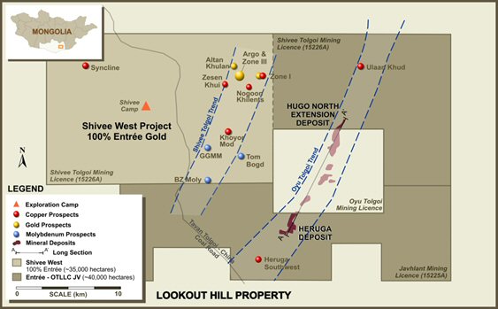
The ownership of the Shivee Tolgoi and Javhlant licences, which comprise Lookout Hill is divided between Entrée and the Entrée-OT LLC Joint Venture (EJV) as described below and in Figure 1.1:
| · | The EJV beneficially holds 39,807 ha consisting of the eastern portion of Shivee Tolgoi and all of Javhlant (Joint Venture Property) and is governed by a joint venture between Entrée and OT LLC. The Joint Venture Property is contiguous with, and on three sides (to the north, east, and south) surrounds the Project. The Joint Venture Property hosts the Hugo North Extension deposit and the Heruga deposit. Rio Tinto plc is also the appointed manager of the Oyu Tolgoi project. |
| · | The portion of Lookout Hill outside of the Joint Venture Property (Shivee West) covers an area of 35,173 ha and includes the western portion of Shivee Tolgoi ML that is not subject to the EJV. |
AMC 813001 : March : 2013
30
ENTRÉE GOLD INC Lookout Hill Property, Southern Mongolia Technical Report | |
Oyu Tolgoi is located in the Southern Gobi region of Mongolia. It consists of a series of deposits containing copper, gold, silver, and molybdenum, being developed by OT LLC. The deposits stretch over 12 km, from the Hugo Dummett North deposit in the north through the adjacent Hugo Dummett South deposit, down to the Southern Oyu deposit and extending to the Heruga deposit in the south (Figure 1.2). Hugo Dummett North extends onto the Shivee Tolgoi ML, where it is known as the Hugo North Extension; the Heruga copper-gold-molybdenum deposit is within the Javhlant ML but extends north across the licence boundary towards the Southwest Deposit on the Oyu Tolgoi licence. The Southern Oyu Tolgoi (SOT) open pit and Hugo North underground deposits (including Hugo North Extension) are currently under development by OT LLC. Initial open pit production commenced in January 2013 and the first commercial production is expected in the first half 2013.
In October 2004, Entrée entered into an arm’s-length Equity Participation and Earn-In Agreement (the "Earn-In Agreement") with Ivanhoe (now TRQ). Under the Earn-In Agreement, TRQ agreed to purchase equity securities of Entrée, and was granted the right to earn an interest in the Joint Venture Property. Most of Ivanhoe’ rights and obligations under the Earn-In Agreement were subsequently assigned by TRQ to what was then its wholly-owned subsidiary, OT LLC (formerly Ivanhoe Mines Mongolia Inc. XXK). The Government of Mongolia (GOM) subsequently acquired a 34% interest in OT LLC, which is also the title holder of the Oyu Tolgoi copper-gold project. On 30 June 2008, OT LLC gave notice that it had completed its earn-in obligations by expending a total of $35 million on exploration on the Joint Venture Property and Entrée and OT LLC formed the EJV on terms annexed to the Earn-In Agreement.
Figure 1.1 Lookout Property - Land Tenure
AMC 813001 : March : 2013
31
ENTRÉE GOLD INC Lookout Hill Property, Southern Mongolia Technical Report | |
| Figure 1.2 | Idealized Long-Section of Southern Oyu, Hugo Dummett and Heruga Deposits (Section Looking West) |

AMC 813001 : March : 2013
32
ENTRÉE GOLD INC Lookout Hill Property, Southern Mongolia Technical Report | |
| 1.2 | Property Location |
Lookout Hill is located in the Aimag (Province) of Ömnögovi in the South Gobi region of Mongolia, about 570 km south of the capital city of Ulaanbaatar and 80 km north of the border with China. It comprises two MLs (Shivee Tolgoi and Javhlant), which cover a total of approximately 74,980 ha and completely surrounds the Oyu Tolgoi Project. Lookout Hill is divided into two contiguous Properties: the EJV Property and Shivee West.
Road access to the Oyu Tolgoi Project follows a well-defined track directly south from Ulaanbaatar requiring approximately 12 hours travel time in a four wheel drive vehicle. Mongolian rail service and a large electric power line lie 350 km east of the property at the main rail line between Ulaanbaatar and China. The China-Mongolia border is located approximately 80 km south of the Oyu Tolgoi Project. OT LLC is constructing a road from the site to the border. OT LLC has constructed a concrete airstrip and the site is serviced by flights to and from Ulaanbaatar. Ulaanbaatar has an international airport, and Mandalgovi, Tsogt Tsetsii, and Dalanzadgad have regional airports. There is currently charter air service between the site and Ulaanbaatar.
| 1.3 | Geology |
| 1.3.1 | Regional Geology |
Lookout Hill lies within the Palaeozoic Gurvansayhan Terrane in southern Mongolia, a component of the Altaid orogenic collage, which is a continental-scale belt dominated by compressional tectonic forces. The Gurvansayhan Terrane consists of highly-deformed accretionary complexes and oceanic island arc assemblages. The island arc terrane is dominated by basaltic volcanics and intercalated volcanogenic sedimentary rocks (Upper Devonian Alagbayan Formation), intruded by pluton-sized, hornblende-bearing granitoids of mainly quartz monzodiorite to possibly granitic composition. Carboniferous-age sedimentary rocks (Sainshandhudag Formation) overlie this assemblage.
Major structures in this area include the Gobi–Tien Shan sinistral strike-slip fault system, which splits eastward into a number of splays, and the Gobi–Altai Fault system, which forms a complex zone of sedimentary basins overthrust by basement blocks to the north and north-west.
| 1.3.2 | Local Geology |
Porphyry copper-gold deposits at Oyu Tolgoi occur along a north-north-east corridor with Hugo North Extension at the north end and the Heruga deposit at the south end. Mineralization is related to Devonian quartz monzodiorite intrusions and associated quartz stockwork. The individual deposits have varied characteristics in regard to host rock, intrusive bodies, sulphide mineralogy, grade, and alteration.
The pre-Carboniferous (probably Devonian) stratigraphy of Oyu Tolgoi consists of massive augite basalt, conglomerate, dacitic tuffs, and siltstones, which are overthrust by the “Heruga sequence”, comprising basaltic flows, volcaniclastic rocks, and siltstones.
AMC 813001 : March : 2013
33
ENTRÉE GOLD INC Lookout Hill Property, Southern Mongolia Technical Report | |
Only the lower parts of the Devonian sequence host porphyry mineralization and associated alteration. The Carboniferous Sainshandhudag Formation unconformably overlies the older rocks. Major Carboniferous or younger faults disrupt the mineralized corridor and bound the western side of most deposits.
The Hugo North Extension deposit within the Joint Venture Property contains copper-gold porphyry-style mineralization associated with quartz monzodiorite intrusions, concealed beneath a deformed sequence of Upper Devonian and Lower Carboniferous sedimentary and volcanic rocks.
The high-grade zone at Hugo North Extension comprises relatively coarse bornite impregnating quartz and disseminated in wall rocks of varying composition, usually intergrown with subordinate chalcopyrite. Bornite is dominant in the highest-grade parts of the deposit (with these zones averaging around 3% to 5% Cu) and is zoned outward to chalcopyrite (to zones averaging around 2% Cu for the high-grade chalcopyrite dominant mineralization).
The Heruga deposit contains copper–gold-molybdenum porphyry style mineralization hosted in Devonian basalts and quartz monzodiorite intrusions, concealed beneath a deformed sequence of Upper Devonian and Lower Carboniferous sedimentary and volcanic rocks. The deposit is cut by several major brittle fault systems, partitioning the deposit into discrete structural blocks. Internally, these blocks appear relatively undeformed, and consist of south-east-dipping volcanic and volcaniclastic sequences. The stratiform rocks are intruded by quartz monzodiorite stocks and dykes that are probably broadly contemporaneous with mineralization. The deposit is shallowest at the south end (approximately 500 m below surface) and plunges gently to the north.
AMC 813001 : March : 2013
34
ENTRÉE GOLD INC Lookout Hill Property, Southern Mongolia Technical Report | |
| 1.4 | EJV Property |
| 1.4.1 | The 2013 Oyu Tolgoi Technical Report |
The 2013 OTTR, was prepared for Turquoise Hill Resources Ltd (TRQ). The 2013 OTTR is based on the technical, production and cost information prepared by OT LLC for project financing of the Oyu Tolgoi project from international financial institutions. The 2013 OTTR includes work on the EJV Property.
The 2013 OTTR analyses the 2013 Reserve Case and is based on a feasibility quality level study that complies with NI 43-101. The work of the 2013 OTTR meets the standards of US Industry Guide 7 requirements for reporting Reserves. The 2013 Reserve Case includes resources from the Oyu Tolgoi licence (wholly owned by OT LLC) and EJV licence areas.
The 2013 OTTR uses updated Mineral Resources for the Southern Oyu Tolgoi deposit and the Hugo North Mineral Resources as first reported in 2007. The 2013 OTTR includes resources from the Oyu Tolgoi licence (wholly owned by OT LLC) and EJV licence areas. Entrée holds a 20% carried interest to production in this Mineral Reserve through its joint venture with OT LLC.
Although the overall strategy for the development of the Oyu Tolgoi Project remains the same in the 2013 OTTR as it did in IDOP, IDP10, and IDP05, there have been changes to several key areas which are addressed in this project update. The changes reported by TRQ at Oyu Tolgoi to date include:
| · | Construction of the Oyu Tolgoi mine’s first phase of development reached 99% completion at the end of 2012. |
| · | The mining and stockpiling of the first open-pit ore began in May 2012. |
| · | Following the signing of the binding Power Purchase Agreement with the Inner Mongolian Power Corporation in early November 2012, electrical transmission lines for power to the Oyu Tolgoi mine were energized and operational. |
| · | Construction of the concentrator was completed in Q4’12. First concentrate was produced on 31 January 2013. Commencement of commercial production is expected by the end of Q2’13 subject to the resolution of the issues being discussed with the Government of Mongolia. |
| · | Underground lateral development at the Hugo North Deposit was suspended in February 2012 as planned to enable the upgrading of hoisting equipment at |
| Shaft 1 and was restarted during Q3’12 following the completion of the upgrade. 1,500 metres of lateral development were achieved from mid-September 2012 to the end of December 2012 after the completion of the shaft changeover. |
| · | Construction of Shaft 2 at the Hugo North Deposit is progressing well with the headframe reaching its final height of 96 m in Q2’12. The headframe and ancillary buildings were 99% complete at the end of Q4’12. Shaft-sinking activities began in December 2011, and the depth of the shaft is now approximately 980 m below surface, 74% of its final 1,319 m depth. |
AMC 813001 : March : 2013
35
ENTRÉE GOLD INC Lookout Hill Property, Southern Mongolia Technical Report | |
| · | The construction of Shaft 5 began in October 2012. Pre-sinking works have been completed and sinking activity is planned to commence in April 2013. Shaft 5 will provide primary ventilation for underground operations and is expected to have a final depth of 1,195 metres. |
| · | Construction of off-site facilities and infrastructure were behind schedule at the end of Q4’12 due to slower progress in the building of the Oyu Tolgoi-Gashuun Sukhait road to the Mongolia-China border, the diversion of the Undai River and development of the Khanbumbat permanent airport. Road development was impacted by local permitting issues related to modifications associated with Oyu Tolgoi's environmental commitments. Road work has been suspended for the winter although there should be no impact upon the transporting concentrate to the border. Work on the river diversion commenced in December 2012; however progress was also impacted by local permitting issues. The permanent airport work was completed in January 2013 and began operating in February 2013. |
| · | Long-term sales contracts have been signed for a significant proportion of the Oyu Tolgoi mine’s concentrate production. |
| · | The Environmental and Social Impact Assessment (ESIA) undertaken as part of the project finance process was publically disclosed in August 2012. |
| · | TRQ and Rio Tinto has been engaged with lenders to refine the overall financing plan and term sheet with the aim of raising $3 billion to $4 billion . Bids have been received from a number of banks that would allow the TRQ to achieve its project financing target and discussions are ongoing with the lenders to finalize the terms of those offers. The project financing is subject to the unanimous approval of the Oyu Tolgoi LLC Board of Directors which includes representatives from the Government of Mongolia. TRQ anticipates the closing of final binding documentation and project financing funding to occur in the first half of 2013. |
Having taken into account the project status, the key changes in LHTR13 compared to the LHTR12 are:
| · | Reserve based on the already constructed 100,000 tpd concentrator with a part expansion of the concentrator to allow for the higher grade feed from Hugo North. |
| · | Signing of a binding Power Purchase Agreement with the Inner Mongolia Power Corporation to supply power to the Oyu Tolgoi mine. |
| · | Construction of a power station no longer included in project scope with costs adjusted to reflect a third party power provider throughout the life of the mine. |
| · | Updated open pit designs on Southern Oyu Tolgoi and commencement of open pit mining including delivery of first ore to the plant. |
| · | Updated underground designs on Hugo North and continued underground development. |
| · | Upgrading of the Shaft 1 hoisting equipment and revision of the production schedule to account for changed timing of the underground production. |
| · | Revisions to capital estimates and updates for costs expended to date. |
AMC 813001 : March : 2013
36
ENTRÉE GOLD INC Lookout Hill Property, Southern Mongolia Technical Report | |
On 6 October 2009, TRQ, OT LLC and Rio Tinto International Holdings Limited signed an Investment Agreement (IA) with the GOM. The Investment Agreement regulates the relationship between these parties and stabilizes the long term tax, legal, fiscal, regulatory, and operating environment to support the development of the Oyu Tolgoi Project. The GOM (through Erdenes Oyu Tolgoi LLC) subsequently acquired from TRQ a 34% interest in OT LLC. The contract area defined in the Investment Agreement includes the Javhlant and Shivee Tolgoi mining licences, including Shivee West which is 100% owned by Entrée and not currently subject to the EJV.
Oyu Tolgoi has a large Mineral Resource providing management with flexibility in studying alternative paths for mine development to match future economic conditions. Ongoing planning work using Inferred Resources has identified the potential for further expansions.
Five deposits have been identified in the Mineral Resource at Oyu Tolgoi. They are Southwest, Central, Hugo South, Hugo North, and Heruga. Southwest and Central comprise the Southern Oyu Tolgoi deposit, and Hugo South and Hugo North (including Hugo North Extension) comprise the Hugo Dummett deposit. The mine planning work to date suggests the following relative ranking for overall return from each deposit, from highest value to lowest:
| · | Hugo North |
| · | Southwest |
| · | Central |
| · | Hugo South |
| · | Heruga |
The 2013 Reserve Case assumes processing of 1.5 bt of ore over a 44 year period, mined from the Southern Oyu open pit and the first lift in the Hugo North underground block cave. The EJV Mineral Reserve is 31 Mt within the 1.5 bt. The mining areas included in the 2013 Reserve Case are shown schematically in Figure 1.3. The location of the EJV Mineral Reserve relative to the OT LLC part of the Hugo North Lift 1 block cave is shown in Figure 1.4.
AMC 813001 : March : 2013
37
ENTRÉE GOLD INC Lookout Hill Property, Southern Mongolia Technical Report | |
| Figure 1.3 | 2013 Reserve Case Mining Areas |
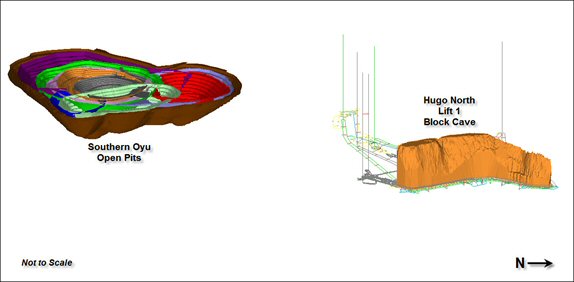
| Figure 1.4 | Hugo North Lift 1 Block Cave |
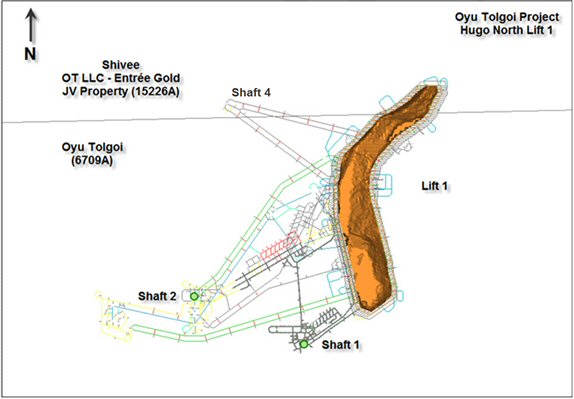
The predominant source of ore at start up is the Southern Oyu open pit. In parallel to this surface construction, underground infrastructure and mine development is ongoing for the Hugo North underground block cave deposit. Stockpiling allows the higher grade ore from Hugo North to gradually displace the open pit ore as the underground production ramps up to reach 85,000 tpd.
AMC 813001 : March : 2013
38
ENTRÉE GOLD INC Lookout Hill Property, Southern Mongolia Technical Report | |
The ore is planned to be processed through conventional crushing, grinding, and flotation circuits. The concentrate produced will be trucked to smelters in China.
Oyu Tolgoi is a remote greenfields project and therefore has required extensive infrastructure in addition to the concentrating facilities. The major initial infrastructure elements constructed include:
| · | Water Borefields |
| · | Water Treatment |
| · | Housing |
| · | Airstrip |
| · | Supporting Facilities |
| · | Power |
| 1.3.2 | Exploration |
In 2010, surface work comprising deep penetrating proprietary IP surveying and drilling was completed on both licences comprising the Joint Venture Property.
On the Shivee Tolgoi ML in 2010, IP surveying was extended north to cover the Ulaan Khud prospect located approximately 7 km northwards of the Hugo North Extension deposit. Previous shallow drilling in this area outlined a low grade copper occurrence in a geological setting similar to that of the Oyu Tolgoi mineralization. North of the Hugo North Extension, four deep core holes totalling 6,601 m were completed along the projected extension of the Oyu Tolgoi Trend between Hugo North Extension deposit and Ulaan Khud, and further north near the new airport. A fifth hole, started in 2010 and completed in 2011, was drilled 650 m north from Hugo North Extension. None of these holes were successful at reaching the planned target. Condemnation drilling (two 200 m RC holes) was also completed over the International Airport Area at the north boundary of Shivee Tolgoi.
During 2011, a total of 7,660 metres of drilling (six holes) was completed on the Shivee Tolgoi ML in three sections located 350 metres, 800 metres, and 2.4 kilometres north of the Hugo North Extension Deposit. On the two southern sections, most holes failed to intersect significant mineralization or only intersected narrow slivers of weakly-mineralized host rocks below 2,000 metres. The drilling showed that if there is a northern extension of the Hugo North Extension Deposit it would be down-dropped by faulting to depths greater than 2,000 metres. On the section 2.4 kilometres to the north of Hugo North Extension, only hornfelsed carboniferous rocks were intersected, despite drilling to 1,450 metres.
AMC 813001 : March : 2013
39
ENTRÉE GOLD INC Lookout Hill Property, Southern Mongolia Technical Report | |
During 2011, 10 geotechnical holes were completed to test the geotechnical character of Lift 1 at Hugo North and to test the area of a planned shaft to the west of Hugo North Extension.
Diamond drilling of a Cretaceous covered area above an IP-gravity target, located 7 kilometres north of Hugo North Extension and to the west of Ulaan Khud, commenced late June 2012 and was completed July 31, 2012. Fifty-two shallow holes totalling 3327 metres were completed on 165 to 330 metre spacing. Results will be used for geological modeling and for locating subsequent diamond drillholes. The best assay result from this shallow drilling was 11.1 metres averaging 0.15% copper with 0.26 g/t gold (from 52 metres depth).
A new drillhole (EGD157) located 750 metres north of Hugo North Extension was commenced September 12, 2012 and terminated December 10 at 2,380 m without intersecting significant mineralization.
In December 2012, two drillholes were completed to test targets generated by the shallow drilling of the Cretaceous covered area. Neither hole intersected significant mineralization.
On the Javhlant ML in early 2010, two core holes were completed on Heruga Southwest, located approximately 5 km south-west of the Heruga orebody. EJD0035A intersected 56 m grading 0.6 % Cu at a depth of approximately 1,400 m in Devonian-aged volcanics. The second hole entered a younger Carboniferous-aged intrusion before intersecting mineralization.
In 2011, four holes totalling approximately 7,228 metres of drilling were completed on Javhlant. EJD0037 tested a geophysical/geochemical target near Southwest Heruga. The hole collared in Devonian volcanics and intersected 24 m of 0.15% Cu and 0.08 g/t Au from 232 m, and 32 m of 0.15% Cu and 0.08 g/t Au from 278 m. EJD0038 tested the Heruga Southwest target previously tested by EJD0035A. Within a 220-metre-thick, weakly-mineralized zone, the best assay interval was four metres of 0.11 g/t of gold and 1.05% copper at 2,110–2,114 metres. Two of the holes (EJD0039 and 0040) tested geophysical targets to the west of Heruga and intersected weak to no mineralization.
During the year ended December 31, 2012, six holes totalling 10,237 metres were completed on the Javhlant licence. Two additional holes (EJD0034A and 0045) tested the east side of Heruga. Hole 0045 did not reach the planned target due to unexpected faults while 0034A, a daughter hole beneath EJD0034, intersected 590 metres of 0.33% copper, 0.70 g/t gold and 56 ppm molybdenum. The fifth hole tested an induced polarization-gravity ("IP-gravity") target, located 2 kilometres to the east of Heruga, and did not return any significant results. A sixth hole (EJD0043) tested the south extension of the Heruga Southwest zone but was terminated after entering barren Carboniferous granodiorite.
AMC 813001 : March : 2013
40
ENTRÉE GOLD INC Lookout Hill Property, Southern Mongolia Technical Report | |
| 1.4.3 | Mineral Resources |
The Hugo North Extension Mineral Resource inventory, cut at the adjacent project boundary, is based on drilling as of 1 November 2006 and reported as of the Resource Effective Date of 20 February 2007. The Effective Date for Heruga is 30 March, 2010. The Mineral Resources above 0.37% copper equivalent as shown in Table 1.1 and include material that is classified as an Indicated and Inferred Mineral Resources. The base case CuEq cut-off grade assumptions for each deposit were determined using operating cost estimates from the Mineral Reserves. The base case copper equivalent (CuEq) cut-off grade assumptions for each deposit were determined using cut-off grades applicable to mining operations exploiting similar deposits. The CuEq cut-off applied for the underground was 0.37%.
Hugo Deposits and Southern Oyu
Based on a Cu price of $0.80/lb and Au price of $350/oz, the 2003 CuEq formula is:
CuEq% = Cu% + (Au g/t) * (11.25 / 17.64)
Where:
17.64 = (Cu $/lb) / (lb/t) = 0.80 / 2,204.62
11.25 = (Au $/oz) / (g / oz) = 350 / 31.10348
Not adjusted for metallurgical recovery
2010 CuEq Formula – Heruga
The decision was taken to use a copper price of $1.35 / lb and a gold price of $650 / oz, and to incorporate molybdenum into the CuEq calculation at a price of $10 / lb.
The resultant 2010 formula was:
CuEq% = Cu% + ((Au g/t * 18.98) + (Mo g/t * 0.01586)) / 29.76
Where:
18.98 = (Au��$ / g) * Au Recovery Factor% = 20.90 * 90.822% (rounded to 91%)
0.01586 = (Mo $ / g) * Mo Recovery Factor% = 0.0220462 * 71.94% (rounded to 72%)
29.76 = Cu $ / %
Molybdenum is used only in the CuEq formula at the Heruga deposit. Silver is not used in the CuEq formula for any of the deposits.
The copper to gold metal price ratio and recovery ratio used have resulted in no change in the calculated CuEq values as stated for the 20 February 2007 Mineral Resources.
AMC 813001 : March : 2013
41
ENTRÉE GOLD INC Lookout Hill Property, Southern Mongolia Technical Report | |
| Table 1.1 | EJV Mineral Resources |
| (>0.37% CuEq cut-off), based on Technical Report March 2010 |
| Deposit | Tonnage (Mt) | Copper (%) | Gold (g/t) | Silver (g/t) | Molybdenum (ppm) | CuEq (%) |
| Hugo North Extension Deposit | ||||||
Indicated Shivee Tolgoi (Hugo North) | 132 | 1.65 | 0.55 | 4.09 | 35.7 | 2.00 |
Inferred Shivee Tolgoi (Hugo North) | 134 | 0.93 | 0.25 | 2.44 | 23.6 | 1.09 |
| Heruga deposit | ||||||
| Inferred Heruga Javhlant | 1,824 | 0.38 | 0.36 | 1.35 | 110 | 0.67 |
| Deposit | Contained Metal | ||||
Copper (Mlb) | Gold (Moz) | Silver (Moz) | Molybdenum (Mlb) | CuEq (Mlb) | |
| Hugo North Extension Deposit | |||||
Indicated Shivee Tolgoi (Hugo North) | 4,800 | 2.32 | 17.4 | 10.4 | 5,810 |
Inferred Shivee Tolgoi (Hugo North) | 2,760 | 1.08 | 10.5 | 7.0 | 3,230 |
| Heruga deposit | |||||
| Inferred Heruga Javhlant | 15,190 | 21.2 | 79.4 | 444 | 26,850 |
Notes:
| · | Effective date for the Mineral Resources for Hugo North Extension is 20 February 2007. |
| · | Effective date for the Mineral Resources for Heruga is 30 March 2010. |
| · | Copper Equivalent (CuEq) has been calculated using assumed metal prices of US$1.35/lb for copper, US$650/oz for gold, and US$10.00 for molybdenum. The equivalence formula was calculated assuming that gold and molybdenum recovery was 91% and 72% of copper recovery respectively. CuEq was calculated using the formula: CuEq% = Cu% + ((Au g/t*18.98)+(Mo g/t*.01586))/29.76. |
| · | The contained copper, gold, copper, and molybdenum in the tables has not been adjusted for metallurgical recovery. |
| · | The Mineral Reserves are not additive to the Mineral Resources. |
| · | Mineral Resources that are not Mineral Reserves do not have demonstrated economic viability. |
| · | The EJV includes a portion of the Shivee Tolgoi licence and the Javhlant licence. Both the Javhlant licence and the eastern portion of the Shivee Tolgoi licence are held in trust for the EJV by Entrée. The Joint Venture Property is operated by Rio Tinto plc. OT LLC has an 80% and Entrée has a 20% beneficial ownership interest in the Joint Venture Property. |
| 1.4.3.1 | Hugo North Extension |
The Hugo North Extension Mineral Resource remains material to the property and was reviewed independently for Entrée by Quantitative Group (QG) in 2008. The Mineral Resource estimate was produced for the Hugo North Extension in 2007 in conformance with NI 43-101. The Mineral Resource estimate is reported in “Lookout Hill Project, Mongolia, NI 43-101 Technical Report with an Effective Date 29 March 2007” (Technical Report 2007). In 2008, QG thoroughly reviewed and independently reproduced this estimate and consider the 2007 estimate is in conformance to NI 43-101. Scott Jackson of QG is acting as QP for the Hugo North Extension estimate.
AMC 813001 : March : 2013
42
ENTRÉE GOLD INC Lookout Hill Property, Southern Mongolia Technical Report | |
The Hugo North Extension deposit within the Joint Venture Property contains copper-gold porphyry-style mineralization associated with quartz monzodiorite intrusions, concealed beneath a deformed sequence of Upper Devonian and Lower Carboniferous sedimentary and volcanic rocks.
The high-grade zone at Hugo North Extension comprises relatively coarse bornite impregnating quartz and disseminated in wall rocks of varying composition, usually intergrown with subordinate chalcopyrite. Bornite is dominant in the highest-grade parts of the deposit (with these zones averaging around 3% to 5% Cu) and is zoned outward to chalcopyrite (to zones averaging around 2% Cu for the high-grade chalcopyrite dominant mineralization).
Geological models were constructed by OT LLC using lithological and structural interpretations completed in late 2006. QG checked the lithological and structural shapes for interpretational consistency on section and plan, and found them to have been properly constructed.
Resource estimates were undertaken using MineSight® commercial mine planning software. Industry-accepted methods were used to create interpolation domains based on mineralized geology, and grade estimation based on ordinary kriging. The assays were composited into 5 m downhole composites; block sizes were 20 m x 20 m x 15 m.
The Mineral Resources were classified using logic consistent with the CIM definitions required by NI 43-101. Inspection of the model and drillhole data on plans and sections showed geological and grade continuity. When taken together with spatial statistical evaluation and investigation of confidence limits in predicting planned annual production, blocks were assigned as Indicated Resources if they fell within the current drillhole spacing, which is on 125 m x 70 m centres. Blocks were assigned to the Inferred Resource category if they fell within 150 m of a drillhole composite.
The mineralization within the Hugo North Extension deposit as of 20 February 2007 is classified as Indicated and Inferred Mineral Resource. The Hugo North Extension Mineral Resources are shown in Table 1.1, and are reported at copper equivalent cut-off grades above 0.37%. Mineral Resources are not Mineral Reserves until they have demonstrated economic viability based on a feasibility study or pre-feasibility study.
| 1.4.3.2 | Heruga |
The Heruga Mineral Resource estimate has not been updated since March 2010 and is in conformance with NI 43-101. The Mineral Resource estimate was prepared under the supervision of Scott Jackson, QG in Perth.
The Heruga deposit within the Joint Venture Property contains copper-gold-molybdenum porphyry style mineralization hosted in Devonian basalts and quartz monzodiorite intrusions, concealed beneath a deformed sequence of Upper Devonian and Lower Carboniferous sedimentary and volcanic rocks. The deposit is cut by several major brittle fault systems, partitioning the deposit into discrete structural blocks. Internally, these blocks appear relatively undeformed, and consist of south-east-dipping volcanic and volcaniclastic sequences. The stratiform rocks are intruded by quartz monzodiorite stocks and dykes that are probably broadly contemporaneous with mineralization.
AMC 813001 : March : 2013
43
ENTRÉE GOLD INC Lookout Hill Property, Southern Mongolia Technical Report | |
The deposit is shallowest at the south end (approximately 500 m below surface) and plunges gently to the north.
QG reviewed OT LLC’s quality assurance/quality control (QA/QC) procedures in 2008 and 2009 and found them to be followed and to exceed industry standards.
The database used to estimate the Mineral Resources for the Heruga deposit consists of samples and geological information from 43 drillholes, including daughter holes, totalling 58,276 m.
The alteration at Heruga is typical of porphyry style deposits, with notably stronger potassic alteration at deeper levels. Locally intense quartz-sericite alteration with disseminated and vein pyrite is characteristic of mineralized quartz monzodiorite. Molybdenite mineralization seems to spatially correlate with stronger quartz-sericite alteration.
Copper sulphides occur at Heruga in both disseminations and veins/fractures. Mineralized veins have a much lower density at Heruga than in the more northerly Southern Oyu and Hugo Dummett deposits.
Modelling of mineralization zones for resource estimation purposes revealed that there is an upper copper-dominant zone and a deeper gold-dominant zone within the overall copper-gold porphyry at Heruga. In addition, there is significant (100 ppm to 1,000 ppm) molybdenum mineralization in the form of molybdenite, which is more closely associated with the copper mineralization.
The Mineral Resource estimate for the Heruga deposit was prepared by Stephen Torr of TRQ under the supervision of QG. A close-off date of 31 May 2009 for survey (collar and downhole) data was utilized for constructing the geological domains. The Effective Date for Heruga is 30 March 2010.
OT LLC created three dimensional shapes (wireframes) of the major geological features of the Heruga deposit. To assist in the estimation of grades in the model, OT LLC also manually created three-dimensional grade shells (wireframes) for each of the metals to be estimated. Construction of the grade shells took into account prominent lithological and structural features, in particular the four major subvertical post-mineralization faults. For copper, a single grade shell at a threshold of 0.3% Cu was used. For gold, wireframes were constructed at thresholds of 0.3 g/t and 0.7 g/t. For molybdenum, a single shell at a threshold of 100 ppm was constructed. Silver was estimated using the copper domains. These grade shells took into account known gross geological controls in addition to broadly adhering to the above mentioned thresholds.
QG checked the structural, lithological and mineralized shapes to ensure consistency in the interpretation on section and plan. The wireframes were considered to be properly constructed and honoured the drill data.
AMC 813001 : March : 2013
44
ENTRÉE GOLD INC Lookout Hill Property, Southern Mongolia Technical Report | |
Resource estimates were undertaken by OT LLC using Datamine® commercial mine planning software. The methodology was very similar to that used to estimate the Hugo North deposit. Interpolation domains were based on mineralized geology, and grade estimation based on ordinary kriging. Bulk density was interpolated using an inverse distance to the third power methodology. The assays were composited into 5 m downhole composites; block sizes were 20 m x 20 m x 15 m.
As an independent check, QG also built a model from scratch using the same wireframes and drill data used in the OT LLC model. Gold, copper, and molybdenum were interpolated using independently generated variograms and search parameters. Silver was estimated with the same variograms as copper. QG compared the two estimates and consider that they agree well within acceptable limits thus adding additional support to the estimate by OT LLC.
The Mineral Resources for Heruga were classified using logic consistent with the CIM definitions required by NI 43-101. Blocks within 150 m of a drillhole were initially considered to be Inferred. A three-dimensional wireframe was constructed inside of which the nominal drill spacing was less than 150 m.
| 1.4.4 | EJV Property - Mineral Reserve |
The Joint Venture Property Mineral Reserve is contained within the Hugo North Block Cave Lift 1. The mine design work on Hugo North Lift 1 was prepared by OT LLC and accepted as the basis for the underground mine planning in the 2013 OTTR. AMC agrees with this conclusion and has reported the results for the March 2013 Hugo North Mineral Reserve estimate in LHTR13. The EJV Property Mineral Reserve will be mined as part of the Oyu Tolgoi Project and as such is a subset of the total Oyu Tolgoi Mineral Reserves reported in the 2013 OTTR. The Mineral Reserves are based on mine planning work prepared by OT LLC. This work was reviewed and has been used as the basis for reporting the current Mineral Reserves.
Mineral Reserves were last publically reported in the LHTR12 (March 2012). LHTR13 Mineral Reserves are shown in Table 1.2. A reconciliation of the LHTR12 and LHTR13 Mineral Reserves is shown in Table 1.3.
LHTR13 only considers Mineral Resources in the Indicated category, and engineering that has been carried out to a feasibility level or better to state the underground Mineral Reserve. There is no Measured Resource in the Hugo North Mineral Resource. Copper and gold grades on Inferred Resources within the block cave shell were set to zero and such material was assumed to be dilution. The block cave shell was defined using a net smelter return (NSR) cut-off of $15/t NSR, further mine planning will examine lower cut-offs. The Hugo North Mineral Reserve is on both the OT LLC Oyu Tolgoi licence and the EJV Shivee Tolgoi licence. A plan showing Hugo North Lift 1 and 2 relative to the mining licence boundaries is shown in Figure 1.5. Figure 1.6 shows an isometric view of the two lifts.
AMC 813001 : March : 2013
45
ENTRÉE GOLD INC Lookout Hill Property, Southern Mongolia Technical Report | |
| Table 1.2 | EJV Mineral Reserve, 25 March 2013 |
| Classification | Ore (Mt) | NSR ($/t) | Cu (%) | Au (g/t) | Ag (g/t) | Copper (M lb) | Gold (koz) | Silver (koz) |
| Proven | – | – | – | – | – | – | – | – |
| Probable | 31 | 95.21 | 1.73 | 0.62 | 3.74 | 1,090 | 521 | 3,229 |
| Total EJV | 31 | 95.21 | 1.73 | 0.62 | 3.74 | 1,090 | 521 | 3,229 |
| Notes: |
| 1. | Metal prices used for calculating the Southern Oyu open pit NSR and the Hugo North underground Net Smelter Return (NSR) are as follows: copper at $2.81/lb; gold at $970/oz; and silver at $15.50/oz, all based on long-term metal price forecasts at the beginning of the mineral reserve work. The analysis indicates that the mineral reserve is still valid at these metal prices. |
| 2. | The NSR has been calculated with assumptions for smelter refining and treatment charges, deductions and payment terms, concentrate transport, metallurgical recoveries and royalties. |
| 3. | The block cave shell was defined using a NSR cut-off of $15/t NSR. |
| 4. | For the underground block cave, all mineral resources within the shell have been converted to mineral reserves. This includes low grade Indicated mineral resources and Inferred mineral resources, which has been assigned a zero grade and treated as dilution. |
| 5. | Only Measured mineral resources were used to report Proven mineral reserves and only Indicated mineral resources were used to report Probable mineral reserves. |
| 6. | EJV is the Entrée Joint Venture. The Shivee Tolgoi Licence and the Javhlant Licence are held by Entrée. The Shivee Tolgoi Licence and the Javhlant Licence are planned to be operated by OT LLC. OT LLC will receive 80% of cash flows after capital and operating costs for material originating below 560 m, and 70% above this depth. |
| 7. | The base case financial analysis has been prepared using the following current long term metal price estimates: copper at $2.87/lb; gold at $1,350/oz; and silver at $23.50/oz. Metal prices are assumed to fall from current prices to the long term average over five years. |
| 8. | The mineral reserves reported above are not additive to the mineral resources. |
| Figure 1.5 | Hugo North Lift 1 and 2 |

AMC 813001 : March : 2013
46
ENTRÉE GOLD INC Lookout Hill Property, Southern Mongolia Technical Report | |
| Figure 1.6 | Isometric View of Hugo North Lift 1 and 2 |
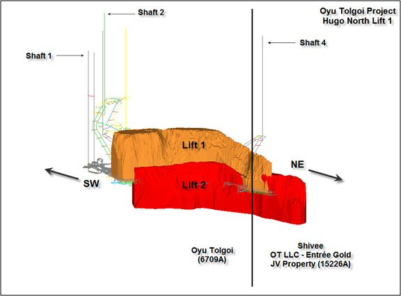
AMC 813001 : March : 2013
47
ENTRÉE GOLD INC Lookout Hill Property, Southern Mongolia Technical Report | |
| Table 1.3 | LHTR13 and LHTR12 Probable Mineral Reserve Comparison |
| Estimate | Ore (Mt) | NSR ($/t) | Cu (%) | Au (g/t) | Ag (g/t) | Copper (M lb) | Gold (koz) | Silver (koz) |
| LHTR13 | 31 | 95.21 | 1.73 | 0.62 | 3.74 | 1,090 | 521 | 3,229 |
| LHTR12 | 27 | 79.40 | 1.91 | 0.74 | 4.17 | 1,043 | 536 | 3,127 |
| Difference | 4 | 15.81 | –0.18 | –0.11 | –0.44 | 47 | –15 | 102 |
| Difference (%) | 15.1% | 19.9% | –9.4% | –15.1% | –10.5% | 4.5% | –2.8% | 3.3% |
Notes:
| 1. | LHTR12 Mineral Reserves have the effective date 29 March 2012. |
| 2. | LHTR13 Mineral Reserves have the effective date 25 March 2013.. |
| 3. | Metal prices used for calculating the Southern Oyu open pit NSR and the Hugo North underground Net Smelter Return (NSR) are as follows: copper at $2.81/lb; gold at $970/oz; and silver at $15.50/oz, all based on long-term metal price forecasts at the beginning of the mineral reserve work. The analysis indicates that the mineral reserve is still valid at these metal prices. |
| 4. | The NSR has been calculated with assumptions for smelter refining and treatment charges, deductions and payment terms, concentrate transport, metallurgical recoveries and royalties. |
| 5. | The block cave shell was defined using a NSR cut-off of $15/t NSR. |
| 6. | For the underground block cave, all mineral resources within the shell have been converted to mineral reserves. This includes low grade Indicated mineral resources and Inferred mineral resources, which has been assigned a zero grade and treated as dilution. |
| 7. | Only Measured mineral resources were used to report Proven mineral reserves and only Indicated mineral resources were used to report Probable mineral reserves. |
| 8. | EJV is the Entrée Joint Venture. The Shivee Tolgoi Licence and the Javhlant Licence are held by Entrée. The Shivee Tolgoi Licence and the Javhlant Licence are planned to be operated by Rio Tinto plc. OT LLC will receive 80% of cash flows after capital and operating costs for material originating below 560 m, and 70% above this depth. |
| 9. | The base case financial analysis has been prepared using the following current long term metal price estimates: copper at $2.87/lb; gold at $1,350/oz; and silver at $23.50/oz. Metal prices are assumed to fall from current prices to the long term average over five years. |
| 10. | The mineral reserves reported above are not additive to the mineral resources. |
AMC 813001 : March : 2013
48
ENTRÉE GOLD INC Lookout Hill Property, Southern Mongolia Technical Report | |
| 1.4.5 | 2013 Reserve Case |
A summary of the EJV Property production and financial results for the 2013 Reserve Case is shown in Table 1.4. The after tax Net Present Value (NPV) at 8% discount rate attributable to Entrée for the 2013 Reserve Case is $110 M.
| Table 1.4 | 2013 Summary Production and Financial Results |
| Description | Units | 2013 Reserve Case |
| Inventory | Mineral Reserve | |
| Total OT Reserve | bt | 1.5 |
| EJV Property Results | ||
| EJV Reserve | Mt | 31 |
| NSR | $/t | 95.21 |
| Cu Grade | % | 1.73 |
| Au Grade | g/t | 0.62 |
| Ag Grade | g/t | 3.74 |
| Copper Recovered | billion lb | 1.1 |
| Gold Recovered | Moz | 0.5 |
| Silver Recovered | Moz | 3.2 |
| NPV (8%) After Tax (Entrée) | US$M | 110 |
Notes:
| 1. | Metal prices used for calculating the Southern Oyu open pit NSR and the Hugo North underground Net Smelter Return (NSR) are as follows: copper at $2.81/lb; gold at $970/oz; and silver at $15.50/oz, all based on long-term metal price forecasts at the beginning of the mineral reserve work. The analysis indicates that the mineral reserve is still valid at these metal prices. |
| 2. | The NSR has been calculated with assumptions for smelter refining and treatment charges, deductions and payment terms, concentrate transport, metallurgical recoveries and royalties. |
| 3. | The block cave shell was defined using a NSR cut-off of $15/t NSR. |
| 4. | For the underground block cave, all mineral resources within the shell have been converted to mineral reserves. This includes low grade Indicated mineral resources and Inferred mineral resources, which has been assigned a zero grade and treated as dilution. |
| 5. | Only Measured mineral resources were used to report Proven mineral reserves and only Indicated mineral resources were used to report Probable mineral reserves. |
| 6. | EJV is the Entrée Joint Venture. The Shivee Tolgoi Licence and the Javhlant Licence are held by Entrée. The Shivee Tolgoi Licence and the Javhlant Licence are planned to be operated by Rio Tinto plc. OT LLC will receive 80% of cash flows after capital and operating costs for material originating below 560 m, and 70% above this depth. |
| 7. | The base case financial analysis has been prepared using the following current long term metal price estimates: copper at $2.87/lb; gold at $1,350/oz; and silver at $23.50/oz. Metal prices are assumed to fall from current prices to the long term average over five years. |
| 8. | The mineral reserves reported above are not additive to the mineral resources. |
The EJV and OT LLC processing tonnages and copper, gold, and silver metal production in the Reserve Case is shown in Figure 1.7 to Figure 1.10. The production shown is the total production from the EJV of which 20% is attributable to Entrée The following is a summary of the terms of the EJV relating to cost allocation and revenues to Entrée. Under the terms of the EJV, Entrée may be carried through to production, at its election, by debt financing from OT LLC with interest accruing at OT LLC’s actual cost of capital or prime +2%, whichever is less, at the date of the advance. Debt repayment may be made in whole or in part from (and only from) 90% of monthly available cash flow arising from sale of Entrée’s share of products. Available cash flow means all net proceeds of sale of Entrée’s share of products in a month less Entrée’s share of costs of operations for the month.
AMC 813001 : March : 2013
49
ENTRÉE GOLD INC Lookout Hill Property, Southern Mongolia Technical Report | |
Under the terms of the Entrée-OTLLC Joint Venture, Entrée may elect to have OTLLC debt finance Entrée’s share of costs with interest accruing at OTLLC’s actual cost of capital or prime plus 2%, whichever is less, at the date of the advance. For the analysis in LHTR12 Entrée have advised that under the terms of the EJV, OT LLC is responsible for 80% of all costs incurred on the Joint Venture property, including capital expenditures, and Entrée for the remaining 20%. Entrée’s cash flows from the Reserve Case are shown in Figure 1.11.
| Figure 1.7 | Processing by Source – 2013 Reserve Case |

EJV total production values are shown.
AMC 813001 : March : 2013
50
ENTRÉE GOLD INC Lookout Hill Property, Southern Mongolia Technical Report | |
| Figure 1.8 | Copper Production – 2013 Reserve Case |

EJV total production values are shown.
| Figure 1.9 | Gold Production – 2013 Reserve Case |

EJV total production values are shown.
AMC 813001 : March : 2013
51
ENTRÉE GOLD INC Lookout Hill Property, Southern Mongolia Technical Report | |
| Figure 1.10 | Silver Production – 2013 Reserve Case |

EJV total production values are shown.
| Figure 1.11 | Entrée Cumulative Cash Flow – 2013 Reserve Case (Undiscounted) |
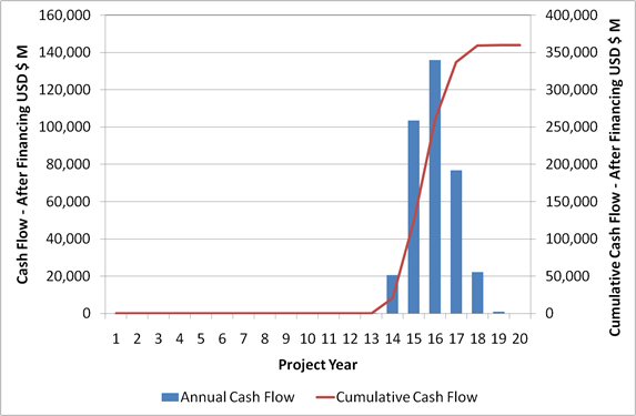
AMC 813001 : March : 2013
52
ENTRÉE GOLD INC Lookout Hill Property, Southern Mongolia Technical Report | |
OT LLC plans to undertake engineering studies of expansion options in the continuing Feasibility Study for Oyu Tolgoi. This will include examining all production scenarios and associated expansion options. OT LLC plans a focused and structured review of the study work to be used in the capital approvals process as the operation developments. AMC believes that further design work could identify opportunities to improve project economics via cost reductions and mine plan optimization. This may result in further positive changes to the EJV development schedule that could bring first EJV ore forward relative to the current plan.
| 1.4.6 | EJV Future Work |
Exploration and development of the Joint Venture Property is under the control of the project manager, Rio Tinto plc. The future work recommendations in the 2013 OTTR although focused on the OT project will be of benefit to Entrée as they will include examination of the Joint Venture Property.
| 1.4.7 | Power Supply Determination |
Turquoise Hill announced on 5 November 2012, that Oyu Tolgoi LLC had signed a binding power purchase agreement with the Inner Mongolia Power Corporation to supply power to the Oyu Tolgoi mine. With the conclusion of the power agreement, Oyu Tolgoi completed a seven-week commissioning of the ore-processing equipment. First concentrate production was completed on 31 January 2013. The commencement of commercial production is expected in the first half of 2013.
The Oyu Tolgoi Investment Agreement recognized that the reliable supply of electrical power is critical to the mine. The agreement also confirmed that Turquoise Hill has the right to obtain electrical power from inside or outside Mongolia, including China, to meet its initial electrical power requirements for up to four years after Oyu Tolgoi begins commercial production. The agreement established that a) Turquoise Hill has the right to build or subcontract construction of a coal-fired power plant at an appropriate site in Mongolia’s South Gobi Region to supply Oyu Tolgoi and b) all of the mine’s power requirements would be sourced from within Mongolia no later than four years after the start of commercial production. Turquoise Hill continues to evaluate the development of a dedicated power plant.
| 1.4.8 | Water Permit |
Due to low average annual precipitation in the project area, water management and conservation are given the highest priority in all aspects of project design.
The development of a borefield to access groundwater reserves within the Gunii Hooloi aquifer basin has been established as the most cost-effective option to meet the raw water demand for the project. Water from the borefield is used for process water supply, dust suppression in the mining areas, and potable use. Another major component of the water management plan is the diversion of the Undai River to accommodate project facilities. Undai River water is not used by the mine, diversion is to totally preserve this water in the environment.
AMC 813001 : March : 2013
53
ENTRÉE GOLD INC Lookout Hill Property, Southern Mongolia Technical Report | |
Oyu Tolgoi will benchmark its water conservation efforts against other mines by assessing factors such as quantified water consumption per tonne of concentrate produced. The current water budget is based on the use of 550 L/t, which compares favourably with other large operations in similar arid conditions. OT LLC is committed to water conservation.
It is also assumed that no water will become available through mine dewatering. Although the need for mine dewatering at a rate of up to 90 L/s is predicted, this will be at a key stage of the mine development, and the actual flow could be lower. The total site design water demand ranges from a low of 465 L/s in spring to a high of 1,205 L/s in winter.
| 1.4.9 | Concentrate Marketing |
Long-term sales contracts have been signed for 75% of the Oyu Tolgoi mine’s concentrate production in the first three years, while 50% of concentrate production is contracted for ten years (subject to renewals). In addition to the signed contracts, in early November 2012, Oyu Tolgoi committed in principle, subject to the conclusion of detailed sales contracts, up to 25% of concentrate available for export would be made available at international terms to smelters in Inner Mongolia for the first ten years.
| 1.4.10 | Socio-economic Aspects of Mine Closure Plan |
The preliminary mine closure and reclamation plan includes provisions to ensure that adverse socio-economic impacts of mine closure are minimized and positive impacts are maximized. To this end, OT LLC has planned that allowances will be incorporated into the annual mine operations budget starting 10 years before mine closure to address the costs of:
| · | Lost employment by the mine workforce. |
| · | Adverse effects on supply chain businesses and downstream businesses, affected communities, public services, and infrastructure. |
| · | Promoting ongoing sustainability among affected stakeholders and communities. |
| · | The details of additional socio-economic aspects of a conceptual mine closure plan have not yet been fully developed and are the subject of work to be done in the near future. |
| 1.4.11 | EJV Potential for Further Development |
Entrée has mineral resources in the Hugo North and Heruga deposits. OT LLC is studying the development options for all the deposits on the project. The mine designs and production schedules for the alternative development options are:
| · | Southern Oyu Open Pits (2013 Mineral Reserve) |
| · | Hugo North Lift 1 Block Cave (2013 Mineral Reserve) |
| · | Hugo North Lift 2 Block Cave (Inferred) |
| · | Hugo South Block Cave or Open Pit (Inferred) |
AMC 813001 : March : 2013
54
ENTRÉE GOLD INC Lookout Hill Property, Southern Mongolia Technical Report | |
| · | Heruga Block Cave (Inferred) |
Under the NI 43-101 guidelines, Inferred Mineral Resources are considered too speculative geologically to have the economic considerations applied to them that would allow them to be categorized as Mineral Reserves. There is no certainty that the alternative production cases will be realized.
Currently the designs for Hugo North Lift 2, Hugo South Block Cave and Heruga are the same as those in IDP10. The Hugo South open pit designs were updated in 2012. From the designs two sets for long term production scheduling can be prepared, one with Hugo South as underground and one as open pit. The two sets are shown in Figure 1.12 and Figure 1.13. The work on the alternative production cases is not complete, in particular the definition of the expansion sizes and costing of the cases.
| Figure 1.12 | Alternative Production Design Set 1 |

| Figure 1.13 | Alternative Production Design Set 2 |

These cases will be part of the strategic planning that is being undertaken by OT LLC. This work will examine the plant capacity for expansions. Figure 1.14 shows the development options that have been identified as part of the study planning.
AMC 813001 : March : 2013
55
ENTRÉE GOLD INC Lookout Hill Property, Southern Mongolia Technical Report | |
| Figure 1.14 | Oyu Tolgoi Development Options |
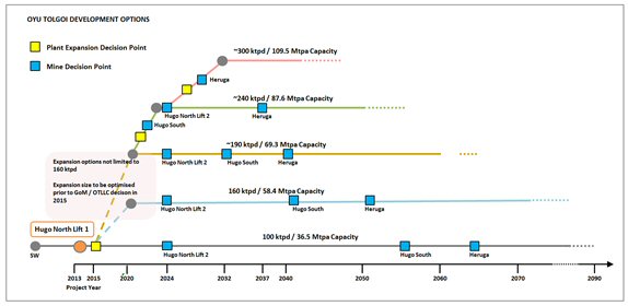
To date several alternative production cases were developed by OT LLC to explore the potential plant expansions and the flexibility inherent in the Heruga and Hugo South deposits. These cases and others will be examined and refined by OT LLC as part of the strategic planning process.
In the first case (Case A), the mining inventory remains the same as the 2013 Reserve Case but with a plant expansion in Year 6. This case is only at a conceptual level and costings have not been prepared. Alternative Production Case A is depicted in Figure 1.15. Total annual production is 59.0 Mtpa from the Southern Oyu open pit and Hugo North Lift 1. The 2013 Reserve Case production is included in black for comparison.
| Figure 1.15 | Alternative Production Case A |
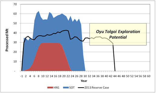
AMC 813001 : March : 2013
56
ENTRÉE GOLD INC Lookout Hill Property, Southern Mongolia Technical Report | |
In Alternative Production Case B, Hugo North Lift 2, Heruga, and Hugo South open pit are added to the schedule. A plant expansion occurs in Year 7. This case is only at a conceptual level and costings have not been prepared. The ultimate production rate for Alternative Production Case B is 68.1 Mtpa and is shown in Figure 1.16. This case uses Heruga as a 25 Mtpa operation and Hugo South as an open pit mine. The 2013 Reserve Case (black) and Alternative Production Case A (orange) are included for comparison.
| Figure 1.16 | Alternative Production Case B |

AMC 813001 : March : 2013
57
ENTRÉE GOLD INC Lookout Hill Property, Southern Mongolia Technical Report | |
The third case is Alternative Production Case C and, again, is only at a conceptual level and costings have not been prepared. The ultimate production rate for Alternative Production Case C is 110 Mtpa and is shown in Figure 1.17. The case also uses Heruga as a 25 Mtpa operation and Hugo South as an open pit mine. The 2013 Reserve Case (black), Alternative Production Case A (orange), and Alternative Production Case B (pink) are included for comparison. There is a significant amount of study work to be carried out to verify the alternative production cases to increase the Mineral Resource confidence and identify suitable infrastructure capacities such as water. These cases are discussed as it is considered that they demonstrate the options for the direction the Project’s long term mine planning could take.
| Figure 1.17 | Alternative Production Case C |
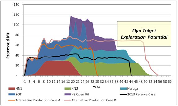
| 1.4.12 | Recent Developments – Joint Venture Property |
As of 31 December 2012, there was one drill rig located at the north end of Heruga immediately south of the licence boundary. Although the hole was collared on the Joint Venture Property, the rig was testing the east side of Heruga immediately north of Javhlant on the Oyu Tolgoi licence.
| 1.5 | SHIVEE WEST |
Entrée has a 100% interest in the 35,173 ha western portion of the Shivee Tolgoi ML.
AMC 813001 : March : 2013
58
ENTRÉE GOLD INC Lookout Hill Property, Southern Mongolia Technical Report | |
| 1.5.1 | Shivee West – Exploration |
In 2011, RC drilling was conducted over the Zone III near-surface epithermal gold target and expanded north, where a new gold zone ("Argo Zone") was discovered 250 metres beyond the previously known area of gold mineralization. The Argo Zone was partly defined by six RC holes (holes EGRC-11-110 to 115), two trenches and surface chip sampling. Hole EGRC-11-112 returned 14 metres of 1.82 g/t gold and hole EGRC-11-111 returned 3 metres of 2.21 g/t gold. Two separate high-grade surface chip samples averaged 42.4 g/t gold over 4 metres and 19.3 g/t gold over 3 metres. Shallow gold mineralization in both zones is hosted by quartz veined felsic volcanic rocks.
In April 2012, Entrée mobilized a field crew to Mongolia to continue exploration of its Shivee West project. Work focussed on geological mapping, excavator trenching and sampling in the Argo/Zone III and Khoyor Mod areas. In total, 22 trenches (1,723 metres) were excavated. The area of Argo gold mineralization was extended 140 metres further north from mineralization defined by 2011 RC drilling and the Argo Zone now measures approximately 400 metres long by up to 130 metres wide. One of the trench samples returned 81.4 g/t gold over 3 metres, confirming and expanding 2011 high-grade gold values. The Khoyor Mod target is located approximately 6 kilometres south of Argo and comprises a 250 metre by 300 metre area of quartz stockwork within Devonian sediments. The stockwork is anomalous in gold (trace to 0.58 g/t) and copper (67 – 505 ppm) and displays some characteristics of porphyry-style mineralization.
| 1.5.2 | Shivee West – Recommended Work |
Based on exploration to date, additional work totalling approximately $6.6 million is recommended for the Shivee West property. The recommended work includes:
Precious Metal Exploration - Argo/Zone III:
| · | Additional detailed geological mapping and excavator-assisted chip sampling along strike to the north and south of known mineralization. Expansion and infill of the existing MMI soil sampling to cover in greater detail the magnetic low that is associated with the gold mineralization. |
| · | Dipole-dipole IP surveying, to cover the magnetic anomaly. |
| · | 3,000 metres of HQ core drilling to follow the Argo mineralization along strike to the north. |
| · | 3,000 metres of RC drilling to infill the core hole pattern, and to drill any additional targets resulting from the geological mapping and excavator trenching. |
Porphyry Copper Exploration:
| · | Re-evaluation of previous drilling of the Khoyor Mod area. |
| · | Evaluation of MMI-Au anomalies north of the Khoyor Mod area, to include 1,000 metres of core drilling. |
| · | 5,000 metres of HQ core drilling to continue deep exploration of the strong hydrothermal alteration system encountered in EG-10-140. |
AMC 813001 : March : 2013
59
ENTRÉE GOLD INC Lookout Hill Property, Southern Mongolia Technical Report | |
| 2 | INTRODUCTION |
| 2.1 | Issuer for Whom Report Prepared |
This report is titled the “Technical Report 2013 on the Lookout Hill Property, Ömnögovi, Mongolia” (LHTR13) and has been prepared under the management of AMC Consultants Pty Ltd (AMC) for Entrée Gold Inc.
| 2.1.1 | Ownership/Joint Venture |
Lookout Hill is located in the Aimag (Province) of Ömnögovi in the south Gobi region of Mongolia, about 570 km south of the capital city of Ulaanbaatar and 80 km north of the border with China.
The Project area comprises two adjacent Properties; Oyu Tolgoi (100% held by TRQ) and Lookout Hill (held in an Earn-in and Equity Participation Agreement with Entrée Gold Inc.). Lookout Hill includes two mining licences (Shivee Tolgoi ML and Javhlant ML) totalling approximately 74,980 ha. One of the Company’s wholly-owned Mongolian subsidiaries, Entrée LLC, is the registered owner of the two mining licences. The beneficial ownership in these licences is divided between Entrée and the EJV as described below and in Section 4:
| · | The EJV beneficially holds 39,807 ha consisting of the eastern portion of Shivee Tolgoi ML and all of Javhlant ML (Joint Venture Property) and is governed by a joint venture agreement between Entrée and OT LLC. The Joint Venture Property is contiguous with, and on three sides (to the north, east, and south) surrounds the Oyu Tolgoi ML. The Joint Venture Property hosts the Hugo North Extension Deposit and the Heruga deposit. OT LLC is the project manager. |
| · | The portion of Lookout Hill outside of the Joint Venture Property (Shivee West) covers an area of 35,173 ha and includes the western portion of Shivee Tolgoi ML that is not subject to the EJV. |
The portion of Lookout Hill outside of the Joint Venture Property (Shivee West) covers an area of 35,173 ha and includes the western portion of Shivee Tolgoi ML that is not subject to the EJV. The vast majority of the identified mineralization on the Oyu Tolgoi Project occurs within the Oyu Tolgoi Property at the Hugo Dummett and Southern Oyu Porphyry Deposits. Only the northernmost extension of the Hugo Dummett Deposit (Hugo North) crosses onto the Shivee Tolgoi Joint Venture Property. (Entrée Gold Inc. refers to the Hugo North Deposit within its property limits, as the Hugo North Extension).
AMC has relied on Entrée for the description of the Mineral Tenure in this section.
AMC 813001 : March : 2013
60
ENTRÉE GOLD INC Lookout Hill Property, Southern Mongolia Technical Report | |
| Figure 2.1 | Lookout Property - Land Tenure |
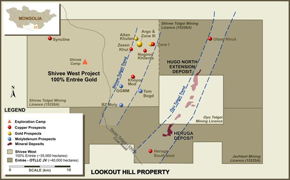
| 2.2 | Terms of Reference and Purpose of Report |
LHTR13 is predominantly based on the 2013 Oyu Tolgoi Technical Report (2013 OTTR) released by TRQ in March 2013. The 2013 Technical Report is based on the technical, production and cost information prepared by OT LLC for the proposed Oyu Tolgoi Project financing.
The LHTR13 analyses a Mineral Reserve case only (2013 Reserve Case) and is based on a feasibility quality level study complying with Canadian National Instrument 43-101 (NI 43-101. The work of the 2013 OTTR meets the standards of US Industry Guide 7 requirements for reporting Reserves.
The underground Mineral Reserves for the Hugo North deposit, including Entrée’s Hugo North Extension deposit were restated in the 2013 OTTR. The Mineral Reserve on the Entrée licences has increased since they were reported in 2012. Entrée holds a 20% carried interest to production in this Mineral Reserve through its joint venture with OT LLC.
| 2.3 | Units of Measure and Currency |
Throughout this Report, measurements are in metric units and currency in United States dollars unless otherwise stated.
AMC 813001 : March : 2013
61
ENTRÉE GOLD INC Lookout Hill Property, Southern Mongolia Technical Report | |
| 2.4 | Sources of Information and Study Participants |
LHTR13 was prepared by the QP’s as noted on the title and signature pages and was managed by AMC Consultants Pty Ltd (AMC). Original authors and companies are listed throughout the text.
| 2.5 | Site Visits |
The following site visits were carried out by the Qualified Persons:
| · | Bernard Peters visited the property in March 2003, July 2003, April 2006, April 2009, July 2010, October 2011, November 2012 and 28 January 2013 to 31 January 2013. Meetings were also attended in Ulaanbataar with OT LLC (formerly IMMI) and Mongolian authorities to discuss the Project from 2003 to 2011. Some of these meetings did not include site visits. Other visits were made to Mongolia and China as part of work on the Project. |
| · | Scott Jackson visited the property from 25 November 2011 to 28 November 2011, 26 July 2010 to 30 July 2010, 20 February 2008 to 22 February 2008 and 2 September 2008 to 12 September 2008. |
| · | Robert M. Cann has made numerous, regular site visits to the Shivee West and Oyu Tolgoi projects since 2002. Most recently he visited Shivee West in June 2011 and Oyu Tolgoi in April 2012. |
| · | Malcolm Bridges visited the property from 28 January 2013 to 31 January 2013. |
| · | Alan Riles visited the property from 28 January 2013 to 31 January 2013. |
AMC 813001 : March : 2013
62
ENTRÉE GOLD INC Lookout Hill Property, Southern Mongolia Technical Report | |
| 3 | RELIANCE ON OTHER EXPERTS |
The authors of this report state that they are Qualified Persons for those areas as identified in the appropriate “Certificate of Qualified Person” attached to this report. The authors have relied upon, and believe there is a reasonable basis for this reliance, the following experts and reports have contributed information regarding legal, land tenure, corporate structure, permitting, environmental and other issues in portions of LHTR13 in the Sections as noted below.
Reports used in Section 4 Property Description and Location:
The following reports and documents affirm the ownership of the explorations and mining licences related to Lookout Hill and to Oyu Tolgoi.
| · | Ministry of Mineral Resources and Energy, Mineral Resources Authority of Mongolia, Conclusion Of The Minerals Council, 1 July 2009. The Minerals Council is a group of Experts appointed by the GOM to review and recommend on the Mongolian Commercial Minerals registration. |
| · | Entree Gold Inc MD&A regarding MRAM Order No. 43, Resolution 175 and 140 and the Draft Mining Law have been used for Legal and Ownership in Section 4. |
| · | Investment Agreement. The IA describes the licence areas and confirms the ownership by OT LLC. |
| · | TRQ. Annual Information Form (AIF) For the year ended 31 December 2012 Dated 25 March 2013. The AIF describes the circumstances and potential impact of the GOM Resolution 175. |
| · | Integrated Development and Operations Plan, (IDOP) OT LLC April 2011. |
| · |
| · | The information of approval status of the Detailed Environmental Impact Assessment Report was provided by OT LLC (email 23 March 2012, OT LLC National Compliance). |
| · | Oyu Tolgoi Project - ESIA, July 2012, http://ot.mn/en/node/2679. |
| · | OT DIDOP ver 1 Draft Section 03-Ownership and Legal Rev1 Dec 2012 provided by OT LLC was used for the description of the ownership, permitting and legal framework of the project and Mongolia. |
Reports used in Section 5 Accessibility, Climate, Local Resources, Infrastructure, and Physiography:
| · | Ivanhoe Mines Mongolia Inc. Oyu Tolgoi Project, Project No. A2MW Process Design Criteria Section:0.05 Site Conditions. Fluor Canada. |
| · | The information in Section 20 Environment was prepared by OT LLC. |
AMC 813001 : March : 2013
63
ENTRÉE GOLD INC Lookout Hill Property, Southern Mongolia Technical Report | |
Reports used in Section 20, Environmental Studies, Permitting, And Social Or Community Impact:
| · | Oyu Tolgoi Project - ESIA, July 2012, http://ot.mn/en/node/2679. |
| · | Integrated Development and Operations Plan, (IDOP)OT LLC April 2011. |
| · | EGI Report 8550/589, May 2003. Acid Rock Damage (ARD) Assessment of the Turquoise Hill (Oyu Tolgoi) Gold and Copper Project. |
| · | EGI Report 8550/633, June 2004. Manual for Turquoise Hill Waste Rock Leach Columns Operated by Ivanhoe Mines Mongolia. |
| · | EGI Report 8550/638, June 2004. Preliminary Cover Design Investigations for Control of ARD at Turquoise Hill. |
| · | EGI Report 8550/641, October 2004. Assessment of Geochemical Data for the Turquoise Hill Project. |
| · | EGI Report 8550/677, June 2005. Geochemical Assessment of Pilot Plant and Bench Test Tailings for the Oyu Tolgoi (Turquoise Hill) Project. |
| · | EGI E-mail, 16 June 2005. Oyu Tolgoi Waste Rock Column Update. |
| · | EGI Appendix A – Assessment of Acid Forming Characteristics. |
| · | Aquaterra Report, 15 June 2005. Oyu Tolgoi Integrated Development Plan, Water Supply and Dewatering Sections. |
| · | Aquaterra Report, September 2004. Oyu Tolgoi Camp and Construction Water Supply. |
| · | Aquaterra Report, October 2004. Feasibility Study, Oyu Tolgoi Dewatering Investigation – Open Pit and Block Cave Mining. |
| · | Aquaterra Report, November 2004. Groundwater Conditions at the Hugo Shaft. |
| · | Aquaterra Memo, 12 July 2004. Open Pit and Underground Mine Dewatering Predictions. |
| · | Sustainability Report, 10 January 2005. Training System Development Report. |
| · | Eco-Trade Ltd., October 2002. Environmental Baseline Study. |
| · | Eco-Trade Co., April 2003. Preliminary Community Consultation Report for the Project. |
| · | The Mongolian Academy of Sciences Institute of Archaeology, 2002. The Report for the Archaeological Excavation Conducted on the Licensed Field of the "Ivanhoe Mines Mongolia INCII". |
| · | The Mongolian Academy of Sciences Institute of Archaeology, 2003. A Summary Report of the Archaeological Excavation Works Conducted through Roads from Oyu Tolgoi, an Exploitation Site of “Ivanhoe Mines Mongolia Inc”. Company, To Gashuun Sukhait Frontier Crossing Point in the Territory of Khanborg Soum, South Gobi Aimak. |
| · | Eco-Trade Ltd. Environmental Consultants, Mongolia, 2004. Oyu Tolgoi Project Environmental Impact Assessment. |
AMC 813001 : March : 2013
64
ENTRÉE GOLD INC Lookout Hill Property, Southern Mongolia Technical Report | |
| · | Volume 1, Report of Oyu Tolgoi to Gashuun Sukhait Road and Infrastructure Corridor, Environmental Protection Plan and Environmental Monitoring Plan. |
| · | Sustainability 2005, Coordinate environmental, archaeological, and socioeconomic assessments and 2007 updates. |
Reports used in Section 22 Economic Analysis:
| · | OT DIDOP VER 1 DRAFT, Section 03-Ownership and Legal Rev1 Dec 2012 provided by OT LLC was used for the assumptions regarding taxes and GOM charges. |
| · | The application of taxes in the costing and economic analysis was reviewed and confirmed by OT LLC. Email A Cookson Subject Re: Tax Questions, 21 March 2013. |
Reports used in Section 24.2 Risk Assessment:
| · | OT DIDOP VER 1 DRAFT. Section 03-Ownership and Legal Rev1 Dec 2012 provided by OT LLC for political, tax and environmental risks. |
AMC 813001 : March : 2013
65
ENTRÉE GOLD INC Lookout Hill Property, Southern Mongolia Technical Report | |
| 4 | PROPERTY DESCRIPTION AND LOCATION |
| 4.1 | Location |
The Lookout Hill Property (Lookout Hill or Property) is located in the Aimag (Province) of Ömnögovi in the South Gobi region of Mongolia, about 570 km south of the capital city of Ulaanbaatar and 80 km north of the border with China (Figure 4.1 and Figure 4.2). The Property is centred at approximately latitude 43° 02' N and longitude, 106° 45' , or UTM coordinates 4766000 N and 644000 E with datum set to WGS-84, Zone 48N. Elevations within the Property area range between 1,160 masl and 1,450 masl.
The Hugo North Extension is the principal zone of mineralization defined on the Property and is where the bulk of the exploration drilling has been conducted. This deposit occurs within the Shivee Tolgoi ML of the Lookout Hill Property and is the northernmost defined portion of a north-north-east trending, 12 km long and 1 km wide copper-gold porphyry mineralized “corridor” that occurs within Lookout Hill and the adjacent Oyu Tolgoi Project. The Hugo North Extension is centred at approximately latitude N 43°04’ and longitude E 106°55’ within the Shivee Tolgoi ML. Surface elevations above the deposit range from approximately 1,160 masl to 1,180 masl.
The Heruga deposit is the second significant zone of mineralization indicated on the Property and is where the bulk of 2007 and 2008 drilling was conducted. This deposit occurs near the centre of the Javhlant ML, south of the Oyu Tolgoi ML, and is at the south end of the north-north-east trending, 12 km long and 1 km wide copper-gold porphyry mineralized “corridor”. The Heruga deposit is centred at approximately latitude 42°58’ N and longitude 106°48’ E. Surface elevations range from approximately 1,160 masl to 1,170 masl.
AMC 813001 : March : 2013
66
ENTRÉE GOLD INC Lookout Hill Property, Southern Mongolia Technical Report | |
| Figure 4.1 | Lookout Hill Property - Location Map |
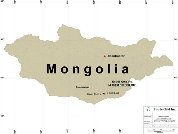
AMC 813001 : March : 2013
67
ENTRÉE GOLD INC Lookout Hill Property, Southern Mongolia Technical Report | |
| Figure 4.2 | Project Location Map – Lookout Hill Property |
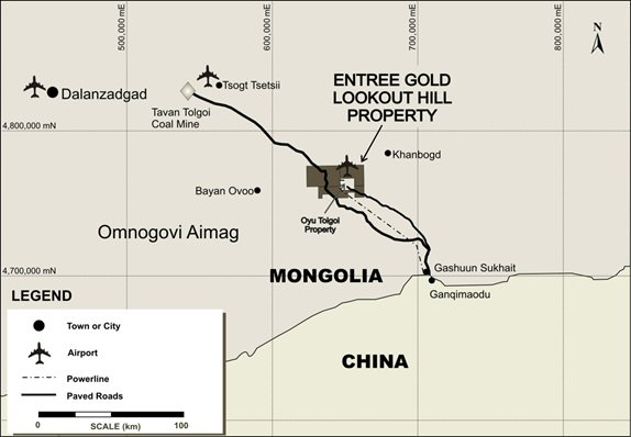
| 4.2 | Legal |
The Lookout Hill property (Lookout Hill) in Mongolia includes two mining licences (Shivee Tolgoi ML and Javhlant ML) totalling approximately 74,980 ha. One of the Company’s wholly-owned Mongolian subsidiaries, Entrée LLC, is the registered owner of the two mining licences. The beneficial ownership in these licences is divided between Entrée and the EJV as described below:
| · | The EJV beneficially holds 39, 807 ha consisting of the eastern portion of Shivee Tolgoi ML and all of Javhlant ML (Joint Venture Property) and is governed by a joint venture agreement between Entrée and TRQ. The Joint Venture Property is contiguous with, and on three sides (to the north, east, and south) surrounds, TRQ’s Oyu Tolgoi Project. The Joint Venture Property hosts the Hugo North Extension Deposit and the Heruga deposit. Rio Tinto plc is the appointed project manager. |
| · | Lookout Hill West Property covers an area of 35,173 ha and includes the western portion of Shivee Tolgoi ML which is not subject to the EJV (Shivee West). |
These two Properties are further described in Sections 4.2.1 and 4.2.6, respectively and are shown on Figure 4.3. A brief description of maintenance of mineral exploration and mining licences in Mongolia is provided in Section 4.2.7.
AMC 813001 : March : 2013
68
ENTRÉE GOLD INC Lookout Hill Property, Southern Mongolia Technical Report | |
A 60% interest in three mineral exploration licences was first acquired by Entrée in 2002, through an arms-length, 5 year option agreement with a Mongolian company, Mongol Gazar Co. Ltd. (Mongol Gazar), who was awarded the MELs by the GOM in March and April 2001. On 6 November 2003, Entrée, through their wholly-owned Mongolian subsidiary Entrée LLC, entered into a purchase agreement with Mongol Gazar, which replaced the existing option agreement. Details of the agreement can be found in the March 2008 technical report (Vann et al., 2008) filed on SEDAR.
The initial 3 year licence term for the MELs expired in 2004; however, Entrée twice extended the MELs. Final expiry was to occur in March and April 2010 but the Shivee Tolgoi (3148X) and Javhlant (3150X) MELs were converted in October 2009 to mining licences with numbers MV-15226A and MV-15225A respectively.
The mining licences are in good standing until 27 October 2039, assuming licence fees shown in Table 4.1 are paid annually. The MLs can be extended for an additional two periods of 20 years each.
| Table 4.1 | Lookout Hill Property – Licence Details |
Mineral Licence Number | Mineral Licence Name | Licence Type | Total Area of Licence (ha) | Licence Award Date | Licence Expiry | Date of Annual Licence Payment(i) | Annual Licence Payment ($US) |
| 15226A | Shivee Tolgoi | Mining | 54,653 | 27 October 2009 | 27 October 2039 | 27 October 2009 | 821,401 |
| 15225A | Javhlant | Mining | 20,327 | 27 October 2009 | 27 October 2039 | 27 October 2009 | 305,192 |
| Total | 74,980 | 1,126,593 |
Note: The Company's Javhlant and Shivee Tolgoi exploration licences were converted to mining licences in October 2009. The total estimated annual fees in order to maintain the licences in good standing are approximately US$1.1 million. Approximately US$600,000 of the total is recoverable from the EJV.
In June 2010, the Government of Mongolia passed Resolution 140, the purpose of which is to authorize the designation of certain land areas for “state special needs” within certain defined areas, some of which include or are in proximity to the Oyu Tolgoi mining complex. These state special needs areas are to be used for Khanbogd village development and for infrastructure and plant facilities necessary in order to implement the development and operation of the Oyu Tolgoi mining complex. A portion of the Shivee Tolgoi licence is included in the land area that is subject to Resolution 140.
In June 2011, the Government of Mongolia passed Resolution 175, the purpose of which is to authorize the designation of certain land areas for “state special needs” within certain defined areas in proximity to the Oyu Tolgoi mining complex. These state special needs areas are to be used for infrastructure facilities necessary in order to implement the development and construction of the Oyu Tolgoi mining complex. Portions of the Shivee Tolgoi and Javhlant licences are included in the land area that is subject to Resolution 175.
It is expected but not yet formally confirmed by the Government that to the extent that a consensual access agreement exists or is entered into between OT LLC and an affected licence holder, the application of Resolution 175 to the land area covered by the access agreement will be unnecessary. OT LLC has existing access and surface rights to the Joint Venture Property pursuant to the Earn-In Agreement. If Entrée is unable to reach a consensual arrangement with OT LLC with respect to Shivee West, Entrée’s right to use and access a corridor of land included in the state special needs areas for a proposed power line may be adversely affected by the application of Resolution 175. While the Mongolian Government would be responsible for compensating Entrée in accordance with the mandate of Resolution 175, the amount of such compensation is not presently quantifiable.
AMC 813001 : March : 2013
69
ENTRÉE GOLD INC Lookout Hill Property, Southern Mongolia Technical Report | |
The Investment Agreement contains provisions restricting the circumstances under which the Shivee Tolgoi and Javhlant licences may be expropriated. As a result, Entrée considers that the application of Resolution 140 and Resolution 175 to the Joint Venture Property will likely be considered unnecessary.
On 27 February 2013, Notice was delivered to Entrée by MRAM that by Order No. 43 dated 22 February 2013, the Ministry of Mining had cancelled the 2009 Order registering the Hugo North Extension and Heruga reserves. The registration of reserves is a pre-condition to applying for the conversion of an exploration licence into a mining licence. The Notice stated that the 2009 Order breached Clause 48.4 of the Minerals Law of Mongolia and Clause 9 of the Charter of the Minerals Resource Council. The Notice further advised that any transfer, sale or lease of the Shivee Tolgoi and Javhlant mining licences is temporarily suspended. Entrée is currently working to understand the full impact of the Notice and to resolve these issues.
| 4.2.1 | Joint Venture Property |
On 15 October 2004, an Earn-In and Equity Participation Agreement (the Earn-In Agreement) was signed between Entrée and Ivanhoe. On 1 March 2005, Ivanhoe transferred most of its rights and obligations under the Earn-in Agreement dated to Ivanhoe Mines Mongolia XXK (now OT LLC). The Earn-In Agreement gave OT LLC the right to earn an interest in a portion (39,807 ha) of the overall area of Entrée’s Lookout Hill Property. The agreement has an effective date of 10 November 2004 (the Earn-In Effective Date). The agreement has been filed on SEDAR and is summarized in the March 2008 technical report (Vann et al., 2008). On 11 March 2008, OT LLC notified Entrée that it had incurred sufficient expenditures (>$27.5 M) to earn a 60% interest as was outlined in the initial agreement. At the end of June 2008, OT LLC notified Entrée that it had incurred sufficient expenditures (>$35 M) to earn an 80% participating interest and thereby forming a joint venture (the "EJV”). The property is now referred to as the “Joint Venture Property”.
By expending over US$35 M in exploration and development, OT LLC has earned an 80% interest in minerals deeper than 560 m extracted from below the surface on the Joint Venture Property and a 70% interest in minerals above that elevation. Entrée can elect to be carried to production by OT LLC through debt financing at prime +2% (set by the Royal Bank of Canada) with its share of development costs repaid from 90% of future production cash flow. This stipulation limits dilution of Entrée’s interest as the project progresses.
AMC 813001 : March : 2013
70
ENTRÉE GOLD INC Lookout Hill Property, Southern Mongolia Technical Report | |
On 6 October 2009, Ivanhoe, OT LLC and Rio Tinto International Holdings Limited signed an Investment Agreement with the GOM. The Investment Agreement regulates the relationship between these parties and stabilizes the long term tax, legal, fiscal, regulatory, and operating environment to support the development of the Oyu Tolgoi Project. The GOM (through Erdenes Oyu Tolgoi LLC) subsequently acquired from Ivanhoe a 34% interest in OT LLC. The contract area defined in the Investment Agreement includes the Javhlant and Shivee Tolgoi mining licences, including Shivee West which is 100% owned by Entrée and not currently subject to the EJV.
One of the conditions precedent under the Investment Agreement was that the rights that Ivanhoe held in respect of the Shivee Tolgoi and Javhlant exploration licences be transferred to OT LLC, whether by way of contractual entitlement or transfer of the relevant titles, and that those exploration licenses be converted to mining licences by the Government before their expiry. Ivanhoe considered the condition precedent in the Investment Agreement to be satisfied as soon as the Shivee Tolgoi and Javhlant exploration licences were converted to mining licences on 27 October 2009.
AMC and the authors of this report have relied exclusively on information provided by Entrée concerning the title to and status of the mining licences comprising the Lookout Hill Property, the Joint Venture Property, and permitting.
The boundaries of the two MLs (or portions thereof) included within the Joint Venture Agreement are defined by latitude and longitude coordinates (WGS 84 datum) and by UTM coordinates with datum set to WGS-84, Zone 48N, and are shown in Figure 4.3 and are listed in Table 4.2.
| Figure 4.3 | Lookout Hill Property – Land Tenure |
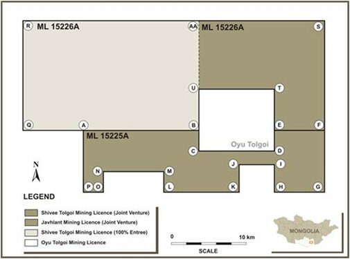
AMC 813001 : March : 2013
71
ENTRÉE GOLD INC Lookout Hill Property, Southern Mongolia Technical Report | |
| Table 4.2 | Joint Venture Property Boundary Coordinates |
| ML | Point | Lat./Long. (WGS 84 (MONREF-97); ° ‘ “) | UTM (WGS84, Zone 48N) | ||
| Latitude | Longitude | Easting | Northing | ||
| 15226A (Shivee Tolgoi; eastern portion only) | AA | 43 08 1.4 N | 106 47 31.4 E | 645752.90 | 4777222.00 |
| S | 43 08 1.4 N | 107 00 1.5 E | 662698.85 | 4777606.89 | |
| F | 43 00 1.4 N | 107 00 1.5 E | 663051.79 | 4762799.00 | |
| E | 43 00 1.4 N | 106 55 1.4 E | 656257.87 | 4762640.85 | |
| T | 43 03 1.4 N | 106 55 1.4 E | 656131.02 | 4768193.51 | |
| U | 43 03 1.4 N | 106 47 31.4 E | 645950.61 | 4767968.55 | |
| 15225A (Javhlant) | A | 43 00 1.4 N | 106 36 1.4 E | 630446.14 | 4762099.72 |
| B | 43 00 1.4 N | 106 47 31.4 E | 646068.97 | 4762415.58 | |
| C | 42 58 31.3 N | 106 47 31.5 E | 646129.37 | 4759638.32 | |
| D | 42 58 31.3 N | 106 55 1.5 E | 656322.33 | 4759863.28 | |
| E | 43 00 1.4 N | 106 55 1.4 E | 656257.87 | 4762640.85 | |
| F | 43 00 1.4 N | 107 00 1.4 E | 663051.79 | 4762799.00 | |
| G | 42 55 31.4 N | 107 00 1.5 E | 663250.93 | 4754470.41 | |
| H | 42 55 31.3 N | 106 55 1.5 E | 656449.01 | 4754310.44 | |
| I | 42 57 31.3 N | 106 55 1.5 E | 656364.58 | 4758012.45 | |
| J | 42 57 31.3 N | 106 51 31.5 E | 651606.78 | 4757905.58 | |
| K | 42 55 31.3 N | 106 51 31.5 E | 651688.44 | 4754203.86 | |
| L | 42 55 31.4 N | 106 44 1.5 E | 641487.14 | 4753986.00 | |
| M | 42 57 1.4 N | 106 44 1.5 E | 641430.13 | 4756762.59 | |
| N | 42 57 1.4 N | 106 38 1.5 E | 633272.23 | 4756599.51 | |
| O | 42 55 31.4 N | 106 38 1.5 E | 633326.19 | 4753822.92 | |
| P | 42 55 31.4 N | 106 36 1.5 E | 630605.88 | 4753770.63 | |
Point 1 for each ML corresponds with the north-western corner of the ML; remaining points are cited in a clockwise direction.
| 4.2.2 | Surveying |
The original MLs within the Lookout Hill Property were legally surveyed in October 2007 by Aerogeodez from Ulaanbaatar and the corners marked with steel posts. The adjacent Oyu Tolgoi ML was legally surveyed in August 2002 by Surtech International Ltd. using the internationally recognized survey datum WGS84 Zone 48N. In September 2004, Geomaster Co. Ltd. (Geomaster), a licenced Mongolian land survey company, re-surveyed the Oyu Tolgoi ML corner points based on the official Mongolian survey datum “MSK42” and marked the corners with concrete and steel pylons. In November 2004, Geomaster also surveyed the northern boundary between the Oyu Tolgoi ML and Entrée’s Shivee Tolgoi ML and marked it with wooden posts on 250 m to 500 m intervals.
AMC 813001 : March : 2013
72
ENTRÉE GOLD INC Lookout Hill Property, Southern Mongolia Technical Report | |
In September 2011, Geomaster Co. Ltd. Completed another survey of the Shivee Tolgoi and Javhlant mining licences (15226A and 15225A, respectively) using the newly instated official Mongolian survey datus “MONREF-97”. During this survey the corner posts were checked for accuracy as compared to the new MONREF-97 coordinates released by the Cadastre office earlier in 2010. As of mid-November 2011, all posts were cemented in place for the Shivee Tolgoi and Javhlant Mining Licences.
| 4.2.3 | Permits and Agreements |
The Mongolian Minerals Law (2006) and Mongolian Land Law (2002) govern OT LLC’s exploration, mining, and land use rights for the Project. Water rights are governed by the Mongolian Water Law and the Mongolian Minerals Law. These laws allow licence holders to use the land and water in connection with exploration and mining operations, subject to the discretionary authority of Mongolian national, provincial, and regional governmental authorities as granted under Mongolian law.
OT LLC has and continues to study the permitting and approval requirements for the development of the Oyu Tolgoi Project and maintains a permit and licencing register. OT LLC personnel work with the Mongolian authorities and have developed descriptions of the permitting processes and procedures for the Oyu Tolgoi Project permitting in Mongolia. Key permits have already been obtained and with a small number of permits still in process. OT LLC has advised that it expects that all permits will be obtained in a suitable time frame for the project development. Under the terms of the Investment Agreement, a working group consisting of OT LLC and government representatives has been formed to assist in the permitting process.
With the adoption of the new Minerals Law in 2006, the GOM set the royalty rate at 5.0% of the sales value of all minerals, except coal and common minerals, extracted from a mining licence area which have been sold, shipped for sale or used. TRQ holds a 2% net smelter returns based payment over the Oyu Tolgoi ML which was purchased from BHP Exploration in 2004.
Further requirements for environmental impact assessment are discussed below.
| 4.2.4 | Environment |
Holders of a mining licence in Mongolia must comply with environmental protection obligations established in the Environmental Protection Law of Mongolia, Law of Environmental Impact Assessment and the Minerals Law. These obligations include preparation of an environmental impact assessment (EIA) for mining proposals, submitting an annual environmental protection plan (EPP), posting an annual bond against completion of the protection plan and submitting an annual environmental report.
OT LLC has posted environmental bonds to the Mongolian Ministry for Nature and Environment (MNE) in accordance with the Minerals Law of Mongolia for restoration and environmental management work required for exploration and the limited development work undertaken at the site. OT LLC pays to the Khanbogd Soum annual fees for water and road usage, while sand and gravel use fees are paid to the Aimag government in Dalanzadgad.
AMC 813001 : March : 2013
73
ENTRÉE GOLD INC Lookout Hill Property, Southern Mongolia Technical Report | |
OT LLC has completed a comprehensive Environmental and Social Impact Assessment (ESIA) for the Oyu Tolgoi Project. The culmination of nearly 10 years of independent work and research carried out by both international and Mongolian experts, the ESIA identifies and assesses the potential environmental and social impacts of the project, including cumulative impacts, focusing on key areas such as biodiversity, water resources, cultural heritage, and resettlement.
The ESIA also sets out measures through all project phases to avoid, minimize, mitigate, and manage potential adverse impacts to acceptable levels established by Mongolian regulatory requirements and good international industry practice, as defined by the requirements of the Equator Principles, and the standards and policies of the International Finance Corporation (IFC), European Bank for Reconstruction and Development (EBRD), and other financing institutions.
Corporate commitment to sound environmental and social planning for the project is based on two important policies: Oyu Tolgoi ML Statement of Values and Responsibilities (March 2010), which declares its support for human rights, social justice, and sound environmental management, including the United Nations Universal Declaration of Human Rights (1948); and The Way We Work 2009, Rio Tinto’s Global Code of Business Conduct that defines the way Rio Tinto manages the economic, social, and environmental challenges of its global operations.
OT LLC has commenced the development and implementation of an environmental management system (EMS) that conforms to the requirements of ISO 14001:2004. Implementation of the EMS during the construction phases will focus on the environmental policy; significant environmental aspects and impacts and their risk prioritization; legal and other requirements; environmental performance objectives and targets; environmental management programs; and environmental incident reporting. The EMS for operations will consist of detailed plans to control the environmental and social management aspects of all project activities following the commencement of commercial production in 2013. The Oyu Tolgoi ESIA builds upon an extensive body of studies and reports, and Detailed Environmental Impact Assessments (DEIAs) that have been prepared for project design and development purposes, and for Mongolian approvals under the following laws:
| · | The Environmental Protection Law (1995) |
| · | The Law on Environmental Impact Assessment (1998, amended in 2001) |
| · | The Minerals Law (2006) |
These initial studies, reports and DEIAs were prepared over a six-year period between 2002 and 2008, primarily by the Mongolian firm Eco-Trade LLC, with input from Aquaterra on water issues.
The original DEIAs provided baseline information for both social and environmental issues. These DEIAs covered impact assessments for different project areas, and were prepared as separate components to facilitate technical review as requested by the GOM.
AMC 813001 : March : 2013
74
ENTRÉE GOLD INC Lookout Hill Property, Southern Mongolia Technical Report | |
The original DEIAs were in accordance with Mongolian standards and while they incorporated World Bank and IFC guidelines, they were not intended to comprehensively address overarching IFC policies such as the IFC Policy on Social and Environmental Sustainability, or the EBRD Environmental and Social Policy.
Following submission and approval of the initial DEIAs, the Mongolian Government requested that OT LLC prepare an updated, comprehensive ESIA whereby the discussion of impacts and mitigation measures was project-wide and based on the latest project design. The ESIA was also to address social issues, meet Mongolian government (legal) requirements, and comply with current IFC good practice.
For the ESIA the baseline information from the original DEIAs was updated with recent monitoring and survey data. In addition, a social analysis was completed through the commissioning of a Socio-Economic Baseline Study and the preparation of a Social Impact Assessment (SIA) for the project.
The requested ESIA, completed in 2012, combines the DEIAs, the project SIA, and other studies and activities that have been prepared and undertaken by and for OT LLC.
A summary of the previous DEIAs prepared for the Oyu Tolgoi Project is shown in Table 4.3.
AMC 813001 : March : 2013
75
ENTRÉE GOLD INC Lookout Hill Property, Southern Mongolia Technical Report | |
| Table 4.3 | Previous DEIA Studies for the Oyu Tolgoi Project |
| EIA Study Title | Description | Date | Status |
| Oyu Tolgoi Project Environmental Baseline Study | This study covers geography, geological, hydrology, hydrogeology, soil, climate, air quality, flora and fauna, the socio-economic status and infrastructure of the Oyu Tolgoi Project site and its surrounding areas. | 2002 | Submitted November 2002 as DEIA. Screening approval not required for baseline study. |
Oyu Tolgoi Project EIA Volume I: Transport and Infrastructure Corridor from Oyu Tolgoi to Gashuun Sukhait | EIA of the original road and power line proposal from Gashuun Sukhait (GS) to Oyu Tolgoi via the western route. See Chapter A5 Figure 5.6. Provides approval for access through the South Gobi Strictly Protected Area (SGSPA). | 2004 | Approved May 2004. |
| Supplementary EIA Volume I: For Route Changes to the Oyu Tolgoi to Gashuun Sukhait Transport Corridor | Assessment of the revised Eastern route to GS and includes an assessment of existing environmental damage caused to the western route from coal traffic. See Chapter A5 Figure 5.6. | 2006 | Approved March 2007. |
Oyu Tolgoi Project EIA Volume II: Water Supply from the Gunii Hooloi (GH) and Galbyn Gobi (GG) Groundwater Aquifer Areas | Provides an evaluation of the proposed aquifers for the provision of a sustainable water supply to the Oyu Tolgoi Project. | 2005 | Approved September 2005. |
| Supplementary EIA Volume II: Supplementary EIA of GH and GG Groundwater Aquifer Areas | Provides an update of the approved EIA Volume II from 2005. Updated assessment of potential impacts and risks, and upgrade of groundwater monitoring in GH area reflecting higher water demand. | 2010 | Initial Screening by MNET in December 2009. Final review and approval by the Water Authority and MNET in March 2011. |
| Supplementary EIA Volume II: Supplementary EIA for GH bore field pipelines and associated infrastructure. | The report was updated further based on an engineering report of Dec 2008. The report covers pipelines, wells, pumps, ponds, lagoon, power supply and access roads from the GH Borefield to the Oyu Tolgoi site. | 2009 | Initial draft 2008. Updated December 2009. Approved March 2010. |
Oyu Tolgoi Project Volume III: Oyu Tolgoi Mining and Processing Facilities | EIA of the open pits, underground, and concentrator, tailings, and all facilities and support infrastructure located within the Oyu Tolgoi Mine Licence Area. The assessment was largely based on the 2005 Integrated Development Plan (IDP), but reflected the general permitting layout of May 2006. The maximum production rate was assumed to be 85,000 tpd. | 2006 | Approved December 2007. |
Oyu Tolgoi Project Volume IV: Coal Fired Steam Power Plant | EIA documentation drafted for a 3 x 100 MW coal fired power plant in 2006. | 2006 | Draft Technical Summary & DEIA completed but not submitted. |
AMC 813001 : March : 2013
76
ENTRÉE GOLD INC Lookout Hill Property, Southern Mongolia Technical Report | |
| EIA Study Title | Description | Date | Status |
Oyu Tolgoi Project Volume V: Domestic Airport Re-location. | The project includes the construction of a temporary gravel Airstrip 10 km north of the Oyu Tolgoi Mine Licence with 2,000 m runway, taxiway, safety end-strip, apron, control tower, passenger terminal, car parking, 15 x 15 m waiting hall, illumination of runway, electric power that is supplied by 40 kVA power generator, surface water drainage system and fence. This EIA covers the new airport construction and operation. This facility is a temporary facility and will be replaced by the Permanent Airport. | 2007 | Approved September 2007. |
| Environmental Impact Assessment for the Permanent Airport | EIA for the construction and operation of the Permanent Airport. | 2011 | Approved 2011. |
| Undai River Diversion Detailed Environmental Impact Assessment | EIA for the diversion of the Undai River | 2011 | Awaiting approval by MNET (as of April 2012). |
Additional environmental studies that relate to specific components of the project and that have not required a full-scale DEIA have been undertaken to achieve regulatory approvals. These are summarized in Table 4.4.
| Table 4.4 | Additional Environmental Approvals, Studies, and Environmental Impact Assessments for Oyu Tolgoi Project |
| Project EIA Component | Description | Date | Status |
| Petrovis Temporary Fuel Station Facility at Oyu Tolgoi Site | Completed for the fuel facility built in 2004 within the Licence Area | 2005 | Approved 2005 |
| Oyu Tolgoi Fuel Depot and Fuel Station | The fuel station expanded in 2008 and a new fuel depot was constructed. The fuel station is 2.0 ha, and has 4 half-concealed tanks of 25 m3 capacity for A-92, A-80 fuel type, 10 tanks of 50 m3 capacity for diesel, and 2 dispensers. | 2010 | Submitted to MNET on 18 February 2010 and approved 13 September 2010 |
| Shaft 1 | EIA of the shaft, headframe facilities, waste rock, and water disposal | 2005 | Approved June 2005 |
| Shaft 2 | EIA of the shaft, headframe facilities, waste rock, and water disposal | 2006 | Approved December 2007 |
| Waste Water Treatment Plant | Supplementary documentation for the construction camp waste water treatment plant with a 4,000 person equivalent capacity | 2007 | Approved May 2007 |
| Quarry Batch Plant and Quarry | Assessment of the existing hard rock quarry, concrete batching plant, and crusher located at the northern boundary of the Licence Area | 2007 | Approved April 2007 |
| 20 MW Diesel Power Plant | The assessment included the initial development of 6 x 2 MW diesel power station (DPS) followed by a stage two addition of 4 x 2 MW diesel generators to the DPS. | 2007 | Approved September 2007 |
| Chemicals | Covers the importation and use of chemicals for construction and development | 2008 | Approved April 2008 |
7MC 813001 : March : 2013
75
ENTRÉE GOLD INC Lookout Hill Property, Southern Mongolia Technical Report | |
| 4.2.5 | Scope of the Environmental and Social Impact Statement |
The IFC and the EBRD have similar, but different, definitions for the scope of an impact assessment. Both institutions frame assessments in terms of a project’s “area of influence.” The guidance provided by both IFC and the EBRD and IFC was utilized in defining the scope of the ESIA. Key elements of the scope of the ESIA are set out below.
| 4.2.5.1 | Project Elements Directly Addressed in this ESIA |
For the purposes of the ESIA, the “project” constitutes the direct activities that are to be financed and/or over which the project can exert control and influence through its project design, impact management, and mitigation measures. This includes:
| • | All Oyu Tolgoi Project facilities within the Mine Licence Area and surrounding 10 km buffer zone, including the following key features: |
| - | Open pit mining facilities. |
| - | Underground mining facilities. |
| - | Accommodation camps. |
| - | Construction-related activities and facilities, including concrete batch plant, quarry, and laydown areas. |
| - | Power generation facilities. |
| - | Heating plant and boilers. |
| - | Crusher. |
| - | Concentrator. |
| - | Tailings storage facility. |
| - | Water management facilities (including diversion of the Undai River). |
| - | Waste water management facilities for camps and mining operations. |
| - | Waste management facilities (municipal and industrial). |
| - | Waste rock storage facilities. |
| - | Access roads within the Mine License Area. |
| - | Vehicle and equipment maintenance and repair facilities. |
| - | Fuel storage facilities. |
| - | Electrical power distribution. |
| - | Administration buildings and catering facilities. |
| • | Airport facilities, including a temporary and permanent airport and associated local access roads to the Oyu Tolgoi site. |
| • | Contractor accommodation camps adjacent to Khanbogd. |
| • | Potential dedicated off-site worker accommodation planned for Khanbogd. |
AMC 813001 : March : 2013
78
ENTRÉE GOLD INC Lookout Hill Property, Southern Mongolia Technical Report | |
| • | Gunii Hooloi water abstraction borefield and the water pipeline supplying the mine, as well as maintenance roads, pumping stations, construction camps, storage lagoons, and other support infrastructure. |
| • | Infrastructure improvements (and associated resource use) by Oyu Tolgoi between the mine site and the Chinese border, including the 220 kV power transmission line, the access road that will be used for concentrate export, construction camps, local water boreholes, and borrow pits. |
| • | Dedicated border crossing at Gashuun Sukhait for the exclusive use of the |
| Oyu Tolgoi Project. |
| - | The concentrate will be sold by Oyu Tolgoi at the Mongolia/China border crossing at Gashuun Sukhait. The point of sale marks a key boundary to the project area. |
| - | Infrastructure Components that may be Transferred to Third-Party Ownership in the Future. |
A number of infrastructure components of the project considered within the ESIA will be constructed by OT LLC but may be transferred at some stage to public or third party operation and/or ownership. Transfer of these infrastructure components to public operation and ownership will limit the degree of control that OT LLC can exert over their management and operation. These infrastructure components may be owned and operated by the Government and will or may be used by members of the public and/or other commercial operations, and include:
| • | The permanent airport, which is planned to be handed over to the Government after the completion of the project construction phase. |
| • | The road from Oyu Tolgoi to the Chinese border at Gashuun Sukhait, which follows the alignment for the designated national road and is planned to be handed over to the Government upon completion of the project construction phase. |
| • | The dedicated border crossing facility at Gashuun Sukhait, which will be operated by the Mongolian authorities. |
| • | The 220 kV electricity transmission line from the Chinese border to Oyu Tolgoi, which may become owned by the Government of Mongolia. |
| 4.2.5.2 | Future Project Elements Not Directly Addressed in the ESIA |
| • | In addition to the project elements identified above, certain other activities and facilities are expected to be developed over time, either as part of or in support of the project, that do not constitute part of the project for the purposes of the ESIA. These include: |
| - | Project expansion to support an increase in ore throughput from 100,000 t/d up to 160,000 t/d. |
| - | Long-term project power supply. Under the terms of the IA, OT LLC will source electricity from within Mongolia within four years of the commencement of project operations. OT LLC may develop a coal-fired power plant within the Oyu Tolgoi Mine Licence Area to provide the required power from Mongolian sources. |
AMC 813001 : March : 2013
79
ENTRÉE GOLD INC Lookout Hill Property, Southern Mongolia Technical Report | |
This development is considered to be an Associated Facility (as defined in IFC PS1) of the Oyu Tolgoi Project and is the subject of an ESIA that will be supplemental to the ESIA for the Oyu Tolgoi Project.
While the impacts of these future project elements (and their mitigation and management) are not directly addressed in the ESIA they are considered in the cumulative impact assessment of the ESIA.
| 4.2.6 | Shivee West (100% Entrée) |
Shivee West is owned 100% by Entrée and covers 35,173 ha. The property now includes only the western portion of the Shivee Tolgoi ML and no longer includes the Togoot licence as it was sold to a private Mongolian group in late 2011.
Entrée retains 100% of the mineral rights on the western portion of the Shivee Tolgoi ML. The grant of the Shivee Tolgoi mining licence allows Entrée to continue to investigate the potential of Shivee West without facing imminent licence expiry. The boundaries of the portions of the Shivee licence which are 100% held by Entrée are defined by latitude and longitude coordinates and these are listed in Table 4.5 and shown in Figure 4.3.
| Table 4.5 | Lookout Hill West (100% Entrée) Boundary Coordinates |
| ML | Lat./Long. (WGS 84 (MONREF-97); ° “ ‘) | ||
Point1 | Latitude | Longitude | |
15226A (Shivee Tolgoi West) | 1 (R) | 43 08 1.4 N | 106 30 1.4 E |
| 2 (AA) | 43 08 1.4 N | 106 47 31.4 E | |
| 3 (B) | 43 00 1.4 N | 106 47 31.4 E | |
| 4 (Q) | 43 00 1.4 N | 106 30 1.4 E | |
| 4.2.7 | Exploration and Mining Title in Mongolia |
Mongolian exploration licences are maintained in good standing by payment to the Mineral Resources Authority of Mongolia (MRAM) of set annual fees escalating from $0.10 to $1.50/ha over the course of the up to 9 year tenure. A property can be reduced in size selectively on application to the Cadastre office of the MRAM (the Cadastre is the central registry for land in Mongolia). Application to convert a Mongolian exploration licence into a mining licence can be made at any time prior to licence expiry. Conversion of a licence to explore for minerals to a licence to mine or develop a property in order to exploit minerals is commenced by review and Government approval of a defined Mineral Resource or Reserve and then filing a formal application together with the reserve approval. A feasibility study must be submitted to MRAM within 60 days of receiving the ML. A mining licence may be granted for up to 30 years, plus two subsequent 20 year terms (cumulative total of 70 years).
Payments to maintain mining and exploration licences in Mongolia are payable in advance on an annual basis according to the schedule shown in Table 4.6. A summary of the Lookout Hill licences and their renewal status is shown in Table 4.1 under the Property Description section.
AMC 813001 : March : 2013
80
ENTRÉE GOLD INC Lookout Hill Property, Southern Mongolia Technical Report | |
| Table 4.6 | Mining Licence Annual Fees |
| Years of Licence | Mining Licence Cost a Hectare (US$) |
| 1 | 15.00 |
| 2 | 15.00 |
| 3 | 15.00 |
| 4 | 15.00 |
| 5 | 15.00 |
| 6 | 15.00 |
| 7 | 15.00 |
| 8 | 15.00 |
| 9 | 15.00 |
Beyond Year 9 of a mining licence, the licence fee remains $US15 a hectare for minerals.
Royalties potentially payable to the GOM are governed by Article 47 of the Minerals Law of Mongolia. Pursuant to the Minerals Law, the GOM assesses royalties of: 5% on the sale value of all metallic minerals (except placer gold) mined in the country; 7.5% of the sales value of gold extracted from placer; and 2.5% on coal and common Mineral Resources.
On 7 December 2012, the Office of the President of Mongolia published a draft revised Minerals Law, which proposes to introduce a new regulatory regime with new legal concepts. The draft law reaffirms the existing list of strategic deposits approved by Parliamentary Resolution #27 dated 6 February 2007, and provides for “mining agreements” to be entered into between the Government of Mongolia and licence holders. Under these mining agreements, the Mongolian State has the right to take an equity interest in the licence holder for no consideration. The draft law also provides: that licence transfer agreements will only be valid upon registration with the Mineral Resources Authority (“MRAM”) and state-owned entities shall have a pre-emptive right to licences being transferred; for more extensive grounds under which licences may be revoked; and that not less than 34% of the equity in a foreign-invested mining licence holder must be held by a Mongolian citizen. As currently drafted, the draft law does not provide for any transitional provisions relating to existing licences nor the rights and obligations of licence holders under the existing system.
It is expected that a new working group will be formed to further develop the draft law before it is submitted to Parliament, sometime after the spring session.
On 27 February 2013, notice (the “Notice”) was delivered to Entrée by MRAM that by Order No. 43 dated 22 February 2013, the Ministry of Mining had cancelled the 10 July 2009 Order No. 167 of the Ministry of Mineral Resources and Energy (the “2009 Order”) registering the Hugo North Extension and Heruga reserves. The registration of reserves is a pre-condition to applying for the conversion of an exploration licence into a mining licence. The Notice stated that the 2009 Order breached Clause 48.4 of the Minerals Law of Mongolia and Clause 9 of the Charter of the Minerals Resource Counsel. The Notice further advised that any transfer, sale or lease of the Shivee Tolgoi and Javhlant mining licences is temporarily suspended. Entrée is currently working to determine the full impact of the Notice and to resolve these issues.
AMC 813001 : March : 2013
81
ENTRÉE GOLD INC Lookout Hill Property, Southern Mongolia Technical Report | |
| 4.2.8 | Surface Rights and Permits |
Mongolian Mining Law allows, through grant of the MLs, Entrée the right to access and explore, subject to land use agreements and fees with the local soums (districts).
| 4.2.9 | Environmental and Socio-Economic Issues |
Entrée is fully compliant with Mongolian exploration regulations. All phases of the Company’s operations are subject to the Minerals Law of Mongolia, Land Law and the Law on Environmental Protection as well as the various Taxation Laws.
In Mongolia, exploration requires filing an annual exploration work plan at the beginning of the year and providing a summary report to the local soum (the local Mongolian equivalent of a township or district). The Lookout Hill Property is affiliated with two soums, Khanbogd and Bayan-Ovoo. A second report must also be filed upon the conclusion of activities that includes a discussion of environmental impacts. In addition, companies are required to post a bond equal to 50% of the total estimated cost of any anticipated environmental reclamation, which is refunded upon completion of the reclamation work. A copy of the environmental plan must be delivered to the local soum (but is not approved by the soum) and the environmental bond is placed with a soum government account.
Mining licences require further environmental and social studies in the form of an environmental impact assessment and an environmental protection plan when the licence is granted.
The soums must also be paid for water and road usage. Payments are computed at the end of each calendar year based on the extent of use. Even if the Company relinquishes its licences, it remains responsible for any required reclamation. Entrée states that at the time of this report, it is in compliance with all environmental requirements.
There are few inhabitants living within the boundaries of the Lookout Hill Property and no towns or villages. The people who do live there are mostly nomadic herders.
Entrée engages in small programmes of basic infrastructure improvements to assist the nearby communities in the vicinity of the Lookout Hill Property. In addition, Entrée maintains close contact with the soums as part of their community relations efforts.
AMC 813001 : March : 2013
82
ENTRÉE GOLD INC Lookout Hill Property, Southern Mongolia Technical Report | |
| 5 | ACCESSIBILITY, CLIMATE, LOCAL RESOURCES, INFRASTRUCTURE AND PHYSIOGRAPHY |
| 5.1 | Access |
The Oyu Tolgoi Project is in the Aimag of Ömnögovi, located in the South Gobi region of Mongolia. The property is approximately 550 km south of the capital city, Ulaanbaatar, and 80 km north of the border with China (Figure 4.2).
The topography largely consists of gravel-covered plains, with low hills along the northern and western lease borders. Small, scattered rock outcrops and colluvial talus are widespread within the northern, western, and southern parts of the property.
The Project hosts a series of copper-gold mineralized deposits in a Palaeozoic porphyry system.
The Project is centered at approximately latitude 43°01'N, longitude 106°51'E or UTM coordinates 4764000 N and 651000 E with datum set to WGS-84, Zone 48N. The Southern Oyu and Hugo Dummett Deposits are the principal zones of mineralization defined on the Project and these occur within a north-north-east trending, 1 km wide mineralized “corridor” in the central portion of the Project at elevations ranging from approximately 1,140 masl to 1,215 masl.
| 5.1.1 | Regional Centers and Infrastructure |
There are a number of communities in the South Gobi region. The most prominent is Dalanzadgad, population 15,000, which is the administrative center of the Ömnögovi Aimag and is 220 km north-west of the Oyu Tolgoi property. Facilities at Dalanzadgad include a regional hospital, tertiary technical colleges, a domestic airport, and a 6 MW capacity coal-fired power station. OT LLC envisions that Dalanzadgad may be suitable as a regional center for recruiting and training. The closest community to the property is Khanbogd, the center of the Khanbogd soum. Khanbogd has a population of approximately 2,500 and is 35 km to the east. Other communities relatively near to the project include Mandalgovi (population 13,500), the capital of the Dundgovi aimag, 310 km north of the project on the road to Ulaanbaatar, Bayan-Ovoo (population 1,600), 55 km to the west, and Manlai (population 2,400), 150 km to the north.
| 5.1.2 | Transportation Infrastructure |
Road access to the Oyu Tolgoi Project follows a well-defined track directly south from Ulaanbaatar requiring approximately 12 hours travel time in a four wheel drive vehicle. Mongolian rail service and a large electric power line lie 350 km east of the property at the main rail line between Ulaanbaatar and China. The China-Mongolia border is located approximately 80 km south of the Oyu Tolgoi Project. OT LLC is constructing a paved road from the site to the border. OT LLC constructed a 220 kV transmission line connecting to the Chinese (Inner Mongolian) grid. This line has the capacity to supply all of Oyu Tolgoi Project’s power needs. The Chinese Government has a highway to the Mongolian border, which is a direct link between the border south of the Oyu Tolgoi Project to the trans-China railway system.
AMC 813001 : March : 2013
83
ENTRÉE GOLD INC Lookout Hill Property, Southern Mongolia Technical Report | |
OT LLC has constructed a concrete airstrip and the site is serviced by flights to and from Ulaanbaatar. Ulaanbaatar has an international airport, and Mandalgovi, Tsogt Tsetsii, and Dalanzadgad have regional airports. There is currently charter air service between the site and Ulaanbaatar. The closest regional airport in China is at Hohhot. There are no airport facilities at Wuyuan or Bayan Obo.
| 5.1.3 | Power Supply |
The supply of power has been recognized as being critical to the execution of the Oyu Tolgoi Project in the IA. OT LLC has been given the right to import power initially but must secure power from sources within Mongolia from the fourth year of operation.
Turquoise Hill announced on 5 November 2012, that Oyu Tolgoi had signed a binding Power Purchase Agreement with the Inner Mongolia Power Corporation to supply power to the Oyu Tolgoi mine. The term of this agreement covers the commissioning of the business plus the initial four years of commercial operations. The locations of power providers in northern China are shown in Figure 5.1.
The Oyu Tolgoi Investment Agreement recognized that the reliable supply of electrical power is critical to the mine. The agreement also confirmed that Turquoise Hill has the right to obtain electrical power from inside or outside Mongolia, including China, to meet its initial electrical power requirements for up to four years after Oyu Tolgoi commences commercial production. The agreement established that a) Turquoise Hill has the right to build or subcontract construction of a coal-fired power plant at an appropriate site in Mongolia’s South Gobi Region to supply the Oyu Tolgoi mine and b) all of the mine’s power requirements would be sourced from within Mongolia no later than four years after the start of commercial production. Turquoise Hill continues to evaluate several options to meet its commitment to sourcing power from within Mongolia, including the development of a dedicated power plant and ownership and funding options to meet this requirement.
AMC 813001 : March : 2013
84
ENTRÉE GOLD INC Lookout Hill Property, Southern Mongolia Technical Report | |
| Figure 5.1 | Northern China Power Grid |
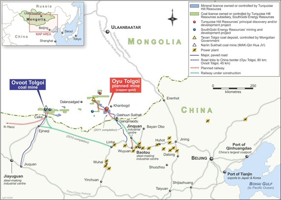
| 5.2 | Climate, Hydrology, and Physiography |
| 5.2.1 | Climate |
The South Gobi region has a continental, semi-desert climate. The spring and autumn seasons are cool, summers are hot, and winters are cold. Typical of desert climates, the site has low average humidity and significant variations in daily temperatures.
Knight Piésold conducted an extensive evaluation of the available climatic information for the project area using regional data from bibliographical sources and local data from nearby climate stations.
The climatic conditions are such that the operating season for the Project will cover the entire year on a continuous shift basis. Minor disruptions are expected and have been allowed for in the estimates of the Project operating hours.
| 5.2.1.1 | Data Sources |
Data were derived primarily from climatic records for Bayan-Ovoo, approximately 75 km west of Oyu Tolgoi, and from 2 years of available Oyu Tolgoi site data. Although these data have some limitations they are considered adequate for use in design. Data were also obtained from Khanbogd, approximately 45 km north-east of the site, Dalanzadgad, 220 km north-west, and Hailutu, 200 km south-west, but the information from Bayan-Ovoo was deemed the most representative of conditions at Oyu Tolgoi.
AMC 813001 : March : 2013
85
ENTRÉE GOLD INC Lookout Hill Property, Southern Mongolia Technical Report | |
| 5.2.1.2 | Air Temperature |
Temperatures range from an extreme maximum of about 50°C to an extreme minimum of about -34°C. The typical air temperature in winter fluctuates between 6°C and -21°C. In the coldest month, January, the average temperature is -12°C. Data from Bayan-Ovoo are shown in Table 5.1.
| Table 5.1 | Monthly Temperatures (°C) Based on Bayan-Ovoo Data |
| Jan | Feb | Mar | Apr | May | Jun | Jul | Aug | Sep | Oct | Nov | Dec | |
| Minimum | -34 | -33 | -25 | -22 | -13 | 0.4 | 4 | 2 | -4 | -20 | -26 | -33 |
| Average | -12 | -8 | -0.4 | 9 | 17 | 23 | 25 | 22 | 16 | 7 | -2 | -10 |
| Maximum | 9 | 16 | 24 | 31 | 38 | 49 | 40 | 39 | 39 | 30 | 25 | 14 |
| 5.2.1.3 | Relative Humidity |
The average relative humidity ranges from 18.7% in May to 53.3% in January. Daily relative humidity is dependent on current temperature and varies considerably. Table 5.2 shows monthly relative humidity statistics using the calculated hourly averages from the site weather station. The design relative humidity for summer is based on an analysis of the July 2002 and 2003 hourly temperatures and corresponding relative humidity values. The design relative humidity for a 1 July temperature of 34.5°C is 15.1%.
| Table 5.2 | Monthly Relative Humidity |
| Jan | Feb | Mar | Apr | May | Jun | Jul | Aug | Sep | Oct | Nov | Dec | |
| Minimum | 19 | 12 | 3 | 2 | 1 | 1 | 4 | 8 | 1 | 2 | 5 | 10 |
| Average | 53 | 38 | 23 | 24 | 18 | 31 | 37 | 36 | 34 | 30 | 40 | 43 |
| Maximum | 81 | 67 | 88 | 89 | 100 | 96 | 100 | 100 | 100 | 81 | 85 | 80 |
| 5.2.1.4 | Ground Temperature |
From the data available to date, the minimum recorded ground temperature is -39°C and the maximum is 70°C. Table 5.3 shows the design freezing depths at the site based on the Mongolian Climate Data and Geophysical Parameters for Use in Construction Design Code Document No. CNR 2.01-01-93.
| Table 5.3 | Design Soil Freezing Depths |
| Soil Type | Freezing Depth (m) |
| Clayey soil | 1.5 |
| Sandy soil | 1.9 |
| Gravely soil | 2.2 |
AMC 813001 : March : 2013
86
ENTRÉE GOLD INC Lookout Hill Property, Southern Mongolia Technical Report | |
| 5.2.1.5 | Solar Radiation |
Solar radiation data have been collected at the Oyu Tolgoi site station since 2002. Solar radiation is measured in W/m2 and fluctuates during the day, ranging from 0 W/m2 at night and peaking soon after mid-day. The average daily maximum for the 2 years of data available is 655 W/m2, the highest daily maximum is 1,030 W/m2, and the lowest daily maximum is 76 W/m2.
Maximum levels of solar radiation are lower during the winter. The average daily maximum is 429 W/m2 for January and 859 W/m2 for July.
| 5.2.1.6 | Precipitation |
Average annual precipitation is 57 mm/a, 90% of which falls as rain and the rest as snow. Snowfall accumulations rarely exceed 50 mm. Maximum rainfall events of up to 43 mm/h for a 1-in-10 year, 10 minute storm event have been recorded. In an average year, rainfalls occur on only 19 days, and snow falls on 10 to 15 days. The ground snow load is 0.1 kPa. Monthly rainfall data are shown in Table 5.4 and Table 5.5.
Both tables are derived from Bayan-Ovoo data for 1975 to 2002.
| Table 5.4 | Rainfall Summary (mm) |
| Jan | Feb | Mar | Apr | May | Jun | Jul | Aug | Sep | Oct | Nov | Dec | Total | |
| Maximum daily | 2.1 | 3.8 | 4.4 | 10.4 | 19.0 | 16.2 | 29.5 | 102.0 | 19.2 | 4.0 | 4.3 | 1.5 | - |
| Average monthly | 0.4 | 0.4 | 0.8 | 1.4 | 3.1 | 8.1 | 18.1 | 17.8 | 5.0 | 0.9 | 0.6 | 0.2 | 56.8 |
| Average rain days per month | 0.6 | 0.6 | 1.0 | 0.8 | 1.5 | 3.0 | 4.5 | 3.9 | 1.4 | 0.6 | 0.7 | 0.4 | 19.0 |
| Table 5.5 | Rainfall Intensities (mm/h) – Bayan-Ovoo |
Return Interval Duration | 1 in 2 Years | 1 in 10 Years | 1 in 20 Years | 1 in 50 Years | 1 in 100 Years | 1 in 500 Years |
| 10 minutes | 15.4 | 44.2 | 63.5 | 99.8 | 138.3 | 284.2 |
| 30 minutes | 10.0 | 28.7 | 41.3 | 64.8 | 89.9 | 187.7 |
| 60 minutes | 6.8 | 19.5 | 28.0 | 44.0 | 60.9 | 125.2 |
| 2 hours | 4.3 | 12.3 | 17.7 | 27.8 | 38.6 | 79.3 |
| 3 hours | 3.2 | 9.2 | 13.3 | 20.9 | 28.9 | 59.4 |
| 6 hours | 1.9 | 5.5 | 7.9 | 12.4 | 17.2 | 35.4 |
| 12 hours | 1.1 | 3.2 | 4.6 | 7.3 | 10.1 | 20.7 |
| 24 hours | 0.7 | 1.9 | 2.7 | 4.2 | 5.9 | 12.0 |
| 48 hours | 0.4 | 1.1 | 1.5 | 2.3 | 3.2 | 6.3 |
| 72 hours | 0.3 | 0.8 | 1.0 | 1.6 | 2.2 | 4.2 |
| 5.2.1.7 | Thunderstorms and Lightning |
Local records indicate that thunderstorms are likely to occur from 2 to 8 days each year at Oyu Tolgoi. Electrical activity generally totals about 29 hours each year. An average storm will have up to 83 lightning flashes a minute.
AMC 813001 : March : 2013
87
ENTRÉE GOLD INC Lookout Hill Property, Southern Mongolia Technical Report | |
| 5.2.1.8 | Evaporation |
Given the importance of this variable for determining project water requirements, a number of different methods were used to generate and analyse evaporation data to determine design levels. The results are summarized in Table 5.6. It should be noted that site measurements are ongoing to confirm these results.
| Table 5.6 | Design Evaporation Data |
| Month | Sublimation (Waterbodies Frozen in Winter) (mm) | Evaporation | |
| Winter | Summer | ||
| (Open Waterbodies) (mm) | |||
| January | 22 | 82 | - |
| February | 41 | 101 | - |
| March | - | - | 142 |
| April | - | - | 256 |
| May | - | - | 439 |
| June | - | - | 378 |
| July | - | - | 382 |
| August | - | - | 285 |
| September | - | - | 192 |
| October | - | - | 132 |
| November | 53 | 11 | - |
| December | 27 | 88 | - |
Total Water Loss: Sublimation + Evaporation = 2,349 mm | |||
| 5.2.1.9 | Wind Loading and Dust Generation |
Wind is usually present at the site, predominantly from the north. Very high winds are accompanied by sandstorms that often severely reduce visibility for several hours at a time. Based on regional information, windstorms can have gusts up to 50 m/s. Snowstorms and blizzards with winds up to 40 m/s occur in the Gobi region for 5 to 8 days each winter. Spring dust storms are far more frequent and can continue through June and July. The average storm duration is 6 to 7 hours. An average of 120 hours of dust storm activity and 220 hours of drifting dust are recorded each year.
Based on the Mongolian Code, the Basic Wind Speed is 34 m/s. Maximum 1 hour speeds recorded at Bayan-Ovoo are shown in Table 5.7. The number of dust days per year is shown in Table 5.8.
| Table 5.7 | Maximum One-Hour Wind Speeds (m/s) at Bayan-Ovoo |
| Jan | Feb | Mar | Apr | May | Jun | Jul | Aug | Sep | Oct | Nov | Dec | |
| Maximum wind speed | 13.4 | 14.0 | 15.4 | 18.1 | 16.6 | 16.2 | 16.3 | 14.8 | 16.0 | 18.6 | 19.3 | 14.5 |
AMC 813001 : March : 2013
88
ENTRÉE GOLD INC Lookout Hill Property, Southern Mongolia Technical Report | |
| Table 5.8 | Frequency of Dust Storms in the Gobi Desert |
| Jan | Feb | Mar | Apr | May | Jun | Jul | Aug | Sep | Oct | Nov | Dec | |
| No. of days | 0.7 | 1.0 | 2.4 | 4.7 | 4.1 | 1.5 | 1.0 | 0.4 | 0.6 | 0.7 | 1.9 | 0.7 |
| 5.2.2 | Hydrology and Surface Water Quality |
The Oyu Tolgoi Project area is located within the closed Central Asian drainage basin and has no outflow to the ocean. Most riverbeds in this drainage basin are ephemeral creeks that remain dry most times of the year. The Umdai River is the most significant hydrological feature of the project area. A tributary of the river passes through the site.
Flows after heavy summer rainstorms often result in very turbulent, high-velocity mud flows, locally termed “Gobian wild floods.” These floods have been known to destroy road crossings and to carry away vehicles caught in the riverbeds. No surface flow data are available for these isolated and episodic flood events. During exploration, only two such events were experienced from 2002 to 2009. Further discussions with locals indicate these events can occur yearly (excluding current drought conditions).
Shallow springs are used by wildlife and livestock as drinking water sources. Migratory wildlife movements during summer months in the Gobi are likely to be dictated by the presence of surface water in natural springs.
Water quality baseline data for surface waters throughout the project area, access road corridor, and aquifer areas are being collected through current monitoring programmes. This information will be established prior to project development as a basis for assessing potential project-related impacts on surface water quality during routine monitoring.
Potential impacts on surface water systems in the project area will include local changes to natural flow paths and depletion of springs, ephemeral wetlands, and salt-marshes from project development and operation activities. The mitigation and design work with regard to surface water focused on the potential impacts to surface water quality include increased sedimentation and risk of pollution of springs, ephemeral wetlands, and salt-marshes from increased erosion, contaminated dust fallout, contaminant spills, and accidents associated with project construction and operational activities.
Fugitive dust control management plans and spill management systems are being developed to avoid and mitigate potential impacts to air and surface water quality. These studies will be used to mitigate impacts that may result in loss of wildlife habitat, decrease in wildlife health, and decrease in wildlife population because of higher mortality rates.
On and off-site infrastructure associated with the upgrading of road facilities at the site and along the corridor include the formation of dedicated stream crossings, which may reduce the number of undefined and informal crossings that now exist along tracks within the corridor.
AMC 813001 : March : 2013
89
ENTRÉE GOLD INC Lookout Hill Property, Southern Mongolia Technical Report | |
| 5.2.2.1 | Hydrogeology and Groundwater Quality |
Detailed groundwater investigations to date have been concentrated in the Gunii Hooloi, Galbyn Gobi, and Nariin Zag aquifer areas to assess the potential to meet the Project’s estimated water demand. Groundwater investigations conducted in the mine licence area focused on assessment of required dewatering rates for mine works and the potential to meet the Project’s camp and construction water demands. Process water supply has been registered and will be piped from the Gunii Hooloi basin to the north-west of the project area. Current studies are ongoing at site to confirm groundwater model predictions with respect to dewatering of the pit and underground and groundwater environmental impacts.
| 5.2.3 | Soils |
Six soil types were identified in the field surveys, all containing low nutrient content and ranging from medium to high alkalinity. Soils in elevated areas contain a high proportion of rock fragments throughout poorly developed horizons. Sandy alluvium over preserved brown loams covers the valleys and steppe areas, providing an indication of the major impact of wind and dusting on soil development. The sandy valley and steppe soils are generally non-saline. Further baseline work within the project area is continuing to further classify soil chemistry so that potential changes resulting from project development can be assessed.
| 5.2.4 | Vegetation |
The flora in the Oyu Tolgoi Project area has been classified as representative of the eastern region of the Gobi Central Zone within the Central Asian Greater Zone. Vegetation tends to be homogenous across the Eastern Gobi Desert Steppe and consists of drought-tolerant shrubs and thinly distributed low grasses. Four rare plant species occur within the mine licence area. Some shrubs are used for cooking and heating fires in “ger” dwellings. However, pressure from human use is lower near Oyu Tolgoi due to the low population density. Vegetation in the region serves as wildlife habitat and food source for migrating wildlife and livestock.
Studies will continue to mitigate potential impacts on vegetation cover and health, and include permanent removal of vegetation cover for the development of project facilities and infrastructure, i.e. open pit, plant site, rock piles, mine roads, tailings storage facility, borrow areas, access road, and power line; and temporary removal and disturbance of vegetation cover for development of underground mines and the water resource pipeline and borefield. Mitigation and monitoring plans will be implemented and updated through operations to continually find ways to reduce these impacts.
| 5.2.5 | Fauna |
The fauna of Mongolia is represented in the north by forest-steppe species of Eurasia and in the south by desert species of Central Asia. The central belt of Mongolia is a transitional zone that includes both. The desert fauna of the Gobi region is extremely diverse, with many species typical of the Central Asian desert. The low population density and isolation of the southern Gobi region of Mongolia has resulted in the survival of several endangered species that no longer exist in neighbouring countries.
AMC 813001 : March : 2013
90
ENTRÉE GOLD INC Lookout Hill Property, Southern Mongolia Technical Report | |
Although the entire project area serves as habitat for reptiles and to migratory mammals and birds, low sandy dunes areas, and shrublands provide habitat to distinct wildlife communities.
Many of the larger mammals found within the general project area are rare and endangered species. Several species with conservation significance have been recorded along the border corridor access (MNE, 1997). Two species (the Asiatic wild ass and black-tailed gazelle), listed as threatened, were sited and recorded in the access road corridor and Galbyn Gobi aquifer area.
OT LLC is dedicated to continued mitigation of impacts on fauna associated with the development of the project including changes in abundance, geographic distribution, and productivity at the species and ecosystem level. Wildlife management plans will be developed along with local authorities and government bodies to minimize these impacts. These plans will include initiation of wildlife research programmes with Mongolian research facilities to gain a better understanding of wildlife populations, migration, and species diversity.
| 5.2.6 | Protected Areas |
The Small Gobi Strictly Protected Area (SGSPA) is approximately 80 km south of the mine licence area, on the Mongolia-China border. The access road corridor traverses through 13 km of the protected area. With the acceptance of the EIA for the corridor in June 2004, OT LLC has received approval to cross through this area.
| 5.2.7 | Land Use |
The land surrounding the mine licence area is predominantly used for nomadic herding of goats, camels, and sheep by small family units. Use is based on informal traditional Mongolian principles of shared grazing rights with limited land tenure for semi-permanent winter shelters and other improvements. Initiation of the herder support programme has reduced the incidence of land use conflict between current mineral exploration and grazing practices. The project intends to maintain coexistence of traditional grazing practices and mineral development except where there is a risk to public safety or livestock.
| 5.2.8 | Closure and Reclamation |
As part of overall project planning, OT LLC has prepared a preliminary reclamation and closure plan. Certain features of the mine, such as the open pit, waste dumps, and tailings impoundment, will create permanent changes to the current landscape that cannot be completely remedied through reclamation. The closure plan will; however, ensure that these disturbed areas are seismically and chemically stable as to limit the ecological impacts to the surrounding water, air, and land.
The closure plan for the Project will address the socio-economic impacts of the mine closure considering that the existence and economic survival of some communities may have become dependent on the Project. Issues include ongoing environmental management during and after reclamation, loss of jobs, and socio-economic impact to the region.
AMC 813001 : March : 2013
91
ENTRÉE GOLD INC Lookout Hill Property, Southern Mongolia Technical Report | |
The primary reclamation objective is to develop the mine in a manner that prevents leaving an unsustainable environmental legacy and that considers community input and values. Other key objectives are as follows:
| · | Protect public health and safety during all stages of project development. |
| · | Prevent or mitigate environmental degradation caused by mining-related activities. |
| · | Return the maximum amount of disturbed land to pre-mining conditions suitable for nomadic herdsmen and their grazing animals. |
| · | Secure the open pit areas, subsidence zones, waste dumps, and tailings storage facilities to ensure public and environmental safety. |
| · | Plan and implement reclamation techniques that eliminate the need for long-term maintenance presence on site and permit OT LLC to “walk away” from the reclaimed mine with no environmental or social encumbrances. |
Oyu Tolgoi LLC will develop environmental monitoring plans, including proposed activities and schedules, to ensure that environmental parameters meet the criteria, standards, and limits laid out in the EIA and Environmental Protection Plan. In accordance with Mongolian law, OT LLC will undertake monitoring at its own expense using approved methods and accredited facilities. The monitoring will permit procedures and activities to be adjusted and/or modified as necessary to ensure optimal environmental protection.
Parameters to be monitored during the closure and post-closure phases of the mine include the following:
| · | Surface water and groundwater quality. |
| · | Physical stability of tailings deposits. |
| · | Physical stability of the river water diversion dike, waste rock dumps, drainage ditches, and concrete shaft/raise caps. |
| · | Isolation of open pit voids and unfilled subsidence zones, including status of open water and erosion controls. |
| · | Success of indigenous revegetation, including remediation as required until proven to be self-sustaining. |
| · | Condition of groundwater monitoring wells, piezometers, survey monuments, and other instrumentation. |
| · | Effectiveness of dust-control measures on waste rock, tailings storage facility (TSF), and other waste areas with specific attention to potential wind-blown contaminant sources. |
| 5.3 | Seismic Zone and Risk |
OT LLC reported in IDOP that a seismic hazard assessment of the Oyu Tolgoi site was completed. The seismicity of the Oyu Tolgoi site was determined to be low, and the seismicity of eastern Mongolia is generally low. However, to the west of Oyu Tolgoi lies the Mongolian Altai – a tectonically active mountain range stretching 1,700 km from south-west Siberia to the Gobi Desert. The easternmost extension of the Mongolian Altai is known as the Gobi Altai, which dies out approximately 50 km to 100 km west of Oyu Tolgoi.
AMC 813001 : March : 2013
92
ENTRÉE GOLD INC Lookout Hill Property, Southern Mongolia Technical Report | |
The Research Center for Astronomy and Geophysics of Academy of Science (Seismology Center) is responsible for assessing seismology in Mongolia. OT LLC appointed the Seismology Center to perform a seismic assessment for the project that was incorporated into the assessment.
AMC 813001 : March : 2013
93
ENTRÉE GOLD INC Lookout Hill Property, Southern Mongolia Technical Report | |
| 6 | HISTORY |
Mining legislation that was drafted in Mongolia in the early to mid-1990s sparked exploration of the southern Gobi region in what became known as the “South Mongolian (porphyry) copper–gold belt”.
The Oyu Tolgoi area was evaluated by a number of companies, including Magma Copper Company, which, in 1995, targeted the area of the Oyu Tolgoi deposits. Following a corporate takeover, the work by Magma was continued from 1997 to 1999 by BHP Exploration Ltd. (BHP). BHP completed an extensive program of geology, sampling, geophysics (IP and magnetics) and 23 diamond drillholes totalling 3,802 m. By 1999, BHP has identified the Southern Oyu deposits and a significant copper–gold resource (Perelló et al., 2001; Crane and Kavalieris, 2013). In late 1999 Ivanhoe acquired BHP’s interest in the Oyu Tolgoi Project and their exploration program commenced in May 2000.
The initial focus by Ivanhoe in 2000 and 2001 was supergene copper at the Central deposit. In late 2001, Ivanhoe discovered the Southwest Oyu deposit with RC hole OTRCD150 which intersected 508 m of 0.81% Cu and 1.17 g/t Au. In late 2002, drilling north of the Central Zone to test gradient IP targets intersected 638 m of bornite–chalcopyrite-rich mineralization (averaging 1.6% Cu) in OTD270 and marked the discovery of the Hugo Dummett South deposit. In June 2002, Ivanhoe had completed all the earn-in requirements and acquired 100% interest in the property from BHP subject to a 2% NSR.
As exploration continued to the north it appeared that the Hugo North Deposit might extend onto the Shivee Tolgoi MEL and in October 2004 Entrée entered into an Earn-In Agreement with Ivanhoe that involved the eastern portion of the Shivee Tolgoi licence and the entire Javhlant Licence south of the Oyu Tolgoi Project in which Ivanhoe was the operator. Ivanhoe proceeded to extend the Hugo Dummett deposit onto Entree’s ground through IP surveys and diamond drilling and in the late April 2005, the first mineralized drillhole (EGD006: 258 m averaging 2.56% cu and 1.17 g/t Au) was reported for Hugo North Extension. This hole was followed in early June 2005 by EGD006A which intersected 608 m of 3.24% Cu and 0.82 g/t Au – one of the best mineralized intervals for the Oyu Tolgoi project. The first Hugo North Extension inferred resource was reported in February 2006 and the first indicated resource was reported in March 2007.
During the period 1996 to 1999, BHP also conducted preliminary geological investigations and some reconnaissance geophysical work in other surrounding areas, including areas within the Lookout Hill Property. The three MELs that formerly comprised the Property were acquired by a private Mongolian group (Mongol Gazar) in March and April 2001, who subsequently completed grid surveying, soil sampling and shallow gradient-type IP geophysical surveys. This work was primarily in the area of Zones I and III in the western portion of the Shivee Tolgoi ML.
AMC 813001 : March : 2013
94
ENTRÉE GOLD INC Lookout Hill Property, Southern Mongolia Technical Report | |
The Lookout Hill property was first optioned from Mongol Gazar by Entrée in July 2002 and later 100% interest was purchased in September 2003. Entrée initially focused on Zones I, II, III, and on the copper showings near Bayan-Ovoo (on the formerly held Togoot Licence). Other areas such as Ring Dyke (on the formerly held Togoot Licence) and West Grid were targeted based on results from ground geophysical surveys (magnetometer and IP surveys), mapping, rock and soil geochemical sampling, reverse-circulation and core drilling.
AMC 813001 : March : 2013
95
ENTRÉE GOLD INC Lookout Hill Property, Southern Mongolia Technical Report | |
| 7 | GEOLOGICAL SETTING AND MINERALIZATION |
| 7.1 | Overview |
Mongolia is underlain by the Central Asian Orogenic Belt, sandwiched between the Siberian Craton to the north and the Tarim and Sino-Korean Cratons to the south. The belt is characterized by numerous accreted terranes (Badarch et al., 2002). An arcuate lineament, the Main Mongolian Lineament, divides the country into two domains. To the north is a domain of Precambrian to Paleozoic metamorphic rocks, Lower Paleozoic ophiolites and island arc volcanics usually classified as a Caledonian orogen (Badarch, 2005). The southern domain comprises Lower to Middle Paleozoic arc volcanics and volcaniclastics, a Hercynian (or Variscan) orogen. Fault-bounded basins of Upper Jurassic to Cretaceous continental volcanic and sedimentary rocks overlie the eastern portions of both domains.
The Central Asian Orogenic Belt records a complex history of Paleozoic tectonics and magmatism related to terrane accretion along the northern margin of the Paleo-Asian Ocean above a generally-interpreted north-dipping subduction zone (Blight et al., 2008). Closure of the ocean was completed in the Permian. Subsequently, a number of periods of deformation during the Mesozoic affected Mongolia, including Triassic to Cretaceous strike-slip faulting, Jurassic thrust faulting, and Jurassic to Cretaceous crustal extension.
| 7.2 | Regional Geology |
Lookout Hill lies within the middle to late Paleozoic Gurvansayhan Terrane, an island-arc terrane accreted to the back-arc Gobi Altai terrane to the north (Figure 7.1). Badarch et al., 2002 describe the Gurvansayhan terrane as being:
“...composed of dismembered ophiolite, melanges, Ordovician - Silurian greenschist facies metamorphosed sandstones, argillite, chert, volcaniclastic rocks, Upper Silurian - Lower Devonian radiolarian chert, tholeiitic pillow basalt, andesite, tuff, Middle Devonian - Mississippian volcaniclastic rocks, chert containing Frasnian conodonts, and minor olistostrome with coral limestone clasts…The major- and trace-element characteristics of Devonian basalt indicate volcanism in an arc environment...The terrane contains porphyry copper deposits, such as Tsagaan Suvarga and Oyu Tolgoi...The structure of the terrane is complex and dominated by imbricate thrust sheets, dismembered blocks, melanges, and high strain zones. There are several melange zones containing blocks of pillow lavas, fossiliferous limestone, sandstone, gabbro, diabase dykes, and amphibolite. On the south-eastern margin of the terrane is located the Hanbogd riebeckite-rich orbicular granite pluton...The terrane is overlain by Carboniferous, Permian, Jurassic and Cretaceous volcanic and sedimentary rocks.” Lamb and Badarch (2001) suggest two possibilities for the tectonic setting: an island arc “… perhaps built on the outer edge of the sedimentary prism of a continental shelf…” or a “…continental arc that changed along strike to an island arc.”
AMC 813001 : March : 2013
96
ENTRÉE GOLD INC Lookout Hill Property, Southern Mongolia Technical Report | |
| Figure 7.1 | General Geology of Mongolia (after Badarch et al., 2002) |
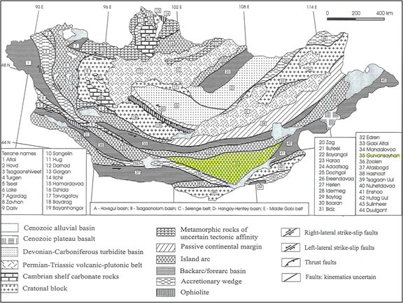
Carboniferous rocks indicate the continuation of volcanism after the Devonian, with development of a more continental back-arc basin (Lamb and Badarch, 2001) featuring subaerial intermediate to felsic volcanic centres. Uplift and unroofing of Devonian granitic rocks is indicated by the presence of coarse granitic boulders in cobble and boulder conglomerates.
Permian strata in southern Mongolia comprise fluvial depositional environments (Lamb and Badarch, 2001) in the south-west and marine turbidite flysch deposits in the south-east. Arc volcanism had ceased, but tectonic activity continued, with continental volcanism possibly related to the consolidation of Central Asia.
Mesozoic and Cenozoic lacustrine sedimentary basins are built on top of the accreted Paleozoic terranes (Hendrix et al., 2001). A mountain chain representing the final stage of Carboniferous-Permian accretion provided the source for Triassic to mid-Jurassic sedimentary rocks, confined to intermontane basins and foreland settings. Triassic rocks are generally conglomerates, coarse sandstones and felsic volcanics (Traynor and Sladen, 1995). The Late Cretaceous to Cenozoic clastic sedimentary rocks infilled older topography, during a time of compressional tectonics.
AMC 813001 : March : 2013
97
ENTRÉE GOLD INC Lookout Hill Property, Southern Mongolia Technical Report | |
Changing climatic conditions are indicated by the regional facies relationships established during accretion of Paleozoic terranes. Two transitions occur: 1) a shift from arid to humid setting in the mid-Permian, evidence for this being redbed sandstones representing well-drained soils and oxidizing conditions underlying Upper Permian coal-bearing strata; and 2) coal-bearing Upper Permian strata overlain by Lower Triassic sandstones, coinciding with the great extinction event at the Permian-Triassic boundary.
| 7.3 | Joint Venture Property |
| 7.3.1 | Hugo North Extension |
The Hugo North Extension Deposit occurs within a geological setting similar to that at Hugo North within the Oyu Tolgoi mining lease. Host rocks are an easterly-dipping sequence of volcanic strata correlated with the lower part of the Devonian Alagbayan Formation and quartz monzodiorite intrusive rocks. The geological setting was established through work completed prior to 2008 and is described in more detail in the March 2008 technical report (Vann et al., 2008). The host rocks descriptions below are taken from Blower (2006); note that in this report, the deposit was discussed under the former name of Copper Flats while the report in hand uses the current Hugo North Extension nomenclature and uses the Copper Flats name only for the exploration grid.
The Devonian stratified host rock sequence in the Hugo North Extension Deposit dips moderately (65° to 75°) to the east or south-east, except for a structurally-induced strike flexure in the southern part of the deposit, within which dips are southward.
These strata include the lower, strongly-altered augite basalt and dacite tuff sequence (units DA1 and DA2) overlain successively by weakly-altered, to unaltered dacitic volcanic conglomerate and breccia (unit DA2), mudstone and siltstone (unit DA3), and interstratified basaltic flows, breccias, and epiclastic rocks (unit DA4). The contact between units DA3 and DA4 is a bedding-parallel fault, and the original stratigraphic relationship between unit DA4 and the underlying units is uncertain. Figure 7.2 presents the current stratigraphic understanding for the Oyu Tolgoi deposits, including Hugo North Extension. Detailed descriptions of the rock units can be found in the March 2008 technical report (Vann et al., 2008). A geologic map of the southern portion of the property that is host to the Hugo North Extension Deposit is shown in Figure 7.3.
| 7.3.1.1 | Sedimentary and Volcanic Rocks |
Devonian Alagbayan Formation
The oldest rocks identified are correlated with the Upper Devonian Alagbayan Formation. Four major lithologic divisions are present within the Alagbayan Formation, and each of these divisions comprises two or more subunits that can be readily mapped. The two lower units are commonly strongly altered and form important mineralization hosts, while the upper two units, although pre- to syn-mineral in age, lack significant alteration, and mineralization.
AMC 813001 : March : 2013
98
ENTRÉE GOLD INC Lookout Hill Property, Southern Mongolia Technical Report | |
Unit DA1: Basaltic Flows and Volcaniclastic Rocks
The stratigraphically lowest rocks identified to date at Shivee Tolgoi consist of mafic volcanic flows and volcanogenic sedimentary rocks, forming a sequence at least several hundred of metres thick. These rocks are commonly strongly altered and host much of the contained copper-gold in the Hugo North Extension and Heruga deposits.
Unit DA2: Dacite Tuff – Volcaniclastic Rocks
Volcanic fragmental rocks of dacitic composition overlie the basaltic rocks of unit DA1. The dacite sequence can be up to 200 m thick and consists of two major divisions. Volumetrically dominant is buff to dark green, dacite lapilli tuff with common eutaxitic texture and ovoid to globular fragments. This subunit occurs in the lower part of the sequence and is usually overprinted by intense sericite and advanced argillic alteration. It is overlain by or partially interstratified with a thinner unit of typically unsorted, polymictic block tuff to breccia. This coarser subunit is usually less altered than the lapilli tuff and does not contain significant copper mineralization.
A zircon U/Pb date of 365 ± 4 Ma constrains the age of the dacite sequence to Upper Devonian (Wainwright et al., 2005).
| Figure 7.2 | Stratigraphic Column, Oyu Tolgoi Exploration Area |
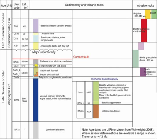
AMC 813001 : March : 2013
99
ENTRÉE GOLD INC Lookout Hill Property, Southern Mongolia Technical Report | |
| Figure 7.3 | Surface Geology Map Joint Venture Property Showing Hugo North Extension |
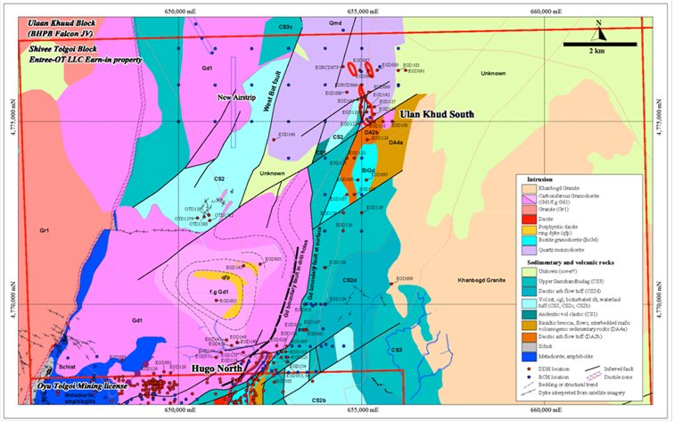
Figure from OT LLC Note: BHPB is no longer in joint venture on the Ulaan Khuud Block
AMC 813001 : March : 2013
100
ENTRÉE GOLD INC Lookout Hill Property, Southern Mongolia Technical Report | |
| 7.3.1.2 | Intrusive Rocks |
Intrusive rocks are widely distributed throughout the area and range from large batholithic intrusions to narrow discontinuous dykes and sills. At least seven classes of intrusive rocks can be defined on the basis of compositional and textural characteristics. Copper–gold porphyry mineralization is related to the oldest recognized intrusive suite, comprising large Devonian quartz monzodiorite intrusions. Many of the older intrusive units found on the property are strongly to intensely-altered (e.g. quartz monzodiorite suite), and the compositional classifications used for these units should therefore be considered only as field terms.
The post-mineral intrusions include rhyolitic, hornblende–biotite andesite, dacite, and basalt–dolerite compositional varieties. These intrusions usually occur as dykes with subvertical orientations or less commonly as easterly-dipping sills emplaced along stratigraphic contacts. They are non-mineralized and not volumetrically significant in most of the deposit.
Biotite Granodiorite
Late- to post-mineral biotite granodiorite intrusions form a voluminous northerly-striking dyke system along the western side of the Hugo North Extension Deposit and more-restricted dykes and sills elsewhere. The intrusions are compositionally and texturally varied and probably include several intrusive phases. Typically, they contain large plagioclase phenocrysts with lesser small biotite phenocrysts, within a fine-grained to aphanitic brown groundmass. The age of the biotite granodiorite is constrained by U/Pb dating of zircon to 362 ± 4 Ma (Wainwright et al., 2005).
At levels above approximately 250 m, where it cuts through the non-mineralized hanging wall strata, the biotite granodiorite occurs as a single intrusive mass with contacts dipping moderately to steeply to the west. Below this level, the biotite granodiorite is more complex, occurring as multiple, subparallel to anastomozing dykes that cut through the quartz monzodiorite intrusion and mineralized Alagbayan Formation strata.
The biotite granodiorite intrusions locally contain elevated copper grades adjacent to intrusive contacts or associated with xenolithic zones; however, they are essentially non-mineralized.
Quartz Monzodiorite
Porphyry-style mineralization at the Hugo North Extension and Oyu Tolgoi deposits is genetically linked to Late Devonian quartz monzodiorite to monzodiorite intrusions, which form the most voluminous intrusions in the deposit area. These intrusions are texturally and compositionally varied, and several distinct phases can be distinguished within the deposits. They are typically phenocryst-crowded, with >40% plagioclase phenocrysts up to 5 mm long, and 10% to 15% biotite and hornblende. The crystallization age of quartz monzodiorite has been interpreted at 372 ± 2 Ma (Wainwright, 2008).
AMC 813001 : March : 2013
101
ENTRÉE GOLD INC Lookout Hill Property, Southern Mongolia Technical Report | |
Quartz monzodiorite contacts are irregular, but overall show a preferred easterly dip, subparallel to stratification in the enclosing rocks. The quartz monzodiorite is contemporaneous with alteration and mineralization, and several varieties are distinguished on the basis of alteration characteristics and position within the deposit: an intensely quartz-veined phase; a gold-rich phase, restricted to the western part of the main intrusion in the Hugo North Extension Deposit; and the main intrusive body, which typically has lower vein density and lower copper and gold grades. Cross-cutting relationships between the different phases are ambiguous, and it is uncertain whether they represent a temporally distinct intrusive events or simply variations in alteration intensity related to position within the deposit.
| 7.3.1.3 | Structural Geology |
The area of the Shivee ML north of Oyu Tolgoi is underlain by complex networks of faults, folds, and shear zones. Most of these structures are poorly exposed on surface and can only be defined through integration of detailed exploration data (primarily drillhole data), property-scale geological mapping, and geophysical data. OT LLC has made extensive use of oriented core drilling, and the structural data collected has been invaluable in helping determine the subsurface morphology and structural history of both the Oyu Tolgoi deposits and the Hugo North Extension Deposit. Major structures strongly influence the distribution of mineralization by both controlling the original position and form of mineralized bodies, and modifying them during post-mineral deformation events.
The Hugo North Extension Deposit occurs within moderately east dipping (65° to 75°) strata contained in a north-north-easterly-elongate fault-bounded block. The deposit is cut by several north-east-striking faults and fault splays near the boundary with Oyu Tolgoi. Other than these north-easterly faults, the structural geometry and deformation history of the Hugo North Extension Deposit is similar to that of the Hugo North Deposit.
Deformation of the Hugo North Extension Deposit is dominated by brittle faulting. Major faults cutting the deposit can be grouped on the basis of orientation into three sets: steep north-north-east-striking faults (West Bat); north-north-east-striking, moderate to steeply east-dipping faults subparallel to lithologic contacts (Contact Fault); and the east-north-east-striking faults cutting across the strike of the deposit (Boundary Fault System).
| 7.3.1.4 | Mineralization – Hugo North Extension |
Information on the mineralization at Hugo North Extension is taken from Juras (2005), Cherrywell (2005) and Forster (2006). An interpreted section, at 4768300N, is included as Figure 7.4. Mineralization and alteration distributions for the same section is shown Figure 7.5.
Grade Distribution
The highest-grade copper mineralization in the Hugo North Extension Deposit is related to a zone of intense stockwork to sheeted quartz veins that typically grades over 2% Cu. The high-grade zone is centred either on thin, east-dipping quartz monzodiorite intrusions or within the upper part of the large quartz monzodiorite body, and extends into the adjacent basalt country rocks (unit DA1) in the southern part of the deposit. In addition, moderate- to high-grade copper and gold values occur within quartz monzodiorite below and to the west of the intensely veined zone. This zone is distinct in its low Cu (%) to Au (ppm) ratios (2:1 to 4:1).
AMC 813001 : March : 2013
102
ENTRÉE GOLD INC Lookout Hill Property, Southern Mongolia Technical Report | |
Elevated gold grades in the Hugo North Extension Deposit occur within the up-dip (western) portion of the intensely veined, high-grade core, and within a steeply-dipping lower zone cutting through the western part of the quartz monzodiorite. Quartz monzodiorite in the lower zone exhibits a characteristic pink to buff colour, with a moderate intensity of quartz veining (25% by volume). This zone is characterized by finely disseminated bornite and chalcopyrite, although in hand specimen the chalcopyrite is usually not visible. The sulphides are disseminated throughout the rock in the matrix as well as in quartz veins. The fine-grained sulphide gives the rocks a black “sooty” appearance. The red coloration is attributed to fine hematite dusting, mainly associated with albite.
The eastern limit of the high-grade zone coincides with either an intrusive or faulted eastern contact of the quartz monzodiorite. The peripheral low-grade zone to the east is contained mainly in augite-phyric basalt (unit DA1) and to a lesser extent in dacite tuff (unit DA2b).
Alteration and mineralization intensity drops abruptly at the upper contact of this package. To the west, the high grade zone is bounded by the Boundary/West Bat Fault system and related splays, which juxtapose it against either unmineralized stratigraphically-higher rocks or more weakly mineralized quartz monzodiorite bodies.
Mineral and Geochemical Zonation
Bornite is dominant in highest-grade parts of the deposit (3% to 5% Cu) and is zoned outward to chalcopyrite (2% Cu). At grades of less than 1% Cu, chalcopyrite ± enargite, tennantite, bornite (rare chalcocite, pyrite and covellite) occur. The high-grade bornite zone comprises relatively coarse bornite impregnating quartz and as disseminations in wall rocks, usually intergrown with subordinate chalcopyrite. Pyrite is rare or absent, except in local areas where the host rocks display advanced argillic alteration. In addition, high-grade bornite is associated with minor amounts of tennantite, sphalerite, hessite, clausthalite, and gold. These minerals occur as inclusions or at grain boundaries.
Alteration Zonation
The Hugo North Extension Deposit is characterized by copper–gold porphyry and related styles of alteration which are analogous to the description appended below for the adjacent Hugo North Deposit.
Alteration at Hugo North includes biotite–K-feldspar (K-silicate), magnetite, chlorite–muscovite–illite, albite, chlorite–illite–hematite–kaolinite (intermediate argillic), quartz–alunite–pyrophyllite–kaolinite–diaspore–zunyite–topaz–dickite (advanced argillic), and sericite–muscovite zones (Juras, 2005).
AMC 813001 : March : 2013
103
ENTRÉE GOLD INC Lookout Hill Property, Southern Mongolia Technical Report | |
| Figure 7.4 | Geological Interpretation Showing Assay Histograms, Section N4768300, Looking North |
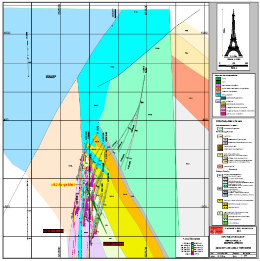
Figure from OT LLC
AMC 813001 : March : 2013
104
ENTRÉE GOLD INC Lookout Hill Property, Southern Mongolia Technical Report | |
| Figure 7.5 | Geology and Mineralization Section N4768300, Looking North |
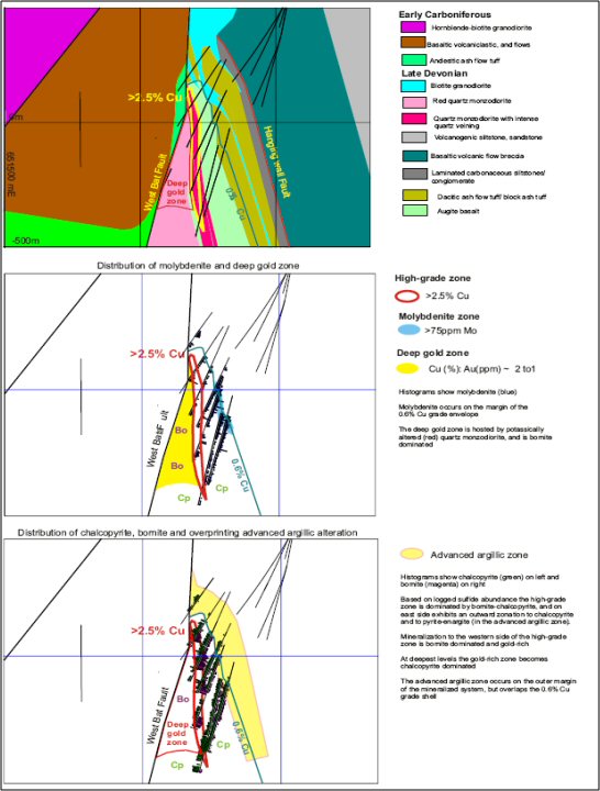
Figure from OT LLC
AMC 813001 : March : 2013
105
ENTRÉE GOLD INC Lookout Hill Property, Southern Mongolia Technical Report | |
Chlorite–illite marks the outer boundary of the advanced argillic zone. It occurs mainly in the coarser, upper part of the dacite tuff.
Quartz–pyrophyllite–kaolinite–dickite (advanced argillic) is hosted mainly in the lower part of the dacite tuff, although on some sections at Hugo North it extends into strongly veined quartz monzodiorite. The advanced argillic zone is typically buff or grey, and late dickite on fractures is ubiquitous. Within the advanced argillic zone, a massive quartz–alunite zone forms a pink–brown bedding-parallel lens.
Topaz is widespread as late alteration, controlled by structures cutting both the advanced and intermediate argillic zone. Topaz appears to replace parts of the quartz–alunite zone. In addition topaz may also occur as disseminations with quartz–pyrophyllite–kaolinite alteration. Topaz-rich zones are mottled buff or light brown and sometimes vuggy.
Hematite–siderite–illite–pyrophyllite–kaolinite–dickite (intermediate argillic) alteration is an inward zonation from the advanced argillic zone, and is commonly hosted by augite basalt but may also occur in dacite ash-flow tuff. Hematite usually comprises fine specularite and may be derived from early-stage magnetite or Fe-rich minerals such as biotite or chlorite.
Hematite–chlorite–illite–(biotite–magnetite) (chlorite) is transitional to the intermediate argillic zone and is commonly hosted by augite basalt. It is characterized by a greenish coloration, and relict hydrothermal magnetite, either disseminated or in veins.
Muscovite–illite (sericite) generally occurs in the quartz monzodiorite intrusions and is a feature of the strongly mineralized zone. Alteration decreases with depth in the quartz monzodiorite.
At Hugo North Extension, the distribution of the alteration is strongly lithologically controlled: dacite tuff typically shows strong advanced argillic alteration, whereas basalt tends to be chlorite–muscovite–hematite-altered with pyrophyllitic advanced argillic alteration in its uppermost parts. Pockets of advanced argillic alteration occur locally in the high-grade zone in the quartz monzodiorites.
| 7.3.2 | Ulaan Khud Prospect |
The geology of this area was established prior in 2006 through sterilization drilling of possible airport locations and is described in detail in Vann et al. (2008). The Ulaan Khud Prospect is 8 km to the north of Hugo North Extension and comprises a narrow, steeply-dipping zone of copper-gold porphyry mineralization. The zone is 30 to 50 m wide and averages less than 0.3% Cu. The best intervals from the is area were 18 m of 0.30% Cu and 1.01 g/t Au from 114 m (EGD132) and 34 m of 1.08% Cu and 0.45 g/t Au from 668 m (EGD127).
AMC 813001 : March : 2013
106
ENTRÉE GOLD INC Lookout Hill Property, Southern Mongolia Technical Report | |
| 7.3.3 | Heruga Deposit |
Outcrop is generally sparse on Javhlant ML and much of the known geology is extrapolated from more detailed geology available on Oyu Tolgoi to the north, on geophysical interpretation (IP and detailed magnetics), and on drill core where available. The geology of Oyu Tolgoi has been described in detail by Blower (2006) and by Cinits and Parker (2007). A map of the deposit area is shown in Figure 7.6.
| Figure 7.6 | Geological Plan of Heruga Deposit Area (Legend as in Figure 7.2) |
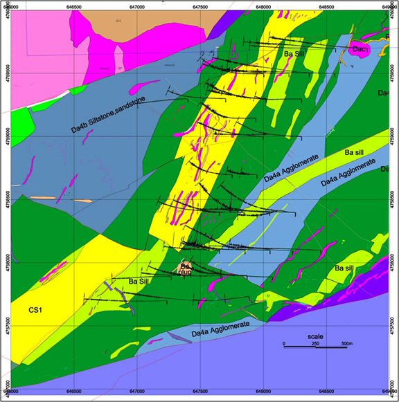
Figure from OT LLC
AMC 813001 : March : 2013
107
ENTRÉE GOLD INC Lookout Hill Property, Southern Mongolia Technical Report | |
Parts of the following sections are summarized and paraphrased from unpublished texts by Peter Lewis (Lewis Geoscience Services Inc.) and David Crane (Senior Geologist for OT LLC). Review of core and geological interpretations on site by QG indicated that the present understanding of geology is reasonable given the generally wide drill spacing.
| 7.3.3.1 | Host Rocks |
Most of the stratigraphic sequence in the Heruga deposit is interpreted to be equivalent to that documented in the Southern Oyu Tolgoi and Hugo Dummett deposits (Figure 7.7). There are; however, several stratigraphic relationships preserved at Heruga that led Lewis (2008) to propose a revised stratigraphic column – specifically to the sequence immediately overlying the Devonian unconformity.
Devonian Sedimentary and Volcanic Rocks
Based on relationships observed in core at both the Heruga and more northerly Oyu Tolgoi deposits, Lewis (2008) divides unit DA2 into three subunits:
| · | DA2b1 and DA2b2 represent pyroclastic deposits of dacitic composition, corresponding to lithotypes traditionally referred to as “dacitic block & ash tuff” and “dacitic ash flow tuff” respectively. In most areas DA2b1 occurs lower in section and these two units are distinguished from each other by clast size, and by the common occurrence of large, quartz-phyric juvenile clasts in DA2b1. |
| · | Unit DA2a is reserved by Lewis (2008) for the polylithic volcanic conglomerates lacking a pyroclastic component. Drillholes containing all three subunits of the DA2 sequence are rare, and any of the three may directly overlie the Devonian unconformity. In drillholes where the stratigraphic relationships between these divisions are preserved, unit DA2a occurs below the pyroclastic rocks of unit DA2b. |
Lewis (2008) also proposes a new unit in the Alagbayan Formation, “Unit DAba”. Drillhole EJD-0012 at Heruga intersects a thick sequence of basaltic to andesitic volcaniclastic rocks consisting of breccia to conglomerate with pebble to cobble-sized fragments. Monolithologic blocky breccias representing flow-banded lavas or subvolcanic intrusions occur locally in this sequence. To date, drillholes at Heruga have only intersected this unit on the west side of the Bor Tolgoi Fault. Otherwise the stratigraphy is as described previously.
| 7.3.3.2 | Intrusives |
Biotite Granodiorite
Biotite granodiorite at Heruga intrudes Devonian rocks as it does throughout the Oyu Tolgoi region. According to Forster et al. (2008) it occurs only below the unconformity at Heruga, where it commonly forms sills intruding along bedding-parallel structures near the Contact Fault. It also occurs less commonly as subvertical dykes.
AMC 813001 : March : 2013
108
ENTRÉE GOLD INC Lookout Hill Property, Southern Mongolia Technical Report | |
| Figure 7.7 | Detailed Stratigraphy for Heruga SW and Javhlant areas |
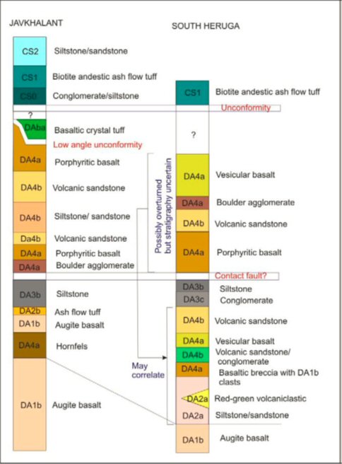
AMC 813001 : March : 2013
109
ENTRÉE GOLD INC Lookout Hill Property, Southern Mongolia Technical Report | |
Quartz Monzodiorite
Quartz monzodiorite at Heruga is similar to that at the Southern Oyu Tolgoi and Hugo Dummett deposits. The quartz monzodiorite at Heruga is relatively fine grained and may possibly be present at two distinct phases (one mineralized and one unmineralized). Much of the higher grade portion of the deposit is localized adjacent to contacts of the mineralized quartz monzodiorite intrusion. The interpretation of Lewis (2008) shows clearly that this intrusion is nearly confined to a single section at current drill spacing, indicating that its contacts are nearly section parallel.
Andesite and Dacite Dykes
Post-mineralization porphyritic hornblende-biotite dykes of andesitic to dacitic composition are widespread at Heruga and strike north to north-east, dipping steeply. Forster et al. (2008) report that these dykes are similar to those dated as Carboniferous in the Oyu Tolgoi deposits.
Basalt and Rhyolite Dykes
Fine grained basaltic dyke, interpreted as often intruding both steep and low-angle structures (Forster et al. 2008) are common at Heruga. These dykes also post-date mineralization and are interpreted as coeval with similar dykes assumed to be Carboniferous in the Oyu Tolgoi deposits. Rhyolite dykes are relatively uncommon. Forster et al. (2008) note that some dolerite dykes of possibly Mesozoic age are encountered at Heruga.
| 7.3.3.3 | Structural Geology |
Heruga lies at the southern end of a north-northeasterly trend of porphyry style deposits, extending to Shivee Tolgoi (Hugo North Extension) in the north. Forster et al. (2008) postulate that this alignment reflects deep crustal structure, exploited by Late Devonian magmatism and mineralizing systems.
The interpretation of Lewis (2008) shows Heruga cut by several major brittle fault systems, partitioning the deposit into discrete structural blocks. Internally, these blocks appear relatively undeformed, and consist of south-east-dipping volcanic and volcaniclastic sequences. The stratiform rocks are intruded by quartz monzodiorite stocks and dykes that are probably broadly contemporaneous with mineralization, as well as subvertical hornblende-biotite andesite dyke swarms discussed in the preceding section of this report.
The deposit-scale faults identified at Heruga displace mineralized zones, with mineralization and alteration zones apparently not localized by the faults, implying they post-date mineralization. Lewis (2008) concludes that it is likely the Heruga porphyry formed within a relatively intact structural block, with most faulting and disruption of contacts related to post-mineralization deformation.
AMC 813001 : March : 2013
110
ENTRÉE GOLD INC Lookout Hill Property, Southern Mongolia Technical Report | |
Contact Fault
As at Oyu Tolgoi, volcaniclastic strata of unit DA4 are structurally juxtaposed over the Heruga deposit along a major, southeast-dipping fault zone. Lewis (2008) describes this fault being “… almost certainly the southerly extension of…” the Contact Fault at the Hugo Dummett and Southern Oyu deposits.
The Contact Fault at Heruga varies from tens of centimetres to 40 m in thickness, and has an average orientation striking 110° and dipping 45° east-south-east. Lewis (2008) also reports that kinematic indicators such as shear bands and drag folds record up-dip (thrust) displacement.
In the northern part of the deposit, facing direction reversals and repetition of stratigraphic units define a large-scale recumbent anticline in the hangingwall sequence to the Contact Fault. Although the magnitude of displacement on the Contact Fault is poorly constrained, the scale of the overturned folds in the hangingwall, vertical stacking of dissimilar stratigraphic sequences, and the fault continuity throughout the Oyu Tolgoi area all suggest that displacement of kilometres to tens of kilometres is probable.
East-Northeast Striking Bounding Faults
The Heruga deposit area lies between two regional, north-east-striking faults that form prominent features on both magnetic and satellite images. The northern (unnamed) fault crosses the deposit trend approximately 300 m north of the northernmost drillholes at the time of writing. Lewis (2008) reports that this fault is not directly exposed nor has it been intersected in drillholes. In consequence, neither its dip direction nor its kinematic history are well constrained.
The southern bounding fault (‘South Sparrow Fault”) crosses the deposit trend approximately 250 m south of the southern most drillhole at the time of writing (EJD-0019). One drillhole has been completed in the Heruga area south of this fault (EJD-0016) which intersected a thick sequence of weakly-altered to unaltered volcaniclastic rocks of probable Carboniferous age, suggesting south side down apparent off-set.
Bor Tolgoi Fault System
Lewis (2008) divides the Heruga deposit into four discrete structural blocks by subvertical, north-north-east-striking faults he refers to as the “Bor Tolgoi Fault System”. These faults occur in drill core as intervals of breccia and gouge, and also reportedly form subtle linear anomalies on ground magnetic images.
In east-west sections, both the West Bor Tolgoi Fault and the better constrained Bor Tolgoi Fault display between 300 m and 500 m west-side-down apparent offset of stratigraphic contacts (Lewis, 2008). Kinematic indicators have not been observed in either fault, and consequently the true slip direction and magnitude are unconstrained.
AMC 813001 : March : 2013
111
ENTRÉE GOLD INC Lookout Hill Property, Southern Mongolia Technical Report | |
Lewis (2008) interprets fault movement as dominantly strike-slip.
Southern Fault
The Southern Fault is an interpreted steep, west-north-west-striking structure that cuts across the southern end of the Heruga deposit. Although multiple interpretations are possible, Lewis (2008) concludes that the simplest fault geometry compatible with the apparent offsets of contacts in these drillholes requires only a single section-parallel fault. Surface maps show an interpreted fault roughly coincident with the interpreted structure, and the fault trace also coincides with a weak linear magnetic feature. Typical cross-sections of geology and mineralization are shown in Figure 7.8 to Figure 7.10.
| Figure 7.8 | Heruga Deposit Area Section N4759300 |
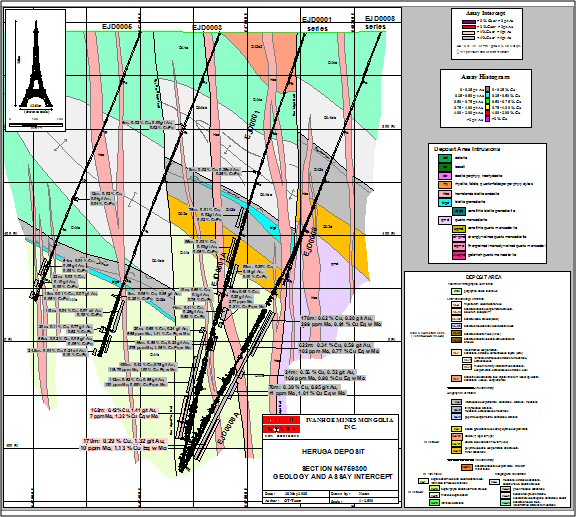
AMC 813001 : March : 2013
112
ENTRÉE GOLD INC Lookout Hill Property, Southern Mongolia Technical Report | |
| Figure 7.9 | Heruga Deposit Area Section N4758400 |
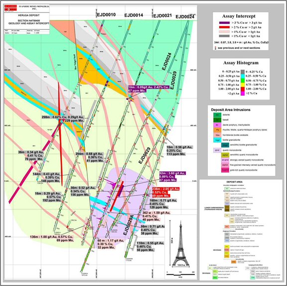
AMC 813001 : March : 2013
113
ENTRÉE GOLD INC Lookout Hill Property, Southern Mongolia Technical Report | |
| Figure 7.10 | Heruga Deposit Area Section N4759500 |
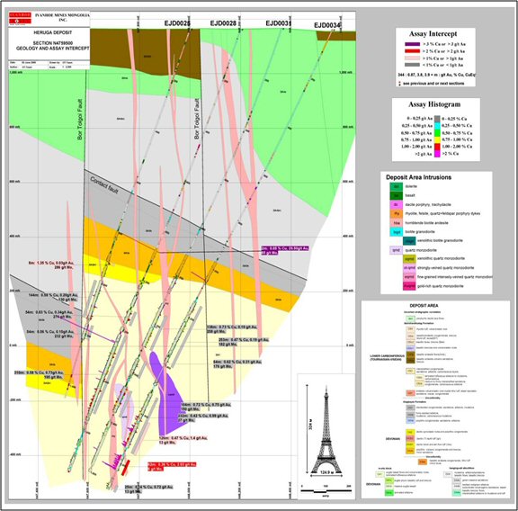
AMC 813001 : March : 2013
114
ENTRÉE GOLD INC Lookout Hill Property, Southern Mongolia Technical Report | |
| 7.3.4 | Mineralization - Heruga |
The following mineralization summaries are sourced from Panteleyev (2004a; 2004b; 2005), Juras (2005), Cherrywell (2005), Forster (2006), Forster and Crane (2006), Khashgerel et al. (2006), Forster et al. (2008), Watkins (2007) and Lewis (2008).
Parts of the following sections are summarized and paraphrased from unpublished texts by Peter Lewis (Lewis Geoscience Services Inc.) and David Crane (former Exploration Manager for OT LLC). Lewis (2008) concludes that it is likely the Heruga porphyry formed within a relatively intact structural block, with most faulting and disruption of contacts related to post-mineral deformation. Forster et al. (2008) note that the mineralization style most closely accords with that at Southwest Oyu Tolgoi, but that the system has lower quartz vein content.
The Heruga deposit is a Cu, Au, Mo porphyry deposit with overlapping zones of mineralization consisting of a Mo-rich carapace at higher elevation with increasing Au-rich mineralization at depth. Copper-rich mineralization occurs at intermediate elevations and overlaps both the Mo rich and Au rich zones. At a 100 ppm Mo cut-off the Mo zone has a vertical extent of 300 to 400 m. At a 0.3% Cu cut-off the top of the copper zone roughly correlates with the top of the Mo zone but extends to deeper depths, for a total vertical extent in the order of 600 m. At a 0.3 g/t cut-off the top of the gold zone is generally about 280 m below the top off the Cu and Mo zones, creating a small overlap with the Mo zone in areas, and a more significant overlap of the Cu zone. The bottom of the gold zone generally extends below the bottom of the Cu zone by about 200 m, giving the gold zone a total vertical extent of about 450 m. The three zones together combine for a continuous zone of mineralization with a vertical extent of close to 800 m. Post mineral north-north-east trending subvertical faults have offset mineralization into two discrete structural blocks. Mineralization remains open down dip to the east of the eastern block although trending towards lower grades in that direction. The western block is assumed to terminate against a parallel north-north-east trending structure, intersected at higher elevations in only a few drillholes, and remains poorly defined at the depth of the deposit. The high grade gold core in the western block remains poorly defined and requires further definition.
There is a rough spatial correlation between metal and alteration zonation and the two may be genetically linked. Generally speaking at deeper levels mineralization consists of chalcopyrite and pyrite in veins and disseminated within biotite-chlorite-albite-actinolite altered basalt or sericite-albite altered quartz monzodiorite. Selvages of salmon pink albite alteration occur with chalcopyrite associated with higher grade mineralization in both basalt and quartz monzodiorite. The higher levels of the orebody are overprinted by strong quartz-sericite-tourmaline-pyrite alteration where mineralization consists of disseminated and vein controlled pyrite, chalcopyrite, and molybdenite.
Gold may correlate with strong biotite alteration at the deeper levels of the deposit. Au:Cu ratios (ppm:%) are generally less than one throughout the upper Mo-rich part of the deposit, i.e. within the >100 ppm Mo shell. Below this, the gold to copper ratios reflect an inverse relationship between Au and Cu.
AMC 813001 : March : 2013
115
ENTRÉE GOLD INC Lookout Hill Property, Southern Mongolia Technical Report | |
The Au to Cu ratio increases rapidly with depth from one to greater than 10, reflecting decreasing copper grades and increasing gold grades. In the deepest parts of the deposit chalcopyrite diminishes to only trace amounts, and is replaced by pyrite as the predominant sulfide. This would suggest that Au does not correlate with chalcopyrite, but is perhaps associated with pyrite at the deepest levels. East of the Bor Tolgoi Fault high AIMCO values occur within and marginal to a quartz monzodiorite intrusion. However, west of the Bor Tolgoi Fault, a small quartz monzodiorite dyke was intersected in only one drillhole and a possible association is less apparent.
A paragenetic framework suggested by Hopper (2008) is simplified as follows:
| · | Pre to early mineral alteration facies predating intrusion of Qmd (dark coloured alteration). |
| · | Early pervasive biotite magnetite actinolite alteration with quartz magnetite-chalcopyrite-pyrite. |
| · | Retrograde chlorite-epidote-sericite. |
| · | Intermineral alteration facies. |
| · | Quartz-magnetite-chalcopyrite-bornite-pyrite-molybdenite and associated quartz-albite, biotite, actinolite alteration. |
| · | Inter to late mineral alteration facies (light coloured alteration). |
| · | Pyrite sericite pyrophyllite alteration (molybdenite shell seems to coincide with this stage). |
| · | Post Mineral. |
| · | Quartz-calcite veinlets. |
Mineralized veins have a much lower density at Heruga than in the more northerly Southern Oyu and Hugo Dummett deposits. Lewis (2008) reports that some quartz veins show a weak preferred orientation, but in general most occur as stockworks with no visible preferred orientation.
High grade copper and gold intersections show a strong spatial association with contacts of the mineralized quartz monzodiorite porphyry intrusion in the southern part of the deposit, occurring both within the outer portion of the intrusion and in adjacent enclosing basaltic country rock.
| 7.4 | Shivee West (100% Entree) |
The bedrock geology of the Shivee Tolgoi Licence comprises volcanic and sedimentary rocks intruded by batholiths, plutons and dykes of varying ages.
| 7.4.1 | Geology and Structural Setting |
Volcanic mapping on Shivee West uses descriptive names based on field observations of rock composition, modified from McPhie et. al. (1993):
AMC 813001 : March : 2013
116
ENTRÉE GOLD INC Lookout Hill Property, Southern Mongolia Technical Report | |
| · | Rhyolite: K-feldspar ± quartz (±Ca-poor plagioclase ± <5% ferromagnesian phase) |
| · | Dacite: plagioclase ± 5-10% ferromagnesian phase ± quartz (± K-feldspar) |
| · | Andesite: plagioclase + ferromagnesian phase: amphibole > pyroxene ± biotite (± olivine) |
| · | Basaltic andesite: plagioclase + pyroxene > amphibole (± olivine) |
| · | Basalt: pyroxene + Ca-rich plagioclase ± olivine |
The bedrock geology of the Shivee Tolgoi ML comprises Devonian and Carboniferous volcanic and sedimentary rocks intruded by batholiths, plutons and dykes of Carboniferous age.
Mapping at 1:10,000 scale (Panteleyev 2004, 2005, 2006, 2007, 2008, 2010, 2011) established a number of volcanic and sedimentary units (see Figure 7.11 and Table 7.1) Some of these are equivalent to Oyu Tolgoi logging and mapping units, allowing correlation of the latter over a large area outside the confines of the Oyu Tolgoi ML and the Joint Venture property.
The following stratigraphic and intrusive sequence has been established at Oyu Tolgoi (see also Figure 7.2 and Figure 7.7 for individual OT mapping and core logging units):
| · | A volcanic and sedimentary assemblage assigned to the Devonian Alagbayan Formation ("DA" units), intruded by late Devonian quartz monzonite plutons and dykes; |
| · | A volcanic and sedimentary assemblage assigned to the Carboniferous Sainshandhudag Formation ("CS" units), intruded by granodiorites, quartz monzonites and dykes of Carboniferous age; |
| · | The Permian-aged Khan Bogd riebeckite complex; and |
| · | Cretaceous terrestrial sedimentary rocks overlying the foregoing assemblages. |
Based on lithological, chemical and stratigraphic similarities, some of the Devonian and Carboniferous units at Oyu Tolgoi have been correlated with a number of mapping units at Shivee West. Khan Bogd intrusives are not known to occur on Shivee West.
| 7.4.2 | Geology of the Devonian Corridor |
Devonian and Carboniferous sedimentary and volcanic rocks form a north-northeast-trending belt (informally known as the "Devonian Corridor"), underlying the western portion of Shivee Tolgoi ML. The corridor is bounded on the east and west by Carboniferous-aged granitic plutons (Figure 7.11).
Two drainages, Tom Gol (River) and a tributary of Umdai Gol, conveniently divide the Devonian Corridor into three geomorphic areas. These areas are also distinguished by the dominant bedrock lithologies: 1) the northern area comprises Devonian volcanics and volcaniclastics and lower to upper Carboniferous volcanics; 2) the central area is dominated by Devonian clastic sedimentary rocks with middle Carboniferous volcanics to the east; and 3) the southern area is underlain by middle Carboniferous volcanics.
AMC 813001 : March : 2013
117
ENTRÉE GOLD INC Lookout Hill Property, Southern Mongolia Technical Report | |
| 7.4.2.1 | Devonian Stratigraphy |
Devonian lithologies on Shivee West have been assigned that age based on their lithological and geochemical similarities to the dated Devonian sequence at Oyu Tolgoi. As well, U-Pb age determinations of detrital zircons from two samples (AP unit D1 on surface and D1 greywacke from core hole EG-05-029) taken by Panteleyev, 2006, see also Mortensen, 2006) are consistent with a Devonian age. The sample from EG-05-029 underlies Carboniferous lithologies that crop out on surface.
Most of the Shivee West Devonian rocks are fine-grained clastic sedimentary lithologies which are correlated with OT Unit DA4b. Overlying and intercalated with these are basaltic volcanics and volcaniclastics.
| · | Unit DA4s (Devonian Alagbayan Formation - sedimentary rocks correlated with OT Unit DA4b). Devonian rocks in the corridor are primarily north-north-east-striking fine-grained to medium-grained clastic sedimentary lithologies (siltstone, sandstone, pebble conglomerates) designated as DA4s. The conglomerates are fine-grained, heterolithic, and clast-supported. Maximum pebble size rarely exceeds 2 cm. Occasionally, vague to well-developed bedding is observed. DA4s rocks are very dark green to greenish-black or maroon, and well indurated. Bedding is locally very well developed on millimetric to centimetric scales in siltstones and, to a lesser extent, sandstones, but often is obscured by recrystallization and alteration, particularly in siltstone layers. Siltstones can be preferentially altered by pervasive replacement by albite and epidote. DA4s rocks are interpreted to be deposits resulting from deep water turbidity currents. |
| · | Unit DA4v (Devonian Alagbayan Formation - volcaniclastic rocks). These are mostly sparsely feldspar-porphyritic basaltic to andesitic lapilli tuffs found as narrow horizons within DA4s. |
| · | Unit DA4a (Devonian Alagbayan Formation - coherent volcanic rocks + derived autoclastic and hyaloclastite breccias correlated with OT Unit DA4a). This unit comprises thin flows or sills of porphyritic augite basalt, flow breccias and hyaloclastite. Presence of amygdules distinguishes this from OT Unit DA1b augite basalts. DA4a usually occurs as thin intercalated flows in DA4s. A basaltic sample collected by Panteleyev (2007) has a whole rock signature, which is the same as that for OT Unit DA4a. |
| · | Unit DA3c (Devonian Alagbayan Formation - carbonaceous sedimentary rocks tentatively correlated with OT Unit DA3b). DA3c has not been observed as outcrop but has been logged in drill core from deep holes testing the Tom Bogd IP target. DA3c rocks are clastic carbonaceous siltstones, sandstones and conglomerates. They may be equivalents of OT Unit DA3b, although the latter is usually very well laminated. |
AMC 813001 : March : 2013
118
ENTRÉE GOLD INC Lookout Hill Property, Southern Mongolia Technical Report | |
| · | Unit DA1b (Devonian Alagbayan Formation - coherent volcanic rocks + derived autoclastic rocks correlated with OT unit DA1b). These are augite-phenocrystic basalt flows and flow breccias, generally lacking amygdules. A whole rock analysis done by Alan Wainwright and reported in Panteleyev (2007) showed that a pyroxene-bearing basalt west of Zone III had a geochemical signature that was the same as that for OT Unit DA1b. Panteleyev (2007) reported that three additional samples, one at the Wainwright site and two other pyroxene-bearing basalts, also had DA1b chemical signatures. Whole rock sampling in 2010 and 2011 also confirmed their presence. At Shivee West; however, they are found stratigraphically above DA4a sedimentary rocks. |
| · | Unit DA1v (Devonian Alagbayan Formation - volcaniclastic rocks tentatively correlated with OT unit DAba). Based on the presence of fiamme in heterolithic lapilli-tuff and juxtaposition with DA1b basalts, this unit is interpreted as an equivalent of OT unit DAba. It has only been recognized on the western side of the Devonian Corridor north of Tom Gol. |
AMC 813001 : March : 2013
119
ENTRÉE GOLD INC Lookout Hill Property, Southern Mongolia Technical Report | |
| Figure 7.11 | Geology of the Devonian Corridor, Shivee West Property |
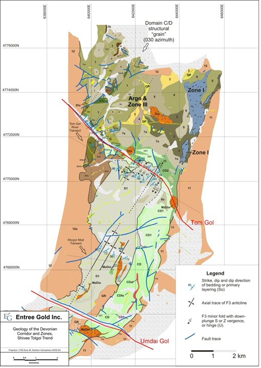
AMC 813001 : March : 2013
120
ENTRÉE GOLD INC Lookout Hill Property, Southern Mongolia Technical Report | |
| Table 7.1 | Legend for Figure 7.11 (after Panteleyev, 2005, 2006, 2007, 2008, 2010, 2011) |
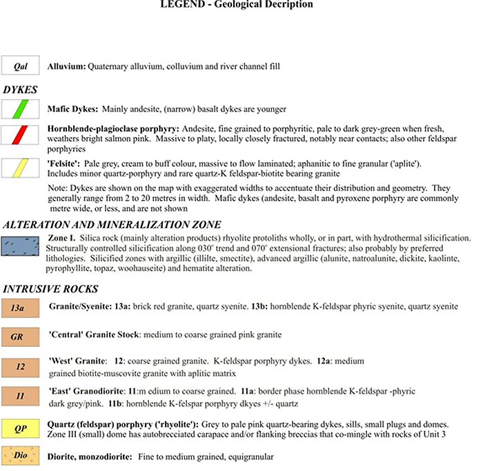
AMC 813001 : March : 2013
121
ENTRÉE GOLD INC Lookout Hill Property, Southern Mongolia Technical Report | |
AMC 813001 : March : 2013
122
ENTRÉE GOLD INC Lookout Hill Property, Southern Mongolia Technical Report | |
AMC 813001 : March : 2013
123
ENTRÉE GOLD INC Lookout Hill Property, Southern Mongolia Technical Report | |
| 7.4.2.2 | Carboniferous Stratigraphy |
Overlying the Devonian stratigraphy unconformably are Carboniferous mafic to felsic volcanic rocks and derived sedimentary rocks. The Carboniferous volcanics are generally north-striking, feldspar-porphyritic intermediate to felsic volcaniclastic rocks, with maroon to pale green colours. Volcaniclastic rocks (in large part pyroclastic flow deposits) are usually heterolithic, poorly sorted to unsorted, with vague bedding; occasionally very well laminated base surge tuffs can be observed. Welded textures (fiamme, rheomorphic flow folding) are common.
The Carboniferous stratigraphy can be subdivided into a number of mapping units, based on common characteristics (phenocryst abundance, and composition, presence of flow banding, and magnetics). In his 1:10,000 mapping, Panteleyev recognized lower, middle and upper volcanic assemblages (Table 7.1). His mapping units have been rationalized and simplified in 2012 to correlate geologic units over several mapping areas, and to reconcile surface geology with drillhole geology.
The first four mapping units described below comprise the lower volcanic/sedimentary assemblage.
| · | Unit CS1. The lowermost volcanic assemblage, CS1, is dominated by feldspar-phyric basaltic to andesitic volcaniclastics (CS1v), basaltic to andesitic flows (CS1f), and intercalated sedimentary rocks (CS1s). Not seen in outcrop but present in drill core are carbonaceous clastic sedimentary rocks (CS1c). CS1 lithologies unconformably overlie the Devonian rocks of the Devonian Corridor - and may have undergone a deformation event prior to the deposition of succeeding Carboniferous units, such that the next four mapping units may constitute a separate "lower to middle" volcanic assemblage. |
| · | Unit CS2. The CS2 volcanic assemblage is a bedded sequence of andesitic lithic tuffs (CS2v), volcaniclastic sandstone (CS2s), and thin amygdaloidal and vesicular basaltic flows (CS2f). These rocks crop out primarily to the north of the Tom Gol. |
| · | Unit CS3. CS3 rocks are felsic (dacite to rhyolite) volcaniclastic rocks (CS3v). There may be intercalated massive to autobrecciated flows. Most CS3 rocks are obviously quartz-bearing with quartz phenocrysts - the massive "flows" are highly siliceous but lack quartz phenocrysts, and may be subvolcanic intrusives. Occasionally, welding (CS3w) can be observed. Hyaloclastite (CS3v-5hxbx) is present, especially noted in reverse-circulation drillhole chips. CS3 breccias can be monolithic (probable flow breccias) or heterolithic, and may in part be hydrothermal breccias. |
| · | Unit CS4. CS4 dacite volcanics have only been recognized in the Zone III area. These are generally well banded welded to flow-banded tuffs, informally called "zebra rock" because of their characteristic centimetre-scaled light and dark bands. |
| · | Unit CS6. CS6 comprises fine to medium-grained pyroxene-bearing flows and related flow breccias (CS6f) and lapilli tuffs (CS6v). Plagioclase is present as microlites and as phenocrysts up to 3 mm in size. Similar to Unit CS2, CS6 crops out mostly to the north of the Tom Gol. |
AMC 813001 : March : 2013
124
ENTRÉE GOLD INC Lookout Hill Property, Southern Mongolia Technical Report | |
Correlation with Oyu Tolgoi mapping units has not been established. However, the overall stratigraphic position suggests that the CS1 and CS2 units are in part equivalent to OT units CS1 (andesitic volcaniclastics) and CS2 (clastic sedimentary rocks and basaltic volcanics). CS3 rhyolitic and CS4 dacitic volcanics at Shivee West are likely local phenomena, and may not have any equivalent in the Oyu Tolgoi mapping scheme.
An unconformity separates the lower volcanic/sedimentary and middle volcanic assemblages.
| · | Unit CS10. Unit CS10 is a distinctive coarsely feldspar-porphyritic basaltic to andesitic flow, flow breccia and volcaniclastic mapping unit with peperite inclusions (CS1b). Plagioclase feldspar laths may be up to a couple of centimetres in length. Crowded porphyritic texture is common in CS10 andesites. Peperite lenses, sometimes preserving contorted sedimentary laminations, have been observed in drill core. Coarse volcaniclastics in CS10 have been correlated with OT unit CS3c_2 (also known as basaltic andesite tuff or "Bat", Panteleyev 2006). CS10v (volcaniclastics) are andesitic tuffs, lapilli tuffs, and heterolithic dacitic ashflows; the latter may form persistent mapping horizons within CS10. CS10 lithologies are primarily found south of the Tom Gold on the east flank of the Devonian Corridor, and south of the Umdai Gol tributary. Two samples of CS10 have ages of 353.2±1.1 Ma and 353.3±0.4 Ma (Davis, 2006). |
A second unconformity separates the middle and upper volcanic assemblages.
| · | Unit CS7. CS7 comprises andesitic to dacitic volcaniclastics (CS7v) and flows (CS7f). Pyroclastic flow deposits are usually heterolithic - eutaxitic foliation and welding are common. CS7 volcanics north of the Tom Gol form most of the highest and most rugged relief on the Shivee West property. |
| · | Unit CS8. CS8 lithologies also form significant relief in the Devonian Corridor. These rocks are usually finely flow-laminated dark purple- to chocolate-brown magnetic dacite ash flows(?) or flow-laminated flows forming a dacite dome. In the area of Zone III there are carapace breccias on the western margin of a large CS8 flow domes. |
| · | Unit CS9. The uppermost (?) stratigraphic mapping unit consists of dacitic welded ash flows. Although separate from the main CS8 dome, CS9 may be the lowermost part of that unit. |
| · | Unit 13. Zone I is a persistent area of argillic, advanced argillic and siliceous alteration along the east side of the Devonian Corridor. It has been dated, based on a single alunite determination, to 341 ma. PIMA determinations by Thompson (2004) indicate the presence of dickite, pyrophyllite, kaolinite, montmorillonite, illite, illite/smectite, alunite, natroalunite, and the alumino-phosphate mineral woodhouseite. The alteration has destroyed original volcanic and sedimentary textures. For mapping convenience, the alteration has been treated as a separate unit (Unit 13, Panteleyev 2004, 2005). Nonetheless, geophysics, in particular magnetics, suggests that at least two of the Carboniferous mapping units (CD2 and CD6) on either side of Zone I can be traced through the alteration without any significant offset. |
AMC 813001 : March : 2013
125
ENTRÉE GOLD INC Lookout Hill Property, Southern Mongolia Technical Report | |
| 7.4.2.3 | Intrusive Rocks |
Intrusive rocks in the Devonian Corridor have been assigned to four suites. None have been shown to be of Devonian age, although the monzodiorite dykes within DA4s sedimentary rocks at Khoyor Mod may be late Devonian to early Carboniferous in age. From oldest(?) to youngest, these are:
| · | Syngenetic Dyke ("SD") Suite. These are dykes and possibly sills of no persistent strike length that cannot be shown to extend beyond the mapping unit that hosts them. Most are basaltic to andesitic dykes; some brecciated dacitic dykes within the Zone III area that appear to be confined to Unit CS3 have been placed into this mapping unit. |
| · | Granitic Plutonic ("GP") Suite. These are large Carboniferous composite plutons, usually medium-grained to weakly feldspar-porphyritic intermediate to felsic rocks. The Western Granite and Eastern Granite intrude the western and eastern boundaries respectively of the Devonian Corridor. South of Khoyor Mod, the Central Granite is a small granitic pluton intruding DA4s rocks. |
| · | Monzonite Plutonic ("MP") Suite. May in part be Devonian. These are syn-to late tectonic mafic (diorite, monzodiorite) plutons and dykes within volcanic/sedimentary sequences. A quartz monzodiorite intersected in drillhole EG-06-042 at Khulanjoroo gave an age of 353.3 ± 0.6 Ma (Davis, 2007). A diorite stock and a late hornblende + feldspar dyke south of Umdai Gol have ages of 350.9±0.4 Ma and 341.3±0.4 Ma (Davis, 2006). |
| · | Late Dyke ("LD") Suite. Late syenitic to felsic dykes, usually cutting all other Plutonic Suites. A late syenitic dyke assigned to this suite is a distinctive salmon pink to orange weathering hornblende plagioclase porphyry that represents a later intrusive event around 312.9 ± 1.5 Ma (Davis, 2006; Panteleyev, 2007) Felsic dykes are dacite to rhyolite in composition, and can have hornblende, feldspar and quartz phenocrysts. A late hornblende + feldspar dyke cutting CS10 units south of Umdai Gol was dated at 341.3±0.4 Ma (Davis, 2006). |
| 7.4.3 | Metamorphism and Structure |
Devonian clastic rocks at the Devonian Corridor and Syncline Areas of Shivee West have undergone a pervasive mild regional metamorphism (prehnite-pumpellyite to low grade greenschist facies) during deformation. This has imparted a very subtle foliation which is rarely measurable in the field. No significant stretching or flattening of pebbles or volcanic clasts is apparent. Carr (2007) studied core from EG-05-031, a drillhole that tested DA4s sedimentary rocks. The hole encountered polydeformed clastic sedimentary rocks interpreted as Devonian, with tight F2 folds that fold bedding and an older local cleavage. She also observed two generations of spaced chlorite-bearing cleavages in the hinges of tight folds, or as sets of spaced, parallel cleavage planes oriented at a systematic angle with respect to bedding. Based on this, she suggested that mineral growth logged as alteration mineralization actually formed during regional metamorphism, and should be considered to be part of the mineral assemblage pervasive in the rock.
AMC 813001 : March : 2013
126
ENTRÉE GOLD INC Lookout Hill Property, Southern Mongolia Technical Report | |
The Devonian stratigraphy in the Devonian Corridor forms an anticline, formed by strongly folded north-east-striking sedimentary rocks, in which the geometry of the Devonian rocks is controlled by moderately south-west-plunging asymmetric F3 folds (Carr, 2007). The anticline core comprises clastic sedimentary rocks equivalent to OT Unit DA4b. Dips are steep to subvertical, except in the nose of the anticline. “Way-up” criteria are almost exclusively confined to graded bedding; rare cross-stratification and flame structures are rarely observed. The clastic sedimentary rocks are generally upward-facing, although there can be occasional bedding reversals. North of Tom Gol, clastic fiamme-bearing lapilli tuffs (OT Unit Daba?) and pyroxene-bearing basalts equivalent to OT Unit DA1b appear to conformably overlie the DA4b equivalents. This suggests the Devonian stratigraphic sequence at Shivee West is normal, and unlike the Oyu Tolgoi geology, lacks significant thrust faulting.
Carboniferous stratigraphy appears to be moderately dipping to relatively flat-lying. “Way-up” criteria are usually always normal facing, with the exception of an area east of Zone III, where clastic sedimentary rocks assigned to CS2 show overturned and normal facing directions. No pervasive deformation is apparent in Carboniferous rocks on surface. However, the lowermost CS1 units appear to exhibit a subtle deformation lacking in the overlying middle and upper volcanic units. Strong foliation was observed in drill core of Carboniferous volcaniclastic rocks from two deep holes drilled on the Tom Bogd target. This deformation is attributed to the influence of a major shear zone of uncertain orientation.
Faults have not been extensively mapped in bedrock exposures of the Devonian Corridor. Most faults are interpreted from offsets in bedding or lithology across areas of overburden, by topographic lows exploited by the local drainage pattern, and by interpretation from geophysical and geochemical surveys. A major fault appears to separate the Devonian and Carboniferous sequences on the east side of the Devonian Corridor. There is also a prominent set of west-north-west-trending faults (see Figure 7.12) that have strongly influenced the local drainage pattern.
At Khulanjoroo, penetrative foliation is common in the Devonian volcanic and sedimentary rocks, especially upon approaching the cataclastic zone separating the Eastern Granite from the supracrustal rocks. This foliation predates emplacement of the numerous felsic dykes in the area.
No pervasive deformation is apparent in the bedrock exposed at Syncline.
| 7.4.4 | Alteration and Mineralization |
To date, no economic zones of precious or base metals mineralization have been outlined on the Shivee West property; however, subeconomic gold and copper mineralization has been identified at Zone III/Argo and at Zone I respectively (Figure 7.11). These are described in more detail below.
AMC 813001 : March : 2013
127
ENTRÉE GOLD INC Lookout Hill Property, Southern Mongolia Technical Report | |
| 7.4.4.1 | Zone III/Argo |
Gold mineralization at Zone III and Argo has been traced over 700 metres along strike and forms two distinct zones of shallow gold mineralization hosted by quartz veined felsic volcanic rocks (Figure 7.12). Mineralization remains open in several directions.
The area of gold mineralization at Argo has been defined by 23 RC drillholes, excavator trenching and surface sampling. The zone measures approximately 400 metres long by up to 130 metres wide. Zone III, as defined by outcrop, trenching and drilling measures approximately 150 m north-south by 150 m east-west.
In Zone III and Argo, gold is associated with auriferous chalcedonic to fine granular quartz veinlets. The host rocks are siliceous and weakly clay altered, derived both from primary rhyolitic volcanic deposits and hydrothermally altered rocks. The ‘clay’ minerals include illite, kaolinite and mixed layer illite-smectite. The siliceous altered zones are pyritic in places with pervasive and fracture controlled fine grained pyrite that locally can form up to 10 per cent of the rock. Gold mineralization in these silicified and pyritized zones is erratically distributed. The chalcedonic quartz veins appear to be small and formed in narrow zones as fracture fillings in the brittle, siliceous hostrocks. No strong or dominant structural controls are evident.
Trench sampling in 2011 on Zone III returned 0.69 g/t Au over 6 metres and a separate interval of 1.44 g/t Au over 6 metres. Previously, trench and outcrop sampling returned gold values of up to 0.51 g/t over 22 metres and 1.39 g/t over 18 metres. Numerous grab samples of siliceous material in the Zone III area have returned between 0.2 g/t and 29.2 g/t Au.
In the Argo Zone, hole EGRC-11-112 returned 14 metres of 1.82 g/t Au and hole 11-111 returned 3 metres of 2.21 g/t Au. Hole EGRC-11-123, located near the centre of Zone III, returned 8 metres of 2.08 g/t Au.
Two very high-grade chip samples were taken to evaluate a quartz stockwork in dacitic volcanic rocks 50 metres southeast of the nearest Argo RC drillhole and returned 42.4 grams/tonne gold (“g/t Au”) over 4 metres and 19.3 g/t Au over 3 metres.
AMC 813001 : March : 2013
128
ENTRÉE GOLD INC Lookout Hill Property, Southern Mongolia Technical Report | |
| Figure 7.12 | Zone III/Argo Compilation, Shivee West Property |
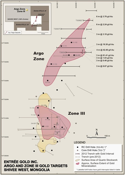
| 7.4.4.1 | Zone I |
Zone I is located 1.5 km east of Zone III/Argo (Figure 7.11) and is a prominent 2 km long area of argillic and advanced argillic alteration. This zone has received considerable attention by mapping, drilling, geophysics (IP), excavator trenching and PIMA investigations. It features several texture-destructive alteration assemblages, imposed on intermediate to felsic Carboniferous volcanic and intrusive rocks. Dating of primary hydrothermal alunite from the south end of Zone I returned Early Carboniferous dates of 323 and 328 Ma.
AMC 813001 : March : 2013
129
ENTRÉE GOLD INC Lookout Hill Property, Southern Mongolia Technical Report | |
The silicified rocks that define this zone form a discrete region of coalescing northerly-trending ridges that outline a topographically prominent highland feature about 1.0 by 3.8 km in size. The zone is dominated by large mounds of massive pale grey to cream coloured chalcedonic, cryptocrystalline to locally very fine granular quartz. In addition steeply dipping ribs or ‘ledges’ form essentially massive silica bodies some metres to a few tens of metres in width. The host rocks for the silica ribs are rarely exposed but where they are, the rocks are propylitic volcanics. In the few places where quartz veins are present in the massive silica rocks they occur in small zones and form white dilational gash fillings, short en echelon curvilinear lenses and weakly developed stockworks. The vein margins are not sharp and distinct against their siliceous hostrocks and tend to blend into them.
The best drill results from this zone were 0.1 to 0.2% Cu over widths of 2 to 4 metres.
AMC 813001 : March : 2013
130
ENTRÉE GOLD INC Lookout Hill Property, Southern Mongolia Technical Report | |
| 8 | DEPOSIT TYPES |
Type deposit descriptions of copper-gold porphyries, high-sulphidation epithermal and low-sulphidation epithermal deposits are taken from Panteleyev (1995, 1996a and 1996b).
| 8.1 | Porphyry Copper ± Gold Deposits |
Porphyry copper deposits commonly form in orogenic belts at convergent plate boundaries, linked to subduction-related magmatism. They can also form in association with the emplacement of high-level stocks during extensional tectonism which is related to strike-slip faulting and back-arc spreading following continent margin accretion. Host rocks are typically intrusions, which range from coarse-grained phaneritic to porphyritic stocks, batholiths and dyke swarms. Intrusive rock compositions range from calcalkaline quartz diorite to granodiorite and quartz monzonite. There are multiple intrusive phases that are successively emplaced, and a large variety of breccias are typically developed.
Stockworks of quartz veinlets, quartz veins, closely-spaced fractures and breccias containing pyrite and chalcopyrite with lesser molybdenite, bornite, and magnetite occur in large zones of economically bulk-mineable mineralization in, or adjoining, porphyritic intrusions and related breccia bodies. The mineralization is spatially, temporally and genetically associated with hydrothermal alteration of the hostrock intrusions and wallrocks. Zones where fracturing is most intensely developed can give rise to economic-grade vein stockworks, notably where there are coincident or intersecting multiple mineralized fracture sets. Disseminated sulphide minerals are present, generally in subordinate amounts. Typical minerals include pyrite, chalcopyrite; molybdenite, lesser bornite and rare (primary) chalcocite, with lesser tetrahedrite/tennantite, enargite and minor gold, electrum and arsenopyrite. Late-stage veins can contain galena and sphalerite in a gangue of quartz, calcite and barite.
Alteration commonly takes the form of different assemblages that are gradational and can overprint earlier phases. Potassic-altered zones (K-feldspar and biotite) commonly coincide with mineralization. This alteration can be flanked in volcanic host rocks by biotite-rich rocks that grade outward into propylitic rocks. The biotite is a fine-grained, secondary mineral that is commonly referred to as a “biotite hornfels”. The early biotite and potassic assemblages can be partially to completely overprinted by later biotite and K-feldspar alteration, zoning outwards to quartz–sericite–pyrite (phyllic) alteration, then, less commonly, argillic zones, and rarely, in the uppermost parts of some deposits, kaolinite–pyrophyllite, or advanced argillic, alteration.
Porphyry copper deposits can be subdivided into three styles on the basis of Cu, Au and Mo metal content ratios. Typical tonnages and grades for the three styles are:
| · | Porphyry Cu: averages 140 Mt at 0.54% Cu, <0.002% Mo, <0.02 g/t Au and <1 g/t Ag |
| · | Porphyry Cu–Au: averages 100 Mt at 0.5% Cu, <0.002% Mo, 0.38 g/t Au and 1 g/t Ag |
| · | Porphyry Cu–Mo: averages 500 Mt at 0.42% Cu, 0.016% Mo, 0.012 g/t Au and 1.2 g/t Ag |
AMC 813001 : March : 2013
131
ENTRÉE GOLD INC Lookout Hill Property, Southern Mongolia Technical Report | |
| 8.2 | High-sulphidation Epithermal Deposits |
Mineralized high-sulphidation epithermal gold deposits predominantly occur in younger poorly eroded magmatic arcs, for example in the Andes of South America, and are hosted in volcanic rocks that are associated with subvolcanic intrusions, particularly flow dome complexes. Deposits are commonly localized by similar major structural corridors to those which host porphyry Cu–Au deposits.
Host rocks are typically volcanic pyroclastic and flow rocks, of andesitic to dacite to and rhyodacitic, composition and their subvolcanic intrusive equivalents. Permeable sedimentary intervolcanic units can also be sites of mineralization. Deposit settings range from volcanic edifices such as caldera ring and radial fractures to fracture sets in resurgent domes and flow-dome complexes, hydrothermal breccia pipes and diatremes. The deposits occur over considerable crustal depths, ranging from high-temperature solfataras at paleosurface down into cupolas of intrusive bodies at depth.
Mineralization forms in veins and as massive sulphide replacement pods and lenses, stockworks and breccias. The deposit shapes are commonly irregular, and controlled by combinations of structural setting and host rock permeabilities. Multiple, crosscutting composite veins and vein sets are common. Two mineralization types are commonly present: massive enargite–pyrite and/or quartz–alunite–gold; characteristic mineral assemblages include pyrite, enargite/luzonite, chalcocite, covellite, bornite, gold, and electrum; lesser minerals, which may or may not be present, comprise chalcopyrite, sphalerite, tetrahedrite/tennantite, galena, marcasite, arsenopyrite, silver sulphosalts, and tellurides including goldfieldite.
Advanced argillic alteration is the most common alteration type, and can be aerially extensive. Quartz occurs as fine-grained replacements and as vuggy, residual silica in acid-leached rocks.
There are wide variations in deposit types, ranging from bulk- mineable, low-grade to selectively mined, high-grade deposits:
| · | Underground mines range in size from 2 to 25 Mt at grades reaching as high as 178 g/t Au, 109 g/t Ag and 3.87% Cu in direct smelting ores, such as those reported from portions of the El Indio Deposit in Chile to 2.8 g/t Au, 11.3 g/t Ag and 1.8% Cu at Lepanto in the Philippines. |
| · | Open pit mines vary in size from 100 Mt to >200 Mt and range in grade from 3.1 g/t Au and 16 g/t Ag at Pueblo Viejo, in the Dominican Republic to the Nansatsu Deposits, Japan that grade between 3 and 6 g/t Au. |
AMC 813001 : March : 2013
132
ENTRÉE GOLD INC Lookout Hill Property, Southern Mongolia Technical Report | |
| 8.3 | Low-sulphidation Epithermal Deposits |
Low-sulphidation epithermal deposits are high-level hydrothermal systems which vary in crustal depths from 1 km to surficial hot spring settings. Host rocks are extremely variable, ranging from volcanic rocks to sediments. Calcalkaline andesitic compositions predominate as volcanic rock hosts, but deposits can also occur in areas with bimodal volcanism and extensive subaerial ashflow deposits. A third, less common association, is with alkalic intrusive rocks and shoshonitic volcanics. Clastic and epiclastic sedimentary rocks in intra-volcanic basins and structural depressions are the primary non-volcanic host rocks.
Mineralization in the near surface environment takes place in hot spring systems, or the slightly deeper underlying hydrothermal conduits. At greater crustal depth, mineralization can occur above, or peripheral to, porphyry (and possibly skarn) mineralization. Normal faults, margins of grabens, coarse clastic caldera moat-fill units, radial and ring dyke fracture sets and hydrothermal and tectonic breccias can act as mineralised-fluid channelling structures. Through-going, branching, bifurcating, anastomozing and intersecting fracture systems are commonly mineralized. Mineralization forms where dilatational openings and cymoid loops develop, typically where the strike or dip of veins change. Hanging wall fractures in mineralized structures are particularly favourable for high-grade mineralization.
Deposits are typically zoned vertically over about a 250 m to 350 m interval, from a base metal poor, Au–Ag-rich top to a relatively Ag-rich base metal zone and an underlying base metal rich zone grading at depth into a sparse base metal, pyritic zone. From surface to depth, metal zones grade from Au–Ag–As–Sb–Hg-rich zones to Au–Ag–Pb–Zn–Cu-rich zones, to basal Ag– Pb–Zn-rich zones.
Silicification is the most common alteration type with multiple generations of quartz and chalcedony, which are typically accompanied by adularia and calcite. Pervasive silicification in vein envelopes is flanked by sericite–illite–kaolinite assemblages. Kaolinite–illite–montmorillonite ± smectite (intermediate argillic alteration) can form adjacent to veins; kaolinite–alunite (advanced argillic alteration) may form along the tops of mineralized zones. Propylitic alteration dominates at depth and along the deposit margins.
Mineralization characteristically comprises pyrite, electrum, gold, silver, and argentite. Other minerals can include chalcopyrite, sphalerite, galena, tetrahedrite, and silver sulphosalts and/or selenide minerals. In alkalic host rocks, tellurides, roscoelite and fluorite may be abundant, with lesser molybdenite as an accessory mineral.
Low-sulphidation deposits typically contain the following tonnages and grades:
| · | Au–Ag deposits (“bonanza” deposits) typically contain about 0.77 Mt at 7.5 g/t Au, 110 g/t Ag and minor Cu, Zn and Pb, eg Comstock, Aurora (Nevada, USA). |
| · | Au–Cu deposits usually average tonnages about 0.3 Mt at average grades of about 1.3% g/t Au, 38 g/t Ag and >0.3% Cu, eg Sado, Hishikari (Japan). |
AMC 813001 : March : 2013
133
ENTRÉE GOLD INC Lookout Hill Property, Southern Mongolia Technical Report | |
| 9 | EXPLORATION |
Exploration on the Lookout Hill property from 2002 through 2009 is summarized in Table 9.1 below and detailed in previous reports (Reid et al., 2003; Reid et al., 2004; Cann, 2004; Panteleyev, 2004a; Panteleyev, 2004b; Panteleyev, 2005; Cherrywell, 2005; Juras, 2005; Forster, 2006; Forster and Crane, 2007, Cinits and Parker, 2007; Forster et al., 2008; Vann et al., 2008, Vann et al., 2009; AMEC Minproc, 2010a; AMEC Minproc, 2010b and Minproc, 2012). Geophysical methods and diamond drilling have been the most important exploration tools. Exploration done from 2002 to 2011 is summarized below while 2012 exploration is described in more detail. Drilling is described in Section 10.
| Table 9.1 | Exploration Summary Joint Venture Property and Shivee West 2002 – 2012 |
| Year | Contractor | Company | Type of Exploration Activity | Quantity |
| 2002 | – | Entrée | Prospecting and reconnaissance lithogeochemistry | 75 samples |
| 2002 | – | Entrée | Trenching Zone III (576 m) | 450 chip samples |
| 2002 | SJ Geophysics | Entrée | IP survey using pole-dipole array and 50 m electrode spacing. 2 initial lines. | 7 to 8 line-km |
| 2002 to 2003 | – | Entrée | Soil geochemistry. Samples every 50 m along lines; 5 lines 200 m apart with another 11 lines 100 m apart. | 2,140 samples |
| 2003 | Scott Geophysics | Entrée | IP survey using pole-dipole array and 50 m to 100 m electrode spacing. Lines spaced 200 m apart. | 109 line-km |
| 2003 | Scott Geophysics | Entrée | Ground magnetics survey. Readings 12.5 m along the lines. 10 lines spaced 100 m apart and 5 lines 200 m apart. | 55.4 line-km |
| 2003 to 2004 | Abitibi Geophysics | Entrée | Gravity survey. 16 lines spaced 200 m apart. | 114 line-km |
| 2004 | XDM | Entrée | 1: 10,000 scale geological mapping. | – |
| 2004 | Can Asia Drilling | Entrée | Diamond drilling at the x-Grid (Oortsog) Prospect | 6 holes - 573 m |
| 2004 to 2005 | OT LLC. | Entrée–OT LLC | Gradient array IP survey. 56 lines spaced 100 m; 11 km A-B electrode spacing initially then 1.2 km, 2 km , 3.1 km, 5 km and 6.6 km electrode spacing in smaller areas. | Approximately 1,562 line-km |
| 2005 | OT LLC. | Entrée–OT LLC | Diamond and RC drilling. Diamond drilling on sections 150 m apart with a nominal 75 m vertical spacing of pierce points. RC drilling used to define bedrock geology and as a geochemical exploration tool. | 55 holes – 43,800 m diamond drill; 57 holes - 3,700 m RC |
AMC 813001 : March : 2013
134
ENTRÉE GOLD INC Lookout Hill Property, Southern Mongolia Technical Report | |
| Year | Contractor | Company | Type of Exploration Activity | Quantity |
| 2005 | – | Entrée | Acquisition and analysis of Aster satellite imagery | |
| 2005 | CanAsia Drilling and AIDD | Entrée | Diamond drilling | 26 holes -14 018.31 m |
| 2005 | Quantec Geoscience | Entrée | IP and resistivity surveys | 250 line-km |
| 2006 | OT LLC. | Entrée–OT LLC | Geophysical survey interpretation | |
| 2006 | OT LLC. | Entrée–OT LLC | Quarried rock for use as aggregate in concrete for the shaft foundations and lining at Oyu Tolgoi; operations discontinued | |
| 2006 | OT LLC. | Entrée–OT LLC | Diamond and RC drilling. Includes 12,400 m on the zone east of the proposed Northern Airport location (Ulaan Khud); approximately 26,400 m on the Hugo North Extension and 1,200 m of geophysical drilling (collared in ST and drilled back into Hugo North) | 40,215 m of core and 850 m of RC |
| 2006 | Major Drilling | Entrée | Diamond drilling | 11 holes - 8,614.1 m |
| 2006 | AIDD | Entrée | RC drilling | 18 holes - 3290.0 m |
| 2006 | – | Entrée | Geological mapping at 1:10,000 scale | – |
| 2006 | – | Entrée | Gradient IP and resistivity geophysical surveys | 40 line-km |
| 2006 | – | Entrée | Reconnaissance exploration; 16 targets on Shivee Tolgoi and Togoot. | 624 rock chip samples |
| 2006 | Dr. Sharon Carr | Entrée | Detailed structural and stratigraphic analysis of Devonian Wedge prospect | – |
| 2006 | – | Entrée | Mobile metal ion (MMI) soil sampling | 31 samples |
| 2006 | PCIGR, UBC/Geochron Lab, U of T | Entrée | Age dating | 8 samples |
| 2006 | PetraScience Consultants Inc. | Entrée | Petrographic and spectral analysis | 34 drill core samples and 15 rock samples |
| 2007 | Dr. Sharon Carr | Entrée | Detailed structural and stratigraphic analysis of Khoyor Mod prospect | – |
| 2007 | Major and AIDD | Entrée | Diamond drilling | 17 holes - 7,712 m |
| 2007 | Geocad | Entrée | Grid surveying | Approx 178 line-km |
| 2007 | Geosan | Entrée | Ground magnetometer surveying | 1,739 line-km |
| 2007 | Geosan | Entrée | Airborne magnetic surveying | 5,890 line-km |
AMC 813001 : March : 2013
135
ENTRÉE GOLD INC Lookout Hill Property, Southern Mongolia Technical Report | |
| Year | Contractor | Company | Type of Exploration Activity | Quantity |
| 2007 | XDM | Entrée | 1: 20,000 and 10,000 scale geological mapping. | – |
| 2007 | – | Entrée | Soil sampling | 3,859 samples |
| 2007 | – | Entrée | MMI soil sampling | 2,065 samples |
| 2007 | – | Entrée | Excavator trenching + samples | 970 m, 485 samples |
| 2007 | Major Drilling | OT LLC | Diamond drilling – Ulaan Khud | 3 holes - 878 m |
| 2007 | Major Drilling | OT LLC | Diamond drilling – Heruga | 27 holes - 27,422 m |
| 2007 | Major Drilling | OT LLC | Geotech drilling – Shivee Tolgoi | 3 holes - 6,247.2 m |
| 2008 | AIDD | Entrée | Diamond drilling | 3 holes - 955 m |
| 2008 | – | OT LLC | Ground magnetometer survey – Heruga & Hugo North Extension | 44.2 line-km |
| 2008 | Major Drilling | OT LLC | Diamond drilling – Heruga | 14 holes - 24,234 m |
| 2008 | Major Drilling | OT LLC | Diamond drilling – Ulaan Khud | 1 hole - 721 m |
| 2009 | – | OT LLC | Deep penetrating IP – HNE & Heruga | 281 line-km |
| 2009 | Geosan | OT LLC | Ground magnetometer survey | 27.83 sq km |
| 2010 | – | Entrée | Mapping - 1:10,000 and 1:2,000 scales | – |
| 2010 | – | Entrée | MMI soil sampling | 4,610 samples |
| 2010 | – | Entrée | Rock sampling | 131 samples |
| 2010 | – | Entrée | Whole rock sampling | 34 samples |
| 2010 | – | Entrée | Excavator trenching + samples | 107 m, 5 samples |
| 2010 | Geosan | Entrée | Gravity surveying | 47 line-km |
| 2010 | Geosan | Entrée | IP surveying | 183 line-km |
| 2010 | Major & AIDD | Entrée | Diamond drilling | 11 holes - 11,634 m |
| 2010 | – | OT LLC | Deep penetrating IP – N of HNE, ST ML | 339.7 line km |
| 2011 | – | Entrée | Mapping - 1:10,000 and 1:2,000 scales | – |
| 2011 | – | Entrée | Rock sampling | 17 samples |
| 2011 | – | Entrée | Whole rock sampling | 14 samples |
| 2011 | – | Entrée | Excavator trenching + samples | 1,212 m, 629 samples |
| 2011 | Geosan | Entrée | Magnetometer surveying | 1,670 line-km |
| 2011 | Landdrill | Entrée | RC drilling | 19 holes - 2,470 m |
| 2010-11 | Major Pontil | OT LLC | Diamond Drilling – ST ML | 10 holes – 12,861 m |
| 2010-11 | Major Pontil | OT LLC | Diamond drilling – Javhlant ML | 9 holes – 10,489.50 m |
| 2011 | Fugro | OT LLC | High resolution MT, ST and Jav MLs | 1,006 stations |
| 2011 | – | OT LLC | Geologic Mapping – Javhlant ML | – |
| 2011 | Geosan | OT LLC | Ground magnetometer survey | 31.53 sq km |
| 2012 | – | Entrée | Mapping - 1:2000 scale | – |
AMC 813001 : March : 2013
136
ENTRÉE GOLD INC Lookout Hill Property, Southern Mongolia Technical Report | |
| Year | Contractor | Company | Type of Exploration Activity | Quantity |
| 2012 | – | Entrée | Excavator trenching + samples | 1,723 m, 547 samples |
| 2012 | – | Entrée | Whole rock sampling | 6 samples |
| 2012 | – | Entrée | Rock sampling | 37 samples |
| 2012 | – | Entrée | Oriented outcrop chip samples | 23 samples |
| 2012 | Major Pontil | OT LLC | Drilling ST ML | 55 holes - 6,659 m |
| 2012 | Major Pontil | OT LLC | Drilling Javhlant ML | 6 holes - 86,212 m (includes all of 44) |
*Work descriptions by Entrée up to 2008 may include work carried out on the Togoot Licence
| 9.1 | Joint Venture Property |
Prior to the agreement between Entrée and Ivanhoe in 2002 to 2004, Entrée mapped, prospected, completed extensive soil sampling and conducted IP, gravity and magnetometer surveys over the area immediately north of the Entrée-OT LLC property boundary. After signing the agreement, all work was conducted by OT LLC, the project operator.
In late 2002, drilling by Ivanhoe north of the Central Zone on the adjacent Oyu Tolgoi Project intersected 638 m of bornite–chalcopyrite-rich mineralization in OTD-270 and marked the discovery of the Hugo Dummett Deposit. As exploration continued to the north it appeared that the Hugo North Deposit might extend onto the Shivee Tolgoi MEL and in October 2004 Entrée entered into an Earn-In Agreement with OT LLC (then Ivanhoe) in which OT LLC was the operator.
Details of the discovery of the Hugo North Extension Deposit on the Shivee Tolgoi ML and the drilling that supports the current resource can be found in the March 2007 technical report (Cinits and Parker, 2007).
On the Javhlant MEL, drill commenced testing chargeability anomalies for deep mineralization, similar to that in the Hugo North deposits and the Oyu South deposits, in March 2007. Copper, gold and molybdenum mineralization was intersected in a number of holes but an intercept of 501.2 m of 0.50% Cu, 0.29 g/t Au and 182 ppm Mo in EJD0008 indicated the significant potential in this area. As geological understanding of the deposit increased, it was clear that early, weakly-mineralized holes at the north end of the deposit were too shallow and subsequent deepening of these holes confirmed mineralization continued but deepened to the north. Since the start of Heruga drilling in 2007, 42 holes totalling 53,765 m have been completed on the Heruga deposit. Of those, 14 diamond drillholes totalling 22,190.8 m were completed on the Heruga deposit in 2008 to better delineate the deposit for an Inferred Mineral Resource estimate completed in 2009.
From June to November 2009 an extensive geophysical survey was completed over Hugo North Extension and over Heruga using the proprietary deep-penetrating IP system. The results were used to target additional drilling, primarily deepening existing holes to test deeper anomalies. Specifically resulting from the survey, two diamond drillholes were completed to test the South Heruga IP anomaly. The IP survey was extended in 2010 and outlined an anomaly on the northern portion of the Shivee licence, the Luuwan target, in the vicinity of the airstrip that was drill tested in 2011 (EGD146).
AMC 813001 : March : 2013
137
ENTRÉE GOLD INC Lookout Hill Property, Southern Mongolia Technical Report | |
In 2010–2011, high-resolution magnetotelluric (MT) surveying was completed over much of the Shivee Tolgoi and Javhlant licences. The MT survey covered the Heruga deposit and the Southwest Heruga IP anomaly. Ground magnetometer surveying was also completed on either side of the previous surveys. These surveys are used as further tool in target generation.
Other recent exploration work includes continued RC and diamond drilling, geological mapping and ground magnetics on Javhlant ML and additional structural studies using existing data on the Hugo North Extension area.
Drilling on the Shivee Tolgoi ML focused five holes on testing the strike extension of the deposits or down-dip of mineralized holes. One additional target was drilled as a test of newly defined IP anomaly, the Luuwan anomaly, to the north of Hugo North Extension near the site of the temporary airport. In addition to exploration drilling, nine engineering holes totalling 13,587 metres were drilled to test the geotechnical character of Lift 1 at Hugo North and to test the area of a planned ventilation shaft (Shaft 4) to the west of Hugo North Extension.
On the Javhlant ML, two holes previously drilled into the Heruga deposit were deepened, another hole tested for mineralization just west of the southern boundary of the Heruga deposit and three additional holes were drilled to test the Heruga Southwest anomaly area.
| 9.2 | Recent Exploration - Joint Venture Property |
Exploration work since January 2012 on the eastern portion of the Shivee Tolgoi Licence and the Javhlant Licence comprised only diamond drilling. On the Shivee Tolgoi ML, a shallow drill program of 52 holes was designed to determine the lithology underlying an area of Cretaceous cover that overlies the new Airport geophysical target. Based on information from the shallow drilling two deeper holes were completed to determine the source of the geophysical anomalies. The target is located about 7 km north of the Hugo North Extension and to the west of Ulaan Khud. Targeting the along-strike continuation of Hugo North Extension, an additional drillhole (EGD157) was completed approximately 750 m north of Hugo North Extension on section EGD147.
On the Javhlant ML, three exploration diamond drillholes were completed around the Heruga deposit and one daughter hole was drilled on the east side. Three additional holes tested for mineralization east of Heruga along the length of the deposit and another was drilled in the Heruga Southwest target.
This work is described in more detail in Section 10.
AMC 813001 : March : 2013
138
ENTRÉE GOLD INC Lookout Hill Property, Southern Mongolia Technical Report | |
| 9.3 | Shivee West Property (100% Entrée) |
Exploration by Entrée in 2002-2003 included prospecting, soil geochemical sampling of seven separate areas, chip sampling and some orientation silt and pan concentrate sampling in selected areas. Five areas were subject to 239.2 line km of pole dipole IP surveying, and 255.8 line km of magnetometer surveying. Gravity surveying (85.1 line km) was carried out north of the Oyu Tolgoi Property, and on selected lines over Main Grid Zones I and II. Figure 9.1 shows the exploration targets on the Lookout Hill Property.
Geological mapping was done at 1:2,000 scale over the Main Grid Zone III, 1:5,000 scale over X-Grid (Oortsog, east of Oyu Tolgoi), and 1:10,000 scale on the Copper Flats Grid. Three trenches totalling 546 m were excavated on Main Grid Zone III. Follow-up work by Entrée during 2004 comprised ground geophysical surveys and diamond drilling on the Copper Flats Grid, Zone I, Zone III, and Oortsog.
| Figure 9.1 | Exploration Targets, Lookout Hill Property |
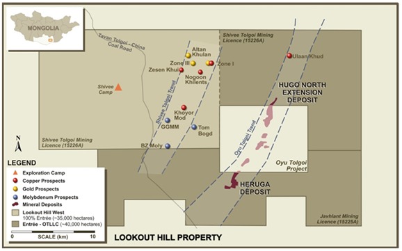
Subsequent to the Earn-in Agreement with OT LLC, Entrée continued evaluation of Shivee West, exploring the Devonian stratigraphy on its 100% owned western portion of the Shivee Tolgoi MEL, as well as the copper showings on the previously held Togoot MEL. From 2005 to 2011 exploration on Shivee West included satellite image interpretation, reconnaissance exploration, geophysical surveys (IP, gravity, airborne magnetics and radiometrics, and ground magnetics), detailed geological mapping, rock sampling, soil and MMI sampling, trenching, diamond and reverse-circulation drilling.
AMC 813001 : March : 2013
139
ENTRÉE GOLD INC Lookout Hill Property, Southern Mongolia Technical Report | |
Details on the earlier exploration can be found in previous technical reports (Cann, 2004; Cherrywell, 2005; Panteleyev, 2005; Cinits and Vann, 2007; Vann et al., 2008; Vann et al., 2009; AMEC Minproc, 2010a; AMEC Minproc, 2010b and Minproc, 2012) and are on SEDAR. A summary table of work done on Shivee West is included in Table 9.1.
Porphyry copper exploration at Shivee West was driven primarily by geophysical surveying, in particular IP, which had been successful for finding porphyry copper mineralization on the Joint Venture property. However, drilling of IP chargeability features on Shivee West up to 2008 did not lead to the discovery of any deposits.
From 2004 to 2007, Entrée drilled a number of holes to test for epithermal gold mineralization at Zones I, II and III, returning sporadic gold results but no continuous zones of mineralization. In 2007, MMI soil sampling was used to define gold targets, including the known mineralization at Zone III and a previously unknown gold target at Altan Khulan. Drilling intersected gold mineralization here in 2008, but did not define a significant target.
In 2008 and 2009, exploration shifted to the coal potential of the Togoot MEL. The MEL was subsequently reduced in size, converted to a Mining Licence, and sold to a private Mongolian firm engaged in coal exploration.
Not until 2010 did Entrée LLC return to exploring the Shivee Tolgoi ML for deep copper porphyry deposits. Whole rock geochemical sampling that year confirmed that rocks geochemically equivalent to the main ore host (Unit DA1b) at Oyu Tolgoi also occurred on Shivee West. Mapping established that the Devonian rocks form a north-east-trending elongate steep-sided dome that is strongly folded and generally north-east-striking. Additional MMI sampling indicated a large area of anomalous MMI-Au results at Khoyor Mod, defining a north-trending area approximately 200 metres x 825 metres. Within this area, eleven MMI soil samples returned values from 11.6 to 36.8 ppb Au.
Drilling in 2010 on porphyry copper targets showed strong hydrothermal alteration systems with barren pyrite mineralization (Section 10).
Work in 2011 comprised mapping, rock sampling for assay and whole rock analyses, excavator-assisted trenching, 1,670 line-kilometres of magnetometer surveying, and 2,470 metres of reverse-circulation ("RC") drilling in nineteen holes on near-surface gold mineralization at Zone III. This resulted in the discovery of moderate to high grade gold mineralization in a new zone called Argo, which lies to the north of Zone III. Gold intercepts in excess of 0.25 g/tonne Au were encountered in eleven holes.
Both Zone III and Argo lie within a well-defined, northerly-trending magnetic-low, which extends for at least 2.5 kilometres along strike.
The Argo Zone was defined by six RC holes (holes EGRC-11-110 to 115), two trenches and surface chip sampling. Two chip samples, taken to evaluate a quartz stockwork in dacitic volcanic rocks 50 metres southeast of the nearest 2011 RC drillhole, averaged 42.4 grams/tonne gold (“g/t Au”) over 4 metres and 19.3 g/t Au over 3 metres.
AMC 813001 : March : 2013
140
ENTRÉE GOLD INC Lookout Hill Property, Southern Mongolia Technical Report | |
2012 exploration work on Shivee West is further detailed below.
| 9.3.1 | Recent Exploration – Shivee West |
The primary focus of the 2012 exploration program was the evaluation of high grade gold mineralization at the Argo Target, by excavator-assisted trenching and detailed mapping. The Altan Khulan gold target was also selected for trenching. Both of these occur within Carboniferous volcanic sequences and are possibly related. A third gold target, within the Devonian stratigraphy at Khoyor Mod, was also selected for trenching. In addition, detailed geological mapping was done in the Nogoon Khilents area, and additional whole rock sampling was done at Syncline. A minor amount of mapping and sampling was done outside these target areas. Target areas are shown in Figure 9.2.
| 9.3.1.1 | Geological Work |
Geological work comprised sampling, and mapping of target areas and trenches. All of the sampling was carried out by Entrée personnel or its contractors.
Mapping was carried out at 1:2,000 scale by Entrée personnel (Danilo Tirona, Gansaikhan Tumee, Gansukh Tserenjav, and James R Foster), primarily in the Zone III and Altan Khulan targets area and the Khoyor Mod area, to complement the trenching program. Additional mapping was done in the Carboniferous stratigraphy between Zone III and Zone I.
| 9.3.1.2 | Rock Sample Results |
Thirty-seven grab samples were collected in 2012 from various target areas (Table 9.2). The only gold result of significance was from a grab sample taken of a rhyolitic volcanic cut by quartz veinlets in Trench T39334 on the Argo Zone. This returned 36.35 g/tonne Au. A chip sample over the same volcanic in this trench returned 81.41 g/tonne Au over 3.0 metres. The best copper result (169 ppm) came from an outcrop of CS3 rhyolite, southwest of Zone III.
| 9.3.1.1 | Chip and Trench Sample Results |
A total of twenty two trenches with cumulative length of 1,723 metres were excavated at the Zone III/Argo, Altan Khulan, and Khoyor Mod targets (Table 9.2). Following mapping and sampling, all trenches were back-filled and the surface re-contoured by the excavator.
At Argo, three chip samples were taken of the outcrop where the two high grade chip samples were collected in 2011. The 2012 samples returned 750 ppb Au over 2.4 m, 330 ppb Au over 2.3 m, and 8670 ppb (8.67 g/tonne Au) over 3.3 m.
Ten trenches totalling 999 meters were excavated on the Argo Target in 2012. All were oriented east-west, and excavated to a maximum depth of 2.5 metres. Two east-west trenches totalling 241 metres were dug to test the southern extension of Zone III. At Altan Khulan, nine trenches were excavated with a total length of 433 meters; a single 50-meter trench was dug at Khoyor Mod.
AMC 813001 : March : 2013
141
ENTRÉE GOLD INC Lookout Hill Property, Southern Mongolia Technical Report | |
The best trench sample results for gold in came from the trenches excavated on the Argo Zone (Table 9.3 and Figure 9.4).
| Figure 9.2 | 2012 Exploration Target Areas, Shivee West |
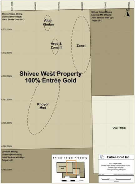
AMC 813001 : March : 2013
142
ENTRÉE GOLD INC Lookout Hill Property, Southern Mongolia Technical Report | |
| Figure 9.3 | Trench and Drillhole Locations - Zone III |
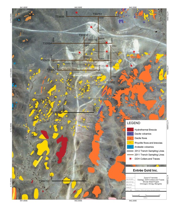
AMC 813001 : March : 2013
143
ENTRÉE GOLD INC Lookout Hill Property, Southern Mongolia Technical Report | |
| Figure 9.4 | Trench and Drillhole Locations - Argo Zone |
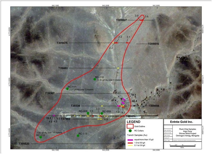
AMC 813001 : March : 2013
144
ENTRÉE GOLD INC Lookout Hill Property, Southern Mongolia Technical Report | |
| TARGET | TRENCH | START_E | START_N | ELEV | AZ | LENGTH (m) |
| Argo | T39334 | 642150 | 4773450 | 1218 | 090 | 100 |
| T39367 | 642100 | 4773475 | 1220 | 090 | 150 | |
| T39422 | 642050 | 4773375 | 1220 | 090 | 170 | |
| T39483 | 642125 | 4773525 | 1219 | 090 | 125 | |
| T309475 | 642125 | 4773575 | 1220 | 090 | 122 | |
| T309520 | 642025 | 4773325 | 1220 | 090 | 170 | |
| T309694 | 642255 | 4773450 | 1215 | 090 | 27 | |
| T309816 | 642259 | 4773573 | 1216 | 090 | 26 | |
| T309827 | 642242 | 4773620 | 1216 | 090 | 50 | |
| T309843 | 642256 | 4773672 | 1217 | 090 | 59 | |
| Zone III | T309703 | 641975 | 4772850 | 1214 | 090 | 115 |
| T309752 | 641900 | 4772600 | 1209 | 090 | 126 | |
| Altan Khulan | T309591 | 641790 | 4774625 | 1223 | 360 | 50 |
| T309614 | 641850 | 4774600 | 1223 | 360 | 75 | |
| T309640 | 641915 | 4774530 | 1224 | 360 | 70 | |
| T309643 | 641980 | 4774710 | 1219 | 130 | 40 | |
| T309650 | 642010 | 4774730 | 1219 | 130 | 35 | |
| T309657 | 642028 | 4774748 | 1219 | 130 | 35 | |
| T309663 | 642013 | 4774810 | 1218 | 130 | 45 | |
| T309671 | 641740 | 4774630 | 1224 | 360 | 40 | |
| T309678 | 641425 | 4773930 | 1213 | 120 | 43 | |
| Khoyor Mod | T309796 | 641825 | 4767380 | 1194 | 100 | 50 |
| Total Length | 1,723 | |||||
| Trench | Zone | Az | From_m | To_m | Length_m | Au_g/tonne |
| T39334 | Argo | 090 | 72.0 | 81.0 | 9.0 | 27.61 |
| T309475 | Argo | 090 | 92.0 | 98.0 | 6.0 | 2.24 |
| T309475 | Argo | 090 | 116.0 | 119.0 | 3.0 | 3.10 |
| T309827 | Argo | 090 | 26.0 | 32.0 | 6.0 | 3.76 |
The average intercept in Trench T39334 is strongly biased by the first three metres, which ran 81.4 g/t Au. Host rock is a rhyolitic volcanic, possibly a flow or subvolcanic intrusive. Trench T309475, located 125 metres to the north, returned 2.24 g/t Au over 6 metres and 3.10 g/t Au over 3 metres. Gold mineralization in T309827, the most northerly trench, averaged 3.76 g/t Au over 6 metres.
AMC 813001 : March : 2013
145
ENTRÉE GOLD INC Lookout Hill Property, Southern Mongolia Technical Report | |
Two trenches were excavated on the southern strike extension of Zone III approximately 225 metres and 465 metres south-southwest of gold mineralization exposed on surface in this target. Bedrock here comprises rhyolitic flow or intrusive breccias and hydrothermal breccias of Unit CS3. Neither trench returned any significant gold or base metals assays.
Anomalous gold was also returned from the trenches at Altan Khulan (Table 9.4) but did not outline a zone of significant mineralization. Here, the bedrock is dominated by basaltic to andesitic volcaniclastics of Unit CS1v.
| Table 9.4 | 2012 Altan Khulan Trench Sampling Summary |
| Trench | Zone | Az | From_m | To_m | Length_m | Au_g/tonne |
| T309591 | Altan Khulan | 180 | 12.0 | 14.0 | 2.0 | 0.59 |
| T309614 | Altan Khulan | 180 | 37.0 | 40.0 | 3.0 | 1.48 |
The trench at Khoyor Mod (Figure 9.6) returned anomalous copper and gold results in an area underlain by Devonian sedimentary rocks. The target was initially discovered by MMI sampling in 2010, and is defined by anomalous MMI-Au over a north-trending area approximately 200 m x 825 m. Within this area, eleven MMI soil samples ranged from 11.6 to 36.8 ppb Au.
| Table 9.5. | 2012 Khoyor Mod Trench Sampling Results |
| Trench | Zone | Az | From_m | To_m | Length_m | Au_g/tonne | Cu_ppm |
| T309796 | Khoyor Mod | 100 | 8.0 | 10.0 | 2.0 | 0.15 | 174 |
| 10.0 | 12.0 | 2.0 | < 0.01 | 198 | |||
| 18.0 | 20.0 | 2.0 | 0.02 | 121 | |||
| 20.0 | 22.0 | 2.0 | 0.25 | 84 | |||
| 22.0 | 24.0 | 2.0 | 0.02 | 100 | |||
| 24.0 | 26.0 | 2.0 | 0.31 | 67 | |||
| 28.0 | 30.0 | 2.0 | 0.01 | 111 | |||
| 32.0 | 34.0 | 2.0 | 0.02 | 182 | |||
| 34.0 | 36.0 | 2.0 | 0.03 | 163 | |||
| 36.0 | 38.0 | 2.0 | 0.06 | 505 | |||
| 40.0 | 42.0 | 2.0 | 0.11 | 77 | |||
| 42.0 | 44.0 | 2.0 | 0.58 | 93 | |||
| 46.0 | 48.0 | 2.0 | 0.02 | 105 |
Mapping in 2012 has outlined two areas of subtle silicification, 100 metres by 100 metres and 80 metres by 300 metres, marked by poorly-developed stockworks of narrow quartz veinlets hosted by well-bedded fine-grained sandstone and siltstone. The trench was excavated on the western stockwork and sampled every two metres, returning nine anomalous copper values (100 to 505 ppm Cu) and three anomalous gold values (250 to 505 ppb Au).
AMC 813001 : March : 2013
146
ENTRÉE GOLD INC Lookout Hill Property, Southern Mongolia Technical Report | |
| 9.3.2 | Khoyor Mod Area Mapping |
Mapping was undertaken to explain the source of a large MMI-Au anomaly
A subtle very poorly developed "stockwork" of quartz veinlets has been mapped over an area of some 250 metres by 300 metres. The quartz veinlets are up to several centimetres thick, can usually be traced along their strikes over several metres, and are subvertical to steeply dipping. A north-north-east-trending late syenite dyke bisects the stockwork into western and eastern portions.
Monzodiorite outcrops approximately 500–600 metres south-west of the trench are cut by numerous quartz veins that form a moderately-developed stockwork indicative of a porphyry-style target.
AMC 813001 : March : 2013
147
ENTRÉE GOLD INC Lookout Hill Property, Southern Mongolia Technical Report | |
| Figure 9.5 | 2012 Entrée Rock Samples, Shivee Tolgoi Licence |
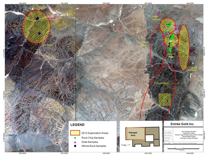
AMC 813001 : March : 2013
148
ENTRÉE GOLD INC Lookout Hill Property, Southern Mongolia Technical Report | |
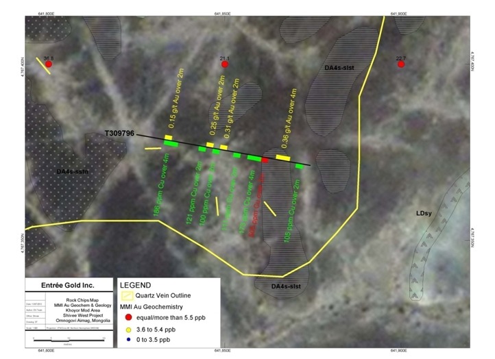
AMC 813001 : March : 2013
149
ENTRÉE GOLD INC Lookout Hill Property, Southern Mongolia Technical Report | |
| 9.4 | Sampling Method and Approach |
| 9.4.1 | Introduction |
Sampling on the Lookout Hill Property has been completed by both Entrée on Shivee West and by OT LLC on the Joint Venture Property. Sampling programs on the Joint Venture Property have included soil, rock chip, drill core and RC techniques.
All of the sampling on the Joint Venture Property is carried out by OT LLC personnel or contractors, except for early-stage sampling by Entrée, prior to the Earn-in Agreement being signed in October 2004. All of the early-stage sampling methods have been superseded by the drilling, which forms the basis of the Mineral Resource estimates discussed in this report, and therefore the early-stage sampling methods on the Joint Venture Property are not discussed in this report.
Sampling programs on Shivee West include soil, soil-MMI, rock chip, drill core and reverse circulation samples. All of the sampling was carried out by Entrée personnel or its contractors.
| 9.4.2 | Joint Venture Property |
| 9.4.2.1 | Diamond Drill Core Sampling – Hugo North Extension |
Sampling for resource estimation has been conducted on diamond drill core obtained from OT LLC holes drilled between 2002 and March 2008. The current core cutting protocol is as follows:
| · | The uncovered core boxes are transferred from the logging area to the cutting shed (approximately 50 m) by fork lift on wooden palettes. |
| · | Long pieces of core are broken into smaller segments with a hammer. |
| · | Core is cut with a diamond saw, following the line marked by the geologist. The rock saw is regularly flushed regularly with fresh water. |
| · | Both halves of the core are returned to the box in their original orientation. |
| · | The uncovered core boxes are transferred from the cutting shed to the sampling area (approximately 50 m) by fork lift carrying several boxes on a wooden palette; constant 2 m sample intervals are measured and marked on both the core and the core box with permanent marker; a sample tag is stapled to the box at the end of each 2 m sample interval; sample numbers are pre-determined and account for the insertion of QA/QC samples (core twins, standards, blanks). |
| · | Samples are bagged. These are always half core samples collected from the same side of the core. Each sample is properly identified with inner tags and outside marked numbers. Samples are regularly transferred to a sample preparation facility, operated by Mongolia LLC (SGS Mongolia), which is located approximately 50 m from the sample bagging area. |
| · | The unsampled half of the core remains in the box, in its original orientation, as a permanent record. It is transferred to the on-site core storage area. |
AMC 813001 : March : 2013
150
ENTRÉE GOLD INC Lookout Hill Property, Southern Mongolia Technical Report | |
| · | Barren dykes that extend more than 10 m along the core length are generally not sampled. |
| 9.4.2.2 | Diamond Drill Core Sampling – Heruga |
QG reviewed the sampling and handling of core during the February 2008 site visit. QG did not observe core photography or core being cut, but did review quality of photos and procedure and equipment for core cutting. Core re-construction, mark-up, logging and sampling observed by QG are fit for purpose. The procedures described in Section 9.4.2.1 of this report are used for Heruga as well and are still in place. Samples are taken on regular 2 m intervals and post-mineralization dykes over 10 m thick downhole were not sampled. The observed core was cut in half correctly.
Scott Jackson concludes that the sampling is adequate, appropriate and sufficient for the purposes of resource estimation on porphyry style deposits.
| 9.4.3 | Shivee West Property |
| 9.4.3.1 | Introduction |
Sampling programs on Shivee West have included soil, soil-MMI, rock chip, drill core and reverse circulation samples. All of the sampling was carried out by Entrée personnel or its contractors. During the 2012 program rock chip sampling was done.
| 9.4.3.2 | Core Sampling Procedures |
The core sampling protocol is as follows:
| · | The logging geologist determines sample interval, based on geology or on a pre-determined interval (generally 2 m or less), and places a uniquely-numbered sample tag at the start of the core interval to be sampled. Sample numbers are pre-determined and account for the insertion of QA/QC samples (core twins, standards, blanks). A line is marked along the core to indicate the line of cut. |
| · | Uncovered core boxes are transferred from the logging area to the cutting shed by van. |
| · | Long pieces of core are broken into smaller segments with a hammer. |
| · | Core is cut with a diamond saw following the cut line, conforming to the sample length selected by the geologist. The rock saw is regularly flushed regularly with fresh water. |
| · | One half of the core is placed into a plastic sample bag pre-marked with the sample tag number along with the sample tag retrieved from the core box. The other half of the core is returned to the core box as a permanent record. When complete, the sample bag is sealed with a ziptie. The box is transferred to the on-site core storage area. |
| · | Five to eight bagged samples are placed into rice bags, which are also zip-tied, prior to dispatch via truck to the analytical laboratory (in this case, SGS Mongolia laboratory in Ulaanbaatar). |
AMC 813001 : March : 2013
151
ENTRÉE GOLD INC Lookout Hill Property, Southern Mongolia Technical Report | |
Field blank, duplicate (quarter samples) and Standard Reference Material (SRM) samples are included in the sample submissions. The blank sample can indicate instances of sample mix-ups or sample contamination; the SRM is used to monitor the accuracy of sample assay values, and the duplicate sample is used to monitor precision during sample preparation phases. Individual samples are weighed prior to shipment to aid in identifying sample switching.
The rice sack-packed samples are loaded, together with a chain-of-custody (CoC) document, into a wooden box on the transport truck; the box is then padlocked. Keys for the padlock are held on site, by the driver who has to allow police authorities to search the truck as requested, and by laboratory staff. On arrival at the laboratory in Ulaanbaatar, staff unlock the box and unload the samples. A signed confirmation of sample receipt is given to the driver, and subsequently handed to the geologist on the driver’s return to the Entrée camp.
| 9.4.3.3 | RC Sampling Procedures |
All chip logging and sampling took place at the drill rig around the clock. Sampling was done on 1 m intervals as determined by the driller. Different sampling protocols were required, based on wet/dry chip return.
Dry samples were retrieved in 5 gallon plastic pails from the EDM2000 cyclone by Entrée personnel. Dry samples were split in a riffler on a 7 to 1 reject (“C”-sample) - analytical sample (“B”-sample) split. The B-sample was placed into a numbered cloth bag with a sample assay tag and tied closed. The C-sample was placed into a rice bag marked with the hole number, meterage and corresponding assay sample tag number. A portion of the C-sample was brought to a mobile chip-logging container for washing and chip description (“A”-sample). Representative chips from the A-sample were archived in plastic chip trays for future reference.
Wet samples were retrieved in 5 gallon plastic pails from the EDM2000 cyclone by Entrée personnel. Because wet samples cannot be split readily in a riffler, Entrée personnel scooped roughly 1/8th of the sample from the pail and placed it into a numbered cloth bag with a sample assay tag and tied closed (“B”-Sample). The remaining sample (“C”-Sample) was placed into a rice bag marked with the hole number, meterage and corresponding assay sample tag number. A portion of the C-sample was brought to a mobile chip-logging container for washing and chip description (“A”-sample). Representative chips from the A-sample were archived in plastic chip trays for future reference.
After each hole was complete an additional sample (“D”-sample) was collected from the C-sample for potential future metallurgical work. The dry C-samples were split in a riffler on a 1 to 1 reject – metallurgical sample (“D”-sample) split. The D-sample was placed into a numbered plastic bag and sealed it with a zap strap. The reject was returned to the original rice bag. Because wet samples cannot be split readily in a riffler, Entrée personal scooped roughly half of the reject sample from the rice bag into a numbered plastic bag and sealed it with a zap strap. All D-samples are currently stored in two locked containers at the Shivee Tolgoi exploration camp.
AMC 813001 : March : 2013
152
ENTRÉE GOLD INC Lookout Hill Property, Southern Mongolia Technical Report | |
Five to eight of the analytical samples (“B”-sample) were placed into rice sacks, which were also zip-tied, prior to dispatch via truck to the ActLabs Asia LLC laboratory in Ulaanbaatar.
| 9.4.3.4 | Soil Sampling - “MMI-M” |
Samples were collected from lines established by hand-held GPS spaced 200 m apart (100-m spacing in areas of greater detail), with samples collected every 25 m. Each sample was collected from depths ranging from 25 cm to 35 cm, using a stainless steel trowel and sieved to -1/4-inch mesh at the collection site. Each sample was placed in a uniquely-numbered ziploc plastic bag corresponding to the uniquely-numbered sample tag inserted within. No additional processing or drying was done – samples were submitted on an “as-is” basis to the SGS laboratory in Ulaanbaatar, and eventually shipped to SGS in Mississauga for MMI-M analyses.
| 9.4.3.5 | Rock Sampling |
Rock sampling for assaying in 2012 included 37 grab samples and 23 oriented chip samples collected from outcrops. As well, 547 chip samples were collected from trenches excavated on the various targets tested in 2012.
Grab samples were taken from lithologies or mineralization of interest encountered during mapping. Oriented chip sample traverses were collected from outcrops with known or suspected gold mineralization over sample length(s) determined on lithological or mineralization criteria, with azimuth, inclination, and length of the individual chip line recorded. Trench samples were collected on regular intervals usually 2 or 3 metres, continuously over the trench length or as exposed outcrop allowed. Due to the friable or crumbling nature of trenched bedrock, no attempt was made to take rigorous channel samples; instead, a series of walnut-sized chips for each sample length were collected from one or the other trench wall. Each chip sample traverse or trench sample series is identified by the first sample in the traverse plus a “T” prefix.
Regardless of type, all rock samples were inserted into plastic bags with uniquely-numbered sample tags, bagged in rice bags, and sent by secure transport to SGS Mongolia or to Actlabs in Ulaanbaatar for analyses.
AMC 813001 : March : 2013
153
ENTRÉE GOLD INC Lookout Hill Property, Southern Mongolia Technical Report | |
| 10 | DRILLING |
| 10.1 | General |
Approximately 253,279 m of drilling has been completed on the Lookout Hill Property from 2004 to March 2013 (Table 10.1) by OT LLC and by Entrée. Drilling has been predominantly core and on the Joint Venture Property by project operator OT LLC. The majority of the diamond drilling has been exploration related and includes 118 holes totalling 95,748 m on the Hugo North Extension deposit and 42 holes totalling 53,765 m on the Heruga deposit. Six early-stage core holes were drilled by Entrée at the X-Grid (Oortsog) Prospect, prior to the Earn-in Agreement being signed in 2004. Diamond drilling has been the source of all geological and grade data in support of the Mineral Resource estimates completed on the Hugo North Extension and Heruga deposits. A very small percentage of the drilling (two holes totalling 736 m) is from combined RC/core drilling, which has RC drilling at the top of the hole in barren rock and core drilling once mineralization is encountered.
Since 2002, on Entrée has completed 71 core holes totalling 38,836 m and 34 RC holes totalling 4,145 m on Shivee West.
There was no drilling on the 100% Entree ground in 2012 or to date in 2013.
| 10.2 | Joint Venture Property |
| 10.2.1 | Introduction |
OT LLC has completed 8 years drilling on the Joint Venture Property with most drilling focused on the Hugo North Extension and Ulaan Khud (Airport North) zones on the Shivee Tolgoi ML and on the Heruga deposit on the Javhlant ML (Table 10.1). In addition, OT LLC has completed a significant amount of condemnation, engineering, and water exploration drilling (RC and core) in the vicinity of the Hugo North Extension (76 holes totalling 14,450 m). These holes have been to assist in the determination of suitable sites for proposed tailings and other infrastructure purposes and to find water sources for the proposed mining operation at the adjacent Oyu Tolgoi Project. The condemnation and water holes are not considered in detail in this report. OT LLC has also drilled early-stage exploration holes at the Ulaan Khud prospect (17,401 m in 36 core holes and 2,500 m in 28 RC holes). A new geophysical target was outlined in 2012 near the Airport located to the north of Hugo North Extension and was drilled with a series of shallow holes (PCD) to determine the lithology underlying the thick Cretaceous cover. In total, 52 holes totalling 3,322 m tested the zone; lithologic information will be used to enhance the geological understanding of this target. Based on the PCD holes two deeper holes were drilled for a combined 942 m.
Drillholes on the Joint Venture Property are identified in the Property database with either the prefix “EG”, for holes located on the Shivee Tolgoi ML, or by “EJ”, for holes located on the Javhlant ML. The prefix is followed by “D” for diamond drillholes, “RC” for reverse circulation holes, and “RCD” for RC holes with diamond tails. Geotechnical, water and condemnation drillholes do not receive a special prefix, and are identified by the drilling method.
AMC 813001 : March : 2013
154
ENTRÉE GOLD INC Lookout Hill Property, Southern Mongolia Technical Report | |
| Table 10.1 | Lookout Hill Property – Drilling Summary |
| Deposit/Prospect | DDH Holes | Length of DDH (m) | RC Holes | Length RC Holes (m) | RC/DDH Holes(4) | Length RC/DDH (m) | All Holes(1) | Total Length (m) (1) |
| Lookout Hill West Property | ||||||||
| Zone I | 19 | 10,583 | 6 | 914 | 0 | 0 | 25 | 11,497 |
| Zone II | 2 | 419 | 0 | 0 | 0 | 0 | 2 | 419 |
| Zone III | 10 | 4,293 | 28 | 3,231 | 0 | 0 | 38 | 7,524 |
| 45 Moly | 3 | 694 | 0 | 0 | 0 | 0 | 3 | 694 |
| Altan Khulan | 3 | 767 | 0 | 0 | 0 | 0 | 3 | 767 |
| BZMo | 2 | 245 | 0 | 0 | 0 | 0 | 2 | 245 |
| Khoyor Mod | 5 | 2,831 | 0 | 0 | 0 | 0 | 5 | 2,831 |
| Nogoon Khilents | 1 | 967 | 0 | 0 | 0 | 0 | 1 | 967 |
| Tom Bogd | 4 | 4,812 | 0 | 0 | 0 | 0 | 4 | 4,812 |
| West Grid | 11 | 8,614 | 0 | 0 | 0 | 0 | 11 | 8,614 |
| Zesen Khui | 5 | 4,019 | 0 | 0 | 0 | 0 | 5 | 4,019 |
| Total (Lookout Hill West) | 65 | 38,244 | 34 | 4,145 | 0 | 0 | 99 | 42,389 |
| Joint Venture Property | ||||||||
Hugo North Extension (2) | 118 | 95,748 | 73 | 4,868 | 2 | 736 | 193 | 101,352 |
| Condemnation/Water | 0 | 0 | 67 | 4,401 | 0 | 0 | 67 | 4,401 |
| Engineering | 9 | 10,049 | 0 | 0 | 0 | 0 | 9 | 10,049 |
| Airport PCD Lithology | 52 | 3,327 | 0 | 0 | 0 | 0 | 52 | 3,327 |
| Airport | 2 | 942 | 0 | 0 | 0 | 0 | 2 | 942 |
| Ulaan Khud | 36 | 17,401 | 28 | 2,500 | 0 | 0 | 64 | 19,901 |
X-Grid (Oortsog)(3) | 6 | 573 | 0 | 0 | 0 | 0 | 6 | 573 |
| Heruga | 45 | 56,957 | 0 | 0 | 0 | 0 | 45 | 56,957 |
| East of Heruga | 1 | 2,005 | 0 | 0 | 0 | 0 | 1 | 2,005 |
| Castle Rock | 2 | 2,098 | 0 | 0 | 0 | 0 | 2 | 2,098 |
| SW Mag Anomaly | 1 | 1,152 | 0 | 0 | 0 | 0 | 1 | 1,152 |
| SW Heruga IP | 5 | 5,277 | 0 | 0 | 0 | 0 | 5 | 5,277 |
| Total (JV Property) | 277 | 195,529 | 168 | 11,769 | 2 | 736 | 447 | 195,529 |
| Grand Total | 342 | 233,773 | 202 | 15,914 | 2 | 736 | 546 | 250,423 |
Notes:
| (1) | Includes all holes drilled to 31 March 2013 on Shivee West, up to and including EGD159 on Shivee JV and on Javhlant, up to and including EJD0045. |
| (2) | A portion of these holes were collared in the Shivee Tolgoi JV Property and drilled into the Oyu Tolgoi Property. |
| (3) | These holes were drilled by Entrée prior to the Earn-in/JV Agreement being signed. |
| (4) | RC holes with diamond drillhole tails. |
AMC 813001 : March : 2013
155
ENTRÉE GOLD INC Lookout Hill Property, Southern Mongolia Technical Report | |
| Figure 10.1 | Drillhole Locations on Joint Venture Property |
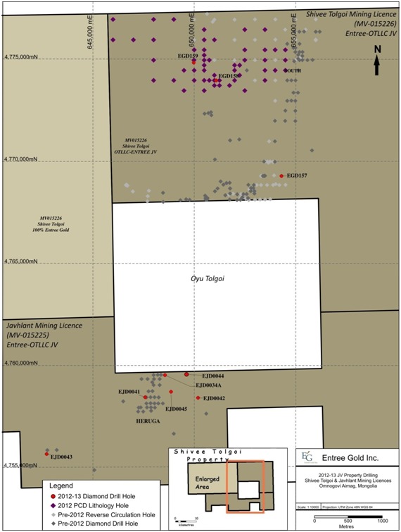
AMC 813001 : March : 2013
156
ENTRÉE GOLD INC Lookout Hill Property, Southern Mongolia Technical Report | |
Exploration diamond drilling is contracted to Major Pontil Pty Ltd. (Major), based out of Australia, who are using a variety of rigs, some with depth capabilities close to 2,000 m. Rigs which have recently been, or are currently on site, include UDR 1000, 1500 and 5000 and Major 50 drills. The vast majority of core at the Property has either been PQ-size (85 mm nominal core diameter) or HQ-size (63.5 mm nominal core diameter), with a small percentage using NQ-size (47.6 mm nominal core diameter). Most holes are now collared with PQ core and are reduced to HQ at depths of around 500 m prior to entering the mineralized zone. A few holes have continued to depths of about 1,300 m using PQ diameter equipment.
Core drilling and database procedures have been extensively described in reports by Cinits and Parker (2007) and Peters et al. (2006). Additional details on core handling are provided in Section 11.
The following descriptions are based on work completed at both the Hugo North (on the adjacent Oyu Tolgoi Project) and Entrée’s Hugo North Extension Deposits. Since both are one continuous zone of mineralization, the supporting database was evaluated as a whole and one block model was constructed to estimate the Mineral Resources. Later, the resources were cut at the Property boundary for reporting purposes; thus discussion of drilling protocols that were in place during the exploration for all of the Hugo North and Hugo North Extension Deposits is warranted.
| 10.2.2 | Resource Drilling – Shivee Tolgoi ML |
No new resource drilling was carried out on the Hugo North Extension Deposit in 2012. Details of previous drilling can be found in the March 2008 NI 43-101 report (Vann et al., 2008).
A typical drill cross-section through Hugo North Extension is shown in Figure 10.2.
| 10.2.3 | 2012 Drilling – Shivee Tolgoi ML |
Two targets were explored with diamond drilling in 2012; the new Airport anomaly west of Ulaan Khud and targets along strike from the Hugo North Extension deposit. Drillhole collar information and depths are listed in Table 10.2 and hole locations are shown in Figure 10.2. Total drilling on the Shivee ML from January 2012 to March 2013 was 5,626 m. Details of previous drilling can be found in the previous NI 43-101 reports: Vann et al., 2008; AMEC Minproc, 2010; AMEC Minproc, 2010a; AMEC Minproc, 2010b and Minproc, 2012.
In 2012, diamond drilling of a Cretaceous covered area above an IP-gravity target, located 7 kilometres north of Hugo North Extension and to the west of Ulaan Khud, commenced June 25 and was completed end of July 2012. Fifty-two shallow PCD holes totalling 3,327 metres were completed on 165 to 330 metre spacing. Results were used for geological modelling and for locating subsequent diamond drillholes. The best assay result from this shallow drilling was 11.1 metres averaging 0.15% copper with 0.26 g/t gold (from 52 metres depth).
AMC 813001 : March : 2013
157
ENTRÉE GOLD INC Lookout Hill Property, Southern Mongolia Technical Report | |
Based on the PCD holes and mapping, an area of augite basalt with an adjacent body of QMD was outlined to the west of the new airports with QMD occurring at the south end of the basalt and to the east. The age of the augite basalt has not been determined and could be Carboniferous or Devonian. These units of geological interest were tested with two diamond drillholes for a combined 942 m. Hole EGD159 was drilled from the augite basalt to the east in the vicinity of the contact with the QMD while EGD158 was drilled west from the QMD to test gold-copper anomaly at EGPCD165. These holes did not return any significant mineralization.
| Figure 10.2 | Hugo North Extension – Section 4768100N, Shivee Tolgoi ML |
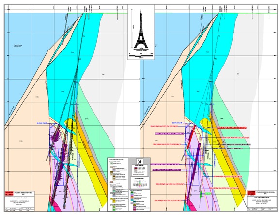
AMC 813001 : March : 2013
158
ENTRÉE GOLD INC Lookout Hill Property, Southern Mongolia Technical Report | |
| Table 10.2 | Joint Venture Exploration Drilling Summary, Shivee Tolgoi ML, 2012 |
| Hole Number | UTM Coordinates (WGS84) | Elevation (masl) | Azimuth (°) | Dip (°) | Start (m) | Final Depth (m) | Length (m) | |
| Easting | Northing | |||||||
| Hugo North Extension | ||||||||
| EGD157 | 654305 | 4769300 | 1173 | 270 | -75 | 0 | 2380 | 2380 |
| Airport IP Target PCD Lithology Drilling | ||||||||
| EGPCD157 | 649997 | 4774997 | 1170 | 360 | -90 | 0 | 72 | 72 |
| EGPCD158 | 650500 | 4775500 | 1170 | 360 | -90 | 0 | 51 | 51 |
| EGPCD159 | 650997 | 4775996 | 1170 | 360 | -90 | 0 | 64 | 64 |
| EGPCD160 | 650500 | 4776500 | 1170 | 360 | -90 | 0 | 45 | 45 |
| EGPCD161 | 650500 | 4774500 | 1170 | 360 | -90 | 0 | 38 | 38 |
| EGPCD162 | 649500 | 4774500 | 1170 | 360 | -90 | 0 | 42 | 42 |
| EGPCD163 | 649000 | 4774000 | 1170 | 360 | -90 | 0 | 62 | 62 |
| EGPCD164 | 650000 | 4774000 | 1170 | 360 | -90 | 0 | 37 | 37 |
| EGPCD165 | 651000 | 4774000 | 1170 | 360 | -90 | 0 | 63 | 63 |
| EGPCD166 | 652000 | 4774000 | 1170 | 360 | -90 | 0 | 64 | 64 |
| EGPCD167 | 652500 | 4773500 | 1170 | 360 | -90 | 0 | 41 | 41 |
| EGPCD168 | 652500 | 4775500 | 1170 | 360 | -90 | 0 | 69 | 69 |
| EGPCD169 | 652500 | 4776500 | 1170 | 360 | -90 | 0 | 65 | 65 |
| EGPCD170 | 653500 | 4776500 | 1170 | 360 | -90 | 0 | 85 | 85 |
| EGPCD171 | 653500 | 4775500 | 1170 | 360 | -90 | 0 | 80 | 80 |
| EGPCD172 | 653500 | 4774500 | 1170 | 360 | -90 | 0 | 82 | 82 |
| EGPCD173 | 650500 | 4773500 | 1170 | 360 | -90 | 0 | 53 | 53 |
| EGPCD174 | 649500 | 4773500 | 1170 | 360 | -90 | 0 | 53 | 53 |
| EGPCD175 | 648000 | 4774000 | 1170 | 360 | -90 | 0 | 52 | 52 |
| EGPCD176 | 648000 | 4775000 | 1170 | 360 | -90 | 0 | 53 | 53 |
| EGPCD177 | 648000 | 4776000 | 1170 | 360 | -90 | 0 | 56 | 56 |
| EGPCD178 | 649000 | 4777000 | 1170 | 360 | -90 | 0 | 56 | 56 |
| EGPCD179 | 648000 | 4777000 | 1170 | 360 | -90 | 0 | 55 | 55 |
| EGPCD180 | 647000 | 4776000 | 1170 | 360 | -90 | 0 | 34 | 34 |
| EGPCD181 | 646000 | 4776000 | 1170 | 360 | -90 | 0 | 37 | 37 |
| EGPCD182 | 646000 | 4777000 | 1170 | 360 | -90 | 0 | 49 | 49 |
| EGPCD183 | 652000 | 4774500 | 1170 | 360 | -90 | 0 | 56 | 56 |
| EGPCD184 | 652000 | 4774500 | 1170 | 360 | -90 | 0 | 56 | 61 |
| EGPCD185 | 650500 | 4775000 | 1170 | 360 | -90 | 0 | 52 | 52 |
| EGPCD186 | 650000 | 4774500 | 1170 | 360 | -90 | 0 | 55 | 55 |
| EGPCD187 | 650500 | 4774000 | 1170 | 360 | -90 | 0 | 54 | 54 |
| EGPCD188 | 652000 | 4774500 | 1170 | 360 | -90 | 0 | 79 | 79 |
AMC 813001 : March : 2013
159
ENTRÉE GOLD INC Lookout Hill Property, Southern Mongolia Technical Report | |
| Hole Number | UTM Coordinates (WGS84) | Elevation (masl) | Azimuth (°) | Dip (°) | Start (m) | Final Depth (m) | Length (m) | |
| Easting | Northing | |||||||
| EGPCD189 | 652250 | 4774750 | 1170 | 360 | -90 | 0 | 76 | 76 |
| EGPCD190 | 650500 | 4775244 | 1170 | 360 | -90 | 0 | 41 | 41 |
| EGPCD191 | 650750 | 4775000 | 1170 | 360 | -90 | 0 | 64 | 64 |
| EGPCD192 | 650500 | 4774750 | 1170 | 360 | -90 | 0 | 58 | 58 |
| EGPCD193 | 653500 | 4774000 | 1170 | 360 | -90 | 0 | 70 | 70 |
| EGPCD194 | 653500 | 4775000 | 1170 | 360 | -90 | 0 | 79 | 79 |
| EGPCD195 | 654000 | 4775500 | 1170 | 360 | -90 | 0 | 79 | 79 |
| EGPCD196 | 654000 | 4774500 | 1170 | 360 | -90 | 0 | 114 | 114 |
| EGPCD197 | 654500 | 4774500 | 1170 | 360 | -90 | 0 | 120 | 120 |
| EGPCD198 | 654500 | 4775000 | 1170 | 360 | -90 | 0 | 120 | 120 |
| EGPCD199 | 654500 | 4775500 | 1170 | 360 | -90 | 0 | 115 | 115 |
| EGPCD200 | 650750 | 4774000 | 1170 | 360 | -90 | 0 | 64 | 64 |
| EGPCD201 | 651000 | 4774250 | 1170 | 360 | -90 | 0 | 49 | 49 |
| EGPCD202 | 651000 | 4773750 | 1170 | 360 | -90 | 0 | 49 | 49 |
| EGPCD203 | 651250 | 4773750 | 1170 | 360 | -90 | 0 | 55 | 55 |
| EGPCD204 | 651250 | 4774000 | 1170 | 360 | -90 | 0 | 61 | 61 |
| EGPCD205 | 651750 | 4773750 | 1170 | 360 | -90 | 0 | 67 | 67 |
| EGPCD206 | 652000 | 4774750 | 1170 | 360 | -90 | 0 | 79 | 79 |
| EGPCD207 | 652500 | 4775000 | 1170 | 360 | -90 | 0 | 73 | 73 |
| EGPCD208 | 652250 | 4774250 | 1170 | 360 | -90 | 0 | 85 | 85 |
| EGD158 | 651080 | 4774000 | 1170 | 90 | -65 | 0 | 418 | 418 |
| EGD159 | 649975 | 4774878 | 1170 | 90 | -65 | 0 | 524 | 524 |
| Total | 5,707 | |||||||
AMC 813001 : March : 2013
160
ENTRÉE GOLD INC Lookout Hill Property, Southern Mongolia Technical Report | |
| Figure 10.3 | 2012 Exploration Drillhole Locations, Shivee Tolgoi ML |

| Figure 10.4 | Section N4769300, EGD1547 Series, Shivee Tolgoi ML |
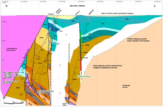
Figure from OT LLC
AMC 813001 : March : 2013
161
ENTRÉE GOLD INC Lookout Hill Property, Southern Mongolia Technical Report | |
| 10.2.4 | Ulaan Khud (Airport North) Diamond Drilling |
No new drilling was carried out on the Ulaan Khud prospect in 2012 and 2013 to date. Details of previous drilling can be found in the March 2008 NI 43-101 report (Vann et al., 2008).
| 10.2.5 | Geotechnical Drilling |
There was no geotechnical drilling done on the property in between January 2012 and March 2013.
| 10.3 | Resource Drilling – Javhlant ML |
To the end of March 2013, over 68,000 m in 54 holes had been completed on Javhlant. All of the drilling has been by core methods and was completed by OT LLC as part of the Joint Venture Agreement. The majority of the drilling has been focused on delineating the Heruga deposit where 45 holes have been drilled since 2007 for a total of 57,518 m.
Exploration diamond drilling at Heruga has been completed by diamond coring methods, with drilling using PQ, HQ or NQ core sizes. Drilling has not used triple tube to date. Most holes are collared in PQ and reduced to HQ and in some instance NQ at depth. Drillholes on the Joint Venture Property are identified in the Property database with “EJ”, for holes located on the Javhlant ML.
The prefix is followed by “D” for diamond drillholes, “RC” for reverse circulation holes, and “RCD” for RC holes with diamond tails. Geotechnical, water and condemnation drillholes do not receive a special prefix, and are identified by the drilling method.
Core drilling and database procedures have been extensively described in reports by Vann et al. (2008), Cinits and Parker (2007) and Peters et al. (2006).
The general treatment and handling of core for Heruga is as described in 9.4.3.2. QG observed all steps in core handling with the exception of marking orientation lines and cutting core (although core saws were examined). QG make the following observations and recommendations:
| · | OT LLC maintains consistency of observations from hole to hole and between different loggers by conducting regular internal checks. QG also recommends OT LLC ensure that actual observations are logged with respect to lithology rather than attempting to match a genetic model. |
| · | The manual logging system in place is potentially more error-prone than digital capture systems and recommends that such systems be investigated by OT LLC. |
| · | Samples should respect lithological, alteration or mineralization boundaries. Although this will have a negligible implication for future resource estimates, it is considered good practice and will improve the estimation quality. Duplicate core samples should not be taken at a contact. |
AMC 813001 : March : 2013
162
ENTRÉE GOLD INC Lookout Hill Property, Southern Mongolia Technical Report | |
| · | The core storage at Oyu Tolgoi represents a possible risk to the project. Given the long possible project life, the ability to locate core for the purposes of either re-logging or re-sampling is emphasized. |
All exploration diamond drillholes at Heruga are drilled approximately grid west, generally at about 70 degree inclinations. However, the holes tend to deviate systematically towards north at depth. The general orientation of drilling is considered to be appropriate, but it is likely some drilling at high angles to the “cross-section” (i.e. to the north or south) will be undertaken in future campaigns to resolve a number of geological uncertainties (for example the disposition of the mineralized quartz monzodiorite).
QG independently checked collar survey in the database versus surveyors’ records and conclude that the data used is sound.
| 10.3.1.1 | Downhole Surveys at Heruga |
Where possible, the core was oriented, initially using BallMark© but more recently using the electronic ACE© core orientation system (a fully electronic system based on accelerometers). QG consider that both of these devices are appropriate means of orienting core, and note that the frequency of core orientation on this project is appropriate.
| 10.3.1.2 | Recoveries and RQD at Heruga |
Core recovery at Heruga is generally very good. Average recovery at Heruga to date is 97% to 100%, with the relatively rare poorly recovered intervals invariably correlated to shearing and faulting.
Scott Jackson examined all the core in hole EJD-009 as well as significant runs (450 to 500 m) from holes EJD-013 and EJD-021 and confirmed that, in general, recovery was good and core condition (with the exception of faults) also very good.
OT LLC informed QG that RQD is not being recorded for Heruga core, nor has geotechnical logging been taking place, although this was reportedly standard practice at Oyu Tolgoi and Hugo Dummett. If the project progresses, geotechnical logging should be reinstituted as a routine step, because the quality of data from half core is lower.
| 10.3.1.3 | Bulk Densities at Heruga |
QG spent time on site with the TRQ Manager QA/QC Advanced Projects to confirm that the procedures described in this report are applicable to the core sample preparation for the Heruga deposit.
QG performed an inspection of the equipment and samples being subjected to specific gravity determination on site accompanied by TRQ Management. This visit did not constitute an audit. TRQ retained an independent geologist/geochemist, Barry Smee, to conduct audits of preparation and analytical facilities (Smee, 2002a, 2002b, 2003a, 2003b, 2004a, 2004b, 2004c, 2004d, 2005, 2006, 2008).
AMC 813001 : March : 2013
163
ENTRÉE GOLD INC Lookout Hill Property, Southern Mongolia Technical Report | |
| 10.3.2 | Exploration Diamond Drilling - Javhlant ML |
In 2012 to March 2013, OT LLC drilled six holes within the Javhlant ML for a total of 6,736 m. Three new exploration holes were completed to the east of Heruga; one hole (EJD0041) was collared into the core of the deposit but lost at 418 m; a daughter hole (EJD0034A) was completed on the east side of the Heruga deposit; and another hole tested the Southwest Heruga target. Details of previous drilling can be found in previous technical reports: AMEC Minproc, 2010; AMEC Minproc, 2010a; AMEC Minproc, 2010b and Minproc, 2012. Drillhole locations are shown in Figure 10.5.
Hole EJD0034 was originally drilled to test the eastern edge of the deposit on the northern-most section on the Joint Venture property but was lost in mineralization due to technical problems. To determine the extent of mineralization, hole EJD0034A was drilled as a daughter hole starting at 848 m below the original to a depth of 1,884.5 m. Assays returned three mineralized intervals. The most outstanding is 590 m of 0.33% copper, 0.70 g/t gold and 56 ppm molybdenum, or 0.80% copper equivalent (CuEq). The hole shows strongly increasing gold with depth and extends mineralization another 150 metres below the previous limit of mineralization in EJD0034. Assays are summarized below in Table 10.3. The hole is shown in cross-section in Figure 10.6.
| Table 10.3 | Significant 2012 Mineralized Intervals from the Heruga Deposit |
| Hole No | From (m) | To (m) | Interval (m) | Cu (%) | Au (g/t) | Mo (ppm) | CuEq*(%) |
EJD0034A | 1,070 | 1,112 | 42 | 0.51 | 0.22 | 215 | 0.76 |
| 1,280 | 1,870 | 590 | 0.33 | 0.70 | 56 | 0.80 | |
| 1,584 | 1,654 | 70 | 0.31 | 1.03 | 10 | 0.97 | |
| 1,740 | 1,794 | 54 | 0.28 | 1.87 | 6 | 1.48 |
Copper Equivalent (CuEq) has been calculated using assumed metal prices of US$1.35/lb for copper, US$650/oz for gold, and US$10.00 for molybdenum. The equivalence formula was calculated assuming that gold and molybdenum recovery was 91% and 72% of copper recovery respectively. CuEq was calculated using the formula: CuEq% = Cu% + ((Au g/t*18.98)+(Mo g/t*.01586))/29.76.
Hole EJD0042 (Figure 10.7) is located 2 km east of Heruga and tested an IP-gravity target. The hole was drilled to a depth of 2,004.6 m and remained in a thick section of DA4a volcanic rocks lying above target units.
On the Heruga Southwest target, hole EJD0043 was designed to test for mineralization at the south end. The hole passed through DA3b sediments (above the mineralization) before entering post-mineral Carboniferous granite which appears to have eradicated possible mineralization. This is similar to results from the EJD0035/0036/0038 section located approximately 200 m to the north.
Hole EJD0044 was drilled from the Javhlant ML onto Oyu Tolgoi ground and crossed the boundary at a depth of 1506 m; the hole ended at 2,067 m. It was drilled to test for mineralized DA1b on the eastern flank of the QMD. No significant mineralization was intersected.
Hole EJD0045 tested mineralization on the east side of the Heruga QMD but was terminated at 1,450.3 m after hitting a late fault prior to intersecting the target. The target remains valid.
AMC 813001 : March : 2013
164
ENTRÉE GOLD INC Lookout Hill Property, Southern Mongolia Technical Report | |
| Table 10.4 | Javhlant ML Drilling Summary 2012 to March 2013 |
| Hole Number | UTM Coordinates (WGS84) | Elevation (masl) | Azimuth (°) | Dip (°) | Start (m) | Final Depth (m) | Length (m) | |
| Easting | Northing | |||||||
| Heruga | ||||||||
| EJD0034A | 648563 | 4759499 | 1162 | 270 | –65 | 848 | 1,885 | 1,037 |
| EJD0041 (lost) | 647580 | 4758400 | 1160 | 270 | –50 | 0 | 418 | 418 |
| EJD0044 | 649622 | 4759528 | 1151 | 286 | 90 | 0 | 2,067 | 1,506 |
| EJD0045 | 648857 | 4758676 | 1170 | 305 | –070 | 0 | 1,450 | 1,450 |
| Heruga East | ||||||||
| EJD0042 | 650187 | 4758376 | 1160 | 295 | –065 | 0 | 2,002 | 2,002 |
| Heruga Southwest | ||||||||
| EJD0043 | 642714 | 4755612 | 1160 | 245 | –075 | 0 | 1,360 | 1,360 |
| Total | 7,773 | |||||||
Hole EJD0034A is a daughter hole below holes EJD0034.
EJD0039 and EJD0040 collared in 2011, completed in 2012.
Hole EJD0044 collared on Joint Venture ground and crossed onto OT ML at 1,506 m. Hole terminated 26 February 2013 at 2,067 m.
| Figure 10.5 | 2012 Drillhole Locations, Javhlant ML |
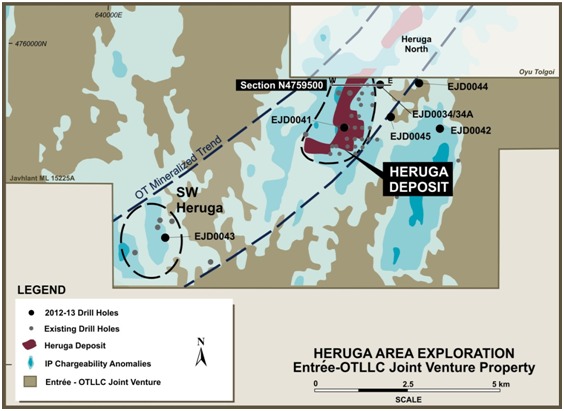
AMC 813001 : March : 2013
165
ENTRÉE GOLD INC Lookout Hill Property, Southern Mongolia Technical Report | |
| Figure 10.6 | Heruga N4759500, Looking North |
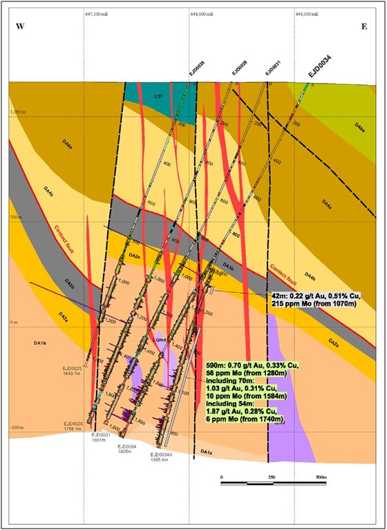
AMC 813001 : March : 2013
166
ENTRÉE GOLD INC Lookout Hill Property, Southern Mongolia Technical Report | |
| Figure 10.7 | Heruga Section Looking North-East |
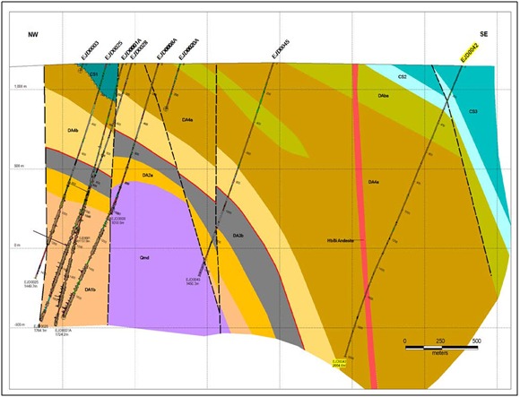
Figure from OT LLC
| 10.4 | Shivee West – Shivee Tolgoi ML (100% Entree) |
There was no drilling carried out on the Shivee West property in 2012. Details of the programs are provided in various technical reports found on SEDAR: Reid et al., 2003; Reid et al., 2004; Cann, 2004; Panteleyev, 2004a; Panteleyev, 2004b; Panteleyev, 2005; Cherrywell, 2005; Juras, 2005; Forster, 2006; Forster and Crane, 2007, Cinits and Parker, 2007; Forster et al., 2008; Vann et al., 2008; Vann et al., 2009; AMEC Minproc, 2010a; AMEC Minproc, 2010b and Minproc, 2012.
In 2011, a total of 2,470 metres of reverse circulation (RC) drilling in 23 vertical holes was completed by Entrée LLC in the vicinity of Zone III. Drilling operations, conducted under contract with Landdrill International LLC, commenced on 8 November 2011 and were completed on 19 November 2011. The rig was a custom-built EDM2000 using Sandvik RE-0052 hammers. PVC casing with 8-inch (20.32 cm) diameter was set to at least 4 metres and up to 7 metres in depth, and the holes continued to their planned depth using a 5 ½-inch (13.97 cm) face-sampling hammer. All holes were drilled on the Zone III target; all were vertical, and were completed to planned target depths. Land drill used two 12-hour shifts during the programme. All drill personnel, with the exception of project foreman and a fitter/engineer, were Mongolian.
AMC 813001 : March : 2013
167
ENTRÉE GOLD INC Lookout Hill Property, Southern Mongolia Technical Report | |
The program was designed to follow up on previous positive results from surface and trench sampling and from drilling. Drilling was completed over an area of 200 metres x 600 metres. Gold values were returned from Zone III and from 250 m metres to the north on the newly defined Argo Zone and is associated with quartz veinlets in felsic volcanic rocks. The Argo Zone is north of previously known mineralization.
To date six new RC holes (holes EGRC-11-110 to 115), two trenches and surface chip sampling define the Argo Zone. In addition, a quartz stockwork in dacitic volcanic rocks was sampled 50 m south-east of the northernmost drillhole and returned high gold values. Best results from recent RC drilling are from hole EGRC-11-123, located near the centre of Zone III, which returned 8 metres of 2.08 g/t Au. Additional results are summarized in Table 10.5.
| Table 10.5 | 2011 RC Drilling Results – Zone III and Argo |
| Hole_ID | Target | From | To | Interval | Au g/tonne | Comment |
| EG-RC-11-109 | Zone III | 63 | 67 | 4 | 0.27 | – |
| EG-RC-11-110 | Argo | 34 | 40 | 6 | 0.36 | – |
| EG-RC-11-111 | Argo | 67 | 70 | 3 | 2.21 | EOH in mineralization |
| EG-RC-11-112 | Argo | 46 | 51 | 5 | 0.91 | – |
| 47 | 48 | 1 | 3.35 | – | ||
| 63 | 77 | 14 | 1.82 | – | ||
| 71 | 75 | 4 | 5.13 | Includes 9.32 g/t Au 2.4 g/t Ag over 2 m | ||
| EG-RC-11-113 | Argo | 14 | 15 | 1 | 0.53 | – |
| EG-RC-11-114 | Argo | 17 | 20 | 3 | 0.76 | Hole ended in 0.175g/t Au over 6 m |
| EG-RC-11-117 | Argo | 60 | 61 | 1 | 0.49 | – |
| EG-RC-11-119 | Zone III | 66 | 71 | 5 | 0.36 | – |
| 76 | 78 | 2 | 0.35 | – | ||
| EG-RC-11-121 | Zone III | 65 | 67 | 2 | 0.74 | – |
| EG-RC-11-123 | Zone III | 31 | 32 | 1 | 0.70 | – |
| 67 | 75 | 8 | 2.08 | First sample of intercept is 9.34 g/t Au over 1 m | ||
| 67 | 69 | 2 | 5.60 | – | ||
| 73 | 75 | 2 | 2.08 | – | ||
| EG-RC-11-130 | Zone III | 84 | 90 | 6 | 0.23 | – |
AMC 813001 : March : 2013
168
ENTRÉE GOLD INC Lookout Hill Property, Southern Mongolia Technical Report | |
| 11 | SAMPLE PREPARATION, ANALYSES, AND SECURITY |
| 11.1 | Introduction |
Sampling on the Lookout Hill Property has been completed by both Entrée on Shivee West and by OT LLC on the Joint Venture Property. Sampling programs on the Joint Venture Property have included soil, rock chip, drill core and RC techniques.
All of the sampling on the Joint Venture Property is carried out by OT LLC personnel or contractors, except for early-stage sampling by Entrée, prior to the Earn-in Agreement being signed in October 2004. All of the early-stage sampling methods have been superseded by the drilling, which forms the basis of the Mineral Resource estimates discussed in this report, and therefore the early-stage sampling methods on the Joint Venture Property are not discussed in this report.
Sampling programs on Shivee West include soil, soil-MMI, rock chip, drill core and reverse circulation samples. All of the sampling was carried out by Entrée personnel or its contractors.
| 11.2 | Joint Venture Property |
| 11.2.1 | Sample Preparation and Shipment |
Currently, split core samples are prepared for analysis at the on-site sample preparation facility operated by SGS Mongolia. The prepared pulps are then shipped by air under the custody of OT LLC to Ulaanbaatar, where they are assayed at a laboratory (lab) facility operated by SGS Mongolia.
The facility is well-equipped and the staff well-trained by SGS Mongolia. All sample preparation procedures and QA/QC protocols were established by OT LLC in consultation with SGS Mongolia. The facility currently processes between 50 and 200 samples per month from OT LLC projects throughout Mongolia, although most of these are from Oyu Tolgoi. The maximum sample preparation capacity has been demonstrated to be around 600 samples per day when fully staffed.
The facility has one large drying oven, two Terminator jaw crushers, and two LM2 pulverizers. The crushers and pulverizers have forced air extraction and compressed air for cleaning. Smee, (2008) noted that some the equipment, in particular the crushers were in poor condition and deficient in a number of areas but also noted that according Dale A Sketchley, all concerns had been addressed as of 10 April 2008.
The samples are initially assembled into groups of 15 or 16 samples, and then 4 or 5 quality control samples are interspersed to make up a batch of 20 samples. The quality control samples comprise one duplicate split core sample, one uncrushed field blank, a reject or pulp preparation duplicate, and one or two standard reference material (SRM) samples (one <2% Cu and one >2% Cu if higher-grade mineralization is present based on visual estimates). The two copper SRMs are necessary because SGS Mongolia uses a different analytical protocol to assay all samples >2% Cu.
AMC 813001 : March : 2013
169
ENTRÉE GOLD INC Lookout Hill Property, Southern Mongolia Technical Report | |
The split core, reject, and pulp duplicates are used to monitor precision at the various stages of sample preparation. The field blank can indicate sample contamination or sample mix-ups, and the SRM is used to monitor accuracy of the assay results.
The SRMs are prepared from material of varying matrices and grades to formulate bulk homogenous material. Ten samples of this material are then sent to each of at least seven international testing laboratories. The resulting assay data are analyzed statistically to determine a representative mean value and standard deviation necessary for setting acceptance/rejection tolerance limits. Blank samples are also subjected to a round-robin programme to ensure the material is barren of any of the grade elements before they are used for monitoring contamination.
The sample preparation protocol for OT LLC samples is as follows:
| · | Coding: an internal laboratory code is assigned to each sample at reception. |
| · | Drying: the samples are dried at 75°C for up to 24 hours. |
| · | Crushing: the entire sample is crushed to obtain nominal 90% at 3.35 mm. |
| · | Splitting: the sample passes twice through an approximate 1 inch (approximately 2.5 cm) Jones Splitter, reducing the sample to approximately 1 kg. The coarse reject is stored. |
| · | Pulverization: the sample is pulverized for approximately 5 minutes to achieve nominal 90% at 75 µm (-200 mesh). A 150 g sample is collected from the pulverizer and sealed in a Kraft envelope. The pulp rejects are stored on site. |
| · | The pulps are put back into the custody of OT LLC personnel and SRM control samples are inserted as required. |
| · | Shipping: the pulps are stored in a core box and locked and sealed with “tamper-proof” numbered tags. Sample shipment details are provided to the assaying facility both electronically and as paper hard copy accompanying each shipment. The box is shipped by air to Ulaanbaatar where it is picked up by SGS personnel and taken to the analytical laboratory. SGS confirms to OT LLC staff by electronic transmission that the seal on the box is original and has not been tampered with. |
| · | Storing and submitting: The pulp rejects are stored on site at the lab for several months and then returned to OT LLC in Ulaanbaatar for storage. |
All equipment is flushed with barren material and blasted with compressed air between each sample that is processed. Screen tests are done on crushed and pulverized material from one sample taken from the processed samples that comprise part of each final batch of 20 samples to ensure that sample preparation specifications are being met.
Reject samples are stored in plastic bags inside the original cloth sample bags and are placed in bins on pallets and stored at site. Duplicate pulp samples are stored at site in the same manner as reject samples.
AMC 813001 : March : 2013
170
ENTRÉE GOLD INC Lookout Hill Property, Southern Mongolia Technical Report | |
| 11.2.2 | Analyses – Joint Venture Property |
Currently all routine sample preparation and analyses of the OT LLC samples are carried out by SGS Mongolia LLC (SGS Mongolia), who operate an independent sample preparation facility at Oyu Tolgoi site and an analytical laboratory in Ulaanbaatar. The preparation facility was installed in 2002 as a dedicated facility for OT LLC’s Project during their exploration and resource definition stages. Although the facility has mostly dealt with samples from the Oyu Tolgoi area, it also prepares some samples from other OT LLC projects in Mongolia. This Oyu Tolgoi facility closed in November 2008, after completion of Heruga drilling but reopened again in late 2011.
The SGS Mongolia analytical laboratory in Ulaanbaatar and the SGS laboratory in Perth were recognized as having ISO 9001:2000 and ISO/IEC 17025 accreditation respectively (SGS 2006). The National Association of Testing Authorities Australia has accredited Genalysis to operate in accordance with ISO/IEC 17025 (1999), which includes the management requirements of ISO 9002:1994.
| 11.2.2.1 | SGS Mongolia |
All samples are routinely assayed by SGS Mongolia for gold, copper, and molybdenum. Gold is determined using a 30 g fire assay fusion, cupelled to obtain a bead, and digested with Aqua Regia, followed by an AAS finish, with a detection limit of 0.01 g/t. Prior to 2011, copper and molybdenum are determined by acid digestion of a 0.5 g subsample, followed by an AAS finish. Samples are digested with nitric, hydrochloric, hydrofluoric and perchloric acids to dryness before being leached with hydrochloric acid to dissolve soluble salts and made to volume with distilled water. The detection limits of the copper and molybdenum are 0.001% and 10 ppm, respectively. The same acid digestion is also used for analyses of Ag and As, with detection limits of 1 ppm and 100 ppm. In 2011, following concerns related to lower level precision of Ag, As and Mo assaying, OT LLC decided to switch methods for Cu, Mo, Ag, As and a suite of other elements to ICP-OES/MS.
OT LLC also conducts a Trace Elements Composites (TEC) programme, in addition to routine copper gold and molybdenum analyses. Ten metre composites of equal weight are made up from routine sample pulp reject material. The composites are subject to multi-element analyses comprising a suite of 48 elements determined by inductively coupled-plasma ICP-OES/MS methods after 4 acid digestions. Additional element analyses include mercury by Cold Vapor atomic absorption spectroscopy (AAS), fluorine by KOH Fusion/Specific Ion Electrode, and carbon/sulphur by Leco furnace. OT LLC uses results from the TEC programme for deleterious element modelling.
According to the most recent audit in April 2008 (Smee, 2008), the analytical laboratory has implemented some significant improvements since the last audit and is using procedures and equipment that are consistent with industry “best practices” and therefore can be used for resource estimating purposes.
SGS Mongolia reports the results digitally to OT LLC via email and submits signed paper certificates. General turn-around is approximately 7 days. All hard copy certificates are stored in a well-organized manner in a secure location on site and copies are kept off site for security.
AMC 813001 : March : 2013
171
ENTRÉE GOLD INC Lookout Hill Property, Southern Mongolia Technical Report | |
| 11.2.3 | QA/QC Programme - Joint Venture Property |
OT LLC has a comprehensive QA/QC programme in place (Sketchley and Forster, 2007) comprising: inserting standard reference samples (SRM’s), blank material, duplicate samples and check assays. All sampling and QA/QC work is overseen on behalf of OT LLC Mines by their QA/QC Manager Dale A. Sketchley, M.Sc., P. Geo. Since March 2002, OT LLC has retained independent geologist/geochemist Barry Smee, P.Geo, to conduct semi-annual audits of both the preparation and analytical facilities (Smee 2002a, 2002b, 2003a, 2003b, 2004a, 2004b, 2004c, 2004d, 2005, 2006, 2008). The most recent audit was completed in late April 2008. Mr. Smee concluded in the last audit that the SGS Mongolia sample preparation laboratory was operating efficiently and with full QC protocols in place and the Ulaanbaatar analytical facility is using procedures and equipment that are consistent with industry “best practices” and can be used for resource estimation purposes.
| 11.2.3.1 | Blank Sample Performance and Sample Duplicates |
Figure 11.1 and Figure 11.2 show typical assay performance of field blanks for gold and copper. In these figures, the lower blue horizontal line represents the analytical detection limit (ADL) of the respective metal, and the upper yellow horizontal line represents the analytical rejection threshold (ART). The gold ADL is 0.01 g/t with an ART of 0.06 g/t; copper ADL was initially 0.01% and is now 0.001% with an ART of 0.06%. The results show a low incidence of contamination and a few cases of sample mix-ups, which were investigated at site and corrected.
The QA/QC programme currently uses three different types of duplicate samples: core, coarse reject, and pulp; laboratory check pulp samples sent to an umpire lab were only used up to the end of 2005 and the programme is now in abeyance.
The same criteria do not apply to core duplicates because these differences cannot be controlled by the subsampling protocol; however, the heterogeneity of the mineralization ideally would allow the difference to be less than 30%. Table 11.1 summarize the results of the Percentile Rank statistical analyses for each type of sample with charts of the results shown in Figure 11.3 and Figure 11.4.
AMC 813001 : March : 2013
172
ENTRÉE GOLD INC Lookout Hill Property, Southern Mongolia Technical Report | |
| Figure 11.1 | Field Blank Performance – Gold |
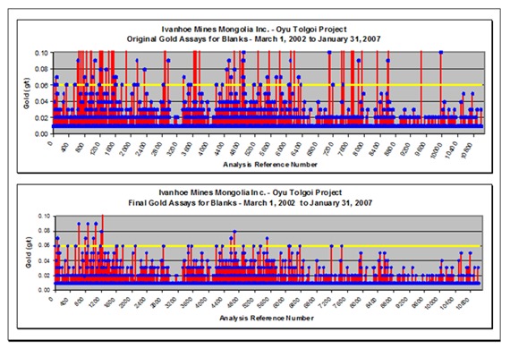
| Figure 11.2 | Field Blank Performance – Copper |
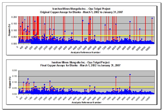
AMC 813001 : March : 2013
173
ENTRÉE GOLD INC Lookout Hill Property, Southern Mongolia Technical Report | |
| Figure 11.3 | Gold Duplicate Samples |
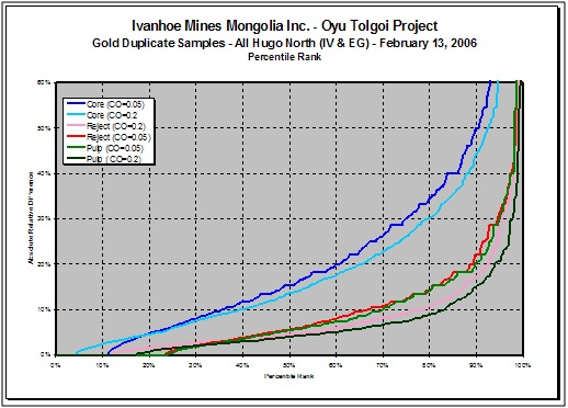
| Figure 11.4 | Copper Duplicate Samples |
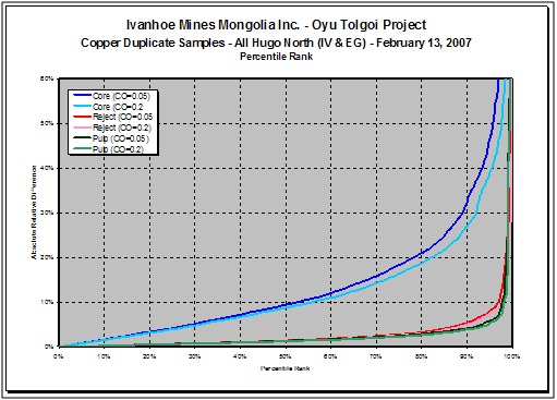
AMC 813001 : March : 2013
174
ENTRÉE GOLD INC Lookout Hill Property, Southern Mongolia Technical Report | |
The coarse reject and pulp duplicates for gold are about the same because of the finer reject crushing size. Although the reject precision is within the ideal threshold, the pulp duplicates tend to be higher, which is probably because most gold values lie near the detection limit where precision is poorer. This is further supported by an improvement in precision at higher grades, although there is also a possibility of gold liberation during pulverization. For copper, both coarse reject and pulp duplicates are also similar because of the finer reject crushing size with both being well within the ideal limits. Core duplicates for both copper and gold are above the ideal arbitrary value of 30%, which is related to an uneven distribution of mineralization between core halves as typically caused by quartz vein and fracture controlled mineralization.
| 11.2.3.2 | Check Assay Programme |
For most of the drill programmes OT LLC has maintained a check assay programme sending approximately 5% of assayed pulps to external (secondary) laboratories.
| Table 11.1 | Duplicate Percent Difference at the 90th Population Percentile |
| Duplicate Type | Cu | Au | ||
| No. | Diff. (%) | No. | Diff. (%) | |
| Core Cut Off = 0.2 g/t | 1969 | 40 | 848 | 44 |
| Coarse Reject Cut Off = 0.2 g/t | 996 | 5 | 445 | 17 |
| Pulp Cut Off = 0.2 g/t | 934 | 4 | 434 | 15 |
SGS Welshpool in Perth was designated as the secondary laboratory until May 2005 (drillhole OTD900), when OT LLC switched to Genalysis in Perth.
| 11.2.4 | QG 2008 Review and Comments on OT LLC Sampling and QA/QC |
| 11.2.4.1 | Sample Preparation and Shipment for Heruga |
John Vann (QG) spent time with TRQ QA/QC Management and confirmed the procedures (described in Section 11.2 of this report) are still applicable to the core sample preparation for the Hugo North and Heruga deposits.
The security measures in place for shipment of pulps to the SGS analytical laboratory in Ulaanbaatar were briefly reviewed (including observing the dispatch of samples) and are considered by Scott Jackson to be adequate and appropriate (these are discussed further under Section 11.2.4.1 of this report).
| 11.2.4.2 | QG Review of the On-Site Sample Preparation Laboratory |
QG performed an inspection of SGS Mongolia sample preparation facility on site during both site visits (accompanied by Dale A. Sketchley). These visits did not constitute an audit. OT LLC retained an independent geologist/geochemist, Barry Smee, to conduct audits of preparation and analytical facilities (Smee 2002a, 2002b, 2003a, 2003b, 2004a, 2004b, 2004c, 2004d, 2005, 2006, 2008).
AMC 813001 : March : 2013
175
ENTRÉE GOLD INC Lookout Hill Property, Southern Mongolia Technical Report | |
In general, QG is of the opinion that this facility is set up and operating in a satisfactory manner. Recommendations about sample preparation made after the first site visit were all noted to have been implemented at the time of the second site visit.
QG recommend that the sample preparation facility be audited at least annually.
| 11.2.4.3 | Heruga Analyses |
QG understand that the analytical protocol followed for Heruga are the same as for previous work at Oyu Tolgoi and Hugo Dummett deposits, as described in Section 11.2 of this report.
QG checked a selection of assays in the database (about 13% of the data employed for the Mineral Resource estimate) against signed certificates as part of the database validation (see Section 14 of this report) and found no errors.
Scott Jackson (QG) briefly visited the SGS Mongolia Minerals assay laboratory at Barmash Building, Chinggis Avenue, Khan-Uul District Ulaanbaatar. This visit did not constitute an audit and there were very few sections of the laboratory actually working on the day (due to a very low workload on the day). OT LLC retained an independent geologist/geochemist, Barry Smee, to conduct audits of analytical facilities (Smee 2002a, 2002b, 2003a, 2003b, 2004a, 2004b, 2004c, 2004d, 2005, 2006, 2008).
QG’s brief review of the laboratory in Ulaanbaatar concluded the laboratory was well run with properly-maintained equipment, a stable workforce and appropriate quality control measures in place. QG noted that there was a high degree of manually recorded readings compared to most modern laboratories.
QG recommend that the SGC analytical laboratory facility in Ulaanbaatar be audited at least annually.
| 11.2.4.4 | QG Comments on Sampling and QA/QC |
QG spent time during site visits with Dale A. Sketchley (OT LLC Manager QA/QC Advanced Projects), who presented the current systems of quality management to QG. These systems are also summarized in Sketchley and Forster (2007).
All sampling, assaying, and QA/QC work at Heruga was overseen by Dale A. Sketchley, assisted by Ariunaa Tuvshintsengel (QA/QC Data Manager, OT LLC).
QG focused their attention on the elements being estimated in the resource, i.e. copper, gold, molybdenum and silver, and make the following specific comments and recommendations:
| · | That the steps described in Section 11.2 of this report are continuing on the Heruga Project. |
| · | The general level of diligence and supervision of sample preparation and analytical quality control is good. |
AMC 813001 : March : 2013
176
ENTRÉE GOLD INC Lookout Hill Property, Southern Mongolia Technical Report | |
| · | The frequency of insertion of SRM, blanks and pulp duplicates is considered to be sufficient to manage the quality of data. |
| · | The monthly QA/QC reports of Sketchley and Tuvshintsengel (example referenced: Sketchley and Tuvshintsengel, 2008) form a better than industry average reporting of quality management on the project. |
| · | Fail criteria for assay batches were considered to be appropriate. |
| · | There are minor biases evident in many of the standard run-charts, mostly minor, and in many instances, reversing over time (thus not contributing to global bias). |
Improved matrix matched SRM’s and closer monitoring have resulted in results for Mo being acceptable. In conclusion, the Mo value of SRM’s should be monitored carefully, and the source of any biases investigated. The biases for Mo discussed here, if present are likely to result in grades being understated, and thus would lead to conservatism in the Mineral Resource estimate.
QG considers that the maintenance of a check assay programme is good practice. QG was advised by OT LLC that a check assaying procedure has been re-instituted.
The duplicates for assay pulps and coarse rejects for Heruga are performing satisfactorily.
Scott Jackson concludes that IMMI's (now OT LLC) past and current sample preparation, analytical and QA/QC procedures, as well as the security measures in place, are adequate and appropriate and consider that the data for the Project are acceptable as inputs to resource estimation.
Figure 11.5 to Figure 11.8 summarizes the average gold, copper and molybdenum bias between 2002 and 2008 at SGX. Analytical results shown on each of the QC monitoring charts (Figure 11.5 to Figure 11.13) have been divided into two parts with subtitles, “RR Assays” and “Routine Assays”. The subtitle “RR Assays” denotes analytical results obtained from each of the participating laboratories that were used to determine the mean and +2SD/3SD tolerance limits marked on each chart. The subtitle “Routine Assays” denotes analytical results obtained from the SGS-UB, the lead analytical laboratory.
AMC 813001 : March : 2013
177
ENTRÉE GOLD INC Lookout Hill Property, Southern Mongolia Technical Report | |
| Figure 11.5 | Average SGS SRM Gold Bias, 2002 to 2008 |
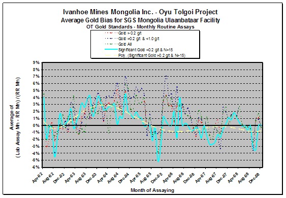
| Figure 11.6 | Average SGS SRM Copper Bias, 2002 to 2008 |
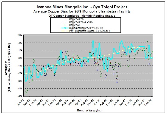
AMC 813001 : March : 2013
178
ENTRÉE GOLD INC Lookout Hill Property, Southern Mongolia Technical Report | |
| Figure 11.7 | Average SGS SRM Molybdenum Bias, 2002 to 2008 |
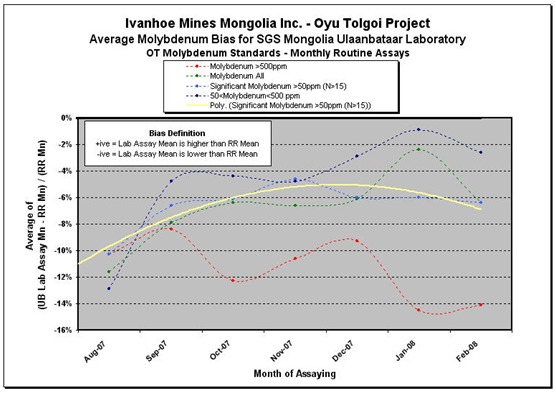
AMC 813001 : March : 2013
179
ENTRÉE GOLD INC Lookout Hill Property, Southern Mongolia Technical Report | |
| Figure 11.8 | SRM #27 Charts – Gold Original and Final |
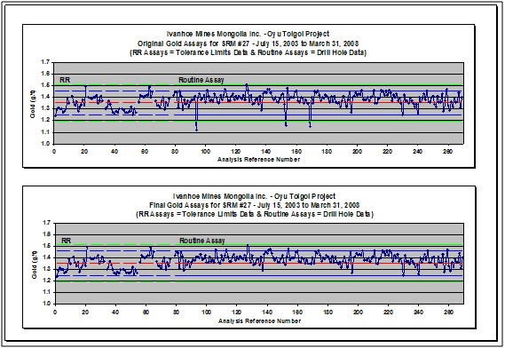
| Figure 11.9 | SRM #27 Charts – Copper Original and Final |
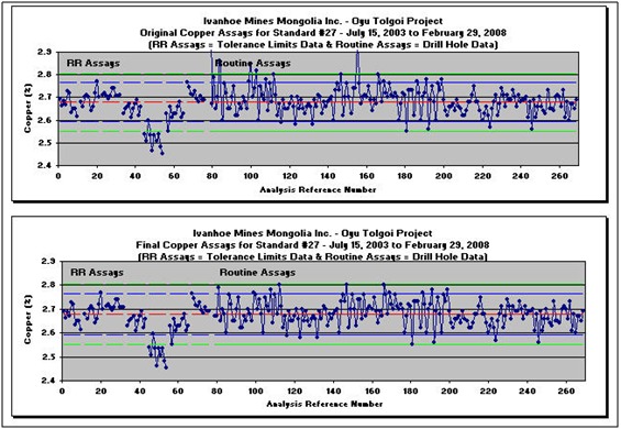
AMC 813001 : March : 2013
180
ENTRÉE GOLD INC Lookout Hill Property, Southern Mongolia Technical Report | |
| Figure 11.10 | SRM #27 Charts – Molybdenum Original and Final |
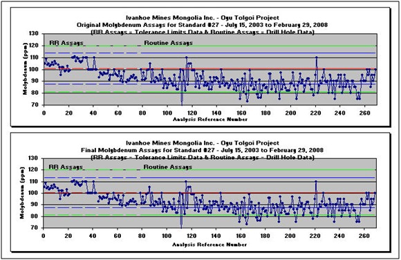
| Figure 11.11 | SRM #33 Charts – Gold Original and Final |
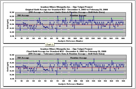
AMC 813001 : March : 2013
181
ENTRÉE GOLD INC Lookout Hill Property, Southern Mongolia Technical Report | |
| Figure 11.12 | SRM #33 Charts – Copper Original and Final |
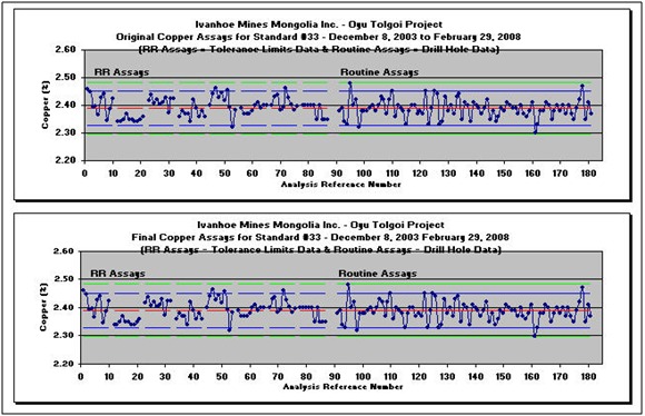
| Figure 11.13 | SRM #33 Charts – Molybdenum Original and Final |
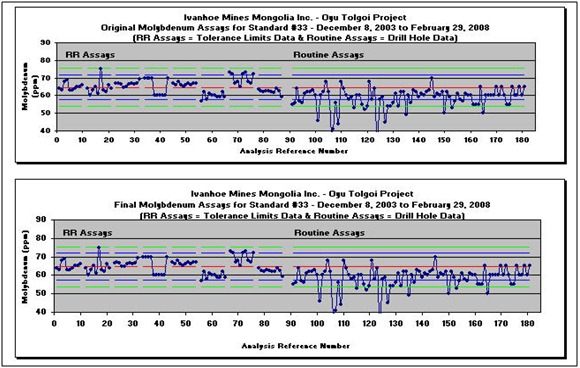
AMC 813001 : March : 2013
182
ENTRÉE GOLD INC Lookout Hill Property, Southern Mongolia Technical Report | |
| Figure 11.14 | SRM #33 Charts – Molybdenum Original and Final |
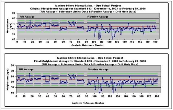
| Figure 11.15 | SRM #50 Charts – Molybdenum Original and Final |
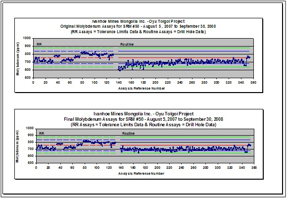
AMC 813001 : March : 2013
183
ENTRÉE GOLD INC Lookout Hill Property, Southern Mongolia Technical Report | |
| 11.3 | Shivee West Property |
Sampling programmes on Shivee West have included soil, rock chip, drill core and RC samples. From 2010 to 2012 sampling was limited to drill core, RC and rock chip (trench) samples. All of the sampling was carried out by Entrée personnel or contractors.
The sampling procedures are described further below.
| 11.3.1 | Rock Sampling and Shipping |
Rock sampling for assaying in 2012 included 37 grab samples and 23 oriented chip samples collected from outcrops. As well, 547 chip samples were collected from trenches excavated on the various targets tested in 2012.
Grab samples were taken from lithologies or mineralization of interest encountered during mapping. Oriented chip sample traverses were collected from outcrops with known or suspected gold mineralization over sample length(s) determined on lithological or mineralization criteria, with azimuth, inclination, and length of the individual chip line recorded. Trench samples were collected on regular intervals usually 2 or 3 metres, continuously over the trench length or as exposed outcrop allowed. Due to the friable or crumbling nature of trenched bedrock, no attempt was made to take rigorous channel samples; instead, a series of walnut-sized chips for each sample length were collected from one or the other trench wall. Each chip sample traverse or trench sample series is identified by the first sample in the traverse plus a “T” prefix.
Regardless of type, all rock samples were inserted into plastic bags with uniquely- numbered sample tags, bagged in rice bags, and sent by secure transport to SGS Mongolia or to Actlabs in Ulaanbaatar for analyses.
| 11.3.2 | Drill Core Sample Preparation and Shipment |
Core was transported to Entrée’s Shivee Tolgoi camp for logging, splitting and sampling. Core was split using a diamond-blade core saw. Sampling was generally on 2 m intervals. Cutting intervals were marked on the wooden core trays, and sample tags inserted along each core sample run. Core was sampled as it was split, and the sampled portion and relevant sample tag placed into pre-numbered plastic bags. The bags were sealed with a zip-tie. Field blanks and standards were inserted at random into the sampling stream at a rate of one per 20 samples.
Five to eight plastic-bagged samples were placed into rice sacks, which were also zip-tied, prior to dispatch via truck to the SGS Mongolia laboratory in Ulaanbaatar. The remaining half-core was taken to a fenced core-storage compound at Entrée’s Shivee Tolgoi camp, where it has been pallet-stacked.
| 11.3.3 | Drill Core Analyses (SGS Mongolia) |
Routine sample preparation and analyses of Entrée’s diamond drill core samples was carried out by SGS Mongolia LLC at the Ulaanbaatar facility, an ISO9000:2001 accredited lab. SGS Mongolia benchmark testing is restricted to confidential internal-SGS round-robins.
AMC 813001 : March : 2013
184
ENTRÉE GOLD INC Lookout Hill Property, Southern Mongolia Technical Report | |
SGS Mongolia sorts the samples, verifying the sample numbers on bags to the sample submission sheets, and assigns a laboratory job number. Sample weights are recorded; weights range from 1 to 15 kg, depending on core diameter and amount of core loss during drilling/sampling.
The 2-stage sample crushing protocol involves firstly crushing core in a jaw crusher to 100% passing nominal -6 mm, and secondly crushing in a TM Engineering Terminator to 85% passing 3.35 mm. The crushed sample is split using an 8 bin TM Engineering rotary splitter. The sample from one bin is placed into a stainless-steel tray, with a sample number tag, for drying, and becomes the primary sample. The remaining seven bins, which form the coarse reject, are emptied back into the original sample bag.
The primary sample is dried at about 65 to 70°C in a stainless steel tray, and then pulverised in a Labtech LM2 pulverizer using low-Cr bowls to 90% passing 75 µm. On request from Entrée on specific samples, approximately 100 g of the sample is bagged into a paper Kraft bag. More normally, the entire sample is funnelled into a paper bag for analysis.
Sizing tests are performed to assess whether the SGS Mongolia pulverising techniques are performing adequately. Sizing data is reported both in digital data and hard-copy assay certificates.
Gold analysis is undertaken using the SGS Mongolia FAE303 assay method, comprising a 30 g fire assay, with an AAS finish after DIBK solvent extraction. The lower detection limit is 1 ppb Au. Samples that assay over 1 g/t Au are automatically rerun, using the same analytical method.
SGS Mongolia reports assay results digitally to Entrée via email, and submit hard-copy signed paper certificates. Electronic versions of the assays are maintained in a Century Systems database. Hard-copy certificates are stored in Entrée’s Vancouver office and duplicates stored in the Entrée office Ulaanbaatar.
| 11.3.4 | RC Chip Sample Preparation and Shipment (2011) |
All chip logging and sampling took place at the drill rig around the clock. Sampling was done on 1 m intervals as determined by the driller. Different sampling protocols were required, based on wet/dry chip return. Of the 2470 samples collected, 121 samples were wet.
Dry samples were retrieved in 5 gallon plastic pails from the EDM2000 cyclone by Entrée personnel. Dry samples were split in a riffler on a 7 to 1 reject (“C”-sample) - analytical sample (“B”-sample) split. The B-sample was placed into a numbered cloth bag with a sample assay tag and tied closed. The C-sample was placed into a rice bag marked with the hole number, meterage and corresponding assay sample tag number. A portion of the C-sample was brought to a mobile chip-logging container for washing and chip description (“A”-sample). Representative chips from the A-sample were archived in plastic chip trays for future reference.
Wet samples were retrieved in 5 gallon plastic pails from the EDM2000 cyclone by Entrée personnel. Because wet samples cannot be split readily in a riffler, Entrée personnel scooped roughly 1/8th of the sample from the pail and placed it into a numbered cloth bag with a sample assay tag and tied closed (“B”-Sample). The remaining sample (“C”-Sample) was placed into a rice bag marked with the hole number, meterage and corresponding assay sample tag number. A portion of the C-sample was brought to a mobile chip-logging container for washing and chip description (“A”-sample). Representative chips from the A-sample were archived in plastic chip trays for future reference.
AMC 813001 : March : 2013
185
ENTRÉE GOLD INC Lookout Hill Property, Southern Mongolia Technical Report | |
After each hole was complete an additional sample (“D”-sample) was collected from the C-sample for potential future metallurgical work. The dry C-samples were split in a riffler on a 1 to 1 reject – metallurgical sample (“D”-sample) split. The D-sample was placed into a numbered plastic bag and sealed it with a zap strap. The reject was returned to the original rice bag. Because wet samples cannot be split readily in a riffler, Entrée personal scooped roughly half of the reject sample from the rice bag into a numbered plastic bag and sealed it with a zap strap. All D-samples are currently stored in two locked containers at the Shivee Tolgoi exploration camp.
Five to eight of the analytical samples (“B”-sample) were placed into rice sacks, which were also zip-tied, prior to dispatch via truck to the ActLabs Asia LLC laboratory in Ulaanbaatar.
| 11.3.5 | RC Chip Sample Analyses - ACTLABS |
No drilling was done in 2012. In 2011, Entrée submitted 2,470 chip samples – one for each metre of our 2,470 m RC programme along with 145 duplicate samples, 146 field blanks and 146 standards. All samples have been submitted to Actlabs Asia LLC in Ulaanbaatar, Mongolia.
Samples were crushed to a nominal -10 mesh (1.7 mm), mechanically riffle-split to obtain a representative sample and then pulverized to at least 95% -150 mesh (106 micron). ACTLABS routinely uses cleaner sand between each sample to avoid inter-sample contamination. All were analyzed for gold using ACTLABS analytical method 1A2-30 (Au – Fire Assay Atomic Absorption Finish on 30-gram splits (detection limits 1 – 3,000 ppb). Samples in excess of 1000 ppb Au were run using a 29.16-gram split from the initial pulp using ACTLABS analytical method 1A3-30 (Au – Fire Assay Gravimetric Finish (detection limits 0.03 – 1,000 ppm). Silver was analyzed for all samples using ACTLABS analytical method Code 1E M-Ag (Ag – Aqua Regia Digestion Atomic Absorption Finish on 30-gram splits (detection limits 1 – 3,000 ppb.
Samples are being analyzed for Au and Ag only using the following analytical methods:
| · | Prep – RX1 – Crush (<5 kg) up to 90% passing 2 mm, split (1,000 g) & pulverize (hardened steel) to 95% passing 75 micron. |
| · | Au – All samples will be analyzed for Au using method 1A2-30 with AA finish; gavimetric (1A3-30) confirmation for samples reporting >1.00 ppm. |
| · | Ag – All samples will be analyzed for Ag using method 1EM (2 acid digestion). |
AMC 813001 : March : 2013
186
ENTRÉE GOLD INC Lookout Hill Property, Southern Mongolia Technical Report | |
| 11.3.6 | Soil Sampling - MMI |
A total of 4,610 MMI soil samples have been collected on the Shivee Tolgoi Licence over the Devonian and Carboniferous stratigraphy similar to that exposed at Oyu Tolgoi.
Mobile Metal Ion (MMI™) is an analytical technique used to detect very low concentrations of elements in bedrock buried below thick overburden and cover rocks. Samples were collected from a grid established by hand-held GPS or by chain-and-compass; lines were spaced on 200 m centres, and samples collected on 25 m centres. Each sample was collected from depths ranging from 25 cm to 35 cm, using a stainless steel trowel and sieved to -1/4-inch mesh at the collection site. Each sample was bagged in a uniquely-numbered ziploc plastic bag corresponding to the uniquely-numbered sample tag inserted within. Duplicate samples were inserted into the sampling stream at a rate of one per 20 samples. No sample processing or drying was done in the field – samples were submitted on an “as-is” basis to the SGS laboratory in Ulaanbaatar, and eventually shipped to SGS in Mississauga for MMI-M analyses.
MMI™ technology uses proprietary extractants. MMI-M is a single multi-element leach that measures the concentration of a broad selection of mobile elements. Target elements are extracted using weak solutions of organic and inorganic compounds rather than conventional aggressive acid or cyanide-based digests. MMI solutions contain strong ligands, which detach and hold metal ions that were loosely bound to soil particles by weak atomic forces in aqueous solution.
This extraction does not dissolve the bound forms of the metal ions. Thus, the metal ions in the MMI solutions are the chemically active or ‘mobile’ component of the sample. Because these mobile, loosely bound complexes are in very low concentrations, measurement is by conventional ICP-MS and ICP-MS Dynamic Reaction Cell™ (DRC II™), allowing very low detection.
| 11.3.7 | Entrée QA/QC Programme |
| 11.3.7.1 | Quality Assurance and Quality Control |
On receipt of analytical results, the lab sample weights were compared to field sample weights, which were checked for discrepancies. None were found, indicating no problem for sample handling between field and lab.
In 2010, 614 core samples were analyzed for Au, Cu, Mo, Ag, Zn and Pb by SGS Mongolia in Ulaanbaatar. Field duplicates, field blanks and standards were inserted at random into the sampling stream at a rate of one per 20 samples. The quality of the data received from the laboratory was verified by the QA/QC module within the Century Systems Database. Batches failed if the Cu and/or Au values returned for a standard were greater than 3 standard deviations from their accepted value, or if the Cu and/or Au values of a field blank were above a certain threshold.
A total of 37 standards and 36 field blanks were used in 2010. The standards used were prepared by CDN Resource Laboratories Ltd located in Langley, British Columbia. The field blanks consisted of locally derived granite.
AMC 813001 : March : 2013
187
ENTRÉE GOLD INC Lookout Hill Property, Southern Mongolia Technical Report | |
| Table 11.2 | 2010 Standards – Summary |
| Standard | Au (mean) | Au (SD) | Cu (mean) | Cu (SD) | # Used in 2010 |
| CDN-CGS-1 | 530 ppb | 34 ppb | 5960 ppm | 145 ppm | 6 |
| CDN-CGS-2 | 970 ppb | 46 ppb | 1.177 % | 0.023 % | 1 |
| CDN-CGS-3 | 530 ppb | 24 ppb | 6460 ppm | 155 ppm | 6 |
| CDN-CGS-5 | 130 ppb | 10 ppb | 1550 ppm | 30 ppm | 8 |
| CDN-CGS-6 | 260 ppb | 15 ppb | 3180 ppm | 90 ppm | 5 |
| CDN-CGS-7 | 950 ppb | 40 ppb | 10100 ppm | 350 ppm | 1 |
| CDN-CGS-8 | 80 ppb | 6 ppb | 1050 ppm | 40 ppm | 8 |
| CDN-CGS-9 | 340 ppb | 17 ppb | 4730 ppm | 125 ppm | 2 |
| Total | 37 | ||||
| Table 11.3 | 2010 Field Blanks – Summary |
| Field Blank | Au ppb (mean) | L. Limit | U. Limit | Cu ppm (mean) | L. Limit |
| FLDBLANK | 1.6 | 0 | 35 | 16.5 | 0 |
Gold and copper control charts for each of the standards and the field blank are found below. Of the following control charts, the only one indicating potential contamination is the Cu FLDBLANK chart. The chart shows quite a bit of variability in Cu values over the 2010 field season. This degree of variability was not noted among the standards and it is possible that this variability is due to matural variations in Cu in the quarried granite. The final chart in this report compares the FLDBLANK Cu data from 2007 and 2010*. The values from 2007 vary between 10–40 ppm, while the data from 2010 varies between 10 to 370 ppm. The blank material (locally derived granite) used during the 2010 field season was originally collected at the beginning of the 2007 field season. Since the time of collection, the blank material has been stored outside in a steel drum with no cover. Under these conditions it is conceivable that contamination of the samples has happened. The recommendation for the 2011 field season is to store the blank material indoors in a covered non-metal storage container, and to replace the blank material with fresh samples on a more regular basis. This was done in the 2011 field season for the RC drilling.
In 2010, of the 14 batches of drill core samples assayed, two batches failed. One was re-assayed and passed for both Cu and Au. For the second, since no significant mineralization was intersected in the drillhole in question, the batch was not re-run.
In the 2011 RC programme, standards (Table 11.4) and field blanks using locally quarried granite (Table 11.5) were inserted into the sampling stream to verify quality control at the analytical lab at a rate of one per 20 samples. A total of 146 standards and 146 field blanks were used. The standards were prepared by CDN Resource Laboratories Ltd., British Columbia. Three standards were used in 2011, CGS-2, CGS-4 and CGS-5. The field blanks consisted of locally derived granite, inserted into the sampling stream at a rate of one per 20 samples. Duplicate samples were collected by running the 75% split through the splitter a second time on a 25% – 75% basis to obtain a duplicate A-sample. In total, 145 duplicates were inserted.
AMC 813001 : March : 2013
188
ENTRÉE GOLD INC Lookout Hill Property, Southern Mongolia Technical Report | |
All duplicates, standards and blanks were also submitted to ACTLABS for analyses as described above.
In 2011, a total of 10 batches were assayed, which includes 2,470 regular samples and 437 QC samples from RC drillholes EG-RC-11-109 to 131. A check assay programme at a secondary lab has not yet been implemented. The regular sample batches are listed in Table 11.4. Table 11.5 summarizes the QC samples applied to the Actlabs samples over the total period.
| Table 11.4 | Actlabs Regular Assay Batches Included in This Report. |
| Lab Batch | Certificate Date |
| U11-1505 | 09/12/2011 |
| U11-1506 | 09/12/2011 |
| U11-1537 | 09/12/2011 |
| U11-1552 | 09/12/2011 |
| U11-1553 | 09/12/2011 |
| U11-1583 | 11/12/2011 |
| U11-1588 | 14/12/2011 |
| U11-1589 | 15/12/2011 |
| U11-1590 | 15/12/2011 |
| U11-1591 | 16/12/2011 |
| Table 11.5 | QC Summary - Actlabs 9 to 16 December 2011 |
| Type | Number | % |
| Regular assays | 2,470 | – |
| Duplicates | ||
| Twins | 0 | 0.0% |
| RC field duplicates | 145 | 5.9% |
| Coarse duplicates | 0 | 0.0% |
| Pulp duplicates | 0 | 0.0% |
| Total Duplicates | 145 | 5.9% |
| Blanks | ||
| Coarse blanks | 146 | 5.9% |
| Fine blanks | 0 | 0.0% |
| Total Blanks | 146 | 5.9% |
| Standards | 146 | 5.9% |
| Total QC | 437 | 17.7% |
Failure limits for lab results were set at three standard deviations above and below the actual Au content for standards.
A total of 145 RC field duplicate pairs were reviewed, which accounts for a 5.9% insertion rate. Max-Min plots were prepared for Au and Ag (see Appendix). No failures were identified for either element. The results of the RC field duplicate samples are considered within the acceptable range for all the studied elements (at least 90% of the sample pairs should plot within the failure limits, evaluated for a maximum relative error of 30%). The RC sampling variance is within acceptable limits.
AMC 813001 : March : 2013
189
ENTRÉE GOLD INC Lookout Hill Property, Southern Mongolia Technical Report | |
In total, 146 coarse blank samples were processed, which accounts for a 5.9% insertion rate. Samples were processed taking into account the previous sample grade. All samples returned values either below the detection level or occasionally at or near the detection level for both Au and Ag.
In total, 146 standards were processed, which accounts for a 5.9% insertion rate. Table 11.6 summarizes the certified values for each SRM, which are commercially available standards, purchased at CDN Labs in Langley, BC.
The following criteria are used to evaluate the accuracy of the standard:
| • | Good = 0 to ±5% bias; |
| • | Reasonable = +5 to +10% or -5% to -10% bias; |
| • | Unacceptable: >10%, </10% bias. |
All Au standards returned acceptable (good) levels of bias (Table 11.7). No samples were flagged as being failures (outliers). The failure criteria is if two consecutive samples plotted outside of the Ave ±2SD range, or one sample outside of the Ave ±3SD.
| Table 11.6 | Certified Values (CDN Labs) |
| Standard | Au (ppm) | Cu (%) |
| CDN-CGS-2 | 0.97 | 1.177 |
| CDN-CGS-4 | 2.09 | 1.947 |
| CDN-CGS-5 | 0.13 | 0.155 |
| Table 11.7 | Summary of Standards Au |
| Standard | Outliers | Bias (%) | Number of Samples |
| CDN-CGS-2 | 0 | 1.3 | 60 |
| CDN-CGS-4 | 0 | 1.3 | 60 |
| CDN-CGS-5 | 0 | 1.2 | 26 |
The QC data processing to date at Actlabs indicates good results.
The overall QC insertion rate is good (17.7%), however, during future drilling programmes it is recommended that the QC insertion programme be modified to include the insertion of coarse and fine duplicates, as well as fine blanks. In addition a check assay programme at a secondary lab should be initiated at various times during the programme. A rough template for an RC drilling programme is included in Table 11.8.
AMC 813001 : March : 2013
190
ENTRÉE GOLD INC Lookout Hill Property, Southern Mongolia Technical Report | |
| Table 11.8 | Suggested QC Programme for RC Drilling |
| Type | ID | Description | Frequency (per 50 reg samples) | Freq (%) |
| Duplicate | Field duplicate | Collected at rig | 1 | 2% |
| crush dup | prep lab inserts | 1 | 2% | |
| pulp dup | prep lab inserts | 1 | 2% | |
| Subtotal of Duplicates | 3 | 6% | ||
| Standard | high | 95th% percentile | 1 | 2% |
| med | average grade | 1 | 2% | |
| low | cut-off | 1 | 2% | |
| Subtotal of Standards | 3 | 6% | ||
| Blank | coarse | 1 | 2% | |
| fine | 1 | 2% | ||
| Subtotal of blanks | 2 | 4% | ||
| Check assays | 3 | 6% | ||
| Total | – | 11 | ||
| Note: | For core drilling substitute the RC field duplicate for a core twin sample. |
RC Field Duplicate data indicate that sampling variances are within acceptable ranges.
No coarse or pulp duplicate samples were collected and therefore a conclusion cannot be reached regarding subsampling and analytical variances.
The coarse blanks did not reveal any potential cross-contamination events during preparation and/or assaying. For future programmes a pulp blank should accompany the coarse blank (inserted immediately before it) to determine whether sample contamination is occurring at the pulverization and analytical stage. When possible, the core logging geologist should attempt to insert the two blanks immediately following a high grade sample.
The standard insertions indicate that analytical accuracy for Au is within acceptable ranges.
The 2011 RC sample batches can be accepted and used for future resource estimation purposes.
Failure limits for lab results were set at three standard deviations above and below the actual Au content for standards.
The following figures are to provide an example of the data analysis.
AMC 813001 : March : 2013
191
ENTRÉE GOLD INC Lookout Hill Property, Southern Mongolia Technical Report | |
| Figure 11.16 | SRM CGS-1 Chart – Au ppm FAE303 |
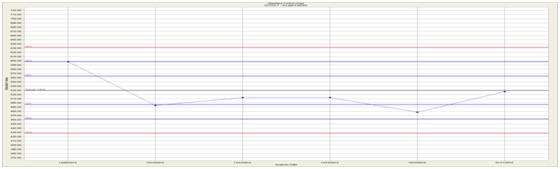
| Figure 11.17 | SRM CGS-1 Chart – Cu ppm AAS21R |
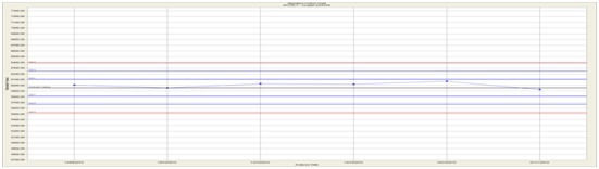
| Figure 11.18 | SRM CGS-2 Chart – Au ppb FAE303 |

| Figure 11.19 | Field Blank Chart – Au ppm FAE303 |
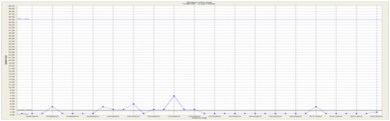
AMC 813001 : March : 2013
192
ENTRÉE GOLD INC Lookout Hill Property, Southern Mongolia Technical Report | |
| 12 | DATA VERIFICATION |
| 12.1 | Shivee Tolgoi ML Visits and Sampling by QG |
Scott Jackson completed a site visit to the Hugo North and Hugo North Extension Deposits in February 2008. Although all drilling at Hugo North had ceased by then, active drilling was observed at Heruga on Entrée ground. QG visited drill rigs and reviewed drill core and sampling procedures at Heruga.
During a subsequent visit in September 2008, QG reviewed the geology and mineralization encountered on surface and in the drillholes completed to that date. Although the review also included mineralized zones in which Entrée has no interest (Southern Oyu Deposits and Hugo Dummett Deposits within the area of the adjacent Oyu Tolgoi Project), time was spent looking at drilling, sampling, quality assurance/quality control (QA/QC), sample preparation and analytical protocols and procedures, and database structures that apply directly to the Hugo North Extension.
The site visits entailed brief reviews of the following:
| · | Overview of the geology and exploration history of the Project (presented by Ivanhoe geologists, Charlie Forster, Stephen Torr and Cyril Orssich). |
| · | Visit to the Joint Venture Property covering the Hugo North Extension. |
| · | Drill rig procedures (at Heruga) including core handling. |
| · | Sample collection protocols. |
| · | Sample transportation and sample chain of custody and security. |
| · | Surveying (topography, collar and downhole deviations). |
| · | Core recovery. |
| · | QA/QC programme (insertion of standards, blanks, duplicates, etc.). |
| · | Inspection of the SGS Mongolia operated on-site preparation laboratory. |
| · | Review of diamond drill core, core logging sheets and core logging procedures (selected core from ten representative drillholes from various mineralized zones). The review included commentary on typical lithologies, alteration, and mineralization styles. |
| · | Bulk density sampling. |
| · | Management of geological data and database structure. |
During the September 2008 visit, 15 quarter core samples were collected by QG although many of these are from core at the Hugo Dummett and Southern Oyu deposits, thus outside of Entrée’s project, they are considered important to report here, since they support the overall Mineral Resource estimate of the Hugo North/Hugo North Extension.
The sole intent of analyzing these samples was to confirm the general range of gold and copper grades, especially the high copper values, reported in previous exploration on the Lookout Hill Property. Immediately after collection, the sample bags were sealed by QG using numbered, secure zip-ties, placed into a sealed plastic drum and put into the custody of Ivanhoe staff.
AMC 813001 : March : 2013
193
ENTRÉE GOLD INC Lookout Hill Property, Southern Mongolia Technical Report | |
Due to logistical difficulties and the time needed to get sample export approval from the GOM, the option of QG carrying the samples out of the country was not possible. Instead, Ivanhoe agreed to organize courier shipping of the samples (via an international courier service) from Ulaanbaatar to QG in Perth. Upon their arrival at QG’s offices in Perth, the seals were checked prior to their submission to Ultratrace Laboratories, also in Perth, for preparation and analysis. These samples were analyzed for gold by 40 g fire assay with an AAS finish and for Cu by AAS method with aqua regia digestion. The results are shown in Table 12.1.
| Table 12.1 | Check Assaying on Selected Oyu Tolgoi Drill Cores |
| Area | Hole | Interval | IVN Cu | QG Cu | IVN Au | QG Au |
| SW Oyu | OTD 185 | 602-604 | 0.79 | 0.61 | 2.45 | 1.89 |
| SW Oyu | OTD 288 | 304-306 | 0.55 | 0.54 | 2.00 | 1.90 |
| SW Oyu | OTD 288 | 420-422 | 1.35 | 1.21 | 1.81 | 1.77 |
| SW Oyu | OTD 292 | 242-244 | 0.75 | 0.69 | 2.16 | 2.02 |
| SW Oyu | OTD 755 | 204-206 | 0.77 | 0.72 | 1.65 | 1.49 |
| Hugo Sth | OTD 653 | 518-520 | 2.59 | 2.69 | 0.03 | 0.03 |
| Hugo Sth | OTD 653 | 620-622 | 2.57 | 2.62 | 0.13 | 0.10 |
| Hugo Sth | OTD 470 | 202-204 | 1.05 | 1.31 | 0.03 | 0.06 |
| Hugo Sth | OTD 470 | 472-474 | 2.72 | 3.02 | 0.07 | 0.14 |
| Hugo Nth | OTD 576C | 1026-1028 | 5.25 | 5.45 | 3.45 | 2.09 |
| Hugo Nth | OTD 576C | 1078-1080 | 4.23 | 4.39 | 0.52 | 0.68 |
| Hugo Nth | OTD 576C | 1112-1114 | 4.53 | 4.48 | 0.56 | 0.53 |
| Hugo Nth Extn | EGD006A | 1240-1242 | 5.27 | 4.84 | 1.87 | 1.49 |
| Hugo Nth Extn | EGD006A | 1464-1466 | 5.42 | 5.18 | 2.99 | 3.23 |
| Hugo Nth Extn | EGD006A | 1564-1566 | 1.41 | 1.44 | 0.42 | 0.40 |
The average check copper grades agree almost exactly with the original values. Although the gold assays are slightly lower, the difference is not statistically significant. QG conclude that this exercise independently confirms the approximate tenor of both gold and copper mineralization identified by the original Ivanhoe sampling and assaying.
| 12.1.1 | QG Core Review |
Over 1,400 m of core, representing portions of three selected drillholes from Hugo North and Hugo North Extension were examined by QG (Table 12.2). Existing drill logs were checked against drill core and, in general, the previous core-logging by Ivanhoe was found to be accurate.
AMC 813001 : March : 2013
194
ENTRÉE GOLD INC Lookout Hill Property, Southern Mongolia Technical Report | |
| Table 12.2 | Summary of Oyu Tolgoi Core Reviewed by QG |
| Area | Hole No | Trays |
| SW Oyu | OTD 185 | All |
| SW Oyu | OTD 288 | All |
| SW Oyu | OTD 292 | All |
| SW Oyu | OTD 755 | All |
| Central | OTD 226 | All |
| Hugo Sth | OTD 653 | 300-700 m |
| Hugo Sth | OTD 470 | 200-EOH |
| Hugo Nth | OTD 514A | 900-1300 m |
| Hugo Nth | OTD 576C | 900-1300 m |
| Hugo Nth Extn | EGD 006A | 1000-1700 m |
| 12.2 | Javhlant MEL Visit by QG |
Scott Jackson (QG) and John Vann (QG) completed a site visit in February 2008. Scott Jackson was on site from February 20 to 22 and John Vann was on site 20 to 26 February. During their site visit they were accompanied at various times by OT LLC senior management and staff personnel. Scott Jackson’s most recent visit to Javhlant MEL was in November 2011.
The purpose of QG’s initial visit was to review the geology and mineralization of the Heruga project. Although there is no outcrop of mineralized units at the Heruga exploration site, Scott Jackson and John Vann made a brief visit to surface exposures of the Oyu Tolgoi deposits with senior OT LLC technical personnel on 20 February 2008.
The current geological model was reviewed in detail on site. In addition, the drilling, sampling, sample preparation, chain of custody, analytical protocols and procedures, quality assurance and quality control (QA/QC), and database structure were briefly reviewed.
The site visit entailed the following activities:
| · | Overview of the geology and exploration history of the Project. |
| · | Thorough review of geological interpretation on paper sections and plans as well as independent examination of the same sections and plans. |
| · | Review of existing drilling data, including brief checking of drillhole orientation, depth, number of holes etc.). |
| · | Visits to the surface exposures of the Oyu Tolgoi South, Southwest and Central Zones. |
| · | Visiting the surface above the Hugo South and Hugo North deposits, up to the boundary with the Joint Venture Property covering Shivee Tolgoi (Hugo North Extension). |
| · | Visit to the site at Heruga. Note that there is no surface exposure of the mineralized geology at Heruga. |
AMC 813001 : March : 2013
195
ENTRÉE GOLD INC Lookout Hill Property, Southern Mongolia Technical Report | |
| · | Rapid review of drill rig procedures and core handling, including a visit to the drilling sites at Heruga (where four rigs were operating at the time of the visit). |
| · | Review of sample collection procedures. |
| · | Rapid review of core recovery for the Heruga drill data. |
| · | Rapid overview of QA/QC measures including standard reference materials, blanks, duplicates etc. |
| · | Examination of bulk density (BD) sampling procedures. |
| · | Review of diamond drill core, core logs, core recovery, collar survey, downhole surveys, core photography for three selected holes: EJD009, EJD013 and EJD021. |
| · | Inspection of SGS Mongolia sample preparation facility on site. Sample transportation and chain of custody procedures were discussed during this inspection, but samples were not being prepared at the time of inspection. The facility was also inspected a second time to sight chain of custody processes. |
| · | Construction of geological wireframes used as the basis of estimation domains. |
| · | Construction of wireframes employed for limiting reported Mineral Resource estimates and discussions regarding classification under CIM definitions. |
| · | Structural geology and interpretation. |
| · | Management and structure of geological database. |
Scott Jackson (QG) also briefly visited the SGS Mongolia Minerals assay laboratory at Barmash Building, Chinggis Avenue, Khan-Uul District Ulaanbaatar. This visit did not constitute an audit. Such audits have been completed at intervals by Barry Smee: (Smee 2002a, 2002b, 2003a, 2003b, 2004a, 2004b, 2004c, 2004d, 2005, 2006, 2008).
AMC 813001 : March : 2013
196
ENTRÉE GOLD INC Lookout Hill Property, Southern Mongolia Technical Report | |
| 13 | MINERAL PROCESSING AND METALLURGICAL TESTING |
No additional metallurgical testing to that reported in Vann et al. (2009) was completed in 2009 on material from Heruga or from Hugo North Extension.
| 13.1 | Joint Venture Property |
| 13.1.1 | Summary |
The project under consideration consists of three main feed sources: Southwest, Central, and Hugo North. Southwest and Central ores will be extracted by open cut mining and Hugo North ore by block caving.
The Hugo North deposit extends onto the Shivee Tolgoi ML where it is called Hugo North Extension and is subject to a joint venture between Entrée and OT LLC. Metallurgical testwork has been carried out on samples from Hugo North Extension as well as Hugo North. The following is a summary from the 2013 OTTR that describes the testwork for the entire project. It is considered that the results of testwork for Hugo North will also be applicable to Hugo North Extension.
The Southwest deposit is a gold-rich porphyry system characterized by pipe-like geometry approximately 250 m in diameter and extending over 700 m vertically. The copper mineralization is dominated by chalcopyrite, with minor bornite (less than 20%).
The South deposit outcrops as copper oxides underlain by secondary sulphides and then chalcopyrite. The copper grade is lower than in the other deposits, and there is little gold. Some of the South deposit will fall within the bounds of the Southwest pit. For this reason, both the South and Southwest ores are hereafter referred to as Southwest.
The Central deposit is “funnel” shaped, with a chalcocite enrichment blanket overlying a large covellite zone. A chalcopyrite/gold zone lies at the base of the covellite zone, although this is expected to contribute less than 5% of the material mined from the Central deposit.
Hugo North dips away and has very high copper grades at a depth of 1,000 m or more. Gold appears to increase with depth, with some coarse, visible particles observed in the drill core. Copper mineralization consists of chalcopyrite, bornite, and chalcocite.
In 2001, OT LLC initiated and supervised a programme of work to investigate the metallurgical response of samples of drill core from the Southwest, Central, and Hugo Dummett deposits. Testwork carried out by SGS Lakefield Research Limited (SGS Lakefield), A.R. MacPherson Consultants Ltd., (“ARM”), and Terra Mineralogical Services (Terra) established basic comminution parameters, the amenability of gold recovery by gravity concentration, and the amenability of copper and gold recovery by flotation. Limited testwork was also conducted on samples from the South deposit.
AMC 813001 : March : 2013
197
ENTRÉE GOLD INC Lookout Hill Property, Southern Mongolia Technical Report | |
The results of this phase of the work, which provided the original definition of key metallurgical parameters, are summarised below by the three main ore sources:
| · | South West: |
| - | Moderate to hard Ball Mill Work Index (BWI) of 15-20. |
| - | 16-45% gravity recoverable gold, but gold very fine so plant recovery likely to be lower. |
| - | Cyanide leaching recoveries of gold very high, confirming the gold to be fine and well-liberated. |
| - | Chalcopyrite the dominant copper mineral; locked cycle tests obtained 83–93% copper recovery to 28% Cu concentrate with gold recoveries following copper but 15–20% less. Fluorine expected to trigger smelter penalties. |
| - | Acid base accounting (ABA) on flotation tails showed them to be non-acid generating. |
| · | Central: |
| - | Low to moderate BWI of 10–13. |
| - | One gravity test gave only 9% gold recovery. |
| - | Cyanide gold leaching recoveries in 30–55% range. |
| - | Mineralogy consists of chalcopyrite plus secondary copper minerals and pyrite with copper/pyrite intergrowths and some enargite. |
| - | Locked cycle tests showed highly variable grade-recovery performance with significant arsenic and fluorine levels incurring smelter penalties, with arsenic close to rejection limits. |
| - | Significantly more complex than South West and possibly incompatible to blend with Southwest. |
| - | ABA on flotation tails indiacted potential fo acid generation, as expected from pyrite content. |
| · | Hugo North: |
| - | Moderate BWI of 12–16.5. |
| - | Chalcopyrite and chalcocite dominant; locked cycle tests produced 29–40% Cu concentrates with recoveries around 90%. Fluorine and arsenic both would incur modest smelter penalties. |
| - | ABA on flotation tails showed them to be potentially acid generating. |
In 2003, the then study managers, Amec Ausenco Joint Venture (AAJV) together with OT LLC, determined that an additional phase of metallurgical testwork was necessary to support a feasibility study. The 2004 to 2005 program was designed to establish the flotation and comminution response of ores from Southwest, Central, Hugo South, and Hugo North. Laboratory batch-scale and pilot-plant flotation testwork programs were conducted at AMMTEC Ltd. (AMMTEC) in Perth. Additional testwork to define fundamental flotation and comminution parameters was executed by MinnovEX. Laboratory-scale comminution testwork programs were also conducted at AMMTEC. SGS Lakefield carried out a SAG pilot-plant test program to confirm the laboratory-scale testwork. Laboratory batch-scale and pilot-plant flotation testwork programs were conducted at AMMTEC Ltd. (AMMTEC) in Perth. Additional testwork to define fundamental flotation and comminution parameters was executed by MinnovEX. Laboratory-scale comminution testwork programs were also conducted at AMMTEC. SGS Lakefield carried out a SAG pilot-plant test program to confirm the laboratory-scale testwork.
AMC 813001 : March : 2013
198
ENTRÉE GOLD INC Lookout Hill Property, Southern Mongolia Technical Report | |
An important part of this additional testwork was related to the Hugo North ore deposit and years 0–5 and 6–9 production composites as well as the northern extensions of this orebody; key results are summarised below:
| · | Optimum grind size was 140–155 µm in the main (southern) section of the orebody but finer, 110 µm, in the north. |
| · | Locked cycle tests on the main orebody confirmed the Lakefield results with 93–94% copper recovery (and 80% gold recovery) a copper concentrate of 42% in years 0-5, falling to 32% in years 6–9 as chalcocite became less dominant. Penalty element levels were low, arsenic being well below penalty levels and fluorine just triggering a penalty. |
| · | Similar results were obtained for sample 963 fan from the north, but sample fan 918 yielded lower copper recoveries (88%) and significantly higher arsenic levels, just below the penalty trigger. |
Another important part of the AMMTEC testwork was variability tests on the main Hugo North orebody and also on the Hugo North Extension.
Significant variability in ore hardness was found, especially for the main Hugo North orebody, and also for flotation grade-recovery performance, re-enforcing in AMC’s opinion, the importance of sound geometallurgical modelling as a basis for blending, especially with the more problematic Central ore.
In 2006 and 2007, SGS (MinnovEX) conducted confirmatory metallurgical cleaner testwork on the Southwest and Central deposits. During the same period, core became available from additional drilling of the Hugo North Sub-Level Cave (SLC) and Entrée deposits, and Process Research Associates (PRA) was contracted to conduct the metallurgical testwork of these new reserves.
| 13.1.2 | Sample Representation |
The main source of IDP05 feed samples for the metallurgical testwork program was diamond drill core from the resource drilling program.
Samples were taken from the Southwest, Central, Hugo South, and Hugo North deposits. The samples collected from Southwest and Central were based on 100 m x 100 m x 45 m vertical height “metallurgical blocks” generated from the 20 m x 20 m x 15 m high resource model blocks that fell within the NSR $2.81 pit shell during the first 10 years of production (based on the current mining schedule, at 9 June 2004).
AMC 813001 : March : 2013
199
ENTRÉE GOLD INC Lookout Hill Property, Southern Mongolia Technical Report | |
Samples were selected from metallurgical blocks lying more than 25% within the NSR shell. Each metallurgical block was defined by a simple three-coordinate system of Level [L], Row [R], and Column [C].
Quarter core was taken from drillhole intercepts that passed through the blocks. If more than one hole passed through a block, then the intercept with the grade closest to that of the average grade of the metallurgical block was chosen. If no hole passed through the block, then the hole in an adjacent block closest to the resource model block grade was chosen.
Samples from Hugo South and Hugo North were taken from the holes that passed through the block-cave envelopes identified in the mining schedule at 9 June 2004. The block level [L] designation is the same for all deposits at Oyu Tolgoi. Therefore, nominal mining blocks were superimposed at each level to delineate the block-cave mining areas. Quarter core was taken from each 2 m geological assay interval along the core from the point where it entered each metallurgical block to the point where it left. These samples were kept in a separate bag until compositing so that location and geological assay data could be referenced. If all of the 2 m sample intervals that constituted the upper, middle, or lower vertical 15 m of a metallurgical block were outside the NSR shell, then they were rejected as barren material. Otherwise, the 2 m samples were added to the hole composite that represented the metallurgical block.
Because the Hugo North orebody is very deep and a relatively small number of holes were available at the time of the sampling program, every available drillhole that could be sampled was sampled. With the non-selective nature of block-cave mining, even obviously barren dyke material, which would be part of the internal dilution, was sampled and included in composite preparation.
The Hugo North, Hugo South, and Central deposits have not been sampled to their limits but only to the limits of zones corresponding to the early years of production, e.g. the end of Year 7 in the case of Hugo South.
| 13.1.3 | Comminution |
(1) Origin of Core Samples for 2003 – 2005 Grindability Testwork – IDP05
The IDP05 comminution samples represented the complete set of samples used for the current 2009 comminution plant design. Samples tested post 2005 are used to populate the geostatistical cell model to determine the processing rates in the production schedule given a fixed plant design.
The core samples delivered for grindability testwork over the 2003 to 2005 period covered Southwest, Hugo North, Central and Hugo South.
Table 13.1 lists the number of samples taken for comminution testwork per deposit.
AMC 813001 : March : 2013
200
ENTRÉE GOLD INC Lookout Hill Property, Southern Mongolia Technical Report | |
| Table 13.1 | Number of Samples taken per Deposit for 2003-2005 Testwork (Samples for Comminution Testwork from All Deposits) |
| Years of Scheduled Production* | Production First Ten Years* (Mt) | No. of Met Blocks | No. of Holes in Met Blocks | No. of Holes Sampled | No. of Comminution Samples Collected | No. of Samples Tested | |
| Southwest | 0-15 | 231 | 424 | 363 | 106 | 198 | 169 |
| Central | 6-14 | 30 | – | 51 | 45 | 56 | 81 |
| Hugo North | 4-20+ | 71 | – | – | 28 | 97 | 36 |
| Hugo South | 9-20+ | 4 | – | 71 | 71 | 81 | 10 |
*Based on the IDP05 Production Schedule.
For Southwest, a comminution sample was taken for every metallurgical block representing the first three years of mine production. From then on, samples were selected to provide an adequate sample distribution for a given level. For all comminution samples, quarter core was taken from core diameters greater than 55 mm, and half core for core diameters less than 55 mm. Most samples taken were in the weight range 5.0 to 5.5 kg but, for approximately every tenth sample, a larger sample of two 6.0–6.5 kg samples was taken and combined to make up a nominally 12 kg sample on which a full Bond Work Index test could be performed.
The purpose of the MinnovEX testwork was for nominal throughput determination based on the tonnage calculated for each metallurgical block represented by a drill core sample. To achieve this objective, Ci (Crusher Index); SPI (SAG Power Index); BWi and Mod-Bond (Bond Work Index and Mod-Bond Work Index) tests were carried out. Table 13.2 provides a list the number of SPI, Ci, Mod-Bond and full BWi tests performed per deposit, between 2003 and 2005.
| Table 13.2 | Number of Comminution Tests Performed at MinnovEX per Deposit |
| Deposit/Sample | SPI Tests | Ci Tests | Mod-Bond Tests | BWi Tests | Production First Ten years (Mt) | SPI Representation (per Mt) |
| Southwest | 169 | 124 | 167 | 31 | 231 | 0.68 |
| Hugo South | 10 | 10 | 3 | 4 | 2.50 | |
| Hugo North | 36 | 36 | 36 | 2 | 71 | 0.51 |
| Central | 81 | 18 | 78 | 5 | 30 | 2.70 |
| Entree | 9 | 9 | 9 | – | – | – |
| Composite | 11 | 11 | – | – | – | – |
| Unallocated | 7 | 7 | – | 7 | – | – |
| Total | 350 | 206 | 319 | 48 | 336 | – |
In addition to the above comminution tests, 26 samples were tested at AMMTEC, for the CEET-JK model comparison study, and 4 samples of Heruga were tested for BWi at G&T Metallurgical.
AMC 813001 : March : 2013
201
ENTRÉE GOLD INC Lookout Hill Property, Southern Mongolia Technical Report | |
(2) Origin of Bulk Sample for 2005 Pilot Campaign
An exploratory hole (OTD725) was drilled in the Southwest orebody to intercept a cross-section of typical plant feed types, guided by geological information gained from the previous exploration program. Downhole grades and SPI measurements were taken. An interval from 68–72 m downhole was selected based on SPI, lithology, and grade being near the orebody average.
A 3 m diameter shaft was sunk in the vicinity of this hole, at UTM coordinates 650,718 m E, 4,763,089 m N, centred on previously drilled diamond drillhole OTD189. A 250 t bulk sample was taken from the sides of the bottom 6 m of this shaft at a depth 68–74 m below surface. Care was taken to blast minimally to ensure that the material taken from the shaft was not over-fractured. The sample was shipped to SGS Lakefield for pilot testing.
A 250 t bulk sample was shipped to SGS Lakefield for the 2005 pilot plant campaign. A subsample of the pilot plant SAG feed material was submitted to MinnovEX for SPI and Mod-Bond measurement. A pilot plant campaign was conducted to confirm the suitability of Oyu Tolgoi Southwest material for semi-autogenous grinding and to validate the CEET Model.
(3) CEET Validation with JKSimmet
The 26 samples were selected in order to cover each of the significant feed types throughout the deposits. Sample mass and top size requirements dictated that PQ drill core was needed for these validation samples. Of the 26 samples, 22 of the samples were selected from three PQ holes through the Southwest deposit, and four samples were selected from one PQ hole in the Central deposit.
(4) Origin of Core Samples for 2006-2007 Grindability Testwork
A minimum of 80 samples from the Hugo North SLC region was required to undertake geostatistical calculations for this region; therefore additional core samples from this region were located, shipped and tested at SGS Lakefield in 2006. The 82 samples comprised 16 core samples already tested during the 2003–2005 program, and 66 new core samples shipped from the Oyu Tolgoi site in October 2006. Nine Entrée samples were tested in early 2007.
Sampling was based on 10 cm/m over a 15 m interval and the core sample was provided as a combination of half-NQ and half-PQ core. Most of the samples were from the bornite core and were split between the two main rock types; the remainder of the samples were from the HW argillic alteration zone and the FW disseminated Cpy mineralization in Qmd.
| 13.1.4 | Flotation |
Table 13.3 and Table 13.4 provide a summary of the flotation sample representation and testwork for the 2004, and the 2006–2007 periods, respectively. Drillhole locations are provided in the geology section.
AMC 813001 : March : 2013
202
ENTRÉE GOLD INC Lookout Hill Property, Southern Mongolia Technical Report | |
| Table 13.3 | Flotation Test Representation (List of Samples for 2004 Test Program) |
Production First Ten Years* (Mt) | Composites | No. of Met Blocks | No. of Holes in Met Blocks | No. of Variability Samples | |
| Southwest | 231 | Periodic Composites Months 0-6 Months 7-12 Year 2 Year 3 Year 4 Year 5 Years 6-10 2006 Minnovex | 424 | 363 | 285 7 |
| Central | 30 | Chalcocite Covellite Chalcocite/Covellite 2006 Minnovex | – | – | 30 5 |
Hugo North SLC | 71 | Upper Phase 1 2007 SLC | – | – | 30 55 |
| Hugo South | 4 | Phase 1 | – | – | 20 |
| Entrée | – | Rougher Cleaner | – | – | 6 6 |
| Heruga | – | – | – | – | 9 comp. |
*Tonnages refer to the IDP05 Schedule
| Table 13.4 | 2007 Summary of Flotation Testwork 2006–2007 Summary of Laboratory Scale Flotation Tests |
| Test | SW | HN | SLC | Central | HS | Entrée | Heruga |
| Rougher | |||||||
| Batch | 149 | 8 | – | 25 | 10 | – | 4 |
| pH/Reagent | 20 | – | 11 | – | – | – | – |
| % Sol. | – | – | 3 | – | – | – | – |
| P. Grind | 133 | 45 | 9 | 41 | 21 | 6 | – |
| FKT/MFT | 7 | 4 | 6 | 1 | 1 | – | – |
| Variability | 266 | 47 | 55 | 41 | – | – | – |
| Cleaner | |||||||
| Batch | 50 | – | – | 11 | – | – | 4 |
| pH | 3 | – | 9 | – | – | – | – |
| Regrind | 51 | – | 10 | – | – | 6 | – |
| FKT | 2 | – | 2 | 2 | – | – | – |
| Column | 8 | – | 2 | – | – | – | – |
| Locked Cycle | 21 | 8 | 3 | 22 | 3 | – | – |
| Pilot Plant | 2 | 1 | – | – | – | – | – |
AMC 813001 : March : 2013
203
ENTRÉE GOLD INC Lookout Hill Property, Southern Mongolia Technical Report | |
(1) IDP05 2001–2003 – Early Lakefield
The early Lakefield work consists primarily of seven composites: two Southwest, one South, three Central and one Hugo North. The total drillhole representation is:
| · | Southwest – 3,076 m |
| · | Hugo North – 852 m |
| · | Central – 1,284 m |
(2) IDP05 2003–2004
The 2004-2005 IDP05 work consisted primarily of period composites: seven Southwest, three Central, three Hugo North and one Hugo South. There were also two pilot plant trials: one Southwest and one Hugo North. The total drillhole representation was:
| · | Southwest – 17,280 m; pilot – 16,351 m |
| · | Hugo North – 1,210 m; pilot – 1,650 m |
| · | Central – 779 m |
| · | Hugo South – 1,506 m |
| (3) | 2006-2007 Southwest, Central, SLC |
The confirmatory work conducted at SGS-Lakefield was on the same period composites for Southwest and Central. The Hugo North SLC work was on three composites consisting 122 m of core.
| (4) | Entrée and Heruga |
Entrée scoping consisted of three composites with 630 m of core and Heruga scoping consisted of four composites of 80 m of core.
| (5) | Plant Feed Representation and Mine Planning |
Note that where reference is made to blocks being treated at certain times in the production schedule (for example, Table 13.3) these references refer to the mine plans current at the time the test program was being planned. As mine plans have changed over time, so too has the relationship between the test samples and the time when the represented material is likely to be processed.
| 13.2 | Test Programmes |
In late 2003, AAJV and IMMI (now OT LLC) determined that additional testwork was necessary to support the feasibility study. The objective of the new testwork was to confirm the amenability of the flow sheet adopted from the early testwork done for the Preliminary Assessment and to characterize the potential plant feed featured in the new mine plans in terms of flotation and comminution response. The testwork scope included:
AMC 813001 : March : 2013
204
ENTRÉE GOLD INC Lookout Hill Property, Southern Mongolia Technical Report | |
| · | Additional bench-scale batch and locked-cycle flotation testing on Southwest and Central production composites to confirm the previous results and to test flow sheet alternatives. |
| · | Bench-scale batch and locked-cycle flotation testing on Hugo South and North production composites to develop prefeasibility level metallurgical parameters. |
| · | Variability testing on Southwest samples to finalize the plant design parameters. |
| · | Bulk flotation testwork on Southwest samples to confirm plant design parameters and to produce sufficient concentrate and tailing samples for vendor testwork and concentrate marketing. |
| · | Bench-scale comminution testwork to develop design parameters. |
| · | Pilot-scale comminution testwork to confirm the circuit design and throughput. |
| · | During the course of the testwork, potential risks and opportunities were to be identified and information was to be gathered to develop strategies to minimize smelter penalties. |
The flotation testwork data forms the basis for all metallurgical modelling. A substantial results database exists for the Southwest ores and moderate databases exist for Central, Hugo North and Hugo South ores.
The flotation tests summarised in Table 13.5 (approximately 1,137 tests) have been conducted since the beginning of the Oyu Tolgoi test programme and the majority of them have been used in model development and in the review process. These tests are detailed in reports from AMMTEC, SGS and PRA and are discussed at length in reports by Aminpro and in this review report.
| Table 13.5 | Oyu Tolgoi Project Flotation Testwork |
| Deposit | SW | C-Cv | C-Cc | C-Cpy | C-4,5,6 | HS | HN | HN Entrée | Orebody Comps |
| Roughers | 213 | 36 | 20 | 1 | 94 | – | 87 | 6 | – |
| Cleaners & Roughers | 390 | 13 | 12 | – | 110 | 42 | 74 | 6 | 4 |
| Lock Cycle Tests | 6 | 1 | 1 | – | – | 1 | 5 | – | – |
| Column | 8 | – | – | – | – | – | 2 | – | – |
| Pilot | 4 | – | – | – | – | – | 1 | – | – |
The comminution testwork for each deposit is summarised in Table 13.6. This work has been analysed and used to prepare the throughput recommendations for each of the ores.
AMC 813001 : March : 2013
205
ENTRÉE GOLD INC Lookout Hill Property, Southern Mongolia Technical Report | |
| Table 13.6 | Summary of Comminution Samples Dispatched to Testwork Facilities |
| Facility | Location | Scale of Testwork | Testwork Conducted | Number |
| MinnovEX Technologies | Toronto, Canada | Bench scale | SAG Power Index [SPI] (measured in minutes) | 350 |
| Bond Ball Mill Work Index [BWi] (measured in kWh/t) | 48 | |||
| Modified Bond Index [Mod-Bond] (measured in kWh/t) | 319 | |||
| MinnovEX Crusher Index [Ci] | 206 | |||
| Ore specific gravity | 7 | |||
| AMMTEC | Perth, Australia | Bench scale | JKTech FAG/SAG Mill parameters | 26 |
| JKTech Rod/Ball Mill Appearance function | 26 | |||
| Unconfined Compressive Strength [UCS] | 26 | |||
| Bond Impact Crushing Work Index | 26 | |||
| Bond Abrasion Index | 26 | |||
| Bond Rod Mill Work Index | 26 | |||
| Ore specific gravity | 26 | |||
| SGS Lakefield | Lakefield, Canada | Pilot scale | Pilot-plant runs at a series of circuit options | 12 tests on one bulk sample |
| Bench scale | JKTech FAG/SAG Mill parameters | Tests on seven composite samples (2003) | ||
| JKTech Rod/Ball Mill Appearance function | ||||
| Unconfined Compressive Strength [UCS] | ||||
| Bond Impact Crushing Work Index | ||||
| Bond Abrasion Index | ||||
| Bond Rod Mill Work Index | ||||
| Ore specific gravity |
| 13.2.1 | AMMTEC Bench-Scale Flotation Test Programme |
AMMTEC Perth, an experienced Australian metallurgical laboratory, was selected to perform the bench-scale flotation work. In early 2004, the testwork programme parameters were finalized, and a campaign was initiated to collect samples from existing drill core at site. Concurrent with this sampling programme, composite samples from the 2003 programme were shipped to Perth for AMMTEC to conduct a series of validation and calibration tests. The 2004 samples began arriving in Perth in May 2004, and testwork commenced soon after. This programme was completed in early 2005.
| 13.2.2 | MinnovEX Comminution Testing |
The MinnovEX Comminution Economic Evaluation Tool (CEET) was used as the primary methodology for estimating throughput rates. CEET uses grinding parameters measured from the geological drill core sample set. Samples were selected from the core at the same time as the flotation sample set and were sent to the MinnovEX laboratory in Toronto.
AMC 813001 : March : 2013
206
ENTRÉE GOLD INC Lookout Hill Property, Southern Mongolia Technical Report | |
| 13.2.3 | MinnovEX FLEET Test Programme |
To provide a secondary confirmation of flotation parameters, portions of the composite samples developed in Perth were sent to MinnovEX for MinnovEX Flotation Tests (MFT). These MFT parameters were used in conjunction with the MinnovEX Flotation Economic Evaluation Tool (FLEET) to provide alternative kinetic information intended to translate the laboratory tests into plant design criteria and to validate circulating loads.
| 13.2.4 | AMMTEC Comminution Testing |
A secondary, or validation, assessment of the milling rates was undertaken with the JKSimMet simulator method, which uses a suite of parameters obtained from testing of large-diameter (PQ or larger) core. Four PQ holes were drilled to intercept as many ore types as possible. Selected core from these holes was shipped to AMMTEC in late 2004 for measurement of JK grinding parameters. Splits from these samples were also sent to MinnovEX for SPI determinations.
| 13.2.5 | SAG Pilot Plant |
A bulk 250 t sample of mined rock, typical of Southwest ore, was shipped to SGS Lakefield in early 2005. A series of pilot-scale plant tests, intended to confirm the prediction of the bench scale comminution work, was conducted in April 2005.
| 13.2.6 | Hugo Far North (Hugo North Extension) |
While the 2004 test programme was in progress, IMMI (now OT LLC) identified potentially large reserves of copper-rich material to the north of the previously sampled area of Hugo North. Additional samples were taken from that part of the orebody for bench-scale flotation work at AMMTEC and MinnovEX and bench-scale comminution work at MinnovEX. Flotation testwork focused on the kinetics of the roughers and cleaners by PRA was also carried out on samples from this area.
| 13.2.7 | Bulk Flotation Test |
Large composites of Southwest and Hugo North ore were made up from surplus sample at the AMMTEC laboratory. These samples were processed through pilot-scale equipment to generate large samples of concentrate and tailings for further testing. Concentrate was required for marketing analysis and to measure the thickening and filtration design parameters. Tailings material was required to confirm the design parameters for the thickeners, transportation pumping, and tailings deposition method. As well as physical plant design data, tailings were also evaluated to define environmental parameters.
| 13.2.8 | Concentrate Upgrading Programme, SGS |
The bulk flotation test at AMMTEC on Southwest ore did not produce concentrate to specification because the material had not been reground properly. Unfortunately, the physical characteristics of the test equipment were not adjusted until the Southwest material sample had been consumed.
AMC 813001 : March : 2013
207
ENTRÉE GOLD INC Lookout Hill Property, Southern Mongolia Technical Report | |
The off-specification sample was shipped to SGS, where it was reground to the correct size and upgraded in a pilot-scale flotation column brought in from MinnovEX. The Hugo North bulk flotation test was satisfactory and produced concentrate and tailings consistent with the design criteria.
| 13.2.9 | Final Product Concentrate Assay Analysis |
Final concentrates from the locked-cycle tests were assayed for a range of minor elements, as shown in Table 13.7. Fluorine and arsenic are the only significant deleterious elements identified.
| Table 13.7 | Concentrate Assay Analysis |
| Element | Unit | Southwest | Hugo North | Hugo South 0-5 Yrs | Central Covellite | ||||
| Range | Average | Median | 0-5 Yrs | 6-9 Yrs | |||||
| Ag | ppm | 34 | 49 | 44 | 45 | 73 | 63 | 62 | 40 |
| Al | ppm | 5,125 | 9,150 | 6,845 | 7,160 | 8,415 | 10,950 | 11,750 | 6,175 |
| As | ppm | 20 | 1,290 | 431 | 140 | 400 | 800 | 2 320 | 3,180 |
| Au | ppm | 10 | 31 | 23 | 25 | 9 | 4 | 2 | 2 |
| Ba | ppm | 20 | 36 | 28 | 27 | 45 | 50 | 51 | 60 |
| Be | ppm | <0.1 | 0 | 0 | 0 | 0 | <0.1 | <0.1 | <2 |
| Bi | ppm | <10 | <10 | <10 | <10 | <10 | <10 | <10 | <10 |
| Ca | ppm | 1,715 | 3,260 | 2,197 | 1,973 | 880 | 777 | 812 | 1,370 |
| Cd | ppm | 8 | 65 | 24 | 15 | 7 | 8 | 25 | 100 |
| Cl | ppm | <50 | 1,600 | 464 | 100 | <50 | <50 | <50 | <50 |
| Co | ppm | 85 | 178 | 127 | 128 | 19 | 64 | 80 | 163 |
| Cr | ppm | 18 | 40 | 26 | 22 | 130 | 100 | 44 | 182 |
| Cu | % | 20.4 | 25.7 | 23.4 | 24.5 | 41.6 | 31.8 | 32.8 | 20.5 |
| F | ppm | 250 | 410 | 320 | 310 | 330 | 420 | 510 | 130 |
| Fe | % | 26.8 | 31.3 | 29.5 | 30.2 | 17.3 | 21.1 | 22.9 | 26.9 |
| Ge | ppm | 1 | 25 | 6 | 1 | <0.5 | 1 | 3 | 30 |
| Hg | ppm | 0 | 2 | 1 | 0 | 3 | 4 | <0.1 | 1 |
| K | ppm | 1,587 | 2,600 | 2,121 | 2,200 | 3,005 | 2,500 | 1,423 | 1,110 |
| Li | ppm | <5 | 5 | 4 | <5 | <5 | <5 | <5 | <5 |
| Mg | ppm | 1,700 | 3,015 | 2,299 | 2,090 | 930 | 765 | 691 | 335 |
| Mn | ppm | 60 | 260 | 123 | 91 | 81 | 85 | 116 | 27 |
| Mo | ppm | 1,031 | 3,071 | 1,987 | 1,850 | 548 | 286 | 798 | 130 |
| Na | ppm | 980 | 1,404 | 1,147 | 1,090 | 399 | 300 | 161 | 206 |
| Ni | ppm | 56 | 138 | 103 | 105 | 125 | 78 | 53 | 235 |
| P | ppm | <100 | 100 | 100 | 100 | 100 | 100 | 235 | 200 |
| Pb | ppm | 248 | 1,182 | 546 | 441 | 247 | 184 | 165 | 45 |
| Pd | ppm | 0 | 0 | 0 | 0 | <0.1 | <0.10 | <0.10 | <0.10 |
| Pt | ppm | <0.05 | 0 | 0 | <0.05 | <0.1 | <0.10 | <0.10 | <0.10 |
| Re | ppm | <0.05 | 3 | 1 | 0 | 0 | 0 | 1 | 0 |
| S | % | 34.4 | 38.0 | 36.0 | 36.1 | 27.4 | 28.7 | 32.8 | 45.3 |
| Sb | ppm | 10 | 65 | 31 | 30 | 142 | 380 | 10 | 10 |
| Se | ppm | 180 | 275 | 227 | 235 | 390 | 280 | 30 | 90 |
| SiO2 | % | 3.8 | 7.5 | 4.7 | 4.2 | 8.4 | 8.7 | 8.3 | 4.7 |
| Sn | ppm | 1.0 | 4.7 | 2.3 | 1.8 | 1.2 | 4.1 | 10.1 | 19.3 |
| Sr | ppm | 18 | 58 | 32 | 27 | 69 | 109 | 122 | 114 |
| Te | ppm | 5 | 10 | 7 | 7 | 30 | 25 | 24 | 10 |
| Ti | ppm | 570 | 1,360 | 890 | 735 | 515 | 665 | 908 | 230 |
| Tl | ppm | <0.5 | 1,160 | 129 | <0.5 | <0.5 | <0.5 | 1 | 4 |
| V | ppm | 22 | 71 | 45 | 43 | 26 | 73 | 62 | 508 |
| Y | ppm | 4 | 7 | 5 | 4 | <1 | 1 | <1 | 2 |
| Zn | ppm | 488 | 2,931 | 1,808 | 2,069 | 444 | 425 | 853 | 1,455 |
| Zr | ppm | 255 | 437 | 350 | 346 | 485 | 451 | 353 | 479 |
AMC 813001 : March : 2013
208
ENTRÉE GOLD INC Lookout Hill Property, Southern Mongolia Technical Report | |
| 13.2.10 | Hugo North Extension Flotation Testwork |
| 13.2.10.1 | Introduction |
At the direction of Aminpro a small number of flotation tests were conducted at the PRA laboratories on samples from the Entrée zone of the Oyu Tolgoi deposit (Table 13.8 and Table 13.9). This report is a brief commentary on the results achieved with those samples and how those results compare with the large number of flotation test results on samples of Hugo North and South underground ores.
Note that Samples 1 to 4 were formed into composite S1 – 49.1 kg, samples 5 to 10 were formed into composite S2 – 81.4 kg and samples 11 to 13 and 17 to 21 were formed into composite S2 – 56.7 kg.
AMC 813001 : March : 2013
209
ENTRÉE GOLD INC Lookout Hill Property, Southern Mongolia Technical Report | |
| Table 13.8 | Samples Submitted for PRA Flotation Testwork |
| Receiving Date: | 23-Feb-07 | Project No: 0702302 | ||||
| Carrier: | DHL | Client: Ivanhoe Mines Mongolia Inc | ||||
| Receiver: | Darren | Page: | 1 of 1 | |||
| Count | Sample Label | Container Type | Sample Type (C, R, P, Sl, S) | Wet /Dry | Top Size | Weight (kg) |
| 1 | DRUM #1 S-1 OTD-1222B 1300-1330m | Plastic Bag | C | Dry | 6" | 11.45 |
| 2 | S-1 OTD 1218 1120-1200m | Plastic Bag | C | Dry | 6" | 11.35 |
| 3 | S-1 OTD 1219B 1280-1310m | Plastic Bag | C | Dry | 6" | 13.50 |
| 4 | S-1 OTD 1218 1140-1170m | Plastic Bag | C | Dry | 6" | 12.80 |
| 5 | DRUM #2 S2-OTD 1222B 1440-1470m | Plastic Bag | C | Dry | 6" | 8.05 |
| 6 | S2-EGD 008 1480-1510m | Plastic Bag | C | Dry | 6" | 7.40 |
| 7 | S2-EGD 008 1120-1450m | Plastic Bag | C | Dry | 6" | 7.10 |
| 8 | S2-OTD 1222B 1500-1530m | Plastic Bag | C | Dry | 6" | 6.75 |
| 9 | S2-EGD 008-1300-1330m | Plastic Bag | C | Dry | 6" | 7.35 |
| 10 | S2-OTD 1222B 1250-1280m | Plastic Bag | C | Dry | 6" | 13.80 |
| 11 | DRUM#3 S3-OTD 12190 1550-1580m | Plastic Bag | C | Dry | 6" | 6.90 |
| 12 | S3-EGD008 1660-1690m | Plastic Bag | C | Dry | 6" | 7.40 |
| 13 | S3-EGD053 1690-1720m | Plastic Bag | C | Dry | 6" | 7.70 |
| 14 | S2-OTD 1219D 1490-1520m | Plastic Bag | C | Dry | 6" | 6.40 |
| 15 | S2-OTD 1218-1230-1260m | Plastic Bag | C | Dry | 6" | 12.65 |
| 16 | S2-OTD1218-1280-1310m | Plastic Bag | C | Dry | 6" | 11.90 |
| 17 | DRUM#4 S3 EGD 053B 1650-1680m | Plastic Bag | C | Dry | 6" | 7.10 |
| 18 | S3 EGD 006A 1650-1680m | Plastic Bag | C | Dry | 6" | 5.85 |
| 19 | S3 EGD 006A 1620-1650m | Plastic Bag | C | Dry | 6" | 6.95 |
| 20 | S3 EGD 006A 1580-1610m | Plastic Bag | C | Dry | 6" | 6.75 |
| 21 | S3 EGD 053B 1740-1770m | Plastic Bag | C | Dry | 6" | 8.05 |
| Table 13.9 | Summary of Composite Head Grades |
| Au | Ag | F | Cu | Mo | Fe | S | As | |
| S1 | 0.02 | 1.5 | 0.4139 | 0.48 | <0.01 | 6.81 | 1.03 | 0.00375 |
| S2 | 1.27 | 5.5 | 0.2845 | 2.78 | <0.01 | 4.87 | 2.235 | 0.00275 |
| S3 | 0.91 | 3.0 | 0.1728 | 1.47 | <0.01 | 2.075 | 1.045 | 0.11465 |
The composite head grades have been back calculated as shown in Table 13.10.
| 13.2.10.2 | Flotation Tests |
One set of rougher tests and a set of cleaner tests were conducted on the composites at PRA laboratories.
Six rougher tests were conducted comprising one test per composite at natural pH and one test per composite at pH 11.5.
AMC 813001 : March : 2013
210
ENTRÉE GOLD INC Lookout Hill Property, Southern Mongolia Technical Report | |
Six cleaner tests were conducted comprising one test per composite after regrinding the cleaner feed to a P80 of 40 µm and one test per composite at 25 µm P80.
| 13.2.10.3 | Results |
Rougher Flotation
The rougher recoveries at 8 minutes are summarised in Table 13.10.
| Table 13.10 | Rougher Flotation Recoveries After 8 Minutes – Entrée Composites |
| Natural pH | pH 11.5 | |
| Composite S1 | 88.3 | 87.3 |
| Composite S2 | 94.6 | 80.4 |
| Composite S3 | 90.9 | 92.4 |
The recoveries are high and suggest that natural pH may be better than high pH. Recoveries after 30 minutes of flotation were marginally higher but at almost double the mass pull. Note that the Cu recover for Composite S2 at pH 11 increased to 89% at 30 minutes of flotation. The high pH appears to have slowed the flotation rate for copper considerably compared to the natural pH test.
Cleaner Flotation
The cleaner flotation results are summarised in Table 13.11.
| Table 13.11 | Cleaner Grades and Recoveries at 6 Minutes – Entrée Composites |
25 µm P80 | 40 µm P80 | |||||
| % Cu | Clnr Rec Cu | Overall Rec Cu | % Cu | Clnr Rec Cu | Overall Rec Cu | |
| Composite S1 | 8.71 | 91.8 | 81.0 | 10.5 | 93.2 | 82.3 |
| Composite S2 | 30.7 | 93.7 | 88.6 | 32.3 | 91.0 | 86.1 |
| Composite S3 | 22.5 | 94.6 | 86.0 | 23.9 | 92.8 | 84.3 |
Composites S2 and S3 gave reasonable results with S2 achieving well above 25% copper grade at recoveries approaching 90% overall. There is potentially a minor benefit from regrinding to 25 µm rather than 40 µm. Grade vs recovery curves show that the samples are relatively insensitive to regrind size.
The impurity levels in the 6 minute cleaner concentrates are summarised in Table 13.12.
Composite S1 is very low grade (<0.5% Cu in feed), generated a low grade cleaner concentrate which has a high gangue content. In this context the high fluorine content is not unusual. Composite S3 has an extreme arsenic content and the prevalence of high arsenic levels in the Entrée ore should be investigated.
AMC 813001 : March : 2013
211
ENTRÉE GOLD INC Lookout Hill Property, Southern Mongolia Technical Report | |
| Table 13.12 | Cleaner Concentrate (6 minutes) Impurity Levels |
25 µm P80 | 40 µm P80 | |||
| F (ppm) | As (ppm) | F (ppm) | As (ppm) | |
| Composite S1 | 3567 | 93 | 3651 | 81 |
| Composite S2 | 929 | 355 | 795 | 389 |
| Composite S3 | 882 | 16240 | 653 | 17400 |
Cleaner stage grade vs recovery curves are plotted for all three composites, each at the two different grind P80 values. For the two higher grade composites, S2 and S3, the regrind size has no discernible effect.
It is clear that the Entrée results lie within the database of Hugo North and South results, even the poorly performing Composite 1 (Figure 13.1).
Figure 13.1 Comparison of Entrée Cleaner Results with the Set of Hugo Cleaner Test Results
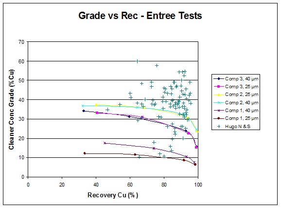
| 13.2.1 | Conclusions |
The Entrée flotation results show that the ore is not unusual with respect to the other Hugo ores tested.
AMC 813001 : March : 2013
212
ENTRÉE GOLD INC Lookout Hill Property, Southern Mongolia Technical Report | |
Preliminary process and metallurgical test work has been completed on the Hugo North Extension Deposit and the Hugo North Deposit within the Oyu Tolgoi Project. Copper and gold recoveries for Hugo North Extension are reasonable and not unusual with respect to the other Hugo ores tested. According to TRQ (pers. comm., 2008), elevated arsenic and fluorine values are evident, but trace element models for Hugo North indicate these elevated arsenic or fluorine zones would be mined over short periods and could be managed though blending. Since the Hugo North and Hugo North Extension Deposits are part of the same continuous zone of mineralization, it is inferred that there is reasonable expectation that the gold and copper mineralization at Hugo North Extension can be treated to produce a saleable concentrate using the currently-proposed metallurgical process methods for the Oyu Tolgoi Project.
The sample set of three is inadequate for determining the typical behaviour of Entrée ore. It is not know if the low grade composite 1 or the high arsenic composite 3 samples are typical or if they are isolated occurrences. A programme of variability testing comprising at least 15 Entrée samples should be conducted to establish typical performance.
| 13.3 | 2006–2007 Confirmatory Testwork |
| 13.3.1 | 2006 SGS-Lakefield – Southwest and Central – Rougher/Cleaner Kinetics Verification |
In 2006, confirmatory rougher and cleaner kinetics testwork was conducted at SGS Lakefield. The testwork was conducted on the 2004–2005 IDP05 period composite samples to verify the IDP05 kinetics. The cleaner tests included variations in pH and regrind. As the kinetics of the roughers was developed under an FKT test, the parameter extractions include a relationship between kinetics and primary P80.
| 13.3.2 | Hugo North |
A complete suite of rougher and cleaner flotation work was carried conducted at Process Research Associates Ltd (PRA) Laboratory in Vancouver. Variability work was conducted to determine the effect of head grade on recovery, and rougher and cleaner tests were conducted to determine the effect of pH and grind. Samples were selected in the area of the deposit that is to be mined first.
| 13.3.3 | 2008 Heruga Scoping Testwork |
Four composite samples of the Heruga deposit were sent to G&T laboratory for initial scoping testwork to assess, the mineralogical characteristics of feed and flotation products, the flotation response of each sample, the bond work index and to analyze the exit streams from the float work to identify opportunities for further improvement in metallurgical performance.
The Heruga metallurgical scoping study was conducted at G&T Metallurgical Services Ltd. and is reported in “Preliminary Metallurgical Assessment of Metallurgical Composites”, Ivanhoe. – Oyu Tolgoi Project Mongolia, KM2133, 5 August 2008. Overall, the composites responded well to the applied Oyu Tolgoi flow sheet.
AMC 813001 : March : 2013
213
ENTRÉE GOLD INC Lookout Hill Property, Southern Mongolia Technical Report | |
| 14 | MINERAL RESOURCE ESTIMATES |
| 14.1 | Hugo North Extension Deposit |
| 14.1.1 | Introduction |
The Hugo North Extension on the Lookout Hill Property and the Hugo North Deposit on OT LLC’s adjacent Oyu Tolgoi Project, to the south are both part of a single geological entity. Because of this, the Mineral Resources of both deposits have been estimated together, as a single body, using the same parameters, composites and geological information. At the completion, Mineral Resources for Hugo North Extension were “cut” to coincide with the boundary between the two projects, and the tonnes and grades are reported accordingly. In the remainder of this section, all comments apply to the combined Hugo North/Hugo North Extension Deposit, unless explicitly stated otherwise.
Mineral Resource estimates for the Hugo North Extension (and Hugo North) were originally prepared under the supervision of Harry Parker, P. Geo by AMEC consulting group in 2007. In 2008, Scott Jackson Quantitative Group (QG) in Perth was asked to act as QP for the Hugo North Extension. Rather than completely re-estimate the deposit, QG decided to complete an audit level review of the AMEC estimate and also build a parallel estimate for checking purposes. The QG independent alternate estimate was completed using domains built by OT LLC. The majority of parameters for estimation were derived independently by QG. Whilst (as expected) the final estimates did not match exactly, the two estimates are not materially different. Global and local checks by QG suggest the estimate by AMEC is robust and suitable for public reporting of Mineral Resources. A summary description of the estimate below is the derived from the report of 2007 Hugo North (and Hugo North Extension) estimate (Cinits and Parker, 2007). Vann et al., (2008) contains the complete description of this estimate.
The resource estimates were made from three-dimensional (3D) block models utilizing commercial mine planning software (MineSight). Project limits are in truncated UTM coordinates. Project limits are 650600–652700 E, 4766000–4768700 N, and -600 m to +1,275 m elevation. The project boundary between Hugo North and Hugo North extension is at approximately 4768100 N. Cell size for the project was 20 m east x 20 m north x 15 m high. The estimates are supported for the Hugo North and Hugo North Extension Deposits by 307 drillholes, including daughter holes totalling 371,172 m. Within the Hugo North Extension there are 37 holes totalling approximately 54,546 m suitable for reporting of Mineral Resources.
| 14.1.2 | QG Checks on 2007 Estimate |
QGchecked the lithologic and structural shapes for interpretational consistency on cross-sections and plans, and found them to have been properly constructed. The shapes were found to honor the drill data. When reviewing the mineralized envelopes generated by OT LLC, QG did note that there was a slight discrepancy between the wireframe points and the drillholes intercepts suggesting that these wireframes were built with a slightly different drillhole file than that used by AMEC to build the estimates. The likely cause of this is slight differences in how different software packages “de-survey” the downhole survey data.
AMC 813001 : March : 2013
214
ENTRÉE GOLD INC Lookout Hill Property, Southern Mongolia Technical Report | |
The differences noted ranged from 0.5 m to 3 m in the deeper holes. QG does not consider this to be a material problem (Figure 14.1 and Figure 14.2).
| Figure 14.1 | Comparison of Copper Estimates in the 2% Cu Domain with Decreasing RL – QG (QG_CU2) vs. AMEC (AMEC_CU2) |
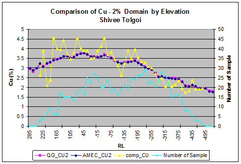
| Figure 14.2 | Comparison of Gold Estimates in the 2% Cu Domain with Decreasing RL – QG (QG_CU2) vs. AMEC (AMEC_CU2) |

AMC 813001 : March : 2013
215
ENTRÉE GOLD INC Lookout Hill Property, Southern Mongolia Technical Report | |
As part of the checking process, QG independently re-estimated the Hugo North deposit. The aim of this was to satisfy QG that the AMEC estimate was robust and that QG would have generated a very similar estimate for reporting purposes.
QG’s check estimate used the same raw assay data and the same wireframes. All other steps (e.g. compositing, coding, variography and estimation) were developed by QG. Globally the differences (looking at various cut-offs) were generally well under 1%. Local comparisons show very close agreement between the estimates. See examples below from a copper and gold domain respectively.
Following the thorough checking process and independent re-estimation, QG concludes that the estimate completed in 2007 by AMEC is robust and suitable for the public reporting of Mineral Resources under the framework of NI 43-101. QG do not consider it is necessary to use the independent QG check estimate as the official estimate because there are no material differences between it and the “current” AMEC estimate. Scott Jackson agrees to act as QP for the current estimate.
QG are satisfied that the reported Indicated Resources are reasonable and meet the criteria set out in the CIM definitions referred to in NI 43-101.
QG are satisfied that the reported Inferred Resources are reasonable and meet the criteria set out in the CIM definitions referred to in NI 43-101.
| 14.1.3 | Geological Models |
A close-off date of 1 November 2006 for drillhole data was utilized.
A list of key units is provided in Table 14.1.
| Table 14.1 | Lithology and Structural Solids and Surfaces, Hugo North Deposit |
| Surfaces – General |
| Topography |
| Solids/Surfaces – Lithology |
| Top of quartz monzodiorite (Qmd) |
| Base of ash flow tuff (DA2 - ign) |
| Base of unmineralized volcanic and sedimentary units (DA2 or DA3 or DA4) |
| Xenolithic biotite granodiorite (xBiGd) |
| Biotite granodiorite (BiGd) dykes |
| Hornblende-Biotite Andesite dykes (Hb-Bi An) |
| Rhyolite (Rhy) dykes |
| Basalt dykes (Bas) |
| Surfaces – Faults |
| East Bat Fault |
| West Bat Fault North Boundary Fault |
AMC 813001 : March : 2013
216
ENTRÉE GOLD INC Lookout Hill Property, Southern Mongolia Technical Report | |
QG checked the lithologic and structural shapes for interpretational consistency on section and plan, and found them to have been properly constructed. The shapes were found to honour the drill data.
To constrain grade interpolation, OT LLC created 3D mineralized envelopes, or shells. The shells were drawn manually and were based either on grade or some lithological feature. Threshold values for the grade shells were determined by inspection of histograms and probability curves. QG did note that there was a slight discrepancy between the wireframe points on the mineralized envelopes and the drillhole intercepts. This suggests that the wireframes were built by OT LLC with a slightly different drillhole file than that used by AMEC to build the estimates. The likely cause of this is slight differences in how different software de-survey the downhole survey data. QG does not consider this to be a material problem.
Two copper shells were used: one at a 0.6% Cu grade threshold, and another shell based on a quartz-vein 15% – by volume threshold. The quartz vein shell replaces the 2% shell that was used in the 2006 Resource model to constrain the higher-grade zone.
The quartz-vein and 2% shells roughly overlap spatially, and it was considered that the quartz-vein shell has a better geological basis to constrain the high copper grades.
Three gold shells were used: 2 at a grade threshold of 0.3 g/t Au (Main and West), and 1 at a 1 g/t Au threshold. The 1 g/t Au shell was added (relative to the 2006 Resource Model) to help constrain better the interpolation of the high gold grades. The 0.3 g/t Au shell has been subdivided into two zones (Main and West); in the Main zone, medium- to high-grade gold mineralization is spatially associated with medium- to high-grade copper mineralization; whereas the West zone comprises a zone of medium- to high-grade gold mineralization with associated medium- to low-grade copper grades. The various copper and gold grade shells for the Hugo North Deposit are shown in relation to each other and key structural features in Figure 14.3 and Figure 14.4.
The solids and surfaces were used to code the drillhole data. All the drillhole intervals outside those shells were assigned to a background domain. Colours were assigned to drillholes based on domains; the domains were also colour-coded. A set of plans and cross-sections that displayed these color-codes were plotted and inspected to ensure the proper assignment of domains to drillholes.
AMC 813001 : March : 2013
217
ENTRÉE GOLD INC Lookout Hill Property, Southern Mongolia Technical Report | |
| Figure 14.3 | Hugo North Copper Grade Shells |
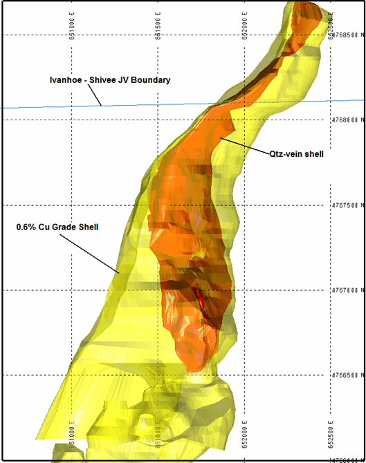
AMC 813001 : March : 2013
218
ENTRÉE GOLD INC Lookout Hill Property, Southern Mongolia Technical Report | |
| Figure 14.4 | Hugo North Gold Grade Shells |
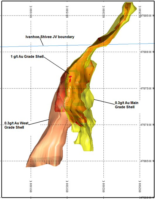
AMC 813001 : March : 2013
219
ENTRÉE GOLD INC Lookout Hill Property, Southern Mongolia Technical Report | |
| 14.1.4 | Composites |
The drillhole assays were composited into fixed-length 5 m downhole composites.
The composites included any post-mineral dyke material intervals that were deemed too small to be part of a post-mineral dyke geology model. Any unsampled material included in the composites was set to 0.001% for copper and 0.01 g/t for gold.
Bulk density data were assigned to a unique file and composited to honor lithological contacts.
| 14.1.5 | Data Analysis |
The lithologic, structural, and mineralized domains were reviewed to determine the appropriate estimation or grade interpolation parameters.
Descriptive statistics, histograms and cumulative probability plots, box plots and contact grade profile plots were summarised in Vann et al, (2008).
| 14.1.5.1 | Estimation Domains |
The data analysis showed that for grade interpolation the data should be subdivided by grade shell and lithological domain. All inter-grade-shell contacts are hard boundaries, but some intra-grade-shell contacts were treated as hard boundaries and some as soft boundaries (see Table 14.2 and Table 14.3).
| 14.1.5.2 | Evaluation of Extreme Grades |
Extreme grades were controlled by using outlier restriction during interpolation instead of capping (see Section 14.1.8).
AMC 813001 : March : 2013
220
ENTRÉE GOLD INC Lookout Hill Property, Southern Mongolia Technical Report | |
| Table 14.2 | Hugo North Copper Intra-domain Boundary Contacts |
| Va | Qmd | Ignimbrite | xBiGd | |
| Background Shell | ||||
| Va | Soft | Hard | Hard | Hard |
| Qmd | Hard | Soft | Hard | Hard |
| Ignimbrite | Hard | Hard | Soft | Hard |
| xBiGd | Hard | Hard | Hard | Soft |
| 0.6% Shell | ||||
| Va | Soft | Hard | Soft | Hard |
| Qmd | Hard | Soft | Hard | Hard |
| Ignimbrite | Soft | Hard | Soft | Hard |
| xBiGd | Hard | Hard | Hard | Soft |
| Qtz Shell | ||||
| Va | Soft | Soft | Soft | Hard |
| Qmd | Soft | Soft | Hard | Hard |
| Ignimbrite | Soft | Hard | Soft | Hard |
| xBiGd | Hard | Hard | Hard | Soft |
| Table 14.3 | Hugo North Gold Intra-domain Boundary Contacts |
| Va | Qmd | Ignimbrite | xBiGd | |
| Background Shell | ||||
| Va | Soft | Hard | Soft | Soft |
| Qmd | Hard | Soft | Hard | Hard |
| Ignimbrite | Soft | Hard | Soft | Hard |
| xBiGd | Soft | Hard | Hard | Soft |
| Main Shell | ||||
| Va | Soft | Soft | Soft | Hard |
| Qmd | Soft | Soft | Hard | Hard |
| Ignimbrite | Soft | Hard | Soft | Hard |
| xBiGd | Hard | Hard | Hard | Soft |
| West Shell | ||||
| Va | Soft | Hard | Hard | Hard |
| Qmd | Hard | Soft | Hard | Soft |
| Ignimbrite | Hard | Hard | Soft | Hard |
| xBiGd | Soft | Hard | Hard | Soft |
| 1 g/t Au Shell | ||||
| Va | Soft | Soft | Soft | Hard |
| Qmd | Soft | Soft | Hard | Hard |
| Ignimbrite | Soft | Hard | Soft | Hard |
| xBiGd | Hard | Hard | Hard | Soft |
AMC 813001 : March : 2013
221
ENTRÉE GOLD INC Lookout Hill Property, Southern Mongolia Technical Report | |
| 14.1.6 | Variography |
Variography, a continuation of data analysis, is the study of the spatial variability of an attribute. Variogram model parameters and orientation data of rotated variogram axes are shown in Table 14.4 to Table 14.7.
| Table 14.4 | Copper Variogram Parameters |
| Model | Zone | |||||
| Background | 0.6% Shell - N | 0.6% Shell - S | Qtz Shell -N | Qtz Shell - S | ||
| SPH | SPH | SPH | SPH | SPH | ||
| Sills | Nugget | 0.20 | 0.13 | 0.15 | 0.30 | 0.25 |
| C1 | 0.55 | 0.35 | 0.40 | 0.20 | 0.45 | |
| C2 | 0.25 | 0.52 | 0.45 | 0.50 | 0.30 | |
| Rotation Angles | Z | 0 | 45 | 25 | 45 | -15 |
| X | 0 | 0 | -30 | 0 | -30 | |
| Y | 0 | 0 | 20 | 0 | 20 | |
| Ranges | Y1 | 17 | 10 | 15 | 15 | 30 |
| X1 | 17 | 15 | 15 | 15 | 10 | |
| Z1 | 17 | 20 | 15 | 15 | 15 | |
| Y2 | 200 | 140 | 220 | 150 | 200 | |
| X2 | 180 | 100 | 120 | 100 | 120 | |
| Z2 | 220 | 175 | 200 | 150 | 200 | |
Models are spherical (SPH) or exponential (EXP). Traditional ranges are used for the exponential variograms. Axial rotations are left-hand, right-hand, left-hand about the positive Z, X and Y axes, respectively.
| Table 14.5 | Azimuth and Dip Angles of Rotated Variogram Axes for Copper |
| Zone | Axis Azimuth | Axis Dip | ||||
| Y | X | Z | Y | X | Z | |
| Background | 0 | 0 | 0 | 0 | 0 | 90 |
| 0.6% Shell – N | 45 | 135 | 0 | 0 | 0 | 90 |
| 0.6% Shell – S | 25 | 105 | 349 | -30 | 17 | 54 |
| Qtz Shell – N | 45 | 135 | 0 | 0 | 0 | 90 |
| Qtz Shell – S | 345 | 65 | 309 | -30 | 17 | 54 |
Azimuths are in degrees. Dips are positive up and negative down.
AMC 813001 : March : 2013
222
ENTRÉE GOLD INC Lookout Hill Property, Southern Mongolia Technical Report | |
| Table 14.6 | Gold Variogram Parameters |
| Model | Zone | |||||
| Background - N | Background - S | 0.3 g/t Main Shell | 0.3 g/t West Shell | 1 g/t Shell | ||
| EXP | SPH | EXP | EXP | EXP | ||
| Sills | Nugget | 0.151 | 0.200 | 0.653 | 0.500 | 0.549 |
| C1 | 0.557 | 0.373 | 0.347 | 0.500 | 0.451 | |
| C2 | 0.292 | 0.427 | – | – | – | |
| Rotation Angles | Z | -29 | 50 | -2 | -6 | -81 |
| X | 13 | -9 | 38 | 22 | 70 | |
| Y | -14 | -51 | -72 | -7 | 2 | |
| Z | -9 | 8 | – | – | – | |
| X | 45 | -31 | – | – | – | |
| Y | 24 | 31 | – | – | – | |
| Ranges | Y | 27 | 70 | 61 | 469 | 12 |
| X | 15 | 54 | 139 | 30 | 149 | |
| Z | 93 | 30 | 25 | 49 | 22 | |
| Y | 1333 | 977 | – | – | – | |
| X | 210 | 400 | – | – | – | |
| Z | 919 | 969 | – | – | – | |
Models are spherical (SPH) or exponential (EXP). Traditional ranges (short ranges) are used for the exponential variograms. Axial rotations are left-hand, right-hand, left-hand about the positive Z, X and Y axes, respectively.
| Table 14.7 | Azimuth and Dip Angles of Rotated Variogram Axes for Gold |
| First Structure | Second Structure | |||||||||||||||||||||||||||||||||||||||||||||||
| Zone | Axis Azimuth | Axis Dip | Axis Azimuth | Axis Dip | ||||||||||||||||||||||||||||||||||||||||||||
| Y | X | Z | Y | X | Z | Y | X | Z | Y | X | Z | |||||||||||||||||||||||||||||||||||||
| Background - N | 58 | -13 | 331 | 13 | 105 | 71 | 351 | 45 | 99 | 17 | 204 | 40 | ||||||||||||||||||||||||||||||||||||
| Background - S | 151 | -50 | 50 | -9 | 133 | 39 | 8 | -31 | 81 | 26 | 319 | 48 | ||||||||||||||||||||||||||||||||||||
| 0.3 g/t Main Shell | 26 | -48 | 358 | 38 | 100 | 14 | – | – | – | – | – | – | ||||||||||||||||||||||||||||||||||||
| 0.3 g/t West Shell | 82 | -6 | 354 | 22 | 157 | 67 | – | – | – | – | – | – | ||||||||||||||||||||||||||||||||||||
| 1 g/t Shell | 11 | 1 | 279 | 70 | 101 | 20 | – | – | – | – | – | – | ||||||||||||||||||||||||||||||||||||
Azimuths are in degrees. Dips are positive up and negative down.
The deposit displays mineralization controls that are related to the intrusive history and structural geology (faults). The patterns of anisotropy demonstrated by the various variograms tend to be consistent with geological interpretations – particularly to any bounding structural features (faults and lithologic contacts) and quartz + sulphide vein orientation data.
AMC 813001 : March : 2013
223
ENTRÉE GOLD INC Lookout Hill Property, Southern Mongolia Technical Report | |
| 14.1.7 | Model Setup |
The block model size selected was 20 m x 20 m x 15 m. This allowed consistency with previous modelling in the Hugo North Deposit (see Juras, 2005 and Blower, 2006). The assays were composited into 5 m downhole composites.
Bulk density data were assigned to a unique file and composited to honour lithological contacts.
Various coding was done on the block models in preparation for grade interpolation. The block model was coded according to zone, lithologic domain, and grade shell. Post-mineral dykes were assumed to represent zero grade waste cutting the mineralized rock.
| 14.1.8 | Estimation |
The Hugo North estimation plans, or sets of parameters used for estimating blocks, were designed using a philosophy of restricting the number of samples for local estimation.
Interpolation was limited to the mineralized lithological units (Va, Ign, Qmd, and xBiGd). Only blocks within those units were interpolated, and only composites belonging to those units were used. Metal values within blocks belonging to all other units (post-mineral dykes and sediments) were set to zero. Modelling consisted of grade interpolation by ordinary Kriging (OK) except for bulk density that was interpolated using inverse distance to the power of three (ID3). Both restricted and unrestricted grades were interpolated to allow calculation of the metal removed by the outlier restriction. Nearest-neighbour grades were also interpolated for validation purposes. Blocks and composites were matched on estimation domain.
The search ellipsoids were oriented preferentially to the general orientation of the grade shells. The ranges and the rotation angles for the various search ellipsoids are highlighted in Table 14.8 and Table 14.9. The search strategy employed concentric expanding search ellipsoids. The first pass used a relatively short search ellipse relative to the long axis of the variogram ellipsoid. For the second pass, the search ellipse was increased by 50% (up to the full range of the variogram) to allow interpolation of grade into those blocks not estimated by the first pass. A last third pass was performed using a larger search ellipsoid.
To ensure that at least two boreholes were used in the estimate, the number of composites from a single drillhole that could be used was set to one less than the minimum number of composites.
These parameters were based on the geological interpretation, data analyses, and variogram analyses. The number of composites used in estimating grade into a model block followed a strategy that matched composite values and model blocks sharing the same ore code or domain. The minimum and maximum number of composites was adjusted to incorporate an appropriate amount of grade smoothing.
AMC 813001 : March : 2013
224
ENTRÉE GOLD INC Lookout Hill Property, Southern Mongolia Technical Report | |
Blocks that fall along grade domain boundaries were assigned two or more values, one for each of the grade domains present within the block. A final undiluted value was calculated by averaging the values for each domain within the block, weighed by the percentage of each domain within the block. This resulted in slightly smoothed metal grades along grade shell boundaries.
For both metals, an outlier restriction of 50 m was used to control the effects of high-grade samples within the domains, particularly in the background domains where unrestricted high-grade composites tended to result in “blow outs” from extreme grade composites. In outlier restricted kriging, outliers (i.e., values above the specified cut-off) are cut down to the specified threshold value if their distance to the interpolated block is greater than 50 m. If the distance to the interpolated block is less than 50 m, then outliers are used at their full value. The outlier thresholds applied were defined at the 99th percentile of their respective population. The thresholds are shown in Table 14.10 and Table 14.11.
| Table 14.8 | Copper Search Ellipsoids for Hugo North |
| Zone | |||||||
| Background N | Background S | 0.6% Shell - N | 0.6% Shell - S | Qtz Shell N | Qtz Shell S | ||
| Rotation Angles | Z | 45 | 0 | 45 | 25 | 45 | -15 |
| X | 0 | 0 | 0 | -30 | 0 | -30 | |
| Y | 0 | 0 | 0 | 20 | 0 | 20 | |
| Ranges - First Pass | Y | 150 | 150 | 150 | 150 | 150 | 150 |
| X | 100 | 100 | 50 | 50 | 35 | 35 | |
| Z | 150 | 150 | 150 | 150 | 150 | 150 | |
| Ranges - Second Pass | Y | 225 | 225 | 225 | 225 | 225 | 225 |
| X | 150 | 150 | 75 | 75 | 50 | 50 | |
| Z | 225 | 225 | 225 | 225 | 225 | 225 | |
| Ranges - Third Pass | Y | 400 | 400 | 400 | 400 | 400 | 400 |
| X | 200 | 200 | 125 | 150 | 100 | 100 | |
| Z | 400 | 400 | 400 | 400 | 400 | 400 | |
| Number of Comps | Min | 4 | 4 | 4 | 4 | 4 | 4 |
| Max | 15 | 15 | 15 | 15 | 15 | 15 | |
| Max per DDH | 3 | 3 | 3 | 3 | 3 | 3 | |
MIN = minimum number of composites; MAX = maximum number of composites, MAX DDH = maximum number of composites derived from a single borehole; bkgrnd = background. Axial rotations are left-hand, right-hand, left-hand about the positive Z, X and Y axes, respectively.
Bulk density values were interpolated into the model using an inverse-distance to the third power (ID3) estimation methodology. The ranges and the rotation angles for the various search ellipsoids are highlighted in Table 14.12.
AMC 813001 : March : 2013
225
ENTRÉE GOLD INC Lookout Hill Property, Southern Mongolia Technical Report | |
| Table 14.9 | Gold Search Ellipsoids for Hugo North |
| Zone | |||||||
| Background | 0.3 g/t Main Shell - N | 0.3 g/t Main Shell - S | 0.3 g/t West Shell | 1 g/t Shell - N | 1 g/t Shell - S | ||
| Rotation Angles | Z | 0 | 30 | 0 | 0 | 30 | 0 |
| X | 0 | 0 | 0 | 0 | 0 | 0 | |
| Y | 0 | 0 | 10 | 0 | 0 | 10 | |
| Ranges - First Pass | Y | 200 | 150 | 150 | 375 | 150 | 150 |
| X | 200 | 25 | 25 | 50 | 25 | 25 | |
| Z | 200 | 150 | 150 | 50 | 150 | 150 | |
| Ranges - Second Pass | Y | 300 | 170 | 170 | 470 | 170 | 170 |
| X | 300 | 45 | 45 | 75 | 45 | 45 | |
| Z | 300 | 170 | 170 | 75 | 170 | 170 | |
| Ranges - Third Pass | Y | 500 | 250 | 250 | 600 | 175 | 175 |
| X | 500 | 250 | 250 | 300 | 175 | 175 | |
| Z | 500 | 250 | 250 | 300 | 175 | 175 | |
| Min | 5 | 5 | 5 | 5 | 5 | 5 | |
| Number of Comps | Max | 20 | 20 | 20 | 20 | 20 | 20 |
| Max per DDH | 4 | 4 | 4 | 4 | 4 | 4 | |
| MIN = minimum number of composites; MAX = maximum number of composites. |
| MAX DDH = maximum number of composites derived from a single borehole. kgrnd = background. |
| Axial rotations are left-hand, right-hand, left-hand about the positive Z, X and Y axes, respectively. |
| Table 14.10 | Outlier Thresholds Applied to Cu Grade Domains |
| Grade Domain | Va Outlier Threshold (%) | Qmd Outlier Threshold (%) | Ign Outlier Threshold (%) | xBiGd Outlier Threshold (%) |
| Cu Qtz vein | 7.5 | 7.0 | 5.5 | 3.5 |
| Cu 0.6% | 2.5 | 2.5 | 2.5 | 2.0 |
| Background | 0.7 | 0.85 | 0.85 | 0.7 |
| Table 14.11 | Outlier Thresholds Applied to Au Grade Domains |
| Grade Domain | Outlier Threshold (g/t) |
| 1 g/t Gold Zone | 5.0 |
| W Gold Zone | 2.0 |
| Main Gold Zone | 2.0 |
| Background QMD, XBiGd | 0.4 |
| Background Va | 0.5 |
| Background Ignimbrite | 0.3 |
AMC 813001 : March : 2013
226
ENTRÉE GOLD INC Lookout Hill Property, Southern Mongolia Technical Report | |
| Table 14.12 | Bulk Density Search Ellipsoids for Hugo North |
| All Domains | ||
Rotation Angles | Z | 8 |
| X | -2 | |
| Y | -31 | |
Ranges (m) | Y | 100 |
| X | 150 | |
| Z | 450 | |
Number of Comps | Min | 4 |
| Max | 10 | |
| Max DDH | 3 |
The process utilized lithological domaining, since statistical analysis showed bulk density variation is primarily controlled by host lithology. Any blocks in the model that were not interpolated were assigned a mean density based on rock type. The mean bulk density of each lithology is shown in Table 14.13.
| Table 14.13 | Average Bulk Density |
| Lithology | Bulk Density |
| Va | 2.87 |
| QMD | 2.76 |
| Sediments | 2.77 |
| Ignimbrite | 2.86 |
| Rhyolite Dyke | 2.77 |
| Hornblende-biotite Andesite Dyke | 2.77 |
| BiGd | 2.70 |
| xBiGd | 2.72 |
| Basalt Dyke | 2.77 |
Final Au and Cu grade values were adjusted to reflect probable occurrences of internal dilution from the unmineralized post-mineral dykes and/or overlying unmineralized sediments (waste). The final diluted value was calculated by multiplying the undiluted value by the volumetric percentage of the mineralized units within the block (weighed by the ratio of the density of the mineralized units to the average density of the block). This resulted in the incorporation of waste dilution into blocks. No additional manipulation of grade or recovery was applied to simulate the effects of mining. The resources for the Hugo North Deposit were tabulated and reported using these diluted grade values.
AMC 813001 : March : 2013
227
ENTRÉE GOLD INC Lookout Hill Property, Southern Mongolia Technical Report | |
| 14.1.9 | Validation |
| 14.1.9.1 | Visual Inspection |
A detailed visual validation of the Hugo North resource model was made by both AMEC and QG. The model was checked for proper coding of drillhole intervals and block model cells, in both section and plan. Coding was found to be properly done. Grade interpolation was examined relative to drillhole composite values by inspecting sections and plans. The checks showed good agreement between drillhole composite values and model cell values. The hard boundaries between grade shells appear to have constrained grades to their respective estimation domains. The addition of the outlier restriction values succeeded in minimizing grade smearing in regions of sparse data. Additional comments on the estimate and QG’s independent checks were given above in Section 14.1.2.
| 14.1.9.2 | Model Checks for Bias |
The block model estimates were checked for global bias by comparing the average metal grades (with no outlier restriction) from the model with means from unrestricted nearest-neighbor estimates. The nearest-neighbor estimator declusters the data and produces a theoretically unbiased estimate of the average value when no cut-off grade is imposed and is a good basis for checking the performance of different estimation methods. Results, summarized in Table 14.4, show no problems with global bias in the estimates.
| Table 14.14 | Global Model Mean Grade Values by Domain in Each Zone |
| Domain/Zone | Nearest Neighbour Estimate | Kriged Estimate | Unrestricted Kriged Estimate | Metal Reduction |
| Cu (%) | ||||
| All Zones | 1.677 | 1.674 | 1.679 | 0.3% |
| Qtz-vein Domain | 3.212 | 3.192 | 3.197 | 0.2% |
| 0.6%Cu Domain | 1.061 | 1.070 | 1.076 | 0.6% |
| Cu background | 0.222 | 0.229 | 0.233 | 1.7% |
| Au (g/t) | ||||
| All Zones | 0.39 | 0.38 | 0.40 | 3.0% |
| 1 g/t Au Zone | 1.42 | 1.39 | 1.44 | 3.5% |
| Main 0.3 g/t Au Zone | 0.54 | 0.52 | 0.54 | 3.7% |
| West 0.3 g/t Au Zone | 0.50 | 0.50 | 0.51 | 2.0% |
| Au Background | 0.11 | 0.10 | 0.11 | 9.1% |
Note: The values shown in the table reflect the global mean grades in the resource model and include blocks that fall in the Joint Venture area.
Local trends in the grade estimates (grade slice or swath checks) were also checked. This was done by plotting the mean values from the nearest-neighbor estimate versus the unrestricted kriged results for elevation (in 60 m-swaths) and for northings and eastings (both in 100 m swaths). The unrestricted kriged estimate should be smoother than the nearest-neighbor estimate, thus the nearest-neighbor estimate should fluctuate around the kriged estimate on the plots.
AMC 813001 : March : 2013
228
ENTRÉE GOLD INC Lookout Hill Property, Southern Mongolia Technical Report | |
The two trends behave as predicted and show no significant differences for copper or gold in the estimates. The elevation and northing swath plots presented as Figure 14.5 to Figure 14.8 show the trends for copper inside the quartz vein shell and gold inside the Main gold zone. The plots are from the entire resource model and include blocks north of the Oyu Tolgoi boundary.
| Figure 14.5 | Comparison of Kriged and Nearest Neighbour Copper Estimates with Increasing Depth – Cu Quartz-Vein Domain |
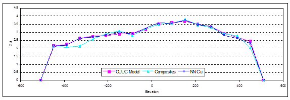
| Figure 14.6 | Comparison of Kriged and Nearest Neighbour Copper Estimates with Increasing Northing – Cu Quartz-vein Domain |
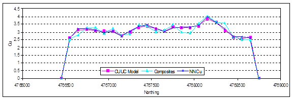
AMC 813001 : March : 2013
229
ENTRÉE GOLD INC Lookout Hill Property, Southern Mongolia Technical Report | |
| Figure 14.7 | Comparison of Kriged and Nearest Neighbour Gold Estimates with Increasing Depth – Au Main + 1 g/t Domains |
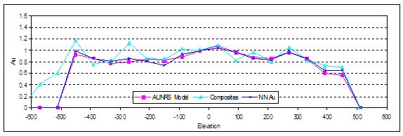
| 14.1.9.3 | Metal Reduction |
The effective amount of metal removed by outlier restriction can be evaluated by comparing copper and gold block models kriged with and without outlier restriction. An assessment of the metal removed by grade shell is shown in Figure 14.8. The quantity of copper removed ranges from 0.2% to 1.7%, and the quantity of gold removed ranges from 2% to 9%. Those amounts of metal removed are reasonable for the type of deposit.
| Figure 14.8 | Comparison of Kriged and Nearest Neighbour Gold Estimates with Increasing Northing – Au Main + 1 g/t Domains |

AMC 813001 : March : 2013
230
ENTRÉE GOLD INC Lookout Hill Property, Southern Mongolia Technical Report | |
| 14.1.10 | Mineral Resource Summary – Hugo North Extension |
Te Hugo North Extension Mineral Resource inventory, cut at the adjacent project boundary, is based on drilling as of 1 November 2006 and reported as of the Resource Effective Date of 20 February 2007. The Mineral Resources are reported at various copper equivalent (CuEq) cut-offs as shown in Table 14.15 and Table 14.16 and include material that is classified as an Indicated and Inferred Mineral Resources.
For consistency with previous Mineral Resource disclosures on the Lookout Hill Property, the equivalent grade was calculated using assumed metal prices of US$1.35/lb for copper and US$650/oz for gold, and assuming gold recovery is 91% of copper recovery. Silver is not included in the CuEq calculation.
For convenience the formula is:
CuEq% = Cu% + ((Au g/t*18.98)+(Mo g/t*.01586))/29.76.
The metal price assumptions and the adjustment for metallurgical recovery used for calculating CuEq for the Hugo North Mineral Resources stated in this report have been changed from previous reports to reflect current market conditions and technical understanding. The copper to gold metal price ratio and recovery ratio used have resulted in no change in the calculated CuEq values as stated for the 20 February 2007 Mineral Resources.
AMC 813001 : March : 2013
231
ENTRÉE GOLD INC Lookout Hill Property, Southern Mongolia Technical Report | |
| Table 14.15 | Indicated Mineral Resources – Hugo North EJV, Effective Date 20 February 2007 (base-case is highlighted) |
| Class | Owner | CuEq Cut-off (%) | Tonnage (Mt) | Cu (%) | Au (g/t) | Ag (g/t) | Mo (ppm) | CuEq (%) | Contained Metal | ||||
Cu (Mlb) | Au (Moz) | Ag (Moz) | Mo (Mlb) | CuEq (Mlb) | |||||||||
| INDICATED | EJV | 3.50 | 22.3 | 3.68 | 1.43 | 7.92 | 46.9 | 4.59 | 1,809 | 1.03 | 5.68 | 2.31 | 2,258 |
| 3.00 | 32.0 | 3.36 | 1.29 | 7.45 | 43.8 | 4.18 | 2,370 | 1.33 | 7.67 | 3.09 | 2,952 | ||
| 2.50 | 42.4 | 3.08 | 1.17 | 7.03 | 40.6 | 3.83 | 2,881 | 1.60 | 9.57 | 3.79 | 3,581 | ||
| 2.00 | 52.3 | 2.84 | 1.09 | 6.62 | 38.0 | 3.53 | 3,270 | 1.83 | 11.1 | 4.38 | 4,072 | ||
| 1.50 | 65.4 | 2.56 | 0.96 | 6.10 | 35.4 | 3.17 | 3,687 | 2.02 | 12.8 | 5.11 | 4,571 | ||
| 1.00 | 84.7 | 2.22 | 0.80 | 5.42 | 33.5 | 2.73 | 4,142 | 2.19 | 14.8 | 6.26 | 5,099 | ||
| 0.90 | 89.7 | 2.14 | 0.77 | 5.25 | 33.4 | 2.63 | 4,235 | 2.21 | 15.1 | 6.61 | 5,202 | ||
| 0.80 | 96.7 | 2.04 | 0.72 | 5.01 | 33.6 | 2.50 | 4,353 | 2.24 | 15.6 | 7.17 | 5,333 | ||
| 0.70 | 107 | 1.91 | 0.66 | 4.68 | 34.4 | 2.33 | 4,517 | 2.27 | 16.2 | 8.13 | 5,508 | ||
| 0.60 | 117 | 1.80 | 0.61 | 4.43 | 35.2 | 2.19 | 4,645 | 2.29 | 16.7 | 9.08 | 5,645 | ||
| 0.50 | 124 | 1.73 | 0.58 | 4.27 | 35.7 | 2.10 | 4,724 | 2.30 | 17.0 | 9.76 | 5,731 | ||
| 0.45 | 127 | 1.70 | 0.56 | 4.20 | 35.7 | 2.06 | 4,757 | 2.31 | 17.2 | 10.0 | 5,766 | ||
| 0.40 | 130 | 1.67 | 0.55 | 4.13 | 35.7 | 2.02 | 4,782 | 2.31 | 17.3 | 10.3 | 5,794 | ||
| 0.37 | 132 | 1.65 | 0.55 | 4.09 | 35.7 | 2.00 | 4,796 | 2.32 | 17.4 | 10.4 | 5,809 | ||
| 0.35 | 134 | 1.63 | 0.54 | 4.06 | 35.7 | 1.98 | 4,807 | 2.32 | 17.4 | 10.5 | 5,821 | ||
| 0.30 | 138 | 1.59 | 0.52 | 3.97 | 35.6 | 1.93 | 4,836 | 2.32 | 17.6 | 10.8 | 5,852 | ||
| 0.25 | 143 | 1.54 | 0.51 | 3.85 | 35.2 | 1.86 | 4,867 | 2.33 | 17.7 | 11.1 | 5,885 | ||
| 0.22 | 146 | 1.51 | 0.50 | 3.79 | 34.9 | 1.83 | 4,882 | 2.33 | 17.8 | 11.3 | 5,901 | ||
| 0.20 | 149 | 1.49 | 0.49 | 3.74 | 34.7 | 1.80 | 4,893 | 2.33 | 17.9 | 11.4 | 5,913 | ||
| Note: | 1) Mineral Resources are reported using a base case 0.37% copper equivalency cut-off grade. Other cases shown in this table are sensitivity cases |
| 2) The copper equivalency is calculated using the formula CuEq = Cu% + (Au g/t) x (11.25 / 17.64). This formula assumes 100% Cu and Au recoveries. |
| 3) Mineral Resources are inclusive of Mineral Reserves |
| 4) Mineral Resources that are not also reported as Mineral Reserves have not been demonstrated to have economic viability. |
| 5) Rounding as required by reporting guidelines may result in apparent summation differences. |
AMC 813001 : March : 2013
232
ENTRÉE GOLD INC Lookout Hill Property, Southern Mongolia Technical Report | |
| Table 14.16 | Inferred Mineral Resources – Hugo North EJV, Effective Date 20 February 2007 (base-case is highlighted) |
| Class | Owner | CuEq Cut-off (%) | Tonnage (Mt) | Cu (%) | Au (g/t) | Ag (g/t) | Mo (ppm) | CuEq (%) | Contained Metal | ||||
Cu (Mlb) | Au (Moz) | Ag (Moz) | Mo (Mlb) | CuEq (Mlb) | |||||||||
| INFERRED | EJV | 3.50 | 1.41 | 3.32 | 1.03 | 5.31 | 32.1 | 3.98 | 103 | 0.047 | 0.24 | 0.100 | 124 |
| 3.00 | 3.62 | 2.97 | 0.88 | 5.79 | 34.3 | 3.53 | 237 | 0.10 | 0.67 | 0.27 | 282 | ||
| 2.50 | 5.85 | 2.68 | 0.87 | 5.63 | 33.1 | 3.23 | 346 | 0.16 | 1.06 | 0.43 | 417 | ||
| 2.00 | 11.0 | 2.21 | 0.86 | 5.12 | 27.2 | 2.76 | 533 | 0.30 | 1.80 | 0.66 | 666 | ||
| 1.50 | 29.1 | 1.73 | 0.58 | 4.42 | 21.7 | 2.10 | 1,108 | 0.54 | 4.13 | 1.39 | 1,345 | ||
| 1.00 | 62.2 | 1.39 | 0.39 | 3.77 | 22.6 | 1.64 | 1,909 | 0.78 | 7.54 | 3.10 | 2,250 | ||
| 0.90 | 70.0 | 1.33 | 0.37 | 3.62 | 23.6 | 1.56 | 2,054 | 0.82 | 8.14 | 3.65 | 2,414 | ||
| 0.80 | 78.2 | 1.27 | 0.34 | 3.47 | 24.5 | 1.49 | 2,190 | 0.87 | 8.72 | 4.23 | 2,568 | ||
| 0.70 | 86.9 | 1.21 | 0.32 | 3.29 | 25.6 | 1.42 | 2,318 | 0.90 | 9.21 | 4.90 | 2,713 | ||
| 0.60 | 95.5 | 1.15 | 0.31 | 3.14 | 26.4 | 1.35 | 2,425 | 0.94 | 9.62 | 5.56 | 2,835 | ||
| 0.50 | 105 | 1.09 | 0.29 | 2.96 | 26.6 | 1.27 | 2,526 | 0.98 | 10.00 | 6.16 | 2,952 | ||
| 0.45 | 113 | 1.04 | 0.28 | 2.79 | 25.7 | 1.22 | 2,596 | 1.01 | 10.2 | 6.44 | 3,038 | ||
| 0.40 | 127 | 0.96 | 0.26 | 2.54 | 24.2 | 1.13 | 2,708 | 1.05 | 10.4 | 6.79 | 3,169 | ||
| 0.37 | 134 | 0.93 | 0.25 | 2.44 | 23.6 | 1.09 | 2,756 | 1.08 | 10.5 | 6.99 | 3,228 | ||
| 0.35 | 140 | 0.91 | 0.24 | 2.37 | 23.2 | 1.06 | 2,789 | 1.10 | 10.6 | 7.14 | 3,270 | ||
| 0.30 | 152 | 0.85 | 0.23 | 2.20 | 22.0 | 1.00 | 2,857 | 1.15 | 10.8 | 7.38 | 3,360 | ||
| 0.25 | 162 | 0.81 | 0.23 | 2.10 | 21.3 | 0.96 | 2,903 | 1.18 | 10.9 | 7.61 | 3,418 | ||
| 0.22 | 165 | 0.80 | 0.22 | 2.07 | 21.3 | 0.94 | 2,919 | 1.18 | 11.0 | 7.76 | 3,437 | ||
| 0.20 | 168 | 0.79 | 0.22 | 2.05 | 21.2 | 0.93 | 2,929 | 1.19 | 11.1 | 7.84 | 3,448 | ||
| Note: | 1) Mineral Resources are reported using a base case 0.37% copper equivalency cut-off grade. Other cases shown in this table are sensitivity cases |
| 2) The copper equivalency is calculated using the formula CuEq = Cu% + (Au g/t) x (11.25 / 17.64). This formula assumes 100% Cu and Au recoveries. |
| 3) Mineral Resources are inclusive of Mineral Reserves |
| 4) Mineral Resources that are not also reported as Mineral Reserves have not been demonstrated to have economic viability. |
| 5) Rounding as required by reporting guidelines may result in apparent summation differences. |
AMC 813001 : March : 2013
233
ENTRÉE GOLD INC Lookout Hill Property, Southern Mongolia Technical Report | |
14.2 Heruga Deposit
14.2.1 Introduction
This Mineral Resource estimate for the Heruga deposit was prepared by Stephen Torr of OT LLC under the supervision of Scott Jackson of Quantitative Group. The estimates were in the form of three-dimensional (3D) block models utilizing commercial mine planning software (Datamine). The project area limits and the block sizes used are shown in Table 14.17.
| Table 14.17 | Project Area Limits and Block Size |
| Min | Max | Block Size (m) | |
| X (UTM) | 646500 | 648550 | 20 |
| Y (UTM) | 4757500 | 5759900 | 20 |
| Z (AMSL) | -700 | 1250 | 15 |
14.2.2 Geologic Models
A close-off date of 21 June 2009 was used for the drillhole data used in the Heruga Resource update. The Effective Date for reporting the resource was 30 March 2010.
OT LLC created three dimensional shapes or wireframes of the major geological features of the Heruga deposit and these are listed in Table 14.18. The key geological features impacting on resource estimation are:
| · | Subvertical post-mineralization faults. |
| · | Devonian host lithologies, primarily augite basalt and quartz monzodiorite. |
| · | Poorly mineralised “late” quartz monzodiorite. |
| · | Poorly mineralised hornblende-biotite-andesite and biotite-granodiorite dykes. |
To assist in the estimation of grades in the model, OT LLC also manually created three dimensional grade shells (wireframes) for each of the metals to be estimated. Construction of the grade shells took into account prominent lithological and structural features, in particular the four major subvertical post-mineralization faults. For copper, a single grade shell at a threshold of 0.3% Cu was used. For gold, wireframes were constructed at thresholds of 0.3 g/t and 0.7 g/t. For molybdenum, a single shell at a threshold of 100 ppm was constructed. Based on correlations with copper, silver was estimated using the copper shells. These grade shells took into account known gross geological controls in addition to broadly adhering to the abovementioned thresholds.
AMC 813001 : March : 2013
234
ENTRÉE GOLD INC Lookout Hill Property, Southern Mongolia Technical Report | |
| Table 14.18 | Lithology and Structural Solids and Surfaces, Heruga deposit |
| Surfaces – General |
| Topography |
| Solids/Surfaces – Lithology |
| Quartz Mondoziorite |
| Late Quartz Monzodiorite |
| Base of unmineralized volcanic and sedimentary units (DA2 or DA3 or DA4) |
| Biotite granodiorite (BiGd) |
| Hornblende-Biotite Andesite dykes (Hb-Bi An) |
| Surfaces – Faults |
| West Bor Tolgoi Fault |
| Central Bor Tolgoi Fault East Bor Tolgoi Fault |
| South Sparrow Fault |
QG checked the grade and mineralized shapes for interpretational consistency on section, in plan and in three dimensions, and found them to have been properly constructed. The shapes were found to honour the drill data and interpreted geology, and QG accepted them as an appropriate basis for the estimation process.
The solids and surfaces were used by OT LLC to code the drillhole data. All the drillhole intervals outside those shells were assigned to a background domain. A set of plans and cross-sections that displayed colour-coded drillholes were plotted and inspected to ensure the proper assignment of domains to drillholes. The faulting at Heruga is interpreted to have had considerable movement as demonstrated by the displacement of the overlying sedimentary and volcanic rocks. For this reason, the fault surfaces were used to define four separate structural domains for grade estimation. Copper, gold and molybdenum grade shells are shown in Figure 14.10 to Figure 14.12.
AMC 813001 : March : 2013
235
ENTRÉE GOLD INC Lookout Hill Property, Southern Mongolia Technical Report | |
| Figure 14.9 | Plan View of Heruga Structural Domains |
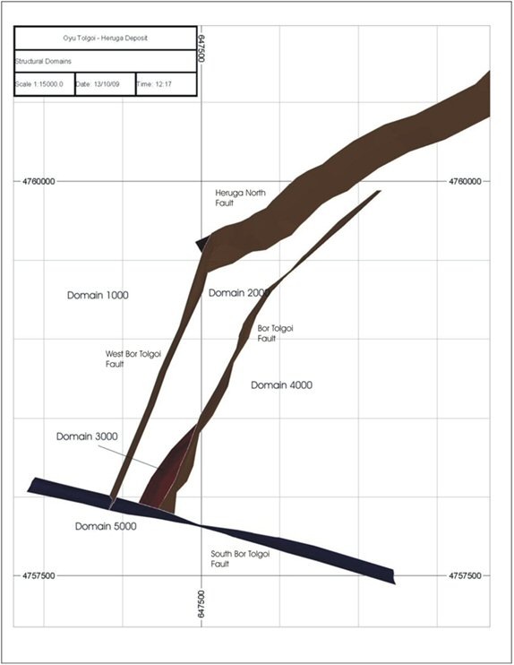
AMC 813001 : March : 2013
236
ENTRÉE GOLD INC Lookout Hill Property, Southern Mongolia Technical Report | |
| Figure 14.10 | Heruga Copper Grade Shell |
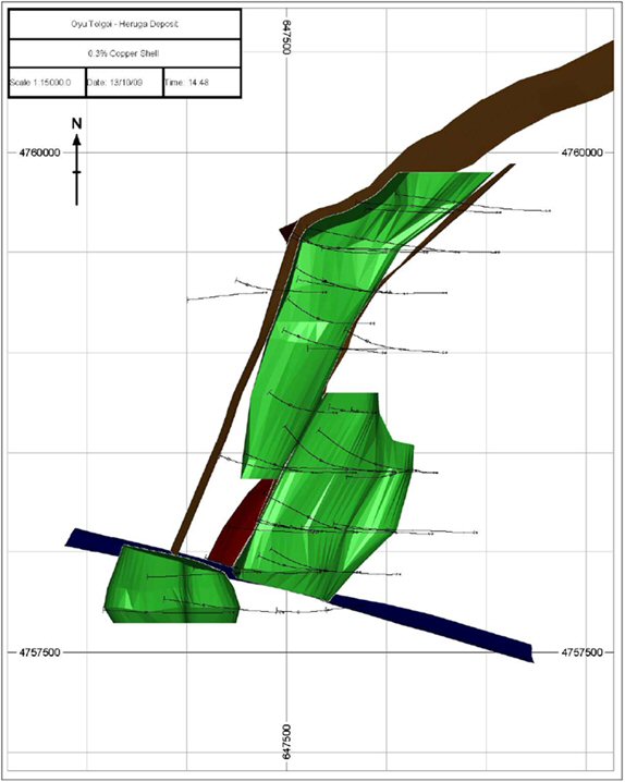
AMC 813001 : March : 2013
237
ENTRÉE GOLD INC Lookout Hill Property, Southern Mongolia Technical Report | |
| Figure 14.11 | Heruga Gold Grade Shells |
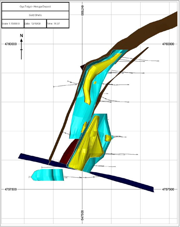
AMC 813001 : March : 2013
238
ENTRÉE GOLD INC Lookout Hill Property, Southern Mongolia Technical Report | |
| Figure 14.12 | Heruga Molybdenum Grade Shells |
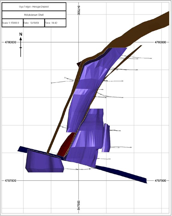
AMC 813001 : March : 2013
239
ENTRÉE GOLD INC Lookout Hill Property, Southern Mongolia Technical Report | |
| 14.2.3 | Composites |
The drillhole assays were composited into fixed-length, 5 m downhole composites, a size which was considered appropriate when taking into account estimation block size, required lithological resolution and probable mining method. This compositing honoured the domain zones by breaking the composites on the domain boundary. The domains used in compositing were a combination of the grade shells and lithological domains. Intervals less than 5 m in length represented individual residual composites from end-of-hole or end-of-domain intervals. Composites that were less than 2 m long were removed from the dataset that was used in interpolation.
The composites included any post-mineral dyke material intervals that were deemed too small to be part of a post-mineral dyke geology model. Any unsampled material included in the composites was set to 0.001% for copper and 0.01 g/t for gold and 10 ppm for molybdenum.
Bulk density data were assigned to a unique file and composited to honour lithological contacts.
| 14.2.4 | Data Analysis |
Data analysis was completed on both the raw data (original 2 m assays) and the 5 m composites. In both cases, analysis was done on individual lithologies inside and outside the grade shells, as well as independently of the grade shells. The relationship between grade and lithology was studied using descriptive statistics, box plots, histograms, CDFs and grade contact plots.
| 14.2.4.1 | Histograms and Cumulative Frequency Plots |
Histograms and cumulative probability plots display the frequency distribution of a given variable and demonstrate graphically how frequency changes with increasing grade. With histograms, the grades are grouped into bins, and a vertical bar on the graph shows the relative frequency of each bin. Cumulative frequency or cumulative distribution function (CDF) diagrams demonstrate the relationship between the cumulative frequency (expressed as a percentile or probability) and grade on a logarithmic scale. They are useful for characterizing grade distributions and identifying whether or not there are multiple populations within a data set.
The statistics of the copper, gold and molybdenum are summarized in Table 14.19, Table 14.20, and Table 14.21 respectively, for the 5 m composites at Heruga. In these tables CV = coefficient of variation (standard deviation/mean), a measure of relative variability. Extreme values or outliers were capped (or top-cut) prior to compositing the data which has reduced both the skewness and the CV of the populations.
AMC 813001 : March : 2013
240
ENTRÉE GOLD INC Lookout Hill Property, Southern Mongolia Technical Report | |
| Table 14.19 | Heruga Statistics for 5 m Composites – Cu % Data |
| Lithology(*) | Cu Shell | Structural Domain | No. of Comps | Min | Max | Mean | CV |
| Va | Bkg | 1000 | 114 | 0.001 | 0.37 | 0.03 | 1.55 |
| Va | Bkg | 2000 | 1,058 | 0.001 | 3.11 | 0.19 | 0.93 |
| LQmd | Bkg | 2000 | 245 | 0.001 | 0.17 | 0.01 | 1.73 |
| Va + Qmd | 0.3 % | 2000 | 1,246 | 0.001 | 2.91 | 0.52 | 0.57 |
| Va | Bkg | 3000 | 92 | 0.001 | 0.67 | 0.06 | 2.54 |
| Va | Bkg | 4000 | 579 | 0.001 | 1.21 | 0.17 | 0.97 |
| Va | 0.3 % | 4000 | 1,051 | 0.001 | 1.88 | 0.52 | 0.51 |
| LQmd | 0.3 % | 4000 | 12 | 0.001 | 0.04 | 0.01 | 1.86 |
| Va | Bkg | 5000 | 175 | 0.001 | 0.51 | 0.10 | 0.85 |
| Va | 0.3 % | 5000 | 253 | 0.001 | 1.53 | 0.35 | 0.54 |
| Va | Bkg | 1000 | 114 | 0.001 | 0.37 | 0.03 | 1.55 |
(*) Va : basalt; Qmd: quartz monzodiorite; LQmd Late quartz monzodiorite.
| Table 14.20 | Heruga Statistics for 5 m Composites – Au g/t Data |
| Lithology(*) | Au Shell | Structural Domain | No. of Comps | Min | Max | Mean | CV |
| Va | Bkg | 1000 | 116 | 0.01 | 1.36 | 0.10 | 1.72 |
| Va | Bkg | 2000 | 1,381 | 0.01 | 2.55 | 0.19 | 1.01 |
| LQmd | Bkg | 2000 | 208 | 0.01 | 0.87 | 0.04 | 2.55 |
| Va + Qmd | 0.3 g/t | 2000 | 540 | 0.01 | 2.90 | 0.45 | 0.63 |
| LQmd | 0.3 g/t | 2000 | 14 | 0.01 | 0.01 | 0.01 | 0.00 |
| Va + Qmd | 0.7 g/t | 2000 | 385 | 0.01 | 7.46 | 1.21 | 0.88 |
| LQmd | 0.7 g/t | 2000 | 29 | 0.01 | 0.27 | 0.02 | 2.53 |
| Va | Bkg | 3000 | 91 | 0.01 | 0.47 | 0.09 | 1.43 |
| Va | 0.3 g/t | 3000 | 2 | 0.41 | 1.29 | 0.85 | 0.52 |
| Va | Bkg | 4000 | 978 | 0.01 | 2.05 | 0.17 | 0.89 |
| LQmd | Bkg | 4000 | 13 | 0.01 | 0.03 | 0.01 | 0.50 |
| Va | 0.3 g/t | 4000 | 402 | 0.01 | 2.18 | 0.49 | 0.59 |
| Va | 0.7 g/t | 4000 | 258 | 0.09 | 6.64 | 1.28 | 0.67 |
| Va | Bkg | 5000 | 307 | 0.01 | 0.93 | 0.16 | 0.80 |
| Va | 0.3 g/t | 5000 | 120 | 0.01 | 0.93 | 0.34 | 0.50 |
(*) Va : basalt; Qmd: quartz monzodiorite; LQmd Late quartz monzodiorite.
AMC 813001 : March : 2013
241
ENTRÉE GOLD INC Lookout Hill Property, Southern Mongolia Technical Report | |
| Table 14.21 | Heruga Statistics for 5 m Composites – Mo ppm Data |
| Lithology(*) | Mo Shell | Structural Domain | No. of Comps | Min | Max | Mean | CV |
| Va | Bkg | 1000 | 116 | 10 | 19 | 10 | 0.09 |
| Va | 100 ppm | 1000 | 1 | 10 | 10 | 10 | 0.00 |
| Va | Bkg | 2000 | 1,556 | 10 | 522 | 51 | 1.10 |
| LQmd | Bkg | 2000 | 251 | 10 | 43 | 11 | 0.38 |
| Va + Qmd | 100 ppm | 2000 | 755 | 10 | 1,570 | 232 | 0.84 |
| Va | Bkg | 3000 | 93 | 10 | 274 | 21 | 1.86 |
| Va | Bkg | 4000 | 918 | 10 | 666 | 41 | 1.31 |
| LQmd | Bkg | 4000 | 13 | 10 | 10 | 10 | 0.00 |
| Va | 100 ppm | 4000 | 713 | 10 | 1,391 | 208 | 0.90 |
| Va | Bkg | 5000 | 249 | 10 | 752 | 54 | 1.36 |
| Va | 100 ppm | 5000 | 180 | 10 | 717 | 129 | 0.74 |
(*) Va : basalt; Qmd: quartz monzodiorite; LQmd Late quartz monzodiorite.
| 14.2.4.2 | Descriptive Statistics |
Copper grades within the 0.3% Cu shell generally display single distributions with some evidence of a lower grade population due to the presence of unmineralized post mineral dykes that have not been captured by wireframes. Coefficients of variation (CV) values are relatively low at 0.5 to 0.6. Background domains for both Qmd (quartz-monzodiorite) and Va (augite basalt) show higher CVs, generally close to or above 1 and the CDF plots also show evidence of a higher grade population not captured by the 0.3% Cu grade shells. The CDF plot for the entire population supports the construction of a grade shell in the 0.3% to 0.4% Cu range. There are no coherent zones of higher grade copper mineralization that are easily constrainable with the current drill coverage.
Gold grades were observed to display moderate positive skewness and multiple populations with evidence of lower grade populations in the 0.2 to 0.3 g/t range. Within the 0.3 g/t and 0.7 g/t gold domains the Va (augite basalt) and Qmd (quartz monzodiorite) display similar properties although the Qmd has a slightly higher mean of 1.31 g/t (vs. 1.21 g/t for Va) in the 0.7 g/t domain. CVs within the grade shells are generally low to moderate, in the 0.6 to 0.9 range; this increases to as high as 1.7 for some of the background domains. The high CV’s in the background domains highlights the requirement for some outlier restriction during estimation.
Overall, the molybdenum grades within the 100 ppm shell display low to moderate positive skewness and single population distribution. Within individual structural domains there is some evidence of multiple populations with breaks at both 50 ppm (possible mixing with waste dykes) and 200 ppm. Augite basalt and Qmd show similar distributions. CVs are low to moderate, in the 0.6 to 0.8 range. The background domains are more positively skewed with somewhat higher CVs, in the 0.8 to 1.3 range.
Given the relatively low magnitude of the silver grades, this variable was estimated within the copper domains. Correlation coefficients between Cu and Mo were in the order of 0.5 to 0.7.
AMC 813001 : March : 2013
242
ENTRÉE GOLD INC Lookout Hill Property, Southern Mongolia Technical Report | |
| 14.2.4.3 | Box-Plot and Contact Grade Profile Analyses |
Contact profiles (or contact plots) were generated by OT LLC to explore the relationship between grade and (1) lithological domains and (2) grade shell domains. The rationale of the studies was to identify lithological or grade shell contacts that should be treated as hard during estimation. A domain with a hard contact will not share composites with other domains during grade interpolation.
| 14.2.4.4 | Results |
Box-plots for copper showed that both within the grade shells and in the background domains there was little evidence of lithological control on copper grades. Augite basalt (Va) and quartz-monzodiorite (Qmd) have very similar overlapping distributions. The post mineral dykes and the late quartz-monzodiorite both show up as distinct, very low grade distributions. There are marked separations between the upper and lower quartiles of the distributions within and outside of the grade shells suggesting the distributions should be modelled separately.
Gold boxplots show similar overlapping relationships for Va and Qmd to those seen for copper. The mean of the Qmd is slightly elevated compared to Va in the 0.7 g/t shell while the reverse is true in the 0.3 g/t shell. Post mineral dykes and the late Qmd show similar relationships to those observed for copper. As with copper, the distributions within the grade shells show a marked separation with those outside.
Molybdenum box-plots show the same relationships as those displayed for copper and gold.
Contact profile analysis confirmed the soft nature of the lithological contacts both inside and outside of the grade shell domains. As expected, contacts of the individual grade shells displayed a marked change in grade supporting the use of the grade shell boundaries as hard contacts. The late Qmd, post mineral dykes and sediment surface – all of which are to be treated as “waste” domains (zero grade) – showed sharp breaks in grade across the contact which were therefore treated as hard boundaries. There is some evidence of increasing grade across the Va Qmd contact inside of the grade shells but, at this stage, the contact was left as a soft contact for grade estimation.
| 14.2.4.5 | Cross Correlation of Copper Gold Molybdenum and Silver |
The relationship between gold and copper was investigated though cross plots for both the main copper and gold estimation domains. Generally the correlations are poor with correlation co-efficients of 0.2 to 0.4 with a wide spread of data. The ratio of Gold to copper is generally 1:1. Inside the 0.7 g/t gold shell, there was clear evidence of two distinct populations, the first with a gold to copper ratio of 1:1 similar to the rest of the deposit, the second with a ratio of greater than 4:1. Spatially, this higher Au:Cu ratio distribution is associated with the deeper parts of the system and with Biotite alteration, a similar style of mineralization is seen in the high grade core of South-west Oyu.
Copper shows a stronger relationship with molybdenum than with gold with correlation co-efficients in the 0.4 to 0.6 range. The overall ratio of Mo:Cu was of the order of 300 to 1 (ppm Mo to % Cu). Similarly, copper shows a strong relationship with silver with correlation co-efficients in the 0.4 to 0.6 range. The overall Cu:Ag ratio (Cu% to Ag ppm) is 1:3.5.
AMC 813001 : March : 2013
243
ENTRÉE GOLD INC Lookout Hill Property, Southern Mongolia Technical Report | |
| 14.2.4.6 | Estimation Domains |
Data analysis showed no discernible difference between the two main host lithologies; augite basalt and quart-monzodiorite. For estimation purposes; therefore, these two lithologies were grouped into a single lithological domain.
It should be noted that the lack of demonstrated lithological control on grade distribution at this early stage in the development of the project is not unexpected. Similar relationships were observed at Oyu Tolgoi, where the controls on mineralization became apparent only once detailed infill drilling was completed. However, there does appear to be a spatial association of higher copper and gold grades with the Qmd intrusion.
The post mineralization lithologies (LQmd, BiGd, HbBiAn), while represented in the block model, were not estimated but rather were assigned zero grade. Within each structural block, the model was therefore split according to whether or not it was mineralized or unmineralized and by grade shell. The final estimation domains used are shown in Table 14.22, Table 14.23, and Table 14.24.
| 14.2.4.7 | Evaluation of Extreme Grades |
Capping (or top-cutting) was applied to the raw assays prior to compositing (Table 14.25). Various capping studies including decile analysis, CV plots and use of CDF plots were used to assign caps. As well as top cutting of extreme grades some outlier restriction was also applied, particularly in the background domains.
| Table 14.22 | Gold Estimation Domains – Mineralised Lithologies Only |
| SDM | GDM | Lithology | GDOMAIN | Description |
| 1000 | 0 | Va, Qmd | 1000 | Background |
| 2000 | 0 | Va, Qmd | 2000 | Background |
| 2000 | 100 | Va, Qmd | 2100 | 0.3 g/t |
| 2000 | 200 | Va Qmd | 2200 | 0.7 g/t |
| 3000 | 0 | Va, Qmd | 3000 | Background |
| 4000 | 0 | Va, Qmd | 4000 | Background |
| 4000 | 100 | Va, Qmd | 4100 | 0.3 g/t |
| 4000 | 200 | Va, Qmd | 4200 | 0.7 g/t |
| 5000 | 0 | Va, Qmd | 5000 | Background |
AMC 813001 : March : 2013
244
ENTRÉE GOLD INC Lookout Hill Property, Southern Mongolia Technical Report | |
| Table 14.23 | Copper and Silver Estimation Domains – Mineralised Lithologies Only |
| SDM | CDM | Lithology | CDOMAIN | Description |
| 1000 | 0 | Va, Qmd | 1000 | Background |
| 2000 | 0 | Va, Qmd | 2000 | Background |
| 2000 | 100 | Va, Qmd | 2100 | 0.3% |
| 3000 | 0 | Va, Qmd | 3000 | Background |
| 4000 | 0 | Va, Qmd | 4000 | Background |
| 4000 | 100 | Va, Qmd | 4100 | 0.3% |
| 5000 | 0 | Va, Qmd | 5000 | Background |
| 5000 | 100 | Va, Qmd | 5100 | 0.3% |
| Table 14.24 | Molybdenum Estimation Domains – Mineralised Lithologies Only |
| SDM | MDM | Lithology | MDOMAIN | Description |
| 1000 | 0 | Va, Qmd | 1000 | Background |
| 2000 | 0 | Va, Qmd | 2000 | Background |
| 2000 | 100 | Va, Qmd | 2100 | 100 ppm |
| 3000 | 0 | Va, Qmd | 3000 | Background |
| 4000 | 0 | Va, Qmd | 4000 | Background |
| 4000 | 100 | Va, Qmd | 4100 | 100 ppm |
| 5000 | 0 | Va, Qmd | 5000 | Background |
| 5000 | 100 | Va, Qmd | 5100 | 100 ppm |
Top cutting was generally applied at values close to or above the 99th percentile for gold and molybdenum. No cap was felt warranted for copper. QG considers the approach taken to metal reduction was appropriate and applied reflecting the Inferred status of mineralization. A number of iterations of grade estimation were done and during these the outlier caps were lowered from those initially selected to better control potential smearing in the background domains. This was particularly the case in the 5000 domain where a quite aggressive outlier was applied to prevent excessive smearing of grades in the background.
| Table 14.25 | Summary of Capping Parameters |
| Domain | Metal | Domain | Cap | Distance | Outlier Cap |
| Background | Au | 1000 to 4000 | 3 g/t | 50 m | 1.0 g/t |
| Background | Au | 5000 | 3 g/t | 50 m | 0.3 g/t |
| Background | Mo | All | 1,000 ppm | 100 m | 500 ppm |
| Background | Ag | All | 30 | 100 | 20 |
| 0.3 Au Shell | Au | 2000 | 3 g/t | – | – |
| 0.3 Au Shell | Au | 4000 | 5 g/t | – | – |
| 0.7 Au Shell | Au | 2000 | 10 g/t | – | – |
| 0.3% Cu Shell | Ag | All | 30 | 100 | 20 |
| 100 Mo Shell | Mo | All | 3,000 ppm | – | – |
| Background | Au | 1000 to 4000 | 3 g/t | 50 m | 1.0 g/t |
AMC 813001 : March : 2013
245
ENTRÉE GOLD INC Lookout Hill Property, Southern Mongolia Technical Report | |
| 14.2.5 | Variography |
Variography was undertaken by OT LLC on copper, gold and molybdenum for the capped and tagged composites using Visor software. Despite limited data OT LLC decided to attempt to model directional variograms for gold, copper and molybdenum. This approach differed to that used in 2008 where isotropic variograms were applied. For variography the Qmd and Va lithologies were combined and the raw data composited into 5 m lengths using the domain coding highlighted in Table 14.26.
Downhole variograms were initially modelled for each of the domains followed by three dimensional modelling of the variogram, this allowed accurate delineation of the nugget for each of the domains. Due to a lack of data, particularly in the strike plane, the 1st structure of the variogram model was mostly taken to be isotropic due to a lack of resolution in that distance range.
| Table 14.26 | Variogram Parameters |
| Model | Copper and Silver | Gold | Molybdenum | ||||||
| Bkg | 0.3 (%) | Bkg | 0.3 (g/t) | 0.7 (g/t) | Bkg | 100 (ppm) | |||
| SPH | SPH | Exp | Exp | Exp | Exp | Exp | |||
| Sills | Nugget | 0.32 | 0.4 | 0.33 | 0.37 | 0.25 | 0.41 | 0.41 | |
| C1 | 0.27 | 0.37 | 0.42 | 0.2 | 0.53 | 0.23 | 0.37 | ||
| C2 | 0.41 | 0.23 | 0.25 | 0.43 | 0.22 | 0.36 | 0.32 | ||
| Rotation Angles | Z | 105 | 127 | -153 | 180 | -155 | -160 | -175 | |
| X | 49 | 68 | -10 | 0 | -70 | -5 | -9 | ||
| Y | 168 | 26 | 80 | -110 | 90 | 90 | 60 | ||
| Ranges | Y1 | 80 | 40 | 50 | 15 | 250 | 100 | 100 | |
| X1 | 80 | 40 | 50 | 15 | 40 | 100 | 100 | ||
| Z1 | 40 | 40 | 40 | 15 | 30 | 100 | 103 | ||
| Y2 | 447 | 352 | 250 | 200 | 450 | 418 | 461 | ||
| X2 | 510 | 274 | 200 | 200 | 180 | 445 | 265 | ||
| Z2 | 204 | 257 | 200 | 200 | 130 | 252 | 207 | ||
In defining the second structure, cognisance was taken of the variography observed in Southern Oyu and Hugo Dummett, where drill spacing is closer. In these deposits, variograms usually have elongated anisotropy both along strike and down dip of the mineralized zone. Because drilling at Heruga is perpendicular to the dip of the mineralized zone it is likely that the current isotropic 1st structure of the variogram models underestimate the range of continuity. Drilling direction is thought to lie between the y and z axis of the model variogram. This short isotropic first structure will have had an impact on the degree of smoothing in the model.
Copper and gold show relatively low nuggets of 25 to 35% of the total variance, molybdenum is moderate to high at 40% of the sill. All three metals show relatively short first structures and long second structures of 250 to 300 m. Due to the relatively wide drill spacing of 150 to 300 m between sections the first structure is essentially the downhole 1st structure which in reality is likely to be parallel to the z axis of the ellipse. In modelling the variograms cognisance was taken of the variography observed in Southern Oyu and Hugo Dummett, where drill spacing is closer. In these deposits, variograms usually have elongated anisotropy both along strike and down dip of the mineralized zone.
AMC 813001 : March : 2013
246
ENTRÉE GOLD INC Lookout Hill Property, Southern Mongolia Technical Report | |
QG independently generated variograms for the three metals and came to similar conclusions as OT LLC on the limitations of directional variography. Subsequent isotropic variogram models were very similar to those generated by OT LLC.
| 14.2.6 | Model Setup |
The block size selected was 20 m x 20 m x 15 m. This allowed consistency with previous modelling at the Oyu Tolgoi deposits and is considered a suitable block size for mining studies using the block cave approach.
To accurately account for the volume of post mineral dyke material, subcelling of the larger blocks was used when tagging the model with dyke wireframes. Each block was allowed to be split into four smaller cells in the x, y, and z dimensions. Subcells were also permitted at grade shell boundaries to allow some smoothing of grades across the contact.
Various coding on the block models was performed by OT LLC in preparation for grade interpolation. The block model was coded according to zone, lithological domain, and grade shell. Post-mineral dykes and the late quartz-monzodiorite were assumed to represent zero-grade waste cutting the mineralized lithologies.
| 14.2.7 | Estimation |
Only the mineralized lithologies were estimated; i.e. Qmd and Va. All other units in the model were set to zero grade (hornblende-biotite-andesite dykes, biotite-granodiorite dykes, late quartz-monzodiorite intrusion and overlying sediments).
Primary grade interpolation for the three metals was by ordinary kriging of capped 5 m composites. In addition density was interpolated by inverse distance to the power three (ID3). As part of the model validation, grades were also interpolated using nearest neighbour, inverse distance to the power three and ordinary kriging of uncapped composites. Blocks and composites were matched on specific domain key fields that ensured hard boundaries were respected between structural domains and between grade shells. Only full cell estimation was used during kriging i.e. subcelling was used for geometry/volume purposes only.
The search ellipsoids were oriented preferentially to the general trend of the grade shells. Studies at other Oyu Tolgoi deposits have shown that the anisotropy of variograms tends to mirror the shape of the grade shells. There are many similarities between Heruga and Hugo Dummett in terms of structural geological setting that support using a similar approach at Heruga.
A staged search strategy was applied by OT LLC with the first pass at 200 m, and a second at 400 m. A minimum two hole rule was applied to both passes. Any blocks not interpolated by the first two passes were filled with a third pass that removed the two hole constraint. The table below (Table 14.27) shows the search strategy. The same ellipse was applied to all metals. QG independently ran additional checks to confirm that the search strategy was appropriate.
AMC 813001 : March : 2013
247
ENTRÉE GOLD INC Lookout Hill Property, Southern Mongolia Technical Report | |
| Table 14.27 | Search Ellipsoids for Heruga |
| Z | X | Y | XDIST | YDIST | ZDIST | Min Comps | Max Comps | MAX DDH | |
| 1st Pass | -65 | -80 | 0 | 200 | 200 | 100 | 8 | 30 | 6 |
2nd Pass | -65 | -80 | 0 | 400 | 400 | 200 | 8 | 30 | 6 |
3rd Pass | -65 | -80 | 0 | 400 | 400 | 200 | 6 | 30 | 6 |
| 14.2.7.1 | Outlier Restriction |
To avoid excessive smearing of isolated high grades, particularly in the background domains, outlier restriction during kriging. Outlier restriction was applied as a second cap whereby grades over a particular threshold were only used in blocks within a specified distance from a drillhole (50 m to 100 m). Outside of this distance the lower capped value was used. The caps and the outlier distances used are shown in Table 14.25.
| 14.2.7.2 | Bulk Density |
Bulk density values were interpolated into the model using inverse distance to the power three (ID3) estimation. The ranges and the rotation angles for the various search ellipsoids are highlighted in Table 14.28. As with copper gold and molybdenum, a concentric search method was applied.
| Table 14.28 | Bulk Density Search Ellipsoids for Heruga |
| All Domains | ||
| Rotation Angles | Z | -65 |
| X | -80 | |
| Y | 0 | |
| Ranges (m) | Y | 200 |
| X | 200 | |
| Z | 200 | |
| Number of Comps | Min | 5 |
| Max | 20 | |
| Max DDH | 4 |
The process utilized lithological domaining, since statistical analysis showed bulk density variation is primarily controlled by host lithology. Any blocks in the model that were not interpolated were assigned a mean density based on rock type. The mean bulk density of each lithology is shown in Table 14.29.
AMC 813001 : March : 2013
248
ENTRÉE GOLD INC Lookout Hill Property, Southern Mongolia Technical Report | |
| Table 14.29 | Average Bulk Density |
| Lithology | Bulk Density |
| Va | 2.86 |
| QMD | 2.73 |
| Late QMD | 2.75 |
| Sediment | 2.81 |
| Hornblende-biotite andesite dyke | 2.75 |
| Biotite granodiorite dyke | 2.73 |
| 14.2.7.3 | Full Cell Model |
The final subcell model was regularized to a full cell model after estimation was complete. Subcells were combined into full cells using volume weighting. Regularization results in smoothing across grade shell boundaries and the incorporation of internal dilution from post mineral dykes where full model cells contained dyke subcells. In the full cell model the lithology is regenerated based upon majority coding by volume. This means blocks can be majority coded as post mineral dyke but may contain some grade.
| 14.2.8 | Validation |
| 14.2.8.1 | Visual Inspection |
A detailed visual validation of the Heruga resource model was undertaken by OT LLC and QG and it was found that tagging of the drill data file and the block model was done correctly. The model was also checked in plan and section to ensure that the grade interpolation accurately reflected the original drill assays. The grade shells appear to have adequately constrained the high values and no evidence of excessive smearing of high grades in the background was observed. In some areas the model showed evidence of nearest neighbor striping due to a lack of data although these areas were excluded when tagging the resource model for classification.
QG also built a model from scratch using the same wireframes and drill data used in the OT LLC model. Gold, copper and molybdenum were interpolated using independently generated variograms and search parameters. QG compared the two estimates and consider they are well within acceptable limits thus adding additional support to the estimate built by OT LLC. Minor differences noted in the resultant models were attributed to slight differences in variograms, search parameters.
| 14.2.8.2 | Model Checks for Bias |
The block model estimates were checked for global bias by comparing the average metal grades from the model with means from unrestricted nearest-neighbor estimates. (The nearest-neighbor estimator declusters the data and produces a theoretically unbiased estimate of the average grade when no cut-off grade is imposed and is a good basis for checking the global performance of different estimation methods) Results, summarized in Table 14.30, show no problems with global bias in the estimates.
AMC 813001 : March : 2013
249
ENTRÉE GOLD INC Lookout Hill Property, Southern Mongolia Technical Report | |
| Table 14.30 | Global Model Mean Grade Values by Domain in Each Zone |
| Domain/Zone | Kriged Estimate | Nearest Neighbour Estimate | Unrestricted Kriged Estimate | Metal Reduction |
| Copper | ||||
| Background | 0.18 | 0.18 | 0.18 | 0% |
| 0.3 % Shell | 0.39 | 0.39 | 0.39 | 0% |
| All Blocks | 0.29 | 0.29 | 0.29 | 0% |
| Gold | ||||
| Background | 0.15 | 0.16 | 0.18 | -16 % |
| 0.3 g/t Au Shell | 0.36 | 0.35 | 0.36 | -2% |
| 0.7 g/t Au Shell | 0.94 | 0.92 | 1.0 | -5% |
| All Blocks | 0.27 | 0.27 | 0.29 | -9% |
| Molybdenum | ||||
| Background | 46 | 46 | 48 | -3 % |
| 100 ppm shell | 165 | 163 | 165 | 0% |
| All Blocks | 83 | 83 | 85 | -1% |
| 14.2.8.3 | Distribution Comparisons |
The distribution of the grades in the model was compared to the distribution of the original drillhole data, the composites used to build the model and the declustered nearest neighbour model. The distributions were compared using box and whisker plots as well as cumulative distribution plots and lognormal and normal histograms. In all cases, the model was found to reflect the underlying data used to build it albeit it a more smooth distribution, this smoothing is expected and is a natural function of kriging. The degree of smoothing occurring within the model was considered reasonable for the type of deposit and the likely mining method (Block Caving). Figure 14.13 shows an example of the comparison of distributions for the copper domains, the entire model, the nearest neighbour model, and the kriged estimate. The reduction in grade from composites to nearest neighbour reflects both declustering of data and the effect of incorporating post mineral dyke into the final estimate.
AMC 813001 : March : 2013
250
ENTRÉE GOLD INC Lookout Hill Property, Southern Mongolia Technical Report | |
| Figure 14.13 | Copper Boxplots |
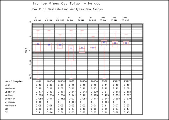
| 14.2.8.4 | Local Bias Checks |
The resource model was also checked for trends and local bias using 50 m swath plots that compared the restricted kriged estimates to nearest neighbour estimates. The nearest neighbour estimates act as an unbiased de-clustered sample population and comparison should highlight areas of potential bias in the kriged estimate. The plots also display the number of model blocks in each 50 m swath (Figure 14.14 to Figure 14.16).
AMC 813001 : March : 2013
251
ENTRÉE GOLD INC Lookout Hill Property, Southern Mongolia Technical Report | |
| Figure 14.14 | Gold Swath Plots |
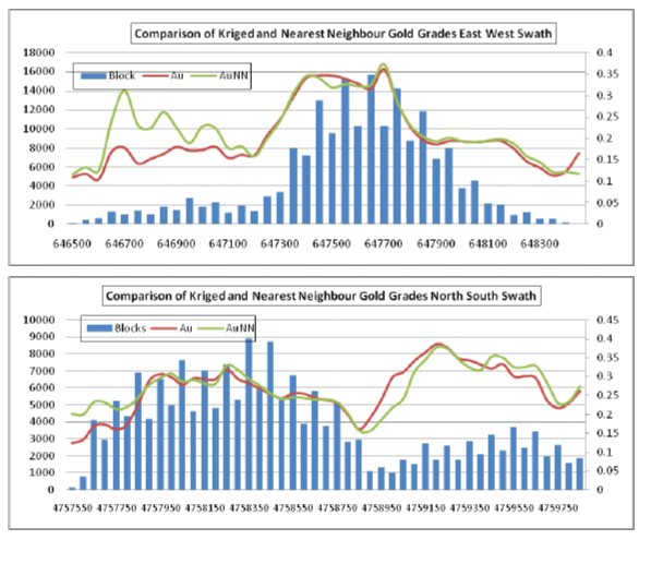
AMC 813001 : March : 2013
252
ENTRÉE GOLD INC Lookout Hill Property, Southern Mongolia Technical Report | |
| Figure 14.15 | Copper Swath Plots |
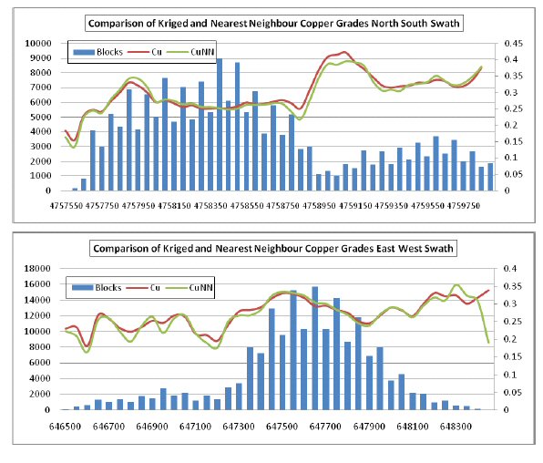
AMC 813001 : March : 2013
253
ENTRÉE GOLD INC Lookout Hill Property, Southern Mongolia Technical Report | |
| Figure 14.16 | Molybdenum Swath Plots |
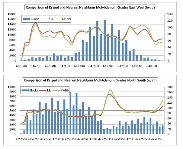
| 14.2.9 | Mineral Resource Classification |
The Mineral Resources of the Heruga deposit were classified using logic consistent with the CIM definitions referred to in NI 43-101. At present the mineralization of the project satisfies sufficient criteria to be classified as an Inferred Resource.
| 14.2.9.1 | Inferred Mineral Resources |
Blocks within 150 m of a drillhole were initially considered to be Inferred. A three-dimensional wireframe was constructed inside of which the nominal drill spacing was less than 150 m. The shape aimed to remove isolated blocks around drillholes where continuity of mineralization could not be confirmed. Within the 150 m shape there were a small number of blocks that were greater than 150 m from a drillhole. These were included because it was considered that geological and grade continuity could be reasonably inferred within the main part of the mineralized zone. The average distance of all the Inferred blocks in the resource model is displayed in the plot below. Of the total tonnes classified as Inferred, approximately 92% are within 150 m of a drillhole while the average distance of the Inferred blocks is approximately 95 m (Figure 14.17).
AMC 813001 : March : 2013
254
ENTRÉE GOLD INC Lookout Hill Property, Southern Mongolia Technical Report | |
QG are satisfied that the resultant Inferred Resources are reasonable and meet the criteria set out in the CIM definitions referred to in NI 43-101.
| Figure 14.17 | Total Inferred Resource Tonnes by Distance in Heruga |
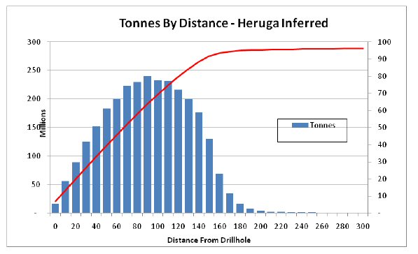
| 14.2.10 | Mineral Resource Summary - Heruga |
The Heruga Mineral Resource inventory is based on drilling as of 21 June 2009 and reported as of the Resource Effective Date of 30 March 2010. The Mineral Resources are reported at various copper equivalent (CuEq) cut-offs as shown in Table 14.31 and include material that is classified as an Indicated and Inferred Mineral Resources.
For consistency with previous Mineral Resource disclosures on the Lookout Hill Property, the equivalent grade was calculated using assumed metal prices of US$1.35/lb for copper, US$650/oz for gold and US$10/lb for molybdenum, and assuming gold recovery is 91% of copper recovery. Silver is not included in the CuEq calculation.
The resultant 2010 formula for Heruga was:
CuEq% = (Cu% + (Au g/t * 18.98) + (Mo g/t * 0.01586)) / 29.76
Where:
18.98 = (Au $ / g) * Au Recovery Factor% = 20.90 / 90.822% (rounded to 91%)
0.01586 = (Mo $ / g) * Mo Recovery Factor% = 0.0220462 * 71.94% (rounded to 72%)
29.76 = Cu $ / %
AMC 813001 : March : 2013
255
ENTRÉE GOLD INC Lookout Hill Property, Southern Mongolia Technical Report | |
| Table 14.31 | Inferred Mineral Resources – Heruga EJV, Effective Date 30 March 2010 (base case is highlighted) |
| Class | Owner | CuEq Cut-off (%) | Tonnage (Mt) | Cu (%) | Au (g/t) | Ag (g/t) | Mo (ppm) | CuEq (%) | Contained Metal | ||||
Cu (Mlb) | Au (Moz) | Ag (Moz) | Mo (Mlb) | CuEq (Mlb) | |||||||||
| INFERRED | EJV | 3.50 | – | – | – | – | – | – | – | – | – | – | – |
| 3.00 | – | – | – | – | – | – | – | – | – | – | – | ||
| 2.50 | 1.35 | 0.83 | 3.40 | 4.00 | 87.3 | 3.04 | 24.6 | 0.15 | 0.17 | 0.26 | 90.6 | ||
| 2.00 | 5.76 | 0.66 | 2.60 | 3.66 | 121 | 2.39 | 84.4 | 0.48 | 0.68 | 1.54 | 303 | ||
| 1.50 | 28.7 | 0.57 | 1.86 | 2.59 | 124 | 1.83 | 362 | 1.72 | 2.39 | 7.86 | 1,155 | ||
| 1.00 | 189 | 0.57 | 0.96 | 1.99 | 155 | 1.26 | 2,365 | 5.83 | 12.1 | 64.5 | 5,258 | ||
| 0.90 | 294 | 0.56 | 0.80 | 1.92 | 160 | 1.15 | 3,601 | 7.52 | 18.1 | 104 | 7,442 | ||
| 0.80 | 447 | 0.54 | 0.66 | 1.85 | 160 | 1.05 | 5,308 | 9.53 | 26.5 | 157 | 10,314 | ||
| 0.70 | 657 | 0.51 | 0.56 | 1.75 | 151 | 0.95 | 7,386 | 11.9 | 36.9 | 219 | 13,775 | ||
| 0.60 | 910 | 0.48 | 0.49 | 1.63 | 141 | 0.87 | 9,570 | 14.4 | 47.8 | 283 | 17,387 | ||
| 0.50 | 1,214 | 0.44 | 0.43 | 1.51 | 130 | 0.79 | 11,775 | 17.0 | 59.0 | 349 | 21,056 | ||
| 0.45 | 1,411 | 0.42 | 0.41 | 1.45 | 123 | 0.74 | 13,003 | 18.5 | 65.9 | 383 | 23,114 | ||
| 0.40 | 1,670 | 0.39 | 0.38 | 1.39 | 115 | 0.69 | 14,425 | 20.3 | 74.6 | 422 | 25,538 | ||
| 0.37 | 1,824 | 0.38 | 0.36 | 1.35 | 110 | 0.67 | 15,190 | 21.2 | 79.4 | 444 | 26,846 | ||
| 0.35 | 1,931 | 0.37 | 0.35 | 1.33 | 107 | 0.65 | 15,693 | 21.9 | 82.6 | 457 | 27,694 | ||
| 0.30 | 2,177 | 0.35 | 0.33 | 1.28 | 102 | 0.61 | 16,734 | 23.2 | 89.6 | 488 | 29,468 | ||
| 0.25 | 2,361 | 0.33 | 0.32 | 1.24 | 97.4 | 0.59 | 17,383 | 24.0 | 94.2 | 507 | 30,588 | ||
| 0.22 | 2,454 | 0.33 | 0.31 | 1.22 | 95.2 | 0.57 | 17,665 | 24.4 | 96.3 | 515 | 31,070 | ||
| 0.20 | 2,509 | 0.32 | 0.30 | 1.21 | 93.8 | 0.57 | 17,813 | 24.6 | 97.4 | 519 | 31,324 | ||
| Note: | 1) Mineral Resources are reported using a base case 0.37% copper equivalency cut-off grade. Other cases shown in this table are sensitivity cases |
| 2) The copper equivalency is calculated using the formula CuEq = Cu% + ((Au g/t x 18.98) + (Mo g/t x 0.01586)) / 29.76. This formula assumes 91% Au recovery and 72% Mo recovery. |
| 3) Mineral Resources are inclusive of Mineral Reserves |
| 4) Mineral Resources that are not also reported as Mineral Reserves have not been demonstrated to have economic viability. |
| 5) Rounding as required by reporting guidelines may result in apparent summation differences. |
AMC 813001 : March : 2013
256
ENTRÉE GOLD INC Lookout Hill Property, Southern Mongolia Technical Report | |
| 14.3 | Joint Venture Mineral Resource Summary |
The Hugo North Extension Mineral Resource inventory, cut at the adjacent project boundary, is based on drilling as of 1 November 2006 and reported as of the Resource Effective Date of 20 February 2007. The Heruga Mineral Resource inventory is based on drilling as of 21 June 2009 and reported as of the Resource Effective Date of 30 March 2010. The Mineral Resources above 0.37% copper equivalent as shown in Table 14.32 and include material that is classified as an Indicated and Inferred Mineral Resources. The base case CuEq cut-off grade assumptions for each deposit were determined using operating cost estimates from the Mineral Reserves. The base case copper equivalent (CuEq) cut-off grade assumptions for each deposit were determined using cut-off grades applicable to mining operations exploiting similar deposits. The CuEq cut-off applied for the underground was 0.37%.
2010 CuEq Formula - Hugo Deposits
Based on a Cu price of $0.80/lb and Au price of $350/oz, the 2003 CuEq formula is:
CuEq% = Cu% + (Au g/t) * (11.25 / 17.64)
Where:
11.25 = (Cu $/lb) / (lb/t) = 0.80 / 2,204.62
17.64 = (Au $/oz) / (g / oz) = 350 / 31.10348
Not adjusted for metallurgical recovery
2010 CuEq Formula – Heruga
The decision was taken to use a copper price of $1.35 / lb and a gold price of $650 / oz, and to incorporate molybdenum into the CuEq calculation at a price of $10 / lb.
The resultant 2010 formula was:
CuEq% = Cu% + ((Au g/t * 18.98) + (Mo g/t * 0.01586)) / 29.76
Where:
18.98 = (Au $ / g) * Au Recovery Factor% = 20.90 / 90.822% (rounded to 91%)
0.01586 = (Mo $ / g) * Mo Recovery Factor% = 0.0220462 * 71.94% (rounded to 72%)
29.76 = Cu $ / %
Molybdenum is used only in the CuEq formula at the Heruga deposit. Silver is not used in the CuEq formula for any of the deposits.
AMC 813001 : March : 2013
257
ENTRÉE GOLD INC Lookout Hill Property, Southern Mongolia Technical Report | |
| Table 14.32 | EJV Mineral Resources |
| (>0.37% CuEq cut-off), based on Technical Report March 2010 |
| Deposit | Tonnage (Mt) | Copper (%) | Gold (g/t) | Silver (g/t) | Molybdenum (ppm) | CuEq (%) |
| Hugo North Extension Deposit | ||||||
Indicated Shivee Tolgoi (Hugo North) | 132 | 1.65 | 0.55 | 4.09 | 35.7 | 2.00 |
Inferred Shivee Tolgoi (Hugo North) | 134 | 0.93 | 0.25 | 2.44 | 23.6 | 1.09 |
| Heruga deposit | ||||||
| Inferred Heruga Javhlant | 1,824 | 0.38 | 0.36 | 1.35 | 110 | 0.67 |
| Deposit | Contained Metal | ||||
Copper (Mlb) | Gold (Moz) | Silver (Moz) | Molybdenum (Mlb) | CuEq (Mlb) | |
| Hugo North Extension Deposit | |||||
Indicated Shivee Tolgoi (Hugo North) | 4,800 | 2.32 | 17.4 | 10.4 | 5,810 |
Inferred Shivee Tolgoi (Hugo North) | 2,760 | 1.08 | 10.5 | 7.0 | 3,230 |
| Heruga deposit | |||||
| Inferred Heruga Javhlant | 15,190 | 21.2 | 79.4 | 444 | 26,850 |
Notes:
| · | Copper Equivalent (CuEq) has been calculated using assumed metal prices of US$1.35/lb for copper, US$650/oz for gold, and US$10.00 for molybdenum. The equivalence formula was calculated assuming that gold and molybdenum recovery was 91% and 72% of copper recovery respectively. CuEq was calculated using the formula: CuEq% = Cu% + ((Au g/t*18.98)+(Mo g/t*.01586))/29.76. |
| · | The contained copper, gold, copper, and molybdenum in the tables has not been adjusted for metallurgical recovery. |
| · | The 0.37% CuEq cut-off is highlighted as the base case resource for underground bulk mining. |
| · | The Mineral Reserves are not additive to the Mineral Resources. |
| · | Mineral Resources that are not Mineral Reserves do not have demonstrated economic viability. |
| · | The EJV includes a portion of the Shivee Tolgoi licence and the Javhlant licence. Both the Javhlant licence and the eastern portion of the Shivee Tolgoi licence are held in trust for the EJV by Entrée. The Joint Venture Property is operated by OT LLC. OT LLC has an 80% and Entrée has a 20% beneficial ownership interest in the Joint Venture Property. |
AMC 813001 : March : 2013
258
ENTRÉE GOLD INC Lookout Hill Property, Southern Mongolia Technical Report | |
| 14.4 | Factors That Could Affect the Mineral Resource Estimates |
Areas of uncertainty that could materially affect the Mineral Resource estimates include the following:
| · | Commodity pricing. |
| · | Interpretations of fault geometries. |
| · | Effect of alteration as a control on mineralization. |
| · | Lithological interpretations on a local scale, including dyke modelling and discrimination of different QMD phases. |
| · | Pit slope angles. |
| · | Geotechnical assumptions related to the proposed block cave design. |
| · | Metal recovery assumptions. |
| · | Dilution considerations. |
| · | Contaminants such as arsenic and fluorine. |
| · | Estimates of operating costs used to support reasonable prospects assessment. |
| · | Changes to drill spacings and number of drillhole composites used to support classification categories. |
AMC 813001 : March : 2013
259
ENTRÉE GOLD INC Lookout Hill Property, Southern Mongolia Technical Report | |
| 15 | MINERAL RESERVE ESTIMATES |
The EJV Property Mineral Reserve is contained within the Hugo North Block Cave Lift 1 (Hugo North Life 1). The mine design work on Hugo North Lift 1 was prepared by OT LLC and was used as the basis for the 2013 Hugo North Underground Mineral Reserve. AMC has agreed with this conclusion and has reported the results for the March 2013 Hugo North Underground Mineral Reserve estimate.
Mineral Reserves were last publically reported in the LHTR12 Technical Report March 2012. The EJV Mineral Reserve is shown in Table 15.1. A reconciliation of the LHTR12 and LHTR13 Mineral Reserves is shown in Table 15.2.
LHTR13 only considers Mineral Resources in the Indicated category, and engineering that has been carried out to a feasibility level or better to state the underground Mineral Reserve. There is no Measured Resource in the Hugo North Mineral Resource. Copper and gold grades on Inferred Resources within the block cave shell were set to zero and such material was assumed to be dilution. The block cave shell was defined by a $15/t NSR, further mine planning will examine lower shut-offs. The Hugo North Mineral Reserve is on both the OT LLC Oyu Tolgoi licence and the EJV Shivee Tolgoi licence.
| Table 15.1 | EJV Mineral Reserve, 25 March 2013 |
| Classification | Ore (Mt) | NSR ($/t) | Cu (%) | Au (g/t) | Ag (g/t) | Copper (M lb) | Gold (koz) | Silver (koz) |
| Proven | – | – | – | – | – | – | – | – |
| Probable | 31 | 95.21 | 1.73 | 0.62 | 3.74 | 1,090 | 521 | 3,229 |
| Total EJV | 31 | 95.21 | 1.73 | 0.62 | 3.74 | 1,090 | 521 | 3,229 |
Notes:
| 1. | Metal prices used for calculating the Southern Oyu open pit NSR and the Hugo North underground Net Smelter Return (NSR) are as follows: copper at $2.81/lb; gold at $970/oz; and silver at $15.50/oz, all based on long-term metal price forecasts at the beginning of the mineral reserve work. The analysis indicates that the mineral reserve is still valid at these metal prices. |
| 2. | The NSR has been calculated with assumptions for smelter refining and treatment charges, deductions and payment terms, concentrate transport, metallurgical recoveries and royalties. |
| 3. | The block cave shell was defined using a NSR cut-off of $15/t NSR. |
| 4. | For the underground block cave, all mineral resources within the shell have been converted to mineral reserves. This includes low grade Indicated mineral resources and Inferred mineral resources, which has been assigned a zero grade and treated as dilution. |
| 5. | Only Measured mineral resources were used to report Proven mineral reserves and only Indicated mineral resources were used to report Probable mineral reserves. |
| 6. | EJV is the Entrée Joint Venture. The Shivee Tolgoi Licence and the Javhlant Licence are held by Entrée. The Shivee Tolgoi Licence and the Javhlant Licence are planned to be operated by OT LLC. OT LLC will receive 80% of cash flows after capital and operating costs for material originating below 560 m, and 70% above this depth. |
| 7. | The base case financial analysis has been prepared using the following current long term metal price estimates: copper at $2.87/lb; gold at $1,350/oz; and silver at $23.50/oz. Metal prices are assumed to fall from current prices to the long term average over five years. |
| 8. | The mineral reserves reported above are not additive to the mineral resources. |
AMC 813001 : March : 2013
260
ENTRÉE GOLD INC Lookout Hill Property, Southern Mongolia Technical Report | |
| Table 15.2 | LHTR13 and LHTR12 Probable Mineral Reserve Comparison |
| Estimate | Ore (Mt) | NSR ($/t) | Cu (%) | Au (g/t) | Ag (g/t) | Copper (M lb) | Gold (koz) | Silver (koz) |
| LHTR13 | 31 | 95.21 | 1.73 | 0.62 | 3.74 | 1,090 | 521 | 3,229 |
| IDOP | 27 | 79.40 | 1.91 | 0.74 | 4.17 | 1,043 | 536 | 3,127 |
| Difference | 4 | 15.81 | –0.18 | –0.11 | –0.44 | 47 | –15 | 102 |
| Difference (%) | 15.1% | 19.9% | –9.4% | –15.1% | –10.5% | 4.5% | –2.8% | 3.3% |
Notes:
| 1. | LHTR12 Mineral Reserves have the effective date 29 March 2012. |
| 2. | LHTR13 Mineral Reserves have the effective date 25 March 2013.. |
| 3. | Metal prices used for calculating the Southern Oyu open pit NSR and the Hugo North underground Net Smelter Return (NSR) are as follows: copper at $2.81/lb; gold at $970/oz; and silver at $15.50/oz, all based on long-term metal price forecasts at the beginning of the mineral reserve work. The analysis indicates that the mineral reserve is still valid at these metal prices. |
| 4. | The NSR has been calculated with assumptions for smelter refining and treatment charges, deductions and payment terms, concentrate transport, metallurgical recoveries and royalties. |
| 5. | The block cave shell was defined using a NSR cut-off of $15/t NSR. |
| 6. | For the underground block cave, all mineral resources within the shell have been converted to mineral reserves. This includes low grade Indicated mineral resources and Inferred mineral resources, which has been assigned a zero grade and treated as dilution. |
| 7. | Only Measured mineral resources were used to report Proven mineral reserves and only Indicated mineral resources were used to report Probable mineral reserves. |
| 8. | EJV is the Entrée Joint Venture. The Shivee Tolgoi Licence and the Javhlant Licence are held by Entrée. The Shivee Tolgoi Licence and the Javhlant Licence are planned to be operated by OT LLC. OT LLC will receive 80% of cash flows after capital and operating costs for material originating below 560 m, and 70% above this depth. |
| 9. | The base case financial analysis has been prepared using the following current long term metal price estimates: copper at $2.87/lb; gold at $1,350/oz; and silver at $23.50/oz. Metal prices are assumed to fall from current prices to the long term average over five years. |
| 10. | The mineral reserves reported above are not additive to the mineral resources. |
| Figure 15.1 | 2013 Reserve Case Mining Areas |
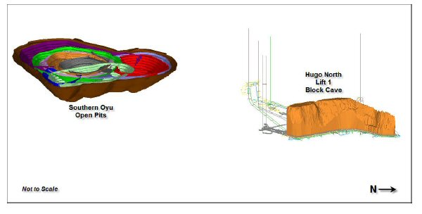
AMC 813001 : March : 2013
261
ENTRÉE GOLD INC Lookout Hill Property, Southern Mongolia Technical Report | |
| Figure 15.2 | Hugo North Lift 1 Block Cave Plan |
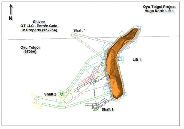
The Hugo Dummett underground deposit will be mined by block caving, a safe, highly productive, cost-effective method. The deposit is comparable in dimension and tonnage to other deposits currently operating by block cave mining elsewhere in the world. The mine planning work has been prepared using industry standard mining software, assumed metal prices as described above and smelter terms as set forth in the 2013 OTTR.
To ensure that Inferred Resources do not become included in the Mineral Reserve estimate, copper and gold grades on Inferred Resources within the block cave shell were set to zero and such material was assumed to be dilution. The block cave shell was defined by a $15/t NSR, further mine planning will examine lower cut-offs. The Hugo North Mineral Reserve is on both the OT LLC Oyu Tolgoi licence and the EJV Shivee Tolgoi licence.
AMC 813001 : March : 2013
262
ENTRÉE GOLD INC Lookout Hill Property, Southern Mongolia Technical Report | |
| 15.1 | Key Mining Assumptions |
The Mineral Reserves were estimated by AMC. Key assumptions are summarized below; other assumptions are documented in the LHTR13:
| · | Metal prices used for calculating the Hugo North Underground NSR are copper $2.81/lb, gold $970/oz, and silver $15.50/oz based on long term metal price forecasts at the beginning of the Mineral Reserve work. The analysis indicates that the Mineral Reserve is still valid at these metal prices. |
| · | The NSR has been calculated with assumptions for smelter refining and treatment charges, deductions and payment terms, concentrate transport, metallurgical recoveries and royalties. |
| · | For the underground a footprint cut-off of $15/t NSR and column height shut-off of $15/t NSR to maintain grade and productive capacity. |
| · | For the underground block cave, all Mineral Resource within the shell has been converted to Mineral Reserve. This includes low grade Indicated Mineral Resource and Inferred Mineral Resource assigned zero grade treated as dilution. |
| · | The base case financial analysis has been prepared using current long term metal price estimates of copper $2.87/lb, gold $1,350/oz, and silver $23.50/oz. Metal prices are assumed to fall from current prices to the long term average over five years. |
| · | The Shivee Tolgoi and Javhlant licences are held by Entrée. The EJV Shivee Tolgoi and EJV Javhlant Licences are planned to be operated by OT LLC. OT LLC will receive 80% of cash flows after capital and operating costs for material originating below 560 m, and 70% above this depth. The Mineral Reserves are not additive to the Mineral Resources. |
| · | The Mineral Reserves are not additive to the Mineral Resources. |
| · | The underground Mineral Resource block models used for reporting the Mineral Reserves are the models reported in the Mineral Resource section of the 2013 OTTR Technical Report. |
| · | Only Indicated Mineral Resources have been converted to Mineral Reserves. |
| · | The processing schedule philosophy adopted for the mine planning work assumes feeding the open pit ore into the plant at an elevated cut-off grade and stockpiling low grade material for later treatment. This philosophy provides some insulation against metal price cycles and reduces the risk that the Mineral Reserve size is overestimated. |
AMC 813001 : March : 2013
263
ENTRÉE GOLD INC Lookout Hill Property, Southern Mongolia Technical Report | |
| 15.1.1 | US SEC Industry Guide 7 |
The Mineral Reserve reported for NI 43-101 is also applicable for reporting the Ore Reserve under the US SEC Industry Guide 7. AMC estimated the Oyu Tolgoi Mineral Reserves for the NI 43-101 LHTR13 which is based on feasibility study work. The definitions of the Mineral Reserve classifications under NI 43-101 are the Canadian Institute of Mining (CIM) Definition Standards – For Mineral Resources and Mineral Reserves, Prepared by the CIM Standing Committee on Reserve Definitions and adopted by CIM Council on 11 December 2005. The definitions below are quoted from the CIM Definition Standards – For Mineral Resources and Mineral Reserves, page 5.
After consideration of guidelines and other information regarding the declaration of Reserves for the United States Securities and Exchange Commission (US SEC) reporting, AMC considers that the LHTR13 is suitable for declaring a Reserve as defined in US Industry Guide 7.
Documentation underlying Mineral Reserves determined in accordance with Industry Guide 7 generally includes the following:
| · | A "final" feasibility study. |
| · | Utilization of the historic 3 year average price for the commodity that expected to be mined in determining economic viability. |
| · | Primary environmental analysis has been submitted to government authorities. |
| 15.1.2 | Bankable Study |
OT LLC is in an advanced stage of project financing with a core lending group of financiers for a $4.0 billion project-finance facility. The core lenders group is comprised of European Bank for Reconstruction and Development, Export Development Canada, International Finance Corporation, BNP Paribas and Standard Chartered Bank, USEx-Im Bank and its adviser, Standard Bank, the World Bank Group’s Multilateral Investment Guarantee Agency and the Australian Export Finance and Insurance Corporation. TRQ has advised AMC that the lenders have received reports from an independent engineering assessment that indicates the studies are suitable to support the technical for consideration of the project financing.
TRQ has advised AMC that bids have been received from a number of banks that would allow the Company to achieve its project financing target and discussions are ongoing with the lenders to finalize the terms of those offers. The project financing is subject to the unanimous approval of the Oyu Tolgoi LLC Board of Directors which includes representatives from the Government of Mongolia. TRQ anticipates the closing of final binding documentation and project financing funding to occur in the first half of 2013. AMC therefore considered it reasonable to conclude that the bankable study test in US SEC Industry Guide 7 has been met.
AMC 813001 : March : 2013
264
ENTRÉE GOLD INC Lookout Hill Property, Southern Mongolia Technical Report | |
| 15.1.3 | Test Price for Commodities |
The base case financial analysis has been prepared using current long term metal price estimates of:
| · | Copper $2.87/lb |
| · | Gold $1,350/oz |
| · | Silver $23.50/oz |
The 2005 SME Guide Section 53 describes how the Test Price for commodities should be applied.
"If a Mineral Reserve is reported using a price lower than the test price, the forward-looking discounted cash flow must be positive, and the Reserve Sensitivity Test (based on an undiscounted cash flow) need not be performed. When applicable, a statement should be made that a Reserves Sensitivity Test was completed, or that such a test was not applicable."
The metal prices for the previous 3 years, their average and the metal prices used for the Mineral Reserve estimates are shown in Table 15.3. The only metal price that is higher than the three year average is the forecast silver price. The three year average silver price is $19.83/oz Ag and the forecast price is $23.50/oz Ag. The sensitivity analysis using the 3 year averages shows the Entrée after tax NPV8 of US$155 M compared to the base case US$110 M. The results are improved compared to the base case financial analysis, as the averages for the copper and gold prices are higher. This indicates that the Mineral Reserve is still valid at the 3 year average prices.
| Table 15.3 | Metal Price Summary |
| Year Ended | Cu ($/lb) | Au ($/oz) | Ag ($/oz) |
| 2010 | 3.42 | 1,225 | 15.44 |
| 2011 | 4.00 | 1,572 | 12.89 |
| 2012 | 3.61 | 1,792 | 31.15 |
| Average | 3.68 | 1,703 | 19.83 |
| Reserve NSR | 2.81 | 970 | 12.00 |
| Base Case Financial Analysis | 2.87 | 1,350 | 23.50 |
| 15.1.4 | Primary Environmental Analysis Submission |
The 2007 SME Guide Section 56 describes how the permitting and legal requirements of US SEC Industry Guideline 7 should be applied. It indicates that:
"To demonstrate reasonable expectation that all permits, ancillary rights and authorizations can be obtained, the reporting entity must show understanding of the procedures to be followed to obtain such permits, ancillary rights and authorizations. Demonstrating earlier success in getting the necessary permits can be used to document the likelihood of success."
AMC 813001 : March : 2013
265
ENTRÉE GOLD INC Lookout Hill Property, Southern Mongolia Technical Report | |
Based on the understanding of the procedures and the history of permitting, it is considered reasonable to assume that the final environmental permitting will be granted without resulting in a change to the Reserve.
OT LLC has completed a comprehensive Environmental and Social Impact Assessment (ESIA) for the Oyu Tolgoi Project. The culmination of nearly 10 years of independent work and research carried out by both international and Mongolian experts, the ESIA identifies and assesses the potential environmental and social impacts of the project, including cumulative impacts, focusing on key areas such as biodiversity, water resources, cultural heritage, and resettlement.
The ESIA also sets out measures through all project phases to avoid, minimize, mitigate, and manage potential adverse impacts to acceptable levels established by Mongolian regulatory requirements and good international industry practice, as defined by the requirements of the Equator Principles, and the standards and policies of the International Finance Corporation (IFC), European Bank for Reconstruction and Development (EBRD), and other financing institutions.
Corporate commitment to sound environmental and social planning for the project is based on two important policies: TRQ's Statement of Values and Responsibilities (March 2010), which declares its support for human rights, social justice, and sound environmental management, including the United Nations Universal Declaration of Human Rights (1948); and The Way We Work 2009, Rio Tinto’s Global Code of Business Conduct that defines the way Rio Tinto manages the economic, social, and environmental challenges of its global operations.
OT LLC has commenced the development and implementation of an environmental management system (EMS) that conforms to the requirements of ISO 14001:2004. Implementation of the EMS during the construction phases will focus on the environmental policy; significant environmental aspects and impacts and their risk prioritization; legal and other requirements; environmental performance objectives and targets; environmental management programs; and environmental incident reporting. The EMS for operations will consist of detailed plans to control the environmental and social management aspects of all project activities following the commencement of commercial production in 2013. The Oyu Tolgoi ESIA builds upon an extensive body of studies and reports, and DEIA’s that have been prepared for project design and development purposes, and for Mongolian approvals under the following laws:
| · | The Environmental Protection Law (1995) |
| · | The Law on Environmental Impact Assessment (1998, amended in 2001) |
| · | The Minerals Law (2006) |
These initial studies, reports and DEIA’s were prepared over a six-year period between 2002 and 2008, primarily by the Mongolian firm Eco-Trade LLC, with input from Aquaterra on water issues.
AMC 813001 : March : 2013
266
ENTRÉE GOLD INC Lookout Hill Property, Southern Mongolia Technical Report | |
The original DEIA’s provided baseline information for both social and environmental issues. These DEIA’s covered impact assessments for different project areas, and were prepared as separate components to facilitate technical review as requested by the GOM.
The original DEIA’s were in accordance with Mongolian standards and while they incorporated World Bank and IFC guidelines, they were not intended to comprehensively address overarching IFC policies such as the IFC Policy on Social and Environmental Sustainability, or the EBRD Environmental and Social Policy.
Following submission and approval of the initial DEIA’s, the Mongolian Government requested that OT LLC prepare an updated, comprehensive ESIA whereby the discussion of impacts and mitigation measures was project-wide and based on the latest project design. The ESIA was also to address social issues, meet Mongolian government (legal) requirements, and comply with current IFC good practice.
For the ESIA the baseline information from the original DEIA’s was updated with recent monitoring and survey data. In addition, a social analysis was completed through the commissioning of a Socio-Economic Baseline Study and the preparation of a Social Impact Assessment (SIA) for the project.
The requested ESIA, completed in 2012, combines the DEIA’s, the project SIA, and other studies and activities that have been prepared and undertaken by and for OT LLC.
| 15.2 | Mongolian Commercial Minerals |
Mongolia has its own system for reporting Mineral Reserves and Mineral Resources.
OT LLC has registered a Mineral Reserve with the GOM. The system is based on a review by Mongolian experts in a number of disciplines. A significant difference between the Mongolian system and 43-101 is that, under the Mongolian system, resources and reserves are not valid until registered by the GOM. A committee of Mongolian experts examines a report prepared by the Owner using a set of guidelines and then, based on a consensus of nominated experts, a recommendation is made to the Minister for Mineral Resources and Energy. The recommendation to the Minister states the resources and reserves and any conditions. The Minister then issues an order registering the resources and reserves.
The reports examined by the experts must be in Mongolian language. OT LLC national staff and Mongolian consultants prepared the report under supervision of OT LLC personnel on secondment from Rio Tinto. The Mongolian Reserve included 43-101 Inferred Mineral Resource and is similar to the IDP10 Life-of-Mine (Sensitivity) Case. The Mongolian Reserve and IDP10 were prepared at different times and with different metal price assumptions for the analyses.
The Minister issued an order on 10 July 2009. OT LLC prepared the following translation of the order.
“Order Of The Minister For Mineral Resources And Energy, July 10, 2009, No. 167, Ulaanbaatar
AMC 813001 : March : 2013
267
ENTRÉE GOLD INC Lookout Hill Property, Southern Mongolia Technical Report | |
On acceptance and registration of the revised reserve estimation of Southern Oyu deposits and the reserve report of Hugo Dummett deposits and Heruga deposit.
Pursuant to Article 48.4 of the Minerals Law, Clause 8, 9 and 14.2 of the Minerals Council Charter, and the Conclusion #15-01 of the Minerals Council extended meeting #15 held on 1 July 2009, it is resolved that:
| ● | One. Revised Mineral Reserve estimation of Southern Oyu deposits, and Mineral Reserves of Hugo Dummett deposits and Heruga deposit in 2000-2008 exploration work report by Ivanhoe Mines Mongolia Inc LLC in Khanbogd soum, Umnugobi aimag are accepted as in the attachment to Conclusion summary #15-01. |
| ● | Two. Geological Research Centre (U. Borchuluun) is authorized to register the reserves quantity accepted under the Article 1 of this Order in the state minerals reserve inventory. |
| ● | Three. In relation to registration of revised Mineral Reserve of Southern Oyu deposits, the following copper and gold reserves of Southern Oyu to be mined with open pit operation registered in the state minerals reserve inventory with Conclusion #16-01 of the Minerals Council meeting #16 held on 30 July 2007 shall be removed from the state minerals reserve registration: 127 Mt ore or 0.658 Mt copper metal and 88.1 tonne gold in Measured (A) class, 803 Mt ore or 3.371 Mt copper metal and 148.3 tonne gold in Indicated (B) class. |
| ● | Four. Ivanhoe Mines Mongolia Inc LLC and MRAM (D. Batkhuyag) are assigned to implement the resolved issues in the Conclusion #15-01 of the Minerals Council extended meeting held on 1 July 2009. |
| ● | Five. Ivanhoe Mines Mongolia Inc LLC is hereby assigned to submit exploration report and field study materials in electronic format (data CD) to Geological Information Center, within 5 working days from the Conclusion of the Minerals Council meeting and the Resolution by Minister of Mineral Resources and Energy issued in relation to it.” |
On 27 February 2013, notice (the “Notice”) was delivered to Entrée by MRAM that by Order No. 43 dated February 22, 2013, the Ministry of Mining had cancelled the 10 July 2009 Order No. 167 of the Ministry of Mineral Resources and Energy (the “2009 Order”) registering the Hugo North Extension and Heruga reserves. The registration of reserves is a pre-condition to applying for the conversion of an exploration licence into a mining licence. The Notice stated that the 2009 Order breached Clause 48.4 of the Minerals Law of Mongolia and Clause 9 of the Charter of the Minerals Resource Counsel. The Notice further advised that any transfer, sale or lease of the Shivee Tolgoi and Javhlant mining licences is temporarily suspended. Entrée is currently working to determine the full impact of the Notice and to resolve these issues.
AMC 813001 : March : 2013
268
ENTRÉE GOLD INC Lookout Hill Property, Southern Mongolia Technical Report | |
| 16 | MINING METHODS |
| 16.1 | Open Pit |
OT LLC prepared the open pit study work used for the 2013 OTTR. The open pits are on the Southern Oyu deposit on the Oyu Tolgoi licence and support the open pit Mineral Reserve. Further details of the Southern Oyu open pits are provided in the 2013 Oyu Tolgoi Technical Report March 2013 on www.sedar.com.
| 16.2 | Underground Geotechnical |
| 16.2.1 | Introduction |
This section relies on reports for the Feasibility Study of underground mining. Two reports particularly were relied on:
| · | “Oyu Tolgoi Feasibility Study – Geotechnical & Cave Design Studies” by Rio Tinto Technology and Innovation, dated 29 May 2012. Numerous notes and reports of studies were appended to this report. |
| · | “Oyu Tolgoi Project Mongolia – Underground Feasibility Study”, Chapter 4: Geotechnical, by Oyu Tolgoi LLC, dated December 2012. Chapter 4 comprised a summary of the Rio Tinto report. |
The previous Technical Report, “Oyu Tolgoi Project, IDOP Technical Report”, dated March 2012, was based on results and assessments for the Pre-feasibility Study (PFS) of the Oyu Tolgoi Project. Since the PFS, there has been a substantial programme of investigations and analyses for the Feasibility Study (FS), which was undertaken during 2012.
Particularly for the FS, investigations and analyses comprised:
| · | A programme of drilling and logging of cores that were drilled in fans across the orebody and host rocks from the underground development off Shaft No.1. |
| · | Additional measurements of in situ stress at several sites from underground development, and an updated interpretation of the in situ stress field for the Hugo North orebody and environs. |
| · | A characterisation drive across the orebody, which was the first underground exposure of the orebody. Results from the development and support of the drive, and of associated measurements of the response of the rock to development were assessed. |
| · | Numerical analyses of all facets of proposed cave mining, undertaken to provide a basis for estimation of geotechnical design parameters for cave mining. |
Investigations and studies have continued since the FS, but there has not been a material change in geotechnical design parameters for the proposed cave mining.
The FS was confined to the Hugo North orebody, Lift 1. It did not consider a possible Lift 2 of Hugo North mineral resources or the Hugo South mineral resources. This section deals with only cave mining of Lift 1 of the Hugo North orebody.
AMC 813001 : March : 2013
269
ENTRÉE GOLD INC Lookout Hill Property, Southern Mongolia Technical Report | |
In this section, the terms geotechnical, geomechanics and engineering geology are considered equivalent. The term geotechnical will be applied.
| 16.2.2 | Characterisation of Rock Units |
| 16.2.2.1 | Geological Setting |
Hugo Dummett mineralization, which includes the Hugo North orebody, is a porphyry copper-gold style of mineralization, associated with an intrusion of quartz monzodiorite into a deformed sequence of sedimentary and volcanic rocks.
Mineralization is elongate, trending north to north-east over a length of about 3 km. Although mineralization is continuous over this length, a major fault toward the southern end, termed the 110 Fault, striking east-west, dipping north, displaced host rock units north side down. This fault separates the Hugo South and Hugo North deposits, at 4 766 400 N.
The main host rock units that will affect cave mining of Lift 1 of Hugo North are, from youngest to oldest:
| · | Basaltic lava flows, intercalated breccias and tuff (BasL). |
| · | Basaltic lapillic tuff (Bat). |
| · | Basaltic andesitic lava flows (AndL). |
| · | Volcanic sandstone, carbonaceous siltstone, sandstone, and conglomerate. |
| · | Andesitic ash flow tuff (Andign). |
| · | Basaltic flow breccia and derived coarse volcanoclastics (L). |
| · | Carbonaceous shale and laminated siltstones, sandstones and conglomerates. |
| · | Dacitic block ash tuff (Vbx). |
| · | Dacitic ash flow tuff (ignimbrite) (Ign). |
| · | Augite basalt flows and breccias (Va). |
Additionally, felsic to mafic dykes occur throughout the mineralised and surrounding rock. The most significant of these are biotite granodiorite (BiGd) and porphyritic quartz monzodiorite (Qmd) intrusives. Qmd dykes are genetically related to the porphyry copper-gold system.
All of those rock units and dykes that are greater than 10 m thickness were modelled as 3D solids, based on drilled core data.
Mineralization occurs within or adjacent to quartz monzodiorite porphyry intrusions. There are multiple intrusions and associated breccias. Mineralization is associated with hydrothermal alteration of the intrusive bodies and intruded host rocks. A majority of mineralization occurs in zones of veining and stockwork, with minor amounts of disseminated and replacement mineralization throughout the hydrothermally altered rock.
AMC 813001 : March : 2013
270
ENTRÉE GOLD INC Lookout Hill Property, Southern Mongolia Technical Report | |
Hydrothermal alteration is zoned, similar to other porphyry copper deposits, principally advanced argillic alteration. Pyrite is the dominant sulphide. Quartz-sulphide veins comprise at least 15% and up to 90% of the volume of the rock.
Mineralization is bounded by three major faults:
| · | WestBat fault, subvertical, west of the mineralization. |
| · | Contact Fault, east-dipping, east of the mineralization. Above the extraction level the fault extends up and over the mineralization, meeting the WestBat fault, defining the top of the resources. |
| · | 110 Fault, subvertical, south of the mineralization, separating Hugo North from Hugo South. |
| 16.2.2.2 | Sources of Data on Rock Units |
Surface Drilling
Initially, all information was from cores drilled from the surface. All cores were steep-plunging. Most cores were drilled to the east or west, across strike. These cores had unavoidable directional bias. The Pre-feasibility Study was based on data from these cores.
Underground Drilling
Diamond drilling of cores from underground was done during 2011 and 2012 (Figure 16.2). It was concentrated on coverage of the orebody, for data on mineral resources and rock conditions of the cave’s footprint at undercut and extraction levels. Drilling was in fans of subhorizontal holes. Some cores included sites of mine infrastructure. The Feasibility Study incorporated data from this drilling.
A total of 19,779 m of core was drilled to November 2011. Drilling to February 2012 took the total to 24,725 m of core. The layout of cores is shown in Figure 16.2.
Underground Development
All underground development has been geologically and geotechnically mapped. Initial development was of Shaft 1 and level stubs off it. Recently, there has been progressive development of the 1300 level off Shaft 1, which has all been mapped.
| 16.2.2.3 | Domains of Rock Conditions Based on Rock Units |
Domains of rock units comprise rock types (lithology) and extensive (major) faults.
The current interpretation of rock units is shown on following plans and sections.
Some key aspects of the geology of the Hugo North orebody (Figure 16.2) are directly relevant to mining of the orebody (Figure 16.3 to Figure 16.5):
AMC 813001 : March : 2013
271
ENTRÉE GOLD INC Lookout Hill Property, Southern Mongolia Technical Report | |
| ● | Sedimentary-volcanogenic (Devonian age) rock units in the hangingwall-east of Quartz monzodiorite and biotite granodiorite, upper to lower (Figure 16.6) Volcanogenic siltstone-sandstone |
| - | Basaltic volcanic flow breccia (L) |
| - | Hangingwall fault |
| - | Laminated siltstone-conglomerate |
| - | Dacitic ash flow (Vbx) |
| - | Augite basalt (Va) |
| ● | Intrusives (Figure 16.6): |
| - | A core of biotite granodiorite |
| - | Flanked east and west by quartz monzodiorite, divided into lower and upper parts: 1) lower (below 0 RL to -100 RL), red quartz monzodiorite, with intense sericite alteration, hosting higher-grade gold; and 2) upper, quartz monzodiorite, with intense sericite alteration, hosting higher-grade bornite and molybdenite. |
| - | Quartz monzodiorite, to the east-hangingwall, of sericite-altered monzodiorite with intense quartz veining, hosting >2.5% copper. |
| ● | West Bat Fault (Figure 16.4 and Figure 16.5) to the west of intrusives, forming a sharp western contact between monzodiorite and intruded rock units. |
| ● | Sediments-volcanogenics to the west of West Bat fault (Figure 16.6) |
| - | Basaltic volcaniclastic and flows (BasL) |
| - | Sediments, fine to course |
| - | Andesitic ash flow tuff (Andlgn) |
AMC 813001 : March : 2013
272
ENTRÉE GOLD INC Lookout Hill Property, Southern Mongolia Technical Report | |
| Figure 16.1 | Plan View of the Hugo North Resource Model at -100 RL |
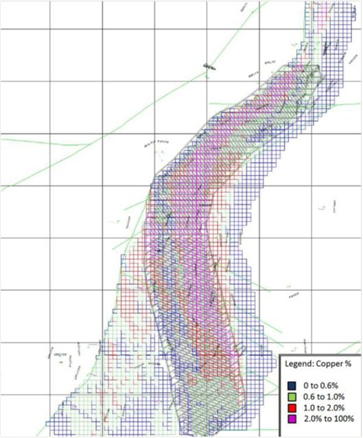
AMC 813001 : March : 2013
273
ENTRÉE GOLD INC Lookout Hill Property, Southern Mongolia Technical Report | |
| Figure 16.2 | Plan of Diamond Drilled Holes at 1300 Level, to November 2011, with Colour-coded Lithology Along Their Paths (Blue Line Outlines the Resource Model) |
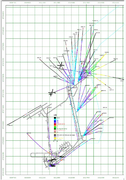
AMC 813001 : March : 2013
274
ENTRÉE GOLD INC Lookout Hill Property, Southern Mongolia Technical Report | |
| Figure 16.3 | Plan of Geology of the Footprint of the Cave (with Planned Drilling) |
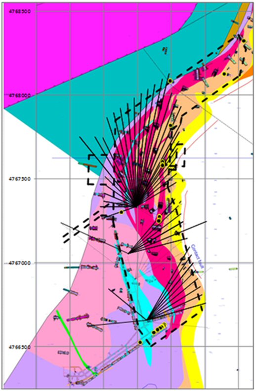
AMC 813001 : March : 2013
275
ENTRÉE GOLD INC Lookout Hill Property, Southern Mongolia Technical Report | |
| Figure 16.4 | Plan of Interpreted Major Faults at the Footwall of the Cave, with the Planned Footprint and Infrastructure Development |
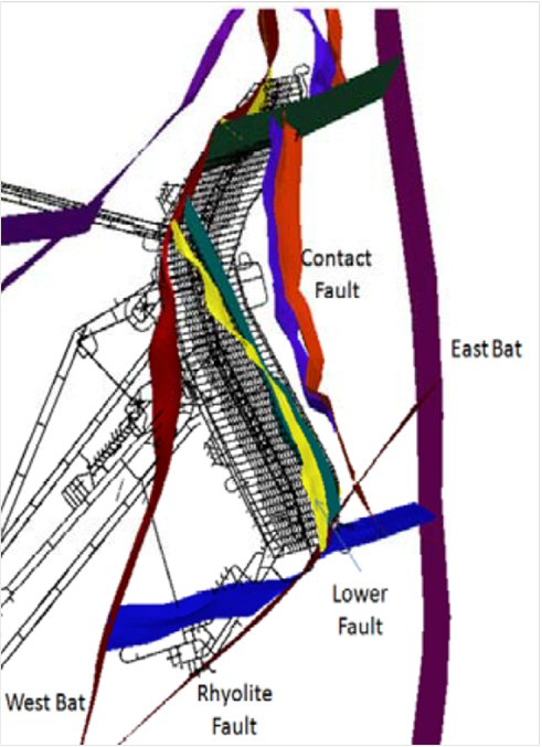
AMC 813001 : March : 2013
276
ENTRÉE GOLD INC Lookout Hill Property, Southern Mongolia Technical Report | |
| Figure 16.5 | Geological Cross-section Through Hugo North, Looking North, at the Kink Between the North and South Sectors (4767400 N), (Prior to Underground Drilling) |
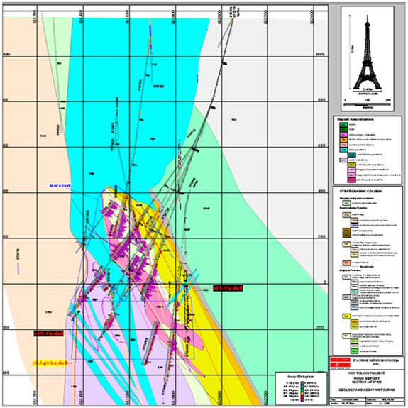
AMC 813001 : March : 2013
277
ENTRÉE GOLD INC Lookout Hill Property, Southern Mongolia Technical Report | |
| Figure 16.6 | Cross-section of Hugo North Orebody, at Approximate Mid-length of the Southern Sector (4766945), Looking North |
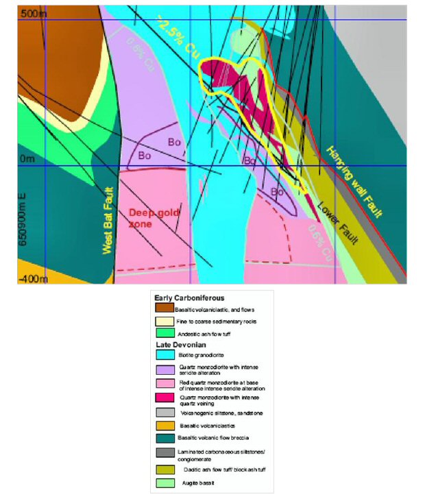
AMC 813001 : March : 2013
278
ENTRÉE GOLD INC Lookout Hill Property, Southern Mongolia Technical Report | |
| 16.2.2.4 | Strength of Rock Materials |
An intensive programme of measurements of the properties rock materials was undertaken for the Feasibility Study, to better characterise the dominant lithologies. This included additional measurements of unconfined (UCS) and confined (triaxial) compressive strength, and of tensile strength (UTS).
Additional measurements of triaxial strength were undertaken on six rock types, to better account for effects of microfractures and veins on strength.
Results from measurements of UCS were divided into those samples that failed through solid rock with an axial fracture (Table 16.1), and those that failed on an identified structure. Mean UCS and UTS are compared in Table 16.1.
Qualitative estimates of strength, from logs, of cored “fault rock” were associated with their host lithology as a means to account for the range of strength of material in each lithologic unit. These measures of strength were not adopted as input for analyses unless there was no other reliable data.
| Table 16.1 | Mean UCS and UTS by Lithology |
| Lithology | UCS (MPa) (solid rock) | UTS (MPa) (Brazilian) |
| Biotite granodiorite (BiGd) | 145 | 9.7 |
| Quartz monzodiorite (QMD) | 125 | 8.4 |
| Ignimbrite (Ign) | 120 | 7.8 |
| Basalt (Va) | 100 | 10.1 |
| Sediments (SED) | 135 | 11.2 |
Point Load measurements were undertaken in 2010 and 2011. Over 540 samples were tested.
For a majority of lithological units, point load strengths, expressed as equivalent UCS, were lower than UCS measured directly on samples, for failure through rock material. However, the dispersion of values from point load measurements was generally greater than those from direct UCS measurements.
For the two dominant intrusive lithologies – biotite granodiorite and quartz monzodiorite – point load strengths from samples with a moderate to low degree of alteration (sericitic, chloritic, argillic) were higher or similar to strengths for unaltered samples. This conclusion was claimed to be consistent with previous results (2007) from direct measurements of UCS.
AMC 813001 : March : 2013
279
ENTRÉE GOLD INC Lookout Hill Property, Southern Mongolia Technical Report | |
| Figure 16.7 | Mean and Dispersion of Strength by Lithology |
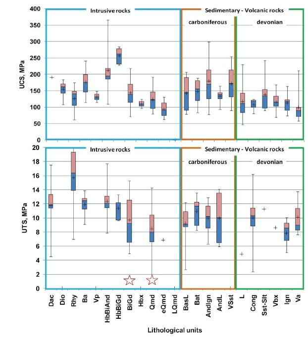
AMC 813001 : March : 2013
280
ENTRÉE GOLD INC Lookout Hill Property, Southern Mongolia Technical Report | |
| 16.2.2.5 | Geologic Structures – Faults |
Fault structures have been interpreted within, around and in the vicinity of the Hugo North orebody.
Hugo North orebody is bounded and transacted by numerous faults. These faults are likely to influence caving and fragmentation of the ore, the stability of associated excavations, and subsidence at the surface.
The location of major, extensive faults at the footprint of the Hugo North orebody is shown in Figure 16.8, with the common strike-trends of these and other interpreted faults.
| ● | In the northern sector, designated Zone 1 and Zone 2 (transition), the common strike trend of faults is north-east. This is typified by the West Bat fault, along the north-western margin of orebody. |
| ● | In the southern sector, designated Zone 3 and Zone 2 (transition), the common strike trend is north-north-west. This is typified by the Contact fault and the Lower fault, along the eastern margin of the orebody. |
For both north and south sectors, the dominant strike-trend of faults is subparallel to the strike-trend of rock units and the orebody.
The report for the feasibility studied remarked on the “high intensity of faulting transecting the rock mass”, and that the “Hugo deposit ... is the most strongly faulted porphyry style deposit the writers have seen”. (“Strongly” meant the intensity of occurrence of faults, not their strength.) Intersections of faults in drilled cores to 2007 are shown in Figure 16.9. In 2010, faults in core were estimated to comprise 3% of the length of core. A majority of these intersections could not be directly modelled as fault surfaces or zones, but rather were accounted as part of the fabric and strength of the rock mass.
AMC 813001 : March : 2013
281
ENTRÉE GOLD INC Lookout Hill Property, Southern Mongolia Technical Report | |
| Figure 16.8 | Plan of Traces of Interpreted Major Faults |

AMC 813001 : March : 2013
282
ENTRÉE GOLD INC Lookout Hill Property, Southern Mongolia Technical Report | |
| Figure 16.9 | Plan Projection of the Occurrence of Intervals of Faults Logged from Cores |
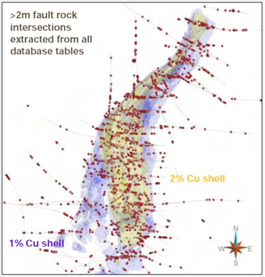
| 16.2.2.6 | Geologic Structures – Fractures, Joints, Veins |
A clearer picture of the occurrence of tunnel-scale and core-scale structures in rock units within and around the orebody emerged from the programme of underground fan drilling.
These structures, principally fractures in the rock (also called joints), but also veins, will affect the fragmentation of caving rock and the response of the rock mass around underground development.
Logs of cores included the orientations of fractures, where core was orientated during drilling. From that, the sets of fractures and the condition of the surface of fractures was estimated, by rock unit (Table 16.2).
AMC 813001 : March : 2013
283
ENTRÉE GOLD INC Lookout Hill Property, Southern Mongolia Technical Report | |
The frequency of occurrence of fractures along drilled core was claimed (in the report of the FS) to represent a highly-fractured rock mass. The condition of fracture surfaces was claimed to be typically low, representing low-friction, planar or slightly undulating surfaces.
| Table 16.2 | Nature and Condition of Geologic Structures In Dominant Units |
| Rock Unit | Number of fracture sets (1) | Fracture frequency (per metre) | Fracture condition (2) | Vein frequency (per metre) |
| Biotite granodiorite (BiGd) | 3 | 4.5 | 14 | 9.9 |
| Quartz Monzodiorite (QMD) | 5 | 5.3 | 13 | 8.9 |
| Ignimbrite (Ign) | 5 | 4.3 | 13 | 10.7 |
| Augite Basalt (Va) | 5 | 4.0 | 12 | 9.2 |
| Sediments (Sed) | – | 2.6 | – | 13.7 |
(1) As identified by OT LLC in Table 3.1 of “Geotechnical & Cave Design Studies”.
(2) As defined by Laubscher 1990.
| 16.2.2.7 | In Situ Stress |
In situ stress is the natural stress due to geologic processes that exists in the rock mass before disturbance by mining.
Magnitudes and directions of in situ stress are critically important for mining the Hugo North orebody, where the undercut, extraction, and haulage levels are at 1,200 m to 1,300 m depth below the ground surface, and high magnitudes of stress are expected.
In situ stress for Hugo North was been measured in two campaigns:
| ● | An initial programme of measurements at six levels off Shaft 1 as it was being sunk (Figure 16.10). Results were reported and reviewed by AMC Consultants Pty Ltd in 2008. |
| ● | A subsequent programme of measurements for the feasibility study of underground mining, at three sites across the 1300 level development, off shaft 1. Broadly, they covered the footprint of the Hugo North cave. Results were reported and reviewed by Mirarco in 2012. |
| ● | There are no other valid measurements at the Oyu Tolgoi site. |
All direct measurements of stress were by overcoring of CSIRO Hollow Inclusion (HI) cells, by the same contractor, Mine Measurement Services. This is regarded as the most accurate and reliable method of measuring in situ stress in mines.
Measuring stress with the HI cell has proved to be “challenging” (as stated in the geotechnical FS report) because much of the core has included microfractures, as well as the usual core-scale and larger fractures. The HI cell, as with all overcoring methods, requires solid uncracked core for successful measurements.
AMC 813001 : March : 2013
284
ENTRÉE GOLD INC Lookout Hill Property, Southern Mongolia Technical Report | |
For Oyu Tolgoi there were more measurements at each site than there would have been for typical rock conditions elsewhere, but there remained a high degree of variability amongst individual measurements at a site and between sites of measurements.
Stress-induced spalling from the wall of the exploratory hole at the centre-line of shaft 1 was measured by a downhole acoustic televiewer (ATV). Results were compiled and assessed in the report by AMC.
Measurements from Shaft 1
AMC interpreted the mine-scale stress field for Hugo North from the results of the measurements at six levels of the shaft. Calculations of stress were as a single result for each level. Figure 16.10 shows a cross-section, looking north, through shaft 1, showing the location of measurements of stress at levels off the shaft, with their geologic setting. Figure 16.11 shows a plot of magnitudes of principal stress by depth (left) and directions (right) for measurements of stress at levels off shaft 1. Table 16.3 shows the interpreted depth-stress relationship for the magnitudes of principal stresses measured at levels off shaft 1. All stress inputs for numerical modelling for the feasibility study were with this stress field.
AMC 813001 : March : 2013
285
ENTRÉE GOLD INC Lookout Hill Property, Southern Mongolia Technical Report | |
| Figure 16.10 | Shaft 1 Stress Measurement Locations |
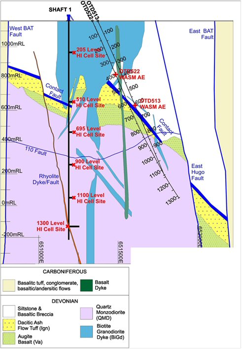
AMC 813001 : March : 2013
286
ENTRÉE GOLD INC Lookout Hill Property, Southern Mongolia Technical Report | |
| Figure 16.11 | Plot Of Magnitudes of Principal Stress by Depth (Left) and Directions (Right) for Measurements of Stress at Levels off Shaft 1 |
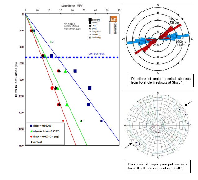
AMC 813001 : March : 2013
287
ENTRÉE GOLD INC Lookout Hill Property, Southern Mongolia Technical Report | |
| Table 16.3 | Interpreted Depth-Stress Relationship for the Magnitudes of Principal Stresses Measured at Levels off Shaft 1 |
| Principal Stress | Magnitude (MPa) | Plunge (°) | Bearing (°) |
s1 | 0.052*D | 00 | 055 |
s2 | 0.033*D | 00 | 145 |
s3 | 0.027*D | 90 | 055 |
D = depth below surface (m)
Plunges are below the horizontal. Bearings are measured clockwise from Oyu Tolgoi Grid North.
Additional Measurements from 1300 Level Development
After completing the measurements from lateral development at 1300 level, in 2011, all of the results of measurements with the HI cell (i.e. those from the shaft and lateral development) were referred to the Geotechnical Technical Advisory Board in 2011, as part of the feasibility study.
The Board concluded that the results were consistent with effects of current tectonism at depths below approximately 700 m. Figure 16.12 is a plot of magnitudes of principal stress by depth for all measurements of stress at Oyu Tolgoi. Plotted Plot of Magnitudes of Principal Stress by Depth for all Measurements of Stress at Oyu Tolgoi. Plotted Points are for Each Overcored HI Cell. At shallower depth the results were consistent with relief of stress from near-surface rock. A revised tabulation of magnitudes of stress with depth was proposed (Table 16.4). The Board concluded that the direction of the major principal stress was 055° (Figure 16.13), the same as for the results from the shaft alone.
OT LLC have accepted the conclusion of the Board. This interpreted stress field will be used as input for all future numerical modelling. One of the effects of accepting this stress field is a reduction of the estimated magnitude of the major principal stress at 1,300 m from the previous estimate of 67 MPa to 57 MPa, a reduction of approximately 15% from the previous estimate.
AMC 813001 : March : 2013
288
ENTRÉE GOLD INC Lookout Hill Property, Southern Mongolia Technical Report | |
| Figure 16.12 | Principal Stress by Depth |
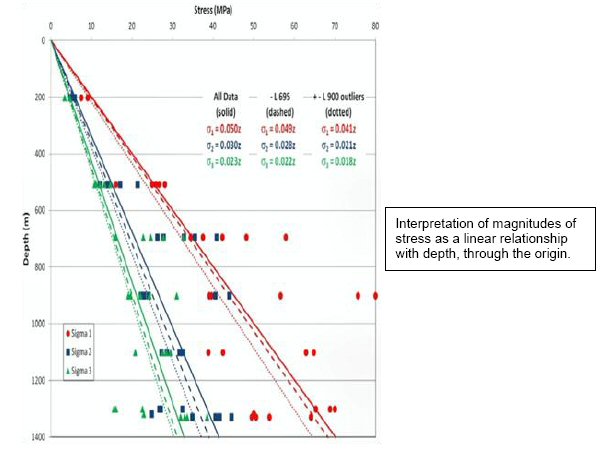
AMC 813001 : March : 2013
289
ENTRÉE GOLD INC Lookout Hill Property, Southern Mongolia Technical Report | |
| Figure 16.13 | Orientations of Principal Stresses |
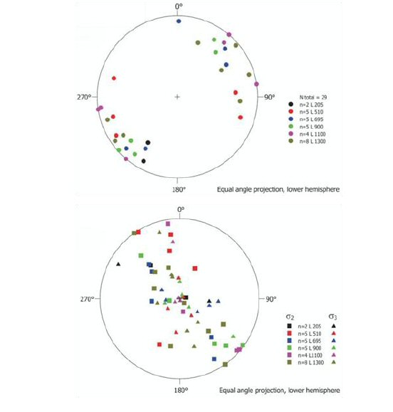
AMC 813001 : March : 2013
290
ENTRÉE GOLD INC Lookout Hill Property, Southern Mongolia Technical Report | |
| Table 16.4 | Depth-stress Relationship for Principal. |
| Principal Stress | Magnitude (MPa) | Plunge (°) | Bearing (°) |
s1 | 25 + 0.025*D | 00 | 055 |
s2 | 6 + 0.024*D | 00 | 145 |
s3 | 4 + 0.022*D | 90 | 055 |
D = depth below surface (m).
Plunges are below the horizontal Bearings are measured clockwise from Oyu Tolgoi Grid North.
| 16.2.2.8 | Strength and Rating of the Rock Mass |
The rock mass comprises the combination of geologic structures – fractures, veins, layering – and the rock material – the solid rock between structures. The compressive and tensile strength of rock materials, and the nature of fractures and faults has been covered.
The rock mass is weaker, in compression and tension, than rock materials, and deformability is lower than rock materials.
Geological Strength Index (GSI)
GSI was developed to estimate the peak strength and deformability of rock masses. For Oyu Tolgoi, the GSI of rock units was estimated with the Cai et al 2004 method. It is based on estimated dimensions of in situ blocks of rock, which in turn is based on the results of logs of cores and exposures. Estimated values are in Table 16.5.
| Table 16.5 | Estimates of Rock Mass Properties for the Principal Rock Units |
| Lithology | GSI (mean) | GSI (range) | RMR90 (mean) | RMR90 (std. dev.) |
| Biotite granodiorite (BiGd) | 75 | 19-41 | 45 | 4 |
| Quartz monzodiorite (QMD) | 76 | 18-38 | 43 | 4 |
| Ignimbrite (Ign) | 79 | 18-41 | 45 | 3 |
| Basalt (Va) | 79 | 22-43 | 46 | 3 |
| Sediments (SED) | 82 | 21-43 | 53 | 3 |
Note: RMR was also calculated for a wider range of rock types
Laubscher RMR(90) System
Values of RMR(90) were calculated from logs of cores. Results are in Table 16.5.
Values are relatively low, and the rock mass is classified as fair.
Discrete Fracture Network (DFN) Model
Representative DFN models were developed from joint (fracture) fabric models.
AMC 813001 : March : 2013
291
ENTRÉE GOLD INC Lookout Hill Property, Southern Mongolia Technical Report | |
Measured Tunnel Displacements
Deformations of the walls of tunnels were measured at a number of locations by multi-point extensometers as a tunnel advanced, when the 1300 Level was developed. Displacements were analysed by a numerical model to estimate the tunnel-scale properties of the rock around the tunnel. Estimated properties were related to the GSI at the locations, estimated from parallel pre-drilled cores. Overall, estimated rock mass strengths were 50% to 70% of GSI.
The Geotechnical Technical Advisory Board proposed that measurements of tunnel displacements with an advancing face be undertaken at more sites.
| 16.2.3 | Undercut and Extraction Level Design Parameters |
| 16.2.3.1 | Introduction |
This section deals with the geotechnical investigations and recommendations that formed the basis for the design and sequencing of the footprint of the cave, comprising the undercut, draw bells, extraction level, and ore tipping points.
The content of this section, and those that follow, is drawn largely from the OT LLC report on the “Underground Feasibility Study” of caving of the Hugo North orebody. This, in turn, was based on the Rio Tinto report on the “Geotechnical & Cave Design Studies” for the Feasibility Study of underground mining of the Hugo North orebody.
| 16.2.3.2 | Panelling Strategy and Initiation |
The footprint of the undercut is divided into two panels: Panel 1 (north cave) and Panel 2 (south cave) (Figure 16.14).
The benefits of the two-panel strategy include:
| ● | The ability to maintain an acceptable undercut advance rate during the first five years of production ramp-up, significantly reducing the risk of a major undercut pillar failure and/or extraction level pillar failure associated with slow-moving undercuts. |
| ● | The geologic structures in panel 1 and panel 2 areas of the cave are different. The two-panel strategy allows the designs and cave advance direction to be optimized for the orientations of the major geological structures and major principal stress. |
| ● | An opportunity for production and technical personnel to develop an understanding the response of the rock mass to undercutting, construction, and production in a smaller, more manageable initiation area. |
| ● | For the first four years, the cave front will progress to the north, where stress effects are predicted to be lower and mining conditions less challenging than for the panel 2 cave front. |
AMC 813001 : March : 2013
292
ENTRÉE GOLD INC Lookout Hill Property, Southern Mongolia Technical Report | |
| Figure 16.14 | Two-Panel Strategy, Cave Initiation, and Advance Sequence |
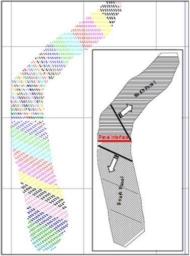
Although the two-panel strategy introduces a panel boundary that complicates the undercutting process and may introduce dilution earlier at the interface, it provides a more manageable and less risky undercutting solution.
Based on analysis of the geological structures and the geometric layout of the orebody, an initiation point on the west side of panel 1 was recommended as the best direction to manage cave face lengths and undercut rate. The columns on the west side of the cave are higher than those on the east, minimizing the dilution potential due to rilling.
Cave initiation on the east side of the cave was recommended for panel 2. This change of direction is based on improving drive and pillar stability by orientating the undercut and cave face perpendicular the principal stress direction rather than parallel with principal stress. In addition, this rotation aligns the undercut and extraction drives with principal stress, further improving drive and pillar stability. Figure 16.14 illustrates the cave initiation points.
AMC 813001 : March : 2013
293
ENTRÉE GOLD INC Lookout Hill Property, Southern Mongolia Technical Report | |
| 16.2.3.3 | Cave Front Profile |
Modelling of stress and closure have highlighted undercut stability management as a high priority. The cave front angle is recommended be adjusted from 45°, as recommended in the pre-feasibility study, to 55° (Figure 16.15). The major benefit of the flatter undercut face is a reduction in undercut lead-lag distances.
Undercut cave faces shorter than 350 m are considered ideal, which is achieved with the northern cave face. In panel 2, the cave face increases up to 450 m. Although this is beyond the ideal length, it has a scheduled advance rate of 6 m/month/undercut drive and is considered acceptable at this stage of design.
An inverted “V”-shaped (in plan view) undercut advance will be used for the first four years of undercutting in panel 1 to promote faster undercut ramp-up.
| 16.2.3.4 | Undercut Sequence |
Both empirical and numerical modelling support the advanced undercut sequence selected for Hugo North. In this sequence, drawpoints and drawbells are developed after the undercut has passed over, so that the abutment stresses are located in the massive rock mass, with only the extraction drives —and two short rounds to form the drawpoint take-off— developed on the extraction level. Damage to the extraction level is reduced by developing the drawpoints and drawbells in de-stressed ground.
Development of the drawpoint drives is recommended to begin 45° behind the undercut face and that full drawbell excavation begin at least 60° behind the undercut face.
| Figure 16.15 | Undercut and Cave Front |
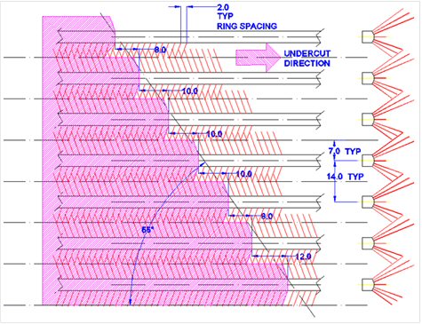
AMC 813001 : March : 2013
294
ENTRÉE GOLD INC Lookout Hill Property, Southern Mongolia Technical Report | |
| 16.2.3.5 | Extraction Level Layout |
Analysis of drawbell spacing and comparison of the Herringbone and El Teniente type layouts was undertaken as part of the study. Although recovery was an integral component of the analysis, focus was placed on stability through extensive numerical modelling work. From a mining perspective, elements of development, construction, and production were considered against the production schedule and business value case. The recommendation was the 15 m x 28 m drawbell spacing associated with an El Teniente drawbell layout.
The increase in spacing over the minor apex was driven by the benefits of greater pillar stability. The El Teniente design, regarded as having a better drawcone packing layout than herringbone, was a supporting factor in retaining interactive draw for fragmentation predictions. Numerical modelling of the new layout indicated that the rock would be stable enough to support drives and pillars. Figure 16.16 illustrates stress levels from modelling on the final layout, and Figure 16.17 shows numerical modelling results indicating the additional support capacity of the El Teniente design to handle stress loading.
Figure 16.18 illustrates the El Teniente layout for Hugo North. The El Teniente drawpoint drives are orientated at 55°, based on benchmarking and aligning with the undercut face.
| Figure 16.16 | Major Principal Stress in 15 m x 28 m El Teniente Layout (at 10 MPa far-field vertical stress) |
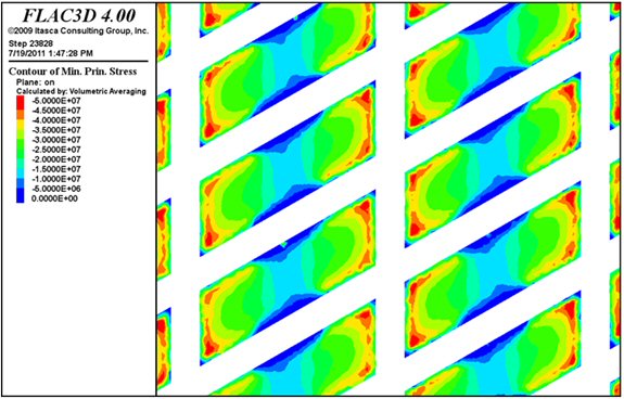
AMC 813001 : March : 2013
295
ENTRÉE GOLD INC Lookout Hill Property, Southern Mongolia Technical Report | |
| Figure 16.17 | Peak Stress Capacity of El Teniente versus Herringbone Layouts when Compressed Vertically |
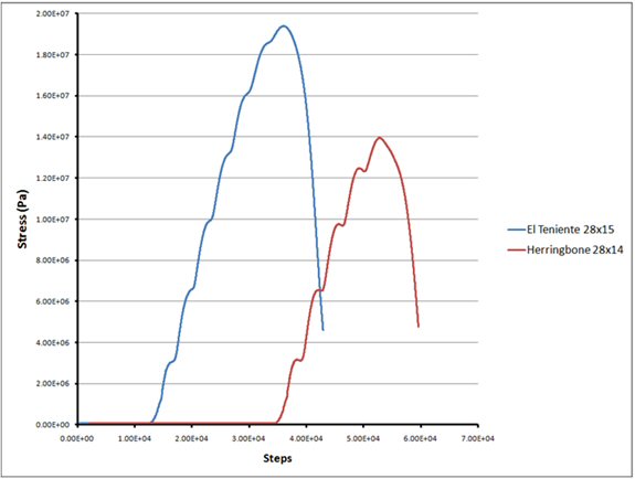
| Figure 16.18 | El Teniente Layout for Hugo North |
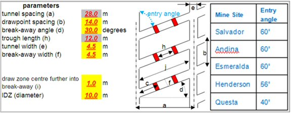
AMC 813001 : March : 2013
296
ENTRÉE GOLD INC Lookout Hill Property, Southern Mongolia Technical Report | |
| 16.2.3.6 | Undercut Level Layout |
Undercut level drives are spaced on 14 m centres and orientated parallel with the extraction level drives.
The small “W” (cross-section) undercut shape is recommended, as illustrated in Figure 16.19. The main benefit of the W shape over a flat undercut is the inclination of the blastholes over the major apex, which assists in preventing the formation of “pillars” on top of the major apex; blastholes are essentially “self cleaning” when their incline is steeper than the frictional properties of the broken ore.
| Figure 16.19 | Cave Section Perpendicular to Extraction Drift |
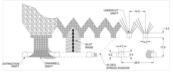
| 16.2.3.7 | Undercut Face Lead-Lag (Plan View) |
Undercut extraction involves “half blasting” the pillar between adjacent undercut drives to permit a stepped sequence in establishing the desired undercut face. In this sequence, blasting in one undercut drive “leads” the blasting in one of its adjacent drives and “lags” it in the other adjacent drive. Both mining experience and review of the induced stresses suggest that sharp changes to, or large irregularities in, the shape of the advancing undercut face should be avoided and that the lead-lag distances should be minimized.
Based on benchmarking and prior experience, a 10 m long half-blasted pillar, or 10 m lead-lag, is recommended as the maximum average lead-lag distance to set up the 55° cave front angle (Figure 16.15). Efficient operation of an undercut requires some flexibility in the lead-lag distance. The recommended maximum lead-lag for Hugo North ground is 14 m, with an operational range of 6 m to 14 m.
AMC 813001 : March : 2013
297
ENTRÉE GOLD INC Lookout Hill Property, Southern Mongolia Technical Report | |
| 16.2.3.8 | Undercut to Drawbell Lead-Lag (Vertical Section View) |
On the extraction level, a safety zone running the length of the undercut face will be established underneath the advancing face. This zone will be 34 m wide, starting 17 m, or 45°, in front of the undercut, and ending 17 m, or 45°, behind the undercut face. Figure 16.19 above shows a cave section perpendicular to an extraction drift, and
Figure 16.20 shows a cave section parallel for an extraction drift. No development will be undertaken within this zone; all extraction drive development will be completed in front of it, and all El Teniente drawpoint and drawbell development will be occur behind it. At an undercut rate of 6 to 8 m/month, there will be a two to three-month lag between the time that undercut blasting passes a particular point on the extraction level and the start of drawpoint development at that point.
After the two- to three-month lag, drawpoint and drawbell development will commence, followed by raise-boring, longhole drilling, steel set installation, and concrete road construction activities in series, before a drawbell is charged and blasted.
| Figure 16.20 | Cave Section Parallel to Extraction Drift |
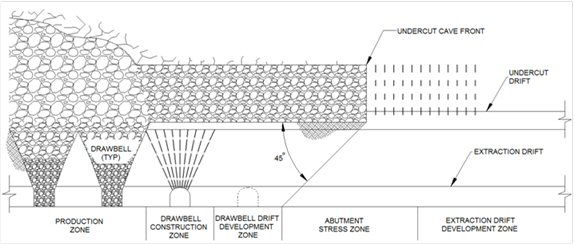
The risk of recompaction at Hugo North is considered to be low, and the planned 65 m to 80 m drawbell lag is recommended. If recompaction and stress related damage were to occur, then the length of the verandah could be reduced; however, this would likely have an impact on the drawpoint construction rate if the extraction level activities had to be carried out in a smaller, more congested area.
| 16.2.3.9 | Undercut Rate |
The undercut rate will match the rate of drawbell construction and drawbell draw.
| ● | An undercut rate consistently in excess of drawbell construction rate will increase, in section view, the ‘overhang’ or verandah distance between the undercut cave front and the extraction level blasted drawbell front. This can increase the stress build up and risk of ground convergence and collapse in the area in front of the undercut cave front. |
AMC 813001 : March : 2013
298
ENTRÉE GOLD INC Lookout Hill Property, Southern Mongolia Technical Report | |
| ● | An undercut rate consistently less than the drawbell construction rate can reduce the stress shadow protection that the undercut provides to extraction. |
Undercut rates greater than 6 m/month/undercut drive are recommended at Hugo North.
Ideally no more than two rings should be blasted at a time. The rock mass responds in a more stable fashion, and it allows the operators to inspect for any pillars formed due to unsuccessful blasting and to take corrective action if required.
The undercut abutment stresses reach their maximum magnitude when the undercut area equates to the critical hydraulic radius (CHR) of the block, which is 22 m for Hugo North. Stress-induced damage is expected to increase once the undercut area reaches half of the CHR of the block.
| 16.2.3.10 | Stress Overcut |
Numerical models of the undercut and extraction levels predict very high (>100 MPa) abutment stresses acting on the extraction level peripheral and rim drives. In particular, elevated horizontal stress levels were noted wrapping around the undercut and affecting the extraction level region at a point two to three drawbells in from the north and south boundaries. FLAC® 3D models were built specifically to investigate stress and stability conditions at the extraction level boundary and rim drive locations. The modelling illustrated that extending the undercut by 30 m, and tucking the extraction level rim drive underneath the stress overcut, reduced the stress exposure, reduced drive closure, and reduced concerns around drive instability.
Figure 16.21 illustrates the stress overcut concept. Two drives are shown on the extraction level: one drive at 70 m from the last drawpoint represents the conventional case where the extraction level rim drive is located outside the high stress zone, and the other a drive at 20 m from the last drawpoint represents the feasibility case where the rim drive is tucked in underneath the stress overcut.
In addition to reducing overall stress loading, the stress overcut reduces the risk of extraction drive rockburst or collapse from stress transmitted along vertical geologic structures near the cave boundaries within a high-abutment stress zone. An example of this is at the north-west boundary of the footprint, where the West Bat Fault runs parallel and very close to the last line of drawpoints (Figure 16.22).
AMC 813001 : March : 2013
299
ENTRÉE GOLD INC Lookout Hill Property, Southern Mongolia Technical Report | |
| Figure 16.21 | Stress Overcut Concept |
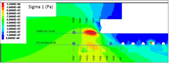
| Figure 16.22 | Extraction Rim Drive in Relation to West Bat Fault |
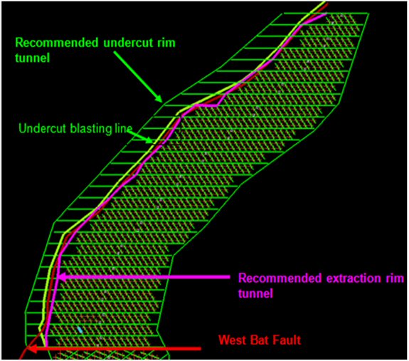
AMC 813001 : March : 2013
300
ENTRÉE GOLD INC Lookout Hill Property, Southern Mongolia Technical Report | |
For the conventional rim drive case, the extraction level rim drive north-west of the West Bat Fault would be located in an area modelled with high abutment loading, requiring each extraction drive to cross through the West Bat Fault to access the orebody.
The risk of continual transmittal of abutment stress along the West Bat Fault was reduced by moving the extraction level rim drive closer to the orebody and bringing the undercut blasting over the extraction drive rim and through the West Bat Fault.
Further work is recommended to optimise the locations and geometries of the drives and areas proposed to be overcut.
| 16.2.3.11 | Footprint Stability Modelling – Undercut |
A cave-scale model and an infrastructure model were used extensively to predict stresses and closure strains on footprint development and infrastructure.
The cave-scale model was used initially to examine induced vertical stresses on undercut pillars and drives. Figure 16.23 shows plots of vertical stress on the undercut level from the base case model for Years 6, 10, and 15. The plot suggests that undercut pillars next to the advancing cave front are likely to experience vertical stresses on the order of 40 to 45 MPa. This zone of elevated vertical stress extends approximately 50 m from both panel 1 and panel 2 cave faces during the early years of caving up to Year 5. The width of this zone remains relatively constant at the northern face over time but increases to ~100 m at the southern face by Year 10.
The 4 m wide x 4 m high undercut drives spaced at 14 m are considered to be supportable and adequate for the Feasibility Study design. The analysis indicates that risks related to high stress conditions and drive closure are present.
AMC 813001 : March : 2013
301
ENTRÉE GOLD INC Lookout Hill Property, Southern Mongolia Technical Report | |
| Figure 16.23 | Induced Vertical Stresses and Induced Major Principal Stress on Undercut Level in Base Case Model in Years 6, 10, and 15 |
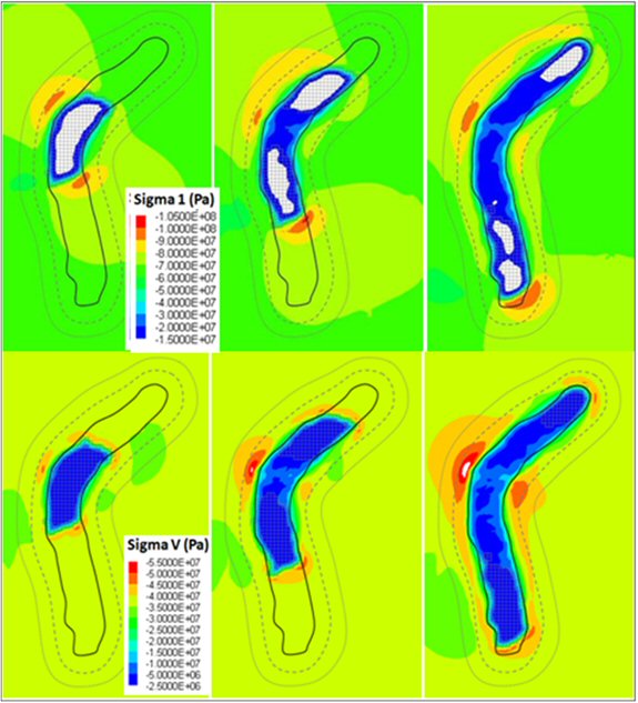
AMC 813001 : March : 2013
302
ENTRÉE GOLD INC Lookout Hill Property, Southern Mongolia Technical Report | |
| 16.2.3.12 | Footprint Stability Modelling - Extraction Level |
The cave-scale model was used to examine induced vertical stresses on the extraction level pillars and drives. The extraction level is expected to experience similar vertical stress magnitudes as those for the undercut level, i.e., 40 to 45 MPa approximately 50 m to 100 m ahead of the advancing cave front. It suggests the extraction level will undergo an average vertical stress of 2.5 to 5 MPa beneath the actively drawn cave; and increase to 5 to 10 MPa under exhausted regions of the cave. The extraction level will be subject to much higher subhorizontal stresses caused by the redistribution of the maximum horizontal stress (σH) around the advancing faces and beneath the cave. Sigma 1 levels are expected to reach 90 to 100 MPa immediately ahead of the southern cave face on the extraction level. Sigma 1 levels are expected to reach 70 to 80 MPa ahead of the northern face.
Modelling predicts that pillar stresses below the leading edge of the undercut will be 70 to 80 MPa and that stresses will remain high in the pillars at the east and west edges of the cave (~90 to 100 MPa).
At least 60% of the undercut material is recommended be mucked after blasting, to ensure adequate void is created. The Feasibility Study plans to remove 80% of the swell on average.
Numerical modelling was used to predict closure strains in the extraction drives and drawpoints. Closure strains of ~2% to 4% can be expected when the extraction drives are first excavated under in situ stress levels. Since the vertical stress at the leading edge of the undercut is in the order of 10 MPa higher than in situ, not much additional closure is expected when the undercut passes over.
| 16.2.3.13 | Panel Boundary |
Splitting the footprint into two panels – beginning with panel 1 and starting panel 2 four years later – will result in the formation of a panel boundary. This will present a two-fold challenge, one from an ore recovery viewpoint and the other with regard to rock mass stability.
The undercut extraction is continuous between the two panels. A boundary pillar has not been designed between the two panels as this would result in significant ore loss and act as a stress concentrator.
Further work is required to optimise the panel boundary layout and sequences.
Ore Recovery
The different extraction drive orientations of panel 1 and panel 2 layouts meet at the panel boundary, but due to geometry, some drawzones do not overlap. Production in panel 2 starts four years after production in panel 1, which creates the potential for early waste dilution in panel 2 boundary drawpoints. Flow modelling (Figure 16.24) assisted in understanding the magnitude of this risk.
AMC 813001 : March : 2013
303
ENTRÉE GOLD INC Lookout Hill Property, Southern Mongolia Technical Report | |
Ore recovery can be maximized through good interactive draw control practice such as reducing extraction from panel 1 boundary drawpoints so that they remain active but still contain ore while panel 2 boundary drawpoints are in operation.
| Figure 16.24 | Panel Boundary Dilution Modelling |
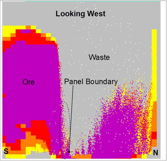
| 16.2.3.14 | Excavation Stability |
The planned division of the footprint into two panels poses a challenge to the stability of excavations close to the boundary between the two caves. Abutment stresses from an operating cave onto development for a new cave could require additional tunnel support. Numerical modelling work undertaken to assess the stress conditions around the boundary has predicted high but manageable closure strains.
To preserve the stability of panel 2 development, any extraction and undercut development associated with panel 2 should be delayed until cave propagation is underway in panel 1 and abutment stresses from panel 1 are pushed further from the cave boundary. In panel 1, the drawbells in the first east-west extraction drive would be blasted to both the north and south of the drive. Those drawpoints to the south would be blasted as full drawbells, but developed with single drawpoint access. A schematic plot is shown in Figure 16.25.
AMC 813001 : March : 2013
304
ENTRÉE GOLD INC Lookout Hill Property, Southern Mongolia Technical Report | |
| Figure 16.25 | Panel Boundary Section Looking East |
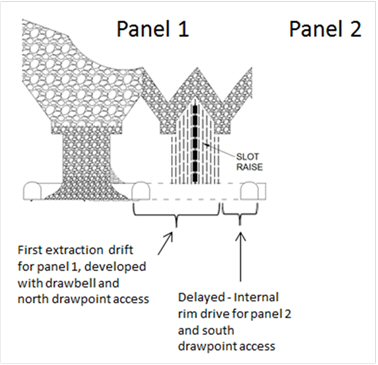
| 16.2.3.15 | Orepass Tipple Excavation |
The Feasibility Study design includes central tipping to achieve the production tonnage rate. The central tipping excavation required to house the orepass and grizzly will be developed and supported before the undercut passes over, so the central orepass and truck chute system is operational to support production mucking requirements. Ground support in this area will be increased to handle the abutment loading. The tipping layout is shown in Figure 16.26.
Recommendations for the central tipping design:
| ● | Do not excavate the ventilation raise on the opposite side of the orepass location, but offset it to the next pillar to avoid large spans across the extraction drift. |
| ● | Move the orepass as close as possible towards the centre of the extraction drive to decrease the loss of pillar area. |
| ● | Increase the local drawpoint spacing over the orepass minor apex from 15 m to 17 m, and move the steel sets of the two surrounding drawpoints slightly deeper into the bell to ensure their stability. |
AMC 813001 : March : 2013
305
ENTRÉE GOLD INC Lookout Hill Property, Southern Mongolia Technical Report | |
| ● | Design the orepass layout with the maximum LHD tipping position angle to reduce the orepass excavation. |
| Figure 16.26 | Orepass Design on the Extraction Level |

| 16.2.3.16 | Key Points in Summary |
| ● | Cave initiation in the west is recommended, along with splitting the footprint into two panels, panel 1 (north cave) and panel 2 (south cave), advancing the panels by mining in the direction of the long axis of the footprint. |
| ● | A cave front angle of 55° is recommended, primarily to reduce the lead-lag distances on the undercut. The cave front was rotated to best position both the cave advance and tunnel orientation to the major principal stress direction (Figure 16.15). |
| ● | An advanced undercut should be employed, where drawpoint development commences only when 45° behind the undercut face, and drawbells are blasted when at least 60° behind the undercut face (Figure 16.20). |
| ● | The El Teniente extraction level layout with 28 m x 15 m drawpoint spacing and undercut spacing on 14 m centres is recommended. |
| ● | The small “W” undercut profile is recommended to produce a more even lead-lag spacing and maximize undercut tunnel stability under the conditions of high abutment stress predicted by the modelling. |
AMC 813001 : March : 2013
306
ENTRÉE GOLD INC Lookout Hill Property, Southern Mongolia Technical Report | |
| ● | An average lead-lag of 10 m, with operational variation of 6 m to 14 m, is recommended on the undercut level, in line with the criterion that a maximum of two rings should be blasted at any time. |
| ● | An undercut rate of more than 6 m/month/undercut drive is recommended, with faster rates preferable. Panel 1 and panel 2 cave faces average 8 and 6 m/month/undercut drives, respectively. When in conflict, the lead-lag spacing rule takes precedence over the undercutting rate. |
| ● | A 30 m “stress overcut” on the undercut level, along with moving the extraction level rim drive underneath the stress overcut, is recommended as a means to preserve the integrity (stability) of the extraction level rim tunnel, the extraction drives leading to the drawpoints, and the outermost drawpoints. |
| ● | A lag of six to eight drawbells between the undercut face and drawbell blasting is recommended based on stress management. The risk of ground recompaction at Hugo North is low, but this drawbell lag may need to be reduced if significant recompaction were to occur. |
| ● | The boundary between panel 1 and panel 2 will present challenges in managing dilution and drive stability; however, these are believed to be manageable and of much less risk than the alternative of not dividing into the two panels. |
| ● | The central orepass tipple will be excavated in front of the stress shadow to ensure that the orepass and truck chute system will be commissioned for production mucking use after the stress shadow passes. The excavation size has been minimized, heavier support installed, and pillars enlarged in the orepass area to ensure stability. |
| 16.2.4 | Haulage Level and Infrastructure Design Parameters |
| 16.2.4.1 | Haulage Level |
The cave-scale model was used to examine haulage level abutment stresses. Modelling suggests the haulage level excavations in panel 2 will be subject to abutment stresses of 90 to 100 MPa associated with the leading edge of the cave. These stresses can be seen advancing down panel 2 over time in Figure 16.27. Higher stresses of >100 MPa are located immediately below the haulage, suggesting that the haulage drives are near the bottom of the stress shadow beneath the cave.
Stress levels along the haulage drives drop to 60 to 70 MPa underneath the active cave, then rise back to 80 to 90 MPa once draw ceases. Because of its orientation relative to σH, stresses at the north limb haulage level are approximately 10 MPa lower than at the south limb for all stages.
High stresses predicted at the perimeters of the cave support the design of the central truck haulage loop. The haulage level was elevated as far as practical to reduce the impact from high stresses under the cave.
AMC 813001 : March : 2013
307
ENTRÉE GOLD INC Lookout Hill Property, Southern Mongolia Technical Report | |
| Figure 16.27 | Abutment Stress on Haulage Level as a Function of Position Relative to Region of Active Draw |
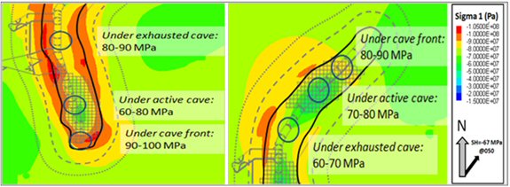
| 16.2.4.2 | Orepass and Truck Chute |
The final truck chute arrangement is shown in Figure 16.29. Based on the iteration considered in Figure 16.28, the pillar between the two orepasses was almost doubled, from 6 m to 11 m, and the height of the excavation was reduced by 3 m. In the modified design, each orepass has its own truck chute and is operated independently.
The number of truck drive-through chambers doubled, reducing from 56 m chamber spacing to 28 m spacing, and the length of each truck chamber was reduced. Geotechnically the larger pillar spacing of the final truck-chute arrangement (Figure 16.29) was preferred.
Orepass angles are designed at or close to 70° inclination. Each orepass will be steel-lined both for stability and to handle the impact and abrasion of an expected 9 Mt of ore throughput.
AMC 813001 : March : 2013
308
ENTRÉE GOLD INC Lookout Hill Property, Southern Mongolia Technical Report | |
| Figure 16.28 | One Iteration of Orepass and Truck Chute Layout |
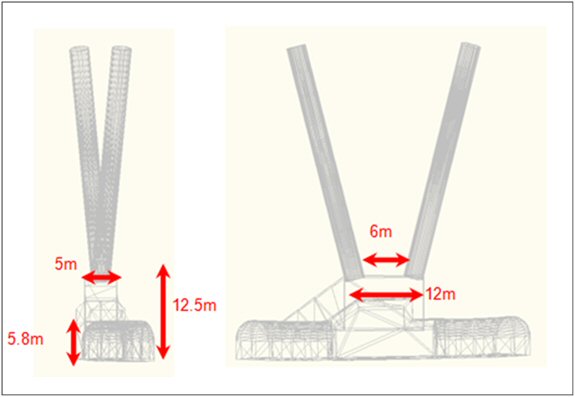
| Figure 16.29 | Final Orepass and Truck Chute Design |
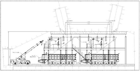
AMC 813001 : March : 2013
309
ENTRÉE GOLD INC Lookout Hill Property, Southern Mongolia Technical Report | |
| 16.2.4.3 | Orepasses |
Orepasses will be raise-bored at 3 m diameter with a dip angle of between 70° and 75°. Steeper orepasses can suffer from higher wear as a result of higher impact energy from ore dumping, ore becoming packed in the muck pile at the bottom of the orepass, or the generation of more dust at the extraction level due to the “piston” effect. Shallower orepasses can have drilling issues and greater risk of hang-up. The average length of the central orepass will be 40 m, and the average rim orepass will be 60 m long.
Development Procedure
A diamond drill investigation hole will be drilled before raiseboring begins. If a poor ground zone is identified during drilling, then the hole will stop and be pressure-grouted before drilling continues. On completion of the hole, core, and drilling conditions will be assessed. Most of the raisebores are expected to be excavated with a standard downhole pilot hole and backream methodology. Poor ground conditions may dictate that a modified approach be taken to improve stability:
| ● | Drilling holes around the circumference area of the raisebore to be reamed and then pressure-grouting them with cement or resin-type grouting. |
| ● | Cable bolting pre-support around the base of the planned raise or targeting areas along the raise identified as requiring stabilization. |
| ● | Dividing each raise into two segments, each 15 m to 20 m in length. This would require a short development access from the exhaust level. A shorter raise reduces the time exposure of the ground before installing raise support. |
| ● | Longhole drilling and blasting of the raise in lifts, with in-cycle remote shotcrete. |
| ● | In isolated cases, using an entry method of raise excavation and support in-cycle, such as a mechanical raise climber (Alimak). |
After being excavated, the orepasses will be lined with a 20 mm thick rolled-steel plate capable of handling rock flow wear in excess of 18 Mt of ore.
AMC 813001 : March : 2013
310
ENTRÉE GOLD INC Lookout Hill Property, Southern Mongolia Technical Report | |
| Figure 16.30 | Isometric of Central Orepass and Truck Chute Design |
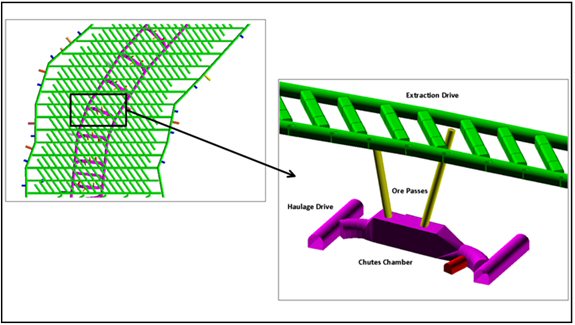
| Further Work |
Orepassses are a critical component of cave production. They are proposed to be developed in a high and changing stress environment, which carries risks for their development and operation. A specific geotechnical analysis has not been undertaken for the proposed method of development and support of orepasses. Protocols for identifying and dealing with “poor ground” have not yet been developed.
There is a significant risk that a proportion of orepasses may not be developed at the rate required for planned rates of advance of the cave undercut and draw.
Further geotechnical investigations are required to examine the interaction of rock conditions, stress, development and support of orepasses. Clear protocols, based on experience, need to be developed for decisions on the siting, raiseboring, and support of orepasses.
| 16.2.4.4 | Crusher Stability Analysis |
The crusher chamber design is based on a large gyratory crusher accommodating direct tipping using 80 tonne side-tip trucks, with two dumping at any one time.
The crusher was moved from the cave to reduce abutment effects and also to distance it somewhat from the H Fault identified from diamond drilling investigation holes near the originally proposed crusher site. In addition, the size of the crusher chamber excavation was reviewed and subsequently decreased by changing the crane orientation and removing hydraulic oil storage and electrical infrastructure into supporting cuddies.
AMC 813001 : March : 2013
311
ENTRÉE GOLD INC Lookout Hill Property, Southern Mongolia Technical Report | |
| 16.2.4.5 | Loading Station and Bins |
The design for the Shaft 2 conveyor loadout arrangement is based on one loadout conveyor feeding skips through a diverter cart system. The excavation width, 6.5 m, significantly reduces the risk of delays due to ground remediation and allows single-pass development for most of the loadout, significantly reducing the time to excavate and install ground support, with associated cost savings.
Numerical modelling of the Shaft 2 skip loading area, focusing on the loadout and the area around the two 10 m diameter bins, resulted in a recommendation to space the bins 50 m apart centre to centre, providing a 40 m pillar.
| 16.2.4.6 | Key Points in Summary |
| ● | General design considerations are to avoid abutment stress conditions, and to develop normal to major structures where possible. |
| ● | The haulage level is a critical excavation and thus should remain centrally located to avoid the very high abutment stresses near the boundaries of the footprint. The stability of the haulage is very sensitive to the width of the cave. The design footprint width for Hugo North, along with the “stress overcut” will help to drive high stresses below the haulage level. |
| ● | The design of an orepass system feeding directly to truck chutes, significantly reduces stability risk compared to other chute designs. |
| ● | Orepasses are a critical component of cave operations, but there has not been a specific geotechnical study of their location, design, development and support. This study is required before a commitment to central orepasses. |
| ● | The crushers are located away from the orebody, and the size of the excavation has been optimized to decrease the predicted closures to supportable levels. |
| ● | Modelling of the stresses and closures around the 10 m diameter ore bins at the shafts identified no significant issues. Bin spacing of 50 m centre to centre is recommended. |
| ● | The spacing of twin developments and other excavations that were not explicitly modelled are typically set at three times the combined diameter to minimize the interaction between those excavations. Wherever possible, all excavations should be aligned with the major principal stress to maximize stability. |
| 16.2.5 | Ground Support |
| 16.2.5.1 | Introduction |
The long-term stability of development, both on and off footprint, is recognized as one of the most critical issues facing the successful operation of the mine. Understanding the deformations that are occurring in current excavations is key to validating any predictive numerical models. Considerable effort has been invested in benchmarking the tunnel stability.
AMC 813001 : March : 2013
312
ENTRÉE GOLD INC Lookout Hill Property, Southern Mongolia Technical Report | |
Ground support has been recommended for the various excavations, based primarily on Barton’s Q system, using rock mass parameters derived from the underground drill core data; experience from the existing underground development; and evaluation of expected stress conditions predicted from numerical modelling.
Primary support is installed during or immediately after excavation to ensure safe working conditions during subsequent excavation and to initiate the process of mobilizing and preserving rock mass strength by controlling boundary displacements. Any additional support or reinforcement installed thereafter is termed second-pass (secondary). Second-pass support is typically in the form of strapping, cable bolting, and/or the application of additional shotcrete. Second-pass support is designed to handle high induced stresses and stress changes resulting from mining activities.
At present, ground conditions are inferred through modelling. Further definition is required based on drilling data and the rock mass conditions encountered during development.
| 16.2.5.2 | Tunnel Closure Estimation |
The rock mass strengths of the orebody units were divided by a range of mining stress levels as inferred from the cave-scale modelling: isolated tunnels under in situ stresses (65 MPa), average abutment stresses (80 MPa), and high abutment stresses (100 MPa). Results showed that closure strains in the order of 5% were possible from high abutment stress loading on the extraction and undercut levels. The advanced undercut reduces the risk of squeezing and/or collapse on the extraction level, and heavy ground support is required.
| 16.2.5.3 | Support Regimes |
The proposed infrastructure has been separated broadly into either “on-footprint” or “off-footprint” development as well as high-stress and normal-stress regimes.
Profile dimensions for each of the regimes were specified.
For these profiles, two main support categories are specified, relating to “Good” ground (MRMR>30) and “Poor” ground (MRMR<30). For on-footprint development, 80% of the ground is classified as Good and 20% as Poor. For off-footprint development, 90% of ground is classified as Good and 10% as Poor.
For on-footprint areas, support has been increased to handle high abutment stress and cave loading. Support levels have also been increased in off-footprint development areas within a 100 m of the cave boundary (extent of undercut blasting) to withstand high abutment stress.
| 16.2.5.4 | Ground Support Elements |
The following ground support elements are inferred for all ground support designs.
AMC 813001 : March : 2013
313
ENTRÉE GOLD INC Lookout Hill Property, Southern Mongolia Technical Report | |
Rock Bolts
| ● | Rock bolts are threaded type. |
| ● | Rock bolts (rebar) are fully encapsulated, resin-grouted with a minimum yield strength of 200 kN; bolt lengths are typically 2.4 m and 3.0 m. |
| ● | All rock bolts have a standard bearing and/or domed face plate of 150 mm x 150 mm x 10 mm as a minimum. |
| ● | All rockbolts are galvanised except short-term development and excavation support such as undercut drill drives and drawbell drives. |
Cable Bolts
| ● | Single-strand cables, which are easier to install and provide better quality control than double strand, are recommended. For 18 mm and 22 mm single-strand cable, the minimum yield strength is 331 kN (33.7 tonnes) and 510 kN (52 tonnes), respectively. |
| ● | For zones of high deformations such as on-footprint or strainburst-prone rock masses, cables should be installed with a 2 m debonded section at the collar and pre-tensioned to 8 tonnes. |
| ● | All cable bolts should be installed with a high tensile face plate of 200 mm x 200 mm x 16 mm as a minimum. |
Straps
| ● | The preferred strap is the OSRO strap design, which can better accommodate higher deformations, both static and dynamic, than both weldmesh and steel plate straps. |
| ● | The installation of mesh straps and cable slings around the bullnoses/camel backs serve to minimize the amount of pillar dilation. Cable slings are able to withstand larger ground deformations in comparison to straps. |
Fibre-Reinforced Shotcrete (FRS) and Mesh-Reinforced Shotcrete (MRS)
| ● | FRS comprises Portland cement concrete containing aggregate and fibre reinforcement, non-metallic, 30 mm minimum length, applied from a spray nozzle. |
| ● | MRS comprises FRS with mesh installed between successive layers, or applications, of FRS. |
| ● | The FRS is to have a minimum UCS of 20 MPa in 72 hours; 30 MPa in 7 days; and 40 MPa in 28 days. |
| ● | The FRS to have a toughness of 375 J as determined by the Round Determinate Panel (RDP) test; or 900 J as determined by the European Federation of National Associations Representing producers and applicators of specialist building products for Concrete (EFNARC) panel test. |
| ● | Shotcrete is to be applied to the backs and walls in-cycle. The use of in-cycle shotcrete of the face is recommended in areas exhibiting high stresses, as recognized through rock noise and/or rock ejection, or poor ground conditions, as defined by the geotechnical face mapping. In-cycle FRS is known to reduce the occurrence of strainbursts, and its early application will limit the development of stress-induced fracturing. |
AMC 813001 : March : 2013
314
ENTRÉE GOLD INC Lookout Hill Property, Southern Mongolia Technical Report | |
Additional Mesh
| ● | In high stress environments exhibiting significant rock mass deformations, it is not possible to prevent shotcrete cracking. Although cracked FRS will continue to support the rock mass, its ability to effectively contain the rock mass during a dynamic event is reduced. Installing mesh over cracked and damaged FRS in poor rock mass and strainburst-prone areas is recommended. |
| ● | Wall cables – 8 m long x 21.8 mm diameter single-strand cable bolts with a minimum yield strength of 60 tonnes installed on a 2 m x 2 m pattern. |
| ● | A final layer of 100 mm fibre-reinforced shotcrete. Care must be taken to ensure the cable “barrel and wedge” is free of shotcrete (needs a protective covering of grease and/or silicone) to prevent the wedge from “gripping” and cables from pulling though when they come under strain. |
| 16.2.6 | Caveability and Subsidence |
| 16.2.6.1 | Introduction |
Various authors have described different “forms” of caving characterized by different rock mass failure mechanisms. These failure mechanisms depend on the rock mass strength, the cave-induced stresses, and the presence of significant structures.
Three caveability assessments were undertaken for the Feasibility Study:
| ● | The first, and most commonly used, is an empirical method based on the Laubscher Modified Rock Mass Rating (MRMR) system and involves the use of Laubscher’s Stability Chart. |
| ● | The second empirical method uses the “Extended Matthew’s Stability Chart,” based on Matthews “N” value (a derivative of the Norwegian Geotechnical Institute (NGI) Q system). |
| ● | The third technique involves numerical modelling analyses, namely FLAC® 3D. |
Given the intense faulting and high stress/strength ratio at Hugo North, stress caving will likely be dominant. However, the existing empirical caveability analysis methods do not contain quantifiable mechanisms to adequately incorporate the influence of significant structures. Therefore, the results of these assessments are considered conservative, and caving could happen earlier and at a faster rate than predicted. The Matthews method was run as an alternative check against the Laubscher method, and confirmed that caveability of the rock mass is unlikely to prove problematic.
Caveability, cave growth, and subsidence work based on numerical modelling and benchmarking information was undertaken to confirm empirical work and to provide boundaries for assessing current surface infrastructure, locating future surface infrastructure, and locating long-term underground infrastructure such as the main conveyor system.
AMC 813001 : March : 2013
315
ENTRÉE GOLD INC Lookout Hill Property, Southern Mongolia Technical Report | |
| ● | Modelling predicted that shaft 2 stability would not be affected and that shaft 1 would remain serviceable as a ventilation shaft (which will be its primary purpose after 2018) beyond 2036. |
| ● | Subsidence analysis indicates that shaft 1 could remain operational as a hoisting shaft beyond 2030, providing additional flexibility to operations or exploration of Hugo South. |
| ● | Modelling predictions confirmed design locations for shaft 3, shaft 4, and underground conveyor infrastructure. |
Caving performance will be monitored during operations to better understand the rock mass response to caving and to calibrate subsidence predictions.
The risk of issues associated with caveability is considered to be low, even though the lift height of the Hugo North cave, from undercut to surface, is one of the largest in the industry. High stress conditions, a highly fractured rock mass, and large caving footprint are key factors. Extensive instrumentation and cave monitoring, integrated with cave draw control, will be employed as key components of the cave management system.
| 16.2.6.2 | Laubscher Caveability Assessment |
Results from the Laubscher assessment are summarized in Figure 16.31, which shows the range of median MRMR values to reach critical hydraulic radius (CHR) and also the footprint hydraulic radius of panel 1 (north cave) and panel 2 (south cave). The rock mass of MRMR 40–45 is caveable at HR > 20-23, or at approximate dimensions of 80 m x 80 m to 100 m x 100 m.
Key points from the analysis include:
| ● | The rock mass is caveable, with a predicted critical hydraulic radius (CHR) of around 20 m to 23 m to sustain continuous caving for median rock mass conditions. The calculated hydraulic radius for the panel 1 and panel 2 footprints is significantly beyond the typical hydraulic radius plotted on Laubscher’s stability chart, indicating ready caving. |
| ● | The influence of major faulting cannot be satisfactorily quantified using Laubscher’s stability chart method. |
| ● | Using Laubscher’s modified “major structure chart,” an adjustment of approximately 10% has been estimated. |
| ● | Stress caving is likely to dominate the cave propagation, although the impact of the high block height combined with intense faulting is likely to complicate the mechanisms of failure, resulting in the formation of irregular cave back profiles (shapes) and increasing the risk of chimney-type caving. |
| ● | The caveability of the QV90 (high quartz vein) zone is not expected to be problematic. |
AMC 813001 : March : 2013
316
ENTRÉE GOLD INC Lookout Hill Property, Southern Mongolia Technical Report | |
| Figure 16.31 | Laubscher’s (2000) MRMR Stability Graph and Hugo North Values |
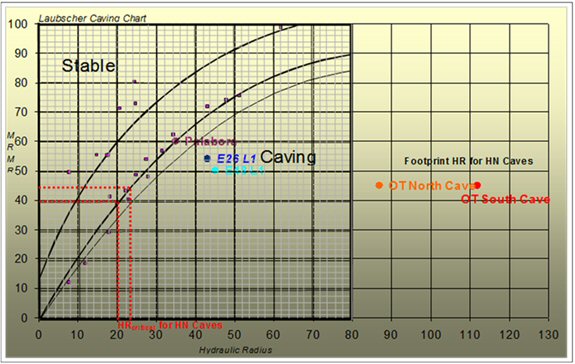
| 16.2.6.3 | Numerical Model |
Numerical modelling, conducted by Itasca Consulting, allowed cave growth and subsidence to be studied in greater detail. Models were based on Hugo North geotechnical conditions, mine design, and production plans. The sensitivity of these predictions to mine design/planning (production rate and profile, undercut direction) was examined. In addition, the impact of uncertainties in rock mass properties (strength, brittleness) on these predictions was evaluated to aid in assessing potential risks associated with the designs.
Modelling showed that caveability and surface subsidence are insensitive to minor production schedule changes and that fine-tuning of production schedule details could be carried out without concern for caveability.
Numerical caving simulations suggest good caveability. Continuous upward growth is predicted, post-CHR, due to the high ratio of in situ horizontal stress to rock mass strength.
| 16.2.6.4 | Cave Growth and Subsidence |
Figure 16.32 illustrates the results of modelling from one north-south section through the cave, the evolving limits of active draw, and the proposed layout.
Modelling showed that fracture limits extend away from the cave boundary at a shallower angle in the east and west. This is attributed to the geometry and redistribution of in situ stresses to the north and south around the developing cave, resulting in a large stress shadow at low confinement to the east and west that fractures and mobilizes more readily.
AMC 813001 : March : 2013
317
ENTRÉE GOLD INC Lookout Hill Property, Southern Mongolia Technical Report | |
| Figure 16.32 | Modelling Results for North-South Section of Advancing Cave |
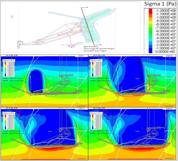
Note: Shows limits of fracturing (red), mobilization (black), and stress distribution on Section 2 as a function of production over time
Modelling also showed that fracture limits extend away from the cave boundary at a steeper angle, almost vertically upward from the advancing face, in the north and south. This is more characteristic of a block cave. This is attributed to the low ratio of advance rate to production rate at Hugo North, which promotes upward growth of the yield zone faster than lateral advance.
Modelling of the cave propagation and cave subsidence revealed that cave growth is more likely to be affected by the presence of major faults than by variations in rock mass strength or in situ stress. One area of note is in the north-west where the North Boundary Fault acts as a barrier, limiting cave growth.
AMC 813001 : March : 2013
318
ENTRÉE GOLD INC Lookout Hill Property, Southern Mongolia Technical Report | |
The surface crater predicted to exist by the end of Lift 1 in the base case model is shown by the outline of the blue area in Figure 16.33. It is modelled to have a maximum depth of approximately 30 m near the kink in the orebody and a depth of 3 m near the limits of the orebody. The crater could be more extensive than that shown by modelling if rapid vertical caving, influenced by structure, were to occur. The fracture limits are illustrated by the thick red line. For the “limit of movement” contour for siting permanent surface infrastructure, a 100 m safety buffer is placed outside the fracture limit contour.
| Figure 16.33 | Subsidence Predictions from Modelling |
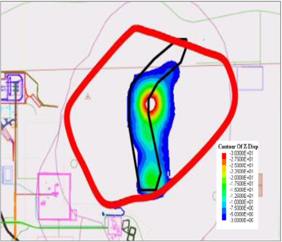
Note: Footprint = black line, depth of crater >3m = blue area, fracture limits = thick red line
| 16.2.7 | Fragmentation Assessment and Cave Flow |
| 16.2.7.1 | Introduction |
Fragmentation is divided into primary and secondary processes. Primary fragmentation results from blocks detaching from the boundary of the rock mass around the mining cavity. Secondary fragmentation occurs as these blocks travel down the draw column.
BCF software incorporating an updated dataset and parameters was used for the fragmentation analysis for the Feasibility Study. This analysis confirmed that the fragmentation will be fine. The analysis highlighted the risk that secondary fragmentation predictions do not take into account the full impact of comminution on high columns (up to 500 m high); as such, actual fragmentation may be finer than modelled. Finer fragmentation could lead to narrower drawzones, an important element in ore recovery and dilution entry predictions. Narrower drawzones may result in greater consolidation of material between active drawzones, increasing the risk of point loading.
AMC 813001 : March : 2013
319
ENTRÉE GOLD INC Lookout Hill Property, Southern Mongolia Technical Report | |
| 16.2.7.2 | In Situ Fragmentation |
In situ fragmentation analysis was carried out using the DFN models developed for synthetic rock mass modelling (SRM) and ubiquitous joint rock mass modelling (UJRM) to estimate a range of rock mass blockiness for each domain.
Cumulative in situ block volume distributions for studied domains are given in Figure 16.34. Modelling results indicate that average in situ block volumes for the geotechnical domains are in the range of 0.02 to 0.28 m3.
| Figure 16.34 | Distribution of In Situ Block Volumes for Dominant Geotechnical Domains |
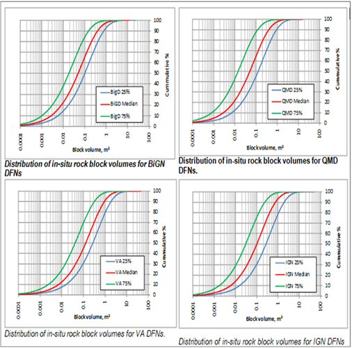
AMC 813001 : March : 2013
320
ENTRÉE GOLD INC Lookout Hill Property, Southern Mongolia Technical Report | |
| 16.2.7.3 | Primary Fragmentation |
The stress inputs for the BCF software were derived from a combination of the FLAC® cave-scale modelling results and Esterhuizen’s stress curves based on 3D stress modelling of hypothetical cave geometries under various stress conditions.
From BCF, the results of the primary fragmentation size distributions are fairly uniform within the deposit, although there is a trend of decreasing block size with depth below surface due to increases in stress-induced fracturing. The VA domain consistently produces the coarsest fragmentation, closely followed by the QMD, BiGD, and IGN domains, respectively. The mass % of primary blocks <2 m3 ranges from around 83% near surface to around 99% within the cave column (500 m above the undercut), as summarized in Table 16.6.
| Table 16.6 | Primary Fragmentation % <2 m3 for Dominant Geotechnical Domains |
| Draw Height | BiGD | IGN | VA | QMD |
| 100 m | 99 | 96 | 90 | 92 |
| 300 m | 96 | 96 | 85 | 87 |
| 500 m | 92 | 96 | 83 | 91 |
| 16.2.7.4 | Secondary Fragmentation |
BCF secondary fragmentation analysis was undertaken for all dominant geotechnical domains for increasing heights of draw from the undercut through to surface at 100 m intervals. Only fragmentation for the first 500 m is reported, as this is relevant to the economic draw column height to be extracted.
The secondary fragmentation process (comminution) simulated within BCF does not significantly reduce the fragmentation size, as anticipated for the high blocks. This is most likely because the primary fragmentation is already fine. Table 16.7 shows secondary fragmentation % <2 m3 that can be classified as “fine.”
| Table 16.7 | Secondary Fragmentation % <2 m3 for Dominant Geotechnical Domains |
| Draw Height | BiGD | IGN | VA | QMD |
| 100 m | 100 | 99 | 90 | 96 |
| 300 m | 100 | 100 | 92 | 97 |
| 500 m | 100 | 100 | 100 | 98 |
| 16.2.7.5 | Oversize and Hang-up Predictions |
Oversize rocks are by definition not easily moved from the drawpoint, and they prevent the load-haul-dump (LHD) from drawing its required tonnage. Consequently, oversize rocks require secondary breaking or some form of double-handling and are therefore recorded as an “event.”
AMC 813001 : March : 2013
321
ENTRÉE GOLD INC Lookout Hill Property, Southern Mongolia Technical Report | |
Table 16.8 shows the BCF prediction for oversize and hang-ups that was used for the study. Predictions are considered conservative are because they do not account for the fines component.
| Table 16.8 | Oversize and Hang-up Predictions Using BCF Software and Northparkes-Palabora Fragmentation Database |
| BCF | Database | ||||
| HOD | Tonnes/OS Rocks | Tonnes/Hang-up | Tonnes/Event | Tonnes/Hang-up | |
| 100 | 287 | 864 | 130 | 576 | |
| 300 | 502 | 1,510 | 138 | 1,077 | |
| 500 | 7,988 | 24,044 | 390 | 16,029 | |
Note: The oversize and hang-up predictions do not include the fines component, which may exceed 11% by mass. This will serve to significantly improve the drawpoint productivity rates and increase the tonnage per oversize and hang-up.
| 16.2.7.6 | Grizzly and Crusher Fall Through |
BCF was used to estimate the percentage passing for the grizzlies installed above the internal orepasses (0.8 m x 0.8 m), the F80 size for the crusher feed, and the crusher aperture setting (0.216 m). Because the BCF prediction of aspect ratio (AR=1.6) is considered conservative, an 11% by volume fines component was added to account for the more cubic rock shape (closer to AR=1) expected from comminution in the cave.
A figure of 90% passing, or one grizzly blockage per 10 LHD buckets, to 95% passing, or one grizzly blockage event every 20 LHD buckets, was considered a conservative to central case, and has been used as the basis for the study.
| 16.2.8 | Cave Flow |
Cave flow analysis is used to determine the drawpoint spacing required for the extraction level layout to ensure interaction between the draw columns, to determine how the cave is expected to propagate, and to calculate orebody recovery and production schedule grades.
| 16.2.8.1 | Laubscher Methodology |
Laubscher’s Empirical method is an industry standard for calculating drawpoint spacing. Fragmentation is the key input into this calculation. Laubscher starts with defining an isolated draw zone (IDZ). Figure 16.35 shows Laubscher’s categories and criteria with Hugo North rock conditions colour-coded to Laubscher’s system. Hugo North’s IDZ diameters are estimated to vary between 9 m and 11.5 m and to average 10 m.
Laubscher’s interactive draw spacing calculation is shown in Figure 16.36. Interactive drawzones are spaced to touch (interact) within a drawbell, resulting in a 1.5 times growth to produce an individual drawbell zone.
On this basis, analyses recommended a drawpoint spacing of 15 m x 28 m.
AMC 813001 : March : 2013
322
ENTRÉE GOLD INC Lookout Hill Property, Southern Mongolia Technical Report | |
| Figure 16.35 | Laubscher Classification System (left) and Hugo North’s Rock Mass Rating (right) |
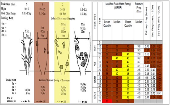
| Figure 16.36 | Laubscher Drawzone Growth Methodology |
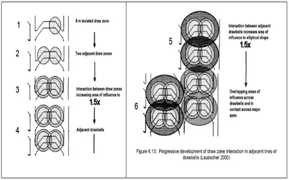
AMC 813001 : March : 2013
323
ENTRÉE GOLD INC Lookout Hill Property, Southern Mongolia Technical Report | |
| 16.2.8.2 | REBOP®, PCGA®, and Benchmarking |
Laubscher’s method is based on information from traditional caves with significantly lower column heights than at Hugo North. The high block height of the Hugo North cave (draw columns up to a maximum of 500 m, average 390 m) will serve to drive the secondary fragmentation processes, resulting in fine fragmentation, and to promote large tangential stresses around drawcones to retard their lateral expansion. This combination of fine fragmentation and high overburden stresses within the muckpile could translate into more isolated draw and less draw interaction, which could result in earlier dilution entry.
The REBOP® results indicate interactive draw for all scenarios investigated, ranging from assumed finer QMD, VA, and IGN material to switching on/off the fines migration and secondary breaking logic in REBOP®. All REBOP® simulations yielded similar but slightly lower ore recoveries than those in the Personal Computer Block Cave (PCBC) model based on the Laubscher methodology.
During production ramp-up, the maximum daily draw rate from a particular drawpoint is constrained by the drawpoint construction rate. This coupled with high draw columns results in a relatively steep depletion front, as shown in Figure 16.37. Studies are ongoing within Rio Tinto to further assess the effect of rilling along steep depletion fronts, and further REBOP and Cellular Automata simulations are recommended to cross-check with PCBC output in analyzing rilling potential and dilution entry.
| Figure 16.37 | Illustration of Hugo North’s Depletion Front |
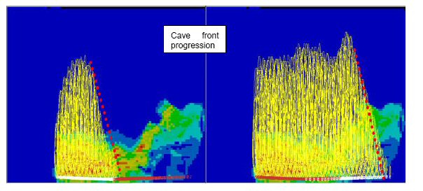
| 16.2.8.3 | Gemcom PCBC™ Scheduling |
Production scheduling was undertaken in Gemcom’s PCBC™ software. PCBC takes the cell model above a footprint and divides it into vertical cylinders above each drawpoint. The diameter of the vertical cylinders is a critical input into PCBC. From Laubscher’s 10 m IDZ and the interactive draw growth process, a PCBC diameter of 25 m was used to represent interactive draw. It is of note that PCBC is not used as a flow modelling tool to determine interactive draw; conditions supporting interactive draw are derived from Laubscher methodology and supporting programs, and these conditions are then represented in PCBC for production scheduling.
AMC 813001 : March : 2013
324
ENTRÉE GOLD INC Lookout Hill Property, Southern Mongolia Technical Report | |
The height of interaction zone (HIZ) is another important PCBC input. The HIZ defines the height above the footprint where mixing occurs; material above this HIZ is believed to exhibit mass flow behaviour, moving evenly downwards with no mixing. For Hugo North, the PCBC HIZ has been estimated at 150 m, consistent with PCBC modelling undertaken for other projects.
On the extraction level, approximately one bucket per drawpoint per day (12 tonnes) will be removed pre-CHR. This minimal removal of material will be for the purpose of stress relief only and there will be no ramp-up in production during this time. The production ramp-up rate for a given drawpoint post CHR is recommended to start at 50 mm/d and to increase to a steady state of 300 mm/d, over a 12 month period or 16% of the column height. This will ensure that the stresses have time to fail the rock mass above the cave back and cause the cave to propagate vertically upwards, minimizing the formation of any overhangs and irregular cave growth. Cave monitoring and management will be used to ultimately determine the rate of draw. The high stress conditions and fine fragmentation predicted at Hugo North may provide higher rates of caving and an opportunity to increase draw rates.
AMC 813001 : March : 2013
325
ENTRÉE GOLD INC Lookout Hill Property, Southern Mongolia Technical Report | |
| Figure 16.38 | Area Opened when Select Drawpoints can Increase to 400 mm/d |
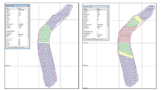
* Panel 1 area is shown on left figure, Panel 2 area is shown on right figure
| 16.2.9 | Cave Monitoring |
| 16.2.9.1 | Cave Monitoring Systems |
Monitoring provides valuable information on cave initiation, caving rate, shape of the cave back, and intensity of stress fracturing. The monitored caving rate can be used as a basis for production scheduling to minimize the risk of air blast. Monitoring is also useful for identifying areas that have stalled and may require cave induction.
The proposed cave monitoring system includes a micro-seismic system, Time Domain Reflectometers (TDR), extensometers, and open drillholes. All of the data recorded from these systems are analyzed and stored in a geotechnical database. The interpreted cave back and muckpile positions are consequently uploaded into the mine design software package for the construction of a 3D model of the cave.
The micro-seismic monitoring system is used to track the inelastic response of the rock mass to mining activities.
Golder Associates was engaged to provide a preliminary design concept of the micro-seismic system for Hugo North. Figure 16.39 is an illustration of the proposed holes that would contain the seismic sensors.
AMC 813001 : March : 2013
326
ENTRÉE GOLD INC Lookout Hill Property, Southern Mongolia Technical Report | |
| Figure 16.39 | Proposed Holes Containing All Seismic Sensors for the Mine |
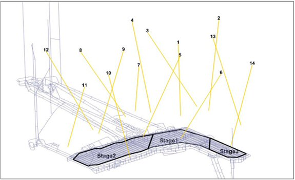
| 16.2.9.2 | Undercut Monitoring |
Monitoring of the undercut will include seismics, convergence (real-time extensometers and convergence stations), and stress change through hollow inclusion cells.
| 16.2.9.3 | Extraction Level Monitoring |
As with the undercut, monitoring of drive stability is critical in terms of stress loading but also for managing the cyclic loading induced through cave draw. The ramifications of any unsuccessful blasting of the undercut and pillar formation are quickly transmitted to the extraction level because the pillars act as point loads that can very easily crush drives and/or drawpoints. One set of convergence stations and one set of three extensometers (two in the extraction drive sidewalls, one in the back) should be installed adjacent to every second or third drawpoint to provide sufficient coverage to detect rock mass response to cave draw.
| 16.2.9.4 | Major Excavation Monitoring |
All major excavations, such as the shafts, workshops, crushers, and bins, require deformation monitoring to ensure timely respond timely to any adverse rock mass movement. Seismics and convergence monitoring will be employed for this purpose.
AMC 813001 : March : 2013
327
ENTRÉE GOLD INC Lookout Hill Property, Southern Mongolia Technical Report | |
| 16.2.9.5 | Cave Flow Monitoring |
The use of Elexon’s Smart Marker System has proved successful at the Northparkes and other caving operations. Markers are placed in surface drillholes across the orebody at recorded coordinates and are drawn down through the cave during operation. When mucked out of a particular drawpoint by LHD, the marker is trammed to the central orepass where a reader picks up and records the marker’s unique identity number. It is then possible to extrapolate the flow path of the marker and gain an understanding of the cave flow characteristics.
| 16.2.9.6 | Subsidence Monitoring |
The subsidence zone is subdivided into a No-Go zone, where no person may enter, and a fenced-off Restricted Access Zone, where geotechnical monitoring and inspections are permitted. After breakthrough, the No-Go zone should be redefined periodically, typically based on aerial photogrammetry, prism monitoring, and extensometers.
| 16.2.10 | Major Hazards |
| 16.2.10.1 | Ground Collapse and/or Crown Pillar Failure |
Figure 16.40 illustrates a situation where the expansion void grows into a significant air gap because the rate of draw is greater than the rate of caving.
A significant air gap accompanied by a large failure of the cave back could result in an underground air blast through either the drawpoints or any other open connection into the cave.
Strict draw control practices in conjunction with geotechnical monitoring of the cave back will ensure that the expansion void required to promote continuous cave propagation does not transform into a significant air gap. A minimum amount of broken material needs to be left in the cave above the drawpoints and undercut level to ensure that no voids or paths are open between the cave and personnel locations where air, fines, or rocks could be ejected. All development intersecting the cave will contain air blast barriers.
AMC 813001 : March : 2013
328
ENTRÉE GOLD INC Lookout Hill Property, Southern Mongolia Technical Report | |
| Figure 16.40 | Uncontrolled Crown Pillar Collapse |
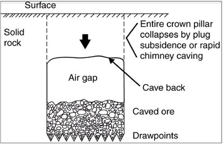
Note: After Brown (2000)
| 16.2.10.2 | Column Loading |
Column loading results from the weight of the overlying ore column or from arching stresses, which are often created at the sides of an active draw ellipsoid. Over time this has the potential for point loading and damage to drives and drawpoints (Figure 16.41).
Sound draw control practice is recognized as the best means of avoiding stress concentrations. Geotechnical monitoring (convergence, cracking, pillar dilation) will detect the onset of loading before any significant drive deformation.
AMC 813001 : March : 2013
329
ENTRÉE GOLD INC Lookout Hill Property, Southern Mongolia Technical Report | |
| Figure 16.41 | Column Loading |
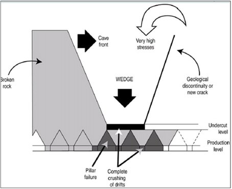
Note: After Florez (1993)
| 16.2.10.3 | Mudrush |
Mudflows in block caves are generally limited to caves situated in high-rainfall areas or where the orebody contains a large amount of fines or clay-bearing minerals. A detailed mudflow risk assessment has yet to be been conducted for Hugo North; however, the risk for mud flow is considered to be low due to the lack of significant volumes of water. A large rainfall event after the cave breaks through to surface would present the highest probability of occurrence.
| 16.2.10.4 | Rockbursts and Slip on Major Structure |
Detailed regional seismic hazard assessments have been carried out by the Research Center of Astronomy and Geophysics (RCAG) in Mongolia and by Knight Piésold Consulting Ltd. in 2005. Fluor Canada reviewed this work in 2010 for the design of the tailings storage facility and performed some seismic hazard assessments.
Itasca was asked to employ the Excess Shear Energy methodology utilizing 3DEC. This is frequently used at South African mines to assess the risk of large-scale seismicity on faults and dykes induced by longwall mining at great depth. Because of the soft nature of the major faults included in the model for Hugo North, no dynamic slip was shown on those structures.
Modelling indicates that the West Bat Fault will be the most active, followed by the Hugo Rhyolite Fault and the East Bat Fault.
AMC 813001 : March : 2013
330
ENTRÉE GOLD INC Lookout Hill Property, Southern Mongolia Technical Report | |
| 16.2.10.5 | Cave Subsidence Risks |
Numerical modelling along with benchmarking indicates that the risk of shaft 2 being affected by subsidence through mining of panel 1 and panel 2 is very low. Subsidence monitoring will be carried out to understand ground movement relative to caving and to recalibrate subsidence models to ensure the most accurate predictions are available.
| 16.2.10.6 | Isolated Draw |
Isolated draw could occur if the material is finer than predicted because of either underestimated primary fragmentation related to ground conditions and stress effects, or underestimated secondary fragmentation related to comminution from high ore columns. Production schedule runs with isolated draw scenarios show that these could have a significant impact on project value through both lost recovery and the inability to produce at the planned 95,000 t/d production rate.
Good draw control practices are the key for maximizing interaction and recovery. Given the current pillar stability concerns, it is not considered feasible at this stage of study to reduce drawpoint spacing further to reduce the risk of isolated draw.
| 16.2.10.7 | Further Work |
Further measurements of in situ stress within the orebody’s host rocks – granodiorite and monzodiorite – are required to provide confidence in the interpretation of the stress field where cave mining will occur. This may mean applying measuring techniques supplementing or replacing the HI cell method.
Then, the interpretation of the in situ stress field for the Hugo North orebody and environs requires reconsideration. There is an arguable case that active tectonism is not occurring at depths below 700 m, but rather that it has all been subjected to uplift, erosion and relief of stress to much greater depths. This has significant implications for the magnitudes of stress at the footprint of cave mining.
The present geological interpretations are acceptable for the geological and resource models at the levels of confidence stated. However, cell models for the Hugo Dummett deposit models, which were created in 2007, have not been updated since. The geological interpretations and models are likely to change as the project proceeds to detailed mine design and construction.
From 2010 to 2012, OT LLC reviewed and re-evaluated much of the data collected in support of mine design and construction. These reviews included consideration of additional drilling completed in the project area, incorporation of revised, and more detailed, structural and lithological interpretations, consideration of changes in interpretation of the evolution and genesis of the Oyu Tolgoi deposits, and the results of preliminary geotechnical reviews. A number of areas were identified that could benefit from targeted work programs, particularly in the areas of structure and rock mechanics.
The result was development of a proposed work program for 2012–2013 that addressed geological issues that could directly affect the mine design and construction.
AMC 813001 : March : 2013
331
ENTRÉE GOLD INC Lookout Hill Property, Southern Mongolia Technical Report | |
The OT LLC work program is likely to include the following:
| ● | Developing a standard set of cross-sections and level plans on the mine grid that can be used to support geotechnical assessment, mine planning, and metallurgical assessment. These sections will replace the variably oblique section lines used previously. |
| ● | Incorporating additional drill data completed since the last update into the resource models. |
| ● | Undertaking drill testing of structural discontinuities identified in the structural and geotechnical reviews. Results of such testwork would be incorporated into the cell model. |
| ● | Reviewing the updated resource models to pinpoint areas where there are gaps in knowledge concerning lithology, alteration, structure, and mineralization that require targeted drill testing. Such gaps are considered more likely to occur on the orebody margins or in areas where high-grade mineralization is in direct contact with areas interpolated as waste. |
| ● | Assessing likely criteria for the most appropriate drill spacing to support classification of measured mineral resources for the proposed block cave areas. |
| ● | Building a 3D district geological and structural model that will assist in further exploration and in the definition of additional drill targets in the near-mine environment. |
| ● | Exploring further opportunities and options for the overall development after resource development work on lift 2, Hugo Dummett North, commences within the next couple of years. |
| ● | Evaluating future work at Hugo South to further enhance the understanding of the overall resource development strategy. |
| ● | Completing drilling and the quantification of the mineralized inventory within Heruga North. |
| 16.3 | Underground Mining |
The Hugo Dummett underground deposit will be mined by block caving which is a highly productive and cost effective method. The deposit is comparable in dimension and tonnage to other deposits currently operating by block-cave mining elsewhere in the world. OT LLC designed the block cave based on the Hugo North Lift 1 Mineral Reserve.
| 16.3.1 | Mine Design |
The mine design consists of 194 km or lateral development, 16 km of vertical development which includes 5 shafts, and 140,500 m3 of mass excavation. A total of 2,155 drawpoints are planned for development within the current footprint, which will be accessed from 63 extraction drives. The mine will produce 493 Mt of ore at the full production rate of 95,000 t/d, with 491 Mt processed and 2 Mt stockpiled. A plan view of the mine is shown in Figure 16.42. Key mine design details are given in Table 16.9 and the shaft details are in Table 16.10.
AMC 813001 : March : 2013
332
ENTRÉE GOLD INC Lookout Hill Property, Southern Mongolia Technical Report | |
| Figure 16.42 | 2013 Mine Layout |

The planned location for Shaft 4 in IDOP was to the east of the orebody, as seen in Figure 16.43. The new location for Shaft 4 is to the west of the orebody and will defer development on the EJV license.
AMC 813001 : March : 2013
333
ENTRÉE GOLD INC Lookout Hill Property, Southern Mongolia Technical Report | |
| Figure 16.43 | 2012 Mine Layout |
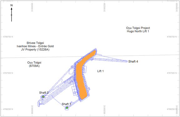
AMC 813001 : March : 2013
334
ENTRÉE GOLD INC Lookout Hill Property, Southern Mongolia Technical Report | |
| Table 16.9 | Key Mine Design Details |
| Extraction Level | Undercut Level | ||
| Layout | El teniente | Sequence | Advanced |
| Spacing (m) | 28 x 15 | Drive Spacing | 14 |
| Drive size excavated (m) | 4.5 wide x 4.5 high | Drive size excavated (m) | 4.0 wide x 4.0 high |
| Loader type | 14 t diesel | Profile | Inclined “W” style |
| Orepass layout, diameter (m) | Central, 3.0 | Face angle (plan) | 55 |
| Grizzly (m) | 0.8 x 0.8 | Lead/lag (m) | 10 |
| No. of drawpoints | 2,155 | Total area (m2) | 641,000 |
| Hole diameter (mm) | 76 | Hole diameter (mm) | 89 |
| Drilling per drawbell (m) | 1,375 | Ring Spacing (m) | 2.0 |
| Concrete road surface | 80 MPa | Metres per ring (m) | 78 |
| Steel sets | Yes | Tonnes per ring (80% swell) | 210 |
| Haulage Level | Conveyer and Loadout | ||
| Haulage method | Truck to crusher | Drive size excavated (m) | 6.8 wide x 5.5 high |
| Truck type | 80 t diesel, side tip | Max. inclination (%) | 18 |
| Haulage loop | One way | Transfer method | Shuttle chute |
| Truck loading (production) | Drive through | Number of shaft bins | 6 |
| Chute style | LKAB | Bin diameter (m) | 10 |
| No. of chutes | 56 | Bin length (m) | 45 |
| Drive size excavated (m) | 6.1 wide x 6.0 high | Total bin capacity (t) | 30,000 |
| Number of crushers | 2 | Skip loadout | Conveyor |
| Table 16.10 | Shaft Details |
| Shaft No. | Diameter (m) | Depth (m) | Hoist Capacity (t/h) | Vent Capacity (m3/s) | Function |
| Shaft #1 | 6.7 | 1,385 | 240 | 460 | Pre-production development, intake vent |
| Shaft #2 | 10.0 | 1,250 | 1,630 | 950 | Cage access, production hoisting, intake vent |
| Shaft #3 | 11.0 | 1,180 | 3,768 | 1,100 | Production hoisting, intake vent |
| Shaft #4 | 11.0 | 1,220 | – | 1,900 | Exhaust vent |
| Shaft #5 | 6.7 | 1,195 | – | 680 | Exhaust vent |
AMC 813001 : March : 2013
335
ENTRÉE GOLD INC Lookout Hill Property, Southern Mongolia Technical Report | |
Figure 16.44 is a section through the footprint showing the relationship between the 5 main levels. Figure 16.45 shows the extraction level layout. Panel 1 has extraction drives orientated east-west, and Panel 2 has extraction drives orientated at 055 strike. A close up of the El Teniente 28 m by 15 m layout illustrates centrally located orepasses and ventilation raises. The orientation of the undercut level layout development is similar to that for the extraction level with two undercut drives for each extraction level drive. Figure 16.46 illustrates the drill and blast excavations for the undercut and drawbells.
| Figure 16.44 | Section View through Footprint |
| Figure 16.45 | Extraction Level Layout |
AMC 813001 : March : 2013
336
ENTRÉE GOLD INC Lookout Hill Property, Southern Mongolia Technical Report | |
| Figure 16.46 | Undercut Drawbell Excavation |
Figure 16.47 shows a section of haulage level development (purple) that is 45 m below the extraction level development (green). The figure also shows the connection between the centrally located production orepasses and drive-through truck-loading chambers. Extraction drives are sized to accommodate 14 tonne LHDs and the haulage drives are sized to accommodate 80 tonne side-tip trucks.
| Figure 16.47 | Extraction Level to Haulage Level Arrangement |

AMC 813001 : March : 2013
337
ENTRÉE GOLD INC Lookout Hill Property, Southern Mongolia Technical Report | |
| 16.3.2 | Orehandling System |
| 16.3.2.1 | Crusher |
The selected 1,600 mm by 2,400 mm gyratory crusher with installed power of 750 kW has a split shell configuration for shaft and underground transport to the crusher stations. Design capacity is 4,000 t/h each for the two crushers. A section through the crusher 1 chamber is shown in Figure 16.48.
Trucks will tip into a 160 tonne bin that feeds directly into the gyratory crusher with an open side setting of 203 mm. A 650 tonne surge bin under the crusher will feed onto a sacrificial belt via an apron feeder to provide for steel removal. The crusher will be controlled remotely. The spare mantle has been removed from the crusher chamber to reduce excavation size, and a separate mantle and concave workshop facility has designed adjacent to the haulage workshop.
| Figure 16.48 | Crusher Station General Arrangement |
AMC 813001 : March : 2013
338
ENTRÉE GOLD INC Lookout Hill Property, Southern Mongolia Technical Report | |
| 16.3.2.2 | Conveyors |
The sacrificial conveyor from Crusher 1 will discharge crushed ore onto a 2,200 mm wide incline transfer conveyor (ST-1600 steel cord). The conveyor has a design capacity of 4,800 t/h, a belt speed of 3.0 m/s, a maximum inclination of 18%, and is fitted with a single 1,320 kW drive assembly at the head pulley. A similar transfer conveyor arrangement will be in place for Crusher 2. Both transfer conveyors will feed onto the 2,200 mm wide x 1,141 m long incline conveyor 1 having a maximum inclination of 18% for a belt lift of 194 m. This conveyor has a design capacity of 9,600 t/h at a belt speed of 3.5 m/s, ST-6300 steel cord belting, and three installed 2,500 kW drives. Advanced Conveyor Technologies (AC-Tek) performed a dynamic analysis of incline conveyor 1 and confirmed the design. The primary flow of ore from incline conveyor 1 will discharge into a two-way diverter chute, which will direct the ore to either the Shaft 2 loading bins via a short horizontal conveyor or to the Shaft 3 loading bins via incline conveyor 2.
| 16.3.2.3 | Shaft Bins and Skip Loadout |
Two ore storage bins are provided at Shaft 2 and four are provided at Shaft 3. Each bin will have a live operating capacity of 4,200 tonnes while maintaining an 800 tonne bed of material (dead bed) to prevent falling rock from impacting the reclaim feeder below. Shaft 2 will contain one skip loading system. Ore from one of the two ore storage bins will be measured by an apron feeder and weightometer system onto a loadout conveyor. Ore will then discharge through a diverter chute into one of two skips. Shaft 3 will contain two skip loading systems; each arrangement is similar to that described for Shaft 2.
AC-Tek performed a discrete element modelling (DEM) analysis for the skip loading operation and a dynamic analysis for the Shaft 3 loadout conveyor. The DEM was used to analyze conveyor discharge trajectories into the skips, to identify any plugging effects in the chute, to simulate the overall ore travel time within the chute, and to confirm that the skip docking time is feasible. Figure 16.49 is a snapshot of the skip loading DEM.
AMC 813001 : March : 2013
339
ENTRÉE GOLD INC Lookout Hill Property, Southern Mongolia Technical Report | |
| Figure 16.49 | Snapshot of Skip-Loading Discrete Element Modelling |
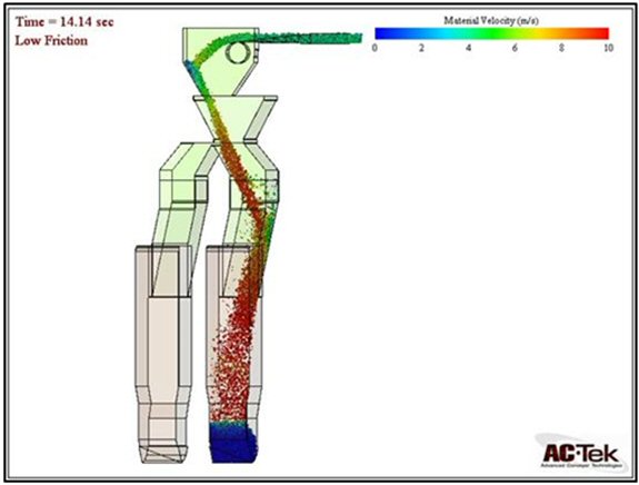
| 16.3.2.4 | Shaft and Surface Conveying |
Shaft 2 contains one Koepe production winder and two 60 tonne capacity skips operating in counterbalance with fixed guides. The Shaft 3 hoisting arrangement contains two Koepe winders (of the same type as Shaft 2) and four 63 tonne skips operating with rope guides. Each pair of skips will discharge into a 200 tonne capacity surface bin. Ore will be reclaimed from each bin by an apron feeder to the overland and stockpile feed conveyors, which will be adjacent to the existing open pit conveying system.
| 16.3.2.5 | Simulation |
An Arena® discrete element simulation model of the ore handling system, from crusher to surface stockpile, was developed to estimate the required capacities of the crushers and the skip ore bins to achieve the target production rate of 95,000 t/d. The model was used to establish the baseline production capacity for the ore handling layout and to undertake trade-offs to improve productivity and equipment utilization, and ultimately to verify that the ore flow circuit was capable of delivering the planned tonnage. The outcome of the ore handling simulation run over a two-year period averaged 95,000 t/d wet delivered to the mill stockpile. To achieve this, the hoists need to operate at their combined instantaneous hoisting rate of 5,400 t/h for an average of 17.5 h/d.
AMC 813001 : March : 2013
340
ENTRÉE GOLD INC Lookout Hill Property, Southern Mongolia Technical Report | |
| 16.3.3 | Infrastructure and Services |
| 16.3.3.1 | Ventilation |
At full production, fresh air will enter the mine through three intake shafts and exit through two dedicated exhaust shafts. The primary ventilation system will be a “pull” design with main exhaust fans on exhaust shafts. At the start of underground production in 2016, 730 m3/s of airflow will be available underground. At full production, 2,300 m3/s will be available (0.024 m3/s per t/d).
The intake air must be heated during the winter months. Hot water from the project central heating system will be used to transfer heat to glycol heating units at Shaft 1, Shaft 2, and Shaft 3. During preproduction, before the connection to the central heating system is ready, a combination of diesel-fired units and a local hot water boiler will be used for air heating at Shaft 1.
Air cooling during production is required only on the undercut level, where localized refrigeration units will be installed; airflow in other mine areas is sufficient to manage heat build-up. A surface refrigeration plant at Shaft 1 will cool all intake air during preproduction to maximize the use of available ventilation during the critical mine establishment phase.
The Hugo Dummett North deposit is high in silica, and occupational exposure limits (OEL) for dust will therefore be low in order to meet the OEL for silica. The dust control strategy for the ore handling system begins at the extraction level where spray bars are fitted to each drawpoint. A ventilation raise connecting directly to exhaust airways is provided adjacent to each central tipping LHD orepass. On the truck haulage level water sprays are provided at each truck loading station along with a ventilation raise connecting directly to an adjacent exhaust airway. At the crusher dump location, water spray dust suppression systems will be provided as well as an adjacent ventilation raise connecting directly to exhaust airways. A dry type dust collector will be provided below the crusher. All conveyor transfer points will be enclosed and fitted with water sprays. The top of each ore bin, along with skip loading and unloading points, will be fitted with air extraction units connected to high-efficiency particulate air (HEPA) filters.
Fire modelling was undertaken to review the robustness of the ventilation models, to determine the appropriate locations for fire doors, and to examine escape plans.
| 16.3.3.2 | Infrastructure |
Major underground infrastructure includes shops, offices, lunchrooms, and other permanent facilities.
Shop facilities will be built to support the planned maximum fleet of 233 units of underground mobile equipment, including light vehicles. The underground maintenance shops will consist of service bays/garages, auxiliary storage, and warehouse facilities for maintenance of the underground mobile equipment and the fixed plant equipment. The maintenance facilities are summarized in Table 16.11.
AMC 813001 : March : 2013
341
ENTRÉE GOLD INC Lookout Hill Property, Southern Mongolia Technical Report | |
| Table 16.11 | Underground Mine Maintenance Shops |
| Shop | Location | Main Service |
| Shaft 1 Shop | Near Shaft 1 on 1300 Level | Development, construction, and service equipment |
| Main Shop | Extraction Level | Production equipment and general fleet |
| Haulage Truck Shop | Haulage Level | 80 tonne haul trucks |
| Drill Shops (2) | Undercut Level (NE and SW) | Undercut drills and development equipment |
Major equipment overhaul and rebuilds will be done in central service facilities on the surface. Tire repairs and recapping will be done in a central tire shop on the surface.
Permanent fuel stations will be established near the Shaft 1 shop, the main shop, and the haulage shop. Mobile fuel and lube trucks will service remote and slow moving equipment such as drills and shotcrete sprayers.
Permanent lunchrooms and office facilities will be built adjoining the main shop, the haulage shop, and the Shaft 1 shop. The lunchrooms are designed to serve hot lunches to the crews at mid-shift, to be used as training areas, and to support supervision and technical services office requirements during the life of the mine.
Refuge stations will be strategically located in areas of the mine that can be easily accessed in the case of an emergency. These will include both permanent and a network of portable 20-person refuge stations.
| 16.3.3.3 | Services |
The mine will be equipped with a service distribution network to provide compressed air, service water, fire protection, electric power distribution, communications, instrumentation, and data system.
After Shaft 2 is commissioned all primary service supply will be through Shaft 2 with backup through Shaft 1. All services will be through a “ring main” style distribution system connecting the shafts, main shops, material handling system, and western edge of the footprint. Branch feeders from the ring main will distribute services to the active workings.
Shotcrete and Concrete
Concrete will be delivered from surface batch plants through slicklines in Shaft 1 and Shaft 2. During the construction phase of the mine, when the concrete and shotcrete needs are the highest, additional slicklines will be installed in sacrificial boreholes near the footprint to reduce congestion at the shaft station and improve construction rates. Concrete haulers will deliver concrete and shotcrete from the slickline stations to the working place.
AMC 813001 : March : 2013
342
ENTRÉE GOLD INC Lookout Hill Property, Southern Mongolia Technical Report | |
Mine Dewatering
The mine is expected to be dry and will require continuous service water make-up. At maximum demand, the mine will require 196 m3/h of service water. Dewatering will be needed only occasionally in the event that the mine water recycling system is not operational, the water quality has deteriorated beyond re-use, or a high rainfall event near the end of mine life introduces significant quantities of water through the cave.
Mine Logistics
The mine will depend on Shaft 1 and Shaft 2 to deliver all personnel, equipment, materials, and supplies to the mine. Shaft 1 will be operating at maximum capacity just before Shaft 2 is commissioned in early 2015, during the period of maximum construction and development activity. After Shaft 2 has been commissioned, excess capacity will be available to manage and control shaft logistics operations.
| 16.3.4 | Operations Plan |
Benchmarking and experience from other caving operations were widely used to support the operating approach. Arena® dynamic simulation modelling was used extensively to develop designs and operating plans, to examine value levers to optimize production, and to manage system bottlenecks and production risks.
Operation productivities are based on 350 work days per year and two 12-hour shifts per day with an available 9.5 working hours per shift.
| 16.3.4.1 | Undercut Operation |
In steady state, the undercut will require two development crews to maintain access ahead of the undercut cave face. Five longhole rigs, a boxhole machine, and five 10 tonne loaders will be used to maintain the average undercut cave retreat of 3,500 m2 per month between the two panels. Satellite workshops on the undercut will be used for maintaining slow-moving drill rigs.
| 16.3.4.2 | Extraction Level Operation |
The extraction level will require three development crews to maintain access ahead of the drawbell construction fronts. Four longhole rigs and two boxhole machines will be used to maintain the drawbell construction rate of seven drawbells per month between the two panels. Steel sets will be installed in all drawpoints, and 80 MPa concrete roadways will be provided for all production mucking areas. Twenty-three 14 tonne diesel production loaders will operate at full production. Drawpoint sprays at the brow of each drawpoint will operate automatically as the loader enters and exits a drawpoint. Development orepasses on the rim drives will be available as a backup for production LHDs.
AMC 813001 : March : 2013
343
ENTRÉE GOLD INC Lookout Hill Property, Southern Mongolia Technical Report | |
Oversize material will be managed by a fleet of twelve machines: four larger single-boom drill rigs fitted with drill-index-charge capability for breaking hang-ups within a drawbell; four small single-boom drill rigs fitted with non-explosive rock breaking technology for oversize removed from the drawpoint by an LHD; and four mobile rockbreaker units for breaking rocks either in the drawpoint or on the 800 mm x 800 mm grizzly.
Extraction level equipment will be maintained in the main workshop on the extraction level horizon and will be fuelled at the extraction level fuel facility. LHD draw quantity and sequence will be managed through the dispatch system. Draw control will be managed by an integrated cave management system along with monitoring of seismic system, open holes, extensometers, and flow markers installed in the cave. Samples will be taken from each active drawpoint twice per week.
| 16.3.4.3 | Haulage Level Operation |
The haulage level will require one development crew to maintain access ahead of the expanding haulage loop. Twenty 80 tonne side-tip production trucks will operate at full production. Truck operators will use remote control to load from truck chutes. The haulage roadway will be constructed of a compacted rock roadbase and maintained by grader during crusher maintenance times or shift change. Dispatch and the traffic management system will coordinate truck movements. Haulage level equipment will be maintained in the truck haulage workshop on the haulage level horizon and will be fuelled at the haulage level fuel facility. The truck haulage workshop will also be used to support sustaining construction and ore handling operation and maintenance crews. Sustaining construction crews will ensure that items such as grizzlies, orepasses, and truck chutes are installed ahead of production requirements.
| 16.3.4.4 | Ore Handling Operation |
The two crushers and conveyor system will be remotely operated. Cameras at each crusher will assist in managing ROM bin blockages or tramp steel. Material from the fine ore transfer bin under the crusher will feed via apron feeder onto a sacrificial belt, where any steel passing through the crusher will be removed before entering the main conveyor system. Each crusher will be shut down for planned maintenance for one shift every week. Conveyors transferring rock from crushers to shafts will have vehicle access (small boom truck) along one side for operations and maintenance personnel. The main conveyor transfer chamber, at the head end of incline conveyor 1 near Shaft 2, will contain a spare shuttle chute on a quick change-out system to minimize maintenance downtime. The shaft ore bins will provide approximately 3 hours of production capacity buffer between the hoisting system and the cave delivery. The diverter chute between the each of the three load-out conveyors and associated skips will also contain a spare chute on a quick change-out system.
Surface conveyors will be remotely operated and maintained by the concentrator team managing the parallel open pit conveyor system.
AMC 813001 : March : 2013
344
ENTRÉE GOLD INC Lookout Hill Property, Southern Mongolia Technical Report | |
| 16.3.4.5 | Production System Capacity |
To achieve an average full production rate of 95,000 t/d, the production system has the capacity to produce in excess of 120,000 t/d. Figure 16.50 is a histogram of the production tonnage variability per day over a one-year period as modelled by the Arena® simulation. Truck and crusher available operating time is 9.5 hours per shift, and hoisting remains operational during shift change if mechanically available and if ore is available in the ore bins. To average 95,000 t/d, the production system is simulated to operate at or above 100,000 t/d for 44% of the available production days.
| Figure 16.50 | Histogram of Production Tonnes per Day |
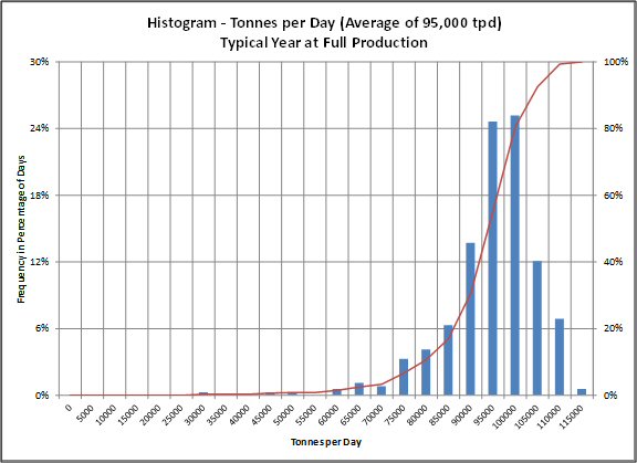
AMC 813001 : March : 2013
345
ENTRÉE GOLD INC Lookout Hill Property, Southern Mongolia Technical Report | |
| 16.4 | Mining Production Schedules |
OT LLC has prepared both the open pit and underground mining work and schedules. The case adopted for 2013 OTTR assumes no plant capacity expansion, is based on Mineral Reserves Only, does not include Inferred Mineral Resources, and does not include underground mining areas other than Hugo North Lift 1.
| 16.4.1 | Scheduling Assumptions |
The following scheduling methodology was used to balance mine, mill, and stockpile quantities:
| · | Underground ore is designated as the priority feed. After the available underground ore is fed to the plant, the additional capacity is met with open pit ore. |
| · | Plant throughput capacity is determined by calculated the available mill hours after the underground ore is processed. |
| · | Ore feed for concentrator start-up in early 2013 is exclusively from the open pit. Underground ore from development is processed starting in December 2014. |
| · | Ramp-up factors were applied to the Year 1 processing production. |
| · | The production schedule is based on Proven and Probable Mineral Reserves only. No Inferred resources were used. |
| · | The open pit schedules were based on mining inventories by bench reported within the pit stages. |
| · | The total movement from different pit stages was balanced to smooth waste and ore production rates and to match the load and haul capacity. |
| · | Low-grade stockpiling was used to balance the mining rate where necessary. |
| · | Total movement capacity includes re-handle from stockpiles. |
The throughput rate algorithm shown in Table 16.12 was developed by SGS. This formula was applied to all the blocks in the mining model. The average throughput rates are shown in Table 16.13.
AMC 813001 : March : 2013
346
ENTRÉE GOLD INC Lookout Hill Property, Southern Mongolia Technical Report | |
| Table 16.12 | Plant Throughput Rates |
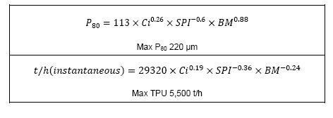
AMC 813001 : March : 2013
347
ENTRÉE GOLD INC Lookout Hill Property, Southern Mongolia Technical Report | |
| Table 16.13 | Average Plant Throughput Rates |
| Metallurgical Ore Type | Deposit | Throughput Rate | |
| t/d | Mt/a | ||
| 1 | Southwest (including South and Far South) | 97 | 32.7 |
| 2 | Central – Chalcocite | 132 | 44.3 |
| 3 | Central – Covellite | 132 | 44.5 |
| 4 | Central – Chalcopyrite | 119 | 40.1 |
| 6 | Hugo North | 119 | 40.1 |
The scheduling periods used for the production schedule are:
| · | Years 2012, 2013, and 2014 by month |
| · | Years 2015 to 2017 by quarters |
| · | 2018 and on, by year |
The following parameter values are carried in the detailed schedule:
| · | NSR $/t |
| · | Cu % |
| · | Au g/t |
| · | Ag g/t |
| · | As ppm |
| · | Throughput Hours per kt |
| · | F ppm |
| · | S % |
| · | Recovered Copper Grade % |
| · | Recovered Gold Grade % |
| · | SPI SAG Power Index |
| · | MB Modified Bond Index |
| · | CI rusher Index |
| · | P80 80% Passing microns |
| · | Fe % |
| · | Mo ppm |
| · | PAF % potentially acid forming (ore 100%, waste varies) |
AMC 813001 : March : 2013
348
ENTRÉE GOLD INC Lookout Hill Property, Southern Mongolia Technical Report | |
| 16.4.2 | Underground Production Schedule |
Ore production from the Hugo North Lift 1 split between the OT LLC and EJV ore is shown in Figure 16.51. The previous mine plan showed ore from EJV being mined by development in 2015. In the current mine plan OT LLC has revised the design and the block cave has moved to the south, resulting in a delay to development on the EJV property. The plan prepared by OT LLC now defers the development to 2019.
OT LLC plans to undertake engineering studies of expansion options in the continuing Feasibility Study for Oyu Tolgoi. This will include examining all production scenarios and associated expansion options. OT LLC plans a focused and structured review of the study work to be used in the capital approvals process as the operation developments. AMC believes that further design work could identify opportunities to improve project economics via cost reductions and mine plan optimization. This may result in further positive changes to the EJV development schedule that could bring first EJV ore forward relative to the current plan.
| Figure 16.51 | Total Underground Material Movement |

| 16.4.3 | Processing Schedule |
The processing schedule was balanced to meet the available mill hours after the underground material was processed. The ramp-up assumptions to full production are summarized in Table 16.14.
AMC 813001 : March : 2013
349
ENTRÉE GOLD INC Lookout Hill Property, Southern Mongolia Technical Report | |
| Tabe 16.14 | Process Ramp-up to Full Production |
| Month | Full Production (%) |
| Month 1 | 11 |
| Month 2 | 34 |
| Month 3 | 47 |
| Month 4 | 82 |
| Month 5 | 92 |
| Month 6 | 100 |
AMC 813001 : March : 2013
350
ENTRÉE GOLD INC Lookout Hill Property, Southern Mongolia Technical Report | |
The processing schedule by metallurgical ore type with the copper and gold feed grades are shown in Figure 16.52. Total concentrate production by ore type is shown in Figure 16.53. The recovered copper, gold, and silver production is in Figure 16.54 to Figure 16.56.
| Figure 16.52 | Ore Processing and Grade by Ore Type |
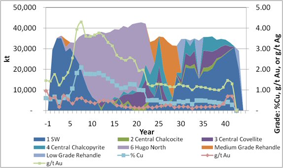
AMC 813001 : March : 2013
351
ENTRÉE GOLD INC Lookout Hill Property, Southern Mongolia Technical Report | |
| Figure 16.53 | Concentrate Production by Ore Type |

| Figure 16.54 | 2013 Reserve Case Copper Production |
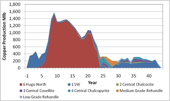
AMC 813001 : March : 2013
352
ENTRÉE GOLD INC Lookout Hill Property, Southern Mongolia Technical Report | |
| Figure 16.55 | 2013 Reserve Case Gold Production |
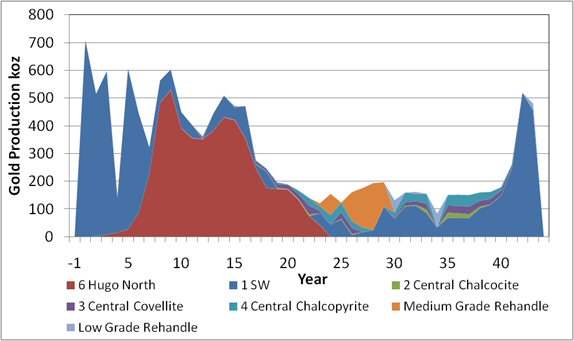
| Figure 16.56 | Total Silver Recovery |
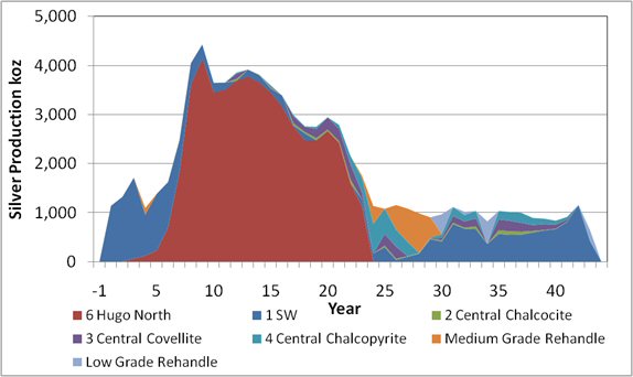
The total processing schedule is detailed in Table 16.15 and the EJV processing schedule is in Table 16.16.
AMC 813001 : March : 2013
353
ENTRÉE GOLD INC Lookout Hill Property, Southern Mongolia Technical Report | |
| Table 16.15 | 2013 Reserve Case Production Schedule Years -1 to 43 |
| Year | |||||||||||||||
| Description | Unit | Total | -1 | 1 | 2 | 3 | 4 | 5 | 6 | 7 | 8 | 9 | 10 | 11 | 12 |
| Open Pit Ore | Mt | 1,048 | 2 | 52 | 51 | 46 | 42 | 47 | 37 | 30 | 20 | 14 | 16 | 24 | 5 |
| Open Pit Waste | Mt | 1,905 | 55 | 58 | 59 | 64 | 64 | 63 | 72 | 41 | 21 | 26 | 24 | 16 | 35 |
| Total Open Pit | Mt | 2,953 | 57 | 110 | 110 | 110 | 106 | 110 | 110 | 71 | 41 | 40 | 40 | 40 | 40 |
| U/G Ore | Mt | 491 | – | – | 0.1 | 1 | 2 | 3 | 6 | 13 | 21 | 27 | 30 | 32 | 33 |
| Total Ore Mined | Mt | 1,539 | 2 | 52 | 51 | 47 | 44 | 50 | 44 | 42 | 41 | 40 | 46 | 56 | 38 |
| Re-handle | Mt | 189 | – | – | – | – | 4 | – | – | – | – | – | – | – | – |
| Total Material including Stockpiles | Mt | 3,142 | 57 | 110 | 110 | 110 | 110 | 110 | 110 | 71 | 41 | 40 | 40 | 40 | 40 |
| Total Process Feed | Mt | 1,539 | 1 | 30 | 35 | 36 | 35 | 33 | 33 | 36 | 37 | 37 | 36 | 37 | 38 |
| Parameter Values | NSR $/t | 47.17 | 33.15 | 48.33 | 37.46 | 44.18 | 20.49 | 41.62 | 40.41 | 56.05 | 98.23 | 112.81 | 95.25 | 92.37 | 91.17 |
| Cu % | 0.89 | 0.54 | 0.60 | 0.55 | 0.67 | 0.42 | 0.62 | 0.69 | 1.07 | 1.83 | 2.09 | 1.78 | 1.78 | 1.77 | |
| Au g/t | 0.34 | 0.43 | 0.96 | 0.59 | 0.65 | 0.18 | 0.73 | 0.54 | 0.35 | 0.57 | 0.61 | 0.47 | 0.41 | 0.36 | |
| Ag g/t | 2.03 | 1.10 | 1.45 | 1.43 | 1.76 | 1.24 | 1.57 | 1.85 | 2.55 | 3.95 | 4.29 | 3.61 | 3.60 | 3.67 | |
| Conc kt | 40,655 | 9 | 615 | 669 | 842 | 492 | 694 | 713 | 1,020 | 1,567 | 1,809 | 1,694 | 1,783 | 1,878 | |
| Con Cu % | 29.6 | 26.8 | 25.5 | 25.5 | 25.7 | 24.9 | 25.8 | 27.8 | 33.8 | 39.6 | 39.5 | 35.2 | 33.6 | 32.9 | |
| Con Au g/t | 9.4 | 18.4 | 35.8 | 23.9 | 22.0 | 9.3 | 27.1 | 17.3 | 9.6 | 10.8 | 10.0 | 7.9 | 6.7 | 5.8 | |
| Con Ag g/t | 65.0 | 51.3 | 57.6 | 61.6 | 63.3 | 69.3 | 62.0 | 72.7 | 77.2 | 81.5 | 77.1 | 67.7 | 64.5 | 64.7 | |
| Con As ppm | 1,712 | 272 | 243 | 478 | 1,016 | 678 | 392 | 658 | 1,068 | 1,153 | 854 | 728 | 828 | 1,405 | |
| Con F ppm | 301 | 251 | 317 | 301 | 298 | 217 | 261 | 215 | 235 | 266 | 283 | 298 | 324 | 345 | |
| Copper M lb | 26,486 | 5 | 346 | 376 | 476 | 271 | 395 | 437 | 761 | 1,369 | 1,575 | 1,314 | 1,320 | 1,360 | |
| Gold koz | 12,889 | 5 | 708 | 515 | 596 | 148 | 605 | 445 | 322 | 563 | 602 | 448 | 403 | 361 | |
| Silver koz | 83,001 | 15 | 1,140 | 1,324 | 1,714 | 1,096 | 1,383 | 1,626 | 2,480 | 4,053 | 4,436 | 3,652 | 3,658 | 3,861 | |
AMC 813001 : March : 2013
354
ENTRÉE GOLD INC Lookout Hill Property, Southern Mongolia Technical Report | |
| Year | |||||||||||||||||
| Description | Unit | 13 | 14 | 15 | 16 | 17 | 18 | 19 | 20 | 21 | 22 | 23 | 24 | 25 | 26 | 27 | 28 |
| Open Pit Ore | Mt | 32 | 8 | 7 | 6 | 10 | 8 | 10 | 24 | 18 | 27 | 10 | 7 | 24 | 12 | 4 | 6 |
| Open Pit Waste | Mt | 8 | 35 | 33 | 37 | 31 | 32 | 31 | 14 | 19 | 31 | 70 | 76 | 74 | 74 | 74 | 77 |
| Total Open Pit | Mt | 40 | 43 | 40 | 43 | 41 | 40 | 41 | 38 | 37 | 58 | 80 | 83 | 98 | 86 | 79 | 83 |
| U/G Ore | Mt | 3 | 33 | 33 | 33 | 32 | 32 | 32 | 33 | 28 | 20 | 14 | – | – | – | – | – |
| Total Ore Mined | Mt | 66 | 41 | 40 | 39 | 42 | 40 | 42 | 57 | 46 | 47 | 24 | 7 | 24 | 12 | 4 | 6 |
| Re-handle | Mt | – | – | – | – | – | – | – | – | – | – | 9 | 27 | 12 | 24 | 29 | 25 |
| Total Material including Stockpiles | Mt | 40 | 43 | 40 | 43 | 41 | 40 | 41 | 38 | 37 | 58 | 90 | 110 | 110 | 110 | 108 | 109 |
| Total Process Feed | Mt | 38 | 38 | 39 | 39 | 41 | 40 | 42 | 42 | 43 | 42 | 33 | 34 | 36 | 36 | 33 | 32 |
| Parameter Values | NSR $/t | 96.60 | 94.67 | 89.81 | 83.28 | 63.27 | 54.60 | 55.38 | 63.46 | 61.87 | 47.69 | 44.54 | 23.46 | 22.55 | 23.88 | 21.65 | 20.01 |
| Cu % | 1.82 | 1.71 | 1.55 | 1.42 | 1.22 | 1.09 | 1.12 | 1.29 | 1.27 | 1.00 | 0.99 | 0.50 | 0.51 | 0.50 | 0.43 | 0.35 | |
| Au g/t | 0.45 | 0.51 | 0.45 | 0.46 | 0.26 | 0.24 | 0.18 | 0.17 | 0.15 | 0.13 | 0.15 | 0.19 | 0.15 | 0.19 | 0.22 | 0.26 | |
| Ag g/t | 3.77 | 3.62 | 3.31 | 3.14 | 2.69 | 2.54 | 2.44 | 2.56 | 2.42 | 1.93 | 1.98 | 1.30 | 1.20 | 1.29 | 1.28 | 1.25 | |
| Conc kt | 1,879 | 1,849 | 1,770 | 1,704 | 1,540 | 1,378 | 1,444 | 1,676 | 1,659 | 1,330 | 1,086 | 603 | 617 | 603 | 492 | 377 | |
| Con Cu % | 33.3 | 32.3 | 31.4 | 29.8 | 29.1 | 28.3 | 29.0 | 29.1 | 29.2 | 27.7 | 26.8 | 23.8 | 24.2 | 24.3 | 24.0 | 24.1 | |
| Con Au g/t | 7.1 | 8.3 | 8.0 | 8.3 | 5.4 | 5.3 | 4.1 | 3.4 | 3.0 | 3.1 | 3.5 | 8.0 | 6.4 | 8.3 | 10.9 | 15.6 | |
| Con Ag g/t | 65.6 | 64.9 | 64.1 | 62.8 | 61.2 | 63.2 | 60.0 | 55.3 | 53.2 | 51.7 | 51.8 | 60.9 | 57.3 | 60.6 | 69.7 | 82.7 | |
| Con As ppm | 1,277 | 1,357 | 1,425 | 1,305 | 1,747 | 1,500 | 2,012 | 2,339 | 2,582 | 2,366 | 2,362 | 4,306 | 4,630 | 3,791 | 2,880 | 662 | |
| Con F ppm | 344 | 349 | 356 | 374 | 367 | 332 | 298 | 321 | 352 | 361 | 407 | 268 | 269 | 260 | 240 | 196 | |
| Copper M lb | 1,380 | 1,316 | 1,226 | 1,121 | 987 | 859 | 922 | 1,075 | 1,067 | 811 | 641 | 317 | 329 | 323 | 260 | 201 | |
| Gold koz | 443 | 509 | 470 | 470 | 275 | 245 | 195 | 188 | 166 | 139 | 120 | 154 | 122 | 160 | 175 | 193 | |
| Silver koz | 3,924 | 3,819 | 3,602 | 3,393 | 2,995 | 2,762 | 2,754 | 2,949 | 2,794 | 2,158 | 1,760 | 1,136 | 1,078 | 1,155 | 1,083 | 987 | |
Note: Minor figure differences may occur due to rounding errors.
AMC 813001 : March : 2013
355
ENTRÉE GOLD INC Lookout Hill Property, Southern Mongolia Technical Report | |
| Year | ||||||||||||||||
| Description | Unit | 29 | 30 | 31 | 32 | 33 | 34 | 35 | 36 | 37 | 38 | 39 | 40 | 41 | 42 | 43 |
| Open Pit Ore | Mt | 18 | 18 | 35 | 31 | 35 | 16 | 36 | 36 | 36 | 34 | 35 | 34 | 33 | 31 | 20 |
| Open Pit Waste | Mt | 79 | 75 | 75 | 49 | 53 | 27 | 30 | 34 | 32 | 26 | 28 | 29 | 26 | 20 | 7 |
| Total Open Pit | Mt | 97 | 94 | 110 | 80 | 88 | 42 | 66 | 70 | 68 | 60 | 63 | 63 | 59 | 51 | 27 |
| U/G Ore | Mt | – | – | – | – | – | – | – | – | – | – | – | – | – | – | – |
| Total Ore Mined | Mt | 18 | 18 | 35 | 31 | 35 | 16 | 36 | 36 | 36 | 34 | 35 | 34 | 33 | 31 | 20 |
| Re-handle | Mt | 13 | 16 | – | 3 | – | 18 | – | – | – | – | – | – | – | – | 9 |
| Total Material including Stockpiles | Mt | 110 | 110 | 110 | 83 | 88 | 61 | 66 | 70 | 68 | 60 | 63 | 63 | 59 | 51 | 36 |
| Total Process Feed | Mt | 31 | 35 | 35 | 34 | 35 | 34 | 36 | 36 | 36 | 34 | 35 | 34 | 33 | 31 | 29 |
| Parameter Values | NSR $/t | 20.08 | 16.95 | 22.03 | 20.83 | 22.86 | 14.65 | 23.70 | 23.75 | 23.33 | 21.37 | 20.56 | 19.27 | 20.95 | 32.92 | 42.73 |
| Cu % | 0.36 | 0.34 | 0.44 | 0.41 | 0.47 | 0.31 | 0.49 | 0.49 | 0.48 | 0.43 | 0.41 | 0.37 | 0.35 | 0.42 | 0.28 | |
| Au g/t | 0.27 | 0.17 | 0.19 | 0.20 | 0.19 | 0.11 | 0.18 | 0.18 | 0.18 | 0.20 | 0.20 | 0.23 | 0.34 | 0.70 | 0.69 | |
| Ag g/t | 1.16 | 1.15 | 1.28 | 1.20 | 1.18 | 1.01 | 1.17 | 1.14 | 1.11 | 1.05 | 1.02 | 0.99 | 1.13 | 1.46 | 1.30 | |
| Conc kt | 372 | 389 | 509 | 461 | 542 | 363 | 586 | 592 | 592 | 500 | 494 | 440 | 389 | 445 | 189 | |
| Con Cu % | 24.3 | 24.1 | 24.5 | 24.4 | 24.3 | 23.4 | 24.2 | 24.1 | 23.9 | 23.7 | 23.3 | 23.1 | 23.6 | 24.8 | 27.8 | |
| Con Au g/t | 16.4 | 10.1 | 9.4 | 11.0 | 8.6 | 8.2 | 7.8 | 7.8 | 7.8 | 10.8 | 10.2 | 12.6 | 19.9 | 34.4 | 43.8 | |
| Con Ag g/t | 80.0 | 81.3 | 72.7 | 72.1 | 62.5 | 75.2 | 59.1 | 58.6 | 58.2 | 62.8 | 62.4 | 64.4 | 77.9 | 88.8 | 98.8 | |
| Con As ppm | 930 | 2,180 | 3,337 | 2,852 | 3,242 | 1,568 | 3,421 | 3,368 | 3,167 | 2,569 | 2,685 | 2,363 | 1,234 | 351 | 329 | |
| Con F ppm | 185 | 183 | 213 | 207 | 231 | 170 | 239 | 242 | 250 | 237 | 241 | 230 | 198 | 222 | 125 | |
| Copper M lb | 199 | 207 | 274 | 248 | 291 | 187 | 313 | 315 | 312 | 261 | 254 | 224 | 202 | 244 | 116 | |
| Gold koz | 196 | 131 | 159 | 161 | 154 | 83 | 150 | 151 | 150 | 159 | 161 | 178 | 259 | 519 | 480 | |
| Silver koz | 904 | 965 | 1,114 | 1,017 | 1,033 | 822 | 1,033 | 1,014 | 994 | 891 | 876 | 836 | 913 | 1,157 | 646 | |
Note: Minor figure differences may occur due to rounding errors.
AMC 813001 : March : 2013
356
ENTRÉE GOLD INC Lookout Hill Property, Southern Mongolia Technical Report | |
| Table 16.16 | EJV Reserve Case Production Schedule Years -1 to 19 |
| Total/Year | -1 | 1 | 2 | 3 | 4 | 5 | 6 | 7 | 8 | 9 | 10 | 11 | 12 | 13 | 14 | 15 | 16 | 17 | 18 | 19 | |
| Mt | 31.12 | – | – | – | – | – | – | – | 0.04 | 0.20 | 0.20 | – | 0.44 | 0.17 | 029 | 1.58 | 5.37 | 9.51 | 8.35 | 4.42 | 0.56 |
| NSR $/t | 95.34 | – | – | – | – | – | – | – | 3.77 | 15.40 | 39.43 | – | 28.01 | 27.33 | 93.84 | 143.46 | 142.03 | 107.60 | 78.22 | 51.93 | 30.42 |
| Cu % | 1.73 | – | – | – | – | – | – | – | 0.23 | 0.62 | 1.58 | – | 1.20 | 1.01 | 2.14 | 2.57 | 2.45 | 1.91 | 1.44 | 1.00 | 0.60 |
| Au g/t | 0.62 | – | – | – | – | – | – | – | 0.01 | 0.26 | 0.58 | – | 0.32 | 0.47 | 1.13 | 1.18 | 1.05 | 0.70 | 0.41 | 0.23 | 0.12 |
| Ag g/t | 3.74 | – | – | – | – | – | – | – | 0.52 | 1.40 | 3.62 | – | 2.79 | 2.51 | 4.94 | 5.74 | 5.54 | 4.26 | 2.87 | 1.92 | 1.11 |
| Conc kt | 1,472 | – | – | – | – | – | – | – | 0.4 | 4 | 9 | – | 17 | 6 | 17 | 100 | 320 | 483 | 353 | 150 | 13 |
| Con Cu% | 33.5 | – | – | – | – | – | – | – | 17.5 | 26.7 | 32.0 | – | 28.3 | 26.7 | 34.2 | 37.4 | 38.1 | 34.4 | 30.9 | 26.2 | 21.4 |
| Con Au g/t | 10.6 | – | – | – | – | – | – | – | 0.8 | 9.7 | 10.3 | – | 6.7 | 10.8 | 15.8 | 15.0 | 14.2 | 11.0 | 7.8 | 5.4 | 3.9 |
| Con Ag g/t | 68.9 | – | – | – | – | – | – | – | 38.7 | 57.9 | 69.6 | – | 62.9 | 63.7 | 75.0 | 79.4 | 81.8 | 73.2 | 58.5 | 48.1 | 37.8 |
| Con As ppm | 478 | – | – | – | – | – | – | – | 1,408 | 556 | 843 | – | 992 | 952 | 932 | 844 | 593 | 421 | 361 | 306 | 406 |
| Con F ppm | 347 | – | – | – | – | – | – | – | 130 | 140 | 256 | – | 279 | 218 | 226 | 276 | 326 | 367 | 376 | 349 | 307 |
| Copper M lb | 1,090 | – | – | – | – | – | – | – | 0 | 2 | 6 | – | 10 | 3 | 13 | 83 | 269 | 368 | 241 | 87 | 6 |
| Gold koz | 521 | – | – | – | – | – | – | – | 0 | 1 | 3 | – | 4 | 2 | 9 | 51 | 153 | 178 | 92 | 27 | 2 |
| Silver koz | 3,229 | – | – | – | – | – | – | – | 0 | 7 | 20 | – | 34 | 12 | 40 | 254 | 833 | 1,126 | 659 | 229 | 16 |
Note: Minor figure differences may occur due to rounding errors.
AMC 813001 : March : 2013
357
ENTRÉE GOLD INC Lookout Hill Property, Southern Mongolia Technical Report | |
| 17 | RECOVERY METHODS |
| 17.1.1 | Introduction |
The Oyu Tolgoi processing plant will commence operation with two grinding lines and two flotation lines. This is sufficient for processing ore arising from the Southwest open pit. However, when Hugo North Lift 1 is developed and comes on-line a third grinding line is necessary to process the additional ore.
As the copper mineralogy changes so does the concentrate grade that can be generated and the recoveries that are expected. This complexity has led to a set of equations describing grades and recoveries for the various ore types and for copper, gold, and silver.
These equations have been used as part of the mine planning process and are consequently inherent in the 2013 Reserve Case ore delivery schedule. Equipment selection has been based around the design criteria and the duty as determined through the ore delivery schedule.
| 17.1.2 | 2013 OTTR Metallurgical Parameters |
The metallurgical parameters used for the mine planning were issued in Base Data Template 29. The relevant metallurgical data and formulae are shown in Table 17.1 to Table 17.5. These parameters were used for the 2013 Mineral Reserve estimate.
The parameters used for Hugo North were applied to all Hugo North including the Entrée (Shivee Tolgoi) ore. Although only limited testwork has been carried out on the EJV area it is considered that the results indicate the Entrée area is similar to the rest of Hugo North.
The throughput rate algorithm is as used in IDOP and was developed by SGS from regression analysis of CEET simulation runs for 30,000 SW blocks over Years 1 to 30 and the SGS database of projects. This formula was applied to all the blocks in the mining model and used for production scheduling.
AMC 813001 : March : 2013
358
ENTRÉE GOLD INC Lookout Hill Property, Southern Mongolia Technical Report | |
| Table 17.1 | Base Data Template 29 Copper Recovery |
| All Ores | ||||
| a*[(b*Cu)/(1+b*Cu)] * [1–exp(–b*Cu )] | ||||
| Southwest | Central Chalcocite | Central Covellite | Central Chalcopyrite | Hugo North |
| a = 98 | a = 82 | a = 85 | a = 98 | a = 95 |
| b = 14.5 | b = 15 | b = 15 | b = 12.2 | b = 15 |
| Table 17.2 | Base Data Template 29 Gold Recovery |
| Southwest Ore | All Other Ores |
| 6.8 + 0.8 * (Cu Recovery) | 9.8 + 0.8 * (Cu Recovery) |
| Table 17.3 | Base Data Template 29 Silver Recovery |
| All Ores |
| 13 + 0.8 * (Cu Recovery) |
| Table 17.4 | Base Data Template 29 Copper in Concentrate |
| Southwest | Central Chalcocite and Covellite | Central Chalcopyrite | Hugo North |
–3.6 * (Cu:S)2 + (12.8 * Cu:S) + 21 | 25 | –3.6 * (Cu:S)2 + (12.8 * Cu:S) + 22.5 | 2.9 * (Cu) + (11.4 * Cu:S) + 15.3 |
AMC notes that the algorithm for the prediction of arsenic levels in the Central concentrate has been updated in order to reflect the varying proportion of enargite in the Central ore types.
| Table 17.5 | Base Data Template 29 Arsenic in Concentrate |
| Central Chalcocite, Covellite, and Chalcopyrite | Southwest and Hugo North |
| 0.7837 * (%Cu in conc/%Cu in feed) * As in feed (ppm) | 55 + 20.6 * As in feed (ppm) |
The throughput rate algorithm shown in Table 17.6 was developed by SGS from these relationships and the SGS database of projects. This formula was applied to all the blocks in the mining model and used for production scheduling.
| Table 17.6 | Plant Throughput Rates |
P80=113 * Ci0.26 * SPI-0.60 * BM0.88 |
max P80 220 µm |
t/h (instantaneous)=29320 * Ci0.19 * SPI -0.36 * BM -0.24 |
max throughput = 5,500 t/h |
AMC 813001 : March : 2013
359
ENTRÉE GOLD INC Lookout Hill Property, Southern Mongolia Technical Report | |
| 17.1.3 | Metallurgical Predictions |
The metallurgical predictions for throughput, metal recovery and concentrate grade have been modeled by experts in their field and validated through peer review.
| 17.1.3.1 | Throughput Modeling |
60” x 113” FFE Primary Gyratory Crusher – FFE Model
The 60” x 113” Primary Crusher throughput estimate was based on a FLSmidth model and is provided in their September 2006 Performance Warranty. The ROM blasting requirement and primary crusher feed size was taken from Scott Mine Consulting Services – Blasting Requirements for the Oyu Tolgoi Open Pits 15NOV04 report.
The crusher work index was based on laboratory scale testwork conducted at Lakefield Research and AMMTEC.
| · | t/h = 4,880 (with crusher work index of 19.9 kWh/t and F80,500 mm, throughput range 4,250 to 5,350 t/h). Fluor design criteria = 5,293 t/h. |
| · | P80 = 152 mm (range 140–152 mm). |
SAG, Pebble Crusher, and Ball Mills – SGS CEET Model
SGS’s CEET model was used to predict throughput based on laboratory scale ore characterization carried out at Lakefield Research and AMMTEC. The CEET model predictions were verified by JKSimMet modeling and pilot plant testwork. The geostatistical block model was populated with the hardness values to predict throughput by ore type and mining period. The throughput and grind algorithms applied to the block model are shown above in Table 17.6.
OT LLC concluded that the SGS predictions were justified and used their predictions in the 2013 Reserve Case model.
| 17.1.3.2 | Flotation Modeling |
Optimum Primary Grind
In IDP05, primary grind size determination analysis was carried out for each of the production-period composites from the Southwest, Hugo South, and Hugo North deposits and the ore-type composites from the Central deposit. In 2007, Aminpro validated the primary grind sizes of the existing ore types, and made additional predictions for the new HN-SLC and Entrée reserves. The criterion for P80 selection was the size that resulted in the highest project net present value (NPV).
The plant design is based on the optimum grind of Southwest and Hugo North. With the power requirement set to achieve an optimum grind, throughput-grind trade-offs were conducted through optimizing production scheduling.
AMC 813001 : March : 2013
360
ENTRÉE GOLD INC Lookout Hill Property, Southern Mongolia Technical Report | |
| Table 17.7 | Optimum Primary Grind Size for Each Ore Type (P80) |
| Deposit/Composite | IDP05 | Aminpro 2007 |
| Southwest | 180 | 180 |
| Hugo South | 150 | – |
| Hugo North | 140 | 116 |
| Central (average) | 138 | 179 |
| SLC (average) | – | 125 |
| Entrée (average) | – | 133 |
Another review of optimum grinds was conducted by OT LLC and AMEC in 2011 using updated metal prices and head grades.
The primary source document for capacity prediction for the current grinding circuit is SGS Mineral Services’ “Comminution Section for Oyu Tolgoi June 2007 IDP,” which states that the grinding circuits will be SAG-mill limited for 75% of the time with Southwest ore. SGS predicted that capacity could be increased by another 4,000 t/d in this period by increasing closing screen aperture from the current design of 13 mm to 17 mm, and by another 3,500 t/d by increasing ball charge from 15% to 17%. The net 7,000 t/d increase, if achieved as modelled, would be sufficient to meet the 96,000 t/d average in Years 1 to 3 after the initial ramp-up.
In the current study, it is considered unrealistic to expect a new plant with 80% to 90% national hire of generally inexperienced personnel to operate so closely to the design limits of a grinding circuit immediately after the initial ramp-up. The mill shell is structurally capable of accepting a 20% ball charge, but measurements are imprecise, and caution is recommended until media wear and liner wear are predictable and instrumentation is known to be reliable by field calibration on each shutdown and grind-out. Despite the advantages in terms of NPV and IRR, it is unusual to promote a base case in which a plant is run over the nominal capacity so soon after start-up.
At present, however, the design criteria have a design volumetric limit of 110,000 t/d for the two-line concentrator. Because the SAG mills are not power-limited on Central ore, it is expected that this tonnage can be processed in 2025 after 13 years of operating experience on the Phase 1 circuits. When the available SAG power is not a limitation, it is possible to use the upset flow volumetric design point of 60,000 t/d for a single SAG mill. The volumetric flows in grinding and flotation in 2025 fall within design limits when ball mill cyclone feed and overflow densities are increased by about 3% solids so that the circulating loads are decreased and the grind is coarsened from 180 to 200–210 μm.
AMMTEC estimated the lost operating margin by coarsening a 180 μm grind to 200 μm at $0.12/t for Central covellite ore and $0.50/t for Central chalcocite ore. It will clearly be cash flow positive to mill the additional tonnage available from the mine schedule. Since the capital costs for Phase 1 are effectively sunk, these losses will be taken into account when considering overall project NPV and the overall capacity of Phases 1 and 2 in the feasibility study. A further round of primary grind optimization will be undertaken on Hugo North, Southwest, and Central ores based on updated economic parameters from the control estimate and the latest project metal price forecasts.
AMC 813001 : March : 2013
361
ENTRÉE GOLD INC Lookout Hill Property, Southern Mongolia Technical Report | |
Optimum Regrind Size
A metallurgical prediction of the optimum regrind size was carried out for IDP05, by AAJV and later data analysis was carried out by AMEC Minproc and Aminpro. The grind size was further reviewed in 2011 by OT LLC. The optimum regrind size is based on a recovery-concentrate grade trade-off, and the production of a saleable concentrate including impurities.
| Table 17.8 | Optimum Regrind Size (P80µm) |
| Deposit/Composite | IDP05* | AMEC Minproc | Aminpro 2007** | OT LLC |
| Southwest | 25 | 25 | 45 | 30 |
| Central | 25 | – | – | 30 |
| Hugo North | 25 | 30 | 45 | 30 |
| Hugo South | 25 | – | – | – |
* Production composite sample of Southwest, Central, Hugo North and Hugo South.
**Production composite modeling of 2008 production schedules.
Aminpro’s prediction of the number of regrind mills for the 96,000 tpd Phase I plant is four to six VM 1500 HP mills and this will achieve Aminpro’s target regrind sizes. AMEC Minproc’s prediction is eight mills based on the finer regrind sizes. AMEC Minproc has estimated that four regrind mills will be capable of achieving average regrind P80 values of 37 to 40 µm.
Crescent Technologies Inc., the Owner’s project management consultant for the concentrator design, requested Owner’s input to the design criteria. The expansion study team carried out a review of past work and commissioned additional QEM. SCAN work on Southwest and Hugo North composites. It was concluded that a 30 μm regrind would initially require six mills and would yield a payback of one year, based on improved grade/recovery response and reduced fluorine penalties. An analysis of past variability testwork also indicated wide scatter around the mean value for fluorine recovery used in the mine model to predict fluorine in concentrate at a given regrind level. Regrind to 30 μm would yield a 20% reduction in mean fluorine content relative to a 40 μm regrind and would reduce the concentrate storage and blending requirements needed to avoid occasional rejections on shipments above 1,000 ppm. The work is reported in an OT LLC memorandum, with accompanying spreadsheets and Powerpoint presentation (“Review of the optimum regrind level and the initial number of regrind mills to be installed for processing of Oyu Tolgoi’s Southwest Orebody,” 14 June 2010).
| 17.1.4 | Flow Sheet Development |
Flow sheet development began with IDP05 for a 70,000 tpd concentrator capable of producing 1,900 tpd of concentrate. IDP05 also included a Phase II 85,000 tpd concentrator. In 2008, the plant’s processing rate was increased to 96,000 tpd with a concentrate production rate of 2,850 tpd.
AMC 813001 : March : 2013
362
ENTRÉE GOLD INC Lookout Hill Property, Southern Mongolia Technical Report | |
| 17.1.4.1 | Comminution |
IDP05
Laboratory-scale hardness testwork was conducted at MinnovEX and AMMTEC. In addition, a SAG pilot-plant test program was carried out at SGS-Lakefield. Circuit simulation work was conducted with CEET and JKSimmet. Details of the testwork and modeling are provided in IDP05. Figure 17.1 provides the overall IDP05 comminution testwork plan.
| Figure 17.1 | Overall IDP05 Comminution Testwork Plan |
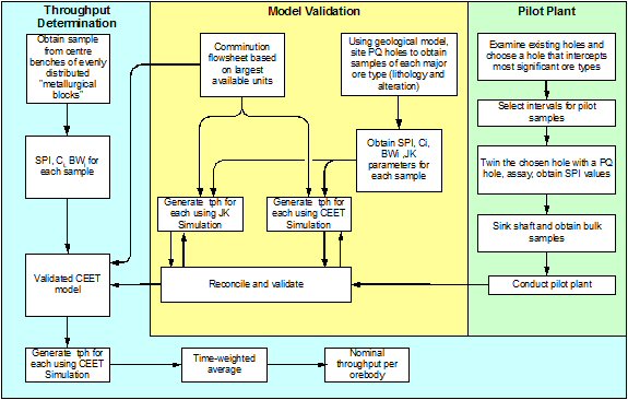
Figure 17.2 and Figure 17.3 are a summary of the ore hardness frequency distributions for Southwest, Hugo North, Central, and Hugo South.
AMC 813001 : March : 2013
363
ENTRÉE GOLD INC Lookout Hill Property, Southern Mongolia Technical Report | |
| Figure 17.2 | Cumulative Frequency Distribution of SPI Values Over the Southwest, Central, and Hugo Deposits(2003 to 2005 Testwork Program) |
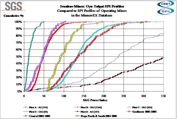
AMC 813001 : March : 2013
364
ENTRÉE GOLD INC Lookout Hill Property, Southern Mongolia Technical Report | |
| Figure 17.3 | Cumulative Frequency Distribution of BWI Values Over the Southwest, Central, and Hugo Deposits(2003 to 2005 Testwork Program) |
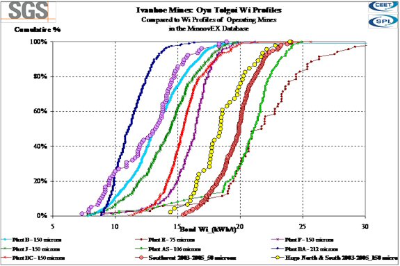
After running the CEET model with a number of circuit alternatives, the optimum IDP05 grinding flow sheet was based on a single SAG line utilizing the largest commercially proven mills, with secondary and pebble crushers, and utilized the maximum installed power. Subsequent testwork and simulation was performed to validate the choice and predict the throughput at the desired primary grind for the different ore deposits.
Production Scheduling and Geostatistics on Ore Hardness Data
SGS Minerals Services conducted a geostatistical study of the grindability data from the Southern area of the Project comprising the Projected open pit areas known as Southwest, South, Central and the Wedge (between Southwest and South). The geostatistical study was conducted by Michel Dagbert of Geostats International in conjunction with Ivanhoe geologist, Stephen Torr, who had already conducted his own study. The hardness data was distributed to each mine block and annual mining periods according to the details of the geological and mine plans.
For the Southern Open Pit area, 219 useable samples that were tested for SPI, Bond Work Index and Crusher Index measurements were available for the geostatistics study. These 219 samples were used to estimate 59,661 ore reserve blocks, representing a total tonnage of about 930 Mt. It was found that the grindability values could be attributed to most blocks with reasonable precision.
AMC 813001 : March : 2013
365
ENTRÉE GOLD INC Lookout Hill Property, Southern Mongolia Technical Report | |
The geostatistical study determined hardness SPI and BWi values for each year of processing the ore. In this manner, the throughput and grind was determined by production period.
Flow Sheet – 96,000 tpd Concentrator
Development of the Phase I flow sheet was conducted with the same laboratory ore hardness data from Southwest and Hugo North.
In November 2005, the comminution circuit was changed to a conventional SABC and documented in Fluor’s 2005 Review and Strategic Plan (RSP); Technical Decision Memorandum, TDM003. This change led to the removal of secondary crushing and increased the 40’ SAG mill motor from 24.6 MW to 28 MW. The decision reduced capital cost and increased revenue. It was also felt that the conventional SABC was a lower production risk to the less conventional secondary crushing SAG circuit. This decision was made after IDP05, and maintained the plant capacity at 70,000 tpd.
In October 2006, a decision was made to increase the plant capacity from 70,000 tpd to 96,000 tpd. The increase in plant capacity led to a second change in circuit configuration documented in Fluor’s PCN 21. The circuit remained as a SABC but changed from a single grinding line to a dual grinding line. This change increased the throughput rate and capital cost, and also the revenue and economic benefit. Additionally, it was felt that a second grinding line would also reduce the production risk through increased equipment redundancy.
The above changes were modelled and again optimized by running CEET. The new optimum flow sheet consists of two SAG mills in parallel, as shown in Figure 17.4. The two SAG mills are each 38 ft diameter and most of the simulations conducted to date have assumed a 21 ft EGL mill drawing peak power of 18.2 MW and maximum sustainable power (over periods of a few hours on hard ore) of 17.25 MW. (The SAG mills are assumed to have 20 MW motors with a service factor of 1.0.) The four ball mills have been assumed to draw a total of 43.3 MW (10.83 MW each) with two 5.7 MW motors per mill (11.4 MW total installed power per mill, 45.6 MW installed power for four mills) with motor service factors of 1.0.
AMC 813001 : March : 2013
366
ENTRÉE GOLD INC Lookout Hill Property, Southern Mongolia Technical Report | |
| Figure 17.4 | Grinding Circuit Flow Sheet |
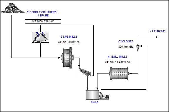
Predictions for Hugo North, Hugo South, and Entrée
The results from the geostatistical distribution of the grindability data from the Southern open pit areas and the CEET block output for each of the 59,661 ore blocks were used to establish useful correlations between SPI, Ci and BWI and predicted tph and P80 for the specific 2-line grinding circuit option, as described above.
For initial prediction purposes, these correlations present a rapid means of tph and P80 estimation for Hugo North (SLC S1, S2 and S3), Hugo South and Entrée samples for production forecasting purposes, prior to additional testwork and geostatistics being completed on these deposits.
Again, the throughput and grind by period were determined with the geostatistical block model populated with the ore characterization hardness data.
AMC 813001 : March : 2013
367
ENTRÉE GOLD INC Lookout Hill Property, Southern Mongolia Technical Report | |
Equipment Requirements
A comparison of the IDP05 and IDOP flow sheet equipment is provided in Table 17.9.
| Table 17.9 | Flow Sheet Equipment Comparison |
| Flow Sheet | IDP05 | IDOP |
| Phase I | Phase I | |
| Ore, ‘000 t/d | 70 | 96 |
| Feed Grade, %Cu | 0.67 | 0.66-2.28 |
| Primary Crusher | 1 | 1 |
| 1.52 m x 2.26 m gyratory, 600 kW | 1.52 m x 2.87 m gyratory, 746 kW | |
| Secondary Crusher | 2 | – |
| MP1000; 746 kW | – | |
| SAG Mill | 1 | 2 |
| 12.2 m dia x 7.47; 24.6 MW | 11.6 m dia x 6.9 m, 20 MW | |
| Pebble Crusher | 2 | 3 |
| MP1000; 746 kW | ||
| Ball Mill | 2 | 4 |
| 8.2 m dia x 13.1 m, 18.6 MW | 7.3 m dia x 11 m, 11.4 MW | |
| Rougher Flotation | 2 x 7 | 4 x 8 |
160 m3 Tank Cells | ||
| Regrind Mill | 4 | 6 - 8 |
| Vertimill VTM 1500, 1119 kW | ||
| Cleaner Flotation | 2 x 4 | 3 x 4 |
160 m3 Tank Cell | ||
| Cleaner Scavenger Flotation | 2 x 4 | 3 x 4 |
160 m3 Tank Cell | ||
| Column Flotation | 4 | 4-8 |
| 4.5m dia x 14m Column Cell | 5.5 m dia x 16m Column Cell | |
| Con. Thickeners | 2 | 2 |
| 20 m dia High Rate | ||
| Concentrate Filters | 2 | 2-3 |
144 m2 Pressure Filter | ||
| Tails Thickeners | 2 | 2 |
| 125 m dia Conventional | 85 m dia High Compression | |
AMC 813001 : March : 2013
368
ENTRÉE GOLD INC Lookout Hill Property, Southern Mongolia Technical Report | |
| 17.1.4.2 | Flotation |
IDP05
The IDP05 flotation flow sheet was developed based on the metallurgical test program conducted between 2001-2005 at SGS-Lakefield and AMMTEC. The results from locked-cycle tests were analyzed to derive kinetic data, and modified flotation tests (MFT) were performed on the seven production-period composites from the Southwest deposit for MinnovEX’s FLEET simulator. MinnovEX also performed rougher-cleaner tests, based on a single-stage rougher and three-stage cleaner circuit, and used FLEET to determine cleaner kinetics. Conventional and Column Pilot Scale tests on Southwest and Hugo North verified the FLEET results.
| ● | Rougher flotation – three banks of seven 160 m3 cells, 26 minute residence time. |
| ● | Regrind – (4) VTM 1500, P80 25 µm. |
| ● | First cleaner – two banks of four 160 m3 cells, 28 minute residence time. |
| ● | Cleaner scavenger – two banks of four, 160 m3 cells, 34 minute residence time. |
| ● | Recleaner columns – four columns, each 4.5 m diameter, 22 minute residence time. |
Details of the metallurgical testing program and FLEET modeling are provided in IDP05 Appendix 10.A.
2009 Startup Flow Sheet
Amelunxen Mineral Processing (Aminpro) also reviewed and validated the MinnovEX flow sheet and equipment. Aminpro established flotation kinetics from the original AMMTEC locked-cycle testwork on the seven production-period composites, and the additional 2006 cleaner tests conducted at SGS. The Aminpro-Flot Simplex (AFS) model was based on rougher and cleaner kinetics derived from standard laboratory testwork and was calibrated to laboratory locked cycle testwork (LCT). The resultant kinetics indicated lower rate constants than those developed by MinnovEX. Slower kinetics lead to an increase in the size of the flotation circuit.
The AFS model was set up to treat a nominal plant feed of 100,000 t/d. The number of rows and cells per row were determined through trials observing the performance of the circuit and measuring the outcome by estimating the Net Smelter Return on a per-ton of feed basis. This approach led to the formulation of a circuit that operated at the highest economic returns.
Aminpro recommended an identical flow sheet to IDP05 with the following equipment:
| ● | Three rows of eight 160 m3 roughers. |
| ● | Four regrind vertimills, 45 µm grind. |
| ● | Two rows of four 160 m3 first cleaner cells. |
| ● | Two rows of four 160 m3 cleaner-scavenger cells. |
| ● | Four 5.5 m diameter x 16 m cleaner columns. |
AMC 813001 : March : 2013
369
ENTRÉE GOLD INC Lookout Hill Property, Southern Mongolia Technical Report | |
Aminpro confirmed that the flow sheet proposed by MinnovEX is both adequate and robust and will handle large fluctuations in ore grades and tonnages. The AFS model was used for development of the 2009 flotation flow sheet, equipment requirements, and mass balance, and also to validate the metallurgical predictions and production schedule.
After Fluor’s design review of the 2009 flow sheet, an additional row of roughers and an additional row of cleaners and cleaner scavengers was added to the flow sheet for hydraulic constraint reasons. The 2009 flow sheet major equipment is provided below, and the 2009 flow sheet is provided in Figure 17.5:
| ● | Rougher flotation – four banks of eight 160 m3 cells, 25 minute residence time. |
| ● | Regrind – four VTM 1500, 45 µm regrind. |
| ● | First cleaner – three banks of four 160 m3 cells, 12 minute residence time. |
| ● | Cleaner scavenger – three banks of four, 160 m3 cells, 14 minute residence time. |
| ● | Recleaner columns – four columns, each 5.5 m diameter. |
Start-up Flowsheet
The flowsheet is shown in Figure 17.5 and is the same as the 2009 circuit but with the addition of two more VTM 1500 regrind mills to achieve a 30 µm sizing for new feed to the cleaning circuits, as described in Section 17.1.3.2. The additional liberation minimizes the potential for rejection of concentrate due to fluorine content beyond the specification for import and allows for a reduction in circulating load around the cleaning circuits. This reduction will allow higher head grades to be treated than those in the current design, which will increase the amount of Hugo North ore that can be processed before the cleaning circuits require additional banks of cells.
| Figure 17.5 | Flow Sheet |
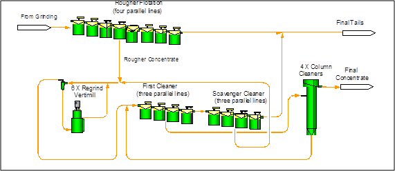
OT LLC has reviewed the circuit proposed by Aminpro and Fluor and found it to be adequate to achieve the design criteria at plant startup.
AMC 813001 : March : 2013
370
ENTRÉE GOLD INC Lookout Hill Property, Southern Mongolia Technical Report | |
| 17.1.5 | Further Work |
A Feasibility Study will be conducted to determine the requirements and costs of the concentrator expansion to add a third grinding line and increase plant production by approximately 60,000 t/d. The work will include an analysis of comminution options and further characterization of the ore types from the various deposits. The aspects to be investigated are listed below.
| 17.1.5.1 | Plant Design/Production Scheduling |
Throughput/Comminution:
| · | Phase 2 160,000 t/d design criteria. |
| · | Additional HN ore hardness characterization/representation. |
| · | Estimation of the optimum primary grind using the economic model parameters, CEET, FLEET, and liberation data. |
| · | Estimation of the optimum SAG mill/ball mill power split. |
| · | Primary crusher feed size (blasting) and product size (OSS) optimization, together with SAG feed size optimization (CEET). |
Roughers
| · | Collector, frother, and pH optimization |
| · | Blending opportunities – Southwest with Hugo North |
| · | Arsenic/enargite depression testwork on high As zones (Hugo North and Central) |
| · | FLEET modelling |
Cleaners
| · | Hugo North regrind size and cleaner kinetics optimization. |
| · | Optimization of fluorine liberation and rejection. |
| · | Arsenic/enargite depression testwork on high As zones (Hugo North and Central). |
| · | FLEET modelling for cleaner and cleaner-scavenger sizing optimization. |
| · | Circuit reconfiguration to use excess SW cleaner capacity to treat high-grade ore. |
| · | Update locked-cycle versus open circuit cleaner performance. |
General
| · | Simulation of process water quality. |
| · | Impact of reclaim water (process + raw water) on flotation performance. |
| · | Refinement of the metallurgical performance algorithms in the block model. |
| · | Extended variability work on HN composites in conjunction with block cave schedule. |
| · | Production of additional tailings samples for further humidity cell testing on Southwest, Hugo North, Central, and blends over a wider range of ore types. |
AMC 813001 : March : 2013
371
ENTRÉE GOLD INC Lookout Hill Property, Southern Mongolia Technical Report | |
| 17.1.5.2 | Reserve Ore Characterization/Feasibility Studies |
Central
Confirmatory testing of all three Central ore types will be conducted, including locked-cycle, synergy, and variability.
Hugo South
Although Hugo South is not included in the 2013 Reserve Case schedule, it is a potential component of alternative schedules. A metallurgical program is required for Hugo South to bring it to feasibility study standards.
Heruga/Molybdenum Recovery
As with Hugo South, the Heruga deposit is not part of 2013 Reserve Case schedule. Ongoing studies of Heruga are in progress. The molybdenum head grades for Heruga are substantial, and the economic viability of its separation from the other valuable minerals should be investigated.
| 17.2 | Metallurgical Plant |
| 17.2.1 | Summary |
The concentrator design is based on processing 35 Mtpa of ore from the Southwest open pit and Hugo North block cave underground deposits.
For the first 3 years, Hugo North development ore will be added to enrich the feed to the concentrator as it is produced. The following 2 years, development will advance and as production from the Hugo North block cave increases, ore from the Southwest open pit will be displaced. This progressive replacement of the Southwest ore with Hugo North Ore will significantly increase the copper head grade. This change in head grade requires an increment of additional flotation and concentrate handling equipment in Years 3 and 4.
This equipment upgrade, required in Year 3, has been identified and the capital requirements for these changes are considered as sustaining infusions and have been considered in the financial analysis.
The Hugo North block cave will reach full production in 2021 and will continue until 2035. During this time approximately 80% of the ore processed will be from Hugo North with the remainder coming from the Southern Oyu open pit. Open pit ore will fully replace the underground ore in 2036 and will feed the plant until the end of mine life in 2055.
The following Concentrator Process Plant description provides details of 2013 Reserve Case including the processing schedule, design criteria, circuit, and equipment description.
AMC 813001 : March : 2013
372
ENTRÉE GOLD INC Lookout Hill Property, Southern Mongolia Technical Report | |
| 17.2.2 | Process Design Criteria |
The process design criteria for the facilities are based on the extensive metallurgical program described in Section 13. Mineral Processing and Metallurgical Testing are summarized below.
| ● | Geometallurgical modelling of grinding parameters jointly conducted by OT LLC and SGS Mineral Services. |
| ● | Annual mine production plan based grinding capacity and product size determinations provided by SGS Mineral Services. |
| ● | Review of the Oyu Tolgoi flotation testing data base and testwork directed by Amelunxen Mineral Processing Ltd (AMINPRO). |
| ● | Testwork performed by Process Research Associates Ltd. |
| ● | Flotation simulation balances and analysis conducted by AMINPRO. |
| ● | Testwork performed by Dorr Oliver Eimco. |
| ● | Water balances developed by Klohn Crippen. |
| ● | Testwork supervised by AAJV and performed at AMMTEC using samples obtained during the 2004/2005 sampling campaign. |
| ● | Testwork performed at MinnovEX Technologies Inc., Toronto, Ontario. |
| ● | Testwork performed by the following subconsultants, based on samples generated at AMMTEC: |
| - | GL&V Australia Pty Ltd, Belmont, Western Australia. |
| - | G&T Metallurgical Consultants, Kamloops, British Columbia. |
| - | Metso Minerals Industries Inc., York, Pennsylvania. |
| ● | Data for site conditions supplied by Knight Piésold. |
The grinding and flotation circuit capacity was modelled by SGS Mineral and AMINPRO and confirmed to match production from annual mine plans available at the time.
Optimum economic grind was estimated using AMINPRO-Flot for all ore types and used as guidance in sizing the grinding circuit. Throughput-recovery trade-offs provided the optimum economic throughput and grind for mill sizing.
The primary crusher, SAG and ball mills and pebble crusher circuits were modelled using SGS Mineral’s CEET simulator and the geostatistical block model ore characterization data. CEET was used to determine the grinding power, and optimum capacity simulations were developed based on iterations of the mine production plan. These simulations determined that the plant should treat 96,000 tpd of Southern Oyu and Hugo North ores.
The flotation mass balance and equipment requirements were obtained with AMINPRO’s flotation simulator. The basis for the model inputs were: OT LLC IDP05 standardized data, including locked-cycle test results from testwork at AMMTEC; kinetic data measured at MinnovEX’s Toronto laboratories; and on data generated at Process Research Associates in 2007. This data was used to derive flotation response relationships for each ore type. The general flotation flow sheet defined during IDP05 was retained, with retention times, and equipment capacities adjusted, as required, to satisfy the output of the simulator.
AMC 813001 : March : 2013
373
ENTRÉE GOLD INC Lookout Hill Property, Southern Mongolia Technical Report | |
With the flotation feed size determined for each production period, generated by CEET, the AFS simulator loaded with the flotation response parameters of each ore type, nominal and design grades for the period, and proportional contributions to mill feed of each ore type, generated full flotation circuit mass balances. The resultant flotation mass balances were then compared to the specified retention times and capacities of the circuit to determine if additional units were required. In the case of rougher, cleaner and cleaner-scavenger flotation, an additional row of cells was added to the flow sheet for each stage above that estimated by AMINPRO for reasons of hydraulic limitations.
The 2013 OTTR is based on a different ore delivery schedule to that used by AMINPRO and Fluor in the above design work. Consequently the Fluor design criteria was used by AMEC Minproc to firstly confirm that the startup equipment selections remained sufficient to treat the initial ore delivery blend and, secondly, estimate a new set of plant expansion requirements to match the schedule.
The equipment requirements to achieve the production schedule, and the period in which the equipment is required to be operational, are identified in Table 17.10. Note the capital expenditure should happen in the year before the equipment is required to be operational.
The production values in the IDP10 Reserve Case were used to generate the equipment requirements. The sizes and number of units selected in Year 1 is as determined by the CEET and AFS simulations and the design factors contained in the Process Design Criteria. The phased equipment requirements in Table 17.10 were determined by AMEC Minproc using the predicted process flows and duties that arise from the IDP10 Reserve Case schedule and the application of critical equipment design factors taken from the Fluor process design criteria.
AMC 813001 : March : 2013
374
ENTRÉE GOLD INC Lookout Hill Property, Southern Mongolia Technical Report | |
| Table 17.10 | Time Phased Equipment Requirements |
| Year | ||||||||||||||||||||||||||||
| Equipment | 1 | 4 | 5 | 6 | 7 | 8 | 9 | |||||||||||||||||||||
| Primary crusher | 1 | – | – | – | – | – | – | |||||||||||||||||||||
| Underground ore overland conveying | – | 1 | – | – | – | – | – | |||||||||||||||||||||
| SAG mills | 2 | – | – | 3 | – | – | – | |||||||||||||||||||||
| Ball mills | 4 | – | – | 6 | – | – | 7 | |||||||||||||||||||||
| Rougher banks | 4 | – | – | 5 | – | – | 6 | |||||||||||||||||||||
| Cl and Cl scavenger banks | 3 | – | – | 4 | – | – | 6 | |||||||||||||||||||||
| No. of column cells | 4 | 8 | – | 12 | – | – | – | |||||||||||||||||||||
| No. of vertical regrind mills | 4 | – | – | 6 | – | – | – | |||||||||||||||||||||
| Concentrate filters | 2 | – | 3 | – | – | 4 | – | |||||||||||||||||||||
| Concentrate thickeners | 2 | – | 3 | – | – | – | – | |||||||||||||||||||||
| Concentrate storage tanks | 2 | 3 | – | – | – | 4 | – | |||||||||||||||||||||
| Covered concentrate storage (t) | 16,000 | – | 32,000 | – | – | 48,000 | – | |||||||||||||||||||||
| Tails thickeners | 2 | – | – | – | 3 | – | – | |||||||||||||||||||||
| 17.2.2.1 | Design Factors |
The primary crushing and overland conveyor facilities from the open pit mine to the coarse ore stockpile will be scheduled to operate on a continuous basis, 365 dpa, with an instantaneous capacity of 7,000 tph and utilization factor of 69%, or an average of 16.5 hours per day. The conveying facilities from the underground mine has been designed to operate on a continuous basis, 365 dpa, with an instantaneous capacity of 7,000 tph and utilization factor of 75%, or an average of 18 hours per day. The greater utilization of the underground crushing and ore handling system is achievable due to the replicated crushing and multiple hoisting shafts.
Mine drill patterns and “powder factors” were determined by Scott Blasting Consultants from the available data during IDP05. These values were used to support the capacity estimate of the primary crusher. As gyratory crusher volumetric capacity is defined by the proportion of its feed finer than the open side set, it is understood that actual blasting data, obtainable during pre-stripping, may require adaptation of the blasting plan to achieve fragmentation in the feed to the primary crusher required to produce the desired feed size distribution to the SAG mills.
The live capacity of the twin grinding line stockpile is 70,000 t with a total capacity of about 340,000 t. This provides a live capacity of about 16.8 hours during initial operation. Expansion to a three line grinding circuit will require an extension of the stockpile structure, increased storage volume, and construction of an additional reclaim tunnel.
Grinding, flotation, thickening, and tailings disposal facilities were scheduled to operate on a continuous basis, 365 dpa, with a utilization factor of 92%. For these plant unit operations, the design limits are 115% of nominal mass balance values.
AMC 813001 : March : 2013
375
ENTRÉE GOLD INC Lookout Hill Property, Southern Mongolia Technical Report | |
The nominal head grade of 0.66% Cu was selected to be the highest annualized head grade for the first three years, and 2.28% Cu nominal for the next 4 years. The design head grade of 115% of the nominal head grade was applied for the first 5 years.
The process design criteria are summarized in Table 17.11.
| Table 17.11 | Summary of Comminution Process Design Criteria Years 1 to 5 |
| Parameter | Unit | Design |
| Annual Ore Treatment | ||
- Years 1 to 5 (96 000 t/d) | ktpa | 35,070 |
| Crusher/Conveyor Utilization | % | 69 |
| Grinding and Flotation Availability | % | 92 |
| Ore Characteristics | ||
- Copper Head Grade | % Cu | 0.766 |
- Moisture | % H2O | 3.0 |
- Hardness – Southwest Ore | – | – |
Crushing Work Index | kWhpt | 16.3 |
| SAG Performance Index (SPI) | ||
Average | min | 138 |
Range | min | 59–293 |
Abrasion Index | – | 0.08–0.274 |
| JK "A" | ||
Average | – | 79 |
Range | – | 61–100 |
| JK "b" | ||
Average | – | 0.48 |
Range | – | 0.21–0.86 |
| JK "A x b" | ||
Average | – | 36 |
Range | – | 21–54 |
| JK "ta" | ||
Average | – | 0.61 |
Range | – | 0.29–0.95 |
| Hardness – Hugo North Ore | ||
Crushing Work Index | – | – |
Average | kWhpt | 23 |
Range | kWhpt | 8.1–39 |
| Bond Rod Mill Work Index | ||
Average | kWhpt | 18.6 |
Range | kWhpt | 14.4–24.0 |
| SAG Performance Index (SPI) | ||
Average | min | 100 |
Range | min | 60–196 |
AMC 813001 : March : 2013
376
ENTRÉE GOLD INC Lookout Hill Property, Southern Mongolia Technical Report | |
| Parameter | Unit | Design |
| ROM Ore | ||
- Maximum size 98% passing | mm | 1,200 |
80% passing | mm | 500 |
Passing 150 mm | % | 37 |
- Overland Conveyor Capacity | tph | 5,293 |
- Stockpile Capacity, live | t | 70,000 |
- Stockpile Capacity, total | t | 340,000 |
| Ore Reclaim Feeders (each SAG Mill Line) | ||
- Type | – | Apron |
- Lines | – | 2 |
- Number per Line | – | 3 |
- Capacity, each | tph | 1,123 |
| SAG Mill Feed Conveyors (each) | ||
- Fresh Ore | tph | 2 175 |
- Recycled pebbles | % new feed | 30 |
- Recycled pebbles | tph | 653 |
- Total mill feed | tph | 2,829 |
- Particle size F80 | mm | 140 |
| SAG Mills 1 and 2 | ||
- Diameter | M | 11.6 |
- EGL | M | 6.9 |
- Ball charge | – | – |
Nominal operating | % v/v | 15 |
Maximum, mechanical design | % v/v | 20 |
- SAG mill load | – | – |
Nominal operating | % v/v | 28 |
Maximum, mechanical design | % v/v | 32 |
- Drive Type | – | Wrap-around |
- Speed range | % critical | 75–80 |
- Power, installed | MW | 20.0 |
- Power utilization, average | % | 90 |
| SAG Mill Discharge Screens | ||
- Trommel screen aperture | mm | 13 x 39 |
- Vibrating screen aperture | mm | 14 x 40 |
| Pebble Crusher Circuit | Each | 3 |
- Feed to pebble crusher | % new feed | 30 |
- Maximum feed size | mm | 75 |
- Crusher | – | Cone |
Capacity, each | tph | 667 |
Product size, P80 | mm | 13 |
Transition Size SAG Mill Circuit to Ball Mill Circuit T80 | µm | 2,400 |
AMC 813001 : March : 2013
377
ENTRÉE GOLD INC Lookout Hill Property, Southern Mongolia Technical Report | |
| Parameter | Unit | Design |
| Ball Mills Lines 1 and 2 | ||
- Number installed (each line) | – | 2 |
- Diameter | m | 7.3 |
- EGL | m | 11.0 |
- Ball charge, nominal operating | % v/v | 33 |
- Installed power, each | MW | 11.4 |
- Power utilization, nominal, each | % | 95 |
- Circulating load, ball mill, nominal | % | 350 |
- Ball mill circuit, final product P80 | µm | 159 |
| Primary Cyclones | ||
- Cyclone diameter | mm | 800 |
- Cyclone overflow pulp density | % w/w | 33 |
| Figure 17.6 | Oyu Tolgoi – Simplified Process Flow Sheet |
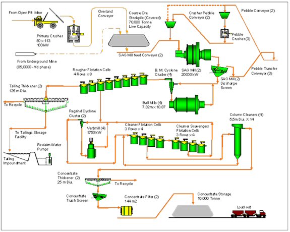
AMC 813001 : March : 2013
378
ENTRÉE GOLD INC Lookout Hill Property, Southern Mongolia Technical Report | |
| 18 | PROJECT INFRASTRUCTURE |
| 18.1 | Power Supply and Distribution |
The Oyu Tolgoi project will be energy-intensive, with electrical power requirements of more than 200 MW on start-up, increasing to around 310 MW in the longer term. A reliable and stable power supply is essential for operations and safety.
A number of studies have been completed since 2004 to investigate the advantages and disadvantages of various power supply alternatives, taking into account the terms of the IA, which allow OT LLC to obtain power from established sources in China until the end of Year 4, and important stakeholder issues related to the GOM desire to electrify the south Gobi and the substantial proportion of total country demand represented by OT LLC.
OT LLC have a 220 kV interconnection between Bayainhanggai in Inner Mongolia, China, and the Oyu Tolgoi site to provide the power supply for Oyu Tolgoi until Year 4. A double-circuit, 170 km long transmission line was constructed between Bayainhanggai.
TRQ announced on 5 November 2012, that Oyu Tolgoi LLC had signed a binding Power Purchase Agreement with the Inner Mongolia Power Corporation to supply power to the Oyu Tolgoi mine. The term of this agreement covers the commissioning of the business plus the initial four years of commercial operations. Distribution at 220 kV and 35 kV is through a central substation approximately 500 m south of the concentrator facility. A second 220 kV switchyard and substation will be constructed adjacent to the production headframes for shafts 2 and 3.
During operations, all critical process and other equipment, heating and lighting, communications, and computer systems will be kept in operation by switching automatically to standby power supply from the diesel plant in the event of failure of the main power plant.
The Oyu Tolgoi Investment Agreement recognized that the reliable supply of electrical power is critical to the mine. The agreement also confirmed that TRQ has the right to obtain electrical power from inside or outside Mongolia, including China, to meet its initial electrical power requirements for up to four years after Oyu Tolgoi commences commercial production. The agreement established that a) Turquoise Hill has the right to build or sub-contract construction of a coal-fired power plant at an appropriate site in Mongolia’s South Gobi Region to supply Oyu Tolgoi and b) all of the mine’s power requirements would be sourced from within Mongolia no later than four years after the start of commercial production. TRQ continues to evaluate several options to meet its commitment to sourcing power from within Mongolia including the development of a dedicated power plant and ownership and funding options to meet this requirement.
AMC 813001 : March : 2013
379
ENTRÉE GOLD INC Lookout Hill Property, Southern Mongolia Technical Report | |
| 18.1.1 | Access |
| 18.1.1.1 | Access Roads |
Approximately 26 km of internal access roads for small vehicles and general normal road transport trucks will be constructed to Mongolian, international, and AASHTO Standards. Construction features will include 35 culverts, one river crossing, and three overpasses. The roads will be constructed of graded gravel. Side-drain ditches will be provided for stormwater drainage.
Access to the water borefield is via a gravel service road from the plant site. Haul roads in the mining areas were developed separately as part of the mine designs.
To support the project development, an existing, 105 km access road from China to Oyu Tolgoi is being upgraded. As measured from the OT site, km 0 to km 25 will be private road, and km 25 to km 105 will be public road. Construction of off-site facilities and infrastructure were behind schedule at the end of 2012 due to slower progress in the building of the Oyu Tolgoi-Gashuun Sukhait road to the Mongolia-China border. Road work has been suspended for the winter although there should be no impact upon the transporting concentrate to the border.
The access road development will include upgrading the roads linking the existing Mongolian customs facility at Gashuun Sukhait to the Chinese customs facility at Ganqimaodao. A working group has been established to obtain agreement on the maintenance of the “OT Road.”
Beyond Ganqimaodao, a reasonable-quality provincial road approximately three years old connects to the Jingzang Expressway via the towns of Hailiutu and Wuuyan, if required. The road has deteriorated slightly but overall is acceptable for copper concentrate hauls.
A gravel road has been completed to the town of Khanbogd; OT proposes to build a mine bypass road to detour public traffic around the project to the town of Khanbogd and beyond.
| 18.1.1.2 | Concentrate Shipment and Handling by Truck |
The project will begin producing copper concentrate at an estimated rate of 600,000 to 1,000,000 t/a. With no rail service in this undeveloped region of southern Mongolia, copper concentrate will need to be transported by truck from the Oyu Tolgoi mine to an OT transload facility at the Ganqimaodao border crossing, from where customers would normally be responsible for further transport.
The rail line in northern China is currently being extended to Ganqimaodo, and while customers would likely prefer to accept delivery to rail head there, the line is still under construction and Chinese railway officials have indicated that there is no excess capacity in the existing rail system. As a result, customers may have to arrange to deliver the concentrates by truck to a railhead in Baotou or Hohhot within China for transfer, or possibly directly to the ultimate destination.
AMC 813001 : March : 2013
380
ENTRÉE GOLD INC Lookout Hill Property, Southern Mongolia Technical Report | |
The trucking of this volume of product across southern Mongolia and northern China, combined with international border issues, will be a significant challenge. Border-crossing protocols and customs-clearance procedures are still developing as the border transitions from a small bilateral boarder to a large international border. The Governments of China and Mongolia have completed a bi-lateral transportation agreement, but this is being applied unevenly in favour of Chinese drivers operating in Mongolia. Neither Mongolia nor China appears to monitor or enforce load limitations with any regularity.
Safety will be a major area of concern for this operation, and a training program will need to be developed for the drivers. Skilled labour and management staff will need to be hired from other areas of the Inner Mongolia Autonomous Region (IMAR) and beyond in Mongolia.
A major support facility will need to be established for staff accommodation and to service the anticipated fleet of tractor-trailer equipment. An area of approximately five acres will be needed, which could be set up on the Mongolian side of the border crossing. There are no other maintenance facilities between OT and the Ganqimaodao border crossing, although the existing level of service improves slightly on the Chinese side of the border.
To ensure a reliable and efficient transportation strategy, OT could manage and operate the haul internally, or it could help a local haulage contractor that has provided services to OT in the past to develop into a bulk commodity transportation company. The latter is likely to be more successful in dealing with border issues to prevent serious delays or transportation stoppages.
| 18.1.1.3 | Airstrip |
A new airport is has been constructed at Oyu Tolgoi to replace the temporary facility for the transportation of people and goods to the site from Ulaanbaatar. The new airport is 11 km north of the Oyu Tolgoi mine lease area and has been sited to avoid flight paths over existing camp areas and structures. The runway is concrete-surfaced, 3,250 m long, aligned with the prevailing north-west-south-east wind direction, and has a projected life of 30 years. Design criteria were established to suit commercial aircraft up to the Boeing 737-800 series arriving and departing twice per day.
Facilities at the terminal include standard check-in counters, a security checkpoint, a departure lounge sized for 100 persons, and an adjacent car park for 40 vehicles. Electricity is provided from an independent diesel generator equipped with a standby unit. No aircraft refuelling capability is provided. The permanent airport work was completed in January 2013 and began operating in February 2013.
| 18.1.2 | Main Site Infrastructure Buildings |
| 18.1.2.1 | Accommodation Facilities |
Accommodation facilities for the first 10–15 years of operations will be constructed adjacent to the existing main construction camp. These will be pre-fabricated, dormitory-style buildings, all equipped with sprinkler and fire-detection systems and central utility and housekeeping rooms on each floor. Seven buildings with single-occupancy rooms for senior staff and seven buildings with double-occupancy rooms for junior staff will be provided.
AMC 813001 : March : 2013
381
ENTRÉE GOLD INC Lookout Hill Property, Southern Mongolia Technical Report | |
The complex will be complete with kitchen-dining area, TV/Internet, and other recreation facilities.
The existing construction camp will be used as long as possible, including the ger VIP, senior staff, and junior staff rooms, modular camp mess, laundry facilities, modular construction offices, and HSES, fire-fighting, and emergency medical facilities.
| 18.1.2.2 | Truckshop Complex |
The truckshop complex is approximately 1 km north-west of the primary crusher, within the maintenance complex, adjacent to the bonded customs storage yard to the north-east and the main fuel storage facility to the south-east. It will cover a land area of approximately 225 m x 175 m, or 4 ha. This space are occupied by outdoor facilities and three self-contained structural steel, pre-engineered buildings designed with the required facilities for repair, maintenance, and rebuild of the open pit mining equipment; storage space for spare parts and consumables; and administration offices. No mine personnel change facilities are included in this complex.
The maintenance building proper will have ground floor space for 10 service bays and related workshops and a second-floor mezzanine for IT, office, and meeting rooms.
Cast rails are embedded in the floor of two of the repair bays for protection when repairing tracked equipment. Serviced with parallel, dual-rail 100 tonne and 25 tonne overhead cranes, the bays are sized to provide for the full dump height of a 360 tonne capacity haul truck. The current open pit mine plan is based on the use of the smaller Komatsu 930-4SE, 290 tonne, haul trucks. A 6 m aisle-way down the centre of the building, between the bays, will provide forklift access directly from the tool crib and warehouse.
Space is provided for lube storage, vehicle wash, and a welding/machine/tire shop. A pipe rack will connect the shop to the lubricant storage building. Recovery systems and holding tanks are provided to store waste oil and coolant products for recycling or disposal.
The wash bay is a stand-alone building north-east of the workshop. Floor- and catwalk-mounted monitors will provide high-pressure water streams to thoroughly wash the mobile equipment. Wash water is recirculated through a large sump outside the building, where solids will settle out before the water is recycled back to the wash bay.
Any oil in the recycled water will pass through an oil skimmer to remove hydrocarbons prior to re-use.
| 18.1.2.3 | Administration Building |
The administration building serves as the central, primary office space for all operations staff on site, including executive, supervisory, and support personnel. The building is equipped with all necessary communication support and is the main data centre for the site, including most of the ICT management and storage equipment. An emergency response area in the main conference room will serve as the command point in the case of an area-wide emergency. The building is two-story, pre-engineered, and steel-framed, with a total floor area of 5,000 m2. The building is cooled in summer by the air-conditioning system and heated in winter by the same system using hot water rather than by chilled water. The data centre will need to be cooled in both summer and winter.
AMC 813001 : March : 2013
382
ENTRÉE GOLD INC Lookout Hill Property, Southern Mongolia Technical Report | |
| 18.1.2.4 | Mine Dry |
The mine dry is a centralized, permanent operations facility whose primary purpose is to provide all site staff with a place to shower and change into work clothes and back into clean street clothes. Spaces are also available for various other activities such as office/meeting room, laundry service, and muster rooms where mining crews will assemble to receive shift instructions before departing for their respective work sites.
The male change rooms will consist of “clean” side and “dirty” sides with approximately 1,200 wire mesh lockers and bench-seating areas on each side, separated by showers and other toilet amenities designed to support the largest number of staff per shift change. A separate women’s change room will accommodate approximately 125 women. VIPs and visitors will have access to a separate room with single lockers that can support up to ten people at a time.
| 18.1.2.5 | Plant Infrastructure Buildings |
A basic laboratory facility has been built on site, comprising standard facilities comprising sample preparation, wet laboratory, fire assay and instrumental laboratory with atomic absorption and mini XRF. This is operated by SGS and supported by the SGS laboratory in Ulan Bataar for multi-element analysis through ICP, diagnostic leaches (which may involve cyanide solutions) and metallurgical test facilities (still to be set up).
AMC considers this laboratory facility to be small, cramped and with poor workflow. Moreover it is inadequately equipped to support a concentrator of the size of OT and with significant geometallurgical issues.
AMC also notes that, in contrast to the substantial truck workshop to service the mine, there is no maintenance workshop for the concentrator. AMC understands that it is planned to carry out concentrator maintenance activities either within the concentrator buildings or in containers, and also rely on rotables and off-site maintenance. AMC believes that this is unduly influenced by the Kennecott Copper approach and not adequate to support the concentrator operation effectively, especially in the Mongolian situation with a severe winter climate and limited off-site resources.
| 18.1.2.6 | Tailings Storage Facility |
Summary of Work to Date
A number of options have been investigated for design of the tailings storage facility (TSF) for Oyu Tolgoi since 2002. These have included the identification of alternative sites, layouts, and the evaluation of various tailings deposition densities up to 70% solids by weight.
AMC 813001 : March : 2013
383
ENTRÉE GOLD INC Lookout Hill Property, Southern Mongolia Technical Report | |
The initial development work in 2002 was conducted by Knight Piésold (KP) and proposed a two-cell facility with perimeter deposition and central decants in each cell. The design was for a total tonnage of 739 Mt of tailings storage capacity and a throughput of 25.6 Mtpa at a slurry solids content of 55% by weight.
In 2004, KP completed a location options study that was carried out in several stages. Options were evaluated against cost, technical, and environmental criteria.
In 2005, Golder Associates completed an alternative TSF design with central discharge of a tailings paste thickened to densities as high as 70% solids. The capital and operating costs, and operational complexities, of a paste tailings system were found to be high compared to those associated with conventionally thickened tailings, and the reduction of water consumption by using paste was small. Therefore, this option was not pursued further.
Klohn Crippen Berger Limited (KCB), the design consultant, continued numerous field assessments, laboratory and site investigations throughout 2006 and 2007.
Upon review of the various alternative option studies, KCB amended the design concept to simplify the embankment sections and replace the flow-through embankment decants with an internal decant pond and barge-mounted pumping facilities for process water reclaim.
During 2007–2008, KCB completed an additional alternatives assessment for the tailings storage facility and considered five sites. In early 2010, a number of variants on the preferred alternative were considered with regard to potential further pit and subsidence zone expansions in addition to the previously analysed variables. Other work included modifying the alignment of the TSF to provide additional buffer zone for potential expansions. This re-alignment required additional site investigation activities, which were completed in July 2010. The feasibility study, which includes the current design concept, was completed and submitted in an updated version in August 2011, after being reviewed by the Oyu Tolgoi Independent Technical Review Board (ITRB).
Subsurface Conditions at the TSF Location
The proposed TSF site is approximately 2 km east of the open pit and 5 km south-east of the plant site. The facility area has a mild surface gradient of 0.3% to the south-east. The ground is covered by limited grassland, and surface water drains via a series of shallow, braided drainages. Ultimately, all drainage in the area reports to the Undai River, which receives run-off from most of the mine site. Stream flow is ephemeral and occurs only a few times a year following rainfall events.
Three main units have been identified in the subsoil profile at the TSF area, as follows:
| ● | Unit 1 – fluvial and aeolian deposits overlying most of the TSF footprint to thicknesses up to 4.0 m and 0.2 m, respectively. |
| ● | Unit 2 – cretaceous clay of deltaic-lacustrine origin that dominates most of the TSF area, overlying the weathered bedrock, ranging from 0 m to 30 m in thickness. |
AMC 813001 : March : 2013
384
ENTRÉE GOLD INC Lookout Hill Property, Southern Mongolia Technical Report | |
| ● | Unit 3 – Weathered bedrock and residual soils, ranging in thickness from 2 m to 10 m, that overlies deeper intact bedrock. Free water is often encountered at the clay/bedrock contact, although perched water tables can occur above this contact. |
Groundwater in the vicinity of the TSF typically ranges from 5 m to 15 m below ground surface, and the aquifer is considered to be largely unconfined.
Tailings Characteristics
Gradation testing on the tailings indicates the material is a typical copper tailings sandy silt with 45% to 65% fines (less than 74 µm) and clay-sized material (less than 2 µm) ranging from 6% to 16%, with an estimated average density of 1.5 t/m3 for the ultimate facility.
Geochemical test work predicts that tailings from Central Oyu, the Wedge Zone, Hugo South, and Heruga will be strongly potentially acid forming (PAF). Non-acid-forming (NAF) tailings are predicted from Southwest Oyu, Hugo North, the Shaft Farm area, and Hugo North Extension.
Design Criteria and Design Basis
The design criteria and design basis prepared by KCB include site climatic and hydrology conditions, design throughputs and total storage requirements, operating requirements, and environmental considerations. Minimum standards for geotechnical and hydro-technical design include return periods for design precipitation events, required factors of safety for seismic events, and allowable deformations under seismic loading conditions. Design features are as follows:
| ● | The design tonnage, based on the current estimate of tailings production over the mine life, is 1,418 Mt. The feasibility level TSF design provides storage for 720 Mt of tailings to be produced during the first 15 years of the project; conceptual designs provide storage for all mine tailings. |
| ● | The facility is designed to store tailings produced from a concentrator constructed to process 160,000 t/d. |
| ● | Based on the consequence classification set by the Canadian Dam Association 2007 Dam Safety Guidelines, the feasibility design is based on a “Very High” consequence classification. |
| ● | Deposition methods will be selected such that run-off is collected into a reclaim pond and water recirculation is maximized. |
| ● | The behaviour of the Cretaceous clay foundation soils was taken into consideration in selecting the design criteria for stability analyses of the embankment. Minimum required static factors of safety were based on strength of foundation clay and pore pressure conditions and therefore ranged from 1.1 to 1.5 depending on the combination of these conditions and the dam configuration – starter dam or ultimate dam configuration. The minimum required factor of safety for both pseudo-static and post-earthquake conditions was set at 1.1. |
AMC 813001 : March : 2013
385
ENTRÉE GOLD INC Lookout Hill Property, Southern Mongolia Technical Report | |
| ● | The site area is classified as a moderate seismic zone. The Maximum Credible Earthquake (MCE) loading at the project site, based on a deterministic assessment for the fault, is estimated to be an M7 earthquake with a Peak Ground Acceleration (PGA) of 0.32 g. |
| ● | Based on CDA guidelines, the flood criteria for a dam of “Very High” consequence category are two-thirds between the 1,000-year return period event and the Probable Maximum Flood (PMF). The estimated 24-hour Probable Maximum Precipitation (PMP) is 184 mm. |
Facility Description
The facility will consist of two cells, each approximately 2 km x 2 km in size (4 km2 area each) and having a storage capacity of 720 Mt of tailings. The facility will be constructed in two stages, starting with Cell 1 initially and then continuing with Cell 2. Each cell will be divided into four 500 ha subcells by berms running the length of the TSF.
The tailings will be pumped at a target density of 64% solids, forming an assumed overall beach slope of 1.0%. The tailings will be deposited alternately among the subcells to minimize evaporative losses and promote water run-off toward the reclaim pond and to maximize water recovery. Water will be reclaimed from the pond by a floating barge and pumped back for re-use in the process plant.
Earthfill and rockfill embankments will be constructed to store the tailings. Embankments will be up to 70 m high and will have one of three typical sections (reclaim pond section, dry section, or wet section), depending on their location and water management regimes around the perimeter of each cell.
Dues to low-strength clay deposits in the foundations, buttressing berms will be required at certain locations, ranging in width up to 500 m, with a resulting overall downstream slope between 2.5H:1V to 10H:1V.
The TSF will consist of engineered earthfill and rockfill embankments. The starter dam will be developed from locally borrowed general fill and clay materials. The clay material will also be used for lower-permeability liners where Cretaceous clay is not present and within core zones.
Most of the embankment will be constructed of various mine waste rock materials and will include a) oxide waste rock, which is up to 25% NAF, b) sedimentary waste rock, which is NAF, and c) random waste rock, which will be segregated, with NAF-only material to be used for the perimeter embankments. Dam zoning to incorporate some PAF rock is therefore a key strategy.
Water Management
Water management is one of the major drivers of the design and operational planning for the TSF. Water will be supplied from a well field some distance from the mine site and is expensive. Water conservation is a major objective of the current design and operating plan, and the concept of depositing tailings in subcells is intended to minimize evaporation losses and promote water release from tailings by consolidation.
AMC 813001 : March : 2013
386
ENTRÉE GOLD INC Lookout Hill Property, Southern Mongolia Technical Report | |
Water will be reclaimed from the eastern side of the impoundment by a pump barge that will return supernatant water back to the process plant. The water balance indicates that an expansion of the raw water supply to 1,200 L/s is planned as part of the Phase 2 works.
Run-off and seepage collection ditches located at the toe of the embankment and around the TSF, designed for a 24-hour, 100-year return period precipitation event, will direct water to seepage collection ponds to maximize recirculation.
Future Work
Recommendations for future work have been outlined, based on the current TSF design for the Oyu Tolgoi Project, to optimize the facility and maximize water conservation. Key recommendations include:
| ● | Review the layout and design of the facility expansion to ensure tailings storage capacity can support continued mining beyond the first 15 years, to account for storage of up to 1.5 Bt of tailings in total. |
| ● | Optimize embankment slopes and specifically evaluate pore pressure response during operation; consider relocating the northern wall farther north on thinner clay. |
| ● | Review, based on the observational approach during operations, the beach formation, beach slopes, and water recovery. |
| ● | Further investigate the geochemistry and leaching behaviour of various rock types used in the embankment construction and their interaction with the stored tailings. |
| ● | Optimize operational aspects to minimize dust emissions and potential environmental impacts such as acid generation and its effect on regional groundwater flow and geochemistry. |
| ● | AMC recommends a review of testwork on tailings rheology and water release properties to support the 64% solids assumption for tailings pumping/deposition, the overall water balance and therefore the raw water demand to confirm the assumptions and conclusions. AMC recommends that some contingency be built into the raw supply facilities to support any shortfall of tailings return water generated from the tailings storage facility. |
| 18.1.3 | Water Systems |
| 18.1.3.1 | River Diversion |
The Undai River channel runs through the proposed open pit area and so must be diverted. Subsurface flow in the river channel is constant, but surface flows are also present occasionally, though usually only after heavy rainfall. The proposed diversion system consists of a dam, diversion channel, and subsurface diversion designed to divert all subsurface and surface flows around and to the north of the South Oyu open pit. Potential seepage from the diversion will be cut-off by keying the main dam below the fluvial gravel. The dam and associated hydraulic structures are designed to ICOLD standards. Both groundwater and surface flood flows will be returned to the Undai River channel downstream.
AMC 813001 : March : 2013
387
ENTRÉE GOLD INC Lookout Hill Property, Southern Mongolia Technical Report | |
| 18.1.3.2 | Site Water Supply System |
Raw Water
Raw water for project requirements are met by pumping groundwater to the site from the Gunii Hooloi aquifer basin. The raw water borefield and pipeline designs are at “Issued for Construction” (IFC) status. Detailed engineering design of the pipeline—inclusive of bore pump stations, collector tank pump stations, break-tank pump stations, emergency storage lagoons, access road, and 6.3 kV power distribution— is underway.
Water Storage and Treatment
A permanent water treatment and bottling plant has been constructed to treat raw water from the Gunii Hooloi borefield to drinking (potable) and domestic water standards.
One section of the building houses two raw/firewater storage tanks, two domestic water tanks, the camp fire water pump station, and domestic water pump station. Each raw water/firewater tank has a capacity of 400 m3 for a total volume of 800 m3, including a combined independent firewater capacity of 324 m3. The remaining water can feed the treatment plant for up to 10 hours at full demand rate in the event of a loss of raw water supply. The two domestic water tanks have a combined capacity of 800 m3, sufficient to supply water at full demand for 16 hours in the event of a loss of raw water supply.
The other area of the building houses the water treatment plant, bottled water storage, a laboratory/office, equipment storage, and chemical storage. Waste water is automatically and regularly discharged into the sewer system by a dedicated pump station in this room.
Potable water intended for routine drinking will meet Mongolian Standards and WHO guidelines for drinking water quality. Raw water is pumped to the treatment plant for dosing, multi-media and granular-activated carbon filtration, micro-filtration, reverse osmosis treatment, ultraviolet sterilization, and ozone disinfection prior to bottling in 20 L bottles and onward distribution. The total output of the treatment facility is 8 m3/h.
Domestic water for use in washing, cleaning, flushing toilets, etc., although not intended for routine drinking, is treated to potable standards. Domestic water is treated at an average flow rate of 70 m3/h (peak rate 125 to 150 m3/h) before distribution to the construction camp and the rest of the Oyu Tolgoi site via utility pipes.
Firewater Distribution System
Firewater storage tanks is installed in the concentrator, and pump stations and dedicated fire mains complete with hydrants will be established in the main functional areas of the site. The fire mains also serve sprinkler systems and fire hose reels at the warehouse, operations camp, north gatehouse, and concentrator office. Fire extinguishers will be provided at all facilities as a first line of defence. Fire detection and alarm systems will be installed at key facilities and will report alarms to the mill area control room in the process plant or to the main gatehouse, which will be manned 24 h/d.
AMC 813001 : March : 2013
388
ENTRÉE GOLD INC Lookout Hill Property, Southern Mongolia Technical Report | |
Wastewater Treatment Plant
An existing wastewater treatment plant, installed within the construction camp, was upgraded from 800 equivalent people (EP) capacity to 4,000 EP capacity in 2006 and is now fully operational. All sewage generated on site will either be pumped directly to the plant or transported there by truck for treatment by mechanical biological activation using a sequencing batch reactor (SBR). The plant is designed for an inflow of 600 m3/d at a daily pollution load of 240 kg BOD5. Maximum inflow is expected to be between the hours of 5 pm and 9 pm each day.
Treated wastewater will eventually be recycled into the industrial processes to minimize water make-up from natural resources. Sludge will be aerobically stabilized in storage tanks and will require no further processing. Thickened sludge will be finally disposed of in the waste management centre.
| 18.1.4 | Information and Communications Technology (ICT) Systems |
Communications systems throughout the Oyu Tolgoi infrastructure and operations facilities will be state of the art complete with information, security, data, and voice communications. The principal components of the ICT systems will include a fibre-optic communications backbone, local area network (LAN), and Voice over Internet Protocol (VoIP) system to support the voice mail system and auto attendant function. Security systems will consist of a closed-circuit television (CCTV) system connected to the local server and control centre and access security system based on card access for building entrance, security turnstiles, vehicle gates, and fence surveillance.
The fire alarm system will consist of thermal flame detectors, ionization smoke detectors, and manual pull stations in site-wide fire-detection zones. The central fire alarm panel will be installed in the north gatehouse, and local fire alarm panels will be provided in ICT rooms or electrical rooms throughout the plant, interconnected via the Ethernet LAN network.
A digital trunk radio system will permit voice communications between individuals carrying hand-held radios, base stations, and mobile vehicles. A designated emergency channel, GPS tracking, and monitor display of individual radios will allow users to notify support authorities in the event of an emergency or safety issue.
Additional communications and control systems are provided for the open pit and underground mines. The wireless open pit truck dispatch system will include links to each truck, GPS transmitters, automatic vehicle locator display, and two-way radio transceivers. The underground leaky-feeder coax system will provide network connectivity in underground shafts and tunnels, emergency paging systems, personnel and underground rail dispatch and tagging, remote control of rails and LHDs, and Gai-tronics phones in rescue chambers.
AMC 813001 : March : 2013
389
ENTRÉE GOLD INC Lookout Hill Property, Southern Mongolia Technical Report | |
| 18.1.5 | Other Support Facilities and Utilities |
| ● | Gatehouse |
The north gatehouse complex is located at the northern boundary of the mine lease area and serves as the main security control point for the Oyu Tolgoi mine. The complex is a single-story building with facilities for a security and logistics checkpoint, site-wide security monitoring, and fire response. Safety and orientation sessions for new employees and/or visitors, as well as special community relations functions, are held there. A separate building will serve as a bank for employees of the mine and the general public. Depending on final agreements for road construction, a south gatehouse may be required to support concentrate transport traffic.
| ● | Warehouse |
The main site warehouse for operations was constructed adjacent to the construction warehouse to provide heated storage for process equipment parts, spares, critical piping, and valves. A fenced, external storage area will include a dedicated space for hazardous chemicals (HAZCHEM).
| ● | Medical Centre |
The Oyu Tolgoi medical centre is designed for both walk-in patients and ambulance access for stretcher patients. It will have a reception area, consultation offices with diagnostic equipment, two resuscitation/treatment beds, two ward beds, and a pharmacy. All controlled prescription drugs are required to be registered to monitor use and stock level. Hard and electronic copies of medical reference material are available for all clinic staff and medical providers on site.
First aid posts are stationed throughout the site to provide initial response in the event of an incident. If required, personnel are moved to the medical centre under the supervision of senior medical staff. Two Toyota ambulance vehicles fully equipped with emergency beacons/sirens are available.
The Medical Mongolia clinic in Ulaanbaatar and the International SOS Global Medical Services (GMS) in Beijing will provide ongoing support for patients requiring medical evacuation.
| ● | Fire Station |
The fire station is in the warehouse compound and be in continuous communication with all operations via a digital trunk radio within a 15 km radius. A fully equipped, dedicated fire crew of four fire-fighters will provide fire and emergency response on the project and be trained to meet the Mongolian statutory requirement for Airport Fire Response. The primary fire truck is fitted with a 7,000 L water tank, an 800 L foam tank, and a roof-mounted foam monitor, supported by 6,000 L water truck. A dedicated fire water supply line with central fire pumps will provide large-fire response support in the main camp.
| ● | Heating |
A central coal-fired boiler plant is under construction to provide hot water heating for all surface facilities at the plant site plus the mine air heating systems in the shaft 1 and 2 areas. Hot water is supplied and returned through a primary circulation loop to the various secondary circulation and heating loops complete and dedicated hot water/glycol heat exchangers to provide heating to the end users.
AMC 813001 : March : 2013
390
ENTRÉE GOLD INC Lookout Hill Property, Southern Mongolia Technical Report | |
| ● | Underground Utilities |
Basic engineering design of underground utility services for raw water, fire water, domestic water, sewer water, return water, and treated water has been completed and battery limit interfaces tentatively agreed among all involved parties for infrastructure facility areas, the concentrator, mining, and the power plant.
| ● | Waste Disposal Facilities |
Wastes generated during the development and operation of the Oyu Tolgoi mine are collected and disposed of in accordance with Mongolian and international laws. The waste management centre will include a non-hazardous waste landfill, leachate management, and a waste incinerator/oil burner.
The landfill is prepared with a clay-geomembrane composite liner system overlain by a protective geotextile fabric. Exposed waste is routinely covered with soil to satisfy hygienic and visual needs and surrounded by secure perimeter fencing. Leachate is collected and gravity-fed to adjacent evaporation ponds fully contained by a composite clay-geomembrane liner system on prepared ground with engineered embankments. Given the arid climate at Oyu Tolgoi, no other treatment is required.
The small amount of suitable hazardous wastes, waste oils, and other combustibles that cannot be directly placed in the landfill is burned in an incinerator designed and operated to international standards to adequately pacify, neutralize, or vaporize the varieties of waste being burned. Ash residue is properly disposed of in the landfill.
| ● | Fuel Storage |
During the construction period a contract agreement was established with a Mongolian supplier, Petrovis, to store 25 ML of pre-purchased fuel to reduce site storage requirements. The supplier will truck the diesel fuel to site and unload it into storage tank farms. Three diesel fuel storage and dispensing facilities are strategically placed close to the users:
| - | A general vehicle fuel facility immediately south of the main construction camp, containing two 50 kL gasoline fuel tanks and two 400 kL diesel fuel tanks, to cater to four-wheel drive light vehicles, road haulage trucks, mobile cranes, and general purpose site tricks. |
| - | A second facility with two 400 kL diesel fuel tanks for fuelling the mine fleet south of the truckshop, in an area that provides access for the heavy mine trucks operating in the open pit. |
| - | A third fuel facility with four 50 kL diesel fuel tanks at the diesel power station just south of the central substation. |
| - | Construction of the fuel storage facilities and dispensing systems is well progressed and scheduled for completion in December 2011. |
AMC 813001 : March : 2013
391
ENTRÉE GOLD INC Lookout Hill Property, Southern Mongolia Technical Report | |
| ● | Core Storage Facility |
The site engineering department has completed the conceptual design of the
pre-engineered building that will serve a core storage shed.
| ● | Toyota Workshop |
Toyota has constructed a light-vehicle maintenance facility for its fleet of vehicles at the site. The facility is complete and fully functional.
| ● | Fencing |
The entire site boundary is surrounded by a mine lease perimeter fence with security gates at entrance/exit points. The fence is a conventional post-and-chain mesh, wide-type, approximately 2 m in high. Supplementary security fencing may be required at individual infrastructure facilities. Temporary security fencing is already established at the project, but it does not cover the entire site boundary, including some development facilities.
AMC 813001 : March : 2013
392
ENTRÉE GOLD INC Lookout Hill Property, Southern Mongolia Technical Report | |
| 19 | MARKET STUDIES AND CONTRACTS |
| 19.1 | Marketing |
Long-term sales contracts have been signed for 75% of the Oyu Tolgoi mine’s concentrate production in the first three years, while 50% of concentrate production is contracted for ten years (subject to renewals). In addition to the signed contracts, in early November 2012, Oyu Tolgoi committed in principle, subject to the conclusion of detailed sales contracts, up to 25% of concentrate available for export would be made available at international terms to smelters in Inner Mongolia for the first ten years.
OT LLC has developed a marketing plan and currently includes consideration of the following factors:
| · | Location value to customer compared to imported material landed at Chinese ports. |
| · | Precious metals recovery and payment. |
| · | Length of contract. |
| · | Percentage of off-take to smelters versus traders. |
| · | Percentage of tonnage on contract versus spot. |
| · | Percentage of feed for any one smelter. |
| · | Number of smelters for a given scale of operation. |
| · | Management of concentrate quality and volume during commissioning and ramp-up. |
| · | Alternate off-shore logistics and costs. |
| · | Delivery point and terms. |
| · | Packaging. |
A detailed timeline has been developed for marketing, logistics, and contract-to-cash functions. OT LLC’s Sales and Marketing will be supported by Rio Tinto Copper Marketing, led by its Chief Marketing Officer. The marketing team will oversee and execute all sales and marketing activities on behalf of OT LLC.
AMC 813001 : March : 2013
393
ENTRÉE GOLD INC Lookout Hill Property, Southern Mongolia Technical Report | |
| 20 | ENVIRONMENTAL STUDIES, PERMITTING, AND SOCIAL OR COMMUNITY IMPACT |
| 20.1 | Environmental and Social Impact Assessment |
OT LLC has completed a comprehensive Environmental and Social Impact Assessment (ESIA) for the Oyu Tolgoi Project. The culmination of nearly 10 years of independent work and research carried out by both international and Mongolian experts, the ESIA identifies and assesses the potential environmental and social impacts of the project, including cumulative impacts, focusing on key areas such as biodiversity, water resources, cultural heritage, and resettlement.
The ESIA also sets out measures through all project phases to avoid, minimize, mitigate, and manage potential adverse impacts to acceptable levels established by Mongolian regulatory requirements and good international industry practice, as defined by the requirements of the Equator Principles, and the standards and policies of the International Finance Corporation (IFC), European Bank for Reconstruction and Development (EBRD), and other financing institutions.
Corporate commitment to sound environmental and social planning for the project is based on two important policies: TRQ's Statement of Values and Responsibilities (March 2010), which declares its support for human rights, social justice, and sound environmental management, including the United Nations Universal Declaration of Human Rights (1948); and The Way We Work 2009, Rio Tinto’s Global Code of Business Conduct that defines the way Rio Tinto manages the economic, social, and environmental challenges of its global operations.
OT LLC has commenced the development and implementation of an environmental management system (EMS) that conforms to the requirements of ISO 14001:2004. Implementation of the EMS during the construction phases will focus on the environmental policy; significant environmental aspects and impacts and their risk prioritization; legal and other requirements; environmental performance objectives and targets; environmental management programs; and environmental incident reporting. The EMS for operations will consist of detailed plans to control the environmental and social management aspects of all project activities following the commencement of commercial production in 2013. The Oyu Tolgoi ESIA builds upon an extensive body of studies and reports, and Detailed Environmental Impact Assessments (DEIAs) that have been prepared for project design and development purposes, and for Mongolian approvals under the following laws:
| · | The Environmental Protection Law (1995) |
| · | The Law on Environmental Impact Assessment (1998, amended in 2001) |
| · | The Minerals Law (2006) |
These initial studies, reports and DEIAs were prepared between 2002 and 2011, primarily by the Mongolian firm Eco-Trade LLC, with input from Aquaterra on water issues.
AMC 813001 : March : 2013
394
ENTRÉE GOLD INC Lookout Hill Property, Southern Mongolia Technical Report | |
The original DEIAs provided baseline information for both social and environmental issues. These DEIAs covered impact assessments for different project areas, and were prepared as separate components to facilitate technical review as requested by the GOM.
The original DEIAs were in accordance with Mongolian standards and while they incorporated World Bank and IFC guidelines, they were not intended to comprehensively address overarching IFC policies such as the IFC Policy on Social and Environmental Sustainability, or the EBRD Environmental and Social Policy.
Following submission and approval of the initial DEIAs, the Mongolian Government requested that OT LLC prepare an updated, comprehensive ESIA whereby the discussion of impacts and mitigation measures was project-wide and based on the latest project design. The ESIA was also to address social issues, meet Mongolian government (legal) requirements, and comply with current IFC good practice.
For the ESIA the baseline information from the original DEIAs was updated with recent monitoring and survey data. In addition, a social analysis was completed through the commissioning of a Socio-Economic Baseline Study and the preparation of a Social Impact Assessment (SIA) for the project.
The requested ESIA, completed in 2012, combines the DEIAs, the project SIA, and other studies and activities that have been prepared and undertaken by and for OT LLC.
A summary of the previous DEIAs prepared for the Oyu Tolgoi Project is shown in Table 20.1.
AMC 813001 : March : 2013
395
ENTRÉE GOLD INC Lookout Hill Property, Southern Mongolia Technical Report | |
| Table 20.1 | Previous DEIA Studies for the Oyu Tolgoi Project |
| EIA Study Title | Description | Date | Status |
| Oyu Tolgoi Project Environmental Baseline Study | This study covers geography, geological, hydrology, hydrogeology, soil, climate, air quality, flora and fauna, the socio-economic status and infrastructure of the Oyu Tolgoi Project site and its surrounding areas. | 2002 | Submitted November 2002 as DEIA. Screening approval not required for baseline study. |
Oyu Tolgoi Project EIA Volume I: Transport and Infrastructure Corridor from Oyu Tolgoi to Gashuun Sukhait | EIA of the original road and power line proposal from Gashuun Sukhait (GS) to Oyu Tolgoi via the western route. See Chapter A5 Figure 5.6. Provides approval for access through the South Gobi Strictly Protected Area (SGSPA). | 2004 | Approved May 2004. |
| Supplementary EIA Volume I: For Route Changes to the Oyu Tolgoi to Gashuun Sukhait Transport Corridor | Assessment of the revised Eastern route to GS and includes an assessment of existing environmental damage caused to the western route from coal traffic. See Chapter A5 Figure 5.6. | 2006 | Approved March 2007. |
Oyu Tolgoi Project EIA Volume II: Water Supply from the Gunii Hooloi (GH) and Galbyn Gobi (GG) Groundwater Aquifer Areas | Provides an evaluation of the proposed aquifers for the provision of a sustainable water supply to the Oyu Tolgoi Project. | 2005 | Approved September 2005. |
| Supplementary EIA Volume II: Supplementary EIA of GH and GG Groundwater Aquifer Areas | Provides an update of the approved EIA Volume II from 2005. Updated assessment of potential impacts and risks, and upgrade of groundwater monitoring in GH area reflecting higher water demand. | 2010 | Initial Screening by MNET in December 2009. Final review and approval by the Water Authority and MNET in March 2011. |
| Supplementary EIA Volume II: Supplementary EIA for GH bore field pipelines and associated infrastructure. | The report was updated further based on an engineering report of Dec 2008. The report covers pipelines, wells, pumps, ponds, lagoon, power supply and access roads from the GH Borefield to the Oyu Tolgoi site. | 2009 | Initial draft 2008. Updated December 2009. Approved March 2010. |
Oyu Tolgoi Project Volume III: Oyu Tolgoi Mining and Processing Facilities | EIA of the open pits, underground, and concentrator, tailings, and all facilities and support infrastructure located within the Oyu Tolgoi Mine Licence Area. The assessment was largely based on the 2005 Integrated Development Plan (IDP), but reflected the general permitting layout of May 2006. The maximum production rate was assumed to be 85,000 tpd. | 2006 | Approved December 2007. |
Oyu Tolgoi Project Volume IV: Coal Fired Steam Power Plant | EIA documentation drafted for a 3 x 100 MW coal fired power plant in 2006. | 2006 | Draft Technical Summary & DEIA completed but not submitted. |
AMC 813001 : March : 2013
396
ENTRÉE GOLD INC Lookout Hill Property, Southern Mongolia Technical Report | |
| EIA Study Title | Description | Date | Status |
Oyu Tolgoi Project Volume V: Domestic Airport Re-location. | The project includes the construction of a temporary gravel Airstrip 10 km north of the Oyu Tolgoi Mine Licence with 2,000 m runway, taxiway, safety end-strip, apron, control tower, passenger terminal, car parking, 15 x 15 m waiting hall, illumination of runway, electric power that is supplied by 40 kVA power generator, surface water drainage system and fence. This EIA covers the new airport construction and operation. This facility is a temporary facility and will be replaced by the Permanent Airport. | 2007 | Approved September 2007. |
| Environmental Impact Assessment for the Permanent Airport | EIA for the construction and operation of the Permanent Airport. | 2011 | Approved 2011. |
| Undai River Diversion Detailed Environmental Impact Assessment | EIA for the diversion of the Undai River | 2011 | Awaiting approval by MNET (as of April 2012). |
Additional environmental studies that relate to specific components of the project and that have not required a full-scale DEIA have been undertaken to achieve regulatory approvals. These are summarized in Table 20.2.
| Table 20.2 | Additional Environmental Approvals, Studies, and Environmental Impact Assessments for Oyu Tolgoi Project |
| Project EIA Component | Description | Date | Status |
| Petrovis Temporary Fuel Station Facility at Oyu Tolgoi Site | Completed for the fuel facility built in 2004 within the Licence Area | 2005 | Approved 2005 |
| Oyu Tolgoi Fuel Depot and Fuel Station | The fuel station expanded in 2008 and a new fuel depot was constructed. The fuel station is 2.0 ha, and has 4 half-concealed tanks of 25 m3 capacity for A-92, A-80 fuel type, 10 tanks of 50 m3 capacity for diesel, and 2 dispensers. | 2010 | Submitted to MNET on 18 February 2010 and approved 13 September 2010 |
| Shaft 1 | EIA of the shaft, headframe facilities, waste rock, and water disposal | 2005 | Approved June 2005 |
| Shaft 2 | EIA of the shaft, headframe facilities, waste rock, and water disposal | 2006 | Approved December 2007 |
| Waste Water Treatment Plant | Supplementary documentation for the construction camp waste water treatment plant with a 4,000 person equivalent capacity | 2007 | Approved May 2007 |
| Quarry Batch Plant and Quarry | Assessment of the existing hard rock quarry, concrete batching plant, and crusher located at the northern boundary of the Licence Area | 2007 | Approved April 2007 |
| 20 MW Diesel Power Plant | The assessment included the initial development of 6 x 2 MW diesel power station (DPS) followed by a stage two addition of 4 x 2 MW diesel generators to the DPS. | 2007 | Approved September 2007 |
| Chemicals | Covers the importation and use of chemicals for construction and development | 2008 | Approved April 2008 |
AMC 813001 : March : 2013
397
ENTRÉE GOLD INC Lookout Hill Property, Southern Mongolia Technical Report | |
| 20.1.1 | Scope of the Environmental and Social Impact Statement |
The IFC and the EBRD have similar, but different, definitions for the scope of an impact assessment. Both institutions frame assessments in terms of a project’s “area of influence.” The guidance provided by both IFC and the EBRD and IFC was utilized in defining the scope of the ESIA. Key elements of the scope of the ESIA are set out below.
| 20.1.1.1 | Project Elements Directly Addressed in this ESIA |
For the purposes of the ESIA, the “project” constitutes the direct activities that are to be financed and/or over which the project can exert control and influence through its project design, impact management, and mitigation measures. This includes:
| ● | All Oyu Tolgoi Project facilities within the Mine Licence Area and surrounding 10 km buffer zone, including the following key features: |
| - | Open pit mining facilities. |
| - | Underground mining facilities. |
| - | Accommodation camps. |
| - | Construction-related activities and facilities, including concrete batch plant, quarry, and laydown areas. |
| - | Power generation facilities. |
| - | Heating plant and boilers. |
| - | Crusher. |
| - | Concentrator. |
| - | Tailings storage facility. |
| - | Water management facilities (including diversion of the Undai River). |
| - | Waste water management facilities for camps and mining operations. |
| - | Waste management facilities (municipal and industrial). |
| - | Waste rock storage facilities. |
| - | Access roads within the Mine License Area. |
| - | Vehicle and equipment maintenance and repair facilities. |
| - | Fuel storage facilities. |
| - | Electrical power distribution. |
| - | Administration buildings and catering facilities. |
| ● | Airport facilities, including a temporary and permanent airport and associated local access roads to the Oyu Tolgoi site. |
| ● | Contractor accommodation camps adjacent to Khanbogd. |
| ● | Potential dedicated off-site worker accommodation planned for Khanbogd |
AMC 813001 : March : 2013
398
ENTRÉE GOLD INC Lookout Hill Property, Southern Mongolia Technical Report | |
| ● | Gunii Hooloi water abstraction borefield and the water pipeline supplying the mine, as well as maintenance roads, pumping stations, construction camps, storage lagoons, and other support infrastructure. |
| ● | Infrastructure improvements (and associated resource use) by Oyu Tolgoi between the mine site and the Chinese border, including the 220 kV power transmission line, the access road that will be used for concentrate export, construction camps, local water boreholes, and borrow pits. |
| ● | Dedicated border crossing at Gashuun Sukhait for the exclusive use of the Oyu Tolgoi Project. |
| - | The concentrate will be sold by Oyu Tolgoi at the Mongolia/China border crossing at Gashuun Sukhait. The point of sale marks a key boundary to the project area. |
| - | Infrastructure Components that may be Transferred to Third-Party Ownership in the Future. |
A number of infrastructure components of the project considered within the ESIA will be constructed by OT LLC but may be transferred at some stage to public or third party operation and/or ownership. Transfer of these infrastructure components to public operation and ownership will limit the degree of control that OT LLC can exert over their management and operation. These infrastructure components may be owned and operated by the Government and will or may be used by members of the public and/or other commercial operations, and include:
| ● | The permanent airport, which is planned to be handed over to the Government after the completion of the project construction phase. |
| ● | The road from Oyu Tolgoi to the Chinese border at Gashuun Sukhait, which follows the alignment for the designated national road and is planned to be handed over to the Government upon completion of the project construction phase. |
| ● | The dedicated border crossing facility at Gashuun Sukhait, which will be operated by the Mongolian authorities. |
| ● | The 220 kV electricity transmission line from the Chinese border to Oyu Tolgoi, which may become owned by the Government of Mongolia. |
| ● | Future Project Elements not Directly Addressed in the ESIA. |
| ● | In addition to the project elements identified above, certain other activities and facilities are expected to be developed over time, either as part of or in support of the project, that do not constitute part of the project for the purposes of the ESIA. These include: |
| - | Project expansion to support an increase in ore throughput from 100,000 t/d up to 160,000 t/d. |
| - | Long-term project power supply. Under the terms of the IA, OT LLC will source electricity from within Mongolia within four years of the commencement of project operations. OT LLC may develop a coal-fired power plant within the Oyu Tolgoi Mine Licence Area to provide the required power from Mongolian sources. |
AMC 813001 : March : 2013
399
ENTRÉE GOLD INC Lookout Hill Property, Southern Mongolia Technical Report | |
This development is considered to be an Associated Facility (as defined in IFC PS1) of the Oyu Tolgoi Project and is the subject of an ESIA that will be supplemental to the ESIA for the Oyu Tolgoi Project.
While the impacts of these future project elements (and their mitigation and management) are not directly addressed in the ESIA they are considered in the cumulative impact assessment of the ESIA.
AMC 813001 : March : 2013
400
ENTRÉE GOLD INC Lookout Hill Property, Southern Mongolia Technical Report | |
| 21 | CAPITAL AND OPERATING COSTS |
The following is a summary of the terms of the EJV relating to cost allocation and revenues to Entrée. Under the terms of the EJV, Entrée may be carried through to production, at its election, by debt financing from OT LLC with interest accruing at OT LLC’s actual cost of capital or prime +2%, whichever is less, at the date of the advance. Debt repayment may be made in whole or in part from (and only from) 90% of monthly available cash flow arising from sale of Entrée’s share of products. Available cash flow means all net proceeds of sale of Entrée’s share of products in a month less Entrée’s share of costs of operations for the month.
All costs of operations will be allocated at the time the program and budget is adopted between the Properties and the Oyu Tolgoi Property, based on the proportions in which each of them benefits most from such operations and:
| · | OT LLC shall bear and pay for one hundred percent (100%) of such costs allocated to the Oyu Tolgoi Property and all associated liabilities including for Environmental Compliance; and |
| · | the balance of such costs shall be borne and paid by the Participants in accordance with their respective Participating Interests, subject to any elections allowed under the EJV. |
If it is impracticable to fully allocate costs of operations between the Properties and the Oyu Tolgoi Property at the time that a program and budget is adopted, such costs will be provisionally allocated based on all information available to the Participants respecting the Properties and the Oyu Tolgoi Property and, if warranted based on additional information obtained from future operations, will be re-allocated to equitably reflect the relative benefits to each such property. Any such provisional or definitive allocation or re-allocation of costs as aforesaid will be agreed by the Participants. A failure to agree will be a dispute for the purposes of the dispute resolution procedure. For illustration purposes only, if a shaft is sunk on the Properties which also provides access to the Oyu Tolgoi Property and fifty five percent (55%) of mineral production is from the Oyu Tolgoi Property and forty five percent (45%) of mineral production is from the Properties, Entrée would have responsibility for a share of those costs equal to its Participating Interest multiplied by forty five percent (45%).
Under the terms of the Entrée-OTLLC Joint Venture, Entrée may elect to have OTLLC debt finance Entrée’s share of costs with interest accruing at OTLLC’s actual cost of capital or prime plus 2%, whichever is less, at the date of the advance. For the analysis in LHTR12 Entrée have advised that under the terms of the EJV, OT LLC is responsible for 80% of all costs incurred on the Joint Venture property, including capital expenditures, and Entrée for the remaining 20%.
AMC 813001 : March : 2013
401
ENTRÉE GOLD INC Lookout Hill Property, Southern Mongolia Technical Report | |
| 21.1 | 2013 Reserve Case Cost Summary |
OT LLC prepared the operating and capital costs presented in the 2013 OTTR. The operating costs are based on the designs of the mines and plant. The cost estimates were generally based on actual costs expended to date and on contracts and supplier quotations for the construction and operation of the project and were applied to the design quantities, equipment schedules, labour numbers and consumption rates and productivity assumptions. Labour costs reduce over time as it is assumed that expatriate labour is reduced and more roles are carried out by Mongolian nationals. The methodology for the cost estimation is described in the following section.
In order to provide an analysis of the 2013 Reserve Case, costs to 31 December 2012 were treated as sunk. Table 21.1 provides a breakdown of operating costs and revenue in the 2013 Reserve Case and the capital costs are detailed in Table 21.2.
| Table 21.1 | 2013 Reserve Case Operating Costs and Revenues |
| US$M | $/t Ore Milled | |||
Total 2013 Reserve Case | 5 Yr Avg | 10 Yr Avg | LOM Avg | |
| Revenue | ||||
| Gross Sales Revenue | 93,016 | 59.27 | 82.12 | 60.43 |
| Less: Realization Costs | ||||
| Concentrate Transport | 3,578 | 1.69 | 2.55 | 2.32 |
| Treatment and Refining | 4,733 | 2.21 | 3.55 | 3.07 |
| Government Royalty | 4,650 | 2.96 | 4.11 | 3.02 |
| 2% Ex BHP Payment | 1,680 | 1.11 | 7.43 | 1.09 |
| Total Realization Costs | 14,641 | 7.97 | 17.64 | 9.51 |
| Net Sales Revenue | 78,375 | 51.30 | 64.49 | 50.92 |
| Less: Site Operating Costs | ||||
| Mining (all sources) | 8,917 | 7.74 | 7.66 | 5.79 |
| Processing | 13,721 | 8.78 | 8.93 | 8.91 |
| Tailings | 1,270 | 1.02 | 1.20 | 0.82 |
| G&A | 1,934 | 4.97 | 3.23 | 1.26 |
| Operations Support | 1,713 | 3.01 | 2.18 | 1.11 |
| Infrastructure | 2,010 | 2.18 | 2.03 | 1.31 |
| Entrée JV Fees | 525 | – | 0.01 | 0.34 |
| Government Fees and Charges | 3,664 | 3.46 | 3.20 | 2.38 |
| Management Fees | 2,486 | 3.23 | 2.61 | 1.62 |
| Total Site Operating Costs | 36,240 | 34.39 | 31.04 | 23.54 |
| Operating Margin | 42,136 | 16.91 | 33.44 | 27.37 |
AMC 813001 : March : 2013
402
ENTRÉE GOLD INC Lookout Hill Property, Southern Mongolia Technical Report | |
Table 21.2 Total Project Capital Cost– 2013 Reserve Case
| US$M | Total Pre-2013 | Phase 1 & 2 From 2013 | Sustaining | Total |
| Direct Costs | ||||
| Open Pit | 423 | – | 535 | 958 |
| Underground | 495 | 2,348 | 1,094 | 3,937 |
| Concentrator | 944 | 131 | 275 | 1,350 |
| Infrastructure | 1,204 | 67 | 154 | 1,426 |
| Power Station | 9 | – | – | 9 |
| Tailings Storage Facility (TSF) | 60 | – | 57 | 117 |
| Subtotal | 3,134 | 2,546 | 2,038 | 7,796 |
| Indirect Costs & Allowances | ||||
| Indirect Costs | 221 | 193 | – | 414 |
| Freight | 215 | 107 | – | 322 |
| Construction O&M, Commissioning, Spares | 492 | 297 | – | 789 |
| Subtotal | 929 | 597 | – | 1,525 |
| Contractor Execution | ||||
| Contractor Margins | 162 | 84 | – | 246 |
| E/EPCM/PMC | 598 | 394 | – | 992 |
| Subtotal | 760 | 477 | – | 1,238 |
| Owner Execution | ||||
| O&M, Commissioning, Owners Teams, Spares | 792 | 281 | 15 | 1,088 |
| Subtotal | 792 | 281 | 15 | 1,088 |
| GOM Fees & Charges | ||||
| Mongolian Customs Duties | 113 | 84 | 53 | 250 |
| Mongolian VAT | 346 | 347 | 165 | 858 |
| Other Mongolian Fees, Taxes & Charges | 2 | 29 | – | 31 |
| Subtotal | 461 | 460 | 218 | 1,139 |
| Contingencies | ||||
| Contingencies | 121 | 740 | – | 861 |
| Subtotal | 121 | 740 | – | 861 |
| Total Development Program | 6,198 | 5,101 | 2,349 | 13,648 |
Notes: Capital includes only direct project costs and does not include non-cash shareholder interest, management fees, foreign exchange gains or losses, forex movements, tax pre-payments, T Bill purchases or exploration phase expenditure.
AMC 813001 : March : 2013
403
ENTRÉE GOLD INC Lookout Hill Property, Southern Mongolia Technical Report | |
| 21.2 | Capital Costs |
Capital costs have been allocated into the following categories:
| · | Mining |
| - | Open Pit |
| - | Underground |
| · | Processing and Infrastructure |
| - | Indirects & EPCM |
| - | Construction & Operations |
| · | GOM Payments |
Customs and VAT costs in the Phase 1 capital estimates have been included in direct costs and shown separately for the remainder.
| 21.2.1 | Underground Capital Cost |
Underground capital costs are divided into the following two categories:
| · | Capital Development – includes all preproduction and production build-up development and infrastructure required to initiate production and undercut the cave until the end of 2015. |
| · | Sustaining Capital – includes work required for long-term development, facilities, or systems to sustain full production operations, but not direct production costs. |
Capital development began in Year -5 and are planned to end in Year 2 (pre-production). Production starts in Year 2 and production build-up continues through Year 8. The first year of full production is Year 8, and full production continues through Year 16. Production ramps down from Year 17 through Year 21. All planned development following first production, but not included in major life-of-mine infrastructure, is categorized as sustaining development. Many of the tasks falling into the capital development and sustaining capital categories are identical. Task classification into either of the two capital categories is purely a matter of timing relative to production status.
The design of the underground incorporates 4 shafts and 5 raises to ventilate the mine. The intended method of construction for the 5 ventilation raises is by raise boring. This has proven difficult and has suffered delays, the primary reason for schedule slippage has been due to poor ground conditions. Completion of the ventilation raises is on the critical path to production from the underground mine as the raises are required to meet the ventilation requirements for development and provide alternative means of egress should Shaft 1 be unavailable. In order to mitigate and minimise risk to the project production, OT LLC are investigating alternative means of establishing the vertical development required to complete the ventilation infrastructure.
Work to determine the impact of this issue is being carried out. Initial analysis by OT LLC suggests that the underground production could be delayed by around twelve months and that each month’s delay could have an NPV value of $50 M. A delay in production is less significant to Entrée than to OT LLC. As most of the ore in the EJV Mineral Reserve is scheduled for production between years 10 and 18 the impact of a one year delay on the return to Entrée would be small. A one year delay would reduce the NPV8 by $10 M. These investigations are planned to be incorporated into DIDOP and will allow OT LLC to quantify potential costs and changes required to meet the Oyu Tolgoi Project schedule.
AMC 813001 : March : 2013
404
ENTRÉE GOLD INC Lookout Hill Property, Southern Mongolia Technical Report | |
In addition possible scope changes have been indicated including:
| · | Additional development and excavation expenditures |
| · | The addition of a shaft No 5 |
| · | An additional crew underground |
| · | Increased operating cost due to design changes |
The components of capital development and sustaining capital are further defined below.
| · | Drifting and Excavating |
| - | Rock handling – truck haulage, conveyor drift, and crosscut development and associated rock handling excavation. |
| - | Ramps and accesses – access ramp, level access, and level development. |
| - | Fixed facilities drifting – infrastructure excavation (i.e. material staging area, shops, lunchrooms, etc). |
| - | Extraction and undercut drifts – perimeter drift, panel drift, drawpoint drift, and drawbell drift development. |
| - | Ventilation drifts and accesses – dedicated intake and exhaust airways (lateral only). |
| - | Mass excavations – large excavations required for facilities and installations. |
| · | Shafts and Raises |
| - | Intake and exhaust raise development. |
| - | Orepass and waste pass development. |
| - | Service and production shaft development. |
| - | Ventilation shaft development. |
| · | Equipment and Infrastructure |
| - | Truck haulage infrastructure – supply and installation of truck haulage-related fixed equipment and infrastructure. |
| - | Ore flow infrastructure – supply and installation of conveyors grizzlies, ore chutes, crushers, etc. |
| - | Drawpoint construction – drawpoint related excavation and construction activities, including construction of drawpoints, slot raise excavation, drawbell and undercut drilling and blasting, and undercut swell mucking. |
AMC 813001 : March : 2013
405
ENTRÉE GOLD INC Lookout Hill Property, Southern Mongolia Technical Report | |
| - | Mobile equipment – production LHDs, production drills, haulage trucks, development jumbos, bolters, trucks, utility vehicles, etc. This includes the initial supply, materials for major rebuilds, and replacement of mobile units. |
| - | Fixed facilities infrastructure – ventilation facilities, pumping systems, shops, offices, lunchrooms, storage areas, fuel and lube areas, explosives magazine. |
| 21.2.2 | Project Capital Costs |
The Phase 1 construction of the Phase 1 plant and infrastructure is substantially complete.
| 21.2.3 | Scope of Work |
The scope of work for the Phase 2 PEP relates primarily to the underground mine, on which development has commenced. The Phase 2 execution plan will be developed during the underground mine Feasibility Study and will include lessons learned and advancements in ongoing project activities from Phase 1.
The scope of work for Phase 2 includes the following elements:
| ● | Completing infrastructure not finished under Phase 1 |
| ● | Conducting work related to the power plant |
| ● | Carrying out regional development work. |
| ● | Expanding the concentrator to a capacity of 150 kt/d |
| 21.3 | Operating Costs |
| ● | Mining |
| - | Open Pit |
| - | Underground |
| ● | Processing |
| ● | Tailings |
| ● | G&A |
| ● | Other |
| - | Government Fees and Charges |
| - | Management Fees |
| 21.3.1 | Underground Operating Costs |
Operating costs include direct and indirect costs associated with the production of ore. Production is defined as pulling ore from drawpoints and delivering it to the main overland conveyor and all activity directly supporting this process. Operating costs include the following items:
| ● | Production |
AMC 813001 : March : 2013
406
ENTRÉE GOLD INC Lookout Hill Property, Southern Mongolia Technical Report | |
| - | Production mucking – production haulage by LHDs from drawpoint to extraction level ore passes. |
| - | Truck haulage and ore flow – truck operation, chute maintenance, apron feeder maintenance, crushing and conveying system operation, and conveyor spill cleanup. |
| - | Secondary breaking – fixed and semi-mobile rock breakers, rock breaker operators, breaking of drawpoint oversize, and relieving low and medium hang-ups. |
| ● | Ground Repair |
| - | Drawpoint repair. |
| - | Sill concrete repair. |
| - | Orepass repair. |
| ● | Indirects – costs not directly allocated to production. |
| 21.3.2 | Process Operating Costs |
Concentrator operating costs were developed using the template used by AMEC Minproc for IDP10. Data for all areas were updated to the latest available as of November 2010. All prices were in 2013 US dollar terms, except where noted. Process plant operating costs have been developed for the main ore sources on an annual basis. The cost areas making up the process operating costs are:
| ● | Workforce |
| ● | Reagents and Consumables |
| ● | Maintenance Materials |
| ● | Concentrator Administration Costs |
| ● | Miscellaneous and Contractor Costs |
Labour has been modelled on an annual basis. Administration and miscellaneous costs have been considered 100% fixed. Power, maintenance consumables and reagents, grinding media and filter cloths have been treated as fully variable on an annual basis for the 2013 Reserve Case. Concentrator operating costs were calculated based on testwork data, calculation of consumables, and unit rates developed from various sources, including:
| ● | IDP10. |
| ● | Updated quotations for supply of goods and services from AMEC and Rio Tinto Procurement. |
| ● | OT LLC’s and AMEC’s database and experience from similar projects. |
| ● | Labour rates and numbers provided by OT LLC. |
OT LLC has created a detailed labour estimate on a period-by-period basis in order to apply labour costs over the life-of-mine. This includes changes in personnel numbers as production levels change, and maintenance of at least 90% Mongolian national hire for all of OT LLC in advance of the IA mandated schedule. The process operating costs are seen in Table 21.3.
AMC 813001 : March : 2013
407
ENTRÉE GOLD INC Lookout Hill Property, Southern Mongolia Technical Report | |
| Table 21.3 | Process Operating Costs |
| Processing Costs | Total US$M | Unit Cost $/t |
| Employee Related Costs | 1,059 | 0.69 |
| External Services | 117 | 0.08 |
| General Consumables | 12,292 | 7.99 |
| Miscellaneous Expenses | 252 | 0.16 |
| Total | 13,721 | 8.91 |
| 21.3.3 | General and Administration Operating Costs |
The G&A costs cover all costs not directly associated with mining and processing. The areas included were:
| · | Executive Management |
| · | Human Resources and Training |
| · | Business Readiness and Integration |
| · | Health, Safety and Security |
| · | Regional Development & Communications |
| · | Government Relations |
| · | Commercial |
The following is a list of cost elements included in the cost estimate of each area:
| · | Employee Related Costs |
| - | FIFO Travel |
| - | FIFO Accommodation |
| - | Relocation Cost |
| - | Recruitment Cost |
| - | R&R Travel |
| - | Housing Cost |
| - | In-country Costs |
| · | External Services |
| · | Inward freight |
| · | Consultants |
| · | Legal Fees |
| · | General Consumables |
| · | Mobile Equipment |
AMC 813001 : March : 2013
408
ENTRÉE GOLD INC Lookout Hill Property, Southern Mongolia Technical Report | |
| - | Site Transport |
| - | UB transport |
| · | Safety, First Aid & Medical Supplies |
| · | Utilities |
| · | Fuel and Energy |
| · | Contractors |
| · | Operating Leases and Rent |
| · | Telecommunications |
| · | Office Accommodation Costs |
| · | Advertising, Promotions and Donations |
| · | Subscriptions & Memberships |
| · | Rates, Taxes & Licences |
| · | Travel Expenses |
| · | Asset Purchases |
| 21.3.4 | Other Operating Costs |
Other costs that are treated as operating costs in the Reserve Case are:
| · | Government Fees and Charges |
| · | Management Fees |
| · | Entrée JV fees |
AMC 813001 : March : 2013
409
ENTRÉE GOLD INC Lookout Hill Property, Southern Mongolia Technical Report | |
| 22 | ECONOMIC ANALYSIS |
| 22.1 | Introduction |
The 2013 Reserve Case schedules a total Mineral Reserve of 1.5 bt of ore (reported by OT LLC) over a 43 year mine life. Of this the EJV Mineral Reserve is 31 Mt at 1.73% Cu, 0.62 g/t Au, and 3.74 g/t Ag.
A summary of the Entrée-OT LLC Project Property production and financial results is shown in Table 22.1. The after tax NPV at 8% per annum discount rate attributable to Entrée for the Reserve Case is $110M.
| Table 22.1 | 2013 Summary Production and Financial Results |
| Description | Units | 2013 Reserve Case |
| Inventory | Mineral Reserve | |
| Total OT Reserve | bt | 1.5 |
| EJV Property Results | ||
| EJV Reserve | Mt | 31 |
| NSR | $/t | 95.21 |
| Cu Grade | % | 1.73 |
| Au Grade | g/t | 0.62 |
| Ag Grade | g/t | 3.74 |
| Copper Recovered | billion lb | 1.1 |
| Gold Recovered | M oz | 0.5 |
| Silver Recovered | M oz | 3.2 |
| NPV (8%) After Tax (Entrée) | US$M | 110 |
| NPV (8%) Before Tax (Entrée) | US$M | 154 |
Notes:
| 1. | Metal prices used for calculating the Southern Oyu open pit NSR and the Hugo North underground Net Smelter Return (NSR) are as follows: copper at $2.81/lb; gold at $970/oz; and silver at $15.50/oz, all based on long-term metal price forecasts at the beginning of the mineral reserve work. The analysis indicates that the mineral reserve is still valid at these metal prices. |
| 2. | The NSR has been calculated with assumptions for smelter refining and treatment charges, deductions and payment terms, concentrate transport, metallurgical recoveries and royalties. |
| 3. | The block cave shell was defined using a NSR cut-off of $15/t NSR. |
| 4. | For the underground block cave, all mineral resources within the shell have been converted to mineral reserves. This includes low grade Indicated mineral resources and Inferred mineral resources, which has been assigned a zero grade and treated as dilution. |
| 5. | Only Measured mineral resources were used to report Proven mineral reserves and only Indicated mineral resources were used to report Probable mineral reserves. |
| 6. | EJV is the Entrée Joint Venture. The Shivee Tolgoi Licence and the Javhlant Licence are held by Entrée. The Shivee Tolgoi Licence and the Javhlant Licence are planned to be operated by Rio Tinto plc. OT LLC will receive 80% of cash flows after capital and operating costs for material originating below 560 m, and 70% above this depth. |
| 7. | The base case financial analysis has been prepared using the following current long term metal price estimates: copper at $2.87/lb; gold at $1,350/oz; and silver at $23.50/oz. Metal prices are assumed to fall from current prices to the long term average over five years. |
| 8. | The mineral reserves reported above are not additive to the mineral resources. |
AMC 813001 : March : 2013
410
ENTRÉE GOLD INC Lookout Hill Property, Southern Mongolia Technical Report | |
The EJV and OT LLC copper, gold, and silver metal production and processing tonnages in the Reserve Case are shown in Figure 22.1 to Figure 22.4.
| Figure 22.1 | Copper Production – 2013 Reserve Case |
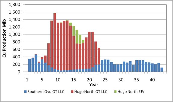
EJV total production values are shown.
| Figure 22.2 | Gold Production – 2013 Reserve Case |
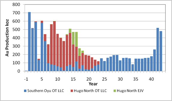
EJV total production values are shown.
AMC 813001 : March : 2013
411
ENTRÉE GOLD INC Lookout Hill Property, Southern Mongolia Technical Report | |
| Figure 22.3 | Silver Production – 2013 Reserve Case |
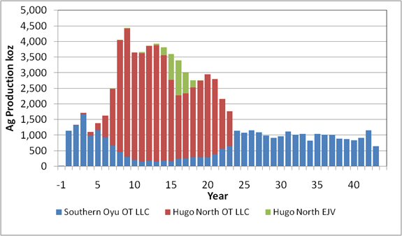
EJV total production values are shown.
| Figure 22.4 | Processing by Source – 2013 Reserve Case |
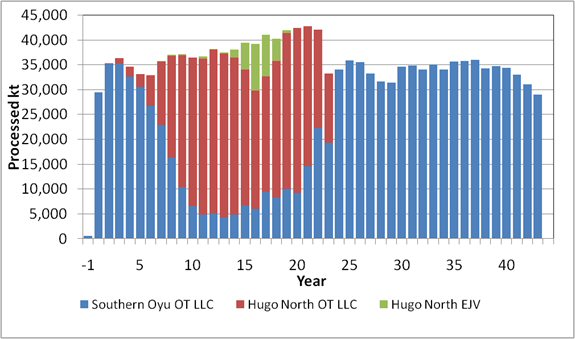
(EJV total production values are shown.
AMC 813001 : March : 2013
412
ENTRÉE GOLD INC Lookout Hill Property, Southern Mongolia Technical Report | |
| 22.2 | Model Assumptions |
The basis of the operational framework of the mine used in the analysis is Mongolian legislation and the terms of the IA between OT LLC and the GOM.
The Project level valuation model begins on 1 January 2012. It is presented in 2012 constant dollars, cash flows are assumed to occur evenly during each year and a mid-year discounting approach is taken. The discount rate applied to the Project is 8% per annum. Metal prices are assumed to fall from current prices to the long-term average over five years. Average metal prices used for the evaluation were $2.90/lb copper, $1,398/oz gold and $23.96/oz silver. This includes long-term metal prices of $2.87/lb copper, $1,350/oz gold and $23.50/oz silver. These prices were judged to be reasonable against similar studies released over the last 12 months.
| 22.2.1 | Treatment of Cash Flow Items |
Under the terms of the Entrée-OTLLC Joint Venture, Entrée may elect to have OTLLC debt finance Entrée’s share of costs with interest accruing at OTLLC’s actual cost of capital or prime plus 2%, whichever is less, at the date of the advance. For the analysis in LHTR12 Entrée have advised that under the terms of the EJV, OT LLC is responsible for 80% of all costs incurred on the Joint Venture property, including capital expenditures, and Entrée for the remaining 20%.
Also under the terms of the EJV, Entrée may be carried through to production, at its election, by debt financing from OT LLC with interest accruing at OT LLC’s actual cost of capital or prime +2%, whichever is less, at the date of the advance. Debt repayment may be made in whole or in part from (and only from) 90% of monthly available cash flow arising from sale of Entrée’s share of products. Such amounts will be applied first to payment of accrued interest and then to repayment of principal. Available cash flow means all net proceeds of sale of Entrée’s share of products in a month less Entrée’s share of costs of operations for the month. Therefore, Entrée will not be obliged to contribute cash to the EJV for its portion of operating and capital expenditures and will receive 10% of its share of cash flow from the EJV until such time as any loans outstanding are repaid and 100% thereafter. Entrée have advised that under the terms of the EJV, OT LLC is responsible for 80% of all costs incurred on the Joint Venture property, including capital expenditures, and Entrée for the remaining 20%. Also under the terms of the EJV, Entrée may be carried through to production, at its election, by debt financing from OT LLC with interest accruing at OT LLC’s actual cost of capital or prime +2%, whichever is less, at the date of the advance. Debt repayment may be made in whole or in part from (and only from) 90% of monthly available cash flow arising from sale of Entrée’s share of products. Such amounts will be applied first to payment of accrued interest and then to repayment of principal.
Available cash flow means all net proceeds of sale of Entrée’s share of products in a month less Entrée’s share of costs of operations for the month. Therefore, Entrée will not be obliged to contribute cash to the EJV for its portion of operating and capital expenditures and will receive 10% of its share of cash flow from the EJV until such time as any loans outstanding are repaid and 100% thereafter.
AMC 813001 : March : 2013
413
ENTRÉE GOLD INC Lookout Hill Property, Southern Mongolia Technical Report | |
The treatment of each key cash flow item included in the Entrée cash flow calculation is outlined in Table 22.2. As a guiding principle, the effective value of revenue and costs used in to calculation of Entrée net cash flow were based on an appropriate revenue or cost driver (e.g. EJV milled tonnes) multiplied by the total Project revenue or cost base (i.e. OT LLC and Entree processing costs) multiplied by its working interest (e.g. 20%).
The Net Cash Inflow – After Effective Realisation and Operating Costs – is the income that Entrée receives under the terms of the EJV.
| Table 22.2 | Treatment of Cash Flow Items |
| Cash Flow Item | Calculation Treatment |
| Gross Sales | Total EJV Revenue x 20% |
| Less: | |
| i) Concentrate Transport | Total Concentrate Transport Costs x (EJV Concentrate Produced/Total Concentrate Produced) x 20% |
| ii) Treatment and Refining Charges | Total Treatment & Refining Charges x (EJV Concentrate Produced/Total Concentrate Produced) x 20% |
| iii) Royalties | Gross Sales * 5% |
| iv) Mining Costs | Total Hugo North Operating Costs x (EJV Hugo North Mined Tonnes / Total Hugo North Mined Tonnes) x 20% |
| v) Processing Costs | Total EJV Milled Tonnes x LOM Average Processing Cost x 20% |
| vi) General & Administration Costs | Total EJV Milled Tonnes x LOM G&A Cost x 20% G&A includes Operations Support and Infrastructure |
| vii) Depreciation – Processing Only | Processing Capital Depreciation x (EJV Milled Tonnes / Total Milled Tonnes) x 20% |
| Net Cash Inflow – After Effective Realisation and Operating Costs | Gross Sales – Effective Realisation and Operating Costs |
| Income Tax Expense | Net Cash Inflow x 25% Tax Rate |
| Net Cash – After Tax | Net Cash Inflow – Income Tax Expense |
| Capital Contributions | Total Hugo North Capital Depreciation (Phase 1 and Phase 2) x (EJV Mined Tonnes / Total Hugo North Mined Tonnes) x 20% |
| Net Cash Flow – Before Finance | Net Cash After Tax – Capital Contributions |
Total EJV Revenue is calculated based on Heruga and Total EJV Hugo North (Lift 1 and Lift 2) tonnages. In the Reserves case EJV revenue is only generated from production sourced from EJV Hugo North Lift 1.
AMC 813001 : March : 2013
414
ENTRÉE GOLD INC Lookout Hill Property, Southern Mongolia Technical Report | |
| 22.3 | Reserve Case – Economic Analysis |
The after tax NPV at 8% discount rate attributable to Entrée for the Reserve Case is $110 M. Table 22.3 summarises the financial results of the Reserve Case. Cumulative cash flow for the Reserve Case is depicted in Figure 22.5. A complete cash flow is provided in Table 22.4.
| Table 22.3 | Reserve Case Entrée Financial Results |
| Before Taxation | After Taxation | ||
| Net Present Value (US$M) | Undiscounted | 487 | 360 |
5.0% | 230 | 170 | |
| 6.0% | 199 | 147 | |
| 7.0% | 173 | 127 | |
| 8.0% | 150 | 110 | |
| 9.0% | 130 | 96 | |
| 10.0% | 113 | 83 |
| Figure 22.5 | Reserve Case Entrée Cumulative Cash Flow – After Financing (Undiscounted) |

AMC 813001 : March : 2013
415
ENTRÉE GOLD INC Lookout Hill Property, Southern Mongolia Technical Report | |
| Table 22.4 | Entrée Reserve Case Cash Flow (Undiscounted) |
| Cash Flow Statement | 1 | 2 | 3 | 4 | 5 | 6 to 10 | 11 to 20 | 21 to Life-of-Mine | Total | |
| Gross Sales | $ M | – | – | – | – | – | 6.1 | 743.0 | – | 749.2 |
| Less: | ||||||||||
| Concentrate Transport | $ M | – | – | – | – | – | (0.2) | (25.7) | – | (25.9) |
| Treatment and Refining Charges | $ M | – | – | – | – | – | (0.3) | (34.2) | – | (34.5) |
| Royalties | $ M | – | – | – | – | – | (0.3) | (37.2) | – | (37.5) |
| Mining Costs | $ M | – | – | – | – | – | (0.5) | (29.5) | – | (30.0) |
| Processing Costs | $ M | – | – | – | – | – | (0.8) | (54.7) | – | (55.5) |
| General & Administration Costs | $ M | – | – | – | – | – | (0.3) | (22.6) | – | (33.2) |
| Depreciation – Processing Only | $ M | – | – | – | – | – | (1.1) | (32.1) | – | (33.2) |
| Net Cash Inflow | $ M | – | – | – | – | – | 2.5 | 507.1 | – | 509.7 |
| Income Tax Expense | $ M | – | – | – | – | – | (0.7) | (126.8) | – | (127.5) |
| Net Cash – After Tax | $ M | – | – | – | – | – | 1.8 | 380.4 | – | 382.2 |
| Capital Contributions | $ M | – | – | (0.3) | (0.6) | (0.5) | (1.7) | (18.2) | – | (21.2) |
| Net Cash Flow – Before Finance | $ M | – | – | (0.3) | (0.6) | (0.5) | 0.1 | 362.2 | – | 360.9 |
| Turquoise Hill Funding | $ M | – | – | 0.3 | 0.6 | 0.5 | (0.1) | (2.4) | – | (0.9) |
| Net Cash Flow – After Finance | $ M | – | – | – | – | – | 0.2 | 359.8 | – | 360.0 |
AMC 813001 : March : 2013
416
ENTRÉE GOLD INC Lookout Hill Property, Southern Mongolia Technical Report | |
Project sensitivities are summarised in Table 22.5.
| Table 22.5 | Metal Price Sensitivity Analysis - Reserve Case - Entrée |
After-tax Values NPV8 US$M | Gold Price/oz | |||||||
| Copper Price/lb | 1,000 | 1,150 | 1,300 | 1,350 | 1,500 | 1,750 | 2,000 | 2,500 |
| 2.25 | 74 | 77 | 80 | 82 | 85 | 90 | 96 | 107 |
| 2.50 | 85 | 89 | 92 | 93 | 96 | 102 | 107 | 118 |
| 2.75 | 97 | 100 | 103 | 105 | 108 | 113 | 119 | 130 |
| 2.87 | 102 | 106 | 109 | 110 | 113 | 119 | 124 | 135 |
| 3.00 | 108 | 112 | 115 | 116 | 119 | 125 | 130 | 141 |
| 3.50 | 131 | 135 | 138 | 139 | 142 | 148 | 153 | 164 |
| 4.00 | 154 | 158 | 161 | 162 | 165 | 171 | 176 | 187 |
| 4.50 | 177 | 181 | 184 | 185 | 188 | 194 | 199 | 210 |
| 22.3.1 | Alternative Production Cases |
The mine designs and production schedules available for the alternative production cases are:
| ● | Southern Oyu Open Pits (2013 Mineral Reserve) |
| ● | Hugo North Lift 1 Block Cave (2013 Mineral Reserve) |
| ● | Hugo North Lift 2 Block Cave (Inferred) |
| ● | Hugo South Block Cave or Open Pit (Inferred) |
| ● | Heruga Block Cave (Inferred) |
Under the NI 43-101 guidelines, Inferred Mineral Resources are considered too speculative geologically to have the economic considerations applied to them that would allow them to be categorized as Mineral Reserves. There is no certainty that the alternative production cases will be realized.
Currently the designs for Hugo North Lift 2, Hugo South Block Cave and Heruga are the same as those in IDP10. The Hugo South open pit designs were updated in 2012. From the designs two sets for long-term production scheduling can be prepared, one with Hugo South as underground and one as open pit. The two sets are shown in Figure 26.4 and Figure 26.5. The work on the alternative production cases is not complete, in particular the definition of the expansion sizes and costing of the cases.
AMC 813001 : March : 2013
417
ENTRÉE GOLD INC Lookout Hill Property, Southern Mongolia Technical Report | |
| Figure 22.6 | Alternative Production Design Set 1 |

| Figure 22.7 | Alternative Production Design Set 2 |
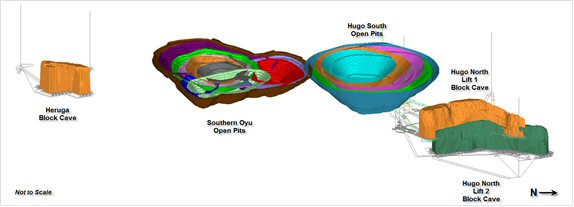
These cases will be part of the strategic planning that is being undertaken by OT LLC. This work will examine the plant capacity for expansions. Figure 26.6 shows an example of the potential decision tree for the potential development options at Oyu Tolgoi.
AMC 813001 : March : 2013
418
ENTRÉE GOLD INC Lookout Hill Property, Southern Mongolia Technical Report | |
| Figure 22.8 | Oyu Tolgoi Development Options |

To date several alternative production cases were developed by OT LLC to explore the potential plant expansions and the flexibility inherent in the Heruga and Hugo South deposits. These cases and others will be examined and refined by OT LLC as part of the strategic planning process. In the first case (Case A), the mining inventory remains the same as the 2013 Reserve Case but with a plant expansion in Year 6. This case is only at a conceptual level and costings have not been prepared. Alternative Production Case A is depicted in Figure 26.7. Total annual production is 59.0 Mtpa from the Southern Oyu open pit and Hugo North Lift 1. The 2013 Reserve Case production is included in black for comparison.
| Figure 22.9 | Alternative Production Case A |

AMC 813001 : March : 2013
419
ENTRÉE GOLD INC Lookout Hill Property, Southern Mongolia Technical Report | |
In Alternative Production Case B, Hugo North Lift 2, Heruga, and Hugo South open pit are added to the schedule. A plant expansion occurs in Year 7. This case is only at a conceptual level and costings have not been prepared. The ultimate production rate for Alternative Production Case B is 68.1 Mtpa and is shown in Figure 26.8. This case uses Heruga as a 25 Mtpa operation and Hugo South as an open pit mine. The 2013 Reserve Case (black) and Alternative Production Case A (orange) are included for comparison.
| Figure 22.10 | Alternative Production Case B |
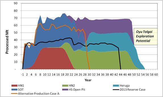
The third case is Alternative Production Case C and, again, is only at a conceptual level and costings have not been prepared. The ultimate production rate for Alternative Production Case C is 110 Mtpa and is shown in Figure 26.9. The case also uses Heruga as a 25 Mtpa operation and Hugo South as an open pit mine. The 2013 Reserve Case (black), Alternative Production Case A (orange), and Alternative Production Case B (pink) are included for comparison. There is a significant amount of study work to be carried out to verify the alternative production cases to increase the Mineral Resource confidence and identify suitable infrastructure capacities such as water. These cases are discussed as it is considered that they demonstrate the options for the direction the Project’s long-term mine planning could take.
AMC 813001 : March : 2013
420
ENTRÉE GOLD INC Lookout Hill Property, Southern Mongolia Technical Report | |
| Figure 22.11 | Alternative Production Case C |

| 22.3.2 | Oyu Tolgoi Dynamic DCF / Real Option Development Alternatives Review |
Turquoise Hill has retained Ernst & Young LLP (Ernst & Young) to review a range of development alternatives for the Oyu Tolgoi Project and their associated metal price risk exposure using Dynamic DCF and Real Option (“RO”) methods. In this context, Ernst & Young is providing on-going analysis to Turquoise Hill for Turquoise Hill’s private and confidential use.
The objective of the Ernst & Young analysis is to provide insight into how a sequence of project development decisions may be adapted in response to changes in the metal price environment. The analysis combines the use of stochastic Monte Carlo simulation to model the effects of metal price uncertainty with a decision tree to describe the sequence of possible development decisions to assess how investing in various capacity expansions and choice of different deposit development sequences changes across a range of metal price environments. Both DCF and RO methods are used in the analysis to estimate project NPV so as to determine if development decisions differ between the two NPV methods. Both NPV methods are also used to assess whether the application of the RO method provides additional insights into characteristics of the Project that influence long-term cash flow uncertainty and Project NPV. The analysis will also consider how the different development alternatives transform metal price uncertainty into overall project risk exposure by different development decisions.
AMC 813001 : March : 2013
421
ENTRÉE GOLD INC Lookout Hill Property, Southern Mongolia Technical Report | |
| 23 | ADJACENT PROPERTIES |
The Joint Venture Property is immediately adjacent to OT LLC's Oyu Tolgoi mining licence which hosts porphyry copper-gold mineralization within the Hugo Dummett (South and North) deposit and within the Southern Oyu deposits (Southwest, South and Central Oyu). From Ulaan Khud in the north to Heruga in the south, the known copper-gold-molybdenum deposits now span a distance of 20 km along what has been termed the Oyu Tolgoi structural trend. Developments on the Oyu Tolgoi Project are relevant to Entrée’s Hugo North Extension and Heruga Mineral Resources.
The following description of mineralization and alteration at Oyu Tolgoi is quoted verbatim from Kirwin et al, 2005.
“Mineralization and alteration at Oyu Tolgoi is characterized by multiple copper-gold porphyry centres with late high-sulfidation systems, which occur above and partially telescoped onto the underlying copper-gold porphyry systems. The high-grade core of the South West Oyu deposit is cylindrical-shaped copper-gold porphyry, 250 m in diameter, that extends vertically for over 800 m. Mineralization is centered on small 10 to 30 m wide; syn to late mineral porphyritic quartz monzodiorite (QMD) dykes and extends for over 100 m into the adjacent host basaltic volcanics. Contorted milky white quartz veins are developed in both the mineralized QMD and basaltic volcanics.
Quartz vein textures include sinuous networks of milky quartz rather than classical porphyry planar, multidirectional centerline vein stockworks. Similar quartz vein textures have been described at Tampakan in the Philippines. The quartz veins appear to have formed largely as an early, relatively high temperature event. Unidirectional solidification textures or USTs have been observed as delicate millimetre lacey layers throughout a 30 m zone in drillhole OTD 183. Similar USTs have been observed at many gold-rich porphyry deposits including Bajo de le Alumbrera. Chalcopyrite with subordinate pyrite and bornite occurs disseminated and as late fracture fillings within the quartz veins and host rocks. Gold to copper ratios increase from 2:1 to 3:1 at depth. Alteration within the QMD is predominantly early pervasive albite overprinted by quartz-sericite with minor fluorite and rare tourmaline. The basaltic volcanics feature biotite-magnetite with late chlorite-sericite. Pervasive biotite alteration occurs in the core of the deposit and grades outwards as vein selvages. Gold is very fine, ranging from 1 to 120 µm, and occurs intergrown with chalcopyrite as veinlet infills, healing hydro fracturing of pyrite crystals and as inclusions within or on grain boundaries with chalcopyrite and bornite or gangue. Lower grade, propylitic altered basalt with 1:1 gold to copper ratios extends for 600 x 2,000 m around the high-grade core. The QMD dyke bounding South West Oyu to the south-east is sericite altered at upper elevations and weakly mineralized with disseminated pyrite and chalcopyrite.
High sulphidation systems above, and partly telescoped onto underlying porphyry systems occur at Central Oyu Tolgoi and South Hugo Dummett, the latter is hosted mainly by dacitic ash flow tuffs which overly basaltic volcanics and stocks and dykes of QMD. Drilling has so far encountered two kinds of HS systems defined by sulfide mineralogy, zonation, and geological setting.
AMC 813001 : March : 2013
422
ENTRÉE GOLD INC Lookout Hill Property, Southern Mongolia Technical Report | |
At Central Oyu covellite and pyrite are related to an upwardly flared zone of intense quartz-muscovite alteration with subordinate minamite, dickite, pyrophyllite. Primary apatite has been altered to secondary phosphates (crandellite, svanbergite and woodhousite). Mineralization is centered on porphyry-style quartz-veined QMD dykes. In Central Oyu, a supergene-enriched chalcocite blanket, tens of metres in thickness has developed overlying the covellite, pyrite-rich HS mineralization. Sooty chalcocite coating pyrite and filling fractures underlies a 20 m to 60 m thick, hematite, goethite-rich leached cap. Minor exotic copper mineralization has been observed in some drillholes adjacent to the main Central Oyu deposit.
At South Hugo, bornite, chalcopyrite and chalcocite are related to high density porphyry-style quartz veins, cutting dacitic ash flow tuffs. Within the ash flow tuffs the advanced argillic alteration is characterized by alunite, pyrophyllite, diaspore, dickite, topaz, zunyite, minor fluorite and rare dumortierite. Mineralization extends vertically and laterally from a series of porphyritic monzodiorite apophysies or from a deep seated porphyry-style core. Deep drilling has encountered magnetite and chalcopyrite veining in biotite and chlorite altered, augite porphyry basalt similar to South West Oyu. The bornite, chalcopyrite and chalcocite mineralization at South Hugo has exceptional copper grades (locally 10% Cu over 2 m sample intervals), and appears to be zoned laterally from a bornite-dominated core, outward to chalcopyrite and pyrite.
North Hugo has a continuous high grade bornite dominant core which extends for at least 1.6 km north-east from South Hugo. At the southern end it has a vertical extent of 100 m which increases to more than 700 m at the northern end. The metre and increases to approximately 200 m at the northern section. The greater than 1% copper grade shell which fully envelops the high grade core, attains a maximum horizontal thickness of 450 m at zero RL (1,160 m below surface). Mineralization is hosted in basalts and quartz monzodiorite stocks. The best gold values are associated with bornite and the gold to copper ratios vary from 1:10 to as high as 1:1 in the northern part.”
Geologists at OT LLC (C. Forster, pers. comm., 2007) compare mineralization at Heruga most closely to the Southwest Deposit on Oyu Tolgoi. The description below of the Southwest Deposit is taken from Peters et al. (2006):
“Copper-gold porphyry style mineralization at the Southwest deposit consists of a cylindrical highgrade core roughly 250 m in diameter enclosed within a broad zone of lower-grade mineralization. The high-grade core is centred on a 10 m to 30 m wide, vein-rich quartz monzodiorite dyke and extends for over 100 m into the adjacent massive porphyritic augite basalt. The high-grade core is characterized by 1 cm to 50 cm wide contorted milky white quartz veins in sericite, albite, minor tourmaline-altered quartz monzodiorite and biotite–magnetite-altered augite basalt, overprinted by chlorite and sericite. Chalcopyrite with subordinate pyrite, bornite, and molybdenite occur as late veinlets filling fractures in quartz veins and disseminated through wall rocks.
AMC 813001 : March : 2013
423
ENTRÉE GOLD INC Lookout Hill Property, Southern Mongolia Technical Report | |
Low-grade copper mineralization peripheral to the high-grade core is characterized by lower vein densities, hosted in chlorite and epidote altered basalt and lesser sericite- and albite-altered quartz monzodiorite. Magnetite veinlets post-date the quartz veins but predate the main sulphide event. Chalcopyrite, bornite, and pyrite are mainly disseminated, with fracture- or vein-controlled sulphides being less prominent. These peripheral zones include; the informally defined Far South zone, which encompasses mineralized basalt with 1:1 gold:copper (ppm:%) ratios on the south-west margin of the deposit area, and the Bridge zone, consisting of copper-mineralized basalt and quartz monzodiorite between the Southwest and Central deposits. Although these two subzones were used in 2005 as domain boundaries in resource modeling (see Juras, 2005), there is no clear geological boundary distinguishing them from the adjacent peripheral zone mineralization.
Gold mineralization in the Southwest deposit is closely associated with chalcopyrite, and occurs intergrown with chalcopyrite, as inclusions and fracture infills within pyrite, or on grain boundaries of pyrite. Less frequently, gold occurs on grain boundaries with bornite or as inclusions in bornite, quartz or carbonate. The gold to copper (ppm:%) ratios range from 2:1 to 3:1 within the high-grade core, decreasing to 1:1 in the low-grade margins of the deposit.
The Southwest deposit is capped by an oxidized zone that varies from 50 m to 60 m thick, and consists of black copper oxide (neotocite or tenorite) as fractures coatings, and speckled throughout the oxidized limonite-stained basalt.
Alteration styles at the Southwest deposit are typical of copper-gold porphyry systems. Augite basalt in the high-grade core of the deposit contains biotite and magnetite alteration, overprinted by chlorite and sericite. Biotite alteration occurs pervasively in the core of the deposit and grades outwards to selvage controlled within pervasive chlorite and epidote alteration. Minor albite alteration occurs as selvages along veins or fractures. Locally, brown carbonate alteration is present in the basalt.
Vein-rich quartz monzodiorite (OT-Qmd and xQmd phases) in the high-grade core contains sericite-biotite-albite alteration with minor tourmaline and montmorillonite. Pink albite alteration commonly occurs as selvages on veins or fractures, and sericite overprints biotite and albite.
In the low-grade peripheral portions of the deposit, augite basalt is pervasively chlorite–magnetite altered, with epidote occurring in patches and sericite and pink albite on vein or fracture selvages. Pink albite may form reaction rims around irregularly-shaped epidote patches. Biotite alteration occurs locally. Late calcite or ankerite veins crosscut the assemblage. Quartz monzodiorite within the low-grade margin contains pervasive sericite alteration, with albite occurring along quartz vein or fracture margins. Spotty biotite alteration occurs locally.”
AMC 813001 : March : 2013
424
ENTRÉE GOLD INC Lookout Hill Property, Southern Mongolia Technical Report | |
| 24 | OTHER RELEVANT DATA AND INFORMATION |
| 24.1 | Management |
The operations plan sets out the various roles and responsibilities required to successfully manage the operating aspects of the Oyu Tolgoi project. It includes the overall workforce development strategy and other operations planning aspects related to supply and logistics; environment, health, and safety policies and procedures; and concentrate shipment and handling. OT LLC has developed an Operational Readiness Plan to ensure that all facilities and personnel are in place to support the successful transition from project construction to mine operations. The operations plan is current as of December 2010 and may be subject to change as planning advances for operations.
| 24.1.1 | The Organization |
OT LLC’s aim is to develop a proficient and reliable workforce possessing the productivity and skills associated with international best practice to support its overall goal of high operations efficiency. The organizational structure of the Oyu Tolgoi project is expected to evolve from a more hierarchical structure to one that is a flatter, more global-type structure. This evolution will be tied to the development of professional management ability and advanced skills within the OT LLC workforce. The overall OT LLC management organizational structure is presented in Figure 24.1.
| Figure 24.1 | Organization Chart for Overall OT LLC Management |
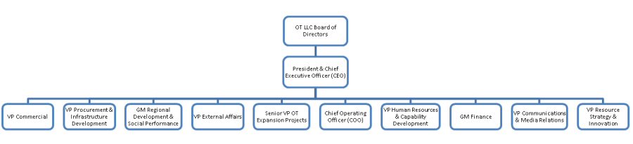
| 24.1.2 | Training and Human Resources |
OT LLC recognizes that employment, benefits, and training are vital to meeting project goals for operations. OT LLC has made commitments and developed plans related to training and human resources as part of its corporate commitments and stewardship of the project.
AMC 813001 : March : 2013
425
ENTRÉE GOLD INC Lookout Hill Property, Southern Mongolia Technical Report | |
Human resources functions for national, regional, and site requirements will be managed centrally in Ulaanbaatar, supported by permanent recruitment offices in Dalanzadgad and Khanbogd, to maintain consistency through the recruitment, hiring, and training processes. Recruitment and training will be linked to the project development schedule and strategy to ensure successful workforce ramp-up.
To meet the needs of construction and operations, fixed rosters have been developed as part of the work rotation strategy. There are four principal rosters for construction and two principal rosters planned foroperations. These rosters will guide the work rotation of the OT LLC workforce at site, regional offices, and in Ulaanbaatar.
| 24.1.3 | Workforce Development |
Present planning provides for an operations workforce consisting of both expatriates and Mongolian nationals. This is largely owing to a lack of Mongolian exposure to the particular technical and trades skills that will be required for the Oyu Tolgoi operation. It is anticipated that the requirements for an expatriate workforce will decline as the operation matures and Mongolian staff skill levels improve to international best practice standard through training and on-the-job experience. This phased reduction will follow the commitments outlined in the IA with the GOM.
| 24.1.4 | Supply and Logistics |
The volumes of incoming freight for the operations phase have not yet been established, but quantities will be much lower than those required for construction.
OT LLC’s procurement standards and processes have been developed to ensure that the manner in which the procurement function is conducted is transparent and understood by all key stakeholders. The Statement of Procurement Practice (October 2010) sets out a range of expectations and commitments relating to how business will be conducted between the Oyu Tolgoi Procurement team, its internal customers (or other departments within the Oyu Tolgoi business), and suppliers to the business. An annual external audit will ensure OT LLC is at all times meeting the commitments outlined under the Statement of Procurement Practice.
| 24.1.5 | Concentrate Shipment and Handling |
Copper concentrate will be sold in-bond free-on-board at a bonded yard on the Chinese side of the border in Ganqimaodao. The proposed copper concentrate transport strategy assumes the existence of a bi-lateral concentrate export/import agreement to allow concentrate to be shipped across the border directly and without having to operate a cross-border shuttle service for full and empty containers.
The Chinese railway is planning to construct an extension of its network to Ganqimaodao. Once this rail line becomes operational, copper concentrate will be exported in bulk to a small truck reload facility at Ganqimaodao for those customers requiring truck delivery.
AMC 813001 : March : 2013
426
ENTRÉE GOLD INC Lookout Hill Property, Southern Mongolia Technical Report | |
| 24.1.6 | Environment, Health, and Safety |
Oyu Tolgoi Health & Safety Management System (H&S MS) has been developed to provide Management with clear direction on health and safety management and to ensure compliance and provide the basis for driving improvements.
| 24.1.7 | Operational Readiness Plan |
The detailed Operational Readiness Plan covers all operating aspects of the Oyu Tolgoi project. It includes an overview of OT LLC’s operational framework and operating philosophy and descriptions of the pertinent strategy, plans, and procedures for 21 identified functions across the project, both on- and off-site.
| 24.2 | Risk Assessment |
Risk analysis was undertaken for IDOP with the assistance of Rio Tinto Technology and Innovation (RT T&I) which updated the previous risk analysis that was conducted in September 2011. The risks identified in IDOP remain current, the summary below includes discussion based on the current status of the Project.
| 24.2.1 | Summary |
RT T&I was asked by OT LLC to facilitate a series of risk analysis workshops to assist in the process of identifying and evaluating risks associated with various key aspects of the Oyu Tolgoi project. The workshops were conducted on and between 25 and 29 October 2010 in Vancouver, Canada. The scope of work for these activities is described in a September 2010 document to Rio Tinto Copper Projects (RTCP)/OT LLC from RT T&I. Key project staff and consultants who were unable to attend the risk workshops were remotely accessed via telecommunications hook-ups, primarily from the project administration office in Ulaanbaatar, Mongolia.
RTCP/OT LLC requested the semi-quantitative risk analysis to identify and analyse the various threats and opportunities associated with the project as viewed and perceived at the time the risk workshops were conducted. The October 2010 risk analysis represents an update to a previous risk analysis conducted by Rio Tinto in September 2009. Earlier risk analyses were also carried out in November 2008 and September 2007. For continuity purposes, all risks identified in the September 2009 risk register were carried over in the current risk register. All September 2009 risks that were deemed to be still applicable were reassessed for likelihood and consequence impacts; if the risk was deemed to be no longer applicable, it was so indicated by being greyed out in the latest risk register.
| 24.2.2 | Key Assumptions |
The risk analysis focussed on threats rather than opportunities as the significant opportunities at Oyu Tolgoi were included within the risk analysis assumptions. Five key assumptions were made in the risk analysis of Oyu Tolgoi:
| ● | Business values, in terms of capital expenditures, operating costs, and productivity, can be achieved by the Project. |
AMC 813001 : March : 2013
427
ENTRÉE GOLD INC Lookout Hill Property, Southern Mongolia Technical Report | |
| ● | The Project will be delivered on time and on a budget that is in an acceptable plus/minus range under the current status of the Project. |
| ● | Acceptable safety, health, and environmental performance maintained throughout the Project. |
| ● | Maintain excellent relationship with GOM and approval bodies. |
| ● | Uphold acceptable management of community and social concerns and expectations of the Project. |
| 24.2.3 | Recommendations |
To achieve the objectives of the risk analysis, Rio Tinto recommended the following:
| ● | Fully understand the results of the risk analysis and manage the identified risks – particularly the Class III and Class IV risks, which require active management – in a manner that is consistent with the candidate risk-management measure(s) recorded in the risk register. |
| ● | Confirm Risk Owners assigned to each risk and ensure that the designated individuals are provided the financial resources, authority, and managerial support to successfully execute the agreed upon candidate risk-management measures. If needed, Risk Owners need to assign Task Owners to assist them with their risk-management duties and responsibilities. |
| ● | Appoint a senior-level person as a “Risk Champion” to assure that all assigned Risk Owners fulfil their risk-management responsibilities. |
| ● | At the appropriate time, develop implementation plans and schedules for each candidate risk-management measure that has been assigned; particularly, the Class III and Class IV risks, which require active management. |
| ● | Conduct periodic and detailed reviews of the risk register, as applicable, to gauge progress and identify and address any gaps in the risk-management program or problems with the proposed risk-management actions that were identified in the risk register. Typically, such reviews are carried out at: |
| - | A quarterly basis |
| - | Upon any developments that alter the nature and/or size of the risks, and/or |
| - | As key project milestones are reached. |
Such reviews and updates can be used to evaluate and refine the risk register due to real or anticipated changes implemented since the original risk analysis was completed.
This is particularly important for Oyu Tolgoi, since a number of key assumptions made during the focused risk workshop may need to be altered and or revised as the Project progresses forward at a relatively rapid pace.
| 24.2.4 | Risk Areas |
The following key development features identified for IDOP identify the areas for which the main risks have been reported by the risk analysis process:
AMC 813001 : March : 2013
428
ENTRÉE GOLD INC Lookout Hill Property, Southern Mongolia Technical Report | |
| ● | Investment Agreement |
| ● | Environment |
| ● | Marketing |
| ● | Water Supply and Management |
| ● | River Diversion |
| ● | Infrastructure |
| ● | Workforce for Operations |
| ● | Schedule Risks |
| ● | Power Supply |
| ● | Financing |
| 24.2.4.1 | Investment Agreement and Taxation Assumptions |
The risk analysis was carried out prior to the signing of the IA and many of the risks related to unknowns in relation to the terms of the IA at the time of the analysis work and addressing the issues that are now part of the IA conditions precedent. The signing of the IA has allowed many of the issues to be clarified and will provide a better understanding of potential risks as well as identifying opportunities in the next stage of the continuous risk analysis process. The IA has been signed by all parties and became effective at 31 March 2010 as a number of conditions precedent before terms come into effect were completed to the satisfaction of all parties.
| 24.2.4.2 | Environment |
To date, no environmental issues have been identified that cannot be managed through normal mining practices. Both environmental and social monitoring activities are ongoing for the Project. The revised ESIA is planned for completion in April 2012 to International Finance Corporation and European Bank for Reconstruction and Development standards.
The environmental baseline assessment for the project was prepared by drawing upon the wide range of internal and independent studies that have been prepared since 2003. The existing information was reviewed and assessed for accuracy, consistency and validity. Where additional environmental baseline data became available in 2010 before the draft ESIA was produced, these were incorporated into the ESIA.
Further data collection studies have been commissioned and started and commitments have been made in the corresponding management plans to ensure that collection of baseline data continues to improve and that the results of ongoing monitoring will be integrated into updated and revised management plans and procedures.
The baseline chapters presented in the ESIA are, necessarily, a summary of an extensive body of research and assessment that has been ongoing over many years.
AMC 813001 : March : 2013
429
ENTRÉE GOLD INC Lookout Hill Property, Southern Mongolia Technical Report | |
| 24.2.4.3 | Marketing |
Current consumption trends for copper suggest that Oyu Tolgoi is well positioned to sell its product. A diversified strategy will be needed to evaluate and encourage the development of greater smelter capacity in geographically favourable regions of China and elsewhere in Asia as concentrate production at Oyu Tolgoi increases beyond 1.5 Mtpa.
As part of the IA, OT LLC has made a commitment to undertake a feasibility study for the construction of a copper smelter in Mongolia to service Oyu Tolgoi. This study must be completed within 5 years of commencement of production. OT LLC is not committed to finance or build a smelter itself under the terms of the IA.
Non-binding memoranda of understanding for concentrate sales to two large Chinese smelters were agreed to during Q3 2011. Contracts are expected to be finalized with these smelters over the coming months. In addition, non-binding agreements on principal sales terms have been reached with two international trading companies; conversion of these agreements to binding contracts is under discussion. Most of the concentrate initially produced at Oyu Tolgoi is expected to be delivered to customers in China.
| 24.2.4.4 | Water Supply and Management |
The development of a borefield to access groundwater reserves within the Gunii Hooloi aquifer basin has been established as the most cost-effective option to meet the raw water demand for the project. Water from the borefield will be required for process water supply, dust suppression in the mining areas, and potable use.
Close monitoring of aquifer behaviour, calibration of models, and monitoring of relevant surface features will become priorities as operations commence.
Entry into the region by other resource companies and increased demand due to population increases will heighten the competition and sensitivities associated with water supply.
Preliminary estimates of total site water demand for a future processing rate of 160 ktpd are 918 L/s average and 1,081 L/s peak, both figures incorporating a conservative design development contingency of 25%. These estimates assume a Phase 1 peak design processing rate of 110 kt/d at 92% plant availability, 64% tailings density, and 0% mine dewatering. Although some mine water could become available at certain stages of mining, the amount would be limited and has been conservatively excluded from design assumptions.
Water consumption in the process plant represents more than 90% of the total demand, estimates of total site water demand for the Phase 2 processing rate of 160 ktpd are 918 L/s average and 1,081 L/s peak, both figures incorporating a conservative design development contingency of 25%.
AMC 813001 : March : 2013
430
ENTRÉE GOLD INC Lookout Hill Property, Southern Mongolia Technical Report | |
OT LLC currently has an approved GOM licence for the abstraction of 870 L/s from Gunii Hooloi and plans to seek an increase for the project expansion based on revised yield numbers that were developed after pump-testing the borefield in 2011.
The Oyu Tolgoi Environmental Management System, currently under development in accordance with ISO14001 standards, will include water conservation as one of the key areas of continuous improvement during the operations period.
| 24.2.4.5 | River Diversion |
The existing Undai River channel runs through the future open pits. Subsurface flow in the river channel is constant, but surface flow is sporadic, occurring only after heavy rainfall. The river must be diverted to prevent the mining hazard represented by water inflows to the pit and to ensure continued supply to downstream users. Because the near-surface water in the river flows in a perched water table, separated from the underlying groundwater table, the river flow is not expected to be affected by the drawdown associated with mine dewatering.
| 24.2.4.6 | Infrastructure |
Oyu Tolgoi is located in an isolated region of Mongolia, with little developed infrastructure. The site is; however, only 80 km from the Chinese border, where resources do exist to support the Project in the energy, transportation, manufacturing, and construction areas. The development plan for the Project is based on the principle of maximizing Mongolian content while involving and realizing the benefits of the resources in China. Balancing the dual objectives is seen as achievable.
It is also assumed that the Chinese road and rail transportation systems can accommodate the movement to site of imported materials required for construction and operations and the shipment off site of all concentrate produced at the process plant. This will need to be confirmed.
| 24.2.4.7 | Tailings Storage Facility |
The TSF analysis concluded that the current design is acceptable for reporting purposes and there are opportunities to further simplify the TSF design and operating plan to achieve a lower net present cost for tailings management.
| 24.2.4.8 | Workforce for Operations |
OT LLC plans to maximize Mongolian employment levels and achieve a 90% national operating workforce. Mongolian exposure to the specific technical and trade skills required for the Project has been limited, and an extensive training program will be required to achieve this level of local participation.
| 24.2.4.9 | Schedule Risks |
IDOP noted that there are risks associated with large scale mining (both open pit and underground) and processing development, construction, and operating that may occur because of changes to the assumptions and could cause delays to the project.
AMC 813001 : March : 2013
431
ENTRÉE GOLD INC Lookout Hill Property, Southern Mongolia Technical Report | |
The most significant schedule risk that has currently been identified are from delays to the underground production. OT LLC is actively managing these issues and has plans in place that are mitigating the issues.
The design of the underground incorporates 4 shafts and 5 raises to ventilate the mine. The intended method of construction for the 5 ventilation raises is by raise boring. There has proven difficult and has suffered delays, the primary reason for schedule slippage has been due to poor ground conditions. Completion of the ventilation raises is on the critical path to production from the underground mine as the raises are required to meet the ventilation requirements for development and provide alternative means of egress should Shaft 1 be unavailable.
| 24.2.4.10 | Financing |
Timely development of the Oyu Tolgoi Project depends upon Turquoise Hill’s ability to maintain an adequate and reliable source of funding. Under the MOA, Turquoise Hill and Rio Tinto agreed to a comprehensive financing plan for the completion and start-up of the Oyu Tolgoi Project; however, volatility in capital markets and other factors may adversely affect Turquoise Hill’s ability to acquire the remaining project finance component to OT Project Financing. Turquoise Hill operates in a region of the world that is prone to economic and political upheaval and instability, which may make it more difficult to obtain sufficient debt financing from project lenders. Failure to obtain sufficient additional financing would likely have a materially adverse impact on Turquoise Hill’s ability to maintain the current development schedule for the Oyu Tolgoi Project and could jeopardize Turquoise Hill’s ability to meet its contractual commitments to third parties in respect of the Oyu Tolgoi Project, including those in respect of the Investment Agreement and the Shareholders’ Agreement. Turquoise Hill may be able to partially mitigate the risk of failing to obtain additional financing by selling some or all of its non-core assets but there is no assurance that the proceeds of any such sale would be sufficient to meet all Oyu Tolgoi Project expenditure requirements.
| 24.2.4.11 | Power Supply |
The IA recognized that reliable supply of electrical power is critical to the Project. The agreement also confirmed that Ivanhoe has the right to obtain electrical power from inside or outside Mongolia, including China, to meet its initial electrical power requirements for up to 4 years after Oyu Tolgoi begins commercial production. The agreement further established that (i) Ivanhoe has the right to build or sub-contract construction of a coal-fired power plant at an appropriate site in Mongolia’s South Gobi region to supply the Project; and (ii) that all of the project’s power requirements would be sourced from within Mongolia no later than 4 years after the start of commercial production.
The Oyu Tolgoi project will be energy-intensive, with electrical power requirements of more than 200 MW on start-up, increasing to around 310 MW in the longer term. A reliable and stable power supply is essential for operations and safety..
TRQ announced on 5 November 2012, that Oyu Tolgoi had signed a binding Power Purchase Agreement with the Inner Mongolia Power Corporation to supply power to the Oyu Tolgoi mine. The term of this agreement covers the commissioning of the business plus the initial four years of commercial operations.
AMC 813001 : March : 2013
432
ENTRÉE GOLD INC Lookout Hill Property, Southern Mongolia Technical Report | |
The Oyu Tolgoi IA recognized that the reliable supply of electrical power is critical to the mine. The agreement also confirmed that TRQ has the right to obtain electrical power from inside or outside Mongolia, including China, to meet its initial electrical power requirements for up to four years after Oyu Tolgoi commences commercial production. The agreement established that a) TRQ has the right to build or sub-contract construction of a coal-fired power plant at an appropriate site in Mongolia’s South Gobi Region to supply the Oyu Tolgoi mine and b) all of the mine’s power requirements would be sourced from within Mongolia no later than four years after the start of commercial production. TRQ continues to evaluate several options to meet its commitment to sourcing power from within Mongolia, including the development of a dedicated power plant and ownership and funding options to meet this requirement.
Power will be delivered to the infrastructure, underground mines, and concentrator via a twin-circuit 220 kV transmission line system and be distributed at 220 kV and 35 kV as required through a central substation approximately 500 m south of the concentrator facility. A second 220 kV switchyard and substation will be constructed adjacent to the production headframes for shafts 2 and 3.
In November 2011, the GOM provided OT LLC a cabinet resolution allowing for the future construction by OT LLC of a coal-fired power plant in Mongolia dedicated to the Project. Such a plant would require certain GOM permits, the negotiation of commercial agreements with the GOM and coal suppliers, and the arrangement of financing for construction. There is no provision for a plant in the current capital cost estimates for 2013, and the additional financing that would be required for such a plant is not contemplated as part of OT LLC's current financing plan.
AMC 813001 : March : 2013
433
ENTRÉE GOLD INC Lookout Hill Property, Southern Mongolia Technical Report | |
| 25 | INTERPRETATIONS AND CONCLUSIONS |
| 25.1 | Joint Venture Property |
The geology of the Oyu Tolgoi Project is well understood. The deposits are considered to be examples of a copper-gold porphyry system and related high-sulfidation types of deposits. The deposits are grouped into three areas: Heruga, Southern Oyu and Hugo Dummett. The exploration program relies strongly on geophysical survey data (IP and magnetics), and other target anomalies still remain within the project land holdings. The current Hugo North, Hugo South and Southern Oyu resource models were developed using industry-accepted methods and are considered acceptable for incorporation into resource estimates.
The Mineral Resources were classified using logic consistent with the CIM definitions referred to in National Instrument 43-101. The mineralization of the project satisfies sufficient criteria to be classified into Measured, Indicated and Inferred Mineral Resource categories.
| 25.1.1 | Hugo North Extension – Shivee Tolgoi ML |
| 25.1.1.1 | Mineralization |
The highest-grade copper mineralization in the Hugo North Deposit is related to a zone of intense stockwork to sheeted quartz veins. The high-grade zone is centred on thin, east-dipping quartz monzodiorite intrusions or within the upper part of the large quartz monzodiorite body and extends into the adjacent basalt. In addition, moderate- to high-grade copper and gold values occur within quartz monzodiorite below and to the west of the intense vein zone, in the Hugo North gold zone. This zone is distinct in its high gold (ppm) to Cu (%) ratios (0.5:1). Bornite is dominant in the highest-grade parts of the deposit (3% to 5% Cu), and is zoned outward to chalcopyrite (2%). At grades of <1% Cu, pyrite–chalcopyrite ± enargite, tennantite, bornite, chalcocite, and rarely covellite occur, hosted mainly by advanced argillically altered dacite tuff.
Elevated gold grades in the Hugo North deposit occur within the up-dip (western) portion of the intensely veined high-grade core, and within a steeply dipping lower zone cutting through the western part of the quartz monzodiorite. Quartz monzodiorite in the lower zone exhibits a characteristic pink to buff colour, with a moderate intensity of quartz veining (25% by volume). This zone is characterized by finely disseminated bornite and chalcopyrite, although in hand specimen the chalcopyrite is usually not visible. The sulfides are disseminated throughout the rock in the matrix as well as in quartz veins. The fine-grained sulfide gives the rocks a black “sooty” appearance. The red colouration is attributed to fine hematite dusting, mainly associated with albite.
The Hugo North Deposit is characterized by copper–gold porphyry and related styles of alteration similar to those at Hugo South. This includes biotite–K-feldspar (K-silicate), magnetite, chlorite–muscovite–illite, albite, chlorite–illite–hematite–kaolinite (intermediate argillic), quartz–alunite–pyrophyllite–kaolinite–diaspore–zunyite–topaz–dickite (advanced argillic), and sericite–muscovite zones.
AMC 813001 : March : 2013
434
ENTRÉE GOLD INC Lookout Hill Property, Southern Mongolia Technical Report | |
| 25.1.1.2 | Resource |
The Hugo North Extension on the Lookout Hill Property and the Hugo North Deposit on OT LLC's adjacent Oyu Tolgoi Project are both part of a single geological entity. Because of this, the Mineral Resources of both deposits together have been estimated as a single body using the same parameters, composites and geological information. At the completion, Mineral Resources for Hugo North Extension were “cut” to coincide with the boundary between the two Projects and the tonnes and grades are reported accordingly.
The publically reported estimate for Hugo North was completed by AMEC in 2007 (Cinits and Parker, 2007). Since then, only a handful of holes have been drilled and it is considered that these holes would not materially impact a subsequent resource estimate. In late 2008, Scott Jackson of Quantitative Group were nominated as QPs for Hugo North Extension, In order to do this, two site visits were completed in 2008 to review local geology, observe sampling, logging, assaying procedures etc as well as understand logic behind the development of the estimation domains. Subsequent to the site visits, QG independently re-estimated the Hugo North (and Hugo North Extension) deposits. All of QG’s checks confirm the work done by AMEC is robust and Scott Jackson of QG consent to signing off as QP for the estimate.
The Mineral Resource estimate for both the Hugo North and North Extension Deposits was based on 307 core holes totalling 371,172 m. Of these, 37 holes for 54,546 m are within the Hugo North Extension.
General conclusions on the estimate and input data are as follows:
| · | The geology of the Hugo North Extension and the adjacent Hugo North Deposit are well understood; however, there is additional structural complexity in the Hugo North Extension. The deposits are considered to be examples of a copper-gold porphyry system. The exploration program completed by Ivanhoe on the Joint Venture Property relies strongly on geophysical survey data (IP and magnetics) as a method of determining drill targets. Several geophysical target anomalies remain untested by drilling along strike and are untested by drilling. |
| · | The highest-grade copper mineralization in the Hugo North Extension is related to a zone of intense stockwork to sheeted quartz veins which typically grades over 2% Cu. The high-grade zone is centred on thin, east-dipping quartz monzodiorite intrusions or within the upper part of the large quartz monzodiorite body, and extends into the adjacent basalt country rocks in the southern part of the deposit. In addition, moderate to high-grade copper and gold values occur within quartz monzodiorite below and to the west of the intensely-veined zone. This zone is distinct in its low Cu (%) to Au (ppm) ratios (2:1 to 4:1). Bornite is dominant in highest-grade parts of the deposit (averaging around 3% to 5% Cu) and is zoned outward to chalcopyrite (averaging around 2% Cu for the high–grade chalcopyrite dominant mineralization). At grades of <1% Cu, chalcopyrite ± enargite, tennantite, bornite (rare chalcocite, pyrite and covellite) occur. |
| · | Elevated gold grades in the Hugo North Extension occur within the up-dip (western) portion of the intensely-veined high-grade core, and within a steeply-dipping lower zone cutting through the western part of the quartz monzodiorite. |
AMC 813001 : March : 2013
435
ENTRÉE GOLD INC Lookout Hill Property, Southern Mongolia Technical Report | |
| · | The Hugo North Extension is characterized by copper-gold porphyry and related styles of alteration similar to those at the adjacent Hugo North Deposit. This includes biotite–K-feldspar (K-silicate), magnetite, chlorite–muscovite–illite, albite, chlorite–illite–hematite–kaolinite (intermediate argillic), quartz–alunite–pyrophyllite–kaolinite–diaspore–zunyite–topaz–dickite (advanced argillic), and sericite–muscovite zones. |
| · | OT LLC, as project operator, employs a comprehensive QA/QC program for the drilling. QG briefly reviewed Ivanhoe QA/QC procedures and found them to be strictly followed. Duplicate performance of core, coarse reject, and pulp duplicates was evaluated by QG and although some biases in Au and Cu for standard reference materials (SRM’s) relative to best value were noted, these were generally small and not consistent and therefore considered acceptable. QG is of the opinion that Ivanhoe current sample preparation, analytical and QA/QC procedures and the sample security measures in place are strictly followed and adhere to industry standards and that the drill samples are acceptable for resource estimation purposes. |
| · | The Hugo North/Hugo North Extension resource model was developed using industry-accepted methods. QG validated Ivanhoe lithologic and structural shapes for interpretational consistency on section and plan, and found them to have been properly constructed. The shapes were found to honour the drill data and appeared to have been well constructed. QG also reviewed Ivanhoe 3D mineralized envelopes, or shells, used to constrain grade interpolation. |
| · | The Mineral Resources of the Hugo North Extension within the Joint Venture Property were classified using logic consistent with the CIM definitions referred to in National Instrument 43-101. The mineralization of the project satisfies sufficient criteria to be classified in both Indicated and Inferred Mineral Resource categories. |
The Hugo North Extension remains open to the north-north-east and in most sections, at depth. However, at the northernmost tip of the deposit, the top of the mineralization is approximately 1,200 m below surface, making additional drilling slow and expensive. Although additional drilling is warranted to trace the mineralization in these directions, this is best done from underground, if the appropriate access and infrastructure is eventually put in place.
| 25.1.1.3 | Processing and Metallurgy |
AMEC Minproc has reviewed preliminary process and metallurgical testwork on the Hugo North Extension Deposit and the Hugo North Deposit within the Oyu Tolgoi Project. Copper and gold recoveries for Hugo North Extension are reasonable and not unusual with respect to the other Hugo ores tested. According to Ivanhoe, elevated arsenic and fluorine values are evident, but trace element models for Hugo North indicate these elevated arsenic or fluorine zones would be mined over short periods and could be managed though blending. Since the Hugo North and Hugo North Extension Deposits are part of the same continuous zone of mineralization, it is inferred that there is reasonable expectation that the gold and copper mineralization at Hugo North Extension can be treated using the currently-proposed metallurgical process methods for the Project.
AMC 813001 : March : 2013
436
ENTRÉE GOLD INC Lookout Hill Property, Southern Mongolia Technical Report | |
| 25.1.2 | Ulaan Khud (Airport North) |
Ulaan Khud, located approximately 8 km north of Hugo North Extension, is an extensive area of flat topography underlain by unconsolidated Cretaceous cover that was considered by Ivanhoe as an ideal location for an international airport. The zone was explored during 2006 and early 2007 with 35 diamond drillholes totalling approximately 16,700 m. One additional hole was drilled in 2008 to test the up-dip extension of mineralization intercepted in hole EGD127.
Drilling in 2006 and 2007 defined a shallow but narrow, steeply-dipping zone 30 to 50 m wide with a north-south strike length of approximately 900 m, and a vertical extent of up to 600 m. The zone averages <0.3% Cu but contains narrow, patchy, high-grade copper and gold intervals. No significant mineralization was intercepted in the 2008 drill test and the zone was not expanded.
No further work is recommended in this area; however, the poorly explored area between the south end of the Ulaan Khud and Hugo North Extension could still be considered prospective.
| 25.1.3 | Heruga Deposit – Javhlant ML |
| 25.1.3.1 | Mineralization |
The Heruga deposit, which lies within the Javhlant ML, contains a large zone of porphyry copper-gold-molybdenum mineralization that has been subject to systematic drilling by Ivanhoe. To date, 43 drillholes totalling 53,403 m had been completed.
QG has reviewed pertinent data from the Javhlant MEL and the adjacent Oyu Tolgoi Project (100% OT LLC) to obtain a sufficient level of understanding to complete a Mineral Resource estimate for the Heruga deposit.
The copper–gold-molybdenum porphyry-style mineralization at Heruga is hosted in Devonian basalts and quartz monzodiorite intrusions, concealed beneath a deformed sequence of Upper Devonian and Lower Carboniferous sedimentary and volcanic rocks. The deposit is cut by several major brittle fault systems, partitioning the deposit into discrete structural blocks. Internally, these blocks appear relatively undeformed, and consist of south-east-dipping volcanic and volcaniclastic sequences. The stratiform rocks are intruded by quartz monzodiorite stocks and dykes that are probably broadly contemporaneous with mineralization. The deposit is shallowest at the south end (approximately 500 m below surface) and plunges gently to the north.
The alteration at Heruga is typical of porphyry style deposits, with notably stronger potassic alteration at deeper levels. Locally intense quartz-sericite alteration with disseminated and vein pyrite is characteristic of mineralized quartz monzodiorite. Molybdenite mineralization seems to spatially correlate with stronger quartz-sericite alteration.
AMC 813001 : March : 2013
437
ENTRÉE GOLD INC Lookout Hill Property, Southern Mongolia Technical Report | |
Copper sulphides occur at Heruga in both disseminations and veins/fractures. Mineralized veins have a much lower density at Heruga than in the more northerly Southern Oyu and Hugo Dummett deposits.
| 25.1.3.2 | Resource |
Modelling of mineralization zones for resource estimation purposes revealed that there is an upper copper-driven zone and a deeper gold-driven zone of copper-gold mineralization at Heruga. In addition, there is significant (100 ppm to 1,000 ppm) molybdenum mineralization in the form of molybdenite. Very rare high gold grades (exceeding 50 g/t) appear to be associated with base metal ± molybdenite in late stage veins.
Similar to comments made regarding the Hugo North estimate, QG has noted that Ivanhoe has continued to implement the comprehensive QA/QC program.
QG reviewed OT LLC QA/QC procedures at site in 2008 and found them to be followed. Results of field blanks show low incidence of contamination and confirm negligible contamination in the assay process. QG also evaluated performance of core, coarse reject, and pulp duplicates, and the results were found to be acceptable. QG conclude that Ivanhoe current sample preparation, analytical and QA/QC procedures, as well as the security measures in place, are generally appropriate and such that the data for the Heruga project are acceptable as inputs to resource estimation.
The Mineral Resource estimate for the Heruga deposit was prepared by Stephen Torr of OT LLC under the supervision of Scott Jackson of Quantitative Group. A close-off date of 21 June 2009 for survey (collar and downhole) data was utilized for constructing the geological domains.
OT LLC created three dimensional shapes (wireframes) of the major geological features of the Heruga deposit. To assist in the estimation of grades in the model, OT LLC also manually created three dimensional grade shells (wireframes) for each of the metals to be estimated. Construction of the grade shells took into account prominent lithological and structural features, in particular the four major subvertical post-mineralization faults. For copper, a single grade shell at a threshold of 0.3% Cu was used. For gold, wireframes were constructed at thresholds of 0.3 g/t and 0.7 g/t. For molybdenum, a single shell at a threshold of 100 ppm was constructed. These grade shells took into account known gross geological controls in addition to broadly adhering to the abovementioned thresholds.
QG checked the structural, lithological and mineralized shapes to ensure consistency in the interpretation on section and plan. The wireframes were considered to be properly constructed and honored the drill data.
Resource estimates were undertaken using Datamine® commercial mine planning software. The methodology used was very similar to that used to estimate the Hugo North deposits. Interpolation domains were based on mineralized geology, and grade estimation based on ordinary kriging. Bulk density was interpolated using an inverse distance to the third power methodology. The assays were composited into 5 m downhole composites; block sizes were 20 m x 20 m x 15 m.
AMC 813001 : March : 2013
438
ENTRÉE GOLD INC Lookout Hill Property, Southern Mongolia Technical Report | |
As an independent check, QG also built a model from scratch using the same wireframes and drill data used in the Ivanhoe model. Gold, copper and molybdenum were interpolated using independently generated variograms and search parameters. QG compared the two estimates and consider that they agree well within acceptable limits thus adding additional support to the estimate built by Ivanhoe.
The Mineral Resources for Heruga were classified using logic consistent with the CIM definitions required by NI 43-101. Blocks within 150 m of a drillhole were initially considered to be in the Inferred category. A three dimensional wireframe was constructed inside of which the nominal drill spacing was less than 150 m. The shape aimed to remove isolated blocks around drillholes where continuity of mineralization could not be confirmed. Within the 150 m shape there were a small number of blocks that were greater than 150 m from a drillhole. These were included because it was considered that geological and grade continuity could be reasonably inferred within the main part of the mineralized zone. Of the total tonnes classified as inferred approximately 92% are within 150 m of a drillhole while the average distance of the Inferred blocks is approximately 100 m.
| 25.2 | Mineral Reserve - Hugo North Extension |
The Mineral Reserves in this Study are based on feasibility study level work carried out for Oyu Tolgoi. Measured and Indicated Resources have been converted to Proven and Probable Mineral Reserves. Feasibility level study work, Measured and Indicated Mineral Resources meet the data density adequacy requirements for Mineral Reserve reporting under the National Instrument 43-101 Standards of Disclosure for Mineral Projects of the Canadian Institute of Mining and Metallurgy (CIM). This result meets the main objective of the Study.
| 25.3 | Shivee West (100% Entrée) |
From 2002 until 2008, exploration of the Shivee West property was for porphyry copper mineralization, primarily driven by geophysical surveying, in particular IP, as the method had been proved reasonably successful for exploring the Shivee Tolgoi ML of the Joint Venture Property, and in leading to the discovery of the Heruga Deposit on the Javhlant ML. Drilling of IP chargeability features on Shivee West has not resulted in any discoveries of significant copper porphyry deposits, of either Devonian or Carboniferous age. As a consequence, the geology of Shivee West is not as well documented as at Oyu Tolgoi. In particular, no Devonian quartz monzodiorite intrusives such as those intimately associated with the Oyu Tolgoi deposits have been verified. Nonetheless, physical similarities of lithologies exposed on surface at Shivee West with both outcropping and drill core lithologies at Oyu Tolgoi indicate that at least part of the Devonian and Carboniferous sedimentary and volcanic sequences are present at Shivee West.
Previously reported whole rock geochemical sampling (Panteleyev, 2006) indicated that rocks geochemically equivalent to the main ore host (Unit DA1b) at Oyu Tolgoi also occurred on Shivee West.
AMC 813001 : March : 2013
439
ENTRÉE GOLD INC Lookout Hill Property, Southern Mongolia Technical Report | |
In 2010 did Entrée return to exploring the Devonian Corridor on the Shivee Tolgoi ML, first for deep copper porphyry deposits in 2010, then for near-surface epithermal gold mineralization in 2011. The latter exploration program resulted in the discovery of high grade gold mineralization on surface and in RC drillholes at the Argo Zone.
Additional mapping in 2010 and 2011 established that the Devonian rocks on Shivee West form a north-east-trending elongate, steep-sided dome (Carr, 2011). These are strongly folded and generally north-east-striking. The domal culmination is an upright, tight, doubly plunging anticline – fine-grained Devonian sedimentary rocks in its core are generally upward-facing. Overlying these is a Devonian volcano-sedimentary sequence of augite-porphyritic mafic volcaniclastics that are geochemically equivalent to
Oyu Tolgoi Unit DA1b (the main ore host at Oyu Tolgoi). Unconformably overlying all Devonian rocks are gently- to steeply-dipping Carboniferous lithologies belonging to several intermediate to felsic volcanic and volcano-sedimentary sequences. Within the lowermost Carboniferous mafic to intermediate volcanic sequence (equivalent to Oyu Tolgoi units CS3c_1 and CS3c_2) are carbonaceous sedimentary rocks interpreted to be equivalent to Oyu Tolgoi unit CS2a, as intersected on the Tom Bogd target.
Core drilling in 2010 was designed primarily to test at depth for Oyu Tolgoi-style porphyry mineralization by targeting chargeability features interpreted to be associated with Devonian rocks and structures underlying Carboniferous volcanic and sedimentary rocks. This drilling did confirm that Devonian rocks can be found at depth, however, none of the chargeability features tested proved to have economic concentrations of copper mineralization. Lithology in these drillholes can be readily correlated with the Carboniferous and Devonian sequences at Oyu Tolgoi. Unlike at Oyu Tolgoi, where fine-grained sedimentary rocks of Devonian age (DA4b, part of the "overturned block stratigraphy") have been fault-emplaced over the DA1b and DA2 host rocks, mapping and core logging at Shivee West indicate that DA1b rocks are conformably overlying the DA4b equivalents, such that any hole collared in DA4b fine-grained sedimentary rocks is not going to find DA1b host stratigraphy underneath.
The Argo gold mineralization occurs in Carboniferous rhyolitic volcanics, probably massive flows with coarse flow breccias and fine hyaloclastites, with subtle development of quartz veinlet stockwork(s). To date, silicification in the form of quartz veining is the only alteration recognized. Pyrite was the only sulphide recognized during RC chip logging in 2011, up to several percent locally but usually on the order of 0.5–2%. Its presence is not a reliable guide to gold grade.
Both Argo and Zone III lie within a well-defined, northerly-trending magnetic-low, which extends for at least 2.5 kilometres along strike. A gradient Titan IP survey done in 2005 went over the area of Argo and Zone III, but was designed to look for deep mineralization. A broad chargeability feature was defined, coincident with the magnetic low.
The chargeability is likely related to weakly elevated sulphide content in the CS3 rhyolitic volcanic rocks. However, based on the RC drilling, sulphide content in the presence of gold mineralization is very low.
AMC 813001 : March : 2013
440
ENTRÉE GOLD INC Lookout Hill Property, Southern Mongolia Technical Report | |
Mineralization at Argo and Zone III may have a relationship to the bedrock geology lying east of the gold targets. The highest gold grades in both drilling and surface sampling have come from the north end of Argo, along the western flank of a significant accumulation of flow-laminated dacite (Unit CS8). Previous sampling and geochemical surveys by Entrée over the CS8 dacite do not indicate any gold anomalies within the unit. Moving south to Zone III, where the lithology immediately to the east is the flow-banded dacite of Unit CS4, the grade of gold mineralization on surface and in drillholes has decreased, and at least on surface, is spread over a greater width. The strike extension of Zone III to the south, which does not show any gold mineralization, also lies on the flank of CS4 dacites. This suggests that the gold mineralization of both Argo and Zone III may have an unknown structural control that is related to their position relative to Unit CS8. The stratigraphic relationships among the three units are not clear, although CS4 dacites may be structurally emplaced above CS3 rhyolites. CS8 may be time-equivalent with CS3. It undergoes a facies change from flow-laminated dacite to dacite flow breccia, in which clasts of flow-laminated dacite can be recognized. Its contact with CS3 rhyolites is difficult to determine, due to the fragmental nature of both units.
Exploration in 2012 on the Argo Zone continued to confirm the moderate to high gold grades obtained by sampling done in 2011. Three chip samples collected from the discovery outcrop returned 0.75 g/tonne Au over 2.4 metres, 0.330 g/tonne Au over 2.3 metres, and 8.67 g/tonne Au over 3.3 metres. Subsequent excavator-assisted trenching also had high gold intervals, including an average of 81.4 g/tonne Au over 3 metres, 2.24 g/tonne Au over 6 metres, 3.10 g/tonne Au over 3 metres, and 3.76 g/tonne Au over 6 metres. Although not consistently mineralized throughout, Argo has now been traced over a strike length of 400 metres, and has a width of 130 metres where high grade mineralization can occur over at least several narrow intervals.
The sampling at Altan Khulan did not return any significant gold values to suggest the presence of structures parallel to the direction of drilling undertaken in 2008.
The Khoyor Mod target comprises a broad 250 by 300 metre area with subtle quartz veining in Devonian age rocks. One 50-metre trench was excavated in 2012: 20 continuous chip samples from the trench returned gold values from trace to 0.58 g/t Au (over 2 metres) and anomalous copper values up to 505 parts per million. The copper-gold geochemical signature and the quartz stockwork indicate a porphyry-style target, at depth within the Devonian sedimentary rocks, in particular where these are associated with monzodiorite intrusions.
AMC 813001 : March : 2013
441
ENTRÉE GOLD INC Lookout Hill Property, Southern Mongolia Technical Report | |
| 26 | RECOMMENDATIONS |
Exploration and development of the Entrée OT LLC Joint Venture Property is under the control of project operator Rio Tinto. The future work recommendations in 2013 OTTR although focused on the OT project will be of benefit to Entrée as they will include examination of the EJV Property.
Recommendations have been stated throughout the text of the report. OT LLC has commenced production from the open pit, the concentrator is expected to reach commercial production in mid 2013 and the underground mine at Hugo North is being developed. OT LLC intends to use this experience and apply it to the continued study and operation of the project. AMC concurs with this plan. The key recommendations for further work are:
| 26.1 | OT LLC Value Engineering |
OT LLC plans to undertake engineering studies of expansion options in the continuing Feasibility Study for Oyu Tolgoi. This will include examining all production scenarios and associated expansion options. OT LLC plans a focused and structured review of the study work to be used in the capital approvals process as the operation developments. AMC believes that further design work could identify opportunities to improve project economics via cost reductions and mine plan optimization.
The Phase 2 Project Expansion Plan should continue to be studied to identify the capacity and definition of the project expansion requirements, infrastructure, power supply, water permitting, concentrate marketing, the underground feasibility study, and further work on mine closure and reclamation plan. A detailed execution plan is being developed for Phase 2 that includes lessons learned and incorporates tools and advancements from the Phase 1 project execution.
| 26.2 | Alternative Production Cases |
The mine designs and production schedules available for the alternative production cases are:
| · | Southern Oyu Open Pits (2013 Mineral Reserve) |
| · | Hugo North Lift 1 Block Cave (2013 Mineral Reserve) |
| · | Hugo North Lift 2 Block Cave (Inferred) |
| · | Hugo South Block Cave or Open Pit (Inferred) |
| · | Heruga Block Cave (Inferred) |
Under the NI 43-101 guidelines, Inferred Mineral Resources are considered too speculative geologically to have the economic considerations applied to them that would allow them to be categorized as Mineral Reserves. There is no certainty that the alternative production cases will be realized.
AMC 813001 : March : 2013
442
ENTRÉE GOLD INC Lookout Hill Property, Southern Mongolia Technical Report | |
Currently the designs for Hugo North Lift 2, Hugo South Block Cave, and Heruga are the same as those in IDP10. The Hugo South open pit designs were updated in 2012. From the designs two sets for long-term production scheduling can be prepared, one with Hugo South as underground and one as open pit. The two sets are shown in Figure 26.1 and Figure 26.2. The work on the alternative production cases is not complete, in particular the definition of the expansion sizes and costing of the cases.
| Figure 26.1 | Alternative Production Design Set 1 |

| Figure 26.2 | Alternative Production Design Set 2 |

These cases will be part of the strategic planning that is being undertaken by OT LLC. This work will examine the plant capacity for expansions. Figure 26.3 shows an example of the potential decision tree for the potential development options at Oyu Tolgoi.
AMC 813001 : March : 2013
443
ENTRÉE GOLD INC Lookout Hill Property, Southern Mongolia Technical Report | |
| Figure 26.3 | Oyu Tolgoi Development Options |
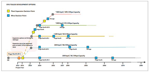
| 26.2.1 | Power Supply Determination |
The supply of power has been recognized as being critical to the execution of the Oyu Tolgoi Project in the IA. OT LLC has been given the right to import power initially but must secure power from sources within Mongolia from the fourth year of operation.
The PPA is now in place to allow power to be imported from Inner Mongolia. The next phase of the IA is for OT LLC to source power from Mongolia by the fourth year of operation in accordance with the terms of the IA.
There is no provision for a plant in the current capital cost estimates and the financing that would be required is not contemplated as part of the Company’s current financing plan.
OT LLC is currently considering a range of options to ensure a reliable and efficient power supply after Year 4.
| 26.2.2 | Water Permit |
OT LLC’s strategy is to obtain approval for increases to the currently approved water reserve ahead of any mine expansion plans. The objective of the study will be to assess the impact if any on the concentrator expansion on water demand and to determine the need for obtaining GOM approval for any substantial increase in the approved water demand from the Gunii Hooloi aquifer.
The current estimate of average water demand for the concentrator expansion to 160 ktpd is 918 L/s, which is marginally above the rate of 870 L/s that has already been approved by the GOM.
AMC 813001 : March : 2013
444
ENTRÉE GOLD INC Lookout Hill Property, Southern Mongolia Technical Report | |
| 26.2.3 | Concentrate Marketing |
Long-term sales contracts have been signed for 75% of the Oyu Tolgoi mine’s concentrate production in the first three years, while 50% of concentrate production is contracted for ten years (subject to renewals). In addition to the signed contracts, in early November 2012, Oyu Tolgoi committed in principle, subject to the conclusion of detailed sales contracts, up to 25% of concentrate available for export would be made available at international terms to smelters in Inner Mongolia for the first ten years.
OT LLC has developed a marketing plan and currently includes consideration of the following factors:
| · | Location value to customer compared to imported material landed at Chinese ports. |
| · | Precious metals recovery and payment. |
| · | Length of contract. |
| · | Percentage of off-take to smelters versus traders. |
| · | Percentage of tonnage on contract versus spot. |
| · | Percentage of feed for any one smelter. |
| · | Number of smelters for a given scale of operation. |
| · | Management of concentrate quality and volume during commissioning and ramp-up. |
| · | Alternate off-shore logistics and costs. |
| · | Delivery point and terms. |
| · | Packaging. |
A detailed timeline has been developed for marketing, logistics, and contract-to-cash functions. OT LLC’s Sales and Marketing will be supported by Rio Tinto Copper Marketing, led by its Chief Marketing Officer. The marketing team will oversee and execute all sales and marketing activities on behalf of OT LLC.
| 26.2.4 | Socio-economic Aspects of Mine Closure Plan |
The preliminary mine closure and reclamation plan includes provisions to ensure that adverse socio-economic impacts of mine closure are minimized and positive impacts are maximized. To this end, OT LLC has planned that allowances will be incorporated into the annual mine operations budget starting 10 years before mine closure to address the costs of:
| · | Lost employment by the mine workforce. |
| · | Adverse effects on supply chain businesses and downstream businesses, affected communities, public services, and infrastructure. |
| · | Promoting ongoing sustainability among affected stakeholders and communities. |
AMC 813001 : March : 2013
445
ENTRÉE GOLD INC Lookout Hill Property, Southern Mongolia Technical Report | |
The details of additional socio-economic aspects of a conceptual mine closure plan have not yet been fully developed and are the subject of work to be done in the near future.
| 26.2.5 | Infrastructure |
OT LLC is continuing to work on further defining the ongoing infrastructure needs for the project. The OT Manager has advised that they expect future additions to the project scope which may include:
| · | Operations camp expansion |
| · | Border facilities upgrade |
| · | Concentrate bagging plant upgrade |
| · | Power substation expansions |
| · | Central maintenance complex |
| · | Central control room |
| · | Borefield expansion |
| · | Operations warehouse expansion |
| · | Core storage warehouse |
There may be additions to scope beyond these items and all items and updated cost estimates will be included in the feasibility study.
| 26.2.6 | EJV Potential for Further Development |
Entrée has mineral resources in the Hugo North and Heruga deposits. OT LLC is studying the development options for all the deposits on the project. The mine designs and production schedules for the alternative development options are:
| · | Southern Oyu Open Pits (2013 Mineral Reserve) |
| · | Hugo North Lift 1 Block Cave (2013 Mineral Reserve) |
| · | Hugo North Lift 2 Block Cave (Inferred) |
| · | Hugo South Block Cave or Open Pit (Inferred) |
| · | Heruga Block Cave (Inferred) |
Under the NI 43-101 guidelines, Inferred Mineral Resources are considered too speculative geologically to have the economic considerations applied to them that would allow them to be categorized as Mineral Reserves. There is no certainty that the alternative production cases will be realized.
Currently the designs for Hugo North Lift 2, Hugo South Block Cave and Heruga are the same as those in IDP10. The Hugo South open pit designs were updated in 2012. From the designs two sets for long term production scheduling can be prepared, one with Hugo South as underground and one as open pit. The two sets are shown in Figure 26.4 and Figure 26.5. The work on the alternative production cases is not complete, in particular the definition of the expansion sizes and costing of the cases.
AMC 813001 : March : 2013
446
ENTRÉE GOLD INC Lookout Hill Property, Southern Mongolia Technical Report | |
| Figure 26.4 | Alternative Production Design Set 1 |
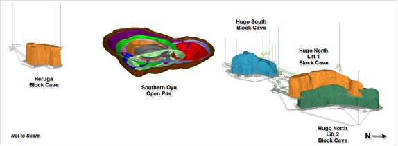
| Figure 26.5 | Alternative Production Design Set 2 |

These cases will be part of the strategic planning that is being undertaken by OT LLC. This work will examine the plant capacity for expansions. Figure 26.6 shows the development options that have been identified as part of the study planning.
AMC 813001 : March : 2013
447
ENTRÉE GOLD INC Lookout Hill Property, Southern Mongolia Technical Report | |
| Figure 26.6 | Oyu Tolgoi Development Options |
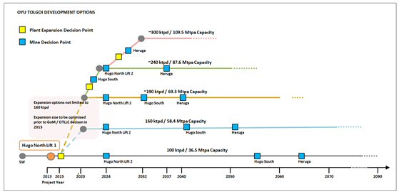
Three alternative production cases were developed by OT LLC to explore the potential plant expansions and the flexibility inherent in the Heruga and Hugo South deposits.
In the first case, the mining inventory remains the same as the 2013 Reserve Case but with a plant expansion in Year 6. This case is only at a conceptual level and costings have not been prepared. Alternative Production Case A is depicted in Figure 26.7.
Total annual production is 59.0 Mtpa from the Southern Oyu open pit and Hugo North Lift 1. The 2013 Reserve Case production is included in black for comparison.
| Figure 26.7 | Alternative Production Case A |

AMC 813001 : March : 2013
448
ENTRÉE GOLD INC Lookout Hill Property, Southern Mongolia Technical Report | |
In Alternative Production Case B, Hugo North Lift 2, Heruga, and Hugo South open pit are added to the schedule. A plant expansion occurs in Year 7. This case is only at a conceptual level and costings have not been prepared. The ultimate production rate for Alternative Production Case B is 68.1 Mtpa and is shown in Figure 26.8. This case uses Heruga as a 25 Mtpa operation and Hugo South as an open pit mine. The 2013 Reserve Case (black) and Alternative Production Case A (orange) are included for comparison.
| Figure 26.8 | Alternative Production Case B |
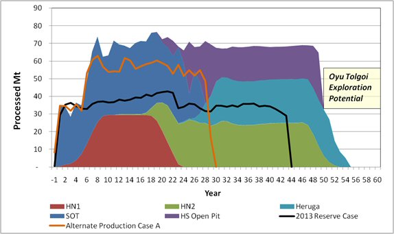
The third case is Alternative Production Case C and, again, is only at a conceptual level and costings have not been prepared. The ultimate production rate for Alternative Production Case C is 110 Mtpa and is shown in Figure 26.9. The case also uses Heruga as a 25 Mtpa operation and Hugo South as an open pit mine. The 2013 Reserve Case (black), Alternative Production Case A (orange), and Alternative Production Case B (pink) are included for comparison. There is a significant amount of study work to be carried out to verify the alternative production cases to increase the Mineral Resource confidence and identify suitable infrastructure capacities such as water. These cases are discussed as it is considered that they demonstrate the options for the direction the Project’s long term mine planning could take.
AMC 813001 : March : 2013
449
ENTRÉE GOLD INC Lookout Hill Property, Southern Mongolia Technical Report | |
| Figure 26.9 | Alternative Production Case C |

| 26.3 | Shivee West |
Additional exploration is recommended on Shivee West to further test Zone III/Argo and to continue porphyry copper exploration. Estimated cost for the following work is approximately US$6.6 million.
| 26.3.1 | Precious Metal Exploration - Argo/Zone III |
Continued exploration of the near surface gold mineralization at Argo is recommended, to look for and subsequently to define mineralization amenable to open pit mining. The work programme would encompass additional geochemical and geophysical surveys, and drilling.
Compared to conventional soil sampling done by Entrée from 2003 to 2007, MMI sampling has been more successful in outlining and locating gold anomalies. Expansion and infill of the existing MMI soil sampling over the Argo Zone is recommended, to cover in greater detail the magnetic low that is associated with the mineralization.
Although the overall sulphide content of the Argo mineralization is very low, dipole-dipole IP surveying is recommended, to define near-surface chargeability and resistivity features, and is not sufficiently detailed to guide continued drilling. Dipole-dipole IP surveying is recommended, using n=1-10 and a=100 m, on lines spaced 100 metres apart, to cover the magnetic and Titan IP anomaly.
Two phases of drilling are recommended. Core drilling (3,000 metres of HQ core) is recommended to gain additional geologic knowledge of the Argo mineralization across the zone and along strike to the north, in particular to determine the stratigraphic and structural controls on mineralization. This would be followed by 3,000 metres of RC drilling, to infill the core hole pattern, and to drill any additional targets resulting from the geophysical and MMI sampling surveys.
AMC 813001 : March : 2013
450
ENTRÉE GOLD INC Lookout Hill Property, Southern Mongolia Technical Report | |
| 26.3.2 | Porphyry Copper Exploration |
The Khoyor Mod area has sporadic copper showings in a monzodiorite intrusion hosted by Devonian DA4s sedimentary units. An attempt to date this intrusion was unsuccessful (Panteleyev, 2006); however, whole rock sampling of core and outcrop is recommended, to determine if it has a geochemical signature similar to the Devonian quartz monzodiorites at Oyu Tolgoi. Establishing a Devonian age would enhance the prospectivity of this area.
The MMI-Au anomalies north of the Khoyor Mod area require additional detailed mapping, sampling, and excavator-assisted trenching to define a drilling target for several relatively shallow HQ core holes totalling 1,000 metres.
5,000 metres of HQ core drilling is recommended to continue deep exploration of the strong magnetite and potassic hydrothermal alteration system encountered in EG-10-140 during Entrée's 2010 drilling campaign.
AMC 813001 : March : 2013
451
ENTRÉE GOLD INC Lookout Hill Property, Southern Mongolia Technical Report | |
| 27 | REFERENCES |
Integrated Development Plan: unpublished report, Ivanhoe Mines Mongolia Inc.
October, 2005, accessed 20 February, 2007;
http://www.ivanhoe-mines.com/s/NewsReleases.asp?ReportID=118375&_Type=
News-Releases&_Title=independent-integrated-development-plan-for-oyu-tolgoi-
highlights-significant and long-lasting benefits for Mongolia.
Mongolia with a special emphasis on copper and gold deposits, R. Seltmann, O. Gerel
and D. Kirwin, eds., IAGOD Excursion Guidebook of the SEG-IAGOD Field Trip to
“Copper and Gold Deposits of Mongolia’, pp.119–129.
for Mongolia: implications for the Phanerozoic crustal growth of Central Asia; Journal of
Asian Earth Sciences Vol. 21 (2002), pp.87–110.
Saykhandulaan Inlier, Mongolia: Implications for Palaeozoic arc magmatism, polyphase
deformation and terrane accretion in the Southeast Gobi Mineral Belt; Journal of Asian
Earth Sciences, Vol. 32 (2008), pp. 142–164.
unpublished internal report, Ivanhoe., (technical report filed under NI 43–101, SEDAR).
Őmnögovi Aimag, Southern Mongolia; unpublished report, Entrée Gold Inc. November,
2004 (technical report filed under NI 43–101, SEDAR).
and Equity Participation Agreement, Shivee Tolgoi Earn-in Property, Southern Gobi
Region, Mongolia: unpublished report, Entrée Gold Inc.
Report March 29, 2007.
Crane, D. and I. Kavalieris, 2013: Geologic Overview of the Oyu Tolgoi Porphyry Cu-Au-
Mo Deposits, Mongolia; In Geology and Genesis of Major Copper Deposits and Districts
of the World: A Tribute to Richard H. Sillitoe; SEG Spec. Pub. 16.
Diessel, C.F.K., 1992: Coal-Bearing Depositional Systems; Springer-Verlag, Berlin-
Heidelberg. 721 p.
basins: Geological settings, coal characteristics, distribution, and resources; Int. ournal
of Coal Geology, Vol. 80 (2009), pp. 87–104.
AMC 813001 : March : 2013
452
ENTRÉE GOLD INC Lookout Hill Property, Southern Mongolia Technical Report | |
Forster, C.N., and Crane, D., 2006: Entrée Gold – Ivanhoe JV Project Geology and
Drilling Report, Second Anniversary: unpublished internal company report, Entrée Gold
Inc., 47 p.
Report, 2nd Anniversary; private report prepared for Entrée Gold Inc., 40 p.
JV Project Geology and Drilling Report, Third Anniversary: unpublished internal
company report, Entrée Gold Inc., 57 p.
Property, Mongolia: unpublished internal company report, Entrée Gold Inc., November
30, 2009.
Hendrix, M. S., Beck, M. A., Badarch, G., and Graham, S. A., 2001: Triassic
synorogenic sedimentation in southern Mongolia: early effects of intracontinental
deformation, in Paleozoic and Mesozoic Tectonic Evolution of Central Asia – From
Continental Assembly to Intracontinental Deformation, M. S. Hendrix and G. A. Davis,
eds., Geological Society of America Memoir 194, pp. 389–412.
Preliminary Assessment, Oyu Tolgoi project, Mongolia: unpublished internal report,
Ivanhoe., January 2005 (technical report filed under NI 43-101, SEDAR). ioGlobal, 2006:
Audit Report on Laboratories, Mongolia: unpublished internal report, Entrée Gold Inc.,
September, 2006.
Resource/Reserve Reporting System for Canada; Geological Survey of Canada Paper
88 – 21, 17 p.
Jackson, S., Vann, J., David, D., Cullingham O., 2010: NI 43-101 Compliant Technical
Report on the Lookout Hill Project, Ömnögovi Aimag, Southern Mongolia, unpublished
report, Entrée Gold Inc., March 2010 (technical report filed under NI 43–101, SEDAR).
Oyu Tolgoi, Mongolia: unpublished report, Ivanhoe Mines Mongolia Inc., May 2005
(technical report filed under NI 43-101, SEDAR).
D., Munkbhat, T. O. and Niislelkhuu, G., 2005: The Oyu Tolgoi copper-gold porphyry
deposits, South Gobi, Mongolia; in Geodynamics and Metallogeny of Mongolia with a
special emphasis on copper and gold deposits, R. Seltmann, O. Gerel and D. J. Kirwin,
eds., IAGOD Guidebook Series 11, CERCAMS/NHM London, pp. 155–168.
AMC 813001 : March : 2013
453
ENTRÉE GOLD INC Lookout Hill Property, Southern Mongolia Technical Report | |
Khashgerel, B., Rye, R.O., Hedenquist, J.W., and Kavalieris, I., 2006: Geology and
Reconnaissance Stable Isotope Study of the Oyu Tolgoi Porphyry Cu-Au System, South
Gobi, Mongolia: Economic Geology, Vol. 101, pp. 503–522. ref.
systems of southern Mongolia: New geochemical and petrographic constraints; in
Paleozoic and Mesozoic Tectonic Evolution of Central Asia – From Continental
Assembly to Intracontinental Deformation, M. S. Hendrix and G. A. Davis, eds.,
Geological Society of America Memoir 194, pp.117–149.
prepared for Ivanhoe Mines Mongolia, 21 p.
Deposit Profiles, Volume 1 — Metallics and Coal, Lefebure, D.V. and Ray, G.E., Editors,
British Columbia Ministry of Energy of Employment and Investment, Open File 1995-20,
pages 87–92.
Columbia Mineral Deposit Profiles, Volume 2 — Metallic Deposits, Lefebure, D.V. and
Hõy, T, Editors, British Columbia Ministry of Employment and Investment, Open File
1996-13, pages 37–39.
Columbia Mineral Deposit Profiles, Volume 2 - Metallic Deposits, Lefebure, D.V. and
Hõy, T, Editors, British Columbia Ministry of Employment and Investment, Open File
1996-13, pages 41–44.
Ömnögovi Aimag, South Gobi Region, Mongolia; Geology of “Main” (Zones I, II and III)
and ‘Copper Flats’ Grids: unpublished internal report to Entrée Gold Inc. by XDM
Geological Consultants Inc.
Shivee Tolgoi (Lookout Hill) Property, Southern Gobi Region, Mongolia: unpublished
internal report to Entrée Gold Inc. by XDM Geological Consultants Inc., April 2005.
Shivee Tolgoi (Lookout Hill) Property, Southern Gobi Region, Mongolia: unpublished
internal report to Entrée Gold Inc. by XDM Geological Consultants Inc., February 2005
(technical report filed under NI 43-101, SEDAR).
Lookout Hill (Shivee Tolgoi) Property, Ömnögovi Aimag, South Gobi Region, Mongolia -
Geologic Mapping of Volcanic Terrane in Northern Togoot Licence Area unpublished
report prepared for Entrée Gold Inc., 25 p.
AMC 813001 : March : 2013
454
ENTRÉE GOLD INC Lookout Hill Property, Southern Mongolia Technical Report | |
(Shivee Tolgoi) Property, (North) Shivee West and North Zone I, ‘Devonian Wedge’ and
Reconnaissance of Western Shivee Tolgoi Property, Ömnögovi Aimag, South Gobi
Region, Mongolia; unpublished report prepared for Entrée Gold Inc., 10 p.
Perelló, J., Cox, D., Garamjav, D., Sanjdorj, S., Schissel, D., Munkhbat, T-O and Oyun,
G. 2001: Oyu Tolgoi, Mongolia: Siluro-Devonian Porphyry Cu-Au-Mo and High
Sulphidation Cu Mineralization with a Cretaceous Chalcocite Blanket: Economic
Geology, v. 96, pp. 1,407–1,428.
Oyu Open Pit Technical Report, unpublished internal report to Ivanhoe., January 2006,
(technical report filed under NI 43-101, SEDAR).
Ivanhoe., March 2012, (technical report filed under NI 43-101, SEDAR).
Peters, B et al, 2012: Oyu Tolgoi Project, Technical Report 2012 on the Lookout Hill
Property, report to Entrée Gold Inc., March 2012, (technical report filed under NI 43-101,
SEDAR).
Reid, D.F., Cole, A.L. and Cann, R.M., 2003: 2002 Exploration Report, Shivee Tolgoi JV
Property, Ömnögovi Aimag, Mongolia: unpublished internal company report, Entrée
Gold Inc.
Property, Ömnögovi Aimag, Mongolia: unpublished internal company report, Entrée
Gold Inc.
Gobi, Mongolia: meeting and exceeding technical disclosure requirements; CIM
Magazine, February 2007, Vol. 2, No. 9.
work Oyu Tolgoi project, South Gobi, Mongolia, Ivanhoe Inc. (Unpublished company
report).
in the composition of coal, No.1; Proceedings of the Royal Society of London, Series B,
Vol. 90, pp. 470–486.
Thomas, L., 2002: Coal Geology, Wiley and Sons, 384 p.
Mongolian People’s Republic and its influence on hydrocarbon geology and potential;
Marine and Petroleum Geology 12 (1995), pp. 35–52.
Compliant Technical Report on the Lookout Hill Project, Ömnögovi Aimag, Southern
Mongolia, unpublished report, Entrée Gold Inc., March 2008 (technical report filed under
NI 43-101, SEDAR).
AMC 813001 : March : 2013
455
ENTRÉE GOLD INC Lookout Hill Property, Southern Mongolia Technical Report | |
Vann, J., Jackson, S.,David, D., Cullingham O, Cann, R., and Foster, J., 2009:
NI 43-101 Compliant Technical Report on the Lookout Hill Project, Ömnögovi Aimag,
Southern Mongolia, unpublished report, Entrée Gold Inc., March 2009 (technical report
filed under NI 43-101, SEDAR).
Wainwright, J.A., 2008. Volcanostratigraphic framework and magmatic evolution of the
Oyu Tolgoi porphyry Cu-Au district, South Mongolia. Unpublished PhD thesis, University
of British Columbia.
Wainwright, J.A., Tosdal, R.M., Forster, C., Kavalieris, I., Crane, D., Findlay, A., and
Kirwin, D., 2005: Structure and Stratigraphy of the Oyu Tolgoi Cu–Au Porphyry,
Mongolia: Poster presentation at Cordilleran Exploration Round Up, Vancouver,
January, 2005.
the Shivee Tolgoi, Javhlant and Togoot Licences, unpublished internal company report,
Entrée Gold Inc., 12 p.
Additional references are identified throughout the text of this report.
AMC 813001 : March : 2013
456