ENDEAVOUR SILVER CORP.
NI 43-101 TECHNICAL REPORT
RESOURCE AND RESERVE ESTIMATES
FOR THE
GUANACEVÍ MINES PROJECT
DURANGO STATE
MEXICO
Report Date: March 27, 2013
Effective Date: December 15, 2012
Report By
William J. Lewis, BSc., P.Geo.
Charley Z. Murahwi, M.Sc., P.Geo., Pr.Sci.Nat., FAusIMM
Ing. Alan J. San Martin, MAusIMM (CP)
SUITE 900 - 390 BAY STREET, TORONTO ONTARIO, CANADA M5H 2Y2
Telephone (1) (416) 362-5135 Fax (1) (416) 362 5763
Table of Contents
i
ii
iii
iv
APPENDIX
| Appendix 1 | Glossary of Mining and Related Terms | At end of Report |
v
List of Tables
vi
vii
List of Figures
viii
ix
x
1.0 SUMMARY
1.1 INTRODUCTION
Endeavour Silver Corp. (Endeavour Silver) has retained Micon International Limited (Micon) to provide an independent resource and reserve estimation for the Guanaceví Mines Project in the State of Durango, Mexico. This report is an update of the previous Micon Technical Report entitled “NI 43-101 Technical Report, Resource and Reserve Estimates for the Guanaceví Mines Project, Durango State, Mexico” and dated March 30, 2012. The 2012 report was posted by Endeavour Silver on the System for Electronic Document Analysis and Retrieval (SEDAR).
This report constitutes an independent estimation of the mineral resources and reserves of the Guanaceví Mines Project as of December 15, 2012. The estimate was conducted to ensure that the mineral resources and reserve discussed herein complied with the Canadian Institute of Mining, Metallurgy and Petroleum (CIM) standards and definitions, as required under Canadian National Instrument 43-101 (NI 43-101) regulations.
This report also comments on the propriety of the continuing studies and budget for the Guanaceví Mines Project.
The term Guanaceví Mines Property, in this report, refers to the entire area covered by the mineral license, while the term Guanaceví Mines Project refers to the area within the mineral license on which the current mining and exploration programs are being conducted.
This report follows the format and guidelines of Form 43-101F1, Technical Report for National Instrument 43-101, Standards of Disclosure for Mineral Projects, and its Companion Policy NI 43-101CP, as amended by the Canadian Securities Administrators and which came into force on June 30, 2011.
Micon does not have nor has it previously had any material interest in Endeavour Silver or related entities. The relationship with Endeavour Silver is solely a professional association between the client and the independent consultant. This report is prepared in return for fees based upon agreed commercial rates and the payment of these fees is in no way contingent on the results of this report.
This report is intended to be used by Endeavour Silver subject to the terms and conditions of its agreement with Micon. That agreement permits Endeavour Silver to file this report as a Technical Report with the Canadian Securities Administrators (CSA) pursuant to provincial securities legislation. Except for the purposes legislated under provincial securities laws, any other use of this report, by any third party, is at that party’s sole risk.
This report includes technical information which requires subsequent calculations or estimates to derive sub-totals, totals and weighted averages. Such calculations or estimations inherently involve a degree of rounding and consequently introduce a margin of error. Where these occur, Micon does not consider them to be material.
1
The conclusions and recommendations in this report reflect the authors’ best independent judgment in light of the information available to them at the time of writing. The authors and Micon reserve the right, but will not be obliged, to revise this report and conclusions if additional information becomes known to them subsequent to the date of this report. Use of this report acknowledges acceptance of the foregoing conditions.
1.2 LOCATION AND PROPERTY DESCRIPTION
The Guanaceví Mines Project is located within the Municipality of Guanaceví in the State of Durango, Mexico, near its northern border with the state of Chihuahua. The Property is accessed by travelling from the city of Durango, located 260 kilometres (km) southeast. Durango has a modern airport with daily flights to and from Mexico City and portions of the United States. The Guanaceví Mines Project is located on the edge of the Sierra Madre, a series of rugged mountains with higher points reaching 3,300 metres (m) above sea level. The Guanaceví Mines Project is located at approximately 105°58'20"W longitude and 25°54'47"N latitude.
The Guanaceví mining district covers an area measuring approximately 5 km northeast-southwest by 10 km northwest-southeast and contains more than 50 silver/gold mines. Although only three of the mines are presently operating, there is considerable mining experience available in the area.
1.3 OWNERSHIP
Endeavour Silver holds the Guanaceví Mines Project through its 100% owned Mexican subsidiary Endeavour Gold Corporation S.A. de C.V. (Endeavour Gold). Endeavour Gold holds the project through its two 100% owned subsidiaries Minera Plata Adelante S.A. de C.V. (Minera Plata Adelante) and Refinadora Plata Guanaceví S.A. de C.V. (Refinadora Plata Guanaceví). At present, the Project is comprised of 40 mineral concessions. The mineral concessions are not all contiguous and vary in size, for a total Property area of 4,076.1977 ha. The annual 2012 concession tax for the Guanaceví Property is approximately 367,200 Mexican pesos (pesos), which is equal to about US $28,400 at an exchange rate of 12.93 pesos to US $1.00 dollar.
On February 9, 2009, Endeavour Silver entered into a mining exploration agreement with Minerales Monte Blanco S.A. de C.V. (Minerales Monte Blanco), represented by Sergio Enrique Silva Franco, on the El Porvenir Cuatro and La Brisa concessions totalling 55.5518 ha. The El Porvenir Cuatro and La Brisa agreement was an option to earn 100% of these Projects over two years for a total consideration of US $700,000.
In February, 2010, Endeavour Silver exercised its option to purchase the El Porvenir Cuatro and La Brisa Projects, by paying a total consideration to the vendors of US $100,000 cash and 136,054 shares on signing the option agreement, and an additional 71,428 common shares and US $160,000 cash on the early exercise of the option to purchase.
2
In July, 2010, Endeavour Silver acquired 100% interest in the Elizabeth (17.0 ha) and El Calvario (1.3 ha) Projects in Guanaceví. The purchase price of these Projects was US $50,000. The El Calvario Project is situated in the central part of San Pedro, adjacent to the historic, high grade Noche Buena mine and transected by the Noche Buena vein. The Elizabeth Project is situated approximately 1 km east of Endeavour Silver’s Porvenir mine.
In June, 2011, Endeavour Silver acquired an option on the La Brisa and La Brisa 2 Projects (90 ha), located approximately 10 km southeast of Endeavour's active Porvenir silver-gold mine in the Guanaceví district. The option agreement requires Endeavour Silver to make US$220,000 in cash payments over a 3 year period.
In 2011, Endeavour Silver also staked several new concessions (2,746 ha) surrounding the La Brisa and La Brisa 2 properties to cover possible extensions of the La Brisa veins and several other recently discovered veins.
In June, 2011, Endeavour Silver also acquired an option to purchase four small properties within the San Pedro sub-district. The El Cambio Project lie about 6 km northwest of the Porvenir mine and along strike from the historic El Soto and Nueva Australia high grade silver mines. The El Cambio option agreement gives Endeavour Silver the right to purchase the El Cambio, La Onza, San Nicolas and Ampliacion de San Nicolas Projects (37 ha) for $150,000 in cash payments over a 2 year period.
In November, 2012, Endeavour Silver acquired 100% interest in the San Fernando mineral concession which is adjacent to the Milache area near the new zone currently being delineated by the exploration group. The San Fernando concession was acquired for $200,000 as a one-time payment.
In addition to the mineral rights, Endeavour Silver has agreements with various private ranch owners and local ejidos (El Hacho and San Pedro) that provide access for exploration and exploitation purposes.
1.4 HISTORY
It is not known if the indigenous peoples or the Spanish colonists first began mining in the Guanaceví district but mining extends back to at least 1535 when the mines were first worked by the Spanish. By the start of the 18th century, Guanaceví had become an important mining centre in the Nueva Vizcaya province of Nueva España (New Spain), as reported by Alexander von Humboldt in his travels through Nueva España. However, the Guanaceví mining district is not as well known today.
The Guanaceví mining district and the Guanaceví Mines Project area are riddled with mine openings and old workings, in a somewhat haphazard fashion near surface, representing the earliest efforts at extraction, and more systematic at depth, which is indicative of later, better organized and engineered mining. Associated with these openings and workings is a number of ruins, which represent the mine buildings, chapels and residences of the inhabitants and indicate the wealth of the mining district during its past.
3
The vast bulk of the material which has been extracted from underground operations through the tunnels, shafts and winzes is scattered over the hillsides in waste dumps and beneath the foundations of the ruins and modern buildings. Historically, individual veins or deposits had separate owners and, in the case of some of the larger veins or deposits, had several owners along the strike length which resulted in a surfeit of adits and shafts and very inefficient operations.
During the late sixteenth century silver production accounted for 80% of all exports from Nueva España, although, by the mid-seventeenth century, silver production collapsed when mercury, necessary to the refining process, was diverted to the silver mines of Potosí in present day Bolivia. Collapse of the seventeenth century mining led to widespread bankruptcy among the miners and hacienda owners; however, in the latter half of the seventeenth century silver mining began to recover in Nueva España. By the start of the 18th century, Guanaceví had become an important mining centre in the Nueva Vizcaya province.
The peasant uprisings of 1810 to 1821 were disastrous to the Mexican mining industry with both the insurgents’ soldiers and royalist troops all but destroying the mining production in Mexico, and the Guanaceví mining district was not spared during this period.
The district has experienced several periods of bonanza-grade production, including the operation of a mint in 1844. The Guanaceví mining district, however, reached its greatest period of activity at the start of the 20th century, when five processing plants were in operation and more than 15 mines were in production.
J.R. Southworth, in his 1905 volume entitled “The Mines of Mexico”, mentions that Guanaceví is a very rich district and “that many of the largest capitalists of New York have enormous interests in its mines”. Southworth mentions that the Barradán, Hacienda Wilson, El Carmen, Nueva Australia and Hacienda Avila were all good mines and properties within the Guanaceví mining district. However, Southworth also mentioned that “considering the large number of once famous properties in Guanaceví, there are comparatively few now in operation. The cessation of development has been due to various causes, though usually not from lack of ore.”
The vast majority of production came prior to the 1910 Mexican Revolution with the Guanaceví mining district being known for its high silver grades. Previous reports noted that the official production records indicate that a total value of 500 million pesos, or approximately 500 million ounces of silver and silver equivalents, with a present day value of about US $3.25 billion, had been extracted from this mining district. This makes the Guanaceví district one of the top five silver mining districts in Mexico on the basis of past production.
4
The extent of historical exploration on the property is relatively unknown. Prior to management by Endeavour Silver, production was coming from three mines without the benefit of any systematic exploration drilling, geological mapping or mine planning.
1.5 GEOLOGY AND MINERALIZATION
The Guanaceví mineral deposits occur as an epithermal low sulphidation, quartz-carbonate, fracture-filling vein hosted by a structure that trends approximately N45°W and dips 55° southwest. The fault and vein comprise a structural system referred to locally as the Santa Cruz vein structure or Santa Cruz vein fault. The Santa Cruz vein itself has been traced for 5 km along the trend and averages approximately 3.0 m in width. High-grade mineralization in the system is not continuous, but occurs in steeply northwest-raking shoots up to 200 m in strike length. A second vein is located sub-parallel and subjacent (located in the footwall) to the Santa Cruz vein but is less continuous. The footwall vein is economically significant in the Porvenir Dos zone and in the northern portion of deep North Porvenir.
The Santa Cruz vein is a silver-rich structure with lesser amounts of gold, lead and zinc. Based on historic production, mineralization has averaged 500 grams per tonne (g/t) silver and 1 g/t gold over a 3 m true width. The minerals encountered are argentite-acanthite with limited gold, galena, sphalerite, pyrite and manganese oxides. Gangue minerals noted are barite, rhodonite, rhodochrosite, calcite, fluorite and quartz. The mineralization down to Level 6 in the Santa Cruz mine is mainly oxidized with a transition zone of oxides to sulphides occurring between Levels 6 to 8, although some sulphide ore was mined above Level 6. Mineralization exhibits evidence of episodic hydrothermal events which generated finely banded textures. High-grade mineralization in the district is commonly associated with multiple phases of banding and brecciation. In the Porvenir Dos area and in the deeper portion of North Porvenir, a footwall-hosted vein is associated with the Santa Cruz vein structure. In both areas, this footwall vein is either within Guanaceví Formation footwall rocks or is at the structural contact between the Guanaceví Formation and Lower Volcanic Sequence andesite. It is banded to brecciated quartz plus carbonate and contains local scatterings (< 1%) of sulphides (pyrite>sphalerite >galena>chalcopyrite) and rare pods (< 50 cm) of sulphides.
1.6 EXPLORATION PROGRAM
Since 2004 and to December 31, 2012, Endeavour Silver has completed 497 diamond drill holes totalling 133,916.6 m and 22 reverse circulation drill holes totalling 2,977 m on the entire Guanaceví Mines Project. More than 32,491 samples have also been collected and submitted for assay.
Of this total, approximately 112,812.2 m of diamond drilling in 381 holes have been completed on the Santa Cruz vein structure. Holes were drilled from both surface and underground drill stations.
5
In 2012, Endeavour Silver spent US $2,146,787 (including property holding costs) on exploration activities mainly on the Milache and La Brisa areas. Twenty-eight surface core holes were drilled for 12,636 m and 2,793 samples were submitted for assay.
During 2012, only limited surface geological mapping and sampling was conducted by Endeavour Silver in the Guanaceví District. Field activities mainly focused in the La Brisa and La Gloria areas. A total of 149 rock samples were collected. Exploration fieldwork was completed in the La Brisa area.
In 2013, Endeavour Silver plans a follow-up surface exploration program focused on the Santa Cruz vein in the Milache area, near Endeavour Silver's mining operation at Guanaceví. Endeavour Silver will also conduct a regional exploration program to investigate several new prospective targets within the district. The mine will continue to conduct both surface and underground drilling in order to further define the mineralization in the operational area. The primary long-term goal of this program is to expand reserves and resources and to identify properties/concessions for potential acquisition in the Guanaceví district for future growth.
Table 1.1 summarizes the planned 2013 exploration budget for the Guanaceví Mines Project.
Table 1.1
Guanaceví Exploration Priority Targets– 2013
| Project Area | 2012 Program | Budget US $ | ||
| Holes | Metres | Samples | ||
| Surface Exploration Drilling | ||||
| Milache | 30 | 12,000 | 3,000 | 1,779,200 |
| Guanaceví Regional Exploration | 0 | 0 | 800 | 126,200 |
| Subtotal | 30 | 12,000 | 3,800 | 1,905,400 |
| Mine Operations Exploration Drilling | ||||
| Porvenir North | 28 | 5,328 | ---- | 852,432 |
| Santa Cruz | 17 | 1,363 | ---- | 465,695 |
| Alex Breccia | 7 | 3,174 | ---- | 507,823 |
| La Prieta | 6 | 1,363 | ---- | 218,033 |
| Subtotal | 58 | 11,228 | ---- | 2,043,983 |
| Total (mine +exploration division) | 88 | 23,228 | 3,949,383 | |
Table provided by Endeavour Silver Corp.
1.7 2012 MINERAL RESOURCE ESTIMATE
1.7.1 Mineral Resource Statement
The mineral resources for the Guanaceví Mines Project as of December 15, 2012 are summarized in Table 1.2. The resources are exclusive of the mineral reserves.
6
Table 1.2
December 15, 2012 Mineral Resource Estimate, Guanaceví Mines Project
| Category | Tonnes | Silver (g/t) | Gold (g/t) | Silver (oz) | Gold (oz) | Silver Eq (oz) |
| Measured (M) | 129,000 | 312 | 0.49 | 1,294,000 | 2,000 | 1,394,000 |
| Indicated (I) | 3,014,000 | 232 | 0.49 | 22,433,700 | 47,700 | 24,818,700 |
| Total M and I | 3,143,000 | 235 | 0.49 | 23,727,700 | 49,700 | 26,212,700 |
| Inferred (Ag+Au) | 1,429,000 | 259 | 0.52 | 11,921,200 | 24,000 | 13,121,200 |
| Inferred (Ag+Pb+Zn) | 644,000 | 124 | 0.14 | 2,577,300 | 3,000 | 2,727,300, |
| 1. | Mineral resources which are not mineral reserves do not have demonstrated economic viability. The estimate of mineral resources may be materially affected by environmental, permitting, legal, title, taxation, sociopolitical, marketing, or other relevant issues. |
| 2. | There has been insufficient exploration to define the inferred resources as an indicated or measured mineral resource. It is uncertain if further exploration will result in upgrading them to an indicated or measured mineral resource category. |
Micon believes that at present there are no known environmental, permitting, legal, title, taxation, socio-economic, marketing or political issues which could adversely affect the mineral resources estimated above.
1.7.2 Assumptions and Parameters
The mineral resource is based on the following parameters:
Minimum mining width – 1.5 m.
Silver equivalent – 50:1, based on prices of US $1,550/oz for gold and US $31/oz for silver.
Cut-off grade – 100 g/t silver equivalent.
1.7.3 Methodology
Resources for the mining areas (Santa Cruz, Porvenir North, Porvenir Dos and Porvenir Cuatro) of the Guanaceví Mines Project were estimated by Micon in 2011/2012 using the 3D modeling technique and the inverse distance cubed (ID3) method for interpolating grade. The resources for these mining areas as at December 15, 2012 have been estimated by Micon by deducting the resources converted into reserves during 2012 from the original total resources previously estimated in 2011/2012.
Resources for the exploration areas (San Joaquin, La Blanc-Mi Niña and Epsilon-Soto) have been carried forward from the December 31, 2011, estimates, as there has been no change since that time. Resources for the Milache Project were estimated by Endeavour Silver using the 3D modeling technique and audited by Micon.
Mineral resources were classified on the basis of the location of blocks relative to the data used to interpolate the block grade, according to the following criteria:
7
Measured mineral resources apply to those resource blocks where grade, density, shape and physical characteristics are so well established to allow the appropriate application of technical and economic parameters, to support production planning.
Indicated mineral resources refer to those resource blocks/areas where the geological framework, continuity and grade of mineralization are sufficiently understood to support a preliminary feasibility study which will serve as the basis for major development decisions. For the operations, this is applicable to those blocks which have had the historical mine sampling superseded by Endeavour Silver’s subsequent channel sampling programs which, in conjunction with the confidence gained from the historical reconciliations, provide an acceptable level of confidence in the sample grades and resultant block estimates. All of the modeled Indicated resource blocks for the existing operations are within a maximum distance of 35 m from any data point, including development, chip samples or drill hole intercepts. For the exploration division’s polygonal resource estimates, a 25 m search radius is used in the definition of Indicated resources.
Inferred mineral resources are those blocks/areas where confidence in the estimate is insufficient to enable an evaluation of the economic viability worthy of public disclosure. For the operations, these are outlined and estimated based on the mine’s interpretation and confidence in the historical sampling results. For the exploration division’s polygonal resource estimates, a 50 m search radius is used in the definition of Inferred resources.
1.8 2012 MINERAL RESERVE ESTIMATE
1.8.1 Mineral Reserve Statement
The mineral reserves for the Guanaceví Mines project as of December 15, 2012 are summarized in Table 1.3.
Table 1.3
December 15, 2012 Proven and Probable Mineral Reserve Estimate
| Category | Tonnes | Silver (g/t) | Gold (g/t) | Silver (oz) | Gold (oz) | Silver Eq (oz) |
| Proven | 423,000 | 243 | 0.52 | 3,308,000 | 7,000 | 3,658,000 |
| Probable | 797,000 | 234 | 0.38 | 5,999,500 | 9,600 | 6,479,500 |
| Total Proven & Probable | 1,220,000 | 237 | 0.43 | 9,307,500 | 16,600 | 10,137,500 |
1.8.2 Mineral Reserve Parameters
The parameters used for the Guanaceví mineral reserves are as follows:
- Cut-off - 158 g/t Ag.
- Minimum width - 2 m.
8
- Gold price – US $1,550 per oz.
- Silver price – US $31 per oz.
- Gold recovery (overall) - 83.67%.
- Silver recovery (overall) - 76.63%.
1.8.3 Definitions and Classification
Mineral reserves are derived from measured/indicated resources after applying the economic parameters stated above. The Guanaceví reserves have been derived and classified according to the following criteria:
Proven mineral reserves are the economically mineable part of the Measured resource where development work for mining and information on processing/metallurgy and other relevant factors demonstrate that economic extraction is achievable. For Guanaceví, this applies to blocks located within approximately 10 m of existing development and for which Endeavour Silver has a mine plan in place.
Probable mineral reserves are those Measured or Indicated mineral resource blocks which are considered economic and for which Endeavour Silver has a mine plan in place. For Guanaceví, this is applicable to blocks located a maximum of 35 m either vertically or horizontally distant from development.
1.9 OPERATIONAL DATA
Since January 1, 2007, Endeavour Silver has been in control of the day-to-day mining operations at the Guanaceví Mines Project. Endeavour Silver assumed control of the mining operations from a local mining contractor in order to allow for more flexibility in operations and to continue optimizing the costs.
On December 15, 2012, the Guanaceví Mines Project had a roster of 443 employees. The mine operates on two 10-hour shifts, 7 days a week, whereas the mill operates on a 24/7 schedule.
A conventional cut and fill mining method is employed with the stopes generally 150 m long and 20 m high. Access to the stoping areas is provided by a series of primary and secondary ramps located in the footwall. The ramps have grades from minus 15% to plus 12%, with plus or minus 12% as standard. The cross-sections are 4 m by 4 m for the primary ramps and 3.5 m by 3.5 m for the secondary ramps.
In the upper parts of the mine, stope access is by short (10 m to 40 m) cross-cuts from the ramp to the vein/stope. These cross-cuts are generally 3.5 m by 3.5 m in cross-section and are usually driven down at minus 18% to intersect with the stope. As the stope advances up-dip on the vein, the back is taken down in these cross-cuts to maintain access until the cross-cut reaches a maximum inclination of 15%.
9
In the lower parts of the mine (below the water table), stope access is by 90 m long cross-cuts to the vein/stope. The cross-cuts are generally 3.0 m by 3.5 m in cross-section and are driven at plus 1% to intersect the stope (for water drainage). As the stope advances up-dip on the vein, the back is taken down in these cross-cuts to maintain access until the cross-cut reaches a maximum inclination of plus 15%.
For the year ending December 15, 2012, silver production was 2,512,943 oz and gold production was 7,874 oz. Plant throughput for 2012 was 418,277 tonnes at an average grade of 250 g/t silver and 0.77 g/t gold. In 2012, mill recoveries averaged 74.6% for silver and 76.1 % for gold.
The mill was originally built in 1970 by the Mexican government and designed to custom mill ores from various mines in the district. The mill has undergone a number of upgrades since 1970, and further upgrades since Endeavour Silver took over the day-to-day operations.
In 2012, the mill processed ore from the mines of Porvenir Cuatro, Porvenir 2, Porvenir North and Santa Cruz, as well as purchased (third party) ore. In 2012, the grinding circuit had an average capacity of 1,200 t/d. The metallurgical complex continued to process the Bolañitos (Guanajuato) flotation concentrate in 2012.
Endeavour Silver has no contracts or agreements for mining, smelting, refining, transportation, handling or sales, that are outside of normal or generally accepted practices within the mining industry. Endeavour Silver has a policy on not hedging or forward selling any of its products. Endeavour Silver produces doré silver-gold bars which it then ships for further refining.
Endeavour Silver holds all necessary environmental and mine permits to conduct planned exploration, development and mining operations on the Guanaceví Mines Project.
The cash operating cost of silver produced at the Guanaceví Mines Project in fiscal year 2012 was $12.25 per ounce, compared to $9.71 per ounce in 2011. Cash operating cost per ounce of silver is calculated net of gold credits and royalties. On a per tonne of ore processed basis, the cash operating costs in 2012 averaged US $103.85/t, compared to US $100.35/t in 2011.
Micon has not undertaken a cash flow analysis for the Guanaceví Mines Project, since the estimated mineral reserves are sufficient for only a short term operation. The current budget is based upon a plant throughput of 460,350 t for 2013.
For 2013, Endeavour Silver is forecasting to produce 2.5 million ounces of silver and 7,000 ounces of gold from the Guanaceví Mines Project. Plant throughput for 2013 is forecast at 460,350 t at an estimated average grade of 227 g/t silver and 0.58 g/t gold. Recoveries are forecast to average 76.63% and 83.67% for silver and gold, respectively. Plant throughput is based on production from the Porvenir North mine, Porvenir Cuatro mine, Santa Cruz mine and third party ore bought from local miners.
10
The property has a substantial undeveloped resource potential. Beyond 2013, Endeavour Silver believes that continued exploration and development will lead to the discovery of new resources, and Endeavour Silver actively continues acquiring rights to new projects in the Guanaceví district.
1.10 CONCLUSIONS AND RECOMMENDATIONS
1.10.1 Conclusions
Micon considers the Guanaceví resource and reserve estimates to conform to the current CIM standards and definitions for estimating resources and reserves, as required under NI 43-101
“Standards of Disclosure for Mineral Projects.” These resources and reserves are the basis for Endeavour Silver’s ongoing mining operations at the Guanaceví Mines Project. Micon has reviewed the mine plan and believes that it is sensible and achievable. In Micon’s opinion, there are no significant technical, legal, environmental or political considerations which would affect the extraction and processing of the resources and reserves at the Guanaceví Mines Project. However, mineral resources that are not mineral reserves do not have demonstrated economic viability.
Micon believes that the mineral concessions in the Guanaceví mining district controlled by Endeavour Silver continue to be highly prospective both along strike and down dip of the existing mineralization and that further resources could be converted into reserves with additional exploration and development.
Endeavour Silver is in the position of being able to apply modern exploration concepts and technology to one of the major historical mining districts in Mexico which previously had experienced only limited exploration. Micon believes that the property continues to hold the potential for the discovery of deposits of similar character and grade as those currently being exploited or which have been mined in the past, either along the trend of the vein or at depth below the presently exploited areas.
Also, in the case of the Guanaceví Mines Project, although a number of mineralized areas have been exploited in the past, improvements in mining techniques have allowed mining to be expanded within the boundaries of previously mined areas and extended into new areas.
Micon is satisfied that Endeavour Silver’s exploration and development objectives for 2012 have been met, as evidenced by the continuing discovery of areas of mineralization which have been added to the resources and reserves. Micon believes that the program for further exploration on the Guanaceví Mines Property proposed by Endeavour Silver is both warranted and justified, as the potential for the continuing discovery of additional resources is good.
11
1.10.2 Recommendations
Micon has reviewed Endeavour Silver’s 2013 proposal for further exploration on its Guanaceví Mines Property and recommends that Endeavour Silver conducts the exploration program as proposed, subject to funding and any other matters which may cause the program to be altered in the normal course of its business activities or alterations which may affect the program as a result of exploration activities themselves.
Micon makes the following additional recommendations to assist Endeavour Silver in its exploration and resource/reserve estimation processes:
| 1) | Micon recommends that future budgets should include modern-day technology sampling tools to improve the quality of the underground samples used for resource evaluation. | |
| 2) | Micon recommends that Endeavour Silver continues to develop an effective reconciliation plan for the Guanaceví Mines Project. The ability to be able to reconcile the ore mined and milled on a stope-by-stope basis to the original estimates for the stope will be a critical factor in future resource and reserve estimations. The reconciliations will form the basis of reviewing dilution estimates, mining loss and gain estimates, and will assist in reviewing the classification categories of the resources. | |
| 3) | Micon recommends that Endeavour Silver continues to have its on-site laboratory participate in a proficiency program of round-robin laboratory testing such as the one run by CanMet. This will continue to assist the on-site laboratory in assessing its performance for one or more analytical methods independently of internal quality control. Coupled with this program, a total of between 5% and 10% of the samples submitted to the on-site assay laboratory should continue to be sent out to a secondary accredited laboratory |
12
2.0 INTRODUCTION
At the request of Mr. Godfrey Walton, President and Chief Operating Officer of Endeavour Silver Corp. (Endeavour Silver), Micon International Limited (Micon) has been retained to provide an independent resource and reserve estimation for the Guanaceví Mines Property in the State of Durango, Mexico. This report is an update of the previous Micon Technical Report entitled “NI 43-101 Technical Report, Audit of the Resource and Reserve Estimates for the Guanaceví Mines Project, Durango State, Mexico” and dated March 30, 2012. The 2012 report was posted by Endeavour Silver on the System for Electronic Document Analysis and Retrieval (SEDAR).
This report constitutes an independent estimation of the December 15, 2012 mineral resources and reserves of the Guanaceví Mines Property for Endeavour Silver. The estimate was conducted to ensure that the mineral resource and reserve estimates complied with the Canadian Institute of Mining, Metallurgy and Petroleum (CIM) standards and definitions, as required under Canadian National Instrument 43-101 (NI 43-101) regulations.
The geological setting of the Property, mineralization style and occurrences, and exploration history were described in variousTechnical Reports that were prepared by Endeavour Silver (2008), Micon (2007, 2009, 2010, 2011 and 2012), Range Consulting (2006), Watts, Griffis and McOuat Limited (WGM) (2005), and in various government and other publications listed in Section 28, References. The relevant sections of those reports are reproduced herein.
The term Guanaceví Mines Property, in this report, refers to the entire area covered by the mineral license, while the term Guanaceví Mines Project refers to the area within the mineral license on which the mining and exploration programs are being conducted.
This is Micon’s sixth Technical Report on the Guanaceví Mines Project for Endeavour Silver. All the previous reports are posted on SEDAR.
All currency amounts are stated in US dollars or Mexican pesos, as specified, with costs and commodity prices typically expressed in US dollars. Quantities are generally stated in Système International d’Unités (SI) units, the standard Canadian and international practice, including metric tons (tonnes, t) and kilograms (kg) for weight, kilometres (km) or metres (m) for distance, hectares (ha) for area, grams (g) and grams per metric tonne (g/t) for gold and silver grades (g/t Au, g/t Ag). Wherever applicable, any Imperial units of measure encountered have been converted to SI units for reporting consistency. Precious metal grades may be expressed in parts per million (ppm) or parts per billion (ppb) and their quantities may also be reported in troy ounces (ounces, oz), a common practice in the mining industry. Base metal grades may be expressed as a percentage (%). Table 2.1 provides a list of the various abbreviations used throughout this report. Appendix 1 contains a glossary of mining terms.
13
Table 2.1
List of the Abbreviations
| Name | Abbreviations | Name | Abbreviations |
| BSI Inspectorate | BSI | Million ounces | Moz |
| Canadian Institute of Mining, Metallurgy and Petroleum | CIM | Million years | Ma |
| Canadian National Instrument 43-101 | NI 43-101 | Million metric tonnes per year | Mt/y |
| Carbon-in-leach | CIL | Milligram(s) | mg |
| Centimetre(s) | cm | Millimetre(s) | mm |
| Comisión de Fomento Minero | Fomento Minero | Minera Capela S.A de C.V. | Minera Capela |
| Day | d | Minera Planta Adelente S.A. de C.V. | Minera Planta Adelente |
| Degree(s) | o | Minera Santa Cruz y Garibaldi S.A. de C.V. | Minera Santa Cruz |
| Degrees Celsius | oC | North American Datum | NAD |
| Digital elevation model | DEM | Net present value | NPV |
| Dirección General de Minas | DGM | Net smelter return | NSR |
| Dollar(s), Canadian and US | $, CDN $ and US $ | Not available/applicable | n.a. |
| Endeavour Silver Gold S.A de C.V. | Endeavour Silver Gold | Ounces (troy) | oz |
| Endeavour Silver Corp | Endeavour Silver | Ounces per year | oz/y |
| Gram(s) | g | Parts per billion | ppb |
| Grams per metric tonne | g/t | Parts per million | ppm |
| Greater than | > | Percent(age) | % |
| Grupo Peñoles | Peñoles | Quality Assurance/Quality Control | QA/QC |
| Hectare(s) | ha | Range Consulting Group, LLC | Range Consulting |
| Internal rate of return | IRR | Second | s |
| Kilogram(s) | kg | Specific gravity | SG |
| Kilometre(s) | km | System for Electronic Document Analysis and Retrieval | SEDAR |
| Less than | < | Système International d’Unités | SI |
| Litre(s) | L | Tonne (metric) | t |
| Metalurgica Guanaceví S.A. de C.V. | Metalurgica Guanaceví | Tonnes (metric) per day | t/d |
| Metre(s) | m | Tonnes (metric) per month | t/m |
| Mexican Peso | peso | Universal Transverse Mercator | UTM |
| Micon International Limited | Micon | Year | y |
| Million tonnes | Mt |
14
The Qualified Persons responsible for the preparation of this report and the resource and reserve estimates on the Guanaceví Mines Project are William J. Lewis, B.Sc., P.Geo. and Charley Z. Murahwi, P.Geo., FAusIMM, both of whom are senior geologists with Micon based in Toronto, and Ing. Alan J. San Martin, MAusIMM(CP), a mineral resource modeler with Micon based in Toronto.
Micon previously visited Endeavour Silver’s Guanaceví Mines Project from December 15 to 18, 2006, September 6 to 9, 2008, November 20 to 22, 2009 and June 23 to 25, 2010. Micon’s latest site visit occurred between December 12 and 16, 2011. Micon did not visit Endeavour Silver’s Guanaceví Mines Project in 2012 as it had visited the operations within the previous 12 months.
Micon was assisted during the visits by a number of employees and consultants working for Endeavour Silver. During the 2006 site visit, one grab sample was taken from an underground muck pile to independently verify the mineralization on the property. Further sampling was not undertaken because the independent verification of the mineralization can be conducted by reviewing Endeavour Silver’s production records for the Project.
Charley Murahwi visited the Guanaceví Property in 2008, 2009, 2010 and 2011, where the underground mine workings and surface facilities were inspected, and the initial review of the database and block model for the resource and reserve estimate was performed. William Lewis visited the Guanaceví Property in 2006 and 2011.
The review of the Guanaceví Mines Project has been based on published material researched by Micon, as well as data, professional opinions and unpublished material submitted by the professional staff of Endeavour Silver or its consultants. Much of the data came from reports prepared and provided by Endeavour Silver or its Mexican subsidiary, Endeavour Gold. The review of the Quality Assurance/Quality Control protocols and resource and reserve estimation parameters was conducted during the site visits to the Guanaceví Mines Project. Further review of the resource and reserve parameters and the resource and reserve estimates was undertaken in December, 2012 and January, 2013, upon receipt of the database from Endeavour Silver.
This report follows the format and guidelines of Form 43-101F1, Technical Report for National Instrument 43-101, Standards of Disclosure for Mineral Projects, and its Companion Policy NI 43-101CP, as amended by the Canadian Securities Administrators (CSA) and which came into force on June 30, 2011.
Micon is pleased to acknowledge the helpful cooperation of Endeavour Silver’s management and personnel, all of whom made any and all data requested available and responded openly and helpfully to all questions, queries and requests for material.
Micon does not have nor has it previously had any material interest in Endeavour Silver or related entities or interests. The relationship with Endeavour Silver is solely a professional association between the client and the independent consultant. This report is prepared in return for fees based upon agreed commercial rates and the payment of these fees is in no way contingent on the results of this report.
15
This report includes technical information which requires subsequent calculations or estimates to derive sub-totals, totals and weighted averages. Such calculations or estimations inherently involve a degree of rounding and consequently introduce a margin of error. Where these occur, Micon does not consider them to be material.
This report is intended to be used by Endeavour Silver subject to the terms and conditions of its agreement with Micon. That agreement permits Endeavour Silver to file this report as an NI 43-101 Technical Report with the CSA pursuant to provincial securities legislation. Except for the purposes legislated under provincial securities laws, any other use of this report, by any third party, is at that party’s sole risk.
The conclusions and recommendations in this report reflect the authors’ best judgment in light of the information available at the time of writing. The authors and Micon reserve the right, but will not be obliged, to revise this report and conclusions if additional information becomes known to them subsequent to the date of this report. Use of this report acknowledges acceptance of the foregoing conditions.
16
3.0 RELIANCE ON OTHER EXPERTS
Micon has reviewed and analyzed data provided by Endeavour Silver, its consultants and previous operators of the Property, and has drawn its own conclusions therefrom, augmented by its direct field examination. Micon has not carried out any independent exploration work, drilled any holes or carried out any extensive program of sampling and assaying on the Property.
Micon audited Endeavour Silver’s previous December 31, 2011 resource and reserve estimates and the results were published in a Technical Report dated March 30, 2012. The estimates contained in the March, 2012 Technical Report have been superseded by new resource and reserve estimates which have an effective date of December 15, 2012. The December 15, 2012 estimates conform to the presently accepted industry standards and definitions for resource and reserve estimates and are compliant with the CIM definitions required by NI 43-101 and, therefore, are reportable as mineral resources and reserves by Endeavour Silver.
While exercising all reasonable diligence in checking, confirming and testing it, Micon has relied upon Endeavour Silver’s presentation of the Project data in formulating its opinion.
Micon has not reviewed any of the documents or agreements under which Endeavour Silver holds title to the Guanaceví Mines Project or the underlying mineral concessions and Micon offers no opinion as to the validity of the mineral titles claimed. A description of the Guanaceví Mines Property, and ownership thereof, is provided for general information purposes only. The existing environmental conditions, liabilities and remediation have been described where required by NI 43-101 regulations. These statements also are provided for information purposes only and Micon offers no opinion in this regard.
The descriptions of geology, mineralization and exploration are taken from reports prepared by various companies or their contracted consultants. The conclusions of this report rely on data available in published and unpublished reports and information supplied by the various companies which have conducted exploration on the Property, and information supplied by Endeavour Silver. The information provided to Endeavour Silver was supplied by reputable companies and Micon has no reason to doubt its validity.
The maps and tables for this report were either produced by Endeavour Silver or reproduced/derived from reports written for Endeavour Silver. The majority of the photographs were taken by two authors of this report during the Micon site visits in December, 2006, September, 2008, November, 2009, June, 2010 and December, 2011. If the illustrations or tables are derived from other sources, the source is acknowledged below figure or table.
17
4.0 PROPERTY DESCRIPTION AND LOCATION
Since January, 2005, the Guanaceví Mines Project has been owned and operated by wholly-owned subsidiary companies of Endeavour Silver of Vancouver, Canada.
4.1 LOCATION
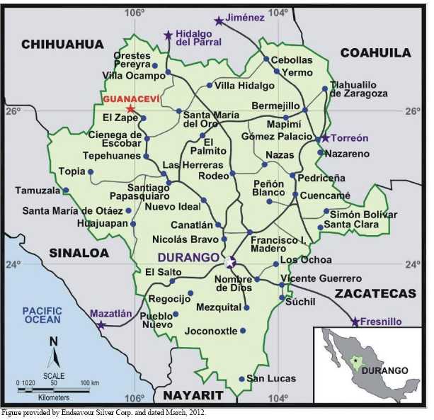
The Guanaceví Mines Project is located in the northwest portion of the Mexican state of Durango near its border with the state of Chihuahua, as shown in Figure 4.1. The project is located 3.6 km from the town of Guanaceví, approximately 260 km northwest of the city of Durango, which is the state capital. The town of Guanaceví also gives its name to the mining district which surrounds it.
The Guanaceví Mines Project is located at the approximate UTM coordinates of 401250 east and 2866500 north in zone 14 NAD 27, or 105°58'20"W longitude and 25°54'47"N latitude.
4.2 OWNERSHIP AND PROPERTY DESCRIPTION
The Guanaceví Mines Project consists of an industrial complex that includes underground silver-gold mines and a cyanidation ore processing plant in the Guanaceví mining district, Durango State, México. The ore processing facility also comprises a recently commissioned flotation circuit.
The Guanaceví Mines Project is located in the Guanaceví mining district which covers an area measuring approximately 5 km northeast-southwest by 10 km northwest-southeast and contains more than 50 silver-gold mines. Although only three of the mines are presently operating, there is considerable mining experience available in the area.
Currently, the Guanaceví Mines Project operates at 1,100 t/d. This Technical Report describes current operating conditions and future projections as planned by Endeavour Silver. Since acquiring the property, Endeavour Silver has initiated an aggressive program of exploration, mine preparation, cyanidation plant improvement and equipment replacement. The Endeavour Silver production schedule includes mining and development of oxide and sulphide ore for processing in parallel circuits of cyanidation and flotation. These circuits have a combined production capacity of more than 1,000 t/d.
Endeavour Silver’s primary short-term goal at Guanaceví is to invest in mine development and plant improvements in order to steadily increase production. Endeavour Silver’s longer term goals are to invest in exploration, find new higher grade orebodies and, if successful, evaluate the potential for further plant expansion.
18
Figure 4.1
Guanaceví Mines Project Location Map
Endeavour Silver’s management recently prepared a 2013 production and exploration forecast, based on a new mine plan and new exploration targets.
4.3 MINERAL TENURE
Endeavour Silver holds the Guanaceví Mines project through its 100% owned Mexican subsidiary Endeavour Gold Corporation S.A. de C.V. (Endeavour Gold). Endeavour Gold holds the project through its two 100% owned subsidiaries Minera Plata Adelante S.A. de C.V. (Minera Plata Adelante) and Refinadora Plata Guanaceví S.A. de C.V. (Refinadora Plata Guanaceví). At present, the project is comprised of 51 mineral concessions. See Figure 4.2 for a concession map of the Guanaceví Mines Project and Table 4.1 for relevant information regarding the individual concessions. The mineral concessions are not all contiguous and vary in size, for a total property area of 4,706.1977 ha. New mineral concessions optioned and staked in the La Brisa area have significantly increased Endeavour Silver’s land holdings in the Guanaceví district. The annual 2013 concession tax for the Guanaceví Properties is estimated to be approximately 367,200 Mexican pesos (pesos), which is equal to about US $28,400 at an exchange rate of 12.93 pesos to US $1.00.
19
Figure 4.2
Guanaceví Mines Project, Mineral Concessions Map
![]()
20
Table 4.1
Guanaceví Mines Concessions Controlled by Endeavour Silver
| Concession Name | Title Number | Term of Mineral Concession | Hectares | 2013 Annual Taxes (pesos) | ||
| From | To | 1st Half | 2nd Half | |||
| Santa Cruz Dos | 191773 | 19/12/91 | 18/12/41 | 113.5387 | 16,966 | 16,966 |
| El Pelayo Y Anexas | 193392 | 19/12/91 | 18/12/41 | 56.2519 | 8,420 | 8,420 |
| Unif. Santa Cruz | 186577 | 24/04/90 | 23/04/40 | 28.5896 | 4,280 | 4,280 |
| San Guillermo | 179601 | 11/12/86 | 10/12/36 | 5.0000 | 749 | 749 |
| Unificacion Flora | 189233 | 05/12/90 | 04/12/40 | 36.5506 | 5,471 | 5,471 |
| San Marcos | 185486 | 14/12/89 | 13/12/39 | 5.4669 | 830 | 830 |
| San Vicente | 187020 | 29/05/90 | 28/05/40 | 8.0000 | 1,198 | 1,198 |
| Nuestra Senora | 185412 | 14/12/89 | 13/12/39 | 5.6000 | 838 | 838 |
| San Pedro Uno | 191143 | 29/04/91 | 28/04/41 | 49.8437 | 7,461 | 7,461 |
| El Porvenir Dos | 161449 | 10/04/75 | 09/04/25 | 30.0000 | 4,491 | 4,491 |
| La Sultana | 162915 | 08/08/78 | 07/08/28 | 11.5889 | 1,735 | 1,735 |
| El Milache | 163509 | 10/10/78 | 09/10/28 | 42.8866 | 6,420 | 6,420 |
| Veronica | 167013 | 11/08/80 | 10/08/80 | 11.7648 | 1,761 | 1,761 |
| El Desengaño | 187018 | 29/05/90 | 28/0540 | 19.4747 | 2,915 | 2,915 |
| El Calvario | 191733 | 19/12/91 | 18/12/41 | 1.3098 | 196 | 196 |
| Elizabeth | 180568 | 13/06/87 | 12/06/37 | 16.9973 | 2,544 | 2,544 |
| El Rocio | 227665 | 28/07/06 | 27/07/56 | 51.2334 | 2,180 | 2,180 |
| La Brisa 3 | 236564 | 16/07/10 | 15/07/60 | 715.8666 | 7,319 | 7,319 |
| La Gloria | 238353 | 23/09/11 | 22/09/61 | 309.9369 | 3,169 | 3,169 |
| La Brisa 4 | 240296 | 16/05/12 | 15/05/62 | 1,584.4986 | 10,838 | 10,838 |
| La Brisa 4, Fracc. | 239873 | 29/02/12 | 28/02/62 | 51.8008 | 354 | 354 |
| La Brisa 5 | 239874 | 29/02/12 | 28/02/62 | 214.6744 | 1,468 | 1,468 |
| Ampl. Al Bajo Del Nvo. P. | 184074 | 15/02/89 | 14/02/39 | 7.3062 | 1,094 | 1,094 |
| La Mazatleca | 186475 | 02/04/90 | 01/04/40 | 14.1797 | 2,123 | 2,123 |
| La Guirnalda | 187771 | 17/09/90 | 16/09/40 | 46.7611 | 7,000 | 7,000 |
| La Guirnalda 2 | 219707 | 03/04/03 | 02/04/53 | 5.9915 | 897 | 897 |
| San Pablo | 216716 | 28/05/02 | 27/05/52 | 3.3972 | 509 | 509 |
| Ana Maria | 214167 | 18/08/01 | 17/01/51 | 3.2320 | 484 | 484 |
| El Martir | 215925 | 02/04/02 | 01/04/52 | 8.8675 | 1,327 | 1,327 |
| Ampl. Del Soto | 191987 | 19/12/91 | 18/12/41 | 3.9998 | 599 | 599 |
| IDA | 191659 | 19/12/91 | 18/12/41 | 4.9086 | 735 | 735 |
| Epsilon | 195079 | 25/08/92 | 24/08/42 | 7.0622 | 1,057 | 1,057 |
| El Terremoto | 193869 | 19/12/91 | 18/12/41 | 12.0000 | 1,796 | 1,796 |
| Alajaa | 183881 | 23/11/88 | 22/11/38 | 11.2050 | 1,677 | 1,677 |
| Barradon 7 | 214162 | 18/08/01 | 17/01/51 | 37.1376 | 5,559 | 5,559 |
| Santa Isabel | 204725 | 25/04/97 | 24/04/47 | 84.0000 | 12,574 | 12,574 |
| Noche Buena | 167563 | 26/11/80 | 25/11/30 | 79.8962 | 11,960 | 11,960 |
| El Porvenir Cuatro | 168105 | 13/02/81 | 12/02/31 | 30.0000 | 4,491 | 4,491 |
| La Brisa | 224158 | 19/04/05 | 18/04/55 | 25.5518 | 2,173 | 2,173 |
| El Cambio | 205475 | 17/09/97 | 16/09/47 | 11.9962 | 1,796 | 1,796 |
| La Onza | 211502 | 30/05/91 | 29/05/41 | 18.2376 | 2,730 | 2,730 |
| San Nicolas | 191543 | 19/12/91 | 18/12/41 | 4.4838 | 671 | 671 |
| Ampl. de San Nicolas | 191675 | 19/12/91 | 18/12/41 | 2.5934 | 388 | 388 |
| La Brisa | 231786 | 22/04/08 | 23/04/58 | 33.0000 | 698 | 698 |
| La Brisa 2 | 234301 | 12/06/09 | 12/06/59 | 57.0000 | 1,205 | 1,205 |
| Santa Cruz Ocho | 215911 | 19/03/02 | 18/03/52 | 165.6280 | 24,793 | 24,793 |
| El Pelayo | 219709 | 03/04/03 | 02/04/53 | 5.8881 | 881 | 881 |
| El Aguaje De Arriba | 170158 | 17/03/82 | 16/03/32 | 5.0000 | 749 | 749 |
| A. El Aguaje De Arriba | 170159 | 17/03/82 | 16/03/32 | 7.0000 | 1,048 | 1,048 |
| La Plata | 170156 | 17/03/82 | 16/03/32 | 2.0000 | 299 | 299 |
| La Prieta | 148479 | 29/10/67 | 28/10/17 | 7.0000 | 1,048 | 1,048 |
| San Fernando | 160545 | 23/08/79 | 22/08/29 | 19.8279 | 2,915 | 2,915 |
| Totals | 4,096.1256 | 186,515 | 186,515 | |||
Table provided by Endeavour Silver Corp.
21
In Mexico, exploitation concessions are valid for 50 years and are extendable provided that the application is made within the five-year period prior to the expiry of the concession and the bi-annual fee and work requirements are in good standing. All new concessions must have their boundaries orientated astronomically north-south and east-west, and the lengths of the sides must be one hundred metres or multiples thereof, except where these conditions cannot be satisfied because they border on other mineral concessions. The locations of the concessions are determined on the basis of a fixed point on the land, called the starting point, which is either linked to the perimeter of the concession or located thereupon. Prior to being granted a concession, the company must present a topographic survey to the Dirección General de Minas (DGM) within 60 days of staking. Once this is completed, the DGM will usually grant the concession. Most of the exploitation concessions which comprise the Guanaceví Mines Project are surveyed but do not have their boundaries orientated astronomically north-south and east-west because the concessions predate the introduction of this legislation.
Endeavour Silver has resurveyed most of its property boundaries. At the time of writing of this report, the Aguaje group, the La Sultana and San Pedro Uno mineral concessions, and the newly acquired concessions in the Milache, San Pedro, Porvenir Cuatro and San Fernando areas have not been check-surveyed.
Prior to December 21, 2005, exploration concessions were granted for a period of 6 years in Mexico and at the end of the 6 years they could be converted to exploitation concessions. However, as of December 21, 2005 (by means of an amendment made on April 28, 2005 to the Mexican mining law) there is now only one type of mining concession. Therefore, as of the date of the amendment (April, 2005), there is no distinction between exploration and exploitation concessions on all new titles granted. All concessions are now granted for a 50 year period provided that the concessions are kept in good standing. For the concessions to remain in good standing, a bi-annual fee must be paid to the Mexican government and a report must be filed in May of each year which covers the work accomplished on the property between January and December of the preceding year.
4.3.1 Property Agreements
Endeavour Silver has executed a number of agreements regarding the acquisition of the mineral properties, mining rights and processing facility which comprise Guanaceví Mines Project. The details of the agreements were extensively reported in the April 16, 2007, Micon Technical Report and the March 31, 2006, Technical Report by Range Consulting.
4.3.1.1 Sale and Purchase of Shares with Reservation of Ownership Agreement
All obligations of this agreement have been completed.
At the time writing of this report, Endeavour Silver owns 100% of the Guanaceví Mines Project mine and plant through Minera Plata Adelantes’ acquisition of Minera Santa Cruz y Garibaldi S.A. de C.V. (Minera Santa Cruz) and Refinadora Plata Guanaceví’s acquisition of Metalurgica Guanaceví S.A. de C.V (MG). In 2006, Refinadora Plata Guanaceví had acquired the remaining 49% interest in the Guanaceví plant through the purchase of 100% of the shares of MG for US $2.2 million.
22
Endeavour Silver was able to execute an early buy-out of the remaining shares of Minera Santa Cruz, which owned 49% of the Santa Cruz silver-gold mine. In May, 2007, the company issued 1,350,000 shares with a fair market value of US $5.04 per share to acquire the remaining 49% of the outstanding shares in Minera Santa Cruz, which included the final option payment originally due in January, 2008, and 49% of the profits for 2006 and 2007.
Endeavour Silver management elected to accelerate the Property buy-out in order to streamline the mining operations and facilitate additional capital investments for the mine development program. Specifically, Endeavour Silver has evaluated the development of two new mines, Alex Breccia and Santa Cruz, on the Guanaceví Mines Project and the early buy-out gave the Company the required flexibility to make the capital investments in the last half of 2007.
Under the terms of the original agreement, Endeavour Silver had the option to pay to the shareholders of Minera Santa Cruz the amount of US $2,551,430 and to spend US $1 million in exploration to acquire up to a 100% interest in Minera Santa Cruz, in accordance with the following schedule:
US $852,143 on January 28, 2005, (paid).
US $423,571 on January 28, 2006, (paid).
US $637,858 on January 28, 2007, (paid).
US $637,858 on January 28, 2008, (paid).
4.3.1.2 Minera Santa Cruz Shareholders’ Agreement
This agreement between the shareholders of Minera Santa Cruz and Endeavour Silver outlines the participation of the parties in the development, administration and operation of the Santa Cruz property and the mining concessions of Minera Santa Cruz and its assets. The agreement came into effect upon Endeavour Silver earning a 51% option interest in Minera Santa Cruz by the payment of US $852,143 on January 28, 2005.
This agreement was completed in May, 2007, granting Minera Plata Adelante 100% interest in the exploitation and exploration rights.
4.3.1.3 Minera Santa Cruz Assignment of Mining Concession Rights Agreement
This agreement between Minera Santa Cruz and Endeavour Silver involved the transfer of Minera Santa Cruz’s rights, interests and title in its mining concessions to Endeavour Silver in consideration for US $448,571. Of this amount, US $428,571 was paid, as required by the agreement, prior to May 17, 2004, and US $5,000 was to be paid annually on January 28, 2005, 2006, 2007 and 2008. Upon payment of US $5,000 on January 28, 2005, Endeavour Silver earned an undivided option interest of 51% in Minera Santa Cruz’s mining concessions, with Minera Santa Cruz retaining the remaining 49% interest, until January 28, 2006. On January 28, 2006, Endeavour Silver paid US $5,000 in order not to relinquish its 51% interest in the mining concessions. Upon payment of US $5,000 on January 28, 2006, no further payments were required by Endeavour Silver to maintain its 51% interest. Endeavour Silver had the option to increase its interest from 51% to 100% by payments of US $5,000 on January 28, 2007 and another US $5,000 on January 28, 2008.
23
This agreement was completed in May, 2007, granting Minera Plata Adelante 100% interest in these mining concessions.
4.3.1.4 Contract for Transfer of Rights and Obligations and Sale and Purchase of Assets
In June, 2005, Endeavour Silver signed the agreement with Minera Capela S.A. de C.V. (Minera Capela) for the transfer of rights and obligations on mining concessions which cover 9 Properties from Minera Capela to Endeavour Silver. Minera Capela retains a 3% net proceeds royalty. In consideration, Endeavour Silver issued 1,000,000 units at a deemed price of CDN $1.60 per unit. Each unit was comprised of one common share and one share purchase warrant with an exercise price of CDN $2.10 until July 22, 2006 and CDN $2.30 thereafter until July 27, 2007.
4.3.1.5 Contract for Transfer of Rights
In July, 2005, Endeavour Silver, through its subsidiary Minera Plata Adelante, signed an option agreement for the transfer of rights from mining concessions relating to two Properties, namely Porvenir Dos and La Sultana. In consideration, Endeavour Silver paid US $137,500 according to the following schedule:
US $25,000 upon signing of agreement, (paid).
US $12,500 on December 30, 2005, (paid).
US $100,000 on December 30, 2006,(paid).
In August, 2005, Endeavour Silver, through Minera Plata Adelante, signed an option agreement for the exclusive right to investigate and to explore 4 Properties known as the La Prieta Group. In consideration, Endeavour Silver paid US $100,000 as follows:
US $15,000 on ratification date, (paid).
US $15,000 by six months of ratification date, (paid).
US $70,000 by twenty-four months of ratification date, (paid).
Both of these agreements were completed in 2007, granting Minera Plata Adelante 100% interest in these mining concession rights.
24
4.3.1.6 Option-to-Purchase Agreements– San Pedro District
In 2007, Endeavour Silver announced acquisition of two new exploration Property positions in the Guanaceví district. The new acquisitions, Milache and San Pedro, are both located in the San Pedro sub-district of the Guanaceví mining district. In addition to the concessions already held (San Pedro Uno and La Sultana), Endeavour Silver now controls approximately 457 ha in the San Pedro area (Table 4.1). These Property acquisitions have excellent exploration potential but do not have an immediate impact on Endeavour Silver’s mine operation at Guanaceví.
The Milache Properties (74.2 ha) are located along the trend of the Santa Cruz silver vein approximately 2 km northwest of the operating Porvenir mine (Figure 4.2). The properties consist of the El Milache, El Desengaño and Veronica concessions (Table 4.1). They were acquired from Francisco Barraza on November 27, 2007. Endeavour Silver acquired a 100% interest by paying US $50,000 and issuing 30,000 shares upon signing the agreement and paying US $50,000 after 18 months.
The 15 San Pedro Properties, totalling 330 ha, are located about 6 km northwest of the Porvenir mine (Table 4.1 and Figure 4.2). On December 12, 2007, Endeavour Silver acquired an option to purchase a 100% interest in the San Pedro Properties from Ignacio Barraza Duarte by paying 120,000 common shares and issuing 60,000 warrants to purchase 60,000 shares at US $4.69 within a one year period following receipt of regulatory approval and a further 570,776 shares within a 24 month period. Final payment was made in 2010. The vendor retains a 1% net smelter royalty on mineral production. In addition, the Company provided the vendor with up to US $400/m to advance the Buena Fé adit (Nacho Barraza’s tunnel) during the 24 month option period. Any ores produced from this tunnel were to be used to repay Endeavour Silver’s investment, after which the net profits were to be shared equally with the vendor. No ore was produced from the Buena Fé adit during the option period which has now expired.
4.3.1.7 Contract of Assignment of Mining Exploitation Rights
In October, 2005, an agreement was executed between Minera Tayahua, S.A. de C.V. (Minera Tayahua) and Endeavour Silver, through its subsidiary Minera Planta Adelante. The agreement provided for the exclusive right to explore and to mine the El Porvenir Property. Under the lease agreement, Endeavour Silver agreed to mine El Porvenir at a rate between 9,000 t and 27,000 t per quarter and to pay a 3% net smelter royalty from production. Endeavour Silver was also committed to incur a minimum of US $100,000 for each quarter in expenditures for exploration, development and mining.
Endeavour Silver held the exclusive right to mine the El Porvenir Property for a 5-year period. However, the agreement included a clause that either party could terminate the contract in advance, without indicating cause, communicating the termination date at least 2 years before the effective date of the termination. On August 16, 2006, Endeavour Silver received a letter indicating contract termination as of August 31, 2008. Endeavour Silver mined the El Porvenir Property until August 30, 2008.
25
4.3.1.8 Mining Exploration and Option Agreement
On February 9, 2009, Endeavour Silver entered into a mining exploration agreement with Minerales Monte Blanco S.A. de C.V. (Minerales Monte Blanco), represented by Sergio Enrique Silva Franco, on the El Porvenir Cuatro and La Brisa concessions totalling 55.5518 ha. The El Porvenir Cuatro and La Brisa agreement is an option to earn a 100% interest in these properties over two years for a total consideration of US $700,000. The first payment was US $100,000 cash on signing and US $200,000 in shares based on the 10-day average price before the signing date of February 9, 2009. The subsequent payment was 12 months from signing with US $240,000 as shares, again based on the average price for 10 days prior to February 9, 2010; the final payment was due on or before February 9, 2011 and consisted of a payment of US $160,000, either as cash or shares.
In February, 2010, Endeavour Silver exercised its option to purchase the El Porvenir Cuatro and La Brisa Properties and acquired a 100% interest in these Properties by paying a total consideration to the vendors of US $100,000 cash and 136,054 shares on signing the option agreement, and an additional 71,428 common shares and US $160,000 cash on the early exercise of the option to purchase.
In July 2010, Endeavour Silver acquired 100% interest in the Elizabeth (17.0 ha) and El Calvario (1.3 ha) Properties in Guanaceví. The purchase price of these Properties was US $50,000. The El Calvario Property is situated in the central part of San Pedro, adjacent to the historic, high grade Noche Buena mine and transected by the Noche Buena vein. The Elizabeth Property is situated approximately 1 km east of Endeavour Silver’s Porvenir mine.
4.3.1.9 La Brisa and Brisa 2 Option Agreement
In June, 2011, Endeavour Silver acquired an option on the La Brisa and La Brisa 2 Properties (90 ha), located approximately 10 km southeast of Endeavour Silver’s active Porvenir silver-gold mine in the Guanaceví district.
The option agreement requires Endeavour Silver to make US $220,000 in cash payments over a 3 year period.
The La Brisa concession optioned in the southern part of the Guanaceví district is different from the La Brisa concession of the same name, acquired along with Porvenir Cuatro in 2010.
26
4.3.1.10 New Concessions in the La Brisa Area
Endeavour Silver also staked several new concessions (2,887 ha) surrounding the La Brisa and La Brisa 2 Properties to cover possible extensions of the La Brisa veins and several other recently discovered veins.
4.3.1.11 El Cambio Properties Option Agreement
In June, 2011, Endeavour Silver also acquired an option to purchase four small properties within the San Pedro sub-district. The El Cambio Properties lie about 6 km northwest of the Porvenir mine and along strike from the historic El Soto and Nueva Australia high grade silver mines. These Properties cover the faulted northerly strike extensions of the El Soto and Epsilon veins which Endeavour Silver has drilled over the past few years with positive results.
The El Cambio option agreement gives Endeavour Silver the right to purchase the El Cambio, La Onza, San Nicolas and Ampliacion de San Nicolas Properties (37 ha) for US $150,000 in cash payments over a 2 year period.
4.3.1.12 San Fernando Property Purchase
On November 28, 2012, Endeavour Silver announced that it had purchased the San Fernando concession located about 1.5 km northwest of its operating Guanaceví mine.
San Fernando is a small Property (20 ha) located adjacent to Endeavour Silver's Milache Property. The Property covers the upper portion of the Santa Cruz vein which hosts the Milache mineralization, and holds good potential to host any northern extensions of the Milache discovery. Exploration drilling is planned at the San Fernando property in 2013.
4.3.1.13 Compensation and/or Indemnification Contract for the Temporary Occupation of Cooperative Land
In November, 2005, Endeavour Silver entered into an agreement, with the local ejido for temporary surface access rights to certain land for the purpose of exploration in areas covered by the mining concessions. In consideration, Endeavour Silver will pay an annual fee of Mexican pesos 10,000 which will increase by the rate of inflation plus 2% for a term of 15 years.
Since the Guanaceví Mines Project is composed of a number of exploitation concessions upon which mining has previously been conducted, all of the exploration work continues to be covered by the environmental permitting already in place and no further notice of work is required by any division of the Mexican government.
In order to begin an exploration program on an exploitation concession upon which no substantial mining has been conducted, Endeavour Silver would be required to file a “Notice of Initiation of Exploration Activities” with the local authorities to inform them of the scope and environmental impact of the exploration work. Also, other permits, such as a permit to use the local municipal garbage dump, may be required.
27
Endeavour Silver reports that it is current in meeting the legal obligations and requirements of Mexican mining and environmental laws and regulations, including assessment work, property taxes and operating permits.
4.3.2 Access Agreements
In addition to the mineral rights, Endeavour Silver has agreements with various private ranch owners and two local ejidos (El Hacho and San Pedro) that provide access for exploration and exploitation purposes. Table 4.2 summarizes the surface access rights as at December 15, 2012.
Table 4.2
Summary of Endeavour Silver’s Surface Access Rights
| Owner | Area Name | Area (ha) | Validity | Term | Drill Pads (Pesos) | ANNUAL PAYMENT (PESOS) |
| Ejido La Soledad | La Soledad (La Brisa) | 3,254 | 5 Years | 26/06/2011 - 2016 | 7,000 | None |
| Alfonso Flores Varela | El Sabinoso (la Brisa) | 239 | 5 Years | 15/06/2011 - 2016 | 7,000 | None |
| Taurino Cisneros Haros | Metates (La Brisa) | 543 | 5 Years | 16/06/2011 - 2016 | 7,000 | None |
| Ejido Arroyo Del Hacho | Guanaceví | 8,559 | 15 Years | 27/11/2005 - 2020 | None | 72,000 |
| Comunidad De San Pedro | San pedro | 5,787 | 4 Years | 14/04/2009 - 2013 | 8,000 | None |
Table provided by Endeavour Silver Corp.
4.4 LICENCES, PERMITS AND ENVIRONMENT
Endeavour Silver reports that it is in compliance with monitoring environmental aspects and with applicable safety, hygiene and environmental standards.
4.4.1 Safety
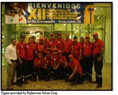
During 2012, advances continued in safety at Guanaceví, with 42,724 hours of training undertaken at the mine and plant. A mine rescue trainer was hired. A fully functional mine rescue team is on site with 34 people trained. Mine rescue training is ongoing and includes first aid, fire fighting, ventilation, use of Draeger re-breathing equipment, knots, mine exploration, practical mine recovery and smoke scenarios. The mine rescue team placed second in first aid and third in the national underground mine rescue competitions in 2010 (Figure 4.3).
28
Figure 4.3
2010 National Mine Rescue Team, Placed Second in First Aid and Third Place Overall
The safety department undertakes inductions of new personnel to train them in the basics of mine and plant safety and also monitors housekeeping and sign installation. Safety talks are given at the beginning of each shift to reinforce safety in the workplace. Safety training at the mines includes the Five Point Safety method, first aid, use of PPE (personal protective equipment – helmet, safety glasses, steel toe boots, gloves, hearing protection), explosives handling, barring down and identification of areas requiring support, identification of risks, lock-out/tag-out of equipment, prevention and fighting of fires, fetid gas and practical mine evacuation training (undertaken without notice during a working shift), dust in the workplace. Similarly, the plant safety training includes Five Point Safety, cyanide handling, correct use of tools, working in confined spaces, crushing and milling risk identification, firefighting and laboratory safety, as well as work at elevated heights and welding hazards. The dedication to safety helped Endeavour Silver win the 2010 Jorge Rangel Zamorano Silver Helmet Award which was presented by CAMIMEX (Camara Minera de Mexico) for safety (Figure 4.4).
Safety is also an element in the production bonus system. In 2009, management introduced the Chairman’s and President’s Safety Awards (annual and quarterly safety awards) to help incentivize all personnel to work safely. These safety initiatives continued throughout 2012. In 2011, there was a fatality at the mine and, as a result, Endeavour Silver re-familiarized all staff with the safety procedures and protocols. This process continued in 2012.
29
Figure 4.4
2010 Jorge Rangel Zamorano Silver Helmet Award Presented by the CAMIMEX for Safety
![]()
4.4.2 Environment
Endeavour Silver holds all necessary environmental and mine permits to conduct planned exploration, development and mining operations on the Guanaceví Mines Project. Further details are covered in Section 20 of this report.
4.5 MICON COMMENTS
Micon is unaware of any other outstanding environmental liabilities at the Guanaceví Mines Project than those already mentioned in this section or Section 20 of this Technical Report. Micon is unable to comment on any remediation which may have been undertaken by previous companies.
Micon is unaware of any other significant factors or risks that may affect access, title or the right or ability of Endeavour Silver to perform work on the Guanaceví Mines Project.
Other than those discussed previously, Micon is not aware of any royalties, back-in rights, payments or other agreements and encumbrances which apply to the Guanaceví Mines Project.
30
5.0 ACCESSIBILITY, CLIMATE, LOCAL RESOURCES, INFRASTRUCTURE AND PHYSIOGRAPHY
5.1 ACCESSIBILITY AND LOCAL RESOURCES
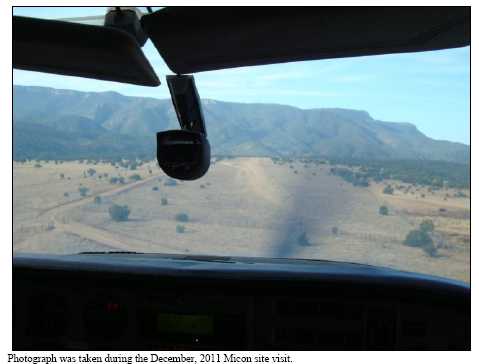
The Guanaceví Property is readily accessible from the city of Durango, capital of the Mexican state of Durango, via paved roads. Access is primarily gained by taking Mexican State Highway 45 north to the town of Canatlan, then continuing along the paved highway that connects to Santiago Papasquiaro, then to Tepehuanes, and ending at the town of Guanaceví. The total distance between Durango and the town of Guanaceví is approximately 260 km and requires about four and one half hours to drive. Guanaceví has a small airport with a 1,000 m long dirt airstrip located a few kilometres south of the town and capable of handling light aircraft. Figure 5.1 is a view of the light aircraft used to fly to Guanaceví during the 2011 Micon site visit and Figure 5.2 is a view of the landing strip at Guanaceví upon approach prior to landing.
The city of Durango is an old colonial city (founded in 1563) which served as the political and ecclesiastical capital of the Nueva Vizcaya province of New Spain until 1823. Minerals are the chief product but the city is also an agricultural, commercial and tourist centre. The city has approximately 427,000 inhabitants (2000) and is the closest major population centre to Guanaceví. Durango has an international airport with numerous regional flights to other major Mexican cities as well as international flights to Los Angeles and to the southeast USA.
The Guanaceví Properties lie 3.6 km from the town of Guanaceví which was founded in 1535. From the town of Guanaceví, a well-conditioned dirt road leads southwards a few kilometres to the flotation and cyanidation plant and the Endeavour Silver offices and then an additional 5 km further to the Santa Cruz and Porvenir mines. Figure 5.3 is a view of part of the town of Guanaceví from the road leading to the Santa Cruz and Porvenir mines.
The population of Guanaceví is approximately 2,170, and the town has all modern amenities, including primary schools and a secondary school (high school), various stores, restaurants and a three star hotel. Although the town does not have a bank, it does have a casa de cambio (foreign exchange house) and an ATM machine. The town, mine and plant are connected to the national land-base telephone system that provides reliable national and international direct dial telephone communications, as well as stable internet connections and satellite television.
Although various people are engaged in town services, the town is economically dependent on the mining and milling operations within the district.
5.2 PHYSIOGRAPHY AND CLIMATE
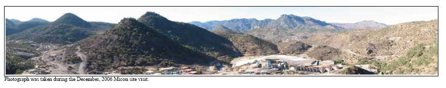
Figure 5.4 is a view of the terrain in the area of mine and mill facilities.
31
Figure 5.1
Light Aircraft used to Access Guanaceví (2011 Micon Site Visit)
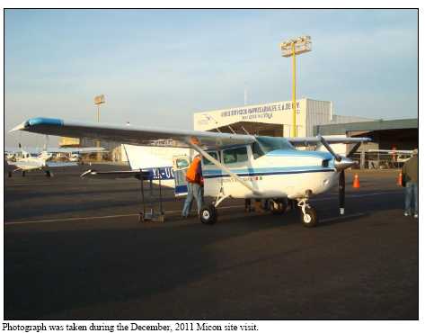
Figure 5.2
View of the Guanaceví Airstrip upon Approach (2011 Micon Site Visit)
32
Figure 5.3
Partial View of the Town of Guanaceví
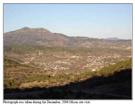
Figure 5.4
View of the Terrain between the Area of Mine and Mill Facilities at Guanaceví
33
The dry season is from October through June with the wet season from July to September. The total average annual rainfall varies from about 65 to 105 mm. Winter temperatures vary from a maximum of 15°C to a minimum of -1.4°C, while summer temperatures range from a minimum of 20°C to a maximum of 30°C. The climate poses no limitations to the length of the operating season. Freezing temperatures can occur overnight but quickly warm to above freezing during daylight hours. Occasional snow does occur in the area but quickly melts on all but the most protected slopes.
The mountains are predominately covered with evergreen forests around Guanaceví. Wildlife in the area consists of deer, badger, foxes, coyotes, squirrels, rabbits and mice.
5.3 INFRASTRUCTURE AND LOCAL RESOURCES
The industrial water for the plant is recycled, with the make-up water (60,000 m3/y of fresh water) being obtained from a nearby underground mine. Electrical power from the Federal Power Authority (34 kV) supplies both the plant and mine. Endeavour Silver has completed the process of upgrading the power to the mine and mill sites by connecting a second line into main power supply.
Endeavour Silver is currently assessing its existing tailings area but believes that there is sufficient capacity for many years of production. Endeavour Silver has also negotiated access and the right to use surface lands sufficient for many years of operation.
At each of the mine sites, the water required is supplied from the dewatering of the mines. The tailings facility at the plant is set up to recycle all water back into the ore processing plant.
Apart from offices, warehouses and other facilities, Endeavour Silver also provides dormitories and limited housing facilities for employees working on a rotational work schedule. Much of the labour work force lives in Guanaceví and nearby communities. The area has a rich tradition of mining and there is an ample supply of skilled personnel sufficient for both the underground mining operations and the surface facilities.
5.4 MICON COMMENTS
Mining at the Guanaceví Project operates on a year-round basis. Details regarding surface rights for mining operations, availability of power sources, potential tailings storage areas, potential waste disposal areas, heap leach pad areas, and potential processing plant sites, are discussed in the relevant sections of this report on mining methods, recovery methods and project infrastructure.
34
6.0 HISTORY
6.1 GENERAL HISTORY
Mining has played an important role in Mexico since pre-historic times, but it entered a period of rapid expansion after the Spanish conquest when rich mineral deposits were found. The wealth found in these early mines served as an incentive for the early colonizers to locate to remote and barely accessible portions of the county.
It is not known if the indigenous peoples or the Spanish colonists first began mining in the Guanaceví district but mining extends back to at least 1535 when the mines were first worked by the Spanish. By the start of the 18th century, Guanaceví had become an important mining centre in the Nueva Vizcaya province of Nueva España (New Spain), as reported by Alexander von Humboldt in his travels through Nueva España. However, the Guanaceví mining district is not as well known today.
6.2 HISTORICAL AND RECENT EXPLORATION
The extent of historical exploration on the property is relatively unknown. Prior to management by Endeavour Silver, production was coming from three mines without the benefit of any systematic exploration drilling, geological mapping or mine planning.
At the start of the 1960’s, Engineer Mejorado of Peñoles Mining Company recommended more exploration to prove up the resource estimate of 360,000 t grading 500 g/t silver at the time. Engineer P. Sanchez Mejorado mapped and sampled the mine underground and recommended diamond drilling below Level 13. This drilling was completed in 1983, with a reported additional 229,000 t outlined grading 1.20 g/t gold and 525 g/t silver, over an average thickness of 4.66 m.
Watts, Griffis and McOuat Limited (WGM) noted in its 2005 Technical Report that “The exploration works conducted by Peñoles consisted of channel sampling across the mineralized zone coupled with short lateral winke diamond drill holes (diameter approximately 1 inch) from the vein structure workings and detailed surveying and geological mapping of the underground workings. The limited exploration by Peñoles was well conducted, and blocked out several areas of potential resources.” However, WGM stated further that it believed that more than half of the areas of potential resources, except for those below the water table (below Level 13), had been mined out.
Pan American Silver Corp. (Pan American) conducted an eight-month evaluation program in 2003 that consisted of an extensive, systematic, underground channel sampling and surveying program and the drilling of three diamond drill holes in the North Porvenir area, holes SSC-01, SSC-02 and SSC-03.
Since taking over in 2004 and to December 31, 2012, Endeavour Silver has completed 497 diamond drill holes totalling 133,916.6 m and 22 reverse circulation drill holes totalling 2,977 m on the entire Guanaceví Mines Project. More than 32,491 samples have also been collected and submitted for assay.
35
Of this total, approximately 112,812.2 m of diamond drilling in 381 holes have been completed on the Santa Cruz vein structure (Table 6.1). Holes were drilled from both surface and underground drill stations.
Table 6.1
Drilling Summary for Santa Cruz Vein Structure at Guanaceví Mines Project (through December, 2012)
| Project | Diamond Drill Holes | Metres |
| North Porvenir | 188 | 57,934.50 |
| Porvenir Dos | 24 | 5,062.00 |
| Porvenir Cuatro | 31 | 9,176.00 |
| Santa Cruz | 80 | 18,033.00 |
| Alex Breccia | 27 | 8113.5 |
| Milache | 31 | 14493.2 |
| Total | 381 | 112,812.20 |
Table provided by Endeavour Silver Corp.
Figures 6.1 and 6.2 are a composite drill hole plan map and a long section of the Santa Cruz vein on the Guanaceví Property, showing the drill hole coverage for the four areas of interest in the mine for further exploration and mining.
Endeavour’s exploration programs up to the end of 2011 have been described in previous Technical Reports by Micon. The 2012 program is discussed in Sections 9 and 10. To provide continuity, a brief description of the 2011 exploration program is included below
In 2011, surface drilling was continued in the mine area in order to increase the understanding of the extent of the mineralization within the Santa Cruz vein in the Porvenir North Zone 1 area, thereby potentially increasing the resources and reserves at the mine. By the end of 2011, seven drill holes had been completed, totalling 3,586.50 m.
At the Santa Cruz mine, an underground drilling program was conducted to intersect the Santa Cruz vein at different depths, down to the unexploited areas below the old workings. The goal of the program was to demonstrate that economic mineralization could continue at depth, in order to increase the resources and possibly reserves in this portion of the mine. In addition, a number of infill drill holes were designed to verify the information from previous drilling. In total, 16 holes were drilled in the Santa Cruz underground program.
As a check against the Alex Breccia results which were obtained from previous drilling by regional exploration personnel and the results obtained from direct sampling, a decision was made to initiate drilling in the Alex Breccia zone towards the north extent of the property. This drilling was conducted to determine whether or not the resources could continue to be increased in this area.
36
Figure 6.1
Composite Drill Hole Plan Showing the Drill Hole Coverage of the Santa Cruz Vein for the Guanaceví Mines Project
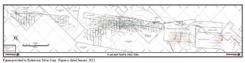
Figure 6.2
Long Section Showing Drill Hole Coverage for the Santa Cruz Vein of the Guanaceví Mines Project
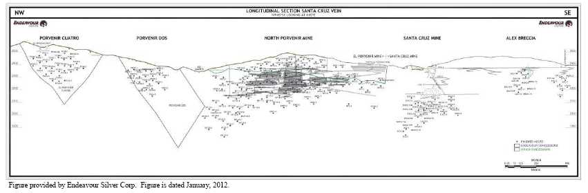
37
Micon reviewed the 2011 exploration programs and concluded that they were conducted according to the exploration best practices as outlined by the CIM and with a good quality assurance/quality control (QA/QC) program in place. It is Micon’s opinion that the data acquired by Endeavour Silver through its exploration programs at the Guanaceví Mines Project can be used in estimating the mineral resources and ultimately the mineral reserves.
6.3 HISTORICAL MINING AND PRODUCTION
6.3.1 Mining
Historic mining was reported in the previous Micon Technical Reports and is reproduced here for the sake of contnuity.
The Guanaceví mining district and the Guanaceví Mines Project area are riddled with mine openings and old workings, in a somewhat haphazard fashion near surface, representing the earliest efforts at extraction, and more systematic at depth, which is indicative of later, better organized and engineered mining. Associated with these openings and workings is a number of ruins, which represent the mine buildings, chapels and residences of the inhabitants and indicate the wealth of the mining district during its past. See Figure 6.3 for a photograph of an old mine waste dump located in the trees, alongside the road to the Santa Cruz and Porvenir mines.
The vast bulk of the material which has been extracted from underground operations through the tunnels, shafts and winzes is scattered over the hillsides in waste dumps and beneath the foundations of the ruins and modern buildings. Historically, individual veins or deposits had separate owners and, in the case of some of the larger veins or deposits, had several owners along the strike length which resulted in a surfeit of adits and shafts and very inefficient operations.
Figure 6.3
Old Mine Waste Dump Located alongside the Road to the Santa Cruz and Porvenir Mines
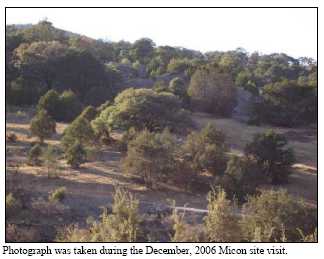
38
The mines within the Guanaceví mining district have been developed primarily by using open stope/shrinkage and cut and fill underground mining methods. Both the ground conditions, which vary from good to poor, and the deposit geometries tend to favour the higher cost, cut and fill mining method, with development waste used for backfill.
6.3.2 Production
Mining in the Guanaceví district extends back to at least 1535 when the mines were first worked by the Spanish.
During the late sixteenth century silver production accounted for 80% of all exports from Nueva España (New Spain), although, by the mid-seventeenth century silver production collapsed when mercury, necessary to the refining process, was diverted to the silver mines of Potosí in present day Bolivia. Collapse of the seventeenth century mining led to widespread bankruptcy among the miners and hacienda owners; however, in the latter half of the seventeenth century silver mining began to recover in Nueva España. By the start of the 18th century, Guanaceví had become an important mining centre in the Nueva Vizcaya province.
The peasant uprisings of 1810 to 1821 were disastrous to the Mexican mining industry with both the insurgents’ soldiers and royalist troops all but destroying the mining production in Mexico, and the Guanaceví mining district was not spared during this period.
The district has experienced several periods of bonanza-grade production including the operation of a mint in 1844. The Guanaceví mining district, however, reached its greatest period of activity at the start of the 20th century when five processing plants were in operation and more than 15 mines were in production.
In an article by George Wilson in the July, 1882 copy of The Engineering and Mining Journal, he states the following: “a Canadian company has forty stamps en route for Guanaceví, while two American companies are now negotiating for mines at Guanaceví to put up 100 stamps. This last-named camp has been worked by Mexicans for one hundred years, beneficiating the ores in arrastras and patio, at a cost of about $30 per ton; but by American machinery and processes, the cost of mining, hauling to mill, and beneficiating, will not exceed from $15 to $18 per ton, all told; while the average yield in the arrastras and patio of all the ores worked in the district is over 70 ounces of silver and half an ounce of gold per ton. Many of the shafts are down 300 feet, and the ores have so far invariably increased in width and yield with depth. They are true fissure veins and of great permanence, being distinctly traceable and worked on for an extension of over twelve miles from north to south. There are enough workings now open to supply ore for 500 stamps,breasts of ore six, eight, ten, and twelve feet wide being usual.”A second article by George Wilson in the same journal mentioned that“....a sale of mines at Guanaceví was closed; theprice is kept private, but believed to be in the neighbourhood of $300,000. The buyers made a very careful examination of the property Their average samples of the mines assayed 342 ounces, 265 ounces,145 ounces, 115 ounces, and 78 ounces silver per ton.”
39
J.R. Southworth, in his 1905 volume entitled “The Mines of Mexico”, mentions that Guanaceví is a very rich district and “that many of the largest capitalists of New York have enormous interests in its mines”. Southworth mentions that the Barradán, Hacienda Wilson, El Carmen, Nueva Australia and Hacienda Avila were all good mines and properties within the Guanaceví mining district. However, Southworth also mentioned that “considering the large number of once famous properties in Guanaceví, there are comparatively few now in operation. The cessation of development has been due to various causes, though usually not from lack of ore.”
Guanaceví was named as one of the most important districts in Western Durango in a 1908 article on the silver mines in Mexico contained in the “Transactions of the American Institute of Mining Engineers”, but only a description of the silver veins and the host rock in given and no mention is made of the actual silver production.
The vast majority of production came prior to the 1910 Mexican Revolution with the Guanaceví mining district being known for its high silver grades. Previous reports noted that the official production records indicate that a total value of 500 million pesos, or approximately 500 million ounces of silver and silver equivalents, with a present day value of about US $3.25 billion, had been extracted from this mining district. This makes the Guanaceví district one of the top five silver mining districts in Mexico on the basis of past production.
Since the 1910 Revolution, production has been sporadic. The Guanaceví Mining Company operated from the 1930’s until production ceased in 1942. Daily output was approximately 110 t/d.
In the 1970’s, the Comisión de Fomento Minero (Federal Mining Commission) (Fomento Minero), a Federal government agency charged with the responsibility of assisting the small-scale Mexican mining industry, constructed a 400 t/d flotation plant, now the MG plant. The plant has been expanded over time to its present capacity of 1,000 t/d for the cyanide circuit. In the early 1990’s, Fomento Minero started construction of a 600 t/d cyanide leach plant but construction ceased when it was only 30% complete due to the lack of funding.
In 1992, MG, a private company, purchased the Fomento Minero facilities and completed the construction of the leach plant. During 2002, total plant production included 170 t/d to 250 t/d coming from the three mines: Santa Cruz, Barradón and La Prieta mines, with approximately 700 to 800 t/d of additional feed purchased from other small scale operations.
Prior to Endeavour Silver management, production was coming from three mines without the benefit of any systematic exploration drilling, geological mapping or mine planning. During the 1920’s, Peñoles purchased several mines including the Santa Cruz mine, where from 1921 to 1924, the 330 m inclined shaft and several kilometres of underground workings on Levels 6, 7, 8, 10, 11 and 13 were developed that partially explored the vein ore shoots. However, the exploration results gave little promise to Peñoles at that time. The mine entered into a passive state and Peñoles rented the mines to various contractors who, up to 2005, slowly mined the more accessible mineralization.
40
In 2004, Endeavour Silver completed a final agreement with the Mexican partner that owned the Metalurgica Guanaceví plant and shareholders of Minera Santa Cruz y Garibaldi S.A. de C.V. (Minera Santa Cruz) to take over the Santa Cruz mine. Ramping was initiated in 2004 to intersect the area where Pan American had drilled three holes in the North Porvenir – El Porvenir area. In six months, diamond drilling was initiated to outline the area, the ramp was driven and approximately 10,000 t were mined from this new zone. Through 2005, approximately 1,524 m of ramping, 1,122 m of drifting and 466 m of raising were completed and 102,617 t were milled.
While it is evident that historical production has occurred in the Guanaceví mining district since pre-colonial times and early production records from the Spanish colonial period probably exist in the Archive of the Indies (Archivo des Indies), in Seville, Spain, in the records of the Viceroyalty of Mexico or in the records for Vizcaya province of Nueva España, Micon did not have access to any historical records of the actual silver and gold production.
Historical production for the years 1991 to 2003, at the Guanaceví Mines Project, prior to Endeavour Silver’s involvement, is roughly estimated in Table 6.2.
Table 6.2
Summary of the Production for the Guanaceví Property (1991 to 2003)
| Year | Tonnes | Silver (g/t) | Gold (g/t) |
| 1991 (from July) | 2,306 (est.) | 470 (est.) | 1.0 (est.) |
| 1992 | 10,128 | 340 (est.) | 1.3 (est.) |
| 1993 | 12,706 | 320 (est.) | 0.8 (est.) |
| 1994 | 18,256 | 190 (est.) | 0.5 (est.) |
| 1995 (until May) | 5,774 | 280 (est.) | 0.5 (est.) |
| 1996 | 11,952 | 315 | 0.74 |
| 1997 | 13,379 | 409 | 0.87 |
| 1998 | 11,916 | 550 | 0.92 |
| 1999 | 6,466 | 528 | 0.84 |
| 2000 | 18,497 | 538 | 1.01 |
| 2001 | 13,150 | 510 | 1.09 |
| 2002 | NA | NA | NA |
| 2003 | 1,531 | 550 | 1.00 |
| Total 1991 to 2003 | 126,061 | 417 | 0.90 |
Table provided by Endeavour Silver Corp.
A summary of the production for the years 2005 through to 2012, after Endeavour Silver became involved, is presented in Table 6.3.
41
Table 6.3
Summary of Production for the Guanaceví Property (2005 through 2011)
| Year | Tonnes | Silver (g/t) | Gold (g/t) | Oz Silver Recovered | Oz Gold Recovered | Recovery Silver (%) | Recovery Gold (%) |
| 2005 | 102,617 | 385 | 0.88 | 948,323 | 2,332 | 74.7 | 80.5 |
| 2006 | 117,255 | 449 | 0.90 | 1,352,661 | 2,493 | 80.0 | 73.0 |
| 2007 | 226,295 | 375 | 0.70 | 1,907,795 | 3,957 | 69.4 | 75.7 |
| 2008 | 255,656 | 318 | 0.58 | 1,852,969 | 3,845 | 70.9 | 80.7 |
| 2009 | 230,632 | 322 | 0.80 | 1,873,833 | 5,243 | 78.4 | 88.8 |
| 2010 | 312,087 | 323 | 0.73 | 2,448,826 | 6,272 | 75.5 | 85.2 |
| 2011 | 363,076 | 311 | 0.69 | 2,659,956 | 6,845 | 73.3 | 84.8 |
| 2012 | 418,278 | 249 | 0.76 | 2,549,533 | 8,971 | 74.6 | 88.1 |
| Total | 2,025,896 | 321 | 0.73 | 15,593,896 | 39,958 |
Table provided by Endeavour Silver Corp.
For the year ending December 15, 2012, silver production was 2,512,943 oz compared to 2,659,956 oz in 2011, a decrease of 5.53%, with gold production of 7,874 oz compared to 6,845 oz in 2011, an increase of 15%. Plant throughput for 2012 was 418,277 t at an average grade of 249 g/t silver and 0.76 g/t gold, as compared to 363,087 t at an average grade of 311 g/t silver and 0.69 g/t gold during 2011. In 2012, recoveries averaged 74.6% and 76.1% for silver and gold, respectively.
6.4 MINERAL RESOURCES AND MINERAL RESERVES
Historical resource and reserve estimates which were conducted prior to Endeavour Silver‘s involvement with the Guanaceví Mines Project will not be discussed in this report as, for the most part, they are historical estimates which were not conducted according to the CIM Standards for reporting mineral resources and reserves. In addition, since Endeavour Silver acquired ownership of the mine’ the resources and reserves have been revised every year based on both mining and exploration conducted during the year. These reports were posted to the SEDAR website by Endeavour Silver.
The last Technical Report to present a mineral resource and reserve estimate for the Guanaceví Mines Project was dated March 30, 2012, but the effective date of the estimate was December 31, 2011. The resource and reserve estimate, as audited by Micon, complied with the current CIM standards and definitions for estimating resources and reserves as required by NI 43-101 regulations.
Since the last estimate was reported, Endeavour Silver has conducted further diamond drilling and underground development and has completed a new resource and reserve estimate for the Guanaceví Mines Project. Micon has prepared Endeavour Silver’s new resource and reserve estimate and the discussions related to the new estimate are contained in Section 14 of this report.
42
7.0 GEOLOGICAL SETTING AND MINERALIZATION
The geological setting and mineralization of the Guanaceví Property are described in detail in the Range (March, 2006) and Micon (April, 2007, March, 2009, March, 2010, March, 2011 and March, 2012) Technical Reports. The following description of the geological setting and mineralization has been excerpted from the March, 2012 Micon report.
7.1 REGIONAL GEOLOGY
The rock types of the district can be divided into three principal stratigraphic groups, based on stratigraphic studies by the Consejo de Recursos Minerales and Endeavour Silver drill core-based observations during its exploration programs.
7.1.1 Guanaceví Formation
The oldest unit in the district is the Guanaceví Formation, a polymictic basal conglomerate composed of angular to sub-angular fragments of quartz and metamorphic rocks set in a sandy to clayey matrix within sericitic and siliceous cement. It is assigned to the Upper Jurassic or Lower Cretaceous on the basis of biostratigraphic indicator fossils mentioned but not detailed in the Durango State Geological Reference Report (1993). At least 450 m of thickness has been reported in the Guanaceví area for this basal unit, the lower contact of which has not been observed. In most areas, the upper contact is structural on high-angle normal faults but, in the San Pedro area, the upper contact is abrupt from Guanaceví conglomerate rocks to fairly fresh, dark coloured andesitic flows of the Lower Volcanic Sequence that appear conformable to the underlying Guanaceví Formation. The Jurassic assignment of the Guanaceví Formation has been in question, and at least two reports in the 1990’s consider it to be Tertiary (Durning and others, unpublished reports). A Tertiary age for the unit mitigates the idea of a transitional unit persisting through the Cretaceous; alternatively, it is possible that paraconformities in the package may be present but unreported to date.
Regional studies in Mexico demonstrate that Mesozoic rocks basal to the Tertiary section are strongly deformed with the development of sericitic alteration, shearing and microfolding in local shear zones and stronger deformation associated with overthrust nappe folds of Laramide age (late Cretaceous to end of the Paleocene). This type of strong deformation is not visible in the Guanaceví Formation, further raising questions about the validity of a Mesozoic assignment for this unit.
The Guanaceví Formation has been structurally defined as a horst, occupying the central portion of the northwest trending Guanaceví erosional window and flanked by sets of northwest striking normal faults that offset the Upper and Lower Volcanic Sequences down to the southwest and northeast on corresponding sides of the window. Mineralization within the horst is hosted by the conglomerate, both as dilatational high-angle fracture-filled structures and, in the San Pedro area, as manto-like replacement bodies below the upper contact of the conglomerate with overlying andesitic units of the Lower Volcanic Sequence.
43
7.1.2 Lower Volcanic Sequence
Using an inherited stratigraphic framework for the area, andesitic rocks and associated sedimentary units are placed in a loosely-defined package of flows and volcaniclastic sediments correlated with Eocene volcanism throughout the Sierra Madre of Mexico. No radio isotope age determinations have been made on volcanic units of the Guanaceví district, and lithological correlations to the Lower Volcanic Sequence appear to be reasonable for the andesitic flows and associated volcaniclastic units.
It has been observed in the rocks that host the Porvenir and Santa Cruz mine workings that the andesite occurs as a pale green to nearly black volcanic flow ranging from aphyric to plagioclase-hornblende phyric. Plagioclase is the common phenocryst type with crystals ranging from 1 to 2 mm up to 10 mm. Hornblende phenocrysts are 1 mm to 4 mm in length. In porphyritic andesites, feldspar phenocryst abundance approaches 5%, and hornblende abundance is generally less than 3%.
The sequence of rock types in the Lower Volcanic Sequence, as presently understood, is a coarsening-upward series of volcaniclastic sediments capped by an andesite flow as described above. The sedimentary lithologies are siltstones overlain by sandstone with minor intercalations of conformable conglomerate beds. The siltstone-sandstone sequence becomes transitionally dominated by conglomeratic beds at the top of the volcaniclastic package. Overall thickness of the siltstone-sandstone beds is up to 120 m. Conglomerate beds of the Lower Volcanic Sequence are from a few centimetres to 150 m thick at the top of the package, and differ from the conglomerates of the Guanaceví Formation in that Lower Volcanic Sequence clasts are mainly andesite of varying textural types.
7.1.3 Upper Volcanic Sequence
The Upper Volcanic Sequence consists of rhyolite crystal-lapilli tuff units uncomformably overlying the andesites which are generally structurally disrupted and altered by oxidation and silicification. The rhyolite is strongly argillically-altered with silicification overprinting argillic alteration in the immediate hanging wall of quartz veins and other silicified structures. The rhyolite commonly contains rounded quartz ‘eyes’ up to 4 mm in diameter, and the matrix consists of adularia, kaolinite and quartz. Local concentrations of biotite crystals up to 2 mm are not uncommon. The rhyolite has variable textures from thin-bedded ash flows to coarse lapilli tuffs with lithic clasts of andesite or rhyolite up to 50 cm in diameter. These latter commonly exhibit alteration rims indicating high temperatures and fluids in the volcanic environment. The thickness of the rhyolite tuff assemblage has not been measured at this time, but appears to exceed 300 m.
Geochemically, the lower portion of the rhyolites has been demonstrated by rare earth element (REE) data, from a series of samples taken from East Santa Cruz drilling, to be magmatically linked to the underlying andesites. The similarity between REE patterns of the rhyolite crystal-lapilli tuff and the andesitic rock units in this data set suggests a common source for the two volcanic packages that is difficult to reconcile with the idea of many millions of years of volcanic quiescence (from Lower Volcanic to Upper Volcanic Sequences). This raises the possibility that regional correlations for Guanaceví rhyolite based on radio isotope age determinations may result in assignment of the rhyolite (of the Santa Cruz/Porvenir mine area) to the Lower Volcanic Sequence rather than the Upper. In the San Martin de Bolanos district of Jalisco and also in the Topia district of Durango State, uppermost volcanic lithologies of the Lower Volcanic Sequence are rhyolitic and directly associated with mineralization. This may be true for the Guanaceví mining district as well.
44
See Figure 7.1 for a map of the regional geology in the area surrounding the Guanaceví mining district. See Table 7.1 for a generalized stratigraphic column in the Guanaceví mining district.
Table 7.1
Generalized Stratigraphic Column in the Guanaceví Mining District
| Geological Age | Stratigraphic Units and Lithologies | Thickness (m) | |
| Tertiary | Oligocene | Upper Volcanic Sequence Rhyolitic tuffs and ignimbrites | + 300 |
| Eocene | Lower Volcanic Sequence Andesite porphrytic flow Andesite conglomerate Volcanic sandstone/siltstone | <70 < 150 < 120 | |
| Jurassic (?) | (Late) ? | Guanaceví Formation | + 450 |
Note: Table adapted from the March, 2006 Technical Report by Range Consulting
7.1.4 Structural Setting
Figure 7.1, shows major faults of the Guanaceví mining district on a simplified geologic map of the region. The map pattern constitutes an erosional window caused by crustal uplift apparently centred about 3 km west of Guanaceví. With some exceptions, fracture-filling vein mineralization is localized on the flanks of the uplift centre, suggesting a genetic relationship between uplift and mineralization. The three principal trends of high-angle normal faults that characterize the region are as follows:
The dominant structural trend in the region is northwest, with significant north- northeast faults in a likely conjugate relationship. This generation of structures hosts most of the mineralization in the district.
Northeast faults postdate the mineralized structures.
East-west faults appear last.
This pattern sequence would appear to indicate an early extension in a northeast-southwest direction, followed by a later extension in an east-northeast–west-southwest direction, followed by a northwest-southeast extension and finally ending with the latest extension in a north-south direction. This clockwise evolution of principal stress directions is similar to that of other regions in the American Cordillera, including the Sierra Madre of Mexico.
45
Figure 7.1
Regional Geology Map for the Guanaceví Mining District
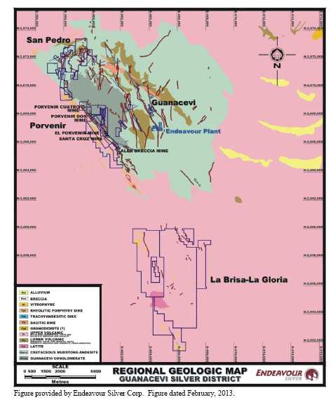
Timing of uplift of the Guanaceví window is constrained by the following considerations:
- Dilatational fractures flanking the uplift are dominantly northwest trending, with subordinate north and north-northeast components. Northeast and east-west fractures are not significant in controlling the uplift pattern. Thus, uplift is early in the structural evolution described above.
46
The northeast-southwest extension in Mexico is generally associated with opening of the Gulf of California, and dated as Oligocene to Miocene.
Uplift, therefore, may be coeval with the onset of silicic volcanism of the Upper Volcanics, which are considered Oligocene in age.
It is reasonable to conclude that uplift occurred at the onset of Upper Volcanic Sequence eruptions (Oligocene), northeast-southwest extension, and was coeval with mineralization. The cause of uplift, however, is left unexplained by these considerations. Alternative explanations include magmatic upwelling at depth, resurgent doming within a cryptic caldera, or tectonic transpression resulting from large-scale lateral displacement
7.2 PROJECT GEOLOGY
The Santa Cruz mine property, which forms part of the main portion of the Guanaceví Mines Project, covers about a 3.0 km strike length of the Santa Cruz fault/vein system. The Santa Cruz vein is similar in many respects to other veins in the Guanaceví district, except that it is the only one to lie on the west side of the horst of Guanaceví Formation and associated facies, and it dips west instead of east. See Figure 7.2 for the Guanaceví Mines Project geology map.
Figure 7.2
Guanaceví Mines Project Geology Map
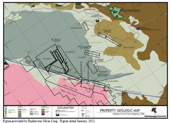
47
In the Porvenir Dos area and the Deep Santa Cruz mine workings, a low angle rhyolite crystal-lapilli tuff and andesitic contact occurs high in the hanging wall of the Santa Cruz vein indicating a fault contact with Guanaceví Formation, which obviously cuts the contact.
7.2.1 Local Structure
The Santa Cruz vein, the principal host of silver and gold mineralization, is located on the west side of the horst of the Guanaceví Formation. The mineralized vein is part of a major fault system that trends northwest and principally places the Guanaceví Formation in the footwall against andesite and/or rhyolite in the hanging wall. The vein/fault presents a preferred strike of N45°W with dips from 45° to 70° to the southwest. From La Prieta to Porvenir Dos, it extends a distance of 5 km and averages approximately 3 m in width.
The broader and higher-grade mineralized ore shoots tend to occur along flexures in the Santa Cruz vein structure, where sigmoidal loops are developed both along strike and down dip. The vein in Deep Santa Cruz, for instance, splays into two, three or four separate mineralized structures with the intervening wallrocks also often well mineralized, giving mining widths up to 20 m in some places. These sigmoidal loops tend to develop with some regularity along strike and all of the ore shoots at the Santa Cruz mine have about a 60° plunge to the northwest. A shallow northwest plunging striation, raking at 15°- 30°, is noted on a number of fault planes within the Santa Cruz structure; these striations appear to be consistent with an observed sinistral movement seen on minor faults which produce small offsets of the Santa Cruz vein.
Particularly around the peripheral ore zones, the vein is observed to develop imbricate structures, either as imbricate lenses shallowly oblique to the principal Santa Cruz trend or as vein segments offset by similarly trending minor faults. The trend of these structural features is generally slightly more westerly than the Santa Cruz vein/fault trend and steeper dipping. Veining is also often affected by north-south structures, which rarely seem to offset the main fault but do cause minor jogs in the vein; often the north-south structures are associated with manganese oxide concentrations and elevated silver grades.
7.2.2 Alteration
The sedimentary and volcanic rocks are hydrothermally altered with propylitization (chlorite) the most widespread, up to 150 m from the veins, with narrower bands of potassic and argillic alteration (kaolinite and adularia) typically up to 25 m thick in the hanging wall and with silicification near the veins. Phyllic alteration, however, is absent in the Guanaceví district.
7.3 MINERALIZATION
The mineralization of the Guanaceví Property is described in detail in the Range (March, 2006) and Micon (April, 2007, March, 2009, March, 2010, March, 2011 and March 2012) Technical Reports. The following description of the mineralization has been excerpted from the March, 2012, Micon report.
48
The principal mineralization within the Santa Cruz-Porvenir mines is an epithermal low-sulphidation, quartz-carbonate, fracture-filling vein hosted by a fault-structure that trends approximately N45°W and dips 55° southwest. The fault and vein comprise a structural system referred to locally as the Santa Cruz vein structure or Santa Cruz vein fault. The Santa Cruz vein structure has been traced for 5 km along the trend and averages about 3 m in width. Mineralization in the system is not continuous, but occurs in steeply northwest-raking shoots up to 200 m in strike length. A second vein, sub-parallel to the Santa Cruz vein but less continuous, is economically significant in the Porvenir Dos zone and in the northern portion of deep North Porvenir. It is referred to in both areas as the “Footwall vein”, although in Porvenir Dos, the term “Conglomerate vein” has also been employed.
7.3.1 Santa Cruz Vein
The Santa Cruz vein is a silver-rich structure with lesser amounts of gold, lead and zinc. Mineralization has averaged 500 g/t silver and 1 g/t gold over 3 m true width. The minerals encountered are argentite-acanthite, limited gold, galena, sphalerite, pyrite and manganese oxides. Gangue minerals noted are barite, rhodonite, rhodochrosite, calcite, fluorite and quartz. The mineralization down to Level 6 in the Santa Cruz mine is mainly oxidized, with a transition zone of oxides to sulphides occurring between Levels 6 to 8, although some sulphide ore was mined above Level 6.
Mineralization exhibits evidence of episodic hydrothermal events which generated finely banded textures. The higher grade mineralization in the district is commonly associated with multiple phases of banding and brecciation. The first phase, deposition of white quartz, white calcite and pyrite in stockwork structures, often exhibits horse-tail structures bifurcating both in the horizontal and vertical sense to form imbricate pods. The second phase deposited semitranslucent quartz with argentite, scarce gold, and oxides of manganese (2%) and rare lead and zinc sulphide (4%), the latter particularly in the lower part of the hydrothermal system. The second phase was accompanied by the deposition of barite, rhodonite, rhodochrosite, fluorite and calcite.
This second phase comprises multiple pulses of mineralization expressed in the vein structures as bands of massive, banded or brecciated quartz. Massive and massive-to-banded quartz are commonly associated with carbonate which is predominantly manganoan calcite and calcitic rhodochrosite. Rhodonite is much less abundant than carbonates but is not uncommon.
According to results obtained through diamond drilling, the lead and zinc mineralization occurs more commonly in the vein below the water table which, in the Santa Cruz mine, is just below the 13 Level.
49
7.3.2 Footwall Veins
In the Porvenir Dos area and in the deeper portion of North Porvenir, a footwall-hosted vein lies in the footwall of the Santa Cruz vein structure. In both areas, this footwall vein is either within Guanaceví Formation footwall rocks or is at the structural contact between Guanaceví Formation and Lower Volcanic Sequence andesite. It is banded to brecciated quartz plus carbonate and contains local scatterings (<1%) of sulphides (pyrite>sphalerite> galena>chalcopyrite) and rare pods (<50 cm) of sulphides. It appears likely from drill sections that these footwall vein occurrences are splays of the main Santa Cruz vein structure and are largely sympathetic to it. At the north end of North Porvenir, on Section 19, the footwall vein attains a true width of over 7 m with silver grades of approximately 400 g/t in some areas. In Porvenir Dos, the footwall vein is narrower than the Santa Cruz vein and is overall a lower-grade vein, although one high grade intercept (uncapped) has been recorded in drill hole PD 36-3, at 2,548 g/t silver over 1.25 m.
50
8.0 DEPOSIT TYPES
The deposit types of the Guanaceví Property are described in detail in the Range (March, 2006) and Micon (April, 2007, March, 2009, March, 2010, March, 2011 and March 2012) Technical Reports. The following description was excerpted from the March, 2012, Micon report.
The Guanaceví silver-gold district comprises classic, high-grade silver-gold, epithermal vein deposits, characterized by low sulphidation mineralization and adularia-sericite alteration. The Guanaceví veins are typical of most other epithermal silver-gold vein deposits in Mexico in that they are primarily hosted in the Tertiary Lower Volcanic series of andesite flows, pyroclastics and epiclastics, overlain by the Upper Volcanic series of rhyolite pyroclastics and ignimbrites. Evidence is accumulating in the Guanaceví mining district that the mineralization is closely associated with a pulse of silicic eruptions that either signaled the end of Lower Volcanic Sequence magmatism or the onset of Upper Volcanic Sequence activity.
Low-sulphidation epithermal veins in Mexico typically have a well defined, subhorizontal ore horizon about 300 m to 500 m in vertical extent where the bonanza grade ore shoots have been deposited due to boiling of the hydrothermal fluids. Neither the top nor the bottom of the Santa Cruz ore horizon has yet been found but, given that high-grade mineralization occurs over a 400 m vertical extent from the top of the Garibaldi shaft (south of the Santa Cruz mine) to below Level 13 in Santa Cruz, it is likely that erosion has not removed a significant extent of the ore horizon.
Low sulphidation deposits are formed by the circulation of hydrothermal solutions that are near neutral in pH, resulting in very little acidic alteration with the host rock units. The characteristic alteration assemblages include illite, sericite and adularia that are typically hosted by either the veins themselves or in the vein wall rocks. The hydrothermal fluid can travel either along discrete fractures where it may create vein deposits or it can travel through permeable lithology such as a poorly welded ignimbrite flow, where it may deposit its load of precious metals in a disseminated deposit. In general terms, this style of mineralization is found at some distance from the heat source. Figure 8.1 illustrates the spatial distribution of the alteration and veining found in a hypothetical low-sulphidation hydrothermal system.
8.1 MICON COMMENTS
Micon observed and discussed the exploration programs during the December, 2011 site visit to the Guanaceví Mines Project and the programs are planned and executed on the basis of the deposit model discussed above. For the most part, drilling is planned and executed to cross-cut the disseminated mineralized stringer zones and veins. Historical mining levels are driven to follow along the stringer zones with further geological sampling and mapping conducted as the mining levels are developed.
51
Figure 8.1
Alteration and Mineral Distributions within a Low Suphidation Epithermal Vein System
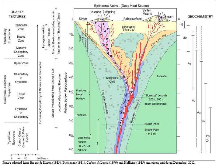
52
9.0 EXPLORATION
Detailed descriptions of Endeavour Silver’s previous exploration programs were provided in previous Micon Technical Reports and are summarized in Section 6 of this report. Only the 2012 exploration program will be discussed in detail in this section.
9.1 2012 GENERAL EXPLORATION AND DRILLING
9.1.1 2012 Mine Exploration
In 2012, the mine conducted drilling programs on a number of targets related to the veins which are being exploited. The mine drilling occured both on surface and underground and is discussed in more detail in Section 10 of this report.
9.1.2 2012 Surface Exploration and Drilling
In 2012, Endeavour Silver spent US $146,787 (including property holding costs) on exploration activities mainly on the Milache and La Brisa areas, as detailed in Table 9.1.
Table 9.1
Summary of the 2012 Expenditures for the Guanaceví Surface Exploration Program
| Mine or Concession/Claim | Area | Description | Pesos | US$ |
| Mine | Nuestra Señora | Taxes | 1,398 | 106 |
| Subtotal | 1,398 | 106 | ||
| San Marcos | Taxes | 2,365 | 179 | |
| Subtotal | 2,365 | 179 | ||
| San Vicente | Taxes | 1,996 | 151 | |
| Subtotal | 1,996 | 151 | ||
| San Pedro Uno | Taxes | 12,436 | 943 | |
| Subtotal | 12,436 | 943 | ||
| Mine Total | 18,195 | 1,380 | ||
| Concession/Claim | Porvenir Dos | Taxes | 23,061 | 1,749 |
| Subtotal | 23,061 | 1,749 | ||
| Las Sultana | Taxes | 2,902 | 220 | |
| Subtotal | 2,902 | 220 | ||
| San Guillermo | Taxes | 1,248 | 95 | |
| Subtotal | 1,248 | 95 | ||
| Unificación Flora | Taxes | 9,118 | 692 | |
| Subtotal | 9,118 | 692 | ||
| Unificación Santa Cruz | Taxes | 7,132 | 541 | |
| Subtotal | 7,132 | 541 | ||
| Santa Cruz Dos | Taxes | 28,326 | 2,149 | |
| Subtotal | 28,326 | 2,149 | ||
| El Pelayo y Anexas | Taxes | 14,034 | 1,065 | |
| Subtotal | 14,034 | 1,065 | ||
| Milache | Assays | 989,020 | 75,024 | |
| Consultants | 184,505 | 13,996 | ||
| Contractors | 3,250 | 247 | ||
| Diamond drilling | 12,535,806 | 950,922 | ||
| Field | 209,600 | 15,899 | ||
| Housing | 8,721 | 662 | ||
| Food | 59,980 | 4,550 | ||
| Office supplies andequipment | 18,568 | 1,408 | ||
| Geology and engieneering personnel | 1,963,082 | 148,912 | ||
| Taxes | 32,105 | 2,435 |
53
| Mine or Concession/Claim | Area | Description | Pesos | US$ |
| Reclamation | 101,536 | 7,702 | ||
| Milache roads and drill pads | 71,120 | 5,395 | ||
| Salaries (subtotal) | 581,730 | 44,128 | ||
| Travel and lodging | 62,647 | 4,752 | ||
| Gas | 99,830 | 7,573 | ||
| Repair and maintenance | 145,869 | 11,065 | ||
| Expenses non-deductable | 281,190 | 21,330 | ||
| Subtotal | 17,348,557 | 1,316,000 | ||
| Porvenir Cuatro | Taxes | 27,255 | 2,067 | |
| Subtotal | 27,255 | 2,067 | ||
| San Pedro | Assays | 46,070 | 3,495 | |
| Geology and engieneering personnel | 67,102 | 5,090 | ||
| Taxes | 125,794 | 9,542 | ||
| Salaries | 20,463 | 1,552 | ||
| San Pedro repair and maintenance | 31,874 | 2,418 | ||
| Subtotal | 291,304 | 22,097 | ||
| Calvario / Elizabeth | Taxes | 13,231 | 1,004 | |
| Subtotal | 13,231 | 1,004 | ||
| Epsilon | CONTRACT PAYMENTS & FEES | 727,650 | 55,197 | |
| Subtotal | 727,650 | 55,197 | ||
| La Brisa | Assays | 565,617 | 42,906 | |
| Diamond drilling | 6,210,188 | 471,083 | ||
| Field | 264,421 | 20,058 | ||
| HOUSING | 18,755 | 1,423 | ||
| Food | 52,299 | 3,967 | ||
| Geology and engieneering personnel | 1,362,065 | 103,321 | ||
| Taxes | 51,923 | 3,939 | ||
| Roads and drill pads | 508,880 | 38,602 | ||
| Salaries (subtotal) | 378,722 | 28,729 | ||
| Travel and lodging | 50,602 | 3,838 | ||
| Gas | 45,385 | 3,443 | ||
| Repair and maintenance | 54,936 | 4,167 | ||
| Non-deductable | 211,392 | 16,035 | ||
| Subtotal | 9,775,183 | 741,511 | ||
| El Cambio, La Onza, SanNicolás, Ampliación de SanNicolas | TaxesS | 13,452 | 1,020 | |
| Subtotal | 13,452 | 1,020 | ||
| Concession/Claim Subtotal | 28,282,453 | 2,145,407 | ||
| Guanaceví Exploration Total | 28,300,648 | 2,146,787 |
Table provided by Endeavour Silver Corp.
9.2 2012 EXPLORATION ACTIVITIES
9.2.1 Drilling
Through November, 2012, Endeavour Silver completed 12,636.90 m of drilling in 28 surface diamond drill holes at the Guanaceví mine. A total of 2,793 samples were collected and submitted for assay. Surface exploration drilling undertaken during 2012 is summarized in Table 9.2.
Table 9.2
Guanaceví Mine Surface Exploration Drilling Activities in 201
| Project Area | Number of Holes | Total Metres | Number of Samples Taken |
| La Brisa | 8 | 2,829.25 | 531 |
| Milache | 20 | 9,807.65 | 2,262 |
| Total | 28 | 12,636.90 | 2,793 |
Table provided by Endeavour Silver Corp.
54
Surface diamond drilling was conducted by Layne de Mexico, S.A. de C.V. (Layne), a wholly-owned subsidiary of the USA-based Layne Christensen Company (Layne Christensen). Neither Layne nor Layne Christensen holds an interest in Endeavour Silver and both are independent of the company.
9.2.2 Other Surface Exploration Activities
9.2.2.1 Surface Geological Mapping and Sampling
During 2012, only limited surface geological mapping and sampling was conducted by Endeavour Silver in the Guanaceví District. Field activities mainly focused in the La Brisa and La Gloria areas (Figure 9.1).
In addition, follow-up evaluation was conducted on targets previously identified by satellite image analysis. These targets were mainly outside the properties currently held by Endeavour Silver
La Brisa 5
During March and April, reconnaissance mapping and sampling was conducted in Endeavour
Silver’s La Brisa 5 claim area (Figure 9.1).
In the La Brisa 5 area, a significant fault was located (Figure 9.2). The footwall of the fault was silicified with minor iron oxides, traces of manganese oxides and oxidized cubic crystals (after pyrite?). The fault was 0.35 m wide with a trend of NW60ºSE/70ºNE. Locally, the fault contained fragments (<0.35 x 0.15 m) associated with weak silicification and light brown fault material. This fault measured up to 2.25 m wide.
This fault was followed to the northwest. At one locality, it consisted of a breccia of milky quartz (white and traces of light brown), silicified fragments and traces of manganese and iron oxides. The fault turned more northward with a trend of NW38ºSE/70ºNE, and measured about 0.3 m wide.
Assays for rock samples collected in Brisa 5 area are shown in Table 9.3. Assay results were mainly below the detections limits for gold and silver.
Table 9.3
Assays for Rock Sampling in the La Brisa 5 Area.
| Sample ID | Location | Sample Width (m) | Assay Results | |
| Au (ppm) | Ag (ppm) | |||
| LB-451 | Brisa 5 | 0.75 | <0.005 | 0.2 |
| LB-452 | Brisa 5 | 1.10 | <0.005 | <0.2 |
| LB-453 | Brisa 5 | 0.45 | <0.005 | <0.2 |
| LB-454 | Brisa 5 | 0.35 | <0.005 | <0.2 |
| LB-455 | Brisa 5 | 2.25 | <0.005 | <0.2 |
| LB-456 | Brisa 5 | 0.25 | <0.005 | 0.2 |
55
| Sample ID | Location | Sample Width (m) | Assay Results | |
| Au (ppm) | Ag (ppm) | |||
| LB-457 | Brisa 5 | 0.90 | <0.005 | <0.2 |
| LB-458 | Brisa 5 | 0.95X0.60 | <0.005 | 0.2 |
Table provided by Endeavour Silver Corp.
Figure 9.1
Surface Map of La Brisa Area
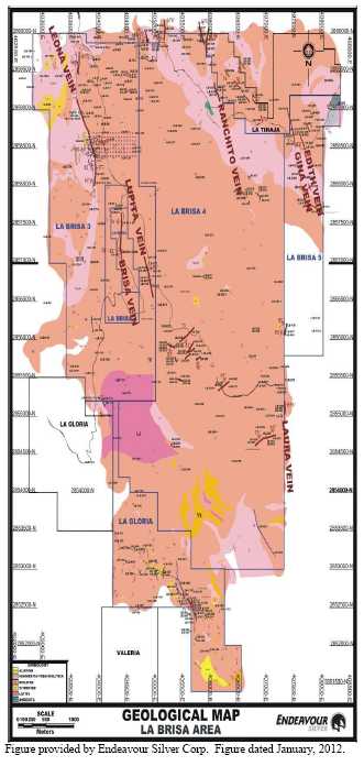
56
Figure 9.2
Photograph Showing Fault with Silicified Fragments and Silicified Matrix on the La Brisa 5 Concession

La Brisa 4 (San Jorge)
During May, 2012, three trenches were excavated and 19 samples collected on the San Jorge vein, located near the northernmost limit of the La Brisa 4 concession (Figure. 9.1; Table 9.4).
In trench #1, the width of the vein was 1.55 m and consisted of quartz (black-light gray-red); skeletal, banded, milky, chalcedonic, crystalline and amethyst (traces) with iron and manganese oxides and weak argillic alteration on the footwall.
In trench #2, the width of the vein was 1.50 m and consisted of quartz (red-light gray-black-white); banded, chalcedonic, crystalline and skeletal with iron and manganese oxides. On the hanging wall of the vein argillic alteration and traces of quartz were present.
In trench #3, only intermittent quartz lenses aligned and vertical, cross-cutting tuff, were found. The outcrop consisted of quartz (white-yellow-traces of red-light brown-purple); milky, chalcedonic, crystalline and amethyst (traces). Alteration includes traces of chlorite and iron oxides, weak argillization and traces of oxidized crystals. The structure is up to 0.45 m wide and trends NW20ºSE.
57
Table 9.4
Assays for Rock Sampling in the La Brisa 4 (San Jorge Vein) Area
| Sample ID | Location | SampleWidth (m) | Assay Results | |
| Au (ppm) | Ag (ppm) | |||
| LB-459 | Brisa 4 | 1.60 | 0.25 | 3 |
| LB-460 | Brisa 4 | 0.35 | 0.09 | 4 |
| LB-461 | Brisa 4 | 0.35 | 0.02 | 2 |
| LB-462 | Brisa 4 | 0.50 | 0.16 | 9 |
| LB-463 | Brisa 4 | 0.60 | 0.06 | 9 |
| LB-464 | Brisa 4 | 0.45 | 0.22 | 10 |
| LB-465 | Brisa 4 | 0.65 | 0.04 | 2 |
| LB-466 | Brisa 4 | 1.00 | 0.03 | 1 |
| LB-467 | Brisa 4 | 0.80 | 0.10 | 17 |
| LB-468 | Brisa 4 | 0.70 | 0.27 | 70 |
| LB-469 | Brisa 4 | 0.60 | 0.03 | 4 |
| LB-470 | Brisa 4 | 0.55 | 0.03 | 3 |
| LB-471 | Brisa 4 | Grab | <0.005 | 0 |
| LB-472 | Brisa 4 | Grab | 0.03 | 0 |
| LB-473 | Brisa 4 | 1.20 | 0.01 | 0 |
| LB-474 | Brisa 4 | 0.45 | 0.05 | 0 |
| LB-475 | Brisa 4 | 0.50 | <0.005 | 0 |
| LB-476 | Brisa 4 | 0.50 | <0.005 | 0 |
| LB-477 | Brisa 4 | 0.50 | <0.005 | <0.2 |
Table provided by Endeavour Silver Corp.
La Gloria
During June, fieldwork was conducted on the La Gloria claim (Figure 9.1).
A vein was mapped that outcropped intermittently for about 150 m before being cut off by a fault. The vein consisted of quartz (white, traces of light gray and light brown), milky-crystalline (traces), with traces of iron and manganese oxides. The vein trends E-W/60º S and has a maximum width of 2.2 m. At the western part of the vein was a zone with iron oxides to a maximum width of 3.4 m.
Also identified were red-white-yellow zones with iron oxides and minor manganese oxides associated with argillic alteration (Figure. 9.3).
Assays for rock samples collected in La Glorias area are shown in Table 9.5. Assay results returned were mainly below the detections limits for gold and silver.
58
Figure 9.3
Photograph Showing Argillized and Oxidized Zone on La Gloria Concession
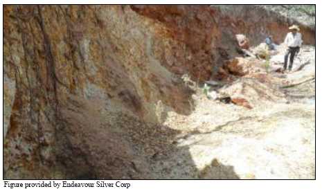
Table 9.5
Assays for Rock Sampling in the La Gloria Area
| Sample ID | Location | Sample Width (m) | Assay results | |
| Au (ppm) | Ag (ppm) | |||
| LB-478 | La Gloria | 3.40 | <0.005 | <0.2 |
| LB-479 | La Gloria | 3.30 | <0.005 | <0.2 |
| LB-480 | La Gloria | 2.20 | <0.005 | <0.2 |
| LB-481 | La Gloria | 0.75 | <0.005 | <0.2 |
| LB-482 | La Gloria | 1.40 | <0.005 | <0.2 |
| LB-483 | La Gloria | 1.00 | <0.005 | <0.2 |
| LB-484 | La Gloria | 0.40 | <0.005 | <0.2 |
| LB-485 | La Gloria | Grab | <0.005 | <0.2 |
| LB-486 | La Gloria | 5.00 | <0.005 | <0.2 |
| LB-487 | La Gloria | 5.00 | <0.005 | <0.2 |
Table provided by Endeavour Silver Corp.
9.3 MICON COMMENTS
Micon reviewed the surface sampling program when it visited the Guanaceví Mines Project in December, 2011 and the programs were found to be well planned and executed during each of the previous site visits as well. For the most part, the sampling is planned and executed to cross-cut the disseminated mineralized stringer zones and veins. Where the historical mining levels are driven to follow along the stringer zones, sampling is planned to cross-cut the mineralized zone horizontally. Geological mapping is also conducted along the old mining levels and assist in determining the dip and true width of the mineralized zone
In general terms, the samples are representative of the mineralized material that is currently being mined and the grade of the individual samples appropriately reflects the variability of the mineralization contained in the vein.
59
10.0 DRILLING
Endeavour Silver’s previous drilling programs on the Guanaceví Mines project have been described detail in the previous Technical Reports and sumarrized in Section 6 of this report. This section discusses the general drilling and core logging procedures, as well as focusing on the 2012 drilling programs.
10.1 GENERAL DISCUSSION
No changes have occurred to the methods of outlining and surveying the locations of the drill holes since the publication of the previous Micon reports. However, for completeness of this report, the following description of Endeavour Silver’s drilling procedures has been excerpted from the prior reports.
10.1.1 Drilling Procedures
After review and approval by management of the planning and budgeting of the drilling programs proposed by Endeavour Silver geologists, the individual drill sites are prepared and surveyed. Drill holes are typically drilled from the hanging wall, perpendicular to and passing through the target structure, into the footwall. No drilling is designed for intercept angles less than about 35° to the target, and most are from 45 to 90°. Drill holes are typically HQ to NQ size in diameter.
On the drill site, the drill set-up is surveyed for azimuth, inclination and collar coordinates with the drilling subject to daily scrutiny and coordination by Endeavour Silver geologists. At or near the targeted drill hole depth, the hole is surveyed using a Reflex down-hole survey instrument in multi-shot mode. The instrument is lowered down the drill rod string by wireline (the core barrel has been removed) and extended through the bit, where it hangs unsecured by resting on the bit crown. Survey measurements are thus obtained at a depth of approximately 4 m below the end of the drill string and at 30 m to 50 m intervals from the bottom of the hole to the collar. The survey data obtained from the drill hole are transferred to a handheld PDA, by which the data are transferred to the office and thence to the Vulcan mine planning software and AutoCAD databases. True thicknesses are estimated from the measured inclination of the drill hole intercept and the interpreted dip of the vein.
Drill core is collected daily and carried to a secure core storage building where it is laid out, measured, logged for geotechnical and geological data, and marked for sampling.
Depending on the competency of the core, core is either cut in half with a diamond bladed core saw or split with a pneumatic core splitter.
The core storage facilities at Guanaceví are well protected by high level security fences and are under 24 hours surveillance by security personnel. This arrangement minimizes any possibility of tampering with the drill cores.
60
10.1.2 Ballmark Core Orientation System
In 2009, Endeavour Silver implemented the Ballmark Oriented Core System for its drilling programs in San Pedro. The most important benefit of this system is its inherent design for accurate measurement of the orientation of mineralized structures, faults and fractures.
The Ballmark system is designed to accurately orient drill core as and when the core is broken from the bottom of the hole. It does this by indent marking a soft disc with a non-magnetic free moving ball which, because of gravity, lies at the bottom or low side of an angled hole.
Ballmark is unique in that it marks the orientation of the core at the time the core is broken, as compared to all other systems that return to the bottom of the hole after the event (breaking the core) to try to measure or mark the profile of the hole bottom or the 'stub' left in hole. Because of this basic difference, there is no downtime in the drilling cycle and the drill rig continues working at its normal pace, without delays to the operation.
The Ballmark system works by utilizing the action of the inner tube back end during core breaking, which transfers load to the outer tube via compression of a spring (Figure 10.1). The system is then able to indent a previously aligned soft disc, using a ceramic ball.
Figure 10.1
The Ballmark Core Orientation System
By breaking core after the drill string has stopped rotating, a ballmark is created on the soft disc (Figure 10.2). This mark can then be transposed to the core resulting in consistent, accurate core orientation. This also produces a permanent record (the disc) of the core orientation information.
61
Figure 10.2
Permanent Core Orientation Inormation is Created on a Soft Disc of the Ballmark System

10.1.3 Core Logging Procedures
In 2012, Endeavour Silver continued using its drill hole data collection and data management system for its exploration projects.
The configuration setup by Century Systems Technologies Inc. was previously selected for this purpose (Figure 10.3). Century was chosen because it directly interfaces with other software such as Vulcan, MapInfo and ArcGIS. The configuration selected was as follows:
DHLogger for drill hole data collection, management and reporting, which runs on a Windows XP or Vista computer.
DHLite for drill hole data collection, which runs on a handheld Windows mobile computer. Fusion Client to move data back and forth between the local computer and the server(s).
Figure 10.3
Century’s Configuration for Drill Hole Data Collection for the Guanaceví Mines Project
62
In 2008, Endeavour Silver established logging codes and other database organization and implemented the Century data collection and data management system at Guanaceví.
Each project is captured into a DHLogger stand-alone database. The database comes in two files that can be easily copied to the office for backup and sharing of the data.
Only one person can be adding data to a project’s database at a given time in DHLogger but many people can be logging drill holes on DHLite at the same time.
The data are captured at the Project or in the office and the database files can be posted to a secure area in the office for others to copy to their computer and view.
10.2 2012 DRILLING PROGRAM AND RESULTS
10.2.1 2012 Surface Drilling Program
In 2012, exploration drilling at Guanaceví focused on exploring the Santa Cruz vein structure to the north of the Porvenir mine, in the Milache claim, and also in the La Brisa area, situated in the southern part.
10.2.1.1 2012 La Brisa Surface Diamond Drilling Program and Results
In 2012, surface diamond drilling was completed in the La Brisa area using one drill rig provided by Layne. By mid-May, 2012, Endeavour Silver completed a total of 2,829.25 m in 8 holes (Table 10.1 and Figure 10.4).
Table 10.1
Summary for La Brisa 2012 Surface Diamond Drilling Program
| Hole | Azimuth | Dip | Diameter | Total Depth (m) | Start Date | Finish Date |
| BR03-1 | 90º | -45º | HQ | 234.25 | 12/12/2011 | 12/01/2012 |
| BR02-1 | 90º | -49º | HQ | 376.60 | 13/01/2012 | 01/02/2012 |
| BR02-2 | 90º | -68º | HQ | 338.10 | 01/02/2012 | 24/02/2012 |
| BR03-2 | 90º | -68º | HQ | 469.60 | 24/02/2012 | 12/03/2012 |
| LT01-1 | 248º | -45º | HQ | 311.80 | 13/03/2012 | 31/03/2012 |
| LT02-1 | 250º | -54º | HQ | 475.50 | 02/04/2012 | 17/04/2012 |
| LE12-1 | 79º | -64º | HQ | 470.60 | 18/04/2012 | 06/05/2012 |
| LT03.5-1 | 49º | -45º | HQ | 152.80 | 07/05/2012 | 16/05/2012 |
| Total | 2,829.25 |
Table provided by Endeavour Silver Corp.
63
Figure 10.4
Surface Map Showing Completed Holes in the La Brisa Area
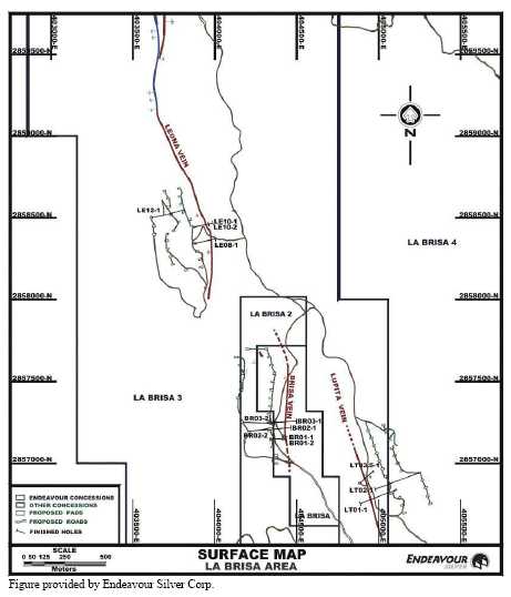
In the La Brisa area, the geology consists of a porous and silicified sequence of rhyolitic volcanic rocks (tuffs, sandstone, volcanic breccias and ignimbrites). Drilling was difficult due to a lack of water, loss of circulation, the hardness of the rock and some sandy horizons. This resulted in slow drilling advance, high consumption of additives, water and bits.
In 2012, the La Brisa vein was tested in four holes (BR02-1, BR02-2, BR03-1 & BR03-2). The La Brisa vein intercepted was mainly a fault structure consisting of silicified rhyolite fragments in a quartz matrix with minor mm-scale quartz veinlets. Fragments of milky white quartz are present locally. Traces of fine, disseminated manganese oxides and possible pyrite were noted. Oxidation is moderate, occuring mainly as iron oxides on fractures.
In 2012, the Lupita vein was tested in three holes (LT01-1, LT02-1 & LT03.5 -1). The structure intercepted was mainly a breccia consisting of rhyolite and minor small quartz fragments cemented by silica. Traces of disseminated pyrite are present. Oxidation is strong in places, occurring primarily iron oxides (hematite) and minor manganese oxides. Hole LT02-1 did not encounter any vein intercepts.
64
In 2012, the Leona structure was tested in only one hole (LE12-1). The structure intercepted was a stockwork zone containing intervals of white to dark-coloured calcite +/- quartz breccia. Minor manganese oxides was observed on some fractures.
All drill intercepts of the La Brisa, Lupita and Leona vein structures returned only low-grade values of <13 g/t silver and <0.20 g/t gold (Table 10.2).
Intercepts of the La Brisa, Lupita and Leona vein structures are shown on the longitudinal sections in Figures 10.5, 10.6 and 10.7.
Figure 10.8 is a cross-section through Holes BR03-1 and BR03-2 drilled to test the La Brisa vein in the La Brisa area.
Figure 10.9 is a cross-section through Hole LT01-1 drilled to test the Lupita vein in the La Brisa area.
Table 10.2
Summary of the 2012 La Brisa Diamond Drilling Results
| Drill Hole ID | Vein | Mineralization Intersection | Assay Results | ||||
| From (m) | To (m) | Core Length (m) | True Width (m) | Silver (g/t) | Gold g/t) | ||
| LE08-1* | Leona Vein | 101.70 | 103.60 | 1.90 | 0.96 | 6.53 | 0.01 |
| LE10-1* | Leona Vein | 78.90 | 84.90 | 6.00 | 5.20 | 2.18 | 0.01 |
| Vein | 120.45 | 120.75 | 0.30 | 0.20 | <0.2 | <0.005 | |
| LE10-2* | Leona Vein | 106.55 | 106.85 | 0.30 | 0.29 | 12.70 | 0.06 |
| BR01-1* | No vein intercept | ||||||
| BR01-2* | La Brisa Vein | 103.55 | 105.30 | 1.75 | 1.12 | 2.70 | 0.01 |
| BR02-1 | La Brisa Vein | 253.80 | 254.45 | 0.65 | 0.52 | <0.2 | <0.005 |
| BR02-2 | Hole abandoned due to stuck rods | ||||||
| BR03-1 | La Brisa Vein | 94.05 | 94.60 | 0.55 | 0.45 | <0.20 | 0.01 |
| BR03-2 | La Brisa Vein | 360.50 | 361.00 | 0.50 | 0.38 | 0.20 | <0.005 |
| LT01-1 | Lupita Vein | 142.30 | 142.90 | 0.60 | 0.57 | 0.20 | <0.005 |
| LT02-1 | No vein intercept | ||||||
| LE12-1 | Leona Vein | 313.05 | 329.00 | 15.95 | 10.30 | 0.20 | <0.005 |
| LT03.5-1 | Lupita Vein | 116.00 | 117.70 | 1.70 | 0.98 | 4.80 | 0.20 |
Table provided by Endeavour Silver Corp.;* Hole completed in 2011 but assays received in 2012.
65
Figure 10.5
Longitudinal Section (looking E) showing Intersection Points on the Brisa Vein
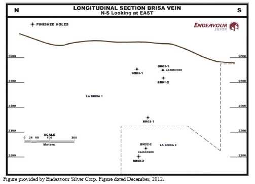
Figure 10.6
Longitudinal Section (looking Northeast) showing Intersection Points on the Lupita Vein
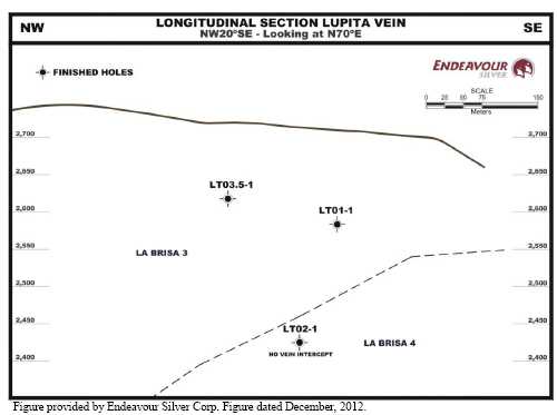
66
Figure 10.7
Longitudinal Section (looking NE) showing Intersection Points on the Leona Vein

Figure 10.8
Cross-Section through Drill Holes BR03-1 and BR03-2 Testing the Brisa Vein in the Brisa Area

67
Figure 10.9
Cross-Section through Drill Hole LT01-1 Testing the Lupita Vein in the Brisa Area

10.2.1.2 2012 Milache Surface Diamond Drilling Program and Results
In May, 2012, surface diamond drilling resumed on the Milache claim to follow up silver-gold intercepts previously obtained on the Santa Cruz vein structure. One drill rig provided by Layne was used for Milache surface drilling. By the end of November, Endeavour Silver had completed a total of 9,807.65 m in 20 holes (Table 10.3 and Figure 10.10).
Table 10.3
Summary for the Milache 2012 Surface Diamond Drilling Program (through November, 2012)
| Drill Hole | Azimuth | Dip | Diameter | Total Depth (m) | Start Date | Finish Date |
| MCH-12 | 49º | -61º | HQ | 374.85 | 19/05/2012 | 26/05/2012 |
| MCH-13 | 50º | -69º | HQ | 387.15 | 26/05/2012 | 02/06/2012 |
| MCH-14 | 52º | -75º | HQ | 443.25 | 03/06/2012 | 11/06/2012 |
| MCH-15 | 55º | -81º | HQ | 490.60 | 11/06/2012 | 19/06/2012 |
| MCH-16 | 62º | -86º | HQ | 566.80 | 19/06/2012 | 29/06/2012 |
| MCH-17 | 42º | -69º | HQ | 399.55 | 30/06/2012 | 07/07/2012 |
| MCH-18 | 42º | -82º | HQ | 494.30 | 07/07/2012 | 17/07/2012 |
| MCH-19 | 45º | -70º | HQ | 458.30 | 17/07/2012 | 26/07/2012 |
68
| Drill Hole | Azimuth | Dip | Diameter | Total Depth (m) | Start Date | Finish Date |
| MCH-20 | 67º | -67º | HQ | 431.65 | 26/07/2012 | 03/08/2012 |
| MCH-21 | 71º | -73º | HQ | 454.45 | 03/08/2012 | 11/08/2012 |
| MCH-22 | 78º | -78º | HQ | 521.55 | 11/08/2012 | 20/08/2012 |
| MCH-23 | 47º | -47º | HQ | 536.85 | 21/08/2012 | 31/08/2012 |
| MCH-24 | 49º | -86º | HQ | 613.10 | 31/08/2012 | 11/09/2012 |
| MCH-25 | 101º | -83º | HQ | 600.85 | 12/09/2012 | 25/09/2012 |
| MCH-26 | 45º | -66º | HQ | 451.30 | 26/09/2012 | 04/10/2012 |
| MCH-27 | 45º | -73º | HQ | 494.05 | 05/10/2012 | 13/10/2012 |
| MCH-28 | 225º | -89º | HQ | 606.55 | 13/10/2012 | 27/10/2012 |
| MCH-29 | 308º | -86º | HQ | 601.40 | 27/10/2012 | 11/11/2012 |
| MCH-30 | 59º | -61º | HQ | 423.80 | 12/11/2012 | 19/11/2012 |
| MCH-31 | 55º | -84º | HQ | 457.30 | 19/11/2012 | 27/11/2012 |
| Total | 9,807.65 |
Table provided by Endeavour Silver Corp.
Figure 10.10
Surface Map Showing Completed Drill Holes 2008 to 2011 (Black) and 2012 (Purple) in the Milache Area

Surface diamond drilling on the Milache claim continued to intercept the Santa Cruz vein and related structures containing silver-gold mineralization. These structures are mainly hosted in Tertiary volcaniclastic andesite (Kms-a). Guanaceví conglomerate (JKcog) was observed in some deeper holes. Guanaceví conglomerate wall rock adjacent to the vein is intensely silicified in some places.
69
The Santa Cruz vein structure is mainly comprised of white quartz, minor calcite +/- fluorite and/or chlorite with disseminated pyrite, weak to moderate iron oxides, and traces of galena +/- sphalerite, sphalerite and argentite. Banding is common and brecciation occurs locally.
The Santa Cruz footwall vein primarily consists of banded and brecciated quartz, minor calcite +/- fluorite, with traces of fine disseminated pyrite (up to 1%), galena (<1%) and traces of argentite. Minor iron oxides (hematite) are present, mainly on fractures.
Drilling highlights included 796 g/t silver and 2.28 g/t gold over a 7.6 m true width (including 10,990 g/t silver and 25.10 g/t gold over a 0.2 m true width) for the Santa Cruz vein intercepted in drill hole MCH-15, 273 g/t silver and 0.77 g/t gold over a 4.5 m true width for the Santa Cruz vein intercepted in hole MCH-14, 321 g/t silver and 0.94 g/t gold over a 4.3 m true width for the Santa Cruz vein intercepted in hole MCH-18 and 308 g/t silver and 1.76 g/t gold over a 2.8 m true width (including 1,885 g/t silver and 6.80 g/t gold over a 0.2 m true width) for a vein in the footwall of the Santa Cruz vein intercepted in hole MCH-24.
Drilling results are summarized in Table 10.4 and the Santa Cruz vein and related intercepts are shown on the longitudinal section in Figure 10.11.
Figures 10.12 and 10.13 depict typical cross-sections showing several of the holes drilled to test the Santa Cruz vein structure in the Guanaceví district.
70
Table 10.4
Summary of the 2012 Milache Diamond Drilling Results
| Drill Hole ID | Structure | Mineralized Interval | Assay Results | ||||
| From (m) | To (m) | Core Length (m) | True Width (m) | Silver (g/t) | Gold (g/t) | ||
| MCH-12 | Santa Cruz Vein | 305.95 | 308.30 | 2.35 | 2.04 | 0.01 | 2.7 |
| MCH-13 | Santa Cruz Vein Including | 325.85 | 328.10 | 2.25 | 1.99 | 1.87 | 529.1 |
| 326.10 | 326.65 | 0.55 | 0.49 | 5.71 | 1,370.0 | ||
| MCH-14 | Santa Cruz Vein Including | 364.80 | 367.20 | 2.40 | 1.75 | 1.30 | 505.6 |
| 366.90 | 367.20 | 0.30 | 0.22 | 4.10 | 1,610.0 | ||
| MCH-15 | Santa Cruz Vein Including | 399.20 | 409.50 | 10.30 | 6.62 | 2.45 | 862.9 |
| 405.85 | 406.20 | 0.35 | 0.22 | 25.10 | 10,990 | ||
| MCH-16 | Santa Cruz Vein Including | 493.25 | 496.30 | 3.05 | 1.53 | 0.65 | 285.6 |
| 494.95 | 495.35 | 0.40 | 0.20 | 3.65 | 1,525.0 | ||
| Fw Santa Cruz Vein Including | 525.80 | 529.35 | 3.55 | 1.83 | 0.07 | 28.4 | |
| 527.50 | 528.00 | 0.50 | 0.26 | 0.12 | 82.0 | ||
| MCH-17 | Santa Cruz Vein | 321.15 | 323.30 | 2.15 | 1.76 | 0.01 | 0.6 |
| MCH-18 | Santa Cruz Vein Including | 395.25 | 397.90 | 2.65 | 1.87 | 1.78 | 601.1 |
| 397.20 | 397.60 | 0.40 | 0.28 | 4.12 | 1,425.0 | ||
| MCH-19 | Santa Cruz Vein Including | 350.25 | 353.70 | 3.45 | 2.72 | 0.52 | 156.0 |
| 353.05 | 353.40 | 0.35 | 0.28 | 1.90 | 1,095.0 | ||
| MCH-20 | Santa Cruz Vein Including | 365.10 | 367.20 | 2.10 | 1.68 | 0.25 | 111.0 |
| 366.90 | 367.20 | 0.30 | 0.24 | 0.60 | 395.0 | ||
| MCH-21 | Santa Cruz Vein Including | 396.00 | 401.35 | 5.35 | 4.10 | 0.54 | 327.7 |
| 399.55 | 399.95 | 0.40 | 0.31 | 1.83 | 1,325.0 | ||
| MCH-22 | Santa Cruz Vein Including | 445.15 | 448.55 | 3.40 | 2.09 | 1.81 | 558.7 |
| 445.15 | 445.55 | 0.40 | 0.25 | 3.87 | 1,235.0 | ||
| Fw Santa Cruz Vein Including | 479.40 | 482.55 | 3.15 | 1.85 | 0.55 | 170.4 | |
| 480.85 | 481.15 | 0.30 | 0.18 | 2.06 | 746.0 | ||
| MCH-23 | Santa Cruz Vein Including | 457.55 | 460.45 | 2.90 | 1.91 | 0.02 | 9.8 |
| 458.30 | 459.20 | 0.90 | 0.64 | 0.01 | 12.8 | ||
| Fw Santa Cruz Vein Including | 474.30 | 478.95 | 4.65 | 2.67 | 0.90 | 400.8 | |
| 477.80 | 478.15 | 0.35 | 0.20 | 2.30 | 1,040.0 | ||
| MCH-24 | Santa Cruz Vein Including | 512.85 | 515.50 | 2.65 | 1.59 | 0.19 | 66.0 |
| 513.10 | 513.40 | 0.30 | 0.18 | 1.07 | 399.0 | ||
| Fw Santa Cruz Vein Including | 548.35 | 551.40 | 3.05 | 1.62 | 1.75 | 305.8 | |
| 551.20 | 551.40 | 0.20 | 0.11 | 6.80 | 1,885.0 | ||
| MCH-25 | Santa Cruz Vein Including | 507.80 | 511.00 | 3.20 | 1.79 | 0.36 | 58.1 |
| 510.60 | 511.00 | 0.40 | 0.22 | 1.05 | 168.0 | ||
| Fw Santa Cruz Vein Including | 545.40 | 548.45 | 3.05 | 1.53 | 0.17 | 33.0 | |
| 546.70 | 547.25 | 0.55 | 0.27 | 0.26 | 56.0 | ||
| MCH-26 | Santa Cruz Vein Including | 382.75 | 385.60 | 2.85 | 2.18 | 0.94 | 257.9 |
| 382.75 | 383.80 | 1.05 | 0.80 | 1.69 | 462.0 | ||
| MCH-27 | Santa Cruz Vein Including | 424.85 | 430.00 | 5.15 | 3.95 | 0.87 | 205.8 |
| 429.05 | 429.65 | 0.60 | 0.46 | 2.98 | 535.0 | ||
| MCH-28 | Santa Cruz Vein Including | 515.20 | 518.80 | 3.60 | 2.06 | 0.34 | 105.4 |
| 516.50 | 517.15 | 0.65 | 0.37 | 0.60 | 179.0 | ||
| Fw Santa Cruz Vein Including | 563.15 | 566.40 | 3.25 | 1.63 | 0.06 | 20.4 | |
| 565.20 | 565.90 | 0.70 | 0.35 | 0.10 | 37.0 | ||
| MCH-29 | Santa Cruz Vein Including | 500.10 | 504.10 | 4.00 | 2.29 | 0.48 | 207.2 |
| 502.60 | 502.95 | 0.35 | 0.20 | 1.73 | 575.0 | ||
| MCH-30 | Santa Cruz Vein Including | 369.60 | 371.35 | 1.75 | 1.56 | 0.25 | 91.6 |
| 370.70 | 370.90 | 0.20 | 0.18 | 0.25 | 268.0 | ||
| MCH-31 | Santa Cruz Vein Including | 404.90 | 407.65 | 2.75 | 1.84 | 0.28 | 138.7 |
| 406.45 | 406.80 | 0.35 | 0.23 | 1.94 | 920.0 | ||
Table provided by Endeavour Silver Corp.
71
Figure 10.11
Longitudinal Section (Looking Northeast) showing Intersection Points on the Santa Cruz Vein
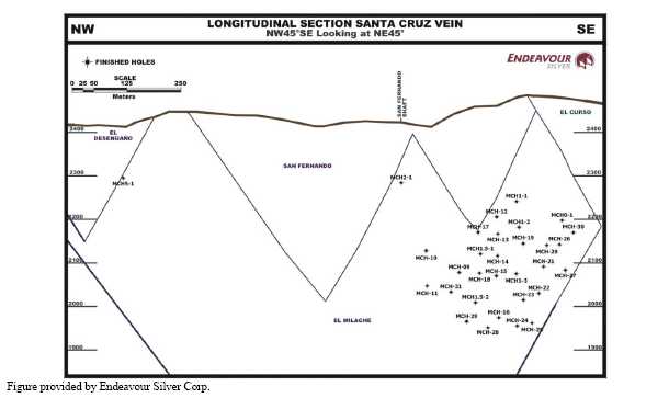
Figure 10.12
Cross-Section through Holes MCH1-1, MCH1-2, MCH1-3, MCH-23 & MCH-24
Drilled to Test the Santa Cruz Vein in the Milache Area

72
Figure 10.13
Cross-Section through Holes MCH1.5 -1, MCH1.5 -2, MCH-17 & MCH-18 Drilled to
Test the Santa Cruz Vein in the Milache Area

10.3 MICON COMMENTS
Micon has reviewed the 2012 exploration programs and notes that the programs were conducted according to the exploration best practices as outlined by the CIM and with a good QA/QC program in place. There are no drilling, sampling, or recovery factors that could materially impact the accuracy and reliability of the results. Micon concludes that the data acquired by Endeavour Silver through its exploration programs for the Guanaceví Mines Project can be used in estimating the mineral resources and ultimately the mineral reserves.
73
11.0 SAMPLE PREPARATION, ANALYSES AND SECURITY
11.1 SAMPLING METHOD AND APPROACH
A description of Endeavour Silver’s sampling method and approach for the Guanaceví Mines Project was provided in previous Technical Reports by Range, (March, 2006) and Micon (April, 2007, March, 2009, March, 2010, March, 2011 and March, 2012). Endeavour Silver personnel have made no material changes to the sampling method and approach since the publication of the March, 2012, Micon report. However, for completeness of this report, the description from the March, 2012, report has been excerpted, edited and updated where appropriate.
11.1.1 Sampling Intervals
Sampling intervals range from about 0.3 m to 2.5 m, with most in the 0.5 m to 1.5 m range. The Endeavour Silver geologist uses geological criteria to select sample intervals. Quartz vein material is separated from hanging wall and footwall horizons, and internal vein samples are broken out by texture type. Three principal types of vein textures are recognized: (a) massive, (b) banded and (c) brecciated. As much as possible, vein samples are selected to represent mineralization episodes.
11.1.2 Underground Sampling Methodology
Mine samples are collected principally for grade control purposes but are also used to build up a channel sample database for resource estimation purposes. Samples are collected from sills and in stopes. Sill samples are taken from the development face on a blast-by-blast basis. All sampling starts from the footwall and proceeds towards the hanging wall, with sample limits based on geological contacts. In stopes, and in sills if time permits, samples are taken from the back and footwall side-wall. In general, footwall waste samples are not taken systematically, although at least one footwall sample is normally taken in a sampling session, depending on wherever the footwall is veined or sulphide rich. If the vein is present in the footwall side-wall, it is sampled. Side-wall channel samples are measured vertically, whilst back samples are measured horizontally. Channel sampling is generally at 2.5 m intervals but can be increased to 5 m intervals in areas where the geology and grade distribution are well known. Samples are taken using a hammer and chisel; if the back is too high, a scaling bar is also used to chip the sample off.
Sample locations underground are measured from an identified control point installed by Endeavour Silver surveyors. All grade control samples are bagged in heavy duty polyurethane bags with a commercially prepared sample ticket inserted in the bag, and the sample number marked on the bag exterior with marker pen. All sample information is noted in a field notebook and later transferred to daily information sheets in the office. Basic sample information is also noted on sample ticket slips which are stored in the mine geology department office.
74
11.1.3 Density Determinations
11.1.3.1 Exploration Samples
Density determinations from previous drilling programs were used for converting volumes to tonnes for the 2012 year-end resource estimates for the San Pedro area.
11.1.3.2 Mine Samples
Bulk density samples have been routinely collected from the mines in the Guanaceví operation. The majority of samples came from Porvenir North and Porvenir Dos. There was no collection of density samples in 2012. Earlier samples were sent for analysis to the Stewart Group laboratory facility in Zacatecas, Mexico. The results for the 179 samples collected are summarized in Table 11.1. A program is in place to collect and analyze density samples regularly on a monthly basis for both mineralized and non-mineralized rock types. A specific gravity value of 2.55, based on past production data, was used for converting volumes to tonnes for the year-end 2012 reserves. This value is within the acceptable range based on the results to date.
Table 11.1
Bulk Density Determinations for Mine Samples from Porvenir North/Dos/Cuatro and Santa Cruz
| Statistics | Porvenir North | Porvenir Dos | Porvenir Cuatro | Santa Cruz |
| Number of Data | 134 | 35 | 4 | 6 |
| Mean | 2.53 | 2.50 | 2.59 | 2.51 |
| Median | 2.52 | 2.49 | 2.59 | 2.52 |
| Standard Deviation | 0.088 | 0.124 | 0.023 | 0.070 |
| Sample Variance | 0.008 | 0.015 | 0.001 | 0.005 |
| C.V. | 0.035 | 0.049 | 0.009 | 0.028 |
| IQR | 2.47 - 2.57 | 2.46 - 2.54 | 2.58 - 2.61 | 2.45 - 2.56 |
| Minimum | 2.26 | 2.29 | 2.56 | 2.43 |
| Maximum | 2.94 | 3.00 | 2.61 | 2.60 |
| Range | 0.68 | 0.72 | 0.05 | 0.17 |
Table provided by Endeavour Silver Corp.
11.2 MICON COMMENTS REGARDING ENDEAVOURSILVER’S SAMPLINGPROCEDURES
Endeavour Silver’s sampling protocols for evaluation purposes (underground and surface drill cores) follow the current CIM exploration best practice guidelines and this provides a degree of confidence regarding the validity and integrity of the database used for the resource and reserve estimates.
For production scheduling, channel chip sampling may not attain a perfectly representative sample due to the hardness of the material being sampled, as usually softer material is sampled preferentially. However, the practice of chip sampling is common around the world for underground deposits and the practice of systematically sampling the faces, backs or walls of development drifts on a close spacing (5 m or less) tends to generate a very large set of samples which, in most cases, is statistically representative of the material being sampled. Endeavour Silver’s underground sampling procedure is in line with current industry practices and standards, and is essentially being used for grade control purposes.
75
Endeavour Silver’s evaluation drilling samples are representative, since the HQ and/or NQ core size used yields almost 100% core recovery and provides a large enough sample size. There are no known factors that may result in sample biases. Production channel chip samples are yielding the desired result of differentiating ore from waste. The quality of the bulk density samples collected is demonstrated by the results being consistent with previous determinations. No drilling, sampling or recovery factors have been identified that could result in sampling bias or otherwise materially impact the accuracy and reliability of the assays and, hence, of the resource database.
Table of the assay results obtained during the 2012 drilling program are included in Section 10, as part of the discussion regarding the drilling program results, and will not be reproduced here. No table of significant underground sampling assay results is included here as the underground assays are part of the mine grade control program.
11.3 QUALITY CONTROL / QUALITY ASSURANCE (QA/QC) PROGRAM
Endeavour Silver imposes and maintains various QA/QC protocols on sampling and assay procedures, including duplicates, standards, blanks and check analyses to monitor the integrity of assay results.
11.3.1 Sampling
11.3.1.1 Mine Channel Samples
Mine chip channel samples and mill feed belt samples are prepared and analyzed at the Metalurgica Guanaceví (MG) laboratory, Endeavour Silver’s in-house laboratory at the Guanaceví Mines Project.
Grade control channel samples, which are used for stope-based reserve estimates, are prepared and analyzed at the in-house laboratory. The sample preparation procedure for samples is as follows: Samples are received and checked in by laboratory staff; moist samples are dried for 2 to 4 hours; otherwise samples are crushed to -½ inch in a primary jaw crusher; samples are split using a 1 inch or ½ inch Jones splitter; 100 to 150 g of sample is retained for pulverizing and is put in a metal tray, along with a pulp envelope; remaining coarse rejects are returned to their original bag along with the sample ticket and stored; the 150 g crushed sample is then dried at a temperature of 100° C. The dried sample is pulverized in a ring pulverizer to -80 mesh; the pulverized sample is stored in a numbered envelope. The procedures for the mine channel sample preparation have been the same since 2008.
76
11.3.1.2 Exploration Core Samples
All exploration drill core is transported to the secure core storage facility at the Santa Cruz mine site. Sampling procedures typically begin with splitting by either a wheel-driven manual splitting device or an electric diamond-bladed core saw. The wheel-driven manual splitting device is generally used only when the core is badly broken-up and cannot be effectively cut by the diamond-bladed core saw. One half of the core is replaced in the original core box with depth markers, and the other half is bagged with sample tickets and recorded in the sample record. Once samples are bagged, they are transported to an outside laboratory.
Since 2009, all drill core samples were sent to ALS-Chemex (ALS). ALS maintains a preparation facility in Chihuahua, where 50 g pulps are prepared and shipped to Vancouver, Canada for analysis. ALS emails assay data results to Endeavour Silver geologists and then returns the pulps to Guanaceví for storage at the core building at the Santa Cruz mine site. ALS is assessed against the international standard EN ISO/IEC 17025:2005 and is independent of Endeavour Silver.
All of Endeavour Silver’s drill core samples are bagged and tagged at the Guanaceví Mines Project. Upon arrival at the laboratory, all samples are logged into the laboratory’s tracking system. Then the entire sample is weighed, dried and fine crushed to better than 70% passing 2 mm. A sample split of up to 250 g is then taken and pulverized to 85% passing 75 microns.
Sampling procedures and assay results are considered to be reasonably representative of the mineralization of the deposits and may be used with acceptable confidence in the estimation of the resources and reserves.
11.3.2 Analysis
11.3.2.1 Mine/Grade Control Samples
At the MG laboratory, a 20 g sample is removed from the 100 g pulp and subjected to fire assay determination of gold and silver contents. Subsequent splits of the pulp are used for lead, zinc, copper, manganese and iron analyses by atomic adsorption (AA). Pulp and rejects are returned to the geology department within 1 to 3 days. The geology department selects pulps and rejects to be returned for re-assay. This methodology became fully operational in June, 2009, and was maintained throughout 2010, 2011 and 2012.
Endeavour Silver also uses outside laboratory assay facilities for check assaying.
77
11.3.2.2 Exploration Samples
All of Endeavour Silver’s exploration samples of rock and drill core were bagged and tagged at the Guanaceví warehouse and shipped to the ALS preparation facility in Chihuahua, Mexico. After preparation, the samples were shipped to the ALS laboratory in Vancouver, Canada, for analysis.
Upon arrival at the ALS preparation facility, all of the samples are logged into the laboratory’s tracking system (LOG-22). Then the entire sample is weighed, dried if necessary, and fine crushed to better than 70% passing 2 mm (-10 mesh). The sample is then split through a riffle splitter and a 250 g split is then taken and pulverized to 85% passing 75 microns (-200 mesh).
In April 2011, Endeavour Silver changed the analytical procedures used for exploration samples. Up until this time, the analytical procedure used for gold and silver was a fire assay followed by a gravimetric finish. The lower detection limits for this procedure were 0.05 g/t for gold and 5 g/t for silver.
A gravimetric finish is generally acceptable for ore-grade samples. However, for lower grade exploration samples, this analytical procedure often gives more variable results. In order to obtain less variable results, the analytical procedures were changed to those described below.
The analytical procedure for the gold mineralization was changed to a fire assay followed by an atomic adsorption (AA) analysis. A 30 g nominal pulp sample weight is used. The detection range for the gold assay is 0.005 to 10 ppm, or 5 to 10,000 ppb.
The analytical procedure for the silver mineralization was changed to an aqua regia digestion followed by an AA analysis. The detection range for the silver assay is 0.2 ppm to 100 ppm.
These analytical methods are optimized for low detection limits.
The assays for evaluation of higher-grade silver (+/- gold) mineralization were also optimized for accuracy and precision at higher concentrations. All Endeavour Silver samples originally assaying >20 ppm silver are then re-assayed using a fire assay followed by a gravimetric finish. A 30 g nominal pulp sample weight is used. The detection ranges are 0.05 to 1,000 ppm for the gold assay and 5 to 3,500 ppm for the silver assay.
As an economical tool for first pass exploration geochemistry, the pulps are sometimes subjected to aqua regia digestion and inductively coupled plasma (ICP) multi-element analysis. The data reported from an aqua regia leach are considered to represent the leachable portion of the particular analyte. These analytical methods are optimized for low detection limits. Over-limits (>10,000 ppm) determined for lead and zinc by ICP are reanalyzed using atomic emission spectroscopy (AES). The analytical procedure is an aqua regia digestion followed by an ICP-AES finish. The detection ranges are 0.001% to 20% for lead and 0.001% to 30% for zinc.
78
ALS is an independent analytical laboratory company which services the mining industry around the world. ALS is also an ISO-certified laboratory that employs a rigorous quality control system in its laboratory methodology as well as a system of analytical blanks, standards and duplicates. Details of its accreditation, analytical procedures and QA/QC program can be found at http://www.alsglobal.com/.
In 2012, the average turn-around time required for analyses was around 2 weeks.
11.3.3 QA/QC Program
11.3.3.1 Mine Channel Sampling
The QA/QC protocol for production samples involves repeat assays on pulp and reject assays, along with in-house prepared blanks and control samples. No commercially available standards were used in 2012. Endeavour Silver creates standards in-house using selected pulp rejects which are prepared by a third party laboratory. Roughly 3% to 5% of production grade control sample are submitted for re-assay.
In August, 2009, the geology department began collecting and sending blanks along with production samples. This practice has continued through 2010, 2011 and 2012. Currently, blanks are inserted at a frequency of 1 to 2 samples per day. Blanks are collected as run-of-mine material from waste headings such as the development ramps. These samples are usually of sufficiently low silver grade to be useful in detecting laboratory errors; however, there is always the possibility that the samples will contain anomalous values. Blanks are submitted blind, that is, they are inserted into the sample stream using the same sample sequence and identifiers as any other sample collected.
11.3.3.2 Surface Exploration
Drilling in the Milache and La Brisa areas was supported by a QA/QC program to monitor the integrity of all assay results. Each batch of 20 samples included one blank, one duplicate and one standard. Check assaying is also conducted at a frequency of approximately 5%. Discrepancies and inconsistencies in the blank and duplicate data are resolved by re-assaying either the pulp or reject or both.
A total of 2,781 samples, including control samples, were submitted during Endeavour Silver’s surface drilling program at Guanaceví in 2012, as shown in Table 11.2. A total of 145 pulps were also submitted for check assaying.
Endeavour Silver’s sampling process, including handling of samples, preparation and analysis, is shown in the quality control flow sheet, Figure 11.1.
79
Table 11.2
Summary of Control Samples Used for the 2012 Surface Exploration Program
| Samples | No. of Samples | Percentage (%) |
| Normal | 2,378 | 85.51 |
| Blanks | 134 | 4.82 |
| Duplicates | 134 | 4.82 |
| Standards | 135 | 4.85 |
| Total | 2,781 | 100 |
| Check Assays | 145 | 5.21 |
Figure 11.1
Flow Sheet for Core Sampling, Sample Preparation and Analysis
![]()
11.3.4 Surface Exploration Blank Samples
Blank samples were inserted to monitor possible contamination during the preparation process and analysis of the samples in the laboratory. The blank material used was commercial bentonite purchased for Endeavour Silver’s drilling programs on the Guanaceví Mines Project. The bentonite used was Enviroplug Coarse (1/4”). Blank samples are inserted randomly into the sample batch and given unique sample numbers in sequence with the other samples before being shipped to the laboratory.
Blank samples were inserted at an average rate of approximately 1 for each 20 original samples. Only a limited number of blank samples returned assay values above the detection limits for gold and silver. Blank samples were also assayed for copper, lead and zinc but little or no contamination was observed for these metals.
80
Based on the results obtained from the blank samples, it is considered that the assay results for the drilling programs are for the most part free of any significant contamination. The control charts for blank samples generated by Endeavour Silver are shown in Figures 11.2 and 11.3.
Figure 11.2
Control Chart for Gold Assays from the Blank Samples Inserted into the Sample Stream
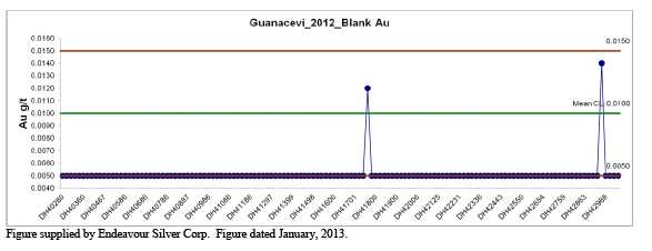
Figure 11.3
Control Chart for Silver Assays from the Blank Samples Inserted into the Sample Stream
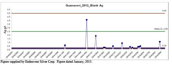
11.3.5 Surface Exploration Duplicate Samples
Duplicate samples were used to monitor (a) potential mixing up of samples and (b) variability of the data as a result of laboratory error or the lack of homogeneity of the samples.
Duplicate core samples were prepared by Endeavour Silver personnel at the core storage facility at the Guanaceví Mines Project. Preparation first involved randomly selecting a sample interval for duplicate sampling purposes. The duplicates were then collected at the time of initial sampling. This required first splitting the core in half and then crushing and dividing the half-split into two portions which were sent to the laboratory separately. The duplicate samples were ticketed with the consecutive number following the original sample. One duplicate sample was collected for each batch of 20 samples. Discrepancies and inconsistencies in the duplicate sample data are resolved by re-assaying either the pulp or reject or both.
81
For the duplicate samples, graphical analysis shows reasonable correlation coefficients for gold and silver in the majority of the samples. The correlation coefficients are both above 0.85, which is considered satisfactory. Scatter plots for duplicate samples are shown in Figures 11.4 and 11.5.
Figure 11.4
Graph of the Original versus Duplicate Sample for the Gold Assays from Endeavour Silver’s Drilling
Program
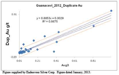
Figure 11.5
Graph of the Original versus Duplicate Sample for the Silver Assays from Endeavour Silver’s Drilling
Program
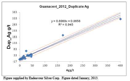
82
11.3.6 Surface Exploration Standard Reference Material
Endeavour Silver uses commercial reference standards to monitor the accuracy of the laboratories. Standard reference material has been purchased from CDN Resource Laboratories Ltd. Each reference standard was prepared by the vendor at its own laboratories and shipped directly to Endeavour Silver, along with a certificate of analysis for each standard purchased.
In 2012, standard reference control samples were submitted at an average frequency of 1 for each batch of 20 samples. Reference standards were ticketed with pre-assigned numbers in order to avoid inadvertently using numbers that were being used during logging.
Two different standards were submitted and analyzed for gold, silver, copper, lead and zinc, as described in Table 11.3. For graphical analysis, results for the standards were scrutinized relative to the mean or control limit (CL), and a lower control limit (LL) and an upper control limit (UL), as shown in Table 11.4.
Table 11.3
Reference Standards Used for Endeavour Silver’s Drilling Programs
| Reference Standard | Reference Number | Reference Source | Reference Standard Assays | Zinc (%) | |||
| Gold (g/t) | Silver (g/t) | Copper (%) | Lead (%) | ||||
| edr-28 | CDN-ME-7 | CDN Resource Laboratories | 0.22 | 151 | 0.23 | 4.95 | 4.84 |
| edr-30 | CDN-GS-5J | CDN Resource Laboratories | 4.90 | 73 | |||
Table provided by Endeavour Silver Corp.
Table 11.4
Basis for Interpreting Standard Sample Assays
| Limit | Value |
| UL | Plus 2 standard deviations from the mean |
| CL | Recommended value (mean) of standard reference material) |
| LL | Minus 2 standard deviations from the mean |
Table provided by Endeavour Silver Corp.
Endeavour Silver’s general rules for a batch failure are as follows:
A reported value for a standard greater than 3 standard deviations from the mean is a failure.
Two consecutive values of a standard greater than 2 standard deviations from the mean is a failure.
A blank value over the acceptable limit is a failure.
Results are reported to Endeavour Silver’s Qualified Person every month.
83
Results of each standard were reviewed separately. Most values for gold, silver and copper were found to be within the control limits, and the results are considered satisfactory. The mean of the ALS assays agrees well with the mean value of the standard. Control charts generated by Endeavour Silver are shown in Figures 11.6 to 11.9 for the standard reference material.
Figure 11.6
Control Chart for Gold Assays from the Standard Reference Sample Edr-28

Figure 11.7
Control Chart for Silver Assays from the Standard Reference Sample Edr-28
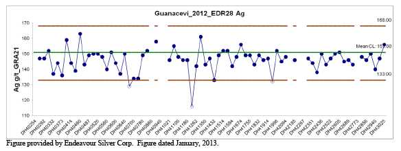
84
Figure 11.8
Control Chart for Gold Assays from the Standard Reference Sample Edr-30
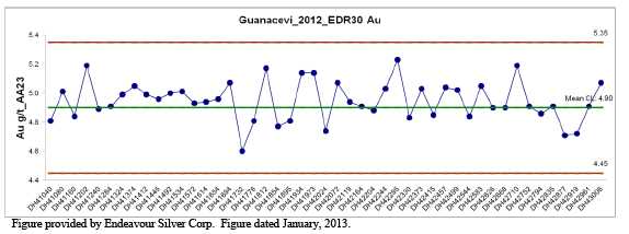
Figure 11.9
Control Chart for Silver Assays from the Standard Reference Sample Edr-30
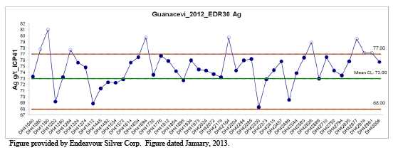
11.3.7 Surface Exploration Check Assaying
To evaluate the accuracy of the primary laboratory, Endeavour Silver periodically conducts check analyses. Random pulps are selected from original core samples and sent to a second laboratory to verify the original assay and monitor any possible deviation due to sample handling and laboratory procedures. Endeavour Silver uses the BSI-Inspectorate laboratory in Durango, Mexico, for check analyses.
Correlation coefficients are high (>0.98) for silver, copper, lead and zinc, showing a high level of agreement between the original ALS assay and the BSI-Inspectorate check assay. For gold, the correlation coefficient is slightly lower at 0.88, but is still satisfactory.
85
11.3.7.1 Mine Area Surface and Underground Exploration Drilling Program
Endeavour Silver’s sampling process for the mine’s exploration program, including handling of samples, preparation and analysis, is the same as shown in the quality control flow sheet presented as Figure 11.1.
11.4 MICON COMMENTS
Micon has analyzed the QA/QC results for Endeavour Silver’s surface and underground drilling programs conducted at the mine. On the basis of its analysis, Micon believes that the data collected during the surface and underground drilling, along with the mine samples collected, are of sufficient quality to support the resource and reserve estimates for the Guanaceví Mines Project.
11.5 METALURGICA GUANACEVÍ (MG) LABORATORY
11.5.1 General Discussion on 2011 Procedure Changes
The Metalurgica Guanaceví (MG) laboratory is Endeavour Silver’s in-house laboratory at the Guanaceví Mines Project. In order to check, maintain or improve the quality of the assaying, a number of changes to the procedures were made in 2011, with further changes also in 2012. The changes which occurred in 2011 are described below.
| 1. | Sample preparation: | ||
A re-split of the first sample to be prepared in a batch was added. | |||
Every 35th sample was re-split and it is followed by a blank sample. | |||
A re-split followed by a blank sample was added at the end of each work order. | |||
| 2. | Fire laboratory: | ||
The laboratory started to use certified standards to replace the liquid standards previously prepared at the laboratory itself. | |||
| 3. | Wet laboratory (acid digestion): | ||
The sample weight was changed from 0.2 g to 0.5 g, to obtain a more representative sample. | |||
The sample digestion procedure was also changed. The new step-by-step process is described below: | |||
1) Weigh 0.5 g of the sample into a glass flask. | |||
86
| 2) | Add 15 mL of concentrated HNO3to the glass flask using a calibrated dispenser. | |
| 3) | Place the glass flask on a medium hot plate for 15 minutes or until it has completed fuming. | |
| 4) | Remove the glass, cool and add 30 mL of concentrated HCL from a calibrated dispenser. | |
| 5) | Place the glass flask on the hot plate and digest for 45 minuites. | |
| 6) | Remove the glass flask from the hot plate and cool to room temperature. | |
| 7) | Transfer the sample to a 200 mL flask. | |
| 8) | Bulk up the sample to 200 mL with distilled water, mix well and pour an aliquot for analysis. | |
| 9) | Allow the sample to settle before reading. | |
| 10) | If the sample will not be read within 24 hours, cover the sample with plastic wrap. |
The additional changes which have been or will be instituted in 2012/2013 are as follows:
| 1. | Sample preparation area: | ||
Install a dust extractor over the concentrates table. | |||
Acquire a drying oven for concentrates only, in order to avoid and minimize contamination of the drying samples. | |||
Begin to use a logbook for all work orders, in order to have a record at the sample preparation area of all the samples received on a daily basis. | |||
| 2. | Fire laboratory: | ||
Obtain forks to load the ovens more quickly and reduce the loss of temperature when loading the ovens. | |||
11.5.2 MG Laboratory QA/QC and Charts
In addition to sending check samples to commercial laboratories, Endeavour Silver’s mine division has imposed and maintains various quality controls on sampling and assaying procedures of the in-house laboratory, including:
- Duplicate samples.
87
- Blanks.
- In-house and commercial reference standards.
Micon considers the in-house protocols to be adequate to ensure the integrity of the database for resource and reserve estimates.
11.5.2.1 MG Blank Samples
In August, 2009, the geology department began inserting blank samples with production samples. This practice has continued through 2011 and 2012. Currently, blanks are inserted at the frequency of 1 to 2 samples per day. Blanks are collected as run-of-mine material from waste headings such as the development ramps. These samples are usually of sufficiently low silver grade to be useful in detecting laboratory errors; however, there is always the possibility of that the samples will contain anomalous values. In the future, attempts will be made to procure certified blanks or blanks with a higher probability of being void of detectable silver.
11.5.2.2 In-House Control (Reference) Samples
In October, 2009, the use of two in-house standards (Table 11.4), which were prepared from material collected from active stope headings, was initiated at the MG laboratory on site. The samples were prepared by SGS at its facility in Durango and involved round-robin assaying at three independent external laboratories. In total, 80 kg of pulverized material was prepared for each control sample. Control samples submitted to the MG laboratory are selected at random from one of the following choices; 1) GCVI_E, 2) GCVI_F or 3) a regular pulp reject. Controls are inserted at the rate of one in each batch of fire assays. The samples are inserted blind. The random selection and inclusion of normal pulp rejects helps to ensure the anonymity of the samples.
Table 11.5
MG Laboratory Guanaceví Control Samples
| Standard Identifier | Reference Number | Silver (g/t) | Gold (g/t) |
| GCVI_E | N/A | 242 | 0.44 |
| GCVI_F | N/A | 232 | 0.44 |
11.5.2.3 Pulp and Reject Duplicate Sampling
In June, 2009, a regular program of collecting and resubmitting pulp and reject duplicates was implemented on a daily basis. This procedure continued throughout 2011and 2012. In addition to the selection of production pulps and rejects, duplicate field samples were also collected in the form of underground chip samples and surface stockpile samples. Discrepancies and inconsistencies in the duplicate sample data are resolved by re-assaying either the pulp or reject or, in some cases, both.
88
In general, results of the duplicate re-assays indicate a reasonable correlation for silver and moderate to poor correlation for gold. The difference in the quality of the results of the pulp assays versus the reject assays suggests that the location of sample error may be in the sample preparation stage and that improvements in sample preparation may reduce the variability in the reject sample results.
Check assays (pulps and rejects) are also sent to at least two external laboratories for analysis, typically the Stewart Group and the Endeavour Silver laboratory at the Guanajuato Mines Project. Samples are collected on a regular basis and Endeavour Silver plans to start submitting samples to additional external laboratories on a monthly basis.
11.6 MICON COMMENTS
Micon has reviewed Endeavour Silver’s QA/QC program and considers that both the exploration and mining department drilling and sampling programs are adequate and that the data collected are appropriate for use in estimating the resources and reserves for the Project. The sample preparation, security and analytical procedures are adequately monitored to ensure credible results.
89
12.0 DATA VERIFICATION
12.1 MICON SITE VISITS
The data verification completed by Micon at Guanaceví was carried out during five separate site visits: December 16 to 18, 2006, September 6 to 9, 2008, November 20 to 22, 2009, June 23 to 25, 2010 and December 12 to 16, 2011. Micon was represented by William Lewis during the 2006 and 2011 visits and by Charley Murahwi during the 2008 through 2011 visits. No independent sampling was conducted by Micon, since other Qualified Persons have previously sampled the mineralization, as discussed in earlier Technical Reports. Furthermore, Micon considers production records to be the most reliable data confirming the mineralization contained in the deposits being mined. The production history for the Guanaceví Mines project is tabulated in Section 6 of this report.
During Messrs. Lewis and Murahwi’s visits to the Guanaceví Property in 2006, 2008, 2009, 2010 and 2011, the underground mine workings and surface facilities were inspected, surveying, drilling, sampling, analytical techniques and QA/QC protocols were reviewed and the initial reviews of the databases were performed. No site visit was conducted in 2012 as there were no material changes to the operations at Guanaceví.
The Guanaceví Mines Project is comprised of an operating mine and processing plant which are producing silver doré bars on a regular basis. The sales of doré are a definitive representation of Endeavour Silver’s production.
Endeavour Silver maintains an active program of assay checks for the production of doré at the plant, in addition to a sampling and assaying program by a sales representative in the city of Torreón, Coahuila, to check the assays reported by the Met-Mex smelter of Industrias Peñoles S.A. de C.V. (Peñoles). An adequate amount of checking has been conducted, and the results are representative of the doré produced at the Guanaceví Mines Project and shipped to the smelter.
Figure 12.1 is a view of the exploration drill visited during the December, 2011 site visit. At the time of the site visit this was the only surface drill operating.
12.2 DATABASE VERIFICATION FOR THE MINERAL RESOURCE ESTIMATE
12.2.1 Review of the In-House Data Protocols
12.2.1.1 Database Construction
Endeavour Silver conducts a validation process on the underground sampling and surface exploration data generated from its Guanaceví Mines Project. The data verification procedures generally involve:
90
Figure 12.1
Surface Drill Operating During the December, 2011 Micon Site Visit
![]()
Visually checking the data for the following: | |||
Any non-conforming assay information, such as duplicate and missing sample numbers. | |||
Verifying collar elevations against survey information for each drill hole. | |||
Verifying collar coordinates against survey information for each drill hole. | |||
Verifying the dip and azimuth against survey information for each hole. | |||
Comparing the database interval against the original assay certificate for drill hole/channel samples. | |||
Verifying survey information for location of underground channel samples used in reserve estimation. | |||
Using Vulcan software to check for data errors and vein continuity. | |||
The assay information comes directly from the laboratory in an electronic format and is merged into the database using sample numbers. Once the laboratory has finalized assays, they are put into a dedicated database directory.
The data are in a format that is directly importable to the company’s Vulcan modeling software. The export format is an Excel spreadsheet, so all data are also readily importable for use in spreadsheets or a different database.
91
Senior project personnel have portable versions of the drill hole database on their laptop computers. This allows them access to the data at all times. The portable databases are only up-to-date to the point that the master database is copied onto the laptop. Through day-today use of the database, staff personnel are constantly verifying and rechecking data.
Channel sample assay data are entered into an Excel spreadsheet used for day-to-day grade control purposes; assay data on sample orientation and location are also entered. All location data are relative to a local surveyed reference point. Channel samples are plotted onto plans prepared on the basis of most up-to-date survey information. If survey data for a particular stope cut are not available, the sample location is estimated on the basis of the most recent survey pick-up. Coordinates are recorded manually and then entered into an Excel spreadsheet. The process of plotting data onto plans ensures that most field recording errors are identified and corrected.
The channel survey and assay data are then merged on the basis of sample numbers to produce the final database for resource estimation. For data collected in late 2007 and early 2008, the merging of data was done using assay plans prepared in AutoCAD, as field data were not routinely plotted up and coordinates recorded at the time. The merging of data initially encountered numerous problems of data duplication. Problems of channel data duplication were filtered using Excel spreadsheets and also Vulcan software. Problems of errors with sample location were identified using Vulcan 3D software. Duplicated channel data are removed, with the oldest data being accepted as the original information. In some cases (evaluated on a case-by-case basis) duplicated data were accepted or rejected on the basis of sample number sequences. Given the large number of channels that were available for use in the channel sample database, the general approach was to exclude any channels/samples with data issues. Much of this process of data elimination is manual and extremely time consuming; due to the quantity of data some errors may still exist in the channel sample database, but the relatively small number means they will have an insignificant effect on the overall resource estimates. A final channel database for resource estimation in an Excel spreadsheet is in a format compatible for import into a Vulcan database.
Assay data and information generated by both operations and exploration are currently transmitted manually and the entire paper trail is accessible and available for inspection.
12.2.1.2 QA/QC on Assay Data
In addition to using accredited commercial laboratories, Endeavour Silver’s exploration division has imposed and maintains various quality controls on sampling and assaying procedures including:
- Duplicate samples.
- Blanks.
- Reference standards.
92
- Check assaying of selected pulps at different laboratories.
Micon considers the in-house protocols to be adequate to ensure the integrity of the database for resource and reserve estimation.
12.2.2 Micon Validation of Data and In-House Protocols
During its visits, Micon completed the following validation tasks:
Review of the property geology and the state of geological/mineralization knowledge.
Review of the evaluation/exploration practices, specifically drilling, underground channel sampling, drill core handling and sampling procedures and sample security arrangements.
Review of on-site laboratory facilities.
General review of QA/QC monitoring reports and charts.
Review of database integrity/back-up and storage procedures.
12.2.2.1 State of Geological / Mineralization Knowledge
Endeavour Silver site geologists base their geological model on a clear understanding of the geology of the deposit. That understanding comes from the intelligent interpretation of accurate observations of surface, underground and drilling exposures. Testing of the geological model is achieved through a thorough review of the geological mapping of the surface and underground openings, as well as auditing the logging and recording of geological observations from drill holes. Endeavour Silver conducts underground development and continuous level back mapping to guide development sampling crews and to facilitate the interpretation of the sampling results.
The surface exploration procedures are enhanced by the use of drill core orientation techniques (Ballmark Oriented Core System) which provide vital information on geological structure and mineralization continuity, influencing the geological model used in the resource estimation.
Following its reviews, Micon is satisfied that the geology teams at Guanaceví have acquired a good understanding of the geology and mineralization controls which have an important bearing on resource estimates and future exploration efforts. Thus, the resource estimation process is well supported by a good geological/mineralization model.
12.2.2.2 Review of Exploration Practices
The drilling procedures as observed by Micon are in accordance with the current CIM exploration best practices guidelines. On the drill site, surveys are conducted to obtain collar coordinates, elevation of the site and its surroundings, inclination and azimuth of the drill hole. This is important for accuracy in the production of maps, sections and plans. As drilling progresses, the inclination and azimuth of the drill hole are monitored by conducting down-hole surveys. As the targeted drill hole depth is approached, the hole is surveyed using a Reflex down-hole survey instrument in multi-shot mode.
93
Endeavour Silver aims for HQ and NQ core sizes for surface and underground drilling, respectively. The bigger the sample, the more representative it is. The slightly smaller underground core is due to the lower capacity of the rigs as compared to surface rigs. Core logging is by bar-coding systems with a minimum of descriptive content. This is good practice which provides a check list, minimizes data transcription errors and assists in maintaining consistency in logging.
In summary, the quality of Endeavour Silver’s diamond drilling is assured by good survey control, NQ and HQ core sizes which yield representative samples, good core recoveries which yield whole intercepts in targeted potential ore zones, and target intersection angles as near to perpendicular as possible. The core storage facilities at Guanaceví are well protected by a high level security fence and are located in an area under 24-hour surveillance by security personnel.
12.2.2.3 On-site Laboratory Inspection
Micon has carried out inspections of the laboratory facilities at Guanaceví during all of its site visits to monitor and ensure continual improvement. The laboratory’s capabilities have recently been enhanced by the addition of new AA and ICP machines, plus two electric furnaces. Although the laboratory is not yet ISO certified, it is actively participating in round-robin exercises with other Mexican laboratories, including SGS and Pan American’s Colorada laboratory. The laboratory in-house QA/QC protocols are in accordance with the CIM best practices guidelines. These include regular calibration of measuring instruments, tight controls/supervision in the sample preparation room to avoid contamination between samples and use of internal certified standards. Currently, the laboratory takes care of all production samples for the mine and half of the trench samples from the exploration team. However, Micon noted that Endeavour Silver still utilizes external ISO certified laboratories for most of its analytical work involving exploration projects and some selected sample pulps are later submitted to the mine laboratory. This ensures confidence in the assay database of new prospective production additions to the mine.
12.2.2.4. Database Check
Micon’s resource database verification involved checks on drill collar coordinates, down-hole deviations, lithology and assay data. In all respects Micon established that the database had been reasonably constructed.
94
12.2.2.5 Micon Comments
Based on the data verification performed, Micon is satisfied that the database was generated in a credible manner and that it is respresentative of the mineralization encountered at the Guanaceví Mines Project and, therefore, suitable to support mineral resource estimation.
95
13.0 MINERAL PROCESSING AND METALLURGICAL TESTING
As part of its ongoing exploration in the Guanaceví mining district, Endeavour Silver has undertaken metallurgical studies on drill core obtained from the various veins under investigation. These studies have been undertaken in order to optimize the processing of the mineralization should a decision to mine these veins be initiated.
Endeavour Silver is waiting for the results from various studies that were undertaken and these will be included in subsequent updates of this report.
96
14.0 MINERAL RESOURCE ESTIMATES
The Mineral Resource estimate has been produced and classified using the November, 2010 CIM standards and definitions for estimating resources, as required by Canadian National Instrument 43-101 and the accompanying documents NI 43-101-F1 and NI 43-101-CP. The updated 2012 resource estimate for the mine has been conducted by Micon. Endeavour Silver has conducted the resource estimate for the exploration areas beyond the limits of the mine (but within the Guanaceví mining lease area) and that estimate has subsequently been audited by Micon.
The process of mineral resource estimation includes technical information which requires subsequent calculations or estimates to derive sub-totals, totals and weighted averages. Such calculations or estimations inherently involve a degree of rounding and consequently introduce a margin of error. Where these occur, Micon does not consider them to be material. This observation also applies to the mineral reserve estimate discussed in Section 15.
The December 15, 2012 mineral resource estimate and audit of resources in the exploration areas supersede the December 31, 2011 resource estimate which was published in the March 30, 2012 Technical Report.
14.1 CIM MINERAL RESOURCE DEFINITIONS AND CLASSIFICATIONS
All mineral resources presented in a Technical Report must follow the current CIM definitions and standards for mineral resources and reserves. The latest edition of the CIM definitions and standards was adopted by the CIM council on November 27, 2010, and includes the resource definitions reproduced below:
“A MineralResource is a concentration or occurrence of diamonds, natural solid inorganic material, or natural solid fossilized organic material including base and precious metals, coal,and industrial minerals in or on the Earth’s crust in such form and quantity and of such a grade or quality that it has reasonable prospects for economic extraction. The location, quantity, grade, geological characteristics and continuity of a Mineral Resource are known, estimated or interpreted from specific geological evidence andknowledge.”
“The term Mineral Resource covers mineralization and natural material of intrinsic economicinterest which has been identified and estimated through exploration and sampling and within which Mineral Reserves may subsequently be defined by the consideration and application of technical, economic, legal, environmental, socio-economic and governmental factors. The phrase“reasonable prospects for economic extraction” implies a judgment by the Qualified Person inrespect of the technical and economic factors likely to influence the prospect of economic extraction. A Mineral Resource is an inventory of mineralization that under realistically assumed and justifiable technical and economic conditions might become economically extractable. These assumptions must be presented explicitly in both public and technical reports.”
97
“Inferred Mineral Resource”
“An ‘Inferred Mineral Resource’ is that part of a Mineral Resource for which quantity and gradeor quality can be estimated on the basis of geological evidence and limited sampling and reasonably assumed, but not verified, geological and grade continuity. The estimate is based on limited information and sampling gathered through appropriate techniques from locations such as outcrops, trenches, pits, workings and drill holes.”
“Due to the uncertainty that may be attached to Inferred Mineral Resources, it cannot be assumedthat all or any part of an Inferred Mineral Resource will be up-graded to an Indicated or Measured Mineral Resource as a result of continued exploration. Confidence in the estimate is insufficient to allow the meaningful application of technical and economic parameters or to enable an evaluation of economic viability worthy of public disclosure. Inferred Mineral Resources must be excluded from estimates forming the basis of feasibility or other economicstudies.”
“Indicated Mineral Resource”
“An ‘Indicated Mineral Resource’ is that part of a Mineral Resource for which quantity, grade orquality, densities, shape and physical characteristics, can be estimated with a level of confidence sufficient to allow the appropriate application of technical and economic parameters, to support mine planning and evaluation of the economic viability of the deposit. The estimate is based on detailed and reliable exploration and testing information gathered through appropriate techniques from locations such as outcrops, trenches, pits, workings and drill holes that are spaced closelyenough for geological and grade continuity to be reasonably assumed.”
“Mineralization may be classified as an Indicated Mineral Resource by the Qualified Personwhen the nature, quality, quantity and distribution of data are such as to allow confident interpretation of the geological framework and to reasonably assume the continuity of mineralization. The Qualified Person must recognize the importance of the Indicated Mineral Resource category to the advancement of the feasibility of the project. An Indicated Mineral Resource estimate is of sufficient quality to support a Preliminary Feasibility Study which canserve as the basis for major development decisions.”
“Measured Mineral Resource”
“A ‘Measured Mineral Resource’ is that part of a Mineral Resource for which quantity, grade orquality, densities, shape, and physical characteristics are so well established that they can be estimated with confidence sufficient to allow the appropriate application of technical and economic parameters, to support production planning and evaluation of the economic viability of the deposit. The estimate is based on detailed and reliable exploration, sampling and testing information gathered through appropriate techniques from locations such as outcrops, trenches, pits, workings and drill holes that are spaced closely enough to confirm both geological and gradecontinuity.”
98
“Mineralization or other natural material of economic interest may be classified as a MeasuredMineral Resource by the Qualified Person when the nature, quality, quantity and distribution of data are such that the tonnage and grade of the mineralization can be estimated to within close limits and that variation from the estimate would not significantly affect potential economic viability. This category requires a high level of confidence in, and understanding of, the geologyand controls of the mineral deposit.”
14.2 DECEMBER 15, 2012 MINERAL RESOURCE ESTIMATE
14.2.1 Mineral Resource Statement
The mineral resources for the Guanaceví Mines Project, as of December 15, 2012 are summarized in Tables 14.1 and 14.2. The resources are exclusive of the mineral reserves.
Table 14.1
Measured and Indicated Mineral Resources for the Guanaceví Mines Project as at December 15, 2012
| Area | Category | Tonnes | Silver (g/t) | Gold (g/t) | Silver (oz) | Gold (oz) | Silver Eq (oz) | Pb (%) | Zn (%) |
| Santa Cruz | Measured (M) | 129,000 | 312 | 0.49 | 1,294,000 | 2,000 | 1,394,000 | ||
| Porvenir North | Indicated (I) | 1,273,000 | 200 | 0.36 | 8,185,600 | 14,700 | 8,920,600 | ||
| Santa Cruz | Indicated (I) | 89,000 | 326 | 0.53 | 932,800 | 1,500 | 1,007,800 | ||
| Santa Cruz (Pb/Zn) | Indicated (I) | 116,000 | 233 | 0.66 | 869,000 | 2,500 | 994,000 | ||
| Porvenir Cuatro | Indicated (I) | 226,000 | 281 | 0.81 | 2,041,800 | 5,900 | 2,336,800 | ||
| Milache | Indicated (I) | 485,000 | 343 | 1.00 | 5,348,400 | 15,600 | 6,128,400 | ||
| La Blanca-Mi Nina | Indicated (I) | 64,000 | 267 | 0.61 | 549,600 | 1,200 | 609,600 | ||
| Epsilon-Soto | Indicated (I) | 106,000 | 297 | 0.55 | 1,010,800 | 1,900 | 1,105,800 | ||
| Noche Buena | Indicated (I) | 655,000 | 166 | 0.21 | 3,495,700 | 4,400 | 3,715,700 | 0.61 | 1.02 |
| Total | M + I | 3,143,000 | 235 | 0.49 | 23,727,700 | 49,700 | 26,212,700 |
Table 14.2
Inferred Mineral Resources for the Guanaceví Mines Project as at December 15, 2012
| Area | Category | Tonnes | Silver (g/t) | Gold (g/t) | Silver (oz) | Gold (oz) | Silver Eq (oz) | Pb (%) | Zn (%) |
| Siver–Gold Only | |||||||||
| Porvenir North | Inferred | 226,000 | 171 | 0.35 | 1,242,500 | 2,500 | 1,367,500 | ||
| Santa Cruz | Inferred | 135,000 | 290 | 0.52 | 1,258,700 | 2,300 | 1,373,700 | ||
| Santa Cruz (Pb/Zn) | Inferred | 140,000 | 129 | 0.61 | 580,600 | 2,700 | 715,600 | ||
| Porvenir Cuatro | Inferred | 76,000 | 310 | 1.02 | 757,500 | 2,500 | 882,500 | ||
| Alex Brecia | Inferred | 381,000 | 257 | 0.35 | 3,148,100 | 4,300 | 3,363,100 | ||
| Milache | Inferred | 197,000 | 221 | 0.5 | 1,399,700 | 3,200 | 1,559,700 | ||
| San Joaquin | Inferred | 51,000 | 184 | 0.05 | 301,700 | 100 | 306,700 | ||
| La Blanca-Mi N | Inferred | 7,000 | 190 | 0.43 | 42,700 | 100 | 47,700 | ||
| Epsilon-Soto | Inferred | 216,000 | 459 | 0.91 | 3,189,700 | 6,300 | 3,504,700 | ||
| Total | Inferred | 1,429,000 | 259 | 0.52 | 11,921,200 | 24,000 | 13,121,200 | ||
| Silver-Gold Lead-Zinc | |||||||||
| Noche Buena | Inferred | 337,000 | 149 | 0.18 | 1,614,400 | 2,000 | 1,714,400 | 0.63 | 1.04 |
| Buena Fé | Inferred | 307,000 | 98 | 0.10 | 962,900 | 1,000 | 1,012,900 | 1.73 | 3.32 |
| Total | Inferred | 644,000 | 124 | 0.14 | 2,577,300 | 3,000 | 2,727,300 | 1.12 | 2.13 |
| 1. | Mineral resources which are not mineral reserves do not have demonstrated economic viability. The estimate of mineral resources may be materially affected by environmental, permitting, legal, title, taxation, sociopolitical, marketing, or other relevant issues. |
| 2. | There has been insufficient exploration to define the inferred resources as an indicated or measured mineral resource. It is uncertain if further exploration will result in upgrading them to an indicated or measured mineral resource category |
99
Micon believes that at present there are no known environmental, permitting, legal, title, taxation, socio-economic, marketing or political issues which could adversely affect the mineral resources estimated above.
14.2.2 Assumptions and Parameters
The mineral resource estimate is based on the following parameters.
Minimum mining width – 1.5 m.
Silver equivalent – 50:1 for silver to gold, based on prices of US $1,550/oz for gold and US $31/oz for silver.
Cut-off grade – 100 g/t silver equivalent using a 50:1 ratio.
14.3 MINERAL RESOURCE ESTIMATION PROCEDURES
14.3.1 Grade Capping of High Grade Assays
Endeavour Silver developed basic statistical parameters for raw silver and gold assays. The parameters indicated that the data are positively skewed and that it was necessary to limit the influence of high outlier assays. To determine the appropriate capping value for each zone, lognormal probability plots and cumulative frequency plots were examined, and the capping values were based on the cumulative probability of approximately 95% for each zone (Table 14.3).
Table 14.3
Summary of Sample Capping Grades for the Various Veins at Guanaceví
| Sample Assay Capping - Vein Only | |||
| Zone | Percentile | Au Accumulation (m. g/t) | Ag Accumulation (m. g/t) |
| Porvenir Zone 1 | 0.975 | 2.01 | 1,357 |
| Porvenir Zone 2 | 0.975 | 3.98 | 1,526 |
| Porvenir Zone 2 North Splay | 0.975 | 3.83 | 2,152 |
| Porvenir Dos | 0.975 | 4.54 | 1,892 |
| Porvenir Quatro | 0.975 | 5.40 | 1,329 |
| Drill hole Sample Assay Capping - Vein Only | |||
| Zones 1, 2 and Zone 2 North | 0.975 | 1.65 | 709 |
| Porvenir Dos | 0.975 | 1.21 | 439 |
| Porvenir Quatro | 0.975 | 1.40 | 409 |
Capping was done on the individual channel and drill hole silver and gold assay accumualation (grade x thickness) before composting was performed.
14.3.2 Tonnage
The Guanaceví Mines Project uses a specific gravity of 2.55 to estimate tonnage. This is considered reasonable for this type of deposit and is based on a number of tests on samples collected from the property.
100
14.3.3 Resource and Grade Estimation
For December 15, 2012, two different methodologies have been employed for the estimation of resources for the Guanaceví Mines Project, as described below.
14.3.3.1 2D Polygonal Resource and Reserve Estimates
The 2D polygonal method is based on the use of a longitudinal section to estimate the mineral resources and reserves.
Mineral resource blocks are defined by drawing a polygon around each drill intercept on a longitudinal section. Before a polygon is drawn, the intercept must be above the established cut-off grade and meet the 1.5 m minimum width criterion. A 25 m projection from the centroid of the drill intercept is then made for indicated resource blocks. When the continuity of mineralization is determined, an additional 25 m projection is made for inferred resources. Block volumes are estimated by drawing each block area on a longitudinal section and measuring this area using AutoCAD. The area of the block is then multiplied by the average horizontal width of the composited drill intercept to estimate the volume.
The 2D classic polygonal method is appropriate in areas tested by a limited number of drill holes/samples and has been successfully used by Endeavour Silver’s exploration division in the last couple of years, as evidenced by the extent to which Indicated resources were quickly upgraded into reserves.
The resources for Noche Buena, San Joaquin, La Blanca-Mi Niña and Epsilon-Soto have been carried forward from 2011, since there was no additional work/exploration conducted in these areas during 2012. The resources for these areas were estimated by Endeavour Silver as of the end of 2011, using the polygonal method, and were verified by Micon. Figures 14.1 to 14.7 are longitudinal sections showing the current resources estimated for Epsilon-Soto, San Joaquin and La Blanca-Mi Niña.
Figure 14.1
Longitudinal Section Showing the Resources for the Epsilon-Soto Vein
![]()
101
Figure 14.2
Longitudinal Section Showing the Resources for the Footwall Soto Vein
![]()
Figure 14.3
Longitudinal Section Showing the Resources for the Hanging Wall Soto Vein
![]()
102
Figure 14.4
Longitudinal Section Showing the Resources for the Epsilon Vein
![]()
Figure 14.5
Longitudinal Section Showing the Resources for the San Joaquin Vein
![]()
103
Figure 14.6
Longitudinal Section Showing the Resources for the La Blanca Vein
![]()
Figure 14.7
Longitudinal Section Showing the Resources for the Mi Niña Vein
![]()
104
14.3.3.2 Block Modeling and Inverse Distance Weighting Method (ID)
Where the number of drill hole intersections of the deposit is sufficiently large (roughly about 100 intersecpts or more), or where the deposit has been covered by intense underground channel sampling at 2 m to 5 m between channels, Endeavour Silver typically uses the 3D modeling technique which yields a better representation of the geometry of the deposit than the 2D polygonal estimate. Grade interpolation is achieved by kriging and/or inverse distance weighting, often to the power 3 (ID3).
Mining Areas
Resources for the mining areas (Santa Cruz, Porvenir North, Porvenir Dos and Porvenir Cuatro) of the Guanaceví Mines Project were estimated by Micon in 2011/2012 using the 3D modeling technique and the inverse distance cubed (ID3) method for interpolating grade. The resources for these mining areas as at December 15, 2012 have been estimated by Micon by deducting the resources converted into reserves during 2012 from the original total resources previously estimated in 2011/2012. During the period January to December, 2012, the new additions to the previous December 31, 2011 data were insignificant and did not justify the creation of new resource block models.
Milache Project 2012
Resources for the Milache Project as at December 15, 2012, were estimated by Endeavour Silver using the 3D modeling technique and the ID3 interpolation method. The VULCAN mining software was utilized. Micon verified the block model using the GEMS mining software.
14.3.4 Classification
Mineral resources were classified on the basis of the location of blocks relative to the data used to interpolate the block grade, according to the following criteria:
Measured mineral resources apply to those resource blocks where grade, density, shape and physical characteristics are so well established to allow the appropriate application of technical and economic parameters, to support production planning.
Indicated mineral resources refer to those resource blocks/areas where the geological framework, continuity and grade of mineralization are sufficiently understood to support a preliminary feasibility study which will serve as the basis for major development decisions. For the operations, this is applicable to those blocks which have had the historical mine sampling superseded by Endeavour Silver’s subsequent channel sampling programs which, in conjunction with the confidence gained from the historical reconciliations, provide an acceptable level of confidence in the sample grades and resultant block estimates. All of the modeled Indicated resource blocks for the existing operations are within a maximum distance of 35 m from any data point, including development, chip samples or drill hole intercepts. For the exploration division’s polygonal resource calculations, a 25 m search radius is used in the definition of Indicated resources.
105
- Inferred mineral resources are those blocks/areas where confidence in the estimate is insufficient to enable an evaluation of the economic viability worthy of public disclosure. For the operations, these are outlined and estimated based on the mine’s interpretation and confidence in the historical sampling results. For the exploration division’s polygonal resource calculations, a 50 m search radius is used in the definition of Inferred resources.
106
15.0 MINERAL RESERVE ESTIMATES
Having established a resource estimate for the mineralization contained in the veins at the Guanaceví Mines Project, Endeavour Silver has prepared a production schedule for the extraction of the measured and indicated mineral resources contained within readily accessible underground areas.
The reserve estimate completed by Micon is compliant with the current CIM standards and definitions specified by NI 43-101. This esimate supersedes the December 31, 2011 reserve estimate for the Guanaceví Mines Project and has an effective date of December 15, 2012.
15.1 CIM MINERAL RESERVE DEFINITIONS AND CLASSIFICATIONS
All resources and reserves presented in a Technical Report must follow the current CIM definitions and standards for mineral resources and reserves. The latest edition of the CIM definitions and standards was adopted by the CIM council on November 27, 2010, and includes the reserve definitions reproduced below.
Mineral Reserve
“Mineral Reserves are sub-divided in order of increasing confidence into Probable Mineral Reserves and Proven Mineral Reserves. A Probable Mineral Reserve has a lower level ofconfidence than a Proven Mineral Reserve.”
“A Mineral Reserve is the economically mineable part of a Measured or Indicated Mineral Resource demonstrated by at least a Preliminary Feasibility Study. This Study must include adequate information on mining, processing, metallurgical, economic and other relevant factors that demonstrate, at the time of reporting, that economic extraction can be justified. A Mineral Reserve includes diluting materials and allowances for losses that may occur when thematerial is mined.”
“Mineral Reserves are those parts of Mineral Resources which, after the application of all mining factors, result in an estimated tonnage and grade which, in the opinion of the Qualified Person(s) making the estimates, is the basis of an economically viable project after taking account of all relevant processing, metallurgical, economic, marketing, legal, environment, socio-economic and government factors. Mineral Reserves are inclusive of diluting material that will be mined in conjunction with the Mineral Reserves and delivered to the treatmentplant or equivalent facility. The term ‘Mineral Reserve’ need not necessarily signify thatextraction facilities are in place or operative or that all governmental approvals have been received. It does signify that there are reasonable expectations ofsuch approvals.”
“Probable Mineral Reserve”
“A ‘Probable Mineral Reserve’ is the economically mineable part of an Indicated and, in somecircumstances, a Measured Mineral Resource demonstrated by at least a Preliminary Feasibility Study. This Study must include adequate information on mining, processing, metallurgical, economic, and other relevant factors that demonstrate, at the time of reporting,that economic extraction can be justified.”
107
“Proven Mineral Reserve”
“A 'Proven Mineral Reserve’ is the economically mineable part of a Measured Mineral Resource demonstrated by at least a Preliminary Feasibility Study. This Study must include adequate information on mining, processing, metallurgical, economic, and other relevant factors that demonstrate, atthe time of reporting, that economic extraction is justified.”
“Application of the Proven Mineral Reserve category implies that the Qualified Person has thehighest degree of confidence in the estimate with the consequent expectation in the minds of the readers of the report. The term should be restricted to that part of the deposit where production planning is taking place and for which any variation in the estimate would not significantlyaffect potential economic viability.”
15.2 DECEMBER 31, 2012 MINERAL RESERVE ESTIMATE
15.2.1 Mineral Reserve Statement
The mineral reserves for the Guanaceví mines project as of December 15, 2012 are as summarized in Table 15.1.
Table 15.1
December 15, 2012 Proven and Probable Mineral Reserve Estimate, Guanaceví Mines Project
| Property | Category | Tonnes | Silver g/t | Gold g/t | Silver oz | Gold oz | Silver Eq oz |
| Porvenir North | Proven | 151,000 | 262 | 0.48 | 1,271,900 | 2,300 | 1,386,900 |
| Santa Cruz | Proven | ||||||
| Porvenir Dos | Proven | 11,000 | 257 | 0.51 | 90,900 | 200 | 100,900 |
| Porvenir Cuatro | Proven | 109,000 | 219 | 0.65 | 767,500 | 2,300 | 882,500 |
| Stockpile | Proven | 152,000 | 241 | 0.46 | 1,177,700 | 2,200 | 1,287,700 |
| Subtotal | Proven | 423,000 | 243 | 0.52 | 3,308,000 | 7,000 | 3,658,000 |
| Porvenir North | Probable | 669,000 | 235 | 0.36 | 5,054,600 | 7,700 | 5,439,600 |
| Santa Cruz | Probable | 83,000 | 234 | 0.37 | 624,400 | 1,000 | 674,400 |
| Porvenir Dos | Probable | 3,000 | 257 | 0.51 | 24,800 | - | 24,800 |
| Porvenir Cuatro | Probable | 42,000 | 219 | 0.65 | 295,700 | 900 | 340,700 |
| Subtotal | Probable | 797,000 | 234 | 0.38 | 5,999,500 | 9,600 | 6,479,500 |
| Total | Proven+Probable | 1,220,000 | 237 | 0.43 | 9,307,500 | 16,600 | 10,137,500 |
15.2.2 Mineral Reserve Parameters
The parameters used for the Guanaceví mineral reserves are as follow:
- Cut-off grade - 158 g/t Ag.
- Dilution - 15% after being diluted to a minimum mining width.
- Minimum width - 2 m.
- Silver equivalent - 50:1 for silver to gold
- Gold price - US $1,550 per oz
108
- Silver price - US $31 per oz.
- Gold recovery (overall) - 83.67%.
- Silver recovery (overall) - 76.63%.
15.2.3 Definitions and Classification
Mineral reserves are derived from measured/ indicated resources after applying the physical and economic parameters stated above. The Guanaceví reserves have been derived and classified according to the following criteria:
Proven mineral reserves are the economically mineable part of the Measured resource where development work for mining and information on processing/metallurgy and other relevant factors demonstrate that economic extraction is achievable. For Guanaceví, this applies to blocks located within approximately 10 m of existing development and for which Endeavour Silver has a mine plan in place.
Probable mineral reserves are those Measured/Indicated mineral resource blocks which are considered economic and for which Endeavour Silver has a mine plan in place. For Guanaceví, this is applicable to blocks located a maximum of 35 m either vertically or horizontally distant from development.
109
16.0 MINING METHODS
16.1 MINING OPERATIONS
Since January 1, 2007, Endeavour Silver has been in control of the day-to-day mining operations at the Guanaceví Mines project. Endeavour Silver assumed control of the mining operations from a local mining contractor in order to allow for more flexibility in operations and to continue optimizing the costs.
On December 15, 2012, the Guanaceví Mines Project had a roster of 443 employees. The mine operates on two 10-hour shifts, 7 days a week, whereas the mill operates on a 24/7 schedule. The miners are skilled and experienced in vein mining and are currently not unionized. There is an incentive system in place rewarding personnel for good attendance, safety and production. Technical services and overall supervision are provided by Endeavour Silver staff. The mine employs geology, planning and surveying personnel and has detailed production plans and schedules. All mining activities are being conducted under the direct supervision and guidance of the mine manager.
16.2 GROUND CONDITIONS
The Porvenir mine is a high grade silver-gold, epithermal vein deposit, characterized by low sulphidation geochemistry and adularia-sericite alteration. The Santa Cruz vein is the principal host of the silver and gold mineralization. It is oriented northwest and occurs principally within the Guanaceví Formation, with a preferred strike of N45°W and dips of between 50° and 55° to the southwest.
The footwall is an unaltered andesite that has rock quality designations (RQD) ranging from 80 to 100. This is competent ground that only occasionally requires additional support such as 6-foot spilt-set bolts or shotcrete.
The vein is a classic quartz vein that varies from 1 to 5 m wide, with an average width of approximately 3 m. The footwall contact is defined by a clear change of rock type from vein material to unaltered andesite. The hanging wall contact is typically defined by a clear structural boundary between the vein and the hanging wall rocks, with the contact usually defined as the Santa Cruz fault, a normal fault characterized by striations and fault gouge. The gouge material is typically white clay that can range from 5 mm up to 1 m or 2 m in thickness. The vein is generally self-supporting over the entire width and requires no mechanical supports. When vein widths increase beyond 5 m, some local support in the form of split-set bolts and welded wire mesh may be required. In some areas post-mineral movement of the fault has caused some fracturing along the vein.
In the Porvenir Deep zone, mineralization is hosted both in the vein and in altered and weakly to moderately oxidized wall rocks. The vein and argillic altered andesitic hosts to mineralization are moderately fractured with RQDs ranging from <20% locally to typically 50 to 80%. Mine workings in the lower levels have openings up to 12 m in width without experiencing serious ground problems, but requiring some ground support. Typically, the wider mineralized zones are not close to the hanging wall fault and are less prone to the hanging wall instability issues seen in some other parts of the mine.
110
The footwall to the Porvenir Deep zone in its central part consists of oxidized and argillic altered andesite with a number of faults, the latter generally requiring support in the form of split sets. The immediate footwall zone is moderately competent but, from about 10 m to 40 m from the vein, systematic ground support is required, consisting of both split sets and wire mesh. One major fault zone requires more extensive support in the form of timber or steel sets due to water lubrication of the clay-filled fault plane.
The hanging wall is an andesite with adularia-sericite alteration which varies locally from very weak to very strong, depending on the amount of argillic phases. In the zones of intense argillic hanging wall alteration, ground support such as 3.6 m Swellex bolts and welded mesh support straps are required on a 1.5 m by 1.5 m spacing to maintain stability. In these areas there is always a risk of greater dilution and the mine accounts for this when estimating the reserves. Occasionally, a thin cap of vein material is left on the hanging wall to prevent weathering of the clay and assist with stability.
16.3 MINING METHOD
A conventional cut and fill mining method is employed, with the stopes generally 150 m long and 20 m high. Access to the stoping areas is provided by a series of primary and secondary ramps located in the footwall. The ramps have grades from minus 15% to plus 12%, with plus or minus 12% as standard. The cross-sections are 4 m by 4 m for the primary ramps and 3.5 m by 3.5 m for the secondary ramps.
In the upper parts of the mine, stope access is by short (10 m to 40 m) cross-cuts from the ramp to the vein/stope. These cross-cuts are generally 3.5 m by 3.5 m in cross-section and are usually driven down at minus 18% to intersect with the stope. As the stope advances up-dip on the vein, the back is taken down in these cross-cuts to maintain access until the cross-cut reaches a maximum inclination of 15%.
In the lower parts of the mine (below the water table) stope access is by 90 m long cross-cuts to the vein/stope. The cross-cuts are generally 3.0 m by 3.5 m in cross-section and are driven at plus 1% to intersect the stope (for water drainage). As the stope advances up-dip on the vein, the back is taken down in these cross-cuts to maintain access until the cross-cut reaches a maximum inclination of plus 15%.
Mining in the stopes is done with jackleg drills. Back cuts are taken 2 m to 2.5 m high via vertical up-hole drilling or by breasting. The broken material is mucked out using scooptrams (2-yard or 3.5 -yard depending on vein width). Waste fill from mine development is placed in the stope by the same scooptrams to within 2 m to 2.5 m of the back. When the vein is less than minimum mining width, the footwall is slashed to provide adequate width. This slashing is done during the fill cycle and the slashed material remains in the stope as fill.
111
Mining dilution has been estimated by Endeavour Silver as variable, with a minimum of 0.4 m of overbreak wallrock dilution and a minimum operational vein width of 2.2 m. Additional dilution is derived from the footwall especially in sill development, from occasional hanging wall failure and from re-mucking of floor fill. In general, dilution is estimated at being between 15% and 32%, while unrecoverable ore is estimated at approximately 5%. The dilution material in almost all cases is mineralized and, therefore, it is difficult to estimate its impact on the final grades of the mined ore, particularly as reliable reconciliation is very difficult to achieve. However, the mining dilution is assumed to have an average grade of 90 g/t silver and 0.18 g/t gold.
Stopes that have high-grade ore in the sill are filled with one metre of cemented rock fill to allow recovery of the sill pillar. The cemented rock fill consists of development waste mixed with 5% by weight ordinary Portland cement which is placed over a 5 mm steel welded mesh on the stope sill. The cemented rock fill is mixed in a muck bay adjacent to the stope by the same scooptrams that place it into the stope. The cemented rock fill is placed into the sill starting at the entrance so that the scooptram is driving on top of the fresh fill to provide compaction. This is a common method in Mexico which works well where it is used. Ore and waste transportation is by scooptram and truck haulage.
Ore and waste haulage is performed using two TORO EJC 522 15-tonne underground trucks which are complemented with four 9-tonne capacity diesel highway trucks rented from local contractors. For stope and development mucking, Endeavour Silver currently has four 2-yard scooptrams and six 3.5 -yard scooptrams. Two single boom jumbo drills and jacklegs are used for development headings and stope drilling is by jackleg drilling only. A scissor lift truck for services is now on site to improve operational efficiency. Complete maintenance and service facilities for the underground mobile equipment are located near the mine portal.
16.4 PRODUCTION AREAS
Currently, in the deep Porvenir North Mine, development of the ramp continues in order to access deeper areas for mineral production. During 2012, the development of the ramp allowed the mine to access the 3131, 3132 and 3133 levels, and begin mineral production immediately. At the end of 2012, the ramp was in position to access the 3134 level, with roughly 30 m of access needed to cross the vein structure..
In the Central Porvenir Mine the development of the access from the 4114 ramp allowed the mine to start production on the 3149 level.
In the Santa Cruz mine, the development of the main ramp to access the deepest levels is currently taking place. During 2012, the 4115 ramp was driven to access the 3357 and 3358 levels. Access to the vein structure is currently being driven on these two levels. The ramp is still under development and has about 90 metres of development needed to reach the 3359 level. During 2012, development in ore was done on the 3352, 3354, 3355 and 3356 levels on several structures.
112
In the Porvenir Dos mine, construction of the main ramp towards the 3408 level continued. In 2012, stoping on the 3408 was started and the stope on the 3401 was completed. Most of Porvenir Dos has been mined out, with only a few remnants remaining to be extracted.
In the Provenir Cuatro mine, development of the main ramp continued to reach the deepest production zones. During 2012, access to the 3505 and 3505 levels was in progress. At the end of 2012, the ramp was still being developed with 80 metres remaining to reach the 3507 level. The inclined development of the ramp reached the 3598 level and will continue another 140 metres to reach the 3597 level. On-structure development in 2012 was on the 3503, 3504 and 3599 levels.
113
17.0 RECOVERY METHODS
17.1 PRODUCTION
For the year ending December 31, 2012, silver production was 2,549,533 oz and gold production was 8,971 oz. Plant throughput for 2012 was 418,278 tonnes at an average grade of 249 g/t silver and 0.76 g/t gold. In 2012, mill recoveries averaged 74.6% for silver and 76.1 % for gold.
17.2 MINERAL PROCESSING
The mill was originally built in 1970 by the Mexican government and designed to custom mill ores from various mines in the district. Figure 17.1 is a partial view of the mill.
Figure 17.1
View of Leach Tanks and CCD circuits
![]()
In 2010, the Guanaceví mill processed ore from the Porvenir mine (North Porvenir and El Porvenir), Porvenir 2 and the metallurgical complex also processed the Guanajuato flotation concentrate. In 2010, grinding had an average capacity of 855 t/d. In 2011 and 2012, the mill processed ore from the mines of Porvenir Cuatro, Porvenir Dos, Porvenir North, and Santa Cruz, as well as purchased (third party) ore. In 2011, the grinding circuit had an average capacity of 1,000 t/d. The metallurgical complex continued to process the Guanajuato flotation concentrate in 2011 and 2012.
The flotation circuit has a capacity of approximately 420 t/d, while the cyanide leach circuit can process up to 1,000 t/d. The re-commissioned flotation section started processing ore in October, 2008, but is currently shutdown due to insufficient feed.
The plant consists of the following circuits:
114
Crushing: ore bins, conventional crushing with a 30"x42" jaw crusher (Figure 17.2), 24”x36” jaw crusher, a 4-foot secondary cone and 3-foot tertiary cone crushers, a
5’x10’ vibrating screen (-½” to -5/8”).Grinding: 5 ball mills, a 10.5’x12’ Hardinge, two 7’x7.5’ Denver, a 5’x 6’ Fimsa ball mill and an Allis-chalmers 5’x4’.
Cyanidation and counter-current decantation (CCD) circuit: 16 leach tanks in two series (12 tanks of 20’x20’ and 4 tanks of 30’x30’).
Merrill-Crowe circuit with 2 leaf clarifiers and one de-aeration tower.
Refinery: two gas fired furnaces.
Flotation.
Figure 17.2
30”x42” Jaw Crusher
![]()
Oxidized ore is crushed, ground and pumped to a 50-foot diameter thickener, where it is thickened to 50% solids. The thickened slurry is transferred to 2 series of agitated leach tanks (12 units of 20’x20’ and 4 units of 30’x30’) that are arranged for gravity flow from tank to tank. Sodium cyanide is added to the slurry at a ratio of 2.7 kg per tonne of solids. The solution from the leaching tanks is processed in a counter-current decantation circuit through five thickeners. The pregnant solution goes to the Merrill-Crowe plant for clarification and precipitation of the silver and gold. The retention time in the leaching plant is about 72 hours.
By the end of 2008, silver recovery had improved from 68 to 70% to 78%, due to higher cyanide concentration in the leach process. Oxygen injection was scaled down from August, 2008, and completely stopped in November, 2008, with no detrimental effect on metal recovery. Figure 17.3 is a view of the Merrill-Crowe precious metal recovery circuit.
115
Figure 17.3
Merrill-Crowe Circuit
![]()
In 2009, hydrated lime was switched to quicklime to reduce the consumption and reduce flocculent and diatomaceous earth consumptions in the pregnant solution clarification stages. There was not much improvement and flocculent and diatomaceous earth consumption did not decrease significantly.
A gas furnace smelts the precipitate to produce doré, which typically averages 98% silver and is shipped for final refining at the Peñoles Met-Mex facility in Torreón. The refined gold and silver is sold through Auramet in London, England.
The assay laboratory utilizes wet assaying, fire assaying and atomic absorption methods. The laboratory does all of the assaying required for mill processing, as well as assaying mine and exploration samples. Duplicates and blanks are run on a regular basis, as well as check assays at outside laboratories. An external audit was carried out by the Stewart Group and a remodeling of the old sample preparation area was completed, along with the installation of a dust collection system. During the December, 2011 site visit, Endeavour Silver was in the process of reviewing and changing a number of the laboratory procedures and operations in order to increase the efficiency of the laboratory and the confidence in its assaying procedures. The procedural and operational changes have been discussed in Section 11 of this report.
During the site visit in December, 2012, Micon inspected the processing plant and facilities at Guanaceví. The plant and facilities were clean, appeared to be well maintained and in excellent condition.
116
18.0 PROJECT INFRASTRUCTURE
Endeavour Silver has all of the necessary mine and mill infrastructure to operate the Guanaceví Mines Project efficiently and to all regulatory standards imposed on the Project by the various government agencies. Figure 18.1 is a panoramic view of the primary mining infrastructure between the Santa Cruz and Porvenir mines. Figure 18.2 and 18.3 are views of the portals of the Porvenir Dos and Porvenir Cuatro mines, respectively.
18.1 MINE PUMPING, VENTILATION AND ELECTRICAL
At shallower depths in the Porvenir mine, drainage and pumping was minimal as very little ground water was encountered. Water was also brought in from the surface for drilling and dust control. As mining proceeded to depth, a second pump station was built at the bottom of the second ventilation borehole to handle water produced from below the water table; the mine is currently pumping to surface between 2,500 and 3,000 gallons per minute, utilizing two pump stations. A third pump station is located in the Santa Cruz area and is pumping 2,000 to 2,500 gallons per minute to surface.
Principal mine ventilation is provided by one 500 HP exhaust fan, located on surface at the top of a 292 m long by 2.4 m diameter borehole. Two exhaust fans of 100 HP are located 400 m away on a second ventilation borehole, 292 m long and 2.4 m diameter. Fresh air is drawn down the principal ramp and Santa Cruz area, circulated through the workings and exhausted to the surface through the boreholes. This circuit is moving approximately 195,000 cfm of air. A third ventilation borehole, 285 m long and 2.4 m diameter, is located to the south in the Santa Cruz mine. Secondary ventilation is by conventional axial-vane mine fans that are from 24 to 36 inches in diameter and range in size from 25 HP to 50 HP. These fans blow fresh air into the workings through ventilation ducting.
Electrical power for the mine is distributed by a series of substations connected to the public power grid, with additional underground transformers added as required. Backup substations are also available.
Electric power arrives at the mine site via 34.5 kV overhead transmission lines and is reduced by a 2,000 kVA transformer to 13.2 kV and distributed to the Santa Cruz mine surface installations, the Porvenir mine (ramp 4114), surface compressor station and secondary pump station transformers. The power is taken underground at the Porvenir mine at 13.2 kV via the ventilation borehole to the principal underground transformer. Power is then distributed to portable underground mine transformers, where it is reduced further to 480 V. The Porvenir mine also has 2,000 kW diesel generators capable of maintaining pumping, secondary ventilation and a compressor in case of any power outage. There is a 350 kW diesel generator in Porvenir 4 and a 950 kW diesel generator in Robbins 1 (Table 18.1).
117
![]()
Table 18.1
Stand-by Electrical Generator Capacity
| Equipment | Type | Capacity | Location |
| Generator 1 | Caterpillar 3508 | 950 kW | Porvenir North (Robbins 1) |
| Generator 2 | Caterpillar 3516 | 2,000 kW | Porvenir North (Robbins 2) |
| Generator 3 | Caterpillar 3516 | 2,000 kW | Porvenir North (Robbins 2) |
| Generator 4 | Caterpillar 3406 | 350 kW | Porvenir 4 |
| Generator 5 | Kholer 2000 Reozm | 2,000 kW | Porvenir North (Robbins 2) |
Table provided by Endeavour Silver Corp.
Compressed air is provided by eight electric compressors installed on the surface. Compressed air is brought into the mine by a six-inch diameter pipe that passes down the principal ventilation borehole and then branches up and down the ramps in four inch diameter airlines, reducing to two-inch airlines that enter the individual working places (Table 18.2).
Table 18.2
Compressor Capacity
| Equipment | Type | Capacity | Location |
| Compresor 1 | IR SSR-EP150 | 650 CFM | Porvenir North (Robbins 1) |
| Compresor 2 | IR IRN200HCC | 900 CFM | Porvenir North (Robbins 1) |
| Compresor 3 | Twistair Joy (Denver) D25 | 1,200 CFM | Porvenir North (Robbins 1) |
| Compresor 4 | IR SSR 1500 LAAM55 | 1,500 CFM | Porvenir 2 |
| Compresor 5 | IR SSR 650R-AA15 | 650 CFM | Porvenir 4 |
| Compresor 6 | Atlas Copco GA807 | 650 CFM | Porvenir 2 |
| Compresor 7 | IR SSR 1500 LAAM55 | 1,500 CFM | Porvenir North (Robbins 1) |
| Compresor 8 | SSR-EPE 300 | 1,363 CFM | Porvenir 4 |
Table provided by Endeavour Silver Corp.
Complete maintenance and service facilities for the underground mobile equipment are located near the Porvenir North mine portal.
18.2 TAILINGS DAM
The mill lies adjacent to historic tailings dams which are not utilized in current operations. Endeavour Silver has sampled the old tailings and it is believed that re-treatment of the tailings could possibly add to the economics of the Guanaceví Mines Project in the future.
The new tailings dam currently in use (Figure 18.4) was constructed using the centreline method and is completely lined. The process water is recycled back to the mill.
In 2010, a new access road around the tailings pond was completed. Construction began in 2011 on the installation of two filter presses with a capacity of 1,350 tonnes each to dry the tailings (Figure 18.5). Dry stacking of tailings will increase the life of the tailings pond.
119
Figure 18.4
Aerial View of the Plant and Tailings Facilities of the Guanaceví Mines Project
![]()
Figure 18.5
December, 2011 Construction of the Two Filter Presses for the Dry Stacking of Tailings
![]()
120
19.0 MARKET STUDIES AND CONTRACTS
19.1 MARKET STUDIES
Endeavour Silver produces silver doré bars which it then ships for further refining. Silver is a widely traded commodity in the world markets and Endeavour Silver has not conducted any market studies.
Table 19.1 summarizes the high and low average annual London PM gold and silver price per ounce from 2002 to 2013.
Table 19.1
Average Annual High and Low London PM Fix for Gold and Silver from 2002 to 2013
| Year | Gold Price (US $/oz) | Silver Price (US $/oz) | ||||
| High (US $) | Low (US $) | Cumulative Average | High (US $) | Low (US $) | Cumulative Average | |
| 2000 | 312.70 | 263.80 | 279.11 | 5.45 | 4.57 | 4.95 |
| 2001 | 278.85 | 255.95 | 271.04 | 4.82 | 4.07 | 4.37 |
| 2002 | 349.30 | 277.75 | 309.73 | 4.85 | 4.20 | 4.60 |
| 2003 | 416.25 | 319.90 | 363.38 | 5.96 | 4.37 | 4.88 |
| 2004 | 454.20 | 375.00 | 409.72 | 7.83 | 5.49 | 6.67 |
| 2005 | 536.50 | 411.10 | 444.74 | 9.23 | 6.39 | 7.32 |
| 2006 | 725.00 | 524.75 | 603.46 | 14.94 | 8.83 | 11.55 |
| 2007 | 841.10 | 608.30 | 695.39 | 15.82 | 11.67 | 13.38 |
| 2008 | 1,011.25 | 712.50 | 871.96 | 20.92 | 8.88 | 14.99 |
| 2009 | 1,212.50 | 810.0 | 972.35 | 10.51 | 19.18 | 14.67 |
| 2010 | 1,421.00 | 1,058.00 | 1,224.53 | 15.14 | 28.55 | 20.19 |
| 2011 | 1,895.00 | 1,319.00 | 1,571.52 | 26.68 | 48.70 | 35.12 |
| 2012 | 1,791.75 | 1,540.00 | 1,668.98 | 37.23 | 26.67 | 31.15 |
| 2013* | 1,693.75 | 1,612.25 | 1,666.14 | 32.23 | 29.32 | 31.17 |
*Note: Data to February 16, 2013 only.
Source:www.kitco.com.
Over the period from 2000 to 2013, world silver and gold prices have increased significantly. This had a favourable impact on revenue from production of most of the world’s silver mines, including the Guanaceví Project.
19.2 CONTRACTS
Endeavour Silver has no contracts or agreements for mining, smelting, refining, transportation, handling or sales, that are outside normal or generally accepted practices within the mining industry. Endeavour Silver has a policy on not hedging or forward selling any of its products.
In addition to its own workforce, Endeavour Silver has a number of contract mining companies working on its outlying mine sites, such as Porvenir Dos and Porvenir Cuarto.
The doré produced by the Guanaceví mill typically averages 98% silver. The doré is shipped for final refining at the Peñoles Met-Mex facility in Torreón. The refined gold and silver is sold through Auramet in London, England.
121
20.0 ENVIRONMENTAL STUDIES, PERMITTING AND SOCIAL OR COMMUNITY IMPACT
20.1 ENVIRONMENTAL STUDIES AND PERMITTING
As part of the mine site reclamation activities, over 500 trees were planted in the areas impacted by the mine exploration programs conducted on the Monte Grande private property and in other impacted areas.
Fruit trees were donated to the schools in the communities surrounding the Project in order to create an environmental awareness among students.
The validity of the Clean Industry Certificate issued by PROFEPA was from May 24, 2010 to May 24, 2012, and Endeavour Silver is continuing to maintain compliance. The recertification process was initiated well before the expiry date and the old certificate remains in force pending the issue of the new by the PROFEPA. In addition, the environmental licence issued by SEMARNAT indicates that Endeavour Silver complies with the current environmental regulations in Mexico.
In 2011, Endeavour Silver obtained environmental authorizations from SEMARNAT to:
| Reopen the exploration areas in Porvenir Dos. | ||
| Conduct drilling in Alex Breccia zone. | ||
| Expand the Robbins 2 of the Porvenir North area. | ||
| Build access to the Porvenir North 2 area. | ||
| Construct a 115 KV electrical transmission line. |
In 2012, no environmental authorizations were required.
Endeavour Silver has always supported a safe working environment. In 2011, another ambulance for the mine and 6 complete sets of firefighting equipment were acquired (Figures 20.1 and 20.2). However, there were no additions in 2012. These devices can also be used for any emergency in the community and are available if needed.
Endeavour Silver holds all necessary environmental and mine permits to conduct planned exploration, development and mining operations on the Guanaceví Mines Project.
20.2 SOCIAL OR COMMUNITY IMPACT
Endeavour Silver supports the community of Guanaceví and other communities within the municipality.
122
Figure 20.1
Mine Ambulance Purchased in 2011
![]()
Figure 20.2
2011 New Fire Fighting Equipment
![]()
123
Endeavour Silver has offered support to the community in the following areas:
- Rehabilitation of schools and religious places.
- Economic support to government institutions.
- Support for sports.
- Donation of materials such as computers to the schools.
- Donations of reusable materials to the community.
- Support for community celebrations.
- Food support.
- Assistance with some transportation.
- Guided tours of school classes to the plant.
- Health support (vaccinations and wheelchairs).
- General cultural support.
Endeavour Silver continues to support the communities and the social aspirations of the citizens of the area surrounding the mine, in order to improve the health and well-being of not only its employees and their families but also of the community in general.
124
21.0 CAPITAL AND OPERATING COSTS
21.1 CAPITAL COSTS
In 2011, the plant expansion and upgrade program was completed at the Guanaceví Mines Project. During the year, emphasis was on expanding plant capacity.
Capital projects completed in 2012 included:
- Mine development, 7,580 m.
- New access road around tailing pond.
- Pump stations.
- Electrical power substations.
- Robbins drill for Porvenir Cuatro.
- Robbins drill for Santa Cruz.
For 2013, Endeavour Silver has US $16.7 million budgeted for capital projects at the Guanaceví Mines Project (Table 21.1). This budget for capital expenditure on the mine and plant and is in addition to the exploration budget presented in Section 26.
Table 21.1
2013 Capital Cost Estimates for the Guanaceví Mines Project
| Description | Cost (US $) |
| Mine equipment | 3,194,016 |
| Plant | 3,794,000 |
| Mobile Equipment | 336,280 |
| Mine exploration | 1,500,000 |
| Development | 7,618,976 |
| Buildings | 34,579 |
| Office Equipment | 64,450 |
| Vehicles | 130,000 |
| Total | 16,672,301 |
Table provided by Endeavour Silver Corp.
21.2 OPERATING COSTS
The cash operating cost of silver produced at the Guanaceví Mines Project in fiscal year 2012 was US $12.25 per oz, compared to US $9.71 in 2011. Cash operating cost per ounce of silver is calculated net of gold credits and royalties. On a per tonne of ore processed basis, the cash operating costs in 2012 averaged US $103.82 /t, compared to US $100.35 in 2011 and US $113.69/t in 2010.
125
22.0 ECONOMIC ANALYSIS
22.1 INTRODUCTION
Mining, worldwide, is generally maintaining its growth cycle, in which the prices of a large number of mineral commodities have reached high levels. Endeavour Silver is consolidating its position and is exploring alternatives, in the short term, to continue taking advantage of the opportunities that are being presented to continue its growth.
Challenges which Endeavour Silver faces include:
New financial statements resulting from the application of International Financial Reporting Standard(s) (IFRS) in the mining industry.
Regulation of Securities Market Act, corporate governance and Sarbanes-Oxley.
Sustainable development and social responsibility.
Mineral exploration projects and growth management.
22.2 TAXES
Taxation in Canada and Mexico is often complex and varies from one jurisdiction to the other. There are numerous calculations and allowances, all of which are outside the scope of this report. However, taxes are all levied in the normal course of business. Endeavour Silver is subject to the taxing jurisdictions of Durango, Mexico and Canada. Endeavour Silver represents that all taxes assessed have been paid or will be paid when due, aside from any protests or other tax relief available under law.
22.3 ECONOMIC ANALYSIS
Micon has not undertaken a cash flow analysis for the Guanaceví Mines Project due to the fact that there are currently only mineral reserves sufficient for a short term operation of approximately 3 years. The mine life is based upon a plant throughput of 460,350 t/y, forecast for 2013.
22.4 2012 PRODUCTION FORECAST
For 2013, Endeavour Silver is forecasting production of 2.5 million ounces of silver and 7,000 ounces of gold from the Guanaceví Mines Project. Plant throughput for 2013 is forecast at 460,350 t at an estimated average grade of 227 g/t silver and 0.58 g/t gold. Recoveries are forecast to average 76.63% and 83.67% for silver and gold, respectively. Plant throughput is based on production from the Porvenir North mine, Porvenir Cuatro mine, Santa Cruz mine and third party ore bought from local miners.
126
The Guanaceví Mines Property has a substantial undeveloped resource potential. Beyond 2013, Endeavour Silver believes that continued exploration and development will lead to the discovery of new resources, and Endeavour Silver actively continues acquiring rights to new properties in the Guanaceví district.
127
23.0 ADJACENT PROPERTIES
23.1 INTRODUCTION
Endeavour Silver’s Property exists within the Guanaceví mining district which has hosted several past producers, a number of which are located on the Property. The majority of the past producers in the district were located on quartz veins that are similar or related to those found on the Guanaceví Property. However, there are no immediately adjacent properties which directly affect the interpretation and evaluation of the mineralization or anomalies found on the Guanaceví Property. The geology, nature of the mineralization, historical production over the last two centuries and the limited use of modern exploration concepts and technology to identify new areas of mineralization are all ingredients which make the the various veins and mineralized areas within the Endeavour Silver Property good targets for exploration and potential expansion of the current operations.
23.2 OTHER SILVER/GOLD PRODUCTION ACTIVITY IN THE GUANACEVÍ MINING DISTRICT
The MG plant performs custom milling and processing for several small mines in the Guanaceví district. These mines include the La Anima Chica mine owned by Saul y Noel Olivas, the San Martin mine owned by Gerardo Rivera, the Capuzaya mine owned by Roberto Velazquez, the El as de Oros mine owned by Efrain Macho and a handful of other smaller operations. The total production from these operations runs between 1,500 and 2,000 tonnes per month, and the material from each mine is processed through the MG plant separately in batch mode. Each mine exploits quartz-carbonate veins similar in character to the Santa Cruz mineralization, but with varying amounts of base metals.
There are two other plants in the district. One is owned by Cesar Loera and is treating about 100 t/d. The other is located at the San Rafael Property and processes about 50 t/d.
The prominent mineral properties and mines within the Guanaceví mining district are shown on Figure 23.1.
Figure 23.2 is a view of a small privately owned headframe located just off of Endeavour Silver’s Property.
128
Figure 23.1
Adjacent Mineral Properties/Mines in the Guanaceví Mining District
![]()
129
Figure 23.2
Small Privately Owned Headframe Located just off the Endeavour Silver Property
![]()
23.3 MICON COMMENTS
Micon has not verified the information regarding adjacent properties and has not visited them or audited them. The information contained in this section of the report is not necessarily indicative of the mineralization at the Guanaceví Mines Project. The information was generally taken from the March, 2012 Micon Technical Report and updated for any areas where new information was available for the adjacent properties. The information for this section was, in part, provided and updated by Endeavour Silver.
130
24.0 OTHER RELEVANT DATA AND INFORMATION
At the writing of this report, all relevant data and information regarding Endeavour Silver’s Guanaceví Mines Project are included in other sections of this report.
Micon is not aware of any other data that would make a material difference to the quality of this Technical Report or make it more understandable, or without which the report would be incomplete or misleading.
131
25.0 INTERPRETATION AND CONCLUSIONS
25.1 INTERPRETATION
Endeavour Silver’s Guanaceví Mines Project has an extensive mining history and well known silver and gold bearing vein systems. The ongoing exploration programs have continued to demonstrate the potential for the discovery of additional resources and reserves at the Project and within the district surrounding the mine. New mining areas have enabled Endeavour Silver to increase production by providing additional sources of mill feed.
In addition, since taking over the day-to-day operation of the mine, Endeavour Silver has continued to implement measures in a number of areas which have culminated in increased productivity and efficiency, leading to cost savings. Further improvements in implementing low-cost mining techniques should allow mining to be expanded beyond the boundaries of previously mined areas and extended into new areas.
25.1.1 December 15, 2012 Mineral Resource and Reserve Estimates
The mineral resources for the Guanaceví Mines Project, as of December 15, 2012, are summarized in Table 25.1.
Table 25.1
December 15, 2012 Mineral Resource Estimate, Guanaceví Mines Project
| Category | Tonnes | Silver (g/t) | Gold (g/t) | Silver (oz) | Gold (oz) | Silver Eq (oz) |
| Measured (M) | 129,000 | 312 | 0.49 | 1,294,000 | 2,000 | 1,394,000 |
| Indicated (I) | 3,014,000 | 232 | 0.49 | 22,433,700 | 47,700 | 24,818,700 |
| Total M and I | 3,143,000 | 235 | 0.49 | 23,727,700 | 49,700 | 26,212,700 |
| Inferred Ag+Au) | 1,429,000 | 259 | 0.52 | 11,921,200 | 24,000 | 13,121,200 |
| Inferred (Ag+Pb+Zn) | 644,000 | 124 | 0.14 | 2,577,300 | 3,000 | 2,727,300 |
| 1. | Mineral resources which are not mineral reserves do not have demonstrated economic viability. The estimate of mineral resources may be materially affected by environmental, permitting, legal, title, taxation, sociopolitical, marketing, or other relevant issues. |
| 2. | There has been insufficient exploration to define the inferred resources as an indicated or measured mineral resource. It is uncertain if further exploration will result in upgrading them to an indicated or measured mineral resource category. |
Future success in exploration would continue to strengthen Endeavour Silver’s position at the Guanaceví Mines Project. There is, however, no assurance that further exploration will delineate additional resources or reserves.
The mineral reserves for the Guanacev�� Mines Project, as of December 15, 2012, are summarized in Table 25.2.
132
Table 25.2
December 15, 2012 Proven and Probable Mineral Reserve Estimate
| Category | Tonnes | Silver (g/t) | Gold (g/t) | Silver (oz) | Gold (oz) | Silver Eq (oz) |
| Proven | 423,000 | 243 | 0.52 | 3,308,000 | 7,000 | 3,658,000 |
| Probable | 797,000 | 234 | 0.38 | 5,999,500 | 9,600 | 6,479,500 |
| Total Proven & Probable | 1,220,000 | 237 | 0.43 | 9,307,500 | 16,600 | 10,137,500 |
In the short to medium term, more reserves are expected to be generated in the immediate surroundings of the current reserve blocks. For the long-term, sustainability will require maintaining the current levels of exploration activities and budgets, and the current levels of exploration success.
25.2 CONCLUSIONS
The Guanaceví resource and reserve estimates presented herein conform to the current CIM standards and definitions for estimating resources and reserves, as required under NI 43-101
“Standards of Disclosure for Mineral Projects.” They form the basis for Endeavour Silver’s ongoing mining operations at the Guanaceví Mines Project. In Micon’s opinion, there are no significant technical, legal, environmental or political considerations which would affect the extraction and processing of the resources and reserves at the Guanaceví Mines Project.
Micon considers that the mineral concessions in the Guanaceví mining district controlled by Endeavour Silver continue to be highly prospective both along strike and down dip of the existing mineralization, and that further resources could be converted into reserves with additional exploration and development.
Endeavour Silver is in the position of being able to apply modern exploration concepts and technology to one of the major historical mining districts in Mexico which previously had experienced only limited exploration. Therefore, Micon believes that the Property continues to hold the potential for the discovery of deposits of similar character and grade as those currently being exploited or which have been mined in the past, either along the trend of the vein or at depth below the presently exploited areas.
Also, in the case of the Guanaceví Mines Project, although a number of mineralized areas have been exploited in the past, improvements in mining techniques have allowed mining to be expanded within the boundaries of previously mined areas and extended into new areas.
Micon is satisfied that Endeavour Silver’s exploration and development objectives for 2012 have been met, as evidenced by the continuing discovery of areas of mineralization which have been added to the resources and reserves. Micon believes that the program for further exploration on the Guanaceví Mines Project proposed by Endeavour Silver is both warranted and justified, as the potential for the continuing discovery of additional resources is good.
133
26.0 RECOMMENDATIONS
26.1 BUDGET FOR FURTHER WORK
Endeavour Silver’s exploration programs are ongoing and exploration efficiencies appear to be improving progressively as new resources are being discovered.
In 2013, Endeavour Silver plans a follow-up surface exploration program focused on several of the new discoveries made in the San Pedro sub-district and Milache, near its mining operation at Guanaceví. Endeavour Silver will also continue to conduct a regional exploration program to investigate several new prospective targets within the district. The mine will continue to conduct both surface and underground drilling in order to further define the mineralization in the operational area. The primary long-term goal of this program is to expand reserves and resources and to identify properties for potential acquisition in the Guanaceví district for future growth.
Table 26.1 summarizes the planned 2013 exploration budget for the Guanaceví Mines Project.
Table 26.1
Guanaceví Exploration Priority Targets– 2013
| Project Area | 2012 Program | Budget US $ | ||
| Holes | Metres | Samples | ||
| Surface Exploration Drilling | ||||
| Milache | 30 | 12,000 | 3,000 | 1,779,200 |
| Guanaceví Regional Exploration | 0 | 0 | 800 | 126,200 |
| Subtotal | 30 | 12,000 | 3,800 | 1,905,400 |
| Mine Operations Exploration Drilling | ||||
| Porvenir North | 28 | 5,328 | ---- | 852,432 |
| Santa Cruz | 17 | 1,363 | ---- | 465,695 |
| Alex Breccia | 7 | 3,174 | ---- | 507,823 |
| La Prieta | 6 | 1,363 | ---- | 218,033 |
| Subtotal | 58 | 11,228 | ---- | 2,043,983 |
| Total (mine +exploration division) | 88 | 23,228 | 3,949,383 | |
Table provided by Endeavour Silver Corp.
26.1.1 Surface Exploration Program
The 2013 surface exploration program is planned to include 12,000 m of core in approximately 30 diamond drill holes to test the Santa Cruz vein on the Milache and San Fernando claims, and any new veins discovered in the Guanaceví district.
Given that (1) the known mineralization on the Santa Cruz vein extends some 4,500 m along strike, (2) the mineralized zones in the Deep Santa Cruz, Porvenir and Alex Breccia areas are open at depth, and (3) the down-dip potential of the Deep Santa Cruz, Porvenir, Porvenir Dos and Alex Breccia areas does not appear to be constrained by an increase in base-metal to silver and gold ratios, Endeavour Silver could reasonably expect that further exploration may yield additional mineralized areas which could have a positive impact on the resources and possibly on the reserves at the Guanaceví Mines Project.
134
Micon believes that the program for further exploration on the Guanaceví Mines Project proposed by Endeavour Silver is both warranted and justified, as the potential for the continuing discovery of additional resources is good.
The proposed exploration program will focus on expanding the highest priority discovery areas in order to prepare them for an updated reserve/resource estimate at year-end 2013.
26.1.2 Mine Surface and Underground Exploration Programs
The mine exploration program to be conducted by Endeavour Silver’s mining division in 2013 will cover a number of areas, with the objective of increasing the resources and potentially the reserves at the Guanaceví Project. A total of 11,228 m over 58 holes is proposed for the 2013 drilling program at a cost of approximately US $2.0 million (Table 26.1). The proposed drilling program will be conducted in the following areas: Porvenir North, Santa Cruz, Ramp 4115, Alex Breccia and La Prieta.
26.1.3 Micon Comments
Micon has reviewed Endeavour Silver’s proposal for further exploration on its Guanaceví
Mines Property and recommends that Endeavour Silver conducts the exploration program as proposed, subject to funding and any other matters which may cause the proposed program to be altered in the normal course of its business activities or alterations which may affect the program as a result of exploration activities themselves.
26.2 FURTHER RECOMMENDATIONS
Micon makes the following additional recommendations to assist Endeavour Silver in its exploration and resource/reserve estimation processes:
| 1) | Micon recommends that future budgets should include modern-day technology sampling tools to improve the quality of the underground samples used for resource evaluation. | |
| 2) | Micon recommends that Endeavour Silver continues to develop an effective reconciliation plan for the Guanaceví Mines Project. The ability to be able to reconcile the ore mined and milled on a stope-by-stope basis to the original estimates for the stope will be a critical factor in future resource and reserve estimations. The reconciliations will form the basis of reviewing dilution estimates, mining loss and gain estimates, and will assist in reviewing the classification categories of the resources. |
135
| 3) | Micon recommends that Endeavour Silver continues to have its on-site laboratory participate in a proficiency program of round-robin laboratory testing such as the one run by CanMet. This will continue to assist the on-site laboratory in assessing its performance for one or more analytical methods independently of internal quality control. Coupled with this program, a total of between 5% and 10% of the samples submitted to the on-site assay laboratory should continue to be sent out to a secondary accredited laboratory |
136
27.0 DATE AND SIGNATURE PAGE
| MICON INTERNATIONAL LIMITED | |
| “William J. Lewis”{Signed and Sealed} | |
| William J. Lewis, B.Sc., P.Geo. | |
| Senior Geologist | Report Date: March 27, 2013 |
| Effective Date: December 15, 2012 | |
| “Charley Z. Murahwi”{Signed and Sealed} | |
| Charley Z. Murahwi, M.Sc., P.Geo, FMAusIMM | |
| Senior Geologist | Report Date: March 27, 2013 |
| Effective Date: December 15, 2012 | |
| “Alan J. San Martin”{Signed and Sealed} | |
| Ing., Alan J. San Martin, MAusIMM (CP) | |
| Mineral Resource Modeler | Report Date: March 27, 2013 |
| Effective Date: December 15, 2012 |
137
28.0 REFERENCES
28.1 TECHNICAL REPORTS, PAPERS AND OTHER SOURCES
Berger, B.R., and Eimon, P.L., (1983), Conceptual Models of Epithermal Precious Metal Deposits, in Shanks, W.C. III, ed., Cameron Volume on Unconventional Mineral Deposits: New York, American Institute of Mining, Metallurgy and Petroleum Engineering, and Society of Mining Engineers, p. 191-205.
Bordeaux, Albert F.J., (1908), The Silver Mines of Mexico, Transactions of the Amercan Institute of Mining Engineers, Volume XXXIX (1908) 1909, pages 357 to368.
Buchanan, L. J., (1981), Precious Metal Deposits Associated with Volcanic Environments in the Southwest, Arizona Geologic Society Digest, Vol. XIV, Relations of Tectonics to Ore Deposits in the Southern Cordillera, ed. By Dickenson, W. R. and Payne, W. D.
Corbett, G.J., Leach, T.M., (1996), Southwest Pacific Rim Gold - Copper Systems: Structure, Alteration and Mineralization, Workshop manual, 185 p
Devlin, B.D., (2008), NI 43-101 Technical Report on the Resource and Reserve Estimates for the Guanaceví Mines Project, Durango State, Mexico.
Endeavour Silver, (2008), Endeavour Silver Corp. Management Discussion and Analysis for the Year Ended December 31, 2007, Draft Copy, 23 p.
Hollister, F.V. 1985, Discoveries of Epithermal Precious Metal Deposits: AIME, Case Histories of Mineral Discoveries, V.1, pp. 168.
Lewis, W.J. Leader, R.J. and Mukhopadhyay, D.K., (2007), NI 43-101 Technical Report Audit of the Resource and Reserve Estimates for the Guanaceví Mines Project, Durango State, Mexico, 103 p.
Lewis, W.J., Murahwi, C., Leader, R.J. and Mukhopadhyay, D.K., (2009), NI 43-101 Technical Report Audit of the Resource and Reserve Estimates for the Guanaceví Mines Project, Durango State, Mexico, 224 p.
Lewis, W.J., Murahwi, C., Leader, R.J. and Mukhopadhyay, D.K., (2010), NI 43-101 Technical Report Audit of the Resource and Reserve Estimates for the Guanaceví Mines Project, Durango State, Mexico, 275 p.
Lewis, W.J., Murahwi, C., Leader, R.J. and Mukhopadhyay, D.K., (2011), NI 43-101 Technical Report Audit of the Resource and Reserve Estimates for the Guanaceví Mines Project, Durango State, Mexico, 291 p.
138
Lewis, W.J., Murahwi, C., and San Martin, A,J., (2012), NI 43-101 Technical Report Resource and Reserve Estimates for the Guanaceví Mines Project, Durango State, Mexico, 258 p.
Olson, A. E., (2006), Technical Report, Mineral Resource and Minera Reserve Estimate, Guanaceví Mines Project, Durango, Mexico for Endeavour Silver, 122 p.
Ramirez, Santiago, (1884), Noticia Historica de la Riqueza Minera De Mexico Y de Su Actual Estado de Explotacion, 768 p.
Salas, G.P., et al, (1991), Economic Geology, Mexico, Volume P-3 of the Geology of North America, in The Decade of North American Geology Project series by The Geological Society of America, Inc., 438 p.
Southworth, J.R., (1905), Las Minas de México (Edición Ilustrada) Historia, Geologia, Antigua Mineria y Descipción General de los Estados Mineros de la República Mexicana, En Español é Inglés, 260 p.
Spring, V., (2005), A Technical Review of the North Porvenir Zone, Santa Cruz Mine, Guanaceví Mines Project in Durango State, Mexico for Endeavour Silver Corp. 67 p.
Wilson, G., (1882), Mexico As A Field For Miners, Engineering and Mining Journal, Volume 34, page 7.
Wilson, G., (1882), Mining Progress in Mexico, Engineering and Mining Journal, Volume 34, page 55.
139
29.0 CERTIFICATES
140
CERTIFICATE OF AUTHOR
WILLIAM J. LEWIS
As the co-author of this report on the Guanaceví Mines Project of Endeavour Silver Corp., in Durango State, Mexico, I, William J. Lewis do hereby certify that:
| 1) | I am employed as a Senior Geologist by, and carried out this assignment for, Micon International Limited, Suite 900, 390 Bay Street, Toronto, Ontario M5H 2Y2, tel. (416) 362-5135, fax (416) 362-5763, e-mailwlewis@micon- international.com; |
| 2) | I hold the following academic qualifications: |
B.Sc. (Geology) University of British Columbia 1985 | |
| 3) | I am a registered Professional Geoscientist with the Association of Professional Engineers and Geoscientists of Manitoba (membership # 20480); as well, I am a member in good standing of several other technical associations and societies, including: |
| Association of Professional Engineers and Geoscientists of British Columbia (Membership # 20333) | ||
Association of Professional Engineers, Geologists and Geophysicists of the Northwest Territories (Membership # 1450) | ||
| Association of Professional Geoscientists of Ontario (Membership # 1522) | ||
| The Geological Association of Canada (Associate Member # A5975) | ||
| The Canadian Institute of Mining, Metallurgy and Petroleum (Member # 94758) |
| 4) | I have worked as a geologist in the minerals industry for 27 years; |
| 5) | I am familiar with NI 43-101 and, by reason of education, experience and professional registration, I fulfill the requirements of a Qualified Person as defined in NI 43-101. My work experience includes 4 years as an exploration geologist looking for gold and base metal deposits, more than 11 years as a mine geologist in underground mines and 5 years as a surficial geologist and 6 years as a consulting geologist on precious and base metals and industrial minerals; |
| 6) | I first visited the property from December 16 to 18, 2006 and subsequently from December 12 to 16, 2011; |
| 7) | I have co-authored the previous Micon Technical Reports for the mineral properties in question; |
| 8) | As of the date of this certificate to the best of my knowledge, information and belief, the Technical Report contains all scientific and technical information that is required to be disclosed to make this report not misleading; |
| 9) | I am independent of Endeavour Silver Corp. as defined by Canadian NI 43-101 regulations and have provided consulting services to Endeavour Silver; |
| 10) | I have read the NI 43-101 Instrument and this Technical Report has been prepared in compliance with this Instrument; |
| 11) | I am responsible for Sections 2 through 8, 13, and 16 through 24 of the Technical Report dated March 27, 2013 entitled “NI 43-101 Technical Report, Resource and Reserve Estimates for the Guanaceví Mines Project, Durango State Mexico.” The effective date of the Technical Report is December 15, 2012. |
Dated this 27th day of March, 2013
“William J. Lewis”
William J. Lewis, B.Sc., P.Geo.
Senior Geologist,
Micon International Limited
141
CERTIFICATE OF AUTHOR
CHARLEY Z. MURAHWI
As a co-author of this report on the Guanaceví Mines Project of Endeavour Silver Corp., I, Charley Z. Murahwi do hereby certify that:
| 1) | I am employed as a Senior Geologist by, and carried out this assignment for, Micon International Limited, Suite 900, 390 Bay Street, Toronto, Ontario M5H 2Y2, telephone 416 362 5135, fax 416 362 5763, e-mailcmurahwi@micon-international.com. |
| 2) | I hold the following academic qualifications: |
| B.Sc. (Geology ) University of Rhodesia, Zimbabwe, 1979; | ||
| Diplome d´Ingénieur Expert en Techniques Minières, Nancy, France, 1987; | ||
| M.Sc. (Economic Geology), Rhodes University, South Africa, 1996. |
| 3) | I am a registered Professional Geoscientist of Ontario (membership number 1618), a Fellow in Geology of the Australasian Institute of Mining & Metallurgy (MAusIMM) (membership number 300395) and am also a registered Professional Natural Scientist with the South African Council for Natural and Scientific Professions (membership # 400133/09). |
| 4) | I have worked as a mining and exploration geologist in the minerals industry for over 28 years; |
| 5) | I do, by reason of education, experience and professional registration, fulfill the requirements of a Qualified Person as defined in NI 43-101. My work experience includes 14 years on gold, silver, copper, tin and tantalite projects (on and off- mine), and 12 years on Cr-Ni-Cu-PGE deposits in layered intrusions/komatiitic environments. |
| 6) | I visited the Guanaceví Mines Project in Mexico during the periods of September 6 to 9, 2008, November 20 to 22, 2009, June 23 to 25, 2010 and from December 12 to 16, 2011. I also visited the Endeavour Silver exploration office in Durango (Mexico) on September 5, 2008 and on November 19, 2009. |
| 7) | I have co-authored the previous Micon Technical Reports for the mineral properties in question; |
| 8) | As of the date of this certificate to the best of my knowledge, information and belief, the Technical Report contains all scientific and technical information that is required to be disclosed to make this report not misleading; |
| 9) | I am independent of Endeavour Silver Corp. as defined by Canadian NI 43-101 regulations and have provided consulting services to Endeavour Silver; |
| 10) | I have read the NI 43-101 and the portions of this Technical Report for which I am responsible have been prepared in compliance with this Instrument. |
| 11) | I am responsible for Sections 1, 9 to 12, 14, 15, 25 and 26 of this Technical Report dated March 27, 2013 entitled “NI 43-101 Technical Report, Resource and Reserve Estimates for the Guanaceví Mines Project, Durango State Mexico.” The effective date of the Technical Report is December 15, 2012. |
Dated this 27th day of March, 2013
“Charley Z. Murahwi”
Charley Z. Murahwi, M.Sc., P.Geo., Pr.Sci.Nat., FAusIMM
142
CERTIFICATE OF AUTHOR
ING. ALAN J. SAN MARTIN, MAUSIMM (CP)
As the co-author of this report on the Guanaceví Mines Project of Endeavour Silver Corp., I, Alan J. San Martin do hereby certify that:
| 1) | I am employed as a Mineral Resource Modeler by Micon International Limited, Suite 900, 390 Bay Street, Toronto, Ontario M5H 2Y2, tel. (416) 362-5135, fax (416) 362-5763, e-mailasanmartin@micon-international.com. |
| 2) | I hold a Bachelor Degree in Mining Engineering (equivalent to B.Sc.) from the National University of Piura, Peru, 1999. |
| 3) | I am a member in good standing of the following professional entities: |
| 1. | The Australasian Institute of Mining and Metallurgy, accredited Chartered Professional in Geology, Membership #301778. | |
| 2. | Canadian Institute of Mining, Metallurgy and Petroleum, Member ID 151724. | |
| 3. | Colegio de Ingenieros del Perú (CIP), Membership # 79184. |
| 4) | I have continuously worked in my profession since 1999, my experience includes mining exploration, mineral deposit modeling, mineral resource estimation and consulting services for the mineral industry. |
| 5) | I am familiar with NI 43-101 and form 43-101F1 regulations and by reason of education, experience and professional registration with MAusIMM, I fulfill the requirements of a Qualified Person as defined in NI 43-101. |
| 6) | I have not visited the Guanaceví Mines Project. |
| 7) | As of the date of this certificate to the best of my knowledge, information and belief, the Technical Report contains all scientific and technical information that is required to be disclosed to make this report not misleading. |
| 8) | I am independent of Endeavour Silver Corp. as defined by Canadian NI 43-101 regulations and have provided consulting services to Endeavour Silver; |
| 9) | I have read the NI 43-101 and the portions of this Technical Report which I assisted in preparing and they have been prepared in compliance with this Instrument; |
| 10) | I am responsible for Section 14 of this Technical Report dated March 27, 2013 entitled “NI 43-101 Technical Report Resource and Reserve Estimates for the Guanaceví Mines Project, Durango State Mexico.” The effective date of the Technical Report is December 15, 2012. |
Dated this 27th day of March, 2013
“Alan J. San Martin”
Ing. Alan J. San Martin, MAusIMM (CP)
Mineral Resource Modeler
Micon International Limited
143
APPENDIX 1
GLOSSARY OF MINING TERMS
144
GLOSSARY AND DEFINED TERMS
|
The following is a glossary of certain mining terms that may be used in this Technical Report.
| A | |
| |
| Adit | A horizontal passage from the surface into the mine providing access to a mineral deposit. |
| |
| Ag | Silver. A metallic chemical element with the chemical symbol Ag (Latin: argentum, from the Indo-European root *arg- for "grey" or "shining") and atomic number 47. A soft, white, lustrous transition metal, it has the highest electrical conductivity of any element and the highest thermal conductivity of any metal. The metal occurs naturally in its pure, free form (native silver), as an alloy with gold and other metals, and in minerals such as argentite and chlorargyrite. Most silver is produced as a by-product of copper, gold, lead, and zinc refining. |
| |
| Arsenopyrite | A tin-white or silver-white to steel-gray orthorhombic mineral: FeAsS. |
| |
| Assay | A chemical test performed on a sample of ores or minerals to determine the amount of valuable metals contained. |
| |
| Au | Gold. A chemical element with the symbol Au (from Latin: aurum "gold") and an atomic number of 79. Gold is a dense, soft, shiny, malleable and ductile metal. Pure gold has a bright yellow colour and luster traditionally considered attractive, which it maintains without oxidizing in air or water. Chemically, gold is a transition metal and a group 11 element. It is one of the least reactive solid chemical elements. The metal therefore occurs often in free elemental (native) form, as nuggets or grains in rocks, in veins and in alluvial deposits. Less commonly, it occurs in minerals as gold compounds, usually with tellurium. |
| B | |
| |
| Backfill | Waste material used to fill the void created by mining an mineral deposit (orebody). |
| |
| Back | A term used to denote the roof or ceiling of a mining drift. |
| |
| Ball mill | A steel cylinder filled with steel balls into which crushed ore is fed. The ball mill is rotated, causing the balls to cascade and grind the ore. |
| |
| Base metal | Any non-precious metal (eg. copper, lead, zinc, nickel, etc.). |
| |
| Blasthole | A drill hole in a mine that is filled with explosives in order to blast loose a quantity of rock. |
145
| Bulk mining | Any large-scale, mechanized method of mining involving many thousands of tonnes of ore being brought to surface per day. |
| |
| Bulk sample | A large sample of mineralized rock, frequently hundreds of tonnes, selected in such a manner as to be representative of the potential mineral deposit (orebody) being sampled and used to determine metallurgical characteristics. |
| |
| Bullion | Metal formed into bars or ingots. |
| |
| By-product | A secondary metal or mineral product recovered in the milling process. |
| |
| C |
|
| |
| Cage | Mining term used for an elevator. |
| |
| Calcine | Name given to concentrate that is ready for smelting (i.e. the sulphur has been driven off by oxidation). |
| |
| Chalcopyrite | A sulphide mineral of copper and iron; the most important ore mineral of copper. |
| |
| Channel sample | A sample composed of pieces of vein or mineral deposit that have been cut out of a small trench or channel, usually about 10 cm wide and 2 cm deep. |
| |
| Chip sample | A method of sampling a rock exposure whereby a regular series of small chips of rock is broken off along a line across the face, back or walls. |
| |
| Chute | An opening, usually constructed of timber and equipped with a gate, through which ore is drawn from a stope into mine cars. |
| |
| CIM | The Canadian Institute of Mining, Metallurgy and Petroleum. |
| |
| CIM Standards | The CIM definitions and standards for mineral resources and mineral reserves adopted by CIM Council from time to time. The most recent update adopted by the CIM Council is effective as of November 27, 2010. |
| |
| Concentrate | A fine, powdery product of the milling process containing a high percentage of valuable metal. |
| |
| Contact | A geological term used to describe the line or plane along which two different rock formations meet. |
| |
| Core | The long cylindrical piece of rock, about an inch in diameter, brought to surface by diamond drilling. |
| |
| Core sample | One or several pieces of whole or split parts of core selected as a sample for analysis or assay. |
| |
| Cross-cut | A horizontal opening driven from a shaft and (or near) right angles to the strike of a vein or other orebody. The term is also used to signify that a drill hole is crossing the mineralization at or near right angles to it. |
146
| Cu | Copper. A chemical element with the symbol Cu (from Latin: cuprum) and atomic number 29. It is a ductile metal with very high thermal and electrical conductivity. Pure copper is soft and malleable; an exposed surface has a reddish-orange tarnish. It is used as a conductor of heat and electricity, a building material, and a constituent of various metal alloys. |
| |
| Custom smelter | A smelter which processes concentrates from independent mines. Concentrates may be purchased or the smelter may be contracted to do the processing for the independent company. |
| |
| Cut-off grade | The lowest grade of mineralized rock that qualifies as ore grade in a given deposit, and is also used as the lowest grade below which the mineralized rock currently cannot be profitably exploited. Cut-off grades vary between deposits depending upon the amenability of ore to gold extraction and upon costs of production. |
| |
| Cyanidation | A method of extracting exposed gold or silver grains from crushed or ground ore by dissolving it in a weak cyanide solution. May be carried out in tanks inside a mill or in heaps of ore out of doors. |
| |
| Cyanide | A chemical species containing carbon and nitrogen used to dissolve gold and silver from ore. |
| D | |
| |
| Dacite | The extrusive (volcanic) equivalent of quartz diorite. |
| |
| Decline | A sloping underground opening for machine access from level to level or from surface; also called a ramp. |
| |
| Development | Underground work carried out for the purpose of opening up a mineral deposit. Includes shaft sinking, cross-cutting, drifting and raising. |
| |
| Development drilling |
|
Drilling to establish accurate estimates of mineral resources or reserves. | |
| |
| Dilution | Rock that is, by necessity, removed along with the ore in the mining process, subsequently lowering the grade of the ore. |
| |
| Diorite | An intrusive igneous rock composed chiefly of sodic plagioclase, hornblende, biotite or pyroxene. |
| |
| Dip | The angle at which a vein, structure or rock bed is inclined from the horizontal as measured at right angles to the strike. |
| |
| Doré | A bar of semi-pure gold and silver usually created at the site of a mine. It is then transported to a refinery for further purification. The proportions of silver and gold can vary wildly with the bar weighing as much as 25 kg. The term is French for “gilded” or “golden” |
147
| Drift | A horizontal or nearly horizontal underground opening driven along a vein to gain access to the deposit. |
| E | |
| |
| Endeavour Silver | Endeavour Silver, including, unless the context otherwise requires, the Company's subsidiaries. |
| |
| Epithermal | Hydrothermal mineral deposit formed within one kilometre of the earth’s surface, in the temperature range of 50° to 200°C. |
| |
| Epithermal deposit | A mineral deposit consisting of veins and replacement bodies, usually in volcanic or sedimentary rocks, containing precious metals or, more rarely, base metals. |
| |
| Exploration | Prospecting, sampling, mapping, diamond drilling and other work involved in searching for or defining a mineral deposit. |
| F | |
| |
| Face | The end of a drift, cross-cut or stope in which work is taking place. |
| |
| Fault | A break in the Earth's crust caused by tectonic forces which have moved the rock on one side with respect to the other. |
| |
| Flotation | A milling process in which valuable mineral particles are induced to become attached to bubbles and float as others sink. |
| |
| Fold | Any bending or wrinkling of rock strata. |
| |
| Footwall | The rock on the underside of a vein or mineralized (ore) structure. |
| |
| Fracture | A break in the rock, the opening of which allows mineral-bearing solutions to enter. A "cross-fracture" is a minor break extending at more-or-less right angles to the direction of the principal fractures. |
| G | |
| |
| Galena | Lead sulphide, the most common ore mineral of lead. |
| |
| Grade | Term used to indicate the concentration of an economically desirable mineral or element in its host rock as a function of its relative mass. With gold or silver, this term may be expressed as grams per tonne (g/t) or ounces per tonne (opt or oz/t). |
| |
| Gram | 0.0321507 troy ounces. |
| |
| g/t | Grams per metric tonne. |
148
| gpt | Grams per tonne. |
| |
| H |
|
| |
| Hangingwall | The rock on the upper side of a vein or mineral (ore) deposit. |
| |
| High grade | Rich mineralization (ore). As a verb, it refers to selective mining of the best mineralization (ore) in a deposit. |
| |
| Host rock | The rock surrounding a mineral (ore) deposit. |
| |
| Hydrothermal | Processes associated with heated or superheated water, especially mineralization or alteration. |
| |
| I |
|
| |
| Indicated Mineral Resource | An Indicated Mineral Resource is that part of a Mineral Resource for which quantity, grade or quality, densities, shape and physical characteristics, can be estimated with a level of confidence sufficient to allow the appropriate application of technical and economic parameters, to support mine planning and evaluation of the economic viability of the deposit. The estimate is based on detailed and reliable exploration and testing information gathered through appropriate techniques from locations such as outcrops, trenches, pits, workings and drill holes that are spaced closely enough for geological and grade continuity to be reasonably assumed. |
| |
| Inferred Mineral Resource | An Inferred Mineral Resource is that part of a Mineral Resource for which quantity and grade or quality can be estimated on the basis of geological evidence and limited sampling and reasonably assumed, but not verified, geological and grade continuity. The estimate is based on limited information and sampling gathered through appropriate techniques from locations such as outcrops, trenches, pits, workings and drill holes. |
| |
| Intrusive | A body of igneous rock formed by the consolidation of magma intruded into other |
| |
| K |
|
| |
| km | Kilometre(s). Equal to 0.62 miles. |
| |
| L |
|
| |
| Leaching | The separation, selective removal or dissolving-out of soluble constituents from a rock or ore body by the natural actions of percolating solutions. |
149
| Level | The horizontal openings on a working horizon in a mine; it is customary to work mines from a shaft, establishing levels at regular intervals, generally about 50 m or more apart. |
| |
| Limestone | A bedded, sedimentary deposit consisting chiefly of calcium carbonate. |
| |
| Longhole Mining | One of the mining methods used to conduct bulk tonnage mining underground |
| |
| M |
|
| |
| m | Metre(s). Equal to 3.28 feet. |
| |
| Marble | A metamorphic rock derived from the recrystallization of limestone under intense heat and pressure. |
| |
| Measured Mineral Resource | A Measured Mineral Resource is that part of a Mineral Resource for which quantity, grade or quality, densities, shape, physical characteristics are so well established that they can be estimated with confidence sufficient to allow the appropriate application of technical and economic parameters, to support production planning and evaluation of the economic viability of the deposit. The estimate is based on detailed and reliable exploration, sampling and testing information gathered through appropriate techniques from locations such as outcrops, trenches, pits, workings and drill holes that are spaced closely enough to confirm both geological and grade continuity. |
| |
| Metallurgy | The science and art of separating metals and metallic minerals from their ores by mechanical and chemical processes. |
| |
| Metamorphic | Affected by physical, chemical, and structural processes imposed by depth in the earth’s crust. |
| |
| Mill | A plant in which ore is treated and metals are recovered or prepared for smelting; also a revolving drum used for the grinding of ores in preparation for treatment. |
| |
| Mine | An excavation on or beneath the surface of the ground from which mineral matter of value is extracted. |
| |
| Mineral | A naturally occurring homogeneous substance having definite physical properties and chemical composition and, if formed under favorable conditions, a definite crystal form. |
| |
| Mineral Claim or Concession | That portion of public mineral lands which a party has staked or marked out in accordance with federal or state mining laws to acquire the right to explore for and exploit the minerals under the surface. |
150
| Mineralization | The process or processes by which mineral or minerals are introduced into a rock, resulting in a valuable or potentially valuable deposit. |
| |
| Mineral Resource | A concentration or occurrence of natural, solid, inorganic or fossilized organic material in or on the earth's crust in such form and quantity and of such grade or quality that it has reasonable prospects for economic extraction. The location, quantity, grade, geological characteristics and continuity of a mineral resource are known, estimated or interpreted from specific geological evidence and knowledge. The term mineral resource covers mineralization and natural material of intrinsic economic interest which has been identified and estimated through exploration and sampling and within which mineral reserves may subsequently be defined by the consideration and application of technical, economic, legal, environmental, socio-economic and governmental factors. The phrase reasonable prospects for economic extraction implies a judgment by the Qualified Person in respect of the technical and economic factors likely to influence the prospect of economic extraction. A mineral resource is an inventory of mineralization that under realistically assumed and justifiable technical and economic conditions, might become economically extractable. The term mineral resource used in this report is a Canadian mining term as defined in accordance with NI 43-101 – Standards of Disclosure for Mineral Projects under the guidelines set out in the Canadian Institute of Mining, Metallurgy and Petroleum (the CIM), Standards on Mineral Resource and Mineral Reserves Definitions and guidelines adopted by the CIM Council on December 11, 2005 and recently updated as of November 27, 2010 (the CIM Standards). |
| |
| N |
|
| |
| National Instrument 43-101 | Means “Canadian” National Instrument 43-101 (NI 43-101) Standards of Disclosure for Mineral Projects, Form 43-101F1 and Companion Policy 43- 101CP. NI 43-101 is a national instrument for the Standards of Disclosure for Mineral Projects within Canada. The Instrument is a codified set of rules and guidelines for reporting and displaying information related to mineral properties owned by, or explored by, companies which report these results on stock exchanges within Canada. This includes foreign-owned mining entities who trade on stock exchanges overseen by the Canadian Securities Administrators (CSA), even if they only trade on Over The Counter (OTC) derivatives or other instrumented securities. The NI 43-101 rules and guidelines were updated as of June 30, 2011. |
151
| Net Smelter Return | A payment made by a producer of metals based on the value of the gross metal production from the property, less deduction of certain limited costs including smelting, refining, transportation and insurance costs. |
| O | |
| |
| Orebody | A term used to denote the mineralization contained within an economic mineral deposit. |
| |
| Outcrop | An exposure of rock or mineral deposit that can be seen on surface, that is, not covered by soil or water. |
| |
| Oxidation | A chemical reaction caused by exposure to oxygen that results in a change in the chemical composition of a mineral. |
| |
| Ounce | A measure of weight in gold and other precious metals, correctly troy ounces, which weigh 31.1 grams as distinct from an imperial ounce which weigh 28.4 grams. |
| |
| oz | Ounce |
| P | |
| |
| Pb | Lead. A main-group element in the carbon group with the symbol Pb (from Latin: plumbum) and atomic number 82. Lead is a soft, malleable poor metal. It is also counted as one of the heavy metals. Metallic lead has a bluish-white colour after being freshly cut, but it soon tarnishes to a dull grayish colour when exposed to air. Lead has a shiny chrome-silver luster when it is melted into a liquid. |
| |
| Plant | A building or group of buildings in which a process or function is carried out; at a mine site it will include warehouses, hoisting equipment, compressors, maintenance shops, offices and the mill or concentrator. |
| |
| Pyrite | A common, pale-bronze or brass-yellow, mineral. Pyrite has a brilliant metallic luster and has been mistaken for gold. Pyrite is the most wide- spread and abundant of the sulphide minerals and occurs in all kinds of rocks. |
| Q | |
| |
| Qualified Person | Conforms to that definition under NI 43-101 for an individual: (a) to be an engineer or geoscientist with at least five years' experience in mineral exploration, mine development or operation or mineral project assessment, or any combination of these; (b) to have experience relevant to the subject matter of the mineral project and the technical report; and (c) to be a member in good standing of a professional association that, among other things, is self-regulatory, has been given authority by statute, admits members based on their qualifications and experience, requires compliance with professional standards of competence and ethics and has disciplinary powers to suspend or expel a member. |
152
| R | |
| |
| Raise | A vertical hole between mine levels used to move ore or waste rock or to provide ventilation or access. |
| |
| Ramp | An inclined underground tunnel which provides access for exploration or a connection between levels of a mine. |
| |
| Reclamation | The restoration of a site after mining or exploration activity is completed. |
| |
| Recovery Rate | A term used in process metallurgy to indicate the proportion of valuable material obtained in the processing of an ore. It is generally stated as a percentage of the material recovered compared to the total material present. |
| |
| Refining | The final stage of metal production in which impurities are removed from the molten metal. |
| |
| Refractory ore | Ore that resists the action of chemical reagents in the normal treatment processes and which may require pressure leaching or other means to effect the full recovery of the valuable minerals. |
| |
| Rod mill | A steel cylinder filled with steel rods into which crushed ore is fed. The rod mill is rotated, causing the balls to cascade and grind the ore. |
| S | |
| |
| Shaft | A vertical passageway to an underground mine for moving personnel, equipment, supplies and material including ore and waste rock. |
| |
| Shoot | A concentration of mineral values; that part of a vein or zone carrying values of ore grade. |
| |
| Sill | A term used to denote the floor of a mining level or drift. Also, used to denote a mining level developed on mineralization or orebody. |
| |
| Skarn | Name for the metamorphic rocks surrounding an igneous intrusive where it comes in contact with a limestone or dolostone formation. |
| |
| Sphalerite | A zinc sulphide mineral; the most common ore mineral of zinc. |
| |
| Stockpile | Broken mineralization (ore) heaped on surface, pending treatment or shipment. |
| |
| Stope | An area in an underground mine where mineralization (ore) is mined. |
153
| Strike | The direction, or bearing from true north, of a vein or rock formation measureon a horizontal surface. |
| |
| Stringer | A narrow vein or irregular filament of a mineral or minerals traversing a rock mass. |
| |
| Sulphides | A group of minerals which contains sulphur and other metallic element such as copper and zinc. Gold is usually associated with sulphide enrichment in mineral deposits. |
| |
| T |
|
| |
| Tailings | Material rejected from a mill after most of the recoverable valuable minerals have been extracted. |
| |
| Tailings pond | A low-lying depression used to confine tailings, the prime function of which is to allow enough time for heavy metals to settle out or for cyanide to be destroyed before water is discharged into the local watershed. |
| |
| Tonne | A metric ton of 1,000 kilograms (2,205 pounds). |
| |
| Tunnel | A horizontal underground opening, open to the atmosphere at both ends. |
| |
| V |
|
| |
| Vein | A fissure, fault or crack in a rock filled by minerals that have travelled upwards from some deep source. |
| |
| W |
|
| |
| Wall rocks | Rock units on either side of a mineral deposit (orebody). The hangingwall and footwall rocks of an mineral deposit (orebody). |
| |
| Waste | Unmineralized, or sometimes mineralized, rock that is not minable at a profit. |
| |
| Z |
|
| |
| Zn | Zinc. From the German Zink, or spelter (which may also refer to zinc alloys), is a metallic chemical element; it has the symbol Zn and atomic number 30. It is the first element in group 12 of the periodic table. Zinc is, in some respects, chemically similar to magnesium, because its ion is of similar size and its only common oxidation state is +2. Zinc is the 24th most abundant element in the Earth's crust and has five stable isotopes. The most common zinc ore is sphalerite (zinc blende), a zinc sulphide mineral. |
| |
| Zone | An area of distinct mineralization. |
154