ENDEAVOUR SILVER CORP.
NI43-101 TECHNICAL REPORT
RESOURCE AND RESERVE
ESTIMATES
FOR THE
EL CUBO MINES PROJECT
GUANAJUATO STATE
MEXICO
Report Date: February 25, 2015
Effective Date: October 31, 2014
Location: Guanajuato, Guanajuato, Mexico
-Prepared by-
Michael J. Munroe, RM-SME #4151306RM
Geology Manager
Endeavour Silver Corp.
301 – 700 West Pender Street
Vancouver, B.C., Canada, V6C 1G8
IMPORTANT NOTICE
This report was prepared as National Instrument 43-101 Technical Report by ENDEAVOUR SILVER (EDR). The quality of information, conclusions, and estimates contained herein is consistent with the level of effort involved in ENDEAVOUR’s projects, based on i) information available at the time of preparation, ii) data supplied by outside sources, and iii) the assumptions, conditions, and qualifications set forth in this report. Except for the purposed legislated under Canadian provincial securities law, any other uses of this report by any third party is at that party’s sole risk.
 | UNIDAD ELCUBO GUANAJUATO, MÉXICO NI 43-101 TECHNICAL REPORT |
| CO N T E N T S |
| 1.0 | SUMMARY | 1-1 | ||
| 1.1 | Location and Property Description | 1-2 | ||
| 1.2 | Ownership | 1-2 | ||
| 1.3 | History | 1-3 | ||
| 1.4 | Geology and Mineralization | 1-5 | ||
| 1.4.1 | Geology | 1-5 | ||
| 1.4.2 | Mineralization | 1-6 | ||
| 1.5 | Exploration | 1-7 | ||
| 1.5.1 | Mine Exploration Drilling | 1-7 | ||
| 1.5.2 | Surface Drilling | 1-8 | ||
| 1.5.3 | Other Activities | 1-8 | ||
| 1.5.4 | 2015 Exploration Program | 1-8 | ||
| 1.6 | 2014 Mineral Resource Estimate | 1-9 | ||
| 1.6.1 | Mineral Resource Statement | 1-9 | ||
| 1.6.2 | Assumptions and Parameters | 1-9 | ||
| 1.6.3 | Methodology | 1-10 | ||
| 1.7 | 2014 Mineral Reserve Estimate | 1-10 | ||
| 1.7.1 | Mineral Reserve Statement | 1-10 | ||
| 1.7.2 | Mineral Reserve Parameters | 1-11 | ||
| 1.7.3 | Definitions and Classifications | 1-11 | ||
| 1.8 | Development and Operations | 1-12 | ||
| 1.9 | Conclusions and Recommendations | 1-13 | ||
| 1.9.1 | Conclusions | 1-13 | ||
| 1.9.2 | Recommendations | 1-14 | ||
| 2.0 | INTRODUCTION | 2-1 | ||
| 2.1 | Terms of Reference | 2-1 | ||
| 2.2 | Qualified Person | 2-2 | ||
| 2.3 | Effective Dates | 2-2 | ||
| 2.4 | Units and Currencies | 2-3 | ||
| 2.5 | Information Sources and References | 2-5 | ||
| 2.6 | Previous Technical Reports | 2-5 | ||
| 3.0 | RELIANCE ON OTHER EXPERTS | 3-1 | ||
| 4.0 | PROPERTY DESCRIPTION AND LOCATION | 4-1 | ||
| 4.1 | Location | 4-1 | ||
| 4.2 | Mineral Tenure and Property Agreements | 4-2 | ||
| 4.2.1 | Contingent Payments Subsequent to Closing | 4-5 | ||
| 4.2.2 | Encumbrances | 4-6 | ||
| 4.2.3 | Minimum Investment & Mining Duty (Tax) | 4-7 | ||
| TOC i |
| UNIDAD ELCUBO GUANAJUATO, MÉXICO NI 43-101 TECHNICAL REPORT |
| 4.3 | Permits and Environmental Liabilities | 4-7 | ||
| 4.4 | Surface Rights | 4-8 | ||
| 4.5 | Environment | 4-9 | ||
| 5.0 | ACCESSIBILITY, CLIMATE, LOCAL RESOURCES, INFRASTRUCTURE, AND PHYSIOGRAPHY | 5-1 | ||
| 5.1 | Accessibility | 5-1 | ||
| 5.2 | Climate | 5-1 | ||
| 5.3 | Local Resources and Infrastructure | 5-1 | ||
| 5.3.1 | Electrical Power Supply | 5-1 | ||
| 5.3.2 | Water Supply | 5-2 | ||
| 5.4 | Physiography | 5-2 | ||
| 5.5 | Sufficiency of Surface Rights | 5-2 | ||
| 6.0 | HISTORY | 6-1 | ||
| 6.1 | Guanajuato Mining District | 6-1 | ||
| 6.2 | El Cubo | 6-3 | ||
| 6.3 | Historical and Recent Exploration | 6-5 | ||
| 6.4 | Historical Mining and Exploration | 6-7 | ||
| 6.4.1 | Mining | 6-7 | ||
| 6.4.2 | Production | 6-7 | ||
| 6.5 | Historic Mineral Resource & Mineral Reserve Estimates | 6-8 | ||
| 7.0 | GEOLOGICAL SETTING AND MINERALIZATION | 7-1 | ||
| 7.1 | Regional Geology | 7-1 | ||
| 7.1.1 | Esperanza Formation (Middle to Upper Triassic) | 7-4 | ||
| 7.1.2 | La Luz Formation | 7-5 | ||
| 7.1.3 | Guanajuato Formation (Eocene to Oligocene) | 7-5 | ||
| 7.1.4 | Loseros Formation (Cenozoic) | 7-5 | ||
| 7.1.5 | Bufa Formation (Cenozoic) | 7-5 | ||
| 7.1.6 | Calderones Formation (Cenozoic) | 7-6 | ||
| 7.1.7 | Cedros Formation (Cenozoic) | 7-6 | ||
| 7.1.8 | Chichíndaro Formation (Cenozoic) | 7-6 | ||
| 7.1.9 | Comanja Granite (Cenozoic) | 7-7 | ||
| 7.1.10 | El Capulin Formation | 7-7 | ||
| 7.2 | Structure | 7-7 | ||
| 7.2.1 | Local Structure | 7-9 | ||
| 7.3 | Local Geology | 7-10 | ||
| 7.3.1 | Alteration | 7-14 | ||
| 7.4 | Mineralization | 7-15 | ||
| 8.0 | DEPOSIT TYPES | 8-1 | ||
| 9.0 | EXPLORATION | 9-1 | ||
| 9.1 | 2014 Mine Exploration | 9-1 | ||
| TOC ii |
| UNIDAD ELCUBO GUANAJUATO, MÉXICO NI 43-101 TECHNICAL REPORT |
| 9.2 | 2014 Surface Exploration | 9-2 | ||
| 9.3 | 2014 Surface Exploration Activities | 9-3 | ||
| 9.3.1 | Drilling | 9-3 | ||
| 9.3.2 | Other Surface Exploration Activities | 9-4 | ||
| 10.0 | DRILLING | 10-1 | ||
| 10.1 | Underground Drilling Procedures. | 10-1 | ||
| 10.1.1 | Core Logging Procedures | 10-2 | ||
| 10.1.2 | 2014 Mine Drilling Program and Results | 10-2 | ||
| 10.2 | Surface Drilling Procedures | 10-18 | ||
| 10.2.1 | Drilling Procedures | 10-18 | ||
| 10.2.2 | 2014 Surface Drilling Program and Results | 10-19 | ||
| 10.3 | Comments on Section 10 | 10-31 | ||
| 11.0 | SAMPLE PREPARATION, ANALYSES, AND SECURITY | 11-1 | ||
| 11.1 | Sampling Method and Approach | 11-1 | ||
| 11.1.1 | Production Sampling | 11-3 | ||
| 11.1.2 | Exploration Sampling | 11-5 | ||
| 11.2 | Sample Preparation and Analysis | 11-6 | ||
| 11.2.1 | Exploration Drilling | 11-6 | ||
| 11.2.2 | Underground Drilling | 11-7 | ||
| 11.3 | Sample Quality Control and Quality Assurance | 11-8 | ||
| 11.3.1 | Production Sampling | 11-8 | ||
| 11.3.2 | Surface Exploration Samples | 11-14 | ||
| 11.3.3 | Underground Exploration Samples | 11-24 | ||
| 11.4 | Comments on Section 11 | 11-33 | ||
| 11.4.1 | Adequacy of Mine Sampling Procedures | 11-33 | ||
| 11.4.2 | Adequacy of Surface Exploration Sampling Procedures | 11-34 | ||
| 11.4.3 | Adequacy of Underground Exploration Sampling Procedures | 11-34 | ||
| 11.4.4 | ALS Chemex | 11-34 | ||
| 11.4.5 | Bolañitos Lab | 11-35 | ||
| 11.4.6 | QAQC Conclusions and Recommendations. | 11-35 | ||
| 12.0 | DATA VERIFICATION | 12-1 | ||
| 12.1 | Knowledge Base | 12-1 | ||
| 12.2 | Underground Exploration Drilling | 12-1 | ||
| 12.3 | Surface Exploration Drilling | 12-2 | ||
| 12.4 | Core Storage | 12-3 | ||
| 12.4.1 | Underground Mine Exploration | 12-3 | ||
| 12.4.2 | Surface Exploration | 12-5 | ||
| 12.5 | Laboratory Inspection | 12-7 | ||
| 12.5.1 | Bolañitos Laboratory QA/QC and Charts | 12-11 | ||
| 12.6 | QA/QC Control Charts | 12-23 | ||
| 12.7 | Database Verification for the Mineral Resource Estimate | 12-23 | ||
| TOC iii |
| UNIDAD ELCUBO GUANAJUATO, MÉXICO NI 43-101 TECHNICAL REPORT |
| 12.8 | Comments on Section 12 | 12-23 | ||
| 13.0 | MINERAL PROCESSING AND METALLURGICAL TESTING | 13-1 | ||
| 13.1 | Processing plants | 13-1 | ||
| 13.2 | Metallurgical Test Work | 13-1 | ||
| 13.2.1 | Mineralogical analysis | 13-1 | ||
| 13.2.2 | Gravity concentration | 13-3 | ||
| 13.2.3 | Concentrate sale vs. cyanide leaching | 13-3 | ||
| 13.2.4 | Flotation collectors | 13-3 | ||
| 13.2.5 | Native silver-gold flotation | 13-3 | ||
| 13.2.6 | Metallurgical accounting | 13-3 | ||
| 13.3 | Comments on Section 13 | 13-4 | ||
| 14.0 | MINERAL RESOURCE ESTIMATES | 14-1 | ||
| 14.1 | Terms of Reference | 14-1 | ||
| 14.1.1 | CIM MINERAL RESOURCE DEFINITIONS AND CLASSIFICATIONS | 14-1 | ||
| 14.2 | Previous Estimates | 14-4 | ||
| 14.3 | Database | 14-4 | ||
| 14.4 | Sample Capping | 14-5 | ||
| 14.5 | Bulk Density Determinations | 14-6 | ||
| 14.6 | Assumptions and Key Parameters | 14-6 | ||
| 14.7 | Methodology | 14-6 | ||
| 14.7.1 | Polygonal Resource based on Chip Samples | 14-6 | ||
| 14.7.2 | Block Modelling | 14-8 | ||
| 14.7.3 | Polygonal Resource based on Drilling | 14-11 | ||
| 14.8 | Classification | 14-12 | ||
| 14.9 | Block Model Validation | 14-13 | ||
| 14.9.1 | Global Comparison | 14-13 | ||
| 14.9.2 | Visual Comparison | 14-14 | ||
| 14.9.3 | Swath Plots | 14-16 | ||
| 14.9.4 | 2D Polygonal Resource Estimates | 14-20 | ||
| 14.10 | Assessment of Reasonable Prospects for Economic Extraction | 14-21 | ||
| 14.11 | Mineral Resource Statement | 14-21 | ||
| 14.12 | Risk Factors | 14-22 | ||
| 14.13 | Comments on Section 14 | 14-23 | ||
| 15.0 | MINERAL RESERVE ESTIMATES | 15-1 | ||
| 15.1 | Terms of Reference | 15-1 | ||
| 15.1.1 | CIM Mineral Reserve Definitions and Classifications | 15-1 | ||
| 15.1.2 | Conversion Factors from Mineral Resources to Mineral Reserves | 15-3 | ||
| 15.2 | Dilution and Recovery | 15-3 | ||
| 15.3 | Cut-off Grade | 15-4 | ||
| TOC iv |
| UNIDAD ELCUBO GUANAJUATO, MÉXICO NI 43-101 TECHNICAL REPORT |
| 15.4 | Reconciliation of Mineral Reserves to Production | 15-5 | ||
| 15.5 | Production Depletion | 15-7 | ||
| 15.6 | Reserve Classification | 15-7 | ||
| 15.7 | Mineral Reserve Statement | 15-8 | ||
| 15.8 | Risk Factors | 15-9 | ||
| 15.9 | Comments on Section 15 | 15-10 | ||
| 16.0 | MINING METHODS | 16-1 | ||
| 16.1 | Mining Operations | 16-1 | ||
| 16.2 | Production History | 16-2 | ||
| 16.3 | Mining Methods | 16-4 | ||
| 16.4 | Mine Equipment | 16-7 | ||
| 16.5 | Geotechnical Factors | 16-9 | ||
| 16.6 | Manpower | 16-9 | ||
| 16.7 | Training and Safety | 16-10 | ||
| 17.0 | RECOVERY METHODS | 17-1 | ||
| 17.1 | Processing plants | 17-1 | ||
| 17.1.1 | El Tajo flotation plant | 17-1 | ||
| 17.1.2 | El Tajo cyanide leach plant | 17-5 | ||
| 17.2 | Recovery | 17-8 | ||
| 17.3 | Tailings | 17-9 | ||
| 18.0 | PROJECT INFRASTRUCTURE | 18-1 | ||
| 18.1 | Offices and Buildings | 18-1 | ||
| 18.1.1 | Treatment Plants and Lab | 18-2 | ||
| 18.2 | Ventilation | 18-2 | ||
| 18.2.1 | Area 1 (San Nicolas Mine) | 18-4 | ||
| 18.2.2 | Area 2 (Dolores Mine) | 18-5 | ||
| 18.2.3 | Area 3 (Villalpando Mine) | 18-6 | ||
| 18.2.4 | Area 4 (Peregrina Mine) | 18-6 | ||
| 18.2.5 | Inventory of Ventilation Installations | 18-7 | ||
| 18.3 | Water | 18-8 | ||
| 18.4 | Compressed Air | 18-8 | ||
| 18.5 | Electricity | 18-8 | ||
| 18.6 | Tailings Impoundments | 18-10 | ||
| 18.7 | Ore Stockpiles and Waste Dumps | 18-11 | ||
| 19.0 | MARKET STUDIES AND CONTRACTS | 19-1 | ||
| 19.1 | Contracts | 19-2 | ||
| 20.0 | ENVIRONMENTAL STUDIES, PERMITTING, AND SOCIAL OR COMMUNITY IMPACT | 20-1 | ||
| 20.1 | Environmental and Sustainability | 20-1 | ||
| 20.2 | Closure Plan | 20-1 | ||
| TOC v |
| UNIDAD ELCUBO GUANAJUATO, MÉXICO NI 43-101 TECHNICAL REPORT |
| 20.3 | Permitting | 20-2 | ||
| 20.4 | Considerations of Social and Community Impacts | 20-3 | ||
| 21.0 | CAPITAL AND OPERATING COSTS | 21-1 | ||
| 21.1 | Capital Costs | 21-1 | ||
| 21.2 | Operating Costs | 21-1 | ||
| 22.0 | ECONOMIC ANALYSIS | 22-1 | ||
| 22.1 | Introduction | 22-1 | ||
| 22.2 | 2015 Production Forecast | 22-1 | ||
| 22.3 | Taxes | 22-2 | ||
| 22.4 | Future Production Potential | 22-2 | ||
| 23.0 | ADJACENT PROPERTIES | 23-1 | ||
| 23.1 | Introduction | 23-1 | ||
| 23.2 | Other Silver/Gold Production Activity in the Guanajuato Mining District | 23-1 | ||
| 23.3 | Comments on Section 23 | 23-3 | ||
| 24.0 | OTHER RELEVANT DATA AND INFORMATION | 24-1 | ||
| 25.0 | INTERPRETATION AND CONCLUSIONS | 25-1 | ||
| 25.1 | Interpretation | 25-1 | ||
| 25.1.1 | October 31, 2014 Mineral Resource Estimate | 25-1 | ||
| 25.1.2 | October 31, 2014 Mineral Reserve Estimate | 25-2 | ||
| 25.2 | Conclusions | 25-3 | ||
| 25.2.1 | Future Potential | 25-3 | ||
| 26.0 | RECOMMENDATIONS | 26-1 | ||
| 26.1 | Budget for Further Work | 26-1 | ||
| 26.1.1 | Exploration Program | 26-1 | ||
| 26.1.2 | Surface Exploration Program | 26-2 | ||
| 26.1.3 | Underground Exploration Program | 26-2 | ||
| 26.1.4 | Comments on Further Work | 26-2 | ||
| 26.2 | Geology, Block Modeling, and Mineral Resources | 26-2 | ||
| 27.0 | REFERENCES | 27-1 | ||
| 28.0 | CERTIFICATES | 28-1 | ||
| TOC vi |
| UNIDAD ELCUBO GUANAJUATO, MÉXICO NI 43-101 TECHNICAL REPORT |
| TA B L E S |
| Table 1-1 2015 El Cubo Exploration Priority Targets | 1-8 |
| Table 1-2 Mineral Resource Estimate, Effective Date October 31, 2014 Michael Munroe, SME Registered Member | 1-9 |
| Table 1-3 Mineral Reserve Estimate, Effective Date October 31, 2014 | 1-10 |
| Table 2-1 List of the Abbreviations | 2-3 |
| Table 4-1 El Cubo Project Mineral Concessions Owned by CIA Minera Del Cubo S.A. de C.V | 4-4 |
| Table 4-2 El Cubo Project Environmental Permits | 4-7 |
| Table 6-1 Historical Drilling at El Cubo | 6-5 |
| Table 6-2 Summary of Endeavour Silver’s Exploration Drilling Activities (as at December 2013) | 6-7 |
| Table 6-3 El Cubo Mine Production | 6-7 |
| Table 6-4 Historic El Cubo Mineral Resources, January 1, 2009 (Clark, 2009). | 6-8 |
| Table 6-5 Historic El Cubo Mineral Reserves, January 1, 2009 (Clark, 2009). | 6-8 |
| Table 6-6 AuRico El Cubo Mineral Resources reported as of December 31, 2011 | 6-9 |
| Table 6-7 AuRico El Cubo Mineral Reserves reported as of December 31, 2011 | 6-9 |
| Table 9-1 Summary of the 2014 Expenditures for the El Cubo Underground Exploration Program | 9-1 |
| Table 9-2 Mine Exploration Drilling Activities in 2014 | 9-1 |
| Table 9-3 Summary of the 2014 Expenditures for the El Cubo Surface Exploration Program | 9-2 |
| Table 9-4 Exploration Drilling Activities in 2014 | 9-3 |
| Table 9-5 Significant Assays for Rock sampling in the Cubo North (Monte San Nicolas) area | 9-9 |
| Table 9-6 Significant Assays for Rock sampling in the Cubo North (Monte San Nicolas) area | 9-10 |
| Table 9-7 Significant Assays for Rock sampling in the Cubo North area | 9-11 |
| Table 9-8 Significant Assays for Rock sampling in the Cubo North area | 9-13 |
| Table 9-9 Significant Assays for Rock sampling in Trenches in the Cubo North area | 9-14 |
| Table 9-10 Significant Assays for Rock sampling in Cubo Central area | 9-27 |
| Table 9-11 Significant Assays for Rock sampling in the Cubo South area | 9-33 |
| Table 9-12 Significant Assays for Rock sampling in the Cubo South (Dalia) area. | 9-33 |
| Table 9-13 Significant Assays for Rock sampling in the Cubo South (Dalia) area. | 9-34 |
| Table 9-14 Significant Assays for Rock sampling in Trenches in the Dalia area | 9-35 |
| Table 10-1 Summary of underground Villalpando Vein drilling with HQ-NQ core, 2014. | 10-4 |
| Table 10-2 Summary of underground Villalpando Vein drilling with TT46 core, 2014. | 10-5 |
| Table 10-3 Summary of intercepts of the 2014 Villalpando vein drilling results with HQ-NQ core | 10-7 |
| Table 10-4 Summary of intercepts of the 2014 Villalpando vein drilling results with TT46 core | 10-8 |
| Table 10-5 Summary of surface underground Dolores Vein drilling with HQ-NQ core, 2014 | 10-10 |
| Table 10-6 Summary of underground Dolores Vein drilling with TT46 core, 2014. | 10-10 |
| Table 10-7 Summary of intercepts of the 2014 Dolores vein drilling results with HQ-NQ core | 10-11 |
| Table 10-8 Summary of intercepts of the 2014 Dolores vein drilling results with TT46 core | 10-12 |
| Table 10-9 Summary of underground San Eusebio Vein drilling with NQ core, 2014. | 10-13 |
| Table 10-10 Summary of underground Alicia Vein drilling with NQ core, 2014 | 10-13 |
| Table 10-11 Summary of intercepts of the 2014 San Eusebio vein drilling results with NQ core | 10-13 |
| Table 10-12 Summary of intercepts of the 2014 Alicia vein drilling results with NQ core | 10-13 |
| Table 10-13 Summary of underground Veta 27 drilling with HQ core, 2014 | 10-15 |
| Table 10-14 Summary of intercepts of the 2014 Veta 27 drilling results with HQ core | 10-15 |
| Table 10-15 Summary of underground San Nicolas 2 vein drilling with TT46 core, 2014 | 10-16 |
| Table 10-16 Summary of intercepts of the 2014 San Nicolas 2 vein drilling results with TT46 core | 10-16 |
| TOC vii |
| UNIDAD ELCUBO GUANAJUATO, MÉXICO NI 43-101 TECHNICAL REPORT |
| Table 10-17 Summary for the Asunción 2014 Surface Diamond Drilling Program (as of December, 2014) | 10-20 |
| Table 10-18 Summary for the Villalpando South 2014 Surface Diamond Drilling Program (as of December, 2014) | 10-21 |
| Table 10-19 Significant intercepts of the 2014 Villalpando diamond drilling results in the Asunción area | 10-23 |
| Table 10-20 Summary of the 2014 Villalpando diamond drilling results in the Cebolletas area | 10-25 |
| Table 10-21 Summary of the 2014 Villalpando diamond drilling results in the Villalpando South area | 10-26 |
| Table 11-1 Summary of Analysis Procedures | 11-7 |
| Table 11-2 Summary of sample type and number used during the 2014 surface exploration program | 11-14 |
| Table 11-3 Reference Standards Used for Endeavour Silver’s Drilling Programs | 11-19 |
| Table 11-4 Basis for Interpreting Standard Sample Assays | 11-19 |
| Table 11-5 2014 Summary of samples submitted to ALS-Chemex by Mine Exploration | 11-24 |
| Table 11-6 2014 Summary of samples submitted to the Bolañitos Laboratory by Mine Exploration | 11-24 |
| Table 11-7 Reference Standards used By Mine Exploration Drilling Programs | 11-29 |
| Table 12-1 Reference Standards Used for Bolanitos Lab | 12-12 |
| Table 12-2 Laboratory Performance for control Sample “ME-19” | 12-12 |
| Table 12-3 Laboratory Performance for control Sample “ME-1101” | 12-14 |
| Table 12-4 Laboratory Performance for control Sample “ME-1206” | 12-15 |
| Table 12-5 Laboratory Performance for control Sample “ME-1302” | 12-17 |
| Table 12-6 Laboratory Performance for control Sample “ME-1305” | 12-18 |
| Table 12-7 Laboratory Performance for control Sample “ME-1307” | 12-20 |
| Table 13-1 Mineralogical analysis of El Cubo ore samples | 13-2 |
| Table 13-2 Distribution of silver minerals in ore samples and size of grains of silver minerals | 13-2 |
| Table 14-1 Capping values applied by lithology to drillhole assays. | 14-5 |
| Table 14-2 Search Ellipsoid Parameters for the Villalpando Resource Model | 14-9 |
| Table 14-3 Univariate Composite Statistics for Banded Vein, Villalpando | 14-10 |
| Table 14-4 Univariate Composite Statistics for Breccia, Villalpando | 14-10 |
| Table 14-5 Villalpando Model Variogram Parameters for Silver | 14-11 |
| Table 14-6 Villalpando Model Variogram Parameters for Gold | 14-11 |
| Table 14-7 Villalpando Global Means by Estimation Method | 14-14 |
| Table 14-8 Mineral Resource Estimate, Effective Date October 31, 2014 Michael Munroe, SME Registered Member | 14-22 |
| Table 14-9 Inferred Mineral Resource Estimate, Effective Date October 31, 2014 Michael Munroe, SME Registered Member | 14-22 |
| Table 15-1 Mining Cost per Tonne Milled El Cubo Property | 15-4 |
| Table 15-2 Mineral Reserve Breakeven Cut-off Inputs for El Cubo Mine | 15-4 |
| Table 15-3 Reconciliation of 2013 LOM to 2014 Geology / Plant Production | 15-5 |
| Table 15-4 Reconciliation F scores for 2013 LOM versus 2014 Geology and Plant Grade Estimates | 15-6 |
| Table 15-5 Proven and Probable Mineral Reserves, Effective Date October 31, 2014 Michael Munroe, SME Registered Member | 15-9 |
| Table 16-1 El Cubo and Las Torres Consolidated Production, 2009-2014 | 16-3 |
| Table 16-2 2014 El Cubo Consolidated Production by Quarter | 16-3 |
| TOC viii |
| UNIDAD ELCUBO GUANAJUATO, MÉXICO NI 43-101 TECHNICAL REPORT |
| Table 16-3 2014 Production Summary (metres of advance) | 16-4 |
| Table 16-4 Mining Equipment Inventory, El Cubo Mine | 16-7 |
| Table 16-5 El Cubo Employees and Contractors | 16-10 |
| Table 17-1 Average reagent consumption in 2014 at El Tajo flotation plant | 17-2 |
| Table 17-2 Principal equipment of El Tajo flotation plant | 17-2 |
| Table 17-3 Reagent consumption of El Tajo leach plant in 2013 | 17-6 |
| Table 17-4 Principal equipment of El Tajo leaching plant | 17-8 |
| Table 17-5 Process Recovery for 2008 – 2014 | 17-8 |
| Table 18-1 Underground Offices | 18-1 |
| Table 18-2 Master List of Ventilation Installations Showing Utilization and Capacities | 18-7 |
| Table 18-3 Summary of Electric Installations | 18-9 |
| Table 19-1 Average Annual High and Low London PM Fix for Gold and Silver from 2000 to 2014 (prices expressed in US$/oz) | 19-1 |
| Table 19-2 Contracts held by Compañía Minera del Cubo, S.A. de C.V | 19-2 |
| Table 20-1 El Cubo Mine Closure Budget | 20-2 |
| Table 20-2 Existing Permits and Issuing Agency | 20-3 |
| Table 20-3 Population Statistics for Communities Surrounding El Cubo | 20-3 |
| Table 21-1 2015 Capital Cost Estimates for the Del Cubo Mines Project | 21-1 |
| Table 21-2 Summary of El Cubo Unit Operating Costs per Tonne. 2013 vs. 2014 Actual | 21-2 |
| Table 21-3 Summary of El Cubo Unit Operating Costs per Tonne. 2014 Actual vs. 2015 Budget | 21-2 |
| Table 22-1 Summary of Life-of-Mine Development Requirements, 2015 – 2017 | 22-2 |
| Table 22-2 Summary of Life-of-Mine Processing Plan, 2015 – 2017 | 22-3 |
| Table 25-1 Mineral Resource Estimate, Effective Date October 31, 2014 Michael Munroe, SME Registered Member | 25-2 |
| Table 25-2 Mineral Reserve Estimate, Effective Date October 31, 2014 Michael Munroe, SME Registered Member | 25-2 |
| Table 26-1 El Cubo 2015 Priority Exploration Targets | 26-2 |
| TOC ix |
| UNIDAD ELCUBO GUANAJUATO, MÉXICO NI 43-101 TECHNICAL REPORT |
| FI G U R E S |
| Figure 4-1: El Cubo Project general location | 4-1 |
| Figure 4-2 El Cubo Project mineral concessions. | 4-3 |
| Figure 4-3 El Cubo Surface Lands. | 4-9 |
| Figure 7-1 El Cubo mine regional geology showing El Cubo concession boundaries (modified from Clark, 2009) | 7-2 |
| Figure 7-2 Stratigraphic column, eastern Guanajuato Mining District | 7-4 |
| Figure 7-3 some of the principal veins of the northern half of the El Cubo Mine | 7-10 |
| Figure 7-4 Capulin Fault- Calderones Formation (left) juxtaposed the La Bufa Formation (right). | 7-12 |
| Figure 7-5 View looking north toward the El Tajo mill and Dolores adit showing trace of Dolores vein contact between La Bufa Rhyolite and Calderones Formation and exploration drilling platforms. | 7-13 |
| Figure 7-6 Dolores 2 vein, Area 2, showing width and dip of structure | 7-14 |
| Figure 7-7 San Francisco Vein, Stope 3-430, showing principal banded quartz-amethyst vein | 7-15 |
| Figure 9-1 Surface Map showing Exploration Targets | 9-4 |
| Figure 9-2 Surface Map of the Cubo North area | 9-15 |
| Figure 9-3 Surface Map of the Monte San Nicolas area (showing location trenches in green). | 9-16 |
| Figure 9-4 Photograph showing working over the Barragana vein. | 9-17 |
| Figure 9-5 Photograph showing mapping activities at the Triunvirato working (left) and the Triunvirato adit (right). | 9-17 |
| Figure 9-6 Photograph showing Fault (trace of the San Cosme vein). | 9-17 |
| Figure 9-7 Photographs showing flooded heading over the Pasadena de los Alisos vein (left); and photograph showing the Del Monte or San Juan vein (right) | 9-18 |
| Figure 9-8 Surface Map of the Las Palomas area | 9-18 |
| Figure 9-9 Photograph showing structures in the contact zones (Esperanza Formation-Andesite) in the Las Palomas area. | 9-19 |
| Figure 9-10 Photograph showing slag dumps (La Palomas area). | 9-19 |
| Figure 9-11 Photographs showing the moderate Silica Zone (left); and sampling in important argillic alteration + moderate oxidation zones (right). | 9-19 |
| Figure 9-12 A and B, Surface Maps showing the La Libertad-Huematzin-Canta Ranas area. | 9-20 |
| Figure 9-13 Surface Map showing the La Libertad-Huematzin-Canta Ranas area. | 9-20 |
| Figure 9-14 Photographs showing a rise in the Purisima area (left); and Fault + fragments of white Quartz + FeOx + Argentite (right). | 9-21 |
| Figure 9-15 Photograph showing Fault in the Huematzin area. | 9-21 |
| Figure 9-16 Photograph showing the Libertad portal; Villalpando System. | 9-21 |
| Figure 9-17 Geological Map of the San Amado Mine area. | 9-22 |
| Figure 9-18 Photographs showing veinlets with presence of Argentite in the San Amado Mine (left); “Catas” in the San Amado Mine (centre); and the Edelmira structure, at the footwall of Villalpando (right). | 9-22 |
| Figure 9-19 Photographs showing Fault (left); and vein of quartz and calcite, with 0.15 m width (right), possible traces of the Rosita vein. | 9-22 |
| Figure 9-20 A and B, Photographs of trench TMN-04 over the Triunvirato vein | 9-23 |
| Figure 9-21 Photograph showing geochemical sampling activities | 9-23 |
| Figure 9-22 Surface Map showing geochemical sampling grid in the Cubo North area. | 9-23 |
| TOC x |
| UNIDAD ELCUBO GUANAJUATO, MÉXICO NI 43-101 TECHNICAL REPORT |
| Figure 9-23 Contoured Au (ppm) (left) & Ag (ppm) (right) results for soil samples collected in the Cubo North area | 9-24 |
| Figure 9-24 Contoured As (ppm) (left) & Cu (ppm) (right) results for soil samples collected in the Cubo North area | 9-24 |
| Figure 9-25 Contoured Hg (ppm) (left) & Mn (ppm) (right) results for soil samples collected in the Cubo North area | 9-25 |
| Figure 9-26 Contoured Zn (ppm) results for soil samples collected in the Cubo North area. | 9-25 |
| Figure 9-27 Surface Map of the Cubo Central area | 9-28 |
| Figure 9-28 A and B, Surface Map of the La Reyna-Panal-La Soledad area. | 9-28 |
| Figure 9-29 Photograph showing the La Reyna Portal. | 9-29 |
| Figure 9-30 Photograph showing Quartz Structure, possible Soledad Fault (left); and adit (fallen) over the Soledad Vein (right). | 9-29 |
| Figure 9-31 Photograph showing El Panal Adit (left); and El Borrego & San Pedrito Mine (right). | 9-29 |
| Figure 9-32 Surface Map showing geochemical sampling grid in the La Reyna-Panal-La Soledad area. | 9-30 |
| Figure 9-33 Contoured Au (ppm) (left) & Ag (ppm) (right) results for soil samples collected in the La Reyna-Panal-La Soledad area | 9-30 |
| Figure 9-34 Contoured As (ppm) (left) & Hg (ppm) (right) results for soil samples collected in the La Reyna-Panal-La Soledad area | 9-31 |
| Figure 9-35 Contoured Mn (ppm) (left) & Pb (ppm) (right) results for soil samples collected in the La Reyna-Panal-La Soledad area | 9-31 |
| Figure 9-36 Surface Map of the Cubo South area | 9-36 |
| Figure 9-37 Surface Map showing trenches completed over the Dalia vein in the Villalpando South area | 9-37 |
| Figure 9-38 A and B, Surface Geological Maps of the Nayal area. | 9-37 |
| Figure 9-39 Contoured Ag Map, showing the location of the geochemical anomaly in the Villalpando South area. | 9-38 |
| Figure 9-40 Surface Map of the Villalpando South area. | 9-38 |
| Figure 9-41 A and B Photographs showing field images of the geochemical anomaly area. | 9-39 |
| Figure 9-42 Surface Maps and photographs of the NW (left) and NE (right) parts of the anomaly area. | 9-39 |
| Figure 9-43 Photograph showing an outcrop of rhyolite | 9-39 |
| Figure 9-44 A and B, Surface Map and photographs showing fault zone and veinlets of Quartz (massive texture) | 9-40 |
| Figure 10-1 Longitudinal Section (looking NE) showing intersection points on Villalpando Vein in the Asunción area | 10-9 |
| Figure 10-2 Longitudinal Section (looking NE) showing intersection points on Villalpando Vein | 10-9 |
| Figure 10-3 Longitudinal Section (looking NE) showing intersection points on Villalpando W Vein . | 10-9 |
| Figure 10-4 Longitudinal Section (looking NE) showing intersection points on Dolores Vein | 10-12 |
| Figure 10-5 Longitudinal Section (looking NW) showing intersection points on San Eusebio Vein | 10-14 |
| Figure 10-6 Longitudinal Section (looking NE) showing intersection points on Veta 27 vein | 10-15 |
| Figure 10-7 Longitudinal Section (looking NE) showing intersection points on Veta 27 vein | 10-16 |
| Figure 10-8 Surface map showing completed drill holes in the Asunción-Villalpando South Area. | 10-22 |
| Figure 10-9 Longitudinal Section (looking NE) showing intersection points on Villalpando Vein | 10-26 |
| Figure 10-10 Villalpando vein in Hole CAS-42 (left) and CAS-43 (right) (P-1970). | 10-27 |
| Figure 10-11 Villalpando vein in Hole CAS-44 (P-1970). | 10-27 |
| TOC xi |
| UNIDAD ELCUBO GUANAJUATO, MÉXICO NI 43-101 TECHNICAL REPORT |
| Figure 10-12 Villalpando vein in Hole CAS-48 (P-2070). | 10-27 |
| Figure 10-13 Villalpando vein in Hole CAS-59 (P-2170). | 10-27 |
| Figure 10-14 Villalpando vein in Hole CAS-60 (P-2170). | 10-28 |
| Figure 10-15 Villalpando vein in Hole CAS-61 (P-2170). | 10-28 |
| Figure 10-16 Villalpando vein in Hole CAS-63 (P-2220). | 10-28 |
| Figure 10-17 Villalpando vein in Hole CAS-64 (P-2220). | 10-28 |
| Figure 10-18 Villalpando vein in Hole CAS-80 (P-2550). | 10-29 |
| Figure 10-19 Cross-Sections through Holes CAS-40, CAS-42, CAS-43 & CAS-44 (P-1970) (left) and CAS-45, CAS-47, CAS-48, CAS-49, CAS-51 & CAS-53 (P-2070) (right). Drilled to Test the Villalpando Vein in the Asunción area. | 10-29 |
| Figure 10-20 Cross-Sections through Holes CAS-55, CAS-56, CAS-57, CAS-58, CAS-59, CAS- 60 & CAS-61 (P-2070) (left) and CAS-33, CAS-62, CAS-63, CAS-64, CAS-66 & CAS-68 (P-2220) (right). Drilled to Test the Villalpando Vein in the Asunción area. | 10-30 |
| Figure 10-21 Cross-Sections through Holes CAS-80, CAS-82, CAS-84, CAS-86 & CAS-88 (P- 2550) (left) and CVS-09 (P-2650) (right). Drilled to Test the Villalpando Vein in the Asunción & Cebolletas areas. | 10-30 |
| Figure 10-22 Cross-Sections through Holes CVS-07 (P-3400) (left) and CVS-01, CVS-02 & CVS- 03 (P-3800) (right). Drilled to Test the Villalpando Vein in the Villalpando South area. | 10-31 |
| Figure 11-1 Chip sampling across Dolores Vein, Rebaje 220 | 11-2 |
| Figure 11-2 Sampling mill feed | 11-4 |
| Figure 11-3 Splitting mill head sample using a riffle (Jones) splitter | 11-4 |
| Figure 11-4 Original El Cubo Exploration core storage facility. Now allocated to Regional Exploration. | 11-5 |
| Figure 11-5 One of several core saws located at the Exploration core facility | 11-6 |
| Figure 11-6 Geology storage area at the Dolores Mine Patio | 11-9 |
| Figure 11-7 Max-Min plot for pulps duplicates Area I silver | 11-10 |
| Figure 11-8 Max-Min plot for pulps duplicates Area I gold | 11-11 |
| Figure 11-9 Max-Min plot for reject duplicates Area I silver | 11-11 |
| Figure 11-10 Max-Min plot for reject duplicates Area I gold | 11-12 |
| Figure 11-11 Max-Min plot for mine duplicate samples Area I silver | 11-12 |
| Figure 11-12 Max-Min plot for mine duplicate samples Area I gold | 11-13 |
| Figure 11-13 Flow Sheet for Core Sampling, Sample Preparation and Analysis | 11-15 |
| Figure 11-14 Control Chart for Gold Assay from the Blank Samples Inserted into the Sample Stream | 11-16 |
| Figure 11-15 Control Chart for Silver Assay from the Blank Samples Inserted into the Sample Stream | 11-16 |
| Figure 11-16 Scatter Plot for Duplicate Samples for Gold | 11-17 |
| Figure 11-17 Scatter Plot for Duplicate Samples for Silver | 11-18 |
| Figure 11-18 Control Chart for Gold Assays from the Standard Reference EDR-30 | 11-20 |
| Figure 11-19 Control Chart for Silver Assays from the Standard Reference EDR-30 | 11-20 |
| Figure 11-20 Control Chart for Gold Assays from the Standard Reference EDR-36 | 11-21 |
| Figure 11-21 Control Chart for Silver Assays from the Standard Reference EDR-36 | 11-21 |
| Figure 11-22 Control Chart for Gold Assays from the Standard Reference EDR-38 | 11-21 |
| Figure 11-23 Control Chart for Silver Assays from the Standard Reference EDR-38 | 11-22 |
| Figure 11-24 Scatter Plot of Check Assays for Gold | 11-23 |
| Figure 11-25 Scatter Plot of Check Assays for Silver | 11-23 |
| TOC xii |
| UNIDAD ELCUBO GUANAJUATO, MÉXICO NI 43-101 TECHNICAL REPORT |
| Figure 11-26 Control Chart for Silver Assays from Rock Blank Samples – ALS-Chemex | 11-25 |
| Figure 11-27 Control Chart for Gold Assays from Rock Blank Samples – ALS-Chemex | 11-26 |
| Figure 11-28 Original versus Duplicate Core Samples for Silver | 11-27 |
| Figure 11-29 Original versus Duplicate Core Samples for Gold | 11-28 |
| Figure 11-30 Control Chart for Silver (left) and Gold (right) for the Standard Reference Material CUB-A analyzed at ALS-Chemex | 11-30 |
| Figure 11-31 Control Chart for Silver (left) and Gold (right) for the Standard Reference Material CUB-B analyzed at ALS-Chemex | 11-30 |
| Figure 11-32 Control Chart for Silver (left) and Gold (right) for the Standard Reference Material CUB-C analyzed at ALS-Chemex | 11-30 |
| Figure 11-33 Control Chart for Silver (left) and Gold (right) for the Standard Reference Material CUB-D analyzed at ALS-Chemex | 11-31 |
| Figure 11-34 Control Chart for Silver (left) and Gold (right) for the Standard Reference Material CUB-E analyzed at ALS-Chemex | 11-31 |
| Figure 11-35 Scatter Plot of Check Assays for Gold | 11-32 |
| Figure 11-36 Scatter Plot of Check Assays for Silver | 11-32 |
| Figure 12-1 Surface drill site at El Cubo Mine | 12-3 |
| Figure 12-2 View of Underground core storage yard. Core is stored under the black tarps | 12-4 |
| Figure 12-3 View inside of underground core storage facility | 12-5 |
| Figure 12-4 Drill core laid out at the Regional Exploration core facility | 12-6 |
| Figure 12-5 El Cubo Regional Core storage facility | 12-6 |
| Figure 12-6 Prepping samples for drying | 12-8 |
| Figure 12-7 PerkinElmer 900F AA Machine (one of two machines) | 12-9 |
| Figure 12-8 Assay Furnace Room | 12-9 |
| Figure 12-9 Sample preparation procedures are posted at various location throughout the lab. | 12-10 |
| Figure 12-10 Procedures are posted on individual pieces of equipment. (See right hand side of machine) | 12-11 |
| Figure 12-11 Front view of lab | 12-11 |
| Figure 12-12 Control Chart for Silver Assays from Standard Reference ME-19 | 12-13 |
| Figure 12-13 Control Chart for Gold Assays from Standard Reference ME-19 | 12-13 |
| Figure 12-14 Control Chart for Silver Assays from Standard Reference ME-1101 | 12-14 |
| Figure 12-15 Control Chart for Gold Assays from Standard Reference ME-1101 | 12-15 |
| Figure 12-16 Control Chart for Silver Assays from Standard Reference ME-1206 | 12-16 |
| Figure 12-17 Control Chart for Gold Assays from Standard Reference ME-1206 | 12-16 |
| Figure 12-18 Control Chart for Silver Assays from Standard Reference ME-1302 | 12-17 |
| Figure 12-19 Control Chart for Gold Assays from Standard Reference ME-1302 | 12-18 |
| Figure 12-20 Control Chart for Silver Assays from Standard Reference ME-1305 | 12-19 |
| Figure 12-21 Control Chart for Gold Assays from Standard Reference ME-1305 | 12-19 |
| Figure 12-22 Control Chart for Silver Assays from Standard Reference ME-1307 | 12-20 |
| Figure 12-23 Control Chart for Gold Assays from Standard Reference ME-1307 | 12-21 |
| Figure 12-24 Scatter plot of Check Assays for Silver submitted to SGS. | 12-22 |
| Figure 12-25 Scatter plot of Check Assays for Gold submitted to SGS | 12-22 |
| Figure 14-1 Portion of typical resource long section (Villalpando vein) showing examples of resource and reserve blocks as explained in text. | 14-7 |
| Figure 14-2 Resource blocks with irregular geometry, San Francisco Vein. | 14-8 |
| Figure 14-3 Polygonal Resource in the South Villalpando Vein | 14-12 |
| TOC xiii |
| UNIDAD ELCUBO GUANAJUATO, MÉXICO NI 43-101 TECHNICAL REPORT |
| Figure 14-4 Villalpando, Cross Section through block model and composite data for silver. | 14-15 |
| Figure 14-5 Villalpando, Cross Section through block model and composite data for gold | 14-16 |
| Figure 14-6 Easting swath plot for silver comparing grade of composites to grade of block model, OK and NN Models (left); comparing number of composites to number of blocks in the block model, (right) | 14-17 |
| Figure 14-7 Northing swath plot for silver comparing grade of composites to grade of block model, OK and NN Models (left); comparing number of composites to number of blocks in the block model, (right) | 14-18 |
| Figure 14-8 Elevation swath plot for silver comparing grade of composites to grade of block model, OK and NN Models (left); comparing number of composites to number of blocks in the block model, (right) | 14-18 |
| Figure 14-9 Easting swath plot for silver comparing grade of composites to grade of block model, OK and NN Models (left); comparing number of composites to number of blocks in the block model, (right) | 14-19 |
| Figure 14-10 Northing swath plot for silver comparing grade of composites to grade of block model, OK and NN Models (left); comparing number of composites to number of blocks in the block model, (right) | 14-19 |
| Figure 14-11 Elevation swath plot for silver comparing grade of composites to grade of block model, OK and NN Models (left); comparing number of composites to number of blocks in the block model, (right) | 14-20 |
| Figure 15-1 Typical resource and reserve section showing Proven reserves in red, Measured resource in orange, average block horizontal width, Ag g/t and Au g/t for the composited sample lines across the vein. Gray areas mined-out, blue areas mined in 2014. | 15-8 |
| Figure 16-1 Division of mining areas (Planta=Mill, Presa=Dam, Tiro=Shaft, Acceso=Adit) | 16-2 |
| Figure 16-2 Cut-and-fill with re-sue method. | 16-5 |
| Figure 16-3 Schematic showing typical longhole stope design | 16-7 |
| Figure 17-1 Metal recovery and grinding product size at El Cubo | 17-1 |
| Figure 17-2 Simplified flowsheet of the new El Tajo flotation plant | 17-3 |
| Figure 17-3 Primary crusher (left); fine ore bins (right) | 17-4 |
| Figure 17-4 Flotation tailings thickener (left); concentrate thickener (right) | 17-4 |
| Figure 17-5 Grinding and flotation circuits of the new El Tajo plant (left); Cyanide leaching and counter current decantation circuits (actually shut down) (right) | 17-5 |
| Figure 17-6 Concentrate filter press (left); Concentrate storage area (right) | 17-5 |
| Figure 17-7 Simplified flowsheet of cyanide leach and CCD circuits at El Tajo plant | 17-7 |
| Figure 17-8 View of the tailings storage facilities of El Cubo mine | 17-10 |
| Figure 18-1 Example of Dolores Mine ventilation system. The legend shows the locations of various elements of the ventilation system | 18-3 |
| Figure 18-2 Longitudinal section schematic of current El Cubo ventilation system showing connections between Las Torres (right) and San Nicolas-Peregrina areas (Areas 1, 3, 4) | 18-4 |
| Figure 23-1 Major land positions held in the Guanajuato mining district | 23-3 |
| TOC xiv |
| UNIDAD ELCUBO GUANAJUATO, MÉXICO NI 43-101 TECHNICAL REPORT |
| 1.0 | SUMMARY |
The purpose of this Technical Report is to support Endeavour Silver Corp’s (EDR) public disclosure related to the resource estimate for the El Cubo Mines property. This Technical Report conforms to National Instrument 43-101 Standards of Disclosure for Mineral Projects (NI 43-101) and as EDR is a producer issuer, this report is in accordance with section 5.3.2 of National Instrument (NI 43-101) regulations. The mineral resource estimates for this deposit were completed in-house by EDR personnel. | |
EDR is a mid-tier silver mining company engaged in the exploration, development, and production of mineral properties in Mexico. EDR is focused on growing its production and reserves and resources in Mexico. Since start-up in 2004 through to 2014, EDR posted ten consecutive years of growth of its silver mining operations. In addition to the El Cubo Mines property, EDR owns and operates the Bolañitos Mine, also located in Guanajuato, and the Guanaceví Mine located in northwestern Durango State, Mexico. | |
This report follows the format and guidelines of Form 43-101F1, Technical Report for National Instrument 43-101, Standards of Disclosure for Mineral Projects, and its Companion Policy NI 43-101 CP, as amended by the CSA and which came into force on June 30, 2011. | |
This report has an effective date of October 31, 2014. The mineral resource and reserve estimates reported in this report comply with the Canadian Institute of Mining, Metallurgy and Petroleum (CIM) standards and definitions, as required under Canadian National Instrument 43-101 (NI 43-101) regulations. | |
The term El Cubo Property, in this report, refers to the entire area covered by the mineral license, while the term El Cubo Project refers to the area within the mineral license on which the current mining and exploration programs are being conducted. | |
This report includes technical information which requires subsequent calculations or estimates to derive sub-totals, totals and weighted averages. Such calculations or estimations inherently involve a degree of rounding and consequently introduce a margin of error. The QP does not consider such errors to be material to the calculations presented here. |
| Page 1-1 |
| UNIDAD ELCUBO GUANAJUATO, MÉXICO NI 43-101 TECHNICAL REPORT |
The conclusions and recommendations in this report reflect the QP's best judgment in light of the information available to them at the time of writing. | |
| 1.1 | Location and Property Description |
The El Cubo mine property is located in central Mexico in the Mexican state of Guanajuato. The property is near the village of El Cubo, approximately 10 km east of the City of Guanajuato, and about 280 km northwest of Mexico City. | |
The region is mountainous with a mild climate that, except for seasonal rains, rarely impacts mining activities. Year-round access is available over a network of paved and unpaved roads. | |
Power to El Cubo Mines project is available from the regional grid (Comisión Federal de Electricidad), and water for operations is obtained from the underground mines and from historic surface damming of intermittent streams. | |
Telephone and internet communications are integrated into the national land- based telephone system and provide reliable service. | |
Most of the supplies and labour required for the exploration programs and mining operations are purchased in either the city of Guanajuato or Leon. | |
The area has a rich tradition of mining and there is an ample supply of skilled personnel sufficient for both the underground mining operations and the surface facilities. | |
| 1.2 | Ownership |
The El Cubo property consists of 57 mining concessions covering an area of approximately 8,141 ha, including several mine adits, ramps, shafts, and the new 1600 tpd El Tajo processing plant. | |
Endeavour Silver’s wholly owned Mexican subsidiary, Compañía Minera del Cubo S.A de C.V (CMC), holds a 100% interest in the 57 mining concessions that make up the El Cubo property. Expiration dates associated with the El Cubo mining concessions range from January 25, 2021, to February 2, 2060. |
| Page 1-2 |
| UNIDAD ELCUBO GUANAJUATO, MÉXICO NI 43-101 TECHNICAL REPORT |
Since August 8, 2012, the concessions 240037 (RF. 306), 240038 (R.F. 307), 1925, and 4334 were added to Unificación Villalpando Sur (original title 229104 and substituted by 240917) Claim. | |
The concessions are free of liens or encumbrances, except that, four of the concessions, R.F. 306, R.F. 307, 1925, and 4334, covering approximately 30 ha, are subject to a lease contract originating in 1941. | |
The El Cubo concessions are subject to annual minimum investments and annual mining taxes. Endeavour has surface rights agreements that are sufficient to carry out proposed exploration and development activities. | |
Endeavour currently holds all necessary environmental permits for exploration and for commercial mining activity on its concessions. | |
| 1.3 | History |
Mining on the El Cubo property has occurred since the 17th century. The Sierra structure, which includes the El Cubo Mine and the adjacent Peregrina Mine (part of the Las Torres complex), accounts for much of the gold produced in the Guanajuato district – on the order of 2,000,000 ounces of gold and 80,000,000 ounces of silver. Gold was originally mined from shallow pits near the San Eusebio vein, one of those on the El Cubo concessions which later produced significant amounts of gold and silver. In the 19th and 20th centuries, mining at El Cubo focused on northwest striking veins known as the Villalpando, Dolores, La Loca, and La Fortuna, and production was divided between many operators. In the early 1900’s, the Túnel Aventurero de San Felipe (now El Cubo level 4) was started in order to connect the Pastora-Fortuna, Villalpando, and La Loca veins. At the time, bonanza grades and widths were encountered on the Villalpando vein. These shoots were up to 4 m wide and assayed close to 1 kg of silver per tonne. The ‘bonanza’ ores were mined through the 1940’s, when much of the area was consolidated into a single company and claim block resembling the one on which CMC operates today. | |
The Villalpando vein, located in the central portion of the modern day El Cubo claim block, was the main source of production through the 1970’s. The main vein structure extended northwest to the El Cubo concession boundary with the Peregrina Mine. The gold grades decreased as the vein was exploited at the deeper (8 - 12) levels. The Alto de Villalpando vein, which generally produced higher gold grade, was mined out. The La Poniente vein was discovered in the early 1970’s, and high grade gold and silver ore was mined until 1976, when the developed section was temporarily exhausted. |
| Page 1-3 |
| UNIDAD ELCUBO GUANAJUATO, MÉXICO NI 43-101 TECHNICAL REPORT |
The El Cubo Mine changed ownership in the 1970’s, when the Palmers sold the mine to a private company owned by Messrs. Villagomez and Chommie. By 1979 there was little developed ore remaining above the 13th level on the Villalpando vein, and production from other related veins was low grade and sporadic. The mill was fed largely from the Chuca Loca open pit and from dumps. The shortage of quality ore came to an end after 1980, when new high grade gold and silver mineralization was discovered and developed along the San Nicolas vein.
In 1995, production was expanded from 350 to 800 tonnes per day, and then to 1,400 tonnes per day in 2001. The mills saw a decrease in head grade after each expansion, likely due to the use of low grade material from old stope fill as supply for the increased tonnage. Given the shortage of tonnage from active stopes, there was likely less emphasis on grade control.
El Cubo was purchased by Mexgold Resources Inc. (Mexgold) from the previous owners in March 2004. The Las Torres mine and mill complex, owned by Industrias Peñoles, S.A. de C.V. (Peñoles) was leased by Mexgold in October of 2004. The property had been a prolific producer for many years, especially the adjacent Peregrina Mine, which continues to complement the El Cubo Mine by facilitating access to the deeper ore at El Cubo. Mexgold became a wholly owned subsidiary of Gammon Lake Resources Inc., in 2006, and. Gammon Gold Inc. changed its name to its current name, AuRico Gold Inc. on August 26, 2011. In April of 2012, Endeavour entered into an agreement with AuRico to acquire a 100% interest in El Cubo. The purchase was completed on July 13, 2012.
| Page 1-4 |
| UNIDAD ELCUBO GUANAJUATO, MÉXICO NI 43-101 TECHNICAL REPORT |
| 1.4 | Geology and Mineralization |
| 1.4.1 | Geology |
The El Cubo mine is located on the southeast flank of the Sierra Madre Occidental geological province in the southeastern portion of the Sierra de Guanajuato, an anticlinal structure about 100 km long and 20 km wide. The property is underlain by a volcano-sedimentary sequence of Mesozoic to Cenozoic age volcanic, sedimentary, and intrusive rocks, some members of which host the veins exploited by the mine. The Cenozoic rocks may have been emplaced in a caldera setting with hydrothermal alteration occurring at approximately 27 Ma (Buchanan, 1980). The Guanajuato mining district hosts three major mineralized fault systems, the La Luz, Veta Madre and Sierra systems. The El Cubo mine exploits veins of the Sierra fault system. | |
The northwest striking and southwest dipping faults are the main structures containing the very important Villalpando, La Loca, Dolores and Pastora- Fortuna veins. These veins are generally steeply dipping with some northeast dipping sections. | |
The east-west striking veins dip both north and south. The strike is commonly N85E°-N75°W and can be seen cutting off the northwest structures. Examples of the east-west veins are Alto de Villalpando, a splay of the Villalpando vein, and the San Nicolas (north-dipping) and San Eusebio (south-dipping) veins. The latter two veins have relatively high gold content. | |
Northeast-striking veins are transverse veins that tend to have a higher gold content than the other veins. These veins normally have a southerly dip. At El Cubo, La Reina, and Marmajas are examples of this series. | |
The Capulin fault offsets the northwest-striking vein systems at the south end of the El Cubo mine, displacing the Dolores vein downward to the south. Recent drilling intersected mineralization in the south block and it is currently being exploited by underground mining. | |
Veins are the main targets for mining. Some weak stockworks that grade into disseminations are viable targets, especially if they are close enough to surface and can be mined from an open pit. An historic open cut exists on the Dolores vein in the vicinity of the El Tajo mill. There are 41 veins within the El Cubo mine area that are included in the mineral resource estimate. These mineralized veins are known to occur from an elevation of 2650 m down to an elevation of 1825 m. The Villalpando and the Dolores veins have been actively mined since the early stages of mining at El Cubo. |
| Page 1-5 |
| UNIDAD ELCUBO GUANAJUATO, MÉXICO NI 43-101 TECHNICAL REPORT |
| 1.4.2 | Mineralization |
Mineralized veins at El Cubo consist of the classic banded and brecciated epithermal variety. Silver occurs primarily in dark sulfide-rich bands within the veins, generally with little mineralization within the wall-rocks. The major metallic minerals reported include pyrite, argentite, electrum and ruby silver, as well as some galena and sphalerite, generally deeper in the veins. Mineralization is generally associated with phyllic (sericite) alteration and silicification which form haloes around the mineralizing structures. | |
The vein textures are attributed to the brittle fracturing-healing cycle of the fault- hosted veins during and/or after faulting. | |
Economic concentrations of precious metals are present in “shoots” distributed vertically and laterally between non-mineralized segments of the veins, and at important vein intersections. The silver-rich veins, such as Villalpando, contain quartz, adularia, pyrite, acanthite, naumannite and native gold. | |
Native silver is widespread in small amounts. Much of the native silver is supergene. Silver sulfosalts (pyrargyrite and polybasite) are commonly found at depth. Gold-rich veins, such as San Nicolas, contain quartz, pyrite, minor chalcopyrite and sphalerite, electrum, and aguilarite. | |
A vertical mineralogical zonation occurs in the vein system. The upper levels are acanthite + adularia + pyrite + electrum + calcite + quartz and the lower- levels are chalcopyrite + galena + sphalerite + adularia + quartz + acanthite. | |
The gold/silver ratio in the more gold-rich veins typically ranges from 1:15 to 1:30. The gold/silver ratio in the silver rich veins typically ranges from 1:60 to 1:150, and sometimes higher. The overall gold/silver ratio for the 41 veins included in the resources and reserves is 1:64. The metal zoning appears to be related, at least in part, to elevation. Ranges for gold/silver ratios at El Cubo vary from 1:10 to 1:20 in upper mine levels, from 1:40 to 1:50 in middle mine levels; and 1:100 to 1:150 at depth. Veins are barren below an elevation of about 1,800 m. |
| Page 1-6 |
| UNIDAD ELCUBO GUANAJUATO, MÉXICO NI 43-101 TECHNICAL REPORT |
The alteration mineral assemblage in the El Cubo veins includes quartz (also, variety amethyst) and adularia with sericite more prevalent in the deeper reaches of the vein system. Chlorite is present laterally. Clay minerals are more common at higher levels of the vein system. | |
The Guanajuato mining district is characterized by classic, high grade silver- gold, epithermal vein deposits with low sulfidation mineralization and adularia- sericite alteration. The Guanajuato veins are typical of most epithermal silver- gold vein deposits in Mexico with respect to the volcanic or sedimentary host rocks and the paragenesis and tenor of mineralization. | |
| 1.5 | Exploration |
| 1.5.1 | Mine Exploration Drilling |
In 2014, underground drilling was conducted with the objective to determine the extent of additional mineralization in areas currently being mined. The main targets were Villalpando (Area I, II and IV), Dolores (Area II), San Eusebio (Area II) and San Nicolas (Area IV) areas. | |
Drilling was conducted with both contractor and in-house machines. | |
The drill contracting firm was Versa Perforaciones S.A. de C.V. (Versa). From mid-May 2014, to mid-November 2014, Versa completed a total of 31 holes in 7,196 m of drilling. | |
During the first Half, 2014, Endeavour Silver conducted in-house drilling using two drill machines (a pneumatically powered CP-65 and an electrically powered Diamec-250); also at mid-June it was acquired a bigger drill rig (VERSA Kmb.4) from Corebeil capable of drill 300 m in NQ size. There were 27 holes with 3,696.80 m of drilling completed by the in-house drills. |
| Page 1-7 |
| UNIDAD ELCUBO GUANAJUATO, MÉXICO NI 43-101 TECHNICAL REPORT |
| 1.5.2 | Surface Drilling |
During 2014, Endeavour Silver completed a total of 27,971.65 m of surface diamond drilling in 69 drill holes by Layne Drilling SA de CV at the El Cubo Mines Project. Drilling activities were focused on the definition of the mineralized Villalpando body at the Asunción area; also drilling was conducted on the Villalpando South area. Endeavour collected and submitted for assay, 5,967 samples. | |
| 1.5.3 | Other Activities |
During 2014, the field exploration activities were mainly focused at the Cubo North area (Monte San Nicolas, San Amado, La Fragua and Villalpando North); also activities were conducted on the Cubo Central (Reyna-Panal-Soledad & Alicia) and Cubo South (Villalpando South area). | |
Detailed geological mapping, trenching, soil geochemical grid and sampling was conducted with the objective to define targets of interest with potential of mineralization for development of possible future drilling programs. | |
During these activities a total of 5,545 rock/soil samples were collected and sent for analysis. | |
| 1.5.4 | 2015 Exploration Program |
For 2015, the Regional Exploration activities will be focused to test the drilling targets defined on 2014 (Villalpando South, Nayal-Cabrestantes and Cubo North), with a total of 5,000 m of drilling programmed. Also, field activities will continue at the East part of the Cubo North area, in order to improve the drilling exploration targets. | |
The Exploration Mine area activities will be focused in the Central Cubo, over the Villalpando, Reyna and Alicia veins areas | |
Table 1-1 summarizes the planned 2015 exploration budget for the El Cubo Mines Project. |
Table 1-1
2015 El Cubo Exploration Priority Targets
| Project Area | 2015 Program | Budget |
| Page 1-8 |
| UNIDAD ELCUBO GUANAJUATO, MÉXICO NI 43-101 TECHNICAL REPORT |
| Metres | Samples | US $ | |
| Surface Exploration Drilling | |||
| Cabestrantes- Nayal | 2,500 | 700 | 555,600 |
| Cubo Norte | 2,500 | 700 | 541,200 |
| Subtotal | 5,000 | 1,400 | 1,096,800 |
| Mine Operations Exploration Drilling | |||
| Mine Exploration | 2,000 | 700 | 506,200 |
| Subtotal | 2,000 | 700 | 506,200 |
| Total (mine +exploration division) | 7,000 | 2,100 | 1,603,000 |
| 1.6 | 2014 Mineral Resource Estimate |
| 1.6.1 | Mineral Resource Statement |
The mineral resources for the El Cubo Project as of October 31, 2014 are summarized in Table 1-2. Resources are exclusive of mineral reserves. |
Table 1-2
Mineral Resource Estimate, Effective Date October 31, 2014
Michael Munroe, SME Registered Member
| Description | Tonnes | Silver (g/t) | Gold (g/t) | Silver (oz) | Gold (oz) | Silver Eq. (oz) |
| Measured | 738,000 | 172 | 2.74 | 4,064,000 | 65,000 | 8,616,000 |
| Indicated | 1,748,000 | 172 | 2.42 | 9,658,000 | 136,000 | 19,167,000 |
| Total Measured and Indicated | 2,486,000 | 172 | 2.51 | 13,722,000 | 201,000 | 27,783,000 |
| Total Inferred | 1,783,000 | 134 | 1.83 | 7,680,000 | 105,000 | 15,017,000 |
| 1.6.2 | Assumptions and Parameters |
Resources are undiluted. Assumed metal prices are $1,540 per ounce for gold and $22 per ounce for silver. Measured and Indicated Resource blocks above a cut-off of 179 g/t silver equivalent are considered for inclusion in resources. Inferred Resources above a cut-off of 100 g/t silver equivalent are included. Silver equivalent is calculated with a factor of 70:1, gold grams to silver grams. |
| Page 1-9 |
| UNIDAD ELCUBO GUANAJUATO, MÉXICO NI 43-101 TECHNICAL REPORT |
| 1.6.3 | Methodology |
The mineral resource estimates presented in this report are estimated by both polygonal methods and 3D block modeling methods for the most recent exploration drilling. Polygonal methods use fixed-distance vertical projections from chip sample lines in the development drifts and stopes, and lateral projections from raises. The average grade of a sample line is the weighted average of the capped assays and the assay length. The average of a length of vein in longitudinal section is the average of all of the samples in the vein along that length weighted by their widths. The area of a block is the length in section multiplied by the vertical (or lateral for raises) projection. The volume is obtained by multiplying the area by the average width of the vein as sampled. | |
Volume is converted to tonnage by multiplying the block volume by a global bulk tonnage factor of 2.5 tonnes/m3. | |
The 3D block modeling method uses geological 3D wireframes based on geological interpretation and the kriging interpolator to estimate grade. Thickness and tonnage are derived from the wireframe models. | |
| 1.7 | 2014 Mineral Reserve Estimate |
| 1.7.1 | Mineral Reserve Statement |
The mineral reserves for the El Cubo Project as of October 31, 2014 are summarized in Table 1-3. |
Table 1-3
Mineral Reserve Estimate, Effective Date October 31, 2014
Michael Munroe, SME Registered Member
| Description | Tonnes | Silver (g/t) | Gold (g/t) | Silver (oz) | Gold (oz) | Silver Eq. (oz) |
| Proven | 346,600 | 144 | 1.94 | 1,615,400 | 21,600 | 3,129,400 |
| Probable | 446,900 | 132 | 1.79 | 1,893,100 | 25,700 | 3,689,800 |
| Total Proven and Probable | 793,500 | 137 | 1.86 | 3,508,500 | 47,300 | 6,819,200 |
| Page 1-10 |
| UNIDAD ELCUBO GUANAJUATO, MÉXICO NI 43-101 TECHNICAL REPORT |
| 1.7.2 | Mineral Reserve Parameters |
The parameters used to convert mineral resources to mineral reserves at the El Cubo project are as follow: |
| • | Cut-off grade: 218 g/t AgEq. | |
| • | Dilution: 40%. | |
| • | Minimum width: 0.8m. | |
| • | Silver equivalent: 70:1, gold grams to silver grams. | |
| • | Gold price: US $1,260 per oz. | |
| • | Silver price: US $18 per oz. | |
| • | Gold recovery (overall): 89.4%. | |
| • | Silver recovery (overall): 87.7%. |
| 1.7.3 | Definitions and Classifications |
Mineral reserves are derived from measured and indicated resources after applying the economic parameters stated Section 15.1.2, above. The El Cubo project reserves have been derived and classified according to the following criteria. | |
Proven mineral reserves are the economically mineable part of the Measured resource where development work for mining and information on processing / metallurgy and other relevant factors demonstrate that economic extraction is achievable. For El Cubo Project, this applies to blocks located within approximately 10m of existing development and for which Endeavour Silver has a mine plan in place. | |
Probable mineral reserves are those Measured or Indicated mineral resource blocks which are considered economic and for which Endeavour Silver has a mine plan in place. For El Cubo Project, this is applicable to blocks located a maximum of 35 m either vertically or horizontally distant from development. |
| Page 1-11 |
| UNIDAD ELCUBO GUANAJUATO, MÉXICO NI 43-101 TECHNICAL REPORT |
| 1.8 | Development and Operations |
The El Cubo Mine is organized into four discrete physical areas, Areas 1 through 4, which have separate crews and infrastructure for access, stoping, ventilation, and ore haulage. The area separations are geographic, and by level. | |
Conventional drill and blast methods are used to extract the ore at El Cubo, and access to the mining areas is provided by ramps, adits and shafts. Mine development headings are drilled by jumbo and by jackleg. | |
The choice of equipment is generally guided by the anticipated vein widths, stoping method, and equipment availability. The stoping methods used at El Cubo in 2014 were 90% mechanized cut-and-fill and 10% longhole open- stoping. | |
It is standard procedure throughout the mine to install systematic ground control. Ground control is carried out using a combination of split sets, mesh, w-straps, and cable bolts. The type of support varies according to the conditions encountered, but split sets are most common and are complemented as needed with mesh and/or w-straps. | |
Cable bolting is required during the preparation of stopes for longhole blasting. The cable bolts are installed by drilling holes in the hanging wall and fixing the bolts in place with cement pumped into the hole. | |
The upper levels of the mine are dry. Water inflows are a factor in the lowest development levels in Area 4 where it is collected, pumped, and distributed as additional water for the needs of mine production. | |
The lowest historic development level of the mine, Level 9 of the Villalpando vein, was flooded until the latter part of 2013. The mine has been gradually dewatered and new development is pursuing mineral in the lower levels. | |
After the strike ended in 2011, Blake (2011) provided a preliminary geotechnical study to AuRico to determine if ground deterioration had occurred and if so, what rehabilitation effort might be needed in order for mining to resume. The geotechnical study concluded that in most cases, scaling and spot bolting would sufficiently mitigate deterioration, and rehabilitation work was carried out in three stopes according to recommendations. |
| Page 1-12 |
| UNIDAD ELCUBO GUANAJUATO, MÉXICO NI 43-101 TECHNICAL REPORT |
The ventilation system at El Cubo is a combination of natural and mechanical, but relies mostly on natural ventilation. Air flow enters through the various access ramps, shafts, raise bore holes, and old mine openings, and moves down to the lower part of the mine, exhausting through a series of partially open old areas of the mine, raise bore holes, and conventional driven raises. | |
As of October 31, 2014, the company had a total of 576 direct employees distributed in different departments. There are 175 contract persons for underground development and ore transport from underground to surface and to the plant. | |
| 1.9 | Conclusions and Recommendations |
| 1.9.1 | Conclusions |
The QP considers the El Cubo resource and reserve estimates presented in this report to follow the current CIM standards and definitions for estimating resources and reserves, as required under NI 43-101 “Standards of Disclosure for Mineral Projects.” These resources and reserves form the basis for Endeavour Silver’s ongoing mining operations at the El Cubo Mines Project. | |
The QP is unaware of any significant technical, legal, environmental or political considerations which would have a negative effect on the extraction and processing of the resources and reserves located at the El Cubo Mines Project. Mineral resources which have not been converted to mineral reserves, and do not demonstrate economic viability, shall remain mineral resources. | |
The QP considers the mineral concessions controlled by Endeavour Silver in the El Cubo mining district to be highly prospective both along strike and down dip of the existing known mineralization, and that further resources could be converted into reserves with additional exploration and development especially south of the Asunción-Villalpando area. | |
The QP is of the belief that with Endeavour’s continued commitment to regional exploration within the district, the potential for the discovery of deposits of similar character and grade, as those that are currently in operation remains optimistic. |
| Page 1-13 |
| UNIDAD ELCUBO GUANAJUATO, MÉXICO NI 43-101 TECHNICAL REPORT |
| 1.9.2 | Recommendations |
Exploration in the El Cubo District is ongoing. Endeavour’s exploration programs have been successful in the past outlining several new resources of which the resource in the Asunción-Villalpando area is the most recent. The QP recommends that exploration continue and that budgeted exploration plans discussed in Section 26.1 be given final approval and executed. | |
The QP recommends that Mine Exploration investigate using an up-to-date electronic logging system for future exploration programs. | |
The QP recommends that an automatic data backup system be installed for both local and server data. A server failure in 2013 resulted in the loss of much of the data that would be useful for reconciliation purposes. | |
The QP recommends that as newer data is collected and newer areas the mine opened, the mine should consider using more 3D modeling techniques. The mine should develop procedures and protocols for modeling resources including 3D geologic models. This is a challenging task at present due to the analog nature of the majority of the data at El Cubo. |
| Page 1-14 |
| UNIDAD ELCUBO GUANAJUATO, MÉXICO NI 43-101 TECHNICAL REPORT |
| 2.0 | INTRODUCTION |
This technical report is an update of the mineral resource estimates for the mines and exploration properties that are part of the El Cubo Unit of Endeavour Silver Corp. near Guanajuato, Guanajuato State, Mexico. | |
This report forms an update to the report titled “NI43-101 Technical Report, Resource and Reserve Estimates for the El Cubo Mines Project, Guanajuato State, Mexico” dated March 27, 2014. This report was prepared in house by Endeavour Silver Corp. | |
| 2.1 | Terms of Reference |
This Technical Report has been prepared by Endeavour Silver Corp. (EDR) in accordance with the disclosure requirements of Canadian National Instrument 43-101 (NI 43-101) to disclose recent information about the mines and exploration which are part of the El Cubo Unit. This information has resulted from additional underground development, sampling, exploration drilling, and includes updated Mineral Resource and Reserve estimates. | |
Endeavour Silver Corp. is a Canadian based mining and exploration company active in Mexico. Endeavour is based in Vancouver, British Columbia with management offices in Leon, Mexico and is listed on the Toronto (TSX:EDR), New York (NYSE:EXK) and Frankfurt (FSE:EJD) stock exchanges. The company operates three units consisting of several independent mines, the Guanaceví Unit in northwest Durango State, The Bolañitos Unit and the Del Cubo Unit both located in Guanajuato State near the city of Guanajuato. | |
The consolidated metal production to December 31, 2014 from Endeavour Silver Corp’s operations was 7,212,074 oz Ag, 62,895 oz Au, from 1,404,406t of ore equating to 10,985,774 oz AgEq at a consolidated cash cost of US $8.31/oz Ag. | |
Endeavour Silver Corp. has been a “producing issuer” since 2004. Pursuant to section 5.3.2 of National Instrument (NI 43-101), Endeavour Silver Corp., as a “producing issuer”, with respect to mineral resource and mineral reserve reporting to Canadian securities authorities, the company is not required to commission an independent Qualified Person to write the technical report. |
| Page 2-1 |
| UNIDAD ELCUBO GUANAJUATO, MÉXICO NI 43-101 TECHNICAL REPORT |
The mines located at Endeavour’s El Cubo Unit is the subject of this technical report. The primary purpose of this new Technical Report is to describe the updated Mineral Resources and Reserves as of October 31, 2014 as well as to detail production at the mine during 2014. | |
| 2.2 | Qualified Person |
The Qualified Person (QP), as defined in NI 43–101 and in compliance with Form 43–101F1 Technical Report, responsible for the preparation of the Report is Mr. Michael J. Munroe, Registered Member, Society of Mining Engineers #4151306RM. | |
Mr. Munroe made regular visits to the El Cubo Mines Property during 2014, the last visit being December 20, 2014. | |
Mr. Munroe acted as project manager during preparation of this report, and is responsible for report Sections 1 through 28. | |
Endeavour Silver staff provided input to the report, under the supervision of Mr. Munroe. | |
| 2.3 | Effective Dates |
The Mineral Resources have an effective date of October 31, 2014. The Mineral Reserves have an effective date of October 31, 2014. | |
Drill data and information on the mining operation is current to October 31, 2014. | |
There were no material changes to the data, models or technical information on the El Cubo Mines Project between the effective date and the signature date of the report. |
| Page 2-2 |
| UNIDAD ELCUBO GUANAJUATO, MÉXICO NI 43-101 TECHNICAL REPORT |
| 2.4 | Units and Currencies |
All currency amounts are stated in US dollars or Mexican pesos (MXP), as specified, with costs and commodity prices typically expressed in US dollars. Quantities are generally stated in Système International d’Unités (SI) units, the standard Canadian and international practice, including metric tons (tonnes, t) and kilograms (kg) for weight, kilometres (km) or metres (m) for distance, hectares (ha) for area, grams (g) and grams per metric tonne (g/t) for gold and silver grades (g/t Au, g/t Ag). Wherever applicable, any Imperial units of measure encountered have been converted to SI units for reporting consistency. Precious metal grades may be expressed in parts per million (ppm) or parts per billion (ppb) and their quantities may also be reported in troy ounces (ounces, oz), a common practice in the mining industry. Base metal grades may be expressed as a percentage (%). Table 2-1 provides a list of the various abbreviations used throughout this report. Appendix A contains a glossary of mining terms. | |
The exchange rate as of the Report effective date of October 31, 2014 was approximately US$1.00 equal to MXP13.47. |
Table 2-1
List of the Abbreviations
| Name | Abbreviations | Name | Abbreviations |
| arithmetic average | mean | Metre(s) | m |
| atomic absorption | AA | Mexican Peso | mxp |
| BSI Inspectorate | BSI | Milligram(s) | mg |
| Canadian Institute of Mining, Metallurgy and Petroleum | CIM | Millimetre(s) | mm |
| Canadian National Instrument 43-101 | NI 43-101 | Million metric tonnes per year | Mt/y |
| Carbon-in-leach | CIL | Million ounces | Moz |
| Centimetre(s) | cm | Million tonnes | Mt |
| Comisión de Fomento Minero | Fomento Minero | Million years | Ma |
| Copper | Cu | Net present value | NPV |
| Cubic feet per minute | cfm | Net smelter return | NSR |
| Page 2-3 |
| UNIDAD ELCUBO GUANAJUATO, MÉXICO NI 43-101 TECHNICAL REPORT |
| Day | d | North American Datum | NAD |
| Degree(s) | ° | Not available/applicable | n.a. |
| Degrees Celsius | °C | Ounces (troy) | oz |
| Digital elevation model | DEM | Ounces per year | oz/y |
| Dirección General de Minas | DGM | Parts per billion | ppb |
| Dollar(s), Canadian and US | $, CDN $ and US $ | Parts per million (= g/t) | ppm |
| Endeavour Silver Corp | Endeavour Silver or EDR | Percent(age) | % |
| Endeavour Silver Gold S.A de C.V. | Endeavour Silver Gold | Potassium-Argon (referring to age date technique) | K-Ar |
| Feet = 0.3048 metre | ft or (') | Pounds per square inch | psi |
| Global Positioning System | GPS | Qualified Person | QP |
| Gold | Au | Quality Assurance/Quality Control | QA/QC |
| Gram (1g = 0.001 kg) | g | Robust relative standard deviation | RSD |
| Grams per metric tonne | g/t | Rock Quality Designation | RQD |
| Greater than | > | Second | s |
| Grupo Peñoles | Peñoles | Silver | Ag |
| Hectare(s) | ha | Specific gravity | SG |
| Horsepower | Hp or HP | Standard Reference Material | Standard |
| Inches, 2.42 cm | in or (") | System for Electronic Document Analysis and Retrieval | SEDAR |
| Internal rate of return | IRR | Système International d’Unités | SI |
| Kilogram(s) | kg | Tonne (metric) | t |
| Kilometre(s) | km | Tonnes (metric) per day | t/d, tpd |
| Kilovolt-amps | Kva | Tonnes (metric) per month | t/m |
| Lead | Pb | Universal Transverse Mercator | UTM |
| Less than | < | Year | y |
| Litre(s) | l | Zinc | Zn |
| Megawatt | Mw | Compañía Minera del Cubo, S.A. de C.V | CMC |
| Page 2-4 |
| UNIDAD ELCUBO GUANAJUATO, MÉXICO NI 43-101 TECHNICAL REPORT |
| 2.5 | Information Sources and References |
Information used to support this Technical Report is based on previously published material, historical documents, professional opinion, geological maps and reports, technical papers and published government reports listed in Section 27, (References) of this Technical Report as well as unpublished material provided by Endeavour Silver including Endeavour Silver’s history and experience as a producer in Mexico. | |
Sources of data include diamond drilling, downhole surveys, underground chip sampling and underground survey data. | |
Sources of data also include actual and historic mining and processing production. | |
| 2.6 | Previous Technical Reports |
Reference is made to the following Technical Reports for the El Cubo Unit prior to Endeavour acquiring the project. | |
Chlumsky et al, 2004. Technical Report, El Cubo Gold-Silver Project, Guanajuato, Mex., Prepared for Gammon Lake Resources, Inc. by Chlumsky, Armbrust and Meyer, LLC, April 12, 2004. | |
Clark, G.R., 2005. El Cubo Gold-Silver Mine, Guanajuato, Mexico, Prepared for Gammon Lake Resources, Inc. by Glenn R. Clark & Associates Limited, December 13, 2004 and amended October 4, 2005 | |
Clark, G.R., 2006. El Cubo Gold-Silver Mine, Guanajuato, Mexico, Prepared for Mexgold Resources Inc. by Glenn R. Clark & Associates Limited, April 17, 2006. | |
Clark, G.R., (2007, unpublished). Review of Resources and Reserves, El Cubo Gold-Silver Mine, Guanajuato, Mexico, Prepared for Gammon Gold Inc. by Glenn R. Clark & Associates Limited, March 31, 2008. | |
Clark, Glenn R., (2009). Review of Resources and Reserves El Cubo Gold- Silver Mine Guanajuato, Mexico: unpublished NI 43-101 technical report prepared by Glenn R. Clark & Associates Limited for Gammon Gold, effective date October 15, 2009. |
| Page 2-5 |
| UNIDAD ELCUBO GUANAJUATO, MÉXICO NI 43-101 TECHNICAL REPORT |
Only the last citation is filed with the System for Electronic Document Analysis and Retrieval (SEDAR), and can be accessed from the SEDAR website (www.sedar.com).
Endeavor Silver has filed the following technical reports for the El Cubo Unit:
Munroe, M.J., (2014). NI43-101 Technical Report, Resource and Reserve Estimates for the El Cubo Mines Project, Guanajuato State, Mexico.
Cameron, Donald E., (2012). Technical Report and Updated Resource and Reserve Estimate for the El Cubo Mine Guanajuato, Mexico: unpublished NI 43-101 technical report prepared by Cameron, Donald E., for Endeavor Silver, effective date June 01, 2012.
The current Technical Report supersedes the previous report listed above. The previous is also available for download from the SEDAR website.
| Page 2-6 |
| UNIDAD ELCUBO GUANAJUATO, MÉXICO NI 43-101 TECHNICAL REPORT |
| 3.0 | RELIANCE ON OTHER EXPERTS |
This report has been prepared in-house by Endeavour Silver. The information, conclusions, opinions, and estimates contained herein are based on: |
| • | Internal information available at the time of preparation of this report, | |
| • | Assumptions, conditions, and qualifications as set forth in this report, and | |
| • | Data, reports, and other information available from EDR and other third party sources. |
The QP, while taking full responsibility for the report content, recognizes the support of:
| • | Luis Castro, VP Exploration, | |
| • | Alejandro Ramirez, Chief Geologist, | |
| • | Hector Arvizo, Resource Modeller, | |
| • | Pedro Figueroa, Plant Manager. |
| Page 3-1 |
| UNIDAD ELCUBO GUANAJUATO, MÉXICO NI 43-101 TECHNICAL REPORT |
| 4.0 | PROPERTY DESCRIPTION AND LOCATION |
| 4.1 | Location |
The El Cubo property is located in central Mexico in the Mexican state of Guanajuato. The property is near the village of El Cubo, approximately 10 km east of the City of Guanajuato, and about 280 km northwest of Mexico City (Figure 4-1). The geographic center of the property is located at roughly 21°00’17” N Latitude and 101°12’ 25” W Longitude, at an elevation of 2265 m above mean sea level. The El Cubo property consists of 57 mining concessions covering an area of approximately 8,141 ha, including several mine adits, ramps, shafts, and the 1600 tpd El Tajo leach plant. |
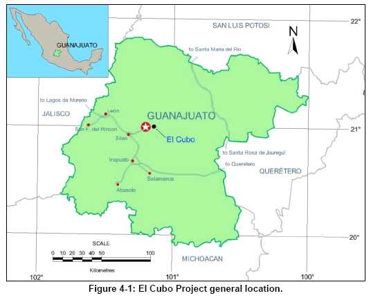
| Page 4-1 |
| UNIDAD ELCUBO GUANAJUATO, MÉXICO NI 43-101 TECHNICAL REPORT |
| 4.2 | Mineral Tenure and Property Agreements |
Compañía Minera del Cubo S.A de C.V (CMC) holds a 100% interest in the 57 mining concessions that make up the El Cubo property, as shown in Figure 4-2. On April 16, 2012, Endeavour Silver Corp. and AuRico (AuRico Gold Inc.), the former owner of CMC, announced that they entered into a definitive agreement whereby Endeavour would acquire 100% interest in the El Cubo property. On July 13, 2012, Endeavour announced in a news release that it had completed the acquisition of El Cubo and the Guadalupe y Calvo exploration projects in Chihuahua State, Mexico for US$100 million in cash and US$100 million in Endeavour common shares (11,037,528 shares). This was accomplished through the purchase of the issued and outstanding shares of Mexgold from AuRico which gives Endeavour ownership of Mexgold subsidiaries Compañía Minera Del Cubo, S.A. de C.V., AuRico Gold GYC, S.A. de C.V. and Metales Interamericanos, S.A. de C.V. Over the next three years, AuRico will be entitled to receive up to an additional US$50 million in cash payments from Endeavour upon the occurrence of certain events, discussed below. |
| Page 4-2 |
| UNIDAD ELCUBO GUANAJUATO, MÉXICO NI 43-101 TECHNICAL REPORT |
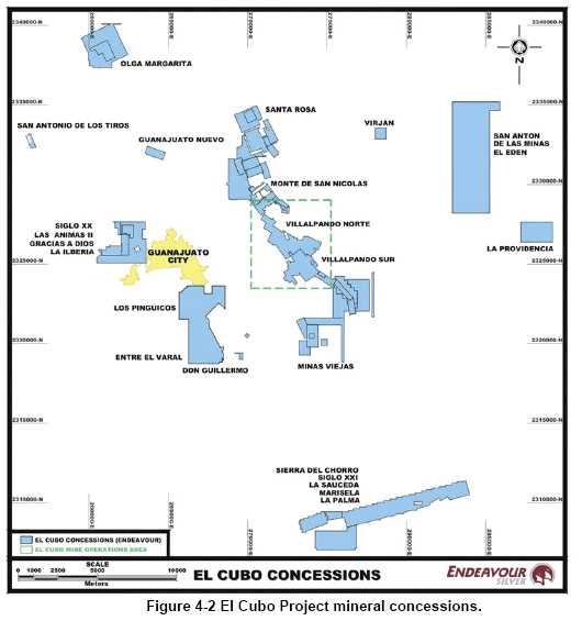
Expiration dates associated with the El Cubo mining concessions range from January 25, 2021, to February 2, 2060, and are listed in Table 4-1.
| Page 4-3 |
| UNIDAD ELCUBO GUANAJUATO, MÉXICO NI 43-101 TECHNICAL REPORT |
Table 4-1
El Cubo Project Mineral Concessions Owned by CIA Minera Del Cubo S.A. de C.V
| Name | Title Number | Hectares | File | Term | Owner | Municipality | State | |
| Start | End | |||||||
| Santa Fe del Monte | 154139 | 15.3541 | 031/04425 | 02/09/1971 | 1/25/2021 | CMC | Guanajuato | Guanajuato |
| Luisa Evelia | 157855 | 22.2241 | ??? | 12/07/1972 | 11/29/2022 | CMC | Guanajuato | Guanajuato |
| Santa Rosa | 157913 | 20.5065 | 031/04540 | 12/07/1972 | 12/06/2022 | CMC | Guanajuato | Guanajuato |
| Primera Ampl. de la Albertina o la Merced | 161513 | 8.8652 | 031/5924 | 4/29/1975 | 4/24/2025 | CMC | Guanajuato | Guanajuato |
| Ampl. de la Fragua | 164851 | 130.885 | 031/05532 | 07/11/1979 | 07/10/2029 | CMC | Guanajuato | Guanajuato |
| El Durazno | 164988 | 60 | 031/04542 | 8/13/1979 | 08/12/2029 | CMC | Guanajuato | Guanajuato |
| Durazno Prisco | 165109 | 43.7524 | 031/04764 | 8/23/1979 | 8/22/2029 | CMC | Guanajuato | Guanajuato |
| La Libertad | 165168 | 48.1 | 031/04357 | 09/12/1979 | 09/11/2029 | CMC | Guanajuato | Guanajuato |
| Edelmira II | 165245 | 135.2726 | 031/04740 | 9/14/1979 | 9/13/2029 | CMC | Guanajuato | Guanajuato |
| La Fragua | 165653 | 42 | 031/03859 | 11/19/1979 | 11/18/2029 | CMC | Guanajuato | Guanajuato |
| La Soledad | 165669 | 65 | 031/03862 | 11/28/1979 | 11/27/2029 | CMC | Guanajuato | Guanajuato |
| San Juan | 165791 | 37.3586 | 031/03778 | 12/11/1979 | 12/10/2029 | CMC | Guanajuato | Guanajuato |
| El Cabrestante | 165792 | 9 | 031/03858 | 12/11/1979 | 12/10/2029 | CMC | Guanajuato | Guanajuato |
| Minas Viejas | 165794 | 16 | 031/04200 | 12/11/1979 | 12/10/2029 | CMC | Guanajuato | Guanajuato |
| Ampl. de Cabrestante | 165795 | 89 | 031/04199 | 12/11/1979 | 12/10/2029 | CMC | Guanajuato | Guanajuato |
| Nueva Luz del Nayal | 165796 | 55 | 031/04685 | 12/11/1979 | 12/10/2029 | CMC | Guanajuato | Guanajuato |
| La China | 165797 | 48.5754 | 031/04619 | 12/11/1979 | 12/10/2029 | CMC | Guanajuato | Guanajuato |
| Huematzin | 171591 | 37.5 | 031/04515 | 11/09/1982 | 11/08/2032 | CMC | Guanajuato | Guanajuato |
| El Chupiro | 171840 | 13.3873 | 031/05770 | 6/15/1983 | 6/14/2033 | CMC | Guanajuato | Guanajuato |
| San Cayetano de Animas y Providencia | 181236 | 30.992 | 031/04660 | 9/21/1987 | 09/10/2037 | CMC | Guanajuato | Guanajuato |
| Socavón de los Alisos | 182003 | 66.3687 | 031/04348 | 04/12/1988 | 04/07/2038 | CMC | Guanajuato | Guanajuato |
| San Juan de Tacuitapa | 182004 | 24 | 031/04376 | 04/12/1988 | 04/07/2038 | CMC | Guanajuato | Guanajuato |
| El Cuarteto | 182005 | 26.091 | 031/04419 | 04/12/1988 | 04/07/2038 | CMC | Guanajuato | Guanajuato |
| Ampliación de Pasadena | 182006 | 3.3399 | 031/05972 | 04/12/1988 | 04/07/2038 | CMC | Guanajuato | Guanajuato |
| Albertina o la Merced | 182007 | 5.9316 | 031/04510 | 04/12/1988 | 04/07/2038 | CMC | Guanajuato | Guanajuato |
| Canta Ranas | 210492 | 98.5468 | 6/1.3/375 | 10/08/1999 | 10/07/2049 | CMC | Guanajuato | Guanajuato |
| Dalia | 210951 | 129.0207 | 031/08472 | 2/29/2000 | 2/28/2050 | CMC | Guanajuato | Guanajuato |
| La Providencia | 211859 | 256.7454 | 6/1.3/316 | 7/28/2000 | 7/27/2050 | CMC | Dolores Hidalgo | Guanajuato |
| El Edén | 212009 | 1675.7707 | 6/1.3/00310 | 8/18/2000 | 8/17/2050 | CMC | Dolores Hidalgo | Guanajuato |
| San Patricio | 212168 | 3.4634 | 6/1.3/00377 | 9/22/2000 | 9/21/2050 | CMC | San Patricio | Guanajuato |
| Gracias a Dios | 212534 | 356.7608 | 031/09137 | 10/31/2000 | 10/30/2050 | CMC | Guanajuato | Guanajuato |
| La Sauceda | 213305 | 747.673 | 031/09009 | 4/20/2001 | 4/19/2051 | CMC | Guanajuato | Guanajuato |
| Page 4-4 |
| UNIDAD ELCUBO GUANAJUATO, MÉXICO NI 43-101 TECHNICAL REPORT |
| La Palma | 213435 | 327.7095 | 031/09149 | 05/11/2001 | 05/10/2051 | CMC | Guanajuato | Guanajuato |
| Marisela | 213751 | 135.9622 | 031/09155 | 6/15/2001 | 6/14/2051 | CMC | Guanajuato | Guanajuato |
| Entre el Varal | 214132 | 3.8977 | 6/1.3/00450 | 08/10/2001 | 08/09/2051 | CMC | Guanajuato | Guanajuato |
| La Asunción | 214133 | 10 | 6/1.3/00451 | 08/10/2001 | 08/09/2051 | CMC | Guanajuato | Guanajuato |
| Violeta | 214134 | 75.6694 | 6/1.3/00452 | 08/10/2001 | 08/09/2051 | CMC | Guanajuato | Guanajuato |
| María Fracc. NE | 214135 | 146.139 | 6/1.3/00453 | 08/10/2001 | 08/09/2051 | CMC | Guanajuato | Guanajuato |
| Violeta | 214136 | 45.6837 | 6/1.3/00454 | 08/10/2001 | 08/09/2051 | CMC | Guanajuato | Guanajuato |
| Las Palomas | 214260 | 257.0432 | 031/09148 | 09/06/2001 | 09/05/2051 | CMC | Guanajuato | Guanajuato |
| Guanajuato Nuevo | 214283 | 60 | 031/09154 | 09/06/2001 | 09/05/2051 | CMC | Guanajuato | Guanajuato |
| La Ilberia | 214422 | 67.821 | 6/1.3/00456 | 09/06/2001 | 09/05/2051 | CMC | Guanajuato | Guanajuato |
| Siglo XX | 214423 | 43.7628 | 6/1.3/00457 | 09/06/2001 | 09/05/2051 | CMC | Guanajuato | Guanajuato |
| Virjan | 214424 | 49 | 6/1.3/00458 | 09/06/2001 | 09/05/2051 | CMC | Guanajuato | Guanajuato |
| Las Animas II | 214425 | 79.5086 | 6/1.3/00459 | 09/06/2001 | 09/05/2051 | CMC | Guanajuato | Guanajuato |
| Siglo XXI | 214614 | 47.1809 | 031/09167 | 10/02/2001 | 10/01/2051 | CMC | Guanajuato | Guanajuato |
| Los Pingüicos | 214742 | 985.11 | 031/09150 | 11/22/2001 | 11/21/2051 | CMC | Guanajuato | Guanajuato |
| Olga Margarita | 215175 | 416.8909 | 031/09172 | 02/08/2002 | 02/07/2052 | CMC | Guanajuato | Guanajuato |
| Janet | 215176 | 96 | 031/09187 | 02/08/2002 | 02/07/2052 | CMC | Guanajuato | Guanajuato |
| Don Guillermo | 215926 | 9.0808 | 031/09160 | 04/02/2002 | 04/01/2052 | CMC | Guanajuato | Guanajuato |
| San Antonio de lo Tiros | 217998 | 25.6113 | 6/1.3/00449 | 9/30/2002 | 9/29/2052 | CMC | Guanajuato | Guanajuato |
| Paco | 217999 | 188.2252 | 6/1.3/00455 | 9/30/2002 | 9/29/2052 | CMC | Guanajuato | Guanajuato |
| Unificación Villalpando Norte | 229103 | 374.4603 | 9/1.2/00002 | 03/09/2007 | 03/08/2057 | CMC | Guanajuato | Guanajuato |
| Unificación Villalpando Sur | 240917 | 318.144 | 9/1.2/00003 | 03/09/2007 | 03/08/2057 | CMC | Guanajuato | Guanajuato |
| Lety Fracción 1 | 235633 | 32.3682 | 031/09473 | 02/03/2010 | 02/02/2060 | CMC | Guanajuato | Guanajuato |
| Lety Fracción 2 | 235634 | 18.3671 | 031/09473 | 02/03/2010 | 02/02/2060 | CMC | Guanajuato | Guanajuato |
| Lety Fracción 3 | 235635 | 4.9644 | 031/09473 | 02/03/2010 | 02/02/2060 | CMC | Guanajuato | Guanajuato |
| 4.2.1 | Contingent Payments Subsequent to Closing |
Endeavour’s agreement with AuRico stipulates additional contingent payments. AuRico will be entitled to receive up to an additional $50 million in cash payments from Endeavour upon the occurrence of certain events as follows: | |
(i) $20,000,000 if at any time during the 3 years following the Closing Date Endeavour, either directly or through its subsidiaries, obtains use of the Las Torres facilities after September 6, 2012 (being the date which the term of the Las Torres Lease expires) whether due to a renewal or extension of the Las Torres Lease or otherwise (other than use obtained solely as a result of the Force Majeure Extension); |
| Page 4-5 |
| UNIDAD ELCUBO GUANAJUATO, MÉXICO NI 43-101 TECHNICAL REPORT |
(ii) $10,000,000 upon the simple average of the daily LME closing prices for gold exceeding $1,900 per ounce for a period of twelve (12) consecutive months at any time during the three (3) year period immediately following the acquisition date; | |
(iii) $10,000,000 upon the simple average of the daily LME closing prices for gold exceeding $2,000 per ounce for a period of twelve (12) consecutive months at any time during the three (3) year period immediately following the acquisition date; and | |
(iv) $10,000,000 upon the simple average of the daily LME closing prices for gold exceeding $2,100 per ounce for a period of twelve (12) consecutive months at any time during the three (3) year period immediately following the acquisition date. | |
Endeavour returned the Las Torres facilities to Fresnillo after it completed the commissioning of the Tajo Plant to design specifications. | |
Within two (2) business days following the date on which a condition to the making of any contingent payment is met, AuRico shall notify Endeavour in writing of the satisfaction (or deemed satisfaction) of such conditions and Endeavour shall then pay to AuRico an amount equal to the contingent payment which is payable according to the paragraphs above. | |
Endeavour established a credit facility secured by its existing operating mines from which facility Endeavour will arrange for contingent payments to be made. Endeavour adjusted a revolving credit facility to $50 million with Scotiabank. Further details concerning the acquisition of Del Cubo are available on SEDAR. | |
| 4.2.2 | Encumbrances |
The concessions are free of liens or encumbrances, except that: (i) 4 of the concessions (covering approximately 30 ha) are subject to a lease contract originating in 1941. |
| Page 4-6 |
| UNIDAD ELCUBO GUANAJUATO, MÉXICO NI 43-101 TECHNICAL REPORT |
| 4.2.3 | Minimum Investment & Mining Duty (Tax) |
All concessions are subject to an annual minimum investment (assessment work) and an annual mining tax that must be paid to keep the concessions in good standing. The amount of the minimum investment or assessment work varies based on the size, age and type of the concession, and changes each year with the Department of Mines publishing a new list at the beginning of the year. Fees are adjusted to the consumer price index. The rate of the mining duty depends on the concession type and the age of the concession. The rate changes each semester with the Department of Mines publishing the new rates in January and July. Payment of the mining duty is also due in both January and July. | |
The annual 2015 concession tax for the mining concessions owned by CMC (8,141 ha) is estimated to be approximately 2,185,960 Mexican pesos which is equal to about US $161,923 at an exchange rate of 13.50 pesos to US $1.00. | |
In 2015, CMC will be able to satisfy the minimum investment and assessment work requirements based on its current work programs and past work completed. | |
| 4.3 | Permits and Environmental Liabilities |
In order to engage in exploration and commercial mining activities, environmental permits are required. CMC currently holds all necessary environmental permits for exploration and for commercial mining activity on these concessions. Endeavour will need to permit a new tailings pond for the El Tajo plant and may require additional permits for new infrastructure and modified operations when the Las Torres lease expires. |
Table 4-2
El Cubo Project Environmental Permits
| Permit Type | Permit | Issuing Agent |
| Environmental License | LAU-11-70101504-09 | Semarnat |
| Annual Operation Card | COA-2011 | Semarnat |
| Environmental Registration | MCUMJ1101511 | Semarnat |
| Hazardous Waste Generating | GRP111500002 | Semarnat |
| Page 4-7 |
| UNIDAD ELCUBO GUANAJUATO, MÉXICO NI 43-101 TECHNICAL REPORT |
| Sewage Discharge License | 4GUA101250/12EMGE94 | CONAGUA |
| Environmental Impact Authorization Construction of Chirimitera Plant | D.O.O. DGOEIA -001788 | Semarnat |
| Environmental Impact Authorization Construction of Chimiritera Tailings Dam | D.O.O. DGOEIA -006508 | Semarnat |
Security is a persistent concern with regard to theft of materials, occasional armed incursions, and unauthorized people entering the mine to work stopes. Endeavour will need to take measures to increase security, including ones to reduce, or eliminate incursions in the mine and supply theft. | |
Aside from the issues described above, the author knows of no other significant factors or risks that might affect access, title, or the right or ability to perform work on the property. | |
| 4.4 | Surface Rights |
The concessions held by CMC are for mineral rights only, but surface rights have been secured through 1,150 hectares of surface lands owned by CMC in 4 polygons and 1,195 hectares (4 polygons) under a lease agreement with the company Industrial Santa Fe; Endeavour believes they are sufficient to carry out proposed exploration and development activities, Figure 4-3. |
| Page 4-8 |
| UNIDAD ELCUBO GUANAJUATO, MÉXICO NI 43-101 TECHNICAL REPORT |
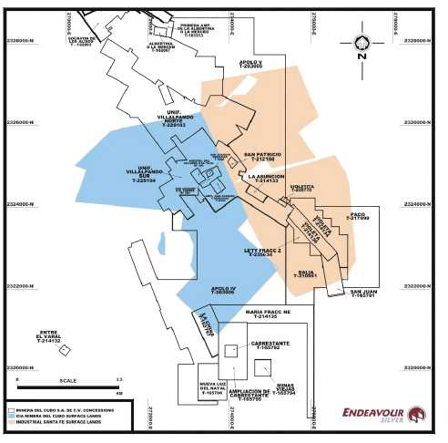
Figure 4-3 El Cubo Surface Lands.
| 4.5 | Environment |
Endeavour Silver holds all necessary environmental and mine permits to conduct planned exploration, development and mining operations on the El Cubo Mines Project. Further details are covered in Section 20 of this report. |
| Page 4-9 |
| UNIDAD ELCUBO GUANAJUATO, MÉXICO NI 43-101 TECHNICAL REPORT |
| 5.0 | ACCESSIBILITY, CLIMATE, LOCAL RESOURCES, INFRASTRUCTURE, AND PHYSIOGRAPHY |
| 5.1 | Accessibility |
Access to the El Cubo mine is provided by periodically maintained dirt roads which originate in the city of Guanajuato approximately 10 km to the west. The city of Guanajuato is accessible by paved highway and daily passenger service to Mexico City is available by luxury bus or at the nearby Leon airport. | |
| 5.2 | Climate |
The regional climate is temperate, with cool winters and mild summers. Rainfall occurs primarily during the summer season, from June to September, and typical annual precipitation is about 50 cm per year. From mid-December through January, nighttime temperatures fall to 7° to 10 °C, and daytime high temperatures in low 20 °C range are typical. Snowfall is rare but has been known to occur at the higher elevations throughout the region. Weather conditions rarely, if ever, restrict mining activity at El Cubo, and operations can be carried out year-round. | |
| 5.3 | Local Resources and Infrastructure |
The capital city of Guanajuato has a population of approximately 160,000 and hosts several universities and post-secondary schools, including a mining college. Tourism is a principal industry in the area, and numerous hotels and restaurants are available as a result. Mining has been a major industry in the area for centuries. A workforce that is familiar with mining and the necessary support facilities is present in the region. The village of El Cubo supplies some of the workforce for the mine, but the majority of workers come from Guanajuato and other nearby villages. Professional staff is also available in the area. The company provides bus service for its employees to and from the city. | |
| 5.3.1 | Electrical Power Supply |
Sufficient power for mining operations is provided by the public network CFE (Comisión Federal de Electricidad). |
| Page 5-1 |
| UNIDAD ELCUBO GUANAJUATO, MÉXICO NI 43-101 TECHNICAL REPORT |
| 5.3.2 | Water Supply |
Water sources at El Cubo include the mine, recycled water from the tailings impoundment facilities. Water for mine operations is currently obtained from the Dolores mine. Water is pumped from the Dolores mine into a series of water reservoirs on surface, from which the water is distributed to the mines. The surplus of the water pumped from the Dolores mine is sent to the freah water tanks, which is used to supply the mines as needed. | |
Additional details regarding infrastructure at El Cubo are provided in Section 18 of this report. | |
| 5.4 | Physiography |
The state of Guanajuato is situated along the southern edge of the Central Mexican Plateau and comprises portions of the Trans-Mexican Volcanic Belt, the Mexican Plateau, and the Sierra Madre Oriental. The El Cubo property is located in the west central portion of the state, among a series of low, gentle mountains which are part of the Sierra Madre Occidental. The El Cubo mine offices are at an elevation of 2265 metres above mean sea level, and the mine workings range in elevation from 2646 metres at the uppermost level (level 180) to 1905 metres at the lowest level (level 14). | |
| 5.5 | Sufficiency of Surface Rights |
Endeavour has negotiated access and the right to use surface lands sufficient for many years of operation. Sufficient area exists at the El Cubo property for all future surface infrastructure needed. |
| Page 5-2 |
| UNIDAD ELCUBO GUANAJUATO, MÉXICO NI 43-101 TECHNICAL REPORT |
| 6.0 | HISTORY |
| 6.1 | Guanajuato Mining District |
The Guanajuato mining district is located at the southern end of what used to be the Chichimeca Empire which was colonized by Nuño de Guzmán in 1540. | |
It is suspected that (but not known if) the indigenous peoples rather than the Spanish colonists first began mining in the Guanajuato district. However, mining extends back to at least 1548 when the silver veins began to be exploited by the Spanish. Guanajuato was one of the premier mining districts of Nueva España (New Spain). The following is a brief timeline of the history of the Guanajuato mining district: |
| • | Pre-Conquest: Martin notes in his 1906 volume on the mines of Guanajuato that “there is reason to believe that the Peregrina mine was being worked and big quantities of ore being taken out by the Indians before Cortez ever set foot in the country.” | |
| • | 1548: The first silver vein, San Bernabé (La Luz), was discovered by a local mule driver. In these early years the silver ore was hand mined and transported by mule to Zacatecas to be milled. | |
| • | 1550: Juan de Rayas discovered the Veta Madre system at the site where the present day Rayas shaft is located. This discovery triggered an exploration rush that saw the discovery of the Valenciana, Tepeyec, Mellado, Cata and Sirena silver occurrences. | |
| • | 1726: Don Jose de Sardeneta y Legaspi introduced gunpowder to be used for blasting. Prior to this, production was very limited as the method of extracting ores was by fire, where the rock face was heated and then quickly quenched with water, shattering the rock. Construction began on the Rayas shaft. | |
| • | 1760 to 1770: Antonio Obregón y Alcocer, who later became Count Valenciana, completed a number of exploration ventures, culminating with the discovery of the Valenciana ore-shoot and the development of the Valenciana mine. |
| Page 6-1 |
| UNIDAD ELCUBO GUANAJUATO, MÉXICO NI 43-101 TECHNICAL REPORT |
| • | 1771: Immense masses of silver sulphides, mixed with ruby silver and native silver were discovered at Valenciana. At the time, the Valenciana mine was estimated to be producing one-third of the world’s silver. Production was increased under the Count’s direction, and the Santo Cristo de Burgos shaft was sunk to a depth of 150 m. | |
| • | 1775: The San Antonio shaft on the Valenciana vein was sunk to a depth of 227 m. | |
| • | 1760 to 1810: Martin notes that during this period the Guanajuato mines accounted for 30% of the entire Mexican production and 20% of the entire world’s output of silver. | |
| • | 1810 to 1868: Production stopped as the result of the War of Independence from Spain. | |
| • | 1810: In September, Hidalgo began his revolt against Spain. In the City of Guanajuato all foreigners’ property was seized and their homes destroyed. Hidalgo took the Alhóndiga de Granaditas (public granary) and massacred most of the people taking refuge in it. | |
| • | 1821: Revolutionaries burned all the mining installations, including the head works of the newly-built Valenciana shaft. | |
| • | 1868: The Valenciana mine was reopened by British investment capital. | |
| • | Between 1887 and 1889, production from the mines of Guanajuato accounted for as much as US $14.4 million or approximately 2.88 million British pounds. | |
| • | 1906: Martin noted that the principal or “mother vein has yielded the sum of one billion dollars as proven by the mint and government records. The Valenciana mine proved to be the greatest silver producer with workings down to 2,400 feet on the incline and producing over $300 million dollars of silver or approximately 60 million British pounds”. | |
| • | 1910 to 1920: Mexican revolution; mining ceased or declined during this period with the destruction of a great many mines and infrastructure. |
| Page 6-2 |
| UNIDAD ELCUBO GUANAJUATO, MÉXICO NI 43-101 TECHNICAL REPORT |
| • | 1936: Peñoles tested the Veta Madre with four diamond drillholes. | |
| • | 1939: Sociedad Cooperativa Minero Metalúrgica Santa Fe de Guanajuato (SCMMSFG) became the legal owner of the properties of the Guanajuato Reduction and Mines Company. Starting out with no mineral reserves and working capital, the new Cooperative had a very difficult time conducting exploration and mining with outdated equipment. | |
| • | 1947-1949: The Fresnillo Company, a division of Peñoles, completed a diamond drilling program consisting of 9 holes which intersected the Veta Madre 80 m to 150 m below the lowest existing workings. | |
| • | 1968: Fresnillo discovered the Torres-Cedros deposit during an exploration and drilling campaign. | |
| • | 1973: The SCMMSFG discovered the Clavo de Rayas “bonanza” mineral shoot. |
| 6.2 | El Cubo |
Mining on the El Cubo property has occurred since the 17th century. The Sierra structure, which includes the El Cubo Mine and the adjacent Peregrina Mine (part of the Las Torres complex), accounts for much of the gold produced in the Guanajuato district – on the order of 2,000,000 ounces of gold and 80,000,000 ounces of silver. Gold was originally mined from shallow pits near the San Eusebio vein, one of those on the El Cubo concessions which later produced significant amounts of gold and silver. In the 19th and 20th centuries, mining at El Cubo focused on northwest striking veins known as the Villalpando, Dolores, La Loca, and La Fortuna, and production was divided between many operators. In the early 1900’s, the Túnel Aventurero de San Felipe (now El Cubo level 4) was started in order to connect the Pastora-Fortuna, Villalpando, and La Loca veins. At the time, bonanza grades and widths were encountered on the Villalpando vein. These shoots were up to 4 m wide and assayed close to 1 kg of silver per tonne. The ‘bonanza’ ores were mined through the 1940’s, when much of the area was consolidated into a single company and claim block resembling the one on which CMC operates today. |
| Page 6-3 |
| UNIDAD ELCUBO GUANAJUATO, MÉXICO NI 43-101 TECHNICAL REPORT |
The Villalpando vein, located in the central portion of the modern day El Cubo claim block, was the main source of production through the 1970’s. The main vein structure extended northwest to the El Cubo concession boundary with the Peregrina Mine. The gold grades decreased as the vein was exploited at the deeper (8 - 12) levels. The Alto de Villalpando vein, which generally produced higher gold grade, was mined out. The La Poniente vein was discovered in the early 1970’s, and high grade gold and silver ore was mined until 1976, when the developed section was temporarily exhausted.
The El Cubo Mine changed ownership in the 1970’s, when the Palmers sold the mine to a private company owned by Messrs. Villagomez and Chommie. By 1979 there was little developed ore remaining above the 13th level on the Villalpando vein, and production from other related veins was low grade and sporadic. The mill was fed largely from the Chuca Loca open pit and from dumps. The shortage of quality ore came to an end after 1980, when new high grade gold and silver mineralization was discovered and developed along the San Nicolas vein.
In 1995, production was expanded from 350 to 800 tonnes per day, and then to 1,400 tonnes per day in 2001. The mills saw a decrease in head grade after each expansion, likely due to the use of low grade material from old stope fill as supply for the increased tonnage. Given the shortage of tonnage from active stopes, there was likely less emphasis on grade control.
El Cubo was purchased by Mexgold Resources Inc. (Mexgold) from the previous owners in March 2004. The Las Torres mine and mill complex, owned by Industrias Peñoles, S.A. de C.V. (Peñoles) was leased by Mexgold in October of 2004. The property had been a prolific producer for many years, especially the adjacent Peregrina Mine, which continues to complement the El Cubo Mine by facilitating access to the deeper ore at El Cubo. Mexgold became a wholly owned subsidiary of Gammon Lake Resources Inc., in 2006, and. Gammon Gold Inc. changed its name to its current name, AuRico Gold Inc. on August 26, 2011. In April of 2012, Endeavour entered into an agreement with AuRico to acquire a 100% interest in El Cubo. The purchase was completed on July 13, 2012.
| Page 6-4 |
| UNIDAD ELCUBO GUANAJUATO, MÉXICO NI 43-101 TECHNICAL REPORT |
| 6.3 | Historical and Recent Exploration |
Historically, exploration at El Cubo was mostly by drifting along the known veins and the amount of drilling was minimum. All drilling before 2000 was not made systematically, therefore, the information it’s not organized. There are evidences of drilling, but when it’s found the information has to be search within historical files, in order to know the data and usually they were made with small diameters y does not fulfill the current standards for the quality of the information, they can only be used as guidance for exploration. | |
Since 2000, exploration was increased in the project, having his best peak with the acquisition of El Cubo by Mexgold and lately by Aurico, of these times there is information in the database of around 844 drillholes (approximately 180,019 m), both surface and underground drilling, with different diameters, mainly over the Villalpando, Dolores, La Loca, San Nicolas, San Eusebio, Pastora, Puertecito and La Cruz structures. Table 6-1 shows a summary of these drilling activities. |
Table 6-1
Historical Drilling at El Cubo
| Code | Diamond Drillholes | Metres |
| C | 457 | 127,746 |
| CE | 10 | 3,730 |
| CUDG | 377 | 48,544 |
| Total | 844 | 180,019 |
| Page 6-5 |
| UNIDAD ELCUBO GUANAJUATO, MÉXICO NI 43-101 TECHNICAL REPORT |
After Endeavour acquired CMC in July, 2012, the efforts of exploration were focused to locate mineralized bodies over primary and secondary structures, mainly near the current production areas. Surface drilling has been conducted over the Villalpando (Villalpando Gap & Asunción), Dolores (Dolores North), La Loca & La Paz veins. The mine exploration drilling program was undertaken to determine the extent of additional mineralization areas currently being mined. The principal targets were the Villalpando (Area II and IV) and Dolores (II) vein systems, with a number of other structures also explored: The Tuberos vein (area III and IV); San Nicolas vein system (Areas II and IV); La Paz vein (Area III) and the veta-995, Vetas 178-143 and Del Niño vein in Area I. At the end of 2013, a total of 34,104.75 m were completed in 150 holes and 6,886 samples (Table 6-2).
| Page 6-6 |
| UNIDAD ELCUBO GUANAJUATO, MÉXICO NI 43-101 TECHNICAL REPORT |
Table 6-2
Summary ofEndeavour Silver’s Exploration Drilling Activities (as at December 2013)
| Project Area | Number of Holes | Total Metres | Number of Samples Taken |
| Villalpando Gap | 8 | 3,741.60 | 344 |
| Dolores North | 5 | 1,334.25 | 182 |
| La Loca | 6 | 2,534.60 | 153 |
| La Paz | 3 | 1,028.80 | 32 |
| Asunción | 34 | 13,791.50 | 2647 |
| Mine Exploration | 94 | 11,674.00 | 3528 |
| Total | 150 | 34,104.75 | 6,886 |
| 6.4 | Historical Mining and Exploration |
| 6.4.1 | Mining |
| 6.4.2 | Production |
Previous operators and AuRico’s predecessor companies did not keep reliable production records for the El Cubo mine. Production achieved at the El Cubo mine between 2007 and 2011, as reported in AuRico’s annual reports, is summarized in Table 6-3. | |
In 2011, the El Cubo mine produced 556,379 ounces of silver and 8,670 ounces of gold from 256,150 tonnes of ore grading 80 g/t Ag and 1.24 g/t Au. Silver and gold recoveries averaged 82% and 86%, respectively. Production in 2011 was affected by a labor strike that was settled during the year. |
Table 6-3
El Cubo Mine Production.
| Year | Tonnes | Grade (g/t) | Production (ounces) | ||
| Gold | Silver | Gold | Silver | ||
| 2007 | 689,753 | 1.77 | 83 | 33,740 | 1,582,316 |
| 2008 | 658,105 | 1.98 | 94 | 38,772 | 1,783,148 |
| 2009 | 505,388 | 1.92 | 83 | 27,842 | 1,183,339 |
| 2010 | 233,006 | 1.63 | 83 | 10,844 | 536,457 |
| 2011 | 256,150 | 1.24 | 80 | 8,670 | 556,379 |
| Page 6-7 |
| UNIDAD ELCUBO GUANAJUATO, MÉXICO NI 43-101 TECHNICAL REPORT |
| 6.5 | Historic Mineral Resource & Mineral Reserve Estimates |
Mineral resource and reserve estimates for El Cubo reported prior to 2009 are not compliant with current NI 43-101 standards, are not considered reliable, and are not discussed here. The mineral resource and reserve estimate reported by AuRico in 2009 is compliant with CIM standards and definitions as required by NI 43-101, and superseded any previous historical estimates. The technical report issued by AuRico was prepared by Glenn R. Clark & Associates Limited (Clark), and is entitled Review of Resources and Reserves El Cubo Gold-Silver Mine, Guanajuato, Mexico, dated October 15, 2009. Clark (2009) estimated mineral resources and mineral reserves for the El Cubo mine based on data and information available as of January 1, 2009 (Table 6-4). The mineral resources reported by Clark were estimated using polygonal methods in spreadsheet and CAD software. |
Table 6-4
Historic El Cubo Mineral Resources, January 1, 2009 (Clark, 2009).
| Resource Category | Tonnes (000's) | Au g/t | Ag g/t |
| Measured | 160 | 2.38 | 94 |
| Indicated (Underground) | 215 | 2.62 | 95 |
| Indicated (Open Pit) | 2,100 | 2.72 | 49 |
| Total Measured and Indicated | 2,475 | 2.69 | 56 |
| Inferred | 2,343 | 4.84 | 220 |
Table 6-4 excludes resources reported by Clark that were associated with Las Torres (Peñoles) lease. Clark also reported Proven and Probable mineral reserves for the El Cubo mine, as summarized in Table 6-5.
Table 6-5
Historic El Cubo Mineral Reserves, January 1, 2009 (Clark, 2009).
| Reserve Category | Tonnes (000's) | Au g/t | Ag g/t |
| Proven | 1326 | 3.34 | 189 |
| Probable | 1,696 | 3.35 | 157 |
| Total Proven and Probable | 3,022 | 3.34 | 171 |
| Page 6-8 |
| UNIDAD ELCUBO GUANAJUATO, MÉXICO NI 43-101 TECHNICAL REPORT |
Since 2009, AuRico has conducted additional diamond drilling and underground development and has estimated new mineral resources and reserves within the El Cubo claim block. The estimates reported by Clark are not considered current and were not relied upon in the preparation of this report. AuRico reported mineral resources for the El Cubo mine effective December 31, 2011 in filings available on SEDAR and summarized in Table 6-6.
The AuRico totals include 2,132,000 tonnes of 2.69 g/t Au and 49 g/t Ag in Measured and Indicated resources and 663,000 tonnes of 3.80 g/t Au and 181 g/t Ag in Inferred resources within properties leased from Peñoles. AuRico also reported mineral reserves for the El Cubo mine (Table 6-7).
Table 6-6
AuRico El Cubo Mineral Resources reported as of December 31, 2011.
| Resource Category | Tonnes (000's) | Au g/t | Ag g/t |
| Measured | 337 | 1.10 | 65 |
| Indicated | 3,874 | 2.07 | 61 |
| Total Measured and Indicated | 4,211 | 1.99 | 61 |
| Inferred | 7,198 | 2.37 | 115 |
Table 6-7
AuRico El Cubo Mineral Reserves reported as of December 31, 2011.
| Reserve Category | Tonnes (000's) | Au g/t | Ag g/t |
| Proven | 2,238 | 1.84 | 114 |
| Probable | 3,152 | 1.88 | 102 |
| Total Proven and Probable | 5,390 | 1.86 | 107 |
AuRico’s mineral reserves included 663,000 tonnes of 1.38 g/t Au and 120 g/t Ag from the Peñoles lease in its estimates. The author did not rely upon the Clark estimates in any way in his preparation of the mineral resource and mineral reserves estimates presented herein. The author used information collected and calculated by CMC/ AuRico, but relied solely on his own review and judgment to make his estimates of mineral resource and mineral reserves.
| Page 6-9 |
| UNIDAD ELCUBO GUANAJUATO, MÉXICO NI 43-101 TECHNICAL REPORT |
The estimates presented in Sections 14 and 15 of this report are the only ones to be considered current and reliable.
| Page 6-10 |
| UNIDAD ELCUBO GUANAJUATO, MÉXICO NI 43-101 TECHNICAL REPORT |
| 7.0 | GEOLOGICAL SETTING AND MINERALIZATION |
The following description of the geological setting for the El Cubo mine property is largely excerpted and modified from the technical report prepared by Clark (2009) and Cameron (2012). The author has reviewed the geologic data and information available, and finds the descriptions and interpretations provided in these documents reasonably accurate and suitable for use in this report. | |
| 7.1 | Regional Geology |
The mining district of Guanajuato is situated along the southern and eastern flanks of the Sierra Madre Occidental geological province, a north- northwesterly trending linear volcanic belt of Tertiary age. It is approximately 1,200 km long and 200 to 300 km in width. Rocks within the belt comprise flows and tuffs of basaltic to rhyolitic composition with related intrusive bodies. The volcanic activity that produced the bulk of the upper volcanic group ended by the late Oligocene, though there was some eruptive activity as recently as 23 Ma (early Miocene). The volcanism was associated with subduction of the Farallon Plate and resulted in accumulations of lava and tuffs on the order of 1 km thick. Later Basin and Range extensional tectonism related to the opening of the Gulf of California resulted in block faulting, uplift, erosion and the present day geomorphology of the belt. Strata within the belt occupy a broad antiform, longitudinally transected by regional scale faults. | |
The Guanajuato district is underlain by a volcano-sedimentary sequence of Mesozoic to Cenozoic age rocks. There are three main northwest trending vein systems that cut these volcano-sedimentary sequences. The vein systems from west to east are known as La Luz, Veta Madre and La Sierra systems. These systems are generally silver-rich with silver to gold ratios from 72:1 to 214:1. They are known along strike for 10 to 25 km. |
| Page 7-1 |
| UNIDAD ELCUBO GUANAJUATO, MÉXICO NI 43-101 TECHNICAL REPORT |
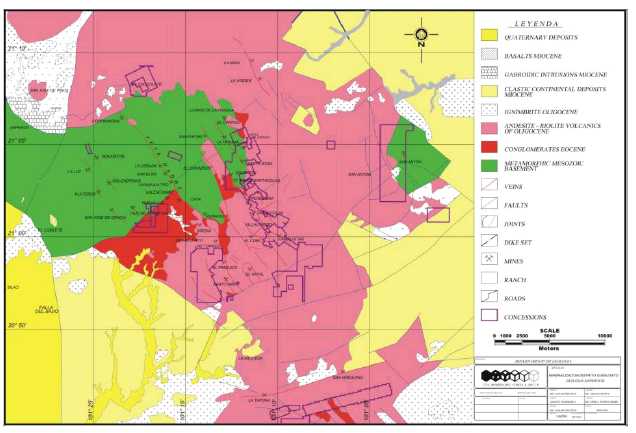
Figure 7-1 El Cubo mine regional geology showing El Cubo concession boundaries
(modified from Clark, 2009).
The El Cubo mine is located in eastern part of the Guanajuato mining district, in the southeastern portion of the Sierra de Guanajuato, an anticlinal structure about 100 km long and 20 km wide. El Cubo is located on the northeast side of this structure where typical primary bedding textures dip 10° to 20° to the north-northeast. Economic mineralization at El Cubo is known to extend as much as 800 m vertically from 2650 m to 1850 m elevation. The location of the main veins and mines in the district are shown in Figure 7-1.
The stratigraphy of the Guanajuato mining district can be divided into a Mesozoic basement (Chiodi et al, 1988; Dávila and Martinez, 1987; Martinez-Reyes, 1992) and overlying Cenozoic units, as shown in Figure 7-2. The lower Mesozoic lithological units are the Esperanza and La Luz Formations which are composed of marine sedimentary rocks, weakly to moderately metamorphosed and intensely deformed by shortening. These rocks are unconformably overlain by the Tertiary Guanajuato Formation conglomerates, and the Loseros, Bufa, Calderones, Cedros and Chichíndaro Formations. The Tertiary rocks consist of continental sediments and sedimentary rocks, which generally occupy lower topographic zones, and subaerial volcanic rocks, which are principally exposed in the ranges and higher plateaus. The rocks of the Cenozoic cover have experienced only extensional deformation and in some places are gently tilted. Tertiary-aged rocks correspond to a period of tectonism accompanied by volcanism and intrusive magmatic activity.
| Page 7-2 |
| UNIDAD ELCUBO GUANAJUATO, MÉXICO NI 43-101 TECHNICAL REPORT |
Figure 7-2 does not depict the Peregrina intrusive, which is a floored body (laccolith) at the contact of the Bufa Formation rhyolite and the Guanajuato Formation conglomerate. The uppermost portion of the Peregrina intrusive extends into the Chichíndaro Formation rhyolite. The thickness of each unit presented graphically in the stratigraphic section represents the maximum thickness of that unit in the vicinity of the El Cubo mine.
| Page 7-3 |
| UNIDAD ELCUBO GUANAJUATO, MÉXICO NI 43-101 TECHNICAL REPORT |

Figure 7-2 Stratigraphic column, eastern Guanajuato Mining District.
| 7.1.1 | Esperanza Formation (Middle to Upper Triassic) |
The Esperanza Formation is composed of carbonaceous and calcareous shale interbedded with arenite, limestone, and andesitic-to-basaltic lava flows, all weakly metamorphosed to phyllites, slates, and marble. The thickness of the formation exceeds 600m. |
| Page 7-4 |
| UNIDAD ELCUBO GUANAJUATO, MÉXICO NI 43-101 TECHNICAL REPORT |
| 7.1.2 | La Luz Formation |
The La Luz Formation overlies the Esperanza Formation and consists mainly of interbedded clastic sedimentary rocks and massive and pillow tholeiitic basalts dated at 108.4 ±2 Ma. Locally, rhyolite tuffs and agglomerates are present, and some volcanogenic massive sulfide occurrences have been reported. A minimum thickness of at least 1,000 m is recognized, but the true thickness is unknown due to deformation and sub-greenschist metamorphism. Included with the La Luz Formation are the La Palma diorite and La Pelon tonalite, which form the upper part of the Guanajuato arc. Pervasive propylitic alteration is common. | |
| 7.1.3 | Guanajuato Formation (Eocene to Oligocene) |
The red conglomerate characteristic of the Guanajuato Formation lies in unconformable contact with the Esperanza Formation and less frequently with the La Luz Formation andesite (Edwards, 1955). The conglomerate consists of pebbles to boulders of quartz, limestone, granite and andesite belonging to older rock units, all cemented by a clay matrix, with some interlayers of sandstone. Beds of volcanic arenites and andesitic lavas occur at the base of the conglomerate. The Guanajuato conglomerate is estimated to be between 1,500 and 2,000 m thick. Contemporaneous vertebrate paleontology and andesitic lavas (49 Ma, Aranda-Gómez and McDowell, 1998) indicate that the unit is mid-Eocene to early Oligocene in age. | |
| 7.1.4 | Loseros Formation (Cenozoic) |
This overlying mid-Tertiary volcanic sequence is interpreted to be within, and adjacent to a caldera. The Loseros tuff is a well-bedded, green to cream-red volcanic arenite from 10 m to 52 m thick. It is interpreted to be a surge deposit at the base of the Cubo caldera filling and Oligocene in age. | |
| 7.1.5 | Bufa Formation (Cenozoic) |
The Bufa Formation rhyolite is a felsic ignimbrite that is approximately 360 m thick and lies above a sharp to gradational contact. It is a sanidine-bearing rhyolite-ignimbrite with biotite as a mafic phase, and is often massive, but locally bedded. Owing to moderate welding and extensive and pervasive silicification, it is a hard rock that forms prominent cliffs east of the city of Guanajuato. It occasionally contains large lithic clasts of various types, many of which were derived from the pre-volcanic basement. At El Cubo, the Bufa rhyolite has three mappable units: a lower breccia overlain by dense, red rhyolite porphyry, in turn overlain by a massive to bedded ignimbrite. The cliff - forming Bufa rhyolite has been dated using the K-Ar dating technique to be 37 ±3 Ma, placing it in the middle Oligocene. |
| Page 7-5 |
| UNIDAD ELCUBO GUANAJUATO, MÉXICO NI 43-101 TECHNICAL REPORT |
| 7.1.6 | Calderones Formation (Cenozoic) |
The Calderones Formation contains a wide variety of volcanic rocks, including low- to medium-grade ignimbrites, deposits of pyroclastic flows, pyroclastic surge layers related to phreatomagmatic activity, airfall ash-rich tuffs, minor Plinian pumice layers, lahars, debris flows, reworked tuffaceous layers deposited in water, tuff-breccias and mega-breccias. Ubiquitous and characteristic chlorite alteration imparts a green to greenish blue color to almost all outcrops of the Calderones. Propylitic alteration adjacent to veins and dikes is of local importance in many outcrops. | |
The Calderones Formation overlies the Bufa Formation at El Cubo with a contact marked by a megabreccia composed of large (often 5 to 10 m) fragments of the Esperanza, La Luz and Guanajuato Formations. The Calderones Formation, which exceeds 300 m in thickness at El Cubo, is the upper caldera-filling unit above the surge deposit and the Bufa ignimbrites. | |
| 7.1.7 | Cedros Formation (Cenozoic) |
Overlying the Calderones Formation is the Cedros Formation andesite, a 100 to 640-m thick unit, which consists of grey to black andesitic lava flows with interlayered red beds and andesitic to dacitic tuffs. | |
The Cedros Formation is entirely post-caldera and is widespread. | |
| 7.1.8 | Chichíndaro Formation (Cenozoic) |
The Chichíndaro Formation rhyolite is a sequence of domes and lava flows interbedded with poorly sorted volcanic breccias and tuffs. Fluidal porphyritic textures are characteristic in the domes and flows. | |
This lithologic unit is closely related to the hypabyssal Peregrina intrusion, and it ranges in thickness from 100 to 250 m. In places, the rhyolite domes contain disseminated tin and vapor-phase cavity-filling topaz distributed along the flow foliation. |
| Page 7-6 |
| UNIDAD ELCUBO GUANAJUATO, MÉXICO NI 43-101 TECHNICAL REPORT |
The Chichíndaro rhyolite is the youngest volcanic unit in the Guanajuato mining district. Three K-Ar ages obtained from this formation (Gross, 1975; Nieto- Samaniego et al, 1996) date the unit at 32 ±1 Ma, 30.8 ±0.8 Ma and 30.1 ±0.8 Ma. | |
| 7.1.9 | Comanja Granite (Cenozoic) |
The Comanja granite, though not observed at El Cubo, is a unit of batholithic size, apparently emplaced along the axis of the Sierra de Guanajuato. It is Eocene in age and has been radiometrically dated at 53 ±3 Ma and 51 ±1 Ma by K-Ar in biotite (Zimmermann et al, 1990). These dates establish the youngest relative age for the Bufa formation, the youngest unit cut by the granite. | |
| 7.1.10 | El Capulin Formation |
The unconsolidated El Capulin Formation consists of tuffaceous sandstone and conglomerate overlain by vesicular basalt, all of Quaternary age. | |
| 7.2 | Structure |
The following paragraphs are modified from the summary of the structural setting of the Guanajuato mining district presented by Starling (2008) which focused on the Veta Madre but likely applies to the Sierra vein system that composes the El Cubo mine. | |
Pre-mineralization deformation during the Laramide orogeny (~80-40 Ma) resulted in west-northwest trending pre-mineral folds and thrusts in the Esperanza Formation as observed in the Cebada mine on the Veta Madre. Early post-Laramide extension (~30 Ma) was oriented north-south to north- northeast, and controlled many vein deposits in the region (e.g. Fresnillo, Zacatecas, La Guitarra). Guanajuato appears to lie on a north-northwest- trending terrane boundary which was reactivated as a sinistral transtensional fault zone in conjunction with early stage intermediate-sulfidation style mineralization. Subsequent (~28 Ma) regional extension to the east-northeast- west-northwest resulted in basin and range-type deformation and block faulting, and is associated with a second phase of mineralization in the Guanajuato district. |
| Page 7-7 |
| UNIDAD ELCUBO GUANAJUATO, MÉXICO NI 43-101 TECHNICAL REPORT |
Along the Veta Madre vein system, ore shoots were controlled during early-stage mineralization by counter-clockwise jogs along the main structure and at intersections with west-northwest and northeast fault zones. These tended to generate relatively steep ore shoots plunging to the south along the Veta Madre.
During the second phase of mineralization, listric block faulting and tilting affected parts of the Veta Madre veins and new systems such as La Luz developed. The veins at La Luz appear to have formed as extensional arrays between reactivated west-northwest fault zones acting as dextral transtensional structures.
The second phase vein systems tend to have formed sub-horizontal ore zones either reflecting fluid mixing zones or structural controls due to changes in dip of the fault surface. The overprint of two events means that in some deposits ore shoots have more than one orientation and that there are vertical gaps in ore grade.
Randall et al (1994) first proposed a caldera structure as a conceptual geologic model for the Guanajuato Mining District, citing the presence of a mega-breccia in the Calderones Formation and the distribution of the Oligocene volcanic formations described above. The hypothesis states that the caldera collapse occurred in at least two stages and the collapse was a trap-door type. The presence of a peripheral three-quarter ring of rhyolite domes intruding along bounding faults, the location of the Oligocene volcanic formations ponded within this ring, mega-breccia and topographic rim, all provide supporting evidence for this hypothesis.
Following caldera formation, normal faulting combined with hydrothermal activity around 27 Ma (Buchanan, 1980) resulted in many of the silver-gold deposits found in the district. Within the Guanajuato Mining District there are three major mineralized fault systems, the La Luz, Veta Madre and Sierra systems. Veta Madre is a north-northwest trending fault system and the largest at 25 km long. The other systems are subparallel to it. Mineralization occurs within these systems principally on normal faults oriented parallel to the main trend; however at El Cubo northeast and east-west faults host important vein orebodies.
| Page 7-8 |
| UNIDAD ELCUBO GUANAJUATO, MÉXICO NI 43-101 TECHNICAL REPORT |
| 7.2.1 | Local Structure |
The El Cubo mine lies within the La Sierra fault system. Within this fault system, all three of the principal fault directions are present. Mineralized veins are found along the faults in each of these directions (Figure 7-3). | |
The northwest striking and southwest dipping faults are the main structures containing the very important Villalpando, La Loca, Dolores and Pastora- Fortuna veins. These veins are generally steeply dipping with some northeast dipping sections. | |
The east-west striking veins dip both north and south. The strike is commonly N85E°-N75°W and can be seen cutting off the northwest structures. Examples of the east-west veins are Alto de Villalpando, a splay of the Villalpando vein, and the San Nicolas (north-dipping) and San Eusebio (south-dipping) veins. | |
The latter two veins have relatively high gold content. | |
Northeast-striking veins are transverse veins that tend to have a higher gold content than the other veins. These veins normally have a southerly dip. At El Cubo, La Reina and Marmajas are examples of this series. | |
Veins striking north-south represent the youngest fault set and dip either east or west. These faults mostly contain veins with short strike lengths that cut the transverse series. They have enriched gold and silver values, especially in gold near the junction of the two fault systems. The Cebolletas fault strikes north- south and dips to the east, and may host an important gold-rich orebody, especially where it cuts the Villalpando vein. |
| Page 7-9 |
| UNIDAD ELCUBO GUANAJUATO, MÉXICO NI 43-101 TECHNICAL REPORT |

Figure 7-3 some of the principal veins of the northern half of the El Cubo Mine
| 7.3 | Local Geology |
All of the geological formations associated with the Guanajuato district occur in the El Cubo mine area, except for the Esperanza Formation and the Comanja granite. The stratigraphic sequence at El Cubo is cut by an intrusive body called the Peregrina laccolith. | |
The Veta Madre historically was the most productive vein in the Guanajuato district, and is by far the most continuous, having been traced on the surface for nearly 25 km. The vein dips from 35° to 55º to the southwest with measured displacement of around 1,200m near the Las Torres mine and 1,700 m near La Valenciana mine. Most of the other productive veins of El Cubo strike parallel to the Veta Madre. | |
Mineralized veins at El Cubo occur in multiple formations, and are not rock type-specific. The principal host rocks for economic mineralization are the Guanajuato Formation conglomerate and the Bufa Formation rhyolite. In the new Dolores 2 discovery area, the major host rocks are the Calderones |
| Page 7-10 |
| UNIDAD ELCUBO GUANAJUATO, MÉXICO NI 43-101 TECHNICAL REPORT |
Formation and the Bufa rhyolite in fault contact along the Dolores fault-vein structure.
El Cubo mineralization is directly related to faulting. Mineralization occurs as open-space fillings in fracture zones or impregnations in locally porous wall rock. From 2009 through 2011, drilling tested a possible offset of the Dolores orebody on the east-west striking Capulin fault (Figure 7-4). The Dolores 2 vein was discovered on the south (downthrown) side of the fault. Mineralization also occurs in the Capulin fault and several surface holes partially tested its extents.
Veins which formed in relatively open spaces are the main targets for mining. Some weak stockworks that grade into disseminations are viable targets, especially if they are close enough to surface and can be mined from an open pit. An historic open cut exists on the Dolores vein in the vicinity of the El Tajo mill (Figure 7-5).
There are 41 veins within the El Cubo mine area that are included in the mineral resource estimate. These mineralized veins are known to occur from an elevation of 2650 m down to an elevation of 1825 m. The Villalpando and the Dolores veins have been actively mined since the early stages of mining at El Cubo.
Several transverse, northeast-striking veins with high grade gold mineralization also occur (Figure 7-3, Marmajas, La Reina, and San Juan de Dios). The known extent of these veins is limited by the lack of development and exploration drilling. The veins are generally 1 to 2 m wide, with some mineralized breccia zones up to 10 m wide. Several high grade veins are only 10 to 20 cm wide.
Most of the veins dip steeply at about 70° to 90°, but some of the northwest striking veins, dip at shallower angles of 50° to 60°. Figure 7-6 shows a typical underground exposure of the Dolores 2 vein (Area 2).
| Page 7-11 |
| UNIDAD ELCUBO GUANAJUATO, MÉXICO NI 43-101 TECHNICAL REPORT |
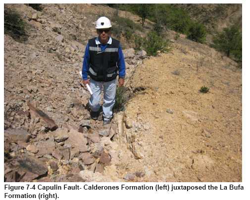
| Page 7-12 |
| UNIDAD ELCUBO GUANAJUATO, MÉXICO NI 43-101 TECHNICAL REPORT |
![]()
Figure 7-5 View looking north toward the El Tajo mill and Dolores adit showing trace of Dolores vein contact between La Bufa Rhyolite and Calderones Formation and exploration drilling platforms.
| Page 7-13 |
| UNIDAD ELCUBO GUANAJUATO, MÉXICO NI 43-101 TECHNICAL REPORT |
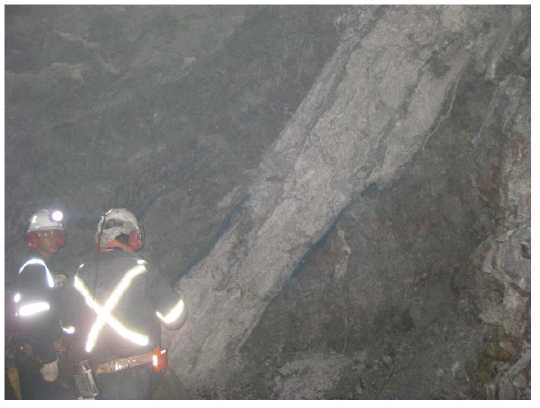
Figure 7-6 Dolores 2 vein, Area 2, showing width and dip of structure.
| 7.3.1 | Alteration |
All of the major veins at El Cubo show silicification halos. Intense silicification of the wall rocks of the San Nicolas vein system has contributed to it being a topographic high. Most of the Cubo-Peregrina rhyolite dome has a colour anomaly, with the grey surface bleached to white. The presence of abundant clay minerals in the upper levels of the El Cubo mine are consistent with acid sulphate alteration due to boiling. Grey sericite alteration is more typical of deeper halos. This sericite alteration is especially noticeable on the Villalpando vein where the Guanajuato Formation conglomerate is pale grey in color. The grey alteration contrasts with the dark chloritic alteration that is most noticeable in the andesitic | |
Calderones tuff. Adularia is present in the El Cubo veins and is more common in the northwest striking veins. The author noted amethyst gangue in some abundance in the Dolores, San Francisco, and Villalpando veins, representing occurrence over a vertical range of over 450 m (Figure 7-7). |
| Page 7-14 |
| UNIDAD ELCUBO GUANAJUATO, MÉXICO NI 43-101 TECHNICAL REPORT |
Alteration of the wall rock is intense and can be a useful guide in prospecting.
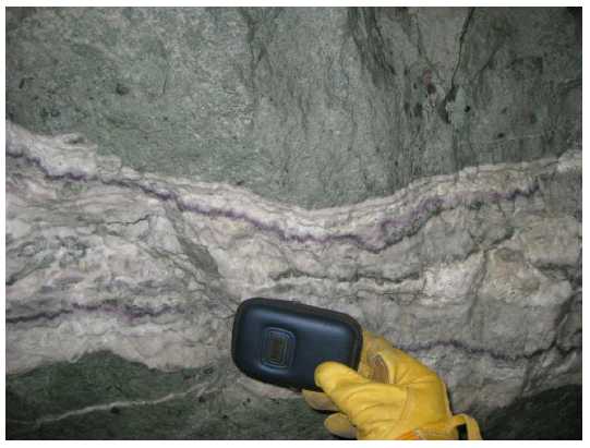
Figure 7-7 San Francisco Vein, Stope 3-430, showing principal banded quartz-amethyst vein.
| 7.4 | Mineralization |
Mineralized veins at El Cubo consist of the classic banded and brecciated epithermal variety. Silver occurs primarily in dark sulfide-rich bands within the veins, with little mineralization within the wall rocks. The major metallic minerals reported include pyrite, argentite, electrum and ruby silver, as well as some galena and sphalerite, generally deeper in the veins. Mineralization is generally associated with phyllic (sericite) and silicification alteration which forms haloes around the mineralizing structures. The vein textures are attributed to the brittle fracturing-healing cycle of the fault-hosted veins during and/or after faulting. |
| Page 7-15 |
| UNIDAD ELCUBO GUANAJUATO, MÉXICO NI 43-101 TECHNICAL REPORT |
Most production is extracted from two of the principal district vein systems, the Veta Madre (Las Torres lease only) and La Sierra (El Cubo mine), which are illustrated in Figure 7-1 and Figure 7-3. Economic concentrations of precious metals are present in “shoots” distributed vertically and laterally between non-mineralized segments of the veins. Vein intersections are locally the site of important historic bonanzas, notably the San Nicolas-Villalpando intersection, nearly perpendicular, and the intersections of various named splays along the principal El Cubo vein, the Villalpando vein. Overall, the style of mineralization is pinch-and-swell with some flexures resulting in closures and others generating wide sigmoidal breccia zones.
Primary economic mineralization at El Cubo is gold and silver. During World War II, some selenium was recovered and sold (Clark, 2009). Base metal values are generally absent, except for small amounts of chalcopyrite. El Cubo appears to be a low sulfidation system with pyrite but no arsenopyrite.
The silver-rich veins, such as Villalpando, contain quartz, adularia, pyrite, acanthite, naumannite and native gold. Native silver is widespread in small amounts. Much of the native silver is supergene. Silver sulfosalts (pyrargyrite and polybasite) are commonly found at depth. Gold rich veins, such as San Nicolas, contain quartz, pyrite, minor chalcopyrite and sphalerite, electrum, and aguilarite.
A vertical mineralogical zonation occurs in the vein system. The upper-levels are acanthite + adularia + pyrite + electrum + calcite + quartz and the lower-levels are chalcopyrite + galena + sphalerite + adularia + quartz + acanthite.
The gold/silver ratio in the more gold-rich veins typically ranges from 1:15 to 1:30. The gold/silver ratio in the silver rich veins typically ranges from 1:60 to 1:150, and sometimes higher. The overall gold/silver ratio for the 41 veins included in the resources and reserves is 1:64. The metal zoning appears to be related, at least in part, to elevation. Ranges for gold/silver ratios at El Cubo vary from 1:10 to 1:20 in upper mine levels, from 1:40 to 1:50 in middle mine levels; and 1:100 to 1:150 at depth. Veins are barren below an elevation of about 1800 m.
| Page 7-16 |
| UNIDAD ELCUBO GUANAJUATO, MÉXICO NI 43-101 TECHNICAL REPORT |
| 8.0 | DEPOSIT TYPES |
The Guanajuato silver-gold district is characterized by classic, high grade silver-gold, epithermal vein deposits with low sulfidation mineralization and adularia-sericite alteration. The Guanajuato veins are typical of most epithermal silver-gold vein deposits in Mexico with respect to the volcanic or sedimentary host rocks and the paragenesis and tenor of mineralization. | |
Epithermal systems form near the surface, usually in association with hot springs, and to depths on the order of a few hundred metres. Hydrothermal processes are driven by remnant heat from volcanic activity. Circulating thermal waters rising up through fissures eventually reach a level where the hydrostatic pressure is low enough to allow boiling to occur. This can limit the vertical extent of the mineralization, as the boiling and deposition of minerals is confined to a relatively narrow range of thermal and hydrostatic conditions. In many cases, however, repeated healing and reopening of host structures can occur, imparting cyclical vertical movement of the boiling zone and resulting in mineralization that spans a much broader range of elevation. | |
As the mineralizing process is driven by filling of void spaces and fissures, mineralization geometry is affected by the permeability and orientation of the host structures. Mineralization tends to favour dilatant zones in areas where fractures branch or change orientation, which may be driven, in turn, by wall rock competency and/or relative hardness of individual strata. | |
Low-sulfidation epithermal veins in Mexico typically have a well-defined, sub- horizontal ore horizon about 300 m to 500 m in vertical extent, where high grade ore shoots have been deposited by boiling hydrothermal fluids. The minimum and maximum elevations of the mineralized horizons at the El Cubo mine have not yet been established precisely, but historic and current production spans an elevation range from 1850 to 2650 m. | |
Silver and gold are generally zoned to some extent in epithermal vein deposits, and mineralization at El Cubo is no exception. The gold-to-silver ratio varies from 1:30 in the upper reaches of the deposit (typified by San Nicolas, Area 1) to 1:100 in the deeper parts of the mine (typified by Peregrina, Area 4, and Dolores 2, Area 2). |
| Page 8-1 |
| UNIDAD ELCUBO GUANAJUATO, MÉXICO NI 43-101 TECHNICAL REPORT |
Low-sulfidation deposits are formed by the circulation of hydrothermal solutions that are near neutral in pH, resulting in very little acidic alteration with the host rock units. The characteristic alteration assemblages include illite, sericite and adularia that are typically hosted either by the veins themselves or in the vein wall rocks. The hydrothermal fluid can travel along discrete fractures creating vein deposits, or it can travel through permeable lithology such as poorly welded ignimbrite flows, where it may deposit its load of precious metals in a disseminated fashion. In general, disseminated mineralization is found some distance from the heat source.
| Page 8-2 |
| UNIDAD ELCUBO GUANAJUATO, MÉXICO NI 43-101 TECHNICAL REPORT |
| 9.0 | EXPLORATION |
| 9.1 | 2014 Mine Exploration |
The mine conducted drilling programs on a number of targets related to veins which are being exploited, and spent US $1,584,694 as detailed in Table 9-1 and Table 9-2. The mine drilling occurred on underground in 2014 and is discussed in more detail in Section 10 of this report. |
Table 9-1
Summary of the 2014 Expenditures for the El Cubo Underground Exploration Program
| Area / Description | US$ |
| Assays | 77,056 |
| Consultants | 120 |
| Diamond drilling | 544,133 |
| Diamond Drilling in House | 304,171 |
| Exploration development | 288,557 |
| Field | 2,409 |
| Office Supplies & Equipment | 6,392 |
| Geology and engineering personnel | 243,241 |
| Salaries | 111,739 |
| Gas | 4,505 |
| Repair & Maintenance | 2,372 |
| Mine Exploration Subtotal | 1,584,694 |
| Grand Total | 1,584,694 |
Table 9-2
Mine Exploration Drilling Activities in 2014
| Project Area | Number of Holes | Total Metres | Number of Samples Taken |
| Mine Exploration | 58 | 10,892.80 | 3669 |
| Total | 58 | 10,892.80 | 3,669 |
| Page 9-1 |
| UNIDAD ELCUBO GUANAJUATO, MÉXICO NI 43-101 TECHNICAL REPORT |
| 9.2 | 2014 Surface Exploration |
In 2014, Endeavour Silver spent US $3,908,846 (including property holding costs) on exploration activities mainly in the Asunción and Villalpando South areas, as detailed in Table 9-3. |
Table 9-3
Summary of the 2014 Expenditures for the El Cubo Surface Exploration Program
| Area / Description | US$ |
| ASSAYS | 142,723 |
| GEOLOGY AND ENGINEERING PERSONNEL | 45,384 |
| SALARIES (SUBTOTAL) | 32,355 |
| GAS | 525 |
| REPAIR & MAINTENANCE | 1,445 |
| El Cubo Subtotal | 222,433 |
| ASSAYS | 155,683 |
| CONSULTANTS | 1,613 |
| DIAMOND DRILLING | 2,372,819 |
| FIELD | 21,800 |
| HOUSING | 17,175 |
| FOOD | 1,167 |
| OFFICE SUPPLIES & EQUIPMENT | 4,530 |
| GEOLOGY AND ENGINEERING PERSONNEL | 269,482 |
| ROADS AND DRILL PADS | 47,721 |
| SALARIES (SUBTOTAL) | 65,244 |
| TRAVEL & LODGING | 8,951 |
| GAS | 14,025 |
| REPAIR & MAINTENANCE | 16,485 |
| NO DEDUCIBLES | 12,931 |
| Asunción Subtotal | 3,009,628 |
| ASSAYS | 15,606 |
| DIAMOND DRILLING | 588,200 |
| FIELD | 1,252 |
| HOUSING | 1,991 |
| FOOD | 752 |
| GEOLOGY AND ENGINEERING PERSONNEL | 38,032 |
| Page 9-2 |
| UNIDAD ELCUBO GUANAJUATO, MÉXICO NI 43-101 TECHNICAL REPORT |
| ROADS AND DRILL PADS | 6,470 |
| SALARIES (SUBTOTAL) | 4,803 |
| TRAVEL & LODGING | 543 |
| GAS | 1,331 |
| REPAIR & MAINTENANCE | 1,060 |
| NO DEDUCIBLES | 832 |
| Villalpando Sur Subtotal | 660,872 |
| CONSULTANTS | 12,202 |
| CONTRACT PAYMENTS & FEES | 1,253 |
| ROADS AND DRILL PADS | 2,458 |
| Cabestrantes Subtotal | 15,914 |
| Grand Total | 3,908,846 |
| 9.3 | 2014 Surface Exploration Activities |
| 9.3.1 | Drilling |
During 2014, Endeavour Silver completed a total of 27,971.65 m in 69 surface diamond drill holes at the El Cubo Mines Project. A total of 5,967 samples were collected and submitted for assays. Surface exploration drilling undertaken during 2014 is summarized in Table 9-4. |
Table 9-4
Exploration Drilling Activities in 2014
| Project Area | Number of Holes | Total Metres | Number of Samples Taken |
| Asunción | 58 | 23,190.50 | 5,424 |
| Villalpando South | 11 | 4,781.15 | 543 |
| Total | 69 | 27,971.65 | 5,967 |
Surface diamond drilling was conducted by Layne de Mexico S.A. de C.V. (Layne), a wholly-owned subsidiary of the USA-base Layne Christensen Company (Layne Christensen). Neither Layne nor Layne Christensen holds an interest in Endeavour Silver and both are independent of the company.
| Page 9-3 |
| UNIDAD ELCUBO GUANAJUATO, MÉXICO NI 43-101 TECHNICAL REPORT |
| 9.3.2 | Other Surface Exploration Activities |
9.3.2.1.Surface Geological Mapping and Sampling
During 2014, the exploration activities were undertaken with the objective to define targets of interest with potential of mineralization for possible future drilling programs (Figure 9-1). These activities were mainly focused at the Cubo North areas; also activities were conducted on the Cubo Central and South.
Activities included geological mapping, trenching, soil geochemical grid and sampling. A total of 5,545 rock and soil samples were collected and sent for analysis.
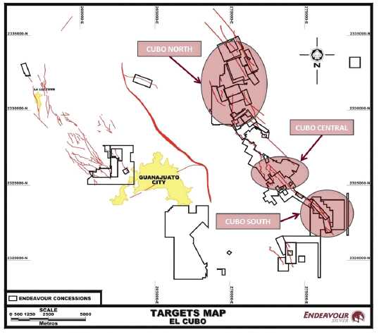
Figure 9-1 Surface Map showing Exploration Targets
| Page 9-4 |
| UNIDAD ELCUBO GUANAJUATO, MÉXICO NI 43-101 TECHNICAL REPORT |
Cubo North
During 2014, geological mapping, rock/soil geochemical sampling and trenching were conducted at the Cubo North area (Figure 9-2). Geological mapping was conducted over the trace of the Triunvirato, Barragana, Pasadena de los Alisos, Del Monte, La Loca, San Cosme and the projection of Villalpando North veins; also detailed mapping was conducted on the San Amado Mine. A total of 4,233 rock/soil samples were collected and submitted for analysis. Assay results are shown in Table 9-3 through Table 9-9.
Monte San Nicolas
TheLa Loca vein was traced inside the EDR concessions. The vein was not located in the areas as most of the area is covered by alluvium, however some minor structures were sampled; no significant results returned.
In theBarragana area some adits were located and in one of them a structure is visible with a width of 0.75 m, mainly consisting of Quartz-Calcite+Fe-Mn (Ox). In the area was also located a working approximately 5 m in depth which intercepted the Barragana vein (Figure 9-4).
In theTriunvirato area was located an adit (Figure 9-5, left) developed for approximately 80 m, which intercepts a formal massive white quartz structure with disseminated Pyrite; the development with an inaccessible level (flooded). In the area it was mapped a mine working, made for the Triunvirato vein (Figure 9-5); in a cross-cut it was located a flooded “contrapozo” over the main vein; the mineralogy consisted of Quartz (white) + Calcite (minor) + FeOx. The mine working is around 70 m deep, trending NE55º, did not intercepted the main vein, but there are several NW trending structures in the system with the presence of disseminated Pyrite and traces of dark minerals were observed.
TheSan Cosme vein was located and traced; the structure does not outcrop. At the SE part, it was located a small mine working, which consisted of a heading of about 7 m in depth, at the end, it intercepted a structure with secondary system NE-SW and dipping SE, namedRosalba, consisting of a fault with the presence of gauge + silicified volcanic fragments + minor Quartz; worked for around 12 m; near the workings its located a shaft, apparently deep but is completely flooded. At the NW end of the San Cosme vein trace was located a strong fault with intense argillization and silica zones, this zone is up to 5 m wide (Figure 9-6). The fault it’s aligned to a creek, which is over the trace of the vein. It was not possible to follow the trace at North due it’s covered by organic material and it’s not possible to observe the outcrop or alteration zones. In the creeks near to the San Cosme Fault were observed faults trending N-S (perpendicular to the main fault).
| Page 9-5 |
| UNIDAD ELCUBO GUANAJUATO, MÉXICO NI 43-101 TECHNICAL REPORT |
Over the trace of thePasadena de los Alisos vein, a structure approximately 530 m long, which is presented as a fault plane with argillic zones and the presence of Quartz (crystalline) and some silica zones + FeOx. In the SE part there is a heading (Figure 9-7, left), developed with the trend of the structure (flooded).
In the area was also located a mine working (adit), developed to intercept theDel Monte Vein or San Juan Vein, the working its developed for around 100 m long, with a cross cut which intercepts the main vein. The structure mineralogically consisted of a brecciated and stockwork zone with Quartz (white and crystalline); some parts with Calcite, disseminated Pyrite, presence of Argentite and minor Fe-Mn (Ox) (Figure 9-7, right). On surface, over the zone, it’s not possible to locate evidences of the structure because it’s covered by alluvium or organic material. Also some old workings, catas and shafts were located.
Geological mapping and sampling was conducted at south of thePalomas Claim(Figure 9-8); in the area it was located a stockwork zone, with a secondary system NE, related to the Encino vein. These structures are small <20 cm and consisted of white Quartz and minor Calcite + Fe (Ox); located mainly in the contacts between Esperanza Formation-Andesite (Figure 9-9Figure 9-9). Also in the area were located some alteration zones (silicification and argillization), with presence of veinlets of Quartz (white) and limonite. At West were located some slag dumps (Figure 9-10), which could mean that smelting activities were conducted in the zone. In the area was located an important zone of moderate silica (Figure 9-11, left), with a main structure NW-SE of white Quartz + disseminated Pyrite (~0.5 -1%)+FeOx+hematite+goetite+traces of Gn. Sampling was conducted on important zones of argillic alteration + moderate Oxidation (Figure 9-11, right), over the road on the Las Palomas area.
| Page 9-6 |
| UNIDAD ELCUBO GUANAJUATO, MÉXICO NI 43-101 TECHNICAL REPORT |
Villalpando North
Reconnaissance mapping was conducted in theHuematzin-La Libertad-El Durazno-Canta Ranasareas (Figure 9-12 and Figure 9-13); in the area were located some old workings, which most of them are inaccessible, it was identified the shaft and working “La Libertad”. In the Canta Ranas area the Purísima zone was located and 6 workings and 2 main shafts were identified, with around 50 to 60 m depth (Figure 9-14, left). The workings were inaccessible. In the Libertad area, mapping was conducted on workings and shafts, with two main workings, it was located an important Fault zone, at the footwall with an important alteration zone (Figure 9-14, right). In the Huematzin Claim was located a main structure (Fault), trending NE-SW, dipping 76ºW (Figure 9-15). The structure consisted of moderate silica + abundant FeOx + MnO + weak oxidation + disseminated Pyrite (~0.5%) following a NE trend with the main structures of the Encino.
Geological mapping was conducted over theVillalpando Vein in the North part of El Cubo Claims, from the La Libertad portal (Figure 9-16). A total of 1 km long was mapped. It was located some old workings (8 shafts, 1 working, 1 cata, 1 heading, 1 stope) over the Villalpando trend, with an average width of 0.20 m and preferential dip 65ºW.
Geological mapping and sampling was conducted on theSan Amado Mine (Figure 9-17) and the Edelmira II Claim. Sampling was conducted over 5 structures, which are of great interest due to some of them are hosted in shale horizons (the structures tend to have low dips controlled by this horizons). Inside the mine are 5 structures, all parallels with a trend NNW. In the two hanging wall structures the dip are controlled by sedimentary rocks, from 35º to 40º; while in the other 3 structures the dip goes from 40º to 50º. The structures consisted mainly of stockwork zones with veinlets of Quartz (white, massive), with zones were the Argentite is visible (Figure 9-18, left), in the areas al located a few zones were the structure is formal, however it’s not discarded the possibility that to depth the structures get formal with considerable widths. According with the information gathered in the mine, it’s possible that the structures that generated more resources are the “frente 4” to “frente 6”, because the structures are more formal and its visible the Argentite and/or some other dark minerals. In the “frente 4” south there are values from 1.3 g/t Au and 700 g/t Ag. Also some small workings were located, mainly “catas” and shafts, most of them inaccessible (Figure 9-18, centre). These were located at the footwall of the San Amado structures; which is why are suggested the existence of secondary structures in this area.
| Page 9-7 |
| UNIDAD ELCUBO GUANAJUATO, MÉXICO NI 43-101 TECHNICAL REPORT |
In theEdelmira II Claim, geological mapping, trenching and sampling commenced in the Edelmira Zone; in the area were located theRosita and Edelmirastructures, trending NW-SE. A total of one trench was made with 28 rock samples collected; no significant results returned. The Edelmira vein-fx with an average width of 0.2 m, with general dip 60ºW, with a mapped are of around ~100m (Figure 9-18, right). The Rosita Vein-Fx with an average width of 0.2 m, with a general dip of 55ºE; the area it’s covered by vegetation, in the area was constructed a trench to see the structure.
TheRosita vein was traced towards the NW part, after trench TMN-13. In the area were located two possible evidences of continuity at this part; the first one (Figure 9-19, left) as a Fault zone with presence of Quartz, Calcite and clay, 50 m from the last adit previously located; and the second (Figure 9-19, right) at 100 m of the last one as a Vein of 0.15 m width with Quartz (white), Calcite and Clay. Also a trenching program (with 49 rock samples collected) was conducted over the Rosita and Villalpando North veins; no evidence of the structures was located, only argillic alteration zones were defined with weak oxidation.
Trenching Program
The trenching program included:
| • | Cizaya San Cosme: A total of 2 trenches with 30 samples. | |
| • | Triunvirato (Figure 9-20): A total of 5 trenches were completed and 124 samples. | |
| • | Cerro Alto vein (La Libertad): A total of 3 trenches and 45 samples. | |
| • | Edelmira: A total of 3 trenches with 43 samples. | |
| • | Canta Ranas: A total of 2 trenches with 34 samples. |
Geochemical Grid
Also, geochemical soil/rock sampling grid was conducted in the Cubo North area (Figure 9-20 right, Figure 9-21). Data was contoured; the best geochemical anomalies were defined by gold, silver, arsenic, copper, mercury, manganese and zinc (Figure 9-22 through Figure 9-26).
| Page 9-8 |
| UNIDAD ELCUBO GUANAJUATO, MÉXICO NI 43-101 TECHNICAL REPORT |
Table 9-5
Significant Assays for Rock sampling in the Cubo North (Monte San Nicolas) area
| Sample_ID | Wide mts | Lote/Area | Structure | Description | Au (ppm) | Ag (ppm) | Cu (%) | Pb (%) | Zn (%) |
| CUB-110 | 0.70 | SOCAVON DE LOS ALISOS | Vein | Tace arg-int + arg-int + Fe (Ox) + Qz bco & crist | 0.18 | 12 | 0.0065 | 0.0021 | 0.0084 |
| CUB-122 | 0.20 | LUISA EVELIA | TriunviratoVein (?) | Qz bco txt Ma + presencia de min obsc + trazas Py diss | 0.02 | 1 | 0.0008 | 0.0009 | 0.0013 |
| CUB-123 | 0.20 | LUISA EVELIA | TriunviratoVein (?) | Zona de Sw con vtlls Qz bco + sil-mod + trazas Py diss | 0.05 | 2 | 0.0045 | 0.0008 | 0.0069 |
| CUB-151 | 0.20 | LUISA EVELIA | Terrero | Qz bco txt Ma + trazas Py diss | 0.14 | 16 | 0.0004 | 0.0006 | 0.0015 |
| CUB-173 | 0.70 | LUISA EVELIA | San Juan Vein | Zona de bx + fragms volcs (Tace) + Qz bco + Py diss <1% | 0.01 | 1 | 0.0017 | 0.0002 | 0.0036 |
| CUB-179 | 0.20 | LUISA EVELIA | Tace txt Fg + Fe (Ox) | 1.66 | 1285 | 0.1660 | 0.0291 | 0.0302 | |
| CUB-180 | 0.20 | LUISA EVELIA | Fault | Fag con Fe (Ox) + Py diss <1% | 0.04 | 5 | 0.0117 | 0.0004 | 0.0097 |
| CUB-181 | 0.20 | LUISA EVELIA | Vein | Qz bco ligeramente ban + Py diss <1% + trazas Arg | 0.04 | 6 | 0.0025 | 0.0002 | 0.0033 |
| CUB-189 | 0.65 | SOCAVON DE LOS ALISOS | Tace. Zona arg-mod + vtlls Qz bco + Fe (Ox) | 0.44 | 43 | 0.0055 | 0.0012 | 0.0020 | |
| CUB-202 | 0.90 | PASADENA | Vein | Qz bco txt Ma + Fe (Ox) | 0.01 | 1 | 0.0003 | <0.0002 | 0.0013 |
| CUB-206 | 0.80 | PASADENA | Tca con arg-int + Fe (Ox) + esc Qz bco & crist | 0.49 | 236 | 0.0077 | 0.0128 | 0.0163 | |
| CUB-207 | 1.70 | PASADENA | Tca con arg-int + Fe (Ox) + esc Qz bco & crist | 0.14 | 84 | 0.0050 | 0.0056 | 0.0099 | |
| CUB-317 | 0.20 | EL CHUPIRO | Terrero | Qz bco + Pirolusita + Fe (Ox) + trazas de min obscuros | 0.79 | 269 | 0.0050 | 0.0113 | 0.0242 |
| CUB-339 | 0.30 | EL CHUPIRO | Vein/ Stokwork | Zona de stockwork-vtlls Qz bco + Pirolusita + arg-mod | 0.01 | 1 | 0.0042 | 0.0002 | 0.0021 |
| CUB-346 | 0.20 | EL CHUPIRO | Terrero | Qz bco + esc Fe (Ox) | <0.05 | 40 | 0.0018 | 0.0050 | 0.0098 |
| CUB-365 | 0.50 | SN JUAN TACUITAPA | Fault | Zona Sw-vtlls Qz bco + Fe (Ox) + arg&sil-mod | <0.05 | 29 | 0.0066 | 0.0139 | 0.0129 |
| CUB-375 | 0.30 | SN JUAN TACUITAPA | Andesita txt Fg + vtlls Qz bco + Fe (Ox) | 304.00 | 290 | 0.0019 | 0.0024 | 0.0062 | |
| CUB-377 | 0.65 | SN JUAN TACUITAPA | Andesita txt Fg + vtlls mm Qz bco | 9.50 | 20 | 0.0032 | 0.0014 | 0.0106 | |
| CUB-380 | 0.90 | SN JUAN TACUITAPA | Fault | Ry txt Fg + sil-mod + Qz bco | 0.01 | 11 | 0.0003 | 0.0006 | 0.0057 |
| CUB-381 | 0.70 | SN JUAN TACUITAPA | Ry txt Fg | 0.07 | 46 | 0.0015 | 0.0006 | 0.0077 | |
| CUB-390 | 0.20 | SN JUAN TACUITAPA | Terrero | Qz bco txt bx & drusas + trazas min obsc | 1.40 | 95 | 0.0038 | 0.0071 | 0.0056 |
| CUB-392 | 0.20 | EL CHUPIRO | Rodados | Qz lechoso txt amorfo + esc Fe (Ox) | <0.05 | 53 | 0.0169 | 0.0067 | 0.0095 |
| CUB-444 | 0.30 | SN JUAN TACUITAPA | Del MonteFault (?) | Andesita con ligera bx + sil-mod + vtlls Cca-Qz | 0.01 | 1 | 0.0019 | 0.0007 | 0.0086 |
| CUB-445 | 0.55 | SN JUAN TACUITAPA | Del MonteFault (?) | Vtlls Cca-Qz + sil-mod + trazas de min obsc | 0.02 | 1 | 0.0012 | 0.0006 | 0.0076 |
| CUB-564 | 0.40 | LAS PALOMAS | Andesita txt Fg + Fe-Mn (Ox) | <0.05 | 29 | 0.0181 | 0.0536 | 0.2050 | |
| CUB-565 | 0.25 | LAS PALOMAS | Fault | Andesita txt Fg + ox-int + limolita | 0.01 | 14 | 0.0633 | 0.0221 | 0.0865 |
| CUB-714 | 0.20 | LAS PALOMAS | Escoria | 0.13 | 31 | 0.3380 | 6.0700 | 0.5240 | |
| CUB-715 | 0.20 | LAS PALOMAS | Terrero | Andesita txt Fg + Fe (Ox) + arg-mod | 0.10 | 12 | 0.0627 | 0.6870 | 0.0608 |
| Page 9-9 |
| UNIDAD ELCUBO GUANAJUATO, MÉXICO NI 43-101 TECHNICAL REPORT |
Table 9-6
Significant Assays for Rock sampling in the Cubo North (Monte San Nicolas) area
| Sample_ID | Width mts | Lote/Area | Structure | Description | Au (ppm) | Ag (ppm) | Cu (%) | Pb (%) | Zn (%) |
| CUB-716 | 0.20 | LAS PALOMAS | Terrero | Andesita txt Fg + Fe (Ox) + arg-mod | 0.48 | 155 | 0.0800 | 0.9590 | 0.0583 |
| CUB-717 | 0.20 | LAS PALOMAS | Terrero | Andesita txt Fg + Fe (Ox) + arg-mod | 0.30 | 36 | 0.0976 | 2.8400 | 0.0724 |
| CUB-718 | 0.20 | LAS PALOMAS | Terrero | Andesita txt Fg + Fe (Ox) + arg-mod | 0.20 | 23 | 0.0940 | 3.3900 | 0.0515 |
| CUB-954 | 0.25 | LAS PALOMAS | Vein | Vein+Qz bco+FeOx+Ox intensa+AgS(?)+diss Py | 0.01 | 1 | 0.0024 | 0.0004 | 0.0029 |
| LC-418 | 0.20 | LA LOCA | Rodados | Qz bco + Py diss 1% | 0.90 | 10 | 0.0177 | 0.0004 | 0.0020 |
| LC-427 | 0.20 | LA LOCA | Rodados | Qz-Cca | 1.15 | 58 | 0.0006 | 0.0008 | 0.0013 |
| LC-429 | 0.20 | LA LOCA | Vnlt | Qz txt oquerosa + Fe (Ox) | 0.16 | 10 | 0.0025 | 0.0045 | 0.0091 |
| LC-436 | 0.30 | LA LOCA | POSS TRAZA LA LOCAVEIN (?) | 0.03 | 1 | 0.0051 | 0.0007 | 0.0077 | |
| TR-13 | 0.30 | TRIUNVIRATO | TRIUNVIRATO VEIN | Vtll Qz bco + Fe (Ox) | 0.05 | 2 | 0.0026 | 0.0006 | 0.0047 |
| TR-14 | 0.25 | TRIUNVIRATO | TRIUNVIRATO VEIN | Zona arg-int + Fe (Ox) | 0.08 | 12 | 0.0036 | 0.0004 | 0.0055 |
| TR-23 | 0.90 | TRIUNVIRATO | TRIUNVIRATO VEIN | Zona de bx + vtlls Qz bco + arg- mod | 0.03 | 3 | 0.0070 | 0.0007 | 0.0074 |
| TR-31 | 0.50 | TRIUNVIRATO | PROYECCIONTRIUNVIRATO VEIN | Arg-int + Fe (Ox) | 0.09 | 2 | 0.0048 | 0.0009 | 0.0116 |
| TR-60 | 0.20 | TRIUNVIRATO | Fault | Zona arg-int + Fe (Ox) + Qz crist | 0.18 | 19 | 0.0027 | 0.0038 | 0.0106 |
| BG-01 | 0.20 | BARRAGANA | Terrero | Cca-Qz + esc Mn (Ox) | 0.29 | 7 | 0.0004 | 0.0004 | 0.0012 |
| BG-15 | 0.30 | BARRAGANA | BARRAGANA VEIN | Qz bco txt oquerosa + Fe (Ox) | 0.25 | 2 | 0.0033 | 0.0009 | 0.0054 |
| BG-18 | 0.20 | BARRAGANA | BARRAGANA VEIN | Qz bco txt oquerosa + Fe (Ox) | 0.54 | 2 | 0.0011 | 0.0002 | 0.0021 |
| BG-28 | 0.60 | BARRAGANA | VNLT | Qz bco + Fe (Ox) | 0.12 | 24 | 0.0051 | 0.0421 | 0.0389 |
| BG-31 | 0.30 | BARRAGANA | TRIUNVIRATO VEIN | Qz bco & crist + Fe (Ox) | 0.09 | 14 | 0.0003 | 0.0004 | 0.0012 |
| BG-32 | 0.20 | BARRAGANA | Tce | 0.48 | 38 | 0.0094 | 0.0015 | 0.0101 | |
| COS-01 | 0.30 | SAN COSME | VEINLET´S | Qz-Cca | 0.23 | 20 | 0.0049 | 0.0008 | 0.0071 |
| RS-01 | 0.50 | ROSALBA | Tce | 0.28 | 15 | 0.0155 | 0.0010 | 0.0122 | |
| AL-04 | 0.20 | LOS ALISOS | Vein | Qz bco + esc Fe (Ox) | 0.02 | 12 | 0.0007 | 0.0022 | 0.0031 |
| AL-07 | 0.20 | LOS ALISOS | Vein | Qz bco + esc Fe (Ox) | 0.11 | 20 | 0.0008 | 0.0013 | 0.0021 |
| Page 9-10 |
| UNIDAD ELCUBO GUANAJUATO, MÉXICO NI 43-101 TECHNICAL REPORT |
Table 9-7
Significant Assays for Rock sampling in the Cubo North area
| Sample ID | Width mts | Area | Structure | Description | Au (ppm) | Ag (ppm) | Cu (%) | Pb (%) | Zn (%) |
| CUB- 1777 | 0.20 | HUEMATZIN | Terrero | Andesita+Qz Bco+MnO+diss Py(<0.5%)+Ox debil | 0.13 | 243 | 0.0046 | 0.0107 | 0.0181 |
| CUB- 1792 | 0.65 | HUEMATZIN | Tace+Arg-Ox mod+MnO | <0.05 | 241 | 0.0061 | 0.0073 | 0.0464 | |
| CUB- 1796 | 0.35 | HUEMATZIN | Vein | Vein Qz lechoso+FeOx+Ox mod+MnO | <0.05 | 114 | 0.0025 | 0.0011 | 0.0121 |
| CUB- 1797 | 0.40 | HUEMATZIN | Vein | Vein Qz lechoso+FeOx+Ox mod+MnO | <0.05 | 316 | 0.0093 | 0.0022 | 0.0152 |
| CUB- 1438 | 0.25 | LA LIBERTAD | Vein | Vein Qz Bco+FeOx+Ox moderada+FeOx | 0.70 | 185 | 0.0032 | 0.0018 | 0.0035 |
| CUB- 1808 | 0.30 | HUEMATZIN-LA LIBERTAD | Zona Silica mod+MnO+FeOx abundante+Ox moderada+fragmentos Qz Bco | <0.05 | 956 | 0.0018 | 0.0049 | 0.0116 | |
| CUB- 1825 | 0.55 | HUEMATZIN-LA LIBERTAD | Tace+Ox moderada+MnO+FeOx+Arg deb- mod+frag Qz lechoso | 0.36 | 305 | 0.0045 | 0.0100 | 0.0478 | |
| CUB- 1827 | 0.75 | HUEMATZIN-LA LIBERTAD | Veinlets | Veinlets Qz +MnO+FeOx+Ox mod+Arg deb | 0.10 | 204 | 0.0031 | 0.0051 | 0.0613 |
| CUB- 1832 | 0.35 | HUEMATZIN-LA LIBERTAD | Veinlets | Veinlets Qz lechoso+FeOx+MnO+Ox moderada+silica mod | 0.64 | 493 | 0.0027 | 0.0086 | 0.0124 |
| CUB- 1851 | 0.25 | HUEMATZIN-LA LIBERTAD | Vein | Vein Qz bco+Arg-Ox mod- intensa+MnO+FeOx | 0.78 | 128 | 0.0050 | 0.0171 | 0.0222 |
| CUB- 1911 | 0.50 | HUEMATZIN-LA LIBERTAD-EL DURAZNO | Veinlets | Veinlets Qz lechoso+FeOx+MnO+Ox moderada | 0.34 | 146 | 0.0043 | 0.0083 | 0.0365 |
| CUB- 1912 | 0.40 | HUEMATZIN-LA LIBERTAD-EL DURAZNO | Veinlets | Veinlets Qz lechoso+FeOx+MnO+Ox moderada | 0.41 | 145 | 0.0021 | 0.0089 | 0.0146 |
| CUB- 1914 | 0.40 | HUEMATZIN-LA LIBERTAD-EL DURAZNO | Veinlets | Veinlets Qz lechoso+FeOx+MnO+Ox moderada | 0.67 | 140 | 0.0035 | 0.0213 | 0.0229 |
| CUB- 1915 | 0.20 | HUEMATZIN-LA LIBERTAD-EL DURAZNO | Fault | Fx+Silica moderada+Qz Bco+FeOx+MnO+Ox moderada | 0.64 | 239 | 0.0045 | 0.0544 | 0.0364 |
| CUB- 1964 | 0.30 | HUEMATZIN-LA LIBERTAD-EL DURAZNO | La LibertadFault | Zona Fx+Ox mod+ vetillas Qz Bco abundante+FeOx+MnO | <0.05 | 299 | 0.0017 | 0.0013 | 0.0087 |
| CUB- 1965 | 0.40 | HUEMATZIN-LA LIBERTAD-EL DURAZNO | La LibertadFault | Zona Fx+Ox mod+ vetillas Qz euhedrales+FeOx+MnO+Ox mod-intensa | <0.05 | 166 | 0.0023 | 0.0013 | 0.0148 |
| CUB- 1972 | 0.30 | HUEMATZIN-LA LIBERTAD-EL DURAZNO- CANTARANAS | Zona Silica mod+Arg moderada+MnO+FeOx | 1.25 | 588 | 0.0247 | 0.0119 | 0.0116 | |
| CUB- 1982 | 0.20 | HUEMATZIN-LA LIBERTAD-EL DURAZNO | Vein(?) | Zona Ox moderada- intensa+FeOx+Mno+Qz bco | 0.59 | 116 | 0.0122 | 0.0046 | 0.0319 |
| CUB- 1995 | 0.40 | HUEMATZIN-LA LIBERTAD-EL DURAZNO | Vein | Vein Qz Bco+FeOx+MnO+Ox moderada- intensa | 0.97 | 186 | 0.0082 | 0.0062 | 0.0124 |
| CUB- 1999 | 0.35 | HUEMATZIN-LA LIBERTAD-EL DURAZNO | Vnlt | Veintless Qz bco+FeOx abundante+pirolusita+Ox mod-intensa | 1.57 | 296 | 0.0094 | 0.0082 | 0.0169 |
| CUB- 2000 | 0.35 | HUEMATZIN-LA LIBERTAD-EL DURAZNO | Vnlt | Veintless Qz bco+FeOx abundante+pirolusita+Ox mod-intensa | 1.70 | 467 | 0.0098 | 0.0093 | 0.0171 |
| CUB- 2064 | 0.40 | NUEVO GUERRERO | NvoGuerreroVein | Vtlls Qz bco Ma + trazas de Py diss <1% + min obsc | 0.17 | 101 | 0.0010 | 0.0022 | 0.0075 |
| CUB- 2067 | 0.90 | NUEVO GUERRERO | NvoGuerreroVein | Sw1. Vtlls Qz bco + Pirolusita + trazas min obsc | 0.20 | 138 | 0.0012 | 0.0047 | 0.0098 |
| CUB- 2083 | 0.20 | NUEVO GUERRERO | NvoGuerreroVein | Qz bco Ma + Py diss 1% + min obsc | 0.51 | 255 | 0.0012 | 0.0022 | 0.0147 |
| CUB- 2103 | 0.20 | HUEMATZIN-LA LIBERTAD-EL DURAZNO | Terrero | Qz bco+FeOx | 0.43 | 123 | 0.0044 | 0.0063 | 0.0126 |
| Page 9-11 |
| UNIDAD ELCUBO GUANAJUATO, MÉXICO NI 43-101 TECHNICAL REPORT |
| CUB- 2104 | 0.20 | HUEMATZIN-LA LIBERTAD-EL DURAZNO | Terrero | Qz bco+FeOx | 1.39 | 412 | 0.0059 | 0.0082 | 0.0173 |
| Page 9-12 |
| UNIDAD ELCUBO GUANAJUATO, MÉXICO NI 43-101 TECHNICAL REPORT |
Table 9-8
Significant Assays for Rock sampling in the Cubo North area
| Sample_ID | Wide mts | Area | Structure | Description | Au (ppm) | Ag (ppm) | Cu (%) | Pb (%) | Zn (%) |
| CUB-2105 | 0.20 | HUEMATZIN-LA LIBERTAD-EL DURAZNO | Terrero | Mpe+Qz bco+traza min obscuros | 0.38 | 130 | 0.0060 | 0.0032 | 0.0104 |
| CUB-2106 | 0.20 | HUEMATZIN-LA LIBERTAD-EL DURAZNO | Terrero | Mpe+Qz bco+traza min obscuros | 0.59 | 184 | 0.0072 | 0.0055 | 0.0177 |
| CUB-2107 | 0.20 | HUEMATZIN-LA LIBERTAD-EL DURAZNO | Terrero | Mpe+Qz bco+traza min obscuros | 0.85 | 184 | 0.0045 | 0.0062 | 0.0157 |
| CUB-2111 | 0.20 | HUEMATZIN-LA LIBERTAD-EL DURAZNO | Vein | Vein Qz bco+FeOx+silica mod+FeOx+MnO+Arg mod | 0.07 | 227 | 0.0030 | 0.0014 | 0.0220 |
| CUB-2185 | 0.20 | HUEMATZIN-LA LIBERTAD-EL DURAZNO | Terrero | Mpe+Qz bco+silica mod | 0.78 | 247 | 0.0083 | 0.0052 | 0.0199 |
| CUB-2299 | 0.20 | HUEMATZIN-LIBERTAD- CANTARANAS | Terrero | Andesita+Qz bco | 0.07 | 119 | 0.0034 | 0.0088 | 0.0130 |
| CUB-2300 | 0.20 | HUEMATZIN-LIBERTAD- CANTARANAS | Terrero | Tace+Qz bco | 0.10 | 121 | 0.0034 | 0.0097 | 0.0075 |
| CUB-2308 | 0.20 | AMPL DE LA FRAGUA | Vein | Fag con vtlls Qz bco & crist + Mn (Ox) | 0.16 | 134 | 0.0036 | 0.0017 | 0.0819 |
| CUB-2318 | 0.20 | NUEVO GUERRERO | Terrero | Qz bco Ma + Arg diss <1% | 0.45 | 148 | 0.0005 | 0.0039 | 0.0094 |
| CUB-2319 | 0.20 | NUEVO GUERRERO | Terrero | Qz-Cca + poss trazas de Arg diss + Mn (Ox) | 0.37 | 126 | 0.0027 | 0.0046 | 0.0107 |
| CUB-2325 | 1.10 | NUEVO GUERRERO | And txt Fg + Py diss <1% + sil-mod | 1.02 | 427 | 0.0031 | 0.0072 | 0.0215 | |
| CUB-2359 | 0.20 | EDELMIRA-SAN AMADO MINE | Vein. Fte 4 Nte | Qz bco Ma + esc Fe (Ox) | 0.99 | 387 | 0.0058 | 0.0106 | 0.0386 |
| CUB-2400 | 0.20 | EDELMIRA-SAN AMADO MINE | Vein. Fte 4 Sur | And txt Fg + vtlls Qz bco Ma + Arg 2% + Py diss <1% | 1.28 | 700 | 0.0099 | 0.0521 | 0.1015 |
| CUB-2419 | 0.40 | EDELMIRA-SAN AMADO MINE | Vein. Fte 5 Nte | Qz bco Ma + Fag + Py diss <1% + trazas min obsc | 0.53 | 252 | 0.0037 | 0.0205 | 0.0360 |
| CUB-2426 | 0.30 | EDELMIRA-SAN AMADO MINE | Vein. Fte 5 Nte | Int vtll Qz bco Ma + Py diss <1% | 0.62 | 146 | 0.0024 | 0.0031 | 0.0081 |
| CUB-2442 | 0.20 | EDELMIRA-SAN AMADO MINE | Vein Fte 6 Nte | Qz bco Ma + Arg diss <1% | 0.37 | 161 | 0.0040 | 0.0029 | 0.0113 |
| CUB-2530 | 0.20 | EDELMIRA-SAN AMADO MINE | Terrero | Qz Bco+Py(~1%)+traza min obscuros | 0.27 | 317 | 0.0037 | 0.0055 | 0.0135 |
| CUB-2552 | 0.20 | EDELMIRA-SAN AMADO MINE | Terrero | Qz bco+traza min obscuros(?) | 0.07 | 244 | 0.0198 | 0.0105 | 0.0171 |
| CUB-2577 | 0.20 | EDELMIRA-SAN AMADO MINE | Terrero | Terrero Tace+Qz bco+traza min obscuros | 0.53 | 156 | 0.0088 | 0.0017 | 0.0125 |
| CUB-2578 | 0.20 | EDELMIRA-SAN AMADO MINE | Terrero | Terrero Tace+Qz bco+traza min obscuros | 0.20 | 231 | 0.0212 | 0.0081 | 0.0178 |
| CUB-2590 | 0.20 | EDELMIRA-SAN AMADO MINE | Terrero | Terrero Mpe+Qz bco | 0.30 | 221 | 0.0029 | 0.0056 | 0.0126 |
| CUB-2592 | 0.20 | EDELMIRA-SAN AMADO MINE | Terrero | Terrero Qz bco | 0.31 | 188 | 0.0034 | 0.0048 | 0.0151 |
| CUB-2653 | 0.60 | EDELMIRA-SAN AMADO MINE | Vein | Qz bco Ma + presencia de oquedades + Pirolusita | 0.22 | 160 | 0.0026 | 0.0012 | 0.0054 |
| CUB-2654 | 0.40 | EDELMIRA-SAN AMADO MINE | Vnlt | And txt Fg + arg-mod + vtlls Qz bco + Fe (Ox) | 9.93 | 491 | 0.0060 | 0.0186 | 0.0151 |
| CUB-2713 | 0.20 | EDELMIRA-SAN AMADO-LA SOLEDAD | Terrero Mina SanGuillermo | And txt Fg + vtlls Cca-Qz + esc min obsc | 0.74 | 426 | 0.0052 | 0.0063 | 0.0166 |
| CUB-2717 | 0.20 | EDELMIRA-SAN AMADO-LA SOLEDAD | Terrero Mina SanGuillermo | And txt Fg + vtlls Cca-Qz + esc min obsc | 0.43 | 236 | 0.0036 | 0.0052 | 0.0145 |
| CUB-410 | 0.40 | LIBERTAD-HUEMATZIN | El Encino(Stockwork) | Zona de vtlls Qz-Cca | 0.07 | 76 | 0.0057 | 0.0265 | 0.0985 |
| CUB-637 | 0.20 | CANTA RANAS | Vein | Vein+Ox moderada+arg deb+MnO+FeOx | 0.59 | 652 | 0.0678 | 0.0097 | 0.2760 |
| Page 9-13 |
| UNIDAD ELCUBO GUANAJUATO, MÉXICO NI 43-101 TECHNICAL REPORT |
Table 9-9
Significant Assays for Rock sampling in Trenches in the Cubo North area
| Trench | TrenchAreaLength | Strike | Lookingat | SampleID | SampleLength | Description | Au(ppm) | Ag(ppm) | Cu (%) | Pb (%) | Zn (%) |
| TMN- 04 | TRIUNVI 8.5 RATO | NE40°S W | NW | MN-46 | 1.0 | Zona Ox ligera | 0.01 | 0.2 | 0.0014 | 0.0006 | 0.0089 |
| MN-47 | 0.5 | Zona Ox moderada ligera+Mn(Ox)+limonita | 0.02 | 0.2 | 0.0015 | 0.0009 | 0.0079 | ||||
| MN-48 | 0.2 | Zona falla | 0.02 | 1.3 | 0.0009 | 0.0008 | 0.0060 | ||||
| MN-49 | 0.2 | Veta Qzo+FeOx | 0.02 | 0.2 | 0.0002 | 0.0002 | 0.0018 | ||||
| MN-50 | 0.4 | Zona de falla | 0.03 | 0.3 | 0.0014 | 0.0007 | 0.0075 | ||||
| MN-51 | 0.7 | Zona falla+ Fe(Ox) moderada+limonita | 0.02 | 0.3 | 0.0014 | 0.0006 | 0.0072 | ||||
| MN-52 | 0.6 | Zona Ox moderada | 0.01 | <0.2 | 0.0015 | 0.0006 | 0.0090 | ||||
| MN-53 | 1.0 | Zona Ox-arg deb+Mn(Ox) | 0.01 | <0.2 | 0.0016 | 0.0006 | 0.0085 | ||||
| MN-54 | 1.0 | Zona Ox-arg deb+Mn(Ox) | 0.01 | <0.2 | 0.0016 | 0.0008 | 0.0080 | ||||
| MN-55 | 1.0 | Zona Ox-arg deb+Mn(Ox) | 0.01 | <0.2 | 0.0015 | 0.0005 | 0.0083 | ||||
| MN-56 | 1.0 | Zona Ox deb+Mn(Ox)+limonita | 0.01 | <0.2 | 0.0015 | 0.0007 | 0.0069 | ||||
| TMN- 05 | TRIUNVI 11.7 RATO | NE50°S W | 40°S E | MN-57 | 1.3 | Zona FeOx | <0.005 | <0.2 | 0.0020 | 0.0004 | 0.0082 |
| MN-58 | 1.3 | Zona FeOx | <0.005 | <0.2 | 0.0016 | 0.0005 | 0.0083 | ||||
| MN-59 | 1.4 | Zona FeOx | 0.01 | <0.2 | 0.0016 | 0.0006 | 0.0083 | ||||
| MN-60 | 1.3 | Zona FeOx | 0.01 | <0.2 | 0.0020 | 0.0007 | 0.0083 | ||||
| MN-61 | 0.8 | Zona FeOx | 0.01 | <0.2 | 0.0017 | 0.0006 | 0.0073 | ||||
| MN-62 | 0.5 | Zona FeOx | 0.04 | 0.4 | 0.0015 | 0.0008 | 0.0056 | ||||
| MN-63 | 1.0 | Zona FeOx | 0.01 | 0.2 | 0.0014 | 0.0004 | 0.0079 | ||||
| MN-64 | 0.2 | Vnlt Qz crist+FeOx | 0.02 | 0.6 | 0.0004 | 0.0002 | 0.0018 | ||||
| MN-65 | 0.4 | Zona FeOx | 0.01 | <0.2 | 0.0014 | 0.0005 | 0.0087 | ||||
| MN-66 | 0.9 | Zona FeOx | 0.01 | 0.2 | 0.0014 | 0.0007 | 0.0078 | ||||
| MN-67 | 1.0 | Zona FeOx | 0.01 | 0.2 | 0.0014 | 0.0005 | 0.0070 | ||||
| MN-68 | 0.7 | Zona FeOx | 0.01 | 0.3 | 0.0014 | 0.0007 | 0.0068 | ||||
| TMN- 13 | EDELMI 7.3 RA | E-W | N | MN-234 | 1.5 | And txt Fg + arg-mod + ox-débil | 0.01 | 0.2 | 0.0006 | 0.0019 | 0.0064 |
| MN-235 | 1.0 | <0.005 | 0.2 | 0.0010 | 0.0020 | 0.0069 | |||||
| MN-236 | 1.0 | <0.005 | 0.3 | 0.0005 | 0.0019 | 0.0053 | |||||
| MN-237 | 1.0 | <0.005 | 0.4 | 0.0005 | 0.0017 | 0.0046 | |||||
| MN-238 | 0.8 | Proy. Rosita Fault. Zona arg-ox-int +silica muy puntual | 0.01 | 0.3 | 0.0006 | 0.0014 | 0.0040 | ||||
| MN-239 | 1.2 | And txt Fg + arg-mod + ox-débil | <0.005 | 0.3 | 0.0003 | 0.0015 | 0.0037 | ||||
| MN-240 | 1.1 | 0.01 | 0.5 | 0.0004 | 0.0014 | 0.0048 | |||||
| MN-241 | 1.1 | 0.01 | 0.6 | 0.0009 | 0.0017 | 0.0053 | |||||
| MN-242 | 1.1 | 0.01 | 0.7 | 0.0010 | 0.0015 | 0.0049 | |||||
| TMN- 14 | CANTA 19.2 RANAS | NE 50° SW | NW 40° | MN-243 | 1.4 | Zona arg-ox-mod | <0.005 | <0.2 | 0.0016 | 0.0013 | 0.0060 |
| MN-244 | 1.3 | Zona arg-int + ox-mod | <0.005 | <0.2 | 0.0023 | 0.0010 | 0.0062 | ||||
| MN-245 | 0.9 | <0.005 | <0.2 | 0.0025 | 0.0013 | 0.0059 | |||||
| MN-246 | 1.4 | <0.005 | <0.2 | 0.0047 | 0.0010 | 0.0076 | |||||
| MN-247 | 1.5 | <0.005 | <0.2 | 0.0048 | 0.0007 | 0.0066 | |||||
| MN-248 | 1.1 | <0.005 | <0.2 | 0.0041 | 0.0005 | 0.0076 | |||||
| MN-249 | 1.5 | Zona arg-ox-mod | <0.005 | <0.2 | 0.0033 | 0.0005 | 0.0076 | ||||
| MN-250 | 1.5 | <0.005 | 0.2 | 0.0022 | 0.0007 | 0.0092 | |||||
| MN-251 | 1.4 | <0.005 | <0.2 | 0.0048 | 0.0005 | 0.0097 | |||||
| MN-252 | 0.9 | Proy. Villalpando Norte. Zona de intarg y oxidacion + Mn tipo wad | <0.005 | <0.2 | 0.0014 | 0.0006 | 0.0086 | ||||
| MN-253 | 1.4 | <0.005 | 0.2 | 0.0017 | 0.0006 | 0.0081 | |||||
| MN-254 | 1.7 | Zona arg-ox-débil | <0.005 | 0.2 | 0.0035 | 0.0006 | 0.0157 | ||||
| MN-255 | 1.4 | <0.005 | 0.2 | 0.0060 | 0.0006 | 0.0221 | |||||
| MN-256 | 0.9 | Zona arg-ox-mod | <0.005 | 0.2 | 0.0091 | 0.0007 | 0.0137 | ||||
| MN-257 | 1.2 | <0.005 | 0.2 | 0.0009 | 0.0012 | 0.0084 |
| Page 9-14 |
| UNIDAD ELCUBO GUANAJUATO, MÉXICO NI 43-101 TECHNICAL REPORT |
![]()
Figure 9-2 Surface Map of the Cubo North area
| Page 9-15 |
| UNIDAD ELCUBO GUANAJUATO, MÉXICO NI 43-101 TECHNICAL REPORT |
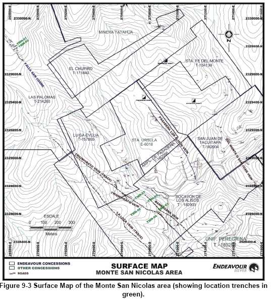
| Page 9-16 |
| UNIDAD ELCUBO GUANAJUATO, MÉXICO NI 43-101 TECHNICAL REPORT |
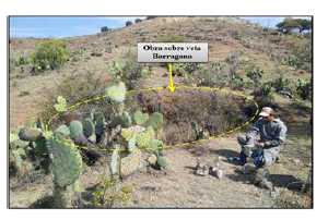
Figure 9-4 Photograph showing working over the Barragana vein.
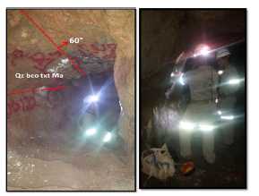
Figure 9-5 Photograph showing mapping activities at the Triunvirato working (left) and
the Triunvirato adit (right).
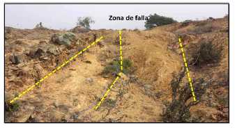
Figure 9-6 Photograph showing Fault (trace of the San Cosme vein).
| Page 9-17 |
| UNIDAD ELCUBO GUANAJUATO, MÉXICO NI 43-101 TECHNICAL REPORT |
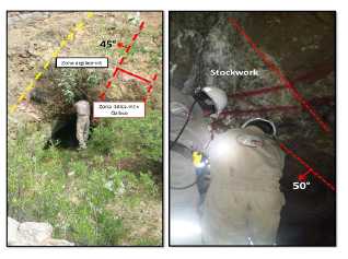
Figure 9-7 Photographs showing flooded heading over the Pasadena de los Alisos vein
(left); and photograph showing the Del Monte or San Juan vein (right).
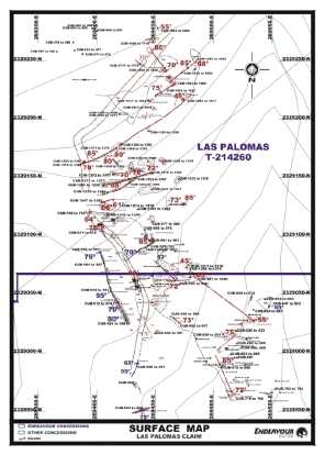
Figure 9-8 Surface Map of the Las Palomas area
| Page 9-18 |
| UNIDAD ELCUBO GUANAJUATO, MÉXICO NI 43-101 TECHNICAL REPORT |

Figure 9-9 Photograph showing structures in the contact zones (Esperanza Formation-
Andesite) in the Las Palomas area.
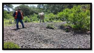
Figure 9-10 Photograph showing slag dumps (La Palomas area).

Figure 9-11 Photographs showing the moderate Silica Zone (left); and sampling in
important argillic alteration + moderate oxidation zones (right).
| Page 9-19 |
| UNIDAD ELCUBO GUANAJUATO, MÉXICO NI 43-101 TECHNICAL REPORT |
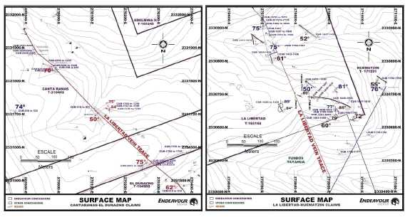
Figure 9-12 A and B, Surface Maps showing the La Libertad-Huematzin-Canta Ranas area.
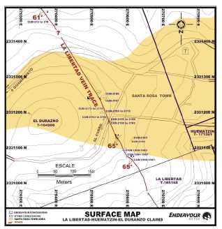
Figure 9-13 Surface Map showing the La Libertad-Huematzin-Canta Ranas area.
| Page 9-20 |
| UNIDAD ELCUBO GUANAJUATO, MÉXICO NI 43-101 TECHNICAL REPORT |
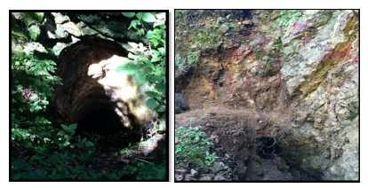
Figure 9-14 Photographs showing a rise in the Purisima area (left); and Fault + fragments
of white Quartz + FeOx + Argentite (right).
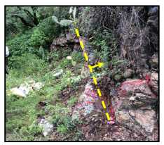
Figure 9-15 Photograph showing Fault in the Huematzin area.
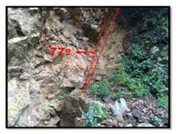
Figure 9-16 Photograph showing the Libertad portal; Villalpando System.
| Page 9-21 |
| UNIDAD ELCUBO GUANAJUATO, MÉXICO NI 43-101 TECHNICAL REPORT |
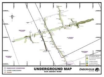
Figure 9-17 Geological Map of the San Amado Mine area.
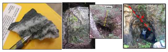
Figure 9-18 Photographs showing veinlets with presence of Argentite in the San Amado
Mine (left); “Catas” in the San Amado Mine (centre); and the Edelmira structure, at the
footwall of Villalpando (right).
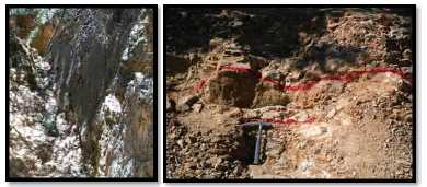
Figure 9-19 Photographs showing Fault (left); and vein of quartz and calcite, with 0.15 m
width (right), possible traces of the Rosita vein.
| Page 9-22 |
| UNIDAD ELCUBO GUANAJUATO, MÉXICO NI 43-101 TECHNICAL REPORT |
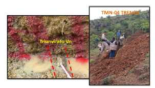
Figure 9-20 A and B, Photographs of trench TMN-04 over the Triunvirato vein.
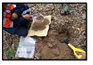
Figure 9-21 Photograph showing geochemical sampling activities.
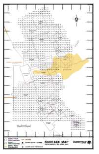
Figure 9-22 Surface Map showing geochemical sampling grid in the Cubo North area.
| Page 9-23 |
| UNIDAD ELCUBO GUANAJUATO, MÉXICO NI 43-101 TECHNICAL REPORT |
![]()
Figure 9-23 Contoured Au (ppm) (left) & Ag (ppm) (right) results for soil samples
collected in the Cubo North area.
![]()
Figure 9-24 Contoured As (ppm) (left) & Cu (ppm) (right) results for soil samples
collected in the Cubo North area.
| Page 9-24 |
| UNIDAD ELCUBO GUANAJUATO, MÉXICO NI 43-101 TECHNICAL REPORT |
![]()
Figure 9-25 Contoured Hg (ppm) (left) & Mn (ppm) (right) results for soil samples
collected in the Cubo North area.
![]()
Figure 9-26 Contoured Zn (ppm) results for soil samples collected in the Cubo North area.
| Page 9-25 |
| UNIDAD ELCUBO GUANAJUATO, MÉXICO NI 43-101 TECHNICAL REPORT |
Cubo Central
During 2014, geological mapping and rock/soil geochemical sampling were conducted at the Cubo Central area (Figure 9-39). A total of 950 rock/soil samples were collected and submitted for analysis. Assay results are shown in Table 9-10 through Table 9-14.
Geological mapping was conducted in theLa Reyna-Panal-La Soledad area (Figure 9-28). In the area was located the portal (Figure 9-29) andLa Reyna vein, the structure on surface consisted of a Fault filled of fault gauge with veinlets of Quartz (white), massive and some stockwork. The structure was traced for around 400 m long. TheSoledad vein does not outcrop on surface, however there is a well-defined fault (Figure 9-30 left), which is located over the projection of the vein. This Fault has only a small “cata” (inaccessible) which makes impossible to see any structure. Over the trace there are some intense argillic zones, which might suggest the existence of the structure to depth. The structure was traced for about 700 m long. At the southern part was located a small adit (fallen), which expose the vein completely (Figure 9-30, right).
TheEl Panal fault was traced on surface for about 700 m, in the area was also located the Panal adit (Figure 9-31 left), with 12 m deep and the fault as a relic dipping 80ºSE. In the working was collected a sample of a Fault (CUB-1540) with the following results: 13.85 g/t Au and 78.9 g/t Ag.
In the area were located theBorrego and San Pedrito workings (Figure 9-31 right) that we assume were developed to exploit and explore the Panal vein, but it’s currently inaccessible.
Geological survey was conducted on theAlicia vein (Figure 9-28 B), which consisted of white Quartz, minor brecciated, with volcanic fragments + minor FeOx, trending NW75ºSE, dipping 60ºSW; traced for around 670 m long and average width of 0.25 m.
Also a geochemical soil/rock sampling grid was conducted in the La Reyna-Panal-La Soledad area (Figure 9-32). Data was contoured and the best geochemical anomalies were defined by gold, silver, arsenic, mercury, manganese and lead (Figure 9-33 through Figure 9-35).
| Page 9-26 |
| UNIDAD ELCUBO GUANAJUATO, MÉXICO NI 43-101 TECHNICAL REPORT |
Table 9-10
Significant Assays for Rock sampling in Cubo Central area
| Sample_ID | Wide mts | Area | Structure | Description | Au (ppm) | Ag (ppm) | Cu (%) | Pb (%) | Zn (%) |
| CUB-745 | 0.20 | REYNA-PANAL- SOLEDAD | Veinlet | Zona de vtlls Qz bco + Fe-Mn (Ox) | 0.97 | 179 | 0.0161 | 0.1620 | 0.0382 |
| CUB-1024 | 0.40 | REYNA-PANAL- SOLEDAD | Vein sist LaReina | Qz bco txt Ma + zonas de sil-mod | 1.85 | 59 | 0.0007 | 0.0031 | 0.0086 |
| CUB-1026 | 0.30 | REYNA-PANAL- SOLEDAD | Vein sist LaReina | Qz bco txt Ma + zonas de sil-mod | 2.44 | 39 | 0.0004 | 0.0032 | 0.0060 |
| CUB-1030 | 0.35 | REYNA-PANAL- SOLEDAD | La Reina Vein(?) | Qz bco Ma con zonas de sil-mod | 0.25 | 19 | 0.0003 | 0.0018 | 0.0066 |
| CUB-1031 | 0.50 | REYNA-PANAL- SOLEDAD | Zona sil-mod | 0.10 | 102 | 0.0005 | 0.0024 | 0.0047 | |
| CUB-1033 | 0.60 | REYNA-PANAL- SOLEDAD | VillalpandoFault | Zona arg-mod | 0.01 | 15 | 0.0001 | 0.0019 | 0.0007 |
| CUB-1035 | 0.60 | REYNA-PANAL- SOLEDAD | VillalpandoFault | Zona arg-mod | 0.20 | 27 | 0.0002 | 0.0063 | 0.0024 |
| CUB-1074 | 0.40 | REYNA-PANAL- SOLEDAD | Sw2 | Vnlts Qz bco Ma en zona arg-mod + Fe (Ox) | 0.60 | 96 | 0.0160 | 0.0337 | 0.0185 |
| CUB-1125 | 0.20 | REYNA-PANAL- SOLEDAD | Fault | Ry txt Fl + sil-mod | <0.05 | 199 | 0.0002 | 0.0018 | 0.0042 |
| CUB-1519 | 0.90 | REYNA-PANAL- SOLEDAD | Soledad Vein | Zona sil-mod + Qz bco & crist con oquedades + Fe (Ox) | 0.76 | 42 | 0.0012 | 0.0035 | 0.0053 |
| CUB-1520 | 0.60 | REYNA-PANAL- SOLEDAD | Soledad Vein | Zona sil-mod + Qz bco & crist con oquedades + Fe (Ox) | 0.15 | 12 | 0.0013 | 0.0022 | 0.0057 |
| CUB-1522 | 0.20 | REYNA-PANAL- SOLEDAD | Soledad Vein | Zona arg-int + Qz bco & crist + silica + Fe (Ox) | 1.37 | 29 | 0.0012 | 0.0025 | 0.0066 |
| CUB-1523 | 0.60 | REYNA-PANAL- SOLEDAD | Soledad Vein | Fag + Qz bco & crist | 2.28 | 39 | 0.0016 | 0.0028 | 0.0069 |
| CUB-1534 | 0.80 | REYNA-PANAL- SOLEDAD | Andesita txt Po + sil-mod + vtlls mm Qz bco Ma | <0.05 | 110 | 0.0002 | 0.0015 | 0.0051 | |
| CUB-1540 | 0.20 | REYNA-PANAL- SOLEDAD | El Panal Fault | Fag + ox-mod | 16.35 | 65 | 0.0017 | 0.0216 | 0.1520 |
| CUB-1561 | 0.20 | REYNA-PANAL- SOLEDAD | Terrero | Qz bco txt oquerosa + Fe (Ox) | 17.45 | 330 | 0.0003 | 0.0007 | 0.0021 |
| CUB-1592 | 1.00 | REYNA-PANAL- SOLEDAD | Fault | Fag + Fe (Ox) | 4.99 | 119 | 0.0024 | 0.0034 | 0.0360 |
| CUB-2006 | 1.50 | REYNA-PANAL- SOLEDAD | Vein | Qz bco txt Ma + Pirolusita | 7.12 | 70 | 0.0009 | 0.0003 | 0.0077 |
| CUB-2031 | 0.80 | ALICIA | Alicia Vein | Txt bx matriz volc + fragms Qz bco Ma | 0.12 | 1 | 0.0018 | 0.0017 | 0.0051 |
| CUB-2043 | 0.40 | ALICIA | Alicia Vein | Qz crist txt oquerosa + Fe (Ox) | 1.41 | 32 | 0.0009 | 0.0020 | 0.0064 |
| CUB-2048 | 0.80 | ALICIA | Sw1 | And txt litica + vtlls Qz bco + Fe (Ox) | 0.08 | 17 | 0.0024 | 0.0016 | 0.0062 |
| CUB-2050 | 0.20 | ALICIA | Veinlet | Qz bco + drusas + presencia de min obscuros | 6.07 | 95 | 0.0008 | 0.0008 | 0.0014 |
| CUB-2052 | 0.50 | ALICIA | Vein | Qz bco txt bx + fragms volcs sanos + rodonita | 6.18 | 104 | 0.0011 | 0.0008 | 0.0014 |
| CUB-2053 | 0.20 | ALICIA | And txt Fg + vtlls Qz bco txt crustif | 0.31 | 19 | 0.0016 | 0.0016 | 0.0043 | |
| CUB-2056 | 0.30 | ALICIA | Alicia Vein | Qz bco txt Ma | 0.87 | 2 | 0.0018 | 0.0006 | 0.0027 |
| CUB-2728 | 0.30 | ALICIA | Vnlt | Qz-Cca + Mn tipo wad | 0.13 | 22 | 0.0001 | 0.0011 | 0.0059 |
| Page 9-27 |
| UNIDAD ELCUBO GUANAJUATO, MÉXICO NI 43-101 TECHNICAL REPORT |
![]()
Figure 9-27 Surface Map of the Cubo Central area
![]()
Figure 9-28 A and B, Surface Map of the La Reyna-Panal-La Soledad area.
| Page 9-28 |
| UNIDAD ELCUBO GUANAJUATO, MÉXICO NI 43-101 TECHNICAL REPORT |
![]()
Figure 9-29 Photograph showing the La Reyna Portal.
![]()
Figure 9-30 Photograph showing Quartz Structure, possible Soledad Fault (left); and
adit (fallen) over the Soledad Vein (right).
![]()
Figure 9-31 Photograph showing El Panal Adit (left); and El Borrego & San Pedrito Mine (right).
| Page 9-29 |
| UNIDAD ELCUBO GUANAJUATO, MÉXICO NI 43-101 TECHNICAL REPORT |
![]()
Figure 9-32 Surface Map showing geochemical sampling grid in the La Reyna-Panal-La
Soledad area.
![]()
Figure 9-33 Contoured Au (ppm) (left) & Ag (ppm) (right) results for soil samples
collected in the La Reyna-Panal-La Soledad area.
| Page 9-30 |
| UNIDAD ELCUBO GUANAJUATO, MÉXICO NI 43-101 TECHNICAL REPORT |
![]()
Figure 9-34 Contoured As (ppm) (left) & Hg (ppm) (right) results for soil samples
collected in the La Reyna-Panal-La Soledad area.
![]()
Figure 9-35 Contoured Mn (ppm) (left) & Pb (ppm) (right) results for soil samples
collected in the La Reyna-Panal-La Soledad area.
| Page 9-31 |
| UNIDAD ELCUBO GUANAJUATO, MÉXICO NI 43-101 TECHNICAL REPORT |
Cubo South
During 2014, geological mapping, trenching and sampling was conducted at the Cubo South area (Figure 9-36). A total of 212 rock samples were collected and submitted for analysis. Assay results are shown in Table 9-11.
In the first Quarter, 2014, in theDalia vein area (Hw vein of the Villalpando System) it was located an alteration zone and veinlets. This structure its similar to the Asunción System, located at North of Cebolletas, with an extension of around 1,150 m long, and the opening zone around 200 m width (Figure 9-37). The trenching program in the area included 6 trenches with 58 rock samples collected.
During February, 2014, as part of the last field activities to complete the evaluation of theNayal area, geological mapping and sampling was conducted (Figure 9-38). In the area were located some faults, well defined, with presence of Quartz (white) and strongly silicified walls, dipping NE and other at SW. It was also located a parallel structure dipping at SW, with two small flooded shafts.
At the End of 2014, geological mapping resumed at theVillalpando South area. Prospecting in the area, around the geochemical anomaly (Paco Claim) (Figure 9-39 through Figure 9-41) was conducted with the objective to prove the possible location of structures at the footwall of the current Villalpando vein trace. The area is widely covered by abundant vegetation, at some parts are located some outcrops of the main rock (rhyolite).
In the NW part (Figure 9-42 left) of the area was located a Fault zone in a creek with 278º Az, which its being traced in order to locate fracturing, alteration and outcrops zones, which could be related to this Fault, because they are located at the footwall of the Villalpando Vein. At the SE part of the anomaly, the area is widely covered by abundant vegetation, but it was located a zone of possible Fault (Figure 9-42 right), in the area were located little evidences of the continuity, but it was located an outcrop of rhyolite (Figure 9-43) which is being inferred with this zone. One of the main objectives is to located evidences in the zone at the footwall of the Villalpando vein a projection, which is the continuity of the previous records obtained in the Violeta Claim, in the area w located zones with strong alteration, FeOx and minor Quartz Floats (Figure 9-44).
| Page 9-32 |
| UNIDAD ELCUBO GUANAJUATO, MÉXICO NI 43-101 TECHNICAL REPORT |
Table 9-11
Significant Assays for Rock sampling in the Cubo South area
| Sample_ID | Wide mts | Area | Structure | Description | Au (ppm) | Ag (ppm) | Cu (%) | Pb (%) | Zn (%) |
| CUB-2603 | 1.00 | PACO- VIOLETA | Trb, Fracturamiento azimut 124c/81° al NE | 0.02 | 1 | <0.0001 | 0.0008 | 0.0015 | |
| CUB-2605 | 1.00 | PACO-VIOLETA | Trb, Fracturamiento azimut 124c/81° al NE | 0.03 | 2 | <0.0001 | 0.0005 | 0.0012 | |
| CUB-2607 | 0.70 | PACO- VIOLETA | Trb, Facturamientor azimut 140c /81° al NE | 0.09 | 1 | 0.0002 | 0.0033 | 0.0011 | |
| CUB-2613 | 1.00 | PACO- VIOLETA | Fault | Trb, falla azimut 338 c /40° al NE | 0.01 | 1 | <0.0001 | 0.0006 | 0.0005 |
| CUB-2614 | 1.00 | PACO- VIOLETA | Fault | Trb, falla azimut 338 c /40° al NE | 0.02 | 2 | <0.0001 | 0.0021 | 0.0006 |
| CUB-2615 | 1.00 | PACO- VIOLETA | Fault | Trb, falla azimut 338 c /40° al NE | 0.01 | 1 | <0.0001 | 0.0012 | 0.0008 |
| CUB-2616 | 1.00 | PACO- VIOLETA | Fault | Trb, falla azimut 338 c /40° al NE | 0.01 | 1 | <0.0001 | 0.0009 | 0.0006 |
| CUB-2617 | 1.00 | PACO- VIOLETA | Fault | Trb, falla azimut 338 c /40° al NE | 0.14 | 2 | <0.0001 | 0.0009 | 0.0010 |
| CUB-2618 | 1.00 | PACO- VIOLETA | Fault | Trb, falla azimut 338 c /40° al NE | 0.06 | 2 | <0.0001 | 0.0012 | 0.0009 |
| CUB-2619 | 0.70 | PACO- VIOLETA | Fault | Trb, falla azimut 338 c /40° al NE | 2.66 | 8 | <0.0001 | 0.0014 | 0.0011 |
| CUB-2620 | 0.80 | PACO- VIOLETA | Fault | Trb, falla azimut 338 c /40° al NE | 0.21 | 14 | <0.0001 | 0.0023 | 0.0007 |
| CUB-2839 | 0.20 | PACO- VIOLETA | Vein | vetilla Qz lechoso az 135c/33° al NE | 0.18 | 1 | 0.0019 | 0.0037 | 0.0021 |
Table 9-12
Significant Assays for Rock sampling in the Cubo South (Dalia) area.
| Sample ID | Width (m) | Area | Description | Notes | Au (ppm) | Ag (ppm) | Cu (%) | Pb (%) | Zn (%) |
| CEB-915 | 0.55 | DALIA | Zona arg-mod + Fe (Ox) | <0.005 | <0.2 | 0.0007 | 0.0009 | 0.0049 | |
| CEB-916 | 0.60 | DALIA | Qz bco + trazas min obsc (?) | Dalia Vein | <0.005 | <0.2 | 0.0002 | <0.0002 | 0.0002 |
| CEB-917 | 1.60 | DALIA | Zona arg-mod + Fe (Ox) | <0.005 | <0.2 | 0.0013 | 0.001 | 0.0049 | |
| CEB-918 | 0.20 | DALIA | Zona arg-mod | <0.005 | <0.2 | 0.0009 | 0.0007 | 0.0089 | |
| CEB-919 | 0.20 | DALIA | Zona arg-mod | <0.005 | <0.2 | 0.001 | 0.0006 | 0.008 | |
| CEB-920 | 0.85 | DALIA | Zona arg-mod + presencia de Qz crist | <0.005 | <0.2 | 0.0009 | 0.0006 | 0.0075 | |
| CEB-921 | 0.20 | DALIA | Zona arg-mod + presencia de Qz crist | <0.005 | 0.3 | 0.0011 | 0.0009 | 0.0068 | |
| CEB-922 | 0.30 | DALIA | Zona arg-mod | 0.007 | 0.2 | 0.0007 | 0.0007 | 0.0066 | |
| CEB-923 | 0.40 | DALIA | Zona arg-mod + presencia de Qz crist | Dalia Vein | 0.007 | 0.2 | 0.0011 | 0.0009 | 0.0067 |
| CEB-924 | 0.60 | DALIA | Zona arg-mod + presencia de Qz crist | 0.007 | 0.5 | 0.0009 | 0.0005 | 0.0071 | |
| CEB-925 | 0.40 | DALIA | Zona arg-mod | 0.005 | <0.2 | 0.0009 | 0.0006 | 0.0076 |
| Page 9-33 |
| UNIDAD ELCUBO GUANAJUATO, MÉXICO NI 43-101 TECHNICAL REPORT |
Table 9-13
Significant Assays for Rock sampling in the Cubo South (Dalia) area.
| Sample ID | Width (m) | Area | Structure | Description | Au (ppm) | Ag (ppm) | Cu (%) | Pb (%) | Zn (%) |
| CNL1094 | 0.45 | NAYAL | VEINLET | Sw-Qz bco + arg-sil-mod | 0.34 | 4.0 | 0.0002 | 0.0010 | 0.0019 |
| CNL1097 | 0.35 | NAYAL | VEINLET | Qz bco txt bx-fragms volcs | 0.02 | 1.6 | 0.0003 | 0.0007 | 0.0026 |
| CNL1099 | 0.6 | NAYAL | FAULT | Sil-int | 0.01 | 0.7 | 0.0003 | 0.0010 | 0.0018 |
| CNL1107 | 0.5 | NAYAL | FAULT | Zona sil-int + vtlls Qz bco | 1.75 | 84.0 | 0.0003 | 0.0010 | 0.0014 |
| CNL1114 | 0.4 | NAYAL | VEINLET | Bx-fragms volcs & sil + Py diss <1% | 0.06 | 15.6 | 0.0002 | 0.0016 | 0.0004 |
| CNL1115 | 0.3 | NAYAL | Ry txt Fl | 0.01 | 10.5 | 0.0003 | 0.0020 | 0.0010 | |
| CNL1121 | 0.7 | NAYAL | Zona sil-mod | 0.43 | 76.0 | 0.0003 | 0.0020 | 0.0012 | |
| CNL1122 | 0.6 | NAYAL | Zona sil-mod | 0.45 | 144.0 | 0.0003 | 0.0048 | 0.0016 | |
| CNL1123 | 0.5 | NAYAL | Zona sil-mod | 0.27 | 43.0 | 0.0003 | 0.0029 | 0.0010 | |
| CNL1124 | 1 | NAYAL | Zona sil-mod | 0.33 | 19.3 | 0.0003 | 0.0017 | 0.0008 | |
| CNL1125 | 0.6 | NAYAL | Zona sil-mod | 0.21 | 28.0 | 0.0007 | 0.0029 | 0.0014 | |
| CNL1126 | 0.4 | NAYAL | Zona sil-mod | 0.20 | 19.0 | 0.0004 | 0.0026 | 0.0015 | |
| CNL1127 | 0.2 | NAYAL | Zona sil-mod | 0.75 | 115.0 | 0.0004 | 0.0065 | 0.0025 | |
| CNL1129 | 0.75 | NAYAL | VEIN | Zona sil-int + Qz bco presencia de oquedades | 0.14 | 4.1 | 0.0002 | 0.0010 | 0.0018 |
| CNL1130 | 0.35 | NAYAL | Zona sil-mod + vtlls Qz bco | 0.10 | 142.0 | 0.0002 | 0.0025 | 0.0016 | |
| CNL1131 | 0.5 | NAYAL | Ry txt Fl | 0.17 | 29.0 | 0.0002 | 0.0019 | 0.0014 | |
| CNL1132 | 0.2 | NAYAL | TERRERO | Sil-int + Qz bco presencia de oquedades | 1.51 | 191.0 | 0.0002 | 0.0017 | 0.0018 |
| CNL1133 | 0.9 | NAYAL | PROYECCION DEVETA | Zona de sil-mod | 0.04 | 3.5 | 0.0002 | 0.0011 | 0.0009 |
| CNL1134 | 0.5 | NAYAL | PROYECCION DEVETA | Zona de sil-mod | 0.06 | 1.8 | 0.0002 | 0.0008 | 0.0010 |
| CNL1135 | 1.2 | NAYAL | PROYECCION DEVETA | Zona de sil-mod | 0.02 | 2.4 | 0.0003 | 0.0013 | 0.0015 |
| CNL1136 | 0.65 | NAYAL | PROYECCION DEVETA | Zona de sil-mod | 0.01 | 3.2 | 0.0002 | 0.0009 | 0.0015 |
| CNL1138 | 0.2 | NAYAL | VEINLET | Qz bco presencia de oquedades | 0.24 | 53.0 | 0.0006 | 0.0020 | 0.0026 |
| Page 9-34 |
| UNIDAD ELCUBO GUANAJUATO, MÉXICO NI 43-101 TECHNICAL REPORT |
Table 9-14
Significant Assays for Rock sampling in Trenches in the Dalia area
| Trench | Trench Length | Strike | Looking at | Sample ID | Sample Length | Description | Au (ppm) | Ag (ppm) | Cu (%) | Pb (%) | Zn (%) |
| TDL-01 | 6 | NE 50° SW | 40° SE | DL-01 | 0.85 | Zona arg-ox-mod | <0.005 | <0.2 | 0.0011 | 0.0009 | 0.0060 |
| DL-02 | 0.45 | Zona arg-ox-mod | <0.005 | <0.2 | 0.0010 | 0.0007 | 0.0058 | ||||
| DL-03 | 0.35 | Zona arg-ox-mod | <0.005 | <0.2 | 0.0010 | 0.0008 | 0.0063 | ||||
| DL-04 | 0.45 | Dalia Vein. Zona arg-mod +vtll Qz-Cca | <0.005 | <0.2 | 0.0012 | 0.0009 | 0.0077 | ||||
| DL-05 | 0.45 | Zona arg-ox-mod | 0.01 | <0.2 | 0.0012 | 0.0006 | 0.0077 | ||||
| DL-06 | 0.40 | Zona arg-ox-mod | 0.01 | <0.2 | 0.0017 | 0.0008 | 0.0075 | ||||
| DL-07 | 0.25 | Zona arg-ox-mod | 0.02 | <0.2 | 0.0020 | 0.0011 | 0.0106 | ||||
| DL-08 | 0.60 | Zona arg-ox-mod | 0.02 | <0.2 | 0.0013 | 0.0008 | 0.0080 | ||||
| DL-09 | 0.65 | Zona arg-ox-mod | 0.05 | <0.2 | 0.0011 | 0.0008 | 0.0075 | ||||
| TDL-04 | 12 | NE 45° SW | 45° SE | DL-35 | 1.65 | Zona arg-ox-mod | <0.005 | <0.2 | 0.0013 | 0.0008 | 0.0069 |
| DL-36 | 1.50 | Zona arg-ox-mod | 0.01 | 0.2 | 0.0014 | 0.0007 | 0.0063 | ||||
| DL-37 | 1.70 | Zona ox-mod | 0.01 | <0.2 | 0.0015 | 0.0009 | 0.0065 | ||||
| DL-38 | 1.35 | Zona arg-ox-mod | 0.01 | <0.2 | 0.0014 | 0.0009 | 0.0054 | ||||
| DL-39 | 1.40 | Zona ox-mod | 0.01 | <0.2 | 0.0011 | 0.0008 | 0.0058 | ||||
| DL-40 | 0.20 | Dalia Vein. Zona arg-ox-mod+ vtll Qz-Cca | 0.01 | <0.2 | 0.0012 | 0.0007 | 0.0068 | ||||
| DL-41 | 0.50 | Zona arg-ox-mod | 0.01 | 0.2 | 0.0013 | 0.0006 | 0.0079 | ||||
| TDL-05 | 15 | NE 50° SW | 40° NW | DL-42 | 0.85 | Zona arg-ox-mod | <0.005 | <0.2 | 0.0010 | 0.0008 | 0.0071 |
| DL-43 | 0.80 | Zona arg-ox-mod | <0.005 | <0.2 | 0.0010 | 0.0012 | 0.0064 | ||||
| DL-44 | 0.80 | Zona ox-mod | <0.005 | <0.2 | 0.0011 | 0.0011 | 0.0068 | ||||
| DL-45 | 0.55 | Zona ox-mod | <0.005 | 0.2 | 0.0012 | 0.0010 | 0.0039 | ||||
| DL-46 | 0.75 | Zona ox-mod | <0.005 | <0.2 | 0.0013 | 0.0006 | 0.0091 | ||||
| DL-47 | 1.40 | Zona ox-mod | <0.005 | <0.2 | 0.0014 | 0.0008 | 0.0080 | ||||
| DL-48 | 0.60 | Traza Dalia Vein. Zona ox-int+ presencia de Qz | <0.005 | <0.2 | 0.0015 | 0.0010 | 0.0076 | ||||
| DL-49 | 0.40 | Traza Dalia Vein. Zona ox-int+ presencia de Qz | <0.005 | <0.2 | 0.0011 | 0.0009 | 0.0079 | ||||
| DL-50 | 1.20 | Zona arg-ox-mod | <0.005 | <0.2 | 0.0011 | 0.0008 | 0.0076 | ||||
| DL-51 | 1.00 | Zona arg-ox-mod | <0.005 | <0.2 | 0.0010 | 0.0007 | 0.0078 | ||||
| TDL-06 | 10 | NE 50° SW | 40° NW | DL-52 | 1.10 | Zona arg-ox-mod | <0.005 | <0.2 | 0.0015 | 0.0012 | 0.0079 |
| Page 9-35 |
| UNIDAD ELCUBO GUANAJUATO, MÉXICO NI 43-101 TECHNICAL REPORT |
| DL-53 | 0.60 | Zona ox-mod | <0.005 | <0.2 | 0.001 5 | 0.0012 | 0.0077 | ||||
| DL-54 | 1.15 | Zona ox-mod | <0.005 | 0.2 | 0.001 6 | 0.0012 | 0.0072 | ||||
| DL-55 | 1.05 | Zona arg-ox-mod | <0.005 | <0.2 | 0.001 1 | 0.0010 | 0.0076 | ||||
| DL-56 | 1.55 | Tce sana | 0.01 | 0.2 | 0.0012 | 0.0012 | 0.0057 | ||||
| DL-57 | 0.20 | Dalia Vein. Zona de Tce sana+ vtll Qz bco | 0.56 | 0.3 | 0.0016 | 0.0013 | 0.0061 | ||||
| DL-58 | 0.65 | Tce sana | 0.01 | <0.2 | 0.0011 | 0.0010 | 0.0056 |
![]()
| Page 9-36 |
| UNIDAD ELCUBO GUANAJUATO, MÉXICO NI 43-101 TECHNICAL REPORT |
![]()
Figure 9-37 Surface Map showing trenches completed over the Dalia vein in the Villalpando South area.
![]()
Figure 9-38 A and B, Surface Geological Maps of the Nayal area.
| Page 9-37 |
| UNIDAD ELCUBO GUANAJUATO, MÉXICO NI 43-101 TECHNICAL REPORT |
![]()
Figure 9-39 Contoured Ag Map, showing the location of the geochemical anomaly in the
Villalpando South area.
![]()
Figure 9-40 Surface Map of the Villalpando South area.
| Page 9-38 |
| UNIDAD ELCUBO GUANAJUATO, MÉXICO NI 43-101 TECHNICAL REPORT |
![]()
Figure 9-41 A and B Photographs showing field images of the geochemical anomaly area.
![]()
Figure 9-42 Surface Maps and photographs of the NW (left) and NE (right) parts of the
anomaly area.
![]()
Figure 9-43 Photograph showing an outcrop of rhyolite.
| Page 9-39 |
| UNIDAD ELCUBO GUANAJUATO, MÉXICO NI 43-101 TECHNICAL REPORT |
![]()
Figure 9-44 A and B, Surface Map and photographs showing fault zone and veinlets of
Quartz (massive texture).
| Page 9-40 |
| UNIDAD ELCUBO GUANAJUATO, MÉXICO NI 43-101 TECHNICAL REPORT |
| 10.0 | DRILLING |
| 10.1 | Underground Drilling Procedures. |
Drill holes are typically drilled from the hanging wall, and ideally drilled perpendicular to structures, however due to limitations on drill station construction oblique intersection holes must also be planned. No drilling is designed for intercept angles less than 35° to the target and most are from 45° to 90°. Underground positive angled holes (up holes) are generally drilled from the footwall using the same criteria as given previously. All holes are designed to pass through the target and into the hanging or footwalls. Drilling is performed by contractor and by in-house drilling crews. Contractor drill holes are typically NQ or HQ in diameter; in-house drilling is performed using TT46 core using CP-65 or Diamec-250 drill machines. In 2014 contractor drilling was performed by Versa Perforaciones S.A. de C.V. (Versa). | |
In underground drill stations azimuth orientation lines are surveyed in prior to drilling. These are used to align the drills for azimuth. For contractor drilling Inclination is set up using a Reflex®EX-Shot®survey device prior to starting drilling. Holes are tested at approximately 12 meters depth to assure azimuth and inclination are within acceptable deviation limits; holes are then surveyed approximately every 30 m to 50 m as drilling progresses. Survey data is recorded by drillers on Reflex®report sheets and on daily reports and the data transferred manually to an Excel®spreadsheet. In-house drill machines have inclination set using a magnetic “Empire” inclinometer or Brunton compass. | |
Drill hole collars and the inclination at the collar are surveyed during drilling or after hole completion by mine underground surveyors. The collar coordinates and down hole survey information are transferred to Vulcan®and AutoCAD®databases, with true thickness graphically interpreted from thickness of drill hole intercept and interpreted strike and dip of vein. For in-house drill holes azimuth and inclination are based on the values obtained from the collar survey. | |
Drill core is transported at the end of every shift to a secure core storage and logging facility, by the drillers (contractor or company), where the core is laid out, measured and logged for geotechnical and geological data and marked for sampling. NQ or HQ core is split in half using manual or hydraulic core splitters; TT46 core is submitted in its entirety for analysis. The core storage facility for mine exploration core is well protected by a wall and high-level security fence. |
| Page 10-1 |
| UNIDAD ELCUBO GUANAJUATO, MÉXICO NI 43-101 TECHNICAL REPORT |
| 10.1.1 | Core Logging Procedures |
In 2014 the mine exploration group used a combination of manual and digital logging procedures. After an initial quick-log on paper, as the hole is received in the core facility, geotechnical data is logged manually on paper sheets and entered into Excel®spreadsheets. Core is then logged and marked for sampling. Initially, samples were entered on manual sheets with data transferred to an Excel®database; subsequently, sample logging has been performed directly into Excel®spreadsheets using laptop computers. Core logging is still being performed manually on paper logging sheets with data transferred to an Excel®spreadsheet. | |
| 10.1.2 | 2014 Mine Drilling Program and Results |
In 2014 underground drilling, with two surface holes, was undertaken to determine the extent of additional mineralization close to areas currently being mined. Drilling focused on the Villalpando Vein system (Areas I, II and IV), as this vein had the greatest potential for wider, economic grade mineralization: In addition the Dolores, San Nicolas 2, San Eusebio, Alicia and Veta-27 veins were explored. Drilling early in the year was performed using the in-house Diamec-250 and CP-65 drills for definition style drilling, using narrow diameter core (TT46). Later in the year drilling was performed by a contractor and an in- house drill capable of drilling NQ core (using a VERSA Kmb.4 drill). During 2014 a total of 58 holes were completed for 10,892.80 meters of coring. | |
The drilling is separated into narrow diameter (TT46) core and NQ-HQ diameter core categories; the latter used for Measured to Inferred Resources and the former for Inferred Resource definition. | |
The contractor underground and surface drilling was conducted using the drill contracting firm Versa Perforaciones S.A. de C.V. (Versa) using a VERSA Kmb1.2 machine to drill HQ diameter core. |
| Page 10-2 |
| UNIDAD ELCUBO GUANAJUATO, MÉXICO NI 43-101 TECHNICAL REPORT |
A total of 7,196 m of drilling in 31 holes was completed by Versa (HQ core) with one hole failing to cut all targets due to intersecting of old workings. A total of 2,681.10 m of drilling in 15 holes was completed by the in-house VERSA Kmb.4 drill machine (NQ core). A total of 1,015.70 m of drilling was performed with TT46 core, with 12 holes (2 holes abandoned without reaching their target).
10.1.2.1.Villalpando Vein Underground Diamond Drilling Programs and Results
In 2014 underground drilling of the Villalpando Vein focused on five areas, with information for HQ-NQ and TT46 drilling summarized in summarized in Table 10-1 and Table 10-2: Drilling between panels VPO_P-1600 and VPO_P-2100, explored the Asuncion zone with efforts concentrating on the San Simon Ramp area; drilling between panels VPO_P-000 and VPO-400, (5-80 stope zone); drilling between panels VPO_P-950 and VPO_P-1150, (8-2140 stope zone); drilling between panels VPO_P- 1400 and VPO_P-1500 (Tiro Gil zone); and between panels VPO_P+400 and VPO_P+600 (stope 9-431 zone).
A total of thirty-nine (39) HQ-NQ core holes, were drilled to intersect the Villalpando Vein, totaling 8,363.70 m (Table 10-1) and four (4) TT46 core holes were drilled using the in-house CP-65 for a total of 230.90 m of coring (Table 10-2). One hole was abandoned for operational reasons shortly after starting (CUDG-00934). One hole targeting the Veta 27 structure also intersected the Villalpando vein, CUDG-00978.
| Page 10-3 |
| UNIDAD ELCUBO GUANAJUATO, MÉXICO NI 43-101 TECHNICAL REPORT |
Table 10-1
Summary of underground Villalpando Vein drilling with HQ-NQ core, 2014.
| Drill Hole Number | Azimuth (°) | Dip (°) | Depth (m) | Area | Drilled By | Drilling Date | |
| Start | Finish | ||||||
| CUDG-00938 | 52.5 | -37.5 | 176.60 | II | VERSA | 09/05/2014 | 14/05/2014 |
| CUDG-00939 | 52.5 | -59.5 | 190.10 | II | VERSA | 15/05/2014 | 20/05/2014 |
| CUDG-00940 | 50 | -49.5 | 154.00 | II | VERSA | 22/05/2014 | 24/05/2014 |
| CUDG-00941 | 50 | -71.5 | 162.50 | II | VERSA | 26/05/2014 | 28/05/2014 |
| CUDG-00942 | 50 | -86 | 205.00 | II | VERSA | 28/05/2014 | 02/06/2014 |
| CUDG-00944 | 24.5 | -37 | 166.00 | II | VERSA | 03/06/2014 | 07/06/2014 |
| CUDG-00945 | 18 | -57 | 185.00 | II | VERSA | 09/06/2014 | 12/06/2014 |
| CUDG-00946 | 358 | -74 | 231.50 | II | VERSA | 13/06/2014 | 18/06/2014 |
| CUDG-00947 | 50 | -39.5 | 145.00 | II | VERSA | 19/06/2014 | 26/06/2014 |
| CUDG-00949 | 50 | -63 | 157.00 | II | VERSA | 26/06/2014 | 30/06/2014 |
| CUDG-00950 | 50 | -80 | 217.00 | II | VERSA | 01/07/2014 | 04/07/2014 |
| CUDG-00951 | 230 | -89.5 | 274.00 | II | VERSA | 05/07/2014 | 11/07/2014 |
| CUDG-00953 | 110 | -52 | 200.00 | II | VERSA | 12/07/2014 | 15/07/2014 |
| CUDG-00954 | 230 | -85.5 | 259.10 | II | VERSA | 28/05/2014 | 02/06/2014 |
| CUDG-00955 | 24.25 | -45 | 107.50 | II | CMdC | 23/07/2014 | 30/07/2014 |
| CUDG-00956 | 5 | -31.5 | 176.55 | II | VERSA | 23/09/2014 | 26/09/2014 |
| CUDG-00957 | 352 | -50 | 194.00 | II | VERSA | 28/07/2014 | 31/07/2014 |
| CUDG-00958 | 351 | -77.5 | 131.50 | II | CMdC | 31/07/2014 | 07/08/2014 |
| CUDG-00959 | 52.5 | -78 | 225.50 | II | VERSA | 31/07/2014 | 05/08/2014 |
| CUDG-00960 | 110 | -75 | 221.50 | II | VERSA | 01/07/2014 | 04/07/2014 |
| CUDG-00961 | 66.75 | -30 | 138.90 | II | CMdC | 09/08/2014 | 20/08/2014 |
| CUDG-00962 | 75 | -59.5 | 162.05 | II | CMdC | 21/08/2014 | 01/09/2014 |
| CUDG-00963 | 49 | -46.5 | 239.00 | IV | VERSA | 29/08/2014 | 04/09/2014 |
| CUDG-00964 | 49 | -62 | 239.00 | IV | VERSA | 05/09/2014 | 08/09/2014 |
| CUDG-00965 | 5.25 | -46.5 | 152.90 | II | CMdC | 04/09/2014 | 06/10/2014 |
| CUDG-00966 | 83.25 | -40 | 248.60 | IV | VERSA | 09/09/2014 | 12/09/2014 |
| CUDG-00967 | 107.5 | -32.5 | 338.50 | IV | VERSA | 13/09/2014 | 22/09/2014 |
| CUDG-00968 | 67.5 | -46.5 | 230.00 | IV | VERSA | 23/09/2014 | 25/09/2014 |
| CUDG-00969 | 28 | -46.5 | 245.00 | IV | VERSA | 26/07/2014 | 30/09/2014 |
| CUDG-00970 | 49 | -81.5 | 374.00 | IV | VERSA | 01/10/2014 | 09/10/2014 |
| CUDG-00971 | 72.75 | -76.5 | 212.95 | II | CMdC | 07/10/2014 | 13/10/2014 |
| CUDG-00972 | 10.75 | -50 | 296.00 | IV | VERSA | 09/10/2014 | 15/10/2014 |
| CUDG-00974 | 120 | -75 | 437.50 | IV | VERSA | 09/10/2014 | 28/10/2014 |
| CUDG-00975 | 28 | -63 | 222.85 | II | CMdC | 27/10/2014 | 03/11/2014 |
| CUDG-00976 | 75 | -61 | 206.50 | IV | VERSA | 09/10/2014 | 28/10/2014 |
| CUDG-00977 | 70.5 | -69.5 | 245.60 | II | CMdC | 05/11/2014 | 11/11/2014 |
| CUDG-00979 | 10 | -77.5 | 269.60 | II | CMdC | 11/11/2014 | 21/11/2014 |
| CUDG-00980 | 351.5 | -66.5 | 173.30 | II | CMdC | 25/11/2014 | 28/11/2014 |
| CUDG-00981 | 115 | -64.5 | 152.10 | II | CMdC | 01/12/2014 | 04/12/2014 |
| Page 10-4 |
| UNIDAD ELCUBO GUANAJUATO, MÉXICO NI 43-101 TECHNICAL REPORT |
Table 10-2
Summary of underground Villalpando Vein drilling with TT46 core, 2014.
| Drill Hole Number | Azimuth (°) | Dip (°) | Depth (m) | Area | Drilled By | Drilling Date | |
| Start | Finish | ||||||
| CUDG-00931 | 24 | -37 | 67.60 | IV | CMdC | 30/12/2013 | 14/01/2014 |
| CUDG-00932 | 94.3 | -30 | 39.45 | IV | CMdC | 15/01/2014 | 27/01/2014 |
| CUDG-00934 (Abandoned) | 80.06 | -5.24 | 4.00 | IV | CMdC | 20/03/2014 | 20/03/2014 |
| CUDG-00934A | 81.3 | -5 | 119.85 | IV | CMdC | 20/03/2014 | 19/04/2014 |
Figure 10-1 shows the points of intersection of the Villalpando Vein for each drill hole in the Asuncion Zone (panels VPO-1600 to VPO-2100); a total of 22 holes were drilled in this zone.
The drill holes below the San Simon ramp zone of Asuncion identified significant mineralization in the Villalpando vein below its intersection with the hanging wall Asuncion vein (below elevation 2075 m). Resource grade mineralization was identified over a 200 m strike and 150 m vertical extension (to 1900 m elevation), between panels VPO-1900 and VPO-2100. In general the stronger mineralized structures in these zones consist of composite structures typically composed of one or all the following components, from footwall through to hanging wall: A massive quartz-carbonate vein; a quartz breccia zone and a stockwork quartz-veinlet zone. Economic mineralization can be present in all three zone types. Resource grade vein widths vary from 0.7 meters to 2 meters, with composite structure zones having widths up to 3.5 meters; un-capped silver equivalent resource grade vein composites range from 107 g/t to 580 g/t Ag equivalent; with higher values present in some breccia and stockwork intervals. The best results for this zone were obtained from holes CUDG-00941, CUDG-00942, CUDG-00949, CUDG-00954 and CUDG-00969. The Asuncion vein below level 9 showed limited potential from the drill holes, with the best result obtained from hole CUDG-00938. These results indicate the importance of sub-vertical ore shoots with greater than 400 m vertical extent along the Villalpando structure.
Drilling in the hanging wall of the Capulin Fault (VPO_P-1600 – VPO-1700) identified Resource grade mineralization within a narrow, steeply plunging ore shoot.
| Page 10-5 |
| UNIDAD ELCUBO GUANAJUATO, MÉXICO NI 43-101 TECHNICAL REPORT |
The second major target of drilling along the Villalpando structure was between panels VPO_P-000 and VPO_P-400, below the area currently being mined in stopes 5-80 and 6-80, associated with the intersection of the Tuberos and San Francisco structures with the Villalpando vein. A total of 10 holes were drilled in this zone, with the majority of the holes showing weak mineralization and significant pinching and swelling of the vein. Hole CUDG-00978, whose primary objective was the Veta 27 vein also intersected the Villalpando vein; it was projected to pass NW of an old stope, between levels 7 and 6 (VPO_P-77) but intersected 1.2 metres of open space, considered to be an old working, with significant silver values in footwall and hanging wall.
Drilling between panels VPO_P-950 and VPO_P-1150 in the area of stope 8-2140 below level 9 (2100 m elevation) was designed to test the potential for a major vertical ore hoot along the Villalpando structure. The drill holes identified a narrow mineralized ore shoot and confirmed the presence of a generally narrow and weakly-mineralized vein in the footwall of the actively mined Villalpando vein. Drilling between panels VPO_P-1400 and VPO_P-1500 was designed to explore the depth potential of the Tiro Gil–San Ignacio Ramp ore shoot, with the results indicating that mineralized strike length and vein width narrow at depth.
In the early part of the year TT46 diameter definition core drilling was perfumed between panels VPO_P+400 and VPO_P+600 in the zone below the 9-431 stope. The drilling indicates some economic potential between levels 10 and 11, where three principal structures intersect, but confirms that the below level 11 (2010 m elevation) the structures become widely separated and weakly mineralized.
Drilling results are summarized in Table 10-3 and Table 10-4; and the Villalpando vein intercepts are shown on the longitudinal sections in Figure 10-1 through Figure 10-3).
| Page 10-6 |
| UNIDAD ELCUBO GUANAJUATO, MÉXICO NI 43-101 TECHNICAL REPORT |
Table 10-3
Summary of intercepts of the 2014 Villalpando vein drilling results with HQ-NQ core
| Drill Hole ID | Structure | Mineralized Interval | Assay Results | ||||
| From (m) | To (m) | Core Length (m) | True Width (m) | Silver (g/t) | Gold (g/t) | ||
| CUDG-938 | Asunción Vein | 115.90 | 117.05 | 1.15 | 1.00 | 108 | 3.00 |
| Asunción Composite | 115.90 | 117.88 | 1.98 | 1.71 | 64 | 1.76 | |
| Including | 115.90 | 116.51 | 0.61 | 0.53 | 181 | 5.28 | |
| Villalpando Vein | 135.43 | 136.14 | 0.71 | 0.64 | 20 | 0.63 | |
| CUDG-939 | Asunción Vein | 144.39 | 144.72 | 0.33 | 0.23 | 1 | 0.05 |
| Villalpando Vein | 148.25 | 150.15 | 1.90 | 1.68 | 1 | 0.01 | |
| CUDG-940 | Asunción Vein | 89.80 | 91.00 | 1.20 | 0.48 | 2 | 0.02 |
| Villalpando Vein | 111.55 | 113.50 | 1.95 | 1.82 | 53 | 0.52 | |
| Including | 112.20 | 112.90 | 0.70 | 0.66 | 110 | 1.00 | |
| CUDG-941 | Villalpando Vein | 138.60 | 140.75 | 2.15 | 1.65 | 319 | 0.94 |
| Including | 139.50 | 140.25 | 0.75 | 0.57 | 350 | 0.79 | |
| CUDG-942 | Villalpando Vein | 177.50 | 182.25 | 4.75 | 3.36 | 150 | 0.54 |
| Villalpando Composite | 177.50 | 180.15 | 2.65 | 1.87 | 255 | 0.92 | |
| Including | 177.50 | 177.90 | 0.40 | 0.28 | 784 | 3.47 | |
| CUDG-944 | Asunción Vein | 121.40 | 124.70 | 3.30 | 3.01 | 34 | 1.70 |
| Asunción Composite | 122.85 | 124.70 | 1.85 | 1.74 | 49 | 2.31 | |
| Including | 122.85 | 123.55 | 0.70 | 0.66 | 32 | 3.09 | |
| Villalpando Vein | 142.55 | 143.60 | 1.05 | 1.05 | 3 | 0.06 | |
| CUDG-945 | Villalpando Vein | 156.00 | 157.00 | 1.00 | 0.87 | 6 | 0.05 |
| CUDG-946 | Villalpando Vein | 182.55 | 183.70 | 1.15 | 0.81 | 24 | 0.11 |
| CUDG-947 | Villalpando Vein | 116.45 | 118.70 | 2.25 | 2.22 | 112 | 0.25 |
| Villalpando Composite | 116.45 | 118.25 | 1.80 | 1.77 | 139 | 0.31 | |
| Including | 116.45 | 116.95 | 0.50 | 0.49 | 479 | 1.02 | |
| CUDG-949 | Villalpando Vein | 129.60 | 133.50 | 3.90 | 3.38 | 409 | 2.32 |
| Including | 131.95 | 132.55 | 0.60 | 0.52 | 770 | 6.08 | |
| CUDG-950 | Villalpando Vein | 190.15 | 195.05 | 4.90 | 3.46 | 398 | 6.59 |
| Villalpando Composite | 184.65 | 194.30 | 9.65 | 6.50 | 336 | 5.62 | |
| Including | 193.00 | 193.95 | 0.95 | 0.67 | 837 | 17.00 | |
| CUDG-951 | Villalpando Vein | 257.80 | 261.50 | 3.70 | 1.56 | 39 | 0.64 |
| CUDG-953 | Villalpando Vein | 179.30 | 188.20 | 8.90 | 4.86 | 86 | 0.29 |
| Villalpando Composite | 185.20 | 188.20 | 3.00 | 1.72 | 220 | 0.76 | |
| Including | 186.85 | 187.45 | 0.60 | 0.34 | 625 | 1.37 | |
| CUDG-954 | Villalpando Vein | 228.90 | 233.05 | 4.15 | 2.08 | 523 | 4.34 |
| Villalpando Composite | 228.40 | 231.85 | 3.45 | 1.73 | 684 | 5.30 | |
| Including | 229.35 | 230.05 | 0.70 | 0.35 | 1515 | 16.95 | |
| CUDG-955 | Villalpando Vein | 76.40 | 79.45 | 3.05 | 2.87 | 65 | 0.66 |
| Villalpando Composite | 76.40 | 78.25 | 1.85 | 1.74 | 105 | 1.06 | |
| Including | 76.40 | 77.35 | 0.95 | 0.89 | 203 | 2.02 | |
| CUDG-956 | Asunción Vein | 128.70 | 131.50 | 2.80 | 2.23 | 69 | 1.35 |
| Asunción Composite | 129.70 | 132.30 | 2.60 | 1.75 | 88 | 1.67 | |
| Including | 129.70 | 130.40 | 0.70 | 0.54 | 203 | 3.02 | |
| Villalpando Vein | 155.55 | 156.30 | 0.75 | 0.54 | 3 | 0.04 | |
| CUDG-957 | Villalpando Vein | 171.95 | 173.25 | 1.30 | 0.84 | 4 | 0.26 |
| Villalpando Composite | 171.95 | 174.60 | 2.65 | 1.70 | 36 | 0.67 | |
| Including | 173.25 | 173.65 | 0.95 | 0.26 | 220 | 3.56 | |
| CUDG-958 | Villalpando Vein | 105.40 | 113.80 | 8.40 | 6.29 | 56 | 1.11 |
| Villalpando Composite | 108.55 | 113.05 | 4.50 | 3.45 | 68 | 1.50 | |
| Including | 109.20 | 109.70 | 0.50 | 0.38 | 294 | 2.41 | |
| CUDG-959 | Villalpando Vein | 184.35 | 184.80 | 0.45 | 0.34 | 17 | 0.05 |
| CUDG-960 | Villalpando Vein | 195.50 | 199.60 | 4.10 | 3.14 | 508 | 10.56 |
| Including | 195.50 | 196.40 | 0.90 | 0.69 | 788 | 17.30 | |
| CUDG-961 | Villalpando Vein | 98.40 | 109.65 | 11.25 | 8.12 | 5 | 0.08 |
| CUDG-962 | Villalpando Vein | 110.95 | 113.70 | 2.75 | 1.38 | 39 | 0.99 |
| Villalpando Composite | 110.95 | 114.35 | 3.40 | 1.70 | 32 | 0.82 | |
| Including | 110.95 | 111.85 | 0.90 | 0.45 | 91 | 2.86 | |
| Page 10-7 |
| UNIDAD ELCUBO GUANAJUATO, MÉXICO NI 43-101 TECHNICAL REPORT |
| CUDG-963 | Villalpando Vein | 181.30 | 183.90 | 2.60 | 2.36 | 14 | 0.28 |
| CUDG-964 | Villalpando Vein | 204.05 | 206.10 | 2.05 | 1.78 | 26 | 1.17 |
| CUDG-965 | Veta Villalpando | 66.30 | 66.90 | 0.60 | 0.52 | 15 | 0.21 |
| Veta Alicia? | 116.50 | 117.10 | 0.60 | 0.49 | 39 | 0.07 | |
| CUDG-966 | Villalpando Vein | 214.20 | 214.55 | 0.35 | 0.30 | 25 | 0.07 |
| CUDG-967 | Villalpando Vein | 273.75 | 274.05 | 0.30 | 0.23 | 4 | 0.10 |
| CUDG-968 | Villalpando Vein | 185.20 | 187.20 | 2.00 | 1.73 | 5 | 0.24 |
| CUDG-969 | Villalpando Vein | 188.35 | 191.45 | 3.10 | 2.68 | 19 | 0.33 |
| Villalpando Composite | 188.85 | 191.10 | 2.25 | 1.95 | 20 | 0.35 | |
| Including | 190.65 | 191.10 | 0.45 | 0.39 | 40 | 0.52 | |
| CUDG-970 | Villalpando Vein | 268.45 | 269.40 | 0.95 | 0.47 | 1 | 0.05 |
| CUDG-971 | Villalpando Vein | 96.20 | 97.85 | 1.65 | 1.26 | 14 | 1.63 |
| Villalpando Composite | 96.20 | 98.25 | 2.05 | 1.57 | 12 | 1.44 | |
| Including | 97.50 | 97.85 | 0.35 | 0.27 | 56 | 7.06 | |
| CUDG-972 | Villalpando Vein | 220.40 | 224.60 | 4.20 | 3.03 | 49 | 0.37 |
| Villalpando Composite | 222.45 | 224.60 | 2.15 | 1.52 | 83 | 0.57 | |
| Including | 223.65 | 224.60 | 0.95 | 0.67 | 163 | 0.91 | |
| CUDG-974 | Villalpando Vein | 341.15 | 341.70 | 0.55 | 0.42 | 18 | 0.05 |
| CUDG-975 | Villalpando Vein | 158.95 | 159.30 | 0.35 | 0.30 | 372 | 1.10 |
| Villalpando Composite | 158.30 | 161.45 | 3.15 | 2.49 | 136 | 0.38 | |
| Including | 158.95 | 159.30 | 0.35 | 0.30 | 372 | 1.10 | |
| CUDG-976 | San Francisco Vein | 154.00 | 154.90 | 0.90 | 0.85 | 30 | 0.38 |
| Villalpando Vein | 160.95 | 163.90 | 2.95 | 2.42 | 3 | 0.39 | |
| Villalpando Composite | 160.95 | 163.00 | 2.05 | 1.68 | 3 | 0.46 | |
| Including | 160.95 | 161.95 | 1.00 | 0.82 | 5 | 0.80 | |
| CUDG-977 | Villalpando Vein | 159.00 | 159.35 | 0.35 | 0.30 | 1 | 0.01 |
| CUDG-979 | Villalpando Vein | 196.75 | 197.55 | 0.80 | 0.40 | 70 | 2.49 |
| Villalpando Composite | 194.90 | 198.30 | 3.40 | 1.70 | 31 | 0.68 | |
| Including | 196.75 | 197.55 | 0.80 | 0.40 | 70 | 2.49 | |
| CUDG-980 | Villalpando Vein | 58.00 | 59.60 | 1.60 | 1.23 | 17 | 0.54 |
| Villalpando Composite | 57.50 | 59.60 | 2.10 | 1.61 | 13 | 0.42 | |
| Including | 58.00 | 58.50 | 0.50 | 0.38 | 30 | 0.81 | |
| CUDG-981 | Villalpando Vein | 87.65 | 90.65 | 3.00 | 2.03 | 3 | 0.39 |
| Villalpando Composite | 87.65 | 90.25 | 2.60 | 1.67 | 3 | 0.41 | |
| Including | 87.65 | 88.00 | 0.35 | 0.22 | 6 | 1.18 |
Table 10-4
Summary of intercepts of the 2014 Villalpando vein drilling results with TT46 core
| Drill Hole ID | Structure | Mineralized Interval | Assay Results | ||||
| From (m) | To (m) | Core Length (m) | True Width (m) | Silver (g/t) | Gold (g/t) | ||
| CUDG-00931 | Villalpando (VPV)_1 | 13.35 | 13.99 | 0.64 | 0.60 | 42 | 0.90 |
| Villalpando (VPV)_2 | 34.84 | 35.25 | 0.41 | 0.41 | 4 | 0.16 | |
| Villalpando (VPV)_3 | 45.94 | 46.47 | 0.53 | 0.46 | 7 | 0.13 | |
| CUDG-00932 | Veta Villalpando (1) - HW | 16.75 | 17.10 | 0.35 | 0.27 | 1537 | 275.10 |
| Veta Villalpando (1) | 17.10 | 18.50 | 1.40 | 1.07 | 17 | 0.26 | |
| CUDG-00934A | Veta Villalpando VPV_1 | 12.60 | 13.03 | 0.43 | 0.33 | <5.000 | <0.033 |
| Veta Villalpando VPV_2 | 21.34 | 21.74 | 0.40 | 0.38 | <5.000 | <0.033 | |
| Veta Villalpando VPV_3? | 94.30 | 95.12 | 0.82 | 0.63 | <5.000 | 0.03 | |
| Veta | 95.12 | 95.67 | 0.55 | 0.27 | 12 | 0.07 | |
| Page 10-8 |
| UNIDAD ELCUBO GUANAJUATO, MÉXICO NI 43-101 TECHNICAL REPORT |
![]()
Figure 10-1 Longitudinal Section (looking NE) showing intersection points on Villalpando
Vein in the Asunción area
![]()
Figure 10-2 Longitudinal Section (looking NE) showing intersection points on Villalpando Vein
![]()
Figure 10-3 Longitudinal Section (looking NE) showing intersection points on Villalpando W Vein
| Page 10-9 |
| UNIDAD ELCUBO GUANAJUATO, MÉXICO NI 43-101 TECHNICAL REPORT |
10.1.2.2.Dolores Vein Underground and Surface Diamond Drilling Programs and Results
In the early part of the year exploration of the Dolores vein system was undertaken using TT46 core; work focused on the northern part of the system, accessed from the 2-100 ramp, below the 2150 m elevation with five TT46 holes and one NQ hole drilled to explore this zone. One TT46 hole was completed in the southern part of the system to explore the Dolores (footwall) vein below stope 2112. Two HQ holes were drilled from surface, to explore the area to the southeast of the 2-100 ramp (Tiro Romana zone). One hole CUDG-00943 was abandoned without reaching its target, due to mechanical problems and was re-drilled (hole CUDG-00943A).
A total of 647.50 meters of TT46 core drilling was performed with 6 holes completed. A total of 793.35 m of HQ-NQ core drilling was performed with 3 holes completed and 1 abandoned. The information for drilling is summarized in Table 10-5 and Table 10-6.
Table 10-5
Summary of surface underground Dolores Vein drilling with HQ-NQ core, 2014.
| Drill Hole Number | Azimuth (°) | Dip (°) | Depth (m) | Area | Drilled By | Drilling Date | |
| Start | Finish | ||||||
| CUDG-00943 (Abandoned) | 50 | -43.5 | 45.80 | II | CMdC | 30/05/2014 | 04/06/2014 |
| CUDG-00943A | 50 | -43.5 | 98.50 | II | CMdC | 11/06/2014 | 29/06/2014 |
| CSFC-0009 | 51 | -45.5 | 407.00 | II | VERSA | 11/08/2014 | 26/08/2014 |
| CSFC-0010 | 29.5 | -44.5 | 242.05 | II | VERSA | 18/08/2014 | 21/08/2014 |
Table 10-6
Summary of underground Dolores Vein drilling with TT46 core, 2014.
| Drill Hole Number | Azimuth (°) | Dip (°) | Depth (m) | Area | Drilled By | Drilling Date | |
| Start | Finish | ||||||
| CUDG-00927 | 69.5 | -26 | 105.85 | II | CMdC | 22/12/2013 | 14/01/2014 |
| CUDG-00928 | 15.5 | -66 | 125.90 | II | CMdC | 30/01/2014 | 28/02/2014 |
| CUDG-00929 | 97.5 | -64 | 100.00 | II | CMdC | 05/03/2014 | 15/03/2014 |
| CUDG-00935 | 65.5 | -35 | 106.55 | II | CMdC | 01/04/2014 | 19/04/2014 |
| CUDG-00936 | 71.5 | -7.5 | 96.80 | II | CMdC | 22/04/2014 | 03/05/2014 |
| CUDG-00937 | 74.5 | -16.5 | 112.40 | II | CMdC | 06/05/2014 | 28/05/2014 |
| Page 10-10 |
| UNIDAD ELCUBO GUANAJUATO, MÉXICO NI 43-101 TECHNICAL REPORT |
The drill results in the northern part of the Dolores vein (DOL_P-050 to DOL_P-250) showed narrow resource grade mineralization below Dolores level 6 (2150 m elevation) down to approximately the 2120 m elevation, as indicated by results from holes CUDG-00936 and CUDG-00943A within the main Dolores zone (where hanging wall and footwall bifurcations are present). Deeper holes showed a rapid decrease in grade. Hole CUDG-00935 highlighted the potential for narrow resource grade mineralization in the San Eusebio structure, perpendicular to and in the footwall of the Dolores vein.
Drilling by Versa from surface in the central part of the Dolores system, close to the Tiro Romana (shaft) between sections DOL_P-325 and DOL_P-400, identified a number of narrow structures, below the 2,200 m elevation however none with economic grade mineralization. Delimitation of mineralization to the SE is also indicated by hole CUDG-00937 (DOL_P-225, elevation 2175 m).
Hole CUDG-00927 drilled into the southeastern footwall part of the Dolores vein, confirmed the presence of narrow mine grade mineralization, (vein zone of 0.71 metres @ 242 g/t Ag equivalent) which was used to help justify development of the 2180 level on this structure.
Drilling results are summarized in Table 10-7 and Table 10-8; and the Dolores vein intercepts are shown on the longitudinal section in Figure 10-4 below.
Table 10-7
Summary of intercepts of the 2014 Dolores vein drilling results with HQ-NQ core
| Drill Hole ID | Structure | Mineralized Interval | Assay Results | ||||
| From (m) | To (m) | Core Length (m) | True Width (m) | Silver (g/t) | Gold (g/t) | ||
| CUDG-943A | Dolores Vein | 53.30 | 54.25 | 0.95 | 0.78 | 43 | 1.19 |
| Dolores Composite | 53.60 | 54.80 | 1.20 | 1.05 | 34 | 0.91 | |
| Including | 53.60 | 54.25 | 0.65 | 0.53 | 62 | 1.72 | |
| Dolores Fw Vein | 84.25 | 85.80 | 1.55 | 1.46 | 9 | 0.60 | |
| CSFC-0009 | Dolores Vein | 191.85 | 192.20 | 0.35 | 0.22 | 2 | 0.01 |
| CSFC-0010 | Dolores Vein | 212.90 | 214.15 | 1.25 | 1.17 | 9 | 0.21 |
| Including | 212.90 | 213.60 | 0.70 | 0.66 | 16 | 0.25 | |
| Page 10-11 |
| UNIDAD ELCUBO GUANAJUATO, MÉXICO NI 43-101 TECHNICAL REPORT |
Table 10-8
Summary of intercepts of the 2014 Dolores vein drilling results with TT46 core
| Drill Hole ID | Structure | Mineralized Interval | Assay Results | ||||
| From (m) | To (m) | Core Length (m) | True Width (m) | Silver (g/t) | Gold (g/t) | ||
| CUDG-927 | Pakman 2 Vein | 80.90 | 82.57 | 1.67 | 1.07 | 240 | 1.02 |
| Including | 80.90 | 82.02 | 1.12 | 0.72 | 331 | 1.40 | |
| CUDG-928 | DLV HW | 47.67 | 49.49 | 1.82 | 1.17 | <5.000 | <0.033 |
| Dolores Vein | 82.93 | 83.84 | 0.91 | 0.45 | <5.000 | <0.033 | |
| DLV FW | 96.23 | 97.25 | 1.02 | 0.66 | <5.000 | <0.033 | |
| CUDG-929 | Dolores Vein | 64.80 | 68.92 | 4.12 | 2.91 | 14 | 0.39 |
| CUDG-00935 | Dolores Vein | 63.88 | 64.30 | 0.42 | 0.41 | <5.000 | 0.03 |
| San Eusebio Vein? | 82.08 | 84.31 | 2.23 | 0.84 | 115 | 0.21 | |
| San Eusebio Composite | 82.08 | 85.95 | 3.87 | 1.66 | 67 | 0.13 | |
| Including | 83.30 | 83.75 | 0.45 | 0.04 | 377 | 0.60 | |
| CUDG-00936 | Dolores Vein | 71.64 | 73.75 | 2.11 | 1.85 | 68 | 1.55 |
| Including | 72.68 | 73.17 | 0.49 | 0.35 | 122 | 1.13 | |
| VLT Zone | 74.67 | 75.24 | 0.57 | 0.54 | 54 | 3.87 | |
![]()
Figure 10-4 Longitudinal Section (looking NE) showing intersection points on Dolores Vein
10.1.2.3.San Eusebio and Alicia Vein Underground Diamond Drilling Programs and Results
Two holes were targeted at the San Eusebio vein close to its intersection with the Villalpando vein to confirm the presence of mineralization above the 2100 m elevation. Both holes intersected a number of narrow structures, some with resource grade mineralization but widths of less than 80 centimeters and indicated that this zone close to the Villalpando vein has little potential for minable mineralization. A total of 355.5 m of drilling was performed (Table 10-9).
| Page 10-12 |
| UNIDAD ELCUBO GUANAJUATO, MÉXICO NI 43-101 TECHNICAL REPORT |
Table 10-9
Summary of underground San Eusebio Vein drilling with NQ core, 2014.
| Drill Hole Number | Azimuth (°) | Dip (°) | Depth (m) | Area | Drilled By | Drilling Date | |
| Start | Finish | ||||||
| CUDG-00948 | 317.5 | -4 | 182.80 | !! | CMdC | 26/06/2014 | 10/07/2014 |
| CUDG-00952 | 297 | -3 | 172.70 | !! | CMdC | 10/07/2014 | 18/07/2014 |
One wildcat hole (257.85 meters of coring) was also targeted at the Alicia vein (Table 10-10) which was identified from surface mapping parallel to and approximately 150 meters in the footwall of the San Eusebio vein. The hole did not identify any significant structures around the 2100 m elevation; however since the surface mapping is around the 2400 m elevation examination of this structure closer to surface is warranted.
Table 10-10
Summary of underground Alicia Vein drilling with NQ core, 2014
| Drill Hole Number | Azimuth (°) | Dip (°) | Depth (m) | Area | Drilled By | Drilling Date | |
| Start | Finish | ||||||
| CUDG-00973 | 330 | -15 | 257.85 | II | CMdC | 15/10/2014 | 24/10/2014 |
Drilling results are summarized in Table 10-11 and Table 10-12; and the San Eusebio vein intercepts are shown on the longitudinal section in Figure 10-5 below.
Table 10-11
Summary of intercepts of the 2014 San Eusebio vein drilling results with NQ core
| Drill Hole ID | Structure | Mineralized Interval | Assay Results | ||||
| From (m) | To (m) | Core Length (m) | True Width (m) | Silver (g/t) | Gold (g/t) | ||
| CUDG-948 | San Eusebio HW Vein | 81.20 | 82.25 | 1.05 | 0.80 | 73 | 0.72 |
| San Eusebio HW Composite | 79.00 | 81.90 | 2.90 | 1.64 | 78 | 0.46 | |
| Including | 80.05 | 80.40 | 0.35 | 0.18 | 286 | 0.35 | |
| San Eusebio Vein | 97.65 | 98.10 | 0.45 | 0.42 | 16 | 0.04 | |
| CUDG-952 | San Eusebio Vein | 118.80 | 120.50 | 1.70 | 0.88 | 5 | 0.08 |
Table 10-12
Summary of intercepts of the 2014 Alicia vein drilling results with NQ core
| Drill Hole ID | Structure | Mineralized Interval | Assay Results | ||||
| From (m) | To (m) | Core Length (m) | True Width (m) | Silver (g/t) | Gold (g/t) | ||
| CUDG-973 | Alicia Vein | 156.70 | 157.05 | 0.35 | 0.30 | 3 | 0.02 |
| Page 10-13 |
| UNIDAD ELCUBO GUANAJUATO, MÉXICO NI 43-101 TECHNICAL REPORT |
![]()
Figure 10-5 Longitudinal Section (looking NW) showing intersection points on San
Eusebio Vein
10.1.2.4.Vein 27 Underground Diamond Drilling Program and Results.
Mine development in the Villalpando 6-80 stope zone and development to the North-west meant that in 2015 there was the possibility of mining the Veta (Vein) 27 structure below level 5. Mining of this structure on upper levels appears to have been on two steeply dipping structures, one to NE and one to SW. Hole CUDG-00978 (Table 10-13) was drilled to target the Veta 27 at the level 6 (2200 m) elevation to test both structures, as well as to explore for potential additional mineralization on the Villalpando and Tuberos structures in this zone as well as to explore a vein previously identified approximately 100 meters in the footwall of the Tuberos vein.
The hole intersected a narrow high grade, gold rich, zone that corresponds to the NE dipping Veta 27, with an intercept of 0.47 metres @ 381 g/t Ag equivalent. The hole also intercepted the Villalpando vein, although an open space of 1.1 metres is considered to be evidence of an old working, albeit with reserve grade mineralization in the hanging wall and resource grade mineralization in the footwall. The tuberos vein was also intercepted in a working not identified on long sections with a width greater than 3 meters; loose material within the working trapped the rods and it was not possible to complete this hole as planned.
| Page 10-14 |
| UNIDAD ELCUBO GUANAJUATO, MÉXICO NI 43-101 TECHNICAL REPORT |
Table 10-13
Summary of underground Veta 27 drilling with HQ core, 2014
| Drill Hole Number | Azimuth (°) | Dip (°) | Depth (m) | Area | Drilled By | Drilling Date | |
| Start | Finish | ||||||
| CUDG-00978 | 29 | -5 | 152.50 | I | VERSA | 04/11/2014 | 12/11/2014 |
Drilling results are summarized in Table 10-14; and the vein intercepts are shown on the longitudinal section in Figure 10-6.
Table 10-14
Summary of intercepts of the 2014 Veta 27 drilling results with HQ core
| Drill Hole ID | Structure | Mineralized Interval | Assay Results | ||||
| From (m) | To (m) | Core Length (m) | True Width (m) | Silver (g/t) | Gold (g/t) | ||
| CUDG-978 | 27 Vein? | 117.55 | 118.05 | 0.50 | 0.47 | 32 | 5.89 |
| Villalpando Vein | 130.85 | 135.70 | 4.85 | 5.17 | 90 | 1.82 | |
| Villalpando Composite | 130.85 | 134.60 | 3.75 | 4.13 | 106 | 2.16 | |
| Including | 130.85 | 131.50 | 0.65 | 0.61 | 312 | 7.17 | |
![]()
Figure 10-6 Longitudinal Section (looking NE) showing intersection points on Veta 27 vein
| Page 10-15 |
| UNIDAD ELCUBO GUANAJUATO, MÉXICO NI 43-101 TECHNICAL REPORT |
10.1.2.5.San Nicolas 2 Vein Underground Diamond Drilling Program and Results
One drill hole (Table 10-15) was drilled to intersect the san Nicolas 2 vein below level 15 (1850 m. elevation) in the zone of stope 15-670. The hole, finishing a program started in 2013) confirmed that mineralization in this ore shoot is narrow and weakly mineralized below the 1850 m. elevation; further development of the 14-242 ramp was cancelled.
Table 10-15
Summary of underground San Nicolas 2 vein drilling with TT46 core, 2014
| Drill Hole Number | Azimuth (°) | Dip (°) | Depth (m) | Area | Drilled By | Drilling Date | |
| Start | Finish | ||||||
| CUDG-00933 | 290 | -21.5 | 91.50 | IV | CMdC | 30/01/2014 | 13/03/2014 |
Drilling results are summarized in Table 10-16; and the San Nicolas vein intercepts are shown on the longitudinal section in Figure 10-7.
Table 10-16
Summary of intercepts of the 2014 San Nicolas 2 vein drilling results with TT46 core
| Drill Hole ID | Structure | Mineralized Interval | Assay Results | ||||
| From (m) | To (m) | Core Length (m) | True Width (m) | Silver (g/t) | Gold (g/t) | ||
| CUDG-00933 | Veta San Nicolas HW | 15.34 | 17.65 | 2.31 | 1.27 | <5.000 | 0.10 |
| Veta San Nicolas | 57.92 | 58.55 | 0.63 | 0.31 | 8 | 0.27 | |
![]()
Figure 10-7 Longitudinal Section (looking NE) showing intersection points on Veta 27 vein
| Page 10-16 |
| UNIDAD ELCUBO GUANAJUATO, MÉXICO NI 43-101 TECHNICAL REPORT |
10.1.2.6.Comments and Recommendations
The majority of the drilling during 2014 focussed on the Villalpando vein system. The positive results from the Asuncion sector drilling highlights the potential for significant ore shoots along the Villalpando vein system, with potential at depth. The Asuncion–San Simon Ramp mineralization is open at depth and indicates that there is still depth potential with other ore-shoots, such as the Tiro Gil–San Ignacio Ramp zone below apparent pinching out zones: this potential should be examined.
The lack of success in 2014 with drilling in other zones along the Villalpando structure within the current mine area indicates that only limited potential remains for identifying additional Villalpando mineralization below current stoping. However given the presence of numerous known ore shoots along this vein over several kilometers of strike length exploration should focus on the continuations of the Villalpando vein system to the North and South of the active Cubo mine, as well as of parallel structures such as the Dolores and La Loca vein systems. Mine drilling should explore the potential of the La Loca Antigua structure at depth as this structure can be accessed relatively easily form existing infrastructure.
The Villalpando-San Nicolas-Panal zone, east of the intersection of the first two named veins is an area with potential to identify narrow (+/- 1 meter wide) limited vertical extent structures that can be easily accessed from existing infrastructure. This area warrants improved mapping and interpretation, combined with encouraging results from surface soil sampling ´programs, for both surface and underground drilling.
The in-house drilling capability was significantly improved by the purchase of the VERSA Kmb.4 drill machine, however to maximise the drilling potential, at Cubo and other Endeavour projects a competent drill supervisor should be contracted.
| Page 10-17 |
| UNIDAD ELCUBO GUANAJUATO, MÉXICO NI 43-101 TECHNICAL REPORT |
| 10.2 | Surface Drilling Procedures |
The drilling and core logging procedures, usually accepted and established in the Procedures Manual of Exploration are summarized as: | |
| 10.2.1 | Drilling Procedures |
| • | Once a drilling program is developed has to be reviewed and approved by the management of Endeavour Silver. | |
| • | To develop this program it’s necessary to have the approval of the environmental authorities (Semarnat). | |
| • | The drill pads are marked and constructed according to a drilling program that previously was approved. | |
| • | Drill holes are typically drilled from the hanging wall, perpendicular to and passing through the target structure, into the footwall. No drilling is designed for intercept angles less than about 30º. | |
| • | Drill holes must go through the target zone and are extended an average of 50m, to avoid possible changes on the dip of the structure. | |
| • | Drill holes are typically HW to NW size in diameter. | |
| • | The drill rig it’s installed under a strict control by the staff of Endeavour Silver, registering the azimuth, inclination and relative position to the drilling program. | |
| • | During the drilling advance, the trajectory of the drill hole it’s controlled through an electronic instrument equipped with a pair of accelerometers that measure the azimuth and inclination of the drill hole (Reflex), these survey measurements are made at 50 m intervals from the collar to the bottom and one extra in the mineralized zone. The survey data are sent to the office and thence to the Vulcan®mine planning software and AutoCAD®databases. | |
| • | True thicknesses are estimated from the measured inclination of the drill hole intercept and the interpreted dip of the vein. |
| Page 10-18 |
| UNIDAD ELCUBO GUANAJUATO, MÉXICO NI 43-101 TECHNICAL REPORT |
| • | Drill core is collected daily and carried to the core logging facilities, always under supervision of the Endeavour Silver’s geologist. | |
| • | The core storage facilities at El Cubo are well protected by high level security fences and are under 24 hours surveillance by security personnel. This arrangement minimizes any possibility of tampering with the dill cores. |
Core Logging Procedures
In 2014, Endeavour Silver used a combination of manual and digital logging procedures. As the hole is received in the core facility, geotechnical data is logged manually on paper sheets and entered into Excel®. Core is then logged and marked for sampling. Logging is currently being performed manually; geological, geotechnical data and sampling logs are entered directly into Excel® spreadsheets using laptop computers.
| 10.2.2 | 2014 Surface Drilling Program and Results |
In 2014, Exploration Drilling at El Cubo focused on the Asunción and Villalpando South areas. |
10.2.2.1.Asunción-Villalpando South Surface Diamond Drilling Program and Results
Early January, 2014, surface diamond drilling resumed in the Asunción area and early April commenced in the Villalpando South area. Two Layne drill rigs were in operation. At the end of the year, Endeavour Silver had completed a total of 27,971.65 m in 69 holes (Table 10-17, Table 10-18 and Figure 10-8).
| Page 10-19 |
| UNIDAD ELCUBO GUANAJUATO, MÉXICO NI 43-101 TECHNICAL REPORT |
Table 10-17
Summary for the Asunción 2014 Surface Diamond Drilling Program (as of December, 2014)
| Hole | Azimuth | Dip | Diameter | Total Depth (m) | Start Date | Finish Date |
| CAS-35 | 55 º | -55 º | HQ | 461.55 | 07/01/2014 | 16/01/2014 |
| CAS-36 | 49 º | -78 º | HQ | 581.75 | 07/01/2014 | 20/01/2014 |
| CAS-37 | 56 º | -63 º | HQ | 484.60 | 16/01/2014 | 26/01/2014 |
| CAS-38 | 49 º | -54 º | HQ | 226.75 | 21/01/2014 | 26/01/2014 |
| CAS-39 | 35 º | -61 º | HQ | 370.25 | 26/01/2014 | 08/02/2014 |
| CAS-40 | 49 º | -48 º | HQ | 214.60 | 26/01/2014 | 31/01/2014 |
| CAS-41 | 41 º | -65 º | HQ | 496.90 | 08/02/2014 | 25/02/2014 |
| CAS-42 | 49 º | -65 º | HQ | 245.05 | 01/02/2014 | 06/02/2014 |
| CAS-43 | 49 º | -76 º | HQ | 292.40 | 06/02/2014 | 13/02/2014 |
| CAS-44 | 49 º | -82 º | HQ | 336.70 | 13/02/2014 | 20/02/2014 |
| CAS-45 | 47 º | -48 º | HQ | 222.55 | 21/02/2014 | 25/02/2014 |
| CAS-46 | 41 º | -71 º | HQ | 509.20 | 25/02/2014 | 11/03/2014 |
| CAS-47 | 47 º | -65 º | HQ | 242.05 | 25/02/2014 | 01/03/2014 |
| CAS-48 | 45 º | -76 º | HQ | 277.25 | 02/03/2014 | 09/03/2014 |
| CAS-49 | 45 º | -84 º | HQ | 333.65 | 08/03/2014 | 15/03/2014 |
| CAS-50 | 58 º | -68 º | HQ | 370.15 | 11/03/2014 | 18/03/2014 |
| CAS-51 | 49 º | -68 º | HQ | 494.90 | 15/03/2014 | 25/03/2014 |
| CAS-52 | 55 º | -57 º | HQ | 316.40 | 18/03/2014 | 24/03/2014 |
| CAS-53 | 49 º | -73 º | HQ | 527.45 | 25/03/2014 | 05/04/2014 |
| CAS-54 | 44 º | -66 º | HQ | 324.35 | 24/03/2014 | 01/04/2014 |
| CAS-55 | 75 º | -61 º | HQ | 248.05 | 05/04/2014 | 12/04/2014 |
| CAS-56 | 75 º | -61 º | HQ | 266.00 | 12/04/2014 | 18/04/2014 |
| CAS-57 | 87 º | -72 º | HQ | 292.70 | 18/04/2014 | 28/04/2014 |
| CAS-58 | 105 º | -79 º | HQ | 364.05 | 28/04/2014 | 06/05/2014 |
| CAS-59 | 49 º | -68 º | HQ | 469.35 | 06/05/2014 | 16/05/2014 |
| CAS-60 | 49 º | -74 º | HQ | 502.90 | 16/05/2014 | 24/05/2014 |
| CAS-61 | 49 º | -78 º | HQ | 549.85 | 25/05/2014 | 06/06/2014 |
| CAS-62 | 84 º | -45 º | HQ | 303.05 | 06/06/2014 | 12/06/2014 |
| CAS-63 | 92 º | -57 º | HQ | 295.45 | 13/06/2014 | 18/06/2014 |
| CAS-64 | 103 º | -66 º | HQ | 367.30 | 19/06/2014 | 28/06/2014 |
| CAS-65 | 56 º | -45 º | HQ | 245.75 | 23/06/2014 | 28/06/2014 |
| CAS-66 | 118 º | -72 º | HQ | 385.30 | 28/06/2014 | 04/07/2014 |
| CAS-67 | 65 º | -75 º | HQ | 310.90 | 29/06/2014 | 05/07/2014 |
| CAS-68 | 70 º | -75 º | HQ | 547.15 | 05/07/2014 | 17/07/2014 |
| CAS-69 | 59 º | -65 º | HQ | 473.35 | 11/07/2014 | 21/07/2014 |
| CAS-70 | 39 º | -49 º | HQ | 316.55 | 17/07/2014 | 23/07/2014 |
| CAS-71 | 59 º | -71 º | HQ | 500.20 | 21/07/2014 | 01/08/2014 |
| CAS-72 | 56 º | -49 º | HQ | 340.20 | 23/07/2014 | 29/07/2014 |
| CAS-73 | 62 º | -77 º | HQ | 531.85 | 01/08/2014 | 11/08/2014 |
| CAS-74 | 58 º | -61 º | HQ | 382.10 | 29/07/2014 | 05/08/2014 |
| CAS-75 | 60 º | -71 º | HQ | 394.70 | 05/08/2014 | 14/08/2014 |
| CAS-76 | 57 º | -57 º | HQ | 438.80 | 11/08/2014 | 21/08/2014 |
| CAS-77 | 63 º | -78 º | HQ | 440.30 | 14/08/2014 | 26/08/2014 |
| CAS-78 | 49 º | -71 º | HQ | 525.40 | 27/08/2014 | 07/09/2014 |
| CAS-79 | 49 º | -76 º | HQ | 560.65 | 07/09/2014 | 23/09/2014 |
| CAS-80 | 43 º | -57 º | HQ | 409.95 | 17/09/2014 | 24/09/2014 |
| CAS-81 | 43 º | -80 º | HQ | 441.80 | 24/09/2014 | 02/10/2014 |
| CAS-82 | 43 º | -66 º | HQ | 448.00 | 24/09/2014 | 03/10/2014 |
| CAS-83 | 66 º | -67 º | HQ | 515.55 | 03/10/2014 | 14/10/2014 |
| Page 10-20 |
| UNIDAD ELCUBO GUANAJUATO, MÉXICO NI 43-101 TECHNICAL REPORT |
| CAS-84 | 40 º | -73 º | HQ | 490.75 | 03/10/2014 | 13/10/2014 |
| CAS-85 | 66 º | -72 º | HQ | 556.05 | 14/10/2014 | 27/10/2014 |
| CAS-86 | 33 º | -79 º | HQ | 528.90 | 14/10/2014 | 24/10/2014 |
| CAS-87 | 50 º | -63 º | HQ | 325.80 | 27/10/2014 | 01/11/2014 |
| CAS-87A | 50 º | -63 º | HQ | 536.50 | 01/11/2014 | 14/11/2014 |
| CAS-88 | 26 º | -84 º | HQ | 544.05 | 25/10/2014 | 05/11/2014 |
| CVS-08 | 42 º | -45 º | HQ | 300.10 | 03/06/2014 | 07/06/2014 |
| CVS-09 | 40 º | -45 º | HQ | 391.30 | 08/06/2014 | 15/06/2014 |
| CVS-10 | 43 º | -57 º | HQ | 321.35 | 15/06/2014 | 20/06/2014 |
| Total | 23,190.50 |
Table 10-18
Summary for the Villalpando South 2014 Surface Diamond Drilling Program (as of December,
2014)
| Hole | Azimuth | Dip | Diameter | Total Depth (m) | Start Date | Finish Date |
| CVS-01 | 49 º | -45 º | HQ | 408.25 | 01/04/2014 | 13/04/2014 |
| CVS-02 | 49 º | -62 º | HQ | 417.40 | 13/04/2014 | 21/04/2014 |
| CVS-03 | 49 º | -77 º | HQ | 405.55 | 21/04/2014 | 29/04/2014 |
| CVS-04 | 45 º | -79 º | HQ | 494.60 | 29/04/2014 | 07/05/2014 |
| CVS-05 | 52 º | -45 º | HQ | 243.50 | 07/05/2014 | 12/05/2014 |
| CVS-06 | 52 º | -82 º | HQ | 469.60 | 12/05/2014 | 23/05/2014 |
| CVS-07 | 47 º | -87 º | HQ | 591.85 | 23/05/2014 | 03/06/2014 |
| CVS-11 | 55 º | -45 º | HQ | 336.00 | 05/07/2014 | 11/07/2014 |
| CVS-12 | 51 º | -75 º | HQ | 406.80 | 21/08/2014 | 26/08/2014 |
| CVS-13 | 257 º | -87 º | HQ | 601.60 | 26/08/2014 | 06/09/2014 |
| CVS-14 | 43 º | -77 º | HQ | 406.00 | 07/09/2014 | 16/09/2014 |
| Total | 4,781.15 |
| Page 10-21 |
| UNIDAD ELCUBO GUANAJUATO, MÉXICO NI 43-101 TECHNICAL REPORT |
![]()
Figure 10-8 Surface map showing completed drill holes in the Asunción-Villalpando
South Area
Drilling was made with the objective to extend the Villalpando vein mineralized body in the Asunción-Cebolletas area and to explore the Villalpando South area.
Drilling highlights for Villalpando vein included 692 g/t silver & 4.35 g/t gold over 1.60 m true width in hole CAS-42 (including 1,225 g/t silver & 8.20 g/t gold over 0.80 m true width); 144 g/t silver & 1.34 g/t gold over 5.94 m true width in hole CAS-43; 194 g/t silver & 2.89 g/t gold over 13.57 m true width in hole CAS-44 (including 10,843 g/t silver & 99.20 g/t gold over 0.15 m true width); 143 g/t silver & 1.30 g/t gold over 4.10 m true width in hole CAS-48; 560 g/t silver & 5.02 g/t gold over 1.84 m true width in hole CAS-59 (including 1,980 g/t silver & 10.95 g/t gold over 0.33 m true width); 200 g/t silver & 5.49 g/t gold over 8.20 m true width in hole CAS-60 (including 1,535 g/t silver & 36.70 g/t gold over 0.40 m true width); 399 g/t silver & 5.41 g/t gold over 4.10 m true width in hole CAS-61 (including 1,355 g/t silver & 19.55 g/t gold over 0.42 m true width); 170 g/t silver & 0.91 g/t gold over 4.57 m true width in hole CAS-63; 235 g/t silver & 2.15 g/t gold over 3.65 m true width in hole CAS-64; and 152 g/t silver & 0.46 g/t gold over 1.71 m true width in hole CAS-80.
| Page 10-22 |
| UNIDAD ELCUBO GUANAJUATO, MÉXICO NI 43-101 TECHNICAL REPORT |
Drilling results are summarized in Table 10-19 through Table 10-21; and the Villalpando vein intercepts are shown on the longitudinal section in Figure 10-9 below.
Figure 10-10 through Figure 10-18 shows Villalpando vein intercepts of several holes drilled on Asunción area.
Figure 10-19 through Figure 10-22 depict typical cross-sections showing some of the holes drilled to test the Villalpando Vein structures in the El Cubo Mines Project.
Table 10-19
Significant intercepts of the 2014 Villalpando diamond drilling results in the Asunción
area
| Drill Hole ID | Structure | Mineralized Interval | Assay Results | ||||
| From (m) | To (m) | Core Length (m) | True Width (m) | Silver (g/t) | Gold (g/t) | ||
| CAS-35 | Villalpando Vein | 414.05 | 415.20 | 1.15 | 1.08 | 102 | 1.59 |
| Villalpando Composite | 414.05 | 415.90 | 1.85 | 1.65 | 67 | 1.04 | |
| Including | 414.05 | 414.80 | 0.75 | 0.70 | 114 | 1.85 | |
| CAS-38 | Villalpando Vein | 182.00 | 192.65 | 10.65 | 9.49 | 47 | 0.41 |
| Villalpando Composite | 188.00 | 192.65 | 4.65 | 4.14 | 70 | 0.55 | |
| Including | 188.70 | 189.30 | 0.60 | 0.53 | 73 | 0.88 | |
| CAS-39 | Villalpando Vein | 284.10 | 290.40 | 6.30 | 5.71 | 225 | 1.34 |
| Villalpando Composite | 285.10 | 290.40 | 5.30 | 4.80 | 268 | 1.59 | |
| Including | 288.35 | 289.20 | 0.85 | 0.77 | 476 | 2.68 | |
| CAS-41 | Villalpando Vein | 435.35 | 443.80 | 8.45 | 7.39 | 50 | 0.71 |
| Villalpando Composite | 440.05 | 441.90 | 1.85 | 1.62 | 179 | 2.85 | |
| Including | 440.70 | 441.60 | 0.90 | 0.79 | 231 | 3.87 | |
| CAS-42 | Villalpando Vein | 201.35 | 204.30 | 2.95 | 2.36 | 479 | 2.98 |
| Villalpando Composite | 202.30 | 204.30 | 2.00 | 1.60 | 692 | 4.35 | |
| Including | 202.75 | 203.75 | 1.00 | 0.80 | 1225 | 8.20 | |
| CAS-43 | Villalpando Vein | 233.95 | 239.80 | 5.85 | 4.14 | 132 | 1.35 |
| Villalpando Composite | 233.95 | 242.35 | 8.40 | 5.94 | 144 | 1.34 | |
| Including | 234.50 | 235.30 | 0.80 | 0.57 | 373 | 6.05 | |
| CAS-44 | Villalpando Vein | 264.10 | 291.90 | 27.80 | 14.32 | 185 | 2.75 |
| Villalpando Composite | 264.10 | 290.45 | 26.35 | 13.57 | 194 | 2.89 | |
| Page 10-23 |
| UNIDAD ELCUBO GUANAJUATO, MÉXICO NI 43-101 TECHNICAL REPORT |
| Including | 265.00 | 265.30 | 0.30 | 0.15 | 10843 | 99.20 | |
| CAS-46 | Villalpando Vein Zone | 455.05 | 459.70 | 4.65 | 4.11 | 69 | 0.42 |
| Villalpando Composite | 455.90 | 459.15 | 3.25 | 2.87 | 92 | 0.58 | |
| Including | 455.90 | 456.60 | 0.70 | 0.62 | 183 | 0.68 | |
| CAS-47 | Villalpando Vein Zone | 188.40 | 200.55 | 12.15 | 9.83 | 66 | 0.43 |
| Villalpando Composite | 188.40 | 190.25 | 1.85 | 1.50 | 181 | 0.87 | |
| Including | 189.95 | 190.25 | 0.30 | 0.24 | 465 | 0.94 | |
| CAS-48 | Villalpando Vein | 228.45 | 234.70 | 6.25 | 4.34 | 137 | 1.24 |
| Villalpando Composite | 228.80 | 234.70 | 5.90 | 4.10 | 143 | 1.30 | |
| Including | 228.80 | 229.20 | 0.40 | 0.28 | 275 | 2.61 | |
| CAS-50 | Villalpando Vein | 306.05 | 311.00 | 4.95 | 4.10 | 131 | 0.53 |
| Villalpando Composite | 306.05 | 309.80 | 3.75 | 3.11 | 156 | 0.61 | |
| Including | 306.05 | 306.70 | 0.65 | 0.54 | 208 | 0.92 | |
| CAS-53 | Villalpando Vein | 480.10 | 483.10 | 3.00 | 2.19 | 181 | 0.67 |
| Villalpando Composite | 480.50 | 483.10 | 2.60 | 1.90 | 206 | 0.76 | |
| Including | 480.50 | 481.20 | 0.70 | 0.51 | 334 | 1.48 | |
| CAS-58 | Villalpando Vein | 299.80 | 310.75 | 10.95 | 6.28 | 65 | 0.69 |
| Villalpando Composite | 306.60 | 309.75 | 3.15 | 1.81 | 126 | 1.14 | |
| Including | 308.25 | 308.70 | 0.45 | 0.26 | 294 | 1.77 | |
| CAS-59 | Villalpando Vein | 415.35 | 420.25 | 4.90 | 4.01 | 281 | 2.62 |
| Villalpando Composite | 415.35 | 417.60 | 2.25 | 1.84 | 560 | 5.02 | |
| Including | 416.40 | 416.80 | 0.40 | 0.33 | 1980 | 10.95 | |
| CAS-60 | Villalpando Vein | 449.60 | 463.40 | 13.80 | 9.93 | 172 | 4.63 |
| Villalpando Composite | 451.70 | 463.10 | 11.40 | 8.20 | 200 | 5.49 | |
| Including | 452.10 | 452.65 | 0.55 | 0.40 | 1535 | 36.70 | |
| CAS-61 | Villalpando Vein | 500.80 | 506.70 | 5.90 | 4.10 | 399 | 5.41 |
| Including | 506.10 | 506.70 | 0.60 | 0.42 | 1335 | 19.55 | |
| CAS-63 | Villalpando Vein | 253.55 | 259.70 | 6.15 | 4.85 | 164 | 0.87 |
| Villalpando Composite | 253.55 | 259.35 | 5.80 | 4.57 | 170 | 0.91 | |
| Including | 255.65 | 256.20 | 0.55 | 0.43 | 456 | 2.62 | |
| CAS-64 | Villalpando Vein | 294.80 | 299.60 | 4.80 | 3.33 | 249 | 2.32 |
| Villalpando Composite | 294.35 | 299.60 | 5.25 | 3.65 | 235 | 2.15 | |
| Including | 298.45 | 298.75 | 0.30 | 0.21 | 793 | 19.70 | |
| CAS-68 | Villalpando Vein (?) | 491.70 | 495.60 | 3.90 | 2.71 | 81 | 0.80 |
| Villalpando Composite | 491.70 | 494.40 | 2.70 | 1.88 | 114 | 1.12 | |
| Including | 492.00 | 492.30 | 0.30 | 0.21 | 535 | 2.73 | |
| Vein Fw | 510.90 | 514.50 | 3.60 | 2.46 | 289 | 2.60 | |
| Including | 512.70 | 513.00 | 0.30 | 0.20 | 826 | 8.09 | |
| CAS-69 | Villalpando Vein | 404.30 | 407.20 | 2.90 | 2.51 | 62 | 0.48 |
| Villalpando Composite | 404.30 | 406.40 | 2.10 | 1.82 | 77 | 0.62 | |
| Including | 404.30 | 405.25 | 0.95 | 0.82 | 100 | 0.78 | |
| CAS-74 | Villalpando Vein | 302.25 | 303.25 | 1.00 | 0.91 | 329 | 0.53 |
| Villalpando Composite | 302.25 | 304.05 | 1.80 | 1.63 | 185 | 0.32 | |
| Including | 302.25 | 302.55 | 0.30 | 0.27 | 831 | 0.69 |
| Page 10-24 |
| UNIDAD ELCUBO GUANAJUATO, MÉXICO NI 43-101 TECHNICAL REPORT |
| CAS-75 | Villalpando Vein | 339.60 | 342.60 | 3.00 | 2.40 | 53 | 0.64 |
| Villalpando Composite | 339.60 | 341.85 | 2.25 | 1.80 | 64 | 0.79 | |
| Including | 339.60 | 340.30 | 0.70 | 0.56 | 172 | 1.90 | |
| CAS-76 | Villalpando Vein | 373.00 | 376.60 | 3.60 | 3.29 | 108 | 0.92 |
| Villalpando Composite | 373.75 | 376.60 | 2.85 | 2.60 | 131 | 1.12 | |
| Including | 373.75 | 374.50 | 0.75 | 0.69 | 111 | 2.58 | |
| CAS-77 | Villalpando Vein | 378.75 | 380.00 | 1.25 | 0.91 | 67 | 1.21 |
| Villalpando Composite | 377.50 | 379.55 | 2.05 | 1.50 | 51 | 0.95 | |
| Including | 378.75 | 379.05 | 0.30 | 0.22 | 119 | 3.14 | |
| CAS-78 | Villalpando Vein | 467.30 | 473.85 | 6.55 | 5.43 | 202 | 2.32 |
| Villalpando Composite | 467.30 | 472.90 | 5.60 | 4.64 | 232 | 2.69 | |
| Including | 469.80 | 470.20 | 0.40 | 0.33 | 670 | 9.40 | |
| CAS-79 | Villalpando Vein | 504.90 | 507.30 | 2.40 | 1.84 | 69 | 3.39 |
| Including | 506.45 | 506.80 | 0.35 | 0.27 | 160 | 8.60 | |
| CAS-80 | Villalpando Vein | 354.65 | 356.55 | 1.90 | 1.71 | 152 | 0.46 |
| Including | 354.65 | 355.15 | 0.50 | 0.45 | 358 | 0.96 | |
| CAS-82 | Villalpando | 381.50 | 382.70 | 1.20 | 1.04 | 121 | 0.68 |
| Villalpando Composite | 380.90 | 382.70 | 1.80 | 1.56 | 90 | 0.52 | |
| Including | 381.85 | 382.35 | 0.50 | 0.43 | 142 | 0.71 | |
| CAS-83 | Villalpando | 479.90 | 482.50 | 2.60 | 2.16 | 59 | 0.31 |
| Villalpando Composite | 479.70 | 481.60 | 1.90 | 1.58 | 77 | 0.48 | |
| Including | 480.20 | 480.60 | 0.40 | 0.33 | 144 | 0.85 | |
| CAS-85 | Villalpando | 492.40 | 495.00 | 2.60 | 2.13 | 180 | 2.55 |
| Villalpando Composite | 492.40 | 494.70 | 2.30 | 1.88 | 201 | 2.85 | |
| Including | 492.75 | 493.30 | 0.55 | 0.45 | 640 | 10.60 | |
| CAS-87A | Villalpando | 480.95 | 483.85 | 2.90 | 2.54 | 45 | 0.44 |
| Villalpando Composite | 480.95 | 482.90 | 1.95 | 1.71 | 63 | 0.60 | |
| Including | 481.25 | 481.60 | 0.35 | 0.31 | 77 | 0.70 |
Table 10-20
Summary of the 2014 Villalpando diamond drilling results in the Cebolletas area
| Drill Hole ID | Structure | Mineralized Interval | Assay Results | ||||
| From (m) | To (m) | Core Length (m) | True Width (m) | Silver (g/t) | Gold (g/t) | ||
| CVS-08 | Villalpando Vein | 249.05 | 251.30 | 2.25 | 2.22 | 11 | 0.19 |
| CVS-09 | Villalpando Vein | 336.50 | 340.40 | 3.90 | 3.80 | 82 | 0.45 |
| Villalpando Composite | 336.50 | 338.95 | 2.45 | 2.39 | 116 | 0.64 | |
| Including | 336.50 | 337.50 | 1.00 | 0.97 | 131 | 0.88 | |
| CVS-10 | Villalpando Vein | 274.70 | 276.60 | 1.90 | 1.46 | 27 | 0.68 |
| Villalpando Composite | 274.70 | 277.15 | 2.45 | 1.73 | 27 | 0.62 | |
| Including | 275.55 | 275.90 | 0.35 | 0.27 | 46 | 0.71 | |
| Page 10-25 |
| UNIDAD ELCUBO GUANAJUATO, MÉXICO NI 43-101 TECHNICAL REPORT |
Table 10-21
Summary of the 2014 Villalpando diamond drilling results in the Villalpando South area
| Drill Hole ID | Structure | Mineralized Interval | Assay Results | ||||
| From (m) | To (m) | Core Length (m) | True Width (m) | Silver (g/t) | Gold (g/t) | ||
| CVS-01 | Dalia Vein | 119.55 | 119.85 | 0.30 | 0.21 | 45 | 3.37 |
| Villalpando Vein ? | 230.40 | 231.10 | 0.70 | 0.66 | 2 | 0.02 | |
| CVS-02 | Dalia Vein | 167.00 | 167.30 | 0.30 | 0.21 | 3 | 0.04 |
| Villalpando Vein | 266.35 | 267.30 | 0.95 | 0.82 | 4 | 0.03 | |
| CVS-03 | Dalia Vein | 216.30 | 217.25 | 0.95 | 0.67 | 25 | 0.24 |
| Villalpando Vein | 311.00 | 312.70 | 1.70 | 1.30 | 2 | 0.03 | |
| CVS-04 | Dalia Vein | 307.65 | 309.10 | 1.45 | 1.07 | 1 | 0.02 |
| Villalpando Vein ? | 393.40 | 393.70 | 0.30 | 0.20 | <0.2 | <0.005 | |
| CVS-05 | Villalpando Vein ? | 172.70 | 173.00 | 0.30 | 0.19 | 7 | 0.06 |
| CVS-06 | Villalpando Vein ? | 353.65 | 354.10 | 0.45 | 0.34 | 147 | 1.48 |
| Villalpando Composite | 352.60 | 354.80 | 2.20 | 1.69 | 35 | 0.37 | |
| CVS-07 | Dalia Vein | 299.55 | 300.70 | 1.15 | 0.43 | 60 | 1.19 |
| Dalia Composite | 299.25 | 303.55 | 4.30 | 1.61 | 36 | 1.11 | |
| Including | 299.25 | 299.55 | 0.30 | 0.11 | 113 | 10.25 | |
| Veinlet | 517.80 | 518.10 | 0.30 | 0.19 | 50 | 0.45 | |
| Veinlet | 518.70 | 519.00 | 0.30 | 0.10 | 5 | 0.04 | |
| Veinlets | 538.45 | 540.10 | 1.65 | 0.56 | 3 | 0.05 | |
| CVS-11 | Dalia Vein (?) | 243.30 | 244.05 | 0.75 | 0.59 | 4 | 0.05 |
| Fault (VPV ?) | 279.40 | 282.20 | 2.80 | 0.96 | <0.2 | 0.01 | |
| CVS-12 | Dalia Vein (?) | 246.10 | 246.90 | 0.80 | 0.46 | 0 | 0.01 |
| CVS-13 | Dalia Vein (?) | 416.75 | 421.70 | 4.95 | 0.39 | 104 | 2.97 |
| Dalia Composite | 420.30 | 422.75 | 2.45 | 1.65 | 46 | 1.19 | |
| Including | 420.85 | 421.20 | 0.35 | 0.10 | 251 | 4.86 | |
| Villalpando Vein ? | 499.85 | 500.25 | 0.40 | 0.14 | 15 | 0.07 | |
| CVS-14 | Dalia Vein | 270.70 | 274.10 | 3.40 | 2.00 | 1 | 0.05 |
![]()
Figure 10-9 Longitudinal Section (looking NE) showing intersection points on Villalpando Vein
| Page 10-26 |
| UNIDAD ELCUBO GUANAJUATO, MÉXICO NI 43-101 TECHNICAL REPORT |
![]()
| Page 10-27 |
| UNIDAD ELCUBO GUANAJUATO, MÉXICO NI 43-101 TECHNICAL REPORT |
![]()
| Page 10-28 |
| UNIDAD ELCUBO GUANAJUATO, MÉXICO NI 43-101 TECHNICAL REPORT |
![]()
Figure 10-18 Villalpando vein in Hole CAS-80 (P-2550).
![]()
Figure 10-19 Cross-Sections through Holes CAS-40, CAS-42, CAS-43 & CAS-44 (P-1970) (left) and
CAS-45, CAS-47, CAS-48, CAS-49, CAS-51 & CAS-53 (P-2070) (right). Drilled to Test the Villalpando
Vein in the Asunción area.
| Page 10-29 |
| UNIDAD ELCUBO GUANAJUATO, MÉXICO NI 43-101 TECHNICAL REPORT |
![]()
Figure 10-20 Cross-Sections through Holes CAS-55, CAS-56, CAS-57, CAS-58, CAS-59, CAS-60 &
CAS-61 (P-2070) (left) and CAS-33, CAS-62, CAS-63, CAS-64, CAS-66 & CAS-68 (P-2220) (right).
Drilled to Test the Villalpando Vein in the Asunción area.
![]()
Figure 10-21 Cross-Sections through Holes CAS-80, CAS-82, CAS-84, CAS-86 & CAS-88 (P-2550)
(left) and CVS-09 (P-2650) (right). Drilled to Test the Villalpando Vein in the Asunción & Cebolletas
areas.
| Page 10-30 |
| UNIDAD ELCUBO GUANAJUATO, MÉXICO NI 43-101 TECHNICAL REPORT |
![]()
Figure 10-22 Cross-Sections through Holes CVS-07 (P-3400) (left) and CVS-01, CVS-02 & CVS-03
(P-3800) (right). Drilled to Test the Villalpando Vein in the Villalpando South area.
| 10.3 | Comments on Section 10 |
The QP has reviewed the 2014 exploration programs and notes that the programs were conducted according to the Exploration Best Practices Guidelines as outlined by the CIM and with a good QA/QC program in place. There are no drilling, sampling, or recovery factors that could materially impact the accuracy and reliability of the results. | |
The QP concludes that the data acquired by Endeavour Silver through its exploration programs is suitable for use in estimating the mineral resources and ultimately the mineral reserves for the El Cubo Mines Project. |
| Page 10-31 |
| UNIDAD ELCUBO GUANAJUATO, MÉXICO NI 43-101 TECHNICAL REPORT |
| 11.0 | SAMPLE PREPARATION, ANALYSES, AND SECURITY |
The samples used in the mineral resource and mineral reserve estimates include diamond drill core and underground chip channel samples. | |
El Cubo operate two small diameter core drill rigs. One compressed-air powered CP-65 and a Diamec 250 electric rig. The small diameter core is used only for short term planning. Samples from this core are treated like production samples and are prepared and assayed at the Bolañitos laboratory. They are not used for resource estimation. | |
| 11.1 | Sampling Method and Approach |
El Cubo employs standardized procedures for collecting underground grade control chip samples, and these procedures are documented in a detailed, illustrated manual. Chip channel sampling is carried out daily in accessible stopes and development headings by mine sampling technicians. Samples are located by measuring with a tape from known survey points. The samples are taken perpendicular to the veins at approximately 2m intervals along drifts. Sample locations are cleaned and marked with two parallel, red spray paint lines to guide the sampling. Chip samples are collected on all vein faces in drifts, crosscuts, raises, and stopes. On faces and raises they are taken perpendicular to the dip of the vein to approximate true width. Stopes are sampled across the roof (back) following the profile of the working (Figure 11-1). |
| Page 11-1 |
| UNIDAD ELCUBO GUANAJUATO, MÉXICO NI 43-101 TECHNICAL REPORT |
![]()
Figure 11-1 Chip sampling across Dolores Vein, Rebaje 220
The entire chip sample is divided into a number of discrete samples based on the geology (lithology). The simplest configuration is a single vein where the chip sample would be divided based on one sample of the wall rock on each side of the vein, and one sample of the vein. In more complex configurations, if there is more than one vein present, or it is divided by waste rock, then each of the vein sections is sampled separately. The chip samples are cut approximately 10 cm wide and 2 cm deep using a hammer and chisel. The rock chips are collected in a net, placed on a canvas, and any fragments larger than 2.5 cm are broken with a hammer. The maximum sample length is generally 1.5 m and minimum sample length is generally 0.2 m, though a few samples are taken over as narrow a width as 0.1 m.
The samples are sealed in plastic bags with a string and sent to the laboratory at Bolañitos. Samples which tend to be large, representing long sample intervals, tend to be too large for the bags provided and are reduced in size at the sample site to 1-2kg by quartering. Care is taken to collect all of the fines for the selected quarters.
| Page 11-2 |
| UNIDAD ELCUBO GUANAJUATO, MÉXICO NI 43-101 TECHNICAL REPORT |
The samples are sealed in plastic bags and transported to the geology storage facility on surface. From there the samples are taken to the laboratory at the Bolañitos mine site by contracted transporter. Sample locations are plotted on stope plans using CAD software. The sample numbers and location data are recorded in a spreadsheet database. Upon receipt of assays, technicians and geologists produce reports used for day-to-day monitoring and grade control. | |
| 11.1.1 | Production Sampling |
11.1.1.1.Muck Samples
El Cubo geologists and technicians attempt to sample as much production muck as possible from drift development and stopes. This task is carried out on a daily basis depending on the coverage available.
Approximately one sample is collected for every 20 tonnes of muck. Samples are either taken directly at the location of the most recent blast, from the scoop buckets as the area is being cleaned, or from stockpiles. The technician marks different positions on the muck pile for sampling with spray paint and fills a number of separate bags from different parts of the each pile. These samples are tagged with location and date information which is recorded in sample books. If a pile is suspected waste and marked as such with paint, the geologist may also place numbered washers in the muckpile to be recovered by the mill belt magnet in case the material is accidentally shipped for waste.
Samples are sent to the assay lab at the Bolañitos mine site. Assay results from the muck samples are usually available within 18 hours, after which the decision is made to send the muck to the mill for processing or to use as backfill. The results from each heading and stope are tracked in spreadsheets and are used to report mine production. The muck sample data are also used as input to reconciliation calculations of mine production to mineral reserves, discussed in Section 15.4.
11.1.1.2.Mill Samples
The mill head at 12.7 mm (½”) crush size is collected manually (Figure 11-2) from a swipe across the belt at 15 minute intervals. The sample is large and
| Page 11-3 |
| UNIDAD ELCUBO GUANAJUATO, MÉXICO NI 43-101 TECHNICAL REPORT |
requires splitting (Figure 11-3) before compositing. Samples are composited into a single sample representing 6 hours of operation, or 4 samples per day.
![]()
Figure 11-2 Sampling mill feed
Moisture is calculated using the same composite samples used to calculate the head grade. Moisture is calculated by weighing the samples before and after drying. Moisture averages about 2.5% but can be as high as 4.0% during the rainy season.
![]()
Figure 11-3 Splitting mill head sample using a riffle (Jones) splitter
| Page 11-4 |
| UNIDAD ELCUBO GUANAJUATO, MÉXICO NI 43-101 TECHNICAL REPORT |
| 11.1.2 | Exploration Sampling |
Endeavour Silver Exploration are responsible for Regional and Mine exploration within the El Cubo mining district including the management, monitoring, surveying, and logging of surface and underground diamond drilling. | |
Regardless of which program the core comes from, the process is the same. Core from diamond drilling is placed in boxes which are tied shut at the drill site. Endeavour personnel transport the core to the core facility. Sample handling at the core facility follows a standard general procedure, during which depth markers are checked and confirmed; the outside of the boxes are labeled with interval information; core is washed and photographed; and the recovery and modified rock quality designation (RQD) are logged for each drillhole. | |
All of Endeavour Silver’s surface and underground exploration drillholes are processed at the Exploration core facility (Figure 11-4). | |
A cutting line is drawn on the core with a coloured pencil, and sample tags are stapled in the boxes or denoted by writing the sample number with a felt tip pen. | |
The core is split using a diamond saw (Figure 11-5). |
![]()
Figure 11-4 Original El Cubo Exploration core storage facility. Now allocated to Regional Exploration.
| Page 11-5 |
| UNIDAD ELCUBO GUANAJUATO, MÉXICO NI 43-101 TECHNICAL REPORT |
![]()
Figure 11-5 One of several core saws located at the Exploration core facility
| 11.2 | Sample Preparation and Analysis |
Mine production sampling including plant feed samples, concentrate and doré, are sent to the Bolañitos assay laboratory. The laboratory is set up in a single facility at the Bolañitos Mine with separate enclosed sections for sample preparation, fire assay with gravimetric finish, and atomic absorption facilities. The facilities are located within the Bolañitos Mine compound and operate 24 hours per day. A description of the Bolañitos lab can be found in Section 12.5. | |
| 11.2.1 | Exploration Drilling |
Since Endeavour Silver took control of CMC, all samples of rock and drill core are bagged and tagged at the El Cubo core facility (Figure 11-4) and shipped to the ALS preparation facility in Zacatecas, Mexico. After preparation, the samples are shipped to the ALS laboratory in Vancouver, Canada, for analysis. | |
Upon arrival at the ALS preparation facility, all of the samples are logged into the laboratory’s tracking system (LOG-22). Then the entire sample is weighed, dried if necessary, and fine crushed to better than 70% passing 2 mm (-10 mesh). The sample is then split through a riffle splitter and a 250 g split is then taken and pulverized to 85% passing 75 microns (-200 mesh). |
| Page 11-6 |
| UNIDAD ELCUBO GUANAJUATO, MÉXICO NI 43-101 TECHNICAL REPORT |
The analysis procedures are summarized in Table 11-1.
Table 11-1
Summary of Analysis Procedures
| Sample Type | Element | Description | Lower Detection Limit | Upper Detection Limit | ALS Code |
| Core | Au | Fire Assay and AA analysis | 0.005 ppm | 10 ppm | AUAA23 |
| Ag | Aqua Regia and AA analysis | 0.2 ppm | 100 ppm | AA45AG | |
| Au, Ag(Samples >20ppmAg AA45AG) | Fire Assays and Gravimetric Finish | 0.05 ppm Au/ 5 ppm Ag | 1,000 ppm Au / 10,000 ppm Ag | Au,Ag ME-GRA21 | |
| Rock | Au | Fire Assay and AA analysis | 0.005 ppm | 10 ppm | AUAA23 |
| Multielements(35 Elements) | Aqua Regia and ICP- AES Finish | 0.2 ppm Ag / 1 ppm Cu / 2 ppm Pb/ 2 ppm Zn | 100 ppm Ag / 10,000 ppm Cu, Pb and Zn | ME-ICP41 | |
| Soil | Au | Aqua Regia and ICP- MS Finish | 0.001 ppm | 1 ppm | TL42-PKG Au-TL42 + ME-MS41 |
| Multielements(51 Elements) | Aqua Regia and ICP- MS and ICP-AES Finish | 0.002 ppm Ag / 0.01 ppm Cu, Pb and Zn | 100 ppm Ag / 10,000 ppm Cu, Pb and Zn |
ALS is an independent analytical laboratory company which services the mining industry around the world. ALS is also an ISO-certified laboratory that employs a rigorous quality control system in its laboratory methodology as well as a system of analytical blanks, standards and duplicates. Details of its accreditation, analytical procedures and QA/QC program can be found at http://www.alsglobal.com/. | |
In 2014, the average turn-around time required for analyses was around 2 weeks. | |
| 11.2.2 | Underground Drilling |
All HQ and NQ drill core samples are sent to ALS-Chemex (ALS). ALS maintains a sample preparation facility in Zacatecas, to where samples are shipped, and 50 g pulps are prepared and shipped to Vancouver, Canada for analysis. |
| Page 11-7 |
| UNIDAD ELCUBO GUANAJUATO, MÉXICO NI 43-101 TECHNICAL REPORT |
The sampling procedure for TT46 core differs from HQ NQ core in that the complete core is submitted as the sample (due to the smaller volume of the core size), with the sample ticket included in the bag. The TT46 core is transported to the Endeavour ISO -9001:2008 rated laboratory at the Bolañitos Mine. Samples are processed using the same procedure used for mine samples although Exploration samples are batched and processed separately from mine samples. | |
Core samples from larger diameter NQ or HQ holes are tagged and bagged in the mine exploration core storage and logging facility at the El Cubo mine and shipped to the ALS sample preparation facility in Zacatecas. Samples are processed and analyzed using the same protocol as the Regional Surface Exploration samples, with the exception that only samples above the 100 ppm Ag or 10 ppm Upper Detection Limits were re-assayed using a fire assay followed by gravimetric finish. A nominal 30 g pulp sample weight is used. | |
Core from in-house drills with narrow diameter core is submitted to the Bolañitos laboratory for analysis. The samples are batched separately from mine or plant samples but analyzed using the same procedures | |
| 11.3 | Sample Quality Control and Quality Assurance |
| 11.3.1 | Production Sampling |
Sample quality assurance procedures underground include careful marking of the sample lines across the faces or backs of the heading, recording measurements from known points to accurately locate the samples, and measuring each sample length with a tape. Samples are collected carefully onto a canvas, conserving all material. Oversize pieces are broken up, then the sample is rolled, coned, and quartered at the sample site to reduce sample volume. Samples remain in the custody of the technicians and geologists who collected them until they are delivered to designated sample storage areas on surface. Samples from the Dolores Mine are stored for pickup at the geology storage area located in the Dolores Mine Patio (Figure 11-6). Samples from Sta. Cecilia and San Nicolas Mines are stored with security at the entrance to the mine patio. Samples are collected from each storage area by a contracted transporter and delivered to the assay lab on site at the Bolañitos mine. |
| Page 11-8 |
| UNIDAD ELCUBO GUANAJUATO, MÉXICO NI 43-101 TECHNICAL REPORT |
![]()
Figure 11-6 Geology storage area at the Dolores Mine Patio
Underground muck samples are collected in a manner to reasonably represent the different size fractions in the muck pile. The sampler includes fistfuls of fine material, pieces up to half of a fist-size, and takes a few chips from larger rocks or boulders. The time, date and location of the samples is recorded and stored in a spreadsheet database. These same principles are applied to the collection of truck samples. As with the chip samples, muck samples remain in the custody of trained technicians who deliver them to the sample storage area where they are later collected up and taken to the Bolañitos lab.
Field duplicate samples are inserted at the frequency of about 1 in 20 chip lines. The last sample taken is a duplicate sample. The sample interval to be duplicated is chosen at random from one of the vein intervals. Waste duplicates are not collected. The sample is collected from a point approximately 10cm above the original sample. Duplicate samples are sent with the rest of the samples from the chip line.
The QA/QC protocol for production samples involves repeat assays on pulp and reject assays, along with in-house prepared blanks. No commercially available standards were used in 2014. Roughly 3% to 5% of production grade control sample are submitted for re-assay.
| Page 11-9 |
| UNIDAD ELCUBO GUANAJUATO, MÉXICO NI 43-101 TECHNICAL REPORT |
11.3.1.1. Precision Demonstrated by Duplicate Results
Maximum-minimum scatter plots for duplicate samples are shown in Figure 11-7 through Figure 11-12. In general, results of the duplicate re-assays indicate a good correlation for silver and moderate to poor correlation for gold. Acceptable failure rate for pulps duplicates is 10%. Silver pulps show a 17% failure rate while gold shows a 43% failure rate.
Acceptable failure rate for reject duplicates is 20%. Silver pulps show a 29% failure rate while gold shows a 43% failure rate.
Finally, failure rate for mine duplicates is 30%. Silver pulps show a 34% failure rate while gold shows a 45% failure rate.
Silver pairs with a mean value of 10x the detection limit were excluded. Gold pairs with a mean value of 15x the detection limit were excluded. The higher gold failure rate may be caused by low precision near the origin. Eliminating pairs that are close to detection will reduce the failure rate. Overall the results are acceptable but perhaps could be improved.
![]()
| Page 11-10 |
| UNIDAD ELCUBO GUANAJUATO, MÉXICO NI 43-101 TECHNICAL REPORT |
![]()
| Page 11-11 |
| UNIDAD ELCUBO GUANAJUATO, MÉXICO NI 43-101 TECHNICAL REPORT |
![]()
| Page 11-12 |
| UNIDAD ELCUBO GUANAJUATO, MÉXICO NI 43-101 TECHNICAL REPORT |
![]()
11.3.1.2.Accuracy Demonstrated by Check Assays
Check assaying is performed to check the precision and accuracy of the primary laboratory, and to identify errors due to sample handling. Check assaying consists of sending pulps and rejects to a secondary lab for analysis and comparison against the primary lab.
No check assays from mine production were sent to secondary labs for analysis in 2014.
11.3.1.3.Blank Performance
No blank material was used for mine production in 2014.
11.3.1.4. Standard Reference Material.
No Standard Reference Materials were used for mine production in 2014.
| Page 11-13 |
| UNIDAD ELCUBO GUANAJUATO, MÉXICO NI 43-101 TECHNICAL REPORT |
| 11.3.2 | Surface Exploration Samples |
Drilling in 2014 was supported by a QA/QC program to monitor the integrity of all assay results. Each batch of 20 samples included one blank, one duplicate and one standard. Check assaying is also conducted at a frequency of approximately 5%. Discrepancies and inconsistencies in the blank and duplicate data are resolved by re-assaying either the pulp, reject or both. | |
A total 5,967 samples, including control samples, were submitted during the surface drilling program at El Cubo in 2014. A summary of sample type and number is shown in Table 11-2. A total of 295 pulps (~6%) were also submitted for check assaying. | |
Regional sampling process, including handling of samples, preparation and analysis, is shown in the quality control flow sheet, Figure 11-13. |
Table 11-2
Summary of sample type and number used during the 2014 surface exploration program
| Samples | No. of Samples | Insertion (%) |
| Standards | 302 | 5.9% |
| Duplicates | 269 | 5.3% |
| Blanks | 304 | 6.0% |
| Normal | 5,092 | |
| Total | 5,967 | |
| Check samples | 295 | 5.8% |
| Page 11-14 |
| UNIDAD ELCUBO GUANAJUATO, MÉXICO NI 43-101 TECHNICAL REPORT |
![]()
Figure 11-13 Flow Sheet for Core Sampling, Sample Preparation and Analysis
11.3.2.1.Surface Exploration Blank Samples
Blank samples were inserted to monitor possible contamination during the preparation process and analysis of the samples in the laboratory. The blank material used was commercial bentonite purchased for Endeavour Silver’s drilling programs on the El Cubo Mines project. The bentonite used was Enviroplug Coarse (1/4”). Blank samples are inserted randomly into the sample batch and given unique sample numbers in sequence with the other samples before being shipped to the laboratory.
Blank samples were inserted at an average rate of approximately 1 for each 20 original samples. Only a limited number of blank samples returned assay values above the detection limits for gold and silver.
The control limit for Blank samples is 10 times the minimum limit of detection of the assay method of the element. For gold is 0.05 ppm and silver 2.0 ppm.
| Page 11-15 |
| UNIDAD ELCUBO GUANAJUATO, MÉXICO NI 43-101 TECHNICAL REPORT |
Based on the results obtained from the blank samples, it is considered that the assay results for the drilling programs are, for the most part, free of any significant contamination (Figure 11-14 and Figure 11-15).
![]()
11.3.2.2.Surface Exploration Duplicate Samples
Duplicate samples are used to monitor (a) potential mixing up of samples and (b) variability of the data as a result of laboratory error or the lack of homogeneity of the samples.
Duplicate core samples were prepared by Endeavour Silver personnel at the core storage facility at the El Cubo Mines project. Preparation first involved randomly selecting a sample interval for duplicate sampling purposes. The duplicates were then collected at the time of initial sampling. This required first splitting the core in half and then crushing and dividing the half-split into two portions which were sent to the laboratory separately. The duplicate samples were ticketed with the consecutive number following the original sample. One duplicate sample was collected for each batch of 20 samples.
| Page 11-16 |
| UNIDAD ELCUBO GUANAJUATO, MÉXICO NI 43-101 TECHNICAL REPORT |
Discrepancies and inconsistencies in the duplicate sample data are resolved by re-assaying either the pulp or reject or both.
For the duplicate samples, graphical analysis shows reasonable correlation coefficients for both silver (0.86) and gold (0.89) . Scatter plots for gold and silver are shown in Figure 11-16 and Figure 11-17 respectively.
![]()
| Page 11-17 |
| UNIDAD ELCUBO GUANAJUATO, MÉXICO NI 43-101 TECHNICAL REPORT |
![]()
11.3.2.3.Surface Exploration Standard Reference Material
Endeavour Silver uses commercial reference standards to monitor the accuracy of the laboratories. Standard reference material (SRM) has been purchased from CDN Resource Laboratories Ltd. Each reference standard was prepared by the vendor at its own laboratories and shipped directly to Endeavour Silver, along with a certificate of analysis for each standard purchased.
In 2014, standard reference control samples were submitted at an average frequency of 1 for each batch of 20 samples. Reference standards were ticketed with pre-assigned numbers in order to avoid inadvertently using numbers that were being used during logging.
Three different standards were submitted and analyzed for gold and silver. The reference standards used during Endeavour Silver’s drilling programs are described in Table 11-3.
Prior to 2013, the control limits Endeavour used were the standard deviations from the control certificate. This was modified in 2013 and defined as a function of the standard deviation resulting from the round robin assaying (the assays of a SRM at various laboratories). This has to do with precision, not with accuracy, which is the control that is wanted with the use of this material (“Simon, M.A. 2011”), therefore the mean used is the product of the ALS assays; also it was established a limit for this mean to have an statistical weight, which is 25 samples, in other words, if the reference material has more than 25 results the mean of the ALS assays its used, otherwise its used the recommended value in the SRM Certificate.
| Page 11-18 |
| UNIDAD ELCUBO GUANAJUATO, MÉXICO NI 43-101 TECHNICAL REPORT |
For graphical analysis, results for the standards were scrutinized relative to the mean or control limit (CL), and a lower control limit (LL) and an upper control limit (UL), as shown in Table 11-4.
Table 11-3
Reference Standards Used for Endeavour Silver’s Drilling Programs
| Reference Standard | Reference Number | Reference Source | Reference Standard Assays (Certificate) | Reference Standard Assays (Calculated) | ||
| Gold (g/t) | Silver (g/t) | Gold (g/t) | Silver (g/t) | |||
| EDR-30 | CDN-GS-5J | CDN Resource Laboratories | 4.90 | 73 | 4.95 | 71 |
| EDR-36 | CDN-ME-1101 | CDN Resource Laboratories | 0.56 | 68 | 0.63 | 65 |
| EDR-38 | CDN-ME-19 | CDN Resource Laboratories | 0.62 | 103 | 0.67 | 99 |
Table 11-4
Basis for Interpreting Standard Sample Assays
| Limit | Value |
| UL | Plus 2 standard deviations from the mean |
| CL | Recommended or Calculated value (mean) of standard reference material) |
| LL | Minus 2 standard deviations from the mean |
Endeavour Silver’s general rules for a batch failure are as follows:
| • | A reported value for a standard greater than 3 standard deviations from the mean is a failure. | |
| • | Two consecutive values of a standard greater than 2 standard deviations from the mean is a failure. | |
| • | A blank value over the acceptable limit is a failure. |
| Page 11-19 |
| UNIDAD ELCUBO GUANAJUATO, MÉXICO NI 43-101 TECHNICAL REPORT |
Results of each standard were reviewed separately. Most values for gold and silver were found to be within the control limits, and the results are considered satisfactory. The mean of the ALS assays agrees well with the mean value of the standard. Examples of the control charts for the standard reference material generated by Endeavour Silver are shown in Figure 11-18 through Figure 11-23.
![]()
| Page 11-20 |
| UNIDAD ELCUBO GUANAJUATO, MÉXICO NI 43-101 TECHNICAL REPORT |
![]()
| Page 11-21 |
| UNIDAD ELCUBO GUANAJUATO, MÉXICO NI 43-101 TECHNICAL REPORT |
![]()
11.3.2.4.Surface Exploration Check Assaying
To evaluate the accuracy of the primary laboratory, Endeavour Silver periodically conducts check analyses. Random pulps are selected from original core samples and send to a second laboratory to verify the original assay and monitor any possible deviation due to sample handling and laboratory procedures. Endeavour Silver uses the BSI-Inspectorate laboratory in Durango, Mexico, for check analyses.
Correlation coefficients are high (>0.97) for both silver and gold, showing a high level of agreement between the original ALS assay and the BSI-Inspectorate check assay. Figure 11-24 and Figure 11-25 show the correlation between the values of gold and silver respectively.
| Page 11-22 |
| UNIDAD ELCUBO GUANAJUATO, MÉXICO NI 43-101 TECHNICAL REPORT |
![]()
| Page 11-23 |
| UNIDAD ELCUBO GUANAJUATO, MÉXICO NI 43-101 TECHNICAL REPORT |
| 11.3.3 | Underground Exploration Samples |
A total of 3206 samples from 2014 drillholes were collected and submitted to ALS for assay, including control samples consisting of commercial standards, blank material and core-duplicates. A total of 96 pulps samples were submitted to BSI Inspectorate for check assaying. The sampling information is summarized in Table 11-5. |
Table 11-5
2014 Summary of samples submitted to ALS-Chemex by Mine Exploration
| Samples | No. of Samples | Insertion (%) |
| HQ/NQ Core | 2,773 | |
| Core Duplicates | 129 | 4.7% |
| Blanks | 157 | 5.7% |
| Standards | 144 | 5.2% |
| Total | 3,206 | |
| Pulp Check Assays to 2ndLab (BSI-Inspectorate) | 96 | 3.5% |
Table 11-6
2014 Summary of samples submitted to the Bolañitos Laboratory by Mine Exploration
| Samples | No. of Samples | Insertion (%) |
| TT46 Core | 298 | |
| Core Duplicates | 0 | 0.0% |
| Blanks | 16 | 5.4% |
| Standards | 8 | 2.7% |
| Total | 322 |
A total of 298 in-house samples were submitted to the Bolañitos mine laboratory; including blanks and standards – due to narrow diameter of core duplicate sampling was not viable. No graphical analysis was conducted on Bolañitos Laboratory due the minor amount of control samples used in the early 2014 underground drilling program.
| Page 11-24 |
| UNIDAD ELCUBO GUANAJUATO, MÉXICO NI 43-101 TECHNICAL REPORT |
11.3.3.1.Blank Samples.
Blank samples were inserted to monitor possible contamination during the preparation process and analysis of samples in the laboratory. The blank material used was andesite rock material collected from an abandoned quarry close to the core storage facility which was broken into 0.5 cm to 5cm rock fragments. Then bagged ready for use. Blank pulp material previously collected from the same source and crushed and pulverized at the El Cubo mine laboratory was also used; approximately 90 g of pulp material are submitted as a sample. Tests of the material prior to use at ALS and the Bolañitos mine showed this material to be suitable for use as blanks, although the possibility of naturally occurring minor gold or silver values cannot be discounted.
Blank samples were inserted at an average rate of approximately 1 for each 20 original samples.
Based on the results obtained from the blank samples it is considered that the assay results for the drilling program are for the most part free of any significant contaminations (Figure 11-26 and Figure 11-27).
![]()
Figure 11-26 Control Chart for Silver Assays from Rock Blank Samples– ALS-Chemex
| Page 11-25 |
| UNIDAD ELCUBO GUANAJUATO, MÉXICO NI 43-101 TECHNICAL REPORT |
![]()
Figure 11-27 Control Chart for Gold Assays from Rock Blank Samples– ALS-Chemex
11.3.3.2.Duplicate Samples.
Duplicate core samples were used to monitor potential mixing of samples, the variability of the data as a result of laboratory error or the inherent lack of homogeneity of the samples.
Duplicate core samples were prepared by Endeavour personnel at the mine exploration core storage facility at the Cubo Mine. Only core submitted to ALS had duplicate core samples taken, as the volume of TT46 core after splitting is unsuitable for sample submission. Duplicate sample intervals are preferentially selected close to ore zones, with less fractured zones preferred. The duplicates were collected at the time of initial sampling, the core was split in half, with half the core bagged as the one sample, the second half of core was then split again, with the duplicate sample consisting of a quarter of the core for the sample length. The duplicate samples are given unique sample number in sequence with the other samples in the batch, generally the sample number succeeding or preceding the original sample. One duplicate sample was collected for each batch of 20 samples.
| Page 11-26 |
| UNIDAD ELCUBO GUANAJUATO, MÉXICO NI 43-101 TECHNICAL REPORT |
A total of 129 core duplicate samples were taken representing 4% of all ALS samples. Discrepancies are resolved by re-assaying of either pulp or reject or both. The graphical analysis for the duplicate samples shows satisfactory correlation coefficient for gold (0.94) and moderate correlation coefficient for silver (0.74) . Scatter diagrams for core duplicate samples are shown in Figure 11-28 and Figure 11-29. The data plotted includes the removal of one data point that was found to be incorrect.
![]()
| Page 11-27 |
| UNIDAD ELCUBO GUANAJUATO, MÉXICO NI 43-101 TECHNICAL REPORT |
![]()
11.3.3.3.Standard Reference Material.
Standard reference materials used by the Cubo mine exploration department have been purchased from internationally recognized companies: WCM Minerals, CDN Resource Laboratories Ltd., Analytical Solutions from Canada and ROCKLABS Ltd from New Zealand. The standard reference materials are prepared by the vendor at their own laboratories, except Analytical Solutions who sell materials prepared by Ore Research and Exploration (in Australia) and shipped directly or via intermediaries to Endeavour. The certificate of analysis is shipped with the material or can be downloaded on the internet.
For the 2014 drilling 144 Standards were submitted to ALS. The reference material samples are tagged and given a unique sample number in sequence with the other samples in the batch, before being shipped to the laboratory. Five different standards were submitted for analysis.
The general rules for batch failure are as follows:
| Page 11-28 |
| UNIDAD ELCUBO GUANAJUATO, MÉXICO NI 43-101 TECHNICAL REPORT |
| • | A reported value for a standard greater than 3 standard deviations from the certified value is a failure | |
| • | Two consecutive values for a standard greater than 2 standard deviations from the certified value is a failure. | |
| • | A blank value over the acceptable limit is a failure |
Standard Reference Materials are not identified in this report, although Table 11-7 gives indicative information on certified grades and sources of the reference materials.
Table 11-7
Reference Standards used By Mine Exploration Drilling Programs
| Reference Standard | Reference Number | Reference Source | Reference Standard Assays (Certificate) | |
| Gold (g/t) | Silver (g/t) | |||
| CUB-A | SQ-47 | Rocklabs | 39.9 | 122 |
| CUB_B | ME-1206 | CDN | 2.6 | 274 |
| CUB_C | ME-19 | CDN | 0.6 | 103 |
| CUB_D | PM-1123 | WCM | 1.4 | 31 |
| CUB_E | OREAS-68a | AS | 3.9 | 43 |
All control charts for standard reference material show the data points (dark blue), the certified value (blue), the median value (green) and +/- 2 (orange) and+/-3 (red) standard deviations, with unit-less axes, showing gold or silver values on the Y-axis and the timeline sequence on the X-axis.
The control charts for silver and gold standards are shown in Figure 11-30 through Figure 11-34.
| Page 11-29 |
| UNIDAD ELCUBO GUANAJUATO, MÉXICO NI 43-101 TECHNICAL REPORT |
![]()
| Page 11-30 |
| UNIDAD ELCUBO GUANAJUATO, MÉXICO NI 43-101 TECHNICAL REPORT |
![]()
Results of each standard were reviewed separately. Most values for gold and silver were found to be within the control limits, and the results are considered satisfactory.
11.3.3.4.Check Assays
Check assaying is performed to check the precision and accuracy of the primary laboratory, and to identify errors due to sample handling. Check assaying consists of sending pulps and rejects to a secondary lab for analysis and comparison against the primary lab. Endeavour Silver uses the BSI-Inspectorate in Durango, Mexico, for check analyses.
| Page 11-31 |
| UNIDAD ELCUBO GUANAJUATO, MÉXICO NI 43-101 TECHNICAL REPORT |
Correlation coefficients for both silver (0.93) and gold (0.94) are considered satisfactory, showing a high level of agreement between the original ALS assay and the BSI-Inspectorate check assay. Figure 11-35 and Figure 11-36 show the correlation between the values of gold and silver respectively.
![]()
| Page 11-32 |
| UNIDAD ELCUBO GUANAJUATO, MÉXICO NI 43-101 TECHNICAL REPORT |
| 11.4 | Comments on Section 11 |
| 11.4.1 | Adequacy of Mine Sampling Procedures |
The QP’s opinion is that field procedures for collecting production samples are well-documented and practiced in a reasonably consistent manner across the operation. The QP recommends that the documentation be updated to reflect procedural changes following the move from Las Torres to El Tajo. | |
Field procedures for collection and handling of chip samples can be improved. Eliminating size reduction in the field, increasing the sample size, measuring samples to at least the nearest 10cm, sampling to represent the entire area of the face rather than just the assumed economic zone, and assigning coordinates to each sample in the database from more accurate survey measurements are some of the changes that would enhance the quality of the chip data. | |
Muck sampling is performed to industry standards and the practices appears reasonably uniform across the operation. The program does not fully sample production due to staff limitations, but it is routine and provides useful information. | |
Overall, custody and security of production samples is adequate through a series of handling steps from the underground mine to staging and prep areas, including the Bolañitos laboratory. | |
The QP is of the opinion that sample size reduction should not be performed in the mine, but should rather be done in the laboratory. Samples should be sized according to the maximum sample size that the lab can process and maximum sample lengths be adjusted accordingly. | |
It is recommended that additional check sampling of the primary lab be done on selected pulps and coarse rejects and submitting those to a third party lab. Especially for any samples that will be used for resource estimation. |
| Page 11-33 |
| UNIDAD ELCUBO GUANAJUATO, MÉXICO NI 43-101 TECHNICAL REPORT |
| 11.4.2 | Adequacy of Surface Exploration Sampling Procedures |
The QP finds the 2014 Regional Exploration sampling procedures and assay methodology to be well-documented, well-practiced, and consistent with industry standard practice. | |
The security and storage of drill core at both the regional exploration core facility is to a high standard. The procedures and facilities are sufficient for continuing exploration programs. | |
| 11.4.3 | Adequacy of Underground Exploration Sampling Procedures |
The QP finds the 2014 Mine Exploration drill core sampling procedures and assay methodology to be adequate and consistent with industry standard practice. | |
The security and storage of drill core at the mine exploration facility is acceptable. The procedures and facilities are sufficient for continuing exploration programs. | |
It is recommended that additional check sampling of the source blank material be performed on a regular basis, and if possible the use of core blank material should be adopted. Follow-up action on batches with unacceptably high values needs to be undertaken in a timelier basis. | |
It is recommended that additional check sampling of the primary lab be done on selected pulps and coarse rejects and submitting those to a third party lab. | |
| 11.4.4 | ALS Chemex |
ALS Chemex is a well-known, ISO9001:2008 certified assay laboratory, and the sample preparation and assay methods are industry standard for precious metal deposits like El Cubo. | |
The QP considers the ALS Chemex silver and gold assay data to be acceptable. |
| Page 11-34 |
| UNIDAD ELCUBO GUANAJUATO, MÉXICO NI 43-101 TECHNICAL REPORT |
| 11.4.5 | Bolañitos Lab |
The Bolañitos Lab is an ISO9001:2008 certified assay laboratory run by Endeavour Silver. Based on the QAQC results from mine production, mine exploration, and data supplied by the lab itself, the QP considers the data to be marginally acceptable. | |
The QP recommends that Endeavour look for appropriate standards for use in the Bolañitos Lab and discontinue the use of standards with reproducibility problems. | |
The QP recommends that Endeavour continue to use SRMs that are certified for both gold and silver and discontinue the use of gold only SRM’s. | |
| 11.4.6 | QAQC Conclusions and Recommendations. |
The QAQC results for ALS indicate that the process is identifying problem assays and that the incidence of problems is low. Overall the ALS assay results are considered reliable for Resource estimation. | |
Significantly more issue were highlighted at the Bolañitos laboratory, where it was found that the laboratory could not reliably estimate certain reference materials. It is recommended that only standards CUB-A, CUB-B and CUB-C be used at the Bolañitos laboratory in order to monitor for accuracy. | |
All QAQC information review and response times need to continue to improve. External assay checks are being implemented and carried out on a routine basis. QAQC procedures were rarely carried out at El Cubo prior to its acquisition by Endeavour Silver and significant advances continue to implement systems and procedures were made starting in 2013 and consolidated in 2014. |
| Page 11-35 |
| UNIDAD ELCUBO GUANAJUATO, MÉXICO NI 43-101 TECHNICAL REPORT |
| 12.0 | DATA VERIFICATION |
| 12.1 | Knowledge Base |
The El Cubo mine is distinguished from most other mines by its long, rich history and by the people who staff it, several of whom have up to 28 years of engineering and geology experience from this mine alone. For this reason, it is possible to get answers to questions about past practices and mining, particularly the mined-out status of specific stopes and how they are accessed. The validation of resources and reserves benefited to a considerable extent from the experience inherent in the professional workforce, as well as the data at hand. | |
Information varies in quality and completeness; most is in the form of paper maps and sections, which may or may not have been scanned electronically. Much of the basic geologic work in the district was completed many years ago. | |
Some of the geologists are quite knowledgeable about district’s structure, lithologies, and mineralogy, whereas others have limited experience outside of the immediate business of mining the veins. The basic tool used by the geologists and planners is the vertical longitudinal projection (VLP), or long section, for which each vein has a system of local reference coordinates. Stopes, access points, and individual resource and reserve blocks are named according to this local reference system. | |
The engineering and geology departments have reasonable skills in drafting software but lack industry standard 3D visualization and resource estimation tools. Ore control data is partially computerized, but only limited historic information is retrievable from databases. Neither the engineering nor geology groups utilize industry-standard database tools for storing, retrieving, and analyzing data. | |
| 12.2 | Underground Exploration Drilling |
The review of surface drilling included inspection of the core storage facility, drill core, surface exploration offices and review of the drillhole data, logs, assays and procedures. |
| Page 12-1 |
| UNIDAD ELCUBO GUANAJUATO, MÉXICO NI 43-101 TECHNICAL REPORT |
Contractor drillholes are typically NQ or HQ in diameter. The bigger core size provides a larger, more representative sample. Core logging is done manually on logging sheets. This has been standard practice in the industry for decades. Newer more advances electronic logging systems are available, such as the Century system used by the Regional Exploration department and discussed in Section 10.3. The QP recommends that Mine Exploration investigate using an up-to-date electronic logging system for future exploration programs. | |
In-house drilling is performed using TT46 core. The TT46 holes are not used in resource estimation. These holes are not down-hole surveyed and smaller size of the TT46 core makes them unsuitable for this purpose. | |
The drilling procedures as observed are in accordance with the current CIM Exploration Best Practice Guidelines. | |
| 12.3 | Surface Exploration Drilling |
The review of surface drilling included inspection of the core storage facility, drill core, surface exploration offices and review of the drillhole data, logs, assays and procedures. | |
Endeavour drills exclusively HQ core for surface drilling. The bigger core size provides a larger, more representative sample. Core logging is by bar-coding systems with a minimum of descriptive content. This is good practice and is to be commended as it provides a check list, minimizes data transcription errors and assists in maintaining consistency in logging. | |
The drilling procedures as observed are in accordance with the current CIM Exploration Best Practice Guidelines. On the drill site (Figure 12-1), topographical surveys are conducted to obtain collar coordinates, elevation of the site and its surroundings, and inclination and azimuth of the drillhole. This is important for accuracy in the production of maps, sections and plans. As drilling progresses, the inclination and azimuth of the drillhole are monitored by conducting down-hole surveys. As the targeted drillhole depth is approached, the hole is surveyed using a Reflex down-hole survey instrument in multi-shot mode. The results are hand written to paper sheets and stored with the drillhole data. Target intersection angles are planned as near to perpendicular as possible. |
| Page 12-2 |
| UNIDAD ELCUBO GUANAJUATO, MÉXICO NI 43-101 TECHNICAL REPORT |
![]()
Figure 12-1 Surface drill site at El Cubo Mine
| 12.4 | Core Storage |
| 12.4.1 | Underground Mine Exploration |
The underground mine exploration core storage facility was built in 2013. The facility houses the exploration offices, sampling preparation areas as well as the drill core. | |
The core storage facility is protected within an enclosed area surrounded by a combination of block wall and chain-link fence. The area is well-lit and under 24-hour surveillance by security personnel and closed circuit TV cameras. This arrangement mitigates the possibility of tampering with the drill cores. The underground mine exploration core storage facilities at El Cubo are shown in Figure 12-2 and Figure 12-3. |
| Page 12-3 |
| UNIDAD ELCUBO GUANAJUATO, MÉXICO NI 43-101 TECHNICAL REPORT |
![]()
Figure 12-2 View of Underground core storage yard. Core is stored under the black tarps.
| Page 12-4 |
| UNIDAD ELCUBO GUANAJUATO, MÉXICO NI 43-101 TECHNICAL REPORT |
![]()
Figure 12-3 View inside of underground core storage facility
| 12.4.2 | Surface Exploration |
The surface exploration core storage facility is the original El Cubo exploration facility (Figure 11-4). The facility houses the exploration offices, sampling preparation areas as well as the drill core. The area is well-lit and has 24-hour internal closed circuit TV surveillance. The facility does not have 24-hour surveillance by security personnel except during extended periods of inactivity. This arrangement mitigates the possibility of tampering with the drill cores. The facility is large and has ample space available for core storage and additional office space. The surface exploration core storage facilities at El Cubo are shown in Figure 12-4 and Figure 12-5. |
| Page 12-5 |
| UNIDAD ELCUBO GUANAJUATO, MÉXICO NI 43-101 TECHNICAL REPORT |
![]()
| Page 12-6 |
| UNIDAD ELCUBO GUANAJUATO, MÉXICO NI 43-101 TECHNICAL REPORT |
| 12.5 | Laboratory Inspection |
In March 2013, the assay lab at Cubo was closed and all mine production samples were sent to the assay lab at the Bolañitos Mine. The lab at Bolañitos is ISO certified receiving the qualification ISO-9001:2008 Quality management in May 2014. | |
The lab has the capacity to prep 500 samples per day in both the prep and assay labs. In 2014 the lab received approximately 180 samples per day from Cubo and 260 from Bolañitos, about 88% of lab capacity. | |
Most of the analyses done are fire assays with AA finish. The lab also does metallurgical testing for the Bolañitos and Cubo processing plants and receives approximately 60 combined samples from the plants bringing the total samples processed to about 100% of the lab capacity. | |
The lab uses certified standards for Ag and Au of high, medium and low grade. One blank, one duplicate and three standards are interested every 35 samples. | |
Each month a batch of control samples is send to an external lab, SGS in Durango, Mexico. The month by month control charts were reviewed by the author and found to be without bias or error. | |
The lab also has calibration certificates of the equipment they use. The QP has reviewed these certificates and considers them to be reliable. | |
There is a lab procedures manual. This manual was not reviewed by the author. | |
The lab was inspected by the QP. The sample preparation area, Figure 12-6, was found to be clean and tidy. | |
The wet lab and fire assay furnace room (Figure 12-8) were also found to be kept in a clean state. Sample preparation procedures are posted in various locations on preparation lab walls (Figure 12-9) and on individual pieces of equipment (Figure 12-10). | |
Rejects can be directly discarded into a collection area at the front of the lab, Figure 12-11, making handling of rejects easier. Reject material is then sent to the process plant. Rejects (and pulps) from El Cubo are stored at the facility for a short period of time before being returned to El Cubo for QA/QC processing. |
| Page 12-7 |
| UNIDAD ELCUBO GUANAJUATO, MÉXICO NI 43-101 TECHNICAL REPORT |
Samples are sent twice daily from Cubo. Assay turn-around is usually 18 hours.
![]()
| Page 12-8 |
| UNIDAD ELCUBO GUANAJUATO, MÉXICO NI 43-101 TECHNICAL REPORT |
![]()
| Page 12-9 |
| UNIDAD ELCUBO GUANAJUATO, MÉXICO NI 43-101 TECHNICAL REPORT |
![]()
Figure 12-9 Sample preparation procedures are posted at various location throughout the lab.
![]()
| Page 12-10 |
| UNIDAD ELCUBO GUANAJUATO, MÉXICO NI 43-101 TECHNICAL REPORT |
Figure 12-10 Procedures are posted on individual pieces of equipment. (See right hand
side of machine)
![]()
Figure 12-11 Front view of lab
| 12.5.1 | Bolañitos Laboratory QA/QC and Charts |
The QP has reviewed the ongoing QA/QC program at the Bolanitos lab. This is a lab controlled QA/QC program and is separate from the QA/QC programs done by operations. | |
The lab processes on average 11 standards in a given day with a maximum approaching 30 samples per day. The figures presented below show the calculated daily averages provided by the lab. In all cases the calculated daily average is below the mean value of the standard. With the exception of ME-19, discontinued in January 2014, and ME-1101, discontinued in March 2014, all standards fall within the defined limits. The majority of standards assays in 2014 were from ME-1302, 1305 and 1307, and although tending to be lower than the mean value of the standard, it is the opinion of the QP that the results are santisfactory. |
| Page 12-11 |
| UNIDAD ELCUBO GUANAJUATO, MÉXICO NI 43-101 TECHNICAL REPORT |
In general the QP is of the opinion that the QA/QC program used by the lab follows current industry standards and CIM best practice guidelines and indicates that the assay results produced by the lab are suitable to be used in conducting resource and reserve estimates for the Bolañitos Mine.
Table 12-1
Reference Standards Used for Bolanitos Lab
| Control | Ag g/t | Au g/t | ||||
| Max | Min | Ideal | Max | Min | Ideal | |
| CDN-ME-1206 | 288 | 260 | 274 | 2.81 | 2.41 | 2.61 |
| CDN-ME-19 | 110 | 96 | 103 | 0.68 | 0.56 | 0.62 |
| CDN-ME-1101 | 73 | 64 | 68 | 0.62 | 0.51 | 0.56 |
| CDN-ME-1302 | 435 | 403 | 419 | 2.65 | 2.18 | 2.41 |
| CDN-ME-1305 | 243 | 219 | 231 | 2.10 | 1.74 | 1.92 |
| CDN-ME-1307 | 57 | 51 | 54 | 1.11 | 0.93 | 1.02 |
ME-19
There were 30 samples of reference standard ME-19 that were submitted. The average values of the standard and the control chart are shown in Table 12-2 and Figure 12-12 for silver and Figure 12-13 for gold. ME-19 was discontinued in January 2014.
Table 12-2 Laboratory Performance forcontrol Sample “ME-19”
| Element | Median Grade of Samples Submitted | Accepted Value of Control |
| Au (g/t) | 0.65 | 0.62 |
| Ag (g/t) | 96 | 103 |
| Page 12-12 |
| UNIDAD ELCUBO GUANAJUATO, MÉXICO NI 43-101 TECHNICAL REPORT |
![]()
| Page 12-13 |
| UNIDAD ELCUBO GUANAJUATO, MÉXICO NI 43-101 TECHNICAL REPORT |
For standard ME-19, seven gold assays (23%) and fourteen silver assays (47%) were outside the defined limits. The results for silver are erratic falling along the lower control limit. The gold assays are erratic. The results for gold and silver are unsatisfactory.
ME-1101
There were 88 samples of reference standard ME-1101 that were submitted. The average values of the standard and the control chart are shown in Table 12-3 and Figure 12-14 for silver and Figure 12-15 for gold. ME-1101 was discontinued in March 2014.
Table 12-3 Laboratory Performance forcontrol Sample “ME-1101”
| Element | Average Grade of Samples Submitted | Accepted Value of Control |
| Au (g/t) | 0.59 | 0.56 |
| Ag (g/t) | 63 | 68 |
![]()
Figure 12-14 Control Chart for Silver Assays from Standard Reference ME-1101
| Page 12-14 |
| UNIDAD ELCUBO GUANAJUATO, MÉXICO NI 43-101 TECHNICAL REPORT |
![]()
Figure 12-15 Control Chart for Gold Assays from Standard Reference ME-1101
For standard ME-1101, seventeen gold assays (19%) and 50 silver assays (57%) were outside the defined limits. The results for silver are erratic falling along the lower control limit. The gold assays are erratic. The results for gold and silver are unsatisfactory.
ME-1206
There were 18 samples of reference standard ME-1206 that were submitted. The average values of the standard and the control chart are shown in Table 12-4 and Figure 12-16 for silver and Figure 12-17 for gold. ME-1206 was discontinued in January 2014.
Table 12-4 Laboratory Performance forcontrol Sample “ME-1206”
| Element | Average Grade of Samples Submitted | Accepted Value of Control |
| Au (g/t) | 2.55 | 2.61 |
| Ag (g/t) | 263 | 274 |
| Page 12-15 |
| UNIDAD ELCUBO GUANAJUATO, MÉXICO NI 43-101 TECHNICAL REPORT |
![]()
Figure 12-16 Control Chart for Silver Assays from Standard Reference ME-1206
![]()
Figure 12-17 Control Chart for Gold Assays from Standard Reference ME-1206
For standard ME-1206, eight gold and eight silver assays (44%) were outside the defined limits. The failing assays appear to belong to another standard and were likely mistakenly included with ME-1206. Despite the obvious mix-up, the results for gold and silver are considered satisfactory.
| Page 12-16 |
| UNIDAD ELCUBO GUANAJUATO, MÉXICO NI 43-101 TECHNICAL REPORT |
ME-1302
There were 253 samples of reference standard ME-1302 that were submitted. The average values of the standard and the control chart are shown in Table 12-5 and Figure 12-18 for silver and Figure 12-19 for gold.
Table 12-5 Laboratory Performance forcontrol Sample “ME-1302”
| Element | Average Grade of Samples Submitted | Accepted Value of Control |
| Au (g/t) | 2.35 | 2.41 |
| Ag (g/t) | 413 | 419 |
![]()
Figure 12-18 Control Chart for Silver Assays from Standard Reference ME-1302
| Page 12-17 |
| UNIDAD ELCUBO GUANAJUATO, MÉXICO NI 43-101 TECHNICAL REPORT |
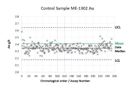
Figure 12-19 Control Chart for Gold Assays from Standard Reference ME-1302
For standard ME-1302, one gold assays (<1%) and three silver assays (1%) were outside the control limits. These results are considered satisfactory. The median gold grade is 3% below the standard mean. The median silver grade is 1% below the standard mean.
ME-1305
There were 253 samples of reference standard ME-1305 that were submitted. The average values of the standard and the control chart are shown in Table 12-6 and Figure 12-20 for silver and Figure 12-21 for gold.
Table 12-6 Laboratory Performance forcontrol Sample “ME-1305”
| Element | Average Grade of Samples Submitted | Accepted Value of Control |
| Au (g/t) | 1.83 | 1.92 |
| Ag (g/t) | 226 | 231 |
| Page 12-18 |
| UNIDAD ELCUBO GUANAJUATO, MÉXICO NI 43-101 TECHNICAL REPORT |
![]()
Figure 12-20 Control Chart for Silver Assays from Standard Reference ME-1305

Figure 12-21 Control Chart for Gold Assays from Standard Reference ME-1305
For standard ME-1305, three gold assays (1%) and twenty-four silver assays (9%) were outside the control limits. The majority of the gold failures occurred during February (5) and March (18). The median gold grade is 2% below the standard mean. The median silver grade is 5% below the standard mean. These results are considered satisfactory
| Page 12-19 |
| UNIDAD ELCUBO GUANAJUATO, MÉXICO NI 43-101 TECHNICAL REPORT |
ME-1307
There were 211 samples of reference standard ME-1307 that were submitted. The average values of the standard and the control chart are shown in Table 12-7 and Figure 12-22 for silver and Figure 12-23 for gold.
Table 12-7 Laboratory Performance for control Sample “ME-1307”
| Element | Average Grade of Samples Submitted | Accepted Value of Control |
| Au (g/t) | 0.98 | 1.02 |
| Ag (g/t) | 53 | 54 |
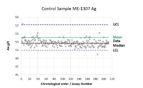
Figure 12-22 Control Chart for Silver Assays from Standard Reference ME-1307
| Page 12-20 |
| UNIDAD ELCUBO GUANAJUATO, MÉXICO NI 43-101 TECHNICAL REPORT |
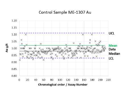
Figure 12-23 Control Chart for Gold Assays from Standard Reference ME-1307
For standard ME-1307, eight gold assays (4%) and three silver assays (1%) were outside the control limits. These results are considered satisfactory. The median gold grade is 4% below the standard mean. The median silver grade is 3% below the standard mean.
Check Samples
The Bolanitos lab routinely conducts check analyses. The lab selects random pulps which are sent to the SGS Lab in Durango, Mexico for analysis.
A check assay and the original result are independent variables. Depending on which variable is assigned to x and which to y, “least-squares” regression will produce different results. The check assay results were compared using the RMA (Reduced Major Axis) linear regression method described by Sinclair (2002).
A total of 111 pulp samples were sent in 2014. Scatterplots for the check assays are shown in Figure 12-24 and Figure 12-25. Outliers were identified and removed prior to completing the comparison. Correlation coefficients are high (>0.99) for both gold and silver, showing excellent overall agreement between the original Bolanitos Lab assay and the SGS check assay.
| Page 12-21 |
| UNIDAD ELCUBO GUANAJUATO, MÉXICO NI 43-101 TECHNICAL REPORT |
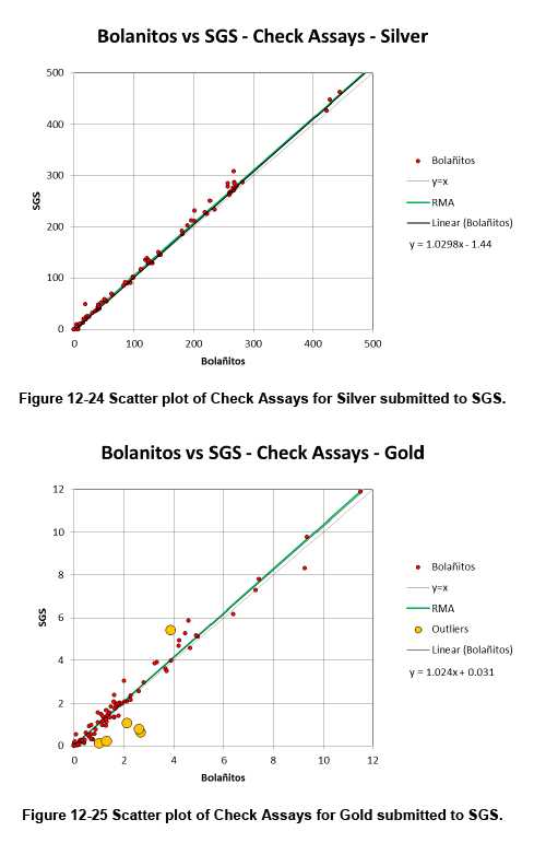
| Page 12-22 |
| UNIDAD ELCUBO GUANAJUATO, MÉXICO NI 43-101 TECHNICAL REPORT |
| 12.6 | QA/QC Control Charts |
QA/QC controls are in place for both surface and underground exploration drilling. Details of the individual QA/QC programs can be found in Section 11.3. | |
Analysis of the QA/QC charts confirm that adequate control samples including the use of certified reference material, blanks and duplicates have been used to ensure accuracy of the analytical database. In instances where standards failed, investigations as the cause were conducted and re-assaying was done on any samples deemed necessary. The QP did not identify any apparent flaws in the control sampling procedures. | |
Pulp and reject duplicates are also collected and re-submitted by mine geology. The QP has reviewed the charts of the pulp and reject data and has found it to be acceptable. QA/QC charts for mine production sampling are discussed in Section 11.3.1. | |
| 12.7 | Database Verification for the Mineral Resource Estimate |
Database verification included comparing assays in the database with the original assay certificates, and checking for discrepancies in lithology codes. In the case of drill data this included a review of down-hole survey data. Assay plans were used to check the reported block grades. Lithological codes in the database were checked against available geologic maps. In general the findings show an adequate correlation, however, much improvement could be done to enhance lithological control on the sample data, specifically by creating sub-domains with the quartz and breccia codes. | |
| 12.8 | Comments on Section 12 |
The QP finds that the 2014 exploration drill data adequately match the original records and that the databases are acceptable for purposes of resource estimation. The QP is also of the opinion that the mine data provided by Endeavour along with the quality assurance and quality control (QA/QC) protocols established by Endeavour are of adequate quality and quantity to support the estimation of mineral resources and mineral reserves. |
| Page 12-23 |
| UNIDAD ELCUBO GUANAJUATO, MÉXICO NI 43-101 TECHNICAL REPORT |
The QP recommends that more supervision and training for sampling crews be given to avoid issues with the quality of the sampling.
It is QP’s opinion that the mine grade control practices are reasonably systematic and conform to general practice in northern and central Mexico.
The QP recommends that Mine Exploration investigate using an up-to-date electronic logging system for future exploration programs.
| Page 12-24 |
| UNIDAD ELCUBO GUANAJUATO, MÉXICO NI 43-101 TECHNICAL REPORT |
| 13.0 | MINERAL PROCESSING AND METALLURGICAL TESTING |
| 13.1 | Processing plants |
El Cubo is an operating mine with a long history of milling and concentrating under various scenarios and in at least three different beneficiation plants. | |
During 2014 El Cubo mine operated the El Tajo flotation plant which was commissioned in May 2013. | |
Besides El Tajo, CMC owns an abandoned plant, La Chirimitera, located approximately in 1.5 km to the north of El Tajo plant. The main equipment (crushers, mill, and filter) was dismantled and used in other projects by AuricoGold. In 2012 Endeavour Silver recovered flotation cells, the vibratory screen and some conveyor belts from La Chirimitera plant which were used in the expansion of the Bolañitos processing plant from 1,200 to 1,600 tpd. | |
| 13.2 | Metallurgical Test Work |
Various metallurgical test programs are in process. Efforts are focused on: |
| • | improving sampling quality, | |
| • | stabilization of the process operation parameter (grinding size, flotation operation parameter), | |
| • | improving recovery by using other flotation reagents, gravity concentrate recovery, | |
| • | optimization of costs by finding optimal grades and recoveries. |
| 13.2.1 | Mineralogical analysis |
Ore samples from 3 mine zones (Santa Cecilia, Rampa Dolores and San Nicolas) and of combined plant feed were analyzed at the University of San Luis Potosi in 2013. The combined plant feed sample includes ore from Bolañitos mine. | |
Tailings sample was submitted to SGS Vancouver for analysis to evaluate possible recovery improvements in flotation. The results are expected in the first quarter of 2014. |
| Page 13-1 |
| UNIDAD ELCUBO GUANAJUATO, MÉXICO NI 43-101 TECHNICAL REPORT |
Table 13-1
Mineralogical analysis of El Cubo ore samples
| Mineral | Santa Cecilia | Rampa Dolores | San Nicolas | Plant feed |
| % | % | % | % | |
| Silver minerals | 0.26 | n.d. | 0.01 | 0.03 |
| Pyrite | 1.22 | n.d. | 1.61 | 1.11 |
| Pyrite-marcasite | n.d. | 0.29 | n.d. | n.d. |
| Arsenopyrite | n.d. | n.d. | 0.13 | 0.01 |
| Other sulphides | 0.2 | n.d. | n.d. | n.d. |
| Quartz | 31 | 23.4 | 40 | 30 |
| Calcite | 14.3 | 40 | n.d. | 10 |
| Iron oxides | n.d. | n.d. | 0.21 | n.d. |
| Aluminosilicates | 25 | n.d. | 12 | 33.85 |
| Feldspars | n.d. | 35 | 46.1 | n.d. |
| Silicates | 28 | n.d. | n.d. | n.d. |
| Metal Iron (Steel) | n.d. | 1.23 | n.d. | n.d. |
| Zinc oxides | n.d. | 0.04 | n.d. | n.d. |
| n.d. = none detected |
Table 13-2
Distribution of silver minerals in ore samples and size of grains of silver minerals
| Ore samples | Aguilarite Ag2(S,Se) | Agularite-Cu Cu12Sb4S12/Ag | Pirargirite Ag3SbS3 | Argentite Ag2S |
| Santa Cecilia | 85% <10 mm, Occluded in quartz | 12% | 3% <2 mm, Occluded in pyrite | |
| Rampa Dolores | 50% Occluded in pyrite | 50% <10 mm, liberated | ||
| San Nicolas | 100% | |||
| <5 mm, occluded in quartz and pyrite | ||||
| Cabeza planta | 50% <60 mm, liberated | 40% <7 mm, occluded in quartz and | 10% <7 mm, occluded in quartz and |
| Page 13-2 |
| UNIDAD ELCUBO GUANAJUATO, MÉXICO NI 43-101 TECHNICAL REPORT |
| aliminosilicates | aliminosilicates |
| 13.2.2 | Gravity concentration |
Gravity concentration tests were started in January 2014. Preliminary mineralogical analysis at SGS showed a presence of native gold (electrum) in flotation tailings in particles between 10 um to 90 um, 78% of gold grains had exposion degree from 30% to fully exposed. Plant samples (flotation tailings, cyclone underflow, and old flotation tailings) were submitted to Falcon lab in Guadalajara to perform gravity concentration tests in January 2014. The test work is still in process. | |
| 13.2.3 | Concentrate sale vs. cyanide leaching |
In 2013 Endeavour Silver conducted a study and found that NSR of selling concentrate directly was higher than that of Dore production by cyanide leaching. As a result, Endeavour Silver selected and closed contracts with two concentrate traders. The first shipment of concentrate was made in March 2013. | |
| 13.2.4 | Flotation collectors |
Various flotation collectors tested at the lab scale, did not show better performance than the currently used Aerophine 3416 and 7310. | |
| 13.2.5 | Native silver-gold flotation |
A collector specially designed by Cytec to float native gold and silver (MaxGold) showed some improvement (1-2%) in gold recovery in lab scale. Plant testing was started in December 2013 and planned to continue until April 2014. | |
| 13.2.6 | Metallurgical accounting |
Improved metallurgical accounting procedures were implemented in October 2013 and have continued through 2014. |
| Page 13-3 |
| UNIDAD ELCUBO GUANAJUATO, MÉXICO NI 43-101 TECHNICAL REPORT |
| 13.3 | Comments on Section 13 |
The El Cubo mine has a long history of operation and processing and has plans to continue. The author is of the opinion that the level of metallurgical testing is appropriate for the duration of the life of the mine plan. |
| Page 13-4 |
| UNIDAD ELCUBO GUANAJUATO, MÉXICO NI 43-101 TECHNICAL REPORT |
| 14.0 | MINERAL RESOURCE ESTIMATES |
| 14.1 | Terms of Reference |
The mineral resource estimates presented here were prepared according to the guidelines of the Canadian Securities Administrators' National Instrument 43- 101 (Aug, 2011), Form 43-101F1 (Aug, 2011), and CIM Estimation of Mineral Resource and Mineral Reserves Best Practices Guidelines (2003). Mineral resource classifications comply with CIM Definition Standards for Mineral Resources and Mineral Reserves (November 27, 2010). | |
This section presents updated mineral resource estimates for the El Cubo mine based on technical data and information available as of October 31, 2014. Historical mineral resource and reserve estimates for the El Cubo mine were reported by Clark (2009), and are discussed in detail in Section 6.5 of this report. The current mineral resource estimates were prepared by El Cubo mine staff and the author based on the results of underground chip sampling and surface and underground drillhole sampling. | |
Calculations required during the resource estimating process arrive at totals and weighted averages with some variability in precision. Rounding to normalize to significant digits may result in minor apparent discrepancies in some tables, and in the opinion of the author, these discrepancies are not material to the resource tabulation. | |
| 14.1.1 | CIM MINERAL RESOURCE DEFINITIONS AND CLASSIFICATIONS |
All mineral resources presented in a Technical Report must follow the current CIM definitions and standards for mineral resources and reserves. The latest edition of the CIM definitions and standards was adopted by the CIM council on November 27, 2010, and includes the resource definitions reproduced below: | |
“Mineral Resource” | |
"A Mineral Resource is a concentration or occurrence of diamonds, natural solid inorganic material, or natural solid fossilized organic material including base and precious metals, coal, and industrial minerals in or on the Earth's crust in such form and quantity and of such a grade or quality that it has reasonable prospects for economic extraction. The location, quantity, grade, geological characteristics and continuity of a Mineral Resource are known, estimated or interpreted from specific geological evidence and knowledge." |
| Page 14-1 |
| UNIDAD ELCUBO GUANAJUATO, MÉXICO NI 43-101 TECHNICAL REPORT |
"The term Mineral Resource covers mineralization and natural material of intrinsic economic interest which has been identz3ed and estimated through exploration and sampling and within which Mineral Reserves may subsequently be defined by the consideration and application of technical, economic, legal, environmental, socio-economic and governmental factors. The phrase "reasonable prospects for economic extraction" implies a judgment by the Qualified Person in respect of the technical and economic factors likely to influence the prospect of economic extraction. A Mineral Resource is an inventory of mineralization that under realistically assumed and justifiable technical and economic conditions might become economically extractable. These assumptions must be presented explicitly in both public and technical reports. "
“Inferred Mineral Resource"
"An 'Inferred Mineral Resource' is that part of a Mineral Resource for which quantity and grade or quality can be estimated on the basis of geological evidence and limited sampling and reasonably assumed, but not verified, geological and grade continuity. The estimate is based on limited information and sampling gathered through appropriate techniques from locations such as outcrops, trenches, pits, workings and drillholes."
"Due to the uncertainty that may be attached to Inferred Mineral Resources, it cannot be assumed that all or any part of an Inferred Mineral Resource will be up-graded to an Indicated or Measured Mineral Resource as a result of continued exploration. Confidence in the estimate is insufficient to allow the meaningful application of technical and economic parameters or to enable an evaluation of economic viability worthy of public disclosure. Inferred Mineral Resources must be excluded from estimates forming the basis of feasibility or other economic studies."
“Indicated Mineral Resource"
"An 'Indicated Mineral Resource' is that part of a Mineral Resource for which quantity, grade or quality, densities, shape and physical characteristics, can be estimated with a level of confidence sufficient to allow the appropriateapplication of technical and economic parameters, to support mine planning and evaluation of the economic viability of the deposit. The estimate is based on detailed and reliable exploration and testing information gathered through appropriate techniques from locations such as outcrops, trenches, pits, workings and drillholes that are spaced closely enough for geological and grade continuity to be reasonably assumed."
| Page 14-2 |
| UNIDAD ELCUBO GUANAJUATO, MÉXICO NI 43-101 TECHNICAL REPORT |
"Mineralization may be classified as an Indicated Mineral Resource by the Qualified Person when the nature, quality, quantity and distribution of data are such as to allow confident interpretation of the geological framework and to reasonably assume the continuity of mineralization. The Qualified Person must recognize the importance of the Indicated Mineral Resource category to the advancement of the feasibility of the project. An Indicated Mineral Resource estimate is of sufficient quality to support a Preliminary Feasibility Study which can serve as the basis for major development decisions."
"Measured Mineral Resource"
"A 'Measured Mineral Resource' is that part of a Mineral Resource for which quantity, grade or quality, densities, shape, and physical characteristics are so well established that they can be estimated with confidence sufficient to allow the appropriate application of technical and economic parameters, to support production planning and evaluation of the economic viability of the deposit. The estimate is based on detailed and reliable exploration, sampling and testing information gathered through appropriate techniques from locations such as outcrops, trenches, pits, workings and drillholes that are spaced closely enough to confirm both geological and grade continuity."
"Mineralization or other natural material of economic interest may be classified as a Measured Mineral Resource by the Qualified Person when the nature, quality, quantity and distribution of data are such that the tonnage and grade of the mineralization can be estimated to within close limits and that variation from the estimate would not significantly affect potential economic viability. This category requires a high level of confidence in, and understanding of, the geology and controls of the mineral deposit.”
| Page 14-3 |
| UNIDAD ELCUBO GUANAJUATO, MÉXICO NI 43-101 TECHNICAL REPORT |
| 14.2 | Previous Estimates |
Information on previous estimates of mineral resources is given in Section 6.2. The author has undertaken his own review of the mineral resource inventory with respect to the available data and Endeavour’s operating plan, as discussed in the following sections. The author has not relied on previous estimates and they should not be considered current. | |
| 14.3 | Database |
The master database at the mine is a series of Excel®workbooks containing individual spreadsheet tabs for each defined mineralized block within a defined vein structure. The workbooks also contain a spreadsheet tab with global parameters, capping and metal price information, along with summary sheets. A master spreadsheet contains all the summary data from the individual spreadsheets. There are a total of 39 individual spreadsheets containing approximately 2,100 individual mineralized blocks making up the resource database. Each resource block has an image of the vertical long section identifying the location of the block. | |
Chip sampling data accounts for the bulk of the resource database. The samplers, under supervision of the geologists, record the sample numbers and location information in sample ticket books. These are returned to the mine office for processing by the geologists and data entry clerks. Data necessary to estimate resources is generally maintained in electronic form as spreadsheets. The data is not centrally stored, and resides on various computers and compact discs in the geology office. Older data, some as much as 100 years old, is contained on paper or linen maps. Much of the older data is very well ordered and neatly drafted, showing the mine openings, sample locations, and widths and grades of gold and silver for each individual sample in a sample line. Newer data is recorded in spreadsheets, one for each workplace, and is organized in directories by vein and mining level. Composite grades are calculated using a standard format for subsequent presentation on CAD- generated longitudinal sections. | |
Longitudinal sections are the principal tool for displaying the resource blocks and the sample averages used to generate them. Each vein has its own long section, comprising 39 separate resource estimates. |
| Page 14-4 |
| UNIDAD ELCUBO GUANAJUATO, MÉXICO NI 43-101 TECHNICAL REPORT |
Many of these veins are simply splays from the Villalpando vein system and so represent relatively low tonnage and strike length. Maintaining and updating these sections is a challenge, both in terms of the mining advance and resource depletion. | |
| 14.4 | Sample Capping |
It is common in the mineral industry to use a form of sample capping (top- cutting) to restrict or prevent the projection of extreme grades during modeling. There are no industry standard method and is left to the QP to determine what is appropriate. | |
In the past sample capping was applied to all resources as described by Clark (2009): “The mean and the standard deviation are calculated for a group of vein channel samples in a stope block. The high assays are capped using the mean plus 1 standard deviation as the highest assay. Any assays above the mean plus 1 standard deviation are reduced to that level.” In 2013 a capping study showed that this level of capping may cause underestimation of the resource blocks. Decile analysis along with analysis of assay probability plots showed that the capping threshold defined by the mean plus 1 standard deviation was generally much lower suggesting that too much metal was being removed during capping. New capping levels were calculated for each major vein where sufficient data existed by decile/probability analysis. Block grades, being composites of individual samples, are also capped as discussed below. | |
Capping of the drill hole assays used for the resource model is shown in Table 14-1. |
Table 14-1
Capping values applied by lithology to drillhole assays.
| Vein | Gold (g/t) | Silver (g/t) |
| Banded Vein | No Cap | 678 |
| Breccia | 3 | 384 |
| Page 14-5 |
| UNIDAD ELCUBO GUANAJUATO, MÉXICO NI 43-101 TECHNICAL REPORT |
| 14.5 | Bulk Density Determinations |
El Cubo staff apply a factor of 2.5 tonnes/m3to convert volume to tonnage. This is considered reasonable for this type of deposit and is based on long production experience and historic measurements. | |
The QP is of the opinion that the bulk density factor used at El Cubo is acceptable for use in the resource estimate given the density factors used in other deposits in the district, and the similarity of the El Cubo veins to other veins in the district. | |
The QP recommends that mine staff should send a new suite of representative samples bulk density determinations to improve the quality of its mineral resources. | |
| 14.6 | Assumptions and Key Parameters |
Resources are undiluted. Estimated blocks are capped to maximum grades of 300 g/t Ag and 4.0 g/t Au. Assumed metal prices are $1540 per ounce for gold and $22 per ounce for silver. Resource blocks above a cut-off of 179 g/t silver equivalent are considered for inclusion in Measured and Indicated resources. Resource blocks above a cut-off of 100 g/t silver equivalent are considered for inclusion in Inferred resources. Silver equivalent is calculated using a 70:1, gold grams to silver grams. | |
| 14.7 | Methodology |
In 2014 several different methodologies have been employed for the estimation of resources for the El Cubo Project, as described below. | |
| 14.7.1 | Polygonal Resource based on Chip Samples |
The mineral resource estimates presented in this report are estimated by polygonal methods using fixed-distance vertical projections from chip sample lines in the development drifts and stopes, and lateral projections from raises. The average grade of a sample line is the weighted average of the capped assays and the assay length. Geologists review grade trends in the sample line averages along the development drifts and group adjacent lines with similar grades together to form resource blocks. The average of a length of vein in longitudinal section is the average of all of the samples in the vein along that length weighted by their widths. The area of a block is the length in section multiplied by the vertical (or lateral for raises) projection. The volume is obtained by multiplying the area by the average width of the vein as sampled. |
| Page 14-6 |
| UNIDAD ELCUBO GUANAJUATO, MÉXICO NI 43-101 TECHNICAL REPORT |
Volume is converted to tonnage by multiplying the block volume by a global bulk tonnage factor of 2.5 tonnes/m3.
Each resource block is given a name whose prefix is the level followed by a distance from a reference point, usually a coordinate from the local coordinate system used for the long section. The blocks are tabulated in the spreadsheet for that vein and classified according to distance-to-nearest-data criteria if they are determined to have reasonable potential for economic extraction.
Table 14-2 shows a portion of a typical resource (and reserve) longitudinal section. Blocks with light gray hatch are not considered economic and are not classified. Orange and light blue blocks are classified as Measured and Indicated resources respectively. Red and green blocks meet reserve criteria and are respectively classified as Proven and Probable reserves. Mined-out areas are shown as solid gray hatch.

| Page 14-7 |
| UNIDAD ELCUBO GUANAJUATO, MÉXICO NI 43-101 TECHNICAL REPORT |
Many blocks have irregular geometries. These irregular blocks are digitized on the longitudinal sections using the same general construction and classification guidelines, and their associated areas are multiplied by thickness and bulk density to obtain volume and weight in tonnes.
Some of the estimated resource blocks have been informed using drillhole information, usually a single hole per block. The areas of the blocks are generally defined by circles of a radius of 20 m for Indicated and an additional 10 m for Inferred resources. No measured resources are defined on a single drillhole.
The grade of each block is the mean grade of the drillhole intersections weighted by their respective lengths. Tonnage is derived from the mean of the thicknesses of each intercept, multiplied by the polygonal area and density factor.

| 14.7.2 | Block Modelling |
Resources for part of the Villalpando vein were estimated using 3D modelling and ordinary kriging as the interpolator. The database is comprised of surface and underground diamond drill holes drilled since EDR acquired El Cubo. |
| Page 14-8 |
| UNIDAD ELCUBO GUANAJUATO, MÉXICO NI 43-101 TECHNICAL REPORT |
Details on the surface and underground drilling can be found in Sections 9 and 10 of this report.
14.7.2.1.Model Setup
The block models were based on wireframes of the Villalpando and Asuncion veins as well as several other vein structures within the Villalpando vein system.
Based on the geometry of the deposit and drill hole spacing, a parent block size of y = 25m, x = 25m and z =25m was selected to fill the mineralization envelope. The data is sparse in places with the average spacing being 50m. Sub-blocks were used at the solid envelope boundaries to give the appearance of a more accurate volume representation.
A volume checks of the block model versus the mineralization envelopes revealed a good representation of the volumes of the solids.
The search parameters applied for grade interpolations are based on variographic analysis and are summarized in Table 14-2.
Table 14-2
Search Ellipsoid Parameters for the Villalpando Resource Model
| Vein | Azimuth | Dip | Search ellipse distances (m) | Composites | |||
| Major | Semi-Major | Minor | Minimum | Maximum | |||
| Primary | 264 | 40 | 45 | 45 | 30 | 2 | 6 |
| Secondary | 264 | 40 | 75 | 75 | 55 | 1 | 6 |
14.7.2.2.Exploratory Data Analysis (EDA)
Descriptive statistics of the assays and composites have been completed by using histograms. Statistics were calculated for silver and gold grades, true thickness and accumulation (grade x thickness). Composites were grouped by lithology and EDA performed separately on each lithology. Composite data was declustered prior to completing EDA.
| Page 14-9 |
| UNIDAD ELCUBO GUANAJUATO, MÉXICO NI 43-101 TECHNICAL REPORT |
14.7.2.3.Univariate Statistics
The data used for the resource estimation for the Villalpando vein is composed of diamond drillhole data. The data consist of 90 composited drillhole intervals spanning the main Villalpando structure and several additional vein structures. The univariate statistics for drillhole composite data is shown in Table 14-3 for banded vein and Table 14-4 for breccia.
The coefficients of variation (CV) are relatively low, demonstrating that the data are not sensitive to the presence of outliers.
Table 14-3
Univariate Composite Statistics for Banded Vein, Villalpando
| Massive Vein | Ag (g/t) | Au (g/t) | Thickness (m) | Ag X Thickness | Au X Thickness |
| No Samples | 109 | 109 | 109 | 109 | 109 |
| Mean | 151.49 | 1.35 | 2.64 | 340.76 | 3.47 |
| SD | 141.40 | 1.41 | 2.28 | 327.82 | 4.90 |
| CV | 0.93 | 1.04 | 0.86 | 0.96 | 1.41 |
| Minimum | 2.90 | 0.02 | 0.3 | 2.46 | 0.01 |
| Lower Quartile | 50.85 | 0.51 | 1.3 | 108.87 | 1.06 |
| Median | 101.82 | 0.82 | 2.05 | 235.84 | 1.96 |
| Upper Quartile | 199.09 | 1.75 | 3.5 | 444 | 4.04 |
| Maximum | 678.00 | 9.94 | 19.9 | 1872.79 | 31.87 |
Table 14-4
Univariate Composite Statistics for Breccia, Villalpando
| Breccia | Ag (g/t) | Au (g/t) | Thickness (m) | Ag X Thickness | Au X Thickness |
| No Samples | 87 | 87 | 87 | 87 | 87 |
| Mean | 62.50 | 0.45 | 2.16 | 123.98 | 0.92 |
| SD | 80.94 | 0.58 | 1.37 | 182.55 | 1.43 |
| CV | 1.30 | 1.29 | 0.63 | 1.47 | 1.55 |
| Minimum | 0.39 | 0.01 | 0.35 | 0.24 | 0.01 |
| Lower Quartile | 8.04 | 0.06 | 1.20 | 14.36 | 0.14 |
| Median | 32.39 | 0.20 | 1.86 | 50.60 | 0.36 |
| Upper Quartile | 84.42 | 0.55 | 2.60 | 131.81 | 0.92 |
| Maximum | 378.00 | 2.16 | 6.20 | 979.69 | 7.26 |
| Page 14-10 |
| UNIDAD ELCUBO GUANAJUATO, MÉXICO NI 43-101 TECHNICAL REPORT |
14.7.2.4.Variography
Variography was completed separately for silver and gold for using Vulcan® software. Endeavour calculated experimental traditional variograms drillhole composite data. The drillhole composites have and average spacing of 55m.
The ranges observed in the variogram models are relatively short ranging from 35 to 55m, Table 14-5 and Table 14-6.
Table 14-5
Villalpando Model Variogram Parameters for Silver
| Model | C0 | C1 | Range (m) | ||
| Major | Semi-Major | Minor | |||
| Vein | 0.30 | 0.60 | 55 | 55 | 35 |
| Breccia | 0.25 | 0.55 | 55 | 55 | 35 |
Table 14-6
Villalpando Model Variogram Parameters for Gold
| Model | C0 | C1 | Range (m) | ||
| Major | Semi-Major | Minor | |||
| Vein | 0.20 | 0.80 | 55 | 55 | 35 |
| Breccia | 0.28 | 0.63 | 55 | 55 | 35 |
| 14.7.3 | Polygonal Resource based on Drilling |
In the southern portion of the Villalpando vein, south of Panel 2150, resources were tabulated using polygonal methods. Upon the completion of more detailed analysis and interpretation of the drill information, the data will be incorporated into the block model which lies to the north of the polygonal resource. |
| Page 14-11 |
| UNIDAD ELCUBO GUANAJUATO, MÉXICO NI 43-101 TECHNICAL REPORT |
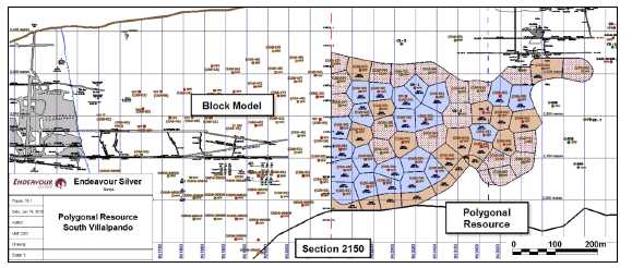
Figure 14-3 Polygonal Resource in the South Villalpando Vein.
| 14.8 | Classification |
The Measured, Indicated, and Inferred resources described here comply with CIM standards and definitions. | |
Mineral resources that are based on ship sample data the following applies. Measured resources are projected up to 10m from sample data or halfway to adjacent data points, whichever is less. Indicated resources may be projected up to an additional 20m, giving the total Measured and Indicated envelope a distance of 30m. | |
Inferred resources may be projected an additional 50m, thus the total projection from sample data is a maximum of 80m vertically. Prior to Endeavour acquiring the El Cubo property, the projections that were in use through 2011 allowed projections of 40m for Indicated resources (30m beyond Measured) and 190m for Inferred resources (150 m beyond Indicated). | |
For mineral resources based on small diameter single drillhole data, Indicated resources are projected to a 20m radius from the drillhole location, and Inferred resources are projected to a 30m radius. No Measured blocks are defined on single drillholes. |
| Page 14-12 |
| UNIDAD ELCUBO GUANAJUATO, MÉXICO NI 43-101 TECHNICAL REPORT |
For mineral resources based on large diameter drillholes, typically HQ core, Indicated resources are projected to a 50m radius from the drillhole location, and Inferred resources are projected to a 75m radius. No Measured blocks are defined on single drillholes. | |
| 14.9 | Block Model Validation |
The Villalpando resource model was validated by the following methods: |
• Comparison of the global mean grades from the NN, OK models and composite data,
• Inspection of the OK block model grades in plan and sectional views in comparison to the drillhole composite grades, and
• Swath plot comparisons of composites, NN and OK models.
| 14.9.1 | Global Comparison |
The global estimation mean for the OK method compared to the global estimation mean of the NN and the declustered composites is shown in Table 14-7. |
| Page 14-13 |
| UNIDAD ELCUBO GUANAJUATO, MÉXICO NI 43-101 TECHNICAL REPORT |
Table 14-7
Villalpando Global Means by Estimation Method
| Vein | Method | Number | Mean | CV | ||
| Silver (g/t) | Gold (g/t) | (Silver) | (Gold) | |||
| Villalpando | OK | 9,727 | 156 | 1.50 | 0.55 | 0.70 |
| NN | 9,727 | 158 | 1.48 | 0.71 | 0.87 | |
| Composites | 90 | 154 | 1.59 | 0.73 | 0.88 | |
The OK and composite values generally show similar mean grades for silver. The gold mean grade between OK and the composites show a larger variance. | |
Based on the CV’s the QP considers these differences to be acceptable. | |
| 14.9.2 | Visual Comparison |
A visual comparison of block grades with drillhole composite grades was made in both long section and cross sectional views. The comparison showed a reasonable correlation between values. This can be seen in | |
Figure 14-4 and Figure 14-5 which show the colour coded OK block model grades and drillhole composites in cross section view looking northwest. |
| Page 14-14 |
| UNIDAD ELCUBO GUANAJUATO, MÉXICO NI 43-101 TECHNICAL REPORT |
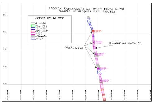
Figure 14-4 Villalpando, Cross Section through block model and composite data for silver.
| Page 14-15 |
| UNIDAD ELCUBO GUANAJUATO, MÉXICO NI 43-101 TECHNICAL REPORT |
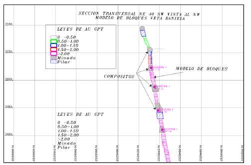
Figure 14-5 Villalpando, Cross Section through block model and composite data for gold. | |
| 14.9.3 | Swath Plots |
Swath plots were generated for the Villalpando vein structure. Swath plots are used to assess the model for global bias by comparing OK and NN values of the estimated blocks with composite samples on each axis of the model, elevation, nothing and easting. Examples of the swath plots used in the evaluation of the Villalpando Vein are shown in Figure 14-6 through Figure 14-8 for silver and Figure 14-9 through Figure 14-11 for gold. The swath plot results have a similar trend between estimation methods. Grade estimates show the greatest differences (smoothing) along the mineralized boundaries indicated by a low number of blocks, and in areas where there are few composites (low data density). | |
The results of the swath plot analyses were considered acceptable. |
| Page 14-16 |
| UNIDAD ELCUBO GUANAJUATO, MÉXICO NI 43-101 TECHNICAL REPORT |
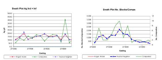
Figure 14-6 Easting swath plot for silver comparing grade of composites to grade of
block model, OK and NN Models (left); comparing number of composites to number of
blocks in the block model, (right).
| Page 14-17 |
| UNIDAD ELCUBO GUANAJUATO, MÉXICO NI 43-101 TECHNICAL REPORT |
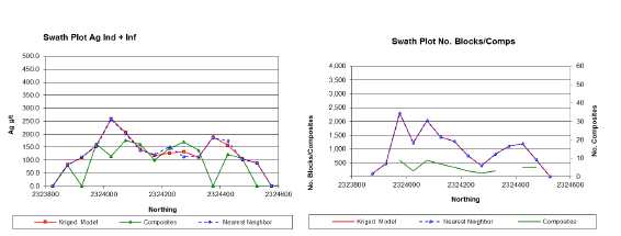
Figure 14-7 Northing swath plot for silver comparing grade of composites to grade of
block model, OK and NN Models (left); comparing number of composites to number of
blocks in the block model, (right).
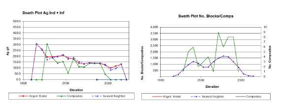
Figure 14-8 Elevation swath plot for silver comparing grade of composites to grade of
block model, OK and NN Models (left); comparing number of composites to number of
blocks in the block model, (right).
| Page 14-18 |
| UNIDAD ELCUBO GUANAJUATO, MÉXICO NI 43-101 TECHNICAL REPORT |
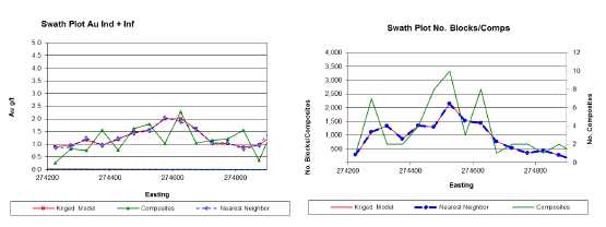
Figure 14-9 Easting swath plot for silver comparing grade of composites to grade of
block model, OK and NN Models (left); comparing number of composites to number of
blocks in the block model, (right).
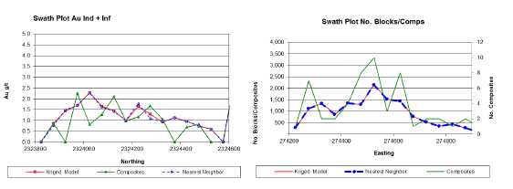
Figure 14-10 Northing swath plot for silver comparing grade of composites to grade of
block model, OK and NN Models (left); comparing number of composites to number of
blocks in the block model, (right).
| Page 14-19 |
| UNIDAD ELCUBO GUANAJUATO, MÉXICO NI 43-101 TECHNICAL REPORT |
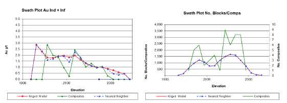
Figure 14-11 Elevation swath plot for silver comparing grade of composites to grade of
block model, OK and NN Models (left); comparing number of composites to number of
blocks in the block model, (right).
| 14.9.4 | 2D Polygonal Resource Estimates |
The 2D polygonal method is based on the use of a longitudinal section to estimate the mineral resources and reserves. This method has been used for estimating the resources in the southern part of the Villalpando Vein. | |
Mineral resource blocks are defined by drawing a polygon around each drill intercept on a longitudinal section. Before a polygon is drawn, the intercept must be above the established cut-off grade and meet the minimum width criterion. A 25m projection from the centroid of the drill intercept is then made for indicated resource blocks. When the continuity of mineralization is determined, an additional 25 m projection is made for inferred resources. Block volumes are estimated by drawing each block area on a longitudinal section and measuring this area using AutoCAD. The area of the block is then multiplied by the average horizontal width of the composited drill intercept to estimate the volume. The 2D classic polygonal method is appropriate in areas tested by a limited number of drill holes/samples and has been successfully used by Endeavour's exploration division in the last couple of years, as evidenced by the extent to which indicated resources were quickly upgraded into reserves. |
| Page 14-20 |
| UNIDAD ELCUBO GUANAJUATO, MÉXICO NI 43-101 TECHNICAL REPORT |
| 14.10 | Assessment of Reasonable Prospects for Economic Extraction |
The assessment of geological and grade continuity of mineralized material was used in determining the limits of mineral resources based on established cut-off grade. | |
By definition, a Mineral Resource must have “reasonable prospects of economic extraction” and therefore a resource defined by a cut-off grade must also satisfy this requirement. Endeavour Silver is reporting resources at cut-offs that are reasonable for deposits of this nature and for the expected mining conditions and methods. | |
The resources presented for the El Cubo mining operations are based on silver-equivalent cut-off grades. Those cut-off grades are 100 g/t AgEQ for Inferred resources and 179 g/t AgEQ for Measured and Indicated resources. Endeavour considered metal prices, recovery, mining method and economics to derive the reported cut-off. | |
The silver-equivalent calculation is based on long-term average gold and silver metal prices. To keep consistent with prior reporting, a gold to silver ratio of 70 to 1 was used to establish the silver-equivalent value. Silver-equivalent calculations for resources reflect gross metal content and are not adjusted for metallurgical recoveries or relative processing and smelting costs. Silver- equivalent grades were used for establishing cut-off grades. | |
| 14.11 | Mineral Resource Statement |
The Measured and Indicated mineral resources for the El Cubo mine as of October 31, 2014, are summarized in Table 14-8. The resources are exclusive of the mineral reserves. Inferred mineral resources are summarized in Table 14-9. |
| Page 14-21 |
| UNIDAD ELCUBO GUANAJUATO, MÉXICO NI 43-101 TECHNICAL REPORT |
Table 14-8
Mineral Resource Estimate, Effective Date October 31, 2014
Michael Munroe, SME Registered Member
| Description | Tonnes | Silver (g/t) | Gold (g/t) | Silver (oz) | Gold (oz) | Silver Eq. (oz) |
| Measured | 738,000 | 172 | 2.74 | 4,064,000 | 65,000 | 8,616,000 |
| Indicated | 1,748,000 | 172 | 2.42 | 9,658,000 | 136,000 | 19,167,000 |
| Total Measured and Indicated | 2,486,000 | 172 | 2.51 | 13,722,000 | 201,000 | 27,783,000 |
Table 14-9
Inferred Mineral Resource Estimate, Effective Date October 31, 2014
Michael Munroe, SME Registered Member
| Description | Tonnes | Silver (g/t) | Gold (g/t) | Silver (oz) | Gold (oz) | Silver Eq. (oz) |
| Inferred | 1,783,000 | 134 | 1.83 | 7,680,000 | 105,000 | 15,017,000 |
| Total Inferred | 1,783,000 | 134 | 1.83 | 7,680,000 | 105,000 | 15,017,000 |
*Notes to Tables 14.7 and 14.8:
1. Measured and Indicated mineral resource cut-off grade is 179 g/t AgEQ.
2. Inferred mineral resource cut-off grade is 100 g/t AgEQ.
3. Mineral resource price assumptions are $1540 and $22 per troy ounce for gold and silver, respectively.
4. Mineral resource silver equivalent is 70:1, gold grams to silver grams.
5. Mineral resources are not fully diluted and no mining recovery or mill recovery is applied.
6. Mineral resources are exclusive of mineral reserves.
7. Figures in table are rounded to reflect estimate precision; small differences generated by rounding are not material to estimates
Mineral resources which are not mineral reserves do not have demonstrated economic viability. The estimate of mineral resources may be materially affected by legal, title, taxation, marketing or other relevant issues; and it is uncertain if further exploration will lead to upgrading Inferred mineral resources to an Indicated or Measured mineral resource category. | |
| 14.12 | Risk Factors |
There is no assurance that mineral resources will be converted into mineral reserves. Mineral resources are subject to further dilution, recovery, lower metal price assumptions, and inclusion in a mine plan to demonstrate economics and feasible of extraction. Not all of the mineral resources can be physically examined due to temporary accessibility issues related to the mine sequence. Estimates for some resources rely on historical data which cannot be verified without re-sampling. |
| Page 14-22 |
| UNIDAD ELCUBO GUANAJUATO, MÉXICO NI 43-101 TECHNICAL REPORT |
| 14.13 | Comments on Section 14 |
The QP is of the opinion that the Mineral Resources for the El Cubo Mines Project, which have been estimated using underground chip and drillhole data, have been performed to acceptable industry standards, and conform to the requirements of CIM (2010). | |
It is the option of the QP that single drillholes should not be used for resources as they do not meet the requirements set forth in the CIM definitions regarding classification of resources. A single drillhole cannot confirm nor can any reasonable assumptions be made concerning the grade or continuity of the mineralization. This is not to be confused with a polygonal resource based on a group of reasonably closely spaced drillholes, but rather refers to isolated holes and holes which are not reasonably spaced. |
| Page 14-23 |
| UNIDAD ELCUBO GUANAJUATO, MÉXICO NI 43-101 TECHNICAL REPORT |
| 15.0 | MINERAL RESERVE ESTIMATES |
| 15.1 | Terms of Reference |
The mineral reserve estimates presented here were prepared according to the guidelines of the Canadian Securities Administrators' National Instrument 43- 101 (Aug, 2011), Form 43-101F1 (Aug, 2011), and CIM Estimation of Mineral Resource and Mineral Reserves Best Practices Guidelines (2003). Mineral reserve classifications comply with CIM Definition Standards for Mineral Resources and Mineral Reserves (November 27, 2010). | |
This section presents updated mineral reserve estimates for the El Cubo mine based on technical data and information available as of October 31, 2014. Historical mineral reserve estimates for the El Cubo mine were reported by Clark (2009), and are discussed in Section 6.2 of this report. The current mineral reserve estimates were prepared by El Cubo mine staff and the author based on the results of underground mine development and chip sampling. This estimate supersedes the December 31, 2013 reserve estimate for the El Cubo Mines project and has an effective date of October 31, 2014. | |
| 15.1.1 | CIM Mineral Reserve Definitions and Classifications |
All resources and reserves presented in a Technical Report must follow the current CIM definitions and standards for mineral resources and reserves. The latest edition of the CIM definitions and standards was adopted by the CIM council on November 27, 2010, and includes the reserve definitions reproduced below. | |
“Mineral Reserve” | |
“Mineral Reserves are sub-divided in order of increasing confidence into Probable Mineral Reserves and Proven Mineral Reserves. A Probable Mineral Reserve has a lower level of confidence than a Proven MineralReserve.” | |
“A Mineral Reserve is the economically mineable part of a Measured or Indicated Mineral Resource demonstrated by at least a Preliminary Feasibility Study. This Study must include adequate information on mining, processing, metallurgical, economic and other relevant factors that demonstrate, at the time of reporting, that economic extraction can be justified. A Mineral Reserve includes diluting materials and allowances for losses that may occur when the material is mined.” |
| Page 15-1 |
| UNIDAD ELCUBO GUANAJUATO, MÉXICO NI 43-101 TECHNICAL REPORT |
“Mineral Reserves are those parts of Mineral Resources which, after the application of all mining factors, result in an estimated tonnage and grade which, in the opinion of the Qualified Person(s) making the estimates, is the basis of an economically viable project after taking account of all relevant processing, metallurgical, economic, marketing, legal, environment, socioeconomic and government factors. Mineral Reserves are inclusive of diluting material that will be mined in conjunction with the Mineral Reserves and deliveredto the treatment plant or equivalent facility. The term ‘Mineral Reserve’ need not necessarily signify that extraction facilities are in place oroperative or that all governmental approvals have been received. It does signify that there are reasonable expectations of such approvals.”
“Probable Mineral Reserve”
“A ‘Probable Mineral Reserve’ is the economically mineable part of an Indicatedand, in some circumstances, a Measured Mineral Resource demonstrated by at least a Preliminary Feasibility Study. This Study must include adequate information on mining, processing, metallurgical, economic, and other relevant factors that demonstrate, at the time of reporting, that economic extraction canbe justified.”
“Proven Mineral Reserve”
“A 'Proven Mineral Reserve’ is the economically mineable part of a MeasuredMineral Resource demonstrated by at least a Preliminary Feasibility Study. This Study must include adequate information on mining, processing, metallurgical, economic, and other relevant factors that demonstrate, at the time of reporting,that economic extraction is justified.”
“Application of the Proven Mineral Reserve category implies that the QualifiedPerson has the highest degree of confidence in the estimate with the consequent expectation in the minds of the readers of the report. The term should be restricted to that part of the deposit where production planning istaking place and for which any variation in the estimate would not significantly affect potential economic viability.”
| Page 15-2 |
| UNIDAD ELCUBO GUANAJUATO, MÉXICO NI 43-101 TECHNICAL REPORT |
| 15.1.2 | Conversion Factors from Mineral Resources to Mineral Reserves |
The parameters used for the El Cubo mineral reserves are as follow: |
| • | Cut-off grade: 218 g/t AgEq. | |
| • | Dilution: 40%. | |
| • | Minimum width: 0.8m. | |
| • | Silver equivalent: 70:1, gold grams to silver grams. | |
| • | Gold price: US $1,260 per oz | |
| • | Silver price: US $18 per oz. | |
| • | Gold recovery (overall): 88.3%. | |
| • | Silver recovery (overall): 85.7%. |
| 15.2 | Dilution and Recovery |
Dilution is applied to Measured and Indicated resource blocks in the amount of 40% at a grade of zero. Mining recovery applied to converted resources is estimated at 95%. | |
Much of the El Cubo mineral reserve is pillar recovery under or adjacent to unconsolidated fill or voids and requires an allowance for lower recovery of in situ resources. Considering the above, recovery factors for the current estimates are further adjusted on a block-by-block basis with the application of a secondary mining recovery factor (pfactor) ranging from 0.1 to 1.0. | |
The global dilution and mining recovery factors at El Cubo have varied over time depending on company philosophy and experience in reconciling estimated mine production with mill sampling. Currently, there is limited information upon which to measure actual dilution and recovery in the development headings, stopes, and transport system. Dilution and mining recoveries are functions of many factors including workmanship, heading design, vein width, mining method, extraction, and transport. Misclassification of ore and waste also contributes to variations in dilution and mining recovery. It is nearly certain that the dilution and metal recovery experienced in the mine is a combination of many factors and is at best valid on a global basis over relatively long time periods. |
| Page 15-3 |
| UNIDAD ELCUBO GUANAJUATO, MÉXICO NI 43-101 TECHNICAL REPORT |
| 15.3 | Cut-off Grade |
The mining breakeven cut-off grade is applied to fully diluted resources in order to determine if they warrant inclusion in the mine plan. The data presented in Table 15-1 is from cost reports for the 2ndQuarter 2014. |
Table 15-1
Mining Cost per Tonne Milled El Cubo Property
| Mining | Plant | G&A | Operating Cost | Production Cost |
| $55.46 | $27.78 | $18.71 | $83.24 | $101.95 |
The production cost data, reserve price assumptions, and mill recoveries are used to calculate the reserve breakeven cut-off grade. The parameters used for the calculation are presented in Table 15-2.
Table 15-2
Mineral Reserve Breakeven Cut-off Inputs for El Cubo Mine
| Description | Cost (US$) |
| Silver price ($US) | $18.00 |
| Gold price ($US) | $1,260 |
| Mill Recovery (Ag) | 0.857 |
| Mill Recovery (Au) | 0.883 |
| Production Cost ($/tonne milled)1 | $101.95 |
| Cut-off Grade AgEq (g/t) | 218 |
The cut-off is stated as silver equivalent since the ratio between gold and silver is variable and both commodities are sold. These cut-offs are applied to the resource blocks, and those that exceed these grades are considered for inclusion in the mine plan and for reporting as reserves. The average cut-off grade for the four working areas is 218 g/t Ag equivalent. Silver equivalent grade is calculated as (silver grade + gold grade) * 70, taking into account gold and silver prices and expected mill recoveries.
| Page 15-4 |
| UNIDAD ELCUBO GUANAJUATO, MÉXICO NI 43-101 TECHNICAL REPORT |
| 15.4 | Reconciliation of Mineral Reserves to Production |
Mine reconciliation is the comparison of an estimate with a measurement (Morley and Moller, 2005), (Schofield, 2001). Estimates can include mineral resource models, ore reserve models, grade control information, or a mine production plan. Measurements include survey information, material movement records or official production, usually reported by the processing plant. | |
Geology staff prepared a reconciliation of the Life of Mine plan (LOM) to actual production from sampling for the 12-month period, January to December, 2014. | |
The reconciliation compared the LOM with geology estimates from chip sampling and plant estimates based on head grade sampling. Reconciliation estimates a negative variance on tonnes for both geology and plant estimated tonnage as compared to the LOM (Table 15-3). Estimated tonnage was 30% lower for geology and 26% lower for the plant than specified in the LOM. |
Table 15-3
Reconciliation of 2013 LOM to 2014 Geology / Plant Production
| LOM_2013 | Geology Short Term | Plant | |
| Ore Mined | 520,634 | 401,036 | 413,282 |
| Grade Au | 1.51 | 1.53 | 1.55 |
| Grade Ag | 118 | 114 | 104 |
| Grade AgEq | 216 | 214 | 204 |
| Ounces Au | 25,254 | 23,579 | 20,549 |
| Ounces Ag | 1,979,561 | 1,863,889 | 1,378,045 |
| Ounces AgEq | 3,621,056 | 2,754,257 | 2,713,759 |
Reconciliation of silver grades show a negative variance for both geology and the processing plant as compared to the LOM, and a positive variance for gold. The geology grade for 2014 shows a negative variance of 3% on silver and a 1% positive variance on gold as compared to the LOM. The mill head grade for 2014 shows a negative variance of 14% on silver and 2% positive variance on gold as compared to the LOM.
| Page 15-5 |
| UNIDAD ELCUBO GUANAJUATO, MÉXICO NI 43-101 TECHNICAL REPORT |
There are six reconciliation metrics defined at El Cubo. Table 15-4 shows the scores for the six reconciliation metrics.
Table 15-4
Reconciliation F scores for 2013 LOM versus 2014 Geology and Plant Grade Estimates.
| Metric | Tonnes | Au g/t | Ag g/t | Oz Au | Oz Ag |
| F1 = Short-term Plan / Long-term Plan | 90% | 103% | 104% | 93% | 94% |
| F2 = Received-at-Plant / Sent-to-Plant | 103% | 101% | 91% | 104% | 93% |
| F3 = Received-at-Plant / Long-term Plan | 79% | 103% | 88% | 81% | 70% |
| F4 = Received-at-Plant / Short-term Plan | 85% | 98% | 93% | 83% | 79% |
| F5 = Mine-Reported / Short-term Plan | 88% | 99% | 84% | 87% | 74% |
| F6 = Mine-Reported / Long-term Plan | 77% | 101% | 97% | 78% | 75% |
The results of the reconciliation shows that production tonnage was the biggest factor on production. In 2014 plant tonnage was 21% lower than stated in the 2013 LOM and 15% lower than stated in the short-term plan. The lower tonnage is the main contributor to the shortfall in the ounces produced. The reconciliation shows good correlation between silver and gold grades. The plant gold grade is practically on par with the mine grade. The plant silver grade was 9% below the mine silver grade. The short-term planned grades are within 10% of the plant grades and the long-term silver grade is 12% higher than the plant grades. These are acceptable reconciliation results.
One of the contributing factors to the shortfall on tonnes is the result of production delays caused by a mine accident in April 2014. Other factors include a reduction in planned dilution and poor mining practices.
The price of silver hovered near $20 / oz for the first half of 2014 before starting it’s steady decline in the second half of 2014 hitting a low of 15.28/oz in November. As a result, operations re-evaluated mining sequences in response to weak silver prices. The high variance on silver between the LOM, geology and plant, appears to be the results of changes in mining strategy to compensate for depressed metal prices. For the first six months of 2014 all reconciliation metrics perform erratically and have large variations. This behaviour slowed starting in July and became more uniform.
It is common practice in the industry to apply a mine call factor (MCF) to compensate for negative mine-mill reconciliations. This factor compares the in situ tonnes and grade estimated by geology with the tonnes and grade reported by the plant.
| Page 15-6 |
| UNIDAD ELCUBO GUANAJUATO, MÉXICO NI 43-101 TECHNICAL REPORT |
The MCF adjusts actual sampling data and is used to provide more realistic forecasts of expected tonnage and grade. It is important however, to understand whether the adjustment is related to sampling, density determination, dilution, outliers, or poor mining and milling performance. | |
A mine call factor if not properly understood can disguise the source of the errors causing the difference. Actions should be taken to minimize the error between estimates and actual production by identifying and resolving the issues that cause a poor reconciliation in place of applying an MCF. | |
Reserves should reflect expectations of performance over the life of the mine. The current reserves apply a MCF of 1.0, and it will require attention and further evaluation by Endeavour to determine whether that is appropriate going forward. | |
| 15.5 | Production Depletion |
Mineral reserves reported here reflect mining depletion to October 31, 2014. Survey data was not updated for some areas in production at the time of compilation of the reserve statement. Depletion in these areas was estimated with a conservative mining recovery factor applied, and any blocks whose production status was in doubt were removed from consideration as reserves. | |
| 15.6 | Reserve Classification |
El Cubo mineral reserves comply with CIM standards and definitions of Proven and Probable mineral reserves. Measured and Indicated resource blocks that are above the reserve cut-off grade, and that are deemed feasible and economic for extraction after any additional adjustments of grade or tonnage after in a life-of-reserve mine plan, are classified as either Proven or Probable. | |
Resulting reserve blocks range in size from 60 to approximately 20,000 tonnes. The smaller blocks are remnant blocks that are included in the mine plan which are close to larger blocks whose net block values support the costs of access requirements. |
| Page 15-7 |
| UNIDAD ELCUBO GUANAJUATO, MÉXICO NI 43-101 TECHNICAL REPORT |
Figure 15-1 shows reserve blocks depicted on a portion of a typical longitudinal section. Proven reserve blocks are shown in red, Probable reserve blocks are shown in green. Inside each block are the average width, silver and gold grade, and the name of the block for cross-referencing with the reserve master spreadsheet. The Proven blocks are often irregular in shape due to proximity to mined out areas. The Probable blocks are projected from the development sill samples, in this case 10m downward, according to Indicated resource criteria. The mine planner has determined that extraction of the blocks is feasible given grade, tonnes, costs, and access requirements.
Mineral reserves and any blocks that are deemed unrecoverable in formulation of the mine plan are not included in the mineral resource estimate.
![]()
Figure 15-1 Typical resource and reserve section showing Proven reserves in red, Measured resource in orange, average block horizontal width, Ag g/t and Au g/t for the composited sample lines across the vein. Gray areas mined-out, blue areas mined in 2014. | |
| 15.7 | Mineral Reserve Statement |
The Proven and Probable mineral reserves for the El Cubo mine as of October 31, 2014 are summarized in Table 15-5. The reserves are exclusive of the mineral resources reported in Table 14-8 and Table 14-9. |
| Page 15-8 |
| UNIDAD ELCUBO GUANAJUATO, MÉXICO NI 43-101 TECHNICAL REPORT |
Table 15-5
Proven and Probable Mineral Reserves, Effective Date October 31, 2014
Michael Munroe, SME Registered Member
| Description | Tonnes | Silver (g/t) | Gold (g/t) | Silver (oz) | Gold (oz) | Silver Eq. (oz) |
| Proven | 346,600 | 144 | 1.94 | 1,615,400 | 21,600 | 3,129,400 |
| Probable | 446,900 | 132 | 1.79 | 1,893,100 | 25,700 | 3,689,800 |
| Total Proven and Probable | 793,500 | 137 | 1.86 | 3,508,500 | 47,300 | 6,819,200 |
*Notes to Table 15-5:
1. Average cut-off grade at El Cubo is 218 g/t Ag equivalent.
2. Minimum mining width for mineral reserves is 0.8 metres.
3. Dilution is 40% of in situ tonnes.
4. Mining recovery of 95% applied to mineral reserves.
5. Silver equivalent is 70:1 gold grams to silver grams.
6. Mineral reserve price assumptions are $1260 and $18 per troy ounce for gold and silver, respectively.
7. Mineral reserves take into account metallurgical recovery assumptions of 85.7% and 88.3% for gold and silver, respectively.
8. Mineral reserves are exclusive of mineral resources.
9. Figures in table are rounded to reflect estimate precision; small differences generated by rounding are not material to estimates.
| 15.8 | Risk Factors |
The El Cubo mine is an operating mine with a long history of production. The mine staff possess considerable experience and knowledge with regard to the nature of the El Cubo orebodies. Maintaining access, infrastructure, and production rates is a constant challenge due to the large number of relatively small reserve blocks and pillar recovery. Underground supervision will need to improve in the areas of grade control and operation controls to ensure that high quality material is extracted. Mine planning and operations need to assure that the rate of waste development is sufficient to maintain the production rates in the mine plan. Maintaining good labor relations with the workforce at El Cubo is critical to the mining operation. | |
It is unlikely that there will be a major change in ore metallurgy during the life of the current reserves, as nearly all of the ore to be mined will come from veins with historic, recent, or current production. | |
The process of mineral reserve estimation includes technical information which requires subsequent calculations or estimates to derive sub-totals, totals and weighted averages. Such calculations or estimations inherently involve a degree of rounding and consequently introduce a margin of error. The QP does not consider these errors to be material to the reserve estimate. |
| Page 15-9 |
| UNIDAD ELCUBO GUANAJUATO, MÉXICO NI 43-101 TECHNICAL REPORT |
Areas of uncertainty that may materially impact the Mineral Reserves presented in this report include variations in commodity price and exchange rate assumptions; mining and processing assumptions including dilution and metallurgical recoveries. | |
Changes in taxation and royalties that may apply to the project, will affect the estimated and actual operating costs used to help define the most appropriate cut-off grade for assessment of reasonable prospects of economic extraction. | |
December 2013, the Mexican President passed tax reform legislation that will be effective January 1, 2014. The tax reform includes, among other items, an increase of the Mexican corporate tax rate from 28% to 30%, removal of the flat tax regime, a Special Mining Duty of 7.5% on taxable revenues, less allowable deductions excluding interest and capital depreciation and an 0.5% Environmental Tax on gold and silver revenues. The tax reform is expected to have a material impact on the Company’s future earnings and cash flows. | |
| 15.9 | Comments on Section 15 |
The QP is of the opinion that the estimation of Mineral Reserves for the El Cubo Project conform to industry leading practices, meets the requirements of CIM (2010), and is in compliance with NI 43-101. Declaration of Mineral Reserves considered environmental, permitting, legal, title, taxation, socio- economic, marketing, and political factors and constraints, as discussed in Section 4 of this Technical Report. | |
The QP recommends that greater effort be applied to organizing and maintaining resource data. | |
The QP recommends that an automatic data backup system be installed for both local and server data. A server failure in 2013 resulted in the loss of much of the data that would be useful for reconciliation purposes. |
| Page 15-10 |
| UNIDAD ELCUBO GUANAJUATO, MÉXICO NI 43-101 TECHNICAL REPORT |
| 16.0 | MINING METHODS |
| 16.1 | Mining Operations |
The El Cubo Mine is organized into four discrete physical areas, Areas 1 through 4, which have separate crews and infrastructure for access, stoping, ventilation, and ore haulage. The area separations are geographic, and by level. | |
Area 1 covers the upper portion of the vein system at the north end of the mine, with access on Levels +120, +60, and 1 on the Villalpando system, and from the Sta. Cecilia ramp. Mining in Area 1 occurs above Level 6 in the La Loca vein and above Level 3 elsewhere. | |
Area 2 includes the southern end of the Villalpando and Dolores vein systems, and is principally accessed from the Dolores ramp at El Tajo and from a crosscut on Level 4. | |
Area 3 occurs below Level 6 in the La Loca vein and below Level 3 everywhere else down to Level 10 on the north end of the vein system. | |
Area 4 covers areas below Level 10 in the north end of the El Cubo concessions with access from the Sta. Lucia shaft (Figure 16-1). |
| Page 16-1 |
| UNIDAD ELCUBO GUANAJUATO, MÉXICO NI 43-101 TECHNICAL REPORT |
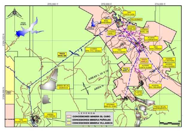
Figure 16-1 Division of mining areas (Planta=Mill, Presa=Dam, Tiro=Shaft, Acceso=Adit)
| 16.2 | Production History |
The El Cubo mine has an extensive production history, which is discussed in detail by Clark (2009) and is summarized here. Table 16-1 details production from the El Cubo mine from 2009 through to the end of 2014. Production in 2010 and 2011 was affected by a general strike that halted operations from June 2010 to March 2011. Production resumed in May 2011. |
| Page 16-2 |
| UNIDAD ELCUBO GUANAJUATO, MÉXICO NI 43-101 TECHNICAL REPORT |
Table 16-1
El Cubo and Las Torres Consolidated Production, 2009-2014
| Description | 2009 | 2010 | 2011 | 2012 | 2013 | 2014 | Total |
| Tonnes | 506,248 | 240,496 | 247,190 | 385,872 | 391,354 | 413,282 | 2,184,442 |
| Ag (g/t) | 83 | 83 | 81 | 100 | 107 | 105 | 94 |
| Au (g/t) | 1.92 | 1.63 | 1.24 | 1.52 | 1.57 | 1.59 | 1.62 |
| Ag (oz) | 1,351,816 | 641,540 | 678,343 | 1,241,227 | 1,159,026 | 1,228,256 | 1,119,957 |
| Au (oz) | 31,177 | 12,599 | 10,343 | 18,826 | 17,145 | 18,146 | 19,613 |
| Waste meters | 7,467 | 2,930 | 4,828 | 12,269 | 10,719 | 13,211 | 51,424 |
| Meters on Vein | 9,505 | 2,747 | 1,377 | 8,518 | 7,048 | 1,419 | 30,614 |
| Meters Total | 16,973 | 5,678 | 6,205 | 20,787 | 17,767 | 14,630 | 82,040 |
Table 16-2 lists production by quarter for 2014. Quarterly production was below plan during the first three quarters by as much as 37%. During the fourth quarter management and production changes reduced the differences to 2%.
Table 16-2
2014 El Cubo Consolidated Production by Quarter
| Total | Q1 | Q2 | Q3 | Q4 | ||||||||
| Actual | Budget | Variance | Actual | Budget | Variance | Actual | Budget | Variance | Actual | Budget | Variance | |
| Production Tonnes | 94,632 | 121,334 | 78% | 83,641 | 133,556 | 63% | 94,407 | 135,175 | 70% | 128,256 | 130,569 | 98% |
| Development Tonnes | 67,586 | 114,777 | 59% | 74,559 | 75,294 | 99% | 68,295 | 51,771 | 132% | 64,198 | 38,491 | 167% |
| Total Tonnes | 162,218 | 236,111 | 69% | 158,200 | 208,850 | 76% | 162,702 | 186,946 | 87% | 192,454 | 169,060 | 114% |
| Ag (g/t) | 110 | 146 | 75% | 103 | 156 | 66% | 102 | 145 | 70% | 106 | 142 | 75% |
| Au (g/t) | 2.01 | 2.27 | 89% | 1.44 | 2.38 | 61% | 1.42 | 2.57 | 55% | 1.51 | 2.18 | 69% |
| Ag (oz) | 320,367 | 368,983 | 87% | 249,887 | 404,016 | 62% | 284,863 | 483,482 | 59% | 373,140 | 479,633 | 78% |
| Au (oz) | 5,606 | 4,872 | 115% | 3,495 | 5,315 | 66% | 3,903 | 6,293 | 62% | 5,142 | 6,098 | 84% |
| Waste meters | 2,829 | 2,616 | 108% | 2,917 | 1,988 | 147% | 2,884 | 2,245 | 128% | 2,523 | 2,508 | 101% |
| Meters on Vein | 1,295 | 1,840 | 70% | 1,069 | 1,995 | 54% | 2,042 | 1,730 | 118% | 1,949 | 1,170 | 167% |
| Total Meters | 5,880 | 4,529 | 130% | 4,330 | 4,143 | 105% | 4,035 | 4,103 | 98% | 3,521 | 4,712 | 75% |
Year-to-date development for 2014 is at 13,090 metres of advance, of which 6,355 metres are in mineral development and 6,735 metres in waste development (Table 16-3).
| Page 16-3 |
| UNIDAD ELCUBO GUANAJUATO, MÉXICO NI 43-101 TECHNICAL REPORT |
Waste development includes bypasses, ventilation raises and ore passes, ramps, areas of waste vein, and cross-cuts to vein. Much of the current mine production is pillar recovery, and bypasses are necessary where old stopes must be avoided to access the pillars.
Table 16-3
2014 Production Summary (metres of advance)
| Month | Ore | Waste | Sub Totals |
| Jan | 352 | 545 | 897 |
| Feb | 508 | 640 | 1,148 |
| Mar | 436 | 655 | 1,091 |
| Apr | 276 | 720 | 996 |
| May | 291 | 670 | 961 |
| Jun | 501 | 605 | 1,106 |
| Jul | 676 | 600 | 1,276 |
| Aug | 695 | 650 | 1,345 |
| Sep | 671 | 480 | 1,151 |
| Oct | 847 | 460 | 1,307 |
| Nov | 610 | 350 | 960 |
| Dec | 492 | 360 | 852 |
| Total | 6,355 | 6,735 | 13,090 |
The life-of-mine plan, presented in Section 22 of this report, forecasts an average of 1,792m per month total development for 2015. This can be broken down into an average of 523m metres in ore and 1,269m in waste. Development begins to taper off towards the end of 2015. In 2016 development is reduced an average of 65m in ore and 227m in waste for a total of 292m total development. By the end of December 2016, total development is down to less than 100m per month. | |
| 16.3 | Mining Methods |
Conventional drill and blast methods are used to extract the ore at El Cubo, and access to the mining areas is provided by ramps, adits and shafts. Mine development headings are drilled by jumbo and by jackleg. The dimensions of the different development sections are as follows: |
| • | Main Ramps: 4.3 W x 4 H metres | |
| • | Accesses: 3 x 3 metres | |
| • | Sill in Mineral 2.2 x 2.5 metres (minimum) | |
| • | Raise: 1.5 x 1.5 metres |
| Page 16-4 |
| UNIDAD ELCUBO GUANAJUATO, MÉXICO NI 43-101 TECHNICAL REPORT |
| • | Bore Holes Raise: 1.8 metre diameter |
The choice of equipment is generally guided by the anticipated vein widths, stoping method, and equipment availability.
The stoping methods used at El Cubo in 2014 were 100% mechanized cut-and-fill. Production from cut-and-fill is shown in Table 16-2.
Once sill development is completed and the limits of the ore have been defined, stope production can begin. For conventional cut and fill stoping, ore is mined upward in horizontal slices using jackleg drills. Cut and fill mining is a method of short hole mining with hole lengths usually less than 2m. After the ore is removed, the void is filled with muck. El Cubo uses unconsolidated mine waste from development headings. Under certain circumstances concrete is used as fill to create a solid floor. This enables mining from the stope below up to the concrete pillar and recovering most, if not all of the ore pillar that would otherwise be left behind. This process is usually reserved for high-grade floor pillars.
The production cycle starts by drilling upper holes using a jackleg (Figure 16-2). Geologists will mark up the vein, and the stope is drilled and blasted accordingly.
Drillholes on the vein (Blue) are blasted first. After the ore has been mucked, the holes drilled in waste (Green) are then blasted to achieve the dimensions required for the scoop to work in the next production lift.

| Page 16-5 |
| UNIDAD ELCUBO GUANAJUATO, MÉXICO NI 43-101 TECHNICAL REPORT |
The mining is simpler where the veins are close to, or equal to the width of the working. In this case, the back is blasted full-width and the extra waste blast step is eliminated.
By comparison, longhole open-stoping, holes are drilled upwards and/or downwards from the sill level. Longhole methods are typically 7 to 15m in length and are more productive than cut and fill methods. Longhole stoping is also cheaper than conventional cut and fill stoping. As with cut and fill methods, longhole stopes are filled with waste rock from development headings (Figure 16-3).
Some of the ore produced with the longhole drill machines is generated by drilling old pillars. Other stopes are blind by drilling uppers and blasting a slot at the far end of the stope to enable the ore to break in the subsequent larger stope blasts. Uppers are drilled to a 10-15m height on vein projections in rows across the width of the vein. The rows closest to the slot are blasted first. The stope is mucked clean, or at least sufficiently to allow the next blast. The stope retreats, leaving a void that can only be filled by a mill hole connected from somewhere above. The ore is extracted using remote- controlled scoops.
| Page 16-6 |
| UNIDAD ELCUBO GUANAJUATO, MÉXICO NI 43-101 TECHNICAL REPORT |
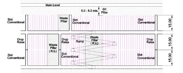
Figure 16-3 Schematic showing typical longhole stope design.
| 16.4 | Mine Equipment |
The mine has its own fleet of scoops, trucks, and rail wagons, as summarized in Table 16-4. Depending on the location, underground ore is delivered to the surface by trucks via ramp, shaft, or rail haulages. |
Table 16-4
Mining Equipment Inventory, El Cubo Mine
| Loaders | Capacity | Model | Qty |
| Scoop tram | 1.25 | LT-210 | 6 |
| Scoop tram | 1.5 | LT-270 | 5 |
| Scoop tram | 2 | LH-203 | 9 |
| Scoop tram | 2 | RDH 200D | 2 |
| Scoop tram | 2.5 | LT-350 | 1 |
| Scoop tram | 3 | LT-410 | 1 |
| Scoop tram | 3.5 | LT-650 y LH307 | 2 |
| Total | 26 | ||
| Page 16-7 |
| UNIDAD ELCUBO GUANAJUATO, MÉXICO NI 43-101 TECHNICAL REPORT |
| Trucks | Capacity | Model | Qty |
| Truck | 4 | Elmac D-5 | 2 |
| Truck | 6.5 | Elmac D-10 | 3 |
| Truck | 10 | Normet | 2 |
| Total | 7 | ||
| Locomotives | Capacity | Model | Qty |
| Goodman | 4.5 | 2 | |
| Goodman | 6 | 2 | |
| Goodman | 8 | 4 | |
| Titan | 3.5 | 1 | |
| Total | 9 | ||
| Compressors | Capacity | Model | Qty |
| Ingersoll Rand | 300 HP | 1 | |
| Atlas Copco | 268 HP | GA 200 | 3 |
| Atlas Copco | 363 HP | GA 315 | 4 |
| Total | 8 | ||
| Other Equipment | Model | Qty | |
| Tractors | New Holland | 6 | |
| Tractors | John Deere | 13 | |
| Jumbo | Ven-Runner II | 1 | |
| Raise-Bore | Robbins / SBM | 2 | |
| Jacklegs | RNP | 59 | |
| Vehicles | varies | 65 | |
| Total | 146 | ||
The mine has an inventory of 59 jacklegs which are spread throughout the operations. Contractors supply additional mining equipment for development.
Two contractors are used in the mining operations, COMINVI (Cominvi, S.A. de C.V.) and JASSO. They are involved in the development of certain areas of the mines and in haulage of ore from underground and surface stockpiles to the plant.
| Page 16-8 |
| UNIDAD ELCUBO GUANAJUATO, MÉXICO NI 43-101 TECHNICAL REPORT |
| 16.5 | Geotechnical Factors |
Since May of 2011 it is standard procedure throughout the mine to install systematic ground control. | |
Ground control is carried out using a combination of split sets, mesh, w-straps, and cable bolts. The type of support varies according to the conditions encountered, but split sets are most common and are complemented as needed with mesh and/or w-straps. | |
Cable bolting is required during the preparation of stopes for longhole blasting. The cable bolts are installed by drilling holes in the hanging wall and fixing the bolts in place with cement pumped into the hole. | |
The upper levels of the mine are dry. Water inflows are a factor in the lowest development levels in Area 4 where it is collected, pumped, and distributed as additional water for the needs of mine production. | |
The lowest historic development level of the mine, Level 9 of the Villalpando vein, was flooded until the latter part of 2013. The water level at the end of 2014 was about 37m below the Level 9. | |
After the strike ended in 2011, Blake (2011) provided a preliminary geotechnical study to AuRico to determine if ground deterioration had occurred and if so, what rehabilitation effort might be needed in order for mining to resume. The geotechnical study concluded that in most cases, scaling and spot bolting would sufficiently mitigate deterioration, and rehabilitation work was carried out in three stopes according to recommendations. | |
| 16.6 | Manpower |
As of December 31, 2014, the company had a total of 614 direct employees distributed in different departments (Table 16-5). This is approximately a 7% increase from the 576 employees at the end of 2013. | |
Of the 614 direct employees, 464 (76%) belong to the local miners’ union (Part of the National Miners Union). | |
Cominvi, S.A. de C.V. (COMINVI) supplies 246 persons for underground development. Juan Ramon Jasso Martinez (JASSO) hauls ore from underground and from the mines to the plant and had 32 people on site as of December 31, 2014. |
| Page 16-9 |
| UNIDAD ELCUBO GUANAJUATO, MÉXICO NI 43-101 TECHNICAL REPORT |
Hammer Seguridad Privada is the security company used to guard the installations and they have a total of 86 persons working on site.
There were 49 other persons working with several other contractors providing various services from personnel transport to construction projects (Table 16-5).
Table 16-5
El Cubo Employees and Contractors
| DIRECTLY EMPLOYED | |
| Employees Cubo | 26 |
| Employees Villalpando | 28 |
| Varal | 96 |
| Cubo Sindicalizados (union) | 464 |
| Total | 614 |
| CONTRACTORS | |
| Transportes Urbanos de Guanajuato, S.A. de C.V. (Personal Transport) | 11 |
| Rangel Barbosa Fernando (Personal Transport) | 7 |
| Construcciones Mineras Gogui, S.A. de C.V. (Personal Transport) | 31 |
| Hammer Seguridad Privada, S.R.L. de C.V. (Security) | 86 |
| Jasso Martinez Juan Ramon (Heavy Equipment, Haulage) | 32 |
| Cominvi, S.A. de C.V. (Mining) | 246 |
| Previniendo, S.C. | 2 |
| Griselda Sandoval Ortiz | 8 |
| Total | 423 |
| 16.7 | Training and Safety |
All new employees, including contractors, are required to complete a two day induction course that explains the risks of the operation, procedures, how to use the safety gear, first aid, handling of explosives, etc. At the end of the training each employee is evaluated to determine if further training is necessary. Safety talks and safety audits are completed and recorded on a daily basis. |
| Page 16-10 |
| UNIDAD ELCUBO GUANAJUATO, MÉXICO NI 43-101 TECHNICAL REPORT |
The mine has an Emergency and Mine Rescue team that consists of 24 members. The team was formed in February, 2012, and is equipped with Drager BG4 breathing apparatus. The team also provides emergency services support to the local community, as needed. Emergency facilities (infirmaries) are located at Sta. Cecilia, El Tajo (Dolores), and El Cubo, and all operate 24 hours 7 days per week. One doctor, ten paramedics, and two nurses are available on-site, and a second doctor is retained in an on-call capacity in order to comply with work regulation NOM-030-STPS-2009.
A second ambulance was purchased in 2013. One is stationed at the Dolores mine site the other at the Santa Cecilia mine site.
| Page 16-11 |
| UNIDAD ELCUBO GUANAJUATO, MÉXICO NI 43-101 TECHNICAL REPORT |
| 17.0 | RECOVERY METHODS |
In 2014, the El Cubo mine produced 413,282 t of ore grading 105 g/t silver and 1.59 g/t gold. 1,228,256 oz silver and 18,146 oz gold were recovered from El Cubo ore. Silver and gold recoveries averaged 88% and 85.9%, respectively. | |
| 17.1 | Processing plants |
| 17.1.1 | El Tajo flotation plant |
Endeavour Silver Corp. refurbished crushing circuit and completely rebuilt grinding and flotation circuits. The new flotation plant was commissioned in May 2013 ramping up the throughput to 1,600 tpd and stabilizing the process in August-September 2013. The process flow sheet of the flotation plant is shown in Figure 17-2 and the principal equipment list is shown in Table 17-2. | |
The plant was designed and built by Promimet S.A. de C.V., a Mexican engineering company based in Guanajuato. An EPC contract was granted in September 2012. The construction management was awarded to Smith & Foster, a Canadian firm. | |
Views of the existing plant are shown in Figure 17-3 to Figure 17-6. | |
Plant performance was improved from October to December (Figure 17-1). |
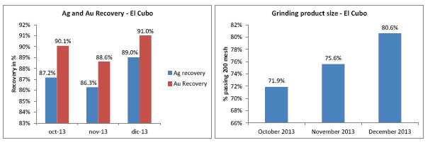
Figure 17-1 Metal recovery and grinding product size at El Cubo
| Page 17-1 |
| UNIDAD ELCUBO GUANAJUATO, MÉXICO NI 43-101 TECHNICAL REPORT |
Table 17-1
Average reagent consumption in 2014 at El Tajo flotation plant
| Reagent/Power | Units | Consumption |
| Collector A-3416 | l/t ore | 0.043 |
| Frother CC-1065 | l/t ore | 0.012 |
| Steel balls | kg/t ore | 1.150 |
| Collector 7310 | l/t ore | 0.018 |
| Copper sulfate | kg/t ore | 0.007 |
| Flocculant | kg/t ore | 0.026 |
Table 17-2
Principal equipment of El Tajo flotation plant
| Principal Equipment | Specification |
| Jaw crusher | 30’x42’ portable crusher |
| Coarse ore bins | Concrete ore bin with approx. capacity of 600 t of ore |
| Secondary cone crusher | Symons, dia. 4-1/4’, standard head |
| Tertiary cone crusher | Symons, dia. 4-1/4’ short head |
| Vibration screens | 1. Terex vibration screen, 6’x16’ |
| 2. Svedala vibration screen, 6’x16’ | |
| Fine ore bins | Two (2) steel ore bins with approx. capacity of 620 t of ore in each or total 1240 t |
| Ball mills | 1. Mercy, 9’x9’, 450 HP |
| 2. Mercy, 9’x10’, 600 HP | |
| 3. Dominion Engineering, 12’x14’, 1300 HP | |
| Rougher/scavenger flotation cells | Five (5) Outotec tank cells, 30 m3each |
| 1stcleaner cell | Four (4) Denver flotation cells, 50 ft3each |
| 2ndcleaner cell | Two (2) Denver flotation cells, 50 ft3each |
| Concentrate filter press | One (1) Diemme filter press with 39 plates of size 1500 mmx1500 mm, chamber thickness 50 mm, total filtration area147 m2, 3.378 m3of concentrate per batch |
| Concentrate thickener | One (1) Outotec thickener of size D 8 m |
| Tailings thickener | One (1) Outotec thickener of size D 21 m |
| Page 17-2 |
| UNIDAD ELCUBO GUANAJUATO, MÉXICO NI 43-101 TECHNICAL REPORT |
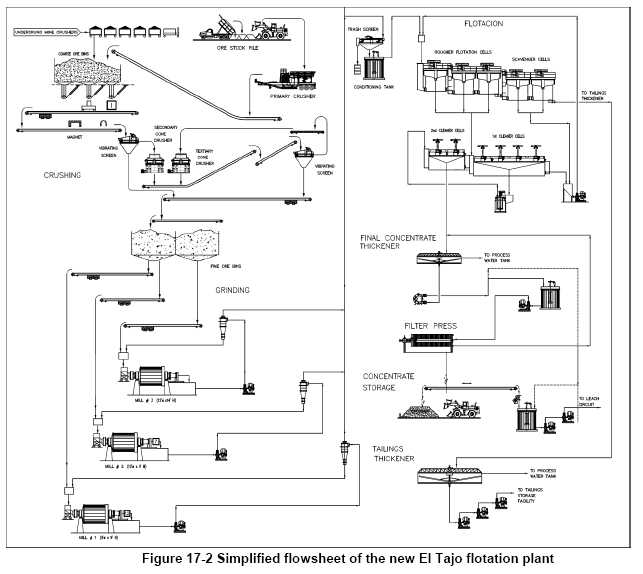
| Page 17-3 |
| UNIDAD ELCUBO GUANAJUATO, MÉXICO NI 43-101 TECHNICAL REPORT |
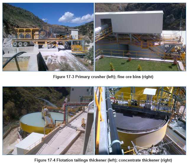
| Page 17-4 |
| UNIDAD ELCUBO GUANAJUATO, MÉXICO NI 43-101 TECHNICAL REPORT |
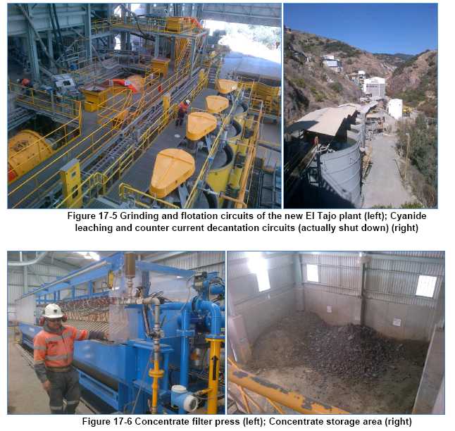
| 17.1.2 | El Tajo cyanide leach plant |
The El Tajo leach plant was designed and built for processing 400 tpd of ore, but at the time of acquisition by Endeavour Silver Corp. it was used for leaching flotation concentrate produced at Las Torres plant rented from Fresnillo Plc. |
| Page 17-5 |
| UNIDAD ELCUBO GUANAJUATO, MÉXICO NI 43-101 TECHNICAL REPORT |
In December 2013 the leaching plant was shut down due to the fact that selling the concentrate was more economic than cyanide leaching at current conditions.
A simplified process flowsheet of El Tajo plant is shown in Figure 17-7. A list of principal equipment is shown in Table 17-4.
Table 17-3
Reagent consumption of El Tajo leach plant in 2013
| Reagent/Power | Units | Consumption |
| Sodium cyanide | kg/kg Ag | 5.44 |
| Flocculant | kg/kg Ag | 0.21 |
| Lime | kg/kg Ag | 4.71 |
| Zinc dust | kg/kg Ag | 0.87 |
| LP gas | kg/kg Ag | 6.62 |
| Borax | kg/kg Ag | 1.50 |
| Soda ash | kg/kg Ag | 0.51 |
| Niter | kg/kg Ag | 0.33 |
| Page 17-6 |
| UNIDAD ELCUBO GUANAJUATO, MÉXICO NI 43-101 TECHNICAL REPORT |
![]()
| Page 17-7 |
| UNIDAD ELCUBO GUANAJUATO, MÉXICO NI 43-101 TECHNICAL REPORT |
Table 17-4
Principal equipment of El Tajo leaching plant
| Principal Equipment | Specification |
| Leach feed thickener | D 60’xH 12’ (used as process water tank) |
| Leach tanks | Five (5) air agitated leach tanks of size D 30’xH 24’ |
| CCD thickeners | Four (4) thickeners of size D 41’xH 11’ and |
| Two (2) thickeners of size D 38’xH 10’ | |
| Merrill-Crowe | A modular 120 m3/h-plant designed and built by Kappes , Cassiday and Associates (1994) |
| Refinery | Two (2) gas fired furnaces |
| 17.2 | Recovery |
The recovery process at El Cubo during 2014 consisted of a single flotation concentrate. Table 17-5 shows the recovery percentage by year. |
Table 17-5
Process Recovery for 2008– 2014
| Year | Recovery (%) | Head Grade (g/t) | ||
Au | Ag | Au | Ag | |
| 2008 | 90.4 | 88.1 | 1.98 | 94.4 |
| 2009 | 90.3 | 88.5 | 1.92 | 83.0 |
| 2010 | 91.0 | 88.7 | 1.70 | 82.1 |
| 2011 | 85.3 | 85.3 | 1.23 | 77.8 |
| 20121 | 87.9 | 85.2 | 1.43 | 87.3 |
| 2013 | 89.62 | 87.22 | 1.73 | 113.0 |
| 2014 | 85.9 | 88.0 | 1.59 | 105.5 |
1. Using estimated AuricoGold recoveries until July 14, 2012. Endeavour also includes ore from Bolañitos
2. Including ore supplied from Bolañitos (not reconciled)
Silver and gold recoveries averaged 88% and 85.9% respectively.
| Page 17-8 |
| UNIDAD ELCUBO GUANAJUATO, MÉXICO NI 43-101 TECHNICAL REPORT |
| 17.3 | Tailings |
The flotation tailings from El Tajo flotation plant with density of approximately 50% solids are pumped through 1.4 km pipeline to Mastrantos VI tailings facility (Figure 17-8), A part of water is reclaimed and pumped back to the flotation plant. | |
The concentrate leaching tailings were sent to Mastrantos IV (Figure 17-8) until leach plant was shut down at the end of 2013. The operation of the tailings dam were not continuous and the tailings are deposited in batch. The solution collected in the tailings dam is reclaimed and sent to the plant and used again in the process. Additional make-up water for the concentrate leaching process is pumped to the El Tajo plant from the Dolores underground mine. The cyanide solutions are handled separately from the flotation circuit process water since the presence of cyanide is depresses the pyrite flotation. | |
Mastrantos I, II and IV are old cyanidation tailings; Mirasol, Mastrantos III and Mastrantos VI are flotation tailings. | |
The mine conducts sampling of waters in arroyos and streams every 3 months. The water samples are sent for analysis to an external certified laboratory. | |
In 2013 Endeavour Silver hired AMEC to plan and implement a tailings facility management program: development, tailings water monitor, and tailings closure. |
| Page 17-9 |
| UNIDAD ELCUBO GUANAJUATO, MÉXICO NI 43-101 TECHNICAL REPORT |
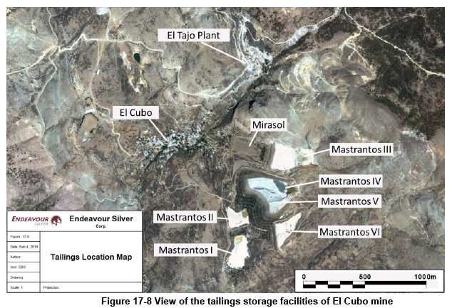
| Page 17-10 |
| UNIDAD ELCUBO GUANAJUATO, MÉXICO NI 43-101 TECHNICAL REPORT |
| 18.0 | PROJECT INFRASTRUCTURE |
Endeavour Silver has all of the necessary mine and mill infrastructure to operate the El Cubo Mines project efficiently and to all regulatory standards imposed on the project by the various government agencies. | |
In the following paragraphs describing infrastructure, the ownership for each infrastructure component is discussed, and the capacities of each facility are summarized. | |
| 18.1 | Offices and Buildings |
CMC uses three building complexes. The main office is located inside the mine site located at the Dolores Mine. The mine site is also the location of the El Tajo process plant. The second complex, which is called La Hacienda and belongs to CMC, is located in the town of El Cubo. The company warehouse is located in La Hacienda. A new warehouse is being constructed near the underground core storage facility. La Hacienda, within itself, has enough buildings and offices to contain all the administrative personnel and activities. The third complex is the Santa Cecelia Mine site. This complex is the home to a maintenance shop and an additional office building used by mine geology and planning among other things. | |
For administration purposes, the underground mine is divided in three areas. Each area has its own small office building with rooms for operation and technical services employees, lamp house, meeting room, etc. Table 18-1 presents the list of the three underground offices indicating location and ownership. |
Table 18-1
Underground Offices
| Area | Name | Location | Ownership |
| 1 | San Nicolas | San Nicolas | CMC |
| 2 | Dolores | Tajo Plant | CMC |
| 3 | Villalpando | La Hacienda | CMC |
| Page 18-1 |
| UNIDAD ELCUBO GUANAJUATO, MÉXICO NI 43-101 TECHNICAL REPORT |
| 18.1.1 | Treatment Plants and Lab |
A new 1,600 tonne per day process plant was commissioned in 2013. The facility, the El Tajo plant, owned by CMC, crushes, grinds, and concentrates in flotation cells all of the ore mined from the underground mine. | |
The second treatment plant, the Chirimitera plant, consists of a 500-tpd comminuting and flotation circuit. The Chirimitera plant has been shut down since November 2007. If CMC decides to resume activity at this facility, it must be rehabilitated and fitted with a grinding mill and a secondary crusher. | |
CMC owns a series of tailing dams and impoundments that were used for the disposition of treated solids from the former concentration process at the El Tajo and Chirimitera plants, and from the past leach process at El Tajo plant. The Mastrantos IV & V impoundments have been receiving all the cyanided- treated solids for the last twenty-six years. The Mastrantos VI tailing dam has not been active since 2007. | |
Slurry discharges from the treatments are sent to their final disposition through HDPE pipelines. Superficial water and diluted solution in dams and impoundments, after settling out solids, is pumped back to the plants for reuse in similar HDPE pipelines. | |
Besides the treatment plant, the El Tajo facilities include a doré refinery and lab. | |
The doré refinery and leach plant was shut down in December 2013. Concentrate is now shipped to third party refiner. | |
The assay lab at El Tajo was closed in 2013 and all sampling sent to the assay lab onsite at the Bolañitos Mine. | |
| 18.2 | Ventilation |
The ventilation system at El Cubo is a combination of natural and mechanical, but relies mostly on natural ventilation. Air flow enters through the various access ramps, shafts, raise bore holes, and old mine openings, and moves down to the lower part of the mine, exhausting through a series of partially open old areas of the mine, raise bore holes, and conventional driven raises. A downfall associated with natural ventilation is the lack of stable directional flow. |
| Page 18-2 |
| UNIDAD ELCUBO GUANAJUATO, MÉXICO NI 43-101 TECHNICAL REPORT |
The natural flow of air is governed by pressure, which can be highly variable, presenting a very dangerous situation in the event of an underground fire.
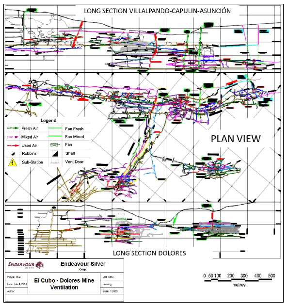
Figure 18-1 Example of Dolores Mine ventilation system. The legend shows the locations
of various elements of the ventilation system
| Page 18-3 |
| UNIDAD ELCUBO GUANAJUATO, MÉXICO NI 43-101 TECHNICAL REPORT |
Figure 18-1 is an example of the ventilation plan for the Dolores Mine, showing ventilation raises and fan locations, and airflows for fresh air and exhaust. The longitudinal section presented in Figure 18-2 illustrates the complexity of the system.
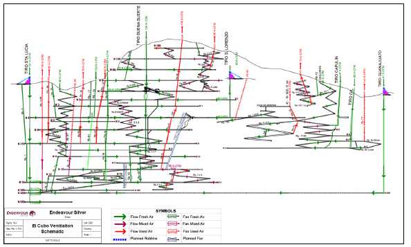
Figure 18-2 Longitudinal section schematic of current El Cubo ventilation system showing connections between Las Torres (right) and San Nicolas-Peregrina areas (Areas 1, 3, 4) | |
| 18.2.1 | Area 1 (San Nicolas Mine) |
The San Nicolas mine is the oldest of the four CMC mines. Air is drawn into the mine through the main entrances on levels 120, 60, and 0, and the San Nicolas Main and Santa Cecilia access ramps. The air flow travels mostly through the ramps and drift accesses to the various stopes. Some of the exhaust air flows to the surface through raise bore holes equipped with two electric fans (42 – 26- 1700, 75hp/60k EA), and the rest flows to the surface naturally through raise bore holes without fans and old open stopes. |
| Page 18-4 |
| UNIDAD ELCUBO GUANAJUATO, MÉXICO NI 43-101 TECHNICAL REPORT |
The total fresh air into Area 1 is 160,000 cfm, and the total air exhausting through the mechanical system is 140,000 cfm. | |
| 18.2.2 | Area 2 (Dolores Mine) |
Dolores mine is ramping up the levels of production in order to meet the required budget. The mining activities are increasing every day and because of that more equipment is coming into the mine. All these activities are introducing more diesel horsepower, dust, heat and fumes. | |
Three new headings have been opened at the Dolores mine: the 1140 ramp to the lower southeast part of the Villalpando vein, the 501 ramp to the lower area of the Dolores-Capulin vein, and the 1105 ramp reactivation to gain access to the lower part of the northwest Villalpando vein. | |
The 1140 ramp is ventilated with 60,000 cfm fresh air drawn from the Capulin shaft using two 3000 VAX 2100, 3600, 50 hp fans and 90,000cfm fresh air drawn from the Gil shaft, with one 5400 VAX 2700, 250 hp electric fan forcing air into the Asunción Area. Future ventilation will include a 4200 VAX 2700, 1800, 100 hp electric fan at the intersection of the Gil Shaft and cross-cut access on 9 levels. The fan will move 74,000cfm, enough to sustain the mining activities in this area. The fan will be relocated when the ramp gets to the lower level, and will pull fresh air from the extension of the Gil shaft; from there the fan will force the air to the bottom of the Asunción vein. The used air will exhaust to surface through the 1140 ramp and new raise boreholes (#85, #83, and #84) from surface to 7 level. | |
The 501 ramp is ventilated with one 4200 VAX 2700, 1800, 100 hp electric fan located on surface at the top of the #75. The fan pulls 75,000 cfm of fresh air from the surface through the 1105 ramp and the #72 raise borehole to ventilate the headings and new development areas located on the negative 501 ramp. The used air is exhausted to surface by the fan (exhaust system). | |
The ventilation for the 1105 ramp comes from surface down the ramp and is drawn into the #87 raise bore hole (90,000 cfm) by a 4800 VAX 2700, 200 hp electric fan located on top of the raise and exhausting to surface. The fresh air flow it is transferred to the heading by electric fan located up-ramp before entering the #87 raise borehole and exhausting to surface through raise bore holes (#87, #73 and #70). |
| Page 18-5 |
| UNIDAD ELCUBO GUANAJUATO, MÉXICO NI 43-101 TECHNICAL REPORT |
Most of the stopes in the older producing areas of the mine are ventilated with natural ventilation (top levels) and auxiliary vent fans. The air flow travels long distances before reaching the areas to ventilate. | |
| 18.2.3 | Area 3 (Villalpando Mine) |
The Villalpando Mine is located in central to the El Cubo claim block and is connected to Peregrina Mine on the 315 level (northwest) and on the 8 level (east side) through the main ramp. It also communicates to surface and to the San Nicolas Mine through the main ramp, connecting the entrance at the Santa Cecilia Ramp (west side) and the entrance of Dolores and Villalpando mines to the southeast. Fresh air comes into the mine mainly through two old shafts, the Buena Suerte and San Lorenzo shafts. In the Buena Suerte shaft, one 4800 VAX 2700, 1800, 200 hp fan pushes 90,000 cfm down to the 10 level. From there, the fresh air is distributed to the levels between the surface and the 8 level. The air flow coming out of the Buena Suerte shaft helps to ventilate a few stopes and a portion of the travel ways. In the San Lorenzo shaft, 70,000 cfm of fresh air is pushed down by a 4200 VAX 2700, 100hp fan. The used air leaves the mine mainly through raise bore holes and old mine openings. The distance between stopes and travel ways connecting others areas are long. Air is pumped into various stopes using auxiliary ventilation fans in combination with ventilation tubing and natural ventilation. | |
| 18.2.4 | Area 4 (Peregrina Mine) |
At the Peregrina mine, the fresh air comes in through the Santa Lucia, Guanajuato Shafts and the new raise bore hole. Both of them draw natural ventilation in combination with a 100 hp electric fan. From the Santa Lucia Shaft, fresh air goes to the 535 level (41,000 cfm), to the 585 level (35,000 cfm), to the 600 level (43,000 cfm), and the base of the shaft (12,000 cfm). Fresh air from the Guanajuato shaft (41,000 cfm) travels 6,000 meters. Fresh air from the Santa Lucia shaft travels along each level and through the internal ramps. One 100 hp electric fan located on top of the #71 Robbins raise transfers 80,000 cfm into the exhaust raise flowing to surface. Fresh air is sent to the stopes with auxiliary ventilation fans. The remaining cfm is flowing up the ramp and other raise bore holes to surface. The entire ventilation plan for this area of El Cubo has been revised to use only CMC openings and infrastructure after the termination of Las Torres agreement. |
| Page 18-6 |
| UNIDAD ELCUBO GUANAJUATO, MÉXICO NI 43-101 TECHNICAL REPORT |
| 18.2.5 | Inventory of Ventilation Installations |
Table 18-2 lists the ventilation installations with their purpose and capacity, as applicable. |
Table 18-2
Master List of Ventilation Installations Showing Utilization and Capacities
| MINE AREA | TYPE | ID | CONNECTION | PURPOSE | FRESH AIR | EXHAUST AIR | COMENTS |
| I | Main Ramp | Surface | Intake | 60,000 | - | - | |
| I | Raise Bore | 10 | Surface -Level 4 | Intake | 15,000 | - | - |
| I | Raise Bore | 16 | Surface -Level 4 | Intake | 20,000 | - | - |
| I | Raise Bore | 17 | Surface -Level 4 | Intake | 20,000 | - | - |
| I | Raise Bore | 37 | Level 0 (portal) - Level 4 | Exhaust | - | 20,000 | - |
| I | Raise Bore | 38 | Surface-Level 10 | Intake | 90,000 | - | FAN: 200 HP |
| I | Raise Bore | 45 | Level 4 - Level 8 | Exhaust | - | 20,000 | - |
| I | Raise Bore | 47 | Level 4 - Level 8 | Exhaust | - | 30,000 | |
| I | Raise Bore | 49 | Surface -Level 4 | Exhaust | - | 78,000 | FAN: 100 HP |
| I | Raise Bore | 53 | Level 4 - Level 8 | Exhaust | 30,000 | - | - |
| I | Raise Bore | 55 | Surface -Level 4 | Intake | 30,000 | - | - |
| I | Raise Bore | 56 | Surface -Level 3 | Exhaust | - | 35,000 | - |
| I | Raise Bore | 64 | Surface-Level 8 | Exhaust | - | 95,000 | FAN: 100 HP |
| I | Raise Bore | 76 | Level 4 - Level 8 | Intake | 15,000 | - | - |
| I | Shaft | Tiro San Lorenzo | Surface -Level 4 | Intake | 60,000 | - | FAN: 100 HP |
| I | Raise Bore | 80 | Surface - 4-333 | Exhaust | - | 85,000 | FAN: 135 HP |
| II | Main Ramp | Surface | Intake | 80,000 | |||
| II | Raise Bore | 70 | Portal San Eusebio - Level 4 | Exhaust | - | 80,000 | FAN: 75 HP |
| II | Raise Bore | 73 | Level 4 - Level 6 | Exhaust | - | - | |
| II | Raise Bore | 75 | Surface - Ramp 501 | Exhaust | - | 74,000 | FAN: 100 HP |
| II | Shaft | Tiro Capulin | Surface -Level 5 | Intake | 40,000 | - | - |
| II | Shaft | Tiro Gil | Surface -Level 9 | Intake | 70,000 | - | FAN: 250 HP |
| II | Raise Bore | 81 | 4-333mRamp 705(-) | Exhaust | - | - | |
| II | Raise Bore | 82 | Surface Level 4 | Exhaust | - | - | In Progress |
| II | Raise Bore | 83 & 84 | Level 4 - Level 7 | Exhaust | - | - | In Progress |
| II | Raise Bore | 85 | Surface - Ramp 1140 (-) | Exhaust | - | - | FAN: 150 HP |
| II | Raise Bore | 87 | Level 6 - Level 9 | Exhaust | - | - | |
| II | Raise Bore | 88 | Surface Level 8 | Exhaust | - | - | In |
| Page 18-7 |
| UNIDAD ELCUBO GUANAJUATO, MÉXICO NI 43-101 TECHNICAL REPORT |
| Progress | |||||||
| IV | Alimak | 3 | Ramp 3006 - Level 13 | Intake | 15,000 | - | - |
| IV | Alimak | 2 | Level 13 - Level 8 | Intake | 15,000 | - | - |
| IV | Raise Bore | 63 | Ramp 321 - Level 14 | Intake | 20,000 | - | - |
| IV | Raise Bore | 65 | Level 10 - Level 14 | Intake | 20,000 | - | - |
| IV | Raise Bore | 71 | Level 12- Level 14 | Exhaust | - | 80,000 | FAN: 100 HP |
| IV | Raise Bore | 74 | Level 8 - Level 12 | Exhaust | - | 20,000 | - |
| IV | Raise Bore | 78 | Level 8 - Level 12 | Intake | 15,000 | - | - |
| TOTAL | 615,000 | 627,000 |
In summary, the ventilation system for each of the mines is being improved to minimize any risk in the event of an underground fire, improve environmental working conditions, and improve production levels. There are three major components to the planned improvements to the ventilation system: 1) purchasing ventilation equipment; 2) increasing electrical power capacity; and 3) increasing the number of raise bore holes dedicated to ventilation in strategic locations. | |
| 18.3 | Water |
Water for the mine operations is obtained from the Dolores Mine. Water is pumped from the Dolores Mine into a series of water reservoirs at the surface for storage and distribution to the mines. The surplus of water pumped from the Dolores mine is sent to the frsh water tanks, which when required is used to supply the mines. The water found in the Dolores mine is a product of filtrations and of intentional flooding for storage. A plan for obtaining water needs to be completed as a precaution should the water in the Dolores mine run out. | |
| 18.4 | Compressed Air |
Compressed air is supplied to the mine by a group of compressors which are all located in different areas on surface. The compressed air is supplied via a network of 4 and 6 inch lines. The working pressure that reaches the headings is at 85 psi. | |
| 18.5 | Electricity |
Electrical power for the mine is provided by the state-owned Comisión Federal de Electricidad (CFE) via 13.3 kV overhead transmission lines connected to the national grid. The energy is transformed on site by a series of substations for distribution to different facilities. Table 18-3 summarizes the location and capacity of the main transformers of CMC and those of Compañía Minera Las Torres. |
| Page 18-8 |
| UNIDAD ELCUBO GUANAJUATO, MÉXICO NI 43-101 TECHNICAL REPORT |
Table 18-3
Summary of Electric Installations
| Area | Location | Capacity (kva) | Power Input (V) | Power Output (V) |
| Los Silvestres | Surface | 1,000 | 13,200 | 440 |
| Chirimitera | Surface | 1,000 | 13,200 | 440 |
| Chirimitera | Surface | 1,000 | 13,200 | 440 |
| Chirimitera | Surface | 1,000 | 13,200 | 2,200 |
| Chirimitera | Surface | 500 | 13,200 | 4,160 |
| Chirimitera | Surface | 1,000 | 13,200 | 4,160 |
| Chirimitera | Surface | 150 | 13,200 | 220 |
| 1 | Underground | 500 | 2,200 | 440 |
| 3 | Underground | 500 | 2,200 | 440 |
| La Hacienda | Surface | 150 | 13,200 | 440 |
| Santa Cecilia Shop | Surface | 200 | 13,200 | 440 |
| La Hacienda | Surface | 200 | 13,200 | 480 |
| Tajo Plant | Surface | 500 | 13,200 | 440 |
| Tajo Plant | Surface | 500 | 13,200 | 440 |
| San Nicolas | Surface | 200 | 13,200 | 480 |
| Tajo Plant | Surface | 1,000 | 13,200 | 440 |
| Tajo Plant | Surface | 1,000 | 13,200 | 440 |
| La Doctora | Surface | 1,000 | 13,200 | 440 |
| Tajo Plant | Surface | 300 | 13,200 | 440 |
| Puertecito | Surface | 113 | 13,200 | 440 |
| Mirasol | Surface | 300 | 13,200 | 440 |
| Puente de Piedra | Surface | 150 | 13,200 | 480 |
| San Nicolas | Surface | 200 | 13,200 | 480 |
| Tajo Plant | Surface | 150 | 13,200 | 440 |
| Cubo | Surface | 150 | 13,200 | 440 |
| Tajo Plant | Surface | 300 | 13,200 | 440 |
| Guadalupe | Surface | 300 | 13,200 | 440 |
| Tajo Plant | Surface | 300 | 13,200 | 220 |
| Tajo Plant | Surface | 300 | 13,200 | 220 |
| Page 18-9 |
| UNIDAD ELCUBO GUANAJUATO, MÉXICO NI 43-101 TECHNICAL REPORT |
| La Doctora | Surface | 1,500 | 13,200 | 4,160 |
| 2 | Underground | 500 | 4,160 | 480 |
| 2 | Underground | 500 | 4,160 | 480 |
| 2 | Underground | 500 | 4,160 | 480 |
| Peregrina | Surface | 750 | 13,200 | 2,200 |
| Peregrina | Surface | 750 | 13,200 | 2,200 |
| Peregrina | Surface | 750 | 13,200 | 2,200 |
| Peregrina | Surface | 300 | 13,200 | 440 |
| Peregrina | Surface | 750 | 2,200 | 440 |
There are no back-up generator sets for the mine operations; however, the El Tajo plant has a generator to keep the agitators functioning should power fail. | |
| 18.6 | Tailings Impoundments |
The active tailings dam for the El Tajo process plant is Mastrantos VI (Figure 17-8, Section 17.3). There are seven other tailings dams located on the El Cubo property, they include: |
| 1. | Mirasol tailings dam, repository of flotation tailings currently out of operation, covered and under reforestation. | |
| 2. | Mastrantos I, repository of concentrate leach tailings, currently out of operation but used for water storage. | |
| 3. | Mastrantos II, repository of concentrate leach tailings, currently out of operation, but receives solutions from underdrain of Mastrantos IV and V. | |
| 4. | Mastrantos III, repository of flotation tailings currently out of operation, in process of reclamation. | |
| 5. | Mastrantos IV operated to deposit concentrate leach tailings in 2013, currently out of operation. |
| Page 18-10 |
| UNIDAD ELCUBO GUANAJUATO, MÉXICO NI 43-101 TECHNICAL REPORT |
| 6. | Mastrantos V, was used to deposit concentrate leach tailings, currently out of operation. | |
| 7. | Chirimitera, repository of flotation tailings currently out of operation, covered and under reforestation. |
Currently water from Mastrantos I, II, IV and V cannot be used in the flotation plant since it contains some amount of cyanide which is a depressor of pyrite flotation. Water from Mastrantos I, II and V is pumped to the Mastrantos IV where water evaporators were installed in 2013 to manage the water balance. | |
| 18.7 | Ore Stockpiles and Waste Dumps |
The El Cubo operation maintains small stockpiles underground and at the mine entrances in order to manage continuous ore haulage. The mine has no excess ore stockpiles and generally consumes all daily production available since the plant is not at capacity. Only small waste dumps are present in the district since most waste never leaves the mines where it is needed for fill. |
| Page 18-11 |
| UNIDAD ELCUBO GUANAJUATO, MÉXICO NI 43-101 TECHNICAL REPORT |
| 19.0 | MARKET STUDIES AND CONTRACTS |
Endeavour Silver has neither a hedging nor forward selling contract for any of its products. As of the date of issuing this report, the company has not conducted any market studies, as gold and silver are commodities widely traded in the world markets. | |
Endeavour Silver produces a silver concentrate which is then shipped for refining. Silver and gold are widely traded commodities in world markets and Endeavour Silver has not conducted any market studies. Due to the size of the concentrate market and the above-ground inventory of concentrate, dore and bullion, Endeavour Silver's activities will not influence silver prices. The concentrate produced by Endeavour Silver at its mines is further refined by third parties before being sold as bullion. To a large extent, silver concentrate is sold at the spot price. | |
Table 19-1summarizes the high and low average annual London PM gold and silver price per ounce from 2000 to 2014. |
Table 19-1
Average Annual High and Low London PM Fix for Gold and Silver from 2000 to 2014
(prices expressed in US$/oz)
| Year | Gold Price (US$/oz) | Silver Price (US$/oz) | ||||
| High | Low | Average | High | Low | Average | |
| 2000 | 312.70 | 263.80 | 279.12 | 5.45 | 4.57 | 4.95 |
| 2001 | 293.25 | 255.95 | 271.04 | 4.82 | 4.07 | 4.37 |
| 2002 | 349.30 | 277.75 | 309.67 | 5.10 | 4.24 | 4.60 |
| 2003 | 416.25 | 319.90 | 363.32 | 5.97 | 4.37 | 4.88 |
| 2004 | 454.20 | 375.00 | 409.16 | 8.29 | 5.50 | 6.66 |
| 2005 | 536.50 | 411.10 | 444.45 | 9.23 | 6.39 | 7.31 |
| 2006 | 725.00 | 524.75 | 603.46 | 14.94 | 8.83 | 11.55 |
| 2007 | 841.10 | 608.40 | 695.39 | 15.82 | 11.67 | 13.38 |
| 2008 | 1,011.25 | 712.50 | 871.96 | 20.92 | 8.88 | 14.99 |
| 2009 | 1,212.50 | 810.00 | 972.35 | 19.18 | 10.51 | 14.67 |
| 2010 | 1,421.00 | 1,058.00 | 1,224.52 | 30.70 | 15.14 | 20.19 |
| 2011 | 1,895.00 | 1,319.00 | 1,571.52 | 48.70 | 26.16 | 35.12 |
| 2012 | 1,791.75 | 1,540.00 | 1,668.98 | 37.23 | 26.67 | 31.15 |
| 2013 | 1,693.75 | 279.40 | 1,257.42 | 32.23 | 5.08 | 21.26 |
| 2014 | 1,385.00 | 1,142.00 | 1,266.40 | 22.05 | 15.28 | 19.08 |
| Page 19-1 |
| UNIDAD ELCUBO GUANAJUATO, MÉXICO NI 43-101 TECHNICAL REPORT |
Over the period from 2000 to 2014, world silver and gold prices have increased significantly. This had a favourable impact on revenue from production of most of the world’s silver mines, including the El Cubo Project. | |
Endeavour Silver has no contracts or agreements for mining, smelting, refining, transportation, handling or sales, that are outside normal or generally accepted practices within the mining industry. | |
In addition to its own workforce, Endeavour Silver has a number of contract mining companies working on the El Cubo property. | |
| 19.1 | Contracts |
CMC has signed a number of contracts or agreements with domestic companies and legal persons in order to cover its production and interests goals. Table 19-2 is a summary of the main contracts that CMC has in place. |
Table 19-2
Contracts held by Compañía Minera del Cubo, S.A. de C.V
| No. Contract | Contractor | Description | Start | End |
| CBO-001MI-2014 | Cominvi, S.A. de C.V. | Mining Contractor | 7/1/2014 | 6/30/2016 |
| CBO-001AD-2014 | Reciclados Santa Fe, S.A. de C.V. | Purchase of recycled materials | 3/18/2014 | 3/19/2017 |
| CBO-002AD-2014 | Mariana Parra Sanchez | Environmental Technical Study Tepetateras | 5/12/2014 | 9/10/2014 |
| CBO-003AD-2014 | Celia Espinoza Ramos | Industrial Waste Collection | 4/1/2014 | 3/31/2015 |
| CBO-004AD-2014 | Mariana Parra Sanchez | Environmental Technical Study Cebolletas | 5/12/2014 | 9/10/2014 |
| CBO-001AD-2013 | Hammer Seguridad Privada, S.R.L. de C.V. | Security and Surveillance Services | 8/4/2014 | 8/3/2015 |
| CBO-006AD-2014 | Previniendo, S.C. | Armed Security Services | 9/1/2014 | 8/31/2015 |
| CBO-002AD-2013 bis | Griselda Sandoval Ortiz | Portable Toilet Service and Maintenance | 10/26/2014 | 10/27/2017 |
| CBO-003MI-2013 | Maquinaria Jasso Majsa, S.A. de C.V. | Trucking Ore and Waste | 5/1/2013 | Extended |
The lease contract with Compañía Minera Las Torres, S.A. de C.V. for the use of the Las Torres process plant and underground mining rights expired in 2013. All facilities were returned to Compañía Minera Las Torres, S.A. de C.V. on August 15th, 2013.
| Page 19-2 |
| UNIDAD ELCUBO GUANAJUATO, MÉXICO NI 43-101 TECHNICAL REPORT |
The collective work contract N° 34 with the national mining worker union shall remain in effect for an indefinite period, though it must be reviewed every year.
CMC also maintains a contract with a civil engineering company, Buck, for civil works in different areas of the operation.
| Page 19-3 |
| UNIDAD ELCUBO GUANAJUATO, MÉXICO NI 43-101 TECHNICAL REPORT |
| 20.0 | ENVIRONMENTAL STUDIES, PERMITTING, AND SOCIAL OR COMMUNITY IMPACT |
| 20.1 | Environmental and Sustainability |
CMC operates under the policy of zero industrial discharges into the environment. Surface water in the tailings disposal facilities are pumped back into the process. Running water in the intermittent streams within the property is tested for mineral elements and contaminants. Some water pumped from the underground workings is discharged in the Peregrina reservoir at the surface. | |
The following aspects are treated with special care by the company as they represent potential risks to the operation. To reduce the possibility of an incident regarding any of these issues, CMC has established strict procedures of operation and monitoring in accordance to accepted standards. |
| • | The tailing dams are the places that require the main environmental and operation control, because its proximity to the Cubo community represents a risk. | |
| • | A cyanide spill into rivers would cause a strong environmental contingency. | |
| • | Tests of water pollutants into rivers near to the tailings dams. | |
| • | Tests of discharge sewage pollutants. | |
| • | Water recovery in tailings dams to be returned to the process of the processing plant. | |
| • | Tests of the combustion gases from laboratory's chimneys and foundry, and lead exposure for lab workers. |
| 20.2 | Closure Plan |
The El Cubo closure budget includes funds for covering the tailings ponds and securing and cleaning up the other surface and underground mine facilities (Table 20-1). |
| Page 20-1 |
| UNIDAD ELCUBO GUANAJUATO, MÉXICO NI 43-101 TECHNICAL REPORT |
Table 20-1
El Cubo Mine Closure Budget
| Facilities | Item | US$ |
| Hoist | 40,231 | |
| Underground | Tunnels | 0 |
| Mines | Raises – Robbins | 70,105 |
| Workshops and Offices | 250,300 | |
| Sub-Total | 360,636 | |
| Crushing Area | 70,493 | |
| Milling and Flotation Areas | 53,689 | |
| El Tajo Plant Flotation | Dynamic Leaching Area | 131,636 |
| and Cyanidation | Precipitation and Foundry Areas | 53,702 |
| Related Facilities | 192,822 | |
| Reclaim of Plant Area | 108,026 | |
| Sub-Total | 610,367 | |
| Trituration Area | 61,159 | |
| Chirimitera Flotation | Milling and Flotation Areas | 38,635 |
| Plant | Related Facilities | 86,075 |
| Reclaim of Plant Area | 68,667 | |
| Sub-Total | 254,535 | |
| Mastrantos I, II, IV & V | 1,258,508 | |
| Tailings Dams | Mastrantos III & VI | 604,559 |
| Cedros | 8,154 | |
| Sub-Total | 1,871,221 | |
| Administrative Personnel | 301,725 | |
| Grand Total | 3,398,484 |
| 20.3 | Permitting |
Table 20-2 lists the existing permits governing the mining and milling operations. | |
According to CMC, tailings ponds Mastrantos I, II, IIIA, IIIB, IV, V, and VI were built before to environmental legislation was approved in 1998 (La Ley General del Equilibrio Ecológico y la Protección al Ambiente), so CMC was not required to apply for permits for these facilities. For pre-existing facilities a mining company must get an update permit whenever there is a change in the processes, capacities, or facilities. Permits are issued by the Secretaría de Medio Ambiente y Recursos Naturales (Semarnat) – Secretary of the Environment and Natural Resources. An annual operation card must be presented to Semarnat at the end of each year. |
| Page 20-2 |
| UNIDAD ELCUBO GUANAJUATO, MÉXICO NI 43-101 TECHNICAL REPORT |
Table 20-2
Existing Permits and Issuing Agency
| Permit Type | Permit | Issuing Agent |
| Environmental License | LAU-11-70101504-09 | Semarnat |
| Annual Operation Card | COA-2011 | Semarnat |
| Environmental Registration | MCUMJ1101511 | Semarnat |
| Hazardous Waste Generating | GRP111500002 | Semarnat |
| Sewage Discharge License | 4GUA101250/12EMGE94 | CONAGUA |
| Environmental Impact Authorization Construction of Chirimitera Plant | D.O.O. DGOEIA -001788 | Semarnat |
| Environmental Impact Authorization Construction of Chimiritera Tailings Dam | D.O.O. DGOEIA -006508 | Semarnat |
| 20.4 | Considerations of Social and Community Impacts |
CMC considers nearby communities as important stakeholders and, as such, the company pays special attention to their problems and requests for support. A good neighbor and open-door policy characterizes the relations with the six communities inside and around the area of operations. A company representative interacts with the local authorities frequently. |
Table 20-3
Population Statistics for Communities Surrounding El Cubo
| Location | Relationship | Total Population | Male Population | Female Population |
| CALDERONES | Indirect | 946 | 449 | 497 |
| EL CEDRO (MINERAL DEL CEDRO) | Indirect | 397 | 190 | 207 |
| MINERAL DEL CUBO | Direct | 498 | 237 | 261 |
| MINERAL DE PEREGRINA | Indirect | 176 | 80 | 96 |
| MONTE DE SAN NICOLÁS | Direct | 286 | 137 | 149 |
| ROSA DE CASTILLA | Direct | 408 | 192 | 216 |
| TOTALS | 2,711 | 1,285 | 1,426 |
| Page 20-3 |
| UNIDAD ELCUBO GUANAJUATO, MÉXICO NI 43-101 TECHNICAL REPORT |
According to the population and housing census of 2010, the inhabitants in the surrounding communities include 2,711 people living in the 6 locations. Women are 52.6% of the population. Table 20-3 presents population by gender in the communities, and shows the relationship of CMC with them, whether directly or indirectly. The relationship with a community is indirect whenever it has a direct relationship with another mining company. The communities of Mineral del Cubo, Monte de San Nicolas, and Rosa de Castilla are located inside the area of current or future influence. Three other communities are included as a result of the leasing contract of properties and facilities from Compañía Minera Las Torres. Regardless of the indirect relationship with these three communities, CMC considers that it has a shared commitment with them.
CMC has a policy of social responsibility based on community development. The tactic used to achieve this strategic principle is focused on:
| • | Encouraging sustainable self-development of communities | |
• | Systematically promoting quality of life conditions that ensure ongoing successful operation of the company in the locality. |
In order to carry out social responsibility actions, CMC has an internal procedure intended to channel the demands of the local communities, to assess their needs, to prioritize them, and to evaluate donations to be made to improve quality of life. The company is interested in maintaining a social license to operate by working together with the communities, providing communication support in resolving problems, promoting good practices in social solidarity through a work plan with the localities, and aiming for sustainability in all its actions. To make public its commitment to its stake-holders, the company pursued an ESR distinctive (Socially Responsible Company), which was obtained the March 1, 2014, from the Mexican Center for Philanthropy (CEMEFI).
The company works respectfully and in coordination with the natural leaders in the surrounding communities, and with local authorities, educational institutions, and government agencies to achieve sustainable development. Actions are mainly aimed at promoting education, sports, culture, health, and environmental care.
| Page 20-4 |
| UNIDAD ELCUBO GUANAJUATO, MÉXICO NI 43-101 TECHNICAL REPORT |
El Cubo’s community library and school were remodeled with the support of the company. CMC donated books and computers to promote education and access to technology. Both El Cubo and Rosa de Castilla communities gained free access to computers.
CMC works in coordination with the municipal government to promote cultural activities in the communities. The company has a cultural center open to the public where workshops of handicrafts, music, and painting are conducted. In addition, CMC promotes the realization of festivals, theater plays, and cinema for children and adults, and facilitates transportation of students to civic and cultural events and sports competitions.
The company provides garbage collection service to contribute to environmental sanitation and prevent gastrointestinal diseases. The company also supplies medical services and medicines in cases of emergency or whenever the community service is not available, assisting between 10 and 15 persons each week. The company’s ambulance is available as needed.
Water shortage in the country has greatly affected the state of Guanajuato, and this has directly impacted El Cubo’s neighboring communities in recent years. The community of El Cubo has no water storage bodies, which is a significant problem. At the request of the community, CMC supplies non-potable domestic water to the community during the dry seasons. The lack of rainfall has also greatly affected the communities of Calderones and El Cedro. The company pumps water from Presa de Mata dam and hires tankers if necessary to provide water to each of these communities.
The company launched a self-employment project to benefit the local work force. A group of women from El Cedro, after being trained with the economic support of the company, developed the cooperative “Mujeres Unidas del Cedro SC de RL de CV” for industrial clothing manufacturing. Plans are to construct a sewing shop. The project includes the purchase of machinery, raw materials, and construction or remodeling of the place where this workshop will be established. A total future investment budget of $72,152 USD will be needed to implement the project; which involves the purchase and provision of materials for the start of operations using a loan from CMC.
| Page 20-5 |
| UNIDAD ELCUBO GUANAJUATO, MÉXICO NI 43-101 TECHNICAL REPORT |
CMC works by Gender Equality Model MEG: 2003, awarded by the National Women's Institute in November 2013. This model helps to ensure equal opportunities for internal and external community by socially responsible actions.
| Page 20-6 |
| UNIDAD ELCUBO GUANAJUATO, MÉXICO NI 43-101 TECHNICAL REPORT |
| 21.0 | CAPITAL AND OPERATING COSTS |
| 21.1 | Capital Costs |
For 2015, Endeavour Silver has budgeted nearly US $ 15 million for capital projects at El Cubo (Table 21-1). This budget includes all planned capital expenditure for El Cubo with the exception of Regional Exploration. An additional US $1.6 million is planned on exploration drilling at El Cubo. The Exploration drilling capital is not listed in Table 21-1 because it does not have a direct impact the reported mineral reserves. |
Table 21-1
2015 Capital Cost Estimates for the Del Cubo Mines Project
| Description | Cost (US $) |
| Mine Development | 8,808,511 |
| Mine Infrastructure | 1,474,148 |
| Underground Equipment | 2,203,942 |
| Plant Infrastructure | 2,291,890 |
| Vehicles | 145,423 |
| Office and IT | 136,930 |
| TOTAL | 15,060,844 |
| 21.2 | Operating Costs |
Operating costs for 2014 are averaged across the four principal working areas of the El Cubo mine. | |
The cash operating cost of silver produced at the El Cubo Mines project in fiscal year 2014 was $15.37 per oz, compared to $18.77 for 2013. Cash operating cost per ounce of silver is calculated net of gold credits and royalties. The cash operating costs per tonne of ore processed averaged US $96.97 per tonne in 2014, compared to US $112.72 in 2013. Table 21-2 summarizes operating cost by category before adjustment for finished goods. | |
Endeavour estimates costs of the life-of-mine operating plan and accompanying economic model based on current costs and cost projections due to expected changes and improvements (Table 21-3). |
| Page 21-1 |
| UNIDAD ELCUBO GUANAJUATO, MÉXICO NI 43-101 TECHNICAL REPORT |
Table 21-2
Summary of El Cubo Unit Operating Costs per Tonne.
2013 vs. 2014 Actual
| Cost Item | Actual 2014 (US$/t) | Actual 2013 (US$/t) |
| Mining | 54.20 | 63.77 |
| Processing | 27.23 | 25.30 |
| G&A | 17.98 | 23.65 |
| Royalty | 0.48 | |
| Total | 99.89 | 112.72 |
Note: before adjusted for finished goods
Table 21-3
Summary of El Cubo Unit Operating Costs per Tonne.
2014 Actual vs. 2015 Budget
| Cost Item | Actual 20141 (US$/t) | Planned 2015 (US$/t) |
| Mining | 54.20 | 46.00 |
| Processing | 27.23 | 24.00 |
| G&A | 17.98 | 16.00 |
| Royalty | 0.48 | 0.74 |
| Total | 99.89 | 86.74 |
1. Before adjustment for finished goods
| Page 21-2 |
| UNIDAD ELCUBO GUANAJUATO, MÉXICO NI 43-101 TECHNICAL REPORT |
| 22.0 | ECONOMIC ANALYSIS |
| 22.1 | Introduction |
Endeavour Silver is a producing issuer. The El Cubo Project has been in continuous operation since Endeavour took control in 2012. The El Cubo Project consists of both current and former producing mines, as well as a number of exploration targets. The El Cubo Project has continued to improve its operational parameters and production output under Endeavour Silver's direction. | |
Endeavour has prepared a mine plan based on mining only the mineral reserves. The plan uses a number of assumptions about mining rates, operating costs, and capital costs. The mine plan is built up on a stope-by- stope basis. One or more resource blocks compose a stope, which for planning purposes is a group of blocks served by a single access ramp. Each block is assigned a provisional net value based on its diluted grade, tonnes, and mill recovery. Inclusion in the mine plan requires a stope to carry any necessary waste access cost and still return a positive net value. One or more individual blocks with negative revenue within a stope may be included in the mine plan as internal dilution if no additional access is required; some of these may actually generate positive value to the project if the mill is not at capacity with better material. Development costs are determined by the linear metres of development required for each stope. The metres are accumulated in the life- of-mine plan and are costed at rates applicable to El Cubo based on Endeavour’s experience at El Cubo and in the Guanajuato district. Final determination of revenue and value generated from the reserves is based on the life-of-mine plan and economic model. | |
| 22.2 | 2015 Production Forecast |
For 2015, Endeavour Silver is forecasting to produce 1,605,292 ounces of silver and 24,441 ounces of gold from the El Cubo Project. Plant throughput for 2015 is forecast at 510,438 t at an estimated average grade of 114 g/t silver and 1.68 g/t gold. Recoveries are forecast to average 88.6% and 85.8% for silver and gold, respectively. Plant throughput is based on production from the Dolores Mine (Villalpando-Asuncion, Dolores veins) and the Santa Cecilia Mine. |
| Page 22-1 |
| UNIDAD ELCUBO GUANAJUATO, MÉXICO NI 43-101 TECHNICAL REPORT |
The El Cubo project has substantial undeveloped resource potential. Beyond 2015, Endeavour Silver believes that continued exploration and development will lead to the discovery of new resources, and Endeavour Silver actively continues acquiring rights to new properties in the Guanajuato district. | |
| 22.3 | Taxes |
Taxation in Canada and Mexico is often complex and varies from one jurisdiction to the other. There are numerous calculations and allowances, all of which are outside the scope of this report. However, taxes are all levied in the normal course of business. Endeavour Silver is subject to the taxing jurisdictions of Durango, Mexico and Canada. Endeavour Silver state that all taxes assessed have been paid or will be paid when due, aside from any protests or other tax relief available under law. | |
| 22.4 | Future Production Potential |
Endeavour has constructed a mine plan that extracts all of the mineral reserves in the El Cubo mine, as listed in Table 15-5. Development metres required to extract the reserves for Areas 2 – 4 are listed in the Table 22-1. With lower metal prices, a significant parts of Area 1 production was suspended in 2013 and no production came from that area in 2014. Production will possibly be re- activated once higher metal prices return and the practicality of mining blocks in this area re-evaluated. |
Table 22-1
Summary of Life-of-Mine Development Requirements, 2015– 2017
| Mine Plan | 2015 | 2016 | 2017 | Total |
| Tonnes Mine Area II | 476,415 | 412,568 | 163,884 | 1,052,866 |
| Development Waste Area II | 9,224 | 1,749 | 820 | 7,015 |
| Development Ore Area II | 4,205 | 630 | 390 | 5,040 |
| Tonnes Mine Area III | 157,888 | 94,442 | 82,591 | 505,021 |
| Development Waste Area III | 4,382 | 610 | 95 | 5,730 |
| Development Ore Area III | 1,675 | 150 | 0 | 1,660 |
| Tonnes Mine Area IV | 73,523 | 59,096 | 7,482 | 176,204 |
| Development Waste Area IV | 1,619 | 370 | 0 | 1,868 |
| Development Ore Area IV | 400 | 0 | 0 | 1,990 |
| Page 22-2 |
| UNIDAD ELCUBO GUANAJUATO, MÉXICO NI 43-101 TECHNICAL REPORT |
| Total Tonnes: | 707,826 | 566,105 | 537,976 | 1,346,097 |
| Total Waste meters: | 15,225 | 2,729 | 915 | 14,613 |
| Total Ore meters: | 6,280 | 780 | 390 | 8,690 |
Total waste development metres required for the life-of-mine are 14,613m with 75% of that being planned for 2015.
Total mine production for the life of the mine plan 6,344,786 ounces of silver and 85,615 ounces of gold. The mined ore is processed by flotation in the El Tajo plant. Life of mine processing plan is shown in Table 22-2.
Table 22-2
Summary of Life-of-Mine Processing Plan, 2015– 2017
| Item | Unit | 2015 | 2016 | 2017 | Total |
| Ore Milled | TMS | 707,826 | 566,105 | 537,976 | 1,811,907 |
| Grade Ag | g/t | 119 | 140 | 62 | 109 |
| Grade Au | g/t | 1.62 | 1.79 | 0.94 | 1.47 |
| Grade AgEq | g/t | 233 | 266 | 128 | 212 |
| Contained Ag | Oz | 2,713,799 | 2,556,044 | 1,074,943 | 6,344,786 |
| Contained Au | Oz | 36,840 | 32,554 | 16,220 | 85,615 |
| Contained Ag Equivalent | Oz | 5,292,609 | 4,834,849 | 2,210,357 | 12,337,815 |
| Recovery Ag | % | 0.858 | 0.858 | 0.858 | 0.858 |
| Recovery Au | % | 0.886 | 0.886 | 0.886 | 0.886 |
| Silver Production | Oz | 2,329,176 | 2,193,779 | 922,593 | 5,445,547 |
| Gold Production | Oz | 32,642 | 28,844 | 14,372 | 75,858 |
| Silver Equivalent | Oz | 4,614,101 | 4,212,888 | 1,928,613 | 10,755,602 |
| Tailings | TMS | 701,473 | 559,046 | 534,194 | 1,794,713 |
| Grade Au | g/t | 0.19 | 0.21 | 0.11 | 0.17 |
| Grade Ag | g/t | 17 | 20 | 9 | 16 |
| Page 22-3 |
| UNIDAD ELCUBO GUANAJUATO, MÉXICO NI 43-101 TECHNICAL REPORT |
| 23.0 | ADJACENT PROPERTIES |
| 23.1 | Introduction |
Mining in the Guanajuato district has been ongoing for more than 450 years. The El Cubo Mine property exists within the Guanajuato mining and hosts a number of the past producing mines. A majority of the past producers in the district are located on quartz veins which are similar or related to those located on the El Cubo mine property. However, there are no immediately adjacent properties which directly affect the interpretation or evaluation of the mineralization and exploration targets found on the property. | |
| 23.2 | Other Silver/Gold Production Activity in the Guanajuato Mining District |
Several other mineral properties and mines are present in the region and within the Guanajuato mining district, as illustrated in Figure 23-1. The most noteworthy includes the Bolañitos, Lucero and Cebada mines, purchased in 2007 by Endeavour. In 2014, these Endeavour properties produced 2,396,179 oz silver and 37,108 oz gold from 567,873 tonnes of ore grading 148 g/t silver and 2.36 g/t gold. Silver and gold recoveries averaged 88.5% and 86.2%, respectively. | |
Endeavour’s Bolañitos properties are the subject of a Technical Report entitled: Technical Report on the Resource and Reserve Estimates for the Guanajuato Mines Project, Guanajuato State, Mexico, with an effective date of December 31, 2013, and available on SEDAR. | |
Great Panther Resources a Canadian mining company that hold The Guanajuato mines complex which include the Valenciana, Cata and Reyes mines, as well as several other holdings in the area. In 2013, the Guanajuato mines of Great Panther produced 1,079,979 oz silver and 15,062 oz gold from 221,545 tonnes of ore grading 169 g/t silver and 2.31 g/t gold. Recoveries averaged 89.6% for Silver and 91.7% for Gold. Production information is reproduced from the March 10, 2014 SEDAR filed report titled “Great Panther Silver Limited Annual Information Form for the year ended December 31, 2013”. The most recent Technical Report available on SEDAR is the report “NI43-101 Technical Report on the Guanajuato Mine Complex Claims and Mineral Resource Estimations for the Guanajuato Mine, San Ignacio Mine, and El Horcon Project”. The effective date of the report is July 31st, 2014. |
| Page 23-1 |
| UNIDAD ELCUBO GUANAJUATO, MÉXICO NI 43-101 TECHNICAL REPORT |
The existing plants also conduct custom milling and processing for a number of small mines in the Guanajuato district. The material from each mine is run through the plants in batches. These smaller mines typically exploit quartz-carbonate veins similar in character to the vein mineralization on the El Cubo mine property.
Primero Mining Company is a Canadian company that operates the Cerro del Gallo Gold Silver Project. The project is located between the city of Guanajuato and Dolores Hidalgo, 23 km east northeast of Guanajuato. Primero Mining acquired 69.2% of the project from Cerro Resources NL in May 2013 and the remaining 30.8% from Goldcorp Inc. in December 2013. Development of the project is subject to permitting. Proven and Probable reserves are estimated at 23,223 kt with an average grade of 15.05 g/t Ag, 0.71 g/t Au and 0.08% Cu.
Technical data on the Cerro del Gallo Gold Silver Project is available in the Technical Report entitled Technical Report First Stage Heap Leach Feasibility Study Cerro del Gallo Gold Silver Project Guanajuato, Mexico, and is available on SEDAR. The effective date of the report is May 11th, 2012.
Peñoles (Minera Peñoles & Fresnillo PLC) also holds numerous concessions in the Guanajuato district but they are not currently producing.
| Page 23-2 |
| UNIDAD ELCUBO GUANAJUATO, MÉXICO NI 43-101 TECHNICAL REPORT |
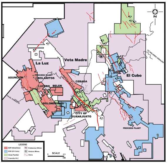
Figure 23-1 Major land positions held in the Guanajuato mining district
| 23.3 | Comments on Section 23 |
The values and the information on adjacent properties presented in the previous sections do not have any direct bearing on the subject property and the author does not mean to imply that El Cubo will have similar results. |
| Page 23-3 |
| UNIDAD ELCUBO GUANAJUATO, MÉXICO NI 43-101 TECHNICAL REPORT |
| 24.0 | OTHER RELEVANT DATA AND INFORMATION |
Endeavour Silver completed this Technical Report in March 2014 on the El Cubo Mines Project entitled “NI 43-101 Technical Report Resource and Reserve Estimates for the Del Cubo Mines Project, Guanajuato State, Mexico”. This report summarizes all relevant work and data completed as of October 31, 2014 by, or on behalf of Endeavour Silver. The report describes the development of the mineral resources and mining reserves, describes the mining methods, processing plants and economics of the Cubo Project based on an estimate of costs and metal prices. | |
To the knowledge of the QP, there is no other relevant data and other information regarding the Cubo Project that has not already been discussed in the appropriate sections of this report. |
| Page 24-1 |
| UNIDAD ELCUBO GUANAJUATO, MÉXICO NI 43-101 TECHNICAL REPORT |
| 25.0 | INTERPRETATION AND CONCLUSIONS |
| 25.1 | Interpretation |
The El Cubo mine exploits a substantial and productive portion of the veins of the Guanajuato mining district in the state of Guanajuato, Mexico. The district is notable for the strike length of its veins and the great vertical extent of mineralization, ranking it among the foremost silver districts of the world and a classic example of a low-sulfidation epithermal vein deposit. | |
Operations are currently divided into four units that have limited communication and are accessed from widely dispersed locations. The logistics of maintaining four different principal accesses and multiple haulages, plants, shops, and administrative personnel is a burden to productivity and administrative cost control. | |
In 2014, the El Cubo mine produced 413,282 t of ore grading 105 g/t silver and 1.59 g/t gold. 1,228,256 oz silver and 18,146 oz gold were recovered from El Cubo ore. Silver and gold recoveries averaged 88% and 85.9%, respectively. | |
Risks associated with the current resources and reserves include lost revenue due to negative variances in reserve grade and metal prices used to classify resources. The mine’s net cash flow is very sensitive to reserve grade and metals, and to a lesser extent operating costs. A substantial drop in revenues due to negative variances in reserve grade or prices could force changes in the current mine plan, and could negatively impact recovery of all of the mineral reserves. | |
| 25.1.1 | October 31, 2014 Mineral Resource Estimate |
The mineral resources for the El Cubo Mines Project, as of October 31, 2014, are summarized in Table 25-1. |
| Page 25-1 |
| UNIDAD ELCUBO GUANAJUATO, MÉXICO NI 43-101 TECHNICAL REPORT |
Table 25-1
Mineral Resource Estimate, Effective Date October 31, 2014
Michael Munroe, SME Registered Member
| Description | Tonnes | Silver (g/t) | Gold (g/t) | Silver (oz) | Gold (oz) | Silver Eq. (oz) |
| Measured | 738,000 | 172 | 2.74 | 4,064,000 | 65,000 | 8,616,000 |
| Indicated | 1,748,000 | 172 | 2.42 | 9,658,000 | 136,000 | 19,167,000 |
| Total Measured and Indicated | 2,486,000 | 172 | 2.51 | 13,722,000 | 201,000 | 27,783,000 |
| Total Inferred | 1,783,000 | 134 | 1.83 | 7,680,000 | 105,000 | 15,017,000 |
For year-end 2014 there was a significant increase in Measured and Indicated Resources at El Cubo. Conversion of inferred resources and information gained through newly opened areas, such as Dolores 2, are chiefly responsible for the change. | |
| 25.1.2 | October 31, 2014 Mineral Reserve Estimate |
The mineral reserves for the Guanaceví Mines project as of October 31, 2014 are summarized in Table 25-2. |
Table 25-2
Mineral Reserve Estimate, Effective Date October 31, 2014
Michael Munroe, SME Registered Member
| Description | Tonnes | Silver (g/t) | Gold (g/t) | Silver (oz) | Gold (oz) | Silver Eq. (oz) |
| Proven | 346,600 | 144 | 1.94 | 1,615,400 | 21,600 | 3,129,400 |
| Probable | 446,900 | 132 | 1.79 | 1,893,100 | 25,700 | 3,689,800 |
| Total Proven and Probable | 793,500 | 137 | 1.86 | 3,508,500 | 47,300 | 6,819,200 |
Since the last Technical Report Proven Reserves increased while Probable Reserves decreased. Overall the Proven and Probable Reserves decreased by about 14% since the last Technical Report. Development in Dolores and changes in the criterion used to classify Proven blocks are responsible for the change.
| Page 25-2 |
| UNIDAD ELCUBO GUANAJUATO, MÉXICO NI 43-101 TECHNICAL REPORT |
| 25.2 | Conclusions |
The QP considers the El Cubo resource and reserve estimates presented here to conform to the current CIM standards and definitions for estimating resources and reserves, as required under NI 43-101 “Standards of Disclosure for Mineral Projects.” These resources and reserves form the basis for Endeavour Silver’s ongoing mining operations at the El Cubo Mines Project. | |
The QP is unaware of any significant technical, legal, environmental or political considerations which would have an adverse effect on the extraction and processing of the resources and reserves located at the El Cubo Mines Project. Mineral resources which have not been converted to mineral reserves, and do not demonstrate economic viability, shall remain mineral resources. | |
The QP considers that the mineral concessions in the El Cubo mining district controlled by Endeavour Silver continue to be highly prospective both along strike and down dip of the existing mineralization, and that further resources could be converted into reserves with additional exploration and development especially south of the Villalpando-Asunción area. | |
The QP is of the belief that with Endeavour’s continued commitment to regional exploration within the district, the potential for the discovery of deposits of similar character and grade, as those that are currently in operation remains optimistic. | |
| 25.2.1 | Future Potential |
For 2015, the Regional Exploration activities will be focused to test the drilling targets defined on 2014 (Villalpando South, Nayal-Cabrestantes and Cubo North), with a total of 5,000 m of drilling programmed. Also, field activities will continue at the East part of the Cubo North area, in order to improve the drilling exploration targets. | |
The Exploration Mine area activities will be focused in the Central Cubo, over the Villalpando, Reyna and Alicia veins areas. |
| Page 25-3 |
| UNIDAD ELCUBO GUANAJUATO, MÉXICO NI 43-101 TECHNICAL REPORT |
Exploration success in one or both of these areas would provide new development opportunities for Endeavour Silver at the El Cubo Mines Project, however, there is no assurance that this exploration will be successful in delineating additional resources and which in turn would eventually be converted to reserves.
The QP believes that the 2015 exploration program for the El Cubo Mines Project proposed by Endeavour Silver is both reasonable and necessary for the continued successful long life of the project.
| Page 25-4 |
| UNIDAD ELCUBO GUANAJUATO, MÉXICO NI 43-101 TECHNICAL REPORT |
| 26.0 | RECOMMENDATIONS |
The El Cubo mine has been in nearly continuous production for decades. A substantial effort combining direct underground exploration, underground drilling, and surface drilling will be necessary to sustain the mine and continually expand resources and reserves. The El Cubo concessions cover at least 5 km of the trace of the vein system across the district. The Villalpando- Asunción area continue to provide the bulk of production from the mine and is currently the focus of surface exploration drilling. The Dolores vein is an important parallel structure along which new resources and reserves have been added through a combination of underground development and diamond drilling. | |
The mine has considerable potential to develop both exploration targets close to existing operations outlined by underground drilling and those identified by surface exploration. | |
A substantial exploration budget has been developed for 2015 and discussed in the following section. | |
| 26.1 | Budget for Further Work |
| 26.1.1 | Exploration Program |
For 2015, the Regional Exploration activities will be focused to test the drilling targets defined on 2014 (Villalpando South, Nayal-Cabrestantes and Cubo North. Also, field activities will continue at the East part of the Cubo North area, in order to improve the drilling exploration targets. | |
The Exploration Mine area activities will be focused in the Central Cubo, over the Villalpando, Reyna and Alicia veins areas. | |
Table 26-1 summarizes the planned 2015 exploration budget for the El Cubo Mines Project. |
| Page 26-1 |
| UNIDAD ELCUBO GUANAJUATO, MÉXICO NI 43-101 TECHNICAL REPORT |
Table 26-1
El Cubo 2015 Priority Exploration Targets
| Project Area | 2015 Program | Budget | |
| Metres | Samples | US $ | |
| Surface Exploration Drilling | |||
| Cabestrantes - Nayal | 2,500 | 700 | 555,600 |
| Cubo Norte | 2,500 | 700 | 541,200 |
| Subtotal | 5,000 | 1,400 | 1,096,800 |
| Mine Operations Exploration Drilling | |||
| Mine Exploration | 2,000 | 700 | 506,200 |
| Subtotal | 2,000 | 700 | 506,200 |
| Total (mine +explorationdivision) | 7,000 | 2,100 | 1,603,000 |
| 26.1.2 | Surface Exploration Program |
The 2015 surface exploration program is planned to include 5,000m of core drilling to test Cabrestantes-Nayal and Cubo North areas of El Cubo. Budgeted cost of the program is US $1.1 million (Table 26-1.). | |
| 26.1.3 | Underground Exploration Program |
The 2015 underground exploration program is planned to include 2,000m of core drilling that will be used to test areas which are proximal to current operations. Budgeted cost for the program is US $506 thousand (Table 26-1). | |
| 26.1.4 | Comments on Further Work |
The QP has reviewed the proposal for further exploration on the El Cubo Mines Property and recommends that that the programs be carried out as planned. | |
| 26.2 | Geology, Block Modeling, and Mineral Resources |
The QP recommends that as newer data is collected in newer areas, the mine should consider using more 3D modeling techniques. The mine should develop procedures and protocols for modeling resources including 3D geologic models. This is a challenging task at present due to the analog nature of the majority of the data at El Cubo. |
| Page 26-2 |
| UNIDAD ELCUBO GUANAJUATO, MÉXICO NI 43-101 TECHNICAL REPORT |
Once developed these modelling procedures and protocols need to be regularly reviewed and revised.
| Page 26-3 |
| UNIDAD ELCUBO GUANAJUATO, MÉXICO NI 43-101 TECHNICAL REPORT |
| 27.0 | REFERENCES |
Aranda-Gómez, J.J., and McDowell, F.W. (1998). Paleogene extension in the Southern Basin and Range Province of Mexico; syndepositional tilting of Eocene Red Beds and Oligocene volcanic rocks in the Guanajuato Mining District: International Geology Review, v. 40, p. 116–134.
AuRico Gold Inc. (2011). Annual Report, p. 116.
AuRico Gold Inc. (2012). Annual Information Form for year ended Dec. 31, 2011, p. 85.
Blake, W. (2011). Preliminary Report on Geotechnical Assessment of Stopes to be Mined During 2011 at the El Cubo Unit: Prepared for Gammon Gold de Mexico SA de CV.
Brown, Robert F. (2014). NI43-101 Technical Report on the Guanajuato Mine Complex Claims and Mineral Resource Estimations for the Guanajuato Mine, San Ignacio Mine, and El Horcon Project, Guanajuato, Mexico. Retrieved from http://www.sedar.com.
Buchanan, L.J. (1980). Ore controls of vertically stacked deposits, Guanajuato, Mexico: Society of Mining Engineers, American Institute of Mining, Metallurgical, and Petroleum Engineers, Preprint 80-82, p. 27.
Cameron, Donald E. (2012). Technical Report and Updated Resource and Reserve Estimate for the El Cubo Mine Guanajuato, Mexico: unpublished NI 43-101 technical report prepared by Cameron, Donald E., for Endeavor Silver, effective date June 01, 2012.
Cerca-Martínez, M.; Aguirre-Díaz, G.J.; and López-Martínez, M. (2000). The geologic evolution of southern Sierra de Guanajuato, Mexico-A documented example of the transition from the Sierra Madre Occidental to the Mexican Volcanic Belt: International Geology Review, v. 12, no. 2, p. 131-151.
Chiodi, M., Monod, O., Busnardo, R., Gaspard, D., Sánchez, A., & Yta, M. (1988). Une discordance ante albienne datée par une fauned'Ammonites et de Brachiopodes de type téthysien au Mexique central. Geobios, 21(2), 125-135.
| Page 27-1 |
| UNIDAD ELCUBO GUANAJUATO, MÉXICO NI 43-101 TECHNICAL REPORT |
Chlumsky et al. (2004). Technical Report, El Cubo Gold-Silver Project, Guanajuato, Mex., Prepared for Gammon Lake Resources, Inc. by Chlumsky, Armbrust and Meyer, LLC, April 12, 2004.
Clark, G.R. (2005). El Cubo Gold-Silver Mine, Guanajuato, Mexico, Prepared for Gammon Lake Resources, Inc. by Glenn R. Clark & Associates Limited, December 13, 2004 and amended October 4, 2005.
Clark, G.R. (2006). El Cubo Gold-Silver Mine, Guanajuato, Mexico, Prepared for Mexgold Resources Inc. by Glenn R. Clark & Associates Limited, April 17, 2006.
Clark, G.R. (2007). (Unpublished). Review of Resources and Reserves, El Cubo Gold-Silver Mine, Guanajuato, Mexico, Prepared for Gammon Gold Inc. by Glenn R. Clark & Associates Limited, March 31, 2008.
Clark, G.R. (2009). NI 43-101 Technical Report, Review of Resources and Reserves El Cubo Gold-Silver Mine, Guanajuato, Mexico, p. 85.
Clark, K.F. (1990). Ore Deposits of the Guanajuato District, Mexico: Society of Economic Geologists, Guidebook Series Volume 6, Mexico Silver Deposits, p.201 - 211.
Dávila-Alcocer, V.M., and Martínez-Reyes, Juventino. (1987). Una edad cretácica para las rocas basales de la Sierra de Guanajuato: (abstract) Universidad Nacional Autónoma de México, Instituto de Geología, Simposio sobre la geología de la Sierra de Guanajuato, resúmenes, p.19-20.
Dreier, J.E. (2009). Exploration Potential and Exploration Targets of the Eastern Part of the Guanajuato Mining District, Guanajuato State, Mexico. Report prepared for Gammon Gold Inc., p. 24.
Edwards, D.J. (1955). Studies of some early Tertiary red conglomerates of central Mexico: U.S. Geological Survey, Professional Paper 264-H, p. 153–185.
Geology of El Cubo Mine and Area. (1990). Guanajuato, Mexico, Society of Economic Geologists Guidebook 6, p.218-227.
Great Panther Silver Limited. (2014, March 10). Annual Information Form for the Year Ended December 31, 2013. Retrieved fromhttp://www.sedar.com.
| Page 27-2 |
| UNIDAD ELCUBO GUANAJUATO, MÉXICO NI 43-101 TECHNICAL REPORT |
Gross, W.H. (1975). New ore discovery and source of silver-gold veins, Guanajuato, Mexico: Economic Geology, v. 70, p. 1175–1189.
Hayward, Peter; Carew, Timothy; Dyer, Thomas and Skeet, John. (2012). Technical Report First Stage Heap Leach Feasibility Study Cerro del Gallo Gold Silver Project Guanajuato, Mexico. Retrieved from http://www.sedar.com.
Kilpatrick, L.R. et al. (2003, December 19). Fatal Flaw Analysis of the El Cubo Gold-Silver Mine, Guanajuato, Mexico: (confidential report), Prepared for BMO Nesbitt Burns by L.R. Kilpatrick Associates, Inc.
Kilpatrick, L.R. et al. (2004, February 20). Due Diligence Report, El Cubo Gold-Silver Mine, Guanajuato, Mexico (confidential report), Prepared for BMO Nesbitt Burns by L.R. Kilpatrick Associates Inc.
Lewis, W.J., Murahwi, C., and San Martin, A.J. (2012). NI 43-101 Technical Report on the Resource and Reserve Estimates for the Guanajuato Mines Project, Guanajuato State, Mexico.
Martin, P.F. (1906). Mexico’s Treasure-House (Guanajuato); An Illustrated and Descriptive Account of the Mines and Their Operations in 1906.
Martínez-Reyes, Juventino, and Nieto-Samaniego, A.F. (1992). Efectos geológicos de la ectónica reciente en la parte central de México: Universidad Nacional Autónoma de México, Instituto de Geología, Revista, v. 9, p. 33–50.
Moncada D, Bodnar RJ, Reynolds TJ, Nieto A, Vanderwall W & Brown R. (2008). Fluid inclusión and mineralogical evidence for boiling in the epithermal silver deposits at Guanajuato, Mexico: Ninth Pan American Conference on Research on Fluid Inclusions, Reston, Virginia, USA, H. E. Belkin, ed.
Munroe, M.J. (2014). NI43-101 Technical Report Resource and Reserve Estimates for the Guanaceví Mines Project, Durango State, Mexico.
Munroe, M.J. (2014). NI43-101 Technical Report, Resource and Reserve Estimates for the El Cubo Mines Project, Guanajuato State, Mexico.
Morley, C and Moller, R, 2005. Iron ore mine reconciliation – A case study from Sishen Iron Ore Mine, South Africa, in Proceedings Iron Ore 2005, pp 311-318 (The Australasian Institute of Mining and Metallurgy: Melbourne).
| Page 27-3 |
| UNIDAD ELCUBO GUANAJUATO, MÉXICO NI 43-101 TECHNICAL REPORT |
Nieto-Samaniego, A.F.; Macías-Romo, Consuelo; and Alaniz-Alvarez, S.A. (1996). Nuevas edades isotópicas de la cubierta volcánica cenozoica de la parte meridional de la Mesa Central, México: Revista Mexicana de Ciencias Geológicas, v. 13, no. 1, p. 117–122.
Ortiz H., L.E., Calvet, P., Chiodi, M., and Yáñez M., C.F. (1989) Afinidad magmática y procesos metalogenéticos del cortejo mesozóico magmático de la Sierra de Guanajuato, México central: Asociación de Ingenieros de Minas, Metalurgistas y Geólogos de México, Convención Nacional, No 17, Memoria, p. 109-125.
Parrish, I. S. (1997). Geologist's Gordian Knot: To cut or not to cut.Mining Engineering,49(4), 45-49.
Randall-Roberts, J.A.; Saldaña-A., E.; and Clark, K.F. (1994). Exploration in a volcano-plutonic center at Guanajuato, Mexico: Economic Geology, v. 89, p. 1722–1751.
Rennie D.W. and Bergen, R.D. (2011, January 31). NI 43-101 Technical Report on the Guanajuato Mine, Guanajuato State, Mexico, Prepared for Great Panther Silver Limited by Scott Wilson Roscoe Postle Associates Inc.
Salas, G.P., et al. (1991). Economic Geology, Mexico, vol. P-3 of Geology of North America, in The Decade of North American Geology Project series by The Geological Society of America, Inc.
Schofield, N. A. (2001). The myth of mine reconciliation. Mineral Resource and Ore Reserve Estimation – The AusIMM Guide to Good Practice(ed: A C Edwards) (pp. 601-610). Melbourne: The Australasian Institute of Mining and Metallurgy.
Southworth, J.R. (1905). Las Minas de México (Edición Ilustrada) Historia, Geologia, Antigua Mineria y Descipción General de los Estados Mineros de la República Mexicana, En Español é Inglés, 260 p.
Starling, A. (2008). Structural Review of the Deposits of the Northern Guanajuato District, Mexico, Field Visit Conclusions prepared for Endeavour Silver Corp.
| Page 27-4 |
| UNIDAD ELCUBO GUANAJUATO, MÉXICO NI 43-101 TECHNICAL REPORT |
Taylor, P.S. (1971). Mineral variations in the silver veins of Guanajuato, Mexico: Unpublished Ph.D. dissertation, Dartmouth College, 139 p.
Vargas, J.C., et al. (1992). Geological – Mining Monograph of the State of Guanajuato, Secretaria de Energia, Minas e Industria Paraestatal, 136 p.
Zimmermann, J.L.; Stein, G.; Lapierre, H.; Vidal, R.; Campa, M.F.; and Monod, O. (1990). Données géochronologiques nouvelles sur les granites laramiens du centro et l’ouest du Mexique (Guerrero et Guanajuato): Société Géologique de France, Réunion des Sciences de la Terre, 13, Grenoble, France, p. 127 (abstract).
| Page 27-5 |
| UNIDAD ELCUBO GUANAJUATO, MÉXICO NI 43-101 TECHNICAL REPORT |
| 28.0 | CERTIFICATES |
CERTIFICATE OF QUALIFIED PERSON
I, Michael Munroe SME-RM, am employed as Geologist with Endeavour Silver Corp. of Vancouver, British Columbia, Canada.
This certificate applies to the technical report titled “NI 43-101 Technical Report Resource and Reserve Estimates for the El Cubo Mines Project Guanajuato State Mexico” effective October 31, 2014 and dated February 25, 2015 (the “technical report”).
I am a Registered Member of the Society for Mining, Metallurgy, and Exploration (SME, #4151306RM).
I graduated from the Acadia University, Nova Scotia, Canada, with a Bachelors of Science with Specialization (B.Sc.S) degree in Geology in 1989. I have completed the Citation Program in Applied Geostatistics at the Centre for Computational Geostatistics (CCG) at the University of Alberta in 2006 followed by a Master of Science degree in Mining Engineering (Geostatistics) in 2012.
With the exception of my time at the University of Alberta (2007-2008) obtaining my Masters degree, I have practiced my profession continuously since 1986. I have been directly involved in narrow vein gold and silver exploration and mining operations in Canada, Mexico, United States, and Venezuela.
As a result of my experience and qualifications, I am a Qualified Person as defined in National Instrument 43–101 Standards of Disclosure for Mineral Projects (NI 43–101).
I visited the El Cubo Property on a regular basis during 2014. I last visited the property on February 12th, 2015 for 1 day.
I am responsible for all sections of the technical report.
I am not independent of Endeavour Silver Corp. as independence is described in Section 1.5 of NI 43-101.
I have been involved with the El Cubo Property since November 2012 performing geological and model review and validation.
I have read NI 43–101 and the technical report has been prepared in compliance with that Instrument.
As of the effective date of the technical report, to the best of my knowledge, information and belief, the technical report contains all scientific and technical information that is required to be disclosed to make the technical report not misleading.
Dated: February 25, 2015
“Signed and sealed”
________________________
Michael Munroe, SME-RM
| Endeavour Silver Corp. 301-700 West Pender Street Vancouver, BC V6C 1G8 Phone: (604) 685-9775 Fax: (604) 685-9744 | www.edrsilver.com | |
| Page 28-1 | ||
| UNIDAD ELCUBO GUANAJUATO, MÉXICO NI 43-101 TECHNICAL REPORT |
DATE AND SIGNATURE PAGE
The effective date of this Technical Report entitled “NI 43-101 Technical Report Resource and Reserve Estimates for the El Cubo Mines Project, Guanajuato State, Mexico” is October 31, 2014.
On behalf of Endeavour Silver Corp.
“Michael J. Munroe”
______________________________
Michael J. Munroe, SME-RM
Geology Manager
Endeavour Silver Corp
Dated: February 25, 2015
| Endeavour Silver Corp. 301-700 West Pender Street Vancouver, BC V6C 1G8 Phone: (604) 685-9775 Fax: (604) 685-9744 | www.edrsilver.com | |
| Page 28-2 | ||