
June 22, 2023
Securities and Exchange Commission
Division of Corporation Finance
Office of Energy & Transportation
| Re: | Timberline Resources Corp |
|
| Form 10-K for the Fiscal Year ended September 30, 2022 Filed December 29, 2022 |
|
| File No. 001-34055 |
Dear Sirs:
This letter represents Management’s Response to the Comment Letter dated March 1, 2023 as referenced above. In our response, we have repeated verbatim the sections of the Letter and have then appended our response to each comment.
Comment: “Please respond to these comments within ten business days by providing the requested information or advise us as soon as possible when you will respond. If you do not believe our comments apply to your facts and circumstances, please tell us why in your response.”
Response by Timberline: We have communicated with the SEC periodically during the period intervening between March 1 and today concerning our actions to respond to the Comment Letter. The required revisions to our Form 10-K for the period ended September 30, 2022 will be filed by amendment to that document by EDGAR, and while it was earlier anticipated to be completed within 60 days of our last correspondence by EDGAR (nominally by the end of May), additional time was required to update our Technical Report and Summary of the Technical Report. We appreciate your patience as we carefully produced a new Technical Report and integrated its data into our upcoming Form 10-KA.
The 10-K/A and exhibits attached to this correspondence are in their near-final draft form and will be finalized after receiving any further comments from your office. This final versions will be attached as exhibits to the Form 10-K/A, as noted in the exhibits table near the close of that document.
Comment: “Form 10-K for the Fiscal Year ended September 30, 2022 Description Of Properties, page 18
1. | We note that you have identified multiple mining properties in this section without differentiating between material and non-material properties, based on the guidance in Item 1301 of Regulation S-K, and without providing or distinguishing between the summary and individual property disclosures. |

Please modify your disclosures as necessary to identify each of the properties as being either material or not material based on the guidance referenced above, and to include all of the information prescribed for summary disclosures in Item 1303(b) of Regulation S-K, including a map or maps showing the locations of all properties, an overview, and a summary tabulation of resources and reserves. Such disclosures should include information that is material to an investor's understanding of your properties and mining operations in the aggregate, and include, where appropriate, reference to, rather than duplication of, the disclosures pertaining to material properties in the section that follows.
The summary disclosures should be clearly identified and positioned in advance of the individual property disclosures required by Item 1304(b) of Regulation S-K.”
Response by Timberline: Timberline is amending its Description of Properties in the upcoming Form 10-KA and future reports to clearly delineate between material and non-material for each property, segregate summary descriptions from individual property disclosures and add to or revise the existing information prescribed for disclosures in Item 1303(b) and elsewhere throughout Items 1300 through 1304 included for our material property(ies).
Comment: “Lookout Mountain Gold Resources, page 25
2. | We understand from your disclosures of mineral resources in this section that you would regard Lookout Mountain as a material property for which individual property disclosures are required pursuant to Item 1304(b) of Regulation S-K. With regard to this property, please address the following points. |
| · | Please amend your filing to (i) include the technical report summary that is required to support your disclosure of resources by Item 1302(b) of Regulation S-K, as an exhibit, or (ii) remove disclosures of resources in the event you are unable to provide a technical report summary from a qualified person, as defined in Item 1300 of Regulation S-K. If you are able to obtain and file a technical report summary, please ensure that the qualified person is aware of, and adheres to, the content requirements set forth in Item 601(b)(96) of Regulation S-K. |
|
|
|
| · | Disclose your resource pricing and metallurgical recovery to comply with Item 1304(d)(1) of Regulation S-K. |
|
|
|
| · | Provide a reconciliation between your current and prior year resource estimates to comply with Item 1304(e) of Regulation S-K. |
|
|
|
| · | Disclose the book value of your material properties to comply with Item 1304(b)(2)(iii) of Regulation S-K. |
|
|
|
| With regard to the final point, please submit the revisions that you propose to include comparable details for each material property.” | |

| 2 |
Response by Timberline: This is indeed a material property and has been clearly designated as such in the Form 10-KA. We engaged the author of Timberline’s 43-101 Updated Technical Report that was authored in 2013 to provide an updated Technical Report and Summary that complies with the information required by Item 1304. We were able to obtain an updated technical report and summary, from which we updated our disclosures in the referenced section to refine and enhance our disclosures of this material property.
Comment: “Seven Troughs Project, page 51
3. | Based on your disclosures, it appears that you may consider the Seven Troughs Project as a material property, following the guidance in Item 1301 of Regulation S-K. |
|
|
| If this is correct, expand your disclosure to provide a clear description of the location of the property, including a map having an accuracy to within one-mile, using an easily recognizable coordinate system, to comply with Item 1304(b)(1)(i) of Regulation S-K.
Please address this requirement for each material property.” |
Response by Timberline: We do not consider this property to be material, and have so stated in our soon to be filed Form 10-KA. If Management changes and subsequently determines that it is a material property, we will include a map to comply with Item 1304(b)(1)(i) as described in the comment. We have also noted the non-material nature of other disclosed properties to remove any question as to Management’s current evaluation of those properties and whether Item 1304 applies to each of those properties.
Comment: “Controls and Procedures, page 80
4. | We note your disclosure indicating that based on an evaluation of the effectiveness of the design and operations of your disclosure controls and procedures, you concluded that such controls and procedures were effective as of September 30, 2022. You disclose a similar conclusion in your subsequent interim report, as of December 31, 2022. |
|
|
| Given the observations made in the other comments in this letter, it appears that you should revisit and update this disclosure in connection with the amendment that will be required to clarify that disclosure controls and procedures were not actually effective when originally filing the annual report for the most recent fiscal year.
Please also disclose the measures that you will undertake to ensure that future reports include all of the required information.” |
Response by Timberline: Our upcoming Form 10-KA includes appropriate modifications and disclosures including measures taken to ensure that future reports include all the required information.

| 3 |
We will continue to correlate our actions with John Cannarella, Staff Accountant, and/or Ken Schuler, Mining Engineer, as we work through the detail of producing a compliant Technical Report, Summary of the Technical Report, author consents and appropriate disclosures of information in the Form 10-KA.
Sincerely,

Ted R. Sharp, CPA
Chief Financial Officer

4 |
UNITED STATES
SECURITIES AND EXCHANGE COMMISSION
Washington, D.C. 20549
FORM 10- K/A
Amendment No.1
☒ | ANNUAL REPORT PURSUANT TO SECTION 13 OR 15(d) OF THE SECURITIES EXCHANGE ACT OF 1934 |
For the fiscal year ended September 30, 2022
OR
☐ | TRANSITION REPORT PURSUANT TO SECTION 13 OR 15(d) OF THE SECURITIES EXCHANGE ACT OF 1934 |
For the transition period from __________ to __________
Commission file number: 001-34055

TIMBERLINE RESOURCES CORPORATION |
(Exact Name of Registrant as Specified in its Charter) |
Delaware |
| 82-0291227 |
(State of other jurisdiction of incorporation or organization) |
| (I.R.S. Employer Identification No.) |
|
|
|
101 East Lakeside Avenue |
|
|
Coeur d’Alene, Idaho |
| 83814 |
(Address of Principal Executive Offices) |
| (Zip Code) |
(208) 664-4859
(Registrant’s Telephone Number, including Area Code)
SECURITIES REGISTERED PURSUANT TO SECTION 12(b) OF THE ACT:
Title of Each Class |
| Trading Symbol(s) |
| Name of Each Exchange on Which Registered |
Common Stock, $0.001 par value |
| TLRS TBR |
| OTCQB TSX-V |
SECURITIES REGISTERED PURSUANT TO SECTION 12(g) OF THE ACT: None
Indicate by check mark if the Registrant is a well-known seasoned issuer, as defined in Rule 405 of the Securities Act. Yes ☐ No ☒
Indicate by check mark if the Registrant is not required to file reports pursuant to Section 13 or 15(d) of the Exchange Act. Yes ☐ No ☒
Indicate by check mark whether the Registrant (1) has filed all reports required by Section 13 or 15(d) of the Securities Exchange Act of 1934 (“Exchange Act”) during the preceding 12 months (or for such shorter period that the Registrant was required to file such reports), and (2) has been subject to such filing requirements for the past 90 days. Yes ☒ No ☐
Indicate by check mark whether the Registrant has submitted electronically and posted on its corporate Web site, if any, every Interactive Data File required to be submitted and posted pursuant to Rule 405 of Regulation S-T (§ 229.405 of this chapter) during the preceding 12 months (or for such shorter period that the registrant was required to submit and post such files). Yes ☒ No ☐
Indicate by check mark if disclosure of delinquent filers pursuant to Item 405 of Regulation S-K is not contained herein, and will not be contained, to the best of the Registrant’s knowledge, in definitive proxy or information statements incorporated by reference in Part III of this Form 10-K or any amendment to this Form 10-K. ☐
Indicate by check mark whether the registrant is a large accelerated filer, an accelerated filer, a non-accelerated filer, a smaller reporting company or an emerging growth company. See definition of “large accelerated filer,” “accelerated filer,” “smaller reporting company” and “emerging growth company in Rule 12b-2 of the Exchange Act.
Large accelerated filer | ☐ | Accelerated filer | ☐ |
Non-accelerated filer | ☒ | Smaller reporting company | ☒ |
|
| Emerging Growth Company | ☐ |
If an emerging growth company, indicate by check mark if the registrant has elected not to use the extended transition period for complying with any new or revised financial accounting standards provided pursuant to Section 13(a) of the Exchange Act. ☐
Indicate by check mark whether the Registrant is a shell company, as defined in Rule 12b-2 of the Exchange Act. Yes ☐ No ☒
As of March 31, 2022, the aggregate market value of the voting and non-voting shares of common stock of the registrant issued and outstanding on such date, excluding shares held by affiliates of the registrant as a group, was $29,586,249. This figure is based on the closing sale price of $0.27 per share of the Registrant’s common stock on March 31, 2022 on the OTCQB.
Number of shares of Common Stock outstanding as of December 29, 2022: 159,676,152
Documents incorporated by reference: To the extent herein specifically referenced in Part III, portions of the Registrant's definitive Proxy Statement for the 2021 Annual General Meeting of Shareholders filed with the Securities and Exchange Commission pursuant to Regulation 14A on March 4, 2021.
Explanatory Note
The purpose of this Amendment No. 1 to Timberline Resources Corporation’s Annual Report on Form 10-K for the fiscal year ended September 30, 2022, filed with the Securities and Exchange Commission on December 29, 2022 (the “Form 10-K”), is to incorporate additional information concerning Timberline’s properties, including revisions made in the report entitled “S-K 1300 Technical Report Summary: Lookout Mountain Project, Eureka Property, Eureka, Nevada” which has a revised and amended date of June 21, 2023 and an effective date of December 31, 2022. The enhanced disclosures of this Form 10-K/A are made to comply with guidance provided by Regulation S-K Subpart 1300.
| 2 |
TABLE OF CONTENTS
PART I |
|
| 7 |
|
|
|
|
|
|
ITEM 1. | DESCRIPTION OF BUSINESS |
| 7 |
|
|
|
|
|
|
ITEM 1A. | RISK FACTORS |
| 11 |
|
|
|
|
|
|
ITEM 1B. | UNRESOLVED STAFF COMMENTS |
| 19 |
|
|
|
|
|
|
ITEM 2. | DESCRIPTION OF PROPERTIES |
| 20 |
|
|
|
|
|
|
ITEM 3. | LEGAL PROCEEDINGS |
| 55 |
|
|
|
|
|
|
ITEM 4. | MINE SAFETY DISCLOSURES |
| 55 |
|
|
|
|
|
|
PART II |
|
| 56 |
|
|
|
|
|
|
ITEM 5. | MARKET FOR COMMON EQUITY, RELATED STOCKHOLDER MATTERS, AND ISSUER PURCHASES OF EQUITY SECURITIES |
| 56 |
|
|
|
|
|
|
ITEM 6. | SELECTED FINANCIAL DATA |
| 57 |
|
|
|
|
|
|
ITEM 7. | MANAGEMENT'S DISCUSSION AND ANALYSIS OF FINANCIAL CONDITION AND RESULTS OF OPERATION |
| 57 |
|
|
|
|
|
|
ITEM 7A. | QUANTITATIVE AND QUALITATIVE DISCLOSURES ABOUT MARKET RISK |
| 63 |
|
|
|
|
|
|
ITEM 8. | FINANCIAL STATEMENTS |
| 64 |
|
|
|
|
|
|
ITEM 9. | CHANGES IN AND DISAGREEMENTS WITH ACCOUNTANTS ON ACCOUNTING AND FINANCIAL DISCLOSURE |
| 81 |
|
|
|
|
|
|
ITEM 9A. | CONTROLS AND PROCEDURES |
| 81 |
|
|
|
|
|
|
ITEM 9B. | OTHER INFORMATION |
| 81 |
|
|
|
|
|
|
PART III |
|
| 82 |
|
|
|
|
|
|
ITEM 10. | DIRECTORS, EXECUTIVE OFFICERS, AND CORPORATE GOVERNANCE |
| 82 |
|
|
|
|
|
|
ITEM 11. | EXECUTIVE COMPENSATION |
| 86 |
|
|
|
|
|
|
ITEM 12. | SECURITY OWNERSHIP OF CERTAIN BENEFICIAL OWNERS AND MANAGEMENT AND RELATED STOCKHOLDERS MATTERS |
| 87 |
|
|
|
|
|
|
ITEM 13. | CERTAIN RELATIONSHIPS AND RELATED TRANSACTIONS AND DIRECTOR INDEPENDENCE |
| 90 |
|
|
|
|
|
|
ITEM 14. | PRINCIPAL ACCOUNTANT FEES AND SERVICES |
| 90 |
|
|
|
|
|
|
PART IV |
|
| 92 |
|
|
|
|
|
|
ITEM 15. | EXHIBITS AND FINANCIAL STATEMENT SCHEDULES |
| 92 |
|
|
|
|
|
|
SIGNATURES |
|
| 94 |
|
| 3 |
COVID-19
In March 2020, COVID-19 was declared a pandemic by the World Health Organization and the Centers for Disease Control and Prevention. Its rapid spread around the world and throughout the United States prompted many countries, including the United States, to institute restrictions on travel, public gatherings and certain business operations. These restrictions did not significantly disrupt economic activity in Timberline Resource’s business.
As of September 30, 2022, the pandemic had not materially impacted our financial statements. However, if the severity of the COVID-19 pandemic continues, the negative financial impact due to limitations in conducting geologic field work and exploration activities could be significantly greater in future periods. In addition, the economic disruptions caused by COVID-19 could adversely impact the impairment risks for certain long-lived assets and equity method investments. Timberline Resources evaluated these impairment considerations and determined that no such impairments occurred as of September 30, 2022.
The effects of the continued outbreak of COVID-19 and related government responses could also include extended disruptions to supply chains and capital markets, reduced availability of contractors and a prolonged reduction in economic activity. These effects could have a variety of adverse impacts on the Company, including its ability to conduct exploration activities. As of September 30, 2022, there were no material adverse impacts on the Company’s operations due to COVID-19.
As of September 30, 2022, Timberline Resource’s available liquidity is approximately $2,400,000. Management believes the Company has adequate liquidity to fund current obligations and commitments. To the extent that future access to the capital markets or the cost of funding is adversely affected by COVID-19, the Company may need to consider additional sources of funding for operations and working capital, which may adversely impact future results of operations, financial condition, and cash flows.
The Company has taken steps to mitigate the potential risks to suppliers and employees posed by the spread of COVID-19, including work from home policies where appropriate. The Company will continue to monitor developments affecting both its workforce and contractors, and will take additional precautions as necessary. The ultimate impact of COVID-19 depends on factors beyond management’s knowledge or control, including its duration and third-party actions to contain its spread and mitigate its public health effects. Therefore, the Company cannot estimate the potential future impact to its financial position, results of operations and cash flows, but the impacts could be material.
Unless otherwise indicated, any reference to “Timberline”, or “we”, “us”, “our”, etc. refers to Timberline Resources Corporation and/or all its subsidiaries, including Staccato Gold, BH Minerals, Wolfpack US, Lookout Mountain LLC and Talapoosa Development Corp.
| 4 |
CAUTIONARY NOTE REGARDING FORWARD-LOOKING STATEMENTS
This Annual Report on Form 10-K and the exhibits attached hereto contain “forward-looking statements” within the meaning of the various provisions of the Securities Act of 1933, as amended (the “Securities Act”), and the Securities Exchange Act of 1934 (the “Exchange Act”). Such forward-looking statements concern the Company’s anticipated results and developments in its operations in future periods, planned exploration and development of its properties, plans related to its business and other matters that may occur in the future. These statements relate to analyses and other information that are based on forecasts of future results, estimates of amounts not yet determinable and assumptions of management. These statements include, but are not limited to, comments regarding:
| · | the establishment and estimates of tonnage and grade of mineralization and reserves; |
| · | forecasts of future gold and silver prices, anticipated expenditures and costs in our operations; |
| · | planned exploration activities and the anticipated timing and results of exploration activities; |
| · | planned technical reports, economic assessments and feasibility studies on our properties; |
| · | plans and anticipated timing for obtaining permits and licenses for our properties; |
| · | expected future financing and its anticipated outcome; |
| · | plans and anticipated timing regarding production dates; |
| · | anticipated liquidity to meet expected operating costs and capital requirements; |
| · | our ability to obtain financing to fund our estimated expenditure and capital requirements; and |
| · | factors expected to impact our results of operations. |
Any statements that express or involve discussions with respect to predictions, expectations, beliefs, plans, projections, objectives, assumptions or future events or performance (often, but not always, using words or phrases such as “expects” or “does not expect”, “is expected”, “anticipates” or “does not anticipate”, “plans”, “estimates” or “intends”, or stating that certain actions, events or results “may”, “could”, “would”, “might” or “will” be taken, occur or be achieved) are not statements of historical fact and may be forward-looking statements. Forward-looking statements are subject to a variety of known and unknown risks, uncertainties, and other factors which could cause actual events or results to differ from those expressed or implied by the forward-looking statements, including, without limitation, risks related to:
| · | our limited operating history; |
| · | our ability to continue as a going concern and to fund our operations; |
| · | a history of losses and our expectation of continued losses; |
| · | the geological risk of mineral exploration; |
| · | properties being in the exploration or, if warranted, development stage; |
| · | bringing our projects into production; |
| · | legislative and administrative changes to mining and environmental laws; |
| · | land reclamation requirements and costs; |
| · | mineral exploration and development activities being inherently hazardous; |
| · | our insurance coverage for operating risks; |
| · | cost increases for our exploration and development projects; |
| · | shortages of skilled personnel, equipment and supplies adversely affecting our ability to operate; |
| · | mineral resource and economic estimates; |
| · | the metallurgical characteristics of current resources and future discoveries; |
| · | fluctuation of prices for precious and base metals, such as gold, silver and copper; |
| · | competition in the mineral exploration industry; |
| · | title and rights in our mineral properties; |
| · | integration issues with acquisitions; |
| · | our shares trading on the Over-the-Counter markets and market conditions generally; |
| · | joint ventures and partnerships; |
| 5 |
| · | potential conflicts of interest of our management; |
| · | dependence on key management; |
| · | our Eureka and other acquired growth projects; |
| · | our business model; |
| · | evolving corporate governance standards for public companies; |
| · | our Canadian regulatory requirements; and |
| · | our shares of common stock or other securities. |
This list is not exhaustive of the factors that may affect our forward-looking statements. Some of the important risks and uncertainties that could affect forward-looking statements are described further under the sections titled “Risk Factors”, “Description of Business” and “Management’s Discussion and Analysis of Financial Condition and Results of Operations” of this Annual Report. Should one or more of these risks or uncertainties materialize, or should underlying assumptions prove incorrect, actual results may vary materially from those anticipated, believed, estimated, or expected. We caution readers not to place undue reliance on any such forward-looking statements, which speak only as of the date made. We disclaim any obligation subsequently to revise any forward-looking statements to reflect events or circumstances after the date of such statements or to reflect the occurrence of anticipated or unanticipated events, except as required by law.
We qualify all the forward-looking statements contained in this Annual Report by the foregoing cautionary statements.
| 6 |
PART I
Note to U.S. Investors Regarding Mineral Reserve and Resource Estimates
Certain of the technical reports referenced in this Annual Report use the terms "mineral resource," "measured mineral resource," "indicated mineral resource" and "inferred mineral resource". We advise investors that these terms are defined in and required to be disclosed in accordance with Canadian National Instrument 43-101 – Standards of Disclosure for Mineral Projects (“NI 43-101”) and the Canadian Institute of Mining, Metallurgy and Petroleum (the “CIM”) – CIM Definition Standards on Mineral Resources and Mineral Reserves, adopted by the CIM Council, as amended. As a reporting issuer in Canada, we are required to prepare reports on our mineral properties in accordance with NI 43-101. We reference those technical reports in this Annual Report for informational purposes only, and such reports are not incorporated herein by reference. "Inferred mineral resources" have a great amount of uncertainty as to their existence, and great uncertainty as to their economic and legal feasibility. It cannot be assumed that all or any part of an inferred mineral resource will ever be upgraded to a higher category. Under Canadian rules, estimates of inferred mineral resources may not form the basis of feasibility or pre-feasibility studies, except in rare cases. Investors are cautioned not to assume that all or any part of an inferred mineral resource exists or is economically or legally mineable. Investors are cautioned not to assume that any part or all of mineral deposits in the above categories will ever be converted into reserves.
Effective January 1, 2021, the Securities and Exchange Commission (“SEC”) adopted amendments to modernize the property disclosure requirements for mining registrants and related guidance, which are currently set for in Item 102 of Regulation S-K Subpart 1300) under the Securities Act of 1933 and the Securities Exchange Act of 1934. The amendments more closely align the SEC’s disclosure requirements and policies for mining properties with current industry and global regulatory practices and standards. This Annual Report on Form 10-K/A incorporates the disclosures and information required under the guidance of Subpart 1300.
ITEM 1. DESCRIPTION OF BUSINESS
Incorporation and Early History
We were incorporated in the State of Idaho in August 1968 under the name Silver Crystal Mines, Inc., to engage in the business of exploring for precious metal deposits and advancing them toward production. We ceased exploration activities during the 1990’s and became virtually inactive. In December 2003, a group of investors purchased 80-percent of the issued and outstanding common stock from the then-controlling management team. In January 2004, we affected a one-for-four reverse split of our issued and outstanding shares of common stock and increased the number of our authorized shares of common stock to 100,000,000 with a par value of $0.001.
In February 2004, our name was changed to Timberline Resources Corporation. Since the reorganization, we have been in an exploration stage evaluating, acquiring, and exploring mineral prospects with potential for economic deposits of precious and base metals. We define a prospect as a mining property, the value of which has not been determined by exploration. In August 2008, we reincorporated into the State of Delaware pursuant to a merger agreement approved by our shareholders.
In July 2007, we closed our purchase of the Butte Highlands Gold Project. In October 2008, we announced that we had agreed to form a 50/50 joint venture at the Butte Highlands Project. In July 2009, we finalized the joint venture agreement with Highland Mining, LLC (“Highland”) to create Butte Highlands JV, LLC (“BHJV”). Under terms of the joint venture agreement, development began in the summer of 2009, with Highland funding all mine development costs through development. Both Timberline’s and Highland’s 50-percent share of costs were to be paid out of net proceeds from future mine production. On January 29, 2016, we executed a Member Interest Purchase Agreement (the “Purchase Agreement”) with New Jersey Mining Company pursuant to which we sold all of our 50% interest in BHJV.
In June 2010, we closed our acquisition of Staccato Gold Resources Ltd. (“Staccato Gold”), a Canadian-based resource company that was in the business of acquiring, exploring, and developing mineral properties with a focus on gold exploration in the dominant gold producing trends in Nevada. As a result of this acquisition, we obtained Staccato’s flagship gold exploration project (“Lookout Mountain”), and several other projects at various stages of exploration in the Battle Mountain/Eureka gold trend in north-central Nevada, along with Staccato Gold’s wholly owned U.S. subsidiary, BH Minerals USA, Inc. (“BH Minerals”).
In August 2014, we closed our acquisition of Wolfpack Gold (Nevada) Corp. (“Wolfpack US”), a U.S. company and a wholly-owned subsidiary of Wolfpack Gold Corp., a Canadian-based resource company (“Wolfpack Gold”), that was in the business of acquiring, exploring, and developing mineral properties with a focus on gold exploration in the dominant gold producing trends in Nevada. As a result of this acquisition, we obtained cash and several projects at various stages of exploration in the gold trends in Nevada.
| 7 |
On March 17, 2015 Timberline signed a definitive option agreement to purchase 100% ownership in the Talapoosa Project in Nevada from Gunpoint Exploration Ltd. (Gunpoint). The Talapoosa Project is located in western Nevada and contains a resource of over 1 million ounces of gold. Under terms of the agreement Timberline paid Gunpoint $300,000 in cash and 2,000,000 shares of common stock on signing the agreement and was required to pay $10,000,000 (“Option Payment”) within 30 months of the agreement date to acquire 100% ownership, subject to significant contingent payments if the price of gold traded above US $1,600 per ounce for extended periods in the five (5) ensuing years. On October 26, 2016, the agreement was amended to extend the option exercise period to March 31, 2019 with the following schedule: payment of $1,000,000 and 1,000,000 common shares of the Company by March 31, 2017, payment of $2,000,000 and 1,000,000 common shares by March 31, 2018, and a final payment of $8,000,000 and 1.5 million common shares by March 31, 2019. Timberline chose to not make the required payment due on March 31, 2018, and, therefore, the Agreement was terminated, resulting in a $3.2 million write off of a loss on abandonment of mineral rights.
In May 2018, we entered into a definitive agreement to acquire ownership interests in two joint venture agreements in Nevada from Americas Gold Exploration, Inc (“AGEI”). The acquisition included a 73.7% interest in the Paiute property joint venture with Nevada Gold Mines LLC (“Nevada Gold”), and the opportunity to earn up to 65% ownership in the Elder Creek joint venture with McEwen Mining, Inc. The acquisition of the two joint venture ownership interests, at Elder Creek with McEwen Mining and at Paiute with Nevada Gold, from AGEI closed on August 14, 2018 for consideration of ten million shares of our common stock and five million warrants to purchase shares of our common stock. An additional five million warrants with the same terms were issued to AGEI contingent upon certain achievements. Upon closing, we became the operator at both of these joint venture projects. Timberline elected to return control and ownership of the Elder Creek property to McEwen Mining in July of 2020.
During the year ended September 30, 2019, the Company recognized an abandonment expense of $48,500 relating to two patented mining claims at in the New York Canyon area of the Eureka property on which the Company had ceased making advance royalty payments.
On June 28, 2019, we entered into a Limited Liability Company Agreement (the “LLC” and the “LLC Agreement”) with PM & Gold Mines, Inc. (“PM&G”) for the advanced exploration, and if determined feasible, the development of the Lookout Mountain Gold Project, a significant portion of the Company’s broader Eureka property located on the southern end of the Battle Mountain-Eureka Trend near Eureka, Nevada. PM&G was a private firm incorporated in Nevada with an interest to explore and advance gold projects to production. The LLC Agreement called for PM&G to fund exploration and development activities in two stages for earned equity in the project. Timberline was to contribute certain claims that constituted the Lookout Mountain Project and adjacent historical Oswego Mine area to the LLC in exchange for its ownership position.
Concurrent with completion of the LLC Agreement, PM&G also participated in a private placement and acquired 3,367,441 shares, or 4.99%, of our common shares. The placement included the right of PM&G to maintain its position in Timberline by pro-rata participation in future financings. The initial interests in the LLC were 51% PM&G and 49% Timberline, subject to PM&G’s contribution to the LLC in the form of an earn-in. Timberline would manage the project through at least the initial stage of investment, at which time PM&G would have been vested at 51% ownership. PM&G retained the right to manage all subsequent activities with or without Timberline’s participation.
Under terms of the LLC Agreement, PM&G committed to $3,000,000 of work expenditure during each of the first two years following the agreement effective date of June 28, 2019. PM&G committed $755,605 towards the first-year obligation due on June 28, 2020, but failed to deliver sufficient capital to meet the required first year investment. Under the terms of the agreement, after written notice and a 30-day cure period, PM&G did not cure the matter and thereby resigned from the LLC Agreement giving up all claims and rights to the property.
Overview of Our Mineral Exploration Business
We are a mineral exploration business and, if and when we establish mineral reserves, a development company. Mineral exploration is essentially a research activity that does not produce a product. Successful exploration often results in increased project value that can be realized through the optioning or selling of the claimed site to larger companies. We acquire properties which we believe have potential to host economic concentrations of minerals, particularly gold and silver. These acquisitions have and may take the form of unpatented mining claims on federal land, or leasing claims on private property owned by others. An unpatented mining claim is an interest that can be acquired in the mineral rights on open lands of the federally-owned public domain. Claims are staked in accordance with the Mining Law of 1872, recorded with the federal government pursuant to laws and regulations established by the Bureau of Land Management (the Federal agency that administers America’s public lands), that grant the holder of the claim a possessory interest in the mineral rights, subject to the paramount title of the United States.
| 8 |
We perform geological work to identify specific drill targets on the properties, and then collect subsurface samples by drilling to confirm the presence of mineralization (the presence of economic minerals in a specific area or geological formation). We may enter into option and joint venture agreements with other companies to fund further exploration and/or development work. It is our plan to focus on assembling a high-quality group of gold and silver exploration prospects using the experience and contacts of the management group. By such prospects, we mean properties that may have been previously identified by third parties, including prior owners such as exploration companies, as mineral prospects with potential for economic mineralization. Often these properties have been sampled, mapped and sometimes drilled, usually with indefinite results. Accordingly, such acquired projects will either have some prior exploration history or will have strong similarity to a recognized geologic ore deposit model. We place geographic emphasis on the western United States, and Nevada in particular.
The focus of our activity has been to acquire properties that we believe to be undervalued, including those that we believe to hold previously unrecognized mineral potential. Properties have been acquired through the location of unpatented mining claims (which allow the claimholder the right to mine the minerals without holding title to the property), or by negotiating lease/option agreements. Our President and CEO, Patrick Highsmith, our Vice President Exploration, Dr. Steven Osterberg, and our CFO, Ted Sharp, as well as our Directors, have experience in evaluating, staking and filing unpatented mining claims, and in negotiating and preparing transactional agreements in connection with those mining claims, including option and JV or mineral lease agreements.
The geologic potential and ore deposit models have been defined and specific drill targets identified on the majority of our properties. Our property evaluation process involves using geologic fieldwork to perform an initial evaluation of a property. If the evaluation is positive, we seek to acquire it, either by staking unpatented mining claims on open public domain, or by leasing or optioning the property from the owner of private property or the owner of unpatented claims. Once acquired, we then typically make a more detailed evaluation of the property. This detailed evaluation involves expenditures for exploration work which may include rock and soil sampling, geologic mapping, geophysics, trenching, drilling, or other means to determine if economic mineralization is present on the property.
Portions of our mineral properties at September 30, 2022 are owned by third parties and leased to us, or carry a financial commitment from us, as outlined in the following table:
Property Name | Third Party | Number of Claims | Area | Agreements/ Royalties |
Lookout Mountain (Eureka) | Rocky Canyon Mining Company | 373 | 6,368 acres | 3.5% NSR + 1.5% NSR capped at $1.5 million (excludes Trevor and Dave claims); 20-year lease term commencing June 1, 2008; annual advanced royalty payment of $72,000.
|
Silverado | Silver International | 10 | 100 | 1% NSR + $10,000 Annual lease payment |
Seven Troughs | Slash, Inc. | 302 | 4,030 | 2% NSR; 50-year lease term commencing December 31, 1975; no annual lease payments;
|
Paiute (ICBM JV with LAC Minerals) | Nevada Gold Mines by assignment from LAC Minerals (USA) LLC
| 65 | 1,343 acres | ICBM Joint Venture Earn-in; 60% ownership for $300,000 work commitment with standard dilution thereafter; historical expenditures by ICBM and Timberline combined bring current Timberline ownership to 76.1%. |
In the case of properties deemed to be of higher risk due to higher cost exploration or those that host commodities of lesser interest to Timberline (such as base metals), we may choose to present them to larger companies for strategic partnerships. Our strategy is intended to maximize the abilities and skills of the management group, conserve capital, and provide superior leverage for investors.
| 9 |
For our gold and silver prospects where drilling costs are reasonable and the likelihood of success seems favorable, we will undertake our own drilling. The target depths, the tenor of mineralization on the surface, and the general geology of the area are all factors that determine the risk as calculated by us in conducting a drilling operation. Mineral exploration is a research and development activity and is, by definition, a high-risk business that relies on numerous untested assumptions and variables. Accordingly, we make our decisions on a project-by-project basis. We do not have any steadfast formula that we apply in determining the reasonableness of drilling costs in comparison to the likelihood of success, i.e., in determining whether the probability of success seems “favorable.”
Our Competition
The mineral exploration industry is intensely competitive in all phases. In our mineral exploration activities, we compete with many companies possessing greater financial resources and technical facilities than we do for the acquisition of mineral concessions, claims, leases, and other mineral interests as well as for the recruitment and retention of qualified employees, including mining engineers, geologists, and other skilled mining professionals. We use consultants and compete with other mining companies for the man hours of consulting time required to complete our studies. We also compete with other mining companies for exploration and development equipment and services. We must overcome significant barriers to enter into the business of mineral exploration as a result of our limited operating history.
We cannot assure the reader that we will be able to compete in any of our business areas effectively with current or future competitors or that the competitive pressures faced by us will not have a material adverse effect on our business, financial condition, and operating results.
Our Offices and Other Facilities
We currently maintain our administrative office at 101 East Lakeside Ave., Coeur d’Alene, ID 83814. The telephone number is (866) 513-4859 (toll free) or (208) 664-4859. We also maintain warehouse space in Eureka, NV 89316.
Our Employees
We are an exploration company and currently have three employees. Management engages independent consultants under contract arrangements as necessary to execute on company strategies at the current early exploration stage of our work and expects to hire staff and additional management as necessary for implementation of our business plan.
Regulation
The exploration and mining industries operate in a legal environment that requires permits to conduct virtually all operations. These permits are required by local, state, and federal government agencies. Federal agencies that may be involved include: the U.S. Forest Service (USFS), Bureau of Land Management (BLM), Environmental Protection Agency (EPA), National Institute for Occupational Safety and Health (NIOSH), the Mine Safety and Health Administration (MSHA), and the Fish and Wildlife Service (FWS). Individual states also have various environmental regulatory bodies, such as Departments of Ecology. Local authorities, usually counties, also have control over mining activity. The various permits address such issues as prospecting, development, production, labor standards, taxes, occupational health and safety, toxic substances, air quality, water use, water discharge, water quality, noise, dust, wildlife impacts, as well as other environmental and socioeconomic issues.
Prior to receiving the necessary permits to explore or mine, a mine operator must comply with all regulatory requirements imposed by all governmental authorities having jurisdiction over the project area. Very often, in order to obtain the requisite permits, the operator must have its land reclamation, restoration, or replacement plans pre-approved. Specifically, the operator must present its plan as to how it intends to restore or replace the affected area. Often all or any of these requirements can cause delays or involve costly studies or alterations of the proposed activity or time frame of operations, in order to mitigate impacts. All of these factors make it more difficult and costlier to operate and have a negative and sometimes fatal impact on the viability of the exploration or mining operation. Finally, it is possible that future changes in these laws or regulations could have a significant impact on our business, causing those activities to be economically re-evaluated at that time. For a more detailed discussion of governmental and environmental regulatory requirements applicable to our mineral exploration business see the section titled “Description of Properties - Overview of Regulatory, Economic and Environmental Issues” below.
Reclamation
We generally are required to mitigate long-term environmental impacts of prospecting and drilling activities, which are normally minor but may require contouring, re-sloping and re-vegetating roads and drill sites. Similarly, the greater impacts of mining and mineral processing operations must also be mitigated by stabilizing, contouring, re-sloping and re-vegetating various portions of a site after operations are completed. These reclamation efforts are conducted in accordance with detailed plans, which must be reviewed and approved by the appropriate regulatory agencies, and may require us to remit cash to pay for reclamation bonds. Should we cease operations without performing the required reclamation, these bonds would cover the cost of reclamation activities to be performed by the regulatory agency.
| 10 |
The Commodities Market
The prices of gold and silver have fluctuated during the last several years, with the prices of gold and silver falling to their lowest levels in the past several years in 2015 and early 2016, before rebounding. In 2017, gold traded between approximately $1,151 and $1,346 per ounce. In 2018, gold traded between approximately $1,175 and $1,355 per ounce. In 2019, gold traded between approximately $1,270 and $1,547 per ounce. In 2020, gold traded between approximately $1,474 and $2,067 per ounce. In 2021, gold traded between $1,683 and $1,943 per ounce. The price of gold was $2,039 per ounce in March 2022, but traded considerably lower during the year, reaching as low as $1,634 per ounce in September 2022, before rising back up to approximately $1,816 at the time of this writing. All of these gold prices are based on the London PM Fix Price per troy ounce of gold in U.S. dollars.
In 2017, silver traded between approximately $15.22 and $18.56 per ounce. In 2018, silver traded between approximately $13.97 and $17.52 per ounce. In 2019, silver traded between approximately $14.38 and $19.42 per ounce. In 2020, silver traded between approximately $12.01 and $28.89 per ounce. In 2021, silver traded between $21.52 and $29.58. The price of silver was $26.17 in March 2022 and continued to drop to a low of $17.77 per ounce in September 2022, before settling at approximately $24 at the time of this writing. All of these silver prices are based on the London Fix Price per troy ounce of silver in U.S. dollars.
Seasonality
Seasonality in Nevada is not a material factor to our operations. Certain surface exploration work may need to be conducted when there is no snow on the ground, but it is not a material issue.
ITEM 1A. RISK FACTORS
An investment in an exploration stage mining company such as ours involves an unusually high degree of risk, known and unknown, present and potential, including, but not limited to the risks enumerated below.
Failure to successfully address the risks and uncertainties described below could have a material adverse effect on our business, financial condition and/or results of operations, and the trading price of our common stock may decline and investors may lose all or part of their investment. We cannot assure you that we will successfully address these risks or other unknown risks that may affect our business.
Estimates of mineralized material are forward-looking statements inherently subject to error. Although mineralization and reserve estimates require a high degree of assurance in the underlying data when the estimates are made, unforeseen events and uncontrollable factors can have significant adverse or positive impacts on the estimates. Actual results will inherently differ from estimates. The unforeseen events and uncontrollable factors include: geologic uncertainties including inherent sample variability, metal price fluctuations, variations in mining and processing parameters, and adverse changes in environmental or mining laws and regulations. We cannot accurately predict the timing and effects of variances from estimated values.
Risks Related to Our Company
Our ability to operate as a going concern is in doubt.
The audit opinion and notes that accompany our consolidated financial statements for the year ended September 30, 2022, disclose a ‘going concern’ qualification to our ability to continue in business. The accompanying consolidated financial statements have been prepared under the assumption that we will continue as a going concern. We have incurred losses since our inception. We have sufficient cash to fund normal operations and meet all of our obligations for the next 12 months. As of September 30, 2022, we have working capital of approximately $1.4 million. However, we are an exploration company with exploration programs that require significant cash expenditures. A significant drilling program, such are those we have planned, can result in depletion of cash and return us to a position of insufficient cash to support normal operations for 12 months.
Full disclosure of the going concern qualification appears in Part II, Item 7 - Financial Condition and Liquidity, and also in the notes to the financial statements (See Note 2 – Summary of Significant Accounting Policies.)
| 11 |
We have a limited operating history on which to base an evaluation of our business and prospects.
Although we have been in the business of exploring mineral properties since our incorporation in 1968, we were inactive for many years prior to our new management in 2004. Since 2004, we have not yet established any mineral reserves. As a result, we have not had any revenues from our exploration activities. While we have had a wholly-owned drilling services subsidiary which has generated revenues in past fiscal years, we no longer own that business.In addition, our operating history has been restricted to the acquisition and exploration of our mineral properties, and this does not provide a meaningful basis for an evaluation of our prospects if we ever determine that we have a mineral reserve and commence the construction and operation of a mine.Other than through conventional and typical exploration methods and procedures, we have no additional way to evaluate the likelihood of whether our mineral properties contain any mineral reserves or, if they do that they will be operated successfully.As a result, we are subject to all of the risks associated with developing and establishing new mining operations and business enterprises including:
| · | completion of feasibility studies to verify reserves and commercial viability, including the ability to find sufficient gold reserves to support a commercial mining operation; |
| · | the timing and cost, which can be considerable, of further exploration, preparing feasibility studies, permitting and construction of infrastructure, mining, and processing facilities; |
| · | the availability and costs of drill equipment, exploration personnel, skilled labor, and mining and processing equipment, if required; |
| · | compliance with environmental and other governmental approval and permit requirements; |
| · | the availability of funds to finance exploration, development, and construction activities, as warranted; |
| · | potential opposition from non-governmental organizations, environmental groups, local groups, or local inhabitants which may delay or prevent development activities; |
| · | potential increases in exploration, construction, and operating costs due to changes in the cost of fuel, labor, power, materials, and supplies; and |
| · | potential shortages of mineral processing, construction, and other facilities-related supplies. |
The costs, timing, and complexities of exploration, development, and construction activities may be increased by the location of our properties and demand by other mineral exploration and mining companies. It is common in exploration programs to experience unexpected problems and delays during drill programs and, if warranted, development, construction, and mine start-up. Accordingly, our activities may not result in profitable mining operations and we may not succeed in establishing mining operations or profitably producing metals at any of our properties. There is no history upon which to base any assumption as to the likelihood that we will prove successful, and we can provide investors with no assurance that we will generate any operating revenues or ever achieve profitable operations.
We have a history of losses and expect to continue to incur losses in the future.
We have incurred losses since inception and expect to continue to incur losses in the future. We incurred the following net losses during each of the following periods:
| · | $5,961,907 for the year ended September 30, 2022 |
| · | $4,707,815 for the year ended September 30, 2021; and |
| · | $3,377,091 for the year ended September 30, 2020 |
We had an accumulated deficit of approximately $74.3 million as of September 30, 2022. We expect to continue to incur losses unless and until such time as one of our properties enters into commercial production and generates sufficient revenues to fund continuing operations. We recognize that if we are unable to generate significant revenues from mining operations and dispositions of our properties, we will not be able to earn profits or continue operations. At this early stage of our operation, we also expect to face the risks, uncertainties, expenses, and difficulties frequently encountered by companies at the start-up stage of their business development. We cannot be sure that we will be successful in addressing these risks and uncertainties and our failure to do so could have a materially adverse effect on our financial condition.
Risks Associated with Mining and Exploration
All of our properties are in the exploration stage. There is no assurance that we can establish the existence of any mineral reserve on any of our properties in commercially exploitable quantities. Until we can do so, we cannot earn any revenues from these properties, and if we do not do so, and are unable to joint venture or sell the properties, we will lose all of the funds that we expend on exploration. If we do not discover any mineral reserve in a commercially exploitable quantity, our business could fail.
We have not established that any of our mineral properties contain any mineral reserves according to recognized reserve guidelines, nor can there be any assurance that we will be able to do so. A mineral reserve is defined by the SEC in its Regulation S-K subpart 1300 as that part of a mineral deposit, which could be economically and legally extracted or produced at the time of the reserve determination. The probability of an individual prospect ever having a "reserve" that meets the requirements of the SEC's Regulation S-K subpart 1300 is remote. Even if we do eventually discover a mineral reserve on one or more of our properties, there can be no assurance that they can be developed into producing mines to extract those minerals. Both mineral exploration and development involve a high degree of risk, and few properties that are explored are ultimately developed into producing mines.
| 12 |
The commercial viability of an established mineral deposit will depend on a number of factors including, by way of example, the size, grade, and other attributes of the mineral deposit, the proximity of the mineral deposit to infrastructure such as a smelter, roads, a point for shipping, government regulation, and market prices. Most of these factors will be beyond our control, and any of them could increase costs and make extraction of any identified mineral deposit unprofitable.
Mineral operations are subject to applicable law and government regulation. Even if we discover a mineral reserve in a commercially exploitable quantity, these laws and regulations could restrict or prohibit the exploitation of that mineral reserve. If we cannot exploit any mineral reserve that we might discover on our properties, our business may fail.
Both mineral exploration and extraction require permits from various foreign, federal, state, provincial, and local governmental authorities and are governed by laws and regulations, including those with respect to prospecting, mine development, mineral production, transport, export, taxation, labor standards, occupational health, waste disposal, toxic substances, land use, environmental protection, mine safety, and other matters. Regarding our future ground disturbing activity on federal land, we will be required to obtain a permit from the US Forest Service or the Bureau of Land Management prior to commencing exploration. There can be no assurance that we will be able to obtain or maintain any of the permits required for the continued exploration of our mineral properties or for the construction and operation of a mine on our properties at economically viable costs. If we cannot accomplish these objectives, our business could face difficulty and/or fail.
We believe that we are in compliance with all material laws and regulations that currently apply to our activities, but there can be no assurance that we can continue to do so. Current laws and regulations could be amended, and we might not be able to comply with them, as amended. Further, there can be no assurance that we will be able to obtain or maintain all permits necessary for our future operations, or that we will be able to obtain them on reasonable terms. To the extent such approvals are required and are not obtained, we may be delayed or prohibited from proceeding with planned exploration or development of our mineral properties.
Environmental hazards unknown to us, which have been caused by previous or existing owners or operators of the properties, may exist on the properties in which we hold an interest. In past years, we have been engaged in exploration in northern Idaho, which is currently the site of a Federal Superfund cleanup project. Although we are no longer involved in this or other areas at present, it is possible that environmental cleanup or other environmental restoration procedures could remain to be completed or mandated by law, causing unpredictable and unexpected liabilities to arise. At the date of this Annual Report, we are not aware of any environmental issues or litigation relating to any of our current or former properties.
Future legislation and administrative changes to the mining laws could prevent us from exploring our properties.
New state and U.S. federal laws and regulations, amendments to existing laws and regulations, administrative interpretation of existing laws and regulations, or more stringent enforcement of existing laws and regulations, could have a material adverse impact on our ability to conduct exploration and mining activities. Any change in the regulatory structure making it more expensive to engage in mining activities could cause us to cease operations.
Regulations and pending legislation governing issues involving climate change could result in increased operating costs, which could have a material adverse effect on our business.
A number of governments or governmental bodies have introduced or are contemplating regulatory changes in response to various climate change interest groups and the potential impact of climate change. Legislation and increased regulation regarding climate change could impose significant costs on us, our venture partners, and our suppliers, including costs related to increased energy requirements, capital equipment, environmental monitoring and reporting, and other costs to comply with such regulations. Any adopted future climate change regulations could also negatively impact our ability to compete with companies situated in areas not subject to such limitations. Given the political significance and uncertainty around the impact of climate change and how it should be dealt with, we cannot predict how legislation and regulation will affect our financial condition, operating performance and ability to compete. Furthermore, even without such regulation, increased awareness and any adverse publicity in the global marketplace about potential impacts on climate change by us or other companies in our industry could harm our reputation. The potential physical impacts of climate change on our operations are highly uncertain and would be particular to the geographic circumstances in areas in which we operate. These may include changes in rainfall and storm patterns and intensities, water shortages, changing sea levels, and changing temperatures. These impacts may adversely impact the cost, production, and financial performance of our operations.
| 13 |
If we establish the existence of a mineral reserve on any of our properties in a commercially exploitable quantity, we will require additional capital in order to develop the property into a producing mine. If we cannot raise this additional capital, we will not be able to exploit the reserve, and our business could fail.
If we do discover mineral reserves in commercially exploitable quantities on any of our properties, we will be required to expend substantial sums of money to establish the extent of the reserve, develop processes to extract it, and develop extraction and processing facilities and infrastructure. There can be no assurance that a mineral reserve will be large enough to justify commercial operations, nor can there be any assurance that we will be able to raise the funds required for development on a timely basis. If we cannot raise the necessary capital or complete the necessary facilities and infrastructure, our business may fail.
Land reclamation requirements for our properties may be burdensome and expensive.
Although variable depending on location and the governing authority, land reclamation requirements are generally imposed on mineral exploration companies (as well as companies with mining operations) in order to minimize long-term effects of land disturbance. Reclamation may include requirements to control dispersion of potentially deleterious effluents and re-establish pre-disturbance land forms and vegetation.
In order to carry out reclamation obligations imposed on us in connection with our potential development activities, we must allocate financial resources that might otherwise be spent on further exploration and development programs. We plan to set up a provision for our reclamation obligations on our properties, as appropriate, but this provision may not be adequate. If we are required to carry out unanticipated reclamation work, our financial position could be adversely affected.
Mining exploration and development are inherently hazardous and subject to conditions or events beyond our control, which could have a material adverse effect on our business and plans.
Mining and mineral exploration involves various types of risks and hazards, including:
| · | environmental hazards; |
| · | power outages; |
| · | metallurgical and other processing problems; |
| · | unusual or unexpected geological formations; |
| · | personal injury, flooding, fire, explosions, cave-ins, landslides, and rock-bursts; |
| · | inability to obtain suitable or adequate machinery, equipment, or labor; |
| · | metals losses; |
| · | fluctuations in exploration, development, and production costs; |
| · | labor disputes; |
| · | unanticipated variations in grade; |
| · | mechanical equipment failure; and |
| · | periodic interruptions due to inclement or hazardous weather conditions. |
These risks could result in damage to, or destruction of, mineral properties, production facilities, or other properties, personal injury, environmental damage, delays in mining, increased production costs, monetary losses, and possible legal liability.
| 14 |
Mineral exploration and development is subject to extraordinary operating risks. We do not currently insure against these risks. In the event of a cave-in or similar occurrence, our liability may exceed our resources, which would have an adverse impact on our Company.
Mineral exploration, development, and production involve many risks, which even a combination of experience, knowledge, and careful evaluation may not be able to overcome. Our operations will be subject to all the hazards and risks inherent in the exploration, development and production of minerals, including liability for pollution, cave-ins or similar hazards against which we cannot insure or against which we may elect not to insure. Any such event could result in work stoppages and damage to property, including damage to the environment. We do not currently maintain any insurance coverage against these operating hazards. The payment of any liabilities that arise from any such occurrence could have a material adverse impact on our Company.
Increased costs could affect our financial condition.
We anticipate that costs at our projects that we may explore or develop will frequently be subject to variation from one year to the next due to a number of factors, such as changing ore grade, metallurgy, and revisions to mine plans, if any, in response to the physical shape and location of the ore body. In addition, costs are affected by the price of commodities such as fuel, rubber, and electricity. Such commodities are at times subject to volatile price movements, including increases that could make production at certain operations less profitable. A material increase in costs at any significant location could have a significant effect on our profitability.
A shortage of equipment and supplies could adversely affect our ability to operate our business.
We are dependent on various supplies and equipment to carry out our mining exploration and, if warranted, development operations. Any shortage of such supplies, equipment, and parts could have a material adverse effect on our ability to carry out our operations and, therefore, limit or increase the cost of production.
Estimates of mineralized material are subject to evaluation uncertainties that could result in project failure.
Our exploration and future mining operations, if any, are and would be faced with risks associated with being able to accurately predict the quantity and quality of mineralized material within the earth using statistical sampling techniques. Estimates of any mineralized material on any of our properties would be made using samples obtained from appropriately placed trenches, test pits, and underground workings and intelligently designed drilling. There is an inherent variability of assays between check and duplicate samples taken adjacent to each other and between sampling points that cannot be reasonably eliminated. Additionally, there also may be unknown geologic details that have not been identified or correctly appreciated at the current level of accumulated knowledge about our properties. This could result in uncertainties that cannot be reasonably eliminated from the process of estimating mineralized material. If these estimates were to prove to be unreliable, we could implement an exploitation plan that may not lead to commercially viable operations in the future.
Mineral prices are subject to dramatic and unpredictable fluctuations.
We expect to derive revenues, if any, from the eventual extraction and sale of precious metals such as gold and silver. The price of those commodities has fluctuated widely in recent years, and is affected by numerous factors beyond our control, including international, economic and political trends, expectations of inflation, currency exchange fluctuations, interest rates, global or regional consumptive patterns, speculative activities and increased production due to new extraction developments, and improved extraction and production methods. The effect of these factors on the price of precious metals, and, therefore, the economic viability of any of our exploration projects, cannot accurately be predicted.
The mining industry is highly competitive and there is no assurance that we will continue to be successful in acquiring mineral claims. If we cannot continue to acquire properties to explore for mineralized material, we may be required to reduce or cease exploration activity and/or operations.
The mineral exploration, development, and production industry is largely fragmented. We compete with other exploration companies looking for mineral properties and the minerals that can be produced from them. While we compete with other exploration companies in the effort to locate and license mineral properties, we do not compete with them for the removal or sales of mineral products from our properties if we should eventually discover the presence of them in quantities sufficient to make production economically feasible. Readily available markets exist worldwide for the sale of gold and other mineral products. Therefore, we will likely be able to sell any gold or mineral products that we identify and produce.
| 15 |
There are hundreds of public and private companies that are actively engaged in mineral exploration. A representative sample of exploration companies that are similar to us in size, financial resources, and primary objective include such publicly traded mineral exploration companies as Allegiant Gold Ltd. (AUAU.V), NuLegacy Gold Corp (NUG.V), First Vanadium Corp (FVAN.V), Adamara Minerals Corp. (ADZ.V), Comstock Mining Inc. (LODE).
Many of our competitors have greater financial resources and technical facilities. Accordingly, we will attempt to compete primarily through the knowledge and experience of our management. This competition could adversely affect our ability to acquire suitable prospects for exploration in the future. Accordingly, there can be no assurance that we will acquire any interest in additional mineral properties that might yield reserves or result in commercial mining operations.
Third parties may challenge our rights to our mineral properties, or the agreements that permit us to explore our properties may expire, if we fail to timely renew them and pay the required fees.
In connection with the acquisition of our mineral properties, we sometimes conduct only limited reviews of title and related matters, and obtain certain representations regarding ownership. These limited reviews do not necessarily preclude third parties from challenging our title and, furthermore, our title may be challenged as defective. Consequently, there can be no assurance that we hold good and marketable title to all of our mining concessions and mining claims. If any of our concessions or claims were challenged, we could incur significant costs and lose valuable time in defending such a challenge. These costs or an adverse ruling with regards to any challenge of our titles could have a material adverse effect on our financial position or results of operations. There can be no assurance that any such disputes or challenges will be resolved in our favor.
We are not aware of challenges to the location or area of any of our mining claims. There is, however, no guarantee that title to the claims will not be challenged or impugned in the future.
Acquisitions and integration issues may expose us to risks.
Our business strategy includes making targeted acquisitions. Any acquisition that we make may be of a significant size, may change the scale of our business and operations, and may expose us to new geographic, political, operating, financial, and geological risks. Our success in our acquisition activities depends on our ability to identify suitable acquisition candidates, negotiate acceptable terms for any such acquisition and integrate the acquired operations successfully with our own. Any acquisitions would be accompanied by risks. For example, there may be significant decreases in commodity prices after we have committed to complete the transaction and have established the purchase price or exchange ratio; a potential mineralized property may prove to be below expectations; we may have difficulty integrating and assimilating the operations and personnel of any acquired companies, realizing anticipated synergies and maximizing the financial and strategic position of the combined enterprise and maintaining uniform standards, policies and controls across the organization; the integration of the acquired business or assets may disrupt our ongoing business and our relationships with employees, customers, suppliers, and contractors; and the acquired business or assets may have unknown liabilities which may be significant. If we choose to use equity securities as consideration for such an acquisition, existing shareholders may suffer dilution. Alternatively, we may choose to finance any such acquisition with our existing resources. There can be no assurance that we would be successful in overcoming these risks or any other problems encountered in connection with such acquisitions.
Joint ventures and other partnerships in relation to our properties may expose us to risks.
We have in the past, and may in the future, entered into joint ventures or other partnership arrangements with other parties in relation to the exploration, development, and production of certain of the properties in which we have an interest. Joint ventures can often require unanimous approval of the parties to the joint venture or their representatives for certain fundamental decisions such as an increase or reduction of registered capital, merger, division, dissolution, amendments of constating documents, and the pledge of joint venture assets, which means that each joint venture party may have a veto right with respect to such decisions which could lead to a deadlock in the operations of the joint venture or partnership. Further, we may be unable to exert control over strategic decisions made in respect of such properties. Any failure of such other companies to meet their obligations to us or to third parties, or any disputes with respect to the parties' respective rights and obligations, could have a material adverse effect on the joint ventures or their properties and, therefore, could have a material adverse effect on our results of operations, financial performance, cash flows, and the price of our common stock.
| 16 |
Risks Related to Our Company
Minimal staffing may be reasonably likely to materially affect the Company’s internal control over financial reporting
With a very limited staff, it is difficult to maintain appropriate segregation of duties in the initiating and recording of transactions, thereby creating a segregation of duties weakness. Due to the significance of segregation of duties to the preparation of reliable financial statements, this weakness may result in more than a remote likelihood that a material misstatement or lack of disclosure within the annual or interim financial statements not be prevented or detected.
Conflicts of Interest
Certain of our officers and directors may be or become associated with other businesses, including natural resource companies that acquire interests in mineral properties. Such associations may give rise to conflicts of interest from time to time. Our directors are required by Delaware’s General Corporation Law to act honestly and in good faith with a view to our best interests and to disclose any interest, which they may have in any of our projects or opportunities. In general, if a conflict of interest arises at a meeting of the board of directors, any director in a conflict will disclose his interest and abstain from voting on such matter or, if he does vote, his vote will not be counted.
We have not adopted any separate formal corporate policy regarding conflicts of interest; however, other corporate governance measures have been adopted, such as creating a directors’ audit committee requiring independent directors. Additionally, our Code of Ethics does address areas of possible conflicts of interest. As of the date of filing of this report, we had two independent directors on our board of directors (Leigh Freeman and Pamela Saxton). We have formed three committees to ensure our legal compliance. We established an independent audit committee consisting of two independent directors, both of whom were determined to be “financially literate” and one of whom was designated as the “financial expert.” We also formed a compensation committee comprised entirely of independent directors and a corporate governance and nominating committee, a majority of which is comprised of independent directors. At this time, we feel that these committees and our Code of Ethics provide sufficient corporate governance for our purposes.
Dependence on Key Management Employees and Contractors
Our ability to continue our exploration and development activities and to develop a competitive edge in the marketplace depends, in large part, on our ability to attract and maintain qualified key management personnel. Competition for such personnel is intense, and there can be no assurance that we will be able to attract and retain such personnel. Our development now and in the future will depend on the efforts of key management figures such as Patrick Highsmith, Steven Osterberg, Donald McDowell and Ted Sharp. The loss of any of these key people could have a material adverse effect on our business. In this regard, we have attempted to reduce the risk associated with the loss of key personnel and have obtained directors and officers insurance coverage. In addition, our shareholders have approved our 2015 Stock and Incentive Plan and 2018 Incentive Plan so that we can provide incentives for our key personnel.
We may not realize the benefits of Eureka, Paiute, Seven Troughs and other acquired growth projects.
As part of our strategy, we will continue existing efforts and initiate new efforts to develop gold and other mineral properties. We have three such project areas, including Eureka, Paiute and Seven Troughs. A number of risks and uncertainties are associated with the development of these types of projects, including political, regulatory, design, construction, labor, operating, technical and technological risks, and uncertainties relating to capital and other costs and financing risks. The failure to successfully develop any of these initiatives could have a material adverse effect on our financial position and results of operations.
As part of our business model, we pursue a strategy that may cause us to expend significant resources exploring properties that may not become revenue-producing sites.
Part of our business model is to pursue a strategy which includes significant exploration activities, such as proposed exploration and, if warranted, development at the Eureka, Paiute, and the Seven Troughs Projects. Because of the nature of exploration for precious metals, a property’s exploration potential is not known until a significant amount of geologic information has been generated. We may spend significant resources exploring and developing the projects and gathering certain geologic information only to determine that the project is not capable of being a revenue-producing property for us.
| 17 |
Our business is subject to evolving corporate governance and public disclosure regulations that have increased both our compliance costs and the risk of noncompliance, which could have an adverse effect on our stock price.
We are subject to changing rules and regulations promulgated by a number of governmental and self-regulated organizations, including the SEC, the Public Company Accounting Oversight Board (“PCAOB”) and the Financial Accounting Standards Board. These rules and regulations continue to evolve in scope and complexity, and many new requirements have been created in response to laws enacted by Congress, making compliance more difficult and uncertain. For example, on July 21, 2010, Congress passed the Dodd-Frank Wall Street Reform and Consumer Protection Act (the “Dodd-Frank Act”) with increased disclosure obligations for public companies and mining companies in the United States. Our efforts to comply with the Dodd-Frank Act and other new regulations have resulted in, and are likely to continue to result in, increased general and administrative expenses and a diversion of our management’s time and attention from operating activities to compliance activities.
We are required to comply with Canadian securities regulations and are subject to additional regulatory scrutiny in Canada.
We are a “reporting issuer” in the Canadian provinces of British Columbia and Alberta. As a result, our disclosure outside the United States differs from the disclosure contained in our SEC filings. Our reserve and resource estimates disseminated outside the United States are not directly comparable to those made in filings subject to SEC reporting and disclosure requirements, as we generally report reserves and resources in accordance with Canadian practices. These practices are different from the practices used to report reserve and resource estimates in reports and other materials filed with the SEC. It is Canadian practice to report measured, indicated, and inferred resources, which are generally not permitted in disclosures filed with the SEC. In the United States, mineralization may not be classified as a “reserve” unless the determination has been made that the mineralization could be economically and legally produced or extracted at the time the reserve determination is made. United States investors are cautioned not to assume that all or any part of measured or indicated resources will ever be converted into reserves. Further, “inferred resources” have a great amount of uncertainty as to their existence and as to whether they can be mined legally or economically. Disclosure of “contained ounces” is permitted disclosure under Canadian regulations; however, the SEC only permits issuers to report “resources” as in-place tonnage and grade without reference to unit measures. Accordingly, information concerning descriptions of mineralization, reserves, and resources contained in disclosures released outside the United States may not be comparable to information made public by other United States companies subject to the reporting and disclosure requirements of the SEC.
We are also subject to increased regulatory scrutiny and costs associated with complying with securities legislation in Canada. For example, we are subject to civil liability for misrepresentations in written disclosure and oral statements. Legislation has been enacted in these provinces which creates a right of action for damages against a reporting issuer, its directors and certain of its officers in the event that the reporting issuer or a person with actual, implied, or apparent authority to act or speak on behalf of the reporting issuer releases a document or makes a public oral statement that contains a misrepresentation or the reporting issuer fails to make timely disclosure of a material change. We do not anticipate any particular regulation that would be difficult to comply with. However, failure to comply with regulations may result in civil awards, fines, penalties, and orders that could have an adverse effect on us.
Risks Associated with Our Common Stock
Our stock price has been volatile and your investment in our common stock could suffer a decline in value.
Our common stock is quoted on the OTCQB Market (“OTCQB”) and traded on the TSX Venture Exchange (“TSX-V”). The market price of our common stock may fluctuate significantly in response to a number of factors, some of which are beyond our control. These factors include price fluctuations of precious metals, government regulations, disputes regarding mining claims, broad stock market fluctuations, and general economic conditions in the United States and Canada.
We do not intend to pay any dividends on shares of our common stock in the near future.
We do not currently anticipate declaring and paying dividends to our shareholders in the near future, and any future decision as to the payment of dividends will be at the discretion of our board of directors and will depend upon our earnings, financial position, capital requirements, plans for expansion, and such other factors as our board of directors deems relevant. It is our current intention to apply net earnings, if any, in the foreseeable future to finance the growth and development of our business.
| 18 |
Investors’ interests in our Company will be diluted and investors may suffer dilution in their net book value per share, if we issue additional employee/director/consultant options or if we sell additional shares and/or warrants to finance our operations.
We have not generated material revenue from exploration since the commencement of our exploration stage in January 2004. In order to further expand our company and meet our objectives, any additional growth and/or expanded exploration activity may need to be financed through sale and issuance of additional shares, including, but not limited to, raising finances to explore our properties. Furthermore, to finance any acquisition activity, should that activity be properly approved, and depending on the outcome of our exploration programs, we may also need to issue additional shares to finance future acquisitions, growth and/or additional exploration programs at any or all of our projects or to acquire additional properties. We may also in the future grant to some or all of our directors, officers, insiders, and key employees options to purchase our common shares and stock unit awards as non-cash incentives. The issuance of any equity securities could, and the issuance of any additional shares will, cause our existing shareholders to experience dilution of their ownership interests.
If we issue additional shares or decide to enter into joint ventures with other parties in order to raise financing through the sale of equity securities, investors' interests in our Company will be diluted and investors may suffer dilution in their net book value per share depending on the price at which such securities are sold. As of September 30, 2022, there are also outstanding options and warrants granted that are exercisable into 65,749,898 common shares. If all of these options and warrants were exercised, the underlying shares would represent approximately 29.2% of our issued and outstanding shares. If all of these options and warrants are exercised and the underlying shares are issued, such issuance will cause a reduction in the proportionate ownership and voting power of all other shareholders. The dilution may result in a decline in the market price of our shares.
We are subject to the continued listing criteria of the TSX-V and our failure to satisfy these criteria may result in delisting of our shares of common stock.
Our shares of common stock are currently listed on the TSX-V. In order to maintain the listing, we must maintain certain share prices, financial, and share distribution targets, including maintaining a minimum amount of shareholders’ equity and a minimum number of public shareholders. In addition to objective standards, the TSX-V may delist our securities if, in their discretionary opinion: (i) our financial condition and/or operating results appear unsatisfactory; (ii) it appears that the extent of public distribution or the aggregate market value of the security has become so reduced as to make continued listing on TSX-V inadvisable; (iii) we sell or dispose of principal operating assets or cease to be an operating company; (iv) we fail to comply with the listing requirements of the TSX-V; (v) our shares of common stock sell at what the TSX-V considers a “low selling price” and if we fail to correct this via a reverse split of shares after notification by the TSX-V; or (vi) any other event occurs or any condition exists which makes continued listing on the TSX-V, in their opinion, inadvisable.
If the TSX-V delists our shares of common stock, investors may face material adverse consequences, including, but not limited to, a lack of trading market for our securities, reduced liquidity, decreased analyst coverage of our securities, and an inability for us to obtain additional financing to fund our operations.
ITEM 1B. UNRESOLVED STAFF COMMENTS
In March 2023, we received an SEC Comment Letter dated March 1, 2023, which specified that:
| 1. | The Company has identified multiple mining properties without differentiating between material and non-material properties as required in Item 1301 of Regulation S-K, without providing or distinguishing between the summary and individual property disclosures. The Lookout Mountain project was of particular note and comment. |
|
| a. | This Form 10-K/A provides the additional disclosure required to resolve this comment. |
| 2. | To meet the requirements of the comment letter, we needed to obtain a new technical report, summary and authors’ consents, which would disclose each of the required points of data, and attach those documents to an Amended Form 10-K. |
|
| a. | We contracted with qualified professionals to issue the prescribed update entitled “S-K 1300 Technical Report Summary: Lookout Mountain Project, Eureka Property, Eureka, Nevada” and a summary entitled Management Summary of SK1300 Technical Report along with authors’ consents. Those tasks have been completed and are attached as exhibits to this Form 10-K/A to incorporate all required amendments and disclosures. |
| 3. | We were required to revisit and update our prior disclosures of the effectiveness of the design and operations of our disclosure controls and procedures. Our disclosures in Item 9A Controls and Procedures have been updated as part of this filing. |
All staff comments have been addressed as of the date of filing of this report.
| 19 |
ITEM 2. DESCRIPTION OF PROPERTIES
We have acquired mineral prospects for exploration in Nevada mainly for target commodities of gold and silver, and formerly copper. The prospects are held by both patented and unpatented mining claims owned directly by us or through legal agreements conveying exploration and development rights to us. Most of our prospects have had a prior exploration history, which is typical in the mineral exploration industry. Most mineral prospects go through several rounds of exploration before an economic ore body is discovered, and prior work often eliminates targets or points to new ones. Also, prior operators may have explored under a completely different commodity price structure or technological regime. Mineralization which was uneconomic in the past may be ore grade at current market prices when extracted and processed with modern technology.
Nevada Gold Properties
The Company currently controls three mineral properties in Nevada including Eureka (including the Company’s sole material property, known as the Lookout Mountain project), Paiute, and Seven Troughs (Figure 1). With the exception of Lookout Mountain, none of the properties or projects rise to the level of a material property under the guidance of Item 1301 of Subpart 1300 of Regulation S-K.
Eureka Project (Battle Mountain/Eureka Trend)
We acquired the Eureka Project as part of our acquisition of Staccato Gold Resources Ltd. (“Staccato Gold”) and its wholly owned subsidiary, BH Minerals USA, Inc. (“BH Minerals”), in June 2010. Eureka comprises an area of 18,464 acres (~29 square miles) within the Battle Mountain – Eureka Mineral Trend. The property’s northern boundary is located approximately 1 mile south of the town of Eureka, Nevada, in Eureka County.
The Eureka Project is situated in the southern part of the Eureka mining district, within T19N, R53E and unsurveyed T17N and T18N, and R53E. The property is also within the bounds of the United States Geological Survey (“USGS”) 1:24,000-scale 7.5-minute topographic series maps of the Pinto Summit and Spring Valley Summit quadrangles.
Property Description
The Eureka Project (Figure 2) includes the Lookout Mountain, Windfall and Oswego trends. Gold mineralization generally occurs along three north-to-south trending zones, each approximately 3 to 4 miles (4.8-6.5 km) in strike length. Each of these mineralized zones is open and will require additional in-fill and step-out drilling. There are also other early-stage prospects on the property.
Historical production of gold in the district included approximately 112,000 oz at the Windfall Mine, which began operation in 1975 (Russell, 2005). An additional 17,700 oz of gold was produced from the Lookout Mountain Pit which operated in 1987 (Cargill, 1988, Jonson, 1991).
Timberline pays federal and county claim maintenance fees on the Eureka Project. The federal claim fees are due to the BLM before September 1 of each year, and the county fees are due to Eureka County on November 1 of each year. All unpatented mining claims on the Eureka property have been located under the General Mining Laws of the United States on US Bureau of Land Management (“BLM”) managed lands.
| 20 |
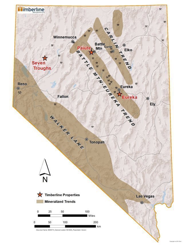
Figure 1. Timberline Project Locations
| 21 |
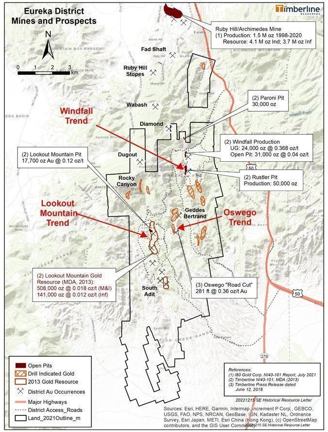
Figure 2. Timberline’s Eureka Project Area and Gold Occurrences
| 22 |
The following table summarizes the claims and royalties for the Eureka Project:
Table 1 - Eureka Project Claim and Royalty Summary
Property Name & Agreements/Royalties | Type of Claim | Number of Claims | Area |
Lookout Mountain Mining lease and agreement dated August 22, 2003, and amended on June 1, 2008, between Timberline and Rocky Canyon Mining Company; 3.5% Net Smelter Return (NSR) royalty + 1.5% NSR royalty capped at $1.5 million (excludes Trevor and Dave claims); 20-year lease term commencing June 1, 2008; annual advanced royalty payment of $72,000. | Unpatented
| 373 | 6,368 acres |
Trail Timberline holds title | Unpatented | 30 | 620 acres |
South Ratto Timberline holds title; 4% NSR | Unpatented | 108 | 1,850 acres |
Hoosac North Amselco 4% NSR | Unpatented | 192 | 3,100 acres
|
Little Rosa (Hoosac royalty applies) | Patented | 1 | 7 acres |
Rambler (North Amselco royalty applies) | Patented | 1 | 7 acres |
TLRat Timberline holds title | Unpatented | 5 | 72 acres |
Silverado/TL 12 1%-3% NSR | Unpatented | 47 | 947 acres |
Secret Canyon/Oswego Timberline holds title. (Includes 2 mill sites on Syracuse 1 & 2) 0 – 3% NSR | Unpatented | 111 | 1,488 acres |
Secret Canyon 1% NSR | Patented | 6 | 36 acres |
Windfall Timberline holds title; 4% NSR | Patented | 13 | 165 acres |
New York Canyon Timberline holds title; 4% NSR | Unpatented | 45 | 862 acres |
Q Claims Timberline holds title | Unpatented | 104 | 2,149 acres |
LS Claims | Unpatented | 28 | 578 |
|
|
|
|
Total Unpatented Lode Claims |
| 1,043 | 18,034 acres |
Total Patented Lode Claims |
| 21 | 215 acres |
Grand Total of Claim Holdings |
| 1,036 | 18,249 acres |
We have the right to explore and develop the Lookout Mountain target subject to a mining lease agreement dated August 22, 2003 with Rocky Canyon Mining. The lease was amended on June 1, 2008 to extend the term to 20 years from June 1, 2008, and thereafter for as long as minerals are mined on the project. Advance royalty payments are $6,000 per month, or $72,000 per year. Timberline fulfilled a $1.5 million work commitment on the Lookout Mountain target stemming from the amended lease agreement. A 3.5% NSR royalty, plus a 1.5% NSR royalty capped at $1.5 million (excludes Trevor and Dave claims) exists on the Lookout Mountain claims.
| 23 |
During the year ended September 30, 2012, Timberline acquired the Windfall patented claims in a transaction of cash and shares valued at $500,000. There is a 4% NSR royalty on these claims.
The Secret Canyon/Oswego, South Ratto, and New York Canyon claim groups are owned by Timberline, subject to royalty agreements. NSR royalties of 2% exist on the projects for claims located within one mile of the Windfall Patented claims. A small portion of the Heiro-Syracuse claim group is subject to an additional 1% NSR royalty.
The Hoosac and North Amselco claims are owned by Timberline and were under lease to Royal Crescent Valley, LLC, a subsidiary of Royal Gold, Inc. until July 2021, at which time they terminated the lease. Until the termination of the lease in July 2021, Royal Gold maintained BLM lease payments and Eureka County fees on the Hoosac and North Amselco claim groups.
Accessibility, Physiography, Climate and Infrastructure
U.S. Highway 50 passes to the east of the Eureka Project and access is gained by heading south out of Eureka on the highway and connecting with unpaved local roads, some of which are periodically maintained by Eureka County. The turnoff for the New York Canyon claim group is about a half mile south of Eureka on U.S. Highway 50 and is an unpaved road running up New York Canyon on the east side of the claim group.
The Windfall group and the northern parts of the Hoosac and Lookout Mountain groups are accessed by the Windfall Canyon Road and its westward extension (the former haul road for the Lookout Mountain Mine), which turns southwest from the highway approximately 2 miles south of Eureka. This road is of uncommon quality and scale for rural Nevada due to its construction as a mine haul road at considerable cost in 1980s dollars.
The southern parts of the Eureka Project are accessed by traveling approximately 8 miles south of Eureka on U.S. Highway 50 to South Gate, then 1 mile south-southwest on the Fish Creek Valley Road to the unimproved Secret Canyon Road, then northwest to the southern part of the Hoosac claims. Many dirt tracks within the Eureka property allow additional access.
The terrain on the Eureka Project is rugged, with high ridges, steep canyons, and narrow valleys. Elevations range from 7,000 to 9,000 feet (2,100-2,400 m). Ridges show abundant bedrock exposures, slopes and valleys are typically covered by soil and alluvium. Sagebrush abounds in lower-elevation areas while juniper and piñon pine cover the higher elevations. Grasses and shrubs grow on the highest ridge tops. The climate of the project area is semi-arid with the area receiving moderate winter snows and occasional summer thunderstorms, with heavy rain from time to time during otherwise hot and dry summers. In winter, access is not maintained off the paved roads and November snow commonly lingers until April.
Summer temperatures usually consist of many consecutive days over 90º F (32.2º C), and temperatures can reach as high as 100º F (37.8° C) or more. Winter temperatures generally range from as cold as below 0º F (-17.8ºC) to, more commonly, in the 20º to 35ºF (-6.67º to 1.7 º C) range. Precipitation amounts vary from year to year, averaging about 10.0 inches (25.4 cm) for the area. Several feet of snow may accumulate on the property during the winter months.
The Eureka Project is situated in north-central Nevada in an area with established mining infrastructure. Transmission power lines serve Eureka from the north. All essential services such as food and lodging are available in Eureka, including dockage for shipments of heavy equipment. A small airport at Eureka is available for private air transport. Railroad access is also available in the area. The gold mines of north-central Nevada continue to produce a significant portion of the world’s gold, and skilled miners and mining professionals are available in Eureka, and 100 miles to the north in Carlin, Elko, and Spring Creek. Permitting a mining operation in Nevada has been a process with which local, state, and federal regulators are very familiar and generally cooperative.
The reader should note that discussions in this document pertaining to assay results and concentrations of gold mineralization span many years and reporting standards have changed considerably over that time. References to historical reports of assay results or the grade (concentration) of gold mineralization may cite results in troy ounces of gold per short ton of rock, which will be abbreviated “opt”. More recent gold assay or concentration data will be reported in this document as grams of gold per tonne (metric) of rock, which will be abbreviated “g/t”. In most cases when discussing modern data, we make an effort to cite the unit conversion, which is on the basis of 1.00 opt = 34.286 g/t. We may also cite other historic work in the original US customary system of units, but modern work will be reported in metric units with conversions to US customary in most instances.
| 24 |
Summary of Modern Exploration by Timberline Resources: 2010-2021 (See below for 2022 and pre-2010 historic summaries)
The Eureka Project has excellent potential for continued exploration success. Based on the work of previous companies and by Timberline, gold mineralization at the Lookout Mountain target is currently defined over a structural-stratigraphic corridor that extends up to 4.3 miles (7 kilometers) in strike length. This corridor hosts several areas of drill-indicated gold, and the potential for discovery of additional mineralization is strong. The Lookout Mountain mineralization itself is open for expansion at depth and along strike.
From 2010 through 2013, the exploration work programs totaled approximately $9,000,000 on the Eureka Project. The work during that period delivered sufficient data to support a mineral resource estimate at Lookout Mountain (including a technical report compliant with Canadian National Instrument 43-101 (“NI 43-101”)), conduct initial gold recovery studies, initiate environmental baseline investigations, better understand the controls of mineralization, and to outline additional exploration drill targets. In summary, these objectives were met in the 2010-2013 exploration by completion of the following:
| · | 16,675 feet (5,083 m) of core drilling focused primarily for metallurgical and geotechnical scoping studies; |
|
|
|
| · | 46,965 feet (14,315 m) of RC drilling directed primarily at resource in-fill and definition drilling, and; |
|
|
|
| · | Additional testing activities, including metallurgical test work on core samples, channel and mini-bulk sampling within the historical Lookout Mountain pit, identification of additional exploration targets beyond the Lookout Mountain Deposit area, and drilling and construction of additional groundwater monitoring wells. |
Lookout Mountain Project, a material property:
An initial technical report entitled, Technical Report on the Lookout Mountain Project, Eureka County, Nevada, USA, compliant with NI 43-101 (“2011 Technical Report”), was completed on May 2, 2011. The Technical Report was prepared by Mine Development Associates (MDA) of Reno, Nevada under the supervision of Michael M. Gustin, Senior Geologist, who is a qualified person under NI 43-101. The Technical Report details mineralization at the Lookout Mountain Deposit. In addition, significant exploration potential was noted.
The mineral resource was modeled and estimated by MDA by statistical evaluation of available drill data utilizing geologic interpretations provided by Timberline. The geologic interpretations were used to constrain gold mineral domains on vertical cross sections spaced at 50- to 100-foot intervals across the extent of the Lookout Mountain mineralization. The cross sections were rectified to the mineral-domain interpretations on level plans spaced at 10-foot intervals, allowing the geostatistical analysis of the modeled mineralization to aid in the establishment of estimation parameters, and interpolating grades into a three-dimensional block model.
The final drill results of the 2011 exploration program were successfully incorporated into the updated mineral resource and NI 43-101 compliant “Updated Technical Report on the Lookout Mountain Project, Eureka County, Nevada, USA” issued by MDA on May 31, 2012 (“2012 Technical Report”). As a result of the 2011 exploration program, the mineralized zone at Lookout Mountain was successfully extended 600 feet (183m) to the south of the existing mineral deposit, and mineralization was also expanded along the west margin of the deposit. Results from Lookout Mountain, and from the South Adit area, significantly increased the reported mineralization at the Lookout Mountain Deposit.
Assay results from drilling during the 2012 and 2013 exploration program were incorporated into another update to the resource and NI 43-101 compliant “Updated Technical Report on the Lookout Mountain Project, Eureka County, Nevada, USA” issued by MDA on April 11, 2013 (“2013 Technical Report”).
Subsequent to the filing of the Company’s Annual Report on Form 10-K on December 29, 2022, we re-engaged Mr. Gustin, most recently of RESPEC, to provide an updated report and summary to meet the guidelines of Subpart 1300. This technical report is called S-K 1300 Technical Report Summary: Lookout Mountain Project, Eureka Property, Eureka, Nevada and is dated June 21, 2023, with an effectivity date of December 31, 2022. As a result, the information of this revised report and the associated Management Summary of SK 1300 Technical Report is reflected as follows:
Lookout Mountain - Mineral Resource Estimate
The gold resources at the Lookout Mountain project, including the Lookout Mountain and South Adit deposits, were modeled and estimated by evaluating the drill data statistically, utilizing the geologic interpretations provided by Timberline to interpret mineral domains on cross sections spaced at 50- and 100-foot intervals, refining the mineral-domain interpretations on level plans spaced at 10-foot intervals, analyzing the modeled mineralization statistically to aid in the establishment of estimation parameters, and interpolating grades into a three-dimensional block model. All modeling of the Lookout Mountain project resources was performed using Gemcom Surpac® mining software.
| 25 |
The Lookout Mountain project resources are presented in Table 2 below:
Table 2. Lookout Mountain Project Gold Resources
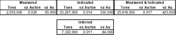
Notes:
| · | The estimate of the Lookout Mountain project Mineral Resources was completed by RESPEC Company LLC of Reno, Nevada. |
| · | The Mineral Resources are comprised of oxidized model blocks that lie within optimized pits at a cutoff grade of 0.005 oz Au/ton plus unoxidized blocks within the optimized pits at a 0.055 oz Au/ton cutoff. |
| · | Mineral Resources that are not Mineral Reserves do not have demonstrated economic viability. |
| · | The Mineral Resources are potentially amenable to open pit mining methods and are therefore constrained by optimized pits created using a gold price of US$1,800/oz, a throughput rate of 10,000 tons/day, assumed metallurgical recoveries of 80% for heap-leaching of oxidized materials and 86% for toll milling of unoxidized materials, a mining cost of US$2.50/ton, heap-leaching processing cost of $3.60/ton, toll milling cost of $80.00/ton, general and administrative costs of $0.83/ton processed, a reclamation cost of $0.25/ton processed, refining cost of $3.00/oz Au produced, and an NSR royalty of 3.5%. |
| · | The effective date of the resource estimate is December 31, 2022. |
| · | Rounding may result in apparent discrepancies between tons, grade, and contained metal content. |
Timberline does not have permits to operate a mine. The Company operates exploration activities at Lookout Mountain under a Plan of Operations (PoO) approved in 2010 by the BLM, subject to annual workplan amendments for drilling related disturbance. Additional environmental and engineering studies will be required to support a mine plan of operations with the BLM to comply with the National Environmental Policy Act (NEPA), and to meet State of Nevada Bureau of Mine Regulation and Reclamation and other agency permit requirements.
(Explanatory Note: The original filing for Form 10-K on December 29, 2022 disclosed Measured & Indicated resources of 508,000 ounces and Inferred resources of 141,000 ounces, The table above reflects a reduction of those estimates of 85,000 ounces and 57,000 ounces, respectively, as a result of the application of the ‘pit-constrained’ methods as disclosed in the notes to the table above. The application of this constraint appropriately takes into account a measure of economic viability of mining the resources.)
Qualified Person’s Conclusions and Recommendations
RESPEC has reviewed the project data and has visited the site. RESPEC believes that the data provided by Timberline are generally an accurate and reasonable representation of the Lookout Mountain project.
The resources reported above are open along strike in both directions, as well as down dip. The possible extension of the Lookout Mountain deposit south through to the South Adit resource, located approximately 3,500 feet south of the southern limit of the modeled mineralization at Lookout Mountain, provides the best opportunity for near-term enhancement of project resources. In addition, there is excellent potential to add to the existing resources that lie west of the Ratto Canyon fault at the Lookout Mountain deposit.
A Phase I program is recommended to include infill drilling, resource-expansion drilling, further metallurgical testing, full three-dimensional geological modeling, and the completion of an Initial Assessment based on the current resources. The cost of this program is estimated to be about $4.5 million dollars.
If the Initial Assessment returns positive results, a Phase II program is recommended that is designed to prepare the project for a pre-feasibility study. The Phase II program includes hydrologic, environmental, and preliminary design studies, as well as continuations of the drilling program and metallurgical studies of Phase I. The cost of the proposed Phase II program is about $6.655 million (the Phase I and II estimated costs exclude all personnel, landholding, reclamation, reclamation bonding, permitting and related environmental costs).
| 26 |
Historical Drilling Data for Lookout Mountain:
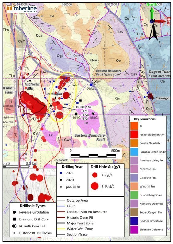
Figure 3. Lookout Mountain Geology and High-Grade Gold Zone Including Drilling through FY 2021
| 27 |
Table 3. Representative High-Grade Gold Drill Intercepts through 2020 from the Lookout Mountain Resource Area
Drill Hole | From (meters) | To (meters) | Length (meters)(1) | Gold (g/t) (2) | Au GT (gram*meters) |
BH05-01 | 82.3 | 102.1 | 19.8 | 11.79 | 233 |
including | 83.8 | 91.4 | 7.6 | 21.98 | 167 |
BH05-03 | 58.8 | 59.8 | 1.0 | 76.80 | 77 |
BH06-02 | 135.7 | 143.9 | 8.2 | 12.40 | 102 |
BH06-07 | 123.8 | 151.8 | 28.0 | 7.44 | 208 |
BH06-10 | 0.0 | 15.2 | 15.2 | 18.40 | 280 |
BH06-13 | 45.1 | 46.0 | 0.9 | 50.30 | 45 |
BH06-13 | 117.4 | 124.9 | 7.5 | 9.51 | 71 |
BH06-16 | 0.0 | 10.0 | 10.0 | 12.90 | 129 |
BHSE-029C | 119.2 | 136.9 | 17.7 | 12.00 | 212 |
BHSE-032 | 42.7 | 45.7 | 3.0 | 14.60 | 44 |
BHSE-034 | 41.2 | 42.7 | 1.5 | 15.80 | 24 |
BHSE-037C | 67.7 | 68.0 | 0.3 | 27.80 | 8 |
BHSE-064 | 39.6 | 45.7 | 6.1 | 3.19 | 19 |
BHSE-066 | 25.9 | 30.5 | 4.6 | 4.95 | 23 |
BHSE-066 | 88.4 | 93.0 | 4.6 | 8.53 | 39 |
BHSE-067 | 51.8 | 56.4 | 4.6 | 3.63 | 17 |
BHSE-076 | 6.1 | 48.8 | 42.7 | 1.43 | 61 |
including | 7.6 | 10.7 | 3.1 | 11.52 | 35 |
BHSE-096 | 32.0 | 94.5 | 62.5 | 1.48 | 92 |
including | 36.6 | 45.7 | 9.1 | 3.73 | 34 |
BHSE-102 | 41.2 | 70.1 | 29.0 | 1.89 | 55 |
including | 59.4 | 62.5 | 3.1 | 13.15 | 40 |
BHSE-104 | 33.5 | 86.9 | 53.3 | 1.18 | 63 |
including | 67.1 | 73.2 | 6.1 | 12.19 | 74 |
BHSE-126C | 9.5 | 14.1 | 4.6 | 33.10 | 152 |
BHSE-151C | 152.7 | 163.6 | 10.9 | 3.63 | 40 |
Including | 154.2 | 156.9 | 2.6 | 35.63 | 93 |
BHSE-176 | 21.3 | 36.6 | 15.2 | 10.09 | 154 |
BHSE-186 | 4.6 | 10.7 | 6.1 | 5.21 | 32 |
BR-1 | 10.7 | 22.9 | 12.2 | 14.50 | 177 |
BR-1 | 19.8 | 22.9 | 3.1 | 45.10 | 140 |
BR-19 | 10.7 | 13.7 | 3.0 | 12.70 | 38 |
BR-19 | 19.8 | 22.9 | 3.1 | 45.10 | 140 |
BR-19 | 67.1 | 71.7 | 4.6 | 11.10 | 51 |
BR-19 | 117.4 | 137.2 | 19.8 | 10.90 | 216 |
BR-26 | 134.2 | 140.2 | 6.0 | 11.10 | 67 |
EFL-4 | 29.0 | 30.5 | 1.5 | 9.30 | 14 |
EFL-5 | 0.0 | 1.5 | 1.5 | 8.60 | 13 |
LM-05 | 0.0 | 19.8 | 19.8 | 8.90 | 176 |
LM-13 | 3.1 | 4.6 | 1.5 | 12.30 | 18 |
| 28 |
RTC-201 | 0.0 | 14.0 | 14.0 | 10.90 | 153 |
RTC-201 | 17.4 | 19.8 | 2.4 | 17.30 | 42 |
RTR-020 | 6.1 | 7.6 | 1.5 | 17.80 | 27 |
RTR-044 | 0.0 | 19.8 | 19.8 | 11.60 | 230 |
RTR-044a | 0.0 | 3.1 | 3.1 | 9.94 | 31 |
RTR-044a | 25.9 | 27.4 | 1.5 | 10.60 | 16 |
RTR-048 | 54.9 | 56.4 | 1.5 | 13.70 | 21 |
RTR-049 | 33.5 | 35.1 | 1.6 | 163.00 | 261 |
RTR-049 | 73.2 | 76.2 | 3.0 | 28.10 | 84 |
RTR-059 | 29.0 | 32.0 | 3.0 | 20.60 | 62 |
RTR-071 | 0.0 | 13.7 | 13.7 | 9.71 | 133 |
RTR-095 | 7.6 | 19.8 | 12.2 | 12.60 | 154 |
RTR-098 | 0.0 | 13.7 | 13.7 | 12.70 | 174 |
RTR-133 | 71.7 | 76.2 | 4.5 | 17.40 | 78 |
RTR-134 | 126.5 | 143.3 | 16.8 | 12.00 | 202 |
RTR-153 | 9.2 | 18.3 | 9.1 | 11.10 | 101 |
RTR-153 | 73.2 | 74.7 | 1.5 | 12.30 | 18 |
RTR-156 | 16.8 | 18.3 | 1.5 | 10.30 | 15 |
RTR-159 | 4.6 | 7.6 | 3.0 | 8.57 | 26 |
RTR-163 | 18.3 | 19.8 | 1.5 | 31.50 | 47 |
RTR-180 | 111.3 | 114.3 | 3.0 | 11.70 | 35 |
RTR-181 | 80.8 | 102.1 | 21.3 | 9.09 | 194 |
RTR-190 | 144.8 | 160.1 | 15.3 | 11.30 | 173 |
RTR-191 | 134.2 | 147.9 | 13.7 | 19.10 | 262 |
RTR-258 | 152.4 | 155.5 | 3.1 | 14.10 | 44 |
(1) Drill thickness – True widths of drill intercepts have not been determined | |||||
(2) g/t: grams/tonne | |||||
Additional Technical Data of the Eureka Project, including Lookout Mountain (Water Well Zone, Oswego and other Eureka properties are non-material properties):
Exploration activities at the Eureka Project, including Lookout Mountain, were curtailed during 2014 due to the limited availability of capital. In fiscal 2015, Timberline drilled three holes to the east of the Lookout Mountain resource and confirmed a 2012 partial drill intercept of higher-grade gold mineralization at depth in hole BHSE-152 (Figure 3). The geology in the hole stratigraphically correlates well with gold intercepts occurring up-dip in the resource area. The host rocks tend to be carbonaceous collapse breccias and jasperoid with pyrite (and sometimes arsenic sulfides) at the contact between the Cambrian-aged Dunderberg and Hamburg formations. The four intercepts are thought by Timberline geologists to be mineralogically consistent with higher-grade occurrences as recognized in deeper levels of many Carlin-type gold systems. One of the strongest intercepts from the 2015 drilling included 65 feet (19.8 m) @ 0.09 opt gold (3.09 g/t), including 25.2 feet (7.7 m) @ 0.146 opt gold (5.02 g/t) in BHSE-171 (Table 3). This new zone of higher-grade gold, downdip from the Lookout Mountain Resource, would become known as the Water Well Zone (WWZ).
Timberline also completed a six-hole RC drill program on the Windfall target in 2015. The drilling successfully tested the on-strike, offset, and down-dip extensions of gold mineralization that was previously mined at Windfall. The drill holes were completed over a strike length of approximately 3,000 feet (914 m) and intersected gold mineralization consistent with that reported from historic drilling in the area, highlighted by drill hole BHWF-40, which intersected 80 feet (24.9 m) at 0.09 opt (3.09 g/t) of gold including a subsection of 20 feet (6.1 m) @ 0.26 opt (8.91 g/t) of gold.
| 29 |
During the continued difficult commodities environment of fiscal years 2016 and 2017, the Company did no drilling or significant field work at the Eureka Project. During fiscal year 2018, we conducted internal geologic reviews of the project, with a focus on higher grade (>3 g/t) gold mineralization that is associated with extensive zones of fault breccia, as well as carbonaceous collapse-breccia. The team also compiled and reviewed historical geophysical data. This included property-wide magnetics and three lines of shallow induced polarization/resistivity (IP) data from 1992. These data defined three north-to-south trending anomalies at Lookout Mountain that are partially coincident with the high-grade gold drill intercepts and faults. In addition, a single line of historical controlled source audio magneto-telluric (CSAMT) data which crosses the Lookout Mountain open-pit area was also evaluated.
The review of historical data led to design and completion of a detailed gravity survey around Lookout Mountain. The gravity data correlates well with structures identified in the CSAMT and with magnetic signatures and geologic mapping. Together the data outline a graben-like feature, the west boundary of which is extensively drilled and approximately coincident with the existing north-to-south trending gold resource at Lookout Mountain. The central portion of the graben had been tested only locally on the west side by four closely-spaced holes (BHSE-152, -171, -172, -173) at the Water Well Zone, all of which contain relatively high-grade gold. The eastern margin of the graben is marked by the major Dugout Tunnel Fault, which separates down-faulted Ordovician rocks from older Cambrian rocks to the east.
Additional field work in 2018 was also completed at the Windfall target. Work there focused on collection of 40 rock chip samples in and between the historical Rustler, Windfall, and Paroni Pits. Highlights included 10 samples with greater than 0.029 opt (1.0 g/t) and 6 greater than 0.088 opt (3.0 g/t) gold, up to a maximum of 0.382 opt (13.1 g/t) gold. In total, 17 samples assayed greater than 0.007 opt (0.250 g/t), documenting the extensive zone of gold mineralization.
During fiscal year 2019, field activities were re-initiated upon entering into the Lookout Mountain LLC Agreement with PM & G Mines, Inc. (“PM&G”) to fund advancement of exploration with an initial focus on the high-grade mineralization in the vicinity of the Lookout Mountain open pit. Initial work entailed a continuation of re-logging of historical drill core in the resource area, where drilling had delineated a northwest-southeast trend of high-grade gold (defined as drill hole intercepts of ≥ 0.10 opt or ~3 g/t) (Figure 3). This high-grade gold area has a strike length of approximately 500 feet (~150m) within the pit area and is up to 250 feet (~60m) wide. It includes relatively flat lying to moderate dipping gold-bearing zones at multiple elevations, including some exposure in the historical pit. The gold mineralization is constrained, at least in part, by stratigraphy and zones of decalcified collapse breccias in the Dunderberg formation. The breccias locally contain the minerals orpiment and realgar (arsenic sulfides).
In addition to relogging historical drill core, a professional land survey was completed in the Lookout Mountain pit area by a Nevada licensed land surveyor. The work was designed as part of a QAQC assessment of historical drill collar data with results to facilitate advancing the project spatial controls to standards required for mine planning, resource modelling and engineering.
In early FY2020, the Company filed with the BLM an amended work plan to the 2009 BLM Plan of Operations for Lookout Mountain. The amended work plan proposed bonding with an additional 9 acres of proposed disturbance beyond the existing 28 acres of disturbance. The increased bond will permit construction of up to 249 drill sites and 28,657 feet of road access in the immediate area of the Lookout Mountain open pit. The work plan was subsequently approved in mid-2020.
During the third quarter of FY 2020, PM&G resigned from the joint venture because they failed to meet the minimum earn-in investment requirements. As a result, the planned drill program did not take place. However, upon completion of a financing in August 2020, the Company submitted additional bond capital of $246,013 to the BLM in preparation for renewed drilling at the Lookout Mountain target.
Twelve RC drill holes totaling 8,000 ft (2,438 m) were completed in FY 2020 within or near the resource area to confirm historical intercepts and as in-fill in mineralized areas (Figure 4). Five of the RC holes were drilled as offsets to the 2015 WWZ discovery drilling. The program continued into early FY2021 with completion of an additional three core holes totaling 4,477 ft (1,365 m). The core holes were completed east of the resource area to test an IP anomaly and down-dip extensions of WWZ mineralization. The core holes did not reach their target depths and were terminated due to drilling difficulties.
In late 2020 and early 2021 Timberline announced additional drill results of high-grade gold inside the existing resource and to the east in the WWZ (Figure 3) (see Company news releases dated December 1, 2020 and January 7, 2021). Highlights included:
| · | Hole BHSE-176 intercepted near surface high-grade gold mineralization, 15.24m averaging 10.09 g/t, beginning at 21.34m downhole depth, including 9.14m of 16.31 g/t, which included 3.05m of 31.40 g/t. |
| · | Holes BHSE-177 and 178 encountered shallow oxide gold within the existing resource, including 18.29m of 0.87 g/t (from surface), 48.77m of 1.00 g/t, and 59.44m of 0.63 g/t. |
| · | Holes BHSE-180, 181, and 182 confirmed northward and down dip extensions of mineralization beyond the Lookout Mountain pit, including gold intercepts of up to 18.29m of 1.58 g/t in the latter of these holes. |
| · | Hole BHSE-184 drilled 18.29m @ 0.93 g/t gold in the shallow sub-surface below the historical pit. |
| · | Hole BHSE-186 intercepted 6.10 m of near surface high-grade gold (5.21 g/t) and a separate, broader zone (25.91 m) at 0.77 g/t mineralization at further depth within the pit area. |
| · | Hole BHSE-187 encountered 7.62 m of 4.49 g/t gold outside the existing resource area within a broader zone of 32.00 m at 1.82 g/t. |
| 30 |
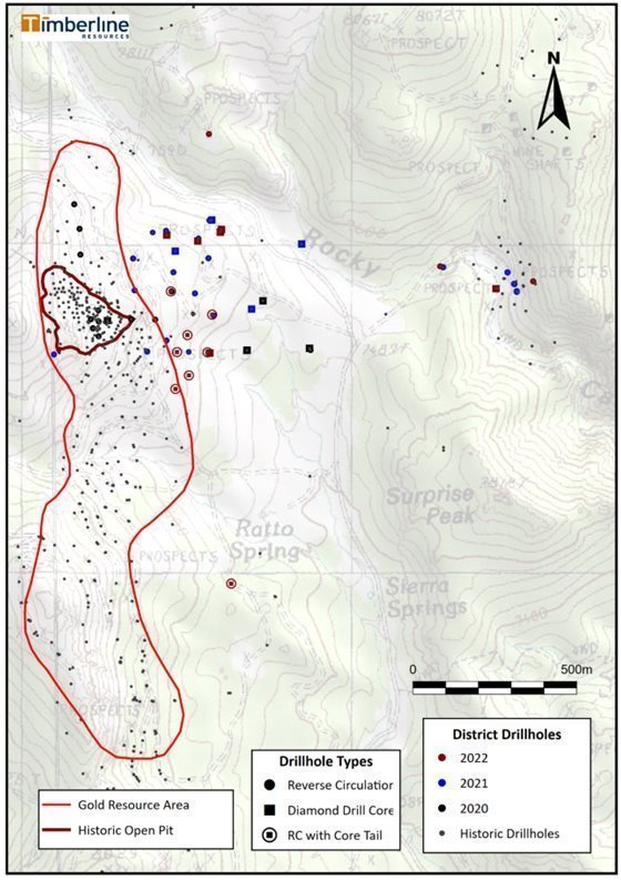
Figure 4. Lookout Mountain Resource Area 2020-2022 Drilling
| 31 |
A schematic cross section view from just south of the historical Lookout Mountain pit shows the geology of the resource and WWZ areas (Figure 5). Much of the Lookout Mountain gold resource is associated with the east-dipping Highwall Fault and the east-dipping contact between the Dunderberg formation and the underlying Hamburg formation. Timberline geologists have noted significant multi-staged collapse brecciation at the contact that likely accounts for the development of porosity and permeability. The mineralizing fluids exploited fault zones and favorable horizons as evidenced by associated intense silicification, sulfidation, and carbonaceous replacement. The resulting jasperoid contains abundant fine sooty pyrite and oftentimes, the arsenic sulfide minerals orpiment and realgar. Jasperoid is present as irregular pods and masses of silicification at various levels within the Dunderberg formation, replacing beds and forming locally cross-cutting veins and veinlets. East of the Lookout Mountain resource, the gold mineralization tends to be localized in the basal 10 to 40m of the Dunderberg, which may or may not be silicified.
The shale and limestone above the gold mineralization often demonstrate calcite veining that passes into zones of argillic alteration. The Hamburg formation dolomite below the contact is usually pervasively oxidized, weakly mineralized and variably decalcified and, in many areas, completely “sanded” by removal of all interstitial calcite.
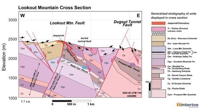
Figure 5. Schematic Cross Section through Lookout Mountain and Graben Zone
As the rock units dip to the east, the mineralization in the WWZ is east, downdip and open from the 2013 gold resource area. The basal Dunderberg formation host is well understood and the 2021 drilling successfully intercepted mineralization approximately where expected.
The Timberline team applied geophysics in conjunction with geologic mapping and 3D modeling of drill data to develop targets beyond the resource area for drill testing. A district-scale gravity survey was extended from the Lookout Mountain area over the Eureka property block in the quarter ending December 31, 2021 (Figure 6). In his interpretation and reporting of the gravity data, Jim Wright of Wright Geophysics (Elko, NV) recognized the presence of multiple structures and alteration zones that are consistent with the architecture of a Carlin-type gold district.
In late 2021, the Company also retained Simcoe Geoscience Limited to complete a 28 line-km IP survey on the Lookout Mountain Trend. IP geophysics is useful for identifying rocks that are rich in sulfide minerals (such as pyrite) and carbonaceous material, both of which can be enriched in Carlin-type gold systems. The 2021 survey followed-up on sulfides and carbonaceous material encountered in some of the deeper drill holes in 2020. Strong north-south trending IP anomalies were identified within the central part of the graben zone at Lookout Mountain. A second IP survey of 25 line-km was completed by Zonge Geosciences, Inc. (Zonge), which identified similar IP anomalies in the Windfall area farther northeast. Zonge also completed a CSAMT survey along four lines totaling 19 line-kilometers with lines transecting major target areas at the WWZ, West Lookout, Oswego, Rocky Canyon, South Lookout - South Adit, and at Windfall. The additional resistivity data generated from the CSAMT provided enhanced insights into the alteration, faults, and host rock stratigraphy. The combined new geophysical data generated significant improvements in the Company’s three-dimensional model of the gold targets at Eureka.
| 32 |
The gold systems at the Eureka Project often come to the surface where faults and altered rocks yield soil geochemical anomalies in gold and pathfinder elements. Each of the three major trends at Eureka is reflected in gold anomalies in Timberline’s historical soil geochemical dataset. During the summer of 2021, Timberline collected approximately 900 soil samples across the northeastern portion of the Eureka property, which had never been covered by previous workers. The 2021 survey employed new ultra-trace level multi-element analyses of the samples, offering a wider range of elements and much higher sensitivity. We also engaged Mary Doherty of International Geochemical Consultants, LLC (IGC) to integrate the new data with the approximately 5,750 historical samples and statistically level the dataset for new interpretation work. The resulting maps provide near-complete soil geochemical coverage over the northern two thirds of the Eureka Project. The new maps and interpretation provided by IGC recognized numerous distinct soil anomalies consistent with Carlin-type gold geochemistry, particularly emphasizing the Lookout, Windfall, and Oswego trends. The soil data also mapped silver-lead-zinc anomalies consistent with carbonate-replacement type deposits (CRD), best developed in the far northeast of the property at New York Canyon. Modern interpretation tools have helped the team map the major NNW trends and crosscutting NW-SE and NE-SW structures (Figure 7). It is clear from the data that silver and gold mineralization is likely to extend well beyond existing drilling in several areas.
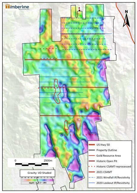
Figure 6. Eureka Project 2020 – 2021 Geophysical Surveys
| 33 |
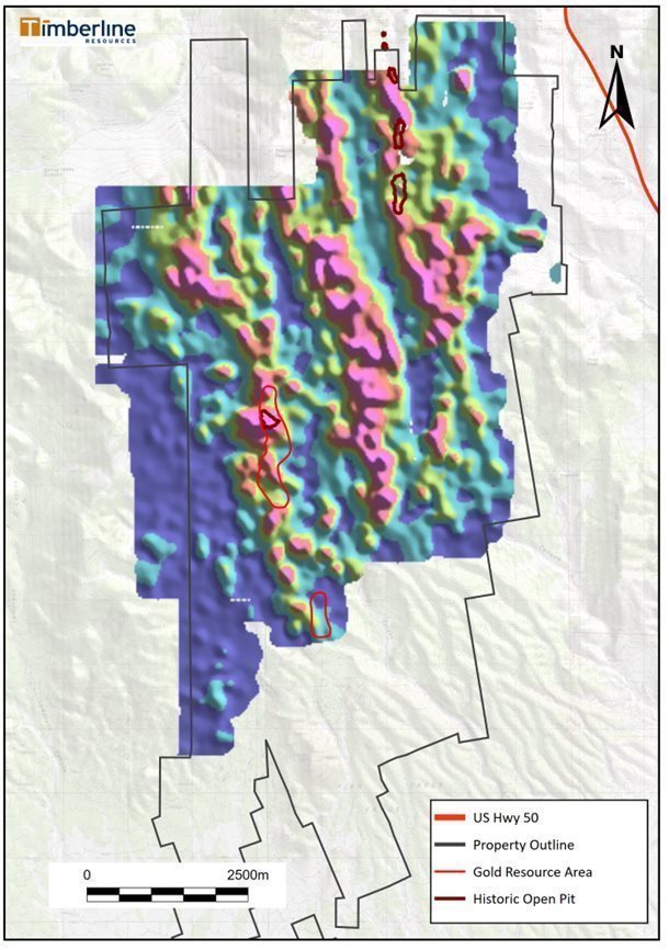
Figure 7. Soil Geochemistry Factor Map Area showing Normalized Au+As+Sb data
| 34 |
Drilling resumed at Eureka in July 2021, though the program was broken into two parts based on availability of drills and drill crews. Drilling began in July with several RC drillholes and then a diamond core rig commenced work in October 2021. In total, the program included 3,495 meters (11,465 feet) of core and 6,536 meters (21,444 feet) of RC drilling. In some cases, the Company employed RC drilling for the upper portions of the holes (pre-collars) and drilled core through the deeper target zones (core tails). The primary targets for this program were step-outs around earlier gold intercepts and selected fault zones in the WWZ as well as the IP anomaly in the Graben Zone east of the WWZ (Figure 8). We added a few drill holes at Oswego late in the program when surface sampling results became available.
The program was successful at expanding the footprint of the new mineralized zone and its average grade and thickness. One of the holes also encountered the first significant silver-lead-zinc (CRD type) intercepts reported from the central portion of the project. Most of the 2021 drilling program was reported during the first quarter of 2022, and the highlights include:
| · | BHSE-212C: 41.1m at 5.03 g/t Au, including 19.8m at 9.49 g/t Au; |
| · | BHSE-220C: 44.2m at 4.10 g/t Au, including 12.2m at 9.18 g/t Au; |
| · | BHSE-192C: 24.4m at 3.85 g/t Au, including 4.6m at 8.35 g/t Au; and |
| · | BHSE-206C: 202.7m at 5.28 g/t silver (Ag), including 56.4m at 9.69 g/t Ag, 0.17% Zn, and 0.11% Pb |
The most important finding from the 2021 drilling campaign was confirmation of the consistency of Carlin-type gold mineralization at the basal contact of the Cambrian aged Dunderberg formation with the Cambrian Hamburg formation. The Dunderberg and its basal contact is the primary host of the gold in the Lookout Mountain deposit, and its downdip continuation is highly mineralized in the WWZ as well. The Hamburg is a thick limestone that is variably altered to dolomite and often subject to solution collapse; the resulting volume loss has also caused the collapse of the overlying Dunderberg. The contact zone is converted into an almost ubiquitous breccia body over a large area at Lookout and the WWZ. This breccia varies from approximately five to more than 40 meters thick, and it was an excellent host for the hydrothermal fluids that deposited the gold.
The 2021 drilling encountered thick and high-grade (>3 g/t) gold over a north-south corridor spanning more than 400 meters, as defined by the intercepts in BHSE-220C in the north and BHSE-212C in the south. Using a long section view that extends that trend southwest into the Lookout Mountain resource area, one can see that the Dunderberg-Hamburg contact is mineralized with gold for more than 1 kilometer (Figure 9). The thickness and grade vary, but gold and associated Carlin-type pathfinder elements are enriched in every drillhole that penetrates the contact. As recorded in Table 4, some of the new WWZ intercepts from the 2021 drill program are among the richest on the project when expressed as grade-thickness in gram – meters of gold (thickness of interval multiplied by the average gold grade of the interval).
There were also important advances in the understanding of structural geology, stratigraphy, alteration, and geologic controls on the gold mineralization in the WWZ resulting from the 2021 drill program. This was due in large part to the increased use of core drilling instead of RC drilling. This came about because Timberline geologists tested RC vs core drilling at the north end of the WWZ. Drilling in this area with an RC rig encountered an area of higher than usual groundwater inflow (BHSE-205). The resulting samples from the RC rig appeared to be visually favorable, including extreme alteration and abundant sulfide minerals. The assays from that interval were highly enriched in gold, but the grades were lower than expected based on the observed geology. We brought in the diamond core rig to twin the RC hole with core (BHSE-220C) – the two vertical holes were collared just over 2 meters apart. The same mineralized zone was encountered with the core rig, but the results were quite different.
Not only was the mineralized zone somewhat thicker as reported from core, but the grade was much higher. The literature and anecdotal reports from Nevada commonly cite differences between RC and core samples of 10 – 20%. After canvasing other experienced Nevada geologists, we also heard reports of more extreme discrepancies of 75 – 100%. Such differences are generally ascribed to the possibility that high rates of groundwater inflow to a drillhole could wash away very fine-grained gold-bearing phases such as sooty pyrite and/or clay minerals. These fine mineral phases can be very gold-rich. Some RC rigs are forced to change bits in wet drilling conditions, and it's accepted by many industry experts that tri-cone bits suffer greater sample loss and contamination than hammer bits. In this case, the results from drill core were markedly different from the RC results:
| · | BHSE-205 (RC): 36.6m at 1.06 g/t gold |
| · | BHSE-220C (core): 44.2m at 4.1 g/t gold |
It is important to note that the discrepancy between sampling results by RC and core drilling is not always so extreme. Additional work during 2022 suggests that core drilling generally yields higher grade-thickness of gold, but this is sometimes because the core drilling appears to more accurately reflect true thickness of the mineralized zones. The comparisons of gold grade between the two methods may be very similar. See below in the review of the 2022 exploration program for more discussion and additional graphics.
| 35 |
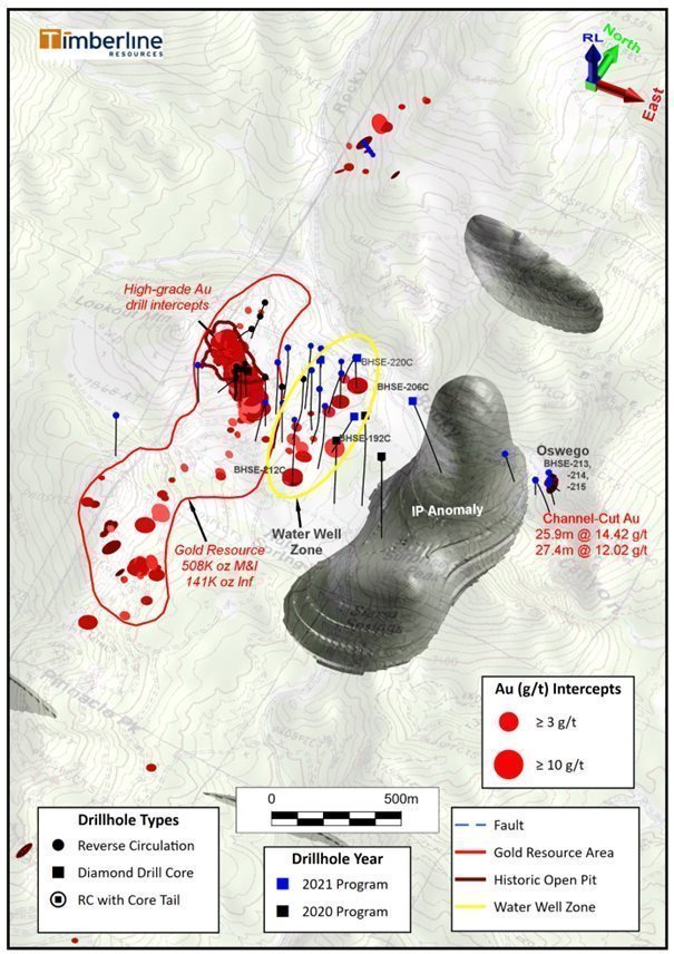
Figure 8. Lookout Mountain Gold Resource Area and Graben Zone with Major Faults, IP anomalies, and 2021 Drill Holes in Target Areas
| 36 |
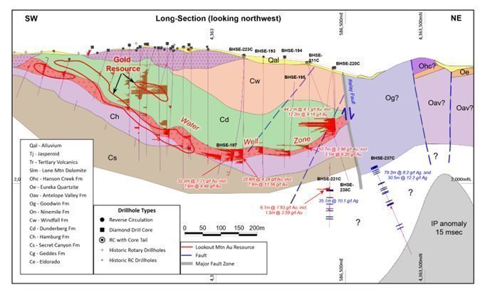
Figure 9. Long Section from Lookout Mountain Resource through Water Well Zone
Table 4. Summary of Drillhole Intercepts in the Water Well Zone (2015 - 2021)
Drill Hole | From (meters) | To (meters) | Length (meters)(1) | Gold (g/t) (2) | Au GT (gram*meters) |
BHSE-152 | 312.4 | 317.0 | 4.57 (at TD) | 4.72 | 22 |
BHSE-171 | 301.8 | 327.7 | 25.9 | 2.54 | 66 |
including | 301.8 | 318.5 | 16.8 | 3.41 | 57 |
including | 310.9 | 317.0 | 6.1 | 5.46 | 33 |
BHSE-172 | 272.8 | 321.7 | 48.9 | 3.26 | 159 |
including | 274.3 | 274.5 | 0.2 | 4.88 | 1 |
BHSE-173 | 285.0 | 304.8 | 19.8 | 2.29 | 45 |
including | 289.6 | 298.7 | 9.1 | 2.91 | 27 |
BHSE-187 | 266.7 | 292.6 | 25.9 | 2.18 | 56 |
including | 266.7 | 274.3 | 7.6 | 4.49 | 34 |
BHSE-193 | 248.4 | 268.2 | 19.8 | 1.38 | 27 |
including | 248.4 | 253.0 | 4.6 | 2.10 | 10 |
BHSE-194 | 301.8 | 312.5 | 10.7 | 2.36 | 25 |
including | 301.8 | 306.4 | 4.6 | 3.20 | 15 |
BHSE-195 | 259.1 | 272.8 | 13.7 | 2.02 | 28 |
including | 269.8 | 272.8 | 3.1 | 4.56 | 14 |
BHSE-198 | 219.5 | 242.4 | 22.9 | 1.11 | 25 |
BHSE-204 | 161.5 | 167.6 | 6.1 | 2.85 | 17 |
including | 161.5 | 164.6 | 3.1 | 4.88 | 15 |
BHSE-205 | 138.7 | 175.3 | 36.6 | 1.06 | 39 |
BHSE-209 | 324.6 | 333.7 | 9.1 | 1.21 | 11 |
| 37 |
including | 326.1 | 330.7 | 4.6 | 2.07 | 10 |
BHSE-210C | 255.1 | 264.2 | 9.1 | 1.34 | 12 |
including | 255.1 | 261.2 | 6.1 | 1.86 | 11 |
BHSE-211C | 229.2 | 239.9 | 10.7 | 2.96 | 32 |
including | 229.2 | 232.3 | 3.1 | 6.26 | 19 |
BHSE-212C | 316.1 | 357.2 | 41.1 | 5.03 | 207 |
including | 317.6 | 345.0 | 27.4 | 7.30 | 200 |
including | 317.6 | 337.4 | 19.8 | 9.49 | 188 |
including | 317.6 | 323.7 | 6.1 | 16.90 | 103 |
including | 328.3 | 335.9 | 7.6 | 8.03 | 61 |
BHSE-220C | 140.8 | 185.0 | 44.2 | 4.10 | 181 |
including | 140.8 | 163.7 | 22.9 | 6.24 | 143 |
including | 151.5 | 163.7 | 12.2 | 9.18 | 112 |
(1) Drill thickness – True widths of drill intercepts have not been determined | |||||
(2) g/t: grams/tonne | |||||
While exploration at Eureka during 2021 focused on the Lookout Trend and nearby WWZ, the team also returned to the Oswego target (approximately 1 kilometer east – See Figure 3) during the fourth quarter of the year. Timberline geologists collected 67 rock samples from a systematic chip, channel, and trenching campaign at the Oswego gold occurrence. The sampling extended along a 65-metre exposed fault scarp, where historical grab sample results had indicated the presence of high-grade gold. The mapping and sampling in the area identified the Trench Fault as a splay of the Dugout Tunnel Fault. The fault zone hosts an outcrop of oxidized and pervasively silicified rocks that is up to 10 meters high and stretches for more than 60 meters in a northwesterly direction. The results of the channel and trench samples were very positive and are summarized in Table 5.
Table 5. Summary of Oswego Channel Sample Gold Assay Results (No cutoff grade applied)
Sample Set | No. Samples3 | Meters | Estimated True Thickness (m) | Au (g/t) | Oxide/ Sulfide1 |
North Trench | 9 | 13.7 | 8.22 | 1.68 | Oxide |
including | 1 | 1.5 | 0.9 | 9.05 | |
Central Trench | 7 | 10.7 | 10.7 | 3.63 | Oxide |
including | 4 | 6.1 | 6.1 | 6.25 | |
South Trench | 7 | 10.7 | 10.7 | 2.41 | Oxide |
including | 3 | 4.6 | 6.1 | 3.77 | |
North Channel | 17 | 25.9 | Unknown | 14.42 | Oxide |
including | 5 | 7.6 | 23.16 | Oxide | |
2Gap Sample | 1 | 1.5 | 9.88 | Oxide | |
Gap Sample | 1 | 1.5 | 6.01 | ||
South Channel | 18 | 27.4 | 12.02 | Oxide | |
Notes: 1 57 of 67 samples were re-analyzed for gold by cyanide leach (method Au-AA13). Average estimated gold recovery by cyanide leach was 93% when compared to fire assay AA or gravimetric finish. 2 Due to limited access for safety considerations, only two samples were collectable in a 12m gap between the North and South Channel samples. 3 Six additional surface outcrop samples west of the South Channel returned no significant gold | |||||
| 38 |
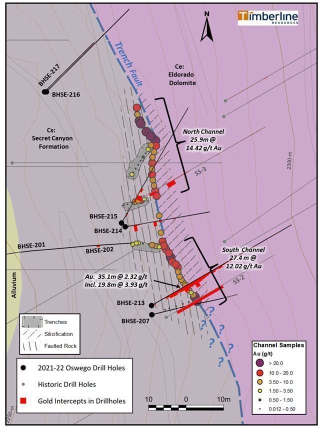
Figure 10. Geologic Map of the Oswego Gold Occurrence with Channel Sample Locations and Results
| 39 |
The strong results from surface sampling at Oswego came just in time to allow adjustments to the 2021 drill program such that eight RC holes totaling 767 meters could be drilled there. Several of the drill holes at Oswego encountered significant near-surface gold mineralization, much of which appears to be oxidized (See Figure 10). The most significant new gold intercepts from these holes included:
| · | 35.1m at 2.32 g/t gold (oxide) from 6.1m depth in BHSE-213, including 19.8m at 3.93 g/t gold from 7.6m depth; |
| · | 13.7m at 1.31 g/t gold from 3.0m depth in BHSE-215, including 6.1m at 2.49 g/t gold from 9.1m depth; and |
| · | 9.1m at 1.72 g/t gold from surface and 12.2m at 1.22 g/t gold from 15.2m depth in BHSE-214. |
The strong gold endowment at Oswego is considered important as Timberline’s geologists recognize that the mineralized fault is associated with the eastern margin of the Graben Zone (Figure 8). The fact that some of the mineralization is near-surface and oxidized is also potentially important for future development plans on the project. However, the Oswego mineralization has also been shown to be tightly structurally controlled and (so far) difficult to follow to depth or along strike.
Exploration by Timberline Resources in 2022
The success of the 2021 exploration campaign significantly upgraded the Water Well Zone due to repeated drill intercepts of thicker (> 15 meters) and higher grade (>3.0 g/t) gold mineralization. The 2022 drill campaign continued with a focus on the WWZ, but also included exploration holes farther north and south along the Lookout Trend and at Oswego. The program included 20 holes totaling 6,367 meters, approximately 65% of the meterage was with diamond core as opposed to RC (Figure 4). At the time of this writing, results from several drill holes are still pending. The most significant results from 2022 came from the WWZ. Highlights included (using a 0.3 g/t gold cutoff grade):
| · | BHSE-221C: 6.1m at 1.83 g/t gold from 332.8m depth, including |
| o | 1.5m at 3.59 g/t gold from 335.9m depth; |
| · | BHSE-223C: 39.0m at 1.71 g/t gold from 259.7m depth, including |
| o | 28.3m at 1.97 g/t gold from 259.7m depth, and including |
|
| ■ | 5.9m at 3.71 g/t gold from 259.7m depth; |
| · | BHSE-224C: 30.5m at 2.56 g/t gold from 317.6m depth, including |
| o | 18.4m at 3.80 g/t gold from 317.6m depth, and including |
|
| ■ | 3.35m at 13.36 g/t gold from 331.3m depth; |
| · | BHSE-226C: 22.8m at 4.29 grams per tonne (g/t) gold from 339.9m depth, including |
| o | 7.6m at 11.56 g/t gold from 342.9m depth; |
| · | BHSE-230C: 3.1m at 10.88 g/t gold from 288.6m depth; |
| · | BHSE-238C: 16.8m at 2.64 grams per tonne (g/t) gold from 178.9m depth, including |
| o | 4.6m at 4.45 g/t gold from 182.0m depth; |
| · | BHSE-239C: 9.4m at 1.09 g/t gold from 194.5m depth; and |
| · | BHSE-239C: 3.1m at 3.77 g/t gold from 439.5m depth. |
Two holes in the southern part of the WWZ encountered significant mineralization. This drilling expanded the high grade (>3 g/t) WWZ gold mineralization for another 75 meters farther south to a total of approximately 475m, and the system remains open to the south and southeast.
Drilling at the north end of the WWZ tested the northward extension of mineralization beyond hole BHSE-220C (drilled in the 2021 program) and exploration targets farther north in a younger Silurian-Ordovician terrane (Figure 11). Three of the holes in the northern part of the WWZ encountered significant gold mineralization, while two holes intersected notable silver-lead-zinc mineralization (Figure 12). Although the WWZ mineralization at the Dunderberg-Hamburg contact appears to be cut-off or down dropped by a major fault on the north, there are lesser intercepts in BHSE-236 and BHSE-239C indicating that Carlin-type gold mineralization does extend into the younger rocks north of the major Relay Zone fault.
| 40 |
The silver intercepts from the 2022 drilling in the northern WWZ are summarized below (using a cut-off grade of 1.0 g/t for silver):
| · | BHSE-221C: 35.1m at 10.1 g/t silver from 329.8m depth; |
| · | BHSE-237C: 79.2m at 8.2 g/t silver from 297.8m depth; and |
| · | BHSE-237C: 30.5m at 12.2 g/t silver from 393.8m depth. |
These drill holes constitute Timberline’s first test of the major fault zone that cuts through the northern part of the Lookout Mountain and Water Well deposits. The significant silver intercepts in this area confirm the presence of overlapping gold and silver systems in this area. The Rocky Canyon Target, to the north of the Lookout Mountain resource area, also includes a mix of significant gold and silver intercepts. These are not isolated occurrences in the Eureka District, as i80 Gold Corp has been reporting significant silver and Carlin-type gold intercepts from the Ruby Hill Mine during 2022. Other explorers have also reported gold and silver intercepts in the same general area of their projects. However, these new silver intercepts in the Relay Zone were completely blind before drilling, and they appear to be the southernmost indication of a possible CRD system in the Eureka District.
Drill hole BHSE-237C cut more than 200m of strongly enriched silver, as did previously reported hole BHSE-206C (see press release dated March 24, 2022). The maximum silver assays in these intervals are 120 and 145 g/t over narrow widths. The silver is correlated with anomalous lead and zinc, up to 1% over narrow widths, and low levels of anomalous gold. These polymetallic zones are often associated with intrusive dikes of granitic composition. These characteristics are consistent with CRD type mineralization, and it is noteworthy that neither the known occurrences of intrusive rocks nor the huge IP anomaly in the underlying graben have been well drilled. These are only the first holes into a new type of target along the Lookout Trend.
The Company is currently attempting to collect age dates on intrusive rocks from the Relay fault zone that may be associated with the silver mineralization. Elsewhere in the district, similar units have been determined to be of Cretaceous age, the likely age of the silver deposits for which Eureka became famous.
This phenomenon of overlapping mineral systems is an important characteristic of the major Carlin type gold districts of Nevada. The Carlin Trend and Cortez District both include multiple ages of mineralization, including earlier silver and base metal events. Recent exploration success from i80 Gold Corp and these early indications from Timberline are providing supporting evidence that the Eureka District will follow suit.
The 2022 drilling also included three holes at the Oswego target where some drill success has been had in the wake of high-grade surface gold sampling reported in 2021. At the time of this Annual Report, assays are pending for these drill holes.
| 41 |
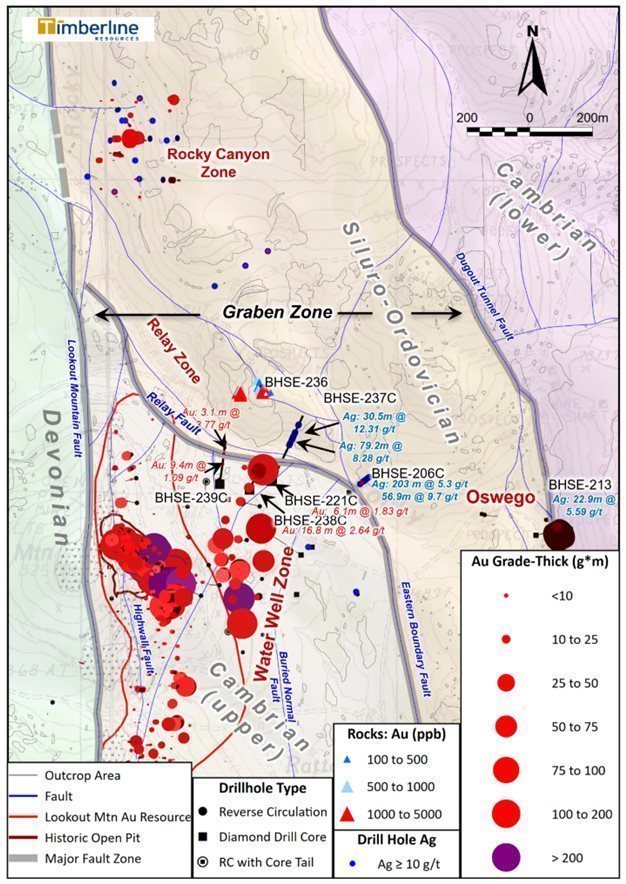
Figure 11 – Plan View of 2022 Drilling with Water Well Zone, North Lookout, and Rocky Canyon
| 42 |
The 2022 drilling of the WWZ successfully expanded the zone to a footprint of 475m north-south and up to 125m east-west. The WWZ remains open to the south and downdip to the east. A total of 23 drillholes have now passed through the mineralized host horizon where it averages 17.8m thick with an average gold grade of 2.97 g/t. There were several intervals within the WWZ footprint ranging from 3 to 41.1m thick in which the gold grade was higher than 4.5 g/t. The expanded footprint of the zone, if demonstrated to have continuity, has the potential to significantly grow the Lookout Mountain Resource.
A significant outcome of the 2022 drilling campaign was an improved understanding of the structural geology of the WWZ. Timberline geologists identified a number of faults that were not previously known. In some cases, the faults appear to control higher-grade, and in other cases, the faults have offset the host rocks and therefore appear to cut off the mineralization. The newly updated cross sections shown in Figures 12 and 13 reflect the improved understanding of the geology of the WWZ. The zone still appears to have good continuity, as alteration and anomalous gold are consistently present at the key contact, but the controls on higher-grade gold are sometimes difficult to determine.
As drilling approaches the major Relay fault zone to the north, the cross section through the WWZ shows a high density of faults (blue lines on the section). There is an upthrown block that is bounded and cut by several faults. The upthrown section hosts the high-grade intercept reported in BHSE-220C early in 2022, and the high-grades through that interval may be related to the presence of low-angle faults. These faults explain why follow-up drilling in BHSE-221, BHSE-237, and BHSE-238 failed to intersect the same thickness and quality of gold mineralization. The majority of the faults that cut the Dunderberg-Hamburg contact have not been drill tested, nor have the deeper sections of that contact to the east.
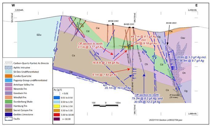
Figure 12 Cross Section Looking North through Northern WWZ (Line 4363275N)
The southern end of the WWZ is host to the best hole yet drilled into the zone, BHSE-212C. Here, as in the northern part of the zone, the drilling indicates that mineralization is more than 40m thick, including a high-grade interval near the top of the zone spanning 19.8m that averaged 9.49 g/t gold (Figure 13). There are differences in the WWZ between north and south. For instance, the strong gold zone starts at only 140m below surface in the north, whereas the key horizon begins at greater depth in the south, 316m below surface. The Dunderberg-Hamburg contact is the primary host throughout the WWZ, but increased drilling has revealed that the high-grade interval in BHSE-212C is associated with a trough, or topographic low, in the top of the Hamburg. This is contrary to the relative topographic high in the top of the Hamburg exhibited in the north.
During 2022, Timberline drilled offsetting holes around BHSE-212C with varying results. BHSE-226C extended the zone to the south by 75m with an intercept of 22.8m averaging 4.29 g/t gold, whereas BHSE-230C encountered thinner, but still strong, mineralization to the north (8.7m at 2.01 g/t gold and 3.1m at 10.88 g/t gold). At the time of this writing, the Company is still awaiting final results from other holes in the area, to the west and east primarily. It is again apparent that the gold zone in the WWZ is consistent but variable. Evidence from the drilling to date at WWZ suggests that the main gold zone pinches and swells, and the controls on the thicker and higher-grade sections are primarily related to faults.
| 43 |
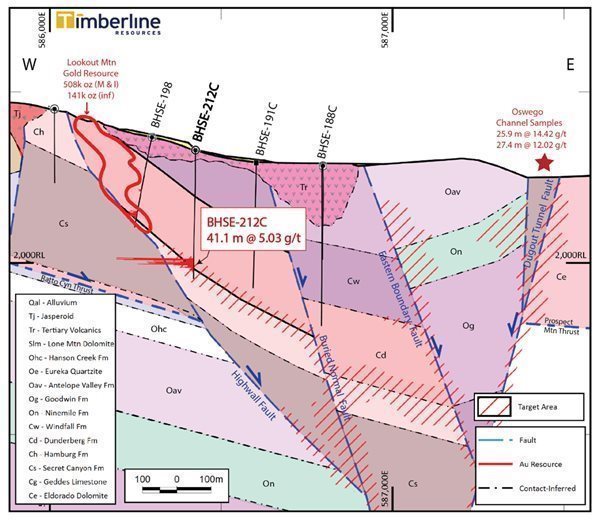
Figure 13 Cross Section Looking North through Southern WWZ (Line 4362875N)
Another important learning from Timberline’s 2022 drill program was that RC drilling can yield satisfactory results in the WWZ, but core drilling does appear to return (at least somewhat) thicker and higher grade than RC over the same intervals. The Company has now conducted three such tests and the results were not entirely consistent. During 2021, Timberline reported that a comparison between RC hole BHSE-205 and core hole BHSE-220C resulted in much higher-grade gold assays over greater width by core when compared to the RC. However, this year’s test compared two more core holes with RC holes, but the holes weren’t exactly twins due to approximately 25m deviation by both RC holes. BHSE-223C (core) was drilled close to BHSE-187 (RC); and BHSE-224C (core) was drilled close to BHSE-209 (RC). As reported in a Company news release dated September 14, 2022, one of the pairs compared very well, while the other comparison was markedly different.
Figure 14 shows the 2021 test of BHSE-205 vs 220 alongside the 2022 test of BHSE-187 vs 223. In the case of 205 vs. 220, the results show few similarities. The distribution of gold grade between the core and RC holes is quite different, particularly with respect to the central part of the interval that was consistently high grade in the core hole. In fact, the RC samples did not return any +10 g/t gold assays. Whereas both the grade distribution and absolute gold assay values compare much better between BHSE-187 and 223. The richest part of the interval is near the top in both cases, but the RC samples yielded higher gold maxima in the assays. The Timberline technical team has concluded that RC drilling can be effective at WWZ, so long as the drill has sufficient compressor capacity and is operated by an experienced team.
| 44 |

Figure 14 Comparison of RC vs Core Drilling Tests at WWZ
Historic Exploration: 2005 to 2010 (Staccato Gold)
Staccato Gold (“Staccato”) advanced exploration of the Eureka Project and completed drilling between 2005 and 2007, and in follow-up initiated a comprehensive work program in June 2008 which included geologic modeling of all drilling results. This modeling included structural and stratigraphic controls to mineralization, additional density determinations, and new drilling and metallurgical test data. Results of this work were incorporated into subsequent exploration work completed since 2008.
From 2005 to 2007, core drilling programs at Lookout Mountain completed by Staccato Gold provided data to better define stratigraphy in the higher-grade breccia-hosted gold zones at the Lookout Mountain pit and discovered new areas of mineralization. The core drilling program demonstrated the stratabound nature of gold mineralization in thick zones of collapse breccia within the Ratto Ridge structural zone. Former Timberline director, David Mathewson, was a consulting geologist for Staccato during this period, leading much of the core logging and development of the geological model at Lookout Mountain. Metallurgical and other technical characteristics of known mineralization were also investigated at Lookout Mountain.
| 45 |
An exploration Plan of Operations was prepared by Staccato and was approved in 2009 by the BLM and the State of Nevada Department of Environmental Protection (“NDEP”) for the Lookout Mountain Trend. The Plan of Operations called for approximately 266 acres of disturbance that can be accessed for use in a phased approach and covers the entire structural corridor. The Plan of Operations allowed ground disturbance to complete additional infill, metallurgical, and exploration drilling necessary to advance the development of the Lookout Mountain Deposit and other targets along the trend.
In October 2009, Staccato also initiated work at the Windfall Target including detailed mapping and sampling programs and completed a ten-hole drill program totaling 8,030 feet (2,448 m). The drilling program focused on testing the extent of gold mineralization below the Windfall and Rustler open pits, located approximately 3 miles northeast of the main Lookout Mountain mineralized area.
Results from the surface mapping program, review of historical production and geologic maps, and drilling indicated that high-grade gold is locally controlled within cross structures cutting the main Windfall fault zone, at the contact between the Hamburg Dolomite and Dunderberg Shale. The 2009 drill program tested approximately 3,600 feet (1,097 m) of strike length of the Windfall fault zone with wide spaced drilling. The Windfall fault zone is part of an extensive mineralized structural trend which extends for over 17,000 feet (5,182 m) based on historical data.
All holes in the 2009 exploration program encountered thick intercepts of low-grade gold (holes 5–12) or anomalous gold mineralization (holes 13 and 14) within the Windfall fault zone. The offset and exploration holes as drilled define the Windfall Fault as a 150 to 200-foot (46 – 61 m) wide zone striking roughly north-to-south and dipping approximately 60 degrees to the east, containing two or more significant zones of mineralization.
Five of the ten holes were drilled as offsets to follow up on the high-grade gold intercept drilled in hole 4, which intersected 75 feet (23 m) at 0.153 opt gold, and five other holes were drilled to test the strike and dip extent of the Windfall fault zone. Several thick intercepts of gold mineralization were returned, including 135 feet (41 m) at 0.011 opt gold in hole 7, 135 feet (41 m) at 0.016 opt gold in hole 8, 115 feet (35 m) at 0.010 opt gold in hole 9, and 100 feet (30.5m) at 0.018 opt gold in hole 11.
A secondary hanging wall structure identified by the mapping program was also encountered in drill holes 7, 8, 11, and 13 and is characterized by strong silicification and decalcification of Windfall Formation and Dunderberg Shale in the hanging wall side of the fault, with Dunderberg Shale and Hamburg Dolomite on the footwall side. Drilling indicates a down to the east offset of the Dunderberg – Hamburg contact. This secondary structure represents an attractive and untested target at depth.
Historical Exploration: 1970s to 1990s
On the Windfall, Hamburg Ridge, and New York Canyon claim groups, Bill Wilson of the Idaho Mining Corp, then Windfall Venture, later Norse-Windfall, initiated reconnaissance mapping, soil and rock chip sampling, trenching, and drilling in the early 1970s. He noted that the original underground Windfall Mine, which was discovered in 1908 and produced approximately 65,000 tons of “invisible gold” mineralized rock grading 0.368 opt, was a Carlin-type sediment-hosted disseminated gold occurrence. Wilson’s work emphasized the east side of Hamburg Ridge and the Windfall Trend, where he drilled conventional air rotary holes. The drill holes were generally from 50 to 250 feet deep. Six of Wilson’s original forty-three Z-holes intersected gold mineralization exceeding 0.02 opt gold. This success led to infill drilling and the development of the Windfall open pit mine in 1975, and soon thereafter, the Rustler and Paroni open pit mines. Gold was extracted in a heap-leach operation from sanded and silicified dolomite and silicified shale.
No geologic maps exist from this period other than a few maps compiled from USGS work. Although many drill hole location maps are archived in the files of Century Gold Corp., the coordinates for many drill hole collars are not available, very few collars are visible in the field, and assay data from infill drilling is poorly documented.
Table 5. Summary of Historic Drilling on Eureka Project
Company | No. Drill Holes | Period | Target Area | |
Norse-Windfall | 63 | 1970s – 1980s | Hoosac/Windfall | |
Amselco | 8 | Mid-1980s | ||
Tenneco | 18 | 1989-1991 | ||
Pathfinder | 18 | 1993 | ||
Pathfinder/Cambior | 36 | 1995-1996 | ||
Amselco | 296 | 1978-1985 | Lookout Mountain | |
Windfall Group | 20 | 1986 | ||
EFL Gold Company | 10 | 1990 | ||
Barrick Gold | 40 | 1992-1993 | ||
Echo Bay | 70 | 1994-1995 | ||
| 46 |
Significant exploration on the Eureka property occurred during the drilling programs mounted during the 1980s and 1990s. The table below summarizes historic drilling by company, era, and focus of their exploration. These data are compiled from historic company reports and, in many cases, have been at least partially validated with the presence of drill cuttings or core in the Company’s inventory. These drilling programs were conducted concurrent with and guided by geologic mapping, geochemical rock and soil sampling programs, and air and ground geophysics. Geological mapping and geochemical programs were very successful in discovering target areas characterized by permissive structures and traces of gold with arsenic, antimony, and mercury anomalies in soil and rock.
The methods of collection and analyses of some historical soil and rock samples were not always available in the data, but it is likely that the samples were collected, documented, prepared, and analyzed to the standards of professional diligence and analytical techniques applicable at the time. The importance of a geochemical-geological exploration approach is evidenced by the fact that the drilling of many such anomalies resulted in significant indications of disseminated gold mineralization. The Windfall, Rustler, and Paroni Deposits on the Windfall claims and the Lookout Mountain Deposit were discovered by drilling soil and rock anomalies in permissive structural and stratigraphic settings. Drill testing of several geochemical anomalies in permissive geological settings has also resulted in the discovery of several additional promising zones of gold mineralization on the Hamburg Ridge, Windfall, and Lookout Mountain claim groups. As yet, these zones have not been fully tested.
Amselco Exploration began exploring the Lookout Mountain project in 1978, conducting extensive geologic mapping, soil and rock sampling and an initial 15-hole reverse circulation (“RC”) drilling program which tested gold mineralization along the Ratto Ridge Fault and associated geochemical anomalies and jasperoids developed along the north-to-south trending Ratto Ridge. This drilling discovered significant sediment-hosted disseminated gold mineralization at depth. Amselco drilled 296 holes between 1978 and 1985, also discovering five areas of gold mineralization along Ratto Ridge which contain partially developed gold resources. These areas are located at South Lookout Mountain, Pinnacle Peak, Triple Junction, South Ratto Ridge, and South Adit. In 1986, while Amselco was in process of becoming BP Minerals, Amselco management optioned the Lookout Mountain Deposit to a joint venture of three companies, which then owned Norse-Windfall Mines.
In 1990, EFL Gold Mines took bulk samples from the floor of the Lookout Mountain pit. These samples returned assay values ranging from 0.10 to 0.135 opt gold. EFL also drilled nine holes, two of which penetrated 500 feet (152 meters) into the floor of the pit, that showed both oxide and sulfide gold mineralization.
During the period 1992-1993, Barrick Gold completed geologic mapping, took more than 500 soil samples to expand and fill in Amselco’s soil grid, and drilled 42 widely spaced holes, primarily along Ratto Ridge. Drilling targeted favorable stratigraphy at depth near fault intersections. Nevada Gold discovered that geochemical anomalies were apparently controlled by E-NE and N-NW to NW trending cross structures which intersect the north-to-south trending Ratto Ridge Fault. Much of the Nevada Gold work focused on the potential in Cambrian Dunderberg Shale and Hamburg Dolomite east of the Ratto Ridge Fault, and potential in the Devonian Nevada Group, especially the Bartine Limestone west of the fault. Outcrops of Bartine Limestone in the area show weak gold mineralization, strong alteration, and anomalous pathfinder element geochemistry. Nevada Gold drilled 42 holes to a maximum depth of approximately 1,300 feet (400 meters) and encountered several gold intercepts.
Work by Barrick Gold also included airborne and ground geophysics and a stratigraphic and geochemical study in conjunction with geologic mapping to develop and prioritize several target areas. Approximately 800 rock samples were collected and had high-quality multi-element analyses at MB Associates in California and Activation Laboratories in Canada. However, their work on the various geological and geochemical targets, or additional drilling in areas of known mineralization previously discovered by Amselco, apparently found insufficient mineralization to meet Barrick Gold’s objectives. It should be noted that the potential for mineralization west of the Ratto Ridge was not significantly explored during this period.
Echo Bay (1993-95) not only worked Ratto Ridge but also acquired additional ground to the north, south, and southwest. They conducted mapping, sampling, and scattered drilling in the area, exploring deep high-grade potential in the Cambrian Dunderberg Shale and Hamburg Dolomite, and testing Devonian Nevada Group targets west of the Ratto Ridge Fault. Echo Bay drilled several promising holes, including drill hole EBR 27, which intersected 110 feet (34 m) grading 0.043 opt gold in the Dunderberg, and drill hole EBR-9 which intersected 115 feet (35 m) grading 0.043 opt gold in the Nevada Group. Offsets of EBR-9 found 90 feet grading 0.028 opt gold, and another hole, which was lost before reaching planned depth, found 45 feet (14 m) of 0.024 opt gold. Further offsets of EBR-9 and several widely spaced holes averaging 1,000 feet (305 m) deep (EBR 15, 16, 17, 18, and 20) found some anomalous gold along Ratto Ridge but no major intercepts. Eventually, the Echo Bay project totaled 104 RC holes. Faced with depletion of budgets with no significant exploration success, the decline in gold prices and large land payments, Echo Bay decided to drop the property.
| 47 |
Paiute Project, a non-material property:
The Paiute Project (formerly referred to as the ICBM Project) is located 6.5 miles due west of Battle Mountain, in the Battle Mountain Mining District, Lander and Humboldt Counties, Nevada. The property consists of 1,346 acres (2.1 square miles) on BLM-administered lands. (See Figure 1: Timberline Project Locations).
Timberline originally acquired the project in 2010 through acquisition of Staccato Gold, who controlled the project as a non-core asset along with the flagship Eureka Project. Staccato controlled the project through an earn-in joint venture (JV) agreement with Lac Minerals (LAC), a subsidiary of Barrick Gold. Timberline acted as operator of the project through November 2013 earning a 73.7% interest in the project, with LAC holding the remaining interest.
Historical exploration demonstrated that gold mineralization is present on the property in styles of mineralization currently being mined elsewhere in the Battle Mountain district including at the Fortitude/Phoenix complex to the south and Lone Tree to the west. An analysis of historical data led to recognition that the property also has porphyry copper-gold characteristics similar to Newmont’s nearby historical Copper Basin mine.
Although Timberline controlled the project, as a non-core asset no exploration was completed between 2010 and December, 2013. In December of 2013, Timberline and LAC entered into an agreement with Americas Gold Exploration, Inc. (AGEI) to continue exploration at the project. Under the terms of the agreement, AGEI could earn up to a 51% ownership position in the property and the joint venture by making certain exploration expenditures over a four-year period. If AGEI earned an initial 51% interest, LAC agreed to withdraw from the Joint venture in exchange for a 5% Net Proceeds royalty and to amend the agreement allowing AGEI to increase its equity interest by 19% for a total of 76.6% by making additional exploration expenditures with Timberline retaining the balance of ownership. AGEI also assumed the role as operator of the joint venture.
On August 14, 2018 Timberline finalized the re-acquisition of the property from AGEI along with the contiguous Elder Creek property as part of a two-property acquisition from AGEI. Timberline re-assumed the operator’s position in the underlying property.
The underlying JV with LAC is an earn-in agreement and as a result of previous qualifying expenditures by Timberline, AGEI and previous owners, Timberline currently controls 76.1% ownership of the project after 2018-2020 expenditures. LAC’s parent company, Barrick, is now the operator of Nevada Gold Mines (NGM), a Nevada joint venture between Barrick and Newmont. NGM operates the nearby Fortitude/Phoenix Complex and Lone Tree Mines. Terms of the continued earn-in are as follows:
| · | No mandatory work commitments are included; |
| · | As operator, Timberline proposes work budgets with a 30-day option for pro-rata participation by LAC; |
| · | If LAC chooses to not participate, ownership dilutes on a pro-rata basis (based on $300,000 earn-in for 60% of the project); and |
| · | If diluted project equity reaches 10% or less, LAC converts to a 2% NSR royalty. |
On November 28, 2018 the Company announced completion of a NI 43-101 Technical Report on the Paiute copper-gold project. The report provides a comprehensive description of the project. The Paiute Project has no known reserves, as defined under Regulation S-K Subpart 1300, and the proposed program for the property is exploratory in nature.
Exploration and Mining History
Battle Mountain Gold Company and its predecessors held the Paiute property through the early 1990s and drilled nine RC holes within the current claim block. A best intercept of 100 feet (30.5 m) with 925 ppb gold was noted in their drilling.
LAC re-located the claims in late 1992 and conducted basic field work in 1993 that included geologic mapping, rock and soil sampling, and ground magnetics. In late 1994 they completed a nine-hole RC drilling program to test the main soil anomalies on the property. One drill hole reported 20 feet (6.1 m) of 0.038 opt (1.18 g/t) gold from 20 to 40 feet (6.1 - 12.2 m) that was associated with a narrow vein-like structure in the Harmony Formation.
Pathfinder Exploration joint ventured the property from LAC in early 1995 and completed infill mapping and sampling and target definition. First pass drilling intersected a 200 feet (61m) zone of 411 ppb gold in drill hole ICBM-95-1 within a quartz-actinolite-sulfide veined granodiorite stock or sill. Follow-up RC drilling by Pathfinder in 1996 was highlighted by hole 96-5 which intersected sericitized, chloritized, amphibole-rich monzonite/granodiorite porphyry with secondary biotite from 450-490 feet (137.1 – 179.8m). Mineralization within the last 15.1 feet (4.6 m) of the hole averaged 0.035 opt Au (1.24 g/t) and was accompanied by increased silicification and sulfides (chalcopyrite, pyrite, arsenopyrite).
| 48 |
Petrographic work by Larson (1996) identified silicified, sulfidic (pyrite, chalcopyrite), quartz/calcite veined quartz monzonite porphyry, Cambrian sandstone/quartzite (Harmony Formation) and diabase lithologies, along with a skarn dominant monzonite or granodiorite porphyry with “significant percentages of pyrite, chalcopyrite, and chalcocite”.
Geology of the Paiute Project Area
In the Paiute Project area, the Dewitt Thrust Fault places Ordovician Valmy Formation cherts and shales on top of Cambrian Harmony Formation quartz- and feldspathic-sandstones and shales, which are locally calcareous. The Harmony Formation is intruded by seven Cretaceous to Tertiary age granitic to granodioritic intrusives. An older Devonian or Ordovician diabase intrusive is exposed in the southwest part of the project and surrounding area.
At Paiute, the granitic to granodiorites intrusives occur as high-level plugs, stocks, dikes and sills. Thermal metamorphism associated with the intrusions produced hornfels, quartzite and skarn in the Harmony Formation sediments. Hydrothermal alteration associated with the intrusions consists of argillization, silicification, quartz veining/stockwork that is accompanied by zones of hydrous iron oxides as fracture fillings, disseminations, and occasional gossans. Chlorite and actinolite occur locally within quartz veins and may represent retrograde metamorphism. Quartz veining occurs throughout the project area and increases in intensity within the alteration zones.
A series of echelon structures and sub-parallel faults define a strong N 10-20° E - striking structural zone through the central part of the property that extends approximately 16,500 feet in length and up to 1,500 feet in width. This fault zone is well defined by field mapping and is the dominant northeast trending feature. Secondary northwest and north striking faults cut the northeast-striking structures. Locally, the structures are occupied by granodiorite porphyry dikes. The structures are typically altered and mineralized.
Previous explorers of the Paiute Project have collected 1,283 soil samples and 301 rock samples in the area and analyzed many of them for 14 elements. Copper, gold, arsenic and bismuth trace element anomalies in soils and rocks occur along the N10-20°E structural zone. A north-northwesterly (N20°W)-trending zone of elevated copper and gold occurs where increased fracturing and actinolitic alteration of the rocks is spatially associated with intrusives near Pathfinder drill-hole 96-5.
Garwin (2014) described the major styles of mineralization in the Paiute area as calc-alkaline, porphyry copper-gold, and gold-bearing structurally controlled vein systems. The main gold mineralized zone on the property is coincident with the N10-20°E structural zone.
Where the rock is not oxidized, fresh disseminated and vein pyrite is pervasive throughout the project area. Pyrite is the most abundant sulfide and occurs within the bleached zones coincident with alteration and structural zones. Pyrrhotite is nearly as abundant as pyrite and occurs both within and adjacent to alteration and structural zones. Arsenopyrite appears to be closely related to alteration and occurs only within the alteration zones.
2018-2019 Timberline Exploration
Exploration expenditures for FY 2018 were limited to geological field reviews, rock grab sampling and assays to characterize surface mineral showings. In addition, an application was submitted to the BLM, with receipt thereafter, of an approved Notice of Intent (NOI) to allow disturbance related to construction of drill roads and pads. The BLM approved the application and the property is fully permitted for road construction and drilling. Work during FY2019 included continued data compilation and review in preparation for drilling planned for FY2020.
Paiute Project Activity during Fiscal Year 2020:
Drilling at Paiute was initiated in the 1st quarter of FY2020, and with assay results announced on January 16, 2020 for our first two drill holes. Drilling intercepted long intervals of disseminated gold mineralization in granodiorite porphyry and metamorphosed sandstone (Figure 15, Table 6). Both RC holes were terminated in hard, silicified and mineralized rock.
Hole PCRC 19-01 intercepted 125 feet (38 m) grading 0.012 opt (0.36 g/t) gold with associated pyrrhotite-pyrite-arsenopyrite in silicified, metamorphosed arkosic sandstone. The hole bottomed in 160 ft (49 m) of silicified granodiorite porphyry. The previously identified 2 km-long gold “Lone Tree-type” structural zone remains largely untested below the 500 feet (152m) depth of historic drilling and is entirely untested over an interval of approximately 500 meters along the trend of the zone. The structural zone includes surface rock chip samples which previously returned multiple values greater than 1.0 g/t of gold including two samples over 0.322 opt (10 g/t) gold and one sample with 1.38 opt (42.9 g/t) gold and 16.9 opt (527 g/t) silver (see Company news release dated May 24, 2018 at http://timberlineresources.co/press-releases).
| 49 |
Table 6. 2019 Drill Hole Assay Results
Drill Hole | From (feet) | To (feet) | Interval (feet) | From (meters) | To (meters) | Interval (meters) | Au (g/t) | Ag (g/t) | As (ppm) | Ba (ppm) | S (%) |
PCRC19-01 | 295 | 420 | 125 | 89.9 | 128.0 | 38.1 | 0.356 | 0.4 | 673 | 266 | 1.5 |
including: | 340 | 420 | 80 | 103.6 | 128.0 | 24.4 | 0.442 | 0.5 | 968 | 185 | 1.9 |
PCRC19-02 | 0 | 710 (TD) | 710 | 0.0 | 216.4 | 216.4 | 0.271 | 0.5 | 72 | 849 | 0.3 |
including: | 0 | 40 | 40 | 0.0 | 12.2 | 12.2 | 0.606 | 0.9 | 292 | 648 | 0.0 |
| 110 | 140 | 30 | 33.5 | 42.7 | 9.1 | 0.488 | 0.5 | 43 | 872 | 0.1 |
| 150 | 230 | 80 | 45.7 | 70.1 | 24.4 | 0.514 | 0.4 | 27 | 1123 | 0.2 |
| 190 | 215 | 25 | 57.9 | 65.5 | 7.6 | 1.123 | 0.6 | 12 | 1280 | 0.2 |
| 280 | 390 | 110 | 85.3 | 118.9 | 33.5 | 0.359 | 0.3 | 39 | 720 | 0.2 |
| 490 | 500 | 10 | 149.4 | 152.4 | 3.0 | 0.511 | 0.1 | 30 | 1070 | 0.2 |
| 525 | 545 | 20 | 160.0 | 166.1 | 6.1 | 0.340 | 0.2 | 20 | 598 | 0.3 |
| 610 | 640 | 30 | 185.9 | 195.1 | 9.1 | 0.400 | 1.0 | 33 | 1023 | 0.8 |
| 685 | 710 | 25 | 208.8 | 216.4 | 7.6 | 0.478 | 0.8 | 38 | 680 | 0.6 |
*True thickness of drill intercepts is unknown. **TD: drill hole total depth | |||||||||||
PCRC 19-02 twinned and deepened historical hole ICBM-95-06, which intercepted gold mineralization within highly silica-altered, sulfide-poor (trace – 1% pyrite) granodiorite porphyry. The hole intercepted multiple zones of gold mineralization in granodiorite porphyry and metamorphosed arkosic sandstone, including 40 ft (12 m) of 0.020 opt (0.61 g/t) gold, 80 ft (24 m) of 0.016 opt (0.51 g/t) gold, 25 ft (8 m) of 0.036 opt (1.12 g/t) gold, and 25 ft (8 m) of 0.025 opt (0.48 g/t) gold over its 710 feet (216 m) length and bottomed in mineralization. The mineralization in PCRC 19-02 expands on multiple intercepts in nearby historic holes (see Table 7). Management believes that the Paiute Project has the potential for bulk-mineable, open-pit gold mineralization based on the near surface thicknesses and gold grades drilled to date.
During FY 2020 year the Company also acquired historical IP and magnetic geophysical survey data to further guide future drill targeting of the under-tested structural zone and largely un-tested porphyry gold targets.
Timberline has conducted no work on the Paiute Project during fiscal years 2021 or 2022, but all BLM and county claim fees have been paid in full.
| 50 |
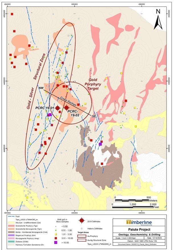
Figure 15. Paiute Project Geology and Primary Target Areas
| 51 |
Table 7. Summary of Historic Porphyry-Hosted Drilling Gold Assay Results
Drill Hole | From (feet) | To (feet) | Interval (feet) | From (meters) | To (meters) | Interval (meters) | Au (g/t) |
ICBM 95-1 | 260 | 295 | 35 | 79.2 | 89.9 | 10.7 | 0.831 |
| 320 | 350 | 30 | 97.5 | 106.7 | 9.1 | 0.552 |
| 385 | 460 | 75 | 117.3 | 140.2 | 22.9 | 0.462 |
ICBM 96-3 | 45 | 65 |
| 13.7 | 19.8 | 6.1 | 0.431 |
| 345 | 370 | 25 | 105.2 | 112.8 | 7.6 | 0.497 |
| 405 | 415 | 10 | 123.4 | 126.5 | 3.0 | 1.000 |
| 480 | 580 | 100 | 146.3 | 176.8 | 30.5 | 0.962 |
ICBM 96-3C | 221 | 246 | 25 | 67.4 | 75.0 | 7.6 | 0.626 |
| 455 | 465 | 10 | 138.7 | 141.7 | 3.0 | 1.276 |
| 475 | 505 | 30 | 144.8 | 153.9 | 9.1 | 0.609 |
| 996 | 1001 | 5 | 303.6 | 305.1 | 1.5 | 3.655 |
ICBM 96-4 | 340 | 370 | 30 | 103.6 | 112.8 | 9.1 | 0.683 |
ICBM 96-5 | 90 | 100 | 10 | 27.4 | 30.5 | 3.0 | 0.741 |
| 320 | 350 | 30 | 97.5 | 106.7 | 9.1 | 0.377 |
| 575 | 590 | 15 | 175.3 | 179.8 | 4.6 | 1.501 |
3899 | 10 | 180 | 170 | 3.0 | 54.9 | 51.8 | 0.695 |
3632 | 0 | 100 | 100 | 0.0 | 30.5 | 30.5 | 0.945 |
| 350 | 400 | 50 | 106.7 | 121.9 | 15.2 | 0.55 |
4062 | 30 | 60 | 30 | 9.1 | 18.3 | 9.1 | 0.460 |
| 220 | 260 | 40 | 67.1 | 79.2 | 12.2 | 0.644 |
4006 | 95 | 145 | 50 | 29.0 | 44.2 | 15.2 | 0.483 |
| 280 | 300 | 20 | 85.3 | 91.4 | 6.1 | 0.948 |
3206 | 210 | 280 | 70 | 64.0 | 85.3 | 21.3 | 0.493 |
Seven Troughs Project, a non-material property:
During the year ended September 30, 2012, Timberline announced the acquisition from CIT Microprobe Holdings, LLC (California Institute of Technology) (“CIT”) of CIT’s interest in 3,900 acres (6.1 square miles) of patented and unpatented mining claims comprising the majority of the Seven Troughs gold mining district near Lovelock, Nevada. (See Figure 1: Timberline Project Locations). Our acquired interest is as lessee under the terms of a 50-year lease, originally executed in 1975. Terms of the purchase agreement included a cash payment of $50,000 and a 2-percent NSR production royalty reserved to CIT. While the Company is certain of its rights and obligations under the lease, the lessor’s identification has become somewhat clouded over the years due to passing of the early lessor principal to the agreement and a lack of full clarity as to all the eventual inheritors of the property. We have met our obligations under the lease and have located and secured agreements with the heirs to acquire any of their residual rights. We are moving to have the agreements adjudicated appropriately. We have the option to purchase one-half of the NSR production royalty for $1 million.
Seven Troughs is an epithermal gold district recognized as yielding some of the highest gold production grades in Nevada history through small-scale operations in the early 20th century. We believe the district has the potential to host a large precious metals system similar to the high-grade gold and silver veins of Japan's world-renowned Hishikari epithermal gold mine.
We are under no obligation to make exploration expenditures at Seven Troughs. Since acquiring the property, we have compiled historical mine workings data and completed limited geologic mapping, and geochemical sampling within the district. The Company conducted no significant work on the ground during fiscal years 2020, 2021, or 2022, but all BLM and county claim fees have been paid in full. During FY2022, the Company entertained queries from outside parties about the project’s availability and hosted visitors on site.
| 52 |
On April 26, 2022, the Company entered into a Memorandum of Agreement with Normandy Gold Limited (“NDY”) to grant NDY a 12-month exclusive option to enter into an earn-in joint venture agreement with the Company regarding the Seven Troughs property. Subject to negotiation and execution of a definitive agreement, the option may provide NDY with the opportunity to solely fund $5,000,000 of exploration over 6 years, make cash payments of $250,000 and issue 2,000,000 NDY shares to the Company to ultimately earn a 75% interest in the property.
Earn-In Period:
To earn an initial 51% interest in the project, NDY must spend $2,000,000 in exploration expenditures and make cash payments of $250,000, as follows:
| · | $100,000 of committed expenditures within the first 12 months from exercising the exclusive option; |
| · | $500,000 of expenditures (an additional $400,000) within 24 months from exercising the exclusive option; |
| · | Payment to the Company of $100,000 in cash at 24 months from exercising the exclusive option or at such time as the Company demonstrates receipt of full title in the Seven Troughs claims, whichever is later; |
| · | $2,000,000 of expenditures (an additional 1,500,000) within 36 months from exercising the exclusive option; and |
| · | Payment to the Company of $150,000 in cash at 36 months from exercising the exclusive option. |
During the Earn-In Period, NDY will be the operator of the project and be responsible for payment of annual federal and county claim fees. NDY may withdraw from the Earn-In after spending $100,000, or if the transfer of claims ownership to the Company is not successfully completed within 24 months of commencement of the Earn-In Period.
Joint Venture Period:
Upon completion of the Earn-In Period, NDY will hold 51% interest and the Company will have the option (for a period of up to 60 business days) to elect to fund and participate in a Joint Venture on the basis of its 49% interest in the project.
If the Company elects not to participate or fails to provide such notice within the 60-business day period, NDY can earn an additional 24% interest (for a total interest of 75%) in the project by:
| · | spending $3,000,000 in exploration expenditures within three years from commencement of the joint venture, and |
| · | Issuing the Company 2,000,000 common shares in the stock of NDY. |
The Company received $50,000 of the initial cash payment in May 2022 and recorded it as a reduction to mineral rights during that period.
New York Canyon, a non-material property:
On August 23, 2022, the Company purchased one patented mining claim, comprising of a total of 13.77 acres commonly known as the South Wales #1 patent within the New York Canyon claim block, from Newmont Capital Limited for a total of $41,310. In conjunction with this purchase, the Company granted a 1.5% net smelter return royalty to the seller.
On September 28, 2022, the Company purchased five patented mining claims, comprising of a total of 28.82 acres commonly known as the Tiger Lilly, Eureka Giant, Southern Cross, Maria and Best & Belcher patents with and near the New York Canyon claim block, from the University of Nevada, Reno Foundation for a total of $86,460. In conjunction with this purchase, the Company granted a 1.5% net smelter return royalty to the seller. Two of the patented claims are not within the New York Canyon claim block, but will be included with this designation on the Company’s claims record references.
During the fourth quarter of fiscal 2022 and first quarter of fiscal 2023, the Company purchased an interest in three patented claims within the New York Canyon claim block, from private parties. In conjunction with the purchase, the Company granted a 0.5% net smelter return royalty to the sellers. The combined purchase price will be capitalized in the first quarter of fiscal 2023 as a mineral property on the Company’s balance sheet.
The New York Canyon claims block is located just to the north of the Eureka properties on Figure 1: Timberline Project Locations above.
| 53 |
Wolfpack Gold Properties, non-material properties:
With the acquisition of Wolfpack Gold (“WPG”), we acquired nine mineral properties in Nevada and one in California. We conducted a due diligence review on each property, including organization of the historical data and review of exploration work completed to-date. As of September 30, 2022, only claims on one property (Trail) have been retained, as they are contiguous with our Eureka project.
In 2017, we sold our property and royalty interests in various unpatented claims that were under lease to Pershing Gold. In addition, we sold various other royalty interests that WPG had retained through previous transactions in four other properties.
Overview of Regulatory, Economic and Environmental Issues
Hard rock mining in the United States is a closely regulated industrial activity. Mining operations are subject to review and approval by a wide variety of agencies at the federal, state, and local level. Each level of government requires applications for permits to conduct operations. The approval process always involves consideration of many issues including but not limited to air pollution, water use and discharge, noise issues, and wildlife impacts. Mining operations involve preparation of environmental impact studies that examine the probable effect of the proposed site development. Federal agencies that may be involved include: the USFS, BLM, EPA, NIOSH, MSHA, and FWS. Individual states also have various environmental regulatory bodies, such as Departments of Ecology and Departments of Environmental Quality. Local authorities, usually counties, also have control over mining activity.
Gold, silver, and copper are mined in a wide variety of ways, both in open pit and underground mines. Open pit mines require the gold deposit to be relatively close to the surface. These surface mineable deposits tend to be lower grade (such as 0.01-0.03 opt gold) and are mined using large, costly earth moving equipment, usually at very high tonnages per day. Modern open pit mines are typically very large excavations that require extensive engineering, planning, reclamation, and permitting.
Some open pit operations for gold in which the ores have bene oxidized involve heap leaching as a metallurgical method to remove the gold. Heap leaching involves stacking the ore on pads which are lined with an impenetrable under-surface, then sprinkling the ore with a weak cyanide solution to extract the gold. The gold-impregnated solution is collected and the gold recovered through further processing. Most new gold discoveries contain ores that are not suitable for heap leach processing. Often this is because the gold is associated with sulfide minerals such as pyrite. Extensive metallurgical testing is required to determine the optimum method for treating such ores, but sulfide ore deposits almost always require complex milling and processing plants.
Underground metal mines generally involve higher-grade ore bodies. Less tonnage is mined underground, and generally the higher-grade ore is processed in a mill or other refining facility. An underground mine may have much less visual impact on the land, but the mine design is complex and requires intensive study and careful engineering.
Gold processing plants often generate tailings (the residual material left behind after recovery of the gold-bearing minerals), which require permitted and engineered disposal facilities or tailings ponds. Mines and processing plants also often require extensive water treatment, which again will necessitate extensive interaction with the community and regulators during permitting
Capital costs for mine, mill, and tailings pond construction can, depending upon the size of the operation, run into the hundreds of millions of dollars. These costs are factored into the profitability of a mining operation. Metal mining is sensitive to both cost considerations and to the value of the metal produced. Metals prices are set on a worldwide market and are not controlled by the operators of the mine. Changes in currency values or exchange rates can also impact metals prices. Changes in metals prices or operating costs can have a huge impact on the economic viability of a mining operation.
Environmental protection and remediation are increasingly important parts of mineral economics. Estimated future costs of reclamation or restoration of mined land are based principally on legal and regulatory requirements. Reclamation of affected areas after mining operations may cost millions of dollars. Often governmental permitting agencies are requiring multi-million-dollar bonds from mining companies prior to granting mining permits, to ensure that reclamation takes place. All environmental mitigation tends to decrease profitability of the mining operation, but these expenses are recognized as a cost of doing business by modern mining and exploration companies.
Mining and exploration activities are subject to various laws and regulations governing the protection of the environment. These laws and regulations are continually changing and are generally becoming more restrictive. We conduct our operations so as to protect the public health and environment and believe our operations follow applicable laws and regulations in all material respects. We have made, and expect to make in the future, expenditures to comply with such laws and regulations, but cannot predict the full amount of such future expenditures.
| 54 |
Every mining activity has an environmental impact. In order for a proposed mining project to be granted the required governmental permits, mining companies are required to present proposed plans for mitigating this impact. In the United States, where our properties are located, no mine can operate without obtaining a number of permits. These permits address the social, economic, and environmental impacts of the operation and include numerous opportunities for public involvement and comment.
We intend to focus on exploration and discovery of mineral resources. If we are successful, the ore bodies discovered will be attractive to production companies, or we will potentially bring the ore bodies to production ourselves. The mining industry, like agriculture, is a fundamental component of modern industrial society, and minerals of all sorts are needed to maintain our way of life. If we are successful in finding an economic ore body, be it gold or silver, sufficient value is expected to be created to reward our shareholders and allow for all production and reclamation expenses to be paid ourselves or by the actual producer to whom we convey, assign, or joint venture the project.
ITEM 3. LEGAL PROCEEDINGS
We are not a party to any material pending legal proceedings, and no such proceedings are known to be contemplated.
No director, officer, or affiliate of Timberline and no owner of record or beneficial owner of more than 5.0% of our securities or any associate of any such director, officer, or security holder is a party adverse to Timberline or has a material interest adverse to Timberline in reference to pending litigation.
ITEM 4.MINE SAFETY DISCLOSURES
Pursuant to Section 1503(a) of the recently enacted Dodd-Frank Wall Street Reform and Consumer Protection Act (The “Dodd-Frank Act”), issuers that are operators, or that have a subsidiary that is an operator, of a coal or other mine in the United States are required to disclose in their periodic reports filed with the SEC information regarding specified health and safety violations, orders and citations, related assessments and legal actions, and mining-related fatalities. During the fiscal year ended September 30, 2022, our U.S. exploration properties were not subject to regulation by the Federal Mine Safety and Health Administration (“MSHA”) under the Federal Mine Safety and Health Act of 1977 (the “Mine Act”). The Company’s exploration operations received no notices, citations, or orders during the year pertaining to health and safety violations.
| 55 |
PART II
ITEM 5. MARKET FOR COMMON EQUITY, RELATED STOCKHOLDER MATTERS, AND ISSUER PURCHASES OF EQUITY SECURITIES
Market Information
Our common stock is quoted on the OTCQB under the trading symbol “TLRS”. Our common stock also trades on the TSX-V in Canada under the trading symbol “TBR”. Our common stock was listed and traded on the NYSE MKT exchange under the trading symbol “TLR” until February 15, 2016 when we voluntarily de-listed from the NYSE MKT and began trading on the OTCQB market on February 16, 2016. The high and low sale prices for our common stock as quoted on the OTCQB and the TSX-V were as follows:
| OTCQB(US$) | TSX-V (CDN$) | ||
Period(1) | High | Low | High | Low |
|
|
|
|
|
2022 |
|
|
|
|
First Quarter | $0.21 | $0.12 | $0.28 | $0.16 |
Second Quarter | $0.29 | $0.13 | $0.36 | $0.17 |
Third Quarter | $0.28 | $0.16 | $0.36 | $0.20 |
Fourth Quarter | $0.20 | $0.11 | $0.26 | $0.14 |
|
|
|
|
|
2021 |
|
|
|
|
First Quarter | $0.38 | $0.24 | $0.49 | $0.31 |
Second Quarter | $0.38 | $0.20 | $0.49 | $0.24 |
Third Quarter | $0.30 | $0.19 | $0.36 | $0.24 |
Fourth Quarter | $0.25 | $0.14 | $0.32 | $0.18 |
|
|
|
|
|
2020 |
|
|
|
|
First Quarter | $0.11 | $0.02 | $0.14 | $0.06 |
Second Quarter | $0.08 | $0.04 | $0.10 | $0.06 |
Third Quarter | $0.27 | $0.04 | $0.34 | $0.09 |
Fourth Quarter | $0.38 | $0.18 | $0.44 | $0.33 |
|
|
|
|
|
(1) Quarters indicate calendar year quarters. | ||||
The quotations on the OTCQB reflect inter-dealer prices without retail mark-up, mark-down, or commission and may not reflect actual transactions.
On September 30, 2022, the closing sale price for our common stock was USD$0.11 on the OTCQB and CDN$0.16 on September 30, 2022 on the TSX-V.
As of December 19, 2022, we had 159,678,710 shares of common stock issued and outstanding and approximately 590 registered shareholders. In many cases, shares are registered through intermediaries, making the precise number of shareholders difficult to obtain.
Dividend Policy
We anticipate that we will retain any earnings to support operations and to finance the growth and development of our business. Therefore, we do not expect to pay cash dividends in the foreseeable future. Any further determination to pay cash dividends will be at the discretion of our board of directors and will be dependent on the financial condition, operating results, capital requirements, and other factors that our board deems relevant. We have never declared a dividend.
Purchases of Equity Securities by the Issuer and Affiliated Purchasers
None.
| 56 |
Stock Incentive Plans
The purpose of the Stock and Incentive Plan is to promote our interests and our Stockholders’ interests by aiding us in attracting and retaining employees, officers, consultants, advisors and non-employee directors capable of ensuring the future success of our Company. On September 24, 2015, our stockholders approved the adoption of the Company’s 2015 Stock and Incentive Plan in which the Company’s executive officers and directors are participants. This plan replaced our 2005 Stock Incentive Plan, as amended. The aggregate number of shares that may be issued under all stock-based awards made under the 2015 Stock and Incentive Plan was 4 million shares of our common stock.
On December 1, 2018, shareholders approved the new 2018 Incentive Plan. The 2018 Incentive Plan replaced our 2015 Stock and Incentive Plan. Concurrent with the approval of the 2018 Incentive Plan, the 2015 Stock and Incentive Plan was withdrawn for the purposes of issuing new options or equity incentives. There were 8,000,000 Timberline shares issuable under the 2018 Incentive Plan.
On April 14, 2021, shareholders approved to amend and restate the 2018 Incentive Plan. Under the amended plan, the shares issuable under the 2018 Incentive Plan increased to 15,000,000.
Equity Compensation Plans
The following summary information is presented as of September 30, 2022.
| Number of securities to be issued upon exercise of outstanding options, warrants, and rights (a) | Weighted-average exercise price of outstanding options, warrants, and rights (b) | Number of securities remaining available for future issuance under equity compensation plans (excluding securities reflected in column (a)) (c) |
Equity compensation plans approved by security holders(1) | 8,335,000(1) | $0.18 | 6,665,000 |
Equity compensation plans not approved by security holders | Not applicable | Not applicable | Not applicable |
TOTAL | 8,335,000(1) | $0.18 | 6,665,000 |
| (1) | See “Stock Incentive Plans,” above. |
There were no options exercised during the years ended September 30, 2022 and September 30, 2021.
Sale of Unregistered Securities
All unregistered sales of equity securities during the period covered by this Annual Report were previously disclosed in our current reports on Form 8-K and our Quarterly Reports on Form 10-Q.
ITEM 6. SELECTED FINANCIAL DATA
Not Applicable.
ITEM 7. MANAGEMENT'S DISCUSSION AND ANALYSIS OF FINANCIAL CONDITION AND RESULTS OF OPERATION
You should read the following discussion and analysis of our financial condition and results of operations together with our financial statements and related notes appearing elsewhere in this report. This discussion and analysis contains forward-looking statements that involve risks, uncertainties and assumptions. Our actual results may differ materially from those anticipated in these forward-looking statements as a result of many factors, including, but not limited to, those set forth under “Risk Factors and Uncertainties” and elsewhere in this document. See “Cautionary Note Regarding Forward-Looking Statements” above.
| 57 |
Overview
We are an exploration company, using tried and proven methods to search for gold, silver, and other metals as become indicated, on properties located in the State of Nevada in the Western United States. Our significant properties consist of our Eureka Projects (Lookout Mountain, Windfall, Oswego and other targets) in the Battle Mountain - Eureka Trend located in the North-Central portion of the state, and the Seven Troughs Project, located in the Northwest portion of the state.
We raised funds to acquire and explore these properties through private placements of our common stock and warrants with investors, through debt placements, and through joint venture arrangements with other mining exploration and development companies in our business sector. Our business plans employ strategies to locate and analyze gold and silver properties to determine the existence, quantity and quality of mineral deposits and advance those deposits for the benefit of our shareholders. We may seek to develop those properties ourselves or engage larger mining companies to purchase, develop, joint venture and otherwise exploit the properties for the purpose of production of these discovered precious metals.
During the fiscal year ended September 30, 2022, we accomplished the following:
| 1. | We closed a private placement of units of our equity for a total of approximately $4,340,000 cash; |
| 2. | We issued shares for exercise of warrants for a total of approximately $146,500; |
| 3. | We entered into an option with Normandy Gold which, if exercised in its entirety, would result in as much as a 75% joint venture interest for Normandy Gold in our Seven Troughs property. Full terms would include $5,000,000 invested by Normandy Gold in the property, 2,000,000 common shares of Normandy Gold issued to us and $250,000 cash paid to us, of which $50,000 has been received during the fourth quarter of our fiscal 2022; |
| 4. | We purchased six patented claims within a property known as New York Canyon for approximately $128,000; and |
| 5. | We reported the drilling results of the 2021-2022 exploration program. |
Highlights of the 2021-2022 exploration program completed during January 2022 include:
| · | Completed approximately 6,535m of drilling, 65% of which was reverse circulation (RC) drilling and 35% was diamond core drilling; |
| · | The first results reported during the program were 5 RC holes completed in July 2021. The most significant new intercepts in these holes included: |
| o | 10.67m at 2.36 grams per tonne (g/t) gold from 301.8m depth in BHSE-194; |
|
| ■ | including 6.01m at 2.98 g/t gold; |
| o | 16.76m at 1.74 g/t gold from 257.6m depth in BHSE-195; |
|
| ■ | including 3.05m at 4.56 g/t gold; and |
| o | 19.81m at 1.38 g/t gold from 248.4m depth in BHSE-193. |
| · | Reported surface rock sample assay results on the channel and trench samples from the Oswego Target. Key results included: |
| o | 25.9m @ 14.42 g/t gold along strike; |
| o | 27.4m @ 12.02 g/t gold along strike; and |
| o | 10.7m @ 3.63 g/t gold, estimated to be true thickness from a trench. |
| · | Integrated new geologic mapping in the Windfall and New York Canyon areas with geochemical and geophysical data in anticipation of new drilling in late 2022 or 2023. |
During the quarter ended March 31, 2022, the Company reported the majority of the drill results from the 2021 drill campaign, including the following highlights:
| · | Results reported in February 2022 from 6 RC holes and portions of 2 core holes included the following highlights: |
| o | 22.9m at 6.11 g/t gold from 140.8m depth in BHSE-220C, |
|
| ■ | including 12.2m at 8.92 g/t gold from 151.5m depth; |
| o | 10.7m at 2.96 g/t gold from 229.2m depth in BHSE-211C; |
| o | 22.9m at 1.11 g/t gold from 219.5m depth in BHSE-198; and |
| o | 6.10m at 2.85 g/t gold from 161.5m depth in BHSE-204. |
| · | In March 2022, Timberline reported additional results from 3 core holes and 1 RC hole, including: |
| o | 41.1m at 5.03 g/t gold from 316.1m depth in BHSE-212C, |
|
| ■ | including 19.8m at 9.49 g/t gold; |
| o | 9.1m at 1.24 g/t gold from 324.6m depth in BHSE-209, |
|
| ■ | including 4.6m at 2.07 g/t gold; and |
| o | 9.1m at 1.34 g/t gold from 255.1m depth in BHSE-210C. |
| 58 |
| · | Later in March 2022, the Company reported the complete results from drillhole BHSE-220C, including: |
| o | 44.2m at 4.10 g/t gold from 140.8m depth in BHSE-220C, |
|
| ■ | including 22.9m at 6.24 g/t gold from 140.8m depth; and |
|
| ■ | including 12.2m at 9.18 g/t gold from 151.5m depth. |
During the quarter ended June 30, 2022, Timberline reported the final results from the 2021-2022 drilling campaign, these included several drill holes from the Oswego target, one hole from the WWZ, and final multielement results from one hole into the Graben Zone.
| · | On May 11, 2022, the Company reported significant shallow oxide gold mineralization from the Oswego Target: |
| o | 35.1m at 2.32 g/t gold from 6.1m depth in BHSE-213, |
| · | including 19.8m at 3.93 g/t gold from 7.6m depth; |
| o | 13.7m at 1.31 g/t gold from 3.0m depth in BHSE-215, |
| · | including 6.1m at 2.49 g/t gold from 9.1m depth; and |
| o | 9.1m at 1.72 g/t gold from surface and 12.2m at 1.22 g/t gold from 15.2m depth in BHSE-214. |
| · | The final news release concerning the 2021-2022 drill program was released on May 18, 2022. The key results from that release included drillholes BHSE-192C and BHSE-206C: |
| o | 24.4m at 3.85 g/t gold from 349.6 depth in BHSE-209C, |
| · | including 4.6m at 8.35 g/t gold from 354.2m depth; and |
| · | including 7.6m at 5.72 g/t gold from 364.8m depth. |
| o | 30.5m at 0.41 g/t gold from 182.0m depth in BHSE-206C, |
| · | including 7.6m of 1.04 g/t gold from 192.6 m depth. |
| o | 202.7m at 5.28 g/t SILVER from 121.0m depth in BHSE-206C, |
| · | including 56.4m at 9.69 g/t SILVER from 264.3m depth. |
During the quarter ended September 30, 2022, Timberline reported the results from the first four holes of the 2022 drilling program at Eureka. Highlights from the four new drill holes include:
| · | BHSE-226C: 22.8m at 4.29 g/t gold from 339.9m depth, |
| o | Including 7.6m at 11.56 g/t gold from 342.9m depth; |
| · | BHSE-224C: 30.5m at 2.56 g/t gold from 317.6m depth, |
| o | including 18.4m at 3.80 g/t gold from 317.6m depth, and |
| ■ | including 3.35m at 13.36 g/t gold from 331.3m depth; |
| · | BHSE-223C: 39.0m at 1.71 g/t gold from 259.7m depth, including |
| o | 28.3m at 1.97 g/t gold from 259.7m depth, and |
| ■ | including 5.9m at 3.71 g/t gold from 259.7m depth; |
| · | BHSE-230C: 3.1m at 10.88 g/t gold from 288.6m depth; and |
| · | BHSE-230C: 8.7m at 2.01 g/t gold from 313.0m depth. |
Subsequent to the quarter ended September 30, 2022, Timberline reported more results from the 2022 drilling program. Highlights from these holes include:
| · | BHSE-238C: 16.8m at 2.64 g/t gold from 178.9m depth, |
| o | including 4.6m at 4.45 g/t gold from 182.0m depth; |
| · | BHSE-221C: 6.1m at 1.83 g/t gold from 332.8m depth, |
| o | including 1.5m at 3.59 g/t gold from 335.9m depth; |
| · | BHSE-239C: 9.4m at 1.09 g/t gold from 194.5m depth; |
| · | BHSE-239C: 6.1m at 1.33 g/t gold from 313.0m depth; |
| · | BHSE-239C: 3.1m at 3.77 g/t gold from 439.5m depth; |
| · | BHSE-221C: 35.1m at 10.1 g/t silver from 329.8m depth; |
| · | BHSE-237C: 79.2m at 8.2 g/t silver from 297.8m depth; and |
| · | BHSE-237C: 30.5m at 12.2 g/t silver from 393.8m depth. |
Maps, tables and figures in Part I of this Annual Report include these drilling results reported for the Company’s fiscal year 2022.
| 59 |
Summary of gold prices
Fiscal year 2022 has seen continuing strong trends in the gold price from a low of approximately $1,634 to a high of approximately $2,039 per ounce, with a trend moving around $1,643 per ounce at year end. We believe the global economic environment and monetary climate continue to favor a strong gold price for the foreseeable future. While volatility is to be expected, our expectation is that we can identify and pursue opportunities to advance our projects and take advantage of the current gold price and market volatility.
Exploration Plans and Budgets
Our exploration focus during fiscal 2023 will continue to be on the Eureka Project. Our financial and human resources will be dedicated to the advancement of the Lookout Mountain, Water Well, Oswego, and other targets across the property. The results of our drilling, mapping, geochemical and geophysical work completed during fiscal years 2020 and 2021 exploration seasons significantly advanced our understanding of the overall geologic setting of the Eureka Project, highlighting several areas with potential for significant gold mineralization. The drilling results of fiscal 2022 significantly added to the geology and mineralization of our target areas in the Eureka Project and will guide our fiscal 2023 exploration plan.
Our preliminary exploration budget for fiscal 2023 is expected to exceed $3.0 million, funded largely by our cash reserves and additional financing activities as we enter into the new 2023 calendar year. We have not yet received all the data from the 2022 work program, and those final results and the analysis thereof will factor heavily into our planning for fiscal 2023. Details of the exploration plan for later in fiscal 2023 will follow after our analysis of the results of the current drill program.
Results of Operations for Years Ended September 30, 2022 and 2021
Consolidated Results
|
| Year Ended September 30, |
| |||||
|
| 2022 |
|
| 2021 |
| ||
Exploration expenses: |
|
|
|
|
|
| ||
Eureka/Lookout Mountain, net of non-cash expenses |
| $ | 4,614,490 |
|
| $ | 2,795,753 |
|
Total exploration expenditures |
| $ | 4,614,490 |
|
| $ | 2,795,753 |
|
Non-cash expenses: |
|
|
|
|
|
|
|
|
Stock option and stock issuance expense |
| $ | 44,321 |
|
| $ | 646,422 |
|
Depreciation, amortization, and accretion |
|
| 5,912 |
|
|
| 5,632 |
|
Total non-cash expenses |
| $ | 50,233 |
|
| $ | 652,054 |
|
Operating expenses paid in cash: |
|
|
|
|
|
|
|
|
Salaries and benefits, net of non-cash expenses |
| $ | 293,097 |
|
| $ | 293,137 |
|
Professional fees expense |
|
| 181,811 |
|
|
| 205,068 |
|
Other general and administrative expenses |
|
| 551,815 |
|
|
| 529,641 |
|
Interest and other (income) expense, net of non-cash expenses |
|
| 270,461 |
|
|
| 232,162 |
|
Income tax provision (benefit) |
|
| - |
|
|
| - |
|
Net loss |
| $ | 5,961,907 |
|
| $ | 4,707,815 |
|
Our consolidated net loss for the fiscal year ended September 30, 2022 increased significantly from the prior year, primarily as a result of our increased exploration program, which included significant increases in drilling and geophysical activities. We also experienced significant decreases in shared-based compensation. Professional fees expenses were lower as a result of decreased utilization of financial professionals during fiscal 2022. General and administrative expenses increased as management executed on marketing, investor relations, and other programs that were not possible in previous years as placement funds became available to do so. Other expenses for fiscal 2022 were generally consistent with the prior year.
Financial Condition and Liquidity
At September 30, 2022, we had assets of $16,972,229, consisting of cash of $2,438,587; property, mineral rights and equipment, net of depreciation, of $13,980,855, reclamation bonds of $528,643, and other assets in the amount of $24,144.
On September 30, 2022, we had total liabilities of $1,157,467 and total assets of $16,972,229. This compares to total liabilities of $570,144 and total assets of $17,716,406 on September 30, 2021. As of September 30, 2022, our liabilities consist of $124,159 for asset retirement obligations, $270,991 of senior unsecured notes payable – related party, and $704,351 of trade payables and accrued expenses and $57,966 interest payable to a related party. Of these liabilities, $1,033,308 are due within 12 months. The increase in liabilities compared to September 30, 2021 is largely due to increased trade payables and accrued liabilities in 2022. Other liabilities were affected positively or negatively by individual small changes in other components of liabilities. The decrease in total current assets was due to an decrease in cash.
| 60 |
On September 30, 2022, we had working capital of $1,423,723 and stockholders’ equity of $15,814,762 compared to working capital of $3,170,019 and stockholders’ equity of $17,146,262 for the year ended September 30, 2021. Working capital experienced an unfavorable change because of a decrease in cash and an increase in trade payables, with other liabilities affected positively or negatively by individual small changes in other components of liabilities.
During the fiscal year ended September 30, 2022, we used cash from operating activities of $5,325,134, compared to $4,263,754 used for fiscal 2021. There was a net loss of $5,961,907 for fiscal 2022 compared to a net loss of $4,707,815 for fiscal 2021. The causal factors are disclosed above in the comparative table and discussion above.
At the end of fiscal 2022, Timberline Resources Corp has accumulated approximately $52.6 million and $22.7 million in federal and state net operating losses, respectively, which may enable us to generate like amounts in net income prior to incurring any significant income tax obligation. Federal net operating losses of $44.8 million will expire in various amounts from 2024 through 2038, while $7.8 million do not expire and the usage of these loss carryforwards is limited to 80% of taxable income. The state net operating losses will expire in fiscal years ending September 30, 2023 through September 30, 2042.
Additionally, BH Minerals has total federal net operating loss carryforwards of approximately $25.5 million, of which $15.8 million expire in fiscal years ending September 30, 2025 through September 30, 2038. Federal net operating loss carryforwards of $9.7 million will not expire and the usage of these loss carryforwards is limited to 80% of taxable income.
At September 30, 2022, the Company also has approximately $6.7 million in net operating loss carryforwards in Canada which will expire in fiscal years ending September 30, 2024 through September 30, 2032.
During the fiscal year ended September 30, 2022, we used cash of $149,717 from investment activities, compared with cash used by investment activities of $13,430 in fiscal 2021. During fiscal 2022, we paid $209,770 to purchase mineral properties, while receiving a refund of reclamation bonds of $10,053, and a non-refundable payment per a memorandum of understanding for sale of mineral rights of $50,000. During fiscal 2021, we paid $92,000 to purchase mineral properties, while receiving $78,570 for lease payments to us for company-owned mineral properties
During the fiscal year ended September 30, 2022, cash of $4,586,086 was provided by financing activities, compared to cash of $5,083,810 provided during the fiscal year ended September 30, 2021. For the fiscal year ended September 30, 2022, cash of $4,439,587 was provided through the sale of stock, net of offering costs, and $146,499 was provided from exercise of warrants. This compares to cash of $4,475,818 provided through the sale of stock and warrants, net of offering costs, $637,001 was provided from exercise of warrants, reduced by $29,009 paid on debt for the fiscal year ended September 30, 2021.
Going Concern:
These consolidated financial statements have been prepared on the basis that the Company is a going concern, which contemplates the realization of our assets and the settlement of our liabilities in the normal course of our operations. Disruptions in the credit and financial markets over the past several years have had a material adverse impact on a number of financial institutions and investors and have limited access to capital and credit for many companies. In addition, commodity prices and mining equities have seen significant volatility which increases the risk to precious metal investors. Market disruptions and alternative investment options, among other things, make it more difficult for us to obtain, or increase our cost of obtaining, capital and financing for our operations. Our access to additional capital may not be available on terms acceptable to us or at all. If we are unable to obtain financing through equity investments, we will seek multiple solutions including, but not limited to, asset sales, corporate transactions, credit facilities or debenture issuances in order to continue as a going concern.
At September 30, 2022, we had working capital of $1,423,723. We have $1,033,308 outstanding in current liabilities and a cash balance of $2,438,587. As of the date of this Annual Report on Form 10-K, we have sufficient cash to meet our normal operating commitments for the next 12 months. Therefore, we do not expect to be required to engage in financial transactions to increase our cash balance or decrease our cash obligations in the near term. However, we are an exploration company with exploration programs that require significant cash expenditures. A significant drilling program, such are those we have planned, can result in in depletion of cash and return us to a position of insufficient cash to support normal operations for the following 12 months. Such cash-raising efforts may include equity financings, corporate transactions, joint venture agreements, sales of assets, credit facilities or debenture issuances, or other strategic transactions.
The audit opinion and notes that accompany our consolidated financial statements for the year ended September 30, 2022 disclose a ‘going concern’ qualification to our ability to continue in business. The accompanying consolidated financial statements have been prepared under the assumption that we will continue as a going concern. We have incurred losses since our inception. We do not have sufficient cash to fund normal operations and meet all of our obligations for the next 12 months without deferring payment on certain current liabilities and/or raising additional funds. The consolidated financial statements do not include any adjustments that might be necessary should we be unable to continue as a going concern. We believe that the going concern condition cannot be removed with confidence until the Company has entered into a business climate where funding of its activities is more assured. If the going concern basis were not appropriate for these financial statements, adjustments would be necessary in the carrying value of assets and liabilities, the reported expenses and the balance sheet classifications used.
| 61 |
We plan, as funding allows, to follow up on our positive drill results on our Eureka and Paiute Projects. Principally, we plan to execute drilling as part of the ongoing exploration program at Eureka. Also, subject to available capital, we may continue prudent exploration programs on our material exploration properties and/or fund some exploratory activities on early-stage properties.
We will require additional funding and/or reductions in exploration and administrative expenditures in future periods. Given current economic conditions, we cannot provide assurance that necessary financing transactions will be available on terms acceptable to us, or at all. Without additional financing, we would have to curtail our exploration and other expenditures while we seek alternative funding arrangements to provide sufficient capital to meet our ongoing, non-discretionary expenditures, and maintain our primary mineral properties. If we cannot obtain sufficient additional financing, we may be unable to make required property payments on a timely basis and be forced to return some or all of our leased or optioned properties to the underlying owners.
Financing activities
Private Placements:
On June 25, 2021, we closed on total subscriptions for a private placement offering for 23,070,798 units of the Company at a price of $0.20 per unit. Each unit consisted of one share of our common stock and one-half common share purchase Series M Warrant (each whole such warrant a “Warrant”), with each Warrant exercisable to acquire an additional share of our common stock at a price of $0.30 per share until the Warrant expiration date of May 31, 2023. A total of 23,070,798 shares and 11,535,399 Warrants issued for net proceeds of $4,475,818 to us, net of $138,342 finders fees. In addition, 596,248 Series M Warrants were issued for finders fees.
On May 2, 2022, we closed a non-brokered private placement of the Company to accredited investors at a price of $0.25 per common share. We issued 18,933,705 common shares for cash proceeds of $4,733,426. Finders fees in the amount of $293,839 and 1,016,022 Series N Warrants were paid and issued, respectively, to licensed brokers and consultants in association with the offering. The warrants have a term of 18 months and are exercisable at $0.25 per common share.
The private placement offerings were completed under Rule 506(b) of Regulation D promulgated by the SEC under the Securities Act of 1933, as amended, solely to persons who qualified as accredited investors. Subscribers who were resident in Canada were required to qualify as accredited investors under Canadian National Instrument 45-106 Prospectus Exemptions.
Off-Balance Sheet Arrangements
We do not have any off-balance-sheet arrangements that are reasonably likely to have a current or future effect on our financial condition, revenues, results of operations, liquidity, or capital expenditures.
Critical Accounting Policies and Estimates
See Note 2 to our consolidated financial statements contained in Item 8 of this Annual Report for a complete summary of the significant accounting policies used in the presentation of our financial statements. As described in Note 2, we are required to make estimates and assumptions that affect the reported amounts and related disclosures of assets, liabilities, revenue, and expenses. We believe that our most critical accounting estimates are related to asset impairments and asset retirement obligations.
Our critical accounting policies and estimates are as follows:
Asset Impairments
Significant property acquisition payments for active exploration properties and the fair value of equity instruments, including common shares and warrants, issued for properties are capitalized. The evaluation of our mineral properties for impairment is based on market conditions for minerals, underlying mineralized material associated with the properties, and future costs that may be required for ultimate realization through mining operations or by sale. If no mineable ore body is discovered, or market conditions for minerals deteriorate, there is the potential for a material adjustment to the value assigned to mineral properties.
| 62 |
We review the carrying value of long-lived assets for impairment whenever events and circumstances indicate that the carrying value of an asset may not be recoverable from the estimated future cash flows expected to result from its use and eventual disposition. In cases where undiscounted expected future cash flows are less than the carrying value, an impairment or abandonment loss is recognized equal to an amount by which the carrying value exceeds the fair value of the asset. The factors considered by management in performing this assessment include current operating results, trends and prospects, the manner in which the asset is used, and the effects of obsolescence, demand, competition, and other economic factors.
Asset Retirement Obligations
We have an obligation to reclaim our properties after the surface has been disturbed by exploration methods at the site. As a result, we have recorded a liability for the fair value of the reclamation costs we expect to incur in association with our Eureka Property. We estimate applicable inflation and credit-adjusted risk-free rates, as well as expected reclamation time frames. To the extent that the estimated reclamation costs change, such changes will impact future reclamation expense recorded. A liability is recognized for the present value of estimated environmental remediation (asset retirement obligation) in the period in which the liability is incurred, if a reasonable estimate of fair value can be made. The offsetting balance is charged to the related long-lived asset. Adjustments are made to the liability for changes resulting from passage of time and changes to either the timing or amount of the original present value estimate underlying the obligation.
ITEM 7A. QUANTITATIVE AND QUALITATIVE DISCLOSURES ABOUT MARKET RISK
Not Applicable.
| 63 |
ITEM 8. FINANCIAL STATEMENTS
TIMBERLINE RESOURCES CORPORATION AND SUBSIDIARIES
Consolidated Financial Statements
September 30, 2022 and 2021
| 64 |
Timberline Resources Corporation and Subsidiaries
Contents
|
| Page |
|
|
|
|
|
FINANCIAL STATEMENTS: |
|
|
|
|
|
|
|
Report of Independent Registered Public Accounting Firm |
| 66 |
|
|
|
|
|
Consolidated balance sheets |
| 67 |
|
|
|
|
|
Consolidated statements of operations |
| 68 |
|
|
|
|
|
Consolidated statements of changes in stockholders’ equity |
| 69 |
|
|
|
|
|
Consolidated statements of cash flows |
| 70 |
|
|
|
|
|
Notes to consolidated financial statements |
| 71-80 |
|
| 65 |

REPORT OF INDEPENDENT REGISTERED PUBLIC ACCOUNTING FIRM
To the Board of Directors and Stockholders of
Timberline Resources Corporation
Opinion on the Consolidated Financial Statements
We have audited the accompanying consolidated balance sheets of Timberline Resources Corporation (the "Company") as of September 30, 2022 and 2021, the related consolidated statements of operations, changes in stockholders’ equity and cash flows for each of the years in the two-year period ended September 30, 2022, and the related notes (collectively referred to as the "financial statements"). In our opinion, the consolidated financial statements present fairly, in all material respects, the financial position of the Company as of September 30, 2022 and 2021, and the results of its operations and its cash flows for each of the years in the two-year period ended September 30, 2022, in conformity with accounting principles generally accepted in the United States of America.
The Company’s Ability to Continue as a Going Concern
The accompanying consolidated financial statements have been prepared assuming that the Company will continue as a going concern. As discussed in Note 2 to the financial statements, the Company has accumulated losses since inception. This factor raises substantial doubt about its ability to continue as a going concern. Management's plans in regard to these matters are also described in Note 2. The financial statements do not include any adjustments that might result from the outcome of this uncertainty.
Basis for Opinion
These consolidated financial statements are the responsibility of the Company's management. Our responsibility is to express an opinion on the Company's financial statements based on our audits. We are a public accounting firm registered with the Public Company Accounting Oversight Board (United States) ("PCAOB") and are required to be independent with respect to the Company in accordance with the U.S. federal securities laws and the applicable rules and regulations of the Securities and Exchange Commission and the PCAOB.
We conducted our audits in accordance with the standards of the PCAOB. Those standards require that we plan and perform the audit to obtain reasonable assurance about whether the financial statements are free of material misstatement, whether due to error or fraud. The Company is not required to have, nor were we engaged to perform, an audit of its internal control over financial reporting. As part of our audits, we are required to obtain an understanding of internal control over financial reporting but not for the purpose of expressing an opinion on the effectiveness of the Company's internal control over financial reporting. Accordingly, we express no such opinion.
Our audits included performing procedures to assess the risks of material misstatement of the consolidated financial statements, whether due to error or fraud, and performing procedures that respond to those risks. Such procedures included examining, on a test basis, evidence regarding the amounts and disclosures in the consolidated financial statements. Our audits also included evaluating the accounting principles used and significant estimates made by management, as well as evaluating the overall presentation of the consolidated financial statements. We believe that our audits provide a reasonable basis for our opinion.
Critical Audit Matters
Critical audit matters are matters arising from the current-period audit of the financial statements that were communicated or required to be communicated to the audit committee and that (1) relate to accounts or disclosures that are material to the financial statements and (2) involved our especially challenging, subjective, or complex judgments. We determined that there are no critical audit matters.

Assure CPA, LLC
We have served as the Company’s independent auditor since 2006.
Spokane, Washington
December 29, 2022
Firm ID: 444
| 66 |
TIMBERLINE RESOURCES CORPORATION AND SUBSIDIARIES | ||||||||
CONSOLIDATED BALANCE SHEETS | ||||||||
|
|
|
|
| ||||
|
| September 30, |
|
| September 30, |
| ||
|
| 2022 |
|
| 2021 |
| ||
ASSETS |
|
|
|
|
|
| ||
CURRENT ASSETS: |
|
|
|
|
|
| ||
Cash |
| $ | 2,438,587 |
|
| $ | 3,327,352 |
|
Prepaid expenses and other current assets |
|
| 18,444 |
|
|
| 23,573 |
|
TOTAL CURRENT ASSETS |
|
| 2,457,031 |
|
|
| 3,350,925 |
|
|
|
|
|
|
|
|
|
|
PROPERTY, MINERAL RIGHTS, AND EQUIPMENT, net (NOTE 3) |
|
| 13,980,855 |
|
|
| 13,821,085 |
|
|
|
|
|
|
|
|
|
|
OTHER ASSETS: |
|
|
|
|
|
|
|
|
Reclamation bonds |
|
| 528,643 |
|
|
| 538,696 |
|
Deposits and other assets |
|
| 5,700 |
|
|
| 5,700 |
|
TOTAL OTHER ASSETS |
|
| 534,343 |
|
|
| 544,396 |
|
|
|
|
|
|
|
|
|
|
TOTAL ASSETS |
| $ | 16,972,229 |
|
| $ | 17,716,406 |
|
|
|
|
|
|
|
|
|
|
LIABILITIES AND STOCKHOLDERS' EQUITY |
|
|
|
|
|
|
|
|
CURRENT LIABILITIES: |
|
|
|
|
|
|
|
|
Accounts payable |
| $ | 639,994 |
|
| $ | 114,819 |
|
Accrued expenses |
|
| 22,214 |
|
|
| 23,749 |
|
Accrued interest – related party (NOTE 5) |
|
| 57,966 |
|
|
| 4,145 |
|
Accrued payroll, benefits and taxes |
|
| 42,143 |
|
|
| 38,193 |
|
Senior unsecured note payable – related party (NOTE 5) |
|
| 270,991 |
|
|
| - |
|
TOTAL CURRENT LIABILITIES |
|
| 1,033,308 |
|
|
| 180,906 |
|
|
|
|
|
|
|
|
|
|
LONG-TERM LIABILITIES: |
|
|
|
|
|
|
|
|
Asset retirement obligation |
|
| 124,159 |
|
|
| 118,247 |
|
Senior unsecured note payable – related party (NOTE 5) |
|
| - |
|
|
| 270,991 |
|
TOTAL LONG-TERM LIABILITIES |
|
| 124,159 |
|
|
| 389,238 |
|
|
|
|
|
|
|
|
|
|
TOTAL LIABILITIES |
|
| 1,157,467 |
|
|
| 570,144 |
|
|
|
|
|
|
|
|
|
|
COMMITMENTS AND CONTINGENCIES (NOTES 5 and 10) |
|
| - |
|
|
| - |
|
|
|
|
|
|
|
|
|
|
STOCKHOLDERS' EQUITY: (NOTE 8) |
|
|
|
|
|
|
|
|
Preferred stock, $ 0.01 par value; 10,000,000 shares authorized, none issued and outstanding |
|
| - |
|
|
| - |
|
Common stock, $ 0.001 par value; 500,000,000 shares authorized, 159,676,152 and 139,696,022 shares issued and outstanding, respectively |
|
| 159,676 |
|
|
| 139,696 |
|
Additional paid-in capital |
|
| 89,955,640 |
|
|
| 85,345,213 |
|
Accumulated deficit |
|
| (74,300,554 | ) |
|
| (68,338,647 | ) |
TOTAL STOCKHOLDERS' EQUITY |
|
| 15,814,762 |
|
|
| 17,146,262 |
|
|
|
|
|
|
|
|
|
|
TOTAL LIABILITIES AND STOCKHOLDERS' EQUITY |
| $ | 16,972,229 |
|
| $ | 17,716,406 |
|
See accompanying notes to consolidated financial statements.
| 67 |
TIMBERLINE RESOURCES CORPORATION AND SUBSIDIARIES CONSOLIDATED STATEMENTS OF OPERATIONS | ||||||||
| ||||||||
|
| Year ended |
| |||||
|
| September 30, |
| |||||
|
| 2022 |
|
| 2021 |
| ||
|
|
|
|
|
|
| ||
OPERATING EXPENSES: |
|
|
|
|
|
| ||
Mineral exploration |
| $ | 4,614,490 |
|
| $ | 2,801,385 |
|
Salaries and benefits |
|
| 337,418 |
|
|
| 564,659 |
|
Professional fees |
|
| 181,811 |
|
|
| 205,068 |
|
Insurance |
|
| 160,004 |
|
|
| 135,906 |
|
Other general and administrative |
|
| 397,723 |
|
|
| 768,635 |
|
TOTAL OPERATING EXPENSES |
|
| 5,691,446 |
|
|
| 4,475,653 |
|
|
|
|
|
|
|
|
|
|
LOSS FROM OPERATIONS |
|
| (5,691,446 | ) |
|
| (4,475,653 | ) |
|
|
|
|
|
|
|
|
|
OTHER INCOME (EXPENSE): |
|
|
|
|
|
|
|
|
Other income |
|
| 218 |
|
|
| 151 |
|
Foreign exchange loss |
|
| (215,019 | ) |
|
| (148,197 | ) |
Interest expense |
|
| - |
|
|
| (1,473 | ) |
Interest expense – related party |
|
| (55,660 | ) |
|
| (82,643 | ) |
TOTAL OTHER EXPENSE |
|
| (270,461 | ) |
|
| (232,162 | ) |
|
|
|
|
|
|
|
|
|
LOSS BEFORE INCOME TAXES |
|
| (5,961,907 | ) |
|
| (4,707,815 | ) |
|
|
|
|
|
|
|
|
|
INCOME TAX PROVISION (BENEFIT) |
|
| - |
|
|
| - |
|
|
|
|
|
|
|
|
|
|
NET LOSS |
| $ | (5,961,907 | ) |
| $ | (4,707,815 | ) |
|
|
|
|
|
|
|
|
|
NET LOSS PER SHARE, BASIC AND DILUTED |
| $ | (0.04 | ) |
| $ | (0.04 | ) |
|
|
|
|
|
|
|
|
|
WEIGHTED-AVERAGE NUMBER OF COMMON SHARES OUTSTANDING, BASIC AND DILUTED |
|
| 149,730,321 |
|
|
| 120,741,893 |
|
See accompanying notes to consolidated financial statements.
| 68 |
TIMBERLINE RESOURCES CORPORATION AND SUBSIDIARIES CONSOLIDATED STATEMENTS OF CHANGES IN STOCKHOLDERS' EQUITY | ||||||||||||||||||||
| ||||||||||||||||||||
|
| Common Stock Shares |
|
| Common Stock Amount |
|
| Additional Paid-in Capital |
|
| Accumulated Deficit |
|
| Total Stockholders’ Equity |
| |||||
|
|
|
|
|
|
|
|
|
|
|
|
|
|
|
| |||||
Balance, September 30, 2020 |
|
| 112,075,224 |
|
| $ | 112,075 |
|
| $ | 79,613,593 |
|
| $ | (63,630,832 | ) |
| $ | 16,094,836 |
|
|
|
|
|
|
|
|
|
|
|
|
|
|
|
|
|
|
|
|
|
|
Common stock issued for exercise of warrants |
|
| 4,550,000 |
|
|
| 4,550 |
|
|
| 632,451 |
|
|
| - |
|
|
| 637,001 |
|
Common stock and warrants issued for private placement, net |
|
| 23,070,798 |
|
|
| 23,071 |
|
|
| 4,452,747 |
|
|
| - |
|
|
| 4,475,818 |
|
Stock-based compensation |
|
| - |
|
|
| - |
|
|
| 646,422 |
|
|
| - |
|
|
| 646,422 |
|
Net loss |
|
| - |
|
|
| - |
|
|
| - |
|
|
| (4,707,815 | ) |
|
| (4,707,815 | ) |
Balance, September 30, 2021 |
|
| 139,696,022 |
|
| $ | 139,696 |
|
| $ | 85,345,213 |
|
| $ | (68,338,647 | ) |
| $ | 17,146,262 |
|
|
|
|
|
|
|
|
|
|
|
|
|
|
|
|
|
|
|
|
|
|
Common stock issued for exercise of warrants |
|
| 1,046,425 |
|
|
| 1,046 |
|
|
| 145,453 |
|
|
| - |
|
|
| 146,499 |
|
Common stock issued for cash, net |
|
| 18,933,705 |
|
|
| 18,934 |
|
|
| 4,420,653 |
|
|
| - |
|
|
| 4,439,587 |
|
Stock-based compensation |
|
| - |
|
|
| - |
|
|
| 44,321 |
|
|
| - |
|
|
| 44,321 |
|
Net loss |
|
| - |
|
|
| - |
|
|
| - |
|
|
| (5,961,907 | ) |
|
| (5,961,907 | ) |
Balance, September 30, 2022 |
|
| 159,676,152 |
|
| $ | 159,676 |
|
| $ | 89,955,640 |
|
| $ | (74,300,554 | ) |
| $ | 15,814,762 |
|
See accompanying notes to consolidated financial statements.
| 69 |
TIMBERLINE RESOURCES CORPORATION AND SUBSIDIARIES CONSOLIDATED STATEMENTS OF CASH FLOWS | ||||||||
|
|
| ||||||
|
| Year Ended September 30, |
| |||||
|
| 2022 |
|
| 2021 |
| ||
CASH FLOWS FROM OPERATING ACTIVITIES: |
|
|
|
|
|
| ||
Net loss |
| $ | (5,961,907 | ) |
| $ | (4,707,815 | ) |
Adjustments to reconcile net loss to net cash used by operating activities: |
|
|
|
|
|
|
|
|
Stock-based compensation |
|
| 44,321 |
|
|
| 646,422 |
|
Accretion of asset retirement obligation |
|
| 5,912 |
|
|
| 5,632 |
|
Changes in assets and liabilities: |
|
|
|
|
|
|
|
|
Prepaid expenses and other current assets |
|
| 5,129 |
|
|
| (9,428 | ) |
Accounts payable |
|
| 525,175 |
|
|
| (59,162 | ) |
Accrued expenses |
|
| (1,535 | ) |
|
| (15,691 | ) |
Accrued interest payable – related party |
|
| 53,821 |
|
|
| (138,347 | ) |
Accrued payroll, benefits, and taxes |
|
| 3,950 |
|
|
| 14,635 |
|
Net cash used by operating activities |
|
| (5,325,134 | ) |
|
| (4,263,754 | ) |
|
|
|
|
|
|
|
|
|
CASH FLOWS FROM INVESTING ACTIVITIES: |
|
|
|
|
|
|
|
|
Purchase of mineral rights |
|
| (209,770 | ) |
|
| (92,000 | ) |
Proceeds from lease of mineral rights |
|
| - |
|
|
| 78,570 |
|
Refund of reclamation bonds |
|
| 10,053 |
|
|
| - |
|
Deposit received on potential sale of mineral rights |
|
| 50,000 |
|
|
| - |
|
Net cash used by investing activities |
|
| (149,717 | ) |
|
| (13,430 | ) |
|
|
|
|
|
|
|
|
|
CASH FLOWS FROM FINANCING ACTIVITIES: |
|
|
|
|
|
|
|
|
Proceeds from sale of common stock and warrants, net |
|
| - |
|
|
| 4,475,818 |
|
Proceeds from sale of common stock, net |
|
| 4,439,587 |
|
|
| - |
|
Proceeds from exercise of warrants |
|
| 146,499 |
|
|
| 637,001 |
|
Payment on senior unsecured note payable – related party |
|
| - |
|
|
| (29,009 | ) |
Net cash provided by financing activities |
|
| 4,586,086 |
|
|
| 5,083,810 |
|
|
|
|
|
|
|
|
|
|
Net increase (decrease) in cash and cash equivalents |
|
| (888,765 | ) |
|
| 806,626 |
|
|
|
|
|
|
|
|
|
|
CASH AT BEGINNING OF YEAR |
|
| 3,327,352 |
|
|
| 2,520,726 |
|
|
|
|
|
|
|
|
|
|
CASH AT END OF YEAR |
| $ | 2,438,587 |
|
| $ | 3,327,352 |
|
|
|
|
|
|
|
|
|
|
Supplemental disclosure of cash flow information: |
|
|
|
|
|
|
|
|
|
|
|
|
|
|
|
|
|
Cash paid for interest |
| $ | 1,839 |
|
| $ | 222,463 |
|
See accompanying notes to consolidated financial statements.
| 70 |
Timberline Resources Corporation
Notes to Consolidated Financial Statements
NOTE 1 – ORGANIZATION AND DESCRIPTION OF BUSINESS:
Timberline Resources Corporation (“Timberline” or “the Company”) was incorporated in August of 1968 under the laws of the State of Idaho as Silver Crystal Mines, Inc., for the purpose of exploring for precious metal deposits and advancing them to production. In 2008, the Company reincorporated into the State of Delaware, pursuant to a merger agreement approved by its shareholders.
Timberline Resources, together with its consolidated entities, is a mineral exploration business and, if and when we establish mineral reserves, a development company. Mineral exploration is essentially a research activity that does not produce a product. Successful exploration often results in increased project value that can be realized through the optioning or selling of the claimed site to larger companies. We have acquired properties which we believe have potential to host economic concentrations of minerals, particularly gold and silver. These acquisitions have and may take the form of unpatented mining claims on federal land, or leasing claims on private property owned by others. An unpatented mining claim is an interest that can be acquired in the mineral rights on open lands of the federally-owned public domain.
NOTE 2 – SUMMARY OF SIGNIFICANT ACCOUNTING POLICIES:
a. Basis of Presentation and Going Concern – This summary of significant accounting policies is presented to assist in understanding the financial statements. The financial statements and notes are representations of the Company’s management, which is responsible for their integrity and objectivity. These accounting policies conform to accounting principles generally accepted in the United States of America (“GAAP”) and have been consistently applied in the preparation of the financial statements.
The accompanying consolidated financial statements have been prepared under the assumption that the Company will continue as a going concern. The Company has incurred losses since its inception. The Company has sufficient cash to fund normal operations and meet all of its obligations for the next 12 months without raising additional funds. However, we are an exploration company with exploration programs that require significant cash expenditures. A significant drilling program, such are those we have planned, can result in depletion of cash and return us to a position of insufficient cash to support normal operations for 12 months. The Company currently has no historical recurring source of revenue, and its ability to continue as a going concern is dependent on its ability to raise equity and/or debt capital to fund future exploration and working capital requirements, or the Company’s ability to profitably execute its business plan. The Company’s plans for the long-term return to and continuation as a going concern include financing its future operations through sales of common stock and/or debt and the eventual profitable exploitation of its mining properties. While the Company has been successful in the past in obtaining financing, there is no assurance that it will be able to obtain adequate financing in the future or that such financing will be on terms acceptable to the Company. These factors raise substantial doubt about the Company’s ability to continue as a going concern.
The consolidated financial statements do not include any adjustments that might be necessary should the Company be unable to continue as a going concern. If the going concern basis were not appropriate for these financial statements, adjustments would be necessary in the carrying value of assets and liabilities, the reported expenses and the balance sheet classifications used.
b. New Accounting Pronouncements - In August 2020, the Financial Accounting Standards Board (“FASB”) issued ASU No. 2020-06 Debt - Debt With Conversion And Other Options (Subtopic 470-20) And Derivatives And Hedging - Contracts In Entity’s Own Equity (Subtopic 815-40): Accounting For Convertible Instruments And Contracts In An Entity’s Own Equity. The update simplifies the accounting for and disclosures related to company debt that is convertible or can be settled in a company’s own equity securities. The update is effective for fiscal years beginning after December 15, 2023 and with early adoption permitted. The Company early adopted the update effective October 1, 2021, which had no impact on the Company’s consolidated financial statements.
Other accounting standards that have been issued or proposed by FASB that do not require adoption until a future date are not expected to have a material impact on the consolidated financial statements upon adoption.
c. Principles of Consolidation – The consolidated financial statements include the accounts of the Company and its wholly owned subsidiaries, BH Minerals USA, Inc.; Lookout Mountain LLC; Wolfpack Gold (Nevada) Corp.; Staccato Gold Resources, Ltd.; and Talapoosa Development Corp., after elimination of intercompany accounts and transactions.
| 71 |
Timberline Resources Corporation
Notes to Consolidated Financial Statements
d. Property and Equipment – Property and equipment are stated at cost. Depreciation of property and equipment is calculated using the straight-line method over the estimated useful lives of the assets, which ranges from two to seven years. Maintenance and repairs are charged to operations as incurred. Significant improvements are capitalized and depreciated over the useful life of the assets. Gains or losses on disposition or retirement of property and equipment are recognized in operating expenses.
e. Mineral Rights, Capitalization and Exploration Expenditures – All exploration expenditures are expensed as incurred. Significant property acquisition payments for exploration properties are capitalized. If no mineable ore body is discovered, the Company determines to focus its exploration efforts elsewhere, claims fees and holding fees are not remitted, or for other reasons, previously capitalized costs are expensed in the period the property is abandoned. When it is determined that a mineral deposit can be economically developed as a result of establishing proven and probable reserves, the costs incurred after such determination will be capitalized and amortized over their useful lives. To date, the Company has not established the commercial feasibility of its exploration prospects; therefore, all exploration costs are being expensed. When a mineral property is sold or abandoned, the net of the sales price of the property and its carrying cost are recognized as a gain or loss on sale or abandonment on the Statement of Operations.
f. Property Holding Costs – Holding costs to maintain a property, excluding mineral lease payments, are expensed in the period they are incurred. These costs include security and maintenance expenses, claim fees and payments, and environmental monitoring and reporting costs.
g. Fair Value Measurements – When required to measure assets or liabilities at fair value, the Company uses a fair value hierarchy based on the level of independent, objective evidence surrounding the inputs used. The Company determines the level within the fair value hierarchy in which the fair value measurements in their entirety fall. The categorization within the fair value hierarchy is based upon the lowest level of input that is significant to the fair value measurement. Level 1 uses quoted prices in active markets for identical assets or liabilities, Level 2 uses significant other observable inputs, and Level 3 uses significant unobservable inputs. The amount of the total gains or losses for the period are included in earnings that are attributable to the change in unrealized gains or losses relating to those recurring assets and liabilities still held at the reporting date.
At September 30, 2022 and 2021, the Company had no assets or liabilities accounted for at fair value on a recurring basis or nonrecurring basis. The carrying amounts of financial instruments, including senior unsecured note payable – related party, approximate fair value at September 30, 2022 and 2021.
h. Cash Equivalents – For the purposes of the statement of cash flows, the Company considers all highly liquid investments with original maturities of three months or less when purchased to be cash equivalents. Balances are insured by the Federal Deposit Insurance Corporation up to $250,000 for accounts at each financial institution.
i. Reclamation Bonds – Bonds paid to assure reclamation of properties covered by exploration permits are capitalized in the period paid, reduced as refunds are received or expensed as they are applied to reclamation obligations.
j. Estimates and Assumptions – The preparation of financial statements in accordance with GAAP requires the use of estimates and assumptions that affect the reported amounts of assets and liabilities at the dates of the financial statements, and the reported amounts of revenues and expenses during the reporting period. Significant areas requiring the use of management assumptions and estimates relate to long-lived asset impairments, asset retirement obligations, and stock-based compensation. Actual results could differ from these estimates and assumptions and could have a material effect on the Company’s reported financial position and results of operations.
k. Accounting for Investments in Joint Ventures - Investments in companies and joint ventures in which we have the ability to exercise significant influence, but do not control, are accounted for under the equity method of accounting. In determining whether significant influence exists, the Company considers its participation in policy-making decisions and representation on governing bodies. Under the equity method of accounting, our share of the net earnings or losses of the investee are included in net income (loss) in the consolidated statements of operations. We evaluate equity method investments whenever events or changes in circumstance indicate the carrying amounts of such investments may be impaired. If a decline in the value of an equity method investment is determined to be other than temporary, a loss is recorded in earnings in the current period. The Company has no investments accounted for under the equity method.
The Company recognizes as income funds that are received from distributions from net accumulated earnings of the joint venture. For joint ventures where the Company holds more than 50% of the voting interest and has significant influence, the joint venture is consolidated with the presentation of a non-controlling interest. In determining whether significant influence exists, the Company considers its participation in policy-making decisions and its representation on the venture’s management committee. The Company has no significant influence over its joint ventures, and therefore accounts for its investment using the cost less impairment basis.
| 72 |
Timberline Resources Corporation
Notes to Consolidated Financial Statements
The Company periodically assesses its investments in joint ventures for impairment. If management determines that a decline in fair value is other than temporary it will write-down the investment and charge the impairment against operations.
l. Asset Impairments - Carrying Value of Property, Mineral Rights and Equipment – The Company reviews the carrying value of property, mineral rights, and equipment for impairment whenever events and circumstances indicate that the carrying value of an asset may not be recoverable from the estimated future cash flows expected to result from its use and eventual disposition. In cases where undiscounted expected future cash flows are less than the carrying value, an impairment loss is recognized equal to an amount by which the carrying value exceeds the fair value of the related assets. The factors considered by management in performing this assessment include current operating results, trends and prospects, the manner in which the property is used, the effects of obsolescence, demand, competition, and other economic factors.
m. Asset Retirement Obligations – Guidance provided by GAAP states that the fair value of a liability for an asset retirement obligation (“ARO”) will be recognized in the period in which it is incurred if a reasonable estimate of fair value can be made and a contractual obligation exists. An ARO asset is capitalized as part of the carrying value of the assets to which it is associated, and depreciated over the useful life of the asset. Adjustments are made to the liability for changes resulting from passage of time and changes to either the timing or amount of the original estimate underlying the obligation. The Company has an asset retirement obligation associated with its exploration program at the Lookout Mountain Target on its Eureka Project, and its Paiute Project.
n. Provision for Income Taxes – Income taxes are provided based upon the liability method of accounting. Under this approach, deferred income taxes are recorded to reflect the tax consequences in future years of differences between the tax basis of assets and liabilities and their financial reporting amounts at each year-end. A valuation allowance is recorded against the deferred tax asset, if management believes it is more likely than not that some portion or all of the deferred tax assets will not be realized (see Note 7).
Uncertain tax positions are evaluated in a two-step process, whereby (i) it is determined whether it is more likely than not that the tax positions will be sustained based on the technical merits of the position and (ii) for those tax positions that meet the more-likely-than-not recognition threshold, the largest amount of tax benefit that is greater than 50% likely of being realized upon ultimate settlement with the related tax authority would be recognized.
o. Translation of Foreign Currencies – All amounts in the financial statements are presented in US dollars, and the US dollar is the Company’s functional currency. The Company has a Canadian subsidiary, but this subsidiary has no operations, assets, or liabilities in Canada for the years ended September 30, 2022 and 2021, respectively. The US-based operations of the Company incur certain expenses in Canada, and the foreign translation and transaction gains and losses relating to such expenses incurred in Canada have been included in the Company’s net loss as a component of other income (expense).
p. Stock-based Compensation – The Company estimates the fair value of its stock-based option compensation, and warrants when issued, using the Black-Scholes model, which requires the input of some subjective assumptions. These assumptions include estimating the length of time employees will retain their vested stock options before exercising them (“expected life”), the estimated volatility of the Company’s common stock price over the expected term (“volatility”), employee forfeiture rate, the risk-free interest rate and the dividend yield. Changes in the subjective assumptions can materially affect the estimate of fair value of stock-based compensation. Options that are forfeited or expired are returned to the pool of options available for grant with no effect on the Company’s Statement of operations, but fair values are reduced from deferred share-based compensation in the calculation of current or deferred income tax assets or obligations.
The fair value of common stock awards is determined based upon the closing price of the Company’s stock on the grant date of the award. Compensation expense for grants that vest is recognized ratably over the vesting period.
q. Net Income (Loss) per Share – Basic earnings per share (“EPS”) is computed as net income (loss) available to common shareholders divided by the weighted-average number of common shares outstanding for the period. Diluted EPS reflects the potential dilution that could occur from common shares issuable through stock options, warrants, and other convertible securities.
| 73 |
Timberline Resources Corporation
Notes to Consolidated Financial Statements
The dilutive effect of convertible and outstanding securities as of September 30, 2022 and 2021 is as follows:
|
| 2022 |
|
| 2021 |
| ||
Stock options |
|
| 8,335,000 |
|
|
| 8,335,000 |
|
Warrants |
|
| 57,414,898 |
|
|
| 74,216,319 |
|
Total potential dilution |
|
| 65,749,898 |
|
|
| 82,551,319 |
|
At September 30, 2022 and 2021, the effect of the Company’s common stock equivalents would have been anti-dilutive. Accordingly, only basic EPS is presented.
NOTE 3 – PROPERTY, MINERAL RIGHTS AND EQUIPMENT:
The following is a summary of property, mineral rights, equipment and accumulated depreciation at September 30, 2022 and 2021:
|
| Expected Useful Lives (years) |
|
| 2022 |
|
| 2021 |
| |||
|
|
|
|
|
|
|
|
|
| |||
Mineral rights – Eureka |
|
| - |
|
| $ | 13,786,608 |
|
| $ | 13,704,608 |
|
Mineral rights – Seven Troughs, New York Canyon and other |
|
| - |
|
|
| 142,770 |
|
|
| 65,000 |
|
Total mineral rights |
|
|
|
|
|
| 13,929,378 |
|
|
| 13,769,608 |
|
|
|
|
|
|
|
|
|
|
|
|
|
|
Equipment and vehicles |
| 2-5 |
|
|
| 53,678 |
|
|
| 53,678 |
| |
Office equipment and furniture |
| 3-7 |
|
|
| 70,150 |
|
|
| 70,150 |
| |
Land |
|
| - |
|
|
| 51,477 |
|
|
| 51,477 |
|
Total property and equipment |
|
|
|
|
|
| 175,305 |
|
|
| 175,305 |
|
Less accumulated depreciation |
|
|
|
|
|
| (123,828 | ) |
|
| (123,828 | ) |
Property, mineral rights, and equipment, net |
|
|
|
|
| $ | 13,980,855 |
|
| $ | 13,821,085 |
|
Depreciation expense for the years ended September 30, 2022 and 2021, was $ 0 for each period.
The Company received lease payments from a third party in two of the Company’s historical leases on the Eureka property. The total amount of these payments received for the years ended September 30, 2022 and September 30, 2021 was $-0- and $78,570, respectively. The lease terms were modified during the fourth quarter of fiscal year 2021, and the payments ceased. These receipts were recorded as a reduction to the carrying amount of the mineral rights.
Seven Troughs:
In its fiscal 2012, Timberline announced the acquisition from CIT Microprobe Holdings, LLC (California Institute of Technology) (“CIT”) of CIT’s interest in 3,900 acres (6.1 square miles) of patented and unpatented mining claims comprising the majority of the Seven Troughs gold mining district near Lovelock, Nevada. The acquired interest is as lessee under the terms of a 50-year lease, originally executed in 1975. Terms of the purchase agreement included a cash payment of $50,000 and a 2-percent NSR production royalty reserved to CIT. While the Company is certain of its rights and obligations under the lease, the lessor’s identification became somewhat clouded over the years due to passing of the early lessor principal to the agreement and a lack of full clarity as to all the eventual inheritors of the property. The Company has met its obligations under the lease and has located and secured agreements with the heirs to acquire any of their residual rights. The Company is moving to have the agreements adjudicated appropriately. The Company has the option to purchase one-half of the NSR production royalty for $1 million.
On April 26, 2022, the Company entered into a Memorandum of Agreement with Normandy Gold Limited (“NDY”) to grant NDY a 12-month exclusive option to enter into an earn-in joint venture agreement with the Company regarding the Seven Troughs property. Subject to negotiation and execution of a definitive agreement, the option may provide NDY with the opportunity to solely fund $5,000,000 of exploration over 6 years, make cash payments of $250,000 to the Company and issue 2,000,000 NDY shares to the Company to ultimately earn a 75% interest in the property.
| 74 |
Timberline Resources Corporation
Notes to Consolidated Financial Statements
Earn-In Period:
To earn an initial 51% interest in the project, NDY must spend $2,000,000 in exploration expenditures and make cash payments of $250,000, as follows:
| · | $100,000 of committed expenditures within the first 12 months from exercising the exclusive option; |
| · | $500,000 of expenditures (an additional $400,000) within 24 months from exercising the exclusive option; |
| · | Payment to the Company of $100,000 in cash at 24 months from exercising the exclusive option or at such time as the Company demonstrates receipt of full title in the Seven Troughs claims, whichever is later; |
| · | $2,000,000 of expenditures (an additional 1,500,000) within 36 months from exercising the exclusive option; and |
| · | Payment to the Company of $150,000 in cash at 36 months from exercising the exclusive option. |
During the Earn-In Period, NDY will be the operator of the project and be responsible for payment of annual federal and county claim fees. NDY may withdraw from the Earn-In after spending $100,000, or if the transfer of claims ownership to the Company is not successfully completed within 24 months of commencement of the Earn-In Period.
Joint Venture Period:
Upon completion of the Earn-In Period, NDY will hold 51% interest and the Company will have the option (for a period of up to 60 business days) to elect to fund and participate in a Joint Venture on the basis of its 49% interest in the project.
If the Company elects not to participate or fails to provide such notice within the 60-business day period, NDY can earn an additional 24% interest (for a total interest of 75%) in the project by:
| · | spending $3,000,000 in exploration expenditures within three years from commencement of the joint venture, and |
| · | Issuing the Company 2,000,000 common shares in the stock of NDY. |
The Company received $50,000 of the initial non-refundable cash payment in May 2022 and recorded it as a reduction to the carrying amount of mineral rights during that period. The Memorandum of Agreement is in force as of the filing of this Annual Report.
New York Canyon:
On August 23, 2022, the Company purchased one patented mining claim, comprising of a total of 13.77 acres commonly known as the South Wales #1 patent within the New York Canyon claim block, from Newmont Capital Limited for a total of $41,310. In conjunction with this purchase, the Company granted a 1.5% net smelter return royalty to the seller.
On September 28, 2022, the Company purchased five patented mining claims, comprising of a total of 28.82 acres commonly known as the Tiger Lilly, Eureka Giant, Southern Cross, Maria and Best & Belcher patents with and near the New York Canyon claim block, from the University of Nevada, Reno Foundation for a total of $86,460. In conjunction with this purchase, the Company granted a 1.5% net smelter return royalty to the seller. Two of the patented claims are not within the New York Canyon claim block, but will be included with this designation on the Company’s claims record references.
During the fourth quarter of fiscal 2022 and first quarter of fiscal 2023, the Company purchased an interest in three patented claims within the New York Canyon claim block, from private parties. In conjunction with the purchase, the Company granted a 0.5% net smelter return royalty to the sellers. The combined purchase price will be capitalized in the first quarter of fiscal 2023 as a mineral property on the Company’s balance sheet.
NOTE 4 – RELATED-PARTY TRANSACTIONS:
Mr. William Matlack, a director of the Company, is the holder of the note described in Note 5.
Mr. Donald McDowell, a director of the Company, performs geological consulting services for the Company, for which he received compensation of $60,750 and $49,100 in the fiscal years ended September 30, 2022 and 2021, respectively.
NOTE 5 – SENIOR UNSECURED NOTES PAYABLE:
On July 30, 2018, the Company entered into a loan agreement and promissory note with William Matlack, a significant shareholder and director. Mr. Matlack loaned the Company $300,000 in the form of a senior unsecured note, with the principal bearing interest at an annual rate of 18%, compounded monthly. The loan is unsecured and has a maturity date of January 20, 2023. During fiscal 2021, the Company repaid $29,009 of principal along with $220,991 of interest. At September 30, 2022 and 2021, the note payable balance was $270,991 and $270,991, respectively, with all of the discount fully amortized.
| 75 |
Timberline Resources Corporation
Notes to Consolidated Financial Statements
The accrued interest on the senior unsecured note payable – related party was $57,966 and $4,145 at September 30, 2022 and September 30, 2021, respectively. Interest expense related to the senior unsecured note payable to this related party was $55,660 and $82,643 for the fiscal years ended September 30, 2022 and 2021, respectively.
The $270,991 senior unsecured note payable would be senior to any other debt obtained by the Company subsequent to September 30, 2021. The note requires that when the Company enters into any other financings, 25% of the proceeds of such financings will be paid toward reduction of the principal and interest accrued on this note. At May 2, 2022 and continuing through September 30, 2022, Mr. Matlack provided a waiver of default on the note that would otherwise have existed due to a non-payment of cash from sales of common stock for cash under this contract term for the note.
NOTE 6 – ASSET RETIREMENT OBLIGATION:
Remediation, reclamation and mine closure costs are based principally on legal and regulatory requirements. Management estimates costs associated with reclamation of mining properties as well as remediation costs for inactive properties. The Company uses assumptions about future costs, capital costs and reclamation costs. Such assumptions are based on the Company’s current mining plan and the best available information for making such estimates.
On an ongoing basis, management evaluates its estimates and assumptions; however, actual amounts could differ from those based on such estimates and assumptions. Changes to the Company’s asset retirement obligation on its mineral properties are as follows:
|
| 2022 |
|
| 2021 |
| ||
Beginning balance |
| $ | 118,247 |
|
| $ | 112,615 |
|
Accretion expense |
|
| 5,912 |
|
|
| 5,632 |
|
Ending balance |
| $ | 124,159 |
|
| $ | 118,247 |
|
Management’s evaluation of the ARO at September 30, 2022 and 2021, did not indicate that a revision to the ARO was needed.
NOTE 7 – INCOME TAXES:
At September 30, 2022 and 2021, the Company did not record a tax provision or benefit due to continuing losses and availability of net operating loss carry forwards.
At September 30, 2022 and 2021, the Company had deferred tax assets arising principally from net operating loss carryforwards for income tax purposes. As the Company’s management cannot determine that it is more likely than not that the Company will realize the benefit of the net deferred tax asset, a valuation allowance equal to 100% of the net deferred tax asset has been recorded at September 30, 2022 and 2021.
The components of the Company’s deferred taxes at September 30, 2022 and 2021 are as follows:
Timberline Resources Corp. |
| 2022 |
|
| 2021 |
| ||
Net deferred tax assets: |
|
|
|
|
|
| ||
Exploration costs |
| $ | 127,000 |
|
| $ | 130,000 |
|
Investments in subsidiaries |
|
| 184,000 |
|
|
| 184,000 |
|
Share-based compensation |
|
| 362,000 |
|
|
| 350,000 |
|
Federal and state net operating loss carryforwards |
|
| 12,163,000 |
|
|
| 11,752,000 |
|
Foreign net operating loss carryforwards |
|
| 1,803,000 |
|
|
| 1,803,000 |
|
Total deferred tax asset |
|
| 14,639,000 |
|
|
| 14,219,000 |
|
Valuation allowance |
|
| (14,639,000 | ) |
|
| (14,219,000 | ) |
Net deferred tax asset |
| $ | - |
|
| $ | - |
|
|
|
|
|
|
|
|
|
|
BH Minerals USA, Inc. |
|
|
|
|
|
|
|
|
Net deferred tax assets (liabilities): |
|
|
|
|
|
|
|
|
Property, mineral rights, and equipment |
| $ | (2,260,000 | ) |
| $ | (2,261,000 | ) |
Exploration costs |
|
| 255,000 |
|
|
| 296,000 |
|
Federal and state net operating loss carryforwards |
|
| 5,353,000 |
|
|
| 4,425,000 |
|
Total deferred tax asset |
|
| 3,348,000 |
|
|
| 2,460,000 |
|
Valuation allowance |
|
| (3,348,000 | ) |
|
| (2,460,000 | ) |
Net deferred tax asset |
| $ | - |
|
| $ | - |
|
| 76 |
Timberline Resources Corporation
Notes to Consolidated Financial Statements
The federal income taxes of the Company’s wholly owned subsidiary, BH Minerals USA, Inc., are not consolidated with those of the rest of the Company since BH Minerals USA, Inc. is wholly owned by the Company’s Canadian subsidiary, Staccato Gold Resources Ltd.
The annual tax benefit is different from the amount that would be provided by applying the statutory federal income tax rate to the Company’s pretax loss for the following reasons:
|
| 2022 |
|
| 2021 |
| ||
|
|
|
|
|
|
| ||
Net Loss |
| $ | (5,962,000 | ) |
| $ | (4,708,000 | ) |
Statutory Federal income tax rate |
|
| 21.0 | % |
|
| 21.0 | % |
Expected income tax benefit based on statutory rate |
|
| (1,252,000 | ) |
|
| (989,000 | ) |
Effect of state taxes |
|
| (61,000 | ) |
|
| (98,000 | ) |
Effect of change in tax rates |
|
| - |
|
|
| (67,000 | ) |
Change in valuation allowance |
|
| 1,308,000 |
|
|
| (346,000 | ) |
Expiration of stock options in prior years |
|
| - |
|
|
| 1,277,000 |
|
Prior year change in estimates |
|
| 5,000 |
|
|
| 223,000 |
|
Income tax provision |
| $ | - |
|
| $ | - |
|
At September 30, 2022, Timberline Resources Corp had total federal net operating loss carryforwards of approximately $52.6 million, of which $44.8 million expire in fiscal years ending September 30, 2024 through September 30, 2038. Federal net operating loss carryforwards of $7.8 million will not expire and the usage of these loss carryforwards is limited to 80% of taxable income. State net operating losses total approximately $22.7 million and will expire in fiscal years ending September 30, 2023 through September 30, 2042.
BH Minerals has total federal net operating loss carryforwards of approximately $25.5 million, of which $15.8 million expire in fiscal years ending September 30, 2025 through September 30, 2038. Federal net operating loss carryforwards of $9.7 million will not expire and the usage of these loss carryforwards is limited to 80% of taxable income.
At September 30, 2022, the Company also has approximately $6.7 million in net operating loss carryforwards in Canada which will expire in fiscal years ending September 30, 2024 through September 30, 2032.
The Company has not identified any unrecognized tax benefits. If interest and penalties were to be assessed, the Company would charge interest to interest expense, and penalties to other operating expense. Fiscal years 2019 through 2022 remain subject to examination by state and federal tax authorities. The Company has reviewed its tax returns and believes the Company has not taken any unsubstantiated tax positions.
IRS Code Section 382 limits the loss and credit carryforwards in the event of an “ownership change” of a corporation. The equity placement activities during the year ended September 30, 2022 did not give rise to an ownership change under Section 382.
As a result of previous acquisitions, the Company acquired approximately $15,000,000 of federal net operating loss carryovers that are limited by Code Section 382. As of September 30, 2022, the Company has not determined if any other losses are limited by IRS Code Section 382.
NOTE 8 – COMMON STOCK, WARRANTS AND PREFERRED STOCK:
At the Annual General Meeting of shareholders held on April 14, 2021, the shareholders approved an increase in the number of authorized common shares of the Company from 200,000,000 to 500,000,000, with no change in par value and no split or other modification to any outstanding shares. The Certificate of Incorporation of the Company in the State of Delaware was amended to reflect that change in October 2021.
Private Placements
On June 25, 2021, the Company closed on total subscriptions for a private placement offering for 23,070,798 units of the Company at a price of $0.20 per unit. Each Unit consisted of one share of common stock of the Company and one-half common share purchase Series M Warrant (each whole such warrant a “Warrant”), with each Warrant exercisable to acquire an additional share of common stock of the Company at a price of $0.30 per share until the Warrant expiration date of May 31, 2023. A total of 23,070,798 shares and 11,535,399 Warrants issued for net proceeds of $4,475,818 to the Company, net of $138,342 finders fees to third parties. In addition, 596,248 Series M Warrants were issued for finders fees.
On May 2, 2022, the Company closed a non-brokered private placement of the Company to accredited investors at a price of $0.25 per common share. The Company issued 18,933,705 common shares for cash proceeds of $4,733,426. Finders fees in the amount of $293,839 and 1,016,022 Series N Warrants were paid and issued, respectively, to licensed brokers and consultants in association with the offering. The warrants have a term of 18 months and are exercisable at $0.25 per common share.
Warrants
During the fiscal year ended September 30, 2021, 12,131,647 Series M Warrants were issued pursuant to a private placement offering. A total of 4,550,000 warrants were exercised for shares of common stock for a total of $637,001 cash proceeds to the Company.
During the fiscal year ended September 30, 2022, 1,016,022 Series N Warrants were issued pursuant to licensed brokers and consultants in association with the private placement offering. A total of 1,046,425 Series H Warrants were exercised for shares of common stock for a total of $146,499 cash proceeds to the Company. Total warrants of 16,271,016 and 9,000,000 expired during the fiscal years ended September 30, 2022 and 2021, respectively. There were 57,414,898 and 74,216,319 warrants outstanding as of September 30, 2022 and 2021, respectively.
| 77 |
Timberline Resources Corporation
Notes to Consolidated Financial Statements
The following is a summary of warrants as of September 30, 2022:
|
| Shares |
|
| Exercise Price ($) |
|
| Expiration Date | |||
Series C Warrants: (Issued for Private Placement) |
|
|
|
|
|
|
|
| |||
Outstanding and exercisable at September 30, 2020 |
|
| 2,880,867 |
|
|
| 0.45 |
|
| October 31, 2022 | |
Outstanding and exercisable at September 30, 2021 |
|
| 2,880,867 |
|
|
|
|
|
|
| |
Outstanding and exercisable at September 30, 2022 |
|
| 2,880,867 |
|
|
|
|
|
|
| |
Series D Warrants: (Issued for Private Placement) |
|
|
|
|
|
|
|
|
|
| |
Outstanding and exercisable at September 30, 2020 |
|
| 7,500,000 |
|
|
| 0.14 |
|
| April 30, 2021 | |
Exercised |
|
| (3,500,000 | ) |
|
|
|
|
|
| |
Expired |
|
| (4,000,000 | ) |
|
|
|
|
|
| |
Outstanding and exercisable at September 30, 2021 and 2022 |
|
| - |
|
|
|
|
|
|
| |
Series D-2 Warrants: (Issued for Mineral Property Purchase) |
|
|
|
|
|
|
|
|
|
| |
Outstanding and exercisable at September 30, 2020 |
|
| 5,000,000 |
|
|
| 0.24 |
|
| May 23, 2021 | |
Expired |
|
| (5,000,000 | ) |
|
|
|
|
|
| |
Outstanding and exercisable at September 30, 2021 and 2022 |
|
| - |
|
|
|
|
|
|
| |
Series E Warrants: (Issued for Private Placement) |
|
|
|
|
|
|
|
|
|
| |
Outstanding and exercisable at September 30, 2020 |
|
| 7,500,000 |
|
|
| 0.14 |
|
| October 29, 2021 | |
Exercised |
|
| (675,000 | ) |
|
|
|
|
|
| |
Outstanding and exercisable at September 30, 2021 |
|
| 6,825,000 |
|
|
|
|
|
|
| |
Expired |
|
| (6,825,000 | ) |
|
|
|
|
|
| |
Outstanding and exercisable at September 30, 2022 |
|
| - |
|
|
|
|
|
|
| |
Series G Warrants: (Issued for Mineral Property Purchase) |
|
|
|
|
|
|
|
|
|
| |
Outstanding and exercisable at September 30, 2020 |
|
| 5,000,000 |
|
|
| 0.24 |
|
| December 18, 2021 | |
Outstanding and exercisable at September 30, 2021 |
|
| 5,000,000 |
|
|
|
|
|
|
| |
Expired |
|
| (5,000,000 | ) |
|
|
|
|
|
| |
Outstanding and exercisable at September 30, 2022 |
|
| - |
|
|
|
|
|
|
| |
Series H Warrants: (Issued for Private Placement) |
|
|
|
|
|
|
|
|
|
| |
Outstanding and exercisable at September 30, 2020 |
|
| 6,367,441 |
|
|
| 0.14 |
|
| March 22, 2022 | |
Exercised |
|
| (375,000 | ) |
|
|
|
|
|
| |
Outstanding and exercisable at September 30, 2021 |
|
| 5,992,441 |
|
|
|
|
|
|
| |
Exercised |
|
| (1,546,425 | ) |
|
|
|
|
|
| |
Expired |
|
| (4,446,016 | ) |
|
|
|
|
|
| |
Outstanding and exercisable at September 30, 2022 |
|
| - |
|
|
|
|
|
|
| |
Series J Warrants: (Issued for Private Placement) |
|
|
|
|
|
|
|
|
|
| |
Outstanding and exercisable at September 30, 2020 |
|
| 3,750,000 |
|
|
| 0.12 |
|
| October 15, 2024 | |
Outstanding and exercisable at September 30, 2021 |
|
| 3,750,000 |
|
|
|
|
|
|
| |
Outstanding and exercisable at September 30, 2022 |
|
| 3,750,000 |
|
|
|
|
|
|
| |
Series K Warrants: (Issued for Extension of Unsecured Note Payable) |
|
|
|
|
|
|
|
|
|
| |
Outstanding and exercisable at September 30, 2020 |
|
| 4,000,000 |
|
|
| 0.08 |
|
| January 20, 2023 | |
Outstanding and exercisable at September 30, 2021 |
|
| 4,000,000 |
|
|
|
|
|
|
| |
Outstanding and exercisable at September 30, 2022 |
|
| 4,000,000 |
|
|
|
|
|
|
| |
Series L Warrants: (Issued for Private Placement) |
|
|
|
|
|
|
|
|
|
| |
Outstanding and exercisable at September 30, 2020 |
|
| 33,636,362 |
|
|
| 0.20 |
|
| August 15, 2023 | |
Outstanding and exercisable at September 30, 2021 |
|
| 33,636,362 |
|
|
|
|
|
|
| |
Outstanding and exercisable at September 30, 2022 |
|
| 33,636,362 |
|
|
|
|
|
|
| |
Series M Warrants: (Issued for Private Placement) |
|
|
|
|
|
|
|
|
|
| |
Outstanding and exercisable at September 30, 2021 |
|
| 12,131,647 |
|
|
| 0.30 |
|
| May 21, 2023 | |
Outstanding and exercisable at September 30, 2022 |
|
| 12,131,647 |
|
|
|
|
|
|
| |
Series N Warrants: (Issued for Private Placement) |
|
|
|
|
|
|
|
|
|
| |
Issued May 2, 2022 |
|
| 1,016,022 |
|
|
| 0.25 |
|
| May 2, 2024 | |
Outstanding and exercisable at September 30, 2022 |
|
| 1,016,022 |
|
|
|
|
|
|
| |
|
|
|
|
|
|
|
|
|
|
| |
Weighted average remaining contractual term is 0.84 years at September 30, 2022 Warrants outstanding and weighted average exercise price at September 30, 2022 |
|
| 57,414,898 |
|
|
| 0.22 |
|
|
| |
| 78 |
Timberline Resources Corporation
Notes to Consolidated Financial Statements
Preferred Stock
The Company is authorized to issue up to 10,000,000 shares of preferred stock, $0.01 par value. The Company’s board of directors is authorized to issue the preferred stock from time to time in series, and is further authorized to establish such series, to fix and determine the variations in the relative rights and preferences as between series, to fix voting rights, if any, for each series, and to allow for the conversion of preferred stock into common stock. There was no preferred stock issued as of September 30, 2022 and 2021.
NOTE 9 – STOCK-BASED AWARDS:
During the year ended September 30, 2019, the Company’s shareholders approved and the Company’s Board of Directors adopted of the Company’s 2018 Stock and Incentive Plan. This plan replaced the Company’s 2015 Equity Incentive Plan. The aggregate number of shares that could be issued to employees, directors, and consultants under all stock-based awards made under the 2018 Stock and Incentive Plan was 8 million shares of the Company’s common stock.
During the year ended September 30, 2021, the Company’s shareholders approved an increase to the number of shares of common stock reserved for issuance under the Plan to 15,000,000 shares of common stock, including 10,000,000 shares of common stock reserved for incentive stock options. Upon exercise of options or other awards, shares are issued from the available authorized shares of the Company. Option awards are granted with an exercise price equal to the fair value of the Company’s stock at the date of grant.
On October 8, 2020, the Company granted a total of 750,000 options to purchase shares of the Company’s common stock that vest over a three-year period. These vesting options had a total fair value of $177,284, with $44,322 recognized immediately and $44,321 being recognized in each of following three years covered by the vesting period. An additional 350,000 options with the same terms were also granted on this date that vested immediately with a total fair value of $82,700.
On May 6, 2021, the Company granted a total of 2,785,000 options to employees, consultants, officers and directors to purchase shares of the Company’s common stock that expire in five years with an exercise price of $0.25. All options vested upon issuance.
The share-based compensation for the option awards granted during 2021 recognized during the years ended September 30, 2022 and 2021 was $44,321 and $646,422, respectively. Unrecognized compensation of $88,642 will be recognized over the next 13 months. Fair values of options issued were measured on the date of the grant with a Black-Scholes option-pricing model using the assumptions noted in the following table:
|
| Options Granted at May 6, 2021 |
|
| Options Granted at October 8, 2020 |
| ||
Expected volatility |
|
| 167.9 | % |
|
| 171.9 | % |
Stock price on date of grant |
| $ | 0.20 |
|
| $ | 0.25 |
|
Exercise price |
| $ | 0.25 |
|
| $ | 0.25 |
|
Expected dividends |
|
| - |
|
|
| - |
|
Expected term (in years) |
|
| 5 |
|
|
| 5 |
|
Risk-free rate |
|
| 0.05 | % |
|
| 0.09 | % |
Expected forfeiture rate |
|
| 0 | % |
|
| 0 | % |
Fair value of vested options at grant date |
| $ | 519,400 |
|
| $ | 259,984 |
|
| 79 |
Timberline Resources Corporation
Notes to Consolidated Financial Statements
The cost of options granted to employees is recorded as salaries and benefits, and the cost of options granted to directors and consultants is recorded as other general and administrative expenses. The total compensation cost of options vested under the plan, charged against operations, is included in the consolidated statements of operations as follows:
|
| Fiscal year ended September 30, |
| |||||
|
| 2022 |
|
| 2021 |
| ||
Salaries and benefits |
| $ | 44,321 |
|
| $ | 271,522 |
|
Other general and administrative expenses |
|
| - |
|
|
| 374,900 |
|
Total |
| $ | 44,321 |
|
| $ | 646,422 |
|
The following is a summary of the Company’s options issued under the Amended 2005 Equity Incentive Plan, the 2015 Stock and Incentive Plan and the 2018 Stock and Incentive Plan:
|
| Options |
|
| Weighted Average Exercise Price |
| ||
Outstanding at September 30, 2021 |
|
| 8,335,000 |
|
|
| 0.18 |
|
Outstanding at September 30, 2022 |
|
| 8,335,000 |
|
| $ | 0.18 |
|
|
|
|
|
|
|
|
|
|
Exercisable at September 30, 2022 |
|
| 7,960,000 |
|
| $ | 0.17 |
|
|
|
|
|
|
|
|
|
|
Weighted average fair value of options granted during the fiscal year ended September 30, 2022 |
|
|
|
|
| $ | - |
|
Average remaining contractual term of options outstanding and exercisable at September 30, 2022 (years) |
|
|
|
|
|
| 2.31 |
|
Intrinsic value of options outstanding at September 30, 2022 |
|
|
|
|
| $ | 79,500 |
|
|
|
|
|
|
|
|
|
|
Intrinsic value of options exercisable at September 30, 2022 |
|
|
|
|
| $ | 79,500 |
|
NOTE 10 – COMMITMENTS AND CONTINGENCIES:
Mineral Exploration
A portion of the Company’s mining claims on the Company’s properties are subject to lease and option agreements with various terms, obligations, and royalties payable in certain circumstances.
The Company pays federal and county claim maintenance fees on unpatented claims that are included in the Company’s mineral exploration properties. These claims payments are included in exploration expense. Should the Company continue to explore all of the Company’s mineral properties, it expects annual fees to total $236,277 per year in the future.
| 80 |
ITEM 9. CHANGES IN AND DISAGREEMENTS WITH ACCOUNTANTS ON ACCOUNTING AND FINANCIAL DISCLOSURE
None.
ITEM 9A. CONTROLS AND PROCEDURES
Conclusions of Management Regarding Effectiveness of Disclosure Controls and Procedures
At the end of the period covered by this Annual Report on Form 10-K, an evaluation was carried out under the supervision of and with the participation of our management, including the Principal Executive Officer and the Principal Financial Officer of the effectiveness of the design and operations of our disclosure controls and procedures (as defined in Rule 13a – 15(e) and Rule 15d – 15(e) under the Exchange Act) as of the end of the period covered by this report.Based upon that evaluation, it had been concluded that our disclosure controls were effective as of the end of the period covered by this report, to ensure that: (i) information required to be disclosed by the Company in the reports that it files under the Exchange Act is recorded, processed, summarized, and reported within required time periods specified by the Securities & Exchange Commission rules and forms, and (ii) material information required to be disclosed in reports filed under the Exchange Act is accumulated and communicated to our management, including our Chief Executive Officer and Chief Accounting Officer, as appropriate, to allow for accurate and timely decision regarding required disclosure.
Integral to resolution of comments made by SEC staff regarding our property disclosures under Subpart 1300 of Regulation S-K, management has revised its conclusion of the effectivity of disclosure controls at the end of the period covered by this report. Management now reports that the disclosure controls were ineffective in regard to disclosures under Subpart 1300.
Management’s Remediation Initiatives
Management’s remediation initiatives included engaging qualified professionals to update and revise its technical report on Lookout Mountain, its material property, along with an effective summary of the technical report, and has revised its Annual report on Form 10-K/A to include additional disclosures as directed by Item 1302 of Subpart 1300. That revised data will be utilized in future reporting, with appropriate and timely updates to future technical information and disclosure as required as exploration activities continue.
Internal Control over Financial Reporting
Our management is responsible for establishing and maintaining adequate internal control over financial reporting. This internal control system has been designed to provide reasonable assurance to the Company’s management and Board of Directors regarding the preparation and fair presentation of the Company’s published financial statements.
All internal control systems, no matter how well designed, have inherent limitations. Therefore, even those systems determined to be effective can provide only reasonable assurance with respect to financial statement preparation and presentation.
Our management has assessed the effectiveness of the Company’s internal control over financial reporting as of September 30, 2022. To make this assessment, we used the criteria for effective internal control over financial reporting described in Internal Control-Integrated Framework (2013), issued by the Committee of Sponsoring Organizations of the Treadway Commission. Based on our assessment, we believe that, as of September 30, 2021, the Company’s internal control over financial reporting is not effective, due to the current inability to segregate duties inherent with limited staffing.
Management’s Remediation Initiatives
Management’s remediation initiatives included implementing additional controls over cash receipt and payment transactions through reviews and approvals performed by our Chief Executive Officer and Chief Financial Officer. These detective controls significantly mitigate segregation of duties issues that exist by one person having the ability to enter payments and receipts into the accounting software, process payment and deposits into the accounting software and reconciling bank statements. The Company has three employees, and management has concluded that anticipated business growth and the accompanying expansion of staffing will improve effectiveness of the Company’s internal controls over financial reporting.
Changes in Internal Control over Financial Reporting
There was no material change in internal control over financial reporting in the quarter ended September 30, 2022.
ITEM 9B. OTHER INFORMATION
None.
| 81 |
PART III
ITEM 10. DIRECTORS, EXECUTIVE OFFICERS, AND CORPORATE GOVERNANCE
Directors and Executive Officers
The following table sets forth certain information with respect to our current directors and nominees, executive officers and key employees. The term for each director expires at our next Annual Meeting or until his or her successor is appointed and qualified. The ages of the directors and officers are shown as of December 20, 2022.
Name |
| Current Office |
| Principal Occupation |
| Director/Officer Since |
| Age |
Patrick Highsmith(1) |
| President & Chief Executive Officer and Director |
| Mining Executive, Geologist & Geochemist |
| October 8, 2020 |
| 55 |
Steven Osterberg(2) |
| VP- Exploration and Director, former President & Chief Executive Officer |
| VP – Exploration, Geologist |
| February 1, 2012 |
| 62 |
Ted R. Sharp |
| Chief Financial Officer, Principal Financial Officer |
| Chief Financial Officer, Founder and Owner of Sharp Executive Associates, Inc., Certified Public Accountant |
| September 10, 2018 |
| 66 |
Leigh Freeman(3) |
| Director |
| Principal, Leigh Freeman Consultancy
|
| January 18, 2013
|
| 73 |
Donald McDowell |
| VP Corporate Development and Director |
| President of Americas Gold Exploration Inc. |
| June 21, 2018 |
| 63 |
William Matlack |
| Director |
| Geologist |
| October 29, 2019 |
| 68 |
Pamela Saxton (3) |
| Director |
| Professional Director |
| May 6, 2021 |
| 70 |
1) | Mr. Highsmith was appointed President and Chief Executive Officer on October 8, 2020, and was appointed to the Board of Directors on January 1, 2021. |
2) | Mr. Osterberg was appointed VP- Exploration on October 8, 2020, was former President and Chief Executive Officer appointed on January 19, 2016 and resigned from those positions on October 8, 2020. |
3) | “Independent” in accordance with Rules 121 and 803A of the NYSE American Company Guide. |
The following is a description of the business background of the directors and executive officers of Timberline Resources Corporation:
Leigh Freeman – Chairman of the Board of Directors
Mr. Freeman was appointed to the Board of Directors (the “Board) in January 2013. He has over 40 years of experience in the mining industry. At present, he is Principal with Leigh Freeman Consultancy. Mr. Freeman has served in technical, managerial and executive positions with junior and senior mining and service companies. He was a co-founder, President and Director of Orvana Minerals and also held several positions with Placer Dome. Mr. Freeman also serves on the industry advisory board for the mining programs at the University of Arizona, Montana Tech and South Dakota School of Mines. In addition, he co-chaired the Education Sustainability Committee for the Society of Mining Engineers.
For the following reasons the Board concluded that Mr. Freeman should serve as a director and Chairman of the Board of Directors of the Company, in light of its business and structure. Mr. Freeman’s technical and management experience in mining and mineral exploration enables him to provide operating and management insight to the Board. Further, his training and experience as a geological engineer allow him to bring technical expertise to the Board as a director. These skills were determined by the Board to be valuable to the Board, as the Company’s primary assets are exploration stage properties.
| 82 |
Patrick Highsmith - President, Chief Executive Officer and Director
Mr. Highsmith has more than 30 years of international experience including operational, exploration and business development roles with major companies such as Newmont Mining, BHP, Rio Tinto, and Fortescue Metals Group. He also has co-founded, and/or acted as a director or senior executive in several junior companies. His junior company pedigree includes Canadian listed companies such as: Lithium One, Bellhaven Copper & Gold, Pure Energy Minerals, Idaho Champion Gold Mines, and FireFox Gold, for whom he is co-founder and chairman of the board. Mr. Highsmith has been involved with several significant discoveries and helped add value to those projects through various stages of economic advancement, partnerships, joint ventures, or sales. He has a long history with Chairman Leigh Freeman and VP Exploration Steven Osterberg. Patrick holds degrees in Geological Engineering and Economic Geology (Geochemistry) from the Colorado School of Mines. He has specialized technical expertise in gold, copper, and lithium exploration. Mr. Highsmith was appointed to the Board effective January 1, 2021.
For the following reasons the Board concluded that Mr. Highsmith should serve as a director of the Company, in light of its business and structure. Mr. Highsmith’s technical and management experience in mining and mineral exploration enables him to provide operating and management insight to the Board. Further, his training and experience as a geological engineer allow him to bring technical expertise to the Board as a director. These skills were determined by the Board to be valuable to the Board, as the Company’s primary assets are exploration stage properties.
Donald McDowell – VP-Corporate Development and Director
Mr. Donald McDowell has served as the founding President of Americas Gold Exploration Inc. since October 2008. He was the President of Great American Minerals Inc. from January 2000 to October 2008. Mr. McDowell is a mineral exploration executive with over 25 years of business, mineral exploration, and development experience with a specific focus on the Great Basin in Nevada. Mr. McDowell’s experience includes 17 years with major corporations including Nippon Mining of Japan, Santa Fe Pacific Gold and Kennecott Exploration, where he was involved in exploration, resource/reserve evaluations and mine development. He was also the founder, president and director of Great American Minerals Inc. from April 2003 until its sale in 2007. From 1997 to 1999, he was a co-founding officer and Director of Golden Phoenix Minerals, Inc., a publicly held natural resources company. Mr. McDowell is a registered professional land surveyor in the state of California.
For the following reasons the Board concluded that Mr. McDowell should serve as a director of the Company, in light of its business and structure. Mr. McDowell’s extensive management experience in mineral exploration companies and background in mineral projects enable him to provide operating and leadership insights to the Board as a director. Further, his experience with other exploration companies allows him to bring a wide range of senior expertise in regard to mineral exploration to the Company. These skills were determined by the Board to be valuable to the Board, as the Company’s primary assets are exploration stage properties.
William Matlack - Director
On October 29, 2019, our Board of Directors appointed Mr. Matlack as a director of the Company. Mr. Matlack is a veteran geologist over a 20-year career in the mining industry, working primarily with Santa Fe Pacific Gold Corp. (now Newmont Mining) and Gold Fields. Mr. Matlack was involved in the exploration and development of several world-class gold discoveries in Nevada and California. Later, he was an equity research analyst in metals & mining with Citigroup and BMO Capital Markets, and an investment banker in metals & mining with Scarsdale Equities. He was interim CEO and a director of Klondex Mines Limited during its transformation from an explorer to gold producer in Nevada.
For the following reasons the Board concluded that Mr. Matlack should serve as a director of the Company, in light of its business and structure. Mr. Matlack holds the Accredited Director designation, ICSA Canada. He is financially literate by virtue of his background as a metals & mining equity research analyst. His extensive geological, and management experience in mineral exploration companies, and background in gold exploration and development projects enable him to provide operating and leadership insights to the Board. These skills were determined to be valuable to the Board, as the Company’s primary assets are exploration-stage properties.
Pamela Saxton – Director
On May 4, 2021, our Board of Directors appointed Ms. Pamela Saxton as a director of the Company, effective May 6, 2021. Ms. Saxton is an accredited accountant and recognized finance leader with more than 35 years of domestic and international experience in the mining, software, and oil and gas industries. Ms. Saxton currently serves on the board of Bunker Hill Mining Corporation since November 2020. Ms. Saxton also served on the board of Aquila Resources Inc. from June 2019 until it was acquired in September 2021, and Pershing Gold Corporation from November 2017 until it was acquired in April 2019. Ms. Saxton also served on a North American advisory board for Damstra Holdings Limited – Damstra Technology, from February 2021 until October 2022. Ms. Saxton has held senior executive finance positions at several mining and oil and gas companies, most recently serving as Executive Vice President and Chief Financial Officer of Thompson Creek Metals Company Inc. from August 2008 to October 2016. Prior to 2008, Ms. Saxton was Vice President Finance—U.S. Operations of Franco-Nevada Corporation, Vice President and Chief Financial Officer of New West Gold Corporation, Vice President and Controller of Amax Gold Inc. and Assistant Controller of Cyprus Amax Minerals Inc. Ms. Saxton also was the Vice President of Finance, Corporate Controller and Chief Accounting Officer for J.D. Edwards & Company. Ms. Saxton began her career with Arthur Andersen & Company after receiving her Bachelor of Science in Accounting from the University of Colorado. Since September 1987, she has served as a Trustee and since January 2017 serves as Vice President for the Viola Vestal Coulter Foundation, which provides scholarships to various colleges and universities, with a focus on mining. She is also the Past Chair of the Board for the Colorado Association of Commerce and Industry, a state chamber of commerce.
| 83 |
For the following reasons the Board concluded that Ms. Saxton should serve as a director and Chair of the Audit Committee of the Company, in light of its business and structure. Ms. Saxton is an independent director and is a financial expert given her extensive financial background and management experience in mining and exploration companies. In addition to Ms. Saxton’s industry knowledge, she has a strong grasp of internal controls over financial reporting and accounting and financial reporting issues and critical accounting policies. These skills were determined to be valuable to the Board, as the Company’s primary assets are exploration-stage properties.
Steven Osterberg – VP-Exploration, former President, Chief Executive Officer
Dr. Osterberg was appointed as our Vice-President, Exploration on October 8, 2020 and previously served as President and Chief Executive Officer and a Director since January 19, 2016, and prior to that was our Vice-President, Exploration since February 1, 2012. Previously, since April 2009, Dr. Osterberg was a Senior Geologist with Tetra Tech, Inc., a mining-related consulting firm. From November 2004 through March 2009, Dr. Osterberg was an independent consulting geologist. During this period, Dr. Osterberg also co-founded Jack’s Fork Exploration, Inc., a privately held mineral exploration company. From 2002 to 2004, Dr. Osterberg was a Senior Geologist at Tetra Tech-MFG, Inc. Dr. Osterberg holds a Ph.D. in geology from the University of Minnesota and is a licensed professional geologist (P.G.) and qualified person (QP) with the Society of Mining and Metallurgy (SME). Mr. Osterberg is employed on a full-time basis with Timberline Resources.
Ted R. Sharp, CPA – Chief Financial Officer
Mr. Sharp was appointed as our Chief Financial Officer, Secretary, and Treasurer effective September 10, 2018. Mr. Sharp is a Certified Public Accountant, and has Bachelor of Business Administration Degree in Accounting from Boise State University. Since 2003 to the present, he serves as President of Sharp Executive Associates, Inc., a privately-held accounting firm providing Chief Financial Officer services to clients. Unless specified, each of the following companies are publicly-traded. Since March 2006 to the present, he serves as Chief Financial Officer of Goldrich Mining Company. From July 2012 through July 2021, Mr. Sharp was a principal and served part-time as Chief Financial Officer of US Calcium LLC, a privately-held natural resource company. In the past, from December 2018 to April 10, 2020, he served as Chief Financial Officer of U.S. Gold Corp. From May 2011 through January 2012, Mr. Sharp served part-time as Chief Financial Officer of Gryphon Gold Corporation. From September 2008 through November 2010, Mr. Sharp served part-time as Chief Executive Officer, President and Chief Financial Officer of Texada Ventures, Inc. Each of the latter three companies are mining exploration companies. From November of 2006 to June 2009, Mr. Sharp served part-time as Chief Financial Officer of Commodore Applied Technologies, Inc, an environmental services company. Prior to 2003, he worked for 14 years in positions of Chief Financial Officer, Managing Director of European Operations and Corporate Controller for Key Technology, Inc, a then-publicly-traded manufacturer of capital goods. Mr. Sharp has more than 35 years of experience in treasury management, internal financial controls, SEC reporting and Corporate Governance.
Arrangements between Officers and Directors
To our knowledge, there is no arrangement or understanding between any of our officers and any other person, including Directors, pursuant to which the officer was selected to serve as an officer.
Family Relationships
None of our Directors are related by blood, marriage, or adoption to any other Director, executive officer, or other key employees.
Other Directorships
None of the Directors of the Company are also directors of issuers with a class of securities registered under Section 12 of the Exchange Act (or which otherwise are required to file periodic reports under the Exchange Act).
| 84 |
Legal Proceedings
Other than as noted below, we are not aware of any of our directors or officers being involved in any legal proceedings in the past ten years relating to any matters in bankruptcy, insolvency, criminal proceedings (other than traffic and other minor offenses) or being subject to any of the items set forth under Item 401(f) of Regulation S-K.
Audit Committee and Audit Committee Financial Experts
We have a standing Audit Committee and audit committee charter, which complies with Rule 10A-3 of the Exchange Act, and the requirements of the NYSE American LLC. Our Audit Committee was established in accordance with Section 3(a)(58)(A) of the Exchange Act. Our Audit Committee is composed of two (2) directors each of whom, in the opinion of the Board, are independent (in accordance with Rule 10A-3 of the Exchange Act and the requirements of Section 803A of the NYSE American Company Guide) and financially literate (pursuant to the requirements of Section 803B of the NYSE American Company Guide): Pamela Saxton (Chairwoman) and Leigh Freeman. Ms. Saxton and Mr. Freeman each satisfy the requirement of a “financial expert” as defined under Item 407(d)(5) of Regulation S-K and meets the requirements for financial sophistication under the requirements of Section 803B of the NYSE American Company Guide. At December 29, 2022, Ms. Saxton and Mr. Freeman are the only members of the Audit Committee.
Director Nomination Procedures
There have been no material changes to the procedures pursuant to which a stockholder may recommend a nominee to the Board. The Corporate Governance and Nominating Committee does not have a set policy for whether or how stockholders are to recommend nominees for consideration by the Board. Recommendations for director nominees made by stockholders are subject to the same considerations as nominees selected by the Corporate Governance and Nominating Committee or the Board.
Code of Business and Ethical Conduct
We have adopted a corporate Code of Business and Ethical Conduct administered by our President and Chief Executive Officer, Patrick Highsmith. We believe our Code of Business and Ethical Conduct is reasonably designed to deter wrongdoing and promote honest and ethical conduct, to provide full, fair, accurate, timely and understandable disclosure in public reports, to comply with applicable laws, to ensure prompt internal reporting of code violations, and to provide accountability for adherence to the code. Our Code of Business and Ethical Conduct provides written standards that are reasonably designed to deter wrongdoing and to promote:
| · | Honest and ethical conduct, including the ethical handling of actual or apparent conflicts of interest between personal and professional relationships; |
| · | Full, fair, accurate, timely and understandable disclosure in reports and documents that are filed with, or submitted to, the Commission and in other public communications made by an issuer; |
| · | Compliance with applicable governmental laws, rules and regulations; and |
| · | The prompt internal reporting of violations of the code to an appropriate person or persons identified in the code; and |
| · | Accountability for adherence to the code. |
Our Code of Business and Ethical Conduct is available on our web site at www.timberline-resources.com. A copy of the Code of Business and Ethical Conduct will be provided to any person without charge upon written request to us at our executive offices: Timberline Resources Corporation, 101 East Lakeside Avenue, Coeur d’Alene, Idaho 83814. We intend to disclose any amendment to or any waiver from a provision of our code of ethics that applies to any of our principal executive officer, principal financial officer, principal accounting officer or controller or persons performing similar functions that relates to any element of our code of ethics on our website. No waivers were granted from the requirements of our Code of Business and Ethical Conduct during the year ended September 30, 2022, or during the subsequent period from October 1, 2022 through the date of this Form 10-K.
Section 16(a) Beneficial Ownership Reporting Compliance
Section 16(a) of the Securities Exchange Act of 1934, as amended, requires our officers, directors, and persons who beneficially own more than 10% of our common stock (“10% Stockholders”), to file reports of ownership and changes in ownership with the Securities and Exchange Commission (“SEC”). Such officers, directors and 10% Stockholders are also required by SEC rules to furnish us with copies of all Section 16(a) forms that they file.
Based solely on our review of the copies of such forms received by us, or written representations from certain reporting persons, the Company believes that during fiscal year ended September 30, 2022, the filing requirements applicable to its officers, directors and greater than 10% percent beneficial owners were complied with.
| 85 |
ITEM 11. EXECUTIVE COMPENSATION
The following summary compensation tables set forth information concerning the annual and long-term compensation for services in all capacities to the Company for the year ended September 30, 2021 of those persons who were, at September 30, 2022 (i) the Chief Executive Officer (Patrick Highsmith), (ii) the Chief Financial Officer (Ted R. Sharp), and (iii) any other highly compensated executive officers of the Company, whose annual base salary and bonus compensation was in excess of $100,000:
SUMMARY COMPENSATION TABLE | ||||||||||||||||||||||||
Name and principal Position |
|
| Fiscal Year |
| Salary ($) |
|
| Bonus ($) |
|
| Stock Unit and Stock Option Awards(10) ($) |
|
| All Other Compensation ($) |
|
| Total ($) |
| ||||||
Patrick Highsmith, President, Chief |
|
| 2022 |
|
| 168,000 |
|
|
| - |
|
|
| 44,321 | (3) |
|
| 11,033 |
|
|
| 179,033 |
| |
Executive Officer(1) |
|
| 2021 |
|
| 166,727 |
|
|
| - |
|
|
| 270,250 | (3)(4) |
|
| - |
|
|
| 436,977 |
| |
Steven Osterberg, VP-Exploration(2) |
|
| 2022 |
|
| 150,000 |
|
|
| - |
|
|
| - |
|
|
| 33,473 |
|
|
| 183,473 |
| |
|
|
| 2021 |
|
| 150,000 |
|
|
| - |
|
|
| 96,391 | (5) |
|
| - |
|
|
| 246,391 |
| |
Donald McDowell, VP-Corporate |
|
| 2022 |
|
| - |
|
|
| - |
|
|
| - |
|
|
| 60,750 | (8) |
|
| 60,750 |
| |
Development |
|
| 2021 |
|
| - |
|
|
| - |
|
|
| 37,300 | (6) |
|
| 49,100 | (8) |
|
| 86,400 |
| |
Ted R. Sharp, Chief Financial Officer |
|
| 2022 |
|
| - |
|
|
| - |
|
|
| - |
|
|
| 34,824 | (9) |
|
| 34,824 |
| |
|
|
| 2021 |
|
| - |
|
|
| - |
|
|
| 27,975 | (7) |
|
| 66,510 | (9) |
|
| 94,485 |
| |
| (1) | Mr. Patrick Highsmith was appointed President & Chief Executive Officer on October 8, 2020. |
| (2) | Mr. Osterberg was President and Chief Executive Officer, appointed on January 19, 2016, until October 8, 2020, resigned from those positions and was then appointed VP – Exploration. |
| (3) | Includes 750,000 stock option awards with an exercise price of $0.25 per share, 25% which vested immediately with the balance vesting at 25% on subsequent anniversaries. |
| (4) | Includes 500,000 stock option awards with an exercise price of $0.25 per share, which vested immediately. |
| (5) | Includes 450,000 stock option awards with an exercise price of $0.25 per share, which vested immediately. |
| (6) | Includes 200,000 stock option awards, with an exercise price of $0.25 per share, which vested immediately. |
| (7) | Includes 150,000 stock option awards, with an exercise price of $0.25 per share, which vested immediately. |
| (8) | Mr. McDowell provides services as VP-Corporate Development under a consulting arrangement. |
| (9) | Mr. Sharp provides services as Chief Financial Officer under a consulting contract. |
| (10) | Stock Option awards are valued using the Black-Scholes method in accordance with FASB ASC Topic 718 and stock unit awards are valued at the market price of the stock on the date of grant. These amounts reflect the Company’s accounting expense for these awards, and do not correspond to the actual value that may be recognized by the named executive officers. For additional information on the assumptions underlying the valuation of the Company’s stock-based awards, please refer to Note 9 of the Company’s consolidated financial statements included in its Annual Report on Form 10-K for fiscal year ended September 30, 2022 and Note 9 of the Company’s consolidated financial statements included in its Annual Report on Form 10-K for fiscal years ended September 30, 2021. |
Executive Compensation Agreements
Compensation agreements for executives are on terms normal to the industry in which we operate. Each agreement is publicly available by inquiring on the Company’s filings as described in the Exhibits of Item 15, Part IV of this document.
Retirement, Resignation or Termination Plans
We sponsor no plan, whether written or verbal, that would provide compensation or benefits of any type to an executive upon retirement, or any plan that would provide payment for retirement, resignation, or termination as a result of a change in control of our Company or as a result of a change in the responsibilities of an executive following a change in control of our Company. Specific executive employment agreements described above do, however, provide that if the executive’s employment is terminated by the Company without cause or by the executive for good reason, as such terms are defined in their respective employment agreements, the executive will be entitled to receive payments as set forth in the above discussions, which payments are greater in each case in the event that such termination or resignation is in relation to a change in control transaction.
| 86 |
Outstanding Equity Awards At Fiscal Year-End
The following table sets forth the stock options granted to our named executive officers, as of September 30, 2022. No stock appreciation rights have been awarded.
Name |
| Number of Securities Underlying Unexercised Options (#) Exercisable(1) |
| Option Exercise Price ($) |
| Option Expiration Date |
Patrick Highsmith |
| 750,000 500,000 |
| $0.25 $0.25 |
| 10/8/2025 5/6/2026 |
Steven Osterberg |
| 500,000 456,522 250,000 200,000 |
| $0.17 $0.08 $0.25 $0.25 |
| 2/2/2023 10/29/2024 10/8/2025 5/6/2026 |
Donald McDowell |
| 100,000 456,522 200,000 |
| $0.10 $0.08 $0.25 |
| 06/21/2023 10/29/2024 5/6/2026 |
Ted R. Sharp |
| 100,000 152,173 150,000 |
| $0.10 $0.08 $0.25 |
| 1/17/2024 10/29/2024 5/6/2026 |
Directors
The following table sets forth the compensation granted to our directors during the fiscal year ended September 30, 2022. Compensation to Directors that are also executive officers is detailed above and is not included on this table.
Name |
| Fees Earned or Paid in Cash ($) |
|
| Stock Awards ($) |
|
| Option Awards ($) |
|
| Non-Equity Incentive Plan Compensation ($) |
|
| Non-Qualified Compensation Earnings ($) |
|
| All Other Compensation ($) |
|
| Total ($) |
| |||||||
Leigh Freeman |
|
| 0 |
|
|
| 0 |
|
|
| 0 |
|
|
| 0 |
|
|
| 0 |
|
|
| 0 |
|
|
| 0 |
|
Patrick Highsmith(1) |
|
| 0 |
|
|
| 0 |
|
|
| 0 |
|
|
| 0 |
|
|
| 0 |
|
|
| 0 |
|
|
| 0 |
|
William Matlack |
|
| 0 |
|
|
| 0 |
|
|
| 0 |
|
|
| 0 |
|
|
| 0 |
|
|
| 0 |
|
|
| 0 |
|
Donald McDowell |
|
| 0 |
|
|
| 0 |
|
|
| 0 |
|
|
| 0 |
|
|
| 0 |
|
|
| 60,750 | (2) |
|
| 60,750 |
|
Pam Saxton |
|
| 0 |
|
|
| 0 |
|
|
| 0 |
|
|
| 0 |
|
|
| 0 |
|
|
| 0 |
|
|
| 0 |
|
| (1) | Mr. Highsmith was appointed director on January 1, 2021. He was appointed President and Chief Executive Officer on October 8, 2020, for which he receives a salary, which is not listed here. |
| (2) | Mr. McDowell performs services as a geological consultant to the Company for which he receives compensation |
Compensation of Directors
Directors that were also executive officers received no monetary compensation for serving as a director. Non-executive directors are granted non-qualified stock options as compensation. Such stock option awards are determined at the sole discretion of the Company’s Compensation Committee.
ITEM 12. SECURITY OWNERSHIP OF CERTAIN BENEFICIAL OWNERS AND MANAGEMENT AND RELATED STOCKHOLDERS MATTERS
The following tables set forth information as of September 30, 2022, regarding the ownership of our common stock by:
| · | each named executive officer, each director and all of our directors and executive officers as a group; and |
| · | each person who is known by us to own more than 5% of our shares of common stock. |
The number of shares beneficially owned and the percentage of shares beneficially owned are based on 159,676,152 shares of common stock outstanding as of September 30, 2022. Beneficial ownership is determined in accordance with the rules and regulations of the SEC. Shares subject to options that are exercisable within 60 days following September 30, 2022 are deemed to be outstanding and beneficially owned by the optionee for the purpose of computing share and percentage ownership of that optionee but are not deemed to be outstanding for the purpose of computing the percentage ownership of any other person. Except as indicated in the footnotes to this table, and as affected by applicable community property laws, all persons listed have sole voting and investment power for all shares shown as beneficially owned by them.
| 87 |
DIRECTORS AND EXECUTIVE OFFICERS
Title of Class |
| Name of Beneficial Owner |
| Number of Shares of Common Stock/Common Shares Underlying Derivative Securities Beneficially Owned |
| Percentage of Common Shares** |
| |
Common Stock |
| Leigh Freeman (a)(1) Chairman of the Board, Director |
| 65,066/805,217 |
| * |
| |
Common Stock |
| Steve Osterberg (c)(2) VP - Exploration |
| 1,108,994/1,648,518 |
|
| 1.71 | % |
Common Stock |
| Donald McDowell (b)(3) VP - Corporate Development, Director |
| 475,000/756,522 |
| * |
| |
Common Stock |
| William Matlack (a)(4) Director |
| 17,204,961/8,985,030 |
|
| 15.53 | % |
Common Stock |
| Patrick Highsmith(b)(5) Chief Executive Officer, Director |
| -/1,250,000 |
| * |
| |
Common Stock |
| Pamela Saxton (a)(6) Director |
| -/200,000 |
| * |
| |
Common Stock |
| Ted R. Sharp (c)(7) Chief Financial Officer |
| -/402,173 |
| * |
| |
|
|
|
|
|
|
|
|
|
Common Stock |
| Total Directors and Executive Officers as a group (7 persons) |
| 18,919,521/13,896,373 |
|
| 25.29 | % |
5% STOCKHOLDERS | ||||||||
| ||||||||
Title of Class |
| Name and Address of Beneficial Owner |
| Number of Shares of Common Stock/Common Shares Underlying Derivative Securities Beneficially Owned |
| Percentage of Common Shares** |
| |
Common Stock |
| William Matlack (a)(4) Director |
| 17,270,461/8,985,030 |
|
| 15.53 | % |
Common Stock |
| Americas Gold Exploration, Inc. (3) Donald McDowell 2131 Stone Hill Circle Reno, NV 89519 |
| 10,475,000/756,552 |
|
| 7.00 | % |
Common Stock |
| Myrmikan Gold Fund LLC (8) Daniel Oliver Jr. 713 Silvermine Rd., New Canaan, CT 06840 |
| 6,150,000/4,647,500 |
|
| 6.57 | % |
Common Stock |
| Condire Resource Master Partnership (9) John Bateman, 2000 McKinney Ave, Suite 2125, Dallas TX 75201 |
| 11,300,000/10,050,000 |
|
| 12.58 | % |
Common Stock |
| Crescat Global Macro Master Fund LTD Crescat Long/Short Fund LLP Crescat Precious Metals Master Fund LTD Kevin and Linda Smith Living Trust (10) Kevin Smith, 1560 Broadway, Suite 2270, Denver, CO 80202 |
| 17,763,636/16,988,636 |
|
| 19.67 | % |
Common Stock |
| Jupiter Investment Management(11) Zig Zag Building 70 Victoria Street London, United Kingdom SW1E 6SQ |
| 15,933,705/- |
|
| 9.98 | % |
* less than 1%.
** The percentages listed for each shareholder are based on 159,676,152 shares outstanding as of September 30, 2022 and assume the exercise by that shareholder only of his/her entire option or warrant, exercisable within 60 days of September 30, 2022.
(a) Director only
(b) Officer and Director
(c) Officer only
| 88 |
| (1) | A vested option to purchase 200,000 shares was granted to this stockholder on February 2, 2018 with an exercise price of $0.17 per share and an expiration date of February 2, 2023. A vested option to purchase 365,217 shares was granted to this stockholder on October 29, 2019 with an exercise price of $0.08 per share and an expiration date of October 29, 2024. A vested option to purchase 240,000 shares was granted to this stockholder on May 6, 2021 with an exercise price of $0.186 per share and an expiration date of May 6, 2026. |
| (2) | A vested option to purchase 500,000 shares was granted to this stockholder on February 2, 2018 with an exercise price of $0.17 per share and an expiration date of February 2, 2023. A vested option to purchase 456,522 shares was granted to this stockholder on October 29, 2019 with an exercise price of $0.08 per share and an expiration date of October 29, 2024. A vested option to purchase 200,000 shares was granted to this stockholder on May 6, 2021 with an exercise price of $0.186 per share and an expiration date of May 6, 2026. This stockholder acquired units on October 29, 2018 which included 187,500 shares of common stock and 187,500 warrants to acquire one share of common stock with an exercise price of $0.14 and an expiration date of October 29, 2021. This stockholder acquired units on March 22, 2019 which included 175,000 shares of common stock and 175,000 warrants to acquire one share of common stock with an exercise price of $0.14 and an expiration date of March 22, 2022. This stockholder acquired units on August 15, 2020 which included 90,909 shares of common stock and 90,909 Series L Warrants exercisable at a price of $0.20 per share that expire on August 15, 2023. This stockholder acquired 71,425 common shares on March 30, 2022 from the partial exercise of warrants which were set to expire on March 30, 2022, at an exercise price of $0.14 per share. Total options include 151,087 owned by Mr. Osterberg’s spouse. |
| (3) | Mr. McDowell, a director of the Company, is the principal holder of shares of Americas Gold Exploration, Inc., owning approximately 75% of the voting securities of that company. The shares include 609,200 shares, a vested option to purchase 100,000 shares was granted to this stockholder on June 21, 2018 with an exercise price of $0.10 per share and an expiration date of June 21, 2023, a vested option to purchase 456,522 shares was granted to this stockholder on October 29, 2019 with an exercise price of $0.08 per share and an expiration date of October 29, 2024, a vested option to purchase 200,000 shares was granted to this stockholder on May 6, 2021 with an exercise price of $0.186 per share and an expiration date of May 6, 2026, each held personally by Mr. McDowell. |
| (4) | A vested option to purchase 404,348 shares was granted to this stockholder on October 29, 2019 with an exercise price of $0.08 per share and an expiration date of October 29, 2024. A vested option to purchase 200,000 shares was granted to this stockholder on May 6, 2021 with an exercise price of $0.186 per share and an expiration date of May 6, 2026. This stockholder acquired units on October 19, 2019 which included 7,125,000 share of common stock and 3,562,500 warrants exercisable at a price of $0.12 per share that expire on October 15, 2024. This stockholder acquired units on August 15, 2020 which included 818,182 shares of common stock and 818,182 Series L Warrants exercisable at a price of $0.20 per share that expire on August 15, 2023. This stockholder renegotiated a senior note – related party, exchanging 3,265,500 Series F Warrants for 4,000,000 Series K Warrants exercisable at $0.08 that expire on January 20, 2023. Mr. Matlack’s warrants include a voluntary provision in which he is prohibited from exercising those warrants if so doing would result in ownership exceeding 20.0%, therefore, the beneficial ownership percentage for Mr. Matlack is limited to the maximum allowed by that provision. Mr. Matlack has sold 178,500 shares on the open market during the fiscal year ended September 30, 2022. |
| (5) | An option to purchase 750,000 shares was granted to this stockholder on October 8, 2020 with an exercise price of $0.25 per share and an expiration date of October 8, 2025, of which 375,000 are vested. A vested option to purchase 500,000 shares was granted to this stockholder on May 6, 2021 with an exercise price of $0.186 per share and an expiration date of May 6, 2026. |
| (6) | A vested option to purchase 200,000 shares was granted to this stockholder on May 6, 2021 with an exercise price of $0.186 per share and an expiration date of May 6, 2026. |
| (7) | A vested option to purchase 100,000 shares was granted to this stockholder on December 31, 2018 with an exercise price of $0.10 per share and an expiration date of December 31, 2023. A vested option to purchase 152,173 shares was granted to this stockholder on October 29, 2019 with an exercise price of $0.08 per share and an expiration date of October 29, 2024. A vested option to purchase 150,000 shares was granted to this stockholder on May 6, 2021 with an exercise price of $0.186 per share and an expiration date of May 6, 2026. |
| (8) | This stockholder acquired units on November 16, 2017 which included 85,000 shares of common stock and 85,000 Series C Warrants exercisable at a price of $0.45 per share that expire on October 31, 2022. This stockholder acquired units on November 9, 2018 which included 500,000 shares of common stock. This stockholder acquired units on July 25, 2019 which included 375,000 shares of common stock. This stockholder acquired units on October 23, 2019 which included 375,000 shares of common stock and 187,500 Series J Warrants exercisable at a price of $0.12 per share that expire on October 14, 2024. This stockholder acquired units on August 15, 2020 which included 3,500,000 shares of common stock and 3,500,000 Series L Warrants exercisable at a price of $0.20 per share that expire on August 15, 2023. This stockholder acquired units on June 29, 2021 which included 1,000,000 shares of common stock and 500,000 Series M Warrants exercisable at a price of $0.30 per share that expire on May 31, 2023. |
| (9) | This stockholder acquired units on August 15, 2020 which included 8,800,000 shares of common stock and 8,800,000 Series L Warrants exercisable at a price of $0.20 per share that expire on August 15, 2023. This stockholder acquired units on June 29, 2021 which included 2,500,000 shares of common stock and 1,250,000 Series M Warrants exercisable at a price of $0.30 per share that expire on May 31, 2023. |
| (10) | This group of affiliated stockholders acquired units on August 15, 2020 which included 17,272,727 shares of common stock and 17,272,727 Series L Warrants exercisable at a price of $0.20 per share that expire on August 15, 2023. This stockholder acquired units on June 29, 2021 which included 1,250,000 shares of common stock and 625,000 Series M Warrants exercisable at a price of $0.30 per share that expire on May 31, 2023. |
| (11) | This stockholder acquired 15,933,705 shares of common stock in April of 2022. |
We believe that all persons named have full voting and investment power with respect to the shares indicated, unless otherwise noted in the table and the footnotes thereto. Under the rules of the SEC, a person (or group of persons) is deemed to be a “beneficial owner” of a security if he or she, directly or indirectly, has or shares the power to vote or to direct the voting of such security, or the power to dispose of or to direct the disposition of such security.
Accordingly, more than one person may be deemed to be a beneficial owner of the same security. A person is also deemed to be a beneficial owner of any security, which that person has the right to acquire within 60 days, such as options or warrants to purchase our common stock.
The Company is not, to the best of our knowledge, directly or indirectly owned or controlled by another corporation or foreign government.
| 89 |
Change in Control
The Company is not aware of any arrangement that might result in a change in control in the future. The Company has no knowledge of any arrangements, including any pledge by any person of our securities, the operation of which may at a subsequent date result in a change in the Company’s control.
ITEM 13. CERTAIN RELATIONSHIPS AND RELATED TRANSACTIONS AND DIRECTOR INDEPENDENCE
Transactions with Related Persons
There were no reportable transactions with related parties, including 5% or greater security holders, during the fiscal year ended September 30, 2022, except as noted below.
On July 30, 2018, the Company entered into a loan agreement and promissory note with William Matlack, a significant shareholder and director. Mr. Matlack loaned the Company $300,000 in the form of a senior unsecured note, with the principal bearing interest at an annual rate of 18%, compounded monthly. The loan is unsecured and has a maturity date of January 20, 2023. During fiscal 2021, the Company repaid $29,009 of principal along with $220,991 of interest. At September 30, 2022 and 2021, the note payable balance was $270,991 and $270,991, respectively, with all of the discount fully amortized.
Mr. Donald McDowell, a director of the Company, performs geological consulting services for the Company, for which he received compensation of $60,750 and $49,100 in the fiscal years ended September 30, 2022 and 2021, respectively.
Except as indicated herein, no officer, director, promoter, or affiliate of Timberline has or proposes to have any direct or indirect material interest in any asset acquired or proposed to be acquired by Timberline through security holdings, contracts, options, or otherwise. In cases where we have entered into such related party transactions, we believe that we have negotiated consideration or compensation that would have been reasonable if the party or parties were not affiliated or related.
Policy for Review of Related Party Transactions
We have a policy for the review of transactions with related persons as set forth in our Audit Committee Charter and internal practices. The policy requires review, approval or ratification of all transactions in which we are a participant and in which any of our directors, executive officers, significant stockholders or an immediate family member of any of the foregoing persons has a direct or indirect material interest, subject to certain categories of transactions that are deemed to be pre-approved under the policy - including employment of executive officers, director compensation (in general, where such transactions are required to be reported in our proxy statement pursuant to SEC compensation disclosure requirements), as well as certain transactions where the amounts involved do not exceed specified thresholds. All related party transactions must be reported for review by the Audit Committee of the Board of Directors pursuant to the Audit Committee’s charter and the rules of the NYSE American.
Following its review, the Audit Committee determines whether these transactions are in, or not inconsistent with, the best interests of the Company and its stockholders, taking into consideration whether they are on terms no less favorable to the Company than those available with other parties and the related person's interest in the transaction. If a related party transaction is to be ongoing, the Audit Committee may establish guidelines for the Company's management to follow in its ongoing dealings with the related person.
Our policy for review of transactions with related persons was followed in all of the transactions set forth above and all such transactions were reviewed and approved in accordance with our policy for review of transactions with related persons.
Director Independence
We have five directors as of December 20, 2022, including two independent directors, as follows:
| · | Leigh Freeman |
| · | Pamela Saxton |
An “independent” director is a director whom the Board of Directors has determined satisfies the requirements for independence under Section 803A of the NYSE American Company Guide.
ITEM 14. PRINCIPAL ACCOUNTANT FEES AND SERVICES
Assure CPA, LLC was the Independent Registered Public Accounting Firm for the Company in the fiscal year ended September 30, 2022.
Our financial statements have been audited by Assure CPA, LLC, independent registered public accounting firm, for the years ended September 30, 2006 through September 30, 2022.
The following table sets forth information regarding the amount billed to us by our independent auditor, Assure CPA, LLC for our two fiscal years ended September 30, 2022 and 2021, respectively:
|
| Years Ended September 30, |
| |||||
|
| 2022 |
|
| 2021 |
| ||
Audit Fees |
| $ | 68,426 |
|
| $ | 64,903 |
|
Audit Related Fees |
|
| - |
|
|
| - |
|
Tax Fees |
|
| 11,110 |
|
|
| 7,850 |
|
All Other Fees |
|
| - |
|
|
| 1,516 |
|
Total |
| $ | 79,536 |
|
| $ | 74,269 |
|
| 90 |
Audit Fees
Consist of fees billed for professional services rendered for the audit of our financial statements and review of interim consolidated financial statements included in quarterly reports and services that are normally provided by the principal accountants in connection with statutory and regulatory filings or engagements.
Audit Related Fees
Consist of fees billed for assurance and related services that are reasonably related to the performance of the audit or review of our consolidated financial statements and are not reported under “Audit Fees”.
Tax Fees
Consist of fees billed for professional services for tax compliance, tax advice and tax planning. These services include preparation of federal and state income tax returns.
All Other Fees
Consist of fees for product and services other than the services reported above.
Policy on Pre-Approval by Audit Committee of Services Performed by Independent Auditors
The Audit Committee has adopted procedures requiring the Audit Committee to review and approve in advance, all particular engagements for services provided by the Company’s independent auditor. Consistent with applicable laws, the procedures permit limited amounts of services, other than audit, review or attest services, to be approved by one or more members of the Audit Committee pursuant to authority delegated by the Audit Committee, provided the Audit Committee is informed of each particular service. All of the engagements and fees for 2022 and 2021 were pre-approved by the Audit Committee. The Audit Committee reviews with Assure CPA, LLC whether the non-audit services to be provided are compatible with maintaining the auditor's independence.
| 91 |
PART IV
ITEM 15. EXHIBITS AND FINANCIAL STATEMENT SCHEDULES
Financial Statements
The following Consolidated Financial Statements of the Corporation are filed as part of this report:
1. | Report of Independent Registered Public Accounting Firm dated December 29, 2022. |
2. | Consolidated Balance Sheets—At September 30, 2022 and 2021. |
3. | Consolidated Statements of Operations—Years ended September 30, 2022 and 2021. |
4. | Consolidated Statements of Changes in Stockholders’ Equity—Years ended September 30, 2022 and 2021. |
5. | Consolidated Statements of Cash Flows—Years ended September 30, 2022 and 2021. |
6. | Notes to Consolidated Financial Statements. |
See “Item 8. Financial Statements and Supplementary Data.”
Exhibits:
Exhibit |
| Description of Document |
3.1 |
| Certificate of Incorporation of the Registrant as amended through October 31, 2014, incorporated by reference to the Company’s Form 10-K as filed with the Securities and Exchange Commission on December 23, 2014 |
3.2 |
| Amended By-Laws of the Registrant, incorporated by reference to the Company’s Form 8-K as filed with the Securities and Exchange Commission on August 13, 2015. |
3.3 |
| Amended By-Laws of the Registrant, incorporated by reference to the Company’s Form 8-K as filed with the Securities and Exchange Commission on October 14, 2021. |
4.1 |
| Specimen of the Common Stock Certificate, incorporated by reference to the Company’s Form 10SB as filed with the Securities Exchange Commission on September 29, 2005 |
4.2 |
| Form of Warrant Agreement incorporated by reference to the Company’s Form 10-Q filed with the Securities and Exchange Commission on August 11, 2016. |
4.3 |
| Form of Warrant Agreement for March and April 2017 Offering of Units, incorporated by reference to the Company’s Form 10-Q filed with the Securities and Exchange Commission on May 15, 2017. |
4.4 |
| Form of the Series H Warrant, incorporated by reference to exhibit 99.1 to the Company’s Form 8-K as filed with the Securities and Exchange Commission on April 1, 2019 |
4.5 |
| Form of the Series G Warrant, incorporated by reference to exhibit 4.4 to the Company’s Form 10-Q as filed with the Securities and Exchange Commission on August 14, 2019 |
4.6 |
| Form of the Series I Warrant, incorporated by reference to exhibit 4.8 to the Company’s Form 10-K as filed with the Securities and Exchange Commission on Jan 10, 2020 |
4.7 |
| Form of the Series J Warrant, incorporated by reference to exhibit 4.5 to the Company’s Form 8-K as filed with the Securities and Exchange Commission on October 25, 2019 |
4.8 |
| Form of the Series K Warrant, incorporated by reference to exhibit 4.8 to the Company’s Form 10-K as filed with the Securities and Exchange Commission on Jan 10, 2020 |
4.9 |
| Form of the Series L Warrant, incorporated by reference to exhibit 4.1 to the Company’s Form 8-K as filed with the Securities and Exchange Commission on September 1, 2020 |
4.10# |
| Form of the Series M Warrant |
4.11# |
| Form of the Series N Warrant |
10.1* |
| Amended 2005 Equity Incentive Plan approved at the September 22, 2006 Annual Meeting of Shareholders, incorporated by reference Exhibit A to the Company’s Schedule DEF14A (Proxy Statement) as filed with the Securities and Exchange Commission on September 8, 2006 |
10.2* |
| Amendment No. 1 to Timberline Resources Corporation’s Amended 2005 Equity Incentive Plan, incorporated by reference to the Company’s Form 8-K as filed with the Securities and Exchange Commission on August 27, 2008. |
10.3* |
| 2015 Stock and Incentive Plan, incorporated by reference to the Company’s definitive proxy statement on Schedule 14A as filed with the Securities and Exchange Commission on August 26, 2015 |
10.4 |
| Form of Loan Agreement dated May 26, 2016, incorporated by reference to the Company’s 8-K as filed with the Securities and Exchange Commission on May 27, 2016 |
10.5 |
| Form of Note dated May 26, 2016, incorporated by reference to the Company’s 8-K as filed with the Securities and Exchange Commission on May 27, 2016 |
10.6 |
| First Amendment to Option Agreement, incorporated by reference to the Company’s Form 8-K filed with the Securities and Exchange Commission on November 17, 2016 |
10.7 |
| Creditor Agreement dated September 12, 2017, incorporated by reference to the Company’s Form 8-K as filed with the Securities and Exchange Commission on September 13, 2017 |
10.8* |
| Sharp Executive Associates, Inc. (Ted R. Sharp) CFO Engagement Letter dated September 10, 2018, incorporated by reference to exhibit 10.36 to the Company’s Form 10-K as filed with the Securities and Exchange Commission on December 27, 2018 |
10.9 |
| Lookout Mountain LLC Agreement dated June 28, 2019, incorporated by reference to the Company’s Form 10-K as filed with the Securities and Exchange Commission on January 10, 2020 |
10.10* |
| Patrick Highsmith Employment Agreement dated October 3, 2020, incorporated by reference to the Company’s Form 8-K as filed with the Securities and Exchange Commission on October 13, 2020 |
| 92 |
10.11* |
| Steven Osterberg Employment Agreement dated October 9, 2020, incorporated by reference to the Company’s Form 8-K as filed with the Securities and Exchange Commission on October 13, 2020 |
10.12 |
| Real Estate Purchase Contract with Newmont Capital Limited signed August 23, 2022, incorporated by reference to the Company’s Form 10-K as filed with the Securities and Exchange Commission on December 29, 2022 |
10.13 |
| Real Estate Purchase Contract with University of Nevada – Reno Foundation signed September 28, 2022, incorporated by reference to the Company’s Form 10-K as filed with the Securities and Exchange Commission on December 29, 2022 |
10.14 |
| Memo of Agreement with Normandy Gold Ltd signed April 26, 2022, incorporated by reference to the Company’s Form 10-K as filed with the Securities and Exchange Commission on December 29, 2022 |
10.15# |
| Technical report entitled S-K 1300 Technical Report Summary: Lookout Mountain Project, Eureka Property, Eureka, Nevada dated June 21, 2023 with an effective date of December 31, 2022 |
10.16# |
| Management Summary of SK 1300 Report |
10.17# |
| Consent of Qualified Person for RESPEC |
10.18# |
| Consent of Qualified Person for Steven A. Osterberg |
21.1 |
| List of Subsidiaries, incorporated by reference to the Company’s Form 10-K as filed with the Securities Exchange Commission on January 10, 2020 |
31.1# |
| Certification of Chief Executive Officer pursuant to Section 302 of the Sarbanes-Oxley Act of 2002 (Rules 13a-14 and 15d-14 of the Exchange Act) |
31.2# |
| Certification of Chief Financial Officer pursuant to Section 302 of the Sarbanes-Oxley Act of 2002 (Rules 13a-14 and 15d-14 of the Exchange Act) |
32.1# |
| Certification of Chief Executive Officer pursuant to Section 906 of the Sarbanes-Oxley Act of 2002 (18 U.S.C. 1350) |
32.2# |
| Certification of Chief Financial Officer pursuant to Section 906 of the Sarbanes-Oxley Act of 2002 (18 U.S.C. 1350) |
101.INS |
| XBRL Instance Document |
101.SCH |
| XBRL Taxonomy Extension Schema Document |
101.CAL |
| XBRL Taxonomy Extension Calculation Linkbase Document |
101.DEF |
| XBRL Taxonomy Extension Definition Linkbase Document |
101.LAB |
| XBRL Taxonomy Extension Label Linkbase Document |
101.PRE |
| XBRL Taxonomy Extension Presentation Linkbase Document |
* - Denotes management contract or compensatory plan
# - Filed herewith
| 93 |
SIGNATURES
In accordance with Section 13 or 15(d) of the Exchange Act, we caused this report to be signed on our behalf by the undersigned thereunto duly authorized.
TIMBERLINE RESOURCES CORPORATION
By: /s/ Patrick Highsmith
Patrick Highsmith, President and Chief Executive Officer, Principal Executive Officer
Date: June XX, 2023
In accordance with Section 13 or 15(d) of the Exchange Act, we caused this report to be signed on our behalf by the undersigned thereunto duly authorized.
TIMBERLINE RESOURCES CORPORATION
By: /s/ Ted R. Sharp
Ted R. Sharp, Chief Financial Officer, Principal Financial Officer
Date: June XX, 2023
In accordance with the Exchange Act, this report has been signed below by the following persons on our behalf and in the capacities and on the dates indicated.
Date: June XX, 2023 | /s/ Leigh Freeman |
|
| Leigh Freeman, Chairman of the Board of Directors |
|
|
|
|
Date: June XX, 2023 | /s/ Patrick Highsmith |
|
| Patrick Highsmith, Director, President and Chief Executive Officer |
|
|
|
|
Date: June XX, 2023 | /s/ Donald McDowell |
|
| Donald McDowell, Director, VP-Corporate Development |
|
|
|
|
Date: June XX, 2023 | /s/ Pamela Saxton |
|
| Pamela Saxton, Director |
|
|
|
|
Date: June XX, 2023 | /s/ William Matlack |
|
| William Matlack, Director |
|
|
|
|
Date: June XX, 2023 | /s/ Ted R. Sharp |
|
| Ted R. Sharp, Chief Financial Officer |
|
| 94 |
EXHIBIT 31.1
CERTIFICATION
I, Patrick Highsmith, certify that:
1. | I have reviewed this annual report on Form 10-K of Timberline Resources Corporation; |
|
|
2. | Based on my knowledge, this report does not contain any untrue statement of a material fact or omit to state a material fact necessary to make the statements made, in light of the circumstances under which such statements were made, not misleading with respect to the period covered by this report. |
|
|
3. | Based on my knowledge, the financial statements, and other financial information included in this report, fairly present in all material respects, the financial condition, results of operations and cash flows of the registrant as of, and for, the periods presented in this report. |
|
|
4. | The registrant's other certifying officer(s) and I are responsible for establishing and maintaining disclosure controls and procedures (as defined in Exchange Act Rules 13a-15(e) and 15d-15(e)) and internal control over financial reporting (as defined in Exchange Act Rules 13a-15(f) and 15d-15(f)) for the registrant and have: |
| (a) | Designed such disclosure controls and procedures, or caused such disclosure controls and procedures to be designed under our supervision, to ensure that material information relating to the registrant, including its consolidated subsidiaries, is made known to us by others within those entities, particularly during the period in which this report is being prepared; |
|
|
|
| (b) | Designed such internal control over financial reporting, or caused such internal control over financial reporting to be designed under our supervision, to provide reasonable assurance regarding the reliability of financial reporting and the preparation of financial statements for external purposes in accordance with generally accepted accounting principles; |
|
|
|
| (c) | Evaluated the effectiveness of the registrant's disclosure controls and procedures and presented in this report our conclusions about the effectiveness of the disclosure controls and procedures, as of the end of the period covered by this report based on such evaluation; and |
|
|
|
| (d) | Disclosed in this report any change in the registrant's internal control over financial reporting that occurred during the registrant's most recent fiscal quarter (fourth quarter in the case of an annual report) that has materially affected, or is reasonably likely to materially affect, the registrant's internal control over financial reporting; and |
5. | The registrant's other certifying officer and I have disclosed, based on our most recent evaluation of internal control over financial reporting, to the registrant's auditors and the audit committee of the registrant's board of directors: |
| a) | All significant deficiencies and material weaknesses in the design or operation of internal control over financial reporting which are reasonably likely to adversely affect the registrant's ability to record, process, summarize and report financial information; and |
|
|
|
| b) | Any fraud, whether or not material, that involves management or other employees who have a significant role in the registrant's internal control over financial reporting. |
Date: June XX, 2023
By: /s/ Patrick Highsmith
Patrick Highsmith, President, Chief Executive Officer and Principal Executive Officer
A signed original of this written statement has been provided to the registrant and will be retained by the registrant to be furnished to the Securities and Exchange Commission or its staff upon request.
| 95 |
EXHIBIT 31.2
CERTIFICATION
I, Ted R. Sharp, certify that:
1. | I have reviewed this annual report on Form 10-K of Timberline Resources Corporation; |
|
|
2. | Based on my knowledge, this report does not contain any untrue statement of a material fact or omit to state a material fact necessary to make the statements made, in light of the circumstances under which such statements were made, not misleading with respect to the period covered by this report. |
|
|
3. | Based on my knowledge, the financial statements, and other financial information included in this report, fairly present in all material respects, the financial condition, results of operations and cash flows of the registrant as of, and for, the periods presented in this report. |
|
|
4. | The registrant's other certifying officer(s) and I are responsible for establishing and maintaining disclosure controls and procedures (as defined in Exchange Act Rules 13a-15(e) and 15d-15(e)) and internal control over financial reporting (as defined in Exchange Act Rules 13a-15(f) and 15d-15(f)) for the registrant and have: |
| (a) | Designed such disclosure controls and procedures, or caused such disclosure controls and procedures to be designed under our supervision, to ensure that material information relating to the registrant, including its consolidated subsidiaries, is made known to us by others within those entities, particularly during the period in which this report is being prepared; |
|
|
|
| (b) | Designed such internal control over financial reporting, or caused such internal control over financial reporting to be designed under our supervision, to provide reasonable assurance regarding the reliability of financial reporting and the preparation of financial statements for external purposes in accordance with generally accepted accounting principles; |
|
|
|
| (c) | Evaluated the effectiveness of the registrant's disclosure controls and procedures and presented in this report our conclusions about the effectiveness of the disclosure controls and procedures, as of the end of the period covered by this report based on such evaluation; and |
|
|
|
| (d) | Disclosed in this report any change in the registrant's internal control over financial reporting that occurred during the registrant's most recent fiscal quarter (fourth quarter in the case of an annual report) that has materially affected, or is reasonably likely to materially affect, the registrant's internal control over financial reporting; and |
5. | The registrant's other certifying officer and I have disclosed, based on our most recent evaluation of internal control over financial reporting, to the registrant's auditors and the audit committee of the registrant's board of directors: |
| a) | All significant deficiencies and material weaknesses in the design or operation of internal control over financial reporting which are reasonably likely to adversely affect the registrant's ability to record, process, summarize and report financial information; and |
|
|
|
| b) | Any fraud, whether or not material, that involves management or other employees who have a significant role in the registrant's internal control over financial reporting. |
Date: June XX, 2023
By: /s/ Ted R. Sharp
Ted R. Sharp, Chief Financial Officer, Principal Financial Officer
A signed original of this written statement has been provided to the registrant and will be retained by the registrant to be furnished to the Securities and Exchange Commission or its staff upon request.
| 96 |
EXHIBIT 32.1
CERTIFICATION PURSUANT TO
18 U.S.C. SECTION 1350,
AS ADOPTED PURSUANT TO
SECTION 906 OF THE SARBANES-OXLEY ACT OF 2002
In connection with the Annual Report of Timberline Resources Corporation, (the "Company") on Form 10-K for the period ended September 30, 2022, as filed with the Securities and Exchange Commission on the date hereof (the "Report"), I, Patrick Highsmith, Chief Executive Officer, President and Principal Executive Officer of the Company, certify, pursuant to 18 U.S.C. Section 1350, as adopted pursuant to Section 906 of the Sarbanes-Oxley Act of 2002, that:
| 1. | The Report fully complies with the requirements of Section 13(a) or 15(d) of the Securities Exchange Act of 1934; and |
|
|
|
| 2. | The information contained in the Report fairly presents, in all material respects, the financial condition and results of operations of Timberline Resources Corporation. |
/s/ Patrick Highsmith | DATE: June XX, 2023 |
Patrick Highsmith, Chief Executive Officer and President |
|
A signed original of this written statement required by Section 906 has been provided to Timberline Resources Corporation and will be retained by Timberline Resources Corporation to be furnished to the Securities and Exchange Commission or its staff upon request.
| 97 |
EXHIBIT 32.2
CERTIFICATION PURSUANT TO
18 U.S.C. SECTION 1350,
AS ADOPTED PURSUANT TO
SECTION 906 OF THE SARBANES-OXLEY ACT OF 2002
In connection with the Annual Report of Timberline Resources Corporation, (the "Company") on Form 10-K for the period ended September 30, 2022, as filed with the Securities and Exchange Commission on the date hereof (the "Report"), I, Ted R. Sharp, Chief Financial Officer and Principal Financial Officer of the Company, certify, pursuant to 18 U.S.C. Section 1350, as adopted pursuant to Section 906 of the Sarbanes-Oxley Act of 2002, that:
| 1. | The Report fully complies with the requirements of Section 13(a) or 15(d) of the Securities Exchange Act of 1934; and |
|
|
|
| 2. | The information contained in the Report fairly presents, in all material respects, the financial condition and results of operations of Timberline Resources Corporation. |
/s/ Ted R. Sharp | DATE: June XX, 2023 |
Ted R. Sharp, Chief Financial Officer |
|
A signed original of this written statement required by Section 906 has been provided to Timberline Resources Corporation and will be retained by Timberline Resources Corporation to be furnished to the Securities and Exchange Commission or its staff upon request.
| 98 |
S-K 1300 Technical Report Summary - DRAFT
Lookout Mountain Project, Eureka Property, Eureka, Nevada USA
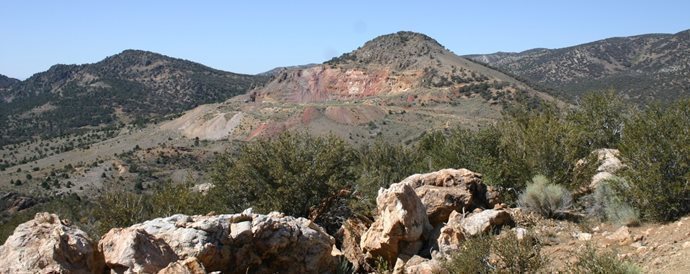
Submitted by:
| Timberline Resources Inc. 101 East Lakeside Ave, Coeur d’Alene, ID 83814 USA +1 208 664-4859 |
|
|
| RESPEC 210 S. Rock Blvd., Reno, NV 89502 +1 775 856-5700 |


Effective Date: December 31, 2022
Report Date: June 21, 2023
TABLE OF CONTENTS
DATE AND SIGNATURE PAGE |
| viii | ||
|
|
| ||
1 | EXECUTIVE SUMMARY |
| 1 | |
|
|
|
| |
| 1.1 | Property Description and Ownership |
| 1 |
|
|
|
|
|
| 1.2 | Geology and Mineralization |
| 1 |
|
|
|
|
|
| 1.3 | Status of Exploration |
| 2 |
|
|
|
|
|
| 1.4 | Development and Operations |
| 3 |
|
|
|
|
|
| 1.5 | Mineral Resource Estimate |
| 3 |
|
|
|
|
|
| 1.6 | Mineral Reserve Estimate |
| 4 |
|
|
|
|
|
| 1.7 | Capital and Operating Costs |
| 4 |
|
|
|
|
|
| 1.8 | Economic Analysis |
| 4 |
|
|
|
|
|
| 1.9 | Permitting Requirements |
| 4 |
|
|
|
|
|
| 1.10 | Qualified Person’s Conclusions and Recommendations |
| 4 |
|
|
|
|
|
2 | INTRODUCTION |
| 5 | |
|
|
|
| |
| 2.1 | Registrant Information |
| 5 |
|
|
|
|
|
| 2.2 | Terms of Reference and Purpose |
| 5 |
|
|
|
|
|
| 2.3 | Sources of Information |
| 5 |
|
|
|
|
|
| 2.4 | Personal Inspection Summary |
| 6 |
|
|
|
|
|
| 2.5 | Previously Filed Technical Reports |
| 7 |
|
|
|
|
|
3 | PROPERTY DESCRIPTION |
| 8 | |
|
|
|
| |
| 3.1 | Property Location |
| 8 |
|
|
|
|
|
| 3.2 | Mineral Titles, Claims, Rights, Leases and Options |
| 8 |
|
|
|
|
|
| 3.3 | Environmental Impacts, Permitting, Other Significant Factors and Risks |
| 11 |
|
|
|
|
|
| 3.4 | Royalty Payments |
| 11 |
|
|
|
|
|
4 | ACCESSIBILITY, CLIMATE, LOCAL RESOURCES, INFRASTRUCTURE AND PHYSIOGRAPHY |
| 12 | |
|
|
|
| |
| 4.1 | Topography and Land Description |
| 12 |
i |
| 4.2 | Access to the Property |
| 12 |
|
|
|
|
|
| 4.3 | Climate Description |
| 12 |
|
|
|
|
|
| 4.4 | Infrastructure and Availability and Sources |
| 13 |
|
|
|
|
|
5 | HISTORY |
| 14 | |
|
|
|
| |
| 5.1 | Exploration History |
| 14 |
|
|
|
|
|
| 5.2 | Past Production |
| 14 |
|
|
|
|
|
6 | GEOLOGICAL SETTING, MINERALIZATION, AND DEPOSIT |
| 16 | |
|
|
|
| |
| 6.1 | Regional Geology |
| 16 |
|
|
|
|
|
| 6.2 | Local Geology |
| 16 |
|
|
|
|
|
| 6.3 | Project Geology |
| 17 |
|
|
|
|
|
| 6.4 | Mineralization |
| 22 |
|
|
|
|
|
| 6.4.1 | Lookout Mountain Deposit Paragenesis |
| 25 |
|
|
|
|
|
| 6.4.2 | South Adit |
| 26 |
|
|
|
|
|
| 6.4.3 | Other Gold Occurrences in Ratto Canyon and Vicinity |
| 27 |
|
|
|
|
|
| 6.5 | Deposit Type |
| 30 |
|
|
|
|
|
7 | EXPLORATION |
| 32 | |
|
|
|
| |
| 7.1 | Introduction |
| 32 |
|
|
|
|
|
| 7.2 | Non-drilling Exploration |
| 32 |
|
|
|
|
|
| 7.2.1 | Geophysical Exploration |
| 32 |
|
|
|
|
|
| 7.2.2 | Geochemical Exploration |
| 34 |
|
|
|
|
|
| 7.2.3 | Reverse Circulation and Diamond Drill-core Drilling |
| 34 |
|
|
|
|
|
| 7.2.4 | Collar Surveys, Down-Hole Surveys, and Project Coordinates |
| 37 |
|
|
|
|
|
| 7.3 | Hydrologic Characterization |
| 38 |
|
|
|
|
|
| 7.4 | Geotechnical Data, Testing and Analysis |
| 40 |
|
|
|
|
|
| 7.5 | Opinion of Qualified Person |
| 40 |
|
|
|
|
|
8 | SAMPLE PREPARATION, ANALYSES, AND SECURITY |
| 44 | |
ii |
| 8.1 | Site Sample Preparation Methods and Security |
| 44 |
|
|
|
|
|
| 8.2 | Sampling Preparation, Assaying, Analytical Procedures, and Assay Laboratories |
| 44 |
|
|
|
|
|
| 8.3 | Quality Control and Quality Assurance Programs |
| 46 |
|
|
|
|
|
| 8.4 | Opinion of Qualified Person |
| 46 |
|
|
|
|
|
9 | DATA VERIFICATION |
| 47 | |
|
|
|
| |
| 9.1 | Drillhole Database |
| 47 |
|
|
|
|
|
| 9.2 | Quality Control/Quality Assurance Data |
| 48 |
|
|
|
|
|
| 9.2.1 | Amselco Drill Data |
| 48 |
|
|
|
|
|
| 9.2.2 | Barrick Drill Data |
| 53 |
|
|
|
|
|
| 9.2.3 | Echo Bay Drill Data |
| 53 |
|
|
|
|
|
| 9.2.4 | Staccato Drill Data |
| 53 |
|
|
|
|
|
| 9.2.5 | Timberline Drill Data - 2010 and 2011 Programs |
| 53 |
|
|
|
|
|
| 9.2.6 | Timberline Drill Data - 2012 Program |
| 57 |
|
|
|
|
|
| 9.2.7 | Discussion of QA/QC Results |
| 59 |
|
|
|
|
|
| 9.3 | Site and Field Office Inspections |
| 60 |
|
|
|
|
|
| 9.4 | Additional Data Verification |
| 60 |
|
|
|
|
|
| 9.5 | Summary Statement |
| 61 |
|
|
|
|
|
10 | MINERAL PROCESSING AND METALLURGICAL TESTING |
| 62 | |
|
|
|
| |
| 10.1 | Nature and Extent of Metallurgical Testing and Analytical Procedures |
| 62 |
|
|
|
|
|
| 10.2 | Representative Metallurgical Test Samples |
| 62 |
|
|
|
|
|
| 10.3 | Metallurgical Laboratories |
| 64 |
|
|
|
|
|
| 10.4 | Metallurgical Recovery Testing Results |
| 64 |
|
|
|
|
|
| 10.4.1 | Column Leach Tests – Surface Bulk Samples |
| 64 |
|
|
|
|
|
| 10.4.2 | Column Leach Tests – Core Composite Samples |
| 65 |
|
|
|
|
|
| 10.4.3 | Preliminary HPGR Crushing Test |
| 66 |
|
|
|
|
|
| 10.4.4 | Historical Recoveries |
| 66 |
iii |
| 10.5 | Opinion of Qualified Person |
| 66 |
|
|
|
|
|
11 | Mineral Resource Estimates |
| 67 | |
|
|
|
| |
| 11.1 | Introduction |
| 67 |
|
|
|
|
|
| 11.2 | Lookout Mountain Project Data |
| 67 |
|
|
|
|
|
| 11.3 | Deposit Geology Relevant to Resource Modeling |
| 67 |
|
|
|
|
|
| 11.4 | Geologic Modeling |
| 67 |
|
|
|
|
|
| 11.5 | Oxidation Modeling |
| 68 |
|
|
|
|
|
| 11.6 | Density Modeling |
| 68 |
|
|
|
|
|
| 11.7 | Gold Modeling |
| 69 |
|
|
|
|
|
| 11.7.1 | Mineral Domains |
| 69 |
|
|
|
|
|
| 11.7.2 | Assay Coding, Capping, and Compositing |
| 70 |
|
|
|
|
|
| 11.7.3 | Block Model Coding |
| 75 |
|
|
|
|
|
| 11.7.4 | Grade Interpolation |
| 75 |
|
|
|
|
|
| 11.7.5 | Model Checks |
| 78 |
|
|
|
|
|
| 11.8 | Lookout Mountain Project Mineral Resources |
| 79 |
|
|
|
|
|
| 11.8.1 | Project Risks and Resource Classification |
| 86 |
|
|
|
|
|
| 11.8.2 | Further Comments on the Resource Modeling |
| 87 |
|
|
|
|
|
12 | MINERAL RESERVE ESTIMATES |
| 88 | |
|
|
|
| |
13 | MINING METHODS |
| 89 | |
|
|
|
| |
14 | PROCESSING AND RECOVERY METHODS |
| 90 | |
|
|
|
| |
15 | INFRASTRUCTURE |
| 91 | |
|
|
|
| |
16 | MARKET STUDIES |
| 93 | |
|
|
|
| |
17 | ENVIRONMENTAL STUDIES, PERMITTING, AND PLANS, NEGOTIATIONS, OR AGREEMENTS WITH LOCAL INDIVIDUALS OR GROUPS |
| 94 | |
|
|
|
| |
| 17.1 | Environmental Studies |
| 94 |
|
|
|
|
|
| 17.1.1 | Baseline Biological Resources Survey |
| 94 |
|
|
|
|
|
| 17.1.2 | Cultural Survey and Report |
| 94 |
iv |
| 17.1.3 | Spring/Riparian Baseline Data |
| 94 |
|
|
|
|
|
| 17.1.4 | Groundwater Data Collection |
| 94 |
|
|
|
|
|
| 17.1.5 | Waste Rock and Ore Geochemical Characterization |
| 95 |
|
|
|
|
|
| 17.2 | Requirements and Plans for Waste Rock Disposal, Site Monitoring, and Water Management |
| 95 |
|
|
|
|
|
| 17.3 | Project Permitting Requirements |
| 95 |
|
|
|
|
|
| 17.4 | Plans, Negotiations, or Agreements with Local Individuals or Groups |
| 97 |
|
|
|
|
|
| 17.5 | Mine Closure Plans |
| 97 |
|
|
|
|
|
| 17.6 | QP’s Opinion |
| 97 |
|
|
|
|
|
| 17.7 | Commitments to Local Procurement and Hiring |
| 97 |
|
|
|
|
|
18 | CAPITAL AND OPERATING COSTS |
| 98 | |
|
|
|
| |
19 | ECONOMIC ANALYSIS |
| 99 | |
|
|
|
| |
20 | ADJACENT PROPERTIES |
| 100 | |
|
|
|
| |
21 | OTHER RELEVANT DATA AND INFORMATION |
| 101 | |
|
|
|
| |
22 | INTERPRETATION AND CONCLUSIONS |
| 102 | |
|
|
|
| |
23 | RECOMMENDATIONS |
| 104 | |
|
|
|
| |
24 | REFERENCES |
| 106 | |
|
|
|
| |
25 | RELIANCE ON INFORMATION PROVIDED BY THE REGISTRANT |
| 110 | |
v |
TABLES
Table 1.1 Lookout Mountain Project Gold Resources |
| 3 |
Table 2.1: Key Acronyms and Definitions |
| 6 |
Table 7.1 Lookout Mountain Project Drilling Database Summary |
| 36 |
Table 8.1 Compilation of Lookout Mountain Analytical Laboratories and Assay Methods |
| 45 |
Table 9.1 Descriptive Statistics of ALS Pulp Duplicates and Original Monitor Assays |
| 51 |
Table 9.2 Timberline Certified Standards |
| 55 |
Table 9.3 Timberline Certified Standards |
| 58 |
Table 10.1 Summary of Historical Metallurgical Testing |
| 62 |
Table 10.2 Summary of Column Leach Test Gold Recovery in Bulk Samples from |
| 65 |
Table 10.3 Summary of Column Leach Test Gold Recovery in Drill Core Composite Samples |
| 65 |
Table 10.4 Comparison of Bottle Roll Test Gold Recovery in Jasperoid by |
| 66 |
Table 11.1 Density Data |
| 68 |
Table 11.2 Descriptive Statistics of Lookout Mountain Coded Gold Assays |
| 70 |
Table 11.3 Descriptive Statistics of South Adit Coded Gold Assays |
| 71 |
Table 11.4 Descriptive Statistics of Lookout Mountain Gold Composites |
| 71 |
Table 11.5 Descriptive Statistics of South Adit Gold Composites |
| 71 |
Table 11.6 Summary of Lookout Mountain Estimation Parameters |
| 77 |
Table 11.7 Summary of South Adit Estimation Parameters |
| 78 |
Table 11.8 Pit Optimization Parameters |
| 79 |
Table 11.9 Lookout Mountain Project Gold Resources |
| 80 |
Table 11.10 Lookout Mountain Deposit In-Pit Mineralization at Various Cutoffs |
| 81 |
Table 11.11 South Adit Deposit Mineralization at Various Cutoffs |
| 82 |
Table 11.12 Lookout Mountain Classification Parameters |
| 87 |
Table 11.13 South Adit Classification Parameters |
| 87 |
Table 23.1 Recommended Phase I Lookout Mountain Work Program |
| 104 |
Table 23.2 Recommended Phase II Lookout Mountain Work Program |
| 105 |
vi |
FIGURES
Figure 3.1 Location of the Lookout Mountain Project |
| 9 |
Figure 3.2 Eureka Property Map |
| 10 |
Figure 6.1 Stratigraphic Column of the South Eureka District |
| 18 |
Figure 6.2 Geology of the Eureka Property and South Eureka District |
| 19 |
Figure 6.3 Geologic Map of the Lookout Mountain Project Area (Mapping by Timberline, December 7, 2010) |
| 23 |
Figure 6.4 Exploration Targets |
| 29 |
Figure 7.1 Project IP Survey and Anomalies over Gravity Vertical Derivative Base Map |
| 33 |
Figure 7.2 Surface Rock Samples in Lookout Mountain Project Area. |
| 35 |
Figure 7.3 Lookout Mountain Project Drillhole Locations |
| 39 |
Figure 7.4 Lookout Mountain Spring Sampling Location Map |
| 42 |
Figure 7.5 Lookout Mountain Monitoring Well Location Map |
| 43 |
Figure 9.1 ALS Preparation Duplicates Relative to Original Monitor Assays – Staccato |
| 50 |
Figure 9.2 Absolute Value of Relative Differences of ALS vs. Monitor - Staccato |
| 50 |
Figure 9.3 Normalized Results of Inspectorate Analyses of All 2010 and 2011 Certified Standards |
| 55 |
Figure 9.4 Normalized Results of Inspectorate Analyses of All 2012 Certified Standards |
| 59 |
Figure 10.1 Lookout Mountain Project Metallurgical Testing Sample Sites |
| 63 |
Figure 11.1 North Lookout Mountain Cross Section 1697700 Showing Gold Mineral Domains |
| 72 |
Figure 11.2 South Lookout Mountain Cross Section 1694900 Showing Gold Mineral Domains |
| 73 |
Figure 11.3 South Adit Cross Section 1687300 Showing Gold Mineral Domains |
| 74 |
Figure 11.4 Variogram of Lookout Mountain Domain 100 and 200 Composites in Dip Direction |
| 76 |
Figure 11.5 North Lookout Mountain Cross Section 1697550N Showing Block Model Gold Grades |
| 83 |
Figure 11.6 South Lookout Mountain Cross Section 1694900N Showing Block Model Gold Grades |
| 84 |
Figure 11.7 South Adit Cross Section 1687300N Showing Block Model Gold Grades |
| 85 |
Figure 15.1 Lookout Mountain Project Scoping-level Facilities Siting |
| 92 |
vii |
DATE AND SIGNATURE PAGE
The effective date of the Mineral Resource estimate is December 31, 2021.
Author | Section(s) | Signature |
Steven A. Osterberg (Timberline)
RESPEC Company LLC | All except Section 11
Sections 1.5, 1.10, 9, 11, 21, 22, and 23 |
|

The qualifications and relevant experience of the QP are shown below.
Steven A. Osterberg Ph.D., P.G:
| · | Education: | |
|
|
|
|
|
| – | Bachelor of Science in Geology, University of Wisconsin, Oshkosh, 1982 |
|
|
|
|
|
| – | Master of Science in Geology, University of Minnesota, Duluth, 1985 |
|
|
|
|
|
| – | Doctor of Philosophy in Geology, University of Minnesota, 1993 |
|
|
|
|
| · | Years of Experience: | |
|
|
|
|
|
| – | Has 40 years of experience in the mining industry as a geologist. |
|
|
|
|
| · | Relevant Experience | |
|
|
|
|
|
| – | Employed as a geologist in the minerals exploration industry for 20 years with mineral companies including: Kerr-McGee Corporation, Noranda Mining, Minnova, BHP Minerals, and Timberline. |
|
|
|
|
|
| – | Employed as an independent geological and hydrogeological consultant for 15 years in consulting for Knight Piesold, Ltd., MFG, Inc., Tetra Tech, Inc., and as an independent. |
|
|
|
|
|
| – | Has been the non-independent QP for Timberline Resources since 2012. |
|
|
|
|
|
| – | Has more than 10 years of experience working on Carlin-type gold deposits. |
|
|
|
|
| · | Professional Registration: | |
|
|
|
|
|
| – | Licensed Professional Geologist – Wyoming, U.S. (Registration No – PG-3444) |
|
|
|
|
|
| – | Registered Member of the Society of Mining Engineers (Registration No. 4103097) |
|
|
|
|
| · | Certified Professional Geologist of the American Institute of State Boards of Geology | |
RESPECT Company LLC acted as an independent QP for this Technical Report Summary.
viii |
1 EXECUTIVE SUMMARY
1.1 Property Description and Ownership
Lookout Mountain is one of several projects located on what Timberline Resources Corporation (“Timberline”) refers to as its Eureka property, which covers an area of about 17,000 acres or over 27 square miles. The Eureka property is in the southern part of the Eureka mining district in Eureka County, central Nevada, beginning approximately one mile south and extending for several miles south of the town of Eureka. The Lookout Mountain claim block is one of eight blocks that comprise Timberline’s Eureka property.
The Eureka property lies within T19N, R53E and unsurveyed T17N and T18N, and R53E. The property is also within the bounds of the United States Geological Survey (“USGS”) 1:24,000-scale 7.5-minute topographic series maps of the Pinto Summit and Spring Valley Summit quadrangles and includes the Lookout Mountain, Windfall and Oswego trends of historic mines and exploration prospects.
1.2 Geology and Mineralization
Central Nevada was a shelf environment throughout Paleozoic time, interrupted by the Late Devonian to Early Mississippian Antler Orogeny with east-directed compression and thrust faulting whose primary feature was the Roberts Mountains thrust, exposed just west of the Eureka district. During the Tertiary, several periods of igneous activity deposited a variety of volcanic and intrusive rocks throughout this region. Extensional tectonics dominated the Tertiary throughout Nevada. The Eureka district lies on the southern end of the 100-mile-long, northwest-trending Battle Mountain-Eureka trend, which hosts numerous sediment-hosted gold deposits and base-metal replacement deposits.
The sedimentary rocks exposed in the south Eureka district are dominantly of Cambrian through Devonian age and are made up of limestone, dolomite, and minor amounts of shale and quartzite that were deposited in a shallow-water miogeosynclinal environment. They have been intruded by a Cretaceous pluton and several felsic dikes of Eocene age. The Oligocene Ratto Springs rhyodacite and Sierra Springs tuff overlie the Paleozoic rocks. Included within the Paleozoic section in the south Eureka district are the Ordovician Goodwin Formation of the Pogonip Group, which hosts gold mineralization at the nearby Ruby Hill Mine; the Cambrian Dunderberg Shale and Hamburg formation, which host gold mineralization at the Lookout Mountain, Windfall, Paroni, Rustler deposits on Timberline’s Eureka property; and the Devonian Bartine Limestone, which hosts gold mineralization at the Gold Bar mine to the northwest.
A pronounced north-trending high-angle fault zone, the Ratto Ridge fault system, has localized jasperoids and gold mineralization in sedimentary units along more than 2.5 miles of strike length at Lookout Mountain. This fault juxtaposes gently dipping Cambrian sedimentary rocks on the east against gently dipping Devonian sedimentary rocks on the west, an offset of perhaps 7,000 feet vertically along Ratto Ridge. The Ratto Ridge fault system is cut by several northeast- and east-trending, steeply south-dipping faults and also by less prominent northwest-trending, steeply south-dipping sets of faults.
There are breccias of multiple origins at Lookout Mountain as evidenced in the historical pit and drill core. Most appear to be collapse breccias, but there are also tectonic and probably depositional breccias, and these breccias host the bulk of the resources discussed in this report. Timberline believes these breccias, which are collectively referred to as Lookout Mountain breccia in this report, are developed within both the Dunderberg and Hamburg formations.
|
| 1 | Page |

The Lookout Mountain breccia has a northerly strike and moderate dip to the east. The breccia is quite wide at the surface and typically thins down dip. Jasperoid-rich zones are common in the upper portion of the breccia near its contact with the Dunderberg Shale, while the lower portion near the Secret Canyon Shale is characterized by a structural zone; both zones are frequently characterized by higher-than-average gold grades. The highest grades at Lookout Mountain appear to be controlled by favorable structural settings in both the breccia and overlying Dunderberg Shale. The Secret Canyon Shale, which immediately underlies much of the breccia, rarely hosts mineralization.
Gold mineralization at the Lookout Mountain project is Carlin-type disseminated sediment-hosted mineralization. Characteristic alteration of these deposits is decalcification, argillization, and intense silicification, which forms jasperoid. Gold is invariably accompanied by silver (at similar or lower concentrations) and a halo of pathfinder elements commonly including arsenic, thallium, mercury, antimony, and barium. In addition to the previously mined Lookout Mountain deposit, other concentrations of gold mineralization on the Lookout Mountain claim block have been identified at South Adit, South Lookout Mountain, South Ratto Ridge, and Triple Junction.
At Lookout Mountain, and for 2.5 miles along Ratto Ridge, disseminated sediment-hosted gold mineralization has been found within the Lookout Mountain breccia, as well as the overlying Cambrian Dunderberg Shale. Gold occurs in jasperoid that caps Ratto Ridge through to depths of 1,500 feet and is associated with strong surface arsenic, mercury, and antimony anomalies in soil and rock samples. Alteration is widespread, with decalcification and silicification being the most common types. Argillic alteration is also present, as is sanding of dolomites. Gold is associated with pyrite, realgar, orpiment, quartz, and clay. The unoxidized mineralization at Lookout Mountain consists of disseminated arsenopyrite and arsenosiderite; assays ranging from 0.5 to over 1.0 oz Au/ton have been reported.
At South Adit, gold occurs in the same geological setting as the other occurrences along Ratto Ridge, i.e. at the Dunderberg-Hamburg contact associated with strong silicification/argillization and steeply dipping normal faults. The mineralized zone trends north and, like Triple Junction to the north, lies east of the crest of Ratto Ridge. At the top of the ridge above South Adit mineralization, a northwest-trending splay of the main north-trending structure appears. Mapping and drill-section interpretation suggest that a strong north-trending cross structure intersects the northwest-trending structure in this area. Large jasperoid bodies lie just above the South Adit mineralized zone with a strong east-northeast fault control.
1.3 Status of Exploration
The Lookout Mountain project has been drilled by Newmont, Amselco, Barrick, Echo Bay, Norse Windfall Mines, EFL, Staccato, and Timberline. The project database provided to RESPEC Company LLC (“RESPEC”) contains data from 754 holes, totaling 418,743 feet, including 75 core holes, 504 RC holes, 16 RC with core-tails, and 159 rotary holes. Amselco’s drilling program from 1978 through 1985 provided 45% of the holes in the current database. Timberline drilled a total of 220 holes from 2010 through 2022, of which 39 were core, 165 RC, and 16 as RC with core-tails.
Most of the various operators prior to Timberline used commercial laboratories for the preparation and analysis of their drill samples that were well recognized and widely used in the minerals industry. In-house mine laboratories were also used for the 20 Norse Windfall Mines holes and some of the Amselco holes, and many of these analyses utilized partial-gold extractions. Some of the Norse Windfall Mines gold data clearly understate grades in comparison to adjacent holes. RESPEC’s reconstruction of the Amselco database effectively limits the impact of the in-house assays by replacing many of them with check analyses performed at commercial laboratories.
|
| 2 | Page |
Staccato used ALS Laboratories for their drill samples from the 2005 through 2007 programs and Inspectorate America Corp. (“Inspectorate”) in 2008. Timberline used Inspectorate for most assaying of their primary drill samples until its most recent work from 2020-2022, for which it used ALS.
1.4 Development and Operations
No development activities or mining operations have been undertaken on the Eureka project during Timberline’s operating control. All activities to-date have been exploration and resource-related.
1.5 Mineral Resource Estimate
The gold resources at the Lookout Mountain project, including the Lookout Mountain and South Adit deposits, were modeled and estimated by evaluating the drill data statistically, utilizing the geologic interpretations provided by Timberline to interpret mineral domains on cross sections spaced at 50- and 100-foot intervals, refining the mineral-domain interpretations on level plans spaced at 10-foot intervals, analyzing the modeled mineralization statistically to aid in the establishment of estimation parameters, and interpolating grades into a three-dimensional block model. All modeling of the Lookout Mountain project resources was performed using Gemcom Surpac® mining software.
The Lookout Mountain project resources are presented in Table 1.1
Table 1.1 Lookout Mountain Project Gold Resources
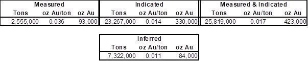
Notes:
| · | The estimate of the Lookout Mountain project Mineral Resources was completed by RESPEC. |
|
|
|
| · | The Mineral Resources are comprised of oxidized model blocks that lie within optimized pits at a cutoff grade of 0.005 oz Au/ton plus unoxidized blocks within the optimized pits at a 0.055 oz Au/ton cutoff. |
|
|
|
| · | Mineral Resources that are not Mineral Reserves do not have demonstrated economic viability. |
|
|
|
| · | The Mineral Resources are potentially amenable to open pit mining methods and are therefore constrained by optimized pits created using a gold price of US$1,800/oz, a throughput rate of 10,000 tons/day, assumed metallurgical recoveries of 80% for heap-leaching of oxidized materials and 86% for toll milling of unoxidized materials, a mining cost of US$2.50/ton, heap-leaching processing cost of $3.60/ton, toll milling cost of $80.00/ton, general and administrative costs of $0.83/ton processed, a reclamation cost of $0.25/ton processed, refining cost of $3.00/oz Au produced, and an NSR royalty of 3.5%. |
|
|
|
| · | The effective date of the resource estimate is December 31, 2022. |
|
|
|
| · | Rounding may result in apparent discrepancies between tons, grade, and contained metal content. |
|
| 3 | Page |
1.6 Mineral Reserve Estimate
Not applicable to this TRS.
1.7 Capital and Operating Costs
Not applicable to this TRS.
1.8 Economic Analysis
Not applicable to this TRS.
1.9 Permitting Requirements
Timberline operated exploration activities at Lookout Mountain under a Plan of Operations (PoO) approved in 2010 by the BLM. Annual work plan amendments to the PoO allow drilling-related disturbance which is totaled annually as part of 266.4 acres of total approved impacts. Additional environmental and engineering studies will be required to support a mine plan of operations with the BLM to comply with NEPA, and to meet State of Nevada Bureau of Mine Regulation and Reclamation and other agency permit requirements.
1.10 Qualified Person’s Conclusions and Recommendations
RESPEC has reviewed the project data and has visited the site. RESPEC believes that the data provided by Timberline are generally an accurate and reasonable representation of the Lookout Mountain project.
The resources reported above are open along strike in both directions, as well as down dip. The possible extension of the Lookout Mountain deposit south through to the South Adit resource, located approximately 3,500 feet south of the southern limit of the modeled mineralization at Lookout Mountain, provides the best opportunity for near-term enhancement of project resources. In addition, there is excellent potential to add to the existing resources that lie west of the Ratto Canyon fault at the Lookout Mountain deposit.
A Phase I program is recommended to include infill drilling, resource-expansion drilling, further metallurgical testing, full three-dimensional geological modeling, and the completion of an Initial Assessment based on the current resources. The cost of this program is estimated to be about $4.5 million dollars.
If the Initial Assessment returns positive results, a Phase II program is recommended that is designed to prepare the project for a pre-feasibility study. The Phase II program includes hydrologic, environmental, and preliminary design studies, as well as continuations of the drilling program and metallurgical studies of Phase I. The cost of the proposed Phase II program is about $6.655 million (the Phase I and II estimated costs exclude all personnel, landholding, reclamation, reclamation bonding, permitting and related environmental costs).
|
| 4 | Page |
2 INTRODUCTION
In 2010 Timberline Resources Inc (“Timberline” or “the Company”) acquired Staccato Gold Resources (“Staccato”), a Canadian-based resource company and its wholly owned U.S. subsidiary BH Minerals USA, Inc. The Lookout Mountain project was the flagship project of Staccato Gold and was acquired by Timberline as a result of the acquisition. From 2010 through 2013, exploration work was performed on the Lookout Project. The work during that period delivered sufficient data to support a mineral resource estimate (including a technical report compliant with Canadian National Instrument 43-101 (“NI 43-101”)), conduct initial gold recovery studies, initiate environmental baseline investigations, better understand the controls of mineralization, and to outline additional exploration drill targets.
2.1 Registrant Information
This Technical Report Summary (TRS) for the Lookout Mountain project was prepared by Timberline’s QP with the Data Verification and Mineral Resources completed by RESPEC Company LLC (“RESPEC”), a mining consulting firm that is independent of Timberline.
2.2 Terms of Reference and Purpose
The effective date of this TRS was June 21, 2023, while the effective date of the Mineral Resource estimate was December 31, 2022. The mineral resources estimate, as reported, represents updates to resources initially completed between December 2012 through February 2013. The current updates of December 2022 include application of pit optimizations to constrain the resources using current economic parameters.
This TRS uses US English spelling. Costs are presented in constant US Dollars, as of April 11, 2013.
Except where noted, coordinates in this TRS are presented in US feet units using the North American Datum of 1927 – SPC Zone Nevada East 2701
The purpose of this TRS is to report Mineral Resources for Timberline’s Lookout Project.
Key acronyms and definitions for this Report include those items listed in Table 2.1.
Measurements are generally reported in English units in this report. Where information was originally reported in metric units, conversions may have been made according to the formulas shown below; discrepancies may result in slight variations from the original data in some cases.
2.3 Sources of Information
The information and data used in the development of this TRS was provided by Timberline as well as sourced from publicly available information.
A detailed list of cited reports is noted in Section 24.0 of this TRS.
|
| 5 | Page |
Table 2.1: Key Acronyms and Definitions
Abbreviation/Acronym | Definition |
AA | atomic absorption spectrometry |
Ag | silver |
Au | gold |
BLM | United States Department of the Interior, Bureau of Land Management |
CSAMT | Controlled Source Audio-Frequency Magneto-Telluric geophysical survey |
cm | centimeter; 1 cm = 0.3937 inch |
°F | degrees Fahrenheit |
ft | foot or feet; 1 ft = 0.3048 m |
g/t | grams per tonne; 1 g Au/t = 1 ppm Au = 0.02917 oz/ton |
ha | hectare; 1 ha = 2.471 acres |
ICP | inductively coupled plasma |
in. | inch or inches |
IP | induced polarization geophysical survey |
kg | kilogram; 1 kg = 2.205 pounds |
km | kilometer; 1 km = 0.6214 mile |
l | liter; 1 l = 1.057 US quarts |
Ma | million years old |
m | meter; 1 m = 3.2808 feet |
mm | millimeter; 1 mm = 0.001 m = 0.003281 ft |
oz | troy ounce; 12 troy oz = 1 troy pound; 1 oz Au/ton = 34.2857 g Au/t |
ppm | parts per million |
ppb | parts per billion |
RC | reverse-circulation drilling method |
SEM | scanning electron microscope |
t, tonne | metric tonne = 1.1023 short tons |
T | township |
2.4 Personal Inspection Summary
Multiple site visits and inspections of the Lookout Mountain project area were completed by RESPEC, who is responsible for the preparation of Sections 9.0 and 11.0 of this TRS.
RESPEC is a third-party Qualified Person (QP) firm that as defined in S-K 1300 and is responsible for the preparation of the Mineral Resources for the Project. RESPEC visited the Lookout Mountain project on January 6 and November 16, 2011 and April 10, 2013, and again on October 6, 2020, and November 4, 2021.
During the site visits, RESPEC reviewed mineralized core and reverse-circulation drill chips, examined drill-hole cross sections showing the geologic model, investigated representative exposures in road cuts and outcrops, inspected sampling and logging procedures at active reverse-circulation drill sites, and took confirmatory visits to almost every Timberline drill site at Lookout Mountain.
|
| 6 | Page |
The Company’s non-independent QP, Dr. Steven Osterberg, is responsible for all sections of this TRS except 11.0 Mineral Resource Estimates. Dr. Osterberg is Vice President of Exploration for Timberline and has had continuous involvement with the project since 2012.
2.5 Previously Filed Technical Reports
No previous regulation SK-1300 TRS reports have been filed on the project.
|
| 7 | Page |
3 PROPERTY DESCRIPTION
3.1 Property Location
Lookout Mountain is one of several projects located on what Timberline calls its Eureka property, which covers an area of about 17,000 acres or approximately 27 square miles. The Eureka property lies within the Eureka mining district at the southeastern end of the Battle Mountain-Eureka (Cortez) mineralized trend of gold and base-metal deposits in north-central Nevada (Figure 3.1). The Eureka property consists of seven large claim blocks: the Lookout Mountain, Windfall-Hoosac, North Amselco, Hiero, South Ratto, Trail, and New York Canyon blocks (Figure 3.2). The focus of this report is on the Lookout Mountain claim group, which covers the Lookout Mountain project and is the largest of the seven claim blocks (Figure 4.3). The Lookout Mountain project includes both the Lookout Mountain and South Adit deposits described in this report.
The Eureka property is in the southern part of the Eureka mining district in Eureka County, Nevada, stretching for several miles south of the town of Eureka, the Eureka County seat. The property lies at the topographic junction of the south end of the Diamond Mountains with the east-central portion of the Fish Creek Range. The Lookout Mountain claim block covers Lookout Mountain and Ratto Ridge in the northern part of surveyed Township 17 North, Range 53 East and in much of unsurveyed Township 18 North, Range 53 East, Mount Diablo Base and Meridian. The approximate center of the Lookout Mountain project is located at 39° 24’ 16”N, 115° 58’ 56”W. The property is covered by the United States Geological Survey 7.5 minute Pinto Summit and Spring Valley Summit topographic quadrangle maps.
In this report, the Lookout Mountain resource area is split into two blocks, with the dividing line at 1696100N (the northing value in Nevada State Plane East, NAD27 coordinates, the coordinate system used for the project). The resource area lying north of this line is referred to as North Lookout Mountain, which includes the previously mined open pit. The South Lookout Mountain area, south of 1696100N, is generally less densely drilled and includes only Indicated and Inferred resources. The South Adit resource area is located about 3,500 feet to the southeast of the southern limits of the South Lookout Mountain resource area.
3.2 Mineral Titles, Claims, Rights, Leases and Options
The Lookout Mountain project has a total of 378 claims, and consists of one lease of 373 claims. The remaining 5 claims Timberline controls outright.
The lease for 373 claims covering 6,368 acres has a 20 year term that expires June 1, 2028. The current advance royalty payment is $72,000 annually.
|
| 8 | Page |
Figure 3.1 Location of the Lookout Mountain Project
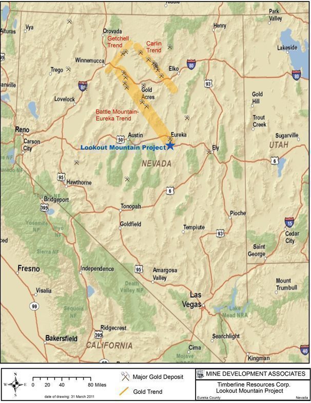
|
| 9 | Page |
Figure 3.2 Eureka Property Map
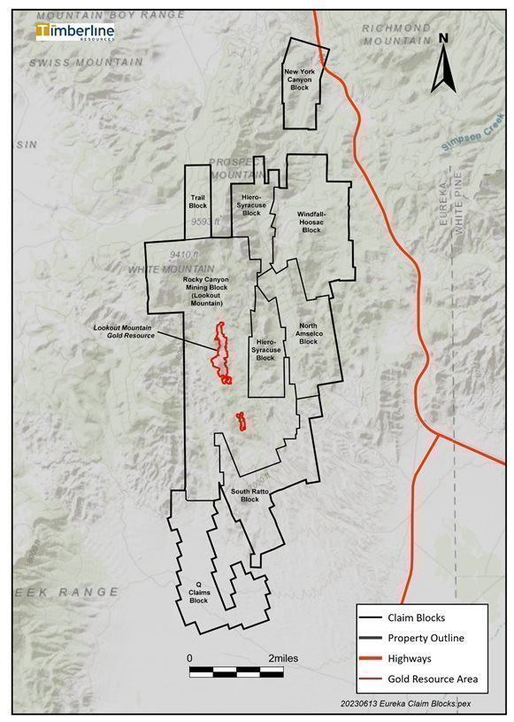
|
| 10 | Page |
3.3 Environmental Impacts, Permitting, Other Significant Factors and Risks
Timberline conducts exploration activities at Lookout Mountain under regulatory authority of the BLM and State of Nevada. Disturbance activities since September 2010 are authorized under Exploration Plan of Operations NVN-086574 which authorizes up to 266.4 acres of exploration-related surface disturbance within the project area. Timberline has assumed the responsibility and liability for all environmental impacts related to such exploration activities. The Nevada Division of Environmental Protection, Bureau of Mining Regulation and Reclamation (“BMRR”) approved a Nevada Reclamation Permit (No. 0307) for the project which has been most recently updated in May, 2022 to a bond in the amount of $433,910 covering up to 266.4 acres of surface disturbance as currently permitted. Work Plan Amendments are prepared and submitted to the BLM for approval typically on an annual basis and include a calculation of anticipated new disturbance acreage. With work completed through the 2022 Amendment, disturbance at Lookout Mountain currently totals 36.1 acres. Currently Timberline is deliberately over-bonded such that future work can be completed by re-allocating already approved and bonded disturbance, through either work plans or letters describing the reallocation of disturbance.
Expanded or additional baseline studies beyond the exploration Plan of Operations will be required if the project is to advance through mine permitting. Such studies were initiated in 2012-2013 but have not been completed (see Section 17.0 for further description).
The property was previously mined in the 1980s for gold. This mining operation resulted in the development of an open pit, a waste-rock dump, a haul road, and exploration drill roads and pads. All processing of the ore occurred off site. Some reclamation has been completed on the mining-related surface disturbance. Under the Plan of Operations, Timberline is not responsible for pre-1981 disturbance and is not held responsible for re-contouring or reclaiming the existing open pit and waste dump at Lookout Mountain. It is reasonable to expect that as long as Timberline does not reactivate the disturbance associated with the waste-rock dump or the open pit, Timberline will continue to not be liable for any additional reclamation.
3.4 Royalty Payments
The Lookout Mountain project is subject to a 3.5% Gross Value Royalty payable to Rocky Canyon Mining Company on production from the Rat and Selrat claim groups and the Dave and Trevor claims. Advanced minimum royalty payments of $72,000 per year are paid to RCMC and total $864,000 paid to-date. In addition, there is a 1.5% Gross Value Royalty payable to Geneve and Mary Bisoni on production from the Rat and Selrat claim groups, which is capped at $1,500,000.
An updated title review by Harris & Thompson (Thompson, 2011) found no transfers of these royalties of record, so they remain vested as described above.
As currently defined, the Lookout Mountain and South Adit resources discussed herein fall entirely within the Rat and Selrat claim groups.
|
| 11 | Page |
4 ACCESSIBILITY, CLIMATE, LOCAL RESOURCES, INFRASTRUCTURE AND PHYSIOGRAPHY
4.1 Topography and Land Description
The Lookout Mountain project is located in the Basin and Range physiographic province, characterized by generally north-trending fault-bounded ranges separated by alluvial valleys. The terrain on the property is rugged, with high ridges, steep canyons, and narrow valleys. Elevations range from 7,000 to 9,000 feet. Ridges show abundant bedrock exposures; slopes and valleys are typically covered by soil and alluvium. Sagebrush abounds in lower-elevation areas, while juniper and pinion cover the higher elevations. Grasses and shrubs grow on the highest ridge tops.
4.2 Access to the Property
Access to the property is via U.S. Highway 50, which passes to the north and east of the Lookout Mountain property, and then by unpaved County roads maintained by Eureka County. The northern part of the Lookout Mountain claim group is accessed by the Windfall Canyon Road and its westward extension (the former haul road for the Lookout Mountain mine), which turns southwest off U.S. 50 approximately two miles south of Eureka. An alternative route provides access via the southern part of the Lookout Mountain group by traveling approximately eight miles south of Eureka on U.S. 50 to South Gate, then approximately two miles south-southwest on the Fish Creek Valley Road to a turnoff to the west and northwest on the Ratto Canyon Road.
4.3 Climate Description
The Lookout Mountain area is characterized by the high-desert climate of the Great Basin. The climate is semi-arid with moderate winter snow and occasional thunderstorms that can include heavy rain from time to time during otherwise hot and dry summers. November snow commonly lingers until April in the higher elevations, and several feet of snow often accumulate on the property during the winter months. Access is not publicly maintained off the paved roads during winter.
Temperatures range from as cold as -10ºF in winter to occasional days near 100ºF in summer. Summer temperatures usually consist of many consecutive days of over 90º F. Winter temperatures are usually in the 20º to 35ºF range. Precipitation amounts vary from year to year, averaging about 10.0 inches annually for the area.
At Eureka, located eight miles north of the property, the average temperature is 44°F, with an average high of 61.9°F and an average low of 26.7°F. Average annual precipitation is 10.1 inches.
Mining can be conducted year around, but heavy snow may impede exploration during the winter.
|
| 12 | Page |
4.4 Infrastructure and Availability and Sources
The Lookout Mountain property is situated in central Nevada in an area with established mining infrastructure. Transmission power lines serve Eureka from the north. Essential services such as food and lodging are available in Eureka, including dockage for shipments of heavy equipment. Eureka’s estimated 2020 population was 411 (U. S. Census). A small airport at Eureka is available for private air transport, and regularly scheduled air service is available in Elko, Nevada, about a two hours’ drive north of the property. US Highway 50 that crosses Nevada in an east-west direction lies to the north and east of the property. The Union Pacific Railroad runs parallel to Interstate 80 about 85 miles north of the property.
Skilled miners and mining professionals are available at Eureka and 100 miles to the north at Carlin, Elko, and Spring Creek. Mining supplies and services are available at Carlin and Elko.
|
| 13 | Page |
5 HISTORY
5.1 Exploration History
The following information is taken from Russell (2005, 2007), Morris (2007), Edmondo (2008a, 2008b), Shawe and Nolan (1989), and Emmons (1995, 1996), with additional references as cited.
Exploration in the Eureka area began around 1860, and the Eureka mining district was discovered in 1864. Production of lead-silver-zinc-gold mineralization from small bonanza mines dates from 1865. Early production from the district was from oxidized, gold-rich, manto-like replacement deposits in Paleozoic carbonate rocks near Cretaceous stocks. In addition to gold, the Eureka deposits produced substantial amounts of lead and silver. Several small lead-silver-gold mines were discovered in the South Eureka district (also known as the Secret Canyon district) about one mile east of Lookout Mountain/Ratto Ridge during this same time period. Incomplete production records prior to the 1950s suggest that production of gold, silver, copper, lead, and zinc from the Eureka district may have totaled $122 million (in 1962 dollars) (Nolan, 1962). About 1.65 million ounces of gold were produced from the Eureka district, mostly during the period from 1870 to 1890 (Shawe and Nolan, 1989).
Gold mineralization that contained no base metals and only minor, if any, silver was discovered in 1904 at Windfall Canyon, about 3.5 miles northeast of Lookout Mountain. The mineralization was largely oxidized and siliceous. The Windfall mine had early underground gold production from 1904 until 1908 and 1909 to 1912 (Vanderburg, 1938). The gold mineralization showed both structural and stratigraphic control, localized by the intersection of northeast-striking fissures with the uppermost beds of the Hamburg dolomite (Nolan, 1962).
Disseminated gold deposits were discovered in the region in the 1960s, and there has been extensive exploration for and development of such deposits since then. Renewed interest in the gold-only mineralization at Windfall brought modern-day prospectors into the Lookout Mountain area in the 1960s.
The ownership and exploration history of the Lookout Mountain area claims includes 12 companies prior to Timberline with programs including geologic mapping, geochemical rock and soil sampling, geophysical surveys, metallurgical testing, and drilling as summarized in Table 5.1.
Timberline acquired the South Eureka property, including the Lookout Mountain project, in June 2010 through its acquisition of Staccato (Timberline press releases dated March 23, June 1, and June 3, 2010). Timberline’s exploration is described in Section 9.0. The Company acquired new claims in the period since the acquisition of Staccato and renamed it the Eureka property in 2020.
5.2 Past Production
The first gold bar was poured from Lookout Mountain ores in January 1987 (Cargill, 1988). Norse Windfall Mines operated the heap-leach mine between 1987 and November 1988 (Jonson, 1991). Production from January through December 1987 totaled 180,200 tons averaging 0.12 oz Au/ton and yielded 17,700 ounces of gold; recovery was 81% (Cargill, 1988; Jonson, 1991). No information regarding the actual production between January and November 1988 is available.
The ore was hauled 5.6 miles from the pit to the Windfall mine for crushing, agglomeration, and heap leaching. Recovery was expected to be 85 to 90%, but problems reported by the mining contractor resulted in lower recovery (Jonson, 1991, citing an August 1988 report not available to Timberline). The cutoff mining grade was 0.02 oz Au/ton due to the long haul to the agglomerator (Jonson, 1991). Mining reportedly was discontinued due to unspecified financial, management, logistical, and metallurgical problems, as well as a lawsuit (Russell, 2005; Alta Gold Co., 1999).
|
| 14 | Page |
Production has also come from the nearby Windfall, Rustler, and Paroni open-pit mines elsewhere on Timberline’s Eureka property, as well as from the Archimedes mine discovered by Homestake Mining Company, which is about five miles north of the Lookout Mountain property and one mile northwest of the town of Eureka. Production from the Windfall, Rustler, and Paroni mines in the 1980s totaled about 2.8 million tons averaging 0.04 oz Au/ton (Russell, 2005).
Table 5.1. Summary of Company Exploration History at Lookout Mountain
Company | Period | Description | Reference |
Cordero Mining Co | 1960s | Drilled several core and rotary holes investigating mercury anomalies | Jonson, 1991 |
Newmont | 1963 | Drilled 5 holes; results including 50 ft @ 0.023 opt Au; drilling during molybdenum exploration program | Jonson, 1991 |
Bisoni | 1974 | Claim staking on anomalous gold, arsenic, antimony, and mercury rock sample results |
|
Amselco Exploration | 1978-1985 | Claim staking; geologic mapping, geochem sampling; drilled 307 holes; discovered sediment-hosted gold at depth |
|
CFB and JV partner Norse Windfall Mines | 1986 | Rock sampling, 20 exploration drillholes; developed LM mine in 1987-1988; produced 17,700 oz @ 0.12 oz Au/ton and 81% recovery |
|
EFL Gold Mine, Inc. | 1990 | Purchased asset; bulk sampling, trenching, 11 RC holes | Jonson, 1991 |
Summit Minerals, Inc. | 1990 | Purchased from EFL | GIS Land Services, 2008; Jonson, 1991 |
Barrick Gold | 1992 | Soil sampling, drilling, ground and airborne geophysics (magnetics,resistivity, VLF-EM, radiometrics), IP/resistivity ; drilled 40 RC holes | Mako, 1993a |
Echo Bay Exploration | 1993 | Rock and soil sampling, CSAMT, 105 RC drillholes on Ratto Ridge, and drill-testing of Devonian section; best intercepts of 110 ft @ 0.043 in Dunderberg Shale, and 115 ft @ 0.043 in Devonian Nevada Group |
|
Alta Gold | 1997-1999 | Metallurgical test work | Langhans, 1997 |
Century Gold | 2003 | Acquired claims by lease from RCMC | GIS Land Services, 2008 |
Staccato | 2005-2010 | Acquired Century Gold’s land holdings; drilled 32 core and 18 RC drillholes; extended soil sampling and ground magnetic surveys | GIS Land Services, 2008 |
Timberline | 2010-present | Acquired Staccato Gold |
|
|
| 15 | Page |
6 GEOLOGICAL SETTING, MINERALIZATION, AND DEPOSIT
6.1 Regional Geology
The following information on regional geology has been taken from Russell (2007), Nolan et al. (1956), Jennings and Schwarz (2005), and Cargill (1988), which in part summarize work by Roberts (1960) and Roberts et al. (1967).
Sedimentary rocks of Cambrian through Permian age are found in this region and were deposited in a shelf environment. Limestone, dolomite, quartzite, and shale make up the Paleozoic section. Ordovician units demonstrate two very different facies that have been juxtaposed by Paleozoic thrust faulting: autochthonous limestone, dolomite, and quartzite and allochthonous chert, quartzite, and graptolite-bearing shales originally deposited to the west but transported to their current position by eastward-vergent thrust faulting.
There were several periods of Tertiary igneous activity in this part of Nevada. Andesitic to rhyolitic volcanic rocks and granitic intrusions were emplaced between 43 and 34 Ma, which may have coincided with deposition of most of the gold mineralization in the region. Rhyolitic and quartz latitic ash-flow tuffs erupted from calderas between 34 and 17 Ma. From 17 to 15 Ma, basaltic andesite volcanism, dike emplacement, and related gold mineralization took place along the northwest-trending Northern Nevada Rift and parallel fractures, followed by peralkaline and rhyolitic volcanism in northernmost Nevada from 14 to 6 Ma.
The Paleozoic Antler Orogeny was characterized by east-directed compression and thrust faulting that transported siliceous and volcanic rocks from the west over shelf sequences in eastern Nevada along the Roberts Mountains thrust, which is exposed just west of the Eureka district. While the Roberts Mountain thrust does not cover the Lookout Mountain area, it exerted a major influence on the structural features of this area in the form of near-surface disturbances in front of the advancing thrust. There is also evidence of younger thrust faulting in the vicinity of the Eureka district associated with the Mesozoic Sevier Orogeny. In contrast, extensional tectonics dominated the Tertiary in northeastern Nevada, culminating in formation of the block-faulted Basin and Range physiographic province.
The South Eureka district lies on the southern end of the Battle Mountain-Eureka trend, also known as the Cortez trend, which hosts many sediment-hosted gold deposits and base-metal replacement deposits. The trend extends about 150 miles from Battle Mountain on the northwest through the Lewis, Hilltop, and Cortez districts and the Tonkin Springs, Goldridge, and Goldbar mines, ending southeast of the Eureka district beyond the Pan and Mt. Hamilton mines. The trend, which strikes N45°W, does not lie parallel to any topographic feature, known structure, or type of lithology.
6.2 Local Geology
The following information has been taken from Russell (2007), Shawe and Nolan (1989), Steininger et al. (1987), and Cargill (1988), which in part summarize the work of Nolan (Nolan et al., 1956, Nolan, 1962) and Roberts et al. (1967).
The Eureka district lies at the northern end of the Fish Creek Range and is underlain by a miles-thick sequence of Cambrian through Devonian calcareous sedimentary rocks and Ordovician clastic rocks that were affected by the Late Devonian to Early Mississippian Antler Orogeny. Just west of the Eureka district, the Roberts Mountain thrust system carried dominantly clastic rocks from the west over dominantly carbonate rocks of the same age to the east during the Antler Orogeny. Post-orogenic coarse clastic units commonly referred to as the Overlap Sequence of Mississippian to Permian age, Lower Cretaceous freshwater sedimentary rocks and megabreccia, Tertiary volcanic rocks, and Mesozoic and Tertiary intrusions occur locally within the Eureka district. Rocks as young as Permian were deformed and cut by thrust faults, which themselves were deformed into a series of north-trending folds by compression that continued into Cretaceous time. Basin-range normal faults subsequently formed the present mountains and valleys.
|
| 16 | Page |
The sedimentary rocks exposed in the South Eureka district are of Cambrian through Devonian age and are made up of limestone, dolomite, and minor amounts of mudstone/shale and quartzite that were deposited in a shallow-water miogeosynclinal environment. These sedimentary units, which total 14,500 feet in thickness in the Eureka area, were autochthonous with respect to the Roberts Mountains thrust. They have been intruded by a Cretaceous pluton, as well as felsic dikes thought to be of Eocene age. The Oligocene Ratto Springs rhyodacite and Sierra Springs tuff overlie the Paleozoic rocks. Figure 6.1 shows the stratigraphy of the South Eureka district.
The South Eureka district is underlain in part by the Ordovician Goodwin member of the Pogonip Group, the stratigraphic unit that hosts much of the gold at the nearby Ruby Hill (Archimedes) Mine. Portions of the property are also underlain by the Cambrian Dunderberg Shale and Hamburg formation, which host the Lookout Mountain, Windfall, Paroni, and Rustler gold deposits on Timberline’s Eureka property. The Devonian Bartine Limestone hosts gold mineralization at the Gold Bar mine to the northwest.
Figure 6.2 shows the geology of Timberline’s Eureka property and vicinity.
6.3 Project Geology
The following descriptions of the stratigraphic units that are important in the definition of major structures and/or are hosts of significant gold mineralization at Lookout Mountain are derived from a combination of the work of Nolan (1956) and several of the Timberline geologic staff.
At Lookout Mountain gold is hosted within the upper Cambrian, Silurian-Ordovician, and Devonian stratigraphic sections (Figure 6.1). The Secret Canyon Shale includes a lower unit of argillaceous calcareous to non-calcareous shale and an upper bioturbated limestone and seems to be the floor to known mineralization at Lookout Mountain. The lower Secret Canyon Shale Member is a calcareous shale- and argillite-dominant unit with lesser wackestone interbeds of variable thickness. The upper Clark Springs Member is a banded thin-bedded limestone that is rhythmically bedded with distinctive wavy bands of micrite and silty limestone. The limestones are composed of predominant quartz silty wackestones and packstones with beds from ¼- to ½-inch thick, separated by 1/8- to ¼-inch calcareous shale and argillite partings. This upper unit is structurally thinned along an overlying postulated thrust fault, averaging about 200 to 250 feet thick near Lookout Mountain. Both members are usually tightly folded by the thrusts above and below the unit in the Lookout Mountain resource area. Very little mineralization has been found in the Secret Canyon Shale to date.
|
| 17 | Page |
Figure 6.1 Stratigraphic Column of the South Eureka District
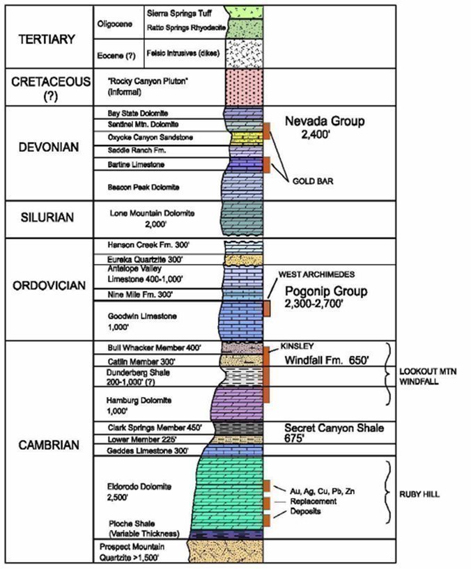
|
| 18 | Page |
Figure 6.2 Geology of the Eureka Property and South Eureka District
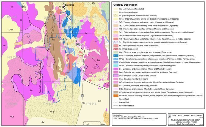
The Cambrian Hamburg formation is one of the principal hosts for gold mineralization at Lookout Mountain, as well as at the Windfall mine, north of Lookout Mountain. The Hamburg is dominantly comprised of limestone and dolostone that is sometimes difficult to distinguish from the Eldorado Dolomite. The unit is normally tan to light brown, quartz-silty, coarsely crystalline, saccharoidal, and porous. It was apparently easily dissolved by meteoric waters or hydrothermal solutions, which have formed evidence of karst features and collapse breccias. At Lookout Mountain, the Hamburg formation is dominantly limestone, but it is widely present as dolostone in the vicinity of Hamburg Ridge along Windfall Canyon. Dolomitization may be related to hydrothermal alteration. Thickness varies widely, possibly partly from its tendency toward dissolution. The combination of original and secondary porosity (from sanding and karsting) results in this formation being a good host for mineralization. Sanding, silicification, and recrystallization are all common in the Hamburg. The extensive jasperoid development along Ratto and Hamburg ridges is principally silicification of the Hamburg and overlying Dunderberg Shale.
The Cambrian Dunderberg Shale formation was considered by some to be the most economically significant unit at Ratto Canyon, according to Steininger et al. (1987). The Dunderberg consists predominantly of grey non-calcareous fissile shale with significant quantity (10 to 20%) of beds and boudins of highly fossiliferous limestones consisting of micrite and wackestone throughout the formation. A distinctive middle unit occurs locally and consists of 50 to100 feet of banded, tan, fossiliferous micrites and wackestones with thinner shale and calcareous shale partings. Nearer the Ratto Ridge structural zone, these limestones have been silicified and form thick jasperoid breccias. At Lookout Mountain, the formation has doubled in thickness, to about 600 feet, presumably resulting from thrust ramping.
|
| 19 | Page |
The Windfall Formation consists of two members: the upper Bullwhacker member and the lower Catlin member. Both are limestones that have significant sand and silt, with intertidal subaqueous wave features. The lower Catlin member, approximately 250 feet thick, has a conformable transitional contact with the underlying Dunderberg Shale over a thickness of about 30 feet, with micritic limes, black laminated chert, and shale giving way to a nearer-surface depositional environment. The lowermost limestones are locally very rich in black and dark brown silty cherts. The lower unit consists of sandy and quartz-silty, fossiliferous, platy wackestones, packstones and grainstones, with interbedded calcareous sands and siltstones. Shaly partings are abundant in the lower half of the section. These sediments are thin bedded and laminated, with calcareous sands often containing fecal matter that has been altered to brown and green fine-grained micas. Coarse whole and partial fossils, rip-ups, sole markings, and wavy beds are common. The upper Bullwhacker member, which is approximately 400 feet thick, has a gradual conformable transition from the Catlin that is largely obscure in drilling. Nolan (1956) describes it as thin bedded, highly fossiliferous micrite and wackestone with ¼- to 1-inch thick sandy interbeds and platy, shaly, or silty partings.
Gold is also known to occur at least locally within the Devonian section at Lookout Mountain. Drilling by Echo Bay identified thick sections of oxide mineralization (90 to 130 feet at grades of 0.020 to 0.047 oz Au/ton) in the Devonian Nevada group (Alta Gold Co., 1999) and the Ordovician Pogonip group at Rocky Canyon. Mapping by Barrick (Cope, 1992; Mako, 1993a) identified eight mappable Devonian and Silurian units within what Amselco had identified as the Devonian Nevada group west of Ratto Ridge. Timberline’s 2010 and 2011 mapping and drill-hole re-logging programs found sufficient issues with the identification of the different Devonian units mapped and logged by Barrick to indicate further study of the section is required. It is difficult to distinguish the Devonian section in the Eureka district, as many units are very similar in composition, texture, and paleoenvironment. Strong alteration, brecciation, and faulting along Ratto Ridge further serve to obscure lithologies and relationships. Timberline is still evaluating the Devonian stratigraphy on the west side of the Ratto Ridge fault zone.
Drilling by Timberline in the Rocky Canyon area encountered unusual stratigraphy in the Ordovician Pogonip group that requires additional work before relationships with published stratigraphy in the district and elsewhere can be determined. The Pogonip group contains three separate members. The lower Goodwin member is transitional from the subaqueous Bullwhacker to shallower seas and resulting higher-energy intertidal and subaerial environments. Limestones of the Goodwin member consist of quartz-silty grainstones, packstones, and fossiliferous wackestones with numerous fossil-hash beds, oncolites, and pisolites. Paleokarst sediments mark the base of the Goodwin in New York Canyon, eight miles north of Lookout Mountain. Cherts have formed in various portions of the Goodwin member and can be misleading marker horizons.
The Ordovician Goodwin member is overlain by 100 to 200 feet of laminated, silty, calcareous argillites that form a distinctive marker unit that is commonly sooty and rich in carbon and pyrite in the Rocky Canyon area. Overlying this distinctive unit is a zone of sheared dark grey to black calcareous silty argillites with soft-sediment deformation and strongly disarticulated boudins of 1-inch thick interbeds of light grey, micritic wackestone with a distinctive dark and light spotted pattern. Timberline staff has tentatively correlated this unit with the Ninemile formation.
|
| 20 | Page |
Above this unit are 200 to 300 feet of Antelope Valley fossiliferous quartz-silty wackestones and packstones with limy argillic partings. The top 50 to 75 feet of the Antelope Valley have been locally dolomitized in the Lookout Mountain area, possibly due to trapping of fluids below the overlying Eureka Quartzite. The uppermost Antelope Valley formation near the contact with the Eureka Quartzite appears to be transitional, with at least 5 to 10 feet of quartz-sandy dolomite grading upward to the lower dolomitic quartz sands of the lower Eureka Quartzite. Timberline staff believes the units encountered in the three core holes represent the Antelope Valley Limestone and the Ninemile formation.
The lowermost Eureka Quartzite can have up to 25 feet of dolomitic quartz sands above the Antelope Valley sandy dolomites. Above this lie 75 feet of pinkish, coarse quartz sands, with 10 to 15% non-calcareous shale and fine trilobite fragments. Overlying the sands is massive, sheared, and brecciated white quartzite with cobbles and clasts of quartzite that show typical rounded and well-sorted quartz grains with a thin white clay matrix.
There are breccias of multiple origins in the Lookout Mountain pit and the Staccato drill core (Morris, 2007). Most appear to be collapse breccias, but there are also tectonic and probably depositional breccias. These are collectively referred to as the Lookout Mountain breccia in this report.
The prospective setting for significant gold deposits, whereby shale overlies limestone, is common in numerous Carlin-type gold deposit settings, and this setting is particularly conducive to the development of dissolution-induced collapse-breccia-hosted, high-grade gold deposits. Examples include Meikle, Goldstrike, Deep Star, portions of Gold Quarry, Rain, and perhaps Cortez Hills. At Lookout Mountain, high-grade gold mineralization is present almost exclusively within reduced (sulfidic) breccia of possible collapse breccia origin. Low-grade mineralization, mostly oxide, is broadly distributed in the overlying limestone and shale of the Dunderberg formation and the underlying Hamburg formation. The low-grade mineralization tends to occur spatially within oxidized and silicified and/or oxidized and dolomitized breccia zones.
Staccato and Timberline generated a new geological interpretation of Ratto Ridge as shown in Figure 6.3. As had previous workers, they identified the Ratto Ridge fault zone, separating Devonian, and Cambrian rocks across Ratto Ridge, as the main control of alteration and mineralization along the ridge. West of the fault zone lies a gently north-dipping, relatively undisturbed sequence of Devonian dolomites, while on the east side of the fault are the Cambrian Windfall formation, Dunderberg Shale, and Hamburg formation. The trace of the Ratto Ridge fault zone is often indistinct due to alteration, colluvial cover, crosscutting faults, and jasperoid bodies. There are numerous intrusive bodies along the fault zone.
Based on drill-hole re-logging and conodont age determinations, the Cambrian section appears to have been thrust over the top of the Silurian Lone Mountain Dolomite and Eureka Quartzite. The Hamburg is present beneath both Lookout Mountain and South Lookout Mountain, occurring at the crest of an antiformal feature. This flat-lying pocket of Hamburg is present the length of Ratto Ridge, from Lookout Mountain to the south end of South Lookout Mountain. The limestone and dolostone show significant solution and collapse textures throughout, indicating either karst formation, dissolution during mineralization, or both have taken place. In addition, an internal thrust in the Cambrian section has removed most of the Hamburg formation from between the Secret Canyon and Dunderberg shales on the east flank of Lookout and South Lookout mountains and has created ramp structures which are important controls of mineralization.
According to Timberline’s interpretation, most gold mineralization is hosted in a solution or karst breccia (Lookout Mountain breccia) formed in the overthrusted remnants of Hamburg that lie in the footwall of ramp faults and at the apex of the antiformal feature sitting below the ridgeline of Ratto Ridge. Collapse-breccia sediment derived from the dissolution of multiple rock types, especially the Hamburg and other carbonates, and subsequent re-deposition of fine-grained sediment along fluid pathways is the primary host of low-grade mineralization (Edmondo, 2009). These collapse-breccia sediments are usually lithified but maintain high permeability and are easily altered and mineralized, often with 5 to 10% or more of sulfides. Drilling indicates there is very little mineralization in the Secret Canyon Shale, but the Dunderberg Shale hosts significant high-grade gold mineralization.
|
| 21 | Page |
6.4 Mineralization
The following information is taken from Russell (2007), Morris (2007), Steininger et al. (1987), Alta Gold Co. (1999), Mako (1993a), Edmondo (2010a), and Cargill (1988) with other references as cited.
At Lookout Mountain, and for 2.5 miles in a north-northwesterly direction along Ratto Ridge, disseminated sediment-hosted gold mineralization occurs within the Cambrian Dunderberg Shale and the Hamburg formation. The Ordovician Pogonip group outcrops immediately north and northeast of the Lookout Mountain resource (Figure 6.3) and is the host for the gold mineralization at the nearby Rocky Canyon prospect. This unit is also an important host at the Archimedes gold deposits, which lie seven miles north of Lookout Mountain. The stratigraphic section at Lookout Mountain is cut by the north-trending Ratto Ridge fault zone and by numerous other faults that may also control gold mineralization.
Alteration at the surface and in the subsurface is widespread, with decalcification and silicification being the most common types. This alteration is found for the entire length of Ratto Ridge and extends up to several thousand feet on either side of the main Ratto Ridge fault zone. Argillic alteration is also present, distinguished by the presence of abundant, multi-colored gumbo-like clays within the Dunderberg Shale. There appears to be a close spatial relationship between silicified zones and argillically altered zones (Hauntz, 1985). Dolomitization and formation of iron carbonates and iron-rich dolomite were identified in the Staccato drill holes but were not recognized in earlier drill programs. Sanding, in which calcareous matrix is removed, also occurs in dolomites in the area. Supergene oxidation is ubiquitous, but hypogene oxidation is only described at the Lookout Mountain deposit (Cargill, 1988). Formation of skarn is only known from the Newmont drill hole drilled on the Rocky Canyon magnetic anomaly (Cargill, 1988).
Mineralization has been discovered at the surface in jasperoid that caps Ratto Ridge downward to depths of up to 1,500 feet vertically below the highest surface exposure. Gold is associated with pyrite, realgar, orpiment, quartz, and clay (Alta Gold Co., 1999). Surface jasperoid bodies are associated with a trace-element geochemical signature consisting of arsenic, mercury, and antimony in both soil and rock chip samples. Multielement geochemical analyses on drill samples (Mathewson, 2006; Edmondo, 2008a) demonstrate that gold mineralization in the Lookout Mountain area is rich in arsenic, with high-grade zones being particularly arsenic-rich. The high-grade zones are generally unoxidized, sulfidic, and, in addition to arsenic, consistently anomalous in thallium, antimony, and mercury. High-grade gold mineralization typically consists of 0.1 to 0.4 oz Au/ton, occasionally up to multiple ounces of gold per ton, and contains thousands of ppm to percent range arsenic. Several tens to hundreds of ppm mercury, several tens of ppm antimony, and several tens to a few hundred ppm thallium are also typical. Base metals are often at background levels, and silver is generally near or below detection within these high-grade gold zones (Mathewson, 2006). Low-grade gold zones of 0.3 to 3 ppm contain anomalous arsenic in the upper hundreds of ppm to several thousand ppm, and are most commonly predominantly oxidized. Antimony, mercury, and thallium persist as highly anomalous in the lower grade gold intervals. Lead is present in the 100 ppm range, and zinc is common in the multiple hundreds to low thousands of ppm (Mathewson, 2006). Electron-microscope studies indicate that gold in the unoxidized zones is generally associated with quartz veinlets and arsenian pyrite. In the oxidized portions of the deposit, there appears to have been remobilization of the gold and re-deposition on iron-stained fractures (Steininger et al., 1987).
|
| 22 | Page |
Figure 6.3 Geologic Map of the Lookout Mountain Project Area (Mapping by Timberline, December 7, 2010)
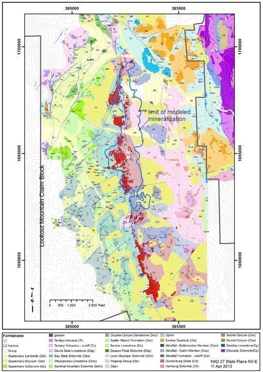
|
| 23 | Page |
Exploration groups have described the Lookout Mountain deposit in various ways, but all workers have described the mineralizing system as being strongly controlled by structures and favorable host rocks. Steininger et al. (1987), reporting on Amselco's discovery, described Lookout Mountain as a mineralized zone trending north-northwest and dipping 20 to 70 degrees to the north-northeast. Mineralization occurs in both jasperoid and in adjacent altered Dunderberg Shale, with the highest grades in altered shale adjacent to jasperoid. Gold occurs where the contact zone between the Dunderberg Shale and Hamburg formation occupy the hanging wall of the Ratto Ridge fault zone and where east- and northeast-trending faults provided ground preparation for mineralization. The thrust fault planes on Ratto Ridge probably formed a now-eroded cap to the system. Steininger reported a great variation in grade over short distances.
Asher (1986) described the mineralizing system as a structurally controlled jasperoid body with an easterly dip of 60 degrees, and with several low-angle zones controlled by bedding occurring as offshoots of the main structure. Cargill (1988) described the sulfide zone as consisting of disseminated arsenopyrite and arsenosiderite. Notably, most subsequent workers have not described arsenopyrite. The earlier workers may have been referring to arsenian pyrite, a term that has been popularized in Carlin-type geology research since the 1990s. The volume percent of sulfide material is reported to be a few tenths of a percent.
Alta (Alta Gold Co., 1999) reported that gold mineralization in drill holes occurs in two forms: in jasperoid and silicified zones within the Dunderberg Shale and Hamburg formation, and in nearly flat-lying, strongly oxidized zones in the Devonian Nevada group. In the Dunderberg Shale, mineralization occurs in steeply dipping stratabound lenses, extending outward from a well-defined jasperoid feeder system. Drilling was not sufficient to determine the true nature of mineralization in the Devonian section.
Barrick distinguished five styles of gold mineralization (Mako, 1993a):
| · | Low-grade gold disseminated in silicified Dunderberg Shale with locally higher grades in and near faults; |
|
|
|
| · | High-grade gold in carbonaceous Dunderberg Shale that appears to be stratabound, including the sulfide zone beneath the Lookout Mountain pit; |
|
|
|
| · | Gold-bearing jasperoid in the Hamburg formation; |
|
|
|
| · | High-grade gold mineralization in thin, fault-controlled zones; and |
|
|
|
| · | Gold mineralization in silicified Bartine Limestone. |
What is now believed to be the main control on mineralization at Lookout Mountain was not recognized until 2006. Mathewson (2006) recognized that extensive zones of hydrothermal-related dissolution and associated brecciation, dolomitization, sideritization, and ankeritization caused cavitation and collapse. This collapse propagated in an upward stoping process that did not stop until well into the overlying shale unit, creating large, almost flat-lying breccia bodies. This ‘ground preparation’ became highly conducive to the introduction of subsequent solutions, including the gold-bearing solutions.
Timberline's results indicate that karst and/or solution/collapse breccia within the Hamburg, at or beneath its upper contact zone with the Dunderberg Shale, is an important control on mineralization at Lookout Mountain along the entire length of Ratto Ridge and elsewhere on the Eureka property, such as at the Windfall and Rustler pits (Edmondo, 2010b). Collapse breccia zones are characterized by a matrix of fine dolomite grains, silt, sand, and small grains of various rock types cementing clasts of jasperoid, dolomite, limestone, and shale. Rare depositional textures, such as bedding, graded beds, and cross bedding, indicate fluvial deposition for the fine silt and sandy fractions.
|
| 24 | Page |
Large structural zones are important for the development of these zones, with cross structures and lesser parallel structures to the main fault zones acting as important modifiers to the overall morphology. As discussed above, strong solution brecciation at Lookout Mountain has formed along a north-trending, 60° east-dipping structural zone that lies just east of the main fault separating Devonian from Cambrian stratigraphy at Lookout Mountain and Ratto Ridge. This fault forms the contact between the Dunderberg Shale and remnants of the Hamburg formation in the apex of an antiformal feature beneath Ratto Ridge, and has been interpreted as a ramp fault in the hanging wall of a basal thrust. The entire Hamburg section at Lookout Mountain displays strong karstic- and collapse-breccia textures. This section of Hamburg and the overlying Dunderberg Shale host most of the mineralization at Lookout Mountain, and the combined solution/karst/collapse/structural breccia unit is referred to herein as the Lookout Mountain breccia.
Strong silicification and gold mineralization are present within the Lookout Mountain breccia, occurring along structures and the contact between the collapse breccia and the Dunderberg Shale. The breccia is characterized by oxidized low- to moderate-grade gold mineralization, although unoxidized and mixed oxide-sulfide areas occur, especially at depth.
Strongly altered and mineralized northeast- and east-northeast-trending faults with moderate offset cut faults related to the main Ratto Ridge structural zone, with west-northwest-trending faults in the Lookout Mountain area potentially localizing higher-grade mineralization (>= 0.10 opt Au). These high grade-zones are typically irregularly shaped discontinuous pods that occur at and near the contact between the Dunderberg Shale and the Hamburg formation. There are three such high-grade zones presently identified by drilling: one at the surface at the Lookout Mountain pit, another about 200 feet in depth, and a third between 300 and 400 feet in depth. The highest-grade zones are typically hosted within unoxidized to partially oxidized stratabound breccia bodies enclosed in limestones within the lower Dunderberg Shale (such relationships are evident in the Windfall and Rustler pits as well (Edmondo, 2010a)).
Other breccia bodies are also present in the overlying Dunderberg Shale but are not oxidized and are mineralized with varying amounts of sulfides. These breccias also have a collapse-style character and contain locally abundant dolomite, siderite, or ankerite stringers. Potassium ferricyanide/Alizarin red staining of carbonates was routinely utilized to macroscopically determine the various carbonate species encountered in drilling (Mathewson, 2006). Within the dolomite, siderite, ankerite, and silica-mix breccias, tens of percent to massive amounts of brassy and sooty sulfides are locally present for up to tens of feet of thickness. The sulfide zones in the breccias, although they look impressive, tend to be only weakly to moderately mineralized with gold, typically from about 1 to 2 ppm (Mathewson, 2006).
The mineralization modeled by RESPEC at the Lookout Mountain deposit (see Section 11) forms a continuous body with a northerly strike length of about 6,900 feet, a maximum width of 1,650 feet (based on the surface projection of down-dip extents), and a vertical extent of 1,400 feet.
6.4.1 Lookout Mountain Deposit Paragenesis
The following is a summary of the paragenesis of the hydrothermal system and related mineralization taken from Mathewson (2006):
|
| 25 | Page |
| · | Onset of the hydrothermal event with dissolution by probable hydrothermal acidic solutions along multiple channel-ways developed within the upper Geddes Limestone. The overlying shale acted, at least in part, as an aquiclude to the essentially ascending probable sulfur-bearing hot solutions. These same solutions may also have been responsible for the transporting of magnesium and iron derived from the underlying units. |
|
|
|
| · | Simultaneous, or certainly near simultaneous, dolomitization, sideritization and ankeritization of limestone occurred. The dolomitization process caused volume loss that further increased permeability and permitted and enhanced additional carbonate dissolution. The limestone unit cavitated and collapsed under overlying lithostatic pressures. The collapsing process stoped well upward into the overlying shale and limestone. The large volumes of open space in the breccias provided permeability and porosity for simultaneous to subsequent mineralization. |
|
|
|
| · | Silicification of large portions of the breccia occurred with perhaps more simultaneous and/or episodic dissolution. |
|
|
|
| · | Extensive sideritization (iron transformation of carbonate) and sulfidation by both sooty and brassy pyrite with perhaps slightly later introduction of pathfinder elements, including arsenic, followed. |
|
|
|
| · | Gold-bearing solutions were introduced into and deposited within the breccias. High-grade gold zones developed in the zones of high concentrations of arsenical sooty-sulfides. |
|
|
|
| · | Multiple pulses of mineralization occurred. Many of the breccias exhibit a multi- stage character suggestive of zones of repeated collapse and related development of new breccias. This likely provided for overlapped and enhanced zones of mineralization. |
|
|
|
| · | The system may have undergone late-stage hypogene oxidation by introduction of oxygenated ground waters during the waning, cooling periods of the hydrothermal system. Oxygenating solutions penetrated throughout and very deep into the permeable portions of the system driven by the pressure gradients created by heat flow. Strong oxide to local massive gossanous material, comprised largely of hematite, including specularite, is present in the deepest portions of the system penetrated by core to date. |
|
|
|
| · | Local and limited extent, post-mineral supergene oxidation occurred as indicated by the presence of dominantly goethite in the shallow portions of the deposits. This oxidation probably occurred during the time of recent uplift commensurate with associated weathering processes. |
6.4.2 South Adit
The initial discovery of gold mineralization by Amselco in the Ratto Canyon area was at South Adit, where gold occurs in the same geological setting as the other occurrences along Ratto Ridge, i.e., at the Dunderberg-Hamburg contact associated with strong silicification/argillization and steeply dipping normal faults. The mineralized zone trends north and, like Triple Junction to the north, lies east of the crest of Ratto Ridge. At the top of the ridge above South Adit mineralization, a northwest-trending splay of the main north-trending structure appears. Mapping and drill-section interpretation suggest that a strong north-trending cross structure intersects the northwest-trending structure in this area (Edmondo, 2010c). Large jasperoid bodies lie just above the South Adit mineralized zone with a strong east-northeast fault control (Edmondo, 2009).
|
| 26 | Page |
The first hole drilled on the property (RTR-1) hit mineralization in the South Adit area, but four later holes drilled around it were barren or encountered only very weak mineralization (Jonson, 1991). Better grades were later found farther to the north.
The mineralization modeled by RESPEC at the South Adit deposit has a north-south extent of almost 2,000 feet, a maximum width of about 700 feet (based on the surface projection of down-dip extents), and a vertical extent of 800 feet.
6.4.3 Other Gold Occurrences in Ratto Canyon and Vicinity
Surface gold anomalies, geology, and alteration features in the Devonian Nevada Group define multiple exploration targets on the property (Alta Gold Co., 1999). The following information on targets in the Nevada Group and other units is taken from Steininger et al. (1987) and Jonson (1991) (Figure 6.4).
North Lookout Mountain to Rocky Canyon
A mineralized zone containing over 0.01 oz Au/ton based on very widely spaced drill holes extends from the north end of the Lookout Mountain deposit to at least hole RCR-3 in Rocky Canyon. Scattered silicified/argillized/sanded outcrops mark this north-trending zone, which appears to be at least 600 feet wide just north of the Lookout Mountain deposit and perhaps 1,400 feet wide near RCR-3. The Haul Road anomaly lies in this zone and is about 3,500 feet northeast of the peak of Lookout Mountain; an outcrop of silty shale lies directly below massive Eureka quartzite and contains an 80-foot section averaging 0.03 oz Au/ton in rock chip samples (Jonson, 1991).
The Rocky Canyon area is underlain by a large magnetic anomaly believed to be caused by a Cretaceous intrusion. Newmont drilled a deep core hole in a search for molybdenum and intersected skarn and a granitic intrusion (Cargill, 1988). Hole 609 was drilled to a depth of 1,525 feet and intersected 50 feet averaging 0.023 oz Au/ton from 450 to 500 feet in a silicified, pyritized fault zone (Jonson, 1991). That hole also intersected metasomatic alteration associated with granitic dikes containing magnetite, quartz, sericite, pyrite, molybdenite, fluorite, and calcite mineralization (Mako, 1993a).
Echo Bay drilled 75 holes in five targets in this area. Of these holes, 42 were drilled into the South Pogonip Anomaly, where 16 holes encountered “significant” gold mineralization (Alta Gold Co., 1999). Hole EBR-58-96 intersected 40 feet of 0.101 oz Au/ton, and EBR-77-97 intersected 45 feet of 0.131 oz Au/ton; it is not known whether the intersected lengths represent true widths.
South Lookout Mountain
At the South Lookout Mountain prospect, first identified as a target in 1983, a thrust fault appears to separate silicified Devonian Nevada group and/or Ordovician Eureka Quartzite in the upper plate from Dunderberg Shale and possible Hamburg formation in the lower plate. The thrust fault is apparently cut by the Ratto Ridge fault, but jasperoid obscures the definition of structural relationships and lithologic contacts. Limited drilling by Amselco identified moderate gold-rich zones in jasperoid, presumably at and below the thrust contact. This target area is 2,500 feet long.
|
| 27 | Page |
South Ratto Ridge
South Ratto Ridge has a structural setting like that of South Lookout Mountain, except that the Eureka Quartzite is absent at South Ratto Ridge. Gold mineralization is present and is stronger near the thrust contact in the jasperoids and sanded dolomites of the upper plate Devonian Nevada group.
Pinnacle Peak
This area is about 1,000 feet south of the South Lookout Mountain area. It consists of three separate gold anomalies along a 1,500-foot strike length. Amselco drilled 20 RC holes in the general area, of which the six closest to the geochemical anomaly had intersections with assays of 0.03 oz Au/ton or better.
Triple Junction
Gold mineralization at Triple Junction is found at the contact of the Hamburg formation and the Dunderberg Shale, associated with steeply dipping normal faults in the crest of a south-plunging anticline. Triple Junction was first identified as a target by Amselco rock geochemical sampling in 1983 and lies east of the north-trending Ratto Ridge in an area of sparse outcrop. Amselco drilled eight RC holes in the area, with intercepts of 0.04 to 0.085 oz Au/ton in three of them.
Water Well Zone
The Water Well Zone (WWZ) is located down-dip to the east and outside of the gold resource in the Lookout Mountain area and was discovered by Timberline in 2015. It was more extensively drilled in 2021-2022. The zone is currently defined as an area of approximately 1,500 feet north to south and 200-300 feet east to west and is marked by multiple high grade gold (>3 g/t (0.09 oz/ton) and up to 25 g/t (0.7 oz/ton)) drill intercepts. Vertical depths to the top of the WWZ mineralization range from approximately 500 feet to 1,200 feet. Gold is strongly associated with variably silicified (claystone to jasperoid) breccia with abundant arsenic and thallium typically at or near the base of the Dunderberg formation. The underlying Hamburg formation is typically oxidized, variably brecciated and at least weakly gold anomalous. Sooty pyrite ± carbon are also common. Timberline continues to explore the WWZ, and it remains open to downdip to the east and southward.
Oswego Mine
The Oswego Mine occurs in a fault zone separating the Eldorado Dolomite from the Secret Canyon Shale approximately 4,000 feet east of Lookout Mountain. Substantial oxide gold mineralization (historical sampling (Muto, 1988) of 0.35 oz Au/ton along 260 feet of strike) occurs at the surface along the fault zone. Timberline collected two channel samples along the fault zone in 2021 and reported 85.0 ft of 0.42 oz Au/ton and 89.9 ft of 0.35 oz Au/ton (see Timberline press release dated December 6, 2021). Drilling in 2021-2022 encountered widely variable grades and thicknesses, demonstrating that the gold at Oswego is strongly structurally controlled. Insufficient drilling has been completed to assess the down-dip potential in this area.
|
| 28 | Page |
Figure 6.4 Exploration Targets
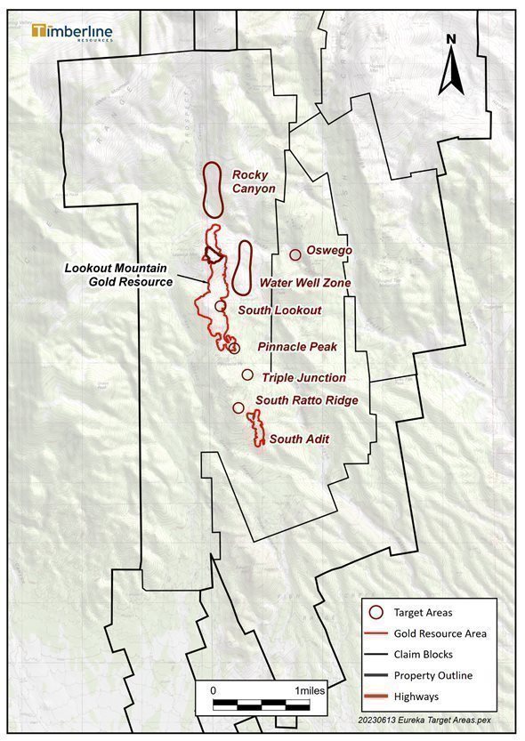
|
| 29 | Page |
6.5 Deposit Type
The following information is taken from Russell (2007) with additional information as cited.
The Eureka district lies at the southernmost end of the Battle Mountain-Eureka trend of gold and base-metal deposits. Russell (2007) proposed that base-metal replacement mineralization in the area was deposited in Paleozoic and Mesozoic calcareous rocks during Mesozoic time, while gold was deposited during the Tertiary. Homestake geologists later confirmed this relationship at Archimedes (Ruby Hill Mine).
Similarly and more recently, most workers believe that gold in the South Eureka district occurs as Carlin-type, disseminated, sediment-hosted mineralization. Gold in these deposits is typically hosted by carbonaceous silty limestones and calcareous siltstones, but locally significant deposits occur in dolomite, shale, and quartzite.
The characteristic alteration of these deposits includes decalcification, argillization, and intense silicification, which often forms jasperoid. Gold is invariably accompanied by more or less silver and a halo of pathfinder elements that commonly include arsenic, thallium, mercury, antimony, and barium (Mako, 1993a). Trace amounts of base metals are locally present in the gold systems, including lead, zinc, and copper. Typical minerals accompanying gold include pyrite, arsenopyrite, stibnite, realgar, orpiment, and their oxidation products. The gold mineralization was deposited in favorable Cambrian, Ordovician, and Devonian calcareous sedimentary units where they are intersected by major northwest-, northeast-, and north-trending faults and fractures that are commonly also mineralized.
i80 Gold Corp’s Ruby Hill Mine is located about 4.5 miles north of Timberline’s Eureka property. The West Archimedes deposit at Ruby Hill (formerly mined by Homestake and Barrick) is an example of the target for near-surface Carlin-type exploration in the district. As of December 31, 2012, Archimedes had remaining proven and probable reserves of 326,000 ounces of gold and additional measured plus indicated resources of 3,463,000 contained ounces, as well as an inferred resource of 220,000 contained ounces of gold (Barrick Gold Corporation annual report 2012). West Archimedes is a sediment-hosted gold deposit in the form of a tabular body approximately 2,560 feet long and 260 feet wide that is hosted by the silicified, often decalcified, upper Goodwin Formation. Mineralization is controlled by a major north-striking fault and by the intersections of west-northwest- and north-northeast-striking faults. The mineralization is also lithologically controlled, with a higher-grade central core of jasperoid grading about 0.25 oz Au/ton within an outer zone of decalcified limestone grading about 0.024 oz Au/ton. Trace element geochemistry around Archimedes shows anomalous arsenic, mercury, and antimony, as is typical of this type of sediment-hosted gold deposits. The Lookout Mountain project has similar stratigraphy to Archimedes, specifically the presence of the Goodwin Formation, and has the same geochemical signature in and near known mineralization.
There are additional examples of Carlin-type gold deposits approximately 3.3 miles northeast of the Lookout Mountain deposit on Timberline’s Eureka property at Windfall Canyon. The Windfall Mine, originally mined in 1904 with sporadic production until 1951, was rediscovered by Idaho Mining Corp. (“Idaho Mining”) in 1967. Underground production prior to 1967 totaled about 65,000 tons grading 0.368 oz Au/ton, with the ore having been processed in a vat-leaching operation on site. The mine was reopened by Idaho Mining in 1975 and continued through at least 1984, producing 1,458,274 tons of ore and recovering 31,077 ounces of gold. Run-of-mine ore was leached without crushing or agglomerating and with 80% recovery (Cargill, 1988). According to Pratt (2004), a total of 90,000 ounces of gold was produced from the Windfall deposit. The Rustler deposit, an extension of the Windfall deposit located about 0.5 mile to the south was then put into production, producing 50,000 ounces (Pratt, 2004). Production of an additional 30,000 ounces of gold also came from the North Paroni and South Paroni pits.
|
| 30 | Page |
Mineralization in the Windfall deposits is primarily hosted by the uppermost part of the Middle and Late Cambrian Hamburg formation, which in the vicinity of the deposit has been altered to sanded dolomite. This is essentially the same stratigraphy as hosts the mineralization at Lookout Mountain. The Windfall deposits are low grade, tabular, and have indistinct assay walls; they occur predominantly adjacent to the contact of the Hamburg with the Dunderberg Shale or a Tertiary rhyodacite dike. Gold is accompanied by strongly anomalous antimony, arsenic, barium, mercury, and silver, but base metals are notably absent. During the 1970s, the Windfall ores were treated by heap leaching of run-of-mine ore without crushing, and recoveries were greater than 80% (W. L. Wilson, 1986). The Rustler deposit also occurs in the Hamburg formation near the contact with both the Dunderberg Shale and the rhyodacite intrusion. Much of the Rustler mineralization occurred in zones that were thoroughly silicified, some of which were also brecciated (W. B. Wilson, 1986).
|
| 31 | Page |
7 EXPLORATION
7.1 Introduction
Timberline acquired the Lookout Mountain project in June 2010 through acquisition of Staccato. Upon acquisition of the property, the Company carried out core and RC drilling (see Section 7.2.3 for details), detailed geologic mapping, channel sampling, bulk sampling within the historical Lookout Mountain pit for bench-scale metallurgical testing, and metallurgical testing on core samples to define the heap-leach characteristics and process parameters (Section 10.0).
Timberline geologists completed geologic mapping and collection of over 370 rock samples to further define additional exploration targets. The company also completed geophysical and geochemical exploration as described below.
7.2 Non-drilling Exploration
7.2.1 Geophysical Exploration
Timberline supplemented historical magnetic, radiometric, and VLF-EM data with new surveys between 2010 and 2013. The magnetic data identified three significant anomalous areas: (1) a circular positive anomaly in the Rocky Canyon area; (2) a series of magnetic highs between the Lookout Mountain pit and Surprise Peak that extends approximately one mile south along Ratto Canyon; and (3) a linear zone in the drainage west of Grays Canyon in the southwest part of the property. A follow-up induced polarization/resistivity (IP) survey along three lines in the Lookout Mountain pit area revealed a weak chargeability anomaly thought to be related to sulfide mineralization associated with gold below the pit. Timberline also complemented historical surveys with follow-up ground magnetic surveys, which supported geologic mapping and recognition of areas underlain by Paleozoic rocks and suggested the presence of concealed intrusions. Many of the magnetic anomalies appeared to be associated with outcrops of Tertiary volcanic tuff, but the resource area at Lookout Mountain is closely associated with a prominent NW-SE magnetic anomaly and the distribution of jasperoid.
A single line of historic controlled source audio magneto-telluric (CSAMT) data was collected in 1994 by Quantec Ltd., crossing the Lookout Mountain historical open-pit. The CSAMT section identifies structures and a high-resistivity feature spatially associated with jasperoid along the west boundary of an area of low resistivity interpreted to be a graben. The graben’s west boundary is extensively drilled and hosts the existing low-grade north-south trending gold resource at Lookout Mountain. The east boundary of the graben structure remains undrilled.
Follow-up ground surveys in 2020 and 2021 included property-wide gravity, dipole-dipole IP, and additional CSAMT coverage (Figure 7.1). A colored image of the gravity data suggests the presence of multiple structures and zones of alteration consistent with the architecture of a Carlin-Type gold district.
During the 2020 and 2021 field season, contractors completed IP over approximately 9.7 line miles at Lookout Mountain (Figure 7.1) and 11.8 line miles of CSAMT. The IP survey data define a strong chargeability anomaly immediately east of the Lookout Mountain gold resource that spans at least two kilometers in a north-south direction. The associated resistivity data along with CSAMT confirms that the anomaly correlates with and aids in the interpretation of stratigraphy and structure including that associated with known gold mineralization in the Lookout Mountain gold resource.
|
| 32 | Page |
Figure 7.1 Project IP Survey and Anomalies over Gravity Vertical Derivative Base Map
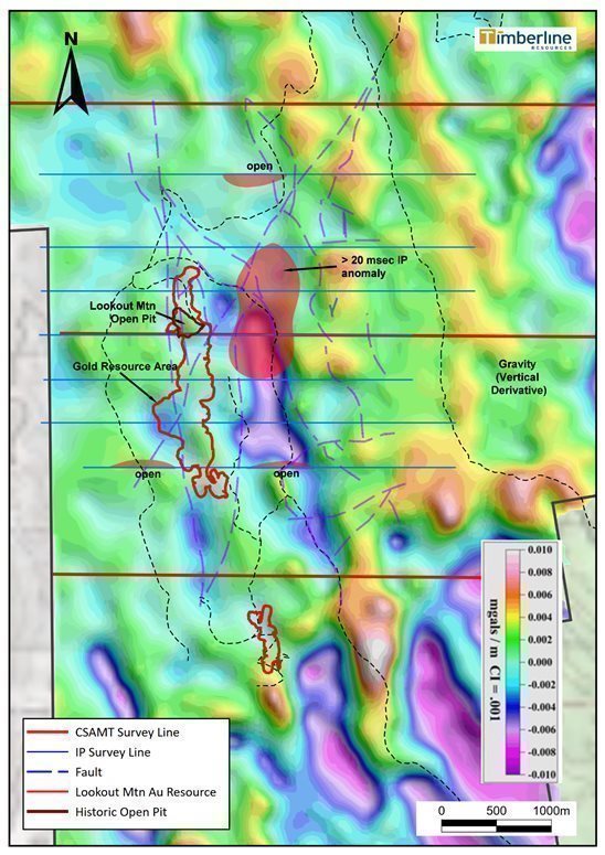
|
| 33 | Page |
7.2.2 Geochemical Exploration
A total of 206 surface rock grab samples were collected during field programs in the Lookout Mountain area (Figure 7.2) since 2013. Most of the samples were collected within and near the Lookout Mountain open pit. Seventy pit wall samples were analyzed to characterize gold content in various rocks including variably oxidized and brecciated shale, sanded dolomite, and jasperoid. Gold content ranged from <0.1 g/t to 1.725 g/t in pit-wall sampling, and up to 24.7 g/t in shall on the floor of the open pit, documenting that gold mineralization remains exposed in the pit.
Timberline geologists also conducted sampling within the resource area and just beyond it in the South Lookout Mountain and South Adit areas. There has been additional sampling beyond the resource area to the north and northeast of Lookout Mountain and along the haul road where road-cuts and adjacent outcrops expose Ordovician strata. Gold content in these samples range widely from <5 ppb to over 5 g/t, demonstrating potential for discovery of additional gold outside the existing resource.
Qualified personnel from Timberline were directly involved or had oversight of the sampling programs. The samples were transported to Timberline’s secure Eureka facility, where the samples were further described and/or photographed before being delivered to ALS USA Inc. (ALS) in Elko, Nevada for sample preparation. The Nevada ALS laboratories are accredited to ISO/IEC 17025:2017 for specific analytical procedures. The rock samples were assayed by ALS for gold by fire assay of a 30-gram charge with an AA or ICP-ES finish (ALS code Au-AA23). The overlimits for gold samples assaying above 10 g/t were determined by a 30-gram fire assay with gravimetric finish. Silver and other trace elements (up to 33 elements), when analyzed, were determined by four-acid digestion and ICP-ES finish (code ME-ICP61). Timberline’s standard methodology includes the insertion of analytical control samples before laboratory submission. Satisfactory results were achieved for all quality control samples related to the data reported herein.
7.2.3 Reverse Circulation and Diamond Drill-core Drilling
Historical drilling at Lookout Mountain was primarily conducted using reverse-circulation (RC) drilling systems with a down-hole hammer, although some of the early drilling was done by diamond core and conventional rotary with a down-hole hammer. Specific problems with drilling were discussed only in one unidentified report on the South Lookout Mountain area, where two of five drill holes were not completed because of lost circulation (Russell, 2007). Brecciated and vuggy rock is common on the Lookout Mountain claim group. Table 7.1 details the vintage and type of drilling in the database used for the mineral resource.
The majority of drill holes have vertical or subvertical orientations, which crosses the predominant mineralized zones at relatively high angles. A significant number of angle holes were also completed, which are approximately perpendicular to the mineralization. In either case, the drill data provided by the holes were appropriate for the modeling of the mineral resources.
RC drilling was completed with industry standard drill rigs utilizing hammer bits and dual tube drill rods, through which drill cuttings were directed from the bit under air pressure into a cyclone recovery system capable of capturing a representative sample of approximately 14 pounds from each 5-foot interval. At depth, particularly if groundwater was encountered, the hammer may have been changed to a tri-cone bit to allow continued penetration towards target depth.
|
| 34 | Page |
Figure 7.2 Surface Rock Samples in Lookout Mountain Project Area.

|
| 35 | Page |
Table 7.1 Lookout Mountain Project Drilling Database Summary
Company | Period | Hole Sequence | Core | RC or Rotary | Total | |||
No. | Feet | No. | Feet | No. | Feet | |||
Newmont | 1960s | NMT-609C | 1 | 1,537 |
|
| 1 | 1,537 |
Amselco | 1978-1979 1982-1985 | RCR-, RTC-, RTR- | 2 | 1,086 | 307 | 104,375 | 309 | 105,461 |
Norse Windfall Mines | 1986 | LM- |
|
| 20 | 3,885 | 20 | 3,885 |
EFL | 1990 | EFL- |
|
| 9 | 3,033 | 9 | 3,033 |
Barrick | 1992-1993 | BR- |
|
| 40 | 33,282 | 40 | 33,282 |
Echo Bay | 1994-1997 | EBR- | 3 | 671 | 102 | 70,769 | 105 | 71,440 |
Staccato | 2005-2008 | BH-, BHSE- | 30 | 32,266 | 20 | 16,565 | 50 | 48,831 |
Timberline | 2010-2011 | BHSE-, BHMW- | 9 | 5,827 | 93 | 57,510 | 102 | 63,337 |
Timberline | 2012 | BHSE- | 17 | 9,206 | 31 | 16,995 | 48 | 26,201 |
Timberline** | 2014-2015 | BHSE- | 2 (as RC pre-collars) | 2,270 | 3 | 3,625 | 5 | 5,895 |
Timberline** | 2020-2022 | BHSE- | 28 (includes 14 as RC pre-collars) | 30,481 | 37 | 25,360 | 65 | 55,841 |
TOTAL | 92 | 83,344 | 662 | 335,399 | 754 | 418,743 | ||
** - Drilling by Timberline in 2014-2015 and 2020-2022 was focused on exploration drilling outside the Lookout Mountain Resource. Nevertheless, all these data are included in the project drilling database.
For RC drillholes, representative rock chip samples for logging were collected on 5-foot intervals in industry standard chip trays. Upon completion of drilling in each hole, or a subsection thereof, the chip samples were systematically logged for lithology, alteration, visible mineralization, and structures as possible. Data was recorded in spreadsheets or by direct input into a drilling database. Sample depths and intervals were systematically checked against drill contractor records for consistency in depth.
Core was drilled primarily as PQ (3.3-in diameter) near surface, and HQ (2.5-in diameter) sized to final depth in most cases. The core was systematically collected in 10-foot core boxes which were laid out daily in the Company’s logging facility in sequence as drilling progressed. Box numbers, drill depths and intervals, as noted on wooden blocks inserted by drillers, were checked for sequential and interval correctness. Each box of core was washed and photographed prior to logging and sampling. Core recovery percentage, rock quality designation (RQD) data, lithologic, alteration, mineralization, and structural data were recorded and compiled in spreadsheets or directly in the project drillhole database.
|
| 36 | Page |
Upon completion of logging, core was then cut in half using a 14-inch ceramic saw at the company’s facility. One half of the core was placed in a marked bag for sampling, and the other half placed back in the appropriate position in the core box for reference. Samples were then picked up by laboratory personnel and delivered to the lab.
Additional information on sampling of RC drill cuttings and core is provided in Section 8.
Timberline and RESPEC are unaware of any sampling or recovery factors that may materially impact the mineral resources discussed in Section 11.0.
The predominant sample length for the drill intervals used directly in the resource estimation is 5 feet, with 10-foot intervals used in some holes and intervals less than 5 feet common in some of the core holes. These intervals are significantly less than the thickness of the bulk-tonnage style of mineralization at Lookout Mountain. Timberline and RESPEC believes that the drill-sampling procedures provided samples that are sufficiently representative and of sufficient quality for use in the resource estimations discussed in Section 11.0.
7.2.4 Collar Surveys, Down-Hole Surveys, and Project Coordinates
Figure 7.3 shows all drillhole locations in the resource area relative to topography and the claim block outline. All Staccato drill collars during the period 2005 - 2007 were surveyed by Carlin Trend Mining Services of Elko, Nevada using high-resolution GPS equipment. Down-hole surveys were performed on regular intervals for most of the Staccato core holes, including vertical holes. Most holes were surveyed within the first 100 feet, again at 500 feet, and then at or near the bottom of the hole (~1,000 feet). All holes showed a plunge deviation of less than three degrees, except angle hole BH-06-16, which steepened from a 45-degree plunge at the collar to 52 degrees at the bottom of the hole.
The Staccato 2008 and Timberline 2010 - 2012 drill-hole collar locations were surveyed by company geologists utilizing a Trimble AG132 sub-meter GPS system. The AG 132 unit utilizes Omnistar space-based differential correction services to achieve sub-meter (<1m) accuracy in the x and y directions. All drill-hole surveys were collected into handheld data collectors utilizing ArcPad software. Collection times for each point utilized 60-second averaging on spatial coordinate readings collected every second. Due to the inherent inaccuracy in elevation data for non-survey grade GPS units, elevation values from the GPS were not used in the project database. Timberline flew an aerial survey in July 2010 that enabled an engineering accuracy of +5 feet on scribed topography. Drill-hole elevations were generated using the digital terrain model (DTM) data from the aerial survey. RESPEC ‘pressed’ the Staccato and Timberline drill holes to this topography, essentially assigning the “z” value of these holes in the project database on the basis of the digital topography.
Staccato staff initiated a program in 2008 to re-survey existing historical drill holes after finding a Barrick document, and then speaking with a Barrick geologist, that discussed errors in the detailed topographic base generated by Echo Bay Exploration. The errors were found when comparing the Echo Bay topographic base to the Pinto Summit and Spring Valley Summit 7.5' USGS topographic maps.
|
| 37 | Page |
Three different surveying methods were used to survey the historical holes. In 2009, historical holes were surveyed using the Trimble AG132 GPS with Omnistar differential correction, as described above. Prior to this, either a Trimble AG132 GPS with U.S. Coast Guard beacon differential correction, which provides variable accuracies depending on which beacon is captured by the unit, or handheld GPS units with approximately +5-meter accuracy were used (Edmondo, personal communication, 2011). A total of 30 Amselco, one Barrick, and two Echo Bay holes were found and surveyed using the Trimble unit with Omnistar differential correction, while 16 Amselco, six Barrick, and one Echo Bay hole were surveyed using the US Coast Guard beacon differential corrections. Handheld GPS units were used for four Amselco holes and one hole each for Echo Bay and EFL. Reclamation of drill access roads and drill sites precluded the surveying of the remainder of the historical holes.
The 2009 sub-meter GPS survey data from historical drill holes and survey points were compared to original coordinates reported in Amselco documents, and these data, in combination with the detailed topography, were used to determine translation/rotation parameters for correcting the discrepancies in the historic coordinates. The resultant first-order polynomial equation was used to transform the unsurveyed historical data into Nevada State Plane East, NAD27 coordinates that are used in the current project database.
International Directional Surveys (“IDS”), with an office in Elko, Nevada completed all down-hole surveys for the Staccato 2008 and Timberline 2010-2012 and 2020-2022 drill programs. IDS utilized a surface recording gyro, which required an initial setup to establish true north for the gyro. A technician shoots an azimuth from a point on the surface to the gyro and then utilizes that direction in a computer program to calculate the azimuth. The survey tool has a built-in inclinometer to determine dip angle. All data are recorded digitally to a computer, processed, and presented to the client on site. There are no down-hole surveys for the following holes due to caving, loss of the hole, or stuck pipe: BHSE-127, -129, -129A, -136, and -160C.
7.3 Hydrologic Characterization
Between 2011 and 2013, Schlumberger Water Services (SWS) completed preliminary surface and groundwater characterization studies to support permitting of a proposed mining operation at Lookout Mountain. The Lookout Mountain project site is located within the northern portion of the Little Smoky Valley Hydrographic Basin, Northern Part (Basin 155A) where surface water drains from the project area southward into the northern part of Fish Creek Valley.
The SWS surface water survey identified actively flowing springs and seeps, and initiated monitoring physical parameters of them for NDEP Profile I parameters. Eleven sites were accessed and sampled by SWS, including two immediately east of the gold resource area (Figure 7.4).
Spring water samples were collected in laboratory-supplied bottles, stored on ice, and transferred to WETLAB in Reno, Nevada under chain of custody protocol. The samples were analyzed for NDEP Profile I parameters and are generally classified as calcium-magnesium bicarbonate type waters with slightly high pH and concentrations of Profile I constituents below Nevada Reference Values (NRVs) in Murry and Secret Canyon Springs. Sierra and Ratto Springs, located within the immediate project boundary, produced water that exceeded MCLs for aluminum and arsenic, and arsenic, respectively. Quarterly monitoring of the springs continued in 2012 and 2013 and further documents the surface water quality baseline.
|
| 38 | Page |
Figure 7.3 Lookout Mountain Project Drillhole Locations
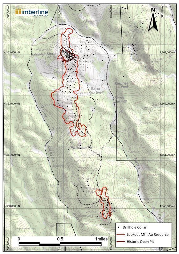
|
| 39 | Page |
SWS also initiated groundwater studies in the project area in 2012 with completion of eight RC groundwater pilot test holes, four of which were dry. The four successful holes were completed as monitoring wells located north, east, and southeast of the gold resource area (see Figure 7.5). The wells were completed with 4-in diameter steel blank casing and mill-slotted screen with silica sand gravel packs, developed and air-lift tested, and equipped with industry standard Geokon electronic data logger pressure transducers. In addition to completion of four monitoring wells, an RC drillhole located within the central portion of the gold resource area was completed for measurement of groundwater levels with a vibrating wire piezometer within a back-filled cement bentonite mix.
The monitoring wells were installed to depths of approximately 500 ft to 900 ft with static water levels of 54 to 326 feet below ground surface level at approximate elevations of 7,139 to 7,473 feet (Figure 7.5). Water quality samples were collected in each monitoring well after construction and well development and quarterly thereafter for one (1) year in one well that had a dedicated bladder pump installed. Water samples were collected, stored, and analyzed at WETLAB under the same protocols as surface samples. The groundwater quality is characterized as a calcium-sodium bicarbonate type with neutral to slightly high pH and concentrations of Profile I constituents below Nevada Reference Values (NRVs) in all wells except BHMW-001. The groundwater quality from well BHMW-001 periodically exceeded NRVs for aluminum, arsenic, iron, and manganese, and the pH also exceeded the NRV for the first sampling event.
7.4 Geotechnical Data, Testing and Analysis
In 2013, Golder Associates (Golder) completed a scoping-level pit wall stability study for a proposed open pit mine at Lookout Mountain. Three oriented PQ-size core holes were drilled with triple-tube method core recovery. Core was logged for rock type, recovery, rock quality designation (RQD), fracture frequency, average joint condition rating (JCR), rock strength index, and weathering/alteration index. Golder used the information to calculate the Rock Mass Rating for the rock.
Golder (2013) reported that “the summary of the rock strength index indicates that the rock strength for Jasperoid breccia and dolomite have a higher strength than units containing significant amounts of shale (Cd and Csc).” Although groundwater data is limited within the immediate resource area, Golder reported that groundwater may be encountered between an elevation of approximately 7,500 and 7,100 feet, but if so, only a small portion of the pit would be below groundwater level. Water was encountered in some exploration holes and likely represents perched groundwater that would likely not impact mining.
Golder concluded “…rock quality and structural conditions generally appear favorable for the development of moderately steep to steep inter-ramp slopes…” and recommended slope design angles of 45-50° in bedrock and 37° in soil units. Four additional geotechnical core holes were recommended with oriented televiewer survey and field point load testing, with follow-up laboratory testing of compressive strength, and triaxial or direct shear tests.
7.5 Opinion of Qualified Person
The geophysical and geochemical surveys completed by the Company demonstrate that distinct anomalies occur and are spatially associated with and provide valuable information in advancing understanding of the Carlin-type gold deposit at Lookout Mountain. The QP concludes that the anomalies indicate further expansion of the gold resource through additional exploration drilling is possible.
|
| 40 | Page |
The QP concludes that exploration drilling by both RC and coring methods utilized by the Company have been completed to industry standards with good follow-up documentation on drill logistics and data logging. Although documentation is limited, drilling of historical drillholes was completed by reputable companies and drilling contractors and, as such, the drilling data is considered to be valid.
The hydrologic characterization studies undertaken in 2012-2013 provide a foundation for understanding the surface and groundwater hydrologic systems at Lookout Mountain. Additional work will be required including installation of up-gradient monitoring wells and/or piezometers to assess groundwater quality and potentiometric levels to further advance the studies to a hydrologic and hydrogeologic model, which will provide an important design basis for mining planning.
The scoping level geotechnical investigations suggest pit walls will likely maintain slopes to provide stable mining conditions. Additional oriented geotechnical core holes with optical survey will be required to confirm the scoping level conclusions. Although the author is not an expert with respect to geotechnical investigations, he believes the information is sufficient for the purpose for which it used in this technical report, which is to support the scoping level pit-design utilized in the resource assessment.
|
| 41 | Page |
Figure 7.4 Lookout Mountain Spring Sampling Location Map
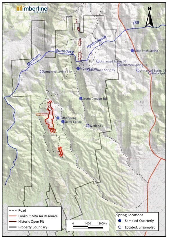
|
| 42 | Page |
Figure 7.5 Lookout Mountain Monitoring Well Location Map
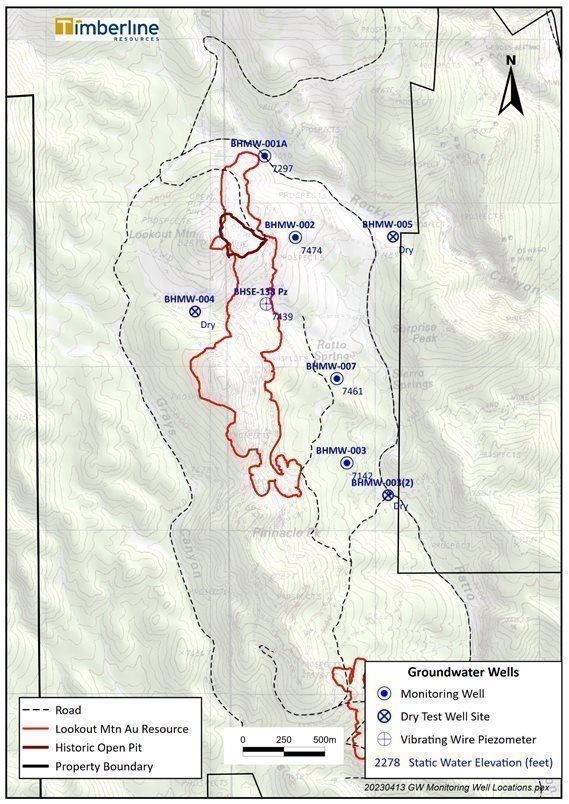
|
| 43 | Page |
8 SAMPLE PREPARATION, ANALYSES, AND SECURITY
8.1 Site Sample Preparation Methods and Security
Records are limited and incomplete on sampling management prior to Staccato drilling in 2005. Drilling by Staccato and Timberline since 2005 was completed under the direct supervision of staff professionals.
During drilling, RC drillhole samples were labeled with a unique sample ID with footages correlated to sample bags via a sampler’s log sheet and with pre-numbered chip trays showing depth from and to for each interval (typically in intervals of five feet). Samples were initially laid out sequentially at the drill site to dry until completion of each hole and demobilization of the rig. The samples were then relocated to Eureka where they were secured within the fenced and lockable Company facility.
The samples were sorted into numerical sequence and cross-checked with drillers logs for interval consistency. Analytical blanks and certified reference standards were then inserted under Company supervision. After drying, the samples were transported in batches sorted by drillhole (either by laboratory pick-up or transport by company personnel) to either Inspectorate America in Sparks, Nevada, or ALS Minerals (formerly ALS Chemex) in Elko, Nevada for sample preparation and analysis assay.
Sampling of drill core was completed under Company supervision. Sample intervals were designated by a geologist during core logging and marked in core boxes with breaks typically correlated to driller’s depths noted by wooden blocks, or at significant lithological breaks, typically not exceeding five feet intervals. The core was sawn or split by technicians under the supervision of company geologists. Certified reference standards and blanks were inserted blindly into the sample stream. Geologists and technicians recorded the sample interval data onto sample dispatch forms before being delivered to ALS or Inspectorate as with RC samples.
8.2 Sampling Preparation, Assaying, Analytical Procedures, and Assay Laboratories
The commercial analytical laboratories used by all operators that contributed data to the project drillhole database, as well as the analytical procedures used by the laboratories to obtain the gold assays for Lookout Mountain, are, or were at the time, well recognized and widely used in the minerals industry. In-house mine laboratories were used for all of the historical Norse Windfall Mines and some of the Amselco holes, however, and many of these analyses appear to have used partial-gold extractions. The Norse Windfall Mines gold data clearly understate grades in at least some of the holes. RESPEC’s reconstruction of the Amselco database effectively limits the impact of the in-house assays by replacing many of them with check analyses performed at commercial laboratories.
Records of drilling prior to that of Staccato have few details on sample preparation, QA/QC, or sample security. Available information is summarized below, along with details on analyses of samples taken from Russell (2007), unless otherwise cited. All of the historic operators were reputable, well-known mining/exploration companies, and there is ample evidence that these companies followed the accepted industry practices relating to sample-preparation and analytical techniques.
|
| 44 | Page |
In consideration of this information, in addition to other data examined in accompanying sections of this report, Timberline and RESPEC believe the Lookout Mountain analytical data are of sufficient quality for use in the resource estimation.
Table 8.1 summarizes analytical laboratory and analytical methods utilized during exploration by various companies that explored Lookout Mountain.
Table 8.1 Compilation of Lookout Mountain Analytical Laboratories and Assay Methods
Company | Assay Laboratory | Assay Method(s) |
Amselco | Monitor Geochemical Laboratory | fire assay with unknown finish process |
Rocky Mountain Geochemical | ||
Hunter Mining Laboratory | ||
In-house (Sparks, NV) | fire assay following cyanide or aqua regia (partial) digestions | |
Norse Windfall | in-house | atomic adsorption following cold cyanide-shake leach digestion |
EFL | American Assay | gold cyanide solubility assays, and fire assay |
Barrick | American Assay | fire assay of 30-gram charges with gravimetric or AA finish |
Echo Bay | Cone Geochemical, Barringer (check assays) | Fire assay of 20- and 30-gram charges with an AA finish |
Staccato | ALS | Fire assay of 50-gram charges with AA finish; Samples >3 ppm re-analyzed by FA with gravimetric finish |
Timberline | Inspectorate | Fire assay of 30-gram charges with AA finish; Samples >3 ppm re-analyzed by FA with gravimetric finish |
Timberline | ALS | Fire assay of 30-gram charges with either AA or ICP-ES finish; Samples >10 ppm re-analyzed by FA with gravimetric finish |
To the knowledge of the authors, the analytical laboratories that provided services to the Lookout Mountain project had no legal or commercial relationships with any of the companies.
During the drilling that predated Staccato’s involvement with the property, accreditation of laboratories was not common. Neither RESPEC nor Timberline have any information on accreditation of those laboratories at that time. However, Monitor, Hunter, Rocky Mountain, American Assay, Cone, Barringer, ALS, and Inspectorate were all widely used laboratories in the mining industry.
Currently, ALS is accredited to ISO/IEC 17025:2017 for the relevant analytical procedures discussed herein, according to their website. Inspectorate is accredited to ISO 17025 standards, according to their website.
|
| 45 | Page |
8.3 Quality Control and Quality Assurance Programs
Little information is known regarding quality control and quality assurance (QA/QC) in pre-Staccato exploration at Lookout Mountain. Since Staccato initiated their exploration through the work of Timberline, extensive QA/QC programs have been implemented including:
| · | Independent QP site and field office inspections |
| · | Re-assay of historical pulps |
| · | Twinning of historical drillholes |
| · | Collection of RC drillhole field duplicates and drillcore duplicate samples |
| · | Insertion of analytical blanks and certified reference standards |
Results of these programs have been positive as discussed in Section 9.0 (Data Validation).
8.4 Opinion of Qualified Person
It is the opinion of the QP that the Company’s sample preparation, analyses, and security meet accepted industry standards and are acceptable as noted in this report.
|
| 46 | Page |
9 DATA VERIFICATION
9.1 Drillhole Database
RESPEC reviewed documentation of an audit of the project drillhole assays completed by SRK Consulting (“SRK”) in November 2009. SRK used files provided to them by Staccato, including original and paper copies of assay certificates, drillhole logs, various other original and copied documents, and digital assay certificates provided directly to SRK by ALS. Discrepancies between the original assay documentation and the assays found by SRK were corrected.
RESPEC confirmed that SRK corrections to the assays were included in the drillhole database provided to RESPEC by Timberline and then completed additional auditing of the project data as part of the 2011 resource study. This verification was designed to complement the SRK audit, so much of the data checked by RESPEC had not been audited by SRK.
The collar coordinates of pre-Staccato holes were originally based on a local grid that was subsequently transformed into Nevada State Plane coordinates. Drillhole collar coordinates, therefore, could not be checked against the historic documentation. Instead, locations of many of the historic holes were checked against rectified aerial photography to assure they were located on roads and drill pads. In some cases, original drillhole maps were used to check relative positioning of the holes.
The azimuths, dips, and total depths of 55 holes were audited against copies of handwritten drill logs. No errors were noted. The azimuth and dips of the entire collar table were then checked for consistency with the survey table data for all holes lacking down-hole survey data, and no inconsistencies were found.
A total of 47 pre-Timberline holes have down-hole survey data in the project database, including 18 BH-series, 23 BHSE-series, and six RTR/RTC-series holes. No backup data were found to check the BH-series down-hole survey data. Four of the 23 BHSE-series holes were audited using printouts from International Directional Services (IDS). Of the 71 survey intervals audited in these holes, seven dip and 11 azimuth values were found to have discrepancies of +0.1 degree. All the errors occur in one hole, and none of the discrepancies are material. All six RTR/RTC-series holes with down-hole surveys were audited using a typed summary sheet of the survey data; no errors were found.
Auditing of the historical assays began by checking 4,800 assay intervals from 54 holes (3 BH-series, 6 BR-series, 11 EBR-series, 1 RTC-series, and 33 RTR-series holes). Initial work on the RTR- and RTC-series resulted in three findings that changed the auditing approach for these holes. First, the gold analyses are identified on various paper auditing materials as being either “AA” or “FA”, with the “AA” analyses found to represent analyses using cyanide shake-leach or aqua regia digestions, both of which are partial digestions and therefore quite different from fire assays (“FA”), which are assumed by the mining industry to represent total gold analyses. However, the “AA” analyses were not differentiated in the project database, and in many cases were listed in the estimation field in the database when fire assay data were also available. In addition, many values in the database for these holes represent inconsistent averaging of sets of assays, including the averaging of “AA” and “FA” analyses. Finally, significant data-entry errors were identified. In light of these discoveries, RESPEC opted to complete a comprehensive re-compilation of all assay data from RTR- and RTC-series holes. The type of analysis was compiled into the database, as were all check-assay data. No “AA” analyses were carried into the database field used in the resource estimation unless no other assay data were available. The averaging of multiple assays was also discontinued.
|
| 47 | Page |
Exclusive of the Amselco holes, as well as Staccato and Timberline BHSE-series holes (discussed below), gold assays from 3,729 sample intervals were audited out of a total of 27,294 in the project database using the same original documentation as SRK. Only one material input error was found and remedied. Eleven minor errors found in three Echo Bay holes were caused by the improper conversion of ppm values to oz/ton. Further conversions of ppb and ppm values to oz/ton led to very minor errors in six Barrick, one EFL, and four Echo Bay holes. Four instances in hole RCR-003 (Amselco) were found where <0.001 oz/ton values were recording in the database as 0.001 oz Au/ton. Finally, four additional intervals in RCR-003 with less than detection assays were entered in the database as “-99” and one interval that was not sampled was listed as 0.001.
The 2012 resource study incorporated 37 holes drilled at Lookout Mountain and 14 at South Adit that were not part of the previous resource database. Collar table data (x and y coordinates, hole azimuth and dip) were audited against the original handwritten tables compiled by Timberline geologists that surveyed the drillhole collars; one discrepancy was found in the angle of a hole. No down-hole survey data were collected for eight of the 51 new holes, six of which were terminated prematurely due to drilling problems. The down-hole data provided by Timberline for the 43 new holes that were surveyed were checked against original digital data provided to RESPEC by IDS; no errors were found.
A complete audit of the Staccato drillhole assay data for holes drilled in 2005 through 2008 was achieved using a computer script that compared the database values to those from digital assay certificates provided to RESPEC directly by Inspectorate. Some significant errors were discovered and resolved, including nine from a single hole (BHSE-003 of Staccato).
The database assay table for all Timberline 2010 through 2012 holes was compiled by RESPEC using original assay certificates received directly from Inspectorate. Original IDS down-hole survey files were used to update the survey table. The northings and eastings of the drillhole collars were updated using digital files exported from the GPS instruments used by Timberline; the elevations of these drill-collar surveys are not sufficiently precise for use in the database, so the collars were pressed to the project digital topographic surface to obtain the database elevations.
9.2 Quality Control/Quality Assurance Data
The following discussion, presented in the order of which the holes were drilled, summarizes RESPEC’s detailed review of the QA/QC data collected by various project operators. RESPEC independently compiled all available QA/QC data and completed detailed statistical evaluations of the results.
9.2.1 Amselco Drill Data
Amselco drill holes contribute 35% of the assays used directly in the resource estimation discussed in Section 11. Available drillhole records indicate that Amselco regularly inserted control samples into the drill-sample stream for assaying. The expected values of these control samples are not known and therefore could not be evaluated. It is not known if further Quality Control/Quality Assurance (“QA/QC”) procedures were implemented by Amselco.
|
| 48 | Page |
Staccato completed check assaying of drill cuttings from Amselco RC holes in 1990. A discussion of the results of these checks, along with some Alta check assay data, follows, along with summaries of the results of duplicate assays compiled into the project database by RESPEC during the database audit.
Staccato Preparation Duplicates. Preparation duplicates are new pulps prepared from splits of the original coarse rejects created during the first crushing and splitting stage of the primary drill samples. Duplicate-pulp data provide information about the sub-sampling variance introduced during this stage of sample preparation.
Rocky Canyon Mining Company provided Staccato with vials of coarse-reject material from Amselco’s drill samples. Each vile held up to approximately 500 grams of material. Staccato filled plastic chip logging trays with a portion of the samples and sent the remainder to ALS for analysis. These samples can be considered as unconventional preparation duplicates, since: (1) the samples were analyzed by a different laboratory (ALS) than the original samples (Monitor); (2) the duplicate samples were analyzed years after completion of the drilling program; (3) the sub-sampling of the original coarse rejects to create the vial samples may not have been done by the original laboratory; and (4) an additional splitting stage was undertaken by Staccato when the chip trays were filled, which involves sub-sampling variance that is additional to ‘conventional’ preparation duplicates. ALS analyzed the duplicates by fire assay with an AA finish, while the original samples were analyzed by Monitor by either fire assay or fire assay of one-assay-ton charges (no finishes specified).
presents a relative-difference graph that shows the percentage of the relative-difference, plotted on the y-axis, of each ALS assay relative to its paired original Monitor fire assay, calculated as follows:
100 x ((duplicate – original))/(lesser of (duplicate, original) )
The x-axis of the graph plots the means of the paired data. The red line shows the moving average of the relative differences (“RDs’) of the pairs and provides a visual guide of trends in the data.
The x-axis of the graph plots the means of the gold values of the paired data (the mean of the pairs, or “MOP”) in a sequential but non-linear fashion. The red line shows the moving average of the RDs of the pairs, thereby providing a visual guide to trends in the data that aids in the identification of potential bias. Positive RD values indicate that the duplicate-sample analysis is greater than the primary-sample assay. A total of 827 assay pairs from 32 Amselco drill holes are shown on the plot, which excludes 23 pairs where both analyses are below detection and 37 outlier pairs. The exclusion of the outlier pairs assists in visually evaluating the data. While there are many pairs exhibiting high variability, no bias is apparent (a bias would be evidenced by the moving-average line tending to be more on one side or the other of the blue 0% RD line).
|
| 49 | Page |
Figure 9.1 ALS Preparation Duplicates Relative to Original Monitor Assays – Staccato
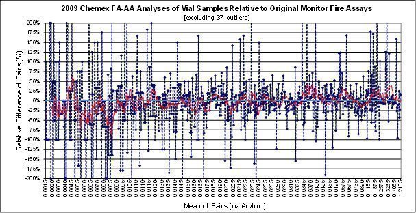
Figure 9.2 shows the absolute values of the RDs of the same paired data. This plot helps to evaluate the variability (precision) of the data at various grade ranges. The graph demonstrates the gradually diminishing variability of the paired data up to an MOP of about 0.012 oz Au/ton, following which the variability fluctuates between about 25 and 50%.
Figure 9.2 Absolute Value of Relative Differences of ALS vs. Monitor - Staccato
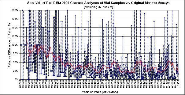
Table 9.1 summarizes the descriptive statistics of the data, excluding the 37 outlier pairs, at various cutoffs of the MOPs. The means of the analyses of the preparation duplicates generally compare well with those of the original assays at all cutoffs. If the 37 outlier pairs are included, the means of the preparation-duplicate analyses vary from 1% higher to 1% lower than the original assay means at the same cutoffs.
|
| 50 | Page |
The average variability at grades in excess of about 0.01 oz Au/ton, as indicated by both Figure 9.2 and the mean of the absolute value of the RDs shown in Table 9.1, is about 35%. This level of precision is not unusually high for preparation duplicates considering it incorporates additional analytical and sub-sampling variability, as discussed above.
Table 9.1 Descriptive Statistics of ALS Pulp Duplicates and Original Monitor Assays
All Pairs | Mean | Original | Duplicate | Diff. | Rel. Diff. | A.V. Rel. Diff. |
Count | 827 | 827 | 827 |
| 827 | 827 |
Mean | 0.051 | 0.051 | 0.052 | 2% | -4% | 47% |
Median | 0.020 | 0.020 | 0.019 |
| ||
Std. Dev. | 0.105 | 0.105 | 0.108 |
| ||
CV | 2.044 | 2.064 | 2.084 |
| ||
Min. | 0.001 | 0.001 | 0.001 | 0% | -400% | 0% |
Max. | 1.219 | 1.130 | 1.307 | 16% | 400% | 400% |
Mean >0.005 | Mean | Original | Duplicate | Diff. | Rel. Diff. | A.V. Rel. Diff. |
Count | 762 | 762 | 762 |
| 762 | 762 |
Mean | 0.056 | 0.055 | 0.056 | 2% | -4% | 42% |
Median | 0.022 | 0.022 | 0.021 |
| ||
Std. Dev. | 0.109 | 0.109 | 0.112 |
| ||
CV | 1.954 | 1.974 | 1.992 |
| ||
Min. | 0.005 | 0.002 | 0.002 | 0% | -400% | 0% |
Max. | 1.219 | 1.130 | 1.307 | 16% | 400% | 400% |
Mean >0.010 | Mean | Original | Duplicate | Diff. | Rel. Diff. | A.V. Rel. Diff. |
Count | 644 | 644 | 644 |
| 644 | 644 |
Mean | 0.064 | 0.064 | 0.065 | 2% | 1% | 36% |
Median | 0.025 | 0.026 | 0.025 |
| ||
Std. Dev. | 0.116 | 0.116 | 0.119 |
| ||
CV | 1.800 | 1.823 | 1.833 |
| ||
Min. | 0.010 | 0.004 | 0.005 | 25% | -280% | 0% |
Max. | 1.219 | 1.130 | 1.307 | 16% | 400% | 400% |
Mean >0.100 | Mean | Original | Duplicate | Diff. | Rel. Diff. | A.V. Rel. Diff. |
Count | 85 | 85 | 85 |
| 85 | 85 |
Mean | 0.303 | 0.298 | 0.309 | 4% | 12% | 38% |
Median | 0.284 | 0.266 | 0.283 |
| ||
Std. Dev. | 0.185 | 0.193 | 0.194 |
| ||
CV | 0.611 | 0.647 | 0.628 |
| ||
Min. | 0.101 | 0.073 | 0.072 | -1% | -99% | 0% |
Max. | 1.219 | 1.130 | 1.307 | 16% | 330% | 330% |
CV = coefficient of variation = (Std. Dev./Mean); A.V. = absolute value | ||||||
Additional duplicate assay data of various types from Amselco and other project operators are discussed below and were evaluated using the same methods shown in Figures 9.1 and 9.2 and Table 9.1, although the charts and tables are not shown.
|
| 51 | Page |
Preparation-duplicate data are also available for 62 vial samples from two Amselco drill holes that were originally analyzed by Rocky Mountain. The data indicate the preparation-duplicate analyses tend to be lower grade, especially at MOPs less than about 0.03 oz A/ton, with higher-grade pairs masking this effect and overwhelming the statistics. For example, if the highest-grade pair is removed, the mean of the preparation duplicates becomes 7% lower than the mean of the original analyses. In consideration of the limited dataset, RESPEC does not believe there is a significant issue.
A total of 32 preparation duplicates were prepared from the Amselco coarse-reject vial samples that were originally analyzed by Amselco’s in-house laboratory by AA methods (aqua regia or cyanide shake-leach digestions). The mean of the ALS fire assays of the preparation duplicates is 24% lower than the Amselco mean, although this reduces to 11% higher if the highest-grade pair is excluded. The dataset is not sufficient to allow for definitive conclusions, but it is nonetheless surprising that the fire assays yield lower results than the AA analyses.
Alta Preparation Duplicates. Alta sent 48 samples from four Amselco drill holes to ALS for fire assay analyses. The ALS laboratory certificate indicates the samples were crushed and pulverized, so they presumably represent preparation duplicates. The ALS results were compared to the original Amselco analyses, which were fire assayed by Monitor.
The following conclusions were drawn from the evaluation of the preparation duplicate fire assay analysis:
| · | There is high variability in the data up to about 0.014 oz Au/ton and above 0.05 oz Au/ton |
|
|
|
| · | The mean of the check assays is 13% lower than the originals, which is reduced to 11% when the four highest grade pairs are removed. |
|
|
|
| · | The check assays tend to be higher than the original analysis at mean grades of less than about 0.031 oz Au/ton. |
Check Assays of Uncertain Type. Alta performed additional fire assays on 29 drill samples from three Amselco holes. The type of material used for the check assaying is not known. RESPEC believes these drill samples were analyzed at Alta’s in-house laboratory by fire assay, while one of the original fire analyses was completed by Rocky Mountain and the remainder by Monitor. The dataset is too limited to be conclusive, but the Alta checks are systematically higher than the original analyses, and the mean of the Alta check analyses is 13% higher than the mean of the original analyses.
During the compilation of Amselco drillhole data into the resource database, RESPEC included analyses from multiple laboratories when available. The resulting paired assay data are summarized below.
| · | RESPEC found 20 samples from a single Amselco hole that were analyzed by both Rocky Mountain and Monitor using fire assay methods. The Rocky Mountain analyses are 7% lower than Monitor, excluding pairs that were less than detection limits for both labs. The difference is systematic at MOP grades above about 0.02 oz Au/ton., although there are too few pairs to derive meaningful conclusions. |
|
|
|
| · | A total of 120 pairs from nine holes were also compiled whereby Amselco AA analyses (thought to be aqua-regia or cyanide-shake leach digestions) and Rocky Mountain fire assays were performed on the same samples. Four pairs in which both analyses are less than the detection limit and four additional pairs that are extreme outliers were excluded. |
|
|
|
| · | High variability is evident up to 0.025 to 0.030 oz Au/ton. The means of the AA analyses range from 3% higher for the entire dataset to 5% higher at MOPs of greater than 0.05 oz Au/ton. |
|
|
|
| · | A subset of these samples was also analyzed by Rocky Mountain using “bulk fire” assay methods. These analyses tend to be slightly lower than the fire assays. Excluding a single high-grade outlier pair, the mean of the “bulk fire” analyses is 1% lower than the mean of the fire assays. |
|
| 52 | Page |
9.2.2 Barrick Drill Data
Pulp Checks. Staccato sent 46 original pulps from two Barrick holes to ALS for check assays. The pulps were originally prepared by American Assay and analyzed by fire assaying of 30-gram charges; some of the higher-grade results were re-fired using gravimetric methods. ALS analyzed the samples by fire assay with AA finishes, with results exceeding 0.3 oz Au/ton re-analyzed by fire assay-gravimetric methods. The check assays are systematically lower than the original analyses at MOPs of about 0.01 oz Au/ton and higher, and the divergence increases with increasing grades. The mean of the check analyses is 12% lower than the original assays.
It is important to note that the dataset is unrepresentatively high grade with respect to the Lookout Mountain mineralization (the check and original analyses average 0.132 and 0.149 oz Au/ton, respectively).
9.2.3 Echo Bay Drill Data
Pulp Checks. Staccato sent 209 original pulps from 17 Echo Bay holes to ALS along with the Barrick pulps discussed above. The original Echo Bay analyses were completed by Cone using fire assays of 20- and 30-gram charges with AA finishes. The mean of the ALS check analyses is 3% higher than the mean of the original Cone assays. This relatively close agreement is a consequence of the pairs with average grades in excess of about 0.07 oz Au/ton dominating the statistics. The RD plot indicates that the ALS checks are systematically ~10% higher in the grade range of about 0.005 to 0.07 oz Au/ton. Variability is unusually high for pulp-check data.
9.2.4 Staccato Drill Data
Pulp Checks.Staccato submitted 178 ALS pulps from 10 holes of the Staccato 2005 through 2007 drilling programs to Assayers Canada (now SGS) for check assaying. The original ALS pulps were analyzed by fire assaying of 50-gram charges with AA finishes, with over-limit results re-assayed gravimetrically. RESPEC is not certain of the type of analysis used by Assayers Canada.
The check assays compare well, with a mean that is 1% higher than the mean of the original ALS analyses at cutoffs of the MOPs of 0, 0.005, 0.050, and 0.100 oz Au/ton. Excluding 12 extreme outlier pairs and 10 pairs whereby both the check and original assays returned less than detection limits, the checks are 2% higher than the original analyses. The of the absolute values of the RDs of the pairs above a grade of 0.005 oz Au/ton average 10%, which is expected for re-assaying of pulps. No bias is evident.
9.2.5 Timberline Drill Data - 2010 and 2011 Programs
Timberline completed a drill program in late 2010 to early 2011, discussed in this subsection and referred to herein as the 2010-2011 program. A second drill program was undertaken in mid- to late-2011 and is referred to as the 2011 drilling program.
|
| 53 | Page |
Timberline’s QA/QC program associated with the 2010-2011 drilling included the insertion of certified reference materials, non-certified standards, preparation blanks, and field duplicates into the drill-sample stream. Preparation duplicates were also analyzed by the primary laboratory (Inspectorate), and Inspectorate pulps were sent to ALS for pulp-check analyses.
Certified Reference Materials. Certified Reference Materials (CRMs) are used to monitor the analytical accuracy and precision of the assay laboratory during the time the drill samples were analyzed. In the case of normally distributed data (note that most assay populations from metal deposits are positively skewed), approximately 95% of the CRM analyses should lie within two standard-deviations of the certified (expected) value, while only about 0.3% of the analyses are expected to lie outside of three standard deviations. As it is statistically unlikely that two consecutive samples would lie outside of the two standard-deviation limits, such samples are considered to be potential failures unless further investigation proves otherwise. All samples outside of the three standard-deviation limits are also deemed to be failures. Failures should trigger investigation and, if warranted, laboratory notification of potential problems and a re-run of all samples included with the failed CRM result.
Timberline used fourteen CRMs acquired from Rocklabs of Aukland, New Zealand. These CRMs have certified gold values that range from 0.002 to 0.25 oz Au/ton, which represents the Lookout Mountain gold-grade distribution well. Table 9.2 provides the details of the Rocklabs CRMS utilized by Timberline.
RESPEC compiled 436 analyses of these CRMs, which were inserted into the original sample stream at a nominal rate of one CRM for every 20 drill samples. The Inspectorate analyses of the CRMs resulted in a total of 53 three-standard-deviation failures, or about one in every eight CRM analyses, with 42 of them being low-side failures (Inspectorate analyses of the CRMs being lower than the certified values). Fifteen of the failures are from one CRM (HiSilk2; all low-side failures).
The complete dataset for the 14 CRMs is shown in Figure 9.3 (three outlier analyses are outside of the plot limits), which graphs the Inspectorate CRM analyses in terms of their differences from the expected values, expressed in normalized standard-deviation units. The data are ordered by the date of the assay certificates on the x-axis. The normalized expected value of the CRMs is represented by the red line, and the + two and + three normalized standard-deviation limits of the CRMs are shown as blue and green lines, respectively. A slight low overall bias in the CRM analyses is evident. Excluding the three outlier results, the Inspectorate analyses of the CRMs have an average difference from the expected values of about -0.5 standard-deviation units.
|
| 54 | Page |
Table 9.2 Timberline Certified Standards
Standard | Source | Certified Value (ppm Au) | Standard Deviation | Drill Program |
SL34 | Rocklabs | 5.893 | 0.14 | 2010 - 2011 |
SN38 | Rocklabs | 8.573 | 0.158 | 2010 - 2011 |
OxA71 | Rocklabs | 0.0849 | 0.0056 | 2010 - 2011 |
OxE74 | Rocklabs | 0.615 | 0.017 | 2010 - 2011 |
HiSilK2 | Rocklabs | 3.474 | 0.087 | 2010 - 2011 |
OxD87 | Rocklabs | 0.417 | 0.013 | 2011 |
OxG83 | Rocklabs | 1.002 | 0.027 | 2011 |
OxG84 | Rocklabs | 0.922 | 0.033 | 2011 |
OxH66 | Rocklabs | 1.285 | 0.032 | 2011 |
OxJ68 | Rocklabs | 2.342 | 0.064 | 2011 |
OxN33 | Rocklabs | 7.378 | 0.208 | 2011 |
SE58 | Rocklabs | 0.607 | 0.019 | 2011 |
SG40 | Rocklabs | 0.976 | 0.022 | 2011 |
SN50 | Rocklabs | 8.685 | 0.18 | 2011 |
Figure 9.3 Normalized Results of Inspectorate Analyses of All 2010 and 2011 Certified Standards
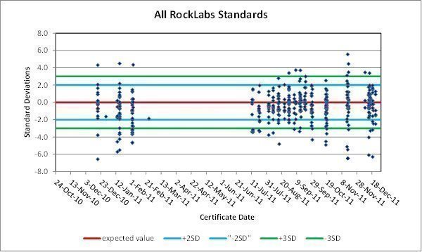
|
| 55 | Page |
Uncertified Reference Materials. In addition to the certified Rocklabs CRMs, four uncertified standards were used from late October 2010 through early February 2011. Each of these reference materials was analyzed 10 times by ALS and one time by Assayers Canada, and these analyses were used to assign expected and standard-deviation values. At a minimum, a proper certification process includes round-robin analyses by a number of commercial laboratories to establish well-founded statistical values, which is not the case for the four standards. At a minimum, a proper certification process includes round-robin analyses by a number of commercial laboratories to establish well-founded statistical values, which is not the case for the four ‘standards.’ At a minimum, a proper certification process includes round-robin analyses by a number of commercial laboratories to establish well-founded statistical values, which is not the case for the four ‘standards.’ Other than to note that the Inspectorate analyses were systematically lower than the uncertified expected values, these results are not discussed further.
Pulp Checks. Timberline sent Inspectorate’s pulps of most samples from mineralized intervals intersected in the 2010-2011 drill program to ALS for check assaying. These 811 pulp checks serve as an additional tool to evaluate analytical accuracy. RESPEC’s evaluation compared the check assays to the original Inspectorate analyses, excluding 21 outlier pairs and 12 additional pairs whereby the original and check assays both returned less than detection limits.
The ALS check assays are systematically higher than the original Inspectorate analyses over the entire grade range of the data, and the mean of the check assays is 7% higher than the mean of the original analyses for all data as well as at MOP cutoffs of up to 0.01 oz Au/ton. The mean of the absolute values of the RDs is 10%.
An additional 1,352 Inspectorate pulps from the 2011 drill program were sent to ALS for check assaying. The mean of the ALS analyses is 3% higher at MOP cutoffs up to 0.01 oz Au/ton, and the mean of the absolute value of the RDs is 10% (all data) to 3% (0.01 oz Au/ton cutoff).
Timberline included 23 Rocklabs CRM samples with the 2010-2011 Inspectorate pulps sent to ALS for check assaying, but only two of the CRM pulps had sufficient material to assay. The ALS analyses of these CRM pulps were both higher than the expected values by 0.7 and 0.9 standard-deviation units. No CRM pulps were submitted with the drill-sample pulps from the 2011 drill program.
Preparation Blanks. Preparation blanks are coarse samples of barren material that are used to detect possible laboratory contamination, which is most common during sample-preparation stages. In order for analyses of blanks to be meaningful, they must be sufficiently coarse to require the same crushing stages as the drill samples. It is also important for many of the blanks to be placed into the sample stream immediately after mineralized samples (which would be the source of most cross-contamination issues). Blank results that are greater than five times the detection limit (25 ppb Au based on the five ppb detection limit of the Inspectorate analyses) are typically considered failures that require further investigation and possible re-assay of associated drill samples. Dimension stone sold in 50-pound sacks available from garden/hardware stores was used as the coarse blank material.
A total of 324 of the Inspectorate analyses of blanks returned less than detection limits. Four of the 345 blank analyses examined by RESPEC from the 2010-2011 drill program exceed the 25 ppb (0.0007 oz Au/ton) threshold, with a maximum value of 71 ppb (0.002 opt). None of these "failures" have previous samples with significant gold values (two less than detection limits, 0.003, and 0.008 oz Au/ton). While these results suggest that cross contamination was not a problem, most of the blank samples were inserted into the sample stream after unmineralized or weakly mineralized drill samples, so the opportunity for cross contamination of the blank samples was limited.
|
| 56 | Page |
Of the 377 blank analyses derived from the 2011 drilling program, only four exceed the 25 ppb Au threshold. Only one of these ‘failures’ was preceded by a sample assaying greater than 0.005 oz Au/ton (0.057 oz Au/ton), and the highest blank analysis is 0.004 oz Au/ton. Twenty-one of the drill samples analyzed immediately before a blank sample have values in excess of 0.01 oz Au/ton, and one (5%) of these blanks were failures.
Preparation Duplicates. Timberline instructed Inspectorate to prepare duplicate pulps from the coarse rejects of 175 drill samples from the 2010-2011 drilling program. Excluding two outlier pairs, the means of the preparation duplicates match those of the original analyses at MOP cutoffs of 0, 0.005, and 0.010 oz Au/ton, and no bias is evident in the data.
Inspectorate analyses of preparation duplicates from the 2011 drilling program, excluding five outlier pairs, show a consistent high bias relative to the original Inspectorate analyses at MOP grades up to about 0.04 oz Au/ton, and the means of the preparation-duplicate analyses are 4% to 7% higher than the means of the assays of the original pulps at MOP cutoffs of up to 0.01 oz Au/ton.
The absolute values of the RDs between the preparation duplicates and original assays from both the 2010-2011 and 2011 drilling programs were also evaluated. The mean of the absolute values of the RDs is 19% for all data (excluding the 12 outlier pairs) and decreases to 8 to 9% for MOPs in excess of 0.01 oz Au/ton.
Field Duplicates. Rig or field duplicates are secondary splits of drill samples. In the case of core drilling, field duplicates are obtained by re-splitting the core remaining after the primary samples have been taken. RC field duplicates are splits of the cuttings collected at the drill rig at the same time as the primary samples. Field duplicates are used to assess inherent geologic variability and sampling variance.
Timberline collected RC rig-duplicate samples at a nominal rate of one duplicate for every 20 samples; no field duplicates were collected from core holes. Out of the 511 RC rig-duplicate/original pairs from the 2010-2011 and 2011 drill programs, there are 232 pairs in which both the duplicate and original Inspectorate assays exceed detection limits. These 232 pairs, excluding 15 outlier pairs, were evaluated by RESPEC. Only four of the excluded outlier pairs have mean grades in excess of 0.004 oz Au/ton.
A high bias is evident at MOPs up to about 0.006 oz Au/ton. There are insufficient pairs at higher grades to allow for statistically significant conclusions. A comparison of the absolute values of the RDs between the rig duplicates and the original analyses shows that at MOP grades higher than about 0.004 oz Au/ton variability gradually declines from about 25% to 15% (seen at MOPs in excess of about 0.015 oz Au/ton).
9.2.6 Timberline Drill Data - 2012 Program
Timberline’s 2012 drilling program incorporated a QA/QC program similar to those used in the 2010 through 2011 drilling programs.
Certified Reference Materials. Fourteen Rocklabs CRMs were used in the 2012 drilling program, including 11 of those listed on Table 9.2. Details of the three new standards are presented in Table 9.3
|
| 57 | Page |
Table 9.3 Timberline Certified Standards
Standard | Source | Certified Value (ppm Au) | Standard Deviation | Drill Program |
OxC102 | Rocklabs | 0.207 | 0.011 | 2012 |
OxF100 | Rocklabs | 0.804 | 0.019 | 2012 |
OxG99 | Rocklabs | 0.932 | 0.020 | 2012 |
The Inspectorate analyses of the CRMs used in the 2012 program show generally similar results as those inserted into the 2010 and 2011 drill-sample streams. While the failure rate is relatively high, most of the ‘failures’ are caused by an overall low bias in the Inspectorate analyses relative to the certified values of the CRMs, which is evident up until the analyses done in Fall 2012 (Figure 9.4).
Excluding the two probable cases of mis-identified CRMs, the Inspectorate analyses of the CRMs have an average difference from the expected values of about -0.5 standard-deviation units, with an average difference of -0.8 for analyses on certificates dated up to mid-September.
Pulp Checks. RESPEC compiled a total of 1,116 ALS check analyses of Inspectorate’s original assay pulps from the 2012 drilling program. RESPEC compared these ALS fire assays to the original Inspectorate fire assays after 27 pairs where the original and check assays both returned less than detection limits and seven outlier pairs were removed. A clear high bias in the ALS check assays is evident at MOP grades of about 0.010 oz Au/ton and higher. The mean of the absolute value of the RDs is 11% for all data and 8% at a 0.010 oz Au/ton cutoff.
These results of the 2012 check-assaying program are consistent with Inspectorate analyses of the 2012 certified standards, as well as with the results of the 2011 check-assaying program.
Preparation Blanks. None of the 354 Inspectorate analyses of the 2012 preparation blanks constituted a failure. The highest blank assay returned was 0.001 oz Au/ton, but only 46 of the samples immediately preceding the blanks assayed over 0.01 oz Au/ton.
Preparation Duplicates. A total of 227 preparation duplicates were analyzed by Inspectorate in 2012; less than detection limits were returned from both the original and duplicate-pulp assays for 67 of these samples. Half of the preparation duplicate/original pairs have MOPs greater than or equal to 0.005 oz Au/ton. The means of the assays of the preparation duplicates are 2% lower than those of the original samples for all samples and at MOP cutoffs of 0.005 and 0.010 oz Au/ton (there are insufficient samples at higher cutoffs for meaningful statistics).
The mean of the absolute values of the RDs between the preparation duplicates and original assays is 16% at a MOP cutoff of 0.005 oz Au/ton, but it drops to 8% if two outlier pairs within this dataset are removed.
Field Duplicates. A total of 146 RC field duplicates were collected and analyzed in 2012; only 58 of these have assays of the field duplicate and/or original split that exceed the detection limits. The mean of the assays of the 58 field duplicates is 4% lower than those of the original samples, although the data are somewhat limited. The mean of the absolute values of the RDs between the rig duplicates and the original analyses is 16% at a MOP cutoff of 0.005 oz Au/ton.
|
| 58 | Page |
Figure 9.4 Normalized Results of Inspectorate Analyses of All 2012 Certified Standards
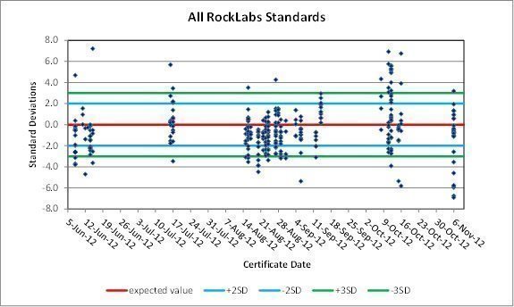
9.2.7 Discussion of QA/QC Results
Amselco drill holes comprise half of the holes that contribute assay data directly used in the estimation of resource grades at both Lookout Mountain and South Adit. Staccato’s analyses of preparation duplicates provide the best check-assay dataset available for the Amselco analytical data, and these duplicates compare very well with the original Amselco analyses. Other QA/QC datasets available for the Amselco holes are generally of insufficient size for statistically meaningful conclusions to be drawn.
Pulp checks undertaken by Staccato using pulps from Barrick’s drill samples yielded results that are systematically lower than the original analyses. There are no additional data available to support either the original or check analyses. Barrick drilled 5% of the holes that contribute assays to the resource estimations at both Lookout Mountain and South Adit. Similar pulp checks were undertaken using original Echo Bay drill samples, which make up 7% of the resource holes at Lookout Mountain; Echo Bay did not drill at South Adit. In this case, the duplicates are systematically higher than the original analyses. In the absence of corroborative data, no definitive conclusions can be made. The checks of both the Barrick and Echo Bay pulps were assayed by ALS.
Staccato drilled 21% of the holes used in the Lookout Mountain resource estimation and 10% at South Adit. Pulp checks completed by Staccato are consistent with the original analyses.
There is no QA/QC information for the Newmont, Norse Windfall Mines, or EFL drill samples. Norse Windfall Mines holes comprise about 6% of the resource drill holes at Lookout Mountain, while the EFL holes contribute less than 1%; neither company drilled at South Adit. The EFL assay data at least partially are comprised of cyanide shake-leach analyses, and many of the holes are clearly lower in grade than surrounding holes from other drill campaigns. No Newmont holes contribute assay data to the Lookout Mountain or South Adit resource estimations.
|
| 59 | Page |
CRMs inserted into Timberline’s drill-sample stream returned results from Inspectorate that are generally slightly lower than the certified values. The original analyses are also systematically lower than pulp checks undertaken by ALS. These datasets suggest that the original 2010 to early 2011 Inspectorate analyses may understate gold grades, perhaps by as much as about 7%; this potential understatement drops to about 3% in subsequent programs. Timberline drill holes comprise about 30% of the drill holes used in the resource grade estimation at Lookout Mountain and 36% of the holes at South Adit.
The Timberline QA/QC data allow for an examination of precision at various stages. The lack of duplicate analyses on the same pulp by the original analytical laboratory (Inspectorate) does not allow for an estimate of the analytical precision of the assays, but the variability is typically low (usually a few percent). The preparation duplicates, which incorporate the analytical precision as well as variability due to subsampling of the coarse rejects, indicate a relatively low variability (less than about 10%) in the laboratory sub-sampling stages. The rig duplicate data, which incorporate the analytical, laboratory sub-sampling, field sub-sampling variances, and inherent geological variability, suggest a total variability of about 20%. This means that a little less than about 10% of the variability (the rig-duplicate variability less the duplicate-pulp variability) can be attributed to the RC sub-sampling in the field (a small percentage is due to analytical variability).
Timberline should continue to attempt to maximize the quantity of preparation and rig duplicates at grades that are representative of the mineralized population distribution. Significantly more blanks that immediately follow mineralized samples are also needed. Core duplicates need to be added to the field-duplicate dataset in future drilling programs that are not using the core for metallurgical testing. Finally, results of the QA/QC program need to be monitored as the results are received, and all failures identified should be acted upon as soon as possible.
9.3 Site and Field Office Inspections
Mr. Gustin visited the Lookout Mountain project on January 6 and November 16, 2011, April 10, 2013, October 6, 2020, and November 4, 2021. These site visits included reviews of mineralized core and reverse-circulation drill chips, examination of drillhole cross sections showing Timberline’s geologic interpretations, investigations of representative exposures in road cuts and outcrops, the inspection of sampling and logging procedures at active reverse-circulation and core drill sites, and confirmatory visits to most of the Timberline drill sites at Lookout Mountain. Project procedures related to logging, sampling, and data capture were discussed with the Timberline geologic personnel, and recommendations were provided as needed.
The site visits contributed significantly to RESPEC’s understanding of the project and confidence in the project data.
9.4 Additional Data Verification
In addition to the verification completed that is discussed above, verification of the project data was undertaken throughout the process of the resource modeling. RESPEC’s detailed explicit modeling of the gold mineral domains within the context of the project geology resulted in the recognition of potentially anomalous drill results that led to further investigation. For example, contaminated RC sample intervals were identified during the sectional gold modeling, as were the anomalously low-grade Norse Windfall drillhole gold assays.
|
| 60 | Page |
RESPEC’s initial resource modeling was completed in mid-2011, and the resources were updated in 2012 and 2013 following successive Timberline drilling programs. The additional drilling led to only minor modifications of the geologic interpretations at North Lookout Mountain and the northern portion of South Lookout Mountain, which progressively increased RESPEC’s confidence in the gold resource modeling in these areas.
9.5 Summary Statement
RESPEC experienced no limitations with respect to data verification activities for the Lookout Mountain project. In consideration of the information summarized in Sections 5 through 9 and Section 11 of this report, RESPEC has verified that the Lookout Mountain project data are acceptable as used in this report, most significantly to support the estimation and classification of the project Mineral Resources.
Timberline’s non-independent QP completed routine review of the project database, QC/QA protocols and implementation thereof, sampling methods, incorporation of assay standards, blanks and duplicates, and field checks of drillhole locations and orientations. The Lookout Mountain data is considered verified and it is the QP’s opinion that it is acceptable for use by RESPEC in development of the project Mineral Resources.
|
| 61 | Page |
10 MINERAL PROCESSING AND METALLURGICAL TESTING
Several metallurgical gold recovery programs have been conducted on surface rock and drillhole samples from the Lookout Mountain gold resource area between 1985 to 2014. The programs were conducted by Amselco, Tenneco, Norse Windfall Mines, Alta Gold, and Timberline Resources (Table 10.1).
Table 10.1 Summary of Historical Metallurgical Testing
Date | Metallurgists | Company | Sample Type | Tests |
07/10/1985 | Hazen | Amselco | composites of cuttings from 6 RC holes | bottle roll |
04/23/1986 | Hazen | Amselco | 2 composites of drill core | 4" column leach |
05/28/1986 | Heinen Lindstrom | Tenneco | 10 composites of drill-hole cuttings | bottle roll |
04/08/1987 | KCA | Norse Windfall Mines | 1-ton bulk sample | 3 column leach crush tests |
11/04/1997 | McClelland | Alta | bulk samples | bottle roll |
2010 – 2014 | KCA, McClelland | Timberline Resources | bulk samples, multiple composites of drill core | bottle roll, 6” column leach |
Other than a single column leach test (CLT) on a bulk sample, no further metallurgical testing has been completed to-date on unoxidized, high-grade sulfidic shale exposed in the open pit or intercepted in RC or core drilling.
10.1 Nature and Extent of Metallurgical Testing and Analytical Procedures
The scope of metallurgical testing on mineralized material at Lookout Mountain includes approximately 7,200 drill samples assayed for NaCN- leachable gold, approximately 450 bottle roll tests (BRT) on RC or core drill samples and 21 CLTs on bulk samples and from composites of drill core material.
The NaCN- assays provide an initial assessment of the leachability of gold and have proven useful for assessing oxidized vs unoxidized mineralized rock. Only limited metallurgical testing has been completed to-date on un-oxidized mineralized rock.
10.2 Representative Metallurgical Test Samples
Samples collected for metallurgical testing were selected from the gold resource area and chosen by rock type and area including North Lookout Mountain to South Lookout Mountain, and from surface bulk samples through shallow to deeper drill core depth.
Lithologic samples selected for CLTs represent composites of oxidized claystone (shale), jasperoid/silicified breccia, or collapsed breccia/fault gouge (representing dominantly sanded dolomite). Rock material was typically composited from multiple drillholes within a given area (Figure 10.1).
|
| 62 | Page |
Figure 10.1 Lookout Mountain Project Metallurgical Testing Sample Sites
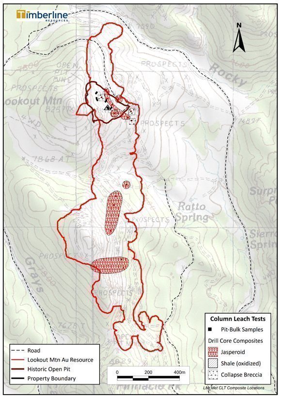
|
| 63 | Page |
The samples on which the Lookout Mountain project metallurgical test work has been performed were selected as representative of the oxide resources in terms of grade and areal distribution. The Amselco samples are understandably clustered in the area of the existing open pit at North Lookout Mountain. Timberline has tested a number of samples from this area as well but has also tested a significant number of samples from various drillholes at South Lookout Mountain.
10.3 Metallurgical Laboratories
Three metallurgical laboratories have completed BRTs or CLTs on Lookout Mountain gold mineralized rock. These include: Hazen Laboratories (Hazen) of Denver, Colorado, and Kappes, Cassiday & Associates (KCA) and McClelland Laboratory (McClelland) of Reno, Nevada. The laboratories are independent of Timberline Resources or previous explorers and have no beneficial relationships to the Company.
Hazen holds analytical certifications or accreditation from state regulatory agencies and from the US Environmental Protection Agency (EPA). The company participates in performance evaluation studies to demonstrate competence in these areas of certification.
McClelland is certified through the International Accreditation Service, ilac-MRA, and they are NDEP approved (Nevada State Certified NV-00933 for MWMP & HC Testing Procedures & Wastewater Certification on select analytes associated with MWMP & HCT.
KCA is a well-respected, Nevada-based consultancy founded and led by Mr. Daniel Kappes (P.E.) and provides services to the international mining industry. KCA specializes in all aspects of heap leaching, cyanide process, laboratory testing, project feasibility study engineering design, construction, and operations management since 1972.
10.4 Metallurgical Recovery Testing Results
CLTs are considered the most representative laboratory test of the potential for NaCN- heap leach processing of Lookout Mountain oxidized ore as is common in Nevada gold mining operations. Bulk samples collected from surface exposures in the historical open pit, and composite samples from drill core (Figure 10.1) have been tested by CLT.
10.4.1 Column Leach Tests – Surface Bulk Samples
CLT programs were completed in 1987 and 2010-2011 on surface bulk samples of various mineralized lithology types exposed in the historical Lookout Mountain open pit (Table 10.2).
Gold recoveries in samples of high-grade shale were generally high (≥ 90%) with little variability at various crush sizes. Gold recovery in unoxidized shale with pyrite, orpiment, and realgar was high but required high reagent consumption.
Other rock types including collapse breccia, dolomite, and mixed lithologies typically exhibited good (≥ 75%) recoveries under test conditions.
|
| 64 | Page |
Table 10.2 Summary of Column Leach Test Gold Recovery in Bulk Samples from
Historical Lookout Mountain Open Pit
Year | Company | Sample Size | Rock Type | Lab | n | Au Assay Grade (oz/ton) | Au Recovery (%) | Leach (days) | Crush size | NaCN- lbs/ton | CaOH- lbs/ton |
|
| ||||||||||||
1987 | Norse-Windfall | ~1 ton | Shale (oxidized) | KCA | 1 | 0.301 | 91 | 7 | -3 in. | UNK | UNK |
|
1 | 0.298 | 90 | -1.5 in. |
| ||||||||
1 | 0.286 | 90 | -0.5 in. |
| ||||||||
2010 - 2011 | Timberline | 597 kg | Shale (unoxidized) | KCA | 1 | 0.347 | *91 | 112 | -3 in. | 6.52 | 34.3 |
|
1045 kg | Mix of collapse breccia, jasperoid breccia, and sanded dolomite | 1 | 0.018 | 79 | 112 | 0.63 | 4.02 |
| ||||
Sanded dolomite with jasperoid | 1 | 0.032 | 76 |
| 0.62 | 4.02 |
| |||||
1001 kg |
| |||||||||||
597 kg | Jasperoid breccia | 1 | 0.0821 | 74 | 112 | 0.57 | 4.07 |
n: number of leach tests | |||||||||||||
* Sulfide (realgar)-bearing; very high NaCN- and Ca(OH)2 consumptions required for recovery | |||||||||||||
10.4.2 Column Leach Tests – Core Composite Samples
CLTs were completed on composites of three rock types from the gold resource area at North Lookout and South Lookout Mountains (Figure 10.1). As noted in Table 10.3, high-grade (> 0.1 oz/ton) oxidized shale demonstrated high (88%) recovery. Composite of collapse breccia/fault gouge (generally dolomitic rock) representing lower grade (0.030 oz/ton) rock leaches moderately (77-84%) with improved recovery at finer crush size of -0.75 in.
Table 10.3 Summary of Column Leach Test Gold Recovery in Drill Core Composite Samples
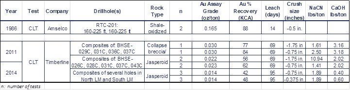
|
| 65 | Page |
10.4.3 Preliminary HPGR Crushing Test
A preliminary 2014 BRT recovery study of crushing by high pressure grinding roll (HPGR) compared to conventional crushing suggests recovery in jasperoid could increase by approximately 10%.
Table 10.4 Comparison of Bottle Roll Test Gold Recovery in Jasperoid by
HPGR Crush vs. Conventional Crush
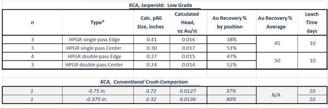
Additional work will be required to further evaluate the potential of HPGR crushing on gold recovery.
10.4.4 Historical Recoveries
Norse Windfall Mines mined about 180,000 tons of mostly oxide gold mineralization reportedly grading 0.12 oz Au/ton during 1987 (Cargill, 1988; Jonson, 1991). They hauled the mineralized rock 5.6 miles from the Lookout Mountain pit to cyanide heap-leach pads at the Windfall Mine, where they achieved an estimated 81% recovery from the pit material.
10.5 Opinion of Qualified Person
Although the authors are not experts with respect to metallurgy, the metallurgical test data have been reviewed, and it is believed that the information is sufficient for the purpose for which it used in this report, which is to support the calculation of a gold resources (Section 11.0) and to qualitatively assess the potential mineability of the project.
|
| 66 | Page |
11 Mineral Resource Estimates
11.1 Introduction
The Lookout Mountain project Mineral Resource estimates presented herein were completed by RESPEC. The Lookout Mountain project includes the Lookout Mountain and South Adit deposits. While the modeling of the project resources was primarily completed in December 2012 through February 2013, the resources were updated in December 2022 by applying pit optimizations to constrain the resources using current economic parameters.
11.2 Lookout Mountain Project Data
The project Mineral Resources were estimated using data generated by Timberline and historical operators, including Amselco, Barrick, Echo Bay, Norse Windfall Mines, EFL, Staccato. This data, as well as digital topography of the project area, were provided to RESPEC by Timberline and incorporated into a digital database in State Plane coordinates expressed in US Survey feet, Nevada East zone, using the NAD27 datum. All modeling of the Lookout Mountain project resources was performed using GEOVIA Surpac® mining software, which in some instances was enhanced by proprietary RESPEC macros.
11.3 Deposit Geology Relevant to Resource Modeling
The gold mineralization at the Lookout Mountain deposit is primarily hosted by the Lookout Mountain breccia, which has a northerly strike and moderate dip to the east. The breccia is quite wide at the surface and within the resource area it typically thins down dip, which creates a wedge shape in cross section that tilts in a westerly direction. Jasperoid-rich zones are common in the upper portion of the breccia near its contact with the Dunderberg Shale, while the lower portion near the Secret Canyon Shale is often marked by a clear structural zone; both zones are frequently characterized by higher-than-average gold grades. The highest-grade zones at Lookout Mountain appear to be controlled by favorable structural settings in both the breccia and overlying Dunderberg Shale. The Secret Canyon Shale, which immediately underlies much of the breccia, rarely hosts mineralization.
Gold mineralization at the much smaller South Adit deposit is similar to that at Lookout Mountain in several respects. Gold occurs at or near the Dunderberg-Hamburg contact and is associated with strong silicification, argillization, and a series of steeply to moderately dipping normal faults that form a westerly tilted and downward-pinching wedge of prospective ground.
11.4 Geologic Modeling
Timberline provided RESPEC with a set of 50- and 100-foot cross sections that define the various stratigraphic units across the full extents of the Lookout Mountain resource model areas, as well as the Lookout Mountain breccia and various structures. These interpretations were derived from careful study of the drill data, including extensive re-logging of drill chips from the pre-Timberline holes. The sectional interpretations were digitized and used as the base for the mineral domain modeling (discussed below).
|
| 67 | Page |
11.5 Oxidation Modeling
Timberline also provided RESPEC with a set of cross sections for the Lookout Mountain and South Adit deposits with interpretations of the boundaries between oxidized and unoxidized rocks, based on drill-hole logging codes. RESPEC subsequently made modifications to these sections, primarily by incorporating cyanide shake-leach data into the oxidation boundary definition. The revised set of oxidation sections were then further refined by RESPEC at 20-foot-spaced, vertical sectional (long section) intervals that match the center of the 20-foot-long blocks that comprise the resource block model.
11.6 Density Modeling
RESPEC was provided with a total of 214 specific-gravity determinations from the resource area. These data were derived from dry bulk specific-gravity determinations completed on core samples by the water immersion method using samples coated with wax, including 12 determinations by Thurston Testing Laboratory and 202 from KCA. There are 167 determinations on samples that lie within mineral domains (discussed in Section 11.7) modeled at Lookout Mountain. Descriptive statistics of these density data, converted into tonnage factors (TF), are summarized in Table 11.1.
Table 11.1 Density Data
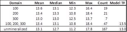
RESPEC does not believe that the differences between the tonnage factors from samples within the low- (domain 100), medium- (domain 200), and high-grade (domain 300) mineral domains are statistically significant; therefore, a single tonnage factor (13.5 ft3/ton) is applied to all modeled mineralization. This tonnage factor is slightly higher than the mean and median values due to in situ open spaces present within the Lookout Mountain breccia that cannot be captured in samples of drill core and therefore cannot be accounted for in the specific-gravity determinations. A tonnage factor of 20 was assigned to the partial percentage of a block coded to alluvium, and this value was weight-averaged with the bedrock tonnage factor to obtain the full-block density.
All unmineralized blocks are assigned a tonnage factor of 13.0 ft3/ton in the Lookout Mountain model. There are a number of different formations and lithologies present in the model area, so this average number has spatial inaccuracies. This simplified modeling of the density of the host rocks will warrant additional evaluation to support future economic studies. Only two density determinations are available from mineralization modeled at South Adit, which yielded tonnage factors of 14.0 and 13.6. The same tonnage factors used at Lookout Mountain were applied to the South Adit model.
For the purposes of density assignment, RESPEC created a solid of the historical Lookout Mountain mine dumps using existing topography and pre-mine topography digitized from an historical topographic map of the mine area. The waste-dumps were then assigned a tonnage factor of 20.
|
| 68 | Page |
11.7 Gold Modeling
11.7.1 Mineral Domains
RESPEC modeled the Lookout Mountain and South Adit gold mineralization by explicitly interpreting mineral-domain polygons on north-looking cross sections that span the extents of the Lookout Mountain and South Adit resource areas. A mineral domain encompasses a volume of rock that ideally is characterized by a single, natural, grade population of a metal or metals that occurs within a specific geologic environment.
In order to define the mineral domains at Lookout Mountain and South Adit, the natural gold populations were first identified on population-distribution graphs that plot the gold-grade distribution of the drill-hole assays. This analysis led to the identification of five separate populations, not all of which show sufficient continuity to model effectively. Ultimately, RESPEC modeled low-grade (~0.003 to ~0.015 oz Au/ton), medium-grade (~0.015 to ~0.080 oz Au/ton), and high-grade (>~0.080 oz Au/ton) populations, assigned to gold domains 100, 200, and 300, respectively. Ideally, each of these populations can then be correlated with specific geologic characteristics that are captured in the project database, which can be used in conjunction with the grade populations to interpret the bounds of each of the gold mineral domains.
In addition to these hard-rock mineral domains, alluvial/colluvial material that was shed from areas of outcropping mineralization at Lookout Mountain was modeled where the alluvium consistently contains gold (domain 10).
Vertical north-looking cross sections spanning a north-south distance of 6,700 feet were used for the initial modeling of the Lookout Mountain mineral domains. Sections spaced at 50-foot intervals were used for the 850-foot-long section of dense drilling at North Lookout Mountain, while the remainder of the modeling utilized 100-foot sections. A total of 20 100-foot spaced sections were utilized for the South Adit modeling. The drill-hole traces, topographic profile, and Timberline geologic and gold interpretations were plotted on the sections, with gold assays (colored by the grade-domain population ranges) and pertinent alteration codes plotted along the drill-hole traces. Mineral-domain envelopes were interpreted on the sections using available and reasonably assumed geologic criteria to encompass gold values that more-or-less correspond to each of the defined grade populations. With few exceptions, the mineral domains only model zones with demonstrable continuity. At North Lookout Mountain, the mineral domains were modeled through to the pre-mine surface using all available drill data, so that assay data that have been ‘mined out’ were also modeled and used in the grade interpolations described below.
RESPEC was not always able to correlate the three mineral domains with specific geologic characteristics that are consistently captured in the project datasets. This is primarily due to the preponderance of RC holes, the chips from which are not of sufficient size to characterize specific textures within the Lookout Mountain breccia. However, the high density of drilling at North Lookout Mountain, which includes most of the core holes drilled in the resource area, ultimately led to the high-quality geologic modeling by Timberline, which in turn significantly increased the confidence of the modeling of gold in this area.
The mineral domains modeled by RESPEC at Lookout Mountain occur predominantly within the Lookout Mountain breccia, with exceptions including mineralization in the Dunderberg Shale in the hanging wall of the breccia, minor mineralization in Secret Canyon limestone immediately below the breccia, and the gold occurring in alluvium. South Adit mineralization has similar structural and lithologic controls.
|
| 69 | Page |
Higher-grade mineralization (domain 300) is most extensive at North Lookout Mountain. In cross-sectional view, the high-grade zones in this area are characterized by a central more-or-less cylindrical core of mineralization that has thin extensions emanating outwards that are slightly oblique to the upper contact of the Lookout Mountain breccia. These high-grade zones transgress the Lookout Mountain breccia – Dunderberg Shale contact, occurring in both units. The long axes of the cylindrical, cigar-shaped zones plunge at shallow angles to the south-southeast. One of the core zones occurs near the present-day surface and is largely mined out, while the other lies about 400 to 500 feet down dip of the upper contact of the breccia (Figure 11.1). The thin extension from the upper high-grade pod extends downwards along a shear within the Dunderberg Shale, sub-parallel to the upper breccia contact.
Mid-grade mineralization (domain 200) at North Lookout Mountain occurs primarily in two continuous zones: one immediately below and along the upper contact of the breccia and the other immediately above the lower contact. These zones periodically branch off to form related sub-parallel zones of lesser continuity. Based on limited core data, the upper mid-grade zone is characterized by jasperoid-dominant breccia, while the lower domain 200 mineralization is associated with a well-defined structural zone that has likely experienced post-mineral movement. Domain 200 mineralization at South Lookout Mountain and South Adit is believed to be controlled by structures of various orientations, some of which include the southern extensions of the two main zones of domain 200 mineralization at North Lookout Mountain.
Domain 100 low-grade mineralization encompasses the extents of the mineralized system in the resource areas, which in many more-or-less outline the extents of the Lookout Mountain breccia.
Representative cross sections showing gold mineral-domain interpretations at Lookout Mountain are shown in Figure 11.1 and Figure 11.2; Figure 11.3 shows the mineral-domain interpretations at South Adit.
11.7.2 Assay Coding, Capping, and Compositing
Drill-hole gold assays were coded to the mineral domains using the cross-sectional mineral-domain envelopes. Descriptive statistics of the coded assays are provided in Tables 11.2 and 11.3 for Lookout Mountain and South Adit, respectively.
Table 11.2 Descriptive Statistics of Lookout Mountain Coded Gold Assays
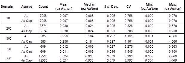
|
| 70 | Page |
Table 11.3 Descriptive Statistics of South Adit Coded Gold Assays
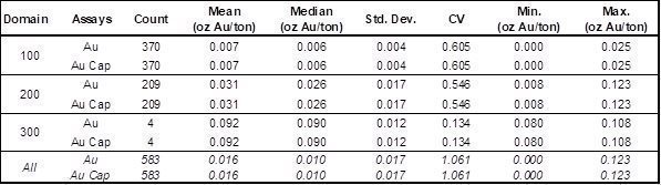
Assay caps were determined by the inspection of population distribution plots of the coded assays, by domain, to identify high-grade outliers that might be appropriate for capping. The plots were also evaluated for the possible presence of multiple grade populations within each of the metal-domains distributions. Descriptive statistics of the coded assays by domain and visual reviews of the spatial relationships of the possible outliers, and their potential impacts during grade interpolation, were also considered in the definition of the assay caps. In addition to the assay caps, restrictions on the search distances of the higher-grade portions of some of the domains were applied (search restrictions are discussed further below).
The descriptive statistics for the composites from Lookout Mountain and South Adit, are included in Tables 11.4 and 11.5, respectively.
Table 11.4 Descriptive Statistics of Lookout Mountain Gold Composites
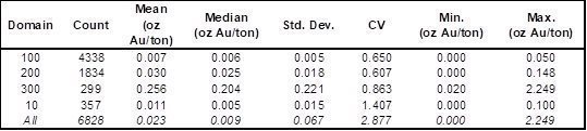
Table 11.5 Descriptive Statistics of South Adit Gold Composites
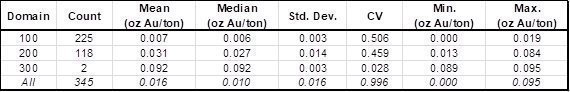
|
| 71 | Page |
Figure 11.1 North Lookout Mountain Cross Section 1697700 Showing Gold Mineral Domains

|
| 72 | Page |
Figure 11.2 South Lookout Mountain Cross Section 1694900 Showing Gold Mineral Domains
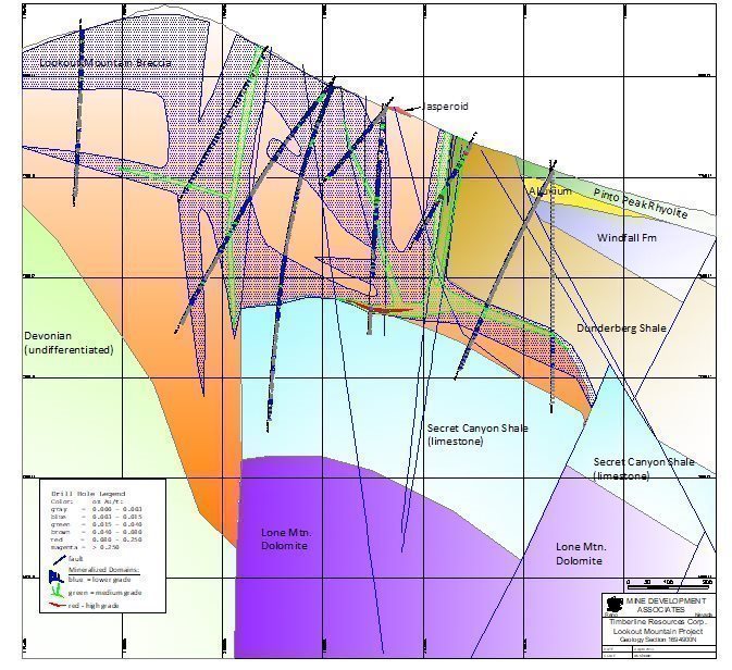
|
| 73 | Page |
Figure 11.3 South Adit Cross Section 1687300 Showing Gold Mineral Domains
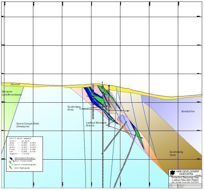
|
| 74 | Page |
11.7.3 Block Model Coding
The cross-sectional gold and silver mineral-domain envelopes were pressed horizontally to the drill data within each sectional window and sliced at 10-ft vertical intervals for the Lookout Mountain deposit and 20-foot intervals at South Adit. These slices were then used to create a new set of gold mineral-domain polygons to rectify the domain interpretations to the drill-hole data. The completed level-plan mineral-domain polygons were used to code three-dimensional block models comprised of 20-foot (wide) x 20-foot (long) x 20-foot (high) blocks. In order for the block models to better reflect the irregularly shaped limits of the various gold domains, as well as to explicitly model dilution, the percentage volume of each mineral domain within each block is stored (the “partial percentages”). At Lookout Mountain, the stored block percentage is the average derived from two 10-foot levels within each 20-foot block, while one level plan is used to code each South Adit block.
Each block is assigned a tonnage factor according to Table 11.1. The percentage of each block that lies below the topographic surface is also stored for use in the calculation of block tonnages. The 20-foot spaced oxide envelopes (see Section 11.5) were used to code the blocks on a partial percentage basis model column-by-model column. If 50% or more of a block is thereby coded, the block is considered as oxidized and the remaining blocks as unoxidized for the purposes of the application of the resource cutoffs (described below).
11.7.4 Grade Interpolation
A variographic study was performed using the Lookout Mountain gold composites from each mineral domain, collectively and separately, at various azimuths, dips, and lags. The study was complicated by the fact that gold mineralization occurs in multiple orientations at South Lookout Mountain. Acceptable structures modeled on variograms were obtained from composites from domain 300, as well as domain 100 and 200 together (Figure 11.4). Maximum ranges of 120 to 135 feet were obtained in both the horizontal direction at an azimuth of 000° and at an orientation of -40° at an azimuth of 090°, which are geologically reasonable orientations for the global strike and dip of the mineralization, respectively. At South Adit, reliable variograms in the strike direction could not be generated due to insufficient data; the longest range defined in the dip direction is 60 feet. Parameters obtained from the variography study were used in an ordinary-krige interpolation and also provided information relevant to both the estimation parameters used in an inverse-distance interpolation and resource classification.
As discussed above, core zones of mineral-domain 300 mineralization at North Lookout Mountain plunge to the southeast. This contrasts with the north-striking, moderately east-dipping mineralization that characterizes the remainder of North Lookout Mountain and some of the South Lookout Mountain mineralization, which is characterized by two additional orientations. The presence of multiple mineral orientations necessitated the use of multiple search ellipses for the Lookout Mountain model.
|
| 75 | Page |
Figure 11.4 Variogram of Lookout Mountain Domain 100 and 200 Composites in Dip Direction
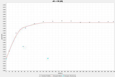
The parameters applied to the gold-grade estimations at Lookout Mountain are summarized in Table 11.6.
Multiple populations were captured in the low-grade, high-grade, and alluvial domains (domains 100, 300, and 10, respectively) at Lookout Mountain and the mid-grade domain (domain 200) at South Adit. Search restrictions were therefore implemented on these populations during grade interpolation. The use of search restrictions allows for minimizing the number of samples subjected to capping while properly respecting the highest-grade populations within each domain.
Hard-rock grades were interpolated using inverse distance to the third power, ordinary krige, and nearest-neighbor methods; the minor amounts of colluvial/alluvial resources at Lookout Mountain were estimated using inverse distance to the second power. The mineral resources reported herein were estimated by inverse-distance interpolation, as this technique was judged to provide results superior to those obtained by ordinary kriging. The nearest-neighbor estimation was also completed as a check on the other interpolations.
The maximum number of composites allowed for the estimation of a block was decreased from 18 to 10 in the low-grade domain (domain 100) in order to limit the influence of some erratically distributed higher-grade samples within the domain. Estimation parameters used at South Adit are listed in Table 11.7.
The major and semi-major axes of the search ellipses approximate the average strike and dip directions of the gold mineralization in each estimation domain. The first-pass search distances take into consideration the results of both the variography and drill-hole spacing. The second passes were designed to estimate grade into all blocks coded to the mineral domains that were not estimated in the first passes.
The estimation passes were performed independently for each of the mineral domains, so that only composites coded to a particular domain were used to estimate grade into blocks coded by that domain. The estimated grades were coupled with the partial percentages of the mineral domains and unmodeled waste stored in the blocks to enable the calculation of a single weight-averaged block-diluted grade for each block.
|
| 76 | Page |
Table 11.6 Summary of Lookout Mountain Estimation Parameters
Search Ellipse Orientations |
Estimation Domain | Major Bearing | Plunge | Tilt |
North Lookout Mountain Au domain 300 | 330° | 20° | -40° |
North & South Lookout Mountain subvertical structures | 0° | 0° | 80° |
North & South Lookout Mountain moderately steeply dipping structures | 0° | 0° | -60° |
North & South Lookout Mountain subhorizontal mineralization & alluvium | 0° | 0° | -10° |
Au Domains 200 & 300 |
Estimation Pass | Search Ranges (ft) | Composite Constraints | ||||
Major | S-Major | Minor | Min | Max | Max/hole | |
1 | 150 | 150 | 75 | 2 | 18 | 3 |
2 | 350 | 350 | 350 | 1 | 18 | 3 |
|
|
|
|
|
|
|
Au Domain 100 | ||||||
1 | 150 | 150 | 75 | 2 | 10 | 3 |
2 | 350 | 350 | 350 | 1 | 10 | 3 |
Search Restrictions |
Domain | Grade Threshold (oz Au/ton) | Search Restriction (ft) | Estimation Pass |
Au 100 | >0.010 | 125 | 1 |
Au 300 | >0.15 | 85 | 1 & 2 |
Au 10 | >0.009 | 100 | 1 & 2 |
Au 10 | >0.040 | 50 | 1 & 2 |
Ordinary Krige Parameters |
Model | Domain | Nugget | First Structure | Second Structure | ||||||
C0 | C1 | Ranges (ft) | C2 | Ranges (ft) | ||||||
SPH-Normal | 10, 100, 200 | 0.151 | 0.250 | 50 | 50 | 35 | 0.120 | 120 | 120 | 105 |
SPH-Normal | 300 | 0.100 | 0.146 | 60 | 60 | 30 | 0.037 | 80 | 60 | 30 |
1 krige interpolation used as a check against the reported inverse-distance interpolation
|
| 77 | Page |
Table 11.7 Summary of South Adit Estimation Parameters
Search Ellipse Orientations |
Estimation Domain | Major Bearing | Plunge | Tilt |
South Adit Au domains 100, 200 & 300 | 0° | 0° | -60° |
Au Domains 100, 200, 300 |
| Estimation Pass | Search Ranges (ft) | Composite Constraints | |||||
Major | S-Major | Minor | Min | Max | Max/hole | ||
1 | 200 | 200 | 100 | 2 | 18 | 3 | |
2 | 400 | 400 | 400 | 1 | 18 | 3 | |
Search Restrictions |
Domain | Grade Threshold (oz Au/ton) | Search Restriction (ft) | Estimation Pass |
Au 200 | >0.035 | 100 | 1 |
Ordinary Krige Parameters |
Model | Domain | Nugget | First Structure | Second Structure | ||||||
C0 | C1 | Ranges (ft) | C2 | Ranges (ft) | ||||||
SPH-Normal | 100,200,300 | 0.176 | 0.228 | 40 | 40 | 28 | 0.098 | 60 | 60 | 40 |
1 krige interpolation used as a check against the reported inverse-distance interpolation
11.7.5 Model Checks
Gold domain volumes coded into the block model as partial percentages were compared to the volumes of both the cross-sectional and level-plan mineral-domain polygons to assure close agreement, and all block-model coding was checked visually. A polygonal estimate using the cross-sectional domain polygons, as well as the nearest-neighbor and ordinary-krige estimates, were used as checks on the ID3 estimation results. No unexpected relationships between the check estimates and the inverse-distance estimate were identified. Various grade-distribution plots of assays, composites, and the nearest-neighbor, ordinary-krige, and inverse-distance block grades were evaluated as a check on both the global and local estimation results. Finally, the inverse-distance grades were visually compared to the drill-hole assay data in detail to assure that reasonable results were obtained.
In addition to these statistical and visual evaluations of the grade models, the resources modeled within the historical open-pit were compared to the recorded production. At a cutoff of 0.020 oz Au/ton, which was the reported cutoff grade employed at the time of mining (Jonson, 1991), Measured, Indicated, and Inferred oxide material within the historical pit estimated in the resource model totals 323,000 tons grading 0.091 oz Au/ton (29,500 ounces). Production data for 1987 indicate that Norse Windfall Mines mined 180,200 tons grading 0.12 oz Au/ton at North Lookout Mountain, for a total of almost 22,000 ounces (Cargill, 1988; Jonson, 1991). The lack of data for 1988, the last year of production, limits the usefulness of the comparison.
|
| 78 | Page |
11.8 Lookout Mountain Project Mineral Resources
The Lookout Mountain and South Adit deposits have the potential to be mined by open-pit methods. The Mineral Resources were estimated to reflect potential open-pit extraction with heap-leach processing of oxide materials and off-site toll milling of unoxidized materials. To meet the requirement of reasonable prospects for eventual economic extraction of the Mineral Resources, Whittle pit optimizations were run using the parameters summarized in Table 11.8.
Table 11.8 Pit Optimization Parameters
Item | Value | Unit |
Mining cost | 2.50 | $/ton |
Heap leach processing cost | 3.60 | $/ton processed |
Toll milling processing cost | 60.00 | $/ton processed |
Toll milling transportation cost | 20.00 | |
General and administrative cost | 3.00 | M$/yr |
Processing rate | 10 | Ktons-per-day processed |
Processing rate | 3,600 | Ktons/yr |
General and administrative cost | 3.00 | $/ton processed |
Reclamation cost | 0.25 | $/ton processed |
Au Refining cost | 3.00 | $/oz produced |
Au price | 1,800 | $/oz |
Heap leach Au recovery | 80 | percent |
Toll milling Au recovery | 86 | percent |
Royalty | 3.50 | NSR % |
The gold price used in the pit optimizations ($1,800/oz) is derived from three-year moving-average prices as of the end of December 2022 ($1,790/oz). The pit shells created by the optimizations were used to constrain the Mineral Resources potentially amenable to open-pit mining methods.
The optimization parameters in Table 11.8 can be used to calculate the internal cutoff grades that define which blocks lying withing the pit optimizations would be potentially available for heap leaching of oxidized materials (cutoff of 0.003 oz Au/ton) and toll milling of unoxidized materials (cutoff of 0.055 oz Au/ton). However, due to potential uncertainties with respect to some of the historical assay data at grades less than 0.005 oz Au/ton (see Section 11.8.1), a cutoff grade of 0.005 was implemented as an override of the 0.003 cutoff grade that otherwise would have applied to the oxidized materials in the resource pit optimizations.
The mining cost is not included in the determination of the cut-off grades, as all materials within the optimized pits are conceptually mined, which means the cut-off grades determine whether the mined materials are sent to be processed or to waste-rock storage facilities. The reference point at which the Mineral Resources are defined is therefore at the top rim of the pit, where material equal to or greater than the applicable cutoff grades would be processed.
|
| 79 | Page |
The Lookout Mountain project block-diluted mineral resources, including both the Lookout Mountain and South Adit deposits, are presented in Table 11.9.
Table 11.9 Lookout Mountain Project Gold Resources

Notes:
| · | The estimate of the Lookout Mountain project Mineral Resources was completed by RESPEC. |
| · | The Mineral Resources are comprised of oxidized model blocks that lie within optimized pits at a cutoff grade of 0.005 oz Au/ton plus unoxidized blocks within the optimized pits at a 0.055 oz Au/ton cutoff. |
| · | Mineral Resources that are not Mineral Reserves do not have demonstrated economic viability. |
| · | The Mineral Resources are potentially amenable to open pit mining methods and are therefore constrained by optimized pits created using a gold price of US$1,800/oz, a throughput rate of 10,000 tons/day, assumed metallurgical recoveries of 80% for heap-leaching of oxidized materials and 86% for toll milling of unoxidized materials, a mining cost of US$2.50/ton, heap-leaching processing cost of $3.60/ton, toll milling cost of $80.00/ton, general and administrative costs of $0.83/ton processed, a reclamation cost of $0.25/ton processed, refining cost of $3.00/oz Au produced, and an NSR royalty of 3.5%. |
| · | The effective date of the resource estimate is December 31, 2022. |
| · | Rounding may result in apparent discrepancies between tons, grade, and contained metal content. |
The modeled mineralization within the optimized pits that constrain the total current project resources is tabulated at various cutoffs for the Lookout Mountain (Table 11.10) and South Adit (Table 11.11) deposits, with the current resources highlighted in bold. These tables are presented to provide grade-distribution information, which allows for a more detailed assessment of the project resources.
|
| 80 | Page |
Table 11.10 Lookout Mountain Deposit In-Pit Mineralization at Various Cutoffs

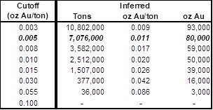
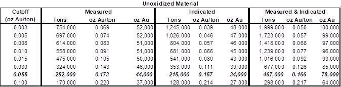
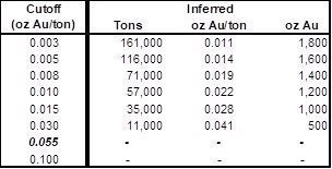
Note: Rounding may result in apparent discrepancies between tons, grade, and contained metal content.
|
| 81 | Page |
Table 11.11 South Adit Deposit Mineralization at Various Cutoffs
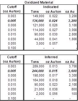
Note: Rounding may result in apparent discrepancies between tons, grade, and contained metal content.
All South Adit mineralization is oxidized
Figure 11.5, Figure 11.6, and Figure 11.7 show cross sections of the block models that correspond to the mineral-domain cross sections in Figures 11.1, 11.2, and 11.3, respectively.
|
| 82 | Page |
Figure 11.5 North Lookout Mountain Cross Section 1697550N Showing Block Model Gold Grades
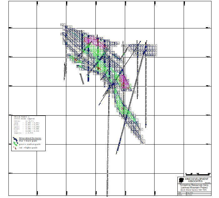
|
| 83 | Page |
Figure 11.6 South Lookout Mountain Cross Section 1694900N Showing Block Model Gold Grades
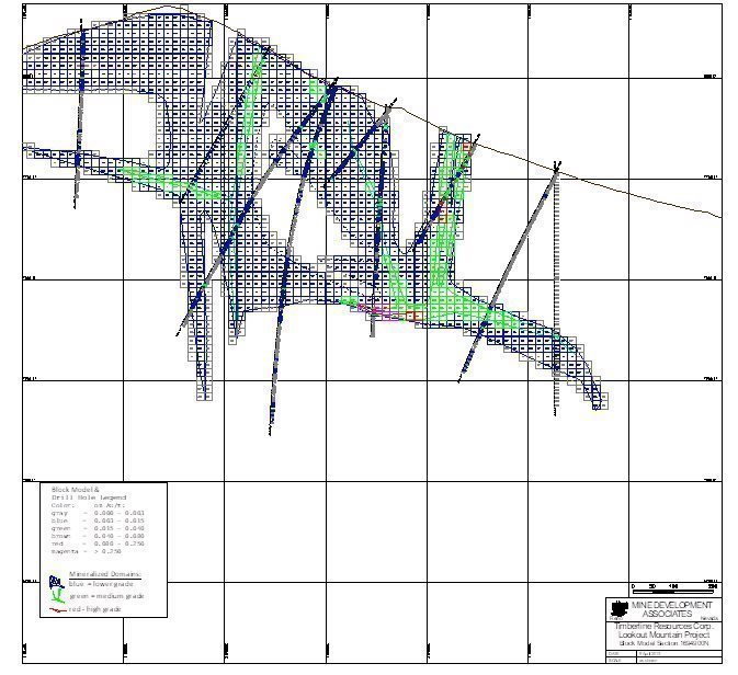
|
| 84 | Page |
Figure 11.7 South Adit Cross Section 1687300N Showing Block Model Gold Grades
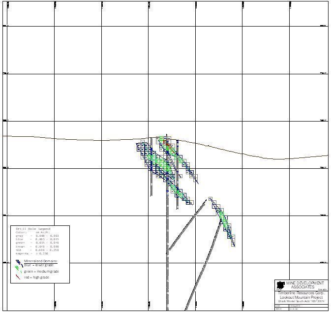
|
| 85 | Page |
11.8.1 Project Risks and Resource Classification
Uncertainties that could impact resource classification include: (i) the potential of unrecognized poor sample quality in some portions of some RC and rotary holes; (ii) potential uncertainties with respect to the veracity of some of the lowest-grade gold assay data derived from some of the historical project operators; (iii) the modeling of gold mineralization and oxidation in less-densely drilled portions of the South Lookout Mountain area; and (iv) the assignment of rock densities, especially in unmineralized areas.
There is strong evidence of local down-hole contamination in certain intervals of the RC and rotary drill data, and such intervals were removed from use in the resource estimation. However, the identification of suspect intervals is interpretational, and RESPEC believes it is possible that some relatively small amount of the excluded mineralization is not actually contaminated, while some mineralized samples included in the resource estimation may be affected by contamination. Unrecognized contamination could locally affect grade and/or tonnage of the project resources. Due to the nature of the drilling methods, rotary drill samples are inherently more prone to sample-quality issues than those from RC.
At very low grades (< ~0.005 oz Au/ton), some of the older historical assays may not have the precision or accuracy of modern analytical methods. The resource cutoff grade applied to in-pit materials was therefore chosen to be 0.005 oz Au/ton, which overrides the lower cutoff of 0.003 oz Au/ton that could have otherwise been used based on the economic parameters applied to the pit optimization.
Subsequent resource modeling could be improved by the incorporation of geologic criteria into the project databases that assist in the definition of the various mineral domains, especially the mid- and higher-grade domains. RESPEC was not always able to correlate the mineral domains that constrain the resources with specific geologic characteristics that are consistently captured in the project databases. This is primarily due to the preponderance of RC and rotary holes, the chips from which are not of sufficient size to characterize specific textures within the Lookout Mountain breccia. The high density of drilling at North Lookout Mountain, which includes most of the core holes drilled in the resource area, ultimately led to the high-quality geologic modeling by Timberline and therefore high-confidence mineral-domain modeling by RESPEC. However, portions of the South Lookout area and the South Adit deposit could benefit from infill drilling to verify the current resource modeling.
Oxidation modeling can also be improved by standardizing the codes in the database, which are derived from the work of many different geologists from the various drill campaigns. Significantly more cyanide-leach analyses would also aid the oxidation modeling.
More density measurements are needed, especially in unmineralized units. While density uncertainties in unmineralized units have minimal impact on the current resources, as the project proceeds accurate assignment of density to all units, mineralized or unmineralized, will be required.
In consideration of the uncertainties discussed above, as well as the steps taken to mitigate these uncertainties, the Lookout Mountain resources are classified using the criteria listed in Table 11.12.
Measured resources are restricted to lie within the densely drilled North Lookout Mountain area and the northernmost portion of South Lookout Mountain, where the geology that supports the resource modeling is very well constrained. Composites from rotary holes are not used to meet the minimum criteria that apply to the definition of Measured resources. Indicated resources are defined using composites from all holes. All estimated blocks that are not classified as Measured or Indicated, or that are coded as alluvium, are assigned to the Inferred category. No waste-dump resources have been estimated.
|
| 86 | Page |
Table 11.12 Lookout Mountain Classification Parameters
Class | Min. No. of Comps | Additional Constraints |
Measured | 3 | Minimum of 2 holes, excluding rotary holes, within an average distance of 45ft from block for all blocks lying between 1695270N and 1698700N |
Indicated | 3 | Minimum of 2 holes within an average distance of 110ft from block |
Inferred | All blocks coded as > 50% alluvium and all other estimated blocks not classified as Measured or Indicated | |
Classification parameters used to classify the South Adit resources are listed in Table 11.13.
Table 11.13 South Adit Classification Parameters
Class | Min. No. of Comps | Additional Constraints |
Indicated | 2 | Minimum of 2 holes within an average distance of 60ft from block |
Inferred | All other estimated blocks | |
The Indicated criteria at South Adit are more restrictive than those used at Lookout Mountain, which again reflects the somewhat lower confidence in the underlying geologic modeling; there are no Measured resources at South Adit.
11.8.2 Further Comments on the Resource Modeling
Mineralized alluvium was modeled and estimated at the Lookout Mountain deposit, with blocks coded as including more than 50% alluvium included as resources and classified as Inferred. A total of 283,000 tons of alluvium grading 0.009 oz Au/ton (2,600 ounces) are included in the resources at the reportable oxide cutoff of 0.005 oz Au/ton.
A total of 839 sample intervals lie within the modeled mineral domains at the Lookout Mountain deposit and are known or suspected to have been analyzed by cyanide shake-leach or aqua regia / AA methods only; no fire-assay data are available for these intervals. This represents 7% of the coded assays used in the resource estimation of Lookout Mountain; there are no cyanide-only assays at South Adit. Since both analytical techniques are partial-gold analyses, the inclusion of these data could result in some under-estimation of the resources. An estimate that excluded these analyses yielded only about 1,000 fewer ounces of gold at the reporting cutoffs than the actual resource estimate reported above. The actual impact is likely to slightly exceed this, however, since artificially lower analyses can lead to samples being modeled into lower-grade domains than otherwise might be the case, i.e., the partial-gold analyses could lead to lower volumes of higher-grade domains, an impact that can only be partly examined by a re-estimation that excludes the analyses.
|
| 87 | Page |
12 MINERAL RESERVE ESTIMATES
This section is not applicable to this TRS.
|
| 88 | Page |
13 MINING METHODS
This section is not applicable to this TRS.
|
| 89 | Page |
14 PROCESSING AND RECOVERY METHODS
This section is not applicable to this TRS.
|
| 90 | Page |
15 INFRASTRUCTURE
Access to the Lookout Mountain project site is southward approximately 8.5 miles from US Highway 50 south of Eureka along the Windfall Canyon Road and the Windfall Cutoff Road. The Windfall Cutoff Road extends past the project site approximately 7.5 miles southeasterly where it becomes the Ratto Canyon Road which can be taken to intersection with the Duckwater Road. Although the country is rugged in part, the Windfall Cutoff Road is excellent and was originally developed as an ore-haulage road.
The Lookout Mountain development project is envisioned as an open pit oxide heap leach operation with a load-out facility for direct shipment of high-grade refractory ore. Newfields completed a scoping-level facilities location study in 2012 and identified prospective sites for rock storage area, leach pad, ponds, and a process facility located west of the north-south trending open pit (Figure 15.1). This siting would limit the facilities to within a single drainage basin with minimal up-gradient drainage area and require only small upstream diversion channels.
In addition, there would be no/minimal impact to county roads and no/minimal impact to Ratto and Sierra Springs. The facilities sited as such would be largely within the existing Plan of Operations area.
No power exists at the proposed mine site. Power would likely either be supplied from grid sources to the north near Eureka, or from on-site generation sources.
At present the project controls no water rights. Such rights would either be purchased or leased from an existing user(s) to the south and east. Based on monitoring wells currently in place it is anticipated that water supply production wells could be sited down-gradient of the resource area with water pumped to the process facility and leach pads.
|
| 91 | Page |
Figure 15.1 Lookout Mountain Project Scoping-level Facilities Siting
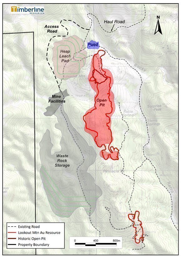
|
| 92 | Page |
16 MARKET STUDIES
This section is not applicable to this TRS.
|
| 93 | Page |
17 ENVIRONMENTAL STUDIES, PERMITTING, AND PLANS, NEGOTIATIONS, OR AGREEMENTS WITH LOCAL INDIVIDUALS OR GROUPS
In March 2009, Staccato submitted the Lookout Mountain Exploration Project Plan of Operations (PoO) to the BLM Mount Lewis Field Office to support exploration-related activities. The BLM completed an environmental assessment (EA) to meet their requirements under NEPA and approved the Plan of Operations (NVN-086574) in September 2010.
Additional environmental and engineering studies will be required to support mine permitting at Lookout Mountain. These include baseline-studies in preparation for possible submission of a mine plan of operations to the BLM.
17.1 Environmental Studies
Baseline data collection will be necessary for the completion of the environmental permit applications and for NEPA compliance include biology, cultural, spring/riparian, groundwater characterization, and waste rock and ore characterization. In addition, geotechnical data will be necessary for completion of engineering design work required for permit applications.
17.1.1 Baseline Biological Resources Survey
An updated survey of vegetation and wildlife will be completed and include consideration of spring/summer flowering and faunal breeding seasonal requirements.
17.1.2 Cultural Survey and Report
In support of exploration activities and as an update to current regulatory standards, Timberline initiated a review and an expansion of the Lookout Mountain cultural resources field survey area in 2021 with completion of field work in 2022. As part of the 2022 Work Plan Amendment, the BLM preliminarily identified site-specific cultural avoidance areas within which, until final reviews and site classifications are complete, disturbance activities will require direct disturbance oversight by qualified archeologists.
Additional cultural surveys will be completed if proposed development facilities have not yet been reviewed.
17.1.3 Spring/Riparian Baseline Data
Based on the hydrologic characterization completed in 2013 (Section 7.5) surface water sampling and water quality analysis will be re-initiated to current regulatory standards.
17.1.4 Groundwater Data Collection
In addition to those previously described (Section 7.3), four additional monitoring wells and pressure transducers are planned for installation where associated with the proposed sites of the open pit, rock waste storage facility, heap leach pad, and other facilities. All sites, including previously installed monitoring wells will be surveyed to allow determination of existing groundwater elevations, hydraulic gradients, aquifer parameters, and advancement of a conceptual hydrologic model for the site.
|
| 94 | Page |
In addition to installation of additional monitoring wells, investigations will be undertaken to identify potential water supply well source(s), installation, and test-pumping of production test well(s) and to provide data adequate for water rights permitting.
17.1.5 Waste Rock and Ore Geochemical Characterization
BLM and Nevada regulators require geochemical characterization of waste rock and ore materials to develop a complete and defensible geochemical database suitable for permitting under NEPA and to define preliminary operational and closure strategies. Data will be appropriate for predictive work on pit wall runoff or seepage chemistry from mine and processing facilities where waste and ore rocks may be exposed to the environment. Testing is required to include static and kinetic methods to determine short and long-term geochemical characterization of mine materials.
A baseline work plan was developed in 2012 and initiated for the project with samples identified from drill core. Characterization work in 2012-2013 included six humidity cell kinetic tests (HCTs), five of which reported Non-PAG (non-potential acid generating) material and one reported PAG (potential acid generating) material, and with metal production below or near Nevada reference values stable or trending downward. Six MWMP (meteoric water mobility procedure) static tests were completed with non-deleterious results.
With changes in the regulatory requirements since 2013, five additional HCTs are planned and anticipated to run for up to 50 weeks. In addition, approximately 150 samples will be required for ABA/NAG pH, 10 to 20 samples for additional MWMP testing are planned to be initiated in 2023.
17.2 Requirements and Plans for Waste Rock Disposal, Site Monitoring, and Water Management
The Plan of Operations and Water Pollution Control Permit are the primary permits which will define plans for management and monitoring and closure of waste rock storage area(s) at Lookout Mountain. These permits are further described below.
17.3 Project Permitting Requirements
Several federal, state, and local permits will be required to continue exploration and to build and operate a mine at Lookout Mountain. Key permits include:
Exploration Plan of Operations Work Plan Amendment
Exploration PoO NVN-086574 authorized up to 266.4 acres of exploration-related surface disturbance within the project area in August 2010. The Nevada Division of Environmental Protection, Bureau of Mining Regulation and Reclamation (“BMRR”) approved a Nevada Reclamation Permit (No. 0307) Nevada Reclamation Permit for the project which has been most recently updated in May 2022 to $433,910 covering up to 266.4 acres of surface disturbance as currently permitted. Work Plan Amendments are prepared and submitted to the BLM for approval typically on an annual basis and include a calculation of anticipated new disturbance acreage. With work completed through the 2022 Amendment, disturbance at Lookout Mountain currently totals 36.1 acres.
|
| 95 | Page |
Timberline has assumed the responsibility and liability for, and is currently operating under, the PoO. A reclamation bond is required based on existing and proposed disturbance and is reviewed annually. Future exploration work under the PoO or mine development will require further adjustments to the bond.
Exploration activities covered by the PoO consist of exploration drilling from existing disturbance and constructed drill sites that would be accessed by existing roads and new road construction, construction of trenches or bulk sampling, and the installation of groundwater monitoring wells. Timberline provides both the BLM and NDEP a map showing existing disturbance, new disturbance created during the reporting year and, any reclamation completed. Timberline must also provide a plan map outlining the proposed drilling activities for the current-year exploration program. Timberline is allowed to utilize any approved disturbance created in prior-year work plans and to construct any disturbance that was authorized in prior-year work plans.
Plan of Operations/Nevada Reclamation Permit
A Plan for submittal to the BLM, Nevada Department of Environmental Protection (NDEP), Bureau of Mining Regulation and Reclamation (BMRR) must be prepared from baseline data describing procedures for the construction, operation, and closure of a mine project. The Plan will address waste rock management, storm water spill contingency, reclamation, monitoring, and a management plan. A Reclamation Cost Estimate (RCE) will be prepared for closure of the operation. The Plan will require an Environmental Assessment (EA) or Environmental Impact Statement (EIS) to be prepared per NEPA.
The initial baseline dataset collected for the Exploration Plan will be expanded to support the Plan of Operations/Nevada Reclamation Permit application. Follow-up or initial baseline investigations will include resource, pit-wall geotechnical, metallurgy, and hydrology studies.
Water Pollution Control Permit
A Water Pollution Control Permit (WPCP) permit will be required to advance to mining at Lookout Mountain. The WPCP application will be prepared for the open pit, waste rock storage area, heap leach pad, and processing facilities. The scoping level facilities investigation will be advanced to construction level engineering drawings to support the permit application.
Air Quality Operating Permit and Mercury Operating Permit
The Air Quality Operating Permit (AQOP) requires a description of the proposed facility and a detailed emissions inventory. No work has been completed to date by the Company on these permits.
|
| 96 | Page |
Industrial Artificial Pond Permit
An Industrial Artificial Pond Permit (IAPP) from the Nevada Department of Wildlife (NDOW) is required for development and operation of the water storage pond for the proposed mine. No work has been completed to date by the Company on this permit.
Water Rights Permit
In addition to the above listed permit requirements, additional requirements will include a water rights permit from the Nevada State Engineer (NSE). Options to obtain water rights for production purposes will include purchase or lease of an existing right(s). No work has been completed to date by the Company on this permit.
Other Permits
In addition to the listed permit requirements, approximately 15 minor or ministerial permits from federal and state agencies will be required for development and operation of a mine at Lookout Mountain.
17.4 Plans, Negotiations, or Agreements with Local Individuals or Groups
Timberline maintains an annual Memorandum of Understanding with Eureka County for minor road maintenance on County Roads used by the Company to access the Lookout Mountain area during each field season when exploration activities are on-going.
17.5 Mine Closure Plans
Mine closure plans will be included in the Plan of Operations and WPCP and as such have not yet been developed for the project.
17.6 QP’s Opinion
It is the opinion of the QP that the existing baseline studies are adequate to support continued exploration of the resource area and are adequate to advance the project to an Initial Assessment.
17.7 Commitments to Local Procurement and Hiring
The Company has no agreements or commitments to ensure local procurement and hiring at the present time.
|
| 97 | Page |
18 CAPITAL AND OPERATING COSTS
This section is not applicable to this TRS.
|
| 98 | Page |
19 ECONOMIC ANALYSIS
This section is not applicable to this TRS.
|
| 99 | Page |
20 ADJACENT PROPERTIES
Timberline’s Eureka property includes other claim groups in addition to the Lookout Mountain group. In addition to Lookout Mountain, historical mining has taken place at the Paroni mine, Rustler mine, and Windfall mine in similar geologic settings as at Lookout Mountain with mineralization focused in the Cambrian-aged Dunderberg and Hamburg stratigraphy.
|
| 100 | Page |
21 OTHER RELEVANT DATA AND INFORMATION
Neither Timberline nor RESPEC are aware of any other data or information relevant to this TRS.
|
| 101 | Page |
22 INTERPRETATION AND CONCLUSIONS
RESPEC reviewed the project data, including the Lookout Mountain drill-hole database, and visited the project site. RESPEC believes that the data provided by Timberline, as well as the geological interpretations Timberline has derived from the data, are generally an accurate and reasonable representation of the Lookout Mountain project.
The modeled gold mineralization at the Lookout Mountain resource extends for almost 7,000 feet in length and is primarily hosted by the Lookout Mountain breccia, which strikes in a northerly direction and dips moderately to the east. The breccia is quite wide at the surface and typically thins down dip, which creates a wedge shape in cross sectional view that tilts to the west. Gold mineralization at South Adit is generally like that at Lookout Mountain. Gold occurs at or near the Dunderberg-Hamburg contact and is associated with strong silicification, argillization, and a series of steeply to moderately dipping normal faults that form a westerly tilted and downward-pinching mineralized wedge. Gold mineralization at the Lookout Mountain project is of the disseminated sediment-hosted type.
The primary controls on the Lookout Mountain mineralization are the north-trending, high-angle Ratto Ridge fault system, which has localized jasperoids and gold mineralization in sedimentary units along more than 2.5 miles of strike length, and the Lookout Mountain breccia. The mineral domains modeled by RESPEC occur predominantly within the Lookout Mountain breccia, with exceptions including mineralization in the Dunderberg Shale in the hanging wall of the breccia, which is often high grade, minor mineralization in the underlying Hamburg limestone and Secret Canyon formations where brecciated, and the gold occurring in colluvium/alluvium. Critical controls to the mineralization at South Audit have yet to be definitively established.
About 180,000 tons of mostly oxide gold mineralization, reportedly grading 0.12 oz Au/ton, were mined from the Lookout Mountain open pit during 1987. The ore was hauled 5.6 miles to cyanide heap-leach pads at the Windfall mine, where an estimated 81% recovery was achieved from the ore. Metallurgical testing completed by Timberline and previous operators suggests that the oxidized gold mineralization remaining at Lookout Mountain and South Adit is amenable to extraction by cyanidation via heap leaching, although projected recoveries are variable for some materials and require further test work.
Timberline provided RESPEC with a project database consisting of information derived from 92 core holes and 662 RC and rotary holes completed by Newmont, Amselco, Norse Windfall Mines, EFL, Barrick, Echo Bay, Staccato, and Timberline. RESPEC audited the database and completed a comprehensive re-compilation of all assay data from Amselco’s RTR- and RTC-series holes. In-house mine laboratories were used for the 20 Norse Windfall Mines holes and some of the Amselco holes, and many of these analyses utilized partial-gold extractions. Some of the Norse Windfall Mines gold data clearly understate grades in comparison to adjacent holes. RESPEC’s reconstruction of the Amselco database effectively limits the impact of the in-house assays by replacing many of them with check analyses performed at commercial laboratories. RESPEC believes the Lookout Mountain analytical data are of sufficient quality for use in the resource estimation. The mineral resources reported herein were estimated using this database.
|
| 102 | Page |
Project risks that could impact the Lookout Mountain project mineral resources include: (i) the potential of unrecognized poor sample quality in some portions of some RC and rotary holes in the form of down-hole contamination; (ii) potential uncertainties with respect to some of the lowest-grade gold assay data derived from some of the historical project operators; (iii) the modeling of gold mineralization and oxidation in less-densely drilled portions of the South Lookout Mountain area; and (iv) the assignment of rock densities, especially in unmineralized areas. As discussed in Section 11.8.1, these risks were at least partially mitigated, as in the case of down-hole contamination, specifically addressed by the choice of resource estimation parameters, as in the case of the application of a higher resource cutoff grade than might otherwise be chosen, and/or by the classification of the resources.
The Lookout Mountain project gold resources, which include both the Lookout Mountain and South Adit deposits, are tabulated using cutoff grades of 0.005 oz Au/ton for oxidized material and 0.055 oz Au/ton for unoxidized material. These cutoffs are chosen to capture mineralization that is potentially available to open-pit extraction, with the lower cutoff applied to oxidized material that can reasonably be assumed to be amenable to heap-leach processing, while the higher cutoff is applied to unoxidized material and reflects probable lower heap-leach recoveries and/or more costly sulfide processing. Measured and Indicated resources total 25,819,000 tons averaging 0.017 oz Au/ton (423,000 ounces), with an additional 7,322,000 tons averaging 0.011 oz Au/ton (84,000 ounces) assigned to the Inferred category.
|
| 103 | Page |
23 RECOMMENDATIONS
The Lookout Mountain project has advanced to the stage where economic studies are warranted, as reflected in the Phase I recommendations discussed below. With positive results, significant expenditures should be invested in various studies that would support a pre-feasibility study (Phase II).
Project resources remain open in all directions. Drill holes have intersected mineralized zones along the strike of the resources both to the north (Rocky Canyon) and to the south, with the 3,500-foot strike extent between the southern limit of the Lookout Mountain deposit and the northern limit of the South Adit deposit affording the best opportunity for resource expansion in the near term. Significant exploration expenditures that include surface sampling, channel sampling in areas of difficult access, and approximately 15,000 feet of drilling are warranted.
Irrespective of the results of the exploration drilling, the existing resource base also justifies further investment. Approximately 10,000 feet of infill RC and core drilling within the project resources is recommended, with the goal of converting current Inferred resources to higher categories. Ongoing metallurgical testing programs should also continue under the guidance of metallurgical experts; this program will require about 10,000 feet of additional core drilling to provide the necessary materials for testing. The program should include additional bottle-roll and column testing of various particle sizes, further crush-size fraction testing, SEM and other mineralogical characterizations, material-type volumetrics, and density measurements.
During the Phase I program, three-dimensionally accurate modeling of the geology needs to be undertaken, including all lithologic and alteration/geochemical interpretations, as well as the complex structural interpretations. This work will support all future economic studies, where waste-rock modeling has increased importance (only sectional-type geologic modeling has been completed to date). This work will entail finalizing all geologic modeling on cross sections and then rectifying the interpretations three-dimensionally to the drill data, which would likely be accomplished on a comprehensive set of level plans.
Estimated costs of the Phase I work program are summarized on Table 23.1.
Table 23.1 Recommended Phase I Lookout Mountain Work Program
Item1 | Estimated Cost |
Drilling (~35,000 feet) - Includes exploration, infill, and metallurgical RC and core drilling | $ 2,900,000 |
Drill Access - construction and upgrading | 150,000 |
Hydrology | 450,000 |
Drill and Surface Sample Assaying – includes QA/QC samples | 350,000 |
Metallurgical Testing | 250,000 |
Geologic Modeling and Resource Estimation | 250,000 |
Initial Assessment | 150,000 |
Total | $ 4,500,000 |
1Excluding all landholding, personnel, environmental (reclamation, reclamation bonding, permitting, etc.), and travel costs
|
| 104 | Page |
If the results of the Lookout Mountain project Phase I program are favorable, i.e. the Initial Assessment yields positive results, a Phase II program that prepares the project for a pre-feasibility study should be initiated. A pre-feasibility and its accompanying baseline environmental studies are required for the submission of a mine Plan of Operation to the BLM. The following Phase II work is recommended to achieve these goals:
| · | Additional drilling, including: continuation of the infill (5,000 feet of core and RC), exploration (15,000 feet of RC and core), and metallurgical (5,000 feet of core) drill programs initiated in Phase I; condemnation drilling (10,000 feet of RC) to define potential sites for waste rock, leach pad, and mine facilities; and drilling to support hydrologic studies (10,000 feet of rotary/RC); |
|
|
|
| · | Continuation of the Phase I metallurgical work; |
|
|
|
| · | Geotechnical program, including pit-slope work, shear and compression tests, and stability analyses; the work would include four to eight oriented core holes that would double as metallurgical holes; |
|
|
|
| · | Completion of environmental baseline studies required for a mine Plan of Operation, including biological (threatened and endangered species, migratory birds, critical habitat, sage grouse, etc.) and cultural surveys; |
|
|
|
| · | Detailed hydrologic studies, including modeling, preparation of a hydrogeochemical characterization report, and the completion of water monitoring and production wells; and |
|
|
|
| · | Preliminary facilities design, including soil geotechnical studies, determination of utility pathway locations and needs, and determination of the location, size, and type of crusher. |
Estimated costs of the Phase II work program are summarized on Table 23.2.
Table 23.2 Recommended Phase II Lookout Mountain Work Program
Item1 | Estimated Cost |
Drilling (~45,000 ft). Includes exploration, hydrologic, condemnation, infill, and metallurgical RC and core drilling | $ 4,000,000 |
Drill Access - construction and upgrading | 75,000 |
Drill Sample Assaying – includes QA/QC samples | 350,000 |
Metallurgical Testing | 250,000 |
Hydrologic Studies | 500,000 |
Environmental Baseline Studies | 1,330,000 |
Preliminary Facilities Design-Related Work | 150,000 |
Total | $ 6,655,000 |
1 Excluding all landholding, personnel, environmental (reclamation, reclamation bonding, permitting, etc.), and travel costs.
|
| 105 | Page |
24 REFERENCES
Alta Gold Co., 1999, Lookout Mountain property; a disseminated gold system along the Battle Mountain-Eureka trend: Internal company report, 9 p. plus figures.
Asher, R., 1986 (May 2), Ratto Canyon submittal, Eureka County, Nevada: Internal Memorandum of Tenneco Minerals Company, 7 p. plus attachments.
Barrick Gold Corporation, 2010, A new era in gold: Annual report for 2009 of Barrick Gold Corporation, 170 p.
Campbell, Foss and Buchanan, Inc., 1986 (April 30), Amselco Ratto Canyon project; overview of data and property examination: Report prepared for Norse Petroleum (U.S.) Inc., 5 p. plus attachments.
Cargill, C., 1988 (July 30), Report on the Eureka property of Norse-Windfall Mines Inc.: Report prepared by Cargill Geological Consultants Limited for Moneta Porcupine Mines Inc., 29 p.
Cope, E. L., 1992 (June 15), Geologic evaluation of the area west of Ratto Ridge, Ratto project, Eureka County, Nevada: Report prepared for Barrick Gold Exploration, 5 p. plus attachments.
Creel, L., 2006 (December 3), Lookout Mountain resource estimation: Report prepared by Creel Consulting for Staccato Gold Resources Ltd., 2 p.
Creel, L., 2007 (January 3), Lookout Mountain resource estimation: Report prepared by Creel Consulting for Staccato Gold Resources Ltd., 2 p.
Dix, R. B., 1987 (April 8), Ratto property bulk sample cyanide leach tests; final report: Report prepared by Kappes, Cassiday & Associates for Norse Windfall Mines Inc., 21 p.
Edmondo, G., 2007, Property evaluation report on properties controlled by Staccato Gold Resources Ltd.: Report prepared by MinGIS for Metallica Resources Inc., 5p.
Edmondo, G., 2008a, Property evaluation report on properties controlled by Staccato Gold Resources Ltd.; Follow up report on short term recommendations: Report prepared by MinGIS for Metallica Resources Inc., 11p.
Edmondo, G., 2008b, Summary of exploration activities at Lookout Mountain and vicinity: Internal report for Staccato Gold Resources Ltd., 2 p.
Edmondo, G., 2009, Lookout Mountain report of 2009 activities and work program for Rocky Canyon Mining Company: Report prepared by Staccato Gold Resources Ltd. and BH Minerals US Inc. for Rocky Canyon Mining Company, 14 p.
Edmondo, G., 2010a, A summary of mineralization in terms of metallurgical type and grade characterization: Internal report for BH Minerals USA Inc., 5 p.
Edmondo, G., 2010b, Eureka district exploration update, Eureka County, Nevada, in 2010 Fall Field Trip Guidebook: Geological Society of Nevada Special Publication no. 51, p. 406-407.
Edmondo, G., 2010c, Lookout Mountain report of 2010 activities and work program for Rocky Canyon Mining Company: Report prepared by Timberline Resources Corp. and BH Minerals US Inc. for Rocky Canyon Mining Company, 14 p.
|
| 106 | Page |
Emmons, D. L., 1995 (August 23), 1995 Ratto Canyon annual report: Report prepared by Echo Bay Exploration Inc. for Rocky Canyon Mining, 2 p. plus attachments.
Emmons, D. L., 1996 (September 4), 1996 Ratto Canyon annual report: Report prepared by Echo Bay Exploration Inc. for Rocky Canyon Mining, 1 p. plus attachments.
Emmons, D. L., 1998 (January 2), 1997 Ratto Canyon annual report: Report prepared by Echo Bay Exploration Inc. for Rocky Canyon Mining, 1 p. plus attachments.
Gathje, J. C., 1985 (August 21), HRI Project 6172, Cyanidation of gold ore samples: Letter from Hazen Research, Inc. to Amselco Exploration Inc., 3 p.
Gathje, J. C., 1986 (April 21), HRI Project 6319, Column leach tests, interim report: Letter from Hazen Research, Inc. to Amselco Minerals Inc., 4 p.
G.I.S. Land Services, 2008 (November 26), Lookout Mountain title review, 373 lode claims, Eureka County, Nevada, executive summary, Report 2008-15-LM,Report prepared for Staccato Gold Resources, Ltd., 56 p.
Golder Associates Inc., 2013 (February), Lookout Mountain project scoping-level pit slope evaluation, Eureka, Nevada: Report prepared for Timberline Resources, 43 p. plus appendices.
Gustin, M. M., 2011 (May 2), Technical report on the Lookout Mountain project, Eureka County, Nevada, USA: Report prepared by Mine Development Associates for Timberline Resources Corp., 124 p.
Gustin, M. M., 2012 (May 31), Updated technical report on the Lookout Mountain project, Eureka County, Nevada, USA: Report prepared by Mine Development Associates for Timberline Resources Corp., 129 p.
Hauntz, C. E., 1985 (January 30), Amselco Exploration Inc. Great Basin precious metals project; Ratto Canyon report: Internal report of Amselco Exploration Inc., 75 p. plus appendices.
Jennings, D., and Schwarz, F., 2005 (March 10), Technical report on the South Eureka district property, Eureka County, Nevada: Draft of report prepared for Staccato Gold Resources Ltd., 38 p. (incomplete draft).
Johns, K. M., 1990, EFL Gold Exploration drill program, August 27 – September 8, 1990: Internal report for EFL Gold Exploration, 4 p.
Jonson, D. C., 1991 (May 6), Exploration potential for gold deposits in the Ratto Canyon area, Eureka County, Nevada: an analysis of Amselco Minerals, Norse Windfall, BP Minerals /Kennecott, and EFL Gold Mines data 1978-1990: Report prepared for Summit Minerals Co., 40 p.
Kappes, Cassiday & Associates, 2011a (February 18), Lookout Mountain project bulk samples, report of metallurgical test work, February 2011: Report prepared for Timberline Resources Corp., 34 p.
Kappes, Cassiday & Associates, 2011b (May), Lookout Mountain project bulk samples, report of metallurgical test work, May 2011: Report prepared for Staccato Gold Resources Ltd./BH Minerals US Inc., 94 p. plus appendices.
Kappes, Cassiday & Associates, 2011c (June), Lookout Mountain project core composite samples, report of metallurgical test work, June 2011: Report prepared for Staccato Gold Resources Ltd./BH Minerals US Inc., 104 p. plus appendices.
|
| 107 | Page |
Kappes, Cassiday & Associates, 2013 (February), Lookout Mountain project report of metallurgical test work February 2013: Report prepared for Staccato Gold Resources Ltd./BH Minerals US Inc., 59 p. plus appendices.
Klessig, P., 1985a (July 10), Letter describing the samples sent for preliminary metallurgical test work: Letter from Amselco Exploration Inc. to Hazen Research Inc., 2 p.
Klessig, P., 1985b (July 12), Samples for metallurgical testing: Internal Amselco Exploration Inc. memorandum, 3 p.
Langenheim, R. L., Jr., and Larson, E. R., 1973, Correlation of Great Basin stratigraphic units: Nevada Bureau of Mines and Geology Bulletin 72, 42 p.
Langhans, J. W., Jr., 1997 (November 4), Report on bottle roll cyanidation testwork – Lookout Mountain exploration samples, MLI job no. 2460: Report prepared by McClelland Laboratories, Inc. for Alta Gold Company, 7 p. plus appendices.
Lightner, F., 2007 (December 13), Staccato Gold – metallurgy Lookout Mountain property: Internal report for Staccato Gold Resources Ltd., 3 p.
Mako, D. A., 1993a (February 19), Ratto project, Eureka County, Nevada; 1992 exploration summary: Internal Barrick Gold Exploration Inc. report, 26 p.
Mako, D. A., 1993b, Ratto project, Eureka County, Nevada; exploration summary for 1993: Internal Barrick Gold Exploration report, 10 p.
Mathewson, D. C., 2006, Lookout Mountain gold deposit, Eureka mining district, Battle Mountain – Eureka gold trend, Nevada: Geological Society of Nevada field trip paper, 13 p.
McClelland, G. E., 1986 (May 15), Report on preliminary cyanidation of 10 drill cuttings composites, HLC job no. 1156: Report prepared by Heinen-Lindstrom Consultants for Tenneco Minerals, 8 p.
Morris, A. J., 2007 (September 28), South Eureka project, Eureka County, Nevada, September 2005 to August 2007 exploration activities update: Report prepared for BH Minerals USA Inc., 11 p.
Mutto, P. J., 1988 (October), Eureka Project 1988 Summary Report, Report prepared for Keradamex-Nevcan J.V.
NewFields, 2012 (October 29), HLP and RSA facilities alternative analysis: Report prepared for Timberline Resources, 5 p. plus figures.
Nolan, T. B., 1962, The Eureka mining district, Nevada: U.S. Geological Survey Professional Paper 406, 78 p.
Nolan, T. B., Merriam, C. W., and Williams, J. S., 1956, The stratigraphic section in the vicinity of Eureka, Nev.: U. S. Geological Survey Professional Paper 276, 77 p.
Pratt, C. L., 2004, Geology and mineralization at the Windfall & Rustler mines, Eureka district, Eureka County, Nevada: Internal compilation report of Century Gold, LLC, 4 p.
Prenn, N. B., 2005 (May 5), Letter describing the resource estimate for the Lookout Mountain property: Letter to Staccato Gold Resources Ltd. from Mine Development Associates, 5 p.
Retzlaff, F., 1998 (revised January 19), Lookout Mt reserve calculations: Report prepared for Alta Gold Co., 3 p. plus attachments.
|
| 108 | Page |
Roberts, R. J., 1960, Alignment of mining districts in north-central Nevada: U. S. Geol. Survey Prof. Paper 400-B, Art. 9.
Roberts, R. J., Montgomery, K. M., and Lehner, R. E., 1967, Geology and mineral resources of Eureka County, Nevada: Nevada Bureau of Mines and Geology Bulletin 64, 152 p.
Russell, R. H., 2005 (May 10), Technical report for the South Eureka district property, Eureka County, Nevada, USA: Technical report prepared for Staccato Gold Resources Ltd., 65 p. plus appendices.
Russell, R. H., 2007 (January 15), Technical report and gold resource estimate for the South Eureka district property, Eureka County, Nevada, USA: Technical report prepared for Staccato Gold Resources Ltd., 76 p. plus appendices.
Schlumberger Water Services USA, Inc., 2013 (March), Timberline Resources Corporation Lookout Mountain project preliminary hydrogeologic characterization report: Report prepared for Timberline Resources Corporation.
Schwarz, F., 2005 (February 20), Proposed drilling, southern Eureka district project: Report prepared for Staccato Gold Resources Ltd., 9 p.
Shawe, D. R., and Nolan, T. B., 1989, Gold in the Eureka mining district, Nevada: U. S. Geological Survey Bulletin 1857-C, p. C27-C37.
SRK Consulting, 2009 (November 13), Access database review: Report prepared for BH Minerals USA Inc./Staccato Gold Resources, 6 p.
Steininger, R. C., Klessig, P. J., and Young, T. H., 1987, Geology of the Ratto Canyon gold deposits, Eureka County, Nevada, in Johnson, J. I., (ed.), Bulk Mineable Precious Metal Deposits of the Western United States, Guidebook for Field Trips, p. 293-304.
Thompson, R. K., 2011 (February 23), South Eureka project update, Lookout Mountain title review, Eureka County, Nevada: Title review prepared by Harris & Thompson, An association of attorneys, for Timberline Resources, 8 p. plus appendices.
Vanderburg, W. O., 1938, Reconnaissance of mining districts in Eureka County, Nev.: U.S. Bureau of Mines Information Circular 7022, 66 p.
Wilson, B., 1999 (September 17), Rocky Canyon: Internal Alta Gold Co. memo, 1 p.
Wilson, W. B., 1986, Geology of the Rustler gold deposit, in Sediment-hosted precious metal deposits of northern Nevada: Nevada Bureau of Mines and Geology Report 40, p. 83.
Wilson, W. L., 1986, Geology of the Eureka-Windfall gold deposit, in Sediment-hosted precious metal deposits of northern Nevada: Nevada Bureau of Mines and Geology Report 40, p. 81-82.
Yeomans, B. W., and Norby, C., 2006, Check assays on drilling – Lookout Mountain pit area, South Eureka project, NV: Report prepared for Staccato Gold Resources Ltd., 3 p.
|
| 109 | Page |
25 RELIANCE ON INFORMATION PROVIDED BY THE REGISTRANT
As summarized in Section 9.0, RESPEC verified the data that formed the basis for the resource estimation summarized in Section 11.0. RESPEC did not rely on Timberline for any of the conclusions or interpretations summarized in the Sections of this TRS for which RESPEC is responsible.
|
| 110 | Page |
MANAGEMENT SUMMARY OF SK 1300 TECHNICAL REPORT
Lookout Mountain Project, Eureka Property, Eureka County, Nevada
Timberline Resources Corporation
Property Description and Ownership
Lookout Mountain is one of several projects located on what Timberline Resources Corp. (“Timberline”) refers to as its Eureka property, which covers an area of about 17,000 acres or over 27 square miles. The Eureka property is located in the southern part of the Eureka mining district in Eureka County, central Nevada, beginning approximately one mile south and extending for several miles south of the town of Eureka. The Lookout Mountain claim block is one of eight blocks that comprise Timberline’s Eureka property. The property also includes the Windfall and Oswego trends of historical mines and exploration prospects.
The Lookout Mountain project and the broader Eureka property are at the exploration stage. Timberline has undertaken no development activities or mining operations on the Eureka property during Timberline’s operating control. The last mining operations on the property were during the middle 1980s.
Geology and Mineralization
The Eureka district lies on the southern end of the +100-mile-long, northwest-trending Battle Mountain-Eureka Trend, which hosts numerous sediment-hosted gold deposits and base-metal replacement deposits.
The sedimentary rocks exposed in the south Eureka district are dominantly of Cambrian through Devonian age and are made up of limestone, dolomite, and minor amounts of shale and quartzite that were deposited in a shallow-water continental margin environment. They have been intruded by a Cretaceous pluton and several felsic dikes of Eocene age. Younger volcanic rocks overlie the Paleozoic rocks. Included within the Paleozoic section in the south Eureka district are the Ordovician Goodwin Formation of the Pogonip Group, which hosts gold mineralization at the nearby Ruby Hill Mine; the Cambrian Dunderberg Shale and Hamburg formation, which host gold mineralization at the Lookout Mountain, Windfall, Paroni, Rustler deposits on Timberline’s Eureka property; and the Devonian Bartine Limestone, which hosts gold mineralization at the Gold Bar mine to the northwest.
A pronounced north-trending high-angle fault zone, the Ratto Ridge fault system, has localized jasperoids and gold mineralization in sedimentary units along more than 2.5 miles of strike length at Lookout Mountain. This major fault juxtaposes gently dipping Cambrian sedimentary rocks on the east against gently dipping Devonian sedimentary rocks on the west. The Ratto Ridge fault system is comprised of numerous parallel faults, cut by many cross faults with variable orientations. The resulting mineral system is complex in its geometry.
There are breccias of multiple origins at Lookout Mountain as evidenced in the historical pit and drill core. Most appear to be collapse breccias, but there are also tectonic and probably depositional breccias, and these breccias host the bulk of the resources discussed in this report. Timberline believes these breccias, which are collectively referred to as Lookout Mountain breccia in the technical report, are developed within both the Dunderberg and Hamburg formations. The highest grades at Lookout Mountain appear to be controlled by favorable structural settings in both the breccia and overlying Dunderberg Shale.
Gold mineralization at the Lookout Mountain project is Carlin-type disseminated sediment-hosted mineralization. Characteristic alteration of these deposits is decalcification, argillization, and intense silicification, which forms jasperoid. Gold is invariably accompanied by silver (at similar or lower concentrations) and a halo of pathfinder elements commonly including arsenic, thallium, mercury, antimony, and barium. In addition to the previously mined Lookout Mountain deposit, other concentrations of gold mineralization on the Lookout Mountain claim block have been identified at South Adit, South Lookout Mountain, South Ratto Ridge, and Triple Junction.
Gold occurs in jasperoid that caps Ratto Ridge through to depths of 1,500 feet and is associated with strong surface arsenic, mercury, and antimony anomalies in soil and rock samples. Alteration is widespread, with decalcification and silicification being the most common types. In primary mineralization, gold is associated with pyrite, realgar, orpiment, quartz, and clay, and the rocks are oxidized to considerable depth. Gold assays of more than 1.0 oz/ton have been reported from sulfide zones deeper in the deposit.
At South Adit, gold occurs in the same geological setting as the other occurrences along Ratto Ridge, i.e., at the Dunderberg-Hamburg contact associated with strong silicification/argillization and steeply dipping normal faults. The mineralized zone trends north and, like Triple Junction to the north, lies east of the crest of Ratto Ridge.
Exploration Drilling and Testing
The Lookout Mountain project has been drilled by Newmont, Amselco, Barrick, Echo Bay, Norse Windfall Mines, EFL, Staccato, and Timberline. The drilling database contains data from 754 holes, totaling 418,743 feet, including 75 core holes, 504 RC holes, 16 RC with core-tails, and 159 rotary holes. Amselco’s drilling program from 1978 through 1985 provided 45% of the holes in the current database. Timberline drilled a total of 220 holes from 2010 through 2022, of which 39 were core, 165 RC, and 16 as RC with core-tails.
Most of the various operators prior to Timberline used commercial laboratories for the preparation and analysis of their drill samples that were well recognized and widely used in the minerals industry. In-house mine laboratories were also used for the 20 Norse Windfall Mines holes and some of the Amselco holes, and many of these analyses utilized partial-gold extractions. Some of the Norse Windfall Mines gold data clearly understate grades in comparison to adjacent holes. RESPEC’s reconstruction of the Amselco database effectively limits the impact of the in-house assays by replacing many of them with check analyses performed at commercial laboratories.
Staccato used ALS Laboratories for their drill samples from the 2005 through 2007 programs and Inspectorate America Corp. (“Inspectorate”) in 2008. Timberline used Inspectorate for most assaying of their primary drill samples until its most recent work from 2020-2022, for which it used ALS.
Timberline and predecessor companies also conducted limited metallurgical testing on the rocks from Lookout Mountain. Preliminary indications are that the mineralization is amenable to gold recovery by sodium cyanide heap leaching following crushing. Considerable work remains to optimize the processing methodology, definitively characterize recovery, and engineer the process design.
Mineral Resource Estimate
The gold resources at the Lookout Mountain project, including the Lookout Mountain and South Adit deposits, were modeled and estimated by evaluating the drill data statistically, utilizing the geologic interpretations provided by Timberline to interpret mineral domains on cross sections spaced at 50- and 100-foot intervals, refining the mineral-domain interpretations on level plans spaced at 10-foot intervals, analyzing the modeled mineralization statistically to aid in the establishment of estimation parameters, and interpolating grades into a three-dimensional block model. All modeling of the Lookout Mountain project resources was performed using Gemcom Surpac® mining software.
The Lookout Mountain project resources are presented in Table 1
Table 1. Lookout Mountain Project Gold Resources

Notes:
| · | The estimate of the Lookout Mountain project Mineral Resources was completed by RESPEC Company LLC of Reno, Nevada. |
|
|
|
| · | The Mineral Resources are comprised of oxidized model blocks that lie within optimized pits at a cutoff grade of 0.005 oz Au/ton plus unoxidized blocks within the optimized pits at a 0.055 oz Au/ton cutoff. |
|
|
|
| · | Mineral Resources that are not Mineral Reserves do not have demonstrated economic viability. |
|
|
|
| · | The Mineral Resources are potentially amenable to open pit mining methods and are therefore constrained by optimized pits created using a gold price of US$1,800/oz, a throughput rate of 10,000 tons/day, assumed metallurgical recoveries of 80% for heap-leaching of oxidized materials and 86% for toll milling of unoxidized materials, a mining cost of US$2.50/ton, heap-leaching processing cost of $3.60/ton, toll milling cost of $80.00/ton, general and administrative costs of $0.83/ton processed, a reclamation cost of $0.25/ton processed, refining cost of $3.00/oz Au produced, and an NSR royalty of 3.5%. |
|
|
|
| · | The effective date of the resource estimate is December 31, 2022. |
|
|
|
| · | Rounding may result in apparent discrepancies between tons, grade, and contained metal content. |
Timberline does not have permits to operate a mine. The Company operates exploration activities at Lookout Mountain under a Plan of Operations (PoO) approved in 2010 by the BLM, subject to annual workplan amendments for drilling related disturbance. Additional environmental and engineering studies will be required to support a mine plan of operations with the BLM to comply with the National Environmental Policy Act (NEPA), and to meet State of Nevada Bureau of Mine Regulation and Reclamation and other agency permit requirements.
Qualified Person’s Conclusions and Recommendations
RESPEC has reviewed the project data and has visited the site. RESPEC believes that the data provided by Timberline are generally an accurate and reasonable representation of the Lookout Mountain project.
The resources reported above are open along strike in both directions, as well as down dip. The possible extension of the Lookout Mountain deposit south through to the South Adit resource, located approximately 3,500 feet south of the southern limit of the modeled mineralization at Lookout Mountain, provides the best opportunity for near-term enhancement of project resources. In addition, there is excellent potential to add to the existing resources that lie west of the Ratto Canyon fault at the Lookout Mountain deposit.
A Phase I program is recommended to include infill drilling, resource-expansion drilling, further metallurgical testing, full three-dimensional geological modeling, and the completion of an Initial Assessment based on the current resources. The cost of this program is estimated to be about $4.5 million dollars.
If the Initial Assessment returns positive results, a Phase II program is recommended that is designed to prepare the project for a pre-feasibility study. The Phase II program includes hydrologic, environmental, and preliminary design studies, as well as continuations of the drilling program and metallurgical studies of Phase I. The cost of the proposed Phase II program is about $6.655 million (the Phase I and II estimated costs exclude all personnel, landholding, reclamation, reclamation bonding, permitting and related environmental costs).

VIA EGDAR
United States of American, Securities Exchange Commission
CONSENT OF QUALIFIED PERSON
I, Steven A. Osterberg, consent to the public filing of the technical report titled “Lookout Mountain Project, Eureka Property, Eureka, Nevada” with an effective date of December 31, 2022, and an issue date of June 21, 2023 (the “technical report”) by Timberline Resources Corporation (Timberline).
I also consent to any extracts from, or a summary of, the technical report or the Technical Report Summary in your annual report, in your news release entitled “Goldrich Mining Releases Revised and Amended Initial Assessment Report” (the “news release”), and to their inclusion as an exhibit to the annual report or any related Form 8-K.
I certify that I have read the news release being filed by Timberline and that it fairly and accurately represents the information in the sections of the technical report for which I am responsible.
Dated June 21, 2023

Steven A. Osterberg
Vice President, Exploration
