Geological Report
on the
Malone Property
Grant County, New Mexico, USA
Evolving Gold Corp.
1500 - 885 West Georgia Street
Vancouver, BC
Canada V6C 3E8
Gerald E. Ray, Ph.D.
Registered Professional Geologist, License No. 19503
Province of British Columbia, CANADA
February 20, 2007
| Malone Property | February 2007 |
ii
TABLE OF CONTENTS
| Malone Property | February 2007 |
iii
Item 26:List of Figures
(No Item Number): List of Tables
| Malone Property | February 2007 |
1
The Malone property in south-west New Mexico is wholly owned by Evolving Gold Corporation. It consists of 80 lode claims that were staked in February 2005 by Newmont Mining Corporation and covers a rectangular area of 667 Ha, being approximately 4 km long N-S and 1.8 km wide E-W.
The property lies in Grant County, New Mexico in Sections 17-20, and 29 and 30, in T20S and R16W. It is situated approximately 17 miles NE of Lordsburg township, New Mexico, and is easily accessible from State Highway No. 90 which connects Lordsburg and Silver City. At UTM 731915-3597835, approximately 17 miles from Lordsburg, access is made by turning north onto the Mill Canyon Road (Forest Road No. 859). A drive of approximately 3 miles reaches the southern claim boundary.
The Malone mines were historical producers that were first worked in 1884. Production was estimated to be in the order of 15,000 oz gold equivalent by the New Mexico Bureau of Mines and Mineral Resources. All production came from veins in argillized and sericitized granite. Known mineralization at Malone is gold and silver bearing quartz and pyrite with little base metals hosted by veins that cut a fine-grained granite. The most significant mineral deposit in the area is the Tyrone porphyry copper deposit 17.5 km to the northeast.
Previous work on the Malone property was largely confined to rock chip sampling by Newmont geologists, who collected 232 surface samples in 2005. Results of that work suggested gold mineralization may be wider spread in the granite and not only restricted to the known veins, however Newmont decide not to continue exploration at Malone. Evolving Gold Corporation purchased the property on April 26, 2006 for 20,000 USD, while Newmont retained a 2% NSR on any gold production.
Subsequently, Evolving has completed a detailed mapping and sampling exercise, along with air photo, aeromagnetic, and self potential surveys to better define possible bulk tonnage gold targets at Malone. Gold mineralization is closely associated with a fine-grained granite of unknown age hosted by the Proterozoic Burro Granite.
Based on these results, a 2000 meter diamond drilling program is proposed to review the possibility of an granite-hosted stockwork gold system at Malone.
| INTRODUCTION AND TERMS OF REFERENCE |
Evolving Gold Corp of Vancouver, BC, contracted the author (G.E. Ray) to prepare this 43-101 technical report regarding the company’s recent acquisition of the Malone property in Grant County, New Mexico. The property will be used
| Malone Property | February 2007 |
2
by Evolving Gold Corp. as a property of merit to list in the TSX-Venture exchange. The author spent three days (3rd to the 5th of May 2006) on the claims accompanied for part of the time by Chris Osterman, Larry Dick and Frank Valenzuela. The geology and many of the old workings were examined and 25 rock grab or chip-channel samples were collected
Units of measurement used in this report are in both Metric and Imperial systems. Analytical results are stated in parts per million (ppm), grams/metric tonne (g/t), ounces per ton (oz/t) or parts per billion (ppb). Distances are in feet or miles (imperial) or metres and kilometers (metric). Element abbreviations used in this report include Au (gold), Ag (silver), Cu (copper), Pb (lead), Zn (zinc), Bi (bismuth) As (arsenic), Cr (chromium), Mo (molybdenum), Hg (mercury) and Sb (antimony.
UTM locations were obtained using a Garmin hand-held GPS and the NAD 27 US datum was used.
This report is not intended to be a guarantee of mineral title, property option or sale agreements, nor is it intended to assess potential environmental, political or legal issues or liabilities. The information contained in this report is not a complete accounting of previous exploration on the Malone property since not all prior data are available to the Author. All locations are subject to survey. Conversions from imperial to metric units are approximate, except assay data.
Despite the presence on the property of numerous pits, trenches and some underground workings, there is very little data readily available regarding this past mining and exploration activity. The author examined two recent reports on the property, one by Hennigh (2004) and another by J.T. Ray (2005). During 2004 and 2005, J.T. Ray and Q. Hennigh collected a large number of rock samples that were assayed for Au, Ag and other elements. Most of these were hand grab samples that tested the precious metal content of various styles of pervasive or structurally controlled alteration in the granitic rocks and quartz veins, as well as material on the many waste dumps. Samples containing up to 17.7 ppm Au and 695 ppm Ag were recorded. The author also obtained a considerable amount of verbal information concerning the claims from Chris Osterman, Exploration Vice President for Evolving Gold Corp.
| Malone Property | February 2007 |
3
| PROPERTY DESCRIPTION AND LOCATION |
Location
The Malone property is situated in southwestern New Mexico, approximately 17 miles (27 km) northeast of the town of Lordsburg (Figure 1). The property lies in the southwestern part of Grant County in Sections 17-20 and 29 and 30, of Township 20 S, Range 16 W. The approximate geographic centre of the property lies at 32.5522° north latitude and 108.5267° west longitude.
The Malone property consists of 80 unsurveyed contiguous mining claims covering approximately 667 hectares on Lands administered by the United States Forest Service, US Department of the Interior, as set out in Table 1 below. All claims are active.
Table 1
Malone Property Claims
| Evolving GoldClaims | BLM SerialNo. | Registered Owner | Expiry Date |
| MAL 1 | NMMC 171758 | Evolving Gold Corp | September 1, 2007 |
| MAL 2 | NMMC 171759 | Evolving Gold Corp | September 1, 2007 |
| MAL 3 | NMMC 171760 | Evolving Gold Corp | September 1, 2007 |
| MAL 4 | NMMC 171761 | Evolving Gold Corp | September 1, 2007 |
| MAL 5 | NMMC 171762 | Evolving Gold Corp | September 1, 2007 |
| MAL 6 | NMMC 171763 | Evolving Gold Corp | September 1, 2007 |
| MAL 7 | NMMC 171764 | Evolving Gold Corp | September 1, 2007 |
| MAL 8 | NMMC 171765 | Evolving Gold Corp | September 1, 2007 |
| MAL 9 | NMMC 171766 | Evolving Gold Corp | September 1, 2007 |
| MAL 10 | NMMC 171767 | Evolving Gold Corp | September 1, 2007 |
| MAL 11 | NMMC 171768 | Evolving Gold Corp | September 1, 2007 |
| MAL 12 | NMMC 171769 | Evolving Gold Corp | September 1, 2007 |
| MAL 13 | NMMC 171770 | Evolving Gold Corp | September 1, 2007 |
| MAL 14 | NMMC 171771 | Evolving Gold Corp | September 1, 2007 |
| MAL 15 | NMMC 171772 | Evolving Gold Corp | September 1, 2007 |
| MAL 16 | NMMC 171773 | Evolving Gold Corp | September 1, 2007 |
| MAL 17 | NMMC 171774 | Evolving Gold Corp | September 1, 2007 |
| MAL 18 | NMMC 171775 | Evolving Gold Corp | September 1, 2007 |
| MAL 19 | NMMC 171776 | Evolving Gold Corp | September 1, 2007 |
| MAL 20 | NMMC 171777 | Evolving Gold Corp | September 1, 2007 |
| MAL 21 | NMMC 171778 | Evolving Gold Corp | September 1, 2007 |
| MAL 22 | NMMC 171779 | Evolving Gold Corp | September 1, 2007 |
| MAL 23 | NMMC 171780 | Evolving Gold Corp | September 1, 2007 |
| MAL 24 | NMMC 171781 | Evolving Gold Corp | September 1, 2007 |
| Malone Property | February 2007 |
4
| Evolving GoldClaims | BLM SerialNo. | Registered Owner | Expiry Date |
| MAL 25 | NMMC 171782 | Evolving Gold Corp | September 1, 2007 |
| MAL 26 | NMMC 171783 | Evolving Gold Corp | September 1, 2007 |
| MAL 27 | NMMC 171784 | Evolving Gold Corp | September 1, 2007 |
| MAL 28 | NMMC 171785 | Evolving Gold Corp | September 1, 2007 |
| MAL 29 | NMMC 171786 | Evolving Gold Corp | September 1, 2007 |
| MAL 30 | NMMC 171787 | Evolving Gold Corp | September 1, 2007 |
| MAL 31 | NMMC 171788 | Evolving Gold Corp | September 1, 2007 |
| MAL 32 | NMMC 171789 | Evolving Gold Corp | September 1, 2007 |
| MAL 33 | NMMC 171790 | Evolving Gold Corp | September 1, 2007 |
| MAL 34 | NMMC 171791 | Evolving Gold Corp | September 1, 2007 |
| MAL 35 | NMMC 171792 | Evolving Gold Corp | September 1, 2007 |
| MAL 36 | NMMC 171793 | Evolving Gold Corp | September 1, 2007 |
| MAL 37 | NMMC 171794 | Evolving Gold Corp | September 1, 2007 |
| MAL 38 | NMMC 171795 | Evolving Gold Corp | September 1, 2007 |
| MAL 39 | NMMC 171796 | Evolving Gold Corp | September 1, 2007 |
| MAL 40 | NMMC 171797 | Evolving Gold Corp | September 1, 2007 |
| MAL 41 | NMMC 171798 | Evolving Gold Corp | September 1, 2007 |
| MAL 42 | NMMC 171799 | Evolving Gold Corp | September 1, 2007 |
| MAL 43 | NMMC 171800 | Evolving Gold Corp | September 1, 2007 |
| MAL 44 | NMMC 171801 | Evolving Gold Corp | September 1, 2007 |
| MAL 45 | NMMC 171802 | Evolving Gold Corp | September 1, 2007 |
| MAL 46 | NMMC 171803 | Evolving Gold Corp | September 1, 2007 |
| MAL 47 | NMMC 171804 | Evolving Gold Corp | September 1, 2007 |
| MAL 48 | NMMC 171805 | Evolving Gold Corp | September 1, 2007 |
| MAL 49 | NMMC 171806 | Evolving Gold Corp | September 1, 2007 |
| MAL 50 | NMMC 171807 | Evolving Gold Corp | September 1, 2007 |
| MAL 51 | NMMC 171808 | Evolving Gold Corp | September 1, 2007 |
| MAL 52 | NMMC 171809 | Evolving Gold Corp | September 1, 2007 |
| MAL 53 | NMMC 171810 | Evolving Gold Corp | September 1, 2007 |
| MAL 54 | NMMC 171811 | Evolving Gold Corp | September 1, 2007 |
| MAL 55 | NMMC 171812 | Evolving Gold Corp | September 1, 2007 |
| MAL 56 | NMMC 171813 | Evolving Gold Corp | September 1, 2007 |
| MAL 57 | NMMC 171814 | Evolving Gold Corp | September 1, 2007 |
| MAL 58 | NMMC 171815 | Evolving Gold Corp | September 1, 2007 |
| MAL 59 | NMMC 171816 | Evolving Gold Corp | September 1, 2007 |
| MAL 60 | NMMC 171817 | Evolving Gold Corp | September 1, 2007 |
| MAL 61 | NMMC 171818 | Evolving Gold Corp | September 1, 2007 |
| MAL 62 | NMMC 171819 | Evolving Gold Corp | September 1, 2007 |
| MAL 63 | NMMC 171820 | Evolving Gold Corp | September 1, 2007 |
| MAL 64 | NMMC 171821 | Evolving Gold Corp | September 1, 2007 |
| MAL 65 | NMMC 171822 | Evolving Gold Corp | September 1, 2007 |
| MAL 66 | NMMC 171823 | Evolving Gold Corp | September 1, 2007 |
| MAL 67 | NMMC 171824 | Evolving Gold Corp | September 1, 2007 |
| MAL 68 | NMMC 171825 | Evolving Gold Corp | September 1, 2007 |
| MAL 69 | NMMC 171826 | Evolving Gold Corp | September 1, 2007 |
| MAL 70 | NMMC 171827 | Evolving Gold Corp | September 1, 2007 |
| MAL 71 | NMMC 171828 | Evolving Gold Corp | September 1, 2007 |
| MAL 72 | NMMC 171829 | Evolving Gold Corp | September 1, 2007 |
| Malone Property | February 2007 |
5
| Evolving GoldClaims | BLM SerialNo. | Registered Owner | Expiry Date |
| MAL 73 | NMMC 171830 | Evolving Gold Corp | September 1, 2007 |
| MAL 74 | NMMC 171831 | Evolving Gold Corp | September 1, 2007 |
| MAL 75 | NMMC 171832 | Evolving Gold Corp | September 1, 2007 |
| MAL 76 | NMMC 171833 | Evolving Gold Corp | September 1, 2007 |
| MAL 77 | NMMC 171834 | Evolving Gold Corp | September 1, 2007 |
| MAL 78 | NMMC 171835 | Evolving Gold Corp | September 1, 2007 |
| MAL 79 | NMMC 171836 | Evolving Gold Corp | September 1, 2007 |
| MAL 80 | NMMC 171837 | Evolving Gold Corp | September 1, 2007 |
The above claims are collectively called the Property as depicted in Figure 2.
Purchase Agreement
On 17 April 2006, Newmont Mining Corporation (Newmont) quit claimed the MAL 1-80 group of claims to Evolving Gold Corp. in exchange for an initial payment of 10,000 USD and a second payment of 10,000 USD after one year. Additionally, Newmont is entitled to a 2% NSR on all gold production. The quit claim agreement has been registered in the Grant County courthouse, the BLM office in Santa Fe and the claims transferred to Evolving Gold Corporation. The annual maintenance has been paid for 2007 and all claims are current until August 31, 2007.
Surface Rights
The Malone property lies within the Gila National Forest. Surface rights at Malone are vested with the U.S. Forest Service. The Forest Service maintains graded access roads across the property. Provided that environmental permits are applied for and obtained from the Gila National Forest, surface access is, generally, not a problem on U.S. federal lands.
Environmental Permitting
Environmental permitting is required for advanced exploration activities such as trenching, road building and drilling. Evolving Gold Corp. has contracted biological, botanical and archeological studies and submitted them along with a “Plan of Operations” application to the Gila National Forest in Silver City, NM. The New Mexico Energy, Minerals and Natural Resources Department, Mining and Minerals Division, also requires a “minimal impact exploration permit application” be filed at the state capitol in Santa Fe. Expected permitting for drilling is likely to take two months to obtain. Bonds for reclaimation of roads and drillsites are required by the Forest Service.
| Malone Property | February 2007 |
6
| ACCESSIBILITY, CLIMATE, LOCAL RESOURCES,INFRASTRUCTURE AND PHYSIOGRAPHY |
The Malone property is located approximately 17 miles northwest of Lordsburg and is accessible from State Route 90. At UTM Zone 12 731915E, 3597835N, approximately 17 miles from Lordsburg, a turn is made to the north onto the Mill Canyon Road (No. 859). A drive of approximately 3 miles reaches the southern claim boundary close to UTM 3602000N.
Southwestern New Mexico has a continental, semi-arid climate. Average temperatures at the Tyrone mine are 72°F in the summer and 36°F in the winter, but daily variations may be as much as 60°F. Yearly precipitation is 16 inches at Tyrone. Most of the rainfall comes in July, August and September as scattered thundershowers. Snowfall is normally light, except in higher elevations.
Accommodations and provisions are readily available in both Silver City and Lordsburg. Silver City is a major mining center. The property lies only 3 miles from the paved State Highway 90 where a high voltage electrical power transmission line is located. The claims have a good network of graded and ungraded dirt roads. There is very little surface water, but there are bores in the district that are used by ranchers to access the plentiful subsurface water.
The Malone property lies in a district of basin and range topography, that is characterized by wide (>3 km) stretches of flat, alluvial-covered semi-desert plains that alternate with elongate stretches of rocky hills and escarpments. The semi-desert vegetation is sparse, consisting of Bear grass, yucca, and cactus in the lower elevations and pinon pine, ponderosa pine, and oak at higher elevations. Elevations on the claims range from 5600 feet up to 6500 feet. The topography is dominated by the N-S trending Brock Ridge whose highest point (Mill Hill) reaches 6500 feet. This ridge represents a west facing escarpment that is underlain by a moderate to steep east-dipping sequence of Tertiary volcanic tuffs. Immediately west of the escarpment there is a flat desert plain that extends further westwards outside the property for at least 3 km. Most of this plain is occupied by thick alluvial and talus surficial deposits; rock outcrop across the plains is rare. However, some pre-Cambrian granitic rocks are exposed immediately west of, and below the Brock Ridge escarpment. The claims cover a 3.5 km-long portion of this N-S trending belt of exposed granitic rocks which hosts Au-Ag mineralization that is the focus of current exploration.
| Malone Property | February 2007 |
7
According to Gillerman (1964), mining of turquoise took place near the Tyrone copper deposit by native American tribes. Historically, the Spaniards began mining native copper from Tyrone in 1801, shipping the metal to Chihuahua and Mexico City for use in Mexican coinage. Reportedly, four million pounds of copper were supplied to Mexican mints. During American colonization, Robert and John Metcalf rediscovered copper and turquoise in the Tyrone area in 1871, but hostile Indians prevented further work, until “Turquoise John” Coleman located claims in the area in 1875. Subsequently, turquoise mining became quite widespread around the present day Tyrone mine.
In 1884, John B. Malone discovered gold on the west flank of the Little Burro Mountains. Gillerman (1964) reported that about $300,000 in gold and minor silver was produced before 1900 from the district which now bears his name. This metal production at $20 per ounce gold, the fixed price at that time, would yield 15,000 oz of gold equivalent. In the 1930’s, a higher gold price spurred renewed interest in the Malone area and resulted in additional underground exploration activities, but little production. The following section from Gillerman (1964) describes the Malone mineralization.
“The veins are fissure fillings of gold-bearing quartz and pyrite. Chalcopyrite, galena, and sphalerite are sparingly present and were observed on the surface of the dump at the old Patanka shaft. The gold is exceedingly fine and can be detected only by analysis. Sericitization, kaolinization, and hematitic alteration of the granite adjacent to the veins is characteristic. The hematitic alteration especially is associated with high gold values. In 1947, the workings were systematically sampled. Although some of the samples were very good, they showed that the ore was spotty and that the high grade pods were small. Thirteen samples showed an average vein width of 3 feet and contained 0.778 ounces of gold and 25.55 ounces of silver a ton.
Many fractures are mineralized, and in some areas of closely spaced fractures, the granite between them is also mineralized”.
Subsequent to Gillerman’s report, three drill holes were collared at the Patanka mine, however the history and results of those holes are not known.
In 2005, Newmont Gold Corporation staked the MAL 1-80 claims with the concept that mineralization in the granite may be related to an alkali gold system. Q. Hennigh and J.T Ray, Newmont geologists, collected 225 samples which were analyzed for gold, silver, and trace elements. Of those, 34 samples contained in excess of 1 gpt gold. Newmont decided at that point to vend the property to Evolving Gold Corp.
| Malone Property | February 2007 |
8
Regional Geology
Rocks in western Grant County, New Mexico are divisible into three major groups based upon age and petrology. They are Precambrian metamorphic and plutonic rocks, Late Cretaceous and Tertiary volcanic rocks, and Late Tertiary and Quaternary consolidated and unconsolidated gravels. The Precambrian rocks crop out mostly in the mountains in the southern part of western Grant County, whereas the volcanic rocks are widespread in the north. Many of the boundaries that delimit the area of outcrop of these three major rock types are prominent northwest-trending zones of structural weakness.
Regionally, the Malone claims lie in a zone of northerly to N-W trending Basin and Range structures that lie off the SE flank of the Colorado Plateau (J.T. Ray, 2005). Unlike other mountain ranges in the region, Phanerozoic sediments are absent in the vicinity of the property, probably because of local non-deposition due to prolonged positive relief (J.T. Ray, 2005). Extensional faulting and rifting during mid and late Tertiary times was accompanied by continental volcanism. Extensive and thick volcanic units were laid down throughout the region, and these were dominated by rhyolite tuffs and flows, although some rhyolitic domes are reported (Callaghan, 1953). Basin and Range faulting probably became more active as volcanism subsided. The Tertiary and Quaternary gravels then filled the structural basins.
Property Geology
Rock outcrops on the western portion of the Malone claims are uncommon due to extensive basin-fill alluvium. The exposed geology on the property mainly comprises a package of northerly striking and easterly dipping Tertiary age volcaniclastics (Figure 3). These rocks overlie a highly leucocratic Precambrian granitoid basement, locally known as the Burro Granite, although the nature of the contact between these two rock types is uncertain. The volcaniclastics are erosionally resistant and outcrop extensively along a NNW trending escarpment named Brock Ridge. By contrast, the older granitoids are generally erosionally recessive and are only seen in a relatively narrow belt immediately west of the volcaniclastics and Brock Ridge escarpment.
| Malone Property | February 2007 |
9
The Precambrian basement includes several generations of intrusive granitic rocks that range from fine to extremely coarse grained and pegmatitic. These rocks are generally highly leucocratic and massive textured. Many are cut by several sets of brittle planar structures, some of which contain quartz ± feldspar ± pyrite veins up to 2 metres thick. Locally the hosting granitoids are extensively and pervasively overprinted and bleached by clay-sericite ± silica ± pyrite alteration, as well as being stained or coated by Fe and Mn oxides.
Although some thin chalcedonic and calcite veining cuts the younger volcanics, to date Au-Ag mineralization has only been identified in the Precambrian granitoids. The precious metal mineralization can occur in the planar quartz veins, as well as in the wider quartz vein stockworks and stringer zones (Figure 4). As gold and silver may also be present in some of the shattered, pyrite-bearing granitoids, these areas should be test-sampled. The stockwork zones and areas with pyritic and densely fractured rocks also warrant exploration as targets for bulk mining.
Volcanic Rocks
The NNW trending Brock Ridge escarpment (Figures 5) is underlain by a thick package of largely volcaniclastic rocks that range in color from white to pale grey to dark brown to maroon. They include dust, ash and lapilli tuffs as well as some epiclastic sediments and possible thin volcanic flows. Compositionally, they appear to be mostly dacite-rhyodacite, although some darker andesitic rocks are present. When viewed from a distance these escarpment rocks are seen to be thickly layered, although on outcrop scale they are generally massive. Throughout the claims, the volcanic package dips easterly, generally at between 35 and 55 degrees. However, immediately north of the claims some thickly layered tuffs appear to dip either vertically or very steep westerly.
The lapilli tuffs range from monomictic to polymictic, with the latter containing sub-rounded to angular fragments of massive to flow-banded dacite, quartz and feldspar fragments, and lesser clasts of andesite. Some rare fragments with fiamme were also seen. The volcanics are presumed to be of continental magmatic origin, and the presence of some maroon colored rocks, fiamme and local bedding indicates that they were deposited in a shallow water to subarial environment.
Precambrian Granitic Rocks
These are best seen on low ground immediately west of the Brock Ridge escarpment where they outcrop discontinuously as a northerly trending and narrow belt of altered and shattered intrusive rocks. Several different generations of highly leucocratic granitoids are recognized; these occur as large intrusions and thin dikes. When fresh, these rocks range from very pale brown to pale pink in color. However, in many places where faulting or widespread
| Malone Property | February 2007 |
10
fracturing is seen, the granites are strongly bleached by clay-sericite-silica alteration or stained by secondary red-yellow Fe (hematite-jarosite-goethite) or black Mn oxides.
Texturally, the granitoids are massive and range from equigranular to coarsely porphyritic with the latter containing large crystals, up to 1 cm long, of quartz and/or pink K spar. Most of the intrusive phases are quartz-rich, and the most common mineralogy is quartz, plagioclase and K-spar. Mafic minerals are very rare, and when present consists of highly to totally choritized biotite, with possible trace remnant hornblende. Compositionally these rocks are believed to be mostly granite with minor granodiorite and possibly some quartz syenite and quartz diorite. In some cases the rocks are pegmatic with large pink K spar crystals up to 3 cm in length.
The following two common types of granitic rocks were identified:
Type 1: This comprises a coarse to very coarse grained massive and quartz-rich granite that may rarely contain up to 5 % chloritized biotite and possible lesser amphibole. It ranges from weakly to strongly feldspar porphyritic, and may locally contain abundant large K spar crystals. When weathered it has a crumbly and rotted appearance.
Type 2: This is a fine to coarse grained quartz-rich granite that commonly has a pale grey bleached color due to pervasive clay-sericite alteration. It tends to be less feldspar porphyritic than the Type 1 granite above. At several locations, such as close to Patenke Mine (UTM 732277-3603016), the Type 1 granite is cut by dikes of Type 2 material. Elsewhere, such as in the open pit at 732296 –3604138, the two granite types are often separated by a planar fault structure that may contain one or more quartz veins.
Several other granitic rocks were identified, but their age and genetic relationship to Types 1 and 2 are unknown. These include fine grained and quartz-rich dikes of aplite and dacite-microgranite, as well as dikes and larger bodies of quartz and K spar rich pegmatite. The aplite-dacite-microgranite dikes may represent a variety of the Type 2 granites.
General Statement
The structural-geological history of the claims area and its relationship to the hydrothermal mineralization is poorly understood. This is due to the uncertainty of the true nature of the volcanic-granite contact and the unknown age of the Au-Ag mineralization.
| Malone Property | February 2007 |
11
Regional Structure
The transition zone between the Colorado Plateau and Basin and Range structures is a northwest-trending structural belt that is 50-60 miles wide (J.T Ray, 2005). The western part of this “Gila Block” has been uplifted and tilted to the east by a series of northwest-trending normal faults (Trauger, 1965). The Mangas Trench is a graben (or half graben) that divides the Gila Block into two nearly equal parts. The west side of the Mangas Trench is well defined topographically by the Big Burro Mountains. In cross section, Drewes et al (1985) shows the Knight Peak fault 20 km west of, and parallel to, the Mangas Fault. The Knight Peak fault is a west-dipping normal structure occurring 4-5 kilometers east of Brock Ridge. It is apparently responsible for the eastward tilting of the Tertiary volcanics and the volcanic-granite contact.
Structures on the Property
The structural history of the claims is poorly understood, as is its temporal relationship to the intrusions, the volcanics and the gold-silver mineralization. Structures on the property are dominated by brittle faulting and block tilting, as evident from the easterly dip of the younger volcanics. No small scale folds were noted and all the igneous rocks are unfoliated. The only observed structures are planar brittle faults and fractures that were probably related to the regional extension that accompanied the formation of the grabens and half-grabens. The claims are believed to overlie the fault-zone boundary of one graben; the 35 to 55 degree easterly dip of the volcanics shows that most of the graben-related movement in this area involved easterly tilting and down-dropping.
The author took over 50 azimuth-dip measurements of the planar structures seen on the claims, and Rose diagrams of the various structures are presented in Figure 3. All these structure cut the older granitic basement rocks; the volcanics along the Brock Ridge were not examined in detail and thus no structures in these were measured. The following basement structures were seen.
| | 1. | Major brittle faults that range up to 3 meters thick, although widths of between 10 cm and 1 meter are more common. These are generally steep to sub-vertical (60 to 90 degrees), and dip directions are variable although most of the E-W and ESE striking faults dip steeply north. Breccia textures and fault gouge is common and many are spatially associated with either one or more planar quartz veins, as well as pervasive silicification, clay-sericite alteration and Fe and/or Mn oxide staining. Some of these brittle faults are marked by horizontal to moderately-dipping slickenslides, |
| Malone Property | February 2007 |
12
| | | although it was not possible to determine the overall offset direction of the trans-current movements. Rose diagram plots on these larger brittle faults show the presence of several sets, the most common of which has an average azimuth of 115 degrees (ESE-WNW). Less common sets strike E-W (azimuth 095 degrees) and north to NNE. |
| | | |
| | 2. | Thin, often hair line fractures that may be spaced between 1 cm to 50 cm apart. These are mostly sub-vertical inclined and they tend to occur in areas where the granitic rocks have undergone brittle shattering. They range from being highly planar and joint-like, to irregular and cross cutting. Many are stained with jarosite- hematite, and in some cases they contain small amounts of remnant pyrite. In some outcrops (at UTM 731997-3604113 for example), there are at least 3 sets, including one that is more moderately dipping (40-45 degrees). In most cases however, two sets are seen with average azimuths of 095 and 125 degrees. |
| | | |
| | 3. | Planar structures containing veins and dikes of either fine-grained granitic aplite or very coarse grained K-spar-rich pegmatites. These intrusives are probably related to the basement granite and are believed to be considerably older than the quartz veins. Rose diagram plots shows several sets. One strikes ESE similar to an important set of major faults and minor fractures. However, one important set of dike-controlling structures trends 145 degrees (NW-SE) which is not seen in either the major faults or minor fractures. It is likely that this NW-SE set represents old structures that were present during the late stages of the granite formation. |
Structural and age relationships
The true nature of the volcanic-granite contact is unknown, as is the age of the brittle structures and the gold-silver mineralization. These questions need to be answered in order to fully understand the controls of mineralization. Regarding the nature of the volcanic-granite contact, the following three models are possible:
Model 1:The volcanics overlie the granite basement either conformably or unconformably. This idea was supported by J.T. Ray (2005) largely due to the apparent absence of any gold-silver mineralization and hydothermal alteration in the volcanics. If correct, this model implies that the mineralization predates the volcanic cover and is probably related to the Pre-Cambrian granitic intrusions. It would also follow that the basement-cover contact on the claims dips easterly, subparallel to the volcanic layering.
| Malone Property | February 2007 |
13
Model 2:The contact represents either a shallow east dipping thrust or extensional gravity slide detachment fault structure. However, I saw no structural evidence to support this model.
Model 3:The volcanic-granitic contact represents a fault zone that has controlled the gold-bearing quartz veins, a model suggested by Gillerman (1964), as quoted by J.T. Ray (2005). With modification, I support this model and suggest the following geological and structural history for the claims area:
| | 1. | Unconformable deposition of the Tertiary volcanics on a peneplaned granitic basement, possibly co-eval with incipient graben structures. |
| | | |
| | 2. | Continued down-dropping movement along a steeply east-dipping structure that formed the western margin of a graben; movement resulted in easterly tilting of the volcanics. This was accompanied by fault-controlled mesothermal and epithermal mineralization that cut both the granites and younger volcanics. |
| | | |
| | 3. | Continued graben down-dropping resulting in the mineralized granites to the west being juxtaposed against unaltered volcanics further east. |
If the Model 3 is correct, it suggests the following:
| | 1. | The main granite-volcanic structural contact is steep east dipping. |
| | | |
| | 2. | The Malone gold-silver mineralization is not related to the granite intrusions but is instead controlled by sets of splay and cross-faults related to an extensional graben structure. Mineralization may be either coeval with, or post-date the Tertiary volcanics. |
| | | |
| | 3. | The volcanic rocks east of the structure could host epithermal mineralization, although this may be too deep to be economically viable. It also suggest that additional sub-surface exploration should be done over the alluvium-covered plains west of Brock Ridge where other related subsidiary mineralized structures may cut the granitic rocks. |
| Malone Property | February 2007 |
14
Ore Deposit Model
The characteristics of the Malone Au-Ag mineralization include (i) it is hosted by discreet quartz veins as well as quartz stockworks and stringer zones, (ii) small, widely scattered vuggy cavities lined with small quartz crystals are seen in some veins, together with rare comb textures, (iii) mineralization is associated with pervasive clay, sericite, ± silica ± pyrite alteration, (iv) the veins are generally sulfide–poor (<6 %) and the main sulfide is pyrite, (v) there is a general lack of significant base metal mineralization, although J.T. Ray (2005) reports some sporadic chalcopyrite, and assays suggest sporadic galena and sphalerite, (vi) the granite host-rocks adjacent to some veins contain alteration envelopes with silica, clay-sericite, minor disseminated pyrite (<2%) and some gold-silver. These latter zones may have a bulk tonnage potential. Geochemically, the gold and silver correlates positively with Pb, As and Sb, but shows no association with Hg, Bi or Zn.
Some Malone veins have a weakly epithermal character, although most appear to have formed at a relatively greater depth, possibly close to or immediately below the epithermal-mesothermal transition. Worldwide such mesothermal quartz vein deposits are a major source of Au, although some contain byproduct Ag and Cu. The Au-bearing fluids may be related to tectonically or seismically driven metamorphic processes or, as is probably the case at Malone, to late-igneous volcanic-magmatic hydrothermal systems.
Generally these deposits comprise Au-bearing quartz veins and veinlets that most commonly have only minor sulphides. They crosscut a wide variety of host-rocks and many are localized along regional faults and related splays, or within or adjacent to more brittle rocks such as intrusive bodies. Wallrock alteration is typified by silica, pyrite and sericite-muscovite within a broader carbonate halo. On a deposit scale, veins may form within fault and joint systems, as well as along second and third-order splays. Typically, many occur as en-echelon veins on all scales. Lower grade bulk-tonnage styles of mineralization may develop in stock-work zones or in areas marginal to the veins where the Au is associated with disseminated sulphides.
Worldwide, the ore mineralogy in these deposits includes native gold, pyrite and arsenopyrite with variable but lesser galena, sphalerite, chalcopyrite, pyrrhotite, tellurides, scheelite, bismuth, cosalite, tetrahedrite, stibnite, molybdenite, gersdorffite (NiAsS), bismuthimite (Bi2S2), tetradymite (Bi2Te2S). The gangue includes quartz, carbonate (ferroan-dolomite, ankerite ferroan-magnesite, calcite, siderite), albite, mariposite (fuchsite), sericite, muscovite, chlorite, tourmaline and graphite. The alteration is marked by variable amounts of silicification,
| Malone Property | February 2007 |
15
pyritization and potassium metasomatism, which generally occurs adjacent to veins.
Exploration Criteria
The vein deposits may be difficult to economically evaluate due to a "nugget effect"; hence the adage: “drill for structure, drift for grade”. However, bulk tonnage deposits can be more readily evaluated by drilling. Exploration methods include rock, soil and stream sediment sampling for elevated values of Au, Ag, As, Sb, K, Li, Bi, W, Te and B ± (Cd, Cu, Pb, Zn and Hg). Areas of alteration may be indicated by negative magnetic anomalies due to the destruction of magnetite as a result of carbonate alteration. Worldwide, typical grades and tonnages of individual deposits average 30 000 tonnes with grades of 16 g/t Au and 2.5 g/t Ag (Berger, 1986), but on the Canadian Shield they range from 1 to 6 Mt at grades of 7 g/t Au.
The Malone gold-silver mineralization is mainly hosted by planar quartz veins and irregular quartz stockworks and stringer zones. In addition, some wide areas of fracturing with silicification and disseminated pyrite may represent good bulk tonnage targets. Assays indicate the mineralization is associated with a weak to very weak enhancement of As, Bi, Sb, Hg and Cu, as well as sporadically high quantities of Pb and Zn (the latter probably due to the presence of galena and sphalerite).
As is proved at the sampled open pit (Figure 6) some of the extensive silica-vein stockwork envelopes around the veins carry some Au and Ag. However, little methodical work has been done to test this bulk tonnage potential. Assay chemistry suggests the gold is free although nothing is known about the size of the gold grains, or whether they are spatially associated with a particular mineral such as pyrite or quartz. Positive Au:Ag correlations suggest some of the silver is held in the lattice of the gold grains, and it is also likely that some electrum is present. It is not known whether some gold and silver is chemically locked in the lattices of pyrite or any other sulfides, and some of the granite-bearing pyritic zones should be systematically tested for precious metals. Minor chalcopyrite mineralization is reported by J.T. Ray (2005) although one extensive program involving the collection of 178 grab samples only recorded values up to 1320 ppm Cu. In addition, this earlier sampling program indicated maximum values of 17.7 ppm Au, 695 ppm Ag, 148 ppm As, 112 ppm Bi, 0.87 ppm Hg, 62 ppm Sb and 1.59% Zn.
| Malone Property | February 2007 |
16
Geological Mapping
Ballman (1960) mapped the Knight Peak Area which is the most detailed published map of the Malone area. Newmont carried out a reconnaissance level surface mapping program and Evolving Gold Corp. mapped mineralized areas area in detail and constructed cross-sections through potential drill sites. The author mapped and sampled an open pit at UTM 732296-3604138 in order to determine whether the altered and silicified granite adjacent to a vein structure carries precious metals. The open pit measures approximately 45 feet E-W by 25 feet N-S. Its southern edge lies close to an easterly to ESE trending fault zone that dips 55 to 60 degrees north. At the SE corner of the pit this zone contains a 30 to 45 cm grey to white vuggy and fractured quartz vein that is locally pyritic. The pyritic vein is seen in a small isolated outcrop in the pit-bottom, and at the SW corner of the pit the fault and vein appears to have splayed into two structures.
The fault zone and vein separates Type 1 granite to the south from Type 2 rocks to the north. The Type 2 granite is bleached, clay-sericite altered and locally silicified with thin quartz stringers. On the western and eastern margins of the pit this rock is cut by quartz stringer and stockwork zones. The much coarser grained Type 1 granite further south is also locally silica flooded with quartz veinlets, up to 5 cm thick, as well as abundant black Mn oxide staining along fractures.
Geochemical Sampling
During 2005, Newmont took a series of 225 rock chip samples over the Malone claim area and analyzed those variously for gold, silver and a suite of elements. Forty seven of those samples where analyzed for gold and silver by fire assay, the remainder by ICP. Of the entire suite, 34 of the 225 samples contained gold in excess of 1 ppm. Within the samples fire assayed, those which contained over 1 ppm gold are presented in Table 2. Assay results and sample distribution for gold, silver, arsenic, and lead in rock chip samples are presented in Figures 7, 8, 9 and 10 respectively.
| Malone Property | February 2007 |
17
Table 2
Significant Rock Samples Collected by Newmont
SAMPLE
NUMBER | SAMPLE DESCRIPTION | GOLD
(ppm) |
| 16031 | Lower most Patenke Mine adit; sulfide impregnated breccia (5-7% mostly pyrite + traces cpy). Matrix looks igneous - possible quartz latite; clasts are largely fine-grained granite. | 23.8 |
| 16004 | Fine sintery qtz; botryoidal iron oxide with qtz eyes; precipitated on E-W fault plane. | 4.56 |
| 16026 | 2m channel chip adj to 16025: as 16025 with minor aplite dike. 75% coarse granite with 25% vein (strongly bleached with hematite | 3.38 |
| 16047 | staining and open space quartz and feox); vein strikes ENE (072); should be highest grade of this zone); 2.6m channel chip. | 2.97 |
| 16015 | Silicified zone (NW 340) from dump of decline: 30-45cm wide structure with sugary to crystalline clear qtz with late fractures and feox - no open space qtz seen. | 2.64 |
| 16003 | Silicified fault zone; subangular clasts to cobble size, in indurated silica cemented breccia; zone strikes E-W; sulfide in veinlets and minor copper staining; local vuggy qtz. | 2.60 |
| 16029 | Miscellaneous dump grab samples of strongly bleached granite and vein quartz (sugary replacement type). | 1.63 |
Evolving Gold geologists took an additional 31 rock chip samples around the areas outlined by the better results of the Newmont sampling. Results are presented in Table 3. Of significance were seven rock chip samples of argillized granite over 1 ppm gold from different areas. Lead values in these and the other samples were in the multi-1000 ppm range.
Table 3
Rock Samples Collected by Evolving Gold Corp.
| SAMPLENUMBER | SAMPLE DESCRIPTION | GOLD
(ppm) | SILVER
(ppm) |
| 80211 | Dump in welded tuff about 2000 tonnes, probably from a caved adit just east of granite contact, 30 cm druzy and chalcedonic qtz w/MnOx. | 0.2 | 82 |
| 80212 | Same sample as 80211 this sample coarse quartz of chalcedony, no manganese. | 0.1 | 63 |
| 80213 | N12°E, 1 m wide outcrop of chalcedony with open spaces, stained black with MnOx, semi-massive in part, sampled before by Newmont, adit in tuff footwall. | 0.26 | 78 |
| 80214 | N30°E, 80°E fine grained granite dyke 70cm wide in coarse grained granite both bleached and argillized. Dump sample of fine grained granite, minor FeOx in vuggy qtz. | 0.76 | 202 |
| 80215 | Shaft 1 by 2 by 4m deep, pit dump coarse granite also argillized. | 1.83 | 288 |
| 80216 | Dump sample, purple flourite and FeOx in coarse granite | 0.61 | 138 |
| Malone Property | February 2007 |
18
| SAMPLENUMBER | SAMPLE DESCRIPTION | GOLD
(ppm) | SILVER
(ppm) |
| | and qtz veinlets. | | |
| 80217 | MnOx stained granite on small dump prospect pit. | 0.29 | 14 |
| 80218 | N30°W 70°E, 10m deep 2 by 2m shaft, wide chalcedonic vein in coarse granite, pit below this contained 3 gpt Au in N50°E, 85° N shear. | <0.05 | 26 |
| 80219 | Location of 3 and 10 gpt Au sample from Hennigh, deep shaft in fine grained granite, white rock due to leaching, N55°W, 65°E pit but no defined vein, jarosite coated granite. | 5.99 | 208 |
| 80220 | From pit in dump near sample 80219, coarse grained w/ minor white qtz veining and abundant jarosite, argillic alteration. | 0.07 | 9 |
| 80222 | Dump from deep shaft in argillized granite, coarse grained jarosite and chalcedonic flooding of granite, composite sample of siliceous and argillized granite. | 0.78 | 57 |
| 80223 | Stockpile dump from hilltop prospect, granite argillized with FeOx from pit. | 2.83 | 553 |
| 80232 | 1 m panel sample over N60E MnOx fractures in coarse grained granite FeOx staining along fractures over granite. | 0.38 | 18 |
| 80233 | 1 m chip channel to west of adit FeOx stained coarse grained granite. | 2.12 | 107 |
| 80234 | 4 m chip channel across face east of adit, argillized granite. | 0.34 | 48 |
| 80235 | 4 m chip channel across face east of adit, argillized granite. | 1.46 | 29 |
| 80236 | 5 m chip channel across face east of adit, argillized granite. | 0.31 | 33 |
| 80237 | 5 m chip channel across face east of adit, argillized granite. | 7.81 | 168 |
| 80238 | Fault surface FeOx and MnOx breccia. | 0.39 | <5 |
| 80239 | 4 m chip channel along N60W fault surface. | 4.22 | 270 |
| 80240 | N60E fracture zone 30 cm wide along N60W, 55N fault surface. | 0.98 | 41 |
| 80241 | N80W fracture surface and prospect pit coarse grained granite with gossanous fractures. | 0.07 | 9 |
| 80242 | Prospect pit 1-2 m in fine-grained granite N60E fractures limonite and jarosite. | 0.1 | <5 |
| 80243 | Prospect pit below previous fine grained granite argillized with FeOx on fract surfaces. | 0.25 | <5 |
| 80244 | Argillized fine grained granite w/ MnOx, faulted extension of canyon fault to east. MnOx from Diabase dike. | 0.17 | 6 |
| 80245 | Rhyolite dike w/ FeOx at entrance of caved adit | 0.38 | 26 |
| 80246 | Qtz veinlets in coarse grained argillized granite along fresh bench, 2-4 mm. | 0.07 | 63 |
| 80247 | N62E set of veinlets from 2-4 cm wide, face is 2m wide, location of a 4 gpt Au Hennigh sample. | <0.05 | <5 |
| 80248 | Broken muck above open cut, quartz and limonite in granite. | 0.86 | 84 |
| 80249 | Dump duplicate sample. | 2 | 139 |
| 80251 | Argillized granite from the Patanke adit, grab from sidewall. | <0.05 | <5 |
A series of 8 foot-long chip samples were collected by the author around the margin of the previously discussed pit (Figure 6). Samples GRM-5, 6, 7, 8, and 9 were taken from the coarser grained Type 1 granite whereas samples GRM-1, 2,
| Malone Property | February 2007 |
19
3 12 and 13 were collected from the bleached and finer grained Type 2 granite. Both granites are hydrothermally altered with quartz stockworks, fracturing and some Fe oxide staining. Parts of the Type 1 granite along the southern margin of the pit has fractures with abundant black Mn oxide staining. Samples GRM-4, 10, and 11 sampled the pyrite-bearing quartz veins exposed in the SE and SW corners of the pit, as well as the immediately adjacent granite host rocks. This ESE trending, north dipping zone of faulting and quartz veining separates the two granite types from one another. Individual veins reach 45 cm in thickness.
The assay results of the 13 samples taken from the pit are shown in Table 4. These demonstrate that not only is the narrow zone of fracturing and veining enriched in precious metals, but the stockwork-veined Type 1 granite adjacent to the zone (samples GRM-5 and 6) has enhanced values up to 0.095 oz/t Au and 10 oz/t Ag. This indicates that other stockwork zones on the property should be tested for their bulk tonnage potential.
Table 4
Rock Samples Collected by the author
SAMPLE
NUMBER | SAMPLE DESCRIPTION | GOLD
(ppm) | SILVER
(ppm) |
| GRM-01 | Pale grey med-cs grained bleached granite (Type 2) with strong clay-sericite altn & jarosite; thin qtz blebs & veinlets with rare small Xstal-lined vugs. No pyrite. | 0.25 | 48 |
| GRM-02 | Very qtz-rich bleached granite similar to GRM-01. Has more jarosite & thin qtz veinlets; some local silica flooding. | 0.06 | 17 |
| GRM-03 | Similar to GRM-02. Abundant jarosite-stained fractures = 120/70S. AI = 6 to7/10. | 0.03 | 13 |
| GRM-04 | Fault zone with 30-45 cm massive qtz vein + <1 % pyrite & Mn oxides. Trends 115/60N. N of fault get Type 2 med-cs grained bleached granite. To S get v cs grained & crumbly Type 1 granite that is mottled. | 1.18 | 220 |
| GRM-05 | Very cs grained Type 1 granite with silica flooding & 2 sets of qtz veins up to 2 cm wide. | 0.72 | 143 |
| GRM-06 | Similar to GRM-01, except get local coarse pink (?K-spar) phenocrysts. Abundant Mn ox on fractures. Quartz veins up to 5 cm wide. | 1.52 | 312 |
| GRM-07 | Very cs grained qtz-rich Type 1 granite similar to GRM-06. AI = 5 to 6/10. | 0.12 | 31 |
| GRM-08 | Very cs grained qtz-rich Type 1 granite similar to GRM-06. Abundant Mn oxides. | 0.19 | 24 |
| GRM-09 | Same fault zone as seen at GRM-04 with 30-35 cm wide pyrite- bearing qtz vein with rare, small crystal-lined vugs. Vein and fault trend 110/55N. Vein hosted by Type 1 v cs granite crystal-lined vugs. Vein and fault trend 110/55N. Vein hosted by Type 1 v cs granite. | 1.65 | 166 |
| GRM-10 | Rusty fault zone with thin pyritic quartz veins. Fault separates Type 1 v cs grained granite to the north | 2.95 | 283 |
| GRM-11 | Small 1 m long o/c in floor of pit. Massive pale to grey silica with patches of Xstalline pyrite. | 1.03 | 146 |
| GRM-12 | Continuation along open pit face from GRM-10. Highly fractured and silica flooded Type 2 granite. A 10-15 cm wide silica vein with pyrite trending 090/ sub-vertical. Some qtz vein stockwork cutting silicified granite at north end of sample. Stockwork veins up to 1 cm, some with pyrite. | 0.28 | 43 |
| Malone Property | February 2007 |
20
SAMPLE
NUMBER | SAMPLE DESCRIPTION | GOLD
(ppm) | SILVER
(ppm) |
| GRM-13 | Final pit-face sample taken at NW end of pit. Silicified Type 2 bleached granite with thin qtz vein stockworks. | 0.22 | 36 |
| GRM-14 | Very qtz-rich bleached granite similar to GRM-01. Has more jarosite & thin qtz veinlets; some local silica flooding. | 0.03 | 3 |
| GRM-15 | Pale grey, med to cs grained sericite-clay-altered Type 2 granite on extreme N side of adit entrance. | 0.22 | 18 |
| GRM-16 | Pale grey, med to cs grained sericite-clay-altered Type 2 granite. | 2.43 | 19 |
| GRM-17 | Pale grey, med to cs grained sericite-clay-altered Type 2 granite. | 2.36 | 18 |
| GRM-18 | Same Type 2 granite as GRM-17 cut by 1 m structure with 15 cm qtz vein. Was not able to sample vein. | 0.03 | 249 |
| GRM-19 | Grab sample. Jarosite & Mn ox stained silica flooded Type 2 granite from a 1 m deep pit south of Patenke Mine adit. | 0.47 | 18 |
| GRM-20 | Float sample from trench. Rusty silica flooded, sericite-altered Type 2 granite with cs qtz & qtz stringers. | 3.89 | 50 |
| GRM-21 | Chip sample across 2 m width. Massive v cs qtz-K-spar intrusive with qtz veins up to 4 cm wide & stockworks. | 0.09 | 12 |
| GRM-22 | Dump sample at 15 m deep shaft. Bleached silicified Type 1 type granite with qtz veins & stringers. | 0.25 | 13 |
| GRM-23 | Dump sample at 10 m deep shaft. Bleached & silicified Type 2 type granite with K-spar & qtz stringers. | 3.08 | 276 |
Self-Potential Survey
Ten kilometers of SP (self potential) measurements were recorded at Malone in June 2006 by Jack Skokan, Golden Colorado. The SP method was used at Malone because recent improvements in data collection and reduction can map extremely small changes in sulfide content and alteration, even those that are related to gold veins and their minor wall rock alteration.
The survey experienced problems with several natural conditions. The first was the development of thunderstorms in the early afternoon. These storms created telluric currents (electrical noise) in the earth that were so strong they made it impossible to make reliable measurements. Also, lightening at Malone proved to be a problem for several days because of safety considerations. Low soil moisture (many storms were dry) produced high contact resistance which also slowed the measurement process.
The SP measurements were started in the central part of the property with 30, 50 and 100 meter electrode spacings. This location, between more significant workings to the north and to the south, was to provide background SP measurements across weakly mineralized structures.
The SP mapping program highlighted two promising areas (Figure 10) in the central part of the Malone claims. One is near the “pit” area to the north, and is centered at UTM 372400E, 3604200N (NAD 27 USA Datum). The center of this anomaly is east of the stream and the pit, and lies beneath the rising slope. The second area of importance lies beneath the area identified as the Malone mines on the topo map (732400E, 3603300N).
| Malone Property | February 2007 |
21
Aerial Photograph Survey and Interpretation
Evolving Gold Corp. contracted Cooper Aerial Surveys Company in October 2006 to establish an orthophoto base map over the Malone project area, as well as generate a set of stereopairs for more detailed mapping. A lineament interpretation of the high resolution orthophoto indicates that the existing prospects and some of the highest gold rock chip samples are located on N50°W oriented linear features (Figure 11). In general, there are two parallel 3 km long N50°W linear features, approximately 1.5 km apart. Shorter northeast trending linear features lie between the long northwest linears.
Airborne Magnetic Survey
PRJ-Edcon conducted an airborne magnetic survey in January 2007 over the Malone claim block. This program (Figure 12) shows the same NW trend in more magnetic units, as was observed in the linears of the orthophoto. In general, the north-south trend of prospects coincides with a 1 km wide magnetic low. The magnetic low also coincides with the self-potential high suggesting destruction of magnetite by the development of sulfide minerals. With magnetic highs underlying the Tertiary volcanic rocks it is possible that the granite is not deeply buried below those rocks.
Although three old drill hole collars were found around the Patanke workings, the history and results of those holes are not known and no core was seen.
| SAMPLING METHOD AND APPROACH |
The Author cannot attest to the sampling methods used, nature or spacing of samples collected, or the quality of the sampling procedures used by Newmont. Evolving Gold Corp. sampling techniques entailed taking either a 20 cm wide rock chip channel or a 50 cm rock chip panel.
| SAMPLE PREPARATION, ANALYSES AND SECURITY |
Rock samples taken by the author and Evolving Gold were delivered either directly to Skyline Labs or were sent by UPS to ALS Chemex in Reno, Nevada. Samples were processed by either Skyline labs, Tucson, Arizona and ALS Chemex
| Malone Property | February 2007 |
22
in Reno Nevada and Vancouver, BC. Rock samples were crushed and pulverized and dried at 110-to-120°C. They were then crushed with an oscillating jaw crusher until 70% of the material was less than 2 mm in size. The sample was rifle split to obtain a 250 gm sample which was then pulverized using a ring mill until 85% of the sample was less than 75 microns. In the standard fire assay procedure, a 30 gram sample was mixed with litharge (lead oxide) and a number of other fluxes such as sodium carbonate, borax, silica, potassium nitrate and household flour. During heating, complex reactions occur between the sample and flux mixture. The litharge was reduced to molten lead and the silica in the sample was reduced to a borosilicate slag. The lead occurs as tiny droplets which dissolved the precious metals and because of its higher specific gravity sinks to the bottom of the iron mold with the borosilicate slag on top.
The precious metal bearing lead was separated from the slag and then cupellated. The lead button was placed in a magnesia cupel and heated in an oven at 960-to-1000°C. The lead melts and oxidizes, part of it volatilizes off and part is drawn into the cupel by capillary attraction. A certain amount of silver, estimated to be about 2%, was also lost during the volatilization process. After the lead was volatilized, a bead of silver and gold alloy remained. Weighing this bead yields the combined silver and gold content of the fluxed sample. Silver is then dissolved with dilute nitric acid leaving a residual mass which consists of pure gold which can be weighed separately, the silver to be determined by computing the difference. The balances used for these purposes are microbalances capable of weighing to the nearest microgram (one millionth of a gram).
Newmont performed 25 check assays on their 225 gold results. The differences were not statistically significant. The assay laboratories used were ALS Chemex and American Assay. Evolving Gold submitted two 4 ppm gold standards in the batch sent to ALS Chemex, one of which was returned with gold below detection limits. This discrepancy was reported to ALS Chemex and they are investigating.
There are no known mineral deposits on properties adjacent to the Malone claims that would aid in assessing the economic potential of the Malone property. Even if such a mineral deposit were identified, it would not necessarily be
| Malone Property | February 2007 |
23
indicative of potential mineralization on the property that is the subject of this technical report.
| MINERAL PROCESSING AND METALLURGICAL TESTING |
No mineral processing or metallurgical testing has been undertaken at Malone.
| MINERAL RESOURCE AND MINERAL RESERVE ESTIMATES |
There is not sufficient information to project a mineral resource at the Malone project.
| OTHER RELEVANT DATA AND INFORMATION |
None
| INTERPRETATION AND CONCLUSIONS |
The 80 MAL claims comprising Evolving Gold’s Malone property lies in the Grant County of New Mexico, approximately 17 miles NE of Lordsburg township. Regionally, the claims lie in a zone of northerly trending Basin and Range structures. Extensional rifting during mid and late Tertiary times was accompanied by continental volcanism dominated by rhyolite tuffs and flows.
The geology on the property comprises a package of north striking and east dipping Tertiary volcaniclastics which overlie a highly leucocratic Pre-Cambrian granitoid basement. The basement includes several generations of intrusive granitic rocks that are cut by different sets of brittle planar structures, some of which contain quartz ± feldspar ± pyrite veins up to 2 metres thick. Although some thin chalcedonic veining cuts the Tertiary volcanics, Au-Ag mineralization has only been identified in the Pre-Cambrian granitoids. Precious metal mineralization can occur in the planar quartz veins, as well as in wider quartz stockworks and stringer zones. The latter have bulk mining potential.
The true nature of the volcanic-granite contact is unknown, as is the age of the brittle structures and the gold-silver mineralization. However, the contact is believed to represents a fault zone that controlled the gold-bearing quartz veins. This fault is thought to lie along the western margin of a graben; movement resulted in easterly tilting of the volcanics, accompanied by fault-controlled
| Malone Property | February 2007 |
24
mesothermal and epithermal mineralization that originally cut both the granites and younger volcanics. This suggests that:
| | (1) | The main granite-volcanic structural contact is steep east dipping. |
| | (2) | The Malone gold-silver mineralization is not related to the granite intrusions but is instead controlled by faults related to graben development. |
| | (3) | Mineralization may be coeval with, or post-date the Tertiary volcanics. |
The Malone property hosts Au-Ag-bearing quartz veins, stockworks and stringer zones that mainly formed under mesothermal conditions, although some of the more vuggy veins may have developed in a shallower, possibly deep-level epithermal environment. Assays from more than 200 samples show that some high grade Bonanza-type precious metal mineralization is present. Some of the wider quartz stockwork and stringer zones are enhanced in Au and Ag and may represent bulk tonnage targets. The Au-Ag mineralization is generally not associated with high quantities of base metals, and other pathfinder elements such as Bi, As, Sb or Hg are only present in trace to minor amounts.
Further exploration is recommended for the following reasons:
| | 1. | Widespread past near surface small-scale mining has taken place on the claims. Evidence of this work is seen in numerous shallow pits and short tunnels/adits although little is known about this activity. |
| | 2. | Recent grab and chip sampling indicates the local presence of high Au and Ag mineralization in the quartz veins, and enhanced Au and Ag values in some quartz stockwork zones. |
| | 3. | A bulk tonnage, granite-hosted related target has been outlined. While additional rock chip sampling may be useful, drill testing of existing known surface gold mineralization is the next logical step in exploration of the Malone property. |
This envisions a minimum of six drill sites (Figure 13) and eight 200 meter deep diamond drillholes over a strike length of 1 km.
The following budget is based on a 1600 meter diamond drill contract along the 1 km strike of outcropping gold and silver mineralization. Due to the testing of the latter for bulk mining potential, most of the 800 proposed assay samples (for Au and Ag) would also be from this 1 km long zone. A water truck is budgeted. A few days work with a D7 or equivalent bulldozer are also planned for road
| Malone Property | February 2007 |
25
clearing and drill pads, but this is light work, and it may be possible to use Forest Service equipment to advantage. Estimates are based on a eight week field program.
| | | $US | |
| Bulldozer | | | |
| Mobilization and demob. | | 1,500 | |
| Four days work and fuel | | 3,000 | |
| | | | |
| Drilling @ $130 per meter | | 208,000 | |
| Mobilization | | 15,000 | |
| Additives, down-hole losses, moves, etc. | | 1,600 | |
| Field equipment, core boxes, etc. | | 1,600 | |
| Core storage and transport | | 1,500 | |
| Water truck, two months | | 10,000 | |
| | | | |
| Assays,Au,Ag, 41 element ICP, transport | | 16,000 | |
| Wages, senior geologist and helper | | 21,000 | |
| Lodging and food | | 6,000 | |
| 4x4 rental, gas, etc. | | 2,400 | |
| | | | |
| | | | |
| Subtotal | | 287,000 | |
| 15% contingency | | 43,000 | |
| | | | |
| TOTAL COST ESTIMATE FOR MALONE WORK | $ | US 330,000 | |
It should be noted that these estimates are for fieldwork, and do not include costs for office overhead, reports, claim upkeep, option payments or reclamation agreements with the Gila National Forest.
| Malone Property | February 2007 |
26
Ballman, Donald Lawrence, 1960, Geology of the Knight Peak Area, Grant County, New Mexico, Bulletin 70, State Bureau of Mines and Mineral Resources, New Mexico Institute of Mining & Technology, Campus Station, Socorro, New Mexico, 39 p.
Drewes, H. et al (1985) Geologic Map of the Silver City 1 x 2 degree Quadrangle, New Mexico and Arizona. U.S. Geological Survey Map I-1310C.
Gillerman, E. (1964) Mineral Deposits of Western Grant County, New Mexico: New Mexico Bureau of Mines and Mineral Resources, Bulletin 83.
Hennigh, Q. (2004) Sampling of the Malone District, Grant County, New Mexico. Newmont Mining Company.
Hennigh, Q. (2005) Personal communication.
Hernon, R. (1949) Geology and Ore Deposits, Silver City region, New Mexico, in West Texas Geological Society Guidebook Field Trip No. 3, November 6-9, 1949, p. 4-6.
Mosier, Singer and Berger, 1992, Descriptive Model of Comstock Epithermal Veins, in "Mineral Deposit Models" (USGS Bulletin 1693, D. Cox and D. Singer, editors, 1986), p.150-155.
Paige, S. (1922) Copper Deposits of the Tyrone District, New Mexico U.S. Geological Survey Professional Paper 122.
Ray, J.T. (2005) Geology of the Malone Property, Grant County, New Mexico. Unpublished report for Newmont Mining Company, May 10, 2005, 6 pages.
Richter, D. (1983) Mineral Deposit map of the Silver City 1 x 2-degree Quadrangle, New Mexico and Arizona. U.S. Geological Survey Map I-1310B.
Trauger, F. (1965) Geologic Structure Pattern of Grant County, New Mexico in New Mexico Geological Society, 16th Field Conference, Southwestern New Mexico II.
| Malone Property | February 2007 |
27
The effective date of this report is February 20th, 2007.
ADDITIONAL REQUIREMENTS FOR TECHNICAL REPORTS ONDEVELOPMENT PROPERTIES AND PRODUCTIONPROPERTIES |
The Malone property is a mineral prospect at a pre-development stage of exploration and no additional requirements are applicable to this technical report on the Malone property.
| STATEMENT OF QUALIFICATIONS |
Gerald E. Ray, Ph.D., P.Geo.
2243 McNeill Avenue,
Victoria, BC
CANADA V8S 2Y7
Telephone 1 250 592 9562
Fax 1 250 592 9740
Email:geray@shaw.ca
I, Gerald Edwin RAY, P.Geo., P. Eng., do hereby certify that:
| 1. | I am currently employed as a consultant geologist by: Evolving Gold Corp, Suite 1500, 885 West Georgia St, Vancouver B.C. |
| 2. | I graduated with B.Sc., degree in Geology from the University of Bristol (UK) in 1966 and obtained a Ph.D., from the “Research Center for African Geology” at the Leeds University (UK) in 1970. |
| 3. | I am a member of the Association of Professional Geoscientists of British Columbia (License # 19503) and the Association of Professional Engineers of Saskatchewan (Member No. 2888). |
| 4. | I have worked as a geologist a total of 35 years since my graduation from university. |
| 5. | In May 2006, I spent three days examining the geology of the Malone property area and sampling areas with mineralization and/or alteration. The Malone |
| Malone Property | February 2007 |
28
| property in New Mexico, USA, is held by Evolving Gold Corp. Other than wages, I hold no shares or economic benefits supplied by Evolving Gold Corp. |
| 6. | I have read the definition of “qualified person” set out in the National Instrument 43-101 (“NI 43-101”) and certify that by reason of my education, affiliation with professional associations (as defined in NI 43-101) and past relevant work experience, I fulfill the requirements to be a “qualified person” for the purposes of NI 43-101. |
| 7. | I am responsible for the preparation of this document titled“Geological Report on the Malone Property, Grant County, New Mexico, USA”dated the February 20th 2007. |
| 8. | I have not had any prior involvement with the property that is the subject of this report. |
| 9. | I am independent of the issuer applying all the tests in section 1.5 of the National Instrument 43-101. |
| 10. | I have read National Instrument 43-101 and Form 42-101FI, and the Technical Report has been prepared in compliance with that instrument and form. |
| 11. | I consent to the filing of the Technical Report with any stock exchange and any other regulatory authority and any publication by them for regulatory purposes, including electronic publication in public company files on their websites accessible by the public. |
Dated at Bangkok, Thailand this 20th day of February 2007.
| Malone Property | February 2007 |
29
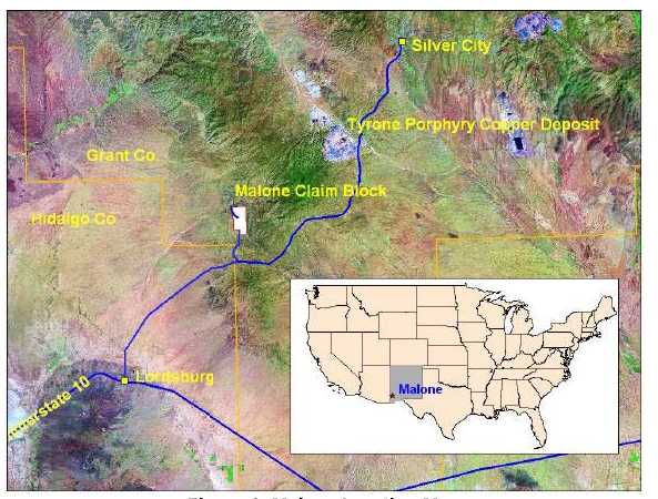
Figure 1. Malone Location Map
| Malone Property | February 2007 |
30
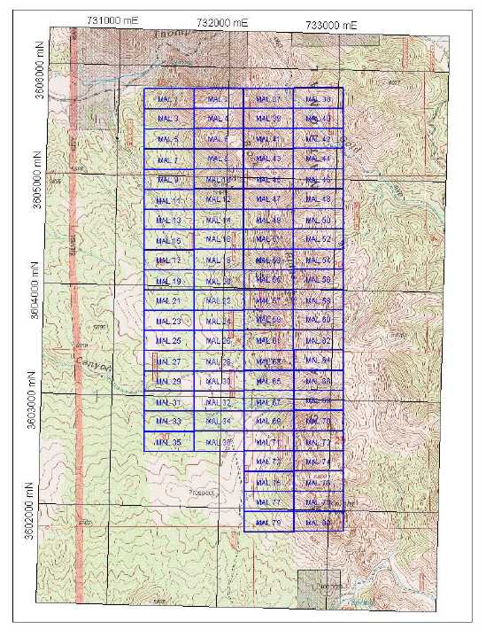
Figure 2. Malone Claim Map. Grant County, New Mexico. Datum: NAD 1927, Zone 12.
| Malone Property | February 2007 |
31
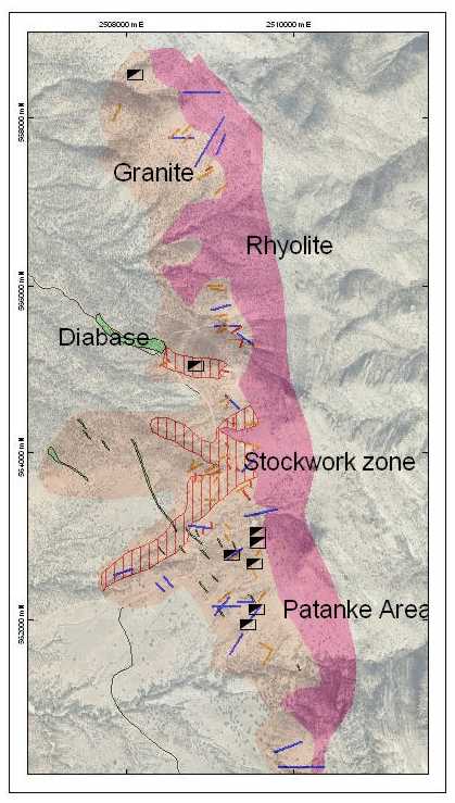
Figure 3. Malone Geological Map showing relationship between
Tertiary rhyolite, Precambrian granite, prospects and quartz stockwork
zones.
| Malone Property | February 2007 |
32

Figure 4. Photographs of Quartz Veins and Stringer Zones.
| Malone Property | February 2007 |
33

Figure 5 Photographs of Brock Ridge.
| Malone Property | February 2007 |
34
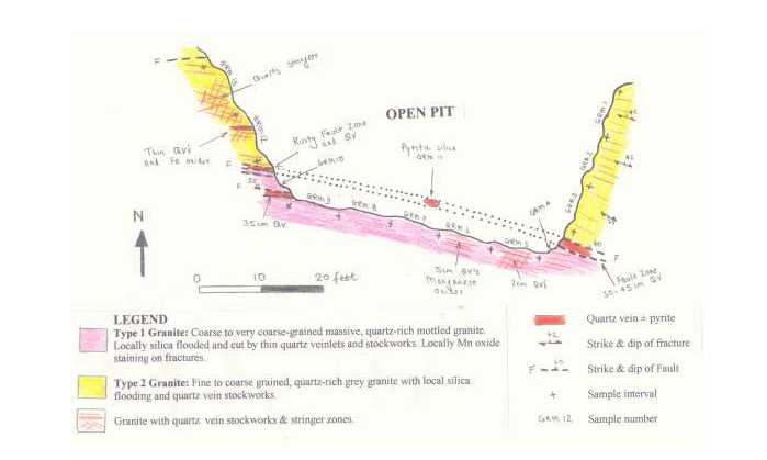
Figure 6. Pit map.
| Malone Property | February 2007 |
35
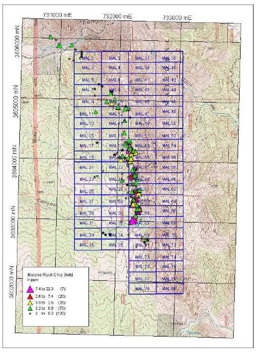
Figure 7. Rock Chip Geochemistry: Gold
| Malone Property | February 2007 |
36
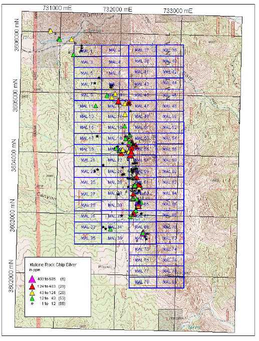
Figure 8. Rock Chip Geochemistry: Silver
| Malone Property | February 2007 |
37
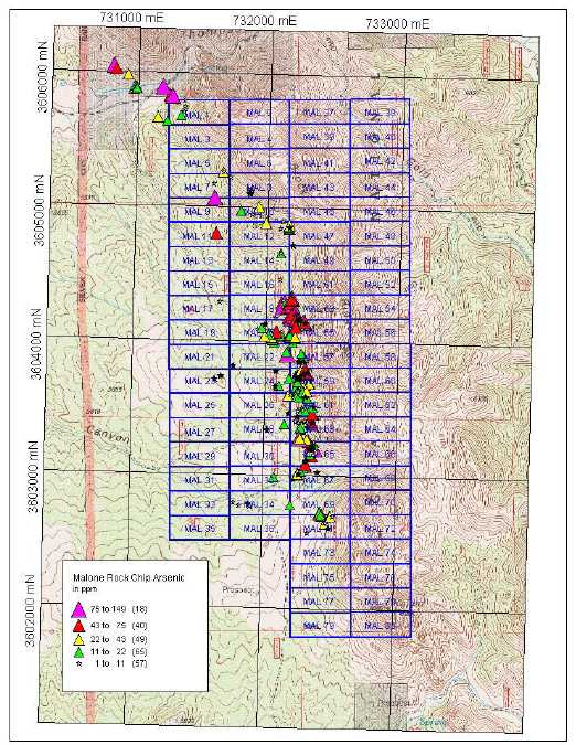
Figure 9. Rock Chip Geochemistry: Arsenic
| Malone Property | February 2007 |
38

Figure 10. Rock Chip Geochemistry: Lead
| Malone Property | February 2007 |
39
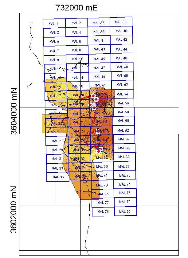
Figure 11. Self Potential Survey
| Malone Property | February 2007 |
40
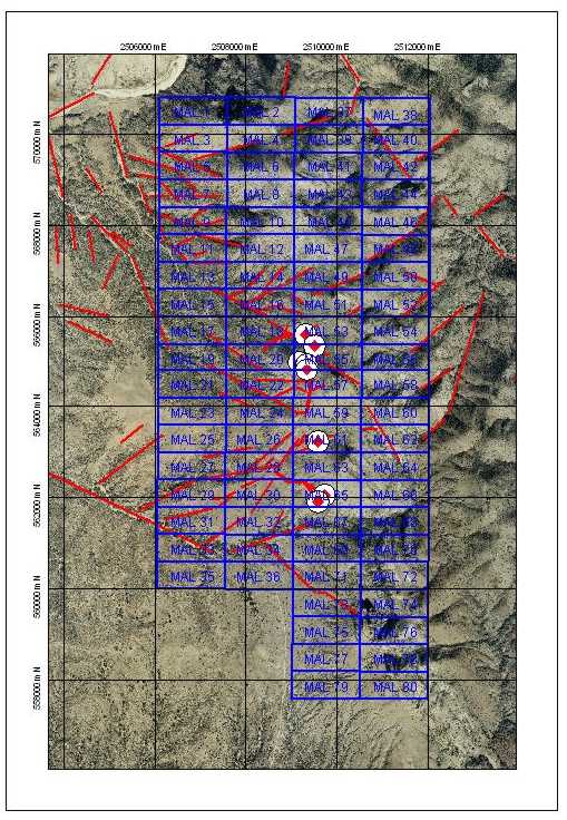
Figure 12. Aerial Photographic Survey
| Malone Property | February 2007 |
41
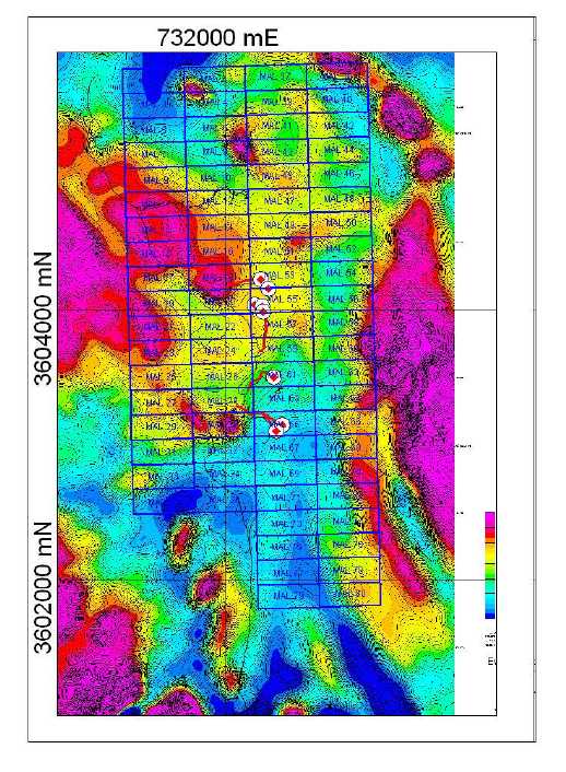
Figure 13. Airborne Magnetometer Survey and Proposed Drillholes.
| Malone Property | February 2007 |