Geological Report
on the
Winnemucca Mountain Property
Humboldt County, Nevada, USA
Evolving Gold Corp.
Suite 725 – 666 Burrard St.
Vancouver, BC V6C 2X8
Canada
Chris Osterman, P.Geol.
7525 N. Ellison Dr.
Tucson, AZ 85704
October 2, 2007
| Winnemucca Mountain Property | October 2, 2007 |
ii
TABLE OF CONTENTS
| Winnemucca Mountain Property | October 2, 2007 |
iii
| Table of Contents, continued | ||
| Item 21: | INTERPRETATION AND CONCLUSIONS | 34 |
| Item 22: | RECOMMENDATIONS | 36 |
| Item 23: | REFERENCES | 36 |
| Item 24: | DATE | 41 |
| Item 25: | ADDITIONAL REQUIREMENTS FOR TECHNICAL REPORTS ON DEVELOPMENT PROPERTIES AND PRODUCTION PROPERTIES | 41 |
| (No Item Number):STATEMENT OF QUALIFICATIONS | 41 | |
| Item 26: | List of Figures | |
| Figure 1 – | Location Map | |
| Figure 2 – | Claim Map | |
| Figure 3 – | Regional Geology | |
| Figure 4 – | Property Geology | |
| Figure 5 – | Rock Sample Geochemistry | |
| Figure 6 – | Auger Drill Geochemistry: Gold | |
| Figure 7 – | Auger Drill Geochemistry: Silver | |
| Figure 8 – | Auger Drill Geochemistry: Arsenic | |
| Figure 9 – | Auger Drill Geochemistry: Mercury | |
| Figure 10 – | Auger Drill Geochemistry: Antimony | |
| Figure 11 – | Airborne Magnetometer Survey | |
| Figure 12 – | IP Gradient Array Survey, Apparent Resistivity | |
| Figure 13 – | Drill Hole Location Map | |
| Figure 14 – | Drill Hole Location Plan, Swordfish Zone | |
| Figure 15 – | Cross Section, Swordfish Zone | |
| Figure 16 – | Meridian Drillhole Location Map | |
| (No Item Number):List of Tables | ||
| Table 1a – | Winnemucca Mountain Property Core Claims | 3 |
| Table 1b – | Winnemucca Mountain Property Expansion Claims | 4 |
| Table 2 – | Rock Samples Collected by Harmen Keyser | 23 |
| Table 3 – | Rock Samples Collected by the Author | 24 |
| Table 4 - | Selected Drill Hole Results | 29 |
| Table 5 – | Meridian Selected Drill Hole Results | 30 |
| Winnemucca Mountain Property | October 2, 2007 |
1
SUMMARY
Evolving Gold Corp. has an option to acquire a 100% interest in the Winnemucca Mountain Property subject to a 2% Net Smelter Royalty (“NSR”). The Property covers 2130 hectares and is accessible by road from the town of Winnemucca, Nevada.
The property is located in a geographic and geologic area that is well known for hosting many gold occurrences and mines of a wide variety of genetic types.
The most significant gold deposit in the Winnemucca Mountain area with respect to proximity and similarity is Sleeper, which produced 1.7 million ounces of gold from high grade ore, and is still actively being explored for additional gold resources.
Known mineralization at Winnemucca Mountain is typical of quartz-adularia epithermal gold mineralization. Gold mineralization is hosted in a pediment covered, northeast trending, quartz-carbonate breccia vein which is localized along an extensional fault cutting a large diatreme complex. Most of the mineralization is confined to a composite quartz vein at a depth of approximately 200 meters and along a strike length of approximately 670 meters. At depth, the vein develops thicknesses in excess of 30 meters.
A potential exploration target is hosted within fractured and veined Triassic sediments peripheral to the diatreme, and anomalous gold is associated with quartz-sulfide veinlets and sulfide-free quartz-carbonate veins and breccias contained within siltstone on the northeast margin of the diatreme and distal to the diatreme.
Based on previous work, the property has been optioned to Meridian Gold Inc. Meridian has the option to earn 70% in the property by expending 4,000,000 USD on the property by December 31, 2008 and by completing a pre-feasibility study by June 30, 2009. In late 2006 and during January 2007, Meridian Gold completed a twelve hole reverse circulation drilling program.
INTRODUCTION AND TERMS OF REFERENCE
This report was prepared for Evolving Gold Corp. Its purpose is to up-date the current status of the Winnemucca Mountain property through a review of publicly available geological data and unpublished data provided by AHL Holdings Ltd., Kayzak Resources, Paul A. Hawkins & Associates Ltd., Anvil Resources, Ltd., Santa Fe Pacific Mining, Inc., Newmont Mining, Inc., Arctic Precious Metals, Inc., St. Joe American Corporation and Meridian Gold, Inc.
The Winnemucca Mountain property is located in Humboldt County, Nevada (Figure 1). Exploration work completed on the Property consists of geological
| Winnemucca Mountain Property | October 2, 2007 |
2
mapping, geochemical sampling, various geophysical surveys and extensive drilling, all completed prior to 1997 and the Meridian drilling program completed earlier this year.
This report is based, principally, on a previous NI 43-101 reports completed in January 2005 by Harmon Keyser, an independent consulting geologist and by the author in October 2006. The author has spent one week on the property during the summer of 2005 and two days in January 2007 and has modified Keyser’s original report here (with his knowledge and permission) to reflect changes pertaining to land status and additional work which has been conducted on the property. Despite much of this report being derived from Keyser’s original work, the author claims responsibility for all revised observations, terms and comments here.
DISCLAIMER
This report is not intended to be a guarantee of mineral title, property option or sale agreements, nor is it intended to assess potential environmental, political or legal issues or liabilities. The information contained in this report is not a complete accounting of previous exploration on the Winnemucca Mountain property since not all prior data are available to the Author. Most of the data presented herein have been acquired from prior maps and reports and, in many instances, the method of data acquisition and processing are unknown or uncertain. Certain data are inconsistent and conflict with other data, largely due to a complex and fragmented property history including multiple operators and multiple local grid coordinate systems. In addition, several of the maps are illegible and have no scales, index keys, or legends, making review and interpretation difficult and potentially inaccurate.
All interpretations and conclusions are based on the Harmen Keyser’s examination of the Winnemucca Mountain property on February 26, 2004, on the author’s one week examination of the property, on Meridian’s drilling results, and on referenced sources that are believed to be reliable. The author was not present during any of the historic drill programs, and has not inspected any of the drill cuttings or core from the property, other than a visual review of Meridian’s 2006-2007 holes. The Property has an extensive pediment cover and therefore the writer had to rely, in part, on prior data provided by AHL Holdings, Kayzak Resources, and Newmont. These data are known to be incomplete.
All locations are subject to survey. Conversions from imperial to metric units are approximate, except assay data. Numerical scales on digital maps included in this report may not be accurate.
| Winnemucca Mountain Property | October 2, 2007 |
3
| PROPERTY DESCRIPTION AND LOCATION |
The Winnemucca Mountain property1 is located in northwestern Nevada, approximately 6 kilometers northwest of the town of Winnemucca. The property is within the Winnemucca Mountain Mining District (Tingley, 1998) of Humboldt County. The claims are situated on the west flank of Winnemucca Mountain in Sections 1, 2, 3, 6, 10, 11, 12, 13, 14, 15, 22, 23, and 24 of Township 36N, Range 37E; Mt. Diablo Baseline and Meridian. The approximate geographic centre of the property lies at UTM grid coordinates 4539000N and 433400E (NAD 27); 41°00.3’ north latitude and 117°47.4’ west longitude.
The Winnemucca Mountain property consists of 266 unsurveyed contiguous mining claims covering approximately 2130 hectares on Lands administered by the Bureau of Land Management (BLM), US Department of the Interior, as set out in Tables 1a and 1b below. Table 1a reflects the core claims reflected in Keyser’s report, whereas Table 1b lists the claims acquired as part of the project expansion. Two patented claims, referred to as the A&T area, lie within the new group of claims staked, these are not part of Evolving Gold’s property position. Additionally, a government radio installation exists on the property staked which may be precluded from exploration or development.
Table 1a
Winnemucca Mountain Property Core Claims
| Golden Arc Claims | BLM Serial No. | Registered Owner (1) | Location Date | Status | Expiry Date |
| WM #1 | 733156 | AHL | 01/04/1996 | Active | September 1, 2007 |
| WM #2 | 405978 | AHL | 04/11/1987 | Active | September 1, 2007 |
| WM #3 | 733157 | AHL | 01/04/1996 | Active | September 1, 2007 |
| WM #4 | 405980 | AHL | 04/11/1987 | Active | September 1, 2007 |
| WM #5 | 733158 | AHL | 01/04/1996 | Active | September 1, 2007 |
| WM #6 | 405982 | AHL | 04/11/1987 | Active | September 1, 2007 |
| WM #8 | 405983 | AHL | 04/11/1987 | Active | September 1, 2007 |
| WM #10 | 405984 | AHL | 04/11/1987 | Active | September 1, 2007 |
| Golden West #6 | 733140 | AHL | 01/02/1996 | Active | September 1, 2007 |
| Golden West #7 | 733141 | AHL | 01/02/1996 | Active | September 1, 2007 |
| Golden West #8 | 733142 | AHL | 01/02/1996 | Active | September 1, 2007 |
| Golden West #9 | 733143 | AHL | 01/02/1996 | Active | September 1, 2007 |
| Golden West #10 | 733144 | AHL | 01/02/1996 | Active | September 1, 2007 |
| Golden West #11 | 733145 | AHL | 01/02/1996 | Active | September 1, 2007 |
| Golden West #12 | 733146 | AHL | 01/02/1996 | Active | September 1, 2007 |
| Golden West #13 | 733147 | AHL | 01/02/1996 | Active | September 1, 2007 |
| Golden West #14 | 733148 | AHL | 01/03/1996 | Active | September 1, 2007 |
| Golden West #15 | 733149 | AHL | 01/03/1996 | Active | September 1, 2007 |
____________________________________
1Claim posts placed before 2004 may have been destroyed by range fires.
| Winnemucca Mountain Property | October 2, 2007 |
4
| Golden Arc Claims | BLM Serial No. | Registered Owner (1) | Location Date | Status | Expiry Date |
| Golden West #16 | 733150 | AHL | 01/03/1996 | Active | September 1, 2007 |
| Golden West #17 | 733151 | AHL | 01/03/1996 | Active | September 1, 2007 |
| Golden West #18 | 733152 | AHL | 01/03/1996 | Active | September 1, 2007 |
| Golden West #19 | 733153 | AHL | 01/03/1996 | Active | September 1, 2007 |
| Amended Golden West Frac A | 733154 | AHL | 01/03/1996 | Active | September 1, 2007 |
| Amended Golden West Frac B | 733155 | AHL | 01/03/1996 | Active | September 1, 2007 |
| WM 206 | 917492 | AHL | 11/19/2005 | Active | September 1, 2007 |
| WM 207 | 917493 | AHL | 11/19/2005 | Active | September 1, 2007 |
| WM 208 | 917494 | AHL | 11/19/2005 | Active | September 1, 2007 |
| T&C #1 | 479032 | AHL | 05/08/1988 | Active | September 1, 2007 |
| T&C #2 | 479033 | AHL | 05/08/1998 | Active | September 1, 2007 |
| T&C #3 | 479034 | AHL | 05/08/1998 | Active | September 1, 2007 |
| TJ #12 | 155540 | AHL | 04/02/1980 | Active | September 1, 2007 |
| TJ #14 | 733159 | AHL | 01/04/1996 | Active | September 1, 2007 |
| TJ #15 | 733160 | AHL | 01/04/1996 | Active | September 1, 2007 |
| TJ #16 | 155544 | AHL | 04/04/1980 | Active | September 1, 2007 |
| TJ #17 | 155545 | AHL | 04/04/1980 | Active | September 1, 2007 |
| TJ #18 | 155546 | AHL | 04/04/1980 | Active | September 1, 2007 |
| TJ #19 | 155547 | AHL | 04/02/1980 | Active | September 1, 2007 |
| TJ #29 | 155557 | AHL | 04/04/1980 | Active | September 1, 2007 |
| TJ #30 | 155558 | AHL | 04/17/1980 | Active | September 1, 2007 |
| TJ #34 | 155562 | AHL | 04/17/1980 | Active | September 1, 2007 |
Table 1b
Winnemucca Mountain Property Expansion Claims
| Additional Claims | BLM Serial No. | Registered Owner | Location Date | Status | Expiry Date |
| WM 101 | NMC887954 | AHL | 11/10/2004 | Active | September 1, 2007 |
| WM 102 | NMC887955 | AHL | 11/10/2004 | Active | September 1, 2007 |
| WM 103 | NMC887956 | AHL | 11/10/2004 | Active | September 1, 2007 |
| WM 104 | NMC887957 | AHL | 11/10/2004 | Active | September 1, 2007 |
| WM 105 | NMC887958 | AHL | 11/10/2004 | Active | September 1, 2007 |
| WM 106 | NMC887959 | AHL | 11/10/2004 | Active | September 1, 2007 |
| WM 107 | NMC887960 | AHL | 11/10/2004 | Active | September 1, 2007 |
| WM 108 | NMC887961 | AHL | 11/10/2004 | Active | September 1, 2007 |
| WM 109 | NMC887962 | AHL | 11/10/2004 | Active | September 1, 2007 |
| WM 110 | NMC887963 | AHL | 11/10/2004 | Active | September 1, 2007 |
| WM 111 | NMC887964 | AHL | 11/10/2004 | Active | September 1, 2007 |
| WM 112 | NMC887965 | AHL | 11/10/2004 | Active | September 1, 2007 |
| WM 113 | NMC887966 | AHL | 11/10/2004 | Active | September 1, 2007 |
| WM 114 | NMC887967 | AHL | 11/10/2004 | Active | September 1, 2007 |
| WM 115 | NMC887968 | AHL | 11/10/2004 | Active | September 1, 2007 |
| WM 116 | NMC887969 | AHL | 11/10/2004 | Active | September 1, 2007 |
| WM 117 | NMC887970 | AHL | 11/10/2004 | Active | September 1, 2007 |
| WM 118 | NMC887971 | AHL | 11/10/2004 | Active | September 1, 2007 |
| Winnemucca Mountain Property | October 2, 2007 |
5
| Additional Claims | BLM Serial No. | Registered Owner | Location Date | Status | Expiry Date |
| WM 119 | NMC887972 | AHL | 11/10/2004 | Active | September 1, 2007 |
| WM 120 | NMC887973 | AHL | 11/10/2004 | Active | September 1, 2007 |
| WM 121 | NMC887974 | AHL | 11/13/2004 | Active | September 1, 2007 |
| WM 122 | NMC887975 | AHL | 11/10/2004 | Active | September 1, 2007 |
| WM 123 | NMC887976 | AHL | 11/10/2004 | Active | September 1, 2007 |
| WM 124 | NMC887977 | AHL | 11/10/2004 | Active | September 1, 2007 |
| WM 125 | NMC887978 | AHL | 11/10/2004 | Active | September 1, 2007 |
| WM 126 | NMC887979 | AHL | 12/10/2004 | Active | September 1, 2007 |
| WM 127 | NMC887980 | AHL | 12/10/2004 | Active | September 1, 2007 |
| WM 128 | NMC887981 | AHL | 12/10/2004 | Active | September 1, 2007 |
| WM 129 | NMC887982 | AHL | 12/10/2004 | Active | September 1, 2007 |
| WM 130 | NMC887983 | AHL | 12/10/2004 | Active | September 1, 2007 |
| WM 131 | NMC887984 | AHL | 12/10/2004 | Active | September 1, 2007 |
| WM 132 | NMC887985 | AHL | 12/10/2004 | Active | September 1, 2007 |
| WM 133 | NMC887986 | AHL | 12/10/2004 | Active | September 1, 2007 |
| WM 134 | NMC887987 | AHL | 12/10/2004 | Active | September 1, 2007 |
| WM 135 | NMC887988 | AHL | 12/10/2004 | Active | September 1, 2007 |
| WM 136 | NMC894073 | AHL | 2/2/2005 | Active | September 1, 2007 |
| WM 137 | NMC894074 | AHL | 2/2/2005 | Active | September 1, 2007 |
| WM 138 | NMC894075 | AHL | 2/2/2005 | Active | September 1, 2007 |
| WM 139 | NMC894076 | AHL | 2/2/2005 | Active | September 1, 2007 |
| WM 140 | NMC894077 | AHL | 2/2/2005 | Active | September 1, 2007 |
| WM 141 | NMC894078 | AHL | 2/2/2005 | Active | September 1, 2007 |
| WM 142 | NMC894079 | AHL | 2/2/2005 | Active | September 1, 2007 |
| WM 143 | NMC894080 | AHL | 2/2/2005 | Active | September 1, 2007 |
| WM 144 | NMC894081 | AHL | 2/2/2005 | Active | September 1, 2007 |
| WM 145 | NMC894082 | AHL | 2/2/2005 | Active | September 1, 2007 |
| WM 146 | NMC894083 | AHL | 2/2/2005 | Active | September 1, 2007 |
| WM 147 | NMC894084 | AHL | 2/2/2005 | Active | September 1, 2007 |
| WM 148 | NMC894085 | AHL | 2/2/2005 | Active | September 1, 2007 |
| WM 149 | NMC894086 | AHL | 2/2/2005 | Active | September 1, 2007 |
| WM 150 | NMC894087 | AHL | 2/2/2005 | Active | September 1, 2007 |
| WM 151 | NMC894088 | AHL | 2/2/2005 | Active | September 1, 2007 |
| WM 152 | NMC894089 | AHL | 2/2/2005 | Active | September 1, 2007 |
| WM 153 | NMC894090 | AHL | 2/2/2005 | Active | September 1, 2007 |
| WM 154 | NMC894091 | AHL | 2/2/2005 | Active | September 1, 2007 |
| WM 155 | NMC894092 | AHL | 2/2/2005 | Active | September 1, 2007 |
| WM 156 | NMC894093 | AHL | 2/2/2005 | Active | September 1, 2007 |
| WM 157 | NMC894094 | AHL | 2/2/2005 | Active | September 1, 2007 |
| WM 158 | NMC894095 | AHL | 2/2/2005 | Active | September 1, 2007 |
| WM 159 | NMC894096 | AHL | 2/2/2005 | Active | September 1, 2007 |
| WM 160 | NMC894097 | AHL | 2/2/2005 | Active | September 1, 2007 |
| WM 161 | NMC894098 | AHL | 2/2/2005 | Active | September 1, 2007 |
| WM 162 | NMC894099 | AHL | 2/2/2005 | Active | September 1, 2007 |
| WM 163 | NMC894100 | AHL | 2/2/2005 | Active | September 1, 2007 |
| WM 164 | NMC894101 | AHL | 2/2/2005 | Active | September 1, 2007 |
| WM 165 | NMC894102 | AHL | 2/2/2005 | Active | September 1, 2007 |
| WM 166 | NMC894103 | AHL | 2/2/2005 | Active | September 1, 2007 |
| Winnemucca Mountain Property | October 2, 2007 |
6
| Additional Claims | BLM Serial No. | Registered Owner | Location Date | Status | Expiry Date |
| WM 167 | NMC894104 | AHL | 2/2/2005 | Active | September 1, 2007 |
| WM 168 | NMC894105 | AHL | 2/2/2005 | Active | September 1, 2007 |
| WM 169 | NMC894106 | AHL | 2/2/2005 | Active | September 1, 2007 |
| WM 170 | NMC894107 | AHL | 2/3/2005 | Active | September 1, 2007 |
| WM 171 | NMC894108 | AHL | 2/3/2005 | Active | September 1, 2007 |
| WM 172 | NMC894109 | AHL | 2/3/2005 | Active | September 1, 2007 |
| WM 173 | NMC894110 | AHL | 2/3/2005 | Active | September 1, 2007 |
| WM 174 | NMC894111 | AHL | 2/3/2005 | Active | September 1, 2007 |
| WM 175 | NMC894112 | AHL | 2/3/2005 | Active | September 1, 2007 |
| WM 176 | NMC894113 | AHL | 2/3/2005 | Active | September 1, 2007 |
| WM 177 | NMC894114 | AHL | 2/3/2005 | Active | September 1, 2007 |
| WM 178 | NMC894115 | AHL | 2/3/2005 | Active | September 1, 2007 |
| WM 179 | NMC894116 | AHL | 2/3/2005 | Active | September 1, 2007 |
| WM 180 | NMC894117 | AHL | 2/3/2005 | Active | September 1, 2007 |
| WM 181 | NMC894118 | AHL | 2/3/2005 | Active | September 1, 2007 |
| WM 182 | NMC894119 | AHL | 2/3/2005 | Active | September 1, 2007 |
| WM 183 | NMC894120 | AHL | 2/3/2005 | Active | September 1, 2007 |
| WM 184 | NMC894121 | AHL | 2/3/2005 | Active | September 1, 2007 |
| WM 185 | NMC894122 | AHL | 2/3/2005 | Active | September 1, 2007 |
| WM 186 | NMC894123 | AHL | 2/3/2005 | Active | September 1, 2007 |
| WM 187 | NMC894124 | AHL | 2/3/2005 | Active | September 1, 2007 |
| WM 188 | NMC894125 | AHL | 2/3/2005 | Active | September 1, 2007 |
| WM 189 | NMC894126 | AHL | 2/3/2005 | Active | September 1, 2007 |
| WM 190 | NMC894127 | AHL | 2/3/2005 | Active | September 1, 2007 |
| WM 191 | NMC894128 | AHL | 2/3/2005 | Active | September 1, 2007 |
| WM 192 | NMC894129 | AHL | 2/3/2005 | Active | September 1, 2007 |
| WM 193 | NMC894130 | AHL | 2/3/2005 | Active | September 1, 2007 |
| WM 194 | NMC894131 | AHL | 2/3/2005 | Active | September 1, 2007 |
| WM 195 | NMC894132 | AHL | 2/3/2005 | Active | September 1, 2007 |
| WM 196 | NMC894133 | AHL | 2/3/2005 | Active | September 1, 2007 |
| WM 197 | NMC894134 | AHL | 2/3/2005 | Active | September 1, 2007 |
| WM 198 | NMC894135 | AHL | 2/3/2005 | Active | September 1, 2007 |
| WM 199 | NMC894136 | AHL | 2/3/2005 | Active | September 1, 2007 |
| WM 200 | NMC894137 | AHL | 2/3/2005 | Active | September 1, 2007 |
| WM 201 | NMC894138 | AHL | 2/4/2005 | Active | September 1, 2007 |
| WM 202 | NMC894139 | AHL | 2/4/2005 | Active | September 1, 2007 |
| WM 203 | NMC894140 | AHL | 2/4/2005 | Active | September 1, 2007 |
| WM 204 | NMC894141 | AHL | 2/4/2005 | Active | September 1, 2007 |
| WM 221 | NMC908914 | AHL | 9/1/2005 | Active | September 1, 2007 |
| WM 222 | NMC908915 | AHL | 9/1/2005 | Active | September 1, 2007 |
| WM 223 | NMC908916 | AHL | 9/1/2005 | Active | September 1, 2007 |
| WM 224 | NMC908917 | AHL | 9/1/2005 | Active | September 1, 2007 |
| WM 230 | NMC908923 | AHL | 9/1/2005 | Active | September 1, 2007 |
| WM 231 | NMC908924 | AHL | 9/1/2005 | Active | September 1, 2007 |
| WM 232 | NMC908925 | AHL | 9/1/2005 | Active | September 1, 2007 |
| WM 233 | NMC908926 | AHL | 9/1/2005 | Active | September 1, 2007 |
| WM 234 | NMC908927 | AHL | 9/1/2005 | Active | September 1, 2007 |
| WM 235 | NMC908928 | AHL | 9/1/2005 | Active | September 1, 2007 |
| Winnemucca Mountain Property | October 2, 2007 |
7
| Additional Claims | BLM Serial No. | Registered Owner | Location Date | Status | Expiry Date |
| WM 236 | NMC908929 | AHL | 9/1/2005 | Active | September 1, 2007 |
| WM 237 | NMC908930 | AHL | 9/1/2005 | Active | September 1, 2007 |
| WM 238 | NMC908931 | AHL | 9/1/2005 | Active | September 1, 2007 |
| WM 239 | NMC908932 | AHL | 9/1/2005 | Active | September 1, 2007 |
| WM 240 | NMC908933 | AHL | 9/1/2005 | Active | September 1, 2007 |
| WM 241 | NMC908934 | AHL | 9/1/2005 | Active | September 1, 2007 |
| WM 242 | NMC908935 | AHL | 9/1/2005 | Active | September 1, 2007 |
| WM 243 | NMC908936 | AHL | 9/1/2005 | Active | September 1, 2007 |
| WM 244 | NMC908937 | AHL | 9/1/2005 | Active | September 1, 2007 |
| WM 245 | NMC908938 | AHL | 9/1/2005 | Active | September 1, 2007 |
| WM 246 | NMC908939 | AHL | 9/1/2005 | Active | September 1, 2007 |
| WM 247 | NMC908940 | AHL | 9/1/2005 | Active | September 1, 2007 |
| WM 248 | NMC908941 | AHL | 9/1/2005 | Active | September 1, 2007 |
| WM 249 | NMC908942 | AHL | 9/1/2005 | Active | September 1, 2007 |
| WM 250 | NMC908943 | AHL | 9/1/2005 | Active | September 1, 2007 |
| WM 251 | NMC908944 | AHL | 9/1/2005 | Active | September 1, 2007 |
| WM 252 | NMC908945 | AHL | 9/1/2005 | Active | September 1, 2007 |
| WM 253 | NMC908946 | AHL | 9/1/2005 | Active | September 1, 2007 |
| WM 254 | NMC908947 | AHL | 9/1/2005 | Active | September 1, 2007 |
| WM 255 | NMC908948 | AHL | 9/1/2005 | Active | September 1, 2007 |
| WM 256 | NMC908949 | AHL | 9/1/2005 | Active | September 1, 2007 |
| WM 257 | NMC908950 | AHL | 9/1/2005 | Active | September 1, 2007 |
| WM 258 | NMC908951 | AHL | 9/1/2005 | Active | September 1, 2007 |
| WM 259 | NMC908952 | AHL | 9/1/2005 | Active | September 1, 2007 |
| WM 260 | NMC908953 | AHL | 9/1/2005 | Active | September 1, 2007 |
| WM 261 | NMC908954 | AHL | 9/1/2005 | Active | September 1, 2007 |
| WM 262 | NMC908955 | AHL | 9/1/2005 | Active | September 1, 2007 |
| WM 263 | NMC908956 | AHL | 9/1/2005 | Active | September 1, 2007 |
| WM 264 | NMC908957 | AHL | 9/1/2005 | Active | September 1, 2007 |
| WM 265 | NMC908958 | AHL | 9/1/2005 | Active | September 1, 2007 |
| WM 266 | NMC908959 | AHL | 9/1/2005 | Active | September 1, 2007 |
| WM 267 | NMC908960 | AHL | 9/1/2005 | Active | September 1, 2007 |
| WM 268 | NMC908961 | AHL | 9/1/2005 | Active | September 1, 2007 |
| WM 269 | NMC908962 | AHL | 9/1/2005 | Active | September 1, 2007 |
| WM 270 | NMC908963 | AHL | 9/1/2005 | Active | September 1, 2007 |
| WM 271 | NMC908964 | AHL | 9/1/2005 | Active | September 1, 2007 |
| WM 272 | NMC908965 | AHL | 9/1/2005 | Active | September 1, 2007 |
| WM 273 | NMC908966 | AHL | 9/1/2005 | Active | September 1, 2007 |
| WM 274 | NMC908967 | AHL | 9/1/2005 | Active | September 1, 2007 |
| WM 275 | NMC908968 | AHL | 9/1/2005 | Active | September 1, 2007 |
| WM 276 | NMC908969 | AHL | 9/1/2005 | Active | September 1, 2007 |
| WM 277 | NMC908970 | AHL | 9/1/2005 | Active | September 1, 2007 |
| WM 278 | NMC908971 | AHL | 9/1/2005 | Active | September 1, 2007 |
| WM 279 | NMC908972 | AHL | 9/1/2005 | Active | September 1, 2007 |
| WM 280 | NMC908973 | AHL | 9/1/2005 | Active | September 1, 2007 |
| WM 281 | NMC908974 | AHL | 9/1/2005 | Active | September 1, 2007 |
| WM 282 | NMC908975 | AHL | 9/1/2005 | Active | September 1, 2007 |
| WM 283 | NMC908976 | AHL | 9/1/2005 | Active | September 1, 2007 |
| Winnemucca Mountain Property | October 2, 2007 |
8
| Additional Claims | BLM Serial No. | Registered Owner | Location Date | Status | Expiry Date |
| WM 284 | NMC908977 | AHL | 9/1/2005 | Active | September 1, 2007 |
| WM 285 | NMC908978 | AHL | 9/1/2005 | Active | September 1, 2007 |
| WM 286 | NMC908979 | AHL | 9/1/2005 | Active | September 1, 2007 |
| WM 287 | NMC908980 | AHL | 9/1/2005 | Active | September 1, 2007 |
| WM 288 | NMC908981 | AHL | 9/1/2005 | Active | September 1, 2007 |
| WM 289 | NMC908982 | AHL | 9/1/2005 | Active | September 1, 2007 |
| WM 290 | NMC908983 | AHL | 9/1/2005 | Active | September 1, 2007 |
| WM 291 | NMC908984 | AHL | 9/1/2005 | Active | September 1, 2007 |
| WM 292 | NMC908985 | AHL | 9/1/2005 | Active | September 1, 2007 |
| WM 293 | NMC908986 | AHL | 9/1/2005 | Active | September 1, 2007 |
| WM 294 | NMC908987 | AHL | 9/1/2005 | Active | September 1, 2007 |
| WM 295 | NMC908988 | AHL | 9/1/2005 | Active | September 1, 2007 |
| WM 296 | NMC908989 | AHL | 9/1/2005 | Active | September 1, 2007 |
| WM 297 | NMC908990 | AHL | 9/1/2005 | Active | September 1, 2007 |
| WM 298 | NMC908991 | AHL | 9/1/2005 | Active | September 1, 2007 |
| WM 299 | NMC908992 | AHL | 9/1/2005 | Active | September 1, 2007 |
| WM 300 | NMC908993 | AHL | 9/1/2005 | Active | September 1, 2007 |
| WM 301 | NMC908994 | AHL | 9/1/2005 | Active | September 1, 2007 |
| WM 302 | NMC908995 | AHL | 9/1/2005 | Active | September 1, 2007 |
| WM 303 | NMC908996 | AHL | 9/1/2005 | Active | September 1, 2007 |
| WM 304 | NMC908997 | AHL | 9/1/2005 | Active | September 1, 2007 |
| WM 305 | NMC908998 | AHL | 9/1/2005 | Active | September 1, 2007 |
| WM 306 | NMC908999 | AHL | 9/1/2005 | Active | September 1, 2007 |
| WM 307 | NMC909000 | AHL | 9/1/2005 | Active | September 1, 2007 |
| WM 308 | NMC909001 | AHL | 9/1/2005 | Active | September 1, 2007 |
| WM 309 | NMC909002 | AHL | 9/1/2005 | Active | September 1, 2007 |
| WM 310 | NMC909003 | AHL | 9/1/2005 | Active | September 1, 2007 |
| WM 311 | NMC909004 | AHL | 9/1/2005 | Active | September 1, 2007 |
| WM 312 | NMC909005 | AHL | 9/1/2005 | Active | September 1, 2007 |
| WM 313 | NMC909006 | AHL | 9/1/2005 | Active | September 1, 2007 |
| WM 314 | NMC909007 | AHL | 9/1/2005 | Active | September 1, 2007 |
| WM 315 | NMC909008 | AHL | 9/1/2005 | Active | September 1, 2007 |
| WM 316 | NMC909009 | AHL | 9/1/2005 | Active | September 1, 2007 |
| WM 317 | NMC909010 | AHL | 9/1/2005 | Active | September 1, 2007 |
| WM 318 | NMC909011 | AHL | 9/1/2005 | Active | September 1, 2007 |
| WM 319 | NMC909012 | AHL | 9/1/2005 | Active | September 1, 2007 |
| WM 320 | NMC909013 | AHL | 9/1/2005 | Active | September 1, 2007 |
| WM 321 | NMC909014 | AHL | 9/1/2005 | Active | September 1, 2007 |
| WM 322 | NMC909015 | AHL | 9/1/2005 | Active | September 1, 2007 |
| WM 323 | NMC909016 | AHL | 9/1/2005 | Active | September 1, 2007 |
| WM 324 | NMC909017 | AHL | 9/1/2005 | Active | September 1, 2007 |
| WM 325 | NMC909018 | AHL | 9/1/2005 | Active | September 1, 2007 |
| WM 326 | NMC909019 | AHL | 9/1/2005 | Active | September 1, 2007 |
| WM 327 | NMC909020 | AHL | 9/1/2005 | Active | September 1, 2007 |
| WM 328 | NMC909021 | AHL | 9/1/2005 | Active | September 1, 2007 |
| WM 329 | NMC909022 | AHL | 9/1/2005 | Active | September 1, 2007 |
| WM 330 | NMC909023 | AHL | 9/1/2005 | Active | September 1, 2007 |
| WM 331 | NMC909024 | AHL | 9/1/2005 | Active | September 1, 2007 |
| Winnemucca Mountain Property | October 2, 2007 |
9
| Additional Claims | BLM Serial No. | Registered Owner | Location Date | Status | Expiry Date |
| WM 332 | NMC909025 | AHL | 9/1/2005 | Active | September 1, 2007 |
| WM 333 | NMC909026 | AHL | 9/1/2005 | Active | September 1, 2007 |
| WM 334 | NMC909027 | AHL | 9/1/2005 | Active | September 1, 2007 |
| WM 335 | NMC909028 | AHL | 9/1/2005 | Active | September 1, 2007 |
| WM 336 | NMC909029 | AHL | 9/1/2005 | Active | September 1, 2007 |
| WM 337 | NMC909030 | AHL | 9/1/2005 | Active | September 1, 2007 |
| WM 338 | NMC909031 | AHL | 9/1/2005 | Active | September 1, 2007 |
| WM 339 | NMC909032 | AHL | 9/1/2005 | Active | September 1, 2007 |
| WM 340 | NMC909033 | AHL | 9/1/2005 | Active | September 1, 2007 |
| WM 341 | NMC909034 | AHL | 9/1/2005 | Active | September 1, 2007 |
| WM 342 | NMC909035 | AHL | 9/1/2005 | Active | September 1, 2007 |
| WM 343 | NMC909036 | AHL | 9/1/2005 | Active | September 1, 2007 |
| WM 344 | NMC909037 | AHL | 9/1/2005 | Active | September 1, 2007 |
| WM 345 | NMC909038 | AHL | 9/1/2005 | Active | September 1, 2007 |
| WM 346 | NMC909039 | AHL | 9/1/2005 | Active | September 1, 2007 |
| WM 347 | NMC909040 | AHL | 9/1/2005 | Active | September 1, 2007 |
The above two sets of claims are collectively called the Winnemucca Mountain Property (collectively the “Property”) as depicted in Figure 2:
Evolving Gold Option
Evolving Gold Corporation (“Evolving”) and Golden Sands Exploration Inc. (“Golden Sands”), AHL Holdings Ltd. (“AHL”) entered into an Option and Royalty Agreement dated December 3, 2004 and amended January 7, 2005, February 25, 2005, April 21, 2005, January 26, 2006, April 27, 2006, June 16, 2006 and July 7, 2006 granting Evolving the option to earn a 100% interest in the Property (the “Golden Sands Option”). Golden Sands is the sole owner of all of the issued shares in AHL.
In order to exercise the option, Evolving must spend US$4,000,000 on exploration prior to December 31, 2008, including a covenant to incur at least US$200,000 on Golden Arc Claims by December 31, 2006, whether or not this option is exercised by Evolving Gold. In addition, Evolving must pay US$80,000 to the vendors (to date, US$40,000 has been paid in cash and US$40,000 has been paid by the issue of shares for debt) and issue 1,800,000 shares of Evolving to the vendor at various times on or before December 31, 2007 (to date, 1,300,000 shares have been issued). Evolving must also prepare, pay for and deliver a Pre-feasibility Study to Golden Sands by June 30, 2009 as well as prepare and deliver a technical report and exploration expense report by July 31, 2006, or as soon as possible thereafter.
The Property is subject to a 2% NSR which will be payable by Evolving to AHL for so long as Evolving and/or its successors and assigns hold any interest in the
| Winnemucca Mountain Property | October 2, 2007 |
10
Property. The NSR is divided between two parties as to the respective mineral claims held by each party. Evolving may purchase the NSR for US$1,000,000 for each one of the two percentage points of the NSR Royalty on the Golden Arc Claims. No agreement exists for such purchase of NSR on the remaining mineral claims. The Property is also subject to advance royalty payments of US$10,000 by March 16, 2006 (payment has been made), US$10,000 by December 3, 2006 and US$20,000 due on each successive December 3, until production from the Property commences and continues uninterrupted for twelve consecutive months. These advance royalty payments will be deducted from the NSR payments otherwise needed. A finder fee of 100,000 shares was also paid by Evolving in connection with this property transaction.
The Golden Sands Option also has a three-mile “area of interest” provision. Any property or claim acquired subsequent to the Golden Sands Option and within three miles of the existing expanded (by contract) claim boundaries is subject at the election of the other party to being treated as forming part of the Golden Sands Option.
Underlying Option
AHL entered into an Option and Royalty Agreement (the “Option and Royalty Agreement”) dated March 22, 2004 with Golden Arc Mining and Refining Inc. (“Golden Arc”) whereby AHL can earn an undivided 100% interest in the Golden Arc claims
In order to exercise the option, AHL must pay Golden Arc $9000, incur on exploration expense of at least $100,000 by the first anniversary of the start date and at least $200,000 by the second anniversary of the start date.
The Golden Arc Claims are subject to a 2% NSR, which will be payable from AHL to Golden Arc for so long as AHL and/or its successors and assigns hold any interest in the Claims. AHL may purchase the NSR for US$1,000,000 for each one of the two percentage points of the NSR Royalty. The Golden Arc Claims are also subject to advance royalty payments of US$10,000 on the first and second anniversary of start date referred to in the interpretation section of the Option and Royalty Agreement, and US$20,000 on each successive anniversary, until production commences from the Golden Arc Claims. These advance royalty payments will be deducted from the NSR Royalty payments otherwise needed.
The Option and Royalty Agreement has a one-mile “area of interest” whereby any unpatented claims within the “area of interest” will, at the election of the other party, form part of the Option and Royalty Agreement.
| Winnemucca Mountain Property | October 2, 2007 |
11
Meridian Option Agreement
In September 2005, Evolving signed a letter of intent with Meridian Gold Inc. (“Meridian”) regarding an option by Meridian to acquire, directly or indirectly, an undivided 70% interest in 100% of Evolving’s option in the Property. On August 1, 2006, Evolving announced that Meridian signed a final option agreement. Meridian will assign their interest to Meridian Minerals Corp. Under the terms of the agreement, Meridian can earn a 70% interest in the Property by making a total contribution of US$500,000 in staged cash payments to Evolving by December 31, 2008, investing a minimum of US$500,000 in exploration expenditures before December 31, 2006 and incurring total exploration expenditures of US$4,000,000 by December 31, 2008. Meridian must also deliver a pre-feasibility report on the Property before June 30, 2009. Upon completion of the required payments and expenditures, Evolving and Meridian have agreed to establish a joint venture in respect of the Property and Meridian will contribute 136 claims it currently has rights to that adjoin the Property into the joint venture.
| ACCESSIBILITY, CLIMATE, LOCAL RESOURCES, |
| INFRASTRUCTURE AND PHYSIOGRAPHY |
The Winnemucca Mountain property is located approximately 6 kilometers northwest of Winnemucca and is accessible from State Route 49, a graded gravel road from Winnemucca to Jungo. A paved road that provides access to a US Air Force radar installation on top of Winnemucca Mountain traverses the southern and northern portions of the claim block. Accommodations and basic provisions are readily available in Winnemucca.
The claims that comprise the Winnemucca Mountain property lie in an irregular, northerly trending block along the flanks of Winnemucca Mountain. The mountain slopes are generally moderate along the west side of the claims, steepening on the east and in drainages. Pediment and alluvium cover is extensive, particularly in the western, or lower, part of the property where a classic bajada is developed. Within the claims, elevations range from approximately 1435 meters in the southwest corner to nearly 2000 meters in the east. The area is devoid of trees, and vegetation consists of sagebrush and sparse grass.
The climate in southern Humboldt County is arid with annual rainfall averaging 20 cm (8 inches; Winnemucca Chamber of Commerce Website) and snowfall of 38 cm (16 inches; Nevada Climate Summaries Website). The area is characterized by hot summers and short, cold winters.
| Winnemucca Mountain Property | October 2, 2007 |
12
| HISTORY |
The discovery of the Comstock Lode in western Nevada in 1859 spurred mineral exploration throughout Nevada. Gold and silver were first discovered in the Winnemucca Mining District in 1863 and, during the 1860’s, several smelters were constructed along the Humboldt River (Willden, 1964). The early productive lodes consisted of quartz veins containing small amounts of variably oxidized copper and lead
The first significant gold discovery in Humboldt County was the Getchell gold deposit in 1933 (Willden, 1964). The Getchell Mine began production in 1938 and has operated intermittently since. The current owners, Placer Dome and Newmont, reopened the Mine in 2002 with a resource of 7 million ounces of gold (Placer Dome website). Since discovery of the Getchell Deposit, Humboldt County has been the site of numerous other significant gold discoveries. Major gold deposits in the area include the Lone Tree, Marigold, Preble, Pinson, Turquoise Ridge, and Twin Creeks, all located east and northeast of Winnemucca, and the Hycroft (Crowfoot-Lewis), Sandman, Rosebud, and Sleeper deposits to the northwest (Tingley, 1998).
On Winnemucca Mountain itself, the Adamson mine, located just east of the TJ #30 claim in the northeast portion of section 11, reported gold production from “rich ore” in 1911-1912 totaling $13,711 (approximately 20 kg of gold equivalent; Willden, 1964). The Pride of the Mountain mine, which reported gold and silver production during 1915 (Willden, 1964), is situated just east of the Golden West claims in the northwestern portion of section 23. Both mines exploited gold-bearing quartz veins cutting metasedimentary rocks. Topographic maps indicate six ‘prospects’ and one old ‘mine’ within the boundaries of the Golden West 8 and 10 claims. These may be mercury workings referred to by Schnell & Hodges (1990b) and Tingley (1998).
The upper slopes of Winnemucca Mountain contain dozens of prospects and several old mines. One of these, the Shively Mine on the north side of Winnemucca Mountain (not on Winnemucca Mountain property), exploited a west-northwest striking, moderate to steeply dipping quartz-calcite vein. In 1982, St. Joe conducted a drilling program directed at this structure. Results of their drilling included 27.4 m (90’) of 0.34 g/t Au in DH1 and 9.1 m (30’) of 0.69 g/t Au in DH2 (Hodges, et al, 1989).
The earliest available record of exploration within the present Winnemucca Mountain property claim area is an undated map by St. Joe American Corporation that describes rock sampling over much of the claim block and soil sampling across the Golden West 6 to 13 claim area. This work was most likely done in conjunction with work in the Shively Mine area during 1982. The same map indicates that Cordex Exploration Company drilled seven drill holes, also on
| Winnemucca Mountain Property | October 2, 2007 |
13
the Golden West 6 to 13 claims. Metzler (pers. comm.) reports that the Cordex holes were drilled in 1972; however none of these data were available to the Author.In addition, 200 meters (700 feet) of trenching was completed and over 1,000 meters (3,300 feet) of existing underground workings were mapped and sampled and the construction of drill access roads were completed (Metzler, pers. comm.). A map dated October 1982 indicates that induced polarization, magnetic, and VLF electromagnetic surveys were performed on the property.Details of work done by St. Joe and Cordex are not available2.
The next record of exploration is by Arctic Precious Metals Inc. in 1985 (Moore, 1987). Work over the next few years included rock sampling by Arctic and Tenneco Minerals in 1986, with geological mapping by Arctic in 1986 in the northern claim area. During 1987, Arctic drilled 573 meters in 5 reverse circulation drill holes. Results were encouraging with hole WM 5 intersecting a 1.5 meter interval of 1050 ppb gold. The next year, Arctic conducted detailed rock sampling and VLF-EM and magnetic surveys over a breccia pipe target area, followed by 7 diamond drill holes for a total of 637 meters. Drill hole WM 7 intersected up to 1950 ppb gold over 1.5 meters and WM 13 cut two large intervals (44 and 55 meters) of elevated gold in a breccia (164 ppb and 147 ppb respectively; SFPM data)
In late 1988, Santa Fe Pacific Mining, Inc. (now Newmont) entered into a joint venture with Arctic after recognizing the significance of anomalous gold in the breccia pipe identified by the Arctic drilling. Santa Fe became operator (Bokich, 1989) and, between 1988 and 1990, conducted geological mapping, rock sampling, trenching, CSAMT and induced polarization geophysical surveys, collected 286 auger hole bedrock samples, and completed a total of 18,260 meters (52,470.8 feet) in 73 reverse circulation drill holes. Three of these drill holes were re-entered with a diamond drill. The total diamond drill footage is uncertain but is in excess of 145 meters (477 feet). Not all of Santa Fe’s drilling was within the boundaries of the current claim block. Santa Fe’s work outlined the Swordfish occurrence that extends approximately 670 meters (2200 feet) along the western flank of Winnemucca Mountain within the current claim block.
In 1994, Anvil Resources of Vancouver, B.C., acquired the property (Metzler, 1994) and became the project operator. Anvil did a great deal of internal compilation work, prepared a topographic base map and collected surface samples to confirm previous gold tenors. They performed test assaying to determine optimum analytical procedures for coarse gold samples and milling tests on bulk samples to maximize gold liberation. An induced polarization (IP) survey conducted in 1996 confirmed that resistivity highs correlated well with known mineralized areas and delineated two new target zones (Metzler, pers comm).
_____________________________
2 Details of the St. Joe and Cordex work are not available; the work is referenced solely for complete disclosure.
| Winnemucca Mountain Property | October 2, 2007 |
14
Santa Fe Pacific Gold Corp. utilized a computer program called Geostat to calculate a cross-sectional resource estimate for the Swordfish zone area (Schnell and Hodges, 1990b). Santa Fe estimated that the Swordfish zone contained 4.15 million tonnes grading 0.82 g/t gold (4.58 million tons grading 0.028 opt gold) at a 0.29 g/t cutoff (0.01 opt cutoff; Schnell and Hodges, 1990b). All resource calculations were based on arithmetic averages (Metzler, 1994). Most of this resource is confined to the main quartz vein at a depth of approximately 200 meters (700 feet), along a strike length of approximately 670 meters (2200 feet; Metzler, 1995b).
The Santa Fe historical resource estimate pre-dates the implementation of NI 43-101. As such, it does not utilize the mineral resource categories outlined in NI 43-101. The author has not done the work necessary to verify the historical resource estimate. The Company is not treating the historical mineral resource estimate as a current mineral resource estimate as defined in NI 43-101, the historical estimate should not be relied upon, it is only relevant in that it is an indication of the grade of mineralization that has been encountered on the property in the past, the estimate is only quoted here only for historical completeness.
| GEOLOGICAL SETTING |
Regional Geology
Nevada lies within the Basin and Range geological province. The geologic structure of this province is the result of repeated interactions between the North American Plate and oceanic plates to the west which are expressed as folds, thrust faults, strike slip faults, normal faults, igneous intrusions, volcanism, metamorphism and sedimentary basins. Every mountain range in the Basin and Range province is bounded on at least one side by a normal fault, many of which are still active. The area’s highly complex and active tectonic history has created a diversity of depositional environments, deep-seated structures, hydrothermal centers and numerous mineral deposits.
Humboldt County is underlain by rocks ranging in age from probable early Cambrian to late Miocene or early Pliocene (Willden, 1964). In general, the oldest rocks are in the southeastern portion of the county with younger rocks to the north and west, however, late Tertiary volcanic and sedimentary rocks are randomly distributed throughout the county (Stewart and Carlson, 1976). Five orogenic episodes have been recognized but structural and lithologic elements are not continuous between mountain ranges.
| Winnemucca Mountain Property | October 2, 2007 |
15
The most important of the orogenic episodes in Nevada is the Antler Orogeny, the late Devonian collision of an arc terrane complex with the western margin of North America (Price, et al, 1999). The arc material (allochthon) was thrust over cratonic carbonates along the Roberts Mountain thrust fault. Mountain building accompanied the Antler Orogeny, resulting in a high mountain range to the west. In addition to the folding and low-angle faulting associated with orogenic compression and mountain building, high-angle reverse and strike-slip faulting were widespread, forming important wrench fault systems (Stewart, 1980). These high-angle faults were crucial in localizing the fluid flow responsible for gold deposition (Price, et al, 1999).
Mineral deposits have been found in all rock units exposed in the county (Stewart and Carlson, 1976). At least three periods of epigenetic ore mineral deposition have been recognized. The oldest are the iron deposits (Cretaceous or older?) in the Jackson Mountains. Contact metamorphic tungsten and vein deposits belong to the second period, developed in conjunction with the emplacement of Cretaceous and Tertiary intrusive rocks. The third, late Tertiary (?), depositional episode includes mercury, uranium and gold-silver deposits, including the Getchell and Sleeper gold deposits. Most Tertiary mineral deposits in northern Nevada are distributed linearly as a result of deep crustal controls (Grauch, et al, 2000), including the Carlin and Battle Mountain trends.
Current gold producers in Humboldt County include the Getchell, Marigold, Lone Tree, and Twin Creeks mines.
Property Geology
The general geology of Winnemucca Mountain is shown on two publicly available maps: Willden (1964) and Stewart and Carlson (1976) and, in more detail, by Arctic Precious Metals Inc. (1987). The latter map is included in this report as Figure 3. The oldest unit exposed on Winnemucca Mountain is the Upper Triassic Winnemucca Formation (Burke and Sieberling, 1973) that underlies the upper elevations. Willden (1964) describes these rocks as gray to brown calcareous shale; buff and gray, thin-bedded to massive carbonate rocks, buff to light brownish-gray calcareous sandstone, gray and brown shale and slate and some light brown feldspathic quartzite.
A younger, unnamed quartzite-mudstone formation is faulted against the Winnemucca Formation on the northwest side of Winnemucca Mountain by a normal fault of uncertain displacement. This unit consists of light brown or buff, thin to thick bedded, fine-grained, feldspathic quartzite which usually weathers dark brown; buff to light brown, medium bedded mudstone; and small amounts of light brown phyllitic shale. Arctic’s map does not segregate the Winnemucca Formation and the unnamed quartzite-mudstone formation that are all mapped as Triassic siltstone and conglomerate.
| Winnemucca Mountain Property | October 2, 2007 |
16
The sedimentary rocks are cut by several small intrusive bodies. The largest is a Jurassic (?)-Cretaceous stock which intrudes Winnemucca Formation rocks on the southern side of Winnemucca Mountain, measuring approximately 2 by 2.75 kilometers. According to Willden (1964), the intrusive contains no quartz but, in general, contains more plagioclase than mafic minerals so is compositionally a diorite. Arctic’s map identifies this unit as granite and hornfels. Willden (1964) has identified a small body of Tertiary volcanic rocks on the west side of Winnemucca Mountain as dacite. Arctic’s map shows a number of these bodies, classified as andesite and tuff.
Tertiary basalt and andesite unconformably overlie the older units on the north side of the mountain. These also include more silicic volcanic and sedimentary rocks (Willden, 1964).
An east-northeast trending breccia body measuring 0.4 by 1.5 kilometers in Triassic sedimentary rocks was mapped on the west side of Winnemucca mountain (Hodges, 1989a), in the vicinity of the WM 5 and 6 claims. The diatreme, containing gold mineralization now known as the Swordfish zone, is described by Metzler (1994) as an ellipsoid plug of brecciated, silicic dacite and rhyolite with sharp contacts. The breccia contains angular clasts of the older siltstone and granodiorite (Moore, 1987) and is considered by Hodges (1989a) and Schnell (1989) to be a Tertiary diatreme.
Arctic’s local geology map shows much more structural detail than either Willden (1964), or Stewart and Carlson (1976). Three directions of major faulting are apparent, each of which appear confined to a particular area of Winnemucca Mountain. In the northern portion of the mountain are three parallel northeast trending faults, situated approximately 900 meters apart. According to Metzler (1994), movement on these faults is primarily dip-slip although some minor strike-slip movement was also noted. On the southern flank of the mountain are two parallel north-northeast trending faults 1.5 kilometers apart. Northerly and northeasterly oriented faults dominate the central part of Winnemucca Mountain. Santa Fe geologists believed that the topography of Winnemucca Mountain was in part controlled by extensional range-front faults (Metzler, 1994), and the dominant structural trend, especially with respect to mineralizing events, is northeast.
| DEPOSIT TYPES |
The Winnemucca Mountain property is in the Basin and Range structural province, an area that contains one of the world’s largest concentrations of precious metal deposits. The property has characteristics in common with other well studied projects, however,the following information is not necessarily
| Winnemucca Mountain Property | October 2, 2007 |
17
indicative of mineralization on the Winnemucca Mountain property that is the subject of this technical report.
Known mineralization at Winnemucca Mountain is typical of low-sulfidation epithermal, sediment- and volcanic-hosted gold deposits found elsewhere in northern Nevada, for example Sleeper (1.68 million ounces of gold and 2.3 million ounces of silver produced between 1986 and 1996; Amax Gold Inc.) and Midas (3.7 million ounces gold equivalent; Leavitt, et al, 2000), as well as El Penon in Chile (2.1 million ounces gold equivalent; Robbins, 2000).
Low-sulfidation epithermal precious metal deposits typically consist of quartz and quartz-carbonate veins, stockworks and breccias carrying gold, silver, electrum, argentite and pyrite with lesser and variable amounts of sphalerite, chalcopyrite, galena, rare tetrahedrite and sulphosalt minerals which have formed in high-level (epizonal) to near-surface environments (Romberger, 1990). Mineralization commonly exhibits open-space filling textures and is associated with volcanic-related hydrothermal to geothermal systems. These deposits are frequently vertically and laterally zoned, and associated with volcanic island and continental margin magmatic arcs and continental volcanic fields with extensional structures.
Cheong, et al (2000) describe low sulfide gold-quartz veins in northwestern Nevada as concentrated in a 60- to 100-kilometer wide, 200-kilometer long, linear, north trending corridor extending from the Humboldt Range in the south to the Idaho border in the north. Winnemucca Mountain is centrally located on the eastern edge of this corridor that is believed to have acted as a regional-scale shear zone. The gold-quartz veins are hosted by deformed Mesozoic metasedimentary, metavolcanic and igneous rocks, affected by both brittle and brittle-ductile shear deformation resulting in thrusts, faults, folds and shear zones. Gold mineralization is accompanied by sparse base metal minerals.
Winnemucca Mountain is situated just 8 km east of the Ten Mile Mining District, a small gold producing area believed to have produced approximately 570 kilograms (20,000 ounces) of gold between 1900 and 1942 (Bowell, et al, 2000). Mines in the Ten Mile area worked oxidized deposits where some exceptionally rich pockets of gold (up to 65 g/t) were concentrated in favorable structural traps in supergene enriched zones.
At El Penon, Chile, a low sulfidation epithermal vein system is spatially related to a rhyolite dome complex. The ore deposit is controlled by fault zones containing quartz and adularia veins in felsic pyroclastic, volcaniclastic, and flow units (Robbins, 2000). Silicification is the dominant alteration grading outward into quartz-sericite-illite-adularia. El Penon gold and gold-silver bearing veins, stockworks, and breccias contain banded, sucrosic, comb, and bladed carbonate-replacement habits. The veins formed from episodically boiling, low salinity epithermal fluids 310 to 450 meters below the paleo water table (Robbins,
| Winnemucca Mountain Property | October 2, 2007 |
18
2000). Mineralization at El Penon is vertically zoned with the most significant gold grades at 200 meters below the present surface (Robbins, 2000).
The Midas gold mine, located approximately 100 km east of Winnemucca and operated by Newmont Mining, hosts high grade gold-silver mineralization discovered by drilling of geochemically barren to weakly anomalous, sulfide-free quartz veins and stockworks exposed on surface (Leavitt, et al, 2000). The host rocks are Miocene felsic ash-flow tuffites, volcaniclastic sediments and mafic dikes that are cut by NNW and NW-SE trending fault zones. The Midas vein systems display propylitic and argillic wallrock alteration as well as silicification associated with vertically zoned ore veining (Goldstrand and Schmidt, 2000).
The Sleeper gold mine, located in the Slumbering Hills approximately 40 kilometers north-northwest of the Winnemucca Mountain project, is a well-known example of a low-sulfidation epithermal gold deposit (Nash, et al, 1991). In the 1930’s, narrow stockwork veins were first worked underground in the Sleeper area. In 1982, Amax Gold Inc. began exploration in the area and in 1984, on the 34th drill hole, intersected 102 meters grading 28 g/t gold and 62 g/t silver (Wood, 1988). The mine operated from 1986 to 1996, producing nearly 1.7 million ounces of gold and 2.3 million ounces silver (Amax annual reports).
At Sleeper, Triassic siltstone and Miocene latite flows are locally cut by an extensive north-northeast trending fault zone 1000 meters wide and 10 kilometers long (Wood, 1988). A large northwest trending normal fault 3 to 30 meters wide intersects the northeast fault zone in the vicinity of the gold deposit which formed in a complex breccia 180 meters wide and 550 meters long at the intersection of these faults (Wood, 1986). The breccia formed in latite lava flows that have undergone extensive tectonic fracturing , hydrothermal brecciation, and locally intense silicification (Wood, 1988) during the Miocene (Conrad and McKee, 1996).
Prior to mining, the Sleeper orebody was 100 meters wide, 300 meters long, and persisted to a depth of over 100 meters (Wood, 1988). Most of the production came from high grade, low sulfide, quartz-carbonate-adularia-barite veins and medium grade breccias, but the entire orebody was3 underlain by low grade breccias and stockworks (Nash and Trudell, 1996) that are now receiving exploration attention (Redfern and Rowe, 2003). The underlying breccias and stockworks extend more than 200 meters below the veins and are rich in pyrite and marcasite (Nash and Trudell, 1996).
______________________________________
3 The underlying stockworks and breccias remain, but the overlying orebody has been mined out.
| Winnemucca Mountain Property | October 2, 2007 |
19
| MINERALIZATION |
The Winnemucca Mountain property and surrounding area has had a long history of mineral exploration. As a result, gold occurrences and targets have been identified at several areas within the current property boundaries. Types of gold-bearing occurrences identified to date on the Winnemucca Mountain property are (Moore, 1987): quartz stockworks in hornfelsed intrusive contact zones, quartz veins, volcanic breccias, and quartz-calcite veins.
Swordfish Zone
Gold mineralization at the Swordfish zone was discovered in 1989 by drilling in a completely pediment covered area (Santa Fe JV minutes, 1989). It is not clear what led to the targeting of the drill holes. The zone is hosted in a quartz-carbonate vein that is localized along an extensional fault cutting a diatreme (Schnell, 1989). The east side of the Swordfish zone is bounded by a north trending normal fault while the west half is subparallel to a major northeast trending fault. The vein strikes north-northeast and dips 45o to the northwest. In the north, the vein becomes wider and more continuous at depth; in the south, it is tighter and mineralizing solutions have been forced into horizontal structures creating a semi-bedded deposit. Outside the perimeters of the Swordfish zone, the vein horsetails into less competent sediments (Schnell, 1989). At depth, the quartz-calcite vein develops thicknesses in excess of 30 meters in the heart of the system drilled by Santa Fe; the thickest vein intercept is 59.4 meters.
According to Metzler (1996), gold occurs as free gold. The vein is oxidized to depths in excess of 275 meters. High grade seams within the main vein average 1 to 1.5 g/t gold. Gold tenors are highly variable, ranging from near background to 68.6 g/t across 1.5 meters in hole 83.
Schnell (1989) describes hanging wall alteration as argillic to propylitic while the footwall is propylitic and/or densely silicified. The enclosing volcanics are highly pyritic with heavy dark brown to black sulfide concentrates and minor amounts of free gold (Metzler, 1995a). Small, subsidiary veinlets and fractures are more abundant, less discrete, and of lower maximum grade in the footwall than in the hanging wall. Hanging wall or footwall veinlets typically contain 1.4 g/t gold (0.04 opt gold) over 1.5 meters, or less.
Mineralization is also hosted within Triassic siltstones peripheral to the Swordfish zone breccia where there has been structural preparation, as at Don’s rock, described below. Maximum gold tenors range from 665 ppb to 69,200 ppb with average tenors of approximately 500 ppb. Small quantities of gold are also found associated with quartz-sulfide veinlets contained within the Triassic siltstones on the northeast margin of the Swordfish zone (eg, Holes DWM 17 and
| Winnemucca Mountain Property | October 2, 2007 |
20
DWM 19). Gold tenors average 500 ppb but range up to 1904 ppb over an intercept of 48.8 meters (Hole DWM 019) and 69 g/t over an intercept of 1.5 meters (Hole DWM 83) at what is an apparent northeast extension of the Swordfish zone. Mineralization appears to be localized by the intersection of the diatreme-sediment contact and a steep east-west trending structure. It is also defined by a trace element soil anomaly (Schnell, 1989).4
Santa Fe geologists took a tour of the Sleeper Mine in 1989 with the intent of comparing the geological characteristics of the Sleeper gold deposit and the Swordfish zone at Winnemucca Mountain (Hodges, 1989b). They found that although there were important differences, the two hydrothermal systems were very similar. While the country rock for both systems was a thick sequence of Triassic siltstones, the host rock in the immediate vicinity of the Sleeper Mine was a brecciated ash flow tuff while at Winnemucca Mountain it is a diatreme. High pre-mineral porosity was likely essential for subsequent mineralization and alteration.
Hodges (1989b) states that the structural configuration of both systems is essentially identical with both systems utilizing north-northeast trending, high-angle extensional fractures as the primary hydrothermal conduits, with younger northwest faults controlling the localization of alteration and gold mineralization at Sleeper (Nash and Trudel, 1996). Propylitic alteration is extensive, argillic alteration near absent and silica flooding is pervasive and coincident with precious-metals mineralization in both systems. Gold indicator geochemistry at both properties is characterized by anomalous silver, arsenic, antimony, mercury, bismuth and selenium, in addition to gold.
Both systems contain early, barren and pervasive quartz-pyrite flooding as veins and breccias. Sleeper has a second stage of high-grade, delicately banded veins consisting of quartz, adularia, stibnite, electrum, naumannite and tetrahedrite which range in thickness from 0.3 to 4.5 meters, averaging 1.5 meters (Wood, 1988). Alteration at Sleeper is dominated by opaline and microcrystalline silica with adularia in veins and is unusually low in chlorite and sulfide minerals. A third quartz-pyrite flooding event contains low-grade, silver-rich, quartz, naumannite, tetrahedrite, stibnite and electrum as stockworks and “black matrix” breccias (Wood, 1986). This material seems identical in composition, texture and tenor to a late phase of the Winnemucca Mountain mineralization (Hodges, 1989b).
Sulfide-rich quartz veins encountered locally at the Swordfish zone may be similar to the banded sulfide veins mined at Sleeper (Hodges, 1989b). The banded character of the veins at Sleeper changes within 180 to 210 meters of
___________________________________
4 Detailed information on soil geochemistry is not available to the Author; reference is made to the soil anomaly solely for disclosure purposes.
| Winnemucca Mountain Property | October 2, 2007 |
21
the surface to become massive, off-white to honey-colored quartz at depth, similar to the quartz at Winnemucca Mountain (Hodges, 1989b).
The Swordfish zone within the Winnemucca Mountain system is more continuously developed over a much greater thickness than is the Sleeper system (Hodges, 1989b). The Winnemucca Mountain vein also contains more polyphase hydrothermal brecciation while calcite is more common than at Sleeper. Both systems are localized by pre-existing breccia zones related to extensional faults.
Don’s Rock
Don’s Rock is an outcrop of altered, resistive weathering, silicified Triassic sedimentary rocks with anomalous Au-Ag-As-Hg-Sb geochemistry. This zone, located in the southwest corner of the WM 5 claim, was identified by Santa Fe and explored by three reverse circulation drill holes (DWM 41 to 43) in 1989. Low grade gold mineralization is associated with polyphase quartz-carbonate veins and hydrothermal breccias. Mineralization is hosted in a variably silicified, propyllitized and argillic altered siltstone irregularly interbedded with conglomerate. Pyrite occurs as fine and coarse disseminations, veinlets and fracture coatings. Initial drilling intersected low levels of elevated gold with a best interval of 3 meters grading 0.95 g/t Au from hole DWM 43 (Hodges, et al, 1989), but later reports suggest higher grade mineralization of 7.6 g/t Au across 3 meters was intersected in Hole DWM 41 (Schnell and Hodges, 1990d). No assay reports are available to be able to resolve this inconsistency on assays and hole numbers. The Don’s Rock zone may represent alteration and low grade mineralization peripheral to the main Swordfish zone.
Ridge Zone
At the Ridge Zone, a resistive weathering, steeply northwest dipping, vein-like zone of quartz-carbonate breccia, subparallel to the Swordfish zone, is exposed along a strike length of some 50 meters before being covered by alluvium. Exposure is poor, but the zone appears to have a true width of about three meters. The zone does not contain any sulfides, however white clay minerals are abundant in the matrix, at least near surface. A grab sample collected by the Author returned 508 ppb gold. This area has only been tested by one prior drill hole, however results for this hole are not available.
Golden West
In the southern part of the current Winnemucca Mountain Property, gold mineralization was tested by Cordilleran Exploration (Cordex) in 1972 (Metzler, pers. comm.). No results of this program are available. Rock samples collected
| Winnemucca Mountain Property | October 2, 2007 |
22
by Anvil Resources returned up to 0.82 g/t gold from a discontinuous breccia zone on the Golden West claims (Metzler, 1994).
Several ‘prospects’ indicated on the local topographic map sheet are situated within the property boundaries, however, the Author has no further information on these prospects.
| EXPLORATION |
Geological Mapping
Geological mapping was completed in 1986 by Arctic Precious Metals over all of Section 11 and large portions of the adjacent sections for a total of approximately 12.8 square kilometers or 1280 hectares. Much of this work was done outside of the current claim area but does cover the TJ & the T&C claim area. Geology was compiled at a scale of 1 inch = 500 feet (1:6000). The map in the Author’s possession has no legend.
A map by Gierzycki (1992) shows the property area as underlain by the Winnemucca Formation intruded by several small intrusive bodies. The Winnemucca Formation is in fault contact with the Raspberry Formation in the west and on the eastern boundary. The fault is mapped as a thrust fault. No geological description of the Raspberry Formation is provided.
In 1989, Santa Fe Pacific Mining Inc. followed up Arctic’s work with mapping over a much broader area in portions of sections 1, 2, 10 (Township 37N Range 38E) and 1, 12, 13, 14, 15, 22, 23 and 24 (Township 36N Range 37E). Not including large blocks of data (not from the vicinity of the present claims) that have been intentionally excised from the Santa Fe map in the Author’s possession, it appears that Santa Fe’s mapping covered approximately 10 square kilometers or 1000 hectares. In terms of the present claim block, their work covered the Golden West 6 to 16 claims, all of the TJ and T&C claims and the WM 2 to 4 claims. Geologic data were compiled at a scale of 1 inch = 1000 feet (1:12,000) and were digitized using AutoCAD (Hodges, et al, 1989). There is no legend on the map in the Author’s possession. Hodges (1989b) states that Santa Fe also mapped the area north-northeast of the Swordfish zone in more detail (1 inch = 400 feet or 1:4800) using airphotos and acetate overlays of topography, however these data are not available.
For purposes of this report, the geology maps by Arctic and Santa Fe have been simplified and compiled as Figure 4.
| Winnemucca Mountain Property | October 2, 2007 |
23
Geochemical Sampling
Soil geochemical sampling is reported to have been completed by Santa Fe in 1989 (Hodges, et al, 1989), however, the extent and quality of this sampling is unknown. Sample results were digitized using AutoCAD (Hodges, et al, 1989); however none of these data are in the Author’s possession. It was reported by Gierzcki (1992) that the soil surveys performed by Santa Fe gave inconclusive results and may not be a cost effective tool.
During 1985 and 1986, Arctic Precious Metals and Tenneco collected rock chip samples over most of section 11 and the eastern portion of section 10 in the vicinity of the TJ and T&C claims. Approximately 235 samples were collected during this period. During 1988, rock sampling continued to the west, concentrating on the Swordfish zone area. Rock sample results are presented as Figure 5 of this report with several anomalous areas of gold greater than 1000 ppb indicated. Anomalous gold values in surface rock samples appear to follow a northeast trend.
Surface sampling by Anvil Resources in 1995 confirmed the presence of anomalous gold but determined that few surface samples were of “ore grade” material (Metzler, 1995a). Anvil also confirmed the presence of particulate gold and performed crushing tests to determine the requisite mesh size of a pulverized sample required to achieve reasonable liberation of free gold (Metzler, 1995c). None of these data have been provided to the Author.
On February 26, 2004, the Harmen Keyser conducted a property examination, accompanied by Howard Metzler. During the course of this examination, three rock samples were collected by Harmen Keyser to verify mineralization. Samples are described in Table 2 below and locations are plotted in Figure 5. The samples were sent to American Assay Laboratories in Sparks, Nevada where they were analyzed for gold and silver by traditional lead fire assay and for 69 additional elements by multi-element ICP-2A scan. Analytical results for gold are indicated in table 2.
Table 2
Rock Samples Collected by Harmen Keyser
| SAMPLE NUMBER | SAMPLE DESCRIPTION | GOLD |
| WM-01 | Grab sample of bleached, brecciated, fractured silty sediments with quartz-chalcedony veinlets from boulder pile on small alluvial fan | 22 ppb |
| WM-02 | “Don’s Rock” - Selected sample of quartz-chalcedony stockwork in bleached conglomerate with angular clasts up to 2 cm. in size | 25 ppb |
| WM-03 | Quartz-carbonate vein, no sulfides, clays in interstices, strong micro breccia texture, clasts up to 2 cm. Vein trends 037o | 508 ppb |
| Winnemucca Mountain Property | October 2, 2007 |
24
The author collected an additional eleven samples to characterize mineralization (Table 3). Sample positions are located on Figure 2. Most of these samples did not have detectable gold values, however sample 22170 showed that a chalcedonic quartz altered tuff did contain 0.4 ppm gold and a peripheral outcrop of silicified shale contained 1.57 ppm gold. Two identical samples from dumps on the A&T patented claim contained up to 3 ppm gold. Arsenic values in the gold bearing samples are elevated with the highest value just under 5000 ppm.
Table 3
Rock Samples Collected by the author
| SAMPLE NUMBER | SAMPLE DESCRIPTION | GOLD |
| 22168 | silicified tuff with chalcedonic veinlets | <0.05 ppm |
| 22169 | Silicified tuff along vein, micro veinlets of chalcedonic qtz | <0.05 ppm |
| 22170 | 2m wide outcrop of chalcedonic qtz replacing tuff | 0.4 ppm |
| 22171 | Prospect pit with silicified tuff, lots of dump material but no outcrop | <0.05 ppm |
| 22172 | N80E, silicified shale outcrop climbing ridge, gossanous fracture surface w/ bladed barite | 1.57 ppm |
| 22173 | 5m long outcrop of a silicified slate w/ a stockwork of white chalcedonic qtz | <0.05 ppm |
| 22174 | N50E, 65W dipping chalcedonic vein in contorted shales | <0.05 ppm |
| 22175 | Travertine hot springs on west side of Rexall canyon | <0.05 ppm |
| 22176 | A&T area largest dump vuggy epithermal breccia, breccia shale fragments cemented by chalcedonic qtz | 2.38 ppm |
| 22177 | Qtz stockwk in a brecciated sandstone angular some pyrite | <0.05 ppm |
| 22178 | Duplicate of 22176 | 3.37 ppm |
Auger Drill Sampling
An auger drill orientation program was initiated by Santa Fe in 1989 (Hodges, 1989b) with completion of 100 auger drill holes. Bedrock samples collected in this manner were analyzed for gold, silver, arsenic, antimony, mercury, copper, lead and zinc and abundances of these minerals were reduced to a series of bubble plots (Hodges et al, 1989) where numerical results are indicated by different sized spheres. Data were compiled at a scale of 1 inch = 1000 feet (1:12,000). The trace element rock geochemical data were examined and compared to soil data for the same elements. It was determined that auger sampling of the underlying bedrock was more useful than conventional shallow soil sampling since the resultant geochemical patterns could be correlated to areas of known mineralization delineated by deeper reverse circulation drilling (SFPM 1989). In 1990, an additional 186 auger drill holes were completed in the area north of the Swordfish zone where an IP survey had indicated anomalous results (Schnell & Hodges, 1990a).
The bubble plots for gold, silver, arsenic, antimony and mercury are in the Author’s possession. For the purposes of this report, areas of elevated to
| Winnemucca Mountain Property | October 2, 2007 |
25
anomalous geochemistry for Au, Ag, As, Sb and Hg have been digitized and are presented as Figures 6 to 10.
Zones variably anomalous in gold, silver, arsenic, antimony, and mercury are evident from the maps. The area of the Swordfish zone is anomalous in gold, silver, arsenic, antimony, and mercury. The anomalous area in the southern portion of the property appears structurally related to a series of NE trending faults and correlates to the area of drilling completed by Cordex. Ground follow-up is required to determine the significance, if any, of these anomalies.
Ground Magnetometer Survey
A detailed ground magnetometer survey was conducted by Arctic Precious Metals in March of 1988 (SFPM 1989). The Author does not have any information regarding the type of magnetometer utilized for this survey, nor whether a base station magnetometer was utilized to correct for diurnal variation.
A total of 24.2 line-kilometers was surveyed in 20 east-west trending lines over the Swordfish zone area (SFPM 1989). The total field magnetic data were contoured and plotted at a scale of 1 inch = 200 feet (1:4800).
The contoured magnetic data ranges from 49970 NT in the extreme southwest corner of the grid to 50020 NT in the southeast. These data do not clearly contribute to the understanding of this property and are, therefore, not included in this report.5
Ground VLF-EM Survey
A detailed ground VLF-EM survey was conducted by Arctic Precious Metals during 1989 (SFPM 1989) covering 24.2 line kilometres, and was plotted at a scale of 1 inch = 200 feet (1:2400).
The contoured VLF-EM survey data from this survey show little variation. The data do not clearly contribute to the understanding of this property and are, therefore, not included in this report.
Airborne Geophysical Surveys
The minutes of a Joint Venture Committee meeting between Santa Fe and Arctic indicate that an Airborne Magnetometer survey was flown over the Krum Hills – Winnemucca Mountain area in 1989. Flight lines were spaced at 400-meter intervals (Hodges, et al, 1990) and included the present Winnemucca Mountain Property.
_______________________________
5 Reference to the ground magnetic, VLF-EM, and CSAMT surveys is made solely for disclosure.
| Winnemucca Mountain Property | October 2, 2007 |
26
In February 1990, a more detailed airborne Magnetometer and VLF-EM survey was completed by Aerodat Limited over the existing Winnemucca Mountain claim area in an attempt to more closely delineate the structural and/or stratigraphic fabric of the area (SFPM 1989). Aerodat utilized a high sensitivity cesium magnetometer and an unspecified VLF-EM device, using a Motorola Mini-Ranger radar navigation system for navigation and recovery. The survey used an average east-west line spacing of 200 meters and an average north-south line spacing of 400 meters with average terrain clearance of 60 meters and sensor clearance of 45 meters. The calculated vertical magnetic gradient and total field VLF-EM data were plotted in color at a scale of 1:12,000.
Magnetic contour data outline several north to northeast trending magnetic highs, one of which coincides with the Swordfish zone (Figure 11).
The airborne VLF-EM data do not show correlation with areas of known mineralization on Winnemucca Mountain and are, therefore, not presented in this report.
CSAMT
A Controlled Source Audio-Frequency Magneto-Telluric (CSAMT) survey was completed by Santa Fe in 1989 (Hodges, 1989). However, these data were not available to the author at the time of this report preparation.
Induced Polarization
In late 1989, Santa Fe Pacific contracted Great Basin Geophysical Inc. to perform a Gradient Array IP orientation survey (SFPM 1989). The orientation survey was successful and a gradient array survey, including chargeability and resistivity, was completed over a 2.6 square kilometer area centered on the Swordfish zone. According to Hodges, et al (1989), the results clearly identified the Swordfish, Don’s Rock, and other areas of mineralization and silicification. Hodges, et al, (1989) state, “This (technique) promises to be an indispensible tool in the recognition of other blind targets within the JV area”. Ground follow-up in an area of anomalous resistivity along the eastern margin of the Swordfish zone area was found to correlate with a zone of quartz veining which strikes N-S and dips near vertically (Hodges, et al, 1990). Only one map remains of this survey; a resistivity contour map with local grid coordinates that cannot be referenced to other maps in the Author’s possession. Therefore, the Great Basin IP data are currently of little value.
| Winnemucca Mountain Property | October 2, 2007 |
27
In 1996, Practical Geophysics of Salt Lake City, Utah was retained by Anvil Resources to conduct a gradient array resistivity and spontaneous potential survey (Fox, 1996). The survey was conducted between April 8 and 20, 1996 by a four-person crew. A total of 45 line-kilometers was surveyed over two grids. The northernmost grid (Grid 1) was centered 500 meters west of the common corner of sections 10, 11, 14 and 15 to cover the Swordfish zone, and Grid 2 was centered 450 meters west of the common corner of sections 14, 15, 22 and 23 to cover the Golden West claims. A 30-meter measuring dipole was used to measure signal strength along east-west grid lines spaced 60 meters apart (Fox, 1996). Survey data were presented as contoured apparent resistivity and contoured spontaneous potential gradient at a scale of 1 inch = 500 feet. It should be noted that numerical data on maps are hand-written, then copied and are partly illegible.
Areas of anomalous resistivity outlined by the gradient array survey in Grid 1 (Fox, 1996) are presented as Figure 12 of this report. Contours indicate that resistivity ranges from less than 20 to 700 ohm-meters, outlining a strong northwest to northeast trending linear which correlates extremely well with the surface projection of the Swordfish zone (Metzler, 1996). A second highly resistive target zone was outlined to the east. Apparent resistivity on Grid 2 is much lower, seldom exceeding 200 ohm-meters, and those data are not presented in this report.
Spontaneous potential gradient, measured in millivolts, is extremely low over both grids (Fox, 1996), showing no variation over the known mineralized zones.
Trenching
Bulldozer trenching was completed on the Winnemucca Mountain Property by St. Joe in 1982. This trenching was not successful in reaching bedrock due to thick pediment cover (St. Joe American, undated Internal Memo).
In 1995, Anvil Resources proposed extensive surface trenching, combined with shallow drilling, along the blocked resource zones in an attempt to delineate shallow mineralization (Metzler, 1995b). The author has seen no indication that the proposed trenching was carried out or results thereof.
| DRILLING |
During 1987 and 1988, Arctic Precious Metals Inc. drilled 5 vertical reverse circulation drill holes6 (573 meters) and 7 diamond drill holes (637.2 meters). Between 1988 and 1990, Santa Fe Pacific Mining drilled a total of 73 additional reverse circulation drill holes for 15,993 meters. Most of the holes were vertical.
____________________________________
6 The author has not examined any drill core or cuttings from the Winnemucca Mountain property.
| Winnemucca Mountain Property | October 2, 2007 |
28
Four of these holes (29, 39, 59 and 71) were re-entered and extended by diamond drilling. The exact amount of the diamond drill footage is unknown since the last two holes were not logged and are evidenced only by photographs but it as at least 145.6 meters.
In addition to the above, eleven additional drill holes are evident on the drill hole location map provided by Paul A. Hawkins & Associates Ltd. These drill holes are numbered DKH 5, 11, 12 and CWM 6, 7, 8, 9, 10, 11, 12 and 29. The holes were all collared to test the Swordfish zone and are shown on cross sections prepared by Santa Fe Pacific Mining indicating that the holes were drilled prior to Santa Fe’s involvement. However, it is not clear if these holes were renumbered from (or to) the DMW series holes reported elsewhere by Santa Fe. The Author is not aware of who drilled these holes, nor are the drill logs or assay results in his possession.
Drill hole collar locations are shown on Figures 13 and 14 of this report. Sample recoveries were locally poor and therefore assays and sample widths may not be accurate (Schnell & Hodges, 1990b; Metzler, pers. comm.).
Reverse circulation drill hole cuttings were sampled on 1.5 meter intervals. Diamond drill core was split and also sampled at 1.5 meter intervals except where those intervals were bisected by geological controls, in which case, smaller samples were collected. All analytical certificates included with drill logs7 in the Author’s possession indicated that drill core and cutting samples were sent to Chemex Labs Inc. in Sparks, Nevada where gold was analyzed by Fire Assay. Various combinations of gold indicator elements were also analyzed. Drill samples were often composited following Fire Assay for detection of indicator elements.
Most of the previous drilling concentrated on exploring and defining the Swordfish zone. During 1990, the upper oxidized portion of the zone was drilled on 61 meter centers to depths rarely exceeding 100 meters. Drilling confirmed that the vein horsetails toward the surface where the tenor of gold mineralization decreases (Schnell & Hodges, 1990a). It was agreed (by the JV partners) that although deep core testing of the quartz vein did encounter thick zones of mineralized quartz vein demonstrating the significant vertical continuity of the system, the tenor of the gold mineralization did not increase with depth (SFPM 1989). No further work was recommended in this area.
Three holes drilled to test mineralization in the Don’s Rock area returned only erratic, un-oxidized gold mineralization (SFPM 1989). The best Au interval was three meters of 948 ppb (Hodges, et al, 1989). The true thickness of the interval is unknown. Participants at an Arctic/Santa Fe joint venture meeting in 1989 agreed that IP Resistivity data suggested that the central parts of the Don’s Rock
__________________________________
7 Not all drill logs and assay reports are available to the author.
| Winnemucca Mountain Property | October 2, 2007 |
29
target had yet to be drill tested and a coincident IP low/Resistivity high in this area suggested the possibility of shallow, oxidized mineralization.
Eight drill holes (DWM 78 to 85) were completed during 1990 to test various geophysical anomalies and lineaments outside of the Swordfish zone (Schnell & Hodges, 1990a). Not all of these holes are shown on the drill hole location maps in the Author’s possession and grid coordinates given on drill logs use different origins and have been rounded off. Seven of the eight holes intersected gold mineralization in silicified or quartz veined Triassic siltstone with mineralized intervals ranging from 1.5 to 59.4 meters in drilled width. The relationship between the sample length and the true thickness of the mineralization is unknown. The best intervals consisted of 1.5 meters (drilled thickness) grading 69 g/t gold in DWM 83 and 9 meters averaging 1538 ppb Au encountered in DWM 85, associated with open space filling and replacement silicification along the down-dip projection of a densely silicified fault breccia found at the surface (Schnell & Hodges, 1990c).
TABLE 4
SELECTED DRILL HOLE RESULTS
Winnemucca Mountain Property
| Drill hole | Area | From-To | Interval8 | Grade | Grade | |
| (Ft) | (Ft) | (m) | Opt Au | g/t Au | ||
| DWM 014 | Swordfish | 190-195’ | 5’ | 1.5 | 2.032 | 63.2 |
| DWM 015 | Swordfish | 55-85’ | 35’ | 10.7 | 0.070 | 2.4 |
| 015 | Swordfish | 145-150’ | 5’ | 1.5 | 0.094 | 3.2 |
| DWM 019 | Swordfish | 15’-45’ | 30’ | 9.1 | 0.027 | 0.9 |
| DWM 026 | Swordfish | 610-615 | 5’ | 1.5 | 0.101 | 3.5 |
| DWM 027 | Swordfish | 510-525’ | 15’ | 4.6 | 0.052 | 1.8 |
| 027 | Swordfish | 875-890’ | 15’ | 4.6 | 0.029 | 1.0 |
| DWM 028 | Swordfish | 360-425’ | 65’ | 19.8 | 0.031 | 1.1 |
| DWM 030 | Swordfish | 845-900 | 55’ | 16.8 | 0.040 | 1.4 |
| DWM 032 | Swordfish | 25-35’ | 10’ | 3.0 | 0.173 | 5.9 |
| DWM 038 | Swordfish | 675-700 | 25’ | 7.6 | 0.051 | 1.7 |
| DMW 039 | Swordfish | 1100-1105’ | 5’ | 1.5 | 0.156 | 5.3 |
| 039 | Swordfish | 1342-1347’ | 5’ | 1.5 | 0.243 | 8.3 |
| DWM 041 | Don’s Rock | 455-465 | 10’ | 3.0 | 0.223 | 7.6 |
| DWM 045 | Swordfish | 70-80’ | 10’ | 3.0 | 0.164 | 5.6 |
| DWM 053 | Swordfish | 265-290’ | 25’ | 7.6 | 0.047 | 1.6 |
| DWM 055 | Swordfish | 250-255’ | 5’ | 1.5 | 0.259 | 8.9 |
| DWM 066 | Swordfish | 645-690’ | 45’ | 13.7 | 0.114 | 3.9 |
| DWM 077 | Swordfish | 615-635’ | 20’ | 6.1 | 0.058 | 2.0 |
| DWM 083 | Swordfish ext | 460-465’ | 5’ | 1.5 | 2.002 | 68.6 |
Note: Data from Santa Fe Drill Logs
__________________________________
8 Interval refers to apparent drill intercept. Insufficient data are available to determine true width.
| Winnemucca Mountain Property | October 2, 2007 |
30
Meridian conducted a 7475 foot, twelve hole reverse circulation program in the later part of 2006 and early 2007. Results are presented in Table 5. Location of the Meridian holes are presented in Figure 16.
TABLE 5
MERIDIAN SELECTED DRILL HOLE RESULTS
Winnemucca Mountain Property
| Drill Hole | Au ppm | Ag ppm | From (ft) | To (ft) | Length (ft) | Au opt | Ag opt |
| MC001 | 0.492 | 3.62 | 395 | 415 | 20 | 0.014 | 0.11 |
| MC001 | 0.27 | 0.65 | 505 | 515 | 10 | 0.008 | 0.02 |
| MC002 | 0.208 | 0.8 | 185 | 200 | 15 | 0.006 | 0.02 |
| MC002 | 0.385 | 0.95 | 570 | 580 | 10 | 0.011 | 0.03 |
| MC002 | 0.647 | 0.78 | 755 | 810 | 55 | 0.019 | 0.02 |
| MC005 | 0.775 | 0.92 | 185 | 205 | 20 | 0.023 | 0.03 |
| MC006 | 0.364 | 2.08 | 220 | 250 | 30 | 0.011 | 0.06 |
| MC006 | 0.856 | 1.2 | 275 | 285 | 10 | 0.025 | 0.03 |
| MC006 | 1.017 | 1.35 | 735 | 745 | 10 | 0.03 | 0.04 |
| MC007 | 0.413 | 1.47 | 465 | 495 | 30 | 0.012 | 0.04 |
| MC008 | 0.234 | 0.43 | 130 | 145 | 15 | 0.007 | 0.01 |
| MC008 | 0.895 | 1.85 | 200 | 210 | 10 | 0.026 | 0.05 |
| MC008 | 0.421 | 7.45 | 300 | 310 | 10 | 0.012 | 0.22 |
| MC010 | 0.234 | 0.67 | 240 | 270 | 30 | 0.007 | 0.02 |
| MC010 | 0.854 | 1.2 | 400 | 410 | 10 | 0.025 | 0.03 |
| MC011 | 0.371 | 0.73 | 270 | 310 | 40 | 0.011 | 0.02 |
| SAMPLING METHOD AND APPROACH |
The extent of soil and rock geochemical sampling completed by previous workers is unknown due to missing data; therefore the Author cannot attest to the sampling methods used, nature or spacing of samples collected, or the quality of the sampling procedures.
Santa Fe Pacific Mining utilized an auger drill to collect a total of 286 bedrock samples from overburden covered areas. This sampling occurred sporadically over an area of approximately 18 square kilometers that included the present claim area and extensive ground to the east. It appears that over 80% of the total samples were collected within the existing claim area. Sample collection was along lines in some areas and as sporadic groupings in other areas, possibly due to access limitations for the auger drilling equipment. Easterly trending grid lines were sampled in the Don’s rock area and north of the Swordfish zone. Sample holes were drilled at 30 meter intervals along 60 meter spaced lines.
| Winnemucca Mountain Property | October 2, 2007 |
31
Sample holes were drilled at 30 meter intervals along 60 meter spaced lines. East of the Swordfish zone, northerly trending lines were spaced 120 meters apart with samples collected at 60 meter intervals. The Author cannot comment on the sampling methods, nor can he comment on possible sample bias, due to missing data.
Reverse circulation drill hole cuttings were sampled on 1.5 - -meter intervals, and diamond drill core was split and also sampled at 1.5 meter intervals except where those intervals were bisected by geological controls, in which case, smaller samples were collected. A total of at least 17,348 meters9 of drilling has been completed, with approximately 11,340 samples collected from the drill holes. No data are available to indicate sampling methods or parameters used to establish the sampling interval, however, based on Santa Fe’s reputation and success at finding gold deposits elsewhere in Nevada, sampling methods for all of Santa Fe’s drilling programs are considered appropriate.
| SAMPLE PREPARATION, ANALYSES AND SECURITY |
The Author is not familiar with any of the sample preparation methods or quality control measures employed prior to dispatch of rock, soil or drill samples to an analytical or testing laboratory, nor can he describe the method or process of sample splitting and reduction with regard to either reverse circulation cuttings or diamond drill core recovered during prior drilling programs on the Winnemucca Mountain property.
Of the analytical certificates included with drill logs, it appears that all samples10 of diamond drill core and reverse circulation cuttings collected by Santa Fe were sent to Chemex Labs Inc., an ISO registered facility, in Sparks, Nevada. Core and cutting samples were analyzed for gold by traditional fire assay using a 30 gram sample. The lower detection limit for this method was 5 ppb gold. Most of the holes drilled by Santa Fe Pacific Minerals were also analyzed for Ag, As, Sb, Hg, Cu, Pb, Zn, Mo, W, Bi, Sn, Te, Ba and Se (Schnell, 1989). Many of Santa Fe’s samples were combined after fire assaying with subsequent analysis for indicator elements performed on four-sample composites. In addition to fire assay for gold, Arctic performed As and Hg analyses on their five reverse circulation holes; it is unknown what analyses were performed for the seven diamond drill holes since the analytical certificates are missing.
The Author cannot comment on any security measures that may have been taken to ensure the validity and integrity of any of the samples collected by previous workers on the Winnemucca Mountain Property. Based on Santa Fe’s reputation and success at finding gold deposits elsewhere in Nevada, there is
___________________________________
9 Most but not all of this drilling was performed within current limits of Winnemucca Mountain property.
10 Not all drill logs and assay certificates were available for review by the author.
| Winnemucca Mountain Property | October 2, 2007 |
32
currently no reason to suspect that the available Santa Fe drill data are anything but reliable.
The three samples collected by the Author in 2004 were personally collected, maintained and delivered to American Assay Laboratories in Sparks, Nevada where they were subjected to conventional lead fire assay for gold, and a multi-element ICP-2A scan for 69 elements.
No aspect of the sample preparation was conducted by an employee, officer, director or associate of AHL Holdings or Evolving Gold.
| DATA VERIFICATION |
In the minutes of an Arctic/Santa Fe joint venture meeting, potential problems associated with the coarse gold in the Swordfish zone were discussed (SFPM, 1989). It was noted that the partners had evaluated the geochemical data and check assays, and did not feel that potential mineralization was being significantly under-estimated. They concluded that no changes were required to their drill sampling procedures (SFPM 1989). The reference to check assays indicates that such procedures were followed although the author has not seen evidence of such. The Swordfish zone is completely pediment covered and therefore the author was not able to collect any verification samples.
Based on the reputation of Santa Fe and the geologists who performed and supervised prior exploration work on the Winnemucca Mountain Property, the quality of existing data is believed to be sufficient to make the interpretations and conclusions in this report.
Three rock samples were collected by the Keyser during the course of a property examination for data verification purposes. The samples, one grab and two selected samples, were taken to confirm mineralization and, as such, were not unbiased samples. The Keyser’s samples from the Don’s Rock area returned low gold values, confirming the low gold values reported at surface by Santa Fe (Hodges, et al, 1989). A sample collected by the Keyser at the Ridge zone returned 508 ppb gold, corresponding well with the 100 ppb to 1000 ppb gold values reported by Arctic Precious Metals.
| ADJACENT PROPERTIES |
There are no known mineral deposits on properties adjacent to the Winnemucca Mountain Property that would aid in assessing the economic potential of the Winnemucca Mountain Property.Even if such a mineral deposit were identified, it would not necessarily be indicative of potential mineralization on the property that is the subject of this technical report.
| Winnemucca Mountain Property | October 2, 2007 |
33
There are numerous mineral occurrences, deposits and mines in the general vicinity of the Winnemucca Mountain Property that have been summarized in this report under “Deposit Types”. None of those properties offer any certainty of the type or quantity of mineralization on the Winnemucca Mountain property.
| MINERAL PROCESSING AND METALLURGICAL TESTING |
In 1995, Anvil Resources confirmed the presence of particulate gold and performed crushing tests to determine the requisite mesh size of a pulverized sample to achieve reasonable liberation of free gold for fire assay purposes (Metzler, 1995c). Sampling was restricted to surface outcrops, float and dump samples. Samples weighing a minimum of 10 pounds (4.5 kg) were crushed in a jaw crusher and cone crusher, and then concentrated on a Eutectic table. Cones were visually examined for free gold then amalgamated with mercury in a tumbler. The amalgam was parted with nitric acid and the remaining gold weighed on a Cahn 23 microbalance. The mercury was subsequently analyzed for gold to monitor contamination, and those results were factored into the final results (Metzler, 1995c).
According to Metzler (1995c), insufficient grinding capabilities allowed only 50% of the samples to be crushed below - 20 to 30 (Tyler) mesh. The size of the particulate gold recovered indicated that at least 90% of the sample would have to be pulverized to smaller than – 150 (Tyler) mesh would be required for reasonable liberation of the free gold.
Metzler (1995c) amalgamated five samples, reporting on the results of two. A ten pound (4.5 kg) sample returned 0.0251 opt (0.86 g/t) gold and a 20 pound (9.1 kg) sample returned 0.0254 opt (0.87 g/t).
| MINERAL RESOURCE AND MINERAL RESERVE ESTIMATES |
There are no current Mineral Resources or Mineral Reserves for the Winnemucca Mountain Property.
| OTHER RELEVANT DATA AND INFORMATION |
During the course of Santa Fe’s 1989 mapping program, all potentially hazardous workings were located (Hodges, 1989b). These were fenced and posted with warning signs during December 1989 (Hodges, et al, 1990).
| Winnemucca Mountain Property | October 2, 2007 |
34
| INTERPRETATION AND CONCLUSIONS |
The Winnemucca Mountain Property is a gold prospect at an early stage of exploration. There are no known economic mineral deposits on the property. Although it is always difficult to quantify geological merits, an extensive but incomplete database on geology, mineralization, and location suggest that the Winnemucca Mountain property has significant potential.
The property is underlain by locally calcareous siltstone and conglomerate of the Triassic Winnemucca Formation. These strata are intruded by mid to upper Mesozoic granitoid rocks, which have, in turn, been intruded and/or unconformably overlain by a complex of Tertiary (Miocene?) volcanic breccias, flows, and tuffs. The geologic setting is interpreted as suitable for hosting gold deposits, especially of an epithermal style that is well known in northern Nevada.
Modern exploration work on the Winnemucca Mountain Property has consisted of geological mapping, geochemistry, geophysics, and at least 19626 meters of drilling. The most recent work on the property was in 2007 by Meridian Gold.
At the Sleeper deposit, located 40 km northwest of Winnemucca Mountain, gold mineralization is localized in narrow high-grade veins which were consistently missed during exploration drilling on 30-metre centers. These narrow veins were finally delineated by drilling on 9-metre centers. Drilling to date at the Swordfish zone has not intersected any high grade structures but drilling was, at best, carried out on 60-metre centers. The Sleeper deposit and the Winnemucca Mountain property have similar geochemistry, structure, alteration, and host rocks.
The most significant mineral occurrence now known on the Winnemucca Mountain Property is the Swordfish zone, a north to northeast-trending, low sulfide, gold bearing, quartz-carbonate vein discovered by drilling in a pediment-covered area. The zone is controlled by multiple faults within a diatreme complex.
High grade drill intercepts reported from Winnemucca Mountain, including 69 g/t gold across 1.5 meters (drilled thickness), based on wide-spaced drill centers, indicate that gold grades within the area of the Swordfish zone are irregular and higher grade zones may be found with more detailed drilling.
At the Don’s Rock zone, drill testing of chalcedonic breccias carrying less than 50 ppb gold and anomalous mercury on surface returned up to 948 ppb gold in drill holes. While this grade is not of economic interest, the increase in grade with depth is suggestive of vertically zoned epithermal-style precious metal
| Winnemucca Mountain Property | October 2, 2007 |
35
mineralization that has been well documented in similar geological settings at Midas, El Penon, and elsewhere.
Anomalous gold mineralization in a well-developed, low-sulfide, quartz-carbonate breccia vein at the Ridge zone may represent the surface expression of higher grade gold mineralization at depth. This area is located within an area of variably anomalous concentrations of gold, silver, arsenic, and mercury in rock and soil samples, high magnetic relief, and directly on the projected strike of a zone of high resistivity. The Ridge zone represents the potential surface expression of vertically-zoned epithermal precious metal mineralization. Anomalous gold values on surface combined with the style of mineralization and alteration are not unlike Midas. A single drill hole with unknown results has not adequately tested this area.
Most of the drilling completed to date on the Winnemucca Mountain property has been concentrated in the Swordfish zone area. In addition to the Ridge and Swordfish Zones, there are many untested, or partially tested, gold exploration targets consisting of a combination of outcropping vein-type mineralization, geochemical anomalies, and geophysical anomalies identified during previous work programs.
Results of exploration work on the Winnemucca Mountain Property have successfully identified blind gold mineralization covered by an extensive blanket of pediment at the Swordfish zone. None of the zones currently have sufficient resources to be of economic interest. In order to advance the property, the currently known mineralization at the Swordfish zone will have to be increased, either in terms of tonnages or grade, or both, and in compliance with NI 43-101, or new zones of mineralization will have to be found.
Outside of the known mineralized zones, there are multiple untested exploration targets comprised of a combination of rock geochemical anomalies, soil geochemical anomalies, and geophysical anomalies of a similar magnitude to the anomalies that have resulted in the discovery of bedrock mineralization at the Swordfish zone by follow-up drilling.
Mineral exploration, by nature and by definition, is an uncertain and highly results-dependent undertaking. It is possible, in fact likely, that the collection of new data as part of the recommended work program below will produce constantly evolving interpretations, targets, methods, and budgets. Accordingly, it is not possible to accurately predict appropriate work or budgets for all mineral exploration programs. Modification of the work program recommended herein may be acceptable or even necessary as the work progresses, in the discretion of an appropriately qualified person, provided that the qualified person is aware of all relevant and available data and budget limitations. Therefore it will be
| Winnemucca Mountain Property | October 2, 2007 |
36
necessary to have a qualified person closely supervise the recommended work program and monitor the results thereof to maximize exploration efficiency.
| RECOMMENDATIONS |
The joint venture agreement with Meridian Gold Inc. will dictate future work. Meridian has indicated that they wish to drill an additional six holes at Winnemucca Mountain.
If this stage of work is successful, normal follow-up would include metallurgical testing of mineralization – the recovery of precious metals, a study of the minability of the mineralization, and then a feasibility study of the project as a whole.
| REFERENCES |
| Bokich, J.C. 1989: | |
Cover letter to The Bureau of Land Management, Winnemucca District office re: permitting of 1989 drill program by John C. Bokich of Santa Fe Pacific Mining, Inc. | |
| Bowell, R.J.; Hunerlach, M.P.; Parshley, J.; Sears, S., 2000: | |
The Ten Mile Mining District, Winnemucca, Nevada: Geology, Mineralogy and Supergene Gold Enrichment; Geology and Ore Deposits 2000: The Great Basin and Beyond. Geological Society of Nevada, Proceedings Volume 1, pp. 349 to 363. | |
| Burke, D.B. and Sieberling, N.J., 1973: | |
The Auld Lang Syne Group of Late Triassic and Jurassic Age, north central Nevada. U.S.G.S. Bulletin 1394-E. | |
| Cheong, S., Peters, S.G., and Iriondo, A., 2000: | |
Summary of Structural Setting and Fluid Characteristics of Low-Sulfide Au- Quartz Veins in Northwestern Nevada; In: Geology and Ore Deposits 2000, The Great Basin and Beyond. J.K. Cluer, J.G. Price, E.M. Struhsacker, R.F. Hardyman, and C.L. Morris, editors. Geological Society of Nevada Proceedings, p.473 to 506. | |
| Conrad, J.E. and McKee, E.H., 1996: | |
High-precision40Ar/39Ar ages of Rhyolitic Host Rock and Mineralized Veins at the Sleeper Deposit, Humboldt County, Nevada. In: Geology and Ore Deposits of the American Cordillera, A.R. Coyner and P.L. Fahey, editors. Geological Society of Nevada, p. 257-262. | |
| Winnemucca Mountain Property | October 2, 2007 |
37
| Fox, R.C., 1996: | |
Winnemucca Mountain Project Gradient Array Grid Resistivity Survey, for Anvil Resources, Ltd; Practical Geophysics, Inc., April 1996. | |
| Gierzcki, G., 1992: | |
Winnemucca Mountain, Additional Field Work , Correspondence addressed to John Buffa, dated March 19, 1992. | |
| Goldstrand, P.M. and Schmidt, K.W., 2000: | |
Geology, Mineralization, Ore Controls at the Ken Snyder Gold-Silver Mine, Elko County, Nevada. In: Geology and Ore Deposits 2000, The Great Basin and Beyond. J.K. Cluer, J.G. Price, E.M. Struhsacker, R.F. Hardyman, and C.L. Morris, editors. Geological Society of Nevada Proceedings, p. 265-287. | |
| Grauch, V.J.S., Rodriguez, B.D., and Wooden, J.L., 2000: | |
Geophysical and Isotopic Constraints on Crustal Structure Related to Mineral Trends, North Central Nevada. Abstract. In: Geology and Ore Deposits 2000, The Great Basin and Beyond. J.K. Cluer, J.G. Price, E.M. Struhsacker, R.F. Hardyman, and C.L. Morris, editors. Geological Society of Nevada Proceedings, p. A11. | |
| Hodges, W.A., 1989a: | |
Winnemucca Mountain Project Update, Santa Fe Pacific Mining, Inc. internal correspondence dated May 8, 1989. | |
| Hodges, W.A., 1989b: | |
Monthly Activity Report, Santa Fe Pacific Mining, Inc. dated October 6, 1989. | |
| Hodges, W.A., Schnell, C.W. and Muntean, J.L., 1989: | |
Santa Fe Pacific Mining, Inc. Monthly Activity Report for the period 10/27/89-11/30/89, dated December 11, 1989. | |
| Hodges, W.A., Schnell, C.W. and Muntean, J.L., 1990: | |
Santa Fe Pacific Mining, Inc. Monthly Activity Report for the period 12/1/89-12/20/89, dated January 2, 1990. | |
| Keyser, Harmen, 2005, Geological Report on the Winnemucca Mountain Property | |
Unpublished report for Evolving Gold Corporation. | |
| Leavitt, E.D., Goldstrand, P.M., Schmidt, K., Wallace, A.R., Spell, T., and Arehart, | |
G.B., 2000: | |
| Winnemucca Mountain Property | October 2, 2007 |
38
Geochronology of the Midas Gold-Silver Deposit and its Relationship to Volcanism and Mineralization along the Northern Nevada Rift. Geological Society of Nevada, 2000 Field Trip Guidebook. | |
| |
Metzler, H., 1994: | |
A Synopsis of Geologic Data Compiled by Santa Fe Mining Co. Covering the North and West Sides of the Winnemucca Mountain Project; Private report by Kayzak Resources, October 17, 1994. | |
| |
Metzler, H., 1995a: | |
Report for Anvil Resources. Private report by Kayzak Resources, May 21, 1995. | |
| |
Metzler, H. V., 1995b: | |
Proposed budget. Private report for Anvil Resources Ltd. by Kayzak Resources, July 30, 1995. | |
| |
Metzler, H., 1995c: | |
Report for Anvil Resources Ltd. Private report by Kayzak Resources, August 8, 1995 | |
| |
Metzler, H.V., 1996: | |
Budget proposals for Anvil Resources by Kayzak Resources, March 21, 1996 and January 7, 1996. | |
| |
Moore, S.C., 1987: | |
Winnemucca Mountain Prospect Evaluation, private report for Arctic Precious Metals Inc., February 12, 1987. | |
| |
Nash, J.T., Utterback, W.C., and Saunders, J.A., 1991: | |
Geology and Geochemistry of the Sleeper Gold Deposits, Humboldt County, Nevada, an Interim Report. In: Geology and Ore Deposits of the Great Basin. G.L. Raines, editor. Geological Society of Nevada, p. 1063- 1084. | |
| |
Nash, J.T. and Trudel, W.S., 1996: | |
Bulk Mineable Gold Ore at the Sleeper Mine, Nevada – Importance of Extensional Faults, Breccia, Framboids, and Oxidation. In: Geology and Ore Deposits of the American Cordillera, A.R. Coyner and P.L. Fahey, editors. Geological Society of Nevada, p. 235-256. | |
| |
Price, J.G., Henry, C.D., Castor, S.B., Garside, L., Faulds, J.E., 1999: | |
| Winnemucca Mountain Property | October 2, 2007 |
39
Geology of Nevada; Nevada Bureau of Mines and Geology, University of Nevada, Rocks and Minerals magazine, November 1999. | |
| Redfern, R. and Rowe, W.A.; 2003: | |
Technical Report on the Sleeper Gold Property, Slumbering Hills, Awakening Mining District, Humboldt County, Nevada, USA. NI 43-101 report written for X-Cal Resources Ltd., Dec. 2, 2003 | |
| Robbins, C.H., 2000: | |
Geology of the El Penon Gold-Silver Deposit, Northern Chile. In: Geology and Ore Deposits 2000, The Great Basin and Beyond, J.K. Cluer, J.G. Price, E.M. Struhsacker, R.F. Hardyman, and C.L. Morris, editors. Geological Society of Nevada, proceedings, p. 219-232. | |
| Romberger, S.B., 1990: | |
Transport and Deposition of Precious Metals in Epithermal Deposits. In: Geology and Ore Deposits of the Great Basin. Geological Society of Nevada, Proceedings, p. 219-232. | |
| Santa Fe Pacific Mining, Inc. and Arctic Precious Metals, Inc., 1989: | |
Joint Venture Meeting Minutes – November, 1989, dated December 7, 1989. | |
| Schnell, C.W., 1989: | |
The Geochemistry of the Winnemucca Mtn. JV, Santa Fe Pacific Mining, Inc. internal report addressed to W.A. Hodges dated September 4, 1989. | |
| Schnell, C.W., 1990: | |
Santa Fe Pacific Mining, Inc. Monthly Activity Report for the period 10/27/90-11/23/90, dated December 6, 1990. | |
| Schnell, C.W. and Hodges, W.A., 1990a: | |
Santa Fe Pacific Mining, Inc. Monthly Activity Report for the period 5/26/90-6/22/90, dated July 5, 1990. | |
| Schnell, C.W. and Hodges, W.A., 1990b: | |
Santa Fe Pacific Mining, Inc. Monthly Activity Report for the period 8/25/90-9/22/90, dated September 28, 1990. | |
| Schnell, C.W. and Hodges, W.A., 1990c: | |
Santa Fe Pacific Mining, Inc. Monthly Activity Report for the period 9/23/90-10/26/90, dated November 5, 1990. | |
| Winnemucca Mountain Property | October 2, 2007 |
40
Stewart, J.H., 1980: | |
Geology of Nevada. Nevada Bureau of Mines and Geology, Special Publication 4, 136 p. | |
| |
Stewart, J.H. and Carlson, J.E., 1976: | |
Geologic Map of North-Central Nevada. Nevada Bureau of Mines and Geology, MacKay School of Mines, University of Nevada-Reno, Map 50. | |
| |
Tingley, J.V., 1998: | |
Mining Districts of Nevada, Second Edition. Nevada Bureau of Mines, Report 47. | |
| |
| |
Willden, R., 1964: | |
Geology and Mineral Deposits of Humboldt County, Nevada; Nevada Bureau of mines and Geology Bulletin 59, MacKay School of Mines, University of Nevada-Reno. | |
| |
Wood, J.D.,1986: | |
General Geology of the Sleeper Gold deposit, Humboldt County, Nevada; Precious-Metal Mineralization in Hot Springs Systems, Nevada-California, Nevada Bureau of Mines and Geology, Report 41, September 1986. | |
| |
Wood, J.D., 1988: | |
Geology of the Sleeper Gold Deposit, Humboldt County, Nevada. In: Bulk Mineable Precious Metal Deposits of the Western United States, R.W. Schafer, J.G. Cooper, and P.G. Vikre, editors. Symposium Proceedings, Geological Society of Nevada | |
| Winnemucca Mountain Property | October 2, 2007 |
41
| DATE |
The effective date of this report is October 2, 2007.
| ADDITIONAL REQUIREMENTS FOR TECHNICAL REPORTS ON |
| DEVELOPMENT PROPERTIES AND PRODUCTION |
| PROPERTIES |
The Winnemucca Mountain property is a mineral prospect at a pre-development stage of exploration and no additional requirements are applicable to this technical report on the Winnemucca Mountain property.
| STATEMENT OF QUALIFICATIONS |
I, Chris Osterman, Ph.D., P.G., do hereby certify that:
I am a consulting geologist to Evolving Gold Corporation.
| 1. | I graduated with a B.Sc. degree in mining engineering from the University of Idaho in 1979. In addition, I have obtained a M.Sc. degree in geological engineering from the University of Arizona in 1984, and a Ph.D. degree in geology from the Colorado School of Mines in 1999. | |
| 2. | I am a registered professional geologist in the state of Arizona. | |
| 3. | I have worked as a geologist for a total of 27 years since my graduation from university. | |
| 4. | I have read the definition of “qualified person” set out in National Instrument 43-101 (NI 43-101) and certify that by reason of my education, affiliation with a professional association (as defined in NI 43- 101) and past relevant work experience, I fulfill the requirements to be a “qualified person” for the purposes of NI 43-101. | |
| 5. | I am responsible for the preparation of all sections of the Technical Report titled “Geological Report on the Winnemucca Mountain Property” and dated October 2, 2007 (the Technical Report) relating to the Winnemucca property. I visited the Winnemucca property in May 2005 and in December 2006. Cumulative time spent on the property is approximately 7 days. | |
| 6. | I have not had prior involvement with the properties that are the subject of the Technical Report. |
| Winnemucca Mountain Property | October 2, 2007 |
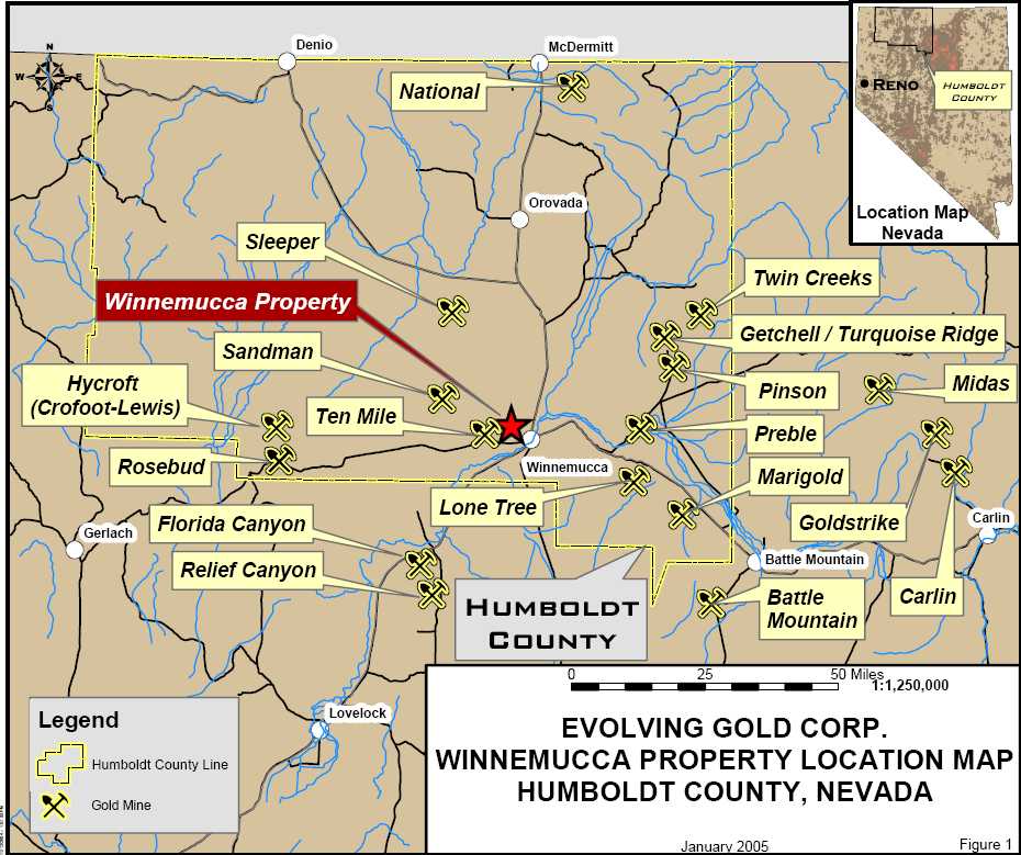
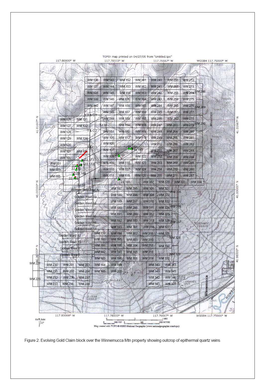
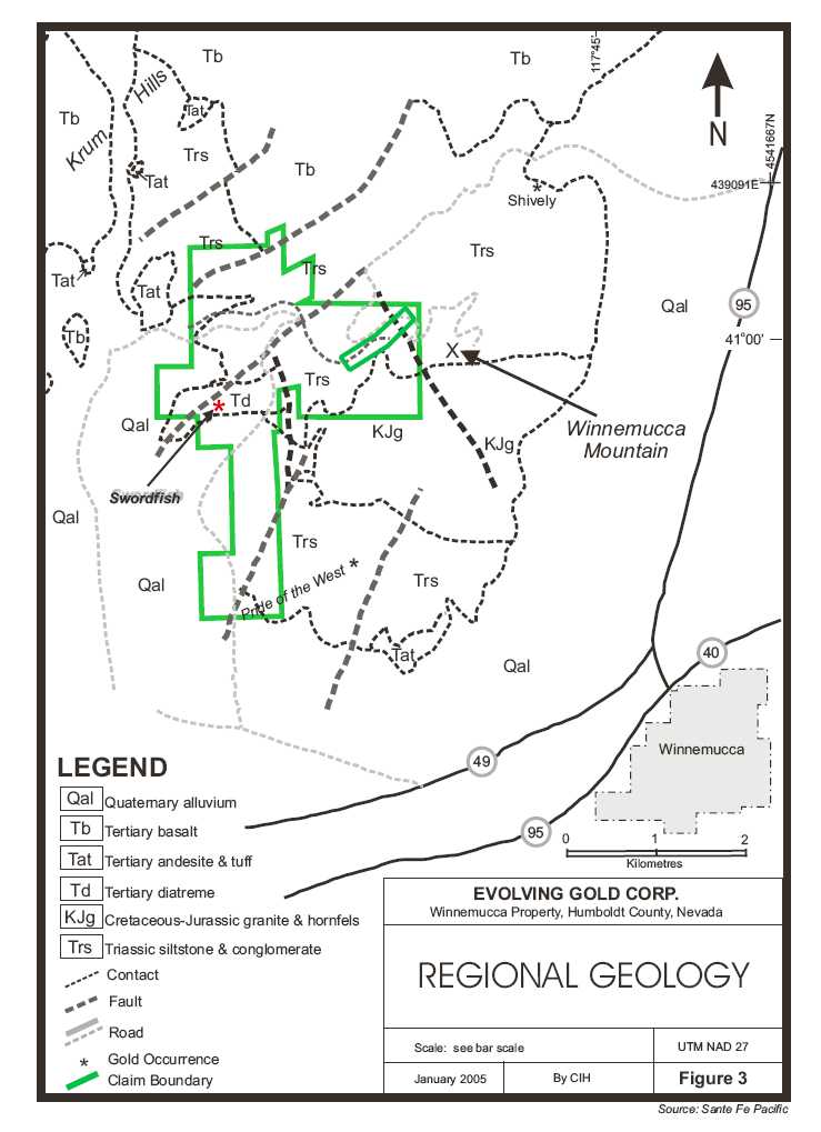
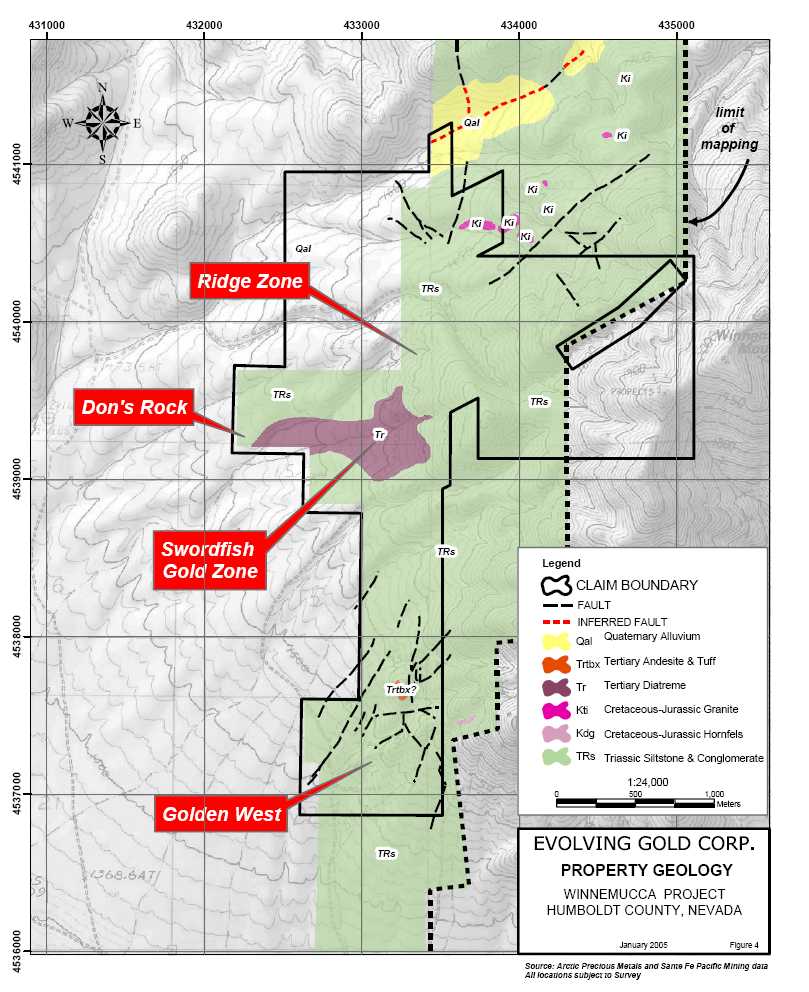
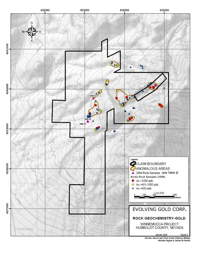
![]()

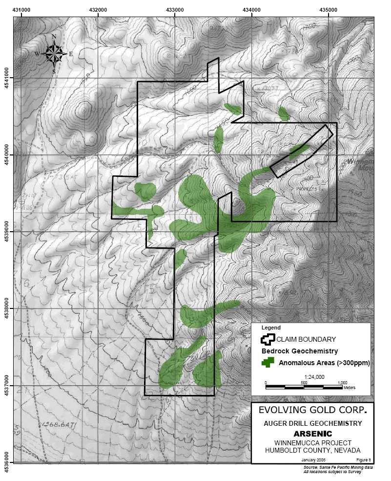
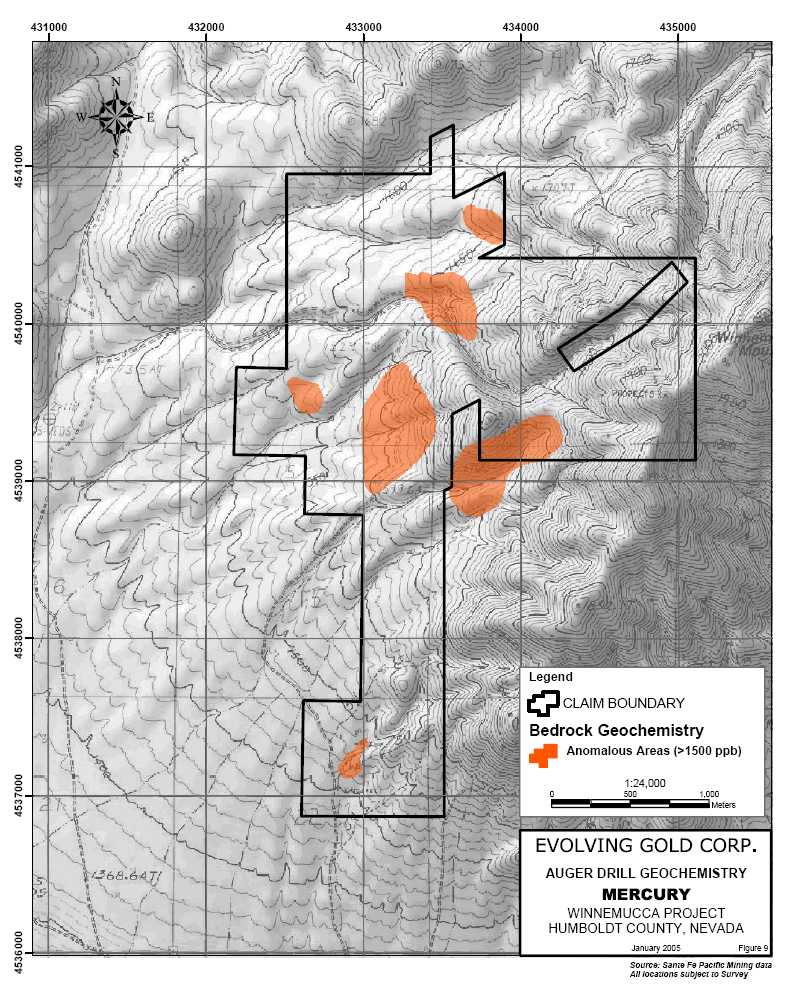


![]()