ANNUAL INFORMATION FORM
For the Year Ended December 31, 2015
(Dated March 30, 2016)
GOLD STANDARD VENTURES CORP.
Suite 610 – 815 West Hastings Street
Vancouver, B.C.
V6C 1B4
TABLE OF CONTENTS
| ITEM 1: PRELIMINARY NOTES | 3 |
| 1.1 | Effective Date of Information | 3 |
| 1.2 | Financial Statements and Management Discussion and Analysis | 3 |
| 1.3 | Currency | 3 |
| 1.4 | Imperial and Metric Conversions | 3 |
| ITEM 2: CAUTIONARY NOTES | 4 |
| 2.1 | Cautionary Note Regarding Forward Looking Statements and Forward Looking Information | 4 |
| 2.2 | Cautionary Note to United States Investors Regarding Mineral Reporting Standards | 6 |
| ITEM 3: GLOSSARY | 7 |
| 3.1 | Glossary of Terms | 7 |
| 3.2 | Glossary of Technical Terms | 8 |
| ITEM 4: CORPORATE STRUCTURE | 11 |
| 4.1 | Name, Address and Incorporation | 11 |
| 4.2 | Intercorporate Relationships | 11 |
| ITEM 5: GENERAL DEVELOPMENT OF THE BUSINESS | 12 |
| 5.1 | Overview | 12 |
| 5.2 | Three Year History | 14 |
| 5.3 | Significant Acquisitions and Dispositions | 21 |
| | 5.3.1 Significant Acquisitions | 21 |
| | 5.3.2 Dispositions | 21 |
| 5.4 | Mineral Property | 21 |
| ITEM 6: DESCRIPTION OF THE BUSINESS | 25 |
| 6.1 | General | 25 |
| ITEM 7: MATERIAL MINERAL PROJECT | 26 |
| ITEM 8: RISK FACTORS | 115 |
| ITEM 9: DIVIDENDS | 126 |
| ITEM 10: DESCRIPTION OF CAPITAL STRUCTURE | 127 |
| ITEM 11: MARKET FOR SECURITIES | 127 |
| 11.1 | Trading Price and Volume | 127 |
| 11.2 | Prior Sales | 127 |
| ITEM 12: ESCROWED SECURITIES AND SECURITIES SUBJECT TO CONTRACTUAL RESTRICTION ON TRANSFER | 129 |
| ITEM 13: DIRECTORS AND OFFICERS | 129 |
| 13.1 | Name, Occupation and Security Holding | 129 |
| 13.2 | Cease Trade Orders, Bankruptcies, Penalties or Sanctions | 133 |
| 13.3 | Conflicts of Interest | 134 |
| ITEM 14: LEGAL PROCEEDINGS AND REGULATORY ACTIONS | 134 |
| 14.1 | Legal Proceedings | 134 |
| 14.2 | Regulatory Actions | 134 |
| ITEM 15: INTEREST OF MANAGEMENT AND OTHERS IN MATERIAL TRANSACTIONS | 134 |
| ITEM 16: TRANSFER AGENT AND REGISTRAR | 136 |
| ITEM 17: MATERIAL CONTRACTS | 136 |
| ITEM 18: INTEREST OF EXPERTS | 137 |
| 18.1 | Names of Experts | 137 |
| 18.2 | Interests of Experts | 138 |
| ITEM 19: AUDIT COMMITTEE | 138 |
| ITEM 20: ADDITIONAL INFORMATION | 140 |
| | | |
| SCHEDULE “A” – Audit Committee Charter | |
ITEM 1: PRELIMINARY NOTES
| 1.1 | Effective Date of Information |
References to “Gold Standard Ventures”, “Gold Standard”, “GSV”, the “Company”, “its”, “our” and “we”, or related terms, in this Annual Information Form (“AIF”), refer to Gold Standard Ventures Corp. and includes, where the context requires, its subsidiaries.
All information contained in this AIF is as at December 31, 2015, unless otherwise stated.
1.2 Financial Statements and Management Discussion and Analysis
This AIF should be read in conjunction with the Company’s consolidated annual financial statements for the year ended December 31, 2015 (the “Financial Statements”), and the accompanying Management’s Discussion and Analysis (“MD&A”) for such period. The Financial Statements and MD&A are available on the SEDAR website at www.sedar.com under the Company’s profile.
1.3 Currency
All references to “$”, “C$” or “dollars” in this AIF are to lawful currency of Canada unless otherwise expressly stated. References to “US$” are to United States dollars.
1.4 Imperial and Metric Conversions
The following table sets forth certain standard conversions between Standard Imperial Units and the International System of Units (or metric units).
| To Convert From | To | Multiply By |
| | | |
| Feet (“ft”) | Metres (“m”) | 0.305 |
| Metres | Feet | 3.281 |
| Miles (“mi”) | Kilometres (“km”) | 1.609 |
| Kilometres | Miles | 0.621 |
| Acres | Hectares | 0.405 |
| Hectares | Acres | 2.471 |
| 2.1 | Cautionary Note Regarding Forward Looking Statements and Forward Looking Information |
Certain statements and information contained in this AIF and the documents incorporated by reference herein and therein constitute “forward-looking statements” and “forward looking information” within the meaning of applicable securities legislation. Forward-looking statements and forward looking information include statements concerning the Company’s current expectations, estimates, projections, assumptions and beliefs, and, in certain cases, can be identified by the use of words such as “seeks”, “plans”, “expects”, “is expected”, “budget”, “estimates”, “intends”, “anticipates”, or “believes”, or variations of such words and phrases or statements that certain actions, events or results “may”, “could”, “should”, “would”, “might” or “will”, “occur” or “be achieved”, or the negative forms of any of these words and other similar expressions.
Forward-looking statements and forward looking information reflect the Company’s current expectations and assumptions, and are subject to a number of known and unknown risks, uncertainties and other factors that may cause the Company’s actual results, performance or achievements to be materially different from any anticipated future results, performance or achievements expressed or implied by the forward-looking statements and forward looking information, including without limitation:
| · | the Company’s limited operating history; |
| · | the Company’s history of losses and expectation of future losses; |
| · | uncertainty as to the Company’s ability to continue as a going concern; |
| · | the existence of mineral resources on the Company’s mineral properties; |
| · | the Company’s ability to obtain adequate financing for exploration and development; |
| · | the Company’s ability to attract and retain qualified personnel; |
| · | foreign currency fluctuations; |
| · | uncertainty as to the Company’s ability to maintain effective internal controls; |
| · | the involvement by some of the Company’s directors and officers with other natural resource companies; |
| · | the uncertain nature of estimating mineral resources and reserves; |
| · | uncertainty surrounding the Company’s ability to successfully develop its mineral properties; |
| · | exploration, development and mining risks, including risks related to infrastructure, accidents and equipment breakdowns; |
| · | title defects to the Company’s mineral properties; |
| · | the Company’s ability to obtain all necessary permits and other approvals; |
| · | risks related to equipment shortages, access restrictions and inadequate infrastructure; |
| · | increased costs and restrictions on operations due to compliance with environmental legislation and potential lawsuits; |
| · | fluctuations in the market price of gold and other metals; |
| · | intense competition in the mining industry; and |
| · | the Company’s ability to comply with applicable regulatory requirements. |
In making the forward-looking statements and developing the forward looking information included in this AIF and the documents incorporated by reference herein and therein, the Company has made various material assumptions, including, but not limited to:
| · | the results of the Company’s proposed exploration programs on the Railroad-Pinion Project will be consistent with current expectations; |
| · | the Company’s assessment and interpretation of potential geological structures and mineralization at the Railroad-Pinion Project are accurate in all material respects; |
| · | the quantity and grade of mineral resources contained in the Pinion and Dark Star Deposits located within the Railroad-Pinion Project are accurate in all material respects; |
| · | the sufficiency of the Company’s current working capital to carry out the work programs and drilling on the Railroad-Pinion Project including, but not limited to, the Pinion and Dark Star Deposits as recommended in the 2016 Railroad-Pinion Report on a timely basis; |
| · | the price for gold and other precious metals will not fall significantly below current levels; |
| · | the Company will be able to secure additional financing to continue exploration and, if warranted, development activities on the Railroad-Pinion Project and meet future obligations as required from time to time; |
| · | the Company will be able to obtain regulatory approvals and permits in a timely manner and on terms consistent with current expectations; |
| · | the Company will be able to procure drilling and other mining equipment, energy and supplies in a timely and cost efficient manner to meet the Company’s needs from time to time; |
| · | the Company’s capital and operating costs will not increase significantly from current levels; |
| · | key personnel will continue their employment with the Company and the Company will be able to obtain and retain additional qualified personnel, as needed, in a timely and cost efficient manner; |
| · | there will be no significant adverse changes in the Canada/U.S. currency exchange rate; |
| · | there will be no significant changes in the ability of the Company to comply with environmental, safety and other regulatory requirements; and |
| · | the absence of any material adverse effects arising as a result of political instability, terrorism, sabotage, natural disasters, equipment failures or adverse changes in government legislation or the socio-economic conditions in Nevada and the surrounding area with respect to the Company’s Railroad-Pinion Project and operations. |
Other assumptions are discussed throughout this AIF and in the documents incorporated by reference herein and therein.
The Company's ability to predict the results of its operations or the effects of various events on its operating results is inherently uncertain. Accordingly, readers are cautioned not to place undue reliance on the forward-looking statements and forward looking information or the assumptions on which the Company’s forward-looking statements and forward looking information are based. Investors are advised to carefully review and consider the risk factors identified in, among other places, this AIF under Item 8 “RISK FACTORS” and in the documents incorporated by reference herein and therein for a discussion of the factors that could cause the Company’s actual results, performance and achievements to be materially different from any anticipated future results, performance or achievements expressed or implied by the forward-looking statements and forward looking information. Investors are further cautioned that the foregoing list of risks and assumptions is not exhaustive and prospective investors should consult the more complete discussion of the Company’s business, financial condition and prospects that is included in this AIF and the documents incorporated by reference herein and therein.
Although the Company believes that the assumptions on which the forward-looking statements are made and forward looking information is provided are reasonable, based on the information available to the Company on the date such statements were made or such information was provided, no assurances can be given as to whether these assumptions will prove to be correct. The forward-looking statements and forward looking information contained in this AIF and the documents incorporated by reference herein and therein are expressly qualified in their entirety by the foregoing cautionary statements. Furthermore, the above risks are not intended to represent a complete list of the risks that could affect the Company and readers should not place undue reliance on forward-looking statements and forward looking information in this AIF and the documents incorporated by reference herein and therein.
Forward-looking statements and forward looking information speak only as of the date the statements are made or such information is provided. The Company assumes no obligation to update publicly or otherwise revise any forward-looking statements or forward looking information to reflect actual results, changes in assumptions or changes in other factors affecting forward-looking statements or forward looking information, except to the extent required by applicable laws. If the Company does update one or more forward-looking statements or forward looking information, no inference should be drawn that the Company will make additional updates with respect to those or other forward-looking statements or forward looking information.
| 2.2 | Cautionary Note to United States Investors Regarding Mineral Reporting Standards |
The disclosure in this AIF and the documents incorporated by reference herein and therein have been prepared in accordance with the requirements of Canadian securities laws, which differ from the requirements of United States securities laws. Disclosure, including scientific or technical information, has been made in accordance with Canadian National Instrument 43-101 Standards of Disclosure for Mineral Projects. NI 43-101 is a rule developed by the Canadian Securities Administrators that establishes standards for all public disclosure an issuer makes of scientific and technical information concerning mineral projects. Canadian standards, including NI 43-101, differ significantly from the requirements of the SEC. In particular, and without limiting the generality of the foregoing, the term “resource” does not equate to the term “reserve”. Under United States standards, mineralization may not be classified as a “reserve” unless the determination has been made that the mineralization could be economically and legally produced or extracted at the time the reserve determination is made. The SEC’s disclosure standards normally do not permit the inclusion of information concerning “measured mineral resources”, “indicated mineral resources” or “inferred mineral resources” or other descriptions of the amount of mineralization in mineral deposits that do not constitute “reserves” by United States standards in documents filed with the SEC. United States investors should also understand that “measured mineral resources”, “indicated mineral resources” and “inferred mineral resources” have a great amount of uncertainty as to their existence and as to their economic and legal feasibility. Investors are cautioned not to assume that any part, or all, of the mineral deposits in these categories will ever be converted into mineral reserves. In accordance with Canadian rules, estimates of “inferred mineral resources” cannot form the basis of feasibility or other economic studies. Although it is reasonably expected that the majority of “inferred resources” could be upgraded to “indicated resources” with continued exploration, investors are cautioned not to assume that all or any part of an “inferred mineral resource” exists or is economically or legally mineable. In addition, the definitions of “proven” and “probable mineral reserves” used in NI 43-101 differ from the definitions in the Industry Guide 7. Disclosure of “contained ounces” is permitted disclosure under Canadian regulations; however, the SEC normally only permits issuers to report mineralization that does not constitute reserves as in place tonnage and grade without reference to unit measures. Accordingly, information contained in this AIF, and any documents incorporated by reference herein and therein containing descriptions of the Company’s mineral properties may not be comparable to similar information made public by U.S. companies subject to the reporting and disclosure requirements under the United States federal securities laws and the rules and regulations thereunder.
[remainder of page left blank intentionally]
ITEM 3: GLOSSARY
3.1Glossary of Terms
“2014 Pinion Resource Report” means the technical report dated October 24, 2014 establishing the maiden resource estimate for the Pinion Deposit titled “Technical Report Maiden Resource Estimate Pinion Project Elko County, Nevada USA” prepared in accordance with NI 43-101 by Michael B. Dufresne, M.Sc., P. Geol., P. Geo, Steven J. Nicholls, BA.Sc., MAIG, and Andrew J. Turner, BSc., P. Geol, of APEX.
“2015 Dark Star Resource Report” means the technical report dated April 17, 2015 establishing the maiden resource estimate for the Dark Star Deposit titled “Technical Report Maiden Resource Estimate Dark Star Deposit Elko County, Nevada USA” prepared in accordance with NI 43-101 by Michael B. Dufresne, M.Sc., P. Geol., P. Geo, Steven J. Nicholls, BA. Sc., MAIG, and Andrew J. Turner, BSc., P. Geol, of APEX.
“2016 Railroad-Pinion Report” means the technical report dated March 30, 2016 on the Railroad-Pinion Project titled “Technical Report on the Railroad - Pinion Project Elko County, Nevada USA” prepared in accordance with NI 43-101 by Michael B. Dufresne, M.Sc., P. Geol., P. Geo. of APEX and Steven R. Koehler, B.Sc., QP, CPG#10216, the Company's Manager of Projects.
“APEX” means APEX Geoscience Ltd., of Edmonton, Alberta.
“BCBCA” means the Business Corporations Act (British Columbia), as amended from time to time.
“BLM” means the United States, Department of Interior, Bureau of Land Management.
“Board” means the board of directors of the Company.
“Computershare” means Computershare Trust Company of Canada, the registrar and transfer agent of the Company.
“Common Shares” means common shares without par value in the capital stock of the Company.
“Dark Star Deposit” means the gold deposit located at the southern end of the Railroad-Pinion Project approximately two miles (three km) east of the Pinion Deposit and the subject of the maiden resource estimate in the 2015 Dark Star Resource Report.
“East Bailey Project” means the Company’s former early stage gold exploration prospect comprising 532 unpatented lode mineral claims totaling approximately 10,425 acres in Elko County, Nevada.
“East Camp Douglas Project” means the Company’s former early stage gold exploration prospect comprising 281 unpatented mineral claims and several blocks of fee lands totaling approximately 5,403.7 acres in the Walker Lane Trend of Mineral County, Nevada.
“GSV US” means Gold Standard Ventures (US) Inc., a wholly owned subsidiary of JKR incorporated pursuant to the laws of Nevada and holding all of the Company’s interest in the Railroad-Pinion Project.
“IFRS” means International Financial Reporting Standards.
“JKR” means JKR Gold Resources Inc., a wholly owned subsidiary of the Company incorporated under the BCBCA.
“JKR US” means JKR Gold Resources USA Inc., a wholly owned subsidiary of JKR incorporated pursuant to the laws of Nevada which previously held the Company’s interests in the Safford-CVN Project and East Bailey Project.
“JMD” means JMD Exploration Corp., a wholly owned subsidiary of JKR incorporated under the BCBCA.
“NI 43-101” means National Instrument 43-101 Standards of Disclosure of Mineral Projects adopted by the Canadian Securities Administrators.
“NSR” means net smelter returns royalty.
“NYSE-MKT” means the NYSE-MKT LLC, a wholly-owned subsidiary of NYSE Euronext.
“Pinion Deposit” means the gold deposit located primarily within Section 27 (T30N, R53E) of the Pinion Project and the subject of the updated resource estimate discussed in the 2016 Railroad-Pinion Report.
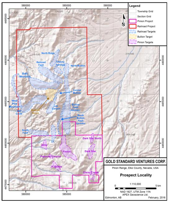
“Pinion Project” means that portion of the Railroad-Pinion Project located in Elko County, Nevada adjoining the southern boundary of the Railroad Project as more particularly described under Item 5.4 “Mineral Properties – Railroad-Pinion Project, Elko County, Nevada” and outlined as such in Figure 4.1, Property Map, under Item 7 “MATERIAL MINERAL PROJECT – Railroad-Pinion Project, Elko County, Nevada”.
“QP” means a “qualified person” for the purposes of NI 43-101.
“Railroad Project” means that portion of the Railroad-Pinion Project in Elko County, Nevada situated north of and adjacent to the Pinion Project as more particularly described under Item 5.4 “Mineral Properties – Railroad-Pinion Project, Elko County, Nevada” and outlined as such in Figure 4.1, Property Map, under Item 7 “MATERIAL MINERAL PROJECT – Railroad-Pinion Project, Elko County, Nevada”.
“Railroad-Pinion Project” means the significant and largely contiguous land position of about 30,404 gross acres (12,304 hectares) and 28,271 net acres (11,623 net hectares) of patented and unpatented lode claims and private lands situated in the prolific Carlin Trend of north-central Nevada, U.S.A. and the Company’s flagship mineral project as more particularly described under Item 5.4 “Mineral Properties – Railroad-Pinion Project, Elko County, Nevada" and Item 7 “MATERIAL MINERAL PROJECT – Railroad-Pinion Project, Elko County, Nevada”.
“Safford-CVN Project” means the Company’s former early stage gold and silver exploration prospect comprising 267 contiguous unpatented lode mining claims covering approximately 5,380.5 acres of land located in Eureka County, Nevada, U.S.
“Scorpio” means Scorpio Gold Corporation, a reporting issuer listed for trading on the TSXV under the symbol SGN, and, where the context so requires, its wholly-owned U.S. subsidiary, Scorpio Gold (US) Corporation.
“SEC” means the United States Securities and Exchange Commission.
“SEDAR” means the System for Electronic Document Analysis and Retrieval as located on the Internet at www.sedar.com.
“TSXV” means the TSX Venture Exchange.
In this AIF, other words and phrases that are capitalized have the meaning assigned in this AIF.
Words importing the masculine shall be interpreted to include the feminine or neuter and the singular to include the plural and vice versa where the context so requires.
| 3.2 | Glossary of Technical Terms |
The following is a glossary of certain geological and technical terms used in this AIF.
Ag - silver.
anticline - a flexure or fold in a rock formation that takes the form of an arch.
anomaly - any departure from the norm which may indicate the presence of mineralization in the underlying bedrock.
assay - in economic geology, to analyze the proportions of metal in a rock or overburden sample; to test an ore or mineral for composition, purity, weight or other properties of commercial interest.
Au - gold.
breccia - a coarse-grained clastic rock, composed of angular broken rock fragments held together by a mineral cement or in a fine-grained matrix; it differs from conglomerate in that the fragments have sharp edges and unworn corners. Breccia may originate as a result of talus accumulation, explosive igneous processes, collapse of rock material, or faulting.
carbonates - a sedimentary rock composed of carbonate minerals, including limestone (CaCO3) and dolomite (CaMg(CO3)2)
clastic - A sedimentary rock (such as shale, siltstone, sandstone or conglomerate) or sediment (such as mud, silt, sand, or pebbles) composed of fragments (clasts) of pre-existing rock or fossils.
conglomerate - rock comprising pieces of other rocks: coarse-grained sedimentary rock containing fragments of other rock larger than 2 mm (0.08 in.) in diameter, held together with another material such as clay.
CSAMT survey – controlled source, audio-frequency, magnetotelluric survey.
Cu - copper.
dip - the angle at which a stratum is inclined from the horizontal.
EM - electromagnetic geophysical survey.
geochemical - pertaining to various chemical aspects (e.g. concentration, associations of elements) of natural media such as rock, soil and water.
geophysical survey - the exploration of an area by exploiting differences in physical properties of different rock types. Geophysical methods include seismic, magnetic, gravity, induced polarization and other techniques.
grade - the amount of valuable metal in each tonne of ore, expressed as grams per tonne (g/t) for precious metals, as percent (%) for copper, lead, zinc and nickel.
Gravity Depth - a measurement of gravity below the surface.
host - a rock or mineral that is older than rocks or minerals introduced into it.
hydrothermal - relative to the circulation of hot water within Earth's crust.
intrusive - an igneous rock body that crystallized from a magma slowly cooling below the surface of the Earth.
jasperoids - a rare, peculiar type of hydrothermal metasomatic alteration and occurs in two main forms; sulfidic jasperoids and hematitic jasperoids. True jasperoids are different from jaspillite, which is a form of metamorphosed chemical sedimentary rock, and from jasper which is a chemical sediment.
limestone - a sedimentary rock composed mainly of calcite (CaCO3) often deposited as a by-product of biological activity in the ocean.
metamorphic rocks - rocks which have undergone a change in texture or mineral composition as the result of exposure to heat and/or pressure.
metasomatic - the chemical alteration of a rock by hydrothermal and other fluids.
outcrop - an exposure of bedrock at the surface.
plutonic - refers to rocks of igneous origin that have come from depth and cooled slowly below the surface of the earth.
porphyry - any igneous rock in which relatively large crystals, called phenocrysts, are set in a fine-grained groundmass.
ppb - parts per billion.
ppm - parts per million, numerically equivalent to grams per long tonne.
pyrite - a common iron sulfide mineral (FeS2) with a brassy metallic luster.
sedimentary rocks - secondary rocks formed from material derived from other rocks mainly deposited under water. Examples are limestone, shale and sandstone.
silica - a combination of silicon dioxide (SiO2); quartz.
silicification - the introduction of, or replacement by, silica, generally resulting in the formation of fine-grained quartz, chalcedony, or opal, which may fill pores and replace existing minerals.
silts - a fine soil particle with sizes that range between 0.075mm and 0.002mm.
skarn - name for the metamorphic rocks surrounding an igneous intrusive where it comes in contact with a limestone or dolostone formation.
st – short ton.
sulphide - a group of minerals in which one or more metals are found in combination with sulphur.
[remainder of page left blank intentionally]
ITEM 4: CORPORATE STRUCTURE
4.1 Name, Address and Incorporation
The Company was incorporated on February 6, 2004 under the BCBCA under the name “TCH Minerals Inc.”. The Company changed its name to “Ripple Lake Minerals Ltd.” on May 13, 2004 and again to “Ripple Lake Diamonds Inc.” on July 26, 2004. On August 16, 2007 the Company consolidated its share capital on a ten for one basis and changed its name to “Devonshire Resources Ltd.”. On November 18, 2009 the Company consolidated its share capital on a further four to one basis and changed its name to its current name “Gold Standard Ventures Corp.”.
The registered and head office of the Company is located at Suite 610 – 815 West Hastings Street, Vancouver, B.C. V6C 1B4, telephone: (604) 669 - 5702, fax (604) 687 – 3567.
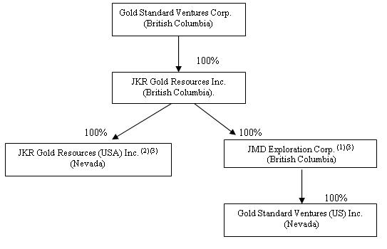
4.2 Inter-corporate Relationships
The Company currently has four wholly-owned subsidiaries: JKR, JMD, GSV US and JKR US.
JKR is a private company incorporated in British Columbia and holds all of the issued and outstanding shares in the capital stock of JMD and JKR USA. JMD is a private company incorporated in British Columbia and holds all of the shares of GSV US. GSV US is a private company incorporated in Nevada and holds the Company’s interest in the Railroad-Pinion Project. JKR US is a private company incorporated in Nevada and previously held the Company’s interests in the former Safford-CVN and East Bailey Projects.
The following chart illustrates the inter-corporate relationships among the Company and its subsidiaries as of March 30, 2016.
| | (1) | Other than holding the shares of GSV US, JMD does not carry on any active business. |
| | (2) | JKR US previously held the Company’s interests in the Safford-CVN and East Bailey Projects. See Item 5.2 “GENERAL DEVELOPMENT OF THE BUSINESS – Three Year History” for a discussion of the Company’s abandonment of the Safford-CVN and East Bailey Projects in 2015. |
| | (3) | The Company is currently investigating options for winding up these subsidiaries in order to simplify its corporate structure and reduce ongoing administrative and accounting expenses. |
ITEM 5: GENERAL DEVELOPMENT OF THE BUSINESS
5.1 Overview
Headquartered in Vancouver, B.C., Gold Standard is a Canadian based company focused on the acquisition and exploration of district-scale and other gold-bearing mineral properties exclusively in the State of Nevada, United States.
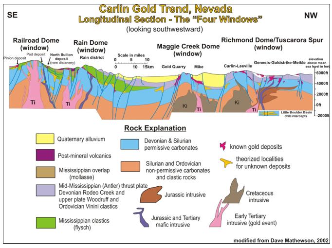
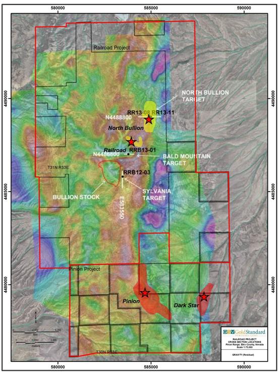
The Company’s flagship property is the Railroad-Pinion Project located at the southeast end of the Carlin (Gold) Trend, a northwest alignment of sedimentary rock-hosted gold deposits in northeastern Nevada where more than 40 separate gold deposits have produced in excess of 80 million ounces of gold to date. The Railroad-Pinion Project is centered on the fourth and southernmost dome-shaped window along the Carlin Trend in the Piñon Range which is cored by igneous intrusions that uplift and expose Paleozoic rocks and certain stratigraphic contacts that are favorable for the formation of Carlin-style gold deposits.
The following is an interpretive illustration of a longitudinal section of the "Four Windows" on the Carlin Trend. (1)
| | (1) | The existence of major gold deposits on properties adjacent to or in close proximity with the Railroad-Pinion Project is not necessarily indicative of the level of gold mineralization on the Railroad-Pinion Project. |
The Railroad-Pinion Project comprises two significant gold target areas. Historic work and exploration conducted by the Company since 2010 has identified several significant zones of gold and base metal mineralization within the Railroad Project portion of the Railroad-Pinion Project. In early 2014, the Company increased its ownership of the Pinion Project, which is located immediately south of, and is contiguous with, the Railroad Project and is host to the Pinion and Dark Star Deposits as well as other exploration prospects. See “Pinion Deposit” and “Dark Star and Dixie Prospects” in Item 5.3.1 “Significant Acquisitions and Dispositions - Significant Acquisitions” below.
The combined Railroad-Pinion Project is the subject of the NI 43-101 2016 Railroad-Pinion Report dated March 30, 2016 and titled “Technical Report on the Railroad - Pinion Project Elko County, Nevada USA” co-authored by Michael B. Dufresne, M.Sc., P. Geol., P.Geo. of APEX and Steven R. Koehler, BSc, QP, CPG #10216, the Company's Manager of Projects. A copy of the 2016 Railroad-Pinion Report is available for review under the Company's profile on SEDAR at www.sedar.com. See Item 7 "MATERIAL MINERAL PROJECT - Railroad-Pinion Project, Elko County, Nevada - Recommendations" below for a description of the recommended work program for the Railroad-Pinion Project in the 2016 Railroad-Pinion Report.
Work completed by the Company at the Railroad-Pinion Project between March and August, 2014 focused on a Phase 1 confirmation drill program at the Pinion Deposit and was the subject of the 2014 Pinion Resource Report dated October 24, 2014, a maiden NI 43-101 resource estimate (the “2014 Maiden Pinion Resource”) for the Pinion Deposit by APEX. During September to November, 2014, the Company completed a Phase 2 drilling program at Pinion totalling 35,730 feet (10,891 m) of RC drilling in 44 holes designed to extend areas of known shallow oxide gold mineralization along strike and at depth, and to test new targets identified by the Phase 1 program and a new 3D geologic model.
The 2014 Phase 2 drilling program also included 5 holes totaling 6,220 feet (1,896 m) at the Bald Mountain target on the Railroad Project.
In late 2014, the Company secured additional mineral rights within the Pinion Project area including the mineral rights to the Dark Star Deposit located approximately 2 miles (3km) east of the Pinion Deposit. A review of the historical Dark Star drilling information was completed by Gold Standard personnel in conjunction with APEX in early 2015 leading to the delineation of a maiden NI 43-101 resource estimate (the “2015 Maiden Dark Star Resource”) for the Dark Star Deposit and issuance of the 2015 Dark Star Resource Report by APEX on April 17, 2015.
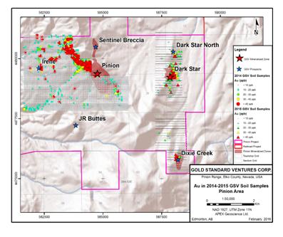
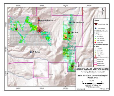
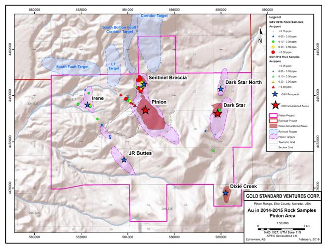
During 2015, the Company completed multi-phase reverse circulation (“RC”) drill programs totaling 46,732 feet (14,244 m) at the Pinion and Dark Star Deposits along with 5 core holes totaling 6,115 feet (1,864 m) at Dark Star and North Bullion. Phase 1 drilling at Pinion and Dark Star during June and July, 2015, was designed to extend areas of known shallow oxide gold mineralization along strike and at depth, and to test new targets identified by the 2014 programs. Phase 1 involved 4,912 metres of RC drilling in 14 holes, of which 9 holes (PIN15-01 - PIN15-09) for 10,970 feet (3,344 m) were completed at Pinion and 5 holes (DS15-01 - DS15-05) totaling 5,145 feet (1,568 m) were completed at Dark Star. PIN15-02 intersected 1.38 g/t Au over 24.4 metres hole length in oxidized and altered multilithic, dissolution collapse breccia along the west edge of the Pinion Deposit but beyond the boundary of the 2014 Maiden Pinion Resource. PIN15-03 intersected multiple gold bearing horizons including 0.56 g/t Au over 82.3 metres hole length and 0.93 g/t Au over 6.2 metres hole length well beyond the southern limit of the 2014 Maiden Pinion Resource.
Phase 2 drilling at Pinion, completed between September and early December 2015, was designed to test five oxide resource expansion targets including: an offset of the intersection in PIN15-02; high potential targets along the highly prospective South Fault Zone at the west edge of the deposit, and; the new Sentinel Contact target which is approximately 100 metres west of the Pinion Far North Zone. The Phase 2 program totaled 19,900 feet (6,066 m) of RC drilling in 15 holes (PIN15-10 – PIN15-24), with one hole to the northwest at the Irene Target area, four holes to test the Sentinel contact at the northern end of the Pinion Project and the remaining ten holes testing the potential for resource expansion along the western, southern and eastern portions of the Pinion Deposit. Highlights include 0.81 g/t Au over 24.4 metres hole length in PIN15-10, 0.82 g/t Au over 51.8 metres hole length in PIN15-21 and 0.95 g/t Au over 22.9 metres hole length in PIN15-22. All intercepts were contained within oxidized and altered multilithic, dissolution collapse breccia, the principal Pinion Deposit host rock, and all intercepts were obtained outside of the boundaries of the 2014 Maiden Pinion Resource.
Phase 1 drilling at Dark Star yielded gold mineralization up to 100 metres to the north of historic drilling and the 2015 Maiden Dark Star Resource and indicates that there is potential to expand the 2015 Maiden Dark Star Resource to the north (“Dark Star North”).
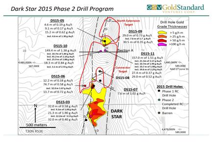
Phase 2 RC drilling at Dark Star North yielded a high priority new oxide gold discovery in Pennsylvanian carbonate and siliciclastic rocks approximately 500 metres north of the 2015 Maiden Dark Star Resource. The Phase 2 Dark Star drilling was completed during October and December, 2015 and comprised 7 RC holes for a total of 10,015 feet (3,053 m), plus 1 diamond (core) drill hole for 1,402 feet (427 m).
Since acquiring and amalgamating the Railroad-Pinion Project, Gold Standard has undertaken an aggressive exploration strategy aimed at delineating NI 43-101 compliant mineral resources at several of the pre-existing and newly discovered prospects. Maiden NI 43-101 compliant mineral resource estimates were completed at the Pinion Deposit in September, 2014 (see 2014 Pinion Resource Report) and the Dark Star Deposit in March, 2015 (see 2015 Dark Star Resource Report).
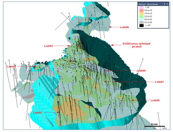
Based upon the results of drilling at the Pinion Project during late 2014 and throughout 2015, APEX constructed a NI 43-101 compliant resource update for Pinion (the “2016 Pinion Resource”) in early 2016 (see news release dated March 15, 2016) which includes an “indicated” mineral resource of 31.61 million tonnes at a grade of 0.62 g/t Au totaling 630,300 ounces of gold (representing an approximate 49% increase in gold versus the 2014 Maiden Pinion Resource) and a revised “inferred” resource of 61.08 million tonnes at a grade of 0.55 g/t Au totaling 1,081,300 ounces of gold (representing an approximate 6% increase in gold versus the 2014 Maiden Pinion Resource). The 2016 Pinion Resource also includes an update to the estimated “inferred” silver resource, which is comprised of 92.69 million tonnes at an average grade of 4.16 g/t Ag totaling 12,401,600 ounces of silver representing a nearly 32% increase in silver versus the 2014 Maiden Pinion Resource. See Item 7 “MATERIAL MINERAL PROJECT - Railroad-Pinion Project, Elko County, Nevada - Mineral Resource Estimates” herein for further details regarding the Company's updated resource estimate for the Pinion Deposit.
The 2015 Maiden Dark Star Resource is located in the southeast part of the Pinion Project area, approximately 3 km (2 miles) east of the Pinion Deposit and includes an “inferred” mineral resource of 23.11 million tonnes grading 0.51 grams per tonne (g/t) gold (Au), totaling 375,000 ounces (oz) of gold. See Item 7 “MATERIAL MINERAL PROJECT - Railroad-Pinion Project, Elko County, Nevada - Mineral Resource Estimates” below for further details regarding the 2015 Maiden Dark Star Resource.
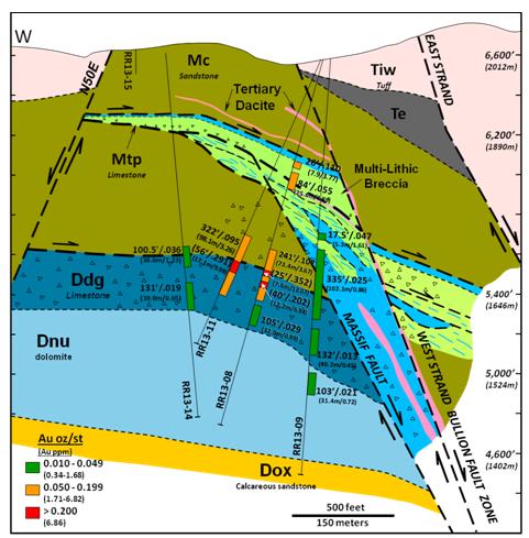
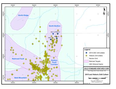
The 2015 drill program at North Bullion consisted of 4 holes (1,437 metres core and 214 metres RC) designed to test west-northwest and north extensions of the lower breccia-hosted gold zone discovered by the Company in 2012. Two of three holes at North Bullion returned significant intercepts that expand the known gold mineralization to the northwest and confirm the west-northwest trend to the high grade lower zone at North Bullion.
5.2 Three Year History
Due to the previously fragmented land ownership, historically, the southern portion or “fourth window” of the Carlin Trend had not been systematically explored with modern techniques.
In 2010, the Company acquired its initial interest in the Railroad Project pursuant to a statutory plan of arrangement with JKR in which the Company acquired all of issued and outstanding securities of JKR in exchange for like securities of the Company on a one for one basis.
Since that time, the Company has worked to consolidate, by way of location, purchase and lease, the Railroad District under its common ownership and/or control.
In late 2011 and throughout 2012, the Company entered into a series of mining leases and surface access and use agreements with various land holders (collectively the “Pinion Leases”) to acquire control over strategic sections of land adjacent to and south of the original Railroad Project in Elko County, Nevada. In November 2012, the Company entered into a lease with option to purchase (the “Pereira Lease”) with Pereira Family, LLC granting the Company exclusive right to explore, mine and develop varying percentage holdings in approximately 21,296 net mineral acres within the Pinion District, Nevada, of which approximately 2,280 net mineral acres of land is both within and contiguous to the south of the Railroad Project in Elko County, Nevada. The Company also secured the surface and water rights on 4,467 net surface acres, through a third party, within the Railroad and Pinion Districts critical to future exploration and development. Collectively, the Pereira Lease and the Pinion Leases comprised the initial Pinion Project and granted the Company control over strategic sections of land located throughout the Railroad and Pinion Districts, including control over approximately 51% of Pinion Section 27 which hosts the bulk of the Pinion Deposit. See Item 5.4 “Mineral Properties - Railroad-Pinion Project, Elko County, Nevada - Pinion and Pereira Leases” below.
On March 5, 2014, the Company acquired the remaining interests in the Pinion Deposit from Scorpio thus completing its consolidation of the Railroad District and "fourth window" of the Carlin Trend under the Company's ownership and/or control. See Item 5.4 “Mineral Properties - Railroad-Pinion Project, Elko County, Nevada - Acquisition of Remaining Interest in the Pinion Deposit” below.
In December 2014, the Company entered into separate option-to-purchase agreements with Allied Nevada Gold Corp., private mineral interest owners, and a private third party claimholder to acquire, in the aggregate, an additional 866 net hectares (2,140 net acres) at the southern end of the Railroad-Pinion Project areas including effective ownership and control of two additional gold occurrences in close proximity to the Pinion Deposit, being the Dark Star Deposit and Dixie prospect.
The Railroad-Pinion Project straddles the Pinon Range in the Railroad Mining District of northeastern Nevada and consists of a significant and largely contiguous land position totaling about 30,404 gross acres (12,304 hectares) and 28,271 net acres (11,623 net hectares) of land in Elko County, Nevada. As of March 30, 2016, the Company owns or has an option on the ownership of 16,439 gross acres (6,652 hectares) of subsurface mineral rights in the form of patented or unpatented mineral lode (claims), and a further 13,965 gross acres (5,651 hectares) of subsurface mineral rights secured or controlled by a contractual interest in private surface and mineral property in the form of various surface use agreements and mining/mineral leases. The private land ownership ranges from 49.2% to 100% yielding a net interest of 12,666 acres (5,126 hectares) of subsurface mineral rights for the private lands within the Railroad-Pinion Project. The Company is pursuing the minority interest in the key private land parcels where it holds less than a 100% interest.
Patented claims, private surface and private mineral property are wholly owned/controlled and subject to lease agreement payments and property taxes (due annually) as determined by the County. The estimated holding cost for the patented claims and private lands controlled by Gold Standard is US$681,511 per annum. Unpatented lode mining claims grant the mineral rights and access to the surface for exploration activities which cause insignificant surface disturbance. The mineral right is maintained by paying a maintenance fee of US$155 per claim to the BLM on or before August 31 every year. A notice of intent to hold must also be filed with the Elko County Recorder on or before November 1 every year along with a filing fee of US$10.50 per claim plus a US$4.00 fee document charge. The 2015 filing is complete. Gold Standard’s estimated maintenance cost for their current package of unpatented lode claims is US$182,090 per annum.
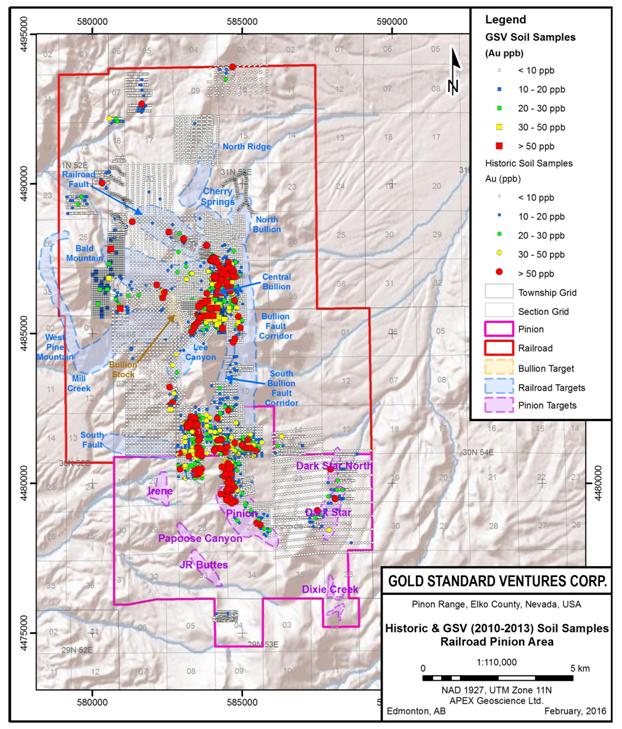
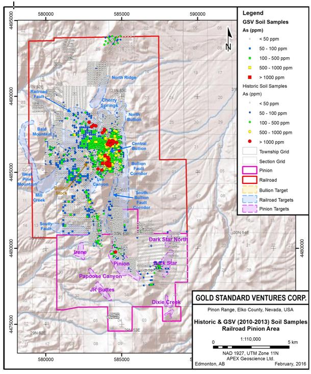
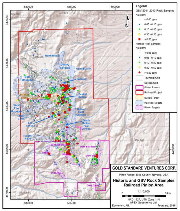
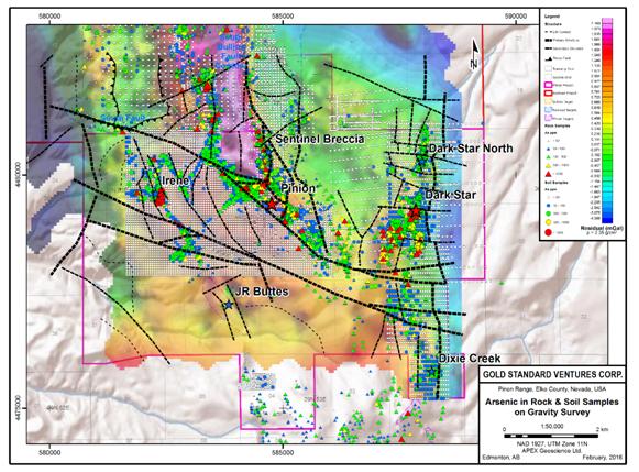
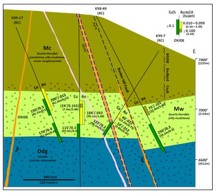
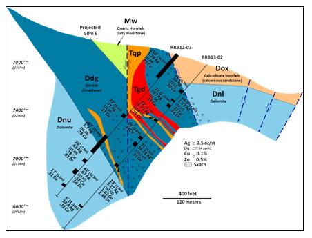
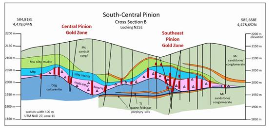
Since 2010, the Company has explored the Railroad-Pinion Project for Carlin-style gold mineralization through the execution of an aggressive and on-going, geologic model-driven exploration program that includes geological mapping, geochemical and geophysical surveys and drilling. This work has confirmed and expanded previously identified zones of mineralization and has resulted in the discovery of several new zones and styles of mineralization. Currently, the Railroad-Pinion Project includes a variety of mineralization types: 1) classic Carlin-style disseminated gold in carbonate dissolution collapse breccia at the contact between Devonian carbonates and Mississippian siliciclastics at the Pinion and North Bullion Deposits; 2) Carlin-style disseminated gold in silicified Pennsylvanian siliciclastic and carbonate rocks at the Dark Star Deposit; 3) stacked, tabular oxide gold and copper zones in quartz hornfels breccia at the Bald Mountain Target; and 4) skarn-hosted silver, copper, lead and zinc mineralization at the Sylvania (formerly Central Bullion) Target.
From mid-2012 to early 2014, the Company drilled 65 holes in the Railroad Project for a total of 34,772 metres (114,082 ft); completed 46.4 line kilometers (28.8 line miles) of CSAMT surveys; collected 578 gravity readings; collected 2,295 rock geochemical samples; and completed the acquisition of additional lands. Geological mapping, data compilation and interpretation along with other geological activities are in progress.
In 2015, the Company drilled 4 holes at North Bullion totaling 1,437 metres core and 214 metres RC designed to test west-northwest and north extensions of the lower breccia-hosted gold zone discovered by the Company in 2012.
Sixteen target areas within the Railroad Project have been identified by the Company for additional exploration. The targets are focused on gold, but also include silver, copper, lead and zinc. To date, nine of these targets have been drilled tested by the Company and significant gold, silver and base metal mineralization has been intersected in holes from a variety of target areas on the Railroad Project. Drill results have confirmed and expanded a significant Carlin-style, disseminated gold system at the North Bullion Target, and identified new mineralized zones at the Bald Mountain and Sylvania (Central Bullion) Targets. In addition, two prospects identified by historic work on the Pinion Project area comprising the Pinion and Dark Star Deposits have been drilled tested by the Company.
Work completed by the Company at the Railroad-Pinion Project between March and September, 2014 was focused on the Pinion Deposit and included a compilation and validation program of the Pinion Deposit drill database followed by a 13 hole Phase 1 confirmation drill program (9 RC and 4 core holes) intended to support the ongoing geological modeling and database validation work in order to allow for an initial mineral resource estimate for the Pinion Deposit. Based upon the compilation and modelling along with the Phase 1 drilling, a maiden NI 43-101 compliant mineral resource estimate was constructed for the Pinion Deposit by APEX in the fall of 2014. Details of the maiden resource estimate are provided in the 2014 Pinion Resource Report which included an "indicated" mineral resource of 20.84 million tonnes at 0.63 g/t Au for a total of 423,000 ounces of gold and an additional "inferred" mineral resource of 55.93 million tonnes at 0.57 g/t Au for 1.022 million ounces of gold. The 2014 Pinion Resource Report also contained an "inferred" mineral resource for silver consisting of 76.77 million tonnes at 3.82 g/t Ag for 9.43 million ounces of silver. All mineral resources were reported within an optimized pit shell using US$1,250/ounce for gold and US$21.50/ounce for silver and a lower cut-off grade of 0.14 g/t Au. See Item 7 “MATERIAL MINERAL PROJECT - Railroad-Pinion Project, Elko County, Nevada - Mineral Resource Estimates” below for further details regarding the 2014 Maiden Pinion Resource. The 2014 Maiden Pinion Resource for gold and silver is superseded in its entirety by the 2016 Pinion Resource estimate noted below.
Between September and November, 2014, the Company completed a Phase 2 drill program consisting of an additional 44 reverse circulation holes totaling approximately 35,730 feet (10,891 m) in and about the Pinion Deposit at a cost of approximately US$1,340,088 (C$1,510,145) designed to extend areas of known shallow oxide gold mineralization along strike and at depth and to test new targets identified by the 2014 Phase 1 work program and a new 3D geologic model. All 44 holes intersected multilithic collapse breccia with 38 of the 44 holes returning significant gold intercepts of at least 0.3 parts per million (ppm) or grams per tonne (g/t) or 0.009 ounces per ton (oz/st) gold (Au) over at least 6.1 metres (20 ft).
The remainder of the 2014 drilling comprised 5 vertical RC holes totaling 6,220 feet (1,896 m) at the Bald Mountain target on the Railroad Project designed to expand the limits of known oxide copper-gold-silver-zinc mineralization hosted in multilithic collapse breccia at the top of the Devils Gate Limestone. All five holes intersected the multilithic, dissolution collapse breccia host and the plan extent of the breccia was expanded in all directions. The stratigraphic position, thickness (35 to 120 metres) and the lateral continuity of the Bald Mountain breccia unit is considered significant as this pattern is consistent with the gold-bearing breccia host at the Pinion Deposit and North Bullion prospect.
In December 2014, the Company entered into separate option-to-purchase agreements to acquire, in the aggregate, an additional 866 net hectares (2,140 net acres) at the southern end of the Railroad-Pinion Project areas including effective ownership and control of two additional gold occurrences in close proximity to the Pinion Deposit, being Dark Star Deposit and Dixie prospect. The total cost of these acquisitions was less than US$163,000 in the first year and is about US$65,000 annually thereafter. See Item 5.3.1 “Significant Acquisitions and Dispositions - Significant Acquisitions - Dark Star and Dixie Prospects”.
A review of the historical Dark Star drilling information was completed by Gold Standard personnel in conjunction with APEX in early 2015, which review confirmed that the existing Dark Star drilling data was of sufficient quantity and quality to warrant a formal resource estimation effort for the Dark Star Deposit. APEX was retained to complete geological modeling and resource estimation for the Dark Star Deposit and a maiden “inferred” resource estimate of 23.11 million tonnes grading 0.51 grams per tonne (g/t) gold (Au), totaling 375,000 ounces (oz) of gold, using a cut-off grade of 0.14 g/t Au, was completed based on the results of 105 RC drill holes from multiple historical drilling campaigns conducted by other companies from 1991 to 1999 and is the subject of the 2015 Dark Star Resource Report dated April 17, 2015. Inferred mineral resources are not mineral reserves and do not have demonstrated economic viability. There has been insufficient exploration to define the inferred resources as an indicated or measured mineral resource, however, it is reasonably expected that the majority of the inferred mineral resources could be upgraded to indicated mineral resources with continued exploration. See Item 7 “MATERIAL MINERAL PROJECT - Railroad-Pinion Project, Elko County, Nevada - Mineral Resource Estimates” below for further details regarding the Company's maiden resource estimate for the Dark Star Deposit.
During 2015, the Company completed multi-phase RC drill programs totaling 46,732 feet (14,244 m) at the Pinion and Dark Star Deposits along with 5 core holes totaling 6,115 feet (1,864 m) at Dark Star and North Bullion. Phase 1 drilling at Pinion and Dark Star during June and July, 2015, was designed to extend areas of known shallow oxide gold mineralization along strike and at depth, and to test new targets identified by the 2014 program. Phase 1 involved 4,912 metres of RC drilling in 14 holes, of which 9 holes (PIN15-01 - PIN15-09) for 10,970 feet (3,344 m) were completed at Pinion and 5 holes (DS15-01 - DS15-05) totaling 5,145 feet (1,568 m) were completed at Dark Star. PIN15-02 intersected 1.38 g/t Au over 24.4 metres hole length in oxidized and altered multilithic, dissolution collapse breccia along the west edge of the Pinion Deposit but beyond the boundary of the 2014 Pinion Maiden Resource. PIN15-03 intersected multiple gold bearing horizons including 0.56 g/t Au over 82.3 metres hole length and 0.93 g/t Au over 6.2 metres well beyond the southern limit of the 2014 Maiden Pinion Resource.
Phase 2 drilling at Pinion, completed between September and early December, 2015, was designed to test five oxide resource expansion targets including: an offset of the intersection in PIN15-02; high potential targets along the highly prospective South Fault Zone at the west edge of the deposit, and; the new Sentinel Contact target which is approximately 100 metres west of the Pinion Far North Zone. The Phase 2 program totaled 19,900 feet (6,066 m) of RC drilling in 15 holes (PIN15-10 – PIN15-24), with one hole to the northwest at the Irene Target area, four holes to test the Sentinel contact at the northern end of the Pinion area and the remaining ten holes testing the potential for resource expansion along the northwestern, western, southern and eastern portions of the Pinion Deposit. Highlights include 0.81 g/t Au over 24.4 metres hole length in PIN15-10, 0.82 g/t Au over 51.8 metres hole length in PIN15-21 and 0.95 g/t Au over 22.9 metres hole length in PIN15-22. All intercepts were contained within oxidized and altered multilithic, dissolution collapse breccia, the principal Pinion Deposit host rock, and all intercepts were obtained outside of the boundaries of the 2014 Maiden Pinion Resource.
The Phase 1 drilling at Dark Star yielded gold mineralization up to 100 metres to the north of historic drilling and the 2015 Maiden Dark Star Resource. DS15-03 intersected a near surface upper oxidized zone that returned 0.58 g/t Au over 32.0 metres hole length and a deeper higher-grade sulphide-hosted zone of 1.90 g/t Au over 21.3 metres hole length which included a higher grade zone of 3.13 g/t Au over 12.2 metres hole length. The Phase 1 drilling indicates that there is potential to expand the Maiden Dark Star Resource to the north.
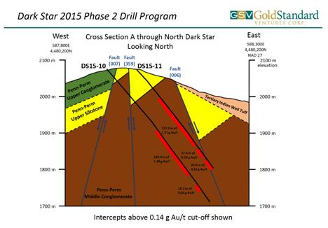
The Phase 2 RC drilling program at Dark Star North yielded a high priority new oxide gold discovery in Pennsylvanian calcareous siliciclastic rocks approximately 500 meters north of the Maiden Dark Star Resource. The Phase 2 drilling at Dark Star was completed during October and December, 2015 and comprised 7 RC holes (DS15-06 – DS15-12) for a total of 10,015 feet (3,053 m), plus 1 diamond (core) drill hole (DS15-13) for 1,402 feet (427 m). Holes DS15-10 and 15-11 intersected a vertically extensive oxide gold zone hosted in a variably silicified and quartz veined bioclastic conglomerate similar to the unit that hosts the 2015 Maiden Dark Star Resource. DS15-10 and DS15-11intersected 1.38 g/t Au over 149.4 metres hole length and 1.51 g/t Au over 157.0 metre hole length, respectively. These two holes were drilled about 60 metres apart. The Phase 2 core hole, DS15-13, was completed as a twin to RC hole DS15-11 at the newly discovered Dark Star North oxide gold zone. Core hole DS15-13 returned multiple, significant, oxidized gold intercepts including from two separate zones an upper zone of 1.85 g/t Au over 15.4 metres core length and a lower zone of 1.60 g/t Au over 96.96 metres core length. The lower gold zone also yielded higher grade zones including 3.29 g/t Au over 17.98 metres core length and a second zone of 4.62 g/t Au over 6.40 metres core length. The core hole confirmed the grades and thicknesses obtained from the RC drilling.
Since acquiring and amalgamating the Railroad-Pinion Project, Gold Standard has undertaken an aggressive exploration strategy aimed at delineating NI 43-101 compliant mineral resources at several of the pre-existing and newly discovered prospects. Maiden mineral resource estimates were completed at the Pinion Deposit in September, 2014 and the Dark Star Deposit in March, 2015. Based upon the results of drilling at Pinion during late 2014 and throughout 2015, APEX constructed a resource update for Pinion in early 2016 (see news release dated March 15, 2016) including an “indicated” mineral resource of 31.61 million tonnes at a grade of 0.62 g/t Au totaling 630,300 ounces of gold (representing an approximate 49% increase in gold versus the 2014 Maiden Pinion Resource) and a revised “inferred” mineral resource of 61.08 million tonnes at a grade of 0.55 g/t Au totaling 1,081,300 ounces of gold (representing an approximate 6% increase in gold versus the 2014 Maiden Pinion Resource).
The 2016 Pinion Resource also includes an update to the estimated “inferred” silver resource, which is comprised of 92.69 million tonnes at an average grade of 4.16 g/t Ag totaling 12,401,600 ounces of silver representing a nearly 32% increase in silver versus the 2014 Maiden Pinion Resource. The silver resource is classified entirely as “inferred” and its lower cut-off is strictly based upon the gold block cut-off of 0.14 g/t. A total of 505 drill holes guided the geological interpretation and estimation of the 2016 Pinion Resource. This total comprises 24 diamond drill holes and 481 RC drill holes that were completed from 1981 to 2015. Similar to the 2014 Maiden Pinion Resource, the 2016 Pinion Resource was constrained within a pit shell optimized utilizing a price of US$1,250/ounce for gold and US$21.50/ounce for silver and a lower cut-off grade of 0.14 g/t Au.
Indicated and inferred mineral resources are not mineral reserves and do not have demonstrated economic viability. There has been insufficient exploration to define the inferred resources as an indicated or measured mineral resource, however, it is reasonably expected that the majority of the inferred mineral resources could be upgraded to indicated mineral resources with continued exploration. See Item 7 “MATERIAL MINERAL PROJECT - Railroad-Pinion Project, Elko County, Nevada - Mineral Resource Estimates”.
The 2015 drill program at North Bullion consisted of 4 holes (1,437 metres core and 214 metres RC) designed to test west-northwest and north extensions of the lower breccia-hosted gold zone discovered by the Company in 2012. Of these four holes, three (RR11-07, RR13-13, RR13-15) were collared but not completed in 2011 and 2013, and one hole (RR15-01) was a 2015 RC collar with an intended core tail that was lost before testing its intended target. Two of three holes at North Bullion returned significant intercepts that expand the known gold mineralization to the northwest. Highlight results include 3.53 g/t Au over 12.4 metres within a thicker interval of 1.68 g Au/t over 74.4 metres core length in hole RR13-13. The gold intercepts and strong alteration in RR13-13 and RR13-15 confirm the west-northwest trend to the high grade lower breccias zone at North Bullion.
Commencing in the spring of 2016, the Company intends to carry out the exploration program for the Railroad-Pinion Project recommended in the 2016 Railroad-Pinion Report. The Company has budgeted approximately US$13,400,000 from the net proceeds of the 2015 and 2016 Private Placements (see “Recent Financings” below) towards aggressively exploring and drilling the Pinion and Dark Star Deposits aimed at expanding and improving the existing mineral resources and following up on a number of targets identified by prior exploration from 2010 to 2013 at the Railroad Project.
The 2016 Railroad-Pinion Report recommends an aggressive exploration program encompassing a total of 42,310 metres (138,800 feet) of a combination of RC and core drilling in phased drilling campaigns at the Pinion and Dark Star Deposit areas and at a variety of other targets across the Railroad-Pinion Project area for a total cost of US$9,113,000. Other recommended property wide activities include geological mapping, geochemical sampling, ground geophysical surveys, further metallurgical test work along with geological modeling leading to updated resource estimates and preliminary engineering and environmental studies culminating in a preliminary economic assessment. The estimated cost to conduct these studies is US$3,375,000, which includes approximately US$905,000 in property maintenance payments. The recommended drilling and other geological, geophysical, engineering and environmental studies along with a contingency of 7%, yields an overall budget to complete the recommended work of US$13,400,000. See Item 7 "MATERIAL MINERAL PROJECT - Railroad-Pinion Project, Elko County, Nevada – Recommendations” for further details of the exploration program recommended in the 2016 Railroad-Pinion Report.
The Company intends to fund the costs of the recommended exploration program from the remaining proceeds of the 2015 Private Placement and the net proceeds of the 2016 Private Placement. See “Recent Financings” below.
In addition, the Company’s historical average monthly burn rate (exclusive of claim maintenance fees and taxes, property lease and/or advance royalty payments and exploration expenditures) has been approximately $320,000. Management believes that the remaining proceeds from the 2015 Private Placement and net proceeds from the 2016 Private Placement will be sufficient to satisfy the Company’s general and administrative and working capital requirements throughout 2016 and 2017, after which time the Company may require additional capital to continue operations and maintain and explore its properties. If additional financing is raised by the issuance of shares from treasury of the Company, control of the Company may change, security holders will suffer additional dilution and the price of the Company’s Common Shares may decrease. Failure to obtain such additional financing could result in the delay or indefinite postponement of further exploration and development of the Company’s Railroad-Pinion Project or even a loss of property interests. See Item 8 "RISK FACTORS".
As part of a strategic decision by the Board to focus the Company's management and financial resources on the further exploration and development of the Railroad-Pinion Project, the Company dropped all of its non-core early stage exploration assets, being the Safford-CVN, East Bailey and East Camp Douglas Projects, in April 2015.
As part of the shift in focus from exploration towards resource delineation and development, co-founder, director and Vice-President, Exploration David Mathewson stepped down as a director and officer of the Company in May, 2014 and Mac Jackson, Jr., M.Sc. was appointed Vice-President, Exploration in his place. Chief Geologist John Norby, M.Sc. also joined the Company at that time. See Item 13 “DIRECTORS AND OFFICERS”.
Recent Financings
On March 5, 2014, the Company completed a private placement of 15,188,495 units (the “Units”) at a price of $0.72 per Unit for gross proceeds of $10,935,716 (the “2014 Private Placement”), of which 13,858,495 Units were sold by a syndicate of agents lead by Macquarie Capital Markets Canada Ltd. (“Macquarie”) and including Medalist Capital Ltd., TD Securities Inc. and National Bank Financial Inc. who were paid an aggregate cash commission of $758,687 and reimbursement of expenses for their services in connection with the 2014 Private Placement. An additional finder's fee of $10,800 cash was paid to a third party finder in connection with the 2014 Private Placement.
On August 19, 2014, the Company completed a short form prospectus offering of 9,850,000 Common Shares at a price of US$0.64 per share to the public in certain provinces of Canada and the United States for gross proceeds of US$6,304,000 (the “2014 Public Offering”) through a syndicate of underwriters lead by Macquarie and including Loewen Ondaatje McCutcheon USA Limited, Tempest Capital Corp. and H.C. Wainwright & Co., LLC. The underwriters were paid an aggregate underwriting fee of US$378,240 and reimbursement of expenses for their services in connection with the 2014 Public Offering.
On February 3, 2015, the Company completed a further short form prospectus offering of 19,032,000 Common Shares at a price of US$0.47 per share to the public in certain provinces of Canada and the United States for gross proceeds of US$8,945,040 (the “2015 Public Offering”) through a syndicate of underwriters lead by Macquarie and including H.C. Wainwright & Co., LLC. The underwriters were paid an aggregate underwriting fee of US$536,702.40 and reimbursement of expenses for their services in connection with the 2015 Public Offering.
On May 20, 2015, the Company completed a private placement of 24,997,661 Common Shares at a price of $0.65 per share for gross proceeds of $16,248,480 (the “2015 Private Placement”) with a wholly-owned subsidiary of OceanaGold Corporation (TSX/ASX/NZX:OCG) (“Oceana”). It is a term of the 2015 Private Placement that as long as Oceana owns not less than 9.9% of the issued and outstanding Common Shares of the Company, Oceana will be entitled to:
| | · | request the formation of a technical committee of the Company consisting of at least four members with the appointment of one representative by Oceana; |
| | · | participate in any future equity financings of the Company in order to (i) maintain its then equity ownership interest in the Company; and/or (ii) increase its equity ownership interest to a maximum of 19.9% of the then issued and outstanding common shares of the Company (the “Oceana Participation Right”); and |
| | · | a right of first refusal to match any third party offers regarding a tolling arrangement or a non-equity financing for the purpose of funding the future exploration and development of any assets of the Company. |
Strategic equity investment and/or finder’s fee totalling $853,045 were paid to certain arm’s length advisors and finders including Macquarie in connection with the 2015 Private Placement.
On February 9 and 12, 2016, the Company completed a private placement of 29,931,931 Common Shares at a price of $1.00 per share for gross proceeds of $29,931,931 (the “2016 Private Placement”) with Goldcorp Inc. (TSX/NYSE:G) (“Goldcorp”) and Oceana. Goldcorp purchased a total of 16,100,000 Common Shares for an aggregate purchase price of $16,100,000 and Oceana exercise its Oceana Participation Right to increase its equity ownership interest to 19.9% by purchasing an additional 13,831,931 Common Shares for a total of $13,831,931.
It is a term of Goldcorp’s subscription agreement that as long as Goldcorp owns not less than 7.5% of the issued and outstanding Common Shares of the Company Goldcorp shall be entitled to:
| | · | receive monthly exploration reports updating the status of the Company’s work programs on its mineral properties including, but not limited, reasonable access to the Company’s scientific and technical data, work plans and programs, permitting information, results of operations and technical personnel from time to time; and |
| | · | participate in any future equity financings of the Company in order to: |
| | (i) | maintain its then equity ownership interest in the Company; and/or |
| | (ii) | increase its equity ownership interest to a maximum of 19.9% of the then issued and outstanding Common Shares of the Company, provided that the purchase price per Common Share under such equity financing (a “Subsequent Financing”) shall be equal to the volume weighted average price (“VWAP”) of the Common Shares on the TSXV for the 20 trading days immediately preceding the date of the Company’s public announcement of such financing plus 4%, rounded up or down to the nearest whole cent. |
Goldcorp is subject to standstill restrictions prohibiting Goldcorp, subject to certain terminating events, from making a takeover bid or tender offer or entering into any agreement, arrangement or understanding or submitting a proposal for, or offer of (with or without conditions) any business combination or extraordinary transaction involving the Company or any affiliate of the Company or any of their respective securities or assets for a period of one year from the closing of the 2016 Private Placement or, in the event of a Subsequent Financing, one year from the closing of the Subsequent Financing.
In addition, for so long as Goldcorp beneficially owns not less than 7.5% of the issued and outstanding Common Shares of the Company (on an undiluted basis), Goldcorp must give the Company prior written notice of its intention to sell more than one (1%) percent of the Company’s then issued and outstanding Common Shares in any 30 day period and, upon receipt of such notice, the Company shall have five business days to purchase or designate the purchasers of all or any part of such shares, failing which Goldcorp may thereafter sell any remaining shares for an additional 30 days. Oceana agreed to a similar restriction with respect to any sales of its Common Shares of the Company exceeding more than one (1%) percent of the Company’s then issued and outstanding Common Shares in any 30 day period in conjunction with its exercise of the Oceana Participation Right under the 2016 Private Placement.
Strategic equity investment and/or finder’s fee totalling $1,335,597 were paid to certain arm’s length advisors and finders including Macquarie in connection with the 2016 Private Placement.
During February and the first half of March, 2016, the Company issued an additional 7,468,804 Common Shares at a price of $1.00 per share for gross proceeds of $7,468,804 pursuant to the exercise of share purchase warrants and 795,000 Common Shares at a weighted average price of $0.70 per share for gross proceeds of $558,850 upon the exercise of stock options. As of the date of this AIF, there are 10,628,000 stock options to purchase up to an aggregate of 10,628,000 Common Shares at a weighted average exercise price of $0.83 per share expiring from April 5, 2016 to November 27, 2020 and no warrants outstanding.
U.S. Registration
Effective September 26, 2011 the Company filed a 20-F registration statement with the SEC and became a United States reporting issuer. The registration statement registers the Company’s Common Shares under the United States Securities Exchange Act of 1934 (the “U.S. Exchange Act”) and requires the Company to file disclosure reports with the SEC to provide information to public investors in the United States (in addition to the Company’s continuous disclosure obligations in Canada).
Listing on the NYSE MKT
Effective June 12, 2012, the Common Shares began trading on the NYSE-MKT under the symbol “GSV”.
5.3 Significant Acquisitions and Dispositions
5.3.1 Significant Acquisitions
Pinion Deposit
On March 5, 2014, the Company acquired the remaining interests in the Pinion Deposit and certain additional lands (collectively the "Scorpio Pinion Interests") from Scorpio effectively completing the Company's consolidation of the Railroad District and "fourth window" of the Carlin Trend under its ownership and/or control. In consideration for the Scorpio Pinion Interests, the Company paid Scorpio an upfront purchase price of $6,000,000 cash, 5,500,000 Common Shares of the Company and a one year promissory note in the principal amount of $2,500,000 bearing interest at 3% (the "Scorpio Note"). The Company paid the Scorpio Note to Scorpio in full on or about March 4, 2015 from the net proceeds of the 2015 Public Offering. See Item 5.4 "Mineral Properties - Railroad-Pinion Project, Elko County, Nevada - Acquisition of Remaining Interest in the Pinion Deposit" below.
As further consideration for the Scorpio Pinion Interests, the Company issued an additional 1,250,000 Common Shares to Scorpio on November 3, 2014 following its receipt of the 2014 Pinion Resource Report confirming an initial resource estimate for the Pinion Deposit in excess of 1,000,000 ounces of gold. See Item 7 "MATERIAL MINERAL PROJECT - Railroad-Pinion Project, Elko County, Nevada - Mineral Resource Estimates" below.
Dark Star and Dixie Prospects
In December 2014, the Company entered into separate option-to-purchase agreements with Allied Nevada Gold Corp., private mineral interest owners, and a private third party claimholder to acquire, in the aggregate, an additional 866 net hectares (2,140 net acres) at the southern end of the Railroad-Pinion Project areas including effective ownership and control of two additional gold occurrences in close proximity to the Pinion Deposit, being Dark Star Deposit and Dixie prospect. The total cost of these acquisitions was less than US$163,000 in the first year and is about US$65,000 annually thereafter.
On April 17, 2015, the Company SEDAR filed the 2015 Dark Star Resource Report including a maiden NI 43-101 “inferred” mineral resource estimate for the Dark Star Deposit of 23.11 million tonnes grading 0.51 g/t Au, totaling 375,000 ounces (oz) of gold, using a cut-off grade of 0.14 g/t Au. See Item 7 "MATERIAL MINERAL PROJECT - Railroad-Pinion Project, Elko County, Nevada - Mineral Resource Estimates" below for further details regarding the Company's maiden resource estimate for the Dark Star Deposit.
5.3.2 Dispositions
As part of a strategic decision by the Board to focus the Company’s management and financial resources on the further exploration and development of the Railroad-Pinion Project, the Company abandoned its interests in and terminated all underlying leases to its non-core early stage exploration assets, being the Safford-CVN, East Bailey and East Camp Douglas Projects, in April 2015. As a result thereof, the Company wrote off its remaining interests in the Safford-CVN and East Bailey Projects totaling $370,019 and the East Camp Douglas Project totaling $533,063 in the fiscal year ended December 31, 2015.
Save and except as aforesaid, no significant acquisitions or dispositions have been completed by the Company since the commencement of its financial year ended December 31, 2015 for which disclosure is required under Part 8 Business Acquisition Report of National Instrument 51-102 Continuous Disclosure Obligations adopted by the Canadian Securities Administrators.
5.4 Mineral Property
As of the date of this AIF, the Railroad-Pinion Project in Elko County, Nevada is the Company’s only material mineral resource property.
Railroad-Pinion Project, Elko County, Nevada
The Company controls, indirectly through GSV US and subject to underlying royalties, a significant and largely contiguous land position of about 30,404 gross acres (12,304 gross hectares) and 28,271 net acres (11,623 net hectares) approximately 29 miles west of Elko, Nevada referred to as the Railroad-Pinion Project.
As of March 30, 2016, the Company owns or has an option on the ownership of 16,439 gross acres (6,652 gross hectares) of subsurface mineral rights in the form of patented or unpatented lode (claims), and a further 13,965 gross acres (5,651 gross hectares) of subsurface mineral rights secured or controlled by a contractual interest in private surface and mineral property. The private land ownership ranges from 49.2% to 100% yielding a net position of 12,666 acres (5,126 hectares) of subsurface mineral rights for the private lands within the Railroad-Pinion Project. The Company is pursuing the minority interest in the key private land parcels where it holds less than a 100% interest. The subsurface mineral rights for the private lands are held under various surface use agreements and mineral leases. See Item 7 “MATERIAL MINERAL PROJECT – Railroad-Pinion Project, Elko County, Nevada” below.
The Company acquired control of an initial 480 unpatented lode mining claims and 25 patented lode claims covering approximately 9,064 acres (14.2 square miles) of the Railroad Project (the "Original Railroad Claims") in July 2010 pursuant to a statutory plan of arrangement with JKR. See Item 4.2 "Inter-corporate Relationships" above. JKR had previously acquired the Original Railroad Claims on an arm’s length basis in November, 2009 from JMD in exchange for 650,000 common shares of JKR (which JKR shares were subsequently exchanged, on a one for one basis, for 650,000 Common Shares of the Company pursuant to such arrangement) and cash and interest payments totalling US$2,965,000 and $90,109, respectively, to various arm’s length parties in satisfaction of outstanding indebtedness incurred by JMD in connection with its acquisition of the claims.
At that time, the Railroad District was characterized by fragmented land ownership. During the next four years the Company focused its efforts on, inter alia, acquiring, by way of location, purchase and lease, the various ownership interests in the Railroad District with a view to consolidating the Railroad District under its single ownership/control. See “Minerals Lease and Agreement with Newmont Mining Corporation”, "Pinion and Pereira Leases" and "Acquisition of Remaining Interest in the Pinion Deposit" below.
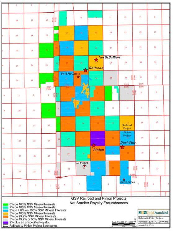
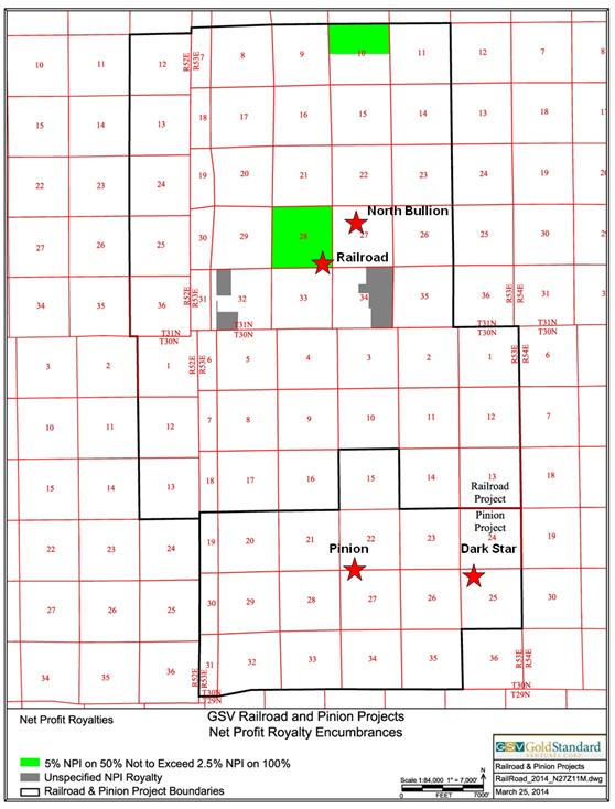
Portions of the patented, unpatented and private lands are encumbered with royalties predominantly in the form of standard Net (or Gross) Smelter Return (NSR or GSR) agreements or Net Profit Interest (NPI) agreements. See Item 7 "MATERIAL MINERAL PROJECT - Railroad-Pinion Project, Elko County, Nevada - Royalties and Agreements" for a discussion of the currently active NSR and NPI encumbrances for the Railroad–Pinion Project.
At present, the Company controls sufficient ground and has sufficient permitting to access the Railroad-Pinion Project and continue future exploration programs. See Item 7 “MATERIAL MINERAL PROJECT - Railroad-Pinion Project, Elko County, Nevada - Environmental Liabilities and Permits”. As of the date of this AIF, the Company is not aware of any significant factors or risks which will limit its right or ability to perform work on the Railroad-Pinion Project.
Minerals Lease and Agreement with Newmont Mining Corporation
On April 5, 2011, the Company entered into a “Minerals Lease and Agreement” to lease four sections of land totalling 2,560 acres (the “Newmont Lease”) from Newmont USA Limited, a Delaware corporation doing business in Nevada as Newmont Mining Corporation (“Newmont”). Two of the four sections are staked public lands which carry no underlying royalty. The other two sections are private surface and minerals lands subject to an underlying 5% NSR. The Newmont Lease, which forms part of the Railroad-Pinion Project, lies between the Rain mining district to the north and the Railroad district controlled by the Company. The Company’s North Bullion fault target is immediately south and east of the east flank of the Newmont Lease. See Item 7 “MATERIAL MINERAL PROJECT – Railroad-Pinion Project, Elko County, Nevada - Mineralization - North Bullion” below. Under the terms of the Newmont Lease, the Company is subject to escalating yearly work commitments in the aggregate amount of US$2.5 million over a period of six years, of which approximately US$1.7 million has been incurred to December 31, 2015.
Newmont has a first back-in right exercisable on or before delivery of a positive feasibility study, enabling Newmont to earn a 51% interest in the Newmont Lease by incurring expenditures totalling 150% of the Company’s expenditures. If Newmont fails to exercise its first back-in right, it will deed the claims and assign the leases on the fee lands to the Company in exchange for a royalty deed conveying a 3% NSR on the claims and a 1% NSR on the fee lands to Newmont. Any royalty payable to Newmont would be net of any underlying royalties, subject to a minimum 1% NSR. If Newmont exercises its first back-in right, it will be entitled to a second back-in right to earn an additional 19% interest in the Newmont Lease (70% in total) by expending an additional 100% of the Company’s expenditures. Upon completion of the second back-in right, the Company will enter into a joint venture with Newmont for further exploration and development of the Newmont Lease on the basis of a 70% interest to Newmont and 30% interest to the Company.
Pinion and Pereira Leases
Commencing in late 2011 and throughout 2012, the Company entered into the Pinion Leases with various land holders encompassing key sections of mineral rights and lands in Elko County, Nevada adjacent to and south of the Original Railroad Claims in the Railroad and Pinion Districts of Nevada.
Generally speaking, the Pinion Leases grant the Company the exclusive right to explore, mine and develop the underlying claims for a minimum of 10 years by making the required annual lease payments and/or minimum advance royalty payments, with the right to extend the term of the lease for an additional term of 10 years or, in some cases, indefinitely if the Company is conducting commercial mining operations on the claims. In certain cases, the Company has the right to purchase, subject to certain royalties, the underlying claims outright upon payment of a lump sum amount exercisable prior to the commencement of commercial production.
In November 2012, the Company entered into the Pereira Lease with Pereira Family, LLC (“Pereira”) granting the Company exclusive right to explore, mine and develop varying percentage holdings in approximately 21,296 net mineral acres within the Pinion District, Nevada, of which approximately 2,280 net mineral acres of land is both within and contiguous to the south of the Railroad Project in Elko County, Nevada. The Company also secured the surface and water rights on 4,467 net surface acres, through a third party, within the Railroad and Pinion Districts critical to future exploration and development.
The Pereira Lease is for an initial term of 12 years and is subject to an initial cash payment of US$1,000,000 (paid), of which 70% is creditable against the Purchase Option (as hereinafter defined), and annual lease payments of US$175,000 per year, subject to yearly increases of 5%. The Pereira Lease is also subject to annual exploration expenditures of US$500,000 in the first year, US$750,000 in the second year and US$1,000,000 in each year thereafter until commercial mining commences on the property. Provided that it is not in default, the Company shall have the right to extend the Pereira Lease for a further term of 10 years (the “Additional Term”) upon payment to Pereira of an extension fee of US$1,000,000 and annual lease payments of US$500,000 during each year of the Additional Term, subject to yearly increases of 5%. The Pereira Lease is also subject to a production royalty (the “Pereira Royalty”) equal to 5% NSR in favour of Pereira, subject to the Company’s right to buy-down up to 3% of the 5% NSR for a cash payment equal to US$3,500,000 during years 1 to 6 of the Pereira Lease and US$7,000,000 during years 7 to 12 of the Pereira Lease. Prior to commencement of commercial production and provided that it is not in default, the Company shall have the right and option to purchase the property (the “Purchase Option”) from Pereira for a purchase price of US$25,000,000, subject to a remaining 2% NRS in favour of Pereira. If the Company exercises the Purchase Option, 70% of all annual cash lease payments previously paid to Pereira by the Company shall be credited against the Pereira Royalty. The Company has the right to terminate the Pereira Lease, at any time after the third anniversary, upon payment to Pereira of a cash amount equal to the following two years’ lease payments.
The Pereira Lease, together with the Pinion Leases, grant the Company control over strategic sections located throughout the Railroad and Pinion Districts, including control over approximately 51% of Pinion Section 27 which contains the bulk of the Pinion Deposit.
Acquisition of Remaining Interest in the Pinion Deposit
On March 5, 2014, the Company acquired all of the right, title and interest of Scorpio in and to (i) certain unpatented mining claims and control over certain fee lands and/or mineral interests in the Pinion Mining District in Elko County, Nevada contiguous to the south of the Company's Railroad Project, being the Scorpio Pinion Interests, and (ii) two leases in Section 33 of Township 31, North, Range 53 East, MDM, Elko County, Nevada within the boundaries of the Company's Railroad Project, in consideration for an upfront purchase price of $6,000,000 cash, 5,500,000 Common Shares of the Company and the Scorpio Note in the principal amount of $2,500,000 bearing interest at the rate of 3% per annum. The Scorpio Note was paid in full by the Company on or before March 4, 2015 from the net proceeds of the 2015 Public Offering.
In addition to the foregoing, the Company agreed to issue Scorpio an additional 1,250,000 Common Shares at such time as the Company obtained a NI 43-101 compliant technical report on the Pinion Project delineating a resource of not less than 1,000,000 ounces of gold. These Common Shares were issued to Scorpio on November 3, 2014 following the Company's receipt of the 2014 Pinion Resource Report confirming a maiden resource estimate of 20.84 million tonnes at 0.63 g/t Au for a total of 423,000 ounces of gold (indicated) and 55.93 million tonnes at 0.57 g/t Au for 1.022 million ounces of gold (inferred) for the Pinion Deposit. See Item 7 "MATERIAL MINERAL PROJECT - Railroad-Pinion Project, Elko County, Nevada - Mineral Resource Estimates" below.
It is a further term of the Scorpio transaction that, for as long as the Company continues to own an interest in the Scorpio Pinion Interests, if the Company sells, transfers or otherwise disposes, directly or indirectly, all or a significant portion of its issued shares, assets or business, whether by way of merger, business combination, take-over, amalgamation, plan of arrangement, option, joint venture or sale agreement, or similar transaction (a "Sale Transaction"), the Company shall pay Scorpio a one-time cash payment of $1.5 million if the aggregate value of the Sale Transaction exceeds $100 million, $2.0 million if the Sale Transaction equal or exceeds $200 million or $3 million if the Sale Transaction equals or exceeds $300 million.
Concurrent with the acquisition of the Scorpio Pinion Interests, Scorpio entered into an orderly sale agreement (the "Orderly Sale Agreement") with the Company whereby Scorpio must provide the Company with 10 business days' advance notice of its proposed sale of any Common Shares of the Company during which period the Company shall have the right to purchase or designate the purchaser(s) who will purchase all or any part of such shares, failing which Scorpio will be entitled to sell such shares without further notice to the Company for an additional 10 business days.
As part of its acquisition of the Scorpio Pinion Interests, the Company has also assumed additional ongoing lease payments of approximately US$48,317 per annum in 2015 and escalating to US$49,090 in year 2017 and thereafter.
The acquisition of the Pinion and Pereira Leases and the Scorpio Pinion Interests constituted a strategic acquisition for the purpose of developing new target opportunities for the Company and grant the Company control over certain key sections within the Railroad and Pinion Districts including approximately 640 acres of the Pinion Deposit.
Dark Star and Dixie Prospects
In December 2014, the Company entered into separate option-to-purchase agreements with Allied Nevada Gold Corp. (“Allied”), private mineral interest owners, and a private third party claimholder to acquire, in the aggregate, an additional 866 net hectares (2,140 net acres) at the southern end of the Railroad-Pinion Project areas including effective ownership and control of two additional gold occurrences in close proximity to the Pinion Deposit, being Dark Star Deposit and Dixie prospect. The Allied agreement area includes 100% control of the Dixie Prospect and the third party claims agreement fills two small gaps in Sections 24 and 26 which were not previously controlled by the Company. Various lease amendments also increase the Company’s mineral interest control in Sections 23 and 25, strategically important sections containing the Dark Star Deposit, from 50% to approximately 98.49%. The total cost of these acquisitions was less than US$163,000 in the first year and is about US$65,000 annually thereafter.
The scientific and technical content and interpretations contained in this Item 5 "GENERAL DEVELOPMENT OF THE BUSINESS" have been reviewed and approved by Steven R. Koehler, Gold Standard’s Manager of Projects, BSc. Geology, CPG-10216, and a "qualified person" as defined by NI 43-101.
ITEM 6: DESCRIPTION OF THE BUSINESS
6.1 General
Summary
The Company is a mineral exploration company engaged, indirectly through its subsidiaries, in the acquisition and exploration of mineral properties in Nevada, U.S.A. The Company is in the exploration stage as none of its properties are currently in production.
Specialized Skill and Knowledge
Management is comprised of a team of individuals who have extensive expertise and experience in the mineral exploration industry and exploration finance and are complemented by an experienced board of directors. See ITEM 13 “DIRECTORS AND OFFICERS”.
Competitive Conditions
The Company competes with other mineral exploration and mining companies for mineral properties, joint venture partners, equipment and supplies, qualified personnel and exploration and development capital. See ITEM 8 “RISK FACTORS – The Company’s competition is intense in all phases of its business” below.
Environmental Protection
The current and future operations of the Company, including development activities on its Railroad-Pinion Project or areas in which it has an interest, are subject to laws and regulations governing exploration, development, tenure, production, taxes, labour standard, occupational health, wastes disposal, greenhouse gas emissions, protection and remediation of environment, reclamation, mine safety, toxic substances and other matters. Compliance with such laws and regulations increases the costs of and delays planning, designing, drilling and developing the Company’s properties. The Company attempts to diligently apply technically proven and economically feasible measures to advance protection of the environment throughout the exploration and development process. Current costs associated with compliance are considered to be normal.
Employees and Consultants
The Company maintains a head office in Vancouver, B.C. and a branch office in Elko County, Nevada.
As of March 30, 2016, the Company engaged the full time services of 5 geologists, 1 office administrator, and 1 corporate lawyer based in the Company’s Nevada office (December 31, 2015 - 5 geologists, 1 office administrator, and 1 corporate lawyer) and 6 persons at its Vancouver head office (December 31, 2015 – 6 persons). As operations require, the Company also retains geologists, engineers, and other consultants on a short term or per diem basis in Vancouver and Nevada and in the field at its Railroad-Pinion Project. Save and except as disclosed elsewhere in this AIF, the Company has not experienced, and does not expect to experience, significant difficulty in attracting and retaining qualified personnel.
Foreign Operations
The Company’s Railroad-Pinion Project is located in Nevada and the Company maintains a branch office in Elko County, Nevada.
Reorganizations
The Company has not completed any reorganization within the three year period preceding the date of this AIF.
ITEM 7: MATERIAL MINERAL PROJECT
Railroad-Pinion Project, Elko County, Nevada
The Company’s material mineral project is the Railroad-Pinion Project located in Elko County, Nevada. The following scientific and technical disclosure regarding the Railroad-Pinion Project has been extracted or derived from information contained in the 2016 Railroad-Pinion Report, except where otherwise noted. In addition, all figures and tables included under this Item 7 “MATERIAL MINERAL PROJECT” have been extracted from the 2016 Railroad-Pinion Report. A complete copy of the 2016 Railroad-Pinion Report is available for review under the Company's profile on SEDAR at www.sedar.com.
Property Description and Location
The Railroad–Pinion Project straddles the Piñon Range in the Railroad Mining District at the southeast end of the Carlin Trend, a northwest-southeast trending belt of gold mines and deposits in northern Nevada. The Company has effective control of the mineral rights for 30,404 gross acres (12,304 hectares) and 28,721 net acres (11,623 net hectares) of land in Elko County, Nevada as shown in Figure 4.1 below.
As of March 30, 2016, Gold Standard owns or has an option on the ownership of a total of 16,439 gross acres (6,652 gross hectares) of subsurface mineral rights in the form of patented and unpatented mineral lodes (claims) and 13,965 gross acres (5,651 gross hectares) of subsurface mineral rights secured or controlled by a contractual interest in private surface and mineral property held via various surface use agreements and mining/mineral lease agreements. Gold Standard holds an interest in the subsurface mineral rights for the private lands that ranges from 49.2% to 100% as shown in Figure 4.1. Gold Standard’s total net interest in the subsurface mineral rights for the private lands totals 12,666 acres (5,126 hectares) including fee mineral and patented lode mineral claims. The Company is pursuing the minority interest for a number of parcels where it holds less than a 100% interest.
Patented claims, private surface and private mineral property are wholly owned and subject to lease agreement payments and property taxes (due annually) as determined by the County. The estimated holding cost for the patented claims and private lands controlled by Gold Standard is US$681,511 per annum. Unpatented lode mining claims grant the mineral rights and access to the surface for exploration activities which cause insignificant surface disturbance. The mineral right is maintained by paying a maintenance fee of US$155 per claim to the BLM on or before August 31 every year. A notice of intent to hold must also be filed with the Elko County Recorder on or before November 1 every year along with a filing fee of US$10.50 per claim plus a US$4.00 fee document charge. The 2015 filing is complete. Gold Standard’s estimated maintenance cost for their current package of unpatented lode claims for 2016 and beyond is US$182,090 per annum.
Gold Standard controls sufficient ground and has sufficient permitting to access the project and continue future exploration programs. See “Environmental Liabilities and Permitting” below. As of the effective date of the 2016 Railroad-Pinion Report no significant factors or risks were found which would limit the Company's right or ability to perform work on the Railroad-Pinion Project.
Royalties and Agreements
Portions of the patented, unpatented and private lands of the Railroad-Pinion Project are encumbered with royalties predominantly in the form of standard Net (or Gross) Smelter Return (NSR or GSR) agreements or Net Profit Interest (NPI) agreements. A summary of the currently active NSR and NPI encumbrances for the Railroad – Pinion Project are provided on Figures 4.2 and 4.3 below.
Gold Standard holds its subsurface mineral interests subject to certain production royalties, with various buy down provisions as follows:
| | · | 1% NSR to Royal Standard Minerals, Inc. and Manhattan Mining Co. on the portion of the Railroad Project acquired pursuant to the statutory plan of arrangement with JKR. |
| | · | 1½% Mineral Production Royalty to Kennecott Holdings Corporation on claims noted as the Selco Group. |
| | · | 5% NSR to the owners of the undivided private mineral interests. |
| | · | Gold Standard owns an approximate 99.2% mineral interest in Sections 21 and 27 by way of several lease agreements. Pursuant to the terms of the relevant lease agreements, Sections 21 and 27 are subject to a five-percent (5%) NSR owed to the lessors of the leased property. |
| | · | Section 22 is comprised of the TC 1 through 39, and TC 37R and 38R unpatented lode mining claims owned by Gold Standard. The TC claims are subject to the following royalties: (1) an unknown/unspecified NSR owed to "GSI, Inc., of Virginia"; and (2) a two-percent (2%) NSR owed to Waterton Global Value LP. |
| | · | 1% NSR to Aladdin Sweepstake Consolidated Mining Company on the portion of the Railroad Project acquired pursuant to the statutory plan of arrangement with JKR, specifically the PIN#1 to PIN#12 lode mining claims. |
| | · | 4% NSR to Allied Nevada for mining claims recently acquired by Gold Standard in Sections 34 and 36, Township 30N, Range 53E, and Sections 2 and 4, Township 29, Range 53E. |
| | · | 3% NSR to Peter Maciulaitis for certain mining claims in Sections 24 and 26, Township 30N, Range 53E. |
There is no current mineral production on the Railroad-Pinion Project.
[remainder of page left blank intentionally]
Figure 4.1: Property Map for the Railroad-Pinion Project.
Figure 4.2: Property Map Summarizing the Railroad – Pinion Net Smelter Royalty Encumbrances.
Figure 4.3: Property Map Summarizing the Railroad – Pinion Net Profit Royalty Encumbrances.
Environmental Liabilities and Permits
The following section discusses land use permitting and other regulatory information specific to the Railroad Project.
| · | Railroad Plan of Operations |
The Company holds a Plan of Operations (“POO”) approved by the BLM covering 3,169 acres (2,620 acres of public land and 549 acres of private land; a total of 1,282 ha with 1,060 ha of public land and 222 ha of private land) of the Railroad Project within which exploration-related disturbance and reclamation bonding can be conducted in two phases of up to 50 acres in phase I and an additional 150 acres in phase II. The Company has posted a reclamation bond of $211,685.
The Company also holds a POO for the Pinion Project allowing up to 17.16 acres of disturbance located in portions of sections 22 and 27, Township 30N, Range 53E, which provides access to multiple key exploration targets that the Company intends to pursue within the Pinion Project in the next several years. The Company has posted a reclamation bond of $90,849.
The Company had an approved BLM Notice for the Railroad Project with a total planned disturbance of approximately 1.73 acres within the North Bullion target and the north to northeast extension of the Bullion Fault Corridor. This notice recently expired and the Company has applied for a new BLM Notice. Additional exploration in other outlying targets, including some in the Pinion Project, can also be addressed under separate Notice Level applications with lead times ranging from two to four weeks required to complete the applications and for the BLM to grant approval.
The Company currently has an approved BLM Notice for the Dark Star project with a total allowable disturbance of 4.72 acres. A financial bond of $25,955 has been approved and posted.
The Company currently has an approved BLM Notice for the Irene Project with a total allowable disturbance of 3.01 acres. A financial bond of $30,482 has been approved but not yet posted.
| · | Private Land Disturbance |
The Company obtained a reclamation permit for the Railroad Project area from the State of Nevada for disturbance greater than five (5) acres on private land allowing for up to thirty nine (39) acres of surface disturbance. The reclamation bond for US$39,388.00 has not yet been posted as of the date of this AIF.
The Company is currently operating under an interim reclamation permit for the Pinion Project area issued by the State of Nevada for disturbance greater than five (5) acres on private land that allows up to eleven (11) acres of surface disturbance. The permit covers portions of sections 21 and 27 (not included in the Pinion POO), Township 30N, Range 53E. The Company is in the process of applying for a permanent reclamation permit.
The Company is permitted to operate on Section 25, Township 30N, Range 53E at Dark Star provided that it keeps the total disturbance to less than 5 acres at any given time.
| · | Water Pollution Control Permit |
The Company has received a water pollution control permit for the North Bullion project that includes Pinion. The permit has a five year duration.
Accessibility, Climate, Local Resources, Infrastructure and Physiology
The Railroad–Pinion Project is located in north-central Nevada approximately 275 road miles (442 km) west of Salt Lake City, Utah, and 290 road miles (467 km) east of Reno, Nevada. The project is located between 8 and 18 miles (13 and 29 km) south of Interstate 80, which is a four lane, east-west, transcontinental highway that serves as the primary highway in northern Nevada.
Primary access to the Railroad-Pinion Project area is by a series of paved and gravel roads from Elko, Nevada (population 18,300). The project can be reached by travelling westbound from Elko for 20 miles (32 km) on Interstate 80 to the town of Carlin (population 2,400), and then south on State Highway 278 for 15 miles (24 km). At Ferdelford Canyon an all-weather, 15 mile-long (24 km) gravel road leads east to the Railroad Project. The Pinion Project area is similarly accessed east from Highway 278 along a gravel road located immediately north of Trout Creek. Alternatively, the Railroad-Pinion Project area may be reached during the summer and autumn months by traveling 30 miles (48 km) southwestward from Elko, Nevada on the Bullion Road, a dirt/gravel road.
At both the Railroad and Pinion Projects, historic and/or recently-created exploration roads combined with four-wheel drive tracks allow for access to many of the known target and prospect areas.
| · | Site Topography, Elevation and Vegetation |
Northern Nevada lies within the Basin and Range physiographic province, an area characterized by flat, lacustrine-gravel-volcaniclastic-volcanic filled valleys bounded by generally north-south trending mountain ranges. The Railroad-Pinion Project area is located within the Piñon Mountains at elevations ranging from 5,800 feet (1,770 m) above sea level on the north and east sides, to nearly 8,700 feet (2,650 m) above sea level in the central portion of the Project. Lower elevations are typified by gentle, rolling hills with little to no bedrock exposure. Higher elevations are characterized by steeper slopes and cliffs, deeply incised drainages, and an increase in bedrock exposure.
Vegetation is consistent with a high desert climate and consists of sagebrush, rabbitbrush, cactus, and bunch grass communities. Cottonwood trees are confined to drainage bottoms and near springs. Pinyon pine, juniper, mountain mahogany and aspen trees grow at higher elevations.
The Railroad-Pinion Project area has a relatively dry “high desert” climate. January maximum and minimum temperatures average approximately 34.4°F and 19.6°F, respectively. July maximum and minimum temperatures average 83.1°F and 58.2°F, respectively. January and July precipitation averages 1.13 inches and 0.41 inches, respectively, while average total precipitation is approximately 12.09 inches. Average annual snowfall for Carlin is approximately 30 inches. Precipitation varies dramatically with changes in elevation and season.
Rainfall in the region is generally light, infrequent and may be associated with dry lightning between May and October. Moist airflow from the south brings ‘monsoon’ rains from July through September. A small number of these storms may carry heavy rains that cause localized flooding in creeks and drainages.
Winter snow and spring runoff may temporarily limit access with respect to drilling and other geological fieldwork activities between November and April each year, but are not considered to be significant issues.
| · | Local Resources and Infrastructure |
Elko, Nevada has served as the northern Nevada exploration and mining center for more than half a century. Elko is a full service community that includes housing; motels; food and restaurants; clinics and a hospital; a regional airport with daily flights to/from Salt Lake City, Utah; interstate highway and railway access; local, state and federal government offices; skilled and experienced labor for the exploration and mining industry; and schools (K-12 and a community college). In this part of Nevada, there is a diverse selection of local/regional/international exploration and mining service companies including assay labs, suppliers, drilling contractors and heavy equipment vendors supporting the exploration and mining industry.
The Railroad-Pinion Project is located in the vicinity of large, active open pit and underground mines operated by Newmont and Barrick Gold Corp along the ‘Carlin Trend’. These mine sites also include fully operational mill complexes designed to treat oxide and/or carbon-sulfide refractory gold ores.
At the Railroad-Pinion Project, water is available proximal to the drilling operations. For communications, 4G cellular network is available in select locations. High voltage electrical transmission lines are located six miles from the project area.
The Railroad-Pinion Project has sufficient and appropriate sites to accommodate exploration and potential mining facilities, including waste rock disposal, and processing infrastructure.
History
| · | Railroad Project Historic Exploration |
The Railroad Mining District, also known as the Bullion or Empire City district, was established in 1869. Initially ore was shipped to Chicago and San Francisco. In 1872 a smelter was completed at the nearby town of Bullion. Beginning in 1905 shipments from operating mines, old dumps, and slag were shipped to Salt Lake City (Ketner and Smith, 1963).
U.S. Geological Survey data published by Ketner and Smith (1963) suggests that, although historic production records are not very reliable for the period between 1869 and 1905, the estimated the total value of production through 1956 was $2 million using the value of the commodity (i.e. gold, silver, copper, lead and zinc) produced for the year it was produced.
The early production in the district focused on silver, lead, and copper from numerous underground mines on the northern flank of Bunker Hill exploiting replacement and skarn-type deposits in marbleized and dolomitized rocks. There were also minor, undeveloped gold veins in intrusive rocks.
Beginning in 1910 and until the mines quit producing in the 1960’s zinc became the prominent metal mined (LaPointe et al., 1991).
Modern exploration began in 1967 when American Selco optioned the claims from Aladdin Sweepstake Consolidated Mining launching a 45 year period of surface sampling, geophysics, geological mapping, and surface drilling. As the work progressed in the Railroad District new geologic interpretations plus base- and precious-metal surface sample results were combined with favorable drill results; expanding the target types being explored for and widening the range of commodities being explored for.
Since 1967, 15 companies have explored in the Company's Railroad Project area completing 382 drill holes and collecting 6,260 soil samples and 3,508 rock samples:
| • Selco | • Mirandor |
| • El Paso/LLE | • Kinross |
| • Placer Amex | • Manhattan Mining Company |
| • AMAX | • Corona/Pezgold |
| • Homestake (LabradorEx) | • Newmont |
| • Nicor | • Barrick |
| • Westmont | • Teck |
| • Ramrod | |
The copper and molybdenum bearing nature of the multiphase intrusives was documented starting in the late 1960’s. Sampling and the understanding of skarn related gold in Nevada led to further exploration and better intercepts in drilling in the historic skarn/replacement portion of the Railroad Project. During the course of these work programs the ongoing exploration advanced the understanding of the geologic controls on the Railroad Project leading finally to the sediment-hosted gold exploration programs.”
| · | Railroad Project Historic Resource Estimates |
Historical resource estimates exist for certain areas within the Railroad Project, most notably the “POD” or "Railroad Deposit" located within the “Railroad Fault” target (see "Mineralization - Railroad Fault" below). However, the authors of the 2016 Railroad-Pinion Report caution that these historic mineral resource estimates are non-NI 43-101 compliant mineral resources that were calculated prior to the implementation of the standards set forth in NI 43-101 and current CIM standards for mineral resource estimation (as defined by the CIM Definition Standard on Mineral Resources and Ore Reserves dated November 27, 2010) and readers should not treat them, or any part of them, as current mineral resources. There is insufficient information available to properly assess data quality, estimation parameters and standards by which the estimates were categorized. In particular, the data utilized is limited in its reliability due to the lack of pulps, rejects, cuttings or core which can be sampled and verified. The historic resources described below have been included simply to demonstrate the mineral potential of certain target areas at the Railroad Project and as a guide to future exploration. A thorough review of all historic data performed by a "qualified person" as defined in NI 43-101, along with additional exploration work to confirm results, would be required in order to produce a current and compliant mineral resource estimate for the POD (Railroad) Zone. To date, there has been no production from the resources described by these historical estimates.
Kuhl (1985) presented the first calculations for the gold contained within the POD (Railroad) deposit (see Table 6.2 below). He used a polygonal process with rectangular blocks under the following parameters:
| · | Data projected half way to the adjoining drill hole or 100 feet |
| · | Inclusion of intercepts less than 0.03 opt gold if the outlying intervals brought the overall average to equal 0.03 opt gold |
| · | Minimum 10 foot intercept in the drill hole |
| · | All calculations made using fire assay intervals |
| · | No stripping ratio calculated |
| · | No metallurgical recovery information utilized |
Bartels (1999) recalculated the gold contained within the POD (Railroad) deposit (see Table 6.2 below) utilizing a cross-sectional method with 58 holes on 27 cross sections spaced 100 feet apart through the POD (Railroad) area with the following assumptions:
| · | Tonnages were calculated using a 13.5 cubic feet per ton density factor |
| · | Assay values include silver credits, at a 60:1 ratio |
| · | Compositing of assay values was done according to the following conventions: |
| · | Intervals of low grade (<0.030 opt Au) up to 15 feet thick, bound on both sides by >0.030 opt Au values were included within the ore envelope only if the average of the low grade and the upper and lower bounding values was greater than or equal to 0.030 opt Au. |
| · | No cropping of high assay values was done, all assays taken at face value. |
| · | Volumes were determined by projecting the contoured ore areas 50 feet either side of the section plane. |
| · | An average grade was assigned to each area by determining the weighted average grade of all drill intercepts within the ore envelope. |
| · | Average grade was assigned to the respective volume and contained ounces were calculated. |
Table 6.2: Historic Resource Estimates for Railroad Project.
| Resource Area | Tons | Tonnes | Average Grade | Contained Ounces Au | Cutoff Grade | Reference |
| | | | Au opt | Au ppm | | Au opt | Au ppm | |
| POD | 1,197,400 | 1,086,280 | 0.090 | 3.09 | 107,766 | 0.030 | 1.03 | Kuhl, 1985 |
| POD | 1,400,000 | 1,270,080 | 0.080 | 2.74 | 112,000 | 0.020 | 0.69 | Kuhl, 1985 |
| POD | 1,006,665 | 913,250 | 0.089 | 3.05 | 89,731 | 0.030 | 1.03 | Bartels, 1999 1999 |
*The mineral resource estimates summarized in Table 6.2 are non–NI 43-101 compliant resources that were calculated prior to the introduction of the standards set forth in NI 43-101. The authors of the 2016 Railroad-Pinion Report have referred to these estimates as “historic resources” and are not treating them, or any part of them, as current mineral resources. There is insufficient information available to properly assess data quality, estimation parameters and standards by which the estimates were categorized. The historic resource estimates described above should not be relied upon and have only been included to demonstrate the mineral potential of the POD (Railroad) Zone at the Railroad Project.
| · | Pinion Project Historic Exploration |
Exploration activity at the Pinion Project area dates back to the discovery of the Pinion prospect in 1980 by Newmont with the majority of the historic work being conducted in the late 1980s and early to mid-1990s. The exploration history for the Pinion Project overlaps somewhat with that of the adjacent Railroad Project area as portions of the two project areas have been operated by the same company in the past.
The historical work completed at the Pinion Project identified a significant zone of Carlin-type gold mineralization at the Pinion Deposit (section 22 and 27, T30N, R53E), as well as an additional zone of mineralization at the Dark Star Deposit (section 25, T30N, R53E).
| · | Pinion Historic Drilling |
The majority of the historic work completed at the Pinion Project has been conducted at and around the Pinion Deposit located in sections 22 and 27 of Township 30 North, Range 53 East (Mount Diablo Meridian). Section 22 hosts the mineralized and outcropping Main Zone and North Zone, which are the near-surface shallow portions of the Pinion Deposit (which has also been referred to historically as the South Bullion or Trout Creek Deposit). Pinion gold mineralization extends southeast, plunging shallowly, into section 27 following the Pinion anticlinorium and the contact between the faulted Mississippian Webb Formation siltstones and the underlying Devonian Devils Gate Formation limestone. Additionally, historic drilling has been conducted in section 25 (T30N, R53E) at the Dark Star Deposit.
In total 385 drill holes have been completed at the Pinion Deposit, and immediate area, between 1981 and 2007 (McCusker and Drobeck, 2012). The majority of the holes were completed by reverse circulation drilling with minor diamond (core) drilling completed by Royal Standard in 1996 and 2007.
To date, historic exploration conducted in the Pinion Project area has identified two areas of gold mineralization at the Pinion and Dark Star Deposits. The Pinion Deposit comprises two discreet zones of mineralization (Main Zone and North Zone) with the majority of the historic drilling having been completed at the Main Zone including the jasperoid breccia outcrops located near the southern boundary of section 22 (T30N, R53E). Historic drilling has intersected and extended the Main Zone gold mineralization well into section 27 to the southeast. The North Zone is located approximately 1000 ft (~300m) north east of the jasperoid outcrops of the Main Zone.
The Main Zone of the Pinion Deposit trends southeasterly, is approximately 4,800 feet (1.46 km) long and ranges from 500 feet to 1,100 ft (150 to 330 m) in width with vertical thickness ranging between 50 feet and 500 ft (~15 to 150 m). Mineralization has been intersected to a depth of about 600 feet (180 m) below surface. The North Zone of the Pinion Deposit is approximately 1,100 feet (300 m) long (along a roughly north-south trend), ranges from 150 to 230 feet (45 to 70 m) wide and ranges in vertical thickness between 120 feet and 450 feet (~35 to 135 m).
The gold zone at Pinion occurs in dissolution collapse breccia developed along the contact between the Mississippian Tripon Pass Formation silty micrite and Devils Gate Formation Limestone. Important structural controls are west-northwest and north to northeast striking folds and faults.
| · | Pinion Historic Resource Estimates |
Several historic mineral resource estimates have been completed by a variety of companies over several years for the Pinion Deposit, as well as the nearby (~2 miles east) Dark Star prospect, within the Company's Pinion Project area. A review of the historical data within the Pinion Project drill hole database conducted by APEX did not identify any significant issues. Where issues were found, original data was reviewed and the database was corrected. As a result, it is the opinion of the authors of the 2016 Railroad-Pinion Report that the historic Pinion project drill data provides sufficient reliability to warrant their inclusion in the 2016 Railroad-Pinion Report.
The reader is cautioned that the historic mineral resource estimates for the Pinion Deposit discussed in the 2016 Railroad-Pinion Report are non-NI 43-101 compliant mineral resources that were calculated prior to the implementation of the standards set forth in NI 43-101 and are not consistent with current CIM standards for mineral resource estimation (as defined by the CIM Definition Standard on Mineral Resources and Ore Reserves dated November 27, 2010). The authors of the 2016 Railroad-Pinion Report have referred to these estimates as “historic resources” and the reader is cautioned not to treat them, or any part of them, as current mineral resources. The historic resources have been included in the 2016 Railroad-Pinion Report simply to summarize previous work at the Pinion Project and to demonstrate the mineral potential of certain target areas within the Railroad-Pinion Project area. The reader is referred to the 2016 Railroad-Pinion Report for the details of the historic mineral resource estimates for the Pinion Deposit.
It should also be noted that all historic estimates for the Pinion Project discussed in the 2016 Railroad-Pinion Report are now superseded by the recently completed NI 43-101 compliant mineral resource estimates for the Pinion Deposit as disclosed in the Company’s news release dated March 15, 2016 and the Dark Star Deposit contained in the Dark Star Resource Report. See "Mineral Resources" below. With respect to the Pinion and Dark Star Deposits, a thorough review of all historic data has now been performed by a "qualified person", along with additional exploration and validation work, which has confirmed historical data that has been used to calculate current and compliant NI 43-101 mineral resource estimates for these deposits that are discussed in greater detail under "Mineral Resource Estimates" below.
| · | Dark Star Historic Exploration and Drilling |
The Dark Star Deposit (section 25, T30N, R53E) is located approximately 2.5 km east of the Pinion Main Zone. In 1990 rock and soil sampling identified anomalous surface geochemistry in the area of the Dark Star Deposit. Follow-up drilling in 1991 resulted in the confirmation of bedrock hosted mineralization at Dark Star.
Although the majority of the historic work completed at the Pinion Project has been conducted at and around the Pinion Deposit, significant drilling has also been completed in Sections 24 and 25 (T30N, R53E) at and around the Dark Star Deposit. Drilling at the Dark Star Deposit and the immediate surrounding area was completed by a variety of companies including Crown Resources, Westmont, Exploration Mirandor, Kinross and Cyprus Amax. A total of 105 RC drill holes were completed between 1991 and 1999 (McCusker and Drobeck, 2012).
Historic drilling has identified an approximately north-south trending mineralization zone at the Dark Star Deposit named the Dark Star Structural Trend (DSST). The 1992 drilling defined a 300 ft (90 m) thick zone of generally lower grade (<0.025 opt [0.85 ppm] Au), somewhat bedding conformable mineralization (Calloway, 1992). The mineralization is open in three directions (north, east and west).
Anomalous gold mineralization at Dark Star has been intersected over an area 2,000 ft (610 m) along a north-south trend by up to 1,610 ft (490 m) in width and to a depth of 690 ft (210 m) below surface. The Dark Star mineralization is hosted in silicified siliciclastic rocks and bioclastic limestone of Pennsylvanian Moleen and/or Tomera formations. In general, the Dark Star gold grades are lower than at Pinion and the mineralization appears to be less continuous although there are some high grade historic intersections including 0.044 opt (1.58 g/t) Au over 95 feet (28.96 m) in hole CDS-001 and 0.061 opt (2.1 g/t) over 250 feet (76.20 m) in hole CDS-053.
In 1994 Cyprus completed 9 drill holes east and northeast of the Dark Star Deposit. Between 1997 and 1999, Mirandor and Kinross completed a total of 24 drill holes designed to extend the Dark Star gold mineralization to the north into section 24.
| · | Dark Star Historic Resource Estimates |
Certain historical resource estimates for the Pinion Deposit included data from the Dark Star Deposit and while one such estimate is considered appropriate for disclosure as a historic resource estimate in the 2016 Railroad-Pinion Report there is insufficient information available to properly assess data quality, estimation parameters and standards by which exist such historic estimate was categorized and therefore it should not be relied upon. The reader is referred to the 2016 Railroad-Pinion Report for the details of the historic mineral resource estimates for the Dark Star Deposit.
The authors of the 2016 Railroad-Pinion Report caution that these historic mineral resource estimates are non-NI 43-101 compliant mineral resources and are not consistent with current NI 43-101 and CIM standards for mineral resource estimation and readers should not treat them, or any part of them, as current mineral resources. There is insufficient information available to properly assess data quality, estimation parameters and standards by which the estimates were categorized. The historic resource estimates have only been included in the 2016 Railroad-Pinion Report to demonstrate the mineral potential of the Dark Star Deposit.
It should be noted that all historic estimates for the Dark Star Deposit discussed in the 2016 Railroad-Pinion Report are now superseded by the NI 43-101 compliant maiden mineral resource estimate for the Dark Star Deposit contained in the Dark Star Resource Report. See "Mineral Resources" below.
| · | Dixie Historic Exploration and Drilling |
The Dixie area, which is located 2 miles (3.6 km) south and southeast, respectively, of the Dark Star and Pinion Deposits, has been explored intermittently since 1980 by various operators. The majority of the historic exploration work conducted at the prospect has been regional to semi-detailed in nature.
In 1997, Cameco conducted rock sampling and prospect-specific IP geophysical surveys at the Pinion, Dark Star and Dixie areas. The 1997 rock sampling at the Dixie area was intended to examine in greater detail the nature of surface mineralization and to compare this data with the results of then recently completed drill holes at the prospect and a number of anomalies were identified. At the main Dixie area, a group of 32 rock samples defined a distinct >1500 ppb Hg anomaly with elevated Au, As, Sb and Ag (Parr, 1999). This anomaly was found to roughly correspond with gold mineralization in the subsurface. Immediately to the north, a “North Dixie” anomaly was identified that was characterized by similar chemistry (elevated Hg, Au, As and Sb). Further north, a group of 15 rock samples collected between the Pinion and Dark Star areas defined a similar zone of geochemistry at the “CISS” area where 6 samples contained 20-135 ppb Au including: As values up to 940 ppm, Sb up to 161 ppm and Hg up to 15 ppm.
In addition to the rock geochemistry program discussed above, Cameco also completed limited IP/Resistivity geophysical surveys at several prospects including the Dixie area in 1997 and 1998. The IP/Resistivity surveys at Dixie identified broad zones of contrasting high and low resistivity and corresponding zones of high chargeability (Parr, 1999).
The first documented drill program at the Dixie prospect was conducted by Freeport McMoran in 1988 and 1989 during which time 25 holes were drilled in a joint venture with Crown Resources. In 1991 Crown Resources completed 4 RC drill holes and later Cameco completed 11 RC drill holes at the Dixie prospect. The drilling identified a zone of low grade gold mineralization within Pennsylvanian siliciclastic and carbonate rocks similar in nature to the host rocks for gold mineralization at Dark Star. Highlights of the historic drilling at the Dixie prospect are provided in the 2016 Railroad-Pinion Report.
Geological Setting and Mineralization
Work by the Company at the Railroad–Pinion Project is ongoing and the prospect-scale understanding of the geology and mineralization thus far encountered is evolving as result of the Company’s systematic approach to exploration and data analysis. However, the regional scale geological setting of the Railroad-Pinion Project area is relatively well understood as described below.
The Railroad–Pinion Project is located along the Carlin Trend, a northwest-southeast alignment of sedimentary rock-hosted gold deposits and mineralization, and is centered on the fourth and southernmost dome-shaped window on the Carlin Trend in the Piñon Range as shown in the interpretive illustration of a longitudinal section of the "Four Windows" in Item 5.1 "GENERAL DEVELOPMENT OF THE BUSINESS - Overview" above. The domes are cored by igneous intrusions that uplift and expose Paleozoic rocks that are favorable for the formation of Carlin-style gold deposits.
The greater Carlin Trend area occupied a passive continental margin during early and middle Paleozoic time, which is the time of deposition of the oldest rocks observed in the area (Stewart, 1980). A westward-thickening wedge of sediments was deposited at and west of the continental margin, in which the eastern facies tend to be siltier and carbonate-rich (shelf and slope deposits, carbonate platform deposits) while the western facies are primarily fine-grained siliciclastic sediments (deeper basin deposits). The Carlin Trend sits proximal to the shelf-slope break, although this break was not static over time.
In Late Devonian through Middle Mississippian time, east-west compression of the Antler Orogeny is traditionally believed to have caused folding and faulting, the most significant manifestation of which is the Roberts Mountain Thrust. This regional fault placed western facies siliciclastic rocks over eastern facies carbonate rocks across the region. In the 2016 Railroad-Pinion Report the western facies are referred to as “allochthonous” whereas the eastern facies are “autochthonous”. As the result of this tectonism, the Mississippian and Pennsylvanian overlap assemblage of clastic rocks was deposited across the region (Smith and Ketner, 1975). Regional stratigraphy shows interleaved allocthonous and autochthonous late Paleozoic sediments in the Piñon Range (Longo et al., 2002; Mathewson, 2001; Rayias, 1999; Smith and Kettner, 1975).
Multiple igneous intrusions occur along the Carlin Trend. The oldest igneous rocks are reported to be Late Triassic age (Teal and Jackson, 2002). Other igneous rocks include: a Late Jurassic dioritic intrusion documented at the Goldstrike Deposit (Bettles, 2002); intermediate to mafic dikes of Jurassic and Cretaceous age; the Cretaceous age Richmond Stock (quartz monzonite); the Eocene age Welches Canyon Stock; and hydrothermally-altered and locally gold-bearing felsic to mafic dikes/dike swarms of Tertiary (Eocene) age (Ressel, 2000).
Post-dating the Carlin-style gold mineralization are Miocene and younger volcanic rocks which blanket large areas of the region with lava flows, tuff beds and tuffaceous sediments. Primarily rhyolitic in composition, the volcanic cover rocks comprise a bimodal suite including rocks as mafic as basalt.
Tertiary crustal thinning commenced in late Eocene and Miocene, approximately coeval with the onset of Miocene volcanism. The extension is generally east-west directed and is manifested in the Basin and Range physiography. The extensional faulting takes the form of normal block faulting which can evolve into listric normal faulting with progressively greater extension. The significant consequence of extensional faulting is the dismemberment and tilting of preexisting features.
Several aspects of the geologic setting complicate gold exploration in northern Nevada. The largest gold deposits are hosted in the carbonate-rich eastern facies of lower to middle Paleozoic rocks, with much less mineralization found in the allochthonous, western facies siliciclastic rocks. Because of this, most gold mineralization has been discovered where “windows” through the western facies rocks above the Roberts Mountain Thrust expose eastern facies rocks. Miocene volcanic rocks also obscure the underlying geology, almost certainly concealing numerous, to-be-discovered deposits. The extensional faulting distorts and dismembers preexisting features (including ore deposits), making the projection of mineralized trends beneath younger cover rocks especially difficult.
The core of the Pinon Range is comprised of an allochthonous and autochthonous sequence of Ordovician through Mississippian marine sedimentary rocks (Smith and Ketner, 1975). Minor folds are present, but horst and graben structure developed within a framework of high-angle faults dominates the structure of the range. Tertiary sedimentary rocks deposited in shallow, fresh water lakes and overlying intermediate to felsic Tertiary volcanic rocks are present on the flanks of the range and within surrounding grabens.
Railroad Geology
Since 2012, 24 additional samples of igneous (intrusive and extrusive) rocks from the Railroad Project area have been collected and age dated by Christopher Henry of the Nevada Bureau of Mines and Geology, University of Nevada. This work was conducted to further investigate the igneous geology at the Railroad Project and its relationship to mineralization. Data analysis and interpretation is currently in progress, however, preliminary interpretation suggests that igneous rocks at the Railroad Project were emplaced and/or deposited during at least 4 distinct episodes between 38.9 and 37.5 Ma, with two possible major pulses at 38.4 and 37.8 Ma, that have produced at least 10 distinct rocks types (Henry et al, 2015).
Four prominent high-angle fault directions have been identified including west-northwest, north-south, northwest and northeast-striking faults. The north-south striking Bullion Fault Corridor separates the Tertiary volcanic rocks to the east from the Paleozoic sediments in the range. Northwest and west-northwest striking faults occur across the Railroad Project. Drilling indicates that low-angle faults have juxtaposed Devonian carbonates and Mississippian rocks with evidence of multiple episodes of low-angle faults.
The Sylvania (Central Bullion) Target area contains a westerly dipping sequence of Paleozoic rocks that are offset into numerous distinct blocks by west-northwest, north-south and northeast-striking faults. The west-northwest trend appears to be the most important structural trend. Fault bounded blocks appear to be affected by intrusion of the Bullion Stock and collapse of the magma chamber. Skarn occurs on the contact of the Bullion Stock and associated intrusive rocks along the Standing Elko dike corridor.
Pinion Geology
The geological setting of the Pinion Project area is the same as that described above for the adjacent and contiguous Railroad Project. Thus, the stratigraphic units observed at the Pinion Project are the same as those described above, as is the overall tectonic history.
Pinion is a Carlin-type gold deposit at the south end of the Railroad District, on the southeast part of the Carlin Trend of Eocene gold deposits. Gold Standard assembled the Pinion land package for the first time in March 2014.
At Pinion, gold mineralization is concentrated within a multilithic dissolution collapse breccia developed along the unconformable contact between underlying Devonian Devils Gate Limestone calcarenite (275 meters thick) and overlying Mississippian Tripon Pass Formation silty micrite (50 meters). The silty micrite provided a second calcareous host to react with mineralizing fluids. The Tripon Pass grades up into the Mississippian Webb Formation non-calcareous silty mudstone (40 meters). These two finer-grained units together were a less-permeable cap to hydrothermal fluids which were channeled beneath it. The Mississippian Chainman Formation chert-clast sandstone to conglomerate (>300 meters) overlies the Webb. At southeast Pinion, feldspar-quartz porphyry sills (2-30 meters) are common, and felty-textured feldspar-amphibole-pyroxene porphyry dikes (2-20 meters) are sparse.
North-northeast trending anticlines occur at central and southeast Pinion. A gently west-dipping thrust, separating an overlying normal Devils Gate to Chainman section from an underlying Chainman section, is drill defined beneath the southeast Pinion anticline and the east limb of the central Pinion anticline. Gold is concentrated along the anticline axis and east fold limb at central Pinion, and to a lesser extent along the anticline at southeast Pinion.
Thicker and higher-grade dissolution collapse breccia occurs along the footwall of the steeply north-northeast dipping Main Zone Fault, which apparently down-drops the section 40 to 120 meters. This structure could be a left-lateral tear fault related to east-southeast, west-northwest compression that also produced the anticlines and thrust. Alternately, the structure could be a fault developed along the steeper limb of a north-northeast verging asymmetric fold.
At the North Gold Zone, the host section could be the left-laterally displaced east limb of the central Pinion anticline. Gold mineralization is controlled by the Bullion Fault on the east, and/or a west-northwest structure parallel to the Main Zone.
The Pinion Deposit is contained within a northwest-trending horst. Faults on the northeast horst margin are linking structures to the more northerly striking, range-bounding structures of the Bullion fault system. The greater Pinion 2.3 kilometre trend of gold concentrations occurs along the footwall of the Bullion fault system where it is offset at the linking structures. The fault on the southwest horst margin continues northwest across the Pinion Range.
Alteration consists of dissolution collapse breccia formation, decalcification, variable silicification, variable clay replacement, sooty sulfide dissemination (oxidized to iron oxide), and barite flooding. Associated trace elements are silver and the typical Carlin suite of arsenic, antimony, mercury, and barium.
Banded fine-grained silica to cockscomb quartz veins with more epithermal style textures cross cut the dissolution collapse breccia. Veins have elevated silver, antimony, mercury, and gold; and, locally contain stibnite (oxidized to stibiconite). Veins are concentrated in the tops of collapse breccia layers. Banded veins may be a later-stage, higher-level alteration facies that overprinted an earlier mid-level alteration facies, both of an Eocene Carlin-type gold system.
Dark Star and Dixie Geology
The Dark Star Deposit and Dixie prospect are located to the east of the Pinion Deposit and hence lie stratigraphically up section however the overall tectonic history is similar to the Pinion and Railroad areas.
The Dark Star Deposit and Dixie prospect lie along what is known as the Dark Star Structural Trend (DSST): a zone of gold mineralization and alteration that has affected the Mississippian Chainman, Pennsylvanian Moleen and Tomera Formations. Based upon an extensive RC chip re-logging program by Gold Standard personnel, gold mineralization has been identified within altered and silicified conglomeratic and calcareous bioclastic units at the Dark Star Deposit. The siliciclastic and carbonate host rocks are thought to be part of the Pennsylvanian Tomera Formation.
Dark Star occurs in a 400 to 600 metre wide, 6 kilometre long, linear, north trending horst. The east-bounding fault is a north-northeast-striking, 75 degree east dipping large displacement normal fault with Eocene Elko Formation sedimentary rocks and Indian Well Formation volcanic rocks in the hanging wall. The west bounding fault is a north-northeast striking, 65 degree west dipping normal fault that has less offset, dropping the host section 100 meters in that direction. Historic drill intercepts, alteration, and geochemical samples indicate the horst is prospective along its defined length.
Gold is hosted in the Pennsylvanian rocks of the Tomera and Moleen Formations. Three correlatable local rock units are defined at Dark Star. The uppermost unit (50 metres) is a silty limestone dominant rock package with interbeds of sandstone, conglomerate, bioclastic limestone and silty mudstone. The middle unit (50 to 100 metres) is the main gold host at Dark Star and is composed of interbedded coarse conglomerate debris flows with a sand to silt matrix, bioclastic limestone, siltstone and basal silty mudstone. The lower unit (>400 metres) is a calcareous siltstone with interbedded bioclastic limestone, sandstone and conglomerate. Felsic dikes and sills occur along structures and at lithologic contacts.
Dark Star is an oxidized, Carlin-Type deposit, where gold-bearing fluids are channeled into permeable, open space zones along feeder structures. Oxidation products are primarily limonite with lesser hematite. Alteration of the upper and middle units is characterized by silicification, decalcification, argillization and barite. Several stages of strong tectonic, collapse and hydrothermal breccia are pervasive through the mineralized zone. Alteration of the lower siltstone unit is characterized by decalcification, argillization, and weak silicification. Dark Star has vertically extensive, pervasive oxidization from the surface to a depth of 275 meters. However, thin zones of unoxidized sulfide are present. These zones comprise less than 2% of the mineralized rock in the deposit. Trace elements related to gold are arsenic, antimony, mercury, barium, zinc, and selenium.
Recent fieldwork and re-logging of RC chips by Gold Standard personnel confirm that gold mineralization at Dark Star is related to a north to north-northeast-striking zone of silicification focussed along west-dipping contacts within a coarse conglomerate and bioclastic limestone bearing unit between broadly siltstone units. These sedimentary rocks are cut by thin rhyolite dikes, part of the DSST.
Dixie gold mineralization is reported to be associated with jasperoids and silicified conglomerates along a prominent resistant ridge. Redfern (2002) suggests the jasperoids and conglomerates are part of the Chainman Formation, and that they are visibly intruded by a number of felsic intrusions including dikes, sills and stocks. However, more recent work by Gold Standard personnel indicates that the host sedimentary package of siliciclastics and limestones is likely part of the Pennsylvanian Tomera Formation.
Historic and recent exploration, including a number of extensive drilling programs, conducted by Gold Standard and previous owners/operators throughout the Railroad-Pinion Project area has demonstrated the presence of Carlin-style gold mineralization similar in setting and style to that of other deposits in the area including Rain and Emigrant (Koehler et al., 2014; Norby et al., 2015). Mineralization occurs mainly as finely disseminated gold in largely stratiform jasperoid (silicified) bodies that represent dissolution, collapse breccias developed along the contact between silty micrite of the Mississippian Tripon Pass Formation and calcarenite of the Devil’s Gate Formation (Norby et al., 2015; McCusker and Drobeck, 2012).
Geological and geochemical work by Gold Standard since 2010 has resulted in the identification of sixteen prospect areas (or zones of mineralization) at the Railroad Project area. To date, nine of the Railroad prospects have been drill tested by the Company. The Company has recently expanded the Pinion Project area through the acquisition of additional mineral rights immediately south of the Dark Star Deposit covering the Dixie prospect. Since amalgamating the Railroad and Pinion Projects into the Railroad-Pinion Project, two NI 43-101 compliant mineral resource estimations have been completed at the Pinion Deposit (Dufresne et al., 2014; updated Dufresne et al, 2016) and a maiden NI 43-101 compliant resource estimate has been completed at the Dark Star Deposit (Dufresne et al., 2015). The following section provides geological descriptions for the current Railroad-Pinion Project target areas and the mineralization in these areas as shown in Figure 7.6 below.
North Bullion
Carlin-style disseminated gold mineralization at North Bullion is not exposed at surface. The bulk of the geological understanding and interpretation of the North Bullion prospect has come from drilling of associated geophysical anomalies (gravity and CSAMT). Gold mineralization is focused in the footwall of the Bullion Fault zone, a north-south striking zone of normal faults with an overall down to the east sense of motion. The footwall is a horst of Paleozoic siliciclastic and carbonate rocks, whereas the hanging wall is a deep graben filled with Tertiary age volcanic rocks. In the footwall north-south-, northwest-, west-northwest- and northeast-striking faults appear to be important controls on mineralization.
North Bullion was a blind discovery in 2010, when a process of vectoring from surface gravity and CSAMT surveys were combined with geologic models and geologic drill hole data, lead to intercepts of 32 metres of 1.39 g Au/t and 43.6 metres of 1.21 g Au/t in RR10-8. The gold system remains open in all directions and spans an area of 400 metres by 1000 metres.
The North Bullion Deposit occurs in a triangular shaped horst in the footwall of the major north-south striking, steeply east-dipping, North Bullion Fault Zone (“NBFZ”). The western edge of the horst is bounded by a northeast-striking, northwest-dipping fault. The deposit is blind with the gold system capped by gently east-dipping, dacite sills. In general, gold is hosted in two zones, a gently to moderately dipping upper zone of strongly sheared siliciclastic/carbonate rocks (a mixed composite of Mississippian Webb and Tripon Pass Formations) and a flat lying, lower zone of dissolution collapse breccia developed above and within micrite and calcarenite of the Devonian Devil’s Gate Limestone. Between strands of the NBFZ, breccia with both collapse and tectonic features propagated upwards through the Mississippian section incorporating Webb Formation silty mudstone, Tripon Pass Formation silty micrite and Chainman Formation sandstone.
Gold zones range from 105 to 400 meters in depth, and steepen from flat (10 degrees) to moderate (45 degrees) dips to the east, as they approach the western strand of the NBFZ. Gold is associated with sooty sulfides, silica, carbon, clay, barite, realgar and orpiment in addition to elevated arsenic, mercury, antimony and thallium. High-grade (> 6 g Au/t) gold has been intercepted in both the upper and lower gold zones. Some of the best gold intercepts include:
· RR12-10 upper zone: 124.1m of 4.05 g Au/t from 218.0 – 342.1m; including 16.5m of 15.09 g Au/t.
· RR13-11 lower zone: 98.2m of 3.26 g Au/t from 313.4-411.6m; including 17.1m of 9.98 g Au/t.
Hydrothermal alteration is characterized by a progression from distal breccia with calcareous clasts and calcite cement to intermediate breccia with dolomitized clasts and dolomite cement to proximal breccia with silica/sulfide cement and replacement of clasts. Dolomitization of the Devil’s Gate Limestone thickens and strengthens towards the NBFZ. Veinlets show a general zonation around the deposit from an outer calcite shell to intermediate ferroan dolomite to barite +/- quartz immediately above, within and below the gold zones.
Intrusive relationships and tilting of units indicate the deposit formed during an Eocene event with synchronous intrusion, hydrothermal activity and extensional movement on graben-bounding faults. Dacite sills, dated at 38.2 to 38.8 Ma (Henry et al, 2015), intruded steeply dipping faults within the NBFZ and low angle, bedding parallel faults, capping the gold system. The margins of dacite dikes and sills are commonly sheared and some dacite occurs as clasts within mineralized dissolution collapse breccia, indicating continued movement along faults and hydrothermal activity after emplacement of the dacite. In fault steps within the NBFZ, the Eocene Elko Formation has the same moderate eastward dip as the underlying Paleozoic rocks. All of this evidence supports the formation of North Bullion during a very dynamic, focused Eocene event with synchronous extension, intrusion and Carlin-style mineralization.
Gold Standard recently supported a North Bullion-focused MSc thesis with the University of Nevada Las Vegas which studied the mineralogy and paragenesis of mineralization and alteration to determine the size and intensity of alteration haloes of both visible alteration minerals and stable isotope signatures, and characterize fluid pathways (Newton, 2015; Newton and Cline, 2014). The thesis yielded the following preliminary findings: 1) mineralogical characteristics examined to date indicate that the North Bullion mineralization displays ore pyrite chemistry, textures and alteration minerals similar to known Carlin–type gold mineralization; 2) the North Bullion pyrites have partial Au-bearing rims and the same trace element chemistry as known Carlin–type gold mineralization; 3) the host rocks at North Bullion have been locally decarbonatized, argillized, dolomitized and silicified, exhibiting alteration similar to known Carlin–type gold mineralization, and 4) the mineralization is hosted along lithologic contacts, within mudstone/silty mudstone/limestone and/or multilithic breccia, and within the lower collapse breccia zone (Newton and Cline, 2014). Petrography indicates that collapse and tectonic breccia within the area formed during the pre-, syn-, and post-gold mineralization stages (Newton, 2015). This may indicate that the multi-stage brecciation was related to multiple episodes of movement and long-lived hydrothermal activity along the Bullion Fault Corridor and other related structures in the area (Newton and Cline, 2014).
[remainder of page left blank intentionally]
Figure 7.6: Railroad-Pinion Project Prospects (Mineralized Zones)
Bald Mountain
At the Bald Mountain target, discreet and separate disseminated gold and copper mineralization is hosted in strongly oxidized, collapse breccia bodies developed along the contact between quartz hornfelsed silty mudstone of the Webb Formation and marbleized Devils Gate Formation Limestone. The collapse breccia zone correlates with a prominent gravity low on the southern flank of Bald Mountain.
The Bald Mountain target comprises a large complex mineralizing system measuring 700 feet (~210m) north-south by 1,800 feet (~550m) east-west. Mineralization starts at ~325 feet (~100m) below surface on the east side of the target and ranges between 40 and 250 feet (~12-75m) in thickness.
Gold and copper mineralization at Bald Mountain is spatially separate with gold mineralization occurring in the upper part of the breccia whereas the copper mineralization is located in the lower part of the breccia above the Devil’s Gate marble. A Carlin-style structural framework of north-, northeast- and west northwest-striking faults, and quartz porphyry to dacite filled faults cut through this target. Vertical and laterally-extensive hydrothermal alteration comprises oxidation, clays, silicification, and quartz veins/stockworks.
In late 2014, 16 samples of drill core from hole RRB13-01 within the Bald Mountain prospect were submitted for petrographic analysis which revealed textures and mineralogy representative of altered skarn style mineralization (McComb, 2014). Garnet appears to have been the main skarn mineral that has been largely replaced by silica and iron oxides by a late Carlin-style silicification event. Ghosted outlines of pyroxene and amphibole were also reported and the iron oxides observed were interpreted as replacing primary pyrrhotite.
The Bald Mountain prospect is currently at an early stage of exploration. All 5 of the 2014 Bald Mountain drill holes intersected significant intervals of precious and base metal mineralization that remain open in all directions.
Sylvania (Central Bullion)
At Sylvania, silver, copper, lead, zinc and minor amounts of gold occur within skarn along the west-northwest-striking, dike-filled Standing Elk fault near the margin of the Bullion Stock (Koehler et al, 2015). The Standing Elk fault is part of a larger, 0.5 kilometre wide x 5 kilometre long corridor of west-northwest-striking dikes. Prograde skarn alteration includes bleaching, andradite and grossularite garnets, pyroxene in Devils Gate Limestone and endoskarn in the Bullion Stock. Retrograde alteration includes deep oxidation, clays and muscovite. Dating using 40Ar/39Ar and U-Pb methods indicate skarn mineralization formed during emplacement of the 38.2 Ma Bullion Stock. Mineralization begins at, or very near, surface and has been traced downdip to approximately 1,100 feet (330 m) below surface, and remains open in all directions.
Railroad Fault
The Railroad Fault target area encompasses a west-northwest trending structural corridor along which is located the historical POD deposit area. The following description of the Railroad Fault target is taken from Hunsaker (2012b):
The Railroad Fault Target area has a geologic setting similar to the North Bullion Target zone. Drilling by Gold Standard Ventures and historic drilling has demonstrated the presence of Carlin-style gold-bearing mineralization. Historic estimates, work completed by previous operators, and GSV exploration describe gold mineralization associated with jasperoids, silicification, argillization, pyritization, barite, and potentially dolomitization within a west-northwest trending corridor. Generally this mineralization is associated with the contact zone of the Mississippian Webb and the Devonian Devils Gate Formation. A historical estimate (non NI-43101 compliant) was done for a zone 1500 feet long (northwest-southeast), 400 feet wide and approximately 200 feet thick. The zone is as shallow as 20 feet below the surface and has good continuity. The broader Target area has widespread gold mineralization in drilling and surface geochemistry with the favorable characteristics (noted above) mapped on the surface or noted in drilling. The work completed and data available throughout the broader Railroad Fault Target area are insufficient to determine the length, width, depth, or continuity of the gold mineralization.”
Bullion Fault Corridor
Carlin-style hydrothermal alteration, gold mineralization and associated trace element geochemistry occur beneath post-mineral volcanic cover along the Bullion Fault Corridor to the south of the North Bullion target. Zones of anomalous (<0.010 oz Au/st) Carlin-style gold mineralization and elevated arsenic occur in close association with silicified, dolomitized and clay altered Paleozoic rocks, and quartz-sericite-pyrite altered igneous dikes.
Cherry Springs
The Cherry Springs target was identified based on geologic mapping, gravity and CSAMT. At this location, drilling targeted Carlin-style disseminated gold mineralization at two separate structural intersections with the west-northwest-striking Cherry Spring fault. Similar to the North Bullion target, Cherry Springs is a blind target. The best intercepts were returned from drill hole RR12-29 which intersected 18 feet of 0.021 oz Au/st and 13 feet of 10.94 oz Ag/st. Disseminated gold and silver mineralization occurred with silicification, barite, carbon, barite in a multilithic collapse breccia at ~1400-foot depth.
LT
The LT target area has a geologic setting similar to that of the North Bullion prospect. Historic drilling, soil geochemistry, and rock geochemistry have demonstrated the presence of gold-bearing mineralization with similar favorable characteristics (Hunsaker, 2012). The LT area is complicated by numerous high angle faults, and the presence of gravity slide blocks that shuffle and comingle Paleozoic siliciclastic and carbonate rocks into a complex tectono-stratigraphic sequence.
North Ridge
The North Ridge target comprises soil geochemical anomalies that suggest the presence of a gold-bearing mineralized system and a coincident geophysical (gravity) anomaly that together indicate the presence of major fault zones.
South Bullion Fault Corridor Target
Mapping at this location illustrates a structural intersection of the north-south striking Bullion Fault Corridor and several northeast and northwest-striking faults within the Lone Mountain Dolomite, Nevada Group dolomite and Oxyoke Formation. Results from 505 rock samples identified the following range of assays: <0.005 – 1.425 ppm Au; <0.2 – 418 ppm Ag; <1 – 30,960 ppm Cu, <2 – >300,000 ppm Zn, and <2 – 120,200 ppm Pb indicating the presence of a large mineralized zone with similar structural and geochemical signatures to Carlin-style mineralization.
Lee Canyon Target
This target area is characterized by numerous historic adits and shafts on the southwest flank of the Bullion Stock. The historic workings accessed base metal skarn deposits hosted in bleached, metamorphosed Devils Gate Formation carbonate rocks. North-south and northeast-striking faults cut the marble at this location. Results from 301 rock samples identified the following range of assays: <0.005 – 1.93 ppm Au, <0.2 – 2,570 ppm Ag, 1 – 190,200 ppm Cu, <2 – 40,930 ppm Pb, and 3 – 150,900 ppm Zn.
Mill Creek Target
At this location west of the Bullion Stock, siliciclastic rocks in the upper plate of the Roberts Mountains Thrust (RMT) and rocks of the Chainman and Webb Formations in the lower plate of the RMT have been cut by northwest-striking quartz feldspar porphyry dikes and northeast-striking faults. Weak hornfels development, silicification and quartz veining have been identified by mapping. Results from 219 rock samples identified the following range of assays: <0.005 – 0.124 ppm Au, <0.2 – 10 ppm Ag, <2 – >10,000 ppm As, and 2 – 4,400 ppm Zn.
West Pine Mountain Target
This target area is located on the western flank of Pine Mountain, a prominent topographic feature that exposes Paleozoic carbonate rocks of the Devils Gate, Nevada Group and Oxyoke Formations. Results from 211 rock samples identified the following range of assays: <0.005 – 0.25 ppm Au, <0.2 – 2.8 ppm Ag, <0.2 – 523 ppm As, 2 – 46,300 ppm Zn.
South Fault Target
This target area is dominated by an east west-striking fault that juxtaposes Chainman Formation sandstone against Woodruff Formation mudstone. Results from 143 rock samples identified the following range of assays: <0.005 – 0.011 ppm Au, <0.2 – 3,800 ppm Zn, <1 – 197 ppm Mo.
Pinion Deposit Area
Historic and recent exploration, including a number of extensive drilling programs conducted by Gold Standard and previous owners/operators at the Pinion Deposit area has demonstrated the presence of Carlin-style gold mineralization similar in setting and style to that of other deposits in the area including North Bullion, Rain and Emigrant (Koehler et al., 2014; Norby et al., 2015). Mineralization at Pinion occurs mainly as finely disseminated gold in largely stratiform jasperoid (silicified) bodies that represent dissolution, collapse breccia developed along the contact between the Mississippian Tripon Pass Formation silty micrite and Devil’s Gate Formation calcarenite (Norby et al., 2015; McCusker and Drobeck, 2012). The similarity and style of mineralization of other gold deposits in the area to the Pinion Deposit is not necessarily indicative of the mineralization in the Pinion Deposit.
The Pinion Deposit is located at the south end of the Bullion Fault Corridor. Previous exploration by other companies identified two adjacent zones of gold mineralization identified as the Main Zone and North Pod Zone. The Main Zone trends approximately N60ºW to N70ºW, reaches up to 5,200 ft (1,580 m) along strike and is approximately 2,300 ft (700 m) wide (across strike). Gold deposition is thought to have occurred contemporaneous with breccia development and with late silica flooding and quartz veining. Barite-rich breccias can also be observed associated with jasperoid bodies at surface. Norby et al. (2015) summarize the gold mineralization at Pinion as follows:
“Gold is hosted in a persistent blanket in a stratiform multilithic, collapse breccia. Breccia clasts grade from dominantly silty micrite (Tripon Pass) in the top of the breccia to calcarenite (Devil’s Gate) in the bottom, with lesser clasts of Webb silty mudstone and Chainman sandstone. Thickness and gold grade of multilithic breccia increase markedly proximal to feeder structures.
Alteration consists of collapse breccia formation, silicification, decalcification, clay replacement, sooty sulfide dissemination (oxidized to iron oxide), and barite flooding. Trace elements associated with gold are silver, antimony, arsenic, barium, and mercury.
A type of mineralization with more typically epithermal-like textures is also present at Pinion. Banded fine-grained to fine-cockscomb silica occurs throughout the deposit, locally with stibnite (stibiconite) and elevated silver to 70 ppm.”
Significant control on the distribution of gold appears to have been exerted by folding and graben development in that the highest grades and thickest mineralization occurs in the apical hinge portion of the Pinion anticline, which now appears to form a horst. Following an extensive data verification program, a 13 hole confirmation drill program conducted by Gold Standard in early 2014 was followed by a second drilling phase of 44 holes resulting in the addition of a number of significant gold intersections indicating that gold mineralization associated with multilithic breccia remains open along and across strike.
Dark Star Area
Exploration at the Dark Star Deposit area has demonstrated the presence of Carlin-style gold mineralization. The Dark Star Deposit occurs at a higher stratigraphic level than the Pinion Deposit, and is thought to be hosted within the Pennsylvanian Tomera or Moleen Formation (Smith and Kettner, 1975), which is cut by north, northeast and northwest faults, hydrothermal breccias and/or jasperoids. Dark Star gold mineralization occurs in a 400 to 600 metre wide, 6 kilometre long, linear, north trending horst that is part of a structural zone defined as the DSST.
Recent fieldwork and an RC chip re-logging program conducted by Gold Standard personnel have confirmed that gold mineralization at Dark Star is related to a north to north-northeast-striking zone of silicification focused along west-dipping contacts, within coarse conglomeratic debris flows intercalated with units of bioclastic limestone between relatively impermeable fine grained silty limestone units. These sedimentary rocks are cut by thin rhyolite dikes that are part of the DSST. Alteration is characterized by silicification, decalcification, argillization and barite. Several stages of strong tectonic, collapse and hydrothermal breccia are pervasive through the mineralized zone. Alteration of the lower siltstone unit is characterized by decalcification, argillization, and weak silicification. Dark Star has vertically extensive, pervasive oxidization from the surface to a depth of 275 meters. However, thin zones of unoxidized sulfide are present. These zones comprise less than 2% of the mineralized rock in the deposit. Trace elements related to gold are As, Sb, Hg, Ba, Zn, and Se. Gold mineralization at Dark Star has been intersected over an area approximately 2,000 feet (610 m) long (along a roughly north-south trend), up to 1,610 feet (490 m) wide and up to a depth of 690 feet (210 m) below surface.
Data verification work was conducted in 2014 immediately following the prospect’s acquisition by Gold Standard and a maiden NI 43-101 compliant mineral resource estimate was completed and announced by Gold Standard on March 3, 2015. See "Mineral Resource Estimates" below.
Dixie
The Dixie – Dark Star trend (DSST) is a 6 kilometre long corridor characterized by a north-striking horst that exposes altered and silicified Pennsylvanian siliciclastic and carbonate rocks.
Dixie gold mineralization is reported to be associated with jasperoids and silicified conglomerates along a prominent north-south resistant ridge (Redfern, 2002) and appears to be hosted in the same stratigraphic section as Dark Star, Pennsylvanian siliciclastic and carbonate rocks. Similar to the Dark Star Deposit, there are a number of visible felsic intrusions including dikes, sills and stocks in the area of the jasperoids and silicified sedimentary rocks. Similar to the Dark Star Deposit, the Dixie target area has an associated large low-level gold and arsenic surface geochemical anomaly.
Historical drilling at the Dixie prospect has identified gold mineralization similar in tenor and width to that of the Dark Star Deposit as exemplified by diamond drill hole CDC97-34, which intersected 35.05 m of 0.86 g/t Au between 100.59 m and 135.64 m. Additional exploration work and drilling is warranted at the Dixie prospect.
Deposit Types
Gold Standard currently recognizes three styles of mineralization at the Railroad-Pinion Project area:
| | · | Carlin-type sedimentary rock-hosted gold mineralization. |
| | · | Skarn-type silver, copper, lead, zinc, gold mineralization. |
| | · | Sedimentary rock-hosted gold, silver and copper mineralization hosted in hornfelsed Paleozoic rocks (similar to geologic patterns observed at the Mike Gold-Copper-Zinc-Silver Deposit, as described by Norby and Orobona, 2002). |
Since mid-2012 (Hunsaker, 2012a,b; Shaddrick, 2012), the information on deposit types for the Railroad-Pinion Project area has evolved and been modified due to observations related to the collection and interpretation of ongoing additional exploration data.
The detailed deposit models utilized by Gold Standard for the Railroad Project are based on direct exploration and mine development experiences on the Carlin and Battle Mountain-Eureka gold trends by Gold Standard geologists and include the following elements: uplifted siliciclastic and carbonate rocks favorable for development of Carlin-style sedimentary rock-hosted gold deposits; similar geologic patterns of Paleozoic host rocks; similar geologic patterns of alteration and mineralization at Railroad to well-documented disseminated gold deposits on the Carlin Trend; the presence of collapse style breccias at Railroad that host gold mineralization; close proximity to a multi-phase igneous stock; dike/sill-filled fault corridors; and the presence of west-northwest, north-south, northeast and northwest striking faults. The identification of these geologic patterns at the Railroad-Pinion Project lends credence to the mineralization models that are being used on the project.
Geologic features that form characteristic patterns associated with Carlin-type, sedimentary rock-hosted gold mineralization include:
| | · | Gold deposition at siliciclastic rock / carbonate rock contacts. |
| | · | The “footwall model”, which refers to sedimentary rock-hosted gold mineralization occurring in favorable Paleozoic carbonate rocks in the footwall (horst) of a normal fault that typically has +500 feet (+150 m) of normal displacement. Many Carlin-type, sedimentary rock-hosted gold deposits are characterized by this model, including but not limited to: Leeville (Jackson et. al., 2002), Betze-Post and Meikle (Bettles, 2002) and Deep Star (Clode et. al., 2002). |
| | · | Collapse breccia developed in carbonate rocks, and in overlying siliciclastic rocks. Collapse breccia is one of the preferred hosts for disseminated gold mineralization. |
| | · | West-northwest, northwest-, northeast-, and north-south-striking high-angle faults. |
| | · | Folds. Anticlines and overturned anticlines are structural features that serve as hydrothermal and metal-bearing fluid traps. |
| | · | Alteration types include: dolomitization, decalcification, silicification, argillization, oxidation, fine-grained sooty pyrite, carbon and barite. Teal and Jackson (1997) noted that these types of deposits typically contain laterally and vertically continuous zones of hypogene oxidation. |
| | · | Proximity to a multi-phase igneous center with associated igneous dikes and sills. |
| | · | Microscopic gold associated with arsenic-rich pyrite. Associated trace elements include arsenic, mercury, antimony, thallium and zinc. |
Geologic features and patterns associated with Carlin-type sedimentary rock-hosted gold mineralization have been identified and verified by geologic work and drilling on the Railroad-Pinion Project. Specific areas for this type of mineralization include the North Bullion Target and the Railroad Fault Target, within the Railroad Project area, and the Pinion and Dark Star Deposits within the Pinion Project area.
At the Railroad Project, skarn-type silver, copper, lead, zinc and gold mineralization/deposits occur within metamorphosed and metasomatically-altered Paleozoic limestone, dolomite, calcareous sandstone (exoskarn), and in igneous rocks (endoskarn). Metamorphism and skarn formation are related to a multi-phase igneous center known as the Bullion Stock. Alteration produced by the skarn event includes bleaching, andradite and grossularite garnets, pyroxene and a wide variety of calc-silicate minerals. Mineralization forms irregular bodies, chimneys, veins, and manto–style replacements typically within brecciated and metamorphosed Paleozoic carbonate rocks, along or proximal to high angle structures. Mineralization is typically associated with deep oxidation, argillization and close proximity to igneous dikes along the west northwest-striking Standing Elk fault corridor. Historic underground production and historic drilling, in addition to more recent mapping, geochemical sampling, and drilling results verify this style of mineralization and exploration model at the Central Bullion Target.
Sedimentary rock-hosted, disseminated gold, silver, copper and zinc mineralization is found in Paleozoic rocks within the hornfelsed aureole of the Bullion Stock at the Bald Mountain Target. This style of mineralization/deposit is a hybrid of characteristics described for the Carlin-type sedimentary rock-hosted gold mineralization and skarn deposit types described above. In this setting, spotted hornfels is developed in Paleozoic siliciclastic and carbonate rocks. Multilithic collapse breccias that contain fragments of a variety of sedimentary rocks along with hornfels, skarn and intrusives are the host to gold, silver, copper and zinc mineralization. The gold and copper/zinc intercepts are tabular and are spatially separate, with the gold zone occurring in the upper portion of the breccia and the copper/zinc zone located in the lower part of the breccia above the Devils Gate Formation marble (Jackson and Koehler, 2014). Alteration features include: vertically-extensive oxidation, argillization, silicification, quartz veining and bleaching. Quartz porphyry and dacite dikes, filling northwest- and west northwest-striking faults, occur in this setting. These geologic characteristics are similar to mineralization at the Mike Deposit on the Carlin Trend (Norby and Orobona, 2002). Geologic mapping, geochemical sampling and core drilling by Gold Standard have verified this style of mineralization at the Bald Mountain Target.
Exploration
The Railroad–Pinion Project is being explored on an ongoing basis by Gold Standard through the execution of systematic, geologic model-driven and aggressive exploration programs that include geological mapping, geochemical and geophysical surveying and drilling.
| · | Previous Exploration Work By Gold Standard (2010 to 2013) |
Geologic Mapping
Previous exploration companies and government agencies have conducted geologic mapping of the Railroad–Pinion Project at a variety of scales. In order to improve and standardize the information resulting from the various surface mapping programs at the project, Gold Standard geologists have implemented a factual-based format of mapping (Anaconda Style) using multiple map layers to record, illustrate and synthesize geologic data at a common scale. Geologic maps are created and compiled at either 1:6,000 or 1:2,400.
The recent geological mapping by Gold Standard, in conjunction with the compilation of previous mapping has contributed significantly to the understanding of the complex lithologic, tectonic and mineral settings at many of the target areas throughout the Railroad-Pinion Project. The compilation and interpretation of geological mapping data is an ongoing process.
Geophysics
There is a significant and growing database of geophysical information at the Railroad-Pinion Project. Work includes gravity, ground magnetic and CSAMT surveying. These surveys have been employed to identify structures, key lithologies and zones of hydrothermal alteration related to mineralization. The data has also facilitated drill hole targeting.
Ground gravity geophysical surveys were conducted at the Railroad-Pinion Project by Gold Standard totaling 3,465 readings. Gold Standard completed a total of 2,808 gravity readings at the Railroad Project area between 2009 and 2011 (Hunsaker, 2012b). An additional 79 gravity readings were acquired from Newmont for a historic 2002 survey (Wright, 2013b). The Company collected a further 578 gravity readings during 2012 and 2013. The gravity survey data cover not only the Railroad Project but also a significant portion of the Pinion Project area, particularly in the area of the Pinion Deposit.
Between 2009 and 2012, Gold Standard conducted a re-evaluation of historic CSAMT data from a 1999 survey. Gold Standard collected 28.8 line miles (46.3 line km) of ground CSAMT data during 2012 and 2013.
In addition to the CSAMT data discussed above, Gold Standard also completed a re-evaluation of magnetic survey data from surveys completed in 1999 and 2006 at the Railroad Project.
1. Gravity
Four separate gravity surveys were completed over the Railroad Project from 2009 to 2013 (Wright, 2009, 2010, 2012c and 2013b) designed to delineate structures – particularly those in areas lacking bedrock exposures and/or those areas covered by post mineral cover; and identify rock types and alteration related to gold (sediment-hosted deposit type) and base/precious metal mineralization (skarn type) (Wright, 2013b). Since mid-2012 (Shaddrick, 2012), an additional 578 gravity readings were collected by the Company. Collectively among the four surveys, the gravity data set totals 3,386 gravity stations and reading (Wright, 2013b).
The results and initial interpretations of the gravity data include:
| | · | Identification of a major north-south striking, 6 mile (10 km) long structural zone, the Bullion Fault Corridor (“BFC”). Gravity data show a distinct gravity break across the BFC between denser carbonate rocks in the footwall, versus less dense volcanic rocks in the hanging wall. This explanation and relationship for the gravity results has been confirmed by Gold Standard’s drilling at North Bullion. The Bullion Fault is one of several faults that control sedimentary rock-hosted gold mineralization at the North Bullion Deposit. |
| | · | A wedge-shaped gravity high corresponds with the sedimentary rock-hosted gold zone at North Bullion. The gravity high appears to be influenced by two factors – uplifted carbonate rocks in the foot wall of the Bullion Fault Corridor and widespread dolomitic alteration. |
| | · | The existence of numerous west-northwest striking fault zones that occur at regular intervals across the Railroad Project. Geologic mapping has verified these faults and their periodicity on the Railroad Project. |
| | · | The identification of northwest, north-south and northeast-striking faults. |
| | · | A distinct east-west trending gravity low/embayment at the Bald Mountain Target |
2. CSAMT
Three separate CSAMT surveys were completed along the Bullion Fault Corridor from North Bullion to north of Pinion to help identify faults and prospective host rocks for mineralization (Wright 2012a; Wright 2012b; Wright, 2013a). Ground CSAMT lines were oriented east-west, spaced 500 (150 m) to 2,000 feet (600 m) apart, covered 5.5 miles (8.8 km) of north-south strike length along the Bullion Fault Corridor, and totaled 28.8 lines miles (46.3 line km) of coverage. Initial interpretations include:
| | · | Refinement of the strike, width and geologic complexity of the BFC. The corridor is made up of multiple faults in between the West Strand Bullion fault (footwall structure) and the East Strand Bullion fault (hanging wall structure). |
| | · | The CSAMT survey illustrated a distinct set of resistivity/rock patterns along the BFC. High resistivity features correspond to Paleozoic carbonate rocks in the footwall of the BFC, an intermediate resistivity feature reflecting tectonically-mixed carbonate/siliciclastic rocks occurring within fault slices of the BFC, and a low resistivity pattern corresponding with a thick sequence of Indian Well tuff in the hanging wall (graben side) of the BFC. These patterns have been confirmed by core drilling at the North Bullion. |
| | · | Identification of additional target areas for follow-up exploration and drilling along strike to the south of the North Bullion Target. |
Geochemistry
Gold Standard collected a total of 1,433 soil samples and 285 rock samples from a variety of target areas and/or areas of geologic interest from 2009 to 2011 (Hunsaker, 2012b; Shaddrick, 2012). No further soil sampling was conducted during 2012 or 2013. The results of historic soil surveys combined with Gold Standard’s prior soil sampling campaigns for gold and arsenic are shown on Figures 9.5 and 9.6 below. Gold Standard’s work during 2009 to 2011 was conducted to target the identification of mineralized fault zones and target refinement for drilling at the Central Bullion Target. With the acquisition of the Scorpio Pinion Interests, the Company obtained a total of 1,335 additional soil sample data points for the Pinion Project. The gold and arsenic results for these historic samples are also provided on Figures 9.5 and 9.6. A significant gold in soil anomaly is associated with the northern most portion of the Main Zone and the North Pod mineralized zones at Pinion.
[remainder of page left blank intentionally]
Figure 9.5: Railroad – Pinion Project Gold in Soils for All Samples and Target Areas Prior to 2014.
Figure 9.6: Railroad – Pinion Project Arsenic in Soils for All Samples and Target Areas Prior to 2014.
During 2012 and 2013, the focus of Gold Standard’s surface exploration was geological mapping and rock sampling. The Company’s geologists collected a total of 1,955 rock samples from areas of interest generated from a variety of mapping efforts at the Railroad Project. The intent of the sampling was to expand the rock geochemistry database in areas of known hydrothermal alteration and mineralization, and perhaps more importantly, initiate sampling in areas that lacked any geochemical sampling. Samples were collected from outcrops, road cuts and from field traverses parallel with topography. The vast majority of the rock samples are classified as selective grab samples. The gold results of the combined historic sampling and Gold Standard’s rock sampling to date are presented on Figure 9.7 below.
The 2012 and 2013 rock sampling program identified extensions to the Bald Mountain target, refined drill hole locations at the LT target, and identified five new target areas for follow-up exploration as described below.
| | · | Bald Mountain Target. This area is located on the north flank of the Bullion Stock within hornfelsed siliciclastic rocks of the Chainman Formation and Webb Formation. The area is cut by west northwest- and northwest-striking quartz porphyry and dacite dikes, and by north south-, east west- and northeast-striking high angle faults. At surface hydrothermal alteration includes oxidation, quartz veins and stockworks, clay on fractures, barite and jarosite. Results from 555 rock samples identified the following range of assays: <0.005 - 0.911 ppm Au, <0.2 - 449 ppm Ag, <1 - 380,700 ppm Cu, 2 - 60,000 ppm Pb, and <2 - 8,700 ppm Zn. |
| | · | South Bullion Fault Corridor Target. Mapping at this location illustrates a structural intersection of the north-south striking Bullion Fault Corridor and several northeast- and northwest-striking faults within the Lone Mountain Dolomite, Nevada Group dolomite and Oxyoke Formation. Results from 505 rock samples identified the following range of assays: <0.005 – 1.425 ppm Au; <0.2 – 418 ppm Ag; <1-30,960 ppm Cu, <2->300,000 ppm Zn, and <2-120,200 ppm Pb. |
| | · | Lee Canyon Target. This area is characterized by numerous historic adits and shafts on the west flank of the Bullion Stock. The historic workings accessed base metal skarn deposits hosted in bleached, metamorphosed Devils Gate Formation carbonate rocks. North-south and northeast striking faults cut the marble at this location. Results from 301 rock samples identified the following range of assays: <0.005 - 1.93 ppm Au, <0.2 - 2,570 ppm Ag, 1 - 190,200 ppm Cu, <2 - 40,930 ppm Pb, and 3 - 150,900 ppm Zn. |
| | · | Mill Creek Target. At this location west of the Bullion Stock, siliciclastic rocks in the upper plate of the Roberts Mountains Thrust (RMT) and rocks of the Chainman and Webb Formations in the lower plate of the RMT have been cut by northwest-striking quartz feldspar porphyry dikes and northeast-striking faults. Weak hornfelsing, silicification, quartz veining have been identified by mapping. Results from 219 rock samples identified the following range of assays: <0.005 -0.124 ppm Au, <0.2 - 10 ppm Ag, <2 - >10,000 ppm As, and 2 - 4,400 ppm Zn. |
| | · | West Pine Mountain Target. This prospect area is located on the western flank of Pine Mountain, a prominent topographic feature that exposes Paleozoic carbonate rocks of the Devils Gate, Nevada Group and Oxyoke Formations. Results from 211 rock samples identified the following range of assays: <0.005 - 0.25 ppm Au, <0.2 - 2.8 ppm Ag, <0.2 - 523 ppm As, 2 - 46,300 ppm Zn. |
| | · | South Fault Target. This prospect area is dominated by an east west-striking fault that juxtaposes Chainman Formation sandstone against Woodruff Formation mudstone. Results from 143 rock samples identified the following range of assays: <0.005 - 0.011 ppm Au, <0.2 - 3,800 ppm Zn, <1 - 197 ppm Mo. |
| | · | LT Target. This target area is a mixture of complex structure, gravity slide blocks, and hydrothermally-altered siliciclastic and carbonate rocks. Results from 89 rock samples identified the following range of assays: <0.005 - 0.603 ppm Au, <0.2 - 2 ppm Ag, <1 - 47 ppm Cu, <2 - 4,030 ppm Pb, and 3 - 2,430 ppm Zn. |
The exploration work described above resulted in the identification of eight target areas where subsequent drilling has been undertaken. Five additional prospect areas were identified in 2013 and work continues at each to advance to drill ready targets. Drilling results have returned significant intercepts of gold, silver, copper, lead and zinc from a number of these prospect areas. See "Drilling" below.
Figure 9.7: Railroad – Pinion Project Gold in All Rock Samples and Target Areas Prior to 2014.
| · | Recent Exploration Work by Gold Standard (2014 to 2015) |
Exploration work conducted at the Railroad–Pinion Project since 2014 has largely been focused on the Pinion Project and comprises additional gravity surveying, CSAMT surveying along with rock sampling and soil geochemical sampling programs. Also completed during 2014 was a ground magnetic survey at and surrounding the Bullion intrusion on the Railroad portion of the Project.
Ground Geophysical Surveys
A total of 601 gravity survey stations were added to the Company’s gravity dataset, 200 in 2014 and 401 stations in 2015 (Wright, 2014a/2015a). The 2014 and 2015 stations were located at the Pinion-Dark Star area with some overlap of the Railroad Project area and bring the total number of gravity data points to 3,988. The additional points have allowed for the refinement of the south end of the gravity anomaly which defines the BFC, which extends south from the Railroad Project area to the Pinion Deposit area. The gravity data define a 6 kilometre north-south trending prominent gravity gradient which extends from east side of the Railroad Project area through the eastern side of the Dark Star Deposit and Dixie prospect areas and likely defines the Dark Star Fault (“DSF”). The DSF juxtaposes tertiary volcanic rocks adjacent to Paleozoic siliciclastic and carbonate rocks that are part of the Dark Star Horst. The Dark Star Horst forms a prominent gravity high that is north-south striking and bounded by a prominent gravity gradient particularly along its east edge, that is likely coincident with the DSF.
The Bullion Horst forms another prominent gravity high that is north-south striking and bounded by a prominent gravity gradient particularly along its east edge. The north-south gravity high that is associated with the Bullion Horst swings to the southeast and parallels the strike of the Main Zone of the Pinion Deposit. A gravity high corresponds to the Paleozoic limestones exposed along the main ridge north of Pinion which terminates at the Pinion Deposit area. The Pinion Deposit appears to be located at a structural intersection between the north-south gravity gradient, likely a bounding structure, lying along the east side of the Bullion Horst (gravity high), which extends south from the Railroad Project area to the Pinion Deposit, and a prominent southeast striking cross-fault. This cross-fault continues to the east-southeast where it is cut by the newly identified, north-south trending DSF which potentially causes the gravity anomaly to horsetail into several branches at the intersection point (Wright, 2014a;2015a).
The 2014 and 2015 gravity data has allowed for a significant increase in the resolution of the gravity anomalies in the Pinion Project area, which has in turn allowed for an extremely detailed interpretation of structures throughout the area. Several of the interpreted structures correspond to, and appear to control the distribution of, mineralization at the Pinion Deposit, most importantly, the South fault zone. Additionally, the 2015 gravity data provides much needed structural clarity in and around the Dark Star Deposit. The strike extensions of these key structures, along with similar parallel structures, represent targets for follow-up exploration and/or drilling going forward.
2. CSAMT Survey
In October 2014 and August 2015, a fourth and fifth phase of CSAMT survey work was completed at the Railroad-Pinion Project. The 2014 program comprised 22 line-km of surveying along 6 lines at the south end of the Bullion Fault Corridor at the Pinion and Dark Star areas while the 2015 program comprised 18 line-km of surveying along 9 lines within the Dark Star and Dixie areas. The 2014-2015 CSAMT survey work brought the total coverage at the Railroad-Pinion Project to 64 line-km. The CSAMT survey work was designed, supervised and interpreted by James Wright, of Wright Geophysics (Wright 2014b; 2015b). The following observations were noted from the 2014-2015 CSAMT surveying:
| | - | the BFC extends south from the Railroad Project into the Pinion area. |
| | - | the BFC appears to split into 3 distinct structures that diverge (“horsetail”) to the south at the Pinion Deposit area. |
| | - | the Dark Star-Dixie corridor is well defined by the CSAMT. The recent survey located the bounding faults, including the DSF, and lithologic contacts along the north-striking Dark Star horst. |
| | - | the DSF Fault appears to play a role in controlling gold mineralization at Dark Star North and may play a role at Dixie. |
| | - | the DSF, which appears to be well defined by the CSAMT survey data, may provide a significant target for future exploration due to its potential to be a district-wide feeder perhaps similar in nature to the BFC. |
| | - | the resistivity results suggest Dixie is open to the south and may require more CSAMT coverage in that direction. |
| | - | similarly Dark Star and Dark Star North require further CSAMT coverage due to their potential to provide further mineralization along the DSF. |
In October 2014 a ground magnetic survey was conducted over the Bullion stock and surrounding area. The survey comprised 196 line-km of magnetics collected along 100m spaced east-west lines covering an area of approximately 4,870 acres. The survey was intended to further examine the extent of the Bullion stock as well as the surrounding area for evidence of skarn alteration and covered large portions of the Railroad Fault, Bald Mountain, Central Bullion, Mill Creek and Lee Canyon targets. The 2014 ground magnetic survey was designed, supervised and interpreted by, James Wright of Wright Geophysics.
The 2014 magnetic survey data showed a significant amount of relief (>500 nT) with the identification of a number of high (and low) magnetic features, which are interpreted to represent rocks with significant magnetite concentrations, likely magnetite bearing skarn alteration. A significant number of these potential skarn related magnetic anomalies are clustered around the mapped margin of the Bullion intrusion. The data suggests that remnant magnetization is present in the highly magnetic features identified, which hinders data processing and interpretation due to their expression as strong lateral dipoles. At the very least, the data indicates the general location of presumably intense skarn alteration bodies adjacent to the Bullion intrusion. The proximity of the known Bald Mountain mineralization to the north-easternmost magnetic feature, that rings the Bullion intrusion, is an indication that all of the skarn like magnetic anomalies should be considered as priority targets for follow up exploration.
Geochemical (Rock and Soil) Sampling
The geochemical results of historic soil sampling over the Railroad-Pinion Project show a positive correlation between anomalous gold and arsenic in surface soils and positive drilling results for gold. Based on this pattern, soils are viewed as an effective tool to identify additional near surface exploration targets. Gold Standard’s 2014 and 2015 soil sampling programs were designed to provide systematic geochemical coverage over areas considered to be prospective for near-surface oxide gold targets at the Pinion Deposit and surrounding target area as well as the Dark Star Deposit and Dixie prospect.
Gold Standard personnel collected a total of 4,248 soil samples in 2014 and 1363 soil samples in 2015 from the Pinion Deposit and surrounding areas. The 2014 samples were collected on a 50 m x 50 m grid located immediately to the west and northwest of the Pinion Deposit. Tthe 2015 samples were collected on a 50 m x 100 m grid on the eastern side of the Pinion Project area over the Dark Star Deposit, the Dixie prospect and their respective potential extensions. Gold and arsenic data for the 2014 and 2015 Pinion soil samples are illustrated in Figures 9.11 and 9.12 below.
The 2014-2015 soil sampling programs yielded numerous areas of geochemical anomalies around the Pinion, Dark Star, Dixie and Irene targets as well as several additional target areas. The soil samples returned results of up to 8.28 ppm Au, 2,670 ppm As, 17.55 ppm Ag, 640 ppm Cu, 1510 ppm Pb, and 1,480 ppm Zn.
The gold and arsenic in soil data show a significant anomaly more than a kilometer in length continuing northwest from the end of the Pinion Main Zone (Figures 9.11 and 9.12). The soil data indicates a possible continuation of mineralization to the northwest subparallel to the northwest trending mineralization identified by drilling to date. In section 21, northwest of Pinion a 1,400 metre long, west-northwest-striking corridor of elevated gold (values up to 339 ppb) and arsenic (values up to 595 ppm) in soils intersects the south end of the LT target area linking up with a pre-existing north trending soil anomaly (Figures 9.5, 9.6, 9.11 to 9.13). The gold in soil anomaly correlates with surface alteration developed in multilithic collapse breccia, similar to altered and gold-bearing outcrops in the Pinion Main Zone. Elevated gold and arsenic values are elongated in a west-northwest orientation, coincident with the northwest strike extensions of the Main Zone and South Fault. Within the overall broad gold and arsenic soil anomaly two distinct targets are evident: a prominent gravity low, and a northeast/west-northwest structural intersection; and the intersection of the South fault with a north-striking fault corridor, south of the LT prospect.
To the southeast of the Pinion Deposit, a prominent gold and arsenic in soil anomaly occurs where west-northwest striking faults intersect a possible north-northwest-striking interpreted fault that is interpreted to be part of the BFC (Figures 9.11 to 9.13). The mapped geology underlying this soil anomaly comprises silicification and barite veining at surface along the footwall of the BFC, geologically similar to the North Bullion deposit 10 km to the north.
At the Irene Prospect a gold and arsenic soil anomaly is coincident with silicified, quartz and dolomite veined breccias (Figures 9.11 to 9.13). Recent surface mapping paired with the soil geochemistry indicate that the Irene prospect is larger than previously thought. Several north-northwest trending structures interpreted from the residual gravity data are coincident with the soil anomalies and potentially warrant future drill testing. See Figure 9.13 below.
A 700 metre by 750 metre arsenic anomaly spans sections 28 and 29 at the Papoose Canyon target area, 2 kilometres west-southwest of Pinion. Gold values up to 97 ppb occur within a broader arsenic halo. The Papoose Canyon area is characterized by hydrothermal alteration and prominent west-northwest structures interpreted from the gravity data (Figures 9.11 to 9.13).
An 1,800 metre long, north-northeast trending zone of elevated gold (values up to 220 ppb) is present at Dark Star and extends into the Dark Star North area which is parallel to and perhaps bounded by the general trend of the DSF and associated cross structures identified by 2015 Gravity and CSAMT surveying (Figures 9.11 to 9.13). Arsenic values at Dark Star exhibit a similar trend to the gold values however the most prevalent arsenic anomaly (values ranging from 9.9 to 464 ppm) occurs to the south and southwest of the Dark Star Deposit. Both gold and arsenic anomalies correspond to gravity highs identified in the gravity survey and are likely horst blocks of Paleozoic rocks and targets that warrant follow-up exploration.
A 300 metre x 450 metre soil anomaly has been identified by the 2015 sampling program at the northeast end of the Dixie prospect and yields gold values up to 66 ppb and arsenic up to 230 ppm (Figures 9.11 to 9.13). The anomaly is largely contained within the boundaries of the current Dixie mineralized area but does extend the area slightly to the north and northwest.
A weak 800 metre by 1,100 metre arsenic and gold in soil anomaly spans the section 35 and 36 boundary 1.6 kilometres northwest of the Dixie prospect (Figures 9.11 to 9.13). The anomalous area corresponds to a prominent gravity high identified by 2014-2015 geophysical surveys and warrants further exploration (Figure 9.13).
[remainder of page left blank intentionally]
Figure 9.11: Pinion Project Gold in Soils for 2014-2015 Samples.
Figure 9.12: Pinion Project Arsenic in Soils for 2014-2015 Samples.
Figure 9.13: Pinion Project Arsenic in Rocks and Soils on Residual Gravity.
During 2014 and 2015 Gold Standard personnel collected a total of 875 rock samples (412 in 2014 and 463 in 2015) from the area around the Pinion Deposit (751 samples), at and around the Dark Star Deposit (116 samples) and at the Mill Creek (6 samples) and South Bullion Fault (2 samples) targets (Figure 9.14). The rock sampling was designed to expand the rock geochemistry database in areas of known hydrothermal alteration and mineralization, and perhaps more importantly, initiate sampling in areas that lacked geochemical sampling. The rock samples included grab (scoop), chip and channel samples that were collected from outcrops and road cuts along field traverses parallel to major topographic features. The 2014-2015 rock sampling program identified extensions to the existing known geochemical anomalies at the Pinion, LT and Papoose Canyon targets as well as at Dark Star.
[remainder of page left blank intentionally]
Figure 9.14: Pinion Project Gold in Rocks for All 2014-2015 Rock Samples.
Chip and channel samples collected from jasperoid outcrops north of the Pinion North Zone returned several highly anomalous gold results. The chip and channel samples were completed as continuous strings of surface samples and were used to guide drilling efforts and may be useable in future resource work to bring mineralization in the subsurface to surface. The best result was obtained from three contiguous channel samples that yielded a length weighted average grade of 2.15 ppm Au over 7.62 metres.
Approximately 175 of the 2014 rock grab/scoop samples were collected on a systematic basis along two large looping traverses southwest of the Pinion Deposit but failed to identify any significant gold values or pathfinder element anomalies. The remainder of the samples were collected along the interpreted fault structures immediately northwest of the Main Zone and along the west side of the North Zone of the Pinion Deposit. The samples collected along structures near Pinion returned abundant anomalous gold assays with associated silver and arsenic highlighting these structures as an important control on mineralization at Pinion.
Gold Standard geologists collected 49 rock chip samples from oxidized and altered multilithic, dissolution collapse breccia in surface outcrop at Northwest Pinion (Figure 9.14). Altered and mineralized outcrops of multilithic, dissolution collapse breccia are exposed along a west-northwest strike for over 760 m, in the foot wall of the South Fault Zone. Individual samples consisted of 1.2 to 4.6 m continuous rock chip channels on larger outcrops or, panel samples from smaller outcrops. Gold assays for the samples ranged from 0.01 to 1.24 ppm Au. Seven composite channel sample intervals returned gold values above the 0.14 g Au/t lower cut-off grade utilized in the Pinion NI 43-101 compliant mineral resource estimate summarized under “Mineral Resource Estimates” below. Drilling and surface rock sampling results confirm that gold mineralization remains open to the north and northwest.
In 2015 a systematic surface sampling program, consisting 463 chip channel samples, was carried out over the Railroad-Pinion Project area. A total of 218 samples were collected from oxidized and silicified multilithic breccia at the Sentinel Breccia target 300 metres north and 100 metres west of the Far North Zone of gold mineralization at Pinion (Figure 9.14). The samples ranged from 0.6 metres to 3.1 metres in length with assay results up to 1.045 ppm Au. Continuous rock chip or channel samples returned the following weight-averaged, composite intervals at a 0.14 ppm Au cutoff: 27.4 m at 0.35 ppm Au; 12.2 m at 0.46 ppm Au; 27.4 m at 0.32 ppm Au; 13.4 m at 0.30 ppm Au; 10.4 m at 0.27 ppm Au; 9.1 m at 0.26 ppm Au and 21.3 m of 0.20 ppm Au.
Ten rock samples were collected from Northwest Pinion along the same northwest trending zone identified by sampling in 2014 with values up to 0.93 ppm Au and 587 ppm As. A total of 116 rock samples were collected from the Dark Star area in 2015 including 68 from Dark Star North, 9 from Dark Star and 39 samples south of Dark Star. The remaining samples were collected along the southeast trend of the Papoose Canyon North and Papoose Canyon targets with results ranging from 0.02 to 0.32 ppm Au and 28.3 to 9321 ppm As.
Petrography
In late 2014, 16 samples of drill core from hole RRB13-01 within the Bald Mountain prospect were submitted for petrographic analysis which revealed textures and mineralogy representing altered skarn mineralization (McComb, 2014). Garnet, largely replaced by silica and iron oxides by a late Carlin-style silicification event, appears to have been the main skarn material. Ghosted outlines of pyroxene and amphibole were also reported and the iron oxides observed were interpreted as replacing primary pyrrhotite.
In addition to the Bald Mountain drill core samples, one drill core sample of an unidentified igneous lithology from hole SB-137 and a surface rock sample of limestone were submitted for analysis. A detailed description of the limestone sample was requested to assist in the determination of its stratigraphic setting as a possible sample of the Tripon Pass Formation. The sample was described as a quartz silt bearing biomicrite and is thus likely derived from the Tripon Pass Formation. The igneous unit intersected in hole SB-137 was determined to be a lamprophyre (McComb, 2014).
Drilling
During 2010 to late 2013, Gold Standard completed a total of 180,756 feet (55,094 m) of drilling in 110 RC and core holes. The bulk of this drilling was focused on the North Bullion Target, with lesser amounts of drilling at the Railroad, Central Bullion, Bullion Fault Corridor, LT, North Ridge, Cherry Springs and Bald Mountain targets.
Following its acquisition of the Scorpio Pinion Interests in March 2014, Gold Standard initiated a data compilation and validation program of the Pinion Deposit drill database followed by a Phase 1 confirmation drill program in mid-2014. The Company planned a multi-phase drill program at Pinion with the initial phase intended to support ongoing geological modeling and database validation work, which also included a significant re-logging program of available archived historic drill core and RC chips. The goal of this work was to complete geological modeling and database validation in order to allow for an initial NI 43-101 mineral resource estimate for the Pinion Deposit, which was completed in September, 2014. During mid-2014, Gold Standard also initiated drill database validation for the Dark Star Deposit. Upon validation and review it was concluded that the data was of sufficient quality to conduct an NI 43-101 mineral resource estimate for the Dark Star Deposit. The maiden NI 43-101 mineral resource estimate for the Dark Star Deposit was completed in March 2015 and is the subject of the Dark Star Resource Report. See “Mineral Resource Estimates” below. During the fall 2014, the Company completed a follow-up Phase 2 drill program at the Pinion Deposit area designed to extend known mineralization and provide further infill intersections to tighten up the existing model. A subsequent multi-phase drill program was completed in 2015 at both the Pinion and Dark Star Deposits. The 2015 Phase 1 drilling at Pinion and Dark Star was designed to extend areas of known shallow oxide gold mineralization along strike and at depth, and to test targets identified by the 2014 program. The Phase 2 drilling focused on testing the most promising targets identified from the Phase 1 program.
| · | Previous Drilling by Gold Standard |
During 2010 to early 2012, Gold Standard completed a total of 63,969 feet (19,498 m) of RC and core drilling in 42 holes at the Railroad Project. The bulk of this drilling was focused on the North Bullion Target, with lesser amounts of drilling at the Sylvania (formerly Central Bullion), Railroad and North Ridge targets. A total of 17 of the 42 holes intersected >10 feet (3.05 m) of >0.010 oz Au/st (0.34 ppm or g/t Au). Between early 2012 and late 2013, Gold Standard completed a further 68 drill holes for a total of 116,787 feet (35,596 m) at the Railroad Project area bringing the total drilling completed by Gold Standard at the Railroad Project as of late 2013 to 180,756 feet (55,094 m) in 110 RC and core holes. The majority of the 2012 and 2013 drilling was conducted at North Bullion, Central Bullion, Railroad and Bullion Fault Corridor target areas.
Early on in Gold Standard’s drilling Carlin-style, sediment-hosted gold mineralization was identified at the North Bullion Target, a blind new discovery. Eleven out of the first 17 drill holes completed returned significant gold intercepts with greater than 1 ppm (0.029 oz/st) over more than 10 ft (3.05 m), all but one of the holes was drilled at North Bullion. The anomalous intersection not at North Bullion was completed at the Railroad Fault target area (Railroad). Highlights of the discovery holes at North Bullion are summarized in Table 10.2 below. The reported gold intervals are ‘down-hole’ intervals and thus they may or may not represent true thicknesses.
Table 10.2: Assay Intercept Highlights for Gold Standard Drilling in 2010, 2011 and Early 2012.
| Hole Number | From (Meters) | To (Meters) | Length (m) | From (Feet) | To (Feet) | Length (Feet) | Au (oz/st) | Au ppm |
| RR10-01 | 4.6 | 24.4 | 19.8 | 15 | 80 | 65 | 0.010 | 0.34 |
| RR10-03 | 76.2 | 82.3 | 6.1 | 250 | 270 | 20 | 0.015 | 0.51 |
| | 86.9 | 93 | 6.1 | 285 | 305 | 20 | 0.010 | 0.34 |
| | 272.8 | 277.4 | 4.6 | 895 | 910 | 15 | 0.015 | 0.51 |
| RR10-04 | 232.9 | 239.3 | 6.4 | 764 | 785 | 21 | 0.019 | 0.65 |
| RR10-06 | 120.4 | 131.1 | 10.7 | 395 | 430 | 35 | 0.016 | 0.55 |
| | 268.2 | 309.4 | 41.2 | 880 | 1015 | 135 | 0.026 | 0.89 |
| RR10-08 | 118.9 | 125 | 6.1 | 390 | 410 | 20 | 0.017 | 0.58 |
| | 266.7 | 298.7 | 32 | 875 | 980 | 105 | 0.038 | 1.30 |
| | 341.4 | 384 | 42.6 | 1120 | 1260 | 140 | 0.035 | 1.20 |
| RR10-09 | 350.5 | 379.5 | 29 | 1150 | 1245 | 95 | 0.017 | 0.58 |
| RR10-11 | 163.1 | 173.7 | 10.6 | 535 | 570 | 35 | 0.030 | 1.03 |
| | 309.4 | 391.7 | 82.3 | 1015 | 1285 | 270 | 0.012 | 0.41 |
| RR10-12 | 100.6 | 126.5 | 25.9 | 330 | 415 | 77 | 0.076 | 2.61 |
| | 140.2 | 146.3 | 6.1 | 460 | 480 | 20 | 0.012 | 0.41 |
| | 155.4 | 162 | 6.6 | 510 | 531.5 | 21.5 | 0.012 | 0.41 |
| RR10-13 | 22.9 | 42.7 | 19.8 | 75 | 140 | 65 | 0.010 | 0.34 |
| RR10-16 | 237.7 | 254.5 | 16.8 | 780 | 835 | 55 | 0.012 | 0.41 |
| incl | 245.4 | 248.4 | 3 | 805 | 815 | 10 | 0.035 | 1.20 |
| | 266.7 | 272.8 | 6.1 | 875 | 895 | 20 | 0.033 | 1.13 |
| RR11-02 | 472.4 | 475.5 | 3.1 | 1550 | 1560 | 10 | 0.002 | 0.07 |
| | 515.1 | 521.2 | 6.1 | 1690 | 1710 | 20 | 0.016 | 0.55 |
| | 527.3 | 530.4 | 3.1 | 1730 | 1740 | 10 | 0.054 | 1.85 |
| | 538 | 541 | 3 | 1765 | 1775 | 10 | 0.082 | 2.81 |
| RR11-03 | 175.3 | 397.8 | 222.5 | 575 | 1305 | 730 | 0.019 | 0.65 |
| incl | 285 | 365.8 | 80.8 | 935 | 1200 | 265 | 0.034 | 1.17 |
| incl | 307.8 | 336.8 | 29 | 1010 | 1105 | 95 | 0.059 | 2.02 |
| RR11-16 | 169.2 | 225.6 | 56.4 | 555 | 740 | 185 | 0.125 | 4.29 |
| | 318.5 | 330.7 | 12.2 | 1045 | 1085 | 40 | 0.022 | 0.75 |
| | 402.3 | 437.4 | 35.1 | 1320 | 1435 | 115 | 0.012 | 0.41 |
| RR11-17 | 253.4 | 256.0 | 2.6 | 831.5 | 840 | 8.5 | 0.071 | 2.43 |
| | 506.0 | 512.1 | 6.1 | 1660 | 1680 | 20 | 0.038 | 1.30 |
| | 524.3 | 538.0 | 13.7 | 1720 | 1765 | 45 | 0.018 | 0.62 |
| RR11-18 | 301.8 | 309.4 | 7.6 | 990 | 1015 | 25 | 0.048 | 1.65 |
| | 326.1 | 403.9 | 77.8 | 1070 | 1325 | 255 | 0.075 | 2.57 |
| RR12-01 | 237.4 | 401.1 | 163.7 | 779 | 1316 | 537 | 0.099 | 3.39 |
| incl | 278.9 | 321.6 | 42.7 | 915 | 1055 | 140 | 0.274 | 9.39 |
| RR12-2 | 256.0 | 271.0 | 15 | 840 | 889 | 49 | 0.034 | 1.17 |
| | 326.7 | 342.1 | 15.4 | 1072 | 1122.5 | 50.5 | 0.028 | 0.96 |
| | 356.9 | 385.9 | 29 | 1171 | 1266 | 95 | 0.029 | 0.99 |
The new mineralization discovered at North Bullion is not exposed at surface and was not recognized prior to Gold Standard’s drilling. The gold mineralization is associated with strongly altered breccia zones, often comprising two spatially separate zones, and is associated with sooty sulphides. The gold mineralization occurs in two distinct stratigraphic settings: at the contact between the Devonian Devil’s Gate Formation and lowermost Mississippian clastic sediments, often associated with a calcarenite, as well as higher in the Mississippian section beneath or at the lower contact of the Tripon Formation silty micrite unit. The main alteration associated with gold mineralization is often silicification along with barite. Widespread dolomitization is also associated with the mineralization as a more distal alteration product in the carbonates.
Drilling on targets outside of North Bullion focused on testing geologic, geophysical and/or geochemical targets for gold, silver and/or base metal mineralization.
Gold Standard drilling results for mid 2012 to late 2013 are summarized below by target area. The reported gold intervals below are ‘down-hole’ intervals and thus they may or may not represent true thicknesses. In general, the gold distribution within these large, complex breccia bodies tends to be irregular and the determination of ‘true widths’ for mineralized zones will require data compilation and geological modeling, which has not yet been completed for any of the drilled targets at the Railroad Project.
The location of example cross-sections for North Bullion, Bald Mountain and the Sylvania targets are provided on Figure 10.1. The example cross-sections are provided as Figures 10.3 to 10.5 and the highest gold value obtained for every drill hole to date is shown on Figure 10.2.
[remainder of page left blank intentionally]
Figure 10.1: Railroad – Pinion Project Cross-Section Locations on Residual Gravity.
Figure 10.2: Highest Au Assay for Each Drill Hole, Exploration Targets and Geology.
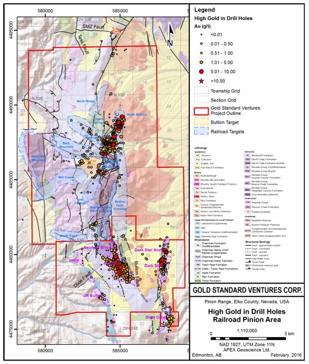
North Bullion
A total of 57 RC, diamond core and combination RC/core holes totaling 90,808 ft (27,678 m) representing more than 50% of all of Gold Standard’s drilling to the end of 2013 was completed at the North Bullion Target. Drilling at North Bullion has continued almost non-stop from 2011 to late 2013 to follow-up the blind discovery of North Bullion gold mineralization as summarized by Hunsaker (2012b), Shaddrick (2012) and Koehler et al. (2014). To date, core drilling has been the most effective way of evaluating and vectoring into higher grade gold zones of this Carlin/Rain Style target, as the hydrothermal alteration and gold mineralization are not exposed at surface. Twenty nine (29) of thirty three (33) core holes drilled during mid-2012 to 2013 yielded positive gold results in the upper and/or lower breccia zones at the North Bullion Target. See Table 10.3 below.
Table 10.3: Significant Drill Hole Intercepts late 2012 and 2013 – North Bullion Deposit.
| Significant Drill Intercepts – North Bullion Target |
| Hole ID | From (m) | To (m) | Length (m) | From (ft) | To (ft) | Length (ft) | Au (oz/t) | Au (ppm) |
| RR12-04 | 275.0 | 304.8 | 29.8 | 902 | 1000 | 98 | 0.058 | 1.99 |
| | 320.1 | 334.7 | 14.6 | 1050 | 1098 | 48 | 0.013 | 0.45 |
| RR12-05 | 551.2 | 557.9 | 6.7 | 1808 | 1830 | 22 | 0.020 | 0.69 |
| RR12-07 | 105.8 | 113.7 | 7.9 | 347 | 373 | 26 | 0.012 | 0.41 |
| | 163.4 | 189.6 | 26.2 | 536 | 622 | 86 | 0.061 | 2.09 |
| | 276.1 | 321.9 | 45.8 | 906 | 1056 | 150 | 0.014 | 0.48 |
| | 360.3 | 368.8 | 8.5 | 1182 | 1210 | 28 | 0.016 | 0.55 |
| | 409.4 | 423.1 | 13.7 | 1343 | 1388 | 45 | 0.017 | 0.58 |
| RR12-08 | 269.5 | 278.6 | 9.1 | 884 | 914 | 30 | 0.014 | 0.48 |
| | 422.2 | 428.3 | 6.1 | 1385 | 1405 | 20 | 0.013 | 0.45 |
| RR12-10 | 218.0 | 342.1 | 124.1 | 715 | 1122 | 407 | 0.118 | 4.05 |
| including | 218.0 | 261.3 | 43.3 | 715 | 857 | 142 | 0.220 | 7.54 |
| including | 233.8 | 250.3 | 16.5 | 767 | 821 | 54 | 0.440 | 15.09 |
| | 355.5 | 407.7 | 52.2 | 1166 | 1337 | 171 | 0.015 | 0.51 |
| | 422.9 | 556.4 | 133.5 | 1387 | 1825 | 438 | 0.013 | 0.45 |
| RR12-11 | 195.4 | 201.2 | 5.8 | 641 | 660 | 19 | 0.100 | 3.43 |
| including | 196.8 | 200.0 | 3.2 | 645.5 | 656 | 10 | 0.160 | 5.49 |
| | 340.9 | 473.5 | 132.6 | 1118 | 1553 | 435 | 0.011 | 0.38 |
| RR12-13 | 105.8 | 119.8 | 14 | 347 | 393 | 46 | 0.026 | 0.89 |
| | 238.7 | 262.2 | 23.5 | 783 | 860 | 77 | 0.015 | 0.51 |
| | 277.1 | 330.2 | 53.1 | 909 | 1083 | 174 | 0.020 | 0.69 |
| | 363.7 | 385.0 | 21.3 | 1193 | 1263 | 70 | 0.020 | 0.69 |
| RR12-15 | 64.6 | 93.3 | 28.7 | 212 | 306 | 94 | 0.012 | 0.41 |
| | 134.4 | 157.6 | 23.2 | 441 | 517 | 76 | 0.016 | 0.55 |
| RR12-18 | 245.1 | 251.2 | 6.1 | 804 | 824 | 20 | 0.011 | 0.38 |
| | 275.3 | 316.2 | 40.9 | 903 | 1037 | 134 | 0.023 | 0.79 |
| | 478.1 | 486.6 | 8.5 | 1568 | 1596 | 28 | 0.033 | 1.13 |
| RR12-19 | 256.7 | 268.6 | 11.9 | 842 | 881 | 39 | 0.013 | 0.45 |
| | 354.0 | 361.9 | 7.9 | 1161 | 1187 | 26 | 0.038 | 1.30 |
| RR12-20 | 331.1 | 334.9 | 3.8 | 1086 | 1098.5 | 12.5 | 0.031 | 1.06 |
| | 466.6 | 472.1 | 5.5 | 1530.5 | 1548.5 | 18 | 0.012 | 0.41 |
| RR12-24 | 89.3 | 95.1 | 5.8 | 293 | 312 | 19 | 0.022 | 0.75 |
| | 264.3 | 273.8 | 9.5 | 867 | 898 | 31 | 0.017 | 0.58 |
| | 281.4 | 321.6 | 40.2 | 923 | 1055 | 132 | 0.039 | 1.34 |
| including | 306.4 | 321.6 | 15.2 | 1005 | 1055 | 50 | 0.072 | 2.47 |
| RR12-25 | 161.5 | 165.2 | 3.7 | 530 | 542 | 12 | 0.023 | 0.79 |
| | 351.2 | 357.9 | 6.7 | 1152 | 1174 | 22 | 0.012 | 0.41 |
| RR12-26 | 25.9 | 35.0 | 9.1 | 85 | 115 | 30 | 0.015 | 0.51 |
| RR12-27 | 151.2 | 168.0 | 16.8 | 496 | 551 | 55 | 0.057 | 1.95 |
| | 265.2 | 271.3 | 6.1 | 870 | 890 | 20 | 0.014 | 0.48 |
| | 292.4 | 307.0 | 14.6 | 959 | 1007 | 48 | 0.011 | 0.38 |
| | 316.2 | 331.4 | 15.2 | 1037 | 1087 | 50 | 0.022 | 0.75 |
| RR12-30 | 366.4 | 370.1 | 3.7 | 1202 | 1214 | 12 | 0.061 | 2.09 |
| RR13-01 | 524.4 | 532.0 | 7.6 | 1720 | 1745 | 25 | 0.010 | 0.34 |
| | 581.7 | 602.1 | 20.4 | 1908 | 1975 | 67 | 0.031 | 1.06 |
| RR13-02 | 226.5 | 233.8 | 7.3 | 743 | 767 | 24 | 0.013 | 0.45 |
| | 296.6 | 375.0 | 78.4 | 973 | 1230 | 257 | 0.027 | 0.93 |
| including | 304.9 | 311.9 | 7 | 1000 | 1023 | 23 | 0.066 | 2.26 |
| RR13-03 | 159.5 | 165.6 | 6.1 | 523 | 543 | 20 | 0.011 | 0.38 |
| | 189.3 | 200.0 | 10.7 | 621 | 656 | 35 | 0.044 | 1.51 |
| including | 190.0 | 192.4 | 2.4 | 626 | 631 | 5 | 0.160 | 5.49 |
| | 307.6 | 337.8 | 30.2 | 1009 | 1108 | 99 | 0.021 | 0.72 |
| | 357.6 | 363.7 | 6.1 | 1173 | 1193 | 20 | 0.013 | 0.45 |
| | 395.7 | 422.5 | 26.8 | 1298 | 1386 | 88 | 0.019 | 0.65 |
| RR13-04 | 150.0 | 160.1 | 10.1 | 492 | 525 | 33 | 0.019 | 0.65 |
| | 285.6 | 354.2 | 68.6 | 937 | 1162 | 225 | 0.013 | 0.45 |
| including | 287.9 | 294.7 | 6.8 | 944.5 | 967 | 22.5 | 0.062 | 2.13 |
| | 361.8 | 428.7 | 66.9 | 1187 | 1406.5 | 219.5 | 0.025 | 0.86 |
| RR13-05 | 155.8 | 176.2 | 20.4 | 511 | 578 | 67 | 0.028 | 0.96 |
| | 239.9 | 249.0 | 9.1 | 782 | 817 | 35 | 0.068 | 2.33 |
| including | 242.4 | 247.6 | 5.2 | 795 | 812 | 17 | 0.117 | 4.01 |
| | 256.6 | 368.8 | 112.2 | 842 | 1210 | 368 | 0.016 | 0.55 |
| | 429.2 | 453.8 | 24.6 | 1408 | 1489 | 81 | 0.015 | 0.51 |
| RR13-06 | 150.5 | 155.5 | 5 | 493.5 | 510 | 16.5 | 0.017 | 0.58 |
| | 211.0 | 233.1 | 22.1 | 692 | 764.5 | 72.5 | 0.059 | 2.02 |
| | 301.2 | 322.2 | 21 | 988 | 1057 | 69 | 0.020 | 0.69 |
| | 336.0 | 394.2 | 58.2 | 1102 | 1293 | 191 | 0.015 | 0.51 |
| RR13-07 | 236.2 | 365.2 | 129 | 775 | 1198 | 423 | 0.026 | 0.89 |
| including | 273.5 | 286.6 | 13.1 | 897 | 940 | 43 | 0.064 | 2.19 |
| including | 343.6 | 357.9 | 14.3 | 1127 | 1174 | 47 | 0.055 | 1.89 |
| | 385.4 | 406.1 | 20.7 | 1264 | 1332 | 68 | 0.014 | 0.48 |
| RR13-08 | 192.1 | 200.0 | 7.9 | 630 | 656 | 26 | 0.110 | 3.77 |
| including | 195.1 | 200.0 | 4.9 | 640 | 656 | 16 | 0.164 | 5.62 |
| | 205.3 | 230.8 | 25.5 | 673.5 | 757 | 83.5 | 0.055 | 1.89 |
| | 303.6 | 377.1 | 73.5 | 996 | 1237 | 241 | 0.107 | 3.67 |
| including | 336.9 | 344.5 | 7.6 | 1105 | 1130 | 25 | 0.352 | 12.07 |
| including | 352.1 | 364.3 | 12.2 | 1155 | 1195 | 40 | 0.202 | 6.93 |
| | 384.1 | 416.1 | 32 | 1260 | 1365 | 105 | 0.029 | 0.99 |
| including | 389.0 | 396.9 | 7.9 | 1276 | 1302 | 26 | 0.091 | 3.12 |
| RR13-09 | 248.8 | 254.1 | 5.3 | 816 | 833.5 | 17.5 | 0.047 | 1.61 |
| | 270.1 | 372.2 | 102.1 | 886 | 1221 | 335 | 0.025 | 0.86 |
| | 389.6 | 429.7 | 40.1 | 1278 | 1409.5 | 131.5 | 0.013 | 0.45 |
| including | 290.9 | 311.3 | 20.4 | 954 | 1021 | 67 | 0.050 | 1.71 |
| including | 342.4 | 353.7 | 11.3 | 1123 | 1160 | 37 | 0.049 | 1.68 |
| | 459.5 | 490.9 | 31.4 | 1507 | 1610 | 103 | 0.021 | 0.72 |
| RR13-10 | 209.1 | 244.2 | 35.1 | 686 | 801 | 115 | 0.053 | 1.82 |
| including | 224.7 | 230.8 | 6.1 | 737 | 757 | 20 | 0.185 | 6.34 |
| | 299.7 | 370.4 | 70.7 | 983 | 1215 | 232 | 0.016 | 0.55 |
| RR13-11 | 313.4 | 411.6 | 98.2 | 1028 | 1350 | 322 | 0.095 | 3.26 |
| including | 322.2 | 327.4 | 5.2 | 1057 | 1074 | 17 | 0.147 | 5.04 |
| including | 354.2 | 371.3 | 17.1 | 1162 | 1218 | 56 | 0.291 | 9.98 |
| RR13-12 | 230.8 | 242.1 | 11.3 | 757 | 794 | 37 | 0.024 | 0.82 |
| | 339.6 | 431.4 | 91.8 | 1114 | 1415 | 301 | 0.031 | 1.06 |
| including | 366.7 | 380.3 | 13.6 | 1203 | 1247.5 | 44.5 | 0.117 | 4.01 |
| RR13-14 | 294.7 | 325.3 | 30.6 | 966.5 | 1067 | 100.5 | 0.036 | 1.23 |
| including | 297.9 | 307.5 | 9.6 | 977 | 1008.5 | 31.5 | 0.072 | 2.47 |
| | 337.5 | 377.4 | 39.9 | 1107 | 1238 | 131 | 0.019 | 0.65 |
In the upper breccia zone, drilling expanded the plan extent of gold mineralization and continued to confirm the continuity of gold mineralization. Some of the better intercepts from the upper zone breccia include: 407 ft (124.05 m) of 0.118 oz Au/st (4.05 ppm Au) including 54 ft (16.46 m) of 0.440 oz Au/st (15.08 ppm Au) in RR12-10 and 257 ft (78.33 m) of 0.027 oz Au/st (0.93 ppm Au) in RR13-02 (see Table 10.3).
In the lower collapse breccia zone, drilling identified a previously unrecognized higher-grade zone of gold mineralization and expanded the overall strike and width of gold mineralization. Some of the better intercepts from the lower zone breccia include: 241 ft (73.46 m) of 0.107 oz Au/st (3.67 ppm Au) including two higher grade internal intervals of 25 ft (7.62 m) of 0.352 oz Au/st (12.07 ppm Au) and 40 ft (12.19 m) of 0.202 oz Au/st (6.93 ppm Au) in RR13-08 and 322 ft (98.15 m) of 0.095 oz Au/st (3.26 ppm Au) including 56 ft (17.07 m) of 0.291 oz Au/st (9.98 ppm Au) in RR13-11 (see Table 10.3).
An example schematic cross-section (North 4488800) for the North Bullion Deposit (location on Figure 10.1) is provided as Figure 10.3 below.
Figure 10.3: North Bullion Example Cross-Section N4488800.
Bald Mountain
One vertical, diamond core hole comprised of 2,035 ft (620.27 m) in length was completed at Bald Mountain to follow-up on historic RC drilling. Results of this hole confirmed the presence of a vertically extensive zone of hydrothermal alteration, collapse brecciation, igneous dikes, and a significant oxide gold and copper system hosted in hornfelsed rocks (see Table 10.4 below). A cross section displaying the 2013 drill hole is provided as Figure 10.4. These results verify the deposit model being used, the presence of a large mineralizing system, and the discovery of a new mineralized zone. Based upon this result, further drilling is warranted at the Bald Mountain target.
Table 10.4: Significant Drill Results 2013 – Bald Mountain Target.
| | Significant Drill Intercepts – Bald Mountain Target |
| Hole ID | From (m) | To (m) | Length (m) | From (ft) | To (ft) | Length (ft) | Au (oz/t) | Au (ppm) | Cu % |
| RRB13-01 | 206.4 | 262.5 | 56.1 | 677 | 861 | 184 | 0.043 | 1.47 | |
| Including | 212.6 | 219.9 | 7.3 | 697.5 | 721.5 | 24 | 0.165 | 5.66 | |
| and | 260.9 | 296.0 | 35.1 | 856 | 971 | 115 | | | 0.31 |
Figure 10.4: Bald Mountain Example Cross-Section N4486800.
Sylvania (formerly Central Bullion)
Gold Standard drilled five core holes testing geologic targets at Central Bullion, bringing the total Gold Standard drilling to 9 holes totaling 13,835 ft (4,217 m) at Sylvania. Significant drill results for the 2012 and 2013 drilling are summarized in Table 10.5 below. All five holes intersected significant silver mineralization, with the best intercepts of 250 ft (76.2 m) of 1.28 oz Ag/st (43.9 ppm Ag) and 187 ft (57 m) of 1.70 oz Ag/st (58.3 ppm Ag) in RRB12-03. Significant copper, lead and zinc mineralization was also intersected in the drilling. The best copper intercept was 187 ft (57 m) of 0.78% Cu in RRB12-03. Drilling results confirmed the skarn deposit model, the presence of a significant mineralizing system, and discovered a new mineralized zone. A schematic cross section for the Sylvania mineralized zone is included as Figure 10.5.
Table 10.5: Significant Drill Results 2012 and 2013 – Sylvania Target.
| | Significant Drill Intercepts – Central Bullion Target |
| Hole ID | From (m) | To (m) | Length (m) | From (ft) | To (ft) | Length (ft) | Ag (oz/st) | Ag (ppm) | Cu % | Pb % | Zn % |
| RRB12-01 | 0 | 4.9 | 4.9 | 0 | 16 | 16 | 4.36 | 149.49 | | | |
| | 0 | 15.7 | 15.7 | 0 | 51.5 | 51.5 | | | 0.34 | 0.78 | 1.73 |
| RRB12-02 | 31.7 | 32.9 | 1.2 | 104 | 108 | 4 | 6.15 | 210.86 | | | |
| | 202.1 | 205.8 | 3.7 | 663 | 675 | 12 | 1.30 | 44.57 | | | |
| | 285.1 | 287.4 | 2.3 | 935 | 942.5 | 7.5 | 6.16 | 211.20 | | | |
| RRB12-03 | 6.1 | 82.3 | 76.2 | 20 | 270 | 250 | 1.28 | 43.89 | 0.25 | | |
| including | 13.7 | 33.5 | 19.8 | 45 | 110 | 65 | 3.06 | 104.92 | 0.80 | 1.08 | 0.79 |
| | 207.3 | 216.5 | 9.2 | 680 | 710 | 30 | 0.71 | 24.34 | 0.27 | | |
| | 278.4 | 335.4 | 57 | 913 | 1100 | 187 | 1.70 | 58.29 | 0.78 | | |
| including | 278.4 | 291.8 | 13.4 | 913 | 957 | 44 | 6.42 | 220.12 | 2.48 | 0.31 | |
| | 360.4 | 368.5 | 8.1 | 1182 | 1208 | 26 | 0.63 | 21.60 | 0.78 | | 0.83 |
| | 393.3 | 406.1 | 12.8 | 1290 | 1332 | 42 | 0.67 | 22.97 | 0.52 | | 0.56 |
| RRB13-02 | 91.8 | 98.5 | 6.7 | 301 | 323 | 22 | 0.54 | 18.51 | 0.30 | | 0.25 |
| | 123.3 | 127.7 | 4.4 | 404.5 | 419 | 14.5 | 1.73 | 59.31 | 0.29 | 0.22 | 0.64 |
| | 138.4 | 146.8 | 8.4 | 454 | 481.5 | 27.5 | 0.92 | 31.54 | 0.24 | 0.11 | 0.18 |
| | 189.6 | 196.3 | 6.7 | 622 | 644 | 22 | 6.71 | 230.06 | 0.75 | 0.24 | 0.23 |
| | 247.5 | 254.7 | 7.2 | 812 | 835.5 | 23.5 | 0.25 | 8.57 | 0.27 | | |
| RRB13-03 | 22.6 | 43.0 | 20.4 | 74 | 141 | 67 | | | 0.42 | | |
| | 91.2 | 99.1 | 7.9 | 299 | 325 | 26 | 0.29 | 9.94 | 0.19 | | 0.21 |
Figure 10.5: Sylvania Example Cross-Section E583550.
Railroad Fault
During the period, Gold Standard drilled a total of eight RC and/or core holes along this west-northwest striking fault corridor testing for Carlin/Rain Style sediment-hosted gold zones bringing the total Gold Standard drilling at the target to eleven holes totaling 14,329 ft (4,367 m). The best intercepts for the period were in drill hole RR12-12, which intersected 20 ft (6.1 m) of 0.011 oz Au/st (0.38 ppm Au) and 5 feet (1.52 m) of 2.45 oz Ag/st (84.0 ppm Ag).
Bullion Fault Corridor
During 2012 and 2013 a total of 7 holes totaling 13,636 ft (4,156 m), including one that has not yet been completed, tested geological and geophysical targets along strike of the Bullion Fault. The holes were collared in the hanging wall of the westernmost strands of the Bullion Fault and intersected numerous Eocene rhyolite and dacite dikes and sills as the holes crossed into altered footwall rocks. These dikes and sills are similar to those closely associated with the gold mineralization at North Bullion.
The majority of the drilling within the BFC was RC, with one core tail completed in BFC13-03. The drill holes intersected thick intervals of anomalous gold and anomalous arsenic within dolomitized, silicified and clay altered Paleozoic sedimentary rocks.
Cherry Springs
During 2012, two RC precollar/diamond core tail drill holes for a total of 3,667 ft (1,118 m) were completed at the Cherry Springs Target to drill test geologic and geophysical targets. The best intercepts were obtained from drill hole RR12-29, which intersected 18 ft (5.49 m) of 0.021 oz Au/st (0.72 ppm Au) and 13 ft (3.96 m) of 10.94 oz Ag/st (375 ppm Ag).
LT
During the period, Gold Standard completed six RC drill holes for a total of 9,930 ft (3,027 m) testing geological, geochemical and geophysical features at the LT Target. Results from the six holes included 15 ft (4.57 m) of 0.031 oz Au/st (1.06 ppm Au) in drill hole LT12-03.
��
North Ridge
One RC precollar/diamond core tail drill hole was completed at the North Ridge Target during the period bringing Gold Standard's total to three drill holes totaling 8,633 ft (2,631 m). The drill hole did not intersect significant gold mineralization.
| · | 2014 Drilling by Gold Standard |
Pinion Area Drilling
Following the amalgamation of the Pinion Project in early 2014, Gold Standard compiled and validated the existing Pinion Deposit drill database. The Company then initiated a multi-phase drill program at Pinion with the initial phase of drilling intended to support ongoing geological modeling and database validation in order to allow for an initial resource estimate for the Pinion Deposit. The 2014 Phase 1 Pinion drill program comprised 5,630 ft (1,716 m) of RC drilling in 9 holes and 1,584 ft (483 m) of diamond drilling in four holes. The drilling was focused on the North Zone and northern portion of the Main Zone mineralization located within the Pinion Deposit. The Phase 1 drilling was utilized to construct and improve the geological model for gold mineralization at Pinion prior to conducting a resource estimate. Highlights of the Phase 1 drilling are provided in Table 10.6 below.
Table 10.6: 2014 Phase 1 Pinion Deposit Drilling Intersection Highlights.
| Drillhole | From (m) | To (m) | Length (m) | From (ft) | To (ft) | Length (ft) | Au (opt) | Au (ppm) | Ag (opt) | Ag (ppm) |
| PIN14-01 | 1.52 | 71.32 | 69.80 | 5 | 234 | 229 | 0.03 | 0.89 | 0.26 | 8.97 |
| including | 9.75 | 17.07 | 7.32 | 32 | 56 | 24 | 0.07 | 2.31 | 0.48 | 16.52 |
| PIN14-02 | 18.29 | 33.53 | 15.24 | 60 | 110 | 50 | 0.01 | 0.44 | 0.03 | 1.07 |
| including | 18.29 | 25.91 | 7.62 | 60 | 85 | 25 | 0.02 | 0.72 | 0.04 | 1.52 |
| including | 18.29 | 21.34 | 3.05 | 60 | 70 | 10 | 0.04 | 1.51 | 0.08 | 2.65 |
| PIN14-03 | 54.86 | 62.48 | 7.62 | 180 | 205 | 25 | 0.01 | 0.29 | 0.04 | 1.23 |
| PIN14-04 | 39.62 | 57.91 | 18.29 | 130 | 190 | 60 | 0.01 | 0.30 | 0.06 | 2.06 |
| PIN14-05 | 121.92 | 161.54 | 39.62 | 400 | 530 | 130 | 0.03 | 1.01 | 0.01 | 0.36 |
| including | 124.97 | 149.35 | 24.38 | 410 | 490 | 80 | 0.04 | 1.46 | 0.14 | 4.88 |
| and | 231.65 | 284.99 | 53.34 | 760 | 935 | 175 | 0.01 | 0.39 | 0.08 | 2.80 |
| PIN14-06 | 41.76 | 71.93 | 30.18 | 137 | 236 | 99 | 0.04 | 1.30 | 0.34 | 11.49 |
| including | 41.76 | 60.96 | 19.20 | 137 | 200 | 63 | 0.06 | 1.89 | 0.48 | 16.46 |
| including | 52.43 | 57.00 | 4.57 | 172 | 187 | 15 | 0.17 | 5.96 | 1.37 | 46.92 |
| PIN14-07 | 140.21 | 152.40 | 12.19 | 460 | 500 | 40 | 0.04 | 1.23 | 0.31 | 10.49 |
| PIN14-08 | 10.67 | 47.24 | 36.58 | 35 | 155 | 120 | 0.04 | 1.23 | 0.55 | 18.93 |
| including | 38.56 | 43.59 | 5.03 | 126.5 | 143 | 16.5 | 0.16 | 5.63 | 0.29 | 10.02 |
| PIN14-09 | 138.68 | 153.92 | 15.24 | 455 | 505 | 50 | 0.01 | 0.42 | 0.11 | 3.94 |
| PIN14-10 | 115.82 | 141.73 | 25.91 | 380 | 465 | 85 | 0.02 | 0.57 | 0.21 | 7.35 |
| PIN14-11 | 108.20 | 173.74 | 65.53 | 355 | 570 | 215 | 0.03 | 0.89 | 0.22 | 7.65 |
| including | 112.78 | 126.49 | 13.72 | 370 | 415 | 45 | 0.07 | 2.51 | 0.44 | 15.23 |
| PIN14-12 | 66.29 | 114.60 | 48.31 | 217.5 | 376 | 158.5 | 0.02 | 0.77 | 0.22 | 7.57 |
| including | 70.41 | 109.73 | 39.32 | 231 | 360 | 129 | 0.03 | 0.91 | 0.26 | 9.01 |
| including | 70.41 | 87.33 | 16.92 | 231 | 286.5 | 55.5 | 0.04 | 1.33 | 0.37 | 12.75 |
| including | 70.41 | 77.42 | 7.01 | 231 | 254 | 23 | 0.06 | 2.13 | 0.41 | 14.02 |
| PIN14-13 | 172.21 | 193.55 | 21.34 | 565 | 635 | 70 | 0.02 | 0.81 | 0.33 | 11.25 |
| including | 181.36 | 187.45 | 6.10 | 595 | 615 | 20 | 0.05 | 1.66 | 0.59 | 20.12 |
During September and October 2014, Gold Standard completed a Phase 2 drilling program at the Pinion Deposit area that comprised 44 RC drill holes for total of 35,730 ft (10,891 m) and a total of 5 RC holes for a total of 6,220 ft (1,900 m) at the Bald Mountain target area. The Phase 2 Pinion RC drilling was designed to extend areas of known shallow oxide gold mineralization along strike and at depth, and to test new targets identified by the Phase 1 program and the new 3D geological and gold mineralization model developed during the Phase 1 program. The follow-up Phase 2 drilling during 2014 was not included in the September, 2014 maiden resourceestimate for the Pinion Deposit; however the results are included in the 2016 resource update provided below (see “Mineral Resource Estimates”). Gold mineralization at Pinion is very continuous and widespread within a highly permeable, silicified, and oxidized collapse breccia which is favorably sandwiched between relatively impermeable silty micrite of the overlying Mississippian Tripon Pass Formation and thick-bedded calcarenite of the underlying Devonian Devil’s Gate Formation. The extent of gold mineralization is controlled by the development and magnitude of multilithic collapse breccia, which in turn is stratigraphically and structurally controlled. The results of the 2014 Phase 2 drilling are summarized below in Table 10.7.
Table 10.7: 2014 Phase 2 Pinion Deposit Drilling Intersection Highlights.
| Hole Number | From (m) | To (m) | Length (m) | From (ft) | To (ft) | Length (ft) | Au (oz/st) | Au (ppm) |
| |
| PIN14-14 | 173.74 | 195.07 | 21.34 | 570 | 640 | 70 | 0.015 | 0.51 |
| including | 173.74 | 190.50 | 16.76 | 570 | 625 | 55 | 0.018 | 0.62 |
| and | 242.32 | 256.03 | 13.72 | 795 | 840 | 45 | 0.006 | 0.19 |
| PIN14-15 | 0.00 | 4.57 | 4.57 | 0 | 15 | 15 | 0.006 | 0.21 |
| | 74.68 | 161.54 | 86.87 | 245 | 530 | 285 | 0.007 | 0.23 |
| including | 74.68 | 115.82 | 41.15 | 245 | 380 | 135 | 0.009 | 0.32 |
| PIN14-16 | 216.41 | 272.80 | 56.39 | 710 | 895 | 185 | 0.015 | 0.52 |
| including | 217.93 | 251.46 | 33.53 | 715 | 825 | 110 | 0.023 | 0.80 |
| PIN14-17 | 99.06 | 115.82 | 16.76 | 325 | 380 | 55 | 0.006 | 0.22 |
| and | 134.11 | 156.97 | 22.86 | 440 | 515 | 75 | 0.011 | 0.37 |
| PIN14-18 | 153.92 | 185.93 | 32.00 | 505 | 610 | 105 | 0.066 | 2.25 |
| including | 178.31 | 184.40 | 6.10 | 585 | 605 | 20 | 0.114 | 3.90 |
| PIN14-19 | 176.78 | 291.08 | 114.30 | 580 | 955 | 375 | 0.016 | 0.55 |
| including | 176.78 | 202.69 | 25.91 | 580 | 665 | 85 | 0.020 | 0.69 |
| including | 184.40 | 198.12 | 13.72 | 605 | 650 | 45 | 0.033 | 1.14 |
| and | 231.65 | 291.08 | 59.44 | 760 | 955 | 195 | 0.017 | 0.60 |
| including | 260.60 | 271.27 | 10.67 | 855 | 890 | 35 | 0.036 | 1.23 |
| PIN14-20 | 126.49 | 190.50 | 64.01 | 415 | 625 | 210 | 0.007 | 0.24 |
| including | 126.49 | 152.40 | 25.91 | 415 | 500 | 85 | 0.011 | 0.39 |
| PIN14-21 | 161.54 | 196.60 | 35.05 | 530 | 645 | 115 | 0.040 | 1.36 |
| PIN14-22 | 3.05 | 10.67 | 7.62 | 10 | 35 | 25 | 0.008 | 0.27 |
| | 179.83 | 182.88 | 3.05 | 590 | 600 | 10 | 0.023 | 0.78 |
| PIN14-23 | 188.98 | 225.55 | 36.58 | 620 | 740 | 120 | 0.007 | 0.25 |
| including | 188.98 | 193.55 | 4.57 | 620 | 635 | 15 | 0.019 | 0.65 |
| and | 205.74 | 220.98 | 15.24 | 675 | 725 | 50 | 0.010 | 0.33 |
| PIN14-24 | 0.00 | 134.11 | 134.11 | 0 | 440 | 440 | 0.006 | 0.20 |
| including | 0.00 | 97.54 | 97.54 | 0 | 320 | 320 | 0.007 | 0.23 |
| including | 1.52 | 18.29 | 16.76 | 5 | 60 | 55 | 0.015 | 0.50 |
| PIN14-25 | 259.08 | 309.37 | 50.29 | 850 | 1015 | 165 | 0.012 | 0.42 |
| including | 278.89 | 298.70 | 19.81 | 915 | 980 | 65 | 0.023 | 0.81 |
| and | 377.95 | 408.43 | 30.48 | 1240 | 1340 | 100 | 0.007 | 0.25 |
| PIN14-26 | 193.55 | 275.84 | 82.30 | 635 | 905 | 270 | 0.008 | 0.28 |
| including | 193.55 | 225.55 | 32.00 | 635 | 740 | 105 | 0.017 | 0.58 |
| including | 193.55 | 202.69 | 9.14 | 635 | 665 | 30 | 0.044 | 1.49 |
| PIN14-27 | 175.26 | 213.36 | 38.10 | 575 | 700 | 125 | 0.022 | 0.74 |
| including | 176.78 | 184.40 | 7.62 | 580 | 605 | 25 | 0.065 | 2.22 |
| PIN14-28 | 160.02 | 188.98 | 28.96 | 525 | 620 | 95 | 0.013 | 0.44 |
| PIN14-29 | 65.53 | 85.34 | 19.81 | 215 | 280 | 65 | 0.006 | 0.21 |
| PIN14-30 | 176.78 | 262.13 | 85.34 | 580 | 860 | 280 | 0.004 | 0.15 |
| including | 176.78 | 199.64 | 22.86 | 580 | 655 | 75 | 0.008 | 0.28 |
| including | 176.78 | 181.36 | 4.57 | 580 | 595 | 15 | 0.017 | 0.60 |
| and | 192.02 | 199.64 | 7.62 | 630 | 655 | 25 | 0.014 | 0.46 |
| PIN14-31 | 160.02 | 193.55 | 33.53 | 525 | 635 | 110 | 0.032 | 1.08 |
| including | 166.12 | 176.78 | 10.67 | 545 | 580 | 35 | 0.066 | 2.26 |
| PIN14-32 | 65.53 | 88.39 | 22.86 | 215 | 290 | 75 | 0.011 | 0.36 |
| including | 70.10 | 80.77 | 10.67 | 230 | 265 | 35 | 0.018 | 0.61 |
| and | 115.82 | 120.40 | 4.57 | 380 | 395 | 15 | 0.007 | 0.23 |
| PIN14-33 | 182.88 | 230.12 | 47.24 | 600 | 755 | 155 | 0.008 | 0.26 |
| including | 182.88 | 199.64 | 16.76 | 600 | 655 | 55 | 0.018 | 0.61 |
| PIN14-34 | 124.97 | 172.21 | 47.24 | 410 | 565 | 155 | 0.009 | 0.30 |
| including | 152.40 | 172.21 | 19.81 | 500 | 565 | 65 | 0.013 | 0.46 |
| PIN14-35 | 86.87 | 118.87 | 32.00 | 285 | 390 | 105 | 0.014 | 0.49 |
| including | 86.87 | 91.44 | 4.57 | 285 | 300 | 15 | 0.081 | 2.79 |
| PIN14-36 | 36.58 | 53.34 | 16.76 | 120 | 175 | 55 | 0.022 | 0.75 |
| including | 38.10 | 45.72 | 7.62 | 125 | 150 | 25 | 0.035 | 1.22 |
| and | 77.72 | 134.11 | 56.39 | 255 | 440 | 185 | 0.005 | 0.17 |
| including | 86.87 | 111.25 | 24.38 | 285 | 365 | 80 | 0.008 | 0.26 |
| PIN14-37 | 53.34 | 65.53 | 12.19 | 175 | 215 | 40 | 0.021 | 0.71 |
| including | 53.34 | 56.39 | 3.05 | 175 | 185 | 10 | 0.058 | 1.99 |
| and | 123.44 | 224.03 | 100.58 | 405 | 735 | 330 | 0.007 | 0.23 |
| including | 126.49 | 135.64 | 9.14 | 415 | 445 | 30 | 0.016 | 0.56 |
| including | 164.59 | 170.69 | 6.10 | 540 | 560 | 20 | 0.019 | 0.65 |
| PIN14-38 | 202.69 | 268.22 | 65.53 | 665 | 880 | 215 | 0.026 | 0.90 |
| including | 222.50 | 257.56 | 35.05 | 730 | 845 | 115 | 0.044 | 1.52 |
| including | 243.84 | 249.94 | 6.10 | 800 | 820 | 20 | 0.198 | 6.78 |
| PIN14-39 | 108.20 | 170.69 | 62.48 | 355 | 560 | 205 | 0.004 | 0.15 |
| including | 134.11 | 156.97 | 22.86 | 440 | 515 | 75 | 0.007 | 0.24 |
| PIN14-40 | 76.20 | 82.30 | 6.10 | 250 | 270 | 20 | 0.010 | 0.34 |
| and | 160.02 | 210.31 | 50.29 | 525 | 690 | 165 | 0.009 | 0.30 |
| including | 196.60 | 208.79 | 12.19 | 645 | 685 | 40 | 0.015 | 0.52 |
| PIN14-41 | 15.24 | 71.63 | 56.39 | 50 | 235 | 185 | 0.006 | 0.21 |
| including | 96.01 | 105.16 | 9.14 | 315 | 345 | 30 | 0.008 | 0.27 |
| PIN14-42 | 80.77 | 91.44 | 10.67 | 265 | 300 | 35 | 0.011 | 0.39 |
| and | 152.40 | 239.27 | 86.87 | 500 | 785 | 285 | 0.014 | 0.47 |
| including | 170.69 | 198.12 | 27.43 | 560 | 650 | 90 | 0.021 | 0.72 |
| PIN14-43 | 551.69 | 612.65 | 60.96 | 1810 | 2010 | 200 | 0.010 | 0.35 |
| including | 551.69 | 560.83 | 9.14 | 1810 | 1840 | 30 | 0.024 | 0.82 |
| PIN14-44 | 108.20 | 137.16 | 28.96 | 355 | 450 | 95 | 0.019 | 0.64 |
| including | 108.20 | 111.25 | 3.05 | 355 | 365 | 10 | 0.070 | 2.40 |
| PIN14-45 | 21.34 | 88.39 | 67.06 | 70 | 290 | 220 | 0.006 | 0.19 |
| including | 35.05 | 48.77 | 13.72 | 115 | 160 | 45 | 0.009 | 0.30 |
| and | 65.53 | 86.87 | 21.34 | 215 | 285 | 70 | 0.007 | 0.24 |
| PIN14-46 | 76.20 | 105.16 | 28.96 | 250 | 345 | 95 | 0.004 | 0.14 |
| PIN14-47 | 56.39 | 64.01 | 7.62 | 185 | 210 | 25 | 0.008 | 0.28 |
| and | 115.82 | 199.64 | 83.82 | 380 | 655 | 275 | 0.004 | 0.13 |
| including | 187.45 | 199.64 | 12.19 | 615 | 655 | 40 | 0.007 | 0.25 |
| and | 243.84 | 275.84 | 32.00 | 800 | 905 | 105 | 0.011 | 0.39 |
| and | 291.08 | 298.70 | 7.62 | 955 | 980 | 25 | 0.021 | 0.70 |
| PIN14-48 | no significant intersection |
| PIN14-49 | 51.82 | 57.91 | 6.10 | 170 | 190 | 20 | 0.005 | 0.19 |
| PIN14-50 | 144.78 | 210.31 | 65.53 | 475 | 690 | 215 | 0.009 | 0.30 |
| including | 192.02 | 202.69 | 10.67 | 630 | 665 | 35 | 0.031 | 1.06 |
| PIN14-51 | 80.77 | 91.44 | 10.67 | 265 | 300 | 35 | 0.005 | 0.16 |
| PIN14-52 | 182.88 | 237.74 | 54.86 | 600 | 780 | 180 | 0.014 | 0.48 |
| including | 187.45 | 208.79 | 21.34 | 615 | 685 | 70 | 0.020 | 0.69 |
| PIN14-53 | 28.96 | 99.06 | 70.10 | 95 | 325 | 230 | 0.004 | 0.12 |
| PIN14-54 | 56.39 | 109.73 | 53.34 | 185 | 360 | 175 | 0.006 | 0.22 |
| including | 57.91 | 67.06 | 9.14 | 190 | 220 | 30 | 0.014 | 0.48 |
| PIN14-55 | no significant intersection |
| PIN14-56 | 278.89 | 359.66 | 80.77 | 915 | 1180 | 265 | 0.008 | 0.28 |
| including | 278.89 | 333.76 | 54.86 | 915 | 1095 | 180 | 0.011 | 0.38 |
| including | 315.47 | 329.18 | 13.72 | 1035 | 1080 | 45 | 0.017 | 0.57 |
| PIN14-57 | 138.68 | 147.83 | 9.14 | 455 | 485 | 30 | 0.020 | 0.67 |
| including | 138.68 | 143.26 | 4.57 | 455 | 470 | 15 | 0.030 | 1.02 |
All but two holes (PIN14-48 and PIN14-55) completed in the Phase 2 Program intersected significant gold mineralization. These two holes were drilled to extend gold mineralization to the northwest of the Pinion Deposit (see Figure 10.8 below). A further four holes intersected only weak gold mineralization over a variety of widths (<0.2 ppm over thicknesses ranging from 6.1 m up to 70 m). Three of these holes (PIN14-49, PIN14-51 and PIN14-53) were drilled to extend the Pinion gold zone to the northwest. One of the holes, PIN14-46, was drilled to extend gold mineralization of the North Zone to the north (see Figure 10.6 below).
Figure 10.6: Pinion Grade x Thickness Contours along with calculated product for Phase 2 holes.
Highlights of the 2014 Phase 2 Pinion drilling are provided in Table 10.7 and Figure 10.6 above and are summarized below:
East Pinion
Along the central east side of Pinion, a total of 15 RC holes intersected gold associated with oxidized multilithic, dissolution collapse breccia southeast, south and east of the near surface Main Zone mineralization (see Figures 10.7 and 10.8 below). Some infill drilling was completed in order to extend the gold zone in gaps where prior historic drilling was not completed to the currently modelled depth of the gold zone or where mineralization was complicated by faults. Other drill holes were planned to expand mineralization in undrilled areas.
| | · | At the new Anticline Target, gold bearing intercepts in PIN14-14, 16, 18 and 21 confirmed and expanded oxidized gold mineralization along the axis of a north-northeast-striking anticline (including up to 0.8 ppm over 33.53 m hole length in hole PIN14-16, 2.25 ppm over 32.0 m hole length in hole PIN14-18 and 1.36 ppm over 35.05 m hole length in hole PIN14-21; Table 10.7). The four holes drilled into this target successfully intersected mineralization over a strike length of 170 m, representing a separate zone of thicker, higher grade gold extending south-southwest from the Main Zone mineralization. Higher grade intervals, exceeding 2.0 ppm in PIN14-18 and -21, remain open along strike to the south. |
| | · | The gold-bearing intercept in PIN14-19 (0.55 ppm over 114.3 m hole length including two separate zones of 1.14 ppm over 13.72 m and 1.12 ppm over 10.67 m hole length; Table 10.7) successfully expanded the southeast strike extent of thicker breccia hosted mineralization along the Main Zone fault, an important gold-controlling structure at Pinion. This hole demonstrates that thick gold intercepts, developed well down into brecciated Devil’s Gate calcarenite, could be present southeast beneath the bottoms of shorter historic drill holes in that area. |
| | · | Along the eastern limb of the new Anticline Target, holes PIN14-23, -26, -27, -30, -31 and -33 successfully intersected oxide gold mineralization along a previously undrilled 200 m by 100 m north-northeast trend. Highlight intersections include 0.58 ppm over 32.0 m hole length including 1.49 ppm over 9.14 m in hole PIN14-26, 0.74 ppm over 38.1 m hole length including 2.22 ppm over 7.62 m in hole PIN14-27 and 1.08 ppm over 33.53 m hole length in hole PIN14-31 (Table 10.7). |
| | · | At East Pinion, holes PIN14-20 and PIN14-22 expanded the lateral extent of the breccia hosted gold zone 75 m to the north and 75 m to the east, respectively, from historic drill intercepts. Mineralization in PIN14-20 is open to the north for additional exploration. |
| | · | Gold bearing intercepts in PIN14-15 and PIN14-17 successfully in-filled an area on the east side of Pinion where historic drill holes were spaced 30 to 60 meters apart. |
Southeast Pinion
Three target areas were tested by a series of eight holes: New Structural Block, Southeast Pinion and Far Southeast Pinion. The key multilithic, dissolution collapse breccia host was intersected in all ten holes and the areal extent of the host breccia was expanded to the south and east. Prior to the Gold Standard drilling, these target areas were characterized by no historic drill holes or historic holes spaced 60 to 400 m apart. Similar to the targets explored in Phase 1 drilling, gold mineralization is continuous and widespread within this highly permeable, silicified breccia which is favorably sandwiched between relatively impermeable silty micrite of the overlying Mississippian Tripon Pass Formation and thick-bedded calcarenite of the underlying Devil’s Gate Formation.
| | · | At the Southeast Pinion target, where the gold-bearing horizon has tended to be deeper, drill holes PIN14-36 and PIN14-37 intersected shallow oxidized gold mineralization (including 16.8 m of 0.75 ppm Au and 12.2 m of 0.71 ppm Au, respectively) starting at approximately 40 m below surface. In this target area, a gold-bearing layer has unexpectedly intersected higher in the stratigraphic section within the Tripon Pass Formation silty micrite, resulting in a gold horizon present at a shallow depth. |
| | · | At the New Structural Block target, five holes successfully intersected gold-bearing multilithic, dissolution collapse breccia in this previously untested structural block between the South fault and the Uplifter fault. PIN14-38 intersected an entirely oxidized interval of 48.8 m of 1.16 ppm Au from 202.7 to 251.5 m, including a higher grade internal interval of 6.1 m of 6.78 ppm Au. PIN14-38 is on the edge of the drill pattern and this oxide mineralization is open to the south. The gold zone intersected in holes PIN14-40, -42 and -47 is dominantly oxidized, but select intervals are mixed oxide-carbon-sulfide. |
| | · | At the Far Southeast Pinion target, gold-bearing intercepts in PIN14-25 successfully expanded the lateral extent of the breccia hosted mineralization 400 m to the southeast of the Pinion Deposit. This gold intercept is open in multiple directions. |
The three target areas noted above exhibit similar geological patterns including: (1) an increase in the volume and thickness of intrusive rock; (2) the presence of lamprophyre, an igneous rock commonly associated with gold deposits on the Carlin Trend; (3) gold-bearing multilithic, dissolution collapse breccia in the hanging wall of a shallow, west-dipping thrust fault that is a laterally-continuous feature as tracked through the drilling. Due to the potential for repetition of the favourable breccia stratigraphy, deeper untested targets similar to those at North Bullion are envisioned at this portion of Pinion.
Southwest-West Pinion
A total of four holes were designed to test for and extend gold mineralization along the west-southwest margin of the known Pinion gold mineralization (Figure 10.8). All four holes intersected significant gold mineralization associated with oxidized multilithic, dissolution collapse breccia. Highlights of the drilling include the following:
| | · | At the west Pinion target, three holes successfully intersected oxidized gold bearing multilithic, dissolution collapse breccia along the west margin of the maiden resource block model. PIN14-44, PIN14-52 and PIN14-56 intersected entirely oxidized intervals of 29.0 m of 0.64 ppm Au, 51.8 m of 0.50 ppm Au, and 54.9 m of 0.38 ppm Au, respectively (Table 10.7). These holes demonstrate that Pinion gold mineralization is open to the northwest along the west margin of the deposit. |
| | · | At the Southwest Pinion target, a gold-bearing intercept of 48.8 m of 0.42 ppm Au in PIN14-43 successfully expanded the lateral extent of the breccia hosted mineralization 245 m to the southwest. PIN14-43 is on the southwest edge of the drill pattern and although 400 m in true vertical depth, this mineralization is oxidized and remains open in all directions. |
Northwest Pinion
A total of seven RC holes were drilled at the Northwest Pinion target. All seven holes successfully intersected gold-bearing multilithic, dissolution collapse breccia along the Main Zone fault and the South fault. Two holes intersected thicker zones of gold mineralization including a shallow intercept of 13.7 m of 0.41 ppm Au in PIN14-54, and 9.1 m of 0.67 ppm Au in PIN14-57 (Table 10.7). These intercepts, along with those in PIN14-52, -54 and -56, suggest the South fault is a feeder structure at Northwest Pinion. The most northwest intercepts in PIN14-54 and -57 indicate that gold mineralization associated with multilithic, dissolution collapse breccia is open to the northwest along strike.
Sentinel Breccia (formerly Far North Pinion)
Drilling at the far north end of the Pinion Deposit, north along strike from the North Zone comprised inclined RC drilling and targeted two separate breccia hosts, a relatively stratiform dissolution collapse breccia at the top of the Devil’s Gate limestone and a fault breccia along the BFC. These breccia targets were tested down-dip from continuous surface rock chip channel samples of 130.8 m of 0.35 ppm Au; 14.0 m of 0.38 ppm Au; 9.5 m of 0.331 ppm Au; 6.1 m of 0.16 ppm Au; 6.1 m of 0.21 ppm Au; 3.1 m of 0.35 ppm Au and 2.4 m of 0.56 ppm Au. The target area is characterized by historic holes spaced 30 to 150 m apart. Breccias and anomalous gold mineralization were intersected in all eight Gold Standard holes along a 430 metre north-south strike length, demonstrating that surface sampling can successfully identify targets for follow-up drilling. Mineralization remains open to the north along strike, down-dip to the east, and to the west. Highlights include:
| | · | PIN14-24 returned five at- or near-surface, oxidized gold zones including 19.8 m of 0.44 ppm Au and 12.2 m of 0.34 ppm Au. Oxidized mineralization is hosted within quartz veined and brecciated Chainman Formation sandstone and mudstone, and fills a gap in the 3D block model. Intercepts in this hole extended the known gold mineralization at the north margin of the North Pinion gold zone. |
| | · | PIN14-32 intersected 21.3 m of 0.38 ppm Au at the fault contact between Webb Formation mudstone and Nevada Formation dolomite. Oxidized mineralization is associated with quartz veins, silicification, hematite and fault breccia. |
| | · | PIN14-35 intersected four zones of gold mineralization including a higher-grade gold zone of 4.6 m of 2.79 ppm Au within oxidized and silicified fault breccia. This gold zone is immediately below a clay-altered quartz-feldspar porphyry dike, within the Bullion Fault Corridor. |
Bald Mountain Drilling
During late 2014, the Company completed five vertical RC holes designed to expand the limits of known oxide copper-gold-silver-zinc mineralization at Bald Mountain intersected in prior drilling and RRB13-01, a vertical core hole completed in 2013. Mineralization is hosted in multilithic collapse breccia at the top of the Devils Gate Limestone, the same breccia host horizon as the Pinion and North Bullion deposits. Intercepts in RRB13-01 include 56.1 m of 1.47 ppm Au immediately above 23.3 m of 0.4% Cu. The Bald Mountain drilling totaled 1,896.2 m in 5 vertical RC holes and tested an area approximately 400 m by 250 m. Highlights of the 2014 drilling are provided in Table 10.8 below.
Table 10.8: 2014 Bald Mountain Target Drilling Intersection Highlights.
| Hole Number | From (m) | To (m) | Length (m) | From (ft) | To (ft) | Length (ft) | Au (ppm) | Ag (ppm) | Cu (%) | Zn (%) |
| RRB14-01 | 134.11 | 140.21 | 6.10 | 440 | 460 | 20 | 0.02 | 11.8 | 0.007 | 0.004 |
| and | 170.69 | 335.28 | 164.59 | 560 | 1100 | 540 | 0.03 | 7.2 | 0.159 | 0.116 |
| including | 249.94 | 262.13 | 12.19 | 820 | 860 | 40 | 0.07 | 18.9 | 0.038 | 0.006 |
| and | 274.32 | 329.19 | 54.86 | 900 | 1080 | 180 | 0.02 | 11.8 | 0.445 | 0.325 |
| including | 292.61 | 329.19 | 36.58 | 960 | 1080 | 120 | 0.02 | 9.3 | 0.620 | 0.414 |
| including | 317.00 | 329.19 | 12.19 | 1040 | 1080 | 40 | 0.02 | 9.5 | 1.235 | 0.565 |
| RRB14-02 | 73.15 | 109.73 | 36.58 | 240 | 360 | 120 | 0.03 | 1.8 | 0.093 | 0.011 |
| including | 73.15 | 79.25 | 6.10 | 240 | 260 | 20 | 0.03 | 2.1 | 0.172 | 0.014 |
| and | 103.63 | 109.73 | 6.10 | 340 | 360 | 20 | 0.01 | 1.5 | 0.178 | 0.016 |
| RRB14-03 | 12.19 | 18.29 | 6.10 | 40 | 60 | 20 | 0.38 | 12.9 | 0.120 | 0.043 |
| and | 237.75 | 426.73 | 188.98 | 780 | 1400 | 620 | 0.07 | 5.7 | 0.122 | 0.032 |
| including | 262.13 | 377.96 | 115.83 | 860 | 1240 | 380 | 0.08 | 8.5 | 0.182 | 0.035 |
| including | 274.32 | 298.71 | 24.38 | 900 | 980 | 80 | 0.11 | 18.0 | 0.334 | 0.005 |
| and | 323.09 | 359.67 | 36.58 | 1060 | 1180 | 120 | 0.08 | 7.4 | 0.267 | 0.007 |
| RRB14-04 | 310.90 | 391.67 | 80.77 | 1020 | 1285 | 265 | 0.05 | 2.5 | 0.086 | 0.145 |
| including | 312.42 | 320.04 | 7.62 | 1025 | 1050 | 25 | 0.11 | 2.5 | 0.121 | 0.030 |
| and | 371.86 | 374.91 | 3.05 | 1220 | 1230 | 10 | 0.03 | 12.3 | 0.430 | 0.410 |
| RRB14-05 | 149.35 | 301.76 | 152.40 | 490 | 990 | 500 | 0.08 | 4.0 | 0.145 | 0.031 |
| including | 158.50 | 184.41 | 25.91 | 520 | 605 | 85 | 0.26 | 8.3 | 0.391 | 0.038 |
| and | 211.84 | 239.27 | 27.43 | 695 | 785 | 90 | 0.08 | 3.7 | 0.288 | 0.044 |
| and | 265.18 | 295.66 | 30.48 | 870 | 970 | 100 | 0.01 | 3.5 | 0.020 | 0.033 |
The Bald Mountain drilling intersected multilithic, dissolution collapse breccia host in all five holes and the plan extent of the breccia was expanded in all directions. Gold, silver and base metal mineralization is widespread within the highly permeable, flat-tabular, multilithic collapse breccia which is sandwiched between relatively impermeable hornfels of the overlying Mississippian Webb Formation and thick-bedded marble of the underlying Devil’s Gate Formation. The stratigraphic position, thickness (35-120 m) and the lateral continuity of the Bald Mountain breccia unit is considered significant as this pattern is consistent with the gold-bearing breccia host at the Pinion and North Bullion deposits. Highlights of the 2014 drilling are as follows:
| | · | RRB14-05, a drill hole 205 m west of RRB13-01, intersected two separate zones of mineralization. The upper zone contained 12.2 m of 0.39 ppm Au along with 25.9 m of 0.39% Cu and 8.3 ppm Ag in oxidized multilithic collapse breccia and quartz-feldspar porphyry sills. The lower zone included 27.4 m of 0.29% Cu and 3.8 ppm Ag hosted in oxidized skarn and quartz-sericite-pyrite altered quartz-feldspar porphyry sills. Mineralization remains open to the west, north and south. |
| | · | Drill hole RRB14-01 targeted the main breccia zone proximal to the north-striking Bunker Hill fault, 210 m east-northeast of RRB13-01. The hole successfully intersected the fault, oxidized-silicified-clay altered breccia, and a 39.6 m interval of 0.58% Cu, 8.8 ppm Ag and 0.40% Zn. Mineralization is open to the north, east and south. |
| | · | Drill holes RRB14-02, -03 and -04 were drilled 110 m south-southwest, 150 m northeast, and 175 m northwest, respectively from RRB13-01. All three holes intersected altered and oxidized breccia with the most significant intercept being 36.6 m of 0.27% Cu and 7.4 ppm Ag in RRB14-03. |
In addition to the drilling and ground magnetics, McComb Petrographics completed a petrographic examination and interpretation of 16 core samples from the gold and copper zones in hole RRB13-01 and came up with the following conclusions:
| | · | Most of the core samples from RRB13-01 are altered skarn that is very similar in appearance to the copper-gold skarn at Fortitude (which produced more than 2.3 million ounces of gold; Atkinson, 2014) in the Battle Mountain District of Nevada. Similarities include a skarn assemblage of garnet, pyroxene, and actinolite occurring with massive pyrrhotite (oxidized). |
| | · | Skarn alteration appears to be overprinted by a Carlin-style silicification event and is also similar to that present at Fortitude. |
| | · | The multilithic breccia host unit includes fragments of calc-silicate hornfels, skarn and porphyritic igneous material. |
| · | 2015 Drilling by Gold Standard |
A two phase drill program designed to expand and infill the areas around and within the Pinion and Dark Star Deposits as well as test newly identified satellite targets was completed during 2015. The Company’s 2015 Phase 1 drilling program during May to July 2015 comprised a total of 10,970 feet (3,344 m) of RC drilling in 9 holes at Pinion and 5,140 feet (1567 m) in 5 RC holes at Dark Star. The bulk of the Pinion drilling was focused on northwest and southeast Pinon while drilling at Dark Star was largely along strike of the current resource area. The Phase 1 drilling was utilized to 1) drill new untested targets; 2) continue to expand the Pinion and Dark Star Deposits along strike; and 3) begin pre-development engineering, metallurgy and environmental studies at the Pinion and Dark Star Deposits.
From September to December 2015, the Company completed Phase 2 drilling programs at the Pinion, Dark Star and North Bullion Deposits. The programs comprised 15 RC drill holes for a total of 19,905 feet (6,067 m) at Pinion, 6 RC drill holes for 8,110 feet (2,473 m) plus 1 core hole totaling 1,402 ft (427 m) at Dark Star and 4 core holes, 1 of which had a 214 metres RC precollar, for a total of 4,715 feet (1,437 m) at North Bullion. The precollared hole (RR15-01) was abandoned and failed to reach its target. The Phase 2 Pinion and Dark Star RC drilling was designed to extend areas of known shallow oxide gold mineralization along strike and at depth, and to test new targets identified by the Phase 1 program. Phase 2 drilling at North Bullion was designed to locate the continuation of the high grade lower breccias zone identified by previous work in 2012 and 2013.
Figure 10.7: 2015 and 2014 Gold Standard Drilling at Pinion and Dark Star.
RC chips were logged by Gold Standard geologists at their secure facility in Elko, NV. RC chip samples were collected and delivered to sample preparation facilities of either ALS Laboratories (“ALS”) or Bureau Veritas Mineral Laboratories (“Bureau Veritas”) also located in Elko, NV. The samples were then crushed, screened and pulverized yielding sample pulps that were then split and a subsample shipped to ALS’ or Bureau Veritas’ certified laboratories in either Vancouver, B.C. or Sparks, Nevada. QA/QC samples were inserted into the sample stream (see “Data Verification” below) and all samples were analyzed by 30 g FA/AA for gold with a wet chemical (Atomic Absorption) finish as well as ICP geochemical analysis.
Due to the potential deviation of vertical and angled drill holes, down hole gyroscopic surveys were completed in each drill hole near or at the completion of the hole.
Pinion
A total of 24 RC holes were completed totaling 9,409 m (30,870 ft) at Pinion during 2015 (see Figure 10.7 above). The 2015 drilling program at Pinion was designed to extend areas of known mineralization and test the Devonian geological contact. Gold mineralization at Pinion is continuous and widespread within a highly permeable, silicified, and oxidized collapse breccia which is favorably sandwiched between relatively impermeable silty micrite of the overlying Mississippian Tripon Pass Formation and thick-bedded calcarenite of the underlying Devonian Devil’s Gate Formation.
During the 2015 program, the main target areas tested included to the south, southeast, east and northwest of the existing resource at the Pinion Deposit. Holes designed to expand known mineralization at the southern portion of the Pinion Deposit included PIN15-01, PIN15-03, PIN15-09, PIN15-20 and PIN15-22. Holes designed to expand known mineralization along the southwest to west edge of the Pinion Deposit included PIN15-02, PIN15-10, PIN15-21 and PIN15-23. Holes designed to expand known mineralization at the northwest end of the Pinion Deposit included PIN15-04 to PIN15-08 and PIN15-11 to PIN15-14. A total of 4 holes were designed to test a prospective Devonian geological contact at the Sentinel target area including holes PIN15-16 to PIN15-19.
Drill assay results for the 2015 Pinion drilling program are shown in Table 10.10 and summarized below. Length-weighted averaging has been used to calculate all reported summary intersection intervals. The reported gold intervals below are ‘down-hole’ intervals and thus they may or may not represent true thicknesses.
Table 10.10: 2015 Significant Drill Hole Intercepts – Pinion Gold Deposit.
| Drill hole | From (m) | To (m) | Length (m) | From (ft) | To (ft) | Length (ft) | Au (ppm) | Au (oz/st) |
| PIN15-01 | 268.23 | 284.99 | 16.76 | 880 | 935 | 55 | 0.27 | 0.008 |
| | 312.42 | 320.04 | 7.62 | 1025 | 1050 | 25 | 1.14 | 0.033 |
| PIN15-02 | 181.36 | 205.74 | 24.38 | 595 | 675 | 80 | 1.38 | 0.040 |
| including | 196.60 | 204.22 | 7.62 | 645 | 670 | 25 | 1.86 | 0.054 |
| | 233.17 | 240.79 | 7.62 | 765 | 790 | 25 | 0.31 | 0.009 |
| | 248.41 | 251.46 | 3.05 | 815 | 825 | 10 | 0.15 | 0.004 |
| | 263.65 | 281.94 | 18.29 | 865 | 925 | 60 | 0.84 | 0.024 |
| PIN15-03 | 60.96 | 65.53 | 4.57 | 200 | 215 | 15 | 0.41 | 0.012 |
| | 170.69 | 216.41 | 45.72 | 560 | 710 | 150 | 0.43 | 0.013 |
| | 237.74 | 320.04 | 82.30 | 780 | 1050 | 270 | 0.56 | 0.016 |
| including | 254.51 | 260.60 | 6.09 | 835 | 855 | 20 | 0.93 | 0.027 |
| and | 303.28 | 307.85 | 4.57 | 995 | 1010 | 15 | 1.01 | 0.030 |
| | 339.85 | 365.76 | 25.91 | 1115 | 1200 | 85 | 0.52 | 0.015 |
| including | 345.95 | 353.57 | 7.62 | 1135 | 1160 | 25 | 0.93 | 0.027 |
| | 377.95 | 381.00 | 3.05 | 1240 | 1250 | 10 | 0.33 | 0.010 |
| | 405.38 | 408.43 | 3.05 | 1330 | 1340 | 10 | 0.23 | 0.007 |
| PIN15-04 | 12.19 | 21.34 | 9.15 | 40 | 70 | 30 | 0.22 | 0.006 |
| | 39.62 | 44.20 | 4.58 | 130 | 145 | 15 | 0.75 | 0.022 |
| | 48.77 | 53.34 | 4.57 | 160 | 175 | 15 | 0.28 | 0.008 |
| | 65.53 | 70.10 | 4.57 | 215 | 230 | 15 | 0.31 | 0.009 |
| | 85.34 | 89.92 | 4.58 | 280 | 295 | 15 | 0.27 | 0.008 |
| | 114.30 | 126.49 | 12.19 | 375 | 415 | 40 | 0.22 | 0.006 |
| | 166.12 | 173.74 | 7.62 | 545 | 570 | 25 | 0.17 | 0.005 |
| PIN15-05 | 234.70 | 236.22 | 1.52 | 770 | 775 | 5 | 0.20 | 0.006 |
| | 254.51 | 256.03 | 1.52 | 835 | 840 | 5 | 0.16 | 0.005 |
| PIN15-06 | 156.97 | 160.02 | 3.05 | 515 | 525 | 10 | 0.20 | 0.006 |
| | 176.78 | 181.36 | 4.58 | 580 | 595 | 15 | 0.28 | 0.008 |
| | 284.99 | 288.04 | 3.05 | 935 | 945 | 10 | 0.67 | 0.020 |
| PIN15-07 | No significant intercepts |
| PIN15-08 | 185.93 | 196.60 | 10.67 | 610 | 645 | 35 | 0.33 | 0.010 |
| | 199.64 | 205.74 | 6.10 | 655 | 675 | 20 | 0.17 | 0.005 |
| PIN15-09 | 6.10 | 10.67 | 4.57 | 20 | 35 | 15 | 0.33 | 0.010 |
| | 278.89 | 292.61 | 13.72 | 915 | 960 | 45 | 0.24 | 0.007 |
| | 390.14 | 405.38 | 15.24 | 1280 | 1330 | 50 | 0.21 | 0.006 |
| | 458.72 | 469.39 | 10.67 | 1505 | 1540 | 35 | 0.33 | 0.010 |
| PIN15-10 | 204.22 | 228.60 | 24.38 | 670 | 750 | 80 | 0.81 | 0.024 |
| including | 211.84 | 219.46 | 7.62 | 695 | 720 | 25 | 1.41 | 0.041 |
| | 233.17 | 254.51 | 21.34 | 765 | 835 | 70 | 0.16 | 0.005 |
| | 303.28 | 309.37 | 6.09 | 995 | 1015 | 20 | 0.69 | 0.020 |
| PIN15-11 | 423.67 | 426.72 | 3.05 | 1390 | 1400 | 10 | 0.14 | 0.004 |
| PIN15-12 | 262.13 | 271.29 | 9.16 | 860 | 890 | 30 | 0.17 | 0.005 |
| PIN15-13 | 216.41 | 228.60 | 12.19 | 710 | 750 | 40 | 0.43 | 0.012 |
| | 268.22 | 277.37 | 9.15 | 880 | 910 | 30 | 0.19 | 0.006 |
| | 284.99 | 292.61 | 7.62 | 935 | 960 | 25 | 0.70 | 0.020 |
| | 306.32 | 329.18 | 22.86 | 1005 | 1080 | 75 | 0.56 | 0.016 |
| PIN15-14 | 216.41 | 233.17 | 16.76 | 710 | 765 | 55 | 0.42 | 0.012 |
| PIN15-15 | 236.22 | 294.13 | 57.91 | 775 | 965 | 190 | 0.43 | 0.012 |
| including | 260.60 | 269.75 | 9.15 | 855 | 885 | 30 | 0.57 | 0.016 |
| and | 283.46 | 286.51 | 3.05 | 930 | 940 | 10 | 1.81 | 0.053 |
| PIN15-16 | 18.29 | 35.05 | 16.76 | 60 | 115 | 55 | 0.21 | 0.006 |
| PIN15-17 | 68.58 | 70.10 | 1.52 | 225 | 230 | 5 | 0.88 | 0.026 |
| | 82.30 | 85.34 | 3.04 | 270 | 280 | 10 | 0.16 | 0.005 |
| | 217.93 | 227.08 | 9.15 | 715 | 745 | 30 | 0.25 | 0.007 |
| PIN15-18 | 27.43 | 30.48 | 3.05 | 90 | 100 | 10 | 0.16 | 0.005 |
| | 32.00 | 33.53 | 1.53 | 105 | 110 | 5 | 0.14 | 0.004 |
| | 67.06 | 68.58 | 1.52 | 220 | 225 | 5 | 0.21 | 0.006 |
| | 217.93 | 222.50 | 4.57 | 715 | 730 | 15 | 0.35 | 0.010 |
| PIN15-19 | 27.43 | 41.15 | 13.72 | 95 | 135 | 40 | 0.20 | 0.006 |
| | 70.10 | 71.63 | 1.53 | 230 | 235 | 5 | 0.15 | 0.004 |
| | 77.72 | 83.82 | 6.10 | 255 | 275 | 20 | 0.14 | 0.004 |
| PIN15-20 | 53.34 | 64.01 | 10.67 | 175 | 210 | 35 | 0.38 | 0.011 |
| | 68.58 | 70.10 | 1.52 | 225 | 230 | 5 | 0.20 | 0.006 |
| | 172.21 | 213.36 | 41.15 | 565 | 700 | 135 | 0.36 | 0.010 |
| | 214.88 | 220.98 | 6.10 | 705 | 725 | 20 | 0.20 | 0.006 |
| | 233.17 | 236.22 | 3.05 | 765 | 775 | 10 | 0.21 | 0.006 |
| | 280.42 | 292.61 | 12.19 | 920 | 960 | 40 | 0.44 | 0.013 |
| PIN15-21 | 321.56 | 373.38 | 51.82 | 1055 | 1225 | 170 | 0.82 | 0.024 |
| including | 327.66 | 332.23 | 4.57 | 1075 | 1090 | 15 | 1.98 | 0.058 |
| and | 342.90 | 352.04 | 9.14 | 1125 | 1155 | 30 | 1.61 | 0.047 |
| | 379.48 | 381.00 | 1.52 | 1245 | 1250 | 5 | 0.20 | 0.006 |
| PIN15-22 | 271.27 | 274.32 | 3.05 | 890 | 900 | 10 | 0.21 | 0.006 |
| | 320.04 | 344.42 | 24.38 | 1050 | 1130 | 80 | 0.57 | 0.017 |
| including | 323.09 | 327.66 | 4.57 | 1060 | 1075 | 15 | 1.08 | 0.031 |
| | 358.14 | 359.66 | 1.52 | 1175 | 1180 | 5 | 0.17 | 0.005 |
| | 400.81 | 402.34 | 1.53 | 1315 | 1320 | 5 | 0.21 | 0.006 |
| | 419.10 | 441.96 | 22.86 | 1375 | 1450 | 75 | 0.95 | 0.028 |
| including | 422.15 | 426.72 | 4.57 | 1385 | 1400 | 15 | 2.61 | 0.076 |
| | 490.73 | 492.25 | 1.52 | 1610 | 1615 | 5 | 0.14 | 0.004 |
| PIN15-23 | 320.04 | 381.00 | 60.96 | 1050 | 1250 | 200 | 0.40 | 0.012 |
| PIN15-24 | No significant intercepts |
Northwest Pinion
A total of eight RC holes were drilled at the Northwest Pinion Target (see Figure 10.7 above) which included PIN15-04 to -08 and PIN15-11 to -14. Seven of the eight holes successfully intersected gold-bearing multilithic, dissolution collapse breccia along the Main Zone fault and the South fault. Three holes intersected thicker zones of gold mineralization including intercepts of 24.38 m of 0.81 ppm Au including 7.62 m of 1.41 ppm Au in PIN15-10, 12.19 m of 0.43 ppm Au in PIN15-13, and 16.76 m of 0.42 ppm Au in PIN15-14 (see Table 10.10). The drilling at Northwest Pinion showed the presence of mineralization closer to surface. Drilling results confirm that gold mineralization remains open to the north and northwest. Further drilling in 2016 is warranted to follow-up on these results.
Sentinel Breccia
Drilling at the north end of the Pinion Deposit, north along strike from the North Zone, comprised 4 inclined RC drill holes (PIN15-16 to -19) that targeted the contact of the Devils Gate Limestone and the underlying Sentinel Mountain dolomite (see Figure 10.7 above). Thick zones of low grade, near surface, oxide gold mineralization were intersected and include 16.76 metres of 0.21 ppm Au in PIN15-16 and 13.72 metres of 0.20 ppm Au in PIN15-19 (see Table 10.10). Gold mineralization is hosted in variably silicified, multilithic collapse breccia developed along the contact between the Devils Gate Limestone and the underlying Sentinel Mountain dolomite. Oxide mineralization is open in multiple directions. Further work is required to evaluate the potential of this target.
East Pinion
One hole, PIN15-15, was drilled along the central east side of the Pinion Deposit. The hole was drilled to target an oxidized gold mineralization zone along the axis of a north-northeast striking anticline, known as the Anticline Target. Drill hole PIN15-15 was drilled as an angle fan (dip = -45) of the 2014 vertical hole PIN14-23. Highlight intersections include 0.25 ppm Au over 36.58 metres hole length in PIN14-23 and 0.43 ppm Au over 57.91 metre hole length in PIN15-15, which includes higher grade intervals of 0.57 ppm Au over 9.15 metres and 1.18 ppm Au over 3.05 metres (see Tables 10.7 and 10.10).
Southeast Pinion
To the south and southeast of Pinion, 5 RC holes intersected gold mineralization successfully expanding a north-south trending zone of gold mineralization to the south. Highlights include 82.30 metres of 0.56 ppm Au in PIN15-03, 12.19 metres of 0.44 ppm Au in PIN15-20 and two zones of mineralization, including an upper unoxidized zone of 24.38 metres at a grade of 0.57 ppm Au and a lower oxidized zone of 22.86 metres of 0.95 ppm Au in PIN15-22. At the south Pinion target, gold-bearing intercepts in PIN15-22 successfully expanded the lateral extent of the gold mineralization 200 metres to the south of the Pinion Deposit (see Table 10.10). Several favorable 30 to 45 meter thick feldspar porphyry sills were intersected adjacent to the gold-bearing sections in this part of Pinion. Zones of both oxidized and unoxidized mineralization were intersected in a number of the drill holes.
Southwest-West Pinion
A total of four drill holes were designed to test gold mineralization along the west-southwest margin of the known Pinion gold mineralization (see Figure 10.7). All four holes intersected significant gold mineralization associated with oxidized multilithic, dissolution collapse breccia. Highlights of the drilling included the following:
| | · | At the West Pinion target, two holes successfully intersected oxidized multilithic dissolution collapse breccia along the west margin of the resource block model. PIN15-02 and PIN15-10 intersected intervals of 1.38 ppm Au over 24.48 metres hole length and 0.81 ppm Au over 24.38 metres hole length, respectively (see Table 10.10). These holes demonstrate that Pinion oxide gold mineralization is open to the northwest along the west margin of the Pinion Deposit. |
| | · | At the Southwest Pinion target, intersections of oxidized multilithic collapse breccia yielded gold-bearing intercepts of 0.82 ppm Au over 51.82 metres hole length and 0.40 ppm Au over 60.96 metres hole length in holes PIN15-21 and PIN15-23, respectively (see Table 10.10). These holes demonstrate that Pinion oxide gold mineralization is open to the west and southwest. |
The 2015 Pinion drill program was utilized to revise the geologic interpretation of the resource area as well as better define the controls on mineralization. This data was utilized to produce an updated NI 43-101 mineral resource estimate for the Pinion Deposit (See “Mineral Resource Estimates” below). The primary host lithology throughout the Pinion area is the multilithic collapse breccia as described above and depicted in Figures 10.8 through 10.10 below.
Figure 10.8: Pinion Area Local Geology and 2015 Long Section Locations
Figure 10.9: Central Pinion: Cross Section A
Figure 10.10: South-Central Pinion: Cross Section B
Dark Star
Gold Standard drilled 13 holes in the vicinity of the Dark Star Deposit, 1 core hole and 12 RC holes in 2015 concurrently with the Pinion drilling (see Figure 10.7 above). The Dark Star drilling was completed as a two phase program designed to extend areas of known shallow oxide gold mineralization along strike and down-dip with a particular focus on the DSST.
Phase 1 drilling at Dark Star in 2015 was designed to extend areas of known shallow oxide gold mineralization along strike and at depth adjacent to the Main Zone mineral resource, and to test new prospective targets (Dark Star North) identified by the 2014 exploration program. Five holes (DS15-01 to DS15-05) totaling 5,145 feet (1,568 m) comprised the Phase 1 2015 drilling at Dark Star and Dark Star North.
The Phase 2 Dark Star drilling in 2015 comprised 7 RC holes (DS15-06 to DS15-12) for a total of 10,015 feet (3053 m), plus 1 diamond (core) drill hole (DS15-13) for 1,402 feet (427 m). The drill program was designed to extend areas of known gold mineralization at the north end of the Dark Star Main Zone resource area where a Phase 1 drill hole (DS15-03) intersected two zones of gold mineralization including 32.0 metres of 0.58 ppm Au and 21.3 metres of 1.90 ppm Au and along the strike of the DSST to Dark Star North and to the south towards Dixie.
RC chips were logged by Gold Standard geologists at the Company’s secure facility in Elko, Nevada. RC chip and core samples were collected and delivered to either ALS’ or Bureau Veritas’ sample preparation facility in Elko, Nevada. QA/QC samples were inserted into the sample steam (see “Data Verification” below) and all samples were analyzed by 30 g FA/AA for gold with a wet chemical (Atomic Absorption) finish as well as ICP geochemical analysis.
Due to the potential deviation of vertical and angled drill holes, down hole gyroscopic surveys were completed in each drill hole near or at the completion of the hole.
Dark Star Main Zone
A single hole (DS15-02) was drilled within the Dark Star Main Zone resource area and returned an intersection of 0.49 ppm Au over 3.05 m. Six holes (DS15-01, DS15-03, DS15-04, DS15-06 to DS15-08) were drilled directly to the north of the Dark Star Main Zone and were designed to test the gap in known mineralization between the Dark Star Main Zone and Dark Star North. Four of the holes intersected significant gold mineralization and extended the known mineralization at the Main Zone 140 metres to the north. Highlights include 0.58 ppm Au over 32 metres in DS15-03, 0.59 ppm Au over 74.68 metres in DS15-06 and 1.19 ppm Au over 7.62 metres in DS15-07 (see Table 10.11 and Figure 10.11 below).
Dark Star North
A total of 5 holes were drilled at the Dark Star North target based upon historic drilling results, surface silicification and breccia development in conjunction with weak surface geochemical anomalies. The 2015 drilling yielded a new unconventional gold discovery approximately 500 metres north of the Dark Star Main Zone resource. Significant oxide gold mineralization was intersected in all five holes. Highlights included 150.88 metres of 1.38 ppm Au in DS15-10, 156.97 metres of 1.51 ppm Au in DS15-11 and two zones in DS15-13 including 15.4 metres of 1.85 ppm Au and 97.0 metres of 1.61 ppm Au (see Table 10.11 and Figures 10.11 and 10.12 below). Gold mineralization in these holes is hosted in an oxidized multi-stage breccia and is associated with limonite, decalcification, silicification, quartz stringers, drusy quartz, hematite, clay and barite.
The Dark Star North gold mineralization is hosted in an uplifted block of favorable Pennsylvanian siliciclastic - carbonate host rocks including bioclastic limestone, silty limestone and calcareous sandstone within a coarse conglomerate debris flow unit. These rocks dip to the west within the north-trending DSST, which is bounded to the east by a large displacement, normal fault, named the Dark Star Fault. The same carbonate unit also hosts the Dark Star Deposit mineral resource to the south and represents a new, unconventional host on the Carlin Trend. Regardless of age and convention, these carbonate rocks react in a chemically similar fashion to more well-known Carlin host formations in which early stage decalcification (carbonate removal) is followed by silicification. Rocks of similar age and composition host large, disseminated gold deposits further west in Nevada on the Getchell Trend and in the Battle Mountain district.
Table 10.11: Gold Standard 2015 Dark Star drilling highlights
| Drill hole | From (m) | To (m) | Length (m) | From (ft) | To (ft) | Length (ft) | Au (ppm) | Au (oz/st) |
| DS15-01 | 24.38 | 32.00 | 7.62 | 80 | 105 | 25 | 0.19 | 0.006 |
| | 100.58 | 108.20 | 7.62 | 330 | 355 | 25 | 0.37 | 0.011 |
| | 163.07 | 167.64 | 4.57 | 535 | 550 | 15 | 0.20 | 0.006 |
| DS15-02 | 4.57 | 7.62 | 3.05 | 15 | 25 | 10 | 0.49 | 0.014 |
| | 143.26 | 146.30 | 3.04 | 470 | 480 | 10 | 0.15 | 0.004 |
| DS15-03 | 1.52 | 7.62 | 6.10 | 5 | 25 | 20 | 0.23 | 0.007 |
| | 13.72 | 45.72 | 32.00 | 45 | 150 | 105 | 0.58 | 0.017 |
| including | 33.53 | 42.67 | 9.14 | 110 | 140 | 30 | 1.09 | 0.032 |
| | 166.12 | 176.78 | 10.66 | 545 | 580 | 35 | 0.18 | 0.005 |
| | 201.17 | 222.50 | 21.33 | 660 | 730 | 70 | 1.90 | 0.055 |
| including | 201.17 | 213.36 | 12.19 | 660 | 700 | 40 | 3.13 | 0.091 |
| | 228.60 | 233.17 | 4.57 | 750 | 765 | 15 | 0.15 | 0.004 |
| | 234.70 | 236.22 | 1.52 | 770 | 775 | 5 | 0.15 | 0.004 |
| | 243.84 | 275.84 | 32.00 | 800 | 905 | 105 | 0.40 | 0.012 |
| DS15-04 | 3.05 | 7.62 | 4.57 | 10 | 25 | 15 | 0.15 | 0.004 |
| | 16.76 | 22.86 | 6.10 | 55 | 75 | 20 | 0.39 | 0.011 |
| DS15-05 | 25.91 | 36.58 | 10.67 | 85 | 120 | 35 | 0.16 | 0.005 |
| | 39.62 | 41.15 | 1.53 | 130 | 135 | 5 | 0.19 | 0.006 |
| | 51.82 | 60.96 | 9.14 | 170 | 200 | 30 | 0.17 | 0.005 |
| | 256.03 | 271.27 | 15.24 | 840 | 890 | 50 | 0.62 | 0.018 |
| including | 256.03 | 260.60 | 4.57 | 840 | 855 | 15 | 1.30 | 0.038 |
| DS15-06 | 67.06 | 73.05 | 5.99 | 220 | 240 | 20 | 0.16 | 0.005 |
| | 96.01 | 99.06 | 3.05 | 315 | 325 | 10 | 0.26 | 0.007 |
| | 115.82 | 128.02 | 12.20 | 380 | 420 | 40 | 0.18 | 0.005 |
| | 187.45 | 262.13 | 74.68 | 615 | 860 | 245 | 0.59 | 0.017 |
| including | 231.65 | 233.17 | 1.52 | 760 | 765 | 5 | 9.61 | 0.280 |
| | 230.12 | 262.13 | 32.01 | 775 | 860 | 85 | 1.07 | 0.031 |
| including | 252.98 | 257.56 | 4.58 | 830 | 845 | 15 | 1.34 | 0.039 |
| | 309.37 | 329.09 | 19.72 | 1015 | 1060 | 45 | 0.72 | 0.021 |
| DS15-07 | 233.17 | 240.79 | 7.62 | 765 | 790 | 25 | 1.19 | 0.035 |
| including | 239.27 | 240.79 | 1.52 | 785 | 790 | 5 | 4.15 | 0.121 |
| DS15-08 | No Significant Intercepts |
| DS15-09 | 9.14 | 13.72 | 4.58 | 30 | 45 | 15 | 0.16 | 0.005 |
| | 16.76 | 24.38 | 7.62 | 55 | 80 | 25 | 0.16 | 0.005 |
| | 36.58 | 65.53 | 28.95 | 120 | 215 | 95 | 0.73 | 0.021 |
| including | 38.10 | 45.72 | 7.62 | 125 | 150 | 25 | 1.70 | 0.049 |
| | 195.07 | 225.55 | 30.48 | 640 | 740 | 100 | 0.35 | 0.010 |
| | 234.70 | 236.22 | 1.52 | 770 | 775 | 5 | 0.16 | 0.005 |
| DS15-10 | 124.97 | 128.02 | 3.05 | 415 | 425 | 10 | 0.24 | 0.007 |
| | 214.88 | 365.76 | 150.88 | 705 | 1200 | 495 | 1.38 | 0.040 |
| including | 220.98 | 231.65 | 10.67 | 725 | 760 | 35 | 1.84 | 0.054 |
| and | 271.27 | 312.42 | 41.15 | 890 | 1025 | 135 | 2.10 | 0.061 |
| and | 320.04 | 345.95 | 25.91 | 1050 | 1135 | 85 | 1.88 | 0.055 |
| | 399.29 | 417.58 | 18.29 | 1310 | 1370 | 60 | 0.84 | 0.025 |
| including | 400.81 | 403.86 | 3.05 | 1315 | 1325 | 10 | 2.55 | 0.074 |
| DS15-11 | 47.24 | 50.29 | 3.05 | 155 | 165 | 10 | 0.15 | 0.004 |
| | 103.63 | 260.60 | 156.97 | 340 | 855 | 515 | 1.51 | 0.044 |
| including | 105.16 | 126.49 | 21.33 | 345 | 415 | 70 | 3.17 | 0.092 |
| and | 132.59 | 143.26 | 10.67 | 435 | 470 | 35 | 1.99 | 0.058 |
| and | 160.02 | 170.69 | 10.67 | 525 | 560 | 35 | 1.98 | 0.058 |
| and | 178.31 | 217.97 | 39.66 | 585 | 715 | 130 | 2.29 | 0.067 |
| | 275.84 | 303.28 | 27.44 | 905 | 995 | 90 | 0.37 | 0.011 |
| | 312.42 | 341.38 | 28.96 | 1025 | 1120 | 95 | 0.52 | 0.015 |
| DS15-12 | 21.34 | 27.43 | 6.09 | 70 | 90 | 20 | 0.42 | 0.012 |
| DS15-13 | 114.30 | 125.12 | 10.82 | 375 | 410.5 | 35.5 | 2.58 | 0.075 |
| including | 117.65 | 120.55 | 2.90 | 386 | 395.5 | 9.5 | 6.94 | 0.202 |
| and | 149.02 | 245.97 | 96.96 | 488.9 | 807 | 318.1 | 1.60 | 0.047 |
| including | 163.22 | 245.97 | 82.75 | 535.5 | 807 | 271.5 | 1.81 | 0.053 |
| including | 172.97 | 245.97 | 73.00 | 567.5 | 807 | 239.5 | 1.96 | 0.057 |
| including | 182.88 | 228.14 | 45.26 | 600 | 748.5 | 148.5 | 2.47 | 0.072 |
| including | 182.88 | 200.86 | 17.98 | 600 | 659 | 59 | 3.29 | 0.096 |
| and | 221.74 | 228.14 | 6.40 | 727.5 | 748.5 | 21.0 | 4.62 | 0.135 |
During late 2015, the Company completed a Phase 2 core hole, DS15-13, in order to twin RC hole DS15-11 at the newly discovered Dark Star North oxide gold zone. Core hole DS15-13 returned multiple, significant, oxidized gold intercepts including from two separate zones an upper zone of 2.58 ppm Au over 10.82 metres and a lower zone of 1.60 ppm Au over 96.96 metres (Table 10.11). The lower gold zone also yielded higher grade zones including 3.29 ppm Au over 17.98 metres core length and a second zone of 4.62 ppm Au over 6.40 metres core length (Table 10.11). The core hole confirmed the grades and thicknesses obtained from the RC drilling and that some low grade Au contamination was pushed down the hole beneath the main mineralized zones likely in both holes DS15-10 and DS15-11.
The Dark Star North discovery is a high quality new discovery that demonstrates the potential to discover new gold mineralization not only at the Dark Star North area, which is 500 metres north of the Dark Star Main Zone resource, but also all along the underexplored DSST. The DSST corridor is a 6 to 10 kilometre zone of uplifted Pennsylvanian carbonate rich favorable host rocks adjacent to an east bounding main normal fault that juxtaposes Tertiary volcanics adjacent to the Paleozoic carbonates.
Figure 10.11: Dark Star 2015 Phase 2 Drill Program Highlights
[remainder of page left blank intentionally]
Figure 10.12: Dark Star 2015 Phase 2 Drill Program Cross Section
North Bullion
In 2015 four holes (1,052 m core and 214 m RC) designed to test west-northwest and north extensions of the lower breccia-hosted gold zone discovered by Gold Standard in 2012 and 2013 were completed at North Bullion. Of these four holes, three (RR11-07, RR13-13, RR13-15) were collared but not completed in 2011 and 2013. The fourth hole (RR15-01) was an RC collar where the core tail hole was lost before testing its intended target. Collar locations are shown in Figure 10.13 with drilling highlights presented in Table 10.12 below.
Figure 10.13: 2015 North Bullion Drilling
Table 10.12: 2015 North Bullion Drilling Highlights
| Drill Hole | From (m) | To (m) | Length (m) | Au (ppm) |
| RR13-13 | 334.7 | 409.1 | 74.4 | 1.68 |
| including | 348.2 | 353.1 | 4.9 | 2.98 |
| including | 367.5 | 379.9 | 12.4 | 3.53 |
| - | 419.5 | 431.7 | 12.2 | 0.55 |
| RR13-15 | 296.9 | 315.2 | 18.3 | 2.05 |
| including | 300.6 | 306.1 | 5.5 | 2.57 |
| including | 308.4 | 313.4 | 5 | 3.15 |
| - | 348.2 | 353.4 | 5.2 | 0.41 |
| - | 361.8 | 364.9 | 3.1 | 0.34 |
| RR11-07 | No intercepts > 0.30 g/t Au |
| RR15-01 | Hole lost before testing the target–no significant intercepts |
Key highlights include:
| | · | RR13-13 intersected 12.4 metres of 3.53 ppm Au within a thicker zone of 74.4 metres of 1.68 ppm Au. This intercept is approximately 60 metres north-northwest of RR13-11, a 2013 core hole that intersected 98.2 metres of 3.26 ppm Au. Gold mineralization in both holes is hosted in the lower breccia zone – a flat-tabular, multilithic collapse breccia developed along the contact between silty micrite of the Tripon Pass Formation and underlying calcarenite of the Devils Gate Limestone. The greater than 3 ppm Au mineralization occurs in breccia composed mostly of silty micrite fragments. |
| | · | RR13-15 intersected two higher-grade gold zones including 5.5 metres of 2.57 ppm Au and 5.0 metres of 3.15 ppm Au within a thicker zone of 18.3 metres of 2.05 ppm Au. The Lower Breccia Zone intercepts are approximately 122 metres west of similar intercepts in RR13-11. |
The strong alteration and gold intercepts in RR13-13 and RR13-15 confirm the west-northwest trend to lower zone, higher-grade gold at North Bullion. This is an important older, dike-filled structural orientation on the Carlin Trend. North Bullion remains open to both the west-northwest and north
Sample Preparation, Analysis and Security
The following summarizes the procedures employed by Gold Standard for surface sampling, the handling of core and reverse-circulation cuttings samples.
| · | Surface Soil and Rock Sampling |
All sampling was conducted under the supervision of the Company’s project geologists and the chain of custody from the field to the sample preparation facility was continuously monitored. A blank or certified reference material was inserted approximately every forty samples for soil and rock samples. The samples are delivered to either ALS’ or Bureau Veritas’ preparation facility in Elko, NV where the samples are crushed, screened and pulverized. Sample pulps are then shipped to ALS' certified laboratory in Vancouver, B.C. or Bureau Veritas’ certified laboratory in Sparks, Nevada for geochemical analysis. Pulps are digested and analyzed for gold using fire assay fusion and an ICP-AES finish on a 30 g aliquot split. All other elements are determined by a 0.5 g aliquot split that is analyzed by wet chemical methods that comprise aqua regia acid digestion followed by ICP-AES analysis at ALS in Vancouver. Data verification of the analytical results includes a statistical analysis of the duplicates, standards and blanks that must pass certain parameters for acceptance to insure accurate and verifiable results.
Drill core is collected from the drill rig by Gold Standard personnel and transported to Gold Standard’s Elko, Nevada office on a daily basis. At the secure Elko facility, Gold Standard personnel complete the following:
| | · | A geological log is completed on the whole core. Logs illustrate core recovery, sample intervals, lithologic data, hydrothermal alteration and structural features with respect to the core axis. |
| | · | The whole core is marked/tagged for sampling, and digitally photographed. High resolution digital jpeg photographs are archived for future reference. |
| | · | Whole core is sawed in half by contractors, working at Gold Standard’s Elko office. Sawed core sample intervals are recorded on daily cut core sheets for review each day. |
| | · | Half core is retained in the original core boxes, and the other half is bagged for geochemical analysis. |
| | · | Standard reference materials (standards and blanks) are inserted into the sample sequence at a rate of approximately 1 in every 10 to 15 samples. |
All original geochemical analyses were completed by either ALS or Bureau Veritas, both internationally accredited independent analytical companies with ISO9001:2008 certification.
In the case of ALS, ALS picks up the core samples from Gold Standard’s Elko office and delivers them to its Elko, Nevada sample preparation facility. At the ALS preparation facility the samples are logged into a computer-based tracking system, weighed and dried. The entire sample is crushed so that +70% passes a 6 mm screen, then it is finely crushed so that +70% passes a 2mm screen. A 250 g (~0.5 pound) spilt (original pulp) is then selected and pulverized to better than 85% passing a 75 micron screen. From Elko the pulp samples are shipped to Reno, Nevada or Vancouver, British Columbia for geochemical analysis. At Reno or Vancouver, a 30 g aliquot is extracted from the pulp and is analyzed for gold using a fire assay fusion and with atomic absorption spectroscopy (AAS) finish. Samples were also analyzed for a suite of 30 other “trace elements” by ICP-AES (Inductively Coupled Plasma – Atomic Emission Spectroscopy) following aqua regia digestion.
In the case of Bureau Veritas, Bureau Veritas picks up the core samples from Gold Standard’s Elko office and delivers them to its Elko, Nevada sample preparation facility. At Bureau Veritas’ preparation facility the samples are logged into a computer-based tracking system, weighed and dried. The entire sample is crushed so that +70% passes a 2 mm screen. A 250 g (~0.5 pound) spilt (original pulp) is then selected and pulverized to better than 85% passing a 75 micron screen. From Elko the pulp samples are shipped to Sparks, Nevada or Vancouver, British Columbia for geochemical analysis. At Sparks or Vancouver, a 30 g aliquot is extracted from the pulp and is analyzed for gold using a fire assay fusion and with atomic absorption spectroscopy (AAS) finish. Samples are also analyzed for a suite of 37 other “trace elements” by ICP-MS following aqua regia digestion.
All samples that assay greater than 0.14 ppm Au are follow-up assayed for Ag by four acid digestion followed by AAS finish. All samples that assay greater than 0.14 ppm Au are also follow-up assayed for Au and Ag by cyanide leach utilizing a 30 g aliquot and a leach time of about an hour. The samples are finished using AAS.
| · | Reverse-circulation drill hole cuttings |
Reverse-circulation drill samples were collected by the drilling contractor using a wet sample splitter on the drill rig. Samples typically range from 5 to 20 pounds. Geochemical standards and/or blanks are inserted by Gold Standard geologists every 10 to 15 samples. The samples were picked up at the drill sites by either ALS or Bureau Veritas and delivered to its preparation lab in Elko, Nevada.
Samples submitted to either ALS or Bureau Veritas utilized the exact same preparation and analytical procedures as described above for the core samples.
Samples submitted to ALS were logged into a computer-based tracking system, sorted, weighed and dried. The entire sample is crushed so that +75% passes a 2 mm screen. A 250 g (~0.5 pound) spilt is then selected and pulverized to better than 85% passing a 75 micron screen. From Elko the samples were shipped to Reno, Nevada or Vancouver, B.C. for geochemical analysis. Pulp samples were analyzed for gold using a fire assay fusion and an atomic absorption spectroscopy (AAS) finish on a 30 gram split. Samples were also analyzed for a suite of 30 other “trace elements” by ICP-AES (Inductively Coupled Plasma – Atomic Emission Spectroscopy) following aqua regia digestion.
At the Bureau Veritas preparation facility the samples are logged into a computer-based tracking system, weighed and dried. The entire sample is crushed so that +70% passes a 2 mm screen. A 250 g (~0.5 pound) spilt (original pulp) is then selected and pulverized to better than 85% passing a 75 micron screen. From Elko the pulp samples are shipped to Sparks, Nevada or Vancouver, British Columbia for geochemical analysis. At Sparks or Vancouver, a 30 g aliquot is extracted from the pulp and analyzed for gold using a fire assay fusion and an atomic absorption spectroscopy (AAS) finish. Samples are also analyzed for a suite of 37 other “trace elements” by ICP-MS following aqua regia digestion.
All samples that assay greater than 0.14 ppm Au are follow-up assayed for Ag by four acid digestion followed by AAS finish. All samples that assay greater than 0.14 ppm Au are also follow-up assayed for Au and Ag by cyanide leach utilizing a 30 g aliquot and a leach time of about an hour. The samples are finished using AAS.
The sample collection, security, transportation, preparation, insertion of geochemical standards and blanks, and analytical procedures are within industry norms and best practices. The procedures utilized by Gold Standard are considered adequate to insure that the results disclosed are accurate within scientific limitations and are not misleading.
Data Verification
One of the co-authors of the 2016 Railroad-Pinion Report, Steven R. Koehler, the Company's Manager of Projects, has verified the location of numerous drill sites throughout the project area and compared them with coordinates in the Gold Standard drill database and has not found any issues. Mr. Koehler has also conducted visits to ALS’s and Bureau Veritas’ sample preparation facilities in Elko, NV and no issues with respect to sample security or integrity were identified. In addition, the authors of the 2016 Railroad-Pinion Report have conducted a review of geological and geochemical data within the Gold Standard drill database by comparing database values to original drill logs (paper copies) and original assay certificates provided by ALS and Bureau Veritas and no issues were identified.
For non-analytical field data Gold Standard has instituted a number of protocols and procedures to insure data integrity. For example, with respect to surface geochemical sampling (rock grab and soil sampling), samplers are required to enter sample locations and descriptive information into computers daily and locations are checked to eliminate data input errors. With respect to non-analytical drill hole information, Gold Standard employs a similar protocol of continuous data checking to insure the accurate recording within the project’s drilling database of collar and down hole survey information along with all geological and geotechnical information from core and RC chip logging. The procedures employed are considered reasonable and adequate with respect to insuring data integrity.
Quality Assurance and Quality Control (QA/QC) Program
The primary goal of the QA/QC program employed by Gold Standard at the Railroad-Pinion Project is to monitor the assaying of drill core and RC chip samples by providing a basis for measuring the accuracy and precision of assay results. To this end, Gold Standard personnel insert standard reference material (standard and blank) samples into the sample sequence. The analytical quality control measures employed are consistent with industry standards and sufficient to properly monitor analytical accuracy and precision.
The following sections discuss the details of the QA/QC program employed by Gold Standard at the Railroad-Pinion Project during the Pinion, Dark Star and North Bullion drill program completed during 2015. The QA/QC procedures and data for the 2014 Railroad Project drill programs are discussed in detail within a previous technical report (Dufresne et al., 2015). As with previous drill programs conducted by Gold Standard at the Railroad-Pinion Project, certified blank and standard samples used during the Railroad-Pinion drill programs in 2015 were obtained from Shae Clark Smith MEG Inc. (“SCS”) in Reno, NV. A review of the sample preparation and certification procedures employed by SCS indicates that reference materials are produced according to industry standards to insure reasonable homogeneity and they appear to be reasonably well tested to establish expected values and acceptable ranges.
Throughout the 2015 Pinion, Dark Star and North Bullion drill programs 531 standard samples were inserted in the sample stream by Gold Standard personnel.
| · | 2015 Pinion RC Drill Program QA/QC |
The 2015 Pinion drill program comprised 30,870 ft (9,409 m) of drilling in 24 RC holes, of which the Phase 1 program totaled 10,970 ft (3,344 m) in 9 holes and the Phase 2 program totaled 19,900 ft (6,066 m) in 15 holes. The full drill program involved the analysis of some 6,780 samples, which included 6,173 actual drill samples and 607 QA/QC samples representing a rate of 1 QA/QC sample for every 9.8 drilling samples. This is a reasonable frequency to allow for a thorough evaluation of laboratory assay procedures and analyses. The QA/QC samples comprised 286 blank pulp samples and 321 standard samples that were inserted into the sample sequence.
A total of 286 blank samples were inserted in the sample stream by Gold Standard personnel during the 2015 Phase 1 and Phase 2 Pinion drill programs. The blank pulp materials are certified by SCS to comprise material that should assay <0.003 ppm Au (<3 ppb Au). All of the blanks are analyzed by 30 g fire assay with a wet chemical finish with a lower detection limit 0.005 ppm Au (5 ppb Au). In total, all but 9 (3.1%) blank samples assayed below detectable limits for gold (<0.005 ppm Au), which relative to a 95% confidence level is considered acceptable. There were no significant issues with respect to the analysis of the blank samples inserted into the Pinion drill programs in 2015.
| | 2. | Standard Reference Materials |
The results for the standard reference materials that were utilized during the 2015 Pinion drill program fell within acceptable limits and therefore no significant issues with respect to laboratory precision were identified and it is the view of the authors of the 2016 Railroad-Pinion Report that no re-assaying is required.
| | 3. | Umpire Check Assays, Duplicate Core Sample Assays and Lab-inserted Standard Reference Materials |
There has been no umpire assaying conducted on the 2015 Pinion drilling samples and no duplicate samples were collected during the 2015 Pinion drilling program. In addition, there were no lab-inserted standard sample results or repeat analysis results reported within the digital assay files provided by the laboratories for the 2015 Pinion drill program.
| · | 2015 Dark Star RC and Core Drill Program QA/QC |
The 2015 Dark Star RC drill program comprised a total of 15,160 ft (4,620.8 m) of drilling in 12 holes. The Phase 1 program consisted of 5 holes for a total of 5,145 ft (1,568.2 m) and the Phase 2 program entailed 7 holes totaling 10,015 ft (3,052.6 m). The core drill program comprised a total of 1,402 ft (427.4 m) of drilling in hole DS15-13. Both phases of the drill program encompassed the analysis of 3,761 samples, which included 3,424 actual drill samples and 337 QA/QC samples representing a rate of 1 QA/QC sample for every 9.8 drilling samples. The QA/QC samples consisted of 167 blank pulp samples, not including 14 repeat assays, and 170 standard samples, not including 9 repeat assays, that were inserted into the sample sequence by Gold Standard personnel. The QA/QC sample insertion frequency is acceptable; however, the use of 6 different standard reference materials by Gold Standard during the relatively short 2015 Dark Star drill program resulted in the analysis of only 16 to 38 (average 28.3) samples of each standard, which is an insufficient number of each to allow for a proper statistical analysis of their results. That being said, the 2015 Dark Star drilling together with the Pinion and North Bullion drill programs involved the analysis of some 1,021 QA/QC samples including 490 blanks and 531 standards, which constitutes a statistically valid average of 88.5 analyses for each standard.
A total of 167 blank pulp samples were inserted in the sample stream during the 2015 Dark Star drill program. The blank pulp materials are certified by SCS to comprise material that should assay <0.003 ppm Au (<3 ppb Au). All of the blanks are analyzed by 30 g fire assay with a wet chemical finish with a lower detection limit of 0.005 ppm Au (5 ppb Au). All but 9 blank sample assayed below detectable limits for gold (<0.005 ppm Au) or 5.4% of the blank samples, which relative to a 95% confidence level, is considered acceptable. There were no significant issues with respect to the analysis of the blank samples inserted into the 2015 Dark Star drill program.
| | 2. | Standard Reference Materials |
Throughout the 2015 Dark Star drill program 170 standard samples were inserted in the sample stream by Gold Standard personnel. The certified values and acceptable analytical ranges for each of the six standard reference materials used during the drill program are the same as those used during the 2015 Pinion drill program tabulated above except for the standard marked Standard 2.69 ppm Au.
The results for the standard reference materials that were utilized during the 2015 Dark Star drill program fell within acceptable limits and therefore no significant issues with respect to laboratory precision were identified and it is the view of the authors of the 2016 Railroad-Pinion Report that no re-assaying is required.
| | 3. | Umpire Check Assays, Duplicate Core Sample Assays and Lab-inserted Standard Reference Materials |
Pulps from the significant intervals in DS15-10 were delivered to the certified laboratory and prep facility of ALS in Reno, NV for verification assay of the original Bureau Veritas gold assays. The pulps were digested and analyzed and results of the ALS gold fire assay confirm the original Bureau Veritas gold assays.
No duplicate samples were collected during the 2015 Dark Star RC drill program. In addition, there were no lab-inserted standard sample results or repeat analysis results reported within the digital assay files provided by the laboratories for the 2015 Dark Star drill program.
| · | North Bullion RC Drill Program QA/QC |
The 2015 North Bullion drill program comprised a total of 5,467.3 ft (1666.4 m) of drilling in 4 holes. The RC drill program encompassed the analysis of 1,009 samples, which included 932 actual drill samples and 77 QA/QC samples representing a rate of 1 QA/QC sample for every 8.3 drilling samples. The QA/QC samples consisted of 37 blank pulp samples and 40 standard samples that were inserted into the sample sequence by Gold Standard personnel. The QA/QC sample insertion frequency is acceptable; however, the use of 4 different standard reference materials by Gold Standard during the relatively short 2015 North Bullion drill program resulted in the analysis of only 8 to 13 (average 10) samples of each standard, which is an insufficient number of each to allow for a proper statistical analysis of their results. That being said, the 2015 North Bullion, Dark Star and Pinion drill programs involved the analysis of some 1021 QA/QC samples including 490 blanks and 531 standards, which constitutes a statistically valid average of 88.5 analyses for each standard.
A total of 37 blank pulp samples were inserted in the sample stream during the 2015 North Bullion drill program. The blank pulp materials are certified by SCS to comprise material that should assay <0.003 ppm Au (<3 ppb Au). All of the blanks are analyzed by 30 g fire assay with a wet chemical finish with a lower detection limit 0.005 ppm Au (5 ppb Au). Only 1 blank sample assayed above detectable limits for gold (<0.005 ppm Au) or 2.7% of the blank samples, which relative to a 95% confidence level, is considered acceptable. There were no significant issues with respect to the analysis of the blank samples inserted into the 2015 North Bullion RC drill program.
| | 2. | Standard Reference Materials |
Throughout the 2015 North Bullion RC drill program 40 standard samples were inserted in the sample stream by Gold Standard personnel. The certified values and acceptable analytical ranges for each of the four standard reference materials used during the drill program are the same as those used during the 2015 Pinion drill program tabulated above except for the standard marked Standard 2.69 ppm Au.
The results for the standard reference materials that were utilized during the 2015 North Bullion drill program fell within acceptable limits and therefore no significant issues with respect to laboratory precision were identified and it is the view of the authors of the 2016 Railroad-Pinion Report that no re-assaying is required.
| | 3. | Umpire Check Assays, Duplicate Core Sample Assays and Lab-inserted Standard Reference Materials |
There has been no umpire sampling conducted on the 2015 North Bullion RC drilling samples and no duplicate samples were collected during the 2015 North Bullion RC drill program. In addition, there were no lab-inserted standard sample results or repeat analysis results reported within the digital assay files provided by the laboratories for the 2015 North Bullion RC drill program.
Mineral Processing and Metallurgical Testing
A variety of historic and modern metallurgical tests have been conducted on material for three Railroad Project prospects including Railroad, North Bullion and Bald Mountain. Two separate first-pass metallurgical tests were completed on drill samples from the North Bullion Deposit and the Bald Mountain Target. A number of historic metallurgical tests have been conducted on material from the Pinion Deposit. The samples, test work and results of metallurgical work conducted to date are summarized below.
In 2006, a total of 63 bottle roll tests and 3 column leach tests were completed by Kappes, Cassiday & Associates on behalf of Royal Standard Minerals on material from core from the Railroad (POD) prospect located on the Railroad Project. A total of 475 lbs of sample material was submitted for the column leach tests and the individual bottle roll tests comprised samples from individual 5 and 10 foot drill hole intervals (Kappes, Cassiday & Associates, 2006). The individual samples were collected from drill holes POD05-01, POD05-02, POD05-04 and POD05-07.
Prior to the initiation of the column leach tests, assays were conducted which established the head grade of the original 475 lbs of sample material as 0.069 oz/st (2.37 g/t) Au. The sample was also submitted for an initial simple bottle roll test that yielded gold recovery of 85%. The column leach tests were conducted on 3 crush sizes (1.5”, 0.5” and 0.25”) and the results approximated the initial bottle roll test averaging 85% for the 3 sizes. After 82 days of leaching, the three crush size columns returned gold recoveries of 83%, 86% and 88%, respectively.
The metallurgical work also included running a series of bottle roll tests from the individual core samples. The results of the 63 individual bottle roll tests were highly variable yielding from 0% to 83% gold recoveries. The Kappes, Cassiday & Associates (2006) report identified carbonaceous materials and pointed out that black siltstone and black jasperoid samples yielded the poorest recoveries.
Three samples were selected from composited, quarter-cut North Bullion drill core from the Railroad Project and provided to Newmont USA Limited, a subsidiary of Newmont. Each sample was taken from drill core and was expected to be refractory. A scope of work was generated to conduct gold head assays (duplicate fire assays, cyanide leachable gold assays, and preg-rob assays), carbon and sulfur assays (with a LECO furnace) and a multi-element ICP-MS analysis. The tests were designed to determine if North Bullion deposit mineralization is amenable to the established recovery technologies commonly used for Carlin-type ores.
Newmont provided the Company with two reports summarizing the results of metallurgical and mineralogical tests from the North Bullion Deposit. All 3 samples were characterized as carbonaceous and sulfidic refractory material with very different gold grades, arsenic grades and sulfide sulfur contents (Arthur, 2013; McComb, 2013). The three samples assayed 0.067 oz Au/st (2.30 g/t), 0.340 oz Au/st (11.66 g/t) and 0.235 oz Au/st (8.06 g/t), respectively. Roaster recoveries were 83.1%, 90.0% and 78.8%, respectively, indicating that North Bullion mineralization is likely to be conducive to roaster processing (Arthur, 2013). The cause of the recovery variances was not determined. Sulfide sulfur burns were between 94% and 96% and organic carbon burns were between 78% and 93%. The results suggest that the roast was complete (Arthur, 2013). The calcines had calculated preg-rob values between 0 and 0.007 opt with AA/FA ratios between 77% and 84% further supporting the conclusion that all of the organic carbon was burned (Arthur, 2013).
Recognizing the potential economic significance of the Bald Mountain gold discovery, Gold Standard commissioned metallurgical tests of the core from drill hole RRB13-01. Inspectorate of Sparks, Nevada used the following procedure: 30 gram pulp samples were agitation-leached for one hour at room temperature in 60 ml of 0.3% sodium cyanide solution. The solution also had a 0.3% concentration of sodium hydroxide in order to stabilize the pH at greater than 10. Pregnant solutions were analyzed by a matrix-matched-calibrated AAS. Internal blanks, standards and duplicates were also analyzed at a frequency of approximately one of each for every 35 samples.
Fourteen of fifteen samples provided an unweighted average recovery of 82.2%. The better recoveries were skewed toward the higher grade samples.
An initial program of metallurgical test work was conducted in 1992 by Crown Metals using RC drill cuttings samples that were composited and processed at McClelland Laboratories in Sparks, NV. A total of 158 – 5 foot RC samples were combined into 8 composite samples that were subjected to basic cyanidation (leach) tests without further preparation (i.e. no additional grinding or screening was conducted). The results of this work indicated that the samples (RC cuttings) were amenable to direct cyanidation with recoveries ranging from 75% to 91.3% and averaged 81.8%. The samples were subjected to 96 hours of leaching but results indicated that gold leaching was relatively rapid and was substantially completed between 6 and 24 hours. Cyanide consumption was low and lime requirements were moderate to high (Calloway, 1992b; DeMatties, 2003).
Additional metallurgical test work was completed in 1994, also at McClelland Laboratories (McPartland, 1995; DeMatties, 2003). Bottle roll and column percolation leach tests were performed on 35 RC drill hole cuttings composites, comprising material from 529 individual RC drill cuttings samples, as well as an 880 lb bulk sample collected from a surface exposure of the Pinion mineralization. Additional column percolation leach testing at various grind sizes, along with mineralogical testing, was recommended.
The results for column leach testing conducted on the Pinion (surface) bulk sample indicate that gold recoveries increase with finer grinding up to 80.6% by column leaching on material ground to 100 mesh. It was concluded from the simulated heap leach cyanidation testing completed that the Pinion (referred to as “South Bullion”) bulk sample material was amenable to leaching at 62% - 2” and 82% - ¾” feed sizes.
With respect to the bottle roll testing of the 35 composited cuttings samples, the data indicates that the samples are amenable to direct cyanidation at a nominal grind of 10 mesh with recoveries averaging 66.1%. Ten of the 35 composites were subjected to further grinding to 80% passing 65 mesh and resulted in an average increase in recovery of 13.7% from 60.6% to 68.0%, with 5 of the 10 samples averaging a 25% increase in recovery. Further grinding to 200 mesh had little effect on recoveries, which increased by an average of 3.8%. Leaching was fairly rapid, cyanide consumption was considered low and lime requirements were moderate. There was no strong correlation between composite depth and gold recovery, recovery rate or reagent requirements.
In 2004, personnel from Kappes, Cassiday & Associates (2004) supervised a trenching program on behalf of Royal Standard Minerals at the Pinion Deposit that resulted in the collection of 6 bulk (or composite) samples (a single 55 gal drum) from 6 trenches at the deposit with metallurgical testing completed on 5 of the samples and several grab samples from the trenches.
Metallurgical tests including bottle rolls and column leach tests, were completed on an equal weighted composite of the 5 bulk trench samples. A cyanide bottle roll leach test was completed on a composite sample that ran for a period of 72 hours. Gold extraction from the pulverized material was 78% after 72 hours of leaching based upon a calculated head grade of 0.048 oz/st (1.64 ppm) Au. Silver extraction was 54% based upon a calculated head grade of 0.67 oz/st (22.97 ppm) Ag. Sodium cyanide consumption for the test is was 0.63 lbs NaCN/ton. Hydrated lime consumption was 4.0 lbs Ca(OH)2/ton (Kappes, Cassiday & Associates, 2004).
Three separate column leach tests were conducted on the composite sample comprising material from five of the trenches completed at the Pinion Project. These tests were conducted at crush sizes of 100% minus 1 ½”, minus ½” and minus ¼”. The gold extractions from the PC Composite sample were 57%, 59% and 69% for these crush sizes, respectively. The silver extractions from the PC Composite sample were 31%, 33% and 62% for the same crush sizes, respectively. Sodium cyanide consumption averaged 1.44 lbs NaCN/ton and hydrated lime consumption averaged 2.0 lbs Ca(OH)2/ton. The minus ¼” crush column leach test required 2.0 lbs cement/ton.
In addition, 76 hand samples were collected from the 6 Pinion trenches and measured for specific gravity using the wax coated water displacement technique. The average of the 76 analyses was 2.65 g/cm3. However, this value was skewed slightly by an unusually high average SG value of 3.20 g/cm3 returned from one trench. The average SG value for the remaining 5 trenches was 2.55 g/cm3, which is very close to (98.8% of) the value of 2.58 g/cm3 that was determined from the 171 SG measurements made on 2014 Pinion drill core samples (Dufresne at al., 2014). The average trench sample SG value excluding both the highest and the lowest individual trench averages (3.03g/cm3 and 2.41g/cm3), then the average of the remaining trench averages is 2.58 g/cm3, which is equal to the SG value determined for the Pinion Deposit determined from 2014 drill core samples (Dufresne at al., 2014).
| · | 2015 Cyanide Leach Work Phase 1 Drilling |
Gold Standard submitted 1299 pulp samples from the 2014 and 2015 Phase 1 drilling for cyanide solubility analyses on Pinion drillhole sample pulps with assays exceeding the 0.14 g/t Au cut-off grade as established by APEX in the 2014 Pinion Resource Report. A 30 g aliquot of sample pulp is treated with cyanide and then analysed by atomic absorption for gold and silver.
For the 2014 drilling and Phase 1 2015 drilling two groups of mineralized lithologies were analysed of which the largest population is oxidized multilithic breccias (mlbx) which forms the main host of gold mineralization at Pinion. The average gold recovery results for all areas is 82.4%. The cyanide soluble silver results for 1173 oxidized and mineralized mlbx pulps averaged at 45.7% from this group. A second group of 102 samples which consist of mineralized and oxidized Tripon Pass limestone, Chainman Formation sandstone and Tonka Formation conglomerate were also analyzed and their average percentage gold recovery is given as 84.2%.
| · | 2015 Cyanide Leach Work Phase 2 Drilling |
Gold Standard submitted pulps from the Phase 2 drilling at Pinion to bring the total number of samples assayed for cyanide solubility to 2294 for the 2014 and 2015 Phases 1 and 2 drilling. As of the date of this AIF, this metallurgical test work remains in progress.
Gold Standard submitted 522 pulp samples from the 2015 RC drilling for cyanide solubility analyses on Dark Star with assays exceeding the 0.14 g/t Au cut-off grade as established by APEX for the 2015 Maiden Dark Star Resource. As of the date of this AIF, this metallurgical test work remains in progress.
| · | 2015 Metallurgy Test Work |
Gold Standard has divided Pinion into 11 areas for the purpose of metallurgical testing, namely; Main Zone, East Pinion North and Far North; North Zone: Central, North and South; NW Pinion: East, West and South and SE Pinion: Central and South. Gold Standard initiated a study during 2015 consisting of two stages to establish the heap leachability of the Pinion ores with Stage One being bottle roll cyanide leach studies for two crush sizes, i.e., where 80% passes 10 mesh Tyler (1.7 mm) and another one of 80% passing 200 mesh Tyler (75µm). Stage Two of the study would be to conduct column and bottle roll cyanidation leach analyses utilizing half-cut drill core as a function of crush size.
Gold Standard submitted 4 shipments of RC and core sample rejects to Kappes, Cassiday & Associates from September to November 2015, originating from coarse rejects of 2014 and 2015 drilling at Pinion for metallurgical test work which including head grade analyses and bottle roll leach testing (Kappes, Cassiday & Associates, 2016). A total of 869 sampled intervals were used to generate 90 variability composites where the variability considered were gold zones, gold mineralized formations, gold grade and cyanide leachable to total gold ratios. As of the date of this AIF, this metallurgical test work remains in progress.
Mineral Resource Estimates
Since Gold Standard acquired and amalgamated the Railroad-Pinion Project it has undertaken an aggressive exploration strategy aimed at delineating NI 43-101 compliant resource estimates at several of the pre-existing and newly discovered prospects. To date maiden NI 43-101 compliant mineral resource estimates have been completed for the Pinion and Dark Star Deposits by APEX. In early 2016 a revised resource estimate was completed for the Pinion Deposit by APEX utilizing all of the historic through 2015 drilling data. The updated Pinion resource estimate resulted in an approximate 49% increase in gold ounces contained in the indicated category and a nearly 6% increase in gold ounces in the inferred category while maintaining grade throughout all categories. Details of three NI 43-101 compliant resource estimations completed to date on the Railroad-Pinion Project are summarized below. Copies of the 2014 Pinion Resource Report and the 2015 Dark Star Resource Report are available for review on SEDAR. A technical report for the updated 2016 Pinion Resource estimate is currently being prepared and the information summarized below for such estimate is derived from such report.
| · | 2014 Pinion Deposit Maiden Mineral Resource Estimate Summary |
Following its acquisition of the Scorpio Pinion Interests in March 2014, the Company initiated a Phase 1 drill program of 13 holes designed to test and confirm mineralization within the Pinion Deposit. Results from the 2014 Phase 1 Pinion drilling confirmed historical assays from several twinned holes and further confirmed that the collapse breccia-hosted oxide gold zone at the Pinion Deposit is widespread and continuous, and that breccia development and mineralization appeared to thicken and strengthen adjacent to high angle fault zones and fault intersections. A thorough review of historical drill data from the Pinion Deposit was completed by the Company in early 2014, which included a significant core and RC chip re-logging effort, and was conducted in conjunction with personnel from APEX. At the conclusion of the historical Pinion drill database review it was concluded that the data was of sufficient quality to warrant the completion of a maiden NI 43-101 mineral resource estimate for the Pinion Deposit. The Pinion resource was released on September 10, 2014 and the following information is taken from the subsequent 2014 Pinion Resource Report (Dufresne et al., 2014). Mineral resources are not mineral reserves and do not have demonstrated economic viability. There is no guarantee that any part of the mineral resource discussed in the 2014 Pinion Resource Report will be converted into a mineral reserve in the future.
The statistical analysis, geological modelling and resource estimation for the Pinion Deposit were performed by Steven Nicholls, BA Sc., M AIG, under the direct supervision of Michael Dufresne, M.Sc., P. Geol., P.Geo., both of whom are with APEX and Qualified Persons as defined by NI 43-101. Mineral resource modelling and estimation was carried out using a 3-dimensional block model based on geostatistical applications using MICROMINE (v14.0.6), a commercially available resource estimation and mine planning software.
Modeling was conducted in Universal Transverse Mercator (UTM) coordinate space relative to the North American Datum (NAD) 1927 and UTM Zone 11. The Pinion resource modeling utilized 392 drill holes that were completed from 1981 to 2014. Mr. Dufresne visited the Pinion Project in May, 2013, April, 2014 and October, 2014 in order to verify and validate the historic drill hole database and to verify the drilling of the recently completed 2014 core and RC holes completed by Gold Standard. Over the applicable 8 month period, APEX personnel were intimately involved in the verification, validation, drill hole collar surveying and QA/QC analysis of the entire Pinion drill hole database. The drill hole database was deemed of good enough quality to create an accurate geological interpretation and model, including the construction of mineralization wireframes, and complete a statistical analysis and resource estimate.
The predominantly oxide gold-silver mineralization was estimated within three dimensional solids that were created from cross-sectional lode interpretation. The upper contact has been cut by the topographic surface. There is little to no significant overburden present at the Pinion Deposit. Grade was estimated into a block model with parent block size of 10 m (X) by 10 m (Y) by 3 m (Z) and sub-blocked down to 5 m (X) by 5 m (Y) by 1 m (Z). A total of 171 density measurements were completed during 2014 on diamond drill core samples. These measurements in combination with historic results yield an average nominal density of 2.58 kg/m3 for gold mineralization hosted in the multilithic collapse breccia. Grade estimation and interpolation of gold and silver was performed using the Inverse Distance squared (ID2) methodology and was checked using Ordinary Kriging (OK). The indicated and inferred resources are constrained within a drilled area that extends approximately 2.3 km along strike to the north-northwest, 1.1 km across strike to the east-northeast and 400 m below surface.
The 2014 Pinion mineral resource was classified as comprising both Indicated and Inferred resources according to the CIM definition standards. The classification of the Pinion Indicated and Inferred Mineral Resource was based on geological confidence, data quality and grade continuity. The most relevant factors used in the classification process were:
| · | Drill hole spacing density. |
| · | Level of confidence in the geological interpretation, which is a result of the extensive re-logging of drill chips. The observed stratigraphic horizons are easily identifiable along strike and across the deposit which provides confidence in the geological and mineralization continuity. |
| · | Estimation parameters i.e. continuity of mineralization |
| · | Proximity to the recently completed 2014 drill holes. |
All mineral resources were reported within an optimized pit shell using US$1,250/ounce for gold and US$21.50/ounce for silver. The volume and tonnage for the reported resources within the US$1,250/ounce of gold optimized pit shell represented approximately 82% of the total tonnage of the unconstrained block model (utilizing a lower cutoff of 0.14 g/t Au).
The mineral resource estimates were reported at a range of gold cut-offs grades for both Indicated and Inferred categories, for gold and silver respectively. No portion of the mineral resource was assigned to the “Measured” category. The 2014 Pinion Indicated and Inferred Mineral Resource used a lower cut-off grade of 0.14 g/t Au, which was constrained within an optimised pit shell and included an Indicated Mineral Resource of 20.84 million tonnes at 0.63 g/t Au for a total of 423,000 ounces of gold and an additional Inferred Mineral resource of 55.93 million tonnes at 0.57 g/t Au for 1.022 million ounces of gold. The reported mineral resource estimates were for only oxide mineral resources.
The mineral resource estimate for silver was constrained to the gold block model. Based upon the extent of sample data and the statistics for silver the mineral resource was classified as entirely an Inferred Mineral Resource using the lower cutoff grade of the gold block model and constrained within the optimized pit shell that utilized a price of US$1,250 per ounce for gold and US$21.50 per ounce for silver. The 2014 Pinion Inferred Mineral Resource for silver consisted of 76.77 million tonnes at 3.82 g/t Ag for 9.43 million ounces of silver.
The 2014 Maiden Pinion Resource for gold and silver is superseded in its entirety by the 2016 Pinion Resource estimate noted below.
| · | 2015 Dark Star Deposit Maiden Resource Estimate |
In late 2014, Gold Standard secured additional mineral rights within the Pinion Project area, which were not part of the Scorpio Pinion Interests acquired in March 2014. These agreements secured the vast majority of the remaining mineral rights to the Dark Star gold prospect located approximately 2 miles (3km) east of the Pinion Deposit that the Company did not already own. A review of the historical Dark Star drilling information was completed by Gold Standard personnel in conjunction with APEX, which confirmed that the existing Dark Star drilling data was of sufficient quantity and quality to warrant a formal resource estimation effort for the prospect. APEX was retained to complete geological modeling and resource estimation for the Dark Star prospect and a maiden resource estimate for the Dark Star Deposit was released on March 3, 2015 (Dufresne et al, 2015). The following information is taken from the subsequent 2015 Dark Star Resource Report supporting the Dark Star Deposit mineral resource estimation effort, a copy of which is available for review on SEDAR.
The initial mineral resource estimate for the Dark Star Deposit comprises an Inferred Mineral Resource of 23.11 million tonnes grading 0.51 g/t Au, totaling 375,000 ounces (oz) of gold, using a cut-off grade of 0.14 g/t Au. See Table 14.3 below extracted from the 2016 Railroad-Pinion Report. A sensitivity analysis of the grade and tonnage relationships at a variety of cutoff grades is also shown in Table 14.3.
Table 14.3: The Dark Star NI 43-101 Mineral Resource Estimate at Various Lower Gold Cut-Offs (*).
| Classification* | Cutoff Grade - | Tonnage - | Grade - Au | Contained |
| | Au | Au | | Ounces Au *** |
| | (grams per | (million | (grams per | (troy ounces) |
| | tonne) | metric | tonne) | |
| | | tonnes) | | |
| | 0.1 | 23.11 | 0.51 | 375,000 |
| | 0.14** | 23.11 | 0.51 | 375,000 |
| | 0.2 | 23.05 | 0.51 | 375,000 |
| Inferred | 0.3 | 21.43 | 0.52 | 361,000 |
| | 0.4 | 16.83 | 0.57 | 309,000 |
| | 0.5 | 9.95 | 0.65 | 209,000 |
| | 0.6 | 4.66 | 0.78 | 117,000 |
*Inferred Mineral Resources are not Mineral Reserves. Mineral resources which are not mineral reserves do not have demonstrated economic viability. There has been insufficient exploration to define the inferred resource as an indicated or measured mineral resource, however, it is reasonably expected that the majority of the Inferred Mineral Resources could be upgraded to Indicated Mineral Resources with continued exploration. There is no guarantee that any part of the mineral resources discussed herein will be converted into a mineral reserve in the future.
** Reported resources have been constrained within a $1250/ounce of gold pit shell.
*** “Contained Ounces” values have been rounded to the nearest 1000 ounces.
The maiden NI 43-101 mineral resource estimate for the Dark Star Deposit was prepared by Michael Dufresne, M.Sc., P.Geol., P.Geo. and Steven Nicholls, BA.Sc., MAIG of APEX, both Qualified Persons as defined by NI 43-101. The current Inferred Mineral Resource estimate is based on the results of 105 RC drill holes from multiple historical drilling campaigns conducted by other companies from 1991 to 1999. During late 2014 through most of 2015, APEX personnel have been intimately involved along with Gold Standard personnel in a comprehensive data verification and validation program with respect to the Dark Star drill hole database. This effort includes a project-wide drill hole re-logging program by Gold Standard personnel designed to standardize geological information in order to facilitate geological modeling throughout the area. The data verification program has resulted in an increased level of confidence in the geologically controlled mineralization model for Dark Star. In the opinion of APEX, the Dark Star database is suitable for resource estimation.
The resource block model was generated using a total of 105 RC drill holes. Drilling has been completed on roughly east-west cross-sections that range in spacing from 15 to 50 m. The Dark Star assay file comprised 9,364 analyses of variable lengths, of which 9,103 samples have been assayed for gold. The silver assays are sporadic at best. Of the 9,364 samples in the Dark Star database, roughly one fifth (2,113 assays) are situated within the gold mineralized lodes. Statistical analysis indicates that the Dark Star gold assays represent a single population of data. Mineralized wireframes/solids were constructed to separate the different mineralized horizons. A capping value of 3.2 g/t Au was applied to the data used in the reported resource estimate, which only affected 10 samples. Subsequent analysis of capped and uncapped resource figures indicated that the capping had little effect on the reported resource estimate.
The mineral resource was estimated by the ID2 method within a three dimensional mineralization envelope that was tailored to the geological model, which was assisted by the detailed data verification effort described above that included chip re-logging, geological re-interpretation and modelling. Grade was estimated into 15 m (X) x 15 m (Y) x 3 m (Z) parent blocks which were sub-blocked down to 5 m (X) x 5 m (Y) x 1 m (Z) to provide a better representation of the lode volume. Silver was not estimated. An incremental search ellipsoid ranging from 30 m x 30 m x 45 m to 180 m x 180 m x 270 m orientated along an azimuth of 12° was used for the gold grade interpolation. A nominal density of 2.58 tonnes per cubic meter was applied to all mineralized blocks, which is based upon the density measurement utilized at the nearby Pinion mineral resource (see Dufresne et al, 2015) and was confirmed with outcrop samples from Dark Star. The gold resource has been classified as entirely inferred.
Historic metallurgical test work has been completed to date, which included an analysis of the suitability of Dark Star gold mineralization to direct cyanide soluble leaching methods. Bottle roll leach test work was completed by Crown Resources Corp. in 1991. This test work obtained recoveries of gold ranging from 75.0 to 91.3%, in direct cyanidation of RC chips in 96 hours of leaching. Gold recovery rates were fairly rapid and extraction was substantially complete after 24 hours. Cyanide consumptions were low with lime consumptions moderate to high. Further metallurgical test work is planned but these initial results are encouraging and warrant further investigation.
In order to demonstrate that the Dark Star Deposit has potential for economic extraction, the unconstrained resource block model was subjected to various preliminary pit optimization scenarios. The criteria used in the whittle pit optimizer were standard for Nevada heap leach deposits and were run at gold prices of US$1,250/ounce, US$1,400/ounce and US$1,550/ounce. All mineral resources have been reported within the optimized pit shell using the US$1,250/ounce. The volume and tonnage for the reported resources within the US$1,250/ounce optimized pit shell represents approximately 90% of the total tonnage in the unconstrained block model.
| · | Updated 2016 Pinion Resource Estimate |
During late 2015, Gold Standard contracted APEX to complete an updated NI 43-101 compliant mineral resource estimate for the Pinion Deposit. The updated 2016 Pinion Resource estimate was released on March 15, 2016 and the following information is taken from the NI 43-101 technical report supporting the updated 2016 Pinion Resource estimate (the “2016 Updated Pinion Resource Report”) which is currently being prepared (Dufresne and Nicholls., 2016). The 2016 Updated Pinion Resource Report will be filed on SEDAR within 45 days from the March 15, 2016 news release.
The statistical analysis, geological modelling and resource estimation discussed in this section was performed by Steven Nicholls, BA.Sc., MAIG, with APEX under the direct supervision of Michael Dufresne, M.Sc., P. Geol., P.Geo., also with APEX. Both are Qualified Persons as defined by NI 43-101. Mineral resource modelling and estimation was carried out using a 3-dimensional block model based on geostatistical applications using commercial mine planning software MICROMINE (v14.0.6).
Modeling was conducted in Universal Transverse Mercator (UTM) coordinate space relative to the North American Datum (NAD) 1927 and UTM Zone 11. A parent block size of 10 m (X) x 10 m (Y) x 3 m (Z) with sub-blocking down to 5 m x 5 m x 1 m was applied. The Pinion resource modeling utilized 505 drill holes that were completed from 1981 to 2015. Mr. Dufresne visited the Pinion Project in May, 2013, April, 2014, October, 2014 and most recently in May-June and August-September, 2015 in order to verify and validate the historic drillhole dataset and verify the drilling of the recently completed 2014 and 2015 diamond and RC drilling campaigns completed by Gold Standard. Over the period of two years, APEX personnel were intimately involved in the verification, validation, drill hole collar surveying and QA/QC analysis of the Pinion drill hole database. The current drill hole database is deemed to be in good condition and suitable to use in ongoing resource estimation studies.
The revised 2016 Pinion Resource is reported in accordance with the Canadian Securities Administrators NI 43-101 and has been estimated using the CIM “Estimation of Mineral Resources and Mineral Reserves Best Practice Guidelines” dated November 23, 2003, CIM “Definition Standards for Mineral Resources and Mineral Reserves” dated November 27, 2010 and CIM “Definition Standards for Mineral Resources and Mineral Reserves” dated May 10, 2014.
The Gold Standard Pinion project database has undergone extensive validation prior to calculation of the revised 2016 Pinion Resource estimate. Historic drilling was largely conducted relative to local grid(s) and the relationship between the grid coordinates and world coordinates was not well documented. The confirmation and validation of historical drillhole collar locations was addressed initially during the May 2013 site visit conducted by Mr. Dufresne. During the visit, approximately 40 historical drill collars were located and recorded using a hand-held GPS, along with tracks representing drill roads and trails. Although unmarked in the field, the identity of several drill collars were ascertained due to their unique location. A comparison between the field GPS’s locations and their database coordinates indicated a small error (50 to 70 m) but suggested that their relative positions were accurate relative to each other. Gold Standard then completed formal surveying of the identified historic drill collars along with a number of others they were able to find using a differential GPS. This survey confirmed a systematic shift and, more importantly, it confirmed that the relative positions for several of the historic phases of drilling were consistent with historic surveying as recorded in the drill database. The remaining drill collars were located by matching drill collars and drilling roads and trails with surveyed collars and the roads and trails visible in a high-resolution geo-rectified aerial photomosaic for the Pinion area that was obtained by Gold Standard from Pacific Geomatics Ltd. It is important to note that the majority of the historic drill holes at Pinion were formally surveyed at the time of their drilling and thus the problem was simply related to confirming the real world coordinates for the collars given their accurate historic recording in local grid space. As a result of the collar surveying and validation work discussed above, APEX is confident that the locations of the historic drill holes at the Pinion Deposit are now well established and are considered validated. This was further reinforced when Gold Standard drilled a number of holes designed to twin historic drill holes and an excellent correlation was observed both geologically and geochemically between the twinned holes.
The extensive historical data compilation and data validation process described above has resulted in a validated drill database for the Pinion Deposit that is considered by APEX to be sufficiently reliable for use in the mineral resource estimation effort described below.
A total of 505 drill holes guided the geological interpretation and estimation of the Pinion mineral resource. This total comprises 24 diamond drill holes and 481 RC drill holes that were completed from 1981 to 2015. Spacing between drill holes varies from 1 m to 1.25 km. Over the life of the project, drilling has been completed on various grids, with line spacing varying from 20 m to 200 m. All of the drill holes were used to guide the geological and mineralization model that was ultimately used in the resource estimation calculation. Lode interpretation was completed using a validated database comprising 24 core and 481 RC drill holes, with an average drill hole spacing of 20 metres for the Main and North Zones and 80 metres for the surrounding mineralized area.
The Pinion assay file comprises 44,123 analyses of variable length from a variety of sampled lithologies. Of the 44,123 samples in the Pinion database, roughly one quarter (11,166 assays) are situated within the gold mineralized lodes. Within the original assay database there were a number of assay intervals with either blank gold or silver grades, or a code describing the interval as a “missing sample” (e.g. MS, NS, NA, -value). Many of these missing sample intervals were found to be located within mineralized zones, which is believed to be the result of poor recovery and/or poor drilling conditions within mineralized breccia zones. It was decided to assign a grade of 0.05 g/t Au and 0.25 g/t Ag to these intervals, as more than likely they would be in fact mineralized. The grade of 0.05 g/t Au is deemed suitable as it is half of the lower grade cut off that was used for interpretation and modelling purposes. For gold, 246 “no sample” intervals (of the total 11,166 assay intervals within the mineralized lodes) were assigned a grade of 0.05 g/t Au. For silver, 196 “no sample” intervals were assigned a grade of 0.25 g/t Ag. In the database a large number (nearly half) of the drill holes do not contain silver analyses. These holes were not assigned any dummy silver values, they were left blank. The minus values in the gold and silver analysis are believed to be the lower detection limit of the analytical method. As such industry practice of applying a grade of half the negative value was applied. For gold, 132 “negative” intervals (of the total 11,166 assay intervals within the mineralized lodes) were assigned a grade of half the negative detection limit. For silver, 71 “negative” intervals were assigned a grade of half the negative detection limit.
Upon completing the geological interpretation of the Pinion Deposit it became clear that the bulk of the mineralization is hosted in a multililthic, dissolution collapse breccia. Gold mineralization exhibits predictable lateral and strike continuity within this silicified and oxidized breccia which appears to have developed preferentially between relatively impermeable silty micrite of the overlying Mississippian Tripon Pass Formation and thick bedded limestone or calcarenite of the underlying Devonian Devil’s Gate Formation. As a result, it became necessary to develop mineralization envelopes, based upon the new Pinion geological model, for the purpose of completing resource estimation.
The Pinion mineral resource estimate was calculated utilizing the gold and silver assay grades. Thorough documentation of the analytical methodologies adopted for all assays was not always recorded, but the available information indicates that gold analyses are the result of fire assaying with variable aliquot size and finishing technique, whereas the silver analyses are mainly by ICP. Further work on compiling the meta data associated with the assay database is recommended. This, and the fact that the Pinion assay database is incomplete with respect to silver analyses, is reflected in the classification of silver as only inferred.
A total of 171 bulk density measurements were collected from the 2014 diamond drill core using the weight in air/weight in water methodology. No further bulk density measurements were collected during 2015. An average nominal density of 2.58 kg/m3 for gold mineralization hosted in the multilithic collapse breccia was obtained from the 2014 work. Results indicate that a density of 2.58 kg/m3 is representative of the Pinion mineralization and was assigned to all mineralized blocks in the block model.
A parent block size of 10 m x 10 m x 3 m was chosen for the Pinion block model. This is deemed appropriate based on the current level of drillhole spacing which ranges from 1 m to 1.25 km. Sub-blocking was used to more effectively honour the volumes and shapes created during the geological interpretation of the mineralized wireframes or lodes. A comparison of wireframe volume versus block model volume was performed for each of the estimations to ensure there was no under- or overestimation of tonnages. Each block was coded with the lode number so that grade could be estimated as hard boundaries.
The Indicated and Inferred Pinion Resource estimation of gold and silver was calculated using inverse distance squared (ID2) for each of the eleven lodes. Initially for the 2014 Indicated and Inferred Pinion resource estimation, both ID2 and ordinary kriging was used for resources estimation but due to the resultant validation of the block models it was decided to use the ID2 estimation technique as it best honoured the input composite grades. As such only the ID2 estimation technique was used for this estimation. Estimation was only calculated on parent blocks. All sub-blocks within the parent block were assigned the parent block grade. A block discretization of 3 x 3 x 3 was applied to all blocks during estimation. Each lode was estimated with ‘hard boundaries’, which means that only composite assays located within each lode were used to estimate the grade of the blocks within that lode.
There were four passes of estimation performed for each lode. The size of the an-isotropic search ellipsoid was based on the suggested ranges obtained from the variography. The maximum range of the gold variography suggested an anisotropic search radius of 275 m x 170 m x 25 m. As such the search ellipsoids used in the estimation of the blocks was incrementally increased with each run to a third search range which was similar to the maximum range observed in the variography. The final estimation ‘run’ the search ranges were expanded further to ensure all blocks were estimated with grade. The minimum sample criteria for the number of composites to be selected from the number of drill holes decreased with each run, as the search ellipsoid size increased. This was designed to ensure that the highest confidence blocks got estimated in the first couple of runs.
For the classification of “Indicated”, the blocks that had been estimated in estimation runs 1 or 2 utilizing a search ellipsoid of approximately a third of the suggested range identified in the variographic analysis were used as a guide. As such, these blocks exhibited a high level of confidence. This, in conjunction with the proximity of the 2014 and 2015 drilling and level of confidence in the geological interpretation, aided the decision to assign this area of the resource to the “Indicated” category. All blocks with an Indicated classification were assigned with a code of two (2). The remaining resource situated within the optimized pit shell was classified as “Inferred”. All blocks with an “Inferred” classification were assigned a code of three (3).
It should be noted that only the gold estimation was assigned the indicated classification. The silver resource has been classified as entirely inferred. Further validation work on the historic silver analyses and methodology is required along with additional infill sampling in order to increase the confidence in the silver model in order to bring it up to the standard of the gold model.
The 2016 Pinion Resource estimate is reported at a range of gold cut-offs grade in Table 14.2 and Table 14.3 below for both Indicated and Inferred categories, for gold and silver respectively. No portion of the current mineral resource has been assigned to the “Measured” category. The updated Pinion Indicated and Inferred Mineral Resource uses a cut-off grade of 0.14 g/t Au, which is constrained within an optimized pit shell and includes an Indicated Mineral Resource of 31.61 million tonnes at 0.62 g/t Au for 630,300 ounces of gold and an Inferred Mineral Resource of 61.08 million tonnes at 0.55 g/t Au for 1.081 million ounces of gold. The base case cut-off of 0.14 g/t Au is highlighted in each table. Other cut-off grades are presented for review ranging from 0.1 g/t Au to 1.0 g/t Au for sensitivity analyses. Resource blocks flagged as “reduced” were removed from the overall resource. The block modeled resource is shown with the US$1,250/ounce for gold and US$21.50/ounce for silver pit shell in Figure 14.1 below.
The 2016 Pinion Resource for silver is constrained in the same optimized pit shell as the gold resource. The silver resource is also constrained by the gold lower cutoff grade of 0.14 g/t. The updated Pinion Deposit model yields an Inferred Mineral Resource of 92.69 million tonnes at 4.16 g/t Ag for a total of 12.4 million ounces of silver as shown in Table 14.3 below.
Table 14.2: The Pinion revised NI 43-101 Mineral Resource Estimate for Gold at Various Lower Cut-offs.
| Classification | Au Cutoff (grams per tonne) | Tonnage - Au (million metric tonnes) | Au Grade (grams per tonne) | Contained Au** (troy ounces)*** |
| Indicated | 0.1 | 31.62 | 0.62 | 630,400 |
| 0.14** | 31.61 | 0.62 | 630,300 |
| 0.17 | 31.56 | 0.62 | 630,100 |
| 0.2 | 31.47 | 0.62 | 629,500 |
| 0.3 | 30.26 | 0.64 | 619,100 |
| 0.4 | 26.35 | 0.68 | 574,500 |
| 0.5 | 20.81 | 0.74 | 494,200 |
| 0.6 | 14.89 | 0.81 | 389,600 |
| 0.7 | 10.13 | 0.89 | 290,400 |
| 0.8 | 6.38 | 0.98 | 200,400 |
| 0.9 | 3.65 | 1.07 | 126,100 |
| 1 | 2.01 | 1.18 | 76,200 |
| |
| Inferred | 0.1 | 61.39 | 0.55 | 1,082,500 |
| 0.14** | 61.08 | 0.55 | 1,081,300 |
| 0.17 | 60.29 | 0.56 | 1,077,300 |
| 0.2 | 58.93 | 0.56 | 1,069,200 |
| 0.3 | 50.10 | 0.62 | 997,200 |
| 0.4 | 39.15 | 0.69 | 874,100 |
| 0.5 | 29.32 | 0.78 | 732,500 |
| 0.6 | 21.10 | 0.87 | 587,000 |
| 0.7 | 14.32 | 0.97 | 445,900 |
| 0.8 | 9.08 | 1.10 | 320,000 |
| 0.9 | 5.46 | 1.26 | 221,500 |
| 1 | 3.58 | 1.43 | 164,300 |
*Indicated and Inferred Mineral Resources are not Mineral Reserves. Mineral resources which are not mineral reserves do not have demonstrated economic viability. There has been insufficient exploration to define the inferred resources as an indicated or measured mineral resource, however, it is reasonably expected that the majority of the Inferred Mineral Resources could be upgraded to Indicated Mineral Resources with continued exploration. There is no guarantee that any part of the mineral resources discussed herein will be converted into a mineral reserve in the future.
**The recommended reported resources are highlighted in bold and have been constrained within a US$1,250/ounce of gold and US$21.50/ounce of silver optimized pit shell.
***Contained ounces may not add due to rounding.
Table 14.3: The Pinion revised NI 43-101 Mineral Resource Estimate for Silver at Various Lower Gold Cut-offs.
| Classification* | Au Cutoff (grams per tonne) | Tonnage – Ag (million metric tonnes) | Ag Grade (grams per tonne) | Contained Ag** (troy ounces)*** |
| Inferred | 0.1 | 93.01 | 4.15 | 12,422,800 |
| 0.14** | 92.69 | 4.16 | 12,401,600 |
| 0.17 | 91.85 | 4.18 | 12,349,800 |
| 0.2 | 90.40 | 4.22 | 12,255,800 |
| 0.3 | 80.36 | 4.42 | 11,424,300 |
| 0.4 | 65.50 | 4.72 | 9,946,000 |
| 0.5 | 50.13 | 5.09 | 8,200,100 |
| 0.6 | 35.99 | 5.21 | 6,030,700 |
| 0.7 | 24.45 | 5.24 | 4,120,500 |
| 0.8 | 15.47 | 5.08 | 2,527,100 |
| 0.9 | 9.12 | 4.88 | 1,429,500 |
| 1 | 5.59 | 4.65 | 836,600 |
* Inferred Mineral Resources are not Mineral Reserves. Mineral resources which are not mineral reserves do not have demonstrated economic viability. There has been insufficient exploration to define the inferred resources as an indicated or measured mineral resource, however, it is reasonably expected that the majority of the Inferred Mineral Resources could be upgraded to Indicated Mineral Resources with continued exploration. There is no guarantee that any part of the mineral resources discussed herein will be converted into a mineral reserve in the future.
**The recommended reported resources are highlighted in bold and have been constrained within a US$1,250/ounce of gold and US%21.50/ounce of silver optimized pit shell.
***Contained ounces may not add due to rounding.
[remainder of page left blank intentionally]
Figure 14.1: Pinion 3D Model of the ID2 Block Model within the $1,250/ounce of Gold Pit Shell
The updated 2016 Pinion Resource estimate resulted in an approximate 49% increase in gold ounces contained in the Indicated category and a nearly 6% increase in gold ounces in the Inferred category while maintaining grade throughout both categories compared to the 2014 Maiden Pinion Resource.
Adjacent Properties
The Railroad-Pinion Project is situated along the southeastern portion of the Carlin Gold Trend. The Rain Mining District, which is largely controlled by Newmont, is located only 2 to 3 km (1.2 to 2 miles) north of the north boundary of the Railroad-Pinion Project. The Rain District has been an active exploration and mining area for several decades and is the location for Newmont’s current mining activities at the Emigrant Mine. The Rain-Emigrant series of deposits has seen extensive exploration over the last three decades. To the south of the Railroad-Pinion Project, several exploration areas have received sporadic exploration over the past three to four decades including Pony Creek. Adjacent properties with bearing or influence on the Railroad-Pinion Project are described below. The authors of the 2016 Railroad-Pinion Report have not visited or worked at any of these projects and where references are made to past production and/or historic or current mineral resources the authors have not verified the information.
Rain is a Carlin-style, sedimentary rock-hosted gold deposit that is located approximately four miles (seven kilometers) north of the Company's North Bullion Target. Newmont operated the Rain open pit mine, the Rain Underground mine and the SMZ open pit mine from 1988 to 2000 and produced approximately 1.24 million ounces of gold (Ressel et al, 2015; Longo et al., 2002). Longo et al. (2002) summarized a number of mineral resources for the three deposits as follows: Rain open pit 15.5 million tons (14.1 million tonnes) at 0.066 oz Au/st (2.3 g/t) for a total of 1,017,300 ounces of gold; Rain Underground 1.154 million tons (1.04 million tonnes) at 0.23 oz Au/st (7.9 g/t) for a total of 265,000 ounces of gold and the SMZ open pit 1.5 million tons (1.4 million tonnes) at 0.019 oz Au/st (0.65 g/t) for a total of 30,000 ounces of gold. No mining has been conducted at these Rain deposits since the date of the Longo et al. (2002) report. The resources pre-date NI 43-101 and little or no detailed information such as potential resource category or number of drill holes etc. is presented for the estimates or how the resources were arrived at, therefore the estimates are considered historic in nature and should not be relied upon. None the less, the information provides an indication of the potential size of the gold mineralized system and deposits held by Newmont immediately north of the Company's Railroad-Pinion Project.
Along strike to the northwest of the Rain Project and likely on the same structure is the Saddle and Tess gold deposits. The mineralized zones are roughly 3.5 km (2 miles) north of the Railroad-Pinion Project and 10 km (6 miles) northwest of the North Bullion Target. Longo et al. (2002) states that Newmont identified a primarily underground high sulphide resource of 1.37 million tons (1.23 million tonnes) at 0.572 oz Au/st (19.6 g/t) for a total of 782,000 ounces of gold at Saddle and 3.99 million tons (3.59 million tonnes) at 0.37 oz Au/st (12.7 g/t) for a total of 1,475,000 ounces of gold at Tess. No mining has been conducted at the two deposits. The resources pre-date NI 43-101 and little or no detailed information such as potential resource category or number of drill holes etc. is presented for the estimates or how the resources were arrived at, therefore the estimates are considered historic in nature and should not be relied upon.
The Rain trend of mineralization is characterized by disseminated gold mineralization hosted in dominantly oxidized, silicified, dolomitized and barite rich collapse breccia with rare sulfides, developed along the Webb Formation mudstone/Devils Gate Formation limestone contact and along the Rain Fault. Important ore-controlling features at Rain include the west-northwest striking Rain fault, the Webb/Devils Gate contact, collapse breccia and northeast striking faults. As at the Saddle and Tess deposits along the trend, shallow oxide zones give way to deeper sulfide and carbon rich zones of substantial size and grade.
West-northwest striking structures, possibly similar in nature to the Rain Fault, are present within the Railroad-Pinion Project area. The west-northwest structure at the Railroad Project appears to control the spatial distribution of the breccia and gold mineralization. At the Pinion Project, west-northwest structures appear to separate and partially control gold mineralization of the North Zone and the northern portion of the Main Zone. The structures parallel or are possibly coincident with a series of west-northwest fold axial planes.
Emigrant Springs is a Carlin-style, sedimentary rock-hosted gold deposit that is located approximately four miles (seven kilometers) north-northeast of the Company's North Bullion Target. Newmont is currently mining the deposit through open pit methods and processing the ore at an onsite, run of mine heap leach operation. Disseminated gold mineralization is hosted in oxidized, silicified, dolomitized and barite rich collapse breccia developed within the Webb Formation mudstone. Important ore-controlling features at Emigrant include the north-south-striking Emigrant Fault, collapse breccia and the Northeast Fault.
Open pit, oxide resource and reserve calculations for Newmont’s Carlin Trend operations are typically commingled into a single heading of “Carlin open pits, Nevada” category. In 2003, reserves at Emigrant were published at 1,200,000 ounces (Newmont, 2003). No details were provided by Newmont as to the quality of the reserves. The mine is expected to produce roughly 80,000 ounces of gold over a ten plus year mine life and has recently commenced production (Harding, 2012).
Pony Creek is located approximately six miles (10 kilometers) south of Gold Standard’s Pinion Deposit. Gold mineralization is hosted in north to northeast-trending shears in rhyolite intrusive and Mississippian to Permian age sediments proximal to the intrusive (Russell, 2006). A total of 175 drill holes were completed on the project from 1981 through 2004, and of these holes, 151 contained gold intercepts of at least 5 ft (1.5 m) of 0.010 oz Au/st (0.34 g/t) (Russell, 2006). No NI 43-101 compliant resource has been disclosed at Pony Creek.
The presence of gold mineralization, resources and/or reserves at the above adjacent properties is not necessarily indicative of the gold mineralization, potential resources or potential reserves at the Railroad-Pinion Project.
Other Relevant Data and Information
There are no additional data for the Railroad-Pinion Project beyond that discussed in the preceding sections.
Interpretation and Conclusions
Gold Standard’s Railroad–Pinion Project is located at the southeast end of the Carlin (Gold) Trend, a northwest alignment of sedimentary rock-hosted gold deposits in northeastern Nevada. The Carlin Trend comprises more than 40 separate gold deposits that have produced in excess of 80 million ounces of gold to date (Muntean, 2014). The Project is located in the Piñon Range of mountains and is centered on the southernmost of four domed features along the Carlin Trend (Jackson and Koehler, 2014). The domes are cored by igneous intrusions that uplift and expose Paleozoic rocks that are favorable for hosting Carlin-style gold deposits.
Gold Standard’s aggressive and ongoing, geologic model-driven exploration programs at the Railroad-Pinion Project since 2010 have confirmed and expanded previously identified zones of mineralization and resulted in the discovery of several new zones and styles of mineralization. Currently, the Railroad-Pinion Project includes a variety of mineralization types: 1) classic Carlin-style disseminated gold in carbonate dissolution collapse breccia at the contact between Devonian carbonates and Mississippian siliciclastics at the Pinion and North Bullion deposits; 2) Carlin-style disseminated gold in silicified Pennsylvanian siliciclastic and carbonate rocks at the Dark Star Deposit; 3) stacked, tabular oxide gold and copper zones in quartz hornfels breccia at the Bald Mountain Target; and 4) skarn-hosted silver, copper, lead and zinc mineralization at the Central Bullion Target (Jackson and Koehler, 2014; Koehler et al., 2014; Turner et al., 2015; Dufresne et al., 2015).
Drilling conducted in the Railroad Project area during 2012 and 2013 confirmed and expanded a significant Carlin-style, disseminated gold system at the North Bullion target, and identified new mineralized zones at the Bald Mountain and Sylvania (Central Bullion) targets (Koehler et al., 2014; Turner et al, 2015). Drilling conducted by Gold Standard in 2014 focused on the Bald Mountain prospect and intersected significant thicknesses of altered and brecciated lithologies hosting Au-Ag-Cu mineralization. Drilling at North Bullion during 2015 focused on expanding a zone of higher grade gold mineralization within the “lower collapse breccia” where sufficient data now exists to warrant an initial mineral resource estimate. The North Bullion mineralized zone remains open in a number of directions and warrants further drilling. Continued drilling on the Bald Mountain and Sylvania (Central Bullion) targets is also warranted based on early-stage drill results. Early-stage results from 10 other target areas at the Railroad portion of the Railroad-Pinion Project area indicate that additional geologic work and drilling is also warranted.
In early 2014, Gold Standard significantly increased its land position with the acquisition of the Pinion Project area which is contiguous to the south end of the Company’s original Railroad Project area (Koehler et al., 2014). The Pinion transaction primarily comprised the acquisition of mineral rights on lands where the Company previously held a minority interest, along with other lands where it previously held no interest, and was part of an on-going effort to consolidate the mineral rights for the greater Railroad District under a single operator. In April 2014, Gold Standard announced a further consolidation of mineral rights at Bald Mountain within the Railroad Project area and later announced the acquisition of lands and additional mineral rights within, and south of, the Pinion Project area covering the Dark Star Deposit and Dixie gold prospect.
The acquisition, and further consolidation, of mineral rights at the Pinion Project area by Gold Standard in 2014 represents an important step in the advancement of the Railroad-Pinion Project. The Pinion portion of the Railroad-Pinion Project area now includes the Pinion, Dark Star and Dixie gold prospects. Work by Gold Standard at the Pinion Project area in 2014 comprised the compilation and review of historic data at the Pinion and Dark Star Deposits and included a significant re-logging effort of archived Pinion RC chip samples and core along with Pinion and Dark Star RC chip samples. An initial phase of drilling at the Pinion Deposit comprising 13 holes confirmed historic drilling assay results and the geological model for the deposit, which were utilized for a maiden NI 43-101 compliant mineral resource estimate that was constructed in September, 2014 (Dufresne et al., 2014; Turner et al, 2015). In late 2014, a second phase of drilling including 44 RC holes was completed at the Pinion Deposit area and was successful in expanding the extent of gold mineralization. Recent work during 2015 has included a further two phases of drilling with an additional 24 RC holes completed at the Pinion Deposit area. The Phase 2 drilling in 2014 combined with the 2015 drilling has led to an updated NI 43-101 compliant mineral resource estimate for the Pinion Deposit (see “Mineral Resource Estimates” above; Dufresne and Nicholls, 2016).
Updated 2016 Pinion Resource
The 2016 NI 43-101 compliant Pinion mineral resource estimate was completed by APEX under the supervision and direction of Mr. Michael Dufresne, M.Sc., P.Geol., P.Geo. a co-author of the 2016 Railroad-Pinion Report, and Mr. Steven Nicholls, BA.Sc., MAIG, both Qualified Persons under NI 43-101.
The 2016 Pinion Resource estimate is reported at a range of gold lower cut-off grades in Table 14.7 and Table 14.8 (see “Mineral Resource Estimates - 2016 Pinion Updated Resource Estimate”) for both Indicated and Inferred categories for gold and silver, respectively. The estimate is also quoted at a lower cut-off grade of 0.14 g/t Au, which was constrained within an optimized pit shell, and includes an Indicated Mineral Resource of 31.61 million tonnes at 0.62 g/t Au for a total of 630,300 ounces of gold and an additional Inferred Mineral Resource of 61.08 million tonnes at 0.55 g/t Au for 1,081,300 ounces of gold. The base case gold cut-off grade of 0.14 g/t Au is highlighted in each table, which also includes the results of other estimates completed using gold cut-off grades ranging from 0.1 – 1.0 g/t Au. All reported resources include only oxidized mineralization. The silver mineral resource estimate was constrained to the gold block model and was classified entirely as an Inferred Mineral Resource. The Inferred 2016 Pinion Resource for silver comprises 92.69 million tonnes at 4.16 g/t Ag for 12,401,600 ounces of silver.
The 2016 Pinion Resource is constrained within a drilled area that extends approximately 2.85 km along strike to the north-northwest, 1.1 km across strike to the east-northeast and 400 metres below surface. The predominantly oxide gold-silver mineralization comprising the deposit was estimated within three dimensional solids that were created from cross-sectional lode interpretation with the upper contact cut by the topographic surface. Lode interpretation was completed using a validated database comprising 24 core and 481 RC drill holes, with an average drill hole spacing of 20 metres for the Main and North Zones and 80 metres for the surrounding mineralized area. A total of 11,166 samples were flagged within the interpreted mineralized lodes yielding a total of 5,756 gold and 3,511 silver composites of 3.05 metres length. No capping of the gold dataset was required as no outliers were identified. A total of six high grade silver composites were capped to 65 g/t Ag. Grade estimation for gold and silver was completed using the Inverse Distance squared methodology into a 10 m (X) by 10 m (Y) by 3 m (Z) block model (with sub-blocking down to 5 m x 5m x 1 m). A total of 171 density measurements made during 2014 on diamond drill core samples was used to establish an average nominal density of 2.58 kg/m3 for gold mineralization hosted in the multilithic collapse breccia.
The 2016 Pinion Resource has been classified as comprising both Indicated and Inferred resources according to the CIM definition standards (Table 14.2). The 2016 Pinion Resource for silver has been classified entirely as an Inferred Mineral Resource (Table 14.3). The classification of the Pinion gold and silver resources was based on geological confidence, data quality and grade continuity. No portion of the 2016 Pinion Resource has been assigned to the “Measured” category. Indicated and inferred mineral resources are not mineral reserves and do not have demonstrated economic viability. There has been insufficient exploration to define the inferred resources as an indicated or measured mineral resource, however, it is reasonably expected that the majority of the inferred mineral resources could be upgraded to indicated mineral resources with continued exploration.
All reported mineral resources occur within a pit shell optimized using values of US$1,250 per ounce for gold and US$21.50 per ounce for silver.
2015 Maiden Dark Star Resource
A maiden NI 43-101 compliant mineral resource for the Dark Star Deposit was completed in the spring of 2015 by APEX under the supervision and direction of Michael Dufresne, M.Sc., P.Geol., P.Geo., a co-author of the 2016 Railroad-Pinion Report, and Steven Nicholls, BA.Sc., MAIG, both Qualified Persons under NI 43-101. The Dark Star Deposit mineral resource is located in the southeast part of the Railroad-Pinion Project area approximately 3 km (2 miles) east of the Pinion Deposit. The 2015 Maiden Dark Star Resource comprises an “Inferred” Mineral Resource of 23.11 million tonnes grading 0.51 g/t Au totaling 375,000 ounces of gold, using a lower cut-off grade of 0.14 g/t Au (see Table 14.3 under “Mineral Resource Estimates – 2015 Dark Star Deposit Maiden Resource Estimate” above). A sensitivity analysis of the grade and tonnage relationships at a variety of lower cutoff grades is also shown in Table 14.3.
The Inferred 2015 Maiden Dark Star Resource is reported within a pit shell optimized using a gold price of US$1,250 per ounce and is based on the results of 105 RC drill holes from multiple historical drilling campaigns conducted by other companies from 1991 to 1999. Gold Standard personnel, in conjunction with APEX, has conducted a comprehensive data verification and validation program for the Dark Star drill hole database, which was assisted by a project-wide drill hole re-logging program. The data verification program has resulted in an increased level of confidence in the geologically controlled mineralization model for the Dark Star Deposit to the point where the Dark Star database was deemed suitable by APEX for resource estimation.
The 2015 Maiden Dark Star Resource was estimated using a total of 105 RC drill holes. Drilling has been completed on roughly east-west lines (sections) that range in spacing from 15 to 50 metres. The Dark Star assay file comprised 9,364 analyses of variable lengths, of which 9,103 samples have been assayed for gold. Silver assays are sporadic at best and so the silver content of the Dark Star Deposit was not estimated. Approximately one fifth of the Dark Star sample assays (2,113 assays) are situated within the gold mineralized lodes and a statistical analysis indicates that the assays represent a single population of data. Mineralized wireframes/solids were constructed to separate the different mineralized horizons. A capping value of 3.2 g/t Au was applied to the data, which only affected 10 samples, and a subsequent analysis of capped and uncapped resource numbers indicates that the capping had little effect on the reported resource estimate.
The 2015 Maiden Dark Star Resource was estimated by the Inverse Distance squared (ID2) method within a three dimensional mineralization envelope that was tailored to the geological model. Grade was estimated into a 15 m (X) x 15 m (Y) x 3 m (Z) block model, with sub-blocking (down to 5 m x 5 m x 1 m) to provide a better representation of lode volumes. A nominal density of 2.58 tonnes per cubic meter was applied to all mineralized blocks, which is based upon the density measurement utilized at the nearby Pinion mineral resource (Dufresne et al, 2014) and was confirmed with outcrop samples from the Dark Star Deposit. The gold resource has been classified as entirely “inferred”. Inferred mineral resources are not mineral reserves and do not have demonstrated economic viability. There has been insufficient exploration to define the inferred resources as an indicated or measured mineral resource, however, it is reasonably expected that the majority of the inferred mineral resources could be upgraded to indicated mineral resources with continued exploration.
2015 Drilling Pinion, Dark Star and North Bullion
During 2015, Gold Standard completed multi-phase RC drill programs totaling 46,732 feet (14,244 m) at the Pinion and Dark Star Deposits along with 5 core holes totaling 6,115 feet (1,864 m) at Dark Star and North Bullion. The Phase 1 and 2 drilling programs at Pinion were designed to extend areas of known oxide gold mineralization along strike and at depth to the 2014 Maiden Pinion Resource area, and test new targets identified by the new 3D geologic model and previous surface exploration. Gold mineralization at Pinion is very continuous and widespread within a highly permeable, silicified, and oxidized multilithic collapse breccia, which is favorably sandwiched between relatively impermeable silty micrite of the overlying Mississippian Tripon Pass Formation and thick-bedded calcarenite of the underlying Devonian Devil’s Gate Formation.
Phase 1 drilling at Pinion comprised a total of 10,970 feet (3,344 m) in 9 RC holes (PIN15-01 - PIN15-09). PIN15-02 intersected 1.38 g/t Au over 24.4 metres hole length in oxidized and altered multilithic, dissolution collapse breccia along the west edge of the Pinion Deposit but beyond the boundary of the 2014 Maiden Pinion Resource. PIN15-03 intersected multiple gold bearing horizons including 0.56 g/t Au over 82.3 metres hole length and 0.93 g/t Au over 6.2 metres hole length well beyond the southern limit of the 2014 Maiden Pinion Resource.
Phase 2 drilling at Pinion, completed between September and early December 2015, was designed to test five oxide resource expansion targets including: an offset of the intersection in PIN15-02; high potential targets along the highly prospective South Fault Zone at the west edge of the Pinion Deposit, and; the new Sentinel Contact target which is approximately 100 metres west of the Pinion Far North Zone. The Pinion Phase 2 program totaled 19,900 feet (6,066 m) of RC drilling in 15 holes (PIN15-10 – PIN15-24), with one hole to the northwest at the Irene Target area, four holes to test the Sentinel contact at the northern end of the Pinion area and the remaining ten holes testing the potential for resource expansion along the western, southern and eastern portions of the Pinion Deposit. Highlights include 0.81 g/t Au over 24.4 metres hole length in PIN15-10, 0.82 g/t Au over 51.8 metres hole length in PIN15-21 and 0.95 g/t Au over 22.9 metres hole length in PIN15-22. All intercepts were contained within oxidized and altered multilithic, dissolution collapse breccia, the principal Pinion Deposit host rock, and all intercepts were obtained outside of the boundaries of the 2014 Maiden Pinion Resource. In total, 14 of the 18 holes drilled during 2015 targeting expansion of the 2014 Maiden Pinion Resource area intersected significant gold with at minimum at least 0.3 g/t Au over thicknesses greater than 6 metres.
As a direct effect of the Pinion 2015 drilling program and completing an updated geologic model, additional target zones have been identified in undrilled areas or areas of limited drill hole testing. Shallow and deeper oxide targets have been identified adjacent to existing resources that have good potential to expand the current inferred resources. Along with targets to potentially expand the resource, areas within the existing inferred mineral resource that are defined by widely spaced drilling but with reasonable grades provide Gold Standard with potential to convert and grow the indicated portion of the oxide mineral resource. The results indicate that there is potential to increase the areal and depth extent of the existing updated 2016 Pinion Resource along the east-central boundary of the Pinion Deposit as well as along the margins at Southeast Pinion, South Pinion, the West Margin of Pinion, Northwest Pinion and North Pinion. An aggressive 2016 drilling program is warranted to further explore and perhaps expand the potential for additional shallow oxide gold mineralization associated with multilithic, dissolution collapse breccia at the Pinion resource area.
The 2016 Pinion Resource was constrained by a pit optimization conducted using US$1,250 per ounce for gold and US$21.50 per ounce for silver along with assumed costs for open pit mining and processing of oxide resources in Nevada. The “in-pit” optimized resources account for a total of approximately 70% of the volume of the drilled and mineralized wire frame area at the Pinion Deposit. As a result, at the Pinion mineralized area there is potential, based upon existing drilling, to add additional resources with a potential exploration target that ranges from 21 to 27 million tonnes at a grade of 0.5 to 0.6 g/t Au. Although the target is defined by wide spaced drilling, the potential size and grade are considered conceptual in nature and there is insufficient drilling and exploration to define the target as a resource and it is uncertain if further exploration including additional drilling will result in any part of the target being delineated as a resource or a mineral reserve.
The Phase 2 drilling program at Pinion included four holes (PIN15-16 through PIN15-19) designed to test the Sentinel contact target. A systematic surface sampling program from outcrops of oxidized and silicified multilithic, dissolution collapse breccia at Sentinel yielded anomalous gold in a number of composite chip or channel sampled intervals including (using a 0.14 g/t Au cut-off) 27.4 m of 0.35 g/t Au; 12.2 m of 0.46 g/t Au; 27.4 m of 0.32 g/t Au; 13.4 m of 0.3 g/t Au; 10.4 m of 0.27 g/t Au; 9.1 m of 0.26 g/t Au and 21.3 m of 0.2 g/t Au. The drill holes in the vicinity of these surface zones intersected narrow but promising zones of near-surface, oxidized low grade gold mineralization hosted in variably silicified, multilithic collapse breccia developed along the contact between the Devils Gate limestone and the underlying Sentinel Mountain dolomite. Oxide mineralization is open in multiple directions. Further work is required to evaluate the potential of this target.
The Phase 1 drilling at Dark Star (DS15-01 to DS15-05) totaling 5,145 feet (1,568 m) yielded gold mineralization up to 100 metres to the north of historic drilling and the 2015 Maiden Dark Star Resource. DS15-03 intersected a near surface upper oxidized zone that returned 0.58 g/t Au over 32.0 metres hole length and a deeper higher-grade sulphide-hosted zone of 1.90 g/t Au over 21.3 metres hole length which included 3.13 g/t Au over 12.2 metres hole length. The Phase 1 drilling indicates that there is potential to expand the 2015 Maiden Dark Star Resource to the north. Further drilling is required to evaluate the potential of this target.
The Phase 2 drilling program at Dark Star North yielded a high priority new oxide gold discovery in Pennsylvanian calcareous siliciclastic rocks approximately 500 metres north of the 2015 Maiden Dark Star Resource. The Phase 2 drilling was completed during October through December, 2015 and comprised 7 RC holes (DS15-06 – DS15-12) for a total of 10,015 feet (3,053 m), plus 1 diamond (core) drill hole (DS15-13) for 1,402 feet (427 m). Holes DS15-10 and 15-11 intersected a vertically extensive oxide gold zone hosted in a variably silicified and quartz veined bioclastic conglomerate similar to that which hosts the 2015 Maiden Dark Star Resource. DS15-10 and DS15-11 intersected 1.38 g/t Au over 149.4 metres hole length and 1.51 g/t Au over 157.0 metre hole length, respectively. The two holes were drilled about 50 to 60 metres apart. The Phase 2 core hole, DS15-13, was completed as a twin to RC hole DS15-11 at the newly discovered Dark Star North oxide gold zone. Core hole DS15-13 returned multiple, significant, oxidized gold intercepts including from two separate zones an upper zone of 1.85 g/t Au over 15.4 metres core length and a lower zone of 1.60 g/t Au over 96.96 metres core length. The lower gold zone also yielded higher grade zones including 3.29 g/t Au over 17.98 metres core length and a second zone of 4.62 g/t Au over 6.40 metres core length. The core hole confirmed the grades and thicknesses obtained from the RC drilling. Although no resources exist at Dark Star North, a recent 3D geological model combined with recent drilling indicate there is potential to identify future resources. Further drilling is required to evaluate the potential of this target.
The 2015 drill program at North Bullion consisted of 4 holes (1,437 m core and 214 m RC) designed to test west-northwest and north extensions of the higher grade lower breccia-hosted gold zone discovered by Gold Standard in 2012 and 2013. Of these four holes, three (RR11-07, RR13-13, RR13-15) were collared but not completed in 2011 and 2013, and one hole (RR15-01) was a 2015 RC collar with an intended core tail that was lost before testing its intended target. Two of three holes that reached target depth at North Bullion returned significant intercepts that expand the known gold mineralization to the northwest. Highlight results include 3.53 g/t Au over 12.4 metres within a thicker interval of 1.68 g Au/t over 74.4 metres core length in hole RR13-13. The gold intercepts and strong alteration in RR13-13 and RR13-15 confirm the west-northwest trend to the high grade lower zone at North Bullion.
Although no resources exist at the Railroad (and North Bullion) Project, recent 3D modelling combined with recent drilling indicate there is potential to identify significant future resources. Further drilling is required to evaluate the potential of the targets at Railroad and North Bullion.
Other Railroad – Pinion Project Prospects
Based upon a review of available historical information and recent data from the on-going exploration work by Gold Standard at other prospect areas throughout the Railroad–Pinion Project area, the authors of the 2016 Railroad-Pinion Report conclude the following:
| | · | Gold Standard has continued to confirm the occurrence of an important sedimentary rock-hosted gold system at the North Bullion Target. Drilling to date has intersected Carlin-style gold mineralization with high grades in a number of intersections and continue to indicate the North Bullion discovery is a significant carbon-sulfide refractory gold deposit that remains open in multiple directions. Continued step-out and offset drilling is warranted for the lower collapse breccia zone. In addition, sufficient data has now been collected to warrant geological modeling of the deposit and the calculation of a maiden mineral resource estimate. |
| | · | Gold Standard has confirmed the discovery of a new sedimentary rock-hosted gold and copper system hosted in oxidized, brecciated and hornfelsed rocks at the Bald Mountain Target. Drill results during 2013 and 2014 indicate this is a significant polymetallic discovery that remains open in all directions. Continued drilling is warranted. |
| | · | Gold Standard has confirmed the discovery of a new silver, copper, lead and zinc skarn system at the Sylvania (Central Bullion) Target. Prior drill results indicate this is a significant polymetallic discovery that remains open in all directions. Continued drilling is warranted. |
| | · | The initial drill results in the Bullion Fault Corridor target confirmed that a Carlin-style hydrothermal system associated with igneous dikes is present to the south of the North Bullion Target. Much of the +5 mile long strike of the Bullion Fault (target) remains untested by drilling. Additional drilling is recommended. |
| | · | Over the last 15 months, Gold Standard has significantly increased its land holdings in the Pinion Project portion of the Railroad-Pinion Project. The Pinion Project is located immediately south of the Railroad Project and includes two Carlin-style gold prospects (Pinion and Dark Star). At both prospects, maiden mineral resource estimates were completed during 2014 and 2015, respectively. Further drilling at both Pinion and Dark Star is warranted to infill the existing mineralization and to expand the known zones of mineralization. Further drilling to expand and explore the mineralized system for areas of improved grade is warranted at Dark Star. |
| | · | Further exploration, including fieldwork and drilling, is warranted at other targets in the Pinion Project area including Dark Star North, the DSST corridor from Dark Star to Dixie, Dixie, Papoose Canyon, Papoose Canyon North and JR Buttes. |
| | · | Sixteen target areas have been identified by Gold Standard for additional exploration at the Railroad Project portion of the Railroad-Pinion Project area. The targets are focused on gold, but also include silver, copper, lead and zinc. Nine of these targets have been drilled by Gold Standard. Although Gold Standard has drilled and conducted extensive work in these areas, and historic work has been done in others, sampling and drilling of sufficient density to determine the distribution and continuity of gold mineralization at most of the targets at the Railroad Project is not yet sufficient to establish a mineral resource or reserve, with the exception of North Bullion. |
| | · | Geologic mapping, geophysics and geochemical sampling continue to refine target areas. The integration of these techniques has identified new target areas. Further exploration utilizing these techniques is warranted throughout the Railroad-Pinion Project area to develop additional drill targets. |
| | · | The geologic, structural and mineralization models used for the Railroad-Pinion Project are analogous to sedimentary rock-hosted gold and polymetallic skarn deposit models used on the Carlin Trend and in northern Nevada. |
| | · | In the opinion of the authors of the 2016 Railroad-Pinion Report, exploration techniques and, specifically, the sampling and analytical procedures employed by Gold Standard at the Railroad-Pinion Project are consistent with industry standards and are appropriate both with respect to the type of mineral deposit(s) being explored and with respect to insuring overall data quality and integrity. |
Recommendations
Gold Standard’s Railroad-Pinion Project is located at the southeast end of the Carlin (Gold) Trend. The project area covers a significant portion of the southernmost structural window within the Carlin Trend that exposes prospective Upper Paleozoic – Pennsylvanian units that host gold mineralization often associated with multilithic collapse breccias elsewhere in the district and comprises a number of gold target areas. Exploration during 2014 and 2015 has resulted in the identification of significant maiden NI 43-101 mineral resource estimates for gold at the Pinion and Dark Star Deposits. Historic work and exploration conducted by Gold Standard since 2010 has identified several other significant zones of gold and base metal mineralization within the Railroad–Pinion Project that warrant further exploration.
The combined Railroad-Pinion Project was the subject of two recent NI 43-101 technical reports dated March 31, 2014 and March 31, 2015 (together the “2014 and 2015 Railroad-Pinion Reports”), in which detailed recommendations were outlined for both the Railroad and Pinion portions of the Railroad-Pinion Project. Copies of the 2014 and 2015 Railroad-Pinion Reports are available for review on SEDAR. Recent work completed at the Railroad-Pinion Project by Gold Standard has been focused on the Pinion Deposit and thus the recommendations made in the 2014 and 2015 Railroad-Pinion Reports pertaining to the Railroad Project target areas remain valid. The 2016 Railroad-Pinion Report describes maiden NI 43-101 compliant mineral resource estimates for the Pinion and Dark Star Deposits, a recent updated mineral resource estimate for the Pinion Deposit, along with follow-up Phase 1 and 2 drilling during 2015 at Pinion, Dark Star and North Bullion. Further aggressive exploration, including drilling is warranted at Pinion and Dark Star aimed at expanding and improving the confidence in the existing mineral resources. Prior exploration by Gold Standard from 2010 to late 2013 identified a number of targets at the Railroad Project that warrant follow-up exploration including drilling. The following section discusses recommendations for future work specific to the entire Railroad-Pinion Project area.
Based upon the results to date, the authors of the 2016 Railroad-Pinion Report recommend an aggressive exploration program for the Pinion Project area involving surface exploration, additional exploration drilling, resource expansion and infill drilling along with continued metallurgical test work at both the Pinion and Dark Star Deposits. With respect to fieldwork, APEX recommends additional soil sampling to expand upon and fill in gaps to the existing database for the Pinion Project area and cover potential strike extensions of the mineralization to the south, and southeast at Pinion along with better geochemical coverage of the Dark Star to Dixie area. Additional geophysical surveying (including one or more of Gravity, IP, CSAMT and TDEM surveys) for the deposit areas and project area is strongly recommended to provide data to assist the targeting of infill, step-out and exploration drilling. Continued surface and subsurface geological mapping and rock sampling is recommended to aid in refining the geological model for the Pinion Deposit area that has been developed largely from sub-surface drill hole information. Exploration and some infill confirmation drilling are required at Dark Star, preferably including some core holes, in order to build upon the chip re-logging program to develop and refine the geological and mineralization models. Once further drilling programs are completed a resource update and potentially a preliminary economic assessment (“PEA”) that includes both Pinion and Dark Star will be warranted. In addition, the 2015 fieldwork and prior exploration have identified a number of exploration targets outside of the Pinion and Dark Star Deposit areas that warrant future exploration drill testing. Further field work comprising geological, geochemical and geophysical surveys is recommended for the remainder of the Pinion Project area with particular attention paid to the JR Butte-Papoose trend located west of the Pinion Deposit and the Dark Star to Dixie trend.
With respect to the Railroad Project area, additional in-fill and step-out drilling is warranted at the North Bullion, Bald Mountain and Central Bullion target areas. Further reconnaissance drilling is recommended for several other target areas including the Cherry Springs, Bullion Fault Corridor, Railroad, North Ridge and Lee Canyon areas. Continued fieldwork comprising geological mapping, geochemical surveying and geophysical surveying is also warranted throughout the Railroad Project to identify and refine additional drill targets. The results of gravity and CSAMT surveys completed to date at the Railroad Project are encouraging and the continued use of these techniques is strongly recommended. Geological modeling and resource estimation is recommended for the North Bullion mineralized zones along with additional metallurgical investigations and, possibly, preliminary engineering studies. The results of the modeling exercise may assist target definition for the proposed in-fill and step-out drilling that is warranted at North Bullion.
With respect to drilling, the authors recommend a significant drill program intended to a) infill the current oxide resource areas at the Pinion and Dark Star Deposits, b) further along strike drilling to test for additional zones of mineralization and extensions to existing zones at Pinion, Dark Star and North Bullion, along with c) aggressive exploration drilling. Specifically, a Phase 1 follow-up drill program is recommended that would comprise primarily RC drilling but would also include some core drilling, particularly at Dark Star, in order to confirm and expand the evolving geological and mineralization model for the Pinion, Dark Star and North Bullion areas. Step-out drilling is recommended along strike of the current resource areas at Pinion and Dark Star along with further step-out drilling at the North Bullion Prospect. Exploration drilling is also recommended for several previously untested geochemical and geophysical (gravity) anomalies in proximity to the current Pinion and Dark Star resource areas. A Phase 2 exploration focused drilling program is also recommended in order to step-out from Pinion and Dark Star and identify further near surface oxide resources at targets such as Pinion Northwest, Pinion Southeast, Dark Star North, Dark Star South, Papoose Canyon, Papoose Canyon North, JR Buttes and other prospects..
The budget presented below in Table 18.1 extracted from the 2016 Railroad-Pinion Report is intended to summarize estimated costs for completing the recommended work program described above for the entire Railroad-Pinion Project area. The authors recommend a total of 42,310 metres (138,800 ft) of a combination of RC and core drilling in phased drilling campaigns at the Pinion and Dark Star Deposit areas and at a variety of other targets across Gold Standard’s Railroad-Pinion Project area for a total cost of US$9,113,000. Other recommended property wide activities include geological mapping, geochemical sampling, ground geophysical surveys, further metallurgical test work along with geological modeling leading to updated resource estimates and preliminary engineering and environmental studies culminating in a PEA. The estimated cost to conduct these studies is US$3,375,000, which includes approximately US$905,000 in property maintenance payments. The recommended drilling and other geological, geophysical, engineering and environmental studies along with a contingency of 7%, yields an overall budget to complete the recommended work of US$13,400,000.
It is the opinion of the authors of the 2016 Railroad-Pinion Report that all of the recommended work is warranted at this time and none is contingent upon the results of any other part of the program.
Table 18.1: Railroad – Pinion Exploration Plan and Budget*.
| Target Area | Activity | Cost/ft | Cost/m | Quantity ft | Quantity m | Cost |
| North Bullion Area | Drilling | $110/ft | $360/m | 10,200 | 3,100 | $1,122,000 |
| Bald Mountain | Drilling | $43/ft | $143/m | 12,000 | 3,600 | $ 516,000 |
| Pinion NW Main Zone, Cross Structure, NW, South and Sentinel Breccia | Drilling (RC) | $43/ft | $143/m | 36,600 | 11,100 | $1,574,000 |
| Pinion Far NW | Drilling (RC) | $47/ft | $157/m | 4,000 | 1,200 | $ 188,000 |
| Irene | Drilling (RC) | $50/ft | $167/m | 6,000 | 1,800 | $ 300,000 |
| Dark Star North | Drilling | $110/ft | $360/m | 33,800 | 10,300 | $3,718,000 |
| Dark Star Corridor | Drilling (RC) | $43/ft | $143/m | 33,000 | 10,000 | $1,419,000 |
| Pinion Met | Drilling (RC) | $55/ft | $183/m | 1,200 | 360 | $ 66,000 |
| Pinion Met | Drilling (core) | $105/ft | $350/m | 2,000 | 600 | $ 210,000 |
| Subtotals | 138,800 | 42,310 | $ 9,113,000 |
| Property Wide Activities | | |
| Geological Mapping | | $ 50,000 |
| CSAMT | | $ 100,000 |
| Gravity | | $ 30,000 |
| Geochemical Sampling | | $ 100,000 |
| Metallurgy | | $ 650,000 |
| Resource Modeling & Scoping Studies | | $ 540,000 |
| Bonding/Environmental | | $ 1,000,000 |
| Property Maintenance | | $ 905,000 |
| Subtotal | $ 3,375,000 |
| Contingency (7%) | | $ 912,000 |
| Total | $ 13,400,000 |
*All costs are in US Dollars.
ITEM 8: RISK FACTORS
The operations of the Company are highly speculative due to, among other things, the high-risk nature of the Company's business, which includes the acquisition, financing, exploration and, if warranted, development of mineral properties, and any investment in Common Shares involves a high degree of risk and should be considered speculative. While the Company considers the risks set out below and incorporated by reference herein to be the most significant to potential investors, they are not the only ones facing the Company. Additional risks and uncertainties not currently known to the Company, or that the Company currently deems immaterial, may also materially adversely affect the Company’s operations, business and financial condition. If any of these risks materialize into actual events or circumstances, the Company’s assets, liabilities, financial condition, results of operations (including future results of operations), business and business prospects, are likely to be materially and adversely affected. In such circumstances, the price of the Company’s Common Shares could decline and investors may lose all or part of their investment. Accordingly, potential investors should carefully consider the risks set out below and other information contained or incorporated by reference in this AIF before purchasing Common Shares.
Risks Relating to the Company
The Company has a limited operating history.
The Company has a limited history of operations and its only mineral resource property is in the exploration stage. The Company has not generated any operating revenues. As such, it is subject to many risks common to such enterprises, including under-capitalization, cash shortages, limitations with respect to personnel and lack of revenues.
The Company has incurred losses since its inception and expects to incur losses for the foreseeable future.
The Company has not been profitable since its inception, has had negative cash flow from operational activities and does not expect to generate revenues in the foreseeable future. For the fiscal year ended December 31, 2015, the Company had a loss and comprehensive loss of $6,288,479 (2014 - $11,708,637). As at December 31 2015, the Company had an accumulated deficit of $33,869,041 (2014 - $28,841,501). To become profitable, the Company must first establish commercial quantities of mineral reserves on its properties, and then either develop such properties or locate and enter into agreements with third party operators to bring such properties into production. Mineral exploration and development involves a high degree of risk that even a combination of careful evaluation, experience and knowledge cannot eliminate, and few properties that are explored are ultimately developed into producing mines. In the event the Company undertakes development activity on any of its properties, there is no certainty that the Company will produce revenues, operate profitably or provide a return on investment in the future. It could be years before the Company receives any revenues from the production of gold or other precious metals, if ever. The Company may suffer significant additional losses in the future and may never be profitable.
The Company may not be able to continue as a going concern.
The Company has limited financial resources and no operating revenues. To maintain its existing interest in the Railroad-Pinion Project, the Company has contractually agreed to make certain expenditures for and on the project. The report of the independent auditors to the Company’s consolidated financial statements for the fiscal year ended December 31, 2015 contains a note that indicates the existence of material uncertainties that raise substantial doubt about the Company’s ability to continue as a going concern. The Company’s ability to continue as a going concern is dependent upon, among other things, the Company establishing commercial quantities of mineral reserves on its properties and obtaining the necessary financing to develop and profitably produce such minerals or, alternatively, disposing of its interests on a profitable basis. Any unexpected costs, problems or delays could severely impact the Company's ability to continue exploration and development activities. Should the Company be unable to continue as a going concern, realization of assets and settlement of liabilities in other than the normal course of business may be at amounts materially different than the Company’s estimates. The amounts attributed to the Company's Railroad-Pinion Project in its financial statements represent acquisition and exploration costs and should not be taken to represent realizable value.
The Railroad-Pinion Project has limited mineral resources and no reserves.
The Company’s sole material mineral project is the Railroad-Pinion Project located along the Carlin Trend in Elko County, Nevada. More than 40 separate gold deposits have been delineated along the Carlin Trend with production exceeding 80 million ounces of gold.
The Railroad-Pinion Project is considered an early to intermediate stage exploration project with a favourable structural, geological and stratigraphic setting that is situated at the southeast end of the Carlin Trend; however, save for the 2016 Pinion Resource and the 2015 Maiden Dark Star Resource (see Item 7 "MATERIAL MINERAL PROJECT - Railroad-Pinion Project, Elko County, Nevada - Mineral Resource Estimates), the Railroad-Pinion Project has no known NI 43-101 compliant mineral resources or reserves.
Historic and current exploration in the Railroad Project area as outlined in the 2016 Railroad-Pinion Report demonstrates that the Railroad Project is a well mineralized area that has the potential to yield future mineral resources with additional exploration.
While the 2016 Railroad-Pinion Report does not contain an estimate for mineral resources or mineral reserves for the Railroad Project, it does make reference to certain historical estimates for gold on portions of the Railroad Project. The Company does not treat these historical estimates, or any part of them, as current mineral resources or reserves as defined by NI 43-101, as there is insufficient information available to fully assess data quality, complete estimation procedures, and the standards by which the estimates were completed and/or categorized. In addition, no gold has been produced from the historical estimates. The historical estimates have been included in the 2016 Railroad-Pinion Report simply to demonstrate the mineral potential of certain target areas within the Railroad Project. A thorough review of all historic data performed by a "qualified person" as defined in NI 43-101, along with additional exploration and validation work to confirm results and estimation parameters, would be required in order to produce a current and compliant NI 43-101 mineral resource estimate for the subject targets.
For these reasons, among others, the historical estimates included in the 2016 Railroad-Pinion Report with respect to the Railroad Project should not be relied upon as a guarantee of mineral resources or reserves. Actual mineral resources or reserves, if any, may differ significantly.
Newmont Mining Corporation has retained a back-in right on a portion of the Railroad Project, which, if exercised, could dilute the Company’s interest in that portion of the Railroad Project.
The Company has leased a portion of the property comprising the Railroad Project from Newmont. The lease relates to 640 acres of fee surface rights and 1,280 acres of fee mineral rights and 1,280 acres of mining claims. However, Newmont has retained a back-in right over the leased property, which allows them to re-acquire up to a 70% interest in this portion of the Railroad Project. If Newmont exercises its back-in right, the Company’s interest in that portion of the Railroad Project would decline. See Item 5.4 "Mineral Properties – Railroad Project, Elko County, Nevada – Minerals Lease and Agreement with Newmont Mining Corporation”.
The Company will require additional capital to develop its Railroad-Pinion Project or complete further exploration programs.
The Company’s current operations do not generate any cash flow. Future work on the Company’s Railroad-Pinion Project will require additional financing. At December 31, 2015, the Company had cash and cash equivalents of $10,121,153 and a working capital surplus of $9,099,363. Subsequent to December 31, 2015, the Company completed the 2016 Private Placement of 29,931,931 Common Shares at a price of $1.00 per share for gross proceeds of $29,931,931 to fund additional exploration of the Railroad-Pinion Project and for general corporate and working capital purposes. Between February and March, 2016, the Company issued an additional 7,468,804 Common Shares at a price of $1.00 per share for gross proceeds of $7,468,804 pursuant to the exercise of existing share purchase warrants and 795,000 Common Shares at a weighted average price of $0.70 per share for gross proceeds of $558,850 upon the exercise of stock options. See Item 5.3 “GENERAL DEVELOPMENT OF THE BUSINESS - Three Year History - Recent Financings”. While the Company estimates that its current working capital surplus, together with the net proceeds from the 2016 Private Placement and exercise of warrants and stock options, will enable it to fund the complete work program on the Railroad-Pinion Project recommended in the 2016 Railroad-Pinion Report, if the Company is successful in identifying additional resources through additional drilling and analysis, it will require significant amounts of additional capital to construct a mill and other facilities and to develop metallurgical processes to extract those resources at any mine site. There are no assurances that the Company will be able to obtain additional funding to allow the Company to fund such costs in whole or in part. Failure to obtain such additional financing could result in the delay or indefinite postponement of further exploration and/or development and the possible, partial or total loss of the Company’s interest in the Railroad-Pinion Project. The Company will also require additional funding to acquire further property interests and maintain and/or carry out exploration work thereon and for general and administrative and working capital purposes.
The Company’s ability to arrange financing in the future will depend, in part, upon the prevailing capital market conditions as well as its business performance. There can be no assurance that the Company will be successful in its efforts to arrange additional financing on terms satisfactory to it or at all. If the Company raises additional financing through the issuance of shares from its treasury, control of the Company may change and existing shareholders will suffer additional dilution.
Calculations of mineral resources and reserves are only estimates.
The Pinion Deposit includes a NI 43-101 compliant resource of 31.61 million tonnes at 0.62 g/t Au for a total of 630,300 ounces of gold (indicated), 61.08 million tonnes at 0.55 g/t Au for 1,081,300 ounces of gold (inferred) and 92.69 million tonnes at 4.16 g/t Ag for 12,401,600 ounces of silver (inferred). In addition, the Dark Star Deposit contains a NI 43-101 compliant resource of 23.11 million tonnes grading 0.51 g/t Au totaling 375,000 ounces of gold (inferred). See Item 7 "MATERIAL MINERAL PROJECT - Railroad-Pinion Project, Elko County, Nevada - Mineral Resource Estimates" above.
However, the estimating of mineral reserves and resources is a subjective process and the accuracy of such estimates is a function of the quantity and quality of available data and the assumptions used and judgments made in interpreting engineering and geological information. There is significant uncertainty in any mineral resource or reserve estimate, and the actual deposits encountered and the economic viability of mining a deposit may differ materially from the Company’s estimates. Estimated mineral resources or reserves may have to be recalculated based on changes in metal prices, further exploration or development activity or actual production experience. These changes could materially and adversely affect estimates of the volume or grade of mineralization, estimated recovery rates or other important factors that influence estimates of mineral resources and reserves. Any material change in the quantity of mineral resources and reserves, mineralization, grade or stripping ratio may affect the economic viability of the Company’s Railroad-Pinion Project. In addition, there can be no assurance that gold recoveries or other metal recoveries in small-scale laboratory tests will be duplicated in larger scale tests under on-site conditions or during production. Save for the 2016 Pinion Resource and the 2015 Maiden Dark Star Resource, as of the date of this AIF, there are no known resources or reserves on the Railroad-Pinion Project.
The Company may experience difficulty attracting and retaining qualified personnel.
The success of the Company will be largely dependent upon the experience, judgment, discretion, integrity, good faith and performance of its management and key employees, such as Jonathan T. Awde, President and Chief Executive Officer, and Mac R. Jackson, Jr., Vice-President, Exploration. The Company could be adversely affected if such individuals do not remain with the Company. The Company does not maintain life insurance policies in respect of its key personnel.
The Company’s future success will also be highly dependent on its ability to attract and retain key individuals to act as directors and/or executives who have the necessary skills and abilities to successfully grow the Company.
Locating mineral deposits depends on a number of factors, not the least of which is the technical skill and expertise of the personnel involved. The competition for qualified personnel in the mineral resource industry is intense and there can be no assurance that the Company will be able to continue to attract and retain all personnel necessary for the development and operation of its business. Failure to retain existing management and key employees or to attract and retain additional key individuals could have a materially adverse impact upon the Company’s success.
The Company is subject to foreign currency fluctuations.
The Company’s financial results are reported in Canadian dollars. The Company’s Railroad-Pinion Project is located in the United States and the Company incurs most of its expenditures in United States dollars. Any appreciation in the currency of the United States against the Canadian dollar will increase the Company’s costs of carrying out operations and its ability to continue to finance its operations. Such fluctuations could have a material adverse effect on the Company’s financial results.
Failure to maintain effective internal control over financial reporting could have a material adverse effect on the Company’s operations.
The Company is required to document and test its internal control procedures in order to satisfy the requirements of Section 404 of United States Sarbanes-Oxley Act (“SOX”), which requires annual management assessments of the effectiveness of the Company’s internal control over financial reporting. During the course of the Company’s testing, the Company may identify material weaknesses. If the Company fails to achieve and maintain the adequacy of its internal controls, as such standards are modified, supplemented or amended from time to time, the Company may not be able to conclude on an ongoing basis that the Company has effective internal control over financial reporting in accordance with Section 404 of SOX. Moreover, effective internal controls are necessary for the Company to produce reliable financial reports and are important to help prevent financial fraud. If the Company cannot provide reliable financial reports or prevent fraud, the Company’s business and operating results could be harmed, investors could lose confidence in the Company’s reported financial information, and the trading price of the Common Shares could drop significantly. In addition, any failure to implement required new or improved controls, or difficulties encountered in their implementation, could harm the Company's operating results or cause it to fail to meet its reporting obligations. Future acquisitions of companies, if any, may provide the Company with challenges in implementing the required processes, procedures and controls in its acquired operations. No evaluation can provide complete assurance that the Company's internal control over financial reporting will detect or uncover all failures of persons within the Company to disclose material information otherwise required to be reported. The effectiveness of the Company's processes, procedures and controls could also be limited by simple errors or faulty judgments. There is no certainty that the Company will be successful in complying with Section 404 of SOX on an ongoing basis.
Conflicts of interest may arise among the Company’s Board as a result of their involvement with other natural resource companies.
Certain of the directors of the Company are also directors and/or officers of other companies that are similarly engaged in the business of acquiring, developing, and exploiting natural resource properties. Such associations may give rise to conflicts of interest from time to time if the Company were to enter into negotiations to acquire an interest in a mineral project in which their other companies hold an interest, or the Company were to enter into negotiations to sell an interest in its mineral properties to, or enter into a joint venture with, any of these companies. The directors of the Company are required to act honestly and in good faith with a view to the best interests of the Company and disclose any interest which they may have in any project or opportunity of the Company. If a conflict of interest arises at a meeting of the Board, any director with a conflict must disclose his interest and abstain from voting on such matter. As a result of these conflicts of interests, the Company may miss the opportunity to participate in certain transactions, which may have a material adverse effect on the Company's business prospects, operations and financial position.
The Company's growth, future profitability and ability to obtain financing may be impacted by global financial conditions.
In recent years, global financial markets have been characterized by extreme volatility impacting many industries, including the mining industry. Global financial conditions remain subject to sudden and rapid destabilizations in response to future economic shocks, as government authorities may have limited resources to respond to future crises. A sudden or prolonged slowdown in the financial markets or other economic conditions, including but not limited to, consumer spending, employment rates, business conditions, inflation, fuel and energy costs, consumer debt levels, lack of available credit, the state of the financial markets, interest rates and tax rates, may adversely affect the Company’s growth and profitability. Future economic shocks may be precipitated by a number of causes, including, but not limited to, material changes in the price of oil and other commodities, the volatility of metal prices, geopolitical instability, war, terrorism, the devaluation and volatility of global stock markets and natural disasters. Any sudden or rapid destabilization of global economic conditions could impact the Company’s ability to obtain equity or debt financing in the future on terms favorable to the Company or at all. In such an event, the Company’s operations and financial condition could be adversely impacted.
Risks Relating to the Mining Industry
Exploration and development of mineral properties involve a high degree of risk and few properties that are explored are ultimately developed into producing properties.
Exploration and development of mineral properties involve a high degree of risk and few properties that are explored are ultimately developed into producing properties. There is no assurance that the Company’s exploration activities will result in any discoveries of commercial bodies of ore. There is also no assurance that even if commercial quantities of ore are discovered, a property will be brought into commercial production or that the metallurgical processing will produce economically viable saleable products. The commercial viability of a deposit once discovered and the decision as to whether it should be brought into production will depend upon the results of exploration programs and/or feasibility studies, and the recommendations of qualified engineers and/or geologists, all of which involves significant expense. This decision will also involve consideration and evaluation of several significant factors including, but not limited to:
| | · | costs of bringing a property into production, including exploration and development work, preparation of feasibility studies and construction of production facilities; |
| | · | availability and costs of financing; |
| | · | ongoing costs of production; |
| | · | market prices for the minerals to be produced; |
| | · | environmental compliance regulations and restraints (including potential environmental liabilities associated with historical exploration activities); and |
| | · | political climate and/or governmental regulation and control. |
Many of these factors are beyond the Company's control.
The Company is subject to substantial operating hazards and risks beyond its control.
The exploration, development and operation of mineral properties is inherently dangerous and involves many risks that even a combination of experience, knowledge and careful evaluation may not be able to overcome, including, but not limited to:
| | · | difficult surface or underground conditions; |
| | · | unexpected or unusual rock conditions or geological operating conditions, including rock bursts, cave-ins, ground fall, slope failures and landslides; |
| | · | fires, explosions, flooding, adverse weather conditions and earthquakes; |
| | · | unanticipated variations in grade and other geological problems; |
| | · | failure of pit walls or dams; |
| | · | adverse environmental conditions or hazards; |
| | · | mechanical and equipment performance problems; and |
| | · | power failures and interruptions. |
These risks could result in damage to, or destruction of, mineral properties, production facilities or other properties, personal injury or death, including to the Company's employees, environmental damage, delays in mining, increased production costs, asset write downs, monetary losses and possible legal liability. While the Company maintains insurance to insure against general commercial liability claims, such insurance will not cover all of the potential risks associated with the Company’s operations at economically feasible premiums or at all. Currently, the Company is not insured against most environmental risks or nuclear or terrorism incidents.
Losses from any one or more of these events that are not covered by the Company's insurance policies may cause the Company to incur significant costs that could materially adversely affect its financial condition and ability to fund activities on its Railroad-Pinion Project. A significant loss could force the Company to reduce or terminate its operations and even result in bankruptcy.
The Company may not have clear title to its Railroad-Pinion Project.
The Company’s ability to explore and operate its Railroad-Pinion Project depends on the validity of its title to such project. The mineral claims currently making up the Company’s Railroad-Pinion Project consist of both patented and unpatented mining claims.
Unpatented mining claims are unique property interests and are generally considered to be subject to greater risk than other real property interests because the validity of unpatented mining claims is often uncertain. Unpatented mining claims provide only possessory title and their validity is often subject to contest by third parties or the federal government. These uncertainties relate to such things as the sufficiency of mineral discovery, proper posting and marking of boundaries, assessment work, unregistered agreements, undetected defects and possible conflicts with other claims not determinable from descriptions of record. Since a substantial portion of all mineral exploration, development and mining in the United States now occurs on unpatented mining claims, this uncertainty is inherent in the mining industry.
No assurances can be given that title defects to the Company’s Railroad-Pinion Project or any future properties in which the Company may seek to acquire an interest do not exist. Such defects may impair the Company's development of the underlying property and result in the loss of all or a portion of the property to which the title defect relates.
Title insurance is generally not available for mineral properties and the Company’s ability to ensure that it has obtained secure claim to individual mineral properties or mining concessions may be severely constrained. The Company’s Railroad-Pinion Project may be subject to prior unregistered agreements, transfers or claims, and title may be affected by, among other things, undetected defects. The Company will also remain at risk that the mining claims may be forfeited either to the United States government or to rival private claimants due to failure to comply with statutory requirements as to location and maintenance of the claims or challenges to whether a discovery of a valuable mineral exists on every claim. The Company’s Railroad-Pinion Project is also subject to annual compliance with assessment work and/or fee requirements, property taxes, lease payments and other contractual payments and obligations. Any failure to make such payments or comply with such requirements or obligations could result in the loss of all or a portion of the Company’s interest in the Railroad-Pinion Project.
The Company’s operations are subject to various governmental and regulatory requirements.
The Company’s current and future operations, including exploration and development activities and, if applicable, commencement of production on its Railroad-Pinion Project, require permits from various federal, state and local governmental authorities, as well as approval of members of surrounding communities. Such operations are also subject to extensive federal, state, and local laws, regulations and policies governing various matters, including:
| | · | environmental protection; |
| | · | management and use of toxic substances and explosives; |
| | · | management of natural resources; |
| | · | exploration and development of mines, production and post-closure reclamation; |
| | · | taxation and mining royalties; |
| | · | regulations concerning business dealings with native groups; |
| | · | management of tailing and other waste generated by operations; |
| | · | labor standards and occupational health and safety, including mine safety; and |
| | · | historic and cultural preservation. |
Permits and studies may be necessary prior to operation of the Railroad-Pinion Project or other exploration properties in which the Company may acquire an interest and there can be no guarantee that the Company will be able to obtain or maintain all necessary permits that may be required to commence construction or operation of mining facilities at these properties on terms that enable operations to be conducted at economically justifiable costs. The Company cannot be certain that all permits and approvals which it may require for its future operations will be obtainable on reasonable terms or that such laws and regulations would not have an adverse effect on any mining project that it might undertake. To the extent such permits and approvals are required and are not obtained, the Company may be delayed or prohibited from proceeding with planned exploration or development of the Railroad-Pinion Project, which would adversely affect the Company's business, prospects and operations.
Failure to comply with applicable laws, regulations and permitting requirements may result in enforcement actions including orders issued by regulatory or judicial authorities causing operations to cease or be curtailed, and may include corrective measures requiring capital expenditures, installation of additional equipment or remedial actions. Parties engaged in mining operations may be required to compensate those suffering loss or damage by reason of the mining activities and may have civil or criminal fines or penalties imposed upon them for violation of applicable laws or regulations. Amendments to current laws and regulations and permits governing operations and activities of mining companies, or more stringent implementation thereof, could have a material adverse impact on the Company and cause increases in capital expenditures or exploration costs, reduction in levels of exploration or abandonment or delays in the development of mining properties.
The Company may face equipment shortages, access restrictions and lack of infrastructure.
Natural resource exploration, development and mining activities are dependent on the availability of mining, drilling and related equipment in the particular areas where such activities are conducted. A limited supply of such equipment or access restrictions may affect the availability of such equipment to the Company and may delay exploration, development or extraction activities. Certain equipment may not be immediately available, or may require long lead time orders. A delay in obtaining necessary equipment for mineral exploration, including drill rigs, could have a material adverse effect on the Company’s operations and financial results.
Mining, processing, development and exploration activities also depend, to one degree or another, on the availability of adequate infrastructure. Reliable roads, bridges, power sources, fuel and water supply and the availability of skilled labor and other infrastructure are important determinants, which affect capital and operating costs. The lack of availability on acceptable terms or the delay in the availability of any one or more of these items could prevent or delay development of the Company’s Railroad-Pinion Project.
In accordance with the laws of the State of Nevada, the Company will need to obtain permits to drill water wells in connection with its future exploration and, if applicable, development and production activities at its Railroad-Pinion Project. However, the amount of water that the Company will be entitled to use from those wells will not be determined by the appropriate regulatory authorities until a future date. A final determination of these rights will be dependent in part on the Company’s ability to demonstrate a beneficial use for the amount of water that it intends to use. Unless the Company is successful in developing its Railroad-Pinion Project to a point where it can commence commercial production of gold or other precious metals, it may not be able to demonstrate such beneficial use. Accordingly, there is no assurance that the Company will have access to the amount of water needed to operate a mine at its Railroad-Pinion Project.
The Company's activities are subject to environmental laws and regulations that may increase the Company's costs and restrict its operations.
All phases of the Company’s operations will be subject to federal, state and local environmental laws and regulations. These laws and regulations address, among other things, the maintenance of air and water quality standards, land reclamation, the generation, transportation, storage and disposal of solid and hazardous waste, and the protection of natural resources and endangered species. Environmental legislation is evolving in a manner that will require stricter standards and enforcement, increased fines and penalties for non-compliance, more stringent environmental assessments of proposed projects, and a heightened degree of responsibility for companies and their officers, directors and employees. Compliance with environmental laws and regulations may require significant capital outlays on behalf of the Company and may cause material changes or delays in the Company’s intended activities. Future changes in environmental regulation, if any, may adversely affect the Company’s operations, make its operations prohibitively expensive, or prohibit them altogether.
Environmental hazards may exist on the Company’s Railroad-Pinion Project or on properties in which the Company may hold interests in the future that are unknown to the Company at the present and that have been caused by the Company or by previous owners or operators of the properties, or that may have occurred naturally. The Company may be liable for remediating such damages.
Failure to comply with applicable environmental laws, regulations and permitting requirements may result in enforcement actions thereunder, including orders issued by regulatory or judicial authorities, causing operations to cease or be curtailed, and may include corrective measures requiring capital expenditures, installation of additional equipment, or remedial actions.
Future production, if any, at the Company’s Railroad-Pinion Project or any future properties will involve the use of hazardous materials. Should these materials leak or otherwise be discharged from their containment systems, the Company may become subject to liability. At present, the Company maintains only limited insurance for environmental risks which may not cover or adequately protect the Company from all potential liabilities including, but not limited to, pollution or other hazards as a result of the disposal of waste products occurring from exploration or production.
In addition, neighbouring landowners and other third parties could file claims based on environmental statutes and common law for personal injury and property damage allegedly caused by the release of hazardous substances or other waste material into the environment on or around the Company’s Railroad-Pinion Project or other future properties. There can be no assurance that the Company’s defence of such claims will be successful. A successful claim against the Company could have a material adverse affect on its business prospects, financial condition and results of operations.
The Company is subject to the volatility in the market price of gold and other metals, which in the past have fluctuated widely.
The market price of gold and other metals has experienced volatile and significant price movements over short periods of time, and is affected by numerous factors beyond the Company’s control, including:
| | · | international economic and political trends; |
| | · | expectations of inflation; |
| | · | currency exchange fluctuations (specifically, the U.S. dollar relative to other currencies); |
| | · | global or regional consumption patterns; |
| | · | purchases and sales of gold by central banks; |
| | · | availability and costs of substitutes; and |
| | · | increased production due to improved mining and production methods. |
The effect of these factors on metal prices cannot be predicted. A decrease in the price of gold or other relevant metal prices at any time during exploration, development or production, if any, of the Company’s properties may prevent the Company’s properties from being economically mined or may result in the write-off of assets whose value is impaired as a result of lower metal prices. A sustained period of declining gold and other applicable metal prices would adversely affect the Company's financial performance, financial position and results of operations.
The Company’s competition is intense in all phases of its business.
The Company competes with many companies in the mining industry, including large, established mining companies. There is a limited supply of desirable mineral lands available for claim-staking, lease or acquisition in the United States, particularly Nevada, and other areas where the Company may conduct exploration activities. The Company may be at a competitive disadvantage in acquiring mineral properties, since it will be competing with individuals and companies, many of which have greater financial resources, operational experience and technical capabilities. The Company's competitors may be able to respond more quickly to new laws and regulations or emerging technologies, or devote greater resources to the expansion or efficiency of their operations than the Company can. In addition, current and potential competitors may make strategic acquisitions or establish cooperative relationships among themselves or with third parties. The Company’s inability to successfully compete with other companies would have a material adverse effect on its results of operation and business.
Legislation has been proposed that would significantly affect the mining industry.
Periodically, members of the U.S. Congress have introduced bills that would supplant or alter the provisions of the General Mining Law of 1872, which governs the unpatented claims that the Company currently controls within its Railroad-Pinion Project. One such amendment has become law and has imposed a moratorium on patenting of mining claims, which reduced the security of title provided by unpatented claims such as those in the Company’s Railroad-Pinion Project. If additional legislation is enacted, it could substantially increase the cost of holding unpatented mining claims by requiring payment of royalties, and could significantly impair the Company’s ability to develop mineral resources on unpatented mining claims. Such bills have proposed, among other things, to make permanent the patent moratorium, to impose a federal royalty on production from unpatented mining claims and to declare certain lands as unsuitable for mining. Although it is impossible to predict at this time what royalties may be imposed in the future, the imposition of such royalties could adversely affect the potential for development of such mining claims, and the economics of operating mines on federal unpatented mining claims. Passage of such legislation could adversely affect the Company’s business.
The Company’s operations are subject to issues relating to security and human rights.
Civil disturbances and criminal activities such as trespass, illegal mining, theft, vandalism and terrorism may cause disruptions at the Company’s operations in Nevada. Such incidents may halt or delay exploration, increase operating costs, result in harm to employees or trespassers, decrease operational efficiency, increase community tensions or result in criminal and/or civil liability for the Company or its employees and/or financial damages or penalties. The manner in which the Company’s personnel respond to civil disturbances and criminal activities can give rise to additional risks where those responses are not conducted in accordance with applicable laws. The failure to conduct security operations in accordance with these standards can result in harm to employees or community members, increase community tensions, result in reputational harm to the Company and its partners or result in criminal and civil liability for the Company or its employees and financial damages or penalties. It is not possible to determine with certainty the future costs that the Company may incur in dealing with the issues described above at its operations.
Risks Relating to Shares
The Company has never paid dividends and does not expect to do so in the foreseeable future.
The Company has not declared or paid any dividends on the Common Shares and does not expect to do so in the foreseeable future. Future earnings, if any, will likely be retained to finance growth. Any return on investment in the Common Shares will come from the appreciation, if any, in the value thereof. The payment of any future dividends will depend upon the Company’s earnings, if any, its then-existing financial requirements and other factors, and will be at the discretion of the Board.
The trading price for our Common Shares is volatile.
The Company's Common Shares are listed on the TSXV in Canada and NYSE MKT in the United States. During the past year, trading in the Company’s Common Shares has, at times, been limited, sporadic and subject to large fluctuations in market price, which may result in losses to investors. There are no assurances that an active, stable market will develop or be sustained in the future. Since January 1, 2015, the trading price of the Company’s Common Shares on the TSXV has ranged from a low of $0.40 per share to a high of $1.55 per share and on the NYSE MKT from a low of US$0.26 per share to a high of US$1.17 per share. If an active, stable public market for the Common Shares does not develop in the future, or if developed, is not sustained, the liquidity of the Common Shares may be limited. The liquidity of the trading market in the Company’s Common Shares, and the market price for the Common Shares, may be adversely affected by, among other things:
| · | the price of gold and other metals; |
| · | the Company’s operating performance and the performance of competitors and other similar companies; |
| · | the public’s reaction to the Company’s press releases, other public announcements and the Company’s filings with the various securities regulatory authorities; |
| · | the results of the Company’s exploration programs and/or resource estimates (initial or otherwise) for the Railroad-Pinion Project; |
| · | the Company’s ability to obtain adequate financing for further exploration and development; |
| · | changes in the Company’s financial performance or prospects; |
| · | changes in general economic conditions; |
| · | the number of Common Shares to be publicly traded after a public offering or private placement of securities of the Company; |
| · | the arrival or departure of key personnel; |
| · | acquisitions, strategic alliances or joint ventures involving the Company or its competitors; |
| · | changes or perceived changes in the Company's creditworthiness; |
| · | performance and prospects for companies in the mining industry generally; |
| · | the number of holders of the Common Shares; |
| · | the interest of securities dealers in making a market for the Common Shares; |
| · | prevailing interest rates. |
| · | changes in global business or macroeconomic conditions; and |
| · | the factors listed under the heading “Cautionary Note Regarding Forward-Looking Statements and Forward Looking Information” above. |
The market price of the Company’s Common Shares is also affected by many variables not directly related to the Company’s success and therefore not within the Company’s control, including other developments that affect the market for all resource sector shares, the breadth of the public market for the Common Shares, and the attractiveness of alternative investments. In addition, the stock market in general, and the market for mining company stocks in particular, has historically experienced significant price and volume fluctuations, and in the mining sector such stocks have suffered significant declines. Volatility in the market price for a particular issuer's securities has often been unrelated to the operating performance of that issuer. As a result of any of these factors, the market price of the Common Shares at any given point in time may not accurately reflect the long-term value of the Company. Volatility in the Company’s share price also increases the risk of securities class action litigation.
Market Price of our Common Shares
Sales of a substantial number of our Common Shares or other equity-related securities in the public markets by the Company or its significant shareholders could also depress the market price of the Common Shares and impair the Company’s ability to raise capital through the sale of additional equity securities. The price of the Common Shares could be affected by possible sales of Common Shares by hedging or arbitrage trading activity which the Company anticipates may occur involving its Common Shares.
Future sales or issuances of Common Shares or the exercise of options and warrants could cause the market price of the Common Shares to decrease significantly, dilute investors' voting power and reduce earnings per share.
The Company may in the future sell additional equity or equity-linked securities or grant to some or all of its directors, officers, key employees and consultants options to purchase Common Shares. The Company cannot predict the size of future sales and issuances of equity or equity-linked securities or the effect, if any, that such future sales and issuances will have on the market price of the Common Shares. Sales or issuances of a substantial number of equity or equity-linked securities, or the perception that such sales could occur, may adversely affect the prevailing market price for the Common Shares and impair the Company’s ability to raise capital through the sale of additional equity securities.
The Company’s current operations do not generate any cash flow and the Company will require significant additional financing to fund further exploration and/or development activities or to fulfill its obligations under applicable agreements for the Railroad-Pinion Project. The Board of the Company has the authority to authorize certain offers and sales of additional securities without the vote of, or prior notice to, shareholders, and given its current stage of development, the Company believes the most realistic source of funds presently available to it is through the sale of equity capital. While there are no assurances the Company will be able to raise additional financing on reasonably commercial terms or at all, such additional financings may involve the issuance of a significant number of Common Shares at prices less than the current market price for the Common Shares. Any future issuance of equity securities will dilute the voting power of existing shareholders and reduce earnings per share, if any. In addition, additional sales of equity securities may decrease the price of the Company's Common Shares and/or result in a change of control.
Our Common Shares are subject to maintaining NYSE MKT requirements which could affect the continued listing.
Failure to meet the applicable maintenance requirements of the NYSE MKT could result in the Company’s Common Shares being delisted from the NYSE MKT. For continued listing, the NYSE MKT requires, among other things, an issuer which has continuing losses from operations to maintain certain levels of shareholders equity, subject to other tests involving market capitalization, assets and shareholdings. There are no assurances that the Company will continue to meet such maintenance requirements in the future.
In the event the Company is delisted from the NYSE MKT, the Common Shares may be eligible for trading on the over-the-counter market in the United States. However, the over-the-counter market will likely be less liquid and more price volatile than the NYSE MKT, possibly resulting in lower prices that could impair future financings.
The Company may lose its foreign private issuer status in the future, which could result in significant additional costs and expenses.
The Company is a foreign private issuer under applicable U.S. federal securities laws and, therefore, is not required to comply with all the periodic disclosure and current reporting requirements of the U.S. Exchange Act. As a result, the Company does not file the same reports that a U.S. domestic issuer files with the SEC, although the Company is required to file with or furnish to the SEC the continuous disclosure documents that the Company is required to file in Canada under Canadian securities laws. Further, the Company’s officers, directors and principal shareholders are exempt from the reporting and “short swing” profit recovery rules under Section 16 of the U.S. Exchange Act. In addition, as a foreign private issuer, the Company is exempt from the proxy rules under the U.S. Exchange Act and can prepare its financial statements using International Financial Reporting Standards.
The Company may in the future lose its foreign private issuer status if a majority of its Common Shares are held in the United States and it fails to meet any of the additional requirements necessary to avoid loss of foreign private issuer status. If the Company loses its status as a foreign private issuer and becomes subject to SEC reporting as a domestic issuer the aforementioned regulations would apply and the Company would also be required to commence reporting on forms required of U.S. companies, such as Forms 10-K, 10-Q and 8-K, which are more detailed and extensive than the forms available to a foreign private issuer. The regulatory and compliance costs under U.S. federal securities laws as a U.S. domestic issuer may be significantly more than the costs incurred as a Canadian foreign private issuer eligible to use the multi-jurisdictional disclosure system implemented by the SEC and the securities regulatory authorities in Canada (“MJDS”), and would require the Company's management to devote substantial time and resources to comply with the new regulatory requirements following a loss of the Company's foreign private issuer status. Further, to the extent that the Company was to offer or sell its securities outside of the United States, the Company would have to comply with the more restrictive Regulation S requirements that apply to U.S. companies, and would no longer be able to utilize the MJDS forms for registered offerings by Canadian companies in the United States, which could limit the Company's ability to access the capital markets in the future. In addition, the Company may lose the ability to rely upon certain exemptions from corporate governance requirements that are available to foreign private issuers. The Company may regain the foreign private issuer status upon re-meeting the eligibility requirements.
As a foreign private issuer whose shares are listed on the NYSE MKT, we may follow certain home country corporate governance practices instead of certain NYSE MKT requirements.
As a foreign private issuer whose shares are listed on the NYSE MKT, the Company is permitted to follow certain home country (i.e. Canadian) corporate governance practices instead of certain requirements of the NYSE MKT rules. Among other things, as a foreign private issuer the Company may follow home country practice with regard to, the composition of the Board, director nomination procedure, compensation of officers and quorum at shareholders’ meetings. In addition, the Company may follow its home country law, instead of the NYSE MKT rules, which require that the Company obtain shareholder approval for certain dilutive events, such as for the establishment or amendment of certain equity based compensation plans, an issuance that will result in a change of control of the Company, certain transactions other than a public offering involving issuances of a 20% or more interest in the Company and certain acquisitions of the stock or assets of another company. Accordingly, the Company’s shareholders may not be afforded the same protection as provided under NYSE MKT’s corporate governance rules. A foreign private issuer that elects to follow a home country practice instead of such requirements must submit to NYSE MKT in advance a written statement from an independent counsel in the issuer’s home country certifying that the issuer’s practices are not prohibited by the home country’s laws. In addition, a foreign private issuer must disclose in its annual reports filed with the SEC each such requirement that it does not follow and describe the home country practice followed by the issuer instead of any such requirement.
The Company may be a “passive foreign investment company” for U.S. tax purposes which could subject U.S. shareholders to increased tax liability.
The Company believes that it was a passive foreign investment company for the taxable year ended December 31, 2015 and expects to be a passive foreign investment company for the taxable year ending December 31, 2016. As a result, a United States holder of Common Shares could be subject to increased tax liability, possibly including an interest charge, upon the sale or other disposition of the United States holder’s Common Shares or upon the receipt of “excess distributions”.
Readers are cautioned that the foregoing list of risks, uncertainties and other factors is not exhaustive.
ITEM 9: DIVIDENDS
All of the Common Shares of the Company are entitled to an equal share in the dividends declared and paid by the Company. There are no restrictions in the Company's articles which could prevent the Company from paying dividends as long as there are no reasonable grounds for believing that the Company is insolvent or the payment of the dividend would render the Company insolvent. However, the Company has not paid any dividends since incorporation and it is not contemplating that any dividends will be paid in the foreseeable future.
The Company intends to retain all future earnings, if any, and other cash resources for the future operation and development of its business, and accordingly, does not intend to declare or pay any cash dividends in the foreseeable future. Payment of any future dividends will be at the discretion of the Company’s Board after taking into account many factors including the Company’s operating results, financial condition and current and anticipated cash needs.
ITEM 10: DESCRIPTION OF CAPITAL STRUCTURE
The authorized capital of the Company consists of an unlimited number of Common Shares without par value. The following Common Shares of the Company were issued and outstanding as of the dates set out below:
| Type of Security | Amount Authorized or to be Authorized | Outstanding as at December 31, 2015 | Outstanding as at March 30, 2016 |
| Common Shares | Unlimited | 167,769,539 | 205,965,274 |
The Company's issued Common Shares are fully paid and not subject to any future call or assessment. In addition, all Common Shares rank equally as to voting rights, participation in a distribution of the assets of the Company on a liquidation, dissolution or winding-up of the Company and the entitlement to dividends. The holders of the Common Shares are entitled to receive notice of all meetings of shareholders and to attend and vote the shares at the meetings. Each Common Share carries with it the right to one vote. The Common Shares have no pre-emptive, conversion, exchange, redemption, retraction, purchase for cancellation or surrender provisions and there are no sinking fund provisions in relation to the Common Shares.
In the event of the liquidation, dissolution or winding-up of the Issuer or other distribution of its assets, the holders of the Common Shares will be entitled to receive, on a pro rata basis, all of the assets remaining after the Company has paid out its liabilities. Distribution in the form of dividends, if any, will be set by the Board. See Item 9 “DIVIDENDS” above for particulars of the Company's dividend policy.
Provisions as to the modification, amendment or variation of the rights attached to the capital of the Company are contained in the Company's Articles and the BCBCA. Generally speaking, substantive changes to the share capital require the approval of the shareholders by either an ordinary (50% +1 of the votes cast) or special resolution (at least 66 2/3% of the votes cast). However, in certain cases, the directors may, subject to the BCBCA, alter the Issuer's authorized and issued share capital to, inter alia, create one or more classes of shares or, if none of the shares of a class are allotted or issued, eliminate that class of shares; increase, reduce or eliminate the maximum number of shares that the Issuer is authorized to issue out of any class of shares; subdivide or consolidate all or any of its unissued, or fully paid issued, shares; or alter the identifying name of any of its shares.
On June 1, 2011, the Company adopted a shareholder rights plan (the ‘‘Rights Plan’’) for the purpose of encouraging potential offerors seeking to make a takeover bid for the Company to comply with certain minimum conditions or be subject to the dilutive features of the Rights Plan. The Rights Plan provides that one ‘‘right’’ attaches to each outstanding Common Share entitling the holder to purchase, in the prescribed circumstances and subject to exceptions, additional Common Shares in accordance with the terms and conditions of the rights agreement dated June 1, 2011 between the Company and Computershare Trust Company of Canada, as rights agent. At the Company's 2014 annual general meeting held on September 9, 2014, the shareholders of the Company approved an extension of the Rights Plan for a further three years.
ITEM 11: MARKET FOR SECURITIES
11.1 Trading Price and Volume
The Common Shares of the Company currently trade on the TSXV in Canada and NYSE-MKT in the United States under the symbol “GSV”. As of March 29, 2016 the closing price of the Company’s Common Shares was $1.33 per share on the TSXV and US$1.00 on the NYSE-MKT.
The following table sets out the high and low sale prices and the volume of trading of the Common Shares on the TSXV and NYSE-MKT on a monthly basis since the commencement of the Company's fiscal year ended December 31, 2015.
| Period | TSXV | NYSE-MKT |
| | $ High | $ Low | Volume | US$ High | US$ Low | Volume |
| March 1 - 29, 2016 | 1.5500 | 1.1600 | 7,656,630 | 1.1700 | 0.878 | 7.927,356 |
| February 2016 | 1.2800 | 0.9100 | 7,543,184 | 0.9300 | 0.6594 | 8,585,720 |
| January 2016 | 0.9600 | 0.7800 | 2,166,207 | 0.6899 | 0.5400 | 2,037,574 |
| December 2015 | 0.9600 | 0.6700 | 4,172,221 | 0.6900 | 0.5000 | 2,712,418 |
| November 2015 | 0.8900 | 0.5000 | 3,093,935 | 0.6300 | 0.3900 | 3,731,803 |
| October 2015 | 0.5600 | 0.4550 | 2,174,359 | 0.4499 | 0.3501 | 1,757,556 |
| September 2015 | 0.5900 | 0.4400 | 1,294,812 | 0.4452 | 0.3250 | 1,822,628 |
| August 2015 | 0.5500 | 0.4200 | 1,921,348 | 0.4300 | 0.3190 | 1,354,316 |
| July 2015 | 0.6400 | 0.4000 | 1,274,684 | 0.5000 | 0.2600 | 4,588,017 |
| June 2015 | 0.6700 | 0.6100 | 3,800,143 | 0.5500 | 0.4740 | 1,649,466 |
| May 2015 | 0.7000 | 0.5500 | 3,707,934 | 0.6000 | 0.4400 | 3,184,883 |
| April 2015 | 0.6300 | 0.5200 | 1,343,248 | 0.5241 | 0.4115 | 2,248,944 |
| March 2015 | 0.6300 | 0.4900 | 2,614,326 | 0.4926 | 0.3701 | 4,953,897 |
| February 2015 | 0.6700 | 0.5400 | 8,514,444 | 0.5400 | 0.4400 | 1,487,244 |
| January 2015 | 0.6900 | 0.5000 | 957,345 | 0.5700 | 0.4256 | 2,380,406 |
| TOTAL | | | 52,234,820 | | | 50,422,228 |
11.2 Prior Sales
The following table summarizes the details of Common Shares and securities convertible into or exercisable for Common Shares issued or granted by the Company since the commencement of the fiscal year ended December 31, 2015:
| Date Issued /Granted | Type of Transaction | Number and Type of Securities | Price Per Security (C$) |
| March 8, 2016 | Exercise of Stock Options | 5,000 Common Shares | $0.73 |
| February 11 to March 4, 2016 | Exercise of Warrants | 7,468,804 Common Shares | $1.00 |
| February 19, 2016 | Exercise of Stock Options | 700,000 Common Shares | $0.71 |
| February 19, 2016 | Exercise of Stock Options | 75,000 Common Shares | $0.63 |
| February 16, 2016 | Exercise of Stock Options | 15,000 Common Shares | $0.73 |
| February 12, 2016 | 2016 Private Placement | 13,831,931 Common Shares (1) | $1.00 |
| February 9, 2016 | 2016 Private Placement | 16,100,000 Common Shares (2) | $1,00 |
| November 27, 2015 | Grant of Stock Options | 3,650,000 Stock Options | $0.73 (3) |
| May 20, 2015 | 2015 Private Placement | 24,997,661 Common Shares (4) | $0.65 |
| February 17, 2015 | Grant of Stock Options | 75,000 Stock Options | $0.63 (5) |
| February 11, 2015 | Grant of Stock Options | 600,000 Stock Options | $0.63 (6) |
| February 3, 2015 | Public Offering | 19,032,000 Common Shares | $0.5854 (7) |
| | (1) | These shares were issued to a wholly-owned subsidiary of Oceana pursuant to the 2016 Private Placement. See Item 5.2 “General Development of the Business - Three Year History – Recent Financings” above. |
| | (2) | These shares were issued to Goldcorp pursuant to the 2016 Private Placement. See Item 5.2 “General Development of the Business - Three Year History – Recent Financings” above. |
| | (3) | Each option entitles the holder to purchase one Common Share of the Company at an exercise price of $0.73 on or before November 27, 2020. |
| | (4) | These shares were issued to a wholly-owned subsidiary of Oceana pursuant to the 2015 Private Placement. See Item 5.2 “General Development of the Business - Three Year History – Recent Financings” above. |
| | (5) | Each option entitles the holder to purchase one Common Share of the Company at an exercise price of $0.63 on or before February 17, 2020. |
| | (6) | Each option entitles the holder to purchase one Common Share of the Company at an exercise price of $0.63 on or before February 11, 2018. |
| | (7) | These shares were issued at a price of US$0.47 per share pursuant to a prospectus supplement dated January 28, 2015 to the Company's accompanying short form base shelf prospectus dated June 23, 2014. This figure represents the Canadian dollar equivalent of US$0.47 as of February 3, 2015. |
| | ITEM 12: | ESCROWED SECURITIES AND SECURITIES SUBJECT TO CONTRACTUAL RESTRICTION ON TRANSFER |
To the knowledge of the directors and officers of the Company, no securities of the Company are subject to escrow or a contractual restriction on transfer as of the date of this AIF, save and except for the 6,750,000 Common Shares issued to Scorpio in connection with the Company's acquisition of the Scorpio Pinion Interests which are subject to the Orderly Sale Agreement. See Item 5.4 "Mineral Properties - Railroad-Pinion Project, Elko County, Nevada - Acquisition of Remaining Interest in the Pinion Deposit".
ITEM 13: DIRECTORS AND OFFICERS
13.1 Name, Occupation and Security Holding
The following are the names and provinces/states of residence of the directors and executive officers of the Company, the positions and offices they currently hold with the Company, their principal occupations within the five preceding years, and the number of Common Shares beneficially held by each of them. Each director will hold office until the next annual general meeting of the Company unless his office is earlier vacated in accordance with the provisions of the BCBCA or the articles of the Company.
| Name, Province/State of Residence and Position with the Company | Principal occupation during last five years | Date of first appointment as a Director of the Company | Number and Percentage of Common Shares held at March 29, 2016 (1) |
Jonathan T. Awde British Columbia, Canada Director, President, Chief Executive Officer | President and Chief Executive Officer of Gold Standard, July 2010 to present | Director since July 13, 2010 | 3,353,200 or 1.63% |
David M. Cole Colorado, U.S.A. Director | President and Chief Executive Officer, Eurasian Minerals Inc. (TSX-V – EMX and NYSE-MKT - EMXX); March 2003 to present | Director since March 29, 2012 | 10,000 or < 0.1% |
Mac R. Jackson, Jr. Oregon, U.S.A. Vice-President, Exploration | Certified Professional Geologist; Vice-President, Exploration, Gold Standard, May 2014 to present; Senior Geologist, Gold Standard, Aug. 2011 to May 2014; Teacher, Sept. 2002 to June 2011; Geologist, Newmont Mining Corporation, 1992 to 2000 | N/A | 7,200 or < 0.1% |
Name, Province/State of Residence and Position with the Company | Principal occupation during last five years | Date of first appointment as a Director of the Company | Number and Percentage of Common Shares held at March 29, 2016 (1) |
Robert J. McLeod British Columbia, Canada Director | Exploration geologist, March 2003 to present; Chief Executive Officer, Vice-President, Operations, and director, Full Metal Minerals Ltd. (TSX-V – FMM), June 2003 to present | Initially appointed a Director on July 13, 2010 Subsequently re-elected on June 28, 2011 (2) | Nil |
Richard S. Silas British Columbia, Canada Director and Corporate Secretary | Principal of Universal Solutions Inc., private company providing management and administration services to TSX Venture Exchange issuers; Secretary, Gold Standard, July 14, 2010 to present (President and Chief Executive Officer from Aug. 26, 2009 to July 13, 2010) | Director since April 2009 | 554,650 or 0.27% |
Jamie D.R. Strauss London, United Kingdom Director | Director, Strauss Partners, London based boutique mining finance firm, 2009 to present; former Managing Director of UK, BMO Capital Markets, 2007 to 2009 | Director since September 5, 2012 | 16,000 or < 0.1% |
William E. Threlkeld Colorado, U.S.A. Director | Geologist, Senior Vice-President, Seabridge Gold Inc. since 2001 | Director since March 17, 2011 | 30,000 or < 0.1% |
Michael N. Waldkirch British Columbia, Canada Chief Financial Officer | Certified General Accountant since 1998, Chief Financial Officer, Gold Standard Ventures Corp., July 2010 to present | N/A | 862,750 or 0.42% |
| | (1) | The approximate number and percentage of Common Shares of the Company beneficially owned, directly or indirectly, or over which control or direction is exercised by each director or executive officer as of March 29, 2016. This information is not within the knowledge of the management of the Company and has been furnished by the respective individuals, or has been extracted from the register of shareholdings maintained by the Company’s transfer agent or from insider reports filed by the individuals and available through the Internet at www.sedi.ca. |
| | (2) | Mr. McLeod was initially appointed as a director of the Company in connection with the completion of the Company’s statutory plan of arrangement with JKR on July 13, 2010. On March 17, 2011, Mr. McLeod stepped down as a director of the Company in order to accommodate the appointment of William E. Threlkeld as a director of the Company. Mr. McLeod was subsequently re-elected as a director of the Company at the Company’s annual general meeting held on June 28, 2011. |
The members of the Company’s audit committee are Robert J. McLeod (Chair), William E. Threlkeld and David M. Cole. See Item 19 “AUDIT COMMITTEE” below.
The Company has also appointed a compensation committee, a corporate governance committee, a nominating committee and a technical committee whose members are as follows:
| Name of Committee | Members of Committee |
| Compensation Committee | Robert J. McLeod (Chair) William E. Threlkeld David M. Cole |
| Corporate Governance Committee | Robert J. McLeod (Chair) Jamie D. Strauss William E. Threlkeld |
| Nominating Committee | Jamie D. Strauss (Chair) Robert J. McLeod Jonathan T. Awde |
| Technical Committee | Mac R. Jackson, Jr. (Chair) William E. Threlkeld John Norby Bill Gehlan (1) |
| | (1) | Mr. Gehlan is Oceana’s representative on the Company’s technical committee. See Item 5.2 “GENERAL DEVELOPMENT OF THE BUSINESS – Three Year History – Recent Financings” above for details of Oceana’s right to appoint one representative to the Company’s technical committee. |
As of March 29, 2016, the directors and executive officers of the Company, as a group, beneficially owned, directly or indirectly, 4,843,800 Common Shares representing 2.35% of the total issued and outstanding Common Shares of the Company.
Management
The following sets forth further background information on each of the directors and executive officers of the Company.
Jonathan T. Awde (age 38), President and Chief Executive Officer
Mr. Awde is the President and Chief Executive Officer of Gold Standard and is the person primarily responsible for the implementation and execution of the Company’s business plan and operations. Mr. Awde is also the key individual responsible for negotiating and acquiring the Company’s interests in the Railroad-Pinion Project.
Mr. Awde holds a Bachelor of Arts (Economics and Finance) from Acadia University in Nova Scotia (1999) and is a former sales and trading professional at Wolverton Securities Inc.
Mac R. Jackson, Jr. (age 55), Vice-President, Exploration
Mr. Jackson has over 18 years experience as an exploration geologist, including 8 years with Newmont. During his tenure with Newmont, Mr. Jackson was a significant contributor to the discovery of the West Leeville and Turf deposits, both of which are on the Carlin Trend, and the Fiber Line deposit at the Twin Peaks complex. Mr. Jackson has been with the Company since July 26, 2011 and has been instrumental in expanding its understanding of the stratigraphy and structural geology and advancing new target opportunities on the Railroad-Pinion Project. Mr. Jackson is a certified professional geologist (CPG - 11661) with the American Institute of Professional Geologists (January 2014) and holds a Master of Science degree from the University of Nevada (June 1988).
Michael N. Waldkirch (age 46), Chief Financial Officer
Mr. Waldkirch holds a Bachelor of Arts in Economics from the University of British Columbia and has been a Certified General Accountant since 1998. From 1997 to 2011, he held the position of principal with JBH Professional Services Inc., a business consulting firm located in Richmond, B.C., Canada. Since 1999, Mr. Waldkirch has also held the position of Senior Partner with the Public Accounting firm Michael Waldkirch and Company Inc., Chartered Professional Accountants, in Vancouver, B.C.
Richard S. Silas (age 44), Corporate Secretary
Mr. Silas is the President of Universal Solutions Inc., a private company providing management and administrative services to TSXV listed companies, and has served as a director and/or officer of various other publicly traded companies over the past 15 years. Mr. Silas also holds a certificate (securities program) from Simon Fraser University in British Columbia.
David Cole (age 54), Director
Mr. Cole has over 28 years of mining and mineral exploration industry experience. In December 2003, Mr. Cole founded Eurasian Minerals Inc. (“Eurasian Minerals”), as a public company. Just after founding Eurasian Minerals, Mr. Cole co-founded Standard Uranium Corporation, a public uranium exploration and development company which was later sold to Energy Metals Corporation. Prior to founding Eurasian Minerals and Standard Uranium Corp., Mr. Cole worked for Newmont where he held a number of management and senior geologic positions, gaining extensive global business and technical experience. Mr. Cole's success as part of Newmont’s exploration team includes contributions at the world class Carlin Trend (Nevada, USA), Yanacocha (Peru), and Minihasa (Indonesia) mines. Subsequently, he established and managed Newmont's exploration programs in Turkey.
Mr. Cole earned his Masters Degree from Colorado State University in 1991 and is a member of several professional organizations and local and international societies.
Robert J. McLeod (age 45), Director
Mr. McLeod is professional geologist (March 2003) with a Masters of Science, Geology, from Queens University, Kingston, Ontario (1998) and a Bachelors of Science, Geology, from the University of British Columbia (1993).
Mr. McLeod has been the Chief Executive Officer, Vice-President, Operations and a director of Full Metal Minerals Corp., a junior exploration company listed on the TSXV, since June 2003. He is also a director of various other publicly listed companies including Revolution Resources Corp. (TSX–RV), Vendetta Mining Corp. (TSXV–VDT) and Entourage Metals Ltd. (TSXV-EMT), and formerly Vice-President, Exploration for Atna Resources Ltd. (TSX-ATN) from February 2003 to February 2004. From 2000 to 2003 Mr. McLeod was a Project Geologist for Miramar Mining Corp. and a Senior Geologist for Grayd Resource Corporation from 1998 to 2000.
Jamie D.R. Strauss (age 46), Director
Mr. Strauss is currently a director of a boutique mining finance firm, Strauss Partners, based in London, England and has worked as a stockbroker in the City of London for over 25 years, specializing in the corporate resource arena, including a term as Managing Director of UK for BMO Capital Markets 2007-2009. He has raised capital for projects spanning the globe in both the energy and mineral world on behalf of leading institutions in North America, Australia and Europe and was a committee member of the Association of Mining Analysts for six years until resigning in 2010. Mr. Strauss is also a non-executive director of Altius Minerals Corporation (TSX).
William E. Threlkeld (age 60), Director
Mr. Threlkeld is a designee of FCMI Parent Co. (see Item 15 “INTEREST OF MANAGEMENT AND OTHERS IN MATERIAL TRANSACTIONS”). Since 2001, he has been a Senior Vice President of Seabridge Gold, Inc. where he is responsible for, among other things, designing and executing exploration and resource delineation programs. From 1997 to 2000, he was Vice-President, Exploration, for Greenstone Resources Ltd., responsible for resource delineation on three Central American gold deposits and development of an organization and strategy to identify new mineral investments. From 1991 to 1997, he was a Vice President and Exploration Manager at Placer Dome Inc. where he was responsible for its exploration activity and investment in South America. Mr. Threlkeld obtained a Master of Science in Economic Geology from the University of Western Ontario.
None of the members of the Company’s management or key personnel has entered into a non-competition agreement with the Company. Each of Jonathan T. Awde, Mac R. Jackson, Jr., Richard S. Silas and Michael N. Waldkirch are bound by non-disclosure covenants in their respective consulting or employment agreements with the Company.
13.2 Cease Trade Orders, Bankruptcies, Penalties or Sanctions
Corporate Cease Trade Orders
No director or executive officer of the Company is, or within the ten years prior to the date of this AIF, has been, a director, chief executive officer or chief financial officer of any other issuer that was the subject of a cease trade or similar order, or an order that denied the other issuer access to any statutory exemptions, for a period of more than thirty consecutive days:
| | (a) | while that person was acting as a director, chief executive officer or chief financial officer; or |
| | (b) | after that person ceased acting as a director, chief executive officer or chief financial officer which resulted from an event that occurred while that person was acting in that capacity. |
Corporate Bankruptcies
Except as disclosed below, no director, executive officer or securityholder holding a sufficient number of securities of the Company to affect materially the control of the Company, is, or within the ten years prior to the date of this AIF has been, a director or executive officer of any other issuer that, while that person was acting in that capacity, or within one year of that person ceasing to act in that capacity, became bankrupt, made a proposal under any legislation relating to bankruptcy or insolvency or was subject to or instituted any proceedings, arrangement or compromise with creditors or had a receiver, receiver manager or trustee appointed to hold its assets.
Messrs. Awde, Silas and Waldkirch are former directors and/or officers of Northern Star Mining Corp. (“Northern Star”), a reporting issuer whose common shares were previously listed for trading on the TSXV. Mr. Awde resigned as a director and officer of Northern Star on July 13, 2010. Effective August 18, 2010 Northern Star filed a Notice of Intention to Make a Proposal (the “Proposal”) under the Bankruptcy and Insolvency Act (Canada) (the “Bankruptcy Act”) and appointed Deloitte & Touche Inc. as its trustee. On January 24, 2011, the deadline for filing its Proposal under the Bankruptcy Act expired and Northern Star was deemed to have filed an assignment in bankruptcy as of such date. Messrs. Silas and Waldkirch also resigned as directors and/or officers of Northern Star effective such date.
Penalties or Sanctions
No director, executive officer or securityholder holding a sufficient number of securities to materially affect the control of the Company has, to the knowledge of the Company, been subject to any penalties or sanctions imposed by a court relating to Canadian securities legislation or by a Canadian securities regulatory authority or has entered into a settlement agreement with a Canadian securities regulatory authority or been subject to any other penalties or sanctions imposed by a court or regulatory body that would likely to be considered important to a reasonable investor in making an investment decision.
Michael N. Waldkirch is a director and officer, and Richard S. Silas is a former director, of Spirit Bear Capital Corp., a capital pool company that was suspended from trading by the TSXV on May 15, 2014 for failure to complete a qualifying transaction within 24 months of its listing.
On September 2, 2014, Jonathan T. Awde was fined a total of $46,000 by the Autorité Des Marchés Financiers in Quebec for 11 counts of filing late insider trading reports. The fine has been paid in full.
Personal Bankruptcies
No director, executive officer or securityholder holding a sufficient number of securities of the Company to affect materially the control of the Company has, within the ten years prior to the date of this AIF, to the knowledge of the Company, become bankrupt, made a proposal under any legislation relating to bankruptcy or insolvency, or been subject to or instituted any proceedings, arrangement or compromise with creditors, or had a receiver, receiver manager or trustee appointed to hold his or her assets.
13.3 Conflicts of Interest
The directors and officers of the Company may, from time to time, serve as directors or officers of other issuers or organizations or may be involved with the business and operations of other issuers or organizations, in which case a conflict of interest may arise between their duties as a director or officer of the Company and their duties as a director or officer of such other issuers or organizations. In particular, certain of the directors and officers of the Company are involved in executive or director positions with other mineral exploration companies whose operations may, from time to time, be in direct competition with those of the Company or with entities which may, from time to time, provide financing to, or make equity investments in, competitors of the Company. See ITEM 13.1 “DIRECTORS AND OFFICERS - Name, Occupation and Security Holding” above for a description of other mineral exploration companies in which the directors and officers of the Company are currently involved with.
The directors and officers of the Company are aware of the existence of laws governing accountability of directors and officers for corporate opportunity and requiring disclosure by directors of conflicts of interest and the Company will rely upon such laws in respect of any directors’ or officers’ conflicts of interest or in respect of any breaches of duty by any of its directors or officers. All such conflicts will be disclosed by such directors or officers in accordance with the BCBCA and they will govern themselves in respect thereof to the best of their ability in accordance with the obligations imposed upon them by law.
Save and except as aforesaid or otherwise disclosed in this AIF, in the notes to the Company’s Financial Statements and its MD&A, to the Company’s knowledge, there are no known existing or potential conflicts of interest between the Company and any director or officer of the Company.
ITEM 14: LEGAL PROCEEDINGS AND REGULATORY ACTIONS
14.1 Legal Proceedings
The Company is not and was not a party to, and its property is not and was not the subject of, any legal proceedings during the fiscal year ended December 31, 2015 and no such proceedings are known by the Company to be contemplated.
14.2 Regulatory Actions
There were no penalties or sanctions imposed against, or settlement agreements with any court or securities regulatory authority relating to securities legislation entered into by, the Company or any other penalties or sanctions imposed by a court or regulatory body against the Company during the fiscal year ended December 31, 2015 that would likely be considered important to a reasonable investor in making an investment decision.
ITEM 15: INTEREST OF MANAGEMENT AND OTHERS IN MATERIAL TRANSACTIONS
Other than as disclosed in this AIF, in the notes to the Company’s Financial Statements and its MD&A, no director or executive officer of the Company, and no shareholder holding of record or beneficially, directly or indirectly, more than 10% of the Company’s outstanding Common Shares, and none of the respective associates or affiliates of any of the foregoing, had any material interest, direct or indirect, in any transaction with the Company or in any proposed transaction within the three most recently completed financial years or the current financial year of the Company that has materially affected or is reasonably expected to materially affect the Company, save and except as follows:
| 1. | 631208 B.C. Ltd., a private company controlled by Jonathan T. Awde, currently receives a management fee of $22,500 per month (2015 - $224,167), plus discretionary bonus (2015 - $98,000), in consideration for providing management services to the Company. Mac R. Jackson, Jr. receives a salary of US$17,667 per month including health insurance (2015 – $234,099), plus discretionary bonus (2015 – $76,416), in his capacity as Vice-President, Exploration of the Company. Universal Solutions Inc., a private company controlled by Richard S. Silas, receives the sum of $11,167 per month (2015 - $134,000), plus discretionary bonus (2015 - $20,100), in consideration for providing general administrative services to the Company. Michael Waldkirch & Company Inc., a private company controlled by Michael N. Waldkirch, receives the sum of $13,583 per month (2015 - $163,000), plus discretionary bonus (2015 - $24,450), in consideration for providing general accounting and financial management services to the Company. |
| 2. | David M. Cole, Robert J. McLeod and Jamie Strauss, as non-executive directors of the Company, each receive director’s fees of $3,000 per month (2015 - $25,000) in consideration for their services as directors of the Company. William E. Threlkeld, who is FCMI Parent Co.’s nominee director on the Board (see paragraph 4 below), has voluntarily waived payment of such fee. |
| 3. | During the immediately preceding three fiscal years, the Company has granted stock options to the directors and officers of the Company as follows: |
Name | Position | Number of Options | Exercise Price | Expiry Date |
| Jonathan T. Awde | President, CEO and Director | 300,000 222,000 200,000 700,000 | $0.79 $0.76 $0.77 $0.73 | March 17, 2018 May 23, 2018 September 12, 2019 November 27, 2020 |
| Mac R. Jackson, Jr. | Vice-President, Exploration | 150,000 150,000 75,000 200,000 | $0.79 $0.76 $0.77 $0.73 | March 17, 2018 May 23, 2018 September 12, 2019 November 27, 2020 |
| Richard S. Silas | Secretary and Director | 102,000 102,000 50,000 200,000 | $0.79 $0.76 $0.77 $0.73 | March 17, 2018 May 23, 2018 September 12, 2019 November 27, 2020 |
| Robert J. McLeod | Director | 150,000 102,000 75,000 250,000 | $0.79 $0.76 $0.77 $0.73 | March 17, 2018 May 23, 2018 September 12, 2019 November 27, 2020 |
William E. Threlkeld | Director | 150,000 102,000 75,000 250,000 | $0.79 $0.76 $0.77 $0.73 | March 17, 2018 May 23, 2018 September 12, 2019 November 27, 2020 |
David M. Cole | Director | 150,000 102,000 75,000 250,000 | $0.79 $0.76 $0.77 $0.73 | March 17, 2018 May 23, 2018 September 12, 2019 November 27, 2020 |
Jamie Strauss | Director | 150,000 150,000 75,000 250,000 | $0.79 $0.76 $0.77 $0.73 | March 17, 2018 May 23, 2018 September 12, 2019 November 27, 2020 |
| Michael N. Waldkirch | Chief Financial Officer | 102,000 102,000 50,000 200,000 | $0.79 $0.76 $0.77 $0.73 | March 17, 2018 May 23, 2018 September 12, 2019 November 27, 2020 |
TOTAL | | 5,261,000 | | |
| 4. | On March 3, 2011, FCMI Parent Co. (“FCMI”) acquired, by way of private placement, a total of 11,000,000 Common Shares in the capital stock of the Company at a price of $0.95 per share for a gross purchase price of $10,450,000. FCMI is a private company based in Toronto, Ontario and controlled by Albert D. Friedberg and members of his family. Under the terms of its subscription agreement and subject to FCMI beneficially owning not less than ten (10%) percent of the issued and outstanding Common Shares of the Company, FCMI had the right, which expired on March 3, 2013, to (a) nominate one member to the Company’s Board, and (b) participate, on a pro rata basis, in any future equity financing undertaken by the Company (excluding stock options granted pursuant to the Company’s stock option plan and then outstanding share purchase warrants). William E. Threlkeld is FCMI’s nominee on the Company’s Board. See Item 13 “DIRECTORS AND OFFICERS”. On March 4, 2014, FCMI acquired an additional 1,944,444 Units of the Company at a price of $0.72 per Unit in connection with the 2014 Private Placement. On August 19, 2014, FCMI acquired an additional 1,300,000 Common Shares of the Company at a price of US$0.64 per share for an aggregate purchase price of US$832,000 pursuant to the 2014 Public Offering. On February 3, 2015, FCMI acquired an additional 11,400,000 Common Shares of the Company at a price of US$0.47 per share for an aggregate purchase price of US$5,358,000 pursuant to the 2015 Public Offering. As of March 29, 2016, FCMI owns and/or exercises control or direction over a total of 27,418,744 Common Shares or 13.31% of the issued and outstanding Common Shares of the Company (Note: the number of Common Shares owned, controlled or directed by FCMI is not within the knowledge of management of the Company and has been derived from insider reports filed by FCMI and available through the Internet at www.sedi.ca). |
| 5. | On May 20, 2015, Oceana acquired, indirectly through a wholly-owned subsidiary, a total of 24,997,661 Common Shares of the Company at a price of $0.65 per share for a gross purchase price of $16,248,480 pursuant to the 2015 Private Placement. Oceana is a public company listed for trading on the TSX, ASX and NZK under the symbol “OCG”. Under the terms of its subscription agreement and subject to Oceana beneficially owning not less than 9.9% of the issued and outstanding Common Shares of the Company, Oceana is entitled to: |
| | (a) | appoint one representative to the Company’s technical committee consisting of at least four members (see Item 13 “DIRECTORS AND OFFICERS” above); |
| | (b) | participate in any future equity financings of the Company in order to (i) maintain its then equity ownership interest in the Company; and/or (ii) increase its equity ownership interest to a maximum of 19.9% of the then issued and outstanding Common Shares of the Company, being the Oceana Participation Right; and |
| | (c) | a right of first refusal to match any third party offers regarding a tolling arrangement or a non-equity financing for the purpose of funding the future exploration and development of any assets of the Company. |
On February 12, 2016, Oceana exercised its Oceana Participation Right in connection with the 2016 Private Placement to increase its equity ownership interest to 19.9% by purchasing an additional 13,831,931 Common Shares at a price of $1.00 per Common Share for a total of $13,831,931. See Item 5.3 “GENERAL DEVELOPMENT OF THE BUSINESS - Three Year History - Recent Financings”. Oceana’s participation in the 2016 Private Placement constituted a “related party transaction” for the purposes of Multilateral Instrument 61-101, Protection of Minority Security Holders in Special Transactions, and the Company relied upon exemptions from the requirement to obtain a formal valuation and seek minority shareholder approval for such participation on the basis that the fair market value of Oceana’s participation was less than 25% of the Company’s then market capitalization.
As of March 29, 2016, Oceana owns and/or exercises control or direction over a total of 39,342,592 Common Shares or approximately 19.1% of the issued and outstanding Common Shares of the Company.
ITEM 16: TRANSFER AGENT AND REGISTRAR
The Company’s registrar and transfer agent for its Common Shares is Computershare located at 3rd Floor - 510 Burrard Street, Vancouver, British Columbia, Canada V6C 3B9.
ITEM 17: MATERIAL CONTRACTS
Other than contracts entered into in the ordinary course of business, the only material contracts entered into by the Company since the commencement of the Company’s fiscal year ended December 31, 2015 or before such time that are still in effect are as follows:
| | 1. | Minerals Lease and Agreement dated April 5, 2011 between the Company and Newmont to lease four sections of land totalling 2,560 acres comprising part of the Railroad Project in Elko County, Nevada. See Item 5.4 “GENERAL DEVELOPMENT OF THE BUSINESS – Mineral Properties – Railroad-Pinion Project – Elko County, Nevada - Minerals Lease and Agreement with Newmont Mining Corporation”. |
| | 2. | Shareholder rights plan agreement dated June 1, 2011 (as extended September 9, 2014) between the Company and Computershare Trust Company of Canada, as rights agent, with respect to the Company’s Rights Plan. See Item 10 “DESCRIPTION OF CAPITAL STRUCTURE”. |
| | 3. | Pereira Lease dated on or about November 9, 2012 between the Company and Pereira Family, LLC with respect to various percentage holdings in the Pinion Project in Elko County, Nevada. See Item 5.4 “GENERAL DEVELOPMENT OF THE BUSINESS – Mineral Properties – Railroad-Pinion Project, Elko County, Nevada - Pinion and Pereira Leases”. |
| | 4. | Agreement for Sale of Mining Properties dated March 4, 2014 between the Company, as purchaser, and Scorpio, as seller, with respect to the Company’s acquisition of the Scorpio Pinion Interests on March 5, 2014. See Item 5.4 “GENERAL DEVELOPMENT OF THE BUSINESS – Mineral Properties – Railroad-Pinion Project, Elko County, Nevada - Acquisition of Remaining Interest in the Pinion Deposit”. |
| | 5. | Underwriting agreement dated January 28, 2015 between the Company and Macquarie and H.C. Wainwright & Co., LLC, as underwriters, in connection with the Company’s 2015 Public Offering of 19,032,000 Common Shares at a price of US$0.47 per share for gross proceeds of US$8,945,040 completed on February 3, 2015. See Item 5.2 “GENERAL DEVELOPMENT OF THE BUSINESS – Three Year History – Recent Financings”. |
| | 6. | Subscription agreement dated May 10, 2015 between the Company and Oceana for 24,997,661 Common Shares at a price of $0.65 per share for gross proceeds of $16,248,480 in connection with the 2015 Private Placement completed on May 20, 2015. See Item 5.2 “GENERAL DEVELOPMENT OF THE BUSINESS – Three Year History – Recent Financings”. |
| | 7. | Subscription agreement dated February 1, 2016 between the Company and Goldcorp for 16,100,000 Common Shares at a price of $1.00 per share for gross proceeds of $16,100,000 in connection with the 2016 Private Placement completed on February 9, 2016. See Item 5.2 “GENERAL DEVELOPMENT OF THE BUSINESS – Three Year History – Recent Financings”. |
| | 8. | Subscription agreement dated February 10, 2016 between the Company and Oceana for 13,831,931 Common Shares at a price of $1.00 per share for gross proceeds of $13,831,931 in connection with the 2016 Private Placement completed on February 12, 2016. See Item 5.2 “GENERAL DEVELOPMENT OF THE BUSINESS – Three Year History – Recent Financings”. |
ITEM 18: INTERESTS OF EXPERTS
18.1 Names of Experts
The following table lists the persons and companies who have prepared or certified a report, valuation, statement or opinion described or included in a filing, or referred to in a filing, made under National Instrument 51-102 Continuous Disclosure Obligations by the Company during the fiscal year ended December 31, 2015 or subsequent thereto:
| Name of Individual or Company | Document Prepared or Certified |
| Davidson & Company LLP | Audited consolidated financial statements of the Company for the years ended December 31, 2015 and December 31, 2014 |
Michael B. Dufrene, M.Sc., P. Geol., P. Geo. of APEX Steven R. Koehler, B.Sc., CPG 10216 | 2016 Railroad-Pinion Report dated March 30, 2016 |
Andrew Turner, B.Sc., P. Geol. and Michael B. Dufrene, M.Sc., P. Geol., P. Geo. of APEX Steven R. Koehler, B.Sc., CPG 10216 | Technical Report on the Railroad and Pinion Projects Elko County, Nevada USA dated March 31, 2015 |
| Michael B. Dufrene, M.Sc., P. Geol., P. Geo., Steven J. Nicholls, BA.Sc., MAIG and Andrew Turner, B.Sc., P. Geol., of APEX | 2014 Pinion Resource Report dated October 24, 2014 |
| Michael B. Dufrene, M.Sc., P. Geol., P. Geo., Steven J. Nicholls, BA.Sc., MAIG and Andrew Turner, B.Sc., P. Geol., of APEX | 2015 Dark Star Resource Report dated April 17, 2015 |
18.2 Interests of Experts
To the knowledge of the Company, none of the experts named above or their respective associates or affiliates held, as of the date of the applicable report, valuation, statement or opinion referred to in Item 18.1 “Names of Experts” above, or currently hold any registered or beneficial interests, direct or indirect, in any securities or other property of the Company, other than Steven R. Koehler, the Company’s Manager of Projects, who holds stock options to purchase an aggregate of 625,000 Common Shares of the Company at exercise prices ranging from $0.73 per share to $1.16 per share and expiring between February 2, 2017 and November 27, 2020.
ITEM 19: AUDIT COMMITTEE
National Instrument 52-110 Audit Committees of the Canadian Securities Administrators (“NI 52-110”) requires the Company to disclose annually in its AIF certain information concerning the constitution of its audit committee and its relationship with its external auditor as set forth below.
1. The Audit Committee Charter
The Company’s audit committee is governed by an audit committee charter, the text of which is attached as Schedule A to this AIF.
2. Composition of Audit Committee
The audit committee is comprised of three directors, being Robert J. McLeod (Chair), William E. Threlkeld and David M. Cole. All three members of the audit committee are considered “independent” as that term is defined in applicable securities legislation.
In addition, each member has the ability to read and understand financial statements that present a breadth and level of complexity of accounting issues that are generally comparable to the breadth and complexity of the issues that can reasonably be expected to be raised by the Company’s financial statements and is therefore considered “financially literate”.
3. Relevant Education and Experience
All of the audit Committee members are businessmen with experience in financial matters; each has an understanding of accounting principles used to prepare financial statements and varied experience as to general application of such accounting principles, as well as the internal controls and procedures necessary for financial reporting, garnered from working in their individual fields of endeavor.
Robert J. McLeod has been the Chief Executive Officer, Vice-President, Operations and a director of Full Metal Minerals Corp., a junior exploration company listed on the Exchange, since June 2003. He is also a director of various other publicly listed companies including Revolution Resources Corp. (TSX–RV), Vendetta Mining Corp. (TSXV–VDT) and Entourage Metals Ltd. (TSXV-EMT), and a former Vice-President, Exploration for Atna Resources Ltd. (TSX-ATN) from February 2003 to February 2004. From 2000 to 2003 Mr. McLeod was a Project Geologist for Miramar Mining Corp. and a Senior Geologist for Grayd Resource Corporation from 1998 to 2000. Mr. McLeod is professional geologist (March 2003) with a Masters of Science, Geology, from Queens University, Kingston, Ontario (1998) and a Bachelors of Science, Geology, from the University of British Columbia (1993).
William E. Threlkeld is a Senior Vice President of Seabridge Gold, Inc. where he is responsible for, among other things, designing and executing exploration and resource delineation programs. From 1997 to 2000, he was Vice-President, Exploration, for Greenstone Resources Ltd., responsible for resource delineation on three Central American gold deposits and development of an organization and strategy to identify new mineral investments. From 1991 to 1997, he was a Vice President and Exploration Manager at Placer Dome Inc. where he was responsible for its exploration activity and investment in South America. Mr. Threlkeld holds a Master of Science in Economic Geology from the University of Western Ontario.
David M. Cole is the President, Chief Executive Officer and founder of Eurasian Minerals , a public company listed on the TSXV and NYSE-MKT. Just after founding Eurasian Minerals, Mr. Cole co-founded Standard Uranium Corporation, a public uranium exploration and development company which was later sold to Energy Metals Corporation. Prior to founding Eurasian Minerals and Standard Uranium Corp., Mr. Cole worked for Newmont where he held a number of management and senior geologic positions, gaining extensive global business and technical experience. Mr. Cole earned his Masters Degree from Colorado State University in 1991 and is a member of several professional organizations and local and international societies.
4. Reliance on Certain Exemptions
Since the commencement of the Company’s financial year ended December 31, 2015, the Company has not relied on the exemptions contained in sections 2.4 (De Minimis Non-Audit Services), 3.2 (Initial Public Offerings), 3.4 (Events Outside Control of Member), 3.5 (Death, Disability or Resignation of Audit Committee Member) or Part 8 (Exemptions) of NI 52-110.
5. Reliance on the Exemption in Subsection 3.3(2) or Section 3.6
Since the commencement of the Company’s financial year ended December 31, 2015, the Company has not relied on the exemptions contained in subsections 3.3(2) (Controlled Companies) or section 3.6 (Temporary Exemption for Limited and Exceptional Circumstances) of NI 52-110.
6. Reliance on Section 3.8
Since the commencement of the Company’s financial year ended December 31, 2015, the Company has not relied on the exemption contained in section 3.8 (Acquisition of Financial Literacy) of NI 52-110.
7. Audit Committee Oversight
Since the commencement of the Company’s financial year ended December 31, 2015, the Board has not failed to adopt a recommendation of the audit committee to nominate or compensate an external auditor.
8. Pre-Approval Policies and Procedures
The audit committee has not adopted specific policies and procedures for the engagement of non-audit services, save for the requirement that all non-audit services to be performed by the Company’s external auditor must be pre-approved and monitored by the audit committee. Subject to NI 52-110, the engagement of non-audit services is considered by the Company’s Board, and where applicable the audit committee, on a case-by-case basis.
9. External Audit Service Fees (By Category)
In the following table, “audit fees” are fees billed by the Company’s external auditor for services provided in auditing the Company’s annual financial statements for the subject year. “Audit-related fees” are fees not included in audit fees that are billed by the auditor for assurance and related services that are reasonably related to the performance of the audit or review of the Company’s financial statements. “Tax fees” are fees billed by the auditor for professional services rendered for tax compliance, tax advice and tax planning. “All other fees” are fees billed by the auditor for products and services not included in the foregoing categories.
The fees paid by the Company to its external auditor, Davidson & Company LLP, for services rendered to the Company in each of the last two fiscal years, by category, are as follows:
| Financial Year Ending | Audit Fees | Audit Related Fees | Tax Fees | All Other Fees |
| December 31, 2015 | $51,000 | Nil | Nil | $22,950 (1) |
| December 31, 2014 | $51,000 | Nil | Nil | $41,565 (1) |
| | (1) | Review of quarterly filings. |
ITEM 20: ADDITIONAL INFORMATION
Additional information relating to the Company may be found on SEDAR at www.sedar.com. Additional information including directors’ and officer’s remuneration and indebtedness, principal holders of the Company’s securities, and securities authorized for issuance under equity compensation plans, if applicable, is contained in the Company’s information circular dated June 9, 2015 for its 2015 annual general meeting of shareholders held on July 22, 2015. Additional financial information is also provided in the Company’s audited Financial Statements and related MD&A for its fiscal year ended December 31, 2015.
Schedule “A”
AUDIT COMMITTEE CHARTER
PURPOSE OF THE COMMITTEE
The purpose of the Audit Committee (the “Committee”) of the board of directors (the “Board”) of the Company is to provide an open avenue of communication between management, the Company’s external auditor and the Board and to assist the Board in its oversight of:
| · | the integrity, adequacy and timeliness of the Company’s financial reporting and disclosure practices; |
| · | the Company’s compliance with legal and regulatory requirements related to financial reporting; and |
| · | the independence and performance of the Company’s external auditor. |
The Committee shall also perform any other activities consistent with this Charter, the Company’s articles and governing laws as the Committee or Board deems necessary or appropriate.
The Committee shall consist of a minimum of three directors who are appointed and may be removed by the Board in its discretion. The members of the Committee shall elect a Chairman from among their number. A majority of the members of the Committee must not be officers or employees of the Company or of an affiliate of the Company. The quorum for a meeting of the Committee is a majority of the members who are not officers or employees of the Company or of an affiliate of the Company. With the exception of the foregoing quorum requirement, the Committee may determine its own procedures.
The Committee’s role is one of oversight. Management is responsible for preparing the Company’s financial statements and other financial information and for the fair presentation of the information set forth in the financial statements in accordance with International Financial Reporting Standards (“IFRS”). Management is also responsible for establishing internal controls and procedures and for maintaining the appropriate accounting and financial reporting principles and policies designed to assure compliance with accounting standards and all applicable laws and regulations.
The external auditor’s responsibility is to audit the Company’s financial statements and provide its opinion, based on its audit conducted in accordance with generally accepted auditing standards, that the financial statements present fairly, in all material respects, the financial position, results of operations and cash flows of the Company in accordance with IFRS.
The Committee is responsible for recommending to the Board the external auditor to be nominated for the purpose of auditing the Company’s financial statements, preparing or issuing an auditor’s report or performing other audit, review or attest services for the Company, and for reviewing and recommending the compensation of the external auditor. The Committee is also directly responsible for the evaluation of and oversight of the work of the external auditor including the resolution of any disagreements between management and the external auditor regarding financial reporting. The external auditor shall report directly to the Committee. The Committee is also entitled to engage independent counsel and other advisers in the performance of its duties and to set and pay the compensation for such counsel or advisers.
AUTHORITY AND RESPONSIBILITIES
In addition to the foregoing, in performing its oversight responsibilities the Committee shall:
| 1. | Monitor the adequacy of this Charter and recommend any changes to the Board from time to time. |
| 2. | Review the appointments of the Company’s Chief Financial Officer and any other key financial executives involved in the financial reporting process. |
| 3. | Review with management and the external auditor the adequacy and effectiveness of the Company’s accounting and financial controls and the adequacy and timeliness of its financial reporting processes. |
| 4. | Review with management and the external auditor the annual financial statements and related documents and review with management the unaudited quarterly financial statements and related documents, prior to filing or distribution, including matters required to be reviewed under applicable legal or regulatory requirements. |
| 5. | Where appropriate and prior to release, review with management the Company’s financial statements, MD&A and any news releases that disclose annual or interim financial results or contain other significant financial information that has not previously been released to the public. |
| 6. | Review the Company’s financial reporting and accounting standards and principles and significant changes in such standards or principles or in their application, including key accounting decisions affecting the financial statements, alternatives thereto and the rationale for decisions made. |
| 7. | Review the quality and appropriateness of the accounting policies and the clarity of financial information and disclosure practices adopted by the Company, including consideration of the external auditor’s judgment about the quality and appropriateness of the Company’s accounting policies. This review may include discussions with the external auditor without the presence of management. |
| 8. | Review with management and the external auditor significant related party transactions and potential conflicts of interest. |
| 9. | Pre-approve and monitor all non-audit services to be provided to the Company by the external auditor. |
| 10. | Monitor the independence of the external auditor by reviewing all relationships between the external auditor and the Company including reviewing and approving the Company’s hiring policies regarding partners, employees and former partners and employees of the Company’s current and formal external auditors. |
| 11. | Establish and review the Company’s procedures for the: |
| | (a) | receipt, retention and treatment of complaints regarding accounting, financial disclosure, internal controls or auditing matters; and |
| | (b) | confidential, anonymous submission by employees regarding questionable accounting, auditing and financial reporting and disclosure matters. |
| 12. | Conduct or authorize investigations into any matters that the Committee believes is within the scope of its responsibilities. The Committee has the authority to retain independent counsel, accountants or other advisors to assist it, as it considers necessary, to carry out its duties, and to set and pay the compensation of such advisors at the expense of the Company. |
| 13. | Perform such other functions and exercise such other powers as are prescribed from time to time for the audit committee of a reporting company in Parts 2 and 4 of National Instrument 52-110 Audit Committees of the Canadian Securities Administrators, the Business Corporations Act (British Columbia) and the articles of the Company. |