EXHIBIT 99.1
TECHNICAL REPORT MAIDEN RESOURCE ESTIMATE
NORTH BULLION AND RAILROAD PROJECT,
ELKO COUNTY, NEVADA, USA
Prepared For: | Gold Standard Ventures Corp. 610-815 West Hastings ST Vancouver BC V6C 1B4 Canada |  |
| | | |
Prepared by: | APEX Geoscience Ltd 110-8429 24 ST NW Edmonton AB T6P 1L3 Canada |  |
| | | |
| | Michael B. Dufresne, M.Sc., P.Geol., P.Geo. Steven J. Nicholls, BA.Sc., MAIG |
| | |
Effective Date: Signing Date: | September 15, 2017 November 3, 2017 Edmonton, Alberta, Canada |
Technical Report Maiden Resource Estimate North Bullion Railroad Project, Elko County, Nevada, USA
Contents
| 1 Summary | 1 |
| 1.1 Exploration Work by Gold Standard Ventures | 2 |
| 1.2 Maiden Mineral Resource Estimate | 4 |
| 1.3 Other Railroad–Pinion Project Prospects | 7 |
| 1.4 Recommendations | 8 |
| 2 Introduction | 11 |
| 2.1 General | 11 |
| 2.2 Terms of Reference | 11 |
| 2.3 Units of Measure | 12 |
| 3 Reliance on Other Experts | 14 |
| 4 Property Description and Location | 14 |
| 4.1 Description and Location | 14 |
| 4.2 Royalties and Agreements | 16 |
| 4.3 Environmental Liabilities and Permits | 19 |
| 4.3.1 Plan of Operations | 19 |
| 4.3.2 Notice Level | 20 |
| 4.3.3 Private Land Disturbance | 20 |
| 4.3.4 Other Permits | 23 |
| 5 Accessibility, Climate, Local Resources, Infrastructure and Physiography | 23 |
| 5.1 Accessibility | 23 |
| 5.2 Site Topography, Elevation and Vegetation | 23 |
| 5.3 Climate | 24 |
| 5.4 Local Resources and Infrastructure | 24 |
| 6 History | 25 |
| 6.1 Railroad Project Historic Exploration | 25 |
| 6.2 Railroad Project Historic Resource Estimates | 35 |
| 6.3 Pinion Project Historic Exploration | 38 |
| 6.4 Pinion Historic Drilling | 39 |
| 6.5 Pinion Historic Resource Estimates | 41 |
| 6.6 Dark Star Historic Exploration | 44 |
| 6.7 Dark Star Historic Drilling | 44 |
| 6.8 Dark Star Historic Resource Estimates | 46 |
| 6.9 Dixie Creek Historic Exploration and Drilling | 46 |
| 6.10 Other Prospects Historical Exploration | 47 |
| 6.10.1 Jasperoid Wash | 47 |
| 6.10.2 Black Rock | 48 |
| 6.10.3 JR Buttes | 48 |
| 7 Geological Setting and Mineralization | 48 |
| 7.1 Regional Geology | 48 |
| 7.2 Local Geology | 51 |
| 7.2.1 Railroad - North Bullion Geology | 53 |
| 7.2.2 Pinion Geology | 54 |
| 7.2.3 Dark Star and Dixie Creek Geology | 58 |
| 7.3 Mineralization | 60 |
| Effective Date: November 3, 2017 | | | i |
Technical Report Maiden Resource Estimate North Bullion Railroad Project, Elko County, Nevada, USA
| 7.3.1 North Bullion Deposit Area | 61 |
| 7.3.2 Pinion Deposit Area | 65 |
| 7.3.3 Dark Star Deposit Area | 67 |
| 7.3.4 Bald Mountain Target | 68 |
| 7.3.5 Central Bullion (Sylvania) Target | 70 |
| 7.3.6 Railroad Fault Target | 70 |
| 7.3.7 Bullion Fault Corridor Target | 70 |
| 7.3.8 Cherry Springs Target | 70 |
| 7.3.9 LT Target | 71 |
| 7.3.10 North Ridge Target | 71 |
| 7.3.11 South Bullion Fault Corridor Target | 71 |
| 7.3.12 Lee Canyon Target | 71 |
| 7.3.13 Mill Creek Target | 71 |
| 7.3.14 West Pine Mountain Target | 72 |
| 7.3.15 South Fault Target | 72 |
| 8 Deposit Types | 72 |
| 9 Exploration | 74 |
| 9.1 Previous Exploration (2009-2016) | 74 |
| 9.1.1 Geological Mapping | 74 |
| 9.1.2 Geophysics | 76 |
| 9.1.3 Geochemistry | 81 |
| 9.1.4 Petrography | 81 |
| 9.2 2017 Exploration | 83 |
| 10 Drilling | 83 |
| 10.1 Previous Drilling in the Railroad Project Area (2010-2015) | 84 |
| 10.2 2016-2017 Drilling in the Railroad Project Area | 90 |
| 10.3 Other Railroad–Pinion Project Prospects | 95 |
| 10.3.1 Pinion Deposit Area | 95 |
| 10.3.2 Dark Star Deposit Area | 98 |
| 11 Sample Preparation, Analyses and Security | 100 |
| 11.1 Surface Soil and Rock Sampling | 100 |
| 11.2 Diamond Drill Core | 100 |
| 11.3 Reverse-circulation Drillhole Cuttings | 101 |
| 12 Data Verification | 102 |
| 12.1 Non-Analytical Data | 102 |
| 12.2 Analytical Data (Quality Assurance and Quality Control Program) | 103 |
| 12.2.1 Blanks | 103 |
| 12.2.1.1 2010-2015 Railroad Blanks | 104 |
| 12.2.1.2 2016-2017 Railroad Blanks | 104 |
| 12.2.2 Standard Reference Materials | 104 |
| 12.2.2.1 2010-2015 Railroad Standards | 105 |
| 12.2.2.2 2016-2017 Railroad Standards | 108 |
| 12.2.2.3 Umpire Check Assays | 110 |
| 12.2.2.4 Duplicate Core Sample Assays | 110 |
| 12.2.2.5 Lab-inserted Standard Reference Materials | 111 |
| 13 Mineral Processing and Metallurgical Testing | 118 |
| Effective Date: November 3, 2017 | | | ii |
Technical Report Maiden Resource Estimate North Bullion Railroad Project, Elko County, Nevada, USA
| 13.1 Railroad | 118 |
| 13.2 North Bullion Target | 118 |
| 13.3 Bald Mountain Target | 119 |
| 14 Mineral Resource Estimates | 120 |
| 14.1 Introduction | 121 |
| 14.2 Data | 121 |
| 14.2.1 Drillhole Database Validation | 121 |
| 14.2.2 Micromine Database | 123 |
| 14.3 Lithological Model/Lode Interpretation | 124 |
| 14.3.1 North Bullion | 125 |
| 14.3.2 Railroad Fault/POD Zone | 125 |
| 14.3.3 Sweet Hollow Zone | 126 |
| 14.3.4 Data Summary and Histograms | 132 |
| 14.3.5 Data Type Comparison | 134 |
| 14.4 Quality Control | 135 |
| 14.5 Drillhole Flagging and Compositing | 139 |
| 14.6 Top Cut Capping | 141 |
| 14.7 Grade Continuity | 142 |
| 14.8 Search Ellipsoids | 148 |
| 14.9 Bulk Density (Specific Gravity) | 149 |
| 14.10 Block Model Extents and Block Size | 149 |
| 14.11 Grade Estimation | 150 |
| 14.12 Model Validation | 151 |
| 14.12.1 Visual Validation | 151 |
| 14.12.2 Statistical Validation | 151 |
| 14.12.3 Northing Comparison | 151 |
| 14.12.4 Easting Comparison | 152 |
| 14.12.5 Elevation Comparison | 152 |
| 14.13 Resource Classification | 161 |
| 14.14 Evaluation of Reasonable Prospects for Economic Extraction | 162 |
| 14.15 Mineral Resource Reporting | 164 |
| 14.16 Additional Railroad–Pinion Mineral Resources | 167 |
| 14.16.1 2016 Pinion Updated Mineral Resource Estimate | 167 |
| 14.16.2 2017 Dark Star Updated Mineral Resource Estimate | 173 |
| 15 Adjacent Properties | 180 |
| 15.1 Rain | 180 |
| 15.2 Emigrant Mine | 182 |
| 15.3 Pony Creek Property | 182 |
| 16 Other Relevant Data and Information | 183 |
| 17 Interpretation and Conclusions | 183 |
| 17.1 Exploration Work by Gold Standard Ventures | 184 |
| 17.2 2017 Maiden Railroad Mineral Resource Estimate | 186 |
| 17.3 Other Railroad–Pinion Project Prospects | 189 |
| 18 Recommendations | 190 |
| 19 References | 194 |
| Effective Date: November 3, 2017 | | | iii |
Technical Report Maiden Resource Estimate North Bullion Railroad Project, Elko County, Nevada, USA
Figures
| Figure 2.1. Project location map. | 13 |
| Figure 4.1. Property map for the Railroad– Pinion Project. | 15 |
| Figure 4.2. Property map summarizing the Railroad–Pinion Net Smelter Royalty (NSR) encumbrances. | 17 |
| Figure 4.3. Property map summarizing the Railroad–Pinion Net Profit Interest (NPI) agreements. | 18 |
| Figure 4.4. Property map with Railroad–Pinion Project PoO and NOI boundaries. | 21 |
| Figure 4.5. Property map for the Railroad–Pinion Project showing surface ownership | 22 |
| Figure 6.1. Historic (pre-2010) soil samples for the Railroad–Pinion project. | 28 |
| Figure 6.2. Historic (pre-2010) rock samples for the Railroad–Pinion project. | 29 |
| Figure 6.3. Historic drillholes for the Railroad–Pinion project. | 30 |
| Figure 6.4. Highest assay in drillholes for the Railroad–Pinion project. | 31 |
| Figure 7.1. Regional geology of the Carlin area (after Hunsaker, 2010). | 50 |
| Figure 7.2. Longitudinal section illustrating the four igneous cored domes on the Carlin Trend. | 51 |
| Figure 7.3. Property geology (after Smith and Ketner, 1975). | 55 |
| Figure 7.4. Railroad–Pinion Project stratigraphic column. | 56 |
| Figure 7.5. North Bullion tectono-stratigraphic column (after Jackson et al., 2015). | 58 |
| Figure 7.6. Railroad–Pinion Project prospects (mineralized zones). | 62 |
| Figure 7.7. North Bullion cross section along N4488800, with no vertical exaggeration. (Jackson et al., 2015). | 64 |
| Figure 7.8. Cross section through the POD zone looking northwest (after Masters, 2003). | 64 |
| Figure 7.9. Pinion Deposit stratigraphic setting (after Norby et al., 2015). | 66 |
| Figure 7.10. Dark Star Deposit detailed tectono-stratigraphic section. | 69 |
| Figure 9.1. GSV’s geological map of the Railroad–Pinion Project. | 75 |
| Figure 9.2. Summary of the area covered by ground geophysical surveys completed for the Railroad–Pinion Project by GSV from 2009 to 2015. | 77 |
| Figure 9.3. Ground geophysics gravity survey completed by GSV from 2009 to 2015 and the 2002 survey acquired by GSV. | 78 |
| Figure 9.4. Ground geophysics CSAMT survey completed by GSV from 2012 to 2016. | 79 |
| Figure 9.5. Airborne magnetic survey (total magnetics) purchased by GSV in 2016. | 80 |
| Figure 9.6. Summary of the area covered by geochemical surveys completed for the Railroad–Pinion Project by GSV from 2010 to 2016. | 82 |
| Figure 10.1. Collar locations of drillholes completed for the Railroad Project by GSV from 2010 to 2015. | 89 |
| Figure 10.2. Collar locations of drillholes completed for the Railroad Project by GSV in 2016 and 2017. | 94 |
| Figure 10.3. Collar locations of drillholes completed in the Pinion Deposit area by GSV in 2014 and 2016. | 97 |
| Figure 10.4. Collar locations of drillholes completed in the Dark Star Deposit area by GSV in 2015 and 2016. | 99 |
| Figure 12.1. 2016-2017 Railroad - North Bullion blank pulp assays. | 104 |
| Figure 12.2. Analytical data for all 10 of the 2010-2015 GSV-inserted Railroad Standards. | 106 |
| Figure 12.3. 2010-2015 Railroad - North Bullion assay data for standard 0.079 ppm Au (MEG-Au.10.04). | 107 |
| Effective Date: November 3, 2017 | | | iv |
Technical Report Maiden Resource Estimate North Bullion Railroad Project, Elko County, Nevada, USA
| Figure 12.4. 2010-2015 Railroad - North Bullion assay data for standard 3.4 ppm Au (MEG-S107005X). | 107 |
| Figure 12.5. 2010-2015 Railroad - North Bullion assay data for standard 3.6 ppm Au (MEG-Au.11.29). | 108 |
| Figure 12.6. 2016-2017 Railroad - North Bullion assay data for standard 0.07 ppm Au (MEG-Au.10.04). | 109 |
| Figure 12.7. 2016-2017 Railroad - North Bullion assay data for standard 1.50 ppm Au (MEG-S107007X). | 109 |
| Figure 12.8. 2016-2017 Railroad - North Bullion assay data for standard 2.70 ppm Au (MEG-Au.11.17). | 110 |
| Figure 12.9. 2010-2015 Railroad - North Bullion duplicate assay data. | 111 |
| Figure 12.10. 2010-2015 Railroad - North Bullion lab inserted assay data for standard OXC102. | 113 |
| Figure 12.11. 2010-2015 Railroad - North Bullion lab replicate assay data. | 113 |
| Figure 12.12. 2016-2017 Railroad - North Bullion lab inserted blanks. | 114 |
| Figure 12.13. 2016-2017 Railroad - North Bullion lab inserted assay data for standard OXC129. | 115 |
| Figure 12.14. 2016-2017 Railroad - North Bullion lab inserted assay data for standard OXI121. | 115 |
| Figure 12.15. 2016-2017 Railroad - North Bullion lab duplicate assay data. | 116 |
| Figure 12.16. 2016-2017 Railroad - North Bullion lab replicate assay data. | 117 |
| Figure 14.1. POD geology interpretation of a transform cross-section (looking northwest, +/-10 m). | 123 |
| Figure 14.2. Plan view of Railroad mineralization and the major mapped structures. | 127 |
| Figure 14.3. Plan view of the Railroad interpreted lode envelopes. | 128 |
| Figure 14.4. POD transform cross section (looking northwest +/-15m) showing the interpreted 0.1 to 0.5 g/t Au and the >0.5 g/t Au shell. | 129 |
| Figure 14.5. Sweet Hollow 4488015N Cross section (+/-10m) showing the interpreted 0.1 to 0.5 g/t Au and the >0.5 g/t Au shell. | 130 |
| Figure 14.6. North Bullion 4488700 mN Cross section (+/-10m) showing the interpreted 0.3 to 0.5 g/t Au and the > 0.5 g/t Au shell. | 131 |
| Figure 14.7. Histogram of the un-composited gold (g/t) assay dataset constrained within the lodes. | 133 |
| Figure 14.8. Probability Plot of the un-composited gold (g/t) assay dataset constrained within the lodes. | 134 |
| Figure 14.9. Plan view of Pod and Sweet Hollow areas where the GSV drilling was located within 25 m of the historic drill holes. | 136 |
| Figure 14.10. 4487385N Cross section (looking north) +/-25 m showing comparison of recent GSV drilling (blue trace) against historic drilling (black trace). | 136 |
| Figure 14.11. 4488020N Cross section (looking north) +/-25 m showing comparison of recent GSV drilling (blue trace) against historic drilling (black trace). | 137 |
| Figure 14.12. Q-Q Plot of GSV assays versus Historic Assays (25 m zone of influence) below the 80th percentile. | 137 |
| Figure 14.13. Histogram of sample length for the Railroad un-composited assay file situated within the mineralization model. | 140 |
| Figure 14.14. Log Probability plot of the gold composites situated within the lodes. | 142 |
| Effective Date: November 3, 2017 | | | v |
Technical Report Maiden Resource Estimate North Bullion Railroad Project, Elko County, Nevada, USA
| Figure 14.15. Log histogram of the gold composites situated within the lodes. | 143 |
| Figure 14.16. Railroad Pod (Lode 24) variograms for the composited gold sample mineralization. | 144 |
| Figure 14.17. Railroad Sweet Hollow (Lode 25 & 26) variograms for the composited gold sample mineralization. | 145 |
| Figure 14.18. Railroad North Bullion (Lode 18, 19 & 21) variograms for the composited gold sample mineralization. | 146 |
| Figure 14.19. Railroad Massif fault zone (Lode 17) variograms for the composited gold sample mineralization. | 147 |
| Figure 14.20. North Bullion schematic section showing the search orientation trend surface with the coded dip and dip direction data in the block model. | 149 |
| Figure 14.21. Plan view showing the spatial distribution of the Railroad density samples. | 149 |
| Figure 14.22. POD Transform Cross Section (+/- 15 m) showing Railroad block grade (gold g/t) versus composited sample grade. | 153 |
| Figure 14.23. POD Transform Cross Section (+/- 15 m) showing Railroad block grade (gold g/t) versus composited sample grade. | 153 |
| Figure 14.24. Cross Section 4487385 N (+/- 15 m) showing Sweet Hollow Zone block grade (g/t Au) versus composited sample grade. | 154 |
| Figure 14.25. Cross Section 4488015 N (+/- 15 m) Showing Sweet Hollow Zone block grade (g/t Au) versus composited sample grade. | 154 |
| Figure 14.26. Cross Section 4488610 N (+/- 15 m) showing North Bullion Zone block grade (g/t Au) versus composited sample grade. | 155 |
| Figure 14.27. Cross Section 4488790 N (+/- 15 m) showing North Bullion Zone block grade (g/t Au) versus composited sample grade. | 155 |
| Figure 14.28. SWATH plots of average gold grades for the composited sample grade versus the calculated grade for the block model by lode for the open pit estimation and the underground estimation. | 156 |
| Figure 14.29. Northing SWATH plot of sample composite average grade versus estimated grade in the block model for gold for the Open Pit and Underground Lodes. | 158 |
| Figure 14.30. Easting SWATH plot of sample composite average grade versus estimated grade in the block model for gold for the Open Pit and Underground Lodes. | 159 |
| Figure 14.31. Elevation SWATH plot of sample composite average grade versus estimated grade in the block model for gold for the Open Pit and Underground Lodes. | 160 |
| Figure 14.32. Plan view of Railroad indicated classification area in relation to estimation run number and drillhole density. | 163 |
| Figure 14.33. Railroad 3D model of the ID2 block model within the $1,350/oz Au constrained pit shells and the underground constrained resource >2.25 g/t Au. | 167 |
| Figure 14.34. Dark Star 3D model of the ID1 block model within the $1,250/oz Au pit shells. | 179 |
| Figure 15.1. Adjacent projects property map. | 181 |
Tables
| Table 1.1. The North Bullion, Sweet Hollow and POD mineral resource estimate with cutoff grades*. | 6 |
| Table 1.2. Sensitivity analysis of the Sweet Hollow and POD oxide mineral resource estimate for gold at various cutoff grades*. | 6 |
| Effective Date: November 3, 2017 | | | vi |
Technical Report Maiden Resource Estimate North Bullion Railroad Project, Elko County, Nevada, USA
| Table 1.3. Sensitivity analysis of the North Bullion, Sweet Hollow and POD sulphide mineral resource estimate for gold at various cutoff grades*. | 7 |
| Table 6.1. Historic geochemical surveys completed within the Railroad Project area summarized by company. | 25 |
| Table 6.2. Summary highlights from historic drillholes completed prior to 2010 at the POD zone. | 26 |
| Table 6.3. Summary highlights from historic drillholes completed prior to 2010 at the Sweet Hollow zone. | 27 |
| Table 6.4. Historic resource estimates for railroad project. | 37 |
| Table 6.5. Summary of historic exploration on the Pinion Property (after DeMatties, 2003). | 38 |
| Table 6.6. Historic drillholes for the Pinion Project area. | 40 |
| Table 6.7. Summary of Pinion Prospect historic resource estimates (Section 22, T30N, R53E). | 43 |
| Table 6.8. Summary of historic exploration in the area of the Dark Star Prospect. | 45 |
| Table 6.9. Summary of 1995 Cyprus Metals’ Historic Resource Estimate for the Dark Star Prospect (Sections 24 and 25, T30N, R53E). | 46 |
| Table 7.1. Formation correlation table. | 52 |
| Table 9.1. Summary of previous geophysical work completed for the Pinion–Railroad Project by GSV from 2009 to 2016. | 76 |
| Table 9.2. Summary of previous geochemical exploration completed for the Pinion–Railroad Project by GSV from 2010 to 2016. | 81 |
| Table 10.1. Summary of drillholes completed for the Railroad Project by GSV from 2010 to 2013. | 84 |
| Table 10.2. Summary highlights from drillholes completed by GSV from 2010-2015 within the North Bullion Deposit area. | 85 |
| Table 10.32. Summary of drillholes completed for the Railroad Project by GSV from 2014 to 2015. | 90 |
| Table 10.4. Summary of drillholes completed for the Railroad Project by GSV in 2016 and 2017. | 91 |
| Table 10.5. Summary highlights from drillholes completed in 2016 by GSV at the Bald Mountain Target area. | 92 |
| Table 10.6. Summary highlights from drillholes completed in 2016 by GSV at the North Bullion Target area. | 93 |
| Table 10.7. Summary highlights from drillholes completed in 2017 by GSV at the North Bullion Target area. | 93 |
| Table 10.8. Summary of drillholes completed in the Pinion Deposit area by GSV from 2014 to 2016. | 95 |
| Table 10.9. Summary of drillholes completed in the Dark Star Deposit area by GSV in 2015 to 2016. | 98 |
| Table 12.1. Summary of 2010-2015 Railroad drill assay standard sample assay results. | 106 |
| Table 12.2. Summary of 2016-2017 Railroad drill assay standard sample assay results. | 108 |
| Table 12.3. Summary table of the BV inserted certified standards and the results – 2010-2015 Railroad - North Bullion drilling. | 112 |
| Table 12.4. Summary table of the BV inserted certified standards and the results – 2016-2017 Railroad - North Bullion drilling. | 114 |
| Table 13.1. 2006 bottle roll gold leach tests. | 118 |
| Table 13.2. Head assays. | 119 |
| Effective Date: November 3, 2017 | | | vii |
Technical Report Maiden Resource Estimate North Bullion Railroad Project, Elko County, Nevada, USA
| Table 13.3. Roast test results. | 119 |
| Table 13.4. Gold Standard Ventures RRB13-01: 15 pulp samples for Au-30-CN. | 120 |
| Table 14.1. Railroad lodes names with the corresponding lode codes for the open pit and underground block models. | 129 |
| Table 14.2. Summary statistics for un-composited gold (g/t) assay dataset constrained within the lodes. | 134 |
| Table 14.3. Summary statistics of GSV assays versus Historic Assays (25 m zone of influence). | 138 |
| Table 14.4. Sample length statistics for the Railroad un-composited assay file situated within the 0.1, 0.3 and 0.5 domains. | 139 |
| Table 14.5. Comparison of gold grade of raw un-composited grade versus the final composited sample file for Railroad. | 140 |
| Table 14.6. Railroad semi-variogram parameters for the composited gold main zones of mineralization.. | 148 |
| Table 14.7. Railroad density measurements in g/cm3 broken down by lode/mineralized zone. | 149 |
| Table 14.8. Block model extents and cell dimensions for the Railroad block model. | 151 |
| Table 14.9. Estimation and search ellipsoid criteria for the Railroad resource calculation. | 151 |
| Table 14.10. Calculated grade (0 % lower cutoff) of model versus composited average sample grades by lode for the Railroad estimation. | 157 |
| Table 14.11. Railroad classification/estimation criteria. | 162 |
| Table 14.12. Parameters used for Whittle Pit Optimization Studies. | 164 |
| Table 14.13. The North Bullion, Sweet Hollow and POD mineral resource estimate with cutoff grades*. | 165 |
| Table 14.14. Sensitivity analysis of the Sweet Hollow and POD oxide mineral resource estimate for gold at various cutoff grades*. | 166 |
| Table 14.15. Sensitivity analysis of the North Bullion, Sweet Hollow and POD sulphide mineral resource estimate for gold at various cutoff grades*. | 166 |
| Table 14.16. The Pinion updated NI 43-101 mineral resource estimate for gold at various lower cutoffs from (Dufresne and Nicholls, 2016)*. | 172 |
| Table 14.17. The Pinion updated NI 43-101 mineral resource estimate for silver at various lower gold cutoffs (from Dufresne and Nicholls, 2016)*. | 173 |
| Table 14.18. The 2017 Dark Star NI 43-101 mineral resource estimates for gold at various gold cutoff grades (from Dufresne and Nicholls, 2017)*. | 178 |
| Table 17.1. The North Bullion, Sweet Hollow and POD mineral resource estimate with cutoff grades*. | 187 |
| Table 17.2. Sensitivity analysis of the Sweet Hollow and POD oxide mineral resource estimate for gold at various cutoff grades*. | 188 |
| Table 17.3. Sensitivity analysis of the North Bullion, Sweet Hollow and POD sulphide mineral resource estimate for gold at various cutoff grades*. | 188 |
| Table 18.1. Railroad–Pinion Project recommended exploration plan and budget*. | 192 |
Appendices
| Appendix 1 - List of Units, Abbreviations and Measurements | 202 |
| Appendix 2 - Detailed Property Description | 206 |
| Appendix 3 - Additional Standard Reference Graphs | 240 |
| Effective Date: November 3, 2017 | | | viii |
Technical Report Maiden Resource Estimate North Bullion Railroad Project, Elko County, Nevada, USA
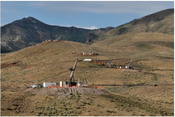
The Gold Standard Ventures Corp. (“Gold Standard” or the “Company” or “GSV”) North Bullion Deposit is located within the Railroad–Pinion Project (the “Project”) at the southeast end of the Carlin (Gold) Trend, a northwest alignment of sedimentary rock-hosted gold deposits in northeastern Nevada (NV). The Carlin Trend, so named for the city of Carlin, NV, comprises more than 40 separate gold deposits that have produced more than 80 million ounces of gold to date (Muntean, 2014). The Project is centered on the fourth and southernmost dome-shaped window on the Carlin Trend in the Piñon Range (Jackson and Koehler, 2014). The domes are cored by igneous intrusions that uplift and expose Paleozoic rocks and certain stratigraphic contacts that are favorable for the formation of Carlin-style gold deposits. The project area covers a significant portion of the southernmost structural window within the Carlin Trend that exposes prospective Upper Paleozoic (Devonian – Pennsylvanian/Permian) units that host gold mineralization often associated with multilithic collapse breccias elsewhere in the district. Exploration in the last year has yielded positive drilling results at North Bullion, Bald Mountain, Dark Star and Pinion. These results have led to the identification of additional mineral resource potential within the Railroad portion of the district, including at the North Bullion deposit, and at the Dark Star and Pinion deposits in the southern “Pinion” portion of the district. This Technical Report provides a Maiden National Instrument (NI) 43-101 Mineral Resource Estimate for the North Bullion, POD and Sweet Hollow deposits in the northern “Railroad” portion of the Project based upon historic and recent drilling completed by Gold Standard.
The Railroad–Pinion Project is located along the Piñon mountain range approximately 15 miles (24 km) south-southeast of Carlin, NV, in the Railroad Mining District. The Project consists of 53,569 gross acres (21,679 gross hectares) of subsurface mineral rights comprising 29,941 gross acres (12,117 gross hectares) that are owned 100 per cent ( %) as patented and unpatented lode mining claims and a further 23,628 gross acres (9,562 hectares) in subsurface mineral rights on private lands. The private land ownership ranges from 49.2 % to 100 % yielding a net position of 20,657 gross acres (8,360 gross hectares) of subsurface mineral rights for the private lands within the Railroad–Pinion Project Area. The Company is pursuing the minority interest in the key private land parcels. The subsurface mineral rights for the private lands are held under contractual arrangement via ‘Surface Use Agreement with Conditional Purchase Option’, ‘Mining Lease and Agreement’, and ‘Mineral Lease Agreement’ contracts. The estimated holding cost for the patented mineral claims, private lands, and leased unpatented claims controlled by Gold Standard is US$951,427 per annum. Gold Standard’s estimated maintenance cost for the current package of unpatented lode claims is an additional US$273,487 per annum. Thus, the total cost for maintaining the current Property on an annual basis is US$1,224,914.
The Railroad Mining District was intermittently active as a copper, lead, silver, zinc, and gold district from 1869 until the early 1960’s. Modern exploration began in the late 1960’s. Since that time fifteen companies have preceded GSV with district-wide exploration; completing fairly extensive surface mapping, geochemical sampling and drilling including the collection of 3,508 rock samples, 6,260 soil samples and the completion of 382 drillholes at the Railroad Project (Hunsaker, 2010, 2012a,b; Shaddrick, 2012; Koehleret al., 2014).
| Effective Date: November 3, 2017 | | | 1 |
Technical Report Maiden Resource Estimate North Bullion Railroad Project, Elko County, Nevada, USA
Gold Standard’s aggressive and on-going geologic model-driven exploration programs at the Railroad–Pinion Project since 2010 have confirmed and expanded previously identified zones of mineralization and have resulted in the discovery of several new zones and styles of mineralization. Currently, the Railroad–Pinion Project includes a variety of mineralization types: 1) Carlin-style disseminated gold in carbonate dissolution collapse breccia at the contact between Devonian carbonates and Mississippian siliciclastics at the Pinion and North Bullion deposits; 2) Carlin-style disseminated gold in silicified Pennsylvanian-Permian siliciclastic and carbonate rocks at the Dark Star Deposit; 3) stacked, tabular oxide gold and copper zones in quartz hornfels breccia at the Bald Mountain Target; 4) skarn-hosted silver, copper, lead and zinc mineralization at the Central Bullion Target; and 5) Carlin-style disseminated gold within the Paleozoic siliciclastic and carbonate section in the footwall of the Bullion Fault zone (Jackson and Koehler, 2014; Koehleret al., 2014; Turneret al., 2015; Dufresneet al., 2015, Dufresneet al., 2017).
This report details a maiden NI 43-101 Mineral Resource Estimate for the North Bullion, POD and Sweet Hollow deposits within the Railroad Project area. In addition, it is an update to the most recent Railroad–Pinion Technical Report by Dufresneet al. (2017) and summarizes work completed by GSV on the Railroad–Pinion Project and its surrounding area. In the opinion of the authors of this Technical Report, exploration techniques, sampling and analytical procedures employed by Gold Standard at the Railroad–Pinion Project are consistent with industry standards and are appropriate, with respect to the type of mineral deposit(s) being explored and with respect to ensuring overall data quality and integrity. In addition, it is the opinion of the authors of this Technical Report that the Railroad–Pinion Project remains a ‘property of merit’ and warrants continued exploration and development work as detailed below.
| 1.1 | Exploration Work by Gold Standard Ventures |
Gold Standard has been exploring the Railroad–Pinion Project area since 2010, discovering new exploration targets and advancing known prospects and deposits by executing systematic, geological model-driven and aggressive exploration. Exploration work from 2010 to 2017 has consisted of geological mapping, geochemical and geophysical surveys, and drilling. Gold Standard has collected over 10,000 geochemical samples and completed geophysical surveys that cumulatively cover much of the Property. Prior to 2015, exploration activities by Gold Standard were focused on the Railroad Project. Work completed in 2015 was largely focused on the Pinion Project after it was acquired by Gold Standard in 2014. Work completed in 2016 focused primarily on the Dark Star deposit area, which included exploration at the Dark Star Main Zone, the Dark Star North Zone and along the Dark Star Corridor.
Gold Standard has conducted drilling on the Railroad–Pinion Project since 2010 to test the extent of known mineralization, support ongoing geological modelling and resolve current geological models. From 2010 to 2017, a total of 316 drillholes totalling 125,438.3 m (411,545.3 ft) were completed on the Railroad–Pinion Project. Drilling conducted by GSV in the Railroad Project area during 2010 and 2011 resulted in the discovery of the North Bullion gold deposit. Drilling conducted in the Railroad Project area during 2012 and 2013 confirmed and expanded a significant Carlin-style, disseminated gold system at the North Bullion Deposit, and identified new mineralized zones at the Bald Mountain and Sylvania (Central Bullion) targets (Koehleret al., 2014; Turneret al., 2015). Drilling conducted by Gold Standard in 2014 in the Railroad portion of the Project focused on the Bald Mountain prospect and intersected significant thicknesses of altered and brecciated lithologies hosting gold-silver-copper (Au-Ag-Cu) mineralization. Drilling at North Bullion during 2015 focused on expanding a zone of higher grade gold mineralization within the “lower collapse breccia”. In 2016, the drilling program at the Railroad portion of the Project area was designed to extend known mineralization and to test new targets at the Bald Mountain, North Bullion and Cherry Springs areas. The drilling at North Bullion extended the zone of known mineralization to the north and northwest (Dufresneet al., 2017). In early 2017, Gold Standard completed a total of 5 RC/core combination drillholes for the Railroad Project at North Bullion that totaled 2,442.4 m (8,013 ft). The North Bullion mineralized zone remains open in a number of directions and warrants further drilling. Continued drilling on the Bald Mountain and Sylvania (Central Bullion) targets is also recommended based upon early-stage drill results. Early-stage results from several other target areas at the Railroad portion of the Project area indicate that additional geological work and drilling is also warranted.
| Effective Date: November 3, 2017 | | | 2 |
Technical Report Maiden Resource Estimate North Bullion Railroad Project, Elko County, Nevada, USA
In early 2014, Gold Standard significantly increased its land position with the acquisition of the Pinion Project area, which is contiguous to the south with the Company’s original Railroad Project area (Koehleret al., 2014; Turneret al., 2015). The Pinion transaction comprised the acquisition of increased mineral rights on lands where the Company previously held a minority interest and acquisition of mineral rights on additional lands where the Company previously held no interest. The Pinion acquisition was part of an on-going effort to consolidate the mineral rights for the greater Railroad District. In April 2014, GSV announced a further consolidation of mineral rights at Bald Mountain within the Railroad Project area (see GSV Press Release dated April 1, 2014) and later announced the acquisition of lands and additional mineral rights within, and south of, the Pinion Project area covering the Dark Star and Dixie Creek gold prospects (see GSV Press Release dated December 11, 2014).
The acquisitions and mineral rights consolidation completed by the Company in 2014 represented an important step in the advancement of the overall Railroad–Pinion Project with the addition of three important gold prospects at Pinion, Dark Star and Dixie Creek. Work by Gold Standard at the Pinion Project area in 2014 comprised the compilation and review of historic data from the Pinion and Dark Star prospects and included a significant re-logging effort of archived Pinion core along with Pinion and Dark Star reverse circulation (RC) drillhole chip samples (Turneret al., 2015). An initial phase of drilling at the Pinion Deposit comprising 13 holes confirmed historic drilling assay results and the geological model for the deposit, which were utilized for a maiden NI 43-101 mineral resource estimate that was completed in September 2014 (Dufresneet al., 2014; Turneret al., 2015). In late 2014, a second phase of drilling comprising 44 RC holes was completed within the Pinion Deposit area and was successful in expanding the extent of gold mineralization. Drilling at the Railroad–Pinion Project in 2015 comprised 41 drillholes. The majority of the drillholes (24) were completed within the Pinion Deposit area and were primarily intended to step-out and extend the zone of mineralization recently established by the NI 43-101 maiden mineral resource (Dufresneet al., 2014; Turneret al., 2015). The 2015 Pinion Deposit area drill program achieved a number of significant drill intercepts that extended the previously defined zone of mineralization to the north and to the south. The results of the 2015 drilling at the Pinion Deposit led to a revised geological model and resource estimation in 2016 (Dufresne and Nicholls, 2016). The 2016 updated and current Mineral Resource Estimate for the Pinion Deposit comprises an Indicated Mineral Resource of 31.61 million tonnes (34.84 million tons) grading 0.62 grams per tonne (g/t) or 0.018 ounces per short ton (oz/st) Au, totalling 630,300 ounces of gold, and an Inferred Mineral Resource of 61.08 million tonnes (67.33 million tons) grading 0.55 g/t (0.016 oz/st) Au, totalling 1,081,300 ounces of gold, using a lower cutoff grade of 0.14 g/t (0.004 oz/st) Au. In addition, The current resource comprises an Inferred Mineral Resource of 92.69 million tonnes (102.17 million tons) grading 4.16 g/t (0.121 oz/st) Ag, using a lower cutoff that is based upon the gold block cutoff of 0.14 g/t (0.004 oz/st) Au (Dufresne and Nicholls, 2017). Twenty-five (25) drillholes were completed in 2016 at the Pinion Deposit. The drilling was designed to extend known zones of mineralization, provide “in-fill” data for specific zones, provide material for metallurgical testing, and to test the Irene target west of the Pinion Deposit and the Sentinel target to the north of the Pinion Deposit. The drill program resulted in the identification of the Sentinel target; a shallow oxidized mineralized stratigraphic zone open to the north and west. In addition, the Pinion mineralization was extended along the west and the southwest edge of the Pinion Deposit (Dufresneet al., 2017).
| Effective Date: November 3, 2017 | | | 3 |
Technical Report Maiden Resource Estimate North Bullion Railroad Project, Elko County, Nevada, USA
Thirteen drillholes were completed at the Dark Star Deposit area located in the southern (Pinion) portion of the project during 2015 and identified significant gold mineralization. The drilling intersected a vertically extensive oxide gold zone hosted in variably silicified and quartz veined bioclastic debris flows and conglomerates within Pennsylvanian-Permian units that lie stratigraphically higher than the Devils Gate – Tripon Pass host to the Main Pinion Zone of gold mineralization. The final 2015 drillhole at Dark Star was a core hole (DS15-13), which twinned an RC hole (DS15-11) that had identified multiple significant intersections of gold mineralization approximately 500 m north of the Dark Star Main Zone. The primary focus of the 2016 Railroad–Pinion drill program was drilling at the Dark Star area with 40 drillholes completed at the Main and North Zones and along the Dark Star Corridor. Drilling at the Dark Star area extended the mineralization of the Main Zone to the west and northwest and extended the zone of known mineralization into the new North Zone, joining the two targets (Dufresneet al., 2017). The results from the 2016 drilling at Dark Star led to a revised geological model and an updated NI 43-101 Mineral Resource Estimate by Dufresne and Nicholls (2017). The 2017 updated and current Mineral Resource Estimate for the Dark Star Deposit comprises an Indicated Mineral Resource of 15.38 million tonnes (16.95 million tons) grading 0.54 g/t (0.016 oz/st) Au, totalling 265,100 ounces of gold, and an Inferred Mineral Resource of 17.05 million tonnes (18.79 million tons) grading 1.31 g/t (0.038 oz/st) Au, totaling 715,800 ounces of gold, using a lower cutoff grade of 0.20 g/t (0.006 oz/st) Au (Dufresne and Nicholls, 2017).
In early 2017, Gold Standard significantly increased its land position with the acquisition of additional contiguous land to the south of the Dark Star and Pinion deposit areas (see GSV Press Release dated March 23, 2017). The land acquisition by Gold Standard is part of an on-going effort to consolidate the mineral rights for the greater Railroad District and to allow continued exploration of the southern strike extensions of the Dark Star Corridor.
| 1.2 | Maiden Mineral Resource Estimate |
Based upon historic drilling and Gold Standard drilling from 2010 to 2017, a maiden Mineral Resource Estimate is presented for the North Bullion, Sweet Hollow and POD gold deposits in the Railroad portion of the Project area. The Mineral Resource Estimate is reported in accordance with the Canadian Securities Administrators (CSA) NI 43-101 regulations and has been estimated using the Canadian Institute of Mining and Metallugy’s (CIM) “Estimation of Mineral Resources and Mineral Reserves Best Practice Guidelines” dated November 23rd, 2003 and CIM “Definition Standards for Mineral Resources and Mineral Reserves” dated May 10th, 2014.
| Effective Date: November 3, 2017 | | | 4 |
Technical Report Maiden Resource Estimate North Bullion Railroad Project, Elko County, Nevada, USA
The Railroad Project resources have been estimated within three dimensional solids that were created from cross-sectional lode interpretation based upon a database of 503 drillholes that were used to guide the geological and mineralization interpretation. The upper contact has been cut by the topographic surface. Grade estimation was based upon 6,941 samples from 232 holes that are within the mineralized lodes. Grade was estimated into a block model with parent block size of 10 m (X) by 10 m (Y) by 3 m (Z) and sub-blocked down to 5 m (X) by 5 m (Y) by 1.5 m (Z). A total of 272 bulk density samples situated within the mineralized wireframes were examined on a lode by lode basis. The average density for the lodes ranges from 2.33 grams per centimeter cubed (g/cm3) to 2.71 g/cm3 with an overall average bulk density of 2.68 g/cm3 for the Railroad Project Mineral Resources. Grade estimation of gold was performed using the Inverse Distance to the power of two (ID2) methodology. The Indicated and Inferred Mineral Resources are constrained within a drilled area that extends approximately 2.75 km along strike to the north, 0.95 km across strike to the east and up to 600 m below surface.
The North Bullion, Sweet Hollow and POD Mineral Resource Estimate is reported at a range of gold cutoff grades in Table 1.1 for both Indicated and Inferred categories. No portion of the current mineral resource has been assigned to the “Measured” category. The Sweet Hollow and POD oxide Indicated and Inferred Mineral Resource uses a cutoff grade of 0.14 g/t Au, which is constrained within an optimized pit shell and includes an Indicated Mineral Resource of 2.92 million tonnes at 0.96 g/t Au for 90,100 ounces of gold and an Inferred Mineral Resource of 3.36 million tonnes at 0.43 g/t Au for 46,600 ounces of gold. The North Bullion, Sweet Hollow and POD sulphide Inferred Mineral Resource uses a cutoff grade of 1.25 g/t Au, which is constrained within an optimized pit shell, and is comprised of 2.05 million tonnes at 2.60 g/t Au for 171,400 ounces of gold. The North Bullion underground Inferred Mineral Resource, which is reported at a 2.25 g/t Au lower cutoff grade, comprises 5.55 million tonnes at 3.29 g/t Au for 587,000 ounces of gold. Other cutoff grades are presented for review ranging from 0 g/t Au to 0.5 g/t Au for oxide pit constrained material, ranging from 1.0 g/t Au to 2.0 g/t Au for sulphide pit constrained material and 2.0 g/t Au to 3.0 g/t Au for sulphide underground constrained material (Tables 1.2 and 1.3). The pit constrained and underground constrained block modeled resources utilize a price of $US1,350/ounce for gold along with a number of generalized costs for Nevada Carlin-type mining operations to establish the recommended lower cutoff grades.
The 2017 North Bullion, Sweet Hollow and POD Mineral Resources for gold have been classified as comprising both Indicated and Inferred Mineral Resources according to recent CIM definition standards (Table 1.1). The classification of the Railroad Project resources was based on geological confidence, data quality, data density and grade continuity. No portion of the current mineral resource has been assigned to the “Measured” category. All reported mineral resources are constrained within a pit shell optimized using values of $US1,350/ounce for gold and either a 0.14 g/t lower cutoff for oxide material, 1.25 g/t lower cutoff for sulphide material or a 2.25 g/t lower cutoff for underground sulphide material. Indicated and inferred mineral resources are not mineral reserves and do not have demonstrated economic viability. There has been insufficient exploration to define the inferred resources as an indicated or measured mineral resource, however, it is reasonably expected that the majority of the inferred mineral resources could be upgraded to indicated mineral resources with continued exploration.
| Effective Date: November 3, 2017 | | | 5 |
Technical Report Maiden Resource Estimate North Bullion Railroad Project, Elko County, Nevada, USA
Table 1.1. The North Bullion, Sweet Hollow and POD mineral resource estimate with cutoff grades*.
| Classification | Type | Au Cutoff Grade (gpt) | Tonnage (million metric tonnes) | Average Au Grade (gpt) | Contained Au** (troy ounces)*** |
Pit Constrained |
| Indicated | Oxide | 0.14 | 2.92 | 0.96 | 90,100 |
| Inferred | Oxide | 0.14 | 3.36 | 0.43 | 46,600 |
| Sulphide | 1.25 | 2.05 | 2.60 | 171,400 |
| Inferred Subtotal | 0.14, 1.25 | 5.42 | 1.25 | 218,000 |
| Underground |
| Inferred | Sulphide | 2.25 | 5.55 | 3.29 | 587,700 |
Pit Constrained and Underground Inferred Total |
| Oxide/Sulphide | 0.14, 1.25, 2.25 | 10.97 | 2.28 | 805,800 |
* Mineral Resources are not Mineral Reserves. Mineral resources which are not mineral reserves do not have demonstrated economic viability. There has been insufficient exploration to define the Inferred Mineral Resources tabulated above as an Indicated or Measured Mineral Resource, however, it is reasonably expected that the majority of the Inferred Mineral Resources could be upgraded to Indicated Mineral Resources with continued exploration. There is no guarantee that any part of the mineral resources discussed herein will be converted into a mineral reserve in the future.
**The recommended reported resources are highlighted in bold and have been constrained within a $US1,350/ounce of gold optimized pit shell and/or an underground mining scenario utilizing a 2.25 g/t Au lower cutoff.
***Contained troy ounces may not add due to rounding.
Table 1.2. Sensitivity analysis of the Sweet Hollow and POD oxide mineral resource estimate for gold at various cutoff grades*.
| Classification* | Au Cutoff Grade (gpt) | Tonnage (million metric tonnes) | Average Au Grade (gpt) | Contained Au** (troy ounces)*** |
Indicated (Oxide) | 0.0 | 3.04 | 0.93 | 90,600 |
| 0.14** | 2.92 | 0.96 | 90,100 |
| 0.2 | 2.51 | 1.09 | 87,800 |
| 0.3 | 1.64 | 1.53 | 80,800 |
| 0.4 | 1.41 | 1.73 | 78,400 |
| 0.5 | 1.40 | 1.74 | 78,200 |
Inferred (Oxide) | 0.0 | 3.63 | 0.41 | 47,500 |
| 0.14** | 3.36 | 0.43 | 46,600 |
| 0.2 | 2.71 | 0.49 | 43,000 |
| 0.3 | 1.47 | 0.70 | 33,200 |
| 0.4 | 1.14 | 0.81 | 29,700 |
| 0.5 | 1.09 | 0.82 | 28,800 |
* Mineral Resources are not Mineral Reserves. Mineral resources which are not mineral reserves do not have demonstrated economic viability. There has been insufficient exploration to define the Inferred Mineral Resources tabulated above as an Indicated or Measured Mineral Resource, however, it is reasonably expected that the majority of the Inferred Mineral Resources could be upgraded to Indicated Mineral Resources with continued exploration. There is no guarantee that any part of the mineral resources discussed herein will be converted into a mineral reserve in the future.
**The recommended reported resources are highlighted in bold and have been constrained within a $US1,350/ounce of gold optimized pit shell.
***Contained troy ounces may not add due to rounding.
| Effective Date: November 3, 2017 | | | 6 |
Technical Report Maiden Resource Estimate North Bullion Railroad Project, Elko County, Nevada, USA
Table 1.3. Sensitivity analysis of the North Bullion, Sweet Hollow and POD sulphide mineral resource estimate for gold at various cutoff grades*.
| Classification | Au Cutoff Grade (gpt) | Tonnage (million metric tonnes) | Average Au Grade (gpt) | Contained Au (troy ounces)**** |
Inferred (Near Surface Sulphide) | 1.0 | 2.20 | 2.50 | 176,700 |
| 1.25** | 2.05 | 2.60 | 171,400 |
| 1.5 | 1.85 | 2.73 | 162,200 |
| 1.75 | 1.66 | 2.86 | 152,400 |
| 2.0 | 1.35 | 3.09 | 133,800 |
Inferred (Underground Sulphide) | 2.0 | 6.87 | 3.07 | 678,000 |
| 2.25*** | 5.55 | 3.29 | 587,700 |
| 2.5 | 4.31 | 3.55 | 492,800 |
| 2.75 | 3.15 | 3.90 | 394,900 |
| 3.0 | 2.52 | 4.16 | 336,300 |
* Mineral Resources are not Mineral Reserves. Mineral resources which are not mineral reserves do not have demonstrated economic viability. There has been insufficient exploration to define the Inferred Mineral Resources tabulated above as an Indicated or Measured Mineral Resource, however, it is reasonably expected that the majority of the Inferred Mineral Resources could be upgraded to Indicated Mineral Resources with continued exploration. There is no guarantee that any part of the mineral resources discussed herein will be converted into a mineral reserve in the future.
** The recommended reported resources are highlighted in bold and have been constrained within a $US1,350/ounce of gold optimized pit shell.
*** The recommended reported resources are highlighted in bold and have been constrained within a $US1,350/ounce of gold underground mining scenario.
**** Contained troy ounces may not add due to rounding.
| 1.3 | Other Railroad–Pinion Project Prospects |
Based upon a review of available historic information and recent data from the on-going exploration work by GSV at other prospect areas throughout the Railroad–Pinion Project area, the authors conclude:
| · | Sixteen target areas have been identified by Gold Standard for additional exploration at the Railroad portion of the Project area (Koehleret al., 2014). The targets are focused on gold, but also include silver, copper, lead and zinc. Nine of these targets have been drilled by Gold Standard. Although Gold Standard has drilled and conducted extensive work in these areas, and historic work has been completed in others, sampling and drilling of sufficient density to determine the distribution and continuity of gold mineralization at most of the other targets at the Railroad Project is not yet sufficient to establish a mineral resource or reserve, with the exception of North Bullion, Sweet Hollow and POD. |
| · | Gold Standard has continued to confirm the presence of an important sedimentary rock-hosted gold system at the North Bullion Target. Drilling to date has intersected Carlin-style gold mineralization with high grades in a number of intercepts and continues to indicate that the North Bullion discovery is a significant sulphide refractory gold deposit that remains open in multiple directions. Continued step-out and offset drilling is warranted for the lower collapse breccia zone. Further work, including additional drilling to expand the current mineral resource and to provide material for metallurgical work to characterize the North Bullion Deposit is warranted. |
| Effective Date: November 3, 2017 | | | 7 |
Technical Report Maiden Resource Estimate North Bullion Railroad Project, Elko County, Nevada, USA
| · | Gold Standard has confirmed the discovery of a new sedimentary rock-hosted gold and copper system hosted in oxidized, brecciated and hornfelsed rocks at the Bald Mountain Target. Drill results from 2013 to 2016 indicate this is a significant polymetallic discovery that remains open in all directions. Continued drilling is warranted. |
| · | Gold Standard has confirmed the discovery of a new silver, copper, lead and zinc skarn system at the Sylvania (Central Bullion) Target. Prior drill results indicate this is a significant polymetallic discovery that remains open in all directions. Continued drilling is warranted. |
| · | Initial drill results along the Bullion Fault Corridor Target confirmed that a Carlin-style hydrothermal system associated with igneous dikes is present to the south of the North Bullion Target. The North Bullion Deposit and the Pinion Deposit occur in the immediate footwall of the Bullion Fault. However, much of the +5 mile-long strike of the Bullion Fault Corridor remains untested by drilling. Additional drilling is warranted. |
| · | Drill tested areas adjacent to and below the pit constrained and/or underground constrained North Bullion, Sweet Hollow and POD Mineral Resources, have good potential to expand the current mineral resource or provide additional mineral resources with added drilling. A near surface oxide target outside of the Sweet Hollow to POD mineral resource provides the potential of 3 million to 6 million tonnes at a grade of 0.3 to 0.5 g/t Au (yielding a target of 30,000 up to 100,000 ounces of gold). In addition, prior drilling of several areas of sulphide mineralization outside of the North Bullion, Sweet Hollow and POD resources provide an exploration target of 8 to 27 million tonnes with a grade of 1.1 to 1.7 g/t Au (300,000 up to 1,475,000 ounces of gold). The potential quantity and size are conceptual in nature. There has been insufficient exploration to define a mineral resource. It is uncertain if further exploration will result in the target being delineated as a mineral resource, however, further drilling is warranted. |
| · | Further exploration, including fieldwork and drilling, is warranted at other targets in the Pinion portion of the Project area including the Dark Star and Dixie Creek area, as well as at the Ski Track Graben trend which includes the Papoose Canyon, Papoose Canyon North, Jasperoid Wash, Black Rock, and JR Buttes targets. |
| · | Additional drilling is warranted along strike to the north and south of the Dark Star Deposit along the recently identified Dark Star Corridor. |
Based upon the results to date, the authors recommend an aggressive exploration program for the Railroad–Pinion Project area involving surface exploration, additional exploration drilling, resource expansion and infill drilling, along with continued metallurgical test work. The combined Railroad–Pinion Project has been the subject of a number of recent Technical Reports in which detailed recommendations were outlined for both the Railroad and Pinion portions of the Project area. Recent work completed at the Railroad–Pinion Project by GSV has been focused on the Pinion and Dark Star deposits and thus the recommendations made in Koehleret al. (2014), Turneret al. (2015) and Dufresne and Koehler (2016) pertaining to the Railroad target areas remain valid. This report details maiden NI 43-101 Mineral Resource Estimates for the North Bullion, Sweet Hollow and POD gold deposits and summarizes previous work at the Railroad–Pinion Project. Further aggressive exploration, including drilling, is warranted at North Bullion, Sweet Hollow and POD aimed at expanding and improving the confidence in the existing mineral resource. The North Bullion, Sweet Hollow and POD deposits require metallurgical characterization of the gold zones with initial gold cyanide shake, bottle roll and column testing of oxide and mixed oxide-sulphide material, along with floatation and roaster testing of sulphide dominated material.
| Effective Date: November 3, 2017 | | | 8 |
Technical Report Maiden Resource Estimate North Bullion Railroad Project, Elko County, Nevada, USA
With respect to the Railroad Project area, additional in-fill and step-out drilling is warranted at the North Bullion, Sweet Hollow, POD, Bald Mountain and Sylvania (Central Bullion) target areas. Further reconnaissance drilling is recommended for several other target areas including the Cherry Springs, Bullion Fault Corridor, Railroad, North Ridge and Lee Canyon areas. Continued fieldwork comprising geological mapping, geochemical surveying and geophysical surveying is also warranted throughout the property to identify and refine additional drill targets. The results of gravity and CSAMT surveys completed to date at the Railroad Project are encouraging and the continued use of these techniques is strongly recommended. Additional geophysical surveying, including seismic lines, is recommended in the North Bullion area where thick volcanic rock sequences or colluvium conceal target opportunities. Continued geological modelling and resource estimation is recommended for the North Bullion mineralized zones along with additional metallurgical investigations and, possibly, preliminary engineering studies. The results of the modelling exercise may assist target definition for the proposed in-fill and step-out drilling that is warranted at North Bullion.
An aggressive exploration program is warranted for the Pinion Project area involving surface exploration, additional exploration drilling, resource expansion and infill drilling, along with continued metallurgical test work. The focus should be on the Dark Star Corridor and to a degree on the ground between the Dark Star and Pinion deposit areas. The authors recommend additional soil sampling to expand upon and fill in gaps to the existing database and to cover potential strike extensions of the mineralization to the south, and southeast at Pinion along with better geochemical coverage of the newly acquired ground to the south of Pinion and Dark Star. Additional geophysical surveying including gravity, CSAMT and seismic surveys for the deposit areas and project area is strongly recommended to provide data to assist the targeting of infill, step-out and exploration drilling. Continued geological mapping and rock sampling is recommended across the entire Project area in order to continue to improve the geological knowledge base. Exploration and some infill confirmation drilling are required at Dark Star. A Preliminary Economic Assessment (PEA) that includes both Pinion and Dark Star is warranted and is in progress. In addition, the acquisition of new ground to the south of Dark Star and Pinion and the 2014 - 2016 fieldwork and prior exploration have identified a number of exploration targets outside of the Pinion and Dark Star deposit areas that warrant future exploration drill testing. Further field work comprising geological, geochemical and geophysical surveys is recommended for the remainder of the Pinion Project area with particular attention paid to the Ski Track trend (the JR Butte-Papoose trend) located west of the Pinion Deposit, the Dark Star Corridor and much of the new lands south of Pinion and Dark Star areas centered around Jasperoid Wash.
| Effective Date: November 3, 2017 | | | 9 |
Technical Report Maiden Resource Estimate North Bullion Railroad Project, Elko County, Nevada, USA
The authors recommend a total of 11,280 m (37,000 ft) of RC and core drilling for the Railroad Project area for a total cost of US$2,800,000 for 2017-2018. In addition, a total of 37,520 m (123,100 ft) is recommended for the Pinion Project area in 2017-2018 at an additional estimated cost of US$8,287,000. In addition to the drilling, other recommended exploration activities at the Railroad–Pinion Project include geological mapping, geochemical sampling, and ground geophysical surveys (controlled source audio-frequency magnetotellurics (“CSAMT”), gravity and seismic) as well as a number of metallurgical, engineering and environmental studies. The estimated cost to conduct the proposed property wide exploration activities over the entire Railroad–Pinion Project area is US$5,220,000. The recommended drilling at the Railroad and Pinion Project area along with other geological, geophysical, engineering and environmental studies and a contingency of ~7 % yields an overall budget to complete the recommended work of US$17,450,000.
It is the opinion of the authors of this Technical Report that all of the recommended work is warranted at this time and none is contingent upon the results of any other part of the program.
| Effective Date: November 3, 2017 | | | 10 |
Technical Report Maiden Resource Estimate North Bullion Railroad Project, Elko County, Nevada, USA
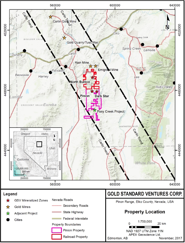
Gold Standard Ventures Corp. (Gold Standard, “GSV” or the “Company”) is a Vancouver-based mineral exploration Company, listed on the Toronto Stock Exchange (TSX: GSV) and on the New York Stock Exchange (NYSE American: GSV). The Company controls a significant and largely contiguous land position of approximately 53,569 gross acres (21,679 gross hectares) in Elko County, Nevada (“NV”) referred to as the Railroad and Pinion Projects displayed on Figure 2.1 (“Railroad–Pinion”, “Railroad”, “Pinion” or the “Project”). The Railroad Project comprises the North Bullion, Sweet Hollow and POD gold deposits and 13 other target areas.
The Railroad–Pinion Project is being explored on an ongoing basis by GSV through systematic geological model-driven and aggressive exploration programs, which include geological mapping, geochemical and geophysical surveying and drilling. This technical report summarizes a maiden NI 43-101 compliant mineral resource estimation for the North Bullion gold deposit, and has been prepared by APEX Geoscience Ltd. (‘APEX’) of Edmonton, Alberta, Canada. This report is intended as an update to previous comprehensive Technical Reports completed on the Railroad–Pinion Project including reports by Hunsaker (2010 and 2012a,b), Shaddrick (2012), Koehleret al. (2014), Dufresneet al. (2014) and, the most recently completed reports by Turneret al. (2015), Dufresneet al. (2015), Dufresne and Nicholls (2016), Dufresne and Koehler (2016) and Dufresneet al. (2017), which are available for download on SEDAR (www.sedar.com).
The Railroad–Pinion Project is considered to be an intermediate to advanced stage exploration project with a favourable structural, geological and stratigraphic setting situated at the southeast end of the Carlin Trend. The Carlin Trend contains more than 40 gold deposits, which have produced in excess of 80 million ounces of gold to date (Muntean, 2014). Since the date of the last Technical Report written for the Project (Dufresneet al. 2017), a maiden NI 43-101 compliant mineral resource estimation for the North Bullion gold deposit was completed (see GSV Press Released Dated September 21, 2017). The maiden resource at the North Bullion Deposit and exploration results throughout the Project area continue to demonstrate significant mineral potential and work designed to expand the current mineral resources and identify new zones of mineralization is ongoing.
This Technical Report is an update of the most recent Technical Report prepared for the Railroad–Pinion Project (Dufresneet al., 2017). It details the maiden NI 43-101 compliant Mineral Resource Estimate for the North Bullion, Sweet Hollow and POD deposits and summarizes recent exploration activities within the Railroad Project area. Gold Standard has been actively exploring the Railroad portion of the Property, primarily for precious metals, since its acquisition in 2010. Gold Standard has been actively exploring the Pinion portion of the Property, including the Dark Star area, for precious metals since its acquisition in 2014 (Turneret al., 2015).
The exploration data utilized and discussed in this report was obtained from GSV in paper and digital format. This included all previous technical reports, exploration data and all modern and historical surface exploration and drilling data. These and other sources of information are reviewed in section 6 and listed in the reference section 19.
| Effective Date: November 3, 2017 | | | 11 |
Technical Report Maiden Resource Estimate North Bullion Railroad Project, Elko County, Nevada, USA
The lead author of this report, Mr. Michael Dufresne, M.Sc., P.Geol., P.Geo. is an independent geologist and principal with APEX Geoscience Ltd. (APEX) and is a Qualified Person. APEX was initially retained in early 2013 by Scorpio Gold Corporation (Scorpio), the previous owners of a portion of the Pinion Project area, and was subsequently retained by GSV following its acquisition of Scorpio’s interest in the Pinion Project. Mr. Dufresne co-authored the most recent complete project Technical Report on the Property with Mr. S. Koehler and Mr. M. Jackson of GSV (Dufresneet al.,2017). Mr. Dufresne first visited the Railroad Project in April and October of 2014 and was the lead author of a Technical Report documenting a maiden Mineral Resource Estimate for the Pinion gold deposit in the fall of 2014 (Dufresneet al., 2014) and the subsequent Mineral Resource Update (Dufresne and Nicholls, 2016). In addition, Mr. Dufresne was the lead author of a Technical Report documenting a maiden Mineral Resource Estimate for the Dark Star gold deposit in 2015 (Dufresneet al., 2015) and the subsequent Mineral Resource Update (Dufresne and Nicholls, 2017). Mr. Dufresne conducted several recent additional site visits from May 31 to June 4, 2015; August 30 to September 2, 2015; and most recently June 7 to 9, 2017. Mr. Dufresne has reviewed historical data and reports and has made contributions to, supervised the preparation of, and is responsible for all aspects and sections of this report.
The Technical Report is a compilation of proprietary and publicly available information. The authors, in writing this Report, used sources of information from previous explorers, which appear to have been completed in a manner consistent with normal exploration practices. Hence, they have no reason not to rely on such historic data and information as listed in the ‘References’ section, based upon the exploration conducted by Gold Standard to date and the property visits by the authors. A large portion of the background information for prior exploration and geology comes from work performed on and in the vicinity of the property by a number of companies and detailed by Hunsaker (2010, 2012a,b), Shaddrick (2012), Koehleret al. (2014),Turneret al. (2015), Dufresne and Koehler (2016), and Dufresneet al. (2017). The supporting documents, which were used as background information are referenced in the ‘History’, ‘Geological Setting and Mineralization’, ‘Deposit Types’, ‘Adjacent Properties’ and ‘References’ sections. The authors, based upon their property visits and work performed on the property to date, believe that work performed by others described in prior reports and listed in the References section are substantially accurate and complete.
Units of measure and imperial to metric conversions used throughout this report are provided in Appendix 1. Assay and analytical results for precious metals are quoted in parts per million (“ppm”), parts per billion (“ppb”), ounces per short ton (“opt” or oz/st), where “ounces” refers to “troy ounces” and “ton” means “short ton”, which is equivalent to 2,000 lbs. Where ppm (also commonly referred to as grams per metric tonne [g/t or gpt]) have been converted to opt (or oz/st), a conversion factor of 0.029166 (or 34.2857) was used. Assay and analytical results for base metals are reported in percent (“%”). Temperature readings are reported in degrees Fahrenheit (°F). Lengths are quoted in feet (“ft”), kilometers (“km”), meters (“m”) or millimeters (“mm”). All currency descriptions in this document are reported in United States dollars (USD).
| Effective Date: November 3, 2017 | | | 12 |
Technical Report Maiden Resource Estimate North Bullion Railroad Project, Elko County, Nevada, USA
Figure 2.1. Project location map.
| Effective Date: November 3, 2017 | | | 13 |
Technical Report Maiden Resource Estimate North Bullion Railroad Project, Elko County, Nevada, USA
| 3 | Reliance on Other Experts |
This Technical Report incorporates and relies on contributions with respect to the details of the surface and subsurface mineral ownership as well as permitting and environmental status from other experts including staff or subcontractors in the employ of Gold Standard. Details of the surface ownership and subsurface mineral ownership have been summarized by Mr. Greg Ekins, who is an independent registered professional landman (RPL#32306) and president of GIS Land Services in Reno, Nevada. Mr. Ekins assisted with the preparation of the summary land description in Appendix 2 and property maps for this report. Mr. Ekins and Gold Standard have relied upon ongoing and recent title opinions prepared by Mr. Jeff Faillers of the law firm Harris, Thompson & Faillers in Reno, Nevada and Ms. Tracy Guinand an independent registered professional landman of Tracy Guinand Land, LLC, of Reno, Nevada. The opinions provided on surface ownership and subsurface mineral ownership along with royalty information are current as of the effective date of this report.
Gold Standard’s Manager of Lands and Environmental Affairs (Ms. Teresa Conner), has assisted with and has provided much of the background information for section 4.3 “Environmental Liabilities and Permits”.
| 4 | Property Description and Location |
| 4.1 | Description and Location |
The Railroad–Pinion Project straddles the Piñon mountain range in the Railroad Mining District at the southeast end of the Carlin Trend, which is a northwest-southeast trending belt of prolific gold endowment in northern Nevada (Figure 2.1). At present, the Railroad–Pinion Project consists of a land position totaling 53,569 gross acres (21,679 hectares) and, with partial interests taken into consideration, 50,598 net acres (20,477 net hectares) of land in Elko County, Nevada. Specifically, within Elko County, the Project is located within; section 13 in Township (T) 28N, Range (R) 52E; sections 10-11, 14, 16-18, and 23-24 in T28N, R53E; sections 1 to 21, 23-25, 29-31, 33, and 35-36 in T29N, R53E; sections 7, 18-19, and 30 in T29N, R54E; section 12 in T30N, R52E; sections 1 to 10, 13 to 29-33 and 36 in T30N, R53E; sections 24 and 36 in T31N, R52E; and sections 8, 10, 14 to 22 and 26 to 35 in T31N, R53E, as shown in Figure 4.1.
Gold Standard owns, or otherwise controls, fully (100 %) the subsurface mineral rights on a total of 29,941 gross acres (12,117 hectares) of land held as patented and unpatented mineral lodes (claims) within the Railroad–Pinion Project Area (as shown in Figure 4.1 and detailed in Appendix 2). Also included in the project area is a total of 23,628 gross acres (9,562 gross hectares) of private lands on which Gold Standard’s ownership of the subsurface mineral rights varies from 49.2 % to 100 %, which yields a net position of approximately 20,657 gross acres (8,360 gross hectares). The mineral rights for these private lands are secured through a variety of contractual agreements, including ‘Surface Use Agreement with Conditional Purchase Option’, ‘Mining Lease and Agreement’, and ‘Mineral Lease Agreement’ contracts (Figure 4.1). The details of these contracts are beyond the scope of this report, however, further information on these contracts is provided in the most recent GSV Annual Information Form (Gold Standard Ventures Corp., 2017b) and can be provided by the Company. The Company is pursuing the minority interest for a number of parcels where they hold less than a 100 % interest.
| Effective Date: November 3, 2017 | | | 14 |
Technical Report Maiden Resource Estimate North Bullion Railroad Project, Elko County, Nevada, USA
Figure 4.1. Property map for the Railroad– Pinion Project.

| Effective Date: November 3, 2017 | | | 15 |
Technical Report Maiden Resource Estimate North Bullion Railroad Project, Elko County, Nevada, USA
Patented claims, private surface and private mineral property are wholly owned and subject to lease agreement payments and property taxes (paid on an annual basis) as determined by the County. The estimated holding cost for the patented claims, private lands, and leased unpatented claims controlled by Gold Standard is US$951,427 per annum. Unpatented lode mining claims grant the mineral rights and access to the surface for exploration activities which cause insignificant surface disturbance. The mineral right is maintained by paying a maintenance fee of $155 per claim to the Department of Interior, Bureau of Land Management (“BLM”) prior to the end of the business day on August 31 every year. A notice of intent to hold must also be filed with the Elko County Recorder on or before November 1 annually along with a filing fee of $12.00 per claim plus a $4.00 fee document charge. The 2017 filing is complete. Gold Standard’s estimated maintenance cost for their current package of unpatented lode claims is US$273,487 per annum. Thus, the estimated total cost for maintaining the current Property is US$1,224,914.
Gold Standard controls sufficient ground and has sufficient permitting to access the project and continue future exploration programs. Details with respect to permitting are provided in section 4.3 “Environmental Liabilities and Permitting”. As of the effective date of this report no significant factors or risks were found which would limit GSV’s right or ability to perform work on the property.
| 4.2 | Royalties and Agreements |
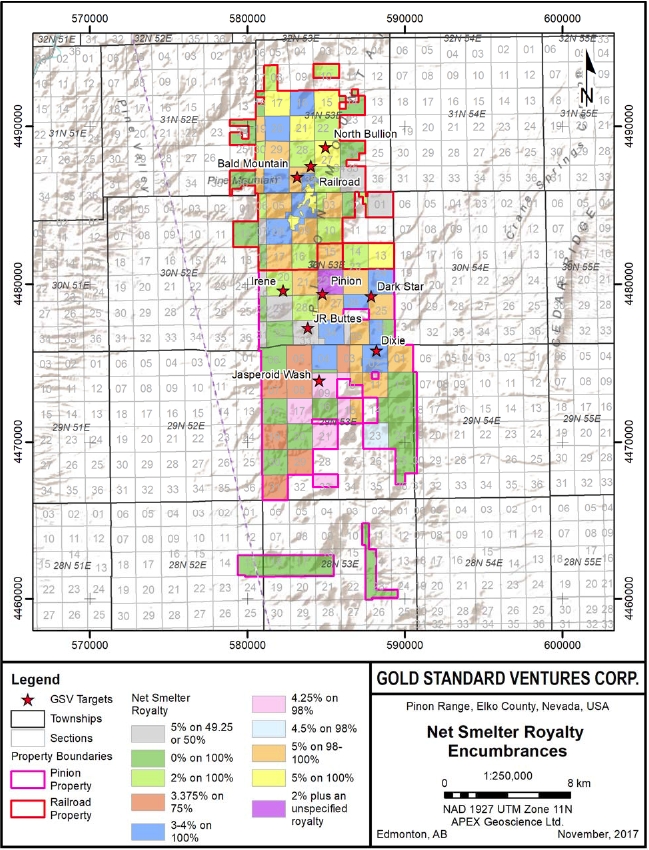
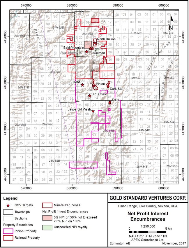
Portions of the patented, unpatented and private lands are encumbered with royalties predominantly in the form of standard Net (or Gross) Smelter Return (NSR or GSR) agreements or Net Profit Interest (NPI) agreements. A summary of the currently active NSR and NPI encumbrances for the Railroad–Pinion Project are provided on Figures 4.2 and 4.3.
Gold Standard holds its subsurface mineral interests subject to certain production royalties, with various buy down provisions as follows:
| · | 1 % NSR to Royal Standard Minerals, Inc. and Manhattan Mining Co. on the portion of the Project acquired by statutory plan of arrangement. |
| · | 1.5 % Mineral Production Royalty to Kennecott Holdings Corporation on claims noted as the Selco Group. |
| · | 5 % NSR to the owners of the undivided private mineral interests. |
| · | Gold Standard owns an approximate 99.2 % mineral interest in Sections 21 and 27 by way of several lease agreements. Pursuant to the terms of the relevant lease agreements, Sections 21 and 27 are subject to a five-per cent (5 %) net smelter return (NSR) royalty owed to the lessors of the leased property. |
| · | Section 22 is comprised of the TC 1 through 39, and TC 37R and 38R unpatented lode mining claims owned by Gold Standard. The TC claims are subject to the following royalties: (1) an unknown/unspecified NSR owed to "GSI, Inc., of Virginia"; and (2) a two-per cent (2 %) NSR owed to Waterton Global Value LP. |
| Effective Date: November 3, 2017 | | | 16 |
Technical Report Maiden Resource Estimate North Bullion Railroad Project, Elko County, Nevada, USA
Figure 4.2. Property map summarizing the Railroad–Pinion Net Smelter Royalty (NSR) encumbrances.
| Effective Date: November 3, 2017 | | | 17 |
Technical Report Maiden Resource Estimate North Bullion Railroad Project, Elko County, Nevada, USA
Figure 4.3. Property map summarizing the Railroad–Pinion Net Profit Interest (NPI) agreements.
| Effective Date: November 3, 2017 | | | 18 |
Technical Report Maiden Resource Estimate North Bullion Railroad Project, Elko County, Nevada, USA
| · | 1 % NSR to Aladdin Sweepstake Consolidated Mining Company on the portion of the Project acquired by statutory plan of arrangement, specifically the PIN#1 to PIN#12 lode mining claims. |
| · | 4 % NSR to Allied Nevada for mining claims recently acquired by GSV in Sections 34 and 36, Township 30N, Range 53E, and Sections 2 and 4, Township 29, Range 53E. |
| · | 3 % NSR to Peter Maciulaitis for certain mining claims in Sections 24 and 26, Township 30N, Range 53E. |
| · | A 3 % NSR (relative to mineral interest) to Linda Zunino and Tony Zunino, Trustees of the Delert J. Zunino and Linda Zunino Family Trusts dated October 11, 1994, and a 3 % NSR (relative to mineral interest) to John C. Carpenter and Roaseann Carpenter, husband and wife, on Section 23, Township 29N, Range 53E. |
| · | A 3 % NSR to Nevada Sunrise LLC on the fourteen (14) WMH claims situated in Sections 1, 2, 3, and 11, Township 29N, Range 53E. |
| · | A 3.5 % NSR (relative to mineral interest) to Dominek Pieretti and Tusca Sullivan on Sections 3, 5, 7, 8, 9, 10, 15, 17, 19, 21, 29, 31, and 33, Township 29N, Range 53E, and Section 33, Township 30N, Range 53E. |
There is no current mineral production at the Project.
The following information summarizing the terms of the Company’s acquisition of the land immediately south of the Pinion and Dark Star deposits in 2017 is taken from Gold Standard’s press release dated March 23, 2017:
“The acquisitions include cost-effect lease agreements with private mineral interest owners and newly staked claims. The total cost of these acquisitions was approximately US$501,121. Annual holding costs for the new acquisitions are approximately US$289,000.”
| 4.3 | Environmental Liabilities and Permits |
Gold Standard Ventures currently has three plans of operations and two notices of intent in place for the Railroad–Pinion Project. The following section discusses land use permitting and other regulatory information specific to the Railroad–Pinion Project.
Gold Standard has drafted a Historic Properties Treatment Plan (HPTP) for archaeological sites within the Railroad Exploration Project Plan of Operations. The draft HPTP is currently being evaluated by the BLM.
The Company states that the Plan of Operations (“PoO”) for the Railroad Project was approved by the BLM in February 2013. The approved PoO covers 3,169 acres (2,620 acres of public land and 549 acres of private land; a total of 1,282 ha with 1,060 ha of public land and 222 ha of private land) located in: Sections 28, 32, 33, and 34, T31N, R53E and portions of section 3, and most of section 4 in T30N, R53E (Figure 4.4).
| Effective Date: November 3, 2017 | | | 19 |
Technical Report Maiden Resource Estimate North Bullion Railroad Project, Elko County, Nevada, USA
Within the area of the PoO, exploration-related disturbance and reclamation bonding can be conducted in two phases of up to 50 acres in Phase I and an additional 150 acres in Phase II. The Company has posted a reclamation bond of US$211,685.
The Company states that a Reclamation Plan for the North Bullion Project (Section 27) was approved by NDEP-BMRR in May 2014. The approved Reclamation Plan allows for total surface disturbance of 39.5 acres. A bond is in place for this plan in the amount of $206,884.
The Company states that the PoO for the South Railroad Project was approved by the BLM in July 2016. The approved PoO covers 8,456 acres (approximately 5,235 acres of public land and 3,072 acres of private land; a total of 3,422 ha with 2,119 ha of public land and 1,243 ha of private land) located in: Section 2 T29N R53E and Sections 20, 21, 22, 23, 24, 25, 27, 28, 34, 35, and 36, and portions of Sections 14, 16, and 26 T30N R53E. Within the area of the PoO exploration-related disturbance and reclamation bonding can be conducted in two phases of up to 100 acres in Phase I and 150 acres in Phase II. The Company has posted a reclamation bond in the amount of US$315,021.
The Company states that the South Railroad PoO has encompassed two earlier Plans of Operation (Pinion and Greater Pinion), and two notices (Dark Star and Irene). These two plans and notices will be closed by the respective agency, either the BLM or the State of Nevada (NDEP), and the associated reclamation bonds will be returned to the Company. The current bond amounts for these plans and notices are, respectively: US$90,849, US$40,241, US$25,955, and US$30,482.
The Company has an approved BLM Notice (NVN-94667, Section 22 notice of intent [NOI]) for the Railroad Project with a total planned disturbance of approximately 4.67 acres located in Section 22 of T31N, R53E (Figure 4.4). Section 22 encompasses the North Bullion target and the north to northeast extension of the Bullion Fault Corridor.
The Company has recently received approval for the Jasperoid Wash notice area which is situated in Section 16 of T29N, R53E. The bond for this notice has been posted in the amount of $31,956. The Jasperoid Wash notice will focus on stratabound gold zones hosted in Pennsylvanian-Permian calcareous debris flow conglomerate within a north-striking dike-filled fault corridor. The host, structural setting, and alteration, are similar to the Dark Star deposit. Additional exploration in other outlying targets, including some in the Pinion Project, can also be addressed under separate Notice Level applications with lead times ranging from two to four weeks required for the BLM to grant approval once a completed application is submitted.
| 4.3.3 | Private Land Disturbance |
The Company obtained a Reclamation Permit for the Railroad Project area issued by the State of Nevada for disturbance greater than five acres on private land (Figure 4.5). The permanent Reclamation Permit allows for up to fifty acres of surface disturbance.
| Effective Date: November 3, 2017 | | | 20 |
Technical Report Maiden Resource Estimate North Bullion Railroad Project, Elko County, Nevada, USA
Figure 4.4. Property map with Railroad–Pinion Project PoO and NOI boundaries.
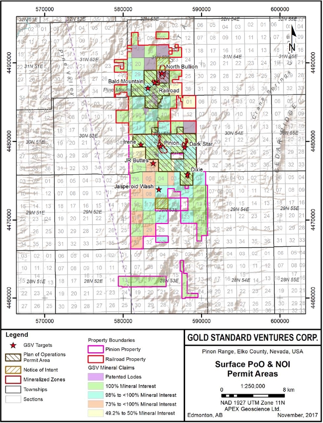
| Effective Date: November 3, 2017 | | | 21 |
Technical Report Maiden Resource Estimate North Bullion Railroad Project, Elko County, Nevada, USA
Figure 4.5. Property map for the Railroad–Pinion Project showing surface ownership.
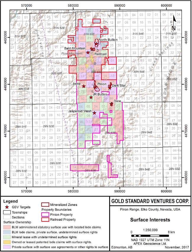
| Effective Date: November 3, 2017 | | | 22 |
Technical Report Maiden Resource Estimate North Bullion Railroad Project, Elko County, Nevada, USA
The Company has received a Reclamation Permit for the South Railroad Project area that now includes the Pinion, Greater Pinion, Dark Star, and Irene reclamation plans. This Plan covers both private land and public land disturbances. Previously approved reclamation plans associated with these project areas will be closed by the respective permitting agency, either BLM or NDEP.
The Company has received a Water Pollution Control Permit for the North Bullion Project. The permit has a five (5) year duration, expiring in November 2019.
The Company has received a Surface Area Disturbance Permit for the North Bullion Project. The permit has a five (5) year duration, expiring in June 2019.
The Company has received a Surface Area Disturbance Permit for the South Railroad Exploration Project (“South Railroad Exploration Environmental Assessment (“EA”)) (Figure 4.4). The granted EA covers approximately 12 square miles (19.3 km2) and allows up to 250 acres (101 ha) of new disturbance (see GSV Press Release dated June 29, 2017). The permit has a five (5) year duration, expiring in July 2022.
| 5 | Accessibility, Climate, Local Resources, Infrastructure and Physiography |
The Railroad–Pinion Project is located in north-central Nevada approximately 275 road miles (442 km) west of Salt Lake City, Utah, and 290 road miles (467 km) east of Reno, Nevada. The Project is located between 8 and 18 miles (13 and 29 km) south of Interstate 80, which is a four lane, east-west, transcontinental highway that serves as the primary highway in northern Nevada.
Primary access to the Project area is by a series of paved and gravel roads from Elko, Nevada (population 18,300). The Project can be reached by travelling westbound from Elko for 20 miles (32 km) on Interstate 80 to the town of Carlin (population 2,400), and then south on State Highway 278 for 15 miles (24 km). At Ferdelford Canyon an all-weather, 15 mile-long (24 km) gravel road leads east to the Railroad Project. The Pinion Project area is similarly accessed east from Highway 278 along a gravel road located immediately north of Trout Creek. Alternatively, the Project area may also be reached during the summer and autumn months by traveling 30 miles (48 km) southwestward from Elko, Nevada on the Bullion Road, a dirt/gravel road.
At both Projects, historic and/or recently created exploration roads combined with four-wheel drive tracks allow for access to many of the known target and prospect areas.
| 5.2 | Site Topography, Elevation and Vegetation |
Northern Nevada lies within the Basin and Range physiographic province, an area characterized by flat, lacustrine-gravel-volcaniclastic-volcanic filled valleys bounded by generally north-south trending mountain ranges. The Project area is located within the Piñon Mountains at elevations ranging from 5,800 ft (1770 m) above sea level on the north and east sides, to nearly 8,700 ft (2,650 m) above sea level in the central portion of the Project. Lower elevations are typified by gentle, rolling hills with little to no bedrock exposure. Higher elevations are characterized by steeper slopes and cliffs, deeply incised drainages, and an increase in bedrock exposure.
| Effective Date: November 3, 2017 | | | 23 |
Technical Report Maiden Resource Estimate North Bullion Railroad Project, Elko County, Nevada, USA
Vegetation is consistent with a high desert climate and consists of sagebrush, rabbit brush, cactus, and bunch grass communities. Cottonwood trees are confined to drainage bottoms and near springs. Pinyon pine, juniper, mountain mahogany and aspen trees grow at higher elevations.
The project area has a relatively dry high desert climate. Weather records from Newmont’s Carlin Mine indicate that from 1966 through 2002, the average January maximum and minimum temperatures were 34.4° and 19.6°F, respectively. July average maximum and minimum temperatures were 83.1° and 58.2°F, respectively. January and July had average precipitation amounts of 1.13 inches and 0.41 inches, respectively, while average total precipitation was 12.09 inches (Western Regional Climate Center, 2011). Average annual snowfall for Carlin is approximately 30 inches. Precipitation varies dramatically with changes in elevation and season.
Rainfall in the region is generally light, infrequent and may be associated with dry lightning between May and October. Moist airflow from the south brings ‘monsoon’ rains from July through September. A small number of these storms can carry heavy rains that cause localized flooding in creeks and drainages. Winter snow and spring runoff may temporarily limit access with respect to drilling and other geological fieldwork activities between November and April each year, but are not considered to be significant issues.
| 5.4 | Local Resources and Infrastructure |
Elko, Nevada has served as the northern Nevada exploration and mining center for more than half a century. Elko is a full service community that includes housing; motels; food and restaurants; clinics and a hospital; a regional airport with daily flights to/from Salt Lake City, Utah; interstate highway and railway access; local, state and federal government offices; skilled and experienced labor for the exploration and mining industry; and schools (K-12 and a community college). In this part of Nevada, there is a diverse selection of local/regional/international exploration and mining service companies including assay labs, suppliers, drilling contractors and heavy equipment vendors supporting the exploration and mining industry.
The Project is located in the vicinity of large, active open pit and underground mines operated by Newmont and Barrick Gold Corp. along the ‘Carlin Trend’. These mine sites also include fully operational mill complexes designed to treat oxide and/or carbon-sulphide refractory gold ores.
At the Project, water is available proximal to the drilling operations. For communications, 4G cellular network is available in select locations. High voltage electrical transmission lines are located six miles from the Project.
| Effective Date: November 3, 2017 | | | 24 |
Technical Report Maiden Resource Estimate North Bullion Railroad Project, Elko County, Nevada, USA
The Project has sufficient and appropriate sites to accommodate exploration and potential mining facilities, including waste rock disposal, and processing infrastructure.
| 6.1 | Railroad Project Historic Exploration |
Historic exploration completed at the Railroad Project remains unchanged from the information provided in previous Technical Reports on the Project (Hunsaker 2010, 2012a, b; Shaddrick, 2012; and Koehleret al., 2014) and thus much of the following information (in sequence with this report) is quoted or taken directly from these reports with minor formatting changes.
Since 1967, 15 companies have explored in the GSV Railroad Project area. These companies collected 6,260 soil samples and 3,508 rock samples (Figures 6.1 and 6.2). A summary of the companies responsible for the geochemical surveys and the elements comprising the historic surface geochemical surveys at the Railroad Project is provided in Table 6.1. A total of 382 historic drillholes were completed by the companies within the Railroad–Pinion project area and are illustrated in Figure 6.3 and their respective highest gold assay values in each hole are illustrated in Figure 6.4. Detailed collar locations along with summary gold intercepts for historic drilling are located in Shaddrick (2012) and Kohleret al. (2014). Highlights of historic drilling within the POD and Sweet Hallow zones are detailed in Tables 6.2 and 6.3 respectively.
Table 6.1. Historic geochemical surveys completed within the Railroad Project area summarized by company.
| Company | Elements - Rocks | Elements - Soils |
| AMAX | Au, Ba, Bi, Cu, Pb, Ag, Zn, Sb, As, Hg | Au, Ag, Pb, Zn, Cu, Sb, As, Ba |
| Homestake* | Au, As, Hg | Au, As, Sb, Hg |
| Westmont | Au, Ag, As, Sb, Bi, Cu, Pb, Hg, Zn | Au, As, Ag, Hg, K, Mg, Mn, Mo, Na, Ni, P, Pb, Sb, Tl, Zn, Sr, Te, Tl, Sc, U, V, Q, Ga, Ge, La |
| Ramrod | | |
| Mirandor | Au, Ag, As, Sb, Hg, Na, W, Ba | Au, Ag, As, Al, Ba, Hg, Sb, Tl |
| Kinross | Au, Ag, As, Sb, Ba, Be, Bi, B, Cd, Ca, Cr, Co, Cu, Ga, Ge, Fe, La, Pb, Mg, Mn, Hg, Mo, Ni, P, K, Sc, Se, Na, Sr, S, Te, Tl, Ti, W, V, Zn | Au, Ag, Al, As, Ba, Be, Bi, Ca, Cd, Co, Cr, Cu, Fe, Hg, K, Lu, Mg, Mn, Mo, Na, Ni, P, Pb, Sb, Sc, Sr, Te, Ti, U, W, V, Zn, Ga, Ge, La, Tl |
| Corona | | Au, Ag, As, Sb, Hg |
| Newmont | Au, As, Sb, Hg | |
| Teck | Au, Ag, As, Sb, Hg Bi, Cu, Pb, Zn | |
| Barrick | Au, Ag, As, Sb, Hg Bi, Cu, Pb, Zn | |
* Includes LabradorEx (Labradex)
| Effective Date: November 3, 2017 | | | 25 |
Technical Report Maiden Resource Estimate North Bullion Railroad Project, Elko County, Nevada, USA
Table 6.2. Summary highlights from historic drillholes completed prior to 2010 at the POD zone.
| Drillhole ID | From (m) | To (m) | Length (m) | From (ft) | To (ft) | Length (ft) | Au (g/t) | Au (oz/st) |
| BDH04 | 45.7 | 65.5 | 19.8 | 150.0 | 215.0 | 65.0 | 1.00 | 0.029 |
| including | 47.2 | 54.9 | 7.6 | 155.0 | 180.0 | 25.0 | 1.92 | 0.056 |
| EMRR_9602 | 21.3 | 82.3 | 61.0 | 70.0 | 270.0 | 200.0 | 2.32 | 0.068 |
| including | 57.9 | 77.7 | 19.8 | 190.0 | 255.0 | 65.0 | 4.20 | 0.123 |
| including | 62.5 | 67.1 | 4.6 | 205.0 | 220.0 | 15.0 | 7.30 | 0.213 |
| EMRR_9603 | 59.4 | 102.1 | 42.7 | 195.0 | 335.0 | 140.0 | 2.65 | 0.077 |
| including | 71.6 | 99.1 | 27.4 | 235.0 | 325.0 | 90.0 | 3.77 | 0.110 |
| including | 71.6 | 79.3 | 7.6 | 235.0 | 260.0 | 25.0 | 8.32 | 0.243 |
| EMRR_9721 | 36.6 | 115.8 | 79.3 | 120.0 | 380.0 | 260.0 | 1.46 | 0.043 |
| including | 70.1 | 74.7 | 4.6 | 230.0 | 245.0 | 15.0 | 9.02 | 0.263 |
| K98_26 | 12.2 | 25.9 | 13.7 | 40.0 | 85.0 | 45.0 | 6.40 | 0.187 |
| including | 15.2 | 18.3 | 3.1 | 50.0 | 60.0 | 10.0 | 21.34 | 0.622 |
| K98_27 | 10.7 | 50.3 | 39.6 | 35.0 | 165.0 | 130.0 | 1.98 | 0.058 |
| including | 27.4 | 38.1 | 10.7 | 90.0 | 125.0 | 35.0 | 5.26 | 0.153 |
| K98_37 | 80.8 | 117.4 | 36.6 | 265.0 | 385.0 | 120.0 | 3.70 | 0.108 |
| including | 86.9 | 91.4 | 4.6 | 285.0 | 300.0 | 15.0 | 14.80 | 0.432 |
| K98_55 | 114.3 | 138.7 | 24.4 | 375.0 | 455.0 | 80.0 | 2.61 | 0.076 |
| including | 114.3 | 118.9 | 4.6 | 375.0 | 390.0 | 15.0 | 7.20 | 0.210 |
| NR019 | 12.2 | 68.6 | 56.4 | 40.0 | 225.0 | 185.0 | 3.35 | 0.098 |
| including | 42.7 | 57.9 | 15.2 | 140.0 | 190.0 | 50.0 | 7.70 | 0.225 |
| NR027 | 25.9 | 64.0 | 38.1 | 85.0 | 210.0 | 125.0 | 5.16 | 0.151 |
| including | 44.2 | 57.9 | 13.7 | 145.0 | 190.0 | 45.0 | 9.97 | 0.291 |
| NR028 | 39.6 | 89.9 | 50.3 | 130.0 | 295.0 | 165.0 | 1.76 | 0.051 |
| including | 56.4 | 73.2 | 16.8 | 185.0 | 240.0 | 55.0 | 3.50 | 0.102 |
| including | 67.1 | 71.6 | 4.6 | 220.0 | 235.0 | 15.0 | 9.27 | 0.270 |
| NR030 | 4.6 | 56.4 | 51.8 | 15.0 | 185.0 | 170.0 | 3.37 | 0.098 |
| including | 16.8 | 39.6 | 22.9 | 55.0 | 130.0 | 75.0 | 6.00 | 0.175 |
| and | 25.9 | 35.1 | 9.1 | 85.0 | 115.0 | 30.0 | 9.40 | 0.274 |
| NR035 | 85.3 | 108.2 | 22.9 | 280.0 | 355.0 | 75.0 | 1.37 | 0.040 |
| including | 89.9 | 99.1 | 9.1 | 295.0 | 325.0 | 30.0 | 2.90 | 0.085 |
| NR042 | 54.9 | 100.6 | 45.7 | 180.0 | 330 | 150.0 | 3.37 | 0.098 |
| including | 67.1 | 77.7 | 10.7 | 220.0 | 255.0 | 35.0 | 9.15 | 0.267 |
| NR044 | 10.7 | 79.3 | 68.6 | 35.0 | 260.0 | 225.0 | 1.38 | 0.040 |
| including | 32.0 | 41.2 | 9.2 | 105.0 | 135.0 | 30.0 | 4.78 | 0.139 |
| NR061 | 15.2 | 51.8 | 36.6 | 50.0 | 170.0 | 120.0 | 1.69 | 0.049 |
| including | 22.9 | 33.5 | 10.7 | 75.0 | 110.0 | 35.0 | 3.12 | 0.091 |
| RR10-12 | 100.6 | 126.5 | 25.9 | 330.0 | 415.0 | 85.0 | 2.55 | 0.074 |
| Effective Date: November 3, 2017 | | | 26 |
Technical Report Maiden Resource Estimate North Bullion Railroad Project, Elko County, Nevada, USA
| Drillhole ID | From (m) | To (m) | Length (m) | From (ft) | To (ft) | Length (ft) | Au (g/t) | Au (oz/st) |
| including | 104.9 | 111.3 | 6.4 | 344.0 | 365.0 | 21.0 | 5.47 | 0.160 |
| WC8901 | 26.5 | 67.7 | 41.2 | 87.0 | 222.0 | 135.0 | 3.70 | 0.108 |
| including | 55.5 | 60.1 | 4.6 | 182.0 | 197.0 | 15.0 | 16.67 | 0.486 |
| WC8902 | 29.6 | 82.6 | 53.0 | 97.0 | 271.0 | 174.0 | 1.81 | 0.053 |
| including | 67.7 | 76.5 | 8.8 | 222.0 | 251.0 | 29.0 | 4.90 | 0.143 |
Table 6.3. Summary highlights from historic drillholes completed prior to 2010 at the Sweet Hollow zone.
| Drillhole ID | From (m) | To (m) | Length (m) | From (ft) | To (ft) | Length (ft) | Au (g/t) | Au (oz/st) |
| EMRR-9743 | 27.43 | 42.67 | 15.24 | 90.00 | 140.00 | 50.00 | 1.10 | 0.032 |
| EMRR-9744 | 18.29 | 19.81 | 1.52 | 60.00 | 65.00 | 5.00 | 5.90 | 0.172 |
| K98_30 | 27.43 | 57.91 | 30.48 | 90.00 | 190.00 | 100.00 | 1.36 | 0.040 |
| including | 36.58 | 47.24 | 10.66 | 120.00 | 155.00 | 35.00 | 2.11 | 0.062 |
| | 86.87 | 99.06 | 12.19 | 285.00 | 325.00 | 40.00 | 0.80 | 0.023 |
| K98_32 | 54.87 | 73.15 | 18.28 | 180.00 | 240.00 | 60.00 | 0.93 | 0.027 |
| including | 70.11 | 71.63 | 1.52 | 230.00 | 235.00 | 5.00 | 3.94 | 0.115 |
| NR079 | 27.43 | 62.48 | 35.05 | 90.00 | 205.00 | 115.00 | 0.61 | 0.018 |
| NR087 | 3.05 | 25.91 | 22.86 | 10.00 | 85.00 | 75.00 | 0.57 | 0.017 |
| | 39.62 | 70.11 | 30.49 | 130.00 | 230.00 | 100.00 | 0.53 | 0.015 |
| NR090 | 15.24 | 50.29 | 35.05 | 50.00 | 165.00 | 115.00 | 0.56 | 0.016 |
| NR093 | 28.96 | 44.20 | 15.24 | 95.00 | 145.00 | 50.00 | 0.83 | 0.024 |
| NR094 | 89.92 | 96.01 | 6.09 | 295.00 | 315.00 | 20.00 | 0.96 | 0.028 |
| NR097 | 103.63 | 106.68 | 3.05 | 340.00 | 350.00 | 10.00 | 1.80 | 0.053 |
| NRA08 | 59.44 | 73.15 | 13.71 | 195.00 | 240.00 | 45.00 | 0.78 | 0.023 |
| WC8903 | 9.75 | 32.31 | 22.56 | 32.00 | 106.00 | 74.00 | 0.89 | 0.026 |
| WR704 | 48.77 | 74.68 | 25.91 | 160.00 | 245.00 | 85.00 | 0.92 | 0.027 |
| WR801 | 0.00 | 54.87 | 54.87 | 0.00 | 180.00 | 180.00 | 1.77 | 0.052 |
| including | 18.29 | 32.00 | 13.71 | 60.00 | 105.00 | 45.00 | 3.49 | 0.102 |
| WR802 | 13.72 | 36.58 | 22.86 | 45.00 | 120.00 | 75.00 | 0.98 | 0.029 |
| WR8815 | 6.10 | 80.77 | 74.67 | 20.00 | 265.00 | 245.00 | 1.05 | 0.031 |
| including | 6.10 | 22.86 | 16.76 | 20.00 | 75.00 | 55.00 | 2.95 | 0.086 |
| WR8816 | 4.57 | 18.29 | 13.72 | 15.00 | 60.00 | 45.00 | 1.21 | 0.035 |
| WR8822 | 6.10 | 33.53 | 27.43 | 20.00 | 110.00 | 90.00 | 1.07 | 0.031 |
| WR8824 | 0.00 | 60.96 | 60.96 | 0.00 | 200.00 | 200.00 | 1.19 | 0.035 |
| including | 6.10 | 21.34 | 15.24 | 20.00 | 70.00 | 50.00 | 3.08 | 0.090 |
| WR8908 | 27.43 | 65.53 | 38.10 | 90.00 | 215.00 | 125.00 | 0.70 | 0.020 |
| WR8909 | 13.72 | 21.34 | 7.62 | 45.00 | 70.00 | 25.00 | 0.70 | 0.020 |
| WR8912 | 6.10 | 42.67 | 36.57 | 20.00 | 140.00 | 120.00 | 1.55 | 0.045 |
| including | 6.10 | 22.86 | 16.76 | 20.00 | 75.00 | 55.00 | 2.82 | 0.082 |
| Effective Date: November 3, 2017 | | | 27 |
Technical Report Maiden Resource Estimate North Bullion Railroad Project, Elko County, Nevada, USA
Figure 6.1. Historic (pre-2010) soil samples for the Railroad–Pinion project.
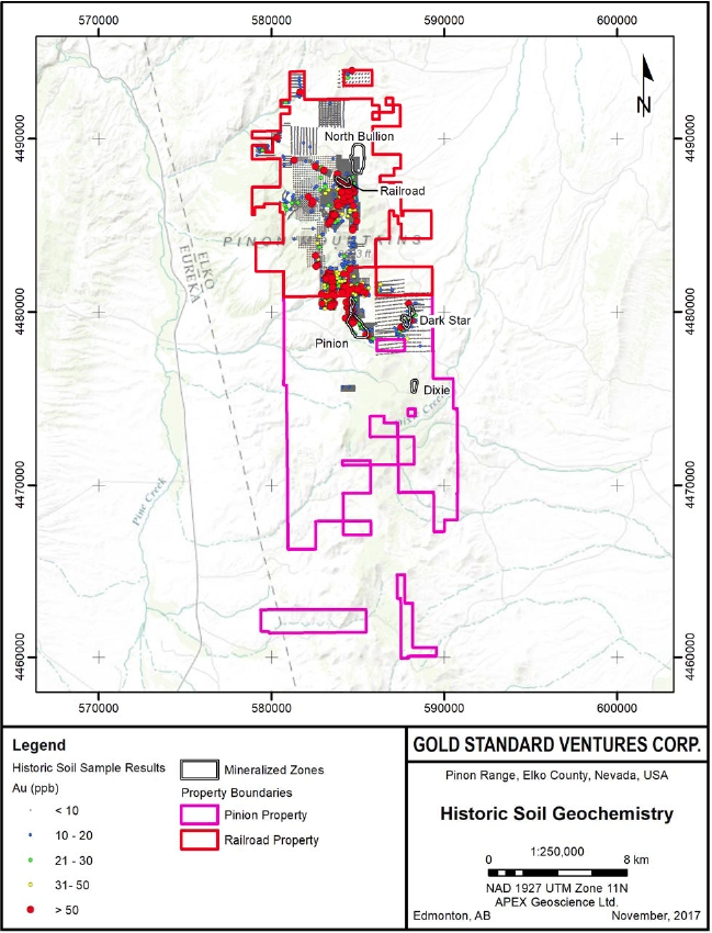
| Effective Date: November 3, 2017 | | | 28 |
Technical Report Maiden Resource Estimate North Bullion Railroad Project, Elko County, Nevada, USA
Figure 6.2. Historic (pre-2010) rock samples for the Railroad–Pinion project.
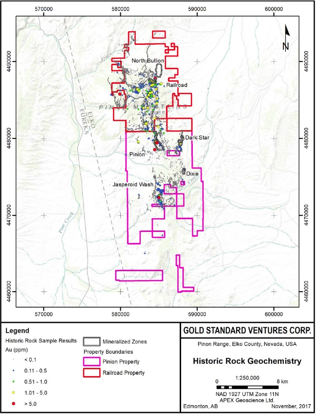
| Effective Date: November 3, 2017 | | | 29 |
Technical Report Maiden Resource Estimate North Bullion Railroad Project, Elko County, Nevada, USA
Figure 6.3. Historic drillholes for the Railroad–Pinion project.
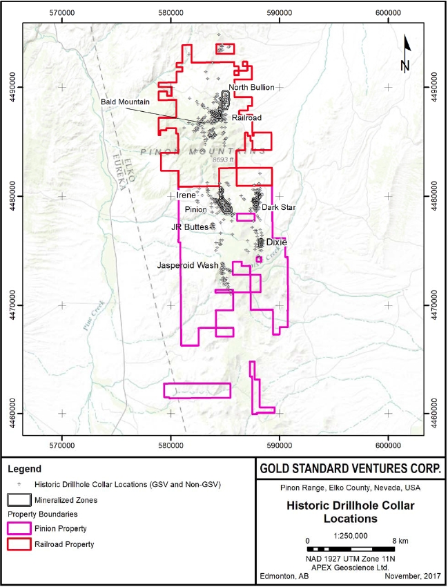
| Effective Date: November 3, 2017 | | | 30 |
Technical Report Maiden Resource Estimate North Bullion Railroad Project, Elko County, Nevada, USA
Figure 6.4. Highest assay in drillholes for the Railroad–Pinion project.
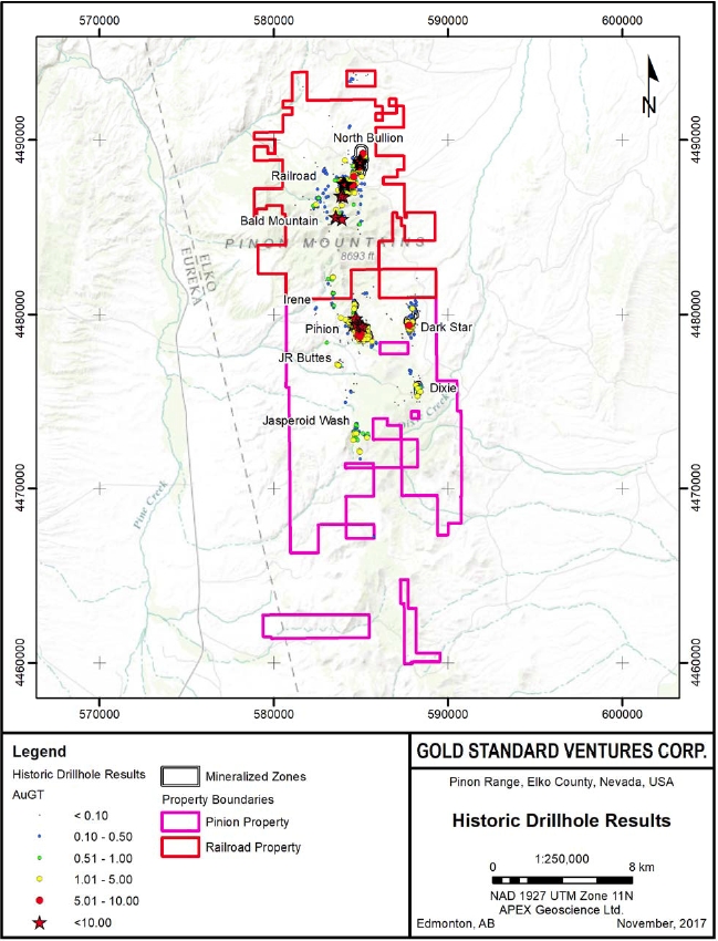
| Effective Date: November 3, 2017 | | | 31 |
Technical Report Maiden Resource Estimate North Bullion Railroad Project, Elko County, Nevada, USA
“The Railroad Mining District was established in 1869. The district was also known as the Bullion or Empire City district (LaPointe et al., 1991). Initially ore was shipped to Chicago and San Francisco. In 1872 a smelter was completed at the nearby town of Bullion. Beginning in 1905 shipments from operating mines, old dumps, and slag were shipped to Salt Lake City (Ketner and Smith, 1963).
U.S. Geological Survey data published by Ketner and Smith (1963) suggests that historic production records are not very reliable for the period between 1869 and 1905. Only the total volumes of tons mined and commodity produced were reported. They estimated the total value of production through 1956 to be worth $2 million using the value of the commodity produced for the year it was produced. Ketner and Smith (1963) reported 43,940 total tons of ore were mined with mineral production distributed as follows:
| · | Copper - 2,850,000 pounds |
The early production in the district focused on silver, lead, and copper from numerous underground mines on the northern flank of Bunker Hill. Emmons (1910) reports that the mines were reopened in 1906 and at the time of his review the Standing Elk, Tripoli, Red Bird, Copper Belle, and Delmas mines were accessible. The most important mines exploited replacement and skarn-type deposits in marbleized and dolomitized rocks. There were also minor, undeveloped gold veins in intrusive rocks.
Beginning in 1910 and until the mines quit producing in the 1960’s zinc became the prominent metal mined (LaPointe et al., 1991). In 1905 the Davis Tunnel was started from a location approximately 4,400 feet northeast and 1,000 feet below the 600 level of the Standing Elk mine. Many lessors worked at extending the tunnel which was being driven southwest to reach a zone beneath the Standing Elk. In 1959 the zone was reached but no ore was found. Numerous oxidized faults and oxidized zones of base-metal mineralization were crossed.
Modern exploration began in 1967 when American Selco optioned the claims from Aladdin Sweepstake Consolidated Mining launching a 45-year period of surface sampling, geophysics, geological mapping, and surface drilling. As the work progressed in the Railroad District new geologic interpretations plus base- and precious-metal surface sample results were combined with favorable drill results; expanding the target types being explored for and widening the range of commodities being explored for.
Since 1967, 15 companies have explored in the GSV Railroad Project area:
| · Selco | · Mirandor |
| · El Paso/LLE | · Kinross |
| · Placer Amex | · Manhattan Mining Company |
| Effective Date: November 3, 2017 | | | 32 |
Technical Report Maiden Resource Estimate North Bullion Railroad Project, Elko County, Nevada, USA
| · AMAX | · Corona/Pezgold |
| · Homestake (LabradorEx) | · Newmont |
| · Nicor | · Barrick |
| · Westmont | · Teck |
| · Ramrod | |
These companies completed 382 drillholes.
The copper and molybdenum bearing nature of the multiphase intrusives was documented starting in the late 1960’s. Sampling and the understanding of skarn related gold in Nevada led to further exploration and better intercepts in drilling in the historic skarn/replacement portion of the Project. During the course of these work programs the ongoing exploration advanced the understanding of the geologic controls on the Project leading finally to the sediment-hosted gold exploration programs.”
American Selco, Placer Amex, and El Paso Natural Gas Company with Louisiana Land and Exploration Company explored the project for porphyry copper and molybdenum in the Bullion Stock and Grey Eagle intrusive rocks. They also looked for additional replacement sulfide “lenses” in the limestone and “unknown replacement or disseminated” mineralization west of the Bullion Stock (American Selco, 1970). American Selco completed an IP and magnetic geophysical survey which identified anomalies that were tested with 13 rotary and core holes. Subsequent core holes (and several of the rotary holes completed to the desired depths) intersected up to 50 % sulfides as well as molybdenum, copper, silver and gold.
Placer Amex drilled a single 1,200 ft hole in 1972. 2,203 ft was drilled in four core holes during 1973-1974 by El Paso Natural Gas Company with Louisiana Land and Exploration Company.
In 1975 AMAX optioned the project from Aladdin/American Selco and explored for tungsten, molybdenum, and base metals until 1980. Detailed mapping was completed in, sections 27, 28, 29, 32, 33 34 T31N/R53E and sections 3, 4, 5, 6, 8, and 9 T30N/R53E. AMAX also completed surface dump and rock chip sampling, soil sampling, a vegetation geochemical survey, a ground magnetometer survey and 6,212 ft of drilling in five core holes and ten rotary holes. The surface rock and soils were assayed for a variety of elements with no consistent analytical suite or assay procedure.
AMAX decided that their work did not identify mineralization significant enough to proceed with advanced exploration or mining. However, they did get results from their surface sampling and drilling encouraging enough to retain an ownership interest in the project (Galey, 1983). AR-7 returned 98 ft of 0.11 oz Au/st from 37 to 135 ft in the vicinity of the historic replacement/skarn mines.
In 1980 Homestake entered into a joint venture arrangement with AMAX. Exploration from this point forward was focused on gold on the Railroad Project. Gold discovered at Rain highlighted the geologic similarities between the Rain mine area and the Railroad District. Homestake drilled 5,788 ft in 22 holes (Galey, 1983) and took rock and soil samples.
| Effective Date: November 3, 2017 | | | 33 |
Technical Report Maiden Resource Estimate North Bullion Railroad Project, Elko County, Nevada, USA
The results of the Homestake work initially identified what later was named the POD deposit (Railroad Mineralized zone). The BDH drill series produced the first significant results in the area. BDH05 returned 43 ft of 0.046 oz Au/st from 7 to 50 ft
Homestake appears to have recognized the significant northwest trend to the mineralization, based on their drill patterns.
In 1983 NICOR Mineral Ventures, Inc. became the joint venture partner to AMAX. As operator NICOR continued the detailed mapping, soil geochemistry, and drilling initiated by Homestake. Eventually the NICOR position was taken over by Westmont Mining Inc. Although the drilling is divided between NICOR and Westmont the rock and soil sampling is recorded as Westmont data.
A total of 44,582 ft in 110 holes was completed during NICOR’s tenure. This drilling expanded the drill coverage at POD (Railroad). Kuhl (1985) produced the first historical estimate of the gold for POD (discussed further in Section 6.2 below).
In 1986 Westmont took over the NICOR position and operated the project until 1992. During this period an additional 32,263 ft drilling was completed in 83 holes. Westmont also collected rock and soil samples.
Westmont retained operatorship of the project until 1993. They developed a detailed stratigraphy for the late Paleozoic sedimentary units and also began to recognize low-angle reverse and low-angle normal faulting, as well as identifying prominent north-south and northwest trending high-angle normal and reverse faults. The interplay of the Webb/Devils Gate contact and complex faulting as controls to the mineralization, were also identified late in the Westmont tenure.
Ramrod Gold became operator in 1993, completing 9,290 ft in 13 drillholes followed by Mirandor Exploration (U.S.A.) Inc. (“Mirandor”) from 1996-1997 who drilled 18,575 ft in 44 holes. The technical program for Ramrod and Mirandor was carried out by explorationists who were previously employed by Westmont thus continuing the district-wide geochemistry, mapping, and target delineation work begun in 1986.
The Ramrod/Mirandor drilling programs tested deeper than its predecessors showed the encouraging drill results along the previously identified northwest trending POD (Railroad) Zone.
The EMRR series of drillholes returned favorable results adjacent to the historic Sylvania Mine which had historic production from replacement/skarn mineralization. EMRR-9722 gave: 70 ft of 0.111 oz Au/st from 15 to 85 ft, including 45 ft of 0.164 oz Au/st from 35 to 70 ft; and 20 ft of 0.236 oz Au/st from 55 to 75 ft This hole was drilled near AMAX hole AR-7.
Ramrod/Mirandor’s deeper drilling and drillhole placement returned higher gold values, as demonstrated by the grade x thickness values >10 for the post-1992 Westmont and Ramrod/Mirandor holes.
| Effective Date: November 3, 2017 | | | 34 |
Technical Report Maiden Resource Estimate North Bullion Railroad Project, Elko County, Nevada, USA
Kinross Gold U.S.A, Inc. took over the project during 1998 and 1999 under the terms of an earn-in agreement with Mirandor. They drilled 43,690 ft in 66 holes, and collected 871 rocks and 2,531 soils. Soils were collected using a uniform collection process and the analysis of both soils and rocks was consistent in analytical lab and procedure. The Kinross surface sample data gives a uniform dataset across most of the project area, which made them useful to Gold Standard Ventures Corp. exploration program.
Gold in soil anomalies from the Kinross samples generally coincide with the known drilling. Ag, As, Sb, and Hg also give a similar pattern and highlight the known areas. Cu, Pb, Zn, and Mo highlight the historic skarn/replacement area.
Kinross drilling tested within the areas of historical estimates, on the extensions of those zones, as well as newer target areas. The results in the areas of known gold returned similar results (Bartels, 1999). Step-out drilling appeared to be encouraging. Kinross drilled deeper holes and in many cases tested more of the stratigraphy than had been tested by previous operators. K98-49 returned 70 ft of 0.108 oz Au/st from 855-925 ft, including 5 ft of 0.387 oz Au/st from 880-885 ft.
Although the grades were not spectacular drillhole K99-19 drilled a significant interval that is well away from any previously targeted areas. K99-19 returned 10 ft at 0.026 oz Au/st from 610-620 ft and 10 ft of 0.018 oz Au/st from 1205 to 1215 ft.
Additionally, in the southern part of the Project they intersected thick intervals of favorable jasperoid and brecciation in holes K98-8, and -9 and K99c-1.
Royal Standard Minerals operating as Manhattan Mining Co. in Nevada acquired the project in 2001and completed four drillholes.
On the northern portion of the project area Corona reported on ground which was held jointly with Pezgold Resource Corporation in sections 16 and 20 T31N/R53E. Available data indicates that geologic mapping, soil and rock sampling, geophysics, and six drillholes were completed from 1987-1990. Specific drill locations are unknown and drill data indicates all the holes remained in the Mississippian Webb formation above the target horizons. A northeast trending corridor of subtle Carlin/Rain-type alteration and weak geochemistry was noted.
The Corona project was acquired by Newmont in 1993 and additional geophysics and two more drillholes were completed reaching as deep as 1,395 ft; however this was not deep enough to reach the target horizon in those locations. Gravity data outlined the northeast trending zone and indicated a significant fault in the northeast corridor.”
| 6.2 | Railroad Project Historic Resource Estimates |
The following discussion of historic resource estimates conducted on prospects within the Railroad Project area is reproduced from previous Technical Reports on the Railroad Project by Hunsaker (2012b), Shaddrick (2012) and Koehleret al. (2014). Specifically, this section discusses historical resource estimates for the “POD” deposit that is also known as the Railroad Deposit and is located within the “Railroad Fault” target discussed further in Section 7 of this report. The authors of this Technical Report have reviewed the information in this section, as well as that within the cited references, and have determined that it is suitable for disclosure. Additional cautionary language pertaining to the disclosure of historical resource estimates has been added to the original text.
| Effective Date: November 3, 2017 | | | 35 |
Technical Report Maiden Resource Estimate North Bullion Railroad Project, Elko County, Nevada, USA
The historic mineral resource estimates discussed in this section, and summarized in Table 6.4 along with other tables in this section, are non – National Instrument (NI) 43-101 compliant mineral resources that were calculated prior to the implementation of the standards set forth in NI 43-101 and current CIM standards for mineral resource estimation (as defined by the CIM Definition Standard on Mineral Resources and Ore Reserves dated May 10, 2014). The authors of this Technical Report have referred to these estimates as “historic resources” and the reader is cautioned not to treat them, or any part of them, as current mineral resources. There is insufficient information available to properly assess data quality, estimation parameters and standards by which the estimates were categorized. The historic resources described below have been included simply to demonstrate the mineral potential of certain target areas at the Railroad Project.
“The drilling at Railroad by NICOR/Westmont and by Kinross led to historical estimates of gold for the POD area. To date, there has been no production from the resources described by these historical estimates.
The following historical estimates are presented as a guide to exploration and as partial summaries of historical data. The drill data used by Westmont and Kinross appears to have been collected and assayed with standards that were of acceptable quality during the time period and review of the available reports do not provide any reason to doubt the results. However, the data utilized are limited in their reliability due to the lack of pulps, rejects, cuttings or core which can be sampled and verified.
Kuhl (1985) presented the first calculations for the gold contained within the POD (Railroad) deposit (Table 6.4). He used a polygonal process with rectangular blocks under the following parameters:
| · | Data projected half way to the adjoining drillhole or 100 feet |
| · | Inclusion of intercepts less than 0.03 opt gold if the outlying intervals brought the overall average to equal 0.03 opt gold |
| · | Minimum 10 ft intercept in the drillhole |
| · | All calculations made using fire assay intervals |
| · | No stripping ratio calculated |
| · | No metallurgical recovery information utilized |
Bartels (1999) recalculated the gold contained within the POD (Railroad) deposit (Table 6.4). Bartels utilized a cross-sectional method with 58 holes on 27 cross sections spaced 100 ft apart through the POD (Railroad) area using the following assumptions:
| · | Tonnages were calculated using a 13.5 cubic ft per ton density factor. |
| · | Assay values include silver credits, at a 60:1 ratio. |
| · | Compositing of assay values was done according to the following conventions: |
| Effective Date: November 3, 2017 | | | 36 |
Technical Report Maiden Resource Estimate North Bullion Railroad Project, Elko County, Nevada, USA
| · | Intervals of low grade (<0.030 opt Au) up to 15 ft thick, bound on both sides by >0.030 opt Au values were included within the ore envelope only if the average of the low grade and the upper and lower bounding values was greater than or equal to 0.030 opt Au. |
| · | No cropping of high assay values was done, all assays taken at face value. |
| · | Volumes were determined by projecting the contoured ore areas 50 ft either side of the section plane. |
| · | An average grade was assigned to each area by determining the weighted average grade of all drill intercepts within the ore envelope. |
| · | Average grade was assigned to the respective volume and contained ounces were calculated.” |
Masters (2003a) recalculated the gold contained within the POD (Railroad) zone (Table 6.4) utilizing a cross-sectional method with 71 holes on 15 cross sections approximately spaced 100 ft apart through the POD (Railroad) area using the following methodology and assumptions:
| · | Tonnages were calculated using a 13.5 cubic ft per ton density factor. |
| · | Mineralization was categorized as oxidized (cyanide soluble gold within the Webb Siltstone) and refractory gold (primarily within carbonaceous, sulphidic, unoxidized Webb Siltstone). |
| · | The oxidized and refractory gold categories were sub-divided into grade shells (0.01-0.02 and > 0.02 oz/st) and an additional category of mineralization above 300 ft depth for refractory gold was also considered. |
| · | Each mineralization category were estimated separately for tons, ounces and grade |
Masters (2003b) presented the first calculation for gold contained within the East Jasperoid zone (Table 6.4) located immediately to the east of the POD zone. Estimation was completed utilizing a cross-sectional method on 4 sections spaced 100 ft apart.
Table 6.4. Historic resource estimates for railroad project.
Resource Area | Tons | Tonnes | Contained Ounces Au | Average Au Grade | Cutoff Au Grade | Reference |
| (opt) | (ppm) | (opt) | (ppm) |
| POD | 1,197,400 | 1,086,280 | 107,766 | 0.090 | 3.09 | 0.030 | 1.03 | Kuhl, 1985 |
| POD | 1,400,000 | 1,270,080 | 112,000 | 0.080 | 2.74 | 0.020 | 0.69 | Kuhl, 1985 |
| POD | 1,006,665 | 913,250 | 89,731 | 0.089 | 3.05 | 0.030 | 1.03 | Bartels, 1999 |
| POD | 2,654,112 | 2,407,810 | 134,445 | 0.0506 | 1.73 | 0.010 | 0.34 | Masters, 2003 |
| East Jasperoid | 1,013,808 | 919,727 | 31,742 | 0.031 | 1.06 | 0.010 | 0.34 | Masters, 2003 |
*The mineral resource estimates summarized in Table 6.4 are non – NI 43-101 compliant resources that were calculated prior to the introduction of the standards set forth in NI 43-101. The authors of this Technical Report have referred to these estimates as “historic resources” and are not treating them, or any part of them, as current mineral resources. There is insufficient information available to properly assess data quality, estimation parameters and standards by which the estimates were categorized. The historic resource estimates described above should not be relied upon and have only been included to demonstrate the mineral potential of the POD (Railroad) Zone at the Railroad Project.
| Effective Date: November 3, 2017 | | | 37 |
Technical Report Maiden Resource Estimate North Bullion Railroad Project, Elko County, Nevada, USA
| 6.3 | Pinion Project Historic Exploration |
Exploration activity at Pinion Project area dates back to the discovery of the Pinion Prospect in 1980 by Newmont with the majority of the historic work being conducted in the late 1980s and early to mid-1990s. The exploration history for the Pinion Project overlaps somewhat with that of the adjacent Railroad Project area as portions of the two project areas have been operated by the same company in the past. Historic exploration work completed at the Pinion Project area is summarized in Table 6.5.
The historical work completed at the Pinion Project identified a significant zone of Carlin-type gold mineralization at the Pinion prospect (section 22 and 27, T30N, R53E), as well as an additional zone of mineralization at the Dark Star prospect (section 25, T30N, R53E). Figures 6.1 and 6.2 illustrate the results of historical soil and rock grab sampling on the Pinion (and Railroad) Projects. Historical drilling and resource estimation work are discussed below. The geology of the Pinion Project and the mineralization encountered at the Pinion and Dark Star prospects are discussed in detail in Section 7 of this Report.
Table 6.5. Summary of historic exploration on the Pinion Property (after DeMatties, 2003).
| Year | Company | Exploration |
| 1980 | Newmont | Conducted a regional stream sediment survey within the Pinion Range, which revealed a geochemical anomaly along Trout Creek Further prospecting on previously staked land led to the finding of the baritic jasperoid (Webb Fm) at what is now the Pinion Main Zone. |
| 1980 | Cyprus Exploration Co. (“Cyprus”)/AMOCO | Completed 31 RC drillholes through Au-bearing jasperoid outcrops and soil geochemical anomalies, 21 of which intersected anomalous Au values assaying up to 0.04 opt (1.37 ppm) Au over 21.3 ft (6.5 m). |
| 1982 | Freeport | Drilled 8 RC holes, each intersected gold, averaging 0.036 opt (1.23 ppm) Au over 134.5 ft (41 m). |
| 1985 | DCDV Corporation (Desert Ventures) | No work was completed on the property. |
| 1988-89 | Newmont | Drilled 65 RC holes through shallow mineralization, which led to the discovery of a deep non-NI 43-101 compliant historic mineral resource (known as South Bullion), comprising 20 million tons grading 0.026 opt (0.89 ppm) Au *(see discussion below in section 6.5). |
| 1989 | Teck Resources (“Teck”)/ Lord River Mines | Completed 33 RC drillholes, geological mapping (1”=100’), and a soil survey within the discovery area. |
| 1990-1994 | Crown Resources (“Crown”) | Drilled 126 RC holes between 1990 and 1994 (property total now 202 RC holes), completed metallurgical testing, claim staking, detailed mapping at a scale of 1”:100’, rock chip sampling, 800 soil samples, (ground) controlled source audio magnetotellurics (CSAMT), and an airborne magnetic-electromagnetic-radiometric survey Defined two small and shallow mineralized zones (Main Zone and Central Zone, also known as North Pod) with a non-NI 43-101 compliant historic mineral resource of 8.1 million tons grading 0.026 opt (0.89 ppm) Au* |
| Effective Date: November 3, 2017 | | | 38 |
Technical Report Maiden Resource Estimate North Bullion Railroad Project, Elko County, Nevada, USA
| 1994-1995 | Crown Resources/ Cyprus | Collected 914 rock samples and compiled the geochemical results of previous exploration on the property, identifying a number of Au anomalies over 0.005 ppm in the area, up to 0.939 ppm defining the Ridge zone and Northern Extension mineralized showings of the Webb Fm. Drilled 74 RC holes through the South Bullion resource, which confirmed and expanded the non-NI 43-101 compliant historic mineral resource to 31 million tons at 0.026 opt(0.89 ppm) Au*(see discussion below in section 6.5). In-fill drilling further defined the mineralization at the Main Zone and North Pod. |
| 1996 | Crown Resources/ Royal Standard Minerals Inc. (“RSM”) | Collected 225 follow-up rock chip samples along 100’ lines, assaying up to 1.7 ppm Au. Conducted field mapping. Completed 7 diamond drillholes, totalling 1354 feet at the Main zone and North Pod, and produced a non-NI 43-101 compliant historic mineral resource* and preliminary scoping study (see discussion below in section 6.5). |
| 1997-1999 | Crown Resources/ RSM/Cameco | Completed mapping, CSAMT ground geophysical surveys, rock chip sampling and 26 RC drillholes. |
| 1999-2001 | Crown Resources/ RSM | No work was completed on the property. |
| 2002-2011 | RSM | In 2003, completed metallurgy work through drilling (10 RC holes) and trenching. Density measurements revealed that overall tonnage could be 10 % greater than previously estimated for the Pinion Main Zone Deposit. In 2007, 5 diamond drillholes were completed to in order to determine the water table, and rock sampling to characterize the neutralization and acid generating potential of the ore and waste rocks. Proposed leach pad drill testing was completed in 2007. |
*The mineral resource estimates summarized in Table 6.5 are NI 43-101 non – compliant resources that were calculated prior to the introduction of the standards set forth in NI 43-101. The authors of this Technical Report have referred to these estimates as “historic resources” and are not treating them, or any part of them, as current mineral resources. There is insufficient information available to properly assess data quality, estimation parameters and standards by which the estimates were categorized. The historic resource estimates described above should not be relied upon and have only been included to demonstrate the mineral potential of the Pinion Project.
| 6.4 | Pinion Historic Drilling |
The majority of the historic work completed at the Pinion Project has been conducted at and around the Pinion Deposit located in sections 22 and 27 of Township 30 North, Range 53 East (Mount Diablo Meridian). Section 22 hosts the mineralized and outcropping Main Zone and North Pod, which are the near-surface shallow portions of the Pinion Deposit (which has also been referred to historically as the South Bullion or Trout Creek Deposit). Pinion gold mineralization extends southeast, plunging shallowly, into section 27 following the Pinion anticlinorium and the contact between the faulted Mississippian Webb Formation siltstones and the underlying Devonian Devils Gate Limestone Formation. Additionally, historic drilling has been conducted in section 25 (T30N, R53E) at the Dark Star occurrence. Historic Pinion Project area drillholes and highlights are illustrated in Figures 6.3 and 6.4, respectively.
A total of 385 drillholes were completed at the Pinion Deposit and immediate area, between 1981 and 2007 (McCusker and Drobeck, 2012). The majority of the holes were completed by reverse circulation drilling with minor diamond (core) drilling by Royal Standard between 1996 and 2007. Table 6.6 below summarizes the historical drilling at Pinion and Dark Star.
| Effective Date: November 3, 2017 | | | 39 |
Technical Report Maiden Resource Estimate North Bullion Railroad Project, Elko County, Nevada, USA
To date, historic exploration conducted in the Pinion Project area has identified two areas of gold mineralization at the Pinion Deposit and Dark Star Prospect (Figures 6.1 to 6.4). The Pinion Deposit comprises two discrete zones of mineralization (Main Zone and North Pod) with the majority of the historic drilling having been completed at the Main Zone including the jasperoid breccia outcrops located near the southern boundary of section 22 (T30N, R53E). Historic drilling has intersected and extended the Main Zone gold mineralization well into section 27 to the southeast. The North Zone is located approximately 1,000 ft (~300m) north east of the jasperoid outcrops of the Main Zone.
Table 6.6. Historic drillholes for the Pinion Project area.
| Drillhole Series | Series First No. | Series Last No. | No. Drillholes* | Total Length (ft) | Company | Year | Project | Type |
Pinion and immediate area |
| TCX | 1 | 27 | 31 | 9,495 | Amoco | 1981 | Pinion | RC |
| TC | 1 | 8 | 8 | 2,695 | Freeport | 1982 | Pinion | RC |
| SB | 1 | 65 | 65 | 37,109 | Newmont | 1988-89 | Pinion | RC |
| TCT | 1 | 33 | 33 | 9,740 | Teck | 1989 | Pinion | RC |
| CTC | 1 | 26 | 27 | 5,815 | Crown | 1991 | Pinion | RC |
| CPR | 27 | 110 | 84 | 22,625 | Crown | 1991 | Pinion | RC |
| CPR | 111 | 125 | 15 | 7,945 | Crown | 1992 | Pinion | RC |
| SB | 66 | 139 | 74 | 41,470 | Cyprus | 1994-95 | Pinion | RC |
| SB-96 | 140 | 146 | 7 | 1,541 | RSM | 1996 | Pinion | Core |
| SB-97 | 140 | 141 | 2 | 1,880 | Cameco | 1997 | Pinion | RC |
| SB-97 | 147 | 152 | 6 | 6,981 | Cameco | 1998 | Pinion | RC |
| SB-98 | 153 | 162 | 10 | 8,684 | Cameco | 1998 | Pinion | RC/Core |
| SB-99 | 163 | 170 | 8 | 9,692 | Cameco | 1999 | Pinion | RC/Core |
| PMZ-03 | 1 | 10 | 10 | 2,620 | RSM | 2003 | Pinion | RC |
| PN-07 | 1 | 5 | 5 | 1,340 | RSM | 2007 | Pinion | Core |
| | Total | 385 | 172,075 | |
Dark Star and other reconnaissance areas |
| CCR | 1 | 8 | 8 | 5,280 | Crown | | Dark Star/Pinion | RC |
| CDS | 1 | 29 | 30 | 12,660 | Crown | 1991 | Dark Star | RC |
| CST | 1 | 6 | 7 | 4,380 | Crown | 1991 | “Recon” | RC |
| WR-91 | 1 | 5 | 5 | 2,465 | Westmont | 1991 | Dark Star/”Recon” | RC |
| Effective Date: November 3, 2017 | | | 40 |
Technical Report Maiden Resource Estimate North Bullion Railroad Project, Elko County, Nevada, USA
| Drillhole Series | Series First No. | Series Last No. | No. Drillholes* | Total Length (ft) | Company | Year | Project | Type |
| CDS | 30 | 62 | 33 | 21,001 | Crown | 1992 | Dark Star | RC |
| JRB-92 | 1 | 13 | 13 | 5,700 | Westmont | 1992 | JR Butte | RC |
| FS | 1 | 3 | 3 | 1,525 | Cyprus | | Jasperoid Wash North | |
| | Total | 99 | 53,011 | |
Dixie Creek and Area |
| DX | 1 | 25 | 26 | 12,125 | Freeport | 1988-89 | Dixie Creek | RC (?) |
| CDC | 26 | 29 | 4 | 2,500 | Crown | 1991 | Dixie Creek | RC |
| CDC-97 | 30 | 36 | 7 | 4,740 | Cameco | 1997 | Dixie Creek | RC |
| CDC-98 | 37 | 40 | 4 | 4,065 | Cameco | 1998 | Dixie Creek | RC |
| | | Total | 41 | 23,430 | |
* Occasionally includes “extra” holes due to drill labelling issues resulting in letter suffixes (i.e. TCX-01 and TCX-01a).
The Main Zone of the Pinion Deposit trends southeasterly and is approximately 4,800 ft (1.46 km) long ranging from 500 ft to 1,100 ft (150 to 330 m) in width with thicknesses ranging between 50 ft and 500 ft (~15 to 150 m) vertically (Figure 6.4). Mineralization at the Main Zone has been intersected to a depth of 600 ft (180 m) below surface. The North Zone of the Pinion Deposit is approximately 1,100 ft (300 m) long (along a roughly north-south trend), ranges from 150 to 230 ft (45 to 70 m) wide and ranges in thickness between 120 ft and 450 ft (~35 to 135 m). Highlights of historic drilling for the Pinion Deposit are provided in Dufresneet al. (2017).
The gold zone at Pinion occurs in a dissolution collapse breccia developed along the contact between the Mississippian Tripon Pass silty micrite and the underlying calcarenite of the Devonian Devils Gate Limestone. Important structural controls are west-northwest and north to northeast striking folds and faults. The Main Zone mineralization broadly lies along the hinge of a west-northwest trending open anticline approximately 2,400 ft (730 m) in strike length, by 500 to 1,100 feet (150 to 330 m) in width and a vertical extent of 50 to 400 feet (15 to 120 m). Historic drilling additionally intersected a number of high grade mineralized zones to the southeast of the main hinge zone at greater depths still within the hinge of the anticline as well as to the south along the southwest limb of the folded/faulted contact zone between the Devils Gate Limestone and the overlying Tripon Pass Formation silty micrite.
| 6.5 | Pinion Historic Resource Estimates |
Several historic mineral resource estimates have been completed by a variety of companies over several years for Pinion, as well as the nearby (~2 miles east) Dark Star prospect, in what is now referred to as GSV’s Pinion Project area. A review of the historical data within the Pinion Project drillhole database conducted by APEX did not identify any significant issues. Where issues were found, original data was reviewed and the database was corrected. As a result, the historic Pinion project drill data provides sufficient reliability to warrant the following discussion of historic mineral resource estimates. However, it should be noted that all historic estimates discussed herein are now superseded by recently completed NI 43-101 compliant Mineral Resource Estimates for the Pinion Deposit (Dufresneet al., 2015; Dufresne and Nicholls, 2016) and the Dark Star Deposit (Dufresneet al., 2015). The updated NI 43-101 compliant Pinion Deposit Mineral Resource Estimate and the 2015 Dark Star Deposit Maiden Mineral Resource Estimate are described in greater detail in Section 14 ‘Mineral Resources’ of this report.
| Effective Date: November 3, 2017 | | | 41 |
Technical Report Maiden Resource Estimate North Bullion Railroad Project, Elko County, Nevada, USA
The reader is cautioned that the historic mineral resource estimates discussed in this section, and summarized in Table 6.7 are non – NI 43-101 compliant mineral resources that were calculated prior to the implementation of the standards set forth in NI 43-101 and are not consistent with current CIM standards for mineral resource estimation (as defined by the CIM Definition Standard on Mineral Resources and Ore Reserves dated May 10, 2014). The authors of this Technical Report have referred to these estimates as “historic resources” and the reader is cautioned not to treat them, or any part of them, as current mineral resources. The historic resources described below have been included simply to summarize previous work at the Project and to demonstrate the mineral potential of certain target areas within the Railroad–Pinion Project area. With respect to the Pinion and Dark Star deposits, as previously mentioned, a thorough review of all historic data has been performed by a Qualified Person, along with additional exploration and validation work, which has confirmed historical data that has been used to calculate current and compliant NI 43-101 compliant mineral resource estimates for these prospects that are discussed in greater detail in Section 14.
The first documented historic resource estimate for the Pinion prospect was completed by Crown Resources in 1991 (Calloway, 1992) and included information from 194 drillholes in the Main Zone and North Pod Zone and appears to have been restricted to section 22 (T30N, R53E). The estimation was completed using a polygonal method based on cross-sections, a gold cutoff grade of 0.01 oz Au/ton (0.34 g Au/t) along with a tonnage factor of 13 cubic feet per ton (SG 2.464). A “geologic” resource of 8.11 million tons of material averaging 0.026 oz Au/ton (0.89 g Au/t), containing approximately 210,000 oz Au, was calculated (Table 6.7).
The most robust historic resource estimates calculated for the Pinion Deposit, which included the Main Zone and North Pod in sections 22 and 27 (T30N, R53E), were completed in 1995 by Cyprus Metals. They comprise a polygonal estimate (Wood, 1995) and a Multiple Indicator Kriging (MIK) estimate using Mintec’s MEDSystem software (Wells, 1995). The polygonal estimate incorporated both high density and low density drilling at, and surrounding, the two zones of mineralization and utilized a tonnage factor of 12.5 cubic feet/ton (SG 2.563). Polygons were constructed using cross-sectional drill hole drillhole information and were classified as “proven” in areas where drill density was high (< 100 ft, where polygons were projected <50 ft on either side of a section). Polygons with drillhole spacing between 100 ft and 200 ft were classified as “probable” and those with relatively wide spacing >200 ft were classified as “inferred”. The resource was calculated by summing all polygons with an average grade above a cutoff of 0.01 opt Au. The original classification of the 1995 polygonal Pinion resource is not consistent with either NI 43-101 or CIM standards. The summary provided in Table 6.5 is taken from the original report and represents a summation of all three of the historic resource categories into a global historic “geological” resource.
| Effective Date: November 3, 2017 | | | 42 |
Technical Report Maiden Resource Estimate North Bullion Railroad Project, Elko County, Nevada, USA
Table 6.7. Summary of Pinion Prospect historic resource estimates (Section 22, T30N, R53E).
| Resource | Year | Tons (×106) | Tonnes (×106) | Gold Grade | Silver Grade | Cutoff Grade | Contained Ounces |
| (opt) | (g/t) | (opt) | (g/t) | Au | Ag |
Crown (Calloway, 1992) | 1991 | 8.11 | 7.36 | 0.026 | 0.891 | - | - | 0.01 | 210,860 | |
Polygonal (Wood, 1995) | 1995 | 30.64 | 27.8 | 0.026 | 0.89 | - | - | 0.01 | 796,640 | |
MIK (Wells, 1995) | 1995 | 18.26 | 16.56 | 0.0269 | 0.92 | - | - | 0.01 | 491,194 | |
Bharti (Bharti Eng., 1996) | 1996 | 10.8 | 9.8 | 0.025 | 0.857 | 0.157 | 5.383 | - | 270,000 | 1,695,600 |
* The mineral resource estimates summarized in Table 6.7 are NI 43-101 non – compliant mineral resources and are not consistent with current NI 43-101 and CIM standards for mineral resource estimation. The authors of this Technical Report have referred to these estimates as “historic resources” and the reader is cautioned not to treat them, or any part of them, as current mineral resources as there is insufficient information available to properly assess estimation parameters and the standards by which the estimates were categorized. The reader is referred to section 14 “Mineral Resource Estimates” for a discussion of a current and NI 43-101 compliant mineral resource estimate for the Pinion Deposit, which was initially discussed in Dufresne and Nicholls (2016).
The 1995 Cyprus Polygonal Resource was calculated using a significant amount of drill data (~350 drillholes) and was completed by reputable individuals in a manner that was consistent with industry standards at that time. However, the estimate incorporated very few density (SG) measurements and a very limited amount of QA/QC data.
Also in 1995, Cyprus produced an MIK (Multiple Indicator Kriging) estimate for the Pinion Deposit utilizing a similar database to that of the polygonal resource described above. The same tonnage factor as the polygonal resource (12.5 cubic feet/ton, or SG 2.563) was used and grade was applied to a 50 ft x 50 ft x 20 ft block model using Mintec’s MEDSystem software and an MIK grade estimation algorithm. Following the estimation process Lerchs-Grossman pit models were run for $400/oz and $700/oz gold price scenarios using various parameters including; 45 degree maximum pit slopes, a $2.51/ton crushed ore cost (crushing processing, pad construction and G&A), 48 % recovery for ROM material and 62 % recovery for crushed material with a 0.0143 opt Au ROM cutoff grade (~0.5 g/t Au) and a ROM/crush cutoff grade of 0.008 opt Au (~0.27 g/t Au) for the $700/oz scenario and 0.009 opt Au (~0.31 g/t Au) for the $400/oz scenario. In a resource summary document by Wells (1995) it is clearly stated that the resource work relied upon estimations, due to limited test work, for key factors such as density, recovery and optimal crush size (limited metallurgical testing). However, the assumptions made are considered reasonable and the resource estimation effort is considered acceptable for disclosure as a historic resource (Table 6.7).
In 1996, Royal Standard Minerals (RSM) contracted Bharti Engineering of Toronto, Canada, to conduct a resource estimation on the Pinion Main Zone and North Pod mineralization within section 22 (T30N, R53E) and excluded data within section 27 (Bharti Engineering, 1996). The resource estimate utilized GEMCOM mining software and although not clearly stated it is thought that the Inverse Distance Squared (ID2) grade estimation algorithm was used to apply grade to a 50 ft x 50 ft x 20 ft block model. Samples (~5 ft average length) were uncapped but composited (to 20 ft), with a minimum of two and a maximum of twelve data points required for modeling. The Bharti estimate comprised a “global resource”, with no lower cutoff grade defined, of 10.8 million tons grading 0.025 opt Au (0.86 g/t Au), representing a total of 273,800 contained ounces of gold (Table 6.7), which incorporated more data but is otherwise comparable to the 1991 Crown polygonal estimate discussed above. A Whittle pit was run for the resource using a gold price of $390/oz, a recovery of 67 %, total operating costs of $5.75/ton, a 4 % Royalty, 50o maximum pit slope and dilution estimated at 10 %. Using these values, two potential pits were generated for the Main Zone and North Pod totaling 3.3 million tons and averaging 0.026 opt Au (0.89 g/t Au) for approximately 85,750 oz of gold of which 57,400 oz would be considered recoverable. As with the previously discussed historic resource estimates, this estimate incorporated limited SG, QA/QC and recovery (metallurgical) information and its geographic limitation to section 22 in turn limits the applicability of the resource estimate as it excludes a significant amount of drill data in the northern part of section 27.
| Effective Date: November 3, 2017 | | | 43 |
Technical Report Maiden Resource Estimate North Bullion Railroad Project, Elko County, Nevada, USA
The Bharti Engineering (1996) historical Pinion resource estimate is of interest as it compares favorably to the 1991 Crown estimate, both of which were restricted to drilling within section 22 only. However, unlike the 1991 Crown estimate, the 1996 Bharti estimate incorporated a significant number of silver analyses (Table 6.7). The parameters used in the estimation of silver in the Bharti 1996 work are uncertain and an analysis of the Pinion database by APEX shows that silver analyses are only available for limited portions of the Pinion drill database.
| 6.6 | Dark Star Historic Exploration |
The Dark Star Prospect (section 25, T30N, R53E) is located approximately 2 miles (3.2 km) east of the Pinion Main Zone. Historic exploration work completed at the Dark Star area is summarised in Table 6.8. In 1990 rock and soil sampling identified anomalous surface geochemistry in the area of the Dark Star Prospect (Figures 6.1 and 6.2). Follow-up drilling in 1991 resulted in the confirmation of bedrock hosted mineralization at Dark Star. The geology of the Pinion Project and the mineralization encountered at the Dark Star Prospect is discussed in detail within Section 7 of this report.
| 6.7 | Dark Star Historic Drilling |
Although the majority of the historic work completed at the Pinion Project has been conducted at and around the Pinion Deposit, significant drilling has also been completed in Sections 24 and 25 (T30N, R53E) at and around the Dark Star Prospect. Historic drillholes for the entire Pinion Project area, including holes in the area of Dark Star, and their highlights are illustrated in Figures 6.3 and 6.4, respectively. Drilling at the Dark Star Prospect and the immediate surrounding area was completed by a variety of companies including Crown, Westmont, Exploration Mirandor, Kinross and Cyprus Amax. A total of 105 RC drillholes were completed between 1991 and 1999 (McCusker and Drobeck, 2012). Highlights of historic drilling within the Dark Star Deposit area are provided in Dufresneet al. (2017).
| Effective Date: November 3, 2017 | | | 44 |
Technical Report Maiden Resource Estimate North Bullion Railroad Project, Elko County, Nevada, USA
Table 6.8. Summary of historic exploration in the area of the Dark Star Prospect.
| Year | Company | Exploration |
| 1990 | Crown Resources ("Crown") | Discovery of Dark Star surface mineralization and definition of surface anomaly with localized rock chip and soil samples |
| | | |
| 1991 | Crown | Discovery of Dark Star mineralized zone, 30 drillholes completed totaling 13, 000 feet (CDS1-30) detailed rock and soil sampling programs detailed surface mapping at 1 inch =100 ft 6 reconnaissance drillholes were completed peripheral to the Dark Star Deposit (3 of which are located outside of the Property) |
| 1991 | Westmont | drilled 3 holes ("WR") north of the Dark Star mineralized zone |
| | | |
| 1992 | Crown | completion of 33 additional drillholes (CDS 31-62) detailed CSAMT survey detailed palynology studies to better define Dark Star stratigraphy resource of 7.0 million tons at 0.022 opt Au or 154,00 oz of contained in Section 25 (Calloway, 1992) |
| 1994 | Crown | updated resource completed by Pan Antilles Resources of 7.5 million tons 0.02opt Au or 151,000 oz Au (McCusker, 2012) |
| | | |
| 1994-1995 | Cyprus AMAX | 9 drillholes completed to the north of the Dark Star mineralized zone (in Section 24) Calculated the Dark Star non-NI 43-101 compliant historic mineral resource of 7.7 million tons at 0.02 opt (0.69 ppm) Au* |
| 1997 | Cameco, Royal Standard Minerals | Gradient IP/Resistivity Survey completed between Dark Star and Dixie Creek |
| | | |
| 1997 | Exploration Mirandor Inc. | 11 holes drilled (EMRR -97##) North and west of Dark Star mineralized zone |
| 1998 | Kinross, Exploration Mirandor Inc. | 7 holes drilled just north of mineralized zone (K98) |
| | | |
| 1999 | Kinross, Exploration Mirandor Inc. | 6 holes drilled northwest of DS mineralized zone (K99) |
*The mineral resource estimates summarized in Table 6.8 are NI 43-101 non – compliant resources that were calculated prior to the introduction of the standards set forth in NI 43-101. The authors of this Technical Report have referred to these estimates as “historic resources” and are not treating them as current mineral resources as there is insufficient information available to properly assess estimation parameters and the standards by which the estimates were categorized. The reader is referred to section 14 “Mineral Resource Estimates” for a discussion of a current and NI 43-101 compliant mineral resource estimate for the Dark Star Deposit, which was initially discussed in Dufresne et al. (2015).
Anomalous gold mineralization at Dark Star has been intersected over an area 2,000ft (610 m) along a north-south trend by up to 1,610 ft (490 m) in width and to a depth of 690 ft (210 m) below surface. The Dark Star mineralization is hosted in collapse brecciated debris flow conglomerate, bioclastic limestone and calcarenite in undifferentiated Pennsylvanian-Permian carbonate section. In general, the Dark Star gold grades are lower than at Pinion and the mineralization appears to be less continuous. However, there are some excellent historic intersections. Highlight drilling intersections at Dark Star include 0.044 opt (1.58 g/t) Au over 95 ft (28.96 m) in hole CDS-001 and 0.061 opt (2.1 g/t) over 250 ft (76.20 m) in hole CDS-053 (Dufresneet al., 2017).
| Effective Date: November 3, 2017 | | | 45 |
Technical Report Maiden Resource Estimate North Bullion Railroad Project, Elko County, Nevada, USA
In 1994 Cyprus completed 9 drillholes east and northeast of the Dark Star Prospect. Exploration Mirandor Inc. and Kinross completed a total of 24 drillholes between 1997 and 1999 designed to extend the Dark Star mineralization to the north into section 24.
| 6.8 | Dark Star Historic Resource Estimates |
The 1995 Cyprus polygonal resource estimate discussed above in section 6.5 also included data from the Dark Star prospect. The same parameters that were applied to the Pinion data were applied to the Dark Star data. The 1995 polygonal resource for Dark Star (Table 6.9; Wood, 1995) is considered appropriate for disclosure as a historic resource estimate. However, there is insufficient information available to properly assess data quality, estimation parameters and standards by which this historic estimate for Dark Star was categorized. The historic resource estimate should not be relied upon.
Table 6.9. Summary of 1995 Cyprus Metals’ Historic Resource Estimate for the Dark Star Prospect (Sections 24 and 25, T30N, R53E).
Resource * (Reference) | Tons (x 106) | Tonnes (x 106) | Average Au Grade | Cutoff Au Grade | Contained Au (oz) |
| (opt) | (g/t) | (opt) | (g/t) |
Polygonal |
| (Wood, 1995) | 7.72 | 7.00 | 0.020 | 0.690 | 0.01 | 0.34 | 151,365 |
* The mineral resource estimates summarized in Table 6.9 are NI 43-101 non – compliant mineral resources and are not consistent with current NI 43-101 and CIM standards for mineral resource estimation. The authors of this Technical Report have referred to these estimates as “historic resources” and the reader is cautioned not to treat them, or any part of them, as current mineral resources. There is insufficient information available to properly assess data quality, estimation parameters and standards by which the estimates were categorized. The historic resource estimates described above should not be relied upon and have only been included to demonstrate the mineral potential of the Pinion Project.
| 6.9 | Dixie Creek Historic Exploration and Drilling |
The Dixie Creek area, which is located 2 miles (3.6 km) south and southeast, respectively, of the Dark Star and Pinion deposits, has been explored intermittently since 1980 by various operators. The majority of the historic exploration work conducted at the prospect has been regional to semi-detailed in nature.
In 1997, Cameco conducted rock sampling and prospect-specific IP geophysical surveys at the Pinion, Dark Star and Dixie Creek areas. The 1997 rock sampling at the Dixie Creek area was intended to examine in greater detail the nature of surface mineralization and to compare this data with the results of the recently completed drillholes at the prospect, a number of anomalies were identified. At the main Dixie Creek area, a group of 32 rock samples defined a distinct >1500 ppb Hg anomaly with elevated Au, As, Sb and Ag (Parr, 1999). This anomaly was found to roughly correspond with gold mineralization in the subsurface. Immediately to the north, a North Dixie anomaly was identified that was characterized by similar chemistry (elevated Hg, Au, As and Sb). Further north, a group of 15 rock samples collected between the Pinion and Dark Star areas defined a similar zone of geochemistry at the CISS area where 6 samples contained 20-135 ppb Au including; As values up to 940 ppm, Sb up to 161 ppm and Hg up to 15 ppm.
| Effective Date: November 3, 2017 | | | 46 |
Technical Report Maiden Resource Estimate North Bullion Railroad Project, Elko County, Nevada, USA
In addition to the rock geochemistry program discussed above, Cameco completed limited IP/Resistivity geophysical surveys at several prospects including the Dixie Creek area in 1997 and 1998. The IP/Resistivity surveys at Dixie Creek identified broad zones of contrasting high and low resistivity and corresponding zones of high chargeability (Parr, 1999).
The first documented drill program at the Dixie Creek prospect was conducted by Freeport McMoran in 1988 and 1989 during which time 25 holes were drilled in a Joint Venture with Crown Resources. In 1991 Crown Resources completed 4 RC drillholes and later Cameco completed 11 RC drillholes at the Dixie Creek prospect. Drilling highlights from these programs are provided in Dufresneet al. (2017). The drilling identified a zone of low grade gold mineralization within Pennsylvanian-Permian siliciclastic and carbonate rocks above the targeted contact between the Mississippian Webb Formation and the underlying Devonian Devils Gate Limestone, which was not intersected by any of the Dixie Creek drillholes (Redfern 2002). The mineralization intersected at Dixie Creek is hosted in rocks that are similar in nature to the host rocks for the Dark Star gold mineralization.
| 6.10 | Other Prospects Historical Exploration |
The Jasperoid Wash, Black Rock, and JR Buttes prospects have been explored intermittently since 1980 by various operators, although the majority of the work conducted has been regional to semi-detailed in nature. In 1988, Westmont conducted geologic mapping, and rock and soil sampling over the Jasperoid Wash and Black Creek regional area. The geochemical sampling identified a large anomalous mineralized system and a 13 hole drilling program, totaling 5900 ft (1798 m) followed in 1989. Nine of the thirteen holes drilled in 1989 intersected intervals of ≥ 0.01 to 0.03 opt (0.34 to 1.03 ppm) Au. Follow up drill programs were conducted in 1990 and 1991 with 27 holes drilled, totaling 11,942 ft (3639 m), with low grade gold mineralization intersected in 22 of the holes (Jones, 1992).
The Jasperoid Wash prospect is located 4.7 miles (7.5 km) south-west of the Dark Star Deposit. In 1991, twelve RC holes, totalling 5,535 ft (1,687 m), were drilled within the Jasperoid Wash prospect target area. The holes were planned to test the width of the known surface mineralization, as well as to trace the Jasperoid Wash mineralization to the north. The drilling identified the Jasperoid Wash fault zone as a key structural feature in the mineralization, with the highest concentrations of mineralization discovered within the fault system, including 100 ft (30.5 m) of 0.011 opt (0.37 g/t) Au, and confirmed open mineralization to the north of the fault zone (Jones, 1992). Further drilling to test a geochemical anomaly outlined by previous sampling on the east side of the Jasperoid Wash target area yielded shallow, low grade mineralization oriented along a north-south trending structural zone. In 1992, Westmont drilled an additional 8 RC holes, totaling 3,260 ft (993.6 m), and two diamond drillholes, totaling 674.5 ft (205.6 m).
In 1997, Cameco collected 35 rock chip samples to test the anomaly within the hydrothermally altered Diamond Peak and Chainman-Dale Canyon Formations of the Jasperoid Wash Prospect area. Five samples returned low grade gold mineralization, with associated arsenic, antimony, and mercury concentrations outlining mineralization along north-east and northerly trending faults. Four RC holes were drilled, totalling 1825 ft (556.3 m), targeting high grade gold mineralization at these structural intersections. Significant gold mineralization was not intersected in the 1997 drilling at Jasperoid Wash, although two of the holes intersected low grade anomalous mineralization (Parr, 1998).
| Effective Date: November 3, 2017 | | | 47 |
Technical Report Maiden Resource Estimate North Bullion Railroad Project, Elko County, Nevada, USA
In 1998, Cameco completed gradient IP/Resistivity geophysical surveys over the Jasperoid Wash area and identified a large zone of low chargeability in the western part of the survey area and high resistivity in the western portion. The anomalies outlined in the surveys were tested by 4 RC holes totalling 2221 ft (677 m) in 1998. Significant gold mineralization was not intersected in the drilling, although two of the drillholes intersected low grade anomalous gold (Parr, 1999).
The Black Rock prospect is located 3 miles (4.8 km) south-west of the Dark Star Deposit. In 1991, Westmont drilled six RC holes in the Black Rock target area, totaling 2,655 ft (809.2 m), to test for mineralization in the northern extension of the Jasperoid Wash structural zone. No gold mineralization was intersected in this drill program (Jones, 1992).
The JR Buttes prospect is located 2.8 miles (4.5 km) south-west of the Dark Star Deposit. Geological mapping was completed over the JR Buttes target area by Hiner and Callaghan in 1977 and outlined an intense silicification alteration zone over an interpreted graben structure. In 1992, Westmount conducted rock chip, reconnaissance soil sampling, and detailed mapping over the structural zone, following up with a 13 hole RC drill program (totaling 4,695 ft (1431 m)). The drilling was designed to test for mineralization adjacent to the graben structural zone. Mineralization was intersected along the western boundary fault of the graben, defined by silicification, arsenic and gold concentrations. No mineralization was intersected along the eastern side of the graben (Jones, 1992). The drilling highlights from the 1992 drill program at JR Buttes are provided in Dufresne and Nicholls (2017).
| 7 | Geological Setting and Mineralization |
Work by Gold Standard at the Railroad–Pinion Project is ongoing and the prospect-scale understanding of the geology and mineralization thus far encountered is evolving as result of the company’s systematic approach to exploration and data analysis. However, the regional scale geological setting of the Project area is relatively well understood. As a result, the regional geological information in the following section is largely derived from previous Technical Reports on the Railroad–Pinion Property by Hunsaker (2010 and 2012a, b), Shaddrick (2012) and Koehleret al. (2014). The following section also includes a discussion of the Pinion Project geology as well as updated information pertaining to the geology of the various prospects located at the Railroad Project. A regional geological map for the Railroad–Pinion Project area is illustrated in Figure 7.1.
The Railroad–Pinion Project is located along the Carlin Trend, a northwest-southeast alignment of sedimentary rock-hosted gold deposits and mineralization. The Project is centered on the fourth and southernmost dome-shaped window on the Carlin Trend in the Piñon Range as shown in a regional long section in Figure 7.2. The domes are cored by igneous intrusions that uplift and expose Paleozoic rocks that are favorable for the formation of Carlin-style gold deposits (Jackson and Koehler, 2014).
| Effective Date: November 3, 2017 | | | 48 |
Technical Report Maiden Resource Estimate North Bullion Railroad Project, Elko County, Nevada, USA
The greater Carlin Trend area occupied a passive continental margin during early and middle Paleozoic time, which is the time of deposition of the oldest rocks observed in the area (Stewart, 1980). A westward-thickening wedge of sediments was deposited at and west of the continental margin, in which the eastern facies tend to be coarse-grained and carbonate-rich (shelf and slope deposits, carbonate platform deposits) while the western facies are primarily fine-grained siliciclastic sediments (deeper basin deposits). The Carlin Trend sits proximal to the shelf-slope break, although this break was not static over time.
In the Late Devonian through Middle Mississippian east-west compression of the Antler Orogeny is traditionally believed to have caused folding and faulting, the most significant manifestation of which is the Roberts Mountain Thrust. This regional fault placed western facies siliciclastic rocks over eastern facies carbonate rocks across the region. In this report, the western facies are referred to as allochthonous whereas the eastern facies are autochthonous. As the result of this tectonism, the Mississippian and Pennsylvanian overlap assemblage of clastic rocks was deposited across the region (Smith and Ketner, 1975). Regional stratigraphy shows interleaved allocthonous and autochthonous late Paleozoic sediments in the Piñon Range (Longoet al., 2002; Mathewson, 2001; Rayias, 1999; Smith and Ketner, 1975).
Multiple igneous intrusions occur along the Carlin Trend. The oldest igneous rocks are reported to be Late Triassic in age (Teal and Jackson, 2002). Other igneous rocks include: a Late Jurassic dioritic intrusion documented at the Goldstrike Deposit (Bettles, 2002); intermediate to mafic dikes of Jurassic and Cretaceous age; the Cretaceous age Richmond Stock (quartz monzonite); the Eocene age Welches Canyon Stock; and hydrothermally-altered and locally gold-bearing felsic to mafic dikes/dike swarms of Tertiary (Eocene) age (Ressel, 2000).
Post-dating the Carlin-style gold mineralization are Eocene, Miocene and younger volcanic rocks which blanket large areas of the region with lava flows, ash-flow tuff beds and tuffaceous sediments. Primarily rhyolitic in composition, the volcanic cover rocks comprise a bimodal suite also including rocks as mafic as basalt.
Tertiary crustal thinning (extension) commenced in late Eocene and Miocene, approximately coeval with the onset of Miocene volcanism. This extension is generally east-west directed and is manifested in the Basin and Range physiography. The extensional faulting takes the form of normal block faulting which can evolve into listric normal faulting with progressively greater extension. The significant consequence of extensional faulting is the dismemberment and tilting of pre-existing features.
Several aspects of the geologic setting complicate gold exploration in northern Nevada. The largest gold deposits are hosted in the carbonate-rich eastern facies of lower to middle Paleozoic rocks, with much less mineralization found in the allochthonous, western facies siliciclastic rocks. Because of this, most gold mineralization has been discovered where “windows” through the western facies rocks above the Roberts Mountain Thrust expose eastern facies rocks. Miocene volcanic rocks also obscure the underlying geology, almost certainly concealing numerous, to-be-discovered deposits. The extensional faulting distorts and dismembers pre-existing features (including ore deposits), making the projection of mineralized trends beneath younger cover rocks especially difficult.
| Effective Date: November 3, 2017 | | | 49 |
Technical Report Maiden Resource Estimate North Bullion Railroad Project, Elko County, Nevada, USA
Figure 7.1. Regional geology of the Carlin area (after Hunsaker, 2010).
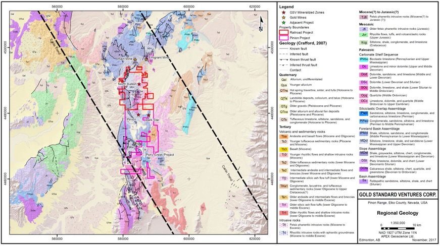
| Effective Date: November 3, 2017 | | | 50 |
Technical Report Maiden Resource Estimate North Bullion Railroad Project, Elko County, Nevada, USA
Figure 7.2. Longitudinal section illustrating the four igneous cored domes on the Carlin Trend.

The core of the Pinon Range is comprised of an allochthonous and autochthonous sequence of Ordovician through Mississippian marine sedimentary rocks (Smith and Ketner, 1975). Folds are present, but horst and graben structure developed within a framework of high-angle faults dominates the structure of the range. Tertiary sedimentary rocks deposited in shallow, fresh water lakes and overlying intermediate to felsic Tertiary volcanic rocks are present on the flanks of the range and within surrounding grabens (Table 7.1, Figures 7.3 and 7.4).
Since the Hunsaker (2012a, b) and Shaddrick (2012) reports, 24 additional samples of igneous (intrusive and extrusive) rocks from the Railroad Project area were collected and dated by Christopher Henry of the Nevada Bureau of Mines and Geology, University of Nevada (Henryet al., 2015). This work was conducted to further investigate the igneous geology at the Project and its relationship to mineralization. The samples were selected during a program that comprised field work and an examination of drill core to determine rock types, relative (cross-cutting) age relationships and spatial relationships to gold and/or base metal mineralization. The selected samples of igneous rocks and mineralization were sent for petrographic analysis, chemical analyses, and 40Ar/39Ar and U-Pb zircon age dating. The age dating work included mineral separations of sanidine, zircon, and/or other appropriate minerals, and was performed at the New Mexico Geochronological Research Laboratory (New Mexico Tech, Socorro, New Mexico) and the USGS – Stanford SHRIMP U-Pb lab (Stanford University, California).
| Effective Date: November 3, 2017 | | | 51 |
Technical Report Maiden Resource Estimate North Bullion Railroad Project, Elko County, Nevada, USA
Table 7.1. Formation correlation table.
Group Formation Member (Ketner and Smith, 1963) | Local Geology Map Labels |
| Quaternary | Qd, Qc, Qcst, Qls, Qay, Qfy, Qfo |
| Argillite unit in Lee Canyon | Tts8, Tcg8, Tba7, Tts6, Tba4, Telk |
| Bullion Stock | Trhy3, Tgd2 |
Diamond Peak and Chainman Webb Argillite unit in Lee Canyon | Mrai, Mton, Mmel, Mc, Mtp Mweb, Mlec, |
| Argillite quartzite unit in Lee Canyon | |
Devils Gate Limestone Woodruff Sentinel Mountain Dolomite Oxyoke Canyon member Beacon Peak Dolomite Member | Ddg, Dwood, Dnvud, Dnvoc, Dnvbpl, Dnvbp |
| Nevada Formation | Dnu |
| Lone Mountain Dolomite | Dslm |
| Hanson Creek Fm | SOhad |
| Eureka Quartzite | Oen |
| Pogonip Group | Opog |
Igneous rocks at the Railroad Project were emplaced and/or deposited during at least 4 distinct episodes between 38.9 and 37.5 Ma, with two possible major pulses at 38.4 and 37.8 Ma, that have produced at least 10 distinct rocks types (Henryet al., 2015).
These results are consistent with other dates from igneous rocks on the Carlin Trend and the accepted Eocene age for Carlin magmatic and hydrothermal systems.
“The northern portion of the Project is primarily covered with Mississippian Webb or equivalent age rocks [Figures 7.3, and 7.4; Table 7.1]. Detailed mapping by Westmont subdivided these units into separate lithologies (Nordquist, 1992). Westmont mapped the units striking northwesterly and dipping north. Some of the historic drillholes were drilled deeper ending in the Devonian Devils Gate Formation. Published reports from the Rain Mine suggest that Mississippian Webb and Chainman formations occur as both allocthonous and autochthonous units (Longo et al., 2002 and Mathewson, 2001).”
Four prominent high-angle fault directions have been identified including west-northwest, north-south, northwest and northeast-striking faults. The north-south striking Bullion Fault Corridor (BFC) separates the Tertiary volcanic rocks to the east from the Paleozoic sediments in the range. Northwest and west-northwest striking faults occur across the Project. Drilling indicates that low-angle faults have juxtaposed Devonian carbonates and Mississippian rocks with evidence of multiple episodes of low-angle faults. These developed a tectonic stratigraphic setting with interleaved Devonian Devils Gate Limestone Formation (Ddg) and Webb Formation (Mw) as well as Webb age equivalent rocks of the Tripon Pass Formation (Mtp (Hunsaker, 2012b).
| Effective Date: November 3, 2017 | | | 52 |
Technical Report Maiden Resource Estimate North Bullion Railroad Project, Elko County, Nevada, USA
The Sylvania (Central Bullion) Target area contains a westerly dipping sequence of Paleozoic rocks that are offset into numerous distinct blocks by west-northwest, north-south and northeast-striking faults. The west-northwest trend appears to be the most important structural trend. Fault bounded blocks appear to be affected by intrusion of the Bullion Stock and collapse of the magma chamber. Skarn occurs on the contact of the Bullion Stock and associated intrusive rocks along the Standing Elko dike corridor.
| 7.2.1 | Railroad - North Bullion Geology |
The North Bullion horst is bounded to the east and west by younger, generally flat lying, dacitic to rhyolitic tuffs of the Indian Well formation which become more felsic upwards (Henryet al., 2015). The Indian Well formation contains phenocrysts of quartz, sanidine, hornblende and biotite within a pink to grey groundmass, and rests on top of an angular unconformity above the underlying Elko Formation in the eastern hanging wall of the North Bullion Fault Zone (NBFZ) as shown in Figure 7.3.
The Eocene Elko Formation is found within the eastern hanging wall of the NBFZ, as shown in Figure 7.3, and consists of thick to thinly bedded mudstone, sandstone, chert pebble conglomerate, fresh water limestone, and tuffaceous sediments (Stewart, 1980; Smith and Ketner, 1976).
The North Bullion horst itself consists of thick bedded, fining upward, conglomerate and mudstone of the Mississippian Chainman Formation which contains 1 to 7 m thick dacite sills from 100 to 200 m below the surface. Dacite dikes occur along steeply dipping faults within the NBFZ (Jacksonet al., 2015). In between the upper and lower Chainman Formation is a sequence of mixed carbonate and siliciclastic rocks which are interpreted to belong to the Mississippian Tripon Pass Formation (Longoet al., 2002; Matthewson, 2001; Oversby, 1973). Two layers within the Tripon Pass Formation act as informal marker nits. Limestone 1 is a dark grey, laminated to thinly bedded micrite located at the top of the Tripon Pass Formation, and Limestone 2 is a grey, medium to thick bedded calcisiltite to calcarenite located approximately 55 m below Limestone 1 (Jacksonet al., 2015). The Tripon Pass Formation hosts the upper gold zone at North Bullion and locally contains >6 g/t Au. The Tripon Pass Formation is underlain by the variably bedded sandstone, conglomerate and silty mudstones of the Mississippian Chainman Formation.
Underlying the Chainman Formation, in low angle fault contact is the Devonian Devils Gate Limestone, composed of grey, thick bedded calcarenite and minor micrite, between 60 to 150 m thick. Dissolution collapse breccia developed at the top of the Devils Gate Limestone is host to high-grade gold within the lower zone at North Bullion (Jacksonet al., 2015). In the northern portion of the deposit, silty mudstone of the Mississippian Webb Formation and silty micrite of the Mississippian Tripon Pass Formation, are important hosts to gold, and are preserved along the low angle fault contact between the Chainman Formation and the Devils Gate Limestone (Figure 7.4). Beneath the Devils Gate Limestone there is a transitional contact into the Sentinel Mountain Dolomite that has an average thickness of 150 m and is in transitional contact with calcareous sandstone of the underlying Oxyoke Formation. The Oxyoke consists of cross bedded, well rounded quartz grains which are either matrix or grain supported, and is approximately 120m thick. Located between the Massif and West Strand faults there is tectonic and dissolution collapse breccia that extends from the lower contact of Limestone 1 to the top of the Devils Gate Limestone. Finally, the deepest drill holes at North Bullion bottomed in thin to thick bedded dolomite of the Devonian Beacon Peak Dolomite (Jacksonet al., 2015).
| Effective Date: November 3, 2017 | | | 53 |
Technical Report Maiden Resource Estimate North Bullion Railroad Project, Elko County, Nevada, USA
In a recent paper by Jacksonet al. (2015), the structural effect on geology at North Bullion is described as follows:
“North Bullion (gold deposit) occurs in a triangular shaped horst in the footwall of the major north-striking, steeply east-dipping, North Bullion Fault Zone (NBFZ). The western edge of the horst is bounded by a northeast-striking, northwest-dipping fault. The NBFZ is 300 m wide and apparent normal displacement across the NBFZ is greater than 600 m, as constrained by the deepest holes into the Indian Well Formation volcanic rocks that fill the Bullion graben to the east. Chainman sandstone occupies the center of the horst, and the variable strikes and dips at the surface indicate an open fold is centered on the horst. The western edge of the horst is bounded by a N50E striking, northwest-dipping fault. The triangular shape of the horst is well represented in structure contours on the top of the Devils Gate Limestone.”
Additionally, they add:
“Intrusive relationships and tilting of units indicate the deposit formed during an Eocene event with synchronous intrusion, hydrothermal activity and extensional movement on graben-bounding faults. Dacite sills, dated at 38.8–38.2 Ma, intruded steeply dipping faults within the NBFZ and low angle, bedding parallel faults, capping the gold system. The margins of dacite dikes and sills are commonly sheared and some dacite occurs as clasts within mineralized dissolution collapse breccia, indicating continued movement along faults and hydrothermal activity after emplacement of the dacite. In fault steps within the NBFZ, the Eocene Elko Formation has the same moderate eastward dip as the underlying Paleozoic rocks. The collapse breccia generally exhibits a flat-tabular textural fabric subparallel to today’s surface. All of this evidence supports the formation of North Bullion during a very dynamic, focused Eocene event with synchronous extension, intrusion and Carlin-style mineralization.”
The geological setting of the Pinion (southern) portion Project area is the same as that described above for the adjacent Railroad (northern) portion of the Project. Thus, the stratigraphic units observed at the Pinion Project are the same as those described above, as is the overall tectonic history. The property scale geology of the Railroad–Pinion Project area is illustrated in Figure 7.3, and a detailed stratigraphic column of the project area is illustrated in Figure 7.4.
The Pinion Project lies at the southeastern end of the Carlin gold trend and is hosted by a sequence of Paleozoic sedimentary rocks exposed within large structural horst blocks in which the sedimentary rocks have been broadly folded into a southward plunging asymmetric anticline. The apparent dip of the western fold limb ranges from 10 to 25 degrees and the steeper eastern limb dips 35 to 50 degrees. Carlin-type mineralization at the Pinion Deposit is hosted in dissolution collapse breccia developed along the contact between the underlying Devonian Devils Gate Limestone Formation (Ddg) and the overlying Mississippian Webb Formation (Mw) fine grained clastic sediments and Tripon Pass Formation silty micrite (DeMatties, 2003; Norbyet al., 2015). The Pinion thrust occurs beneath or along the base of the deposit and emplaced Devonian Devils Gate Limestone on top of Mississippian Chainman sandstone. Recently, an additional zone of mineralization has been identified at the Pinion Deposit hosted within the Sentinel Mountain dolomite and the top of the underlying Oxyoke sandstone below the Devils Gate Limestone.
| Effective Date: November 3, 2017 | | | 54 |
Technical Report Maiden Resource Estimate North Bullion Railroad Project, Elko County, Nevada, USA
Figure 7.3. Property geology (after Smith and Ketner, 1975).
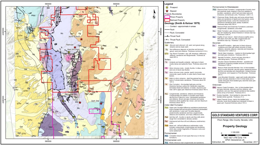
| Effective Date: November 3, 2017 | | | 55 |
Technical Report Maiden Resource Estimate North Bullion Railroad Project, Elko County, Nevada, USA
Figure 7.4. Railroad–Pinion Project stratigraphic column.
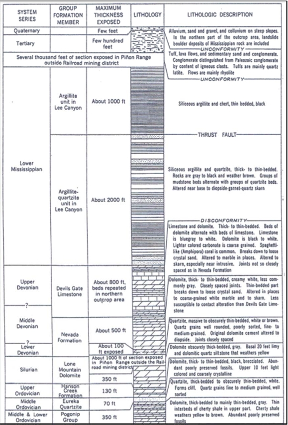
| Effective Date: November 3, 2017 | | | 56 |
Technical Report Maiden Resource Estimate North Bullion Railroad Project, Elko County, Nevada, USA
The following historic account of the local geology has been reproduced from a previous Technical Report on the Pinion Project by DeMatties (2003):
“The axis of the Pinion Anticline is defined at surface by bedding plane attitudes in thin-bedded siliciclastic strata. This anticlinorium, which can be traced for approximately 2 miles, trends north – south N20ºW and plunges approximately 25º to 30º S. It is characteristically asymmetrical with moderately dipping western limbs and steep eastern limbs. Lower plate, Eastern Assemblage carbonates of Nevada and Devils Gate Formations form the core of the fold, while siliceous clastic units of the upper plate Overlap Assemblage (Mississippian Webb, Chainman, and Diamond Peak Formations) form its limbs (Calloway, 1992). The high angle faults have dissected and displaced locally the axial trace of the anticlinorium.”
In a recent paper by Norbyet al. (2015), the local geology is described as follows:
“The Pinion Deposit is contained within a northwest-trending horst. Faults on the northeast horst margin are linking structures to the more northerly striking, range-bounding structures of the Bullion fault system. The greater Pinion 2.3-kilometer trend of gold concentrations occurs along the footwall of the Bullion fault system where it is offset at the linking structures. The fault on the southwest horst margin continues northwest across the Pinion Range.
NNE-trending anticlines occur at central and southeast Pinion. A gently west-dipping thrust, separating an overlying normal Devils Gate to Chainman section from an underlying Chainman section, is drill defined beneath the southeast Pinion anticline and the east limb of the central Pinion anticline. Gold is concentrated along the anticline axis and east fold limb at central Pinion, and to a lesser extent along the anticline at southeast Pinion.
Thicker and higher-grade dissolution collapse breccia occurs along the footwall of the steeply NNE-dipping Main Zone Fault, which apparently down-drops the section 40 to 120 meters. This structure could be a left-lateral tear fault related to ESE-WNW compression that also produced the anticlines and thrust. Alternately, the structure could be a fault developed along the steeper limb of a NNE-verging asymmetric fold.
At the North Gold Zone, the host section could be the left-laterally displaced east limb of the central Pinion anticline. Gold mineralization is controlled by the Bullion Fault on the east, and/or a west-northwest structure parallel to the Main Zone.”
| Effective Date: November 3, 2017 | | | 57 |
Technical Report Maiden Resource Estimate North Bullion Railroad Project, Elko County, Nevada, USA
| 7.2.3 | Dark Star and Dixie Creek Geology |
The Dark Star and Dixie Creek prospects are located to the east of the Pinion Deposit and are hosted in younger, Pennsylvanian-Permian rocks. However, the overall tectonic history is similar to that of the Pinion and Railroad areas. Thus, the Dark Star and Dixie Creek prospects lie stratigraphically up section relative to the Pinion and Railroad areas. A stratigraphic column for the Dark Star area is illustrated in Figure 7.5.
The Dark Star and Dixie Creek prospects lie along what is currently referred to as the Dark Star Corridor (DSC), which was previously referred to as the Dark Star Structural Trend (DSST) which has not been changed in the quotations that follow. The DSC is a north-south zone of gold mineralization and alteration that has affected the Mississippian Chainman, and Pennsylvanian Moleen and Tomera Formations. Gold mineralization at Dark Star has been identified within a decalcified and silicified Pennsylvanian-Permian carbonate unit, consisting of debris flow conglomerate, bioclastic limestone, calcarenite, calcisiltite and minor silty mudstone. These carbonate host rocks were mapped by the USGS as undifferentiated Tomera and Moleen Formations (Smith and Ketner, 1975).
Crown Resources produced a detailed geological report for the area of their Cord Ranch Lease which encompasses the southern portion of the Dark Star Prospect and the Dixie Creek area. The following description of the local geology is from Calloway, 1992:
“The DSST is a prominent north-south to northeast-southwest trending system of folds, high en echelon normal faulting, extensive hydrothermal alteration, silicification, brecciation (both tectonic and hydrothermal) and late stage NE-SW and NW-SE normal faulting. The DSST is expressed on the surface by a nearly linear alignment of moderately to completely silica replaced outcrops. The system has a surface expression of over 5.0 miles in strike length, however geophysical data suggest that it can be extended for an additional 2.5 to 3 miles. The DSST is bounded on the east and west by high angle normal faults forming a north-south trending horst block. Preserved within the horst is the hinge of a large, generally north-south trending antiform. Rocks along the crest of the fold have been subjected to widespread decalcification, episodic silicification and extensive argillization. Multi-stage, heterolithic, matrix and clast supported hydrothermal breccias are common. The stratigraphy of the rocks preserved in the horst block is complex and not easily determined.
Folded and faulted Paleozoic rocks along the DSST have been buried by Oligocene volcanics and upper Miocene sediments. Some Paleozoics are exposed in windows along fold axes or were erosional highs during deposition of the volcanics and sediments. Early north-south normal faults are truncated by NW-SE trending normal faults which are in turn truncated by NE-SW trending normal faults. Interestingly, the north half of the DSST is characterized by northwest trending normal faults while the southern half has predominantly northeast trending normal faults. Cross-cutting relationships are consistent between the two areas.
Widespread extensive decalcification characterizes the initial phases of alteration followed closely by pervasive silica flooding and weak to intense, texturally destructive silica replacement.
| Effective Date: November 3, 2017 | | | 58 |
Technical Report Maiden Resource Estimate North Bullion Railroad Project, Elko County, Nevada, USA
Figure 7.5. North Bullion tectono-stratigraphic column (after Jacksonet al., 2015).
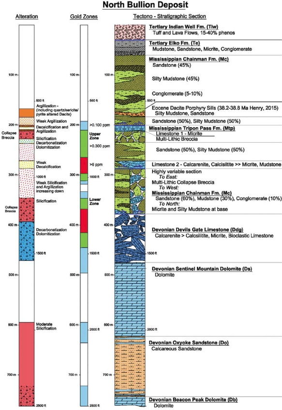
| Effective Date: November 3, 2017 | | | 59 |
Technical Report Maiden Resource Estimate North Bullion Railroad Project, Elko County, Nevada, USA
Silicification has ostensibly followed receptive lithologies and hence shows a generalized antiformal distribution mimicking local structural trends.
Argillization forms a broad halo to the entire strike length of the DSST. Argillization grades from intense proximal to weak distal over a distance of 500 ft.”
Recent fieldwork and re-logging of RC chips by GSV personnel confirms that gold mineralization at Dark Star is related to a north to north-northeast-striking zone of silicification focused along west-dipping contacts within a coarse conglomerate and bioclastic limestone bearing unit sandwiched between silty limestone units. These sedimentary rocks are cut by thin rhyolite dikes along the DSC.
Dixie Creek gold mineralization is reported to be associated with jasperoids and silicified conglomerates along a prominent resistant ridge. Redfern (2002) suggests the jasperoids and conglomerates are part of the Chainman Formation, and that they are visibly intruded by a number of felsic intrusions including dikes, sills and stocks. However, more recent work by Gold Standard personnel indicates that the host sedimentary package of siliciclastics and limestones is likely part of the Pennsylvanian Tomera or Moleen formations. The host rocks for the Dixie Creek gold mineralization are similar in nature to those that host the Dark Star gold deposit, and the Dixie Creek mineralized zone is hosted within the southern portion of the DSC.
Historic and recent exploration, including a number of extensive drilling programs, conducted by Gold Standard and previous owners/operators throughout the Railroad–Pinion Project area has demonstrated the presence of Carlin-style gold mineralization similar in setting and style to that of other deposits in the area including Rain and Emigrant (Koehleret al., 2014; Turneret al., 2015, Norbyet al., 2015). Mineralization at Pinion occurs mainly as finely disseminated gold in largely stratiform jasperoid (silicified) bodies that represent dissolution, collapse breccia developed along the contact between the Mississippian Tripon Pass Formation silty micrite and Devil’s Gate Formation calcarenite (Koehleret al.,2014;Turneret al., 2015; Norbyet al., 2015). Mineralization also includes silica flooding, quartz veining and deposition of minor fine-grained pyrite, stibnite and barite.
Carlin-style gold mineralization has also been demonstrated at the Dark Star Deposit, occurring as part of a north-striking zone of faults, dikes, and silicification that runs along the east side of the Piňon range. Mineralization at Dark Star occurs within the Pennsylvanian-Permian siliciclastic and carbonate rocks, hosted along contacts with and within a west-dipping conglomerate and bioclastic limestone (Dufresneet al., 2017).
Mineralization at the North Bullion Deposit occurs as Carlin-style disseminated gold that is focused in the footwall of the Bullion Fault zone. The footwall is a horst of Paleozoic siliciclastic and carbonate rocks, whereas the hanging wall is a deep graben filled with Tertiary volcanic rocks. In the footwall north-south-, northwest-, west-northwest- and northeast-striking faults appear to be important controls on mineralization.
| Effective Date: November 3, 2017 | | | 60 |
Technical Report Maiden Resource Estimate North Bullion Railroad Project, Elko County, Nevada, USA
Geological and geochemical work by Gold Standard since 2010 has resulted in the identification of 16 prospect areas (or zones of mineralization) at the Railroad Project area (Figure 7.6). This section summarizes the main mineralization styles of prospects within the Railroad Project area and the Pinon and Dark Star Deposit areas. A detailed discussion of the mineralization within each prospect within the Pinion Project area has been thoroughly discussed in previous Technical Reports, most recently, by Turneret al. (2015), Dufresneet al. (2015), Dufresne and Nicholls (2016), Dufresne and Koehler (2016), and Dufresneet al. (2017)
| 7.3.1 | North Bullion Deposit Area |
Carlin-style disseminated gold mineralization at North Bullion is not exposed at surface. The bulk of the geological understanding and interpretation of the North Bullion prospect has come from core drilling of associated geophysical anomalies (gravity and CSAMT). Gold mineralization is focused in the footwall of the Bullion Fault zone (see Footwall Model in Section 8 below), a north-south striking zone of normal faults with an overall down to the east sense of motion. The footwall is a horst of Paleozoic siliciclastic and carbonate rocks, whereas the hanging wall is a deep graben filled with Tertiary volcanic rocks. In the footwall north-south, northwest-, west-northwest- and northeast-striking faults appear to be important controls on mineralization.
North Bullion was a blind gold discovery in 2010, when a process of vectoring from surface gravity surveys was combined with geological models and geological drillhole data, lead to intercepts of 32 m of 1.39 g Au/t and 43.6 m of 1.21 g Au/t in drillhole RR10-8 (Jacksonet al., 2015). The gold system remains open in all directions and spans an area of 400 m by 1,200 m.
The North Bullion Deposit occurs in a triangular shaped horst in the footwall of the major north-south striking, steeply east-dipping, North Bullion Fault Zone (NBFZ). The western edge of the horst is bounded by a northeast-striking, northwest-dipping fault. The deposit is blind with the gold system capped by gently east-dipping, dacite sills. In general, gold is hosted in two zones, a gently to moderately dipping upper zone of strongly sheared siliciclastic and carbonate rocks (a mixed composite of Mississippian Webb and Tripon Pass formations) and a flat lying, lower zone of dissolution collapse breccia developed above and within silty micrite of the Mississippian Tripon Pass Formation and calcarenite of the Devonian Devils Gate Limestone (Jackson and Koehler, 2014; Jacksonet al., 2015). Between strands of the NBFZ, breccia with both collapse and tectonic features propagated upwards through the Mississippian section incorporating Webb Formation silty mudstone, Tripon Pass Formation silty micrite and Chainman Formation sandstone (Figure 7.5 and 7.7).
Gold zones range from 105 to 400 meters in depth, and steepen from flat (10 degrees) to moderate (45 degrees) dips to the east, as they approach the eastern strand of the NBFZ. Gold is associated with sooty sulphides, silica, carbon, clay, barite, realgar and orpiment in addition to elevated As, Hg, Sb and Tl. High-grade (> 6 g/t Au) gold has been intercepted in both the upper and lower gold zones. Some of the best gold intercepts include:
| · | RR12-10 upper zone: 124.1 m (core length) of 4.05 g/t Au from 218.0 to 342.1 m; including a high grade zone of 16.5 m core length of 15.09 g/t Au, and |
| · | RR13-11 lower zone: 98.2 m (core length) of 3.26 g/t Au from 313.4 to 411.6 m; including a high grade zone of 17.1 m (core length) of 9.98 g/t Au. |
| Effective Date: November 3, 2017 | | | 61 |
Technical Report Maiden Resource Estimate North Bullion Railroad Project, Elko County, Nevada, USA
Figure 7.6. Railroad–Pinion Project prospects (mineralized zones).
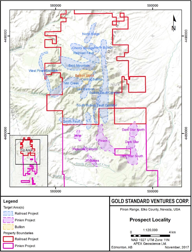
| Effective Date: November 3, 2017 | | | 62 |
Technical Report Maiden Resource Estimate North Bullion Railroad Project, Elko County, Nevada, USA
Hydrothermal alteration is characterized by a progression from distal breccia with calcareous clasts and calcite cement to intermediate breccia with dolomitized clasts and dolomite cement to proximal breccia with silica/sulphide cement and replacement of clasts. Dolomitization of the Devils Gate limestone thickens and strengthens towards the NBFZ. Veinlets show a general zonation around the deposit from an outer calcite shell to intermediate ferroan dolomite to barite +/- quartz immediately above, within and below the gold zones (Jacksonet al., 2015).
Intrusive relationships and tilting of units indicate the deposit formed during an Eocene event with synchronous intrusion, hydrothermal activity and extensional movement on graben-bounding faults. Dacite sills, dated at 38.2-38.8 Ma (Henryet al., 2015), intruded steeply dipping faults within the NBFZ and low angle, bedding parallel faults, capping the gold system. The margins of dacite dikes and sills are commonly sheared and some dacite occurs as clasts within mineralized dissolution collapse breccia, indicating continued movement along faults and hydrothermal activity after emplacement of the dacite. In fault steps within the NBFZ, the Eocene Elko Formation has the same moderate eastward dip as the underlying Paleozoic rocks. All of this evidence supports the formation of North Bullion during a very dynamic, focused Eocene event with synchronous extension, intrusion and Carlin-style mineralization
Gold Standard supported a North Bullion-focused M.Sc. thesis with the University of Nevada Las Vegas designed to determine the mineralogy and paragenesis of mineralization and alteration, determine the size and intensity of alteration haloes of both visible alteration minerals and stable isotope signatures, and characterize fluid pathways (Newton, 2015; Newton and Cline, 2014). The thesis yielded the following findings: 1) mineralogical characteristics examined to date indicate that the North Bullion mineralization displays ore pyrite chemistry, textures and alteration minerals similar to known Carlin–type gold mineralization; 2) the North Bullion pyrites have partial Au-bearing rims and the same trace element chemistry as known Carlin–type gold mineralization; 3) the host rocks at North Bullion have been locally decarbonatized, argillized, dolomitized and silicified, exhibiting alteration similar to known Carlin–type gold mineralization, and 4) the mineralization is hosted along lithologic contacts, within mudstone/silty mudstone/limestone and/or multilithic breccia, and within the lower collapse breccia zone (Newton and Cline, 2014). Petrography indicates that collapse and tectonic breccia within the area formed during the pre-, syn-, and post-gold mineralization stages (Newton, 2015; Newton and Cline, 2014). This may indicate that the multi-stage brecciation was related to multiple episodes of movement and long-lived hydrothermal activity along the Bullion Fault Corridor (BFC) and other related structures in the area (Newton and Cline, 2014).
Mineralization at the POD zone is restricted to a steeply-dipping shear zone which trends west-northwest and is situated in rocks stratigraphically higher than the lower zone at North Bullion (Masters, 2003; Hunsaker, 2012b). Mineralization at POD is hosted by the upper siltstones of the Webb Formation (Figure 7.8). There is a zonation in the mineralization with a core of carbon and fine, disseminated pyrite (accounting for approximately 15 % of the mineralization) which is surrounded by strongly oxidized mineralization as a result of interaction with surface oxidizing groundwater. Gold is fine grained (5-20 microns) and is associated with oxidized pyrite, stibnite and arsenopyrite (Masters, 2003). Additionally, gold mineralization at POD is associated with jasperoids, silicification, argillization, pyritization, barite and some minor dolomitization (Hunsaker, 2012b).
| Effective Date: November 3, 2017 | | | 63 |
Technical Report Maiden Resource Estimate North Bullion Railroad Project, Elko County, Nevada, USA
Figure 7.7. North Bullion cross section along N4488800, with no vertical exaggeration. (Jacksonet al., 2015).
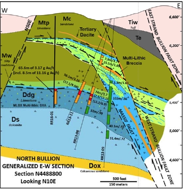
Figure 7.8. Cross section through the POD zone looking northwest (after Masters, 2003).
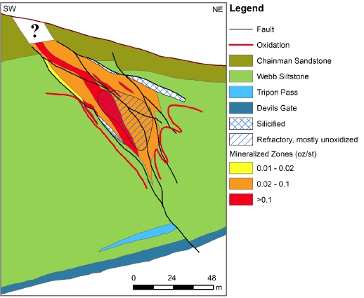
| Effective Date: November 3, 2017 | | | 64 |
Technical Report Maiden Resource Estimate North Bullion Railroad Project, Elko County, Nevada, USA
The Pinion Deposit is located at the south end of the Bullion Fault Corridor. The Carlin-style gold mineralization of the Pinion Deposit is similar in setting and style to the mineralization of the North Bullion Deposit. Previous exploration by other companies identified two adjacent zones of gold mineralization at the Pinion Deposit identified as the Main Zone and North Pod Zone. The Main Zone trends approximately N60ºW to N70ºW, reaches up to 5,200 ft (1,580 m) along strike and is approximately 2,300 ft (700 m) wide.
Mineralization at Pinion occurs mainly as finely disseminated gold in largely stratiform jasperoid (silicified) bodies that represent dissolution, collapse breccia developed along the contact between the Mississippian Tripon Pass Formation silty micrite and Devil’s Gate Formation calcarenite (Koehleret al.,2014;Turneret al., 2015; Norbyet al., in Press). Gold deposition is thought to have occurred contemporaneous with breccia development and with late silica flooding and quartz veining. Barite-rich breccias can also be observed associated with jasperoid bodies at surface. Norbyet al. (2015) summarize the gold mineralization at Pinion as follows:
“Gold is hosted in a persistent blanket in a stratiform multi-lithic, collapse breccia. Breccia clasts grade from dominantly silty micrite (Tripon Pass) in the top of the breccia to calcarenite (Devil’s Gate) in the bottom, with lesser clasts of Webb silty mudstone and Chainman sandstone. Thickness and gold grade of multi-lithic breccia increase markedly proximal to feeder structures.
Alteration consists of collapse breccia formation, silicification, decalcification, clay replacement, sooty sulfide dissemination (oxidized to iron oxide), and barite flooding. Trace elements associated with gold are silver, antimony, arsenic, barium, and mercury.
A type of mineralization with more typically epithermal-like textures is also present at Pinion. Banded fine-grained to fine-cockscomb silica occurs throughout the deposit, locally with stibnite (stibiconite) and elevated silver to 70 ppm.”
Gold deposition is thought to have occurred during the Eocene at the same time as formation of the dissolution collapse breccia. Significant control on the distribution of gold appears to have been exerted by folding/horst development in that the highest grades and thickest mineralization occurs in the apical hinge portion of the coincident Pinion anticline and main horst block. Breccias and gold zones thicken noticeably towards high angle faults, which likely acted as conduits for the gold-bearing hydrothermal fluids (Koehleret al.,2014; Turneret al., 2015; Norbyet al., 2015 and 2016). The main mineralized collapse breccia horizon is oxidized to depths of 1,050 ft (320 m), or more. The stratigraphic setting for gold mineralization at the Pinon Deposit is illustrated below in Figure 7.9.
| Effective Date: November 3, 2017 | | | 65 |
Technical Report Maiden Resource Estimate North Bullion Railroad Project, Elko County, Nevada, USA
Figure 7.9. Pinion Deposit stratigraphic setting (after Norbyet al., 2015).
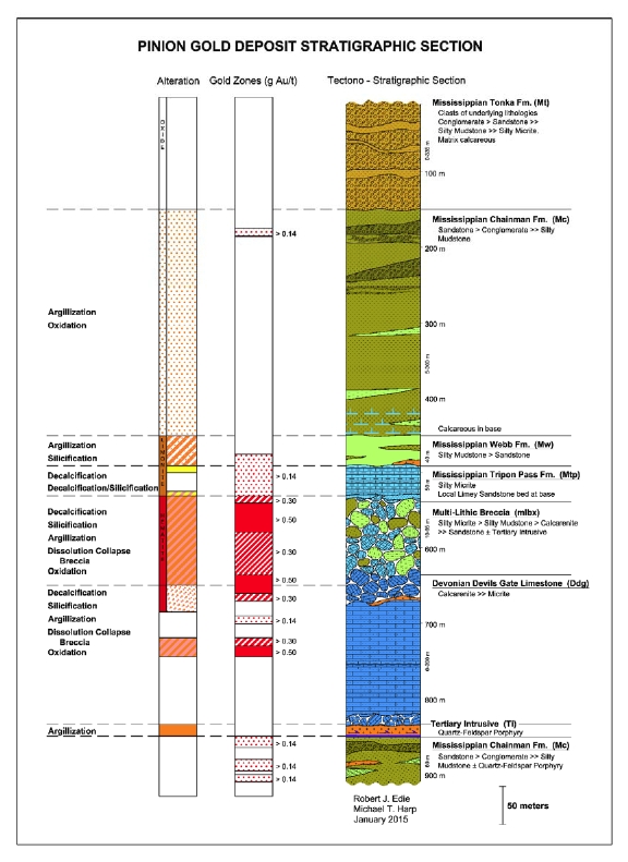
| Effective Date: November 3, 2017 | | | 66 |
Technical Report Maiden Resource Estimate North Bullion Railroad Project, Elko County, Nevada, USA
| 7.3.3 | Dark Star Deposit Area |
Exploration at the Dark Star area has demonstrated the presence of Carlin-style gold mineralization. The Dark Star Deposit occurs at a higher stratigraphic level than the Pinion Deposit and occurs within rocks mapped as undifferentiated Pennsylvanian Tomera and Moleen Formation by Smith and Ketner (1975), which is cut by north, northeast and northwest striking faults and hydrothermal breccias and/or jasperoids. Gold mineralization is hosted along contacts with and within a west-dipping conglomerate and bioclastic limestone bearing unit sandwiched between overlying and underlying siltstone units (Figure 7.10). These sedimentary rocks are cut by thin rhyolite dikes. Surface geology for the Dark Star Deposit area is characterized by prominent zones of silicification that appear as hematitic jasperoids.
Dark Star gold mineralization occurs in a 400 to 600 m wide, 6 km long, linear, north trending horst that is part of a structural zone defined as the Dark Star Corridor (DSC), which exposes altered and silicified Pennsylvanian siliciclastic and carbonate rocks (Harpet al., 2016). North-south trending gold mineralization at Dark Star has been intersected over an area approximately 2,000 ft (610 m) long, up to 1,610 ft (490 m) wide and up to a depth of 690 ft (210 m) below surface.
The following discussion of the mineralization and alteration observed at the Dark Star Prospect has been provided by GSV geologists and is the result of the Company’s extensive re-logging program involving archived reverse circulation chip samples (Harp and Edie, 2015):
“Mineralization is well developed in the coarse conglomerate debris flow of the middle unit, which is constrained between the two siltstone units. Gold bearing fluids were channeled along the contact of the upper siltstone unit with the underlying conglomerate debris flow unit. The upper siltstone unit can be gold bearing near its base where it transitions into the conglomerate unit. There is a sharp contact at the base of the conglomerate unit with the lower calcareous siltstone. The silty mudstone at the base of conglomerate is stratigraphically above the lower siltstone and acted as an aquitard that focused mineralization into the upper two rock units and formed a base to stratiform flow in the system. Gold values are generally consistent throughout the deposit with higher grade gold focused at the top and base of the middle conglomerate unit.
Hydrothermal alteration of the upper siltstone and middle conglomerate units is defined by sooty sulfide dissemination that is oxidized primarily to limonite with lesser hematite. Alteration also includes weak to moderate silicification, decalcification, and argillization. Quartz veinlets, drusy quartz on fractures and quartz banding occur with silicification. Minor zones of weak brecciation are common and occur near faults. These breccia zones are not directly associated with higher grades in the deposit. Mineralization is continuous within the conglomerate and propagates into the lower part of the upper siltstone. Alteration of the lower siltstone unit is characterized by decalcification, weak oxidation, argillization, and minor silicification. Gold mineralization is uncommon in the lower siltstone unit. Alteration of rhyolite and granodiorite sills or dikes includes moderate to strong argillization, weak silicification, propylitization, and oxidation.
Dark Star is overwhelmingly oxidized, however thin zones of un-oxidized sulfide are present. These zones occur where silicification is more intense or where oxidizing fluids were inhibited in the system. These zones tend to be above or below mineralization, and comprise less than 2 % of the mineralized rock in the deposit.
| Effective Date: November 3, 2017 | | | 67 |
Technical Report Maiden Resource Estimate North Bullion Railroad Project, Elko County, Nevada, USA
Gold mineralization crops out at surface on the east side of the deposit and is drilled to a depth of 210 meters down dip to the west. The deepening of gold from east to west corresponds to the dip of the rock units. Gold intercepts thicken in the upper siltstone and conglomerate units near major faults and fault intersections. Historic multi-element ICP analyses are sporadic throughout the deposit. Multi-element analyses indicate arsenic is closely related to gold. Gold mineralization is stronger where silicification and oxidation increase. Higher grades are commonly associated with drusy quartz on fractures that have a limonite and/or hematite coating. This illustrates that Dark Star is a typical oxidized Carlin-Type deposit, where gold-bearing fluids were preferentially channeled in highly permeable, open space zones along feeder structures, allowing for mineral deposition and later oxidation of sulfide.”
| 7.3.4 | Bald Mountain Target |
At the Bald Mountain target, discrete and separate disseminated gold and copper mineralization is hosted in strongly oxidized, collapse breccia bodies developed along the contact between quartz hornfelsed silty mudstone of the Webb Formation lying immediately above marbleized Devonian Devils Gate Limestone (Koehleret al., 2015). The collapse breccia zone correlates with a prominent gravity low on the southern flank of Bald Mountain. The Bald Mountain target comprises a large complex mineralizing system measuring 700 feet (~210m) north-south by 1,800 feet (~550m) east-west. Mineralization starts at ~325 feet (~100m) below surface on the east side of the target and ranges between 40 and 250 feet (~12-75m) in thickness.
Gold and copper mineralization at Bald Mountain is spatially separate with gold mineralization occurring in the upper part of the breccia whereas the copper mineralization is located in the lower part of the breccia above the Devils Gate marble. A Carlin-style structural framework of north-, northeast- and west northwest-striking faults, and quartz porphyry to dacite filled faults cut through this target. Vertical and laterally-extensive hydrothermal alteration comprises oxidation, clays, silicification, and quartz veins/stockworks.
In late 2014, 16 samples of drill core from hole RRB13-01 within the Bald Mountain prospect were submitted for petrographic analysis by consultant Mark McComb (McComb Petrographics, Buena Vista, Co). The samples revealed textures and mineralogy representative of altered skarn style mineralization (McComb, 2014). Garnet appears to have been the main skarn mineral that has been largely replaced by silica and iron oxides by a late Carlin-style silicification event. Ghosted outlines of pyroxene and amphibole were also reported and the iron oxides observed were interpreted as replacing primary pyrrhotite.
The Bald Mountain prospect is currently at an early stage of exploration. All 5 of the 2014 Bald Mountain drillholes intersected significant intervals of precious and base metal mineralization that remain open in all directions.
| Effective Date: November 3, 2017 | | | 68 |
Technical Report Maiden Resource Estimate North Bullion Railroad Project, Elko County, Nevada, USA
Figure 7.10. Dark Star Deposit detailed tectono-stratigraphic section.
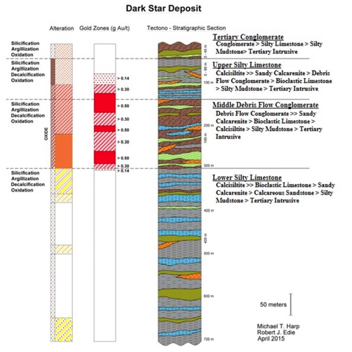
| Effective Date: November 3, 2017 | | | 69 |
Technical Report Maiden Resource Estimate North Bullion Railroad Project, Elko County, Nevada, USA
| 7.3.5 | Central Bullion (Sylvania) Target |
At Sylvania, silver, copper, lead, zinc and minor amounts of gold occur within skarn along the west-northwest-striking, dike-filled Standing Elk fault near the margin of the Bullion Stock (Koehleret al., 2015). The Standing Elk fault is part of a larger, 0.5 km wide x 5 km long corridor of west-northwest-striking dikes. Prograde skarn alteration includes bleaching, andradite and grossularite garnets, pyroxene in Devils Gate Limestone and endoskarn in the Bullion Stock. Retrograde alteration includes deep oxidation, clays and muscovite. Dating using 40Ar/39Ar and U-Pb methods indicate skarn mineralization formed during emplacement of the 38.2 Ma Bullion Stock. Mineralization begins at, or very near, surface and has been traced down dip to ~1100 feet (330 m) below surface, and remains open in all directions.
| 7.3.6 | Railroad Fault Target |
The Railroad Fault target area encompasses a west-northwest trending structural corridor, which includes the historical POD deposit area. Section 6.2 of this report discusses historic resource estimates for the POD (Railroad) zone of mineralization. The following description of the Railroad Fault target is taken from Hunsaker (2012b):
“The Railroad Fault Target area has a geologic setting similar to the North Bullion Target zone. Drilling by Gold Standard Ventures and historic drilling has demonstrated the presence of Carlin-style gold-bearing mineralization. Historic estimates, work completed by previous operators, and GSV exploration describe gold mineralization associated with jasperoids, silicification, argillization, pyritization, barite, and potentially dolomitization within a west-northwest trending corridor. Generally, mineralization is associated with the contact zone of the Mississippian Webb and the Devonian Devils Gate Formation. A historical estimate (non NI-43-101 compliant) was done for a zone 1500 feet long (northwest-southeast), 400 feet wide and approximately 200 feet thick. The zone is as shallow as 20 feet below the surface and has good continuity. The broader Target area has widespread gold mineralization in drilling and surface geochemistry with the favorable characteristics (noted above) mapped on the surface or noted in drilling. The work completed and data available throughout the broader Railroad Fault Target area are insufficient to determine the length, width, depth, or continuity of the gold mineralization.”
| 7.3.7 | Bullion Fault Corridor Target |
Carlin-style hydrothermal alteration, gold mineralization and associated trace element geochemistry occur beneath post-mineral volcanic cover along the Bullion Fault Corridor to the south of the North Bullion target. Zones of anomalous (<0.010 oz Au/st) Carlin-style gold mineralization and elevated arsenic occur in close association with silicified, dolomitized and clay altered Paleozoic rocks, and quartz-sericite-pyrite altered igneous dikes.
| 7.3.8 | Cherry Springs Target |
The Cherry Springs target was identified based on geologic mapping, gravity and CSAMT. At this location, drilling targeted Carlin-style disseminated gold mineralization at two separate structural intersections with the west-northwest-striking Cherry Spring fault. Similar to the North Bullion target, Cherry Springs is a blind target. The best intercepts were returned from drillhole RR12-29, which intersected 18 feet of 0.021 oz Au/st and 13 feet of 10.94 oz Ag/st. Disseminated gold and silver mineralization occurred with silicification, barite, carbon, barite in a multilithic collapse breccia at ~1400 ft depth.
| Effective Date: November 3, 2017 | | | 70 |
Technical Report Maiden Resource Estimate North Bullion Railroad Project, Elko County, Nevada, USA
The LT target area has a geologic setting similar to that of the North Bullion prospect. Historic drilling, soil geochemistry, and rock geochemistry have demonstrated the presence of gold-bearing mineralization with similar favorable characteristics (Hunsaker, 2012). The LT area is complicated by numerous high angle faults, and the presence of gravity slide blocks that shuffle and comingle Paleozoic siliciclastic and carbonate rocks into a complex tectono-stratigraphic sequence.
The North Ridge target comprises soil geochemical anomalies that suggest the presence of a gold-bearing mineralized system and a coincident geophysical (gravity) anomaly that together indicate the presence of major fault zones.
| 7.3.11 | South Bullion Fault Corridor Target |
Mapping at this location illustrates a structural intersection of the north-south striking Bullion Fault Corridor and several northeast- and northwest-striking faults within the Lone Mountain Dolomite, Nevada Group dolomite and Oxyoke Formation. Results from 505 rock samples identified the following range of assays: <0.005 – 1.425 ppm Au; <0.2 – 418 ppm Ag; <1 – 30,960 ppm Cu, <2 – >300,000 ppm Zn, and <2 – 120,200 ppm Pb indicating the presence of a large mineralized zone with similar structural and geochemical signatures to Carlin-style mineralization.
This target area is characterized by numerous historic adits and shafts on the southwest flank of the Bullion Stock. The historic workings accessed base metal skarn deposits hosted in bleached, metamorphosed Devils Gate Limestone Formation carbonate rocks. North-south and northeast-striking faults cut the marble at this location. Results from 301 rock samples identified the following range of assays: <0.005 – 1.93 ppm Au, <0.2 – 2,570 ppm Ag, 1 – 190,200 ppm Cu, <2 – 40,930 ppm Pb, and 3 – 150,900 ppm Zn.
At this location west of the Bullion Stock, siliciclastic rocks in the upper plate of the Roberts Mountains Thrust (RMT) and rocks of the Chainman and Webb Formations in the lower plate of the RMT have been cut by northwest-striking quartz feldspar porphyry dikes and northeast-striking faults. Weak hornfels development, silicification and quartz veining have been identified by mapping. Results from 219 rock samples identified the following range of assays: <0.005 – 0.124 ppm Au, <0.2 – 10 ppm Ag, <2 – >10,000 ppm As, and 2 – 4,400 ppm Zn.
| Effective Date: November 3, 2017 | | | 71 |
Technical Report Maiden Resource Estimate North Bullion Railroad Project, Elko County, Nevada, USA
| 7.3.14 | West Pine Mountain Target |
This target area is located on the western flank of Pine Mountain, a prominent topographic feature that exposes Paleozoic carbonate rocks of the Devils Gate, Nevada Group and Oxyoke Formations. Results from 211 rock samples identified the following range of assays: <0.005 – 0.25 ppm Au, <0.2 – 2.8 ppm Ag, <0.2 – 523 ppm As, 2 – 46,300 ppm Zn.
This target area is dominated by an east west striking fault that juxtaposes Chainman Formation sandstone against Woodruff Formation mudstone. Results from 143 rock samples identified the following range of assays: <0.005 – 0.011 ppm Au, <0.2 – 3,800 ppm Zn, <1 – 197 ppm Mo.
Gold Standard currently recognizes three styles of mineralization within the Railroad–Pinion Project area:
| · | Carlin-type sedimentary rock-hosted gold mineralization. |
| · | Skarn-type silver, copper, lead, zinc, gold mineralization. |
| · | Sedimentary rock-hosted gold, silver and copper mineralization hosted in hornfelsed Paleozoic rocks (similar to geologic patterns observed at the Mike Gold-Copper-Zinc-Silver Deposit, as described by Norby and Orobona, 2002). |
Since mid-2012 (Hunsaker, 2012a, b; Shaddrick, 2012), the information on deposit types for the Railroad–Pinion Project area has evolved and been modified due to observations related to the collection and interpretation of ongoing additional exploration data.
The detailed deposit models utilized by Gold Standard for the Railroad Project are based on direct exploration and mine development experiences on the Carlin and Battle Mountain-Eureka gold trends by Gold Standard geologists and include the following elements; uplifted siliciclastic and carbonate rocks favorable for development of Carlin-style sedimentary rock-hosted gold deposits; similar geologic patterns of Paleozoic host rocks; similar geologic patterns of alteration and mineralization at Railroad to well-documented disseminated gold deposits on the Carlin Trend; the presence of collapse style breccias at Railroad that host gold mineralization; close proximity to a multi-phase igneous stock; dike/sill-filled fault corridors; and the presence of west-northwest, north-south, northeast and northwest striking faults. The identification of these geologic patterns at the Railroad–Pinion Project lends credence to the mineralization models that are being used on the Project. Geologic features that form characteristic patterns associated with Carlin-type, sedimentary rock-hosted gold mineralization include:
| · | Gold deposition at siliciclastic rock / carbonate rock contacts. |
| · | The “footwall model”, which refers to sedimentary rock-hosted gold mineralization occurring in favorable Paleozoic carbonate rocks in the footwall (horst) of a normal fault that typically has +500 feet (+150 m) of normal displacement. Many Carlin-type, sedimentary rock-hosted gold deposits are characterized by this model, including but not limited to: Leeville (Jacksonet al., 2002), Betze-Post and Meikle (Bettles, 2002) and Deep Star (Clodeet al., 2002). |
| Effective Date: November 3, 2017 | | | 72 |
Technical Report Maiden Resource Estimate North Bullion Railroad Project, Elko County, Nevada, USA
| · | Collapse breccia developed in carbonate rocks, and in overlying siliciclastic rocks. Collapse breccia is one of the preeferred hosts for disseminated gold mineralization. |
| · | West-northwest, northwest-, northeast-, and north-south-striking high-angle faults. |
| · | Folds. Anticlines and overturned anticlines are structural features that serve as hydrothermal and metal-bearing fluid traps. |
| · | Alteration types include: dolomitization, decalcification, silicification, argillization, oxidation, fine-grained sooty pyrite, carbon and barite. Teal and Jackson (1997) noted that these types of deposits typically contain laterally and vertically continuous zones of hypogene oxidation. |
| · | Proximity to a multi-phase igneous center with associated igneous dikes and sills. |
| · | Microscopic gold associated with arsenic-rich pyrite. Associated trace elements include arsenic, mercury, antimony, thallium and zinc. |
Geologic features and patterns associated with Carlin-type sedimentary rock-hosted gold mineralization have been identified and verified by geologic work and drilling on the Railroad–Pinion Project. Specific areas for this type of mineralization include the North Bullion Target and the Railroad Fault Target, within the Railroad Project area, and the Pinion and Dark Star prospects within the Pinion Project area.
At the Railroad Project, skarn-type silver, copper, lead, zinc and gold mineralization/deposits occur within metamorphosed and metasomatically-altered Paleozoic limestone, dolomite, calcareous sandstone (exoskarn), and in igneous rocks (endoskarn). Metamorphism and skarn formation are related to a multi-phase igneous center known as the Bullion Stock. Alteration produced by the skarn event includes bleaching, andradite and grossularite garnets, pyroxene and a wide variety of calc-silicate minerals. Mineralization forms irregular bodies, chimneys, veins, and manto–style replacements typically within brecciated and metamorphosed Paleozoic carbonate rocks, along or proximal to high angle structures. Mineralization is typically associated with deep oxidation, argillization and close proximity to igneous dikes along the west northwest-striking Standing Elk fault corridor. Historic underground production and historic drilling, in addition to more recent mapping, geochemical sampling, and drilling results verify this style of mineralization and exploration model at the Central Bullion Target.
Sedimentary rock-hosted, disseminated gold, silver, copper and zinc mineralization is found in Paleozoic rocks within the hornfelsed aureole of the Bullion Stock at the Bald Mountain Target. This style of mineralization/deposit is a hybrid of characteristics described for the Carlin-type sedimentary rock-hosted gold mineralization and skarn deposit types described above. In this setting, spotted hornfels is developed in Paleozoic siliciclastic and carbonate rocks. Multilithic collapse breccias that contain fragments of a variety of sedimentary rocks along with hornfels, skarn and intrusives are the host to gold, silver, copper and zinc mineralization. The gold and copper/zinc intercepts are tabular and are spatially separate, with the gold zone occurring in the upper portion of the breccia and the copper/zinc zone located in the lower part of the breccia above the Devils Gate Formation marble (Jackson and Koehler, 2014). Alteration features include: vertically-extensive oxidation, argillization, silicification, quartz veining and bleaching. Quartz porphyry and dacite dikes, filling northwest- and west northwest-striking faults, occur in this setting. These geologic characteristics are similar to mineralization at the Mike Deposit on the Carlin Trend (Norby and Orobona, 2002). Geologic mapping, geochemical sampling and core drilling by Gold Standard have verified this style of mineralization at the Bald Mountain Target.
| Effective Date: November 3, 2017 | | | 73 |
Technical Report Maiden Resource Estimate North Bullion Railroad Project, Elko County, Nevada, USA
Gold Standard has been exploring the Railroad–Pinion Project area since 2010, discovering new exploration targets and advancing known prospects and deposits by executing systematic, geological model-driven and aggressive exploration. Exploration work from 2010 to 2016 has consisted of geological mapping, geochemical and geophysical surveys, the acquisition of an airborne magnetic survey from a third party, petrographic analysis, and drilling. Gold Standard has collected over 10,000 geochemical samples and geophysical surveys have cumulatively covered much of the Property.
| 9.1 | Previous Exploration (2009-2016) |
Prior to 2015, exploration activities by Gold Standard focused on the Railroad Project while work completed in 2015 largely focused on the Pinion Project (after its acquisition in 2014). This section is a summary of work completed for the Railroad–Pinion Project from 2009 to 2016. A thorough discussion of these work programs and their results and interpretations is presented in previous Technical Reports on the Project (Hunsaker, 2010, 2012a, 2012; Shaddrick, 2012; Koehleret al., 2014; Turneret al., 2015; Dufresne and Koehler, 2016; and Dufresneet al., 2017).
Previous exploration companies and government agencies have conducted geological mapping in the Railroad–Pinion Project area at a variety of scales. To improve and standardize the earlier work, Gold Standard geologists have implemented a factual-based format of geological mapping (Anaconda Style) using multiple map layers to record, illustrate and synthesize geological data at a common scale (Figure 9.1).
| Effective Date: November 3, 2017 | | | 74 |
Technical Report Maiden Resource Estimate North Bullion Railroad Project, Elko County, Nevada, USA
Figure 9.1. GSV’s geological map of the Railroad–Pinion Project.
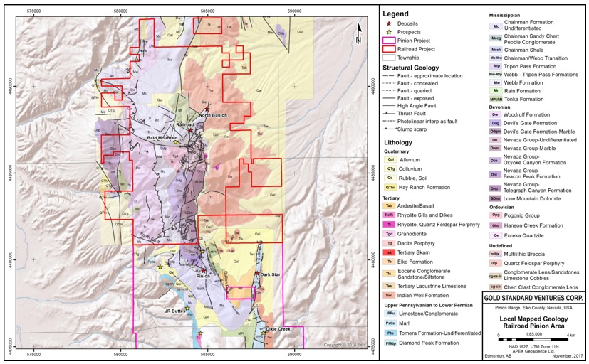
| Effective Date: November 3, 2017 | | | 75 |
Technical Report Maiden Resource Estimate North Bullion Railroad Project, Elko County, Nevada, USA
There is a significant and growing database of geophysical information for the Railroad–Pinion Project that includes gravity, Controlled-Source Audio Magneto-Telluric (CSAMT) and ground magnetic surveys. These surveys have been employed to aid in identifying geological structures, key lithologies and zones of hydrothermal alteration related to mineralization. Additionally, the geophysical surveys have aided in drillhole targeting and have identified multiple exploration targets.
Gold Standard completed six gravity surveys from 2009 to 2015, collecting measurements from 3,991 stations covering most of the Railroad–Pinion Project area (Figures 9.2 and 9.3; Table 9.1). Seven CSAMT surveys were completed by GSV from 2012 to 2016, covering the Bullion Fault Corridor and Pinion, Dark Star and the Dark Star Structural Corridor, and Bullion Deposits and their surrounding areas (Figures 9.2 and 9.4; Table 9.1), and a ground magnetic survey was completed over the Bullion Stock target area in 2014 (Figure 9.2; Table 9.1; Wright, 2009, 2010, 2012a, 2012b, 2012c, 2013a, 2013b, 2014a, 2014b, 2015a, 2015b, 2016a).
Table 9.1. Summary of previous geophysical work completed for the Pinion–Railroad Project by GSV from 2009 to 2016.
| Year | Gravity (No. Stations) | Magnetics | CSAMT |
| (line-km) | (line-miles) | (line-km) | (line-miles) |
| 2009 | 1089 | - | - | - | - |
| 2010 | 1268 | - | - | - | - |
| 2011 | 455 | - | - | - | - |
| 2012 | - | - | - | 20.4 | 12.7 |
| 2013 | 578 | - | - | 3.6 | 2.2 |
| 2014 | 200 | 196.6 | 122.2 | 22 | 13.7 |
| 2015 | 401 | - | - | 18 | 11.2 |
| 2016 | - | - | - | 21.2 | 13.2 |
| Total | 3991 | 196 | 122.2 | 85.2 | 53.4 |
In addition to Gold Standard’s geophysical work, the Company acquired data from 79 gravity stations located in the Railroad Project area from Newmont Mining Corporation’s 2002 gravity survey (Figure 9.3; Wright, 2010). Gold Standard also re-evaluated historic magnetic survey data from surveys completed in the Railroad Project area in 1999 and 2006 (Hunsaker, 2012b; Wright, 2012a, 2012b, 2013). In 2016, Gold Standard purchased a portion of an airborne magnetic survey from EDCON-PRJ that covers the entire Railroad–Pinion Project area and its surroundings (Figure 9.5; Wright, 2016b).
| Effective Date: November 3, 2017 | | | 76 |
Technical Report Maiden Resource Estimate North Bullion Railroad Project, Elko County, Nevada, USA
Figure 9.2. Summary of the area covered by ground geophysical surveys completed for the Railroad–Pinion Project by GSV from 2009 to 2015.
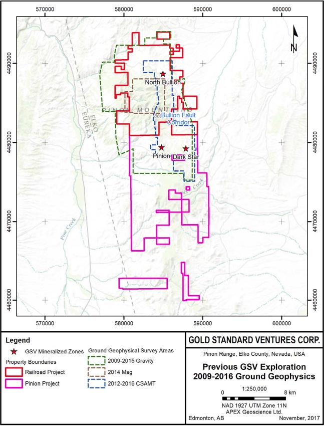
| Effective Date: November 3, 2017 | | | 77 |
Technical Report Maiden Resource Estimate North Bullion Railroad Project, Elko County, Nevada, USA
Figure 9.3. Ground geophysics gravity survey completed by GSV from 2009 to 2015 and the 2002 survey acquired by GSV.
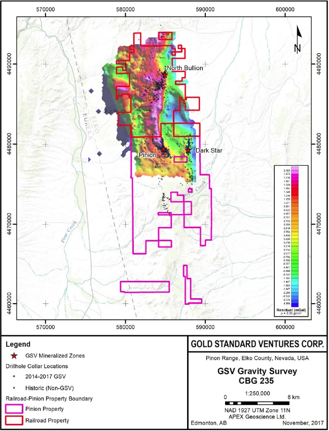
| Effective Date: November 3, 2017 | | | 78 |
Technical Report Maiden Resource Estimate North Bullion Railroad Project, Elko County, Nevada, USA
Figure 9.4. Ground geophysics CSAMT survey completed by GSV from 2012 to 2016.
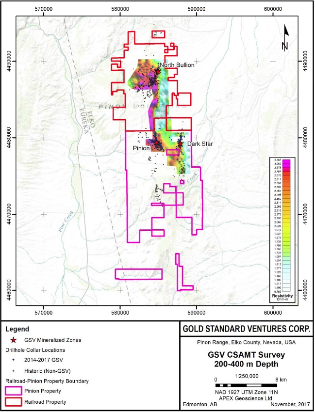
| Effective Date: November 3, 2017 | | | 79 |
Technical Report Maiden Resource Estimate North Bullion Railroad Project, Elko County, Nevada, USA
Figure 9.5. Airborne magnetic survey (total magnetics) purchased by GSV in 2016.
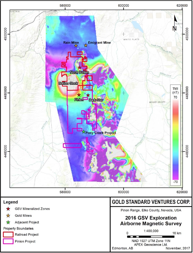
| Effective Date: November 3, 2017 | | | 80 |
Technical Report Maiden Resource Estimate North Bullion Railroad Project, Elko County, Nevada, USA
Soil sampling programs are designed to provide systematic geochemical coverage over areas considered to be prospective for near-surface mineralization. A positive correlation has been found to exist between anomalous gold and arsenic values identified by historic (and recent) soil geochemical surveys over the Railroad–Pinion Project area, several of which have subsequently been verified by positive drilling results. This illustrates the ability of soil sampling surveys to identify near surface exploration targets at the Project. Based on this, Gold Standard has completed extensive soil sampling programs throughout the Railroad–Pinion Project area collecting 7,044 soil samples from 2010 to 2016 (Figure 9.6; Table 9.2). Additionally, Gold Standard has collected 3,489 rock samples throughout the Railroad–Pinion Project from 2010 to 2016 (Table 9.2) from outcrops, road cuts and field traverses parallel with topography.
The geochemical exploration work described above has identified 8 drill targets at the Railroad–Pinion Project—some of which have returned significant intercepts of gold, silver, copper, lead and zinc. Additionally, 5 prospects were identified that are a focus of ongoing exploration work to advance them to drill ready targets (Dufresne and Koehler, 2015).
Table 9.2. Summary of previous geochemical exploration completed for the Pinion–Railroad Project by GSV from 2010 to 2016.
| Year | No. Soil Samples | No. Rock Samples |
| 2010 | 1203 | - |
| 2011 | 230 | 285 |
| 2012 | - | 463 |
| 2013 | - | 1866 |
| 2014 | 4,248 | 412 |
| 2015 | 1,363 | 463 |
| 2016 | - | - |
| Total | 7044 | 3489 |
Petrographic analysis systematically classifies and describes mineralogical and textural details of rock samples. Consultant Mark McComb of McComb Petrographics performed a petrographic analysis on 18 samples in 2014 and 14 samples in 2016. The 2014 samples included 16 drill core samples from a drillhole within the Bald Mountain Prospect area (RRB13-01), one drill core sample from a drillhole within the Pinion Prospect area (SB-137) and a single surface rock sample (McComb, 2014). All 2016 samples were from drillholes DS15-13, drilled within the Dark Star Project area (Dufresneet al., 2017).
| Effective Date: November 3, 2017 | | | 81 |
Technical Report Maiden Resource Estimate North Bullion Railroad Project, Elko County, Nevada, USA
Figure 9.6. Summary of the area covered by geochemical surveys completed for the Railroad–Pinion Project by GSV from 2010 to 2016.
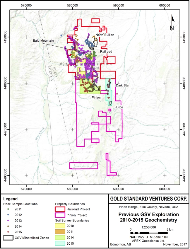
| Effective Date: November 3, 2017 | | | 82 |
Technical Report Maiden Resource Estimate North Bullion Railroad Project, Elko County, Nevada, USA
Gold Standard is continuing exploration efforts for the Railroad–Pinion Project in 2017. In early 2017, Gold Standard significantly increased its land position with the acquisition of additional land contiguous to the south of the Dark Star and Pinion Deposit areas (see GSV Press Release dated March 23, 2017). The land acquisition was part of an on-going effort to consolidate the mineral rights for the greater Railroad District and allows access to the southern strike extensions of the Dark Star Corridor.
Exploration work currently in progress at the Railroad–Pinion Project includes geological mapping and geochemical soil and rock sampling within the newly acquired area centered on the Jasperoid Wash target area immediately to the south of the Pinion and Dark Star deposits. In addition, ground CSAMT and gravity geophysical surveys along with two lines of seismic data are currently being completed. Exploration efforts within the North Bullion Deposit area are largely focused on infill and step-out drilling and structural re-interpretation of the area. No results have been received at the time of this report.
Gold Standard has conducted drilling at the Railroad–Pinion Project since 2010 to test the extent of known mineralization, support ongoing geological modeling and resolve current geological models with infill drilling. Since 2010, Gold Standard has completed 316 reverse circulation (RC), diamond core drillholes (DDH), and RC/DDH combination holes totalling 125,438.3 m (411,545.3 ft) for the Railroad–Pinion Project. The following section summarize previous drilling conducted by Gold Standard from 2010 to 2015, and drilling completed in 2016 and 2017 for the Railroad–Pinion Project.
All drillhole collar coordinates are recorded in the UTM NAD 27 (Zone 11) coordinate system. Gold Standard geological staff first stake collar locations in the field using a hand-held Global Positioning System (GPS). For angled holes, staff place additional stakes using a Brunton compass that allow the driller to align the drill to the correct azimuth. The driller then sets the inclination of the drill that Gold Standard geological staff check prior to drilling. International Directional Services of Elko, NV measure hole deviation of all drillholes using a gyroscopic down-hole survey. Apex Surveying, LLC of Spring Creek, Nevada (no relation to APEX Geoscience Ltd.) professionally surveys the final drillhole collars using a differential GPS. Once drilling is complete, all drillhole collars are marked by wooden lath with the hole name on a wire/aluminum tag placed in the cement collar plug.
Gold Standard geologists that are familiar with the Project and the local geology perform geological logging. Geologist first record their data on paper logging forms developed specifically for the Project that Gold Standard geological and/or data entry staff digitize. Details recorded in the geological logs are, but are not limited to, the following: rock per cent recovery (for core holes only), lithology, interpreted formation, hydrothermal alteration, oxidation, structures (faults, fractures and folds—relative to the core axis), breccia type, vein type and abundance, sample intervals, and other important geological comments. Oriented core measurements for structures, veins, fractures are collected from selected core holes.
| Effective Date: November 3, 2017 | | | 83 |
Technical Report Maiden Resource Estimate North Bullion Railroad Project, Elko County, Nevada, USA
| 10.1 | Previous Drilling in the Railroad Project Area (2010-2015) |
Drilling conducted by Gold Standard for the Railroad Project from 2010 to 2013 focused on the North Bullion target with added drilling in the Railroad, Sylvania, Bullion Fault Corridor, LT, North Ridge, Cherry Springs and Bald Mountain target areas (Hunsaker, 2012a, b; Shaddrick, 2012; Koehleret al. 2014). After Gold Standard’s acquisition of the Pinion Project in 2014, efforts focused on the Pinion Deposit and Dark Star Deposit and their surrounding areas. During this time, Gold Standard completed some limited drilling in the Bald Mountain and North Bullion target areas (Turneret al., 2015; Dufresne and Koehler, 2016). This section is a summary of drilling conducted by Gold Standard for the Railroad–Pinion Project from 2010 to 2015. Detailed accounts of this summarised work and discussion about its results and interpretations are provided in the reports by Hunsaker (2012a, b), Shaddrick (2012), Koehleret al. (2014), Turneret al. (2015) and Dufresne and Koehler, (2016).
From 2010 to 2013, Gold Standard completed 110 RC and diamond drillholes totalling 55,094 m (180,756 ft) for the Railroad Project (Table 10.1; Figure 10.1; Hunsaker, 2012a, b; Shaddrick, 2012; Koehleret al., 2014). In 2010, Gold Standard utilized gravity geophysical data and geological models to identify an untested target that lead to intercepts of 32 m of 1.39 g Au/t and 43.6 m of 1.21 g/t Au in drillhole RR10-8 completed at the North Bullion Target (Table 10.2; Jacksonet al., 2015). This blind discovery of sediment-hosted Carlin-style gold mineralization by Gold Standard lead to more than 50 % of drilling conducted from 2010 to 2013 within the North Bullion Deposit area. Additional drilling focused on testing geological, geophysical and/or geochemical targets for gold, silver and/or base metal mineralization.
Following the acquisition of the Pinion Project in early 2014, Gold Standard limited their drilling efforts for the Railroad Project to the North Bullion and Bald Mountain target areas. From 2014 to 2015, Gold Standard completed 9 RC and RC collar/diamond tail drillholes totalling 3,562.3 m (11,687.3 ft; Table 10.3; Figure 10.1; Turneret al., 2015; Dufresne and Koehler, 2016). Highlights from drillholes completed by GSV from 2010 to 2015 within the North Bullion Deposit area are summarized in Table 10.2.
Table 10.1. Summary of drillholes completed for the Railroad Project by GSV from 2010 to 2013.
| Target Area | Years Drilled | No. Holes | No. RC Holes | No. Core Holes | RC/Core Holes | Total Length (m) | Total Length (ft) |
| Bald Mountain | 2013 | 1 | 0 | 1 | | 620 | 2,035 |
| Bullion Fault Corridor | 2010 - 2013 | 11 | 8 | 0 | 3 | 6,418 | 21,057 |
| Sylvania (Central Bullion) | 2011 - 2013 | 9 | 0 | 9 | | 4,217 | 13,835 |
| Cherry Springs | 2012 | 2 | 0 | 1 | 1 | 1,118 | 3,667 |
| LT | 2012 | 6 | 6 | 0 | | 3,027 | 9,930 |
| North Bullion | 2010 - 2013 | 57 | 9 | 36 | 12 | 27,678 | 90,808 |
| North Ridge | 2011 - 2012 | 4 | 3 | 1 | | 2,699 | 8,856 |
| Railroad NW Fault Trend (Railroad) | 2010 - 2013 | 20 | 9 | 10 | 1 | 9,317 | 30,569 |
| | Total | 110 | 35 | 58 | 17 | 55,094 | 180,756 |
| Effective Date: November 3, 2017 | | | 84 |
Technical Report Maiden Resource Estimate North Bullion Railroad Project, Elko County, Nevada, USA
Table 10.2. Summary highlights from drillholes completed by GSV from 2010-2015 within the North Bullion Deposit area.
| Drillhole ID | From (m) | To (m) | Length (m) | From (ft) | To (ft) | Length (ft) | Au (g/t) | Au (oz/st) |
| RR10-01 | 4.6 | 24.4 | 19.8 | 15.0 | 80.0 | 65.0 | 0.34 | 0.010 |
| RR10-03 | 76.2 | 82.3 | 6.1 | 250.0 | 270.0 | 20.0 | 0.51 | 0.015 |
| | 86.9 | 93.0 | 6.1 | 285.0 | 305.0 | 20.0 | 0.34 | 0.010 |
| | 272.8 | 277.4 | 4.6 | 895.0 | 910.0 | 15.0 | 0.51 | 0.015 |
| RR10-04 | 232.9 | 239.3 | 6.4 | 764.0 | 785.0 | 21.0 | 0.65 | 0.019 |
| RR10-06 | 120.4 | 131.1 | 10.7 | 395.0 | 430.0 | 35.0 | 0.55 | 0.016 |
| | 268.2 | 309.4 | 41.2 | 880.0 | 1015.0 | 135.0 | 0.89 | 0.026 |
| RR10-08 | 118.9 | 125.0 | 6.1 | 390.0 | 410.0 | 20.0 | 0.58 | 0.017 |
| | 266.7 | 298.7 | 32.0 | 875.0 | 980.0 | 105.0 | 1.30 | 0.038 |
| | 341.4 | 384.0 | 42.6 | 1120.0 | 1260.0 | 140.0 | 1.20 | 0.035 |
| RR10-09 | 350.5 | 379.5 | 29.0 | 1150.0 | 1245.0 | 95.0 | 0.58 | 0.017 |
| RR10-11 | 163.1 | 173.7 | 10.6 | 535.0 | 570.0 | 35.0 | 1.03 | 0.030 |
| | 309.4 | 391.7 | 82.3 | 1015.0 | 1285.0 | 270.0 | 0.41 | 0.012 |
| RR10-12 | 100.6 | 126.5 | 25.9 | 330.0 | 415.0 | 77.0 | 2.61 | 0.076 |
| | 140.2 | 146.3 | 6.1 | 460.0 | 480.0 | 20.0 | 0.41 | 0.012 |
| | 155.4 | 162.0 | 6.6 | 510.0 | 531.5 | 21.5 | 0.41 | 0.012 |
| RR10-13 | 22.9 | 42.7 | 19.8 | 75.0 | 140.0 | 65.0 | 0.34 | 0.010 |
| RR10-16 | 237.7 | 254.5 | 16.8 | 780.0 | 835.0 | 55.0 | 0.41 | 0.012 |
| including | 245.4 | 248.4 | 3.0 | 805.0 | 815.0 | 10.0 | 1.20 | 0.035 |
| | 266.7 | 272.8 | 6.1 | 875.0 | 895.0 | 20.0 | 1.13 | 0.033 |
| RR11-02 | 472.4 | 475.5 | 3.1 | 1550.0 | 1560.0 | 10.0 | 0.07 | 0.002 |
| | 515.1 | 521.2 | 6.1 | 1690.0 | 1710.0 | 20.0 | 0.55 | 0.016 |
| | 527.3 | 530.4 | 3.1 | 1730.0 | 1740.0 | 10.0 | 1.85 | 0.054 |
| | 538.0 | 541.0 | 3.0 | 1765.0 | 1775.0 | 10.0 | 2.81 | 0.082 |
| RR11-03 | 175.3 | 397.8 | 222.5 | 575.0 | 1305.0 | 730.0 | 0.65 | 0.019 |
| including | 285.0 | 365.8 | 80.8 | 935.0 | 1200.0 | 265.0 | 1.17 | 0.034 |
| including | 307.8 | 336.8 | 29.0 | 1010.0 | 1105.0 | 95.0 | 2.02 | 0.059 |
| RR11-16 | 169.2 | 225.6 | 56.4 | 555.0 | 740.0 | 185.0 | 4.29 | 0.125 |
| | 318.5 | 330.7 | 12.2 | 1045.0 | 1085.0 | 40.0 | 0.75 | 0.022 |
| | 402.3 | 437.4 | 35.1 | 1320.0 | 1435.0 | 115.0 | 0.41 | 0.012 |
| RR11-17 | 253.4 | 256.0 | 2.6 | 831.5 | 840.0 | 8.5 | 2.43 | 0.071 |
| | 506.0 | 512.1 | 6.1 | 1660.0 | 1680.0 | 20.0 | 1.30 | 0.038 |
| | 524.3 | 538.0 | 13.7 | 1720.0 | 1765.0 | 45.0 | 0.62 | 0.018 |
| RR11-18 | 301.8 | 309.4 | 7.6 | 990.0 | 1015.0 | 25.0 | 1.65 | 0.048 |
| | 326.1 | 403.9 | 77.8 | 1070.0 | 1325.0 | 255.0 | 2.57 | 0.075 |
| RR12-01 | 237.4 | 401.1 | 163.7 | 779.0 | 1316.0 | 537.0 | 3.39 | 0.099 |
| including | 278.9 | 321.6 | 42.7 | 915.0 | 1055.0 | 140.0 | 9.39 | 0.274 |
| Effective Date: November 3, 2017 | | | 85 |
Technical Report Maiden Resource Estimate North Bullion Railroad Project, Elko County, Nevada, USA
| Drillhole ID | From (m) | To (m) | Length (m) | From (ft) | To (ft) | Length (ft) | Au (g/t) | Au (oz/st) |
| RR12-02 | 256.0 | 271.0 | 15.0 | 840.0 | 889.0 | 49.0 | 1.17 | 0.034 |
| | 326.7 | 342.1 | 15.4 | 1072.0 | 1122.5 | 50.5 | 0.96 | 0.028 |
| | 356.9 | 385.9 | 29.0 | 1171.0 | 1266.0 | 95.0 | 0.99 | 0.029 |
| RR12-04 | 275.0 | 304.8 | 29.8 | 902.0 | 1000.0 | 98.0 | 1.99 | 0.058 |
| | 320.1 | 334.7 | 14.6 | 1050.0 | 1098.0 | 48.0 | 0.45 | 0.013 |
| RR12-05 | 551.2 | 557.9 | 6.7 | 1808.0 | 1830.0 | 22.0 | 0.69 | 0.020 |
| RR12-07 | 105.8 | 113.7 | 7.9 | 347.0 | 373.0 | 26.0 | 0.41 | 0.012 |
| | 163.4 | 189.6 | 26.2 | 536.0 | 622.0 | 86.0 | 2.09 | 0.061 |
| | 276.1 | 321.9 | 45.8 | 906.0 | 1056.0 | 150.0 | 0.48 | 0.014 |
| | 360.3 | 368.8 | 8.5 | 1182.0 | 1210.0 | 28.0 | 0.55 | 0.016 |
| | 409.4 | 423.1 | 13.7 | 1343.0 | 1388.0 | 45.0 | 0.58 | 0.017 |
| RR12-08 | 269.5 | 278.6 | 9.1 | 884.0 | 914.0 | 30.0 | 0.48 | 0.014 |
| | 422.2 | 428.3 | 6.1 | 1385.0 | 1405.0 | 20.0 | 0.45 | 0.013 |
| RR12-10 | 218.0 | 342.1 | 124.1 | 715.0 | 1122.0 | 407.0 | 4.05 | 0.118 |
| including | 218.0 | 261.3 | 43.3 | 715.0 | 857.0 | 142.0 | 7.54 | 0.220 |
| including | 233.8 | 250.3 | 16.5 | 767.0 | 821.0 | 54.0 | 15.09 | 0.440 |
| | 355.5 | 407.7 | 52.2 | 1166.0 | 1337.0 | 171.0 | 0.51 | 0.015 |
| | 422.9 | 556.4 | 133.5 | 1387.0 | 1825.0 | 438.0 | 0.45 | 0.013 |
| RR12-11 | 195.4 | 201.2 | 5.8 | 641.0 | 660.0 | 19.0 | 3.43 | 0.100 |
| including | 196.8 | 200.0 | 3.2 | 645.5 | 656.0 | 10.0 | 5.49 | 0.160 |
| | 340.9 | 473.5 | 132.6 | 1118.0 | 1553.0 | 435.0 | 0.38 | 0.011 |
| RR12-13 | 105.8 | 119.8 | 14.0 | 347.0 | 393.0 | 46.0 | 0.89 | 0.026 |
| | 238.7 | 262.2 | 23.5 | 783.0 | 860.0 | 77.0 | 0.51 | 0.015 |
| | 277.1 | 330.2 | 53.1 | 909.0 | 1083.0 | 174.0 | 0.69 | 0.020 |
| | 363.7 | 385.0 | 21.3 | 1193.0 | 1263.0 | 70.0 | 0.69 | 0.020 |
| RR12-15 | 64.6 | 93.3 | 28.7 | 212.0 | 306.0 | 94.0 | 0.41 | 0.012 |
| | 134.4 | 157.6 | 23.2 | 441.0 | 517.0 | 76.0 | 0.55 | 0.016 |
| RR12-18 | 245.1 | 251.2 | 6.1 | 804.0 | 824.0 | 20.0 | 0.38 | 0.011 |
| | 275.3 | 316.2 | 40.9 | 903.0 | 1037.0 | 134.0 | 0.79 | 0.023 |
| | 478.1 | 486.6 | 8.5 | 1568.0 | 1596.0 | 28.0 | 1.13 | 0.033 |
| RR12-19 | 256.7 | 268.6 | 11.9 | 842.0 | 881.0 | 39.0 | 0.45 | 0.013 |
| | 354.0 | 361.9 | 7.9 | 1161.0 | 1187.0 | 26.0 | 1.30 | 0.038 |
| RR12-20 | 331.1 | 334.9 | 3.8 | 1086.0 | 1098.5 | 12.5 | 1.06 | 0.031 |
| | 466.6 | 472.1 | 5.5 | 1530.5 | 1548.5 | 18.0 | 0.41 | 0.012 |
| RR12-24 | 89.3 | 95.1 | 5.8 | 293.0 | 312.0 | 19.0 | 0.75 | 0.022 |
| | 264.3 | 273.8 | 9.5 | 867.0 | 898.0 | 31.0 | 0.58 | 0.017 |
| | 281.4 | 321.6 | 40.2 | 923.0 | 1055.0 | 132.0 | 1.34 | 0.039 |
| including | 306.4 | 321.6 | 15.2 | 1005.0 | 1055.0 | 50.0 | 2.47 | 0.072 |
| RR12-25 | 161.5 | 165.2 | 3.7 | 530.0 | 542.0 | 12.0 | 0.79 | 0.023 |
| Effective Date: November 3, 2017 | | | 86 |
Technical Report Maiden Resource Estimate North Bullion Railroad Project, Elko County, Nevada, USA
| Drillhole ID | From (m) | To (m) | Length (m) | From (ft) | To (ft) | Length (ft) | Au (g/t) | Au (oz/st) |
| | 351.2 | 357.9 | 6.7 | 1152.0 | 1174.0 | 22.0 | 0.41 | 0.012 |
| RR12-26 | 25.9 | 35.0 | 9.1 | 85.0 | 115.0 | 30.0 | 0.51 | 0.015 |
| RR12-27 | 151.2 | 168.0 | 16.8 | 496.0 | 551.0 | 55.0 | 1.95 | 0.057 |
| | 265.2 | 271.3 | 6.1 | 870.0 | 890.0 | 20.0 | 0.48 | 0.014 |
| | 292.4 | 307.0 | 14.6 | 959.0 | 1007.0 | 48.0 | 0.38 | 0.011 |
| | 316.2 | 331.4 | 15.2 | 1037.0 | 1087.0 | 50.0 | 0.75 | 0.022 |
| RR12-30 | 366.4 | 370.1 | 3.7 | 1202.0 | 1214.0 | 12.0 | 2.09 | 0.061 |
| RR13-01 | 524.4 | 532.0 | 7.6 | 1720.0 | 1745.0 | 25.0 | 0.34 | 0.010 |
| | 581.7 | 602.1 | 20.4 | 1908.0 | 1975.0 | 67.0 | 1.06 | 0.031 |
| RR13-02 | 226.5 | 233.8 | 7.3 | 743.0 | 767.0 | 24.0 | 0.45 | 0.013 |
| | 296.6 | 375.0 | 78.4 | 973.0 | 1230.0 | 257.0 | 0.93 | 0.027 |
| including | 304.9 | 311.9 | 7.0 | 1000.0 | 1023.0 | 23.0 | 2.26 | 0.066 |
| RR13-03 | 159.5 | 165.6 | 6.1 | 523.0 | 543.0 | 20.0 | 0.38 | 0.011 |
| | 189.3 | 200.0 | 10.7 | 621.0 | 656.0 | 35.0 | 1.51 | 0.044 |
| including | 190.0 | 192.4 | 2.4 | 626.0 | 631.0 | 5.0 | 5.49 | 0.160 |
| | 307.6 | 337.8 | 30.2 | 1009.0 | 1108.0 | 99.0 | 0.72 | 0.021 |
| | 357.6 | 363.7 | 6.1 | 1173.0 | 1193.0 | 20.0 | 0.45 | 0.013 |
| | 395.7 | 422.5 | 26.8 | 1298.0 | 1386.0 | 88.0 | 0.65 | 0.019 |
| RR13-04 | 150.0 | 160.1 | 10.1 | 492.0 | 525.0 | 33.0 | 0.65 | 0.019 |
| | 285.6 | 354.2 | 68.6 | 937.0 | 1162.0 | 225.0 | 0.45 | 0.013 |
| including | 287.9 | 294.7 | 6.8 | 944.5 | 967.0 | 22.5 | 2.13 | 0.062 |
| | 361.8 | 428.7 | 66.9 | 1187.0 | 1406.5 | 219.5 | 0.86 | 0.025 |
| RR13-05 | 155.8 | 176.2 | 20.4 | 511.0 | 578.0 | 67.0 | 0.96 | 0.028 |
| | 239.9 | 249.0 | 9.1 | 782.0 | 817.0 | 35.0 | 2.33 | 0.068 |
| including | 242.4 | 247.6 | 5.2 | 795.0 | 812.0 | 17.0 | 4.01 | 0.117 |
| | 256.6 | 368.8 | 112.2 | 842.0 | 1210.0 | 368.0 | 0.55 | 0.016 |
| | 429.2 | 453.8 | 24.6 | 1408.0 | 1489.0 | 81.0 | 0.51 | 0.015 |
| RR13-06 | 150.5 | 155.5 | 5.0 | 493.5 | 510.0 | 16.5 | 0.58 | 0.017 |
| | 211.0 | 233.1 | 22.1 | 692.0 | 764.5 | 72.5 | 2.02 | 0.059 |
| | 301.2 | 322.2 | 21.0 | 988.0 | 1057.0 | 69.0 | 0.69 | 0.020 |
| | 336.0 | 394.2 | 58.2 | 1102.0 | 1293.0 | 191.0 | 0.51 | 0.015 |
| RR13-07 | 236.2 | 365.2 | 129.0 | 775.0 | 1198.0 | 423.0 | 0.89 | 0.026 |
| including | 273.5 | 286.6 | 13.1 | 897.0 | 940.0 | 43.0 | 2.19 | 0.064 |
| and | 343.6 | 357.9 | 14.3 | 1127.0 | 1174.0 | 47.0 | 1.89 | 0.055 |
| | 385.4 | 406.1 | 20.7 | 1264.0 | 1332.0 | 68.0 | 0.48 | 0.014 |
| RR13-08 | 192.1 | 200.0 | 7.9 | 630.0 | 656.0 | 26.0 | 3.77 | 0.110 |
| including | 195.1 | 200.0 | 4.9 | 640.0 | 656.0 | 16.0 | 5.62 | 0.164 |
| | 205.3 | 230.8 | 25.5 | 673.5 | 757.0 | 83.5 | 1.89 | 0.055 |
| | 303.6 | 377.1 | 73.5 | 996.0 | 1237.0 | 241.0 | 3.67 | 0.107 |
| Effective Date: November 3, 2017 | | | 87 |
Technical Report Maiden Resource Estimate North Bullion Railroad Project, Elko County, Nevada, USA
| Drillhole ID | From (m) | To (m) | Length (m) | From (ft) | To (ft) | Length (ft) | Au (g/t) | Au (oz/st) |
| including | 336.9 | 344.5 | 7.6 | 1105.0 | 1130.0 | 25.0 | 12.07 | 0.352 |
| and | 352.1 | 364.3 | 12.2 | 1155.0 | 1195.0 | 40.0 | 6.93 | 0.202 |
| | 384.1 | 416.1 | 32.0 | 1260.0 | 1365.0 | 105.0 | 0.99 | 0.029 |
| including | 389.0 | 396.9 | 7.9 | 1276.0 | 1302.0 | 26.0 | 3.12 | 0.091 |
| RR13-09 | 248.8 | 254.1 | 5.3 | 816.0 | 833.5 | 17.5 | 1.61 | 0.047 |
| | 270.1 | 372.2 | 102.1 | 886.0 | 1221.0 | 335.0 | 0.86 | 0.025 |
| | 389.6 | 429.7 | 40.1 | 1278.0 | 1409.5 | 131.5 | 0.45 | 0.013 |
| including | 290.9 | 311.3 | 20.4 | 954.0 | 1021.0 | 67.0 | 1.71 | 0.050 |
| and | 342.4 | 353.7 | 11.3 | 1123.0 | 1160.0 | 37.0 | 1.68 | 0.049 |
| | 459.5 | 490.9 | 31.4 | 1507.0 | 1610.0 | 103.0 | 0.72 | 0.021 |
| RR13-10 | 209.1 | 244.2 | 35.1 | 686.0 | 801.0 | 115.0 | 1.82 | 0.053 |
| including | 224.7 | 230.8 | 6.1 | 737.0 | 757.0 | 20.0 | 6.34 | 0.185 |
| | 299.7 | 370.4 | 70.7 | 983.0 | 1215.0 | 232.0 | 0.55 | 0.016 |
| RR13-11 | 313.4 | 411.6 | 98.2 | 1028.0 | 1350.0 | 322.0 | 3.26 | 0.095 |
| including | 322.2 | 327.4 | 5.2 | 1057.0 | 1074.0 | 17.0 | 5.04 | 0.147 |
| and | 354.2 | 371.3 | 17.1 | 1162.0 | 1218.0 | 56.0 | 9.98 | 0.291 |
| RR13-12 | 230.8 | 242.1 | 11.3 | 757.0 | 794.0 | 37.0 | 0.82 | 0.024 |
| | 339.6 | 431.4 | 91.8 | 1114.0 | 1415.0 | 301.0 | 1.06 | 0.031 |
| including | 366.7 | 380.3 | 13.6 | 1203.0 | 1247.5 | 44.5 | 4.01 | 0.117 |
| RR13-14 | 294.7 | 325.3 | 30.6 | 966.5 | 1067.0 | 100.5 | 1.23 | 0.036 |
| including | 297.9 | 307.5 | 9.6 | 977.0 | 1008.5 | 31.5 | 2.47 | 0.072 |
| | 337.5 | 377.4 | 39.9 | 1107.0 | 1238.0 | 131.0 | 0.65 | 0.019 |
| RR13-13 | 334.7 | 409.1 | 74.4 | 1098.1 | 1342.2 | 244.1 | 1.68 | 0.049 |
| including | 348.2 | 353.1 | 4.9 | 1142.4 | 1158.5 | 16.1 | 2.98 | 0.087 |
| and | 367.5 | 379.9 | 12.4 | 1205.7 | 1246.4 | 40.7 | 3.53 | 0.103 |
| | 419.5 | 431.7 | 12.2 | 1376.3 | 1416.3 | 40.0 | 0.55 | 0.016 |
| RR13-15 | 296.9 | 315.2 | 18.3 | 974.1 | 1034.1 | 60.0 | 2.05 | 0.060 |
| Effective Date: November 3, 2017 | | | 88 |
Technical Report Maiden Resource Estimate North Bullion Railroad Project, Elko County, Nevada, USA
Figure 10.1. Collar locations of drillholes completed for the Railroad Project by GSV from 2010 to 2015.
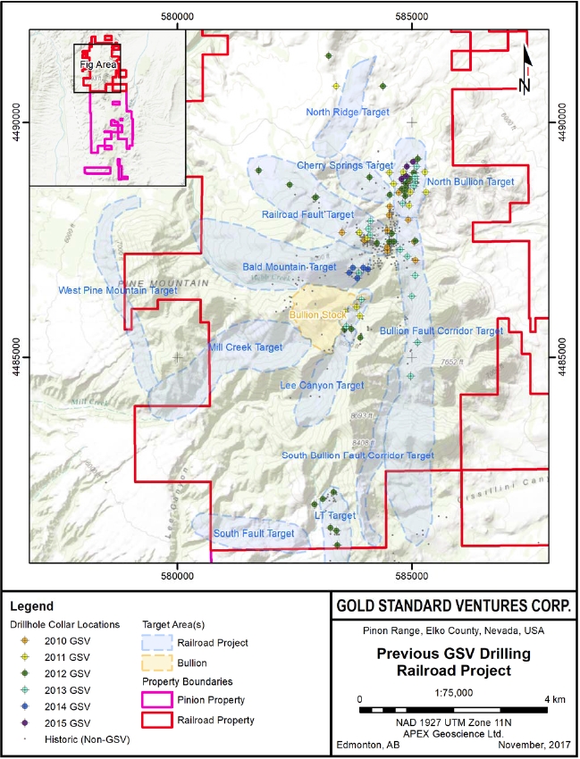
| Effective Date: November 3, 2017 | | | 89 |
Technical Report Maiden Resource Estimate North Bullion Railroad Project, Elko County, Nevada, USA
Table 10.32. Summary of drillholes completed for the Railroad Project by GSV from 2014 to 2015.
| Year | No. RC Holes | RC Drillholes | No.RC + DD Holes | RC Collar and Diamond Tail Drillholes | Total Length (m) | Total Length (ft) |
Total Length (m) | Total Length (ft) | RC | DDH |
Total Length (m) | Total Length (ft) | Total Length (m) | Total Length (ft) |
Bald Mountain Target Area |
| 2014 | 5 | 1,895.9 | 6220 | - | - | - | - | - | 1,895.9 | 6,220 |
North Bullion Target Area |
| 2015* | 1 | 475.5 | 1560 | 3 | 560.8 | 1840 | 630.1 | 2067.3 | 1,666.4 | 5,467.3 |
| Total | 6 | 2,371.4 | 7,780 | 3 | 560.8 | 1840 | 630.1 | 2067.3 | 3,562.3 | 11,687.3 |
* Three holes were collared but not completed in 2011 (RR11-07) and 2013 (RR13-13, RR13-15)
| 10.2 | 2016-2017 Drilling in the Railroad Project Area |
In 2016, Gold Standard completed a total of 19 RC and RC/core combination drillholes at the Railroad portion of the Project that totaled 10,889.6 m (35,727 ft). Significant time and cost savings were achieved by collaring several drillholes with RC drilling prior to switching to core drilling to test the target zones. The 2016 Railroad area drill program included step-out drilling and the testing of new targets at the Bald Mountain, North Bullion and Cherry Springs (Newmont Joint Venture) areas (Table 10.4; Figure 10.2).
Samples collected from the drillholes completed within the Cherry Springs Target area of the Newmont Joint Venture did not return any significant gold assays.
Samples collected from drillholes completed in the Bald Mountain Target area returned anomalous gold and base metal assays (Table 10.5) that include:
| · | a 4.57 m (15.0 ft) core length interval of 38.77 g/t Ag from drillhole RRB16-03; and |
| · | a 25.9 m (85.0 ft) core interval of 0.67 g/t Au (0.02 oz/st) that includes a 7.6 m (25.0 ft) interval of 1.67 g/t Au (0.049 oz/st) and includes a 19.81 m (65.0 ft) interval of 50 g/t Ag (1.46 oz/st), 0.122 % Cu, 0.044 % Mo and 0.17 % Pb from drillhole RRB16-04. |
The 2016 drilling at the North Bullion prospect extended mineralization some 180 m to the north from previous drill intersections. In fact, with the results achieved in drillholes RR16-01 and RR16-05 (see below and Table 10.6), the North Bullion zone was extended to the north and northwest. The 2016 North Bullion Target drilling highlights included:
| · | a 65.6 m (215 ft) core length interval of 3.17 g/t Au (0.092 oz/st) that includes a 8.5 m (28.0 ft) interval of 11.16 g/t Au (0.325 oz/st) from drillhole RR16-01; and |
| · | a 19.8 m (65.0 ft) core length interval of 4.4 g/t Au (0.128 oz/st) that includes a 5.3 m (7.02 ft) interval of 7.02 g/t Au (0.204 oz/st) from drillhole RR16-05. |
| Effective Date: November 3, 2017 | | | 90 |
Technical Report Maiden Resource Estimate North Bullion Railroad Project, Elko County, Nevada, USA
Gold Standard’s 2017 drill program is ongoing; however, a total of 5 RC/core combination drillholes for the Railroad Project were completed totalling 2,442.4 m (8,013 ft) and were available and were utilized at the time of the 2017 resource estimation detailed in this Technical Report. The 2017 Railroad Project drill program included step-out drilling and the testing of new targets at the northern part of the North Bullion area (Table 10.4; Figure 10.2). Results from the 2017 drill program (see below and Table 10.7) extended mineralization some 200 m to the north from previous intersections in drillholes RR16-02 and RR16-05. Step-out holes an additional 300 m to the north (RR17-04 and RR17-05) returned anomalous gold assays, with the intersections considered low grade and narrow to moderate thickness compared to intervals to the south. The 2017 North Bullion Target drilling highlights to date include:
| · | a 4.6 m (15.0 ft) core length interval of 0.45 g/t Au (0.013 oz/st) in drillhole RR17-01; |
| · | a 1.2 m (4.0 ft) core length interval of 2.16 g/t Au (0.063 oz/st) in drillhole RR17-03; |
| · | a 24.4 m (80.0 ft) core length interval of 0.46 g/t Au (0.014 oz/st) from drillhole RR17-04 |
Table 10.4. Summary of drillholes completed for the Railroad Project by GSV in 2016 and 2017.
| Year | No. RC Holes | RC Drillholes | No.RC + DD Holes | RC Collar and Diamond Tail Drillholes | Total Length (m) | Total Length (ft) |
Total Length (m) | Total Length (ft) | RC | DDH |
Total Length (m) | Total Length (ft) | Total Length (m) | Total Length (ft) |
Bald Mountain Target Area | | | | | | | |
| 2016 | 9 | 4,969.8 | 16,305 | - | - | - | - | - | 4,969.8 | 16,305 |
| North Bullion Target Area | | | | | | | |
| 2016 | - | - | - | 8 | 2,090.9 | 6,860.0 | 1,483.8 | 4,868.0 | 3,574.7 | 11,728.0 |
| 2017 | | | | 5 | 1,424.9 | 4,675.0 | 1,017.4 | 3,338.0 | 2,442.4 | 8,013.0 |
| Total | | | | 13 | 3,515.8 | 11,535.0 | 2,501.2 | 8,206.0 | 6,017.1 | 19,741.0 |
Cherry Springs Target Area | | | | | | | |
| 2016 | - | - | - | 3 | 1,005.9 | 3,300 | 1,339.3 | 4,394 | 2,345.1 | 7,694 |
| Total | 9 | 4,969.8 | 16,305.0 | 16 | 4,521.7 | 14,835.0 | 3,840.5 | 12,600.0 | 13,332.0 | 43,740.0 |
| Effective Date: November 3, 2017 | | | 91 |
Technical Report Maiden Resource Estimate North Bullion Railroad Project, Elko County, Nevada, USA
Table 10.5. Summary highlights from drillholes completed in 2016 by GSV at the Bald Mountain Target area.
| Drillhole ID | From (m) | To (m) | Length (m) | From (ft) | To (ft) | Length (ft) | Au (g/t) | Au (oz/st) | Ag (g/t) | Cu ( %) | Zn ( %) | Mo ( %) | Pb ( %) |
| RRB16-01 | 80.80 | 82.30 | 1.50 | 265.0 | 270.0 | 5 | 0.19 | 0.006 | | | | | |
| | 224.03 | 294.13 | 70.10 | 735.0 | 965.0 | 230 | | | | | | 0.029 | |
| including | 266.70 | 280.42 | 13.72 | 875.0 | 920.0 | 45 | | | | 0.209 | | 0.029 | |
| | 364.24 | 464.82 | 100.58 | 1195.0 | 1525.0 | 330 | | | | | | 0.036 | |
| including | 441.96 | 448.06 | 6.10 | 1450.0 | 1470.0 | 20 | | | | | | 0.237 | |
| RRB16-02 | 156.97 | 172.21 | 15.24 | 515.0 | 565.0 | 50 | | | 18.09 | 0.201 | | 0.049 | |
| including | 157.00 | 158.50 | 1.50 | 515.0 | 520.0 | 5 | 0.15 | 0.004 | | | | | |
| | 199.64 | 207.26 | 7.62 | 655.0 | 680.0 | 25 | | | 20.78 | 0.409 | | 0.017 | |
| | 266.70 | 289.56 | 22.86 | 875.0 | 950.0 | 75 | | | 3.38 | 0.138 | | 0.026 | |
| | 309.37 | 316.99 | 7.62 | 1015.0 | 1040.0 | 25 | | | 10.96 | 0.239 | | 0.043 | |
| | 316.99 | 367.28 | 50.29 | 1040.0 | 1205.0 | 165 | | | | | | 0.045 | |
| RRB16-03 | 193.55 | 198.12 | 4.57 | 635.0 | 650.0 | 15 | | | 38.77 | 0.11 | | | |
| | 204.22 | 213.36 | 9.14 | 670.0 | 700.0 | 30 | | | 2.58 | 0.212 | 0.220 | | |
| | 219.46 | 225.55 | 6.10 | 720.0 | 740.0 | 20 | | | 3.03 | 0.315 | 0.124 | | |
| | 367.28 | 393.19 | 25.91 | 1205.0 | 1290.0 | 85 | | | 5.43 | 0.116 | | | |
| | 400.81 | 416.05 | 15.24 | 1315.0 | 1365.0 | 50 | | | 10.74 | 0.418 | | | |
| RRB16-04 | 278.90 | 304.80 | 25.90 | 915.0 | 1000.0 | 85 | 0.67 | 0.020 | | | | | |
| including | 283.46 | 303.28 | 19.81 | 930.0 | 995.0 | 65 | | | 50.00 | 0.122 | | 0.044 | 0.170 |
| including | 286.60 | 294.20 | 7.60 | 940.0 | 965.0 | 25 | 1.67 | 0.049 | | | | | |
| RRB16-05 | 117.40 | 122.00 | 4.60 | 385.0 | 400.0 | 15 | 0.17 | 0.005 | | | | | |
| | 157.00 | 163.10 | 6.10 | 515.0 | 535.0 | 20 | 0.21 | 0.006 | | | | | |
| | 243.90 | 251.50 | 7.60 | 800.0 | 825.0 | 25 | 0.14 | 0.004 | | | | | |
| | 370.33 | 425.20 | 54.86 | 1215.0 | 1395.0 | 180 | | | 9.50 | 0.366 | 0.277 | | |
| including | 404.90 | 408.00 | 3.10 | 1328.0 | 1338.0 | 10 | 0.38 | 0.011 | | | | | |
| RRB16-06 | 327.66 | 339.85 | 12.19 | 1075.0 | 1115.0 | 40 | | | 6.29 | 0.171 | | | |
| including | 349.00 | 367.28 | 18.29 | 1145.0 | 1205.0 | 60 | | | 1.43 | 0.323 | | 0.012 | |
| | 416.05 | 449.58 | 33.53 | 1365.0 | 1475.0 | 110 | | | 5.87 | 0.451 | 0.338 | | |
| including | 422.20 | 425.30 | 3.10 | 1385.0 | 1395.0 | 10 | 0.21 | 0.006 | | | | | |
| and | 448.20 | 449.70 | 1.50 | 1470.0 | 1475.0 | 5 | 0.43 | 0.012 | | | | | |
| | 586.74 | 598.93 | 12.19 | 1925.0 | 1965.0 | 40 | | | 10.24 | 0.184 | 0.136 | | |
| RRB16-07 | 362.71 | 379.48 | 16.76 | 1190.0 | 1245.0 | 55 | | | 15.88 | | 0.224 | | 0.716 |
| | 406.91 | 419.10 | 12.19 | 1335.0 | 1375.0 | 40 | | | 16.50 | 0.083 | 0.577 | | 0.121 |
| | 432.82 | 470.92 | 38.10 | 1420.0 | 1545.0 | 125 | | | 2.46 | 0.068 | 0.296 | | |
| RRB16-08 | 45.70 | 47.20 | 1.50 | 150.0 | 155.0 | 5 | 0.16 | 0.005 | | | | | |
| | 54.90 | 61.00 | 6.10 | 180.0 | 200.0 | 20 | 0.16 | 0.005 | | | | | |
| | 102.10 | 105.20 | 3.10 | 335.0 | 345.0 | 10 | 0.15 | 0.004 | | | | | |
| | 135.70 | 143.30 | 7.60 | 445.0 | 470.0 | 25 | 0.19 | 0.006 | | | | | |
| | 233.20 | 234.70 | 1.50 | 765.0 | 770.0 | 5 | 0.33 | 0.009 | | | | | |
| RRB16-08A | 137.10 | 140.20 | 3.10 | 450.0 | 460.0 | 10 | 0.23 | 0.006 | | | | | |
| | 487.68 | 542.54 | 54.86 | 1600.0 | 1780.0 | 180 | | | 3.38 | 0.452 | 0.271 | | |
| Effective Date: November 3, 2017 | | | 92 |
Technical Report Maiden Resource Estimate North Bullion Railroad Project, Elko County, Nevada, USA
Table 10.6. Summary highlights from drillholes completed in 2016 by GSV at the North Bullion Target area.
| Drillhole ID | From (m) | To (m) | Length (m) | From (ft) | To (ft) | Length (ft) | Au (g/t) | Au (oz/st) |
| RR16-01 | 323.7 | 389.3 | 65.6 | 1062 | 1277 | 215 | 3.17 | 0.092 |
| including | 323.7 | 332.2 | 8.5 | 1062 | 1090 | 28 | 11.16 | 0.325 |
| and | 352.7 | 365.5 | 12.8 | 1157 | 1199 | 42 | 3.49 | 0.102 |
| RR16-02 | 325.0 | 334.5 | 9.5 | 1066 | 1097 | 31 | 1.18 | 0.034 |
| | 360.4 | 366.5 | 6.1 | 1182 | 1202 | 20 | 0.36 | 0.01 |
| RR16-03 | No Significant Au Intercepts |
| RR16-04 | 376.2 | 377.6 | 1.4 | 1234 | 1238.6 | 4.6 | 1.01 | 0.029 |
| | 497.9 | 500.6 | 2.7 | 1633 | 1642 | 9 | 0.33 | 0.009 |
| | 507.3 | 511.6 | 4.3 | 1664 | 1678 | 14 | 0.78 | 0.023 |
| RR16-05 | 404.9 | 408.0 | 3.1 | 1328 | 1338 | 10 | 0.38 | 0.011 |
| | 447.1 | 466.9 | 19.8 | 1466.5 | 1531.5 | 65 | 4.4 | 0.128 |
| including | 461.6 | 466.9 | 5.3 | 1514 | 1531.5 | 17.5 | 7.02 | 0.204 |
| RR16-06 | 482.6 | 488.2 | 5.6 | 1583 | 1601.5 | 18.5 | 0.69 | 0.02 |
| RR16-07 | No Significant Au Intercepts |
Table 10.7. Summary highlights from drillholes completed in 2017 by GSV at the North Bullion Target area.
| Drillhole ID | From (m) | To (m) | Length (m) | From (ft) | To (ft) | Length (ft) | Au (g/t) | Au (oz/st) |
| RR17-01 | 395.7 | 400.3 | 4.6 | 1298 | 1313 | 15 | 0.45 | 0.013 |
| RR17-02 | 406.7 | 408.2 | 1.5 | 1334 | 1339 | 5 | 0.3 | 0.009 |
| | 484.5 | 486 | 1.5 | 1589 | 1594 | 5 | 0.32 | 0.009 |
| RR17-03 | 361 | 362.2 | 1.2 | 1184 | 1188 | 4 | 2.16 | 0.062 |
| | 363.7 | 366.8 | 3.1 | 1193 | 1203 | 10 | 0.6 | 0.017 |
| RR17-04 | 421.3 | 445.7 | 24.4 | 1382 | 1462 | 80 | 0.46 | 0.014 |
| RR17-05 | 369.5 | 371.9 | 2.4 | 1212 | 1220 | 8 | 0.62 | 0.018 |
| | 432 | 433.5 | 1.5 | 1417 | 1422 | 5 | 0.42 | 0.012 |
| | 461 | 462.5 | 1.5 | 1512 | 1517 | 5 | 0.36 | 0.01 |
| | 464 | 465.7 | 1.7 | 1522 | 1527.5 | 5.5 | 0.32 | 0.009 |
| Effective Date: November 3, 2017 | | | 93 |
Technical Report Maiden Resource Estimate North Bullion Railroad Project, Elko County, Nevada, USA
Figure 10.2. Collar locations of drillholes completed for the Railroad Project by GSV in 2016 and 2017.
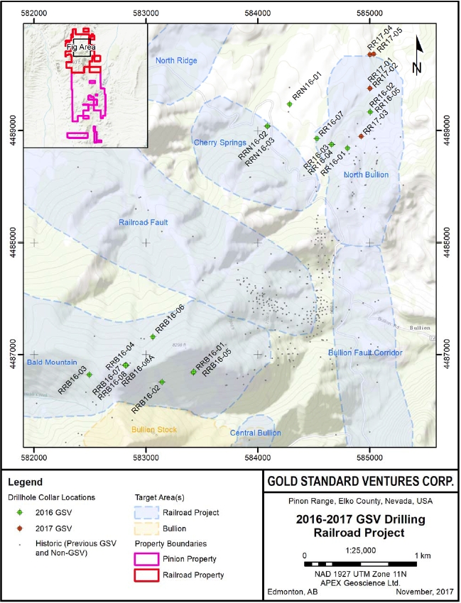
| Effective Date: November 3, 2017 | | | 94 |
Technical Report Maiden Resource Estimate North Bullion Railroad Project, Elko County, Nevada, USA
| 10.3 | Other Railroad–Pinion Project Prospects |
| 10.3.1 | Pinion Deposit Area |
Following the acquisition of the Pinion Project in early 2014, Gold Standard compiled and validated the existing Pinion Deposit drillhole database. After this review, the Company began drilling efforts in the Pinion Deposit area. Phase 1 of the 2014 drill program focused on the North Zone and northern portion of the Main Zone. After which, Gold Standard designed and completed subsequent drill programs to extend areas of known shallow gold mineralization along strike and at depth and to test newly identified exploration targets. From 2014 to 2015, Gold Standard completed 81 RC and diamond drillholes totalling 22,498.5 m (73,814.0 ft) within the Pinion Gold deposit area (Table 10.8; Figure 10.3). Additional details and highlights of the 2016 Pinion Deposit area drill program are summarized by Turneret al., 2015, Dufresne and Koehler, 2016, and Dufresneet al., 2017.
In 2016, Gold Standard completed a total of 25 drillholes in the Pinion Deposit area totalling 8,053.7 m (26,423.0 ft; Table 10.8; Figure 10.3). Drilling at the Pinion Deposit was designed to extend known zones of mineralization, provide additional ‘in-fill’ data for specific zones, provide material for continued metallurgical testing (“met holes”) and included several holes that were intended to test the Irene geological/geochemical target west of the Pinion Deposit and the new Sentinel target to the north of the Pinion deposit. Additional details and highlights of the 2016 Pinion Deposit area drill program are summarized by Dufresneet al., 2017.
A maiden mineral resource estimate was calculated in late 2014 for the Pinion Deposit by Dufresneet al. (2014). Based upon the positive results of the 2014 Phase 2 and the 2015 drilling in the Pinion Deposit area, an updated mineral resource was calculated in early 2016 by Dufresne and Nicholls (2016). Both resources are detailed briefly in Section 14.
Table 10.8. Summary of drillholes completed in the Pinion Deposit area by GSV from 2014 to 2016.
| Year | No. RC Holes | RC Drillholes | No. DD Holes | Diamond Drillholes | Total Length (m) | Total Length (ft) |
Total Length (m) | Total Length (ft) | Total Length (m) | Total Length (ft) |
Main Zone |
| 2014 | 3 | 591.3 | 1,940 | 2 | 179.2 | 588.0 | 770.5 | 2,528 |
| 2016 | | | | 3 | 182.3 | 598.0 | 182.3 | 598.0 |
| Total | 3 | 591.3 | 1,940 | 5 | 361.5 | 1,186.0 | 952.8 | 3,126.0 |
East Pinion |
| 2014 | 17 | 4,210.8 | 13,815.0 | - | - | - | 4,210.8 | 13,815.0 |
| 2015 | 1 | 387.1 | 1,270.0 | - | - | - | 387.1 | 1,270.0 |
| Total | 18 | 4,597.9 | 15,085.0 | - | - | - | 4,597.9 | 15,085.0 |
Southeast Pinion |
| 2014 | 8 | 2,409.4 | 7,905.0 | - | - | - | 2,409.4 | 7,905.0 |
| Effective Date: November 3, 2017 | | | 95 |
Technical Report Maiden Resource Estimate North Bullion Railroad Project, Elko County, Nevada, USA
| Year | No. RC Holes | RC Drillholes | No. DD Holes | Diamond Drillholes | Total Length (m) | Total Length (ft) |
Total Length (m) | Total Length (ft) | Total Length (m) | Total Length (ft) |
| 2015 | 5 | 2,650.2 | 8,695.0 | - | - | - | 2,650.2 | 8,695.0 |
| Total | 13 | 5,059.7 | 16,600.0 | - | - | - | 5,059.7 | 16,600.0 |
South Pinion |
| 2015 | 1 | 400.8 | 1315.0 | - | - | - | 400.8 | 1315.0 |
| 2016 | 1 | 402.3 | 1320.0 | - | - | - | 402.3 | 1320.0 |
| Total | 2 | 803.1 | 2,635.0 | - | - | - | 803.1 | 2,635.0 |
Southwest Pinion |
| 2014 | 2 | 1039.4 | 3410.0 | - | - | - | 1039.4 | 3410.0 |
| 2015 | 1 | 452.6 | 1485 | - | - | - | 452.6 | 1485 |
| Total | 3 | 1,492.0 | 4,895.0 | | | | 1,492.0 | 4,895.0 |
West Pinion |
| 2014 | 2 | 403.9 | 1325.0 | - | - | - | 403.9 | 1325.0 |
| 2015 | 2 | 795.5 | 2610.0 | - | - | - | 795.5 | 2610.0 |
| Total | 4 | 1,199.4 | 3,935.0 | - | - | - | 1,199.4 | 3,935.0 |
West-southwest Pinion |
| 2016 | 4 | 1,752.6 | 5,750.0 | - | - | - | 1,752.6 | 5,750.0 |
Northwest Pinion |
| 2014 | 7 | 1,080.5 | 3,545.0 | - | - | - | 1,080.5 | 3,545.0 |
| 2015 | 10 | 3,749.0 | 12,300.0 | - | - | - | 3,749.0 | 12,300.0 |
| 2016 | 2 | 920.5 | 3,020.0 | - | - | - | 920.5 | 3,020.0 |
| Total | 19 | 5,750.0 | 18,865.0 | - | - | - | 5,750.0 | 18,865.0 |
North Pinion |
| 2014 | 6 | 1,328.93 | 4,360.0 | 2 | 303.6 | 996.0 | 1,632.53 | 5356.0 |
| 2016 | - | - | - | 2 | 294.7 | 967.0 | 294.7 | 967.0 |
| Total | 6 | 1,328.9 | 4,360.0 | 4 | 598.3 | 1,963.0 | 1,927.2 | 6,323.0 |
Sentinel |
| 2014 | 8 | 1,542.3 | 5,060.0 | - | - | - | 1,542.3 | 5,060.0 |
| 2015 | 4 | 973.8 | 3,195.0 | - | - | - | 973.8 | 3,195.0 |
| 2016 | 10 | 2,869.7 | 9,415.0 | 1 | 275.2 | 903.0 | 3,144.9 | 10,318.0 |
| Total | 22 | 5,385.8 | 17,670.0 | 1 | 275.2 | 903.0 | 5,661.0 | 18,573.0 |
Irene |
| 2016 | 2 | 1356.4 | 4,450.0 | - | - | - | 1356.4 | 4,450.0 |
| Total | 96 | 29,317.0 | 96,185.0 | 10 | 1,235.0 | 4,052.0 | 30,552.0 | 100,237.0 |
| Effective Date: November 3, 2017 | | | 96 |
Technical Report Maiden Resource Estimate North Bullion Railroad Project, Elko County, Nevada, USA
Figure 10.3. Collar locations of drillholes completed in the Pinion Deposit area by GSV in 2014 and 2016.
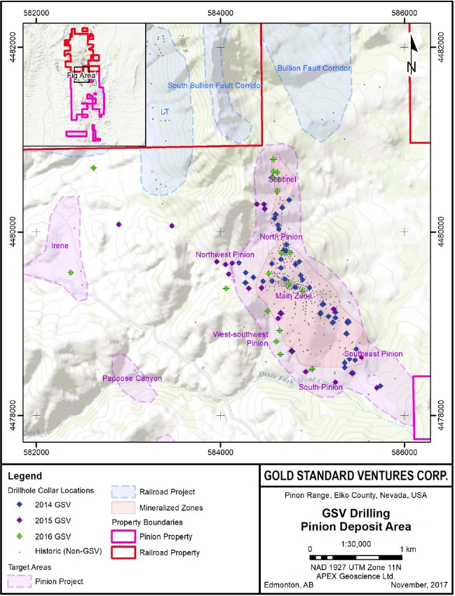
| Effective Date: November 3, 2017 | | | 97 |
Technical Report Maiden Resource Estimate North Bullion Railroad Project, Elko County, Nevada, USA
| 10.3.2 | Dark Star Deposit Area |
In 2015, Gold Standard began drilling in the Dark Star Deposit area, targeting the Dark Star Deposit, the Dark Star North target identified during Gold Standard’s 2014 exploration program, and to a lesser extent, the Dark Star Corridor (DSC) south of the Dark Star Deposit. Gold Standard completed a two-phase drill program in the Dark Star Deposit area, completing 13 RC and diamond drillholes totalling 5,048.0 m (16,562.0 ft; Table 10.9; Figure 10.4; Dufresne and Koehler, 2016). The Company designed the drill programs for the Dark Star Deposit area to extend known shallow oxide gold mineralization along strike and to test newly identified exploration targets. Additional details and highlights of the 2015 Dark Star Deposit area drill programs are summarized by Dufresne and Koehler, 2016 and Dufresneet al., 2017.
In 2016, GSV completed 40 holes totaling 17,850.0 m (58,563.0 ft) that tested the Dark Star Main Zone as well as the Dark Star North target and areas to the south along the DSC (Table 10.9; Figure 10.4; Dufresneet al., 2017). Drilling at the Dark Star Main Zone was designed to extend zones of known mineralization to the west and northwest and to provide additional ‘in-fill’ data, and material for metallurgical testing, for the Dark Star Deposit. Drilling at the Dark Star North target area and to the south along the DSC was designed to test around the initial Dark Star North discovery holes and to test for new zones of mineralization along strike (structural trend) to the south of the current Dark Star Deposit area. Additional details and highlights of the 2016 Dark Star Deposit area drill program are summarized by Dufresneet al., 2017.
A maiden mineral resource estimate was calculated in early 2015 for the Dark Star Deposit area prior to the 2015 drilling campaign by Dufresneet al. (2015). Based upon the positive results of the 2016 Phase 2 drilling at Dark Star, an updated mineral resource was calculated in 2017 by Dufresne and Nicholls (2017). Both resources are detailed briefly in Section 14.
Table 10.9. Summary of drillholes completed in the Dark Star Deposit area by GSV in 2015 to 2016.
| Year | No. RC Holes | RC Drillholes | No. DD Holes | Diamond Drillholes | No.RC + DD Holes | RC Collar and Diamond Tail Drillholes | Total Length (m) | Total Length (ft) |
Total Length (m) | Total Length (ft) | Total Length (m) | Total Length (ft) | RC | DDH |
Total Length (m) | Total Length (ft) | Total Length (m) | Total Length (ft) |
Dark Star Main Zone |
| 2015 | 4 | 1,335.0 | 4,380.0 | - | - | - | - | - | - | - | - | 1,335.0 | 4,380.0 |
| 2016 | 5 | 2,429.3 | 7,970.0 | 4 | 1,092.1 | 3,583.0 | - | - | - | - | - | 3,521.4 | 11,553.0 |
| Total | 9 | 3,764.3 | 12,350.0 | 4 | 1,092.1 | 3,583.0 | - | - | - | - | - | 4,856.4 | 15,933.0 |
Dark Star North |
| 2015 | 7 | 2,705.1 | 8,875.0 | 1 | 427.3 | 1,402.0 | - | - | - | - | - | 3,132.4 | 10,277.0 |
| 2016 | 8 | 3,419.9 | 11,220.0 | 15 | 6,893.4 | 22,616.0 | 2 | 243.8 | 800.0 | 703.8 | 2,309.0 | 11,260.8 | 36,945.0 |
| Total | 15 | 6,125.0 | 20,095.0 | 16 | 7,320.7 | 24,018.0 | 2 | 243.8 | 800.0 | 703.8 | 2,309.0 | 14,393.2 | 47,222.0 |
Dark Star Corridor |
| 2015 | 1 | 580.6 | 1,905.0 | - | - | - | - | - | - | - | - | 580.6 | 1,905.0 |
| 2016 | 6 | 3,067.8 | 10,065.0 | - | - | - | - | - | - | - | - | 3,067.8 | 10,065.0 |
| Total | 7 | 3,648.4 | 11,970.0 | - | - | - | - | - | - | - | - | 3,648.4 | 11,970.0 |
| Total | 31 | 13,537.7 | 44,415.0 | 20 | 8,412.8 | 27,601.0 | 2 | 243.8 | 800.0 | 703.8 | 2,309.0 | 22,898.0 | 75,125.0 |
| Effective Date: November 3, 2017 | | | 98 |
Technical Report Maiden Resource Estimate North Bullion Railroad Project, Elko County, Nevada, USA
Figure 10.4. Collar locations of drillholes completed in the Dark Star Deposit area by GSV in 2015 and 2016.
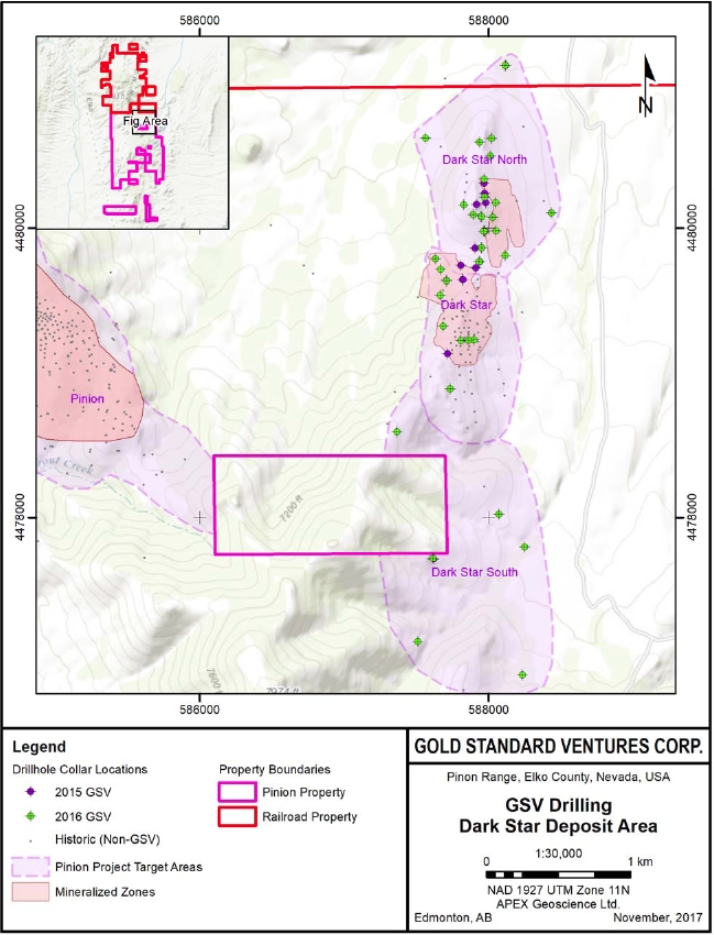
| Effective Date: November 3, 2017 | | | 99 |
Technical Report Maiden Resource Estimate North Bullion Railroad Project, Elko County, Nevada, USA
| 11 | Sample Preparation, Analyses and Security |
The following summarizes the procedures employed by Gold Standard personnel for surface sampling, the handling of core and reverse-circulation cuttings samples.
| 11.1 | Surface Soil and Rock Sampling |
The following describes the surface sampling procedures that have been established by Gold Standard at the Railroad–Pinion Project. All sampling is conducted under the supervision of the Company’s project geologists and the chain of sample custody from the field to the sample preparation facility is continuously monitored. A blank or certified reference material was inserted approximately every forty samples for soil and rock samples. The samples are delivered to either ALS’ or Bureau Veritas’ preparation facility in Elko, NV where the samples are crushed, screened and pulverized. Sample pulps are then shipped to ALS' certified laboratory in Reno, NV (or Vancouver, B.C.) or Bureau Veritas’ certified laboratory in Sparks, Nevada for geochemical analysis. Samples are crushed and pulverized and for gold assay, 30g aliquots are fire assayed and finished with a wet chemical procedure, normally AA – Atomic Absorption or by ICP-AES finish. All other elements are determined using a 0.5 g aliquot of the pulp that is analyzed by wet chemical methods that compriseaqua regia acid digestion followed by ICP-AES analysis. Data verification of the analytical results includes a statistical analysis of the duplicates, standards and blanks that must pass certain parameters for acceptance to insure accurate and verifiable results.
Drill core is collected from the drill rig by Gold Standard personnel and transported to Gold Standard’s Elko, Nevada office on a daily basis. At the secure Elko facility, Gold Standard personnel complete the following:
| • | A geological log is completed on the whole core. Logs illustrate core recovery, sample intervals, lithologic data, hydrothermal alteration and structural features with respect to the core axis. |
| • | The whole core is marked/tagged for sampling, and digitally photographed. High resolution digital jpeg photographs are archived for future reference. |
| • | Whole HQ-size core is cut in half (rock sawed), and whole PQ-size core is quarter cut, by contractors working at Gold Standard’s Elko office. Sawed core sample intervals are recorded on daily cut core sheets for review each day. |
| • | Samples for geochemical analysis are collected and comprise either one half of the HQ-size core or one quarter of the PQ-size core with the remaining core for each retained in their original core boxes. |
| • | Standard reference materials (standards and blanks) are inserted into the sample sequence at a rate of approximately 1 in every 10 to 15 samples. |
All original geochemical analyses were completed by either ALS or Bureau Veritas, both internationally accredited independent analytical companies with ISO9001:2008 certification.
| Effective Date: November 3, 2017 | | | 100 |
Technical Report Maiden Resource Estimate North Bullion Railroad Project, Elko County, Nevada, USA
In the case of ALS, ALS picks up the core samples from Gold Standard’s Elko office and delivers them to its Elko, Nevada sample preparation facility. At the ALS preparation facility the samples are logged into a computer-based tracking system, weighed and dried. The entire sample is crushed so that +70 % passes a 6 mm screen, then it is finely crushed so that +70 % passes a 2mm screen. A 250 g (~0.5 pound) spilt (original pulp) is then selected and pulverized to better than 85 % passing a 75 micron screen. From Elko the pulp samples are shipped to Reno, Nevada or Vancouver, British Columbia for geochemical analysis. At Reno or Vancouver, a 30 g aliquot is extracted from the pulp and is analyzed for gold using a fire assay fusion and with atomic absorption spectroscopy (AAS) finish. Samples were also analyzed for a suite of 30 other “trace elements” by ICP-AES (Inductively Coupled Plasma – Atomic Emission Spectroscopy) followingaqua regia digestion.
In the case of Bureau Veritas, Bureau Veritas picks up the core samples from Gold Standard’s Elko office and delivers them to its Elko, Nevada sample preparation facility. At Bureau Veritas’ preparation facility the samples are logged into a computer-based tracking system, weighed and dried. The entire sample is crushed so that +70 % passes a 2 mm screen. A 250 g (~0.5 pound) spilt (original pulp) is then selected and pulverized to better than 85 % passing a 75 micron screen. From Elko the pulp samples are shipped to Sparks, Nevada or Vancouver, British Columbia for geochemical analysis. At Sparks or Vancouver, a 30 g aliquot is extracted from the pulp and is analyzed for gold using a fire assay fusion and with atomic absorption spectroscopy (AAS) finish. Samples are also analyzed for a suite of 37 other “trace elements” by ICP-MS following aqua regia digestion.
All Pinion samples that assay greater than 0.14 ppm Au are follow-up assayed for Ag by four acid digestion followed by AAS finish. All samples that assay greater than 0.14 ppm Au are also follow-up assayed for Au and Ag by cyanide leach utilizing a 30 g aliquot and a leach time of about an hour. The samples are finished using AAS.
| 11.3 | Reverse-circulation Drillhole Cuttings |
Reverse-circulation drill samples were collected by the drilling contractor using a wet sample splitter on the drill rig. Samples typically range from 5 to 20 pounds. Geochemical standards and/or blanks are inserted by Gold Standard geologists every 10 to 15 samples. The samples were picked up at the drill sites by either ALS or Bureau Veritas and delivered to its preparation lab in Elko, Nevada.
Samples submitted to either ALS or Bureau Veritas utilized the exact same preparation and analytical procedures as described above for the core samples.
Samples submitted to ALS were logged into a computer-based tracking system, sorted, weighed and dried. The entire sample is crushed so that +75 % passes a 2 mm screen. A 250 g (~0.5 pound) spilt is then selected and pulverized to better than 85 % passing a 75 micron screen. From Elko the samples were shipped to Reno, Nevada or Vancouver, B.C. for geochemical analysis. Pulp samples were analyzed for gold using a fire assay fusion and an atomic absorption spectroscopy (AAS) finish on a 30 gram split. Samples were also analyzed for a suite of 30 other “trace elements” by ICP-AES (Inductively Coupled Plasma – Atomic Emission Spectroscopy) followingaqua regia digestion.
| Effective Date: November 3, 2017 | | | 101 |
Technical Report Maiden Resource Estimate North Bullion Railroad Project, Elko County, Nevada, USA
At the Bureau Veritas preparation facility the samples are logged into a computer-based tracking system, weighed and dried. The entire sample is crushed so that +70 % passes a 2 mm screen. A 250 g (~0.5 pound) spilt (original pulp) is then selected and pulverized to better than 85 % passing a 75 micron screen. From Elko the pulp samples are shipped to Sparks, Nevada or Vancouver, British Columbia for geochemical analysis. At Sparks or Vancouver, a 30 g aliquot is extracted from the pulp and analyzed for gold using a fire assay fusion and an atomic absorption spectroscopy (AAS) finish. Samples are also analyzed for a suite of 37 other “trace elements” by ICP-MS following aqua regia digestion.
All Pinion samples that assay greater than 0.14 ppm Au are follow-up assayed for Ag by four acid digestion followed by AAS finish. All samples that assay greater than 0.14 ppm Au are also follow-up assayed for Au and Ag by cyanide leach utilizing a 30 g aliquot and a leach time of about an hour. The samples are finished using AAS.
The sample collection, security, transportation, preparation, insertion of geochemical standards and blanks, and analytical procedures are within industry norms and best practices. The procedures utilized by Gold Standard are considered adequate to insure that the results disclosed are accurate within scientific limitations and are not misleading.
The following sections discuss the details of the Quality Assurance and Quality Control (QA/QC) program employed by GSV at the Railroad–Pinion Project between 2010 and 2017 with respect to the drilling of the holes that were used in the estimation of the maiden resource estimate for the North Bullion, Sweet Hollow and POD deposits discussed in Section 14 of this report. The authors have conducted a review of geological and geochemical data within the GSV drill database by comparing database values to original drill logs (paper copies) and original assay certificates provided by ALS Minerals (ALS) and Inspectorate America Corporation (Inspectorate/Bureau Veritas). No significant issues were identified and the Railroad drilling database is considered sufficiently validated for use in the mineral resource estimation work discussed elsewhere in this report.
For the specific details of QA/QC results for the most recent Pinion and Dark Star resource estimates refer to Dufresne and Nicholls (2016), Dufresne and Nicholls (2017) and Dufresneet al. (2017). The following QA/QC data are presented for the Railroad Project drilling.
For non-analytical field data, Gold Standard employs a variety of protocols and procedures to insure data integrity. For non-analytical drillhole information, GSV employs a protocol of multiple data checks to insure the accurate recording of information within the Project’s drilling database. This includes both collar and down hole survey information as well as all geological and geotechnical information from both core and RC chip logging. These procedures are considered reasonable and adequate and insure data integrity.
Steven Koehler, a qualified person and co-author of previous reports, had verified the location of numerous drill sites throughout the project area and compared them with coordinates in the GSV drill database and no issues were found.
| Effective Date: November 3, 2017 | | | 102 |
Technical Report Maiden Resource Estimate North Bullion Railroad Project, Elko County, Nevada, USA
| 12.2 | Analytical Data (Quality Assurance and Quality Control Program) |
The analytical portion of the QA/QC program employed by GSV aims to insure the overall accuracy and precision of the assaying that is performed on its drilling samples. To this end, GSV personnel insert samples of standard reference materials (standards and blanks) into the company’s sample stream, along with duplicate samples. The standard samples are certified to contain a known concentration of an element (or elements), in this case gold, including blank (pulp) samples that are a type of standard that are certified to contain Au below detectable limits for normal fire assay procedures. GSV’s protocol is to use several different standards which allow for a range of gold values during a drilling program and to insert one of these standard samples, selected at random, into the stream of drill samples at a rate of approximately 1 in 10. The QC samples inserted alternate between a standard and a blank such that there is one of each in every 20 drill samples. The analytical quality control measures employed by GSV are consistent with industry standards and sufficient to properly monitor analytical accuracy and precision.
The certified standard and blank samples used for the Railroad drilling between 2010 and 2017 were purchased from MEG Inc. (www.sheaclarksmith.com) in Reno, NV. A review of the sample preparation and certification procedures employed by MEG Inc. indicates that the reference materials are produced as per industry standard to insure homogeneity. The standards appear to be reasonably well tested by round-robin analysis at between 5 and 10 different laboratories, to establish expected values and acceptable ranges. Between 2010 and 2015 a total of 2,049 standard reference materials were inserted in the Railroad drilling sample stream, comprising 1,073 standards and 976 blanks. This results in a ration of 1 QA/QC sample for every 20 drill samples. During the 2016 and 2017 drilling programs at the North Bullion deposit a total of 672 standard reference materials were inserted (404 standards and 268 blanks), representing a ratio of 1 QA/QC sample for every 15 drill samples.
A total of 1,244 blank pulp samples were inserted in the drilling sample stream from the Railroad area between 2010 and 2017 by GSV. The analysis of blank pulp samples tests for possible contamination, and/or poor instrument calibration, within the laboratory during sample analysis. The blank pulp materials are certified by MEG Inc. to contain material that should assay <0.003 ppm (<3 ppb) Au. All the blanks were analyzed by 30 g fire assay with a wet chemical (AA) finish with a lower detection limit 0.005 ppm Au (5 ppb Au). The analytical work on the 2010-2017 North Bullion drill samples was split between two laboratories; the Bureau Veritas (Inspectorate) in Reno, NV and ALS, Reno, NV.
In total, 114 of the 1,244 blank pulp samples returned a gold assay result above detectable limits (<5ppb Au), or 9.2 % of the blank samples. Relative to a 95 % confidence level, these results are considered high but acceptable. As illustrated in Figure 12.1, in which samples are plotted chronologically from left to right, there were no issues with the blank pulps during the 2016-2017 North Bullion drilling. However, the analysis of the blank pulps during the preceding 2010-2015 drilling showed a number of failures that appears to have diminished over time.
| Effective Date: November 3, 2017 | | | 103 |
Technical Report Maiden Resource Estimate North Bullion Railroad Project, Elko County, Nevada, USA
Figure 12.1. 2016-2017 Railroad - North Bullion blank pulp assays.
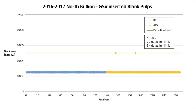
| 12.2.1.1 | 2010-2015 Railroad Blanks |
The 2010-2015 Railroad drilling included 976 blank pulp samples inserted by GSV personnel. There were 114 “failures” (11.7 %), which is much higher than one would normally expect in such a dataset. However, it can also be seen that 94.6 % of the blank sample assays lie within 0.007 ppm Au (7 ppb Au) and the maximum value is only 37 ppb Au. Furthermore, the chronological arrangement of the blank pulp samples indicates that the number of “failures” decreased significantly over time. As a result, it is the opinion of the authors of this report that this data is not unreasonable and is deemed acceptable. A reference graph is provided in Appendix 3 at the end of this report.
| 12.2.1.2 | 2016-2017 Railroad Blanks |
The 2016-2017 Railroad drilling included 268 blank pulp samples inserted by GSV personnel. The analysis of these samples resulted in zero (0) “failures” thus indicating no issues with the analyses.
| 12.2.2 | Standard Reference Materials |
A total of 1,477 standards were inserted in the sample stream for the Railroad 2010 to 2017 drilling including the North Bullion, Sweet Hollow and POD resource drilling. The analysis of standard reference materials is primarily intended to test analytical accuracy and precision. The standards are certified by MEG Inc. to contain a known concentration of gold with a given standard deviation. All the standards were analyzed by 30 g fire assay with a wet chemical (AA) finish. The analytical work on the North Bullion drill samples between 2010 and 2017 was split between two laboratories; the Bureau Veritas (Inspectorate) in Reno, NV and ALS, Reno, NV.
| Effective Date: November 3, 2017 | | | 104 |
Technical Report Maiden Resource Estimate North Bullion Railroad Project, Elko County, Nevada, USA
| 12.2.2.1 | 2010-2015 Railroad Standards |
Between 2010 and 2015 a total of 1,073 standard samples were inserted in the sample stream by GSV personnel for the Railroad drilling including the North Bullion, Sweet Hollow and POD resource drilling. The certified values and acceptable analytical ranges for the ten standard reference materials used by GSV during this period are presented in Table 12.1. The analytical data for the ten standards is summarised in Figure 12.2 while individual graphs for each of the standard sample datasets are appended to this report (Appendix 3) although Figures 12.3 through 12.5 are examples of these datasets and represent standards 0.079 ppm Au (MEG-Au.10.04), 1.343 ppm Au (MEG-S107005X) and 3.651 ppm Au (MEG-Au.11.29).
In general terms, the data illustrated in Figure 12.2 shows that there were no significant issues with respect to the analysis (fire assaying) of the 10 standards utilized by GSV during the 2010 to 2015 Railroad drill programs. Of the outlier samples shown in Figure 12.2, it is likely that the majority simply represent naming errors in the GSV drill database such that their assay values correspond with the acceptable range of another of the standard samples. That being said, the total number of “failures” among standards was only 35 out of the total of 1,073 samples, or 3.3 %, which is an acceptable overall failure rate relative to a 95 % confidence limit for the data. The apparent fail rate drops to 2.7 % if one considers only the data for the 5 standards with a “statistically significant” number of analyses (i.e. > 50 analyses). Although specific standards performed better than others (see below), in general, there are no significant issues with respect to the assaying of the 2010-2015 GSV-inserted standard samples.
A large portion (14 of 35) of the analytical “failures” observed in the 1,073 (2010-2015) standard sample dataset are limited to the three standards with certified gold concentrations > 2 ppm. In total, there were a total of 14 “failures” out of 122 total analyses for these 3 standards (11.4 %). However, upon closer examination it was determined that one (1) sample of ‘standard 2.1 ppm Au’ assayed 6.66 ppm Au and is likely a lab data entry error as a second aliquot of the sample, analysed by a cyanidation assay, returned a value of 1.55 ppm Au, which is less than the certified value of ~2.1 ppm Au but this is likely due to partial leachability of the gold and is similar to 7 other CN leach results also completed for this standard. Furthermore, a sample of ‘standard 3.6 ppm Au’ assayed below detectable limits for gold and thus most likely represents the accidental insertion of a blank pulp. Another issue with ‘standard 2.1 ppm Au’ is that its data comprises only 9 assay results, which is not a ‘statistically significant’ number of analyses. It should also be noted that two of the standards have very similar values and acceptable ranges such that several of the greater than 2 Standard Deviation (2SD) “failures” for ‘standard 3.4 ppm Au’ may actually represent acceptable values for ‘standard 3.6 ppm Au’, which may have been submitted accidentally. With these factors taken into consideration, there only 4 or 5 analyses for the three >2 ppm Au standards that assayed significantly outside their respective 2SD limits, which is an acceptable “failure” rate (Appendix 3).
As a result of the analysis discussed above it can be concluded that there are no issues of statistical significance with the QA/QC data (GSV-inserted standards and blanks) from the 2010-2015 North Bullion deposit drill programs. Thus, the 2010-2015 drill data is considered by the authors of this report to be sufficiently validated for inclusion in the Company’s drilling databases and for use in the resource estimation discussed in a subsequent section of this report.
| Effective Date: November 3, 2017 | | | 105 |
Technical Report Maiden Resource Estimate North Bullion Railroad Project, Elko County, Nevada, USA
Table 12.1. Summary of 2010-2015 Railroad drill assay standard sample assay results.
| GSV Identifier | Supplier Identifier | Certified Data | 2010-2015 Analytical Data | No of Analyses | No of 2SD Fails | % Fail |
Au (g/t) | SD (g/t) | % RSD | Au (g/t) | SD (g/t) | % RSD |
| Standard 0.04 ppm Au | MEG-Au.10.02 | 0.036 | 0.004 | 11.1 | 0.035 | 0.007 | 18.8 | 251 | 3 | 1.2 |
| Standard 0.07 ppm Au | MEG-Au.10.04 | 0.079 | 0.006 | 7.6 | 0.080 | 0.006 | 7.9 | 233 | 4 | 1.7 |
| Standard 0.11 ppm Au | MEG-Au.11.19 | 0.12 | 0.013 | 10.8 | 0.119 | 0.013 | 10.5 | 214 | 8 | 3.7 |
| Standard 0.18 ppm Au | MEG-Au.09.02 | 0.184 | 0.019 | 10.3 | 0.193 | 0.085 | 44.3 | 33 | 1 | 3.0 |
| Standard 0.75 ppm Au | MEG-Au.13.02 | 0.746 | 0.039 | 5.2 | 0.758 | 0.015 | 2 | 16 | 0 | 0.0 |
| Standard 1.30 ppm Au | MEG-S107005X | 1.343 | 0.085 | 6.3 | 1.351 | 0.119 | 8.8 | 189 | 5 | 2.6 |
| Standard 1.50 ppm Au | MEG-S107007X | 1.526 | 0.068 | 4.5 | 1.536 | 0.047 | 3 | 15 | 0 | 0.0 |
| Standard 2.10 ppm Au | MEG-Au.11.34 | 2.113 | 0.172 | 8.1 | 2.679 | 1.505 | 56.2 | 9 | 3 | 33.3 |
| Standard 3.40 ppm Au | MEG-Au.09.04 | 3.397 | 0.204 | 6.0 | 3.658 | 0.260 | 7.1 | 30 | 5 | 16.7 |
| Standard 3.60 ppm Au | MEG-Au.11.29 | 3.651 | 0.319 | 8.7 | 3.717 | 0.215 | 5.8 | 83 | 6 | 7.2 |
Figure 12.2. Analytical data for all 10 of the 2010-2015 GSV-inserted Railroad Standards.
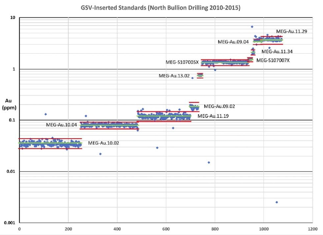
| Effective Date: November 3, 2017 | | | 106 |
Technical Report Maiden Resource Estimate North Bullion Railroad Project, Elko County, Nevada, USA
Figure 12.3. 2010-2015 Railroad - North Bullion assay data for standard 0.079 ppm Au (MEG-Au.10.04).
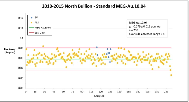
Figure 12.4. 2010-2015 Railroad - North Bullion assay data for standard 3.4 ppm Au (MEG-S107005X).
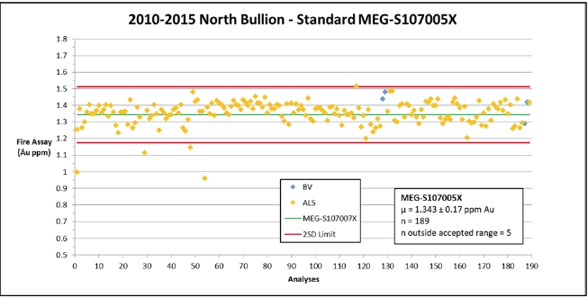
| Effective Date: November 3, 2017 | | | 107 |
Technical Report Maiden Resource Estimate North Bullion Railroad Project, Elko County, Nevada, USA
Figure 12.5. 2010-2015 Railroad - North Bullion assay data for standard 3.6 ppm Au (MEG-Au.11.29).

| 12.2.2.2 | 2016-2017 Railroad Standards |
During the 2016 and 2017 drilling programs at the Railroad project area, a total of 404 standard reference samples (standards) were inserted in the actual drilling sample stream by GSV personnel. The certified values and acceptable analytical ranges for the six standard reference materials used during these drill programs are presented in Table 12.2. The analytical data for each of the six standards have been graphed and are appended to this report (Appendix 3). Figures 12.6 and 12.7 are examples of these datasets and represent standards 0.07 ppm Au (MEG-Au.10.04) and 1.50 ppm Au (MEG-S107007X), respectively, and are discussed in greater detail below.
Table 12.2. Summary of 2016-2017 Railroad drill assay standard sample assay results.
| GSV Identifier | Supplier Identifier | Certified Data | 2016-2017 Analytical Data | No of Analyses | No of 2SD Fails | % Fail |
Au (g/t) | SD (g/t) | % RSD | Au (g/t) | SD (g/t) | % RSD |
| Standard 0.04 ppm Au | MEG-Au.10.12 | 0.036 | 0.004 | 11.1 | 0.035 | 0.003 | 7.5 | 94 | 0 | 0.0 |
| Standard 0.07 ppm Au | MEG-Au.10.04 | 0.079 | 0.006 | 7.6 | 0.079 | 0.005 | 6.0 | 116 | 2 | 0.9 |
| Standard 0.75 ppm Au | MEG-Au.13.02 | 0.746 | 0.039 | 5.2 | 0.753 | 0.02 | 2.6 | 76 | 0 | 0.0 |
| Standard 1.50 ppm Au | MEG-S107007X | 1.526 | 0.068 | 4.5 | 1.556 | 0.063 | 4.0 | 50 | 2 | 4.0 |
| Standard 2.70 ppm Au | MEG-Au.11.17 | 2.693 | 0.118 | 4.4 | 2.789 | 0.117 | 4.2 | 60 | 9 | 15.0 |
| Standard 3.60 ppm Au | MEG-Au.11.29 | 3.651 | 0.319 | 8.7 | 3.891 | 0.283 | 7.3 | 8 | 1 | 12.5 |
| Effective Date: November 3, 2017 | | | 108 |
Technical Report Maiden Resource Estimate North Bullion Railroad Project, Elko County, Nevada, USA
Figure 12.6. 2016-2017 Railroad - North Bullion assay data for standard 0.07 ppm Au (MEG-Au.10.04).
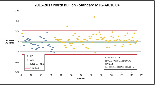
Figure 12.7. 2016-2017 Railroad - North Bullion assay data for standard 1.50 ppm Au (MEG-S107007X).
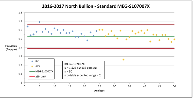
The total number of outside 2SD “failures” among the 2016-2017 Railroad drill program standards was 13 out of the total of 404 assay results (3.2 %), which is an acceptable overall failure rate relative to a 95 % confidence limit for the data.
| Effective Date: November 3, 2017 | | | 109 |
Technical Report Maiden Resource Estimate North Bullion Railroad Project, Elko County, Nevada, USA
The most significant issue recognized in the 2016-2017 Railroad standard sample dataset was a slight, but consistent, positive bias in standard MEG-Au.11.17 (GSV ID – “Standard 2.7 ppm Au”). There was a total of 60 samples of Standard 2.7 ppm Au analysed during 2016 and 2017 with some 9 “failures” (15 %), all of which were >2SD (there were no <2SD “failures”). The overall average of the 60 analyses of this standard sample was 2.79 ppm Au, whereas the certified value for the standard is 2.69 ppm Au (+3.7 %). The 60 analyses were completed at both ALS and Bureau Veritas and both laboratories showed a similar positive bias (see Figure 12.8). What this suggests is that there is likely an issue with the certified value for standard MEG-Au.11.17. As a result, additional testing of this standard is recommended or it should be removed from use. Although a 9 of 60 “failure” rate is higher than one would normally accept, these “failures” lie just beyond the 2SD limit and so the issues with this standard are not considered significant and no re-assaying of samples is recommended.
Figure 12.8. 2016-2017 Railroad - North Bullion assay data for standard 2.70 ppm Au (MEG-Au.11.17).
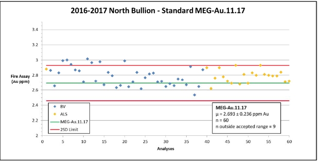
As a result of the analysis discussed above it can be concluded that there are no issues of statistical significance with the QA/QC data (GSV-inserted standards and blanks) from the 2016-2017 North Bullion deposit drill programs. Thus, the 2016-2017 drill data is considered by the authors of this report to be sufficiently validated for inclusion in the Company’s drilling databases and for use in the resource estimation discussed in a subsequent section of this report.
| 12.2.2.3 | Umpire Check Assays |
There has been no umpire assaying/sampling conducted on the Railroad Project 2010 to 2017 drilling including the North Bullion, Sweet Hollow and POD resource drilling.
| 12.2.2.4 | Duplicate Core Sample Assays |
Duplicate samples, also referred to as “field duplicates,” were collected from the core during the 2010-2015 Railroad drilling programs. With the original sample comprising ½ of the cut core, the duplicate sample was collected by quartering (cutting) the remaining (archive) half of the core. Duplicate sampling allows for an examination of the reproducibility of assay results, which can be affected by laboratory issues as well as heterogeneity in the distribution of gold within the sample interval (i.e. the nugget effect). In total, there were 352 duplicate samples collected during the 2010-2015 Railroad drill programs. The duplicate assay data is illustrated in Figure 12.9., which shows a very strong correlation (0.9777) between the duplicate and original samples. This is considered a good result that provides additional confidence in the sample preparation and analytical procedures employed at the laboratories. In addition, the data indicates that there is a reasonable amount of scatter and no significant issues related to the “nugget effect,” which indicates that the assay technique utilized (30g fire assay with an AA finish) is appropriate for the Railroad styles or types of gold mineralization.
| Effective Date: November 3, 2017 | | | 110 |
Technical Report Maiden Resource Estimate North Bullion Railroad Project, Elko County, Nevada, USA
Figure 12.9. 2010-2015 Railroad - North Bullion duplicate assay data.
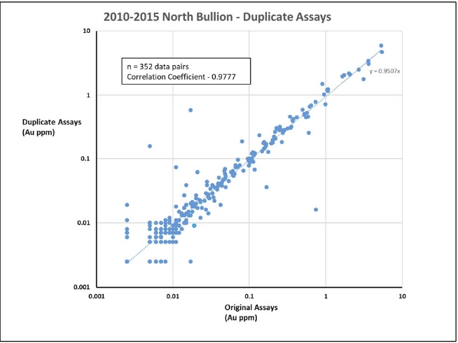
| 12.2.2.5 | Lab-inserted Standard Reference Materials |
Samples analysed at Bureau Veritas (BV) laboratories in Sparks, NV, had several lab-inserted/lab-initiated QC samples that were reported on the assay certificates along with the data for the GSV submitted samples. BV reported the results for 45 standards, 35 blank pulps, and 17 replicate samples during the 2010-2015 Railroad drilling programs. During the 2016 Railroad drilling program they reported results for 144 blank pulps, 57 coarse blanks, 293 standards, 100 replicates, and 99 duplicates (‘duplicates’ represent assays on additional splits from an original pulp, whereas ‘replicates’ represent assays of a second pulp from a second split of coarse reject material).
| Effective Date: November 3, 2017 | | | 111 |
Technical Report Maiden Resource Estimate North Bullion Railroad Project, Elko County, Nevada, USA
The 2010-2015 lab inserted standard sample assays had no results fall outside expected values for the 45 standards analysed other than the results from standard OXI96, which had 7 out of 12 standards fail (58.3 %) which has a significantly higher standard deviation then is expected from the certified values given. It is unknown if the actual standard reference material for OXI96 has real heterogeneity issues or if there was some contamination during the processing of these samples. Given the fact that this was the only standard to have even a single failure it is more likely that the heterogeneity of the standard is at issue and the authors have concluded that these results should not be used to assess the laboratory’s performance. The blank pulps identified only minor issues with 4 out of the 33 blank pulps (11 %) yielding results greater or equal to detection limits (0.005 ppm Au). Figure 12.10 shows an STD OXC102 as an example of the data from the lab inserted standards and blanks. The remaining graphs for the BV Lab-inserted standard sample assay data are appended to this report (Appendix 3).
Bureau Veritas also performed replicate analysis on randomly selected samples from the 2010-2015 Railroad drilling. Replicate assays involve the pulverization and analysis of a second pulp from the original sample’s remaining coarse reject. Seventeen (17) replicate assays were performed by Bureau Veritas and the results are illustrated in Figure 12.11. The replicate assays show excellent correlation exhibiting a 0.9248 correlation coefficient. There were no significant issues identified by the BV replicate assays.
The lab inserted blanks (coarse and pulp) during the 2016 Railroad Project drilling did not identify any significant issues. Only 6 of the 201 samples (3 %) yielded assay results equal to or above the gold detection limit (0.005 ppm Au; Figure 12.12).
Table 12.3. Summary table of the BV inserted certified standards and the results – 2010-2015 Railroad - North Bullion drilling.
Rocklabs Identifier | Certified Data | 2016 Analytical Data | No. of Analyses | No. of 2SD Fails | % Fail |
Au (g/t) | SD (g/t) | % RSD | Au (g/t) | SD (g/t) | % RSD |
| STD OXA89 | 0.0836 | 0.005 | 6.0 | 0.077 | 0.003 | 4.1 | 5 | 0 | 0 |
| STD OXC102 | 0.207 | 0.008 | 3.9 | 0.201 | 0.012 | 6.0 | 11 | 0 | 0 |
| STD OXD87 | 0.417 | 0.008 | 1.9 | 0.407 | 0.013 | 3.2 | 6 | 0 | 0 |
| STD OXF85 | 0.805 | 0.016 | 2.0 | 0.801 | 0.019 | 2.4 | 5 | 0 | 0 |
| STD OXI96 | 1.802 | .024 | 1.3 | 1.757 | 0.098 | 5.6 | 12 | 7 | 58.3 |
| SP37 | 18.14 | 0.3 | 1.7 | 18.48 | 0.356 | 1.9 | 6 | 0 | 0 |
| Effective Date: November 3, 2017 | | | 112 |
Technical Report Maiden Resource Estimate North Bullion Railroad Project, Elko County, Nevada, USA
Figure 12.10. 2010-2015 Railroad - North Bullion lab inserted assay data for standard OXC102.
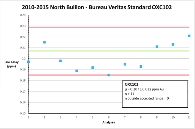
Figure 12.11. 2010-2015 Railroad - North Bullion lab replicate assay data.
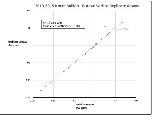
| Effective Date: November 3, 2017 | | | 113 |
Technical Report Maiden Resource Estimate North Bullion Railroad Project, Elko County, Nevada, USA
Figure 12.12. 2016-2017 Railroad - North Bullion lab inserted blanks.
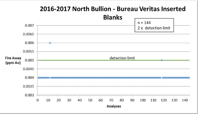
The average failure rate for the lab-inserted standards during the 2016 Railroad Project drill program was 10 in 293 samples (3.4 %), which is an acceptable rate relative to a 95 % confidence limit for the samples. The laboratory primarily used two standards, OXC129 (0.21 ppm Au) and OXI121 (1.83 ppm Au). Graphs illustrating the analytical data for these two standards are illustrated in Figures 12.13 and 12.14, respectively. The data for both standards shows reasonable precision (low variance) and the analytical failures for standard OXI121 can be seen to be marginal 2SD failures and are not deemed to be significant.
Table 12.4. Summary table of the BV inserted certified standards and the results – 2016-2017 Railroad - North Bullion drilling.
Rocklabs Identifier | Certified Data | 2016 Analytical Data | No. of Analyses | No. of 2SD Fails | % Fail |
Au (g/t) | SD (g/t) | % RSD | Au (g/t) | SD (g/t) | % RSD |
| STD OXA131 | 0.077 | 0.007 | 9.1 | 0.075 | 0.001 | 1 % | 5 | 0 | 0 |
| STD OXC129 | 0.205 | 0.007 | 3.4 | 0.202 | 0.011 | 5 % | 141 | 0 | 0 |
| STD OXH66 | 1.285 | 0.032 | 2.5 | 1.328 | -- | -- | 2 | 0 | 0 |
| STD OXI121 | 1.834 | 0.1 | 5.5 | 1.84 | 0.1 | 5 % | 145 | 10 | 6.9 % |
| Effective Date: November 3, 2017 | | | 114 |
Technical Report Maiden Resource Estimate North Bullion Railroad Project, Elko County, Nevada, USA
Figure 12.13. 2016-2017 Railroad - North Bullion lab inserted assay data for standard OXC129.
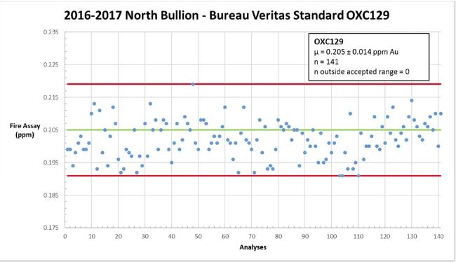
Figure 12.14. 2016-2017 Railroad - North Bullion lab inserted assay data for standard OXI121.

Bureau Veritas performed duplicate and replicate assaying on randomly selected samples from the 2016 Railroad Project drilling. Duplicate assays involve the analysis of a second 30 g aliquot from the original sample pulp, whereas replicate assays involve the pulverization and analysis of a second pulp from the original sample’s remaining coarse reject. A total of 99 duplicate and 100 replicate assays were performed by BV and the results are illustrated in Figures 12.15 and 12.16. Both the duplicate and replicate assays show excellent correlation with the duplicate assays exhibiting a 0.835 correlation coefficient and the replicate assays exhibiting a 0.999 correlation coefficient. This data is interesting in that the correlation (reproducibility) of duplicate assays is normally better than that of replicate assays for the simple fact that there is normally greater variation in a sample’s coarse reject material than in its pulp. A significant portion of the “scatter” in the duplicate assays is attributable to the lower grade of many of these samples where minor variations in gold content/distribution can have a greater affect on the grade of a sample. Although a curiosity, these differences are not considered significant.
| Effective Date: November 3, 2017 | | | 115 |
Technical Report Maiden Resource Estimate North Bullion Railroad Project, Elko County, Nevada, USA
Figure 12.15. 2016-2017 Railroad - North Bullion lab duplicate assay data.
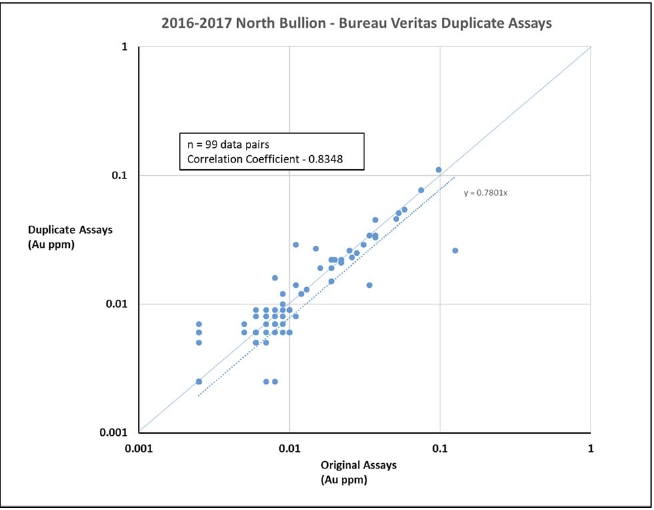
In Summary, the largest issue was the high rate of failure of the blank pulp material early in the 2010-2015 Railroad Project drilling. This issue has been resolved and as seen later in the 2010-2015 data and in the 2016-2017 data the failures are well within expected values. The other issue identified was with respect to the certified value of a couple of the standard reference materials inserted in the 2010-2015 and 2016 Railroad Project drilling by GSV personnel. There were no other significant issues noted in the Company’s QA/QC program. As a result, the data from the 2010-2015 and 2016-2017 Railroad Project drilling, including North Bullion, Sweet Hollow and POD resource drilling, is deemed to be acceptable for insertion into the Company’s drilling database and to be used in the mineral resource estimates in this report.
| Effective Date: November 3, 2017 | | | 116 |
Technical Report Maiden Resource Estimate North Bullion Railroad Project, Elko County, Nevada, USA
Figure 12.16. 2016-2017 Railroad - North Bullion lab replicate assay data.
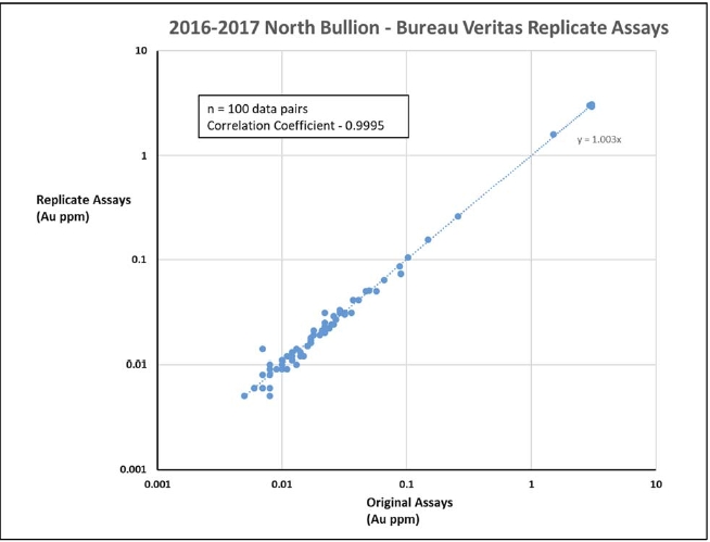
In Summary, the QA/QC protocols employed by GSV throughout the 2010-2017 drilling programs at the North Bullion Deposit area, at the Pinion-Railroad Project, are consistent with industry standards and are considered to be adequate and appropriate for ensuring a high degree of accuracy and precision in the assaying of the samples that were produced by these programs. Although there were issues with a high number of assay “failures” related to the analysis of blank pulp samples early on in the North Bullion drilling programs, which was not seen in the more recent (2016-2017 data), the actual assay values were very low (<20 ppb Au). Thus, considering the excellent performance of the majority of the GSV-inserted standard samples during these programs, it can be concluded that this issue has had little effect on the assaying of the actual drill samples during this time. Additionally, although there appear to have been minor issues with specific standard reference materials, taken as a whole, the 2010-2017 QA/QC sampling did not identify any significant issues with respect to the overall accuracy and precision in assaying of the samples comprising the North Bullion drill assay database. Furthermore, it is the opinion of the authors of this report that the North Bullion drill assay database is sufficiently validated for use in the mineral resource estimation work discussed elsewhere in this report.
| Effective Date: November 3, 2017 | | | 117 |
Technical Report Maiden Resource Estimate North Bullion Railroad Project, Elko County, Nevada, USA
| 13 | Mineral Processing and Metallurgical Testing |
A variety of historic and modern metallurgical tests have been conducted on material for three Railroad Project prospects including Railroad, North Bullion and Bald Mountain. Two separate first-pass metallurgical tests were completed on drill samples from the North Bullion Deposit and the Bald Mountain Target. The samples, test work and results of metallurgical work conducted to date are summarized below.
In 2006, a total of 63 bottle roll tests and 3 column leach tests were completed by Kappes, Cassiday & Associates on behalf of Royal Standard Minerals on material from core from the Railroad (POD) prospect located on the Railroad portion of the Project area. A total of 475 lbs of sample material was submitted for the column leach tests. The individual bottle roll tests involved samples from individual 5 and 10 ft drillhole intervals (Kappes, Cassiday & Associates, 2006). The individual samples were collected from drillholes POD05-01, POD05-02, POD05-04 and POD05-07.
Prior to the initiation of the column leach tests, assays were conducted which established the head grade of the original 475 lbs of sample material as 0.069 oz/st (2.37 g/t) Au. The sample was also submitted for an initial simple bottle roll test that yielded gold recovery of 85 %. The column leach tests were conducted on 3 crush sizes (1.5”, 0.5” and 0.25”) and the results approximated the initial bottle roll test averaging 85 % for the 3 sizes. After 82 days of leaching, the three crush size columns returned gold recoveries of 83 %, 86 % and 88 %, respectively.
The metallurgical work also included running a series of bottle roll tests from the individual core samples (Table 13.1). The results of the 63 individual bottle roll tests were highly variable yielding from 0 % to 83 % gold recoveries. The Kappes, Cassiday & Associates (2006) report identified carbonaceous materials and pointed out that black siltstone and black jasperoid samples yielded the poorest recoveries.
Table 13.1. 2006 bottle roll gold leach tests.
| Hole ID | No. Samples | Average Au Recovery ( %) | Au Recovery Range ( %) |
| POD05-01 | 18 | 55 | 10 to 83 |
| POD05-02 | 20 | 17 | 0 to 70 |
| POD05-04 | 22 | 19 | 0 to 78 |
| POD05-07 | 3 | 0 | 0 |
Three samples were selected from composited, quarter-cut North Bullion drill core. The samples were provided to Newmont USA Limited, a subsidiary of Newmont Mining Corporation (Newmont). Each sample was taken from drill core and was expected to be refractory. A scope of work was generated to conduct gold head assays (duplicate fire assays, cyanide leachable gold assays, and preg-rob assays), carbon and sulphur assays (with a LECO furnace) and a multi-element ICP-MS analysis (Table 13.2). The tests were designed to determine if North Bullion deposit mineralization is amenable to the established recovery technologies commonly used for Carlin-type ores. The samples tested are described as follows:
| Effective Date: November 3, 2017 | | | 118 |
Technical Report Maiden Resource Estimate North Bullion Railroad Project, Elko County, Nevada, USA
| · | Sample #1 represents a 95 ft (28.96 m) lower breccia interval from 1200 to 1295ft (365.76 to 394.72 m) in hole RR11-18. |
| · | Sample #2 represents a 45 ft (13.72 m) upper breccia interval from 960 to 1005 ft (292.61 to 306.32 m) in hole RR12-01. |
| · | Sample #3 represents a 20 ft (6.10 m) lower breccia interval from 1160 to 1180 ft in (353.57 to 359.66 m) hole RR13-08. |
Newmont provided the Company with two reports summarizing the results of metallurgical and mineralogical tests from the North Bullion Deposit. All three samples were characterized as carbonaceous and sulphidic refractory material with very different gold grades, arsenic grades and sulphide sulphur contents (Arthur, 2013; McComb, 2013). The three samples assayed 0.067 oz Au/st (2.30 g/t), 0.340 oz Au/st (11.66 g/t Au) and 0.235 oz Au/st (8.06 g/t Au), respectively. Roaster recoveries were 83.1 %, 90.0 % and 78.8 %, respectively, as illustrated in Table 13.3, indicating that North Bullion mineralization is likely to be conducive to roaster processing (Arthur, 2013). The cause of the recovery variances was not determined. Sulphide sulphur burns were between 94 % and 96 % and organic carbon burns were between 78 % and 93 %. The results suggest that the roast was complete (Arthur, 2013). The calcines had calculated preg-rob values between 0 and 0.007 opt (0.24 ppm) with AA/FA ratios between 77 % and 84 % further supporting the conclusion that all of the organic carbon was burned (Arthur, 2013).
Table 13.2. Head assays.
Sample ID | AuTG (oz/t) | AuTG (g/t) | AA/FA ( %) | Calc. PR (oz/t) | Sulph- ide S ( %) | Org- anic C ( %) | Carb- onate C ( %) | Ag (ppm) | As (ppm) | Cu (ppm) | Hg (ppm) | Ni (ppm) | Zn (ppm) |
| RR11-18 | 0.067 | 2.30 | 4.2 | 0.026 | 1.20 | 0.30 | 0.10 | 1.08 | 235 | 20 | 11 | 40 | 880 |
| 12-01A | 0.340 | 11.66 | 13.5 | 0.024 | 3.26 | 0.53 | 0.34 | 0.30 | 2,473 | 40 | 78 | 46 | 54 |
| 13-08 | 0.235 | 8.06 | 2.4 | 0.049 | 6.16 | 0.61 | 0.32 | 0.70 | 1,005 | 47 | 46 | 47 | 2,029 |
Table 13.3. Roast test results.
| Sample ID | Recovery ( %) | Sulphide Sulphur Burn ( %) | Organic Carbon Burn ( %) | Calcine Calc. PR (opt) | Calcine AA/FA ( %) | NaCN Demand (lb/ton) | Lime Demand (lb/ton) |
| RR11-18 | 83.1 | 96 | 78 | 0.007 | 77 | 1.81 | 15.4 |
| 12-01A | 90.0 | 94 | 90 | 0.000 | 84 | 1.81 | 21.6 |
| 13-08 | 78.8 | 96 | 93 | 0.001 | 76 | 1.01 | 15.2 |
Recognizing the potential economic significance of the Bald Mountain gold discovery, Gold Standard commissioned metallurgical tests of the core from drillhole RRB13-01. Inspectorate America Corporation (“Inspectorate”) of Sparks, Nevada used the following procedure: 30 gram pulp samples were agitation-leached for one hour at room temperature in 60 ml of 0.3 % sodium cyanide solution. The solution also had a 0.3 % concentration of sodium hydroxide in order to stabilize the pH at greater than 10. Pregnant solutions were analyzed by a matrix-matched-calibrated AAS. Internal blanks, standards and duplicates were also analyzed at a frequency of approximately one of each for every 35 samples.
| Effective Date: November 3, 2017 | | | 119 |
Technical Report Maiden Resource Estimate North Bullion Railroad Project, Elko County, Nevada, USA
Fourteen of fifteen samples provided an unweighted average recovery of 82.2 %. The better recoveries were skewed toward the higher grade samples (Table 13.4).
Table 13.4. Gold Standard Ventures RRB13-01: 15 pulp samples for Au-30-CN.
| Sample ID | AuAA 23 Chemex (ppm) | Au (oz/t) | Au 30 CN Inspectorate (ppm) | Au (oz/t) | Gold Recovery ( %) | Cu (ppm) |
| RRB13-01 680 | 1.355 | 0.040 | 1.33 | 0.039 | 98 | 464 |
| RRB13-01 684 | 0.883 | 0.026 | 0.75 | 0.022 | 85 | 316 |
| RRB13-01 702 | 2.4 | 0.070 | 2.02 | 0.059 | 84 | 549 |
| RRB13-01 712 | 6.75 | 0.197 | 5.61 | 0.164 | 83 | 402 |
| RRB13-01 716.5 | 12.85 | 0.375 | 10.61 | 0.309 | 83 | 218 |
| RRB13-01 721.5 | 4.04 | 0.118 | 3.8 | 0.111 | 94 | 323 |
| RRB13-01 730 | 0.952 | 0.028 | 0.8 | 0.023 | 84 | 380 |
| RRB13-01 743 | 0.433 | 0.013 | 0.37 | 0.011 | 85 | 494 |
| RRB13-01 772 | 0.381 | 0.011 | 0.24 | 0.007 | 63 | 787 |
| RRB13-01 792 | 1.705 | 0.050 | 1.42 | 0.041 | 83 | 601 |
| RRB13-01 802 | 2.5 | 0.073 | 1.74 | 0.051 | 70 | 756 |
| RRB13-01 812 | 1.415 | 0.041 | 1.08 | 0.031 | 76 | 137 |
| RRB13-01 827 | 1.22 | 0.036 | 0.99 | 0.029 | 81 | 404 |
| RRB13-01 834 | 0.623 | 0.018 | 0.51 | 0.015 | 82 | 855 |
| RRB13-01 861 | 0.569 | 0.017 | 0.1 | 0.003 | 18 | 1110 |
| 14 | Mineral Resource Estimates |
Since GSV acquired and amalgamated the Railroad–Pinion Project they have undertaken an aggressive exploration strategy aimed at delineating NI 43-101 mineral resource estimates at several of the pre-existing and newly discovered prospects. To date, maiden NI 43-101 Mineral Resource Estimates for the Pinion Deposit by Dufresneet al. (2014) and the Dark Star Deposit by Dufresneet al. (2015) have been completed. In early 2016, a revised Mineral Resource Estimate was completed for the Pinion Deposit by APEX utilizing all of the historic through 2015 drilling data (Dufresne and Nicholls, 2016). In mid 2017, a revised Mineral Resource Estimate was completed for the Dark Star Deposit by APEX (Dufresne and Nicholls, 2017).
This report details a maiden NI 43-101 Mineral Resource Estimate completed for the Railroad Project that includes mineral resources for the North Bullion, Sweet Hollow and POD deposits by APEX. Details of the four previous NI 43-101 compliant Mineral Resource Estimates completed to date for the Railroad–Pinion Project are summarized in Section 14.16 of this report and are detailed in previous reports covering the entire Project by Dufresneet al. (2015, 2016 and 2017). Copies of the Maiden 2014 Pinion Mineral Resource Report, the Maiden 2015 Dark Star Mineral Resource Report, the 2016 Pinion Mineral Resource Update Report, and the 2017 Dark Star Mineral Resource Update are available for review on SEDAR.
| Effective Date: November 3, 2017 | | | 120 |
Technical Report Maiden Resource Estimate North Bullion Railroad Project, Elko County, Nevada, USA
The statistical analysis, geological modelling and resource estimation discussed in this section of the Technical Report was performed by Mr. Steven Nicholls, BA Sc., MAIG, with APEX Geoscience Ltd. (APEX) under the direct supervision of Mr. Michael B. Dufresne, M.Sc., P. Geol., P.Geo. also with APEX. Both are independent geological consultants and Qualified Persons as defined by NI 43-101. Mineral resource modelling and estimation was carried out using a 3-dimensional block model based on geostatistical applications using commercial mine planning software MICROMINE (v16.1).
Modeling was conducted in Universal Transverse Mercator (UTM) coordinate space relative to the North American Datum (NAD) of 1927 (Zone 11). A parent block size of 10 m (X) x 10 m (Y) x 3 m (Z) with sub-blocking down to 5 m (X) x 5 m (Y) x 1.5 m (Z) was applied in order to best honour the interpreted wireframe solids for gold mineralization. The database consists of 503 drillholes completed in the Railroad Project area many of which were used to guide the geological and mineralization interpretation; of which, 232 drillholes completed from 1980 to 2017 were used in the resource estimation. Mr. Dufresne, M.Sc., P.Geol., P.Geo., visited the property in April and October, 2014, June, 2015, August to September, 2015 and June 2017, in order to verify and validate the historic drill hole dataset and drilling recently completed by GSV. Since the acquisition of the Pinion Project area by GSV in early 2014, the Company has been conducting a significant historic data verification and validation program, with which APEX has been involved with throughout this period. Validation, a re-logging program and re-interpretation of historic drilling has been undertaken to improve the geological understanding and models and to improve the quality of the database. In the opinion of APEX, the Railroad Project database is suitable for resource estimation and the current drillhole database is deemed to be in good condition and suitable to use in ongoing resource estimation studies.
The North Bullion, Sweet Hollow and POD Mineral Resource Estimate is reported in accordance with the Canadian National Instrument 43-101 and has been estimated using the CIM “Estimation of Mineral Resources and Mineral Reserves Best Practice Guidelines” dated November 23rd, 2003 and CIM “Definition Standards for Mineral Resources and Mineral Reserves” dated May 14th, 2014.
| 14.2.1 | Drillhole Database Validation |
The GSV database has undergone extensive validation prior to the 2017 resource estimation effort discussed below. Historic drilling was largely conducted relative to UTM grid lines, with the exception being the POD deposit area. The majority of the drilling was performed on east-west oriented drill sections for Sweet Hollow and North Bullion zones and 040° for the POD zone. GSV has performed differential GPS surveys of all of its collars for drilling between 2010 and 2017. Where possible they have picked up historic collars. The confirmation and validation of historical drillhole collar locations was addressed during site visits conducted by Mr. Dufresne. During the site visits, Mr. Dufresne located a number of historic and GSV drill collars using a hand-held GPS, along with tracks representing drill roads and trails. Although unmarked in the field, the identity of several drill collars were ascertained due to their unique location, which were found to be consistent with historically recorded location information. Further work on refining the collar positions and validation of the drillhole database has been performed by GSV personnel and reviewed by the authors of this report.
| Effective Date: November 3, 2017 | | | 121 |
Technical Report Maiden Resource Estimate North Bullion Railroad Project, Elko County, Nevada, USA
The most significant problem with the historic drillhole database centered on collar elevations, which initially provided a number of obvious errors. With near flat lying mineralized zones it was determined to be imperative to obtain a reliable dataset of collar elevations that were internally consistent from one hole to the next. Once accurate real world coordinates were obtained for the historic collars, elevations for the drillholes were generated by using the digital elevation model that was generated by Pacific Geomatics from its ortho-rectified satellite imagery that had 3 ft (~1 m) elevation and location resolution. This problem only applied to the historic pre GSV drillholes. All recent 2010 to 2017 GSV drillholes were surveyed using a differential GPS for their easting, northing and elevation coordinates.
A total of 170 of the 503 drill holes in the Railroad database have actual downhole survey data over and above collar information, including 128 holes completed by GSV between 2010 and 2017, along with 42 holes completed by Kinross during 1998 and 1999. All available historic documentation was searched with respect to identifying down-hole orientation survey data for the historic Railroad drillholes. Besides the documented collar information, there was no additional down-hole orientation survey information obtained. Of the 503 drillholes in the Railroad database, 297 drillholes were drilled vertically (-85° to -90° dip), with the remaining inclined holes (206 holes) drilled along easterly or westerly azimuths or 040°/ 220° in the case for the POD zone with dips (inclinations) ranging from -30° to -85° from horizontal. A total of 33 of the 333 historic holes without downhole survey information were drilled to depths greater than 200 m and only 13 of the 33 holes were drilled to greater than 300 m. Based upon the abundance of shallow vertical holes in the historic drillhole database, the amount of down-hole deviation from collar setups for the historic holes is uncertain but is considered to be likely minimal. As such this has been taken into consideration with the classification of the Railroad resources.
The assay portion of the Railroad drilling database has also undergone rigorous validation checks. To date GSV and APEX personnel have validated the drillhole assay database data with all available original assay certificates that could be located. Assay certificates were available for all 135 GSV holes completed between 2010 and 2017. GSV and APEX personnel located the original laboratory assay certificates for 140 of the 368 historic drillholes. The assay data for all of the historic drillholes was compared to a number of other historic databases in GSV’s possession and compiled by companies such as Newmont, Kinross and Royal Standard. No assay issues were identified with GSV’s historic assay database. This provided APEX and GSV personnel the confidence in the validity of the existing assay database used for this mineral resource estimation.
| Effective Date: November 3, 2017 | | | 122 |
Technical Report Maiden Resource Estimate North Bullion Railroad Project, Elko County, Nevada, USA
In order to understand the geological model and place the mineralization in context with the geology, GSV personnel initiated a re-logging program using a) historic drill logs and b) archived RC drilling chips from the historic drillholes. This has resulted in an increased level of confidence in the geological controlled mineralization model. Out of the 503 drillholes in the database, 101 historic holes have been “re-interpreted” by GSV personnel in 2016 and 2017 as of the date of this report, 7 historic holes have been re-interpreted from cross sections by GSV personnel, and 135 holes have been drilled and logged by GSV from 2010 to 2017. Based upon the core drilling and the improved understanding of Railroad geology, a number of the 2010 to 2017 and historic drillholes have been recently re-logged and re-interpreted. The revised logs were entered into a database and imported into Micromine where modeling was initially conducted in cross-sectional view (Figure 14.1).
Figure 14.1. POD geology interpretation of a transform cross-section (looking northwest, +/-10 m).
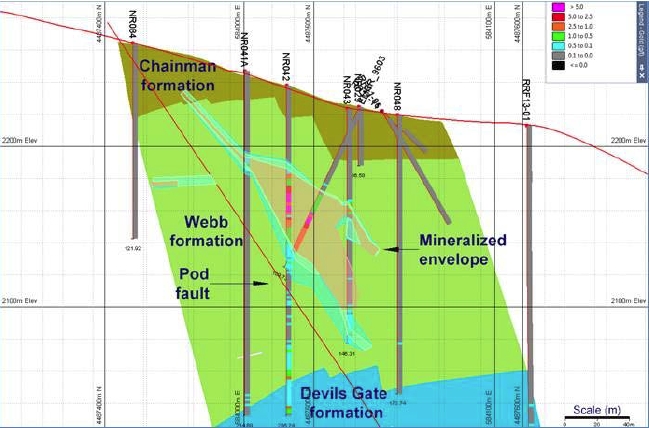
The extensive historical data compilation and data validation process described above resulted in a compiled drill database for the Railroad Project area that is considered by APEX to be sufficiently reliable for use in the mineral resource estimation effort described below.
The drilling database used is current as of August 18th, 2017. The database incorporates all available Reverse Circulation (RC) drilling and diamond core (Core) drilling completed to date. All data for the mineral resource estimation was copied from excel spreadsheets into the Micromine program. The seven main Micromine .DAT files that were generated and utilized in the mineral estimation include:
| Effective Date: November 3, 2017 | | | 123 |
Technical Report Maiden Resource Estimate North Bullion Railroad Project, Elko County, Nevada, USA
| · | NB-RR Collar Aug 2017 – Collar file; |
| · | NB-RR Survey Aug 2017 – Down hole survey file; |
| · | NB-RR Assay Aug 2017 – Assay file; |
| · | NB-RR Geology Aug 2017 – Geology file; |
| · | Density Measurements – Specific gravity measurements; |
| · | NB-RR 2013 DEM 2m Grid – southern surface topography; and |
| · | NB-RR 2017 DEM 2m Grid – northern surface topography. |
There was a total of 503 drillholes within the export that guided the mineralization interpretation and estimation of the Railroad Project mineral resources. This total comprises 95 core holes completed by GSV from 2010 to 2017, 40 RC drillholes also completed by GSV from 2010 to 2014, along with 40 historic core holes and 328 historic RC holes that were completed from 1969 to 1999. Spacing between drillholes over the main resource area varies from 2 m to 120 m (6.5 to 394 ft). Drilling has been completed on roughly east-west sections that range in spacing from 25 to 120 m (82 to 393 ft) with an average spacing of around 25 m (82 ft) through Sweet Hollow and 50 m (164 ft) at North Bullion. The exception to this is the POD zone of mineralization, for which drilling was completed on 040° oriented drill sections that were roughly spaced 25 m (82 ft) apart. All of the drillholes were used to guide the mineralization model that was ultimately used in the resource estimation calculation.
The Railroad assay file comprises 75,890 analyses of variable lengths, of which 75,724 samples have been assayed for gold. Of the 75,890 samples in the Railroad database, roughly nine percent (6,941 assays) are situated within the gold mineralized lodes. Within the original assay database there were a number of assay intervals with codes describing the interval as a “missing sample” (e.g. “NS”, “MS” or “#value!”). There were eight NS samples situated with mineralized wireframes and were assigned a nominal gold value of 0.0025 g/t Au which corresponded to half the detection limit.
The drillhole database was validated using the validation functions within the Micromine modeling software. No significant errors or issues were noted.
| 14.3 | Lithological Model/Lode Interpretation |
After the completion of the maiden resource estimate of the Pinion property (see Dufresneet al., 2014), GSV personnel began work compiling all of the available geological information for the Railroad Project area in order to commence work on a geological and mineralization model for a number of the Railroad prospects. Prior to GSV personnel commencing work on the Railroad geological model, there was little to no geological information recorded in the drillhole database files. GSV personnel embarked on a re-logging and re-interpretation program designed to examine archived RC drill chips, core and historic logs in order to better understand the geological control(s) on mineralization observed at Railroad and to standardize the recorded geological information between drillholes completed by different companies and logged by different geologists over a number of years. GSV identified the following major geological units:
| Effective Date: November 3, 2017 | | | 124 |
Technical Report Maiden Resource Estimate North Bullion Railroad Project, Elko County, Nevada, USA
| · | Devils Gate Limeston Formation. |
The following section provides geological descriptions for the current Railroad Project target areas and the mineralization.
Carlin-style disseminated gold mineralization at North Bullion is not exposed at surface. The bulk of the geological understanding and interpretation of the North Bullion prospect has come from core drilling of associated geophysical anomalies (gravity and CSAMT). Gold mineralization is focused in the footwall of the North Bullion Fault Zone (NBFZ), a north-south striking zone of normal faults with an overall down to the east sense of motion. The footwall is a horst of Paleozoic siliciclastic and carbonate rocks, whereas the hanging wall is a deep graben filled with Tertiary volcanic rocks. In the footwall north-south-, northwest-, westnorthwest- and northeast-striking faults appear to be important controls on mineralization.
The North Bullion Deposit occurs in a triangular shaped horst in the footwall of the major north-south striking, steeply east-dipping, NBFZ. The western edge of the horst is bounded by a northeast-striking, northwest-dipping fault. The deposit is blind with the gold system capped by gently east-dipping, dacite sills. In general, gold is hosted in two zones, a gently to moderately dipping upper zone of strongly sheared siliciclastic and carbonate rocks (a mixed composite of Mississippian Webb and Tripon Pass formations) and a flat lying, lower zone of dissolution collapse breccia developed above and within silty micrite of the Mississippian Tripon Pass Formation and calcarenite of the Devonian Devils Gate Limestone (Jackson and Koehler, 2014; Jacksonet al., 2015). Between strands of the NBFZ, breccia with both collapse and tectonic features propagated upwards through the Mississippian section incorporating Webb Formation silty mudstone, Tripon Pass Formation silty micrite and Chainman Formation sandstone.
Gold zones range from 105 to 400 m (344 to 1312 ft) in depth, and steepen from flat (10°) to moderate dip (45°) to the east as they approach the eastern strand of the NBFZ. Gold is associated with sooty sulphides, silica, carbon, clay, barite, realgar and orpiment in addition to elevated As, Hg, Sb and Tl. High grade (> 6 g/t Au) gold has been intercepted in both the upper and lower gold zones.
| 14.3.2 | Railroad Fault/POD Zone |
The Railroad Fault target area encompasses a west-northwest trending structural corridor, which includes the historical POD deposit area. Section 6.2 of this report discusses historic resource estimates for the POD (Railroad) zone of mineralization. The following description of the Railroad Fault target (including POD) is taken from Hunsaker (2012b):
| Effective Date: November 3, 2017 | | | 125 |
Technical Report Maiden Resource Estimate North Bullion Railroad Project, Elko County, Nevada, USA
“The Railroad Fault Target area has a geologic setting similar to the North Bullion Target zone. Drilling by Gold Standard Ventures and historic drilling has demonstrated the presence of Carlin-style gold-bearing mineralization. Historic estimates, work completed by previous operators, and GSV exploration describe gold mineralization associated with jasperoids, silicification, argillization, pyritization, barite, and potentially dolomitization within a west-northwest trending corridor. Generally, mineralization is associated with the contact zone of the Mississippian Webb and the Devonian Devils Gate Formation. A historical estimate (non NI-43-101 compliant) was done for a zone 1500 feet long (northwest-southeast), 400 feet wide and approximately 200 feet thick. The zone is as shallow as 20 feet below the surface and has good continuity. The broader Target area has widespread gold mineralization in drilling and surface geochemistry with the favorable characteristics (noted above) mapped on the surface or noted in drilling. The work completed and data available throughout the broader Railroad Fault Target area are insufficient to determine the length, width, depth, or continuity of the gold mineralization.”
Mineralization at the Railroad Fault/POD zone is restricted to a steeply-dipping shear zone which trends west-northwest and is situated in rocks stratigraphically higher than the lower zone at North Bullion and is hosted by silty mudstone of the Mississippian Webb Formation (Masters, 2003; Hunsaker, 2012b). Additionally, gold mineralization at POD is associated with jasperoids, silicification, argillization, pyritization, barite and some minor dolomitization (Hunsaker, 2012b).
The gold zone at Sweet Hollow is the up plunge, shallow portion of the upper gold zone at North Bullion. Like North Bullion, it occurs in the footwall of the north-striking NBFZ and is hosted in strongly sheared siliciclastic and carbonate rocks (a mixed composite of Mississippian Webb and Tripon Pass formations). Alteration consists of decalcification, silicification and minor argillization. Dissolution collapse breccia is developed in carbonate rocks.
Using Micromine 3-D software, a sectional approach was utilized for the initial examination of the drillhole database. A series of east-west and transform geology sections (looking north and northwest) were compiled by GSV personnel at 20 to 60 m (65 to 196 ft) intervals through the POD zone, 100 m (328 ft) intervals through the Sweet Hollow zone and 20 to 90 m (65 to 295 ft) intervals through the North Bullion zone. These were registered into Micromine to guide the interpretation of geology and mineralization. In addition, a series of surface and subsurface string files of the interpreted faults and top of formation boundaries were also compiled by GSV personnel. From these sections and strings a geological model was built for the Railroad Project and in particular for North Bullion, Sweet Hollow and POD zones of mineralization.
In order to construct mineralized envelopes for resource estimation, gold assay data from the Railroad drill database was examined relative to the geological model. A sectional approach was utilized for the initial examination of the data with a 30 m (98 ft) transform spacing (looking northwest) through the more densely drilled POD zone, a 20 to 60 m (66 to 197 ft) spacing for the Sweet Hollow zone of mineralization and finally 40 to 60 m (131 to 197 ft) spacings at the northern end of the deposit (North Bullion zone). These sectional spacings correlate roughly to the 30 m to 60 m drill spacings. The interpretation of the mineralized horizons was guided by the revised geological model and restricted, where necessary, by late high angle cross-cutting faults (e.g., the NBFZ, Carbonate N-S Fault east strand illustrated in Figure 14.2).
| Effective Date: November 3, 2017 | | | 126 |
Technical Report Maiden Resource Estimate North Bullion Railroad Project, Elko County, Nevada, USA
Figure 14.2. Plan view of Railroad mineralization and the major mapped structures.
With very few silver analyses in the compiled Railroad drill database, gold is the only commodity that was modeled during the 2017 resource estimation effort. Gold is the main commodity of interest in the North Bullion, Sweet Hollow and POD deposits.
As a result of closer examination of the sample population and anticipated economic parameters, it was decided to model the mineralization into two domains. These include a greater than 0.5 g/t Au high grade envelope and a lower grade 0.1 to 0.5 g/t Au envelope. The higher cut -off grade of 0.5 g/t Au is thought to better reflect the anticipated mining constraints for the sulphide rich zones at the North Bullion Deposit as well as deeper sulphide rich material at the Sweet Hollow and POD zones. This was completed by interpreting the entire deposit at a 0.1 g/t Au lower cutoff grade. Following this, a higher grade >0.5 g/t Au grade envelope was created within this >0.1 g/t Au interpretation. Wireframe solids of both mineralization interpretations were then created. The >0.5 g/t Au solids were then used to boolean out the volume from the overall >0.1 g/t Au low grade solids. This produced a set of >0.5 g/t Au lode wireframes and an outer skin of 0.1 to 0.5 g/t Au wireframes (Figures 14.3 to 14.6). This was performed for all lodes with the exception of the North Bullion mineralized zone as it only contains sulphide material. At North Bullion, a 0.3 to 0.5 g/t Au lower grade envelope was constructed around the >0.5 g/t Au mineralization (Figure 14.6). These lode wireframes were used to constrain the mineralization for the open pit constrained and underground constrained potential mineral resources. The wireframes were interpreted down to a minimum down hole width of 3 m.
| Effective Date: November 3, 2017 | | | 127 |
Technical Report Maiden Resource Estimate North Bullion Railroad Project, Elko County, Nevada, USA
A total of ten geographically different mineralized zones (lodes) were interpreted for the mineralization south of North Bullion, and six different lodes were interpreted for the North Bullion mineralization. The lodes visible from plan view are displayed in Figure 14.3. Table 14.1 shows the lode names and the corresponding lode numeric codes for the estimation and statistics for the interpreted mineralized zones.
Due to the grade, depth and the sulphidic nature of the North Bullion mineralization it was decided to create another set of lode wireframes at a 1 g/t Au lower cutoff that could be used for the underground constrained potential mineral resource. The lode names and corresponding lode codes are shown in Table 14.1.
Figure 14.3. Plan view of the Railroad interpreted lode envelopes.
| Effective Date: November 3, 2017 | | | 128 |
Technical Report Maiden Resource Estimate North Bullion Railroad Project, Elko County, Nevada, USA
Table 14.1. Railroad lodes names with the corresponding lode codes for the open pit and underground block models.
| Lode Name | Lode Code |
| Open Pit Model Domains | Underground Model 1 g/t Domain |
| 0.3 to 0.5 g/t | > 0.5 g/t | 0.1 to 0.5 g/t |
| Massif Fault | 1 | 17 | - | 42 |
| NB Lower | 2 | 18 | - | 43 |
| NB Mid | 3 | 19 | - | 44 |
| NB North | 4 | 20 | - | 45 |
| NB Upper | 6 | 21 | - | 47 |
| NB Top | 5 | 22 | - | 46 |
| Pod Footwall | - | 23 | 41 | - |
| RR Fault/POD | - | 24 | 34 | - |
| SH A | - | 25 | 35 | - |
| SH Main | - | 26 | - |
| SH N ext lwr East | - | 28 | - |
| SH N ext lwr | - | 27 | 36 | - |
| SH N ext Mid | - | 33 | - |
| SH N ext upr | - | 29 | 37 | - |
| SH S ext | - | 30 | 38 | - |
| South Lode | - | 32 | 40 | - |
Figure 14.4. POD transform cross section (looking northwest +/-15m) showing the interpreted 0.1 to 0.5 g/t Au and the >0.5 g/t Au shell.
| Effective Date: November 3, 2017 | | | 129 |
Technical Report Maiden Resource Estimate North Bullion Railroad Project, Elko County, Nevada, USA
Figure 14.5. Sweet Hollow 4488015N Cross section (+/-10m) showing the interpreted 0.1 to 0.5 g/t Au and the >0.5 g/t Au shell.
Within the Railroad Project area, the geometry and thickness of the zone of mineralization is different for each deposit (i.e., North Bullion, POD and Sweet Hollow). In the western side of the deposit, the POD mineralized zone is characterized by mainly one large zone (Lodes 24 and 34) situated within the Webb Formation that strikes 305° and dips 45° to the northeast along the Pod Fault zone. The POD mineralized zone has a strike length of 650 m (2,130 ft) and varies in thickness from 7 to 45 m (25 to 150 ft; Figure 14.4). The POD mineralized zone contains mainly oxide, with some transitional and sulphide (reduced) material.
The Sweet Hollow mineralized zone is located to the east of the POD Zone and to the south of the North Bullion Zone. This zone of mineralization is situated mainly within the Chainman/Tripon formations, which trend north-northwest and dip gently (5 to 10°) to the west. The Carbonate High Fault Zone separates the hanging wall zone of mineralization from the footwall zone of mineralization. The hanging wall mineralized zone (Lodes 25, 26, 28 and 35) varies in thickness but is typically 50 to 100 m (165 to 330 ft) in thickness. This zone has a strike length of over 1 km. The footwall mineralization, which is situated in the Tripon Formation, is smaller in size (Lodes 27, 33, 36 and 37) and dips gently (20°) back towards the fault. It is typically 5 to 50 m (15 to 165 ft) in thickness and 275 m (900 ft) in strike length (Figure 14.5). The Sweet Hollow Zone contains mainly oxide, with some transitional and sulphide (reduced) material.
| Effective Date: November 3, 2017 | | | 130 |
Technical Report Maiden Resource Estimate North Bullion Railroad Project, Elko County, Nevada, USA
The North Bullion Zone is located to the north of the Sweet Hollow Zone and is comprised of three interpreted zones of mineralization (Upper/Middle and Lower Lodes 2, 3, 6, 18, 19 and 21) that are situated within the Tripon, Chainman and the Devils Gate formations. There is between 35 to 75 m (115 to 245 ft) of vertical separation between these zones. The thickness of the lodes ranges from 3 to 130 m (10 to 430 ft) which dip gently at 10° to the east. The North Bullion Zone is truncated to the east by the west strand of the NBFZ and to the west by the Northeast Fault. The North Bullion Zone is 740 m (2,430 ft) in strike length (1200 m [3,940 ft] when including the North Bullion North mineralized Lodes 4 and 20). There is a barren gap of about 110 m (360 ft) between the North Bullion and North Bullion North lodes (Figure 14.3). In the center of the North Bullion Deposit, west of the west strand of the NBFZ, the Massif Fault strikes 340° and dips 60° to the east. The Massif gold zone (Lodes 1 and 17) is within the hanging wall of the Massif Fault, and has been interpreted as being parallel to the Massif Fault Zone. The mineralized zone varies in thickness from 6 to 60 m (20 to 200 ft; Figure 14.6). The North Bullion Zone contains high concentrations of sulphide (reduced) and variable amounts of silicification and dolomitization.
Figure 14.6. North Bullion 4488700 mN Cross section (+/-10m) showing the interpreted 0.3 to 0.5 g/t Au and the > 0.5 g/t Au shell.
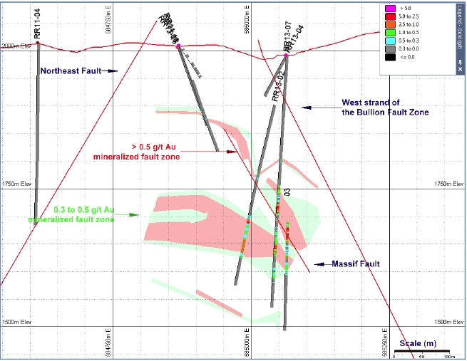
| Effective Date: November 3, 2017 | | | 131 |
Technical Report Maiden Resource Estimate North Bullion Railroad Project, Elko County, Nevada, USA
The interpretation of mineralized lodes was initiated in the approximate center of the deposit and extrapolated to adjacent sections north and south. If a zone of mineralization was not present on the adjacent section, then the interpretation was extended half way to the next section and the lode was closed. The down dip edge of the mineralized envelopes was extrapolated 50 to 70 m (165 to 230 ft) from the closest drillhole. The drillholes located on the adjacent sections to the north and south were used to help determine the distance the lode should be extrapolated.
Due to the topographic relief over the North Bullion, Sweet Hollow and POD gold deposits, there is little to no overburden present. Topographic surfaces were created from 2 m (6.5 ft) grid (pixel) spaced stereo corrected data from the 2013 and 2017 Satellite Orthophoto data. These surfaces were then used to truncate the mineralized lodes to the surface where necessary.
With the overall plan of identifying a deposit amenable to heap leaching, the degree of oxidation within mineralized zones was a key aspect of the re-logging and re-interpretation program conducted by GSV. Drill intersections at the Sweet Hollow and POD deposits comprise both oxide, mixed and sulphide (reduced) mineralization. The mineralized lodes at Sweet Hollow and POD comprise 64 % oxide, 1 % mixed and 35 % sulphide mineralization based upon the current information. The majority of the mineralized intersections in the North Bullion Deposit are classed as sulphide (reduced). The areas of sulphide mineralization at Sweet Hollow and POD were modelled with the aim of identifying the proportion of the final resource that is sulphide based and would likely require high cost processing in the future. These areas of sulphide mineralization are mainly situated in the deeper portion of the POD Zone, and isolated areas of the Sweet Hollow Zone. The entire North Bullion Zone is classified as sulphide (reduced).
Little to no CN soluble gold data exists for the Railroad Project area drillholes. As a result, re-logging and re-interpretation of the historic and more recent GSV drillhole logs was completed with a focus on the oxidation state of the material logged. Most of the GSV drilling has been conducted at the North Bullion Zone, which is entirely classified as sulphide (reduced) mineralization. For Sweet Hollow and POD, historic logs along with RC chips and core where available were reviewed and re-interpreted with the determination of the percent downhole sulphide and intensity of hematite and Fe limonite being the primary focus.
Due to the block size of 10 x 10 x 3 m, a generalized approach of mapping zones of oxide, mixed or sulphide material was completed with minimum sized zones of at least 3 m in thickness. Where there was no CN soluble gold recovery information available, the logged sulphide mineralization in conjunction with the intensity of hematization and/or Fe limonite alteration were utilized to determine the oxidation state of the material.
| 14.3.4 | Data Summary and Histograms |
The Railroad mineral resource estimate was calculated utilizing the gold (Au) assay grades within the Railroad drill database. Thorough documentation of the analytical methodologies used to generate the gold assay data along with assay certificates and full QAQC is available for the 135 GSV drillholes. The assay certificates and partial QAQC data was only available for 140 out of 368 of the historic holes within the Railroad drill database. Where certificates are available, gold was analyzed by standard fire assaying with a 30 g aliquot size, a wet chemical (AA) finish with lower detection limits ranging from 5 ppb up to 0.002 oz/st (70 ppb) Au that were specified or had an obvious lower limit visible in the data. This was, and remains, a standard assay technique at most analytical laboratories throughout North America. The majority of the historic assays without laboratory certificates used in the Railroad resource estimate are reported within the drill database in ppb or ppm Au down to a lower limit of between 5 ppb and 70 ppb Au and are thus believed to be the result of 30g fire assays with an AA finish (ICP assay finishing was not commonly used in the 1980’s through the 1990s and a gravimetric finish would have had a higher detection limit of around 50 – 150 ppb Au). Further work on compiling the meta data associated with the Railroad assay database is still in progress by GSV personnel.
| Effective Date: November 3, 2017 | | | 132 |
Technical Report Maiden Resource Estimate North Bullion Railroad Project, Elko County, Nevada, USA
Histograms, probability plots and summary statistics for the Railroad un-composited raw samples that are situated within the interpreted mineralized lodes are presented in Figures 14.7 and 14.8, and tabulated in Table 14.2, respectivly. The Railroad gold samples exhibit a single population of data. Mineralized wireframes/solids have been constructed to separate the different mineralized horizons. Due to the single population present, linear estimation techniques are deemed suitable for statistical estimation of the North Bullion, Sweet Hollow and POD gold deposits.
Figure 14.7. Histogram of the un-composited gold (g/t) assay dataset constrained within the lodes.
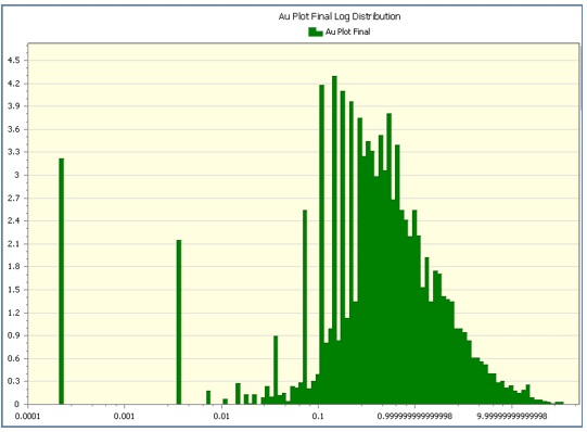
| Effective Date: November 3, 2017 | | | 133 |
Technical Report Maiden Resource Estimate North Bullion Railroad Project, Elko County, Nevada, USA
Figure 14.8. Probability Plot of the un-composited gold (g/t) assay dataset constrained within the lodes.
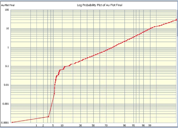
Table 14.2. Summary statistics for un-composited gold (g/t) assay dataset constrained within the lodes.
| Statistic | Global |
| Mean | 0.945 |
| Median | 0.377 |
| Std Dev | 1.9 |
| Variance | 3.609 |
| Std Error | 0.023 |
| Coeff Var | 2.01 |
| Minimum | 0 |
| Maximum | 30.199 |
| Total data | 6941 |
| 14.3.5 | Data Type Comparison |
The historic drilling completed to date within the Railroad Project area is comprised of multiple phases of drilling conducted by several companies between 1969 and 2008. In order to assist with the validation of the project’s historic dataset and the new geological model for the North Bullion, Sweet Hollow and POD gold deposits, GSV completed 135 holes in various drill programs between 2010 and 2017. A comparison of the mineralization intersected in the new GSV drillholes and the historic drilling was performed. All pre-2010 drillhole samples located within 25 m of the GSV drillholes were flagged for comparison. There were five areas, all within the Sweet Hollow and POD resource areas, where there were historic composites located within 25 m of GSV composites (Figures 14.9 to 14.11). A Q-Q plot which shows the grades of the different percentiles for each dataset is shown in Figure 14.12.
| Effective Date: November 3, 2017 | | | 134 |
Technical Report Maiden Resource Estimate North Bullion Railroad Project, Elko County, Nevada, USA
Examination of the Q-Q plot shows that the GSV drilling intersected similar grades as the historic pre-2008 drillholes. The Q-Q plot generally shows a good comparison between the two datasets with the percentile grades following to slightly below the parity line. The Q-Q plot shows that the pre 2010 drilling reported/intersected mineralization that is slightly lower in grade than the 2010 to 2017 GSV holes, with a mean grade of 0.7 g/t Au (historic) versus 0.804 g/t Au (GSV). This is considered acceptable when the inherent variability in the distribution of gold in gold deposits is taken into account. Overall the GSV confirmation drilling has confirmed and reproduced the mineralization reported in historic drillholes that predate the GSV 2010 to 2017 drilling results. Ideally, further twin/confirmation drilling should be performed by GSV to establish that there is no bias. Assay certificates and historic geological logs for most of the historic drillholes were recovered; however, there are little to no preserved cuttings or core for the historic drillholes.
The cross section comparisons showing historic drillhole intersections versus GSV drillhole intersections (shown in Figures 14.10 and 14.11) confirm the location of the gold zones and, in particular, the location of the different higher and lower grade zones of mineralization. Table 14.3 provides a comparison of the mineralized intervals in the comparative holes and indicates excellent correlation. Overall the GSV drilling has confirmed the grade population and the location/contacts of the mineralization present in the historic database and as such the historic data is considered to be sufficiently validated of a quality suitable for resource estimation.
The analytical portion of the QA/QC program employed by GSV aims to insure the overall accuracy and precision of the assaying that is performed on its drilling samples. To this end, GSV personnel insert samples of standard reference materials (standards and blanks) into the company’s sample stream, along with duplicate samples. The standards are inserted at random, into the stream of drill samples at a rate of approximately 1 in 10. The QC samples inserted alternate between a standard and a blank such that there is one of each in every 20 drill samples. The analytical quality control measures employed by GSV are consistent with industry standards and sufficient to properly monitor analytical accuracy and precision.
Gold Standard completed a total of 70,637.44 m (231,750 ft) in 135 drillholes from 2010 to 2017. The drillhole database shows a total of 42,462 samples collected and submitted to the laboratory by GSV during the 2010 to 2017 drilling programs. Between 2010 and 2017, GSV personnel submitted a total of 2,721 standard reference materials inserted into the Railroad drilling sample stream, comprising 1,477 standards and 1,244 blanks. GSV also quartered core for a number of drillholes and submitted a further 352 duplicate core samples. This yields a ratio of 1 QA/QC sample per every 13.7 drillhole samples submitted by GSV personnel. In addition to this, the laboratories also provided data for an additional 338 standards, 236 blanks and 216 duplicates or replicates during the period. This brings the total Railroad QA/QC database to a ratio of 1 sample per every 10.9 drillhole samples for the 2010 to 2017 drilling programs.
| Effective Date: November 3, 2017 | | | 135 |
Technical Report Maiden Resource Estimate North Bullion Railroad Project, Elko County, Nevada, USA
Figure 14.9. Plan view of Pod and Sweet Hollow areas where the GSV drilling was located within 25 m of the historic drill holes.
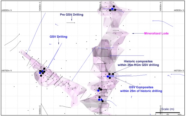
Figure 14.10. 4487385N Cross section (looking north) +/-25 m showing comparison of recent GSV drilling (blue trace) against historic drilling (black trace).
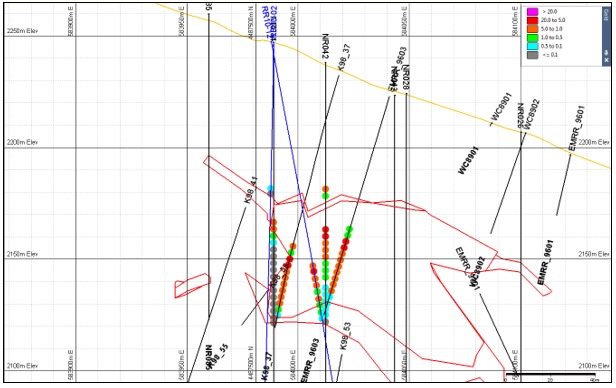
| Effective Date: November 3, 2017 | | | 136 |
Technical Report Maiden Resource Estimate North Bullion Railroad Project, Elko County, Nevada, USA
Figure 14.11. 4488020N Cross section (looking north) +/-25 m showing comparison of recent GSV drilling (blue trace) against historic drilling (black trace).
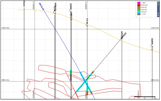
Figure 14.12. Q-Q Plot of GSV assays versus Historic Assays (25 m zone of influence) below the 80th percentile.
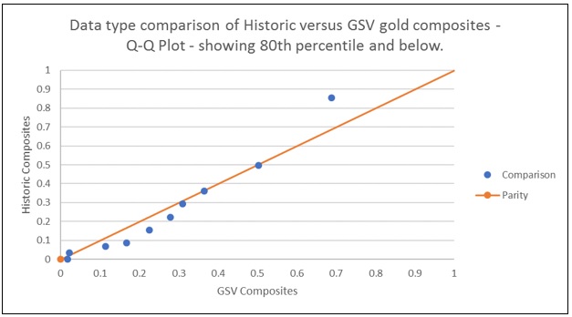
| Effective Date: November 3, 2017 | | | 137 |
Technical Report Maiden Resource Estimate North Bullion Railroad Project, Elko County, Nevada, USA
Table 14.3. Summary statistics of GSV assays versus Historic Assays (25 m zone of influence).
| Statistic | GSV (Au ppm) | Historic (Au ppm) |
| Mean | 0.804 | 0.7 |
| Median | 0.31 | 0.292 |
| Std Dev | 1.238 | 1.514 |
| Variance | 1.531 | 2.293 |
| Std Error | 0.032 | 0.039 |
| Coeff Var | 1.54 | 2.162 |
| Minimum | 0.01 | 0.002 |
| Maximum | 5.015 | 12.904 |
Percentiles |
| 2.5 | 0.018 | 0.002 |
| 5 | 0.022 | 0.034 |
| 10 | 0.114 | 0.068 |
| 20 | 0.168 | 0.086 |
| 30 | 0.225 | 0.155 |
| 40 | 0.278 | 0.223 |
| 50 | 0.31 | 0.292 |
| 60 | 0.365 | 0.36 |
| 70 | 0.502 | 0.497 |
| 80 | 0.688 | 0.854 |
| 90 | 3.138 | 1.554 |
| 95 | 3.968 | 2.059 |
| 97.5 | 5.015 | 4.335 |
| 98 | 5.015 | 4.38 |
| 99 | 5.015 | 11.358 |
In Summary, the QA/QC protocols employed by GSV throughout the 2010-2017 drilling programs at the Railroad Project area, are consistent with industry standards and are considered to be adequate and appropriate for ensuring a high degree of accuracy and precision in the assaying of the samples that were produced by these programs.
Although there were issues with a number of assay “failures” related to the analysis of blank pulp samples early on in the Railroad drilling programs, which was not seen in the more recent (2014 to 2017 data), the actual assay failure values were very low (<20 ppb Au). Thus, considering the excellent performance of the majority of the GSV-inserted standard samples during these programs, it can be concluded that this issue has had little effect on the assaying of the actual drill samples during this time. Additionally, there appear to have been only minor issues with the assaying of specific standard reference materials. Therefore as a whole, the 2010 to 2017 QA/QC sampling did not identify any significant issues with respect to the overall accuracy and precision in assaying of the samples comprising the majority of the Railroad drill assay database. Furthermore, it is the opinion of the authors of this report that the Railroad drill assay database is sufficiently validated for use in the mineral resource estimation work discussed below.
| Effective Date: November 3, 2017 | | | 138 |
Technical Report Maiden Resource Estimate North Bullion Railroad Project, Elko County, Nevada, USA
QA/QC samples and data are limited for the historic drilling. However, a review of the historic drilling company and laboratory QA/QC assay data did not identify any issues in the available data. This coupled with acceptable results for assays in the drillhole comparisons provided in the prior section provide the authors of this report with the confidence that the historic assay data in the drillhole database is sufficiently validated for use in the mineral resource estimation work discussed below.
| 14.5 | Drillhole Flagging and Compositing |
Drillhole samples situated within the mineralized wireframes/solids were selected and flagged with the wireframe name/code. The flagged samples were checked visually next to the drillhole to check that the automatic flagging process worked correctly. All samples were correctly flagged and there was no need to manually flag or remove any samples.
A review of the sample lengths was conducted on the samples that were situated within the mineralized wireframes. The drillhole sample width analysis results showed a variable sample length from 0.15 m to 27.43 m (0.5 to 90 ft) in length (Table 14.4 and Figure 14.13). Looking at all of the sample widths, there is one dominant sample length population at 1.52 m (5 feet). In order to honour the Railroad mineralization characteristics with some zones of mineralization thinning to 3 m (10 ft) it was decided to composite to 3.05 m size. The selected mining unit (SMU) of the open pit bench height is thought to be 6 m (20 ft) in size, so a theoretical bench will be comprised of two composites. Of the 6,941 un-composited samples within the mineralization wireframes 99.84 % of the samples were less than 3.05 m in size.
Table 14.4. Sample length statistics for the Railroad un-composited assay file situated within the 0.1, 0.3 and 0.5 domains.
| Statistic | Width (m) |
| Mean | 1.492 |
| Median | 1.52 |
| Std Dev | 0.535 |
| Variance | 0.286 |
| Std Error | 0.006 |
| Coeff Var | 0.358 |
| Minimum | 0.15 |
| Maximum | 27.43 |
| Total data | 6,941 |
| Effective Date: November 3, 2017 | | | 139 |
Technical Report Maiden Resource Estimate North Bullion Railroad Project, Elko County, Nevada, USA
Figure 14.13. Histogram of sample length for the Railroad un-composited assay file situated within the mineralization model.
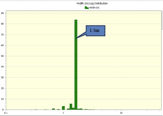
Length weighted composites were calculated for all of the Railroad Project assay samples. The compositing process starts from the first point of intersection between the drillhole and the mineralized wireframe, and is stopped upon the end of the mineralized wireframe.
Upon completion of the 3.05 m compositing process, both the 3.05 m composites and the 3.05 m composites with “orphans” (sub 3.05 m composites) were examined to determine any noticeable bias applied to the gold grades during the compositing process (Table 14.5).
Table 14.5. Comparison of gold grade of raw un-composited grade versus the final composited sample file for Railroad.
| Lode | Un-Composited | 3.05 m Composited Sample Grade (g/t) |
| | Sample Grade (g/t) | with all orphans | with > 1.5 m orphans | with > 3.0 m orphans | with > 3.0 m orphans |
| All Composites | 0.95 | 0.90 | 0.91 | 0.95 | 0.95 |
| 0.5 Domain | 1.71 | 1.68 | 1.69 | 1.74 | 1.74 |
| 0.3 Domain | 0.34 | 0.34 | 0.34 | 0.33 | 0.33 |
| 0.1 Domain | 0.21 | 0.21 | 0.21 | 0.21 | 0.21 |
| 1 | 0.32 | 0.32 | 0.32 | 0.31 | 0.31 |
| 2 | 0.33 | 0.33 | 0.33 | 0.32 | 0.32 |
| 3 | 0.34 | 0.34 | 0.33 | 0.33 | 0.33 |
| 4 | 0.34 | 0.37 | 0.37 | 0.34 | 0.34 |
| 5 | 0.36 | 0.36 | 0.36 | 0.36 | 0.36 |
| Effective Date: November 3, 2017 | | | 140 |
Technical Report Maiden Resource Estimate North Bullion Railroad Project, Elko County, Nevada, USA
| Lode | Un-Composited | 3.05 m Composited Sample Grade (g/t) |
| | Sample Grade (g/t) | with all orphans | with > 1.5 m orphans | with > 3.0 m orphans | with > 3.0 m orphans |
| 6 | 0.36 | 0.36 | 0.36 | 0.35 | 0.35 |
| 17 | 2.05 | 2.01 | 2.02 | 2.07 | 2.08 |
| 18 | 0.87 | 0.84 | 0.84 | 0.83 | 0.84 |
| 19 | 1.50 | 1.51 | 1.52 | 1.56 | 1.57 |
| 20 | 3.15 | 3.12 | 3.15 | 3.34 | 3.34 |
| 21 | 2.54 | 2.39 | 2.51 | 2.57 | 2.57 |
| 22 | 0.84 | 0.78 | 0.90 | 0.90 | 0.90 |
| 23 | 0.79 | 0.79 | 0.79 | 0.79 | 0.79 |
| 24 | 2.24 | 2.20 | 2.23 | 2.28 | 2.27 |
| 25 | 0.64 | 0.64 | 0.64 | 0.64 | 0.64 |
| 26 | 1.08 | 1.07 | 1.06 | 1.09 | 1.09 |
| 27 | 1.25 | 1.25 | 1.25 | 1.25 | 1.25 |
| 28 | 1.15 | 1.10 | 1.10 | 1.21 | 1.21 |
| 29 | 0.59 | 0.59 | 0.59 | 0.59 | 0.59 |
| 30 | 0.79 | 0.78 | 0.78 | 0.81 | 0.81 |
| 32 | 0.80 | 0.81 | 0.81 | 0.79 | 0.80 |
| 33 | 0.97 | 0.95 | 0.95 | 0.99 | 0.99 |
| 34 | 0.24 | 0.25 | 0.25 | 0.25 | 0.25 |
| 35 | 0.20 | 0.20 | 0.20 | 0.20 | 0.20 |
| 36 | 0.17 | 0.17 | 0.17 | 0.17 | 0.17 |
| 37 | 0.20 | 0.21 | 0.21 | 0.20 | 0.20 |
| 38 | 0.19 | 0.19 | 0.19 | 0.18 | 0.19 |
| 40 | 0.22 | 0.22 | 0.22 | 0.22 | 0.20 |
| 41 | 0.30 | 0.29 | 0.29 | 0.32 | 0.32 |
| 42 | 2.41 | 2.41 | 2.44 | 2.47 | 2.47 |
| 43 | 1.53 | 1.35 | 1.45 | 1.53 | 1.53 |
| 44 | 2.29 | 2.24 | 2.29 | 2.39 | 2.39 |
| 45 | 1.43 | 1.45 | 1.44 | 1.49 | 1.49 |
| 46 | 3.44 | 3.24 | 3.39 | 3.43 | 3.46 |
| 47 | 3.68 | 3.53 | 3.73 | 3.74 | 3.74 |
Upon the completion of the compositing process it was decided to use the 3.05 m composites with orphans greater than 1.5 m in length. This provided the best reflection of grade from the un-composited assays to the composite file. There was little to no change in the gold grades for the Railroad composite file. The composited samples were used for all sample statistics, capping, estimation input file and validation comparisons.
The gold composite file was used for the capping analysis. The composited gold grades were displayed using a log probability plot and a log histogram plot (Figures 14.14 and 14.15). Both of these, in conjunction with the actual composite file, were used to assess the need for capping. Both of these plots show that the gold values belong to one single population. This is evident from the straight nature of the line in the log probability plot below. There is a suggestion of a smaller higher grade population but due to limited data the composite dataset has been treated as one population. Inflection points along the log probability plot line are normally used to govern an appropriate capping level to apply. There is an inflection point located at the 99th percentile which is 9.0 g/t Au. After analysis of the composite file distribution, examination of the log histogram, log probability plot and the co-efficients of variations of the composite/lode statistics it was decided not to cap the composite file.
| Effective Date: November 3, 2017 | | | 141 |
Technical Report Maiden Resource Estimate North Bullion Railroad Project, Elko County, Nevada, USA
Figure 14.14. Log Probability plot of the gold composites situated within the lodes.
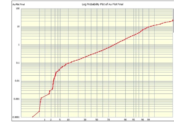
Variography to examine grade continuity was conducted on the Railroad composite assays located within the mineralized wireframes and log spherical semi variogram’s were produced. The four main zones of mineralization were examined for variographic analysis. These included the POD Zone (RR Fault 0.5 lode), Sweet Hollow Zone (lodes SH Main 0.5 and SH A 0.5), North Bullion Zone (lodes NB Lower, Mid and upper) and finally the Massif Fault Zone (Lode Massif). These lodes had the largest number of composites available for analysis. Smaller surrounding lodes around these zones had the same variographic ranges applied as they share similar lode orientations.
| Effective Date: November 3, 2017 | | | 142 |
Technical Report Maiden Resource Estimate North Bullion Railroad Project, Elko County, Nevada, USA
Figure 14.15. Log histogram of the gold composites situated within the lodes.
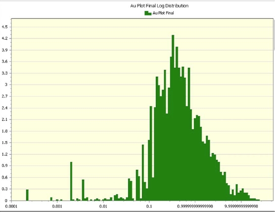
The variography of the gold composites at Railroad POD Zone suggest a maximum continuity of grade along a 296° strike orientation, with a 0° plunge and a 70° tilt to the east. This is in line with the geological model. The ranges of the gold mineralization continuity in all three directions are shown in Table 14.6 and the individual variograms are shown in Figure 14.16.
The variography of the gold composites at Railroad Sweet Hollow Zone suggest a maximum continuity of grade along a 002° strike orientation, with a 0° plunge and a 10° tilt to the west. This is in line with the geological model. The ranges of the gold mineralization continuity in all three directions are shown in Table 14.6 and the individual variograms are shown in Figure 14.17.
The variography of the gold composites at Railroad North Bullion Zone suggest a maximum continuity of grade along a 006° strike orientation, with a 15° plunge to the north and a 11° tilt to the east. This is in line with the geological model. The ranges of the gold mineralization continuity in all three directions are shown in Table 14.6 and the individual variograms are shown in Figure 14.18.
The variography of the gold composites at Railroad Massif Zone suggest a maximum continuity of grade along a 172° strike orientation, with a 31° plunge to the north and a 50° tilt to the east. This is in line with the geological model. The ranges of the gold mineralization continuity in all three directions are shown in Table 14.6 and the individual variograms are shown in Figure 14.19.
| Effective Date: November 3, 2017 | | | 143 |
Technical Report Maiden Resource Estimate North Bullion Railroad Project, Elko County, Nevada, USA
Figure 14.16. Railroad Pod (Lode 24) variograms for the composited gold sample mineralization.
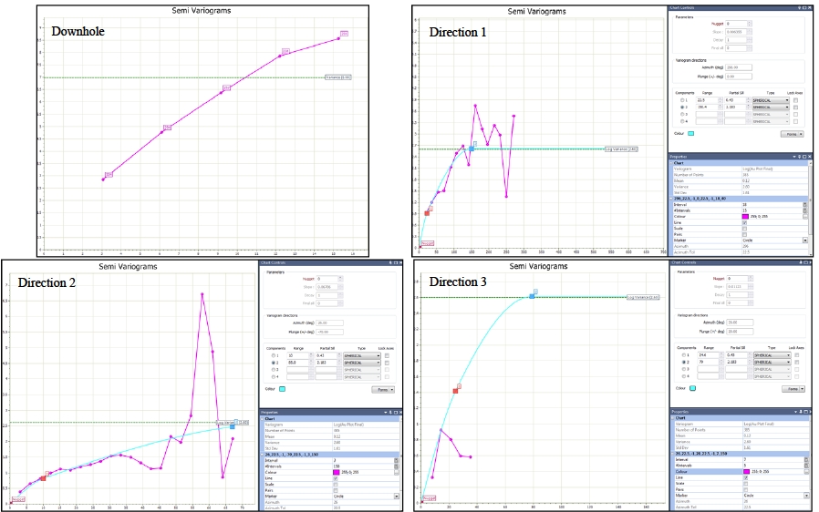
| Effective Date: November 3, 2017 | | | 144 |
Technical Report Maiden Resource Estimate North Bullion Railroad Project, Elko County, Nevada, USA
Figure 14.17. Railroad Sweet Hollow (Lode 25 & 26) variograms for the composited gold sample mineralization.
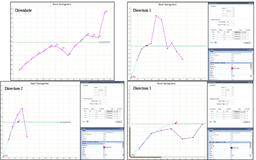
| Effective Date: November 3, 2017 | | | 145 |
Technical Report Maiden Resource Estimate North Bullion Railroad Project, Elko County, Nevada, USA
Figure 14.18. Railroad North Bullion (Lode 18, 19 & 21) variograms for the composited gold sample mineralization.
| Effective Date: November 3, 2017 | | | 146 |
Technical Report Maiden Resource Estimate North Bullion Railroad Project, Elko County, Nevada, USA
Figure 14.19. Railroad Massif fault zone (Lode 17) variograms for the composited gold sample mineralization.
| Effective Date: November 3, 2017 | | | 147 |
Technical Report Maiden Resource Estimate North Bullion Railroad Project, Elko County, Nevada, USA
| Zone | Lode | C0 | Azimuth | Dip | Tilt | Structure 1 | | Structure 2 |
| Type | C1 | Direction Ranges | | Type | C2 | Direction Ranges |
| 1 | 2 | 3 | | 1 | 2 | 3 |
| Pod | 24 | 0 | 296 | 0 | 70 | sph | 0.43 | 22.5 | 10 | 25 | | sph | 2.183 | 150 | 85 | 80 |
Sweet Hollow | 25 & 26 | 0 | 2 | 0 | 10 | sph | 0.792 | 70 | 50 | 22 | | | | | | |
North Bullion | 18, 19 & 21 | 0 | 6 | 15 | 11 | sph | 0.945 | 60 | 70 | 23 | | | | | | |
| Massif | 17 | 0 | 172 | 31 | 50 | sph | 0.539 | 69 | 69 | 33 | | sph | 0.611 | 160 | 160 | 160 |
sph - spherical; C0 - nugget effect; C1 - covariance contribution of Structure 1; and C2 - covariance contribution of Structure 2.
A variable search orientation approach was adopted for the orientation of the search ellipsoid during grade estimation. This variable search was adopted due to the folded nature of some of the lodes with numerous flexures. This was completed by creating a 3-dimensional surface of the general orientation of the folded/linear lodes across the entire deposit area. This surface showing the trend of the mineralization was then used to orientate the search ellipsoid for the nearest block. This was completed by obtaining the dip and dip direction orientation data of the individual triangles for this trend surface. This orientation data of the triangles was then used to code the blank block model using inverse distance to the power of one, which essentially coded the model with the dip and dip direction information from the trend surface (Figure 14.20). This dip and dip direction information in the block model was then used to orientate the search ellipsoid based upon the orientation of the lode. That is if a lode was folding over then the search ellipsoid would cater to this change for each block in the block model. The ranges of the search ellipsoid were sourced from the suggested ranges from the variographic analysis.
Figure 14.20. North Bullion schematic section showing the search orientation trend surface with the coded dip and dip direction data in the block model.
| Effective Date: November 3, 2017 | | | 148 |
Technical Report Maiden Resource Estimate North Bullion Railroad Project, Elko County, Nevada, USA
| 14.9 | Bulk Density (Specific Gravity) |
A total of 988 bulk density samples were collected from a variety of sources including bulk sampling, surface rock chip samples and drill core. A total of 272 bulk density samples were situated within the mineralized wireframes. The 272 bulk density samples situated within the mineralized zones were examined on a lode by lode basis. The average bulk density determined from the analytical work for each lode was assigned to all the blocks within that lode. The average density for the lodes ranges from 2.33 g/cm3 to 2.71 g/cm3 with an overall average bulk density of 2.68 g/cm3 for the North Bullion, Sweet Hollow and POD Mineral Resource. The density values were determined using the Archimedes (weight in air/weight in water).
The 272 density samples situated within the mineralized zones were examined on a lode by lode basis. The summary statistics of this analysis is shown in Table 14.7. Figure 14.21 shows the spatial distribution of the Railroad density samples. The majority of density samples have been collected from the North Bullion Zone (Table 14.7, Figure 14.21). Further measurements are recommended for collection in the other zones of mineralization. It was decided to assign the average density values of the individual lodes noted in Table 14.7 to the block model.
Table 14.7. Railroad density measurements in g/cm3 broken down by lode/mineralized zone.
| Mineralized Zone | Massif | NB Lower | NB Mid | NB North | NB Top | BU pper | POD | SH Main |
| Lode Code | 1, 17, & 42 | 2, 18 & 43 | 3, 19, 44 & 45 | 4, 20 & 47 | 5 & 22 | 6, 21 & 46 | 23, 24 & 41 | 25 to 30, 32, 33,35 to 38, 39 & 40 |
Normal Statistics |
| Mean | 2.676 | 2.707 | 2.702 | 2.573 | 2.622 | 2.682 | 2.326 | 2.411 |
| Median | 2.665 | 2.695 | 2.67 | 1.27 | 2.58 | 2.65 | 2.33 | 2.42 |
| Std Dev | 0.14 | 0.188 | 0.156 | 0.095 | 0.035 | 0.152 | 0.064 | 0.144 |
| Variance | 0.02 | 0.035 | 0.024 | 0.009 | 0.001 | 0.023 | 0.004 | 0.021 |
| Std Error | 0.019 | 0.033 | 0.015 | 0.055 | 0.014 | 0.024 | 0.02 | 0.046 |
| Coeff Var | 0.052 | 0.069 | 0.058 | 0.037 | 0.014 | 0.057 | 0.028 | 0.06 |
| Minimum | 2.42 | 2.27 | 2.53 | 2.5 | 2.58 | 2.21 | 2.21 | 2.16 |
| Maximum | 3.15 | 3.31 | 3.79 | 2.68 | 2.67 | 3.18 | 2.43 | 2.57 |
| Number of Points | 55 | 33 | 115 | 3 | 6 | 40 | 10 | 10 |
| 14.10 | Block Model Extents and Block Size |
A parent block size of 10 m x 10 m x 3 m was chosen for the Railroad block model. This is deemed appropriate based on the current level of drillhole spacing which ranges from 2 to 120 m (7 to 395 ft) in the resource area. The block model extents were extended beyond the mineralized wireframe to encompass the entire domain. The coordinate ranges and block size dimensions used to build the Railroad 3D block model from the mineralization wireframes are presented in Table 14.8. Sub-blocking was used to more effectively honour the volumes and shapes created during the geological interpretation of the mineralized wireframes or lodes. Grade was interpolated for the parent blocks and assigned to the sub-blocks. Each block was coded with the lode number so that grade could be estimated as hard boundaries.
| Effective Date: November 3, 2017 | | | 149 |
Technical Report Maiden Resource Estimate North Bullion Railroad Project, Elko County, Nevada, USA
Figure 14.21. Plan view showing the spatial distribution of the Railroad density samples.
The Indicated and Inferred Railroad Resource Estimation of gold was calculated using inverse distance to the power of two (ID2) for each of the open pit and underground lodes. Both inverse distance squared and ordinary kriging estimation techniques were used to calculate estimates, but due to the resultant validation of the block models showing a better correlation of the input composites grades, it was decided to use the ID2 estimation technique for reporting. Estimation was only calculated on parent blocks, all sub blocks had the parent block grades applied. A block discretization of 3 x 3 x 3 was applied to all blocks during estimation. Each lode was estimated with ‘hard boundaries,’ which means that only composite assays located within each lode were used to estimate the grade of the blocks within that lode.
| Effective Date: November 3, 2017 | | | 150 |
Technical Report Maiden Resource Estimate North Bullion Railroad Project, Elko County, Nevada, USA
Table 14.8. Block model extents and cell dimensions for the Railroad block model.
| Deposit | Block model dimensions | Easting | Northing | RL |
| Railroad | Maximum | 585610 | 4489810 | 2302 |
| Minimum | 583300 | 4486400 | 1300 |
| Parent Cell Size | 10 | 10 | 3 |
| Sub Block Cell Size | 5 | 5 | 1.5 |
There were four passes of estimation performed for each lode. The size of the anisotropic search ellipsoid was based on the ranges obtained from the variography. The orientation of the search ellipsoid was based on the orientation of the mineralized lodes. Estimation runs 1 to 3 equated to ranges less than or equal to the maximum range observed in the variography. The final estimation ‘run’ the search ranges were expanded to ensure all blocks were estimated with grade. The criteria for the number of composites to be selected from the number of drillholes decreased with each run, as the search ellipsoid size increased. This was designed to ensure that the highest confidence blocks got estimated in the first couple of runs. The estimation criteria for each pass are provided in Table 14.9. The number of composites used for the estimation of each block was capped to 20 composites and a maximum of three composites from any given hole was used to limit the influence of high grade mineralization on the estimation.
The blocks were visually validated on cross-sections comparing block grades versus the sample grades for all sections and drillholes (Figures 14.22 to 14.27). In addition, the block and sample data were compared by lode, easting and northing and elevation as swath plots. These swath plot comparisons are presented in Figures 14.28 to 14.31 and Table 14.10.
| 14.12.2 | Statistical Validation |
Figure 14.28 and Table 14.10 show the average gold grade of the composited sample data versus the calculated block model grade data by lode. It can be concluded that the average/mean grade of the ID2 block model data is very close to, or generally slightly lower than, the composited sample data.
| 14.12.3 | Northing Comparison |
The input sample composite average and the calculated block model grade were calculated on 200 m (655 ft) composite sections along northings (Figure 14.29). This is along the strike of the North Bullion and Sweet Hollow deposits and roughly across the strike of the POD deposit. The purpose was to compare the input sample file with the block model data to make sure there was no gross over or under estimation occurring. The northing composites generally compare quite well. There is some local over and under estimation observed but this is to be expected with the estimation process and the selection of the composite level relative to the parent block centroids. Overall the block averages follow the general trend of the input sample data.
| Effective Date: November 3, 2017 | | | 151 |
Technical Report Maiden Resource Estimate North Bullion Railroad Project, Elko County, Nevada, USA
Table 14.9. Estimation and search ellipsoid criteria for the Railroad resource calculation.
| Estimation | Run No. | Minimum No. of Holes | Minimum No. of Samples | Maximum No. of Composites from any drill hole | Max No. of Composites | Search Ellipsoid Radius (m) |
| | 1 | 6 | 12 | 3 | 20 | 50 x 50 x 15 |
| North Bullion | 2 | 6 | 12 | 3 | 20 | 50 x 50 x 15 |
| | 3 | 2 | 2 | 3 | 20 | 70 x 70 x 23 |
| | 4 | 1 | 1 | 3 | 20 | 280 x 280 x 100 |
| | 1 | 6 | 12 | 3 | 20 | 120 x 1200x 25 |
| Massif Zone | 2 | 6 | 12 | 3 | 20 | 120 x 1200x 25 |
| | 3 | 2 | 2 | 3 | 20 | 160 x 160 x 33 |
| | 4 | 1 | 1 | 3 | 20 | 320 x 320 x 66 |
| | 1 | 6 | 12 | 3 | 20 | 50 x 40 x 15 |
| Sweet Hollow | 2 | 6 | 12 | 3 | 20 | 50 x 40 x 15 |
| | 3 | 2 | 2 | 3 | 20 | 70 x 50 x 22 |
| | 4 | 1 | 1 | 3 | 20 | 280 x 200 x 88 |
| 1 | 6 | 12 | 3 | 20 | 110 x 65 x 60 |
| POD Zone | 2 | 6 | 12 | 3 | 20 | 110 x 65 x 60 |
| | 3 | 2 | 2 | 3 | 20 | 150 x 85 x 80 |
| | 4 | 1 | 1 | 3 | 20 | 300 x 170 x 160 |
| 14.12.4 | Easting Comparison |
The input sample composite average and the calculated block model grade were calculated on 200 m (656 ft) composite sections across eastings (Figure 14.30). This is across the strike of the North Bullion and Sweet Hollow gold deposits and oblique to the POD deposit. The purpose was to compare the input composite sample file with the resulting block model data to make sure there was no gross over or under estimation occurring. The east composites generally compare quite well. Overall the block averages follow the general trend of the input sample data.
| 14.12.5 | Elevation Comparison |
The input sample composite average and the calculated block model grade were calculated on 50 m (165 ft) composite sections down the elevation from surface (Figure 14.31). The purpose was to compare the input sample composite file with the resulting block model data to make sure there was no gross over or under estimation occurring. The elevation composites generally compare quite well. There are some areas where the block model is overstating the grade of mineralization but these areas are limited and overall the block averages follow the general trend of the input sample data.
| Effective Date: November 3, 2017 | | | 152 |
Technical Report Maiden Resource Estimate North Bullion Railroad Project, Elko County, Nevada, USA
Figure 14.22. POD Transform Cross Section (+/- 15 m) showing Railroad block grade (gold g/t) versus composited sample grade.
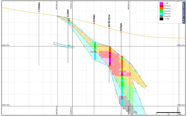
Figure 14.23. POD Transform Cross Section (+/- 15 m) showing Railroad block grade (gold g/t) versus composited sample grade.
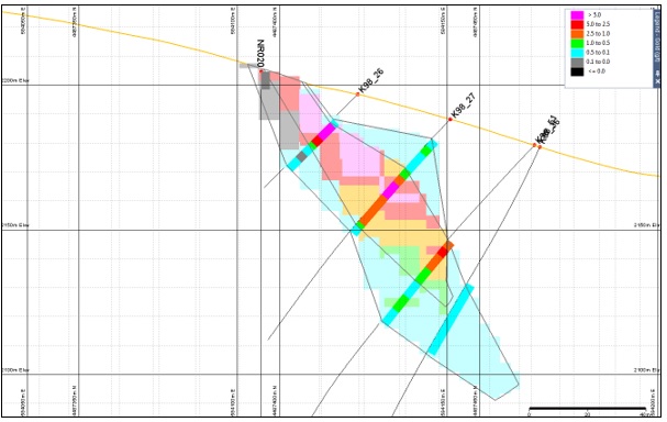
| Effective Date: November 3, 2017 | | | 153 |
Technical Report Maiden Resource Estimate North Bullion Railroad Project, Elko County, Nevada, USA
Figure 14.24. Cross Section 4487385 N (+/- 15 m) showing Sweet Hollow Zone block grade (g/t Au) versus composited sample grade.
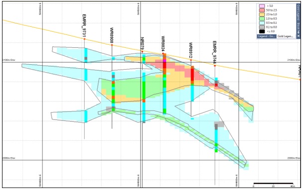
Figure 14.25. Cross Section 4488015 N (+/- 15 m) Showing Sweet Hollow Zone block grade (g/t Au) versus composited sample grade.

| Effective Date: November 3, 2017 | | | 154 |
Technical Report Maiden Resource Estimate North Bullion Railroad Project, Elko County, Nevada, USA
Figure 14.26. Cross Section 4488610 N (+/- 15 m) showing North Bullion Zone block grade (g/t Au) versus composited sample grade.
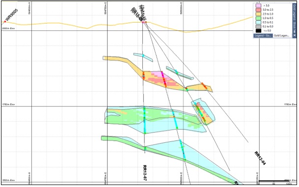
Figure 14.27. Cross Section 4488790 N (+/- 15 m) showing North Bullion Zone block grade (g/t Au) versus composited sample grade.
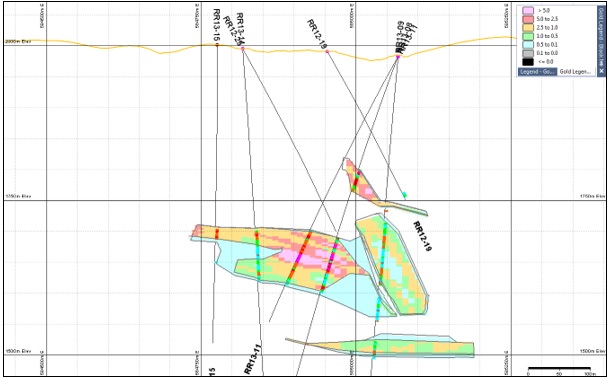
| Effective Date: November 3, 2017 | | | 155 |
Technical Report Maiden Resource Estimate North Bullion Railroad Project, Elko County, Nevada, USA
Figure 14.28. SWATH plots of average gold grades for the composited sample grade versus the calculated grade for the block model by lode for the open pit estimation and the underground estimation.
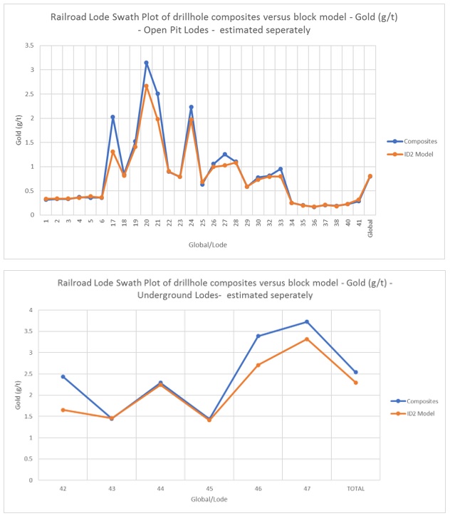
| Effective Date: November 3, 2017 | | | 156 |
Technical Report Maiden Resource Estimate North Bullion Railroad Project, Elko County, Nevada, USA
Table 14.10. Calculated grade (0 % lower cutoff) of model versus composited average sample grades by lode for the Railroad estimation.
| Lode | No. of Composites | Composite Mean | ID2 Model |
| 1 | 45 | 0.32 | 0.34 |
| 2 | 67 | 0.33 | 0.34 |
| 3 | 269 | 0.33 | 0.34 |
| 4 | 3 | 0.37 | 0.36 |
| 5 | 15 | 0.36 | 0.38 |
| 6 | 43 | 0.36 | 0.36 |
| 17 | 183 | 2.02 | 1.31 |
| 18 | 53 | 0.84 | 0.81 |
| 19 | 405 | 1.52 | 1.41 |
| 20 | 15 | 3.15 | 2.66 |
| 21 | 132 | 2.51 | 1.98 |
| 22 | 2 | 0.90 | 0.90 |
| 23 | 2 | 0.79 | 0.79 |
| 24 | 410 | 2.23 | 1.97 |
| 25 | 69 | 0.64 | 0.68 |
| 26 | 213 | 1.06 | 1.00 |
| 27 | 9 | 1.25 | 1.02 |
| 28 | 7 | 1.10 | 1.08 |
| 29 | 2 | 0.59 | 0.59 |
| 30 | 11 | 0.78 | 0.73 |
| 32 | 51 | 0.81 | 0.79 |
| 33 | 12 | 0.95 | 0.80 |
| 34 | 286 | 0.25 | 0.25 |
| 35 | 860 | 0.20 | 0.20 |
| 36 | 107 | 0.17 | 0.17 |
| 37 | 26 | 0.21 | 0.21 |
| 38 | 21 | 0.19 | 0.18 |
| 40 | 86 | 0.22 | 0.23 |
| 41 | 6 | 0.29 | 0.32 |
| 42 | 139 | 2.44 | 1.65 |
| 43 | 12 | 1.45 | 1.46 |
| 44 | 221 | 2.29 | 2.24 |
| 45 | 7 | 1.44 | 1.41 |
| 46 | 88 | 3.39 | 2.71 |
| 47 | 12 | 3.73 | 3.32 |
| Effective Date: November 3, 2017 | | | 157 |
Technical Report Maiden Resource Estimate North Bullion Railroad Project, Elko County, Nevada, USA
Figure 14.29. Northing SWATH plot of sample composite average grade versus estimated grade in the block model for gold for the Open Pit and Underground Lodes.
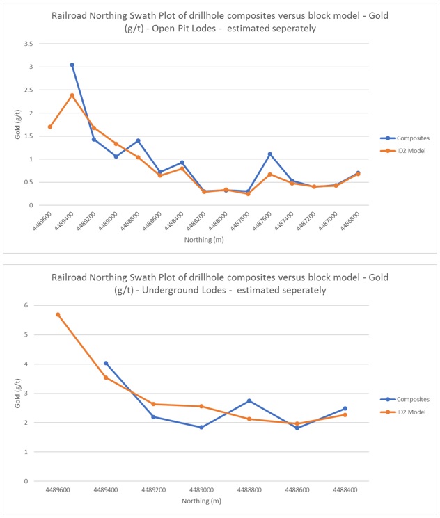
| Effective Date: November 3, 2017 | | | 158 |
Technical Report Maiden Resource Estimate North Bullion Railroad Project, Elko County, Nevada, USA
Figure 14.30. Easting SWATH plot of sample composite average grade versus estimated grade in the block model for gold for the Open Pit and Underground Lodes.
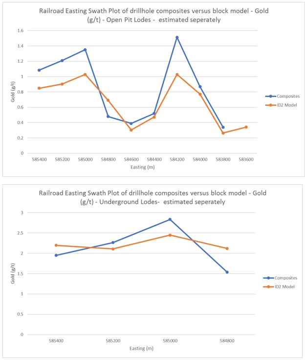
| Effective Date: November 3, 2017 | | | 159 |
Technical Report Maiden Resource Estimate North Bullion Railroad Project, Elko County, Nevada, USA
Figure 14.31. Elevation SWATH plot of sample composite average grade versus estimated grade in the block model for gold for the Open Pit and Underground Lodes.
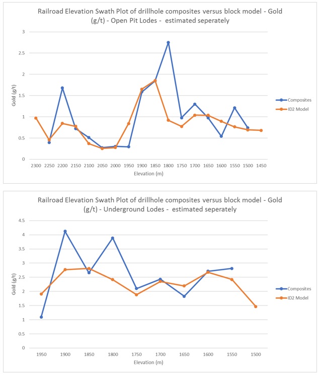
| Effective Date: November 3, 2017 | | | 160 |
Technical Report Maiden Resource Estimate North Bullion Railroad Project, Elko County, Nevada, USA
| 14.13 | Resource Classification |
The Railroad mineral resource estimate discussed in this report has been classified in accordance with guidelines established by the CIM “Estimation of Mineral Resources and Mineral Reserves Best Practice Guidelines” dated November 23rd, 2003 and CIM “Definition Standards for Mineral Resources and Mineral Reserves” dated May 14th, 2014.
A ‘Measured Mineral Resource’ is that part of a Mineral Resource for which quantity, grade or quality, densities, shape, physical characteristics are so well established that they can be estimated with confidence sufficient to allow the appropriate application of technical and economic parameters, to support production planning and evaluation of the economic viability of the deposit. The estimate is based on detailed and reliable exploration, sampling and testing information gathered through appropriate techniques from locations such as outcrops, trenches, pits, workings and drillholes that are spaced closely enough to confirm both geological and grade continuity.
An ‘Indicated Mineral Resource’ is that part of a Mineral Resource for which quantity, grade or quality, densities, shape and physical characteristics, can be estimated with a level of confidence sufficient to allow the appropriate application of technical and economic parameters, to support mine planning and evaluation of the economic viability of the deposit. The estimate is based on detailed and reliable exploration and testing information gathered through appropriate techniques from locations such as outcrops, trenches, pits, workings and drillholes that are spaced closely enough for geological and grade continuity to be reasonably assumed.
An ‘Inferred Mineral Resource’ is that part of a Mineral Resource for which quantity and grade or quality can be estimated on the basis of geological evidence and limited sampling and reasonably assumed, but not verified, geological and grade continuity. The estimate is based on limited information and sampling gathered through appropriate techniques from locations such as outcrops, trenches, pits, workings and drillholes.
The 2017 maiden North Bullion, Sweet Hollow and POD Mineral Resource has been classified as comprising both Indicated and Inferred Resources according to the CIM definition standards. The classification of the Railroad Indicated and Inferred Resource was based on geological confidence, data quality and grade continuity (Table 14.11). The most relevant factors used in the classification process were:
| · | Drillhole spacing density |
| · | Level of confidence in the geological interpretation, which is a result of the extensive re-interpretation of geological logs along with re-logging of drill chips and core where possible. The observed stratigraphic horizons are easily identifiable along strike and across the deposit which provides confidence in the geological and mineralization model continuity. |
| · | Estimation parameters (i.e. continuity of mineralization) |
| · | Proximity to the recently completed GSV drillholes. |
| Effective Date: November 3, 2017 | | | 161 |
Technical Report Maiden Resource Estimate North Bullion Railroad Project, Elko County, Nevada, USA
| · | Drillhole database data density. |
Based on the criteria noted above, a polygonal area was chosen for the indicated area at the Sweet Hollow and POD gold deposits (Figure 14.32). The blocks in this area were mostly made up of the blocks that were estimated in estimation runs 1 and 2, which utilized a search ellipsoid with a range of three quarters of the maximum range of continuity based on the variography and the highest number of composites and drill holes (Table 14.11). As such, these blocks exhibited a high level of confidence. This area was located at Sweet Hollow and POD where the drillhole density was the highest. This, in conjunction with the proximity of the GSV drilling and level of confidence in the geological interpretation, aided the decision to assign this area of the resource to the “Indicated” category. All blocks with an Indicated classification were assigned with a code of two (2). The remaining resource was classified as “Inferred”. All blocks with an “Inferred” classification was assigned a code of three (3).
Table 14.11. Railroad classification/estimation criteria.
| Criteria | Pod | Sweet Hollow | North Bullion (open pit & UG) | Massif Zone (open pit & UG) |
| Indicated | Inferred | Indicated | Inferred | Inferred | Inferred |
| Gold Search Distance Ranges (m) | 110 x 65 x 60 | 150 x 85 x 80 to 300 x 170 x 160 | 50 x 40 x 15 | 70 x 50 x 22 to 280 x 200 x 88 | 50 x 50 x 15 to 280 x 280 x 100 | 120 x 120 x 25 to 320 x 320 x 66 |
| Estimation Run Number | 1 or 2 | 3 or 4 | 1 or 2 | 3 or 4 | 1 to 4 | 1 to 4 |
| Minimum number of composites used to guide the estimation | 12 | 1 or 2 | 12 | 1 or 2 | 12 to 1 | 12 to 1 |
| Minimum number of holes used to guide the estimation | 3 or 6 | 1 or 2 | 3 or 6 | 1 or 2 | 1 to 6 | 1 to 6 |
| 14.14 | Evaluation of Reasonable Prospects for Economic Extraction |
In order to demonstrate that the North Bullion, Sweet Hollow and POD gold deposits have potential for future economic extraction, the unconstrained resource block model was subjected to a series of whittle pit optimizations and underground scenarios. The criteria used in the Whittle pit optimizer were considered reasonable for Nevada heap leach deposits as well as conventional sulphide processing. All mineral resources reported below are reported within an optimized pit shell and/or underground constrained parameters using $1,350/ounce for gold. The criteria used for the $1,350/ounce pit shell and underground optimization are shown in Table 14.12. The open pit oxide constrained resource utilized a greater than 0.1 g/t Au interpreted wireframe/lode cutoff and a 0.14 g/t Au lower cutoff for the block model for the POD and Sweet Hollow deposits. The open pit constrained sulphide (reduced) resource utilized a 0.5 g/t Au interpreted wireframe cutoff and a 1.25 g/t Au lower cutoff for the block model. For the North Bullion deposit the open pit sulphide (reduced) constrained resource utilized a greater than 0.3 g/t Au interpreted wireframe/lode cutoff and a 1.25 g/t Au lower cutoff for the block model. The underground resource was constrained using a 1 g/t Au interpreted lower cutoff to constrain the wireframe/lode. The blocks within this were then estimated and reported at a lower cutoff of 2.25 g/t Au which represents expected underground costs associated with a potential block and cave mining scenario. The resource block model and optimized pit shell is illustrated in Figure 14.33.
| Effective Date: November 3, 2017 | | | 162 |
Technical Report Maiden Resource Estimate North Bullion Railroad Project, Elko County, Nevada, USA
Figure 14.32. Plan view of Railroad indicated classification area in relation to estimation run number and drillhole density.
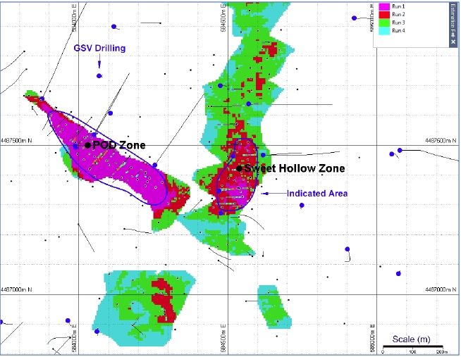
*The reader is cautioned that mineral resources are not mineral reserves and do not have demonstrated economic viability. There is no guarantee that all or any part of the Indicated and Inferred Railroad mineral resource discussed in this report will be converted into a mineral reserve at any point in the future. However, while the project is at an early stage of resource evaluation, it is the opinion of the authors of this report that the collective work completed to date at the Railroad prospect has identified a mineral resource of sufficient size and grade (with respect to gold) to be of future economic interest. As a result, further work is recommended to expand and better define the Railroad mineral resource.
Overall, the authors of this Technical Report consider that these assumptions are considered reasonable for the purpose of determining reasonable prospects for future economic extraction of the North Bullion, Sweet Hollow and POD gold deposits for the purpose of providing a maiden Mineral Resource Estimate. The resources presented herein are not a mineral reserves and they do not have demonstrated economic viability. There has been insufficient exploration to define the resources as a measured mineral resource, and it is uncertain if further exploration will result in upgrading them to a measured resource category and there is no guarantee that any part of the resources identified herein will be converted to a mineral reserve in future.
| Effective Date: November 3, 2017 | | | 163 |
Technical Report Maiden Resource Estimate North Bullion Railroad Project, Elko County, Nevada, USA
Table 14.12. Parameters used for Whittle Pit Optimization Studies.
| Parameter | Unit | Pit Oxide Cost | Pit Sulphide Cost | UG Sulphide Cost |
| Gold price | $US$/ounce | $1,350 | $1,350 | $1,350 |
| Gold recover | % | 80 % | 88 % | 88 % |
| Pit wall angles | 50° | 50° | 50° | NA |
| Mining Cost | US$/tonne | $1.75 | $1.75 | $50 |
| Ore Density | Kg/m3 | Ranged from 2.33 to 2.71 | 2.33 to 2.71 | 2.33 to 2.71 |
| Waste Density | Kg/m3 | 2.60 | 2.60 | 2.60 |
| Processing Rate | 5 Mtpa | 5 Mtpa | 5 Mtpa | 5 Mtpa |
| Processing Cost & Hauling | US$/tonne | $3.25 | $45 | $45 |
| G & A Cost | US$/tonne | $0.50 | $0.50 | $0.50 |
| Discount Rate | 5 % | 5 % | 5 % | 5 % |
| 14.15 | Mineral Resource Reporting |
The North Bullion, Sweet Hollow and POD Indicated and Inferred Mineral Resource Estimate is reported in accordance with the Canadian Securities Administrators National Instrument 43-101 and has been estimated using the CIM “Estimation of Mineral Resources and Mineral Reserves Best Practice Guidelines” dated November 23rd, 2003 and CIM “Definition Standards for Mineral Resources and Mineral Reserves” dated May 10th, 2014.
The resource has been estimated within three dimensional solids that were created from cross-sectional lode interpretation. The upper contact has been cut by the topographic surface. There is little to no overburden present at the Railroad property. Grade was estimated into a block model with parent block size of 10 m (X) by 10 m (Y) by 3 m (Z) and sub-blocked down to 5 m (X) by 5 m (Y) by 1.5 m (Z). A total of 272 bulk density samples were situated within the mineralized wireframes. The 272 bulk density samples situated within the mineralized zones were examined on a lode by lode basis. The average bulk density determined from the analytical work for each lode was assigned to all the blocks within that lode and surrounding lodes where there were no density samples available for review. The average density for the lodes ranges from 2.33 g/cm3 to 2.71 g/cm3 with overall average bulk density of 2.68 g/cm3 for the Railroad mineral resource. Grade estimation of gold was performed using the ID2 methodology. The Indicated and Inferred Mineral Resources are constrained within a drilled area that extends approximately 2.75 km along strike to the north, 0.95 km across strike to the east and 600 m below surface.
The North Bullion, Sweet Hollow and POD Mineral Resource Estimate is reported at a range of gold cutoff grades in Table 14.13 for both Indicated and Inferred categories. No portion of the current mineral resource has been assigned to the “Measured” category. The Sweet Hollow and POD oxide Indicated and Inferred Mineral Resource uses a cutoff grade of 0.14 g/t Au, which is constrained within an optimized pit shell and includes an Indicated Mineral Resource of 2.92 million tonnes at 0.96 g/t Au for 90,100 ounces of gold and an Inferred Mineral Resource of 3.36 million tonnes at 0.43 g/t Au for 46,600 ounces of gold. The North Bullion, Sweet Hollow and POD sulphide Inferred Mineral Resource uses a cutoff grade of 1.25 g/t Au, which is constrained within an optimized pit shell and includes an Inferred Mineral Resource of 2.05 million tonnes at 2.60 g/t Au for 171,400 ounces of gold. The North Bullion inferred underground constrained mineral resource is reported at a 2.25 g/t Au lower cutoff and comprises 5.55 million tonnes at 3.29 g/t Au for 587,700 ounces of gold. The base case cutoff grades of 0.14 g/t Au for open pit oxide and 1.25 g/t Au for open pit sulphide material, and 2.25 g/t Au for underground sulphide material are highlighted in Table 14.13. Other cutoff grades are presented for review ranging from 0.14 g/t Au to 0.5 g/t Au for oxide are presented in Table 14.14. Other cutoff grades are presented in Table 14.15 for review ranging from 1.0 g/t Au to 2.0 g/t Au for sulphide open pit constrained material and 2.0 g/t Au to 3.0 g/t Au for sulphide underground constrained material. The open pit and underground block modeled resource shown is constrained within a $1,350/ounce gold pit shell and a 2.25 g/t lower cutoff for the underground block model.
| Effective Date: November 3, 2017 | | | 164 |
Technical Report Maiden Resource Estimate North Bullion Railroad Project, Elko County, Nevada, USA
The 2017 North Bullion, Sweet Hollow and POD gold Mineral Resource has been classified as comprising both Indicated and Inferred resources according to recent CIM definition standards (Table 14.13). The classification of the Railroad gold resources was based on geological confidence, data quality and grade continuity. No portion of the current mineral resource has been assigned to the “Measured” category. All reported mineral resources occur within a pit shell optimized using values of $US1,350 per ounce for gold. Indicated and Inferred mineral resources are not mineral reserves and do not have demonstrated economic viability. There has been insufficient exploration to define the inferred resources as an indicated or measured mineral resource, however, it is reasonably expected that the majority of the inferred mineral resources could be upgraded to indicated mineral resources with continued exploration.
Table 14.13. The North Bullion, Sweet Hollow and POD mineral resource estimate with cutoff grades*.
| Classification | Type | Au Cutoff Grade (gpt) | Tonnage (million metric tonnes) | Average Au Grade (gpt) | Contained Au** (troy ounces)*** |
Pit Constrained |
| Indicated | Oxide | 0.14 | 2.92 | 0.96 | 90,100 |
| Inferred | Oxide | 0.14 | 3.36 | 0.43 | 46,600 |
| Sulphide | 1.25 | 2.05 | 2.60 | 171,400 |
| Inferred Subtotal | 0.14, 1.25 | 5.42 | 1.25 | 218,000 |
Underground |
| Inferred | Sulphide | 2.25 | 5.55 | 3.29 | 587,700 |
Pit Constrained and Underground Inferred Total |
| Oxide/Sulphide | 0.14, 1.25, 2.25 | 10.97 | 2.28 | 805,800 |
* Mineral Resources are not Mineral Reserves. Mineral resources which are not mineral reserves do not have demonstrated economic viability. There has been insufficient exploration to define the Inferred Mineral Resources tabulated above as an Indicated or Measured Mineral Resource, however, it is reasonably expected that the majority of the Inferred Mineral Resources could be upgraded to Indicated Mineral Resources with continued exploration. There is no guarantee that any part of the mineral resources discussed herein will be converted into a mineral reserve in the future.
**The recommended reported resources are highlighted in bold and have been constrained within a $US1,350/ounce of gold optimized pit shell and/or an underground mining scenario utilizing a 2.25 g/t Au lower cutoff.
***Contained troy ounces may not add due to rounding.
| Effective Date: November 3, 2017 | | | 165 |
Technical Report Maiden Resource Estimate North Bullion Railroad Project, Elko County, Nevada, USA
Table 14.14. Sensitivity analysis of the Sweet Hollow and POD oxide mineral resource estimate for gold at various cutoff grades*.
| Classification* | Au Cutoff Grade (gpt) | Tonnage (million metric tonnes) | Average Au Grade (gpt) | Contained Au** (troy ounces)*** |
Indicated (Oxide) | 0.0 | 3.04 | 0.93 | 90,600 |
| 0.14** | 2.92 | 0.96 | 90,100 |
| 0.2 | 2.51 | 1.09 | 87,800 |
| 0.3 | 1.64 | 1.53 | 80,800 |
| 0.4 | 1.41 | 1.73 | 78,400 |
| 0.5 | 1.40 | 1.74 | 78,200 |
Inferred (Oxide) | 0.0 | 3.63 | 0.41 | 47,500 |
| 0.14** | 3.36 | 0.43 | 46,600 |
| 0.2 | 2.71 | 0.49 | 43,000 |
| 0.3 | 1.47 | 0.70 | 33,200 |
| 0.4 | 1.14 | 0.81 | 29,700 |
| 0.5 | 1.09 | 0.82 | 28,800 |
* Mineral Resources are not Mineral Reserves. Mineral resources which are not mineral reserves do not have demonstrated economic viability. There has been insufficient exploration to define the Inferred Mineral Resources tabulated above as an Indicated or Measured Mineral Resource, however, it is reasonably expected that the majority of the Inferred Mineral Resources could be upgraded to Indicated Mineral Resources with continued exploration. There is no guarantee that any part of the mineral resources discussed herein will be converted into a mineral reserve in the future.
**The recommended reported resources are highlighted in bold and have been constrained within a $US1,350/ounce of gold optimized pit shell.
***Contained troy ounces may not add due to rounding.
Table 14.15. Sensitivity analysis of the North Bullion, Sweet Hollow and POD sulphide mineral resource estimate for gold at various cutoff grades*.
| Classification | Au Cutoff Grade (gpt) | Tonnage (million metric tonnes) | Average Au Grade (gpt) | Contained Au (troy ounces)**** |
Inferred (Near Surface Sulphide) | 1.0 | 2.20 | 2.50 | 176,700 |
| 1.25** | 2.05 | 2.60 | 171,400 |
| 1.5 | 1.85 | 2.73 | 162,200 |
| 1.75 | 1.66 | 2.86 | 152,400 |
| 2.0 | 1.35 | 3.09 | 133,800 |
Inferred (Underground Sulphide) | 2.0 | 6.87 | 3.07 | 678,000 |
| 2.25*** | 5.55 | 3.29 | 587,700 |
| 2.5 | 4.31 | 3.55 | 492,800 |
| 2.75 | 3.15 | 3.90 | 394,900 |
| 3.0 | 2.52 | 4.16 | 336,300 |
* Mineral Resources are not Mineral Reserves. Mineral resources which are not mineral reserves do not have demonstrated economic viability. There has been insufficient exploration to define the Inferred Mineral Resources tabulated above as an Indicated or Measured Mineral Resource, however, it is reasonably expected that the majority of the Inferred Mineral Resources could be upgraded to Indicated Mineral Resources with continued exploration. There is no guarantee that any part of the mineral resources discussed herein will be converted into a mineral reserve in the future.
** The recommended reported resources are highlighted in bold and have been constrained within a $US1,350/ounce of gold optimized pit shell.
*** The recommended reported resources are highlighted in bold and have been constrained within a $US1,350/ounce of gold underground mining scenario.
**** Contained troy ounces may not add due to rounding.
| Effective Date: November 3, 2017 | | | 166 |
Technical Report Maiden Resource Estimate North Bullion Railroad Project, Elko County, Nevada, USA
Figure 14.33. Railroad 3D model of the ID2 block model within the $1,350/oz Au constrained pit shells and the underground constrained resource >2.25 g/t Au.
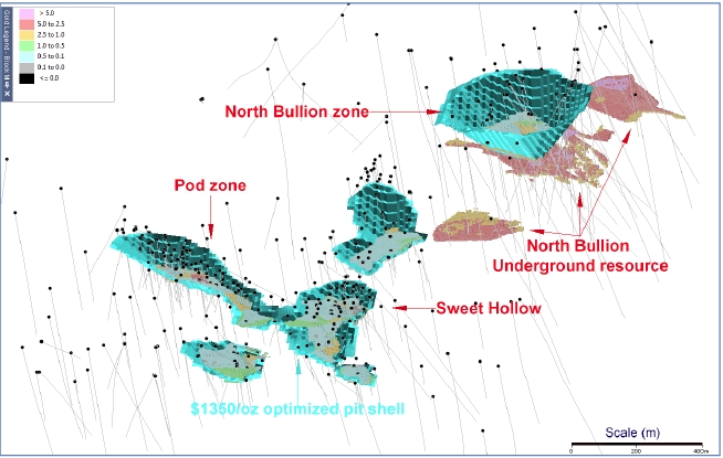
| 14.16 | Additional Railroad–Pinion Mineral Resources |
| 14.16.12016 | Pinion Updated Mineral Resource Estimate |
During late 2015, Gold Standard contracted APEX to complete an updated NI 43-101 Mineral Resource Estimate for the Pinion Deposit. The Pinion updated resource was released in March 2016 (see GSV Press Release dated March 15, 2016) and the following information is taken from a subsequent technical report supporting the current 2016 Pinion Deposit Mineral Resource Estimate by Dufresne and Nicholls (2016).
The statistical analysis, geological modelling and resource estimation discussed in this section of the Technical Report was performed by Mr. Steven Nicholls, BA.Sc., MAIG, with APEX under the direct supervision of Mr. Dufresne, M.Sc.,P. Geol., P.Geo. also with APEX. Both are Qualified Persons as defined by National Instrument 43-101. Mineral resource modelling and estimation was carried out using a 3-dimensional block model based on geostatistical applications using commercial mine planning software MICROMINE (v14.0.6). The details of the resource estimation are summarized below and provided in detail by Dufresne and Nicholls (2016).
| Effective Date: November 3, 2017 | | | 167 |
Technical Report Maiden Resource Estimate North Bullion Railroad Project, Elko County, Nevada, USA
Modeling was conducted in Universal Transverse Mercator (UTM) coordinate space relative to the North American Datum (NAD) 1927 and UTM Zone 11. A parent block size of 10 m (X) x 10 m (Y) x 3 m (Z) with sub-blocking down to 5 m x 5 m x 1 m was applied. The Pinion resource modeling utilized 505 drillholes that were completed from 1981 to 2015. Mr. Dufresne, P.Geol visited the property in May, 2013, April, 2014, October, 2014 and most recently in May-June and August-September, 2015 in order to verify and validate the historic drillhole dataset and to verify the drilling of the recently completed 2014 and 2015 diamond and RC drilling campaigns completed by GSV. Over the period of two years, APEX personnel were intimately involved in the verification, validation, drillhole collar surveying and QA/QC analysis of the Pinion drillhole database. The current drillhole database is deemed to be in good condition and suitable to use in ongoing resource estimation studies.
The revised Pinion Mineral Resource Estimate is reported in accordance with the Canadian Securities Administrators National Instrument 43-101 and has been estimated using the CIM “Estimation of Mineral Resources and Mineral Reserves Best Practice Guidelines” dated November 23rd, 2003, CIM “Definition Standards for Mineral Resources and Mineral Reserves” dated May 10th, 2014. Mineral resources are not mineral reserves and do not have demonstrated economic viability. There is no guarantee that any part of the mineral resource discussed in this Technical Report will be converted into a mineral reserve in the future.
The GSV Pinion Project database has undergone extensive validation prior to the calculation of the updated 2016 Mineral Resource Estimate. Historic drilling was largely conducted relative to local grid(s) and the relationship between the grid coordinates and world coordinates was not well documented. The confirmation and validation of historical drillhole collar locations was addressed initially during the May 2013 site visit conducted by Mr. Dufresne. During the visit, approximately 40 historical drill collars were located and recorded using a hand-held GPS, along with tracks representing drill roads and trails. Although unmarked in the field, the identity of several drill collars were ascertained due to their unique location. A comparison between the field GPS’s locations and their database coordinates indicated a small error (50 to 70 m) but suggested that their relative positions were accurate relative to each other. GSV then completed formal surveying of the identified historic drill collars along with a number of others they were able to find using a differential GPS. This survey confirmed a systematic shift and, more importantly, it confirmed that the relative positions for several of the historic phases of drilling were consistent with historic surveying as recorded in the drill database. The remaining drill collars were located by matching drill collars and drilling roads and trails with surveyed collars and the roads and trails visible in a high-resolution geo-rectified aerial photomosaic for the Pinion area that was obtained by GSV from Pacific Geomatics Ltd. It is important to note that the majority of the historic drillholes at Pinion were formally surveyed at the time of their drilling and thus the problem was simply related to confirming the real world coordinates for the collars given their accurate historic recording in local grid space. As a result of the collar surveying and validation work discussed above, APEX is confident that the locations of the historic drillholes at the Pinion Deposit are now well established and are considered validated. This was further reinforced when GSV drilled a number of holes designed to twin historic drillholes and an excellent correlation was observed both geologically and geochemically between the twinned holes.
The extensive historical data compilation and data validation process described above has resulted in a validated drill database for the Pinion prospect that is considered by APEX to be sufficiently reliable for use in the mineral resource estimation effort described below.
| Effective Date: November 3, 2017 | | | 168 |
Technical Report Maiden Resource Estimate North Bullion Railroad Project, Elko County, Nevada, USA
A total of 505 drillholes guided the geological interpretation and estimation of the Pinion mineral resource. This total comprises 24 diamond drillholes and 481 RC drillholes that were completed from 1981 to 2015. Spacing between drillholes varies from 1 m to 1.25 km. Over the life of the project, drilling has been completed on various grids, with line spacing varying from 20 m to 200 m. All the drillholes were used to guide the geological and mineralization model that was ultimately used in the resource estimation calculation. Lode interpretation was completed using a validated database comprising 24 core and 481 RC drillholes, with an average drillhole spacing of 20 meters for the Main and North Zones and 80 meters for the surrounding mineralized area.
The Pinion assay file comprises 44,123 analyses of variable length from a variety of sampled lithologies. Of the 44,123 samples in the Pinion database, roughly one quarter (11,166 assays) are situated within the gold mineralized lodes. Within the original assay database there were a number of assay intervals with either blank gold or silver grades, or a code describing the interval as a “missing sample” (e.g. MS, NS, NA, -value). Many of these missing sample intervals were found to be located within mineralized zones, which is believed to be the result of poor recovery and/or poor drilling conditions within mineralized breccia zones. It was decided to assign a grade of 0.05 g/t Au and 0.25 g/t Ag to these intervals, as more than likely they would be in fact mineralized. The grade of 0.05 g/t Au is deemed suitable as it is half of the lower grade cutoff that was used for interpretation and modelling purposes. For gold, 246 “no sample” intervals (of the total 11,166 assay intervals within the mineralized lodes) were assigned a grade of 0.05 g/t Au. For silver, 196 “no sample” intervals were assigned a grade of 0.25 g/t Ag. In the database there a large number (nearly half) of the drillholes do not contain silver analyses. These holes were not assigned any dummy silver values, they were left blank. The minus values in the gold and silver analysis are believed to be the lower detection limit of the analytical method. As such industry practice of applying a grade of half the negative value was applied. For gold, 132 “negative” intervals (of the total 11,166 assay intervals within the mineralized lodes) were assigned a grade of half the negative detection limit. For silver, 71 “negative” intervals were assigned a grade of half the negative detection limit.
Upon completing the geological interpretation of the Pinion Deposit it became clear that the bulk of the mineralization is hosted in a multilithic, dissolution collapse breccia. Gold mineralization exhibits predictable lateral and strike continuity within this silicified and oxidized breccia which appears to have developed preferentially between relatively impermeable silty micrite of the overlying Mississippian Tripon Pass Formation and thick bedded limestone or calcarenite of the underlying Devonian Devils Gate Limestone Formation. As a result, it became necessary to develop mineralization envelopes, based upon the new Pinion geological model, for the purpose of completing resource estimation.
The Pinion mineral resource estimate was calculated utilizing the gold and silver assay grades. Thorough documentation of the analytical methodologies adopted for all assays was not always recorded, but the available information indicates that gold analyses are the result of fire assaying with variable aliquot size and finishing technique, whereas the silver analyses are mainly by ICP. Further work on compiling the meta data associated with the assay database is recommended. This, and the fact that the Pinion assay database is incomplete with respect to silver analyses, is reflected in the classification of silver as only inferred.
| Effective Date: November 3, 2017 | | | 169 |
Technical Report Maiden Resource Estimate North Bullion Railroad Project, Elko County, Nevada, USA
A total of 171 bulk density measurements were collected from the 2014 diamond drill core using the weight in air/weight in water methodology. No further bulk density measurements were collected during 2015. An average nominal density of 2.58 kg/m3 for gold mineralization hosted in the multilithic collapse breccia was obtained from the 2014 work. The 2014 selection of samples was completed on all of the stratigraphic horizons. The 171 density samples were examined by formation (geological unit) and also with respect to whether the samples were mineralized or not. Results indicate that a density of 2.58 kg/m3 is representative of the Pinion mineralization and was assigned to all mineralized blocks in the block model.
A parent block size of 10 m x 10 m x 3 m was chosen for the Pinion block model. This is deemed appropriate based on the current level of drillhole spacing which ranges from 1 m to 1.25 km. Sub-blocking was used to more effectively honour the volumes and shapes created during the geological interpretation of the mineralized wireframes or lodes. A comparison of wireframe volume versus block model volume was performed for each of the estimations to ensure there was no under- or overestimation of tonnages. Each block was coded with the lode number so that grade could be estimated as hard boundaries.
The Indicated and Inferred Pinion Resource estimation of gold and silver was calculated using inverse distance squared (ID2) for each of the eleven lodes. Initially for the 2014 Indicated and Inferred Pinion resource estimation, both ID2 and ordinary kriging was used for resources estimation but due to the resultant validation of the block models it was decided to use the ID2 estimation technique as it best honoured the input composite grades. As such only ID2 estimation technique was used for this estimation. Estimation was only calculated on parent blocks. All sub-blocks within the parent block were assigned the parent block grade. A block discretization of 3 x 3 x 3 was applied to all blocks during estimation. Each lode was estimated with ‘hard boundaries’, which means that only composite assays located within each lode were used to estimate the grade of the blocks within that lode.
There were four passes of estimation performed for each lode. The size of the an-isotropic search ellipsoid was based on the suggested ranges obtained from the variography. The maximum range of the gold variography suggested an anisotropic search radius of 275 m x 170 m x 25 m. As such the search ellipsoids used in the estimation of the blocks was incrementally increased with each run to a third search range which was similar to the maximum range observed in the variography. The final estimation ‘run’ the search ranges were expanded further to ensure all blocks were estimated with grade. The minimum sample criteria for the number of composites to be selected from the number of drillholes decreased with each run, as the search ellipsoid size increased. This was designed to ensure that the highest confidence blocks were estimated in the first couple of runs. The estimation criteria for each pass are provided in Dufresne and Nicholls (2016).
For the classification of “Indicated”, the blocks that had been estimated in estimation runs 1 or 2 utilizing a search ellipsoid of a about a third of the suggested range identified in the variographic analysis were used as a guide (Dufresne and Nicholls, 2016). As such, these blocks exhibited a high level of confidence. This, in conjunction with the proximity of the 2014 and 2015 drilling and level of confidence in the geological interpretation, aided the decision to assign this area of the resource to the “Indicated” category. The classification criteria are provided in detail in Dufresne and Nicholls (2016). All blocks with an Indicated classification were assigned with a code of two (2). The remaining resource situated within the optimized pit shell was classified as “Inferred”. All blocks with an “Inferred” classification were assigned a code of three (3).
| Effective Date: November 3, 2017 | | | 170 |
Technical Report Maiden Resource Estimate North Bullion Railroad Project, Elko County, Nevada, USA
It should be noted that only the gold estimation was assigned the indicated classification. The silver resource has been classified as entirely inferred. Further validation work on the historic silver analyses and methodology is required along with additional infill sampling in order to increase the confidence in the silver model in order to bring it up to the standard of the gold model.
The updated (2016) Pinion Mineral Resource Estimate is reported at a range of gold cutoff grades in Table 14.16 and Table 14.17 for both Indicated and Inferred categories, for gold and silver respectively. No portion of the current mineral resource has been assigned to the “Measured” category. The updated Pinion Indicated and Inferred Mineral Resource uses a cutoff grade of 0.14 g/t Au, which is constrained within an optimized pit shell and includes an Indicated Mineral Resource of 31.61 million tonnes at 0.62 g/t Au for 630,300 ounces of gold and an Inferred Mineral Resource of 61.08 million tonnes at 0.55 g/t Au for 1.081 million ounces of gold. The base case cutoff of 0.14 g/t Au is highlighted in each table. The Mineral Resource is presented at other cutoff grades for review ranging from 0.1 g/t Au to 1.0 g/t Au for sensitivity analyses. Resource blocks flagged as “reduced” were removed from the overall resource.
The Pinion updated Inferred Mineral Resource for silver is constrained in the same optimized pit shell as the gold resource. In addition, the silver resource is constrained by the gold lower cutoff grade of 0.14 g/t. The updated Pinion Deposit model yields an Inferred Mineral Resource of 92.69 million tonnes at 4.16 g/t Ag for a total of 12.4 million ounces of silver as shown in Table 14.17 below.
The updated Pinion resource estimate resulted in an approximate 49 % increase in gold ounces contained in the indicated category and a nearly 6 % increase in gold ounces in the inferred category while maintaining grade throughout all categories in comparison to the previous maiden resource. Details of the updated NI 43-101 compliant Mineral Resource Estimate for the Pinion Deposit are provided in a Technical Report by Dufresne and Nicholls (2016).
Considerable metallurgical test work has been completed to date for Pinion, which includes analysis of the suitability of the gold and silver mineralization to cyanide soluble leaching methods. Bottle roll and column leach test work was completed by Teck in 1990, Crown in 1992, Cyprus in 1994 to 1996 and Royal Standard in 2004. This test work obtained recoveries of gold ranging from 41.7 to 91.3 %, with coincident recoveries of silver ranging from 31 to 62 %. Further metallurgical test work is planned but these initial results are encouraging and warrant further investigation. More than 99 % of the block modeled material is considered oxide mineralization.
| Effective Date: November 3, 2017 | | | 171 |
Technical Report Maiden Resource Estimate North Bullion Railroad Project, Elko County, Nevada, USA
Table 14.16. The Pinion updated NI 43-101 mineral resource estimate for gold at various lower cutoffs from (Dufresne and Nicholls, 2016)*.
| Classification* | Au Cutoff Grade (gpt) | Tonnage (million metric tonnes) | Average Au Grade (gpt) | Contained Au** (troy ounces)*** |
| Indicated | 0.1 | 31.62 | 0.62 | 630,400 |
| 0.14** | 31.61 | 0.62 | 630,300 |
| 0.17 | 31.56 | 0.62 | 630,100 |
| 0.2 | 31.47 | 0.62 | 629,500 |
| 0.3 | 30.26 | 0.64 | 619,100 |
| 0.4 | 26.35 | 0.68 | 574,500 |
| 0.5 | 20.81 | 0.74 | 494,200 |
| 0.6 | 14.89 | 0.81 | 389,600 |
| 0.7 | 10.13 | 0.89 | 290,400 |
| 0.8 | 6.38 | 0.98 | 200,400 |
| 0.9 | 3.65 | 1.07 | 126,100 |
| 1 | 2.01 | 1.18 | 76,200 |
| Inferred | 0.1 | 61.39 | 0.55 | 1,082,500 |
| 0.14** | 61.08 | 0.55 | 1,081,300 |
| 0.17 | 60.29 | 0.56 | 1,077,300 |
| 0.2 | 58.93 | 0.56 | 1,069,200 |
| 0.3 | 50.10 | 0.62 | 997,200 |
| 0.4 | 39.15 | 0.69 | 874,100 |
| 0.5 | 29.32 | 0.78 | 732,500 |
| 0.6 | 21.10 | 0.87 | 587,000 |
| 0.7 | 14.32 | 0.97 | 445,900 |
| 0.8 | 9.08 | 1.10 | 320,000 |
| 0.9 | 5.46 | 1.26 | 221,500 |
| 1 | 3.58 | 1.43 | 164,300 |
*Indicated and Inferred Mineral Resources are not Mineral Reserves. Mineral resources which are not mineral reserves do not have demonstrated economic viability. There has been insufficient exploration to define the inferred resources as an indicated or measured mineral resource, however, it is reasonably expected that the majority of the Inferred Mineral Resources could be upgraded to Indicated Mineral Resources with continued exploration. There is no guarantee that any part of the mineral resources discussed herein will be converted into a mineral reserve in the future.
**The recommended reported resources are highlighted in bold and have been constrained within a US$1,250/ounce of gold and US$21.50/ounce of silver optimized pit shell.
***Contained ounces may not add due to rounding.
The 2016 Pinion Deposit Gold Mineral Resource has been classified as comprising both Indicated and Inferred resources according to recent CIM definition standards (Table 14.16). The 2016 Pinion Silver Mineral Resource estimate has been classified entirely as an Inferred Mineral Resource (Table 14.17). The classification of the Pinion gold and silver resources was based on geological confidence, data quality and grade continuity. No portion of the current mineral resource has been assigned to the “Measured” category. All reported mineral resources occur within a pit shell optimized using values of US$1,250 per ounce for gold and US$21.50 per ounce for silver. Indicated and inferred mineral resources are not mineral reserves and do not have demonstrated economic viability. There has been insufficient exploration to define the inferred resources as an indicated or measured mineral resource, however, it is reasonably expected that the majority of the inferred mineral resources could be upgraded to indicated mineral resources with continued exploration.
| Effective Date: November 3, 2017 | | | 172 |
Technical Report Maiden Resource Estimate North Bullion Railroad Project, Elko County, Nevada, USA
Table 14.17. The Pinion updated NI 43-101 mineral resource estimate for silver at various lower gold cutoffs (from Dufresne and Nicholls, 2016)*.
| Classification* | Au Cutoff Grade (gpt) | Tonnage (million metric tonnes) | Average Ag Grade (gpt) | Contained Ag** (troy ounces)*** |
| Inferred | 0.1 | 93.01 | 4.15 | 12,422,800 |
| 0.14** | 92.69 | 4.16 | 12,401,600 |
| 0.17 | 91.85 | 4.18 | 12,349,800 |
| 0.2 | 90.40 | 4.22 | 12,255,800 |
| 0.3 | 80.36 | 4.42 | 11,424,300 |
| 0.4 | 65.50 | 4.72 | 9,946,000 |
| 0.5 | 50.13 | 5.09 | 8,200,100 |
| 0.6 | 35.99 | 5.21 | 6,030,700 |
| 0.7 | 24.45 | 5.24 | 4,120,500 |
| 0.8 | 15.47 | 5.08 | 2,527,100 |
| 0.9 | 9.12 | 4.88 | 1,429,500 |
| 1 | 5.59 | 4.65 | 836,600 |
* Inferred Mineral Resources are not Mineral Reserves. Mineral resources which are not mineral reserves do not have demonstrated economic viability. There has been insufficient exploration to define the inferred resources as an indicated or measured mineral resource, however, it is reasonably expected that the majority of the Inferred Mineral Resources could be upgraded to Indicated Mineral Resources with continued exploration. There is no guarantee that any part of the mineral resources discussed herein will be converted into a mineral reserve in the future.
**The recommended reported resources are highlighted in bold and have been constrained within a US$1,250/ounce of gold and US$21.50/ounce of silver optimized pit shell.
***Contained ounces may not add due to rounding.
In order to demonstrate that the Pinion Deposit has reasonable potential for eventual economic extraction the unconstrained resource block model was subjected to various preliminary pit optimization scenarios. The cost and mining criteria used in the whittle pit optimizer scenarios were standard for Nevada heap leach deposits and were run at gold prices of US$1,100/ounce, US$1,250/ounce, US$1,400/ounce and US$1550/ounce. All mineral resources for the updated 2016 Pinion Mineral Resource have been reported within the optimized pit shell using prices of US$1,250/ounce of gold and US$21.50/ounce of silver. The volume and tonnage for the reported resources within the $1,250/ounce optimized pit shell represents approximately 71 % of the total tonnage in the unconstrained block model at a 0.14 g/t Au block cutoff grade.
| 14.16.22017 | Dark Star Updated Mineral Resource Estimate |
During the summer of 2017, Gold Standard contracted APEX to complete an updated NI 43-101 updated Mineral Resource Estimate for the Dark Star Deposit. The Dark Star updated resource was released in June 2017 (see GSV Press Release datedJune 29, 2017) and the following information is taken from a subsequent technical report supporting the current 2017 Dark Star Deposit Mineral Resource Estimate by Dufresne and Nicholls (2017).
| Effective Date: November 3, 2017 | | | 173 |
Technical Report Maiden Resource Estimate North Bullion Railroad Project, Elko County, Nevada, USA
The statistical analysis, geological modelling and resource estimation discussed in this section of the Technical Report was performed by Mr. Steven Nicholls, BA Sc., MAIG, with APEX Geoscience Ltd. (APEX) under the direct supervision of Mr. Michael B. Dufresne, M.Sc., P. Geol., P.Geo. also with APEX. Both are independent geological consultants and Qualified Persons as defined by National Instrument 43-101. Mineral resource modelling and estimation was carried out using a 3-dimensional block model based on geostatistical applications using commercial mine planning software MICROMINE (v14.0.6). The details of the resource estimation are summarized below and provided in detail by Dufresne and Nicholls (2017).
Modeling was conducted in Universal Transverse Mercator (UTM) coordinate space relative to the North American Datum (NAD) of 1927 (Zone 11). A parent block size of 6 m (X) x 6 m (Y) x 6 m (Z) which was sub-blocked down to 3 m (X) by 3 m (Y) by 3 m (Z) was used. The database consists of 158 drillholes completed at the Dark Star prospect ranging from 1984 to 2016 of which 91 were used in the Dark Star resource modeling. Mr. Dufresne, M.Sc., P.Geol., P.Geo., visited the property in May, 2013, October, 2014, September, 2015 and again in June, 2017 to verify and validate the historic drillhole dataset and to verify the drilling of the recently completed in 2015 and 2016 diamond and RC drilling campaigns completed by GSV. Over the period of two years, APEX personnel were intimately involved in the verification, validation, drillhole collar surveying and QA/QC analysis of the Pinion drillhole database. The current drillhole database is deemed to be in good condition and suitable to use in ongoing resource estimation studies.
The revised Dark Star Mineral Resource Estimate is reported in accordance with the Canadian Securities Administrators National Instrument 43-101 and has been estimated using the CIM “Estimation of Mineral Resources and Mineral Reserves Best Practice Guidelines” dated November 23rd, 2003, CIM “Definition Standards for Mineral Resources and Mineral Reserves” dated May 10th, 2014. Mineral resources are not mineral reserves and do not have demonstrated economic viability. There is no guarantee that any part of the mineral resource discussed in this Technical Report will be converted into a mineral reserve in the future.
The GSV database has undergone extensive validation prior to the 2017 resource estimation effort. Historic drilling was largely conducted relative to UTM grid lines and was performed on east-west oriented drill sections. Mr. Dufresne’s May 2013 site visit both confirmed and validated historical drillhole collar locations. During the visit, a number of historic drill collars were located and recorded using a hand-held GPS, along with tracks representing drill roads and trails. Although unmarked in the field, the identity of several drill collars were ascertained due to their unique location, which were found to be consistent with historically recorded location information. Further work on refining the collar positions and validation of the drill hole database in general has been conducted up until and including the 2015 Maiden Resource Estimate and has continued since. The largest problem with the historic drillhole database centered on collar elevations, which initially provided a number of obvious errors. With near flat lying mineralized zones it was determined to be imperative to obtain a reliable dataset of collar elevations that were internally consistent from one hole to the next. Once accurate real world coordinates were obtained for the historic Dark Star collars, elevations for the drillholes were generated using the digital elevation model that was generated by Pacific Geomatics from its ortho-rectified satellite imagery that had 3 ft (~1 m) elevation and location resolution. This problem only applied to the historic pre GSV drillholes. All recent 2015 and 2016 GSV drillholes were surveyed using a differential GPS for their easting, northing and elevation coordinates.
| Effective Date: November 3, 2017 | | | 174 |
Technical Report Maiden Resource Estimate North Bullion Railroad Project, Elko County, Nevada, USA
The extensive historical data compilation and data validation process described above has resulted in a validated drill database for the Dark Star Deposit that is considered by APEX to be sufficiently reliable for use in the mineral resource estimation effort described below.
There was a total of 158 drillholes within the export that guided the mineralization interpretation and estimation of the Dark Star resource. This total comprises 23 diamond core holes completed by GSV in 2015 and 2016, 30 RC drillholes also completed by GSV in 2015 and 2016, and finally 105 RC drillholes that were completed from 1984 to 1999. Spacing between drillholes over the main resource area varies from 2 m to 160 m. Drilling has been completed on roughly east-west sections that range in spacing from 15 to 100 m with an average spacing of around 30 m (100 ft) through Dark Star Main and 100 m (330 ft) at North Dark Star. All of the drillholes were used to guide the mineralization model that was ultimately used in the resource estimation calculation.
The Dark Star assay file comprises 25,376 analyses of variable lengths, of which 23,803 samples have been assayed for gold. The database comprises very few silver assays. Of the 25,376 samples in the Dark Star database, roughly fourteen percent (3,507 assays) are situated within the gold mineralized lodes. Within the original assay database there were a number of assay intervals with codes describing the interval as a “missing sample” (e.g. “-2”, “NS”, “NA” or “#value!”). None of these samples were situated within the mineralized wireframes.
The Dark Star Prospect occurs at a higher stratigraphic level than the Pinion Deposit and occurs within rocks mapped as undifferentiated Pennsylvanian Tomera and Moleen Formation by Smith and Ketner (1975), which are cut by north, northeast and northwest striking faults and hydrothermal breccias and/or jasperoids. Dark Star gold mineralization occurs in a 400 to 600 m wide, 6 km long, linear, north trending horst that is part of a structural zone defined as the DSC (Harpet al., 2016). Gold mineralization is related to a north to north-northeast striking zone of silicification focused along west-dipping contacts centered around high angle faults, within coarse conglomeratic debris flows intercalated with bioclastic limestone between relatively impermeable fine grained silty limestone units. These sedimentary rocks are cut by thin rhyolite dikes that are part of the Dark Star corridor
The Dark Star mineral resource estimate was calculated utilizing the gold assay grades within the Dark Star drill database. Thorough documentation of the analytical methodologies used to generate the gold assay data for the historic holes within the Dark Star drill database is largely unavailable, but an assay certificate for samples comprising hole CDS-63 from September 1993 indicates that gold was analyzed by standard fire assaying with a 30g aliquot size and a wet chemical (presumably AA) finish and a 5 ppb Au detection limit was specified. This was, and remains, a standard assay technique at most analytical laboratories throughout North America. The majority of the historical assays used in the Dark Star resource estimate are reported within the prospect’s drill database in ppb Au down to a lower limit of 5 ppb Au and are thus believed to be the result of 30g fire assays with an AA finish (ICP assay finishing was not commonly used in the early 1990s and a gravimetric finish would have had a higher detection limit of around 50 – 150 ppb Au). Further work on compiling the meta data associated with the Dark Star drillhole database is recommended. With respect to the 2015 and 2016 drill results, all the gold intersections were check assayed at ALS Vancouver. In addition, several of the intersections were further check assayed at SGS. In the end, it was determined there was a slight problem with the flux being used by BV resulted in a minor understating of the Au for the 2015 and 2016 Dark Star drill assay results. The subsequent ALS Vancouver assays were inserted into the database for the 2015 and 2016 Dark Star drillholes and were used for the resource estimation work.
| Effective Date: November 3, 2017 | | | 175 |
Technical Report Maiden Resource Estimate North Bullion Railroad Project, Elko County, Nevada, USA
A total of 260 bulk density samples were situated within the mineralized wireframes. The 260 bulk density samples situated within the mineralized zones were examined on a lode by lode basis. The average bulk density determined from the analytical work for each lode was assigned to all the blocks within that lode. The average density for the lodes ranges from 2.46 g/cm3 to 2.62 g/cm3 with overall average bulk density of 2.54 g/cm3 for the combined Dark Star and North Dark Star mineral resource.
The resource has been estimated within three dimensional solids that were created from cross-sectional lode interpretation. The upper contact has been cut by the topographic surface. There is little to no overburden present at the Dark Star property. Grade was estimated into a block model with parent block size of 6 m (X) by 6 m (Y) by 6 m (Z) and sub-blocked down to 3 m (X) by 3 m (Y) by 3 m (Z). This block model size is deemed appropriate based on the current level of drillhole spacing which ranges from 2 to 100 m for Dark Star Main and 6 to 120 m for North Dark Star.
The Indicated and Inferred Dark Star Resource Estimation of gold was calculated using inverse distance to the power of one (ID1) for each of the six lodes. Both inverse distance squared and ordinary kriging were also evaluated for resource estimation, but due to the resultant validation of the block models showing the grades of North Dark Star overstating the composite grades it was decided to use the inverse distance to the power of one estimation technique as it best honoured the input composite grades. As such only inverse distance estimation technique was used for this estimation. Estimation was only calculated on parent blocks. A block discretization of 3 x 3 x 3 was applied to all blocks during estimation. Each lode was estimated with ‘hard boundaries’, which means that only composite assays located within each lode were used to estimate the grade of the blocks within that lode.
There were four passes of estimation performed for each lode. The size of the an-isotropic search ellipsoid was based on the suggested ranges obtained from the variography. Estimation runs 1 to 3 for gold equated to ranges less than or equal to the maximum range observed in the variography. The final estimation ‘run’ the search ranges were expanded further to ensure all blocks were estimated with grade. The criteria for the number of composites to be selected from the number of drillholes decreased with each run, as the search ellipsoid size increased. This was designed to ensure that the highest confidence blocks got estimated in the first couple of runs. The number of composites used for the estimation of each block was capped to 36 composites and a maximum of three composites from any given hole was used to limit the influence of high grade mineralization on the estimation.
The 2017 Dark Star Mineral Resource has been classified as comprising both Indicated and Inferred Resources according to the CIM definition standards. The classification of the Dark Star Indicated and Inferred Resource was based on geological confidence, data quality and grade continuity. The most relevant factors used in the classification process were drillhole spacing density, level of confidence in the geological interpretation, estimation parameters, proximity to the recently completed 2015 and 2016 drillholes, and drillhole database data density.
| Effective Date: November 3, 2017 | | | 176 |
Technical Report Maiden Resource Estimate North Bullion Railroad Project, Elko County, Nevada, USA
Based on the criteria noted above a polygonal area was chosen for the indicated area at the Dark Star deposit. The blocks in this area were mostly made up of the blocks that were estimated in estimation runs 1 and 2, which utilized a search ellipsoid of the maximum range of continuity based on the variography and the highest number of composites and drill holes. As such, these blocks exhibited a high level of confidence. This area was located at Dark Star Main where the drillhole density was the highest. Although the overall drillhole spacing ranges from 2 m to 160 m the average drill hole spacing at Dark Star Main is 30 m. This, in conjunction with the proximity of the 2015 and 2016 drilling and level of confidence in the geological interpretation, aided the decision to assign this area of the resource to the “Indicated” category. All blocks with an Indicated classification were assigned with a code of two (2). The remaining resource was classified as “Inferred”. All blocks with an “Inferred” classification was assigned a code of three (3). There has been no classification of measured resources at Dark Star Main. There remains uncertainty associated with the historic drilling database including a lack of downhole surveys and missing original laboratory assay certificates along with a lack of QAQC data at Dark Star Main. Additional infill drilling will be required at Dark Star Main to increase the level of confidence in the database and models. Dark Star North with an average drillhole spacing of 100 m requires infill drilling to improve the overall average drillhole spacing and level of confidence in the geological model and the resource model.
The updated Dark Star Mineral Resource Estimate is reported at a range of gold cutoff grades in Table 14.18 for both Indicated and Inferred categories. No portion of the current mineral resource has been assigned to the “Measured” category. The updated Dark Star Indicated and Inferred Mineral Resource uses a cutoff grade of 0.2 g/t Au, which is constrained within an optimized pit shell and includes an Indicated Mineral Resource of 15.38 million tonnes at 0.54 g/t Au for 265,100 ounces of gold and an Inferred Mineral Resource of 17.05 million tonnes at 1.31 g/t Au for 715,800 ounces of gold. The base case cutoff of 0.2 g/t Au is highlighted in each table. Other cutoff grades are presented for review ranging from 0.2 g/t Au to 1.0 g/t Au. Resource blocks flagged as “reduced” were removed from the overall resource. The block modeled resource is shown with the $1,250/ounce per gold pit shell in Figure 14.34 below.
The 2017 updated Mineral Resource Estimate resulted in an approximate 48 % increase in gold ounces contained in the inferred category when compared to the previous 2015 maiden Mineral Resource Estimate. No portion of the maiden mineral resource estimate was assigned to the ‘Indicated” category so comparisons cannot be drawn in that respect. Details of the updated NI 43-101 compliant Mineral Resource Estimate for the Dark Star Deposit are provided in a Technical Report by Dufresne and Nicholls (2017).
| Effective Date: November 3, 2017 | | | 177 |
Technical Report Maiden Resource Estimate North Bullion Railroad Project, Elko County, Nevada, USA
Table 14.18. The 2017 Dark Star NI 43-101 mineral resource estimates for gold at various gold cutoff grades (from Dufresne and Nicholls, 2017)*.
| Category* | Au Cutoff Grade (gpt) | Tonnage (million metric tonnes) | Average Au Grade (gpt) | Contained Au** (troy ounces)*** |
| Indicated | 0.0 | 15.38 | 0.54 | 265,100 |
| 0.2** | 15.38 | 0.54 | 265,100 |
| 0.3 | 14.91 | 0.54 | 261,000 |
| 0.4 | 12.16 | 0.59 | 229,300 |
| 0.5 | 7.95 | 0.66 | 168,200 |
| 0.6 | 4.01 | 0.77 | 98,900 |
| 0.7 | 2.02 | 0.89 | 57,800 |
| 0.8 | 1.19 | 0.99 | 37,800 |
| 0.9 | 0.71 | 1.08 | 24,800 |
| 1.0 | 0.40 | 1.19 | 15,500 |
| Inferred | 0.0 | 17.06 | 1.31 | 715,900 |
| 0.2** | 17.05 | 1.31 | 715,800 |
| 0.3 | 16.38 | 1.35 | 710,300 |
| 0.4 | 15.17 | 1.43 | 696,400 |
| 0.5 | 14.06 | 1.51 | 680,500 |
| 0.6 | 12.82 | 1.60 | 658,500 |
| 0.7 | 11.34 | 1.72 | 627,600 |
| 0.8 | 10.04 | 1.85 | 596,300 |
| 0.9 | 8.92 | 1.97 | 565,900 |
| 1.0 | 8.07 | 2.08 | 539,700 |
* Indicated and Inferred Mineral Resources are not Mineral Reserves. Mineral resources which are not mineral reserves do not have demonstrated economic viability. There has been insufficient exploration to allow for the classification of the inferred resources tabulated above as an indicated or measured mineral resource, however, it is reasonably expected that the majority of the Inferred Mineral Resources could be upgraded to Indicated Mineral Resources with continued exploration. There is no guarantee that any part of the mineral resources discussed herein will be converted into a mineral reserve in the future.
** The recommended reported resources are highlighted in bold and have been constrained within a US$1,250/ounce of gold optimized pit shell.
*** ‘Contained Ounces’ may not add due to rounding
A variety of historic and modern metallurgical tests have been conducted on material for the Dark Star Deposit. In 1991, a total of 158 samples were submitted to McClelland Laboratories Inc. in Sparks, NV for initial leaching test work (Macy, 1992). The results of this bottle roll cyanide leach testing showed gold recoveries ranging from 75.0% to 91.3% with an overall average of 82.2% recovery following a 96-hour leach. In 2015 and 2016 Gold Standard submitted 1,945 pulp samples from 39 of the RC drillholes completed at the Main Dark Star and North Dark Star deposits for cyanide solubility analysis at ALS Minerals certified laboratory in Vancouver, BC. The gold recoveries averaged 88.9% in the Main Dark Star oxide zone and 89.9 % in the North Dark Star oxide zone. GSV states that the results of this metallurgical test work confirm the consistently oxidized nature of gold mineralization at the Dark Star deposits and suggest that they will be amenable to heap leach gold processing (see GSV Press Release dated April 10, 2017).
| Effective Date: November 3, 2017 | | | 178 |
Technical Report Maiden Resource Estimate North Bullion Railroad Project, Elko County, Nevada, USA
The 2017 Dark Star Deposit Gold Mineral Resource has been classified as comprising both Indicated and Inferred resources according to recent CIM definition standards (Table 14.18). The classification of the Pinion gold resources was based on geological confidence, data quality and grade continuity. No portion of the current mineral resource has been assigned to the “Measured” category. All reported mineral resources occur within a pit shell optimized using values of $US1,250 per ounce for gold. Indicated and inferred mineral resources are not mineral reserves and do not have demonstrated economic viability. There has been insufficient exploration to define the inferred resources as an indicated or measured mineral resource, however, it is reasonably expected that the majority of the inferred mineral resources could be upgraded to indicated and/or measured mineral resources with continued exploration.
In order to demonstrate that the Dark Star Gold Deposit has potential for future economic extraction, the unconstrained resource block model was subjected to a pit optimization scenario. The criteria used in the Whittle pit optimizer were considered reasonable for Nevada heap leach deposits. All mineral resources reported below are reported within the optimized pit shell using $1,250/ounce for gold. The volume and tonnage for the reported resources within the $1,250/ounce optimized pit shell represents approximately 84% of the total volume and tonnage of the unconstrained block model (which utilized a lower gold cutoff of 0.2 g/t Au).
Figure 14.34. Dark Star 3D model of the ID1 block model within the $1,250/oz Au pit shells.
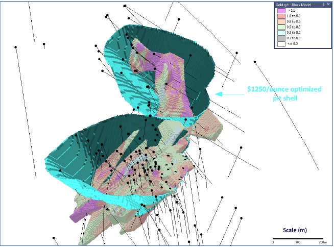
| Effective Date: November 3, 2017 | | | 179 |
Technical Report Maiden Resource Estimate North Bullion Railroad Project, Elko County, Nevada, USA
The Railroad and Pinion Projects are situated along the southeastern portion of the Carlin Gold Trend. The Rain Mining District, which is largely controlled by Newmont Mining Corporation (Newmont), is located only 2 to 3 km (1.2 to 2 miles) north of the Railroad–Pinion Project (Figure 15.1). The Rain District has been an active exploration and mining area for several decades and is the location for Newmont’s current mining activities at the Emigrant Mine. The Rain – Emigrant series of deposits has seen extensive exploration over the last three decades. To the south of the Railroad and Pinion Projects, several exploration areas have received sporadic exploration over the past three to four decades including Pony Creek. Adjacent properties with bearing or influence on the Railroad and Pinion Projects are described below. The authors of this Technical Report have not visited or worked at any of these projects and where references are made to past production and/or historic or current mineral resources the authors have not verified the information.
Rain is a Carlin-style, sedimentary rock-hosted gold deposit that is located approximately four miles (seven kilometers) north of Gold Standard’s North Bullion Deposit. Newmont operated the Rain open pit mine, the Rain Underground mine and the SMZ open pit mine from 1988 to 2000 and produced approximately 1.24 million ounces (Resselet al., 2015). Longoet al. (2002) summarized a number of mineral resources for the three deposits as follows: Rain open pit 15.5 million tons (14.1 million tonnes) at 0.066 oz/st (2.3 g/t) Au for a total of 1,017,300 ounces of gold; Rain Underground 1.154 million tons (1.04 million tonnes) at 0.23 oz/st (7.9 g/t) Au for a total of 265,000 ounces of gold and the SMZ open pit 1.5 million tons (1.4 million tonnes) at 0.019 oz/st (0.65 g/t) Au for a total of 30,000 ounces of gold. The resources pre-date NI 43-101 and little or no detailed information such as potential resource category or number of drillholes is presented for the estimates or how the resources were arrived at, therefore the estimates are considered historic in nature and should not be relied upon. None the less, the information provides an indication of the potential size of the gold mineralized system and deposits held by Newmont immediately north of Gold Standard’s Railroad–Pinion Project.
Along strike to the northwest of the Rain Project and likely on the same structure is the Saddle and Tess gold deposits. The mineralized zones are roughly 3.5 km (2 miles) north of the Railroad–Pinion Project and 10 km (6 miles) northwest of the North Bullion Target. Longoet al. (2002) states that Newmont identified a primarily underground high sulphide resource of 1.37 million tons (1.23 million tonnes) at 0.572 oz/st (19.6 g/t) Au for a total of 782,000 ounces of gold at Saddle and 3.99 million tons (3.59 million tonnes) at 0.37 oz/st (12.7 g/t) Au for a total of 1,475,000 ounces of gold at Tess. The project was part of a joint venture between Premier Gold Mines and Newmont and has recently been consolidated under Newmont ownership. No mining has been conducted at the two deposits. The resources pre-date NI 43-101 and little or no detailed information such as potential resource category or number of drillholes etc. is presented for the estimates or how the resources were arrived at, therefore the estimates are considered historic in nature and should not be relied upon.
| Effective Date: November 3, 2017 | | | 180 |
Technical Report Maiden Resource Estimate North Bullion Railroad Project, Elko County, Nevada, USA
Figure 15.1. Adjacent projects property map.
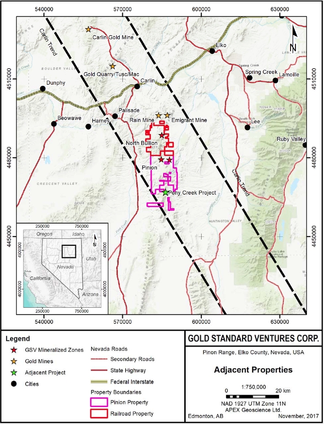
| Effective Date: November 3, 2017 | | | 181 |
Technical Report Maiden Resource Estimate North Bullion Railroad Project, Elko County, Nevada, USA
The Rain trend of mineralization is characterized by disseminated gold mineralization hosted in dominantly oxidized, silicified, dolomitized and barite rich collapse breccia with rare sulphides, developed along the Webb Formation mudstone/Devils Gate Limestone Formation contact and along the Rain Fault. Important ore-controlling features at Rain include the west-northwest striking Rain fault, the Webb/Devils Gate contact, collapse breccia and northeast striking faults. Along the Carlin Trend, and at the Rain, Saddle and Tess deposits, shallow oxide zones give way to deeper sulphide and carbon rich zones of substantial size and grade.
West-northwest striking structures, possibly similar in nature to the Rain Fault, are present within the Railroad–Pinion Project area. The west-northwest structure at Railroad appears to control the spatial distribution of the breccia and gold mineralization at North Bullion. At the Pinion Project the west-northwest structures appear to separate and partially control gold mineralization of the North Zone and the northern portion of the Main Zone. The structures parallel or are possibly coincident with a series of west-northwest fold axial planes.
The Emigrant Mine is a Carlin-style, sedimentary rock-hosted gold deposit that is located approximately four miles (seven kilometers) north-northeast of Gold Standard’s North Bullion Deposit. Newmont is currently mining the deposit through open pit methods and processing the ore at an onsite, run of mine heap leach operation with some crushing. Disseminated gold mineralization is hosted in oxidized, silicified, dolomitized and barite rich collapse breccia developed within the Webb Formation mudstone. Important ore-controlling features at Emigrant include the north-south-striking Emigrant Fault, collapse breccia and the Northeast Fault.
Open pit, oxide resource and reserve calculations for Newmont’s Carlin Trend operations are typically commingled into a single heading of “Carlin open pits, Nevada” category. In 2003, reserves at Emigrant were published at 1,220,000 ounces (Resselet al., 2015). No details were provided by Newmont as to the quality of the reserves. The mine is expected to produce roughly 80,000 ounces of gold over a ten plus year mine life and is currently in production (Harding, 2012).
Pony Creek is situated within the Piñon Range in the south-central Carlin trend and located approximately six miles (10 kilometers) south of Gold Standard’s Pinion Deposit. Significant structural features in the area include the Piñon Range anticline and Piñon graben. The gold mineralization at Pony Creek is interpreted to be Carlin-style, with mineralization hosted in north to northeast-trending shears in rhyolite intrusive and Mississippian to Permian age sediments proximal to the intrusive (Russell, 2006). Mineralization is associated with marcasite, pyrite, realgar, and stibnite occurring along fractures in the rhyolite intrusion, as well as in the matrix of the intrusion breccias. The most significant mineralization at Pony Creek is located in the Bowl area, with high grade mineralization controlled by a north-trending high angle fault zone, and lower grade mineralization occurring along the lower contact of the rhyolite intrusion with the underlying sediments (Gustin, 2017).
| Effective Date: November 3, 2017 | | | 182 |
Technical Report Maiden Resource Estimate North Bullion Railroad Project, Elko County, Nevada, USA
A total of 202 drillholes (126,594.5 ft (38,586 m)) were completed on the project from 1981 through 2007, and of these holes, at least 151 contained gold intercepts of at least 5 ft (1.5 m) of 0.010 oz/st (0.34 g/t) Au (Russell, 2006). Historic mineral resources have been estimated for Pony Creek although very limited information is provided on how the resources were calculated. Gustin (2017) stated that Newmont completed a resource estimation in 1983 (not classified) of 1.12 million tons (1.02 million tonnes) with 65,000 ounces of gold. The authors are treating this resource as historic in nature, therefore it should not be relied upon.
| 16 | Other Relevant Data and Information |
There are no additional data for the Railroad Project beyond that discussed in the preceding sections.
| 17 | Interpretation and Conclusions |
The Railroad–Pinion Project is located at the southeast end of the Carlin (Gold) Trend, a northwest alignment of sedimentary rock-hosted gold deposits in northeastern Nevada. The Carlin Trend comprises more than 40 separate gold deposits that have produced in excess of 80 million ounces of gold (Muntean, 2014). The Project is located in the Piñon Range of mountains and is centered on the southernmost of four domal features along the Carlin Trend (Jackson and Koehler, 2014). The domes are cored by igneous intrusions that uplift and expose Paleozoic rocks that are favorable for hosting Carlin-style gold deposits.
The Project consists of 53,569 gross acres (21,679 gross hectares) of subsurface mineral rights comprising 29,941 gross acres (12,117 gross hectares) that are owned 100 per cent ( %) as patented and unpatented lode mining claims and a further 23,628 gross acres (9,562 hectares) in subsurface mineral rights on private lands. The private land ownership ranges from 49.2 % to 100 % yielding a net position of 20,657 gross acres (8,360 gross hectares) of subsurface mineral rights for the private lands within the Railroad–Pinion Project Area. The estimated holding cost for the Patented mineral claims, private lands, and leased unpatented claims controlled by Gold Standard is US$951,427 per annum. Gold Standard’s estimated maintenance cost for the current package of unpatented lode claims is an additional US$273,487 per annum. Thus, the total cost for maintaining the current Property is US$1,224,914.
Gold Standard’s aggressive and on-going geologic model-driven exploration programs at the Railroad–Pinion Project since 2010 have confirmed and expanded previously identified zones of mineralization and have resulted in the discovery of several new zones and styles of mineralization. Currently, the Railroad–Pinion Project includes a variety of mineralization types: 1) classic Carlin-style disseminated gold in carbonate dissolution collapse breccia at the contact between Devonian carbonates and Mississippian siliciclastics at the Pinion and North Bullion deposits; 2) Carlin-style disseminated gold in silicified Pennsylvanian siliciclastic and carbonate rocks at the Dark Star Deposit; 3) stacked, tabular oxide gold and copper zones in quartz hornfels breccia at the Bald Mountain Target; and 4) skarn-hosted silver, copper, lead and zinc mineralization at the Central Bullion Target (Jackson and Koehler, 2014; Koehleret al., 2014; Turneret al., 2015; Dufresneet al., 2015).
| Effective Date: November 3, 2017 | | | 183 |
Technical Report Maiden Resource Estimate North Bullion Railroad Project, Elko County, Nevada, USA
This report is an update to the most recent Railroad–Pinion Technical Report by Dufresneet al. (2017). It details the maiden NI 43-101 Mineral Resource Estimation for the North Bullion, Sweet Hollow and POD gold deposits and summarizes work completed by GSV on the Railroad Project. In the opinion of the authors of this Technical Report, exploration techniques, sampling and analytical procedures employed by Gold Standard at the Railroad–Pinion Project are consistent with industry standards and are appropriate with respect to the type of mineral deposit(s) being explored and with respect to ensuring overall data quality and integrity.In addition, it is the opinion of the authors of this Technical Report that the Railroad–Pinion Project remains a ‘property of merit’ and warrants continued exploration and development work as detailed below.
| 17.1 | Exploration Work by Gold Standard Ventures |
Gold Standard has been exploring the Railroad–Pinion Project area since 2010, discovering new exploration targets and advancing known prospects and deposits by executing systematic, geological model-driven and aggressive exploration. Exploration work from 2010 to 2017 has consisted of geological mapping, geochemical and geophysical surveys, and drilling. Gold Standard has collected over 10,000 geochemical samples and completed geophysical surveys that cumulatively cover much of the Property. Prior to 2015, exploration activities by Gold Standard were focused on the Railroad Project. Work completed in 2015 was largely focused on the Pinion Project after it was acquired by Gold Standard in 2014. Work completed in 2016 focused primarily on the Dark Star deposit area, which included exploration at the Dark Star Main Zone, the Dark Star North Zone and along the Dark Star Corridor.
Gold Standard has conducted drilling on the Railroad–Pinion Project since 2010 to test the extent of known mineralization, support ongoing geological modelling and resolve current geological models. From 2010 to 2017, a total of 316 drillholes totalling 125,438.3 m (411,545.3 ft) were completed on the Railroad–Pinion Project. Drilling conducted by GSV in the Railroad Project area during 2010 and 2011 resulted in the discovery of the North Bullion gold deposit. Drilling conducted in the Railroad Project area during 2012 and 2013 confirmed and expanded a significant Carlin-style, disseminated gold system at the North Bullion Deposit, and identified new mineralized zones at the Bald Mountain and Sylvania (Central Bullion) targets (Koehleret al., 2014; Turneret al., 2015). Drilling conducted by Gold Standard in 2014 in the Railroad portion of the Project focused on the Bald Mountain prospect and intersected significant thicknesses of altered and brecciated lithologies hosting gold-silver-copper (Au-Ag-Cu) mineralization. Drilling at North Bullion during 2015 focused on expanding a zone of higher grade gold mineralization within the “lower collapse breccia”. In 2016, the drilling program at the Railroad portion of the Project area was designed to extend known mineralization and to test new targets at the Bald Mountain, North Bullion and Cherry Springs areas. The drilling at North Bullion extended the zone of known mineralization to the north and northwest (Dufresneet al., 2017). In early 2017, Gold Standard completed a total of 5 RC/core combination drillholes for the Railroad Project at North Bullion that totaled 2,442.4 m (8,013 ft). The North Bullion mineralized zone remains open in a number of directions and warrants further drilling. Continued drilling on the Bald Mountain and Sylvania (Central Bullion) targets is also recommended based upon early-stage drill results. Early-stage results from several other target areas at the Railroad portion of the Project area indicate that additional geological work and drilling is also warranted.
| Effective Date: November 3, 2017 | | | 184 |
Technical Report Maiden Resource Estimate North Bullion Railroad Project, Elko County, Nevada, USA
In early 2014, Gold Standard significantly increased its land position with the acquisition of the Pinion Project area, which is contiguous to the south with the Company’s original Railroad Project area (Koehleret al., 2014; Turneret al., 2015). The Pinion transaction comprised the acquisition of increased mineral rights on lands where the Company previously held a minority interest and acquisition of mineral rights on additional lands where the Company previously held no interest. The Pinion acquisition was part of an on-going effort to consolidate the mineral rights for the greater Railroad District. In April 2014, GSV announced a further consolidation of mineral rights at Bald Mountain within the Railroad Project area (see GSV Press Release dated April 1, 2014) and later announced the acquisition of lands and additional mineral rights within, and south of, the Pinion Project area covering the Dark Star and Dixie Creek gold prospects (see GSV Press Release dated December 11, 2014).
The acquisitions and mineral rights consolidation completed by the Company in 2014 represented an important step in the advancement of the overall Railroad–Pinion Project with the addition of three important gold prospects at Pinion, Dark Star and Dixie Creek. Work by Gold Standard at the Pinion Project area in 2014 comprised the compilation and review of historic data from the Pinion and Dark Star prospects and included a significant re-logging effort of archived Pinion core along with Pinion and Dark Star reverse circulation (RC) drillhole chip samples (Turneret al., 2015). An initial phase of drilling at the Pinion Deposit comprising 13 holes confirmed historic drilling assay results and the geological model for the deposit, which were utilized for a maiden NI 43-101 mineral resource estimate that was completed in September 2014 (Dufresneet al., 2014; Turneret al., 2015). In late 2014, a second phase of drilling comprising 44 RC holes was completed within the Pinion Deposit area and was successful in expanding the extent of gold mineralization. Drilling at the Railroad–Pinion Project in 2015 comprised 41 drillholes. The majority of the drillholes (24) were completed within the Pinion Deposit area and were primarily intended to step-out and extend the zone of mineralization established by the NI 43-101 Maiden Mineral Resource (Dufresneet al., 2014; Turneret al., 2015). The 2015 Pinion Deposit area drill program achieved a number of significant drill intercepts that extended the previously defined zone of mineralization to the north and to the south. The results of the 2015 drilling at the Pinion Deposit led to a revised geological model and resource estimation in 2016 (Dufresne and Nicholls, 2016). The 2016 updated and current Mineral Resource Estimate for the Pinion Deposit comprises an Indicated Mineral Resource of 31.61 million tonnes (34.84 million tons) grading 0.62 grams per tonne (g/t) or 0.018 ounces per short ton (oz/st) Au, totalling 630,300 ounces of gold, and an Inferred Mineral Resource of 61.08 million tonnes (67.33 million tons) grading 0.55 g/t (0.016 oz/st) Au, totalling 1,081,300 ounces of gold, using a lower cutoff grade of 0.14 g/t (0.004 oz/st) Au. In addition, the current resource comprises of an Inferred Mineral Resource of 92.69 million tonnes (102.17 million tons) grading 4.16 g/t (0.121 oz/st) Ag, using a lower cutoff that is based upon the gold block cutoff of 0.14 g/t (0.004 oz/st) Au (Dufresne and Nicholls, 2017). Twenty-five (25) drillholes were completed in 2016 at the Pinion Deposit. The drilling was designed to extend known zones of mineralization, provide “in-fill” data for specific zones, provide material for metallurgical testing, and to test the Irene target west of the Pinion Deposit and the Sentinel target to the north of the Pinion Deposit. The drill program resulted in the identification of the Sentinel target; a shallow oxidized mineralized stratigraphic zone open to the north and west. In addition, the Pinion mineralization was extended along the west and the southwest edge of the Pinion Deposit (Dufresneet al., 2017).
Thirteen drillholes were completed at the Dark Star prospect area located in the southern (Pinion) portion of the project during 2015 and identified significant gold mineralization. The drilling intersected a vertically extensive oxide gold zone hosted in variably silicified and quartz veined bioclastic debris flows and conglomerates within Pennsylvanian-Permian units that lie stratigraphically higher than the Devils Gate – Tripon Pass host to the Main Pinion Zone of gold mineralization. The final 2015 drillhole at Dark Star was a core hole (DS15-13), which twinned an RC hole (DS15-11) that had identified multiple significant intersections of gold mineralization approximately 500 m north of the Dark Star Main Zone. The primary focus of the 2016 Railroad–Pinion drill program was drilling at the Dark Star prospect area with 40 drillholes completed at the Main and North Zones and along the Dark Star Corridor. Drilling at the Dark Star area extended the mineralization of the Main Zone to the west and northwest and extended the zone of known mineralization into the new North Zone, joining the two targets (Dufresneet al., 2017). The results from the 2016 drilling at Dark Star led to a revised geological model and an updated NI 43-101 Mineral Resource Estimate by Dufresne and Nicholls (2017). The 2017 updated and current Mineral Resource Estimate for the Dark Star Deposit comprises an Indicated Mineral Resource of 15.38 million tonnes (16.95 million tons) grading 0.54 g/t (0.016 oz/st) Au, totalling 265,100 ounces of gold, and an Inferred Mineral Resource of 17.05 million tonnes (18.79 million tons) grading 1.31 g/t (0.038 oz/st) Au, totaling 715,800 ounces of gold, using a lower cutoff grade of 0.20 g/t (0.006 oz/st) Au (Dufresne and Nicholls, 2017).
| Effective Date: November 3, 2017 | | | 185 |
Technical Report Maiden Resource Estimate North Bullion Railroad Project, Elko County, Nevada, USA
In early 2017, Gold Standard significantly increased its land position with the acquisition of additional contiguous land to the south of the Dark Star and Pinion deposit areas (see GSV Press Release dated March 23, 2017). The land acquisition by Gold Standard is part of an on-going effort to consolidate the mineral rights for the greater Railroad District and to allow continued exploration of the southern strike extensions of the Dark Star Corridor.
| 17.2 | 2017 Maiden Railroad Mineral Resource Estimate |
Based upon historic drilling and Gold Standard drilling from 2010 to 2017, a maiden Mineral Resource Estimate is presented for the North Bullion, Sweet Hollow and POD gold deposits in the Railroad Project area. The Mineral Resource Estimate is reported in accordance with the Canadian Securities Administrators (CSA) NI 43-101 regulations and has been estimated using the Canadian Institute of Mining and Metallugy’s (CIM) “Estimation of Mineral Resources and Mineral Reserves Best Practice Guidelines” dated November 23rd, 2003 and CIM “Definition Standards for Mineral Resources and Mineral Reserves” dated May 10th, 2014.
The Railroad Project resources have been estimated within three dimensional solids that were created from cross-sectional lode interpretation based upon a database of 503 drillholes that were used to guide the geological and mineralization interpretation. The upper contact has been cut by the topographic surface. Grade estimation was based upon 6,941 samples from 232 holes that are within the mineralized lodes. Grade was estimated into a block model with parent block size of 10 m (X) by 10 m (Y) by 3 m (Z) and sub-blocked down to 5 m (X) by 5 m (Y) by 1.5 m (Z). A total of 272 bulk density samples situated within the mineralized wireframes were examined on a lode by lode basis. The average density for the lodes ranges from 2.33 grams per centimeter cubed (g/cm3) to 2.71 g/cm3 with an overall average bulk density of 2.68 g/cm3 for the Railroad Project Mineral Resources. Grade estimation of gold was performed using the Inverse Distance to the power of two (ID2) methodology. The Indicated and Inferred Mineral Resources are constrained within a drilled area that extends approximately 2.75 km along strike to the north, 0.95 km across strike to the east and up to 600 m below surface.
| Effective Date: November 3, 2017 | | | 186 |
Technical Report Maiden Resource Estimate North Bullion Railroad Project, Elko County, Nevada, USA
The North Bullion, Sweet Hollow and POD Mineral Resource Estimate is reported at a range of gold cutoff grades in Table 17.1 for both Indicated and Inferred categories. No portion of the current mineral resource has been assigned to the “Measured” category. The Sweet Hollow and POD oxide Indicated and Inferred Mineral Resource uses a cutoff grade of 0.14 g/t Au, which is constrained within an optimized pit shell and includes an Indicated Mineral Resource of 2.92 million tonnes at 0.96 g/t Au for 90,100 ounces of gold and an Inferred Mineral Resource of 3.36 million tonnes at 0.43 g/t Au for 46,600 ounces of gold. The North Bullion, Sweet Hollow and POD sulphide Inferred Mineral Resource uses a cutoff grade of 1.25 g/t Au, which is constrained within an optimized pit shell, and is comprised of 2.05 million tonnes at 2.60 g/t Au for 171,400 ounces of gold. The North Bullion underground Inferred Mineral Resource, which is reported at a 2.25 g/t Au lower cutoff grade, comprises 5.55 million tonnes at 3.29 g/t Au for 587,000 ounces of gold. Other cutoff grades are presented for review ranging from 0 g/t Au to 0.5 g/t Au for oxide pit constrained material, ranging from 1.0 g/t Au to 2.0 g/t Au for sulphide pit constrained material and 2.0 g/t Au to 3.0 g/t Au for sulphide underground constrained material (Tables 17.2 and 17.3). The pit constrained and underground constrained block modeled resources utilize a price of $US1,350/ounce for gold along with a number of generalized costs for Nevada Carlin-type mining operations to establish the recommended lower cutoff grades.
The 2017 North Bullion, Sweet Hollow and POD Mineral Resources for gold have been classified as comprising both Indicated and Inferred Mineral Resources according to recent CIM definition standards (Table 17.1). The classification of the Railroad Project resources was based on geological confidence, data quality, data density and grade continuity. No portion of the current mineral resource has been assigned to the “Measured” category. All reported mineral resources are constrained within a pit shell optimized using values of $US1,350/ounce for gold and a either 0.14 g/t lower cutoff for oxide material, 1.25 g/t lower cutoff for sulphide material or 2.25 g/t lower cutoff for underground sulphide material. Indicated and inferred mineral resources are not mineral reserves and do not have demonstrated economic viability. There has been insufficient exploration to define the inferred resources as an indicated or measured mineral resource, however, it is reasonably expected that the majority of the inferred mineral resources could be upgraded to indicated mineral resources with continued exploration.
Table 17.1. The North Bullion, Sweet Hollow and POD mineral resource estimate with cutoff grades*.
| Classification | Type | Au Cutoff Grade (gpt) | Tonnage (million metric tonnes) | Average Au Grade (gpt) | Contained Au** (troy ounces)*** |
Pit Constrained |
| Indicated | Oxide | 0.14 | 2.92 | 0.96 | 90,100 |
| Inferred | Oxide | 0.14 | 3.36 | 0.43 | 46,600 |
| Sulphide | 1.25 | 2.05 | 2.60 | 171,400 |
| Inferred Subtotal | 0.14, 1.25 | 5.42 | 1.25 | 218,000 |
Underground |
| Inferred | Sulphide | 2.25 | 5.55 | 3.29 | 587,700 |
Pit Constrained and Underground Inferred Total |
| Oxide/Sulphide | 0.14, 1.25, 2.25 | 10.97 | 2.28 | 805,800 |
| Effective Date: November 3, 2017 | | | 187 |
Technical Report Maiden Resource Estimate North Bullion Railroad Project, Elko County, Nevada, USA
* Mineral Resources are not Mineral Reserves. Mineral resources which are not mineral reserves do not have demonstrated economic viability. There has been insufficient exploration to define the Inferred Mineral Resources tabulated above as an Indicated or Measured Mineral Resource, however, it is reasonably expected that the majority of the Inferred Mineral Resources could be upgraded to Indicated Mineral Resources with continued exploration. There is no guarantee that any part of the mineral resources discussed herein will be converted into a mineral reserve in the future.
**The recommended reported resources are highlighted in bold and have been constrained within a $US1,350/ounce of gold optimized pit shell and/or an underground mining scenario utilizing a 2.25 g/t Au lower cutoff.
***Contained troy ounces may not add due to rounding.
Table 17.2. Sensitivity analysis of the Sweet Hollow and POD oxide mineral resource estimate for gold at various cutoff grades*.
| Classification* | Au Cutoff Grade (gpt) | Tonnage (million metric tonnes) | Average Au Grade (gpt) | Contained Au** (troy ounces)*** |
Indicated (Oxide) | 0.0 | 3.04 | 0.93 | 90,600 |
| 0.14** | 2.92 | 0.96 | 90,100 |
| 0.2 | 2.51 | 1.09 | 87,800 |
| 0.3 | 1.64 | 1.53 | 80,800 |
| 0.4 | 1.41 | 1.73 | 78,400 |
| 0.5 | 1.40 | 1.74 | 78,200 |
Inferred (Oxide) | 0.0 | 3.63 | 0.41 | 47,500 |
| 0.14** | 3.36 | 0.43 | 46,600 |
| 0.2 | 2.71 | 0.49 | 43,000 |
| 0.3 | 1.47 | 0.70 | 33,200 |
| 0.4 | 1.14 | 0.81 | 29,700 |
| 0.5 | 1.09 | 0.82 | 28,800 |
* Mineral Resources are not Mineral Reserves. Mineral resources which are not mineral reserves do not have demonstrated economic viability. There has been insufficient exploration to define the Inferred Mineral Resources tabulated above as an Indicated or Measured Mineral Resource, however, it is reasonably expected that the majority of the Inferred Mineral Resources could be upgraded to Indicated Mineral Resources with continued exploration. There is no guarantee that any part of the mineral resources discussed herein will be converted into a mineral reserve in the future.
**The recommended reported resources are highlighted in bold and have been constrained within a $US1,350/ounce of gold optimized pit shell.
***Contained troy ounces may not add due to rounding.
Table 17.3. Sensitivity analysis of the North Bullion, Sweet Hollow and POD sulphide mineral resource estimate for gold at various cutoff grades*.
| Classification | Au Cutoff Grade (gpt) | Tonnage (million metric tonnes) | Average Au Grade (gpt) | Contained Au (troy ounces)**** |
Inferred (Near Surface Sulphide) | 1.0 | 2.20 | 2.50 | 176,700 |
| 1.25** | 2.05 | 2.60 | 171,400 |
| 1.5 | 1.85 | 2.73 | 162,200 |
| 1.75 | 1.66 | 2.86 | 152,400 |
| 2.0 | 1.35 | 3.09 | 133,800 |
Inferred (Underground Sulphide) | 2.0 | 6.87 | 3.07 | 678,000 |
| 2.25*** | 5.55 | 3.29 | 587,700 |
| 2.5 | 4.31 | 3.55 | 492,800 |
| 2.75 | 3.15 | 3.90 | 394,900 |
| 3.0 | 2.52 | 4.16 | 336,300 |
| Effective Date: November 3, 2017 | | | 188 |
Technical Report Maiden Resource Estimate North Bullion Railroad Project, Elko County, Nevada, USA
* Mineral Resources are not Mineral Reserves. Mineral resources which are not mineral reserves do not have demonstrated economic viability. There has been insufficient exploration to define the Inferred Mineral Resources tabulated above as an Indicated or Measured Mineral Resource, however, it is reasonably expected that the majority of the Inferred Mineral Resources could be upgraded to Indicated Mineral Resources with continued exploration. There is no guarantee that any part of the mineral resources discussed herein will be converted into a mineral reserve in the future.
** The recommended reported resources are highlighted in bold and have been constrained within a $US1,350/ounce of gold optimized pit shell.
*** The recommended reported resources are highlighted in bold and have been constrained within a $US1,350/ounce of gold underground mining scenario.
**** Contained troy ounces may not add due to rounding.
| 17.3 | Other Railroad–Pinion Project Prospects |
Based upon a review of available historical information and recent data from the on-going exploration work by GSV at other prospect areas throughout the Railroad–Pinion Project area, the authors conclude:
| · | Sixteen target areas have been identified by Gold Standard for additional exploration at the Railroad portion of the Project area (Koehleret al., 2014). The targets are focused on gold, but also include silver, copper, lead and zinc. Nine of these targets have been drilled by Gold Standard. Although Gold Standard has drilled and conducted extensive work in these areas, and historic work has been completed in others, sampling and drilling of sufficient density to determine the distribution and continuity of gold mineralization at most of the other targets at the Railroad Project is not yet sufficient to establish a mineral resource or reserve, with the exception of North Bullion, Sweet Hollow and POD. |
| · | Gold Standard has continued to confirm the presence of an important sedimentary rock-hosted gold system at the North Bullion Target. Drilling to date has intersected Carlin-style gold mineralization with high grades in a number of intercepts and continues to indicate that the North Bullion discovery is a significant sulphide refractory gold deposit that remains open in multiple directions. Continued step-out and offset drilling is warranted for the lower collapse breccia zone. Further work, including additional drilling to expand the current mineral resource and to provide material for metallurgical work to characterize the North Bullion Deposit is warranted. |
| · | Gold Standard has confirmed the discovery of a new sedimentary rock-hosted gold and copper system hosted in oxidized, brecciated and hornfelsed rocks at the Bald Mountain Target. Drill results from 2013 to 2016 indicate this is a significant polymetallic discovery that remains open in all directions. Continued drilling is warranted. |
| · | Gold Standard has confirmed the discovery of a new silver, copper, lead and zinc skarn system at the Sylvania (Central Bullion) Target. Prior drill results indicate this is a significant polymetallic discovery that remains open in all directions. Continued drilling is warranted. |
| · | Initial drill results along the Bullion Fault Corridor Target confirmed that a Carlin-style hydrothermal system associated with igneous dikes is present to the south of the North Bullion Target. The North Bullion Deposit and the Pinion Deposit occur in the immediate footwall of the Bullion Fault. However, much of the +5 mile-long strike of the Bullion Fault Corridor remains untested by drilling. Additional drilling is warranted. |
| Effective Date: November 3, 2017 | | | 189 |
Technical Report Maiden Resource Estimate North Bullion Railroad Project, Elko County, Nevada, USA
| · | Drill tested areas adjacent to and below the pit constrained and/or underground constrained North Bullion, Sweet Hollow and POD Mineral Resources, have good potential to expand the current mineral resource or provide additional mineral resources with added drilling. A near surface oxide target outside of the Sweet Hollow to POD mineral resource provides the potential of 3 million to 6 million tonnes at a grade of 0.3 to 0.5 g/t Au (yielding a target of 30,000 up to 100,000 ounces of gold). In addition, prior drilling of several areas of sulphide mineralization outside of the North Bullion, Sweet Hollow and POD resources provide an exploration target of 8 to 27 million tonnes with a grade of 1.1 to 1.7 g/t Au (300,000 up to 1,475,000 ounces of gold). The potential quantity and size are conceptual in nature. There has been insufficient exploration to define a mineral resource. It is uncertain if further exploration will result in the target being delineated as a mineral resource, however, further drilling is warranted. |
| · | Further exploration, including fieldwork and drilling, is warranted at other targets in the Pinion portion of the Project area including the Dark Star and Dixie Creek area, as well as at the Ski Track Graben trend which includes the Papoose Canyon, Papoose Canyon North, Jasperoid Wash, Black Rock, and JR Buttes targets. |
| · | Additional drilling is warranted along strike to the north and south of the Dark Star Deposit along the recently identified Dark Star Corridor. |
Gold Standard’s Railroad–Pinion Project is located at the southeast end of the Carlin (Gold) Trend, a northwest alignment of sedimentary rock-hosted gold deposits in northeastern Nevada where more than 40 separate gold deposits that have produced in excess of 80 million ounces of gold to date (Muntean, 2014). The Project is centered on the fourth and southernmost dome-shaped window on the Carlin Trend in the Piñon Range (Jackson and Koehler, 2014). The domes are cored by igneous intrusions that uplift and expose Paleozoic rocks and certain stratigraphic contacts that are favorable for the formation of Carlin-style gold deposits. The project area covers a significant portion of the southernmost structural window within the Carlin Trend that exposes prospective Upper Paleozoic – Permian units that host gold mineralization often associated with multilithic collapse breccias elsewhere in the district and comprises a number of gold target areas. Exploration over the last three years has resulted in the identification of significant maiden NI 43-101 mineral resource estimates for gold at the Pinion and Dark Star deposits. Historic work and exploration conducted by Gold Standard since 2010 has identified several other significant zones of gold and base metal mineralization within the Railroad–Pinion Project that warrant further exploration.
The combined Railroad–Pinion Project was the subject of recent Technical Reports (Koehleret al., 2014; Turneret al., 2015; Dufresne and Koehler, 2016, Dufresneet al., 2017) in which detailed recommendations were outlined for both the Railroad and Pinion portions of the Project area. Recent work completed at the Railroad–Pinion Project by GSV has been focused on the Pinion and Dark Star deposits and thus the recommendations made in Koehleret al. (2014), Turneret al. (2015) and Dufresne and Koehler (2016) pertaining to the Railroad target areas remain valid. This report details the maiden NI 43-101 Mineral Resource Estimate for the North Bullion, Sweet Hollow and POD gold deposits within the Railroad portion of the Project. Further aggressive exploration, including drilling, is warranted at Railroad aimed at expanding and improving the confidence in the existing mineral resources. The following section discusses recommendations for future work specific to the entire Project area.
| Effective Date: November 3, 2017 | | | 190 |
Technical Report Maiden Resource Estimate North Bullion Railroad Project, Elko County, Nevada, USA
Based upon the results to date, the authors recommend an aggressive exploration program for the Railroad–Pinion Project area involving surface exploration (mapping and geochemical sampling), additional exploration drilling, resource expansion and infill drilling, along with continued metallurgical test work. The combined Railroad–Pinion Project has been the subject of a number of recent Technical Reports in which detailed recommendations were outlined for both the Railroad and Pinion portions of the Project area. Recent work completed at the Railroad–Pinion Project by GSV has been focused on the Pinion and Dark Star deposits and thus the recommendations made in Koehleret al. (2014), Turneret al. (2015) and Dufresne and Koehler (2016) pertaining to the Railroad target areas remain valid. This report details maiden NI 43-101 Mineral Resource Estimates for the North Bullion, Sweet Hollow and POD gold deposits and summarizes previous work at the Railroad–Pinion Project. Further aggressive exploration, including drilling, is warranted at North Bullion, Sweet Hollow and POD aimed at expanding and improving the confidence in the existing mineral resource. The North Bullion, Sweet Hollow and POD deposits require metallurgical characterization of the gold zones with initial gold cyanide shake, bottle roll and column testing of oxide and mixed oxide-sulphide material, along with floatation and roaster testing of sulphide dominated material.
With respect to the Railroad Project area, additional in-fill and step-out drilling is warranted at the North Bullion, Sweet Hollow, POD, Bald Mountain and Sylvania (Central Bullion) target areas. Further reconnaissance drilling is recommended for several other target areas including the Cherry Springs, Bullion Fault Corridor, Railroad, North Ridge and Lee Canyon areas. Continued fieldwork comprising geological mapping, geochemical surveying and geophysical surveying is also warranted throughout the property to identify and refine additional drill targets. The results of gravity and CSAMT surveys completed to date at the Railroad Project are encouraging and the continued use of these techniques is strongly recommended. Additional geophysical surveying, including seismic lines, is recommended in the North Bullion area where thick volcanic rock sequences or colluvium conceal target opportunities. Continued geological modelling and resource estimation is recommended for the North Bullion mineralized zones along with additional metallurgical investigations and, possibly, preliminary engineering studies. The results of the modelling exercise may assist target definition for the proposed in-fill and step-out drilling that is warranted at North Bullion.
An aggressive exploration program is warranted for the Pinion Project area involving surface exploration, additional exploration drilling, resource expansion and infill drilling, along with continued metallurgical test work. The focus should be on the Dark Star Corridor and to a degree on the ground between the Dark Star and Pinion deposit areas. The authors recommend additional soil sampling to expand upon and fill in gaps to the existing database and to cover potential strike extensions of the mineralization to the south, and southeast at Pinion along with better geochemical coverage of the newly acquired ground to the south of Pinion and Dark Star. Additional geophysical surveying including gravity, CSAMT and seismic surveys for the deposit areas and project area is strongly recommended to provide data to assist the targeting of infill, step-out and exploration drilling. Continued geological mapping and rock sampling is recommended across the entire Project area in order to continue to improve the geological knowledge base. Exploration and some infill confirmation drilling are required at Dark Star. A Preliminary Economic Assessment (PEA) that includes both Pinion and Dark Star is warranted and is in progress.
| Effective Date: November 3, 2017 | | | 191 |
Technical Report Maiden Resource Estimate North Bullion Railroad Project, Elko County, Nevada, USA
Table 18.1. Railroad–Pinion Project recommended exploration plan and budget*.
| Drilling |
| Target Area (Type) | Cost/ft (All-in) | Cost/m (approx.) | Quantity (ft) | Quantity (m) | Cost |
| North Bullion Area (RC) | $70/ft | $230/m | 13,000 | 3,960 | $910,000 |
| North Bullion Area (core) | $120/ft | $394/m | 9,000 | 2,750 | $1,080,000 |
Bald Mountain, Steve’s Camp and Sylvania (RC) | $54/ft | $177/m | 15,000 | 4,570 | $810,000 |
| Sentinel Breccia (RC) | $73/ft | $240/m | 12,000 | 3,660 | $876,000 |
| Sentinel Breccia (core) | $147/ft | $482/m | 600 | 180 | $88,000 |
| North and West Dark Star (RC) | $57/ft | $187/m | 36,000 | 10,965 | $2,052,000 |
| North and West Dark Star (core) | $104/ft | $341/m | 5,000 | 1,525 | $520,000 |
| Dark Star Corridor (RC) | $57/ft | $187/m | 37,500 | 11,420 | $2,138,000 |
| Ski Track (RC) | $59/ft | $194/m | 20,000 | 6,100 | $1,180,000 |
| Pinion Met. (core) | $129/ft | $423/m | 8,800 | 2,700 | $1,135,000 |
| Dark Star Met. (core) | $93/ft | $305/m | 3,200 | 970 | $298,000 |
| Drilling Subtotal | 160,100 | 48,799 | $11,087,000 |
Property Wide Activities |
| Activity Type | | Cost |
| Geological Mapping & Consulting | | $45,000 |
| CSAMT Surveying | | $145,000 |
| Gravity Surveying | | $160,000 |
| Seismic Surveying | | $120,000 |
| Geochemical Sampling | | $450,000 |
| Metallurgical Testwork | | $1,030,000 |
| PEA (Study and Report) | | $175,000 |
| Resource Modeling & Scoping Studies | | $240,000 |
| Bonding / Environmental | | $775,000 |
| Earthwork / Reclamation | | $815,000 |
| Database Management | | $40,000 |
| Property Maintenance | | $1,225,000 |
| Property Wide Activities Subtotal | $5,220,000 |
Contingency (7 %) | $1,143,000 |
| Grand Total | $17,450,000 |
| | | | | | | |
*All costs are in US Dollars and are rounded to the nearest $1,000.00
| Effective Date: November 3, 2017 | | | 192 |
Technical Report Maiden Resource Estimate North Bullion Railroad Project, Elko County, Nevada, USA
In addition, the acquisition of new ground to the south of Dark Star and Pinion and the 2014 - 2016 fieldwork and prior exploration have identified a number of exploration targets outside of the Pinion and Dark Star deposit areas that warrant future exploration drill testing. Further field work comprising geological, geochemical and geophysical surveys is recommended for the remainder of the Pinion Project area with particular attention paid to the Ski Track trend (the JR Butte-Papoose trend) located west of the Pinion Deposit, the Dark Star Corridor and much of the new lands south of Pinion and Dark Star areas centered around Jasperoid Wash.
The authors recommend a total of 11,280 m (37,000 ft) of RC and core drilling for the Railroad Project area for a total cost of US$2,800,000 for 2017-2018. In addition, a total of 37,520 m (123,100 ft) is recommended for the Pinion Project area in 2017-2018 at an additional estimated cost of US$8,287,000. In addition to the drilling, other recommended exploration activities at the Railroad–Pinion Project include geological mapping, geochemical sampling, and ground geophysical surveys (controlled source audio-frequency magnetotellurics (“CSAMT”), gravity and seismic) as well as a number of metallurgical, engineering and environmental studies. The estimated cost to conduct the proposed property wide exploration activities over the entire Railroad–Pinion Project area is US$5,220,000. The recommended drilling at the Railroad and Pinion Project area along with other geological, geophysical, engineering and environmental studies and a contingency of ~7 % yields an overall budget to complete the recommended work of US$17,450,000 (Table 18.1).
It is the opinion of the authors of this Technical Report that all of the recommended work is warranted at this time and none is contingent upon the results of any other part of the program.
APEX Geoscience Ltd. | | APEX Geoscience Ltd. |
 | | 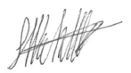 |
| Michael B. Dufresne, M.Sc., P.Geol., P.Geo. | | Steven J. Nicholls, BA Sc (Geology), M AIG. |
| Effective Date: | | September 15, 2017 |
| Signing Date: | | November 3, 2017 |
| | | Edmonton, Alberta, Canada |
| | | Perth, Western Australia, Australia |
| Effective Date: November 3, 2017 | | | 193 |
Technical Report Maiden Resource Estimate North Bullion Railroad Project, Elko County, Nevada, USA
American Selco Incorporated, 1970. Review of Field Investigations, 1968, and Proposed Exploration Program for 1969 in the Railroad Mining District Elko County, Nevada, prepared for the Directors of Aladdin Sweepstake Consolidated Mining Company.
Arthur, B., 2013. Roaster Tests on Rail Road Ore 2013-OP-003, Newmont Mining Corporation memo.
Bartels, Ed, 1999. Railroad Project, Pod Area Sectional Resource Calculation, Kinross Gold U.S.A, Inc., internal company memorandum.
Bettles, K., 2002. Exploration and Geology, 1962-2002, at the Goldstrike Property, in Thompson, T.B., Teal, L., and Meeuwig, R., eds., Gold Deposits of the Carlin Trend: Nevada Bureau of Mines and Geology Bulletin 111, p. 54-75.
Bharti Engineering, 1996. Preliminary Assessment of the South Bullion Deposit, confidential internal report, 5p.
Calloway, V. 1992. Exploration Summary, Results and Recommendations for the Cord Ranch Lease, Elko County, Nevada, Crown Resources internal report, 78p.
CIM, 2010. CIM Definition Standards-For Mineral Resources and Mineral Reserves.
Clode, C.H., Grusing, S.R., Johnston, I.M., and Heitt, D.G., 2002. Geology of the Deep Star Gold Deposit, in Thompson, T.B., Teal, L., and Meeuwig, R., eds., Gold Deposits of the Carlin Trend: Nevada Bureau of Mines and Geology Bulletin 111, p. 76-90.
DeMatties, T.A., 2003. NI 43-101 Technical Report: An Evaluation of the Pinion Gold Property, Elko County, Nevada, USA. Dated January 20, 2003. Prepared for Royal Standard Minerals Inc.
Dufresne, Michael B. and Koehler, Steven R., 2016. Technical Report on the Railroad and Pinion Project, Elko County, Nevada USA. Unpublished Technical Report (NI43-101 compliant) prepared for Gold Standard Ventures Corp. dated March 30, 2016, 217p.
Dufresne, Michael B., Koehler, Steven R. And Jackson, Mac R., 2017. Technical Report on the Railroad - Pinion Project, Elko County, Nevada USA. Unpublished Technical Report (NI43-101 compliant) prepared for Gold Standard Ventures Corp. dated March 30, 2017, 251p.
Dufresne, Michael B. and Nicholls, Steven J., 2016. Technical Report Updated Resource Estimate Pinion Project, Elko County, Nevada USA. Unpublished Technical Report (NI43-101 compliant) prepared for Gold Standard Ventures Corp. dated April 29, 2016, 220p.
Dufresne, Michael B. and Nicholls, Steven J., 2017. Technical Report and Mineral Resource Update Dark Star Project, Elko County, Nevada, USA. Unpublished Technical Report (NI43-101 compliant) prepared for Gold Standard Ventures Corp. dated August 11, 2017, 234p.
Dufresne, Michael B., Nicholls, Steven J. and Turner, Andrew, 2014. Technical Report Maiden Resource Estimate Pinion Project, Elko County, Nevada USA. Unpublished Technical Report (NI43-101 compliant) prepared for Gold Standard Ventures Corp., dated October 24, 2014, 141p.
Dufresne, Michael B., Nicholls, Steven J. and Turner, Andrew, 2015. Technical Report Maiden Resource Estimate Dark Star Deposit, Elko County, Nevada USA. Unpublished Technical Report (NI43-101 compliant) prepared for Gold Standard Ventures Corp. dated April 17, 2015, 179p.
| Effective Date: November 3, 2017 | | | 194 |
Technical Report Maiden Resource Estimate North Bullion Railroad Project, Elko County, Nevada, USA
Emmons, W.H. 1910. A Reconnaissance of Some Mining Camps in Elko, Lander and Eureka Counties, Nevada, U.S. Geological Survey Bulletin 408.
Faillers, Jeff N., 2014. Title Report Update (Ownership) on Unpatented Claims and Leased Properties, Pinon Project, Elko County, Nevada. Unpublished letter report prepared by Harris & Thompson Attorneys for Gold Standard Ventures Corp. dated March 4, 2014.
Galey, John T., 1983. Appraisal, Railroad Project, Elko County, Nevada, AMAX Exploration, Inc., internal company report
Gold Standard Ventures Corp., 2014a. Gold Standard Completes Consolidation of Bald Mountain Land Position & Provides Exploration Update, unpublished company news release dated April 1, 2014.
Gold Standard Ventures Corp., 2014b. Gold Standard Ventures Closes Deal to Expand its Pinion and Dark Star Land Positions in Carlin Trend, Nevada, unpublished company news release dated December 11, 2014.
Gold Standard Ventures Corp., 2016. Gold Standard Increases the Oxide Gold Resource in an Updated Mineral Resource Estimate at the Pinion Deposit, unpublished company news release dated March 15, 2016.
Gold Standard Ventures Corp., 2017a. Gold Standard Acquires Strategic Claims Immediately South of Dark Star and Pinion Deposits in Nevada’s Carlin Trend, unpublished company news release dated March 23, 2017.
Gold Standard Ventures Corp., 2017b. Annual Information Form for the Year Ended December 31, 2016 (Dated March 31, 2017), Annual Information Form, p 133.
Gold Standard Ventures Corp., 2017c. Gold Standard to Commence Drilling at the Dark Star Oxide Gold Deposit and at the North Bullion Deposit, unpublished company news release dated May 9, 2017.
Gold Standard Ventures Corp., 2017d. Gold Standard Reports Cyanide Soluble Recoveries of +88% for the Dark Star Oxide Gold Deposit, unpublished company news release dated April 10, 2017
Gold Standard Ventures Corp., 2017e. Gold Standard Reports Increased Oxide Gold Resource and Approval of an Exploration at the Dark Star Deposit, Carlin Trend, Nevada, unpublished company news release dated June 29, 2017.
Gold Standard Ventures Corp., 2017f. Gold Standard Reports a Maiden Resource Estimate for Its North Bullion Deposit at Its Railroad-pinion Project, unpublished company news release dated September 21, 2017.
Gustin, M.M., 2017. Technical Report on the Pony Creek Gold Project, Elko County, Nevada, USA. Carlin-Opportunities Inc., 10p.
Harding, A., 2012. Mining to Start Soon at Emigrant, in Mining Quarterly Spring 2012, Elko Daily Free Press, p. 30-34.
Harp, Michael T. and Edie, Robert J. 2015. Dark Star Geology. Gold standard Ventures Corp. internal company report, 2p.
Harp, M.T., Edie, R.J., Jackson, M.R., Koehler, S.R., Norby, J.W., Whitmer, N.E., Moore, S., and Wright, J.L., 2016. New Discovery within the Dark Star Corridor, Railroad–Pinion District, Elko County, Nevada (abst): Association for Mineral Exploration British Columbia, Mineral Exploration Roundup 2016, Vancouver, abstract volume, p. 44.
| Effective Date: November 3, 2017 | | | 195 |
Technical Report Maiden Resource Estimate North Bullion Railroad Project, Elko County, Nevada, USA
Henry, C.D., Jackson, M.R., Mathewson, D.C., Koehler, S.R., and Moore, S.C., 2015. Eocene igneous geology and relation to mineralization: Railroad District, southern Carlin trend, Nevada: Geological Society of Nevada, New Concepts and Discoveries, W.M. Pennell and L.J. Garside, eds., 2015 Symposium Volume, Reno/Sparks, Nevada, p. 939–965.
Hunsaker III, E.L., 2010. Technical Report on the Railroad Project, Elko County, Nevada, USA. Unpublished Technical Report prepared for Gold Standard Ventures Corp (NI43-101 compliant) and dated May 9, 2010, 67p.
Hunsaker III, E.L., 2012a. Technical Report on the Railroad Project, Elko County, Nevada, USA. Unpublished Technical Report prepared for Gold Standard Ventures Corp (NI43-101 compliant) dated February 15, 2012, 78p.
Hunsaker III, E.L., 2012b. Amended and Restated Technical Report on the Railroad Project, Elko County, Nevada, USA. Unpublished Technical Report prepared for Gold Standard Ventures Corp (NI43-101 compliant) dated April 18, 2012, 82p.
Jackson, M.R., 2013. North Bullion Tectono-Stratigraphic Column. Unpublished geologic compilation.
Jackson, M.R. and Koehler, S.R., 2014. Carlin-style Gold and Polymetallic Targets within a Large Eocene, Magmato-thermal System on the Carlin Trend, Nevada, Abstract for the AMEBC Mineral Exploration Roundup 2014, Vancouver, British Columbia.
Jackson, M.R., Mathewson, D.C., Koehler, S.R., Harp, M.T., Edie, R.J., Whitmer, N.E., Norby, J.W., and Newton, M.N., 2015. Geology of the North Bullion Gold Deposit: Eocene Extension, Intrusion and Carlin-style Mineralization, the Railroad District, Carlin Trend, Nevada, in New Concepts and Discoveries, Pennell, W.M., and Garside, L.J., eds., Geological Society of Nevada 2015 Symposium, Reno, Nevada, p. 313-331.
Jones, William C. and Postlethwaite, Clay, 1992. Pieretti Land Block, Pieretti Ranch and Pinon Projects, Elko and Eureka Counties, Nevada, dated April, 1991, 148 p.
Kappes, Cassiday & Associates, 2006. Pinion Railroad Project Report Of Metallurgical Test Work, March, 2006, Project 126C, File 7355. Unpublished Confidential Report Prepared on Behalf of Royal Standard Minerals, 146 p.
Ketner, K.B. and Smith Jr., J.F., 1963. Geology of the Railroad mining district, Elko County, Nevada, U.S. Geological Survey Bulletin 106.
Koehler, Steven R., Dufresne, Michael B. and Turner, Andrew, 2014. Technical Report on the Railroad and Pinion Projects, Elko County, Nevada USA. Unpublished Technical Report prepared for Gold Standard Ventures Corp. (NI43-101 compliant) dated March 31, 2014, 158p.
Koehler, S.R, Jackson, M.R., Harp, M.T., Edie, R.J., Whitmer, N.E., Mathewson, D.C., Norby, J.W. and Henry, C., 2015. Precious and Base Metal Mineralization within a large Eocene, Magmato-Thermal System, Railroad District, Carlin Trend, Nevada, in New Concepts and Discoveries, Pennell, W.M., and Garside, L.J., eds., Geological Society of Nevada 2015 Symposium, Reno, Nevada, p. 1229-1242.
| Effective Date: November 3, 2017 | | | 196 |
Technical Report Maiden Resource Estimate North Bullion Railroad Project, Elko County, Nevada, USA
Kuhl, T. F., 1985. Geological Ore Reserves, Railroad Project, Elko County, Nevada, NICOR Mineral Ventures, internal company memorandum.
LaPointe, Daphne, D., Tingley, Joseph V., and Jones, Richard B., 1991. Mineral Resources of Elko County, Nevada, Nevada Bureau of Mines and Geology Bulletin 106
Longo, Anthony A., Thompson, Tommy B., and Harlan J. Bruce, 2002. Geologic Overview of the Rain Subdistrict, in: Gold Deposits of the Carlin Trend, edited by Tommy B. Thompson, Lewis Teal, and Richard O. Meeuwig, Nevada Bureau of Mines and Geology Bulletin 111.
Macy, F.A., 1992. McClelland Laboratories Inc. Results of 59 Cyanide Solubility Tests Performed on
Masters, T.D., 2003a. Gold Resource Calculations of the POD Gold Zone at Railroad Bullion. Unpublished Report Prepared by Royal Standard Minerals Inc. dated February 26, 2003, 8p.
Masters, T. D., 2003b. History, Geology, Resources, Discovery Potential and proposed Exploration Drilling Program for the Pinion – Railroad Project, Nevada. Unpublished Report Prepared by Royal Standard Minerals Inc. dated July 30, 2003, 38p.
Mathewson, David, C., 2001. Tectono-Stratigraphic Setting for the Rain District Gold Deposits, Carlin Trend, Nevada, in: Shaddrick, D.R., Zbinden, E.A., Mathewson, D.C. and Prenn, C. (eds.) Regional Tectonics and Structural Control of Ore: The Major Gold Trends of Northern Nevada, Geological Society of Nevada Special Publication 33.
McComb, M., 2013. Petrographic Examination of 18 Samples from the Bald Mountain Project, Nevada. Unpublished Memo prepared by McComb Petrographic for Gold Standard Ventures Corp., 111p.
McComb, M., 2014. Mineralogical Characterization of Three Samples from the Railroad Property, Nevada, Newmont Mining Corporation – Metallurgical Services memo NM216202
McComb, M., 2016. Petrographic Examination of Fourteen Core Samples from Dark Star Project, Nevada. Unpublished Memo prepared by McComb Petrographic for Gold Standard Ventures Corp., 124p.
McCusker, R. and Drobeck, P., 2012. Piñon Project Summary. Prepared for Royal Standard Minerals Inc.
McPartland, J.S., 1995. Cyanidation Testwork – South Bullion Samples. McLelland Laboratories Inc., Sparks, Nevada.
Muntean, J.L. 2014. Overview - The Nevada Mineral Industry 2012 in Nevada Bureau of Mines and Geology Special Publication MI-2012, Mackay School of Earth Sciences and Engineering, College of Science, University of Nevada, Reno, Nevada, USA, p 3-12.
Newton, M.N., 2015. Characterization of Gold and Related Mineralization at the North Bullion Carlin System, Railroad Project, a Nevada Carlin-Type Gold Prospect. A thesis submitted in partial fulfillment of the requirements for the Master of Science – Geosciences Department, University of Nevada, Las Vegas December, 2015.
Newton, M.N. and Cline, Dr. J.S., 2014. Characterization of Gold and Related Mineralization at the North Bullion Deposit, Railroad Project, A Nevada Carlin-Type Gold Prospect, Abstract for the AMEBC Mineral Exploration Roundup 2014, Vancouver, British Columbia.
| Effective Date: November 3, 2017 | | | 197 |
Technical Report Maiden Resource Estimate North Bullion Railroad Project, Elko County, Nevada, USA
Norby, John W and Orobona, Michael J.T., 2002. Geology and Mineral Systems of the Mike Deposit, in: Gold Deposits of the Carlin Trend, edited by Tommy B. Thompson, Lewis Teal, and Richard O. Meeuwig, Nevada Bureau of Mines and Geology Bulletin 11, p. 143-167.
Norby, J.W., Edie, R.J., Harp, M.T., Jackson, M.R., Koehler, S.R., Mathewson, D.C., Moore, S., Whitmer, N.E., and Wright, J.L., 2015. Pinion Gold Deposit, Elko County, Nevada, in New Concepts and Discoveries, Pennell, W.M., and Garside, L.J., eds., Geological Society of Nevada 2015 Symposium, Reno, Nevada, p. 169-189.
Norby, J.W., Edie, R.J., Harp, M.T., Jackson, M.R., Koehler, S.R., and Whitmer, N.E., 2016. Pinion Gold Deposit, Railroad District, Elko County, Nevada, USA (abst): Association for Mineral Exploration British Columbia, Mineral Exploration Roundup 2016, Vancouver, abstract volume, p. 89-91.
Nordquist, William A., 1992. Railroad Project, Elko County Nevada 1991 Annual Report, Westmont Gold Inc., internal company report
Parr, Andrew, J., 1998. Pinon Project, Elko County Nevada, 1997 Exploration Report, Cameco (US) Inc, internal company report.
Parr, Andrew, J., 1999. Pinon and Jasperoid Wash Projects, Elko County Nevada, 1999 Exploration Report, Cameco (US) Inc, internal company report.
Rayias, Alexa C., 1999. Stratigraphy, Structural Geology, Alteration, and Geochemistry of the Northeastern Railroad District, Elko County, Nevada, University of Nevada-Reno M.S. Thesis.
Redfern, R. R., 2002, Geological Report on the Dixie Creek Property, Report for Frontier Pacific Mining Corporation, 34 p.
Ressel, M.W., 2000. Summary of research on igneous rocks and gold deposits on the Carlin Trend, Nevada: Ralph J. Roberts Center for Research in Economic Geology Annual Research meeting-1999, Program and Reports, 38 p.
Russell, R. H., 2006, Evaluation of the Gold Resource on the Pony Creek Property, Report for Vista Gold Corp. and Allied Nevada Gold Corp., 130 p.
Ressel, M.W., Dendas, M., Lujan, R., Essman, J. and Shumway, P.J., 2015. Shallow Expressions of Carlin-type Hydrothermal Systems: An Example from the Emigrant Mine, Carlin Trend, Nevada, p409-433.
Shaddrick, D.R., 2012. Technical Report on the Railroad Project, Elko County, Nevada, USA report prepared for Gold Standard Ventures Corp (NI43-101 compliant).
Smith, J.F., and Ketner, K.B., 1975. Stratigraphy of Paleozoic Rocks, Carlin-Piñon Range area, Nevada, U.S. Geological Survey Professional Paper 867-A.
Stewart, J.H., 1980. Geology of Nevada: Nevada Bureau of Mines and Geology Special Publication 4, 136 p.
Teal, Lewis and Jackson, Mac, 1997. Geologic Overview of the Carlin Trend Gold Deposits and Description of Recent Deep Discoveries, in Carlin-Type Gold Deposits Field Conference edited by Peter Vikre, Tommy B. Thompson, Keith Bettles, Odin Christensen, and Ron Parratt, Society of Economic Geologists Guidebook Series, Volume 28, p 3-37.
| Effective Date: November 3, 2017 | | | 198 |
Technical Report Maiden Resource Estimate North Bullion Railroad Project, Elko County, Nevada, USA
Turner, Andrew, Dufresne, Michael B. and Koehler, Steven R., 2015. Technical Report on the Railroad and Pinion Projects, Elko County, Nevada USA. Unpublished Technical Report prepared for Gold Standard Ventures Corp. (NI43-101 compliant) dated March 31, 2015, 196p.
Wells, R.A., 1995. Pinion/South Bullion Deposit Resource Estimates. Cyprus Metals Exploration Corporation internal memorandum.
Western Regional Climate Center Historic Climate Information, Carlin Newmont Mine, Nevada, 2011. Administered by N.O.A.A. http://www.wrcc.dri.edu/Climsumetershtml.
Wood, J., 1995. South Bullion/Dark Star Resource Estimates. Cyprus Metals Exploration Corporation internal memorandum.
Wright, J.L., 2009. Railroad Property Gravity Survey, GIS Compilation: Gold Standard Ventures internal company report.
Wright, J.L., 2010. Railroad Property Gravity Survey - II, GIS Compilation: Gold Standard Ventures internal company report.
Wright, J.L., 2012a. Railroad Property CSAMT Survey, GIS Compilation: Gold Standard Ventures internal company report.
Wright, J.L., 2012b. Railroad Property CSAMT Survey - II, GIS Compilation: Gold Standard Ventures internal company report.
Wright, J.L., 2012c. Railroad Property Gravity Survey - III, GIS Compilation: Gold Standard Ventures internal company report.
Wright, J.L., 2013a. Railroad Property CSAMT Survey - III, GIS Compilation: Gold Standard Ventures internal company report.
Wright, J.L., 2013b. Railroad Property Gravity Survey - IV, GIS Compilation: Gold Standard Ventures internal company report.
Wright, J.L., 2014a. Railroad Property Gravity Survey – Phase V, GIS Compilation: Gold Standard Ventures internal company report.
Wright, J.L., 2014b. Railroad Property CSAMT Survey – Phase IV, GIS Compilation: Gold Standard Ventures internal company report.
Wright, J.L., 2014c. Railroad Property Ground Magnetic Survey, GIS Compilation: Gold Standard Ventures internal company report.
Wright, J.L., 2015a. Railroad Property Gravity Survey – Phase VI, GIS Compilation: Gold Standard Ventures internal company report.
Wright, J.L., 2015b. Railroad Property CSAMT Survey – Phase V, GIS Compilation: Gold Standard Ventures internal company report.
Wright, J.L., 2016a. Railroad Property CSAMT Survey – Phase VI GIS Compilation: Gold Standard Ventures internal company report.
Wright, J.L., 2016b. Railroad Property Pearson, Deritter and Johnson Airborne Magnetic Survey GIS Database: Gold Standard Ventures internal company report.
| Effective Date: November 3, 2017 | | | 199 |
Technical Report Maiden Resource Estimate North Bullion Railroad Project, Elko County, Nevada, USA
Certificate of Qualified Person
I, Michael B. Dufresne, M.Sc., P.Geol., P.Geo., do hereby certify that:
| 1. | I am President of: | APEX Geoscience Ltd. (APEX) Suite 110, 8429 – 24th Street NW Edmonton, Alberta T6P 1L3 Phone: 780-467-3532 |
| 2. | I graduated with a B.Sc. in Geology from the University of North Carolina at Wilmington in 1983 and with a M.Sc. in Economic Geology from the University of Alberta in 1987. |
| 3. | I am and have been registered as a Professional Geologist with the Association of Professional Engineers and Geoscientists of Alberta since 1989. I have been registered as a Professional Geologist with the association of Professional Engineers and Geoscientists of BC since 2011. |
| 4. | I have worked as a geologist for more than 30 years since my graduation from university and have extensive experience with exploration for, and the evaluation of, gold deposits of various types, including sediment-hosted (Carlin-type) mineralization. |
| 5. | I have read the definition of “Qualified Person” set out in National Instrument 43-101 (“NI 43-101”) and certify that by reason of my education, affiliation with a professional association (as defined in NI 43-101) and past relevant work experience, I fulfill the requirements to be a “Qualified Person. |
| 6. | I am responsible for or directly supervised all sections of the Technical Report titled“Technical Report Maiden Resource Estimate North Bullion and Railorad Project, Elko County, Nevada, USA”, with an effective date of November 3, 2017 and a signing date of September 15, 2017 (the “Technical Report”). I have personally conducted a visit to the Railroad–Pinion-Dark Star Project between May 1 and May 4, 2013, April 21 and April 23, 2014, October 4 and October 5, 2014, May 31 to June 4, 2015, August 30 to September 2, 2015 and June 7 to 9, 2017. |
| 7. | APEX was initially retained as geological consultants in 2013 by Scorpio Gold Corporation, then owners of the Pinion portion of the Project, and was subsequently retained as consultants by the issuer (Gold Standard Ventures) following its acquisition of the Pinion Property in early 2014. Otherwise, I have had no prior involvement with the property that is the subject of theTechnical Report. |
| 8. | I am not aware of any scientific or technical information with respect to the subject matter of theTechnical Report that is not reflected in theTechnical Report, the omission to disclose which makes theTechnical Report misleading. |
| 9. | I am independent of the property and the issuer applying all of the tests in section 1.5 of NI 43-101. |
| 10. | I have read National Instrument 43-101 and Form 43-101F1, and theTechnical Report has been prepared in compliance with that instrument and form. |
| 11. | I consent to the filing of theTechnical Report with any stock exchange and other regulatory authority and any publication by them for regulatory purposes, including electronic publication in the public company files or their websites. |
| | | |
| Signed: Novermber 3, 2017 | | Michael B. Dufresne, M.Sc., P.Geol., P.Geo. |
| Edmonton, Alberta, Canada | | President, APEX Geoscience Ltd. |
| Effective Date: November 3, 2017 | | | 200 |
Technical Report Maiden Resource Estimate North Bullion Railroad Project, Elko County, Nevada, USA
Certificate of Qualified Person
I, Steven J. Nicholls, BA Sc (Geology), M AIG., do hereby certify that:
| 1. | I am an employee of: | APEX Geoscience Australia Pty Ltd. (APEX) 33 Ebsworth Street Mount Lawley, Western Australia 6050 Phone: 08 9221-6200 |
| 2. | I graduated with a Bachelor of Applied Science in Geology from the University of Ballarat in 1997. |
| 3. | I am and have been registered as a Member with the Australian Institute of Geoscientists, Australia (AIG) since 2007. |
| 4. | I have worked as a geologist for more than 19 years since my graduation from university and have extensive experience with exploration/resource estimation for, and the evaluation of, gold deposits of various types, including sediment-hosted mineralization. |
| 5. | I have read the definition of “Qualified Person” set out in National Instrument 43-101 (“NI 43-101”) and certify that by reason of my education, affiliation with a professional association (as defined in NI 43-101) and past relevant work experience, I fullfil the requirements to be a “Qualified Person”. |
| 6. | I am responsible for section 14 along with contributions to sections 1, 10, 11, 12, and 18 of the Technical Report titled“Technical Report Maiden Resource Estimate North Bullion and Railroad Project, Elko County, Nevada, USA”, with an effective date of November 3, 2017 and a signing date of September 15, 2017 (the “Technical Report”). I have not performed a site visit to the Railroad Project. |
| 7. | APEX was retained as geological consultants in 2013 by Scorpio Gold Corporation (Scorpio) with respect to planned work at the Pinion Project and was subsequently retained by the issuer (Gold Standard Ventures Corp.) following its acquisition of the Project in early 2014. Otherwise, I have had no prior involvement with the property that is the subject of theTechnical Report. |
| 8. | I am not aware of any scientific or technical information with respect to the subject matter of theTechnical Report that is not reflected in theTechnical Report, the omission of which would make theTechnical Report misleading. |
| 9. | I am independent of the property and the issuer applying all of the tests in section 1.5 of NI 43-101. |
| 10. | I have read National Instrument 43-101 and Form 43-101F1, and theTechnical Report has been prepared in compliance with that instrument and form. |
| 11. | I consent to the filing of theTechnical Report with any stock exchange and other regulatory authority and any publication by them for regulatory purposes, including electronic publication in the public company files or their websites. |
Dated: November 3, 2017
Perth, Western Australia, Australia
| | | |
| Steven J. Nicholls, BA Sc (Geology), M AIG. | | |
| Effective Date: November 3, 2017 | | | 201 |
Technical Report Maiden Resource Estimate North Bullion Railroad Project, Elko County, Nevada, USA
Appendix 1 - List of Units, Abbreviations and Measurements
| ’ | - Minutes (in the context of latitude and longitude coordinates) |
| ” | - Seconds (in the context of latitude and longitude coordinates) |
| %RS | - Percentage of the Standard Deviation to the Mean |
| AA/AAS | - Atomic Absorption (Spectrometry) |
| ALS | - ALS Global (analytical laboratories) |
| APEX | - APEX Geoscience Ltd. |
| BFC | - Bullion Fault Corridor |
| BLM | - Bureau of Land Management, U.S. Department of the Interior |
| CHIINV | - Chi Inverse statistical Anlaysis |
| cm | - Centimeter (0.3937 in) |
| CSAMT | - Controlled Source Audio MagnetoTellurics |
| Crown | - Crown Resources Corporation |
| Cyprus | - Cyrpus Amax Minerals Company |
| FA-AA | - Fire Assay with Atomic Absorption (Spectrometry) finish |
| Effective Date: November 3, 2017 | | | 202 |
Technical Report Maiden Resource Estimate North Bullion Railroad Project, Elko County, Nevada, USA
| g/t | - Grams per tonne (equivalent to ppm, 1 g/t Au = 0.29167 oz/ton Au) |
| GIS | - Geographic Information System |
| GPS | - Global Positioning System |
| GSR | - Gross Smelter Royaly |
| GSV | - Gold Standard Ventures Corp. |
| Hz | - Hertz (cycles per second) |
| ICP | - Inductively Coupled Plasma geochemical analysis (ICP-AES, Atomic Emissions Spectrometry and ICP-MS, Mass Spectrometry) |
| ID2 | - Inverse Distance Squared |
| ISO | - International Standards Organization |
| kg | - Kilogram (2.2046 lbs) |
| km | - Kilometers (0.6214 mi) |
| km² | - Square Kilometers (247.105 acres) |
| MIK | - Multiple Indicator Kriging |
| Mirandor | -Mirandor Exploration (U.S.A.) Inc. |
| NAD | - North American Datum (NAD27 – 1927 datum, NAD83 – 1983 datum) |
| Effective Date: November 3, 2017 | | | 203 |
Technical Report Maiden Resource Estimate North Bullion Railroad Project, Elko County, Nevada, USA
| Newmont | - Newmont Mining Corporation |
| oz | - ounce (always referring to troy ounce when referring to gold grade) |
| oz/st | - ounces (eg. Gold) per short ton (equivalent to ounce per ton – opt or 1 oz/st = 34.286 g/t or ppm) |
| PLSS | - Public Land Survey System |
| ppm | - Parts per million (equivalent to grams per tonne, 1 g/t Au = 0.29167 oz/ton Au) |
| QAQC | - Quality Assurance and Quality Control |
| R | - Range (as in T30N, R53E) |
| RC | - Reverse Circulation Drilling |
| RMT | - Roberts Mountain Thrust |
| RSM | -Royal Standard Minerals Inc. |
| SAD | - Surface Area Disturbance |
| Scorpio | - Scorpio Mineral Corporation |
| SG | - Specific Gravity or Density |
| SGS | - SGS Mineral Services |
| st | - short ton (2,000 lbs) |
| t | - metric tonne (1000 kg = 2,204.6 lbs) |
| T | - Township (as in T30N, R53E) |
| ton | - imperial ton or short ton (2,000 lbs) |
| USA | - United States of America |
| Effective Date: November 3, 2017 | | | 204 |
Technical Report Maiden Resource Estimate North Bullion Railroad Project, Elko County, Nevada, USA
| UTM | - Universal Transverse Mercator |
| Effective Date: November 3, 2017 | | | 205 |
Technical Report Maiden Resource Estimate North Bullion Railroad Project, Elko County, Nevada, USA
Appendix 2 - Detailed Property Description
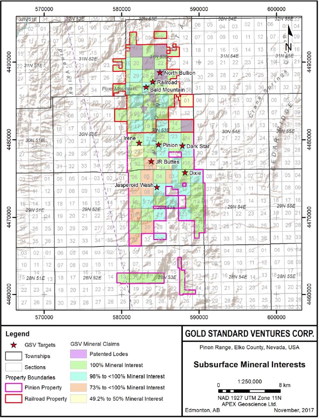
| Effective Date: November 3, 2017 | | | 206 |
Technical Report Maiden Resource Estimate North Bullion Railroad Project, Elko County, Nevada, USA
Exhibit 1
Railroad and Pinion Project
Gold Standard Ventures
Part 1 Lode claims; 887 Total
Claim Name/ Number | Serial No | County Book; Page | Document | Amended County Number | Count |
| B #1 | 138543 | 313/159 | 131352 | | 1 |
| B #2 | 138544 | 313/160 | 131353 | | 2 |
| B #3 | 138545 | 313/161 | 131354 | | 3 |
| B #4 | 138546 | 313/162 | 131355 | | 4 |
| B #5 | 138547 | 313/163 | 131356 | | 5 |
| BARDY | 75877 | 98/350 | 38115 | | 6 |
| BLACK | 75973 | 45/154 | 15175 | | 7 |
| BLUE | 75974 | 45/159 | 15180 | | 8 |
| BURKE FRAC | 75975 | 8/300 | n/a | 21/94 | 9 |
| CANARY | 75976 | 39/366 | 5371 | | 10 |
| CISS #1 | 407849 | 560/304 | 228452 | | 11 |
| CISS #2 | 407850 | 560/305 | 228453 | | 12 |
| CISS #3 | 407851 | 560/306 | 228454 | | 13 |
| CISS #4 | 407852 | 560/307 | 228455 | | 14 |
| CISS #5 | 407853 | 560/308 | 228456 | | 15 |
| CISS #6 | 407854 | 560/309 | 228457 | | 16 |
| CISS #7 | 407855 | 560/310 | 228458 | | 17 |
| CISS #8 | 407856 | 560/311 | 228459 | | 18 |
| CISS #9 | 407857 | 560/312 | 228460 | | 19 |
| CISS #10 | 407858 | 560/313 | 228461 | | 20 |
| CISS #11 | 407859 | 560/314 | 228462 | | 21 |
| CISS #12 | 407860 | 560/315 | 228463 | | 22 |
| CISS #13 | 407861 | 560/316 | 228464 | | 23 |
| CISS #14 | 407862 | 560/317 | 228465 | | 24 |
| CISS #15 | 407863 | 560/318 | 228466 | | 25 |
| CISS #16 | 407864 | 560/319 | 228467 | | 26 |
| CISS #17 | 407865 | 560/320 | 228468 | | 27 |
| CISS #18 | 407866 | 560/321 | 228469 | | 28 |
| CISS #19 | 407867 | 560/322 | 228470 | | 29 |
| CISS #20 | 407868 | 560/323 | 228471 | | 30 |
| CISS #21 | 407869 | 560/324 | 228472 | | 31 |
| CISS #22 | 407870 | 560/325 | 228473 | | 32 |
| CISS #23 | 407871 | 560/326 | 228474 | | 33 |
| Effective Date: November 3, 2017 | | | 207 |
Technical Report Maiden Resource Estimate North Bullion Railroad Project, Elko County, Nevada, USA
Claim Name/ Number | Serial No | County Book; Page | Document | Amended County Number | Count |
| CISS #24 | 407872 | 560/327 | 228475 | | 34 |
| CISS #25 | 407873 | 560/328 | 228476 | | 35 |
| CISS #26 | 407874 | 560/329 | 228477 | | 36 |
| CISS #27 | 407875 | 560/330 | 228478 | | 37 |
| CISS #28 | 407876 | 560/331 | 228479 | | 38 |
| CISS #29 | 407877 | 560/332 | 228480 | | 39 |
| CISS #30 | 407878 | 560/333 | 228481 | | 40 |
| CISS #31 | 407879 | 560/334 | 228482 | | 41 |
| CISS #32 | 407880 | 560/335 | 228483 | | 42 |
| CISS #33 | 407881 | 560/336 | 228484 | | 43 |
| CISS #34 | 407882 | 560/337 | 228485 | | 44 |
| CISS #35 | 407883 | 560/338 | 228486 | | 45 |
| CISS #36 | 407884 | 560/339 | 228487 | | 46 |
| CISS #37 | 407885 | 560/340 | 228488 | | 47 |
| CISS #38 | 407886 | 560/341 | 228489 | | 48 |
| CISS #39 | 407887 | 560/342 | 228490 | | 49 |
| CISS #40 | 407888 | 560/343 | 228491 | | 50 |
| CISS #41 | 407889 | 560/344 | 228492 | | 51 |
| CISS #42 | 407890 | 560/345 | 228493 | | 52 |
| CISS #43 | 407891 | 560/346 | 228494 | | 53 |
| CISS #44 | 407892 | 560/347 | 228495 | | 54 |
| CISS #45 | 407893 | 560/348 | 228496 | | 55 |
| CISS #46 | 407894 | 560/349 | 228497 | | 56 |
| CISS #47 | 407895 | 560/350 | 228498 | | 57 |
| CISS #48 | 407896 | 560/351 | 228499 | | 58 |
| CISS #49 | 407897 | 560/352 | 228500 | | 59 |
| CISS #50 | 407898 | 560/353 | 228501 | | 60 |
| CISS #51 | 407899 | 560/354 | 228502 | | 61 |
| CISS #52 | 407900 | 560/355 | 228503 | | 62 |
| CISS #53 | 407901 | 560/356 | 228504 | | 63 |
| CISS #54 | 407902 | 560/357 | 228505 | | 64 |
| CISS #55 | 407903 | 560/358 | 228506 | | 65 |
| CISS #56 | 407904 | 560/359 | 228507 | | 66 |
| CISS #57 | 407905 | 560/360 | 228508 | | 67 |
| CISS #58 | 407906 | 560/361 | 228509 | | 68 |
| CISS #59 | 407907 | 560/362 | 228510 | | 69 |
| CISS #60 | 407908 | 560/363 | 228511 | | 70 |
| CISS #61 | 407909 | 560/364 | 228512 | | 71 |
| CISS #62 | 407910 | 560/365 | 228513 | | 72 |
| Effective Date: November 3, 2017 | | | 208 |
Technical Report Maiden Resource Estimate North Bullion Railroad Project, Elko County, Nevada, USA
Claim Name/ Number | Serial No | County Book; Page | Document | Amended County Number | Count |
| CISS #63 | 407911 | 560/366 | 228514 | | 73 |
| CISS #64 | 407912 | 560/367 | 228515 | | 74 |
| CISS #65 | 407913 | 560/368 | 228516 | | 75 |
| CISS #66 | 407914 | 560/369 | 228517 | | 76 |
| CISS #67 | 407915 | 560/370 | 228518 | | 77 |
| CISS #68 | 407916 | 560/371 | 228519 | | 78 |
| CISS #69 | 407917 | 560/372 | 228520 | | 79 |
| CISS #70 | 407918 | 560/373 | 228521 | | 80 |
| CISS #71 | 407919 | 560/374 | 228522 | | 81 |
| CISS #72 | 407920 | 560/375 | 228523 | | 82 |
| CISS #73 | 407921 | 560/376 | 228524 | | 83 |
| CISS #74 | 407922 | 560/377 | 228525 | | 84 |
| CISS #75 | 407923 | 560/378 | 228526 | | 85 |
| CISS #76 | 407924 | 560/379 | 228527 | | 86 |
| CISS #77 | 407925 | 560/380 | 228528 | | 87 |
| CISS #78 | 407926 | 560/381 | 228529 | | 88 |
| CISS #79 | 407927 | 560/382 | 228530 | | 89 |
| CISS #80 | 407928 | 560/383 | 228531 | | 90 |
| CISS #81 | 407929 | 560/384 | 228532 | | 91 |
| CISS #82 | 407930 | 560/385 | 228533 | | 92 |
| CISS #83 | 407931 | 560/386 | 228534 | | 93 |
| CISS #84 | 407932 | 560/387 | 228535 | | 94 |
| CISS #85 | 407933 | 560/388 | 228536 | | 95 |
| CISS #86 | 407934 | 560/389 | 228537 | | 96 |
| CISS #87 | 407935 | 560/390 | 228538 | | 97 |
| CISS #106 | 407954 | 560/409 | 228557 | | 98 |
| CISS #107 | 407955 | 560/410 | 228558 | | 99 |
| CISS #108 | 407956 | 560/411 | 228559 | | 100 |
| CISS #109 | 407957 | 560/412 | 228560 | | 101 |
| CISS #110 | 407958 | 560/413 | 228561 | | 102 |
| CISS #111 | 407959 | 560/414 | 228562 | | 103 |
| CISS #112 | 407960 | 560/415 | 228563 | | 104 |
| CISS #113 | 407961 | 560/416 | 228564 | | 105 |
| CISS #114 | 407962 | 560/417 | 228565 | | 106 |
| CISS #115 | 407963 | 560/418 | 228566 | | 107 |
| CISS #116 | 407964 | 560/419 | 228567 | | 108 |
| CISS #117 | 407965 | 560/420 | 228568 | | 109 |
| CISS #118 | 407966 | 560/421 | 228569 | | 110 |
| CISS #119 | 407967 | 560/422 | 228570 | | 111 |
| Effective Date: November 3, 2017 | | | 209 |
Technical Report Maiden Resource Estimate North Bullion Railroad Project, Elko County, Nevada, USA
Claim Name/ Number | Serial No | County Book; Page | Document | Amended County Number | Count |
| CISS #124 | 407968 | 560/423 | 228571 | | 112 |
| CISS #125 | 407969 | 560/424 | 228572 | | 113 |
| CISS #126 | 407970 | 560/425 | 228573 | | 114 |
| CISS #127 | 407971 | 560/426 | 228574 | | 115 |
| CISS #128 | 407972 | 560/427 | 228575 | | 116 |
| CISS #129 | 407973 | 560/428 | 228576 | | 117 |
| CISS #130 | 407974 | 560/429 | 228577 | | 118 |
| CISS #131 | 407975 | 560/430 | 228578 | | 119 |
| CISS #132 | 407976 | 560/431 | 228579 | | 120 |
| CISS #133 | 407977 | 560/432 | 228580 | | 121 |
| CISS #134 | 407978 | 560/433 | 228581 | | 122 |
| CISS #135 | 407979 | 560/434 | 228582 | | 123 |
| CISS #136 | 407980 | 560/435 | 228583 | | 124 |
| CISS #137 | 407981 | 560/436 | 228584 | | 125 |
| DIKE #1 | 75977 | 21/534 | 44926 | | 126 |
| DIKE #2 | 75978 | 21/535 | 44928 | | 127 |
| DIKE #3 | 75979 | 21/536 | 44929 | | 128 |
| DIKE #4 | 75980 | 21/536 | 44930 | | 129 |
| DIKE #6 | 75981 | 21/537 | 44931 | | 130 |
| DIKE #7 | 75982 | 21/537 | 44932 | | 131 |
| DIKE #8 | 75983 | 21/538 | 44933 | | 132 |
| DIKE #9 | 75984 | 21/538 | 44934 | | 133 |
| DIKE #11 | 75985 | 21/535 | 44927 | | 134 |
| EAGLE | 75986 | 7//86 | n/a | 7/596 | 135 |
| GOLD | 75987 | 45/161 | 15182 | | 136 |
| GREEN | 75988 | 45/160 | 15181 | | 137 |
| GUTSY #1203 | 399864 | 553/106 | 226058 | | 138 |
| GUTSY #1204 | 399865 | 553/107 | 226059 | | 139 |
| GUTSY #1205 | 399866 | 553/108 | 226060 | | 140 |
| GUTSY #1206 | 399867 | 553/109 | 226061 | | 141 |
| GUTSY #1207 | 399868 | 553/110 | 226062 | | 142 |
| GUTSY #1208 | 399869 | 553/111 | 226063 | | 143 |
| GUTSY #1209 | 399870 | 553/112 | 226064 | | 144 |
| GUTSY #1210 | 399871 | 553/113 | 226065 | | 145 |
| GUTSY #1211 | 399872 | 553/114 | 226066 | | 146 |
| GUTSY #1212 | 399873 | 553/115 | 226067 | | 147 |
| GUTSY #1213 | 399874 | 553/116 | 226068 | | 148 |
| GUTSY #1214 | 399875 | 553/117 | 226069 | | 149 |
| GUTSY #1215 | 399876 | 553/118 | 226070 | | 150 |
| Effective Date: November 3, 2017 | | | 210 |
Technical Report Maiden Resource Estimate North Bullion Railroad Project, Elko County, Nevada, USA
Claim Name/ Number | Serial No | County Book; Page | Document | Amended County Number | Count |
| GUTSY #1216 | 399877 | 553/119 | 226071 | | 151 |
| GUTSY #1217 | 399878 | 553/120 | 226072 | | 152 |
| GUTSY #1218 | 399879 | 553/121 | 226073 | | 153 |
| GUTSY #1219 | 399880 | 553/122 | 226074 | | 154 |
| GUTSY #1220 | 399881 | 553/123 | 226075 | | 155 |
| GUTSY #1221 | 399882 | 553/124 | 226076 | | 156 |
| GUTSY #1222 | 399883 | 553/125 | 226077 | | 157 |
| GUTSY #1223 | 399884 | 553/126 | 226078 | | 158 |
| GUTSY #1224 | 399885 | 553/127 | 226079 | | 159 |
| GUTSY #1225 | 399886 | 553/128 | 226080 | | 160 |
| GUTSY #1226 | 399887 | 553/129 | 226081 | | 161 |
| GUTSY #1227 | 399888 | 553/130 | 226082 | | 162 |
| GUTSY #1228 | 399889 | 553/131 | 226083 | | 163 |
| GUTSY #1229 | 399890 | 553/132 | 226084 | | 164 |
| GUTSY #1230 | 399891 | 553/133 | 226085 | | 165 |
| GUTSY #1231 | 399892 | 553/134 | 226086 | | 166 |
| GUTSY #1232 | 399893 | 553/135 | 226087 | | 167 |
| GUTSY #1233 | 399894 | 553/136 | 226088 | | 168 |
| GUTSY #1234 | 399895 | 553/137 | 226089 | | 169 |
| GUTSY #1235 | 399896 | 553/138 | 226090 | | 170 |
| GUTSY #1236 | 399897 | 553/139 | 226091 | | 171 |
| GUTSY #1237 | 399898 | 553/140 | 226092 | | 172 |
| GUTSY #1238 | 399899 | 553/141 | 226093 | | 173 |
| GUTSY #1239 | 399900 | 553/142 | 226094 | | 174 |
| GUTSY #1240 | 399901 | 553/143 | 226095 | | 175 |
| GUTSY #1241 | 399902 | 553/144 | 226096 | | 176 |
| GUTSY #1242 | 399903 | 553/145 | 226097 | | 177 |
| GUTSY #1243 | 399904 | 553/146 | 226098 | | 178 |
| GUTSY #1244 | 399905 | 553/147 | 226099 | | 179 |
| GUTSY #1245 | 399906 | 553/148 | 226100 | | 180 |
| GUTSY #1246 | 399907 | 553/149 | 226101 | | 181 |
| GUTSY #1247 | 399908 | 553/150 | 226102 | | 182 |
| GUTSY #1248 | 399909 | 553/151 | 226103 | | 183 |
| GUTSY #1249 | 399910 | 553/152 | 226104 | | 184 |
| GUTSY #1250 | 399911 | 553/153 | 226105 | | 185 |
| GUTSY #1251 | 399912 | 553/154 | 226106 | | 186 |
| GUTSY #1252 | 399913 | 553/155 | 226107 | | 187 |
| GUTSY #1253 | 399914 | 553/156 | 226108 | | 188 |
| GUTSY #1254 | 399915 | 553/157 | 226109 | | 189 |
| Effective Date: November 3, 2017 | | | 211 |
Technical Report Maiden Resource Estimate North Bullion Railroad Project, Elko County, Nevada, USA
Claim Name/ Number | Serial No | County Book; Page | Document | Amended County Number | Count |
| GUTSY #1255 | 399916 | 553/158 | 226110 | | 190 |
| GUTSY #1256 | 399917 | 553/159 | 226111 | | 191 |
| GUTSY #1257 | 399918 | 553/160 | 226112 | | 192 |
| GUTSY #1258 | 399919 | 553/161 | 226113 | | 193 |
| GUTSY #1259 | 399920 | 553/162 | 226114 | | 194 |
| GUTSY #1260 | 399921 | 553/163 | 226115 | | 195 |
| GUTSY #1261 | 399922 | 553/164 | 226116 | | 196 |
| GUTSY #1262 | 399923 | 553/165 | 226117 | | 197 |
| GUTSY #1263 | 399924 | 553/166 | 226118 | | 198 |
| GUTSY #1264 | 399925 | 553/167 | 226119 | | 199 |
| GUTSY #1265 | 399926 | 553/168 | 226120 | | 200 |
| GUTSY #1266 | 399927 | 553/169 | 226121 | | 201 |
| GUTSY #1267 | 399928 | 553/170 | 226122 | | 202 |
| GUTSY #1268 | 399929 | 553/171 | 226123 | | 203 |
| GUTSY #1269 | 399930 | 553/172 | 226124 | | 204 |
| GUTSY #1270 | 399931 | 553/173 | 226125 | | 205 |
| GUTSY #1271 | 399932 | 553/174 | 226126 | | 206 |
| GUTSY #1272 | 399933 | 553/175 | 226127 | | 207 |
| GUTSY #1273 | 399934 | 553/176 | 226128 | | 208 |
| GUTSY #1274 | 399935 | 553/177 | 226129 | | 209 |
| HANNAH | 75880 | 98/353 | 38118 | | 210 |
| HOFFMAN FRAC | 75989 | 7/598 | n/a | 17/101 | 211 |
| HOLD UP | 75990 | 17/5 | 8002 | | 212 |
| HOME #1 | 164143 | 326/659 | 136567 | | 213 |
| HOME #2 | 164144 | 326/660 | 136568 | | 214 |
| HOME #3 | 164145 | 326/661 | 136569 | | 215 |
| HOME #4 | 164146 | 326/662 | 136570 | | 216 |
| HOME #5 | 164147 | 326/663 | 136571 | | 217 |
| HOME #6 | 164148 | 326/664 | 136572 | | 218 |
| HOME #7 | 164149 | 326/665 | 136573 | | 219 |
| HOME #8 | 164150 | 326/666 | 136574 | | 220 |
| HOME #9 | 164151 | 326/667 | 136575 | | 221 |
| HOME #10 | 164152 | 326/668 | 136576 | | 222 |
| HOME #11 | 164153 | 326/669 | 136577 | | 223 |
| HOME #12 | 164154 | 326/670 | 136578 | | 224 |
| HOME #13 | 164155 | 326/671 | 136579 | | 225 |
| HOME #14 | 164156 | 326/672 | 136580 | | 226 |
| HOME #15 | 164157 | 326/673 | 136581 | | 227 |
| HOME #16 | 164158 | 326/674 | 136582 | | 228 |
| Effective Date: November 3, 2017 | | | 212 |
Technical Report Maiden Resource Estimate North Bullion Railroad Project, Elko County, Nevada, USA
Claim Name/ Number | Serial No | County Book; Page | Document | Amended County Number | Count |
| HOME #17 | 164159 | 326/675 | 136583 | | 229 |
| HOME #18 | 164160 | 326/676 | 136584 | | 230 |
| HOME #19 | 190211 | 350/307 | 146804 | | 231 |
| HOME #20 | 190212 | 350/308 | 146805 | | 232 |
| HOME #21 | 190213 | 350/309 | 146806 | | 233 |
| HOME #22 | 190214 | 350/310 | 146807 | | 234 |
| HOME #23 | 190215 | 350/311 | 146808 | | 235 |
| HOME #24 | 190216 | 350/312 | 146809 | | 236 |
| HOME #25 | 190217 | 350/313 | 146810 | | 237 |
| HOME #26 | 190218 | 350/314 | 146811 | | 238 |
| HOME #27 | 190219 | 350/315 | 146812 | | 239 |
| HOME #28 | 190220 | 350/316 | 146813 | | 240 |
| HOME #29 | 190221 | 350/317 | 146814 | | 241 |
| HOME #30 | 190222 | 350/318 | 146815 | | 242 |
| HOME #31 | 190223 | 350/319 | 146816 | | 243 |
| HOME #42 | 227247 | 378/289 | 158546 | | 244 |
| HOME #43 | 227248 | 378/290 | 158547 | | 245 |
| HOME #44 | 227249 | 378/291 | 158548 | | 246 |
| HOME #45 | 227250 | 378/292 | 158549 | | 247 |
| HOME #46 | 227251 | 378/293 | 158550 | | 248 |
| HOME #47 | 227252 | 378/294 | 158551 | | 249 |
| HOME #48 | 227253 | 378/295 | 158552 | | 250 |
| HOME #49 | 227254 | 378/296 | 158553 | | 251 |
| HOME #50 | 227255 | 378/297 | 158554 | | 252 |
| HOME #51 | 227256 | 378/298 | 158555 | | 253 |
| HOME #52 | 227257 | 378/299 | 158556 | | 254 |
| HOMESTAKE | 75991 | 17/6 | 8003 | | 255 |
| JKR 1 | 1025800 | | 627853 | | 256 |
| JKR 2 | 1025801 | | 627854 | | 257 |
| JKR 3 | 1025802 | | 627855 | | 258 |
| JKR 4 | 1025803 | | 627856 | | 259 |
| JKR 5 | 1025804 | | 627857 | | 260 |
| JKR 6 | 1025805 | | 627858 | | 261 |
| JKR 7 | 1025806 | | 627859 | | 262 |
| JKR 8 | 1025807 | | 627860 | | 263 |
| JKR 9 | 1025808 | | 627861 | | 264 |
| JKR 10 | 1025809 | | 627862 | | 265 |
| JKR 11 | 1025810 | | 627863 | | 266 |
| JKR 12 | 1025811 | | 627864 | | 267 |
| Effective Date: November 3, 2017 | | | 213 |
Technical Report Maiden Resource Estimate North Bullion Railroad Project, Elko County, Nevada, USA
Claim Name/ Number | Serial No | County Book; Page | Document | Amended County Number | Count |
| JKR 13 | 1025812 | | 627865 | | 268 |
| JKR 14 | 1025813 | | 627866 | | 269 |
| JKR 15 | 1025814 | | 627867 | | 270 |
| JKR 16 | 1025815 | | 627868 | | 271 |
| JKR 17 | 1025816 | | 627869 | | 272 |
| JKR 18 | 1025817 | | 627870 | | 273 |
| JKR 19 | 1025818 | | 627871 | | 274 |
| JKR 20 | 1025819 | | 627872 | | 275 |
| JKR 21 | 1025820 | | 627873 | | 276 |
| JKR 22 | 1025821 | | 627874 | | 277 |
| JKR 23 | 1025822 | | 627875 | | 278 |
| JKR 24 | 1025823 | | 627876 | | 279 |
| JKR 25 | 1025824 | | 627877 | | 280 |
| JKR 26 | 1025825 | | 627878 | | 281 |
| JMD 1 | 1013878 | | 620141 | | 282 |
| JMD 2 | 1013879 | | 620142 | | 283 |
| JMD 3 | 1013880 | | 620143 | | 284 |
| JMD 4 | 1013881 | | 620144 | | 285 |
| JMD 5 | 1013882 | | 620145 | | 286 |
| JMD 6 | 1013883 | | 620146 | | 287 |
| JMD 7 | 1013884 | | 620147 | | 288 |
| JMD 8 | 1013885 | | 620148 | | 289 |
| JMD 9 | 1013886 | | 620149 | | 290 |
| JMD 10 | 1013887 | | 620150 | | 291 |
| JMD 11 | 1013888 | | 620151 | | 292 |
| JMD 12 | 1013889 | | 620152 | | 293 |
| JMD 13 | 1013890 | | 620153 | | 294 |
| JMD 14 | 1098808 | | 682367 | | 295 |
| JMD 15 | 1098809 | | 682368 | | 296 |
| JMD 16 | 1098810 | | 682369 | | 297 |
| JMD 17 | 1098811 | | 682370 | | 298 |
| JMD 18 | 1098812 | | 682371 | | 299 |
| JMD 19 | 1098813 | | 682372 | | 300 |
| JMD 20 | 1098814 | | 682373 | | 301 |
| JMD 21 | 1098815 | | 682374 | | 302 |
| JMD 22 | 1098816 | | 682375 | | 303 |
| JMD 23 | 1098817 | | 682376 | | 304 |
| JMD 24 | 1098818 | | 682377 | | 305 |
| JMD 25 | 1098819 | | 682378 | | 306 |
| Effective Date: November 3, 2017 | | | 214 |
Technical Report Maiden Resource Estimate North Bullion Railroad Project, Elko County, Nevada, USA
Claim Name/ Number | Serial No | County Book; Page | Document | Amended County Number | Count |
| JMD 26 | 1098820 | | 682379 | | 307 |
| JMD 27 | 1098821 | | 682380 | | 308 |
| JMD 28 | 1098822 | | 682381 | | 309 |
| JMD 29 | 1098823 | | 682382 | | 310 |
| JMD 30 | 1098824 | | 682383 | | 311 |
| JMD 31 | 1098825 | | 682384 | | 312 |
| JMD 32 | 1098826 | | 682385 | | 313 |
| JMD 33 | 1098827 | | 682386 | | 314 |
| JMD 34 | 1098828 | | 682387 | | 315 |
| JMD 35 | 1098829 | | 682388 | | 316 |
| JMD 36 | 1098830 | | 682389 | | 317 |
| JMD 37 | 1098831 | | 682390 | | 318 |
| JMD 38 | 1098832 | | 682391 | | 319 |
| JMD 39 | 1098833 | | 682392 | | 320 |
| JMD 40 | 1098834 | | 682393 | | 321 |
| JMD 41 | 1098835 | | 682394 | | 322 |
| JMD 42 | 1098836 | | 682395 | | 323 |
| JOE PP 56 | 898185 | | 535441 | | 324 |
| JOE PP 58 | 898186 | | 535442 | | 325 |
| JOHN | 75876 | 98/349 | 38114 | | 326 |
| KEN | 75881 | 98/356 | 38121 | | 327 |
| KEY | 75992 | 8/377 | n/a | 20/694 | 328 |
| LARK | 75993 | 7/603 | n/a | | 329 |
| LAST CHANCE | 75994 | 20/413 | 35070 | | 330 |
| LT #1 | 504170 | 629/422 | 257084 | | 331 |
| LT #2 | 504171 | 629/423 | 257085 | | 332 |
| LT #3 | 504172 | 629/424 | 257086 | | 333 |
| LT #4 | 504173 | 629/425 | 257087 | | 334 |
| LT #5 | 504174 | 629/426 | 257088 | | 335 |
| LT #6 | 504175 | 629/427 | 257089 | | 336 |
| LT #7 | 504176 | 629/428 | 257090 | | 337 |
| LT #8 | 504177 | 629/429 | 257091 | | 338 |
| LT #9 | 504178 | 629/430 | 257092 | | 339 |
| LT #10 | 504179 | 629/431 | 257093 | | 340 |
| LT #11 | 504180 | 629/432 | 257094 | | 341 |
| LT #12 | 504181 | 629/433 | 257095 | | 342 |
| LT #13 | 504182 | 629/434 | 257096 | | 343 |
| LT #14 | 504183 | 629/435 | 257097 | | 344 |
| LT #15 | 504184 | 629/436 | 257098 | | 345 |
| Effective Date: November 3, 2017 | | | 215 |
Technical Report Maiden Resource Estimate North Bullion Railroad Project, Elko County, Nevada, USA
Claim Name/ Number | Serial No | County Book; Page | Document | Amended County Number | Count |
| LT #16 | 504185 | 629/437 | 257099 | | 346 |
| LT #17 | 504186 | 629/438 | 257100 | | 347 |
| LT #18 | 504187 | 629/439 | 257101 | | 348 |
| LT #19 | 504188 | 629/440 | 257102 | | 349 |
| LT #20 | 504189 | 629/441 | 257103 | | 350 |
| LT #21 | 504190 | 629/442 | 257104 | | 351 |
| LT #22 | 504191 | 629/443 | 257105 | | 352 |
| LT #23 | 504192 | 629/444 | 257106 | | 353 |
| LT #24 | 504193 | 629/445 | 257107 | | 354 |
| LT #25 | 504194 | 629/446 | 257108 | | 355 |
| LT #26 | 504195 | 629/447 | 257109 | | 356 |
| LT #27 | 504196 | 629/448 | 257110 | | 357 |
| MAGGIE | 75878 | 98/351 | 38116 | | 358 |
| MAHOGANY | 75995 | 8/308 | n/a | 21/95 | 359 |
| MENDOTA | 75996 | 16/452 | 6593 | 17/102 | 360 |
| MOON | 75997 | 45/156 | 15177 | | 361 |
| MOON #1 | 75998 | 45/157 | 15178 | | 362 |
| MOON #2 | 75999 | 45/158 | 15179 | | 363 |
| NEVADA | 76000 | Jul-85 | n/a | 7/597 | 364 |
| NEW #56 | 202156 | 357/213 | 149637 | | 365 |
| NEW #57 | 202157 | 357/214 | 149638 | | 366 |
| NEW #58 | 202158 | 357/215 | 149639 | | 367 |
| NEW #59 | 202159 | 357/216 | 149640 | | 368 |
| NEW #60 | 202160 | 357/217 | 149641 | | 369 |
| NEW #61 | 202161 | 357/218 | 149642 | | 370 |
| NEW #62 | 202162 | 357/219 | 149643 | | 371 |
| NEW #63 | 202163 | 357/220 | 149644 | | 372 |
| NEW #65 | 202165 | 357/222 | 149646 | | 373 |
| NEW #66 | 202166 | 357/223 | 149647 | | 374 |
| NEW #67 | 202167 | 357/224 | 149648 | | 375 |
| NEW #68 | 202168 | 357/225 | 149649 | | 376 |
| NEW #69 | 202169 | 357/226 | 149650 | | 377 |
| NEW #70 | 202170 | 357/227 | 149651 | | 378 |
| NEW #71 | 202171 | 357/228 | 149652 | | 379 |
| NEW #72 | 202172 | 357/229 | 149653 | | 380 |
| NEW #135 | 227243 | 378/300 | 158558 | | 381 |
| NEW #136 | 227244 | 378/301 | 158559 | | 382 |
| NEW #137 | 227245 | 378/302 | 158560 | | 383 |
| NEW #138 | 227246 | 378/303 | 158561 | | 384 |
| Effective Date: November 3, 2017 | | | 216 |
Technical Report Maiden Resource Estimate North Bullion Railroad Project, Elko County, Nevada, USA
Claim Name/ Number | Serial No | County Book; Page | Document | Amended County Number | Count |
| OWL | 76001 | 7/604 | n/a | | 385 |
| PAM | 75883 | 98/354 | 38119 | | 386 |
| PETER | 75882 | 98/355 | 38120 | | 387 |
| PIN NO 1 | 698494 | 854/764 | 352404 | | 388 |
| PIN NO 2 | 698495 | 854/765 | 352405 | | 389 |
| PIN NO 3 | 698496 | 854/766 | 352406 | | 390 |
| PIN NO 4 | 698497 | 854/767 | 352407 | | 391 |
| PIN NO 5 | 698498 | 854/768 | 352408 | | 392 |
| PIN NO 6 | 698499 | 854/769 | 352409 | | 393 |
| PIN NO 7 | 698500 | 854/770 | 352410 | | 394 |
| PIN NO 8 | 698501 | 854/771 | 352411 | | 395 |
| PIN NO 9 | 698502 | 854/772 | 352412 | | 396 |
| PIN NO 10 | 698503 | 854/773 | 352413 | | 397 |
| PIN NO 11 | 698504 | 854/774 | 352414 | | 398 |
| PIN NO 12 | 698505 | 854/775 | 352415 | | 399 |
| PINE #1 | 407779 | 560/234 | 228381 | | 400 |
| PINE #2 | 407780 | 560/235 | 228382 | | 401 |
| PINE #3 | 407781 | 560/236 | 228383 | | 402 |
| PINE #4 | 407782 | 560/237 | 228384 | | 403 |
| PINE #5 | 407783 | 560/238 | 228385 | | 404 |
| PINE #6 | 407784 | 560/239 | 228386 | | 405 |
| PINE #7 | 407785 | 560/240 | 228387 | | 406 |
| PINE #8 | 407786 | 560/241 | 228388 | | 407 |
| PINE #9 | 407787 | 560/242 | 228389 | | 408 |
| PINE #10 | 407788 | 560/243 | 228390 | | 409 |
| PINE #11 | 407789 | 560/244 | 228391 | | 410 |
| PINE #12 | 407790 | 560/245 | 228392 | | 411 |
| PINE #13 | 407791 | 560/246 | 228393 | | 412 |
| PINE #14 | 407792 | 560/247 | 228394 | | 413 |
| PINE #15 | 407793 | 560/248 | 228395 | | 414 |
| PINE #16 | 407794 | 560/249 | 228396 | | 415 |
| PINE #17 | 407795 | 560/250 | 228397 | | 416 |
| PINE #18 | 407796 | 560/251 | 228398 | | 417 |
| PINE #58 | 407836 | 560/291 | 228438 | | 418 |
| PINE #59 | 407837 | 560/292 | 228439 | | 419 |
| PINE #60 | 407838 | 560/293 | 228440 | | 420 |
| PINE #61 | 407839 | 560/294 | 228441 | | 421 |
| PINE #62 | 407840 | 560/295 | 228442 | | 422 |
| PINE #63 | 407841 | 560/296 | 228443 | | 423 |
| Effective Date: November 3, 2017 | | | 217 |
Technical Report Maiden Resource Estimate North Bullion Railroad Project, Elko County, Nevada, USA
Claim Name/ Number | Serial No | County Book; Page | Document | Amended County Number | Count |
| PINE #64 | 407842 | 560/297 | 228444 | | 424 |
| PINE #65 | 407843 | 560/298 | 228445 | | 425 |
| PINE #66 | 407844 | 560/299 | 228446 | | 426 |
| PINK | 76002 | 45/162 | 15183 | | 427 |
| PORTAL | 76003 | 8/262 | n/a | | 428 |
| PORTAL FRACTION R | 1013877 | | 620139 | | 429 |
| PP 1 | 829752 | 2/22680 | 484937 | | 430 |
| PP 2 | 829753 | 2/22681 | 484938 | | 431 |
| PP 3 | 829754 | 2/22682 | 484939 | | 432 |
| PP 4 | 829755 | 2/22683 | 484940 | | 433 |
| PP 5 | 829756 | 2/22684 | 484941 | | 434 |
| PP 6 | 829757 | 2/22685 | 484942 | | 435 |
| PP 7 | 829758 | 2/22686 | 484943 | | 436 |
| PP 8 | 829759 | 2/22687 | 484944 | | 437 |
| PP 9 | 829760 | 2/22688 | 484945 | | 438 |
| PP 10 | 829761 | 2/22689 | 484946 | | 439 |
| PP 11 | 829762 | 2/22690 | 484947 | | 440 |
| PP 12 | 829763 | 2/22691 | 484948 | | 441 |
| PP 13 | 829764 | 2/22692 | 484949 | | 442 |
| PP 14 | 829765 | 2/22693 | 484950 | | 443 |
| PP 15 | 829766 | 2/22694 | 484951 | | 444 |
| PP 16 | 829767 | 2/22695 | 484952 | | 445 |
| PP 17 | 829768 | 2/22696 | 484953 | | 446 |
| PP 18 | 829769 | 2/22697 | 484954 | | 447 |
| PP 19 | 829770 | 2/22698 | 484955 | | 448 |
| PP 20 | 829771 | 2/22699 | 484956 | | 449 |
| PP 21 | 829772 | 2/22700 | 484957 | | 450 |
| PP 22 | 829773 | 2/22701 | 484958 | | 451 |
| PP 23 | 829774 | 2/22702 | 484959 | | 452 |
| PP 24 | 829775 | 2/22703 | 484960 | | 453 |
| PP 25 | 829776 | 2/22704 | 484961 | | 454 |
| PP 26 | 829777 | 2/22705 | 484962 | | 455 |
| PP 27 | 829778 | 2/22706 | 484963 | | 456 |
| PP 28 | 829779 | 2/22707 | 484964 | | 457 |
| PP 29 | 829780 | 2/22708 | 484965 | | 458 |
| PP 30 | 829781 | 2/22709 | 484966 | | 459 |
| PP 31 | 829782 | 2/22710 | 484967 | | 460 |
| PP 32 | 829783 | 2/22711 | 484968 | | 461 |
| PP 33 | 829784 | 2/22712 | 484969 | | 462 |
| Effective Date: November 3, 2017 | | | 218 |
Technical Report Maiden Resource Estimate North Bullion Railroad Project, Elko County, Nevada, USA
Claim Name/ Number | Serial No | County Book; Page | Document | Amended County Number | Count |
| PP 34 | 829785 | 2/22713 | 484970 | | 463 |
| PP 35 | 829786 | 2/22714 | 484971 | | 464 |
| PP 36 | 829787 | 2/22715 | 484972 | | 465 |
| PP 37 | 829788 | 2/22716 | 484973 | | 466 |
| PP 38 | 829789 | 2/22717 | 484974 | | 467 |
| PP 39 | 829790 | 2/22718 | 484975 | | 468 |
| PP 40 | 829791 | 2/22719 | 484976 | | 469 |
| PP 41 | 829792 | 2/22720 | 484977 | | 470 |
| PP 42 | 829793 | 2/22721 | 484978 | | 471 |
| PP 43 | 829794 | 2/22722 | 484979 | | 472 |
| PP 44 | 829795 | 2/22723 | 484980 | | 473 |
| PP 45 | 829796 | 2/22724 | 484981 | | 474 |
| PP 46 | 829797 | 2/22725 | 484982 | | 475 |
| PP 59 | 829810 | 2/22738 | 484995 | | 476 |
| PP 60 | 829811 | 2/22739 | 484996 | | 477 |
| PP 61 | 829812 | 2/22740 | 484997 | | 478 |
| PP 62 | 829813 | 2/22741 | 484998 | | 479 |
| PP 63 | 829814 | 2/22742 | 484999 | | 480 |
| PP 64 | 829815 | 2/22743 | 485000 | | 481 |
| PP 65 | 829816 | 2/22744 | 485001 | | 482 |
| PP 66 | 829817 | 2/22745 | 485002 | | 483 |
| PP 67 | 829818 | 2/22746 | 485003 | | 484 |
| PP 68 | 829819 | 2/22747 | 485004 | | 485 |
| PP 69 | 829820 | 2/22748 | 485005 | | 486 |
| PP 70 | 829821 | 2/22749 | 485006 | | 487 |
| PP 71 | 829822 | 2/22750 | 485007 | | 488 |
| PP 72 | 829823 | 2/22751 | 485008 | | 489 |
| PP 73 | 829824 | 2/22752 | 485009 | | 490 |
| PP 74 | 829825 | 2/22753 | 485010 | | 491 |
| PP 75 | 829826 | 2/22754 | 485011 | | 492 |
| PP 76 | 829827 | 2/22755 | 485012 | | 493 |
| PP 77 | 881622 | 4/57463 | 526778 | | 494 |
| PP 78 | 881623 | 4/57464 | 526779 | | 495 |
| PP 79 | 881624 | 4/57465 | 526780 | | 496 |
| PR 1 | 881625 | 4/57448 | 526762 | | 497 |
| PR 2 | 881626 | 4/57449 | 526763 | | 498 |
| PR 3 | 881627 | 4/57450 | 526764 | | 499 |
| PR 4 | 881628 | 4/57451 | 526765 | | 500 |
| PR 5 | 881629 | 4/57452 | 526766 | | 501 |
| Effective Date: November 3, 2017 | | | 219 |
Technical Report Maiden Resource Estimate North Bullion Railroad Project, Elko County, Nevada, USA
Claim Name/ Number | Serial No | County Book; Page | Document | Amended County Number | Count |
| PR 6 | 881630 | 4/57453 | 526767 | | 502 |
| PR 7 | 881631 | 4/57454 | 526768 | | 503 |
| PR 8 | 881632 | 4/57455 | 526769 | | 504 |
| PR 9 | 881633 | 4/57456 | 526770 | | 505 |
| PR 10 | 881634 | 4/57457 | 526771 | | 506 |
| PR 11 | 881635 | 4/57458 | 526772 | | 507 |
| PR 12 | 881636 | 4/57459 | 526773 | | 508 |
| PR 13 | 881637 | 4/57460 | 526774 | | 509 |
| PR 14 | 881638 | 4/57461 | 526775 | | 510 |
| PR 15 | 881639 | 4/57462 | 526776 | | 511 |
| RED R | 1013875 | | 620137 | | 512 |
| RED WEST | 1013876 | | 620138 | | 513 |
| RF #1 | 403753 | 558/437 | 227904 | | 514 |
| RF #2 | 403754 | 558/438 | 227905 | | 515 |
| RF #3 | 403755 | 558/439 | 227906 | | 516 |
| RF #4 | 403756 | 558/440 | 227907 | | 517 |
| RF #5 | 403757 | 558/441 | 227908 | | 518 |
| RF #6 | 403758 | 558/442 | 227909 | | 519 |
| RF #7 | 403759 | 558/443 | 227910 | | 520 |
| RF #8 | 403760 | 558/444 | 227911 | | 521 |
| RN 1 | 602676 | 727/444 | 293981 | | 522 |
| RN 2 | 602677 | 727/445 | 293982 | | 523 |
| RN 3 | 602678 | 727/446 | 293983 | | 524 |
| RN 4 | 602679 | 727/447 | 293984 | | 525 |
| RN 5 | 602680 | 727/448 | 293985 | | 526 |
| RN 6 | 602681 | 727/449 | 293986 | | 527 |
| RN 7 | 602682 | 727/450 | 293987 | | 528 |
| RN 8 | 602683 | 727/451 | 293988 | | 529 |
| RN 9 | 602684 | 727/452 | 293989 | | 530 |
| RN 10 | 602685 | 727/453 | 293990 | | 531 |
| RN 11 | 602686 | 727/454 | 293991 | | 532 |
| RN 12 | 602687 | 727/455 | 293992 | | 533 |
| RN 13 | 602688 | 727/456 | 293993 | | 534 |
| RN 14 | 602689 | 727/457 | 293994 | | 535 |
| RN 15 | 602690 | 727/458 | 293995 | | 536 |
| RN 16 | 602691 | 727/459 | 293996 | | 537 |
| RN 17 | 602692 | 727/460 | 293997 | | 538 |
| RN 18 | 602693 | 727/461 | 293998 | | 539 |
| RN 19 | 602694 | 727/462 | 293999 | | 540 |
| Effective Date: November 3, 2017 | | | 220 |
Technical Report Maiden Resource Estimate North Bullion Railroad Project, Elko County, Nevada, USA
Claim Name/ Number | Serial No | County Book; Page | Document | Amended County Number | Count |
| RN 20 | 602695 | 727/463 | 294000 | | 541 |
| RN 21 | 602696 | 727/464 | 294401 | | 542 |
| RN 22 | 602697 | 727/465 | 294402 | | 543 |
| RN 23 | 602698 | 727/466 | 294403 | | 544 |
| RN 24 | 602699 | 727/467 | 294004 | | 545 |
| RN 25 | 602700 | 727/468 | 294005 | | 546 |
| ROB | 75879 | 98/352 | 38117 | | 547 |
| RR #1 | 320216 | 473/538 | 197675 | | 548 |
| RR #2 | 320217 | 473/539 | 197676 | | 549 |
| RR #3 | 320218 | 473/540 | 197677 | | 550 |
| RR #4 | 320219 | 473/541 | 197678 | | 551 |
| RR #5 | 320220 | 473/542 | 197679 | | 552 |
| RR #6 | 320221 | 473/543 | 197680 | | 553 |
| RR #7 | 320222 | 473/544 | 197681 | | 554 |
| RR #8 | 320223 | 473/545 | 197682 | | 555 |
| RR #9 | 320224 | 473/546 | 197683 | | 556 |
| RR #10 | 320225 | 473/547 | 197684 | | 557 |
| RR #11 | 320226 | 473/548 | 197685 | | 558 |
| RR #12 | 320227 | 473/549 | 197686 | | 559 |
| RR #13 | 320228 | 473/550 | 197687 | | 560 |
| RR #14 | 320229 | 473/551 | 197688 | | 561 |
| RR #15 | 320230 | 473/552 | 197689 | | 562 |
| RR #16 | 320231 | 473/553 | 197690 | | 563 |
| RR #17 | 320232 | 473/554 | 197691 | | 564 |
| RR #18 | 320233 | 473/555 | 197692 | | 565 |
| RR #19 | 320234 | 473/556 | 197693 | | 566 |
| RR #20 | 320235 | 473/557 | 197694 | | 567 |
| RR #21 | 320236 | 473/558 | 197695 | | 568 |
| RR #22 | 320237 | 473/559 | 197696 | | 569 |
| RR #23 | 320238 | 473/560 | 197697 | | 570 |
| RR #24 | 320239 | 473/561 | 197698 | | 571 |
| RR #25 | 320240 | 473/562 | 197699 | | 572 |
| RR #26 | 320241 | 473/563 | 197700 | | 573 |
| RR #27 | 320242 | 473/564 | 197701 | | 574 |
| RR #28 | 320243 | 473/565 | 197702 | | 575 |
| RR #29 | 320244 | 473/566 | 197703 | | 576 |
| RR #30 | 320245 | 473/567 | 197704 | | 577 |
| RR #31 | 320246 | 473/568 | 197705 | | 578 |
| RR #32 | 320247 | 473/569 | 197706 | | 579 |
| Effective Date: November 3, 2017 | | | 221 |
Technical Report Maiden Resource Estimate North Bullion Railroad Project, Elko County, Nevada, USA
Claim Name/ Number | Serial No | County Book; Page | Document | Amended County Number | Count |
| RR #33 | 320248 | 473/570 | 197707 | | 580 |
| RR #34 | 320249 | 473/571 | 197708 | | 581 |
| RR #35 | 320250 | 473/572 | 197709 | | 582 |
| RR #36 | 320251 | 473/573 | 197710 | | 583 |
| RR #37 | 320252 | 473/574 | 197711 | | 584 |
| RR #38 | 320253 | 473/575 | 197712 | | 585 |
| RR #39 | 320254 | 473/576 | 197713 | | 586 |
| RR #40 | 426606 | 572/466 | 233143 | | 587 |
| RR #41 | 426607 | 572/467 | 233144 | | 588 |
| RR #42 | 426608 | 572/468 | 233145 | | 589 |
| RR #43 | 426609 | 572/469 | 233146 | | 590 |
| RR #44 | 426610 | 572/470 | 233147 | | 591 |
| RR #45 | 426611 | 572/471 | 233148 | | 592 |
| RR #46 | 426612 | 572/472 | 233149 | | 593 |
| RR #47 | 426613 | 572/473 | 233150 | | 594 |
| RR #48 | 426614 | 572/474 | 233151 | | 595 |
| RR #49 | 426615 | 572/475 | 233152 | | 596 |
| RR #50 | 426616 | 572/476 | 233153 | | 597 |
| RR #51 | 426617 | 572/477 | 233154 | | 598 |
| RR #52 | 426618 | 572/478 | 233155 | | 599 |
| RR #53 | 426619 | 572/479 | 233156 | | 600 |
| RR #54 | 426620 | 572/480 | 233157 | | 601 |
| RR #55 | 466934 | 605/248 | 247268 | | 602 |
| RR #56 | 466935 | 605/249 | 247269 | | 603 |
| RR #57 | 466936 | 605/250 | 247270 | | 604 |
| RR #58 | 466937 | 605/251 | 247271 | | 605 |
| RR #59 | 466938 | 605/252 | 247272 | | 606 |
| RR #60 | 466939 | 605/253 | 247273 | | 607 |
| RR #61 | 466940 | 605/254 | 247274 | | 608 |
| RR #62 | 466941 | 605/255 | 247275 | | 609 |
| RR #63 | 466942 | 605/256 | 247276 | | 610 |
| RR #64 | 466943 | 605/257 | 247277 | | 611 |
| RRW 1 | 1055758 | | 647488 | | 612 |
| RRW 2 | 1055759 | | 647489 | | 613 |
| RRW 3 | 1055760 | | 647490 | | 614 |
| RRW 4 | 1055761 | | 647491 | | 615 |
| RRW 5 | 1055762 | | 647492 | | 616 |
| RRW 6 | 1055763 | | 647493 | | 617 |
| RRW 7 | 1055764 | | 647494 | | 618 |
| Effective Date: November 3, 2017 | | | 222 |
Technical Report Maiden Resource Estimate North Bullion Railroad Project, Elko County, Nevada, USA
Claim Name/ Number | Serial No | County Book; Page | Document | Amended County Number | Count |
| RRW 8 | 1055765 | | 647495 | | 619 |
| RRW 9 | 1055766 | | 647496 | | 620 |
| RRW 10 | 1055767 | | 647497 | | 621 |
| RRW 11 | 1055768 | | 647498 | | 622 |
| RRW 12 | 1055769 | | 647499 | | 623 |
| RRW 13 | 1055770 | | 647500 | | 624 |
| RRW 14 | 1055771 | | 647501 | | 625 |
| RRW 15 | 1055772 | | 647502 | | 626 |
| RRW 16 | 1055773 | | 647503 | | 627 |
| RRW 17 | 1055774 | | 647504 | | 628 |
| RRW 18 | 1055775 | | 647505 | | 629 |
| RRW 19 | 1055776 | | 647506 | | 630 |
| RRW 20 | 1055777 | | 647507 | | 631 |
| RRW 21 | 1055778 | | 647508 | | 632 |
| RRW 22 | 1055779 | | 647509 | | 633 |
| RRW 23 | 1055780 | | 647510 | | 634 |
| RRW 24 | 1055781 | | 647511 | | 635 |
| RRW 25 | 1055782 | | 647512 | | 636 |
| RRW 26 | 1055783 | | 647513 | | 637 |
| RRW 27 | 1055784 | | 647514 | | 638 |
| RRW 28 | 1055785 | | 647515 | | 639 |
| RRW 29 | 1055786 | | 647516 | | 640 |
| RRW 30 | 1055787 | | 647517 | | 641 |
| RRW 31 | 1055788 | | 647518 | | 642 |
| RRW 32 | 1055789 | | 647519 | | 643 |
| RRW 33 | 1055790 | | 647520 | | 644 |
| RRW 34 | 1055791 | | 647521 | | 645 |
| RRW 35 | 1055792 | | 647522 | | 646 |
| RRW 36 | 1055793 | | 647523 | | 647 |
| RRW 37 | 1055794 | | 647524 | | 648 |
| RRW 38 | 1055795 | | 647525 | | 649 |
| RRW 39 | 1055796 | | 647526 | | 650 |
| RRW 40 | 1055797 | | 647527 | | 651 |
| RRW 41 | 1055798 | | 647528 | | 652 |
| RRW 42 | 1055799 | | 647529 | | 653 |
| RRW 43 | 1055800 | | 647530 | | 654 |
| RRW 44 | 1055801 | | 647531 | | 655 |
| RRW 45 | 1055802 | | 647532 | | 656 |
| RRW 46 | 1055803 | | 647533 | | 657 |
| Effective Date: November 3, 2017 | | | 223 |
Technical Report Maiden Resource Estimate North Bullion Railroad Project, Elko County, Nevada, USA
Claim Name/ Number | Serial No | County Book; Page | Document | Amended County Number | Count |
| RRW 47 | 1055804 | | 647534 | | 658 |
| RRW 48 | 1055805 | | 647535 | | 659 |
| RRW 49 | 1055806 | | 647536 | | 660 |
| RRW 50 | 1055807 | | 647537 | | 661 |
| RRW 51 | 1055808 | | 647538 | | 662 |
| RRW 52 | 1055809 | | 647539 | | 663 |
| RRW 53 | 1055810 | | 647540 | | 664 |
| RRW 54 | 1055811 | | 647541 | | 665 |
| RRW 55 | 1055812 | | 647542 | | 666 |
| RRW 56 | 1055813 | | 647543 | | 667 |
| RRW 57 | 1055814 | | 647544 | | 668 |
| RRW 58 | 1055815 | | 647545 | | 669 |
| RRW 59 | 1055816 | | 647546 | | 670 |
| RRW 60 | 1055817 | | 647547 | | 671 |
| RRW 61 | 1055818 | | 647548 | | 672 |
| RRW 62 | 1055819 | | 647549 | | 673 |
| RRW 63 | 1055820 | | 647550 | | 674 |
| RRW 64 | 1055821 | | 647551 | | 675 |
| RRW 65 | 1055822 | | 647552 | | 676 |
| RRW 66 | 1055823 | | 647553 | | 677 |
| RRW 67 | 1055824 | | 647554 | | 678 |
| RRW 68 | 1055825 | | 647555 | | 679 |
| RRW 69 | 1055826 | | 647556 | | 680 |
| RRW 70 | 1055827 | | 647557 | | 681 |
| RRW 71 | 1055828 | | 647558 | | 682 |
| RRW 72 | 1055829 | | 647559 | | 683 |
| RRW 73 | 1055830 | | 647560 | | 684 |
| RRW 74 | 1055831 | | 647561 | | 685 |
| RRW 75 | 1055832 | | 647562 | | 686 |
| RRW 76 | 1055833 | | 647563 | | 687 |
| RRW 77 | 1055834 | | 647564 | | 688 |
| RRW 78 | 1055835 | | 647565 | | 689 |
| RRW 79 | 1055836 | | 647566 | | 690 |
| RRW 80 | 1055837 | | 647567 | | 691 |
| RRW 81 | 1055838 | | 647568 | | 692 |
| RRW 82 | 1055839 | | 647569 | | 693 |
| RRW 83 | 1055840 | | 647570 | | 694 |
| RRW 84 | 1055841 | | 647571 | | 695 |
| RRW 85 | 1055842 | | 647572 | | 696 |
| Effective Date: November 3, 2017 | | | 224 |
Technical Report Maiden Resource Estimate North Bullion Railroad Project, Elko County, Nevada, USA
Claim Name/ Number | Serial No | County Book; Page | Document | Amended County Number | Count |
| RRW 86 | 1055843 | | 647573 | | 697 |
| RRW 87 | 1055844 | | 647574 | | 698 |
| RRW 88 | 1055845 | | 647575 | | 699 |
| RRW 89 | 1055846 | | 647576 | | 700 |
| RRW 90 | 1055847 | | 647577 | | 701 |
| RRW 91 | 1055848 | | 647578 | | 702 |
| RRW 92 | 1055849 | | 647579 | | 703 |
| RRW 93 | 1055850 | | 647580 | | 704 |
| RRW 94 | 1055851 | | 647581 | | 705 |
| RRW 95 | 1055852 | | 647582 | | 706 |
| RRW 96 | 1055853 | | 647583 | | 707 |
| RRW 97 | 1055854 | | 647584 | | 708 |
| RRW 98 | 1055855 | | 647585 | | 709 |
| RRW 99 | 1055856 | | 647586 | | 710 |
| RRW 100 | 1055857 | | 647587 | | 711 |
| RRW 101 | 1055858 | | 647588 | | 712 |
| RRW 102 | 1055859 | | 647589 | | 713 |
| RRW 103 | 1055860 | | 647590 | | 714 |
| RRW 104 | 1055861 | | 647591 | | 715 |
| RRW 105 | 1055862 | | 647592 | | 716 |
| RRW 106 | 1055863 | | 647593 | | 717 |
| RRW 107 | 1055864 | | 647594 | | 718 |
| RRW 108 | 1055865 | | 647595 | | 719 |
| RRW 109 | 1055866 | | 647596 | | 720 |
| RRW 110 | 1073755 | | 658461 | | 721 |
| SELCO #1 | 75884 | 98/339 | 38104 | | 722 |
| SELCO #2 | 75885 | 98/340 | 38105 | | 723 |
| SELCO #3 | 75886 | 98/341 | 38106 | | 724 |
| SELCO #4 | 75887 | 98/342 | 38107 | | 725 |
| SELCO #5 | 75888 | 98/343 | 38108 | | 726 |
| SELCO #6 | 75889 | 98/344 | 38109 | | 727 |
| SELCO #7 | 75890 | 98/345 | 38110 | | 728 |
| SELCO #8 | 75891 | 98/346 | 38111 | | 729 |
| SELCO #9 | 75892 | 98/347 | 38112 | | 730 |
| SELCO #10 | 75893 | 98/348 | 38113 | | 731 |
| SELCO #12 | 75895 | 98/509 | 38207 | | 732 |
| SELCO #13 | 75896 | 98/510 | 38208 | | 733 |
| SELCO #14 | 75897 | 98/511 | 38209 | | 734 |
| SELCO #19 | 75902 | 98/516 | 38214 | | 735 |
| Effective Date: November 3, 2017 | | | 225 |
Technical Report Maiden Resource Estimate North Bullion Railroad Project, Elko County, Nevada, USA
Claim Name/ Number | Serial No | County Book; Page | Document | Amended County Number | Count |
| SELCO #20 | 75903 | 98/517 | 38215 | | 736 |
| SELCO #21 | 75904 | 98/518 | 38216 | | 737 |
| SELCO #22 | 75905 | 98/519 | 38217 | | 738 |
| SELCO #23 | 75906 | 98/520 | 38218 | | 739 |
| SELCO #24 | 75907 | 98/521 | 38219 | | 740 |
| SELCO #25 | 75908 | 98/522 | 38220 | | 741 |
| SELCO #26 | 75909 | 98/523 | 38221 | | 742 |
| SELCO #27 | 75910 | 98/224 | 38023 | | 743 |
| SELCO #28 | 75911 | 98/225 | 38024 | | 744 |
| SELCO #29 | 75912 | 98/226 | 38025 | | 745 |
| SELCO #30 | 75913 | 98/524 | 38222 | | 746 |
| SELCO #31 | 75914 | 98/525 | 38223 | | 747 |
| SELCO #32 | 75915 | 101/56 | 39393 | | 748 |
| SELCO #33 | 75916 | 101/57 | 39394 | | 749 |
| SELCO #34 | 75917 | 101/58 | 39395 | | 750 |
| SELCO #35 | 75918 | 101/59 | 39396 | | 751 |
| SELCO #36 | 75919 | 101/60 | 39397 | | 752 |
| SELCO #37 | 75920 | 101/61 | 39398 | | 753 |
| SELCO #38 | 75921 | 114/400 | 45258 | 115/665 | 754 |
| SELCO #39 | 75922 | 114/401 | 45259 | | 755 |
| SELCO #40 | 75923 | 114/402 | 45260 | | 756 |
| SELCO #41 | 75924 | 114/403 | 45261 | | 757 |
| SELCO #42 | 75925 | 114/404 | 45262 | | 758 |
| SELCO #43 | 75926 | 114/405 | 45263 | | 759 |
| SELCO #44 | 75927 | 114/406 | 45264 | | 760 |
| SELCO #45 | 75928 | 114/407 | 45265 | | 761 |
| SELCO #46 | 75929 | 114/408 | 45266 | | 762 |
| SELCO #47 | 75930 | 114/409 | 45267 | | 763 |
| SELCO #48 | 75931 | 114/410 | 45268 | | 764 |
| SELCO #49 | 75932 | 114/411 | 45269 | | 765 |
| SELCO #50 | 75933 | 114/412 | 45270 | | 766 |
| SELCO #51 | 75934 | 114/413 | 45271 | | 767 |
| SELCO #52 | 75935 | 114/414 | 45272 | | 768 |
| SELCO #53 | 75936 | 114/415 | 45273 | | 769 |
| SELCO #54 | 75937 | 116/55 | 46003 | | 770 |
| SELCO #55 | 75938 | 116/56 | 46004 | | 771 |
| SELCO #56 | 75939 | 116/57 | 46005 | | 772 |
| SELCO #57 | 75940 | 116/58 | 46006 | | 773 |
| SELCO #58 | 75941 | 116/59 | 46007 | | 774 |
| Effective Date: November 3, 2017 | | | 226 |
Technical Report Maiden Resource Estimate North Bullion Railroad Project, Elko County, Nevada, USA
Claim Name/ Number | Serial No | County Book; Page | Document | Amended County Number | Count |
| SELCO #59 | 75942 | 116/60 | 46008 | | 775 |
| SELCO #60 | 75943 | 116/61 | 46009 | | 776 |
| SELCO #61 | 75944 | 116/62 | 46010 | | 777 |
| SELCO #63 | 75946 | 115/667 | 45941 | | 778 |
| SELCO #65 | 75948 | 115/669 | 45943 | | 779 |
| SELCO #67 | 75950 | 115/671 | 45945 | | 780 |
| SELCO #69 | 75952 | 115/673 | 45947 | | 781 |
| SELCO #70 | 75953 | 115/674 | 45948 | | 782 |
| SELCO #71 | 75954 | 115/675 | 45949 | | 783 |
| SELCO #72 | 75955 | 115/676 | 45950 | | 784 |
| SELCO #73 | 75956 | 115/677 | 45951 | | 785 |
| SELCO #74 | 75957 | 115/678 | 45952 | | 786 |
| SELCO #75 | 75958 | 115/679 | 45953 | | 787 |
| SELCO #76 | 75959 | 115/680 | 45954 | | 788 |
| SELCO #77 | 75960 | 115/681 | 45955 | | 789 |
| SELCO #78 | 75961 | 115/682 | 45956 | | 790 |
| SELCO #79 | 75962 | 115/683 | 45957 | | 791 |
| SELCO #80 | 75963 | 115/684 | 45958 | | 792 |
| SELCO #81 | 75964 | 115/685 | 45959 | | 793 |
| SELCO #84 | 75967 | 115/688 | 45962 | | 794 |
| SELCO #85 | 75968 | 115/689 | 45963 | | 795 |
| SELCO #86 | 75969 | 115/690 | 45964 | | 796 |
| SELCO #87 | 75970 | 115/691 | 45965 | | 797 |
| SELCO #88 | 75971 | 115/692 | 45966 | | 798 |
| SELCO #89 | 75972 | 115/693 | 45967 | | 799 |
| SNOW BIRD | 76006 | 7/597 | n/a | | 800 |
| SPRING | 76007 | 17/101 | 8688 | | 801 |
| STAR | 76008 | 45/155 | 15176 | | 802 |
| STORM KING | 76009 | 5/294 | n/a | 17/102 | 803 |
| TC #1 | 125639 | 304/6 | 127282 | | 804 |
| TC #2 | 125640 | 304/7 | 127283 | | 805 |
| TC #3 | 125641 | 304/8 | 127284 | | 806 |
| TC #4 | 125642 | 304/9 | 127285 | | 807 |
| TC #5 | 125643 | 304/10 | 127286 | | 808 |
| TC #6 | 125644 | 304/11 | 127287 | | 809 |
| TC #7 | 125645 | 304/12 | 127288 | | 810 |
| TC #8 | 125646 | 304/13 | 127289 | | 811 |
| TC #9 | 125647 | 304/14 | 127290 | | 812 |
| TC #10 | 125648 | 304/15 | 127291 | | 813 |
| Effective Date: November 3, 2017 | | | 227 |
Technical Report Maiden Resource Estimate North Bullion Railroad Project, Elko County, Nevada, USA
Claim Name/ Number | Serial No | County Book; Page | Document | Amended County Number | Count |
| TC #11 | 133862 | 309/184 | 129702 | | 814 |
| TC #12 | 148871 | 329/58 | 137481 | | 815 |
| TC #13 | 148872 | 329/59 | 137482 | | 816 |
| TC #14 | 148873 | 329/60 | 137483 | | 817 |
| TC #15 | 148874 | 329/61 | 137484 | | 818 |
| TC #16 | 148875 | 329/62 | 137485 | | 819 |
| TC #17 | 148876 | 329/63 | 137486 | | 820 |
| TC #18 | 148877 | 329/64 | 137487 | | 821 |
| TC #19 | 148878 | 329/65 | 137488 | | 822 |
| TC #20 | 148879 | 329/66 | 137489 | | 823 |
| TC #21 | 148880 | 329/67 | 137490 | | 824 |
| TC #22 | 148881 | 329/68 | 137491 | | 825 |
| TC #23 | 148882 | 329/69 | 137492 | | 826 |
| TC #24 | 148883 | 329/70 | 137493 | | 827 |
| TC #25 | 148884 | 329/71 | 137494 | | 828 |
| TC #26 | 148885 | 329/72 | 137495 | | 829 |
| TC #27 | 148886 | 329/73 | 137496 | | 830 |
| TC #28 | 148887 | 329/74 | 137497 | | 831 |
| TC #29 | 403761 | 558/426 | 227892 | | 832 |
| TC #30 | 403762 | 558/427 | 227893 | | 833 |
| TC #31 | 403763 | 558/428 | 227894 | | 834 |
| TC #32 | 403764 | 558/429 | 227895 | | 835 |
| TC #33 | 403765 | 558/430 | 227896 | | 836 |
| TC #34 | 403766 | 558/431 | 227897 | | 837 |
| TC #35 | 403767 | 558/432 | 227898 | | 838 |
| TC #36 | 403768 | 558/433 | 227899 | | 839 |
| TC #37 | 403769 | 558/434 | 227900 | | 840 |
| TC #38 | 403770 | 558/435 | 227901 | | 841 |
| TC #39 | 403771 | 558/436 | 227902 | | 842 |
| UHALDE BORNE | 76010 | 40/110 | 5925 | | 843 |
UHALDE BORNE NORTH | 76011 | 39/47 | 4812 | | 844 |
| WCS 1 | 1073756 | | 658463 | | 845 |
| WCS 2 | 1073757 | | 658464 | | 846 |
| WCS 3 | 1073758 | | 658465 | | 847 |
| WCS 4 | 1073759 | | 658466 | | 848 |
| WCS 5 | 1073760 | | 658467 | | 849 |
| WCS 6 | 1073761 | | 658468 | | 850 |
| WCS 7 | 1073762 | | 658469 | | 851 |
| Effective Date: November 3, 2017 | | | 228 |
Technical Report Maiden Resource Estimate North Bullion Railroad Project, Elko County, Nevada, USA
Claim Name/ Number | Serial No | County Book; Page | Document | Amended County Number | Count |
| WCS 8 | 1073763 | | 658470 | | 852 |
| WCS 9 | 1073764 | | 658471 | | 853 |
| WCS 10 | 1073765 | | 658472 | | 854 |
| WCS 11 | 1073766 | | 658473 | | 855 |
| WCS 12 | 1073767 | | 658474 | | 856 |
| WCS 13 | 1073768 | | 658475 | | 857 |
| WCS 14 | 1073769 | | 658476 | | 858 |
| WCS 15 | 1073770 | | 658477 | | 859 |
| WCS 16 | 1073771 | | 658478 | | 860 |
| WCS 17 | 1073772 | | 658479 | | 861 |
| WCS 18 | 1073773 | | 658480 | | 862 |
| WCS 19 | 1073774 | | 658481 | | 863 |
| WCS 20 | 1073775 | | 658482 | | 864 |
| WCS 21 | 1073776 | | 658483 | | 865 |
| WCS 22 | 1073777 | | 658484 | | 866 |
| WCS 23 | 1073778 | | 658485 | | 867 |
| WCS 24 | 1073779 | | 658486 | | 868 |
| WCS 25 | 1073780 | | 658487 | | 869 |
| WCS 26 | 1073781 | | 658488 | | 870 |
| WRN 1 | 602701 | 727/469 | 294007 | | 871 |
| WRN 2 | 602702 | 727/470 | 294008 | | 872 |
| WRN 3 | 602703 | 727/471 | 294009 | | 873 |
| WRN 4 | 602704 | 727/472 | 294010 | | 874 |
| WRN 5 | 602705 | 727/473 | 294011 | | 875 |
| WRN 6 | 602706 | 727/474 | 294012 | | 876 |
| WRN 7 | 602707 | 727/475 | 294013 | | 877 |
| WRN 8 | 602708 | 727/476 | 294014 | | 878 |
| WRN 9 | 602709 | 727/477 | 294015 | | 879 |
| WRN 10 | 602710 | 727/478 | 294016 | | 880 |
| WRN 11 | 602711 | 727/479 | 294017 | | 881 |
| WRN 12 | 602712 | 727/480 | 294018 | | 882 |
| JMD 43 | NMC1102648 | | | | 883 |
| JMD 44 | NMC1102649 | | | | 884 |
| JMD 45 | NMC1102650 | | | | 885 |
| TC 37R | NMC1102651 | | | | 886 |
| TC 38R | NMC1102652 | | | | 887 |
End Part 1
GSV Lode Claims Railroad and Pinon; 887 Total
| Effective Date: November 3, 2017 | | | 229 |
Technical Report Maiden Resource Estimate North Bullion Railroad Project, Elko County, Nevada, USA
Exhibit 2
Railroad and Pinion Project
Gold Standard Ventures
Begin Part 2
GSV Railroad Patent Listing; 30 Total
| Patent Name | Current MS | Assessed Owner | Controlled By | Property |
| Bald Eagle | 4592 | Gold Standard Ventures (US) Inc. | Gold Standard Ventures (US) Inc. | Lode |
| Blue Jay | 4592 | Gold Standard Ventures (US) Inc. | Gold Standard Ventures (US) Inc. | Lode |
| Bullion | 1487 | Gold Standard Ventures (US) Inc. | Gold Standard Ventures (US) Inc. | Lode |
| Cleveland | 1498 | Gold Standard Ventures (US) Inc. | Gold Standard Ventures (US) Inc. | Lode |
| Grey Eagle | 4592 | Gold Standard Ventures (US) Inc. | Gold Standard Ventures (US) Inc. | Lode |
| Hecla | 1491 | Gold Standard Ventures (US) Inc. | Gold Standard Ventures (US) Inc. | Lode |
| Hoffman | 1500 | Gold Standard Ventures (US) Inc. | Gold Standard Ventures (US) Inc. | Lode |
| Kansas City | 4592 | Gold Standard Ventures (US) Inc. | Gold Standard Ventures (US) Inc. | Lode |
| Lucky Boy | 4592 | Gold Standard Ventures (US) Inc. | Gold Standard Ventures (US) Inc. | Lode |
| Mounted Ledge | 1499 | Gold Standard Ventures (US) Inc. | Gold Standard Ventures (US) Inc. | Lode |
| Safety Pin | 4592 | Gold Standard Ventures (US) Inc. | Gold Standard Ventures (US) Inc. | Lode |
| Silver King | 1492 | Gold Standard Ventures (US) Inc. | Gold Standard Ventures (US) Inc. | Lode |
| Sky Blue | 1495 | Gold Standard Ventures (US) Inc. | Gold Standard Ventures (US) Inc. | Lode |
| Standing Elk Lode | 1486 | Gold Standard Ventures (US) Inc. | Gold Standard Ventures (US) Inc. | Lode |
| Standing Elk MS | 1486 | Gold Standard Ventures (US) Inc. | Gold Standard Ventures (US) Inc. | Mill Site |
| Tom Boy | 4592 | Gold Standard Ventures (US) Inc. | Gold Standard Ventures (US) Inc. | Lode |
| Tripoli | 1496 | Gold Standard Ventures (US) Inc. | Gold Standard Ventures (US) Inc. | Lode |
| Tripoli East | 1497 | Gold Standard Ventures (US) Inc. | Gold Standard Ventures (US) Inc. | Lode |
| Webfoot | 1488 | Gold Standard Ventures (US) Inc. | Gold Standard Ventures (US) Inc. | Lode |
| Kenilworth | 4608 | Sylvania Resources LLC | Gold Standard Ventures (US) Inc. | Lode |
| Sylvania | 4608 | Sylvania Resources LLC | Gold Standard Ventures (US) Inc. | Lode |
| Valley View | 4608 | Sylvania Resources LLC | Gold Standard Ventures (US) Inc. | Lode |
| Victor Fraction | 4608 | Sylvania Resources LLC | Gold Standard Ventures (US) Inc. | Lode |
| Vindicator Fraction | 4608 | Sylvania Resources LLC | Gold Standard Ventures (US) Inc. | Lode |
| Wide West | 4608 | Sylvania Resources LLC | Gold Standard Ventures (US) Inc. | Lode |
| Bald Mtn Chief | 1489 | Victory Exploration Inc. - ANv | Gold Standard Ventures (US) Inc. | Lode |
| Copper Bell | 1490 | Victory Exploration Inc. - ANv | Gold Standard Ventures (US) Inc. | Lode |
| Sun Lode | 1494 | Sun Lode Company LLC | Gold Standard Ventures (US) Inc. | Lode |
| Androsa | 3382 | Canadian American Mining Company, L.L.C. | Gold Standard Ventures (US) Inc. | Lode |
| Gladstone | 3365 | Canadian American Mining Company, L.L.C. | Gold Standard Ventures (US) Inc. | Lode |
End Part 2 GSV Railroad Patent Listing; 30 Total
| Effective Date: November 3, 2017 | | | 230 |
Technical Report Maiden Resource Estimate North Bullion Railroad Project, Elko County, Nevada, USA
Exhibit 3
Railroad and Pinion Project
Gold Standard Ventures
Part 3 ANG Pony LLC Unpatented Lode claims; 105 Total
| Name | Location Date | BLM Serial Number | Doc ID |
| DIX 1 | 09/05/2001 | NMC 825914 | 476602 |
| DIX 2 | 09/05/2001 | NMC 825915 | 476603 |
| DIX 3 | 09/05/2001 | NMC 825916 | 476604 |
| DIX 4 | 09/05/2001 | NMC 825917 | 476605 |
| DIX 5 | 09/05/2001 | NMC 825918 | 476606 |
| DIX 6 | 09/05/2001 | NMC 825919 | 476607 |
| DIX 7 | 09/05/2001 | NMC 825920 | 476608 |
| DIX 8 | 09/05/2001 | NMC 825921 | 476609 |
| DIX 9 | 09/05/2001 | NMC 825922 | 476610 |
| DIX 10 | 09/05/2001 | NMC 825923 | 476611 |
| DIX 11 | 09/05/2001 | NMC 825924 | 476612 |
| DIX 12 | 09/05/2001 | NMC 825925 | 476613 |
| DIX 13 | 09/05/2001 | NMC 825926 | 476614 |
| DIX 14 | 09/05/2001 | NMC 825927 | 476615 |
| DIX 15 | 09/10/2001 | NMC 825928 | 476616 |
| DIX 16 | 09/10/2001 | NMC 825929 | 476617 |
| DIX 17 | 09/10/2001 | NMC 825930 | 476618 |
| DIX 18 | 09/10/2001 | NMC 825931 | 476619 |
| DIX 19 | 09/10/2001 | NMC 825932 | 476620 |
| DIX 20 | 09/10/2001 | NMC 825933 | 476621 |
| DIX 21 | 09/10/2001 | NMC 825934 | 476622 |
| DIX 22 | 09/10/2001 | NMC 825935 | 476623 |
| DIX 23 | 09/10/2001 | NMC 825936 | 476624 |
| DIX 24 | 09/10/2001 | NMC 825937 | 476625 |
| DIX 25 | 09/10/2001 | NMC 825938 | 476626 |
| DIX 26 | 09/10/2001 | NMC 825939 | 476627 |
| DIX 27 | 09/11/2001 | NMC 825940 | 476628 |
| DIX 28 | 09/11/2001 | NMC 825941 | 476629 |
| DIX 29 | 09/11/2001 | NMC 825942 | 476630 |
| DIX 30 | 09/13/2001 | NMC 825943 | 476631 |
| DIX 31 | 09/13/2001 | NMC 825944 | 476632 |
| DIX 32 | 09/13/2001 | NMC 825945 | 476633 |
| Effective Date: November 3, 2017 | | | 231 |
Technical Report Maiden Resource Estimate North Bullion Railroad Project, Elko County, Nevada, USA
| Name | Location Date | BLM Serial Number | Doc ID |
| DIX 33 | 09/13/2001 | NMC 825946 | 476634 |
| WMH 131 | 06/11/2002 | NMC 831193 | 487250 |
| WMH 132 | 06/11/2002 | NMC 831194 | 487251 |
| WMH 133 | 06/11/2002 | NMC 831195 | 487252 |
| WMH 134 | 06/11/2002 | NMC 831196 | 487253 |
| WMH 135 | 06/11/2002 | NMC 831197 | 487254 |
| WMH 136 | 06/11/2002 | NMC 831198 | 487255 |
| WMH 137 | 06/11/2002 | NMC 831199 | 487256 |
| WMH 138 | 06/11/2002 | NMC 831200 | 487257 |
| WMH 139 | 06/11/2002 | NMC 831201 | 487258 |
| WMH 140 | 06/11/2002 | NMC 831202 | 487259 |
| WMH 141 | 06/11/2002 | NMC 831203 | 487260 |
| WMH 142 | 06/11/2002 | NMC 831204 | 487261 |
| WMH 143 | 06/11/2002 | NMC 831205 | 487262 |
| WMH 144 | 06/11/2002 | NMC 831206 | 487263 |
| WMH 145 | 06/11/2002 | NMC 831207 | 487264 |
| WMH 146 | 06/11/2002 | NMC 831208 | 487265 |
| WMH 147 | 06/11/2002 | NMC 831209 | 487266 |
| WMH 148 | 06/11/2002 | NMC 831210 | 487267 |
| WMH 151 | 06/10/2002 | NMC 831211 | 487268 |
| WMH 152 | 06/10/2002 | NMC 831212 | 487269 |
| WMH 153 | 06/10/2002 | NMC 831213 | 487270 |
| WMH 154 | 06/10/2002 | NMC 831214 | 487271 |
| WMH 155 | 06/10/2002 | NMC 831215 | 487272 |
| WMH 156 | 06/10/2002 | NMC 831216 | 487273 |
| WMH 157 | 06/10/2002 | NMC 831217 | 487274 |
| WMH 158 | 06/10/2002 | NMC 831218 | 487275 |
| WMH 159 | 06/10/2002 | NMC 831219 | 487276 |
| WMH 160 | 06/11/2002 | NMC 831220 | 487277 |
| WMH 161 | 06/11/2002 | NMC 831221 | 487278 |
| WMH 162 | 06/11/2002 | NMC 831222 | 487279 |
| WMH 163 | 06/11/2002 | NMC 831223 | 487280 |
| WMH 164 | 06/11/2002 | NMC 831224 | 487281 |
| WMH 165 | 06/11/2002 | NMC 831225 | 487282 |
| WMH 166 | 06/11/2002 | NMC 831226 | 487283 |
| WMH 167 | 06/11/2002 | NMC 831227 | 487284 |
| WMH 168 | 06/11/2002 | NMC 831228 | 487285 |
| TF 1 | 06/12/2002 | NMC 831229 | 487286 |
| TF 2 | 06/12/2002 | NMC 831230 | 487287 |
| Effective Date: November 3, 2017 | | | 232 |
Technical Report Maiden Resource Estimate North Bullion Railroad Project, Elko County, Nevada, USA
| Name | Location Date | BLM Serial Number | Doc ID |
| TF 3 | 06/12/2002 | NMC 831231 | 487288 |
| TF 4 | 06/12/2002 | NMC 831232 | 487289 |
| TF 5 | 06/12/2002 | NMC 831233 | 487290 |
| TF 6 | 06/12/2002 | NMC 831234 | 487291 |
| TF 7 | 06/18/2002 | NMC 831235 | 487292 |
| TF 8 | 06/18/2002 | NMC 831236 | 487293 |
| TF 9 | 06/18/2002 | NMC 831237 | 487294 |
| TF 10 | 06/18/2002 | NMC 831238 | 487295 |
| TF 11 | 06/18/2002 | NMC 831239 | 487296 |
| TF 12 | 06/18/2002 | NMC 831240 | 487297 |
| TF 13 | 06/18/2002 | NMC 831241 | 487298 |
| TF 14 | 06/18/2002 | NMC 831242 | 487299 |
| TF 15 | 06/19/2002 | NMC 831243 | 487300 |
| TF 16 | 06/19/2002 | NMC 831244 | 487301 |
| TF 17 | 06/19/2002 | NMC 831245 | 487302 |
| TF 18 | 06/19/2002 | NMC 831246 | 487303 |
| TF 19 | 06/19/2002 | NMC 831247 | 487304 |
| TF 20 | 06/19/2002 | NMC 831248 | 487305 |
| TF 21 | 06/19/2002 | NMC 831249 | 487306 |
| TF 22 | 06/19/2002 | NMC 831250 | 487307 |
| TF 23 | 06/19/2002 | NMC 831251 | 487308 |
| TF 24 | 06/19/2002 | NMC 831252 | 487309 |
| TF 25 | 06/19/2002 | NMC 831253 | 487310 |
| TF 26 | 06/19/2002 | NMC 831254 | 487311 |
| TF 27 | 06/19/2002 | NMC 831255 | 487312 |
| TF 28 | 06/18/2002 | NMC 831256 | 487313 |
| TF 29 | 06/18/2002 | NMC 831257 | 487314 |
| TF 30 | 06/18/2002 | NMC 831258 | 487315 |
| TF 31 | 06/18/2002 | NMC 831259 | 487316 |
| TF 32 | 06/18/2002 | NMC 831260 | 487317 |
| TF 33 | 06/18/2002 | NMC 831261 | 487318 |
| TF 34 | 06/18/2002 | NMC 831262 | 487319 |
| TF 35 | 06/18/2002 | NMC 831263 | 487320 |
| TF 36 | 06/18/2002 | NMC 831264 | 487321 |
End Part 3
GSV Unpatented Lode Claims ANG Pony LLC; 105 Total
| Effective Date: November 3, 2017 | | | 233 |
Technical Report Maiden Resource Estimate North Bullion Railroad Project, Elko County, Nevada, USA
Exhibit 4
Railroad and Pinion Project
Gold Standard Ventures
Part 4 Calavera Exploration LLC Unpatented Lode claims; 2 Total
| Claim Name/Number | BLM Ser No | County Book; Page | Document | Amended County Number | Count |
| Calavera #6 | NMC276106 | | 179214 | | 1 |
| Calavera #21 | NMC276121 | | 179229 | | 2 |
End Part 4
GSV Unpatented Lode Claims Calavera Exploration LLC; 2 Total
| Effective Date: November 3, 2017 | | | 234 |
Technical Report Maiden Resource Estimate North Bullion Railroad Project, Elko County, Nevada, USA
EXHIBIT 5
New Unpatented Claims
| A. | The following two (2) unpatented lode mining claims owned by the Stitzels subject to lease held by Gold Standard Ventures (US) Inc.: |
| | | County |
| Claim Name | NMC # | Book/Page | Document # |
| Joe PP 56A | 1104555 | | 691029 |
| Joe PP 58A | 1104556 | | 691030 |
| B. | The following fourteen (14) unpatented lode mining claims owned by Nevada Sunrise LLC which are subject to lease held by Gold Standard Ventures (US) Inc.: |
| | | Country | |
| Claim Name | Location Date | Recorded | Document No. | BLM No. |
| WMH 9 | 9/8/2001 | 12/5/2001 | 477034 | NMC826307 |
| WMH 10 | 9/8/2001 | 12/5/2001 | 477035 | NMC826308 |
| WMH 11 | 9/8/2001 | 12/5/2001 | 477036 | NMC826309 |
| WMH 12 | 9/8/2001 | 12/5/2001 | 477037 | NMC826310 |
| WMH 13 | 9/8/2001 | 12/5/2001 | 477038 | NMC826311 |
| WMH 14 | 9/8/2001 | 12/5/2001 | 477039 | NMC826312 |
| WMH 17 | 9/8/2001 | 12/5/2001 | 477042 | NMC826315 |
| WMH 19 | 9/8/2001 | 12/5/2001 | 477044 | NMC826317 |
| WMH 31 | 9/8/2001 | 12/5/2001 | 477046 | NMC826319 |
| WMH 32 | 9/8/2001 | 12/5/2001 | 477047 | NMC826320 |
| WMH 33 | 9/8/2001 | 12/5/2001 | 477048 | NMC826321 |
| WMH 34 | 9/8/2001 | 12/5/2001 | 477049 | NMC826322 |
| WMH 38 | 9/8/2001 | 12/5/2001 | 477053 | NMC826326 |
| WMH 40 | 9/8/2001 | 12/5/2001 | 477055 | NMC826328 |
| Effective Date: November 3, 2017 | | | 235 |
Technical Report Maiden Resource Estimate North Bullion Railroad Project, Elko County, Nevada, USA
| C. | The following eighty (80) unpatented lode mining claims owned by Gold Standard Ventures (US) Inc.: |
| | | Country |
| Claim Name | NMC # | Book/Page | Document # |
| WC 1 | 1117619 | | 707289 |
| WC 2 | 1117620 | | 707290 |
| WC 3 | 1117621 | | 707291 |
| WC 4 | 1117622 | | 707292 |
| WC 5 | 1117623 | | 707293 |
| WC 6 | 1117624 | | 707294 |
| WC 7 | 1117625 | | 707295 |
| WC 8 | 1117626 | | 707296 |
| WC 9 | 1117627 | | 707297 |
| WC 10 | 1117628 | | 707298 |
| WC 11 | 1117629 | | 707299 |
| WC 12 | 1117630 | | 707300 |
| WC 13 | 1117631 | | 707301 |
| WC 14 | 1117632 | | 707302 |
| WC 15 | 1117633 | | 707303 |
| WC 16 | 1117634 | | 707304 |
| WC 17 | 1117635 | | 707305 |
| WC 18 | 1117636 | | 707306 |
| WC 19 | 1117637 | | 707307 |
| WC 20 | 1117638 | | 707308 |
| WC 21 | 1117639 | | 707309 |
| WC 22 | 1117640 | | 707310 |
| WC 23 | 1117641 | | 707311 |
| WC 24 | 1117642 | | 707312 |
| WC 25 | 1117643 | | 707313 |
| WC 26 | 1117644 | | 707314 |
| WC 27 | 1117645 | | 707315 |
| WC 28 | 1117646 | | 707316 |
| WC 29 | 1117647 | | 707317 |
| WC 30 | 1117648 | | 707318 |
| WC 31 | 1117649 | | 707319 |
| WC 32 | 1117650 | | 707320 |
| WC 33 | 1117651 | | 707321 |
| WC 34 | 1117652 | | 707322 |
| WC 35 | 1117653 | | 707323 |
| WC 36 | 1117654 | | 707324 |
| WC 37 | 1117655 | | 707325 |
| WC 38 | 1117656 | | 707326 |
| WC 39 | 1117657 | | 707327 |
| WC 40 | 1117658 | | 707328 |
| Effective Date: November 3, 2017 | | | 236 |
Technical Report Maiden Resource Estimate North Bullion Railroad Project, Elko County, Nevada, USA
| WC 41 | 1117659 | | 707329 |
| WC 42 | 1117660 | | 707330 |
| WC 43 | 1117661 | | 707331 |
| WC 44 | 1117662 | | 707332 |
| WC 45 | 1117663 | | 707333 |
| WC 46 | 1117664 | | 707334 |
| WC 49 | 1117667 | | 707337 |
| WC 50 | 1117668 | | 707338 |
| WC 51 | 1117669 | | 707339 |
| WC 52 | 1117670 | | 707340 |
| WC 53 | 1117671 | | 707341 |
| WC 54 | 1117672 | | 707342 |
| WC 55 | 1117673 | | 707343 |
| WC 56 | 1117674 | | 707344 |
| WC 57 | 1117675 | | 707345 |
| WC 58 | 1117676 | | 707346 |
| WC 61 | 1117679 | | 707349 |
| WC 62 | 1117680 | | 707350 |
| WC 63 | 1117681 | | 707351 |
| WC 64 | 1117682 | | 707352 |
| WC 65 | 1117683 | | 707353 |
| WC 66 | 1117684 | | 707354 |
| WC 67 | 1117685 | | 707355 |
| WC 68 | 1117686 | | 707356 |
| WC 69 | 1117687 | | 707357 |
| WC 70 | 1117688 | | 707358 |
| WC 73 | 1117691 | | 707361 |
| WC 74 | 1117692 | | 707362 |
| WC 75 | 1117693 | | 707363 |
| WC 76 | 1117694 | | 707364 |
| WC 77 | 1117695 | | 707365 |
| WC 78 | 1117696 | | 707366 |
| WC 79 | 1117697 | | 707367 |
| WC 80 | 1117698 | | 707368 |
| WC 81 | 1117699 | | 707369 |
| WC 82 | 1117700 | | 707370 |
| WC 83 | 1117701 | | 707371 |
| WC 84 | 1117702 | | 707372 |
| WC 85 | 1117703 | | 707373 |
| WC 86 | 1117704 | | 707374 |
| Effective Date: November 3, 2017 | | | 237 |
Technical Report Maiden Resource Estimate North Bullion Railroad Project, Elko County, Nevada, USA
| D. | The following eighteen (18) unpatented lode claims owned by Gold Standard Ventures (US) Inc.: |
| | County | BLM |
| Claim Name | Book/Page | Document No. | NMC No. |
| TM 1 | | 709568 | 1120097 |
| TM 2 | | 709569 | 1120098 |
| TM 3 | | 709570 | 1120099 |
| TM 4 | | 709571 | 1120100 |
| TM 5 | | 709572 | 1120101 |
| TM 6 | | 709573 | 1120102 |
| TM 7 | | 709574 | 1120103 |
| TM 8 | | 709575 | 1120104 |
| TM 9 | | 709576 | 1120105 |
| TM 10 | | 709577 | 1120106 |
| TM 11 | | 709578 | 1120107 |
| TM 12 | | 709579 | 1120108 |
| TM 13 | | 709580 | 1120109 |
| TM 14 | | 709581 | 1120110 |
| TM 15 | | 709582 | 1120111 |
| TM 16 | | 709583 | 1120112 |
| TM 17 | | 709584 | 1120113 |
| TM 18 | | 709585 | 1120114 |
| E. | The following fifty-two (52) unpatented lode mining claims owned by Gold Standard Ventures (US) Inc.: |
| | BLM | | County | | | |
| Count | Serial No. | Claim Name | Doc No. | Township | Range | Section(s) |
| 1 | NMC1116606 | PF 1 | 706340 | 31N | 53E | 14, 15, 22, 23 |
| 2 | NMC1116607 | PF 2 | 706341 | 31N | 53E | 14, 23 |
| 3 | NMC1116608 | PF 3 | 706342 | 31N | 53E | 14, 23 |
| 4 | NMC1116609 | PF 4 | 706343 | 31N | 53E | 14, 23 |
| 5 | NMC1116610 | PF 5 | 706344 | 31N | 53E | 14, 23 |
| 6 | NMC1116611 | PF 6 | 706345 | 31N | 53E | 14, 23 |
| 7 | NMC1116612 | PF 7 | 706346 | 31N | 53E | 14, 23 |
| 8 | NMC1116613 | PF 8 | 706347 | 31N | 53E | 14, 23 |
| 9 | NMC1116614 | PF 9 | 706348 | 31N | 53E | 13, 14, 23, 24 |
| 10 | NMC1116615 | PF 10 | 706349 | 31N | 53E | 14 |
| 11 | NMC1116616 | PF 11 | 706350 | 31N | 53E | 14 |
| 12 | NMC1116617 | PF 12 | 706351 | 31N | 53E | 14 |
| 13 | NMC1116618 | PF 13 | 706352 | 31N | 53E | 14 |
| 14 | NMC1116619 | PF 14 | 706353 | 31N | 53E | 14 |
| 15 | NMC1116620 | PF 15 | 706354 | 31N | 53E | 14 |
| 16 | NMC1116621 | PF 16 | 706355 | 31N | 53E | 13, 14 |
| Effective Date: November 3, 2017 | | | 238 |
Technical Report Maiden Resource Estimate North Bullion Railroad Project, Elko County, Nevada, USA
| BLM | | County | | | |
| Count | Serial No. | Claim Name | Doc No. | Township | Range | Section(s) |
| 17 | NMC1116622 | PF 17 | 706356 | 31N | 53E | 13, 14 |
| 18 | NMC1116623 | PF 18 | 706357 | 31N | 53E | 13, 14 |
| 19 | NMC1116624 | PF 19 | 706358 | 31N | 53E | 13, 14 |
| 20 | NMC1116625 | PF 20 | 706359 | 31N | 53E | 14 |
| 21 | NMC1116626 | PF 21 | 706360 | 31N | 53E | 14 |
| 22 | NMC1116627 | PF 22 | 706361 | 31N | 53E | 11, 14 |
| 23 | NMC1116628 | PF 23 | 706362 | 31N | 53E | 14, 15 |
| 24 | NMC1116629 | PF 24 | 706363 | 31N | 53E | 14, 15 |
| 25 | NMC1116630 | PF 25 | 706364 | 31N | 53E | 14, 15 |
| 26 | NMC1124620 | PF 26 | 712260 | 31N | 53E | 22, 23, 26, 27 |
| 27 | NMC1124621 | PF 27 | 712261 | 31N | 53E | 23, 27 |
| 28 | NMC1124622 | PF 28 | 712262 | 31N | 53E | 26, 27 |
| 29 | NMC1124623 | PF 29 | 712263 | 31N | 53E | 26 |
| 30 | NMC1124624 | PF 30 | 712264 | 31N | 53E | 23, 26 |
| 31 | NMC1124625 | PF 31 | 712265 | 31N | 53E | 23, 26 |
| 32 | NMC1124626 | PF 32 | 712266 | 31N | 53E | 23, 26 |
| 33 | NMC1124627 | PF 33 | 712267 | 31N | 53E | 23, 24, 25, 26 |
| 34 | NMC1124628 | PF 34 | 712268 | 31N | 53E | 26, 27 |
| 35 | NMC1124629 | PF 35 | 712269 | 31N | 53E | 26 |
| 36 | NMC1124630 | PF 36 | 712270 | 31N | 53E | 26 |
| 37 | NMC1124631 | PF 37 | 712271 | 31N | 53E | 26 |
| 38 | NMC1124632 | PF 38 | 712272 | 31N | 53E | 26 |
| 39 | NMC1124633 | PF 39 | 712273 | 31N | 53E | 26 |
| 40 | NMC1124634 | PF 40 | 712274 | 31N | 53E | 26 |
| 41 | NMC1124635 | PF 41 | 712275 | 31N | 53E | 26 |
| 42 | NMC1124636 | PF 42 | 712276 | 31N | 53E | 25, 26 |
| 43 | NMC1124637 | PF 43 | 712277 | 31N | 53E | 26, 27 |
| 44 | NMC1124638 | PF 44 | 712278 | 31N | 53E | 26 |
| 45 | NMC1124639 | PF 45 | 712279 | 31N | 53E | 26 |
| 46 | NMC1124640 | PF 46 | 712280 | 31N | 53E | 26 |
| 47 | NMC1124641 | PF 47 | 712281 | 31N | 53E | 26 |
| 48 | NMC1124642 | PF 48 | 712282 | 31N | 53E | 26 |
| 49 | NMC1124643 | PF 49 | 712283 | 31N | 53E | 26 |
| 50 | NMC1124644 | PF 50 | 712284 | 31N | 53E | 26, 27, 34, 35 |
| 51 | NMC1124645 | PF 51 | 712285 | 31N | 53E | 26, 27, 34, 35 |
| 52 | NMC1124646 | PF 52 | 712286 | 31N | 53E | 26, 35 |
End Part 5:
GSV New Unpatented Lode Claims; 166 Total
| Effective Date: November 3, 2017 | | | 239 |
Technical Report Maiden Resource Estimate North Bullion Railroad Project, Elko County, Nevada, USA
Appendix 3 - Additional Standard Reference Graphs
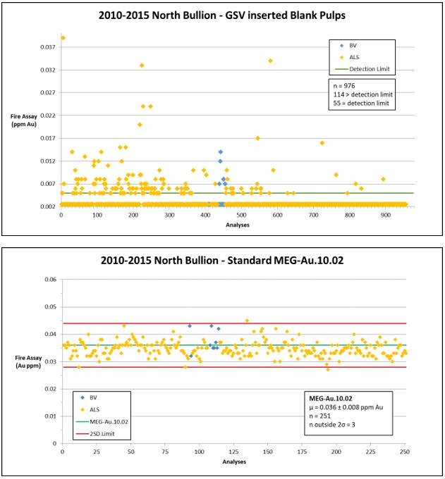
| Effective Date: November 3, 2017 | | | 240 |
Technical Report Maiden Resource Estimate North Bullion Railroad Project, Elko County, Nevada, USA
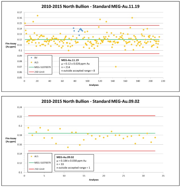
| Effective Date: November 3, 2017 | | | 241 |
Technical Report Maiden Resource Estimate North Bullion Railroad Project, Elko County, Nevada, USA
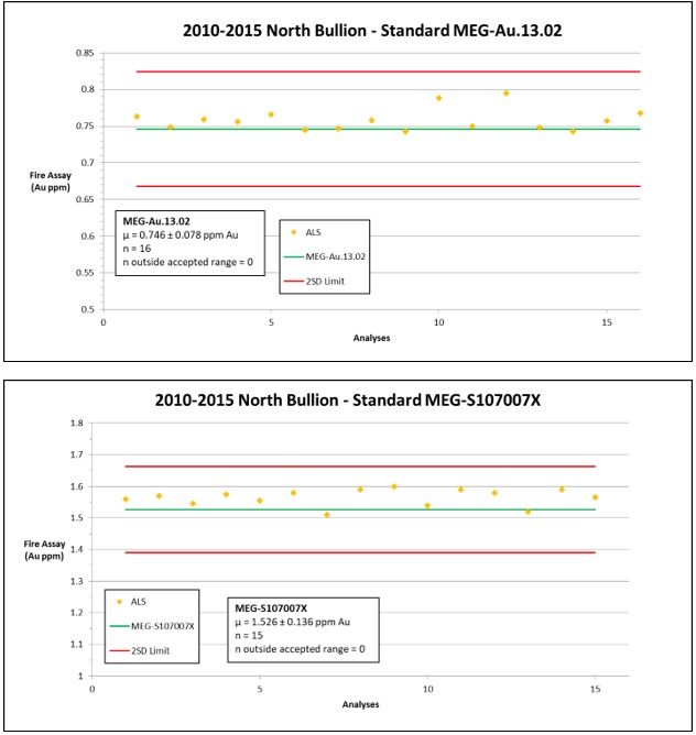
| Effective Date: November 3, 2017 | | | 242 |
Technical Report Maiden Resource Estimate North Bullion Railroad Project, Elko County, Nevada, USA

| Effective Date: November 3, 2017 | | | 243 |
Technical Report Maiden Resource Estimate North Bullion Railroad Project, Elko County, Nevada, USA

| Effective Date: November 3, 2017 | | | 244 |
Technical Report Maiden Resource Estimate North Bullion Railroad Project, Elko County, Nevada, USA
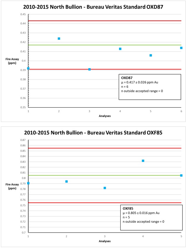
| Effective Date: November 3, 2017 | | | 245 |
Technical Report Maiden Resource Estimate North Bullion Railroad Project, Elko County, Nevada, USA
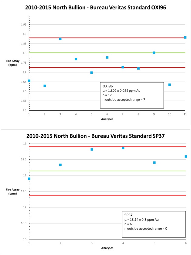
| Effective Date: November 3, 2017 | | | 246 |
Technical Report Maiden Resource Estimate North Bullion Railroad Project, Elko County, Nevada, USA
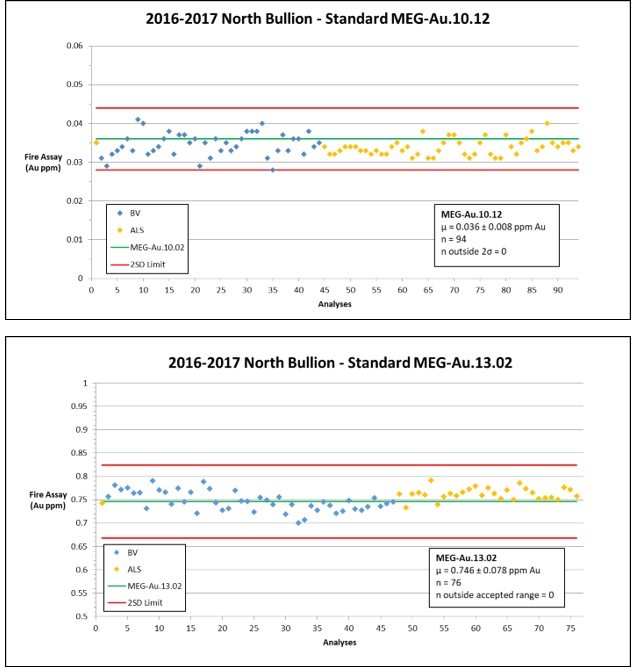
| Effective Date: November 3, 2017 | | | 247 |
Technical Report Maiden Resource Estimate North Bullion Railroad Project, Elko County, Nevada, USA
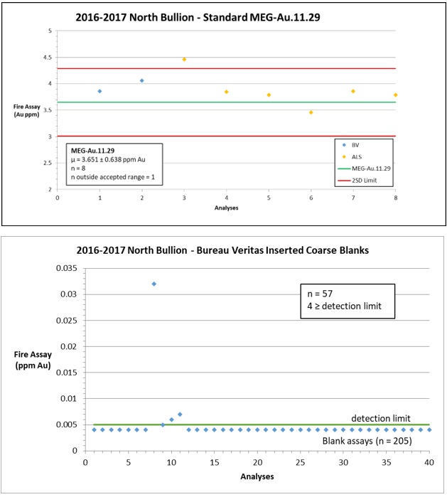
| Effective Date: November 3, 2017 | | | 248 |
Technical Report Maiden Resource Estimate North Bullion Railroad Project, Elko County, Nevada, USA
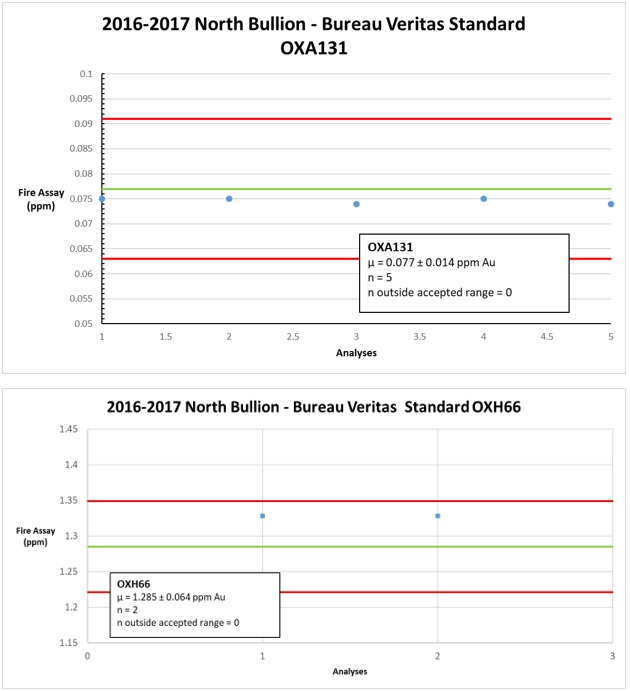
| Effective Date: November 3, 2017 | | | 249 |