FORM 6-K
SECURITIES AND EXCHANGE COMMISSION WASHINGTON, D.C. 20549
_____________
REPORT OF FOREIGN ISSUER
Pursuant to Rule 13a-16 or 15d-16 of
the Securities Exchange Act of 1934
For the month of December, 2007
Silver Wheaton Corp.
(Translation of registrant's name into English)
Suite 3150, 666 Burrard Street, Vancouver, British Columbia V6C 2X8 CANADA
(Address of principal executive offices)
Indicate by check mark whether the registrant files or will file annual reports under cover Form 20-F or Form 40-F.
| Form 20 F [ ] | Form 40 F [ X ] |
Indicate by check mark whether the registrant by furnishing the information contained in this Form is also thereby furnishing the information to the Commission pursuant to Rule 12g3-2(b) under the Securities Exchange Act of 1934.
| Yes [ ] | No [ X ] |
If "Yes" is marked, indicate below the file number assigned to the registrant in connection with Rule 12g3-2(b): 82-________________
EXHIBIT INDEX
The following is a list of Exhibits included as part of this Report on Form 6-K:
Technical Report dated December 31, 2006
SIGNATURES
Pursuant to the requirements of the Securities Exchange Act of 1934, the registrant has duly caused this report to be signed on its behalf of the undersigned, thereunto duly authorized.
| Silver Wheaton Corp. | ||
| (Registrant) | ||
| Date: December 11, 2007 | By:/s/ Peter Barnes | |
| Name | ||
| Its:President and Chief Executive Officer | ||
| (Title) | ||
| AN AUDIT OF THE |
| MINERAL RESERVES/RESOURCES |
| TAYOLTITA, SANTA RITA AND SAN ANTONIO MINES |
| AS OF DECEMBER 31, 2006 |
| FOR |
| SILVER WHEATON CORP. |
Velasquez Spring, P.Eng.
Senior Geologist
and
Gordon Watts, P.Eng.
Senior Associate Mineral Economist
| March 15, 2007 | Watts, Griffis and McOuat Limited |
| Toronto, Canada | Consulting Geologists and Engineers |
Watts, Griffis and McOuat
TABLE OF CONTENTS
Page
| 1. | SUMMARY | 1 |
| 2. | INTRODUCTION AND TERMS OF REFERENCE | 12 |
| 2.1 | GENERAL | 12 | |
| 2.2 | TERMS OF REFERENCE | 15 | |
| 2.3 | UNITS AND CURRENCY | 16 | |
| 2.4 | DEFINITIONS | 16 | |
| 2.5 | LUISMIN APPROACH TO MINERAL RESERVE ESTIMATION | 18 | |
| 2.6 | DISCLAIMERS | 18 |
| 3. | RELIANCE ON OTHER EXPERTS | 22 |
| 4. | PROPERTY DESCRIPTION AND LOCATION | 23 |
| 4.1 | LOCATION | 23 | |
| 4.2 | PROPERTY DESCRIPTION | 23 |
| 5. | ACCESSIBILITY, CLIMATE, LOCAL RESOURCES, INFRASTRUCTURE AND PHYSIOGRAPHY | 26 |
| 5.1 | ACCESS | 26 | |
| 5.2 | CLIMATE | 26 | |
| 5.3 | LOCAL RESOURCES | 26 | |
| 5.4 | INFRASTRUCTURE | 27 | |
| 5.5 | PHYSIOGRAPHY | 29 |
| 6. | HISTORY | 30 |
| 7. | GEOLOGICAL SETTING | 32 |
| 8. | DEPOSIT TYPES | 38 |
| 9. | MINERALIZATION | 39 |
| 10. | EXPLORATION | 44 |
| 11. | DRILLING | 46 |
| 12. | SAMPLING METHOD AND APPROACH | 47 |
- ii -
Watts, Griffis and McOuat
TABLE OF CONTENTS
(continued)
Page
| 13. | SAMPLE PREPARATION, ANALYSES AND SECURITY | 48 |
| 14. | DATA VERIFICATION | 49 |
| 15. | ADJACENT PROPERTIES | 50 |
| 16. | MINING OPERATIONS | 51 |
| 16.1 | GENERAL | 51 | |
| 16.2 | DESCRIPTION OF MINING OPERATIONS | 52 |
| 17. | MILLING OPERATIONS | 56 |
| 17.1 | GENERAL | 56 | |
| 17.2 | TAYOLTITA MILL | 56 |
| 18. | MINERAL RESOURCE AND MINERAL RESERVE ESTIMATES | 59 |
| 18.1 | GENERAL | 59 | |
| 18.2 | LUISMIN APPROACH | 59 | |
| 18.3 | PAH AUDIT | 60 | |
| 18.4 | VOLUME ESTIMATE | 60 | |
| 18.5 | TREATMENT OF HIGH GRADE ASSAYS | 61 | |
| 18.6 | TONNAGE FACTOR | 61 | |
| 18.7 | DILUTION | 61 | |
| 18.8 | CUTOFF GRADE | 62 | |
| 18.9 | CLASSIFICATION OF RESERVES | 62 | |
| 18.10 | RECONCILIATION BETWEEN RESERVES AND PRODUCTION | 64 | |
| 18.11 | DISCUSSION | 64 |
| 19. | SAN DIMAS TAILINGS MANAGEMENT | 83 |
| 19.1 | GENERAL | 83 | |
| 19.2 | TAYOLTITA TAILINGS | 83 | |
| 19.3 | SAN ANTONIO TAILINGS | 85 | |
| 19.4 | EXPLORATION PROPERTIES | 86 |
| 20. | CAPITAL AND OPERATING COSTS | 90 |
| 20.1 | CAPITAL COSTS | 90 | |
| 20.2 | OPERATING COSTS | 91 |
- iii -
Watts, Griffis and McOuat
TABLE OF CONTENTS
(continued)
Page
| 21. | MARKETS AND CONTRACTS | 93 |
| 22. | OBSERVATIONS, CONCLUSIONS AND RECOMMENDATIONS | 94 |
| CERTIFICATES | 97 |
| REFERENCES | 101 |
LIST OF TABLES
| 1. | Reconciliation between predicted grade and production | 19 |
| 2. | Luismin mine production | 31 |
| 3. | Luismin San Dimas mining operations for 2006 | 51 |
| 4. | San Dimas mill performance 2006 | 56 |
| 5. | Reconciliation between predicted Reserves and actual production – Tayoltita-Santa Rita (1978-2002) | 66 |
| 6. | Reconciliation between predicted Reserves and actual production – San Antonio | 67 |
| 7. | Inferred Mineral Resources of San Dimas district geology department (as of December 31, 2006) | 69 |
| 8. | Luismin, S.A. de C.V. operating mines Inferred Mineral Resources transformed into Mineral Reserves (1979-1998) | 68 |
| 9. | Luismin S.A. de C.V. Tayoltita Mine Inferred Resources | 70 |
| 10. | Luismin S.A. de C.V. Santa Rita Mine Inferred Resources | 71 |
| 11. | Minas Luismin, S.A. de C.V. San Antonio Area Inferred Resources | 72 |
| 12. | Mineral Reserves of San Dimas district - Luismin geology department (as of December 31, 2006) | 79 |
| 13. | Tayoltita Mineral Reserves | 80 |
| 14. | Santa Rita Mineral Reserves | 81 |
| 15. | Block Central Mineral Reserves | 82 |
| 16. | Minas Luismin, S.A. de C.V. - exploration project status, 2004 | 88 |
| 17. | San Dimas capital budget, years 2007 to 2011 | 90 |
| 18. | Luismin operating costs for 2006 | 92 |
- iv -
Watts, Griffis and McOuat
TABLE OF CONTENTS
(continued)
Page
LIST OF FIGURES
| 1. | Luismin Organization Chart | 13 |
| 2. | Location map, Luismin's operating mines, Mexico | 14 |
| 3. | Grades and reconciliation - Luismin Operations (1978-2002), includes San Martin Mine in Queretero, Mexico | 20 |
| 4. | Location of Tayoltita, San Antonio and Santa Rita mines | 24 |
| 5. | Property map, San Dimas district | 25 |
| 6. | Infrastructure at Tayoltita | 28 |
| 7. | Geologic Map of the San Dimas District | 33 |
| 8. | Litho-stratigraphic column of the San Dimas District | 34 |
| 9. | Structural map of the San Dimas District | 36 |
| 10. | Geologic section across the San Dimas District | 37 |
| 11. | Longitudinal cross-section of San Luis Vein, Tayoltita Mine | 40 |
| 12. | Longitudinal cross-section of Guadalupe Vein | 41 |
| 13. | Longitudinal cross-section of San Antonio Vein | 42 |
| 14. | Schematic section of the Favourable Zone | 45 |
| 15. | Flowsheet of El Perihuete 2,100 tpd processing plant | 58 |
| 16. | Regional structure and known veins | 65 |
| 17. | Longitudinal section San Fernando | 73 |
| 18. | Longitudinal section Veta Roberta | 74 |
| 19. | Longitudinal section Veta Robertita | 75 |
| 20. | Longitudinal section Veta Marina I | 76 |
| 21. | Longitudinal section Veta Marina II | 77 |
| 22. | Longitudinal section Veta Santa Lucia | 78 |
| 23. | Mexican exploration projects | 87 |
- v -
Watts, Griffis and McOuat
1. SUMMARY
General
Watts, Griffis and McOuat Limited ("WGM") was retained by Silver Wheaton Corp.("Silver Wheaton") to conduct an independent audit of the Mineral Reserves and Mineral Resources of three Mexican operating gold and silver mines in Durango Mexico, belonging toLuismin S.A. de C.V.("Luismin") as of December 31, 2006, and to prepare a report in compliance with National Instrument 43-101 ("NI 43-101"). Silver Wheaton is a 64% owned company ofGoldcorp Inc./Wheaton River Minerals Ltd. ("Wheaton") that has agreed to purchase all the silver produced by Luismin's mining operations in Mexico over a 25 year period (2005 to 2029). Wheaton purchased all of the shares of Luismin in 2002 and Luismin, a Mexican mining company, is now a wholly owned subsidiary of Wheaton. The purpose of the audit was to support disclosure in Silver Wheaton's Annual Information Form.
WGM has visited the three mines on several occasions during the past six years and produced independent Mineral Resource/Reserve audits of Luismin's operations as of: December 31, 2001; December 31, 2002; August 31, 2004 and December 31, 2004. PreviouslyPincock, Allen and Holt("PAH") had conducted independent audits as of: June 30, 1998; December 31, 1999; and, October 31, 2000.
The three mining properties are each operated by wholly owned subsidiaries of Luismin and include: Tayoltita, Santa Rita and San Antonio mines in the San Dimas district, on the border of Durango and Sinaloa states. Exploration and exploitation concessions covering the three mines have a total area of 22,468.2 ha. This extensive land ownership covers the mines, as well as the most prospective surrounding areas, and forms an important asset for Luismin's future exploration programs.
All mines are underground operations using primarily mechanized cut-and-fill mining methods. After milling, cyanidation, precipitation and smelting, doré bars are poured and then transported for refining, 70% to Torreon, Mexico and 30% to Salt Lake City, Utah.
Luismin also holds numerous exploration projects throughout Mexico, most of which are in the grassroots stage of development.
- 1 -
Watts, Griffis and McOuat
Luismin's production of gold and silver in the San Dimas District: during 2004 was 84,958 oz Au and 6,206,781 oz Ag; during 2005 was 115,913 oz Au and 7,380,755 oz Ag; and, during 2006 was 162,669 oz Au and 8,695,955 oz Ag.
The geological and engineering work done by Luismin is of high quality and follows accepted engineering practices, and record keeping is very good.
The three mines that comprise the San Dimas District, Tayoltita, Santa Rita and San Antonio are located some 125 km northeast from Mazatlan, Sinaloa or approximately 150 km west of the city of Durango, Durango. The district is accessed by aircraft in a one hour flight from either Mazatlan or Durango, or by driving some 10 hours from Durango.
The Santa Rita mine is located approximately 3 km upstream from the Tayoltita mine while the San Antonio mine is 7 km west of Tayoltita. Production from the three mines is processed in the central milling facility at Tayoltita. The San Antonio mill, that formerly processed production from the San Antonio mine, was put in care and maintenance in November 2003. The San Antonio mill is accessed from the Tayoltita mine by road, to the portal of the San Luis tunnel then through the tunnel and finally along a river bed or access road to the mill, about an hour and a half drive in total.
The San Dimas District has experienced a long history of mining since precious metal production was first reported in 1757. Historical production is estimated at 564.7 million ounces of silver and 10.46 million ounces of gold making the San Dimas District third in Mexico for precious metal production.
The geological setting at San Dimas shows two major volcanic successions, totalling 3,500 m in thickness, separated by an erosional and depositional unconformity. The Lower Volcanic Unit ("LVG") is predominantly composed of andesitic and rhyolitic flows and tuffs, while the Upper Volcanic Unit ("UVG") is composed of a lower andesitic horizon capped by rhyolitic ash flows and tuffs. The LVG is the host of the mineralized veins.
The district lies within an area of complex normal faulting. Five major, post-ore north-northwest trending faults have divided the district into five tilted blocks.
- 2 -
Watts, Griffis and McOuat
The deposits are high grade, silver-gold epithermal vein deposits formed from the final stages of igneous and hydrothermal activity in two different vein systems. The first formed set of veins strikes east-west while the second strikes north-northeast. Both sets of veins pinch, swell, bifurcate and exhibit horse-tailing and cymoidal structures. The veins vary in width from a fraction of a centimetre to fifteen metres, but average 1.5 m. The ore shoots in the veins have variable strike lengths, and average 150 m. They can have up to 200 m down-dip extensions but the down-dip extensions are normally less than the strike length. The ore forming minerals are light coloured, medium to coarse grained quartz with intergrowths of base metal sulphides, pyrite, argentite, polybasite, native silver and electrum.
Typical of epithermal systems, the San Dimas District exhibits a vertical zonation with a distinct top and bottom that Luismin has termed the Favourable Zone. At the time of deposition, the Favourable Zone was in a horizontal position, paralleling the erosional surface of the LVG. Luismin has successfully located the Favourable Zone in fault tilted blocks from the position of the unconformity between the lower and upper volcanic units. At San Dimas, the Favourable Zone has a vertical extent of some 300 to 600 m. Past mining experience has shown that 30% of the volume/tonnage of structures in the Favourable Zone, when later developed, becomes ore. At the current mining rate, Inferred Mineral Resources are being successfully developed on a yearly basis into Mineral Reserves to replace mined out ore.
Exploration is done both by diamond drilling and by underground development work. The drilling is mainly done from underground stations.
The workings of the San Dimas District mines are sampled across the vein at 1.5 m intervals along the vein under the direction of the Geological Department. The splits are taken along the sample line to reflect geology but no sample is greater than 1.5 m. Once an ore block has been developed, the sample line spacing may be increased to 3.0 m. Sampling is by an approximately 10 cm wide chip-channel across the vein.
The samples are crushed, ground, split and homogenized at the mine assay laboratory to produce a representative 10 g sample for fire assaying. Routine quality control is carried out with check assays done at the mine assay laboratory, and between commercial assay mine laboratories.
- 3 -
Watts, Griffis and McOuat
The method used by Luismin to estimate tonnage/grade at the mines in an ore shoot is the conventional block estimation method where the average width is multiplied by the area measured in a vertical plane (corrected for dip) to determine the volume. This volume is multiplied by the Specific Gravity ("SG") of 2.7 to give the estimated tonnage.
Grade corrections of 0.85 by silver grade and 0.95 by gold grade, have been applied. To account for narrow veins at the San Dimas mines, a dilution factor of 10% (at zero grade) is also applied to blocks of less than 5,000 tonnes. These grade corrections and dilution, where appropriate, are applied to both the Proven and Probable Mineral Reserves and the Inferred Mineral Resources.
Calculation of the minimum cutoff grade is based on market metal prices for gold and silver metal recovered in the mill and the average monthly production costs for mining/milling/overhead etc., to produce a minimum dollar per tonne cutoff grade.
The terminology used by Luismin to designate Measured and Indicated Mineral Resources and Proven and Probable Mineral Reserves is in general agreement with the CIM Standards as adopted in NI 43-101.
Luismin designates Proven Mineral Reserves only when mineralization above cutoff grade is exposed in a drift. The distance projected above and below the drift is a function of the exposed length of the above-cutoff grade mineralization in the drift.
Luismin also estimates Probable Mineral Reserves by diamond drilling. A square is drawn on the vertical longitudinal section with the drillhole centered on the square. The shape and size of the block depends upon the geological interpretation and thickness of the vein ranging from 25 by 25 m for veins less than 1.0 m thick to 50 by 50 m for veins greater than 1.5 m thick.
Drillhole blocks, based on drillhole assays 50 m or less from underground workings, are classified as "Probable Mineral Reserves from Drilling".
Mining has been conducted in the San Dimas District for more than 200 years and knowledge of the geology i.e. character of the more than 100 veins/structures has been obtained. Detailed mapping and record keeping has assisted in developing a working model. The economic mineralization is known to be confined to an epithermal zone with a distinct top and bottom.
- 4 -
Watts, Griffis and McOuat
Experience has shown that the mineralization within the vein/structure in the favourable zone is very irregular but statistically occupies 30% of the vein/structure. The extent of extrapolation of an individual vein/structure within the favourable zone is defined on structural and stratigraphic relationships supported by geochemical trace element studies and by fluid inclusion studies. These studies have been published as various papers in Economic Geology (see bibliography).
Extrapolation of a particular vein/structure (generally from 200 m to 500 m but in some cases up to 1,000 m) is based on various criteria from: known underground workings, surface exposure, drillholes intercepts; continuity and width of the known part of the structure, etc.
WGM's audit of Luismin's Mineral Resource/Mineral Reserve estimates did not uncover any fatal flaws, and WGM believes that the methods used by Luismin to estimate the Mineral Resources/Mineral Reserves are reasonable.
Prior to 2004, the three Luismin mines in the San Dimas District were treated as separate mining units with production from the Tayoltita and Santa Rita mines processed at the Tayoltita mill and production from the San Antonio mine processed at the San Antonio mill. Late in 2003, the San Antonio mill was put on standby and closed, and with all mine production to be processed through the Tayoltita mill, a reclassification was made into three new mining units: Tayoltita, Santa Rita and the Central Block.
The Proven and Probable Mineral Reserves at the three operating mining units as of December 31, 2006 are4.31 million tonnes at 388 g Ag/t and 5.73 g Au/t, as follows:
| Proven and Probable Mineral Reserves - San Dimas | |||
| Tonnes | g Ag/t | g Au/t | |
| Proven Mineral Reserves | |||
| Tayoltita | 359,174 | 332 | 3.08 |
| Santa Rita | 206,351 | 497 | 3.59 |
| Block Central | 1,001,444 | 420 | 7.70 |
| Probable Mineral Reserves | |||
| Tayoltita | 1,124,673 | 315 | 3.25 |
| Santa Rita | 476,629 | 358 | 5.38 |
| Block Central | 1,146,362 | 442 | 7.82 |
Notes to Reserve Statement
| 1. | Reserves were estimated by Luismin and audited by WGM as of December 31, 2006. |
| 2. | Cutoff grade for the San Dimas District, based on total operating cost, was US$64.31 per tonne. |
| 3. | All reserves are diluted, a mining recovery factor has not been applied, but WGM estimates that the mining recovery will be approximately 90%. |
| 4. | The tonnage factor is 2.7 tonnes per cubic metre. |
| 5. | Cutoff values are calculated at a silver price of US$7.00 per troy ounce and US$450.00 per troy ounce for gold. |
- 5 -
Watts, Griffis and McOuat
The Inferred Mineral Resources at San Dimas, diluted, are about7.99 million tonnes at an approximate grade of 321 g Ag/t and 2.9 g Au/t, and are separately reported and not included in the above total Mineral Reserve estimate, as Inferred Mineral Resources are not known to the same degree of certainty as Mineral Reserves and do not have demonstrated economic viability.
The three silver and gold mines in the San Dimas district are underground operations employing cut-and-fill mining and using load, haul, and dump ("LHD") equipment. Primary access is provided by adits and internal ramps. Milling operations are carried out at Tayoltita which has a capacity of 2,100 tpd. The ore is processed by conventional cyanidation followed by zinc precipitation of the silver and gold and refining for the production of doré.
In 2004, San Dimas district mined 397,646 tonnes at an average grade of 6.9 g Au/t and 525 g Ag/t for a production of 84,958 oz of gold and 6,206,781 oz of silver at recoveries of 96.8% and 92.5% respectively. In 2005, the San Dimas District mined 507,528 tonnes at an average grade of 7.4 g Au/t and 497 g Ag/t for a production of 115,913 oz of gold and 7,380,755 oz silver at recoveries of 96.1% and 91% respectively, in 2006, the production was 688,942 tonnes at an average grade of 7.76 g Au/t and 438 g Ag/t for a production of 162,669 oz of gold and 8,695,953 oz of silver at recoveries of 95.6% and 90.2% respectively.
Environmental Issues with Luismin Operations
Luismin’s practice in the design and operation of tailings containment sites complies with the requirements of Mexico and with the permits issued for the dams in use at San Dimas, however, improvements are necessary to bring the tailings dam designs and operations up to international guidelines. Various assessments and geotechnical testing were carried out in the past five years to investigate the safety of the dams and design improved operational procedures for the tailings deposits. Since the acquisition of Luismin, Wheaton River has initiated various construction work to increase the dam safety and to better manage the tailings operations. The San Dimas tailings now employ "dry tailings staking" one of the three dry tailings operation in Mexico.
Tailings previously were discharged from milling operations into unlined structures designed to settle the solids and to collect and drain solutions for recycle to the milling operations. The
- 6 -
Watts, Griffis and McOuat
containment structures were constructed from the more dense and coarse underflow from cyclones operating on the tailings lines. Solutions from the cyclone overflows drained to decant structures in the central dam area and the solutions were recycled to the mill.
The deficiencies in the Luismin tailings dams were recognized and capital expenditures are being made to improve this area of the operations. The scope of work includes seepage controls, geotechnical investigations to support existing tailings dam and the installation at the San Antonio Tailings dam of a rock filled berm and a Roller Compacted Concrete ("RCC") stepped spillway.
In the San Dimas district, both the tailings dams at San Antonio and at Tayoltita require extensive work to stabilize the structures against erosion and possible failure. The remediation and stabilization works have started with construction of a reinforcing berm on the downstream side of the dam at Tayoltita. The operation at the San Antonio mill was shut down primarily due to depletion of tailings storage capacity. Reclamation of the San Antonio tailings dam has been designed and some approvals have been obtained. Work has started with development of an access road and covering of the exposed tailings surfaces with low strength concrete.
Improving the safety factor on the Tayoltita tailings dam includes the placement of a reinforcing berm downstream of the current dam and extension of the seepage collection system. The first phase of constructing the safety berm to stabilize the dam has been completed. The ten-stage tailings pumping system has been replaced with single stage positive displacement pumps as well as a new pipeline crossing of the river. The river crossing design includes spill protection in the event of a line failure. The installing of belt filters of the tailings, to allow dry placement of the tailings, is currently under construction at the Tayoltita operation.
With the remediation and stabilization works underway and the work planned for the future, Luismin's operations have moved considerably forward in bringing the tailings operations to international guidelines since acquisition of the operations by Wheaton River.
- 7 -
Watts, Griffis and McOuat
Capital and Operating Costs
A series of capital expenditures is required to address the remaining environmental deficiencies with the Luismin operations, sustain the existing operations and complete planned expansions of the production capacity. The capital expenditures in 2005 and 2006 for environmental purposes totalled US$6 million.
Capital expenditures are also being made to expand the Tayoltita mill operation to 3,200 tpd as the central milling facility for the San Dimas mining operations at the Tayoltita Mine, Santa Rita Mine and the Central Block Mine (includes the former San Antonio Mine).
In addition to expenditures for expansion, capital is also committed to sustain the existing production facilities with equipment replacement and ongoing exploration and mine development.
Operating costs, in 2006, in the San Dimas District for the three mines averaged US$64.32 per tonne. Detailed operating costs are separately accounted for all aspects of the mining operations to determine the cutoff grade to plan and control the mining operations.
The Luismin operations have achieved significant reductions in operating costs from increasing the scale of operations as well as improvements in the efficiencies of operating methods. Various improvements such as the integration of the Santa Rita ore haulage with Tayoltita will continue to improve efficiencies and reduce the cost structure. All operations will incur some increase in operating costs associated with the future tailings operations and associated environmental monitoring.
Markets and Contracts
Luismin ships 70% of the silver and gold doré bars to Peñoles in Torreon, Mexico where a charge of US$4.25 per kilo of doré, based on 99.8% of the contained gold and silver, is made to Luismin. The remaining 30% of the doré bars are shipped to the Johnson Matthey refinery in Salt Lake City, where the payment to Luismin is based on 99.8% of the silver and gold content, less a refining charge of US$0.14 per troy oz of doré and US$1.00 per troy oz of gold.
- 8 -
Watts, Griffis and McOuat
Although Luismin has successfully used a hedging policy in the past for its sale prices, virtually all hedge positions were fulfilled by late 2002 and there are no hedges in place at the time of this report.
Observations and Conclusions
WGM believes that the Inferred Mineral Resources are an important part of the overall planning for this project because:
- Production from the San Dimas deposits has been sustained for more than 200 years;
- Luismin has been successfully conducting mine operations at San Dimas for 25 years;
- Capital investment of approximately US$175.9 million is currently planned by Luismin for a 50% production increase from the present production over the next 5 years (2007-2011);
- A study in the main production area at San Dimas covering the period from 1979 to 1988 showed that Luismin was able to achieve a conversion rate of about 90% of the Inferred Mineral Resources into Mineral Reserves;
- WGM believes that Luismin has successfully demonstrated that there is a high probability that Inferred Mineral Resources will be converted to Mineral Reserves;
- Luismin operating practice has been to convert Mineral Resources into Mineral Reserves after drifting in the mineralization and completion of sampling and mining of the headings; and,
- Due to the combination of ever expanding production requirements, better access to capital, the well understood geology and economic zone of the mineralization, and the historical success of the operations, Luismin will be better positioned to support mine development and Mineral Reserve definition with a normal level of diamond drilling prior to mining. This should provide for a higher level of Mineral Reserve definition prior to mining.
- 9 -
Watts, Griffis and McOuat
Luismin has estimated Proven and Probable Reserves as of December 31, 2006. WGM's audit of the reserves of the Luismin mines incorporated the following steps:
- A review of all the steps in the estimation process to confirm that the procedures are appropriate for each of the deposits;
- An analysis of the system used to classify the reserves to determine whether it meets current international standards of practice in the mining industry (NI 43-101);
- A review of any changes in the estimation process since December 31, 2003;
- A review of the reconciliation between predicted reserves and actual results of mining over the period 1975 through December 31, 2006; and,
- An analysis of operating results for 2006 to confirm that the reserves are in fact being mined and processed at a profit.
Interpretation and Conclusions
WGM has concluded that:
| Total Proven and Probable Mineral Reserves estimated as of December 31, 2006, for Luismin's three operating mines (Tayoltita, Santa Rita, San Antonio/Block Central) are 4.31 million tonnes at a grade of 388 g Ag/t and 5.73 g Au/t; | |||
| The procedures used by Luismin to estimate the Mineral Reserves are reasonable and the reserves fairly represent the tonnage and grade that can be expected from an operation; | |||
| The total Inferred Mineral Resources, estimated as of December 31, 2006, for the same three operating mines, and not included in the Mineral Reserves stated above, are about 7.99 million tonnes at an approximate grade of 321 g Ag/t and 2.9 g Au/t; | |||
| The procedures used by Luismin to estimate the Inferred Mineral Resources are reasonable and there is a reasonable expectation the Inferred Resource will be converted to Indicated and Measured Resources; | |||
| The experience and capabilities of the Luismin management team are regarded as excellent and important elements in the success of current and future operations; | |||
- 10 -
Watts, Griffis and McOuat
- The potential for exploration, both on active mining properties as well as on exploration holdings, to expand the reserve base to both support and expand operations is excellent;
- Future operations will incur additional capital and operating costs for management of tailings sites as well as remediation of existing sites;
- Opportunities for future reductions in operating costs will be possible with capital investment in mining and processing equipment as well as changes to operating practices; and,
- The past history of the Luismin operations shows growth in small increments where capital expenditures were justified on short term planning and assessments. This has resulted in "add on" style expansions and a variety of equipment sizes and types that reduces some efficiencies in operations and maintenance. The renewed support of capital and longer term planning should lead to better return on investments;
Watts, Griffis and McOuat
2. INTRODUCTION AND TERMS OF REFERENCE
| 2.1 | GENERAL |
At the request ofSilver Wheaton Corp.("Silver Wheaton"),Watts, Griffis and McOuat Limited("WGM") revisited the three operating gold and silver mines in Mexico of the Mexican corporationLuismin S.A. de C.V.("Luismin"). Silver Wheaton is a 64% owned company ofWheaton River Minerals Ltd. ("Wheaton") that has agreed to purchase all the silver produced by Luismin's mining operations in Mexico over a 25 year period (2004 to 2029). Wheaton purchased all of the shares of Luismin in 2002 and Luismin, a Mexican mining company, is now a wholly owned subsidiary of Wheaton.
The three mining properties are each operated by wholly owned subsidiaries of Luismin and include: the Tayoltita, Santa Rita and San Antonio mines in the San Dimas district, on the border of Durango and Sinaloa states. The organization chart (Figure 1) illustrates the various wholly owned Luismin companies, which control the mining operations and exploration properties. The three mines cover an area of approximately 22,468 ha in exploration and exploitation concessions. This extensive land ownership covers the mines as well as the most prospective surrounding areas, which forms an important asset for Luismin's future exploration programs.
All mines are underground operations using primarily mechanized cut-and-fill mining methods. After milling, cyanidation, precipitation and smelting, doré bars are poured and then transported for refining to Johnson Matthey in Salt Lake City, Utah. The locations of the mines are shown on Figure 2.
Luismin also holds numerous exploration projects throughout Mexico, most of which are at the grassroots stage of development and some are being explored under option agreements.
Gold and silver production from Luismin’s three San Dimas mines: during 2003 was 68,465 oz of gold and 5,455,958 oz of silver; during 2004 was 84,958 oz of gold and 6,206,781 oz of silver; during 2005 115,913 oz of gold and 7,380,7855 oz of silver and in the
- 12 -
Watts, Griffis and McOuat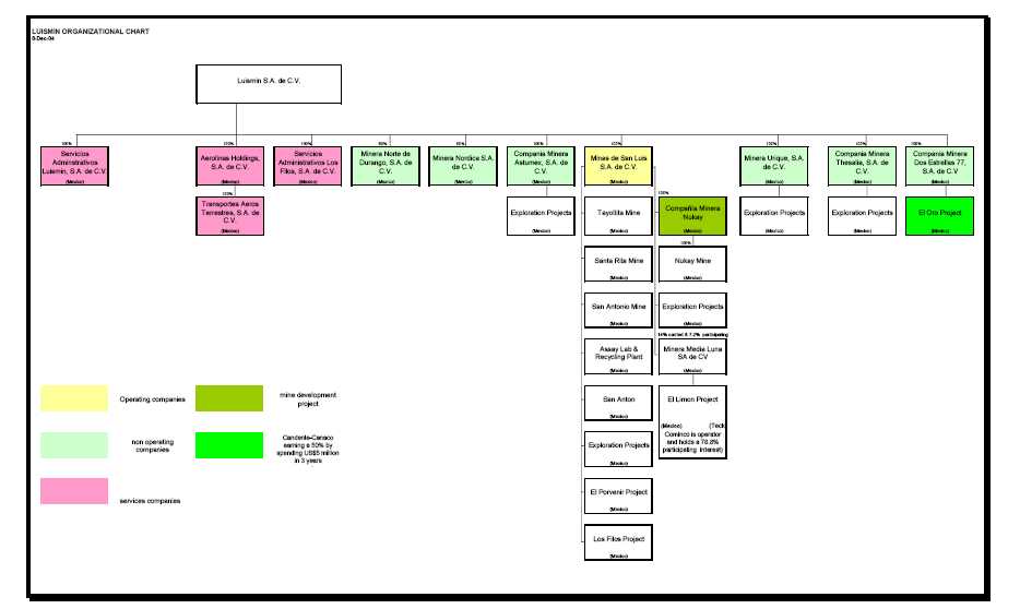
Figure 1. Luismin Organization Chart
- 13 -
Watts, Griffis and McOuat
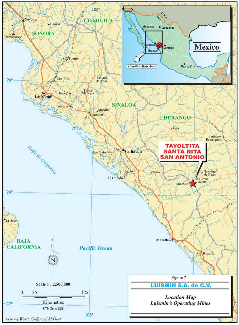
Figure 2. Location map, Luismin's operating mines, Mexico
- 14 -
Watts, Griffis and McOuat
past year (2006) 162,669 oz of gold and 8,695,953 oz of silver. Over the four year period (2003 to 2006) the Luismin gold production has increased by 139% and silver production by 59%.
| 2.2 | TERMS OF REFERENCE |
WGM was retained in 2004 by Silver Wheaton to conduct an independent technical review and to prepare a report in compliance with National Instrument 43-101 ("NI 43-101") following Form 43-101F1, on three operating silver-gold mines (Tayoltita, Santa Rita, San Antonio) in Mexico.
WGM has previously in 2002 been retained by Wheaton River Minerals Ltd. to conduct an independent technical review and to prepare a technical report in compliance with NI 43-101 on the same three mines and also in 2003 WGM was again retained by Wheaton to conduct an independent audit on the three mines as of December 31, 2002 and again as of December 31, 2004. WGM is very familiar with the operations at the three mines.
The purpose of the WGM independent technical review and audit of the Mineral Reserves is to support disclosure in Silver Wheaton's Annual Information Form.
Velasquez Spring, a Senior Geologist of WGM revisited the three mining operations during January 17 to 19, 2007. Subsequent to the visit several telephone calls and discussions were held with Luismin engineers and geologists, at each of the operating mines, as well as with senior personnel at Luismin’s head office, regarding the mining/milling operations, exploration, and Mineral Resource/Reserve estimation procedures. During the site visit, a detailed review was made by WGM of the plans and capital budgets that were prepared by Luismin/Wheaton for the proposed underground expansions at each of the three Luismin mines.
WGM checked the information provided during the visits to the mines and reviewed it for adequacy and completeness.
The geological and engineering work done by Luismin is of high quality and follows accepted engineering practices. The record keeping with regard to Mineral Resource/Mineral Reserve estimates, i.e. plans, sections and calculation sheets, is very good. From 1994 to 2000,
- 15 -
Watts, Griffis and McOuat
Luismin retained the consulting firm of Pincock, Allen and Holt to conduct an independent audit on the Mineral Resource/Mineral Reserve estimates every two years.
The opinions and conclusions presented in this report are based on information received from Luismin. WGM received the full cooperation and assistance of Luismin during the site visit and in preparation of this report.
| 2.3 | UNITS AND CURRENCY |
Throughout this report common measurements are in metric units. Tonnages are shown as tonnes (1,000 kg), linear measurements as metres ("m"), or kilometres ("km") and precious metal values as grams ("g"), grams of gold per tonne ("g Au/t"), and grams of silver per tonne ("g Ag/t"). Cubic feet per minute ("cfm") is used for ventilation air flow. Grams are converted to ounces based upon 31.103 grams per ounce.
All economic data is quoted in US dollars ("US$"). When peso amounts required conversion into US dollars, the peso exchange rate used was 11.00 pesos equivalent to US$1.00.
| 2.4 | DEFINITIONS |
The classification of Mineral Resources and Mineral Reserves used in this report conforms with the definitions provided in the final version of National Instrument 43-101 ("NI 43-101"), which came into effect on February 1, 2001. We further confirm that, in arriving at our classification, we have followed the guidelines adopted by the Council ofthe Canadian Institute of Mining Metallurgy and Petroleum (the "CIM Standards"). The relevant definitions for the CIM Standards/NI 43-101 are as follows:
AMineral Resource is a concentration or occurrence of natural, solid, inorganic or fossilized organic material in or on the Earth's crust in such form and quantity and of such a grade or quality that it has reasonable prospects for economic extraction. The location, quantity, grade, geological characteristics and continuity of a Mineral Resource are known, estimated or interpreted from specific geological evidence and knowledge.
AnInferred Mineral Resourceis that part of a Mineral Resource for which quantity and grade or quality can be estimated on the basis of geological evidence and limited sampling and reasonably assumed, but not verified, geological and grade continuity.
- 16 -
Watts, Griffis and McOuat
The estimate is based on limited information and sampling gathered through appropriate techniques from locations such as outcrops, trenches, pits, workings and drillholes.
AnIndicated Mineral Resource is that part of a Mineral Resource for which quantity, grade or quality, densities, shape and physical characteristics, can be estimated with a level of confidence sufficient to allow the appropriate application of technical and economic parameters, to support mine planning and evaluation of the economic viability of the deposit. The estimate is based on detailed and reliable exploration and testing information gathered through appropriate techniques from locations such as outcrops, trenches, pits, workings and drillholes that are spaced closely enough for geological and grade continuity to be reasonably assumed.
AMeasured Mineral Resource is that part of a Mineral Resource for which quantity, grade or quality, densities, shape, physical characteristics are so well established that they can be estimated with confidence sufficient to allow the appropriate application of technical and economic parameters, to support production planning and evaluation of the economic viability of the deposit. The estimate is based on detailed and reliable exploration, sampling and testing information gathered through appropriate techniques from locations such as outcrops, trenches, pits, workings and drillholes that are spaced closely enough to confirm both geological and grade continuity.
AMineral Reserve is the economically mineable part of a Measured or Indicated Mineral Resource demonstrated by at least a Preliminary Feasibility Study. This Study must include adequate information on mining, processing, metallurgical, economic and other relevant factors that demonstrate, at the time of reporting, that economic extraction can be justified. A Mineral Reserve includes diluting materials and allowances for losses that may occur when the material is mined.
AProbable Mineral Reserve is the economically mineable part of an Indicated, and in some circumstances a Measured Mineral Resource demonstrated by at least a Preliminary Feasibility Study. This Study must include adequate information on mining, processing, metallurgical, economic, and other relevant factors that demonstrate, at the time of reporting, that economic extraction can be justified.
AProven Mineral Reserve is the economically mineable part of a Measured Mineral Resource demonstrated by at least a Preliminary Feasibility Study. This Study must include adequate information on mining, processing, metallurgical, economic, and other relevant factors that demonstrate, at the time of reporting, that economic extraction is justified.
The terminology used by Luismin to designate Measured and Indicated Mineral Resources and Proven and Probable Mineral Reserves is in general agreement with the CIM Standards as
- 17 -
Watts, Griffis and McOuat
adopted in NI 43-101. Luismin’s Mineral Resource categories "potential resource" and "drill inferred resource" would, under the CIM Standards, be called Inferred Resources. We have used the term Inferred Mineral Resources for this material throughout the rest of this report.
| 2.5 | LUISMIN APPROACH TO MINERAL RESERVE ESTIMATION |
Rather than calculating Mineral Resources/Mineral Reserves over a minimum mining width and then applying corrections for dilution and mine losses to determine Mineral Reserves, Luismin estimates the reserve in each of the underground mining blocks by using the conventional mining block estimation methods for underground mines and later applying a tonnage and grade correction to determine Mineral Reserves. The minimum mining width is 0.9 m. However, on occasion, where very high grade values are encountered over intervals less than 0.9 m, the minimum mining width is calculated to 0.9 m, using zero grade gold and silver values for the additional width required to meet 0.9 m.
Luismin’s success with predicting the tonnage and grade of the reserves over the period 1979-2002 for all operations is shown on Table 1. The table clearly shows that, although there are variances from year to year, the overall totals compare well. We have presented the actual silver and gold grades graphically in Figure 3.
Table 1 shows the predicted tonnage and grade of reserves over the period 2003 to 2004 including production from the San Martin Mine in Queretero, and from years 2003 to 2006 (at the bottom of Table 1), and again the overall predicted tonnage and grades continue to show good comparisons.
| 2.6 | DISCLAIMERS |
WGM did not independently review the lease and land status information on the mines and the information as reported herein, was provided by Luismin.
WGM did not independently sample or assay any of the mineralization at the mines. WGM did observe the pouring of numerous doré bars and receipts of payment from the sale of doré bars and we are satisfied that the mines are producing silver and gold. WGM did not carry out a formal due diligence review of environmental considerations asSRK Consulting ("SRK"),
- 18 -
Watts, Griffis and McOuat
TABLE 1
RECONCILIATION BETWEEN PREDICTED GRADE AND PRODUCTION
| YEAR | TONNES | SILVER GRADE | GOLD GRADE | SILVER CONTENT (OZ) | GOLD CONTENT (OZ) | ||||||||||
| Variance | g Ag/t | Variance | g Au/t | Variance | Variance | Variance | |||||||||
| Predicted | Actual | % | Predicted | Actual | % | Predicted Actual | % | Predicted | Actual | % | Predicted | Actual | % | ||
| LUISMIN OPERATIONS (1978-2004)* | |||||||||||||||
| 1978 | 156,000 | 159,628 | 2.3% | 400 | 404 | 1.0% | 7.00 | 7.10 | 1.4% | 2,006,237 | 2,073,424 | 3.3% | 35,109 | 36,439 | 3.8% |
| 1979 | 156,000 | 161,428 | 3.5% | 400 | 395 | -1.3% | 7.00 | 6.50 | -7.1% | 2,006,237 | 2,050,094 | 2.2% | 35,109 | 33,736 | -3.9% |
| 1980 | 162,000 | 162,290 | 0.2% | 390 | 381 | -2.3% | 6.40 | 6.40 | 0.0% | 2,031,315 | 1,987,991 | -2.1% | 33,334 | 33,394 | 0.2% |
| 1981 | 162,000 | 155,837 | -3.8% | 390 | 468 | 20.0% | 6.40 | 7.80 | 21.9% | 2,031,315 | 2,344,845 | 15.4% | 33,334 | 39,081 | 17.2% |
| 1982 | 162,000 | 158,163 | -2.4% | 390 | 483 | 23.8% | 6.40 | 7.70 | 20.3% | 2,031,315 | 2,456,121 | 20.9% | 33,334 | 39,156 | 17.5% |
| 1983 | 195,000 | 176,643 | -9.4% | 383 | 422 | 10.2% | 6.50 | 6.90 | 6.2% | 2,401,215 | 2,396,661 | -0.2% | 40,752 | 39,187 | -3.8% |
| 1984 | 216,000 | 200,256 | -7.3% | 396 | 424 | 7.1% | 6.30 | 6.60 | 4.8% | 2,750,088 | 2,729,915 | -0.7% | 43,751 | 42,494 | -2.9% |
| 1985 | 202,800 | 197,864 | -2.4% | 422 | 433 | 2.6% | 5.30 | 6.30 | 18.9% | 2,751,555 | 2,754,561 | 0.1% | 34,557 | 40,078 | 16.0% |
| 1986 | 236,300 | 222,295 | -5.9% | 396 | 423 | 6.8% | 5.77 | 6.28 | 8.8% | 3,008,546 | 3,023,206 | 0.5% | 43,837 | 44,884 | 2.4% |
| 1987 | 274,471 | 235,459 | -14.2% | 340 | 307 | -9.9% | 4.21 | 3.93 | -6.7% | 3,001,255 | 2,320,810 | -22.7% | 37,171 | 29,738 | -20.0% |
| 1988 | 315,520 | 315,551 | 0.0% | 335 | 310 | -7.6% | 4.89 | 4.38 | -10.3% | 3,399,316 | 3,142,158 | -7.6% | 49,579 | 44,479 | -10.3% |
| 1989 | 314,475 | 316,997 | 0.8% | 313 | 261 | -16.4% | 4.32 | 3.95 | -8.6% | 3,163,238 | 2,664,293 | -15.8% | 43,710 | 40,283 | -7.8% |
| 1990 | 319,607 | 308,593 | -3.4% | 287 | 240 | -16.5% | 3.68 | 3.58 | -2.9% | 2,949,143 | 2,378,476 | -19.4% | 37,843 | 35,483 | -6.2% |
| 1991 | 239,760 | 249,947 | 4.2% | 331 | 298 | -9.9% | 3.99 | 3.33 | -16.5% | 2,550,545 | 2,395,927 | -6.1% | 30,746 | 26,750 | -13.0% |
| 1992 | 331,685 | 331,966 | 0.1% | 347 | 326 | -5.9% | 3.30 | 3.49 | 5.8% | 3,695,707 | 3,480,175 | -5.8% | 35,141 | 37,228 | 5.9% |
| 1993 | 387,449 | 360,606 | -6.9% | 301 | 313 | 3.9% | 3.55 | 3.32 | -6.5% | 3,748,776 | 3,624,409 | -3.3% | 44,247 | 38,486 | -13.0% |
| 1994 | 529,785 | 550,119 | 3.8% | 267 | 235 | -11.8% | 3.29 | 2.95 | -10.5% | 4,548,809 | 4,163,776 | -8.5% | 56,103 | 52,142 | -7.1% |
| 1995 | 614,390 | 649,874 | 5.8% | 262 | 254 | -2.9% | 3.25 | 3.06 | -5.9% | 5,170,018 | 5,311,805 | 2.7% | 64,138 | 63,865 | -0.4% |
| 1996 | 720,670 | 753,517 | 4.6% | 257 | 252 | -2.1% | 3.17 | 3.30 | 4.1% | 5,953,125 | 6,094,302 | 2.4% | 73,473 | 79,961 | 8.8% |
| 1997 | 796,042 | 843,504 | 6.0% | 256 | 238 | -6.9% | 3.33 | 3.32 | -0.2% | 6,548,927 | 6,461,571 | -1.3% | 85,281 | 90,160 | 5.7% |
| 1998 | 847,388 | 873,460 | 3.1% | 239 | 217 | -9.5% | 3.23 | 3.06 | -5.1% | 6,517,784 | 6,080,367 | -6.7% | 88,009 | 86,073 | -2.2% |
| 1999 | 880,785 | 911,842 | 3.5% | 222 | 215 | -3.5% | 2.97 | 3.05 | 2.7% | 6,300,275 | 6,295,689 | -0.1% | 84,156 | 89,508 | 6.4% |
| 2000 | 944,110 | 982,710 | 4.1% | 216 | 207 | -4.2% | 3.07 | 3.12 | 1.4% | 6,560,586 | 6,543,742 | -0.3% | 93,306 | 98,435 | 5.5% |
| 2001 | 1,012,100 | 921,200 | -9.0% | 212 | 224 | 5.7% | 2.98 | 3.55 | 18.9% | 6,901,718 | 6,640,615 | -3.8% | 97,060 | 105,066 | 8.2% |
| 2002 | 837,077 | 801,480 | -4.3% | 242 | 253 | 4.4% | 3.94 | 4.32 | 9.5% | 6,519,449 | 6,515,789 | -0.1% | 106,152 | 111,266 | 4.7% |
| 2003 | 825,998 | 700,155 | -15.2% | 273 | 331 | 21.2% | 3.35 | 4.95 | 47.8% | 7,249,911 | 5,920,913 | -18.3% | 88,964 | 104,901 | -17.9% |
| 2004 | 837,036 | 670,380 | -19.9% | 277 | 428 | 54.5% | 4.11 | 6.11 | 49.0% | 7,454,438 | 6,665,462 | -10.6% | 110,606 | 121,893 | -10.2% |
| Total | 12,676,448 | 12,371,363 | -0.1% | 278 | 283 | -1.8% | 3.83 | 4.07 | 6.3% | 113,250,845 | 108,517,098 | -4.2% | 1,558,806 | 1,604,164 | -14.0% |
| LUISMIN'S SAN DIMAS OPERATIONS (2003-2006) | |||||||||||||||
| 2003 | 513,296 | 423,674 | -17.4% | 350 | 427 | 22.0% | 3.6 | 5.2 | 44.4% | 5,401,391 | 5,455,958 | 1.0% | 57,200 | 68,465 | 19.7% |
| 2004 | 530,913 | 397,646 | -25.1% | 385 | 525 | 36.4% | 4.3 | 6.9 | 60.5% | 6,112,952 | 6,206,781 | 1.5% | 70,904 | 84,958 | 19.8% |
| 2005 | 583,531 | 507,528 | -13.1% | 371 | 497 | 34.0% | 4.3 | 7.4 | 72.1% | 7,306,424 | 7,380,755 | 1.0% | 87,859 | 115,913 | 31.9% |
| 2006 | 709,800 | 688,941 | -2.9% | 497 | 438 | -11.9% | 6.0 | 7.7 | 28.3% | 9,499,073 | 8,695,955 | -8.5% | 32,131 | 162,668 | 23.1% |
| Total | 2,337,540 | 2,017,789 | -13.7% | 408 | 468 | 14.7 | 4.7 | 6.9 | 46.8 | 28,319,840 | 27,739,449 | -2.0% | 348,094 | 432,004 | 24.1% |
* Also includes Luismin's San Martin Mine, Queretaro, Mexico
- 19 -
Watts, Griffis and McOuat
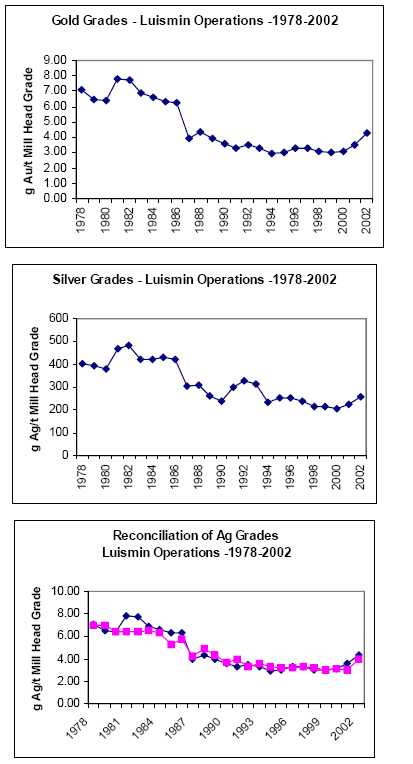
Figure 3. Grades and reconciliation - Luismin Operations (1978-2002), includes
San Martin Mine in Queretero, Mexico
- 20 -
Watts, Griffis and McOuat
at the request of Wheaton, had conducted a due diligence environmental review of Luismin’s mining properties in January 2002. The SRK review was to identify if any serious liabilities exist that would materially affect the economic performance of the operations over the next 10 years. The report is titled "Environmental Due Diligence Review of Active Mining Units Owned and Operated by Minas Luismin, S.A. de C.V., February 20, 2002" and has been reviewed by WGM as part of the technical review of the Luismin operations.
- 21 -
Watts, Griffis and McOuat
3. RELIANCE ON OTHER EXPERTS
WGM did not independently review the lease and land status information on the San Dimas Project and the information as reported herein, was provided by Luismin.
WGM prepared this study using the resource materials, reports and documents as noted in the text and "References" at the end of this report. WGM conducted an audit of the methods, parameters and documentation used and prepared by Luismin in the preparation of its Mineral Resource/Reserve estimates for the zones comprising the San Dimas Project.
WGM did not prepare independent Mineral Resource/Reserve estimates for the San Dimas Project, however, is satisfied that those persons who prepared the estimates were qualified to do so and that the estimates are reliable. WGM accepts the estimates as supplied by Luismin.
WGM has not verified title to the property, but has relied on information supplied by Luismin in this regard. WGM has no reason to doubt that the title situation is other than that which was reported to it by Luismin.
- 22 -
Watts, Griffis and McOuat
4. PROPERTY DESCRIPTION AND LOCATION
| 4.1 | LOCATION |
The San Dimas mining district is centered on latitude 24°06'N and longitude 105°56'W located about 125 km NE from Mazatlan, Sinaloa or approximately 150 km west of the city of Durango (Figure 4).
| 4.2 | PROPERTY DESCRIPTION |
Luismin’s three operating mines in the San Dimas district, on the border of Durango and Sinaloa states include San Antonio, Tayoltita and Santa Rita.
The San Dimas properties are surveyed and contained in a contiguous block and held in the name of Minas San Luis S.A. de C.V. an area of 22,468.2 ha (Figure 5).
- 23 -
Watts, Griffis and McOuat
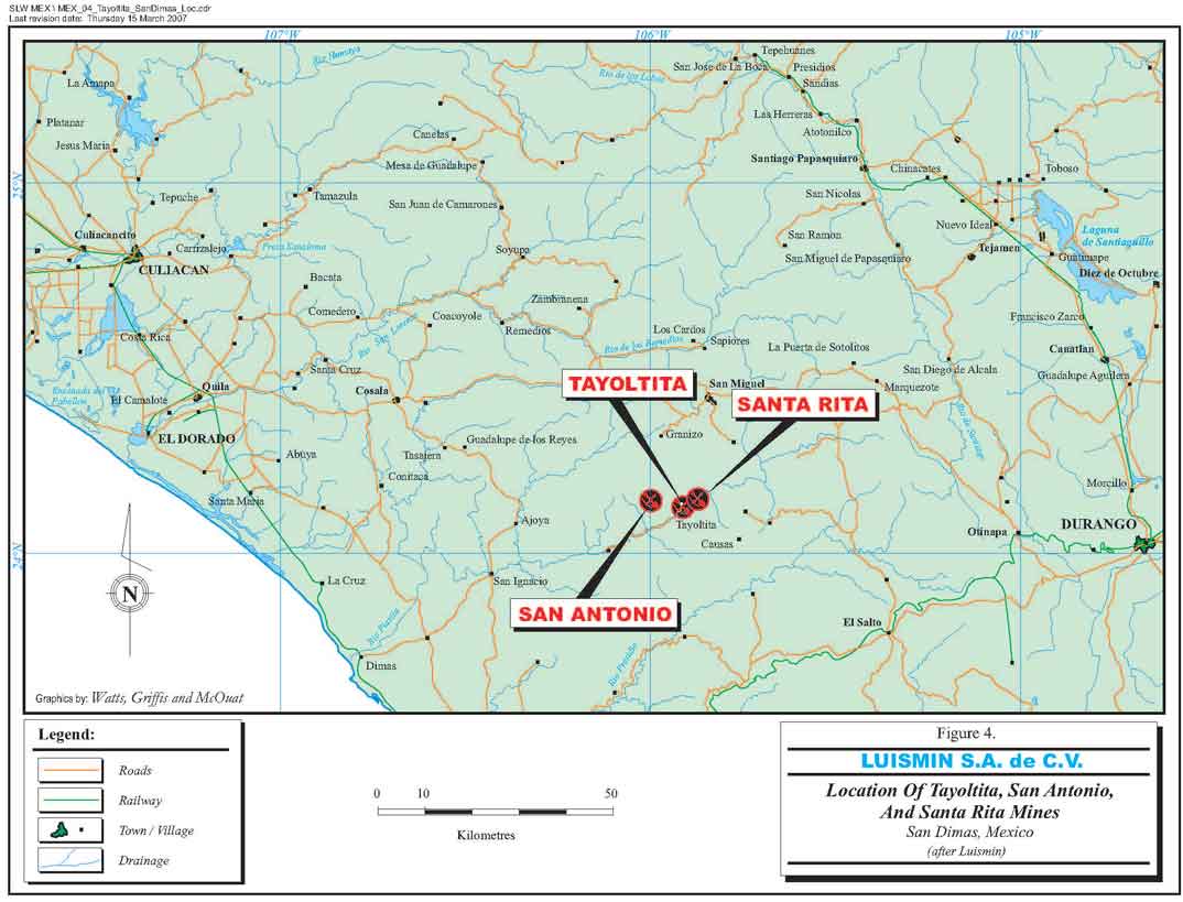
Figure 4. Location of Tayoltita, San Antonio and Santa Rita mines
- 24 -
Watts, Griffis and McOuat
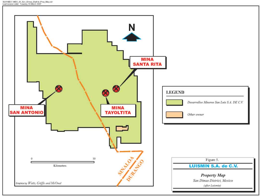
Figure 5. Property map, San Dimas district
- 25 -
Watts, Griffis and McOuat
5. ACCESSIBILITY, CLIMATE, LOCAL RESOURCES, INFRASTRUCTURE AND PHYSIOGRAPHY
| 5.1 | ACCESS |
Access to the San Dimas area is by air or road from the city of Durango. By road the trip requires some 10 hours. Luismin maintains a de Havilland Twin Otter aircraft and a helicopter; both are based at Tayoltita. An approximate one hour flight in the Twin Otter is required from either Mazatlan or Durango to Tayoltita. Most of the personnel and light supplies for the San Dimas mines arrive on the company's regular flights from Mazatlan and Durango. Heavy equipment and supplies are brought in by road from Durango.
Originally access to the Dimas district was from the town of San Ignacio, Sinaloa along a 55 km long narrow mule trail, carved in the steep valley wall above the high water level of the Piaxtla River. A rough road, paralleling the mule trail, now follows the river bed to San Ignacio but the road is only accessible for about six months of the year during the Spring dry season. San Ignacio is connected by 70 km of paved roads to Mazatlan.
| 5.2 | CLIMATE |
Regionally, the climate is variable from the coast to the high plateau.
The climate of the San Dimas area is semi-tropical, characterized by relatively high temperatures and humidity, with hot summers (maximum about 35°C) and mild winters. At higher elevations in the Sierra, frosty nights occur in the winter (November to March). The majority of the precipitation occurs in the summer (June through September) however tropical rainstorms during October to January can result in considerable additional rainfall. The total average annual rainfall varies from about 66 to 108 cm.
Weather does not affect the operations and mining is carried out throughout the year.
| 5.3 | LOCAL RESOURCES |
Sufficient pine, juniper and scattered oak trees grow on the higher ridges, to support a timber industry while the lower slopes, and valleys are covered with thick brush, cactus and grasses.
- 26 -
Watts, Griffis and McOuat
Subsistence farming, ranching, mining and timber cutting are the predominant activities of the region’s population. Tayoltita is the most important population centre in the area with approximately 8,000 inhabitants including mining company personnel. Population outside the mining and sawmill camps is sparse.
Water for the mining operations is obtained from wells and from the Piaxtla River. Water is also supplied by Luismin to the town of Tayoltita from an underground thermal spring at the Santa Rita mine.
Mining at both the Santa Rita and San Antonio mines is done by contract mining while at Tayoltita the mining is carried out by Luismin personnel.
Electrical power is provided by a combination of Luismin's own system and the Federal Power Commission supply system. Luismin operates hydroelectric and back-up diesel generators which are interconnected with the Federal Power Commission supply system.
Luismin's hydroelectrical power is being increased with additional turbines in a tunnel now under construction, as well the Federal Power Commission supply system is being increased both to manage the increase in power required for the 3,200 tpd mill under construction.
| 5.4 | INFRASTRUCTURE |
The infrastructure of the San Dimas district, roads, townsite, airport and mill tailings area for the operations of Tayoltita, San Antonio, and Santa Rita Mines is illustrated in Figure 6, around the town of Tayoltita.
The Santa Rita mine is located three kilometres upstream from Tayoltita. The ore from the Santa Rita mine is trucked along a winding road that follows the Rio Piaxtla to the Tayoltita mill.
The San Antonio mine is located 7 km west of the Tayoltita Mine in the State of Sinaloa. The mine is accessed, from Tayoltita, by road some 3 km through the town of Tayoltita to the portal of the San Luis Tunnel, through the tunnel and from the exit, by road, or along the San Antonio river bed to the San Antonio Mill, about an hour and a half drive in total.
- 27 -
Watts, Griffis and McOuat
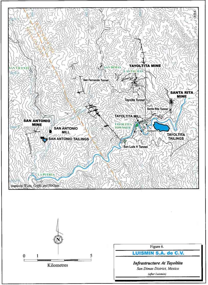
Figure 6. Infrastructure at Tayoltita
- 28 -
Watts, Griffis and McOuat
Infrastructure at the San Antonio mine includes a mill, small campsite, warehouse, analytical fire assay laboratory and maintenance shops.
| 5.5 | PHYSIOGRAPHY |
The San Dimas district is located in the central part of the Sierra Madre Occidental, a mountain range characterized by very rugged topography with steep, often vertical walled valleys and narrow canyons. Elevations vary from 2,400 m above mean sea level ("amsl") on the high peaks to elevations of 400 m amsl in the valley floor of the Piaxtla River.
- 29 -
Watts, Griffis and McOuat
6. HISTORY
The San Dimas district has experienced a long mining history. Precious metal production was first reported in 1757 by a group of Spanish families living at Las Queleles (near the present town of Tayoltita). Government and religious authorities made several unsuccessful attempts to determine the location of the Queleles group of mines. By 1795, a town of 10,000 residents had been established upstream at Guarisamey where other gold and silver veins had been discovered. The Spanish continued working several of the mines until the start of the Mexican War of Independence (1810). Mining activity in the district then decreased and did not start up again until the 1880s when agents of William Randolph Hearst of San Francisco and American Colonel Daniel Burns arrived in the area. W.R. Hearst acquired the Tayoltita mine under the name of the San Luis Mining Company. In 1883, when Colonel Burns took control of the Candelaria mine, modern mining methods began. Later the Contraestaca (San Antonio) mine was discovered along with several large bonanza grade orebodies.
In 1904, the first cyanide mill in Mexico was built at Tayoltita. By 1940, the Candelaria Mine had been mined out and the properties of the Mexican Candelaria and Contraestaca mines were purchased by the San Luis Mining Company.
A mining law introduced in 1959 in Mexico required the majority of a Mexican mining company be held by Mexicans and forced the sale of 51% of the shares of the San Luis Mining Company to Mexicans. In 1961, the Minas de San Luis S.A. de C.V. was formed and assumed operations of the mine. In 1978, the remaining 49% interest was obtained by a group known as Luismin S.A. de C.V.
Historical production through 2006 from the San Dimas District is estimated at 565 million ounces of silver and 10.5 million ounces of gold, placing the district third in Mexico for precious metal production after Pachuca and Guanajuato. Production from the San Dimas District during 2006 was approximately 162,700 ounces of gold and 8.7 million ounces of silver respectively, while production in 2005 was approximately 116,000 ounces of gold and 7.4 million ounces of silver respectively.
- 30 -
Watts, Griffis and McOuat
TABLE 2
LUISMIN MINE PRODUCTION
| Area | Tonnes | Mill Head Grade | ||
| g Ag/t | g Au/t | |||
| Tayoltita | ||||
| 1996 | 259,807 | 275 | 1.3 | |
| 1997 | 281,011 | 272 | 2.4 | |
| 1998 | 294,979 | 242 | 2.3 | |
| 1999 | 302,248 | 247 | 2.7 | |
| 2000 | 279,164 | 254 | 2.8 | |
| 2001 | 241,445 | 278 | 3.0 | |
| 2002 | 178,334 | 262 | 3.5 | |
| Santa Rita | ||||
| 1996 | 79,898 | 432 | 2.6 | |
| 1997 | 87,058 | 399 | 2.3 | |
| 1998 | 106,764 | 341 | 2.3 | |
| 1999 | 126,138 | 366 | 2.2 | |
| 2000 | 160,428 | 308 | 2.1 | |
| 2001 | 144,148 | 334 | 2.3 | |
| 2002 | 134,810 | 493 | 4.2 | |
| San Antonio | ||||
| 1996 | 131,746 | 377 | 6.2 | |
| 1997 | 148,302 | 356 | 5.3 | |
| 1998 | 141,176 | 274 | 4.2 | |
| 1999 | 136,025 | 267 | 3.8 | |
| 2000 | 144,842 | 263 | 3.8 | |
| 2001 | 146,470 | 319 | 5.1 | |
| 2002 | 140,205 | 389 | 6.1 | |
| San Dimas District | ||||
| 2003 | 423,673 | 428 | 5.2 | |
| 2004 | 397,646 | 665 | 7.2 | |
| San Martin(no longer a Luismin mine operation) | ||||
| 1996 | 187,691 | 43 | 3.4 | |
| 1997 | 219,827 | 43 | 3.3 | |
| 1998 | 224,279 | 50 | 3.4 | |
| 1999 | 242,295 | 45 | 3.5 | |
| 2000 | 284,484 | 55 | 3.6 | |
| 2001 | 287,502 | 65 | 3.7 | |
| 2002 | 268,451 | 71 | 4.3 | |
| 2003 | 276,481 | 88 | 4.3 | |
| 2004 | 272,734 | 83 | 4.5 | |
| La Guitarra(no longer a Luismin mine operation) | ||||
| 1996 | 94,375 | 287 | 3.6 | |
| 1997 | 107,305 | 294 | 4.3 | |
| 1998 | 106,262 | 319 | 3.8 | |
| 1999 | 105,136 | 312 | 4.0 | |
| 2000 | 113,808 | 254 | 3.3 | |
| 2001 | 101,549 | 230 | 4.0 | |
| 2002 | 79,679 | 201 | 3.5 | |
- 31 -
Watts, Griffis and McOuat
7. GEOLOGICAL SETTING
The general geological setting of the San Dimas District is illustrated in Figure 7. Two major volcanic successions totalling approximately 3,500 m in thickness have been described, the Lower Volcanic Group ("LVG") and the Upper Volcanic Group ("UVG") separated by an erosional and depositional unconformity.
The LVG is of Eocene age predominantly composed of andesites and rhyolitic flows and tuffs and has been locally divided into five units (Figure 8). The LVG outcrops along the canyons formed by major westward drainage systems and has been intruded by younger members of the batholith complex of granitic to granodioritic composition. The Socavón rhyolite is the oldest volcanic unit in the district, its lower contact destroyed by the intrusion of the Piaxtla granite.
More than 700 m thick, the Socavón rhyolite is host for several productive veins in the district. Overlying the Socavón rhyolite is the 20 to 75 m thick, well-bedded Buelna andesite that is remarkably present throughout the area. The Buelna andesite is overlain by the Portal rhyolite, a grey, cream to purple coloured rock containing potassic feldspar and quartz cementing small (5 to 10 mm) volcanic rock fragments. It ranges in thickness from 50 to 250 m and is also prevalent throughout the district.
The overlying Productive Andesite is more than 750 m in thickness and has been divided into two varieties based on grain size, but of identical mineralogy. One variety is fragmental (varying from a lapilli tuff to a coarse agglomerate), the other has a porphyritic texture (1 to 2 mm plagioclase phenocrysts).
The overlying Camichin unit, composed of purple to red interbedded rhyolitic and andesite tuffs and flows, is more than 300 m thick. It is the host rock of most of the productive ore shoots of Patricia, Patricia 2, Santa Rita and other lesser veins in the Santa Rita Mine.
The Las Palmas Formation, at the top of the LVG, consists of green conglomerates at the base and red arkoses and shales at the top, with a total thickness of approximately 300 m. This unit outcrops extensively in the Tayoltita area. The lower contact between the LVG and the underlying Productive Andesite is unconformable.
- 32 -
Watts, Griffis and McOuat
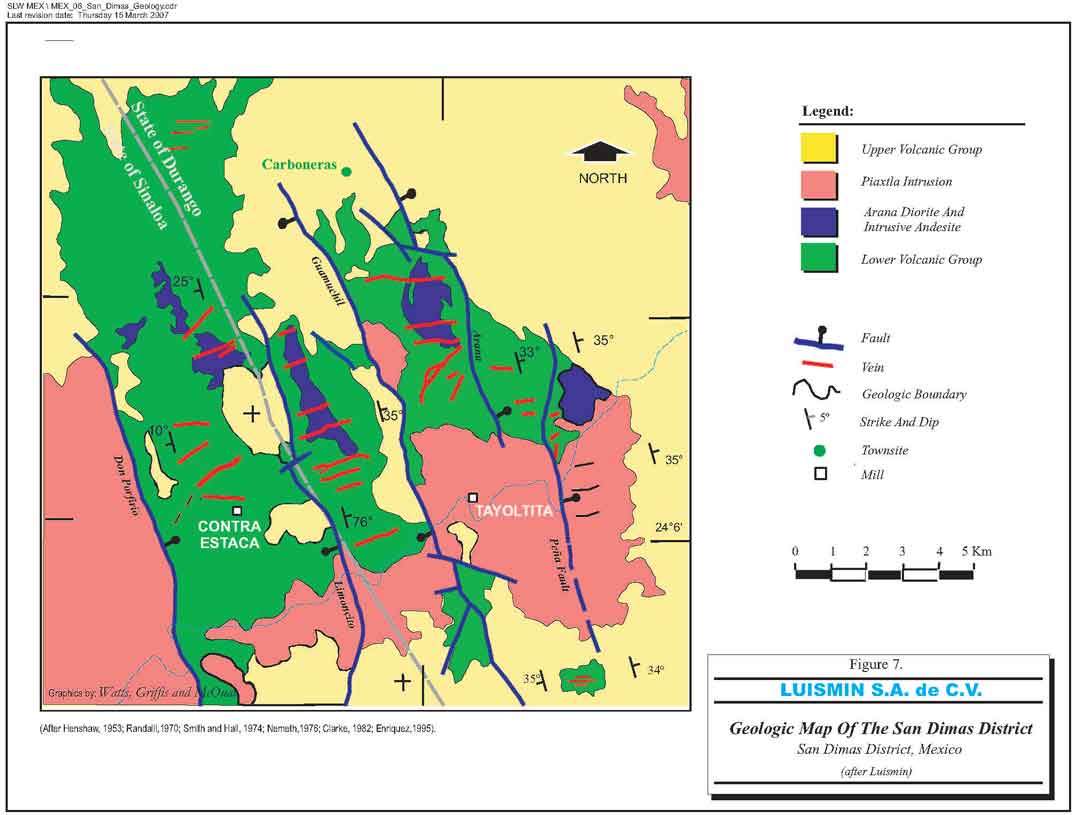
Figure 7. Geologic Map of the San Dimas District
- 33 -
Watts, Griffis and McOuat

Figure 8. Litho-stratigraphic column of the San Dimas District
- 34 -
Watts, Griffis and McOuat
The predominant plutonic events in the district resulted in intrusion of the LVG by granitic to granodioritic intrusives, part of the Sinaloa composite batholith.
Other intrusives cutting the LVG include the Intrusive Andesite, the Elena aplite and the Santa Rita dacitic dikes. The even younger Bolaños rhyolite dike, and the basic dykes intrude both the LVG and UVG. Intrusive activity in the western portion of the Sierra Madre Occidental has been dated continuously from 102 to 43 million years.
The UVG overlies the eroded surface of the LVG unconformably. In the San Dimas District, the UVG is divided into a subordinate lower unit composed mainly of lavas of intermediate composition called Guarisamey Andesite and an upper unit called the Capping Rhyolite. The Capping Rhyolite is mainly composed of rhyolitic ash flows and air-fall tuffs and is up to 1,500 m thick in the eastern part of the district however within most of the district is about 1,000 m thick.
The San Dimas district lies within an area of complex normal faulting along the western edge of the Sierra Madre Occidental. Compressive forces first formed predominantly east-west and east-northeast tension gashes, that were later cut by transgressive north-northwest striking slip faults. The strike-slip movements caused the development of secondary north-northeast faults, with right lateral displacement.
Five major north-northwest-trending normal faults divide the district into five tilted fault blocks generally dipping 35° to the east (Figures 9 and 10). In most cases, the faults are post ore in age and offset both the LVG and UVG.
All major faults display northeast-southwest extension and dip from near vertical (Peña fault) to less than 55° (Guamuchil fault). Offsets on the blocks range from a downthrow of 150 m on the Peña and Arana faults, to more than 1,500 m on the Guamuchil fault.
- 35 -
Watts, Griffis and McOuat
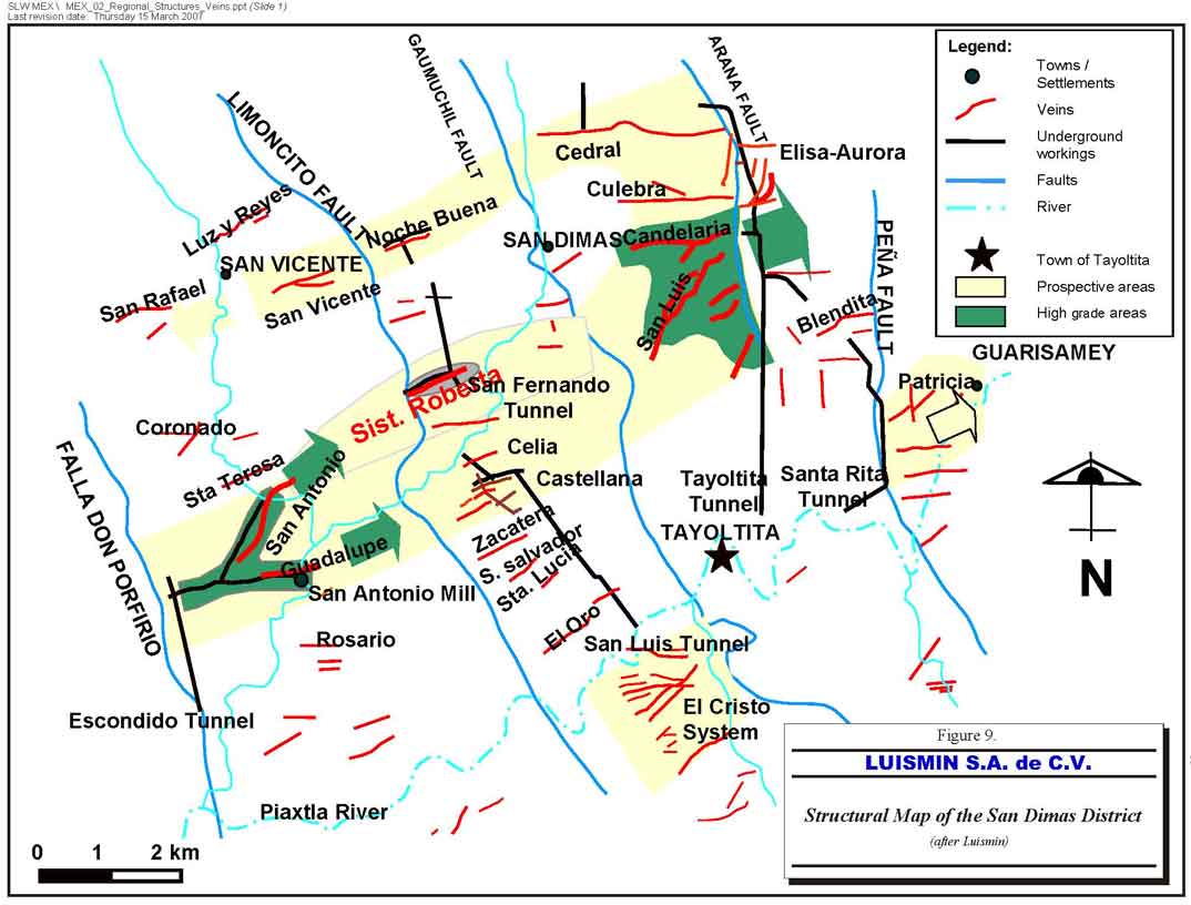
Figure 9. Structural map of the San Dimas District
- 36 -
Watts, Griffis and McOuat
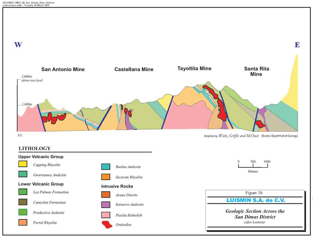
Figure 10. Geologic section across the San Dimas District
- 37 -
Watts, Griffis and McOuat
8. DEPOSIT TYPES
The deposits of the San Dimas district are high grade, silver-gold-epithermal vein deposits characterized by low sulphidation and adularia-sericitic alteration formed during the final stages of igneous and hydrothermal activity from quartz-monzonitic and andesitic intrusions.
As is common in epithermal deposits, the hydrothermal activity that produces the epithermal vein mineralization began a few million years after the intrusion of the closely associated plutonic rocks and several million years after the end of the volcanism that produced the rocks that host the hydrothermal systems. At San Dimas, based on age determinations, the average period between the end of late stage of plutonism and the hydrothermal activity is 2.1 million years, however hydrothermal activity continued for at least another 5.0 million years. Older veins appear more common in the eastern part of the district whereas younger veins are found in the western part.
- 38 -
Watts, Griffis and McOuat
9. MINERALIZATION
The mineralization is typical of epithermal vein structures with banded and drusy textures. Within the district, the veins occupy east-west trending fractures except in southern part of Tayoltita where they strike mainly northeast and in the Santa Rita mine where they strike north-northwest. The veins were formed in two different systems. The east-west striking veins were the first system developed, followed by a second system of north-northeast striking veins. Veins pinch and swell and commonly exhibit bifurcation, horse-tailing and cymoidal structures. The veins vary from a fraction of a centimetre in width to 15 m, but average 1.5 m. They have been followed underground from a few metres in strike-length to more than 1,500 m. Examples of veins with mineralization in the Favourable Zone extending over considerable distances are illustrated in the following three mined veins, each vein extending for more than 2,000 m, in the Tayoltita Mine, the San Luis Vein (Figure 11) and in the San Antonio Mine the Guadalupe Vein (Figure 12) and San Antonio Vein (Figure 13).
Three major stages of mineralization have been recognized in the district:
| 1. | an early stage; |
| 2. | an ore forming stage; and, |
| 3. | a late stage quartz. |
Three distinct sub-stages of the ore forming stage also have been identified, each characterized by distinctive mineral assemblages with ore grade mineralization always occurring in the three sub-stages:
| a) | quartz-chlorite-adularia; |
| b) | quartz-rhodonite; and, |
| c) | quartz-calcite. |
The minerals characteristic of the ore forming stage are composed mainly of white, to light grey, medium to coarse grained crystalline quartz with intergrowths of base metal sulphides (sphalerite, chalcopyrite and galena) as well as pyrite, argentite, polybasite, stromeyerite, native silver and electrum.
- 39 -
Watts, Griffis and McOuat
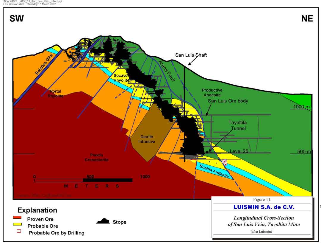
Figure 11. Longitudinal cross-section of San Luis Vein, Tayoltita Mine
- 40 -
Watts, Griffis and McOuat
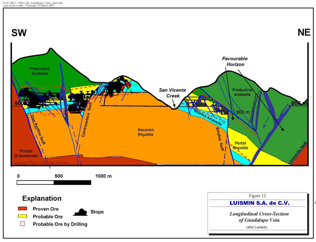
Figure 12. Longitudinal cross-section of Guadalupe Vein
- 41 -
Watts, Griffis and McOuat
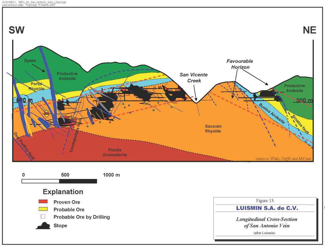
Figure 13. Longitudinal cross-section of San Antonio Vein
- 42 -
Watts, Griffis and McOuat
The ore shoots within the veins have variable strike lengths (5 to 600 m); however, most average 150 m in strike-length. Down-dip extensions of ore shoots are up to 200 m but are generally less than the strike length.
- 43 -
Watts, Griffis and McOuat
10. EXPLORATION
Typical of epithermal systems, the silver and gold mineralization at the San Dimas District exhibits a vertical zone with a distinct top and bottom that Luismin has termed the Favourable Zone (Figure 14). At the time of deposition, this Favourable Zone was deposited in a horizontal position paralleling the erosional surface of the LVG on which the UVG was extruded.
This favourable, or productive, zone at San Dimas is some 300 to 600 m in vertical extent and can be correlated, based both on stratigraphic and geochronologic relationships, from vein system to vein system and from fault block to fault block. Using this concept of the dip of the unconformity at the base of the UVG, Luismin is able to infer the dip of the Favourable Zone and with considerable success explore and predict the Favourable Zone in untested areas.
At the Tayoltita deposit, Ag:Au ratios have been a useful exploration tool. In most of the veins, detailed studies have shown that Ag:Au ratios increase progressively within the ore zone with the contours strongly elongated along the strike of the vein. The horizontal elongations of the Ag:Au ratios are thought to represent the former flow path of the ore fluids which were subhorizontal at the time of the ore deposition suggesting ore shoots can be found along these possible fluid paths (Figure 14).
Luismin applies a 30% probability factor to the volume of the favourable zone to estimate the volume/tonnage of Inferred Mineral Resources that will later be discovered in the zone. For more than 30 years, Luismin has historically and successfully applied the 30% factor. The factor was originally developed by comparing the explored area of the active veins at that time (San Luis, Guadalupe, Cedral etc.) to the mined out area plus the Mineral Reserve area. After a review of numerous longitudinal vein sections for our August 2002 report, WGM concluded that the application of the 30% factor was justified.
- 44 -
Watts, Griffis and McOuat
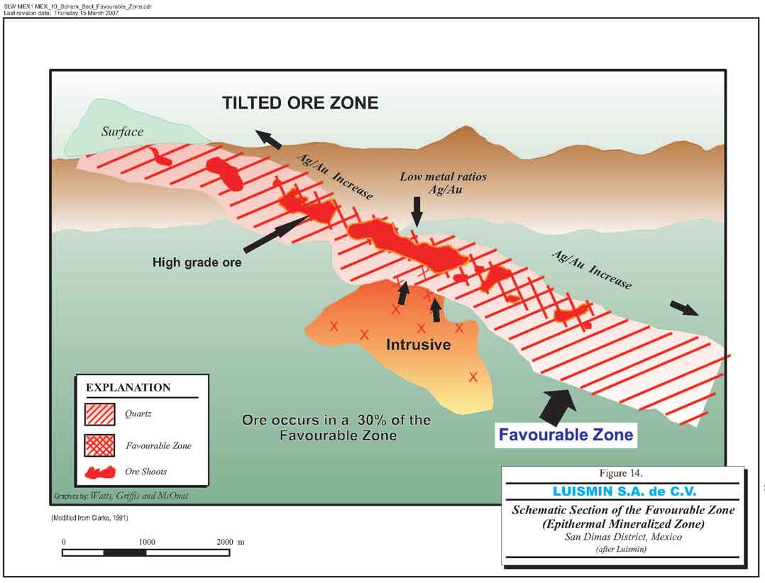
Figure 14. Schematic section of the Favourable Zone
- 45 -
Watts, Griffis and McOuat
11. DRILLING
Exploration of the Favourable Zone at San Dimas District is done both by diamond drilling and by underground development work. Diamond drilling is predominantly done from underground stations as both the rugged topography, (i.e. access to surface drill stations) and the great drilling distance from the surface locations to the target(s) makes surface drilling both challenging and expensive. All exploration drilling and the exploration underground development work is done in-house by Luismin. Diamond drilling is of NQ/HQ size with excellent core recoveries (in the range of +95%) at a cost of approximately US$45/m.
Luismin conducts a continuous program of exploration/development diamond drilling throughout the year at each of its mines with its own rigs. Twelve diamond drill rigs and crews are employed in the mines. Generally two rigs are stationed at the San Martin mine with eight rigs in the mines at San Dimas, although sometimes one of the rigs may be moved to a particular mine if required.
Given that the majority (70%) of the Favourable Zone is not mineralized and the magnitude of the number of mine vein workings, it is WGM's opinion that confirmatory diamond drilling was not warranted and Wheaton did not conduct any independent diamond drilling during its due diligence exercise in 2002. WGM also visited an operating diamond drill rig underground and observed the core handling, and, later at the core shack, examined the drill core in detail, the sample splitting by diamond sawing, the bagging, tagging and shipment to the mine assay laboratory. All operations, observed by WGM, were being done in a professional manner. Core boxes are well marked and stored and very detailed geological logging is carried out.
An additional diamond drilling rig was purchased in 2005 to assist in Luismin's planned expansion of mine production.
- 46 -
Watts, Griffis and McOuat
12. SAMPLING METHOD AND APPROACH
Other than the control samples collected at the mill for material balance, two principal types of samples are collected daily from the mine workings:
| 1. | Samples of the mineralized zones exposed by the mine workings; and, |
| 2. | Samples of the diamond drill core from the exploration/development drilling. |
Samples are also collected but on a less routine basis, from mine cars and from the blasted rock pile in a stope.
Individual samples collected from a mineral shoot in certain veins can show considerable variation both vertically and horizontally in the vein as observed by samples from subsequent slices of the stope or from samples taken from the top of the pile of blasted rock in the stope compared to the samples from the back. Grade control in these veins is achieved in part by the considerable number of samples taken.
Drill core samples after being sawn in half are bagged, tagged and sent to the mine assay laboratory. Several hundreds of samples are collected and processed every month at the mine assay laboratories.
- 47 -
Watts, Griffis and McOuat
13. SAMPLE PREPARATION, ANALYSES AND SECURITY
At each of the mines, the mine workings are sampled under the direction of the Geological Department initially across the vein, at 1.5 m intervals. Splits are also taken along the sample line to reflect geological changes. No sample length is greater than 1.5 m. Once the ore block has been outlined and the mining of the block begins the sample line spacing may be increased to 3.0 m. Sampling is done by chip-channel (the channel approximately 10 cm wide), cut across the vein. Sample chips of similar size are collected on a canvas sheet then broken into smaller sized fragments, coned and quartered to produce a 1 to 2 kg sample, which is sent for fire assay to the mine assay laboratory. Sampled intervals are clearly marked on the underground rock faces with spray paint.
Samples are crushed, homogenized, ground and split at the mine assay laboratory to produce a 10 g representative pulp sample for fire assaying. Routine quality control is carried out with every tenth sample repeated as a check assay done at the mine assay laboratory, and check assays between the Luismin mine laboratories. Routine assaying of standards is also carried out at the mine assay laboratory.
WGM reviewed all the steps in the sample handling at the two mine assay laboratories (Tayoltita and San Antonio) from the initial recording and control of the numbers of incoming samples through the crushing, splitting, grinding and collecting of a subsample for fire assay. This is followed by the preparation for fire assay and cupellation and the weighing of the silver-gold and gold beads.
The procedures used by Luismin's assay laboratories are those introduced by the former American mine owners. Certain steps have through time become somewhat slack and could be improved i.e. more rolling of the pulp sample to be better homogenized, better control of the dust, rock chips in the crushing-grinding area, the need for air conditioning in the balance room for the bead weighing etc. WGM believes, however, that the sample preparation, analysis and security process is without any serious problems. WGM believes that the introduction of a new program of quality control would be advantageous and helpful.
- 48 -
Watts, Griffis and McOuat
14. DATA VERIFICATION
WGM did not collect any individual samples to verify the silver-gold mineralization at the Luismin mines. However, WGM did observe the gold-silver beads in the crucibles as taken from the fire assay furnace and their subsequent weighing. WGM also observed the pouring of numerous doré bars and receipts of payment from the sale of the doré bars.
Luismin, starting in September 2005, has been sending on a regular basis (monthly or trimonthly), an approximate average of 70 duplicate samples per month to a commercial laboratory (SGS or Chemex). The samples are analyzed for their Au and Ag contents to check the analytical results of the Tayoltita mine laboratory. Samples are analyzed at the commercial laboratories using the same analytical procedures as the mine laboratory. During 15 months from September 2005 to December 2006, a total of 1,078 samples have been analysed with only a small percentage 15% to 30% showing good agreement between the two laboratories for both their gold and silver analyzed contents. Luismin plans to continue to monitor its mine assay results. WGM recommends that blind mine standards (high, medium low grade) and blind blanks be introduced into the analytical stream process for both laboratories and that a thorough review of the sample preparation procedures be made.
In 2000, Luismin sent a suite of 199 samples (approximately 40 from each deposit) to three laboratories, DMC Durango, Bondar Clegg and Barringer, for check assays for silver and gold. These samples were also assayed at the Tayoltita, San Antonio and San Martin laboratories. In general, there was good correlation between the San Dimas laboratories and the outside laboratories and between the San Dimas laboratories.
As part of the verification of the reported precious metal production by Luismin, a review was carried out by WGM of the reported silver and gold ounces of production from the Luismin mining (smelting) operation and compared to the reported settlement of ounces for silver and gold. There was excellent agreement between the reported metal production (ounces) and the settlement (ounces) by the refinery.
Luismin's experience has shown considerable variation in grade within the mineralized shoots of the veins, and sampling of the muck piles is not routinely carried out.
- 49 -
Watts, Griffis and McOuat
15. ADJACENT PROPERTIES
Exploration over the past few years has been concentrated on finding new Mineral Resources/Mineral Reserves in the immediate area of the present mine workings. Luismin holds a very large land position around the present/past mine workings and as such there are no adjacent properties. More than 120 mineralized veins are known within the San Dimas district land holdings.
Luismin has a number of exploration properties throughout Mexico that are described later in this report.
Tunnels driven to provide better access to the numerous producing mines continually cross-cut and discover new veins. In a helicopter flight over the land holdings surrounding the mines, WGM observed untested, relatively unknown, extensively hydrothermally altered areas characteristic of epithermal vein mineralization. These lands hold promise for future exploration.
- 50 -
Watts, Griffis and McOuat
16. MINING OPERATIONS
| 16.1 | GENERAL |
The current mines of Luismin in the San Dimas district consist of three underground gold and silver mining operations at Tayoltita, Central Block and Santa Rita. With the current and near term mine plans, these three mining areas are scheduled to contribute equally to the San Dimas mine production. Production is presently coming from: 9 veins (34 stopes) in the Central Block; 10 veins (17 stopes) in the Tayoltita Mine; and, 9 veins (21 stopes) in the Santa Rita Mine. The typical mining operations employ mechanized cut-and-fill mining with primary access provided by adits and internal ramps from an extensive tunnel system through the steep mountainous terrain. Production is presently coming from 9 veins (34 stopes) in the Central Block, from 10 veins (17 stopes) in the Tayoltita Mine and 9 veins (21 stopes) in the Santa Rita Mine. All milling operations are now carried out at a central milling facility at Tayoltita. The ore processing is by conventional cyanidation followed by zinc precipitation of the silver and gold followed by refining to doré.
The San Antonio Mill operation was put into care and maintenance in November 2003 with all milling consolidated to the Tayoltita Mill and all former San Antonio mine production considered part of the Central Block Mine operation.
San Dimas, the largest centre of Luismin operations, is located on the border of Durango and Sinaloa States. The district is characterized by the very rugged terrain of the Sierra Madre Occidental mountains with steep walled canyons and high mountain peaks which has presented challenges to the establishment of mining operations and haulage routes, mill sites and tailings management areas. Table 3 summarizes the San Dimas operations in 2006.
TABLE 3
LUISMIN SAN DIMAS MINING OPERATIONS FOR 2006
| Ore Production | Grade | |||
| Tonnes | Gold (g/t) | Silver (g/t) | ||
| Tayoltita | 225,907 | 2.80 | 423 | |
| Santa Rita | 78,969 | 2.87 | 375 | |
| Central Block/San Antonio | 400,180 | 9.22 | 638 | |
| Total | 705,057 | 6.46 | 540 | |
- 51 -
Watts, Griffis and McOuat
| 16.2 | DESCRIPTION OF MINING OPERATIONS |
| 16.2.1 | TAYOLTITA MINE |
The Tayoltita Mine is the oldest operating mine in the San Dimas area. The main access is a 4.4 km tunnel from a portal approximately 400 m northeast of the Tayoltita Mill. About 570,000 cfm of ventilation air is supplied by a combination of natural flow from the access tunnel as well as fan driven through a system of raises. Raises for ventilation and ore and waste passes are typically developed with boring machines.
The mining method employs mechanized cut-and-fill mining on vein mineralization using waste rock as backfill. The veins vary from 1 to 3 m in width and generally dip at 75° to 80°.
Production drilling is completed with jackleg drills or single boom jumbos depending on the vein thickness. Ore is hauled from the stoping areas, using LHD equipment, then by rail haulage to surface through the main access tunnel. The rail haulage has a trolley system using 8 tonne cars.
With completion of the San Luis Tunnel, development of the Central Block mine has evolved to connect with the San Antonio mining area. This mining area is characterized by veins that dip 75°, with variable widths, and is currently being developed as an important mining area for Tayoltita.
| 16.2.2 | SANTA RITA MINE |
The Santa Rita Mine main access is by adit approximately 3 km to the northeast of the Tayoltita Mill site. The mining method employs cut-and-fill mining on vein mineralization. The vein dip can vary from subvertical to as low as 35°. In some of the flatter lying areas, the vein thickness allows for a room and pillar mining operation. Ventilation is maintained by three exhaust fans providing 530,000 cfm.
The ore haulage is by LHD equipment either to an internal shaft or directly to rail haulage on the main access tunnel where 2.5 -tonne rail cars are used on a trolley line to surface. The shaft employs a double drum hoist with 2.2 -tonne skips. A tunnel excavation to connect the rail haulage to the Tayoltita tunnel has been completed and has reduced ore transport costs by
- 52 -
Watts, Griffis and McOuat
elimination of the transfer to trucks at surface. With the haulage integrated into the Tayoltita haulage system it provides for more blending of the mill ore supply.
| 16.2.3 | SAN ANTONIO AND CENTRAL BLOCK |
The San Antonio Mine is located northwest of Tayoltita and is connected by 20 km of winding dirt road over the mountains. In 2001, the San Luis Tunnel was completed which provides for easier access between San Antonio and Tayoltita as well as integration of support services of the two locations.
Mining operations at San Antonio work veins that vary in thickness from 1 to 6 m and employ mechanized cut-and-fill mining methods. Ventilation is by a combination of natural and fan forced methods supplying 290,000 cfm of air to the operations. Ore haulage is by a combination of LHD equipment with highway type trucks used to haul the ore to the Tayoltita mill.
The San Antonio site includes a mill and some limited accommodation for the workforce. The mill operation was shutdown in November 2003 and all milling consolidated at the expanded Tayoltita mill facility. Following the San Antonio mill shutdown all underground production was integrated into the Central Block mine area. Ore haulage from the Central Block Mine utilizes a short tunnel on the north side of the Piaxtla River that provides ore haulage to the Tayoltita mill and bypasses the townsite. The decision to terminate the San Antonio milling operations was made primarily due to the exhaustion of the tailings storage capacity.
| 16.2.4 | GROUND SUPPORT FOR MINING |
The ground conditions throughout most of the San Dimas operations are good. Routine operations do not employ rockbolting or any other ground support with any regular pattern. In wider stopes where the veins are flat lying, some split sets are used and low-grade pillars are left for support. Apart from some minor problem areas, no bolting is used in the main haulage ramps and drifts. In areas that require ground support, steel arches and lagging has been used as well as shotcrete and screening. Luismin now employs a rock mechanics engineer to review ground conditions and mine planning on an ongoing basis.
- 53 -
Watts, Griffis and McOuat
| 16.2.5 | GRADE CONTROL |
Grade control in the San Dimas operations is difficult to manage because of the inherent dilution of narrow vein mining. Additionally, the veins at San Dimas pinch and swell and have significant variation in grade over relatively short distances. Dilution is also added by uncemented waste rock that is used to backfill the stopes and used as a working base for subsequent cuts. Fill lines are marked by paint for reference while mucking on top of fill to reduce dilution. Chip sampling is completed at regular intervals across the back as headings are advanced. Mine geologists also mark grades directly on the stope walls to guide the mining advance. The visibility of the vein contacts and to a lesser extent the higher grade ore zones help to guide grade control within each stope.
During 2004, the operations at San Dimas mill throughput had to be reduced to maintain high recoveries from the higher grade ore being processed. The reduced milling rate ensured that the leach extraction and metal recoveries from solution could be optimized with the limited capacity limitation of this part of the mill circuit. This has provided the mining operations the opportunity to blend the ores to a more uniform grade and produce for a more stable mill operation. At the end of August 2004, the Tayoltita Mill operation was processing ores at gold and silver grades of 6.9 g/t and 524 g/t which are 60% and 36% higher than plan respectively.
High grade gold and silver ores continued to be mined in the years 2005 and 2006 requiring continued blending of the ore for the mill.
| 16.2.6 | OPERATIONS WORKFORCE |
Luismin employs a combination of union and contracted workforce at the San Dimas operations with a total current workforce of 1,142 with 671 at Tayoltita, 140 at Santa Rita and 331 in the Central Block of which approximately 598 are contracted.
- 54 -
Watts, Griffis and McOuat
| 16.2.7 | DISCUSSION |
WGM regards the diligence and work ethic of the Luismin management team as major contributors to the success of the Luismin operations. Their efforts are evident in the general order and cleanliness of the mines and mills and a testament to well run operations. Over the past 12 years the operations have made significant improvements in productivity. Over the past seven years the accident frequency per 1,000,000 man-hours has been reduced considerably. There has been considerable progress, since the initial site visits in 2002, in the introduction of international guidelines throughout the operations.
- 55 -
Watts, Griffis and McOuat
17. MILLING OPERATIONS
| 17.1 | GENERAL |
The San Dimas district now has one milling facility at Tayoltita to process the production from the three active mining areas in San Dimas. The Tayoltita Mill has a conventional process flowsheet that employs cyanidation and zinc precipitation for recovery of the gold and silver. The mill currently has an installed leaching capacity of 2,100 tpd.
The construction and installation to increase the Tayoltita crushing and grinding capacity of the mill to 3,200 tpd is currently well underway and expected to be completed at end of 2008. In 2006, the mill averaged 1,935 tpd.
Table 4 summarizes the performance of the San Dimas milling operations during 2006
TABLE 4
SAN DIMAS MILL PERFORMANCE 2006
| Tayoltita | Santa Rita | Central Block | Total | |
| Tons milled | 214,063 | 78,265 | 396,614 | 688,942 |
| Grade Ag (g/t) | 252 | 346 | 551 | 438.2 |
| Grade Au (g/t) | 2.32 | 3.54 | 11.40 | 7.76 |
| Recovery (Ag) | 90.21 | 90.21 | 90.21 | 90.21 |
| Recovery (Au) | 95.57 | 95.57 | 95.57 | 95.57 |
| Oz (Au) | 29,310 | 14,713 | 118,647 | 162,669 |
| Oz (Ag) | 1,566,842.4 | 786,507.8 | 6,342,602.8 | 8,695,953 |
| 17.2 | TAYOLTITA MILL |
The Tayoltita mill presently employs two-stage crushing and single stage ball milling to achieve 80% passing 200 mesh. Leaching is completed in a series of tanks providing 72 hours of leach residence time. The pregnant solution is recovered in a counter current decant ("CCD") circuit with the gold and silver recovered from solution in a zinc precipitation circuit. Two positive displacement pumps operating in parallel move a high density tailings slurry to a box canyon east of the mill site for permanent disposal. Refining uses an induction furnace to produce 1,000 oz silver and gold doré bars.
- 56 -
Watts, Griffis and McOuat
The Tayoltita Mill has undergone a series of plant expansions over its operating life which has resulted in three small ball mills in parallel as well as a series of small tanks in the leaching and CCD circuit. An expansion at Tayoltita in 2003 increased the nominal capacity to 1,500 tpd to replace the capacity required for shutdown of the San Antonio Mill. Currently the Tayoltita Mill is at 2,100 tpd and undergoing further expansion to increase the capacity to 3,200 tpd.
The 2,100 tpd expansion included a new cone crusher and dust collection/system and the installation of a 1,000 hp ball mill providing two stage grinding (Figure 15). The expansion retrofited a number of existing tanks for higher capacity for solid liquid separation. Included in the expansion was increased automation and process controls as well as a general upgrade of the plant power distribution and control system. At the time of the site visit in late January, the building's steel structure and ball mill installation for the 3,200 tpd was well underway. The start-up of the expanded 3,200 tpd capacity is anticipated in 2009.
- 57 -
Watts, Griffis and McOuat
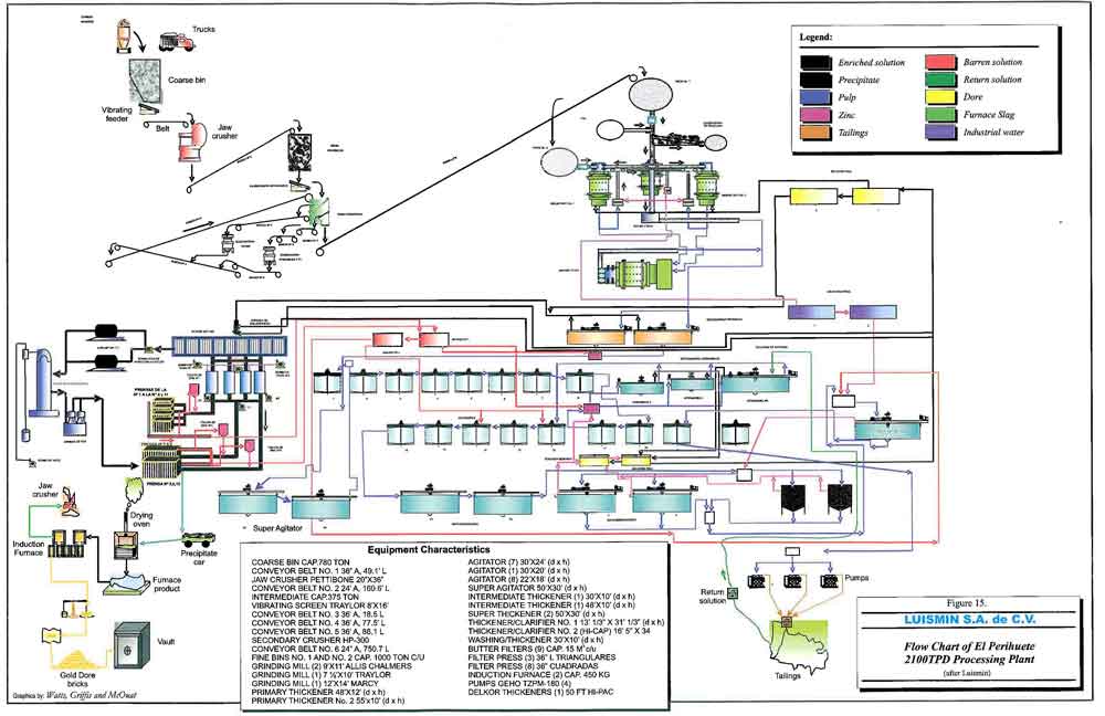
Figure 15. Flowsheet of El Perihuete 2,100 tpd processing plant
- 58 -
Watts, Griffis and McOuat
18. MINERAL RESOURCE AND MINERAL RESERVE ESTIMATES
| 18.1 | GENERAL |
The Proven and Probable Mineral Reserves, estimated by Luismin as of December 31, 2006 for the three operating mines in the San Dimas District, Tayoltita, Santa Rita and San Antonio/Central Block are 4.31 million tonnes at 388 g Ag/t and 5.73 g Au/t.
Similarly an Inferred Mineral Resource, separately reported and estimated by Luismin for the same three mines, is about 7.99 million tonnes at an approximate grade of 321 g Ag/t and 2.9 g Au/t. Inferred Mineral Resources are not known with the same degree of certainty as Proven and Probable Mineral Reserves and do not have demonstrated economic viability.
WGM reviewed the estimation methods used by Luismin and found them reasonable, and believes that the above Mineral Reserve and Mineral Resource estimates fairly represent the Mineral Reserve/Mineral Resource potential.
| 18.2 | LUISMIN APPROACH |
Rather than calculating Mineral Resources/Mineral Reserves over a minimum mining width and then applying corrections for dilution and mine losses to determine Mineral Reserves, Luismin estimates the reserve in each of the underground mining blocks by using the conventional mining block estimation methods for underground mines and later applying a tonnage and grade correction to determine Mineral Reserves. The minimum mining width is 0.9 m; however, on occasion where very high grade values are encountered over intervals less than 0.9 m, the minimum mining width is calculated to 0.9 m, using zero grade gold and silver values for the additional width required to meet 0.9 m.
Luismin's practice is to apply gold and silver correction factors to the grades as estimated for the in situ mineralization to correlate with the head grades of the mill feed. The correction factors account for losses in gold and silver values in the cut-and-fill mining method as well as for dilution.
- 59 -
Watts, Griffis and McOuat
| 18.3 | PAH AUDIT |
Luismin has retainedPincock, Allen and Holt(“PAH”) on three occasions to audit the reserves and resources of the operations. PAH visited the three mines of San Dimas and the San Martin mines in December 1999. PAH has produced three reports1 dated September 1998, April 2000 and January 2001 reporting on Luismin Resource/Reserve estimates dated June 30, 1998, December 31, 1999 and October 31, 2000.
PAH’s approach to audit the Mineral Reserves was to:
- review the parameters used to estimate resources and reserves;
- review the methods of estimation and classification;
- check calculations of grade, width and/or tonnage on individual blocks of reserves; and,
- review the predicted reserves against production for the same areas on an annual basis.
The results of PAH’s audit found no significant errors in calculation of the Mineral Reserves.
PAH also reviewed Luismin’s estimate of Inferred Resources and stated:
"Based on a historical review of the tonnage of material that was originally estimated as…[Inferred Resources]…and the tonnage of material that was ultimately mined or defined as mineable reserves, it is PAH’s opinion that there is a high probability that further exploration and mine development will convert a substantial amount of these resources into mineable reserves."
PAH’s statement of Inferred Resources in the January 2001 report is essentially equivalent to the statement of Inferred Resources in this report. While there are minor discrepancies between the PAH and the WGM reports, in our opinion these are not material.
| 18.4 | VOLUME ESTIMATE |
The sample data are posted on level plans, and a geologist defines the limits of mineralization across and along the vein to determine the block lengths for mining and Mineral Reserve
| _______________________________ |
| 1Reports included audit of the previous owned and operated La Guitarra Mine. |
- 60 -
Watts, Griffis and McOuat
estimation. The data are then transferred to longitudinal sections and the volume of the block is calculated based on the average mineralized width of the vein and the measured longitudinal area (corrected for the dip of the vein).
| 18.5 | TREATMENT OF HIGH GRADE ASSAYS |
Cutting of high grade values is sometimes carried out by the geologist estimating the tonnage and grade of a block. Luismin informed us that the rule for the cutting of high grade silver values, i.e. those greater than 350 g Ag/t, is to average the high grade value with the silver values of the samples immediately adjacent on either side of the high grade sample, i.e. the average of three sample values. If the high grade value of the sample is equal to, or greater than three times the average then both the silver and gold values of the high grade sample are cut in half.
| 18.6 | TONNAGE FACTOR |
The tonnage factor for the mines that use the metric system is to multiply the volume in cubic metres by 2.7 (SG) to give tonnes and similarly in the mines using the English system to divide the volume, in cubic feet, by 13 to give tonnes. WGM believes that these factors are reasonable.
| 18.7 | DILUTION |
Prior to October 2000, an empirical dilution curve was applied to correct the silver and gold values at the mines of the San Dimas District. The curve was developed from years of experience measuring the head grade in the mill at the Tayoltita mine. However, as the silver grades mined decreased, a statistical study in 1999 showed that the empirical dilution curve was no longer appropriate. The 1999 statistical study was based on more than 12,000 data entries from the various mines compared to the head grades of the mill. The results indicated the need to apply the following new correction factors to both silver and gold values.
Since November 2000, grade corrections of -15%, or 0.85 by silver grade, and –5%, or 0.95 by gold grade, have been applied. The adjustments incorporate, in WGM's opinion, grade differences due principally to dilution and to mining losses but also correct, according to Luismin, other factors that affect the results of the silver and gold assays, namely: 1) the
- 61 -
Watts, Griffis and McOuat
collecting and splitting of the samples; 2) grinding contamination in the assay lab; 3) contamination during the cupellation of samples with very high values in silver and gold; and, 4) weighing errors in determining the gold and silver grades of the samples. A tonnage mining dilution of 10% is applied after the grade correction.
To account for narrow veins, an additional dilution factor of 10% (at zero grade) is also applied to blocks less than 5,000 tonnes at the San Dimas mines.
Luismin does not apply a mining recovery factor but since the reserve tonnes balance well with the tonnage mined, WGM estimates that mining recovery is already included in the estimation.
| 18.8 | CUTOFF GRADE |
The calculation of the minimum cutoff grade is based on market metal prices (adjusted monthly) for gold and silver metal recovered in the mill and the average monthly production costs for mining/milling/overhead etc., to produce a minimum dollar per tonne cutoff grade. The same cutoff grade is applied to each of the mining areas in the San Dimas district. The cutoff grade, for estimation of reserves at the San Dimas mines, as of December 31, 2006, was US$64.31/t.
| 18.9 | CLASSIFICATION OF RESERVES |
The terminology used by Luismin to designate Measured and Indicated Mineral Resources and Proven and Probable Mineral Reserves is in general agreement with the CIM Standards as adopted in NI 43-101. Luismin’s Mineral Resource categories "potential resource" and "drill inferred resource" would, under the CIM Standards, be called Inferred Mineral Resources. We have used the term Inferred Mineral Resources for this material throughout this report.
- 62 -
Watts, Griffis and McOuat
The following criteria are used by Luismin to classify Proven and Probable Mineral Reserves. The distance for vertical projections for Proven Mineral Reserves and Probable Mineral Reserves is a function of the length of the block, defined as follows:
| Block Length | Maximum Vertical Projection for | Maximum Vertical Projection for |
| Proven Mineral Reserves | Probable Mineral Reserves | |
| Less than 15 m (50 ft) | 4 m (12 ft) | 8 m (24 ft) |
| 15 to 45 m (50 to 148 ft) | 8 m (24 ft) | 16 m (52 ft) |
| 45 to 85 m (148 to 279 ft) | 16 m (52 ft) | 32 m (105 ft) |
| Greater than 85 m (279 ft) | 20 m (65 ft) | 40 m (135 ft) |
Blocks are adjusted to reflect faults, old workings and/or vein intersections.
Luismin also estimates Probable Mineral Reserves by diamond drilling. A square is drawn on the vertical longitudinal section with the drillhole centered on the square. The shape and size of the block depends upon the geological interpretation with the maximum size of the block based on the thickness of the vein as follows:
| Vein Thickness | Size of Block | |
| Less than 1.0 m | 25 x 25 m | |
| 1.0 to 1.5 m | 35 x 35 m | |
| Greater than 1.5 m | 50 x 50 m |
Drillhole blocks, based on drillhole assays 50 m or less from underground workings, are classified as "probable reserves from drilling". If the drillhole assays are more than 50 m from sampled underground workings or adjacent drillholes, the block is classified as Inferred Resources.
Luismin also estimates Inferred Mineral Resources based on the geological interpretation of partially explored veins and the vertical extent of the "Favourable Zone" of the epithermal mineralization. An average grade is determined from the average metal values of widely spaced samples collected variously, when present, from outcrops, widely spaced drillholes and underground workings.
Past mining experience shows that economic mineralization is confined to an epithermal zone with a distinct top and bottom called the Favourable Zone and that mineralization within a vein in the Favourable Zone is very irregular but statistically occupies 30% of vein in the zone. The extent of extrapolation of an individual vein in the Favourable Zone is based on
- 63 -
Watts, Griffis and McOuat
structural and stratigraphic relationships supported by geochemical trace element studies and fluid inclusion studies. The extrapolation of a particular vein is based on various individual criteria, e.g. the height of the Favourable Zone, the knowledge of the structure and its extension through the interception of the structure in underground workings, by surface exposure and/or by intersection with diamond drillholes. The strength, width and character of the individual vein determine the geological confidence in the distance of the extrapolation of the vein.
A total of more than 100 veins, at Tayoltita, San Antonio and Santa Rita (Figure 16), comprise the Inferred Mineral Resource of the San Dimas District. The various veins and the corresponding length, width and height projected are used to determine the total volume/tonnage of the Favourable Zone and ultimately the 30% of the total tonnage figure represents the Inferred Mineral Resources.
| 18.10 | RECONCILIATION BETWEEN RESERVES AND PRODUCTION |
The most useful test of a Mineral Reserve estimate at an operating mine is a review of the tonnes and grade predicted by the reserve estimate against the results of production from the same area. Reconciliation between the reserves of the Tayoltita/Santa Rita mines and the San Antonio mine, and production from the same areas for the period 1978 to 2002 is shown on Tables 5 and 6. In November 2003, the mill at San Antonio was closed and all milling operations from the three mines are now carried out at the Tayoltita mill. However the reconciliation between the two mill/mine operations showed very close agreement and the same is expected at the Tayoltita mill.
| 18.11 | DISCUSSION |
Luismin does not include the Inferred Mineral Resources in its Mineral Reserve Estimate. The Inferred Mineral Resources are targets to develop additional reserves. To determine how successful they had been in converting Inferred Mineral Resources into Mineral Reserves, Luismin geologists studied a number of veins in each of the four mines. It is important to note that the study did not include all the veins that were mined during the period and thus the mine production for the same period will be greater. Table 7 illustrates the percentage of the resources that Luismin has successfully transferred into reserves fromselected veins, at each
- 64 -
Watts, Griffis and McOuat

Figure 16. Regional structure and known veins
- 65 -
Watts, Griffis and McOuat
TABLE 5
RECONCILIATION BETWEEN PREDICTED RESERVES AND ACTUAL PRODUCTION – TAYOLTITA-SANTA RITA
(1978-2002)
| YEAR | TONNES | SILVER GRADE | GOLD GRADE | SILVER CONTENT | GOLD CONTENT | ||||||||||
| Variance | g Ag/t | Variance | g Au/t | Variance | Contained oz | Variance | Contained oz | Variance | |||||||
| Predicted | Actual | % | Predicted | Actual | % | Predicted | Actual | % | Predicted | Actual | % | Predicted | Actual | % | |
| 1978 | 156,000 | 159,628 | 2.3% | 400 | 404 | 1.0% | 7.00 | 7.10 | 1.4% | 2,006,237 | 2,073,424 | 3.3% | 35,109 | 36,439 | 3.8% |
| 1979 | 156,000 | 161,428 | 3.5% | 400 | 395 | -1.3% | 7.00 | 6.50 | -7.1% | 2,006,237 | 2,050,094 | 2.2% | 35,109 | 33,736 | -3.9% |
| 1980 | 162,000 | 162,290 | 0.2% | 390 | 381 | -2.3% | 6.40 | 6.40 | 0.0% | 2,031,315 | 1,987,991 | -2.1% | 33,334 | 33,394 | 0.2% |
| 1981 | 162,000 | 155,837 | -3.8% | 390 | 468 | 20.0% | 6.40 | 7.80 | 21.9% | 2,031,315 | 2,344,845 | 15.4% | 33,334 | 39,081 | 17.2% |
| 1982 | 162,000 | 158,163 | -2.4% | 390 | 483 | 23.8% | 6.40 | 7.70 | 20.3% | 2,031,315 | 2,456,121 | 20.9% | 33,334 | 39,156 | 17.5% |
| 1983 | 195,000 | 176,643 | -9.4% | 383 | 422 | 10.2% | 6.50 | 6.90 | 6.2% | 2,401,215 | 2,396,661 | -0.2% | 40,752 | 39,187 | -3.8% |
| 1984 | 216,000 | 200,256 | -7.3% | 396 | 424 | 7.1% | 6.30 | 6.60 | 4.8% | 2,750,088 | 2,729,915 | -0.7% | 43,751 | 42,494 | -2.9% |
| 1985 | 202,800 | 197,864 | -2.4% | 422 | 433 | 2.6% | 5.30 | 6.30 | 18.9% | 2,751,555 | 2,754,561 | 0.1% | 34,557 | 40,078 | 16.0% |
| 1986 | 236,300 | 222,295 | -5.9% | 396 | 423 | 6.8% | 5.77 | 6.28 | 8.8% | 3,008,546 | 3,023,206 | 0.5% | 43,837 | 44,884 | 2.4% |
| 1987 | 224,055 | 200,323 | -10.6% | 348 | 310 | -10.9% | 3.90 | 3.60 | -7.7% | 2,506,869 | 1,996,596 | -20.4% | 28,094 | 23,186 | -17.5% |
| 1988 | 222,520 | 226,756 | 1.9% | 346 | 319 | -7.8% | 3.67 | 3.54 | -3.5% | 2,475,386 | 2,325,665 | -6.0% | 26,256 | 25,808 | -1.7% |
| 1989 | 224,475 | 224,142 | -0.1% | 312 | 262 | -16.0% | 3.33 | 2.11 | -36.6% | 2,251,751 | 1,888,088 | -16.2% | 24,033 | 15,206 | -36.7% |
| 1990 | 229,607 | 214,025 | -6.8% | 287 | 248 | -13.6% | 2.50 | 1.90 | -24.0% | 2,118,677 | 1,706,530 | -19.5% | 18,455 | 13,074 | -29.2% |
| 1991 | 149,760 | 158,120 | 5.6% | 335 | 275 | -17.9% | 2.90 | 1.94 | -33.1% | 1,613,015 | 1,398,032 | -13.3% | 13,963 | 9,862 | -29.4% |
| 1992 | 234,685 | 237,580 | 1.2% | 341 | 311 | -8.8% | 2.26 | 2.49 | 10.2% | 2,572,986 | 2,375,571 | -7.7% | 17,053 | 19,020 | 11.5% |
| 1993 | 293,885 | 297,581 | 1.3% | 285 | 303 | 6.3% | 2.90 | 2.90 | 0.0% | 2,692,899 | 2,898,982 | 7.7% | 27,401 | 27,746 | 1.3% |
| 1994 | 300,150 | 300,711 | 0.2% | 307 | 286 | -6.8% | 2.30 | 1.90 | -17.4% | 2,962,610 | 2,765,114 | -6.7% | 22,195 | 18,370 | -17.2% |
| 1995 | 303,891 | 323,803 | 6.6% | 315 | 301 | -4.4% | 2.00 | 1.70 | -15.0% | 3,077,699 | 3,133,611 | 1.8% | 19,541 | 17,698 | -9.4% |
| 1996 | 334,225 | 339,704 | 1.6% | 311 | 312 | 0.3% | 1.90 | 2.10 | 10.5% | 3,341,928 | 3,407,634 | 2.0% | 20,417 | 22,936 | 12.3% |
| 1997 | 366,206 | 368,069 | 0.5% | 306 | 299 | -2.3% | 2.20 | 2.30 | 4.5% | 3,602,837 | 3,538,328 | -1.8% | 25,903 | 27,218 | 5.1% |
| 1998 | 388,163 | 401,743 | 3.5% | 274 | 264 | -3.6% | 1.85 | 2.29 | 23.8% | 3,419,499 | 3,409,965 | -0.3% | 23,088 | 29,579 | 28.1% |
| 1999 | 414,400 | 428,386 | 3.4% | 294 | 278 | -5.4% | 2.37 | 2.52 | 6.3% | 3,917,101 | 3,828,933 | -2.3% | 31,577 | 34,708 | 9.9% |
| 2000 | 432,690 | 439,590 | 1.6% | 288 | 274 | -4.9% | 2.50 | 2.54 | 1.8% | 4,003,443 | 3,868,390 | -3.4% | 34,710 | 35,898 | 3.4% |
| 2001 | 440,720 | 385,660 | -12.5% | 273 | 299 | 9.7% | 2.33 | 2.72 | 16.8% | 3,861,269 | 3,706,692 | -4.0% | 32,972 | 33,689 | 2.2% |
| 2002 | 330,225 | 313,145 | -5.2% | 350 | 361 | 3.1% | 3.40 | 3.8 | 10.9% | 3,716,000 | 3,634,536 | -2.2% | 36,098 | 37,956 | 5.1% |
| Total | 6,537,757 | 6,453,742 | -1.3% | 329 | 326 | -0.8% | 3.50 | 3.57 | 2.1% | 69,151,791 | 67,699,488 | -2.1% | 734,875 | 740,402 | 0.8% |
- 66 -
Watts, Griffis and McOuat
TABLE 6
RECONCILIATION BETWEEN PREDICTED RESERVES AND ACTUAL PRODUCTION – SAN ANTONIO
(1987-2002)
| YEAR TONNES | SILVER GRADE | GOLD GRADE | SILVER CONTENT | GOLD CONTENT | |||||||||||
| Variance | g Ag/t | Variance | g Au/t | Variance | Contained oz | Variance | Contained oz | Variance | |||||||
| Predicted | Actual | % | Predicted Actual | % | Predicted Actual | % | Predicted | Actual | % | Predicted Actual | % | ||||
| 1987 | 50,416 | 35,136 | -30.3% | 305 | 287 | -5.9% | 5.60 | 5.80 | 3.6% | 494,386 | 324,214 | -34.4% | 9,077 | 6,552 | -27.8% |
| 1988 | 93,000 | 88,795 | -4.5% | 309 | 286 | -7.4% | 7.80 | 6.54 | -16.2% | 923,930 | 816,493 | -11.6% | 23,323 | 18,671 | -19.9% |
| 1989 | 90,000 | 92,855 | 3.2% | 315 | 260 | -17.5% | 6.80 | 8.40 | 23.5% | 911,488 | 776,205 | -14.8% | 19,677 | 25,077 | 27.4% |
| 1990 | 90,000 | 94,568 | 5.1% | 287 | 221 | -23.0% | 6.70 | 7.37 | 10.0% | 830,467 | 671,946 | -19.1% | 19,387 | 22,408 | 15.6% |
| 1991 | 90,000 | 91,827 | 2.0% | 324 | 338 | 4.3% | 5.80 | 5.72 | -1.4% | 937,530 | 997,895 | 6.4% | 16,783 | 16,887 | 0.6% |
| 1992 | 97,000 | 94,386 | -2.7% | 360 | 364 | 1.1% | 5.80 | 6.00 | 3.4% | 1,122,721 | 1,104,604 | -1.6% | 18,088 | 18,208 | 0.7% |
| 1993 | 93,564 | 63,025 | -32.6% | 351 | 358 | 2.0% | 5.60 | 5.30 | -5.4% | 1,055,878 | 725,427 | -31.3% | 16,846 | 10,740 | -36.2% |
| 1994 | 93,185 | 90,235 | -3.2% | 340 | 359 | 5.6% | 5.10 | 5.90 | 15.7% | 1,018,645 | 1,041,519 | 2.2% | 15,280 | 17,117 | 12.0% |
| 1995 | 98,286 | 114,201 | 16.2% | 373 | 359 | -3.8% | 6.30 | 6.20 | -1.6% | 1,178,686 | 1,318,142 | 11.8% | 19,908 | 22,765 | 14.3% |
| 1996 | 115,913 | 131,747 | 13.7% | 381 | 366 | -3.9% | 6.10 | 6.04 | -1.0% | 1,419,890 | 1,550,314 | 9.2% | 22,733 | 25,584 | 12.5% |
| 1997 | 138,688 | 148,302 | 6.9% | 385 | 333 | -13.5% | 5.80 | 5.17 | -10.9% | 1,716,712 | 1,587,775 | -7.5% | 25,862 | 24,651 | -4.7% |
| 1998 | 144,000 | 141,176 | -2.0% | 386 | 259 | -32.9% | 5.70 | 4.03 | -29.3% | 1,787,094 | 1,175,597 | -34.2% | 26,390 | 18,292 | -30.7% |
| 1999 | 132,188 | 136,025 | 2.9% | 261 | 251 | -3.8% | 3.40 | 3.43 | 0.9% | 1,109,252 | 1,097,716 | -1.0% | 14,450 | 15,001 | 3.8% |
| 2000 | 134,990 | 144,840 | 7.3% | 267 | 263 | -1.5% | 3.60 | 3.75 | 4.2% | 1,158,806 | 1,224,735 | 5.7% | 15,624 | 17,463 | 11.8% |
| 2001 | 152,720 | 146,470 | -4.1% | 315 | 334 | 6.0% | 3.65 | 5.07 | 38.9% | 1,546,693 | 1,572,870 | 1.7% | 17,922 | 23,876 | 33.2% |
| 2002 | 154,267 | 140,205 | -9.1% | 309 | 389 | 25.9% | 5.08 | 6.14 | 20.9% | 1,532,601 | 1,753,520 | 14.4% | 25,196 | 27,678 | 9.8% |
| Total 1,768,217 | 1,753,793 | 0.8% | 320 | 315 | -4.6% | 5.39 | 5.51 | 2.3% | 18,744,779 | 17,738,971 | -5.4% | 306,546 | 310,969 | 1.4% | |
- 67 -
Watts, Griffis and McOuat
TABLE 7
LUISMIN, S.A. DE C.V. OPERATING MINES
INFERRED MINERAL RESOURCES TRANSFORMED INTO MINERAL RESERVES
(1979-1998)
| Mine | Inferred Mineral Resources1 | Grade | Production2 | Grade | Actual | Grade | Production & | Transfer4 | |||
| Reserves3 | Actual Reserves | ||||||||||
| (g Ag/t) | (g Au/t) | (t) | (g Ag/t) | (g Au/t) | (t) | (g Ag/t) | (g Au/t) | (%) | |||
| Tayoltita | 4,300,000 | 406 | 3.8 | 3,201,919 | 419 | 4.22 | 633,000 | 307 | 2.69 | 3,835,000 | 89 |
| Santa Rita | 900,000 | 336 | 3.4 | 479,646 | 440 | 2.84 | 340,000 | 381 | 2.73 | 819,000 | 91 |
| San Antonio | 2,100,000 | 336 | 4.8 | 1,162,752 | 334 | 5.67 | 349,000 | 223 | 2.52 | 1,511,000 | 72 |
| San Martin* | 1,200,000 | 45 | 3.7 | 899,583 | 43 | 3.34 | 1,065,000 | 45 | 3.46 | 1,965,000 | 164 |
| La Guitarra** | 800,000 | 350 | 3.0 | 466,952 | 246 | 3.27 | 363,000 | 292 | 2.96 | 830,000 | 104 |
| Total | 9,300,000 | 330 | 3.9 | 6,210,900 | 337 | 4.18 | 2,750,000 | 202 | 3.00 | 8,961,000 | 96 |
| 1. | Inferred Mineral Resources at the beginning of the project of veins selected for study. |
| 2. | Not the total production from the mines for the period. |
| 3. | Reserves of the veins analyzed for Tayoltita, Santa Rita and San Antonio, does not include total reserves for those mines. |
| 4. | Percentage of resources transformed into reserves. |
| 5. | Figures rounded. |
| * | San Martin Mine (previously owned Luismin Mine). |
| * | La Guitarra mine (a previously owned Luismin mine). |
- 68 -
of the mines, over the 20 year period (1979 to 1998). Luismin records, over the 20 year period, show that follow-up exploration has converted on average almost 90% of the Inferred Mineral Resources into Mineral Reserves.
The Inferred Mineral Resources of the San Dimas District as of December 31, 2006 as estimated by Luismin and reviewed by WGM are shown in Table 8. Tables 9, 10 and 11 give the breakdown of the individual veins summarized in Table 8.
TABLE 8
INFERRED MINERAL RESOURCES OF SAN DIMAS DISTRICT GEOLOGY DEPARTMENT
(as of December 31, 2006)
| Area | SG | % | Metric | Average Grade | Content (Troy oz) x 103 | ||
| Probability | Tonnes x 106 | (g Ag/t) | (g Au/t) | (Ag) | (Au) | ||
| Tayoltita | 2.70 | 30 | 7.99 | 321 | 2.9 | 82,407 | 737 |
| Santa Rita | 2.70 | 30 | 4.06 | 329 | 2.3 | 42,933 | 299 |
| San Antonio | 2.70 | 30 | 5.23 | 314 | 4.3 | 52,802 | 724 |
| Total | 17.27 | 321 | 3.2 | 178,142 | 1,760 | ||
All Mineral Resources are diluted. Inferred Mineral Resources are not known to the same degree of certainty as Mineral Reserves and do not have demonstrated economic viability.
During WGM’s review of Luismin’s Resource/Reserve estimation procedures, a detailed step-by-step estimation of a block by WGM produced a similar tonnage and grade estimate to that produced by Luismin.
Recent exploration of five veins along the San Fernando Tunnel (Figure 17) in the area known as the Central Block has outlined more than 2.1 million tonnes of Mineral Reserves containing significant gold and silver values.
Figures 18 through 22 illustrate the Mineral Reserve blocks along longitudinal sections of the five veins.
WGM's review of Luismin's Mineral Resource/Mineral Reserve estimates at the three operating mines at the San Dimas District did not uncover any fatal flaws, and WGM believes that the methods used by Luismin to determine Mineral Resource/Mineral Reserve estimates are reasonable and, as presented in Tables 8 and 12, fairly represent the Mineral Reserve/Mineral Resource potential. WGM has rounded Luismin's reported tonnage figures
- 69 -
Watts, Griffis and McOuat
TABLE 9
LUISMIN S.A. DE C.V.
TAYOLTITA MINE INFERRED RESOURCES
(As of December 31, 2006)
| Longitud | Height | Wide | Density | Probability | Metric | Ag | Au | Ounces | Ounces | ||
| (F.Z.) | Tonnes | ||||||||||
| Vein | (m) | (m) | (m) | 2.7 | 30% | (g/t) | (g/t) | (Ag) | (Au) | oz Au Eq. | |
| Tayoltita | |||||||||||
| Arana | 530 | 250 | 2.50 | 2.70 | 0.30 | 268,305 | 278 | 2.80 | 2,398,121 | 24,154 | 60,697 |
| Cedral Este | 900 | 350 | 2.00 | 2.70 | 0.30 | 510,300 | 262 | 1.50 | 4,298,576 | 24,610 | 90,112 |
| Arana Centro-Norte | 268 | 150 | 2.00 | 2.70 | 0.30 | 65,223 | 314 | 2.20 | 658,458 | 4,613 | 14,647 |
| Culebra (Alto de Arana) | 400 | 120 | 1.50 | 2.70 | 0.30 | 58,320 | 299 | 2.80 | 560,643 | 5,250 | 13,793 |
| Veta de Crucero | 177 | 122 | 1.20 | 2.70 | 0.30 | 126,213 | 511 | 6.43 | 2,073,589 | 26,092 | 57,690 |
| Veta 19-560 | 500 | 200 | 1.50 | 2.70 | 0.30 | 121,500 | 250 | 2.50 | 976,594 | 9,766 | 24,647 |
| Veta 25-730 | 500 | 200 | 1.50 | 2.70 | 0.30 | 121,500 | 270 | 2.50 | 1,054,721 | 9,766 | 25,838 |
| Vetas Tipo Manto 6 | 200 | 100 | 1.50 | 2.70 | 0.30 | 145,800 | 250 | 2.50 | 1,171,913 | 11,719 | 29,577 |
| Veta 27-317 | 475 | 100 | 1.50 | 2.70 | 0.30 | 57,713 | 264 | 2.00 | 489,864 | 3,711 | 11,176 |
| Veta San Luis | 300 | 150 | 1.50 | 2.70 | 0.30 | 54,675 | 358 | 5.10 | 629,317 | 8,965 | 18,555 |
| Veta 15-207 | 350 | 150 | 1.50 | 2.70 | 0.30 | 63,788 | 251 | 1.87 | 514,767 | 3,835 | 11,679 |
| Maria Elena | 300 | 100 | 1.50 | 2.70 | 0.30 | 36,450 | 248 | 1.80 | 290,634 | 2,109 | 6,538 |
| Veta 27-326 | 375 | 150 | 1.50 | 2.70 | 0.30 | 68,344 | 258 | 2.10 | 566,915 | 4,614 | 13,253 |
| Veta 22-930 | 300 | 150 | 1.50 | 2.70 | 0.30 | 54,675 | 233 | 1.60 | 409,583 | 2,813 | 9,054 |
| Veta 27-312 | 309 | 150 | 1.50 | 2.70 | 0.30 | 56,360 | 233 | 1.65 | 422,205 | 2,990 | 9,423 |
| Veta 27-328 | 350 | 150 | 1.50 | 2.70 | 0.30 | 63,788 | 223 | 1.44 | 457,343 | 2,953 | 9,922 |
| Arana del Bajo | 200 | 150 | 1.50 | 2.70 | 0.30 | 36,450 | 253 | 3.34 | 296,494 | 3,914 | 8,432 |
| Ramaleos Este de Arana | 100 | 150 | 1.50 | 2.70 | 0.30 | 18,225 | 319 | 3.20 | 186,920 | 1,875 | 4,723 |
| Victoria del Bajo | 200 | 150 | 1.50 | 2.70 | 0.30 | 36,450 | 251 | 2.40 | 294,150 | 2,813 | 7,295 |
| Veta Nueva | 200 | 150 | 1.50 | 2.70 | 0.30 | 36,450 | 182 | 1.60 | 213,288 | 1,875 | 5,125 |
| Veta 25-300 | 133 | 150 | 1.50 | 2.70 | 0.30 | 24,300 | 379 | 2.37 | 296,103 | 1,852 | 6,364 |
| Veta 25-065 | 200 | 100 | 1.50 | 2.70 | 0.30 | 24,300 | 296 | 1.95 | 231,257 | 1,523 | 5,047 |
| Sistema 25-830 (Alto Arana) | 600 | 200 | 1.50 | 2.70 | 0.30 | 145,800 | 300 | 2.50 | 1,406,295 | 11,719 | 33,148 |
| Subtotal | 2,194,929 | 282 | 2.46 | 19,897,751 | 173,533 | 476,737 | |||||
| Alto AranaSan Eduardo Tunnel | |||||||||||
| Blendita Vein System | 680 | 200 | 2.00 | 2.70 | 0.30 | 220,320 | 450 | 3.00 | 3,187,602 | 21,251 | 69,824 |
| Alejandra | 770 | 200 | 2.00 | 2.70 | 0.30 | 249,480 | 450 | 5.00 | 3,609,491 | 40,105 | 95,107 |
| Caludia | 770 | 200 | 2.00 | 2.70 | 0.30 | 249,480 | 400 | 3.00 | 3,208,436 | 24,063 | 72,954 |
| El Carrizo | 470 | 200 | 2.00 | 2.70 | 0.30 | 152,280 | 250 | 6.00 | 1,223,998 | 29,376 | 48,027 |
| Liliana-Ofelia | 1000 | 350 | 2.70 | 2.7 | 0.30 | 765,450 | 399 | 1.80 | 9,819,456 | 44,298 | 193,928 |
| Pochote | 1000 | 350 | 2.00 | 2.7 | 0.30 | 567,000 | 318 | 4.00 | 5,797,061 | 72,919 | 161,255 |
| Agua Caliente | 1000 | 350 | 2.00 | 2.7 | 0.30 | 567,000 | 350 | 3.00 | 6,380,413 | 54,689 | 151,915 |
| Subtotal | 2,771,010 | 373 | 3.22 | 33,226,459 | 286,702 | 793,010 | |||||
| Tahonitas Area | |||||||||||
| Minitas | 800 | 200 | 1.20 | 2.70 | 0.30 | 155,520 | 350 | 3.00 | 1,750,056 | 15,000 | 41,668 |
| El Pinito | 600 | 200 | 1.20 | 2.70 | 0.30 | 116,640 | 350 | 3.00 | 1,312,542 | 11,250 | 31,251 |
| Tahonitas | 600 | 200 | 1.20 | 2.70 | 0.30 | 116,640 | 350 | 3.00 | 1,312,542 | 11,250 | 31,251 |
| Chirimollo | 600 | 200 | 1.20 | 2.70 | 0.30 | 116,640 | 350 | 3.00 | 1,312,542 | 11,250 | 31,251 |
| Subtotal | 505,440 | 350 | 3.00 | 5,687,683 | 48,752 | 135,421 | |||||
| Area Tinajas | |||||||||||
| San Francisco Oeste | 900 | 350 | 2.50 | 2.70 | 0.30 | 637,875 | 290 | 1.90 | 5,947,457 | 38,966 | 129,594 |
| San Francisco Este | 500 | 350 | 2.50 | 2.70 | 0.30 | 354,375 | 290 | 1.90 | 3,304,143 | 21,648 | 71,997 |
| Subtotal | 992,250 | 290 | 1.90 | 9,251,600 | 60,614 | 201,591 | |||||
| TOTAL | 6,463,629 | 328 | 2.74 | 68,063,493 | 569,600 | 1,606,758 | |||||
| El Cristo Area | |||||||||||
| La Luz | 400 | 300 | 2.00 | 2.7 | 0.3 | 194,400 | 300 | 3.50 | 1,875,060 | 21,876 | 50,448 |
| Santa Gertrudis | 687.5 | 300 | 2.00 | 2.7 | 0.3 | 334,125 | 250 | 4.00 | 2,685,633 | 42,970 | 83,894 |
| Santa Cruz | 350 | 250 | 1.00 | 2.7 | 0.3 | 70,875 | 300 | 3.50 | 683,616 | 7,976 | 18,393 |
| Joliet | 500 | 200 | 1.00 | 2.7 | 0.3 | 81,000 | 250 | 4.00 | 651,063 | 10,417 | 20,338 |
| Olivia | 400 | 200 | 1.00 | 2.7 | 0.3 | 64,800 | 280 | 3.00 | 583,352 | 6,250 | 15,139 |
| Guadalupe 4 | 250 | 200 | 1.00 | 2.7 | 0.3 | 40,500 | 280 | 2.50 | 364,595 | 3,255 | 8,811 |
| Camichin | 540 | 250 | 2.00 | 2.7 | 0.30 | 218,700 | 300 | 3.00 | 2,109,443 | 21,094 | 53,238 |
| Tejas | 540 | 250 | 2.00 | 2.7 | 0.30 | 218,700 | 300 | 3.00 | 2,109,443 | 21,094 | 53,238 |
| Verdosa | 576 | 250 | 2.50 | 2.7 | 0.30 | 291,600 | 350 | 3.50 | 3,281,355 | 32,814 | 82,815 |
| Subtotal | 1,514,700 | 295 | 3.44 | 14,343,560 | 167,746 | 386,315 | |||||
| GRAND TOTAL | 7,978,329 | 321 | 2.87 | 82,407,053 | 737,347 | 1,993,073 | |||||
- 70 -
Watts, Griffis and McOuat
TABLE 10
LUISMIN S.A. DE C.V.
SANTA RITA MINE INFERRED RESOURCES
(As of December 31, 2006)
| Vein | Longitud | Height | Wide | Density | Probability | Metric | Ag | Au | Ounces | Ounces | |
| (F.Z.) | Tonnes | ||||||||||
| (m) | (m) | (m) | 2.7 | 30% | (g/t) | (g/t) | (Ag) | (Au) | oz Au Eq. | ||
| Santa Rita | 200 | 40 | 2.30 | 2.7 | 0.3 | 14,904 | 438 | 2.67 | 209,882 | 1,279 | 4,478 |
| Patricia I | 206 | 100 | 1.80 | 2.7 | 0.3 | 29,970 | 390 | 2.33 | 375,794 | 2,245 | 7,972 |
| Magdalena del bajo | 240 | 100 | 2.50 | 2.7 | 0.3 | 48,600 | 265 | 2.15 | 414,076 | 3,359 | 9,669 |
| Lupita | 300 | 150 | 2.00 | 2.7 | 0.3 | 72,900 | 536 | 2.31 | 1,256,290 | 5,414 | 24,558 |
| Patricia II | 300 | 100 | 1.80 | 2.7 | 0.3 | 43,740 | 340 | 2.00 | 478,140 | 2,813 | 10,099 |
| Magdalena del bajo | 500 | 200 | 1.00 | 2.7 | 0.3 | 81,000 | 380 | 3.00 | 989,615 | 7,813 | 22,893 |
| Marisa | 350 | 100 | 1.60 | 2.7 | 0.3 | 45,360 | 400 | 2.91 | 583,352 | 4,244 | 13,133 |
| Cristina-Nancy | 250.6 | 200 | 2.12 | 2.7 | 0.3 | 86,066 | 490 | 2.97 | 1,355,894 | 8,218 | 28,880 |
| Promontorio | 900 | 250 | 2.40 | 2.7 | 0.3 | 437,400 | 325 | 1.97 | 4,570,459 | 27,704 | 97,349 |
| Blendita | 680 | 200 | 2.00 | 2.7 | 0.3 | 220,320 | 291 | 2.04 | 2,061,316 | 14,450 | 45,861 |
| Porvenir | 600 | 150 | 1.50 | 2.7 | 0.3 | 109,350 | 358 | 2.78 | 1,258,634 | 9,774 | 28,953 |
| Gabriela | 600 | 150 | 1.50 | 2.7 | 0.3 | 109,350 | 250 | 1.50 | 878,935 | 5,274 | 18,667 |
| Animas | 1000 | 250 | 3.00 | 2.7 | 0.3 | 607,500 | 265 | 2.15 | 5,175,948 | 41,994 | 120,865 |
| America | 500 | 250 | 1.00 | 2.7 | 0.3 | 101,250 | 353 | 2.40 | 1,149,125 | 7,813 | 25,323 |
| Tacuacha | 800 | 180 | 1.20 | 2.7 | 0.3 | 139,968 | 353 | 2.40 | 1,588,551 | 10,800 | 35,007 |
| Trinidad | 1000 | 250 | 1.20 | 2.7 | 0.3 | 243,000 | 353 | 2.40 | 2,757,901 | 18,751 | 60,776 |
| Cristina del Alto | 300 | 200 | 2.50 | 2.7 | 0.3 | 121,500 | 309 | 2.15 | 1,207,070 | 8,399 | 26,792 |
| Carolina | 500 | 200 | 1.00 | 2.7 | 0.3 | 81,000 | 325 | 1.97 | 846,381 | 5,130 | 18,028 |
| San Jose | 500 | 200 | 1.00 | 2.7 | 0.3 | 81,000 | 325 | 1.97 | 846,381 | 5,130 | 18,028 |
| San Carlos | 700 | 350 | 1.50 | 2.7 | 0.3 | 297,675 | 274 | 2.55 | 2,622,350 | 24,405 | 64,365 |
| Concepcion | 600 | 350 | 1.50 | 2.7 | 0.3 | 255,150 | 353 | 2.40 | 2,895,796 | 19,688 | 63,815 |
| Guarisamey | 487.5 | 350 | 2.00 | 2.7 | 0.3 | 276,413 | 353 | 2.40 | 3,137,113 | 21,329 | 69,132 |
| El Rincon | 600 | 350 | 1.50 | 2.7 | 0.3 | 255,150 | 353 | 2.40 | 2,895,796 | 19,688 | 63,815 |
| Santa Barbara | 700 | 350 | 1.50 | 2.7 | 0.3 | 297,675 | 353 | 2.40 | 3,378,429 | 22,969 | 74,450 |
| TOTAL | 4,056,241 | 329 | 2.29 | 42,933,230 | 298,684 | 952,905 | |||||
- 71 -
Watts, Griffis and McOuat
TABLE 11
MINAS LUISMIN, S.A. DE C.V.
SAN ANTONIO AREA INFERRED RESOURCES
(As of December 31, 2004)
| Vein | Longitud | Height | Wide | Density | Probability | Metric | Ag | Au | Ounces | Ounces | |
| (F.Z.) | Tonnes | ||||||||||
| (m) | (m) | (m) | 2.7 | 30% | (g/t) | (g/t) | (Ag) | (Au) | oz Au Eq. | ||
| West Block | |||||||||||
| San Antonio | 150 | 150 | 2.20 | 2.7 | 0.3 | 40,095 | 270 | 5.00 | 348,058 | 6,446 | 11,749 |
| Santa Rosa | 300 | 100 | 2.50 | 2.7 | 0.3 | 60,750 | 270 | 5.00 | 527,361 | 9,766 | 17,802 |
| Guadalupe | 300 | 110 | 1.50 | 2.7 | 0.3 | 40,095 | 312 | 3.40 | 402,200 | 4,383 | 10,512 |
| Carmen | 800 | 250 | 0.90 | 2.7 | 0.3 | 145,800 | 190 | 2.70 | 890,654 | 12,657 | 26,229 |
| San Ricardo | 200 | 250 | 1.00 | 2.7 | 0.3 | 40,500 | 300 | 4.00 | 390,638 | 5,209 | 11,161 |
| Sin Nombre | 200 | 250 | 1.00 | 2.7 | 0.3 | 40,500 | 300 | 4.00 | 390,638 | 5,209 | 11,161 |
| Santa Cruz | 200 | 250 | 1.00 | 2.7 | 0.3 | 40,500 | 300 | 4.00 | 390,638 | 5,209 | 11,161 |
| Agua Dulce | 200 | 250 | 1.00 | 2.7 | 0.3 | 40,500 | 300 | 4.00 | 390,638 | 5,209 | 11,161 |
| Santa Maria 1 | 200 | 250 | 1.00 | 2.7 | 0.3 | 40,500 | 300 | 4.00 | 390,638 | 5,209 | 11,161 |
| Santa Maria 2 | 200 | 250 | 1.00 | 2.7 | 0.3 | 40,500 | 300 | 4.00 | 390,638 | 5,209 | 11,161 |
| Marshal | 200 | 250 | 1.00 | 2.7 | 0.3 | 40,500 | 300 | 4.00 | 390,638 | 5,209 | 11,161 |
| Franklin | 200 | 250 | 1.00 | 2.7 | 0.3 | 40,500 | 300 | 4.00 | 390,638 | 5,209 | 11,161 |
| Cata | 200 | 250 | 1.00 | 2.7 | 0.3 | 40,500 | 300 | 4.00 | 390,638 | 5,209 | 11,161 |
| Rosario | 200 | 250 | 1.00 | 2.7 | 0.3 | 40,500 | 300 | 4.00 | 390,638 | 5,209 | 11,161 |
| Macho Bayo | 200 | 250 | 1.00 | 2.7 | 0.3 | 40,500 | 300 | 4.00 | 390,638 | 5,209 | 11,161 |
| Peggy | 250 | 200 | 1.00 | 2.7 | 0.3 | 40,500 | 350 | 4.00 | 455,744 | 5,209 | 12,153 |
| Santa Teresa | 450 | 250 | 2.50 | 2.7 | 0.3 | 227,813 | 245 | 3.10 | 1,794,495 | 22,706 | 50,051 |
| Coronado Trinidad | 1000 | 250 | 2.00 | 2.7 | 0.3 | 405,000 | 300 | 3.00 | 3,906,376 | 39,064 | 98,589 |
| Subtotal | 1,405,553 | 279 | 3.49 | 12,621,901 | 157,523 | 349,856 | |||||
| Central Block | |||||||||||
| El Oro System | 750 | 200 | 1.65 | 2.7 | 0.3 | 200,475 | 350 | 4.50 | 2,255,932 | 29,005 | 63,381 |
| Los Queleles system | 827 | 200 | 1.70 | 2.7 | 0.3 | 227,813 | 340 | 3.00 | 2,490,320 | 21,973 | 59,921 |
| Santa Lucia | 750 | 200 | 1.65 | 2.7 | 0.3 | 200,475 | 370 | 5.00 | 2,384,842 | 32,228 | 68,568 |
| Santa Gertrudis | 500 | 250 | 1.48 | 2.7 | 0.3 | 149,850 | 350 | 5.00 | 1,686,252 | 24,089 | 49,785 |
| Zacatera | 500 | 250 | 1.48 | 2.7 | 0.3 | 149,850 | 350 | 5.00 | 1,686,252 | 24,089 | 49,785 |
| Castellana | 862 | 250 | 1.50 | 2.7 | 0.3 | 261,954 | 343 | 3.70 | 2,888,796 | 31,162 | 75,182 |
| Celia | 560 | 300 | 0.90 | 2.7 | 0.3 | 122,472 | 322 | 3.73 | 1,267,916 | 14,687 | 34,008 |
| Capitana | 200 | 250 | 0.75 | 2.7 | 0.3 | 30,375 | 428 | 4.80 | 417,982 | 4,688 | 11,057 |
| Soledad | 460 | 300 | 0.90 | 2.7 | 0.3 | 201,204 | 311 | 3.40 | 2,011,846 | 21,994 | 52,651 |
| Marina I | 592 | 300 | 0.90 | 2.7 | 0.3 | 258,854 | 260 | 4.27 | 2,163,844 | 35,537 | 68,510 |
| Marina II | 600 | 300 | 0.90 | 2.7 | 0.3 | 262,440 | 260 | 5.27 | 2,193,821 | 44,467 | 77,897 |
| Gloria | 417 | 200 | 0.90 | 2.7 | 0.3 | 60,750 | 312 | 5.54 | 609,395 | 10,821 | 20,107 |
| Roberta | 447 | 300 | 2.50 | 2.7 | 0.3 | 271,483 | 510 | 9.24 | 4,451,543 | 80,651 | 148,485 |
| Robertita | 182 | 300 | 2.20 | 2.7 | 0.3 | 97,040 | 455 | 8.00 | 1,419,580 | 24,960 | 46,591 |
| Mariana | 528 | 250 | 0.92 | 2.7 | 0.3 | 98,415 | 300 | 3.00 | 949,249 | 9,492 | 23,957 |
| Pozolera | 528 | 250 | 0.92 | 2.7 | 0.3 | 98,415 | 317 | 3.70 | 1,003,040 | 11,707 | 26,992 |
| Frapopan Sur | 556 | 200 | 0.90 | 2.7 | 0.3 | 81,000 | 370 | 3.00 | 963,573 | 7,813 | 22,496 |
| Frapopan Norte | 600 | 350 | 0.90 | 2.7 | 0.3 | 153,090 | 370 | 3.00 | 1,821,152 | 14,766 | 42,517 |
| Noche Buena | 840 | 300 | 1.00 | 2.7 | 0.3 | 204,120 | 327 | 3.60 | 2,146,006 | 23,626 | 56,327 |
| Subtotal | 3,130,075 | 346 | 4.65 | 34,811,341 | 467,756 | 998,215 | |||||
| San Vicente Area | |||||||||||
| Luz y Reyes | 800 | 250 | 1.25 | 2.7 | 0.3 | 202,500 | 286 | 4.40 | 1,862,039 | 28,647 | 57,021 |
| San Rafael | 820 | 250 | 1.51 | 2.7 | 0.3 | 250,736 | 227 | 5.30 | 1,829,954 | 42,726 | 70,611 |
| Hedionda | 200 | 250 | 1.20 | 2.7 | 0.3 | 48,600 | 212 | 3.40 | 331,261 | 5,313 | 10,360 |
| Esperanza | 500 | 250 | 1.20 | 2.7 | 0.3 | 121,500 | 212 | 3.40 | 828,152 | 13,282 | 25,901 |
| Tescalama | 250 | 250 | 1.50 | 2.7 | 0.3 | 75,938 | 212 | 3.40 | 517,598 | 8,301 | 16,188 |
| Subtotal | 699,274 | 239 | 4.37 | 5,369,004 | 98,268 | 180,081 | |||||
| TOTAL | 5,234,902 | 314 | 4.30 | 52,802,245 | 723,547 | 1,528,153 | |||||
- 72 -
Watts, Griffis and McOuat

Figure 17. Longitudinal section San Fernando
- 73 -
Watts, Griffis and McOuat
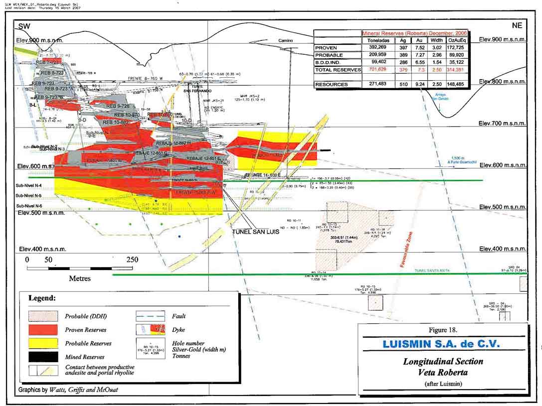
Figure 18. Longitudinal section Veta Roberta
- 74 -
Watts, Griffis and McOuat
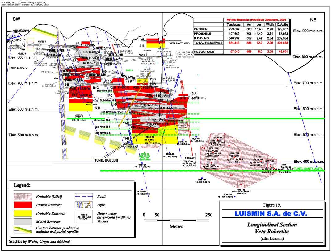
Figure 19. Longitudinal section Veta Robertita
- 75 -
Watts, Griffis and McOuat

Figure 20. Longitudinal section Veta Marina I
- 76 -
Watts, Griffis and McOuat
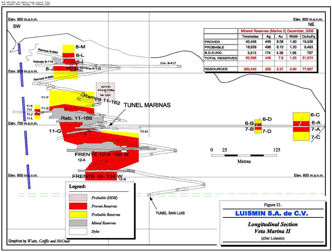
Figure 21. Longitudina l section Veta Marina II
- 77 -
Watts, Griffis and McOuat
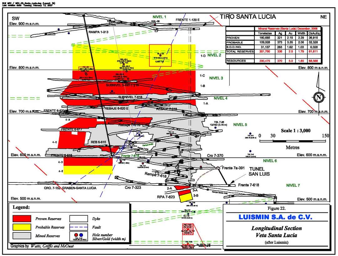
Figure 22. Longitudinal section Veta Santa Lucia
- 78 -
Watts, Griffis and McOuat
to conform to CIM Standards. Tables 13 to 15 illustrate the detailed Mineral Reserves of individual veins of each of the mining units.
TABLE 12
MINERAL RESERVES OF SAN DIMAS DISTRICT - LUISMIN GEOLOGY DEPARTMENT
(as of December 31, 2006)
| Metric | Total Contained | ||||
| Tonnes | g Ag/t | g Au/t | (oz Ag) | (oz Au) | |
| Proven Reserves | |||||
| Tayoltita | 359,174 | 332 | 3.08 | 3,839,434 | 35,543 |
| Santa Rita | 206,351 | 497 | 3.59 | 3,298,114 | 23,807 |
| Block Central | 1,001,444 | 420 | 7.70 | 13,529,993 | 247,893 |
| Total Proven Reserves | 1,566,969 | 410 | 6.10 | 20,667,541 | 307,243 |
| Probable Reserves | |||||
| Tayoltita | 390,062 | 356 | 3.78 | 4,460,378 | 47,405 |
| Santa Rita | 181,860 | 403 | 2.71 | 2,357,812 | 15,838 |
| Block Central | 542,597 | 429 | 7.69 | 7,486,806 | 134,107 |
| Total Probable Reserves | 1,114,519 | 399 | 5.51 | 14,304,996 | 197,350 |
| Proven and Probable Reserves | |||||
| Tayoltita | 749,236 | 345 | 3.44 | 8,299,811 | 82,948 |
| Santa Rita | 388,211 | 453 | 3.18 | 5,655,926 | 39,645 |
| Block Central | 1,544,041 | 423 | 7.70 | 21,016,799 | 382,000 |
| Total Proven and Probable Reserves | 2,681,489 | 406 | 5.85 | 34,972,536 | 504,593 |
| Probable Reserves by Diamond Drilling | |||||
| Tayoltita | 734,611 | 294 | 2.97 | 6,947,552 | 70,211 |
| Santa Rita | 294,769 | 330 | 7.03 | 3,125,457 | 66,643 |
| Block Central | 603,765 | 453 | 7.93 | 8,800,273 | 153,895 |
| Total Probable Reserves by Diamond Drilling | 1,633,146 | 359 | 5.54 | 18,873,282 | 290,749 |
| GRAND TOTAL Proven and Probable Reserves | 4,314,635 | 388 | 5.73 | 53,845,818 | 795,342 |
Notes to Reserve Statement
| 1. | Reserves were estimated by Luismin and audited by WGM as of December 31, 2004. |
| 2. | Cutoff grade based on total operating cost for Tayoltita, Santa Rita and Block Central (US$56.00/t). |
| 3. | All reserves are diluted, a mining recovery factor has not been applied, but WGM estimates that the mining recovery will be approximately 90%. |
| 4. | The tonnage factor is 2.7 tonnes per cubic metre. |
| 5. | Cutoff values are calculated at a silver price of US$5.50 per troy ounce and US$375.00 per troy ounce for gold. |
| 6. | Rounding of figures may alter the sum of individual columns. |
- 79 -
| Watts, Griffis and McOuat |
| TABLE 13 |
| TAYOLTITA MINERAL RESERVES |
| (December 31, 2006) |
| Tonnes | Ag | Au | kg Ag | kg Au | oz Ag | oz Au | |
| (g/t) | (g/t) | ||||||
| Proven | |||||||
| VETA SANLUIS | 350 | 305 | 3.13 | 107 | 1.1 | 3,436 | 35 |
| FRONTERA | 751 | 284 | 3.09 | 213 | 2.3 | 6,846 | 75 |
| MINA ARANA | 44,480 | 398 | 5.14 | 17,683 | 228.6 | 568,513 | 7,349 |
| ARANA DEL ALTO | 92,139 | 298 | 3.34 | 27,466 | 308.0 | 883,040 | 9,904 |
| CULEBRA | 24,701 | 434 | 4.24 | 10,727 | 104.8 | 344,884 | 3,371 |
| CANDELARIA | 16,044 | 364 | 3.87 | 5,841 | 62.1 | 187,782 | 1,997 |
| CEDRAL | 6,204 | 250 | 2.18 | 1,554 | 13.5 | 49,948 | 434 |
| 15-207 | 9,438 | 324 | 2.08 | 3,056 | 19.6 | 98,262 | 630 |
| EL CRISTO | 4,363 | 223 | 3.89 | 973 | 17.0 | 31,296 | 546 |
| TSL ( SANTA LUCIA ) | 158,588 | 323 | 2.16 | 51,241 | 343.0 | 1,647,435 | 11,027 |
| TSL ( EL ORO ) | 2,116 | 264 | 2.59 | 560 | 5.5 | 17,993 | 176 |
| Total Proven | 359,174 | 332 | 3.08 | 119,420 | 1,105.5 | 3,839,434 | 35,543 |
| Probable | |||||||
| VETA SAN LUIS | 1,029 | 305 | 3.13 | 314 | 3.2 | 10,091 | 104 |
| VETA FRONTERA | 1,758 | 284 | 3.09 | 499 | 5.4 | 16,036 | 175 |
| MINA ARANA | 72,812 | 368 | 4.56 | 26,791 | 332.2 | 861,338 | 10,681 |
| ARANA DEL ALTO | 105,374 | 320 | 3.68 | 33,668 | 387.4 | 1,082,447 | 12,454 |
| MINA CULEBRA | 44,535 | 446 | 4.41 | 19,844 | 196.4 | 637,992 | 6,314 |
| MINA CANDELARIA | 28,801 | 368 | 3.93 | 10,601 | 113.1 | 340,843 | 3,637 |
| MINA CEDRAL | 13,435 | 249 | 2.21 | 3,352 | 29.7 | 107,755 | 954 |
| VETA 15-207 | 3,265 | 233 | 1.93 | 761 | 6.3 | 24,478 | 203 |
| EL CRISTO | 7,183 | 220 | 3.81 | 1,578 | 27.4 | 50,745 | 880 |
| TSL ( SANTA LUCIA) | 109,928 | 373 | 3.35 | 40,972 | 368.2 | 1,317,283 | 11,837 |
| TSL ( EL ORO ) | 1,942 | 182 | 2.67 | 354 | 5.2 | 11,370 | 166 |
| Total Probable | 390,062 | 356 | 3.78 | 138,733 | 1,474.5 | 4,460,378 | 47,405 |
| Total Proven and Probable | 749,236 | 345 | 3.44 | 258,153 | 2,580.0 | 8,299,811 | 82,948 |
| Probable Reserves by DDH | 734,611 | 294 | 2.97 | 216,093 | 2,183.8 | 6,947,552 | 70,211 |
| GRAND TOTAL | 1,483,847 | 320 | 3.21 | 474,246 | 4,763.8 | 15,247,363 | 153,159 |
- 80 -
| Watts, Griffis and McOuat |
| TABLE 14 |
| SANTA RITA MINERAL RESERVES |
| (December 31, 2006) |
| Tonnes | Ag | Au | kg Ag | kg Au | oz Ag | oz Au | |
| (g/t) | (g/t) | ||||||
| Proven | |||||||
| VETA SANTA RITA | 9,188 | 358 | 2.54 | 3,292 | 23.3 | 105,835 | 751 |
| VETA PEÑA | 1,118 | 537 | 4.16 | 600 | 4.7 | 19,295 | 150 |
| VETA 11-210 | 1,132 | 461 | 4.54 | 522 | 5.1 | 16,767 | 165 |
| VETA 16-804 | 818 | 322 | 2.71 | 264 | 2.2 | 8,475 | 71 |
| VETA MARLENNE | 2,451 | 303 | 2.21 | 742 | 5.4 | 23,844 | 174 |
| VETA PATY I | 7,530 | 414 | 2.27 | 3,116 | 17.1 | 100,174 | 549 |
| VETA LUPITA | 7,487 | 304 | 1.98 | 2,274 | 14.9 | 73,115 | 478 |
| VETA PATY II | 358 | 282 | 2.49 | 101 | 0.9 | 3,251 | 29 |
| VETA MAGDALENA | 2,148 | 739 | 7.62 | 1,587 | 16.4 | 51,021 | 526 |
| VETA MARISA | 34,624 | 322 | 1.86 | 11,160 | 64.5 | 358,815 | 2,075 |
| VETA MISACHE | 14,969 | 283 | 1.78 | 4,230 | 26.6 | 135,984 | 856 |
| VETA CRISTINA | 2,653 | 302 | 2.04 | 802 | 5.4 | 25,785 | 174 |
| VETA CRISTINA DEL ALTO | 12,500 | 347 | 2.67 | 4,341 | 33.4 | 139,563 | 1,074 |
| VETA PROMONTORIO | 6,489 | 391 | 2.40 | 2,539 | 15.6 | 81,640 | 502 |
| VETA BLENDITA FW | 1,623 | 262 | 1.98 | 425 | 3.2 | 13,663 | 103 |
| VETA BLENDITA HW | 8,206 | 290 | 1.62 | 2,377 | 13.3 | 76,412 | 427 |
| VETA LA LUZ | 706 | 288 | 2.49 | 203 | 1.8 | 6,532 | 57 |
| VETA AMERICA | 30,340 | 1,333 | 9.87 | 40,430 | 299.4 | 1,299,854 | 9,625 |
| VETA NANCY | 33,314 | 515 | 4.50 | 17,161 | 149.9 | 551,741 | 4,819 |
| VETA CLAUDIA | 2,854 | 202 | 1.31 | 577 | 3.7 | 18,539 | 120 |
| VETA FABIOLA | 1,353 | 288 | 1.13 | 390 | 1.5 | 12,534 | 49 |
| VETA ALEXIA | 2,203 | 192 | 1.71 | 423 | 3.8 | 13,589 | 121 |
| VETA CAROLINA | 6,873 | 227 | 1.23 | 1,560 | 8.5 | 50,170 | 273 |
| VETA SARITA | 1,089 | 210 | 1.36 | 228 | 1.5 | 7,346 | 48 |
| VETA LIZETH | 14,326 | 226 | 1.29 | 3,240 | 18.4 | 104,167 | 593 |
| Total Proven | 206,351 | 497 | 3.59 | 102,583 | 740.5 | 3,298,114 | 23,807 |
| Probable | |||||||
| VETA SANTA RITA | 4,844 | 354 | 2.49 | 1,715 | 12.1 | 55,140 | 388 |
| VETA PATY I | 19,310 | 420 | 2.30 | 8,102 | 44.4 | 260,483 | 1,429 |
| VETA LUPITA | 2,526 | 317 | 1.52 | 801 | 3.8 | 25,768 | 123 |
| VETA MAGDALENA | 3,085 | 739 | 7.62 | 2,279 | 23.5 | 73,265 | 756 |
| VETA MARISA | 24,245 | 314 | 1.83 | 7,620 | 44.5 | 244,992 | 1,430 |
| VETA MISACHE | 6,907 | 286 | 1.81 | 1,974 | 12.5 | 63,451 | 403 |
| VETA CRISTINA | 4,261 | 271 | 1.83 | 1,156 | 7.8 | 37,165 | 251 |
| VETA CRISTINA DEL ALTO | 11,681 | 357 | 2.74 | 4,170 | 32.0 | 134,054 | 1,028 |
| VETA PROMONTORIO | 11,969 | 402 | 2.56 | 4,816 | 30.6 | 154,823 | 983 |
| VETA BLENDITA FW | 3,245 | 262 | 1.98 | 850 | 6.4 | 27,326 | 207 |
| VETA LA LUZ | 599 | 288 | 2.49 | 172 | 1.5 | 5,545 | 48 |
| VETA AMERICA | 18,423 | 1,071 | 7.61 | 19,732 | 140.1 | 634,397 | 4,506 |
| VETA NANCY | 16,076 | 452 | 3.72 | 7,274 | 59.8 | 233,850 | 1,923 |
| VETA FABIOLA | 3,333 | 288 | 1.13 | 961 | 3.8 | 30,883 | 121 |
| VETA ALEXIA | 5,654 | 192 | 1.71 | 1,085 | 9.7 | 34,877 | 311 |
| VETA CAROLINA | 14,256 | 249 | 1.36 | 3,555 | 19.4 | 114,293 | 625 |
| VETA SARITA | 2,187 | 210 | 1.36 | 459 | 3.0 | 14,759 | 95 |
| VETA LIZETH | 29,258 | 226 | 1.29 | 6,617 | 37.7 | 212,741 | 1,211 |
| Total Probable | 181,860 | 403 | 2.71 | 73,336 | 492.6 | 2,357,812 | 15,838 |
| Total Proven and Probable | 388,211 | 453 | 3.18 | 175,919 | 1,233.1 | 5,655,926 | 39,645 |
| Probable Reserves by DDH | 294,769 | 330 | 7.03 | 97,213 | 2,072.8 | 3,125,457 | 66,643 |
| GRAND TOTAL | 682,980 | 400 | 4.84 | 273,132 | 3,305.9 | 8,781,383 | 106,288 |
- 81 -
Watts, Griffis and McOuat
TABLE 15
BLOCK CENTRAL MINERAL RESERVES
(December 31, 2006)
| Tonnes | Ag | Au | kg Ag | kg Au | oz Ag | oz Au | |
| (g/t) | (g/t) | ||||||
| Proven | |||||||
| LUZ Y REYES | 8,459 | 236 | 3.96 | 1,996 | 33.5 | 64,160 | 1,077 |
| SAN RAFAEL | 9,523 | 201 | 4.99 | 1,912 | 47.5 | 61,482 | 1,529 |
| CELIA II | 38,050 | 366 | 3.43 | 13,945 | 130.6 | 448,347 | 4,199 |
| CAPITANA | 2,338 | 434 | 5.07 | 1,015 | 11.9 | 32,637 | 381 |
| SOLEDAD | 30,402 | 351 | 4.10 | 10,682 | 124.7 | 343,429 | 4,008 |
| MARINA I | 113,258 | 322 | 6.23 | 36,506 | 705.9 | 1,173,686 | 22,696 |
| MARINA II | 40,456 | 446 | 8.08 | 18,040 | 327.1 | 580,000 | 10,516 |
| ROBERTITA | 229,837 | 568 | 11.82 | 130,634 | 2,716.3 | 4,199,992 | 87,331 |
| NOCHE BUENA | 58,882 | 320 | 3.94 | 18,816 | 232.3 | 604,955 | 7,468 |
| ROBERTA | 392,269 | 397 | 7.52 | 155,826 | 2,948.4 | 5,009,906 | 94,793 |
| GLORIA | 16,666 | 709 | 12.50 | 11,816 | 208.3 | 379,886 | 6,698 |
| KATIA | 3,172 | 503 | 10.03 | 1,595 | 31.8 | 51,266 | 1,022 |
| CASTELLANA | 50,788 | 321 | 3.55 | 16,320 | 180.5 | 524,715 | 5,804 |
| SAN SALVADOR | 7,344 | 235 | 1.57 | 1,727 | 11.6 | 55,533 | 372 |
| Total Proven | 1,001,444 | 420 | 7.70 | 420,830 | 7,710.3 | 13,529,993 | 247,893 |
| Probable | |||||||
| LUZ Y REYES | 11,429 | 248 | 4.25 | 2,836 | 48.6 | 91,185 | 1,562 |
| SAN RAFAEL | 10,890 | 189 | 5.13 | 2,059 | 55.9 | 66,186 | 1,796 |
| CELIA II | 26,205 | 435 | 3.61 | 11,391 | 94.7 | 366,226 | 3,043 |
| CAPITANA | 3,895 | 473 | 5.51 | 1,843 | 21.5 | 59,241 | 690 |
| SOLEDAD | 16,909 | 308 | 4.24 | 5,216 | 71.6 | 167,701 | 2,303 |
| MARINA I | 45,560 | 249 | 5.38 | 11,336 | 245.0 | 364,451 | 7,876 |
| MARINA II | 18,629 | 498 | 8.10 | 9,277 | 151.0 | 298,256 | 4,854 |
| ROBERTITA | 107,669 | 707 | 14.40 | 76,147 | 1,550.2 | 2,448,184 | 49,840 |
| NOCHE BUENA | 9,386 | 307 | 3.70 | 2,881 | 34.7 | 92,622 | 1,116 |
| ROBERTA | 209,959 | 389 | 7.27 | 81,718 | 1,525.7 | 2,627,290 | 49,051 |
| GLORIA | 9,098 | 672 | 12.29 | 6,116 | 111.8 | 196,645 | 3,594 |
| KATIA | 7,700 | 503 | 10.03 | 3,871 | 77.2 | 124,460 | 2,482 |
| CASTELLANA | 41,063 | 320 | 3.47 | 13,142 | 142.5 | 422,509 | 4,581 |
| SAN SALVADOR | 24,207 | 208 | 1.69 | 5,034 | 41.0 | 161,850 | 1,319 |
| Total Probable | 542,597 | 429 | 7.69 | 232,866 | 4,171 | 7,486,806 | 134,107 |
| Total Proven and Probable | 1,544,041 | 423 | 7.70 | 653,696 | 11,882 | 21,016,799 | 382,000 |
| Probable Reserves by DDH | 603,765 | 453 | 7.93 | 273,719 | 4,787 | 8,800,273 | 153,895 |
| GRAND TOTAL | 2,147,807 | 432 | 7.76 | 927,415 | 16,668.2 | 29,817,072 | 535,895 |
- 82 -
Watts, Griffis and McOuat
19. SAN DIMAS TAILINGS MANAGEMENT
| 19.1 | GENERAL |
At the time of Wheaton River’s acquisition of the Luismin operations, the practice in the design and operation of tailings containment sites in the San Dimas district complied with the requirements of Mexico and with the permits issued for the dams. To bring the facilities to international guidelines, a series of improvements were identified as necessary to reduce risk as well as the potential environmental impact. Since the acquisition, a number of improvements have been made and extensive work is ongoing to further improve the standard of the tailings operation.
Luismin’s practice had been to discharge tailings from the cyanidation mills to unlined structures designed to settle the solids and collect solutions for recycle to the milling operations. The containment dams were typically constructed with cyclone underflow, and the overflow drains to decant structures in the central portion of the dam. Previously the tailings containment sites had not been subjected to comprehensive geotechnical investigations before construction, normal safety factors in dam design nor monitoring or control of seepage.
The deficiencies with the tailings management aspect of the operations are being addressed by Luismin and capital investments are currently being made to upgrade the containment structures and tailings operations to bring them more in line with accepted practice. In 2005 US$1.34 million was spent on the San Antonio tailings, and US$2.19 million in 2006, and on the Tayoltita tailing US$1.87 million in 2005 and US$0.59 million in 2006. Environmental requirements in Mexico can be expected to become more aligned with world standards in the future. The planned capital expenditures and changes to upgrade the Luismin tailings management operations are expected to continue to comply with the operating standards required in Mexico, and to ultimately achieve compliance with international guidelines.
| 19.2 | TAYOLTITA TAILINGS |
The very rugged mountainous terrain and steep walled canyons in the San Dimas district have presented formidable challenges to tailings management as the scale of operations grew and
- 83 -
Watts, Griffis and McOuat
storage areas were depleted. The Tayoltita operation has developed numerous tailings disposal sites in the valley near the mill and in more recent years, the tailings dam has been moved up the valley to the east of the mill. At that time the operation relied on 10 pumping stations to elevate the tailings to the containment site. The operation included the tailings line and solution return line on cable supports to cross the river valley without any provisions for spill containment in the event of a line failure.
The historical construction practice has been to gradually build containment basins on the steep hillsides using thickened tailings while continuously decanting the solutions for recycle to the mill. On abandonment, the dried tailings have been left to dehydrate and efforts to establish a natural vegetation cover have been undertaken. The abandoned dams in the area are subject to erosion and instability until remediation measures are taken. On three of the older tailings dams near the Tayoltita mill, the land has been reclaimed for use as a soccer field, a softball field, and a garden nursery.
Monitoring of the Piaxtla River downstream of the Tayoltita tailings deposits has not shown any environmental impact on the water quality, but WGM expects that it is impacted with higher suspended solids in periods of heavy rainfall.
Under the current San Dimas plan, the Tayoltita Mill operation and future expansion will process all ore mined in the district with all tailings deposited in the currently active tailings disposal dam. Since the acquisition by Wheaton River in 2002 significant capital improvements have been made at the Tayoltita tailings operation and further improvements to the dam and operating practices are planned.
The 10 relay tailings pumping stations have been replaced with four positive displacement pumps operating in parallel with the capacity to pump high density tailings the full distance to the dam. High capacity thickeners have been added to the mill to increase the tailings density and reduce the solution containment, hydrostatic heads, and return capacity required at the tailings dam. At the river crossing, the tailings lines are suspended in a spill recovery trough with provision to divert any spills into a containment area. At the time of the visit in January, installation of a tailings filtration plant, to allow for dry placement of tailings, was near completion.
- 84 -
Watts, Griffis and McOuat
Construction of the initial phase of an earthen berm against the downstream side of the dam has been completed to increase the safety factor of the containment structure. The project includes the construction of a seepage drainage and collection channel below the dam.
| 19.3 | SAN ANTONIO TAILINGS |
Due primarily to the exhausted capacity of the tailings dam, the San Antonio Mill operation was shutdown in 2003. The tailings dam site is located in a turn in a steep walled river canyon downstream of the mill operation. The river has been diverted through two tunnels which have been excavated in the canyon wall on the inside of the river bend. A third tunnel for road access has been excavated and also serves as an additional channel for the river in high flow periods. In the 2002 due diligence by Wheaton River, the San Antonio tailings dam was identified as a risk to failure due to a low safety factor in the dam, risk associated with an unknown hydrostatic head in the active tailings deposition area, and possible erosion due to a flood event in the adjacent river.
Since the shutdown of the mill operations, some of the risk has been removed by elimination of the hydrostatic head in the dam and diversion of a local drainage channel. It has been proposed that the dam safety factor be increased by extending the concrete wall on the upstream side of the dam and protection of the downstream side by covering with mine waste rock. These measure would also decrease the erosion potential of the tailings. Some of this work has been initiated while options to close and reclaim the tailings dam were studied.
Luismin has now received approval to reclaim the San Antonio dam by stabilizing the tailings in their current location subject to the submittal of an environmental assessment that demonstrates the validity of the plan in the second quarter of 2005. Expenditures in 2004 totalled US$0.11 million and expenditures in 2005 and 2006 were US$1.34 million and US$2.19 million, respectively. An access road is being constructed and covering of the tailings with low strength concrete was delayed due to rain in the fall of 2006 and now it is expected to be carried out in mid-2007. Construction of a rock filled berm and a Roller Compacted Concrete stepped spillway has begun.
- 85 -
Watts, Griffis and McOuat
| 19.4 | EXPLORATION PROPERTIES |
| 19.4.1 | INTRODUCTION |
In addition to the three operating mines, Luismin owns or has an interest in 23 exploration properties throughout Mexico. The properties range from the more advanced exploration stage to preliminary grassroots stage. WGM has not visited these properties, but has completed a review of available data and held discussions with Luismin exploration staff. Table 16 summarizes the geology and work completed on the properties.
Eight of the properties have signed joint venture agreements with other mining companies who operate the properties and one is presently being explored by Luismin.
Figure 23 shows the location of these exploration properties. The particular details of each property are listed in Table 16.
| 19.4.2 | DISCUSSION |
Since its acquisition by Wheaton River Minerals, Luismin has been active in evaluating and acquiring joint venture partners to explore and develop the exploration properties. WGM believes that the properties warrant further exploration and some, particularly those at a more advanced stage, appear to have very promising potential to develop Mineral Resources/Mineral Reserves.
- 86 -
Watts, Griffis and McOuat
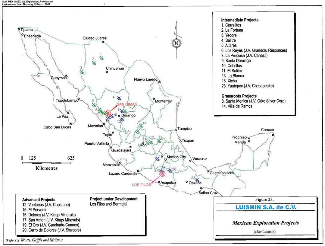
Figure 23. Mexican exploration projects
- 87 -
Watts, Griffis and McOuat
TABLE 16
MINAS LUISMIN, S.A. DE C.V. - EXPLORATION PROJECT STATUS, 2004
| No. | Project Name | PartnershipStatus | Claim Area | Location | State | Latitude or UTM North | Longitude or UTM East | Deposit Type | Commodity | Host Rock Lithology | Ore Mineralogy | Gangue Mineralogy | Alteration | Geophys | Geochem Typ | Drillholes | Mine Develop. | Historic Production | Royalties | Comments | |
| (ha) | Type | # Samples | Qty, (m) | (m) | TonnesGrade g/t,%) | ||||||||||||||||
| 1 | Corralitos | Available | 416 | 45 Km N38E Of NuevoCasas Grandes | Chihuahua | 3,402,679 N | 247,451 E | Epithermal AndMesothermal Veins,Skarn | Zn, Cu, Pb, Au,Ag | Limestone,Sandstone, Siltstone, QuartzDiorite | Au, Py, Cpy,Bo, Pr, Gal,Sphal | Qtz, Ca, Py, SkarnMinerals | Ca, Sil, Prop | No | 50 | 8 (2,000) | Kilometres | 3,000,000 | 1-2grAuAg, 2%Cu,10%ZnPb | 3% To San Luis | Sight of significant former production. To be combined with La Fortuna asa package |
| 2 | La Fortuna | Available | 265 | 25 Km S30E Of NuevoCasas Grandes | Chihuahua | 3,341,284 N | 231,100 E | Epithermal Veins | Ag, Au | Rhyolitic TuffsAnd Flows | Ag, Au, Gal,Sphal, Py, Mangan, Barite | Qtz, Ca, Ba, Clays | Sil, Argil, Prop,Hem, Jar, Chlor | IP, AR | 120 | 2-3 (1,000) | 2,300 Drift 390Shaft | 40,000 | 300grAg | 3% To San Luis | Collapsed caldera. Project needs resource definition through drilling, u/gdevelopment. To be combined with Corralitos as a package. |
| 3 | Yécora | Available | 676 | 25 Km N77W Of Yécora Town | Sonora | 3,139,537 N | 670,362 E | Tourmaline Breccias, Stockwork, Por Cu,Mo, W | Cu, Pb, W, Mo(Ag-Au) | Monzonites AndQtz.-Monz,Tourmaline Breccia | Cpy, Au, Ag,WO3, Gal, Sphal, MOS2 | Qtz, Tourmaline, Silica, K-spar, Kaol | K-spar, Silica,Jarosite, Hem | IP, AR | 350 | 4-5? | None | None | None | 3% To San Luis | Drilled by IMMSA. Large district of tourmaline breccia pipes-Los Verdes,La Providencia, Las Mantequillas, Tres Piedras, Penasco Blanco, plus gold,silver, copper veins. Old Cominco ground. |
| 4 | El Salitre | JV WithMauricioHochschild | 12,963 | 27 Km N20E OfSantiago Papasquiaro | Durango | 2,794,000 N | 467,000 E | Epithermal Veins | Au, Ag | Andesite, Dacite,Rhyolite, Domes,Dykes | Au, Arg, Gal,Sphal, Cpy, Barite, Mercury | Qtz, Calcite, Barite,Vuggy Silica | Argil, Adv Argil, Hem,Alunite | No | Rocks, Soils,1,000 | 5 (1,500) | Minor Old UG Works | 5-10,000 | 5-10 gr AuEquiv.? | 3% To San Luis OnSome Claims/Others No NSR | Presently A Joint Venture With Mauricio Hochschild. Former JV partners completed surface prospecting, mapping, sampling and diamonddrilling in 2003. Hochschild has also completed a daimond drillingprogram. |
| 5 | Altares | Available | 655 | 15 Km E OfBaridaguato Town | Sinaloa | 25º 20' 46.9" | 107º 21' 23.5" | Epithermal Veins | Au, Ag | Clastic Sediments | Free Au | Qtz, Tourmaline | Prop, Ser,Tourmaline | No | No | No | OldTunnels/Shafts | 40,000 | ? | 3% To San Luis | Possible bulk tonnage low grade gold copper deposit. |
| 6 | Guadalupe De Los Reyes | JV with CanasilCorp | 4,117 | 20 Km SE Of CosaláTown | Sinaloa & Durango | 2,685,000 N | 344,000 E | Epithermal Veins | Au, Ag | Andesite,Rhyolite | Au, Arg, Ac,Po, El | Qtz, Ca,Rhodocrosite | Sil, Prop, Ser | IP, AR | 150 | Numerous | UndergroundWorkings | 900,000ounces gold equivalent | 900,000 ouncesgold equivalent | 3% To San Luis | Presently A Joint Venture With Canasil Corp.200,000 ounces drilldefined by Northern Crown. Peripheral claims mainly untested. |
| 7 | La Preciosa | JV With OrkoSilver Corp. | 1,134 | 47 Km N25E OfDurango City | Durango | 2,702,147 N | 555,230 E | Epithermal Veins | Ag, Au | Andesite,Rhyolite, Basalt,Volcanic Breccia | Au, Arg, Sph,Gal, Barite | Qtz, Ca, Gal, Sphal,Py | Sil, Prop, Arg | IP | >1,000 | 7, (1,319) | 2,500 Metres | 30-40,000 | 238Ag, 0.7 Au,0.17%Zn | 3% To San Luis OnSome Claims/Others No NSR | Presently A Joint Venture With Orko Silver Corp.Excellentexploration/development opportunity. Good infrastructure. |
| 8 | SantaMonica | JV With OrkoGold Corp. | 16,386 | 47 Km N25E OfDurango City | Durango | 2,702,147 N | 555,230 E | Epithermal Veins | Ag, Au | Andesite,Rhyolite, Basalt,Volcanic Breccia | Au, Arg, Sph,Gal, Barite | Qtz, Ca, Gal, Sphal,Py | Sil, Prop, Arg | IP | 50 | None | None | None | None | None | Presently A Joint Venture With Orko Gold Corp.Excellent explorationopportunity. Large land position located between La Preciosa to the westand Avino Mines to the east. Large block of land to north held by Penoles. |
| 9 | SantoDomingo | Available | 418 | 44 Km NW OfTayoltita, 53 Km NE San Ignacio | Sinaloa | 2,680,000 N | 365,000 E | Porphyry Au, Cu | Au, Cu | QuartzMonzonite | Au, Cpy | Qtz, Py, Sphal, Gal,Cpy, Feox | Ad, Ser, Prop,Arg, Ox | No | 50 | 3, (520) | None | None | None | 3% To San Luis | Battle Mtn. Gold DDH's cut significant anomalies in Cu-Au. |
| 10 | Cebollas | Available | 1,861 | 14 Km SE Of Tayoltita,Close To CebollasRanch | Durango | 2,760,000 N | 420,000 E | Epithermal Veins | Au, Ag | Capping,Rhyolite | Au, Ag, Arg,Po, Ac, Sph,Gal | Qtz, Ca, Py, Sph,Gal, Lim, Mnox | Prop, Arg, Ser,Ad, Sil, K-spar | No | 60 | No | Pits And SmallUg Workings | 1,500 | 3,000Ag, 40Au | None | Los Laureles vein outcrops 1500 m, 2-14 m width. Good infrastructure,near Tayoltita. Near a small mine with limited Au/Ag production called ElDuraznito. |
| 11 | ElCandelero | Available | 2,281 | 21 Km West OfTayoltita | Sinaloa | 2,665,000 N | 380.000 E | Epithermal Veins | Ag, Au | Andesite, Granite | Au, Ac,Proustite,Pyrargyrite | Qtz, Py, Sphal, Gal,Cpy | Prop, Ser, Adularia, | No | 30 | No | None | None | None | None | Narrow veins from 0.5 to 0.8 m, hosted in Lower Volcanics. Clean title, noSan Luis NSR. |
| 12 | Ventanas | JV with Capstone | 3,570 | 110 Km S84W OfDurango City | Durango | 2,643,000 N | 423,000 E | Epithermal Veins,Stockworks | Ag, Au | Andesite,Rhyolite, Lower-Upper VolcanicSeries | Au, Ac, Po, Sphal, Gal, Manganese | Qtz, Ca, Py, Sphal,Gal, Cpy | Prop, Ser, Arg | No | 300 + NewSampling | 21(>5,000)+ 4 New | Kilometres | 400,000 | 490Ag, 2.5 Au | None | Poject Drilled And Abandoned By Capstone Gold Corp.The districtincludes Ventanas and Mala Noche, >125K Au equiv ounces historicproduction. Considered the geological and mineralogical twin to Tayoltita. |
| 13 | La Blanca | Available | 188 | 43 Km N50W OfSombrerete Town | Durango | 2,643,181 N | 609,474 E | Epithermal Veins | Au, Ag, Zn, Pb, Cu | Limestone, Shale, Sandstone, Dolomite | Au, Arg, Sph,Ga, Cpy | Qtz, Ca, Jasperoid,Fluorite | Sil, Ca | No | 200 | 3 (600) | 500 m | 2,000 | ? | 3% To San Luis | Epithermal Carlin-style veining diststal to Sacrificio skarn. Excellentinfrastructure. |
| 14 | Villa deRamos | Available | 1,088 | 70 Km N85E OfZacatecas City | San LuisPotosi | 2,526,038 N | 205,100 E | Epithermal Veins | Ag, Au, Cu, Pb,Zn | Phyllite,Andesite, Basalt, Limestone | Au, Ag, Sphal, Arg, Gal, Cpy,Tet, Mal, Az | Qtz, Clay, Calcite,Barite | Sil, Argil, | No | No | No | Kilometres,Adjac Mines | 3,000,000 | 300-500Ag, 2-3Au, CuPbZn | 3% To San Luis On Some Claims/Others No NSR | Excellent access and infrastructure. |
| 15 | El Porvenir | Available | 960 | 40 Km N30E Of AguasCalientes | AquasCalientes | 2,462,000 N | 798,000 E | Mesothermal-Epithermal Veins-Skarns | Zn, Pb, Cu, Au,Ag | Phyllite,Sandstone, Siltstone, Limestone,Dolomite,Andesite | Au, Ag, Sphal, Gal, Cpy, Te, Arg | Qtz, Ca, Fl, Da,Bak, Go, He, Ce | Ser, Sid, Chl,Act, Hed,Jasperoid | IP, AR | 1,500 | 143,(26,261),Core,Rev.Circ. | Kilometres,Lower Works | 2,000,000 | 150Ag, 4.5Zn,2Cu | 3% To San Luis | Nine million tonnes are oxides and 5 million tonnes are sulfides. |
| 16 | Dolores | JV With KingsMinerals NL | 1,665 | 25 Km WSW OfDolores Hidalgo Townsite | Guanajuato | 2,334.000 N | 279,000 E | Porphyry Cu-Mo | Cu, Mo, Au, Ag,Pb, Zn | Granodiorite,Diorite, Andesite | Cu, Mo, Au,Ag, Pb, Zn | Qtz, Clay, Pyrite, | Argillic,Phyllic,Potassic | IP | 200 | No | No | No | No | 3% To San Luis | Presently A Joint Venture With Kings Minerals. Extensive alterationsystem, mainly argillic with zones of pyrite/quartz stockwork. |
| 17 | San Antón | JV With KingsMinerals NL | 7,480 | 15 Km WSW OfDolores HidalgoTownsite | Guanajuato | 21º 04' 19.2" | 101º 02' 53.0" | Porphyry Cu-Au-Hornfels | Au, Ag, Cu, Pb,Zn | Qtz Monzonite,Hornfels | Au, Arg (Py,Sph, Ga, Cpy) | Qtz, Py, Bornite,Copper Oxides | K-spar, Ser,Diopside,Biotite | IP, AR(20km) | 4,000 | 14, (3,550) | None | None | None | 3% To San Luis | Presently A Joint Venture With Kings Minerals.Other distalconcessions are grassroots targets, and need evaluation. |
- 88 -
Watts, Griffis and McOuat
TABLE 16
MINAS LUISMIN, S.A. DE C.V. - EXPLORATION PROJECT STATUS, 2004
(continued)
| No. | Project Name | Partnership Status | Claim Area | Location | State | Latitude orUTM North | Longitude orUTM East | Deposit Type | Commodity | Host Rock Lithology | Ore Mineralogy | Gangue Mineralogy | Alteration | Geophys | Geochem Typ | Drillholes | Mine Develop. | Historic Production | Royalties | Comments | |
| (ha) | Type | # Samples | Qty, (m) | (m) | Tonnes | Grade (g/t,%) | |||||||||||||||
| 18 | Xichu | Available | 2,500 | 85 Km East Of San LuisDe La Paz | Guanajuato | 2,358.564 N | 393,012 E | Skarn/Vein, Pb, Zn,Ag, Cu | Zn, Pb, Ag, Cu | Limestone, Chert, Dolomote, Shale, Acid Intermed. Dykes, Sills | PbS, ZnS, Cpy, Ac, Py, Po, Asp, Pr, Pyr, Chal, Ten | Calcite, Qtz, Goeth, Hem, Lim, Ba, Fl, Dol, Gypsum, Mt,. | Carbonates, Skarn | No | ? | ? | Extensive OldWorks | 500,000-2,000,000 | 250-750Ag, 3.5%Pb, 5% Zn, 2-7%Cu | 1.5% To TeckCominco | Acquired when Miranda Mining purchased. Polymetallic base/preciousmetal skarn system. |
| 19 | El Oro | JV WithCandente-Canaco | 14,942 | 75 Km N45W OfToluca City | Mexico-Michoacan | 19º 47' 32.8" | 100º 09' 27.8" | Epithermal Veins | Au, Ag | Phyllite,CarbonaceousShale, Andesite | Au, Arg, Sphal,Gal, Py | Qtz, Calcite | Argillic, Prop,Sil, Ser, K-spar | RSIP-CSAMT | Placer, MMI, +1,700 | 9, (1,543) NewDiamond & Rev. Circ. | Drifts, Shafts,Stopes | 30,000,000 | 15Au, 200Ag | 3% To San Luis On Some Claims/Others No NSR | Presently A Joint Venture With Candente-Canaco.Very significant production history, >20 million Au equiv ounces. Placer Dome is earningan interest. |
| 20 | Cerro deDolores | JV With StarcoreInternational Ventures Ltd | 697 | 120 Km S33E OfCuernavaca City | Puebla-Guerrero | 1,983,700 N | 539,745 E | VMS, Vein, Karst,Manto Replacement | Ag, Pb, Zn, Cu | Phyllite,Quartzite (Chert), Limestone,Andesite | Ag, Sphal, Gal, Ruby Ag, Cpy, | Qtz, Sparry Calcite Barite, Py | Sil, Chl, Ser | IP, AR | 500 | >30(5,000m) | 4,000 | <5,000 | 1kgAg 30%ZnPb | 3% To San Luis On Some Claims/Others No NSR | Presently A Joint Venture With Starcore International Ventures Ltd.Ag/Pb/Zn potential. Good infrastructure, excellent exploration potential. |
| 21 | Ana Paula | Presently BeingExplored By Luismin | 4,000+ | West of Iguala | Guerrero | 1,997,500 N | 410,000 E | Skarn/Intrusive Hosted Gold/Silver | Au, Ag, Cu | Limestone,Granodiorite, Diorite | Au, Ag, CuOx | Calc-silicates, Hem, Mt, Clays | Endo-Exoskarn, Jasperoid, Felds, Qtz, Ser, Clays | Airborne Magnetic Anomaly | 50 | Nil | Some SmallAdits | 100 | 15Au | No | This project came with the Los Filos acquisition. Lies north of the RioBalsas. Magnetic anomaly associated with Exoskarn/Endoskarn. |
| 22 | El Limon | 21.2% WRM/78.8% | 26,262 | West of Iguala | Guerrero | 1,990,000 N | 420,000 E | Skarn/Intrusive Hosted Gold/Silver | Au, Ag, Cu | Limestone, Granodiorite, Diorite | Au, Ag, CuOx | Calc-silicates, Hem, Mt, Clays | Endo-Exoskarn, JAsperoid, Felds, Qtz, Ser, Clays | Airborne Magnetic, I.P. | 1,000's | 100+ | Some Small Adits, Surface Trenches | No | No | JV | This project came with the Los Filos acquisition. Lies south of Balsas. Teck-Cominco is actively exploring. |
| 23 | La GitanaYautepec | JV With Chesapeake Gold Corp. Teck Cominco | 494 | 120 Km S60E Of Oaxaca De Juarez | Oaxaca | 16º 31' 15.1" | 95º 45' 50.1" | Epithermal Veins, Disseminated Au, Ag | Au, Ag | Rhyolite Porphyry, Andesite | Au, Ag | Opaline Quartz Veinlets, | Qtz, Clay, Stockworks | No | 50 | No | Pits, Trenches | No | No | 3% To San Luis | Presently A Joint Venture With Chesapeake Gold Corp.Almaden-San Carlos, LUISMIN-Gitana vein. Poor exposure, difficult access. |
- 89 -
Watts, Griffis and McOuat
20. CAPITAL AND OPERATING COSTS
| 20.1 | CAPITAL COSTS |
| 20.1.1 | GENERAL |
Capital costs have been estimated by Luismin in three general categories to the year 2011 for the San Dimas operations. These include capital to sustain the existing operations, capital investment to expand the production capacity in the short term, and capitals to remove currently identified risks with tailings management facilities and bring the tailings operating practices in line with international guidelines.
The estimates have been developed internally by Luismin with additional input from external consultants for more specialized areas in the mill expansions and tailings dam projects. As is common industry practice, Luismin has used lease purchase options available from suppliers of major mining equipment to defer capital expenditures and prepared budgets on this basis. WGM has used these projections in the economic analysis of future operations.
Table 17 summarizes the capital requirements estimated for a life of mine plan to 2011 for the Luismin San Dimas operations.
TABLE 17
SAN DIMAS CAPITAL BUDGET, YEARS 2007 TO 2011
(US$ thousands)
| 2007 | 2008 | 2009 | 2010 | 2011 | TOTAL | ||
| Sustaining: | Mine | 18,436 | 18,239 | 19,057 | 19,057 | 19,057 | 93,844 |
| Plant | 338 | 1,504 | 1,504 | 1,504 | 1,504 | 6,355 | |
| Facilities | 709 | - | - | - | - | 709 | |
| Total Sustaining | 19,484 | 19,743 | 20,561 | 20,561 | 20,561 | 100,908 | |
| Improvement: | Mine | 666 | 8,257 | 757 | 757 | 757 | 11,195 |
| Plant | 657 | 1,546 | - | - | - | 2,203 | |
| Facilities | 576 | - | - | - | - | 576 | |
| Total Improvement | 1,900 | 9,803 | 757 | 757 | 757 | 13,974 | |
| Expansion: | Mine | 6,151 | 8,000 | 2,134 | 320 | 320 | 16,925 |
| Plant | 12,425 | 5,771 | - | - | - | 18,196 | |
| Special Projects | 23,078 | 698 | 698 | 698 | 698 | 25,872 | |
| Total Expansion | 41,655 | 14,469 | 2,833 | 1,018 | 1,018 | 60,994 | |
| Total Capital | 63,038 | 44,015 | 24,150 | 22,336 | 22,336 | 175,876 | |
- 90 -
Watts, Griffis and McOuat
| 20.1.2 | CAPITAL EXPENDITURES FOR ENVIRONMENTAL MITIGATION AND UPGRADE OF TAILINGS MANAGEMENT PRACTICE. |
The environmental capital expenditures planned for the next two years are primarily for remediation work on existing tailings operations at the two mine sites that was identified by the environmental due diligence review completed by SRK for Wheaton in February 2002. The SRK cost estimates for the environmental work have subsequently been updated with more extensive site investigations and more detailed planning of the field work required.
In the San Dimas District construction work for stabilizing the main Tayoltita tailings dam is underway and erosion protection for the San Antonio dam has been started following studies of possible options.
| 20.1.3 | CAPITAL EXPENDITURES FOR EXPANSION OF PRODUCTION |
The capital requirements to meet the planned changes and expansions to the mill operations have been estimated by the Luismin internal engineering group. To reduce capital requirements, Luismin is using some refurbished used equipment, a fairly common practice for major processing equipment procurement which has the added advantage of reducing delivery times.
The mill expansion at Tayoltita is to replace the capacity resulting from the shutdown of the San Antonio milling operations as well as bring the capacity up to 3,200 tpd as part of the planned expansion and update of the operation. This capacity will better utilize the mining capacity available from the three mining operations and contribute to a lower unit cost structure. Since 2002 the capacity at Tayoltita will have been increased by 62%.
| 20.2 | OPERATING COSTS |
Luismin maintains a cost centre for the San Dimas mine operating units that forms the basis for the cutoff grade used to control the mine operations. An additional annual head office cost of approximately US$6 million for general and administrative expenses is not distributed by Luismin to the individual operating units.
- 91 -
Watts, Griffis and McOuat
The San Dimas district has a higher cost structure than normal due to the remote location of the operations and required townsite infrastructure. In 2003 and 2004, the Tayoltita Mill has been run at reduced capacity due to the higher grades taxing the metal recovery circuit in the mill to the limit resulting in an overall higher cost per tonne for the district.
Table 18 shows the costs for the San Dimas operating division for 2006.
| TABLE 18 | |
| LUISMIN OPERATING COSTS FOR 2006 | |
| US$/t | San Dimas |
| US$/t mined | 64.31 |
| * This does not include G&A (Durango Office) costs | |
WGM has used the San Dimas operating costs projected by Luismin where economies of the increased scale of the operations as well as the capital improvements should make the projected operating costs possible. The mill expansion will provide the metal recovery circuit to achieve scheduled recoveries on the full nameplate capacity of the mill and reduce the current cost structure at San Dimas.
- 92 -
Watts, Griffis and McOuat
21. MARKETS AND CONTRACTS
Gold and silver dore in the form of bullion that is produced from the mines is shipped 70% to Peñoles refinery in Torreon, Mexico and 30% to the Johnson Matthey refinery in Salt Lake City, Utah. The terms of the Peñoles refinery contract a charge of US$4.25/kg of doré at 99.8% of Au and Ag content, while the terms of the Johnson Matthey refinery contract provide for payment of 99.8% of the gold and silver content with treatment charges of $0.14/troy oz of dore and refining charges of US$I.OO/troy oz of gold. Payment is due 20 days following receipt of the bullion at the refinery.
The Luismin dore is a clean product with few impurities. There are numerous refineries around the world available to take the dore.
Luismin has used hedging in the past to considerable advantage in sales prices realized but terminated virtually all hedge positions in September 2001.
- 93 -
Watts, Griffis and McOuat
22. OBSERVATIONS, CONCLUSIONS AND RECOMMENDATIONS
WGM's review of Luismin's three operating mines, previous operating records as well as the currently identified Mineral Reserves and Mineral Resources has concluded that profitable operations should be sustainable for at least the next 15 years. Based on the operating history of Luismin, the potential for additional reserves being found on current land holdings, and the high success rate in turning resources into reserves, it is also probable that profitable operations will be extended much beyond the 15 year period that has been considered by WGM in its analysis.
In addition to the general conclusion on the future viability of the Luismin operations, WGM has also reached the following conclusions:
- Total Proven and Probable Mineral Reserves estimated as of December 31, 2006, for Luismin's four operating mines are 4.31 million tonnes at a grade of 388 g Ag/t and 5.73 g Au/t as follows:
| Tonnes | Grade | ||||
| g Ag/t | g Au/t | ||||
| Proven | Tayoltita | 359,174 | 332 | 3.08 | |
| Santa Rita | 206,351 | 497 | 3.59 | ||
| Block Central | 1,001,444 | 420 | 7.70 | ||
| Probable | Tayoltita | 1,124,673 | 315 | 3.25 | |
| Santa Rita | 206,351 | 358 | 5.38 | ||
| Block Central | 1,146,362 | 442 | 7.82 | ||
- The procedures used by Luismin to estimate the Mineral Reserves are reasonable and the reserves fairly represent the tonnage and grade that can be expected from an operation;
- The total Inferred Mineral Resources, estimated as of December 31, 2006, for the same four operating mines, and not included in the Mineral Reserves stated above, are about 7.99 million tonnes at an approximate grade of 321 g Ag/t and 2.9 g Au/t;
- The procedures used by Luismin to estimate the Inferred Mineral Resources are reasonable and the Inferred Resource estimate represents a reasonable expectation of potential;
- 94 -
Watts, Griffis and McOuat
- The experience and capabilities of the Luismin management team are regarded as excellent and important elements in the success of current and future operations;
- The potential for exploration, both on active mining properties as well as on exploration holdings, to expand the reserve base to both support and expand operations is excellent;
- Future operations will incur additional capital and operating costs for management of tailings sites as well as remediation of existing sites;
- Opportunities for future reductions in operating costs will be possible with capital investment in mining and processing equipment as well as changes to operating practices;
- It is evident that the Luismin operations have grown gradually over time where capital expenditures have been justified on short term planning and assessments. This has resulted in "add on" style expansions and a variety of equipment sizes and types that reduces some efficiencies in operations and maintenance that could otherwise be realized with longer term planning;
- An economic analysis of the Proven and Probable Reserves of the operations completed in March 2007 demonstrated that the reserves can be mined and processed at a profit; and
- A review of production and costs for 2005 and 2006 has demonstrated that the March 2007 economic analysis is valid.
As a result of WGM’s most recent review of the Luismin operations and comparison to the review completed at the time of the Wheaton acquisition in 2002, the following additional observations and conclusions are provided:
- The capital investment made available for exploration has resulted in the development of significant new mining areas in the San Dimas district that have substantially increased the grades being mined;
- The capital investment in mining equipment and the process plant have allowed the mine to develop the new areas and bring them into production quickly;
- 95 -
Watts, Griffis and McOuat
- Luismin management has made considerable progress in implementing safer practices in the underground operations by introducing rock mechanics expertise and modern ground control techniques to reduce the risks inherent in the operations;
- Although there is more work planned, substantial progress has been made in improving tailings management, in on site awareness of the international guidelines in regard to tailings dams, and in introducing lower risk techniques to generally upgrade this aspect of the operations; and,
- Site management has ongoing focus on reducing costs and improving the efficiencies of the operations through a very thorough data collection and reporting system.
- 96 -
Watts, Griffis and McOuat
CERTIFICATE
To Accompany the Report titled
"An Audit of the Mineral Reserves/Resources Tayoltita, Santa Rita and San Antonio
Mines, as of December 31, 2006, for Silver Wheaton Corp."
dated March 15, 2007
I, Velasquez Spring, do hereby certify that:
| 1. | I reside at 1020 Walden Circle, Unit 17, Mississauga, Ontario, Canada, L5J 4J9. |
| 2. | I am a graduate from the University of Toronto, Toronto, Ontario with a B.A.Sc. Degree in Applied Geology (1957), and I have practised my profession continuously since that time. |
| 3. | I am a member of the Association of Professional Engineers Ontario (Membership Number 43927011). |
| 4. | I am a Senior Geologist with Watts Griffis and McOuat Limited, a firm of consulting geologists and engineers, which has been authorized to practice professional engineering by Professional Engineers Ontario since 1969, and professional geoscience by the Association of Professional Geoscientists of Ontario. |
| 5. | I am a qualified person for the purpose of NI 43-101 with regard to epithermal mineral deposits and resource and reserve audits. |
| 6. | I visited the three mining properties on five occasions between January 16 to 26, 2002, March 7 to 11, 2002, January 18 to 22, 2003, September 27 to October 3, 2004, and January 17 to 19, 2007. |
| 7. | I was solely responsible for all sections except Section 20. |
| 8. | I have no personal knowledge as of the date of this certificate of any material fact or change, which is not reflected in this report. |
| 9. | Neither I, nor any affiliated entity of mine, is at present, under an agreement, arrangement or understanding or expects to become, an insider, associate, affiliated entity or employee of Silver Wheaton Corp., or any associated or affiliated entities. |
| 10. | Neither I, nor any affiliated entity of mine own, directly or indirectly, nor expect to receive, any interest in the properties or securities of Silver Wheaton Corp., or any associated or affiliated companies. |
- 97 -
Watts, Griffis and McOuat
| 11. | Neither I, nor any affiliated entity of mine, have earned the majority of our income during the preceding three years from Silver Wheaton Corp., or any associated or affiliated companies. |
| 12. | I have read NI 43-101 and Form 43-101F1 and have prepared the technical report in compliance with NI 43-101 and Form 43-101F1; and have prepared the report in conformity with generally accepted Canadian mining industry practice, and as of the date of the certificate, to the best of my knowledge, information and belief, the technical report contains all scientific and technical information that is required to be disclosed to make the technical report not misleading. |
Velasquez Spring, P.Eng., B.A.Sc.
March 15, 2007
- 98 -
Watts, Griffis and McOuat
CERTIFICATE
To Accompany the Report titled
"An Audit of the Mineral Reserves/Resources Tayoltita, Santa Rita and San Antonio
Mines, as of December 31, 2006, for Silver Wheaton Corp."
dated March 15, 2007
I, Gordon Watts, do hereby certify that:
| 1. | I reside at Suite 1301, 80 Mill Street, Toronto, Ontario, Canada, M5A 4T3. |
| 2. | I am a graduate from the University of Toronto, Toronto, Ontario with a B.A.Sc. Degree in Mining Engineering (1966), and I have practised my profession continuously since 1969. |
| 3. | I am a member of the Association of Professional Engineers Ontario (Membership Number 49149016). |
| 4. | I am a Senior Associate Mineral Economist with Watts Griffis and McOuat Limited, a firm of consulting geologists and engineers, which has been authorized to practice professional engineering by Professional Engineers Ontario since 1969, and professional geoscience by the Association of Professional Geoscientists of Ontario. |
| 5. | I am a qualified person for the purpose of NI 43-101. |
| 6. | I have not visited the mining properties. |
| 7. | I was solely responsible for Section 20. |
| 8. | I have no personal knowledge as of the date of this certificate of any material fact or change, which is not reflected in this report. |
| 9. | Neither I, nor any affiliated entity of mine, is at present, under an agreement, arrangement or understanding or expects to become, an insider, associate, affiliated entity or employee of Silver Wheaton Corp., or any associated or affiliated entities. |
| 10. | Neither I, nor any affiliated entity of mine own, directly or indirectly, nor expect to receive, any interest in the properties or securities of Silver Wheaton Corp., or any associated or affiliated companies. |
- 99 -
Watts, Griffis and McOuat
| 11. | Neither I, nor any affiliated entity of mine, have earned the majority of our income during the preceding three years from Silver Wheaton Corp., or any associated or affiliated companies. |
| 12. | I have read NI 43-101 and Form 43-101F1 and have prepared the technical report in compliance with NI 43-101 and Form 43-101F1; and have prepared the report in conformity with generally accepted Canadian mining industry practice, and as of the date of the certificate, to the best of my knowledge, information and belief, the technical report contains all scientific and technical information that is required to be disclosed to make the technical report not misleading. |
Gordon Watts, B.A.Sc., P.Eng.
March 15, 2007
- 100 -
Watts, Griffis and McOuat
REFERENCES
Minas Luismin S.A. de C.V.
| Jan. 2002 | Data Room Index (selected items were reviewed by WGM from the following sections: |
| Section 5 Reserves and Resources, p. 18. | |
| Sections 6.0 to 6.5 Operative Mines: Tayoltita, Santa Rita, San Antonio, San Martin and La Guitarra, pp. 19 to 50. | |
| Section 7 Exploration Projects, pp. 35 to 50. |
Society of Economic Geologists
| 2001 | Geology of the Santa Rita Ag-Au Deposit, San Dimas District Durango, Mexico. SP8, pp. 39 to 58. |
SRK Consulting
| 2002 | Environmental Due Diligence Review of Active Mining Units Owned and Operated by Minas Luismin S.A. de C.V. |
Watts, Griffis and McOuat Limited
| 2002 | A Technical Review of the Tayoltita, Santa Rita, San Antonio, La Guitarra and San Martin Operating Silver and Gold Mines in Mexico for Wheaton River Minerals Ltd. |
| 2002 | Technical review letter report re: Project Armstrong, pp. 1 to 18. |
Wheaton River Minerals Ltd.
| 2002 | Trip Report by R. Gagnon. |
| 2002 | Trip Report by R.D. Bergen. |
| 2002 | Trip Report by Randy Smallwood. |
- 101 -