REPORT
on the
HERMOSA PROSPECT
Yellow Pine Mining District
Clark County
Nevada, U.S.A.
Approximate Co-ordinates
35°48'20" North Latitude
115°30'45" West Longitude
for
SOM RESOURCES INC.
Vancouver, British Columbia
by
W.G.TIMMINS, P. Eng.
February 20, 2005
TABLE OF CONTENTS
FIGURES
APPENDICES
SUMMARY
Som Resources Inc. has acquired by purchase agreement the Hermosa property consisting of one unpatented lode mineral claim located in the Yellow Pine Mining District, Clark County, Nevada, U.S.A.
The region is known for its historic production of lead, zinc, silver and gold.
The claim is underlain by the Paleozoic Monte Cristo Limestone Formation.
Mineralization on the property, which encompasses the Hermosa claim, consists mainly of hydrozincite and calamine occurring as hydrothermal replacement mineralization in the limestone.
A two-phased program of exploration consisting of geological mapping, electromagnetic surveying, trenching and rock sampling, followed by diamond drilling, is recommended at a total cost of $124,200.
February 20, 2005
INTRODUCTION
The author was retained by Som Resources Inc. to review all available data on the Hermosa property, provide an assessment and, if warranted, recommend a program of exploration.
The author has spent considerable time in the area over a period of years visiting numerous mineral properties in the immediate area during the 1980's and in 2004 and a personal examination of the property in March 1982 and during August 2004.
PROPERTY
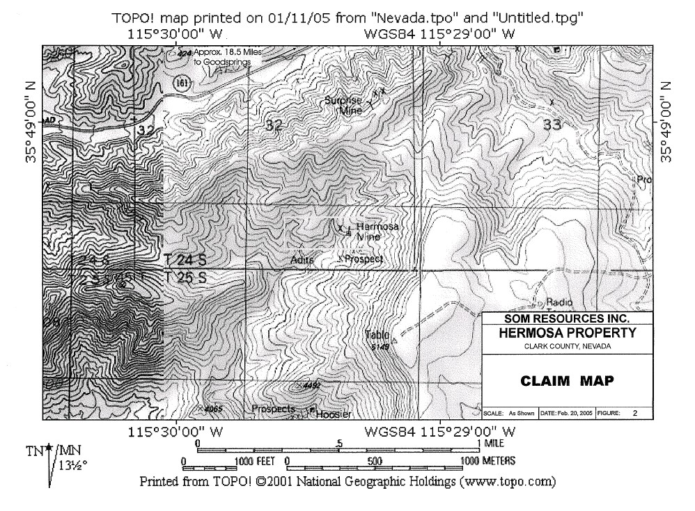
The property consists of one unpatented mineral lode claim known as the Hermosa claim situated in the Yellow Pine Mining District, Clark County, Nevada, Section 32 of Township 24 south, Range 58 east. The location notices are recorded at the office of the Clark County recorder in Las Vegas, Nevada in File 078, Book No. 20040922, Page 0033, Instr. 0005258.
Any legal aspects pertaining to these claims is beyond the scope of this report.
2.
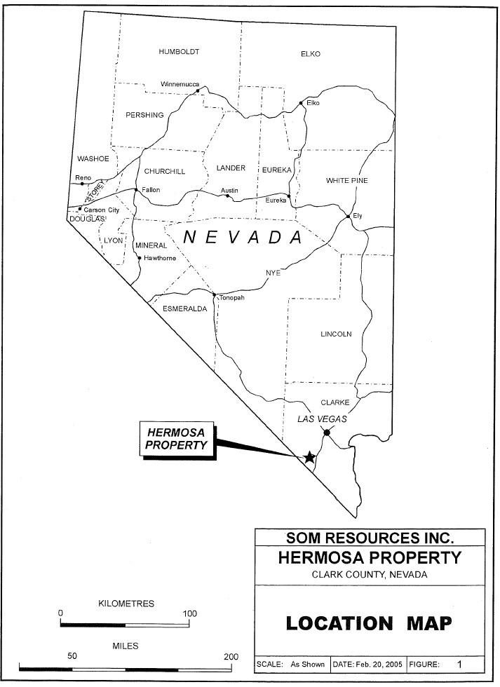
LOCATION AND ACCESS
Approximate Co-ordinates: 35°48'20"N Latitude; 115°30'45"W Longitude.
The property is located 30 miles southwest of Las Vegas, Nevada and about five miles west of Goodsprings on the western slopes of the Spring Mountains.
Access to the area is provided by means of Interstate Highway 15 from Las Vegas southwest to Jean. Goodsprings is accessible by paved road from Jean, a distance of seven miles to the northwest.
The property may then be reached by travelling west along a paved road for about five miles towards the village of Sandy, then a dirt road to the workings of the property.
CLIMATE AND VEGETATION
The area is typically desert with relatively high temperatures, low precipitation, and vegetation consisting mainly of desert shrubs and cactus. Sources of water would be available from valley wells.
PHYSIOGRAPHY
The property lies in a region of moderate rolling hills with local incised narrow canyons. Elevations locally range from 3200 feet to 4300 feet A.S.L.
HISTORY
The history of the area dates back to 1856 following investigation of lead ore by Mormon missionaries. The first ore was smelted in 1857 and a mill was built north of Goodsprings in 1898.
The completion of the San Pedro, Los Angeles and Salt Lake railroad in 1905 and recognition of oxidized zinc minerals in the ore in 1906 stimulated development of the mines and the region has been subject to intermittent activity up to 1964, particularly during the World War I and II years.
The Yellow Pine District has been mined primarily for lead-zinc-silver, however, an estimated 91,000 ounces of gold has also been recovered.
The area has been mainly dormant since. 1964.
The Hermosa claim was originally staked about 1890 and two adits were later excavated as well as several test pits.
The claim was again staked in 1982 and re-staked in October of 2004. No recent work has been recorded to the writer's knowledge.
REGIONAL GEOLOGY
| | Paleozoic Stratigraphic Succession
In the Vicinity of | |
| | The Goodsprings District | |
| | Thickness | |
| | (feet) | |
| | | |
| Permian: | | |
| Red beds | 1,000 - 1,100 | |
| | | |
| Mississippian to Permian: | | |
| Bird Spring Formation | 2,500+ | |
| | | |
| Local erosional unconformity | | |
| | | |
| | | |
| Mississippian: | | |
| Monte Cristo Limestone: | | |
| Yellowpine Limestone Member | 60 - 120 | |
| Arrowhead Limestone Member | 10- 20 | |
| Bullion Dolomite Member | 85 - 300 | |
| Anchor Limestone Member | 65 - 400 | |
| Dawn Limestone Member | 50 - 399 | |
| | | |
| Devonian: | | |
| Sultan Limestone: | | |
| Crystal Pass Limestone Member | 150 - 260 | |
| Valentine Limestone Member | 75 - 380 | |
| Ironside Dolomite Member | 5 - 125 | |
| | | |
| Cambrian to Devonian(?): | | |
| Goodsprings Dolomite | 2,450+ | |
The Spring Mountain Range consists mainly of Paleozoic sediments which have undergone intense folding accompanied by faulting. The Yellow Pine District is underlain by a series of carboniferous sediments consisting of limestones, pure crystalline limestone, and dolomite with occasional intercalated beds of fine-grained sandstone. These strata have a general west to southwest dip of from 15 to 45 degrees occasionally disturbed by local folds. Igneous rocks are scarce and are represented chiefly by quartz-monzonite porphyry dikes and sills.

LOCAL GEOLOGY
The property is underlain by limestones belonging to the Upper Mississippian Bird Spring Formation. Zinc mineralization, hydrozincite and calamine occurs associated with a breccia zone parallel to the limestone beds. Galena occurs along a north to northeast trending fault dipping to the west. Sporadic malachite mineralization is also observed accounting for the copper values.
D.F. Hewett (1931) reports that several cars of lead ore were mined which contained an uncommon assemblage of oxidized lead minerals - carbonate, molybdate, and phosphate.
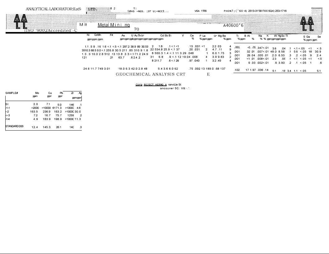
Two rock samples collected from the mine dump by the writer in March 1982 assayed 1.22 oz/ton silver, 1.54% lead, 0.99% zinc, 1.46 oz/ton silver, and 2.60% lead and 20.61 % zinc.
Four samples were collected from the portal area and mine dump by Multi-Metal Mining Corp. of Las Vegas, Nevada in October, 2004.
Pertinent assay results are tabulated below, (Also see complete geochemical analysis at rear of report as Appendix I.)
| Sample No. | Cu% | Pb%, | Ag oz/ton |
| | | | |
| H-1 | 1.0 | 2.51 | Tr |
| H-2 | 0.024 | 18.03 | APPROX 1.0 |
| H-3 | Tr | Tr | Tr |
| H-4 | 0.018 | 21.68 | APPROX 0.3 |
CONCLUSIONS
A two-phased program of exploration consisting of geological mapping on both surface and underground along with a VLF electromagnetic and magnetometer survey is recommended in order to trace the mineralized fault structures and breccia zones along their extensions. In addition, a trenching and sampling program in areas of exposed mineralization should be carried out.
A second phase of exploration should consist of a diamond drilling program to test the mineralized fault structures and breccia both laterally and at depth.
ESTIMATED COSTS OF PROGRAM (U.S. FUNDS)
| PHASEI | | US DOLLARS | |
| | | | |
| 1. | Geological Mapping | $ 8,000 | |
| 2. | VLF-EM Survey | 4,000 | |
| 3. | Trenching and Sampling including assays | 10,000 | |
| 4. | Mobilization and Demobilization | 3,000 | |
| 5. | Food and Lodging | 3,000 | |
| 6. | Reports, Maps, etc. | 2,000 | |
| 7. | Contingency | 3,000, | |
| | | | |
| Total Cost - PhaseI | | $33,000 |
| PHASEII | | | |
| | | | |
| 1. | Diamond Drilling | | |
| Estimated: 1500 feet @ $35/ft | $ 52,500 | |
| 2. | Mobilization and demobilization | 10,000 | |
| 3. | Reports, Assays, etc. | 8,000 | |
| 4. | Food and Lodging | 6,000 | |
| 5. | Transportation | 700 | |
| 6. | Engineering and Supervision | 6,000 | |
| 7. | Contingency | 8,000 | |
| | | | |
| Total Cost - PhaseII | | 91,200 |
| | | | |
| TOTAL COST - PHASEIAND PHASEII | | $ 124,200 |
Further work would be dependent upon results of the above recommended program of work February 20, 2005 W.G.Ti pmaps,F Eng. |
STATEMENT OF QUALIFICATIONS
I, William G. Timmins, of the City of Vancouver, in the Province of British Columbia, do hereby certify that:
| 1. | I am a consulting geologist, with offices at 1016 - 470 Granville Street, Vancouver, B.C. V6C 1 V5. |
| |
| 2. | I have been practising my profession for the past 40 years since university, having been engaged in the evaluation, exploration and development of mineral properties .throughout Canada, the United States, Latin and South America, Australia and New Zealand. |
| |
| 3. | 1 am a graduate of the Provincial Institute of Mining, Haileybury, Ontario (1956) and attended Michigan Technological University 1962-1965, Geology and was licensed by the Professional Engineers Association of B.C. (geological discipline) in 1969. |
| |
| 4. | This report titled "Geological Report on the Hermosa Prospect for Som Resources Inc." is based on published and private reports, maps and data provided by Multi-Metal Mining Corp. and in the public domain, and personal visits to the Hermosa property from 1982 to 2004. The author has reviewed relevant data prepared by reputable qualified persons and is responsible for his own geological analysis, conclusions and recommended exploration program. |
| |
| 5. | I have no interest, nor do I expect to receive any interest in the properties or securities of Som Resources Inc. and am independent of the issuer. |
| |
| 6. | I consent to the filing of this report with any stock exchange and other regulatory authority, and any publication by them, including electronic publication in the company's files or their websites accessible by the public. |
REFERENCES
| Hewett, D.F. | Geology and Ore Deposits of the Goodsprings Quadrangle, Nevada, |
| | Paper 162, U.S. Department of the Interior, Geological Survey. |
| | |
| | Nevada Bureau of Mines and Geology, Bulletin 62, Geology and |
| | Mineral Deposits of Clark County, Nevada, 1965 |
| | |
| Timmins, W.G. | Geological Report on the Whale Mine for Celebrity Mining, November, |
| | 1982, and for Tao Minerals Ltd., October, 2004 |
Appendix I
GEOCHEMICAL ANALYSIS