UNITED STATES
SECURITIES AND EXCHANGE COMMISSION
Washington, D.C. 20549
SECURITIES AND EXCHANGE COMMISSION
Washington, D.C. 20549
FORM 8-K
CURRENT REPORT
Pursuant to Section 13 or 15(d) of the Securities Exchange Act of 1934
Pursuant to Section 13 or 15(d) of the Securities Exchange Act of 1934
September 12, 2024
Date of Report (Date of earliest event reported)
Date of Report (Date of earliest event reported)
URANIUM ENERGY CORP.
(Exact name of registrant as specified in its charter)
(Exact name of registrant as specified in its charter)
Nevada | 001-33706 | 98-0399476 |
| (State or other jurisdiction of incorporation) | (Commission File Number) | (IRS Employer Identification No.) |
500 North Shoreline, Ste. 800, Corpus Christi, Texas, U.S.A. | 78401 | |
| (U.S. corporate headquarters) | (Zip Code) | |
1830 – 1188 West Georgia Street Vancouver, British Columbia, Canada | V6E 4A2 | |
| (Canadian corporate headquarters) | (Zip Code) |
(Address of principal executive offices)
(361) 888-8235
(Registrant’s telephone number, including area code)
(Registrant’s telephone number, including area code)
Not applicable.
(Former name or former address, if changed since last report)
(Former name or former address, if changed since last report)
Check the appropriate box below if the Form 8-K is intended to simultaneously satisfy the filing obligation of the registrant under any of the following provisions:
| ☐ | Written communications pursuant to Rule 425 under the Securities Act (17 CFR 230.425) |
| ☐ | Soliciting material pursuant to Rule 14a-12 under the Exchange Act (17 CFR 240.14a-12) |
| ☐ | Pre-commencement communications pursuant to Rule 14d-2(b) under the Exchange Act (17 CFR 240.14d-2(b)) |
| ☐ | Pre-commencement communications pursuant to Rule 13e-4(c) under the Exchange Act (17 CFR 240.13e-4(c)) |
Securities registered pursuant to Section 12(b) of the Act:
| Title of each class | Trading Symbol (s) | Name of each exchange on which registered |
| Common Stock | UEC | NYSE American |
Indicate by check mark whether the registrant is an emerging growth company as defined in as defined in Rule 405 of the Securities Act of 1933 (Section 230.405 of this chapter) or Rule 12b-2 of the Securities Exchange Act of 1934 (Section 240.12b-2 of this chapter).
Emerging growth company ☐
If an emerging growth company, indicate by check mark if the registrant has elected not to use the extended transition period for complying with any new or revised financial accounting standards provided pursuant to Section 13(a) of the Exchange Act. ☐
__________
Item 7.01 Regulation FD Disclosure
On September 12, 2024, Uranium Energy Corp. (the “Company” or “UEC”) issued a news release to report results from the ongoing drill campaign at its Roughrider Project (the “Project”), located in Northern Saskatchewan, Canada.
Drilling 850 metres northeast of the Roughrider Project Deposit has intersected additional high-grade uranium mineralization:
| ● | Drill hole RR-961 grades 11.4% eU3O8 over 2.4 metres with a high-grade sub interval that is 24.9% eU3O8 over 1.0 metres. |
| ● | RR-961 followed-up RR-940 that was reported on August 20, 2024 and graded 12.7% eU3O8 over 7.2 metres(1). RR-961 is 15 metres along strike to the east of RR-940. |
| ● | An additional 20 drill holes remain in the drill program and further results will be forthcoming as the program progresses. |
UEC’s ongoing drill program on the Project continues to explore along the north trend. To date uranium mineralization at Roughrider North has been encountered along ~200 metres of strike length, with the high-grade core of the area now measuring ~55 metres of strike with this most recent intersection. The high-grade uranium mineralization at Roughrider North remains open to the east and west.
About Roughrider North
The Roughrider North discovery has been identified along an exploration trend that is parallel to the Roughrider Project. The uranium mineralization thus far at the Roughrider North Discovery is entirely in the basement about 250 metres below the surface.
Chris Hamel, Vice President Exploration, Canada, stated: “The on-going drill campaign at Roughrider North has successfully identified additional high-grade mineralization along strike of what was reported in August. The current drill campaign has about 20 drill holes remaining and can be extended further into the fall if necessary to continue the delineation of this uranium mineralization. Drill hole RR-961 expands the high-grade core of this discovery and should help guide the field team to further success in the area.”
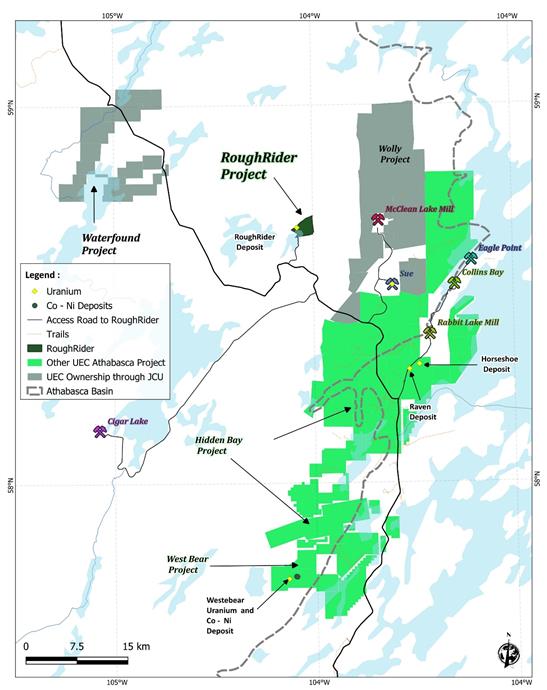
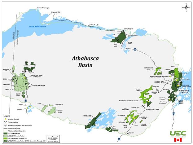
Table 1, outlined below, details the equivalent uranium intersections (“eU3O8”) from select drill holes from the 2024 summer campaign. Figure 1 shows the immediate Roughrider Project area in the Northern part of Athabasca Basin, and Figure 2 illustrates a wider picture of where the Roughrider Project is located within the Athabasca Basin.
- 2 -
Table 1: Roughrider Summer Drilling Program Equivalent Grades
From (m) | To (m) | Width (m) | Avg. Grade (eU3O8) | Cut-off Grade (eU3O8) | GT | ||
| RR-909 | 244.3 | 264.8 | 20.6 | 0.07 | 0.05 | 1.4 | |
| RR-910 | 250.3 | 305.5 | 55.2 | 0.52 | 0.05 | 28.8 | |
| incl. | 250.3 | 255.4 | 5.1 | 1.63 | 0.05 | 8.3 | |
| incl. | 297.6 | 305.5 | 7.9 | 2.53 | 0.05 | 20.0 | |
| RR-913 | 262.8 | 310.3 | 47.5 | 0.47 | 0.05 | 22.1 | |
| incl. | 307.8 | 309.9 | 2.1 | 6.81 | 1.00 | 14.3 | |
| RR-919 | 304.1 | 307.1 | 3.0 | 2.23 | 0.05 | 6.7 | |
| incl. | 304.4 | 306.2 | 1.8 | 3.51 | 1.00 | 6.3 | |
| RR-925 | 239.8 | 313.0 | 73.3 | 0.11 | 0.05 | 7.8 | |
| incl. | 244.3 | 246.1 | 1.9 | 1.83 | 1.00 | 3.5 | |
| RR-929 | 291.1 | 300.2 | 9.1 | 0.79 | 0.05 | 7.2 | |
| incl. | 291.5 | 292.3 | 0.8 | 1.38 | 1.00 | 1.1 | |
| incl. | 294.2 | 295.0 | 0.8 | 2.76 | 1.00 | 2.2 | |
| RR-930 | 282.8 | 288.4 | 5.6 | 0.18 | 0.05 | 1.0 | |
| RR-933 | 242.2 | 244.7 | 2.5 | 0.0936 | 0.05 | 0.2 | |
| 230.6 | 231.1 | 0.5 | 0.08 | 0.05 | 0.0 | ||
| 249.9 | 264.2 | 14.3 | 3.00 | 0.05 | 42.8 | ||
| incl. | 251.9 | 262.2 | 10.3 | 4.06 | 1.00 | 41.8 | |
| incl. | 260.4 | 260.8 | 0.4 | 14.68 | 10.00 | 5.9 | |
| RR-934 | 316.2 | 318.1 | 1.9 | 0.22 | 0.05 | 0.4 | |
| 327.1 | 328.4 | 1.3 | 0.07 | 0.05 | 0.1 | ||
| RR-935 | 319.1 | 320.2 | 1.1 | 0.05 | 0.05 | 0.1 | |
| 324.1 | 327.9 | 3.8 | 0.10 | 0.05 | 0.4 | ||
| RR-937 | 313.8 | 315.7 | 1.9 | 0.64 | 0.05 | 1.2 | |
| incl. | 314.8 | 315.4 | 0.6 | 1.44 | 1.00 | 0.9 | |
| RR-938 | 322.4 | 323.2 | 0.8 | 0.32 | 0.05 | 0.3 | |
| RR-940 | 271.1 | 284.6 | 13.5 | 6.96 | 0.05 | 93.9 | |
| incl. | 271.2 | 283.4 | 12.2 | 7.69 | 0.10 | 93.8 | |
| incl. | 273.2 | 280.4 | 7.2 | 12.71 | 1.00 | 91.5 | |
| incl. | 281.9 | 282.5 | 0.6 | 1.99 | 1.00 | 1.2 | |
| RR-945 | 270.8 | 281.3 | 10.5 | 3.17 | 0.05 | 33.2 | |
| incl. | 271.7 | 280.8 | 9.1 | 3.61 | 1.00 | 32.9 | |
| incl. | 273.6 | 273.9 | 0.3 | 10.62 | 10.00 | 3.2 | |
| incl. | 277.6 | 278.2 | 0.6 | 15.18 | 10.00 | 9.1 | |
| RR-948 | 292.4 | 293.5 | 1.1 | 0.62 | 0.05 | 0.7 | |
| incl. | 292.9 | 293.1 | 0.2 | 1.10 | 1.00 | 0.2 | |
| RR-949-1 | 255.6 | 261.6 | 6.0 | 0.14 | 0.05 | 0.8 | |
| incl. | 255.6 | 257.3 | 1.7 | 0.14 | 0.05 | 0.2 | |
| incl. | 259.8 | 261.6 | 1.8 | 0.33 | 0.05 | 0.6 | |
| RR-950 | 266.7 | 268.1 | 1.4 | 0.27 | 0.05 | 0.4 | |
| RR-954 | 228.0 | 228.7 | 0.7 | 0.05 | 0.05 | 0.0 | |
| 278.5 | 280.1 | 1.6 | 0.18 | 0.05 | 0.3 | ||
| 294.8 | 296.9 | 2.1 | 0.45 | 0.05 | 0.9 | ||
| RR-958 | 266.9 | 269.5 | 2.6 | 0.20 | 0.05 | 0.5 | |
RR-961 | 330.1 | 332.5 | 2.4 | 11.40 | 0.05 | 27.3 | |
incl. | 330.5 | 332.1 | 1.6 | 16.93 | 1.00 | 27.1 | |
incl. | 330.8 | 331.8 | 1.0 | 24.88 | 10.00 | 24.9 | |
| *Due to the preliminary nature of these results, true thicknesses have not yet been estimated. | |||||||
- 3 -
About Canada’s Athabasca Basin
The Athabasca Basin is a world-class uranium district in the northern portion of the provinces of Saskatchewan and Alberta in Canada, occupying an area of about 100,000 square kilometres. The unique geology of the Athabasca Basin often results in deposit grades that exceed the world average of uranium deposits of 0.2% U3O8 by up to 100 times.
All of Canada’s current uranium production occurs from the mines located in the Athabasca Basin. According to the World Nuclear Association, the Athabasca Basin was responsible for producing 15% of the world’s uranium production in 2022.
Uranium mineralization in the Athabasca Basin occurs in fault structures that penetrate the interface between the sandstone and underlying basement rocks. Uranium can be found at the interface, known as the unconformity, or up to several hundreds of metres below the unconformity surface in the underlying basement rock and fault structures.
The uranium concentrations in the holes presented above from the radiometric equivalent uranium grade (“REG”), denoted as eU3O8, were determined in-situ within the drill hole. For more information on REGs please see the “About Radiometric Equivalent Grades” section below.
About Radiometric Equivalent Grades
The eU3O8 grades were estimated in-situ within the drill holes using calibrated down-hole radiometric gamma probes lowered down into the hole. This is a measuring method commonly used by uranium explorers and miners in the Athabasca Basin. The probe records the amount of radioactivity present in the rock adjacent to the probe as it moves up and down the hole.
The standard and shielded probes were calibrated prior to the commencement of the current drill program at the Saskatchewan Research Council’s (“SRC”) test pit facility in Saskatoon, Saskatchewan, and the Hi-Flux probes are calibrated at Alpha Nuclear in Saskatoon. Using down-hole probes to calculate radiometric equivalent grades is a common practice used by uranium mining companies in the Athabasca Basin. Down-hole probes can accurately measure uranium concentration by measuring the light flashes that occur every time the probe’s scintillator is struck by a gamma radiation particle emitted from uranium crystals. The number of light flashes are ‘counted’ by a photomultiplier tube. Due to a process called ‘saturation’ that occurs when light emitted by the probe’s scintillator overwhelms the photomultiplier tube’s ability to ‘count’ individual light flashes, it can sometimes be difficult to accurately determine radiometric equivalent grades in high-grade intervals.
- 4 -
Samples from all holes have been collected for assay analysis to confirm these equivalent grades. The samples will be analyzed at SRC’s Geoanalytical Laboratory in Saskatoon, with results expected in the coming weeks.
About the Roughrider Uranium Project
The Roughrider Project is a uranium project located in the eastern Athabasca Basin of northern Saskatchewan, Canada; one of the world’s premier uranium mining jurisdictions. The Project is located approximately 13 kilometres west of Orano’s McClean Lake Mill, near UEC’s existing Athabasca Basin properties. The depth to mineralization at the project is approximately 200 metres and hosted primarily in the basement rocks below the unconformity.
Qualified Persons and Data Acquisition
The technical information in this news release has been reviewed and approved by Chris Hamel, P.Geo., UEC’s Vice President Exploration, Canada, who is a Qualified Person for the purposes of SEC Regulation S-K 1300.
About Uranium Energy Corp
Uranium Energy Corp is the fastest growing supplier of fuel for the green energy transition to a low carbon future. UEC is the largest, diversified North American focused uranium company, advancing the next generation of low-cost, environmentally friendly In-Situ Recovery (“ISR”) uranium projects in the United States and high-grade conventional projects in Canada. The Company has one producing ISR production hub and spoke platform in Wyoming and one ISR production-ready ISR hub and spoke platform located in South Texas. These two production platforms are anchored by fully operational central processing plants and served by seven U.S. ISR uranium projects with all their major licenses and permits in place. Additionally, the Company has diversified uranium holdings including: (1) one of the largest physical uranium portfolios of North American warehoused U3O8; (2) a major equity stake in Uranium Royalty Corp., the only royalty company in the sector; and (3) a Western Hemisphere pipeline of resource stage uranium projects. The Company's operations are managed by professionals with decades of hands-on experience in the key facets of uranium exploration, development and mining.
| 1. | Press Release: Uranium Energy Corp Intersects 12.7% eU3O8 over 7.2 metres, 850 m northeast of Roughrider Deposit https://www.sec.gov/Archives/edgar/data/1334933/000143774924027381/ex_716280.htm |
- 5 -
Figure 1: Roughrider Location Map
- 6 -
Figure 2: Athabasca Project Map
- 7 -
A copy of the news release is attached as Exhibit 99.1 hereto.
Item 9.01 Financial Statements and Exhibits
(d) Exhibits
Exhibit | Description | |
| 99.1 | ||
| 104 | Cover Page Interactive Data File (the cover page XBRL tags are embedded within the inline XBRL document). |
__________
- 8 -
SIGNATURES
Pursuant to the requirements of the Securities Exchange Act of 1934, the registrant has duly caused this report to be signed on its behalf by the undersigned hereunto duly authorized
URANIUM ENERGY CORP. | |||
DATE: September 12, 2024. | By: | /s/ Pat Obara | |
Pat Obara, Secretary and Chief Financial Officer | |||
__________
- 9 -