
| NI 43-101 Technical Report Mineral Resource | Singatse Peak Services, LLC |
| | Yerington Copper Project |
TABLE OF CONTENTS
| Tetra Tech | February 2012 | iii |
| NI 43-101 Technical Report Mineral Resource | Singatse Peak Services, LLC |
| | Yerington Copper Project |
| Tetra Tech | February 2012 | iv |
| NI 43-101 Technical Report Mineral Resource | Singatse Peak Services, LLC |
| | Yerington Copper Project |
| NI 43-101 Technical Report Mineral Resource | Singatse Peak Services, LLC |
| | Yerington Copper Project |
LIST OF TABLES
| Tetra Tech | February 2012 | vi |
| NI 43-101 Technical Report Mineral Resource | Singatse Peak Services, LLC |
| | Yerington Copper Project |
LIST OF FIGURES
| Tetra Tech | February 2012 | vii |
| NI 43-101 Technical Report Mineral Resource | Singatse Peak Services, LLC |
| | Yerington Copper Project |
LIST OF APPENDICES
| Tetra Tech | February 2012 | viii |
| NI 43-101 Technical Report Mineral Resource | Singatse Peak Services, LLC |
| | Yerington Copper Project |
1.0EXECUTIVE SUMMARY
Singatse Peak Services, LLC (SPS), a wholly owned subsidiary of Quaterra Resources, Inc., commissioned Tetra Tech, Inc. to prepare a Canadian National Instrument 43-101 (NI 43-101) compliant resource estimate for the Yerington Mine portion of their Yerington Copper Project in Lyon County, Nevada..
The results of the updated resource estimate for the Yerington Mine were announced on January 5, 2012. The estimate was based upon the 2011 verification of previous drilling completed by Anaconda and drilling completed by SPS on the Yerington Mine. The Qualified Person for this report is Dr. Rex Bryan, Senior Geostatistician for Tetra Tech, Golden, Colorado.
Neither Tetra Tech nor any of its employees and associates employed in the preparation of this report has any beneficial interest in SPS or in the assets of any affiliated company. Tetra Tech will be paid a fee for this work in accordance with normal professional consulting practices.
1.1 Location, Property Description and Ownership
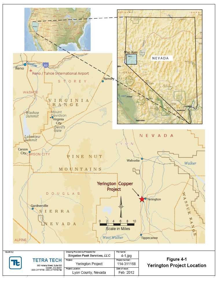
The Yerington Copper Project is located near the geographic center of Lyon County, Nevada, US, along the eastern flank of the Singatse Range. The property centers on the historical Yerington open pit mine (Yerington Mine), flanked on the west by Weed Heights, Nevada (a small private community, the original company town of The Anaconda Company), and on the east by the town of Yerington, Nevada. The property is easily accessible from Yerington by a network of paved roads that were used as principal transportation and access routes during the former operating period of the Yerington Mine.
The property consists of 2,690 acres (4.2 square miles) of fee mineral properties and patented mining claims as well as 457 unpatented lode claims totaling approximately 9,400 acres (14.6 square miles) on lands administered by the US Department of Interior, Bureau of Land Management (BLM). The private land, patented claims, and 32 unpatented mining claims were acquired on April 27, 2011 when SPS closed a transaction under which all property and water rights of Arimetco, Inc. (Arimetco), a Nevada corporation, were acquired. The additional 434 unpatented claims have been staked by SPS.
1.2 History
The current Yerington Copper Project includes the Yerington Mine which was operated by the Anaconda Company from 1952 until 1979, producing approximately 1.744 billion pounds of copper from an ore body that contained 162 million tons averaging 0.54% Cu. Approximately 104 million tons of this total were oxidized copper ore that was “vat-leached” with sulfuric acid in 13,000-ton cement vats on a 96-hour leach, seven to eight day cycle. The sulfide ore concentrator on site was dismantled and sold after the 1979 termination of mining. In 1976, all assets of The Anaconda Company, including the Yerington Mine, were purchased by the Atlantic Richfield Company (ARCO), which shut down dewatering pumps in the pit and closed the Yerington Mine in 1979 due to low copper prices, selling the property to Mr. Don Tibbals.
| NI 43-101 Technical Report Mineral Resource | Singatse Peak Services, LLC |
| | Yerington Copper Project |
In 1989, Arimetco acquired the property and produced some 95 million pounds of copper from the Yerington property and the nearby MacArthur Mine from 1989 to 1999 before declaring bankruptcy and abandoning the property.
In early 2000 the Nevada Division of Environmental Protection (NDEP) assumed operation of the site on a care and maintenance basis, primarily to ensure that heap leach drawdown solutions would continue to be maintained. The property remained in bankruptcy until purchased by SPS in April of 2011, but because soil and groundwater contamination, alleged to stem from the former mining operation, have been identified on the property, a portion of the property acquired by SPS is now under the jurisdiction of the US Environmental Protection Agency (USEPA).
In order to establish Singatse's position and rights, the acquisition by SPS of the Arimetco properties required a series of rigorous environmental, legal, and technical due diligence studies. In 2008, Chambers Group, Inc. and Golder Associates Inc. conducted a Phase I Environmental Site Assessment (Phase I ESA) for the Yerington Mine Site. A Phase I ESA is intended to serve as an appropriate, commercially prudent, and reasonable inquiry regarding the potential for recognized environmental conditions in connection with the subject property. The 2008 Phase 1 ESA was updated by SRK Consulting (U.S.) Inc. (SRK) in 2010 and again in 2011. These were completed to allow SPS to establish liability protection as a bona fide prospective purchaser (BFPP). Prior to closing on the property, SPS received letters from the Nevada Department of Environmental Protection (NDEP), US Bureau of Land Management (BLM) and the USEPA indicating the post-closing requirements then applicable to the Site for SPS to maintain its defense to liability as a BFPP as regards the activities of the former mine owners and operators.
1.3 Geological Setting and Mineralization
The Yerington property includes both the Yerington Deposit (Yerington Mine) and a portion of the Bear Deposit, which represent two of three known porphyry copper deposits in the Yerington copper district. The porphyry systems are hosted in middle Jurassic intrusive rocks of the Yerington Batholith. Unless noted otherwise, the following discussions refer to the Yerington Deposit.
Mineralized porphyry dikes associated with three phases of intrusive activity related to the Yerington Batholith form an elongate body of mineralization that extends 6,600 feet along a strike of S62ºE. The mineralization has an average width of 2,000 feet and has been defined by drilling to an average depth of 250 feet below the Yerington Mine pit bottom at the 3,800-foot elevation. Because of the economic constraints of low copper prices at the time, many of the 558 historic Anaconda drill holes used in the SPS study were stopped in mineralization and very few were drilled below the 3,400-foot level where the porphyry system remains nearly unexplored.
Only four historic holes have actually explored the deep vertical projection of copper mineralization in the pit. Three of the holes were drilled along a single N-S oriented section through the center of the pit. According to M. T. Einaudi in a 1970 report to Anaconda, the deep
| NI 43-101 Technical Report Mineral Resource | Singatse Peak Services, LLC |
| | Yerington Copper Project |
drilling program defined a series of nested, concave upward, grade shells that are elongated down the N 70º dip of the dikes with the 0.2% Cu zone extending to approximately the 2,600-foot level; an overall dip distance of 2,200 feet. Although the program encountered an increasing ratio of pyrite to chalcopyrite, there was no indication of a “barren core”, the porphyry dikes showed a “remarkable continuity” down dip and host a zone of molybdenite mineralization of indeterminate size and grade.
The orientation of the Yerington Deposit is due to mid-Tertiary down and east extensional faulting that rotated the near vertically-emplaced batholiths 60° to 90° westerly. The west to east dilation-displacement positioned the porphyry copper deposit on its side, resulting in a cross section of the of the porphyry system visible in the pit with its top toward the west end. Mining has revealed an alteration geometry displaying the original pyrite-rich cap (present-day leached sericite-limonite on the west end of the Yerington pit, grading downward easterly to quartz-sericite-pyrite alteration and potassic alteration in the central portion of the pit, continuing to a soda-flooded root zone at the eastern end).
Secondary oxide copper formed much of the upper Yerington Deposit. Chrysocolla was the dominant copper oxide mineral, occurring as fracture coatings and fillings to a depth of approximately 400 feet below the surface. Below the 4,100-foot level, chalcopyrite is the dominant copper sulfide mineral with minor bornite primarily hosted in A-type quartz veins in the older porphyry dikes. The unmined mineralized material below the current pit bottom is primarily of chalcopyrite mineralization.
The primary copper mineralization of the Bear copper deposit, located partially in the northeast corner of the Yerington property is related to micaceous veining rather than A-type quartz veining common in the Yerington Mine porphyry system.
The Bear Deposit was discovered in 1961 by Anaconda during condemnation drilling in the sulfide tailings disposal area. The program identified chalcopyrite mineralization hosted in a porphyry system below 500 to 1,000 feet of valley fill and unmineralized bedrock. Historic (not NI 43-101-compliant) resources estimated for the Bear Deposit are more than 500 million tons of material averaging 0.4% copper (Dilles, 1995). The deposit is known to extend beyond the boundaries of SPS properties and the percentage of the resource estimate controlled by SPS is unknown.
1.4 SPS 2011 Program
In July 2012, SPS commenced a drilling and re-assaying program to convert and expand the historic non-compliant resources of the Yerington Mine into NI 43-101 compliant resources through:
compilation and verification of historic archived data
twin drilling of selected, accessible Anaconda drill holes
the re-assay of representative samples selected from Anaconda core preserved on site
| NI 43-101 Technical Report Mineral Resource | Singatse Peak Services, LLC |
| | Yerington Copper Project |
- exploration drilling (largely as reverse circulation drilling) as offsets, extensions, or in-fill along and below pit walls
The drilling program tested or twinned both extensions and zones of oxide copper, chalcocite enrichment, and primary sulfide mineralization. SPS drilled 18 twin holes and 24 exploration holes and successfully verified assay data for 558 (previously reported as 565) historic holes for inclusion in the current database through records research, data capture, and the reassay of selected remaining core from 45 Anaconda drill holes.
Results of the 2011 program allowed the company to establish a drillhole database suitable for converting and expanding the historic estimates into NI 43-101 compliant resources.
Numerous historic holes drilled by Anaconda bottom in strong mineralization, and SPS drilling along the western edge of the pit confirmed that mineralization. For example, twin hole SP-04 at the northwest end of the pit intercepted 524.5 feet averaging 0.35% total copper (designated as % TCu or % Cu) at a depth of 228 feet, including 88 feet of 0.69% TCu at a depth of 265 feet. In addition to the 8,797 feet drilled in the 18 twin holes, the SPS 2011 drilling campaign completed 15,016 feet of exploration drilling in 24 holes near the Yerington Pit to target possible extensions to the mineralization. Hole SP-36, located along the south central margin of the pit, intercepted 95 feet averaging 0.28% TCu at a depth of 230 feet. Highlights from SPS's 2011 twin hole and exploration drilling program are shown below:
Table 1-1 2011 Singatse Peak Drilling Highlights
Drill Hole | From
ft | To
ft | Thickness
ft | Total Cu
% |
| Core Twin Holes |
| SP-004 | 228 | 752.5 | 524.5 | 0.35 |
| including | 265 | 353 | 88 | 0.69 |
| SP-006 | 204 | 408 | 204 | 0.53 |
| | 430.5 | 770 | 339.5 | 0.38 |
| SP-010 | 258 | 369 | 111 | 0.71 |
| | 429 | 634 | 205 | 0.35 |
| RC Twin Holes |
| SP-023 | 10 | 600 | 590 | 0.21 |
| including | 425 | 490 | 65 | 0.37 |
| RC Exploration Holes |
| SP-035 | 0 | 190 | 190 | 0.23 |
| including | 75 | 90 | 15 | 0.73 |
| SP-036 | 230 | 325 | 95 | 0.28 |
| SP-039 | 0 | 45 | 45 | 0.25 |
| | 135 | 215 | 80 | 0.3 |
| SP-040 | 0 | 200 | 200 | 0.24 |
| including | 170 | 200 | 30 | 0.49 |
Note: All intervals calculated using 0.1% total copper cutoff.
| NI 43-101 Technical Report Mineral Resource | Singatse Peak Services, LLC |
| | Yerington Copper Project |
The samples from the Yerington drilling program are prepared and assayed by Skyline Assayers & Laboratories in Tucson, Arizona, which is accredited by the American Association for Laboratory Accreditation (A2LA - certificate no. 2953.01) and by ISO17025 compliant ALS Chemex Laboratories in Sparks, Nevada.
1.5 Resource Estimation
Tetra Tech, Inc. of Golden, Colorado, has completed an NI 43-101 compliant independent resource estimate for mineralization in and around the historic Yerington Mine previously owned and operated by Anaconda. Using a cutoff of 0.2% TCu, the Yerington Mine'smeasured and indicated primary copper resourcetotals 71.8 million tons averaging 0.30% TCu and contains 430 million pounds of copper. Aninferred primary copper resource of 63.9 million tons averaging 0.25% TCu contains 323 million pounds of copper. Acid-solubleoxide/chalcocitemineralization includes a measured and indicated resourceof 9.4 million tons averaging 0.30% TCu (57 million pounds of copper) and aninferred resource of 8.6 million tons averaging 0.28% TCu (47 million pounds of copper).
Based on benchmarking of the Yerington Deposit to similar deposits, Tetra Tech has determined that reasonable base case cutoff grades for the leachable (oxide/chalcocite) SX/EW recoverable copper and for flotation recoverable primary sulfide resources are 0.12% and 0.15% TCu, respectively.
The data clearly show that the possibility exists to expand the resource as mineralization extends beyond the limit of current drilling, particularly below the pit and on its western end.
The results of the NI 43-101-compliant resource estimate compare favorably to the noncompliant estimates of copper remaining in and around the Yerington pit after the mine shut down (K. L. Howard, Jr., Anaconda Internal Memo, 1979). The 1979 estimate contained no classification for measured, indicated, or inferred, so direct comparison can only be made when considering all classes of the current estimate.
Using the same 0.2% TCu cutoff, the Tetra Tech estimate is 127% of the total tonnage, 81% of the average grade, and 104% of the total pounds of contained copper in the 1979 Anaconda estimate of 121 million tons with an average grade of 0.34% Cu containing approximately 831 million pounds of copper. The lower grade and higher tonnage of the Tetra Tech estimate are attributed to the effects of the kriging estimation method used for modern resource estimates. A nearest neighbor model run by Tetra Tech to test the results raised the average grade of the deposit to 0.32% TCu.
The 1979 estimate cited approximately 84% of the total contained copper (696 million pounds of copper in 97.8 million tons with an average grade of 0.356% Cu) as being within the original Anaconda pit design, suggesting that a significant portion of the Yerington resource may be mined without a pushback or major changes to the upper walls of the Anaconda pit.
The current Tetra Tech resource estimate is based upon SPS's 2011 drilling as well as 558 historic drill holes taken from approximately 10,000 scanned pages of assay and/or geologic
| NI 43-101 Technical Report Mineral Resource | Singatse Peak Services, LLC |
| | Yerington Copper Project |
data which were reviewed and digitally recorded by SPS personnel. The digital data entry was validated by Tetra Tech against historic sections and was considered to be compliant, based upon results of 18 twin holes and 5,446 feet of core from 45 Anaconda holes which were assayed by SPS. The twinned drill intercepts statistically confirmed that the new compliant data support use of the historical data, as did the new core assays which were well within the expected norms for corroborating the old with new data.
1.5.1 Details of Resource Estimate
Table 1-2 Measured Copper Resources–January 2012
| Cutoff
Grade |
Tons | Average
Grade | Contained
Copper |
| | %TCu | (x1000) | % TCu | (lbs x 1000) |
Oxide and
Chalcocite
Material
| 0.5 | 248 | 0.67 | 3,342 |
| 0.4 | 463 | 0.57 | 5,250 |
| 0.3 | 1,143 | 0.43 | 9,917 |
| 0.25 | 1,754 | 0.38 | 13,253 |
| 0.2 | 2,853 | 0.32 | 18,122 |
| 0.15 | 4,850 | 0.26 | 25,065 |
| 0.12 | 6,006 | 0.23 | 28,192 |
Primary Material
| 0.5 | 1,692 | 0.64 | 21,691 |
| 0.4 | 4,974 | 0.51 | 50,665 |
| 0.3 | 12,931 | 0.41 | 105,258 |
| 0.25 | 19,160 | 0.36 | 139,446 |
| 0.2 | 25,866 | 0.33 | 169,629 |
| 0.15 | 31,804 | 0.30 | 190,570 |
| 0.12 | 34,108 | 0.29 | 196,871 |
| NI 43-101 Technical Report Mineral Resource | Singatse Peak Services, LLC |
| | Yerington Copper Project |
Table 1-3 Indicated Copper Resources– January 2012
| Cutoff
Grade |
Tons | Average
Grade | Contained
Copper |
| | % TCu | (x1000) | % TCu | (lbs x 1000) |
Oxide and
Chalcocite
Material
| 0.5 | 339 | 0.65 | 4,410 |
| 0.4 | 767 | 0.53 | 8,167 |
| 0.3 | 2,188 | 0.41 | 17,845 |
| 0.25 | 3,809 | 0.35 | 26,701 |
| 0.2 | 6,592 | 0.3 | 39,117 |
| 0.15 | 10,293 | 0.25 | 52,041 |
| 0.12 | 12,386 | 0.23 | 57,719 |
Primary
Material
| 0.5 | 648 | 0.62 | 8,046 |
| 0.4 | 2,946 | 0.48 | 27,993 |
| 0.3 | 14,607 | 0.37 | 106,865 |
| 0.25 | 27,831 | 0.32 | 179,176 |
| 0.2 | 45,914 | 0.28 | 260,332 |
| 0.15 | 62,089 | 0.26 | 317,399 |
| 0.12 | 68,418 | 0.24 | 334,564 |
Table 1-4 Measured + Indicated Copper Resources–January 2012
| Cutoff
Grade |
Tons | Average
Grade | Contained
Copper |
| % TCu | (x1000) | % TCu | (lbs x 1000) |
Oxide and
Chalcocite
Material
| 0.5 | 588 | 0.66 | 7,765 |
| 0.4 | 1,230 | 0.55 | 13,417 |
| 0.3 | 3,331 | 0.42 | 27,761 |
| 0.25 | 5,563 | 0.36 | 39,953 |
| 0.2 | 9,445 | 0.3 | 57,237 |
| 0.15 | 15,143 | 0.25 | 77,108 |
| 0.12 | 18,391 | 0.23 | 85,886 |
Primary
Material
| 0.5 | 2,340 | 0.64 | 29,737 |
| 0.4 | 7,919 | 0.5 | 78,652 |
| 0.3 | 27,539 | 0.39 | 212,160 |
| 0.25 | 46,991 | 0.34 | 318,599 |
| 0.2 | 71,781 | 0.3 | 429,968 |
| 0.15 | 93,893 | 0.27 | 507,961 |
| 0.12 | 102,526 | 0.26 | 531,495 |
| NI 43-101 Technical Report Mineral Resource | Singatse Peak Services, LLC |
| | Yerington Copper Project |
Table 1-5 Inferred Copper Resources– January 2012
| Cutoff
Grade |
Tons | Average
Grade | Contained
Copper |
| | % TCu | (x1000) | % TCu | (lbs x 1000) |
Oxide and
Chalcocite
Material
| 0.5 | 209 | 0.58 | 2,407 |
| 0.4 | 724 | 0.48 | 6,942 |
| 0.3 | 2,226 | 0.39 | 17,167 |
| 0.25 | 4,215 | 0.33 | 28,021 |
| 0.2 | 8,596 | 0.28 | 47,347 |
| 0.15 | 17,911 | 0.22 | 79,525 |
| 0.12 | 24,703 | 0.2 | 97,873 |
Primary
Material
| 0.5 | 68 | 0.61 | 833 |
| 0.4 | 703 | 0.45 | 6,261 |
| 0.3 | 9,073 | 0.34 | 61,442 |
| 0.25 | 26,700 | 0.29 | 157,103 |
| 0.2 | 63,918 | 0.25 | 322,530 |
| 0.15 | 123,366 | 0.21 | 529,734 |
| 0.12 | 160,104 | 0.2 | 629,209 |
1.6 Other Relevant Information
Tetra Tech is not aware of any potential limitations to the project that would materially change any of the data, resource estimates, environmental considerations, socio-economic factors, or conclusions presented within this report that are outside of normal factors that may impact mining projects, such as price variability, exchange rates, permitting time, etc. With respect to the Yerington Copper Project, historic production of copper took place from 1953 to 1978. Taking into account information gathered to date, the environmental liabilities resulting from the former mining activity do not include any fatal flaws that would impede the progress of this project.
1.7 Recommendations and Proposed Work Plan
There is an obvious potential for a significant addition to the resources of the Yerington Copper Project.
Results from the current resource model and drilling indicate that the horizontal and vertical limits to mineralization at the Yerington Mine have not yet been found. Additional exploration and in-fill drilling are warranted, and are expected to further expand and upgrade the NI 43-101 compliant Yerington Mine resources.
| NI 43-101 Technical Report Mineral Resource | Singatse Peak Services, LLC |
| | Yerington Copper Project |
Historical resources in the residuals which are part of the Yerington Copper Project reflect a notable potential which should be more fully evaluated in order to bring those resources into NI 43-101 compliant standards.
The Bear porphyry deposit remains unconstrained by drilling. Although it contains no NI 43-101 compliant resources, historical drilling on the property has indicated a large footprint for copper mineralization that will ultimately need delineation by additional drilling.
In order to further develop the resources at the Yerington Mine, the following work program is recommended:
IP geophysics in the pit area to target deep holes to explore the keel of the Yerington porphyry system.
Core drilling below the Yerington mine both to upgrade the classification of the inferred resources and to test the deeper extension of mineralization that remains almost unexplored below the 3,300-foot level.
To further evaluate the residuals from historic mining activities on the property, a sonic drilling program is recommended to sample and characterize the heap leach pads, tailings, and low grade ore stock piles on site.
And finally, a review of historic information and a program of preliminary metallurgical testing are recommended to support a preliminary economic assessment of the property.
| NI 43-101 Technical Report Mineral Resource | Singatse Peak Services, LLC |
| | Yerington Copper Project |
2.0INTRODUCTION
2.1 Terms of Reference
SPS commissioned Tetra Tech, Inc. to prepare a Canadian National Instrument 43-101 (NI 43-101) compliant technical resource estimate for the Yerington Mine portion of its Yerington Copper Project in Lyon County, Nevada, approximately 80 miles southeast of Reno. The property, with historical resources and water rights, was purchased by SPS in April 2011. Data for the resouce work was to be derived from previous operators and the 2011 work completed by SPS.
The Yerington Copper Project is a mid-stage exploration project. Sections for advanced stage properties have not been addressed in this report.
2.2 Sources of Information
This report is based on data supplied by SPS, as well as previous historic reports by third parties also provided by SPS. Tetra Tech has prepared this report exclusively for SPS. The information presented, opinions and conclusions stated, and estimates made are based on the following information:
Source documents used for this report as summarized in the Section 27 of this report
Assumptions, conditions, and qualifications as set forth in the report
Data, reports, and opinions from prior owners and third-party entities
Personal inspection and review
Tetra Tech has not independently conducted any title or other searches but has relied upon SPS for information on the status of the claims, property title, agreements, permit status, and other pertinent conditions. In addition, Tetra Tech has not independently conducted any sampling, mining, processing, economic studies, permitting, or environmental studies on the property
Information provided by SPS includes:
Assumptions, conditions, and qualifications as set forth in the report
Land status
Drillhole records
Property history details
Sampling protocol details
Geological and mineralization setting
Data, reports, and opinions from prior owners and third-party entities
Copper and other assays from original assay records and reports
| Tetra Tech | February 2012 | 10 |
| NI 43-101 Technical Report Mineral Resource | Singatse Peak Services, LLC |
| | Yerington Copper Project |
The primary individuals who have provided input to this technical report are listed in Table 2-1.
Table 2-1 Key Project Personnel
| Company | Name | Title |
| Singatse Peak Services | George Eliopulos | Project Manager, Chief Geologist |
| | David Heatwole | Exploration Manager |
| | Judy Pratt | Technical Services |
| Tetra Tech, Inc. | Rex Bryan | Sr. Geostatistician |
2.3 Property Inspection by Qualified Person
The site visit to the project by Dr. Rex Bryan in September of 2011 included a physical review of sample preparation and security procedures, as well as discussions with geologists and individuals regarding data handling and project geology. It is Dr. Bryan's opinion that there were no deficiencies in the company's protocols or procedures.
2.4 Units and Abbreviations
Unless explicitly stated otherwise, all units presented in this report are in US customary units (i.e., short tons, miles [mi], feet [ft], inches [in], percent [%], grams per metric ton, and parts per million [ppm]).
Common units of measure and conversion factors used in this report include:
| Linear Measure: | | |
| | 1 inch = | 2.54 centimeters |
| | 1 foot = | 0.3048 meter |
| | 1 yard = | 0.9144 meter |
| | 1 mile = | 1.6 kilometers |
| Area Measure: | | |
| | 1 acre = | 0.4047 hectare |
| | 1 square mile = | 640 acres = 259 hectares |
| | Capacity Measure (liquid): | |
| | 1 US gallon = | 4 quarts = 3.785 liter |
| | 1 cubic meter per hour = | 4.403 US gpm |
| Weight: | | |
| | 1 short ton | = 2,000 pounds = 0.907 tonne |
| Tetra Tech | February 2012 | 11 |
| NI 43-101 Technical Report Mineral Resource | Singatse Peak Services, LLC |
| | Yerington Copper Project |
| | 1 pound | = | 16 oz = 0.454 kg |
| Frequently used acronyms and abbreviations: |
| | AA | = | atomic absorption spectrometry |
| | amsl | = | above mean sea level |
| | °C | = | degrees Centigrade |
| | CIMM | = | Canadian Institute of Mining, Metallurgical, and Petroleum |
| | % TCu | Total copper percent equivalent |
| | EUR | = | Euro – European Monetary Unit |
| | °F | = | degrees Fahrenheit |
| | ft | = | foot or feet |
| | g | = | gram(s) |
| | g/kWh | = | grams per kilowatt hour |
| | g/t | = | grams per tonne |
| | h | = | hour |
| | HQ | = | 2.75 in. diameter core size |
| | ICP | = | Inductively Coupled Plasma Atomic Emission Spectroscopy |
| | km | = | kilometer |
| | kV | = | kilovolts |
| | kWh | = | Kilowatt hour |
| | kWh/t | = | Kilowatt hours per tonne |
| | l | = | liter(s) |
| | m | = | meter(s) |
| | ml | = | milliliter |
| | m2 | = | square meter(s) |
| | m2/t/d | = | square meters per tonne per day |
| | m3 | = | cubic meter(s) |
| | m3/h | = | cubic meter(s) per hour |
| | mm | = | millimeter |
| | % Mo | = | percent molybdenum |
| | Mtpd | = | metric tonnes per day |
| | MW | = | megawatts |
| Tetra Tech | February 2012 | 12 |
| NI 43-101 Technical Report Mineral Resource | Singatse Peak Services, LLC |
| | Yerington Copper Project |
| | NSR | = | net smelter return |
| | ppm | = | parts per million |
| | ppb | = | parts per billion |
| | RC | = | reverse circulation drilling method |
| | sq m | = | square meters |
| | sq km | = | square kilometers |
| | T | = | total |
| | ton | = | short ton |
| | tonne | = | metric tonne |
| | t/m3 | = | tonne per cubic meter |
| | % Cu | = | percent copper (total copper) |
| | µm | = | micron(s) |
| | % | = | percent |
| Tetra Tech | February 2012 | 13 |
| NI 43-101 Technical Report Mineral Resource | Singatse Peak Services, LLC |
| | Yerington Copper Project |
3.0RELIANCE ON OTHER EXPERTS
The Yerington Mine, having been an operating mine for many years, has been the subject of numerous written reports. Many of these reports and other documents were prepared by mining consulting firms on behalf of the operators of the mine/property at the time.
Specific experts, both internal to Tetra Tech and external, who had an important role in the preparation of this report include:
Dr. Rex C. Bryan
Dr. Bryan graduated with a Mineral Economics doctorate degree from the Colorado School of Mines, Golden, Colorado, in 1980. He graduated in 1976 from Brown University in Providence, Rhode Island, with a master of science degree in Geology, and also graduated from Michigan State University with an MBA (1973) and a BS in Engineering (1971). Dr. Bryan is a member of the Society for Mining, Metallurgy, and Exploration (SME).
Dr. Bryan has worked as a geostatistical reserve analyst and mineral industry consultant for a total of 26 years since graduating from the Colorado School of Mines. He is an expert witness to industry and for the U.S. Department of Justice on ore-grade control, reserves, and mine contamination issues. He is currently a consultant to the industry in mine valuation, ore reserve estimation, and environmental compliance, and is the Qualified Person representing Tetra Tech for this report.
Mr. George Eliopulos
Mr. Eliopulos graduated with a Geological Engineering MS degree from the University of Arizona in 1974. He also graduated in 1972 with a Geological Engineering B.S. degree from the Colorado School of Mines, Golden, Colorado. He is a member of the Society of Economic Geologists (SEG), the Geological Society of Nevada (GSN), and is a Certified Professional Geologist (CPG-11010).
Mr. Eliopulos has worked as a mine geologist in an operating gold mine and has been engaged in mineral exploration for precious and base metals and for heavy mineral sands in the US since graduation from the University of Arizona. He currently provides consulting services to SPS and to Quaterra Resources, Inc. as Project Manager and Chief Geologist of the Yerington district properties.
Mr. David Heatwole
Mr. Heatwole graduated from the University of Arizona in 1966 with an MS degree in Geology and in 1964 with a B.S. degree in Geological Engineering. The University of Arizona awarded him the honorary PE degree of Geological Engineer in 1970.
| Tetra Tech | February 2012 | 14 |
| NI 43-101 Technical Report Mineral Resource | Singatse Peak Services, LLC |
| | Yerington Copper Project |
Mr. Heatwole worked for the Anaconda Company for 20 years as a geological engineer in exploration, development, and production on assignments in the southwest US, Mexico, Chile, and Alaska, spending three and a half years in the Yerington district. After the acquisition of Anaconda by Atlantic Richfield, heworked seven years in executive positions involving oil production on Alaska’sNorth Slope and petroleum exploration in the Soviet Far East.
In 1992, Mr. Heatwole formed the Alaska Russia Investment Company and engaged in consulting activities for natural resource development and the sale of mining equipment to the Russian Far East. He currently provides consultation services to SPS and to Quaterra Resources, Inc. as Exploration Manager of the Yerington district properties.
Ms. Judy Pratt
Ms. Pratt graduated with a B.S. degree in Engineering Science, with a minor in Geology in 1975 from Colorado State University, Fort Collins, Colorado and is a member of the Society for Mining, Metallurgy, and Exploration (SME).
Ms. Pratt has worked in mineral exploration for precious metals and uranium since 1968 in the southwest US and has spent more than 12 years working on projects in Spain. Since 1994 she has primarily worked in developing three-dimensional models of mineral deposits, resource evaluations, and reserve estimates for open pit operations. She is currently a full time employee of Quaterra.
| Tetra Tech | February 2012 | 15 |
| NI 43-101 Technical Report Mineral Resource | Singatse Peak Services, LLC |
| | Yerington Copper Project |
4.0PROPERTY DESCRIPTION AND LOCATION
4.1 Location
The Yerington Copper Property is located near the geographic center of Lyon County, Nevada, US, along the eastern flank of the Singatse Range (Figures 4-1 and 4-2). The property centers on the historical Yerington open pit mine, flanked on the west by Weed Heights, Nevada (a small private community, the original company town of The Anaconda Company) and on the east by the town of Yerington, Nevada. The property is easily accessed from Yerington by a network of paved roads that were used as principal transportation and access routes during the former operating period of the Yerington Mine. Topographic coverage is on US Geological Survey “Yerington” and “Mason Butte” 7.5' topographic quadrangles. The nearest major city is Reno, Nevada, approximately 80 miles to the northwest.
| Tetra Tech | February 2012 | 16 |

| NI 43-101 Technical Report Mineral Resource | Singatse Peak Services, LLC |
| | Yerington Copper Project |
4.2 Property Ownership
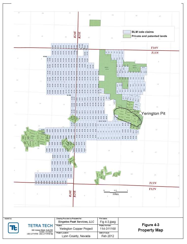
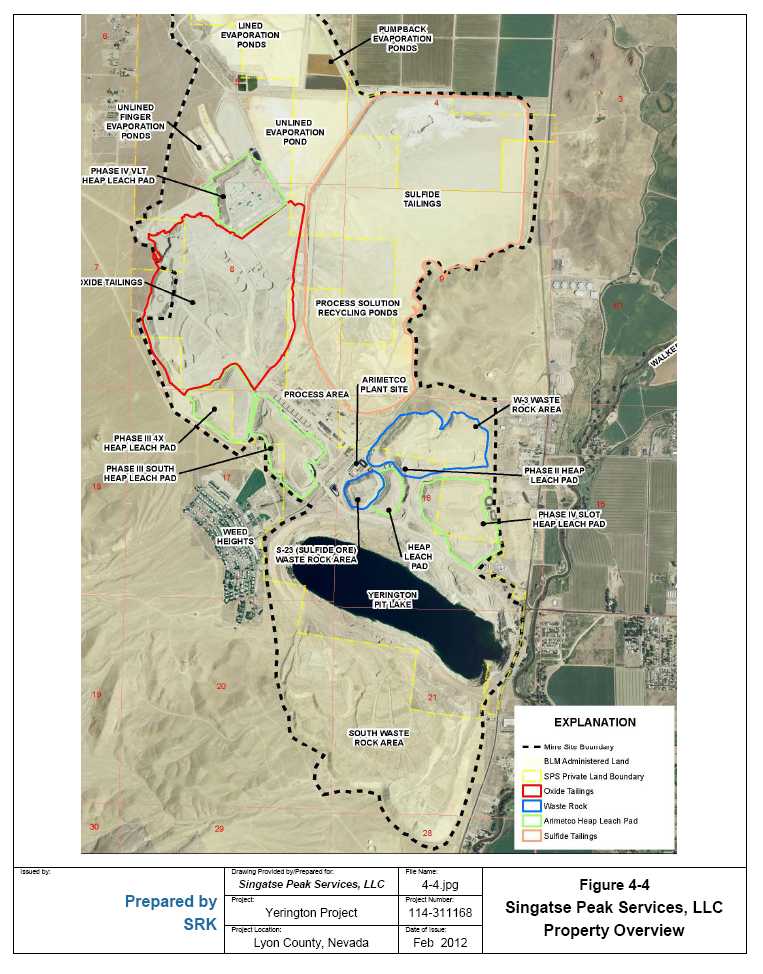
The property consists of 2,690 acres (4.2 square miles) of fee mineral properties and patented mining claims as well as 457 unpatented lode claims totaling approximately 9,400 acres (14.6 square miles) on lands administered by the US Department of Interior, Bureau of Land Management (BLM) (Figure 4-3).
The private land, patented claims, and 23 unpatented mining claims were acquired on April 27, 2011 when SPS closed a transaction under which assets of Arimetco, Inc. (Arimetco), a Nevada corporation, were acquired. Private properties are located in Township 13 North, Range 25 East in Sections 4, 5, 8, 9, 16, 17, and 21, and patented claims are located within Township 13 North, Range 25 East in Sections 16, 17, 19, 21, 31, and 32 and in Township 13 North, Range 24 East in Sections 22-25 and 36.
An additional 434 unpatented claims were staked prior to or subsequent to the acquisition by SPS.
SPS's claims are located in Sections 1, 2, 11-13, 22-27, 35, and 36, Township 13 North, Range 24 East and in Sections 4-9, 16-21, and 30-32, Township 13 North, Range 25 East, Mount Diablo Base & Meridian.
| Tetra Tech | February 2012 | 19 |
| NI 43-101 Technical Report Mineral Resource | Singatse Peak Services, LLC |
| | Yerington Copper Project |
4.3 Mineral Tenure and Title
The purchase of the Arimetco assets was accomplished through a US$500,000 cash payment, 250,000 shares of Quaterra common stock, and a 2% net smelter return royalty capped at $7.5 million on production from any claims owned by Quaterra Alaska, Inc (including Quaterra's MacArthur copper property) in the Yerington mining district.
Ownership of the patented claims and private land is held through payment of county assessed taxes, while unpatented lode claims staked in the United States require a federal annual maintenance fee of $140 each, due by 12:00 pm (noon) on September 1 of each year. Further, each lode claim staked in Nevada requires an Intent to Hold fee of $10.50, plus a $4.00 filing fee, due 60 days after September 1 of each year payable to the County Recorder of the appropriate Nevada county. All SPS claims are current.
Unpatented lode claims have been staked by placing a location monument (two- by two-in by four foot high wood post) along the center line of each claim and two- by two-inch by four-foot high wood posts at all four corners, with all posts properly identified in accordance with the rules and regulations of the BLM and the State of Nevada. Maximum dimensions of unpatented lode claims are 600 feet × 1,500 feet. A complete property listing is included in Appendix A.
4.4 Relevant Information
Copper mining was first recorded at the Yerington Mine site from 1918-1920 at the Empire Mine, and later, beginning in 1953 by Anaconda. From that time forward, the mine operated under different companies until 1999 when Arimetco, the last operator, closed the operation. However, soil and groundwater contamination, alleged to stem from the former mining operation, have been identified on the property.
As a result, a portion of the property acquired by SPS (Figure 4.4) in 2011 is now under the jurisdiction of the US Environmental Protection Agency (USEPA). Liability for the contamination on site is the responsibility of a third party which is actively engaged in remedial investigation and remediation activities under the supervision of the USEPA. Liability for a portion of the site was the responsibility of a now bankrupt entity and the unfunded liability is the financial responsibility of the US taxpayers as governed by USEPA environmental laws.
In order to establish Singatse's position and rights, the acquisition by SPS of the Arimetco properties required a series of rigorous environmental, legal, and technical due diligence studies. In 2008, Chambers Group, Inc. and Golder Associates Inc. conducted a Phase I Environmental Site Assessment (Phase I ESA) for the Yerington Mine Site. A Phase I ESA is intended to serve as an appropriate, commercially prudent, and reasonable inquiry regarding the potential for recognized environmental conditions in connection with the subject property. The 2008 Phase 1 ESA was updated by SRK Consulting (U.S.) Inc. (SRK) in 2010 and again in 2011. These were completed to allow SPS to establish liability protection as a bona fide prospective purchaser (BFPP). Prior to closing on the property, SPS received letters from the Nevada Department of Environmental Protection (NDEP), US Bureau of Land Management (BLM) and the USEPA indicating the post-closing requirements then applicable to the Site for
| Tetra Tech | February 2012 | 21 |
| NI 43-101 Technical Report Mineral Resource | Singatse Peak Services, LLC |
| | Yerington Copper Project |
SPS to maintain its defense to liability as a BFPP regarding the activities of the former mine owners and operators.
Legal due diligence included a legal description of the property, a chain of title report, and an assignment of water rights. BFPP letters have been received from the NDEP, BLM and USEPA which indicate the basic requirements known as reasonable steps” SPS must take to retain its BFPP defense from existing liabilities on the property.
Technical due diligence included the review and compilation of a wealth of historical data in the Anaconda Collection, American Heritage Center, University of Wyoming, in Laramie. Numerous reports, maps, and historical drilling data have been scanned and entered into an internal data base, allowing an initial review of both past production and remaining mineralization in and around the Yerington pit.
The company controls approximately 8600 acre feet of groundwater rights for use at the site. The places of use for each of the nine water rights which make up this total are on the site, which also contains a pit lake now estimated to contain approximately 37,000 acre feet of water to be dewatered during mining activities. The company believes this water will have a variety of beneficial uses, but will require some costs to make the water available for those beneficial uses.
SPS's 2011 drilling program was restricted to fee mineral properties or patented mining claims in or near the Yerington pit, and approved by the State of Nevada Bureau of Mining Regulation and Reclamation of the Nevada Division of Environmental Protection (NDEP), as an Interim Exploration Permit “BMRR Reclamation Permit #0321”, supported by posting a $70,363 reclamation bond. The interim permit was approved as a final permit on November 7, 2011, by the NDEP.
If SPS elects to conduct exploration on unpatented lode mining claims on public lands administered by the Bureau of Land Management, a Notice of Intent is required if the proposed disturbance is less than five acres. The Notice of Intent includes a description and map of proposed work, supported by a reclamation bond. Proposed disturbance exceeding five acres requires a Plan of Operation, a more comprehensive evaluation of cultural features, vegetation, wildlife, water, and other items, supported by a reclamation bond.
| Tetra Tech | February 2012 | 22 |
| NI 43-101 Technical Report Mineral Resource | Singatse Peak Services, LLC |
| | Yerington Copper Project |
5.0ACCESSIBILITY, CLIMATE, LOCAL RESOURCES, INFRASTRUCTURE, AND PHYSIOGRAPHY
5.1 Accessibility
Access to the property from the town of Yerington follows US Highway ALT 95 north about one mile to the Burch Street turnoff, a paved road that leads west into the Yerington mine area. Access into the mine area is fenced and restricted. Inside the fenced area a series of roads provide access to all of the property in Township 13 North, Range 25 East. Claims in Township 13 North, Range 24 East are accessed by a number of existing dirt roads leading west from US Highway ALT 95, from one to three miles south of the town of Yerington.
5.2 Climate
The climate is temperate and is characterized by cool winters with temperatures between zero and 50 degrees Fahrenheit and warm to hot summers with temperatures between 50 and 100 degrees Fahrenheit. Average annual precipitation is estimated at three to eight inches per year, with a significant part of this total precipitation falling as snow and increasing with elevation. Work can be conducted throughout the year with only minor delays during winter months due to heavy snowfall or unsafe travel conditions when roads are particularly muddy.
Elevations on the property range from approximately 3,700 feet at the bottom of the Yerington pit to 4,600 feet in the Yerington mine area and approximately 4,600 feet to 5,800 feet in the uplands to the west. The Yerington pit contains approximately 37,000 acre-feet of water, based upon the January 2012 water elevation at 4,227 feet. The pit lake is currently actively fed from the Walker River, the result of a trench cut from the river to the pit during a flood in the late 1990s diverting water into the pit to prevent flooding of the Yerington town site, and from a seep in the west wall of the Yerington pit approximately 100 feet above water level. It is a ground water sink and water levels are shown to be increasing at a decreasing rate, with a 4-foot increase measured in 2011 and a projected equilibrium elevation at approximately 4,240 feet, to be achieved around the year 2025. Yerington pit dimensions are approximately 6,000 feet long ESE to WNW, 2,500 feet wide, and 800 feet deep.
There are no active streams or springs on the remainder of the SPS property. The terrain is moderately steep and sparsely covered by sagebrush and interspersed low profile desert shrubs. All gulches that traverse the property are normally dry.
5.3 Local Resources and Infrastructure
The nearest population center is the agricultural community of Yerington one mile east of the Yeringon pit. Formerly an active mining center from 1953 to 1978 and from 1989 to 1997, Yerington now serves as a base for three active exploration groups: Quaterra Alaska Inc. (MacArthur property) and its subsidiary SPS; Entrée Gold Inc. (Ann Mason copper-molybdenum property); and Nevada Copper Corporation (Pumpkin Hollow Copper Project). Yerington hosts a work force active in, qualified for, and familiar with mining operations within a one-hour drive.
| Tetra Tech | February 2012 | 24 |
| NI 43-101 Technical Report Mineral Resource | Singatse Peak Services, LLC |
| | Yerington Copper Project |
Yerington offers most necessities and amenities including police, hospital, groceries, fuel, regional airport, hardware, and other necessary infrastructure. One core drilling contractor is based in Yerington. Drilling supplies and assay laboratories can be found in Reno, a 1.5 -hour drive. Reverse circulation drilling contractors are found in Silver Springs, Nevada, 33 miles north, as well as in the Winnemucca and Elko, Nevada areas, within a three- to five-hour drive from the site.
Power is available on site at the Yerington Mine area. Nevada Energy operates a 30 million kW propane-fired, electrical generating power plant within ten miles of the site. The power infrastructure at the Yerington Mine site is expected to be readily available for a future mining operation due to the historical mine operations at the site.
SPS controls approximately 8,600 acre-feet of groundwater rights and the Yerington pit contains an estimated 37,000 acre-feet of water.
| Tetra Tech | February 2012 | 25 |
| NI 43-101 Technical Report Mineral Resource | Singatse Peak Services, LLC |
| | Yerington Copper Project |
6.0HISTORY
6.1 Ownership/Property History
Recorded production in the Yerington mining district dates back to 1883 (Moore, 1969) as prospectors were attracted to and investigated colorful oxidized copper staining throughout the Singatse Range. Knopf (1918) reported that oxidized copper cropped out at the historic Nevada-Empire mine located above the south center of the present-day Yerington open pit. Knopf does not show or reference other mines or prospects that are underlain by the Yerington open pit footprint, as gravel and alluvial cover obscure bedrock over an approximate 0.75 -mile radius around the Nevada-Empire Mine.
Information is sparse for the period from Knopf's reporting in 1918 until World War II, although it is likely that lessees worked the Nevada-Empire during spikes in the copper price. Private reports (Hart, 1915 and Sales, 1915) describe ore shipments and planned underground exploration from a northwest striking, southwest dipping structure at the historic Montana-Yerington Mine area located approximately one mile west of the present-day Yerington pit.
During the 1940s, The Anaconda Company (Anaconda), at that time one of world's major copper producers, sent geologists to the Yerington district whose exploration outlined a 60-million-ton resource over the Yerington pit. During the early 1950s, the US government, citing the need for domestic copper production, offered “start-up” subsidies to Anaconda to open a copper mine in the Yerington district. Anaconda sank two approximately 400-foot-deep shafts in the present-day open pit and drove cross cuts to obtain bulk samples of oxidized rock for metallurgical study. Anaconda began operating the Yerington Mine in 1952 and mined continually through 1979, producing approximately 1.744 billion pounds of copper from an ore body that contained 162 million tons averaging 0.54% Cu. Approximately 104 million tons of this total were oxidized copper ore that was “vat-leached” with sulfuric acid in 13,000-ton cement vats on a seven day leach cycle. Sulfide ores were concentrated on site in a facility that was dismantled and sold following termination of mining in 1979.
In 1976, all assets of The Anaconda Company, including the Yerington Mine, were purchased by the Atlantic Richfield Company (ARCO), which shut down dewatering pumps in the pit and closed the Yerington Mine in 1979 due to low copper prices. In 1982, ARCO sold the entire Yerington Mine complex and Weed Heights town site to Mr. Don Tibbals of Yerington, Nevada, who scrapped the plant and equipment. At closure, before dewatering pumps were shut off, the Yerington mine plan hosted a pre-stripped, non NI 43-101 compliant reserve of 98 million tons averaging 0.36% Cu (Howard, 1979) within their ultimate pit design.
In 1989, Arimetco Inc. (Arimetco) purchased the mine property from Tibbals, commissioned a 50,000-pound-per-day solvent extraction/electrowinning plant, and began heap leaching “sub-grade” dump rock stripped from the Yerington pit by Anaconda. Arimetco also added an unknown tonnage of “vat leach tailings” (minus 3/8 inch oxidized tailings leached during Anaconda's operation) to some heap leach pads (HLP's) as well as trucking oxidized ore from the MacArthur property located approximately five miles north of the Yerington mine site.
| Tetra Tech | February 2012 | 26 |
| NI 43-101 Technical Report Mineral Resource | Singatse Peak Services, LLC |
| | Yerington Copper Project |
Arimetco produced some 95 million pounds of copper from 1989 to 1999 before declaring bankruptcy due to low copper prices and abandoning the property.
In early 2000 the Nevada Division of Environmental Protection (NDEP) assumed operation of the site on a care and maintenance basis, primarily to ensure that HLP draindown solutions would continue to be maintained.
Following four years of due-diligence studies and negotiations with state and federal agencies, the property was acquired by SPS from the Arimetco bankruptcy court in April, 2011, after receiving BFPP letters from the USEPA, NDEP and BLM to protect SPS from liability emanating from activites of the former mine owners and operations.
6.2 Historical Resources
At the time the property was acquired by SPS in 2011, the historical non-compliant resources at the Yerington Mine itself were reported to be over 120 million tons in the ground at a grade of 0.34% Cu, representing material both within their ultimate pit design (98 million tons of 0.36% Cu) and material outside their design. That historical resource has now been replaced with the current updated NI 43-101 estimate as summarized in Section 14 of this report.
No copper extraction from the Arimetco heaps or mining has occurred since the Arimetco closure in 1999, but residuals from leaching and processing operations conducted by Anaconda and Arimetco (see Figure 4.4) are reported to contain additional, non-compliant resources including:
Vat leach tailings (VLT) from the former Anaconda processing of oxide ore
Low grade oxide ore stockpile from the Yerington Pit that was below Anaconda's cut-off grade for oxide ore
Low grade sulfide ore stockpile from the Yerington Pit that was below Anaconda's cut-off grade for sulfide ore
Arimetco's heap leach operations for Anaconda oxide tailings, low grade oxide ore from Anaconda's operations, and copper oxide ore mined from the MacArthur Mine located five miles north of the Yerington site
Table 6.1 summarizes a non-compliant estimate of the volume and grade of the residual sources on site. References 2 through 4 shown on the table refer to documents published by the USEPA (EPA), as listed in Section 27, References.
| Tetra Tech | February 2012 | 27 |
| NI 43-101 Technical Report Mineral Resource | Singatse Peak Services, LLC |
| | Yerington Copper Project |
Table 6-1 Yerington Mine - Historic Resource in Residuals
TABLE 6.1: YERINGTON MINE - RESIDUALS BASED UPON HISTORIC (NON-COMPLIANT) DATA
AND CURRENT VOLUME AND DENSITY ESTIMATES |
| Residual Source | Volume
Cu Ft
(000's) | Est
tons
(000's) | Assumed
TCu
Grade, % | Contained
Cu, lbs
(000's) | Particle
Size | Assumed
Recovery
% | Recoverable
Cu lbs (000's) |
Anaconda Oxide
Tails (VLT)1,3,5 |
959,717 |
57,572 |
0.133 |
153,601 | <0.5
inch |
70 |
107,521 |
Anaconda Oxide
Waste Rock W-
31,4 |
327,450
|
19,643
|
0.226
|
88,787
|
ROM
|
50
|
44,393
|
Anaconda Sulfide
Low Grade Ore S-
234 |
38,615
|
2,316
|
0.226
|
10,470
|
ROM
|
85
|
8,900
|
Arimetco Phase 3
HLP 41,2 |
138,980 |
7,951 |
0.120 |
19,082 | ROM <6
inch |
50 |
9,541 |
Arimetco Phase 3
HLP S1,2 |
157,595 |
10,115 |
0.083 |
16,710 | ROM <6
inch |
50 |
8,355 |
Arimetco Phase 1/2
HLP1,2 |
36,793 |
2,263 |
0.099 |
4,471 | ROM <6
inch |
50 |
2,236 |
Arimetco Phase 4
Slot HLP1,2 |
237,426 |
12,925 |
0.091 |
23,394 | ROM <6
inch |
50 |
11,697 |
Arimetco Phase 4
VLT HLP1,2 |
176,563 |
11,555 |
0.075 |
17,240 | ROM <6
inch |
50 |
8,620 |
Subtotal Arimetco
HLPs |
747,357 |
44,809 |
- |
80,897 |
- |
- |
40,449 |
| Grand Total | 2,073,139 | 124,340 | - | 333,755 | - | - | 201,262 |
Notes:
1 Volume based on SRK 2010 Digitization and Volume calculations using MineSight 3D Software.
1 Density based on: Draft Supplemental RI Report_OCT_2010 - Page 47.
2 Grade based on: AnacondaArimetco_RI_Report.pdf - Page 170-172.
3 Grade based on: VLT XRF DSR July 2010 - Page 99.
4 Grade based on: HistoricalSummaryReport-YeringtonMine-2010-10.pdf - Page 19.
5 Additional VLT identified as cap on Sulfide Tails, but not quantified. |
| Tetra Tech | February 2012 | 28 |
| NI 43-101 Technical Report Mineral Resource | Singatse Peak Services, LLC |
| | Yerington Copper Project |
7.0GEOLOGICAL SETTING AND MINERALIZATION
7.1 Regional Geology
The Yerington Copper Project property is located in western Nevada near the western boundary of the Basin and Range Province, a land mass of internal drainage encompassing most of the state of Nevada. Basin and Range physiography consists of a series of nearly north-trending ranges separated by alluvial-filled, normal fault-bounded basins. The valley infill may range from tens to thousands of feet of alluvium.
In western Nevada, overprinted on the Basin and Range but not altering its physiographic character, is a major right lateral, northwest trending structural zone called the “Walker Lane” approximately 60 miles wide and generally parallel to the Nevada-California border, between Reno to the northwest and Las Vegas to the southeast. Major ore deposits, principally precious metals, occur in the Walker Lane as does the Yerington copper mining district.
Within Lyon County, Nevada, the Yerington Project area occupies the alluvial-covered eastern flank and bedrock uplands of the central Singatse Range, a modest sized, north trending mountain range.
Regional geology of the Singatse Range, including the Yerington mining district is displayed in Figure 7-1 (Proffett and Dilles, 1984) from which the following text has been adapted.
The oldest rocks of the Singatse Range are an approximate 4,000-foot section of Late Triassic, intermediate and felsic metavolcanics, and sedimentary rocks forming the McConnell Canyon Formation, associated with volcanic arc development along the North American Continent during the Mesozoic Period.
This sequence is disconformably overlain by a series of Upper Triassic carbonates, meta-sediments, and volcaniclastics that are, in turn, overlain by Upper Triassic limestone, siltstone, and tuffs, and by argillite thought to span the Triassic-Jurassic boundary. Jurassic limestone is succeeded by gypsum and sandstone, and by andesitic volcanics that may signal the beginning pulse of middle Jurassic plutonism.
Middle Jurassic plutonism, possibly related to the igneous activity that formed the Sierra Nevada Mountains to the west, resulted in emplacement of two batholiths comprising the Singatse Range, including the Yerington Batholith extending across 40 miles from the Wassuk Range on the east to the Pine Nut Range on the west. East-west striking structural zones mark the contacts between igneous rock and older, outlying Mesozoic basement at the north and south ends of the Singatse Range; the structures can be projected through the adjoining basins.
The Yerington Batholith comprises three intrusive phases emplaced between 169 Ma to 168 Ma (Proffett and Dilles, 1984): an early granodiorite pluton; a second phase of medium-grained quartz monzonite, creating a finer-grained „'border phase quartz monzonite” where in contact with granodiorite; and, finally, a medium-grained porphyritic quartz monzonite emplaced as a stock with cupolas developed over its top. Porphyry dike swarms sourced from the youngest
| Tetra Tech | February 2012 | 29 |
| NI 43-101 Technical Report Mineral Resource | Singatse Peak Services, LLC |
| | Yerington Copper Project |
phase, the porphyritic quartz monzonite, cut the cupolas. Copper mineralization formed contemporaneously with the dike swarms. Andesite and rhyolite dikes represent the final phase of Mesozoic igneous activity.
Mesozoic rocks were deeply eroded and then covered by Mid-Tertiary tuffs and lesser sedimentary rocks. The entire package was subsequently faulted along north-trending, downward and east dipping faults that resulted in extension and major westerly tilting.
| Tetra Tech | February 2012 | 30 |

| NI 43-101 Technical Report Mineral Resource | Singatse Peak Services, LLC |
| | Yerington Copper Project |
7.2 Local Geology
The Yerington Copper property includes both the Yerington Deposit and a portion of the Bear Deposit which represent two of three known porphyry copper deposits in the Yerington district. Like the Ann Mason copper deposit located 2.5 miles to the west, the Yerington and Bear Deposits are hosted in Middle Jurassic intrusive rocks of the Yerington Batholith.
Copper mineralization on the property occurs in all three phases of the Yerington Batholith. Intrusive phases, from oldest to youngest, are known as the McLeod Hill Quartz Monzodiorite (field name granodiorite), the Bear Quartz Monzonite, and the Luhr Hill Granite, the source of quartz monzonitic (i.e. granite) porphyry dikes related to copper mineralization.
Following uplift and erosion, a thick Tertiary volcanic section was deposited, circa 18-17 Ma. This entire rock package was then extended along northerly striking, down-to-the-east normal faults that flatten at depth, creating an estimated 2.5 miles of west to east dilation-displacement (Proffett and Dilles, 1984). The extension rotated the section such that the near vertically-emplaced batholiths were tilted 60° to 90° westerly. Pre-tilt, flat-lying Tertiary volcanics now crop out as steeply west dipping units in the Singatse Range west of the Yerington Mine Copper property. The easterly extension thus created a present-day surface such that a plan map view actually represents a cross-section of the geology.
7.3 Property Geology
Current knowledge of Yerington Mine geology benefits from detailed geologic mapping by Anaconda geologists on various pit benches during mining operations from the 1950s to the 1970s. SPS gained access to this data through membership in the Anaconda Collection – American Heritage Center housed on the campus of the University of Wyoming, Laramie, Wyoming. Further, of the approximately 700 exploration core holes drilled by Anaconda to define the Yerington Mine ore body, one-half splits of approximately 20 per cent of the core were stored in a recoverable manner on the mine site. SPS moved the core to a dry location for relogging and reassay to understand Anaconda geology as it relates to copper mineralization.
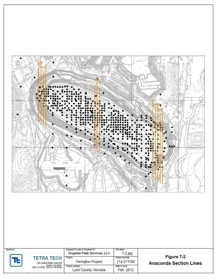
Anaconda referenced Yerington pit geology and drill hole locations alphabetically, on a 100-foot by 100-foot north-south/east-west grid, beginning at the east end of the pit with cross section “A minus 100”, “A”, “A+100”, “B”, “B+100”, etc. progressing westerly to “Z+100”, ending westerly with “AA”, as illustrated in Figure 7-2.
| Tetra Tech | February 2012 | 32 |
| NI 43-101 Technical Report Mineral Resource | Singatse Peak Services, LLC |
| | Yerington Copper Project |
The three intrusive phases of the middle Jurassic Yerington Batholith, exposed in the Yerington pit, have been intruded by at least six porphyry dikes originating from the youngest batholithic phase, the Porphyritic Quartz Monzonite (PQM). Anaconda geologists identified petrographically similar porphyry dikes by number, e.g. QMP1, QMP1.5, QMP2, QMP2.5, QMP2.7, QMP3, with the lowest numbers representing the earliest and strongest copper mineralized dike activity. Younger Jurassic rhyolite and andesite dikes followed. Cross-cutting relationships in pit walls allowed Anaconda geologists to determine age relationships of the dikes. A determination in core is more difficult. The oldest dikes are the best mineralized, especially QMP which averaged 0.80% to 2.0% TCu (J. Proffett, 2010, personal communication).
Yerington Mine rock descriptions used by SPS to log 2011 drill holes and to re-log historic Anaconda core follow, with reference to Anaconda cross section nomenclature.
7.3.1 Porphyritic Quartz Monzonite (PQM)
Medium-grained equigranular to porphyritic quartz monzonite with large (1-2 cm) K-feldspar phenocrysts, 5-10% hornblende, 5-10% biotite, 10-20% anhedral quartz and plagioclase more abundant than K-feldspar. The large K-feldspar phenocrysts are pink and constitute 5-10% of the rock; however, K-feldspar also occurs as 1-4 mm anhedral grains intergrown with plagioclase and quartz. The rock is differentiated from the quartz monzonite porphyries by the lack of an aplitic groundmass (PQM has a more intergrown texture). Also, feldspar phenocrysts are commonly in contact.
PQM represents the cupola of porphyry copper deposits throughout the Yerington district and is the source for the porphyry dikes. It most commonly occurs on the northeastern and southeastern portions of the pit.
7.3.2 Granodiorite (GD)
An olive green fine-grained rock with 5-15% hornblende, 2-10% biotite, 20% quartz, and a one-third K-feldspar/plagioclase ratio. Minor magnetite and other opaques are common. GD is the finest-grained and most mafic-rich of the equigranular rocks. It is not commonly mapped in the Yerington pit but, when present, it most commonly occurs on the western portion of the pit.
7.3.3 Quartz Monzonite (QM)
Medium-grained equigranular whitish rock with 5-10% hornblende, 1-2% biotite, 10-15% quartz, 1-3% sphene, and nearly equal amounts of plagioclase and K-feldspar. It is usually coarser-grained than the border phase quartz monzonite and granodiorite. QM is most commonly observed on the eastern and east-central portion of the pit.
7.3.4 Border Phase Quartz Monzonite (BQM)
BQM represents the contact „rind' between the quartz monzonite and granodiorite. The rock is the most common equigranular rock mapped in the pit and finer-grained than the quartz monzonite. It is characteristically fine- to medium-grained but locally subequigranular to subporphyritic BQM. It has a pinkish hue and contains 5-10% hornblende, 2-5% biotite, 15-20%
| Tetra Tech | February 2012 | 34 |
| NI 43-101 Technical Report Mineral Resource | Singatse Peak Services, LLC |
| | Yerington Copper Project |
quartz and nearly equal amounts of plagioclase and K-feldspar. It most commonly occurs in the east-central to western portions of the pit.
7.3.5 Equigranular Quartz Monzonite (QME)
Found in the east-central to western portions of the pit, QME is described as an „igneous breccia' related to the Quartz monzonite porphyries at Yerington. The rock is difficult to distinguish from the border phase quartz monzonite as it differs only in age relationships and in the presence of quartz vein fragments. QME was the first equigranular rock mapped in the pit, later removed, and then reinstated as a valid rock type. The rock is differentiated by age relationships as it contains fragments of the QMP2 dike and granodiorite within it.
7.3.6 Porphyry Dikes
Porphyry dikes are almost impossible to differentiate without cross-cutting relationships observed on pit benches by Anaconda geologists.
7.3.7 QMP1
QMP1 is the main mineralized host in the Yerington pit. It contains 70-95% fine-grained groundmass with granular quartz and K-spar with minor biotite (aplitic). The phenocrysts consist of 2-10% hornblende, 2-10% biotite, 1-10% quartz eyes, 2-10% K-spar, and 35-40% 2-4mm plagioclase. Phenocrysts are commonly not in contact or are in point contact.
QMP1 almost always grades better than 1% Cu and commonly grades higher than 2% Cu. It contains at least 10% quartz (A-type) veinlets, but locally contains 30-40% quartz veinlets. The veining commonly obscures the porphyritic texture. Bornite and chalcopyrite are present as well as secondary magnetite occurring in distinct veinlets or with quartz (A-type) veins.
Primary potassium feldspar crystals turn a purple-gray color upon altering to plagioclase. Fine, shreddy biotite is also observed due to the potassic alteration. The lens-shaped dike has been mapped as far west as the N and N+100 section lines. The eastern extension in the pit is unclear.
7.3.8 QMP1.5
QMP1.5 is commonly chilled and is differentiated from the QMP1 and QMP2 as it cuts the QME. The rock has abundant A-veins with bornite, chalcopyrite, and secondary magnetite. The percent of sulfide and veining is less than that of the QMP1. QMP1.5 commonly runs 0.8 -1% Cu but mineralogically it is the same as the QMP1.
QMP1.5 has been mapped from at least the N+100 to the V+100-section line; the eastern extension is unknown. The thickest development is from the T+100 section line to the V-section line (on the 4,000-foot bench elevation).
| Tetra Tech | February 2012 | 35 |
| NI 43-101 Technical Report Mineral Resource | Singatse Peak Services, LLC |
| | Yerington Copper Project |
7.3.9 QMPc
Any of the porphyry dikes can have a chilled margin at the contact with another rock type causing a dark green to gray fine-grained groundmass with 2-4 mm white feldspar phenocrysts. However, there seems to be a QMPc dike that is separate from this contact phase; it may be the same dike as QMP1.5. It is possible that its occurrence is coeval with QMP1. It is described as having 70-95% fine-grained groundmass containing granular quartz and K-feldspar as well as biotite and muscovite (which make up 30% of groundmass). This dike has chalcopyrite and bornite as well as secondary magnetite occurring in abundant A-veins.
7.3.10 QMP2
QMP2 is mineralogically similar to the QMP1 and QMP1.5 dikes, but does have a few slight differences. It contains 50-80% fine-grained groundmass with granular quartz and K-feldspar (aplitic, but without biotite). Mafic phenocrysts are hornblende and biotite, but hornblende is more abundant than in the QMP1 and QMP1.5 (causing a higher hornblende:biotite ratio). K-feldspar phenocrysts are also generally larger than that of the QMP1 and QMP1.5.
Proffett (J. Proffett, verbal communication) describes it as a “run of the mill porphyry”. Mineralization consists mainly as chalcopyrite with some bornite. The grade varies from 0.2 to 0.8% Cu. Distinct A-veinlets are rare (1-2%) with more common B-type veinlets. B-type veinlets are quartz veinlets with coarse-grained inward growing quartz crystals. Magnetite is usually absent or sparsely present. Its groundmass is usually lighter in color than that of the QMP1 and QMP1.5.
USTs (unidirectional solidification textures) are commonly associated with the QMP-2 which represent the apex of the porphyry. These are identified by quartz crystals growing in a distinct direction (downward on the porphyry). It is sometimes described as „brain-rock'. This porphyry has been identified from at least the N section line to the U-section line, but is cut off in spots due to the QMP2.5.
7.3.11 QMP2.5
Porphyry dikes mapped as QMP2.5 are mineralogically similar to QMP2, but have a higher hornblende:biotite ratio. They are characteristically low in grade (0.1 -0.2% Cu), but do “get good in spots” (J. Proffett, personal communication). Mafics are weakly biotized to unbiotized. QMP 2.5 has little to no quartz veining and a high pyrite to chalcopyrite ratio.
East of the O-section line there are areas where the dike has 2-10% quartz veining with a grade of 0.4% Cu and even as high as 0.6% Cu with chalcopyrite and bornite. In this zone, the dike contains rectangular mafics that were hornblende, but are now chlorite. It is believed the dike “changes character”. It cuts off the QMP2 and exists from at least the N-section line to the S+100-section line.
| Tetra Tech | February 2012 | 36 |
| NI 43-101 Technical Report Mineral Resource | Singatse Peak Services, LLC |
| | Yerington Copper Project |
7.3.12 QMP3
QMP3 is probably the most easily recognized porphyry at the Yerington pit. The dike contains 60-80% fine-grained groundmass with angular K-feldspar and quartz and subhedral plagioclase laths. The groundmass can contain fine shreds of chlorite and muscovite. Mafic phenocrysts are mostly hornblende with minor biotite. Mafic phenocrysts are fresh to chloritized with little to no biotization. The rock has very few quartz veins (≤1%) and pyrite is the most abundant sulfide mineral. The grade ranges from <0.1 to 0.1% Cu.
7.3.13 Rhyolite
White to gray siliceous dikes occur sporadically throughout the Yerington pit. These dikes are 60-70% fine-grained quartz, 20-25% white feldspar phenocrysts, and 5-10% hornblende and biotite (usually hornblende>biotite). These dikes have little to no mineralization.
7.3.14 Andesite
A fine-grained dark gray to green rock with a commonly chloritized groundmass is mapped as andesite. The groundmass is composed mainly of hornblende and biotite. The rock contains 10-15% plagioclase phenocrysts, 2-4 mm in length, that may be epidotized. The andesite is not mineralized but may contain up to 2% pyrite with only trace amounts of chalcopyrite. These dikes range from 1-10 foot in thickness and occur sporadically throughout the pit.
7.3.15 Alteration
Alteration types recognized in drill core at the Yerington Mine Copper property are common to those found in many mineralized porphyry copper systems. Mid-Tertiary downward and eastward extensional faulting exposes a porphyry copper deposit in cross section lying on its side with its top toward the west end of the Yerington pit. Limonite brownish sericite alteration (the pre-tilt upper, original pyrite-rich phyllic shell) is exposed at the west end of the pit. Potassically altered secondary biotite and magnetite dominant alteration in the center of the pit grades easterly into off-white sodic-rich rock (sodic-calcic alteration), the pre-tilt base near the eastern pit boundary. A thin slice of Tertiary volcanics underlying the alluvial gravels is exposed in pit benches at the west end of the pit.
7.3.15.1 Propylitic
Propylitic alteration is common throughout the Yerington Mine property in all rock types. This alteration type occurs as chlorite replacing hornblende, and especially epidotization as veining, coatings, and/or flooding on the granodiorite. Calcite veining is present but not commonly observed in core or drill cuttings. Feldspars are commonly unaltered. Propylitic alteration frequently overprints or occurs with the alteration types described below.
7.3.15.2 Quartz-Sericite-Pyrite (QSP)
Phyllic alteration is most frequently characterized by tan to light green sericite partially or completely replacing hornblende and/or biotite sites. When phyllic alteration becomes more
| Tetra Tech | February 2012 | 37 |
| NI 43-101 Technical Report Mineral Resource | Singatse Peak Services, LLC |
| | Yerington Copper Project |
intense, plagioclase and/or K-feldspar sites are also replaced by sericite. The altered mafics and feldspars are accompanied by a significant addition of pyrite, locally up to 10%. However, these minerals do not replace mafic or felsic sites. Sericitic altered zones are often quite siliceous; however, it is unclear if this is due to quartz addition or just the destruction of other primary minerals.
Phyllic alteration is most pervasive and intense near the west-central Yerington pit. The alteration type does not show preference with rock type and has been described in the granodiorite, quartz monzonite, and the porphyries.
7.3.15.3 Potassic Alteration
Potassic alteration occurs as shreddy, fine-grained biotite replacing hornblende along with secondary disseminated magnetite. To a lesser extent, there is potassium feldspar replacing plagioclase within the rock as well as in vein halos. Potassic alteration occurs in the central part of the Yerington pit coinciding with the most intense and extensive quartz veining, and highest grade copper mineralization.
Potassic alteration is best observed in oldest (highest grade) porphyry dikes as well as the granodiorite and quartz monzonite hosts.
7.3.15.4 7.3.1.4 Sodic-Calcic Alteration
Pervasive sodic-calcic alteration, described by Anaconda geologists as sodic flooding, occurs at the east end (pre-tilt base) of the Yerington pit, creating off-white, hard altered rock. This type of alteration most frequently occurs as albite replacing K-feldspar and as chlorite, epidote, or actinolite replacing hornblende and/or biotite. In the most intense zones of sodic alteration, the mafics are completely destroyed.
7.3.15.5 7.3.1.5 Silicification
Silicification occurs as a wholesale replacement of the rock, more common in mineralized porphyry dikes.
7.3.15.6 Supergene alteration
Supergene, or secondary enriched copper minerals, made only a minor contribution to Yerington mine production due to insufficient pyrite available for oxidation and creation of sulfuric acid. Chalcocite, the primary result of secondary enrichment, occurs randomly toward the west end (pre-tilt top) of the Yerington pit. Chalcocite is rarely mentioned in review of historic Anaconda drill logs.
SPS's drill holes collared on the west-northwest side of the pit intersected narrow, isolated chalcocite mineralization typically 0.1x% Cu over 10 to 20 feet thickness. The thickest chalcocite intercept measured 0.15% Cu over 95 feet in drill hole SP-014A (180/-70°/1000') from 435 feet to 540 feet. The transition from oxide (green and / or black) copper to primary
| Tetra Tech | February 2012 | 38 |
| NI 43-101 Technical Report Mineral Resource | Singatse Peak Services, LLC |
| | Yerington Copper Project |
sulfide copper mineralization is sharp and consistently chalcocite-absent throughout the pit excepting the west pit area noted above.
The oxide – sulfide surface across the Yerington pit generally occupies the 4,100 foot elevation as a rather smooth, undulating surface with local “divots” down to 3900 feet in places, ostensibly where oxidation followed fracturing downward. Base of oxidation in limited SPS drilling confirmed the general 4,100 foot elevation.
7.4 Mineralization
7.4.1 Yerington Mine Porphyry Copper Deposit
The Yerington Mine produced approximately 162 million tons of ore grading 0.54% Cu, of which oxide copper ores amenable to leaching accounted for approximately 104 million tons. A 1971 snapshot of head grades shows oxide mill head grade averaging 0.53% Cu and sulfide grades ranging from 0.45% to 0.75% Cu (D. Heatwole, personal communication).
The general geometry of copper mineralization below the Yerington pit is shown by the Datamine view of the resource model (Figure 7-3). The elongate body extends 6,600 feet along a strike of S62ºE. The modeled mineralization has an average width of 2,000 feet and has been defined by drilling to an average depth of 250 feet below the pit bottom at the 3,800-foot elevation.

Figure7-3 Datamine View through Half of Model Looking East Though the Yerington Pit
| Tetra Tech | February 2012 | 39 |
| NI 43-101 Technical Report Mineral Resource | Singatse Peak Services, LLC |
| | Yerington Copper Project |
Because of the economic constraints of low copper prices at the time, many Anaconda holes were aborted when still in mineralization and very few were drilled below the 3,400 level where the porphyry system remains nearly unexplored. Only six deep holes drilled by Anaconda tested the pit area below the 3,000 level; only four of which (Anaconda Holes D158, D152, D174, and V2-28-33) actually explored the deep vertical projection of mineralization in the pit.
Holes D158, D152, and D174 were three of five holes drilled along a N-S oriented section through the pit during the period of 1969 -1970 (Figure 7-4). M.T. Einaudi (1970) summarized the results of the deep drilling program as defining a series of nested, concave upward, grade shells that are elongated down the N 70º dip of the dikes with the 0.2% Cu zone extending to approximately the 2,600 level; an overall dip distance of 2,200 feet. Although the program encountered an increasing ratio of pyrite to chalcopyrite, there was no indication of a “barren core”, and the porphyry dikes showed a “remarkable continuity” down dip.
The study also established a 250 to 500 foot thick zone of fracture hosted and disseminated molybdenite mineralization that wraps around the sulfide zone near the chalcopyrite / chalcopyrite-pyrite transition. The outer limit of the molybdenite matches “in detail” the outer limit of the +0.1% Cu zone. The report concluded that the drill program had “demonstrated the existence of considerable reserves of +0.2% Cu” (not to be considered as NI 43-101 compliant) below the northern portion of the pit.
Figure 7-4 displays the location of Anaconda's deep holes in section N+100 (looking west) showing +0.2%TCu (yellow) and 0.1%TCu (blue) intervals intercepted below the current resource model.
| Tetra Tech | February 2012 | 40 |
| NI 43-101 Technical Report Mineral Resource | Singatse Peak Services, LLC |
| | Yerington Copper Project |
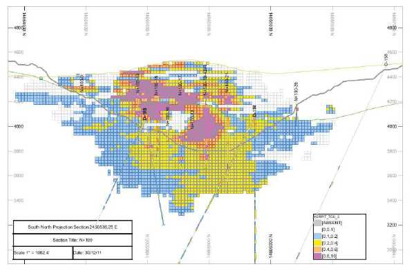
Figure 7-4 Resource Model at Anaconda Section N+100 (2,436,536N)
The copper mineralization and alteration throughout the Yerington district and at the Yerington Mine are unusual for porphyry copper camps in that the mineralization is “stripey”, occurring in WNW striking bands or stripes between materials of lesser grade. Clearly, much of this geometry is influenced by the strong, district-wide WNW structural grain observed in fault, fracture and, especially, porphyry dike orientations. Altered, mineralized bands range in width from tens of feet to 200-foot-wide mineralized porphyry dikes mined in the Yerington pit by Anaconda.
Oxide copper occurred throughout the extent of the Yerington pit, attracting the early prospectors who sank the Nevada-Empire shaft on copper showings located over the present-day south central portion of the pit. To extract the copper oxides, Anaconda produced sulfuric acid on site, utilizing native sulfur mined and trucked from Anaconda's Leviathan Mine located approximately 70 miles west of Yerington.
Greenish, greenish-blue chrysocolla (CuSiO3.2H20) was the dominant copper oxide mineral, occurring as fracture coatings and fillings, easily amenable to an acid leach solution. Historic Anaconda drill logs note lesser neotocite,akablack copper wad (Cu, Fe, Mn), SiO2and rare tennorite (CuO) and cuprite (Cu2O). Oxide copper also occurs in iron oxide/limonite fracture coatings and selvages.
Chalcopyrite (CuFeS2) was the dominant copper sulfide mineral occurring with minor bornite (Cu5FeS4) primarily hosted in A-type quartz veins in the older porphyry dikes and in quartz
| Tetra Tech | February 2012 | 41 |
| NI 43-101 Technical Report Mineral Resource | Singatse Peak Services, LLC |
| | Yerington Copper Project |
monzonite and granodiorite, as well as disseminated between veins in host rock at lesser grade. The unmined mineralized material below the current pit bottom is primarily of chalcopyrite mineralization.
7.4.2 Bear Porphyry Copper Deposit
The mineralization of the Bear copper deposit, located partially in the northeast corner of the Yerington Mine property represents primary copper mineralization related to micaceous veining rather than A-type quartz veining common in the Yerington Mine porphyry system.
The Bear Deposit was discovered in 1961 by Anaconda during condemnation drilling in the sulfide tailings disposal area. The program identified chalcopyrite mineralization hosted in a porphyry system below 500 to 1,000 feet of valley fill and unmineralized bedrock. Historic resources in the Bear Deposit are reportedly more than 500 million tons of material averaging 0.4% copper (Dilles and Proffett, 1995). The deposit is known to extend beyond the boundaries of SPS properties. The percentage of the resource estimate controlled by SPS properties is unknown.
Historic estimates of the Bear Deposit are not NI 43-101 compliant and should not be relied upon. A qualified person has not done sufficient work to classify these historic estimates as a current mineral resource and SPS does not treat them as such. In order to do so, they will have to be confirmed by additional drilling.
| Tetra Tech | February 2012 | 42 |
| NI 43-101 Technical Report Mineral Resource | Singatse Peak Services, LLC |
| | Yerington Copper Project |
8.0DEPOSIT TYPES
The Yerington Mine represents a partially mined porphyry copper deposit hosted in porphyry dikes that formed in stocks of the upper Yerington Batholith. The Yerington porphyry system has been tilted westerly so that the plan view of the deposit is a cross sectional exposure. Mining has revealed an alteration geometry displaying the original pyrite-rich cap (present-day leached sericite-limonite on the west end of the Yerington pit) grading downward easterly to quartz-sericite-pyrite alteration and to potassic alteration in the central portion of the pit, and then continuing to a soda-flooded root zone at the eastern end.
| Tetra Tech | February 2012 | 43 |
| NI 43-101 Technical Report Mineral Resource | Singatse Peak Services, LLC |
| | Yerington Copper Project |
9.0EXPLORATION
SPS exploration at the Yerington Mine Copper property was confined to drilling along accessible pit ramps and access roads along the sides of the Yerington pit.
There was no exploration work other than drilling completed by SPS during 2011.
Historically, the property in the area of the Yerington pit has been drilled extensively by Anaconda and ultimately resulted in the extraction of over 1.7 billion pounds of copper.
Only very limited drilling has been conducted on the Bear Deposit by Anaconda and Phelps Dodge, resulting in a non-compliant historic resource estimate of 500 million tons at an average grade of 0.4% Cu.
9.1 Geophysics
During the 1952 to 1979 period of mine operation at the Yerington Mine, Anaconda completed a number of geophysical surveys, including an aeromagnetic survey, a ground magnetic survey, and an induced polarization-resistivity survey. Published gravity data were examined to estimate alluvial thicknesses in Mason Valley east of the Yerington mine. These surveys covered much more additional ground than SPS's Yerington Copper Mine property.
One of the more successful ore-finding geophysical techniques was an in-situ induced polarization-resistivity and magnetic susceptibility survey taken over the pit floor during mining advance. This technology and innovation, developed by Anaconda geophysicist G.H. Ware, was able to define mineralization by tracking secondary magnetite alteration associated with the ore-bearing QMP1 dike within the Yerington pit (Ware, 1979).
SPS has not yet commissioned additional geophysical surveys over the Yerington Mine property. However, going forward, SPS will review historic geophysical data to determine where follow-up surveys are necessary and target those potential sites.
| Tetra Tech | February 2012 | 44 |
| NI 43-101 Technical Report Mineral Resource | Singatse Peak Services, LLC |
| | Yerington Copper Project |
10.0DRILLING
10.1 Historical Drilling
Considerable exploration drilling was conducted by Anaconda during its long tenancy of the project which resulted in the current day Yerington pit. Although the actual number of exploration drill holes and footages is unknown, historic records indicate that well over a thousand holes, including both core and rotary, were drilled in exploration and development at the Yerington pit alone.
At the Anaconda Collection – American Heritage Center, University of Wyoming at Laramie, a huge inventory of Anaconda data is available for review. In an effort to obtain drill hole information on the Yerington Project, approximately 10,000 pages of scanned drill hole records from the library were reviewed and drill hole lithology, assays, and/or survey coordinates were initially recorded on almost 800 drill holes by SPS. While some holes contained only lithologic or assay summary information, after final verification (discussed further in Section 12), 558 of those contained adequate detailed assay, hole location and orientation information to be used in the resource estimation.
Questionable hole location or inadequacy of detailed assay data were the primary reasons for a hole being considered unacceptable for inclusion in the data base.
Of additional benefit to the SPS program, core left on site by Anaconda was available for assay by SPS. As part of the validation of the Anaconda data, selected intervals from 45 Anaconda core holes were shipped to Skyline Labs for assay to compare with assays recorded from the historic documents. A further discussion is found in the Section 12 of this report.
Although historic drilling included intervals which were subsequently mined by Anaconda, they remained in the data base for statistical and interpolation purposes. Anaconda drill hole locations incorporated into the SPS data base are shown in Figure 10-1 along with SPS drill hole locations and sites of re-assayed core. A full coordinate listing of SPS and historic drill holes used in this study is included in Appendix B.
| Tetra Tech | February 2012 | 45 |
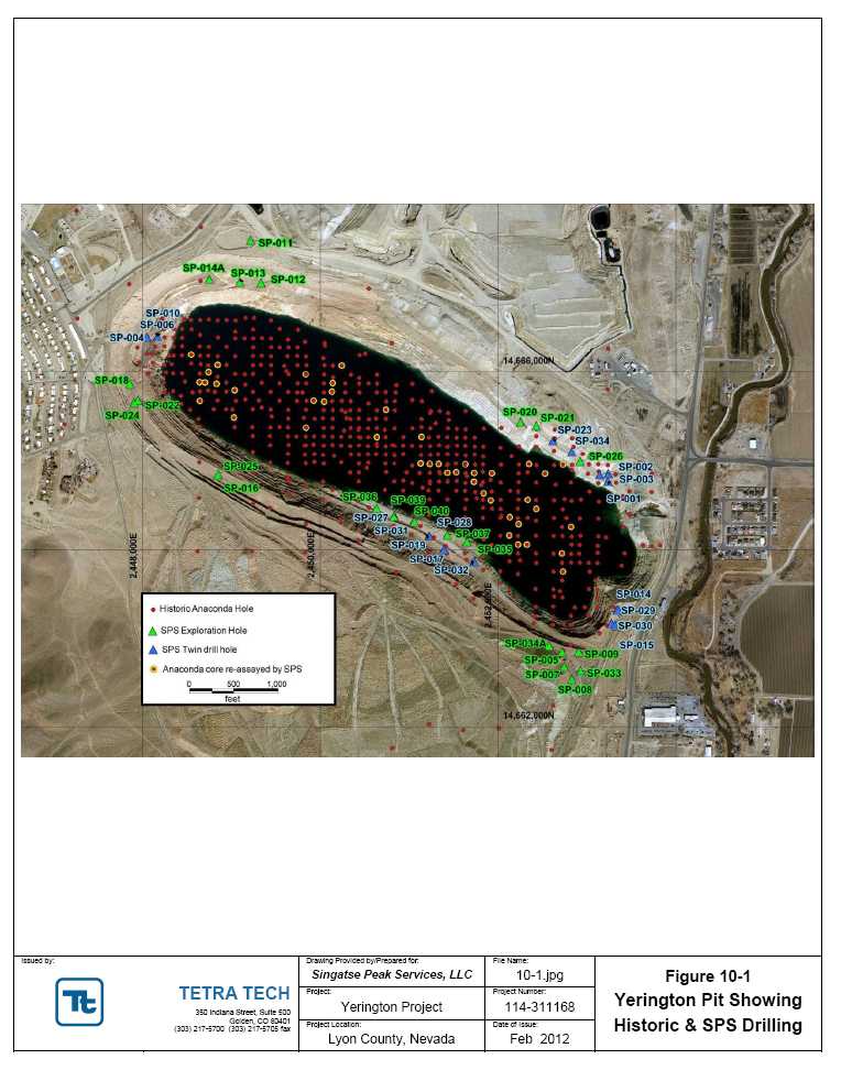
| NI 43-101 Technical Report Mineral Resource | Singatse Peak Services, LLC |
| | Yerington Copper Project |
10.2 Current Drilling
SPS's 2011 drilling program totaled 21,887 feet in 42 holes including 6,871 feet of core in 14 core holes and 15,016 feet of reverse circulation (RC) in 28 RC holes (Figure 10-1). The core holes and four RC holes were drilled to twin Anaconda core holes, while the remaining RC holes were targeted for expansion of mineralization laterally and below historic Anaconda drill intercepts along the perimeter of the Yerington pit.
Hole siting was seriously hampered by pit wall geometry and by the presence of the pit lake, and was confined to selected benches within the Yerington pit in order to maintain safe access around the existing pit lake. One hole, SP-038, collared approximately 5,000 feet northwest of the Yerington pit, is an 830 foot RC precollar hole scheduled for core finish during 2012.
The total area covered by the drilling resembles an elliptical doughnut (the accessible ramps and roads along perimeter within the Yerington pit) measuring approximately 6,000 feet west-northwest by 2,500 feet. Drill hole spacing is irregular due to access and safety limitations within the pit. Two RC holes were drilled outside of pit benches, one along the northwest pit rim, and one approximately 5,000 feet northwest of the pit. Two core holes, twinned by two RC holes, were drilled on the eastern pit rim.
SPS's drill holes, as well as other necessary survey control, have been surveyed by SPS staff using a Trimble XHT unit with horizontal accuracy to within one-half meter and vertical accuracy from one-half to one meter.
Eleven drill holes were downhole surveyed. The downhole survey work, using a surface recording gyro system, was contracted to International Directional Services LLC based in Elko, Nevada.
Table 10-1 provides basic information for 2011 drilling by SPS, and Table 10-2 details the new significant intercepts that were added to the data base. A full listing of intercepts greater than 0.10% Cu from all SPS holes is included in Appendix C.
Table 10-1 2011 Drilling Yerington Copper Project
| Drill Hole | Azimuth | Dip | Total Depth (ft) | Purpose | Type |
| SP-001 | 0 | -90 | 207.5 | Twin | Core |
| SP-002 | 0 | -90 | 259 | Twin | Core |
| SP-003 | 0 | -90 | 405 | Twin | Core |
| SP-004 | 0 | -90 | 803.5 | Twin | Core |
| SP-005 | 0 | -90 | 390 | Expl | RC |
| SP-006 | 0 | -90 | 791 | Twin | Core |
| SP-007 | 0 | -90 | 340 | Expl | RC |
| SP-008 | 0 | -90 | 435 | Expl | RC |
| SP-009 | 0 | -90 | 355 | Expl | RC |
| SP-010 | 90 | -70 | 741 | Twin | Core |
| Tetra Tech | February 2012 | 47 |
| NI 43-101 Technical Report Mineral Resource | Singatse Peak Services, LLC |
| | Yerington Copper Project |
| Drill Hole | Azimuth | Dip | Total Depth (ft) | Purpose | Type |
| SP-011 | 180 | -60 | 500 | Expl | RC |
| SP-012 | 180 | -60 | 1000 | Expl | RC |
| SP-013 | 180 | -70 | 1000 | Expl | RC |
| SP-014 | 0 | -90 | 341.5 | Twin | Core |
| SP-014A | 180 | -90 | 1000 | Expl | RC |
| SP-015 | 0 | -90 | 438 | Twin | Core |
| SP-016 | 180 | -70 | 780 | Expl | RC |
| SP-017 | 0 | -90 | 216.5 | Twin | Core |
| SP-018 | 90 | -70 | 530 | Expl | RC |
| SP-019 | 0 | -90 | 300 | Twin | Core |
| SP-020 | 180 | -80 | 265 | Expl | RC |
| SP-021 | 180 | -60 | 720 | Expl | RC |
| SP-022 | 180 | -60 | 940 | Expl | RC |
| SP-023 | 180 | -60 | 596 | Twin | RC |
| SP-024 | 0 | -90 | 780 | Expl | RC |
| SP-025 | 0 | -90 | 610 | Expl | RC |
| SP-026 | 180 | -60 | 655 | Expl | RC |
| SP-027 | 0 | -90 | 797 | Twin | Core |
| SP-028 | 0 | -90 | 300 | Twin | RC |
| SP-029 | 0 | -90 | 560 | Twin | RC |
| SP-030 | 0 | -90 | 460 | Twin | RC |
| SP-031 | 0 | -90 | 162 | Twin | Core |
| SP-032 | 0 | -90 | 506 | Twin | Core |
| SP-033 | 0 | -90 | 190 | Expl | RC |
| SP-034 | 180 | -60 | 903 | Twin | Core |
| SP-034A | 0 | -90 | 365 | Expl | RC |
| SP-035 | 0 | -60 | 190 | Expl | RC |
| SP-036 | 0 | -60 | 550 | Expl | RC |
| SP-037 | 180 | -60 | 180 | Expl | RC |
| SP-038 | 90 | -60 | 830 | Expl | RC |
| SP-039 | 0 | -60 | 295 | Expl | RC |
| SP-040 | 0 | -55 | 200 | Expl | RC |
| Tetra Tech | February 2012 | 48 |
| NI 43-101 Technical Report Mineral Resource | Singatse Peak Services, LLC |
| | Yerington Copper Project |
Table 10-2 2011 Listing Of Significant Intercepts Yerington Copper Project
| Drillhole ID | From | To | Thickness (ft) | TCu % |
| SP-004 | 228 | 752.5 | 524.5 | 0.35 |
| Including | 265 | 353 | 88 | 0.69 |
| SP-006 | 204 | 408 | 204 | 0.53 |
| | 430.5 | 770 | 339.5 | 0.38 |
| SP-010 | 258 | 369 | 111 | 0.71 |
| | 429 | 634 | 205 | 0.35 |
| SP-023 | 10 | 600 | 590 | 0.21 |
| Including | 425 | 490 | 65 | 0.37 |
| SP-035 | 0 | 190 | 190 | 0.23 |
| Including | 75 | 90 | 15 | 0.73 |
| SP-036 | 230 | 325 | 95 | 0.28 |
| SP-039 | 0 | 45 | 45 | 0.25 |
| | 135 | 215 | 80 | 0.3 |
| SP-040 | 0 | 200 | 200 | 0.24 |
| Including | 170 | 200 | 30 | 0.49 |
| Tetra Tech | February 2012 | 49 |
| NI 43-101 Technical Report Mineral Resource | Singatse Peak Services, LLC |
| | Yerington Copper Project |
11.0SAMPLE PREPARATION, ANALYSES, AND SECURITY
Tetra Tech has reviewed all of the Quaterra sample preparation, handling, analyses, and security procedures. It is Tetra Tech's opinion that the current practices meet NI 43-101 and CIM defined requirements.
It is the opinion of Tetra Tech that during the period from 1952 to 1979 when Anaconda operated the Yerington Mine, the drill samples taken by Anaconda were representative of the deposit and the methodologies commonly used by the industry at that time. This statement applies to samples used for the determination and publication of operating costs and profit by The Anaconda Company, a US publicly traded company, as well as for mine head grades, lithology, densities, and metallurgical performance.
While no details are available regarding Anaconda's exact assaying protocol and quality control during the period the Yerington copper mine was operating, public records of profit and cost confirmed that the techniques and procedures implemented conformed to industry standards for that era.
11.1 Current Drilling Methods and Details
SPS explored the Yerington Mine Copper property with both RC and diamond core drilling methods. Paramount concern for safety restricted SPS drill sites to selected ramps and access along sides of the Yerington pit.
Core drilling was contracted to Ruen Drilling, Inc., Clark Fork, Idaho, who operated a track-mounted rig. Two RC drill contractors were engaged: George DeLong Construction, Inc., Winnemucca, Nevada, operating a truck-mounted rig, and Diversified Drilling LLC, Missoula, Montana, operating a track-mounted rig. Ruen operated round-the-clock, while the RC crews ran one 12-hour shift. Down-hole surveys were completed on nine drill holes.
Drill footage during 2011 amounted to 21,887 feet in 42 holes including 6,871 feet of core in 14 holes and 15,016 feet of RC drilling in 28 holes. Approximately 4,300 samples were collected and shipped for sample analyses. Samples were analyzed for total copper (TCu), gold, and a 47 element trace element package. Samples representing oxide mineralization and acid soluble sulfide copper were also analyzed for acid soluble copper and for ferric sulfate soluble copper. Rock quality designations (RQD) and magnetic susceptibility measurements were taken on all core which was photographed following geologic logging. Selected core was used to provide 23 bulk density measurements.
11.2 Reverse Circulation Drilling Sampling Method
All RC drilling is conducted with water added to eliminate dust. Diversified Drilling LLC uses a percussion hammer with interchange sampling system. Samples are collected in a conventional manner via a cyclone and standard wet splitter. Samples are collected in 17-in by 26-in cloth bags placed in five-gallon buckets to avoid spillage of material. Sample bags are pre-marked by SPS personnel at five-foot intervals and also include a numbered tag inserted into a plastic bag
| Tetra Tech | February 2012 | 50 |
| NI 43-101 Technical Report Mineral Resource | Singatse Peak Services, LLC |
| | Yerington Copper Project |
bearing the hole number and footage interval. Collected samples, weighing approximately 15 to 20 pounds each, are wire tied and then loaded onto a ten-foot trailer with wood bed allowing initial draining and drying. Each day SPS personnel or the drillers at the end of their shift, haul the sample trailer from the drill site to SPS's secure sample preparation warehouse in Yerington, Nevada. Samples for geologic logging are collected at the drill site in a mesh strainer, washed, and placed in standard plastic chip trays collected daily by SPS personnel.
11.3 Core Drilling Sampling Method
Core diameter was HQ (approximately 2.75 -inch diameter). Following convention, the drill crew at the drill site placed core samples in wax-impregnated, ten-foot capacity cardboard boxes. Sample boxes were delivered to SPS's secure sample warehouse in Yerington, Nevada by the drill crew following each 12-hour shift.
11.4 Sample Quality
It is Tetra Tech's opinion that SPS's samples of the Yerington Mine Copper Project are of high quality and are representative of the property. This statement applies to samples used for the determination of grades, lithologies, and densities.
11.5 RC Sample Preparation and Security
RC sample bags, having been transported on a ten-foot trailer by drill crews or by SPS personnel from the drill site to the secure sample warehouse, are unloaded onto suspended wire mesh frames for further drying. Diesel-charged space heaters assist in drying during winter months. Once dry, four to five samples are combined in a 24- by 36-inch woven polypropylene transport (“rice”) bag, wire tied, and carefully loaded on plastic lined pallets. Each pallet, holding approximately 13 to 15 rice bags, is shrink-wrapped and further secured with wire bands. Each pallet is weighed. Pallets are picked up and trucked by Skyline Assayers & Laboratories (Skyline) personnel who operate a sample preparation facility in Battle Mountain, Nevada. A chain of custody form accompanies all shipments from Yerington to Battle Mountain. Once Skyline preps each sample in its Battle Mountain facility, approximately 50 gram sample pulps are air-freighted to Skyline's analytical laboratory in Tucson, Arizona for analyses and assay.
11.6 Core Sample Preparation and Security
Drill core, having been transported at end of each shift by the drill crew to SPS's secure sample warehouse, is logged by a SPS geologist who marks appropriate sample intervals (one to nominal five feet) with colored flagging tape. Lines are marked along the length of core with red wax crayons to indicate where the core piece should be sawed. Each core box, bearing a label tag showing drill hole number, box number, and box footage interval, is then photographed. Rock quality designations (RQD), magnetic susceptibility, and recovery measurements are taken. Core is then loaded on a pallet, shrink wrapped, and secured with wire bands for trucking by Skyline personnel to Skyline's sample preparation facility in Battle Mountain, Nevada. The core is sawed in half by Skyline personnel, one half designated for sample preparation/assay,
| Tetra Tech | February 2012 | 51 |
| NI 43-101 Technical Report Mineral Resource | Singatse Peak Services, LLC |
| | Yerington Copper Project |
the second half placed in its core box for return to SPS. Chain of custody procedures for core shipments picked up by Skyline at the SPS core shed follow the format for RC samples.
11.7 Sample Analysis
All drilling samples from the Yerington Copper Project were analyzed by Skyline in Tucson, Arizona, which is accredited by the American Association for Laboratory Accreditation (A2LA - certificate no. 2953.01) and by ISO17025-compliant ALS Minerals Laboratories in Sparks, Nevada. Sample preparation (crush-split-pulverize) was completed at Skyline's Battle Mountain,
Nevada, facility to prepare an approximate 50 gram pulp for shipment to Skyline's Tucson facility.
SPS implements a quality assurance and quality control assay protocol whereby either one blank or one standard is inserted with every ten samples into the assay stream.
The Skyline assay procedures are as follows:
For Total Copper: A 0.2000 to 0.2300 gram (g) sample is weighed into a 200-milliliter (ml) flask in batches of 20 samples plus two checks (duplicates) and two standards per rack. A three-acid mix, 14.5 ml in total, is added and heated to about 250°C for digestion. The sample is made to volume and read on an ICP/AAS using standards and blanks for calibration.
For Acid Soluble Copper: A 1.00 to 1.05 g sample is weighed into a 200 ml flask in batches of 20 samples plus two checks (duplicates) and two standards per rack. Sulfuric acid (2.174 l) in water and sodium sulfite in water are mixed and added to the flask and allowed to leach for an hour. The sample is made to volume and read on an ICP/AAS using standards and blanks for calibration.
For Ferric Soluble Copper (QLT): This uses an assay pulp sample contacted with a strong sulfuric acid-ferric sulfate solution. The sample is shaken with the solution for 30 minutes at 75ºC, and then filtered. The filtrate is cooled, made up to a standard volume, and the copper determined by AA with appropriate standards and blanks for calibration.
For Gold: Fire assay fusion with atomic absorption finish to determine elemental concentration. Lower detection limit of five parts per billion (ppb).
For Four Acid Digestion Trace Element Geochemistry: Ultratrace analyses by ICP/MS four acid digestion.
11.8 Quality Control
As part of the SPS quality control program, 220 standards and 222 blanks were submitted (Table 11-1) along with 5,557 individual drill hole samples to Skyline Laboratories. Additionally, 68 check assays plus seven quality control samples were submitted to ALS Mineral Labs, Reno, and 137 samples plus seven quality control samples were submitted for reassay to Skyline. No quality control failures were found during the reassaying.
| Tetra Tech | February 2012 | 52 |
| NI 43-101 Technical Report Mineral Resource | Singatse Peak Services, LLC |
| | Yerington Copper Project |
Lot failure criteria were established as any standard assaying beyond two standard deviations of the expected value, or any blank assay greater than 0.015 percent TCu.
Table 11-1 SPS 2011 QA/QC Program Results
| | Skyline Labs | ALS Mineral Labs |
| Total Drill Hole Samples | 5694 | 68 |
| Submitted Standards | 220 | 3 |
| Failed Standards | 8 | 0 |
| % Standards Failure | 3.6% | 0 |
| Submitted Blanks | 222 | 4 |
| Failed Blanks | 4 | 0 |
| % Blank Failure | 1.8% | 0 |
Check assays from ALS Mineral Labs compared well with Skyline assays, providing additional confidence in the assay database, as shown in Figure 11.1.
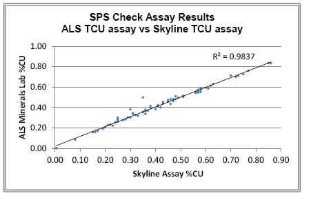
Figure 11-1 SPS Check Assay Results
11.9 Review of Adequacy of Sample Preparation, Analyses, and Security
Tetra Tech's designated Qualified Person visited the site per NI 43-101 requirements in September, 2011. Both historic and SPS generated core were available for inspection and independent verification, and therefore, the NI 43-101 requirements for QA/QC with regard to the drill hole data in Tetra Tech's opinion can be met.
| Tetra Tech | February 2012 | 53 |
| NI 43-101 Technical Report Mineral Resource | Singatse Peak Services, LLC |
| | Yerington Copper Project |
During Dr. Bryan's visit, George Eliopulos (Yerington Project Manager and Chief Geologist), Judy Pratt, and other Singatse staff discussed with Dr. Bryan the history of the project (Figure 11-2) and observed ongoing drilling (Figure 11-3).
 |
| Figure 11-2Discussing the History of the Project |
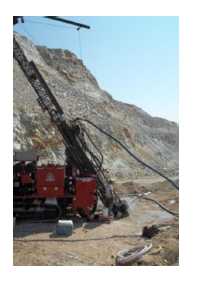 |
| Figure 11-3Ongoing Drilling Observed During Site Visit |
| Tetra Tech | February 2012 | 54 |
| NI 43-101 Technical Report Mineral Resource | Singatse Peak Services, LLC |
| | Yerington Copper Project |
Also observed were geologic logging and data entry of drill data following an established protocol (Figure 11-4), and procedures for manually creating geologic sections from the drill data (Figure 11-5)
 |
| Figure 11-4Reviewing Established Protocol for Data Entry |
| Tetra Tech | February 2012 | 55 |
| NI 43-101 Technical Report Mineral Resource | Singatse Peak Services, LLC |
| | Yerington Copper Project |
 |
| Figure 11-5Manually Creating Geologic Sections From the Drill Data |
Finally, the use of double bagging (Figure 11-6), chain of custody procedures, standards storage, and sample security were reviewed.
| Tetra Tech | February 2012 | 56 |
| NI 43-101 Technical Report Mineral Resource | Singatse Peak Services, LLC |
| | Yerington Copper Project |
 |
| Figure 11-6Double Bagging of Samples Prior to Shipment |
| Tetra Tech | February 2012 | 57 |
| NI 43-101 Technical Report Mineral Resource | Singatse Peak Services, LLC |
| | Yerington Copper Project |
12.0DATA VERIFICATION
12.1 Data Verification Procedures
SPS carried out detailed data capturing and verification processes in 2011 from Anaconda archives available through the Anaconda Collection – American Heritage Center, University of Wyoming at Laramie. In order to verify and validate this data, three programs were completed:
Cross sections with composites of captured data were generated to compare against Anaconda archived cross sections with posted composites
Eighteen twin holes were drilled to confirm historic data
Utilizing Anaconda core remaining on site, selected intervals from 45 holes were sent for assay to compare against historic results
12.2 Results of Verification Programs
12.2.1 Cross Section Verification
Some type of data for almost 800 drill holes was initially captured from over 10,000 pages of scanned records from the Anaconda archives. Values were recorded for assay intervals, core recovery (where applicable), total copper grade (TCU), oxidized copper grade (ASCU), and, when present, grades for sludge collected during core drilling. These sludge grades were used by Anaconda in conjunction with core assays through zones of poor core recovery as a way to compensate for lost material. Although attempts were made to recreate their methodology, the lack of details and supplemental data ultimately restricted our use of the information to the original assays.
In addition to the assay information, cross sections showing bench composites were available from the Anaconda archives. By bench compositing the captured data and comparing to the bench composite values posted on the cross sections, Tetra Tech was able to identify and isolate bench differences and determine the cause. When incorporation of the sludge factors by Anaconda in its bench composites was identified as the cause but the data capture from the scanned sheets was correct, the data were deemed acceptable.
Drill holes not retained in the data set were those which contained only summary data of the assays, often reporting intervals several times larger than bench height. Only those holes which reported grades for the normal sampling intervals (generally 5 feet) were kept.
Additionally, only holes with surveyed collar locations were used.
Data from 558 historic holes was ultimately used for the current NI-43-101 resource estimation.
12.2.2 Drill Hole Twinning
Fourteen core and two RC holes were drilled in an effort to twin Anaconda holes to confirm mineralization, and two RC holes were drilled to twin two of the SPS core holes.
| Tetra Tech | February 2012 | 58 |
| NI 43-101 Technical Report Mineral Resource | Singatse Peak Services, LLC |
| | Yerington Copper Project |
Figure 12-1 shows a portion of the “twin” drilling study performed to determine if the historical data from Anaconda can be used in a 43-101 resource estimation. The newer SPS data have the appropriate chain-of-custody along with modern analytical assay. Of interest is the comparison of the new data to the historical data. The original Anaconda data were documented in hard copy sections that were rekeyed into a computer data base. The position of SPS drill
Figure 12-1 Section Showing Twin Dataholes was compared to Anaconda data by both visual inspection of plotted sections and by the application of a strategy of using jackknife estimates of proximal data. The latter method
| Tetra Tech | February 2012 | 59 |
| NI 43-101 Technical Report Mineral Resource | Singatse Peak Services, LLC |
| | Yerington Copper Project |
produced 48 pairs of Anaconda and SPS data that were, on the average, 12 feet apart. Figure 12-2 shows the side-by-side histograms of the 48 pairs. Visually, the Anaconda drilling data are slightly higher in grade than the SPS twins. No statistical difference can be shown. More formally stated, a T-test of the twins shows that the null hypothesis of the two populations being the same cannot be rejected at a 95% confidence level (alpha of 0.05) .

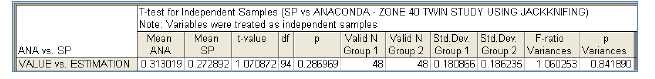
Figure 12-2 Histogram and T-Test Comparison of Anaconda and SPS Drilling
Figure 12-3 shows that the 48 twin samples have a correlation of 84%, with a regression equation showing an equivalent grade at 0.5% copper.
| Tetra Tech | February 2012 | 60 |
| NI 43-101 Technical Report Mineral Resource | Singatse Peak Services, LLC |
| | Yerington Copper Project |
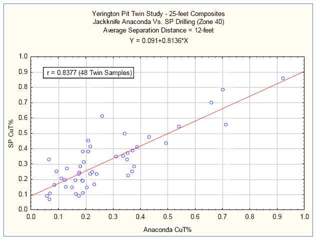
Figure 12-3 Scatterplot Showing Anaconda and SPS Twin Data
12.2.3 Re-assay of Anaconda Core
In addition to the twin study, selected intervals from archived Anaconda core were re-assayed following chain-of-custody procedures and utilizing modern analytical techniques.
Core intervals from 45 holes, well distributed across the pit, were relogged and photographed prior to being sent to Skyline Labs for re-assaying, and represented 5,446 feet of drilling. A total of 1,396 TCu assays were completed by Skyline.
In comparing the Skyline and Anaconda Assay data, Figure 12-4 shows a good correlation between the historic assays and reassayed intervals. The coefficient of determination, R2, with a value of 0.742, shows that the two data sets are well correlated, further validating the historic data.
| Tetra Tech | February 2012 | 61 |
| NI 43-101 Technical Report Mineral Resource | Singatse Peak Services, LLC |
| | Yerington Copper Project |
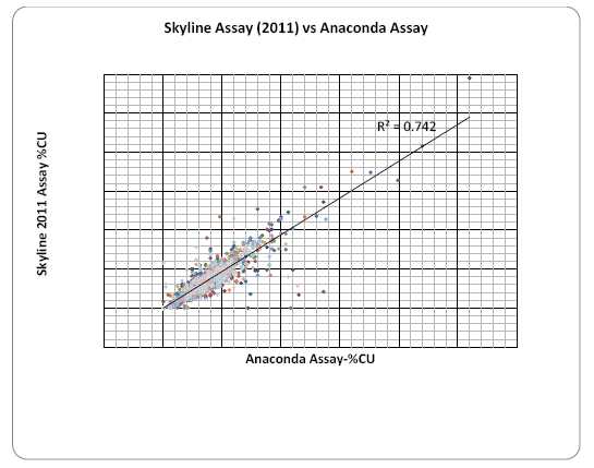
Figure 12-4 Skyline Assay (2011) vs Anaconda Assay
12.3 Current Data Check
Tetra Tech has made several data checks and verifications of Singatse work that has been performed for the Yerington Project. These checks include validation of assays from Skyline and comparing geologic field logs with drill hole data. No discrepancies have been found.
12.4 Adequacy of Data
It is Tetra Tech's opinion that the data collection of both historic and modern data by SPS is adequate for the use of a 43-101 resource for the following reasons:
| Tetra Tech | February 2012 | 62 |
| NI 43-101 Technical Report Mineral Resource | Singatse Peak Services, LLC |
| | Yerington Copper Project |
13.0MINERAL PROCESSING AND METALLURGICAL TESTING
The production history of the Yerington Mine, leaching of over 100 million tons of oxide copper ore and approximately 58 million tons of sulfide ore, demonstrates the amenability for successful copper recovery accomplished by Anaconda, averaging in the 70% range for oxide ore and in the high 90% for sulfide ore (Nesbitt, M., 1971). Oxide ores were treated with a 96 hour leach time in eight 13,000 ton cement vats. These large cement vats remain standing in the process area of the property. The concentrate from sulfide ore was rail shipped to the Anaconda smelter in Anaconda, Montana. The concentrator and ancillary tanks and equipment were dismantled and removed from the property following Anaconda's property closure.
As the project advances, detailed investigations into the historical metallurgy will be undertaken and new studies will be conducted.
| Tetra Tech | February 2012 | 63 |
| NI 43-101 Technical Report Mineral Resource | Singatse Peak Services, LLC |
| | Yerington Copper Project |
14.0MINERAL RESOURCE ESTIMATES
14.1 Introduction
This study has been completed in order to establish NI 43-101 compliant resources at the Yerington Mine. It has been completed using validated historic drill hole data generated by Anaconda and current drilling results generated by SPS in 2011.
The mineral resource estimate has been generated from assay analyses and the interpretation of a geologic model which relates to the spatial distribution of copper in the Yerington deposit. Appendix B contains a table of the drill holes contained in the Yerington project data base. Interpolation characteristics have been defined based on the geology, drill hole spacing, and geostatistical analysis of the data. The mineral resources have been classified by their proximity to the sample locations and are reported, as required by NI 43-101 and CIM standards on mineral resources and reserves.
14.2 Resource Estimation
This section describes the methodology used in developing the mineral resource estimate for contained copper resources in the Yerington Mine deposit.
The mineral resource estimate was prepared in the following manner:
The drill hole data base of 685 holes containing historical and recent drilling was provided by SPS. From this, 85 holes were removed yielding a final drill hole data base of 600 holes that were used for the resource estimation.
The resource area was considered as a single deposit, with no sub-regions requiring local interpolation adjustments.
MicroModel® and DataMine® mining software were used for this analysis.
Based upon geologic notations by the Anaconda geologists and input from SPS geologists, a surface defining the boundary between oxide (Zone Code 30) and sulfide (Zone Code 40) mineralization was established to allow independent grade interpolations.
A surface was generated at the base of the Quaternary alluvium, and was used as a pseudo-topography as the upper limit to the model. Blocks above this surface were given a Zone code of 0.
The assay intervals were composited to a 25-foot bench height taking into account sample recovery. Statistics for the composites were analyzed for each of the rock codes. As with the five-foot interval data, analyses were done separately on the Anaconda and SPS data.
An analysis of twinned drill hole data was done as part of the data verification. It confirmed that the Anaconda drill hole data were statistically comparable to the SPS drill hole data. An additional study that re-assayed Anaconda core using modern analytical methods produced comparable results with the historical Anaconda assays. The positive outcome of these two studies has allowed Tetra Tech to conclude that the Anaconda data are of sufficient quality to be used for an NI 43-101 resource estimation.
| Tetra Tech | February 2012 | 64 |
| NI 43-101 Technical Report Mineral Resource | Singatse Peak Services, LLC |
| | Yerington Copper Project |
Geostatistical analysis was done on the 25-foot, recovery weighted composite data. Unitized general relative variograms (UGR variograms) were generated. The directional variograms were modeled with the spherical function using a nugget and up to three nested structures.
The quality of the variogram models was checked using a model-validation technique called “jackknifing”. The method helps determine the best variogram parameters to be used for the theoretical model, and the best kriging parameters (range, direction, and search) to use.
The resource model used multiple pass ordinary kriging (OK) to estimate percent total copper (%TCu) within each of the oxide and sulfide mineral zones. The kriged grades were checked by comparing block, composite, and assay histograms.
The block model values were visually inspected in multiple sections and plan maps. These values were compared to the drill hole traces containing both interval assay data and composite data.
A resource classification of measured, indicated, and inferred was developed using three ordinary kriging passes with differing search parameters. These parameters were chosen using jackknifing. The resource classification is based on an adjustment using kriging error.
The Yerington total copper resource was tabulated for volume, tonnage, and contained metal for the measured, indicated, and inferred classes, excluding material within the current pit.
Figure 14-1 shows the general location of drill holes. The black dots represent the Anaconda data and the red the new SPS data. Note that the SPS data are from holes drilled at the periphery of the large Yerington pit.
| Tetra Tech | February 2012 | 65 |
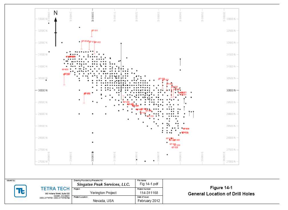
| NI 43-101 Technical Report Mineral Resource | Singatse Peak Services, LLC |
| | Yerington Copper Project |
14.3 Yerington Block Model
Block model parameters for Yerington were defined to best reflect both the drill spacing and current geologic interpretations. Table 14-1 shows the Yerington block model parameters.
Table 14-1 Yerington Model Parameters
| Yerington Model Parameters | X (Columns) | Y (Rows) | Z (Levels) |
| Origin (lower left corner): | 2,446,400 | 14,661,000 | 2,900 |
| Block size (feet) | 25 | 25 | 25 |
| Number of Blocks | 360 | 320 | 100 |
| Rotation | 0 degrees azimuth from North to left boundary |
| Composite Length | 25 feet (Bench) |
The Excel data base provided by SPS contains the pertinent drill hole and assay information for 600 drill holes on the Yerington Deposit. Of the holes used, 558 are historic Anaconda holes and 42 are recent SPS holes. Anaconda totals represent 255,744 feet of drilling in 542 core holes totaling 231,756 feet and 8,968 feet of drilling in 16 rotary holes. SPS drilling represent 21,887 feet of drilling in 14 core holes totaling 6,871 feet and 28 rotary holes totaling 15,016 feet.
Although historic data include material which has since been mined, inclusion of that data was critical in establishing statistical parameters for grade interpolation into unmined blocks.
The variables in the data base are total copper (TCU) and acid-soluble copper (ASCU) from both Anaconda and SPS holes, and ferric sulfate copper (QLT) assays when available from SPS. Core recovery for core holes and lithology as recorded from Anaconda archives or by SPS geologists were also included in the data base (Table 14-2). When lithology was not available, the intervals were recorded as "UNK." Full descriptions of the lithologies listed are available in Section 7.3, Property Geology. An examination of the relationship of grade to the various lithologies shows low variability in the average grade of all samples and even less variability for those greater than 0.1% Cu, indicating that the bulk of the mineralization is generally independent of lithology (Figure 14-2).
Further, the issue of metallurgical recovery is more a function of the mineralogical species of copper. With this is mind, the SPS geologists, incorporating their data and data from the Anaconda archives, interpreted two mineral zones, representing oxide and sulfide mineralization for grade interpolation.
| Tetra Tech | February 2012 | 67 |
| NI 43-101 Technical Report Mineral Resource | Singatse Peak Services, LLC |
| | Yerington Copper Project |
Table 14-2 Lithology Codes
| Lithology Code (RX) | Description |
| NS | No sample |
| AND | andesite |
| APL | aplite |
| BQM | border quartz monzonite |
| BX | breccia |
| GD | granodiorite |
| PBX | pebble breccia |
| QAL | alluvium |
| QM | quartz monzonite |
| QME | equigranular quartz monzonite |
| QMP1 | quartz monzonite porphyry dike 1 |
| QMP1.5 | quartz monzonite porphyry dike 1.5 |
| QMP2 | quartz monzonite porphyry dike 2 |
| QMP2.5 | quartz monzonite porphyry dike 2.5 |
| QMP3 | quartz monzonite porphyry dike 3 |
| QMPa | unidentified code found hist records |
| QMPc | fine grained qtz monzonite por dike |
| QMPu | undifferentiated qtz monzonite por dike |
| QTZ | quartz |
| RHY | rhyolitic porphyry |
| TU | Tertiary undefined |
| TV | Tertiary volcanics |
| UNK | unknown |
| Tetra Tech | February 2012 | 68 |
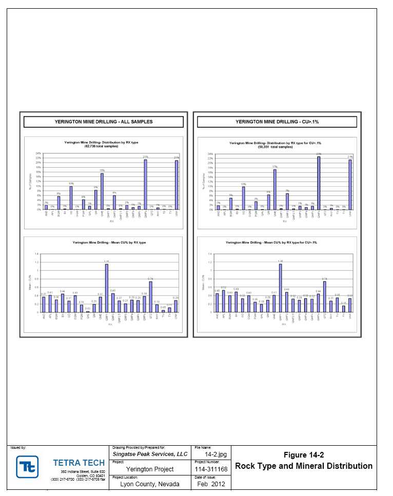
| NI 43-101 Technical Report Mineral Resource | Singatse Peak Services, LLC |
| | Yerington Copper Project |
| 14.4 Bulk Density Measurements (Specific Gravity) |
| | |
Table 14-3 shows the results of 23 density tests which were completed in November, 2011 by Kappes, Cassiday & Associates in Reno, Nevada on samples from the current SPS drilling, resulting in an average bulk density tonnage factor of 12.62 cubic feet per ton for oxide material and 12.61 for sulfide. A final value 12.6 cubic feet per ton was used for the resource model and compares to 12.5 historically used by Anaconda. |
| |
| Table 14-3Yerington Mine Specific Gravity Tests |

Table 14-4 shows the statistics regarding the maximum and minimum for location coordinates, depth, and dip for drill holes at Yerington. Table 14-5 shows the statistics for the interval assay and composite data for the Anaconda and SPS drill holes. Figure 14-3 is a section showing the surfaces for historical topo (pseudo-topo at base of Qal), current topography, and the oxide/sulfide boundary surface. These surfaces have been used to code the assay and composite data in zones. The surfaces also have been used to give a zone code to each block. Table 14-6 gives a count of the zone codes for samples, composites, and blocks. The blocks
| Tetra Tech | February 2012 | 70 |
| NI 43-101 Technical Report Mineral Resource | Singatse Peak Services, LLC |
| | Yerington Copper Project |
have a dimension of 25 × 25 × 25 feet which equates to an individual block measuring 15,625 cubic feet and having 1,240 tons.
| Tetra Tech | February 2012 | 71 |
| NI 43-101 Technical Report Mineral Resource | Singatse Peak Services, LLC |
| | Yerington Copper Project |
Table 14-4 Drill Hole Geometry Statistics
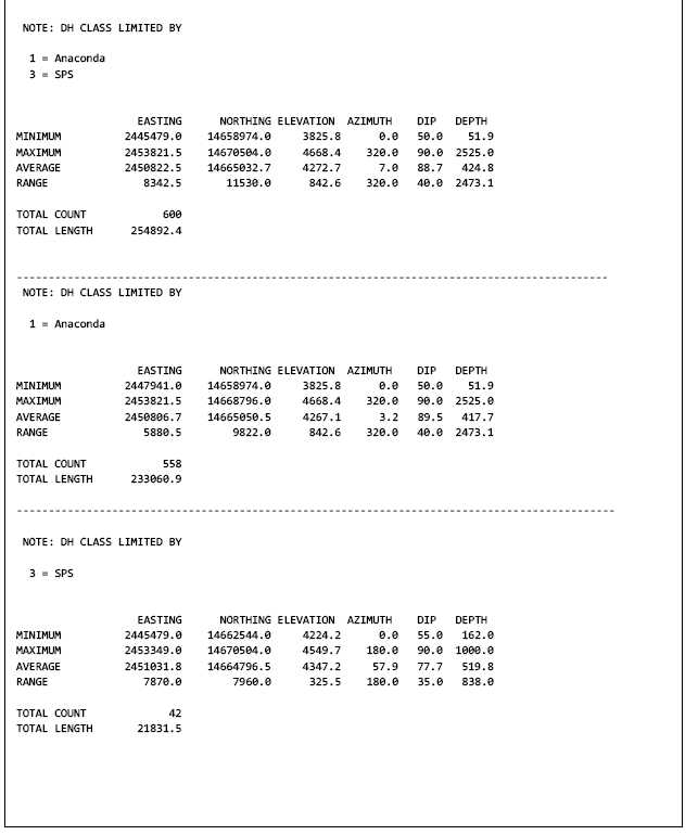
| Tetra Tech | February 2012 | 72 |
| NI 43-101 Technical Report Mineral Resource | Singatse Peak Services, LLC |
| | Yerington Copper Project |
Table 14-5 Drill Hole Sample Interval Statistics

| Tetra Tech | February 2012 | 73 |
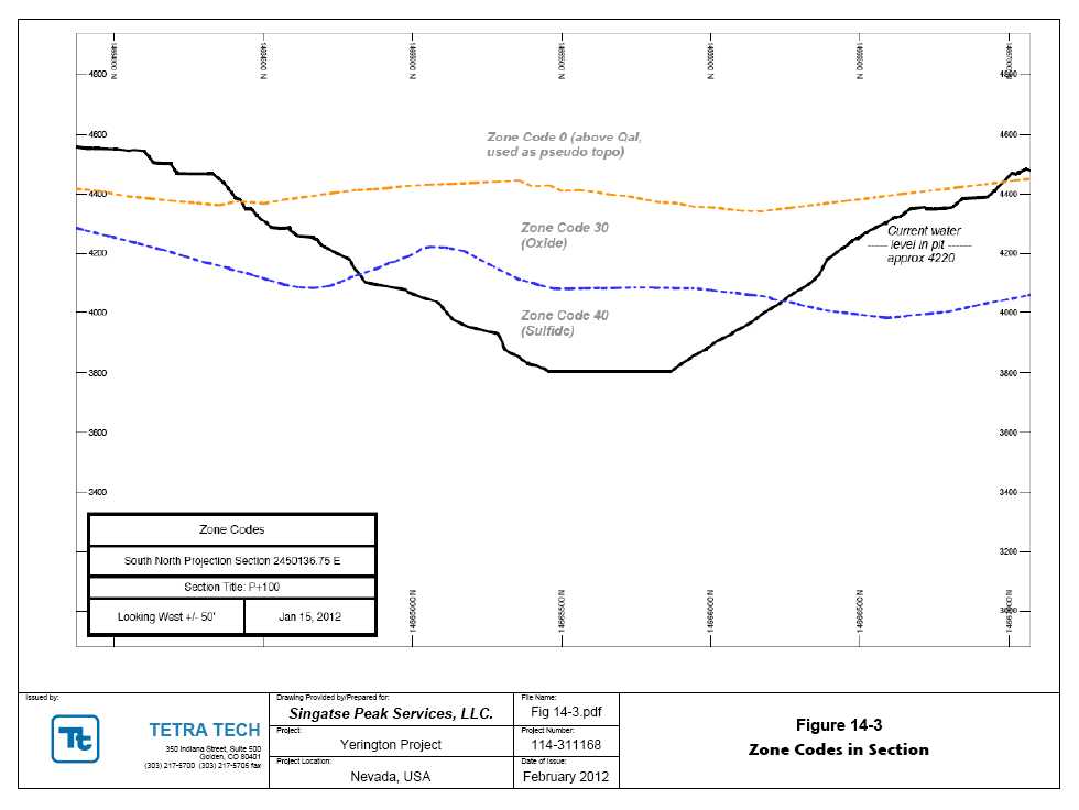
| NI 43-101 Technical Report Mineral Resource | Singatse Peak Services, LLC |
| | Yerington Copper Project |
Table 14-6 Zone (Rock) Code Counts for Assays, Composites, Blocks
| ZONE CODE COUNT FOR SAMPLES | |
| CODE | | COUNT | | | MINCOL | | | MAXCOL | | | MINROW | | | MAXROW | | | MINLEV | | | MAXLEV | |
| 0 | | 597 | | | 59 | | | 284 | | | 30 | | | 224 | | | 53 | | | 67 | |
| 30 | | 22903 | | | 59 | | | 297 | | | 31 | | | 312 | | | 1 | | | 65 | |
| 40 | | 37021 | | | 59 | | | 297 | | | 30 | | | 260 | | | 1 | | | 59 | |
| 9999 | | 1683 | | | 1 | | | 294 | | | 1 | | | 320 | | | 1 | | | 66 | |
| TOTAL | | 62204 | | | | | | | | | | | | | | | | | | | |
| | | | | | | | | | | | | | | | | | | | | | |
| | | | | | | | | | | | | | | | | | | | | | |
| ZONE CODE COUNT FOR COMPOSITES (25-foot) | |
| CODE | | COUNT | | | MINCOL | | | MAXCOL | | | MINROW | | | MAXROW | | | MINLEV | | | MAXLEV | |
| 0 | | 838 | | | 59 | | | 294 | | | 30 | | | 260 | | | 48 | | | 71 | |
| 30 | | 3748 | | | 59 | | | 297 | | | 30 | | | 312 | | | 1 | | | 66 | |
| 40 | | 5866 | | | 59 | | | 297 | | | 30 | | | 260 | | | 1 | | | 59 | |
| 9999 | | 252 | | | 1 | | | 294 | | | 1 | | | 320 | | | 1 | | | 66 | |
| TOTAL | | 10704 | | | | | | | | | | | | | | | | | | | |
| | | | | | | | | | | | | | | | | | | | | | |
| ZONE CODE COUNT FOR BLOCK MODEL (R200) | |
| CODE | | COUNT | | | MINCOL | | | MAXCOL | | | MINROW | | | MAXROW | | | MINLEV | | | MAXLEV | |
| 0 | | 4418717 | | | 1 | | | 360 | | | 1 | | | 320 | | | 48 | | | 100 | |
| 30 | | 3338286 | | | 1 | | | 360 | | | 1 | | | 320 | | | 1 | | | 73 | |
| 40 | | 3480949 | | | 22 | | | 322 | | | 20 | | | 300 | | | 1 | | | 66 | |
| 9999 | | 282048 | | | 1 | | | 360 | | | 1 | | | 320 | | | 1 | | | 74 | |
| TOTAL | | 11520000 | | | | | | | | | | | | | | | | | | | |
Table 14-7 has the copper grade statistics for the original sample data broken out by zone. Zone code is called “ROCK TYPE” in the table. Note that there are data shown in Zones 0, 30, and 40. The small number and low grade copper data's position (155 assays and 3 composites) is categorized as Zone “0” and was not used in grade interpolations, as it was from above the pseudo-topography surface created at the base of the Qal. The table lists both central tendency (mean) and count (median) statistics. A histogram of the logarithm transformed copper grade is shown as part of the statistical table. Table 14-8 shows the same type of statistics for composites. Note that the histogram becomes strikingly log-normal when composited.
Figure 14-4 shows the log-probability plot of the composite data. The log probability shows a linear trend for the final highest grades, without any observable “break”. This supports the contention that the highest grade composites are most likely part of a single log-normal population. It is felt that, because of this, no capping is needed for higher grade copper composite values. Hence, composite values are used without further modification for the resource estimation. Figure 14-5 is a sectional view of the composites.
| Tetra Tech | February 2012 | 75 |
| NI 43-101 Technical Report Mineral Resource | Singatse Peak Services, LLC |
| | Yerington Copper Project |
Table 14-7 Sample Statistics Within Zones
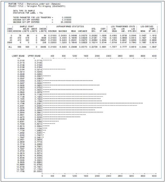
| Tetra Tech | February 2012 | 76 |
| NI 43-101 Technical Report Mineral Resource | Singatse Peak Services, LLC |
| | Yerington Copper Project |
Table 14-8 Composite Statistics within Zone
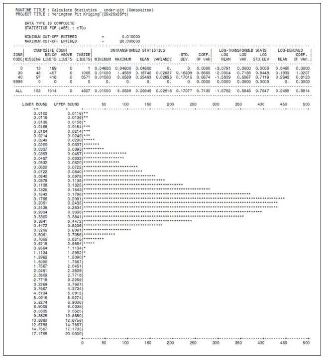
| Tetra Tech | February 2012 | 77 |
| NI 43-101 Technical Report Mineral Resource | Singatse Peak Services, LLC |
| | Yerington Copper Project |
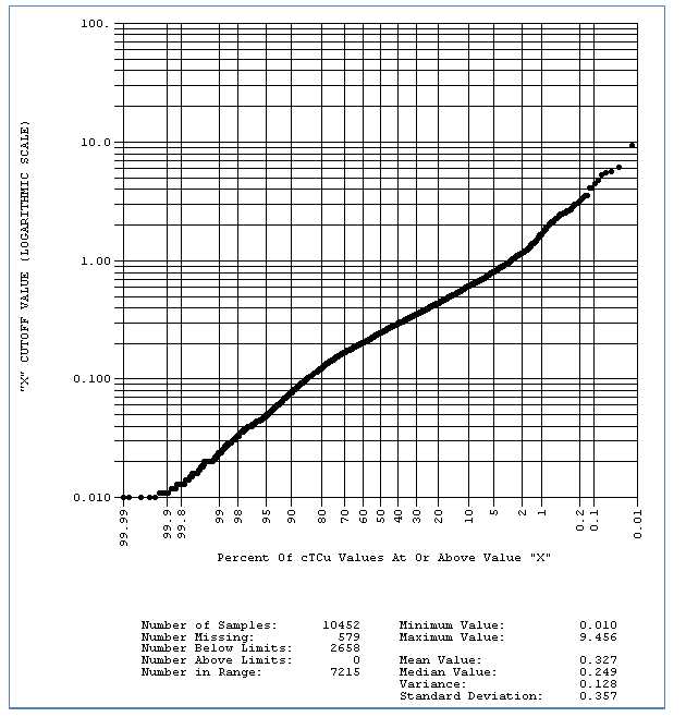
Figure 14-4 Log-Probability Plots of Composites Data
| Tetra Tech | February 2012 | 78 |
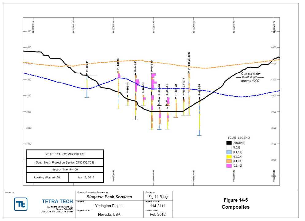
| NI 43-101 Technical Report Mineral Resource | Singatse Peak Services, LLC |
| | Yerington Copper Project |
14.5 Grade Estimation and Resource Classification
Figure 14-6 shows one of numerous experimental variograms analyzed in this study. This figure shows the horizontal omni variogram for total copper composites. The variogram's x-axis is the “lag” or average separation distance of samples for each relative variance plotted on the y-axis. The final relative variance is unitized so that the ultimate value is 1.0. At the other extreme, a nugget of 0.20 is shown at the zero lag. The plotted curve shows a set of nested spherical models which have ranges of 0.75, 300, and 600, respectively.
Analysis of the directional variograms showed an anisotropy of 400:200:60, with the azimuth of the longest range being 300 degrees, the intermediate range 200 feet, and a vertical range of 60 feet.
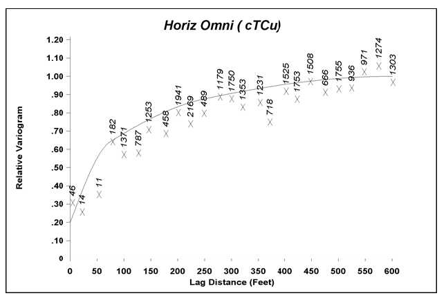
Figure 14-6 Horizontal Omni Variogram of Total Copper (Zone 40)
Table 14-9 shows the variogram model parameters along with the parameters for the search ranges used in a geostatistical estimation using ordinary kriging. Composite data from Zone 40 was used to estimate Zone 40 blocks, and composite data from Zone 30 was used to estimate blocks with Zone 30. Three passes with increasing search ranges were used in the block model estimation to help establish blocks to be classified as measured, indicated, and inferred. For example, the table shows that an indicated block used an ellipsoidal search pattern with a maximum search radius of 260 feet. In addition, a minimum of five samples were required to
| Tetra Tech | February 2012 | 80 |
| NI 43-101 Technical Report Mineral Resource | Singatse Peak Services, LLC |
| | Yerington Copper Project |
estimate a block. These samples were selected by a sector search allowing for a maximum of two samples per sector and two samples from each drill hole. All parameters being the same, the measured class has a maximum search radius of 200 feet. The inferred class has a maximum search radius of 600 feet. |
| |
| Table 14-9Variogram and Search Parameters |
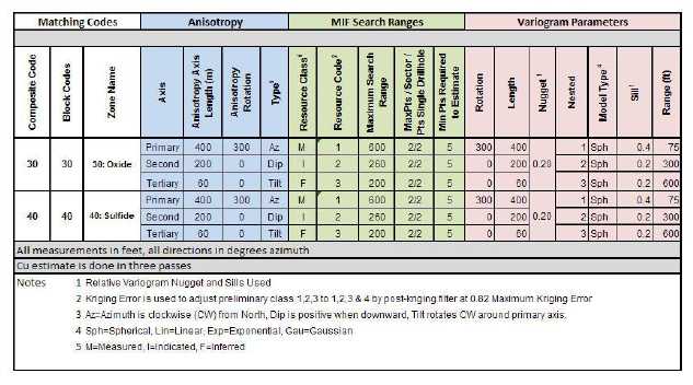
Figure 14-7 shows the estimated block values for total copper in section, and Table 14-10 shows the grade statistics for the block estimates. Figure 14-8 shows the log-probability plot of the kriging error with an interpreter change in slope at a value of 0.82. Note that kriging is designed to produce a robust estimate of grade. It also produces a measure of the quality of that estimate. Kriging errors above 0.82 are considered to indicate an estimation of poor quality. Hence, blocks classified by the three-pass method are reduced in classification quality when the kriging error exceeds 0.82. For example, blocks initially classified as indicated with a kriging error above 0.82 will be classified as inferred. Inferred blocks with such a kriging error will be removed from the resource.
| Tetra Tech | February 2012 | 81 |
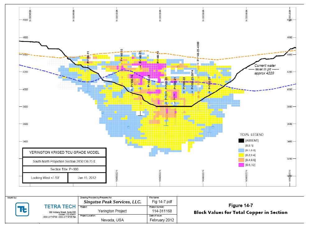
| NI 43-101 Technical Report Mineral Resource | Singatse Peak Services, LLC |
| | Yerington Copper Project |
Table 14-10 Kriged Block Statistics
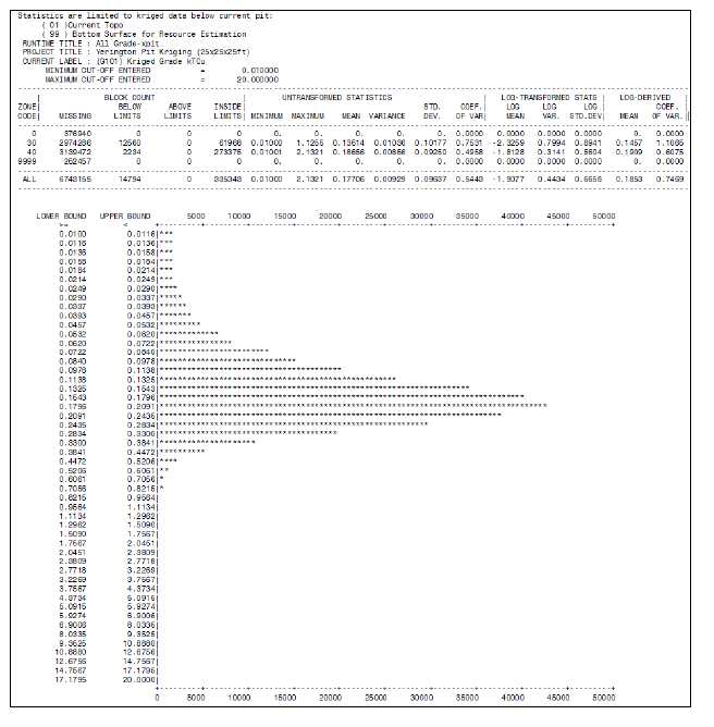
| Tetra Tech | February 2012 | 83 |
| NI 43-101 Technical Report Mineral Resource | Singatse Peak Services, LLC |
| | Yerington Copper Project |
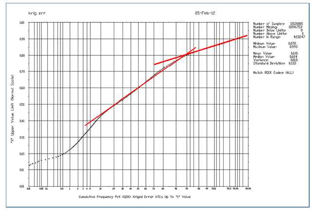
Figure 14-8 Log-Probability Plot of the Kriging Error
| Tetra Tech | February 2012 | 84 |
| NI 43-101 Technical Report Mineral Resource | Singatse Peak Services, LLC |
| | Yerington Copper Project |
Figure 14-9 shows the results of the jackknife study that resulted in the selection of the search parameters for measured, indicated, and inferred. The jackknife method sequentially removes sample values (“the target”) and uses the remaining data along with prospective search parameters to krige its value (“the estimate”). The x-axis maps the estimate while the y-axis the target. If all estimates were perfect, each plotted point would lie on the 45-degree line. A measure of the quality of the jackknife as the search parameters are changed is shown with a correlation. For the search parameters selected for measured (“M”) plotted in red a correlation of 0.74 is achieved. Indicated (“I”) plotted in green has a correlation of 0.58. Inferred (“F”) plotted in blue has a correlation of 0.37. A series of nested ellipses containing 80% of each of the measured, indicated, and inferred classes (“MIF”) are plotted as a visual aid. Note that this plot does not include the refinement of final MIF adjustment using the 0.82 kriging error.
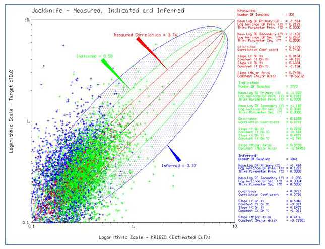
Figure 14-9 Jackknife Study of Measured, Indicated and Inferred (“MIF”) Blocks
| Tetra Tech | February 2012 | 85 |
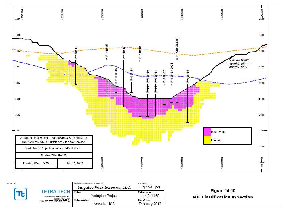
| NI 43-101 Technical Report Mineral Resource | Singatse Peak Services, LLC |
| | Yerington Copper Project |
Figure 14-11 shows the side-by-side histograms of the block grades for measured, indicated, and inferred. Note that the block count for each is radically different in quantity. In this plot, each class has been normalized to 100%, allowing for comparison of distribution. Note that the average grade shifts higher as the classification goes from inferred to measured.
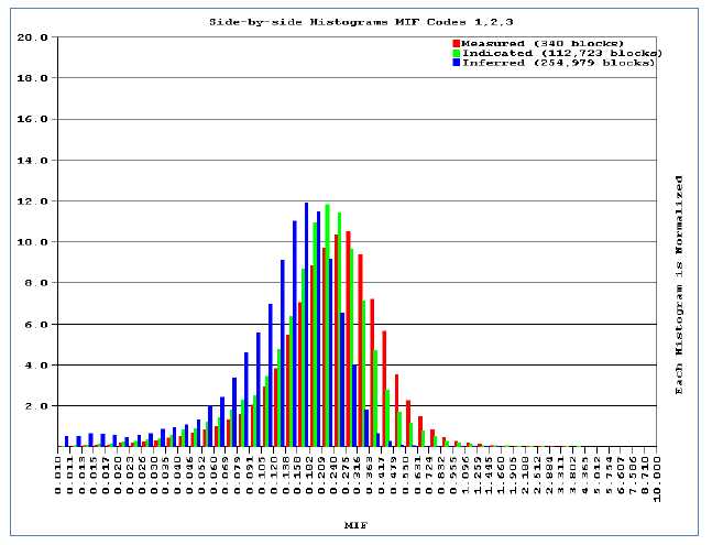
Figure 14-11 Side-by-Side Histograms of Measured, Indicated and Inferred Blocks
14.6 Resource Model Verification
The resource model was verified for quality using several methods. The first was the visual comparison in section of the samples, composites, and blocks. High grade areas shown by drilling were shown as block high grade areas. The statistical relationship of going from assay to composite and then to block was checked for theoretical correctness. Figure 14-12 shows the side-by-side grade histograms of assay, composite, and blocks. Figure 14-13 compares the three using a log-probability plot. An expected reduction in variability in the progression of assay to block is seen. Approximately 20% of the composites and samples have grades above a 0.5% grade. Block grades above 0.5% are extremely rare. This is observed in the grade-tonnage tables presented in the next section.
| Tetra Tech | February 2012 | 87 |
| NI 43-101 Technical Report Mineral Resource | Singatse Peak Services, LLC |
| | Yerington Copper Project |
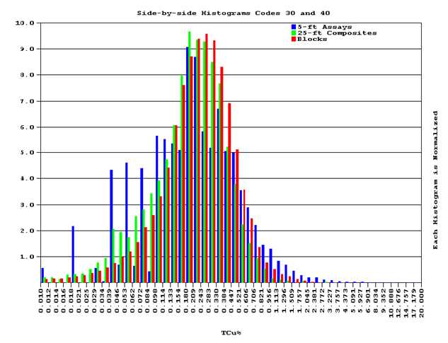
Figure 14-12 Side-by-Side Histograms Comparing Assay, Composites, and Blocks
| Tetra Tech | February 2012 | 88 |
| NI 43-101 Technical Report Mineral Resource | Singatse Peak Services, LLC |
| | Yerington Copper Project |
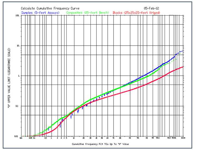
Figure 14-13 Log-Probability Plots of Samples, Composites and Blocks
| Tetra Tech | February 2012 | 89 |
| NI 43-101 Technical Report Mineral Resource | Singatse Peak Services, LLC |
| | Yerington Copper Project |
14.7 Mineral Resource Statement
Results of the resource estimation are summarized in Tables 14-11 through 14-14.
Table 14-11Measured Copper Resources–January 2012
| Cutoff
Grade |
Tons | Average
Grade | Contained
Copper |
| | %TCu | (x1000) | % TCu | (lbs x 1000) |
Oxide and
Chalcocite
Material
| 0.5 | 248 | 0.67 | 3,342 |
| 0.4 | 463 | 0.57 | 5,250 |
| 0.3 | 1,143 | 0.43 | 9,917 |
| 0.25 | 1,754 | 0.38 | 13,253 |
| 0.2 | 2,853 | 0.32 | 18,122 |
| 0.15 | 4,850 | 0.26 | 25,065 |
| 0.12 | 6,006 | 0.23 | 28,192 |
Primary Material
| 0.5 | 1,692 | 0.64 | 21,691 |
| 0.4 | 4,974 | 0.51 | 50,665 |
| 0.3 | 12,931 | 0.41 | 105,258 |
| 0.25 | 19,160 | 0.36 | 139,446 |
| 0.2 | 25,866 | 0.33 | 169,629 |
| 0.15 | 31,804 | 0.30 | 190,570 |
| 0.12 | 34,108 | 0.29 | 196,871 |
Table 14-12 Indicated Copper Resources– January 2012
| Cutoff
Grade |
Tons | Average
Grade | Contained
Copper |
| | % TCu | (x1000) | % TCu | (lbs x 1000) |
Oxide and
Chalcocite
Material
| 0.5 | 339 | 0.65 | 4,410 |
| 0.4 | 767 | 0.53 | 8,167 |
| 0.3 | 2,188 | 0.41 | 17,845 |
| 0.25 | 3,809 | 0.35 | 26,701 |
| 0.2 | 6,592 | 0.3 | 39,117 |
| 0.15 | 10,293 | 0.25 | 52,041 |
| 0.12 | 12,386 | 0.23 | 57,719 |
Primary
Material
| 0.5 | 648 | 0.62 | 8,046 |
| 0.4 | 2,946 | 0.48 | 27,993 |
| 0.3 | 14,607 | 0.37 | 106,865 |
| 0.25 | 27,831 | 0.32 | 179,176 |
| 0.2 | 45,914 | 0.28 | 260,332 |
| 0.15 | 62,089 | 0.26 | 317,399 |
| 0.12 | 68,418 | 0.24 | 334,564 |
| Tetra Tech | February 2012 | 90 |
| NI 43-101 Technical Report Mineral Resource | Singatse Peak Services, LLC |
| | Yerington Copper Project |
Table 14-13 Measured + Indicated Copper Resources– January 2012
| Cutoff
Grade |
Tons | Average
Grade | Contained
Copper |
| | % TCu | (x1000) | % TCu | (lbs x 1000) |
Oxide and
Chalcocite
Material
| 0.5 | 588 | 0.66 | 7,765 |
| 0.4 | 1,230 | 0.55 | 13,417 |
| 0.3 | 3,331 | 0.42 | 27,761 |
| 0.25 | 5,563 | 0.36 | 39,953 |
| 0.2 | 9,445 | 0.3 | 57,237 |
| 0.15 | 15,143 | 0.25 | 77,108 |
| 0.12 | 18,391 | 0.23 | 85,886 |
Primary
Material
| 0.5 | 2,340 | 0.64 | 29,737 |
| 0.4 | 7,919 | 0.5 | 78,652 |
| 0.3 | 27,539 | 0.39 | 212,160 |
| 0.25 | 46,991 | 0.34 | 318,599 |
| | | | |
| 0.2 | 71,781 | 0.3 | 429,968 |
| 0.15 | 93,893 | 0.27 | 507,961 |
| 0.12 | 102,526 | 0.26 | 531,495 |
Table 14-14 Inferred Copper Resources– January 2012
| Cutoff
Grade |
Tons | Average
Grade | Contained
Copper |
| | % TCu | (x1000) | % TCu | (lbs x 1000) |
Oxide and
Chalcocite
Material
| 0.5 | 209 | 0.58 | 2,407 |
| 0.4 | 724 | 0.48 | 6,942 |
| 0.3 | 2,226 | 0.39 | 17,167 |
| 0.25 | 4,215 | 0.33 | 28,021 |
| 0.2 | 8,596 | 0.28 | 47,347 |
| 0.15 | 17,911 | 0.22 | 79,525 |
| 0.12 | 24,703 | 0.2 | 97,873 |
Primary
Material
| 0.5 | 68 | 0.61 | 833 |
| 0.4 | 703 | 0.45 | 6,261 |
| 0.3 | 9,073 | 0.34 | 61,442 |
| 0.25 | 26,700 | 0.29 | 157,103 |
| 0.2 | 63,918 | 0.25 | 322,530 |
| 0.15 | 123,366 | 0.21 | 529,734 |
| 0.12 | 160,104 | 0.2 | 629,209 |
| Tetra Tech | February 2012 | 91 |
| NI 43-101 Technical Report Mineral Resource | Singatse Peak Services, LLC |
| | Yerington Copper Project |
15.0MINERAL RESERVE ESTIMATES
To date, the Yerington Copper Project does not have any CIM definable mineral reserves.
| Tetra Tech | February 2012 | 92 |
| NI 43-101 Technical Report Mineral Resource | Singatse Peak Services, LLC |
| | Yerington Copper Project |
16.0MINING METHODS
Section 16.0 applies to advanced stage properties only. As of the date of this report, the Yerington Copper Project is considered an exploration project for which no mine criteria, design parameters, equipment selection, and production schedule have been estimated.
| Tetra Tech | February 2012 | 93 |
| NI 43-101 Technical Report Mineral Resource | Singatse Peak Services, LLC |
| | Yerington Copper Project |
17.0RECOVERY METHODS
Section 17.0 applies to advanced stage properties only. As of the date of this report, the Yerington Copper Project is considered an exploration project for which no engineering work has been performed to define the recovery methods, plant layout, flow sheet, or material balance.
| Tetra Tech | February 2012 | 94 |
| NI 43-101 Technical Report Mineral Resource | Singatse Peak Services, LLC |
| | Yerington Copper Project |
18.0INFRASTRUCTURE
Section 18.0 applies to advanced stage properties only. As of the date of this report, the Yerington Copper Project is considered an exploration project for which no infrastructure items have been designed and costed.
| Tetra Tech | February 2012 | 95 |
| NI 43-101 Technical Report Mineral Resource | Singatse Peak Services, LLC |
| | Yerington Copper Project |
19.0MARKET STUDIES
Section 19.0 applies only to advanced stage properties.
| Tetra Tech | February 2012 | 96 |
| NI 43-101 Technical Report Mineral Resource | Singatse Peak Services, LLC |
| | Yerington Copper Project |
20.0ENVIRONMENTAL STUDIES, PERMITTING AND SOCIAL OR COMMUNITY IMPACT
Section 20.0 applies only to advanced stage properties.
| Tetra Tech | February 2012 | 97 |
| NI 43-101 Technical Report Mineral Resource | Singatse Peak Services, LLC |
| | Yerington Copper Project |
21.0CAPITAL AND OPERATING COSTS
Section 21.0 applies only to advanced stage properties. As of the date of this report, the Yerington Copper Project is considered an exploration project.
| Tetra Tech | February 2012 | 98 |
| NI 43-101 Technical Report Mineral Resource | Singatse Peak Services, LLC |
| | Yerington Copper Project |
22.0ECONOMIC ANALYSIS
Section 22.0 applies only to advanced stage properties. As of the date of this report, the Yerington Copper Project is considered an exploration project for which no economic analyses have prepared.
| Tetra Tech | February 2012 | 99 |
| NI 43-101 Technical Report Mineral Resource | Singatse Peak Services, LLC |
| | Yerington Copper Project |
23.0ADJACENT PROPERTIES
The deposits presented in Table 23-1 are within a few miles of the Yerington pit, with the Ann Mason and the Bear (also referred to as the Bear-Lagomarsino) Deposits having mineralization that is similar in nature to the Yerington Mine. An unknown portion of the Bear resource is on SPS properties.
Resource figures listed for the MacArthur property in Table 23-1 are based upon a January 2011 NI 43-101 Technical Report, and those of the Ann Mason Deposit are based upon a March 2011 Technical Report. Estimates shown for the Bear Deposit are based on data and reports thatpredate NI 43-101 definitions of mineral resources and reserves and are presented as an indication of the types and magnitude of similar deposits, but do not meet current CIM standards.
Table 23-1 Adjacent Property Resource Estimates
Adjacent Property Name |
Cutoff | Tons
(000s) | Average
Grade
(% TCu) | Contained
Cu
(000s Tons) | Contained
Cu
(000s lbs) |
| NI-43-101 Compliant Estimates |
| MacArthur Deposit - NI 43-101 | 0.12 | | | | |
| Measured and Indicated | | 145,169 | 0.19 | 27,896 | 557,926 |
| Inferred | | 289,133 | 0.21 | 61,316 | 1,226,328 |
| Ann Mason Deposit NI 43-101 | 0.3 | | | | |
| Inferred | | 810,390 | 0.4 | 3,233 | 6,466,912 |
| Non-Compliant Estimate |
| Bear-Lagomarsino Deposit1 | unk | 500,000* | 0.4 | 2,000 | 4,000,000 |
| |
| Total All Deposits | | 1,744,692 | 0.35 | 6,126 | 12,251,166 |
*An unknown percentage of the Bear- Lagomarsino historic resource estimate is on the Yerington Mine properties controlled by SPS
| Tetra Tech | February 2012 | 100 |
| NI 43-101 Technical Report Mineral Resource | Singatse Peak Services, LLC |
| | Yerington Copper Project |
24.0OTHER RELEVANT DATA AND INFORMATION
Tetra Tech is not aware of any potential limitations to the project that would materially change any of the data, resource estimates, environmental considerations, socio-economic factors, or conclusions presented within this report or that are outside of normal factors impacting mining projects, such as price variability, exchange rates, or permitting time. Prior production of copper took place at the Yerington Copper Project and liabilities resulting from this activity do not include any environmental fatal flaws that could impede the progress of this project, taking into account information gathered to date. Potential new environmental issues, not considered as part of this report, will be investigated more completely in future advanced studies, and are not anticipated to materially impact the project going forward.
| Tetra Tech | February 2012 | 101 |
| NI 43-101 Technical Report Mineral Resource | Singatse Peak Services, LLC |
| | Yerington Copper Project |
25.0INTERPRETATIONS AND CONCLUSIONS
There is an obvious potential for a significant addition to the resources of the Yerington Copper Project.
Historic and current drilling indicate that limits to the mineralization at the Yerington Mine have not yet been found, both horizontally and vertically, and additional exploration and in-fill drilling are warranted, and are expected to both expand and upgrade the current NI 43-101 compliant copper resources.
Historic resources in the residuals which are part of the Yerington Copper Project reflect a notable potential which should be more fully evaluated in order to bring those resources into NI 43-101 compliant standards.
The Bear porphyry deposit remains unconstained by drilling. Although it contains no NI 43-101 compliant resources, historical drilling has indicated a large footprint for copper mineralization that will ultimately need delineation by additional drilling.
| Tetra Tech | February 2012 | 102 |
| NI 43-101 Technical Report Mineral Resource | Singatse Peak Services, LLC |
| | Yerington Copper Project |
26.0RECOMMENDATIONS
26.1 Recommended Work Programs
In order to further develop the resources at the Yerington Mine, the following are recommended:
IP geophysics in the pit area to target deep holes to explore the keel of the Yerington porphyry system.
Core drilling below the Yerington Mine both to upgrade the classification of the inferred resources and to test the deeper extension of mineralization that remains almost unexplored below the 3,300-foot level.
To further evaluate residuals on the property, a sonic drilling program is recommended to sample and characterize the heap leach pads, tailings, and low grade ore stockpiles on site.
And finally, a review of historic information and a program of preliminary metallurgical testing are recommended to support a preliminary economic assessment of the property.
26.2 Work Program Budget
Table 26.1 outlines the proposed budget for the work programs outlined above.
Table 26-1 Proposed Budget for Plan of Work, February 2012
Task | Est.
Completion
Date* | Estimated
Cost to
Complete* |
Notes |
Infill and exploratory drilling
below Yerington Pit |
Q2-13 |
$4,000,000 |
20,000 ft |
Residual characterization,
drilling & sampling |
Q2-12 |
$500,000 |
5,000 ft |
| Geophysics | Q3-12 | $100,000 | IP-Yerington Pit |
Assays
| Q2-13
| $300,000
| Includes sample prep &
handling |
Metallurgical studies
| Q1-13
| $300,000
| Residuals and Yerington
pit mineralization |
| Technical studies to supportPEA | Q4-13 | $500,000 | Yerington Project |
| Personnel & infrastructure | Q4-13 | $4,000,000 | 24 months |
| Total–Overall Budget | $9,700,000 | 24 months |
| * Completion dates and expenditures represent programs based on current market conditions and are subject to the availability of funding and program results. |
| Tetra Tech | February 2012 | 103 |
| NI 43-101 Technical Report Mineral Resource | Singatse Peak Services, LLC |
| | Yerington Copper Project |
27.0REFERENCES
Anaconda Collection – American Heritage Center, University of Wyoming, Laramie, Wyoming.
Carten, Richard B., 1986: Sodium-Calcium Metasomatism: Chemical, Temporal, and Spatial Relationships at the Yerington Nevada Porphyry Copper Deposit: Economic Geology, Vol 81, pp. 1495-1519.
Dilles, J.H. and Proffett, J.M., Porphyry Copper Deposits of the American Cordillera: Arizona Geological Society Digest 20, 1995, p.306-315.
Einaudi M.T, 1970, Final Report Deep Drilling Project Yerington Mine: unpublished private report for The Anaconda Company, 9p.
Hart, V. A., 1915, Report Montana-Yerington Prospect and Adjoining Properties near Yerington, Nevada: unpublished private report for International Smelting Company: Anaconda Collection – American Heritage Center, University of Wyoming, 11p.
Howard, Jr., K. L., 1979, Geological Reserves – Yerington District: unpublished private report for The Anaconda Company: Anaconda Collection – American Heritage Center, University of Wyoming, 4p.
Knopf, Adolph, 1918, Geology and ore deposits of the Yerington district, Nevada: U.S. Geol. Survey Professional Paper 114, 68p.
Moore, James G., 1969, Geology and Mineral Deposits of Lyon, Douglas, and Ormsby Counties, Nevada: Nevada Bureau of Mines and Geology, Bulletin 75, 45p.
Nelson, P.H. and Van Voorhis, G.D., 1983, Estimation of sulfide content from induced polarization data, GEOPHYSICS, V.48, No. 1, pp. 62-75.
Nesbitt, M., 1971, unpublished private report, The Anaconda Company.
Proffett, Jr., J. M., and Dilles, J. H., 1984, Geologic Map of the Yerington District, Nevada: Nevada Bureau of Mines and Geology, Map 77.
Proffett, J.M. and Proffett, B.H., 1976, Stratigraphy of the Tertiary Ash-Flow Tuffs in the Yerington District, Nevada: Nevada Bureau of Mines and Geology, Report 27.
Sales, Reno H., 1915, Report on the Montana Yerington mine, Yerington, Nevada: unpublished private report for Anaconda Copper Mining Company: Anaconda Collection – American Heritage Center, University of Wyoming, 7p.
Sawyer, Joe, 1999, Production history summary: private report, Arimetco Inc., 7p.
Schmidt, R., 1996, Copper Mineralogy of Four Samples: Hazen Research, Inc.: unpublished private report for Arimetco, Inc., 10p.
| Tetra Tech | February 2012 | 104 |
| NI 43-101 Technical Report Mineral Resource | Singatse Peak Services, LLC |
| | Yerington Copper Project |
Souviron, Alavaro, 1976, Exploration Possibilities of the Yerington Mine, unpublished report, Anaconda Collection – American Heritage Center, University of Wyoming, 11p.
Tingley, J.V., Horton, R.C., and Lincoln, F.C., 1993, Outline of Nevada Mining History: Nevada Bureau of Mines and Geology, Special Publication 15, 48p.
USEPA, 2011, Supplemental Remedial Investigation Report, Arimetco Facilities Operable Unit 8, Anaconda Copper Yerington Mine, Yerington, NV.
USEPA, 2008, Public Review Draft, Remedial Investigation Report, Arimetco Facilities Operable Unit 8, Anaconda Copper Yerington Mine, pp. 170-172.
USEPA, 2010, Data Summary Report for the Characterization of Vat Leach Tailings (VLT) Using X-Ray Fluorescence (XRF) - Yerington Mine Site.
USEPA, 2010, Historical Summary Report – Anaconda-Yerington Mine Site – Yerington, NV.
Ware, G. H., 1979, In-situ induced-polarization and magnetic susceptibility measurements – Yerington mine, GEOPHYSICS, V. 44, No. 8, pp.1417-1428.
| Tetra Tech | February 2012 | 105 |
| | | Appendices NI 43-101 Technical Report
Mineral Resource
Yerington Copper Project
Lyon County, Nevada Prepared for: Singatse Peak Services, LLC 517 West Bridge Street Suite A
Yerington 89447
(775) 463-9600
(775) 463-9690 fax Prepared by: Tetra Tech 350 Indiana Street, Suite 500
Golden, Colorado 80401
(303) 217-5700
Fax (303) 217-5705
Tetra Tech Project No. 114-311168 February 2012 |
APPENDIX A
PROPERTY LISTING
SINGATSE PEAK SERVICES, LLC
PROPERTY LISTING - Dec 31, 2011
PATENTED CLAIMS:
| | MINERAL | COUNTY | |
| 82 PATENTED CLAIM(S) | SURVEY | PARCEL | PARCEL ACREAGE |
| | NUMBER | NUMBER | |
| Know U Don'T | 3144 | 012-111-21 | 98 |
| January | 3145 | | |
| Rossland | 3367 | | |
| Eclipse | 4080 | | |
| Edwin 1,2,5 | 4080 | | |
| Copper King, Kid | 4081 | | |
| Copper Queen No. 1 | 4081 | | |
| Santa Cruse 1,3 | 3075 | 012-111-23 | 58 |
| Santa Cruz | 3075 | | |
| Copper Queen No. 1,3 | 3655 | 012-112-01 | 490 |
| Minnie Edith | 3655 | | |
| Nevada King | 3655 | | |
| San Jacinto | 3655 | | |
| Alcatraz | 3656 | | |
| Black Horse | 3656 | | |
| Boston | 3656 | | |
| Cash Boy | 3656 | | |
| Christina | 3656 | | |
| Colorado | 3656 | | |
| Colorado Springs | 3656 | | |
| Copper Queen 2,6 | 3656 | | |
| Daisy | 3656 | | |
| Fortuna | 3656 | | |
| Iron Cap,Iron Cap 2 | 3656 | | |
| Jack Clubs | 3656 | | |
| Juanita | 3656 | | |
| Kathleen | 3656 | | |
| Monte Cristo | 3656 | | |
| Pocahontas | 3656 | | |
| Sage Hen | 3656 | | |
| Santa Inez | 3656 | | |
| Santigo | 3656 | | |
| Scorpion | 3656 | | |
| Styx | 3656 | | |
| No. 102 | 4850 | 012-113-01 | 64.48 |
| No. 73 | 4850 | | |
| No. 74 | 4850 | | |
| Diamond,Diamond 1,2 | 3736 | 012-113-02 | 130 |
| Diamond 3,4 | 3977 | | |
| Diamond Fr.,Diamond Fr. 1 | 3977 | | |
| Lone Star | 3977 | | |
| Anaconda | 3692 | 012-113-04 | 19 |
| Copper Canyon | 3157 | 012-113-05 | 20 |
| A & L | 4499 | 014-451-04 | 506.86 |
| Wild Rose,Wild Rose 1-2 | 4499 | | |
| Black Horse | 4531 | | |
| Blue Star | 4531 | | |
| Canidate | 4531 | | |
| Consolidated,Consolidated Fr. | 4531 | | |
| Greenhorn | 4531 | | |
| Hungry Bill | 4531 | | |
| Katy Didn'T | 4531 | | |
| New Blue Bird,New Blue Bird 1,2 | 4531 | | |
| New Royal Blue,New Royal Blue Ext. | 4531 | | |
| North Star | 4531 | | |
| Red Star | 4531 | | |
| Sunlight | 4531 | | |
| West Starlight | 4531 | | |
| No. 38 | 4778 | | |
| No. Seven | 4778 | | |
| No. Thirty-Five Fr. | 4778 | | |
| No. Twenty-Five | 4778 | | |
| No. Twenty-Four | 4778 | | |
| No. Twenty-Six | 4778 | | |
| No. Twenty-Three | 4778 | | |
| Total Claims: 82 | | Total acreage: | 1386.34 |
PRIVATE GROUND
| | | COUNTY | |
| PRIVATE GROUND | | PARCEL | ACREAGE |
| | | NUMBER | |
| Private | | 014-401-06 | 182.77 |
| Private | | 014-461-10 | 12.7 |
| Private | | 014-461-11 | 31 |
| Private | | 014-401-15 | 1074.74 |
| | | Total acreage: | 1301.21 |
UNPATENTED CLAIMS
457
UNPATENTED
MINING CLAIM | BLM MINING
SERIAL
NUMBER | COUNTY
REFERENCE
NUMBER | SEC-TWP-RNGE | LOCATION
DATE |
| BR 1 | NMC960196 | 410213 | S32-T14N-R25E, S5-T13N-R25E | 4/26/2007 |
| BR 2 | NMC960197 | 410214 | S32-T14N-R25E, S5-T13N-R25E | 4/26/2007 |
| BR 3 | NMC960198 | 410215 | S32-T14N-R25E, S5-T13N-R25E | 4/26/2007 |
| BR 4 | NMC960199 | 410216 | S5-T13N-R25E | 4/26/2007 |
| BR 5 | NMC960200 | 410217 | S32-T14N-R25E, S5-T13N-R25E | 4/26/2007 |
| BR 6 | NMC960201 | 410218 | S5-T13N-R25E | 4/26/2007 |
| BR 7 | NMC960202 | 410219 | S32-T14N-R25E, S5-T13N-R25E | 4/26/2007 |
| BR 8 | NMC960203 | 410220 | S5-T13N-R25E | 4/26/2007 |
| BR 9 | NMC960204 | 410221 | S32-T14N-R25E, S5-T13N-R25E | 4/26/2007 |
| BR 10 | NMC960205 | 410222 | S5-T13N-R25E | 4/26/2007 |
| BR 11 | NMC960206 | 410223 | S32,33-T14N-R25E, S4, 5-T13N-R25E | 4/26/2007 |
| BR 12 | NMC960207 | 410224 | S4, 5-T13N-R25E | 4/26/2007 |
| BR 13 | NMC960208 | 410225 | S5-T13N-R25E | 4/25/2007 |
| BR 14 | NMC960209 | 410226 | S5, 8-T13N-R25E | 4/25/2007 |
| BR 15 | NMC960210 | 410227 | S5-T13N-R25E | 4/25/2007 |
| BR 16 | NMC960211 | 410228 | S4, 5-T13N-R25E | 4/25/2007 |
| BR 17 | NMC960212 | 410229 | S4-T13N-R25E | 4/25/2007 |
| BR 18 | NMC960213 | 410230 | S4, 9-T13N-R25E | 4/25/2007 |
| BR 19 | NMC960214 | 410231 | S4-T13N-R25E | 4/25/2007 |
| BR 20 | NMC960215 | 410232 | S4, 9-T13N-R25E | 4/25/2007 |
| BR 21 | NMC960216 | 410233 | S5, 8-T13N-R25E | 4/25/2007 |
| BR 22 | NMC960217 | 410234 | S8-T13N-R25E | 4/25/2007 |
| BR 23 | NMC960218 | 410235 | S4,5,8,9-T13N-R25E | 4/25/2007 |
| BR 24 | NMC960219 | 410236 | S8, 9-T13N-R25E | 4/25/2007 |
| BR 25 | NMC960220 | 410237 | S9-T13N-R25E | 4/25/2007 |
| BR 26 | NMC960221 | 410238 | S9-T13N-R25E | 4/25/2007 |
| BR 27 | NMC960222 | 410239 | S4, 9-T13N-R25E | 4/25/2007 |
| BR 28 | NMC960223 | 410240 | S9-T13N-R25E | 4/25/2007 |
| BR 29 | NMC960224 | 410241 | S4, 9-T13N-R25E | 4/25/2007 |
| BR 30 | NMC960225 | 410242 | S9-T13N-R25E | 4/25/2007 |
| BR 31 | NMC960226 | 410243 | S4, 9-T13N-R25E | 4/25/2007 |
| BR 32 | NMC960227 | 410244 | S9-T13N-R25E | 4/25/2007 |
| BR 33 | NMC960228 | 410245 | S4, 9-T13N-R25E | 4/25/2007 |
| BR 34 | NMC960229 | 410246 | S9-T13N-R25E | 4/25/2007 |
| BR 35 | NMC960230 | 410247 | S4, 9-T13N-R25E | 4/25/2007 |
| BR 36 | NMC960231 | 410248 | S9-T13N-R25E | 4/25/2007 |
| BR 37 | NMC960232 | 410249 | S4, 9-T13N-R25E | 4/26/2007 |
| BR 38 | NMC960233 | 410250 | S9-T13N-R25E | 4/26/2007 |
| BR 39 | NMC960234 | 410251 | S3,4,9,10-T13N-R25E | 4/26/2007 |
| BR 40 | NMC960235 | 410252 | S3, 4-T13N-R25E | 4/26/2007 |
| BR 41 | NMC1035881 | 470282 | S8-T13N-R25E | 12/2/2010 |
| BR 42 | NMC1035882 | 470283 | S8, 17-T13N-R25E | 12/2/2010 |
| BR 43 | NMC1035883 | 470284 | S8-T13N-R25E | 12/2/2010 |
| BR 44 | NMC960239 | 410256 | S8,9,16,17-T13N-R25E | 4/26/2007 |
| BR 45 | NMC960240 | 410257 | S9, 16-T13N-R25E | 4/26/2007 |
| BR 46 | NMC960241 | 410258 | S9, 16-T13N-R25E | 4/26/2007 |
| BR 47 | NMC960242 | 410259 | S9-T13N-R25E | 4/26/2007 |
| BR 48 | NMC960243 | 410260 | S9, 16-T13N-R25E | 4/26/2007 |
| BR 49 | NMC960244 | 410261 | S9-T13N-R25E | 4/26/2007 |
| BR 50 | NMC960245 | 410262 | S9-T13N-R25E | 4/25/2007 |
| BR 51 | NMC960246 | 410263 | S9-T13N-R25E | 4/25/2007 |
| BR 52 | NMC960247 | 410264 | S9-T13N-R25E | 4/25/2007 |
| BR 53 | NMC960248 | 410265 | S9-T13N-R25E | 4/25/2007 |
| BR 54 | NMC960249 | 410266 | S9-T13N-R25E | 4/25/2007 |
| BR 55 | NMC960250 | 410267 | S9-T13N-R25E | 4/25/2007 |
| BR 56 | NMC960251 | 410268 | S9-T13N-R25E | 4/25/2007 |
| BR 57 | NMC960252 | 410269 | S9-T13N-R25E | 4/25/2007 |
| BR 58 | NMC960253 | 410270 | S9-T13N-R25E | 4/25/2007 |
| BR 59 | NMC960254 | 410271 | S9-T13N-R25E, | 4/25/2007 |
| ADP 1 | NMC 938537 | 395695 | S4, 5-T13N-R25E | 9/6/2006 |
| ADP 2 | NMC 938538 | 395696 | S5, 8-T13N-R25E | 9/6/2006 |
| ADP 3 | NMC 938539 | 395697 | S5, 8-T13N-R25E | 9/6/2006 |
| ADP 4 | NMC 938540 | 395698 | S7, 8-T13N-R25E | 9/6/2006 |
| ADP 5 | NMC 938541 | 395699 | S7, 8-T13N-R25E | 9/6/2006 |
| ADP 6 | NMC 938542 | 395700 | S17-T13N-R25E | 9/6/2006 |
| ADP 7 | NMC 938543 | 395701 | S17-T13N-R25E | 9/6/2006 |
| ADP 8 | NMC 938544 | 395702 | S8-T13N-R25E | 9/6/2006 |
| ADP 9 | NMC 938545 | 395703 | S8-T13N-R25E | 9/6/2006 |
| ADP 10 | NMC 938546 | 395704 | S16-T13N-R25E | 9/6/2006 |
| ADP 11 | NMC 938547 | 395705 | S16-T13N-R25E | 9/6/2006 |
| ADP 12 | NMC 938548 | 395706 | S16-T13N-R25E | 9/6/2006 |
| ADP 13 | NMC 938549 | 395707 | S16-T13N-R25E | 9/6/2006 |
| ADP 14 | NMC 938550 | 395708 | S16-T13N-R25E | 9/6/2006 |
| ADP 15 | NMC 938551 | 395709 | S16-T13N-R25E | 9/6/2006 |
| ADP 16 | NMC 938552 | 395710 | S16-T13N-R25E | 9/6/2006 |
| ADP 17 | NMC 938553 | 395711 | S16-T13N-R25E | 9/6/2006 |
| ADP 18 | NMC 938554 | 395712 | S16-T13N-R25E | 9/6/2006 |
| ADP 19 | NMC 938555 | 395713 | S16-T13N-R25E | 9/6/2006 |
| ADP 20 | NMC 938556 | 395714 | S16-T13N-R25E | 9/6/2006 |
| ADP 21 | NMC 938557 | 395715 | S16-T13N-R25E | 9/6/2006 |
| ADP 22 | NMC 938558 | 395716 | S17-T13N-R25E | 9/6/2006 |
| ADP 23 | NMC 938559 | 395717 | S17-T13N-R25E, | 9/6/2006 |
| SC 1 | NMC1021840 | 455777 | S19,20-T13N-R25E | 1/6/2010 |
| SC 2 | NMC1021841 | 455778 | S19,20,29,30-T13N-R25E | 1/6/2010 |
| SC 3 | NMC1021842 | 455779 | S20-T13N-R25E | 1/6/2010 |
| SC 4 | NMC1021843 | 455780 | S20,29-T13N-R25E | 1/6/2010 |
| SC 5 | NMC1021844 | 455781 | S20-T13N-R25E | 1/6/2010 |
| SC 6 | NMC1021845 | 455782 | S20,29-T13N-R25E | 1/6/2010 |
| SC 7 | NMC1021846 | 455783 | S20-T13N-R25E | 1/6/2010 |
| SC 8 | NMC1021847 | 455784 | S20,29-T13N-R25E | 1/6/2010 |
| SC 9 | NMC1021848 | 455785 | S20-T13N-R25E | 1/6/2010 |
| SC 10 | NMC1021849 | 455786 | S20,29-T13N-R25E | 1/6/2010 |
| SC 11 | NMC1021850 | 455787 | S20-T13N-R25E | 1/6/2010 |
| SC 12 | NMC1021851 | 455788 | S20,29-T13N-R25E | 1/6/2010 |
| SC 13 | NMC1021852 | 455789 | S20-T13N-R25E | 1/6/2010 |
| SC 14 | NMC1021853 | 455790 | S20,29-T13N-R25E | 1/6/2010 |
| SC 15 | NMC1021854 | 455791 | S20-T13N-R25E | 1/6/2010 |
| SC 16 | NMC1021855 | 455792 | S20,29-T13N-R25E | 1/6/2010 |
| SC 17 | NMC1021856 | 455793 | S20-T13N-R25E | 1/6/2010 |
| SC 18 | NMC1021857 | 455794 | S20,29-T13N-R25E | 1/6/2010 |
| SC 19 | NMC1021858 | 455795 | S19,20-T13N-R25E | 1/6/2010 |
| SC 20 | NMC1021859 | 455796 | S20-T13N-R25E | 1/6/2010 |
| SC 21 | NMC1021860 | 455797 | S20-T13N-R25E | 1/6/2010 |
| SC 22 | NMC1021861 | 455798 | S20-T13N-R25E | 1/6/2010 |
| SC 23 | NMC1021862 | 455799 | S20-T13N-R25E | 1/6/2010 |
| SC 24 | NMC1021863 | 455800 | S20-T13N-R25E | 1/6/2010 |
| SC 25 | NMC1021864 | 455801 | S20-T13N-R25E | 1/6/2010 |
| SC 26 | NMC1021865 | 455802 | S20-T13N-R25E | 1/6/2010 |
| SC 27 | NMC1021866 | 455803 | S20-T13N-R25E | 1/6/2010 |
| SC 28 | NMC1025365 | 461854 | S20,21-T13N-R25E | 5/7/2010 |
| SC 29 | NMC1025366 | 461855 | S20,21-T13N-R25E | 5/7/2010 |
| SC 30 | NMC1025367 | 461856 | S21-T13N-R25E | 5/7/2010 |
| SC 31 | NMC1025368 | 461857 | S21-T13N-R25E | 5/7/2010 |
| SC 32 | NMC1025369 | 461858 | S21-T13N-R25E | 5/7/2010 |
| SC 33 | NMC1025370 | 461859 | S21-T13N-R25E | 5/7/2010 |
| SC 34 | NMC1025371 | 461860 | S21-T13N-R25E | 5/7/2010 |
| SC 35 | NMC1025372 | 461861 | S20,21,28,29-T13N-R25E | 5/7/2010 |
| SC 36 | NMC1025373 | 461862 | S21,28-T13N-R25E | 5/7/2010 |
| SC 37 | NMC1025374 | 461863 | S21,28-T13N-R25E | 5/7/2010 |
| SC 38 | NMC1025375 | 461864 | S21,28-T13N-R25E | 5/7/2010 |
| SC 39 | NMC1025376 | 461865 | S21-T13N-R25E | 5/7/2010 |
| SC 40 | NMC1025377 | 461866 | S21,28-T13N-R25E | 5/7/2010 |
| SC 41 | NMC1025378 | 461867 | S21-T13N-R25E | 5/7/2010 |
| SC 42 | NMC1025379 | 461868 | S21,28-T13N-R25E | 5/7/2010 |
| SC 43 | NMC1025380 | 461869 | S21-T13N-R25E | 5/7/2010 |
| SC 44 | NMC1025381 | 461870 | S19,30-T13N-R25E | 5/7/2010 |
| SC 45 | NMC1025382 | 461871 | S19,30-T13N-R25E | 5/7/2010 |
| SC 46 | NMC1025383 | 461872 | S19,30-T13N-R25E | 5/7/2010 |
| SC 47 | NMC1025384 | 461873 | S19,30-T13N-R25E | 5/7/2010 |
| SC 48 | NMC1025385 | 461874 | S19,30-T13N-R25E | 5/7/2010 |
| SC 49 | NMC1025386 | 461875 | S19,30-T13N-R25E | 5/7/2010 |
| SC 50 | NMC1025387 | 461876 | S19,30-T13N-R25E | 5/7/2010 |
| SC 51 | NMC1025388 | 461877 | S19,30-T13N-R25E | 5/7/2010 |
| SC 52 | NMC1025389 | 461878 | S19-T13N-R25E | 5/4/2010 |
| SC 53 | NMC1025390 | 461879 | S24-T13N-R24E; S19-T13N-R25E | 5/4/2010 |
| SC 54 | NMC1025391 | 461880 | S19-T13N-R25E | 5/4/2010 |
| SC 55 | NMC1025392 | 461881 | S19-T13N-R25E | 5/4/2010 |
| SC 56 | NMC1025393 | 461882 | S19-T13N-R25E | 5/4/2010 |
| SC 57 | NMC1025394 | 461883 | S19-T13N-R25E | 5/4/2010 |
| SC 58 | NMC1025395 | 461884 | S19-T13N-R25E | 5/4/2010 |
| SC 59 | NMC1025396 | 461885 | S19-T13N-R25E | 5/4/2010 |
| SC 60 | NMC1025397 | 461886 | S19-T13N-R25E | 5/4/2010 |
| SC 61 | NMC1025398 | 461887 | S19-T13N-R25E | 5/4/2010 |
| SC 62 | NMC1025399 | 461888 | S19-T13N-R25E | 5/4/2010 |
| SC 63 | NMC1025400 | 461889 | S19-T13N-R25E | 5/4/2010 |
| SC 64 | NMC1025401 | 461890 | S19-T13N-R25E | 5/4/2010 |
| SC 65 | NMC1025402 | 461891 | S19-T13N-R25E | 5/4/2010 |
| SC 66 | NMC1025403 | 461892 | S19-T13N-R25E | 5/4/2010 |
| SC 67 | NMC1025404 | 461893 | S19-T13N-R25E | 5/4/2010 |
| SC 68 | NMC1025405 | 461894 | S13,24-T13N-R24E; S18,19-T13N-R25E | 5/4/2010 |
| SC 69 | NMC1025406 | 461895 | S13-T13N-R24E; S18-T13N-R25E | 5/4/2010 |
| SC 70 | NMC1025407 | 461896 | S18,19-T13N-R25E | 5/4/2010 |
| SC 71 | NMC1025408 | 461897 | S18-T13N-R25E | 5/4/2010 |
| SC 72 | NMC1025409 | 461898 | S18,19-T13N-R25E | 5/4/2010 |
| SC 73 | NMC1025410 | 461899 | S18-T13N-R25E | 5/4/2010 |
| SC 74 | NMC1025411 | 461900 | S18,19-T13N-R25E | 5/4/2010 |
| SC 75 | NMC1025412 | 461901 | S18-T13N-R25E | 5/4/2010 |
| SC 76 | NMC1025413 | 461902 | S18,19-T13N-R25E | 5/4/2010 |
| SC 77 | NMC1025414 | 461903 | S18-T13N-R25E | 5/4/2010 |
| SC 78 | NMC1025415 | 461904 | S18,19-T13N-R25E | 5/4/2010 |
| SC 79 | NMC1025416 | 461905 | S18-T13N-R25E | 5/4/2010 |
| SC 80 | NMC1025417 | 461906 | S18,19-T13N-R25E | 5/4/2010 |
| SC 81 | NMC1025418 | 461907 | S18-T13N-R25E | 5/4/2010 |
| SC 82 | NMC1025419 | 461908 | S18,19-T13N-R25E | 5/4/2010 |
| SC 83 | NMC1025420 | 461909 | S18-T13N-R25E | 5/4/2010 |
| SC 84 | NMC1025421 | 461910 | S17,18,19,20-T13N-R25E | 5/4/2010 |
| SC 85 | NMC1025422 | 461911 | S17,18-T13N-R25E | 5/4/2010 |
| SC 86 | NMC1025423 | 461912 | S17,20-T13N-R25E | 5/4/2010 |
| SC 87 | NMC1025424 | 461913 | S17-T13N-R25E | 5/4/2010 |
| SC 88 | NMC1025425 | 461914 | S17,20-T13N-R25E | 5/4/2010 |
| SC 89 | NMC1025426 | 461915 | S17-T13N-R25E | 5/4/2010 |
| SC 90 | NMC1025427 | 461916 | S17,20-T13N-R25E | 5/4/2010 |
| SC 91 | NMC1025428 | 461917 | S19,20-T13N-R25E | 5/7/2010 |
| SC 92 | NMC1025429 | 461918 | S20-T13N-R25E | 5/7/2010 |
| SC 93 | NMC1025430 | 461919 | S13-T13N-R24E; S18-T13N-R25E | 5/4/2010 |
| SC 94 | NMC1025431 | 461920 | S13-T13N-R24E; S18-T13N-R25E | 5/4/2010 |
| SC 95 | NMC1025432 | 461921 | S18-T13N-R25E | 5/4/2010 |
| SC 96 | NMC1025433 | 461922 | S18-T13N-R25E | 5/4/2010 |
| SC 97 | NMC1025434 | 461923 | S18-T13N-R25E | 5/4/2010 |
| SC 98 | NMC1025435 | 461924 | S18-T13N-R25E | 5/4/2010 |
| SC 99 | NMC1025436 | 461925 | S18-T13N-R25E | 5/4/2010 |
| SC 100 | NMC1025437 | 461926 | S18-T13N-R25E | 5/4/2010 |
| SC 101 | NMC1025438 | 461927 | S18-T13N-R25E | 5/4/2010 |
| SC 102 | NMC1025439 | 461928 | S18-T13N-R25E | 5/4/2010 |
| SC 103 | NMC1025440 | 461929 | S18-T13N-R25E | 5/4/2010 |
| SC 104 | NMC1025441 | 461930 | S18-T13N-R25E | 5/4/2010 |
| SC 105 | NMC1025442 | 461931 | S18-T13N-R25E | 5/4/2010 |
| SC 106 | NMC1025443 | 461932 | S18-T13N-R25E | 5/4/2010 |
| SC 107 | NMC1025444 | 461933 | S18-T13N-R25E | 5/4/2010 |
| SC 108 | NMC1025445 | 461934 | S18-T13N-R25E | 5/4/2010 |
| SC 109 | NMC1025446 | 461935 | S17,18-T13N-R25E | 5/4/2010 |
| SC 110 | NMC1025447 | 461936 | S17,18-T13N-R25E | 5/4/2010 |
| SC 111 | NMC1025448 | 461937 | S17-T13N-R25E | 5/4/2010 |
| SC 112 | NMC1025449 | 461938 | S17-T13N-R25E | 5/4/2010 |
| SC 113 | NMC1025450 | 461939 | S17-T13N-R25E | 5/4/2010 |
| SC 114 | NMC1025451 | 461940 | S17-T13N-R25E | 5/4/2010 |
| SC 115 | NMC1025452 | 461941 | S12-T13N-R24E | 5/4/2010 |
| SC 116 | NMC1025453 | 461942 | S12,13-T13N-R24E | 5/4/2010 |
| SC 117 | NMC1025454 | 461943 | S12-T13N-R24E | 5/4/2010 |
| SC 118 | NMC1025455 | 461944 | S12,13-T13N-R24E | 5/4/2010 |
| SC 119 | NMC1025456 | 461945 | S12-T13N-R24E | 5/4/2010 |
| SC 120 | NMC1025457 | 461946 | S12,13-T13N-R24E | 5/4/2010 |
| SC 121 | NMC1025458 | 461947 | S12-T13N-R24E | 5/4/2010 |
| SC 122 | NMC1025459 | 461948 | S12,13-T13N-R24E | 5/4/2010 |
| SC 123 | NMC1025460 | 461949 | S12-T13N-R24E; S7-T13N-R25E | 5/4/2010 |
| SC 124 | NMC1025461 | 461950 | S12,13-T13N-R24E; S7,18-T13N-R25E | 5/4/2010 |
| SC 125 | NMC1025462 | 461951 | S7-T13N-R25E | 5/4/2010 |
| SC 126 | NMC1025463 | 461952 | S7,18-T13N-R25E | 5/4/2010 |
| SC 127 | NMC1025464 | 461953 | S7-T13N-R25E | 5/4/2010 |
| SC 128 | NMC1025465 | 461954 | S7,18-T13N-R25E | 5/4/2010 |
| SC 129 | NMC1025466 | 461955 | S7-T13N-R25E | 5/4/2010 |
| SC 130 | NMC1025467 | 461956 | S7,18-T13N-R25E | 5/4/2010 |
| SC 131 | NMC1025468 | 461957 | S7-T13N-R25E | 5/4/2010 |
| SC 132 | NMC1025469 | 461958 | S7,18-T13N-R25E | 5/4/2010 |
| SC 133 | NMC1025470 | 461959 | S7-T13N-R25E | 5/4/2010 |
| SC 134 | NMC1025471 | 461960 | S7,18-T13N-R25E | 5/4/2010 |
| SC 135 | NMC1025472 | 461961 | S7-T13N-R25E | 5/4/2010 |
| SC 136 | NMC1025473 | 461962 | S7,18-T13N-R25E | 5/4/2010 |
| SC 137 | NMC1025474 | 461963 | S7-T13N-R25E | 5/4/2010 |
| SC 138 | NMC1025475 | 461964 | S7,18-T13N-R25E | 5/4/2010 |
| SC 139 | NMC1025476 | 461965 | S7,8-T13N-R25E | 5/4/2010 |
| SC 140 | NMC1025477 | 461966 | S7,8,17,18-T13N-R25E | 5/4/2010 |
| SC 141 | NMC1025478 | 461967 | S1,2,11,12-T13N-R24E | 5/6/2010 |
| SC 142 | NMC1025479 | 461968 | S11,12-T13N-R24E | 5/6/2010 |
| SC 143 | NMC1025480 | 461969 | S1,12-T13N-R24E | 5/6/2010 |
| SC 144 | NMC1025481 | 461970 | S12-T13N-R24E | 5/6/2010 |
| SC 145 | NMC1025482 | 461971 | S1,12-T13N-R24E | 5/6/2010 |
| SC 146 | NMC1025483 | 461972 | S12-T13N-R24E | 5/6/2010 |
| SC 147 | NMC1025484 | 461973 | S1,12-T13N-R24E | 5/6/2010 |
| SC 148 | NMC1025485 | 461974 | S12-T13N-R24E | 5/6/2010 |
| SC 149 | NMC1025486 | 461975 | S1,12-T13N-R24E | 5/6/2010 |
| SC 150 | NMC1025487 | 461976 | S12-T13N-R24E | 5/6/2010 |
| SC 151 | NMC1025488 | 461977 | S1,12-T13N-R24E | 5/5/2010 |
| SC 152 | NMC1025489 | 461978 | S12-T13N-R24E | 5/5/2010 |
| SC 153 | NMC1025490 | 461979 | S1,12-T13N-R24E | 5/5/2010 |
| SC 154 | NMC1025491 | 461980 | S12-T13N-R24E | 5/5/2010 |
| SC 155 | NMC1025492 | 461981 | S1,12-T13N-R24E | 5/5/2010 |
| SC 156 | NMC1025493 | 461982 | S12-T13N-R24E | 5/5/2010 |
| SC 157 | NMC1025494 | 461983 | S1,12-T13N-R24E | 5/5/2010 |
| SC 158 | NMC1025495 | 461984 | S12-T13N-R24E | 5/5/2010 |
| SC 159 | NMC1025496 | 461985 | S1,12-T13N-R24E; S6,7-T13N-R25E | 5/5/2010 |
| SC 160 | NMC1025497 | 461986 | S12-T13N-R24E; S7-T13N-R25E | 5/5/2010 |
| SC 161 | NMC1025498 | 461987 | S6,7-T13N-R25E | 5/5/2010 |
| SC 162 | NMC1025499 | 461988 | S7-T13N-R25E | 5/5/2010 |
| SC 163 | NMC1025500 | 461989 | S6,7-T13N-R25E | 5/5/2010 |
| SC 164 | NMC1025501 | 461990 | S7-T13N-R25E | 5/5/2010 |
| SC 165 | NMC1025502 | 461991 | S6,7-T13N-R25E | 5/5/2010 |
| SC 166 | NMC1025503 | 461992 | S7-T13N-R25E | 5/5/2010 |
| SC 167 | NMC1025504 | 461993 | S6,7-T13N-R25E | 5/5/2010 |
| SC 168 | NMC1025505 | 461994 | S7-T13N-R25E | 5/5/2010 |
| SC 169 | NMC1025506 | 461995 | S6,7-T13N-R25E | 5/5/2010 |
| SC 170 | NMC1025507 | 461996 | S7-T13N-R25E | 5/5/2010 |
| SC 171 | NMC1025508 | 461997 | S6,7-T13N-R25E | 5/5/2010 |
| SC 172 | NMC1025509 | 461998 | S7-T13N-R25E | 5/5/2010 |
| SC 173 | NMC1025510 | 461999 | S6,7-T13N-R25E | 5/5/2010 |
| SC 174 | NMC1025511 | 462000 | S7-T13N-R25E | 5/5/2010 |
| SC 175 | NMC1025512 | 462001 | S5,6,7,8-T13N-R25E | 5/5/2010 |
| SC 176 | NMC1025513 | 462002 | S7,8-T13N-R25E | 5/5/2010 |
| SC 177 | NMC1025514 | 462003 | S1,2-T13N-R24E | 5/6/2010 |
| SC 178 | NMC1025515 | 462004 | S1,2-T13N-R24E | 5/6/2010 |
| SC 179 | NMC1025516 | 462005 | S1-T13N-R24E | 5/6/2010 |
| SC 180 | NMC1025517 | 462006 | S1-T13N-R24E | 5/6/2010 |
| SC 181 | NMC1025518 | 462007 | S1-T13N-R24E | 5/6/2010 |
| SC 182 | NMC1025519 | 462008 | S1-T13N-R24E | 5/6/2010 |
| SC 183 | NMC1025520 | 462009 | S1-T13N-R24E | 5/6/2010 |
| SC 184 | NMC1025521 | 462010 | S1-T13N-R24E | 5/6/2010 |
| SC 185 | NMC1025522 | 462011 | S1-T13N-R24E | 5/6/2010 |
| SC 186 | NMC1025523 | 462012 | S1-T13N-R24E | 5/6/2010 |
| SC 187 | NMC1025524 | 462013 | S1-T13N-R24E | 5/6/2010 |
| SC 188 | NMC1025525 | 462014 | S1-T13N-R24E | 5/6/2010 |
| SC 189 | NMC1025526 | 462015 | S1-T13N-R24E | 5/6/2010 |
| SC 190 | NMC1025527 | 462016 | S1-T13N-R24E | 5/6/2010 |
| SC 191 | NMC1025528 | 462017 | S1-T13N-R24E | 5/6/2010 |
| SC 192 | NMC1025529 | 462018 | S1-T13N-R24E | 5/6/2010 |
| SC 193 | NMC1025530 | 462019 | S1-T13N-R24E | 5/6/2010 |
| SC 194 | NMC1025531 | 462020 | S1-T13N-R24E | 5/6/2010 |
| SC 195 | NMC1025532 | 462021 | S1-T13N-R24E; S6-T13N-R25E | 5/5/2010 |
| SC 196 | NMC1025533 | 462022 | S1-T13N-R24E; S6-T13N-R25E | 5/5/2010 |
| SC 197 | NMC1025534 | 462023 | S6-T13N-R25E | 5/5/2010 |
| SC 198 | NMC1025535 | 462024 | S6-T13N-R25E | 5/5/2010 |
| SC 199 | NMC1025536 | 462025 | S6-T13N-R25E | 5/5/2010 |
| SC 200 | NMC1025537 | 462026 | S6-T13N-R25E | 5/5/2010 |
| SC 201 | NMC1025538 | 462027 | S6-T13N-R25E | 5/5/2010 |
| SC 202 | NMC1025539 | 462028 | S6-T13N-R25E | 5/5/2010 |
| SC 203 | NMC1025540 | 462029 | S6-T13N-R25E | 5/18/2010 |
| SC 204 | NMC1025541 | 462030 | S6-T13N-R25E | 5/5/2010 |
| SC 205 | NMC1025542 | 462031 | S6-T13N-R25E | 5/5/2010 |
| SC 206 | NMC1025543 | 462032 | S6-T13N-R25E | 5/5/2010 |
| SC 207 | NMC1025544 | 462033 | S1,2-T13N-R24E; S35-T14N-R24E | 5/6/2010 |
| SC 208 | NMC1025545 | 462034 | S1,2-T13N-R24E | 5/6/2010 |
| SC 209 | NMC1025546 | 462035 | S1-T13N-R24E; S35,36-T14N-R24E | 5/6/2010 |
| SC 210 | NMC1025547 | 462036 | S1-T13N-R24E | 5/6/2010 |
| SC 211 | NMC1025548 | 462037 | S1-T13N-R24E; S36-T14N-R24E | 5/6/2010 |
| SC 212 | NMC1025549 | 462038 | S1-T13N-R24E | 5/6/2010 |
| SC 213 | NMC1025550 | 462039 | S1-T13N-R24E; S36-T14N-R24E | 5/6/2010 |
| SC 214 | NMC1025551 | 462040 | S1-T13N-R24E | 5/6/2010 |
| SC 215 | NMC1025552 | 462041 | S1-T13N-R24E; S36-T14N-R24E | 5/6/2010 |
| SC 216 | NMC1025553 | 462042 | S1-T13N-R24E | 5/6/2010 |
| SC 217 | NMC1025554 | 462043 | S1-T13N-R24E; S36-T14N-R24E | 5/5/2010 |
| SC 218 | NMC1025555 | 462044 | S1-T13N-R24E | 5/5/2010 |
| SC 219 | NMC1025556 | 462045 | S1-T13N-R24E; S36-T14N-R24E | 5/5/2010 |
| SC 220 | NMC1025557 | 462046 | S1-T13N-R24E | 5/5/2010 |
| SC 221 | NMC1025558 | 462047 | S1-T13N-R24E; S36-T14N-R24E | 5/5/2010 |
| SC 222 | NMC1025559 | 462048 | S1-T13N-R24E | 5/5/2010 |
| SC 223 | NMC1025560 | 462049 | S1-T13N-R24E; S36-T14N-R24E | 5/5/2010 |
| SC 224 | NMC1025561 | 462050 | S1-T13N-R24E | 5/5/2010 |
| SC 225 | NMC1025562 | 462051 | S1-T13N-R24E; S6-T13N-R25E; S36-T14N-R24E; S31-T14N-R25E | 5/5/2010 |
| SC 226 | NMC1025563 | 462052 | S1-T13N-R24E; S6-T13N-R25E | 5/5/2010 |
| SC 227 | NMC1025564 | 462053 | S6-T13N-R25E; S31-T14N-R25E | 5/18/2010 |
| SC 229 | NMC1025565 | 462054 | S6-T13N-R25E; S31-T14N-R25E | 5/18/2010 |
| SC 231 | NMC1025566 | 462055 | S6-T13N-R25E; S31-T14N-R25E | 5/5/2010 |
| SC 232 | NMC1025567 | 462056 | S6-T13N-R25E | 5/5/2010 |
| SC 233 | NMC1025568 | 462057 | S6-T13N-R25E; S31-T14N-R25E | 5/5/2010 |
| SC 234 | NMC1025569 | 462058 | S6-T13N-R25E | 5/5/2010 |
| SC 235 | NMC1040806 | 474396 | S11-T13N-R24E | 1/7/2011 |
| SC 236 | NMC1040807 | 474397 | S11, 14-T13N-R24E | 1/7/2011 |
| SC 237 | NMC1040808 | 474398 | S11-T13N-R24E | 1/7/2011 |
| SC 238 | NMC1040809 | 474399 | S11, 14-T13N-R24E | 1/7/2011 |
| SC 239 | NMC1040810 | 474400 | S11, 12-T13N-R24E | 1/7/2011 |
| SC 240 | NMC1040811 | 474401 | S11, 12, 13, 14-T13N-R24E | 1/7/2011 |
| SC 241 | NMC1040812 | 474402 | S12-T13N-R24E | 1/7/2011 |
| SC 242 | NMC1040813 | 474403 | S12, 13-T13N-R24E | 1/7/2011 |
| SC 243 | NMC1040814 | 474404 | S12-T13N-R24E | 1/7/2011 |
| SC 244 | NMC1040815 | 474405 | S12, 13-T13N-R24E | 1/7/2011 |
| SC 245 | NMC1040816 | 474406 | S12-T13N-R24E | 1/7/2011 |
| SC 246 | NMC1040817 | 474407 | S12-T13N-R24E | 1/7/2011 |
| SC 247 | NMC1040818 | 474408 | S12-T13N-R24E | 1/7/2011 |
| SC 248 | NMC1040819 | 474409 | S12, 13-T13N-R24E | 1/7/2011 |
| SC 249 | NMC1040820 | 474410 | S2, 11-T13N-R24E | 1/7/2011 |
| SC 250 | NMC1040821 | 474411 | S11-T13N-R24E | 1/7/2011 |
| SC 251 | NMC1040822 | 474412 | S2, 11-T13N-R24E | 1/7/2011 |
| SC 252 | NMC1040823 | 474413 | S11-T13N-R24E | 1/7/2011 |
| SC 253 | NMC1040824 | 474414 | S2-T13N-R24E | 1/7/2011 |
| SC 254 | NMC1040825 | 474415 | S2-T13N-R24E | 1/7/2011 |
| SC 255 | NMC1040826 | 474416 | S2-T13N-R24E | 1/7/2011 |
| SC 256 | NMC1040827 | 474417 | S2-T13N-R24E | 1/7/2011 |
| SC 257 | NMC1040828 | 474418 | S13-T13N-R24E | 1/6/2011 |
| SC 258 | NMC1040829 | 474419 | S13-T13N-R24E | 1/6/2011 |
| SC 259 | NMC1040830 | 474420 | S13-T13N-R24E | 1/6/2011 |
| SC 260 | NMC1040831 | 474421 | S13, 24-T13N-R24E | 1/6/2011 |
| SC 261 | NMC1040832 | 474422 | S13, 24-T13N-R24E | 1/6/2011 |
| SC 262 | NMC1040833 | 474423 | S24-T13N-R24E | 1/6/2011 |
| SC 263 | NMC1040834 | 474424 | S24-T13N-R24E; S19-T13N-R25E | 1/6/2011 |
| SC 264 | NMC1040835 | 474425 | S13-T13N-R24E | 1/6/2011 |
| SC 265 | NMC1040836 | 474426 | S13-T13N-R24E | 1/6/2011 |
| SC 266 | NMC1040837 | 474427 | S13-T13N-R24E | 1/6/2011 |
| SC 267 | NMC1040838 | 474428 | S2-T13N-R24E | 1/7/2011 |
| SC268 | NMC1046273 | 477851 | S13-T13N-R24E | 4/5/2011 |
| SC269 | NMC1046274 | 477852 | S23-T13N-R24E | 4/5/2011 |
| SC270 | NMC1046275 | 477853 | S23, 26-T13N-R24E | 4/5/2011 |
| SC271 | NMC1046276 | 477854 | S23-T13N-R24E | 4/5/2011 |
| SC272 | NMC1046277 | 477855 | S23, 24, 25, 26-T13N-R24E | 4/5/2011 |
| SC273 | NMC1046278 | 477856 | S24, 25-T13N-R24E | 4/5/2011 |
| SC274 | NMC1046279 | 477857 | S23, 24, 25-T13N-R24E | 4/5/2011 |
| SC275 | NMC1046280 | 477858 | S24-T13N-R24E | 4/5/2011 |
| SC276 | NMC1046281 | 477859 | S24, 25-T13N-R24E | 4/5/2011 |
| SC277 | NMC1046282 | 477860 | S24-T13N-R24E | 4/5/2011 |
| SC278 | NMC1046283 | 477861 | S24, 25-T13N-R24E | 4/5/2011 |
| SC279 | NMC1046284 | 477862 | S24-T13N-R24E | 4/5/2011 |
| SC280 | NMC1046285 | 477863 | S24, 25-T13N-R24E | 4/5/2011 |
| SC281 | NMC1046286 | 477864 | S24-T13N-R24E | 4/5/2011 |
| SC282 | NMC1046287 | 477865 | S24, 25-T13N-R24E | 4/5/2011 |
| SC283 | NMC1046288 | 477866 | S24-T13N-R24E | 4/5/2011 |
| SC284 | NMC1046289 | 477867 | S24, 25-T13N-R24E | 4/5/2011 |
| SC285 | NMC1046290 | 477868 | S24-T13N-R24E | 4/5/2011 |
| SC286 | NMC1046291 | 477869 | S24, 25-T13N-R24E | 4/5/2011 |
| SC287 | NMC1046292 | 477870 | S24-T13N-R24E | 4/5/2011 |
| SC288 | NMC1046293 | 477871 | S24, 25-T13N-R24E | 4/5/2011 |
| SC289 | NMC1046294 | 477872 | S24-T13N-R24E | 4/5/2011 |
| SC290 | NMC1046295 | 477873 | S24, 25-T13N-R24E | 4/5/2011 |
| SC291 | NMC1046296 | 477874 | S23-T13N-R24E | 4/5/2011 |
| SC292 | NMC1046297 | 477875 | S23-T13N-R24E | 4/5/2011 |
| SC293 | NMC1046298 | 477876 | S23-T13N-R24E | 4/5/2011 |
| SC 294 | NMC1054472 | 483116 | S26-T13N-R24E | 7/27/2011 |
| SC 295 | NMC1054473 | 483117 | S26-T13N-R24E | 7/27/2011 |
| SC 296 | NMC1054474 | 483118 | S25,26-T13N-R24E | 7/27/2011 |
| SC 297 | NMC1054475 | 483119 | S25,26-T13N-R24E | 7/27/2011 |
| SC 298 | NMC1054476 | 483120 | S25-T13N-R24E | 7/27/2011 |
| SC 299 | NMC1054477 | 483121 | S25-T13N-R24E | 7/27/2011 |
| SC 300 | NMC1054478 | 483122 | S25-T13N-R24E | 7/27/2011 |
| SC 301 | NMC1054479 | 483123 | S25-T13N-R24E | 7/27/2011 |
| SC 302 | NMC1054480 | 483124 | S25-T13N-R24E | 7/27/2011 |
| SC 303 | NMC1054481 | 483125 | S25-T13N-R24E | 7/27/2011 |
| SC 304 | NMC1054482 | 483126 | S25-T13N-R24E | 7/27/2011 |
| SC 305 | NMC1054483 | 483127 | S25-T13N-R24E | 7/27/2011 |
| SC 306 | NMC1054484 | 483128 | S25-T13N-R24E | 7/27/2011 |
| SC 307 | NMC1054485 | 483129 | S25-T13N-R24E | 7/27/2011 |
| SC 308 | NMC1054486 | 483130 | S25-T13N-R24E | 7/27/2011 |
| SC 309 | NMC1054487 | 483131 | S25-T13N-R24E | 7/27/2011 |
| SC 310 | NMC1054488 | 483132 | S25-T13N-R24E | 7/27/2011 |
| SC 311 | NMC1054489 | 483133 | S25-T13N-R24E | 7/27/2011 |
| SC 312 | NMC1054490 | 483134 | S25-T13N-R24E | 7/27/2011 |
| SC 313 | NMC1054491 | 483135 | S25-T13N-R24E | 7/27/2011 |
| SC 314 | NMC1054492 | 483136 | S30-T13N-R25E | 7/27/2011 |
| SC 315 | NMC1054493 | 483137 | S30-T13N-R25E | 7/27/2011 |
| SC 316 | NMC1054494 | 483138 | S30-T13N-R25E | 7/27/2011 |
| SC 317 | NMC1054495 | 483139 | S30-T13N-R25E | 7/27/2011 |
| SC 318 | NMC1054496 | 483140 | S30-T13N-R25E | 7/27/2011 |
| SC 319 | NMC1054497 | 483141 | S30-T13N-R25E | 7/27/2011 |
| SC 320 | NMC1054498 | 483142 | S30-T13N-R25E | 9/29/2011 |
| SC 321 | NMC1054499 | 483143 | S30-T13N-R25E | 7/27/2011 |
| SC 322 | NMC1054500 | 483144 | S25,36-T13N-R25E | 9/30/2011 |
| SC 323 | NMC1054501 | 483145 | S25-T13N-R24E | 9/30/2011 |
| SC 324 | NMC1054502 | 483146 | S25,36-T13N-R24E | 7/27/2011 |
| SC 325 | NMC1054503 | 483147 | S25-T13N-R24E | 7/27/2011 |
| SC 326 | NMC1054504 | 483148 | S25,36-T13N-R24E | 7/27/2011 |
| SC 327 | NMC1054505 | 483149 | S25-T13N-R24E | 7/27/2011 |
| SC 328 | NMC1054506 | 483150 | S25,36-T13N-R24E | 7/27/2011 |
| SC 329 | NMC1054507 | 483151 | S25-T13N-R24E | 7/27/2011 |
| SC 330 | NMC1054508 | 483152 | S25,36-T13N-R24E | 7/27/2011 |
| SC 331 | NMC1054509 | 483153 | S25-T13N-R24E | 7/27/2011 |
| SC 332 | NMC1054510 | 483154 | S25,36-T13N-R24E | 7/27/2011 |
| SC 333 | NMC1054511 | 483155 | S25-T13N-R24E | 7/27/2011 |
| SC 334 | NMC1054512 | 483156 | S25,36-T13N-R24E | 7/28/2011 |
| SC 335 | NMC1054513 | 483157 | S25-T13N-R24E | 7/27/2011 |
| SC 336 | NMC1054514 | 483158 | S35,36-T13N-R24E | 9/7/2011 |
| SC 337 | NMC1054515 | 483159 | S36-T13N-R24E | 7/28/2011 |
| SC 338 | NMC1054516 | 483160 | S36-T13N-R24E | 7/28/2011 |
| SC 339 | NMC1054517 | 483161 | S36-T13N-R24E | 7/28/2011 |
| SC 340 | NMC1054518 | 483162 | S36-T13N-R24E | 7/28/2011 |
| SC 341 | NMC1054519 | 483163 | S36-T13N-R24E | 7/28/2011 |
| SC 342 | NMC1054520 | 483164 | S36-T13N-R24E | 7/28/2011 |
| SC 343 | NMC1054521 | 483165 | S36-T13N-R24E | 7/28/2011 |
| SC 344 | NMC1054522 | 483166 | S36-T13N-R24E | 7/28/2011 |
| SC 345 | NMC1054523 | 483167 | S36-T13N-R24E | 7/28/2011 |
| SC 346 | NMC1054524 | 483168 | S36-T13N-R24E | 7/28/2011 |
| SC 347 | NMC1054525 | 483169 | S36-T13N-R24E | 7/28/2011 |
| SC 348 | NMC1054526 | 483170 | S36-T13N-R24E | 7/28/2011 |
| SC 349 | NMC1054527 | 483171 | S36-T13N-R24E | 7/28/2011 |
| SC 350 | NMC1054528 | 483172 | S36-T13N-R24E | 7/28/2011 |
| SC 351 | NMC1054529 | 483173 | S36-T13N-R24E | 7/28/2011 |
| SC 352 | NMC1054530 | 483174 | S36-T13N-R24E | 7/28/2011 |
| SC 353 | NMC1054531 | 483175 | S35-T13N-R24E | 7/28/2011 |
| SC 354 | NMC1054532 | 483176 | S2-T12N-R24E | 7/28/2011 |
| SC 355 | NMC1054533 | 483177 | S35-T13N-R24E | 7/28/2011 |
| SC 356 | NMC1054534 | 483178 | S2-T12N-R24E, S35-T13N-R24E | 7/28/2011 |
| SC 357 | NMC1054535 | 483179 | S35-T13N-R24E | 7/28/2011 |
| SC 358 | NMC1054536 | 483180 | S2-T12N-R24E, S35-T13N-R24E | 7/28/2011 |
| SC 359 | NMC1054537 | 483181 | S35-T13N-R24E | 7/28/2011 |
| SC 360 | NMC1054538 | 483182 | S2-T12N-R24E, S35-T13N-R24E | 7/28/2011 |
| SC 361 | NMC1054539 | 483183 | S35-T13N-R24E | 9/7/2011 |
| SC 362 | NMC1054540 | 483184 | S2-T12N-R24E, S35-T13N-R24E | 7/28/2011 |
| SC 363 | NMC1054541 | 483185 | S1,2-T12N-R24E, S35,36-T13N-R24E | 7/28/2011 |
| SC 364 | NMC1054542 | 483186 | S1-T12N-R24E, S36-T13N-R24E | 7/28/2011 |
| SC 365 | NMC1054543 | 483187 | S1-T12N-R24E, S36-T13N-R24E | 7/28/2011 |
| SC 366 | NMC1054544 | 483188 | S1-T12N-R24E, S36-T13N-R24E | 7/28/2011 |
| SC 367 | NMC1054545 | 483189 | S1-T12N-R24E, S36-T13N-R24E | 7/28/2011 |
| SC 368 | NMC1054546 | 483190 | S1-T12N-R24E, S36-T13N-R24E | 7/28/2011 |
| SC 369 | NMC1054547 | 483191 | S1-T12N-R24E, S36-T13N-R24E | 7/28/2011 |
| SC 370 | NMC1054548 | 483192 | S35-T13N-R24E | 9/7/2011 |
| SC 371 | NMC1054549 | 483193 | S25,36-T13N-R24E | 9/30/2011 |
| SC-500 | NMC1042047 | 475245 | S17,20-T13N-R25E | 4/18/2011 |
| SC-501 | NMC1042048 | 475246 | S17,20-T13N-R25E | 4/18/2011 |
| SC502 | NMC1047782 | 479204 | S9, 16-T13N-R24E | 4/27/2011 |
| SC503 | NMC1047783 | 479205 | S9, 16-T13N-R24E | 4/27/2011 |
| SC504 | NMC1047784 | 479206 | S21-T13N-R24E | 4/27/2011 |
| SC505 | NMC1047785 | 479207 | S21-T13N-R24E | 4/27/2011 |
APPENDIX B
DRILL HOLE LISTING
| HOLES INCLUDED IN RESOURCE ESTIMATION |
| NEVADA WEST SP, NAD83, NAVD 88, US FEET |
| SOURCE | BHID | EASTING (ft) | NORTHING
(ft) | ELEVATION
(ft) | AZIMUTH/DIP | DEPTH | TYPE |
| SPS | SP-001 | 2453236.2 | 14664767.9 | 4246.2 | 0º/-90º | 207.5 | Core |
| SPS | SP-002 | 2453140.6 | 14664839.0 | 4256.0 | 0º/-90º | 259.0 | Core |
| SPS | SP-003 | 2453237.6 | 14664853.6 | 4252.5 | 0º/-90º | 405.0 | Core |
| SPS | SP-004 | 2448046.2 | 14666391.4 | 4299.1 | 0º/-90º | 803.5 | Core |
| SPS | SP-005 | 2452718.2 | 14662851.6 | 4416.0 | 0º/-90º | 390.0 | RC |
| SPS | SP-006 | 2448167.3 | 14666398.5 | 4277.9 | 0º/-90º | 791.0 | Core |
| SPS | SP-007 | 2452741.4 | 14662686.4 | 4439.4 | 0º/-90º | 340.0 | RC |
| SPS | SP-008 | 2452828.0 | 14662544.2 | 4436.6 | 0º/-90º | 435.0 | RC |
| SPS | SP-009 | 2452908.0 | 14662853.6 | 4414.4 | 0º/-90º | 355.0 | RC |
| SPS | SP-010 | 2448170.1 | 14666397.7 | 4278.3 | 90º/-70º | 741.0 | Core |
| SPS | SP-011 | 2449214.5 | 14667477.8 | 4513.5 | 180º/-60º | 500.0 | RC |
| SPS | SP-012 | 2449332.1 | 14666999.1 | 4377.1 | 180º/-60º | 1000 | RC |
| SPS | SP-013 | 2449094.6 | 14667010.8 | 4377.6 | 180º/-70º | 1000 | RC |
| SPS | SP-014 | 2453338.8 | 14663322.9 | 4396.9 | 0º/-90º | 341.5 | Core |
| SPS | SP-014A | 2448750.6 | 14667042.3 | 4356.1 | 180º/-70º | 1000 | RC |
| SPS | SP-015 | 2453274.7 | 14663173.0 | 4416.9 | 0º/-90º | 438.0 | Core |
| SPS | SP-016 | 2448842.4 | 14664832.8 | 4473.3 | 180º/-60º | 780 | RC |
| SPS | SP-017 | 2451391.6 | 14664007.1 | 4264.7 | 0º/-90º | 216.5 | Core |
| SPS | SP-018 | 2447855.6 | 14665863.0 | 4448.1 | 90º/-70º | 530 | RC |
| SPS | SP-019 | 2451220.6 | 14664152.3 | 4241.2 | 0º/-90º | 300.0 | Core |
| SPS | SP-020 | 2452251.0 | 14665438.2 | 4360.4 | 180º/-80º | 265 | RC |
| SPS | SP-021 | 2452430.2 | 14665393.2 | 4351.9 | 180º/-60º | 720 | RC |
| SPS | SP-022 | 2447946.6 | 14665681.0 | 4468.9 | 180º/-60º | 940 | RC |
| SPS | SP-023 | 2452614.7 | 14665222.6 | 4323.1 | 180º/-60º | 596.0 | RC |
| SPS | SP-024 | 2447903.4 | 14665652.3 | 4467.8 | 0º/-90º | 780 | RC |
| SPS | SP-025 | 2448849.1 | 14664850.6 | 4466.9 | 0º/-90º | 610 | RC |
| SPS | SP-026 | 2452922.6 | 14664994.1 | 4296.9 | 180º/-60º | 655 | RC |
| SPS | SP-027 | 2450832.1 | 14664380.2 | 4238.0 | 0º/-90º | 797.0 | Core |
| SPS | SP-028 | 2451225.8 | 14664152.4 | 4241.2 | 0º/-90º | 300.0 | RC |
| SPS | SP-029 | 2453349.0 | 14663323.1 | 4396.9 | 0º/-90º | 560.0 | RC |
| SPS | SP-030 | 2453315.8 | 14663152.4 | 4415.9 | 0º/-90º | 460.0 | RC |
| SPS | SP-031 | 2451050.7 | 14664313.1 | 4237.0 | 0º/-90º | 162.0 | Core |
| SPS | SP-032 | 2451730.9 | 14663862.4 | 4243.4 | 0º/-90º | 506.0 | Core |
| SPS | SP-033 | 2452929.4 | 14662639.8 | 4434.5 | 0º/-90º | 190.0 | RC |
| SOURCE | BHID | EASTING (ft) | NORTHING
(ft) | ELEVATION
(ft) | AZIMUTH/DIP | DEPTH | TYPE |
| SPS | SP-034 | 2452826.8 | 14665098.9 | 4309.9 | 180º/-60º | 903.0 | Core |
| SPS | SP-034A | 2452573.7 | 14662918.9 | 4440.9 | 0º/-90º | 365.0 | RC |
| SPS | SP-035 | 2451653.7 | 14664089.2 | 4224.2 | 0º/-60º | 190.0 | RC |
| SPS | SP-036 | 2450631.9 | 14664467.4 | 4226.4 | 0º/-60º | 550.0 | RC |
| SPS | SP-037 | 2451430.0 | 14664163.7 | 4231.4 | 180º/-60º | 180.0 | RC |
| SPS | SP-038 | 2445479.1 | 14670504.1 | 4549.7 | 90º/-60º | 830.0 | RC |
| SPS | SP-039 | 2450827.1 | 14664373.9 | 4237.4 | 0º/-60º | 295.0 | RC |
| SPS | SP-040 | 2451055.5 | 14664317.5 | 4236.4 | 0º/-55º | 200.0 | RC |
| HISTORIC | A+100-0 | 2453118.1 | 14663546.7 | 4341.4 | 0º/-90º | 300 | CORE |
| HISTORIC | A+100-1 | 2453095.4 | 14663652.5 | 4445.9 | 0º/-90º | 283.1 | CORE |
| HISTORIC | A+100-10 | 2453133.6 | 14664537.7 | 4434.4 | 0º/-90º | 240.5 | CORE |
| HISTORIC | A+100-12 | 2453126.0 | 14664746.9 | 4434.4 | 0º/-90º | 294 | CORE |
| HISTORIC | A+100-14 | 2453128.3 | 14664960.8 | 4408.4 | 0º/-90º | 328 | CORE |
| HISTORIC | A+100-1S | 2453117.5 | 14663451.7 | 4354.4 | 0º/-90º | 300 | CORE |
| HISTORIC | A+100-2S | 2453123.8 | 14663348.7 | 4417.4 | 0º/-90º | 288.4 | CORE |
| HISTORIC | A+100-3 | 2453118.1 | 14663848.7 | 4452.4 | 0º/-90º | 482.1 | CORE |
| HISTORIC | A+100-4 | 2453119.9 | 14663966.8 | 4435.4 | 0º/-90º | 487.9 | CORE |
| HISTORIC | A+100-5 | 2453122.3 | 14664040.7 | 4434.4 | 0º/-90º | 487 | CORE |
| HISTORIC | A+100-5S | 2453140.9 | 14663059.5 | 4417.4 | 0º/-90º | 393 | CORE |
| HISTORIC | A+100-6 | 2453127.0 | 14664149.7 | 4420.4 | 0º/-90º | 486.2 | CORE |
| HISTORIC | A+100-8 | 2453127.4 | 14664348.7 | 4428.4 | 0º/-90º | 328 | CORE |
| HISTORIC | A-100-12 | 2453327.7 | 14664751.4 | 4397.4 | 0º/-90º | 305 | CORE |
| HISTORIC | A-100-13 | 2453319.3 | 14664845.4 | 4398.4 | 0º/-90º | 200 | CORE |
| HISTORIC | A-100-2S | 2453300.6 | 14663351.4 | 4413.4 | 0º/-90º | 545 | CORE |
| HISTORIC | A-100-4S | 2453314.3 | 14663151.3 | 4414.4 | 0º/-90º | 379 | CORE |
| HISTORIC | A-12 | 2453230.9 | 14664768.1 | 4302.4 | 0º/-90º | 176 | CORE |
| HISTORIC | A-13 | 2453231.5 | 14664850.1 | 4402.4 | 0º/-90º | 200 | CORE |
| HISTORIC | A-14 | 2453234.1 | 14664952.0 | 4403.4 | 0º/-90º | 200 | CORE |
| HISTORIC | A-15 | 2453216.7 | 14665041.2 | 4405.4 | 0º/-90º | 200 | CORE |
| HISTORIC | A-22+50 | 2453234.7 | 14665800.1 | 4410.4 | 0º/-90º | 2284.7 | CORE |
| HISTORIC | A-27 | 2453239.7 | 14666260.1 | 4411.4 | 180º/-55º | 470 | CORE |
| HISTORIC | A-4S | 2453216.4 | 14663152.0 | 4416.4 | 0º/-90º | 305 | CORE |
| HISTORIC | A-6 | 2453214.9 | 14664139.1 | 4417.4 | 0º/-90º | 222.2 | CORE |
| HISTORIC | AA+100-25 | 2447962.8 | 14666106.8 | 4403.4 | 0º/-90º | 453 | CORE |
| HISTORIC | AA+100-27 | 2447940.9 | 14666270.9 | 4403.4 | 0º/-90º | 550 | CORE |
| HISTORIC | AA-24 | 2448061.9 | 14665983.0 | 4602.9 | 0º/-90º | 855.9 | CORE |
| HISTORIC | AA-26 | 2448044.4 | 14666205.2 | 4580.1 | 0º/-90º | 1202 | CORE |
| HISTORIC | AA-28 | 2448056.6 | 14666390.1 | 4600.1 | 0º/-90º | 1076 | CORE |
| HISTORIC | AA-30 | 2448077.7 | 14666563.0 | 4528.3 | 0º/-90º | 1091.5 | CORE |
| HISTORIC | B+100-15 | 2452952.3 | 14665074.0 | 4426.5 | 0º/-90º | 137 | CORE |
| HISTORIC | B+100-3-4202 | 2452919.4 | 14663854.1 | 4205.0 | 0º/-90º | 250 | CORE |
| SOURCE | BHID | EASTING (ft) | NORTHING
(ft) | ELEVATION
(ft) | AZIMUTH/DIP | DEPTH | TYPE |
| HISTORIC | B+100-4 | 2452911.1 | 14663955.2 | 4279.9 | 0º/-90º | 225 | CORE |
| HISTORIC | B+100-5 | 2452916.7 | 14664055.2 | 4206.4 | 0º/-90º | 250 | CORE |
| HISTORIC | B+100-6 | 2452925.4 | 14664154.6 | 4306.6 | 0º/-90º | 212 | CORE |
| HISTORIC | B+100-8 | 2452920.6 | 14664348.2 | 4303.3 | 0º/-90º | 247.1 | CORE |
| HISTORIC | B+150-2S | 2452867.5 | 14663347.5 | 4423.2 | 0º/-90º | 65 | CORE |
| HISTORIC | B+150-2SA | 2452862.2 | 14663349.5 | 4423.6 | 0º/-90º | 299 | CORE |
| HISTORIC | B+50-2S | 2452973.1 | 14663351.7 | 4421.0 | 0º/-90º | 383.5 | CORE |
| HISTORIC | B-0 | 2453021.4 | 14663555.7 | 4423.7 | 0º/-90º | 317 | CORE |
| HISTORIC | B-100-0 | 2453379.8 | 14663554.9 | 4413.4 | 0º/-90º | 416 | CORE |
| HISTORIC | B-100-10 | 2453403.1 | 14664598.3 | 4399.0 | 180º/-50º | 319.3 | CORE |
| HISTORIC | B-100-11 | 2453476.1 | 14664656.9 | 4401.7 | 0º/-90º | 374 | CORE |
| HISTORIC | B-100-3-4419 | 2453387.5 | 14663819.9 | 4422.4 | 0º/-90º | 382.5 | CORE |
| HISTORIC | B-100-4 | 2453421.3 | 14663957.8 | 4403.8 | 0º/-90º | 422.3 | CORE |
| HISTORIC | B-100-7 | 2453404.7 | 14664251.3 | 4401.9 | 180º/-60º | 304 | CORE |
| HISTORIC | B-100-8 | 2453479.2 | 14664398.3 | 4398.4 | 0º/-90º | 415 | CORE |
| HISTORIC | B-11 | 2453026.5 | 14664653.5 | 4439.9 | 0º/-90º | 257.4 | CORE |
| HISTORIC | B-13 | 2453009.8 | 14664851.6 | 4437.9 | 0º/-90º | 996 | CORE |
| HISTORIC | B-14 | 2453022.5 | 14664958.5 | 4419.7 | 0º/-90º | 505 | ROTARY |
| HISTORIC | B-15 | 2453026.9 | 14665035.5 | 4422.5 | 0º/-90º | 380 | CORE |
| HISTORIC | B-2 | 2453029.6 | 14663751.4 | 4430.1 | 0º/-90º | 300.1 | CORE |
| HISTORIC | B-3 | 2453017.3 | 14663852.5 | 4227.2 | 0º/-90º | 608 | CORE |
| HISTORIC | B-3S | 2453010.4 | 14663254.5 | 4378.7 | 0º/-90º | 300 | CORE |
| HISTORIC | C+100-10 | 2452749.3 | 14664568.4 | 4434.2 | 0º/-90º | 532.6 | CORE |
| HISTORIC | C+100-14 | 2452729.9 | 14664957.5 | 4302.0 | 0º/-90º | 405 | CORE |
| HISTORIC | C+100-1S-4198 | 2452723.1 | 14663462.5 | 4202.3 | 0º/-90º | 300 | CORE |
| HISTORIC | C+100-1S-4250 | 2452697.6 | 14663531.7 | 4253.3 | 0º/-90º | 427.3 | CORE |
| HISTORIC | C+100-2 | 2452730.0 | 14663751.4 | 4152.8 | 0º/-90º | 500 | CORE |
| HISTORIC | C+100-3 | 2452716.7 | 14663852.5 | 4252.9 | 0º/-90º | 566.3 | CORE |
| HISTORIC | C+100-4 | 2452717.4 | 14663956.5 | 4131.7 | 0º/-90º | 535 | CORE |
| HISTORIC | C+100-4S | 2452739.2 | 14663163.3 | 4427.0 | 0º/-90º | 293 | CORE |
| HISTORIC | C+100-6 | 2452724.6 | 14664153.5 | 4378.4 | 0º/-90º | 362.5 | CORE |
| HISTORIC | C+100-7 | 2452717.3 | 14664251.6 | 4254.1 | 0º/-90º | 604 | CORE |
| HISTORIC | C+100-7S | 2452735.2 | 14662864.3 | 4434.0 | 0º/-90º | 300 | ROTARY |
| HISTORIC | C+100-9 | 2452727.6 | 14664451.5 | 4280.0 | 0º/-90º | 603 | CORE |
| HISTORIC | C-10 | 2452827.0 | 14664545.8 | 4381.3 | 0º/-90º | 291.7 | CORE |
| HISTORIC | C-12 | 2452821.4 | 14664753.9 | 4391.5 | 0º/-90º | 377.2 | CORE |
| HISTORIC | C-13 | 2452829.3 | 14664892.8 | 4293.4 | 0º/-90º | 215 | CORE |
| HISTORIC | C-14 | 2452830.7 | 14664951.8 | 4448.1 | 0º/-90º | 675.8 | CORE |
| HISTORIC | C-16 | 2452851.0 | 14665154.7 | 4467.5 | 0º/-90º | 380 | CORE |
| SOURCE | BHID | EASTING (ft) | NORTHING
(ft) | ELEVATION
(ft) | AZIMUTH/DIP | DEPTH | TYPE |
| HISTORIC | C-3 | 2452822.6 | 14663855.8 | 4204.3 | 0º/-90º | 350 | CORE |
| HISTORIC | C-3S | 2452818.6 | 14663254.8 | 4424.3 | 0º/-90º | 315.4 | CORE |
| HISTORIC | C-4S | 2452817.0 | 14663154.8 | 4425.9 | 0º/-90º | 363 | CORE |
| HISTORIC | C-5 | 2452824.9 | 14664055.8 | 4180.1 | 0º/-90º | 403 | CORE |
| HISTORIC | C-6 | 2452827.5 | 14664146.8 | 4178.8 | 0º/-90º | 300 | CORE |
| HISTORIC | C-6S | 2452819.5 | 14662930.7 | 4427.4 | 0º/-90º | 257.9 | CORE |
| HISTORIC | C-7 | 2452820.7 | 14664254.3 | 4154.0 | 0º/-90º | 343 | CORE |
| HISTORIC | C-8 | 2452768.9 | 14664353.2 | 4382.1 | 0º/-90º | 678.8 | CORE |
| HISTORIC | CDH S-12 | 2451032.5 | 14665166.4 | 4478.5 | 0º/-90º | 604.5 | CORE |
| HISTORIC | D+13 | 2452528.4 | 14664853.9 | 4186.2 | 0º/-90º | 360 | CORE |
| HISTORIC | D-10 | 2452627.4 | 14664554.2 | 4403.4 | 0º/-90º | 1006 | CORE |
| HISTORIC | D-12 | 2452647.5 | 14664730.1 | 4431.2 | 0º/-90º | 616 | CORE |
| HISTORIC | D-13S | 2452619.8 | 14662248.4 | 4431.8 | 0º/-90º | 426 | CORE |
| HISTORIC | D-15 | 2452626.0 | 14665110.3 | 4467.3 | 0º/-90º | 621 | CORE |
| HISTORIC | D-152 | 2450541.8 | 14665870.8 | 4080.0 | 180º/-62.5º | 1840.6 | CORE |
| HISTORIC | D-158 | 2450545.7 | 14666936.9 | 4488.4 | 180º/-65º | 2533.6 | CORE |
| HISTORIC | D-168 | 2450539.0 | 14664977.8 | 4055.1 | 180º/-65º | 1006 | CORE |
| HISTORIC | D-17 | 2452636.9 | 14665250.2 | 4481.1 | 0º/-90º | 240 | CORE |
| HISTORIC | D-173 | 2450539.0 | 14664977.8 | 4055.1 | 0º/-80º | 878 | CORE |
| HISTORIC | D-174 | 2450542.8 | 14665870.8 | 4081.0 | 0º/-90º | 1514 | CORE |
| HISTORIC | D-18S | 2452603.1 | 14661749.1 | 4434.2 | 0º/-90º | 505.6 | CORE |
| HISTORIC | D-1A (P-18) | 2450266.7 | 14665341.7 | 4511.4 | 0º/-90º | 416.6 | CORE |
| HISTORIC | D-2S | 2452619.1 | 14663360.7 | 4395.1 | 0º/-90º | 466 | CORE |
| HISTORIC | D-30-A | 2450813.9 | 14665173.9 | 4278.9 | 0º/-90º | 206 | CORE |
| HISTORIC | D-3S | 2452618.2 | 14663245.2 | 4428.0 | 0º/-90º | 377.9 | CORE |
| HISTORIC | D-4S | 2452615.2 | 14663158.1 | 4431.2 | 0º/-90º | 563 | CORE |
| HISTORIC | D-8 | 2452626.1 | 14664354.2 | 4403.4 | 0º/-90º | 586 | CORE |
| HISTORIC | D-8S | 2452610.8 | 14662752.8 | 4433.7 | 0º/-90º | 309 | CORE |
| HISTORIC | DD1 | 2449616.7 | 14666006.5 | 4511.2 | 0º/-90º | 259.6 | CORE |
| HISTORIC | D-Q+100-14 | 2449933.9 | 14664987.9 | 4305.2 | 320º/-84º | 328.9 | CORE |
| HISTORIC | D-S-15 | 2449634.9 | 14665076.1 | 4278.4 | 0º/-90º | 257.5 | CORE |
| HISTORIC | E+100-10 | 2452331.1 | 14664559.6 | 4075.7 | 0º/-90º | 600 | CORE |
| HISTORIC | E+100-13 | 2452330.4 | 14664869.8 | 4153.9 | 0º/-90º | 600 | CORE |
| HISTORIC | E+100-5 | 2452323.9 | 14664057.0 | 4128.8 | 0º/-90º | 350 | CORE |
| HISTORIC | E+14 | 2452348.8 | 14664961.6 | 4169.3 | 0º/-90º | 596 | CORE |
| HISTORIC | E+8 | 2452330.2 | 14664356.7 | 4058.7 | 0º/-90º | 500 | CORE |
| HISTORIC | E-0 | 2452419.2 | 14663556.6 | 4415.4 | 0º/-90º | 330.1 | CORE |
| HISTORIC | E-100-11 | 2453726.5 | 14664646.6 | 4399.4 | 0º/-90º | 200 | CORE |
| HISTORIC | E-100-13 | 2453728.7 | 14664854.1 | 4392.8 | 0º/-90º | 200 | CORE |
| HISTORIC | E-100-5 | 2453727.8 | 14664035.0 | 4398.8 | 0º/-90º | 300 | CORE |
| HISTORIC | E-12 | 2452429.0 | 14664755.6 | 4457.4 | 0º/-90º | 725 | ROTARY |
| SOURCE | BHID | EASTING (ft) | NORTHING
(ft) | ELEVATION
(ft) | AZIMUTH/DIP | DEPTH | TYPE |
| HISTORIC | E-14 | 2452432.2 | 14664951.6 | 4439.4 | 0º/-90º | 731 | CORE |
| HISTORIC | E-16 | 2452431.5 | 14665153.6 | 4448.0 | 0º/-90º | 289 | CORE |
| HISTORIC | E-17 | 2452427.6 | 14665275.2 | 4451.9 | 0º/-90º | 620 | CORE |
| HISTORIC | E-18 | 2452430.8 | 14665355.7 | 4451.1 | 0º/-90º | 151 | CORE |
| HISTORIC | E-2S | 2452422.0 | 14663354.6 | 4401.9 | 0º/-90º | 230.8 | CORE |
| HISTORIC | E-3 | 2452427.7 | 14663848.5 | 4178.0 | 0º/-90º | 394 | CORE |
| HISTORIC | E-3S | 2452411.3 | 14663250.7 | 4434.6 | 0º/-90º | 349.5 | CORE |
| HISTORIC | E-4S | 2452406.2 | 14663174.0 | 4436.9 | 0º/-90º | 185.8 | CORE |
| HISTORIC | E-9 | 2452430.0 | 14664455.6 | 4084.5 | 0º/-90º | 532 | CORE |
| HISTORIC | F+100-0 | 2452127.3 | 14663550.0 | 4402.0 | 0º/-90º | 550 | CORE |
| HISTORIC | F+100-11 | 2452137.3 | 14664661.3 | 4032.1 | 0º/-90º | 200 | CORE |
| HISTORIC | F+100-3 | 2452129.2 | 14663867.1 | 4354.7 | 0º/-90º | 281.7 | CORE |
| HISTORIC | F+100-4 | 2452123.8 | 14663956.4 | 4204.3 | 0º/-90º | 300 | CORE |
| HISTORIC | F+100-6 | 2452125.0 | 14664158.2 | 4127.0 | 0º/-90º | 340 | CORE |
| HISTORIC | F+100-8 | 2452131.8 | 14664364.0 | 4027.8 | 0º/-90º | 200 | CORE |
| HISTORIC | F+15 | 2452150.7 | 14665051.7 | 4149.3 | 0º/-90º | 254 | CORE |
| HISTORIC | F-100-5 | 2453821.5 | 14664047.9 | 4397.4 | 180º/-53º | 428 | CORE |
| HISTORIC | F-11-4051 | 2452228.4 | 14664648.0 | 4054.2 | 0º/-90º | 525 | CORE |
| HISTORIC | F-11-4400 | 2452228.6 | 14664657.0 | 4403.4 | 0º/-90º | 374 | CORE |
| HISTORIC | F-13 | 2452231.5 | 14664856.6 | 4153.7 | 0º/-90º | 311 | CORE |
| HISTORIC | F-14 | 2452234.5 | 14664957.0 | 4404.2 | 0º/-90º | 414.9 | CORE |
| HISTORIC | F-16 | 2452231.8 | 14665158.0 | 4438.7 | 0º/-90º | 560 | CORE |
| HISTORIC | F-1S | 2452206.5 | 14663457.5 | 4412.7 | 0º/-90º | 257.9 | CORE |
| HISTORIC | F-2 | 2452224.5 | 14663724.9 | 4415.4 | 0º/-90º | 327.2 | CORE |
| HISTORIC | F-3 | 2452243.8 | 14663880.0 | 4203.9 | 0º/-90º | 300 | CORE |
| HISTORIC | F-5 | 2452224.7 | 14664057.0 | 4111.4 | 0º/-90º | 250 | CORE |
| HISTORIC | F-7 | 2452230.6 | 14664285.1 | 4059.1 | 0º/-90º | 399 | CORE |
| HISTORIC | F-8 (D-64) | 2452225.5 | 14664353.8 | 4456.4 | 0º/-90º | 530.5 | CORE |
| HISTORIC | F-9 | 2452219.8 | 14664460.5 | 4053.8 | 0º/-90º | 550 | CORE |
| HISTORIC | G+100-10 | 2451916.3 | 14664554.1 | 4029.6 | 0º/-90º | 200 | CORE |
| HISTORIC | G+100-11 | 2451930.4 | 14664651.8 | 4054.3 | 0º/-90º | 300 | CORE |
| HISTORIC | G+100-12 | 2451915.6 | 14664785.4 | 4000.6 | 0º/-90º | 200 | CORE |
| HISTORIC | G+100-13 | 2451927.7 | 14664855.9 | 4000.8 | 0º/-90º | 150 | CORE |
| HISTORIC | G+100-2S | 2451902.1 | 14663333.5 | 4450.2 | 0º/-90º | 170 | CORE |
| HISTORIC | G+100-5 | 2451928.7 | 14664056.0 | 4206.4 | 0º/-90º | 350 | CORE |
| HISTORIC | G+100-6 | 2452025.6 | 14664158.4 | 4127.1 | 0º/-90º | 298 | CORE |
| HISTORIC | G+100-65 | 2452819.5 | 14662930.7 | 4427.4 | 0º/-90º | 257.9 | CORE |
| HISTORIC | G+100-9 | 2451932.1 | 14664459.1 | 4028.1 | 0º/-90º | 175 | CORE |
| HISTORIC | G+8 | 2452034.1 | 14664377.4 | 4028.3 | 0º/-90º | 334 | CORE |
| HISTORIC | G-1 | 2452027.1 | 14663627.3 | 4444.3 | 0º/-90º | 262.7 | CORE |
| HISTORIC | G-16 | 2452026.0 | 14665146.4 | 4403.2 | 0º/-90º | 540.2 | CORE |
| SOURCE | BHID | EASTING (ft) | NORTHING
(ft) | ELEVATION
(ft) | AZIMUTH/DIP | DEPTH | TYPE |
| HISTORIC | G-16S | 2452006.5 | 14661991.3 | 4452.9 | 0º/-90º | 435.2 | CORE |
| HISTORIC | G-18 | 2452034.5 | 14665370.4 | 4440.5 | 0º/-90º | 519 | CORE |
| HISTORIC | G-2 | 2452023.0 | 14663758.4 | 4446.9 | 0º/-90º | 252 | CORE |
| HISTORIC | G-4 | 2452029.3 | 14663965.3 | 4415.4 | 0º/-90º | 310.8 | CORE |
| HISTORIC | G-9 | 2452029.5 | 14664457.4 | 4028.7 | 0º/-90º | 325 | CORE |
| HISTORIC | H+100-10 | 2451760.9 | 14664578.6 | 4028.4 | 0º/-90º | 150 | CORE |
| HISTORIC | H+100-11 | 2451742.7 | 14664645.7 | 4028.0 | 0º/-90º | 325.5 | CORE |
| HISTORIC | H+100-12 | 2451727.9 | 14664760.8 | 4001.9 | 0º/-90º | 200 | CORE |
| HISTORIC | H+100-13 | 2451729.8 | 14664860.4 | 4001.3 | 0º/-90º | 200 | CORE |
| HISTORIC | H+100-14 | 2451738.3 | 14664956.6 | 4001.6 | 0º/-90º | 200 | CORE |
| HISTORIC | H+100-15 | 2451734.2 | 14665068.2 | 4151.4 | 0º/-90º | 350 | CORE |
| HISTORIC | H+100-16 | 2451735.6 | 14665158.2 | 4151.3 | 0º/-90º | 437 | CORE |
| HISTORIC | H+100-17 | 2451732.4 | 14665261.4 | 4150.2 | 0º/-90º | 200 | CORE |
| HISTORIC | H+100-3 | 2451726.2 | 14663860.1 | 4381.0 | 0º/-90º | 500 | CORE |
| HISTORIC | H+100-52 | 2451761.1 | 14668795.6 | 4430.4 | 0º/-90º | 2287.4 | CORE |
| HISTORIC | H+100-6 | 2451727.3 | 14664160.6 | 4203.0 | 0º/-90º | 250 | CORE |
| HISTORIC | H-10 | 2451826.7 | 14664559.8 | 4029.6 | 0º/-90º | 325 | CORE |
| HISTORIC | H-10 (D-22) | 2451828.1 | 14664559.8 | 4481.4 | 0º/-90º | 460 | CORE |
| HISTORIC | H-11 | 2451834.4 | 14664631.2 | 4030.8 | 0º/-90º | 506 | CORE |
| HISTORIC | H-12 | 2451810.2 | 14664723.9 | 4028.4 | 0º/-90º | 350 | CORE |
| HISTORIC | H-12 (D-21) | 2451828.4 | 14664757.3 | 4469.6 | 0º/-90º | 400 | CORE |
| HISTORIC | H-13 | 2451826.5 | 14664874.8 | 4000.4 | 0º/-90º | 200 | CORE |
| HISTORIC | H-15 | 2451833.6 | 14665050.7 | 4054.5 | 0º/-90º | 206 | CORE |
| HISTORIC | H-18 | 2451839.7 | 14665363.7 | 4446.6 | 0º/-90º | 566.9 | CORE |
| HISTORIC | H-1S | 2451722.1 | 14663448.8 | 4453.9 | 0º/-90º | 245 | CORE |
| HISTORIC | H-2 | 2451831.2 | 14663770.2 | 4449.5 | 0º/-90º | 259 | CORE |
| HISTORIC | H-4 | 2451827.3 | 14663922.7 | 4452.7 | 0º/-90º | 255 | CORE |
| HISTORIC | H-5+50 | 2451838.4 | 14664112.8 | 4205.4 | 0º/-90º | 250 | CORE |
| HISTORIC | H-9 | 2451830.5 | 14664469.9 | 4028.4 | 0º/-90º | 200 | CORE |
| HISTORIC | I+100-0+50 | 2451532.5 | 14663613.3 | 4458.5 | 0º/-90º | 195 | CORE |
| HISTORIC | I+100-11 | 2451628.0 | 14664663.1 | 4004.3 | 0º/-90º | 300 | CORE |
| HISTORIC | I+100-12 | 2451534.3 | 14664768.7 | 3983.4 | 0º/-90º | 600 | CORE |
| HISTORIC | I+100-13 | 2451529.6 | 14664661.8 | 4003.4 | 0º/-90º | 175 | CORE |
| HISTORIC | I+100-14 | 2451521.9 | 14664967.4 | 3979.4 | 0º/-90º | 200 | CORE |
| HISTORIC | I+100-15 | 2451531.5 | 14665072.3 | 3977.4 | 0º/-90º | 200 | CORE |
| HISTORIC | I+100-15A | 2451533.8 | 14665069.5 | 3930.1 | 0º/-90º | 400 | CORE |
| HISTORIC | I+100-16 | 2451536.8 | 14665168.8 | 4151.4 | 0º/-90º | 400 | CORE |
| HISTORIC | I+100-17 | 2451533.3 | 14665262.0 | 4152.0 | 0º/-90º | 472 | CORE |
| HISTORIC | I+100-18 | 2451535.8 | 14665359.4 | 4151.6 | 0º/-90º | 250 | CORE |
| HISTORIC | I-10 | 2451637.3 | 14664564.2 | 4028.4 | 0º/-90º | 175 | CORE |
| HISTORIC | I-10 (D-23) | 2451643.7 | 14664561.0 | 4511.8 | 0º/-90º | 426 | CORE |
| SOURCE | BHID | EASTING (ft) | NORTHING
(ft) | ELEVATION
(ft) | AZIMUTH/DIP | DEPTH | TYPE |
| HISTORIC | I-11 | 2451529.5 | 14664868.1 | 3980.0 | 0º/-90º | 200 | CORE |
| HISTORIC | I-12 | 2451630.8 | 14664749.1 | 3978.6 | 0º/-90º | 317 | CORE |
| HISTORIC | I-13 | 2451632.8 | 14664858.3 | 4027.9 | 0º/-90º | 325 | CORE |
| HISTORIC | I-13 (D-3) | 2451648.8 | 14664826.4 | 4463.5 | 200º/-70º | 651.4 | CORE |
| HISTORIC | I-14 | 2451631.4 | 14664961.2 | 3978.4 | 0º/-90º | 200 | CORE |
| HISTORIC | I-14 (D-44) | 2451631.8 | 14664959.8 | 4460.9 | 0º/-90º | 426 | CORE |
| HISTORIC | I-14-4350 | 2451627.4 | 14664957.2 | 4353.4 | 0º/-90º | 227 | CORE |
| HISTORIC | I-15 | 2451634.2 | 14665059.8 | 4126.6 | 0º/-90º | 250 | CORE |
| HISTORIC | I-16 S | 2451608.3 | 14661971.1 | 4464.7 | 0º/-90º | 429.6 | CORE |
| HISTORIC | I-17 | 2451631.7 | 14665261.2 | 4150.2 | 0º/-90º | 419 | CORE |
| HISTORIC | I-18 | 2451633.9 | 14665353.2 | 4380.3 | 0º/-90º | 466 | CORE |
| HISTORIC | I-20 | 2451632.8 | 14665560.6 | 4383.9 | 0º/-90º | 404 | CORE |
| HISTORIC | I-3 | 2451643.4 | 14663884.6 | 4448.4 | 0º/-90º | 282.5 | CORE |
| HISTORIC | I-4 | 2451624.9 | 14663961.1 | 4450.3 | 0º/-90º | 257 | CORE |
| HISTORIC | I-6 | 2451626.1 | 14664157.1 | 4403.4 | 0º/-90º | 365.9 | CORE |
| HISTORIC | I-8 (D-39) | 2451627.0 | 14664360.2 | 4473.6 | 0º/-90º | 257 | CORE |
| HISTORIC | I-9 | 2451628.1 | 14664461.1 | 4093.4 | 0º/-90º | 210 | CORE |
| HISTORIC | J+100-11 | 2451331.5 | 14664664.1 | 4129.2 | 0º/-90º | 461.4 | CORE |
| HISTORIC | J+100-12 | 2451336.7 | 14664764.1 | 3981.3 | 0º/-90º | 175 | CORE |
| HISTORIC | J+###-##-#### | 2451339.9 | 14664872.6 | 3955.3 | 0º/-90º | 422 | CORE |
| HISTORIC | J+###-##-#### | 2451346.1 | 14664857.2 | 4352.9 | 0º/-90º | 558 | CORE |
| HISTORIC | J+100-14 | 2451329.2 | 14664963.1 | 3979.5 | 0º/-90º | 417 | CORE |
| HISTORIC | J+100-15 | 2451323.5 | 14665071.3 | 4327.5 | 0º/-90º | 598.5 | CORE |
| HISTORIC | J+100-16 | 2451337.4 | 14665175.0 | 3978.7 | 0º/-90º | 175 | CORE |
| HISTORIC | J+100-17 | 2451328.7 | 14665268.2 | 4154.2 | 0º/-90º | 442 | CORE |
| HISTORIC | J+100-19 | 2451298.2 | 14665424.1 | 4155.0 | 0º/-90º | 225 | CORE |
| HISTORIC | J+100-2 | 2451318.4 | 14663752.0 | 4462.8 | 0º/-90º | 225 | CORE |
| HISTORIC | J+100-20 | 2451343.3 | 14665562.3 | 4153.2 | 0º/-90º | 200 | CORE |
| HISTORIC | J-10 | 2451429.0 | 14664562.5 | 4078.4 | 0º/-90º | 215 | CORE |
| HISTORIC | J-12 | 2451431.1 | 14664768.9 | 4004.4 | 0º/-90º | 300 | CORE |
| HISTORIC | J-12 (D-20) | 2451430.6 | 14664762.3 | 4478.9 | 0º/-90º | 364.7 | CORE |
| HISTORIC | J-13 | 2451431.0 | 14664862.5 | 3978.4 | 0º/-90º | 175 | CORE |
| HISTORIC | J-14 | 2451425.3 | 14664948.2 | 4028.9 | 0º/-90º | 325 | CORE |
| HISTORIC | J-14 (D-19) | 2451432.0 | 14664962.4 | 4466.7 | 0º/-90º | 338 | CORE |
| HISTORIC | J-15 | 2451430.2 | 14665075.4 | 3978.8 | 0º/-90º | 198 | CORE |
| HISTORIC | J-16-3965 | 2451427.8 | 14665154.0 | 3968.1 | 0º/-90º | 447 | CORE |
| HISTORIC | J-17 | 2451426.9 | 14665266.2 | 4152.2 | 0º/-90º | 500 | CORE |
| HISTORIC | J-18 | 2451434.3 | 14665364.6 | 4329.5 | 0º/-90º | 512.3 | CORE |
| HISTORIC | J-19 | 2451445.8 | 14665459.6 | 4153.2 | 0º/-90º | 250 | CORE |
| SOURCE | BHID | EASTING (ft) | NORTHING
(ft) | ELEVATION
(ft) | AZIMUTH/DIP | DEPTH | TYPE |
| HISTORIC | J-20 | 2451435.4 | 14665536.6 | 4409.6 | 0º/-90º | 290.7 | CORE |
| HISTORIC | J-5 | 2451408.7 | 14664039.6 | 4466.7 | 0º/-90º | 202 | CORE |
| HISTORIC | J-8 | 2451430.3 | 14664369.9 | 4177.6 | 0º/-90º | 225 | CORE |
| HISTORIC | K+100-11 | 2451149.0 | 14664696.7 | 4043.5 | 0º/-90º | 190 | CORE |
| HISTORIC | K+100-13 | 2451117.4 | 14664861.7 | 4304.1 | 0º/-90º | 609 | CORE |
| HISTORIC | K+100-14 | 2451128.8 | 14664968.1 | 3980.5 | 0º/-90º | 250 | CORE |
| HISTORIC | K+100-15 | 2451131.7 | 14665064.7 | 4303.4 | 0º/-90º | 544 | CORE |
| HISTORIC | K+100-16 | 2451128.4 | 14665164.3 | 3978.4 | 0º/-90º | 250 | CORE |
| HISTORIC | K+100-17 | 2451137.5 | 14665270.1 | 3976.4 | 0º/-90º | 200 | CORE |
| HISTORIC | K+100-18 | 2451136.8 | 14665379.4 | 4175.4 | 0º/-90º | 425 | CORE |
| HISTORIC | K+100-19 | 2451138.4 | 14665472.6 | 4329.6 | 0º/-90º | 585 | CORE |
| HISTORIC | K+100-21 | 2451141.2 | 14665669.5 | 4175.9 | 0º/-90º | 225 | CORE |
| HISTORIC | K+100-7 | 2451127.9 | 14664265.0 | 4277.3 | 0º/-90º | 200 | CORE |
| HISTORIC | K+100-9 | 2451126.8 | 14664468.3 | 4151.9 | 0º/-90º | 200 | CORE |
| HISTORIC | K-11 | 2451215.1 | 14664665.6 | 4050.9 | 0º/-90º | 200 | CORE |
| HISTORIC | K-12 | 2451230.6 | 14664763.9 | 4001.4 | 0º/-90º | 150 | CORE |
| HISTORIC | K-12 (D-32) | 2451231.1 | 14664746.9 | 4475.9 | 0º/-90º | 329 | CORE |
| HISTORIC | K-13 | 2451231.3 | 14664864.0 | 3978.4 | 0º/-90º | 175 | CORE |
| HISTORIC | K-14-unk | 2451231.9 | 14664963.9 | 3928.4 | 0º/-90º | 250 | CORE |
| HISTORIC | K-15 | 2451237.8 | 14665065.4 | 4031.4 | 0º/-90º | 325 | CORE |
| HISTORIC | K-15 S | 2451223.2 | 14662040.5 | 4483.1 | 0º/-90º | 326 | CORE |
| HISTORIC | K-17 | 2451217.9 | 14665265.1 | 4303.6 | 0º/-90º | 391 | CORE |
| HISTORIC | K-20 | 2451232.7 | 14665537.0 | 4330.0 | 0º/-90º | 280 | CORE |
| HISTORIC | K-20A | 2451244.9 | 14665563.1 | 4153.4 | 0º/-90º | 250 | CORE |
| HISTORIC | K-22 | 2451255.2 | 14665782.8 | 4457.1 | 0º/-90º | 365.3 | CORE |
| HISTORIC | K-4 | 2451218.3 | 14663964.9 | 4482.4 | 0º/-90º | 248.8 | CORE |
| HISTORIC | K-6 | 2451221.7 | 14664152.9 | 4475.0 | 0º/-90º | 313.3 | CORE |
| HISTORIC | K-8 | 2451223.2 | 14664387.0 | 4402.7 | 0º/-90º | 259.6 | CORE |
| HISTORIC | L+100-11 | 2450931.2 | 14664664.6 | 4128.4 | 0º/-90º | 498.3 | CORE |
| HISTORIC | L+100-12 | 2450931.6 | 14664774.9 | 4024.0 | 0º/-90º | 195 | CORE |
| HISTORIC | L+100-13 | 2450968.7 | 14664870.8 | 4304.0 | 0º/-90º | 564 | CORE |
| HISTORIC | L+100-15 | 2450932.1 | 14665073.0 | 4277.8 | 0º/-90º | 457.2 | CORE |
| HISTORIC | L+100-16 | 2450930.4 | 14665171.7 | 3980.9 | 0º/-90º | 300 | CORE |
| HISTORIC | L+100-17 | 2450934.3 | 14665266.0 | 4277.9 | 0º/-90º | 613.5 | CORE |
| HISTORIC | L-10 (D-24) | 2451028.6 | 14664563.3 | 4483.4 | 0º/-90º | 397 | CORE |
| HISTORIC | L-12 (D-25) | 2451030.8 | 14664750.3 | 4481.4 | 0º/-90º | 322 | CORE |
| HISTORIC | L-14 (D-17) | 2451031.1 | 14664945.4 | 4502.4 | 0º/-90º | 330 | CORE |
| HISTORIC | L-18 (D-18) | 2451034.8 | 14665365.4 | 4467.4 | 0º/-90º | 462 | CORE |
| HISTORIC | L-22 | 2451034.9 | 14665685.4 | 4328.4 | 0º/-90º | 347.4 | CORE |
| HISTORIC | L-23 | 2451034.3 | 14665864.7 | 4254.0 | 0º/-90º | 337.7 | CORE |
| HISTORIC | L-5 | 2451025.1 | 14664032.5 | 4483.6 | 0º/-90º | 255 | CORE |
| SOURCE | BHID | EASTING (ft) | NORTHING
(ft) | ELEVATION
(ft) | AZIMUTH/DIP | DEPTH | TYPE |
| HISTORIC | L-6 | 2451023.0 | 14664166.3 | 4482.2 | 0º/-90º | 339.2 | CORE |
| HISTORIC | L-8 | 2451055.0 | 14664318.1 | 4478.4 | 0º/-90º | 393.3 | CORE |
| HISTORIC | M+100-11 | 2450726.7 | 14664669.4 | 4116.4 | 0º/-90º | 185 | CORE |
| HISTORIC | M+100-13 | 2450740.0 | 14664873.4 | 4279.4 | 0º/-90º | 568 | CORE |
| HISTORIC | M+100-14 | 2450732.6 | 14664967.4 | 4029.4 | 0º/-90º | 150 | CORE |
| HISTORIC | M+100-15 | 2450733.3 | 14665067.4 | 4279.4 | 0º/-90º | 566 | CORE |
| HISTORIC | M+100-16 | 2450732.9 | 14665162.4 | 4006.4 | 0º/-90º | 128 | CORE |
| HISTORIC | M+100-17 | 2450733.6 | 14665265.4 | 4278.4 | 0º/-90º | 671 | CORE |
| HISTORIC | M+100-18 | 2450721.2 | 14665350.5 | 3982.4 | 0º/-90º | 100 | CORE |
| HISTORIC | M+100-19 | 2450735.9 | 14665473.4 | 4278.4 | 0º/-90º | 574.9 | CORE |
| HISTORIC | M+100-20 | 2450737.6 | 14665572.4 | 3954.4 | 0º/-90º | 176 | CORE |
| HISTORIC | M+100-21 | 2450740.2 | 14665668.4 | 4078.4 | 0º/-90º | 275 | CORE |
| HISTORIC | M+100-22 | 2450734.9 | 14665771.5 | 4078.4 | 0º/-90º | 200 | CORE |
| HISTORIC | M+16 | 2450830.8 | 14665161.7 | 3904.4 | 0º/-90º | 239 | CORE |
| HISTORIC | M-10 (D-38) | 2450829.9 | 14664568.7 | 4493.4 | 0º/-90º | 351 | ROTARY |
| HISTORIC | M-12 (D-26) | 2450831.2 | 14664765.7 | 4488.4 | 0º/-90º | 360 | CORE |
| HISTORIC | M-14 (D-29) | 2450833.5 | 14664967.7 | 4516.4 | 0º/-90º | 487 | CORE |
| HISTORIC | M-15-3901 | 2450830.2 | 14665066.7 | 3904.4 | 0º/-90º | 175 | CORE |
| HISTORIC | M-15-4004 | 2450834.1 | 14665062.7 | 4007.4 | 0º/-90º | 128 | CORE |
| HISTORIC | M-16 | 2450833.8 | 14665161.7 | 4007.4 | 0º/-90º | 128 | CORE |
| HISTORIC | M-16 (D-30) | 2450834.8 | 14665165.7 | 4508.4 | 0º/-90º | 427 | CORE |
| HISTORIC | M-18 (D-36) | 2450834.1 | 14665364.8 | 4485.4 | 0º/-90º | 751 | CORE |
| HISTORIC | M-18S | 2450810.7 | 14661768.6 | 4668.4 | 0º/-90º | 405 | ROTARY |
| HISTORIC | M-2 | 2450854.5 | 14663743.5 | 4529.4 | 0º/-90º | 201 | CORE |
| HISTORIC | M-21 | 2450837.1 | 14665668.7 | 4078.4 | 0º/-90º | 250 | CORE |
| HISTORIC | M-22 | 2450844.7 | 14665768.7 | 4330.4 | 0º/-90º | 678 | CORE |
| HISTORIC | M-23 | 2450853.2 | 14665851.6 | 4154.4 | 0º/-90º | 313.4 | CORE |
| HISTORIC | M-27 | 2450802.4 | 14666322.0 | 4480.4 | 0º/-90º | 568 | CORE |
| HISTORIC | M-4 | 2450774.6 | 14658973.6 | 4485.5 | 0º/-90º | 180 | CORE |
| HISTORIC | M-5 | 2450831.8 | 14664099.7 | 4488.4 | 0º/-90º | 254 | CORE |
| HISTORIC | M-7 | 2450824.0 | 14664266.7 | 4489.4 | 0º/-90º | 363 | CORE |
| HISTORIC | M-8 | 2450826.6 | 14664370.7 | 4445.4 | 0º/-90º | 252 | CORE |
| HISTORIC | N+100-13 | 2450522.6 | 14664919.9 | 4266.4 | 0º/-90º | 399.7 | CORE |
| HISTORIC | N+100-15 | 2450534.6 | 14665069.8 | 4253.4 | 0º/-90º | 496.1 | CORE |
| HISTORIC | N+100-16 | 2450534.2 | 14665164.8 | 4006.4 | 0º/-90º | 128.7 | CORE |
| HISTORIC | N+100-17 | 2450537.8 | 14665267.8 | 4253.4 | 0º/-90º | 620 | CORE |
| HISTORIC | N+100-18 | 2450535.5 | 14665364.8 | 3981.4 | 0º/-90º | 100 | CORE |
| HISTORIC | N+###-##-#### | 2450625.1 | 14665477.2 | 3956.4 | 0º/-90º | 300 | CORE |
| HISTORIC | N+###-##-#### | 2450545.2 | 14665469.7 | 4252.4 | 0º/-90º | 598.3 | CORE |
| SOURCE | BHID | EASTING (ft) | NORTHING
(ft) | ELEVATION
(ft) | AZIMUTH/DIP | DEPTH | TYPE |
| HISTORIC | N+100-21 | 2450542.3 | 14665646.8 | 4278.4 | 0º/-90º | 735 | CORE |
| HISTORIC | N+100-26 | 2450504.0 | 14666205.1 | 4205.4 | 0º/-90º | 200 | CORE |
| HISTORIC | N+100-9 | 2450547.7 | 14664467.6 | 4276.4 | 0º/-90º | 202 | CORE |
| HISTORIC | N-10 (D-35) | 2450628.2 | 14664570.1 | 4501.4 | 0º/-90º | 419.5 | CORE |
| HISTORIC | N-15 | 2450625.5 | 14665074.2 | 4029.4 | 0º/-90º | 150 | CORE |
| HISTORIC | N-16-3878 | 2450635.2 | 14665191.1 | 3881.4 | 0º/-90º | 298 | CORE |
| HISTORIC | N-16-4003 | 2450634.1 | 14665165.1 | 4006.4 | 0º/-90º | 130.5 | CORE |
| HISTORIC | N-17-3879 | 2450635.7 | 14665268.1 | 3882.4 | 0º/-90º | 386 | CORE |
| HISTORIC | N-17-4004 | 2450635.7 | 14665266.1 | 4007.4 | 0º/-90º | 128 | CORE |
| HISTORIC | N-18 | 2450635.4 | 14665368.1 | 3981.4 | 0º/-90º | 100 | CORE |
| HISTORIC | N-18 (D-2) | 2450634.4 | 14665368.1 | 4523.2 | 0º/-90º | 465 | CORE |
| HISTORIC | N-20 (D-10) | 2450635.7 | 14665568.1 | 4495.4 | 0º/-90º | 653 | CORE |
| HISTORIC | N-22 (D-11) | 2450636.0 | 14665768.2 | 4491.4 | 0º/-90º | 581 | CORE |
| HISTORIC | N-23 | 2450638.6 | 14665868.2 | 4080.4 | 0º/-90º | 200 | CORE |
| HISTORIC | N-6 | 2450624.5 | 14664151.1 | 4494.4 | 0º/-90º | 246.1 | CORE |
| HISTORIC | N-8 | 2450628.9 | 14664367.1 | 4428.4 | 0º/-90º | 303 | CORE |
| HISTORIC | O+100-13 | 2450334.5 | 14664870.2 | 4302.4 | 0º/-90º | 257 | CORE |
| HISTORIC | O+100-15 | 2450343.8 | 14665071.1 | 4251.4 | 0º/-90º | 451 | CORE |
| HISTORIC | O+100-16 | 2450334.4 | 14665165.6 | 4006.2 | 0º/-90º | 128 | CORE |
| HISTORIC | O+100-17 | 2450333.2 | 14665272.2 | 4253.4 | 0º/-90º | 622 | CORE |
| HISTORIC | O+100-18 | 2450338.8 | 14665369.5 | 4006.8 | 0º/-90º | 128.4 | CORE |
| HISTORIC | O+100-19 | 2450336.5 | 14665472.2 | 4253.4 | 0º/-90º | 547.2 | CORE |
| HISTORIC | O+100-20 | 2450335.1 | 14665567.2 | 3980.9 | 0º/-90º | 100 | CORE |
| HISTORIC | O+100-21 | 2450338.7 | 14665669.2 | 4277.4 | 0º/-90º | 668 | CORE |
| HISTORIC | O+100-24 | 2450342.5 | 14665969.4 | 4080.0 | 0º/-90º | 300 | CORE |
| HISTORIC | O-10 | 2450422.3 | 14664543.5 | 4407.4 | 0º/-90º | 266.7 | CORE |
| HISTORIC | O-13 | 2450432.4 | 14664869.5 | 4088.4 | 0º/-90º | 185 | CORE |
| HISTORIC | O-14 (D-27) | 2450432.1 | 14664968.5 | 4503.4 | 0º/-90º | 401.6 | CORE |
| HISTORIC | O-15 | 2450432.7 | 14665067.5 | 4007.4 | 0º/-90º | 128 | CORE |
| HISTORIC | O-16 | 2450434.3 | 14665167.5 | 4006.4 | 0º/-90º | 128 | CORE |
| HISTORIC | O-16 (D-31) | 2450434.4 | 14665169.5 | 4508.4 | 0º/-90º | 497 | CORE |
| HISTORIC | O-17-3878 | 2450449.0 | 14665262.4 | 3881.4 | 0º/-90º | 204 | CORE |
| HISTORIC | O-17-4005 | 2450432.0 | 14665267.5 | 4008.4 | 0º/-90º | 128 | CORE |
| HISTORIC | O-18 | 2450426.5 | 14665351.6 | 3855.4 | 0º/-90º | 255 | CORE |
| HISTORIC | O-18 (D-28) | 2450435.7 | 14665368.5 | 4525.4 | 0º/-90º | 485 | CORE |
| HISTORIC | O-19 | 2450431.4 | 14665476.6 | 4107.4 | 0º/-90º | 455 | CORE |
| HISTORIC | O-20 | 2450435.9 | 14665566.5 | 3982.4 | 0º/-90º | 100 | CORE |
| HISTORIC | O-20 (D-33) | 2450437.9 | 14665569.5 | 4499.4 | 0º/-90º | 385 | CORE |
| HISTORIC | O-23 | 2450435.9 | 14665868.6 | 4130.4 | 0º/-90º | 332.3 | CORE |
| HISTORIC | O-24 | 2450435.3 | 14665932.6 | 4303.4 | 0º/-90º | 347.3 | CORE |
| HISTORIC | O-26 | 2450442.0 | 14666187.5 | 4252.4 | 0º/-90º | 456 | CORE |
| SOURCE | BHID | EASTING (ft) | NORTHING
(ft) | ELEVATION
(ft) | AZIMUTH/DIP | DEPTH | TYPE |
| HISTORIC | O-6 | 2450422.4 | 14664103.5 | 4498.4 | 0º/-90º | 220 | CORE |
| HISTORIC | O-8 | 2450431.1 | 14664367.5 | 4495.4 | 0º/-90º | 249 | CORE |
| HISTORIC | P+100-11 | 2450134.5 | 14664669.5 | 4279.4 | 0º/-90º | 304 | CORE |
| HISTORIC | P+100-16 | 2450135.8 | 14665176.6 | 4004.4 | 0º/-90º | 128 | CORE |
| HISTORIC | P+100-18 | 2450135.1 | 14665371.6 | 4007.4 | 0º/-90º | 128 | CORE |
| HISTORIC | P+100-20 | 2450137.4 | 14665571.6 | 3980.4 | 0º/-90º | 100 | CORE |
| HISTORIC | P+100-21 | 2450136.0 | 14665672.6 | 3980.4 | 0º/-90º | 100 | CORE |
| HISTORIC | P+100-22 | 2450130.7 | 14665778.7 | 3978.4 | 0º/-90º | 250 | CORE |
| HISTORIC | P+###-##-#### | 2450137.3 | 14665873.6 | 3977.4 | 0º/-90º | 225 | CORE |
| HISTORIC | P+100-25 | 2450142.6 | 14666071.6 | 3978.4 | 0º/-90º | 475 | CORE |
| HISTORIC | P+140-15 | 2450154.0 | 14665057.4 | 4303.4 | 0º/-90º | 467 | CORE |
| HISTORIC | P+140-17 | 2450136.5 | 14665273.6 | 4276.4 | 0º/-90º | 586.2 | CORE |
| HISTORIC | P+140-19 | 2450139.8 | 14665475.6 | 4276.4 | 0º/-90º | 706 | CORE |
| HISTORIC | P+###-##-#### | 2450145.8 | 14665939.6 | 4303.4 | 0º/-90º | 550 | CORE |
| HISTORIC | P+20 | 2450134.4 | 14665571.6 | 3854.4 | 0º/-90º | 275 | CORE |
| HISTORIC | P+21 | 2450128.0 | 14665670.7 | 3857.4 | 0º/-90º | 275 | CORE |
| HISTORIC | P-10 | 2450275.6 | 14664563.5 | 4400.4 | 0º/-90º | 245.3 | CORE |
| HISTORIC | P-14 | 2450234.4 | 14664980.9 | 4073.4 | 0º/-90º | 235 | CORE |
| HISTORIC | P-16 | 2450234.6 | 14665170.9 | 4006.4 | 0º/-90º | 128 | CORE |
| HISTORIC | P-17 | 2450235.3 | 14665270.9 | 4003.4 | 0º/-90º | 128 | CORE |
| HISTORIC | P-19-4105 | 2450293.4 | 14665480.4 | 4108.1 | 0º/-90º | 444.1 | CORE |
| HISTORIC | P-20 (D-8) | 2450279.0 | 14665546.6 | 4506.4 | 0º/-90º | 542 | CORE |
| HISTORIC | P-20-unk | 2450237.2 | 14665570.9 | 4003.4 | 0º/-90º | 100 | CORE |
| HISTORIC | P-21-3977 | 2450239.9 | 14665671.9 | 3980.4 | 0º/-90º | 100 | CORE |
| HISTORIC | P-23-4128 | 2450281.1 | 14665870.6 | 4131.4 | 0º/-90º | 462.5 | CORE |
| HISTORIC | P-25 | 2450240.5 | 14666070.9 | 4103.4 | 0º/-90º | 225 | CORE |
| HISTORIC | P-8 | 2450228.2 | 14664333.9 | 4502.4 | 0º/-90º | 419 | CORE |
| HISTORIC | Q+100-17 | 2449930.7 | 14665277.0 | 4304.6 | 0º/-90º | 570 | CORE |
| HISTORIC | Q+100-19 | 2449936.0 | 14665473.0 | 4304.2 | 0º/-90º | 736.8 | CORE |
| HISTORIC | Q+15A | 2449934.4 | 14665073.0 | 4053.4 | 0º/-90º | 250 | CORE |
| HISTORIC | Q+16A | 2449920.9 | 14665181.1 | 4042.2 | 0º/-90º | 200 | CORE |
| HISTORIC | Q+21 | 2449923.6 | 14665676.3 | 3825.8 | 0º/-90º | 275 | CORE |
| HISTORIC | Q-10 | 2450023.0 | 14664568.3 | 4494.3 | 0º/-90º | 298.6 | CORE |
| HISTORIC | Q-12 | 2450030.3 | 14664764.3 | 4377.8 | 0º/-90º | 341 | CORE |
| HISTORIC | Q-15 | 2450031.3 | 14665066.1 | 4157.5 | 0º/-90º | 628.2 | CORE |
| HISTORIC | Q-17 | 2450036.5 | 14665276.3 | 4130.6 | 0º/-90º | 716.5 | CORE |
| HISTORIC | Q-19 | 2450026.4 | 14665479.0 | 4079.0 | 0º/-90º | 772.6 | CORE |
| HISTORIC | Q-20-3976 | 2450037.1 | 14665569.6 | 3979.5 | 0º/-90º | 100 | CORE |
| HISTORIC | Q-21 | 2450042.9 | 14665663.8 | 4079.1 | 0º/-90º | 632 | CORE |
| SOURCE | BHID | EASTING (ft) | NORTHING
(ft) | ELEVATION
(ft) | AZIMUTH/DIP | DEPTH | TYPE |
| HISTORIC | Q-22 (D-46) | 2450039.2 | 14665770.6 | 4515.3 | 0º/-90º | 854 | CORE |
| HISTORIC | Q-23 | 2450039.5 | 14665871.4 | 4106.4 | 0º/-90º | 633 | CORE |
| HISTORIC | Q-25 | 2450045.3 | 14666077.3 | 4154.7 | 0º/-90º | 579 | CORE |
| HISTORIC | Q-26 | 2450032.3 | 14666153.4 | 4357.8 | 0º/-90º | 621 | CORE |
| HISTORIC | Q-27 | 2450051.3 | 14666297.1 | 4228.3 | 0º/-90º | 175.5 | CORE |
| HISTORIC | Q-28 | 2450047.7 | 14666323.0 | 4253.6 | 0º/-90º | 378.2 | CORE |
| HISTORIC | R+100-17 | 2449729.4 | 14665271.6 | 4024.4 | 0º/-90º | 190 | CORE |
| HISTORIC | R+100-21 | 2449735.6 | 14665674.4 | 4330.0 | 0º/-90º | 723.3 | CORE |
| HISTORIC | R+100-23 | 2449742.9 | 14665870.3 | 4303.7 | 0º/-90º | 685 | CORE |
| HISTORIC | R+100-24 | 2449834.7 | 14665974.2 | 3976.5 | 0º/-90º | 300 | CORE |
| HISTORIC | R+100-25 | 2449740.8 | 14666075.3 | 4073.5 | 0º/-90º | 300 | CORE |
| HISTORIC | R+100-26 | 2449739.2 | 14666177.8 | 4073.6 | 0º/-90º | 250 | CORE |
| HISTORIC | R+100-29 | 2449745.6 | 14666473.3 | 4277.8 | 0º/-90º | 240 | CORE |
| HISTORIC | R+22 | 2449739.3 | 14665769.0 | 3828.0 | 0º/-90º | 294 | CORE |
| HISTORIC | R+27 | 2449742.5 | 14666274.4 | 4028.4 | 0º/-90º | 175 | CORE |
| HISTORIC | R-12 | 2449829.3 | 14664720.7 | 4462.5 | 0º/-90º | 342.6 | CORE |
| HISTORIC | R-15 | 2449824.4 | 14665069.2 | 4157.3 | 0º/-90º | 503.2 | CORE |
| HISTORIC | R-16 | 2449823.1 | 14665171.8 | 4040.4 | 0º/-90º | 225 | CORE |
| HISTORIC | R-16 (D-16) | 2449835.2 | 14665173.7 | 4524.4 | 0º/-90º | 563 | CORE |
| HISTORIC | R-17 | 2449835.4 | 14665273.3 | 4130.2 | 0º/-90º | 602.2 | CORE |
| HISTORIC | R-18 | 2449838.0 | 14665370.9 | 3979.4 | 0º/-90º | 100 | CORE |
| HISTORIC | R-18 (D-13) | 2449835.5 | 14665373.1 | 4527.2 | 0º/-90º | 564 | CORE |
| HISTORIC | R-19 | 2449813.1 | 14665481.8 | 4052.7 | 0º/-90º | 654.3 | CORE |
| HISTORIC | R-20 (D-7) | 2449837.9 | 14665572.8 | 4524.3 | 0º/-90º | 623.5 | CORE |
| HISTORIC | R-21 | 2449838.4 | 14665673.7 | 4523.4 | 0º/-90º | 940 | ROTARY |
| HISTORIC | R-21-3977 | 2449840.0 | 14665671.7 | 3980.6 | 0º/-90º | 100 | CORE |
| HISTORIC | R-22 (D-4) | 2449797.7 | 14665770.3 | 4522.4 | 0º/-90º | 659.9 | CORE |
| HISTORIC | R-23 | 2449840.8 | 14665873.0 | 4053.0 | 0º/-90º | 744.8 | CORE |
| HISTORIC | R-24 | 2449834.7 | 14665974.2 | 3975.5 | 0º/-90º | 300 | CORE |
| HISTORIC | R-24 (D-15) | 2449840.8 | 14665973.0 | 4525.3 | 0º/-90º | 554 | CORE |
| HISTORIC | R-25 | 2449844.4 | 14666075.0 | 4131.2 | 0º/-90º | 613.7 | CORE |
| HISTORIC | R-26 | 2449838.7 | 14666173.7 | 4353.2 | 0º/-90º | 414.9 | CORE |
| HISTORIC | R-28 | 2449825.4 | 14666336.6 | 4253.6 | 0º/-90º | 310 | CORE |
| HISTORIC | S+100-21 | 2449538.9 | 14665675.8 | 4328.7 | 0º/-90º | 940 | CORE |
| HISTORIC | S+100-23 | 2449538.2 | 14665870.8 | 4353.8 | 0º/-90º | 1088.7 | CORE |
| HISTORIC | S+###-##-#### | 2449542.8 | 14666275.8 | 4028.4 | 0º/-90º | 125 | CORE |
| HISTORIC | S+100-29 | 2449542.8 | 14666481.6 | 4228.2 | 0º/-90º | 200 | CORE |
| HISTORIC | S+18 | 2449540.9 | 14665382.4 | 4004.4 | 0º/-90º | 243 | CORE |
| HISTORIC | S-10+50 | 2449646.5 | 14664635.8 | 4378.6 | 0º/-90º | 480 | ROTARY |
| HISTORIC | S-12+50 | 2449631.9 | 14664805.9 | 4455.7 | 0º/-90º | 393.8 | CORE |
| SOURCE | BHID | EASTING (ft) | NORTHING
(ft) | ELEVATION
(ft) | AZIMUTH/DIP | DEPTH | TYPE |
| HISTORIC | S-16 | 2449641.5 | 14665179.0 | 4329.7 | 0º/-90º | 337 | CORE |
| HISTORIC | S-17 | 2449635.0 | 14665275.3 | 4129.6 | 0º/-90º | 525.4 | CORE |
| HISTORIC | S-18 | 2449637.1 | 14665375.3 | 4534.2 | 0º/-90º | 688 | ROTARY |
| HISTORIC | S-19 | 2449637.7 | 14665476.2 | 4053.6 | 0º/-90º | 708 | CORE |
| HISTORIC | S-25 | 2449594.0 | 14666067.2 | 4106.9 | 0º/-90º | 720 | CORE |
| HISTORIC | S-26 | 2449630.0 | 14666174.2 | 4484.6 | 0º/-90º | 818.8 | CORE |
| HISTORIC | S-27 | 2449642.6 | 14666275.1 | 4028.4 | 0º/-90º | 150 | CORE |
| HISTORIC | S-28-4299 | 2449635.2 | 14666362.7 | 4301.9 | 0º/-90º | 60 | CORE |
| HISTORIC | T+100-21 | 2449308.2 | 14665679.4 | 4378.8 | 0º/-90º | 749.3 | CORE |
| HISTORIC | T+100-23 | 2449339.8 | 14665878.4 | 4405.8 | 0º/-90º | 923 | CORE |
| HISTORIC | T+100-25 | 2449332.8 | 14666078.2 | 4379.6 | 0º/-90º | 696.5 | CORE |
| HISTORIC | T+100-26 | 2449342.2 | 14666181.7 | 4078.8 | 0º/-90º | 425 | CORE |
| HISTORIC | T+100-28 | 2449343.0 | 14666381.7 | 4077.1 | 0º/-90º | 200 | CORE |
| HISTORIC | T+20 | 2449342.2 | 14665600.2 | 3978.4 | 0º/-90º | 413 | CORE |
| HISTORIC | T-14 | 2449433.5 | 14664976.5 | 4405.4 | 0º/-90º | 466.8 | CORE |
| HISTORIC | T-17 | 2449432.4 | 14665277.7 | 4129.5 | 0º/-90º | 460 | CORE |
| HISTORIC | T-19 | 2449451.9 | 14665498.5 | 4054.1 | 0º/-90º | 543.5 | CORE |
| HISTORIC | T-20 (D-14) | 2449438.7 | 14665575.5 | 4543.0 | 0º/-90º | 686.3 | CORE |
| HISTORIC | T-25 | 2449442.7 | 14666074.8 | 4131.9 | 0º/-90º | 751.4 | CORE |
| HISTORIC | T-27 | 2449444.8 | 14666276.7 | 4104.7 | 0º/-90º | 300 | CORE |
| HISTORIC | T-28 | 2449442.6 | 14666376.0 | 4276.0 | 0º/-90º | 437.8 | CORE |
| HISTORIC | T-30 | 2449444.6 | 14666577.3 | 4277.6 | 0º/-90º | 214 | CORE |
| HISTORIC | T-9 | 2449435.2 | 14664467.5 | 4552.8 | 0º/-90º | 475 | ROTARY |
| HISTORIC | U+100-21 | 2449155.0 | 14665691.6 | 4031.4 | 0º/-90º | 385 | CORE |
| HISTORIC | U+100-23 | 2449155.6 | 14665857.1 | 4131.2 | 0º/-90º | 343.1 | CORE |
| HISTORIC | U+100-24 | 2449148.4 | 14665972.5 | 3911.4 | 0º/-90º | 412 | CORE |
| HISTORIC | U+100-28 | 2449143.9 | 14666378.4 | 4104.6 | 0º/-90º | 300 | CORE |
| HISTORIC | U+100-30 | 2449156.5 | 14666606.5 | 4262.4 | 0º/-90º | 175 | CORE |
| HISTORIC | U-10 | 2449240.5 | 14664510.6 | 4559.2 | 0º/-90º | 442 | CORE |
| HISTORIC | U-12S | 2449218.8 | 14662373.7 | 4553.4 | 0º/-90º | 150 | CORE |
| HISTORIC | U-13 | 2449232.8 | 14664875.1 | 4378.4 | 0º/-90º | 460 | ROTARY |
| HISTORIC | U-16 | 2449238.5 | 14665096.8 | 4405.2 | 0º/-90º | 396.1 | CORE |
| HISTORIC | U-17 | 2449239.2 | 14665279.5 | 4153.7 | 0º/-90º | 498.3 | CORE |
| HISTORIC | U-18 | 2449233.4 | 14665377.9 | 4403.4 | 0º/-90º | 706 | CORE |
| HISTORIC | U-20 | 2449238.7 | 14665578.8 | 4403.4 | 0º/-90º | 806 | CORE |
| HISTORIC | U-20A | 2449238.7 | 14665578.8 | 4403.4 | 0º/-90º | 696.7 | CORE |
| HISTORIC | U-22 | 2449241.9 | 14665774.8 | 4405.3 | 0º/-90º | 887.8 | CORE |
| HISTORIC | U-25 | 2449242.7 | 14666076.8 | 4131.5 | 0º/-90º | 1031.6 | CORE |
| HISTORIC | U-27 | 2449243.7 | 14666273.6 | 4134.3 | 0º/-90º | 475.2 | CORE |
| HISTORIC | U-28 | 2449243.9 | 14666376.9 | 4543.4 | 0º/-90º | 985 | CORE |
| HISTORIC | U-29 | 2449242.3 | 14666477.2 | 4104.1 | 0º/-90º | 200 | CORE |
| SOURCE | BHID | EASTING (ft) | NORTHING
(ft) | ELEVATION
(ft) | AZIMUTH/DIP | DEPTH | TYPE |
| HISTORIC | U-30 | 2449254.3 | 14666605.8 | 4280.4 | 0º/-90º | 301 | CORE |
| HISTORIC | U-4 | 2449228.5 | 14663982.9 | 4566.7 | 0º/-90º | 194 | CORE |
| HISTORIC | U-4S | 2449223.0 | 14663178.2 | 4552.0 | 0º/-90º | 227 | CORE |
| HISTORIC | U-8S | 2449223.5 | 14662786.7 | 4547.4 | 0º/-90º | 200 | CORE |
| HISTORIC | V+100-23 | 2448941.9 | 14665879.9 | 4054.6 | 0º/-90º | 434 | CORE |
| HISTORIC | V+100-25 | 2448942.1 | 14666078.7 | 4055.1 | 0º/-90º | 411 | CORE |
| HISTORIC | V+100-27 | 2448943.6 | 14666279.9 | 4081.4 | 0º/-90º | 100 | CORE |
| HISTORIC | V+100-30 | 2448943.2 | 14666583.3 | 4189.7 | 0º/-90º | 450 | CORE |
| HISTORIC | V+20 | 2448936.3 | 14665581.0 | 4079.7 | 0º/-90º | 371 | CORE |
| HISTORIC | V+21 | 2449047.7 | 14665671.8 | 4079.5 | 0º/-90º | 460 | CORE |
| HISTORIC | V+22 | 2448939.6 | 14665778.3 | 4077.2 | 0º/-90º | 524 | CORE |
| HISTORIC | V-18 (D-67) | 2449037.6 | 14665379.2 | 4562.2 | 0º/-90º | 465 | CORE |
| HISTORIC | V-19 | 2449029.2 | 14665485.7 | 4080.1 | 0º/-90º | 272 | CORE |
| HISTORIC | V-20 | 2449010.0 | 14665576.4 | 4563.4 | 0º/-90º | 756.4 | CORE |
| HISTORIC | V-22 | 2449036.3 | 14665794.3 | 4527.3 | 0º/-90º | 1000 | CORE |
| HISTORIC | V-24 | 2449041.5 | 14665979.3 | 4559.4 | 0º/-90º | 1047 | CORE |
| HISTORIC | V-26 | 2449043.8 | 14666176.3 | 4554.4 | 0º/-90º | 1265 | CORE |
| HISTORIC | V-28 | 2449043.1 | 14666378.3 | 4551.7 | 0º/-90º | 815 | CORE |
| HISTORIC | V-29-33 | 2449041.7 | 14666451.6 | 4155.0 | 0º/-90º | 1404.5 | CORE |
| HISTORIC | V-30 | 2449044.5 | 14666580.3 | 4548.6 | 0º/-90º | 822 | CORE |
| HISTORIC | W+100-25 | 2448739.6 | 14666073.3 | 4568.8 | 0º/-90º | 982.3 | CORE |
| HISTORIC | W+100-27 | 2448743.9 | 14666280.3 | 4566.4 | 0º/-90º | 938 | CORE |
| HISTORIC | W+100-30 | 2448743.8 | 14666590.2 | 4213.5 | 0º/-90º | 500 | CORE |
| HISTORIC | W+1-23 | 2448703.3 | 14665881.0 | 4531.1 | 0º/-90º | 764.8 | CORE |
| HISTORIC | W+21 | 2448841.9 | 14665680.1 | 4079.4 | 0º/-90º | 255 | CORE |
| HISTORIC | W+22 | 2448734.4 | 14665790.1 | 4105.3 | 0º/-90º | 267 | CORE |
| HISTORIC | W+24 | 2448741.2 | 14665996.7 | 4053.4 | 0º/-90º | 413 | CORE |
| HISTORIC | W-20 | 2448800.3 | 14665580.9 | 4571.9 | 0º/-90º | 612.8 | CORE |
| HISTORIC | W-22 | 2448810.5 | 14665774.8 | 4570.3 | 0º/-90º | 850 | CORE |
| HISTORIC | W-23 | 2448833.3 | 14665864.5 | 4083.7 | 0º/-90º | 490 | CORE |
| HISTORIC | W-24 | 2448841.6 | 14665946.6 | 4566.3 | 0º/-90º | 875 | CORE |
| HISTORIC | W-25 | 2448843.3 | 14666078.7 | 4058.4 | 0º/-90º | 442 | CORE |
| HISTORIC | W-26 | 2448843.1 | 14666175.6 | 4563.3 | 0º/-90º | 1078 | CORE |
| HISTORIC | W-30 | 2448844.7 | 14666578.7 | 4559.2 | 0º/-90º | 710.8 | CORE |
| HISTORIC | X+100-20 | 2448535.4 | 14665575.1 | 4333.5 | 0º/-90º | 350 | CORE |
| HISTORIC | X+100-22 | 2448562.2 | 14665770.4 | 4104.7 | 0º/-90º | 293 | CORE |
| HISTORIC | X+100-25 | 2448546.3 | 14666094.3 | 4107.1 | 0º/-90º | 532 | CORE |
| HISTORIC | X+100-26 | 2448546.9 | 14666192.4 | 4105.0 | 0º/-90º | 495 | CORE |
| HISTORIC | X+100-29 | 2448548.3 | 14666479.3 | 4278.5 | 0º/-90º | 300 | CORE |
| HISTORIC | X+100-30 | 2448543.5 | 14666582.4 | 4277.9 | 0º/-90º | 325 | CORE |
| HISTORIC | X-10 | 2448632.0 | 14664581.3 | 4591.1 | 0º/-90º | 463.5 | CORE |
| SOURCE | BHID | EASTING (ft) | NORTHING
(ft) | ELEVATION
(ft) | AZIMUTH/DIP | DEPTH | TYPE |
| HISTORIC | X-14 | 2448635.6 | 14664982.0 | 4581.4 | 0º/-90º | 345 | ROTARY |
| HISTORIC | X-18 | 2448639.3 | 14665382.7 | 4580.0 | 0º/-90º | 599 | ROTARY |
| HISTORIC | X-19 | 2448627.4 | 14665471.1 | 4318.0 | 0º/-90º | 364.5 | CORE |
| HISTORIC | X-21 | 2448643.5 | 14665674.4 | 4104.9 | 0º/-90º | 212.5 | CORE |
| HISTORIC | X-22 | 2448641.9 | 14665782.0 | 4578.2 | 0º/-90º | 635 | ROTARY |
| HISTORIC | X-23 | 2448640.7 | 14665883.1 | 4083.1 | 0º/-90º | 275 | CORE |
| HISTORIC | X-24 | 2448642.1 | 14665981.8 | 4575.3 | 0º/-90º | 625 | ROTARY |
| HISTORIC | X-25 | 2448655.0 | 14666086.8 | 4106.3 | 0º/-90º | 390 | CORE |
| HISTORIC | X-26 | 2448644.4 | 14666181.4 | 4571.7 | 0º/-90º | 595 | ROTARY |
| HISTORIC | X-27 | 2448639.6 | 14666285.6 | 4572.1 | 0º/-90º | 838 | CORE |
| HISTORIC | X-4 | 2448619.1 | 14663981.4 | 4597.4 | 0º/-90º | 638 | CORE |
| HISTORIC | Y+100-22 | 2448341.2 | 14665783.1 | 4303.2 | 0º/-90º | 200.1 | CORE |
| HISTORIC | Y+100-24 | 2448342.5 | 14665985.1 | 4286.4 | 0º/-90º | 275 | CORE |
| HISTORIC | Y+100-25 | 2448327.2 | 14666085.2 | 4302.9 | 0º/-90º | 453 | CORE |
| HISTORIC | Y+100-26 | 2448348.8 | 14666180.1 | 4281.3 | 0º/-90º | 275 | CORE |
| HISTORIC | Y+100-27 | 2448351.5 | 14666283.0 | 4306.4 | 0º/-90º | 481 | CORE |
| HISTORIC | Y+100-28 | 2448349.1 | 14666382.1 | 4280.7 | 0º/-90º | 250 | CORE |
| HISTORIC | Y+100-29 | 2448349.7 | 14666482.1 | 4280.3 | 0º/-90º | 150 | CORE |
| HISTORIC | Y-21 | 2448432.6 | 14665639.7 | 4379.8 | 0º/-90º | 778 | CORE |
| HISTORIC | Y-21-50 | 2448430.2 | 14665729.0 | 4312.9 | 0º/-90º | 400 | CORE |
| HISTORIC | Y-23 | 2448476.3 | 14665890.1 | 4231.6 | 0º/-90º | 384 | CORE |
| HISTORIC | Y-24 | 2448444.4 | 14665987.4 | 4585.6 | 0º/-90º | 830 | CORE |
| HISTORIC | Y-26 | 2448443.7 | 14666183.4 | 4581.7 | 0º/-90º | 985 | CORE |
| HISTORIC | Y-27 | 2448443.2 | 14666288.6 | 4281.2 | 0º/-90º | 375.3 | CORE |
| HISTORIC | Y-28 | 2448444.2 | 14666381.8 | 4312.6 | 0º/-90º | 808.5 | CORE |
| HISTORIC | Y-29 | 2448443.5 | 14666483.4 | 4279.6 | 0º/-90º | 225 | CORE |
| HISTORIC | Y-30 | 2448466.8 | 14666592.0 | 4230.7 | 0º/-90º | 500 | CORE |
| HISTORIC | Z+100-25 | 2448117.1 | 14666103.2 | 4305.7 | 0º/-90º | 425 | CORE |
| HISTORIC | Z+100-26 | 2448105.3 | 14666207.8 | 4309.4 | 0º/-90º | 400 | CORE |
| HISTORIC | Z+100-27 | 2448143.7 | 14666285.5 | 4282.4 | 0º/-90º | 425 | CORE |
| HISTORIC | Z+100-28 | 2448157.5 | 14666378.2 | 4280.4 | 0º/-90º | 125 | CORE |
| HISTORIC | Z+100-28A | 2448170.8 | 14666384.3 | 4273.8 | 0º/-90º | 450 | CORE |
| HISTORIC | Z-22 | 2448244.4 | 14665771.3 | 4304.0 | 0º/-90º | 400 | CORE |
| HISTORIC | Z-23 | 2448239.9 | 14665878.6 | 4303.2 | 0º/-90º | 125 | CORE |
| HISTORIC | Z-24 | 2448263.9 | 14665994.8 | 4347.5 | 0º/-90º | 941.5 | CORE |
| HISTORIC | Z-25 | 2448241.8 | 14666079.7 | 4281.3 | 0º/-90º | 250 | CORE |
| HISTORIC | Z-26 | 2448297.8 | 14666181.4 | 4334.0 | 0º/-90º | 987 | CORE |
| HISTORIC | Z-27 | 2448243.9 | 14666285.8 | 4282.5 | 0º/-90º | 250 | CORE |
| HISTORIC | Z-28 (D-50) | 2448246.5 | 14666387.0 | 4590.9 | 0º/-90º | 840 | ROTARY |
| HISTORIC | Z-29-4278 | 2448241.3 | 14666480.8 | 4281.5 | 0º/-90º | 100 | CORE |
| HISTORIC | Z-29-4312 | 2448248.3 | 14666491.0 | 4315.7 | 0º/-90º | 550 | CORE |
| SOURCE | BHID | EASTING (ft) | NORTHING
(ft) | ELEVATION
(ft) | AZIMUTH/DIP | DEPTH | TYPE |
| HISTORIC | Z-30 | 2448220.4 | 14666595.9 | 4553.3 | 0º/-90º | 1176.5 | CORE |
APPENDIX C
DRILL HOLE INTERCEPTS
SPS DRILL HOLE INTERCEPTS
YERINGTON MINE
Drill hole intercepts (0.1% cutoff, 10' thickness minimum) |
| Drill Hole | From | To | Thickness | Total Cu% |
| SP-001 | 0.00 | 94.00 | 94.00 | 0.348 |
| including(0.2 cut) | 19.00 | 29.50 | 10.50 | 0.309 |
| including(0.2 cut) | 79.00 | 89.50 | 10.50 | 0.319 |
| | 109.00 | 129.00 | 20.00 | 0.252 |
| including(0.2 cut) | 109.00 | 124.00 | 15.00 | 0.282 |
| | 144.00 | 154.00 | 10.00 | 0.110 |
| SP-002 | 10.00 | 98.50 | 88.50 | 0.328 |
| including(0.2 cut) | 32.00 | 52.50 | 20.50 | 0.386 |
| including(0.3 cut) | 37.00 | 47.30 | 10.30 | 0.541 |
| including(0.2 cut) | 68.10 | 87.60 | 19.50 | 0.535 |
| including(0.3 cut) | 68.10 | 83.40 | 15.30 | 0.608 |
| SP-003 | 0.00 | 188.00 | 188.00 | 0.278 |
| including(0.2 cut) | 35.00 | 135.00 | 100.00 | 0.312 |
| including(0.3 cut) | 114.00 | 127.00 | 13.00 | 0.534 |
| including(0.2 cut) | 157.50 | 169.00 | 11.50 | 0.784 |
| including(0.3 cut) | 157.50 | 169.00 | 11.50 | 0.784 |
| | 286.00 | 296.50 | 10.50 | 0.167 |
| | 329.50 | 385.00 | 55.50 | 0.150 |
| SP-004 | 69.00 | 132.00 | 63.00 | 0.174 |
| | 154.50 | 205.50 | 51.00 | 0.229 |
| including(0.2 cut) | 157.50 | 177.50 | 20.00 | 0.259 |
| | 228.00 | 752.50 | 524.50 | 0.347 |
| including(0.2 cut) | 250.00 | 465.00 | 215.00 | 0.468 |
| including(0.3 cut) | 265.00 | 353.00 | 88.00 | 0.689 |
| including(0.3 cut) | 378.50 | 402.00 | 23.50 | 0.382 |
| including(0.2 cut) | 489.00 | 520.00 | 31.00 | 0.341 |
| including(0.3 cut) | 499.00 | 515.00 | 16.00 | 0.427 |
| including(0.2 cut) | 534.00 | 665.00 | 131.00 | 0.360 |
| including(0.3 cut) | 534.00 | 650.00 | 116.00 | 0.376 |
| including(0.2 cut) | 695.00 | 720.00 | 25.00 | 0.232 |
| SP-005 | 300.00 | 340.00 | 40.00 | 0.113 |
| SP-006 | 18.00 | 103.00 | 85.00 | 0.325 |
| including(0.2 cut) | 28.00 | 95.00 | 67.00 | 0.361 |
| including(0.3 cut) | 28.00 | 38.00 | 10.00 | 0.495 |
| including(0.3 cut) | 59.00 | 95.00 | 36.00 | 0.372 |
| Drill Hole | From | To | Thickness | Total Cu% |
| | 121.50 | 132.50 | 11.00 | 0.125 |
| | 204.00 | 408.00 | 204.00 | 0.534 |
| including(0.2 cut) | 228.00 | 408.00 | 180.00 | 0.573 |
| including(0.3 cut) | 228.00 | 311.50 | 83.50 | 0.775 |
| including(0.3 cut) | 329.00 | 374.00 | 45.00 | 0.539 |
| | 430.50 | 770.00 | 339.50 | 0.380 |
| including(0.2 cut) | 430.50 | 770.00 | 339.50 | 0.380 |
| including(0.3 cut) | 430.50 | 567.00 | 136.50 | 0.395 |
| including(0.3 cut) | 581.70 | 640.00 | 58.30 | 0.519 |
| including(0.3 cut) | 655.00 | 665.00 | 10.00 | 0.395 |
| including(0.3 cut) | 685.00 | 765.00 | 80.00 | 0.363 |
| SP-007 | 300.00 | 315.00 | 15.00 | 0.147 |
| SP-008 | -N/A- | -N/A- | -N/A- | -N/A- |
| SP-009 | 130.00 | 160.00 | 30.00 | 0.183 |
| including(0.2 cut) | 145.00 | 155.00 | 10.00 | 0.300 |
| | 235.00 | 260.00 | 25.00 | 0.216 |
| including(0.2 cut) | 250.00 | 260.00 | 10.00 | 0.260 |
| SP-010 | 21.50 | 98.50 | 77.00 | 0.308 |
| including(0.2 cut) | 48.00 | 69.00 | 21.00 | 0.342 |
| including(0.3 cut) | 59.00 | 69.00 | 10.00 | 0.450 |
| | 137.00 | 193.00 | 56.00 | 0.180 |
| | 214.00 | 374.00 | 160.00 | 0.554 |
| including(0.2 cut) | 234.00 | 246.00 | 12.00 | 0.382 |
| including(0.2 cut) | 258.00 | 374.00 | 116.00 | 0.687 |
| including(0.3 cut) | 258.00 | 369.00 | 111.00 | 0.707 |
| | 389.00 | 735.00 | 346.00 | 0.280 |
| including(0.2 cut) | 389.00 | 399.00 | 10.00 | 0.220 |
| including(0.2 cut) | 429.00 | 634.00 | 205.00 | 0.348 |
| including(0.3 cut) | 439.00 | 569.00 | 130.00 | 0.374 |
| including(0.3 cut) | 609.00 | 634.00 | 25.00 | 0.394 |
| including(0.2 cut) | 649.00 | 667.00 | 18.00 | 0.244 |
| including(0.2 cut) | 719.00 | 729.00 | 10.00 | 0.225 |
| SP-011 | -N/A- | -N/A- | -N/A- | -N/A- |
| SP-012 | 315.00 | 325.00 | 10.00 | 0.125 |
| | 485.00 | 495.00 | 10.00 | 0.120 |
| SP-013 | 410.00 | 420.00 | 10.00 | 0.140 |
| | 555.00 | 580.00 | 25.00 | 0.194 |
| including(0.2 cut) | 555.00 | 565.00 | 10.00 | 0.290 |
| | 750.00 | 760.00 | 10.00 | 0.115 |
| | 845.00 | 865.00 | 20.00 | 0.110 |
| | 960.00 | 985.00 | 25.00 | 0.104 |
| SP-014 | 0.00 | 23.00 | 23.00 | 0.163 |
| Drill Hole | From | To | Thickness | Total Cu% |
| including(0.2 cut) | 0.00 | 13.00 | 13.00 | 0.203 |
| | 172.50 | 193.00 | 20.50 | 0.105 |
| SP-014A | 345.00 | 400.00 | 55.00 | 0.164 |
| | 450.00 | 525.00 | 75.00 | 0.158 |
| including(0.2 cut) | 455.00 | 470.00 | 15.00 | 0.287 |
| | 625.00 | 650.00 | 25.00 | 0.118 |
| | 690.00 | 720.00 | 30.00 | 0.153 |
| | 795.00 | 805.00 | 10.00 | 0.115 |
| SP-015 | 76.00 | 91.00 | 15.00 | 0.134 |
| | 102.50 | 194.00 | 91.50 | 0.212 |
| including(0.2 cut) | 138.00 | 156.50 | 18.50 | 0.332 |
| including(0.2 cut) | 173.00 | 194.00 | 21.00 | 0.301 |
| including(0.3 cut) | 176.50 | 187.00 | 10.50 | 0.329 |
| SP-016 | -N/A- | -N/A- | -N/A- | -N/A- |
| SP-017 | 0.00 | 51.50 | 51.50 | 0.165 |
| | 192.50 | 202.50 | 10.00 | 0.109 |
| SP-018 | -N/A- | -N/A- | -N/A- | -N/A- |
| SP-019 | 15.00 | 51.00 | 36.00 | 0.141 |
| | 61.50 | 95.00 | 33.50 | 0.306 |
| including(0.2 cut) | 66.00 | 85.50 | 19.50 | 0.430 |
| including(0.3 cut) | 66.00 | 80.50 | 14.50 | 0.492 |
| | 170.00 | 230.00 | 60.00 | 0.180 |
| | 278.50 | 300.00 | 21.50 | 0.107 |
| SP-020 | 80.00 | 115.00 | 35.00 | 0.121 |
| SP-021 | 100.00 | 135.00 | 35.00 | 0.144 |
| | 160.00 | 170.00 | 10.00 | 0.125 |
| | 290.00 | 340.00 | 50.00 | 0.191 |
| including(0.2 cut) | 310.00 | 325.00 | 15.00 | 0.223 |
| | 435.00 | 515.00 | 80.00 | 0.226 |
| including(0.2 cut) | 445.00 | 495.00 | 50.00 | 0.271 |
| including(0.3 cut) | 450.00 | 460.00 | 10.00 | 0.420 |
| | 565.00 | 575.00 | 10.00 | 0.105 |
| | 590.00 | 655.00 | 65.00 | 0.195 |
| including(0.2 cut) | 635.00 | 645.00 | 10.00 | 0.520 |
| including(0.3 cut) | 635.00 | 645.00 | 10.00 | 0.520 |
| | 685.00 | 710.00 | 25.00 | 0.130 |
| SP-022 | -N/A- | -N/A- | -N/A- | -N/A- |
| SP-023 | 10.00 | 600.00 | 590.00 | 0.213 |
| including(0.2 cut) | 80.00 | 105.00 | 25.00 | 0.542 |
| including(0.3 cut) | 80.00 | 105.00 | 25.00 | 0.542 |
| including(0.2 cut) | 125.00 | 155.00 | 30.00 | 0.315 |
| including(0.2 cut) | 175.00 | 185.00 | 10.00 | 0.270 |
| Drill Hole | From | To | Thickness | Total Cu% |
| including(0.2 cut) | 200.00 | 235.00 | 35.00 | 0.314 |
| including(0.3 cut) | 220.00 | 230.00 | 10.00 | 0.395 |
| including(0.2 cut) | 280.00 | 310.00 | 30.00 | 0.222 |
| including(0.2 cut) | 425.00 | 490.00 | 65.00 | 0.375 |
| including(0.3 cut) | 425.00 | 440.00 | 15.00 | 0.640 |
| SP-024 | -N/A- | -N/A- | -N/A- | -N/A- |
| SP-025 | -N/A- | -N/A- | -N/A- | -N/A- |
| SP-026 | 0.00 | 45.00 | 45.00 | 0.146 |
| | 65.00 | 185.00 | 120.00 | 0.198 |
| including(0.2 cut) | 110.00 | 125.00 | 15.00 | 0.247 |
| including(0.2 cut) | 155.00 | 175.00 | 20.00 | 0.365 |
| | 235.00 | 315.00 | 80.00 | 0.181 |
| including(0.2 cut) | 250.00 | 290.00 | 40.00 | 0.229 |
| | 335.00 | 370.00 | 35.00 | 0.230 |
| including(0.2 cut) | 350.00 | 360.00 | 10.00 | 0.455 |
| including(0.3 cut) | 350.00 | 360.00 | 10.00 | 0.455 |
| | 425.00 | 505.00 | 80.00 | 0.195 |
| including(0.2 cut) | 425.00 | 455.00 | 30.00 | 0.212 |
| including(0.2 cut) | 490.00 | 505.00 | 15.00 | 0.247 |
| SP-027 | 0.00 | 73.00 | 73.00 | 0.135 |
| | 129.00 | 139.00 | 10.00 | 0.181 |
| | 179.50 | 191.50 | 12.00 | 0.226 |
| | 256.00 | 302.50 | 46.50 | 0.138 |
| | 402.50 | 413.00 | 10.50 | 0.232 |
| | 470.50 | 509.50 | 39.00 | 0.154 |
| | 585.00 | 610.00 | 25.00 | 0.106 |
| | 630.00 | 640.00 | 10.00 | 0.120 |
| | 675.50 | 690.00 | 14.50 | 0.110 |
| SP-028 | 0.00 | 45.00 | 45.00 | 0.259 |
| including(0.2 cut) | 0.00 | 25.00 | 25.00 | 0.352 |
| including(0.3 cut) | 0.00 | 10.00 | 10.00 | 0.535 |
| | 60.00 | 135.00 | 75.00 | 0.169 |
| including(0.2 cut) | 65.00 | 75.00 | 10.00 | 0.350 |
| including(0.3 cut) | 65.00 | 75.00 | 10.00 | 0.350 |
| | 160.00 | 300.00 | 140.00 | 0.175 |
| including (0.2 cut) | 215.00 | 225.00 | 10.00 | 0.225 |
| including(0.2 cut) | 270.00 | 300.00 | 30.00 | 0.337 |
| including(0.3 cut) | 275.00 | 285.00 | 10.00 | 0.450 |
| SP-029 | 0.00 | 20.00 | 20.00 | 0.235 |
| including(0.2 cut) | 0.00 | 20.00 | 20.00 | 0.235 |
| | 50.00 | 60.00 | 10.00 | 0.175 |
| | 80.00 | 90.00 | 10.00 | 0.115 |
| Drill Hole | From | To | Thickness | Total Cu% |
| | 115.00 | 265.00 | 150.00 | 0.138 |
| | 380.00 | 415.00 | 35.00 | 0.451 |
| including(0.2 cut) | 385.00 | 415.00 | 30.00 | 0.502 |
| including(0.3 cut) | 390.00 | 400.00 | 10.00 | 0.600 |
| SP-030 | 70.00 | 195.00 | 125.00 | 0.210 |
| including(0.2 cut) | 150.00 | 190.00 | 40.00 | 0.409 |
| including(0.3 cut) | 150.00 | 160.00 | 10.00 | 0.780 |
| SP-031 | 0.00 | 101.00 | 101.00 | 0.215 |
| including(0.2 cut) | 16.50 | 29.00 | 12.50 | 0.302 |
| including(0.2 cut) | 63.00 | 75.00 | 12.00 | 0.364 |
| including(0.2 cut) | 91.00 | 101.00 | 10.00 | 0.290 |
| SP-032 | 116.50 | 127.00 | 10.50 | 0.126 |
| | 156.00 | 181.50 | 25.50 | 0.197 |
| | 206.00 | 238.00 | 32.00 | 0.195 |
| | 250.00 | 308.00 | 58.00 | 0.193 |
| including(0.2 cut) | 255.00 | 271.00 | 16.00 | 0.243 |
| | 323.00 | 506.00 | 183.00 | 0.194 |
| including(0.2 cut) | 352.50 | 362.50 | 10.00 | 0.285 |
| including(0.2 cut) | 393.00 | 409.00 | 16.00 | 0.313 |
| including(0.2 cut) | 435.00 | 445.50 | 10.50 | 0.416 |
| including(0.3 cut) | 435.00 | 445.50 | 10.50 | 0.416 |
| including(0.2 cut) | 461.00 | 471.00 | 10.00 | 0.225 |
| SP-034 | 20.00 | 38.00 | 18.00 | 0.119 |
| | 83.00 | 93.00 | 10.00 | 0.125 |
| | 107.50 | 148.00 | 40.50 | 0.250 |
| | 168.00 | 230.50 | 62.50 | 0.206 |
| including(0.2 cut) | 213.00 | 225.00 | 12.00 | 0.416 |
| | 261.00 | 271.00 | 10.00 | 0.175 |
| | 308.00 | 323.50 | 15.50 | 0.245 |
| including(0.2 cut) | 313.00 | 323.50 | 10.50 | 0.281 |
| | 339.50 | 403.00 | 63.50 | 0.178 |
| including(0.2 cut) | 347.50 | 358.00 | 10.50 | 0.283 |
| including(0.2 cut) | 373.00 | 383.00 | 10.00 | 0.260 |
| | 418.00 | 493.00 | 75.00 | 0.194 |
| including(0.2 cut) | 423.00 | 443.00 | 20.00 | 0.265 |
| including(0.2 cut) | 458.00 | 468.00 | 10.00 | 0.215 |
| | 523.00 | 538.00 | 15.00 | 0.140 |
| | 573.00 | 588.00 | 15.00 | 0.117 |
| | 683.00 | 693.00 | 10.00 | 0.270 |
| SP-034A | 100.00 | 215.00 | 115.00 | 0.154 |
| including(0.2 cut) | 150.00 | 160.00 | 10.00 | 0.280 |
| | 260.00 | 270.00 | 10.00 | 0.125 |
| Drill Hole | From | To | Thickness | Total Cu% |
| SP-035 | 0.00 | 190.00 | 190.00 | 0.228 |
| including(0.2 cut) | 0.00 | 30.00 | 30.00 | 0.280 |
| including(0.2 cut) | 75.00 | 90.00 | 15.00 | 0.730 |
| including(0.3 cut) | 75.00 | 90.00 | 15.00 | 0.730 |
| including (0.2 cut) | 155.00 | 165.00 | 10.00 | 0.325 |
| SP-036 | 0.00 | 95.00 | 95.00 | 0.178 |
| including(0.2 cut) | 55.00 | 95.00 | 40.00 | 0.230 |
| including(0.3 cut) | 60.00 | 70.00 | 10.00 | 0.300 |
| | 110.00 | 550.00 | 440.00 | 0.180 |
| including(0.2 cut) | 110.00 | 120.00 | 10.00 | 0.340 |
| including(0.2 cut) | 230.00 | 325.00 | 95.00 | 0.280 |
| including(0.3 cut) | 230.00 | 240.00 | 10.00 | 0.675 |
| including(0.2 cut) | 465.00 | 475.00 | 10.00 | 0.270 |
| including(0.2 cut) | 495.00 | 505.00 | 10.00 | 0.215 |
| including(0.2 cut) | 525.00 | 540.00 | 15.00 | 0.203 |
| SP-037 | 0.00 | 20.00 | 20.00 | 0.188 |
| | 65.00 | 80.00 | 15.00 | 0.137 |
| | 100.00 | 110.00 | 10.00 | 0.100 |
| | 145.00 | 160.00 | 15.00 | 0.150 |
| SP-038 | 0.00 | 40.00 | 40.00 | 0.096 |
| SP-039 | 0.00 | 255.00 | 255.00 | 0.223 |
| including(0.2 cut) | 0.00 | 45.00 | 45.00 | 0.254 |
| including(0.2 cut) | 70.00 | 80.00 | 10.00 | 0.200 |
| including(0.2 cut) | 135.00 | 215.00 | 80.00 | 0.300 |
| including(0.3 cut) | 155.00 | 175.00 | 20.00 | 0.435 |
| including(0.3 cut) | 200.00 | 210.00 | 10.00 | 0.345 |
| | 270.00 | 295.00 | 25.00 | 0.106 |
| SP-040 | 0.00 | 200.00 | 200.00 | 0.240 |
| including(0.2 cut) | 0.00 | 15.00 | 15.00 | 0.333 |
| including(0.3 cut) | 0.00 | 15.00 | 15.00 | 0.333 |
| including(0.2 cut) | 50.00 | 65.00 | 15.00 | 0.270 |
| including(0.2 cut) | 95.00 | 105.00 | 10.00 | 0.220 |
| including(0.2 cut) | 130.00 | 140.00 | 10.00 | 0.250 |
| including(0.2 cut) | 170.00 | 200.00 | 30.00 | 0.493 |
| including(0.3 cut) | 170.00 | 185.00 | 15.00 | 0.797 |