NI 43-101 technical report on the Groundhog Project, Bristol Bay
Region, southwestern Alaska
60°04’N / 155°08’ W
|
prepared for: |
| Quaterra Resources Inc. Suite 1100 - 1199 West Hastings Street
|
| prepared by: Sisyphus Consulting
|
| Effective Date: April 28, 2020 Report Date: May 13, 2020 |
| Quaterra Resources Inc. | May |
| Technical Report on the Groundhog Project | 2020 |
1 Summary
The Groundhog project ("Groundhog") is an early-stage exploration property located in the Bristol Bay region of southwestern Alaska, 300 km (186 mi) west-southwest of Anchorage, 18 miles north-northwest of the village of Iliamna, within the Lake and Peninsula Borough (Figure 1). The Groundhog property consists of 343 claims located on Alaska State land within the Iliamna recording district held by Chuchuna Minerals Company. The aggregate area covered by all claims is 22,209 hectares (54,880 acres) (Figures 2 and 3). Groundhog is situated in close proximity to the Pebble Cu-Au-Mo porphyry deposit. Quaterra Resources "Quaterra" reached an agreement with Chuchuna in April 2017 whereby it has to provide $5 million over five years in exploration spending, later amended to six years, in order to earn a 90% interest in Groundhog. Quaterra is also required to pay a lump sum of $3 million at the end of the sixth year. Quaterra has no obligation to exercise its option and can terminate the agreement at its discretion annually.
Evaluation of the Groundhog property has primarily been via geophysical means with ground-based CSAMT, VIP and dipole-dipole IP surveys together with a property-wide airborne magnetic and ZTEM surveys. In 2017, 1241 m of core drilling from four widely spaced sites tested IP anomalies. Two of the drill holes (CHU-17-001 and 004) were entirely in Tertiary-aged volcanic and intrusive rocks, the remaining two drill holes (CHU-17-002 and CHU-17-003/3A) were in metasediments and intrusive rocks broadly correlative with geologic units present at the Pebble deposit. While none of the mineralization was economic, the highest Cu values were measured in CHU-17-003/3A. Both drillholes CHU-17-001 and CHU-17-003/3A were designed to drill test IP anomalies but failed to reach the target depths and neither drillhole reached the strongest part of the IP anomalies.
Surface geochemical surveying methods to date have been shown to be of lesser value than the geophysics largely due to a combination of glacial and Tertiary-cover over prospective geologic units.
Sisyphus Consulting concludes that Quaterra's Groundhog project represents a potentially promising early-stage exploration project in south-west Alaska. Its close proximity to the Pebble Cu-Au-Mo porphyry deposit and presence on the project of geologically correlative units means that Groundhog has excellent potential to host similar mineralization.
Recommendations for continuing exploration efforts at the Groundhog project should be focused on refining targets defined by existing geophysical surveys. Geophysics has proven to be an effective tool in identifying structures that host mineralization. The ZTEM survey completed in September 2019 should be the focus of additional data processing (3D inversion modelling) and integration with the existing ground-based IP surveys in order to assist in prioritizing potential drill targets. It is possible that some additional ground-based geophysical surveys (VIP and/or dipole-dipole IP lines) will be required in the final drill target selection, but ultimately success or failure at Groundhog will be determined by drilling intercepting porphyry Cu mineralization and that should be the priority of future exploration expenditures.
| Quaterra Resources Inc. | May |
| Technical Report on the Groundhog Project | 2020 |
Community engagement and baseline environmental studies should be undertaken and maintained throughout the exploration stages.
Sisyphus Consulting has reviewed a Phase 1 exploration program totaling $35,000 as a budget that is adequate and appropriate for the proposed work. Specifics as to the subsequent Phase 2 budget are unable to be detailed until the Phase 1 portion is completed, however budgeting should be capped at the amount of funds required for Quaterra to complete its exploration requirements according to their agreement with Chuchuna Minerals Company.
This technical report complies with disclosure and reporting requirements set forth in National Instrument 43-101 Standards of Disclosure for Mineral Projects, Companion Policy 43-101CP, and Form 43-101F.
| Quaterra Resources Inc. | May |
| Technical Report on the Groundhog Project | 2020 |
Table of Contents
| 1 Summary | 1 |
| Table of Contents | 3 |
| Figures | 5 |
| Tables | 5 |
| 2 Introduction | 7 |
| 2.1 Terms of Reference | 7 |
| 2.2 Purpose of Report | 8 |
| 2.3 Sources of Information | 8 |
| 2.4 Field Examination | 8 |
| 2.5 Units and Abbreviations | 8 |
| 3 Reliance on Other Experts | 10 |
| 4 Property Description and Location | 11 |
| 4.1 Area and Location | 11 |
| 4.2 Claims | 11 |
| 4.3 Environmental Liabilities | 29 |
| 4.4 Permits | 29 |
| 5 Accessibility, Climate, Local Resources, Infrastructure and Physiography | 29 |
| 5.1 Access | 29 |
| 5.2 Climate | 30 |
| 5.3 Infrastructure | 30 |
| 5.4 Local Resources | 30 |
| 5.5 Physiography | 32 |
| 6 History | 33 |
| 7 Geological Setting and Mineralization | 35 |
| 7.1 Regional Geology | 35 |
| 7.2 Local and property geology | 37 |
| 7.2.1 Jura-Cretaceous metasediments | 37 |
| 7.2.2 Jura-Cretaceous intrusive rocks | 37 |
| 7.2.3 Tertiary Volcanics | 38 |
| 7.2.4 Quaternary Geology | 39 |
| 7.2.5 Structural Geology | 39 |
| 8 Deposit Type | 41 |
| 9 Exploration | 42 |
| 9.1 Geophysical surveys | 42 |
| 9.1.1 2006 to 2007 CSAMT and IP | 42 |
| 9.1.2 2010 to 2011 geophysical surveys | 43 |
| 9.1.3 Discussion of 2011 and 2017 IP results | 46 |
| 9.1.4 2019 ZTEM and magnetics | 49 |
| 9.2 Surface geochemical sampling and mapping | 51 |
| 9.2.1 2006 to 2008 | 51 |
| 9.2.2 2010 to 2011 | 51 |
| 9.2.3 2017 to 2019 | 51 |
| 9.3 Geochronology at Groundhog | 56 |
| 9.3.1 Alpha anomaly area | 56 |
| 9.3.2 Beta anomaly area | 56 |
| 9.3.3 Groundhog Mountain area | 56 |
| 10 Drilling | 57 |
| 11 Sample Preparation, Analyses and Security | 63 |
| 11.1 Sample Preparation | 63 |
| 11.1.1 Conventional surface rock, stream silt and soil samples | 63 |
| 11.1.2 Vegetation sampling | 63 |
| 11.1.3 Selective soil leach 2019 | 63 |
| 11.1.4 Till heavy mineral sampling 2019 | 63 |
| 11.1.5 Drill core samples 2017 | 64 |
| 11.2 QA/QC procedures | 64 |
| 11.3 Sample Security | 65 |
| 11.4 Opinion on the adequacy of sample preparation, security, and analytical procedures | 65 |
| 11.4.1 Quality Assurance | 65 |
| 11.4.2 Quality control | 66 |
| 11.4.3 Summary statement on QA/QC | 66 |
| 12 Data Verification | 67 |
| 12.1 Author's visit check sample verification | 67 |
| 12.2 Drill database verification | 67 |
| 13 Mineral Processing and Metallurgical Testing | 67 |
| 14 Mineral Resource | 67 |
| 15 Adjacent Properties | 68 |
| 16 Other Relevant Data and Information | 69 |
| 16.1 Environmental Studies, Permitting and Social or Community Impact | 69 |
| 17 Interpretation and Conclusions | 70 |
| 17.1 Interpretations | 70 |
| 17.2 Conclusions | 71 |
| 18 Recommendations | 73 |
| 18.1 Phase 1: target refinement via addition data modelling | 73 |
| 18.2 Phase 2: target selection for drill testing or ground-based IP | 73 |
| 18.2.1 NW Sector - Alpha Anomaly and ZTEM targets 9, 17, 13, 8 and 18. | 74 |
| 18.2.2 Existing IP anomalies on Lines 5 and 6 | 74 |
| 18.2.3 SE Sector - extension of ZG fault zone | 74 |
| 18.2.4 Beta Magnetic Anomaly | 75 |
| 18.3 Geochemistry | 75 |
| 18.4 Project supervision and data management | 75 |
| 18.5 Costs | 76 |
| 19 References | 77 |
| Quaterra Resources Inc. | May |
| Technical Report on the Groundhog Project | 2020 |
| Date, Signature and Certificate of Qualifications Pages | 80 |
Figures
| Figure 1: Groundhog Project Location. | 7 |
| Figure 2: Groundhog Property Location, Access, and Infrastructure. | 11 |
| Figure 3: Claim map of the Groundhog property. | 12 |
| Figure 4: Groundhog property topography. | 31 |
| Figure 5: Location of Groundhog within regional geology of SW Alaska (modified from Gaunt et al., 2018) | 36 |
| Figure 6: Property geology (Leberge, 2010) | 40 |
| Figure 7: 2010 aeromagnetic survey Groundhog project | 44 |
| Figure 8: IP line locations for ground IP surveys completed in 2007, 2011 and 2017 | 46 |
| Figure 9: IP surveys with anomalous chargeability areas indicated | 47 |
| Figure 10: VIP interpretation | 48 |
| Figure 11: ZTEM targets | 50 |
| Figure 12: Rock chip samples at Groundhog 2006 - 2019 | 52 |
| Figure 13: Soil samples at Groundhog 2006 - 2019 | 53 |
| Figure 14: Stream silt samples at Groundhog 2006 - 2019 | 54 |
| Figure 15: Geologic observations at Groundhog 2006-2019 | 55 |
| Figure 16: DDH CHU-17-001 on IP Line 6 section | 58 |
| Figure 17: DDH CHU-17-003/3A on IP Line 5 section | 60 |
| Figure 18: DDH CHU-17-004 on IP Line 3 section | 62 |
| Figure 19: Northern Dynasty's Pebble resource estimate in December 2017 (Gaunt et al., 2018). | 68 |
| Quaterra Resources Inc. | May |
| Technical Report on the Groundhog Project | 2020 |
Tables
| Table 1: List of Abbreviations. | 8 |
| Table 2: Active Claims on the Groundhog Property. | 14 |
| Table 3: Drillhole collars | 57 |
| Quaterra Resources Inc. | May |
| Technical Report on the Groundhog Project | 2020 |
2 Introduction
The Groundhog project is an early-stage exploration program located in south-west Alaska (Figure 1). At present the Groundhog property consists of 343 claims, an area of 22,209 hectares (54,880 acres), located adjacent to the Pebble project.
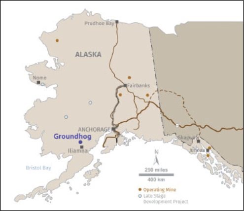
Figure 1: Groundhog Project Location.
2.1 Terms of Reference
Quaterra Resources Inc. ("Quaterra") requested Sisyphus Consulting to perform a property visit and to prepare an independent technical report for the Groundhog Project (the "Property"). Quaterra is based in Vancouver, British Columbia. The author of this document is Nicholas Van Wyck, Ph.D. CPG, of Sisyphus Consulting, who is an independent consultant, and has agreed to compile the information pertaining to the Property. The author is an independent consultant with has more than 27 years of experience in related mineral exploration and has sufficient experience relevant to the style of mineralization and type of deposit under consideration, and to the activities which are being recommended. Dr. Van Wyck is therefore an Independent and Qualified Person as defined in National Instrument 43-101.
| Quaterra Resources Inc. | May |
| Technical Report on the Groundhog Project | 2020 |
2.2 Purpose of Report
The purpose of this report is to compile past exploration activities on the property and to provide recommendations for further exploration. This report conforms to the guidelines set out by the National Instrument 43-101 for the disclosure of technical information regarding mineral projects owned by publicly traded Canadian companies.
2.3 Sources of Information
The material and data provided in this report were provided to the author by AES and through interviews with the principals at AES. Information consists of data generated from ongoing exploration by AES and historical data maintained by AES from previous owners. All the data files that were reviewed for the report were provided by AES in digital format. Also included in this report are personal observations made by Dr. Van Wyck in the course of field visits and on general geologic information available to the public through peer review journals, publications by the U.S. Geological Survey, and agencies of the State of Alaska. Public data and press releases on this and adjacent properties have been accessed via SEDAR.
A complete list of the reports and source documents used in the preparation of this report are cited in Section 19 References.
2.4 Field Examination
Dr. Van Wyck visited the project from September 11 to 12th, 2019.
2.5 Units and Abbreviations
All technical terms of reference regarding the terms resources, reserves or mineralization used in this report conform to the standards of practice published by the Canadian Institute of Mining Metallurgy and Petroleum. All geographic locations in this report are relative to North American Datum 1983. Geological and structural measurements, and directional bearings, are expressed relative to true north unless otherwise stated. Non-geodetic coordinates are expressed in Universal Transverse Mercator Zone 5N metric coordinates. All geological terms used are in standard use within the geological consulting profession in Canada and the U.S.A. This report uses metric units whenever possible and falls back to imperial measure when it is necessary to preserve historical context. Chemical elements and compounds are abbreviated using standard International Union of Pure and Applied Chemistry abbreviations. All references to dollars are in U.S. Dollars unless otherwise indicated. Other abbreviations are listed in Table 1.
Table 1: List of Abbreviations.
Abbreviation | Definition |
2D | 2 dimensional (data is modelled along a section) |
3D | 3 dimensional (data is modelled within a volume) |
AERI | Alaska Earth Resources Inc |
AES | Alaska Earth Sciences |
amsl | Above mean sea level |
ANCSA | Alaska Native Claims Settlement Act |
| Quaterra Resources Inc. | May |
| Technical Report on the Groundhog Project | 2020 |
APMA | Application for Permit to Mine in Alaska |
oC | Degrees Celsius |
CHU | Chuchuna Minerals Company |
CSAMT | Controlled-source Audio-frequency Magnetotellurics |
DDH | Diamond Drill Hole |
g | Grams |
g/t | Grams per Tonne - synonymous with ppm |
ft | feet |
Hz | hertz |
ICP - AES | Inductively Coupled Plasma - Atomic Emission Spectra |
IP | Induced polarization |
KEC | Kennecott Exploration Company |
km | kilometers |
m | meters |
Ma | Million years |
MTRSC | Meridian-Township-Range-Section-Quarter Section; the grid on which Alaska bases its mining claims |
mrad, mradian | milliradian |
MT | Magneto-telluric |
NI 43-101 | National Instrument 43-101 |
NQ | NQ drill core = 47.6 mm inside diameter |
ppb | Parts per Billion |
ppm | Parts per Million |
QA/QC | Quality Assurance/Quality Control |
QSP | Quartz-sericite-pyrite |
VIP | Vector IP (also known as RIP or reconnaissance IP) |
UTM | Universal Transverse Mercator Geographic Coordinate System (type of map projection) |
XYZ | Cartesian Coordinates; "Easting", "Northing", and "Elevation" |
ZTEM | Z-tipper axis electromagnetic survey (http://bit.ly/1WPDmcz) |
| Quaterra Resources Inc. | May |
| Technical Report on the Groundhog Project | 2020 |
3 Reliance on Other Experts
This report has been prepared by the author for Quaterra Resources. The information, conclusions, opinions, and estimates contained herein are based on:
• Information available to the author at the time of preparation of this report,
• Assumptions, conditions, and qualifications as set forth in this report, and
• Data, reports, and other information supplied by AES and other third-party sources.
For the purpose of this report, the author has relied on ownership information provided by AES.
The author has not researched Property title or mineral rights for the Groundhog property and expresses no opinion as to the ownership status at the property. Effort was made to review the information provided for obvious errors and omissions; however, the author is not responsible for any errors or omissions relating the legal status of claims described within this report.
Except for the purposes legislated under provincial securities laws, any use of this report by any third party are at that party's sole risk.
| Quaterra Resources Inc. | May |
| Technical Report on the Groundhog Project | 2020 |
4 Property Description and Location
4.1 Area and Location
The Groundhog property is located in the Bristol Bay region of southwestern Alaska, 300 km (186 mi) west-southwest of Anchorage, 18 miles north-northwest of the village of Iliamna, within the Lake and Peninsula Borough.
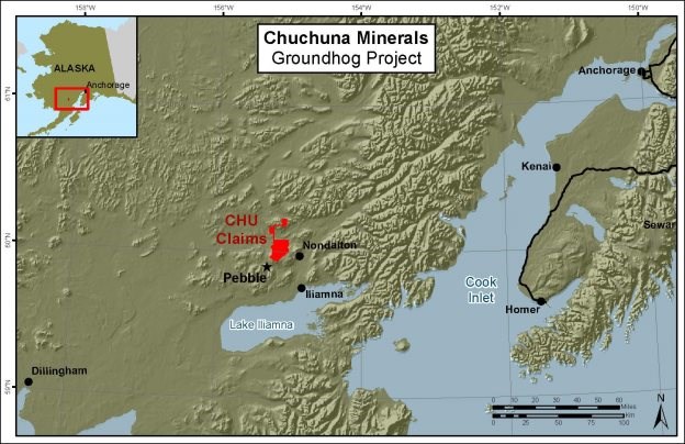
Figure 2: Groundhog Property Location, Access, and Infrastructure.
The property is centered, approximately, at latitude 60°04′ N and longitude 155°08′ W, and is located on the United States Geological Survey (USGS) topographic maps Iliamna D6 and Lake Clark A6, in Townships 1 North and South, Township 2 South, Ranges 33-34 West, Seward Meridian.
4.2 Claims
Chuchuna Minerals Company holds 100% interest in a contiguous block of 343 mineral claims covering approximately 84 square miles or 54,880 acres or 22,209 hectares.
| Quaterra Resources Inc. | May |
| Technical Report on the Groundhog Project | 2020 |
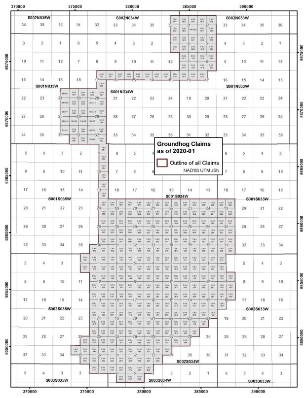
Figure 3: Claim map of the Groundhog property.
| Quaterra Resources Inc. | May |
| Technical Report on the Groundhog Project | 2020 |
State mineral claims in Alaska are kept in good standing by performing annual assessment work or in lieu of assessment work by paying $100 per year per 40 acre (0.06 square mile) mineral claim, and by paying annual escalating state rentals. All of the claims come due annually on August 31. However, credit for excess work can be banked for a maximum of five years afterwards, and can be applied as necessary to continue to hold the claims in good standing. The property claims have a variable amount of work credit available that can be applied in this way. Annual assessment work obligations for the property total US$111,200; existing credit for past work available for use going forward after 2019 total US$1,416,338. The annual rentals for 2019 were US$47,685. At the effective date of this report all rentals and assessment payments were current, all claims had been formally approved by the State of Alaska, and quitclaim transferred to Chuchuna.
Quaterra reached an agreement with Chuchuna in April 2017 whereby it has to provide $5 million over five years in exploration spending, later amended to six years, in order to earn a 90% interest in Groundhog. The Company is also required to pay a lump sum of $3 million at the end of the sixth year. Quaterra has no obligation to exercise its option and can terminate the agreement at its discretion annually. (All amounts are expressed in U.S. dollars). Chuchuna is the operator of the project and plans, implements and manages exploration field programs as set out in a budget and work plan approved by Quaterra. Chuchuna is an Alaskan company jointly owned by Kijik Corporation, the ANCSA village corporation for the community of Nondalton, and Alaska Earth Sciences, an Anchorage-based mineral exploration company. In February, 2019 a private party purchased Chuchuna shares and the percentage of ownership now consists of AES (48.433%), Kijik (46.533%), and private party (5.033%).
The details of the mineral claims are provided below (ADL refers to the Alaska Department of Lands).
| Quaterra Resources Inc. | May |
| Technical Report on the Groundhog Project | 2020 |
Table 2: Active Claims on the Groundhog Property.
ADL | Claim | T | R | S | Q | Owner | Loc Date | Acres | Status |
647270 | GDH 3 | 01N | 34W | 32 | SW | Chuchuna Minerals Company | 12/18/2004 | 160 | State |
648191 | NIKA 14 | 01N | 34W | 29 | NW | Chuchuna Minerals Company | 2/17/2005 | 160 | State |
648478 | NIKA1 | 01N | 35W | 36 | NE | Chuchuna Minerals Company | 2/17/2005 | 160 | State-Selected |
648481 | NIKA 4 | 01N | 34W | 32 | NW | Chuchuna Minerals Company | 2/17/2005 | 160 | State |
648484 | NIKA 7 | 01N | 34W | 29 | SW | Chuchuna Minerals Company | 2/17/2005 | 160 | State |
648485 | NIKA 8 | 01N | 34W | 30 | SE | Chuchuna Minerals Company | 2/17/2005 | 160 | State |
648486 | NIKA 9 | 01N | 34W | 30 | SW | Chuchuna Minerals Company | 2/17/2005 | 160 | State |
648487 | NIKA10 | 01N | 35W | 25 | SE | Chuchuna Minerals Company | 2/17/2005 | 160 | State-Selected |
648488 | NIKA11 | 01N | 35W | 25 | NE | Chuchuna Minerals Company | 2/17/2005 | 160 | State-Selected |
648494 | NIKA 17 | 01N | 34W | 20 | SW | Chuchuna Minerals Company | 2/17/2005 | 160 | State |
648497 | NIKA20 | 01N | 35W | 24 | SE | Chuchuna Minerals Company | 2/17/2005 | 160 | State-Selected |
648498 | NIKA21 | 01N | 35W | 24 | NE | Chuchuna Minerals Company | 2/17/2005 | 160 | State-Selected |
648569 | NIKA 92 | 02N | 33W | 31 | SE | Chuchuna Minerals Company | 2/17/2005 | 160 | State |
724143 | CHU 001 | 02N | 34W | 36 | NE | Chuchuna Minerals Company | 4/15/2017 | 160 | State |
724144 | CHU 002 | 02N | 33W | 31 | NW | Chuchuna Minerals Company | 4/15/2017 | 160 | State |
724145 | CHU 003 | 02N | 33W | 31 | NE | Chuchuna Minerals Company | 4/15/2017 | 160 | State |
724146 | CHU 004 | 02N | 33W | 32 | NW | Chuchuna Minerals Company | 4/15/2017 | 160 | State |
724147 | CHU 005 | 02N | 33W | 32 | NE | Chuchuna Minerals Company | 4/15/2017 | 160 | State |
724148 | CHU 006 | 02N | 33W | 32 | SE | Chuchuna Minerals Company | 4/15/2017 | 160 | State |
724149 | CHU 007 | 02N | 33W | 32 | SW | Chuchuna Minerals Company | 4/15/2017 | 160 | State |
724150 | CHU 008 | 02N | 33W | 31 | SW | Chuchuna Minerals Company | 4/15/2017 | 160 | State |
| Quaterra Resources Inc. | May |
| Technical Report on the Groundhog Project | 2020 |
724151 | CHU 009 | 02N | 34W | 36 | SE | Chuchuna Minerals Company | 4/15/2017 | 160 | State |
724152 | CHU 010 | 01N | 34W | 01 | NE | Chuchuna Minerals Company | 4/15/2017 | 160 | State |
724153 | CHU 011 | 01N | 34W | 01 | SE | Chuchuna Minerals Company | 4/15/2017 | 160 | State |
724154 | CHU 012 | 01N | 33W | 06 | SW | Chuchuna Minerals Company | 4/15/2017 | 160 | State |
724155 | CHU 013 | 01N | 33W | 05 | SW | Chuchuna Minerals Company | 4/15/2017 | 160 | State |
724156 | CHU 014 | 01N | 33W | 05 | SE | Chuchuna Minerals Company | 4/15/2017 | 160 | State |
724157 | CHU 015 | 01N | 33W | 08 | NE | Chuchuna Minerals Company | 4/15/2017 | 160 | State |
724158 | CHU 016 | 01N | 33W | 08 | NW | Chuchuna Minerals Company | 4/15/2017 | 160 | State |
724159 | CHU 017 | 01N | 33W | 07 | NW | Chuchuna Minerals Company | 4/15/2017 | 160 | State |
724160 | CHU 018 | 01N | 33W | 07 | SW | Chuchuna Minerals Company | 4/15/2017 | 160 | State |
724161 | CHU 019 | 01N | 33W | 08 | SW | Chuchuna Minerals Company | 4/15/2017 | 160 | State |
724162 | CHU 020 | 01N | 33W | 08 | SE | Chuchuna Minerals Company | 4/15/2017 | 160 | State |
724163 | CHU 021 | 01N | 33W | 17 | NW | Chuchuna Minerals Company | 4/15/2017 | 160 | State |
724164 | CHU 022 | 01N | 33W | 18 | NE | Chuchuna Minerals Company | 4/15/2017 | 160 | State |
724165 | CHU 023 | 01N | 33W | 18 | NW | Chuchuna Minerals Company | 4/15/2017 | 160 | State |
724166 | CHU 024 | 01N | 34W | 13 | NE | Chuchuna Minerals Company | 4/15/2017 | 160 | State |
724167 | CHU 025 | 01N | 34W | 13 | NW | Chuchuna Minerals Company | 4/15/2017 | 160 | State |
724168 | CHU 026 | 01N | 34W | 14 | NE | Chuchuna Minerals Company | 4/15/2017 | 160 | State |
724169 | CHU 027 | 01N | 34W | 14 | NW | Chuchuna Minerals Company | 4/15/2017 | 160 | State |
724170 | CHU 028 | 01N | 34W | 15 | NE | Chuchuna Minerals Company | 4/15/2017 | 160 | State |
724171 | CHU 029 | 01N | 34W | 15 | NW | Chuchuna Minerals Company | 4/15/2017 | 160 | State |
724172 | CHU 030 | 01N | 34W | 16 | NE | Chuchuna Minerals Company | 4/15/2017 | 160 | State |
724173 | CHU 031 | 01N | 34W | 16 | NW | Chuchuna Minerals Company | 4/15/2017 | 160 | State |
| Quaterra Resources Inc. | May |
| Technical Report on the Groundhog Project | 2020 |
724174 | CHU 032 | 01N | 34W | 17 | NE | Chuchuna Minerals Company | 4/15/2017 | 160 | State |
724175 | CHU 033 | 01N | 34W | 17 | SE | Chuchuna Minerals Company | 4/15/2017 | 160 | State |
724176 | CHU 034 | 01N | 34W | 20 | NE | Chuchuna Minerals Company | 4/15/2017 | 160 | State |
724177 | CHU 035 | 01N | 34W | 20 | NW | Chuchuna Minerals Company | 4/15/2017 | 160 | State |
724178 | CHU 036 | 01N | 34W | 19 | NE | Chuchuna Minerals Company | 4/15/2017 | 160 | State |
724179 | CHU 037 | 01N | 34W | 19 | NW | Chuchuna Minerals Company | 4/15/2017 | 160 | State |
724180 | CHU 038 | 01N | 34W | 19 | SW | Chuchuna Minerals Company | 4/15/2017 | 160 | State |
724181 | CHU 039 | 01N | 34W | 19 | SE | Chuchuna Minerals Company | 4/15/2017 | 160 | State |
724182 | CHU 040 | 01N | 34W | 20 | SE | Chuchuna Minerals Company | 4/15/2017 | 160 | State |
724183 | CHU 041 | 01N | 34W | 29 | NE | Chuchuna Minerals Company | 4/15/2017 | 160 | State |
724184 | CHU 042 | 01N | 34W | 30 | NE | Chuchuna Minerals Company | 4/15/2017 | 160 | State |
724185 | CHU 043 | 01N | 34W | 30 | NW | Chuchuna Minerals Company | 4/15/2017 | 160 | State |
724186 | CHU 044 | 01N | 34W | 29 | SE | Chuchuna Minerals Company | 4/15/2017 | 160 | State |
724187 | CHU 045 | 01N | 34W | 32 | NE | Chuchuna Minerals Company | 4/15/2017 | 160 | State |
724188 | CHU 046 | 01N | 34W | 31 | NE | Chuchuna Minerals Company | 4/15/2017 | 160 | State |
724189 | CHU 047 | 01N | 34W | 31 | NW | Chuchuna Minerals Company | 4/15/2017 | 160 | State |
724190 | CHU 048 | 01N | 34W | 31 | SW | Chuchuna Minerals Company | 4/15/2017 | 160 | State |
724191 | CHU 049 | 01N | 34W | 31 | SE | Chuchuna Minerals Company | 4/15/2017 | 160 | State |
724192 | CHU 050 | 01N | 34W | 32 | SE | Chuchuna Minerals Company | 4/15/2017 | 160 | State |
724193 | CHU 051 | 01S | 35W | 01 | NE | Chuchuna Minerals Company | 4/15/2017 | 160 | State |
724194 | CHU 052 | 01S | 35W | 01 | SE | Chuchuna Minerals Company | 4/15/2017 | 160 | State |
724195 | CHU 053 | 01S | 35W | 12 | NE | Chuchuna Minerals Company | 4/15/2017 | 160 | State |
724196 | CHU 054 | 01S | 35W | 12 | SE | Chuchuna Minerals Company | 4/15/2017 | 160 | State |
| Quaterra Resources Inc. | May |
| Technical Report on the Groundhog Project | 2020 |
724197 | CHU 055 | 01S | 35W | 13 | NE | Chuchuna Minerals Company | 4/15/2017 | 160 | State |
724198 | CHU 056 | 01S | 35W | 13 | SE | Chuchuna Minerals Company | 4/15/2017 | 160 | State |
724199 | CHU 057 | 01S | 34W | 23 | NW | Chuchuna Minerals Company | 4/15/2017 | 160 | State |
724200 | CHU 058 | 01S | 34W | 21 | NE | Chuchuna Minerals Company | 4/15/2017 | 160 | State |
724201 | CHU 059 | 01S | 34W | 21 | NW | Chuchuna Minerals Company | 4/15/2017 | 160 | State |
724202 | CHU 060 | 01S | 34W | 20 | NE | Chuchuna Minerals Company | 4/15/2017 | 160 | State |
724203 | CHU 061 | 01S | 34W | 20 | NW | Chuchuna Minerals Company | 4/15/2017 | 160 | State |
724204 | CHU 062 | 01S | 34W | 19 | NE | Chuchuna Minerals Company | 4/15/2017 | 160 | State |
724205 | CHU 063 | 01S | 34W | 19 | NW | Chuchuna Minerals Company | 4/15/2017 | 160 | State |
724206 | CHU 064 | 01S | 35W | 24 | NE | Chuchuna Minerals Company | 4/15/2017 | 160 | State |
724207 | CHU 065 | 01S | 35W | 24 | SE | Chuchuna Minerals Company | 4/15/2017 | 160 | State |
724208 | CHU 066 | 01S | 34W | 19 | SW | Chuchuna Minerals Company | 4/15/2017 | 160 | State |
724209 | CHU 067 | 01S | 34W | 19 | SE | Chuchuna Minerals Company | 4/15/2017 | 160 | State |
724210 | CHU 068 | 01S | 34W | 20 | SW | Chuchuna Minerals Company | 4/15/2017 | 160 | State |
724211 | CHU 069 | 01S | 34W | 20 | SE | Chuchuna Minerals Company | 4/15/2017 | 160 | State |
724212 | CHU 070 | 01S | 34W | 21 | SW | Chuchuna Minerals Company | 4/15/2017 | 160 | State |
724213 | CHU 071 | 01S | 34W | 21 | SE | Chuchuna Minerals Company | 4/15/2017 | 160 | State |
724214 | CHU 072 | 01S | 34W | 23 | SW | Chuchuna Minerals Company | 4/15/2017 | 160 | State |
724215 | CHU 073 | 01S | 34W | 26 | NE | Chuchuna Minerals Company | 4/15/2017 | 160 | State |
724216 | CHU 074 | 01S | 34W | 26 | NW | Chuchuna Minerals Company | 4/15/2017 | 160 | State |
724217 | CHU 075 | 01S | 34W | 28 | NE | Chuchuna Minerals Company | 4/15/2017 | 160 | State |
724218 | CHU 076 | 01S | 34W | 28 | NW | Chuchuna Minerals Company | 4/15/2017 | 160 | State |
724219 | CHU 077 | 01S | 34W | 29 | NE | Chuchuna Minerals Company | 4/15/2017 | 160 | State |
| Quaterra Resources Inc. | May |
| Technical Report on the Groundhog Project | 2020 |
724220 | CHU 078 | 01S | 34W | 29 | NW | Chuchuna Minerals Company | 4/15/2017 | 160 | State |
724221 | CHU 079 | 01S | 34W | 30 | NE | Chuchuna Minerals Company | 4/15/2017 | 160 | State |
724222 | CHU 080 | 01S | 34W | 30 | NW | Chuchuna Minerals Company | 4/15/2017 | 160 | State |
724223 | CHU 081 | 01S | 35W | 25 | NE | Chuchuna Minerals Company | 4/15/2017 | 160 | State |
724224 | CHU 082 | 01S | 35W | 25 | SE | Chuchuna Minerals Company | 4/15/2017 | 160 | State |
724225 | CHU 083 | 01S | 34W | 30 | SW | Chuchuna Minerals Company | 4/15/2017 | 160 | State |
724226 | CHU 084 | 01S | 34W | 30 | SE | Chuchuna Minerals Company | 4/15/2017 | 160 | State |
724227 | CHU 085 | 01S | 34W | 29 | SW | Chuchuna Minerals Company | 4/15/2017 | 160 | State |
724228 | CHU 086 | 01S | 34W | 29 | SE | Chuchuna Minerals Company | 4/15/2017 | 160 | State |
724229 | CHU 087 | 01S | 34W | 28 | SW | Chuchuna Minerals Company | 4/15/2017 | 160 | State |
724230 | CHU 088 | 01S | 34W | 28 | SE | Chuchuna Minerals Company | 4/15/2017 | 160 | State |
724231 | CHU 089 | 01S | 34W | 26 | SW | Chuchuna Minerals Company | 4/15/2017 | 160 | State |
724232 | CHU 090 | 01S | 34W | 26 | SE | Chuchuna Minerals Company | 4/15/2017 | 160 | State |
724233 | CHU 091 | 01S | 34W | 35 | NE | Chuchuna Minerals Company | 4/15/2017 | 160 | State |
724234 | CHU 092 | 01S | 34W | 35 | NW | Chuchuna Minerals Company | 4/15/2017 | 160 | State |
724235 | CHU 093 | 01S | 34W | 33 | NE | Chuchuna Minerals Company | 4/15/2017 | 160 | State |
724236 | CHU 094 | 01S | 34W | 33 | NW | Chuchuna Minerals Company | 4/15/2017 | 160 | State |
724237 | CHU 095 | 01S | 34W | 32 | NE | Chuchuna Minerals Company | 4/15/2017 | 160 | State |
724238 | CHU 096 | 01S | 34W | 32 | NW | Chuchuna Minerals Company | 4/15/2017 | 160 | State |
724239 | CHU 097 | 01S | 34W | 31 | NE | Chuchuna Minerals Company | 4/15/2017 | 160 | State |
724240 | CHU 098 | 01S | 34W | 31 | NW | Chuchuna Minerals Company | 4/15/2017 | 160 | State |
724241 | CHU 099 | 01S | 35W | 36 | NE | Chuchuna Minerals Company | 4/15/2017 | 160 | State |
724242 | CHU 100 | 01S | 35W | 36 | SW | Chuchuna Minerals Company | 4/15/2017 | 160 | State |
| Quaterra Resources Inc. | May |
| Technical Report on the Groundhog Project | 2020 |
724243 | CHU 101 | 01S | 35W | 36 | SE | Chuchuna Minerals Company | 4/15/2017 | 160 | State |
724244 | CHU 102 | 01S | 34W | 31 | SW | Chuchuna Minerals Company | 4/15/2017 | 160 | State |
724245 | CHU 103 | 01S | 34W | 31 | SE | Chuchuna Minerals Company | 4/15/2017 | 160 | State |
724246 | CHU 104 | 01S | 34W | 32 | SW | Chuchuna Minerals Company | 4/15/2017 | 160 | State |
724247 | CHU 105 | 01S | 34W | 32 | SE | Chuchuna Minerals Company | 4/15/2017 | 160 | State |
724248 | CHU 106 | 01S | 34W | 33 | SW | Chuchuna Minerals Company | 4/15/2017 | 160 | State |
724249 | CHU 107 | 01S | 34W | 33 | SE | Chuchuna Minerals Company | 4/15/2017 | 160 | State |
724250 | CHU 108 | 01S | 34W | 35 | SW | Chuchuna Minerals Company | 4/15/2017 | 160 | State |
724251 | CHU 109 | 01S | 34W | 35 | SE | Chuchuna Minerals Company | 4/15/2017 | 160 | State |
724252 | CHU 110 | 02S | 34W | 02 | NE | Chuchuna Minerals Company | 4/15/2017 | 160 | State |
724253 | CHU 111 | 02S | 34W | 02 | NW | Chuchuna Minerals Company | 4/15/2017 | 160 | State |
724254 | CHU 112 | 02S | 34W | 04 | NE | Chuchuna Minerals Company | 4/15/2017 | 160 | State |
724255 | CHU 113 | 02S | 34W | 04 | NW | Chuchuna Minerals Company | 4/15/2017 | 160 | State |
724256 | CHU 114 | 02S | 34W | 05 | NE | Chuchuna Minerals Company | 4/15/2017 | 160 | State |
724257 | CHU 115 | 02S | 34W | 05 | NW | Chuchuna Minerals Company | 4/15/2017 | 160 | State |
724258 | CHU 116 | 02S | 34W | 06 | NE | Chuchuna Minerals Company | 4/15/2017 | 160 | State |
724259 | CHU 117 | 02S | 34W | 06 | NW | Chuchuna Minerals Company | 4/15/2017 | 160 | State |
724260 | CHU 118 | 02S | 35W | 01 | NE | Chuchuna Minerals Company | 4/15/2017 | 160 | State |
724261 | CHU 119 | 02S | 35W | 01 | NW | Chuchuna Minerals Company | 4/15/2017 | 160 | State |
724262 | CHU 120 | 02S | 35W | 02 | NE | Chuchuna Minerals Company | 4/15/2017 | 160 | State |
724263 | CHU 121 | 02S | 35W | 02 | SE | Chuchuna Minerals Company | 4/15/2017 | 160 | State |
724264 | CHU 122 | 02S | 35W | 01 | SW | Chuchuna Minerals Company | 4/15/2017 | 160 | State |
724265 | CHU 123 | 02S | 35W | 01 | SE | Chuchuna Minerals Company | 4/15/2017 | 160 | State |
| Quaterra Resources Inc. | May |
| Technical Report on the Groundhog Project | 2020 |
724266 | CHU 124 | 02S | 34W | 06 | SW | Chuchuna Minerals Company | 4/15/2017 | 160 | State |
724267 | CHU 125 | 02S | 34W | 06 | SE | Chuchuna Minerals Company | 4/15/2017 | 160 | State |
724268 | CHU 126 | 02S | 34W | 05 | SW | Chuchuna Minerals Company | 4/15/2017 | 160 | State |
724269 | CHU 127 | 02S | 34W | 05 | SE | Chuchuna Minerals Company | 4/15/2017 | 160 | State |
724270 | CHU 128 | 02S | 34W | 04 | SW | Chuchuna Minerals Company | 4/15/2017 | 160 | State |
724271 | CHU 129 | 02S | 34W | 04 | SE | Chuchuna Minerals Company | 4/15/2017 | 160 | State |
724272 | CHU 130 | 02S | 34W | 03 | SW | Chuchuna Minerals Company | 4/15/2017 | 160 | State |
724273 | CHU 131 | 02S | 34W | 02 | SE | Chuchuna Minerals Company | 4/15/2017 | 160 | State |
724274 | CHU 132 | 02S | 34W | 01 | SW | Chuchuna Minerals Company | 4/15/2017 | 160 | State |
724275 | CHU 133 | 02S | 34W | 01 | SE | Chuchuna Minerals Company | 4/15/2017 | 160 | State |
724276 | CHU 134 | 02S | 33W | 06 | SW | Chuchuna Minerals Company | 4/15/2017 | 160 | State |
724277 | CHU 135 | 02S | 33W | 07 | NE | Chuchuna Minerals Company | 4/15/2017 | 160 | State |
724278 | CHU 136 | 02S | 33W | 07 | NW | Chuchuna Minerals Company | 4/15/2017 | 160 | State |
724279 | CHU 137 | 02S | 34W | 12 | NE | Chuchuna Minerals Company | 4/15/2017 | 160 | State |
724280 | CHU 138 | 02S | 34W | 12 | NW | Chuchuna Minerals Company | 4/15/2017 | 160 | State |
724281 | CHU 139 | 02S | 34W | 11 | NE | Chuchuna Minerals Company | 4/15/2017 | 160 | State |
724282 | CHU 140 | 02S | 34W | 10 | NW | Chuchuna Minerals Company | 4/15/2017 | 160 | State |
724283 | CHU 141 | 02S | 34W | 09 | NE | Chuchuna Minerals Company | 4/15/2017 | 160 | State |
724284 | CHU 142 | 02S | 34W | 09 | NW | Chuchuna Minerals Company | 4/15/2017 | 160 | State |
724285 | CHU 143 | 02S | 34W | 08 | NE | Chuchuna Minerals Company | 4/15/2017 | 160 | State |
724286 | CHU 144 | 02S | 34W | 08 | NW | Chuchuna Minerals Company | 4/15/2017 | 160 | State |
724287 | CHU 145 | 02S | 34W | 07 | NE | Chuchuna Minerals Company | 4/15/2017 | 160 | State |
724288 | CHU 146 | 02S | 34W | 07 | NW | Chuchuna Minerals Company | 4/15/2017 | 160 | State |
| Quaterra Resources Inc. | May |
| Technical Report on the Groundhog Project | 2020 |
724289 | CHU 147 | 02S | 35W | 12 | NE | Chuchuna Minerals Company | 4/15/2017 | 160 | State |
724290 | CHU 148 | 02S | 35W | 12 | NW | Chuchuna Minerals Company | 4/15/2017 | 160 | State |
724291 | CHU 149 | 02S | 34W | 07 | SW | Chuchuna Minerals Company | 4/15/2017 | 160 | State |
724292 | CHU 150 | 02S | 34W | 07 | SE | Chuchuna Minerals Company | 4/15/2017 | 160 | State |
724293 | CHU 151 | 02S | 34W | 08 | SW | Chuchuna Minerals Company | 4/15/2017 | 160 | State |
724294 | CHU 152 | 02S | 34W | 08 | SE | Chuchuna Minerals Company | 4/15/2017 | 160 | State |
724295 | CHU 153 | 02S | 34W | 09 | SW | Chuchuna Minerals Company | 4/15/2017 | 160 | State |
724296 | CHU 154 | 02S | 34W | 09 | SE | Chuchuna Minerals Company | 4/15/2017 | 160 | State |
724297 | CHU 155 | 02S | 34W | 10 | SW | Chuchuna Minerals Company | 4/15/2017 | 160 | State |
724298 | CHU 156 | 02S | 34W | 12 | SW | Chuchuna Minerals Company | 4/15/2017 | 160 | State |
724299 | CHU 157 | 02S | 34W | 12 | SE | Chuchuna Minerals Company | 4/15/2017 | 160 | State |
724300 | CHU 158 | 02S | 33W | 07 | SW | Chuchuna Minerals Company | 4/15/2017 | 160 | State |
724301 | CHU 159 | 02S | 33W | 07 | SE | Chuchuna Minerals Company | 4/15/2017 | 160 | State |
724302 | CHU 160 | 02S | 33W | 18 | NE | Chuchuna Minerals Company | 4/15/2017 | 160 | State |
724303 | CHU 161 | 02S | 33W | 18 | NW | Chuchuna Minerals Company | 4/15/2017 | 160 | State |
724304 | CHU 162 | 02S | 34W | 17 | NE | Chuchuna Minerals Company | 4/15/2017 | 160 | State |
724305 | CHU 163 | 02S | 34W | 17 | NW | Chuchuna Minerals Company | 4/15/2017 | 160 | State |
724306 | CHU 164 | 02S | 34W | 18 | NE | Chuchuna Minerals Company | 4/15/2017 | 160 | State |
724307 | CHU 165 | 02S | 34W | 17 | SW | Chuchuna Minerals Company | 4/15/2017 | 160 | State |
724308 | CHU 166 | 02S | 34W | 17 | SE | Chuchuna Minerals Company | 4/15/2017 | 160 | State |
724309 | CHU 167 | 02S | 34W | 13 | SE | Chuchuna Minerals Company | 4/15/2017 | 160 | State |
724310 | CHU 168 | 02S | 33W | 18 | SW | Chuchuna Minerals Company | 4/15/2017 | 160 | State |
724311 | CHU 169 | 02S | 34W | 24 | NE | Chuchuna Minerals Company | 4/16/2017 | 160 | State |
| Quaterra Resources Inc. | May |
| Technical Report on the Groundhog Project | 2020 |
724312 | CHU 170 | 02S | 34W | 24 | NW | Chuchuna Minerals Company | 4/15/2017 | 160 | State |
724313 | CHU 171 | 02S | 34W | 21 | NE | Chuchuna Minerals Company | 4/15/2017 | 160 | State |
724314 | CHU 172 | 02S | 34W | 21 | NW | Chuchuna Minerals Company | 4/15/2017 | 160 | State |
724315 | CHU 173 | 02S | 34W | 20 | NE | Chuchuna Minerals Company | 4/15/2017 | 160 | State |
724316 | CHU 174 | 02S | 34W | 20 | NW | Chuchuna Minerals Company | 4/15/2017 | 160 | State |
724317 | CHU 175 | 02S | 34W | 20 | SW | Chuchuna Minerals Company | 4/16/2017 | 160 | State |
724318 | CHU 176 | 02S | 34W | 20 | SE | Chuchuna Minerals Company | 4/16/2017 | 160 | State |
724319 | CHU 177 | 02S | 34W | 21 | SW | Chuchuna Minerals Company | 4/16/2017 | 160 | State |
724320 | CHU 178 | 02S | 34W | 21 | SE | Chuchuna Minerals Company | 4/16/2017 | 160 | State |
724321 | CHU 179 | 02S | 34W | 23 | SE | Chuchuna Minerals Company | 4/16/2017 | 160 | State |
724322 | CHU 180 | 02S | 34W | 24 | SW | Chuchuna Minerals Company | 4/16/2017 | 160 | State |
724323 | CHU 181 | 02S | 34W | 26 | NE | Chuchuna Minerals Company | 4/16/2017 | 160 | State |
724324 | CHU 182 | 02S | 34W | 26 | NW | Chuchuna Minerals Company | 4/16/2017 | 160 | State |
724325 | CHU 183 | 02S | 34W | 28 | NE | Chuchuna Minerals Company | 4/16/2017 | 160 | State |
724326 | CHU 184 | 02S | 34W | 28 | NW | Chuchuna Minerals Company | 4/16/2017 | 160 | State |
724327 | CHU 185 | 02S | 34W | 29 | NE | Chuchuna Minerals Company | 4/16/2017 | 160 | State |
724328 | CHU 186 | 02S | 34W | 29 | NW | Chuchuna Minerals Company | 4/16/2017 | 160 | State |
724329 | CHU 187 | 02S | 34W | 30 | SE | Chuchuna Minerals Company | 4/16/2017 | 160 | State |
724330 | CHU 188 | 02S | 34W | 29 | SW | Chuchuna Minerals Company | 4/16/2017 | 160 | State |
724331 | CHU 189 | 02S | 34W | 29 | SE | Chuchuna Minerals Company | 4/16/2017 | 160 | State |
724332 | CHU 190 | 02S | 34W | 28 | SW | Chuchuna Minerals Company | 4/16/2017 | 160 | State |
724333 | CHU 191 | 02S | 34W | 28 | SE | Chuchuna Minerals Company | 4/16/2017 | 160 | State |
724334 | CHU 192 | 02S | 34W | 27 | SW | Chuchuna Minerals Company | 4/16/2017 | 160 | State |
| Quaterra Resources Inc. | May |
| Technical Report on the Groundhog Project | 2020 |
724335 | CHU 193 | 02S | 34W | 27 | SE | Chuchuna Minerals Company | 4/16/2017 | 160 | State |
724336 | CHU 194 | 02S | 34W | 26 | SW | Chuchuna Minerals Company | 4/16/2017 | 160 | State |
724337 | CHU 195 | 02S | 34W | 34 | NW | Chuchuna Minerals Company | 4/16/2017 | 160 | State |
724338 | CHU 196 | 02S | 34W | 33 | NE | Chuchuna Minerals Company | 4/16/2017 | 160 | State |
724339 | CHU 197 | 02S | 34W | 33 | NW | Chuchuna Minerals Company | 4/16/2017 | 160 | State |
724340 | CHU 198 | 02S | 34W | 32 | NE | Chuchuna Minerals Company | 4/16/2017 | 160 | State |
724341 | CHU 199 | 02S | 34W | 32 | NW | Chuchuna Minerals Company | 4/16/2017 | 160 | State |
724342 | CHU 200 | 02S | 34W | 31 | NE | Chuchuna Minerals Company | 4/16/2017 | 160 | State |
724343 | CHU 201 | 02S | 34W | 31 | NW | Chuchuna Minerals Company | 4/16/2017 | 160 | State |
724344 | CHU 202 | 02S | 35W | 36 | SE | Chuchuna Minerals Company | 4/16/2017 | 160 | State |
724345 | CHU 203 | 02S | 34W | 31 | SW | Chuchuna Minerals Company | 4/16/2017 | 160 | State |
724346 | CHU 204 | 02S | 34W | 31 | SE | Chuchuna Minerals Company | 4/16/2017 | 160 | State |
724347 | CHU 205 | 02S | 34W | 32 | SW | Chuchuna Minerals Company | 4/16/2017 | 160 | State |
724348 | CHU 206 | 02S | 34W | 32 | SE | Chuchuna Minerals Company | 4/16/2017 | 160 | State |
724349 | CHU 207 | 02S | 34W | 33 | SW | Chuchuna Minerals Company | 4/16/2017 | 160 | State |
724350 | CHU 208 | 02S | 34W | 33 | SE | Chuchuna Minerals Company | 4/16/2017 | 160 | State |
724351 | CHU 209 | 03S | 34W | 04 | NW | Chuchuna Minerals Company | 4/16/2017 | 160 | State |
724352 | CHU 210 | 03S | 34W | 05 | NE | Chuchuna Minerals Company | 4/16/2017 | 160 | State |
724353 | CHU 211 | 03S | 34W | 05 | NW | Chuchuna Minerals Company | 4/16/2017 | 160 | State |
724354 | CHU 212 | 03S | 34W | 06 | NE | Chuchuna Minerals Company | 4/16/2017 | 160 | State |
724355 | CHU 213 | 03S | 34W | 06 | NW | Chuchuna Minerals Company | 4/16/2017 | 160 | State |
724356 | CHU 214 | 03S | 35W | 01 | NE | Chuchuna Minerals Company | 4/16/2017 | 160 | State |
724357 | CHU 215 | 03S | 35W | 01 | NW | Chuchuna Minerals Company | 4/16/2017 | 160 | State |
| Quaterra Resources Inc. | May |
| Technical Report on the Groundhog Project | 2020 |
724358 | CHU 216 | 03S | 34W | 06 | SE | Chuchuna Minerals Company | 4/16/2017 | 160 | State |
724359 | CHU 217 | 03S | 34W | 05 | SW | Chuchuna Minerals Company | 4/16/2017 | 160 | State |
724360 | CHU 218 | 03S | 34W | 05 | SE | Chuchuna Minerals Company | 4/16/2017 | 160 | State |
728084 | CHU 239 | 01S | 34W | 22 | NW | Chuchuna Minerals Company | 5/8/2018 | 160 | State |
728085 | CHU 240 | 01S | 34W | 22 | NE | Chuchuna Minerals Company | 5/8/2018 | 160 | State |
728086 | CHU 241 | 01S | 34W | 22 | SW | Chuchuna Minerals Company | 5/8/2018 | 160 | State |
728087 | CHU 242 | 01S | 34W | 22 | SE | Chuchuna Minerals Company | 5/8/2018 | 160 | State |
728088 | CHU 243 | 01S | 34W | 27 | NW | Chuchuna Minerals Company | 5/8/2018 | 160 | State |
728089 | CHU 244 | 01S | 34W | 27 | NE | Chuchuna Minerals Company | 5/8/2018 | 160 | State |
728090 | CHU 245 | 01S | 34W | 27 | SW | Chuchuna Minerals Company | 5/8/2018 | 160 | State |
728091 | CHU 246 | 01S | 34W | 27 | SE | Chuchuna Minerals Company | 5/8/2018 | 160 | State |
728092 | CHU 247 | 01S | 34W | 34 | NW | Chuchuna Minerals Company | 5/8/2018 | 160 | State |
728093 | CHU 248 | 01S | 34W | 34 | NE | Chuchuna Minerals Company | 5/8/2018 | 160 | State |
728094 | CHU 249 | 01S | 34W | 34 | SW | Chuchuna Minerals Company | 5/8/2018 | 160 | State |
728095 | CHU 250 | 01S | 34W | 34 | SE | Chuchuna Minerals Company | 5/8/2018 | 160 | State |
728096 | CHU 251 | 02S | 34W | 03 | NW | Chuchuna Minerals Company | 5/8/2018 | 160 | State |
728097 | CHU 252 | 02S | 34W | 03 | NE | Chuchuna Minerals Company | 5/8/2018 | 160 | State |
728098 | CHU 253 | 02S | 34W | 03 | SE | Chuchuna Minerals Company | 5/8/2018 | 160 | State |
728099 | CHU 254 | 02S | 34W | 02 | SW | Chuchuna Minerals Company | 5/8/2018 | 160 | State |
728100 | CHU 255 | 02S | 34W | 10 | NE | Chuchuna Minerals Company | 5/8/2018 | 160 | State |
728101 | CHU 256 | 02S | 34W | 11 | NW | Chuchuna Minerals Company | 5/8/2018 | 160 | State |
728102 | CHU 257 | 02S | 34W | 10 | SE | Chuchuna Minerals Company | 5/8/2018 | 160 | State |
728103 | CHU 258 | 02S | 34W | 11 | SW | Chuchuna Minerals Company | 5/8/2018 | 160 | State |
| Quaterra Resources Inc. | May |
| Technical Report on the Groundhog Project | 2020 |
728104 | CHU 259 | 02S | 34W | 11 | SE | Chuchuna Minerals Company | 5/8/2018 | 160 | State |
728105 | CHU 260 | 02S | 34W | 16 | NW | Chuchuna Minerals Company | 5/8/2018 | 160 | State |
728106 | CHU 261 | 02S | 34W | 16 | NE | Chuchuna Minerals Company | 5/8/2018 | 160 | State |
728107 | CHU 262 | 02S | 34W | 15 | NW | Chuchuna Minerals Company | 5/8/2018 | 160 | State |
728108 | CHU 263 | 02S | 34W | 15 | NE | Chuchuna Minerals Company | 5/8/2018 | 160 | State |
728109 | CHU 264 | 02S | 34W | 14 | NW | Chuchuna Minerals Company | 5/8/2018 | 160 | State |
728110 | CHU 265 | 02S | 34W | 14 | NE | Chuchuna Minerals Company | 5/8/2018 | 160 | State |
728111 | CHU 266 | 02S | 34W | 13 | NW | Chuchuna Minerals Company | 5/8/2018 | 160 | State |
728112 | CHU 267 | 02S | 34W | 13 | NE | Chuchuna Minerals Company | 5/8/2018 | 160 | State |
728113 | CHU 268 | 02S | 34W | 16 | SW | Chuchuna Minerals Company | 5/8/2018 | 160 | State |
728114 | CHU 269 | 02S | 34W | 16 | SE | Chuchuna Minerals Company | 5/8/2018 | 160 | State |
728115 | CHU 270 | 02S | 34W | 15 | SW | Chuchuna Minerals Company | 5/8/2018 | 160 | State |
728116 | CHU 271 | 02S | 34W | 15 | SE | Chuchuna Minerals Company | 5/8/2018 | 160 | State |
728117 | CHU 272 | 02S | 34W | 14 | SW | Chuchuna Minerals Company | 5/8/2018 | 160 | State |
728118 | CHU 273 | 02S | 34W | 14 | SE | Chuchuna Minerals Company | 5/8/2018 | 160 | State |
728119 | CHU 274 | 02S | 34W | 13 | SW | Chuchuna Minerals Company | 5/8/2018 | 160 | State |
728120 | CHU 275 | 02S | 34W | 22 | NW | Chuchuna Minerals Company | 5/8/2018 | 160 | State |
728121 | CHU 276 | 02S | 34W | 22 | NE | Chuchuna Minerals Company | 5/8/2018 | 160 | State |
728122 | CHU 277 | 02S | 34W | 23 | NW | Chuchuna Minerals Company | 5/8/2018 | 160 | State |
728123 | CHU 278 | 02S | 34W | 23 | NE | Chuchuna Minerals Company | 5/8/2018 | 160 | State |
728124 | CHU 279 | 02S | 34W | 22 | SW | Chuchuna Minerals Company | 5/8/2018 | 160 | State |
728125 | CHU 280 | 02S | 34W | 22 | SE | Chuchuna Minerals Company | 5/8/2018 | 160 | State |
728126 | CHU 281 | 02S | 34W | 23 | SW | Chuchuna Minerals Company | 5/8/2018 | 160 | State |
| Quaterra Resources Inc. | May |
| Technical Report on the Groundhog Project | 2020 |
728127 | CHU 282 | 02S | 34W | 27 | NW | Chuchuna Minerals Company | 5/8/2018 | 160 | State |
728128 | CHU 283 | 02S | 34W | 27 | NE | Chuchuna Minerals Company | 5/8/2018 | 160 | State |
728130 | CHU 220 | 01N | 33W | 06 | NW | Chuchuna Minerals Company | 5/8/2018 | 160 | State |
728131 | CHU 221 | 01N | 33W | 06 | NE | Chuchuna Minerals Company | 5/8/2018 | 160 | State |
728132 | CHU 222 | 01N | 33W | 05 | NW | Chuchuna Minerals Company | 5/8/2018 | 160 | State |
728133 | CHU 223 | 01N | 33W | 05 | NE | Chuchuna Minerals Company | 5/8/2018 | 160 | State |
728134 | CHU 224 | 01N | 33W | 06 | SE | Chuchuna Minerals Company | 5/8/2018 | 160 | State |
728135 | CHU 225 | 01N | 33W | 07 | NE | Chuchuna Minerals Company | 5/8/2018 | 160 | State |
728136 | CHU 226 | 01N | 33W | 07 | SE | Chuchuna Minerals Company | 5/8/2018 | 160 | State |
730658 | CHU 284 | 01S | 34W | 23 | NE | Chuchuna Minerals Company | 9/13/2019 | 160 | State |
730659 | CHU 285 | 01S | 34W | 24 | NW | Chuchuna Minerals Company | 9/13/2019 | 160 | State |
730660 | CHU 286 | 01S | 34W | 24 | NE | Chuchuna Minerals Company | 9/13/2019 | 160 | State |
730661 | CHU 287 | 01S | 33W | 19 | NW | Chuchuna Minerals Company | 9/13/2019 | 160 | State |
730662 | CHU 288 | 01S | 33W | 19 | NE | Chuchuna Minerals Company | 9/13/2019 | 160 | State |
730663 | CHU 289 | 01S | 34W | 23 | SE | Chuchuna Minerals Company | 9/13/2019 | 160 | State |
730664 | CHU 290 | 01S | 34W | 24 | SW | Chuchuna Minerals Company | 9/13/2019 | 160 | State |
730665 | CHU 291 | 01S | 34W | 24 | SE | Chuchuna Minerals Company | 9/13/2019 | 160 | State |
730666 | CHU 292 | 01S | 33W | 19 | SW | Chuchuna Minerals Company | 9/13/2019 | 160 | State |
730667 | CHU 293 | 01S | 33W | 19 | SE | Chuchuna Minerals Company | 9/13/2019 | 160 | State |
730668 | CHU 294 | 01S | 34W | 25 | NW | Chuchuna Minerals Company | 9/13/2019 | 160 | State |
730669 | CHU 295 | 01S | 34W | 25 | NE | Chuchuna Minerals Company | 9/13/2019 | 160 | State |
730670 | CHU 296 | 01S | 33W | 30 | NW | Chuchuna Minerals Company | 9/13/2019 | 160 | State |
730671 | CHU 297 | 01S | 33W | 30 | NE | Chuchuna Minerals Company | 9/13/2019 | 160 | State |
| Quaterra Resources Inc. | May |
| Technical Report on the Groundhog Project | 2020 |
730672 | CHU 298 | 01S | 34W | 25 | SW | Chuchuna Minerals Company | 9/13/2019 | 160 | State |
730673 | CHU 299 | 01S | 34W | 25 | SE | Chuchuna Minerals Company | 9/13/2019 | 160 | State |
730674 | CHU 300 | 01S | 33W | 30 | SW | Chuchuna Minerals Company | 9/13/2019 | 160 | State |
730675 | CHU 301 | 01S | 33W | 30 | SE | Chuchuna Minerals Company | 9/13/2019 | 160 | State |
730676 | CHU 302 | 01S | 34W | 36 | NW | Chuchuna Minerals Company | 9/13/2019 | 160 | State |
730677 | CHU 303 | 01S | 34W | 36 | NE | Chuchuna Minerals Company | 9/13/2019 | 160 | State |
730678 | CHU 304 | 01S | 33W | 31 | NW | Chuchuna Minerals Company | 9/13/2019 | 160 | State |
730679 | CHU 305 | 01S | 33W | 31 | NE | Chuchuna Minerals Company | 9/13/2019 | 160 | State |
730680 | CHU 306 | 01S | 34W | 36 | SW | Chuchuna Minerals Company | 9/13/2019 | 160 | State |
730681 | CHU 307 | 01S | 34W | 36 | SE | Chuchuna Minerals Company | 9/13/2019 | 160 | State |
730682 | CHU 308 | 01S | 33W | 31 | SW | Chuchuna Minerals Company | 9/13/2019 | 160 | State |
730683 | CHU 309 | 01S | 33W | 31 | SE | Chuchuna Minerals Company | 9/13/2019 | 160 | State |
730684 | CHU 310 | 02S | 34W | 1 | NW | Chuchuna Minerals Company | 9/13/2019 | 160 | State |
730685 | CHU 311 | 02S | 34W | 1 | NE | Chuchuna Minerals Company | 9/13/2019 | 160 | State |
730686 | CHU 312 | 02S | 33W | 6 | NW | Chuchuna Minerals Company | 9/13/2019 | 160 | State |
730687 | CHU 313 | 02S | 35W | 12 | SW | Chuchuna Minerals Company | 9/13/2019 | 160 | State |
730688 | CHU 314 | 02S | 35W | 12 | SE | Chuchuna Minerals Company | 9/13/2019 | 160 | State |
730689 | CHU 315 | 02S | 35W | 13 | NW | Chuchuna Minerals Company | 9/13/2019 | 160 | State |
730690 | CHU 316 | 02S | 35W | 13 | NE | Chuchuna Minerals Company | 9/13/2019 | 160 | State |
730691 | CHU 317 | 02S | 34W | 18 | NW | Chuchuna Minerals Company | 9/13/2019 | 160 | State |
730692 | CHU 318 | 02S | 35W | 13 | SW | Chuchuna Minerals Company | 9/13/2019 | 160 | State |
730693 | CHU 319 | 02S | 35W | 13 | SE | Chuchuna Minerals Company | 9/13/2019 | 160 | State |
730694 | CHU 320 | 02S | 34W | 18 | SW | Chuchuna Minerals Company | 9/13/2019 | 160 | State |
| Quaterra Resources Inc. | May |
| Technical Report on the Groundhog Project | 2020 |
730695 | CHU 321 | 02S | 34W | 18 | SE | Chuchuna Minerals Company | 9/13/2019 | 160 | State |
730696 | CHU 322 | 02S | 35W | 24 | NW | Chuchuna Minerals Company | 9/13/2019 | 160 | State |
730697 | CHU 323 | 02S | 35W | 24 | NE | Chuchuna Minerals Company | 9/13/2019 | 160 | State |
730698 | CHU 324 | 02S | 34W | 19 | NW | Chuchuna Minerals Company | 9/13/2019 | 160 | State |
730699 | CHU 325 | 02S | 34W | 19 | NE | Chuchuna Minerals Company | 9/13/2019 | 160 | State |
730700 | CHU 326 | 02S | 35W | 24 | SW | Chuchuna Minerals Company | 9/13/2019 | 160 | State |
730701 | CHU 327 | 02S | 35W | 24 | SE | Chuchuna Minerals Company | 9/13/2019 | 160 | State |
730702 | CHU 328 | 02S | 34W | 19 | SW | Chuchuna Minerals Company | 9/13/2019 | 160 | State |
730703 | CHU 329 | 02S | 34W | 19 | SE | Chuchuna Minerals Company | 9/13/2019 | 160 | State |
730704 | CHU 330 | 02S | 35W | 25 | NW | Chuchuna Minerals Company | 9/13/2019 | 160 | State |
730705 | CHU 331 | 02S | 35W | 25 | NE | Chuchuna Minerals Company | 9/13/2019 | 160 | State |
730706 | CHU 332 | 02S | 34W | 30 | NW | Chuchuna Minerals Company | 9/13/2019 | 160 | State |
730707 | CHU 333 | 02S | 34W | 30 | NE | Chuchuna Minerals Company | 9/13/2019 | 160 | State |
730708 | CHU 334 | 02S | 35W | 26 | SE | Chuchuna Minerals Company | 9/13/2019 | 160 | State |
730709 | CHU 335 | 02S | 35W | 25 | SW | Chuchuna Minerals Company | 9/13/2019 | 160 | State |
730710 | CHU 336 | 02S | 35W | 25 | SE | Chuchuna Minerals Company | 9/13/2019 | 160 | State |
730711 | CHU 337 | 02S | 34W | 30 | SW | Chuchuna Minerals Company | 9/13/2019 | 160 | State |
730712 | CHU 338 | 02S | 35W | 35 | NW | Chuchuna Minerals Company | 9/13/2019 | 160 | State |
730713 | CHU 339 | 02S | 35W | 35 | NE | Chuchuna Minerals Company | 9/13/2019 | 160 | State |
730714 | CHU 340 | 02S | 35W | 36 | NW | Chuchuna Minerals Company | 9/13/2019 | 160 | State |
730715 | CHU 341 | 02S | 35W | 36 | NE | Chuchuna Minerals Company | 9/13/2019 | 160 | State |
730716 | CHU 342 | 02S | 35W | 35 | SE | Chuchuna Minerals Company | 9/13/2019 | 160 | State |
730717 | CHU 343 | 02S | 35W | 36 | SW | Chuchuna Minerals Company | 9/13/2019 | 160 | State |
| Quaterra Resources Inc. | May |
| Technical Report on the Groundhog Project | 2020 |
The claim boundaries have not been surveyed.
4.3 Environmental Liabilities
There are no known environmental liabilities associated with the property.
4.4 Permits
All necessary permits and authorizations are in place for the Company to continue to conduct ground-based exploration on the property including helicopter-supported drilling.
A multi-year APMA application was submitted in 2017 to explore on the property. APMA authorization (APMA# 173099) was approved by the DNR on July 6, 2017 and has been revised four times. The current APMA (#173099#4) is valid until 12/31/2021 along with an additional Miscellaneous Land Use Permit 3099#4.
Reclamation bonding for the project is through the Alaska Statewide Bond Pool, for which there is an annual fee of $112.50 per acre of disturbance. The project is not required to post bond as the area of disturbance is currently less than 5 acres and the project has 0.25 acres of recorded disturbance. An annual reclamation statement was last submitted to DNR April, 2019 documenting no new surface disturbance in 2018.
5 Accessibility, Climate, Local Resources, Infrastructure and Physiography
[portions of the text in this section have been excerpted and modified from the same section of the current 43-101 report from the adjacent Pebble project (Gaunt et al., 2018)]
5.1 Access
Access to the property is typically via air travel from the city of Anchorage, which is situated at the north-eastern end of Cook Inlet and is connected to the national road network via Interstate Highway 1 through Canada to the USA. Anchorage is serviced daily by several regularly scheduled flights from major national and international airports. From Anchorage, there are regular flights to Iliamna and/or Nondalton through three currently active Part 135 air taxi services. Charter flights may also be arranged from Anchorage. From Nondalton, access to the Groundhog property can be accomplished by four-wheeler to the southern portion of the claim block or by helicopter to the remainder.
| Quaterra Resources Inc. | May |
| Technical Report on the Groundhog Project | 2020 |
5.2 Climate
The climate of the Groundhog ranges between continental in winter and more maritime conditions in summer due to variations in local ice cover on Iliamna Lake and, to a lesser extent, the Bering Sea and Cook Inlet. Mean monthly temperatures range from about 55°F in summer to 2°F in winter. There is approximately 50 inches per year of precipitation with a third of that falling as snow. The wettest months are August through October.
The adjacent Pebble Project has demonstrated the climate-conditions do not preclude a 12-month exploration season.
5.3 Infrastructure
The closest public airfield is in the village of Nondalton where the State of Alaska maintains a 2800 foot gravel strip. The Iliamna airport, with two paved 4,920 foot airstrips, suitable for DC-6 and Hercules cargo aircraft, and commercial jet aircraft, is located 16 miles south of the project area (early exploration campaigns at Groundhog were based out of Iliamna). A partly paved, partly gravel road extends from Iliamna to a proposed Newhalen River crossing near Nondalton, but at present it is not possible to drive from Iliamna to Nondalton. The property is currently not connected to any local communities by road.
There is no access road that connects the communities of Nondalton, Newhalen and Iliamna to the coast on Cook Inlet. From the coast, at Williamsport on Iniskin Bay, there is an 18.6 mile state-maintained road that terminates at the east end of Iliamna Lake, where watercraft and transport barges may be used to access Iliamna. The route from Williamsport, over land to Pile Bay on Iliamna Lake, is currently used to transport bulk fuel, equipment and supplies to communities around the lake during the summer months.
Also during summer, supplies are barged up the Kvichak River, approximately 43.4 miles southwest of Iliamna, from Kvichak Bay on the North Pacific Ocean.
A small run-of-river hydroelectric installation on the nearby Tazamina River provides power to Nondalton in the summer months. Supplemental power generation using diesel generators is required during winter months.
5.4 Local Resources
Iliamna and surrounding communities have a combined population of just over 400 people. As such, there is limited local commercial infrastructure except that which services seasonal sports fishing and hunting.
| Quaterra Resources Inc. | May |
| Technical Report on the Groundhog Project | 2020 |
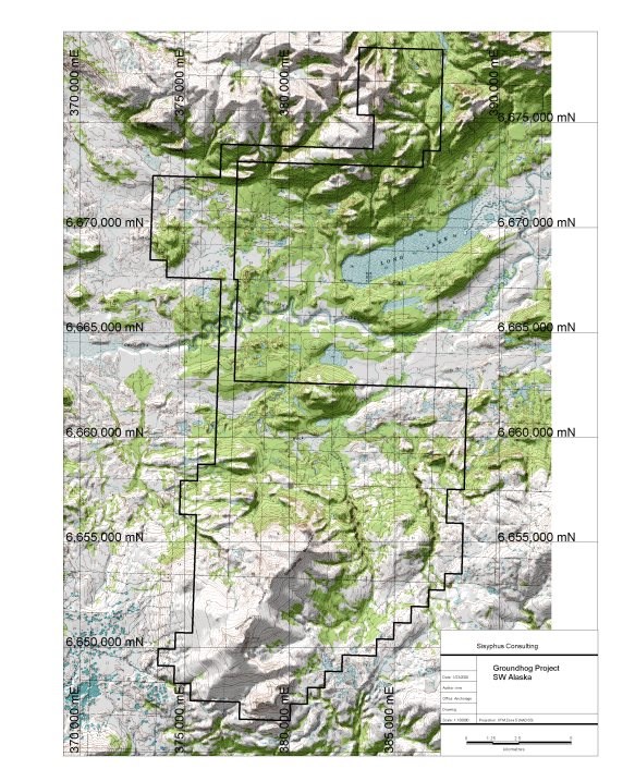
Figure 4: Groundhog property topography.
| Quaterra Resources Inc. | May |
| Technical Report on the Groundhog Project | 2020 |
5.5 Physiography
Property elevation ranges from 3074 ft amsl (937 m) at Groundhog Mountain to 306 ft (93 m). The area consists of rolling hills and low mountains separated by wide, shallow valleys blanketed with glacial deposits that contain numerous small, shallow lakes and streams.
Tundra plant communities (mixtures of shrub and herbaceous plants) cover the project area. Willow is common only along streams, and sparse patches of dense alder are confined to better drained areas where coarse soils have developed. Poorly drained lowland regions support black spruce and marsh vegetation.
| Quaterra Resources Inc. | May |
| Technical Report on the Groundhog Project | 2020 |
6 History
The history of the Groundhog prospect began with the expanded exploration of the adjacent Pebble deposit by the Hunter-Dickinson Group in 2001. Mining claims over the Groundhog prospect area were staked up to the edge of adjacent Pebble claim block by AERI on behalf of a private investor between December 2004 and February 2005. AERI and AES share two owner-investors and AERI contracted preliminary investigations to AES which included geologic mapping, sampling, a CSAMT geophysical survey and a dipole IP survey between 2005 and 2007. The business relationship between AERI and the initial investor were dissolved and ownership in the Groundhog project claims was reassigned to AES in 2009. The following year the property was optioned to Kennecott Exploration (KEC), a subsidiary of Rio Tinto Corporation. At that time Rio Tinto was a 19.8% owner of the adjacent Pebble deposit.
In June 2010 KEC commissioned a detailed high resolution helicopter-borne aeromagnetic geophysical survey over the Groundhog project area and a ground-based "deep-looking" 3D magnetotelluric (3DMT) survey. In Jan 2011 KEC applied for drilling permits for seven sites based on the aeromagnetic data. In July 2011 they commenced a VIP (reconnaissance induced polarization) survey followed immediately by dipole IP surveys along specific areas of interest. During the same 2011 summer field season KEC conducted geologic mapping and sampling (Laberge, 2011).
No further fieldwork was performed by KEC after 2011 and in 2014 Rio Tinto donated its shares in Pebble to local charities and withdrew from the project.
In 2014 Chuchuna was incorporated with the Groundhog project as the principle asset. In April 2017 Quaterra entered into an agreement with Chuchuna with Quaterra providing $5 million over five years in exploration spending, later amended to six years, in order to earn a 90% interest in Groundhog. Quaterra is also required to pay a lump sum of $3 million at the end of the sixth year. Quaterra has no obligation to exercise its option and can terminate the agreement at its discretion annually. Chuchuna is the operator of the project and plans, implements and manages exploration field programs as set out in a budget and work plan approved by Quaterra.
During the 2017 field season three of the previous IP lines were extended to permit greater signal penetration-depth together with a one new additional line. From August to September 2017 four drillholes were completed at Groundhog targeting IP anomalies in addition to further surface geologic mapping and sampling. Drill results are discussed further in the Section 10.
| Quaterra Resources Inc. | May |
| Technical Report on the Groundhog Project | 2020 |
In 2019, 1664 line-km ZTEM and magnetic survey was flown and interpreted (Inman, 2019), 60 additional claims were staked together with a modest program of surface sampling and mapping.
| Quaterra Resources Inc. | May |
| Technical Report on the Groundhog Project | 2020 |
7 Geological Setting and Mineralization
7.1 Regional Geology
[The following section is excerpted from Gaunt et al., 2018 from their regional geology description of the adjacent Pebble deposit, itself derived largely from Goldfarb et al. (2013).]
The tectonic and magmatic history of southwest Alaska is complex interaction between the formation of sedimentary basins between tectonostratigraphic terranes, amalgamation of these terranes and their translation along crustal-scale strike-slip faults, and episodic magmatism and formation of related mineral occurrences (Plafker and Berg, 1994).
The allochthonous Wrangellia superterrane comprises the amalgamated Wrangellia, Alexander and Peninsular oceanic arc terranes that approached North America from the southwest in the early Mesozoic.
West-dipping subduction beneath the superterrane formed the Late Triassic to Early Jurassic Talkeetna oceanic arc, which is now preserved in the Peninsular terrane east of Pebble (Figure 5). Several foreland sedimentary basins dominated by Jurassic to Cretaceous flysch, including the Kahiltna basin that hosts the Pebble deposit (Kalbas et al., 2007), formed between Wrangellia and pericratonic terranes and previously amalgamated allochthonous terranes of the Intermontane belt (Wallace et al., 1989; McClelland et al., 1992).
Basin closure occurred as Wrangellia accreted to North America by the late Early Cretaceous (Detterman and Reed, 1980; Hampton et al., 2010). Between approximately 115 to 110 Ma and 97 to 90 Ma, the strata in the foreland basins were folded, complexly faulted and subjected to low-grade regional metamorphism (Bouley et al., 1995; Goldfarb et al., 2013). Intrusions at Pebble are undeformed (Goldfarb et al., 2013) and were probably emplaced during a period when at least local extension occurred across southwest Alaska in the mid-Cretaceous (e.g. Pavlis et al., 1993).
Since the early Late Cretaceous, deformation in southwest Alaska has occurred mostly on major dextral strike-slip faults, broadly parallel to the continental margin. The major Denali fault in central Alaska forms the contact between the Intermontane Belt and the collapsed flysch basins (Figure 5). Smaller, subparallel faults are located south of the Denali fault, and the Pebble district is located between what are probably terminal strands of the Lake Clark fault zone; Shah et al., 2009). The Lake Clark fault zone marks the poorly defined boundary between the Peninsular terrane to the southeast and the Kahiltna terrane, which hosts Pebble, to the northwest. Haeussler and Saltus (2005) propose about 16.1 miles of dextral offset along the Lake Clark fault zone, most of which is interpreted to have occurred prior to approximately 38 to 36 million years ago. Recent field studies of geomorphology along the Lake Clark fault indicate that this structure has not experienced seismic activity for at least the last 10,000 years (Haeussler and Saltus, 2005, 2011; Koehler, 2010; Koehler and Reger, 2011). Other sub-parallel strike-slip faults also form terrane boundaries in the region, including the Mulchatna and Bruin Bay faults (Figure 5). Goldfarb et al. (2013) propose that most or all movement on these smaller structures occurred during oroclinal bending in the Tertiary, after formation of the Pebble deposit.
| Quaterra Resources Inc. | May |
| Technical Report on the Groundhog Project | 2020 |
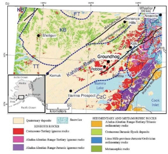
Figure 5: Location of Groundhog within regional geology of SW Alaska (modified from Gaunt et al., 2018)
| Quaterra Resources Inc. | May |
| Technical Report on the Groundhog Project | 2020 |
7.2 Local and property geology
There are three salient features of the local property-scale geology relevant to the regional geology framework described in the preceding section.
First, the topographic high portions of the property are underlain by Tertiary-aged volcanic, volcaniclastic and hypabyssal intrusive rocks. Second, this package of rocks overlies older deformed, Kahiltna-flysch sequence metasediments intruded by Mesozoic-aged igneous rocks. This package can be observed in scattered outcrop in the topographically lower portions of the property. This basement sequence is directly correlative with the package hosting the Pebble deposit. Finally the entire property is variably mantled by recent glacially derived deposits. The details of this are discussed below. Much of the property scale geology was elucidated by KEC in 2010-11 and described in the internal company report of Leberge (2011), from which the following descriptions are excerpted.
7.2.1 Jura-Cretaceous metasediments
The oldest unit exposed on the property is a flysch sequence of fine-grained, light green, thinly bedded siltstone, mudstone and massive greywacke. Bedding is commonly well preserved in these rocks, with thin beds a few centimeters thick. The sediments have been regionally metamorphosed from greenschist to lower-amphibolite facies with some middle amphibolite facies contact metamorphism near Jura-Cretaceous mafic intrusions locally containing clinopyroxene ± cordierite. The mineralogy and chemistry suggests that these sediments are andesitic in composition. This unit is interpreted to correlate with the Kahiltna flysch (Koksetna River sequence?).
7.2.2 Jura-Cretaceous intrusive rocks
The Jura-Cretaceous sedimentary sequence is intruded by some intermediate to mafic intrusive bodies a few kilometers in length. These intrusions are mainly composed of fine- to medium grained gabbro and form strong magnetic anomalies. The three main intrusions have been referred to, from south to north, as Alpha, Beta and Gamma. Alpha is Late Jurassic medium grained ophitic gabbro dated by U-Pb at 149.2 ± 0.3 Ma. It is commonly banded, with 2-10 mm thick alternating leucocratic and mesocratic bands. Beta is a Late Cretaceous medium-grained biotite gabbro, yielding a U-Pb age date of 98.2 ± 0.2 Ma. It is generally equigranular, massive, with local K-feldspar veins and epidote veinlets. Gamma is a fine-grained, magnetite-rich, massive gabbro, likely of Cretaceous age. It is very poorly exposed and has only been observed at one outcrop.
Veinlets containing pyrite and chalcopyrite have been observed on Alpha and Beta, but no significant mineralization was found. Beta yielded the highest Cu content with values up to 0.5%. Au values were consistently low in these intrusions, with Au/Cu ratio of ~0.2 (ppm/%).
| Quaterra Resources Inc. | May |
| Technical Report on the Groundhog Project | 2020 |
7.2.3 Tertiary Volcanics
Tertiary volcanic rocks represent the most common and best exposed units on the property. It is a sequence of volcanic flows and tuffaceous beds of various compositions which are not easily split in lithological map units. The units presented here attempt to group some lithologies for simplification.
7.2.3.1 Intermediate Volcanic Rocks
This unit is composed mostly of porphyritic dacite and massive to porphyritic andesite. Euhedral plagioclase phenocrysts up to 3 mm are common in these rocks, as well as smaller subhedral clinopyroxene phenocrysts <1mm in size. The matrix varies from a light grey glassy matrix to a medium grey to purplish-grey fine-grained matrix. These rocks are moderately magnetic. Note that some rhyolitic to intermediate tuffaceous beds and minor basalt are also present within the unit.
7.2.3.2 Intermediate Tuffaceous Rocks
A volcaniclastic sedimentary unit of lithic intermediate tuff has been mapped above the intermediate volcanics. It is composed mainly of grey, fine-grained andesitic volcaniclastic rocks, with minor amount of white, fine-grained porphyritic rhyolite and rhyolitic tuff. These rocks are locally bedded and commonly have the appearance of a siltstone. They are either ash to lithic tuffs or volcaniclastic siltstone.
7.2.3.3 Mafic Volcanic Rocks
Sub-horizontal basaltic flows are well exposed at higher elevations on Groundhog Mountain, dipping at shallow angle to the south. Flows are 10-30 m thick and commonly columnar jointed. The basalt is dark-grey, very magnetic, fine-grained and massive. Thin rhyolitic tuff is locally interbedded within the basaltic sequence.
7.2.3.4 Rhyolitic Tuff
Although rhyolitic tuff occurs throughout the Tertiary volcanic package on the property, some beds have been mapped independently. These rhyolitic to rhyodacitic tuff are white, fine grained, and commonly porphyritic, with small euhedral quartz and/or plagioclase phenocrysts up to 2 mm in size. The matrix is glassy to aphanitic, locally banded. These include ash tuffs, crystal tuffs and welded tuffs.
7.2.3.5 Volcanic Breccia
Two small lenses of volcanic breccias have been mapped on the north slope of Groundhog. These breccias are composed of angular volcanic fragments generally a few mm in size, but locally up to 10 cm, in a fine-grained, light-green matrix. It is not clear whether these breccias are truly volcanic or cataclastic breccias.
| Quaterra Resources Inc. | May |
| Technical Report on the Groundhog Project | 2020 |
7.2.3.6 Tertiary Intrusive
Rubble crop of intermediate intrusive rocks are present on the ridge extending northeast from the peak of Groundhog. Because these rubble crops are located on the ridge and within zones of subcrop, it is believed that this rubble and boulders are locally derived. This unit is a medium to fine-grained, light-colored, leuco-diorite with hornblende, magnetite, biotite and common secondary epidote. The diorite is strongly magnetic, and the extent of the unit was interpreted from the magnetic data. Whole-rock composition indicates it is a silica-saturated alkalic intrusion.
7.2.4 Quaternary Geology
Hamilton and Klieforth (2010) prepared a detail surficial geology report and map of the Iliamna D6 and D7 quadrangles. Portion of their mapping extends on to the southern tip of the Groundhog property.
Their mapping and analysis identified the latest Wisconsin-aged ice advance (Newhalen stade) as responsible for the mantling moraines present along the southern property boundary at high elevations on the flanks of Groundhog Mountain. Their inferred ice-flow direction was from the northeast flowing to the southwest into the Iliamna Lake drainage basin.
7.2.5 Structural Geology
7.2.5.1 Folding
Deformation observed on the Groundhog property is dominated by late brittle faults that cut through the Tertiary sequence. Outcrop-scale folding has not been observed in any unit, but the Jura-Cretaceous sedimentary package is regionally known to be affected by broad, open folding. The Jura-Cretaceous sediments generally dip to the north 60°-70°, but dip 35°-65° to the south in the vicinity of the Alpha anomaly. Tertiary stratigraphy, well exposed on Groundhog Mountain, appears upright and is locally tilted ~10° to the south-southwest.
7.2.5.2 Faulting
Most faults on the property have been interpreted from the airborne magnetic data acquired in 2010. Two major sets of faults have been interpreted, one striking northeast and the other striking west-northwest to northwest. The northwest structures appear to be cut by the northeast faults. Because of a poor understanding of the Tertiary stratigraphy, the displacement on these faults is poorly constrained. By extending faults from the Pebble property, combined with IP data observations, the northeast-striking faults appear to be normal faults dipping to the southeast. The most prominent of the NE-trending fault continuing along strike from the Pebble deposit is identified as the ZG Fault at Groundhog.
Fault breccia has been observed on multiple Tertiary outcrops and as rubble crop, commonly where faults had also been interpreted from the magnetic data. These cataclastic breccias are clearly the result of brittle deformation along Tertiary or later faults. Fault breccias are cutting though volcanic and volcaniclastic units, contain angular fragments a few millimeters to a few centimeters in size, and are partially to fully indurated.
| Quaterra Resources Inc. | May |
| Technical Report on the Groundhog Project | 2020 |
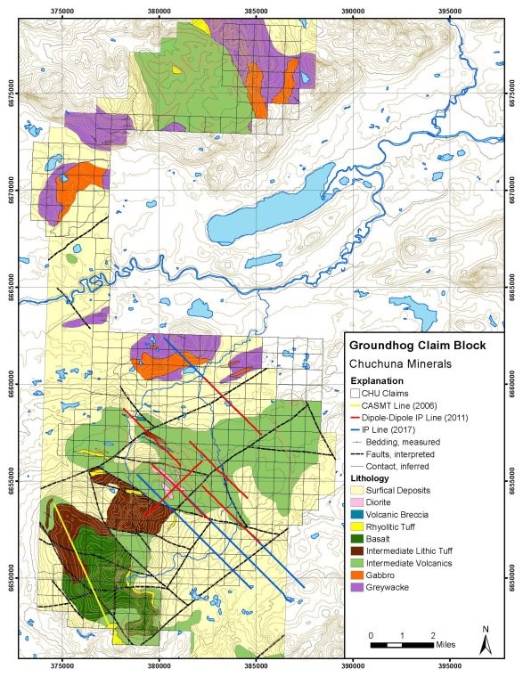
Figure 6: Property geology (Leberge, 2010)
| Quaterra Resources Inc. | May |
| Technical Report on the Groundhog Project | 2020 |
8 Deposit Type
The adjacent Pebble deposit is described as a copper-gold-molybdenum porphyry deposit (Gaunt et al. 2018). They further go on to state:
"Pebble has one of the largest metal endowments of any gold-bearing porphyry deposit currently known. Comparison of the current Pebble resource to other major gold-bearing porphyry deposits shows that it ranks at or near the top in terms of both contained copper and gold. In fact, Pebble is both the largest known undeveloped copper resource and the largest known undeveloped gold resource in the world today."
[The author has not verified this information, and it is not necessarily indicative of the mineralization on the Groundhog Project.]
This observation is the basis for the mineral deposit type being explored for at the Groundhog property, specifically all exploration to date has been focused on finding a similar copper-gold-molybdenum porphyry deposit.
The characteristics of porphyry copper deposits are summarized by Sinclair (2007):
Porphyry deposits are the world's most important source of Cu and Mo, and are major sources of Au, Ag, and Sn; significant byproduct metals include Re, W, In, Pt, Pd, and Se. They account for about 50 to 60% of world Cu production and more than 95% of world Mo production. In Canada, they account for more than 40% of Cu production, virtually all Mo production, and about 10% of Au production. Porphyry deposits are large, low- to medium-grade deposits in which primary (hypogene) ore minerals are dominantly structurally controlled and which are spatially and genetically related to felsic to intermediate porphyritic intrusions. They are distinguished from other granite-related deposits such as skarns and mantos by their large size and structural control, mainly stockworks, veins, vein sets, fractures, and breccias. Porphyry deposits typically contain hundreds of millions of tonnes of ore, although they range in size from tens of millions to billions of tonnes; grades for the different metals vary considerably but generally average less than 1%. In porphyry Cu deposits, for example, Cu grades range from 0.2% to more than 1% Cu; in porphyry Mo deposits, Mo grades range from 0.07% to nearly 0.3% Mo. In porphyry Au and Cu-Au deposits, Au grades range from 0.2 to 2 g/t Au. Associated igneous rocks vary in composition from diorite-granodiorite to high-silica granite; they are typically porphyritic epizonal and mesozonal intrusions, commonly subvolcanic. A close temporal and genetic relationship between magmatic activity and hydrothermal mineralization in porphyry deposits is indicated by the presence of intermineral intrusions and breccias that were emplaced between or during periods of mineralization. Porphyry deposits range in age from Archean to Recent, although most economic deposits are Jurassic or younger.
| Quaterra Resources Inc. | May |
| Technical Report on the Groundhog Project | 2020 |
9 Exploration
On account of the geologically perspective interval of rocks at the Groundhog property being covered by Tertiary-aged and younger rocks and unconsolidated material much of the exploration has utilized geophysical methods. However a systematic ground-based geologic mapping program has been completed as well as selected areas covered by geochemical soil sampling. Four widely-spaced areas have been tested with reconnaissance core drilling.
Details are discussed below in broadly chronological order subdivided into geophysical surveys and surface geological mapping and sampling programs. The following section on geophysical surveys is largely based on an internal company report (Inman, 2019) cited without direct attribution.
All exploration work conducted after April 2017 was conducted on behalf of Quaterra.
9.1 Geophysical surveys
9.1.1 2006 to 2007 CSAMT and IP
In August and September 2006 Zonge International was contracted to perform a CSAMT survey over the southern portion of the claim block. A single line (7.8 line-km) data was collected and resistivity was measured and processed both with 1D and 2D inversion techniques. The following year in early spring 2007 one line (4.8 km long) of dipole-dipole IP was completed along the CSAMT line from stations 2600N to 7400N, essentially the NW portion of the CSAMT line. The survey was completed with 150m dipoles and readings to N=8 which generally results in a depth of investigation equal to 250-350m below surface. The resistivity section is very similar to that of the CSAMT; i.e. mixed high resistivity and conductivity to a depth of 150m (volcaniclastics and intermediate volcanics) and conductive unit (<50 ohm-m) extending to the bottom of the section near 350m depth. The IP response is very low over the entire line (<4 mrads) to the full depth of the section. It would appear the use of 150m dipole size was insufficient to 'see' through the Tertiary volcanic rocks; except for the odd station at the largest dipole separation (N=8) which is anomalous at four locations: 4250, 5400, 6400 and near the NW end of the line at 7200. These stations are shown as yellow dots in Figure 9. There are at least two possible explanations of these results:
1. The anomalous stations are the result of alteration/mineralization within the Tertiary volcanic rocks; or
2. The 150m dipole spacing was insufficient to 'see' through the Tertiary volcanic rocks except in a very few areas (as noted) where anomalies were just detected sourced from alteration/mineralization from below at a depth exceeding 350m, within the pre-Tertiary basement rocks. These small and isolated 'peeks' extend over a distance of 3500m along the IP line and could be considered leakage from a deeper zone.
| Quaterra Resources Inc. | May |
| Technical Report on the Groundhog Project | 2020 |
9.1.2 2010 to 2011 geophysical surveys
KEC commissioned a helicopter-borne magnetic survey by MPX Geophysics, Ltd. in June 2010. A total of 1,745.7 line-kilometers of data were acquired over a total area of 314.7 km². The survey blocks were flown at a nominal mean terrain clearance of 70 meters (40 meters for the magnetic sensor). The survey blocks were flown along N-S (001.5°) flight lines separated by 200 meters, and E-W (091.5°) tie lines at a line separation of 2000 meters.
Three significant areas of magnetic highs were detected: Alpha (gabbroic intrusive in the Groundhog Mountain area); Beta (gabbroic intrusive approximately 10km NNW of Alpha and Gamma (unknown source) 16 km NNE of Alpha. Figure 7 shows the extent of the aeromagnetic survey with named anomalies.
| Quaterra Resources Inc. | May |
| Technical Report on the Groundhog Project | 2020 |
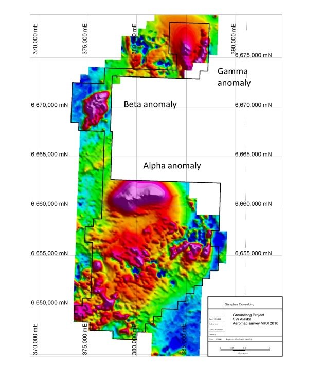
Figure 7: 2010 aeromagnetic survey Groundhog project
In July 2010 a ground-based magneto-telluric survey (MT) consisting of 185 stations covering an area of 135 km2 with the data reduced to an 800 by 800 m grid. The survey covered nearly all of the magnetic high characterizing the Groundhog and Pig Mountain area EXCEPT for the Alpha magnetic high itself. Both 2D and 3D inversions of the MT resistivity data were completed.
| Quaterra Resources Inc. | May |
| Technical Report on the Groundhog Project | 2020 |
A thick, layered conductive feature is mapped in the southern portion of the area and was presumed to be indicative of Tertiary volcanic rocks exceeding 500m in depth. The MT 3D model would suggest the thickest interpreted Tertiary rocks occur at the SW edge of the claim block thinning to the N and NE from that point.
Within the MT survey area a significant NW-SE trending high resistivity (>2000 ohm-m) feature and a NNW-SSE trending low resistivity (<80 ohm-m) feature dipping to the NE can be noted.
From July to August 2011 KEC commissioned Zonge International to collect vector IP survey (VIP), or reconnaissance IP, in the areas where the MT survey had identified a relatively shallow resistive feature. Chargeable anomalies from the VIP survey were then followed up with some dipole-dipole IP lines. The purpose of the double-dipole IP survey was to identify chargeable features that could be associated with porphyry-style alteration (Leberge, 2011).
The VIP survey consisted of measurements at 94 stations utilizing three transmitter setups covering an area of 89.2 km². The resultant data was gridded at a 1 km resolution.
IP surveys were run that included VIP as well as 6 lines of dipole-dipole IP, utilizing 300m dipoles to achieve a depth of investigation exceeding 500m depth and in most cases exceeding 600m depth.
The VIP survey layout is similar to the MT layout with a grid of receiver stations on 1000m centers. A total of 94 stations were collected using three different transmitting locations to achieve coverage and signal strength over an area of nearly 9000 hectares. The VIP survey was offset to the north relative to the MT survey, but did cover the features noted earlier in the MT survey but also fell short of covering the gabbro intrusive and main magnetic anomaly to the northwest (Alpha). Figure 10 shows the individual VIP stations with IP values in mradians and an approximate outline of the anomalous areas. The VIP identified two major areas of IP anomalies; a NW sector and a SE sector. The NW sector follows the high resistive body defined in the MT data and includes the copper anomalous gabbro intrusive. The SE sector is also open to the south and east and contains anomalous stations east of the ZG fault zone; however, VIP stations are indicative of a general area of IP response and the source of the anomalous stations east of the fault could actually lie back to the west towards the bipole transmitters.
Six dipole-dipole IP survey lines (18 line-km) with dipole spacing of 300 meters and N=1 to 8 were also completed in 2011. Lines are oriented NW-SE except for line 4 which was oriented NE-SW and crosses lines 3 as well as the area between lines 1 and 6 (Figure 8). In 2017, prior to drilling, the three pre-existing dipole-dipole IP lines were extended as a means to increase the depth of analysis with the same dipole spacing of 300 meters but with N=1 to 10. The depth of investigation of this survey exceeds 600m below ground surface. Three of the lines, L1, L3 and L5 are extensions and overlaps of lines run in 2011. Line 10 is a new line located SW of line 3. Zonge International performed the geophysical survey under contract.
| Quaterra Resources Inc. | May |
| Technical Report on the Groundhog Project | 2020 |
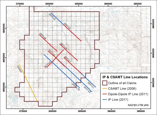
Figure 8: IP line locations for ground IP surveys completed in 2007, 2011 and 2017
9.1.3 Discussion of 2011 and 2017 IP results
The results of the IP surveys indicate significant anomalies occur on every line. It is problematic to correlate anomalies from line-to-line because of the wide spacing between lines, which is as great as 4 km (lines 5 and 6) and the minimal spacing of 1 km (lines 3, 6, 10, 1 and 2). The anomalies are shown as color-coded bars in Figure 9 along each line, with the shallower anomalies (<300m depth to top) above the line itself and the deeper anomalies (>300m and generally 500m or greater) below the lines. The strength of the anomalies is color-coded as follows:
Intense - red - >50 mradians; ~7%+ by volume metallic sulfides
Strong - orange - 40-50 mradians; 5-7% by volume metallic sulfides
Moderate - green - 25-40 mradians; 3-5% by volume metallic sulfides
Weak - light blue - 15-25 mradians; < 3% by volume metallic sulfides
| Quaterra Resources Inc. | May |
| Technical Report on the Groundhog Project | 2020 |
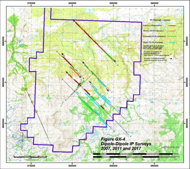
Figure 9: IP surveys with anomalous chargeability areas indicated
Figure 10 summarizes the results of the 2011 VIP survey as identifying two major sectors of anomalous VIP data; a NW sector extending from Groundhog Mountain 4-5 km further to the NW and a SE sector on the east side of Groundhog Mountain. Further, the VIP survey seems to have established the limits of the shallow anomalies defined by the dipole-dipole surveys, although the dipole-dipole survey provides much greater detail about the individual anomalies; specifically, depth, extent and strength.
NW Sector- Two dipole-dipole lines, 5 and 6, contain shallow 'intense' IP anomalies near the NW ends of both lines, and both extend beyond the ends of the lines. The anomalous zone on line 5 occurs within the immediate area of the Cu-anomalous gabbro intrusive. The anomaly on line 6 (unknown full extent) occurs in an area that is indicated to be an extension of the gabbro intrusive based on the helicopter magnetic map. Outcropping gabbro is 1500m to the north, and yet the magnetics indicate it is likely to extend beyond the apparent outcrop to the south.
| Quaterra Resources Inc. | May |
| Technical Report on the Groundhog Project | 2020 |
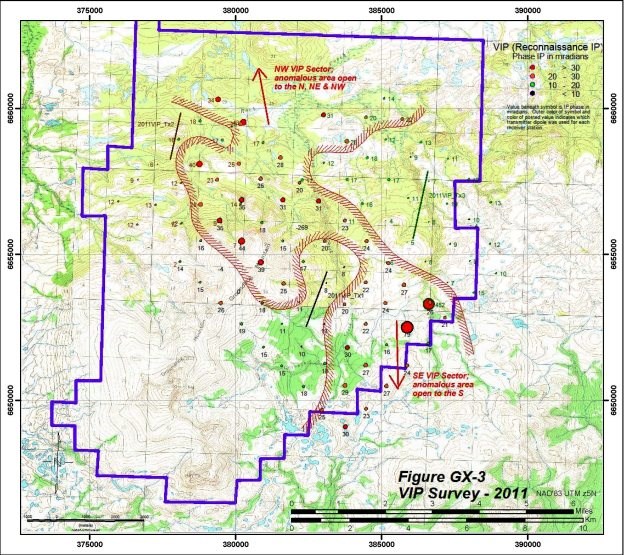
Figure 10: VIP interpretation
SE Sector - Zones of 'intense, strong and moderate' IP anomalies occur on all of the remaining lines with the strongest group occurring on Line 3. A number of these zones occur near the top of Groundhog Mountain and west of the SE sector. And an additional tantalizing target occurs at depth exceeding 500m, dipping to the E and SE. These IP anomalies are generally moderate in strength but this could be a result of the depth at which they occur. Further, it appears the anomalies continue to the point of offset along the ZG normal fault zone, at which point the zones are terminated or more likely they are down-dropped beyond the ability of 300m dipole-dipole IP to sense the response; which is the case at the east side of Pebble East. The deep anomalous zones occur on lines 6, 2, 1, 3 and 10; and there is indication on line 10 of a deep response on the down-dropped side of the fault (the response could also be shallower but off-line to the south). Additionally, the shallow 'intense' anomalies on line 3 appear to be connected to and likely sourced (leakage) from a more extensive deep zone.
| Quaterra Resources Inc. | May |
| Technical Report on the Groundhog Project | 2020 |
Summarizing the IP results, a major zone of intense IP anomalies possibly 4 km in size has been delineated in the NW sector and remains open in all directions. Shallow zones of narrow but intense/strong IP anomalies occur in the SE sector and appear to be sourced from a more extensive, deep source.
9.1.4 2019 ZTEM and magnetics
In parts of August and September 2019 a helicopter borne ZTEM and magnetic survey was flown over the southern portion of the claim block by Geotech, Ltd. 1664 line-km were flown covering an area of 467 km2. Line spacing was 300 m with calculated resistivities recorded at frequencies from 30 hz to 720 hz. Of interest and relevance is a case study published by Geotech of a similar ZTEM survey over the adjacent Pebble deposit (Geotech, 2015).
ZTEM is very similar to MT and the results of the 2d inversion of the ZTEM data are very similar to the 2d and 3d inversion of the data from the 2010 MT survey. It is noted that ZTEM and MT do NOT measure IP response, but rather measure changes in resistivity. However, IP response from sulfides is often associated with changes in resistivity typical of various alteration types.
The ZTEM survey data were process and interpreted with nineteen targets identified based on similarities to other ZTEM surveys over known porphyry deposits, including the adjacent Pebble deposit (Inman, 2019). Targets with a top ranking, rank 1, most closely resemble the response to known deposits, whereas ranks 2 and 3 are of interest but less similar to the known deposits. The targets shown in Figure 11 are colored red are rank 1 anomalies, those colored orange rank 2 and blue is used for the lowest rank 3.
| Quaterra Resources Inc. | May |
| Technical Report on the Groundhog Project | 2020 |
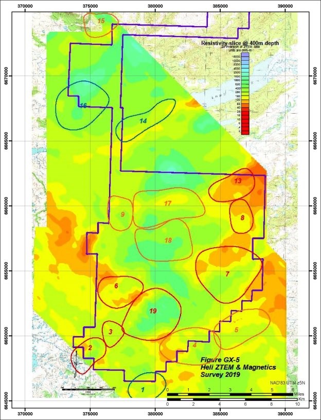
Figure 11: ZTEM targets
| Quaterra Resources Inc. | May |
| Technical Report on the Groundhog Project | 2020 |
9.2 Surface geochemical sampling and mapping
9.2.1 2006 to 2008
Prior to KEC involvement in the Groundhog project 460 soil, rock chip and stream sediment samples were collected using conventional sampling methods in conjunction with 256 vegetation samples. None of the results were deemed anomalous with subsequent follow-up work.
9.2.2 2010 to 2011
Following identification of the Alpha and Beta magnetic anomalies by KEC in 2010, rock chip and soil sampling over the areas indicated the presence of anomalous copper in gabbroic rocks with values as high as 1810 ppm Cu at Alpha and 5060 ppm Cu at Beta.
KEC focused their surface sampling for lithological characterization to aid in their mapping, collecting 19 whole rock samples for major and trace element geochemistry as well as selective geochronology samples.
13 rock and 60 soil samples were recorded as collected as part of the property-wide geochemical database.
9.2.3 2017 to 2019
In addition to 384 DDH core samples discussed in section 10, 105 rock, soil and stream silt samples were collected primarily along IP line extensions. In 2019, in a program designed to address whether selective leach techniques could identify geochemical anomalies beneath the younger Tertiary cover 66 selective leach samples were collected along with 7 till samples within the southern limits of the claim block.
| Quaterra Resources Inc. | May |
| Technical Report on the Groundhog Project | 2020 |
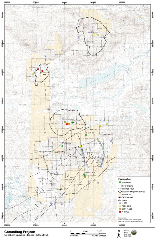
Figure 12: Rock chip samples at Groundhog 2006 - 2019
| Quaterra Resources Inc. | May |
| Technical Report on the Groundhog Project | 2020 |
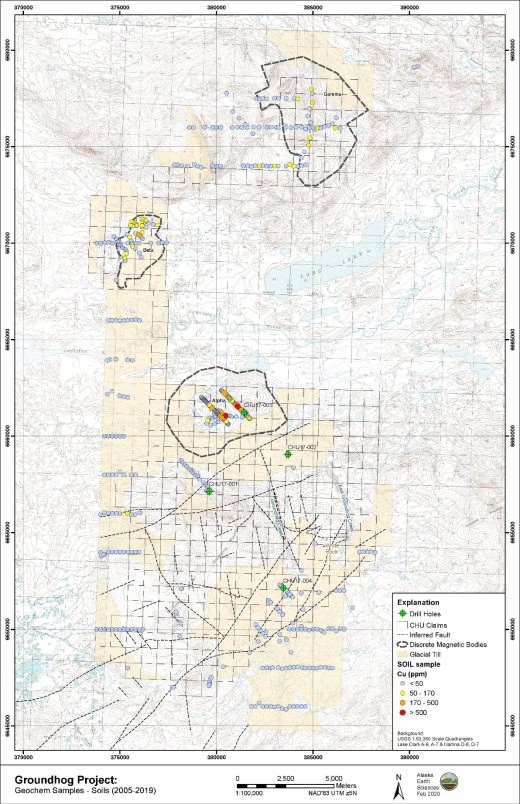
Figure 13: Soil samples at Groundhog 2006 - 2019
| Quaterra Resources Inc. | May |
| Technical Report on the Groundhog Project | 2020 |
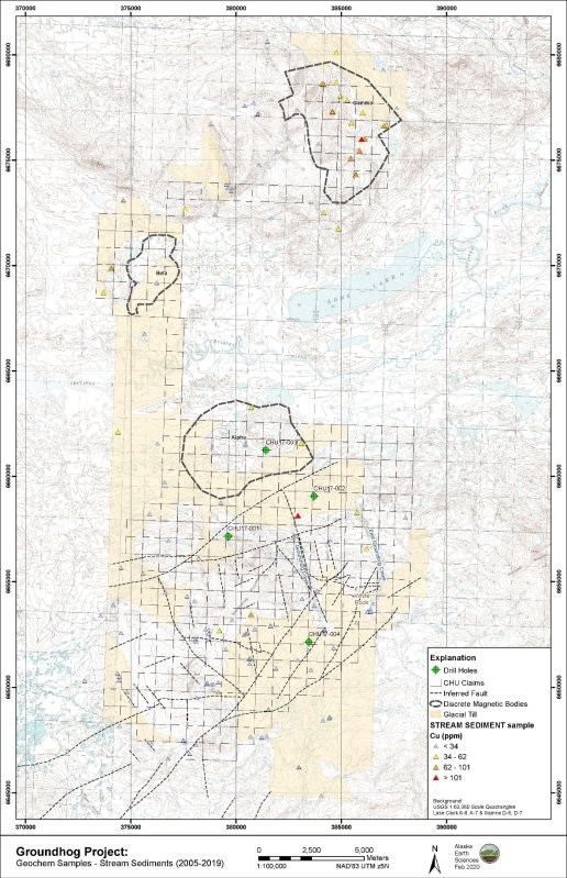
Figure 14: Stream silt samples at Groundhog 2006 - 2019
| Quaterra Resources Inc. | May |
| Technical Report on the Groundhog Project | 2020 |
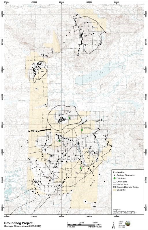
Figure 15: Geologic observations at Groundhog 2006-2019
| Quaterra Resources Inc. | May |
| Technical Report on the Groundhog Project | 2020 |
9.3 Geochronology at Groundhog
The primary mineral deposit objective at Groundhog is a Cu-Au-Mo porphyry deposit. The regional geology shows that mineralization at the adjacent Pebble deposit is closely constrained in age and limited to intrusive rocks with ages between 89 to 98 Ma, emplaced into Jurassic to Cretaceous-aged flysch. At Groundhog, as at Pebble, rocks of this age are covered by younger Tertiary volcanic, sedimentary and hypabyssal intrusive rocks. As a consequence selective rock units have had their ages calculated using a variety of radiometric isotopic techniques. The author is aware of the following ages at the Groundhog property. The degree of specificity of the location as referenced in the description below reflects information shared with the author.
9.3.1 Alpha anomaly area
KEC report U/Pb ages of 149.2±0.3 Ma on sphene/titanite collected from a gabbro in the Alpha magnetic anomaly. AES report two other U/Pb ages on zircon (115±1.2 Ma and 152.4±0.8 Ma) separated from fine grained and equigranular diorites from the Alpha anomaly collected approximately 1 km west of DDH CHU-17-003 and 03A.
9.3.2 Beta anomaly area
KEC report U/Pb ages of 98.2±0.2 Ma on zircon collected from a gabbro in the Beta magnetic anomaly (Laberge, 2011).
9.3.3 Groundhog Mountain area
AES cites two USGS ages from volcanic rocks collected towards the top of Groundhog Mountain of 38.5 and 39.7 Ma. In 2011 KEC submitted a diorite sample (JL-122) (UTM coordinates: 380689E 6654390N) for TIMS U/Pb zircon analysis. By the time the results were finalized KEC had exited the project and it was verbally reported to be Tertiary in age and similar to the USGS ages cited above.
In 2018 AES submitted two samples to the USGS from DDH CHU-17-004 for U/Pb zircon analysis. Both ages were reported as Tertiary (64.9 and 64.2 Ma).
| Quaterra Resources Inc. | May |
| Technical Report on the Groundhog Project | 2020 |
10 Drilling
The first drilling at the Groundhog property was in 2017 when five widely spaced core holes were drilled in 2017 (two were from the same location). 1241 m core was recovered.
Table 3: Drillhole collars
Hole # | Northing | Easting | Elevation (m) | Bearing | Dip | Depth (m) |
CHU-17-001 | 6657152 | 05V0379620 | 356 | N45E | -80 | 274.6 |
CHU-17-002 | 6659056 | 05V0383700 | 159 | S45W | -80 | 159.1 |
CHU-17-003 | 6661238 | 05V0381412 | 172 | S50E | -80 | 148.4 |
CHU-17-003A | 6661239 | 05V0381411 | 172 | S65E | -70 | 358.7 |
CHU-17-004 | 6652136 | 05V0383455 | 375 | S45E | -77 | 300.2 |
A light-weight, helicopter transported drill rig was used for all holes which were drilled with NQ sized core. The holes were all targeting identified IP anomalies.
CHU-17-001 was targeted at an IP anomaly identified by KEC in 2011 along their IP line 6. The anomaly was projected to be within approximately 200 m from the surface. Lithologies described from core to the end of the hole included a sequence of tuffs, breccias and volcaniclastic sediments. Mineralization was weak consisting of veinlets of pyrite and carbonate with sulphide content increasing downhole to 5% in places. Traces of chalcopyrite and sphalerite were reported. CHU-17-001 reported the highest Zn assays of all drillholes with 1980 ppm from 182.9 - 184.8 m and averaged 631 ppm over an 8.5 m interval from 143.3 to 151.8 m. The interpretation of the stratigraphy was that the entire drillhole sampled Tertiary-aged rocks. Regrettably drilling did not reach the main IP anomaly (Figure 16) and the possibility remains that stronger, deeper IP anomaly contain significant mineralization.
| Quaterra Resources Inc. | May |
| Technical Report on the Groundhog Project | 2020 |
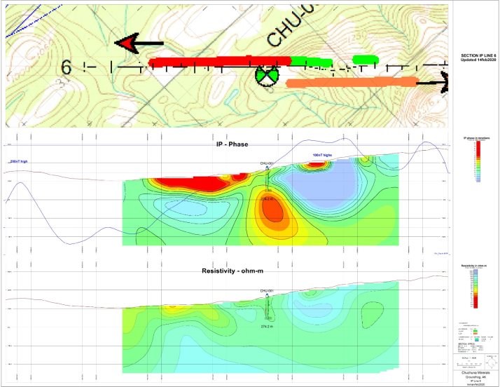
Figure 16: DDH CHU-17-001 on IP Line 6 section
| Quaterra Resources Inc. | May |
| Technical Report on the Groundhog Project | 2020 |
CHU-17-002 was targeted at an IP chargeability anomaly first identified by KEC but the line was extended and refined by AES in 2017 along IP survey line 5. The anomaly was interpreted to be within 100 m of the surface. The entire hole was within grey to black bedded siltstone interpreted to be part of the Kahiltna flysch sequence. Several high-strain fault zones were noted in the log. Trace to 0.5% pyrite was reported throughout the hole with occasional zones as high as 4%. Of the four holes drilled in 2017 CHU-17-002 had the lowest maximum assay values for Cu, Mo and Zn. None of the alteration or mineralization was described as porphyry-related or indicative of nearby intrusive activity. It was concluded that the hole was of sufficient depth to reach the IP anomaly. Samples were collected for geophysical property testing returned chargeability values ranging from 70 to 42 mrads in accord with values measured on the IP survey.
CHU-17-003 (and 003A) were drilled 3.1 km NW of CHU-17-002 along the same geophysical line likewise targeting an IP anomaly as well as being within the large "Alpha" aeromagnetic anomaly. Hole 3 was lost at 148.4 m and hole 003A was offset and drilled to depth of 358.7 m. Drill core contained a sequence of basalt, clinopyroxenite and gabbro. Alteration was moderate to strongly propylitic with abundant epidote, chlorite and quartz/carbonate veining. Sulphides to 2% were mostly pyrite but with regular trace amounts of visible chalcopyrite. High magnetic susceptibilities were recorded on core as well as up to 10 % magnetite noted in thin section of core samples (Deininger, 2018). Maximum assay values for Au, Cu and Mo for all holes drilled in 2017 were measured with values of 0.892, 612 and 177 ppm respectively. In addition to the maximum assay values CHU-17-003/3A had broad, anomalous high-background Cu over much of its length; collectively from 6 to 25 m 235 ppm Cu, 54 to 97 m 253 ppm Cu, 295 to 307 m 340 ppm Cu and 313 to 325 m 281 ppm Cu.
A significant IP anomaly remains at depth beneath CHU-17-003 as the drillhole failed to reach sufficient depth (Figure 17).
| Quaterra Resources Inc. | May |
| Technical Report on the Groundhog Project | 2020 |
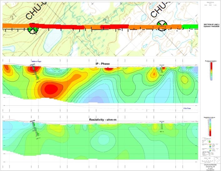
Figure 17: DDH CHU-17-003/3A on IP Line 5 section
| Quaterra Resources Inc. | May |
| Technical Report on the Groundhog Project | 2020 |
CHU-17-004 was drilled 6.3 km SE of CHU-17-001 targeting an IP chargeability anomaly along IP line 3. The hole intersected predominantly diorite porphyry consisting of altered clinopyroxene, plagioclase phenocrysts in a dark altered matrix. Alteration consisted of epidote, carbonate and clays cut by later quartz pyrite veining. Assays down the length of the drillhole showed background Au, Cu and Zn values, with the maximum reported values of 6 ppb Au, 89 ppm Cu and 341 ppm Zn. Two U/Pb zircon ages of 64.2 and 64.9 Ma were returned from core samples of diorite collected at a depth of 147.5 and 285 m down hole respectively, and is interpreted as indicating that the age of intrusion, mineralization and the associated measured IP response as being Tertiary in age and younger than the Pebble-aged mineralizing event.
| Quaterra Resources Inc. | May |
| Technical Report on the Groundhog Project | 2020 |
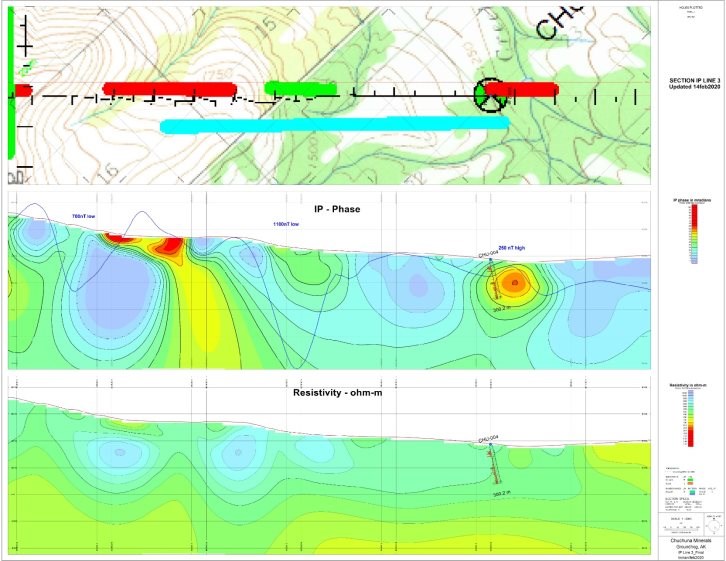
Figure 18: DDH CHU-17-004 on IP Line 3 section
| Quaterra Resources Inc. | May |
| Technical Report on the Groundhog Project | 2020 |
11 Sample Preparation, Analyses and Security
11.1 Sample Preparation
11.1.1 Conventional surface rock, stream silt and soil samples
Specific details were not available to the author as to how conventional surface sampling was conducted from 2005 to 2017 at the property. There is no reason to conclude anything other than the typical methods used in the area were employed. These consist of rock chip sampling of exposed bedrock, silt-sized fractions of flowing stream sediment and soil samples (the predominant method used at Groundhog).
In 2019 37 soil samples, 34 rock and 7 stream silts were collected and analyzed. Soils and silts are dried and sieved to pass 80 mesh (although curiously three stream silts were pulverized and split prior to analysis); rocks are crushed, split and pulverized. Analysis for all rocks, silts and some soils was by ALS method code AuME-TL43. Subsets of soils were analyzed by ALS method code AuMe-ST43. Both methods used a 25g sample dissolved in acids differing only in the minimum detection limit for Au. At the adjacent Pebble deposit these methods are all effective where mineralization is at or close to the surface. However in areas with thick glacial or post-mineralization cover these methods are less effective.
11.1.2 Vegetation sampling
Limited data from prior to 2010 suggest some vegetation sampling was undertaken. No documentation has been provided to document sampling protocols. There were no anomalous results or follow-up studies.
11.1.3 Selective soil leach 2019
At the adjacent Pebble deposit the USGS published results of an orientation survey comparing different methods of selective elemental analysis of soil samples subjected to weak leaching by various solutions (Fey and others, 2008). Two methods were chosen for use at Groundhog, out of the suite tested at Pebble: an ionic leach method, and a cold hydroxylamine leach method, both provided by ALS Laboratories. A total of twenty-two sample sites were established on 2017 IP lines 1, 3, and 10. Three samples were analyzed from each site; all analyses were done by ALS Laboratories in Vancouver, after drying and preparation by ALS Laboratories preparation facility in Fairbanks. The analyses include Ionic Leach (AuME-MS23), Cold Hydroxylamine Leach (AuME-MS05), and traditional sieving to -80 mesh and total digestion (Au-ME-ST43).
11.1.4 Till heavy mineral sampling 2019
Seven samples of glacial till were collected in close proximity in the SE corner of the property. Sampling methodology involved collecting approximately 12kg of -8mm material from holes 30 to 50 cm deep into 5 gallon plastic buckets.
Samples were processed by Overburden Drill Management, Ontario, Canada and involved:
| Quaterra Resources Inc. | May |
| Technical Report on the Groundhog Project | 2020 |
a) Collecting 500 g archival sample with all or portion of the archival split sieved to completion at 0.063 mm and -0.063 mm silt+clay fraction submitted for conventional geochemical analysis.
b) Panning the remainder for gold, PGMs and fine-grained metallic indicator minerals.
c) Separating nonferromagnetic heavy mineral fractions with SG of 2.8 to 3.2 and SG >3.2, with a grain size of 0.25-2.0 mm picked for porphyry Cu indicator minerals.
d) Separating nonparamagnetic (>1.0 amp) with a grain size of 0.5-1.0 mm and 0.25-0.5 mm heavy mineral fractions for scheelite by UV lamping.
11.1.5 Drill core samples 2017
Four drill holes totalling 1241 m of recovered core have been collected. Of that 754.3 m was divided into 384 sample intervals and assayed during the 2017 drill program. Specific intervals were selected for sampling and not all NQ core was assayed. Core was halved via rock saw.
A total of 424 drill core samples, including 15 standards, 19 blanks, and 7 duplicates, were analysed during the 2017 drilling program. All samples were prepared and analysed by ALS Minerals. Sample preparation consisting of sample login, coarse crush and fine crush (CRU-31 and CRU-21), sample splitting (SPL-21), was performed at the ALS lab in Fairbanks, AK. A split was shipped and pulverization of the split sample to 85% <75 microns (PLU-31) and gold analysis (Au-AA23) was completed at ALS Reno, NV, USA. Trace elements (ME-MS41) was completed at the ALS lab, Vancouver, Canada.
The raw samples were crushed in an oscillating steel jaw crusher (>70% of the sample passing through a 2mm screen), a 500 g riffle split was then pulverized to 85% passing through a 75-micron screen. Aqua regia digestion (ALS method ME-MS41) was performed for analysis of 51 elements: Ag, Al, As, Au, B, Ba, Be, Bi, Ca, Cd, Ce, Co, Cr, Cs, Cu, Fe, Ga, Ge, Hf, Hg, In, K, La, Li, Mg, Mn, Mo, Na, Nb, Ni, P, Pb, Rb, Re, S, Sb, Sc, Se, Sn, Sr, Ta, Te, Th, Ti, Tl, U, V, W, Y, Zn and Zr. The method utilizes a 0.5 g of prepared sample digested in aqua regia with the resultant solution analysed by induced coupled plasma mass spectroscopy (ICP-MS) finish.
Gold analyses were performed on a 30 g sub-sample using ALS method Au-AA23; fire assay fusion with atomic absorption spectroscopy (AAS) finish.
11.2 QA/QC procedures
The author is unable to comment specifically on the nature and extent of all quality control measures employed including check assays and other check analytical techniques used. Review of the drill core assay certificates show that the assay labs maintained and reported on internal quality control methods. The sampling documentation show sample blanks, standards and duplicates have been inserted but the results have not been collected and analyzed. The author is not aware of any summary or analysis of QA/QC procedures.
| Quaterra Resources Inc. | May |
| Technical Report on the Groundhog Project | 2020 |
11.3 Sample Security
The author was not present during any of the sample collection and preparation for shipping and is unable to comment on specific sample security details.
According to the NI43-101 reporting requirements a statement is required if any aspect of the sample preparation is conducted by an employee, officer, director or associate of the issuer. AES was significantly involved in collecting and submitting multiple soil, rock and drill core samples to assay labs.
11.4 Opinion on the adequacy of sample preparation, security, and analytical procedures
The author recognizes that during early stages of the exploration process many different methods are used to best identify an effective technique. That some analytical procedures have not demonstrated their effectiveness is not a criticism of the approach or of the method itself.
11.4.1 Quality Assurance
The Groundhog project covers two geological domains: an area where pre-Tertiary ("Pebble-aged") rocks are variably exposed (mostly north of UTM Northing 6655000) and a region to the south covered by Tertiary volcanic, volcaniclastic and intrusive rocks centered on Groundhog Mountain. Both domains are covered by glacial overburden. The author's concerns with geochemical sampling are that geochemical sampling techniques that may be appropriate for one domain have been used in less than optimal locations. Specifically:
Glacial till samples were collected over a small portion of the property, at a high elevation within an area known to be underlain by a thick Tertiary section. The report of Hamilton and Klieforth (2010) map these tills as part of the last glacial advance from the NE moving to the SW. Any indicator mineralization would presumably be derived from off the property area if present. If it is argued that the till is locally derived and represents a geochemical sample of the immediate area, then conventional soil sampling techniques would presumably also be geochemically anomalous. It is the author's opinion that the till sampling does not provide meaningful data.
The selective leach sampling likewise was collected entirely in the Tertiary-cover domain and while designed to test whether geochemical "leakage" could be observed across the ZG Fault the results reportedly were equivocal. The USGS orientation sampling at Pebble (Fey et al., 2008) showed the strongest response over the exposed and thinly covered by glacial material. For this reason the author considers the selective leach sampling results to not be meaningful in the area of the property where employed (but thinks the sampling technique could be useful over the "Pebble-aged" domain of the property).
| Quaterra Resources Inc. | May |
| Technical Report on the Groundhog Project | 2020 |
11.4.2 Quality control
Going forward the author recommends a more formal and clearly documented approach to sample preparation, sample security and analytical methods used, as well as documenting the results of QA/QC procedures used at the end of each field season.
11.4.3 Summary statement on QA/QC
Pursuant to section 3.3 of 43-101 a summary statement on quality assurance and quality control is present thus:
The quality assurance and quality control measures applied and the data collected during the execution of the work being presented in this report are fit and adequate for their current purposes of early-stage exploration.
| Quaterra Resources Inc. | May |
| Technical Report on the Groundhog Project | 2020 |
12 Data Verification
12.1 Author's visit check sample verification
The Author was not present for the 2019 or prior season sampling and was unable to personally collect duplicate samples for verification purposes.
The author randomly selected and checked 10% of the rock and soil samples in the 2019 sample database against the assay certificates and found them all to be clearly tabulated and without errors.
Pre-2019 work has not been verified by the author.
The existing core was properly stored and available for future examination and sampling should there be need in the future.
12.2 Drill database verification
The author examined the existing historic drillhole database. Where checked, assay values in the database matched with the corresponding assay certificates. Were the drillhole database to be used for resource calculations, the author would expect and require more detailed verification work, however for its current purpose of documenting detailed subsurface geochemical samples it is fit-for-purpose.
The author has not surveyed the DDH collars.
13 Mineral Processing and Metallurgical Testing
No mineral processing or metallurgical testing analyses have been performed on samples collected from the property
14 Mineral Resource
There are no mineral resources or mineral reserves estimates for the Groundhog project
| Quaterra Resources Inc. | May |
| Technical Report on the Groundhog Project | 2020 |
15 Adjacent Properties
The Groundhog property lies adjacent to the Pebble project claim block. The current resource estimate is provided below copied from Gaunt et al. (2018) and has been publically released according to NI 43-101 standards. The author of this report has not verified the information and is accepting the reported data as stated.
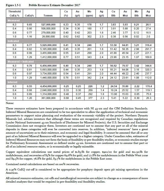
| Quaterra Resources Inc. | May |
| Technical Report on the Groundhog Project | 2020 |
Figure 19: Northern Dynasty's Pebble resource estimate in December 2017 (Gaunt et al., 2018).
Furthermore the author states unequivocally that the reported mineralization on the adjacent Pebble property in no way is indicative of mineralization on the Groundhog property (the subject of this report).
16 Other Relevant Data and Information
16.1 Environmental Studies, Permitting and Social or Community Impact
The southwest portion of the Groundhog claim block is the closest to the proposed Pebble mine area and the Upper Talarik Creek drainage, but the majority of the Groundhog claim block lies in a northward-draining catchment basin that flows away from the Pebble area. The Pebble project remains a highly visible and contentious project in Alaska with significant local community opposition. The author considers that success at Groundhog would be very difficult were the Pebble project terminated through a failure to receive all necessary permits.
| Quaterra Resources Inc. | May |
| Technical Report on the Groundhog Project | 2020 |
17 Interpretation and Conclusions
17.1 Interpretations
The Groundhog property lies in close proximity to the Pebble deposit. Groundhog has been the focus for the episodic exploration over the past fourteen years. A sizable body of data has been collected designed to identify whether similar mineralization to that seen at the adjacent Pebble project exists at Groundhog. Mapping, limited drilling and geochronology have demonstrated the presence of similar aged-rocks in a similar structural setting occur at Groundhog. To date no significant porphyry- Cu mineralization has been found on the property. The majority of attention has been focused on the southern portion of the property and significant areas of potential promising geochemistry around the Alpha and Beta magnetic anomalies remain underexplored.
The main exploration approach has been the use of a suite of geophysical tools: aeromagnetic, CSAMT, VIP, dipole-dipole IP and ZTEM surveys. The magnetic survey has identified three magnetic anomalies that show good correlation with intrusive centers. The southernmost anomaly (Alpha) is associated with a Jurassic-aged gabbro significantly older than mineralization at Pebble. The Beta magnetic anomaly is associated with a Cretaceous-aged diorite, close in age to the Pebble mineralization and contains surface rock chip samples with values of 0.5% Cu. The resistivity and IP geophysical methods have largely been focused in the southern portion of the property largely covered by Tertiary-aged rocks and have outlined a SE and NW sectors. The SE sector contains shallow zones of narrow but intense/strong IP anomalies. A single DDH (CHU-17-004) into one of these anomalies showed the IP anomaly originating from Tertiary-aged intrusive rocks and associated mineralization and alteration. However geophysical interpretation of the data does not rule out an IP response from a more extensive deep source. The NW sector likewise contains major zones of intense IP anomalies and remains open. Both drillholes CHU-17-001 and CHU-17-003/3A were designed to drill test IP anomalies in the NW sector but failed to reach the target depths and neither drillhole reached the strongest part of the IP anomalies.
The thickness of Tertiary cover is a significant constraint in interpreting the existing geophysical data. The majority of IP lines are south of the N6,655,000 line and any anomalies have to be evaluated as to whether they are sourced in the Tertiary cover or are derived from a deeper source. Surprisingly limited IP lines test areas known to have Pebble-correlative stratigraphy exposed at the surface or at least only covered by Quaternary glacial deposits. For example between IP Lines 5 and 6 just south of the Alpha anomaly there is a 4 km gap without data.
The true thickness of Tertiary cover at the southern end of the property is poorly constrained but estimates may be applied. These include the following constraints: KEC describe the Tertiary at Groundhog Mountain and having southward dips of between 0 to 10 degrees. In the vicinity of the upthrow-side of the ZG Fault a cross section indicates the base of the Tertiary would be at a depth of 800 meters below the surface using a 5 degree dip. These depths to the base of the Tertiary are comparable to those seen in published cross sections along strike at the Pebble deposit. On the down-throw side of the ZG Fault drilling at the Pebble East intersected Tertiary-thicknesses of 1400 meters. Without drill data there remains a large degree of uncertainty of the depth to pre-Tertiary rocks in the vicinity of the ZG Fault. Similarly the uncertainty in the Tertiary thickness impacts the interpretation of the IP geophysics data; at present the IP data is depth limited to approximately 350 m below the surface. Deep IP anomalies remain interpretable as either chargeable-zones beneath the Tertiary cover section, or as deep anomalies still within the Tertiary.
| Quaterra Resources Inc. | May |
| Technical Report on the Groundhog Project | 2020 |
A disinterested discussion of the exploration data collected to date at Groundhog would be amiss not to discuss potential for exploration ideas to fall into the trap of circular-thinking. The main attraction of the Groundhog property is its close proximity to Pebble. The general geology can reasonably be extrapolated between the two areas; for example the ZG Fault is present on published cross sections at Pebble and is known to separate the Pebble West deposit from the buried, higher-grade Pebble East portion of the deposit. The ZG Fault can be traced via offsets in aeromagnetic trends onto the Groundhog property. The main difference in the geology of the two areas is that porphyry-mineralization is exposed at the surface at Pebble yet to date no evidence of any economic mineralization has been found in the southern portion of the Groundhog property, which is entirely covered by Tertiary rocks. In order to prospect beneath the Tertiary cover the majority of geophysics and geochemical techniques have been employed in this area. The best surface geology and geochemistry at Groundhog lie in the central to northern portions of the property, yet because of their distance from Pebble, the area has received less exploration.
Conventional geochemical soil and stream silt sampling has not been effective to date on account of the glacial cover and Tertiary stratigraphy. A pilot program in 2019 to evaluate selective leaching and glacial till/heavy mineral analysis has also produced equivocal results. Regrettably the sampling for the pilot program covered a small area of the property with likely the thickest section of Tertiary cover. As an orientation program it failed to sample over a wide-enough area to encompass the known range of differing topography, vegetation, soil and overburden type areas. It is still possible that the selective leach soil sampling methods will be effective in areas without Tertiary cover and therefore it is suggested the method not be abandoned yet.
17.2 Conclusions
Groundhog remains potentially-promising early stage exploration project targeting a porphyry Cu deposit.
As results of past exploration work at and nearby the property it can be demonstrated that:
Groundhog contains rocks correlative with those hosting porphyry Cu mineralization at the adjacent Pebble deposit.
Significant areas of the property remain untested.
| Quaterra Resources Inc. | May |
| Technical Report on the Groundhog Project | 2020 |
- Geophysics has shown the best potential to evaluate broad areas of potentially favorable geology and, given the problems of overburden geology, should be continued going forward to identify targets for drill-testing.
Independent constraints on Tertiary thickness are required to assist in interpretation of geophysical data and target selection.
Exploration efforts should be shifted to the areas around the Alpha and Beta magnetic anomalies where the surface geochemistry and stratigraphy are more favorable than the southern areas characterized by a thick Tertiary section.
| Quaterra Resources Inc. | May |
| Technical Report on the Groundhog Project | 2020 |
18 Recommendations
18.1 Phase 1: target refinement via addition data modelling
The primary goal of future exploration at Groundhog must be to return drilled intercepts from a mineralized porphyry system. Selecting the best drill target is critical and to that regard it is recommended that a modest budget be allocated to extract additional information from the 2019 ZTEM survey with 3D inversion modelling of the data. The objectives of this work are twofold. The first is to help rank the existing ZTEM targets. Second, the inversion data should be examined to see if it provides information on the thickness of Tertiary cover in the southern portion of the property.
It is recognized that there are multiple reasons why depth modelling will not work including little to no resistivity contrast between the Tertiary cover and the Pebble-aged basement or that the Tertiary is thicker than the ZTEM can effectively resolve, however the great advantage of the Groundhog ZTEM survey is that it is a uniform dataset covering much of the property area. If the data is carefully interpreted in conjunction with the known geology it is possible that of the existing ZTEM anomalies one or two will become obvious priorities. The costs to do this additional work are modest compared to drill testing.
Without this additional 3D inversion modelling the focus for future geophysics work as well as targeting the source of anomalous geophysics data should be in the NW sector around the Alpha and Beta magnetic anomalies.
18.2 Phase 2: target selection for drill testing or ground-based IP
Decision making at Phase 2 presents a greater number of choices. What is discussed below represents anticipated options but other unforeseen choices may be viable following Phase 1 data modelling.
Best option: Following the data processing one or two existing ZTEM anomalies, either with or without additional constraints from the ground-based IP data, become high priority drill-ready targets. The proposed Stage 2 budget could be entirely directed towards the drilling costs.
The lest-best option will be that the Stage 1 data processing does not produce a clearly highest ranked target. This is essentially the situation at present. In this case the recommended course of action is to focus on the NW sector around the Alpha and Beta magnetic anomalies.
| Quaterra Resources Inc. | May |
| Technical Report on the Groundhog Project | 2020 |
18.2.1 NW Sector - Alpha Anomaly and ZTEM targets 9, 17, 13, 8 and 18.
There are two options to test these targets. Either four additional lines of dipole-dipole IP should be surveyed in addition to extending line 6 further to the NW and to the SE to connect with Line 1. Three of the additional lines will be spaced at 1km intervals between lines 5 and 6 and the fourth line will be an offset of 1km NE of line 5. Or alternatively two grids of vector VIP data in the NW sector and then, if necessary, a single dipole-dipole line to define a specific drill target.
The objective of the additional lines is to define the extent and character of the intense IP anomalies in the NW sector and to possibly to provide drill targets for 3 drill holes.
18.2.2 Existing IP anomalies on Lines 5 and 6
The existing IP anomalies that were partially tested by DDH CHU-17-001 and 003/3A remain as untested targets at depth. Regardless of the potential improvements from 3D inversion of the ZTEM data, these IP targets remain as top priority drill targets deserving of further drill testing. Special attention should be afforded to the inverted ZTEM data around these known IP anomalies in order to 'extend' the untested target zones on lines 5 and 6 into the areas of no ground data. If a decision is made to drill test to depth the known IP anomalies, having additional off-line ZTEM-generated targets should be identified for immediate follow-up targeting while the drill rig is on-site.
18.2.3 SE Sector - extension of ZG fault zone
Much attention has been spent on this area as the Pebble mineralizing system has been shown to extend under younger Tertiary cover. To date at Groundhog all the significant IP targets are very deep and shallow targets are not of great extent. Examination of the 3D inversion data should be examined carefully for evidence as to the thickness of the Tertiary in this sector. It may be that the results of the Phase 1 data modelling are equivocal in this region leaving a difficult choice of testing geophysical targets without knowledge of the overlying Tertiary cover thickness. At the present point of knowledge the safest approach would be to not spend any further effort in the SE Sector; however this may change after the Phase 1 data modelling.
| Quaterra Resources Inc. | May |
| Technical Report on the Groundhog Project | 2020 |
18.2.4 Beta Magnetic Anomaly
The area at Beta of anomalous rock chip and soil geochemistry is large as is the magnetic anomaly defining the gabbroic intrusive at Alpha. Therefore it is recommended a vector VIP survey be conducted initially to define the general extent of a possible sulfide system.
Following the completion and interpretation of the VIP survey a single dipole-dipole line should be run in the best area in order to define the depth and size of a possible target. The data from this line when merged with the vector VIP data should result in an accurate map of the sulfide system at Beta.
Depending on the results returned at least one drill hole should be planned for to test the source of the best IP anomalies and copper geochemistry. One advantage of working in the NW sector is the shallow depth to potential targets and the existing drill rig should be of sufficient size to test IP and geochemical target.
Additional notes: vector VIP surveys assume a large transmitter/generator and two field receiver teams. This will greatly increase the speed of the survey and lower the cost. Helicopter support will be required and all geophysics should be done as early as possible in the area, so that drilling could potentially follow in the same field season.
18.3 Geochemistry
Continued application of selected leach soil samples is recommended within areas target by vector VIP survey in the Alpha and Beta areas. Sample lines are to have no larger than 150 m spacing between samples with lines starting outside, crossing and ending beyond anomalous VIP response areas. Sampling is to follow precise, documented procedures to ensure uniform sampling methods among field staff. Selective leach soil samples should be collected along any new IP lines in order to facilitate direct comparison of IP responses with geochemical anomalies.
18.4 Project supervision and data management
Sisyphus Consulting recommends that during drill core sampling and assaying the project be managed by people or persons independent of the Issuer. They would be responsible for documenting and supervising core sample handling and security from drill rig, through sample splitting and delivery to an assay lab. They would be responsible for implementing, documenting, maintaining and evaluating procedures for quality assurance/quality control including a regular procedure of introducing standards, duplicates and blanks into the sample submittals. In addition a subset of sample pulps should be submitted to a second assay lab. All results should be documented, including analysis of results, and included as part of the project database.
| Quaterra Resources Inc. | May |
| Technical Report on the Groundhog Project | 2020 |
18.5 Costs
The estimated budget for this work is estimated as follows:
Phase 1 3D inversion modelling of ZTEM data and interpretation by a geophysicist/geologist $35,000.
Phase 2 is budgeting should be capped as the amount of funds required for Quaterra to complete its exploration requirements according to their agreement with Chuchuna Minerals Company ($5 million total to be spent prior to April 17, 2023). It is estimated that approximately half of this funding requirement has been met. With three field seasons remaining between the effective date of this report and the agreement deadline, there is sufficient time to carefully prioritize geophysical targets for subsequent drill testing.
If the decision is made to drill-test priority targets and the work fails to result in finding the QSP halo associated with a porphyry copper system and/or the potassic zone with high copper mineralization, then further work is not recommended.
| Quaterra Resources Inc. | May |
| Technical Report on the Groundhog Project | 2020 |
19 References
Anderson, E.D., Hitzman, M.W., Monecke, T., Bedrosian, P.A., Shah, A.K., and Kelley, K.D., 2013, Geological analysis of aeromagnetic data from southwestern Alaska: Implications for exploration in the area of the Pebble porphyry Cu-Au-Mo deposit. Economic Geology, Volume 108, p. 421-436.
Bouley, B.A., St. George, P., and Wetherbee, P.K., 1995, Geology and discovery at Pebble Copper, a copper-gold porphyry system in southwest Alaska: in Schroeter, T.G., ed., Porphyry Deposits of the Northwestern Cordillera of North America, CIM Special Volume 46, p. 422-435.
Bundtzen, T.K., and Miller, M.L., 1997, Precious metals associated with Late Cretaceous-early Tertiary igneous rocks of southwestern Alaska: in Goldfarb, R.J., and Miller, L.D., eds., Mineral Deposits of Alaska: Economic Geology Monograph 9, p. 242-286.
Decker, J., Bergman, S.C., Blodgett, R.B., Box, S.E., Bundtzen, T.L., Clough, J.G., Coonrad, W.L., Gilbert, W.G., Miller, M.L., Murphy, J.M., Robinson, M.S., and Wallace, W.K., 1994, Geology of southwestern Alaska: in Plafker, G., and Berg, H.C., eds., The Geology of Alaska. Geological Society of America, The Geology of North America, v. G-1., p. 285-310.
Deininger, J.W., 2018, Petrographic descriptions for Alaska Earth Sciences Project CHU-17-00X. Internal report 30 p.
Detterman, R.L., and Reed, B.L, 1973. Surficial Deposits of the Iliamna Quadrange, Alaska, U.S. Geological Survey Bulletin 1368-A, 64 p.
Detterman, R.L., and Reed, B.L., 1980, Stratigraphy, structure, and economic geology of the Iliamna quadrangle, Alaska: U.S. Geological Survey Bulletin 1368-B, 86 p.
Fey, D.L., Granitto, M, Giles, S.A., Smith, S.M., Eppinger, R.G., Kelly, K.D., 2008, Geochemical data for samples collected in 2007 near the concealed Pebble porphyry Cu-Au-Mo deposit, southwest Alaska. USGS OFR 2008-1132.
Gaunt, J.D., Lang, J., Titley, E., Lu, T., and Hodgson, S., 2018, 2018 Technical report on the Pebble Project, SW Alaska. Available on www.sedar.com, 191 p.
Geotech case study, 2015. ZTEM Tipper AFMAG Results over the Pebble Porphyry deposit http://geotech.ca/wp-content/uploads/2015/04/015-ZTEM_Porphyry_Pebble_Alaska.pdf
Gierymski, C., 2019. 2019 Groundhog Project exploration summary, Iliamna Recording District, SW Alaska. Internal Quaterra Resources company report, 26p.
| Quaterra Resources Inc. | May |
| Technical Report on the Groundhog Project | 2020 |
Goldfarb, R.J., Anderson, E.D., and Hart, C.J.R 2013, Regional tectonic framework of the Pebble deposit: Economic Geology 108:405-419.
Haeussler, P.J., and Saltus, R.W., 2005, 26 km of offset on the Lake Clark fault since late Eocene time: U.S. Geological Survey, Professional Paper 1709A, 4 p.
Haeussler, P.J., and Saltus, R.W., 2011, Location and Extent of Tertiary Structures in Cook Inlet Basin, Alaska, and Mantle Dynamics that Focus deformation and Subsidence, in Dumoulin, J.A., and Galloway, J.P., eds., Studies by the U.S. Geological Survey in Alaska 2008-2009: U.S. Geological Survey Professional Paper 1776-D, 26 p.
Hamilton, T., and Klieforth, R.F., 2010, Surficial geologic map of parts of the D-6 and D-7 quadrangles, Pebble project area, southwestern Alaska: Alaska Division of Geological & Geophysical Surveys, Report of Investigation 2009-4, 19 p.
Hampton, B.A., Ridgway, K.D., and Gehrels, G.E., 2010, A detrital record of Mesozoic island arc accretion and exhumation in the North American Cordillera: U-Pb geochronology of the Kahiltna basin, southern Alaska: Tectonics, v. 29, doi.org/10.1029/2009TC002544
Inman, J., 2019, Groundhog, AK Exploration - Geophysics Report. Internal Quaterra Resources company report. 15 p.
Kalbas, J.L., Ridgeway, K.D., and Gehrels, G.E., 2007, Stratigraphy, depositional systems, and provenance of the Lower Cretaceous Kahiltna assemblage, western Alaska Range: Basin development in response to oblique collision: in Ridgeway, K.D., Trop, J.M., Glen, J.M.G, Evolution of Southern Alaska: Geological Society of America Special Paper 431, p. 307-344.
Kelley, K.D., Eppinger, R.G., Lang, J., Smith, S.M., and Fey, D.L., 2011, Porphyry Cu indicator minerals in till as an exploration tool: example from the giant Pebble porphyry Cu-Au-Mo deposit, Alaska. Geochemistry: Exploration, Environment, Analysis, v. 11, p. 321-334.
Koehler, R.D., and Reger, R.D., 2011, Reconnaissance evaluation of the Lake Clark fault, Tyonek area, Alaska. State of Alaska Department of Natural Resources, Division of Geological & Geophysical Surveys, Preliminary Interpretive Report 2011-1, 10 p.
Koehler, R.D., 2010, Technical review of a trench across a potential fault scarp feature east of lower Talarik Creek, Lake Iliamna area, southwestern Alaska. State of Alaska Department of Natural Resources, Alaska Division of Geological & Geophysical Surveys, Miscellaneous Publication 139, 12 p.
Lang, J.R., Gregory, M.J., Rebagliati, C.M., Payne, J.G., Oliver, J.L., and Roberts, K., 2013, Geology and magmatic-hydrothermal evolution of the giant Pebble porphyry copper-gold-molybdenum deposit, southwest Alaska, USA. Economic Geology, Volume 108, p 437-462.
| Quaterra Resources Inc. | May |
| Technical Report on the Groundhog Project | 2020 |
Leberge, J. 2011, Report on 2011 exploration activities on the Groundhog project, Bristol Bay Region, Southwestern Alaska, United States. KEC internal company report 34 p.
McClelland, W.C., Gehrels, G.E., and Saleeby, J.B., 1992, Upper Jurassic-Lower Cretaceous basinal strata along the Cordilleran Margin: Implications for the accretionary history of the Alexander-Wrangellia-Peninsular Terrane: Tectonics, v. 11, p. 823-835.
Pavlis, T.L., Sisson, V.B., Foster, H., Nokleberg, W.J., and Plafker, G., 1993, Constraints on crustal extension in the western Yukon-Tanana terrane, central Alaska: Tectonics, v. 12, p. 103-122.
Plafker, G., and Berg, H.C., 1994, Overview of the geology and tectonic evolution of Alaska: in Plafker, G., and Berg, H.C., eds., The Geology of Alaska: Geological Society of America, The Geology of North America, v. G-1, p. 989-1021.
Shah, A., Bedrosian, P., Anderson, E., Kelley, K., and Lang, J., 2009, Geophysical data used to characterize the regional setting of the Pebble porphyry deposit in southwest Alaska: Geological Society of America Annual Meeting, Program with Abstracts, v. 41, p. 493.
Sinclair, W.D., 2007, Porphyry Deposits: in Mineral deposits of Canada: a synthesis of major deposit-types, district metallogeny, the evolution of geological provinces, and exploration methods; by Goodfellow, W D (ed.); Geological Association of Canada, Mineral Deposits Division, Special Publication no. 5, 2007 p. 223-243.
Wallace, W.E., Hanks, C.L., and Rogers, J.F., 1989, The southern Kahiltna terrane: Implications for the tectonic evolution of southwestern Alaska: Geological Society of America Bulletin, v. 101, p. 1389- 1407.
Young, L.E., St. George, P., and Bouley, B.A., 1997, Porphyry copper deposits in relation to the magmatic history and palinspastic restoration of Alaska: in Goldfarb, R.J., and Miller, L.D., eds., Mineral Deposits of Alaska: Society of Economic Geologists Monograph 9, p. 306-333.
| Quaterra Resources Inc. | May |
| Technical Report on the Groundhog Project | 2020 |
Date, Signature and Certificate of Qualifications Pages
Effective Date: April 28, 2020
I, Nicholas Van Wyck Ph.D., 3705 Arctic Blvd #1150, Anchorage, AK 99503 do hereby certify that:
1. I have graduated from the following Universities with degrees as follows:
a. Tufts University, B.S. Geology 1985
b. University of Wisconsin - Madison, M.S. Geology 1989
c. University of Wisconsin - Madison, Ph. D. Geology 1994
2. I am a member in good standing of the following professional associations:
a. American Institute of Professional Geologists
3. I have worked as a geologist for 34 years since my graduation from Tufts University.
4. I am a Certified Professional Geologist (AIPG #10553).
5. I have read the definition of "Qualified Person" set out in National Instrument 43-101 and certify that by reason of my education, affiliation with professional associations and past relevant work experience, I fulfill the requirements to be a "Qualified Person" for the purposes of NI 43-101.
6. I am the author of this report responsible for the preparation of the report titled "NI 43-101 technical report on the Groundhog Project, Bristol Bay Region, southwestern Alaska 60°04'N / 155°08' W" and dated April 28, 2020 (the "Technical Report") relating to the Groundhog property.
7. I visited the Groundhog property September 11h to 12th, 2019.
8. I have not had prior involvement with the property that is the subject of the Technical Report.
9. As at the effective date of the Technical Report, to the best of my knowledge, information, and belief, the Technical Report contains all scientific and technical information that is required to be disclosed to make the technical report not misleading.
10. I am independent of the issuer applying all of the tests in section 1.5 of National Instrument 43-101.
11. I have read National Instrument 43-101 and Form 43-101F1, and the Technical Report has been prepared in compliance with that instrument and form.
12. I consent to the filing of the Technical Report with any stock exchange and other regulatory authority and any publication by them for regulatory purposes, including electronic publication in the public company files on their websites accessible by the public, or the Technical Report.
Signed and dated this April 28, 2020 at Anchorage, Alaska.

____________________________
Signature of Qualified Person
Nicholas Van Wyck Ph.D., CPG #10553
Effective Date: April 28, 2020