NI 43-101 TECHNICAL REPORT ON THE
OZHERELIE and YKANSKOYE GOLD
PROJECTS,
IRKUTSK OBLAST, RUSSIA
PREPARED FOR
SUTCLIFFE RESOURCES LTD.
Dated March 20, 2007
Prepared by
William J Crowl, R.G.
Gustavson Associates, LLC
TABLE OF CONTENTS
| 3/19/2007 | i | Gustavson Associates |
| 23. | ADDITIONAL REQUIREMENTS FOR TECHNICAL REPORTS ON DEVELOPMENT PROPERTIES AND PRODUCTION PROPERTIES | 80 |
| 24. | ILLUSTRATIONS | 81 |
LIST OF FIGURES
LISTOFTABLES
APPENDICES:
| A | CV for Anatoly I. Ivanov |
| B | Translations of License Agreements, Ozherelie and Ykanskoye |
| C | Russian Mineral Reporting, Stephen Henley |
| D | Drill Hole Collar Coordinates and Trench Locations |
1. SUMMARY
Sutcliffe Resources Ltd., through its wholly-owned subsidiary Baykal Gold, acquired a 51% interest (with an option to own 100%) in ML Ltd in January 2007. ML Ltd, a Russian company, has a 100% interest in the Ozherelie and Ykanskoye gold projects, approximately 1,100 km north of the City of Irkutsk in the Irkutsk Oblast, Siberia, Russia (Figure 1-1 and Figure 1-2).
Gustavson Associates, LLC (“Gustavson”) was commissioned by Sutcliffe Resources Ltd ("Sutcliffe") in late November 2006 to prepare a Canadian National Instrument 43-101 (NI43-101) compliant Independent Technical Report on Ozherelie and Ykanskoye and to review Sutcliffe’s proposed 2007/08 exploration programs for both Projects. William J Crowl, R.G., the Qualified Person for the preparation of this report personally visited the Ozherelie and Ykanskoye project sites in early February, 2007.
The Ozherelie and Ykanskoye deposits are located in two separate mining licenses with terms of 20 years from August 2, 2006. The licenses are some 10km apart, covering 24 and 7.2km2 respectively, to a depth of 1,000m below the current surface.
The deposits are located approximately 130km north of the district center of Bodaibo. Irkutsk is serviced by regular direct air services with the capital city of Moscow, which in turn services the town of Bodaibo with daily turbo-prop flight services. Large river barges can also supply Bodaibo (on the Lena River) which is linked to the prospect areas by a gravel road. The prospect areas are situated within 3 km off this road. Alternatively the nearest rail head is at Taksimo situated 240km south of Bodaibo and linked by road.
The Ozherelie and Ykanskoye gold deposits are located within a highly mineralized belt of deposits which includes the world class Sukhoi Log gold deposit as well as a number of other hard rock and alluvial gold deposits either in production or in development in the region. The region has historically produced a reported 48 million ounces of gold, making it one of the most prolific gold producing regions in the world.
ML discovered the deposits in an area where no hard rock gold deposits had been previously identified. The immediate area adjacent to Ozherelie has seen significant placer gold production that continues today. The Ozherelie deposit has been traced for over 7km but it is still relatively unexplored: to date there has been relatively small amounts of core drilling (20 holes, 1317m, 1317 samples) and channel sampling (1631 samples). The Ykanskoye deposit, has been traced for 6km confirmed through 33 trenches (859 channel samples). More detailed exploration has so far been limited to 11 drill holes (476m, 410 samples).
At Ozherelie, the quartz-gold veins are associated with silicification, sulphides (minor), brown-sparring (ankerite), albitization and muscovite, hosted within flat lying (dipping on average 7º to the NNE, varying from 5-12º) thrust zones. Mineralization is hosted within banded carbonaceous cherty flysch terrigenous (psammitic-pelitic) schists, which display a distinctive layering. The coarse quartz-gold mineralizing event is considered to overprint and remobilize an earlier schist formation related mineralizing event associated with sericite and muscovite (+ chlorite). The zones vary in vertical thickness from 8m to 36m. Gold occurs as generally coarse (70% greater than 1mm) and visible free gold with a fineness of 940 hosted in white quartz veins
and often along the boundary or within the browner “spar”(ankeritic) material. Silver content is less than 1 g/t.
Mineralization at Ykanskoye is hosted with a shallow dipping thrust zone dipping 12-14º to the NE over a width of 2.0 to 8.0m within a zone of intensely sericite-muscovite (+ silicification and sulphides consisting of pyrite and pyrrhotite). An earlier stage quartz event occurs but is only weakly gold mineralized and previous prospecting focused on exploring this with limited success. This quartz event has a spatial relationship to the mineralized zone. The early mineralization event occurred during metamorphism and is associated with chlorite and muscovite (+ sericite). The main gold mineralizing event occurred associated with regional granitic intrusions and thrusting with less quartz (silicification) and sulphides (pyrite and pyrrhotite). Peripheral to the mineralized zones occur minor arsenopyrite but arsenopyrite does not appear to host gold mineralization. Gold is visible in higher grade zones (+10 g/t Au) but not generally coarse. Gold is not locked in sulphides but free milling and has a fineness of +950. Silver grades are less 1 g Ag/t.
At Ozherelie, ML has conducted 4 tests of bulk samples, variously testing the characteristics of the coarse gold mineralization and comparing trench sample analysis results with assays on core from the same location. In 2003, 2,606t of mineralized material was processed through a company-constructed gravity recovery plant. At a calculated head grade of 2.91g Au/t, some 94.5% of the gold was recovered. In 2006, a further 5000t bulk sample was taken and processed from Zone 1 at Ozherelie. A comparison of assays from core holes, trench samples and bulk samples from Zone 1 during 2006 has shown sufficient comparative reliability of trench samples to bulk sample results and a lack of corresponding comparative reliability between the core holes and both the trench and bulk samples. The insufficiency of the core samples in predicting bulk sample grades is at least partially related to the prevalence of coarse gold in the mineralized zone and the relative small diameter and mass of the core samples relative to the other sampling methods.
Neither Gustavson nor Sutcliffe has completed any independent sampling and/or confirmatory logging of core, except for an examination of half core from one hole in Ozherelie and one hole at Ykanskoye. Future rounds of evaluation of the existing data may involve assaying historical sample pulps and rejects, if available. Based on a review of available data and interviews with principals of ML, Gustavson has no reason to doubt the validity of the work summarized in this report, as it has been generated under a strict set of Russian protocols and developed by ML, an experienced Russian exploration company, and analyses were carried out by respected Russian analytical laboratories.
Gustavson has reviewed the protocols of the ML exploration program, the results of that program, the geology and mineralization data and the methodologies employed in the Ozherelie C1 and C2 resource estimates. Whereas the data collected has not been collected with an eye toward compliance with western standards (i.e. quality control and quality assurance), the protocols rigorously employed were those mandated by the government of Russia. The Russian protocols are strict and comprehensive, dealing with nearly the same issues as the western industry standards, but with differences in terms of core and sample retention, submission of
blanks, standards and duplicates, etc. The geological investigations were thorough and well documented.
Gustavson considers that the Ozherelie and Ykanskoye C1 and C2 mineral resources as estimated by ML and approved by TKZ “Irkutsknedra”, can be classified and reported as Inferred Mineral Resources as defined by the CIM. Gustavson considers that these Inferred Mineral Resources are NI43-101 compliant. Using a 1.0g Au/t cutoff grade, a 3m minimum composite thickness and a specific gravity of 2.7, the Inferred Mineral Resources are as follows:
| Property | Tonnes (millions) | Grade (g Au/t) | Contained Au (Oz) | Contained Au (t) |
| Ozherelie | 1.05 | 3.68 | 124,000 | 3.86 |
| Ykanskoye | 1.40 | 3.43 | 154,000 | 4.78 |
| Total | 2.45 | 3.53 | 278,000 | 8.65 |
Both deposits remain relatively untested. At Ozherelie, of the 7km of apparent strike length, only about 0.5km comprise the resource stated above. At Ykanskoye, about 1.4km of a 6km strike length comprise the resource above The shallow dip of both prospects enhances the prospectivity of down-dip projections along strike.
Sutcliffe is presently planning several full seasons of exploration on both the Ozherelie and Ykanskoye projects. A US$12m budget has been committed for 2007 and 2008 and funds allocated as follows:
| Ozherelie | Ykanskoye | Total | |||||||||
| Total | Meters | Cost US$/m | US$ m | Meters | Cost US$/m | US$ m | Meters | Cost US$/m | US$ m | ||
| BTS Drilling | 3500 | 100 | 0.35 | 0 | 100 | 0.00 | 3500 | 100 | 0.35 | ||
| Core Drilling – Phase 1 | 9800 | 200 | 1.96 | 5500 | 200 | 1.10 | 15300 | 200 | 3.06 | ||
| RD 10 – Phase 2 | 24500 | 120 | 2.94 | 13000 | 120 | 1.56 | 37500 | 120 | 4.50 | ||
| Trenching (m³) | 12600 | 10 | 0.13 | 18000 | 10 | 0.18 | 30600 | 10 | 0.31 | ||
| Other | 2.27 | 1.51 | 3.78 | ||||||||
| Total | 7.65 | 4.35 | 12.00 | ||||||||
Nearly 64% of the total US$12.0m will be spent at Ozherelie with the remainder spent at Ykanskoye. At both properties, two phases of exploration are planned. The first phase will generally test the extent of the mineralized horizons across the respective properties, while the second phase will be predominately in-fill drilling down dip and along strike of the current resource areas. The activities will include core drilling, conventional air rotary drilling (BTS-150), reverse circulation drilling, test pitting, bulldozer trenching and other geological investigations. This phased approach is appropriate, given that exploration to date has been limited and confined to a relatively small area of both properties.
Sutcliffe will conduct the exploration on the properties in accordance with protocols that will satisfy NI43-101 requirements.
The potential for the Ozherelie project ranges from the current inferred mineral resource of 3.86t of gold contained in 1.05 million tonnes at a gold grade of 3.68g/t developed over 0.5km of the 7km strike length to more than 40t of gold (1.3 million oz) contained along the remaining 6.5km of strike length. This potential is based on an average of approximately 100m down-dip projections of mineralization. This potential is not CIM-compliant and is stated here to be indicative of the potential of the known mineralized system at Ozherelie.
The potential for the Ykanskoye project ranges from the current inferred mineral resource of 4.78t of gold contained in 1.40 million tonnes at a gold grade of 3.43g/t to more than 16t of gold (>0.5 million oz) contained along the remaining 4.6km of strike length, however, Gustavson considers that there is considerable strike and down-dip potential at Ykanskoye that could increase the above potential significantly beyond the 16t of gold. This potential is not CIM-compliant and is stated here to be indicative of the potential of the known mineralized system at Ykanskoye. As above, further exploration is planned to test this potential in the near future. This statement of potential assumes a down-dip projection similar to that used in the estimation of the Inferred Mineral Resource (between 100 and 300m). The deposit remains open down-dip.
Gustavson recommends that Sutcliffe carry out the following tasks in addition to the drilling, sampling and testing programs proposed:
- Prepare a centralized database and carry-out a detailed data verification program; and
- Implement a CIM-compliant resource estimation procedures for sampling, assaying, QA/QC programs and resource estimation. These procedures should be guided by the CIM “Best Practice Guidelines”.
Gustavson considers the exploration program proposed by Sutcliffe to be appropriate for the Projects at their current state. The staged exploration program will be conducted in a manner that supports the eventual estimation NI43-101 – compliant Measured or Indicated Mineral Resources (if warranted).
![]()
![]()
2. INTRODUCTION
Gustavson Associates, LLC (“Gustavson”) was commissioned by Sutcliffe Resources Ltd ("Sutcliffe") in late November 2006 to (1) prepare a Canadian National Instrument 43-101 (NI43-101) compliant Independent Technical Report on the Ozherelie and Ykanskoye gold exploration projects (the "Projects") in the Irkutsk Oblast, Russia, and (2) to review Sutcliffe’s proposed 2007/08 exploration programs for both Projects.
2.1 Terms of Reference
This report has been prepared in accordance with the guidelines provided in National Instrument 43-101 ("NI43-101"), Standards of Disclosure for Mineral Projects, dated December 31, 2005. The Qualified Person responsible for this report is Mr. William J Crowl, R.G., Vice President, Mining Sector at Gustavson.
2.2 Property Ownership Structure
Sutcliffe acquired Baykal Gold (“Baykal”) as a wholly owned subsidiary on December 1, 2006 for a consideration of US$3,500. Baykal is a company incorporated under the laws of the Russian Federation to acquire tendered or licensed properties in the region of Irkutsk. Sutcliffe is obligated to pay a finder’s fee of US$500,000 to the founding shareholder of Baykal in connection with the initial 51% acquisition of ML Ltd. (“ML”). ML is the owner of the Ozherelie and Ykanskoye gold projects located in the Irkutsk Oblast region of East Siberia. An additional finder’s fee of US$400,000 will also be paid upon the acquisition of the remaining 49% of ML.
Sutcliffe, through Baykal, has acquired a 51% interest and can, ultimately, acquire a 100% interest in the Ozherelie and Ykanskoye mineral projects. The Company paid US$10,000,000 for its initial 51% interest in ML and must thereafter incur US$12,000,000 in exploration expenses on the two projects over four years. The 51% interest in ML was acquired from six arm’s length individuals, who retain the 49% balance. If a resource calculation prepared as a “C2” calculation under Russian law and indicating a reserve (non-CIM compliant) of at least 20 tonnes of gold (approximately 650,000 troy ounces) is received by the Company, the Company will be obligated to pay an additional US$8,000,000 for the remaining 49% interest in ML, giving the Company 100% control of the two projects. After such time as the entire US$12,000,000 has been spent on exploration, a further C2 resource calculation (under Russian law) will be prepared and the Company will be obligated to pay to the vendors of ML that amount which is equal to US$10.00 per ounce for each troy ounce of gold reserves in excess of 20 tonnes.
2.3 Purpose and Basis of Report
Gustavson has prepared this report exclusively for Sutcliffe to fulfill requirements for the TSX-V Exchange. The information presented, opinions and conclusions stated, and estimates made are based on the following information:
- Information provided by Sutcliffe, Baykal and ML;
- Assumptions, conditions, and qualifications as set forth in the report; and
- Data, reports, and opinions from third-party entities.
Gustavson has not independently conducted any title or other searches, but has relied upon Sutcliffe for information on land ownership, tenure and permit status. In addition, Gustavson has not independently conducted any mining, processing, or economic studies, or permitting and environmental studies.
2.4 Personal Inspection
A personal inspection of the Ozherelie and Ykanskoye project sites was conducted on February 5, 2007 by William J Crowl, the Qualified Person responsible for preparation of this report. The site visit was made in the company of Dr A.I. Ivanov, Director General of CJSC Siberian Geological Company and Mr. M. Kurani, General Director, Chukot Gold and translator. In addition, 2 days were spent in ML’s Konakovo offices and 4 days in the Irkutsk offices of ML.
2.5 Units
Unless explicitly stated, all units presented in this report are in the International System (SI) or the Metric System (i.e. tonnes, meters, grams, etc.). All references to economic data are in U.S. dollars and cents, unless otherwise noted.
2.6 Acknowledgements
Gustavson wishes to acknowledge the hospitality of ML in Konakovo, Irkutsk and Bodaibo. The cooperation of the ML staff made the understanding of the Projects possible. The language skills of Mr. Mohammed Kurani and his staff were essential to the report’s completion.
3. RELIANCE ON OTHER EXPERTS
A number of individuals have contributed to the data and technical programs discussed in this technical report, besides the Qualified Person. The two individuals responsible for much of the work include Dr. Anatoly I. Ivanov and Mr. Gary V. O’Connor. Each is highly-qualified in his respective fields and possesses a significant number of years in the mining industry. A brief summary of their experience is as follows:
Dr. Anatoly I. Ivanov is currently the Director General of CJSC Siberian Geological Company. He holds a PhD. in geology. He has been involved with the exploration and development of mining projects for over 34 years, primarily in the Irkutsk Region of Russia. Dr. Ivanov and his team discovered both the Ozherelie and Ykanskoye deposits. His CV is included in Appendix A.
Mr. Gary V. O’Connor is a Graduate in Geology from the University of Auckland, 1982. He is a Member AusIMM, an has worked in mineral exploration and development since 1983 in New Zealand, Australia, Pacific Islands, Indonesia, Philippines, Mexico, USA and Eastern Europe for BP Minerals, Amax, Pelsart International, Freeport McMoRan and Gabriel Resources.
Mr. William J. Crowl has personally reviewed the input of the above individuals to this report in order to ensure that it meets all of the necessary reporting criteria as set out in Canadian Instrument NI43-101 guidelines.
4. PROPERTY DESCRIPTION AND LOCATION
4.1 Property Description and Location
The Ozherelie and Ykanskoye deposits are located in two separate licenses some 10km apart covering 24 and 7.2 sq km (km2)respectively. Initially, ML gained 25 year exploration licenses for both projects. These have subsequently been transferred into 20 year mining licenses, to a depth of 1,000m below the current surface. Table 4-1 and Table 4-2 provide the geographical coordinates of the corner points of the respective licenses, defined in Latitude and Longitude using the WGS84 spheroid. Figure 4-1 and Figure 4-2 show the license boundaries for Ozherelie and Ykanskoye, respectively.
Table 4-1 Geographical Coordinates of the Ozherelie Project License
| No. of Point | Latitude | Longitude |
| 1 | 58° 41’ 13”N | 114° 39’ 44”E |
| 2 | 58° 41’ 08”N | 114° 43’ 36”E |
| 3 | 58° 39’ 18”N | 114° 45’ 33”E |
| 4 | 58° 37’ 35”N | 114° 45’ 08”E |
| 5 | 58° 37’ 20”N | 114° 44’ 11”E |
| 6 | 58° 38’ 47”N | 114° 41’ 12”E |
| 7 | 58° 39’ 21”N | 114° 40’ 41”E |
| 8 | 58° 40’ 28”N | 114° 40’ 57”E |
Table 4-2 Geographical Coordinates of the Ykanskoye Project License
| No. of Point | Latitude | Longitude |
| 1 | 58° 34’ 13”N | 114° 34’ 35”E |
| 2 | 58° 34’ 25”N | 114° 34’ 59”E |
| 3 | 58° 33’ 14”N | 114° 37’ 11”E |
| 4 | 58° 32’ 10”N | 114° 37’ 57”E |
| 5 | 58° 31’ 54”N | 114° 38’ 30”E |
| 6 | 58° 31’ 25”N | 114° 37’ 40”E |
| 7 | 58° 31’ 42”N | 114° 36’ 52”E |
| 8 | 58° 32’ 30”N | 114° 35’ 50”E |
| 9 | 58° 32’ 55”N | 114° 36’ 06”E |
| 10 | 58° 33’ 45”N | 114° 34’ 55”E |
The license areas just cover the outline of the known deposits. If additional room for processing plants, tailings and waste dumps as well as other infrastructure is needed, it is reported that acquisition of adjacent land will not be an issue. There is reported to be some overlap in licenses with the Marakan Mining Company. Currently, Marakan is mining alluvial gold within the Ozherelie license area as it has the rights to the alluvial deposits, while ML has the mining rights to all the hard rock deposits within its license area.
![]()
![]()
Gustavson has not reviewed the permits that must be acquired by Sutcliffe with respect to the exploration and exploitation of Ozherelie and Ykanskoye. Gustavson is not aware of any environmental liabilities associated with the properties.
4.2 Mineral Land Tenure
Both licenses were granted on August 4th, 2006 for a period of 20 years. There are work requirements (both physical and geological), industrial and labor safety requirements, environmental requirements, social and economic development requirements, defined taxes and payments associated with the Licenses. A non-edited English translation of both licenses is included in Appendix B. The work requirements and taxes/payments (as restated from the machine translation) are summarized below.
4.2.1 Ozherelie License 13710
The work requirements for Ozherelie are:
a) not later than September 1, 2007, the preparation and approval of a geological exploration plan for the license site and positive approval following state ecological examination;
b) not later than December 1, 2007, the beginning of prospecting activity on the license site;
c) not later than September 1, 2010, the end of prospecting of the deposit and the presentation of an appropriate geological report which includes an estimate of gold reserves for State expert appraisal. The reserve estimate is to be based on the following minimum amount of exploration work:
• drilling of boreholes – 8,000m;
• drifting of surface mining developments – 85,000m3;
• selection and analysis of bulk samples – 14,400t;
d) not later than September 1, 2011 preparation, coordination and approval of a technical program (design) for commercial development, and the approval from the state ecological examination and examination of industrial safety;
e) not later than March 1, 2012 the beginning of mine and infrastructure construction ;
f) not later than March 1, 2013 the beginning of commercial extraction of gold;
g) not later than September 1, 2013 commissioning of productive capacity of not less than 240 kg of gold per year (capacity of the extraction enterprise is specified after the end of deposit prospecting and following technical design of development);
h) not later than 6 months prior to planned time for completion of mining the deposit, completion of the closure plan design for the mine,
Taxes and payments due are as follows:
a) Subsoil user pays the following payments for subsoil use:
• Regular payments for subsoil use with a view of carrying out of prospecting of a deposit of gold ore prior to commercial production (for entire area of the License site, excluding the areas of a deposit that has entered into commercial operation):
3,000 roubles for 1 km2 – in 2006;
12,000 roubles for 1 km2 – in 2007-2010;
18,000 roubles for 1 km2 – in 2011 and the next years.
• The tax on extraction of minerals – the rate of the tax is defined according to the tax law of the Russian Federation.
• The water tax from the extraction of underground water during mining are established according to the legislation of the Russian Federation.
b) Single payment for subsoil use at a rate of 576,000 (five hundred seventy six thousand) roubles.
c) Single payment for subsoil use is brought in the income of the federal budget within 30 days from the moment of the state registration of the license.
d) Subsoil user is obliged to pay fees for licensing for a subsoil site use in the federal budget at a rate of 12,000 (twelve thousand) roubles, within 20 days from the date of the state registration of the license.
e) Other kinds of payments and taxes, stipulated by the legislation of the Russian Federation are brought by Subsoil user in established order.
4.2.2 Ykanskoye License 13711
The work requirements for Ykanskoye are:
a) not later than September 1, 2007 not later than September 1, 2007, the preparation and approval of a geological exploration plan for the license site and positive approval following state ecological examination;
b) not later than December 1, 2007, the beginning of prospecting activity on the license site;
c) not later than September 1, 2010, the end of prospecting of the deposit and the presentation of an appropriate geological report which includes an estimate of gold reserves for State expert appraisal. The reserve estimate is to be based on the following minimum amount of exploration work:
• drilling of boreholes – 5,000m;
• drifting of surface mining developments – 52,000m3;
• selection and analysis of bulk samples – 80,000t;
d) not later than September 1, 2011 preparation, coordination and approval of a technical program (design) for commercial development, and the approval from the state ecological examination and examination of industrial safety
e) not later than March 1, 2012 the beginning of mine and infrastructure construction ;
f) not later than March 1, 2013 the beginning of commercial extraction of gold;
g) not later than September 1, 2013 commissioning of productive capacity of not less than 300 kg of gold per year (capacity of the extraction enterprise is specified after the end of deposit prospecting and following technical design of development);
h) not later than 6 months prior to planned time for completion of mining the deposit, completion of the closure plan design for the mine,
Taxes and payments due are as follows:
a) Subsoil user pays the following payments for subsoil use:
• Regular payments for subsoil use with a view of carrying out of prospecting of a deposit of ore gold till the moment of input of the License site in commercial operation (for all area of the License site except for the areas of a deposit entered into commercial operation):
3000 roubles for 1 km2 – in 2006;
12000 roubles for 1 km2 – in 2007-2010;
18000 roubles for 1 km2 – in 2011 and the next years.
• The tax on extraction of minerals – the rate of the tax is defined according to the tax law of the Russian Federation.
• The water tax from the extraction of underground water during mining are established according to the legislation of the Russian Federation.
b) Single payment for subsoil use at a rate of 924,000 (Nine hundred twenty four thousand) roubles.
c) Single payment for subsoil use is brought in the income of the federal budget within 30 days from the moment of the state registration of the license.
d) Subsoil user is obliged to pay fees for licensing for a subsoil site use in the federal budget at a rate of 12000 (twelve thousand) roubles, within 20 days from the date of the state registration of the license.
e) Other kinds of payments and taxes, stipulated by the legislation of the Russian Federation are brought by Subsoil user in established order.
5. ACCESSIBILITY, CLIMATE, LOCAL RESOURCES, INFRASTRUCTURE andPHYSIOGRAPHY
5.1 Accessibility
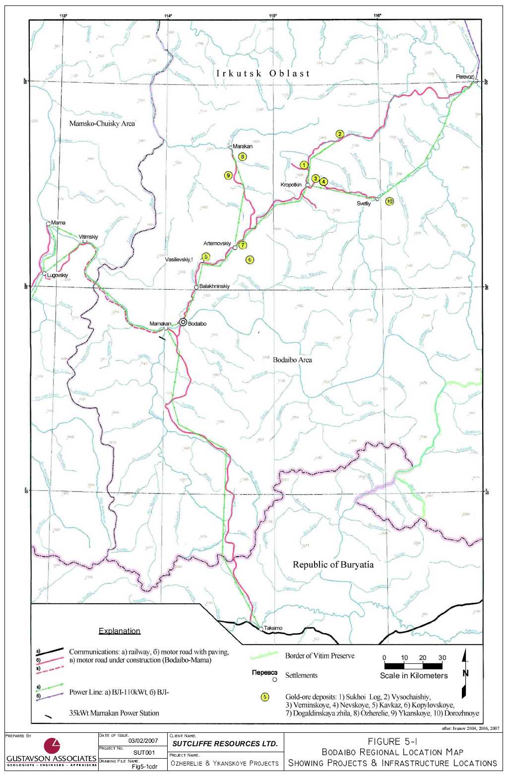
The Ozherelie and Ykanskoye deposits are located in the northeastern part of the Irkutsk Oblast in central Siberia, Russia. The Project areas are located approximately 1,100km north of the main center of the region, Irkutsk, with a population of some 700,000. The district center of Bodaibo (pop. 20,000) lies approximately 130km to the south. Ozherelie and Ykanskoye are some 6km southeast and 15km south (respectively) of the local mining support town of Marakan (pop. 1000) (Figure 5-1). Irkutsk is serviced by regular direct air services with the capital city of Moscow (5 hours) which in turn services the town of Bodaibo with daily turbo-prop flight services (2.5 hours). Both Irkutsk and Bodaibo airports can be effected by weather on a regular basis. Large river barges on the Lena and Vitim rivers can also supply Bodaibo, which is linked to the Project areas by a poorly maintained gravel road. The Project areas are situated 2 to 3km off this road. The road trip from Bodaibo to site takes 3-4 hours, weather and conditions dependent. Winter travel (with the roads frozen) is easier than travel in summer. Alternatively the nearest rail head is at Taksimo situated 240km south of Bodaibo and linked by road.
The area is remote with no telephone or mobile phone coverage and no local population or inhabitants. The land is owned and managed by the National Forestry Fund, but trees are sparse and small. A 110 KW power line follows the road.
5.2 Climate
The climate is extremely cold with only a short brief summer period. During the site visit by Gary O’Connor in August, 2006, the surrounding hills were capped by fresh snow and temperatures dropped to sub-freezing with surface water freezing over night. Deep permafrost is said to be common in the area. Annual precipitation averages 375mm, with 260mm falling as rain, and the rest as snow. The daily maximum precipitation is 55mm.
5.3 Local Resources and Infrastructure
Bodaibo has been a center of support for mining activity over many years. Sutcliffe, through ML’s long-standing relationships in the Bodaibo area, has identified several opportunities for office space, capable labor and an equipment yard to take care of logistical issues as they may arise.
5.4 Physiography
The relief around the Projects is moderate, with slopes commonly 10-18°, and rarely 20-25°. Maximum ridge elevations range from 1000 to 1300m.
5.5 Environmental Conditions
Alluvial mining has taken place in the immediate vicinity of both Ozherelie and Ykanskoye. At Ozherelie, alluvial mining is active, whereas at Ykanskoye, the alluvial mining reportedly dates from Tsarist times. The Exploitation and Exploration Licenses specify permitted activities at the sites as well as requirements at the time of closure. To date, site disturbances by ML have been related to road and drill pad construction, trenching and bulk sampling. Future disturbances will be similar, with additional efforts in all areas.
6. HISTORY
6.1 General Background
The deposits of Ozherelie and Ykanskoye are relatively new discoveries made by ML in a district with a long history of gold production with a number of mines still in production and more in development. Gold mining in the region dates back to times of the Tsarist times (1800s). Historical gold mining from the region was mostly alluvial and as much as 1500 tonnes (48 Moz) of gold has been recorded as historical production from the district. The drive from Bodaibo to Marakan follows rivers which host numerous old and current alluvial operations with continuous mining along what are wide gravel rich river beds. Grades are said to be in the order of 10g per cubic meter. Current regional gold production in reported to be 15t (482,000oz) per year (10-12t from placer deposits and 3-4t from hard rock sources). Gold mining along with hydro-electric power generation are the main economic activities in the region.
The very large undeveloped gold deposit, Sukhoi Log (Spot # 1 on Figure 5-1) is situated 30-35km to the ESE of the deposits on the same regional up-thrust structure. In the region gold was deposited in multiple stages but the main, latest and largest event being associated with the granitic intrusions and thrusting and occurring post-metamorphism. In the district, tungsten and tin mineralization associated with granites has also been explored but not exploited.
At the prospect areas, a current large scale alluvial operation at Ozherelie is currently mining the deeper placer deposits immediately adjacent to the deposit and has been the site of historical alluvial mining operations. At Ykanskoye, the alluvial deposits were reportedly exploited during Tsarist times.
Historically, hard rock mining was conducted on high grade quartz vein-gold systems hosting coarse grained gold. Two historic quartz-gold mines are situated peripheral to the Sukhoi Log deposit. Ozherelie is a similar system with coarse gold hosted primarily in quartz veins. The coarse grained quartz-gold deposits are considered to be the main source for the extensive alluvial deposits in the area. More recent exploration has targeted finer grained gold systems. Sukhoi Log hosts finer grained gold in pyrite-quartz veins as does the Ykanskoye deposit. It would appear that the Ozherelie deposit was not located historically due to the very small outcrop above the “bogs” which covered the deposit. A working deposit model helped in the recent exploration success, partly due to the understanding of the systems based on work done at Sukhoi Log and the surrounding area.
6.2 Ozherelie
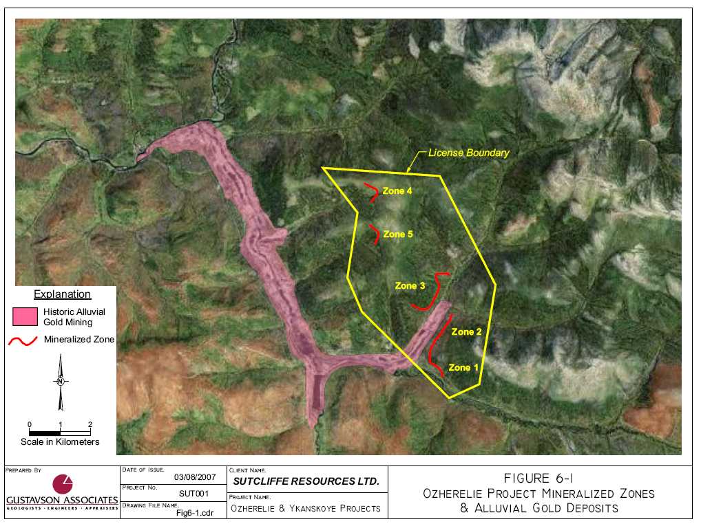
Historical alluvial mining which continues to the present with a large dredging operation (Marakan Mining) occurring immediate adjacent to and abutting the Ozherelie deposit. The current production details are not known. The hard rock source of the alluvial mineralization is a recent discovery by ML. Figure 6-1 is a satellite image of the alluvial mining in the vicinity of Ozherelie, showing the juxtaposition of the recent placer workings and the Ozherelie prospects.
As the exploration work (geological investigations, drilling, trenching, analysis and resource estimation) was conducted post-NI43-101 inception, the resource estimates and the supporting
work programs must be discussed as non-historical, and included in sections 10 through 16 of this report.
6.3 Ykanskoye
The Ykanskoye deposit area was reportedly mined for alluvial gold in the 19th Century during the times of the Tsar. Additional alluvial mining was again conducted during the 1950’s. It is reported that 50t of gold has been recovered from the area. No hard rock mining of gold had taken place on the site. The hard rock mineralization is a recent discovery by ML.
As the exploration work (geological investigations, drilling, trenching, analysis and resource estimation) was conducted post-NI43-101 inception, the resource estimates and the supporting work programs must be discussed as non-historical, and included in sections 10 through 16 of this report.
7. GEOLOGICAL SETTING
7.1 Regional Setting
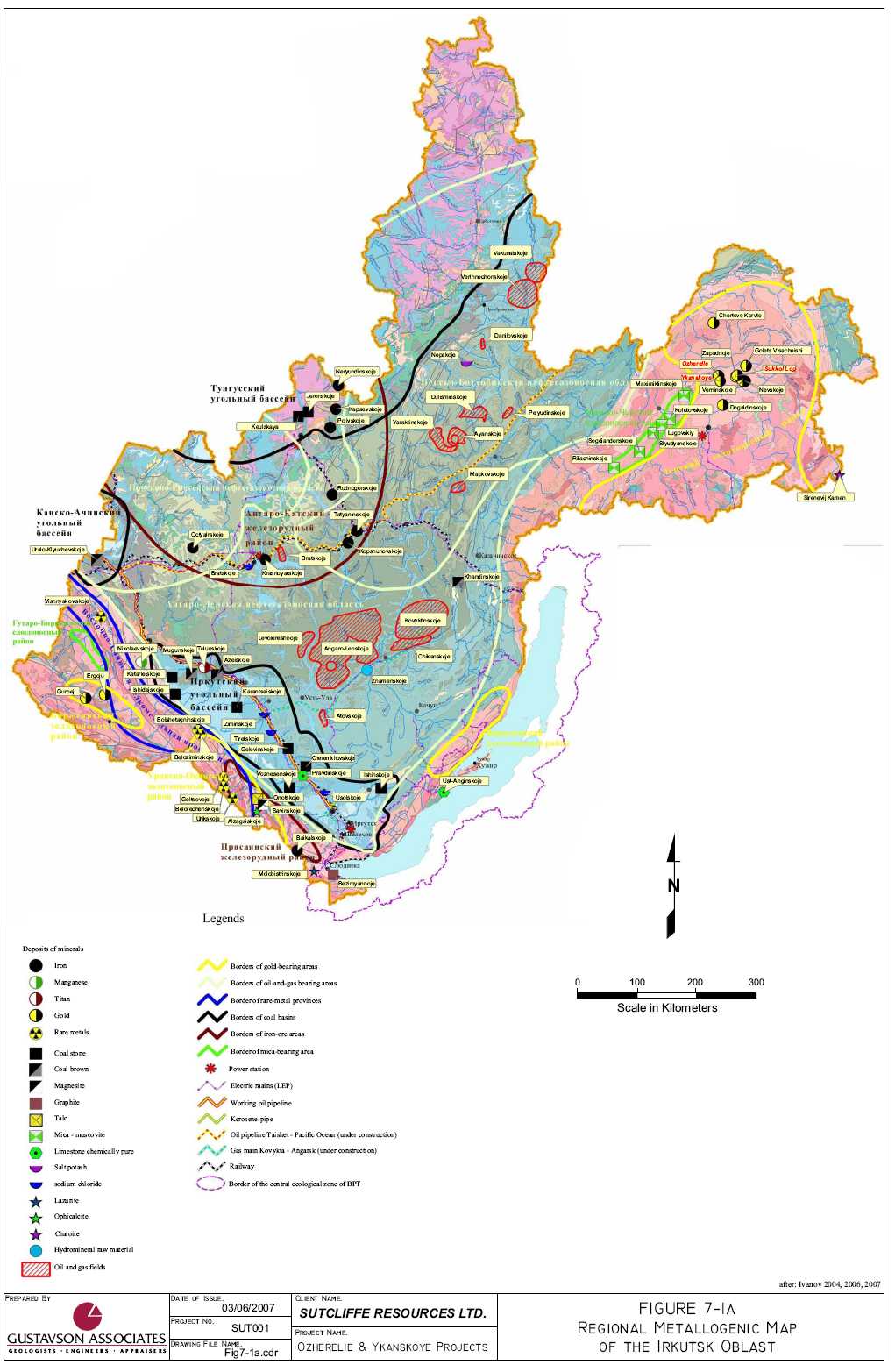
The region is hosted in terrigenous and carbonate units regionally metamorphosed to greenschist to epidote and epidote-amphibolite grade metamorphism dated at 430 Ma. The intrusion of granites and granite dykes occurred in the Upper Palaeozoic (320Ma) and resulted in contact metamorphic aureoles around or above granite bodies distinguished by biotite isogrades. The intrusion of granites is considered to be concurrent with the thrusting event, faulting and the last and main stage of gold deposition. Figure 7-1 is a metallogenic map of the Irkutsk Oblast. Figure 7-2 shows the local geology in the area surrounding the Ozherelie and Ykanskoye deposits.
The deposits are situated on the northern and southern flanks of a regional mega-syncline structure trending WNW. Crustal shortening and thrusting has occurred from the NE. This is situated within a regional up-thrust block (The Marakan-Tungus structure) with the same trend which is seen to extend for some 70km and 15-20km wide. This trend hosts 3 main mineralized areas on the intersection of regional NNE structures with the Marakan-Tungus structure. The central Sukhoi Log area is hosted in a metamorphic iso-grade zone containing chlorite+ muscovite.
![]()
7.2 Property Geology
7.2.1 Ozherelie
The deposit is hosted within carbonate to terrigenous (psammitic-pelitic) schists regionally metamorphosed to predominantly greenschist to amphibolite facies grades of Reef-Sorbian age (430 Ma). Local granite porphyry dykes of Upper Palaeozoic age intrude the schists and are considered to be associated with thrusting and the main mineralization event. A district-scale granite dome feature is situated to the immediate west of the deposit which has created an antiform and the structural setting for the more intense thrusting which displays a northerly trending orientation at Ozherelie. Ozherelie is situated on the NE limb of this structure within a strongly deformed zone. The recently discovered mineralized zones (numbered Zone 1 through Zone 5) are confined to thrust zones with thrusting occurring in a WSW direction (Figure 7-3). The thrust zone in the immediate Ozherelie area is associated with visible gold, quartz and brown-spar (ankerite), demonstrating geological continuity between the zones. As shown in Figure 6-1 and Figure 7-3, the Ozherelie hard rock gold occurrences fall immediately adjacent to alluvial gold mines or in the heads of drainages that host alluvial gold operations.
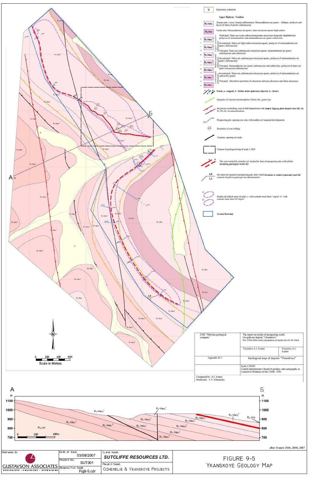
7.2.2 Ykanskoye
The Ykanskoye deposit is hosted within Riphean-Sorbian age (430 Ma) metamorphic schist units which have been intruded by Upper-Palaeozoic age granite dykes which cross-cut the earlier schist units. The schist units display regional greenschist to epidote-amphibolite facies grade metamorphism with local cross-cutting biotite-kyanite higher-grade metamorphism. Granite intrusion is associated with thrusting from a NE direction as part of the Upper-Palaeozoic age regional Baikal fold belt.
The mineralized zone is hosted immediately above a black carbonaceous pelitic slate unit (Black unit) within a thrusted grey coloured fine psammitic to pelitic slate unit (Grey unit). It appears that the reducing environment of the carbonaceous slate has influenced the precipitation of gold in the unit above and the continuity of this unit may affect the potential down dip extension of additional mineralization.
Structurally the prospect is relatively more simple than Ozherelie. One single NE (12º average) plunging thrust zone has been mapped. The prospect is situated on the southern limb of a regional anti-form created by granite doming with a WNW orientation (Figure 7-4). The prospect is located within the western most part of a major WNW trending up-thrusted block which hosts 3 mineralized centers, of which Sukhoi Log is one.
8. DEPOSIT TYPES
The Ozherelie gold deposit may be described as low sulphidation quartz/carbonate/gold veins and stockworks in a shear zone.
The Ykanskoye gold deposit may be described as a mesothermal or epithermal low sulphidation hydrothermal system, characterized by gold-bearing quartz-pyrite-pyrrhotite veins and replacements of schistose slates beneath a capping formation.
9. MINERALIZATION
9.1 Ozherelie
At Ozherelie, the quartz-gold veins are associated with silicification, sulphides (minor), brown-sparring (ankerite), albitization and muscovite, hosted within flat lying (dipping on average 7º to the NNE, varying from 5-12º) thrust zones. Mineralization is hosted within banded carbonaceous cherty flysch terrigenous (psammitic-pelitic) schists, which display a distinctive layering. The coarse quartz-gold mineralizing event is considered to overprint and remobilize an earlier schist formation related mineralizing event associated with sericite and muscovite (+chlorite). The zones vary in vertical thickness from 8m to 36m. Mineralization is bounded to the SW by more carbonaceous schist facies, which indicates some lateral changes in lithology. Within the carbonaceous units to the SW, mineralization is weak. The carbonaceous content of the unit would be considered to provide the geochemically reducing environment for the deposition of gold. And it may be that the higher grades are located nearer to this transitional boundary. Gold occurs as generally coarse and visible (70% greater than 1mm) particles with a fineness of 940, hosted in white quartz veins and often occurs along the boundary or within the browner “spar” material. Silver content is less than 1g/t.
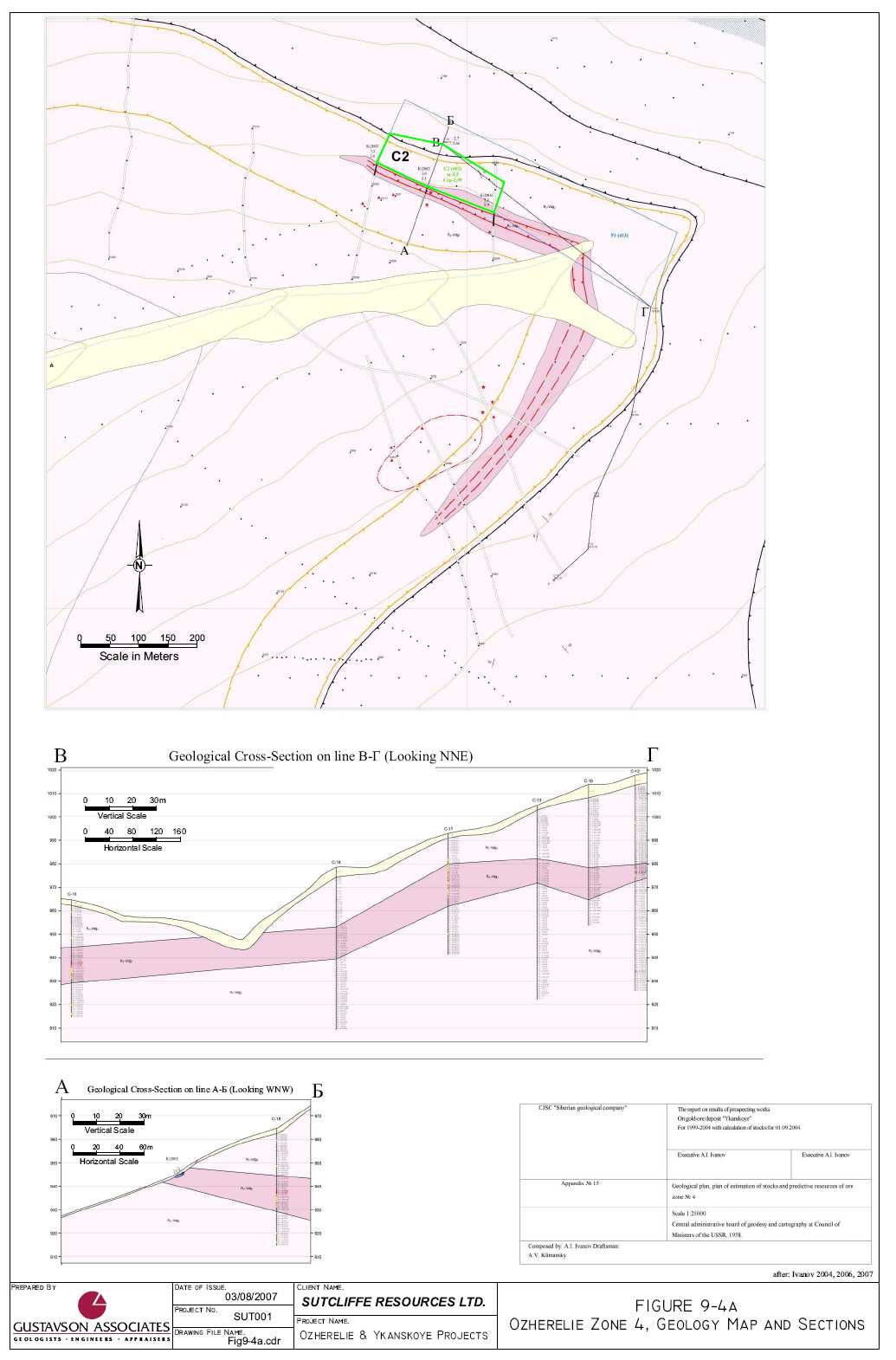
Gold distribution is extremely non-uniform in the mineralization tested in Zone 1. Drill holes C-29, 30 and 31, drilled to intersect the Zone 1 mineralization in the vicinity of Trenches 102 and 122, returned a weighted average gold content of 0.9 grams per tonne (g/t), whereas channel samples in the immediate vicinity returned an average gold grade of 5.16g/t and a bulk sample in the same area (1,177t) returned an average gold grade of 5.04g/t. The core size (61mm) (and therefore the sample size) may be insufficient to gain a representative sample given the coarseness of the gold particles, (70% greater than 1.0mm) . The core drilling does however provide excellent geological detail concerning the nature of the shear zone and the prospectivity of the mineral assemblage intersected. Figure 9-1 shows a long-sectional view of the bulk mined cut at Zone 1. The blue colored areas indicate detailed mapping of the quartz-ankerite gold bearing horizons in the face.
The 5 mineralized zones (Figure 7-3) have received differing levels of exploration to date. Zones 1 and 4 have seen the most work. All of the zones display very similar geology and mineralization across the property. Each is the host of native gold, exposed in trenches, pits and/or drill holes. As all exploration to date has been immediately adjacent to the above zones, it is therefore not yet known whether the mineralized horizon outcropping in Zone 3 extends westward all the way through to Zone 4 and 5.
Figure 9-2 shows the 5 zones in detail and their relationship to each other.
![]()
9.2 Ykanskoye
Mineralization at Ykanskoye is hosted with a shallow dipping thrust zone dipping 12-14º to the NE over a width of 2.0 to 8.0m within a zone of intensely sericite-muscovite (+ silicification and sulphides consisting of pyrite and pyrrhotite). An earlier stage quartz event occurs but is only weakly gold mineralized and previous prospecting focused on exploring this with limited success. This quartz event has a spatial relationship to the mineralized zone. The early mineralization event occurred during metamorphism and consisted is associated with chlorite and muscovite (+ sericite).
The main gold mineralizing event occurred associated with regional granitic intrusions and thrusting with less quartz (silicification) and sulphides (pyrite and pyrrhotite). Peripheral to the mineralized zones occur minor arsenopyrite but arsenopyrite does not appear to host gold mineralization. Gold is visible in higher grade zones (+10g Au/t) but not generally coarse. Gold is not locked in sulphides but free milling and has a fineness of +950. Silver grades are less 1g/t.
The mineralized zone has been traced for approximately 6km of strike length and is open along strike and has been tested locally down dip from 100 to 300m, The zone remains open down dip along its entire strike length. Only 11 drill holes, totaling 475.7m, have been drilled into the zone.
10. EXPLORATION
ML conducted the exploration programs that discovered the Ozherelie and Ykanskoye gold deposits. Starting in 1999, ML maintained exploration expeditions (programs) in the area that includes the Ozherelie and Ykanskoye deposits. The exploration methodologies employed were similar for both deposits and the following is a discussion of those techniques. A major impediment to carrying out an effective exploration program in the Ykanskoye and Ozherelie areas, as in most of Russia, is the occurrence of permafrost. Sampling methodologies will be discussed in Section 12 of this report.
ML followed a systematic approach to exploration for the Ozherelie and Ykanskoye deposits that are probably a partial source for the large placer gold occurrences in the area. Recognizing that potential source for the placers were probably overlain by bogs and surficial deposits, often frozen, that mask Secondary Auras of Dispersion (SAD) or dispersion halos of gold and trace elements. ML used a three stage process to identify and explore prospective areas. The work resulted in the identification of the 5 zones at Ozherelie and the Ykanskoye deposit. The three stages were: (1) predictive-metallogenic analysis of geological-geophysical information and choice of areas for prospecting; (2) the actual prospecting; and finally (3) estimating the resource. Appendix D contains a listing of the collar coordinates of the drill holes and the location coordinates of the trenches.
The following table (Table 10-1) documents the exploration efforts at Ozherelie to date.
Table 10-1 Ozherelie Exploration Summary
| ## | Types of Works | Quantity | Quantity | Years | Number of Samples |
| 1 | Core drilling | 14 drill holes Zone 1 6 drill holes Zone 4 | 1317m | 2003 | 1317 |
| 2 | Cable tool Drilling (Amurets) | 31 drill holes | 403m | 2006 | 444 |
| 3 | BTS-150 (drilling- technical machine –interpr.) | 25 drill holes | 945m | 2006 | 912 |
| 4 | Trenches - bulldozer - manual | 38 trenches 20 trenches | 163307m3 6670m3 | 2002-2004 2000-2005 | 1631 |
| 5 | Bulldozer clearings | 32km | 112000m3 | 1999-2004 | |
| 6 | Prospect-holes - depth of 1 m - depth to 2,5 m | 2510 ea. 720 ea. | Total 4310 m | 1999-2004 | Total: dot samples – 505 geochemical – 7379 schlich – 3288 |
| 7 | Bulk samples | 4 samples | 5000t | 2003-2004 | |
| 8 | Technological samples | 3 samples | 145kg | 2003-2004 |
The following table (Table 10-2) documents the exploration efforts at Ykanskoye to date.
Table 10-2 Ykanskoye Exploration Summary
| ## | Types of Works | Quantity | Quantity | Years | Number of Samples |
| 1 | Core drilling | 11 drill holes | 476m | 2003 | 410 |
| 2 | Trenches - bulldozer - manual | 28 trenches 5 trenches | 5905m3 660m3 | 2003 2000-2001 | 859 |
| 3 | Prospect-holes - depth of 1m - depth to 2.5m | 1030 ea. 106 ea. | Total 1293m | 1999-2003 | Total: chip samples – 22 geochemical -2856 schlich – 655 |
| 4 | Technological samples | 3 samples | 110kg | 2003 |
10.1 Geologic Mapping
Local experience with the other hard rock gold deposits has led to recognition of the role of metamorphic facies changes in localizing the deposits. Limited outcrops in the area presented challenges to bringing the regional geologic picture into a local focus on specific areas. ML took advantage of results of early (pre-1960) prospecting for alluvial gold deposits. In the case of Ozherelie, the occurrence of alluvial gold stops immediately adjacent to Zone 2. There are no placer gold shows above that point.
10.2 Trenching
Trenching in areas of permafrost required opening of the area of the eventual trench to bedrock with a dozer, a waiting period during the summer months for thawing and deepening of the trench after thawing.
10.3 Geochemical Sampling
Test pits (prospect holes) of 1m and 2.5m in the cover provided points for geochem sampling. This is a common technique employed in the Bodaibo area. The primary guide to mineralization was the occurrence of gold in the test pit samples.
10.4 Geophysics
Ground magnetic surveys have proven effective in identifying geologic structures – faults and thrust plate edges.
According to Gary O’Connor and confirmed by William Crowl, the exploration programs were conducted according to norms of exploration activities conducted in Russia. The programs, although somewhat different procedurally from Western programs, are well founded, organized and very detail-oriented.
10.5 Bulk Sampling
At Ozherelie, ML has conducted 4 tests of bulk samples, variously testing the characteristics of the coarse gold mineralization and comparing trench sample analysis results with assays on core from the same location. A gravity recovery plant was constructed in 2003, which includes lines of ore preparation (jaw crusher, cone crusher and chain crusher) and concentration (sluices, jigs and tables) through which in 2003, 2,606t of mineralized material was processed. According to reports by ML, the operational experience of the complex has shown up to 70 – 80% of the coarse gold is caught by the sluice. Approximately 10 – 15% remains in the over-screen material of the jigs and the remaining gold is caught by the concentration tables and the Nelson concentrator. Both rich and poor ores were processed. The average recovered content of gold on all tests run through the gravity recovery plant (2,606 tons) was 2.75g/t, as defined by the results from the samples sent to the gold refinery. Average losses of gold in tails was reported to be 0.16g/t, yielding an average gold head grade of 2.91g/t, and an extraction rate of 94.5% .
In 2006, a 5000t bulk sample was taken from Zone 1 at Ozherelie. The sample was processed through the gravity recovery plant on site. Again, the sample was taken to assist in understanding the distribution of coarse gold mineralization recognized at Ozherelie. Among other tests, a 1177t sample was taken in the vicinity of core hole 29, 30 and 31. These holes had been drilled, each to a depth of 12m, in very close proximity to one another (1m). The average content of gold in these holes is 0.9g/t, whereas the average content of gold on trench samples in the wall of the open pit is 5.16g/t, and in the bulk sample (1177 t), 5.04g/t. The comparison of average gold content in core, trench and bulk samples is 1 : 5.73 : 5.61. Comparison of results of core, trench and bulk samples has shown sufficient comparative reliability of trench samples to bulk sample results and a lack of corresponding comparative reliability between the core holes and both the trench and bulk samples. The insufficiency of the core samples in predicting bulk sample grades is at least partially related to the prevalence of coarse gold in the mineralized zone. This characteristic has led ML to use the core drilling in Ozherelie Zone 1 for mineralized zone delineation only.
In all, the 5000t processed through the gravity plant has returned some 15kg of gold, yielding a calculated head grade of +3.0g/t gold.
11. DRILLING
11.1 Core Drilling
In 2003, for inclusion in the Russian resource estimation programs, diamond core drilling was done to produce core for sampling at both the Ozherelie and Ykanskoye deposits. The zone of mineralization in both project areas is relatively flat (7 and 12 degrees) and all holes were drilled vertical. Hole depths averaged approximately 60m, hence no down-hole surveying was conducted and all holes were assumed to be straight. Vertical drilling is quicker and easier however it is not generally recommended for mineralized areas. Some angle holes would be recommended to test for sub-vertical mineralization.
Standard Russian core drilling, core logging and core sampling procedures prescribed by the Government were strictly followed by ML. Core logging, operational and geological, was meticulous and accurate. Each hole has a journal allocated to it, recording all information about that hole, including, in most cases, transcription of assay results upon receipt of the reports from the laboratory. Split core is available for only one hole each, at both Ozherelie and Ykanskoye. The reason cited is that the non-uniform distribution of gold and the coarse nature of the gold particles. ML has taken the position that if only half core is submitted for analysis, there is a high likelihood that the reduced size sample will render the sample less representative of the gold mineralization intersected.
11.2 Non-Core Drilling Techniques
More recent drilling (2006; 25 holes for 945m), which is not to be included in any resource updates, was conducted at Ozherelie using new drilling methods. No new drilling as conducted at Ykanskoye during 2006. Due to the coarse nature of the gold and subsequent nugget effect it was decided to use a Russian-built BTS-150 conventional rotary air drill (“BTS”), rather than core drilling due to its larger diameter and subsequent sample size. The BTS method is essentially a rotating blade with the “chipped-off” rock then blown up the outside of the barrel and collected as sample. The weight of each samples collected per meter was weighed to measure “core-loss”. The BTS drilling was designed to provide a quick and relatively inexpensive, spot view of the first few meters of bedrock at the drill site. It was very effectively used at Ozherelie in 2006 to define the subcrop of the shallow dipping ore zone in Zone 1. The air rotary cuttings are collected in a box, displaying the stratification seen in the hole. ML recognizes that the BTS drilling method does not yield quantitative samples, and the results have not been and will not be used in mineral resource calculations efforts.
For Zone 3 area at Ozherelie, a different system, referred to as a Cable-Tool in the West or Amurets in Russia, system of casing off the alluvium/colluvium was designed in order to penetrate or hit bed-rock to test for mineralization. Each meter was sampled and the “drilling” only just penetrated bedrock so did not test this to any degree. The drilling was designed to check for mineralized outcrop.
The surveying of drill hole locations and trench locations as well as compilation of detailed topographic maps was done by in-house, by ML surveyors. According to Gary O’Connor, this appears to be of good quality and standards. No field checks were conducted. At this stage of the program such issues are not considered material.
12. SAMPLING METHOD AND APPROACH
Gustavson did not independently re-sample or assay any of the samples comprising the historic data for Ozherelie or Ykanskoye. The following discussion of sampling methodology and approach is taken from ML reports and records of personal interviews and inspections by William Crowl and Gary O’Connor.
12.1 Channel Sampling and Core Sampling
A review of the channel sampling and core sampling procedures and inspection in the field found these to be of good standards. Channel sampling in trenches were of consistent size and sampled using a rock saw. They were of a uniform 10cm wide by 5cm deep and can be considered to adequately represent the material sampled. Channel and core samples were generally of 1m length unless major geological boundaries were met then shorter lengths were considered. Each sample consisted of some 35kg. Such a large sample is considered appropriate in sampling systems such as Ozherelie and Ykanskoye where free gold is the primary mineralization type. Each trench is mapped at a scale of 1cm = 0.5m. At this scale, the fine details of the geology are easily mapped. ML has retained all records of these trenches for future investigations.
For drill core, the entire core is sampled, with no half core retained, except for the representative half core from hole C-5 at Ozherelie and C-19 at Ykanskoye. A complete photographic record of the core from all of the holes is available in ML’s office in Irkutsk. Future core drilling programs must consider retention of half core for compliance with Western industry practices.
12.2 Bulk Sampling
See Section 10.5 above.
13. SAMPLE PREPARATION, ANALYSES, AND SECURITY
13.1 Sample Preparation
Drilling and trench samples were prepared by ML at site. Trench samples are collected in bags, a numbered wood tag is inserted in the bag. The core samples are bagged, assigned a sample number and the from, to length of sample and weight is recorded at the rig. The core sample is then transported to the crushing facility at Ozherelie, as are the trench samples. Each entire sample is dried, weighed and crushed to 1mm and passed through a 1mm screen. Two duplicate 1kg splits are taken from this and transported to the laboratory for further processing. Sample preparation procedures and methods appear to be of good practice, however as the sample preparation was not in use at the time of the visit no checks were possible.
At Ozherelie, there were 33 samples that yielded coarse gold as oversize during the screening of the minus 1m fractions. This gold was collected and weighed. The assays returned from the laboratory were upgraded appropriately to reflect the content of coarse gold. It is reported that there was no oversize free gold in the Ykanskoye samples.
BTS drilling samples, taken at a standard 1m length, are weighed at the drill rig and upon arrival at the Ozherelie crusher. They are then treated identically to the core and trench samples.
13.2 Sample Analysis
Analysis was conducted at the Institute of Rare Metals in Irkutsk (IIRE), an analytical laboratory founded in 1871. The laboratory’s web site iswww.irgiredmet.ru. Each 1kg sample is pulverized to -0.0074mm and analyzed (50g Au fire assay) using industry standard fire assay techniques. The results of the two assays are compared. If they are within 20%, then the average is reported, if not, two more 50g charges are taken and assayed. This procedure is repeated until the values are within 20%.
13.3 Check and Duplicate Sampling/Preparation and Assaying
For approximately 3% of the samples, ML takes a duplicate split of the core, assigns a second number to the split and submits it for assay. If the analytical results are not within tolerances, the laboratory is asked to re-assay the sample interval. As another check, ML submits up to 3% of the sample pulps to IIRE as duplicates. And as a further check, termed Exterior Control, analysis was conducted on a representative number of samples (30 each from 5 grade ranges for a total of 150 samples at Ozherelie) at a corresponding institute laboratory in the neighboring state. The standard Russian procedure of submitting 5% of samples as duplicates for analysis was done. No external standards or blanks were submitted as these are done by the laboratory. Under Russian regulations, the laboratory is required to perform quality control. While the procedures used are different than International practices and might not pass Western “Best Practice” QA/QC procedures, it is considered that the analysis done and assays used would be considered to accurately reflect the gold content of the samples analyzed. However no review of the data
base nor due diligence of the accuracy and precision of results was conducted. In reality, there are times where there are not a sufficient number of samples in each category to allow full compliance with the mandated protocol, but there is always an effort made to comply.
Gustavson visited the IIRE laboratory in February, 2007 in the company of Dr. Ivanov, Messrs. M. Kurani and A. Popov. Discussions were held with the management of the laboratory and a tour of the facility revealed that the lab is in good order. The laboratory participates in international round robin analytical programs and appears to operate at a competency level equal to similar laboratories outside Russia.
13.4 Security
The following is a translation of a document received from Dr. Ivanov, describing the security arrangements in place at the Ykanskoye and Ozherelie projects during the processing of samples:
”The entire effort of processing of bulk samples was supervised by the security service of Closed Joint-Stock Company “Nedra Bodaibo”, which built the plant and carried out the processing of bulk samples on it.
Employees of the security service report to a department of the Ministry of Internal Affairs of Bodaibo.
All employees allowed to participate in the processing of gold had corresponding credentials.
According to the requirements of the Ministry of Internal Affairs, sealing of all sites where gold accumulated was obligatory and carried out. Crushing and collection of gold was carried out by corresponding employees of security service, gold-bearing heavy fraction was placed in special metal containers and was transported by special transport to GPC (gold-processing complex), according to requirements.
CJSC “Nedra Bodaibo” – especially protected the gold according to requirements of the Ministry of Internal Affairs. The “pure” gold was separated and was delivered in special containers by the specialized collector state service of the refining factory.
CJSC “Nedra Bodaibo” itself recognized that placer gold varied from the gold of the “Ozherelie” deposit, not only on morphology (placer gold is rolled and eroded to a high degree), but also on fineness. Fineness of the gold of “Ozherelie” is much higher than fineness of placer gold (accordingly 940 and 900) and it is impossible to “dilute” by placer gold without change of its characteristics, which is recognizable.”
Gustavson had no opportunity to examine the security arrangements first hand, as the plant was not in operation at the time of the visit. The above description does, in fact, describe a security scheme that on it’s face is adequate for the exploration programs of ML.
14. DATA VERIFICATION
Gustavson has not independently conducted any title or other searches, but has relied upon Sutcliffe for information on the status of the claims, property title, agreements, and other pertinent conditions. In addition, Gustavson has not independently conducted any mining, processing, or economic studies, or permitting and environmental studies.
14.1 Verification of Geologic Data
Gustavson has met with Dr. Ivanov and reviewed the geological data collected by ML on both the Ozherelie and Ykanskoye properties. In addition, geological core logs and related data were reviewed on plan maps and sections for consistency of interpretation and accuracy of data entry and plotting. Finally, Dr. Ivanov led the site visits in February, 2007 as well as the visit by Gary O’Connor in August, 2006.
Representative drill logs were reviewed for both properties. Data posting was checked on several cross sections and plan maps. As there is minimal core remaining from the drilling campaigns, no actual comparison was possible between the core logs and actual core.
Gustavson has no reason to believe that the data as presented are not representative of all of the previous geologic work completed. Gustavson found no material errors associated with the drill logs in their review.
14.2 Verification of Analytical Data
Neither Gustavson nor Sutcliffe has completed any independent sampling and/or confirmatory geologic logging of core. Future rounds of evaluation of the existing data may involve re-assaying sample pulps and rejects, if available.
Gustavson has no reason to doubt the validity of the data presented in this report, as it has been generated under a strict set of protocols and developed by ML, an experienced Russian exploration company and analyses were carried out by respected analytical laboratories.
15. ADJACENT PROPERTIES
There are no immediately adjacent non-alluvial gold properties in the vicinity of Ozherelie and Ykanskoye. Marakan Mining is conducting alluvial gold mining on land adjacent to the hard rock deposits at Ozherelie.
The Sukhoi Log gold deposit, geologically similar to the Ykanskoye deposit is located some 35km from Ykanskoye. The following is an abbreviated version of a discussion of the Sukhoi Log deposit provided by Dr. B.L. Wood. Statements of resource estimates are included for information only and are not NI43-101 compliant and should not be directly related to Sutcliffe’s Ozherelie and Ykanskoye projects.
The Sukhoi Log gold deposit is centrally located in the Lena goldfield region, approximately 850 km NE of the city of Irkutsk. and is hosted in Upper Proterozoic marine sandstone, carbonaceous slate and phyllite, metamorphosed to low greenschist facies in an outlying part of the major Akitkan Foldbelt. The disseminated pyritic orebody is defined solely by assay grades, is tabular in form and is located in the axial zone of a large, near-isoclinal, reclining anticline. Highest ore grades occur in pyritic black shale beds, especially where they cross the axial zone, and form two elongate higher grade (4 - 9 g/t gold) cylindrical zones, termed ore pillars, along the gently plunging anticlinal crest. The anticline is exposed E-W over a length of 3 km and plunges at approximately 10 degrees NW. The axial plane and orebody dip 15N, and the latter is open to depth beyond 400 m.
The mineralisation assemblage is consistently quartz-pyrite-gold carbonate with minor base and platinum group metals, and low levels of arsenic and base metals. Pyrite is widely distributed in black shale throughout the deposit, at between 2 and 5 percent, and in lesser amounts in a disseminated envelope around the orebody. In the outer parts of the orebody and in the enclosing mineralisation envelope it contains gold of higher fineness (900-920), whereas clustered and veinlet pyrite is more common in the interior productive zone, with gold of lower fineness (840-880).
The deposit was intensively explored from October 1971 to December 1977. The geological ore reserve was estimated to a cutoff grade of 1 g/t gold, and is an elongate irregular planoconvex sheet up to 140 m thick, dipping NNE at 150 to 300, with a length of 2.2 km, a down dip width of more than 500 m, and is probably open to depth. The main orebody has a geological reserve, at a 1 g/t Au cutoff, of 384 million tonnes with an average grade of 2.5 to 2.7 grams per tonne. Additional resources include 165 million t at 2.0 to 2.3 g/t in a low grad,. possible pit extension, and 205 million t at 0.8 g/t in the mineralisation envelope.
Sequences of pyrite-gold paragenesis, of textural and structural changes, and limited isotope data indicate that four distinct stages of mineralisation occurred during the final accretion, ridge-subduction, and Riphean closure of the major Proterozoic Akitkan Foldbelt.,
Synsedimentary, syndiagenetic mineralisation of finely disseminated pyrite (Pyrite 1) in anoxic carbonaceous pelitic sediments, by density stratified metalliferous brines, sourced from Au-bearing, deep crustal hydrothermal fluids, and by PGM-bearing mantle-sourced fluids through rift basin extensional faults.
Mineralisation with gold of lower fineness in coarser pyrite (Pyrite 2), accompanying ductile synmetamorphic, large-scale flexural slip folding (F1), with pervasive fluid transport of gold, PGM, and other metals into the anticlinal hinge region.
Post-metamorphic non-penetrative small-scale flexural folding (F2) occurred, with local segregations of small high-grade quartz-gold veins in hinge zones and elsewhere non-pervasive, small irregular quartz-pyrite-gold-carbonate veinlets in clusters , and scattered pyrite porhyroblasts with quartz pressure rims (all Pyrite 2). Followed by a generation of coarsely porphyroblastic, low gold pyrite in large clusters without quartz (Pyrite 3).
Late stage, large and lengthy, widely spaced, tensional, low grade mesothermal quartz-gold veins, transgressive through the main orebody but probably sourced from it.
16. MINERAL PROCESSING AND METALLURGICAL TESTING
16.1 Ozherelie
Metallurgical test work conducted consisting of a gravity circuit including jigs, Wilfley concentrating tables and Nelson concentrators recovered 90.6% of the gold on samples averaging 3.5g Au /t. Some gravity sampling and processing (see Section 10.5) conducted by ML returned total recoveries of to 94.5% Au on samples grading 2.91 g Au /t. Direct cyanidation reportedly resulted in recoveries of up to 99.5% Au recovery. Gold had a fineness of 945-966.
Based on a limited review of the Ozherelie metallurgical test data, Gustavson considers that the samples were probably representative. The testing will be expanded in the next rounds of exploration. Given the coarse nature of the gold particles at Ozherelie the results are reasonable.
16.2 Ykanskoye
Two test samples were sent to IIRE an independent company for metallurgical test work. One consisted of 80kg and the other of 15kg. Results from metallurgical test work including jigging, concentrate tabling followed by Nelson concentrating, returned recoveries of up to 95.6% . Direct cyanide leaching returned recoveries of up to 99.0% .
The standard gravity circuit (Jigs and tables) on a sample grading 4.7g Au /t achieved 86.61% Au recovery.
Based on a limited review of the Ykanskoye metallurgical test data, Gustavson considers that the tests described above were conducted on representative samples from the Ykanskoye mineralization. The testing will be expanded in the next rounds of exploration.
17. MINERAL RESOURCE AND MINERAL RESERVE ESTIMATES
17.1 Introduction
Resource estimates prepared by ML at Ozherelie and Ykanskoye in 2004 used standard Russian methodologies. For Ozherelie Zone 1, cross sections were drawn at appropriate intervals. On these cross-sections were displayed topography, traces of drill holes/trenches and the accompanying assays for each trench and drill hole. The top and bottom of the mineralized zone was delineated using geology and assay results. Areas on the sections were named for the level of confidence the investigators had for the mineralization depicted therein – in this case as C1 and C2. The area C1 is representative of a zone of higher geological confidence and C2 somewhat less.
At Ozherelie Zone 4 and Ykanskoye, the average vertical thickness was calculated for the most prospective and sampled parts of the prospects and a mineralized horizontal envelope in the plane of the mineralized zone was drawn and the area measured. The two figures were multiplied to yield a volume, which was converted to a tonnage using the specific gravity (bulk density). The grade assigned to the tonnage is the weighted average gold grade of the assays inside the mineralized area above a cutoff grade.
The designations C1 and C2 originate in the Russian resource classification system. However, for the purposes of this report, these designations can be taken as simply a breakdown of the Ozherelie and Ykanskoye prospect into polygonal blocks for estimation purposes.
Stephen Henley has written a comprehensive article on the subject of Russian mineral reporting, that is included here in Appendix C.
17.2 Ozherelie Resource Estimates
For Ozherelie Zone 1, the assays were composited in intervals of 3m or more, for both material above a 1g Au/t cutoff grade and below. The weighted average gold grade of the 3m or greater intersections was calculated for the sections. Then, a Mineralization Factor (MF) was calculated for each of the sections, equaling the ratio of the greater than 1g Au/t composited material to the total length within the mineralized zone. Finally, the vertical thickness of the mineralized zone on each section was calculated, based on the slope angle of the trench. Based on the results seen in the core holes, where smaller sampling cross-sectional area appears to have under-reported the coarse gold in the immediate vicinity, only geology was used from the core hole record, not the MF or Au grades.
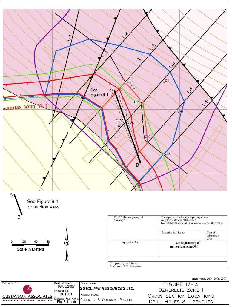
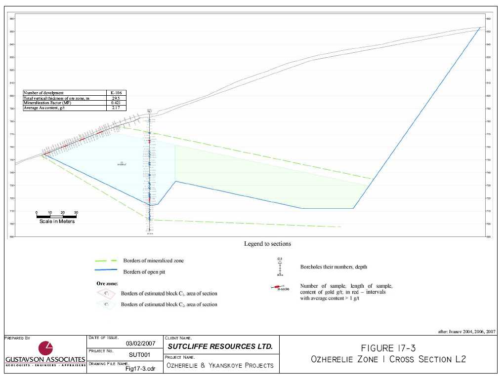
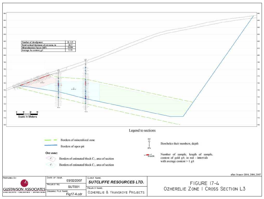
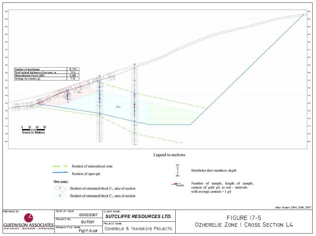
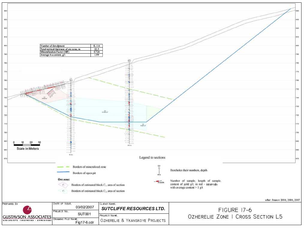
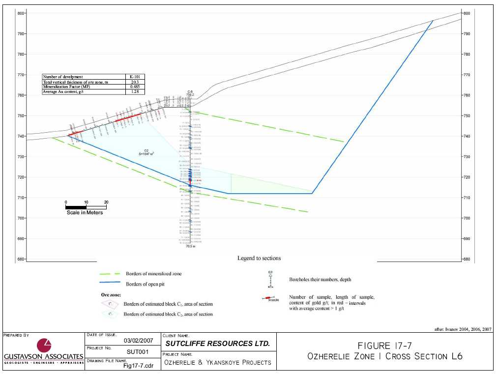
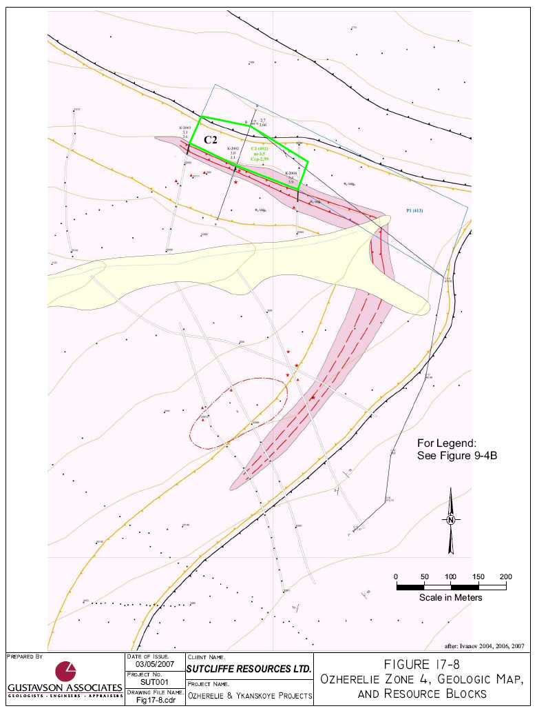
Figure 17-1 shows the location of the sections and Figure 17-2, Figure 17-3, Figure 17-4, Figure 17-5, Figure 17-6 and Figure 17-7 are the cross sections for Zone 1 at Ozherelie. The C1 areas are colored pink and the C2 areas are colored light blue. For Zone 4, Figure 17-8 shows the area designated as C2.
The areas on the vertical section for C1 and C2 at Zone 1 were measured. End area calculation methods were used to calculate volumes between the adjoining sections. For Section L1 the end area was projected 20m West. For Zone 4, the C2 area was defined in plan using the results of
drilling, trenching and geological projection down dip. C1 areas and volumes (and tonnages) are exclusive of one another.
The specific gravity (SG) measurements used in the resource tonnage estimations were calculated by measuring the length of the core, weighing the sample and using 61mm as the diameter of the core (HQ size) and then back-calculating the SG using the formula for a cylinder. The method assumes that the core stays at 61mm, but in reality drill core bits often move and the core diameter can be slightly smaller than the size of the bit. This however would mean that the SG measurements may be slightly on the conservative size. It was reported that more than 100 samples were measured for each type of sample but this could not be verified. Additionally, ML reports that it has a large database for the entire region and that the variance around 2.7 is very small. The SG used would appear to accurately reflect the true value and potentially yield conservative tonnage estimates.
The results of the calculations of resources for Ozherelie Zones 1 and 4 (Areas C1 for Zone 1 and C2 in both Zones) are as follows (Table 17-1). In all cases, the SG used was 2.7 and the average silver grade is <1 g/t and not estimated. The minimum length of composites used is 3.0m and maximum internal dilution is 3.0m. The cut-off is 1.0 g/t Au. These resources, at this point non-CIM compliant mineral resources (see Section 17.2.1), are as presented by ML (A.I. Ivanov) in their resource report dated September 1, 2004, were approved in a report (#639K) dated November 12, 2004 by the regional agency, TKZ “Irkutsknedra”, authored by V.A. Mordvin.
Table 17-1 Ozherelie Resource Estimates, Zones 1 and 4
| Category | Tonnes (t) | Grade (Au) | Contained Au (Oz) | Contained Au (t) |
| Zone 1 | ||||
| C1 | 106,363 | 4.93 g/t | 16,881 | 0.525 |
| C2 | 807,969 | 3.63 g/t | 94,340 | 2.934 |
| C1 + C2 | 914,332 | 3.78 g/t | 111,221 | 3.459 |
| Zone 4 | ||||
| C2 | 134,484 | 2.99 g/t | 12,926 | 0.402 |
| Total Ozherelie C1+C2 | 1,048816 | 3.68 | 124,134 | 3.861 |
![]()
17.2.1 Ozherelie Mineral Resource Classification
Gustavson has reviewed the protocols of the ML exploration program, the results of that program, the geology and mineralization data and the methodologies employed in the Ozherelie C1 and C2 resource estimates described above. Whereas the data collected has not been collected with an eye toward compliance with western standards (i.e. quality control and quality assurance), the protocols rigorously employed were those mandated by the government of Russia. The Russian protocols are strict and comprehensive, dealing with nearly the same issues as the western industry standards, but with differences in terms of core and sample retention, submission of blanks, standards and duplicates, etc. The geological investigations were thorough and well documented.
Gustavson considers that the Ozherelie C1 and C2 mineral resources as estimated by ML and approved by TKZ “Irkutsknedra”, can be classified and reported as Inferred Mineral Resources as defined by the CIM. Gustavson considers that these Inferred Mineral Resources are NI43-101 compliant.
The CIM definition for Inferred Mineral Resources is as follows:
“An ‘Inferred Mineral Resource’ is that part of a Mineral Resource for which quantity and grade or quality can be estimated on the basis of geological evidence and limited sampling and reasonably assumed, but not verified, geological and grade continuity. The estimate is based on limited information and sampling gathered through appropriate techniques from locations such as outcrops, trenches, pits, workings and drill holes.”
“Due to the uncertainty that may be attached to Inferred Mineral Resources, it cannot be assumed that all or any part of an Inferred Mineral Resource will be upgraded to an Indicated or Measured Mineral Resource as a result of continued exploration. Confidence in the estimate is insufficient to allow the meaningful application of technical and economic parameters or to enable an evaluation of economic viability worthy of public disclosure. Inferred Mineral Resources must be excluded from estimates forming the basis of feasibility or other economic studies.”
The geological evidence and “limited” sampling has demonstrated geological and grade continuity in Zone 1 at Ozherelie and less so in Zone 4. The tighter spaced drilling and trenching, plus eventual underground testing of the zones planned for the next 2 to 3 years (under NI43-101 standards) by Sutcliffe may provide sufficient verification to upgrade the Inferred Mineral Resource estimates to categories of higher confidence, namely Indicated and/or Measured Mineral Resources.
At Ozherelie, there are large, untested areas along strike and down dip of the identified Zones with the geological potential to significantly expand the mineral resources beyond the current level. This is discussed further in Sections 19 and 20 in the context of Conclusions and the future exploration program.
Of note is the coarse nature of the gold mineralization at Ozherelie, where the up to 70% of the native gold particles are reported to be greater than 1.0mm in diameter. The coarse nature of the
gold has been taken into account by the Russian investigators in their resource estimate for Zone 1, C1 where they did not use the assay values from the core holes, only the geological contact recognized in the core holes, citing the non-representative nature of the “small” core hole samples. Exclusion of data can be appropriate or inappropriate, depending on circumstances in each estimate. Gustavson considers that exclusion in this case, on a limited basis, is not critical to the quantum of the reported resource estimate. However, Sutcliffe must, as part of their ongoing exploration efforts at Ozherelie, formalize resource modeling protocols that fully explain the rationale for data inclusion/exclusion.
17.3 Ykanskoye Resource Estimates
Using the same methodology as used at Ozherelie Zone 4, resources were estimated. Figure 17-9 shows the C1 area, delimited by surface trenches and core holes. The C2 area is shown also and is exclusive of the C1 area.
These resources, at this point non-CIM compliant mineral resources (see Section 17.3.1), are as presented by ML (A.I. Ivanov) in their resource report dated September 1, 2004, were approved in a report (#640K) dated November 12, 2004 by the regional agency, TKZ “Irkutsknedra”, authored by V.A. Mordvin, are summarized below (Table 17-2). The SG used was 2.7, the average silver grade is <1 g/t and not estimated. The minimum length of composites used is 3.0m and maximum internal dilution is 3.0m. The cut-off is 1.0 g/t Au.
Table 17-2 Ykanskoye Mineral Resource Estimates
| Category | Tonnes (t) | Grade (Au) | Contained Au (Oz) | Contained Au (t) |
| C 1 | 213,935 | 4.50 g/t | 30,965 | 0.963 |
| C 2 | 1,190,449 | 3.21 g/t | 122,862 | 3.821 |
| C 1 + C 2 | 1,404,384 | 3.43 g/t | 153,826 | 4.784 |
Average vertical width of C-1 zones is 3.66 m and C2 is 3.00 m.
17.3.1 Ykanskoye Mineral Resource Classification
Gustavson has reviewed the protocols of the ML exploration program, the results of that program, the geology and mineralization data and the methodologies employed in the Ykanskoye C1 and C2 resource estimates described above. Whereas the data collected has not been collected with an eye toward compliance with western standards (quality control and quality assurance etc.), the protocols rigorously employed were those mandated by the government of Russia. The Russian protocols are strict and comprehensive, dealing with nearly the same issues as the western industry standards, but with differences in terms of core and sample retention, submission of blanks, standards and duplicates, etc. The geological investigations were thorough and well documented.
| 65 | Gustavson Associates |
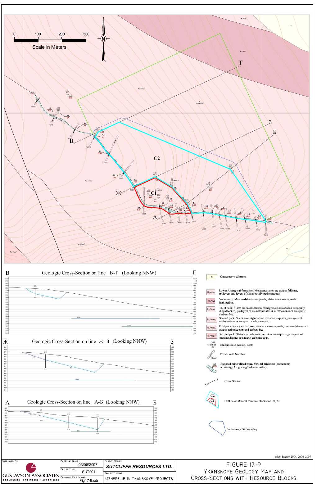
Gustavson considers that the Ykanskoye C1 and C2 mineral resources as estimated by ML and approved by TKZ “Irkutsknedra”, can be classified and reported as Inferred Mineral Resources as defined by the CIM. Gustavson considers that these Inferred Mineral Resources are NI43-101 compliant.
The CIM definition for Inferred Mineral Resources is as follows:
“An ‘Inferred Mineral Resource’ is that part of a Mineral Resource for which quantity and grade or quality can be estimated on the basis of geological evidence and limited sampling and reasonably assumed, but not verified, geological and grade continuity. The estimate is based on limited information and sampling gathered through appropriate techniques from locations such as outcrops, trenches, pits, workings and drill holes.”
“Due to the uncertainty that may be attached to Inferred Mineral Resources, it cannot be assumed that all or any part of an Inferred Mineral Resource will be upgraded to an Indicated or Measured Mineral Resource as a result of continued exploration. Confidence in the estimate is insufficient to allow the meaningful application of technical and economic parameters or to enable an evaluation of economic viability worthy of public disclosure. Inferred Mineral Resources must be excluded from estimates forming the basis of feasibility or other economic studies.”
The geological evidence and “limited” sampling has demonstrated geological and grade continuity at Ykanskoye. The tighter spaced drilling and trenching, plus eventual underground testing of the Ykanskoye deposit planned for the next 2 to 3 years (under NI43-101 standards) by Sutcliffe may provide sufficient verification to upgrade the Inferred Mineral Resource estimates to categories of higher confidence, namely Indicated and/or Measured Mineral Resources.
There is significant, undefined geological potential at Ykanskoye to expand the mineral resources beyond the current level. There are, however, no guarantees that the expansion will take place, and any such projections should not be relied upon by investors.
Of note is that the coarse nature of the gold mineralization at Ozherelie is not evident at Ykanskoye. No oversize (>1.0mm and not passing the initial 1mm sample prep screen) gold has been identified at Ykanskoye.
17.4 Discussion of the Russian Mineral Reporting System
Stephen Henley has written a comprehensive article on the subject of Russian mineral reporting, that is included here in Appendix C. He has provided definitions of Russian C1 and C2 resources, in terms that can be compared to Western definitions of mineral resources. He states that:
- Category C1reserves (resources in NI43-101 terms) in place have been estimated by asparse grid of trenches, drill holes or underground workings. This category also includesreserves adjoining the boundaries of A and B reserves, as well as reserves of very complexdeposits in which the distribution cannot be determined even by a very dense grid. Thequality and properties of the deposit are known tentatively by analyses and by analogy withknown deposits of the same type. The general conditions for exploitation are known. The ore
| 67 | Gustavson Associates |
- tonnage is derived from estimates of strike length, dip length and the average thickness ofthe orebody. Allowance for barren blocks may be made statistically; and.
Category C2reserves(resources in NI43-101 terms)are based on an extremely looseexploration grid, with little data. The limits of the orebody are defined mainly byextrapolation within known geological structures, and from comparison with other similardeposits in the vicinity. The grade and mineral properties of the orebody are determinedfrom core samples and comparison with similar mineral deposits in the area. The reserveshave been extrapolated from limited data, sometimes only a single hole. This categoryincludes reserves adjoining A, B, and C1 reserves in the same deposit.
He further states that “a broad equivalence between the classifications (Russian and Western (NI43-101) may be presented as follows (Table 17-3):
Table 17-3 Russian Classification Compared to International Codes
| Russian | Internationalreporting code JORC, etc. |
| A, B | Proved reserve/measured resource |
| C1 | Proved or probable reserve/indicated resource |
| C2 | Probable reserve/indicated resource/inferred resource |
| P1 | Inferred resource |
| P2 | Reconnaissance mineral resource (as found under UN Framework Classification for Reserves/Resources, code 334) |
| P3 | No equivalent |
Western (including NI43-101) reporting schemes rely heavily on the Qualified Person to assess the category of mineral resource to be assigned to a mineral resource estimate. As stated above, Gustavson considers the Russian Ozherelie and Ykanskoye C1 and C2 mineral resources to be Inferred Mineral Resources, for the reasons cited in Section 17.2.1 and 17.3.1 above. The Inferred Mineral Resources for the Projects are shown in Table 17-4.
Table 17-4 Ozherelie and Ykanskoye Inferred Mineral Resources
| Property | Tonnes (millions) | Grade (g Au/t) | Contained Au (Oz) | Contained Au (t) |
| Ozherelie | 1.05 | 3.68 | 124,000 | 3.86 |
| Ykanskoye | 1.40 | 3.43 | 154,000 | 4.78 |
| Total | 2.45 | 3.53 | 278,000 | 8.65 |
| 68 | Gustavson Associates |
18. OTHER RELEVANT DATA AND INFORMATION
Gustavson is unaware of any other data and/or information that would be relevant to this report and is not contained in one of the existing Sections of this report.
| 69 | Gustavson Associates |
19. INTERPRETATION AND CONCLUSIONS
19.1 General Conclusions
ML does not maintain one central database for all of the drilling and trench data, so it was not possible to obtain a copy or conduct any preliminary evaluation of this. However it was considered that this could readily be compiled as the data is available digitally. Printing of accurate, detailed maps and cross-sections shows that the data appears to be in good order and able to be accessed with good plots of channel samples from trenches, (and results) as well as drill holes. Data at the moment appears to be filed in a number of folders. ML has a GIS software package (Arc-View) from which it accesses the data and makes plots of results. ML has stated that they are in the process of acquiring a license to a Western mine planning package to enable the company to centrally store and manage all resource data and be able to produce level plans, cross-sections, plans and some 3-D visualization and modeling capability.
Gustavson considers that ML, and thus Sutcliffe, have carried out effective and successful exploration programs that have resulted in the identification of significant gold mineralization at both Ozherelie and Ykanskoye. However, relative to the potential extent of the deposits, both down dip and along strike, previous exploration has been limited. ML has used standard Russian protocols to conduct these programs. Although these protocols differ from those employed by Western companies and from Western best practices, the protocols have resulted in the creation of drilling and sampling databases of a quality that adequately supports the estimation of NI43-101 compliant Inferred Mineral Resources.
The registering of federal mineral resources and reserves is a well controlled and regulated procedure. Such issues as quality control, back-up data and checks, limits of assurance and resource confidence are all regulated by the relevant “resource/reserve” commissions. For a total “reserve” of up to 10 tonnes (C1 and C2) and less than 10 tonnes in any one resource category, the regional commission based in Irkutsk (TKZ) is able to sign-off on the estimation. For numbers larger than this the sign-off procedure must go to the federal commission in Moscow (GKZ).
19.2 Ozherelie
The Ozherelie deposit has been traced for over 7km and is open to the north and south, as well as down dip. The deposit has only been tested to a minimal extent with relatively small amounts of drilling and channel sampling. The approximate strike length comprised in the C1 and C2 resource blocks in Zones 1 and 4 is 0.5km, leaving more than 6.5km remaining to be tested. The mineralized horizon is confined to a thrust zone dipping 8-12º to the ENE. To the east, the zone plunges beneath hills which may restrict the ability to drill and open pit mine the horizon in that direction. However, to the west the zone dips up and out of the hills with topography working in favor of accessing the horizon to the west of hills adjacent to the main ore zones. Zones 4 and 5 occur in such an area. Additional zones of lower grade mineralization occur over narrower widths above the main zone but have not been prospected or defined to date and may add additional potential.
The objectives of the ML exploration program at Ozherelie were to define new gold mineralization that may have been the source of placer gold in the adjacent alluvial mining area.
| 70 | Gustavson Associates |
Gustavson’s review indicates that ML have been successful in their endeavor. They have, in fact, discovered heretofore unknown gold mineralization that may have been the source of the adjacent placer gold.
Preliminary metallurgical test work indicates that the gold is coarse and is hosted within coarse quartz veins. The gold is apparently free milling and recoverable by gravity and cyanide leaching.
The Ozherelie gold system has been the subject of detailed exploration for approximately 0.5km of the total 7km strike length, and down-dip an average of about 100m. Reasonable extrapolation of more detailed geological data collected in Zones 1 and 4 to Zones 2, 3 and 5 yields a substantial exploration target. Sutcliffe’s 2007 and 2008 exploration programs at Ozherelie are focused on the definition of the projections of known mineralization. Gustavson considers that there is significant potential for the discovery of substantial additional gold mineralization in the 5 mineralized zones on the Ozherelie license, as well as in those areas not yet tested.
The overall potential for the Ozherelie project ranges from the current inferred mineral resource of 3.86t of gold contained in 1.05 million tonnes at a gold grade of 3.68g/t to more than 40t (1.3 million oz) of gold contained along the remaining 6.5km of strike length. This statement of potential only assumes a down-dip projection similar to that used in the estimation of the Inferred Mineral Resource (approximately 100m). The deposit remains open down-dip. The shallow dip of Ozherelie enhances the prospectivity of down-dip projections along strike. This potential is not CIM-compliant and is stated here to be indicative of the potential of the known mineralized system at Ozherelie. As above, further exploration is planned to test this potential in the near future.
19.3 Ykanskoye
The Ykanskoye deposit has been traced for some 6km and confirmed through 33 trenches and 16 drill holes down dip for only a limited distance and depth. The approximate strike length comprised in the C1 and C2 resource blocks for Ykanskoye is 1.4km, leaving more than 4.6km remaining to be tested. Projections in the dip direction for resource estimation range from 100 to 300m. The deposit remains open down dip and along strike. The deposit is situated in a shallow plunging thrust zone and hosted within a distinct banded metamorphic unit. It contains Au grades in excess of 3.0g Au/t on average, with no significant Ag grades. The gold appears to be amenable to gravity recovery and is readily extractable by cyanide leaching. The deposit is similar to, but has minor differences to other gold deposits in the belt, being finer grained than Ozherelie and hosted in a zone of silicification-pyrite-pyrrhotite rather than coarse quartz. While the zone dips to the NE and subsequently gets deeper, topography also dips in this general direction meaning possible strip ratios may not be adversely affected in all areas. Again, as at Ozherelie, there is potential for the discovery of substantial additional gold mineralization both along strike and down-dip from the more thoroughly tested area containing the Inferred Mineral Resources.
The potential for the Ykanskoye project ranges from the current inferred mineral resource of 4.78t of gold contained in 1.40 million tonnes at a gold grade of 3.43g/t to more than 16t of gold
| 71 | Gustavson Associates |
(>0.5 million oz) contained along the remaining 4.6km of strike length, however, Gustavson considers that there is considerable strike and down dip potential at Ykanskoye that could increase the above potential significantly beyond the 16t of gold. This potential is not CIM-compliant and is stated here to be indicative of the potential of the known mineralized system at Ykanskoye. As above, further exploration is planned to test this potential in the near future. This statement of potential assumes a down-dip projection similar to that used in the estimation of the Inferred Mineral Resource (between 100 and 300m). The deposit remains open down-dip.
| 72 | Gustavson Associates |
20. RECOMMENDATIONS
Sutcliffe is presently planning several full seasons of exploration on both the Ozherelie and Ykanskoye projects. The activities will include core drilling, BTS-150 drilling, reverse circulation (RC) drilling, test pitting, bulldozer trenching and other geological investigations. The proposed US$12m exploration budget for Ozherelie and Ykanskoye is listed in Table 20-1 below and shown in Figure 20-1 and Figure 20-2, respectively. Importantly, given the coarse nature of the gold particles in the Ozherelie deposit, Sutcliffe has acquired two larger (132mm) diameter, high productivity core drills for the upcoming exploration season, and will deploy a large diameter RD 10+ reverse circulation rig for Phase 2 in-fill drilling. These drills will provide a significantly larger sample size than the previously used Russian core drill.
Table 20-1 Ozherelie and Ykanskoye Proposed Direct Exploration Budget, 2007 and 2008
| Ozherelie | Ykanskoye | Total | |||||||||
| Total | Meters | Cost US$/m | US$ m | Meters | Cost US$/m | US$ m | Meters | Cost US$/m | US$ m | ||
| BTS Drilling | 3500 | 100 | 0.35 | 0 | 100 | 0.00 | 3500 | 100 | 0.35 | ||
| Core Drilling – Phase 1 | 9800 | 200 | 1.96 | 5500 | 200 | 1.10 | 15300 | 200 | 3.06 | ||
| RD 10 – Phase 2 | 24500 | 120 | 2.94 | 13000 | 120 | 1.56 | 37500 | 120 | 4.50 | ||
| Trenching (m³) | 12600 | 10 | 0.13 | 18000 | 10 | 0.18 | 30600 | 10 | 0.31 | ||
| Other | 2.27 | 1.51 | 3.78 | ||||||||
| Total | 7.65 | 4.35 | 12.00 | ||||||||
Note: Other includes costs for camps, sampling, sample processing, sample analysis road construction and other categories of expenditures.
Nearly 64% of the total US$12.0m will be spent at Ozherelie with the remainder spent at Ykanskoye. At both properties, two phases of exploration are planned. The first phase will generally test the extent of the mineralized horizons across the respective properties, while the second phase will be predominately in-fill drilling down dip and along strike of the current resource areas. This phased approach is appropriate, given that exploration to date has been limited and confined to a relatively small area of both properties.
At Ozherelie, in the first phase a relatively widely-spaced drilling grid (480m x 160m) is planned, along strike and down dip of the current resource in Zone 1. In addition, three widely-spaced drill fences are planned in the central zone to test the continuity of the mineralized horizon between Zone 3 and Zone4/5. BTS drilling will be concentrated at Zone 3 to again test for continuity. As detailed in the plan shown on Figure 20-1 Ozherelie Exploration Program 2007 and 2008, a significant amount of trenching will be undertaken during Phase 1. This is seen as highly appropriate given the variability of mineralization at Ozherelie. Apart from being used as a primary exploration tool, several trenches will be excavated in previous drill tested areas to provide checks against previous core logs and assays. In Phase 2 at Ozherelie, RC drilling will concentrate on expanding the known area of mineralization and possibly the mineral resources in Zone 1. With success and at the proposed drilling density of 120 x 80m, there may
| 73 | Gustavson Associates |
be an opportunity to enhance continuity of geology and mineralization and perhaps define Indicated Mineral Resources.
Currently at Ykanskoye, detailed trenching has been undertaken along approximately 1.4km of the potential 6km strike length of the mineralized system. In Phase 1 of the 2007-2008 exploration plans, new trenching will be undertaken to further define continuity of the mineralized horizon along the entire strike length. Seven widely-spaced fences of core holes (approx. 1km apart) are planned to ascertain down dip continuity across the property. In Phase 2, an in-fill drilling program is planned on a 120m x 80m grid in the central-north area of the property. With success and at the proposed drilling density, there may be an opportunity to enhance continuity of geology and mineralization and perhaps define Indicated Mineral Resources.
The above programs represent a staged approach to defining and/or upgrading mineral resources at both deposits. Decision points have been defined that will re-direct efforts to other areas if and when the first phase of the exploration program should prove unsuccessful.
Gustavson recommends that Sutcliffe carry out the following tasks in addition to the drilling, sampling and testing programs proposed:
- Prepare a centralized database and carry-out a detailed data verification program; and
- Implement a CIM-compliant resource estimation procedures for sampling, assaying, QA/QC programs and resource estimation. These procedures should be guided by the CIM “Best Practice Guidelines”.
Gustavson considers the exploration program proposed by Sutcliffe to be appropriate for the Projects at their current state. The staged exploration program will be conducted in a manner that supports the eventual estimation NI43-101 – compliant Measured or Indicated Mineral Resources (if warranted).
| 74 | Gustavson Associates |
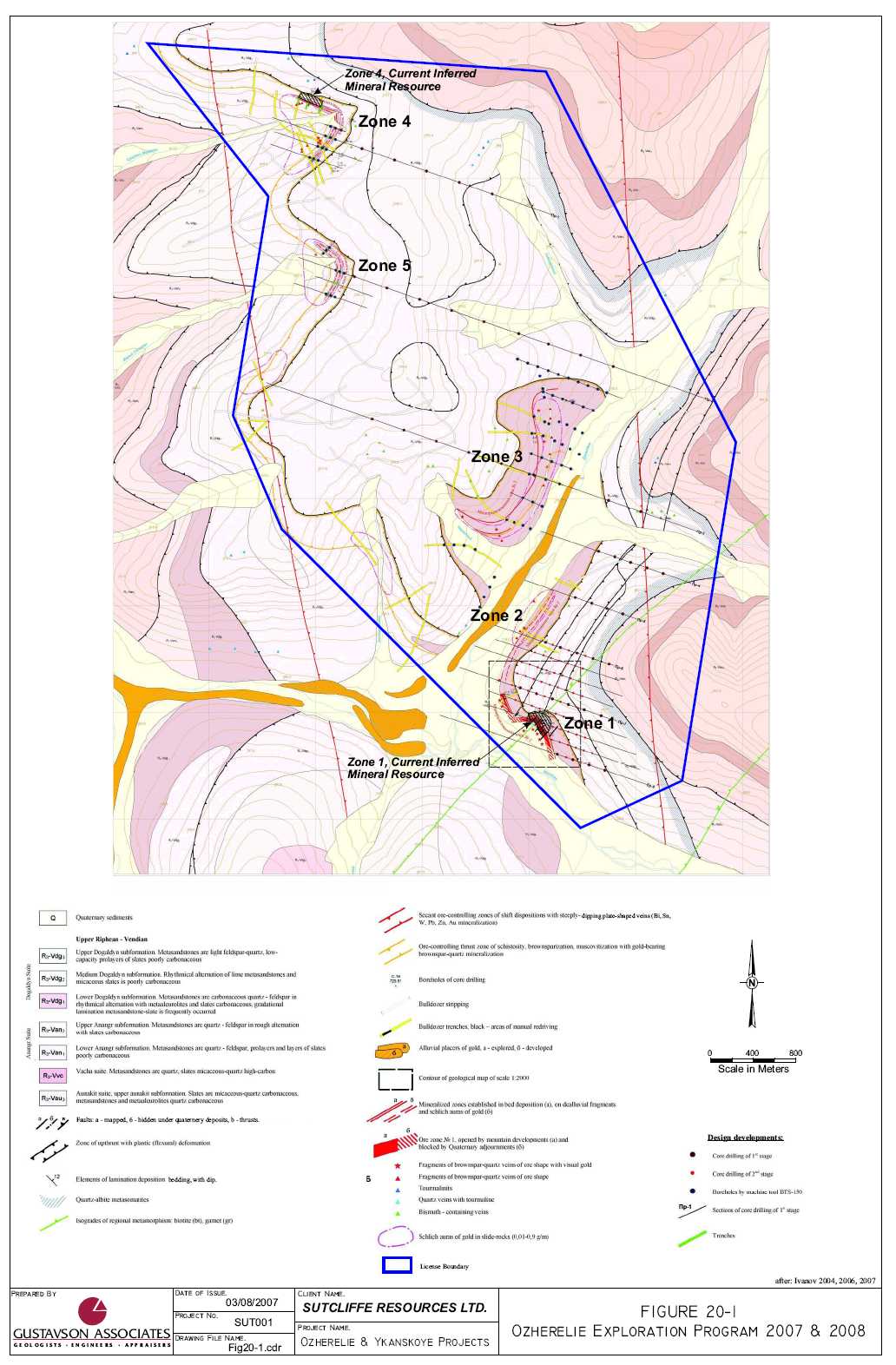
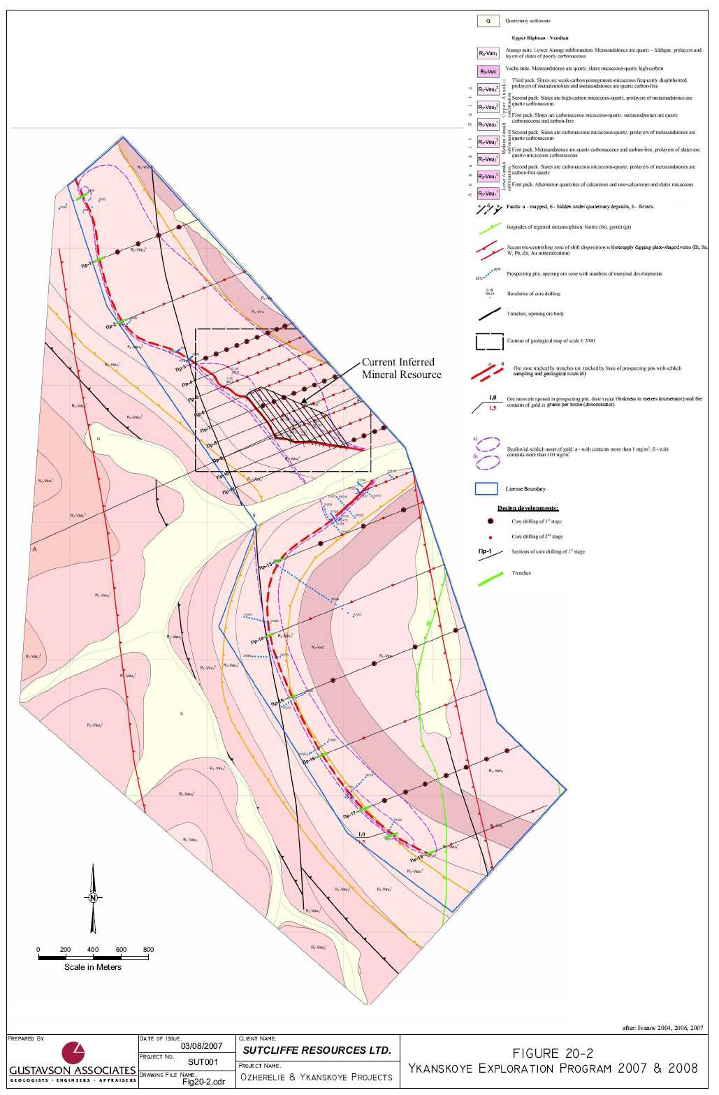
21. REFERENCES
| 1. | Ivanov, A.I. et al, 2004, Report About Results of Geological-Prospecting Works on Gold- Ore Deposit Ozherelie for 1999-2004 with Estimation of Reserves on 01.09.2004, S3 volumes, September 2004. | |
| 2. | Ivanov, A.I. et al, 2004, Report About Results of Geological-Prospecting Works on Gold- Ore Deposit Ykanskoye for 1999-2004 with Estimation of Reserves on 01.09.2004, S3 volumes, September 2004. | |
| 3. | Mordvin, V.A., 2004, Irkutsknedra Approval #639K of Prospecting Standards, Ozherelie, November 12, 2004. | |
| 4. | Mordvin, V.A., 2004, Irkutsknedra Approval #639K of Prospecting Standards, Ozherelie, November 12, 2004. | |
| 5. | Ozherelie License #13710, August 2006 | |
| 6. | Ykanskoye License #13711, August 2006 | |
| 7. | Woods, B.L., 2004, Sukhoi Log Expert Group Web Site, http://www.sukhoilog.com/. | |
| 8. | O’Connor, G., 2006, Ozherelie and Ykanskoye Deposits, Irkutsk Oblast, Siberia, Russia Field Site Visit Report, August 2006. | |
| 9. | Henley, Stephen, 2004, Russian Mineral Reporting, Mining Journal, London, August 20, 2004 | |
| 10. | Ivanov, A.I. et al, 2004, 2005 2006 and 2007, Miscellaneous Maps, Figures, Documents, Photographs in ML Files, Irkutsk, Irkutsk Oblast, Russia. |
| 77 | Gustavson Associates |
22. DATE AND SIGNATURE PAGE
William J Crowl
Vice President, Mining
Gustavson Associates, LLC
5757 Central Avenue, Suite D
Boulder, Colorado 80301
Telephone: 303-443-2209
Facsimile: 303-443-3156
Email:wcrowl@gustavson.com
CERTIFICATE of AUTHOR
I, William J Crowl do hereby certify that:
| 1. | I am currently employed as Vice President, Mining by Gustavson Associates, LLC at: | |
| 5757 Central Avenue Suite D | ||
Boulder, Colorado 80301 |
| 2. | I am a graduate of the University of Southern California with a Bachelor of Arts in Earth Science (1968), and a MSc. In Economic Geology from the University of Arizona in 1979, and have practiced my profession continuously since 1973. | |
| 3. | I am a registered Professional Geologist in the State of Oregon (G573) and am a member in good standing of the Australian Institute of Mining and Metallurgy and the Society of Economic Geologists. | |
| 4. | I have worked as a geologist for a total of 35 years since my graduation from university; as a graduate student, as an employee of a major mining company, a major engineering company, and as a consulting geologist. | |
| 5. | I have read the definition of “qualified person” set out in National Instrument 43-101 (“NI 43-101”) and certify that by reason of my education, affiliation with a professional association (as defined in NI 43-101) and past relevant work experience, I fulfill the requirements to be a “qualified person” for the purposes of NI 43-101. | |
| 6. | I am responsible for the preparation of the technical report titled “NI 43-101 TECHNICAL REPORT ON THE OZHERELIE AND YKANSKOYE GOLD PROJECTS, IRKUTSK OBLAST, RUSSIA.” Dated 20 March 2007 (the “Technical Report”). A personal visit of the subject properties was conducted on 5 February, 2007. | |
| 7. | I have personally completed an independent review and analysis of the data and written information contained in this Technical Report. | |
| 8. | I have not had prior involvement with Sutcliffe Resources Ltd. on the property that is the subject of this Technical Report. |
| 78 | Gustavson Associates |
| 9. | I am not aware of any material fact or material change with respect to the subject matter of the Technical Report that is not reflected in the Technical Report, the omission to disclose which makes the Technical Report misleading. | |
| 10. | I do not hold, nor do I expect to receive, any securities or any other interest in any corporate entity, private or public, with interests in the properties that are the subject of this report or in the properties themselves, nor do I have any business relationship with any such entity apart from a professional consulting relationship with the issuer, nor to the best of my knowledge do I have any interest in any securities of any corporate entity with property within a two (2) kilometer distance of any of the subject properties. | |
| 11. | I have read National Instrument 43-101 and Form 43-101, and the Technical Report has been prepared in compliance with that instrument and form. | |
| 12. | I consent to the filing of the Technical Report with any stock exchanges or other regulatory authority and any publication by them, including electronic publication in the public company files on the websites accessible by the public, of the Technical Report. |
Dated this 20th day of March, 2007.
William J Crowl
Signature of Qualified Person
"William J Crowl"
Print name of Qualified Person
| 79 | Gustavson Associates |
23. ADDITIONAL REQUIREMENTS FOR TECHNICAL REPORTS ONDEVELOPMENT PROPERTIES AND PRODUCTION PROPERTIES
The Ozherelie and Ykanskoye projects are neither development properties nor production properties.
| 80 | Gustavson Associates |
24. ILLUSTRATIONS
All of the illustrations used in the preparation of this report appear in each of their respective sections.
| 81 | Gustavson Associates |
APPENDIX A
CV for Anatoly I. Ivanov
| 82 | Gustavson Associates |
RESUME
Anatoly Innokentievich Ivanov
Position: Director General of Closed Joint-Stock Company «Siberian Geological Company»
Office phone: +73952346657, +73952346661
Mobile phone: +73952747140
Date of a birth: 17.02.1951.
Residence: Russia, Irkutsk
Education:
1968-1973, Irkutsk state university (cum laude);
Qualification – engineer-geologist;
Specialty – «Geological shooting and searches of minerals deposits».
Work:
1973-1992 – association "Irkutsgeology": geologist, senior geologist, chief of the set, leading geologist of expedition;
1992 – to present time (since 1997 – combine jobs) – Closed Joint-Stock Company "Ofit": director general;
1997 – to present time – Closed Joint-Stock Company «Siberian geological company»: director general.
Academic degree:
Candidate of geological-mineralogical sciences (1984). Theme of the dissertation: «Regularity of formation of linear folding of Baikal-Patom uplands ».
Scientific works:
Author of 50 published works, including two monographies: «Structural-kinematic analysis of Patom deflection» (1992) and «Precambrian of Patom uplands» (1995).
Industrial reports: in total 16 (in 13 – executive and first author), including:
- geological shooting of scale 1:50000 – 3 reports;
- prospecting works – 3 reports, including minerals: iron (ferruterous quartzites); tin and tungsten; complex (with tin, tungsten, titan and bismuth) gold-bearing looses;
- research works on predictive estimation – 4 reports, including: one on Sn; one – Sn, W, Mo; two – Au; one – Au, Sn, W, Ag, Bi;
- research works on drawing up of legends to geological maps – 1 report;
- prospecting works – 6 reports with estimation of reserves, including: ore Au – two; talc – one; greenstone – one; plaster – one; decorative dolomite – one.
At present time reports with estimation of reserves are in a process of preparation: one – ore gold; one – plaster. Also prospecting and estimated works on three new gold-ore objects are carried out.
Opening (on forecast, under a management and at direct participation):
- deposits of ore gold of Ozherelie and Ykanskoye (Certificates on the fact of opening are officially received);
- Vitim iron-ore area (six potential deposits) with an estimation of predictive resources on more than 3 billion tons;
- Tonodsky tin-tungsten-bearing area (three tin-ore objects and one tungstic – estimated works will be carried out);
- commercial deposits of talc, plaster (reserves are estimated, development is planned);
- four prospective ore-occurrences of gold on which Closed Joint-Stock Company «Siberian geological company» conducts works now;
- prospective ore-occurrences of tin (one), tungsten (two), molybdenum (two) for which works are planned at the nearest years.
| 83 | Gustavson Associates |
Appendix B
Translations of License Agreements
for the
Ozherelie Deposit (13710)
and
Ykanskoye Deposit (13711)
| 84 | Gustavson Associates |
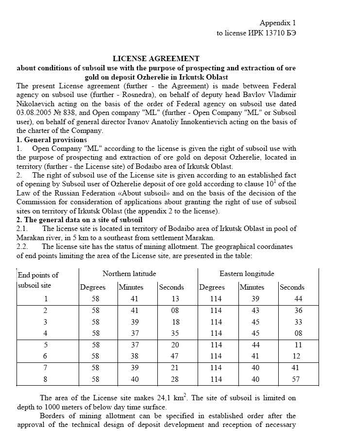
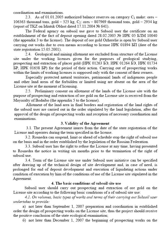
![]()

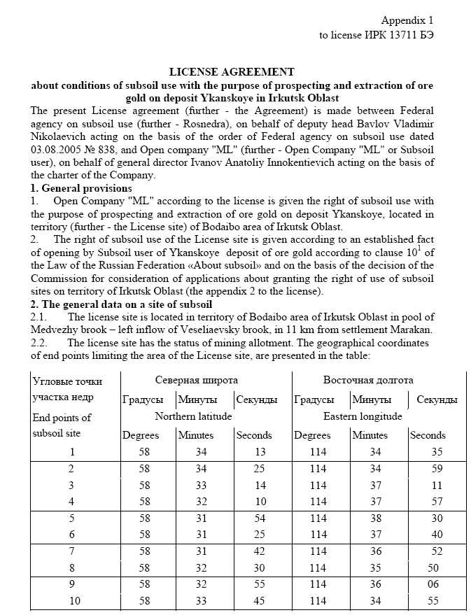
![]()
![]()
![]()
![]()
![]()
![]()
![]()
Appendix C
Russian Mineral Reporting
by
Stephen Henley
| 85 | Gustavson Associates |
![]()
![]()
![]()
![]()
Appendix D
Drill Hole Collar Coordinates and Trench Locations
| 86 | Gustavson Associates |
Ozherelie Drill Hole Collars
| Hole Number | Coordinates of hole collar | Elevation of Collar Z | |
X | Y | ||
| Zone 1: | |||
| 1 | 20368139.47 | 6503913.42 | 773.63 |
| 2 | 20368144.38 | 6503852.91 | 758.32 |
| 3 | 20368114.66 | 6503942.76 | 775.79 |
| 4 | 20368194.11 | 6503897.96 | 780.30 |
| 5 | 20368174.53 | 6503942.69 | 788.47 |
| 6 | 20368136.80 | 6503974.95 | 790.66 |
| 7 | 20368197.93 | 6503783.15 | 753.96 |
| 8 | 20368174.86 | 6503828.45 | 758.20 |
| 9 | 20367826.07 | 6504167.53 | 759.64 |
| 10 | 20367857.58 | 6504123.83 | 759.69 |
| 11 | 20368089.03 | 6503987.64 | 785.71 |
| 29 | 20368113.66 | 6503880.64 | 754.89 |
| 30 | 20368114.24 | 6503879.50 | 754.80 |
| 31 | 20368114.80 | 6503878.68 | 754.60 |
| Zone 4: | |||
| 12 | 20366147.11 | 6509047.33 | 1017.67 |
| 13 | 20366215.77 | 6509186.78 | 1005.00 |
| 14 | 20366313.21 | 6509513.47 | 978.63 |
| 16 | 20366205.82 | 6509100.47 | 1013.75 |
| 17 | 20366279.25 | 6509325.72 | 992.99 |
| 18 | 20365958.15 | 6509791.40 | 964.73 |
Ozherelie Trench Coordinates
| Trench | Trench end points | Coordinates of trench end points | elevation | |
| X | Y | Z | ||
| 116 | Initial | 20368007.98 | 6503917.17 | 744.25 |
| Final | 20368019.07 | 6503963.88 | 761.40 | |
| 106 | Initial | 20368039.44 | 6503923.04 | 753.70 |
| Final | 20368085.45 | 6503983.06 | 782.65 | |
| 115 | Initial | 20368106.63 | 6503934.04 | 772.00 |
| Final | 20368069.26 | 6503894.34 | 753.00 | |
| 123 | Initial | 20368109.96 | 6503909.81 | 766.65 |
| Final | 20368134.30 | 6503926.31 | 777.35 | |
| 102 | Initial | 20368063.82 | 6503827.40 | 734.00 |
| Final | 20368154.75 | 6503924.92 | 776.30 | |
| 122 | Initial | 20368090.42 | 6503831.94 | 745.50 |
| Final | 20368137.18 | 6503880.00 | 765.70 | |
| 114 | Initial | 20368111.78 | 6503803.42 | 743.20 |
| Final | 20368144.35 | 6503845.80 | 755.60 | |
| 101 | Initial | 20368134.87 | 6503785.10 | 740.40 |
| Final | 20368177.11 | 6503819.82 | 754.10 | |
Ykanskoye Drill Hole Collars
| Hole Number | Coordinates of drillhole collar | Elevation of drillhole collar | |
| X | Y | H | |
| 21 | 20360604.91 | 6495634.28 | 946.31 |
| 20 | 20360566.95 | 6495639.95 | 952.64 |
| 19 | 20360524.25 | 6495657.16 | 961.69 |
| 28 | 20360552.48 | 6495731.29 | 961.09 |
| 22 | 20360622.90 | 6495687.74 | 947.26 |
| 23 | 20360686.82 | 6495618.14 | 928.70 |
| 24 | 20360776.60 | 6495689.08 | 917.04 |
| 25 | 20360144.30 | 6496006.42 | 985.5 |
| 27 | 20360311.57 | 6495920.99 | 978.0 |
| 26 | 20360184.66 | 6496075.18 | 977.6 |
| 32 | 20360870.30 | 6495764.50 | 908.10 |
Location of Ykanskoye Trenches
| Trench # | End points of trenches | Coordinates of end points of trenches | Elevation of points | |
| X | Y | Z | ||
| 201 | beginning | 20360569.60 | 6495617.05 | 942.70 |
| end | 20360573.04 | 6495595.32 | 946.60 | |
| 202 | beginning | 20360616.56 | 6495564.59 | 928.10 |
| end | 20360607.34 | 6495604.54 | 938.50 | |
| 203 | beginning | 20360650.42 | 6495572.41 | 924.40 |
| end | 20360646.59 | 6495588.97 | 929.00 | |
| 204 | beginning | 20360681.76 | 6495574.38 | 918.70 |
| end | 20360676.80 | 6495591.69 | 924.00 | |
| 205 | beginning | 20360713.44 | 6495550.28 | 908.60 |
| end | 20360702.83 | 6495589.89 | 920.20 | |
| 206 | beginning | 20360757.09 | 6495564.94 | 904.70 |
| end | 20360753.64 | 6495597.76 | 913.70 | |
| 207 | beginning | 20360797.84 | 6495557.68 | 896.90 |
| end | 20360794.18 | 6495587.46 | 905.50 | |
| 208 | beginning | 20360826.89 | 6495553.41 | 891.90 |
| end | 20360822.38 | 6495579.02 | 898.70 | |
| 209 | beginning | 20360852.65 | 6495546.85 | 885.50 |
| end | 20360850.25 | 6495569.72 | 892.10 | |
| 210 | beginning | 20360897.47 | 6495540.53 | 874.70 |
| end | 20360894.41 | 6495562.32 | 882.20 | |
| 211 | beginning | 20360936.83 | 6495536.17 | 867.70 |
| end | 20360929.48 | 6495561.07 | 875.50 | |
| 212 | beginning | 20360981.54 | 6495533.86 | 859.90 |
| end | 20360975.40 | 6495553.95 | 866.60 | |
| 213 | beginning | 20361020.52 | 6495522.04 | 850.70 |
| end | 20361019.42 | 6495555.01 | 860.40 | |
| 221 | beginning | 20360506.23 | 6495602.27 | 953.20 |
| end | 20360507.83 | 6495650.23 | 961.30 | |
| 226 | beginning | 20360468.34 | 6495689.41 | 966.90 |
| end | 20360483.39 | 6495706.81 | 966.80 | |
| 220 | beginning | 20360419.17 | 6495745.81 | 970.60 |
| end | 20360429.64 | 6495759.20 | 970.50 | |
| 219 | beginning | 20360355.55 | 6495821.69 | 974.20 |
| end | 20360364.00 | 6495839.81 | 974.10 | |
| 218 | beginning | 20360289.26 | 6495887.14 | 976.30 |
| end | 20360304.92 | 6495910.35 | 975.60 | |