NI 43-101
TECHNICAL REPORT
ON THE
KENKEREN GOLD PROJECT,
CHUKOTKA AUTONOMOUS OKRUG, RUSSIA
PREPARED FOR
ZOLOTO RESOURCES LTD.
![]()
Dated November 11, 2007
Prepared by
William J Crowl, R.G.
Gustavson Associates, LLC
+1 (303) 443-2209
![]()
TABLE OF CONTENTS
| 11/14/2007 | i | Gustavson Associates |
LIST OF FIGURES
| 11/14/2007 | ii | Gustavson Associates |
LISTOFTABLES
APPENDICES
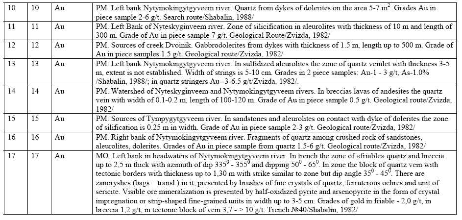
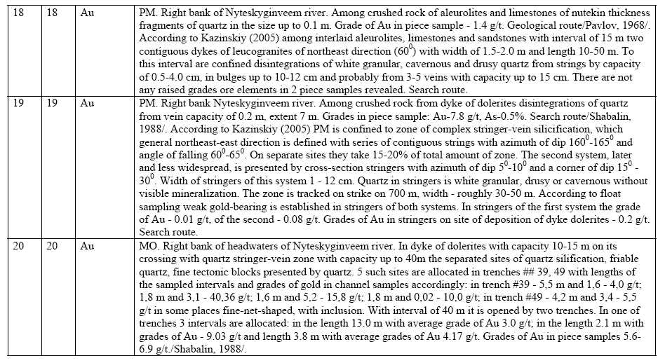
| APPENDIX A LIST OF BEDROCK TARGETS, POINTS OF MINERALIZATION AND PLACERS OF GOLD ON KENKEREN FIELD | 47 |
| 11/14/2007 | iii | Gustavson Associates |
1. SUMMARY
Zoloto Resources Ltd. through its wholly-owned subsidiary, Chukot Gold ZAO, holds the Kenkeren License in the Chukotka Autonomous Okrug, Russia. The license comprises some 325 km2 , located 150km to the north of the regional center, Anadyr, in the far northeast corner of Russia. Anadyr has an international airport and full-service sea port. The term of the license is 5 years, ending in 2011.
Gustavson Associates, LLC (“Gustavson”) was commissioned by Zoloto Resources Ltd in July 2007 to (1) prepare a Canadian National Instrument 43-101 (NI43-101) compliant Independent Technical Report on the Kenkeren gold exploration project (the "Project") in the Chukotka Autonomous Okrug, Russia, and (2) to review Sutcliffe’s proposed 2007/08 exploration programs for the Project. Mr. William J. Crowl, R.G. is the Qualified Person (as defined in NI43-101) responsible for the preparation of this report.
Zoloto acquired Chukot Gold ZAO as a wholly owned subsidiary on December 1, 2006 for a consideration of US$327,750 to the founding shareholder of Chukot in connection with the initial acquisition of two exploration properties (Elvenei and Tumannoye) in the Federal Subsoil Agency auction held August 17, 2006, in Anadyr, Chukotka Autonomous Okrug, in the Russian Far East. Chukot is a company incorporated under the laws of the Russian Federation to acquire tendered or licensed properties in the region of Chukotka. The Kenkeren license was acquired by Chukot Gold ZAO for US$1,500,000 with four small alluvial properties.
Zoloto has expended approximately $4,000,000 on equipment purchases (bulldozers, drills and camp facilities). The equipment was shipped in the summer of 2006 for movement to site on winter roads. At the time of the site visit in July/August, 2007, preparatory work (camp set up) was underway at Kenkeren. No work on the Kenkeren License had yet been done.
The Kenkeren license was acquired by Zoloto because past Russian exploration programs defined several zones of gold mineralization that were sufficiently interesting that they deserved additional follow-up exploration. The most prospective of these zones is the Skvoznoy zone. Other areas that will require varying levels of follow-up are the KAR, Northern and East Nutekin zones.
The Kenkeren license area has seen considerable exploration activity since 1955 by several Russian expeditions. A number of campaigns have employed diamond drilling, cable-tool drilling, trenching, pitting and soil sampling. The application of geophysical methods has yielded contour maps of tectonically-weakened sites and sites of hydrothermally altered formations and which contain all known occurrences of gold mineralization.
The geology of the Kenkeren license area is complex, characterized by widespread low-angle reverse faults (thrusts) and the occurrence of a number of distinct sedimentary units and Mesozoic to Cenozoic intrusive and extrusive rocks. The Kenkeren gold prospects display characteristics consistent with low sulphidation gold systems. Gold is predominantly associated with quartz, with minor amounts of pyrite, and arsenopyrite in veins, veinlets and stockworks, often in close relationships to thrust faults.
| 11/14/2007 | 1 | Gustavson Associates |
The gold mineralization in the Skvoznoy zone (the focus of Zoloto’s 2007 exploration campaign) occurs as free gold and gold in sulfides in quartz veins cutting Triassic Nutekin strata, as well as, Pliocene dolerite dikes and Oligocene extrusive–vent and sub-volcanic rocks. The quartz veins occur in a north-northeast zone of intense fracturing and crushing in the aleurolites and sandstones. These strongly fractured and crushed zones are sub-parallel to the thrust faults recognized in the area. Silicification of the wall rocks is spotty. The zone is 50 – 60m wide, dipping 45° to the northwest and strikes 075°. Within the zone, quartz ladder veins ranging from 1mm to 12-15mm in width are found cutting the sandstones and massive aleurolites. According to Shabalin (1988) stockwork-like zones and series of ladder veins in the northeast part of the Skvoznoy zone are accompanied by gold in soils with gold grades up to 7g/t, over and area of 5.23m2.
A significant part of the most prospective mineralization at Skvoznoy is covered by glacial debris in the western part of the prospect. A few trenches have exposed veins containing anomalous gold values, but the area remains largely untested.
The most prospective area at Skvoznoy has been tested by trenching and widespread clearing of alluvial cover exposing an area of dolerite dikes intruding Nutekin sediments. The dolerite dikes, as well as the enclosing sediments are cut by quartz veins containing gold. Seven core holes have been drilled, with depths ranging from 49.8 to 216.5m. The highest grade gold in the drilling is reportedly 17.23 g/t over an interval of 10-15.6m in one hole and 7 g/t over 2.7m in another hole. The Russian investigators state that the drilling has insufficiently tested the occurrence. Grab samples in the area have returned gold values ranging from 2.4 g/t to as much as 1277 g/t.
Coarse native gold was observed during the site visit by the author in a hand sample from a trench in the Skvoznoy prospect.
Total Russian-estimated predictive resources of gold on Kenkeren field as a result of the 2000-2004 exploration programs are estimated at 105 t, of which 70 t are within the limits of the ore-bearing sites Skvoznoy, Northern, Kar, Upper-Nutymokinskiy in Russian category P2,2, and 35 t in other territories in Russian category P2,3. These resources have passed expert scrutiny by the Russian Central R&D Geological Institute for Nonferrous and Noble Metals (CNIGRI) without change. The resource estimates are non-historical (estimated post-2001) and are hypothetical in nature, estimated using techniques that are non-NI43-101 compliant and are mentioned here as merely being indicative of the potential of the area for discovery of gold mineral resources.
Zoloto has contracted with the Russian company “GeoRegion” to carry out the Kenkeren exploration. The GeoRegion budget for 2007 is approximately US$117,000. In addition to the GeoRegion budget, Zoloto has spent or is in the process of spending approximately US$4.00 million on the three Chukotka projects – Elvenei, Tumannoye and Kenkeren for equipment, camps and incidentals. At the time of the site visit, a modern camp was under construction, a new diamond drill was on site and most supplies were on site.
It is critical that Zoloto spend time reviewing and critically analyzing the voluminous data available from previous exploration campaigns on the Kenkeren license area. The incorporation
| 11/14/2007 | 2 | Gustavson Associates |
of the previous data in their efforts, already well underway with the participation of V.P. Shabalin and the staff of GeoRegion, will help Zoloto make informed decisions about allocation of exploration dollars to the better targets on the license.
| 11/14/2007 | 3 | Gustavson Associates |
2. INTRODUCTION
Gustavson Associates, LLC (“Gustavson”) was commissioned by Zoloto Resources Ltd ("Zoloto") in July 2007 to (1) prepare a Canadian National Instrument 43-101 (NI43-101) compliant Independent Technical Report on the Kenkeren gold exploration project (the "Project") in the Chukotka Autonomous Okrug, Russia, and (2) to review Sutcliffe’s proposed 2007/08 exploration programs for the Project.
2.1 Terms of Reference
This report has been prepared in accordance with the guidelines provided in National Instrument 43-101 ("NI43-101"), Standards of Disclosure for Mineral Projects, dated December 31, 2005. The Qualified Person responsible for this report is Mr. William J Crowl, R.G., Vice President, Mining Sector at Gustavson.
2.2 Property Ownership Structure
On July 5, 2007, Sutcliffe Resources Ltd. (“Sutcliffe”) changed the name of the corporation to Zoloto Resources Ltd. Where Sutcliffe is cited in this report, the reader should consider the citation to be Zoloto Resources Ltd. as well.
Zoloto acquired Chukot Gold ZAO (“Chukot”) as a wholly owned subsidiary on December 1, 2006 for a consideration of US$327,750 to the founding shareholder of Chukot in connection with the initial acquisition of two exploration properties (Elvenei and Tumannoye) in the Federal Subsoil Agency auction held August 17, 2006, in Anadyr, Chukotka Autonomous Okrug, in the Russian Far East. Chukot is a company incorporated under the laws of the Russian Federation to acquire tendered or licensed properties in the region of Chukotka.
Zoloto has expended approximately $4,000,000 on equipment purchases (bulldozers, drills and camp facilities). The equipment was shipped in the summer of 2006 for movement to site on winter roads. At the time of the site visit in July/August, 2007, preparatory work (camp set up) was underway at Kenkeren. No work on the Kenkeren License had yet been done.
The successful bid amount for the Kenkeren deposit (and four small alluvial properties) was US$1,500,000. Sutcliffe has a 5 year license to exploit and explore the deposit area.
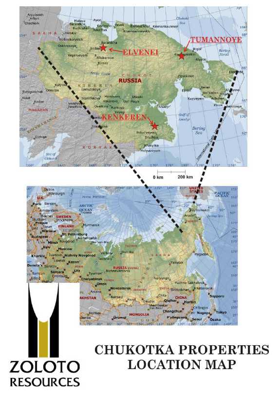
Figure 2-1 is a general location map of the Chukotka properties of Zoloto Resources.
| 11/14/2007 | 4 | Gustavson Associates |
Figure 2-1 Zoloto Resources’ Property Locations, Chukotka A.O.
| 11/14/2007 | 5 | Gustavson Associates |
2.3 Purpose and Basis of Report
Gustavson has prepared this report exclusively for Sutcliffe to fulfill requirements for the TSX-V Exchange. The information presented, opinions and conclusions stated, and estimates made are based on the following information:
- Information provided by Zoloto, Chukot and ML Ltd.;
- Assumptions, conditions, and qualifications as set forth in the report; and
- Data, reports, and opinions from third-party entities.
Gustavson has not independently conducted any title or other searches, but has relied upon Sutcliffe for information on land ownership, tenure and permit status. In addition, Gustavson has not independently conducted any mining, processing, or economic studies, or permitting and environmental studies.
2.4 Personal Inspection
A personal inspection of the Kenkeren prospect on August 2, 2007 was conducted by William J Crowl, R.G., the Qualified Person responsible for preparation of this report. The site visit was made in the company of Messrs. Georgiy Isaikin - Chief Geologist and Afanasiy Bylgaev – and Translator of Chukot Gold, Alexander Popov – Deputy Director, Production and Oleg Lagniy – Chief Geologist of IVK Resources and Alan Tenenbaum, Investor Relations, Zoloto Resources. In addition, 2 days were spent in Zoloto/ML’s Konakovo, Russia offices and several days in the Anadyr offices of Chukot/Zoloto.
Meetings were held with in Anadyr at the Geo-Region offices with Mr. Vladimir P. Shabalin, Geologist of Geo-Region.
2.5 Units
Unless explicitly stated, all units presented in this report are in the International System (SI) or the Metric System (i.e. tonnes, meters, grams, etc.). All references to economic data are in U.S. dollars and cents, unless otherwise noted.
2.6 Acknowledgements
Gustavson wishes to acknowledge the hospitality of ML in Konakovo and Zoloto in Anadyr. The cooperation of the Zoloto and other company’s staff made the understanding of the Projects possible.
| 11/14/2007 | 6 | Gustavson Associates |
3. RELIANCE ON OTHER EXPERTS
A number of individuals have contributed to the data and technical programs discussed in this technical report, besides the Qualified Person. This report is largely a compilation of the works by Russian investigators over the long exploration history of the project. Mr. Oleg Lagniy, a consultant to Zoloto has provided multiple detailed discussions of the geological regime at Kenkeren.
Mr. William J. Crowl, R.G. has personally reviewed the input of the above individuals to this report in order to ensure that it meets all of the necessary reporting criteria as set out in the NI43-101 guidelines.
4. PROPERTY DESCRIPTION AND LOCATION
4.1 Property Description and Location
The Kenkeren project is located in a license covering 325 sq km (km2). The term of the license is 5 years. Table 4-1 provides the geographical coordinates of the corner points of the license, defined in Latitude and Longitude using the WGS84 spheroid.
Table 4-1 Geographical Coordinates of the Kenkeren Project License 13843
| No. of Point 1 | Latitude 63°18’00”N | Longitude 176°35’00”W |
| 2 | 63°25’00”N | 176°35’00”W |
| 3 4 | 63°25’00”N 63°18’00”N | 177°05’30”W 177°05’30”W |
Gustavson has not reviewed the permits that must be acquired by Zoloto with respect to the exploration and exploitation of Kenkeren. Gustavson is not aware of any environmental liabilities associated with the properties.
| 11/14/2007 | 7 | Gustavson Associates |
Figure 4-1 Kenkeren License Location Map
![]()
| 11/14/2007 | 8 | Gustavson Associates |
4.2 Mineral Land Tenure
The license (No. 13843) was granted on August 4th, 2006 for a period of 5 years, expiring on November 15, 2011. There are work requirements (both physical and geological), industrial and labor safety requirements, environmental requirements, social and economic development requirements, defined taxes and payments associated with the License. The work requirements and taxes/payments (as restated from the machine translation) are summarized below.
4.2.1 Kenkeren License
The work requirements for Kenkeren are:
a) Not later than August 15, 2007, the preparation and approval of a geological exploration plan for the license site and positive approval following state ecological examination;
b) Not later than September 15, 2007, the beginning of prospecting activity on the license site;
c) Stage I: Geological studying of the License site - search works and submitting of the geological report prepared in established order by results of search works with calculation of predictive resources of ore gold on categories P2,2 and P2,3 to Territorial agency on subsoil use on Chukotka autonomous region (further - Chukotnedra) and its transfer to territorial and federal geological funds not later than December 31, 2009, thus minimal volumes of prospecting works should make:
- ground geophysical works - not less than 21 km2;
- drifting of surface mining works - not less than 80,000 m3;
- core drilling - not less than 4,000m;
d) Stage II: Estimation of revealed ore deposits of gold and accompanying components and submitting of the geological report prepared in established order by results of geological studying with calculation of stocks and predictive resources on categories C2and P1not laterthan October 15, 2011 to Chukotnedra thus the minimal amount of works should make:
- drifting of surface mining works - not less than 80,000 m;
- core drilling - not less than 3,000m.
If necessary types and amounts of works are corrected in established order after drawing up of the design of prospecting works.
Taxes and payments due are as follows:
a) Subsoil user pays the following payments for subsoil use:
Regular payments for subsoil use with a view of searches and estimation of deposits of ore gold on all area of the License site are established under the following rates: | |
| 90 roubles for 1 km2in 2006, | |
| 160 roubles for 1 km2in 2007-2011. |
| 11/14/2007 | 9 | Gustavson Associates |
Fees for licensing at the rate 31,516 (thirty one thousand five hundred sixteen) roubles are brought in the federal budget within 20 days from the date of its state registration.
Other types of payments and taxes stipulated by the legislation of the Russian Federation are brought by subsoil user in established order.
Gustavson has not carried out title research on the Kenkeren License, and has relied totally on Zoloto’s description of the property and the Russian language documents provided by Zoloto.
5. ACCESSIBILITY, CLIMATE, LOCAL RESOURCES, INFRASTRUCTURE andPHYSIOGRAPHY
5.1 Accessibility
Kenkeren is located in central part of Mainitsky metallogenic zone of Anadyr-Koryak metallogenic system. The licensed territory covers most part of Kenkeren ridge located in a northeast part of Koryak uplands on border with Nizhne-Anadyr drainage. The nearest settlements - the regional center Beringovsky (135km on southeast), coastal villages - Meinypilgino (95km on south) and Khatyrka (170km on southwest). Beringovsky has a thermal power station, seaport and air station for small aircraft operations. The regional center, Anadyr, is located in 150km to the north, has an international airport and full-service sea port (Figure 5-1). Established motorways in the Kenkeren area are absent, with movement possible only by off-highway vehicles. The territory is developing in connection with the beginning of development of the Western-Lake gas deposit (50km to the North) connected by a gas main with the district center, and also with the beginning of prospecting of Telekaisky oil field, 35km distant. Access to the property for the site visit was via helicopter and Ural 4WD truck.
The area is remote with no telephone or mobile phone coverage and no local population or inhabitants.
| 11/14/2007 | 10 | Gustavson Associates |
Figure 5-1 Anadyr Regional Location Map showing Kenkeren Project and Infrastructure Locations
![]()
| 11/14/2007 | 11 | Gustavson Associates |
5.2 Climate
Climate of area is subarctic with mid-annual temperature of - -11°C. Duration of the winter period is up to 8-9 months. Consistent snow cover falls in second half of September, melting during June. Snow cover varies from 1.5 to 3m. The snow is friable, testifying to the small number of snowstorm days. Freezing of the rivers occurs at the end of October, with break-up in mid May. The average annual amount of precipitation is 250 to 300mm. Island development of permafrost soil formations is typical for area. The thickness of the seasonally thawed layer changes from 0.5 to 2.0 m depending on the exposure of the slopes.
5.3 Local Resources and Infrastructure
Anadyr is a commercial center, with an international airport and a full-service harbor facility. There is no grid power in the vicinity of the project. Zoloto has access to the logistical and construction capabilities of FSC International in Anadyr. Laborers are available from the larger communities in the area. Workers for a major mine development would probably need to be sourced from other parts of the Russian Far East.
5.4 Physiography
The Kenkeren area is one of low to high relief, characterized by open expanses of tundra and lakes, bordering steep alpine ridges and U-shaped inter-montane valleys. Mountain ridges range from 800 to1000m in elevation. Hilly and flat areas range in elevation from 200-500m and 100-400m in the valleys of the large rivers. The territory is made up of mountain and forest tundras, with areas of a long-term permafrost of 70-190m in depth. The river network is well advanced, and all rivers flow to the Bering Sea. The largest rivers are the Chirynaj, Nygchekveem and Gytgyveem. The largest lake, Majnits has an area of 46km2.
5.5 Environmental Conditions
Surface disturbance from exploration has been minimal in the Kenkeren area. To date, site disturbances have been related to road and drill pad construction, trenching and bulk sampling. Future disturbances will be similar, with additional efforts in all areas.
No significant disturbances were noted that will constitute a liability for Zoloto.
| 11/14/2007 | 12 | Gustavson Associates |
6. HISTORY
Geological surveys of scale 1:1000000 (A.I.Kulikov, 1955) were first conducted in 1955, with the results reflected on the State geological map of similar scale issued in 1959, author I.M.Rusakov.
In 1964, the western half of ridge Kenkeren was covered with geological surveys of scale 1:200000 by the Mainitsky party, AKGRE SVTGU, under V.G.Kuprienko's management (Kuprienko V.G., Rozenblum I.S., 1965) and this work resulted in a total changeof the scheme of stratigraphy suggested earlier by geologists of NIIGA. For the first time in the area, terrigenous sediments of kimeridge-volga, goterivsky, senonian and paleogene age were established using fossil evidence. Intrusive formations were classified as early-cretaceous (ultrabasites, gabbros and dikes of gabbro-dolerites) and lower-upper-cretaceous (gabbro-diorites - granites and dikes of gabbro, diorite-porphyrites) complexes. Gold mineralization in alluvium was recognized in the majority of stream channels, with the content of gold in stream sediment slimes (“schlich halo”) from "signs" up to 0.15 to 2.0 g/m3.
In 1966, Nonmykenveem GSP carried out geological surveys of scale 1:200000 under J.K. Usenko's management (Usenko, etc., 1966) on eastern continuation of Kenkeren ridge. Additional work was done on stratigraphic correlation. Gold in schlich with content of metal in separate samples up to 1 g/m3 was expanded downstream on Kenkereveem river and one point of mineralization with content of gold 0.4 g/t was found.
In 1967, geological-search works including geological survey and searches of minerals in scale 1:50000 (Kenkeren GSP, Pavlov, etc., 1968) were started. As a result of these works, the geological structure of territory was identified in detail. During this search, relative gold content in separate tests from 3 g/m3 to 50 g/m3 (Kenkereveem river) have been established in already known secondary dispersion halos of gold, and signs of platinum group metals (in one test in headwaters of Kenkereveem river - 11 g/t) were discovered. Eleven samples of mineralization in quartz veins and zones of silicification with content up to 1 g/t Au were taken, and in separate tests up to 10 g/t of gold was discovered in the area. A grab sample of quartz with visible gold and a content 3 g/t Au (ore occurence Skvoznoye) was taken from bedrock on the left bank of the Nuteskyginveem river.
Again in 1968, a geological survey and searches of minerals of scale 1:50000 (Zvonkaya GSP, Nevretdinov, etc., 1969) was carried out in east part of area. Result of works was specification and large detail of the geological structure of territory, and in exploration, secondary dispersion halos of gold with content in separate samples up to 21.2 g/m3 were taken on a number of inflows of Kenkereveem river.
In 1968, an aeromagnetic survey of scale 1:50000 (Alganskaya party, Skorikov, Starikov, 1969) was carried out over the entire area. Positive magnetic anomalies were correlated with bodies of ultrabasics and intrusions that could not be differentiated easily (from gabbro to granites).
In 1970, a gravimetric survey of scale 1:200000 (Chirynaiskaya gravimetric party, Lisitsyn, 1970) was carried out on the Kenkeren field. A line of gravimetric anomalies in axial part of
| 11/14/2007 | 13 | Gustavson Associates |
Kenkeren ridge was correlated by the authors of the survey with supposed bodies of ultrabasites or the crystalline basement at depth.
From 1968 to 1972, drilling and prospecting works and preliminary exploration of the revealed placers with a complex of geophysical and hydro-geological research was carried out in area. Some 746 boreholes of UKB (44,200 lin.m.) were drilled and 424 prospect holes (2470 lin.m.) are excavated. Industrial placers were outlined in the valleys of rivers Nutyskyginveem, Tymlygytgyveem, Kenkereveem. Preliminary prospecting was carried out in a small volume on the Nutyskyginveem placer, but because of a lack of profitability in the extraction of gold for that period, prospecting works were suspended. At the end of 60’s and the beginning of 70’s, prospecting for gold was carried out by traditional prospecting and trenching methods in the southern part of territory. As a consequence of the large thicknesses of friable sediments and the presence of unfrozen horizons, prospecting was carried out using cable-tool drilling.
In 1970, the gold mining cooperative "Soyuz" of association "Severovostokzoloto" carried out extraction of placer gold on a deposit in the Kenkereveem river. Some 64.2kg of pure gold was extracted (as recalculated).
A number of buried valleys have been discovered, a map of buried relief of vein breeds was made, and data on hydro-geological conditions of deposition of placer gold deposits was received. A hydro-geological survey of scale 1:50000 on an 80 km2 area (Kusch, etc., 1973) was carried out during geophysical and hydro-geological surveys, accompanied searches and prospecting of placers.
Prospecting activities and facilities were renewed in 1977 and exploration proceeded in 1982. During this period, 51,400m of boreholes of UKB are drilled, industrial placer mining of Nutyskyginveem river was finished with prospecting, placer deposits of gold of Tymlygytgyveem, Kenkereveem rivers, Zvonkiy, Kon, Nezametniy, Sukhoy, Nadezhda brooks were explored and transferred to industrial development to mine "Otrozhniy" of association "Severovostokzoloto". Reserves of gold in the Russian resource category C1 have been prospected on deposit of Nutyskyginveem river. Some 507kg of chemically pure gold (in view of technological losses) has been extracted at an average grade of 0.68 g/m3 during the industrial development of unit.
During 1978 – 80, Southern-Kenkeren group (Zvizda, Vasilenko, etc., 1982) carried out a group geological survey of scale 1:50,000 with search works on Kenkeren field. As a result of these works, except for the decision of some questions on a geological structure of territory, about 40 areas of gold mineralization were identified and the allocation of the prospective gold-ore site “Skvoznoye” with ladder morphological type of mineralization and content of gold up to 800 g/t was made. The authors speak of a spatial connection of the gold mineralization with dolerite dikes. A non-43-101 compliant P3 mineral resource of some 250t of gold was postulated. In the pool of Kenkereveem river, three industrial placers of gold were identified, one of which is prospected by trenching, with calculation of reserves on category C1 (all historical and non-43-101 compliant). Prospects of undiscovered placer gold are estimated at 19t (without taking into account prospected placers). All of the above resource/reserve estimates are historical and hypothetical in nature, estimated using techniques that are non-NI43-101 compliant and are
| 11/14/2007 | 14 | Gustavson Associates |
mentioned here as merely being indicative of the potential of the area for discovery of gold-containing mineral resources. It is uncertain if further exploration will result in the target being delineated as a mineral resource.
From 1979 to 1981, employees of Transbaikalian Scientific Research Institute studied the hydrodynamic zoning of placers (Atroshkin, Krasikov, etc., 1981). They assumed the presence in the area of two genetic types of vein sources that fed the placers: gold-quartz moderate-sulphidic shallow formations connected with granitoid magmatism; and gold-quartz in black-schist formations, connected with basaltic magmatism. The first type of vein source, in the opinion of the authors, were not yet eroded, while the second type was eroded some 30 - 40%.
As a result of the geological surveys and searches at a scale of 1:50,000 listed above, the Nutekin ore field was conditionally allocated, with an area of about 30km2, with the most prospective area in its limits the ore-bearing site “Skvoznoy”.
Detailed searches have been carried out on most part of Nutekin ore field, including site Skvoznoy, in 1980 – 82 (Nutekin group AGRE, Shabalin, Krymov, 1982) and in 1986 – 88 (Skvoznoy group AGRE, Shabalin, Krymov, 1988).
Nutekin group has carried out exploration with application of geophysical methods (magnetic exploration on a network 200×40m and 100×20m, and with a method of natural field on a network 100×20m and a method of electro-profiling on a network 100×10m), resulting in three gold-ore sites being detailed with geological plans at a scale of 1:500 (site Skvoznoy) and at a scale of 1:2,000 (site N 4 and N 5, which later received the name of Northern-Kar) in the upper streams of the Nutyskyginveem and Tymlygytgyveem rivers. Some 20 mineralized dolerite dikes with an average length of 400-500m and average width of 10m were identified. Half of the mineralized dikes of dolerites were opened by trenches, and an extremely non-uniform distribution of gold content in the dikes was established. The maximum concentrations of gold inside of dikes are associated to the quartz-vein bodies in them. The gold content varies from "traces" up to 800 g/t and more. Predictive resources of gold at site Skvoznoy have been estimated at 77 tons (category P2,2). This resource/reserve estimate is historical and hypothetical in nature, estimated using techniques that are non-NI43-101 compliant and is mentioned here as merely being indicative of the potential of the area for discovery of gold-containing mineral resources.
Application of geophysical methods has yielded contour maps of tectonically-weakened sites and sites of hydrothermally altered formations and which contain all known occurrences of gold mineralization This geophysical survey information was not available for review by Gustavson.
Work by Skvoznoy group has increased the number of mineralized gold-bearing dolerite dikes up to 30 with average strike of 0.5 -0.7km and average width of 7-10m in the Nutekin ore field with the area 30km2. Five of the ore-bearing dolerite dikes have been prospected in detail from the surface and by core drilling to a depth up to 235m at Skvoznoy. Lithochemical sampling of secondary halos of dispersion, detailed magnetic surveys and electro-prospecting works of EG and EP on sites Skvoznoy, Kar and Northern have been conducted. Predictive resources of gold at Skvoznoy are estimated for category P2,1 at 16 tons. In other areas of the ore field and in
| 11/14/2007 | 15 | Gustavson Associates |
category P2,2, the predictive gold resources are 130 tons. Predictive resources on the area of lithochemical sampling were estimated on the grade of the secondary halos of dispersion, with a quantity of 50 tons. These resource estimates are historical and hypothetical in nature, estimated using techniques that are non-NI43-101 compliant and are mentioned here as merely being indicative of the potential of the area for discovery of mineral resources containing gold. It is uncertain if further exploration will result in the target being delineated as a mineral resource.
In 1992 the mining enterprise "Dore" (Zakharov, 1992) carried out prospecting works with extraction of gold. Large-volume sampling of 9 veins and vein zones with dredging of veins up to 2m was carried out using manual methods. The free gold content of the ore bodies ranges from 7 g/t up to 218.86 g/t, and in a bulge of one the veins the gold grade was 400 g/t. In total 3.291 kg of gold was extracted.
From 1996 to 1998 CJSC “East-Chukotka gold mining enterprise” conducted development in the area of placer on the brook Sukhoy and extraction of gold at the Skvoznoy site (TGF, Accounting balances of minerals for 1996; 1997; 1998; 1999; 2000). In total 9.6kg of gold was extracted. In accounting documents, the geological data on Skvoznoy was not presented.
During 1985-86 employees of Koryak expedition and the Department of complex researches SKVNII DVO of the Russian Academy of Science (Zvizda, Vasilenko, 1990) carried out thematic work within the limits of western part of Kenkeren ore-placer unit. The results of these studies was a fluid-explosive model of Nutekin ore field with participation in its structure of subvolcanic basalts, andesites, rhyolites and their explosive breccias which were included as tuffs, tuff-breccias and tuff-conglomerates earlier in structure of different aged stratified divisions. In the central part of the Nutekin ore field, the authors have identified a dome structure generated by explosive breccias to which vein displays of gold are spatially correlated.
In 2000-2004 the Kenkeren field was the subject of geochemical searches on streams of dispersion of scale 1:200000 of Ukvutvuyneyskiy geochemical group of FGUGP "GeoRegion" (Kazinsky, etc., 2005). Besides lithochemical searches on streams of dispersion, other lithochemical surveys and geophysical programs were conducted, duplicating similar exploration by the Nutekin group in 1988.
Exploration activities have been directed at: (1) authentication of geochemical anomalies of gold revealed by results of lithochemical searches on streams of dispersion; (2) additional searching of previously known prospective sites Skvoznoy, Northern, Kar and their flanks; and (3) investigation of platinum group metals (PGM) prospects. Exploration for gold has been concentrated in the northern part of Kenkeren field, with more detailed surveys on Western Nutekin, including the prospective gold-bearing sites, Skvoznoy, Northern, Kar and East Nutekin. These areas include the most attractive gold anomalies seen in the results of lithochemical sampling on secondary halos of dispersion on a 500 × 100m network.
Exploration for PGM, including traverses with grab sampling and profile lithogeochemical sampling on primary and secondary dispersion halos, were concentrated in the southern part of the area on melange zones containing bodies of ultrabasic rocks.
| 11/14/2007 | 16 | Gustavson Associates |
Exploration has identified what the Russian’s call an ore field, with evidence of hydrothermal mineral deposits, including anomalous precious metal content. The prospectivity of gold mineralization was verified in steeply dipping mineralized zones of mylonites, jointing and crushing not only in crossing dikes of dolerites, but also beyond their limits. Another prospective ore-bearing area (Upper-Nutymokinskiy) has been identified during the search of the East Nutekin. The Nutymokinskiy ore field was nearly completely covered by results of exploration routes and lithochemical sampling of secondary halos of dispersion on a 500 × 100m grid which has received name Nutekin-Nutymokinskoye, with the area now 65km2.
In the southern part of Kenkeren field, several exploration surveys identified some highly anomalous occurrences of gold, and some blank areas. The blank areas have been related to the washout of gold-bearing friable quaternary sediments. The details of the occurrence of PGM mineralization in the southern areas of the Kenkeren project remains unclear due to lack of adequate sampling.
Total Russian-estimated predictive resources of gold on Kenkeren field as a result of the 2000-2004 exploration programs are estimated at 105 t, of which 70 t are within the limits of the ore-bearing sites Skvoznoy, Northern, Kar, Upper-Nutymokinskiy in Russian category P2,2, and 35 t in other territories in Russian category P2,3. These resources have passed expert scrutiny by the Russian Central R&D Geological Institute for Nonferrous and Noble Metals (CNIGRI) without change. The resource estimates are non-historical (estimated post-2001) and are hypothetical in nature, estimated using techniques that are non-NI43-101 compliant and are mentioned here as merely being indicative of the potential of the area for discovery of gold mineral resources. It is uncertain if further exploration will result in the target being delineated as a mineral resource.
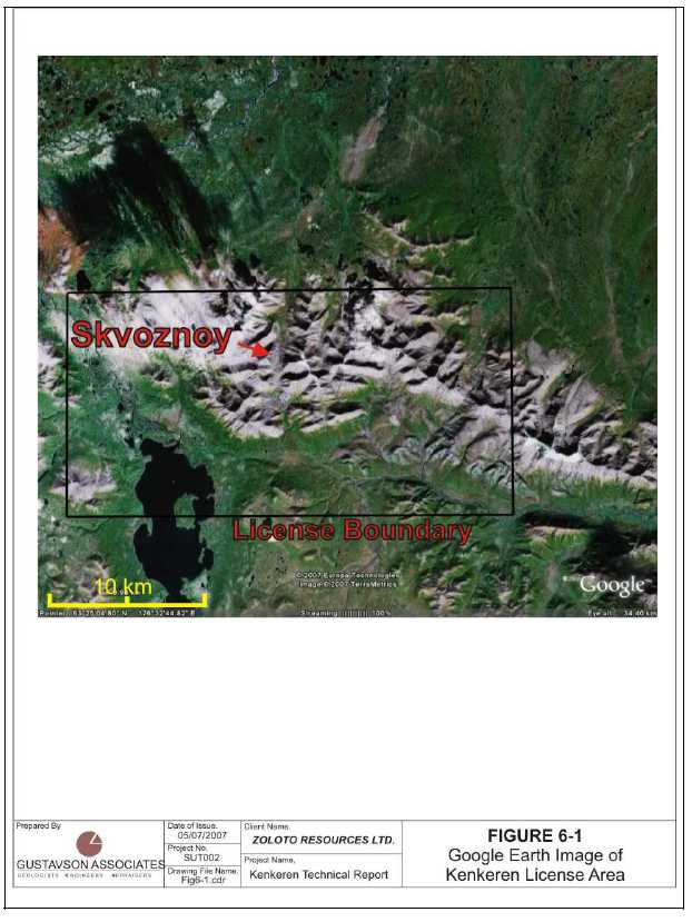
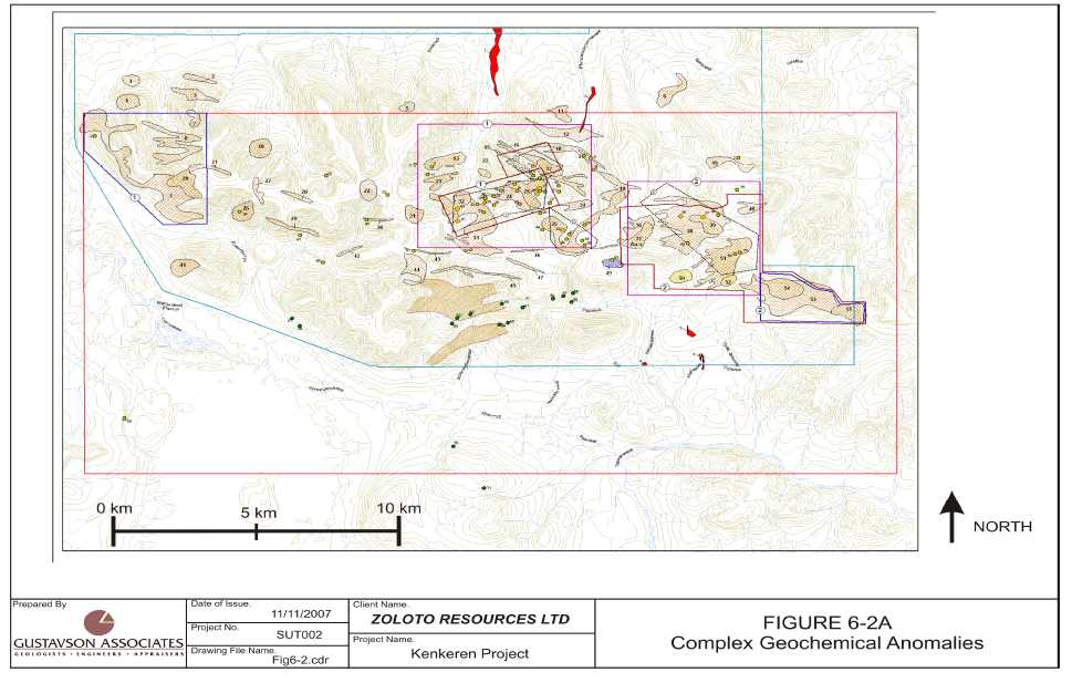
Figure 6-1 is a satellite image of the Kenkeren area from Google Earth©, showing the relative position of the Skvoznoy prospect and the license border. Figure 6-2 shows outlines of complex lithochemical survey anomalies. The sampling points (areas) are keyed to a tabular accounting of each sample area in Appendix A. The distribution of the anomalies indicates the good prospectivity of the license area and presents a view substantiating the challenge Zoloto faces with multiple prospective sites on which to conduct exploration.
| 11/14/2007 | 17 | Gustavson Associates |
Figure 6-1 Google Earth Imagery of the Kenkeren Project
| 11/14/2007 | 18 | Gustavson Associates |
Figure 6-2AComplexGeochemicalAnomalies,KenkerenLicense
| 11/14/2007 | 19 | Gustavson Associates |
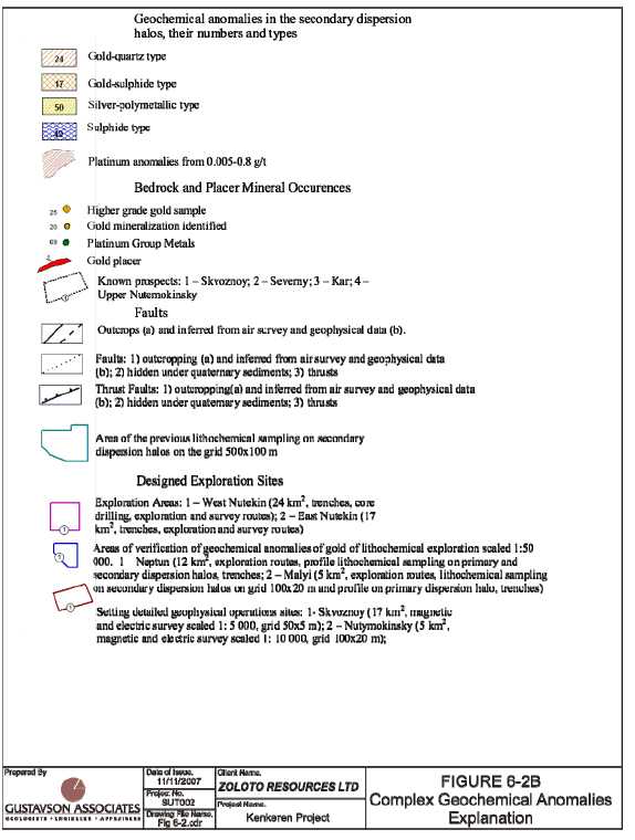
Figure 6-2B Complex Geochemical Anomalies, Explanation
| 11/14/2007 | 20 | Gustavson Associates |
7. GEOLOGICAL SETTING
7.1 Regional Geology
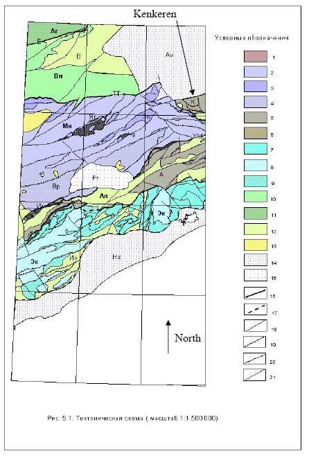
The Kenkeren prospect is located in an upland in the northeast part of Anadyr-Koryak fold system (Figure 7-1).
In plan, the upland has lenslike outlines and the Kenkeren thrust fault zone strikes predominantly E-W with a width of from 15 to 30km. There are multiple strands of thrust faults in the area. Triassic terrigenous tuffs and siliceous-terrigenous formations and lower to middle Jurassic sedimentary and volcanogenic-sedimentary formations are exposed in its central part. They are overlain by late-Jurassic - Cretaceous terrigenous sediments and terrigenous tuffs.
Intrusive formations include early Cretaceous gabbros and differentiated granite-plagiogranite, Paleocene-Eocene subvolcanic bodies and dikes of gabbro, as well as, numerous Oligocene-Miocene subvolcanic bodies and dikes ranging in composition from basic to siliceous. Gold mineralization, in the form of quartz veins, narrow quartz – stringer zones and stockworks, occur in and near the thrust fault zones and intrusive dolerite dikes.
7.2 Local Geology
The geology of the Kenkeren license area is complex, characterized by widespread low-angle reverse faults (thrusts) and the occurrence of a number of distinct sedimentary units and Mesozoic to Cenozoic intrusive and extrusive rocks.
The following descriptions of the lithologies in the Kenkeren area is taken from the Explanatory Note from the Kenkeren Proyeckt, 2006.
7.2.1 Sedimentary Lithologies
Triassic: Nutekin strata are exposed in the central part of territory near the source of the Kenkereveem river. Sedimentary lithologies include aleurolites and argillites, with lesser amounts of limestones, tuff-sandstones, sandstones, gravelite, siliceous argillites, flints and jaspers. Thickness is more than 400m.
Jurassic: West-Kenkeren strata crops out in the center of the area, as part of the axis of the Kenkeren ridge. Lithologies include aleurolites, siliceous aleurolites and aleuropelite, with lesser amounts of sandstones and calcareous aleurolites with lenses of limestone. Thickness of strata exceeds 800m. The contact relationship with the older Triassic Nutekin strata is not clear.
Jurassic/Cretaceous: Elgevayam strata exposed in west, southwest and south of the area in small (up to 4km2) sites as sandstones, aleurolites, tuff-sandstones, basalts, jaspers, epidote-glaucophane, muscovite-quartz and amphibole-epidote-albite slates. Thickness of strata is more than 1000m.
| 11/14/2007 | 21 | Gustavson Associates |
Pekulney series exposed in a strip in width of 1-3km width, across all territory in an EW direction, making up part of Kenkeren ridge. It is made up of aleurolites, sandstones, gravelites, conglomerates, argillites with total thickness up to 1400m.
Cretaceous: Kenkeren Series exposed in northwest and east parts of territory, and made up of sandstones, aleurolites, tuff-sandstones, tuff-aleurolites, gravelites, conglomerates, calcareous sandstones with total thickness of 800-900m.
Neikinveem Series exposed in east part of territory in headwaters of Dvoinoy brook. It is made up of aleurolites, sandstones, and less commonly - gravelites and conglomerates with lenses of limestone and carbonate concretions. It lies non-conformably above the sediments of the Kenkeren series. Thickness of the series is 750-800m.
The Ginterovskaya Series is widely advanced in northwest, north and northeast of territory along northern slopes of Kenkeren ridge and is limited on right bank of Kenkereveem river, and is divided on two subseries:
Lower subseries with washout overlies the sediments of the neikinveem series and is made up of interstratifying aleurolites and sandstones, less often by gravelites, argillites, conglomerates and tuff-sandstones with lenses of calcareous sandstones. Thickness of subseries is up to 800m.
Upper subseries are exposed on the small area in northeast part of Kenkeren field in sources of Kievsky brook. It is made up of aleurolites and sandstones with carbonate concretions, in subjection of gravelites and conglomerates. Thickness of the subseries is up to 800m.
Koryak Series exposed on the limited area in interfluve Ergichguigyveem-Kenkereveem and is comprised of sandstones, aleurolites, tuff-sandstones, tuff-aleurolites, and less often by gravelites and conglomerates. Its visible thickness is 230m.
Vysokorechenskaya Series exposed in interfluve Kenkereveem-Ergichguigyveem and in the east in the headwaters of the Kenkereveem river. It is made up of sandstones, tuff-sandstones, tuffs and lavas of andesite, aleurolites, conglomerates and gravelites, lying unconformably on older strata. The thickness of the series is about 400m.
Paleogene: Krasnorechenskaya Series is exposed in southeast of the area on a left bank of Kenkereveem river. Here it is comprised of aleurolites, sandstones, argillites, conglomerates and gravelites with lenses of limestone. Thickness is 500 – 550m.
Neogene: Kamenistaya strata exposed in the small tectonic block on the right bank of Terginveem river. Made up of non-equigranular sandstones, conglomerates, aleurolites, argillites, sands and pebbles with thin layers (0.2m) of brown coals. Thickness is about 100m.
Quaternary: Lithologies include alluvial, glacial, water-glacial and proluvial sediments in the bottoms of river valleys, as well as talus developed on slopes.
| 11/14/2007 | 22 | Gustavson Associates |
7.2.2 Intrusive/Extrusive Lithologies
The Lozovskiy complex is represented by intrusive rocks of two phases. Small bodies of gabbros and gabbro-norites are related to the first phase; quartz diorites, tonalites and plagiogranites to the second. Exposures of rocks of the complex lie in a thick tectonic plate in the central part of Kenkeren ridge. Intrusive contact with surrounding rocks of Nutekin strata has been observed only for bodies of gabbro and plagiogranites. Separate bodies have tectonic restrictions and lie in zones of serpentinite melange. The age of the complex is early Cretaceous.
The Nygchekveem complex is represented by several intrusions of gabbro, making up the Gytgeveem massif at the western edge of Kenkeren ridge. Their contacts with surrounding rocks of Pekulney series are secant. The age of the complex is Paleocene-Eocene.
The Viluineiveem complex where observed is represented by diorite-porphyrites and granite-porphyries. Diorite-porphyries are present in large bodies on the right bank of Ergichguigyveem brook and also small dikes. Narrow granite-porphyries occur in the southern part of the area, as well as, small dikes. The porphyry bodies are confined to zones of serpentine melange, and the dikes are associated with fault zones with a northwest strike. The age of complex is accepted as Miocene.
Oligocene subvolcanic formations are found in volcanogenic structures of bedded Triassic and Jurassic rocks (Zvizda, Vasilenko, 1990). They are represented by bodies of lense-shaped or isometric forms made up of andesites, basalts and their breccia lavas. The area of the largest body covers 0.25km2. The existence of these formations has been questioned by some investigators.
Pliocene subvolcanic formations are represented by numerous dikes of dolerites, forming a large belt and a number of swarms of northwest or sub-meridian directions. Dolerite dikes contain gold-bearing quartz veins and veinlets in areas of anomalous gold. They cut sediments of Krasnorechensky series of Eocene age and extrusion-conduits (feeder dikes) of Oligocene age. The age of dykes is conditionally accepted as Pliocene.
7.2.3 Metamorphic Lithologies
Metamorphic rocks in the area are represented by formations of dynamothermal and thermal metamorphism. The first are found in zones of mélanges and thrusts. In particular, metaslates and amphibolites are found as a narrow strip on a right bank of Erguchguigyveem brook in thrust zones and mélanges, which are replaced by banded gabbro in juxtaposition to the sole of the Kenkeren thrust. Tonalites and quartz diorites differ by gneissic structures in this zone, and epidote develops in plagiogranites after plagioclase. There are some areas made up of epidosites (highly altered epidote and quartz bearing rock, sometimes containing gold). Eclogite rocks of pomegranate-pyroxenite structure are found in zones of melange. The thickness of these metamorphic rocks is more than 400m.
Thermally metamorphosed formations are represented by contact-metamorphosed rocks around intrusive bodies of magmatic rocks. Rocks of Elgevayam strata, silicified and epidotized to strictly quartz-epidote rocks on contact with intrusions of the Lozovsky complex rocks. The
| 11/14/2007 | 23 | Gustavson Associates |
width of the halo of the reaches several tens of meters. Terrigenous rocks of the Pekulney series are silicified, silificated and sulfidized on contacts with gabbro of Nygchekveem complex, containing hornstoned and sulfidized rocks in contact with granite-porphyries of the Viluineiveem intrusive complex. The thickness of contact-metamorphosed rocks is less than 10m.
Hydrothermal formations are represented by quartz, less often by quartz-sulphidic and quartz-carbonate veins and stringers, quite often forming wide stockwork-formed zones or series of veins and stringer zones; by mineralized (usually silicificated and pyritized) zones of mylonites and tectonic breccias, by fields of sulfidized (usually pyritized) rocks. Rarely quartz-prehnite, prehnite-epidote and carbonate stringers are found in bodies of gabbro.
Gold mineralization is connected with quartz, quartz-sulphidic veins and stringers, mineralized zones of mylonite and tectonic breccia in the Kenkeren area.
| 11/14/2007 | 24 | Gustavson Associates |
Figure 7-1A Regional Map of Anadyr – Koryak Fold System
| 11/14/2007 | 25 | Gustavson Associates |
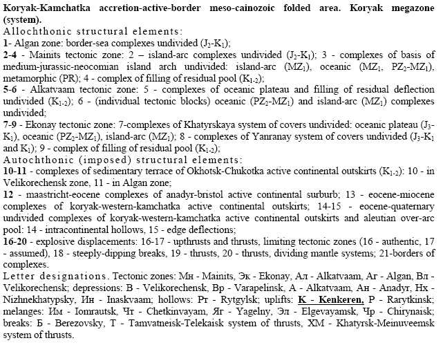
Figure 7-1B Explanation Key for 7-1A
SYMBOLS
to the tectonic scheme
| 11/14/2007 | 26 | Gustavson Associates |
Figure 7-2AGeology ofKenkerenLicense Area
![]()
| 11/14/2007 | 27 | Gustavson Associates |
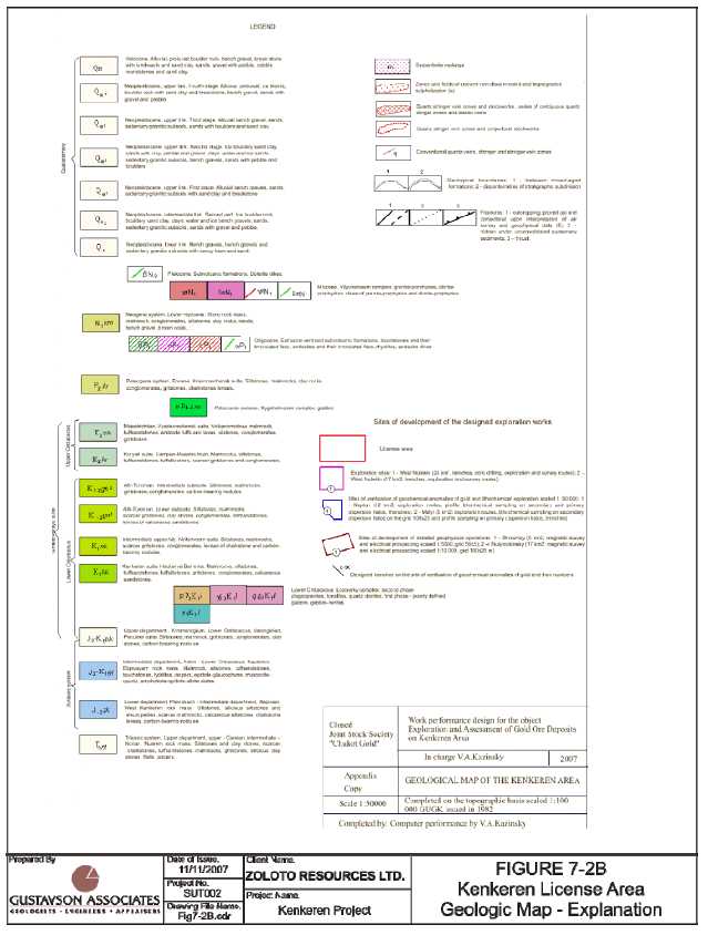
Figure 7-2B Legend for Geology of Kenkeren License Area
| 11/14/2007 | 28 | Gustavson Associates |
8. DEPOSIT TYPES
The Kenkeren gold prospects display characteristics consistent with low sulphidation gold systems. Gold is predominantly associated with quartz, with minor amounts of pyrite, and arsenopyrite in veins, veinlets and stockworks, often in close relationships to thrust faults.
9. MINERALIZATION
The Kenkeren license was acquired by Zoloto because past Russian exploration programs defined several zones of gold mineralization that were sufficiently interesting that they deserved additional follow-up exploration. The most prospective of these zones is the Skvoznoy zone. Other areas that will require varying levels of follow-up are the KAR, Northern and East Nutekin zones. The descriptions of mineralization are taken from the Proyect documents, modified by personal observation by the author.
9.1 Skvoznoy
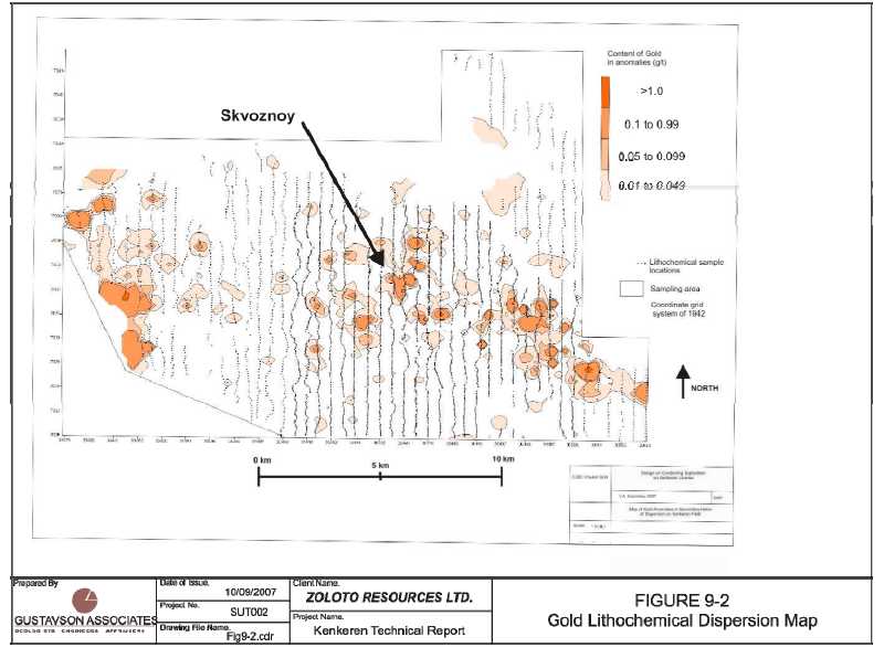
The gold mineralization in the Skvoznoy zone occurs as free gold and gold in sulfides in quartz veins cutting Triassic Nutekin strata, as well as, Pliocene dolerite dikes and Oligocene extrusive–vent and sub-volcanic rocks. (figure 9-1). The quartz veins occur in a north-northeast zone of intense fracturing and crushing in the aleurolites and sandstones. These strongly fractured and crushed zones are sub-parallel to the thrust faults recognized in the area. Silicification of the wall rocks is spotty. The zone is 50 – 60m wide, dipping 45° to the northwest and strikes 075°. Within the zone, quartz ladder veins ranging from 1mm to 12-15mm in width are found cutting the sandstones and massive aleurolites. According to Shabalin (1988) stockwork-like zones and series of ladder veins in the northeast part of the Skvoznoy zone are accompanied by gold in soils with gold grades up to 7g/t, over and area of 5.23m2. A lithochemical secondary dispersion map of gold anomalies in the Skvoznoy zone is presented here as Figure 9-2.
A significant part of the most prospective mineralization at Skvoznoy is covered by glacial debris in the western part of the prospect. A few trenches have exposed veins containing anomalous gold values, but the area remains largely untested.
The most prospective area at Skvoznoy has been tested by trenching and widespread clearing of alluvial cover exposing an area of dolerite dikes intruding Nutekin sediments. The dolerite dikes, as well as the enclosing sediments are cut by quartz veins containing gold. Historically, seven core holes have been drilled, with depths ranging from 49.8 to 216.5m. The highest grade gold in the drilling is reportedly 17.23 g/t over the interval of 10-15.6m in one hole and 7 g/t over 2.7m in another hole. The Russian investigators state that the drilling has insufficiently tested the occurrence. Grab samples in the area have returned gold values ranging from 2.4 g/t to as much as 1277 g/t.
Coarse native gold was observed during the site visit by the author in a hand sample from a trench in the Skvoznoy prospect.
| 11/14/2007 | 29 | Gustavson Associates |
Figure 9-1A Skvoznoy Detailed Geology, Historical Exploration Results

| 11/14/2007 | 30 | Gustavson Associates |
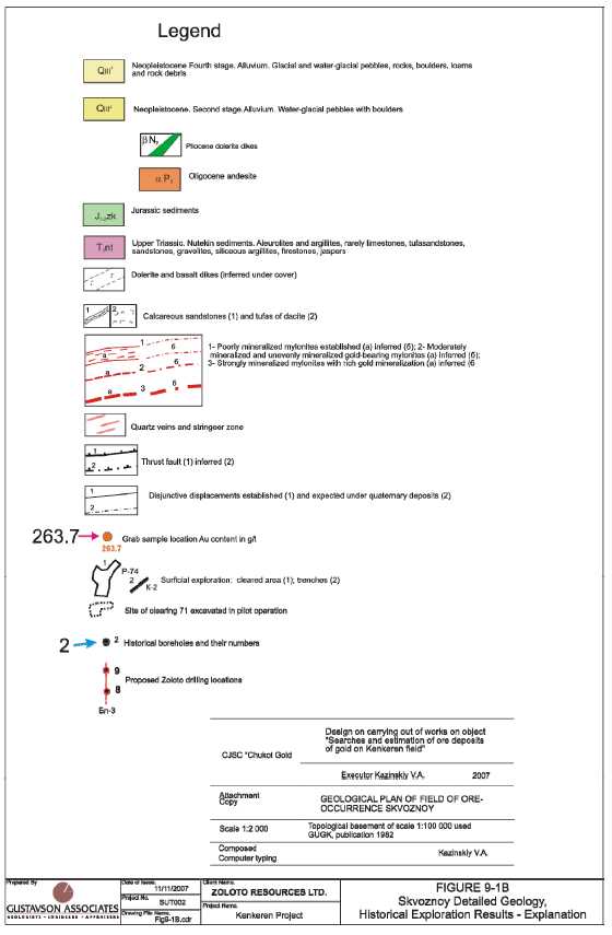
Figure 9-1B Skvoznoy Detailed Geology, Historical Exploration Results - Explanation
| 11/14/2007 | 31 | Gustavson Associates |
Figure 9-2Lithochemical Map – GoldAnomalies
| 11/14/2007 | 32 | Gustavson Associates |
10. EXPLORATION
The historical exploration programs conducted by Russian investigators on the Kenkeren license are described in detail in Section 6, History of this report. Tables 10-1, 10-2, and 10-3 summarize the details of the historical exploration efforts.
Table 10-1 Kenkeren Drillholes and Trenches
| Number | Cum. Length (meters) | Number of Samples | Date (year/years) | |
| Drillholes (core) | unknown | 235.0 | unknown | 1986-88 |
| Drillholes (other), UKB (cable tool) | 746 | 44200 | n/a | 1968-1972 |
| Drillholes (other), UKB (cable tool) | unknown | 51400 | n/a | 1977-1982 |
| Trenches | n/a | n/a | n/a | n/a |
Table 10-2 Kenkeren Larger Area Surveys
| Number | Date (year/years) | |
| Test Pits | 424/2470 m | 1968-72 |
| Grab Samples | ||
| Bulk Samples (>25 kg ea.) | 9 (to 2m depth) | 1992, mining company "Dore" |
| Geophysical surveys | 3 | 1969-82 |
| - aeromagnetic, scale 1:50000 | 1 | 1969, Algansk party |
| - gravimetric, scale 1:200000 | 1 | 1970, Chirynaysk gravimetric party |
| - detailed magnetic survey, scale 1:2000 and 1:500 | 1 | 1980-82, Nutekin crew |
| Geochemical surveys | 1 | |
| - scale 1:200000 | 1 | 2000-2004, FSUE "GeoRegion" |
| Hydrogeological survey scale 1:50000 | 1 | 1973 |
| 11/14/2007 | 33 | Gustavson Associates |
Table 10-3 Kenkeren Survey Detail
| Type | Area | Sampling Density and/or Cum. Length | Date (year) |
| Geophysical surveys: | |||
| - aeromagnetic, scale 1:50000 | 28 km2 | n/a | 1969 |
| - gravimetric, scale 1:200000 | 28 km2 | n/a | 1970 |
| - detailed magnetic survey: | 28 km2 | 1980-82 | |
| Geomagnetic | 28 km2 | 200×40 m | 1980-82 |
| Method of natural field | 28 km2 | 100×20 m | 1980-82 |
| Method of electric profiling | 28 km2 | 100×10 m | 1980-82 |
| Geochemical surveys | |||
| - scale 1:200000 | 30 km2 | 500×100 m and 100×20 m | 2000- 2004 |
| Hydrogeological survey scale 1:50000 | 80 km2 | n/a | 1973 |
| 11/14/2007 | 34 | Gustavson Associates |
11. DRILLING
11.1 Core Drilling
As of the date of the site visit by the author, Zoloto had not conducted any drilling at the Kenkeren site. According to the Russian reports, at least 7 core holes were completed in the Skvoznoy area. The collar locations are shown on Figure 9-1 and 9.2. As is typical of Russian core drilling campaigns, there is no core remaining to be examined, as all of the core was consumed in the analysis process. Future core drilling programs by Zoloto will follow Western protocols, where drill core is split and 50% is retained for future examination and 50% is sent for assay and analysis.
It has been the author’s experience that Russian methods of geologic logging and sampling follow relatively rigid mandated protocols and the resulting data and logs are typically usable to plan future drilling campaigns and can be used in geologic modeling and resource estimation. Zoloto must seek out all available records to assist in guiding their exploration programs. Their Chief Geologist and the head of the field programs are both Russian and very familiar with the Russian systems. They have both agreed the need to assemble all available data as soon as possible.
11.2 Non-Core Drilling Techniques
The UKB drilling method is equivalent to the cable tool method used in the West. No record of the detailed drilling procedures were available to the author.
| 11/14/2007 | 35 | Gustavson Associates |
12. SAMPLING METHOD AND APPROACH
Gustavson did not independently re-sample or assay any of the samples comprising the historic data for Kenkeren. The following discussion of sampling methodology and approach is taken from Russian reports and records of personal interviews and inspections by the author.
12.1 Core Sampling
Whole drill core was submitted for assay, with none remaining for future examination. This is a typical Russian procedure. No evidence of core photographs was presented.
12.2 Channel Sampling
Trenches were channel sampled along their full length. Examination of trenches at Skvoznoy indicated that the channels in the trenches were approximately 3 to 5cm deep and about 10cm wide. No additional details were available for examination.
12.3 Bulk Sampling
According to the Russian records, 9 bulk samples (>25kg) were collected from pits 2m deep. No additional information was available on the bulk sampling.
13. SAMPLE PREPARATION, ANALYSES, AND SECURITY
Zoloto has made assurances to the author that sample preparation and analyses conducted during their exploration programs will satisfy the requirements of Western Best Practices and will pass the scrutiny of future investigators as required by NI43-101. Prior programs reportedly have followed Russian protocols which are similar to Western requirements, but there is no readily accessible documentation to review. The Zoloto geologists must gain access to the previously generated data and provide descriptions of the methodologies applied during all phases of data collection and analysis.
13.1 Sample Preparation
No available information. See above. Typical Russian procedures are adequate for this early stage exploration program.
13.2 Sample Analysis
No available information. See above. Typical Russian procedures are adequate for this early stage exploration program.
13.3 Check and Duplicate Sampling/Preparation and Assaying
No available information. See above. Typical Russian procedures are adequate for this early stage exploration program.
| 11/14/2007 | 36 | Gustavson Associates |
13.4 Security
No available information. See above. Typical Russian procedures are adequate for this early stage exploration program.
14. DATA VERIFICATION
Gustavson has not independently conducted any title or other searches, but has relied upon Zoloto for information on the status of the claims, property title, agreements, and other pertinent conditions. In addition, Gustavson has not independently conducted any mining, processing, or economic studies, or permitting and environmental studies.
14.1 Verification of Geologic Data
The site visit by the author confirmed the general layout of the prospects as portrayed on the maps of the mineralized zones. Examination of the rocks at various sites on the prospect verified that the geologic information shown on the maps was accurate. Zoloto should re-sample some of the trenches and pits to gain an understanding of the relationship between the previously collected data and the data to be collected during their campaigns.
14.2 Verification of Analytical Data
Neither Gustavson nor Zoloto has completed any independent sampling and/or confirmatory geologic logging of core. Future rounds of evaluation of the existing data may involve re-assaying sample pulps and rejects, if available.
15. ADJACENT PROPERTIES
There are no immediately adjacent non-alluvial gold properties in the vicinity of Kenkeren.
16. MINERAL PROCESSING AND METALLURGICAL TESTING
No significant mineral processing test work has been carried out at Kenkeren.
17. MINERAL RESOURCE AND MINERAL RESERVE ESTIMATES
There are no NI 43-101-compliant mineral resource estimates for the Kenkeren prospects.
18. OTHER RELEVANT DATA AND INFORMATION
Gustavson is unaware of any other data and/or information that would be relevant to this report and is not contained in one of the existing Sections of this report.
| 11/14/2007 | 37 | Gustavson Associates |
19. INTERPRETATION AND CONCLUSIONS
Detailed exploration work by a number of Russian exploration entities over the period 1964 to the present has identified a number of occurrences of gold mineralization in the area of the Kenkeren License. The low-sulphidation epithermal gold occurrences have seen a moderate amount of trenching, test pitting and drilling. Several lithogeochemical and geophysical surveys have focused attention on several smaller areas within the larger license, the most prospective of which is the Skvoznoy zone. Grab samples have yielded gold values up to +1200 g/t and drilling has identified a 5.6m interval grading 17.23 g/t gold.
Zoloto acquired the Kenkeren license in 2006. Since that time, they have been assembling an in-house team of geologists, contracting for exploration at Kenkeren and arranging for the shipment and delivery of materials to the Kenkeren camp site. As part of the activities, they have worked closely with the organization “GeoRegion” to conduct the exploration programs. GeoRegion has been involved with past exploration programs at Kenkeren and was responsible for the preparation of the Proyeckt documentation that defined the exploration programs to be conducted by Zoloto over the next several years.
Based on the data in hand and using standard Russian estimation methodologies, Russian investigators have estimated total predictive resources for the Kenkeren License area that equal approximately 105 metric tonnes of gold, 67% in the Skvoznoy and surrounding areas (Russian P2 classification) and 33% as P3 resources in other areas of the license. These resource estimates are historical andhypothetical in nature, estimated using techniques that are non-43-101 compliant and are mentioned here as merely being indicative of the potential of the area for discovery of gold mineral resources. It is uncertain if further exploration will result in the target being delineated as a mineral resource.
The Kenkeren License area is highly prospective for the identification of potentially mineable gold deposits. There is sufficient strike length and the depth potential has not been tested. Zoloto should pursue exploration at the more attractive areas within the License.
| 11/14/2007 | 38 | Gustavson Associates |
20. RECOMMENDATIONS
Exploration by the Russians in the Kenkeren License area has identified highly prospective targets for further exploration. Recent reviews of the target areas has identified areas that were either under-explored or potentially mis-understood from a geological perspective.
In 2007, exploration at Kenkeren will concentrate on the Skvoznoy zone, trying to open the trenches and outcrops on the east side of the drainage, as well as, expanding the area opened up by previous investigators. The geometry of the gold mineralization at Skvoznoy remains unclear, even in the area where all alluvium has been removed. Zoloto intends to drill at least three holes in the area of the thrust fault to the south of the opened zone, in an attempt to pin down the relationship between the EW thrust faults, the accompanying structural ground preparation and the gold mineralization.
Zoloto has contracted with the Russian company “GeoRegion” to carry out the Kenkeren exploration. The GeoRegion budget for 2007 is shown in Table 20.1. In addition to the GeoRegion budget, Zoloto has spent or is in the process of spending approximately US$4.00 million on the three Chukotka projects – Elvenei, Tumannoye and Kenkeren for equipment, camps and incidentals. At the time of the site visit, a modern camp was under construction, a new diamond drill was on site and most supplies were on site (figures 20-1, 20-2 and 20-3).
It is critical that Zoloto spend time reviewing and critically analyzing the voluminous data available from previous exploration campaigns on the Kenkeren license area. The incorporation of the previous data in their efforts, already well underway with the participation of V.P. Shabalin and the staff of GeoRegion, will help Zoloto make informed decisions about allocation of exploration dollars to the better targets on the license.
| 11/14/2007 | 39 | Gustavson Associates |
Table 20-1 Kenkeren GeoRegion Exploration Budget
| Item | Amounts for Details, Roubles | Main Component Total, Roubles | Amounts for Details, US$ | Main Component Total, US$ | |
| I | BASIC CHARGES | ||||
| I.1 | Site Preparation | 1293795 | 1,293,793 | $50,458 | $50,458 |
| I.2 | Field operations | 205,324 | $8,008 | ||
| I.2.1 | Traverses | 46702 | $1,821 | ||
| I.2.2 | Geochemical Investigation of Mineralization and Alteration | ||||
| I.2.2.1 | chip samples from bottoms of trenches | 10101 | $394 | ||
| I.2.2.2 | chip samples from core drill holes | 6498 | $253 | ||
| I.2.3 | Sampling | ||||
| I.2.3.1 | channel sampling | 37413 | $1,459 | ||
| I.2.3.2 | core sampling | 9604 | $375 | ||
| I.2.4 | Geological Investigation | ||||
| I.2.4.1 | trenches | 40738 | $1,589 | ||
| I.2.4.2 | drill holes | 33396 | $1,302 | ||
| I.2.5 | Surveying | ||||
| I.2.5.1 | trenches | 17393 | $678 | ||
| I.2.5.2 | drill hole location lines | 6378 | $249 | ||
| I.3 | Mobilization, 5.4% | 11,087 | $432 | ||
| II | OVERHEAD (20%) | 302,041 | $11,780 | ||
| III | PROFIT MARKUP (20%) | 362,449 | $14,136 | ||
| IV | ADDITIONAL RECOVERABLE EXPENSES | 367,679 | $14,339 | ||
| Contingency (15.9875%) | 347,679 | $13,559 | |||
| Per Diem (food) for | |||||
| fieldwork | 20000 | 20,000 | $780 | $780 | |
| Subtotal | 2,542,373 | $99,153 | |||
| VAT (18%) | 457,627 | $17,847 | |||
| TOTAL | 3,000,000 | $117,000 | |||
| NOTE: | US$ figures calculated using an exchange rate of 1 Russian Rouble = US$0.39 |
| 11/14/2007 | 40 | Gustavson Associates |

| 11/14/2007 | 41 | Gustavson Associates |
21. REFERENCES
| 1. | Igumenshchev S.P., Pisarenko L.A., 1986, State geological map of the USSR of scale 1:200 000, Koryak series, sheet P-60-IX. An explanatory note. Mh., 1986. # 6476 | |
| 2. | Malysheva G.M., Malyshev Ju.E., 1990, State geological map of the USSR of scale 1:200 000, Koryak series, sheets P-60-X, XVI; XI, XII; XVII, XVIII. An explanatory note. Mh., 1990. # 6477 Fund | |
| 3. | Kazinsky V.A., 2005, Report on object "Search works in limits of Mainitsko- Khatyrskaya platinum-bearing areas (Chukotka AR) ". Anadyr, 2005. # 6934 | |
| 4. | Shabalin V.P., Krymov V.T., 1982, Report about searches of gold ore deposits in Kenkerensky area (Nutekin group, 1980-1982). Anadyr, 1982. # 4201. | |
| 5. | Shabalin V.P., 1988, Report about searches of deposits of gold in Kenkerensky gold- bearing area carried out in 1986-1988 (Through group). Anadyr, 1988. #5168 |
| 11/14/2007 | 42 | Gustavson Associates |
22. DATE AND SIGNATURE PAGE
William J Crowl
Vice President, Mining
Gustavson Associates, LLC
5757 Central Avenue, Suite D
Boulder, Colorado 80301
Telephone: 303-443-2209
Facsimile: 303-443-3156
Email:wcrowl@gustavson.com
CERTIFICATE of AUTHOR
I, William J Crowl do hereby certify that:
| 1. | I am currently employed as Vice President, Mining by Gustavson Associates, LLC at: |
5757 Central Avenue
Suite D
Boulder, Colorado 80301
| 2. | I am a graduate of the University of Southern California with a Bachelor of Arts in Earth Science (1968), and a MSc. In Economic Geology from the University of Arizona in 1979, and have practiced my profession continuously since 1973. |
| 3. | I am a registered Professional Geologist in the State of Oregon (G573) and am a member in good standing of the Australian Institute of Mining and Metallurgy and the Society of Economic Geologists. |
| 4. | I have worked as a geologist for a total of 35 years since my graduation from university; as a graduate student, as an employee of a major mining company, a major engineering company, and as a consulting geologist. |
| 5. | I have read the definition of “qualified person” set out in National Instrument 43-101 (“NI 43-101”) and certify that by reason of my education, affiliation with a professional association (as defined in NI 43-101) and past relevant work experience, I fulfill the requirements to be a “qualified person” for the purposes of NI 43-101. |
| 6. | I am responsible for the preparation of the technical report titled “NI 43-101 TECHNICAL REPORT ON THE KENKEREN GOLD PROJECT, CHUKOTKA AUTONOMOUS OKRUG, RUSSIA”, dated November 11, 2007 (the “Technical Report”). |
| 7. | A personal visit of the subject property was conducted on August 2, 2007. |
| 8. | I have personally completed an independent review and analysis of the data and written information contained in this Technical Report. |
| 9. | I have not had prior involvement with Zoloto Resources Ltd. on the property that is the subject of this Technical Report. |
| 11/14/2007 | 43 | Gustavson Associates |
| 10. | I am not aware of any material fact or material change with respect to the subject matter of the Technical Report that is not reflected in the Technical Report, the omission to disclose which makes the Technical Report misleading. |
| 11. | I do not hold, nor do I expect to receive, any securities or any other interest in any corporate entity, private or public, with interests in the properties that are the subject of this report or in the properties themselves, nor do I have any business relationship with any such entity apart from a professional consulting relationship with the issuer, nor to the best of my knowledge do I have any interest in any securities of any corporate entity with property within a two (2) kilometer distance of any of the subject properties. |
| 12. | I have read National Instrument 43-101 and Form 43-101, and the Technical Report has been prepared in compliance with that instrument and form. |
| 13. | I consent to the filing of the Technical Report with any stock exchanges or other regulatory authority and any publication by them, including electronic publication in the public company files on the websites accessible by the public, of the Technical Report. |
Dated this November 11, 2007.
“William J Crowl” .
Print name of Qualified Person
| 11/14/2007 | 44 | Gustavson Associates |
23. ADDITIONAL REQUIREMENTS FOR TECHNICAL REPORTS ON
DEVELOPMENT PROPERTIES AND PRODUCTION PROPERTIES
The Kenkeren project is neither a development property nor a production property.
| 11/14/2007 | 45 | Gustavson Associates |
24. ILLUSTRATIONS
All of the illustrations used in the preparation of this report appear in each of their respective sections.
| 11/14/2007 | 46 | Gustavson Associates |
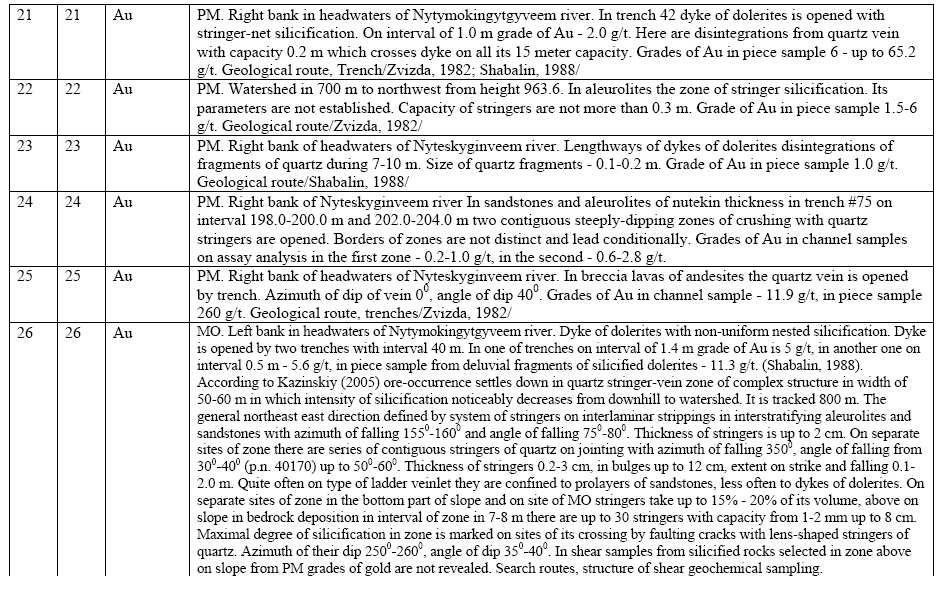
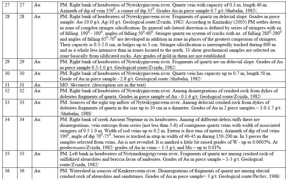
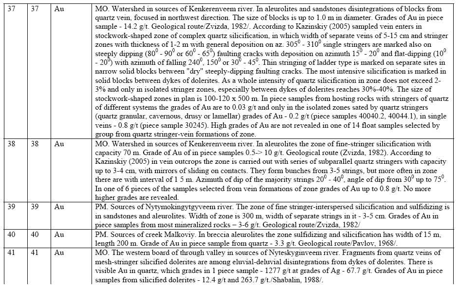
Appendix A
Data for Figure 6-2
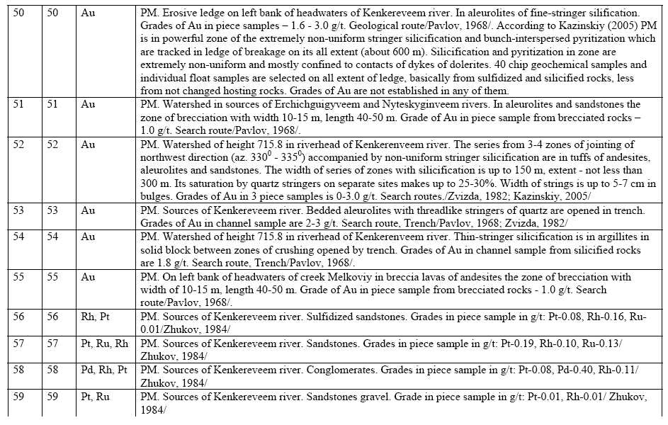
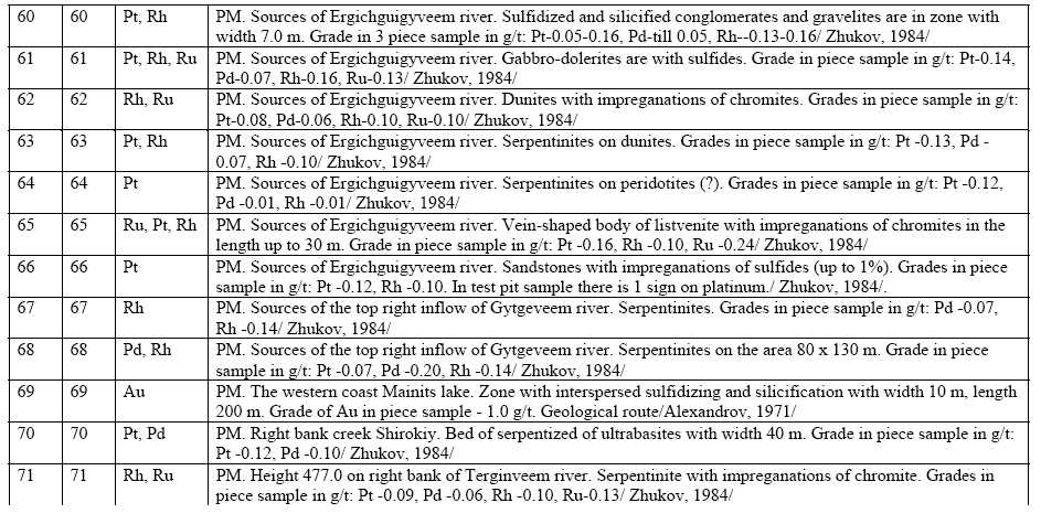
| 11/14/2007 | 47 | Gustavson Associates |
ATTACHMENT 1
List ofbedrocktargets, points ofmineralization andplacers of gold onKenkeren field

| 11/14/2007 | 48 | Gustavson Associates |
| 11/14/2007 | 49 | Gustavson Associates |
| 11/14/2007 | 50 | Gustavson Associates |
| 11/14/2007 | 51 | Gustavson Associates |
| 11/14/2007 | 52 | Gustavson Associates |
| 11/14/2007 | 53 | Gustavson Associates |
| 11/14/2007 | 54 | Gustavson Associates |
| 11/14/2007 | 55 | Gustavson Associates |
| 11/14/2007 | 56 | Gustavson Associates |
![]()
Note: PM – Point of mineralization, MO – Manifestation of ore
| 11/14/2007 | 57 | Gustavson Associates |