NI 43-101
TECHNICAL REPORT
ON THE
TUMANNOYE GOLD PROJECT,
CHUKOTKA AUTONOMOUS OKRUG, RUSSIA
PREPARED FOR
ZOLOTO RESOURCES LTD.
![]()
Dated March 10, 2008
Prepared by
William J. Crowl, R.G.
Gustavson Associates, LLC
+1 (303) 443-2209
![]()
| Zoloto Resources Ltd. | |
| Tumannoye Gold Project, Russia | Technical Report |
TABLE OF CONTENTS
| 3/8/2008 | i | Gustavson Associates |
| Zoloto Resources Ltd. | |
| Tumannoye Gold Project, Russia | Technical Report |
| 3/8/2008 | ii | Gustavson Associates |
| Zoloto Resources Ltd. | |
| Tumannoye Gold Project, Russia | Technical Report |
LIST OF FIGURES
| 3/8/2008 | iii | Gustavson Associates |
| Zoloto Resources Ltd. | |
| Tumannoye Gold Project, Russia | Technical Report |
LISTOFTABLES
APPENDICES
| A. | Tumannoye License – Scan of Russian License | 40 |
| 3/8/2008 | iv | Gustavson Associates |
| Zoloto Resources Ltd. | |
| Tumannoye Gold Project, Russia | Technical Report |
1. SUMMARY
Gustavson Associates, LLC (“Gustavson”) was commissioned by Zoloto Resources Ltd ("Zoloto") to (1) prepare a Canadian National Instrument 43-101 (NI43-101) compliant Independent Technical Report on the Tumannoye gold exploration project (the "Project") in the Chukotka Autonomous Okrug, Russia, and (2) to review Zoloto’s proposed 2007 to 2009 exploration programs for the Project.
This report has been prepared in accordance with the guidelines provided in National Instrument 43-101 ("NI43-101"), Standards of Disclosure for Mineral Projects, dated December 31, 2005. The Qualified Person responsible for this report is Mr. William J. Crowl, R.G., Vice President, Mining Sector at Gustavson.
On July 5, 2007, Sutcliffe Resources Ltd. (“Sutcliffe”) changed the name of the corporation to Zoloto Resources Ltd. Where Sutcliffe is cited in this report, the reader should consider the citation to be Zoloto Resources Ltd. as well.
Zoloto acquired Chukot Gold ZAO (“Chukot”) as a wholly owned subsidiary on December 1, 2006 for a consideration of US$327,750 to the founding shareholder of Chukot in connection with the initial acquisition of two exploration properties (Elvenei and Tumannoye) in the Federal Subsoil Agency auction held August 17, 2006, in Anadyr, Chukotka Autonomous Okrug, in the Russian Far East. Chukot is a company incorporated under the laws of the Russian Federation to acquire tendered or licensed properties in the region of Chukotka.
Zoloto has expended approximately $6,600,000 on the combined Elvenei and Tumannoye properties, of which approximately $2,600,000 has been spent on property acquisitions and $4,000,000 on equipment purchases (bulldozers, drills and camp facilities). The equipment was shipped in the summer of 2006 for movement to site on winter roads. At the time of the site visit to Tumannoye in August, 2007, site preparatory work (camp set up) was underway and geological work was in progress. Two dozers were trenching on the license area. Work continued after the site visit.
The successful bid amount for the Tumannoye License was 31.5 million Russian rubles (US$1,150,000). Zoloto has a 25 year license to exploit and explore the deposit area. The Tumannoye license was acquired by Zoloto because past Russian exploration programs defined several zones of gold mineralization that were sufficiently interesting that they deserved additional follow-up exploration.
Geological studies in the area of the Tumannoye deposit began in 1952 with geological mapping at a scale of 1:500,000 by the Vankarem geological exploration party. A.I. Kyshtymov first noted the indications of gold mineralization while carrying out geological mapping in 1955 at a scale of 1:100,000. During this project, twelve orebodies were identified based on the occurrence of stibnite (antimonite) bearing quartz. One sample of quartz and stibnite from a vein reportedly contained 69 g/t gold. Traces of gold were reportedly observed in panning samples along the valleys.
| 3/8/2008 | 1 | Gustavson Associates |
| Zoloto Resources Ltd. | |
| Tumannoye Gold Project, Russia | Technical Report |
During 1977-1981 and in 1991-1994 detailed mineralization investigation began, including core drilling. About 15,771 meters of core drilling was carried out, and 128,000 cubic meters of trenches were cut from the surface of the deposit.
The Tumannoye prospects display characteristics consistent with low sulphidation gold systems, characterized by gold bearing arsenopyrite mineralization that is confined to mineralized zones of crushing and fracture zones located sub-parallel to country rock stratification. Based upon morphological features, deposition conditions and internal structure of ore bodies, and the distribution of gold mineralization, there are two main types of mineralization at Tumannoye. First, are tabular deposits of disseminated pyrite-arsenopyrite ores in quartz-pyrite altered terrigenous-carbonaceous layers and second, gold mineralized granite porphyry dikes.
Mineralization concentrations are composed of transpressional crushed zones, brecciated sandstones, siltstones, and mudstones that have been permeated with a dense network of thin sulfide-quartz veins or stockwork. The width of mineralized zones ranges from 0.4 to 7.5m and they extend along strike some 50 to 400m. Changes in width both along strike and dip are gradual, sudden pinching and swelling of the zone are uncommon, and the ore zones tend to pinch out gradually. The borders of mineralized zones are typically distinct but may also continue into the surrounding rock via faults and bedding contacts of various lithologies. Mineralized zones are complicated with rare post-mineralization faults in sub-North-South directions. Fault displacements, in plan view, do not exceed 1-2m and do not significantly affect the continuity of ore zones.
Gold contents in samples of mineralization vary from 1-2 g/t to 111 g/t and average 5-12 g/t. Orebody dips are moderate (30-50°) and are generally oriented in the northern direction. Vertically, mineralization is exposed on relief as much as 200m, ore zones have been intercepted by historic core holes drilled to a depth of 350m below the surface. The mineralization has a vertical extent of more than 400m. There are several prospective areas of the deposit, including the most investigated site known as "Rudny", where 8 ore zones have been identified in one area. Gold mineralization has also been identified in quartz-sulfide dikes within granite-porphyries where there are arsenopyrite-quartz veins like those in some of the sedimentary strata. However, the gold mineralization in the dikes is reportedly much lower grade.
Russian Predictive resources of Tumannoye were authorized in the amounts: category P1 - 1.75 million tonnes grading approximately 6.9 g/t, gold; category P2: - 1.88 million tonnes grading approximately 7.3 g/t gold. These historical resource estimates are hypothetical in nature, estimated using techniques that are non-NI43-101 compliant and are mentioned here as merely being indicative of the potential of the area for discovery of gold-containing mineral resources at Tumannoye.
The exploration operations for 2007 were carried out under contract by the Russian contractor, FGUGP “GeoRegion” based in Anadyr, C.A.O. Total 2007 expenditures on Tumannoye were 13,506,319 roubles (US$554,219). Requirements of the Tumannoye license are satisfied for the 2008 exploration season. Zoloto is evaluating the results of the 2007 program and planning the
| 3/8/2008 | 2 | Gustavson Associates |
| Zoloto Resources Ltd. | |
| Tumannoye Gold Project, Russia | Technical Report |
future campaigns at Tumannoye and their other Chukotka properties – Elvenei and Kenkeren. Gustavson expects that Zoloto’s final decisions on the Tumannoye program later in the Spring of 2008.
Gustavson recommends that Zoloto carry out the following tasks in addition to any other programs proposed:
- Prepare a centralized database and carry-out a detailed data verification program; and
- Implement CIM-compliant resource estimation procedures for sampling, assaying, QA/QC programs and resource estimation. These procedures should be guided by the CIM “Best Practice Guidelines”.
Zoloto has outlined, in general terms, a future exploration program for Tumannoye. Gustavson considers that this future exploration program is appropriate for the project at its current state. Any future exploration program will be conducted in a manner that supports the eventual estimation of NI 43-101 – compliant Mineral Resources (if warranted).
| 3/8/2008 | 3 | Gustavson Associates |
| Zoloto Resources Ltd. | |
| Tumannoye Gold Project, Russia | Technical Report |
2. INTRODUCTION
Gustavson Associates, LLC (“Gustavson”) was commissioned by Zoloto Resources Ltd ("Zoloto") to (1) prepare a Canadian National Instrument 43-101 (NI43-101) compliant Independent Technical Report on the Tumannoye gold exploration project (the "Project") in the Chukotka Autonomous Okrug, Russia, and (2) to review Zoloto’s proposed 2007 to 2009 exploration programs for the Project.
2.1 Terms of Reference
This report has been prepared in accordance with the guidelines provided in National Instrument 43-101 ("NI43-101"), Standards of Disclosure for Mineral Projects, dated December 31, 2005. The Qualified Person responsible for this report is Mr. William J. Crowl, R.G., Vice President, Mining Sector at Gustavson.
2.2 Property Ownership Structure
On July 5, 2007, Sutcliffe Resources Ltd. (“Sutcliffe”) changed the name of the corporation to Zoloto Resources Ltd. Where Sutcliffe is cited in this report, the reader should consider the citation to be Zoloto Resources Ltd. as well.
Zoloto acquired Chukot Gold ZAO (“Chukot”) as a wholly owned subsidiary on December 1, 2006 for a consideration of US$327,750 to the founding shareholder of Chukot in connection with the initial acquisition of two exploration properties (Elvenei and Tumannoye) in the Federal Subsoil Agency auction held August 17, 2006, in Anadyr, Chukotka Autonomous Okrug, in the Russian Far East. Chukot is a company incorporated under the laws of the Russian Federation to acquire tendered or licensed properties in the region of Chukotka.
Zoloto has expended approximately $6,600,000 on the combined Elvenei and Tumannoye properties, of which approximately $2,600,000 has been spent on property acquisitions and $4,000,000 on equipment purchases (bulldozers, drills and camp facilities). The equipment was shipped in the summer of 2006 for movement to site on winter roads. At the time of the site visit to Tumannoye in August, 2007, site preparatory work (camp set up) was underway and geological work was in progress. Two dozers were trenching on the license area. Work continued after the site visit.
The successful bid amount for the Tumannoye License was 31.5 million Russian rubles (US$1,150,000). Zoloto has a 25 year license to exploit and explore the deposit area.
Figure 2-1 is a general location map of the Chukotka properties of Zoloto Resources.
| 3/8/2008 | 4 | Gustavson Associates |
| Zoloto Resources Ltd. | |
| Tumannoye Gold Project, Russia | Technical Report |
![]()
| 3/8/2008 | 5 | Gustavson Associates |
| Zoloto Resources Ltd. | |
| Tumannoye Gold Project, Russia | Technical Report |
2.3 Purpose and Basis of Report
Gustavson has prepared this report exclusively for Zoloto. The information presented, opinions and conclusions stated, and estimates made are based on the following information:
- Information provided by Zoloto, Chukot and ML Ltd.;
- Assumptions, conditions, and qualifications as set forth in the report; and
- Data, reports, and opinions from third-party entities.
Gustavson has not independently conducted any title or other searches, but has relied upon Zoloto for information on land ownership, tenure and permit status. In addition, Gustavson has not independently conducted any mining, processing, or economic studies, or permitting and environmental studies.
2.4 Personal Inspection
A personal inspection of the Tumannoye prospect on August 6, 2007 was conducted by William J Crowl, R.G., the Qualified Person responsible for preparation of this report. The site visit was made in the company of Messrs. Georgiy Isaikin - Chief Geologist and Afanasiy Bylgaev, Director and Translator for Chukot Gold, Alexander Popov – Deputy Director, Production, Oleg Lagniy – Chief Geologist of IVK Resources and Alan Tenenbaum, Investor Relations, Zoloto Resources. In addition, 2 days were spent in Zoloto/ML’s Konakovo, Russia offices and several days in the Anadyr offices of Chukot/Zoloto.
Meetings were held with in Anadyr at the Geo-Region offices with Mr. Vladimir P. Shabalin, Geologist of Geo-Region.
2.5 Units
Unless explicitly stated, all units presented in this report are in the International System (SI) or the Metric System (i.e. tonnes, meters, grams, etc.). All references to economic data are in U.S. dollars and cents, unless otherwise noted.
2.6 Acknowledgements
Gustavson wishes to acknowledge the hospitality of ML Ltd. in Konakovo and Zoloto in Anadyr. The cooperation of the Zoloto and other company’s staff made the understanding of the Projects possible.
| 3/8/2008 | 6 | Gustavson Associates |
| Zoloto Resources Ltd. | |
| Tumannoye Gold Project, Russia | Technical Report |
3. RELIANCE ON OTHER EXPERTS
A number of individuals have contributed to the data and technical programs discussed in this technical report, besides the Qualified Person. This report is largely a compilation of the works by Russian investigators over the long exploration history of the project. Mr. Oleg Lagniy, a geological consultant to Zoloto has provided multiple detailed discussions of the geological regime at Tumannoye.
Mr. William J. Crowl, R.G. has personally reviewed the input of the above individuals to this report in order to ensure that it meets all of the necessary reporting criteria as set out in the NI43-101 guidelines.
4. PROPERTY DESCRIPTION AND LOCATION
4.1 Property Description and Location
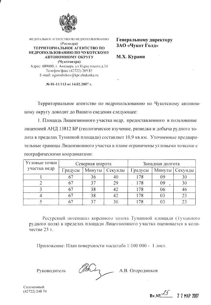
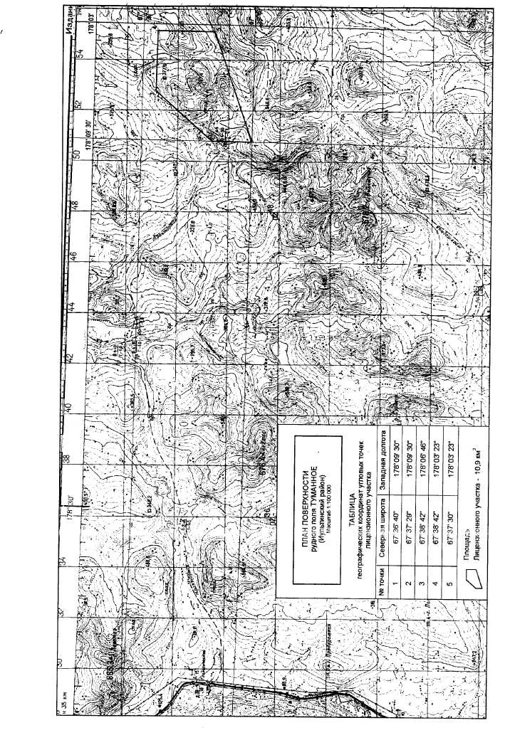
The Tumannoye project is located in a license covering 10.9 square km (km2). The term of the license is 25 years. Table 4-1 provides the geographical coordinates of the corner points of the license, defined in Latitude and Longitude using the WGS84 spheroid. Figure 4-1 shows the license boundaries for Tumannoye, as originally provided to Zoloto. The boundaries for the Tumannoye license were determined to be in error soon after the granting of the license, and were revised to reflect the License as it was intended to be in September, 2006 (Table 4-2).
Table 4-1 Geographical Coordinates of the Tumannoye Project License - Original
| No. of Point | Latitude | Longitude |
| 1 2 3 | 67° 38’ 34”N 67° 38’ 35”N 67° 37’ 25”N | 178° 07’ 54”W 178° 04’ 50”W 178° 04’ 47”W |
| 4 | 67° 37’ 24”N | 178° 07’ 51”W |
Table 4-2 Geographical Coordinates of the Tumannoye Project License – Revised, Final
| No. of Point | Latitude | Longitude |
| 1 | 67° 36’ 40”N | 178° 09’ 30”W |
| 2 | 67° 37’ 29”N | 178° 09’ 30”W |
| 3 | 67° 38’ 42”N | 178° 06’ 46”W |
| 4 | 67° 38’ 42”N | 178° 03’ 23”W |
| 5 | 67° 37’ 30”N | 178° 03’ 23”W |
The license areas just cover the outline of the known deposits. If additional room for processing plants, tailings and waste dumps as well as other infrastructure is needed, it is reported that acquisition of adjacent land will not be an issue.
| 3/8/2008 | 7 | Gustavson Associates |
| Zoloto Resources Ltd. | |
| Tumannoye Gold Project, Russia | Technical Report |
Gustavson has not reviewed the permits that must be acquired by Zoloto with respect to the exploration and exploitation of Tumannoye. Gustavson is not aware of any environmental liabilities associated with the properties.
4.2 Mineral Land Tenure
The license was granted on August 4, 2006 for a period of 25 years. There are work requirements (both physical and geological), industrial and labor safety requirements, environmental requirements, social and economic development requirements, defined taxes and payments associated with the License. A non-edited English translation of the license is included in Appendix A. The work requirements and taxes/payments (as restated from the computer translation) are summarized below.
4.2.1Tumannoye License 13812
The subsurface lessee that carries out geological studies, prospecting, and development of gold deposits within the boundaries of the license area is held to the following basic conditions:
Work Requirements for Tumannoye are:
a) not later than October 20, 2007, the preparation and approval according of a geological exploration plan for the license site and positive approval following State environmental examination (prepared and approved);
b) not later than January 20, 2008, begin prospecting activity on the license site (satisfied);
c) not later than October 20, 2010, Conclude the geological evaluation of the license area and submittal of the geological report (including calculation of gold reserves in categories P1 and P2) to the government agency responsible for subsurface use in the Chukotka Autonomous Region. This shall include at a minimum
In 2008: not less than 300 m3 of trenching (52,800 m3 completed in 2007);
In 2009: not less than 5000 m of drilled boreholes and not less than 400 m3 of trenching
In 2010: not less than 5000 m of drilled boreholes and not less than 300 m3 of trenching
d) not later than April 20, 2011, preparation and approval of designs for exploration tasks that must obtain approval from the State environmental evaluation
e) not later than October 20, 2014, at the conclusion of exploration activities and submission of a geological report that includes estimates of reserves in categories C1 and C2, for the government mineral reserve appraisal expert
f) not later than October 20, 2015, preparation and approval of a design for the commercial development of the license area reserves, and approval from the State environmental and industrial safety examinations
g) not later than April 20, 2016, the beginning of mine and infrastructure construction
h) not later than October 20, 2017, commissioning of a mine with production of not less than 100,000 tones of ore per year (contingent upon the results of the exploration and development design phases)
| 3/8/2008 | 8 | Gustavson Associates |
| Zoloto Resources Ltd. | |
| Tumannoye Gold Project, Russia | Technical Report |
i) not later than six months prior to the planned completion of the mining of the deposit, completion of the closure plan design for the mine that will include plans for removal of equipment and facilities and reclamation
Taxes and Payments are Due as Follows:
The subsurface lessee will pay the following payments and taxes:
a) Regular payments for subsurface use for preliminary exploration and evaluation of gold ore deposits contained in the entire License area (except for areas with discovered deposits undergoing more detailed exploration) are established with the following rates:
90 roubles for 1 km2 in 2006,
202 roubles for 1 km2 in 2007-2009,
270 roubles for 1 km2 in 2010.
b) Regular payments for subsurface use for prospecting within the entire license area (except for areas where prospecting of surface deposits is carried out) are established for each by the square kilometer under the following rates:
10,875 roubles - from the first to the third (inclusive) calendar years of prospecting, but not later than 2011 1
8,000 roubles - in the fourth and subsequent calendar years of prospecting, but not later than 2015
c) Mineral extraction (severance) tax is defined by the tax law of the Russian Federation.
d) Water tax is levied for the extraction of groundwater during mining operations according to the Russian Federation legislation.
A one-time payment of 29,400,000 roubles for subsurface use has been set as result of an auction bid.
According to the Russian Federation legislation, the one-time payment for subsurface use, with a deduction of the previously paid deposit (28,000,000 roubles), is due to the federal government within 30 days of the date of the registration of the license by the State.
A fee for the use of geological information for the license area is due for the State’s past previous geological studies and the size of this payment and the schedule for payment will depend on the volume of data purchased.
The subsurface lessee is obligated to pay a licensing fee for subsurface site of 8000 roubles, due within 20 banking days from the date of registration of the license by the government.
Fees for licensing are paid to the federal budget according to legislation of the Russian Federation.
Other payments and taxes as stipulated by the tax law of the Russian Federation include those for the right to surface use and for environmental contamination.
| 3/8/2008 | 9 | Gustavson Associates |
| Zoloto Resources Ltd. | |
| Tumannoye Gold Project, Russia | Technical Report |
Gustavson considers that all of the above requirements are in good standing as of the date of this report.
| 3/8/2008 | 10 | Gustavson Associates |
| Zoloto Resources Ltd. | |
| Tumannoye Gold Project, Russia | Technical Report |
![]()
| 3/8/2008 | 11 | Gustavson Associates |
| Zoloto Resources Ltd. | |
| Tumannoye Gold Project, Russia | Technical Report |
5. ACCESSIBILITY, CLIMATE, LOCAL RESOURCES, INFRASTRUCTURE andPHYSIOGRAPHY
5.1 Accessibility
The Tumannoye deposit is located in the northern part of the Chukotski peninsula on a valley of the Vykvyvyal (Ekugvaam) River and the Zeleny Creek. It falls in the Iultin administrative area of the Chukotka AO. The 19 square kilometer deposit is within the coordinates of 178°04' – 178°08' longitude west and 67°37' – 67°39’ latitude north. The area is remote with no telephone or mobile phone coverage and no local population or inhabitants.
5.2 Climate
The area has an arctic climate with long cold winters and short cool summers. The average temperature in January is -24,6>C and the low temperature averages -58>C. The July temperature averages 8>C and the high averages 30>C. Annual precipitation averages about 400 mm with about 150 mm as summer precipitation. Snow cover typically persists from the end of September until the beginning of July. The Tumannoye deposit is located in an area with permafrost that reaches a maximum depth of about 180 m in the valleys and 300-500 m beneath streams. During summer thaw, the soil melts to a depth of 1-1.5 m.
5.3 Local Resources and Infrastructure
The Tumannoye deposit is located about 80 km southeast of the town of Iultin, which is connected to the seaport town of Egvekinot with a 199 km long class II road. Due to the closing of the Iultinsky area mines and mills, Iultin is largely uninhabited. The closest town to the deposit is Geologichesky, located about 40 km to the west of the deposit. A 110 kW powerline along this road supplies electricity to Iultin from the 29.3 MW Egvekinot thermal power station.
5.4 Physiography
The deposit occurs in parts of the Chukchi uplands on the border with Vankarem lowland area. There is low mountain relief with elevations ranging from 300-641 m. The deposit is located on the northern slope of a hill with an elevation of 511.1 m. Northeast facing slopes tend to be steep (20-35 degrees), southeast facing slopes are flatter (10-20 degrees) and also commonly have terrace-like ledges. Slopes are covered with 1-6 meters of alluvial and colluvial sediments.
5.5 Environmental Conditions
Surface disturbance from exploration has been minimal to moderate in the Tumannoye area. To date, site disturbances have been related to road and drill pad construction, trenching and bulk sampling. Future disturbances will be similar, with additional efforts in all areas.
No significant disturbances were noted that will constitute a liability for Zoloto.
| 3/8/2008 | 12 | Gustavson Associates |
| Zoloto Resources Ltd. | |
| Tumannoye Gold Project, Russia | Technical Report |
![]()
| 3/8/2008 | 13 | Gustavson Associates |
| Zoloto Resources Ltd. | |
| Tumannoye Gold Project, Russia | Technical Report |
![]()
| 3/8/2008 | 14 | Gustavson Associates |
| Zoloto Resources Ltd. | |
| Tumannoye Gold Project, Russia | Technical Report |
6. HISTORY
6.1 General Background
Geological studies in the area of the Tumannoye deposit began in 1952 with geological mapping at a scale of 1:500,000 by the Vankarem geological exploration party. A.I. Kyshtymov first noted the indications of gold mineralization while carrying out geological mapping in 1955 at a scale of 1:100,000. During this project, twelve orebodies were identified based on the occurrence of stibnite (antimonite) bearing quartz. One sample of quartz and stibnite from a vein reportedly contained 69 g/t gold. Traces of gold were reportedly observed in panning samples along the valleys.
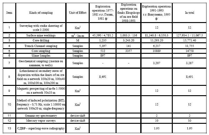
During 1977-1981 and in 1991-1994 detailed mineralization investigation began, including core drilling. About 15,771 meters of core drilling was carried out, and 128,000 cubic meters of trenches were cut from the surface of the deposit.
Table 6-1 Tumannoye Historical Exploration
| 3/8/2008 | 15 | Gustavson Associates |
| Zoloto Resources Ltd. | |
| Tumannoye Gold Project, Russia | Technical Report |
7. GEOLOGICAL SETTING
7.1 Regional Setting
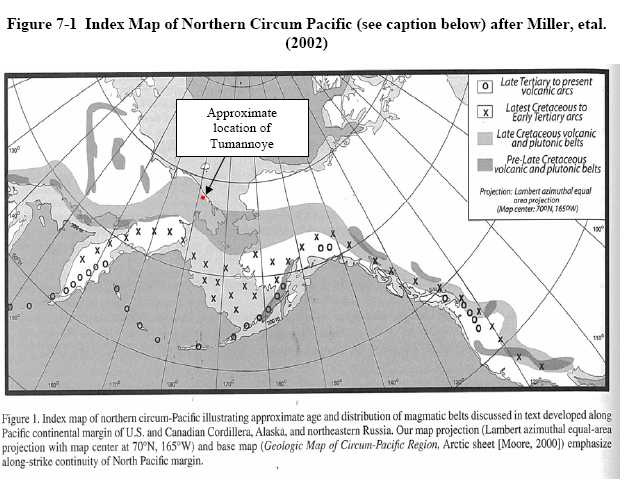
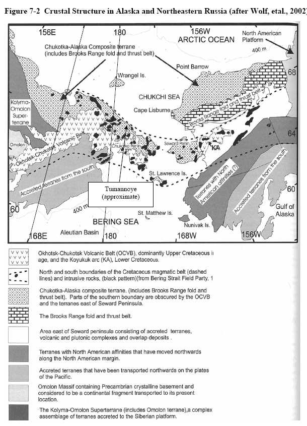
Quoting from Miller, et al (2002), “The Mesozoic represents an important time span of subduction-related magmatism along the northern circum-Pacific margin. As a result, volcanic and plutonic belts of Mesozoic age now form fundamental elements of the geology of the Pacific margins of both North America and Northeast Asia (Figure 7-1). The emplacement of these belts was followed by continued magmatism into the Cenozoic. At the scale of the northern Pacific, magmatic belts appear to have remained relatively stationary through time in the Western U.S. and Canadian Cordillera (Figure 7-1). In contrast, a progressive migration of magmatism toward the Pacific seems to have occurred in the Alaska and northeastern Russia sectors of the belt. This migration locally included subduction zone jumps with the formation of backarc basins during the Tertiary (Figure 7-1).” Further, “Compared to the Cordillera, less is known about the timing of magmatic events in northeastern Russia. Our preliminary comparison suggests that tectonic and magmatic events in northeastern Russia are similar to those of the Cordillera but that in several cases nearly opposite tectonic environments characterize these time intervals. For example, a magmatic episode coeval with crustal shortening on one side of the Pacific may coincide with a coeval period of magmatism on the other side of the Pacific that occurred in a neutral to extensional tectonic environment.” The Tumannoye prospect lies on the edge of an area of late Cretaceous volcanic and plutonic belts.
Figure 7-2 shows the crustal structure in northeastern Russia and Alaska (Wolf, et. al. 2002).
7.2 Property Geology
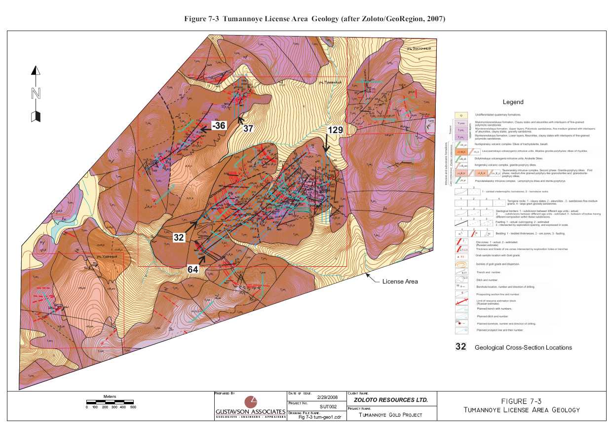
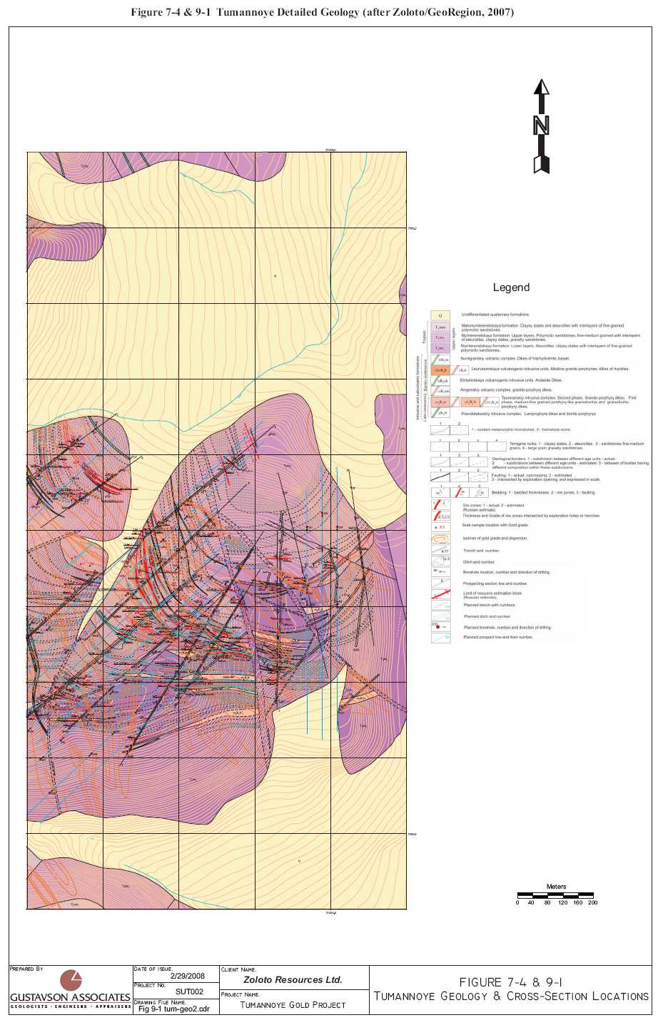
The Tumannoye deposit is located within the Kuekvun-Iultin ore zone and is a component of the Ekugsky ore unit. The deposit occurs within a faulted terrigenous Triassic rock system that includes interbedded carbonate-clastic flysch facies of the Amguem Group of early Middle Triassic age and terrigeneous rocks of the Mymlerenetsky and Malomymlerenetsky formations (local stratigraphic units) of the Late Triassic. See Figures 7-3 and 7-4.
Intrusive rocks include early Cretaceous granodiorites, early Cretaceous lamprophyre dikes, granite-porphyries, late Cretaceous granite-porphyries, diorite-porphyry, andesites, basalts, and trachydolerites.
The author observed that the above description is valid, with the host rocks of the mineralized system as described. Most of the lithologies observed were intrusive rocks of one form or another. Some altered sedimentary rocks were observed as well.
| 3/8/2008 | 16 | Gustavson Associates |
| Zoloto Resources Ltd. | |
| Tumannoye Gold Project, Russia | Technical Report |
| 3/8/2008 | 17 | Gustavson Associates |
| Zoloto Resources Ltd. | |
| Tumannoye Gold Project, Russia | Technical Report |
| 3/8/2008 | 18 | Gustavson Associates |
| Zoloto Resources Ltd. | |
| Tumannoye Gold Project, Russia | Technical Report |
| 3/8/2008 | 19 | Gustavson Associates |
| Zoloto Resources Ltd. | |
| Tumannoye Gold Project, Russia | Technical Report |
| 3/8/2008 | 20 | Gustavson Associates |
| Zoloto Resources Ltd. | |
| Tumannoye Gold Project, Russia | Technical Report |
8. DEPOSIT TYPES
The Tumannoye prospects display characteristics consistent with low sulphidation gold systems, characterized by gold bearing arsenopyrite mineralization that is confined to mineralized zones of crushing and fracture zones located sub-parallel to country rock stratification.
9. MINERALIZATION
The following is an English translation of the Russian description (in the Russian Proyect documents) of the Tumannoye mineralization. Gustavson took sight of the mineralization at Tumannoye, but did not visit every site discussed herein.
Mineralization is found in the central part and northern part of the Tumaninsky intrusive dome structure that has a granodiorite core (also known as the Tumaninsky granodiorite core). The Tumannoye amphibolite-biotite granodiorite stockwork is exposed in the central part of the deposit over an area of about 0.65km2. This is apparently an extension of a deep lying granodiorite intrusive body. Numerous dikes fill fractures.
The deposit boundaries include rocks that have some extent of hydrothermal and/or metamorphic alteration. Contact metamorphism occurred in a halo about 100-200 m wide around the intrusion and includes zones of biotite and cordierite hornfels. Associated hydrothermal features include quartz, quartz-stibnite (antimonite) veins, veinlets and zones of veinlets.
Gold occurrence at Tumannoye is confined primarily to the lower shaley-silty strata and upper silty sandstone beneath layers of the Mymlerenetsky units.
Ore-bearing structures with low sulfidation gold mineralization have a roughly north-south linear orientation, regional deformation related zones of increased dynamic or dislocation metamorphism including zones of shearing, crushing and brecciation, and multiple sequential fracturing with hydrothermal alteration.
Based upon morphological features, deposition conditions and internal structure of ore bodies, and the distribution of gold mineralization, there are two main types of mineralization at Tumannoye. First, are tabular deposits of disseminated pyrite-arsenopyrite ores in quartz-pyrite altered terrigenous-carbonaceous layers and second, gold mineralized granite porphyry dikes.
Mineralization concentrations are composed of transpressional crushed zones, brecciated sandstones, siltstones, and mudstones that have been permeated with a dense network of thin sulfide-quartz veins or stockwork. The width of mineralized zones ranges from 0.4 to 7.5m and they extend along strike some 50 to 400m. Changes in width both along strike and dip are gradual, sudden pinching and swelling of the zone are uncommon, and the ore zones tend to pinch out gradually. The borders of mineralized zones are typically distinct but may also continue into the surrounding rock via faults and bedding contacts of various lithologies. Mineralized zones are complicated with rare post-mineralization faults in sub-North-South directions. Fault displacements, in plan view, do not exceed 1-2m and do not significantly affect the continuity of ore zones.
| 3/8/2008 | 21 | Gustavson Associates |
| Zoloto Resources Ltd. | |
| Tumannoye Gold Project, Russia | Technical Report |
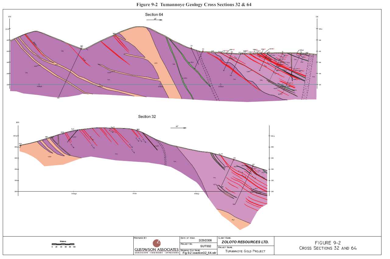
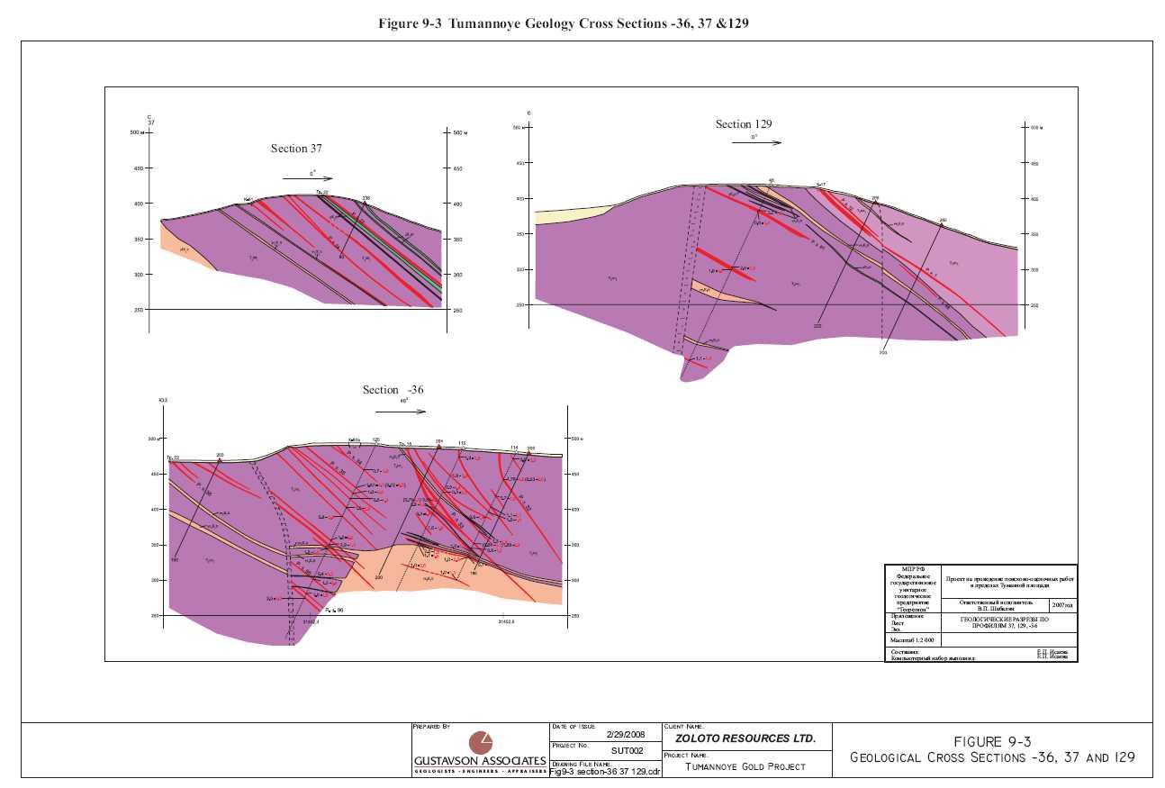
Figures 7-4 and 9-1 show the detailed geology of the Tumannoye zone. Gold contents in samples of mineralization vary from 1-2 g/t to 111 g/t and average 5-12 g/t. Orebody dips are moderate (30-50°) and are generally oriented in the northern direction. Vertically, mineralization is exposed on relief as much as 200m, ore zones are intercepted by historic core holes drilled to a depth of 350m below the surface as shown in Figures 9-2, 9-3 and 9-4. The mineralization has a vertical extent of more than 400m. There are several prospective areas of the deposit, including the most investigated site known as "Rudny", where 8 ore zones have been identified in one area. Gold mineralization has also been identified in quartz-sulfide dikes within granite-porphyries where there are arsenopyrite-quartz veins like those in some of the sedimentary strata. However, the gold mineralization in the dikes is reportedly much lower grade.
| 3/8/2008 | 22 | Gustavson Associates |
| Zoloto Resources Ltd. | |
| Tumannoye Gold Project, Russia | Technical Report |
Figure 9-1 Tumannoye Detailed Geology, Exploration History and Activity Locations
Please see Page 20 – Figure 7-4 and 9-1.
| 3/8/2008 | 23 | Gustavson Associates |
| Zoloto Resources Ltd. | |
| Tumannoye Gold Project, Russia | Technical Report |
| 3/8/2008 | 24 | Gustavson Associates |
| Zoloto Resources Ltd. | |
| Tumannoye Gold Project, Russia | Technical Report |
| 3/8/2008 | 25 | Gustavson Associates |
| Zoloto Resources Ltd. | |
| Tumannoye Gold Project, Russia | Technical Report |
![]()
| 3/8/2008 | 26 | Gustavson Associates |
| Zoloto Resources Ltd. | |
| Tumannoye Gold Project, Russia | Technical Report |
10. EXPLORATION
10.1 Historical Exploration
The historical exploration programs conducted on the Tumannoye license are briefly described in Section 6 History of this report. Table 6-1 summarizes the details of those exploration efforts.
10.1.1Geologic Mapping
No record of the geologic mapping techniques was available to Gustavson for review. However, maps of 1:2000 and 1:10000 were available for review with Geo-Region and Zoloto geologists in the field and in Anadyr.
10.1.2Trenching
Several trenches were visited by Gustavson during the site visit in August 2007. The documented mineralization was observed as mapped and described previously.
Typically, trenching in areas of permafrost required opening of the area of the eventual trench to bedrock with a dozer, a waiting period during the summer months for thawing and deepening of the trench after thawing.
10.1.3Geochemical Sampling
No record of the geochemical sampling techniques or protocols employed was available to Gustavson for review. On the ground, evidence abounds of a significant number of sampling campaigns (pits, trenches and prospect holes), as is typical of Russian prospect testing. Figures 7-3 and 9-2 through 9-4 display the results of several historical sampling campaigns. Mercury vapor sampling is mentioned in Table 10-1.
10.1.4Geophysics
Russian documents on the Tumannoye prospect mention geophysical surveys (induced polarization, ground magnetics, gamma ray spectrometry and super long wave radiography), but they do not discuss the results of those surveys. Surveys such as these are typically used by Russian expeditions (exploration campaigns) to assist with focusing efforts on the more prospective zones in a larger property package.
10.1.5Bulk and Test Sampling
Mention is made of historical test samples being taken from test pits. Such samples are often used in preliminary metallurgical tests of potentially economically mineralized zones.
| 3/8/2008 | 27 | Gustavson Associates |
| Zoloto Resources Ltd. | |
| Tumannoye Gold Project, Russia | Technical Report |
10.2 Exploration in 2007
Subsequent to the site visit in August, 207, Zoloto has reported that the following work was completed:
- Geological routes – 32.17 km;
- Geochemical works on primary halos - 165 samples;
- Mining works – 52,800 m3(see Note 1);
- Channel sampling - 736 samples;
- Spot sampling - 55 samples;
- Geological documentation of trenches – 736.l m.
Note 1: Including finished: - --200; T-201; T-203; K-100 with total volume 23,690 m3. Ditches 101, 102 and trenches 202, 204, 205, cutbacks are in a various stages of completion, with total volume of uncompleted works – 29,110 m3
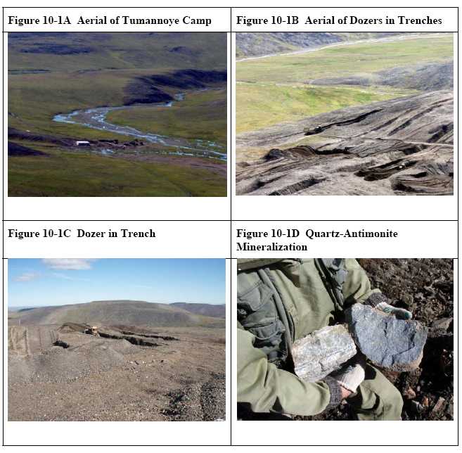
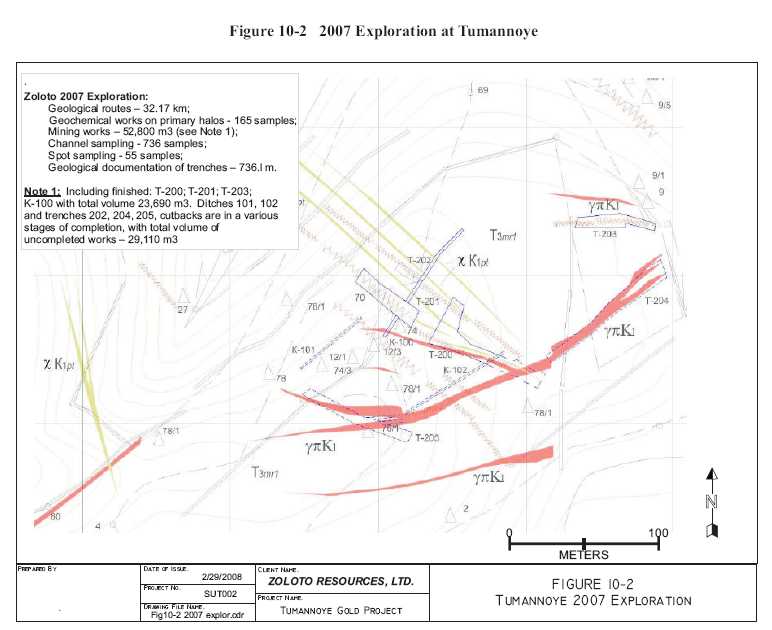
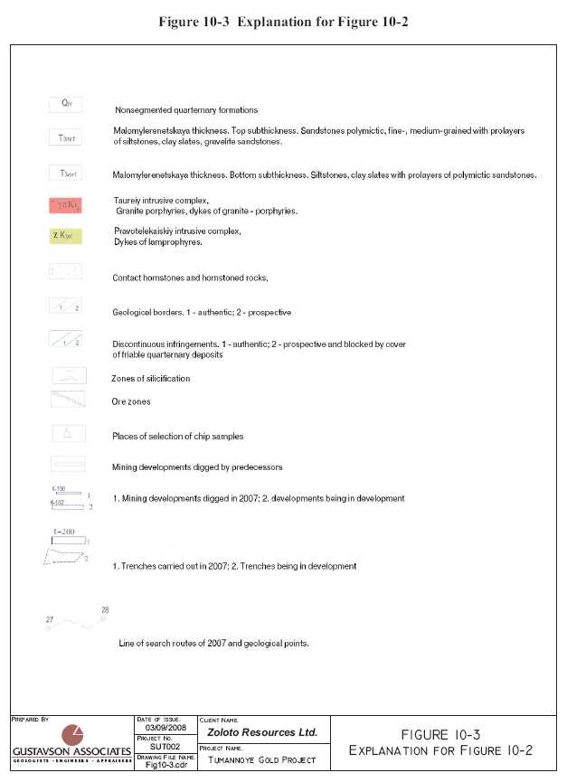
Figures 10-1A through 10-1D are photographs of exploration activities at Tumannoye during August, 2007. No finished map of the 2007 Tumannoye exploration was available at the time of writing this report, nor was sample location information was available. Figure 10-2 is a rough representation of the area that was explored in 2007 at Tumannoye. Figure 10-3 is the explanation for Figure 10-2. The laboratory used by Zoloto is Alex Stewart Geo Analytics in Moscow, Russia.
| 3/8/2008 | 28 | Gustavson Associates |
| Zoloto Resources Ltd. | |
| Tumannoye Gold Project, Russia | Technical Report |
| 3/8/2008 | 29 | Gustavson Associates |
| Zoloto Resources Ltd. | |
| Tumannoye Gold Project, Russia | Technical Report |
| 3/8/2008 | 30 | Gustavson Associates |
| Zoloto Resources Ltd. | |
| Tumannoye Gold Project, Russia | Technical Report |
| 3/8/2008 | 31 | Gustavson Associates |
| Zoloto Resources Ltd. | |
| Tumannoye Gold Project, Russia | Technical Report |
11. DRILLING
11.1 Core Drilling
As of the date of the site visit by the author (August, 2007), Zoloto had not conducted drilling at the Tumannoye site.
According to the historical Russian reports, 15,771.4m of core drilling was done historically at Tumannoye, yielding 14,758 samples. The locations of the collars of the holes are presented on Figures 9-1 through 9-4. As is typical of Russian core drilling campaigns, there is no core remaining to be examined, as all of the core was consumed in the analysis process. Gustavson has recommended that core drilling programs by Zoloto follow Western protocols, where drill core is split and 50% is retained for future examination and 50% is sent for assay and analysis.
It has been the author’s experience that Russian methods of geologic logging and sampling follow relatively rigid mandated protocols and the resulting data and logs are typically usable to plan future drilling campaigns and can be used in geologic modeling and resource estimation after verification of methodologies and results. Zoloto must seek out all available records to assist in guiding their exploration programs. Their Chief Geologist and the head of the field programs are both Russian and very familiar with the Russian systems. They have both agreed upon the need to assemble all available data as soon as possible.
12. SAMPLING METHOD AND APPROACH
Gustavson did not independently re-sample or assay any of the samples comprising the historic data for Tumannoye. The following discussion of sampling methodology and approach is taken from Russian reports and records of personal interviews and inspections by the author.
12.1 Core Sampling
Whole drill core was submitted for assay, with none remaining for future examination. This is a typical Russian procedure. No evidence of core photographs was presented.
12.2 Channel Sampling
Reportedly, trenches were channel sampled along their full length. Direct evidence of these activities was not available to the author during the site visit, due to weathering and erosion of the historical trenches.
12.3 Bulk and Test Sampling
According to the historical Russian records, 5 test samples were collected from the Tumannoye prospect. Chapter 16 of this report presents the results of testwork on these samples.
| 3/8/2008 | 32 | Gustavson Associates |
| Zoloto Resources Ltd. | |
| Tumannoye Gold Project, Russia | Technical Report |
13. SAMPLE PREPARATION, ANALYSES, AND SECURITY
Zoloto has made assurances to the author that sample preparation and analyses conducted during their exploration programs will satisfy the requirements of Western Best Practices and will pass the scrutiny of future investigators as required by NI43-101. Prior programs reportedly have followed Russian protocols which are similar to Western requirements, but there is no readily accessible documentation to review. The Zoloto geologists must gain access to the previously generated data and provide descriptions of the methodologies applied during all phases of data collection and analysis.
13.1 Sample Preparation
No available information. See above. Typical Russian procedures are adequate for this early stage exploration program.
13.2 Sample Analysis
No available information. See above. Typical Russian procedures are adequate for this early stage exploration program.
13.3 Check and Duplicate Sampling/Preparation and Assaying
No available information. See above. Typical Russian procedures are adequate for this early stage exploration program.
13.4 Security
No available information. See above. Typical Russian procedures are adequate for this early stage exploration program.
14. DATA VERIFICATION
Gustavson has not independently conducted any title or other searches, but has relied upon Zoloto for information on the status of the claims, property title, agreements, and other pertinent conditions. In addition, Gustavson has not independently conducted any mining, processing, or economic studies, or permitting and environmental studies.
14.1 Verification of Geologic Data
The site visit by the author confirmed the general layout of the prospects as portrayed on the maps of the mineralized zones. Examination of the rocks at various sites on the prospect, in the company of Geo-Region geologist, Victor Shabalin and Zoloto geologists verified that the geologic information shown on the maps was accurate. Zoloto should, as is their plan, re-sample some of the trenches and pits to gain an understanding of the relationship between the previously collected data and the data to be collected during their campaigns. At the time of the site visit, a bulldozer was opening previously excavated trenches, under the direction of Geologist Shabalin.
| 3/8/2008 | 33 | Gustavson Associates |
| Zoloto Resources Ltd. | |
| Tumannoye Gold Project, Russia | Technical Report |
14.2 Verification of Analytical Data
Neither Gustavson nor Zoloto has completed any independent sampling and/or confirmatory geologic logging of core. Future rounds of evaluation of the existing data may involve re-assaying sample pulps and rejects, if available.
15. ADJACENT PROPERTIES
There are no adjacent non-alluvial gold properties in the vicinity of the Tumannoye License.
16. MINERAL PROCESSING AND METALLURGICAL TESTING
Mineralogic and processing characteristics of the Tumannoye deposit ore were investigated with five test samples. The results found that the portion of the deposit tested is split almost evenly between secondary semi-oxidized ores (surface to a depth of 50-70m) and primary sulfide ores. The deposit includes gold mineralization associated with arsenic and carbon that may be refractory. Stibnite (antimony), sphalerite (blende), galena, and chalcopyrite are present in variable amounts. Free or native gold occurs as powder-like grains (0.01 -0.05mm) . The bulk of the fine gold is within sulfides, especially arsenopyrite, which grades about 500 g/t of gold. In the primary ores, about 47% of the gold is contained in sulfide minerals. In the secondary semi-oxidized ores, gold associated with scorodite comprises about 26.3%, free gold is about 5.6%, gold associated with sulfides is 2.6%, and the remainder of the gold content is associated with carbon or carbon-bearing substances and gangue minerals.
Research has shown that gold is the primary economic component of the deposit and silver (2-5 g/t) may be a suitable by-product metal, antimony is not likely to be an economic component. Impurities associated with the gold are arsenic (0.7 -1.0%) and carbon (0.5%) .
The average fineness of the gold in both the primary and semi-oxidized ore is high, with greater than 70-80% at 900-975. Gold with fineness greater than 900 composes about 71.4% of the primary ore and 84.6% of the semi-oxidized ore.
Gustavson considers that potentially economic mineralization includes only gold that is finely dispersed, mainly within sulfides.
17. MINERAL RESOURCE AND MINERAL RESERVE ESTIMATES
17.1 Tumannoye Russian Resource Estimates
There are no NI 43-101-compliant mineral resource estimates for the prospects on the Tumannoye License. Early Russian investigators estimated Russian category C2 resources to several zones at Tumannoye, referring to them as Rudny zones # 1, 2, 3, 4, 5, 9, 12, Centralny zones 18, 19, 20, 44 and Zapadny zones 32, 33, 35, 36.
A Russian government examination of the supporting data and the predictive resources of Tumannoye, revealed weak validity of the chosen rejection standards, erroneous acceptance in calculation of stocks of the minimal-industrial content of gold in calculation block - 5.9 g/t,
| 3/8/2008 | 34 | Gustavson Associates |
| Zoloto Resources Ltd. | |
| Tumannoye Gold Project, Russia | Technical Report |
inexact delineation of the calculation block. On the basis of report #-C # 31 dated June 5 1995 stocks of gold of category C2 of ore occurrence Tumannoye are transferred to category P1, and predictive resources of gold of category P1 are transferred to category P2. Predictive resources of Tumannoye were authorized in the amounts: category P1 - 1.75 million tonnes grading approximately 6.9 g/t, gold; category P2: - 1.88 million tonnes grading approximately 7.3 g/t gold (report #-C # 46 dated July 9, 1995). These historical resource estimates are hypothetical in nature, estimated using techniques that are non-NI43-101 compliant and are mentioned here as merely being indicative of the potential of the area for discovery of gold-containing mineral resources at Tumannoye.
18. OTHER RELEVANT DATA AND INFORMATION
Gustavson is unaware of any other data and/or information that would be relevant to this report and is not contained in one of the existing Sections of this report.
19. INTERPRETATION AND CONCLUSIONS
As described in Sections 9 and 17 above, there are two main types of gold mineralization at Tumannoye. First, there are tabular deposits of disseminated pyrite-arsenopyrite ores in quartz-pyrite altered terrigenous-carbonaceous layers and second, gold mineralized granite porphyry dikes. The mineralization covers a wide area and historical sampling indicates that potentially ore-grade mineralization is present over potentially mineable widths.
The exploration data presented by Zoloto and reviewed by Gustavson supports such a conclusion on the occurrence of gold mineralization at Tumannoye. A thorough review of all available previously collected data by Zoloto geologists is required in order to direct a reasonable test of the mineralized system.
20. RECOMMENDATIONS
Zoloto acquired the Tumannoye license because of the potential for advancing the already discovered precious metal mineralization to a stage where measured and indicated mineral resources might be definable. To that end, Zoloto carried out the 2007 work program. The exploration operations for 2007 were carried out under contract by the Russian contractor, FGUGP “GeoRegion” based in Anadyr, C.A.O. Total 2007 expenditures on Tumannoye were 13,506,319 roubles (US$554,219). Requirements of the Tumannoye license are satisfied for the 2008 exploration season. Zoloto is evaluating the results of the 2007 program and planning the future campaigns at Tumannoye and their other Chukotka properties – Elvenei and Kenkeren. Gustavson expects that Zoloto’s final decisions on the Tumannoye program later in the Spring of 2008.
20.1 Future Exploration Program
The following is a description of the future exploration program planned by Zoloto. The work program has been designed to test the zone of gold mineralization with drilling, trenching, grab
| 3/8/2008 | 35 | Gustavson Associates |
| Zoloto Resources Ltd. | |
| Tumannoye Gold Project, Russia | Technical Report |
sampling and geophysics (downhole and surface). The description has been paraphrased from a Russian-English translation.
The Plan for exploration of the Tumannoye license area consists of the following:
- Field work including topographical-surveyor work, geological reconnaissance and mapping, drilling and documentation of boreholes, digging and documentation of trenches. Opening of earlier trenches showing mineralization and the re-sampling of same. Sampling activities involving channel, core and geochemical samples. Allocation and contouring of potential ore bodies.
- Use ground geophysical works, mineralogical-petrographic and geochemical studies of samples of core and other samples to further define geological-structural features of the Tumannoye field and the ore bodies, geochemical, mineralogical and metasomatic anomalies revealed.
- Study the morphology, size and vertical scope of mineralization, as well as the deposition condition of ore bodies and the material structure of ores. Execute a thorough program of laboratory-analytical work with the inclusion of all available data.
- Office processing of received information.
A contract with organization FGUGP "GeoRegion" can be entered into for carrying out the above activities. At the present time, a geological-technical project and contract for future work has not been finalized with FGUGP "GeoRegion".
The above program represents a staged approach to defining the physcial form of the ore occurences at Tumannoye. Decision points will have been defined that would re-direct efforts to other areas if and when specific parts of the exploration program should prove unsuccessful.
Gustavson recommends that Zoloto carry out the following tasks in addition to any other programs proposed:
- Prepare a centralized database and carry-out a detailed data verification program; and
- Implement CIM-compliant resource estimation procedures for sampling, assaying, QA/QC programs and resource estimation. These procedures should be guided by the CIM “Best Practice Guidelines”.
Gustavson considers the future exploration program proposed by Zoloto for Tumannoye to be appropriate for the project at its current state. The staged exploration program will be conducted in a manner that supports the eventual estimation of NI 43-101 – compliant Mineral Resources (if warranted).
| 3/8/2008 | 36 | Gustavson Associates |
| Zoloto Resources Ltd. | |
| Tumannoye Gold Project, Russia | Technical Report |
21. REFERENCES / BIBLIOGRAPHY
21.1 References with Project Specific Relevance
| 1. | Golik V., 1982 Report on searches on the area of Tumannoye gold-ore deposit (Second confirmatory search group 1980-1981). | |
| 2. | Kukhtin V.I., etc., 1965, Report on work of Kuekvunskiy aeromagnetic party of scale 1 : 50 000 for 1964. | |
| 3. | Kuzmin G.I., Pinegin Y.D., 1975 Pilot-production and methodological aerogeophysical works on tin, gold and other minerals in Magadan area for 1974. | |
| 4. | Mitropolskiy P., 1981 Report on search works on deposit Tumannoye, 1988-1991. | |
| 5. | Moskalev V.A., Zenko V.D. Report about gravimetric survey of scale 1:200 000 of western part of Vankarem depression and its mountain frame in 1973, 1974. | |
| 6. | Prityko S.F., 1990 Report about searches of weak-eroded mineralization in head waters of stream Lost of Ekugskiy ore unit in 1988-1990. | |
| 7. | Vakulenko N.M., 1995 Report about search works on deposit Tumannoye in 1991- 1993. | |
| 8. | Vasiliev V. Report on general searches on sites Udachniy, Eastern, 1990-1994, 1994. | |
| 9. | Wolf, L.W., McCaleb, R.C., Stone, D.B., Brocher, T.M., Fujita, K., and Klemperer, S.L., 2002, Crustal structure across the Bering Strait, Alaska: Onshore recordings of a marine seismic survey,inMiller, E.L., Grantz, A., and Klemperer, S.L., eds., Tectonic Evolution of the Bering Shelf – Chukchi Sea – Arctic Margin and Adjacent Land Masses: Boulder, Colorado, Geological Society of America Special Paper 360, p. 25-37. | |
| 10. | Miller, E.L., Gelman, M., Parfenov, L., and Hourigan, J., 2002, Tectonic setting of Mesozoic magmatism: A comparison between northeastern Russian and the North American Cordillera,inMiller, E.L., Grantz, A., and Klemperer, S.L., eds., Tectonic Evolution of the Bering Shelf – Chukchi Sea – Arctic Margin and Adjacent Land Masses: Boulder, Colorado, Geological Society of America Special Paper 360, p. 313-332. |
21.2 Selected General Publications
| 1. | Volkov A.S., Dolgov. B.P., 1982, Rotary drilling of prospecting holes. Moscow, 342 p. | |
| 2. | Instruction on geomagnetic., 1981, Leningrad, Subsoil, 262 p. | |
| 3. | Instruction on electroprospecting., 1984, Leningrad, Subsoil, 351 p. | |
| 4. | Instruction on designing and estimates for prospecting works., 1993, Moscow, State Committee on Geology and Subsoil Resources, 82 p. | |
| 5. | Instruction on topographical-geodetic supply of geological prospecting works. 1984, Moscow, 216 p. | |
| 6. | Kudryashov B.B., Yakovlev A.M., 1983, Drilling of holes in frozen rocks., Moscow, Subsoil, 286 p. | |
| 7. | Kazhdan A.B., 1985, Searches and prospecting of deposits of minerals. Manufacture of geological-prospecting works. Moscow, Subsoil, 288 p. |
| 3/8/2008 | 37 | Gustavson Associates |
| Zoloto Resources Ltd. | |
| Tumannoye Gold Project, Russia | Technical Report |
| 8. | Kreiter V.M., 1969, Searches and prospecting of deposits of minerals. Moscow, Subsoil, 292 p. | |
| 9. | Polyakov G.D., Bulgakov E.S., Shumov L.A., 1983, Designing, calculation and operation of drilling installations. Moscow, Subsoil, 318 p. | |
| 10. | Safety rules at geological prospecting works., 1991, Moscow, Subsoil, 309 p. | |
| 11. | Fire prevention rules for prospecting organizations and enterprises., 1979, Mingeo USSR., 126 p. | |
| 12. | Directory on mining-ore business., 1961, Moscow. | |
| 13. | Directories of budget norms, releases 1-11., 1992, Moscow, Viems. | |
| 14. | 14. Addition to the collection of budget norms for prospecting works (SSN-92), rel. 1, parts 1-4, 1996, Moscow. | |
| 15. | Temporary budget norms of labour and material expenses on computer support GSR- 200, 2001, 48 p. | |
| 16. | Methodical recommendations on account, storage and transfer of fund information on machine carriers., 1996, Moscow, 52 p. | |
| 17. | Collection of explanations, additions and changes, Release 2, 2000, Moscow. | |
| 18. | Technical instruction on carrying out of geophysical researches in holes., 1985, Moscow, Subsoil. | |
| 19. | Umitbaev R.V., 1986, Okhotsko-Chaunsk metallogenic province. Moscow, Subsoil, 286 p. | |
| 20. | Directory of the mining master of prospecting parties, Moscow "Subsoil", 1973 | |
| 21. | Semenov A.S., 1974 Electroprospecting by method of natural electric field, "Subsoil". | |
| 22. | Instruction on magnetic prospecting, "Subsoil", 1981. | |
| 23. | Reference guidance of master of geological prospecting drilling, "Subsoil", 1983 | |
| 24. | Temporary methodical instructions on complexation of geophysical methods at searches of gold-silver deposits in vulcanites of Northeast of USSR, Leningrad, 1983. | |
| 25. | Instruction on electroprospecting, "Subsoil", 1984. | |
| 26. | Sapozhnikov B.G., 1984 Electroprofiling with not earthed working lines, "Subsoil". | |
| 27. | Instruction on topographic-geodetic maintenance of prospecting works, Moscow, 1984. | |
| 28. | Methodical recommendations on application of gamma-spectrometer method at searches of gold-silver deposits in vulcanites of Northeast of USSR, Leningrad, 1987. | |
| 29. | Multifactorial predictive-search models of deposits of gold and silver of Northeast of Russia, 1992. | |
| 30. | Technique of exploration of gold-ore deposits, Moscow, 1991. |
| 3/8/2008 | 38 | Gustavson Associates |
| Zoloto Resources Ltd. | |
| Tumannoye Gold Project, Russia | Technical Report |
22. DATE AND SIGNATURE PAGE
William J. Crowl
Vice President, Mining
Gustavson Associates, LLC
5757 Central Avenue, Suite D
Boulder, Colorado 80301
Telephone: 303-443-2209
Facsimile: 303-443-3156
Email:wcrowl@gustavson.com
CERTIFICATE of AUTHOR
I, William J. Crowl do hereby certify that:
| 1. | I am currently employed as Vice President, Mining by Gustavson Associates, LLC at: |
5757 Central Avenue
Suite D
Boulder, Colorado 80301
| 2. | I am a graduate of the University of Southern California with a Bachelor of Arts in Earth Science (1968), and a MSc. in Economic Geology from the University of Arizona in 1979, and have practiced my profession continuously since 1973. | |
| 3. | I am a registered Professional Geologist in the State of Oregon (G573) and am a member in good standing of the Australian Institute of Mining and Metallurgy and the Society of Economic Geologists. | |
| 4. | I have worked as a geologist for a total of 35 years since my graduation from university; as a graduate student, as an employee of a major mining company, a major engineering company, and as a consulting geologist. | |
| 5. | I have read the definition of “qualified person” set out in National Instrument 43-101 (“NI 43-101”) and certify that by reason of my education, affiliation with a professional association (as defined in NI 43-101) and past relevant work experience, I fulfill the requirements to be a “qualified person” for the purposes of NI 43-101. | |
| 6. | I am responsible for the preparation of the technical report titled “NI 43-101 TECHNICAL REPORT ON THE TUMANNOYE GOLD PROJECT, CHUKOTKA AUTONOMOUS OKRUG, RUSSIA”, dated March 10, 2008 (the “Technical Report”). | |
| 7. | A personal visit of the subject property was conducted on August 6, 2007. | |
| 8. | I have personally completed an independent review and analysis of the data and written information contained in this Technical Report. | |
| 9. | I have not had prior involvement with Zoloto Resources Ltd. on the property that is the subject of this Technical Report. |
| 3/8/2008 | 39 | Gustavson Associates |
| Zoloto Resources Ltd. | |
| Tumannoye Gold Project, Russia | Technical Report |
| 10. | I am not aware of any material fact or material change with respect to the subject matter of the Technical Report that is not reflected in the Technical Report, the omission to disclose which makes the Technical Report misleading. | |
| 11. | I do not hold, nor do I expect to receive, any securities or any other interest in any corporate entity, private or public, with interests in the properties that are the subject of this report or in the properties themselves, nor do I have any business relationship with any such entity apart from a professional consulting relationship with the issuer, nor to the best of my knowledge do I have any interest in any securities of any corporate entity with property within a two (2) kilometer distance of any of the subject properties. | |
| 12. | I have read National Instrument 43-101 and Form 43-101, and the Technical Report has been prepared in compliance with that instrument and form. | |
| 13. | I consent to the filing of the Technical Report with any stock exchanges or other regulatory authority and any publication by them, including electronic publication in the public company files on the websites accessible by the public, of the Technical Report. |
Dated this March 10, 2008.
| 3/8/2008 | 40 | Gustavson Associates |
| Zoloto Resources Ltd. | |
| Tumannoye Gold Project, Russia | Technical Report |
23. ADDITIONAL REQUIREMENTS FOR TECHNICAL REPORTS ONDEVELOPMENT PROPERTIES AND PRODUCTION PROPERTIES
The Tumannoye project is neither a development property nor a production property.
24. ILLUSTRATIONS
All of the illustrations used in the preparation of this report appear in each of their respective sections.
| 3/8/2008 | 41 | Gustavson Associates |
| Zoloto Resources Ltd. | |
| Tumannoye Gold Project, Russia | Technical Report |
APPENDIX A
Tumannoye License
Scan of Russian License
| 3/8/2008 | 42 | Gustavson Associates |