CORRESP
July 11, 2014
VIA ELECTRONIC EDGAR FILING
John Reynolds, Assistant Director
George Schuler, Mining Engineer
Securities and Exchange Commission
100 F. Street, N.E.
Washington, D.C. 20549
Re: Colorado Goldfields Inc.
Form 10-K for Fiscal Year Ended August 31, 2013
Filed December 16, 2013
File No. 000-51718
Dear Mr. Reynolds:
We received your comment letter of June 26, 2014 in which you requested additional information, or a statement of when we will provide the requested response. Additionally, you requested an explanation describing how the comments may or may not apply to our current facts and circumstances and whether an amendment would be appropriate.
Following is our response. We trust you shall deem the contents of this transmittal letter responsive to your comment letter.
Comment 1.
We have reviewed your proposed draft disclosure as requested by our original comments 1 through 6. These comments requested a description of your mineral rights, property descriptions, location maps, exploration plans, permitting requirements, and any environmental issues related to previous mining activities. We re-issue comments 1 through 6. Please provide the requested disclosure for your King Solomon, Payday, and Rage properties. In addition please remove your resource disclosure from your Silver Wing and Champion property descriptions along with your capital and operating cost estimates.
Response 1.
We have made the requested revisions to the draft disclosure and have incorporated your requested information and changes. The revised draft is attached as Exhibit A.
1
Finally, we acknowledge the following:
| ● | the Company is responsible for the adequacy and accuracy of the disclosure in the filing; |
| ● | staff comments or changes to disclosure in response to staff comments do not foreclose the Commission from taking any action with respect to the filing; and |
| ● | the Company may not assert staff comments as a defense in any proceeding initiated by the Commission or any person under the federal securities laws of the United States. |
Please do not hesitate to contact us if you have any further questions or comments.
Sincerely,
COLORADO GOLDFIELDS INC.
| /s/ Lee R. Rice | /s/ C. Stephen Guyer | |||
| Lee R. Rice, President & CEO | C. Stephen Guyer, CFO |
2
Exhibit A
The Champion Mine Project
Summary
The Champion Mine is a precious and base metal production project located on private land holdings in one of the richest and most prolific metallogenic provinces on earth, the Colorado Mineral Belt. Metal production in the area has been more or less continuous since initial discoveries in 1874 and the mining boom that followed. Deposits locally are part of an enormous system of veins associated with the Silverton Caldera and covering an area greater than 230 square miles (601 square kilometers).
In June 2013, the Company completed a Preliminary Technical Report for the Champion Mine Project (Sultan Mountain Mine) located in San Juan County, Colorado. The report was prepared by Mr. Lee R. Rice, who is President and CEO of Colorado Goldfields Inc. The report was prepared in accordance with SEC Guideline 7 criteria.
Terms, Conditions, Royalties and Nature of Ownership
Should the contracts to purchase the Silver Wing and Champion Mines be renegotiated, additional final details shall be added here.
Property Location
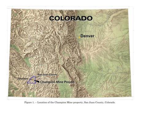
The property lies within the Silverton topographic quadrangle (USGS 7½-minutetopographic map series, 37107-G6-TF-024, 1955) occupying the east and northeast flanks of Sultan Mountain (maximum elevation 13,368 ft., 4,075m). The Champion Mine property is adjacent to the town limits of Silverton and extends southward for 1.3 miles (2.09 km). U.S. Highway 550 crosses the property from Silverton southward along the route of the Animas River. See figure 1.
Property Description
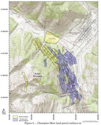
Sixty-nine patented land parcels, both lode and mill site claims, make up the Champion Mine Project. A total area of 580.842 acres (0.908 sq. mi., 235.059 ha.) of subsurface and mineral rights is included in the property. Of this amount, 349.005 acres (0.545 sq. mi., 141.238 ha.) of surface rights is included. Following is a list of claims and associated rights.
3
Mineral and Surface Rights:
| Claim Name | US Survey No. | Patent No. | Acres | |||||||||
| Belle Conklin | 899 | 7431 | 10.330 | |||||||||
| Chicago | 16046 | 39721 | 6.680 | |||||||||
| Florence R | 18291 | 47075 | 0.900 | |||||||||
| Indiana | 14696 | 35280 | 10.000 | |||||||||
| Keystone | 19674 | 817450 | 10.304 | |||||||||
| Last Chance | 16610 | 40216 | 3.934 | |||||||||
| Little Maud | 498 | 23826 | 7.900 | |||||||||
| Overlook | 19674 | 817450 | 3.512 | |||||||||
| Sam E | 19674 | 817450 | 5.661 | |||||||||
| Sultan | 15154 | 38486 | 6.806 | |||||||||
| Thunder | 19674 | 817450 | 5.650 | |||||||||
| Aletha | 670 | 14433 | 6.000 | |||||||||
| Blue Jay | 14322 | 35422 | 1.698 | |||||||||
| Bryan | 19674 | 817450 | 4.182 | |||||||||
| Champion | 14696 | 35280 | 10.000 | |||||||||
| Champion No. 2 | 14696 | 35280 | 10.000 | |||||||||
| Cocktail | 446 | 6021 | 7.000 | |||||||||
| Emblem | 487 | 6165 | 10.000 | |||||||||
| Empire | 647 - A | 6336 | 10.000 | |||||||||
| Empire M.S. | 647 - B | 6336 | 5.000 | |||||||||
| Empire Tunnel | 14806 - A | 36113 | 10.300 | |||||||||
| Excelsior | 13757 - A | 33980 | 10.312 | |||||||||
| Fairview | 19674 | 817450 | 10.282 | |||||||||
| Florence R Fraction | 18291 | 47075 | 13.858 | |||||||||
| Fraction | 14328 | 36053 | 3.505 | |||||||||
| Great Central | 650 | 10757 | 4.200 | |||||||||
| Great Republic | 649 - A | 28836 | 8.200 | |||||||||
| Great Republic M.S. | 649 - B | 28836 | 5.000 | |||||||||
| Hawkeye | 486 | 6030 | 8.700 | |||||||||
| Hercules | 648 - A | 6337 | 7.700 | |||||||||
| Hercules M.S. | 648 - B | 6337 | 5.000 | |||||||||
| Ida The Maid | 1807 | 11163 | 7.640 | |||||||||
| Jennie Parker | 207 | 3793 | 6.100 | |||||||||
| Justice | 19674 | 817450 | 3.679 | |||||||||
| Little Dora | 981 | 7636 | 7.500 | |||||||||
| Little Mollie | 17833 | 45022 | 8.906 | |||||||||
| Melville M.S. | 652 - B | 6348 | 5.000 | |||||||||
| Neglected | 18291 | 47075 | 10.310 | |||||||||
| Oregon | 14696 | 35280 | 10.000 | |||||||||
| Seal | 488 | 7574 | 10.300 | |||||||||
| Silverton Park | 14806 - A | 36113 | 10.300 | |||||||||
| Silverton Park M. S. | 14806 - B | 36113 | 3.973 | |||||||||
| Smith | 17849 - A | 45020 | 10.331 | |||||||||
| Smith M. S. (less surface rights) | 17849 - B | 45020 | 4.522 | |||||||||
| Stadaconda | 2624 | 23275 | 0.631 | |||||||||
| State Street | 13757 | 33980 | 10.331 | |||||||||
| Victoria | 1051 - A | 8345 | 7.300 | |||||||||
| Victoria M. S. | 1051 - B | 8345 | 5.000 | |||||||||
| Water Witch | 651 | 5.816 | 4.100 | |||||||||
| Whitman M.S. | 1051 - B | 36007 | 4.990 | |||||||||
| Total Acres | 353.527 | |||||||||||
4
Mineral rights only:
| Claim Name | US Survey No. | Patent No. | Acres | |||||||||
| Arlington | 1777 | 11306 | 10.331 | |||||||||
| Eunice | 8532 | 24683 | 10.331 | |||||||||
| North Star No. 2 | 734 | 7482 | 10.33 | |||||||||
| Protection | 5048 | 20377 | 7.275 | |||||||||
| Wheal Alfred | 5046 | 18677 | 6.282 | |||||||||
| Tuscarora | 14323 | 36051 | 10.321 | |||||||||
| Merrimac | 18713 | 96575 | 8.61 | |||||||||
| Monitor | 18713 | 96575 | 8.61 | |||||||||
| Blanche Placer | 2260 | 16574 | 63.59 | |||||||||
| Winthrop | 1776 | 11035 | 10.33 | |||||||||
| Avalanche | 663 | 8186 | 8.67 | |||||||||
| Chief | 692 | 19102 | 10.33 | |||||||||
| Cook | 17848 - A | 45021 | 8.189 | |||||||||
| Crown Point | 5047 | 18678 | 5.654 | |||||||||
| Gladstone | 19695 | 611472 | 8.118 | |||||||||
| North Star | 271 | 24221 | 10.3 | |||||||||
| PI | 15529 | 37353 | 10.124 | |||||||||
| President | 2229 | 23278 | 10.33 | |||||||||
| Teller | 1852 | 24215 | 9.59 | |||||||||
| Total Acres | 227.315 | |||||||||||
Figure 2 following show the locations of the claims.1
_____________________________________
Accessibility, Climate, Infrastructure
The Champion Mine property is accessed from U.S. Highway 550 (the Million Dollar Highway) which crosses several of the Champion Mine land parcels. This all-weather road connects Silverton to Durango to the south (45.5 miles, 73.2 km) and to Ouray to the west and north (48 miles, 77 km).
The property is immediately southwest of Silverton, Colorado at an elevation substantially the same as that of the town, 9,305 ft. (2,836 m) and therefore will experience similar temperatures and snowfall. On the average, freezing temperatures are not experienced daily only in July and August and that during these months the average daily high temperature is only about 70°F (21°C). Annual snowfall averages 154.8 in. (3,932 mm) and only the months of May through September are generally snow free. Snow slides are common in the Animas River Valley north of Silverton and in the Mineral Creek valley west of Silverton, but Highway 550 is kept open year ‘round.
Existing infrastructure at Silverton consists of the narrow gauge railway and the paved all-weather highway (Hwy. 550). Electrical power is supplied by a substation in Silverton, and industrial power (25kV) is available within 1 mile (1.6 km) of the project site. Cellular communication and landline communication facilities are available in Silverton. Water is available from the Animas River and from the City of Silverton or from shallow wells in the valley floor. Mine workings in the hillsides produce moderate to large quantities of water, sometimes of very poor quality due to the mineralization encountered in the mine workings. No treated water supply is available at the Champion Mine site and no sewerage treatment facilities are present there.
History2
The Champion Mine is a consolidation of seven previously operated mining properties established over the first 60 years of the district. It includes the Alletha, Champion, Gladstone, Hercules, Jennie Parker, Little Dora, and North Star mines.
The Jennie Parker Mine, located on the Jennie Parker vein, was developed in the late 1870's through the Jennie Parker shaft and later through the Jennie Parker tunnel. After 1900, the Jennie Parker vein was mined through the Empire tunnel located near the base of Sultan Mountain as part of the Hercules Consolidated Mining Company. The mine ceased operations during the financial panic of 1907.
The Alletha Mine is located on the Alletha vein and was initially mined in the1880's through the Alletha tunnel and an internal winze. It was re-opened in the1930's and was mined through the Thunder tunnel located lower on Sultan Mountain in Deadwood Gulch. Ore was transported over an aerial tramway to an ore bin on a rail siding beside the Animas River. The Alletha was closed by the Gold Mine Closure Act of 1942.
The Hercules Mine, located on the Hercules vein, was developed in the 1880'sthrough the Ricker shaft and later through the Ricker tunnel. In the 1890's, the Boston tunnel was driven lower on Sultan Mountain to access ore below the Ricker tunnel level. The Hercules Mill was constructed at the base of the mountain and received ore through an inclined surface tramway. Another lower tunnel, the Empire tunnel, was driven in the early 1900's to access ore in the Hercules vein.
The Little Dora Mine, located on the Little Dora vein, was initially developed through the Blue Jay shaft, the Hawkeye shaft, and the Little Dora shaft in the 1880's.It was then mined through the Boston tunnel and still later through the Empire tunnel and below the Empire tunnel level through the Little Dora winze. The Little Dora Mine was closed during the financial panic of 1907, but was operated for a time on a limited basis in the 1950's.
The Champion Mine was originally developed in 1900 in conjunction with a copper-silver smelter located on the north side of Silverton, the Kendrick-Gelder Smelter. Ore from the Champion vein was transported by aerial tramway that connected the No. 4Level of the Champion Mine to an ore bin located on a rail siding next to the Animas River.
In 1907, the Pittsburgh tunnel was completed at the base of Sultan Mountain and was connected through a 500-foot raise to the No. 4 Level. Both the mine and the smelter were shut down during the financial panic of 1907.
___________________________________
2 Page 15 of Preliminary Technical Report, Champion Mine Project (Sultan Mountain Mine), San Juan County, Colorado, by Lee R. Rice, PE, Lakewood, Colorado, June 24, 2013
6
The Gladstone Mine was located in the 1880's with initial access and production through the Gladstone Tunnel located high on the northern slope of Sultan Mountain at an elevation of approximately 9,967 ft. (3,038 m). The cost and difficulty of hoisting ore from below this level caused the operators to drive the Sultan Tunnel elevation9,608 ft., 2,928 m) in 1900. Production from the Gladstone Vein (an extension of the Jennie Parker-Hercules veins) continued to the Sultan Tunnel level.
The North Star Mine was located in 1876 and was initially developed by adits high in Belcher Gulch at an elevation of approximately 9,927 ft. (3,025 m). The development of crosscut adits from the Mineral Creek drainage on the north slope of Sultan Mountain permitted extensive production from the North Star Vein and by 1881, the North Star Mine became the most productive mine in San Juan County. The lowest adit, the No. 7 Level crosscut was completed in 1890 and permitted production from the North Star Vein down to that level, approximately 9,390 ft. (2,862 m). Increased costs due to hoisting ore from below the 9,390-ft. level and of pumping water from lower levels of the mine in conjunction with decreased silver prices forced the mine to cease operations in 1899.
Production from the Crown Point-Wheal Alfred Vein, a structure nearly parallel to the North Star Vein and from the Dalsant Stope was carried out from 1892 until 1927.
Geological Setting and Mineralization
Silverton and the Champion property lie within a zone of prominent Laramide uplift constituting the San Juan Mountains. Tertiary-Paleocene period volcanism on the Uncompahgre and San Juan uplifts gave rise to an extensive range of mountains known as the San Juan volcanic field. The type of volcanism that created the San Juan volcanic field created a number of large to very large calderas.
The Champion property is situated on the south rim of the Silverton Caldera in an Oligocene age quartz monzonite intrusive, the Sultan Mountain Stock. Extensive fracturing of the intrusive stock occurred at a later time along with pervasive propylitic alteration by hydrothermal fluids and the emplacement of vein mineralization. South of the Sultan Mountain Stock and peripheral to the land parcels, Precambrian, Paleozoic, and Mesozoic metamorphic and sedimentary rocks are exposed. These rocks also have been extensively fractured and altered and contain mineralized vein structures.
The veins of the Sultan Mountain Stock and south of the Sultan Mountain Stock consist of base metal sulfides and arsenosulfides with accompanying minor precious metals in a quartz and minor carbonate mineral gangue. The predominant base metal in these veins is lead.
Surface and groundwater disturbances or contamination issues due to historical mining activities
The Champion mine has several historic adit sites that created surface mine waste piles containing varying amounts of sulfide minerals that could contribute to water quality degradation of surface water from stormwater run-off. Only five adit sites are of sufficient size to contribute measurable water quality impacts to the Animas River and its tributaries. These issues will need to be addressed through the Stormwater Discharge Permit process and by final site reclamation as defined by the Mined Land Reclamation Permit.
The Champion, Little Dora and North Star #7 adits discharge varying flows of water from underground sources. These discharges will require a Water Quality Discharge Permit and may require on-going treatment to meet water quality discharge standards.
7
Exploration
A summary of past exploration at the property includes:3
The Champion, Hercules, Jennie Parker, and Little Dora mines were closed in1907, approximately six years before the introduction of core drilling in the mining industry in 1913. Some work was completed in the Little Dora Mine in the 1950's, but records of that work and any exploration results from that effort have not been recovered.
Many of the properties in the area were gradually consolidated by Warren Prosser in the 1940's and 1950's and were purchased by Sultan Mountain LLC in 1974. P & G Mining, Inc., conducted an extensive effort from 1983 to 1987 to map and sample all of the properties now constituting the Champion including the Gladstone and North Star Veins as well. P & G re-entered the workings and refurbished some of the workings and facilities during the period from 1983 to 1987. Much of the information has been derived from the surviving maps and plans of this work effort.
The access to older workings and the drifting performed in this work program provided excellent measurements and vein material assays, but P & G did not perform any exploration drilling to test for additional vein structures west of the Champion Vein or southwest of the Jennie Parker - Hercules - Gladstone Vein and no exploration drilling was performed to determine the extent of the known vein systems below the Pittsburgh Tunnel level.
A detailed exploration plan has not been developed at this time.
Mineral Reserve Estimates
The amount of information available at this stage of mine development is insufficient to prepare a reserve estimate for the property.
Project Infrastructure
The Champion property is located approximately one mile (1.6 km) south of the town of Silverton, Colorado, and is accessed by San Juan County Road 31. The mine workings will be accessed through the Little Dora Adit located adjacent to Silverton and through the Pittsburgh Adit located south of town. Both adits are adjacent to CR 31 and are connected underground via prior development drifts.
Initially, ore will be shipped from the Pittsburgh Adit on CR 31 to Colorado Route110 in Silverton and then on San Juan County Road 2 to Howardsville and the Pride of the West Mill, a distance of 6.42 miles (10.3 km). Mill tailings for backfill in the mine will be trucked over the return route. As development proceeds, ore will ship from the Little Dora Adit instead of the Pittsburgh Adit.
Concentrates from the Pride of the West Mill will be trucked via CR 2 and Route 110 to Silverton and then over US Highway 550 (Million Dollar Highway)approximately 60 miles (97 km) to the rail head at Montrose where the materials will be shipped by rail to the appropriate smelter.
This area is served by a cooperative electric utility the San Miguel Power Association, Inc. Industrial power (25 kV) is available within ¼ mile (400 m) of the Little Dora Adit. An electrical substation is planned for the mine site converting the25 kV transmission line power to 4,160 V/480 V secondary electrical service for the mine. All underground electrical needs of the property will be supplied from a single 4,160 V distribution line run underground through the Little Dora Adit. Substations providing 480 V underground will be located as needed. The Little Dora substation will power an electrical air compressor located in an existing building next to the county road and the Little Dora Adit. Compressed air will be piped underground from this location. Phone service will be extended via land line to the facilities adjacent to the Little Dora Adit. Cell phone coverage is available on the surface at both the Little Dora and the Pittsburgh adits.
_______________________________________
3 Page 32 of Preliminary Technical Report, Champion Mine Project (Sultan Mountain Mine), San Juan County, Colorado, by Lee R. Rice, PE, Lakewood, Colorado, June 24, 2013
8
Mine offices and a change room facility will be constructed adjacent to the Little Dora Adit. A mechanical shop and warehousing space will be located in the existing building that will house the air compressor. Some refurbishment and improvement of this building will be required. Maintenance support facilities also will be provided by the main maintenance shop located at the Pride of the West Mill.
Environmental Studies, Permitting and Social or Community Impact
All mining activities and construction or refurbishment of surface facilities will be conducted on private land that has historically been used for mining purposes. No environmental studies are required. Water sampling on a daily or weekly basis for quality monitoring of the Animas River both upstream of the property and downstream from the operations is recommended.
Permitting
A number of permits will be required pursuant to the reopening of the Champion Mine and the conduct of mining operations:
| 1. | Air Quality Permit – Colorado Department of Public Health and Environment, Air Quality Control Division. Fugitive dust emissions from mining operations including ventilation fan discharges from the mine are covered by this permit. Dust from truck haulage on the public highway is not considered in this permit. |
| 2. | Land Use Permit – San Juan County - A land use permit issued by San Juan County is required. Mining is a “Use-by-Right” in the county. Permit issues will address the use and maintenance of public roads and mitigation of natural hazards. Due to the proximity of the Champion property to Silverton, it lies within anoint town-county interest zone and will require comment from both Silverton and County for approval. Additional issues to be addressed will be traffic patterns, noise, and visual impact. The proposed mining plan will address these issues. |
| 3. | Mined Land Reclamation Permit – Colorado Division of Reclamation, Mining and Safety. The Mined Land Reclamation Permit (MLRP) covers the life of the mine and requires approval of the basic overall mine operating plan and a reclamation plan. It includes a site-specific financial warranty for reclamation and eventual closure of the mine. |
| 4. | Notice of Intent – Colorado Division of Reclamation, Mining and Safety. The Notice of Intent (NOI) to conduct prospecting activities is needed to conduct the work necessary to re-enter the Champion Mine, to conduct initial mapping and sampling, to assess underground conditions, and to conduct drilling operations. This permit requires a reclamation bond which can be combined with the final Mined Land Reclamation Permit bonding requirement. This permit allows initial work to be conducted while the Mined Land Reclamation Permit is pending. It includes a site-specific financial warranty for work to be conducted under the NOI. |
| 5. | NPDES Mine Water Discharge Permit – Colorado Department of Public Health and Environment, Water Quality Control Division. An NPDES discharge permit may be required for a small (approximately 30gallons per minute) historic discharge from the main adit. Existing maps of the workings indicate that a single fracture beyond the ore zone may be responsible. Initial work underground will investigate the possibility of grouting this source thereby eliminating the need for this permit. |
| 6. | Stormwater Discharge Permit – Colorado Department of Public Health and Environment, Water Quality Control Division. A Stormwater Discharge Permit will be required. The permit will address stormwater runoff and associated management facilities from the active mining areas at the Pittsburgh and Little Dora adits. The permit will be updated from time to time for compliance with changes in site conditions. |
9
Adjacent Properties
Property adjacent to the Champion property is public land administered by the U.S. Bureau of Land Management. There exist some inholdings of patented lands previously used for mining but currently inactive. These nearby properties occupy potentially viable mineral vein deposits and may be future acquisition targets because of access provided by the Pittsburgh, Little Dora, and North Star adits.
Silver Wing Mine Project
Summary
The Silver Wing Mine Project is a polymetallic mine production project located on private land holdings in one of the richest and most prolific metallogenic provinces on earth, the Colorado Mineral Belt. Metal production in the area has been more or less continuous since the initial deposit discoveries in 1874 and the mining boom that followed. Deposits locally are part of an enormous system of veins associated with the Silverton Caldera and covering an area greater than 230 square miles (601 square kilometers).
In December 2012, the Company completed a Preliminary Technical Report for the Silver Wing Project located in San Juan County, Colorado. The report was prepared by Mr. Lee R. Rice, who is President and CEO of Colorado Goldfields Inc. The report was prepared in accordance with SEC Guideline 7 criteria.
Terms, Conditions, Royalties and Nature of Ownership
Should the contracts to purchase the Silver Wing and Champion Mines be renegotiated, additional final details shall be added here.
Property Location
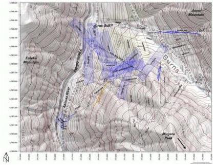
The Silver Wing property is located in the San Juan Mountains in the Eureka Mining District, San Juan County, Colorado (Figure 1.). It lies within the Handies Peak topographic quadrangle (USGS 7½-minute topographic map series, 37107-H5-TF-024, 1955) on the western flank of Niagara Peak in the valley of the Animas River, approximately 200 meters (650 ft.) south of Burns Gulch.
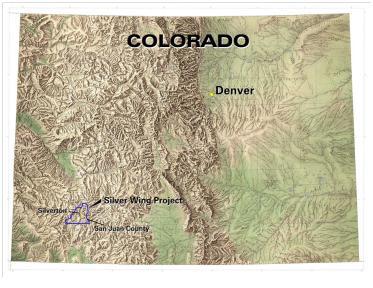
Figure 1. – Location of the Silver Wing property, San Juan County, Colorado.
10
The property is 3.8 km (2.4 mi.) south-southeast of the abandoned townsite of Animas Forks and 3.1 km (2.0 mi.) north-northeast of the abandoned townsite of Eureka. It is 15.7 km (9.8 mi.) northeast of Silverton along County Road 2. See figure 2.
Property Description
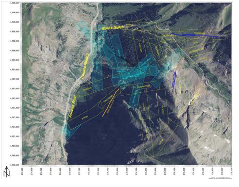
The Silver Wing property consists of 10 patented claims. These include all surface and mineral rights with the exception of the Silver Wing claim which does not include the surface rights. The claims constituting this property are shown shaded in Figure 2 along with adjacent and overlapping properties. A shaded relief and topographic map of the property area is shown in Figure 3.4
4 Page 5 and 6 of Preliminary Technical Report, Silver Wing Project, San Juan County, Colorado, by Lee R. Rice, PE, Lakewood, Colorado, December 24, 2012.
11
Silver Wing land parcel outline (shaded) on shaded relief topographic map.
Individual claim descriptions are listed below showing their mineral survey number and the approximate size of the parcel in acres.
Silver Wing land parcels.
| Parcel Name | USMS Survey No. | Area (acres) | ||||||
| Byron Mill Site Claim | 419-B | 2.6 | ||||||
| Cynic Lode Mining Claim | 126 | 10.3 | ||||||
| Denver Belle Lode Claim | 132 | 6.31 | ||||||
| Edward Lode Claim | 210 | 10.33 | ||||||
| La Plata Lode Claim | 19003 | 5.116 | ||||||
| Manitou Lode Mining Claim | 125 | 9.00 | ||||||
| Rob Roy Lode Claim | 499 | 6.5 | ||||||
| Rocky Mountain Chief Lode Claim | 131 | 2.8 | ||||||
| Silver Wing Lode Claim – mineral rights only | 70 | 9.97 | ||||||
| Whale Lode Mining Claim | 127 | 8.28 | ||||||
| 71.206 | ||||||||
Accessibility, Climate, Infrastructure
Accessibility
The Silver Wing property is accessed by San Juan County Road 2. The road is unpaved from a few miles north of Silverton, but is maintained by county crews. Due to the lack of activity in the area, the road is only kept open as far as the Eureka townsite during the winter months. A narrow-gauge rail line runs from Durango to Silverton providing some freight service, but it is primarily a tourist facility and provides only irregular service during winter months. The nearest full service rail facility is located in Montrose, 91.6 km (56.9 miles) from Silverton via highway 550. Although the segment of the Million Dollar Highway (550) connecting Silverton to Durango is only 73.2 km (45.5 miles) in length, there is no railhead connecting with the nation’s railways in Durango.
12
Climate
The property is located 15.7 km (9.8 mi.) Northeast of Silverton, Colorado at an elevation of approximately 3,210 m (10,500 ft.) and therefore will have lower temperatures, more snowfall, and longer snow duration than Silverton. Records show that on the average, freezing temperatures are not experienced daily only in July and August and that during these months the average daily high temperature is only about 70°F (21°C). Annual snowfall averages 154.8 in. (3,932 mm) in Silverton and only the months of May through September are generally snow free. Snow slides are common in the Animas River Valley north of Silverton often blocking County Road 2. Blockages may last for only a few hours when access is needed.
Infrastructure
Existing infrastructure in the Animas River Valley northeast of Silverton consists only of the county-maintained road. Transportation is solely by unpaved county road. Electrical power is supplied by a substation in Silverton, and industrial power (25 kV) extends as far as the former townsite of Eureka, but is operated as only a single phase.. Household power (110 v AC) extends further north for local residents and summer homes, but power lines do not extend into the Silver Wing area. Communication lines parallel the extent of electrical power availability. Cell tower coverage is available only within a few miles of Silverton. Water is available from the Animas River or from shallow wells in the valley floor. Mine workings in the hillsides produce moderate to large quantities of water, sometimes of very poor quality due to the mineralization encountered in the mine workings. No treated water supply is available at the and no sewerage treatment facilities are present there.
History
The table below summarizes the history of operations at the Silver Wing property.5
| Date | Production (Tons of Ore) | Description of Operation |
| 1875 | unknown amount | Initial production from upper workings, start Silver Wing Tunnel |
| 1895 | unknown amount | Completion of the Silver Wing Tunnel |
| 1898 | unknown amount | Construction of the Silver Wing Mill |
| 1899 | unknown amount | Mill completed, operation unsuccessful |
| 1906-07 | 4000 tons | shipped to smelter |
| 1909 | Mine ceased operations pending outcome of lawsuit | |
| 1917 | Property leased to Silver Bell (no production) | |
| 1941 | Exploration program planned and approved but not executed | |
| 1945 | Purchase of the property by E. T. Chase | |
| 1957 | Leased by Kirk-Hudson Mines, Ltd. | |
| 1959 | Dale Carlson reopens Silver Wing Tunnel | |
| 1962 | Silver Wing Mining Corporation reopens mine | |
| 1963 | 376.7 tons | shipped to smelter |
| 1964 | 12,529.1 tons | shipped to smelter |
| 1965 | 6,251.4 tons | shipped to smelter |
| 1966 | 723.5 tons | shipped to smelter, operations suspended |
| 1967 | I.M.E. exploration sampling and drilling, property idled | |
| 1982 | Tax sale of property | |
| 1992 | Acquisition of property by Silver Wing Company, Inc. |
________________________________
5 Page 18-19 of Preliminary Technical Report, Silver Wing Project, San Juan County, Colorado, by Lee R. Rice, PE, Lakewood, Colorado, December 24, 2012.
5 Page 18-19 of Preliminary Technical Report, Silver Wing Project, San Juan County, Colorado, by Lee R. Rice, PE, Lakewood, Colorado, December 24, 2012.
13
Geological Setting and Mineralization
Silverton, Colorado and the Silver Wing mine lie within a zone of prominent Laramide uplift constituting the San Juan Mountains. Tertiary-Paleocene period volcanism on the Uncompahgre and San Juan uplifts gave rise to an extensive range of mountains known as the San Juan volcanic field. The type of volcanism that created the San Juan volcanic field created a number of large to very large calderas.
The Silver Wing mine is situated on the southeast rim of the Silverton Caldera in rocks of the Silverton Volcanics. Extensive fracturing of the volcanics occurred at a later time along with pervasive propylitic alteration by hydrothermal fluids and the emplacement of vein mineralization.
The extensive network of veins peripheral to the Silverton Caldera in the area of the Silver Wing consist of silver-bearing base metals and/or gold-bearing pyrite and chalcopyrite occurring in quartz, barite, and carbonate mineral gangues. The ore bodies at the Silver Wing are polymetallic base metal sulfide veins with minor precious metal and some rare metal content. These veins are long, often connecting with other veins of differing strike and generally are almost vertical.
Surface and groundwater disturbances or contamination issues due to historical mining activities
The Silver Wing mine has several historic adit sites that created surface mine waste piles containing varying amounts of sulfide minerals that could contribute to water quality degradation of surface water from stormwater run-off. Only the main Silver Wing adit is of sufficient size to contribute measurable water quality impacts to the Animas River. These issues will need to be addressed through the Stormwater Discharge Permit process and by final site reclamation as defined by the Mined Land Reclamation Permit.
The main Silver Wing mine adit discharges approximately 20 gallons per minute of water from underground sources. This discharge will require a Water Quality Discharge Permit and may require on-going treatment to meet water quality discharge standards.
Exploration
A summary of past exploration includes:6
Following the purchase of the Silver Wing-Frederico group of claims by E. T. Chase and sons in the mid 1940's, some diamond drilling was performed at the Silver Wing mine and good copper ore was reported encountered; however, operations ceased in the early 1950's and no record of the exploration work is available.
Kirk-Hudson Mines Ltd. of Ontario, Canada, leased the property in 1957 and reopened the Silver Wing Tunnel. They completed six core holes across the entire vein system before closing their U.S. operations.
In 1959 Dale Carlson and a group of Albuquerque businessmen founded Silver Wing Mining Corporation and performed extensive mapping and sampling of the workings.
Exploration activities at the mine were continued under contract by International Mineral Engineers in 1967. Channel sampling was undertaken and all of the underground workings were mapped; several hundred feet of diamond drill holes and percussion drill long holes were completed and an ore reserve estimate was prepared.
A detailed exploration plan has not been developed at this time.
____________________________
6 Page 37 of Preliminary Technical Report, Silver Wing Project, San Juan County, Colorado, by Lee R. Rice, PE, Lakewood, Colorado, December 24, 2012.
6 Page 37 of Preliminary Technical Report, Silver Wing Project, San Juan County, Colorado, by Lee R. Rice, PE, Lakewood, Colorado, December 24, 2012.
14
Mineral Reserve Estimates
The amount of information available at this stage of mine development is insufficient to prepare a reserve estimate for the Silver Wing.
Project Infrastructure
The Silver Wing Mine is located approximately 10 miles (16 km) from Silverton on County Road 2. This highway is a two-lane all weather road; it is paved for about 2 miles (3.2 km) outside of Silverton and then proceeds as a good quality unsurfaced road suitable for haul trucks for the remainder of its length up the Animas Valley. The road to the Silver Wing property leaves County Road 2 at an elevation of approximately 10,429 feet (3,179 m) and parallels County Road 2 for 780 feet (240 m) and then turns east, crossing the Animas River on the Silver Wing’s highway bridge and then heading south, ending at the load out a total distance of 1,210 feet (368 m) from County Road 2. Ore will be hauled by truck from the Silver Wing load out along County Road 2 a total of 5.7 miles (9.1 km) to the Pride of the West Mill. Seven avalanche chutes cross County Road 2 in the interval from the Silver Wing to the Pride of the West Mill. An avalanche control plan will be utilized to maintain safety and minimize haulage interruptions due to avalanches. Concentrates from the Pride of the West Mill will be trucked via County Road 2 to Silverton and then over US Highway 550 (Million Dollar Highway) approximately 60 miles (97 km) to the rail head in Montrose where they will be shipped to the appropriate smelter by rail.
Electrical power is not available at the mine site and will have to be supplied initially by a 150 kW generator. This area is served by a cooperative electric utility, the San Miguel Power Association, Inc. The project plan includes extending an existing 25 kV line from its present terminus at the abandoned townsite of Eureka two miles (3.2 km) to the Silver Wing Mine. An electrical substation is planned for the mine site converting the 25 kV transmission line power to 4,160 V/480 V secondary electrical service for the mine. A cost estimate for this transmission line extension has been provided by the electric utility.
Electrical power at the mine site will be supplied by the substation. All underground electrical power needs of the Silver Wing Mine will be supplied by a 4,160 V line to be extended underground from the substation through the mine adit. Electrical substations (4,160 V/480 V) will be situated underground as needed. Compressed air will be piped into the Silver Wing Mine through the Silver Wing Tunnel portal from an electrically-powered compressor located in a new building on the mine site. Phone service will be extended via land line to the mine site and will be supplied to each building on the site.
Environmental Studies and Permitting
Environmental Studies
All mining activities and construction or refurbishment of surface facilities will be conducted on private land that has historically been used for mining purposes. No environmental studies are required. Water sampling on a daily or weekly basis for quality monitoring of the Animas River both upstream of the property and downstream from the operations is recommended.
Permitting
A number of permits will be required pursuant to the reopening of the Silver Wing Mine and the conduct of mining operations:
| 1. | Air Quality Permit – Colorado Department of Public Health and Environment, Air Quality Control Division Fugitive dust emissions from mining operations including ventilation fan discharges from the mine are covered by this permit. Dust from truck haulage on the public highway is not considered in this permit. |
| 2. | Land Use Permit – San Juan County A land use permit issued by San Juan County is required. Mining is a “Use-by-Right” in the county. Permit issues will address the use and maintenance of public roads and mitigation of natural hazards. |
15
| 3. | Mined Land Reclamation Permit – Colorado Division of Reclamation, Mining and Safety The Mined Land Reclamation Permit (MLRP) covers the life of the mine and requires approval of the basic overall mine operating plan and a reclamation plan. It includes a bond for reclamation and eventual closure of the mine. |
| 4. | Notice of Intent – Colorado Division of Reclamation, Mining and Safety The Notice of Intent (NOI) to conduct prospecting activities is needed to conduct the work necessary to re-enter the Silver Wing Mine, to conduct initial mapping and sampling, to assess underground conditions, and to conduct drilling operations. This permit requires a reclamation bond which can be combined with the final Mined Land Reclamation Permit bonding requirement. This permit allows initial work to be conducted while the Mined Land Reclamation Permit is pending. It includes a site-specific financial warranty for work to be conducted under the NOI. |
| 5. | NPDES Mine Water Discharge Permit – Colorado Department of Public Health and Environment, Water Quality Control Division An NPDES discharge permit may be required for a small (approximately 30 gallons per minute) historic discharge from the main adit. Existing maps of the workings indicate that a single fracture beyond the ore zone may be responsible. Initial work underground will investigate the possibility of grouting this source thereby eliminating the need for this permit. |
| 6. | Stormwater Discharge Permit – Colorado Department of Public Health and Environment, Water Quality Control Division the Silver Wing Mine has an existing Stormwater Discharge Permit in effect. This permit will be updated from time to time to adjust for changes in conditions at the mine site. |
Adjacent Properties
Property adjacent to the Silver Wing is public land administered by the U.S. Bureau of Land Management. There exist numerous inholdings of patented lands previously used for mining but currently inactive. No adjacent or nearby private lands are in mineral production at this time.
16
The King Solomon Mine Project
Terms, Conditions, Royalties and Nature of Ownership or Lease
On September 18, 2009, the Company entered into a lease with an option to purchase the King Solomon Mine, in consideration for which the Company issued 10,000 pre-split (20 post-split) shares of restricted Class A Common Stock valued at $17.50 pre-split ($8,750 post-split) per share (the quoted market price on the date the Company entered into the agreement and obtained the mining rights) totaling $175,000. The lease/option was for a period of three years. The stock was restricted from sale during the initial term of the lease. The lease/option automatically renewed and continued so long as ores, minerals, or metals are produced or sold. The lease granted the Company the exclusive right to perform exploration, mining, development, production, processing or any other activity that benefits the leased premises and required a minimum work commitment of $50,000 to be expended by the Company for each successive three year term during the term of the lease/option. The lease also required the Company to pay the lessor a 3.5% NSR on all mineral bearing ores. In addition, before royalties are computed, 5% of the value of NSR on all materials produced and sold from the mining property must be deducted for the purpose of a contingency reclamation reserve fund for paying potential reclamation costs, up to $200,000. The Company has the sole and exclusive option to purchase all of lessor's right, title and interest in the property for a total purchase price of $1,250,000, payable in cash or other cash equivalents as mutually agreed by the lessor and the Company.
On October 11, 2012, the Company entered into a three-year extension and renewal of mining lease with option to purchase, effective September 18, 2012, for which the Company issued 250,000 pre-split (500 post-split) shares of restricted Class A Common Stock, with an additional 25,000 pre-split (50 post-split) shares to be issued upon each yearly anniversary. The mining lease with an option to purchase expires on September 18, 2015. The Company recorded $62,500 as mining rights and claims based upon the share price on the date of the transaction of $0.25 pre-split ($125 post-split) per share. The stock is restricted for two years. The original work commitment outlined above is considered fulfilled. All other terms and conditions of the original lease remain in effect.
As part of the Lease/Options for the King Solomon Mine, the Company granted a Net Smelter Royalty (“NSR”), of 3.5%. Should the contracts to purchase the Silver Wing and Champion Mines be renegotiated, both properties carry a 5% NSR payable to the prior owners. In addition, historical royalties may be asserted by third-parties which are currently unknown to us.
Property Location
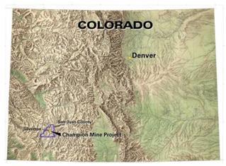
The King Solomon Mine is located on the southern flank of King Solomon Mountain, Colorado just a few hundred yards up the mountain from the first discovery of gold in the San Juan Mountains in Little Giant Basin. Opened in 1876, the mine was in production until 1883. The King Solomon is within San Juan County, Colorado and located within 5 miles of the Champion Mine described above and shown within the purple area on the map below.
17
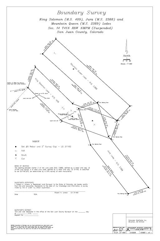
Property Description
The property consists of a total of 94.39 acres. The claims and acreage are listed below.
| Claim Description | Acres | |||
| King Solomon | 7.33 | |||
| Mountain Queen | 10.31 | |||
| Jura | 10.33 | |||
| Group total | 27.97 | |||
| Bowery | 6.88 | |||
| Contra-Costa | 9.92 | |||
| Dolly Varden No. 2 | 8.86 | |||
| Ext & Combination | 10.33 | |||
| Group total | 29.11 | |||
| Master Delorosa | 10.3 | |||
| Hungry Joe | 10.3 | |||
| Group total | 20.6 | |||
| Galena Mill Site | 4.207 | |||
| Galena #2 | 5.623 | |||
| Group total | 9.83 | |||
| Total acres | 94.39 | |||
A Boundary Survey map follows.
18
19
Accessibility, Climate, Infrastructure
Accessibility
The King Solomon property is accessed by San Juan County Road 21A and the San Juan County Road system for a total of approximately 4 miles from Silverton. The San Juan County road system is unpaved beyond two miles from Silverton, but is maintained by county crews. Due to the lack of activity in the area, the road is only kept open for the first two miles during the winter months. Silverton is accessed by US Highway 550 which is maintained by the Colorado Department of Transportation on a year-round basis.
Climate
The property is located 3.2 km (2.0 miles) East of Silverton, Colorado at an elevation of approximately 3,540 m (11,600 ft.) and therefore will have lower temperatures, more snowfall, and longer snow duration than Silverton. Records show that on the average, freezing temperatures are not experienced daily only in July and August and that during these months the average daily high temperature is only about 70° F (21°C). Annual snowfall averages 154.8 inches (3,392 mm) in Silverton and only the Months of May through September are generally snow free. Snow slides are common on the Animas River Valley north of Silverton often blocking county roads accessing the mine.
Infrastructure
Existing infrastructure in the Animas River Valley northeast of Silverton consists only of the county-maintained road. Transportation is by 2 miles (3.2 km) of paved county road and 2.5 miles (4.0 km) of unpaved county road. Electrical power is supplied by a substation in Silverton, and industrial power (25kv) extends along San Juan County Road 2 within 1.3 miles (2.1 km) of the mine. Communication lines parallel the extent of electrical power availability. Cell tower coverage is available only within a few miles of Silverton. Water is available from the Animas River or its tributaries. Mine workings in the hillsides produce moderate to large quantities of water, sometimes of very poor quality due to the mineralization encountered in the mine workings. No treated water supply is available at the mine and no sewerage treatment facilities are present there.
History
The claims of the King Solomon mine lie within the South Silverton Mining District and were located between 1876 and 1882. Mining of the lead/copper/silver veins occurred as early as 1883 with ore shipped by pack train to local smelters or sampling works. Mining was suspended in the late 1880’s, and no known production has occurred since that time.
Geological Setting and Mineralization
Silverton, Colorado and the King Solomon mine lie within a zone of prominent Laramide uplift constituting the San Juan Mountains. Tertiary-Paleocene period volcanism on the Uncompahgre and San Juan uplifts gave rise to an extensive range of mountains known as the San Juan volcanic field. The type of volcanism that created the San Juan volcanic field created a number of large to very large calderas.
The King Solomon mine is situated on the southeast rim of the Silverton Caldera in rocks of the Silverton Volcanics. Extensive fracturing of the volcanics occurred at a later time along with pervasive propylitic alteration by hydrothermal fluids and the emplacement of vein mineralization.
The extensive network of veins peripheral to the Silverton Caldera in the area of the King Solomon mine consist of silver-bearing base metals and/or gold-bearing pyrite and chalcopyrite occurring in quartz, barite, and carbonate mineral gangues. The ore bodies at the King Solomon mine are polymetallic base metal sulfide veins with minor precious metal content. These veins are generally almost vertical.
20
Surface and groundwater disturbances or contamination issues due to historical mining activities.
The King Solomon mine has two historic adit sites that created small surface mine waste piles containing varying amounts of sulfide minerals that could contribute to water quality degradation of surface water from stormwater run-off. A minor drainage ( ~ 1 gpm) exists at the lower adit. Both storm water run-off from the mine dumps and the discharge of the lower adit appear to of nearly diminimus impact to the surrounding environment. Further investigation will be required to determine if a storm water discharge permit and/or a Water Quality Discharge Permit with or without treatment will be required.
Exploration
A detailed exploration plan has not been developed at this time.
Mineral Reserve Estimates
The amount of information available at this stage of mine development is insufficient to prepare a reserve estimate for the property.
Environmental Studies and Permitting
Environmental Studies
All mining activities and construction or refurbishment of surface facilities will be conducted on private land that has historically been used for mining purposes. No environmental studies are required. Water sampling on a daily or weekly basis for quality monitoring of the Animas River both upstream of the property and downstream from the operations is recommended.
Permitting
A number of permits will be required pursuant to the reopening of the King Solomon Mine and the conduct of mining operations:
| 7. | Air Quality Permit – Colorado Department of Public Health and Environment, Air Quality Control Division Fugitive dust emissions from mining operations including ventilation fan discharges from the mine are covered by this permit. Dust from truck haulage on the public highway is not considered in this permit. |
| 8. | Land Use Permit – San Juan County A land use permit issued by San Juan County is required. Mining is a “Use-by-Right” in the county. Permit issues will address the use and maintenance of public roads and mitigation of natural hazards. |
| 9. | Mined Land Reclamation Permit – Colorado Division of Reclamation, Mining and Safety The Mined Land Reclamation Permit (MLRP) covers the life of the mine and requires approval of the basic overall mine operating plan and a reclamation plan. It includes a bond for reclamation and eventual closure of the mine. |
| 10. | Notice of Intent – Colorado Division of Reclamation, Mining and Safety The Notice of Intent (NOI) to conduct prospecting activities is needed to conduct the work necessary to re-enter the Silver Wing Mine, to conduct initial mapping and sampling, to assess underground conditions, and to conduct drilling operations. This permit requires a reclamation bond which can be combined with the final Mined Land Reclamation Permit bonding requirement. This permit allows initial work to be conducted while the Mined Land Reclamation Permit is pending. It includes a site-specific financial warranty for work to be conducted under the NOI. |
| 11. | NPDES Mine Water Discharge Permit – Colorado Department of Public Health and Environment, Water Quality Control Division An NPDES discharge permit may be required for a small (approximately 30 gallons per minute) historic discharge from the main adit. Existing maps of the workings indicate that a single fracture beyond the ore zone may be responsible. Initial work underground will investigate the possibility of grouting this source thereby eliminating the need for this permit. |
| 12. | Stormwater Discharge Permit – Colorado Department of Public Health and Environment, Water Quality Control Division the Silver Wing Mine has an existing Stormwater Discharge Permit in effect. This permit will be updated from time to time to adjust for changes in conditions at the mine site. |
21
The Pay Day Rage Project
Summary
THE PAY DAY AND RAGE URANIUM CLAIM GROUP IS NOT A MATERIAL PROPERTY FOR THE COMPANY AT THIS TIME.
Terms, Conditions, Royalties and Nature of Ownership
On June 13, 2011, the Company purchased mineral rights to 63 mining claims in the state of Utah. The claims are referred to as The Pay Day and Rage Uranium Claim Group and are located in San Juan County northeast of Monticello, Utah. In consideration for the acquisition of these claims, the Company issued 50,000 pre-split (100 post-split) shares of restricted Class A Common Stock, which had a value of $150,000 on the purchase date, (based on the quoted market price on the date the Company entered into the agreement and obtained the mineral rights). The shares were issued in two blocks of 25,000 pre-split (50 post-split) shares each and are subject to lock-up provisions for periods of one and two years respectively, during which no sales or other conveyances of the shares may be undertaken.
The Company must pay the appropriate annual fee(s) to the Bureau of Land Management to maintain its ownership if these claims. No royalties are associated with these claims.
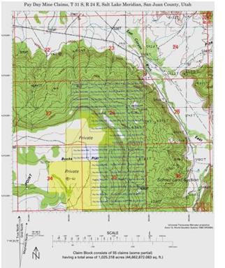
Property Location
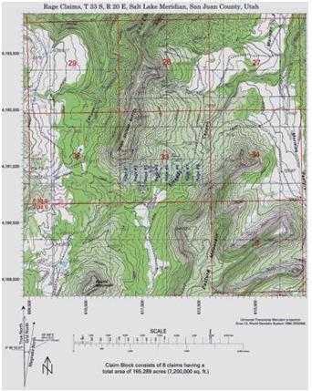
These claim groups consist of 63 (55 Pay Day and 8 Rage) claims. The Pay Day claim group is located in Township 32 South, Range 24 East of the Salt Lake Meridian in Sections 26, 27, 34, and 35, in San Juan County, Utah northeast of Monticello, Utah. The Rage claim group spans Stevens Canyon on the southeast flank of the Seven Sisters Buttes in Township 33 South, Range 20 East of the Salt Lake Meridian in Section 33, San Juan County, Utah.
The claim maps are shown below.
22
Property Description
Claim numbers and type are listed below.
| Serial No. | Claim Name/Number | Type |
| UMC379740 | PAY DAY MINE # 9 | Lode Claim |
| UMC379741 | PAY DAY MINE # 10 | Lode Claim |
| UMC379742 | PAY DAY MINE # 11 | Lode Claim |
| UMC379743 | PAY DAY MINE # 12 | Lode Claim |
| UMC.379744 | PAY. DAY MINE # 13 | Lode Claim |
| UMC379745 | PAY DAY MINE # 14 | Lode Claim |
| UMC379746 | PAY DAY MINE # 15 | Lode Claim |
| UMC379747 | PAY DAY MINE # 16 | Lode Claim |
| UMC379748 | PAY DAY MINE # 17 | Lode Claim |
| UMC379749 | PAY DAY MINE # 18 | Lode Claim |
| UMC379750 | PAY DAY MINE # 19 | Lode Claim |
| UMC379751 | PAY DAY MINE # 20 | Lode Claim |
| UMC379752 | PAY DAY MINE # 21 | Lode Claim |
| UMC379753 | PAY DAY MINE # 22 | Lode Claim |
| UMC379754 | PAY DAY MINE # 23 | Lode Claim |
| UMC379755 | PAY DAY MINE # 24 | Lode Claim |
| UMC379756 | PAY DAY MINE # 25 | Lode Claim |
| UMC379757 | PAY DAY MINE # 26 | Lode Claim |
| UMC379760 | PAY DAY MINE # 29 | Lode Claim |
23
| UMC379761 | PAY DAY MINE # 30 | Lode Claim |
| UMC379762 | PAY DAY MINE # 31 | Lode Claim |
| UMC379763 | PAY DAY MINE # 32 | Lode Claim |
| UMC379764 | PAY DAY MINE # 33 | Lode Claim |
| UMC379765 | PAY DAY MINE # 34 | Lode Claim |
| UMC379766 | PAY DAY MINE # 35 | Lode Claim |
| UMC379767 | PAY DAY MINE # 36 | Lode Claim |
| UMC379768 | PAY DAY MINE # 37 | Lode Claim |
| UMC379769 | PAY DAY MINE # 38 | Lode Claim |
| UMC379770 | PAY DAY MINE # 39 | Lode Claim |
| UMC379774 | PAY DAY MINE # 45 | Lode Claim |
| UMC379775 | PAY DAY MINE # 46 | Lode Claim |
| UMC379776 | PAY DAY MINE # 47 | Lode Claim |
| UMC379777 | PAY DAY MINE # 48 | Lode Claim |
| UMC379778 | PAY DAY MINE # 49 | Lode Claim |
| UMC379779 | PAY DAY MINE # 50 | Lode Claim |
| UMC379780 | PAY DAY MINE # 51 | Lode Claim |
| UMC379781 | PAY DAY MINE # 52 | Lode Claim |
| UMC379782 | PAY DAY MINE # 53 | Lode Claim |
| UMC379783 | PAY DAY MINE # 54 | Lode Claim |
| UMC379784 | PAY DAY MINE # 55 | Lode Claim |
| UMC379785 | PAY DAY MINE # 56 | Lode Claim |
| UMC379786 | PAY DAY MINE # 57 | Lode Claim |
| UMC379787 | PAY DAY MINE # 58 | Lode Claim |
| UMC379788 | PAY DAY MINE # 59 | Lode Claim |
| UMC3797B9 | PAY DAY MINE # 60 | Lode Claim |
| UMC379790 | PAY DAY MINE # 61 | Lode Claim |
| UMC379791 | PAY DAY MINE # 62 | Lode Claim |
| UMC379792 | PAY DAY MINE # 63 | Lode Claim |
| UMC379793 | PAY DAY MINE # 64 | Lode Claim |
| UMC379794 | PAY DAY MINE # 65 | Lode Claim |
| UMC379795 | PAY DAY MINE # 66 | Lode Claim |
| UMC379796 | PAY DAY MINE # 67 | Lode Claim |
| UMC379797 | PAY DAY MINE # 68 | Lode Claim |
| UMC379798 | PAY DAY MINE # 69 | Lode Claim |
| UMC379799 | PAY DAY MINE # 70 | Lode Claim |
| UMC385575 | RAGE # 1 | Lode Claim |
| UMC385576 | RAGE # 2 | Lode Claim |
| UMC385577 | RAGE # 3 | Lode Claim |
| UMC385578 | RAGE # 4 | Lode Claim |
| UMC385579 | RAGE # 5 | Lode Claim |
| UMC385580 | RAGE # 6 | Lode Claim |
| UMC385581 | RAGE # 7 | Lode Claim |
| UMC385582 | RAGE # 8 | Lode Claim |
24
Accessibility, Climate, Infrastructure
Accessibility
The Pay Day and Rage claim groups are accessed by US Highway 161 north of Monticello, Utah approximately 15 miles to Church Rock and East approximately 9 miles along an all-weather dirt road. From that point, the claims are accessed west by various 4 wheel drive dirt roads.
Climate
The Pay Day and Rage claim groups are located approximately 15 miles north of Monticello, Utah at an elevation of approximately 5,000 ft. on the Colorado Plateau. Most of the Colorado Plateau ranges from 4,000 to 5,000 ft. in elevation and receives between 2 and 7 inches of precipitation. Local ridges of higher elevation may receive considerably more precipitation. Weather and climate data can be obtained from records kept for Monticello, Utah.
Infrastructure
The Pay Day and Rage claim groups are located within approximately 9 miles of US Highway 161 (paved). General access to the claim area is provided by an all-weather dirt road. Local access is by typical unimproved 4 wheel drive roads. Water for drilling, dust control and production is not readily available, but could be obtained by drilled wells, based on an evaluation of the well potential and determination of water right issues. Otherwise, it may be necessary to truck in necessary water to support operations. Electric utility power is available at Monticello Utah.
Opportunities for electric power to the mine sites should be investigated. No treated water is available at the mine sites, and no sewerage treatment facilities are present there. No known developed mine facilities currently exist in the claim area.
History
The district was discovered and developed in the first uranium boom of the 1950's The Happy Jack mine of that period is located to the south. Tech report #74 was done in 1953 when the Government was doing work to develop uranium. The 1970's brought the second uranium boom. The Rim canyon mine (north) was worked during that period.
Geological Setting and Mineralization
The Pay Day and Rage claim groups generally lie in a region that has seen significant uranium/vanadium production. The country rock is the salt wash member of the Morrison Formation (Jurassic in age). Mineralization typically lies in favorable paleostream channel locations. The regional geology and characteristic ore bodies are outlined in ta comprehensive AEC Report: Technical Memorandum #74, Dry Valley District, San Juan County, Utah, July 7, 1953 by R.A. Teichman Jr. Etal.1
Surface and groundwater disturbances or contamination issues due to historical mining activities
The presence of windmills in the regional area indicates the presence of some underground water sources. While the area is generally arid, rain fall and snow melt from winter storms may require stormwater controls and permitting. Underground development may encounter underground sources of water that may require treatment and permitting. A number of old adits and minor dumps exist in the area. An investigation would be necessary to determine if any environmental or water quality issues exist.
Exploration
A detailed exploration plan has not been developed at this time.
__________________________________________
7 AEC report: Technical Memorandum #74, Dry Valley District, San Juan County, Utah July, 7, 1953 by R.A. Teichman Jr. Etal.
25
Mineral Reserve Estimates
The amount of information available at this stage of mine development is insufficient to prepare a reserve estimate for the property.
Permitting
A number of permits will be required pursuant to the reopening of the Pay Day and Rage and to conduct mining operations. However, specific permitting requirements for this site have not yet been ascertained.
26