SUMMARY REPORT ON THE
COAL CANYON PROPERTY
Eureka County
Nevada
For
GOLDEN ARIA CORP.
Suite 500 - 625 Howe Street
Vancouver, B.C. V6C 2T6
Canada
By
Gerald G. Carlson, Ph.D., P.Eng
August 15, 2005
TABLE OF CONTENTS*
LIST OF FIGURES*
INTRODUCTION*
LOCATION AND ACCESS*
PHYSIOGRAPHY AND CLIMATE*
PROPERTY*
HISTORY AND PREVIOUS WORK*
REGIONAL GEOLOGY AND METALLOGENY*
PROPERTY GEOLOGY*
MIRANDA WORK PROGRAM*
Geological Mapping*
Geophysical Survey*
Geochemical Sampling*
CONCLUSIONS*
RECOMMENDATIONS*
BUDGET - PROPOSED DRILL PROGRAM*
REFERENCES CITED*
STATEMENT OF QUALIFICATIONS*
APPENDIX A - COAL CANYON PROPERTY*5
Figure 1. Coal Canyon Property Location Sketch.*
Figure 2. Coal Canyon Claims Sketch.*
Figure 3. Gold Deposits of the Battle Mountain - Eureka Trend.*
Figure 4. Coal Canyon Property Geology.*
Figure 5. Coal Canyon Resistivity Survey Interpretation.*
Figure 6. Preliminary Proposed Drill Hole Location Sketch.*
This report is prepared at the request of the directors of Golden Aria Corp. It includes a compilation of previous work on the property augmented by an interim geological report on a surface exploration program currently underway on the claim group (Cellura and Koehler, 2005) and a recently completed geophysical survey (Fox, 2005).
The writer visited the property in May, 2005 and has directed the current exploration program undertaken by Nevada based contract geologists and geophysicists. This work has included 1:2400 scale geological mapping by R. Stoeberl, including the collection of a number of rock samples for geochemical analysis (yet to be received) as well as a Spontaneous Potential/Resistivity geophysical survey, by R. Fox of Practical Geophysics. This geophysical method has proven effective in Nevada for outlining areas of hydrothermal alteration as well as sulphide mineralization, with excellent depth penetration capabilities. This report is distilled from the preliminary reports provided by these contractors.
The Coal Canyon gold property is located in west-central Eureka County Nevada along the Battle Mountain-Eureka mineral trend (Figure 1). The property is on the northwest flank of the northern Simpson Park Mountains and it extends into Pine Valley. Access to the property can be gained via secondary roads and tracks branching off either Nevada Highway 306 or Highway 278. Nearby towns include Elko (85mi/136km to the northeast), Carlin (65 mi/104 km to the north) and Eureka (60mi/95 km to the south).
Coal Canyon is in the Rocky Hills 7.5 minute quadrangle of the Simpson Park Mountains. The project is within the Basin and Range province, a major physiographic region of the western United States. The region is typified by north-northeast trending mountain ranges separated by broad, flat alluvium filled valleys. Elevations on the project range from 5,000 feet (minimum) in the valley to 7,500 feet (maximum) on the Twin Peaks summit. The climate is dry with annual precipitation in the 5 to 10 inch (12-25cm) range. Temperatures range from 10o-40oFahrenheit (-12o to 5o C) in the winter to highs exceeding 90o Fahrenheit (32o C) in the summer. Lower elevation foliage is typified by sagebrush, grasses and greasewood whereas pinion, juniper and mountain mahogany are more typical of the mountain ranges.

Figure 1. Coal Canyon Property Location Sketch.
Sixty four unpatented lode mining claims (Coal 1-64) cover the property in Sections 16, 17, 18, 20, 21, 28 and 29 Township 25 North, Range 49 East, MDBM (Appendix A, the "Property"). Each claim measures 600 feet by 1500 feet totaling 2.1 sq. miles of claimed ground (Figure 2). The property is currently held by Miranda Gold Corporation via an agreement with Nevada North Resources. A complete list of the claims is included in Appendix A.
Golden Aria entered into an option agreement on April 6, 2005 whereby it has the right to earn a 60% interest in the Property by spending $1,000,000 in exploration over four years, including a minimum of $50,000 in year 1, $150,000 in year 2, $300,000 in year 3 and $550,000 in year 4. Golden Aria will also make payments to Miranda of $200,000 over four years, assume the obligations of the underlying lease agreement, including payments of $22,500 over four years, issue 250,000 Golden Aria shares to Miranda and maintain the claims in good standing. If Golden Aria earns its 60% interest in the Property, it then will have the option of increasing its interest to 70% by producing a Bankable Feasibility.
The Coal Canyon property has a long exploration history including work by Homestake Mining Company (early 1970's) and Amselco (1980's), prior to re-staking by Walter Schull in 1985. Following the re-staking effort, the property was leased to the Cordex Mineral Syndicate, Fisher Watt Gold Company, American Copper and Nickel Company (a subsidiary of Inco), Great Basin Exploration and Mining (GBEM), and most recently by Kennecott Exploration. These operators completed 39,200 feet of drilling in 81 holes. Exploration expenditures are estimated at $1 million USD. This estimate does not include property payments, claim rentals and filing fees.

Figure 2. Coal Canyon Claims Sketch.
Coal Canyon is located in immediate proximity to a number of existing economic gold mines, newly discovered gold deposits and previously operating mines, including: the Pipeline mine complex (22.5MM oz), Cortez Hills/Pediment (9.4MM oz), Cortez mine (1.7MM oz), Horse Canyon mine (0.8MM oz), Buckhorn mine (0.4MM oz ), Tonkin Springs mine (1.7MM oz), and Gold Bar (1.0MM oz) (Figure 3).
REGIONAL GEOLOGY AND METALLOGENY
The Coal Canyon property lies within the Battle Mountain-Eureka mineral trend, a 90 mile long (145 km), north-northwest alignment of predominantly carbonate-hosted gold deposits in north-central Nevada. Disseminated gold deposits are hosted in Ordovician through Permian sedimentary rocks, but seem to blossom in Silurian and Devonian carbonate rocks. The Battle Mountain-Eureka Trend is also famous for a world class gold-base metal skarn deposit (Fortitude/Phoenix), and a Climax- type porphyry molybdenum deposit (Mt. Hope). Gold deposits (Buckhorn, Mule Canyon) hosted in Miocene basalt also occur in the Northern Nevada Rift.
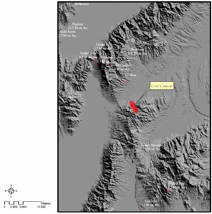
Figure 3. Gold Deposits of the Battle Mountain - Eureka Trend.
Much of the gold mineralization in northeastern Nevada is related to the Roberts Mountain Thrust, a low angle fault zone that has placed the older, Upper Plate rocks on top of younger Lower Plate rocks. The Upper Plate rocks, Ordovician in age, include mudstone, dark shale and siltstone, dark chert and siliceous mudstone, quartz arenite of various colors in thin to medium beds, finely-crystalline limestone that weathers to pastel shades of yellow and red, and irregular units of greenstone (pillow basalt).
The Lower Plate rocks, Devonian in age, include a number of distinct formations that consist primarily of limestone, silty limestone and dolomite.
These rocks have been intruded by a number of magmatic events, including Jurassic quartz monzonite intrusions, diorite stocks and dikes of Cretaceous age and numerous Tertiary quartz porphyry dikes and sills. Lamprophyre dikes are also present in the district, as well as Tertiary basalt flows and dikes.
The Paleozoic to early Mesozoic history has been complicated by three separate periods of folding, faulting, uplift and erosion. The Roberts Mountain Thrust formed during the earliest of these and has therefore been subject to subsequent deformation and in many places burial under younger sedimentary rocks. The current Basin and Range topography results from extensional tectonics that commenced in middle Tertiary time.
The geology of the Coal Creek property includes a window of Lower Plate rocks of the Roberts Mountain Thrust (see Figure 4) that correlate with the main host rocks for disseminated gold deposits in northeastern Nevada. On the property, these include the Hanson Creek Formation, of Silurian to Ordovician age, consisting of dark, thin-bedded limestone and dolomite. This is overlain by the Silurian to Devonian Roberts Mountain Formation, divided into two parts. The lower part includes yellowish-weathering, laminated limestone with a basal chert horizon. The upper part consists of thin-bedded limy mudstone interbedded with thick-bedded, massive to brecciated fossiliferous limestone. These are in turn overlain by the Devonian Rabbit Hill limestone and McColley Canyon limestone.
These units are partially covered by Tertiary volcanic rocks, including rhyodacite breccias, lavas and related intrusive dikes of the Fye Canyon Formation and rhyodacite breccias and domes of the Twin Peaks Formation.
The youngest rocks on the property include Tertiary basalt flows and gravel deposits with Quaternary gravels and alluvial fan deposits.

Figure 4. Coal Canyon Property Geology.
Geological mapping of the property was recently completed, at a scale of 1:2400, by Mr. R. Stoeberl (Cellura and Koehler, 2005). Mapping focused the various rock lithologies present on the property, the strike and dip of bedding and fault and fold structures, and hydrothermal alteration. This mapping expands on previous mapping efforts by Schull (1991-1992, 1998, 2000), and McKee and Conrad (1994).
The Grouse Creek fault that trends northwesterly across the southwestern corner of the property is believed to be a potential source of gold mineralization. A number of parallel faults and associated alteration were mapped by Stoeberl within the property. In addition, Stoeberl mapped a number of east-west and north-south structures that in places had coincident alteration including silicification, de-calcification of limestones and brecciation. Stoeberl also noted structural complexity and stratigraphic repetition, features that have also been noted associated with the Pipeline, Cortez, and Horse Canyon gold mines, to the west.
The fault geometries, Devonian and Silurian slope facies carbonate rocks, hydrothermal alteration (decalcification, silicification, clay, oxidation) and the presence of hydrothermally altered dikes are similar to geologic features observed within or proximal to gold deposits in the Cortez District and along the Carlin Trend.
Practical Geophysics (2005) carried out a gradient array resistivity survey (GAR and a spontaneous potential gradient survey (SPG) over an area of approximately 1.75 by 1.75 miles. GAR is a well-established method for detecting and delineating alteration zones, in particular silicification, as well as high angle fault zones. Effective search depth is 1,000 feet. SPG, on the other hand, detects oxidizing, vertically extensive sulphide mineralization. A summary of the GAR and SPG data is shown in Figure 5.
The resistivity data suggest that the surveyed area may contain several volcanic vents where low resistivity anomalies are associated with outcropping volcanics. The abrupt margins of the resistivity lows indicate high-angle contact between the volcanics and their sedimentary host rocks not gradual thickening of volcanic cover over local sedimentary basins. SPG data indicate that these possible vent features are not mineralized by veined sulfides, but in a few places their margins are SPG anomalous.
Anomalous high resistivity zones possibly associated with silicified limestone in the southern part of the grid show numerous SPG anomalies interpreted to be associated with oxidizing veined sulfide mineralization.
Linear patterns in the contoured resistivity data indicate probable high-angle fault geometry. These interpreted faults may have provided conduits for altering and mineralizing fluids.
To date, the geophysical results have not been fully integrated with the new geological survey. However, a number of the mapped structures with alteration patterns correlate with the geophysical data. The survey results, when evaluated with respect to known geology and geochemistry, are expected to help define several exploration targets

Figure 5. Coal Canyon Resistivity Survey Interpretation.
Work still in progress on the property includes the collection of a number of rock samples for the various lithologies and alteration zones for geochemical analysis. In addition, a mercury soil gas survey is also being undertaken.
Results of this work, including a complete property compilation, will be included in the final report.
Exploration efforts at Coal Canyon have identified a gold bearing hydrothermal system(s). The property presents strong encouragement for geologic and conceptual targets analogous to gold mineralization at Pipeline, Cortez Hills, and Horse Canyon. Some of the targets are blind in that they are down dip structural/stratigraphic projections, or they are covered by post-mineral volcanic rocks. Trace element values in jasperoid at Coal Canyon are similar to jasperoid overlying or proximal to ore zones in the Cortez District.
Favorable carbonate host rocks are present at Coal Canyon. Specifically the upper Wenban (Denay), lower Wenban, the Wenban / Roberts Mountains contact, the upper and lower portions of the Roberts Mountains Formation, and the Roberts Mountains / Hanson Creek contact are potential hosts for gold mineralization. As described earlier, these horizons host large, disseminated gold deposits in northern Nevada. Much of the previous work at Coal Canyon focused on carbonate units down section (Hanson, Eureka, Hamburg) from the Wenban and Roberts Mountains rocks, near the Grouse Creek Fault. Continued exploration should focus on prospecting and drilling rocks in the Wenban and Roberts Mountains Formations, particularly along altered fault zones or near folds. These rocks provide the best chance of hosting a large, economic gold deposit.
The Grouse Creek Fault is of similar orientation to well-documented, ore-controlling faults in gold deposits of northern Nevada (Cortez Hills, Pipeline, Gold Quarry, Mike, Betze, Rain, Lantern, and West Leeville). Many workers believe these faults are old, long-lived structures that controlled Paleozoic sedimentation, Mesozoic to Cenozoic igneous activity, and metal-bearing hydrothermal systems. The Grouse Creek Fault focuses igneous dikes, hydrothermal alteration and gold mineralization. Parallel faults occur on the Coal Canyon property and should be considered potential hydrothermal fluid conduits. Additional sampling and drilling is recommended along these faults.
Moderate amplitude folds are important structural traps for gold bearing fluids on the Eureka-Battle Mountain and Carlin Trends (e.g. Betze-Post, Cortez Hills, Pipeline, Genesis/Bluestar, Gold Quarry). At Coal Canyon, a moderate amplitude fold is recognized in favorable carbonate rocks. This feature combined with cross-cutting faults presents an attractive structural/stratigraphic setting. Additional cross section work and drilling is recommended.
The combined compilation of previous geological exploration work on the Coal Canyon and adjacent properties plus the geological mapping and geophysical surveys completed during the current program have yielded the following targets which are ready for drill testing. The Phase I drill program would include 3,000 feet of reverse circulation drilling, with a budget of $129,000, and would require about 1 month to complete. Targets include (Figure 6):
Drill test favorable carbonate section along strike of hydrothermally-altered 015 to 030 striking faults exposed in the east-central portion of the property. Alteration may represent up dip leakage from a large gold system in the lower Wenban and/or upper Roberts Mountains Formations, at depth. These structures project into a high resistivity area partially covered by volcanic rocks - this may represent a lower priority drill target.
Drill test Grouse Creek fault parallel structures where they intersect cross-cutting 015 to 030 striking faults.
In the east-central map area, drilling should target the line of intersection between 270-280 and 015-030 striking faults where it intersects favorable lower Wenban and the upper Roberts Mountains Formations rocks. This drilling will also be testing the axis of the inferred syncline. On the eastern side of the property, drilling should target these faults in lower plate carbonate, beneath Tertiary basalt flows.
Northeast-striking faults with silicified breccias crop out in the central and eastern portion of the property. In this area, favorable carbonate rocks are mostly covered by post-mineral, rhyodacite lava flows. Where exposed, these structures cut the Wenban, Roberts Mountains and Hanson Creek Formations. Drilling is recommended to test favorable carbonate rocks/northeast structure beneath the volcanic flows.
Contingent on successful results from the Phase I drill program, a Phase II program, consisting of approximately 12,000 feet of reverse circulation drilling would be considered. The budget for such a program, at $462,000, is outlined below.

Figure 6. Preliminary Proposed Drill Hole Location Sketch.
BUDGET - PROPOSED DRILL PROGRAMS
Phase I
Personnel
Supervising Geologist - 8 days @ 500/day $4,000
Field geologist - 15 days @ 350/day $5,250
Field Assistant - 15 days @ 250/day $3,750
Drilling (Reverse Circulation)
Mobilization, site preparation $20,000
3,000 ft. @ $20/ft. $60,000
Assaying
300 samples @ $20 $6,000
Report Preparation $5,000
Management Fee (5%) $5,000
Contingency$20,000
Total$129,000
Phase II
Geological support $36,000
Drilling (Reverse Circulation)
Mobilization, site preparation $80,000
12,000 ft. @ $20/ft. $240,000
Assaying
1,200 samples @ $20 $24,000
Report Preparation $12,000
Management Fee (5%) $20,000
Contingency$50,000
Total$462,000
REFERENCES CITED
Cellura, B. and S. Koehler, 2005, Coal Canyon Property - Interim Exploration Report, Eureka County, Nevada, 28 p.
Gilluly, J. and Masursky, H, 1967. Geology of the Cortez quadrangle, Nevada. USGS bulletin 1175.
McKee, E.H. and Conrad, J.E., 1994. Geologic map of the northern part of the Simpson Park Mountains, Eureka County, Nevada. USGS miscellaneous field studies map MF-2257.
Norby, J., 2002. Geology of the Maggie Creek District - Carlin Trend, Eureka County, Nevada. in Thompson, T.B., Teal, L., and Meeuwig, R.O. eds. Gold Deposits of the Carlin Trend, Nevada Bureau of Mines and Geology, Bulletin 111, plate 2.
Practical Geophysics, 2005, report on Gradient Array Grid Resistivity and Spontaneous Potential Gradient Survey, 3 p plus figures.
Schull, H.W., 2000. Grouse Creek fault zone - geologic and drill hole location map - Coal Canyon. Great Basin Exploration and Mining unpublished map.
Teal, L. and Jackson, M., 2002. Geologic overview of the Carlin Trend gold deposits. in Thompson, T.B., Teal, L., and Meeuwig, R.O. eds. Gold Deposits of the Carlin Trend, Nevada Bureau of Mines and Geology, Bulletin 111, p. 9-19.
I, Gerald G. Carlson, hereby certify that:
I am a consulting mineral exploration geologist with KGE Management Ltd. of 1740 Orchard Way, West Vancouver, B.C. V7V 4E8.
I am a graduate of the University of Toronto, with a degree in Geological Engineering (B.A.Sc., 1969). I attended graduate school at Michigan Technological University (M.Sc., 1974) and Dartmouth College (Ph.D., 1978). I have been involved in geological mapping and mineral exploration continuously since 1969, with the exception of time between 1972 and 1978 for graduate studies in economic geology.
I am a member in good standing of the Association of Professional Engineers and Geoscientists of the Province of British Columbia, Registration No. 12513 and of the Association of Professional Engineers of Yukon, Registration No. 0198.
I am author of this report on the Coal Creek Property. The report is based on a literature review, on private company reports and on a property visits during the 2005 field seasons.
I am a Director, President and CEO of Copper Golden Aria Resource Corp. and I own shares of Golden Aria.
I have had direct involvement with the exploration programs conducted on the area discussed in this report. I have experience writing Qualifying Reports and conducting evaluations of mineral properties.
Dated at Vancouver, B.C. this 15 day of August, 2005,
_______________________________
Gerald G. Carlson, P. Eng
1740 Orchard Way
West Vancouver, B.C. V7V 4E8
604-816-3012
Appendix A
Coal Canyon Property
Eureka County, Nevada
Sections 17, 18, 20, 21, 28, and & 29 T25N, R49E M.D.B.M. Appendix A Claim List
Claim Name County BLM_NMC# Loc. Date Book Page
Coal 1 Eureka 847957 5/29/2003 361 279
Coal 2 Eureka 847958 5/29/2003 361 280
Coal 3 Eureka 847959 5/29/2003 361 281
Coal 4 Eureka 847960 5/29/2003 361 282
Coal 5 Eureka 847961 5/29/2003 361 283
Coal 6 Eureka 847962 5/29/2003 361 284
Coal 7 Eureka 847963 5/29/2003 361 285
Coal 8 Eureka 847964 4/9/2003 361 286
Coal 9 Eureka 847965 4/9/2003 361 287
Coal 10 Eureka 847966 4/9/2003 361 288
Coal 11 Eureka 847967 4/9/2003 361 289
Coal 12 Eureka 847968 4/9/2003 361 290
Coal 13 Eureka 847969 4/9/2003 361 291
Coal 14 Eureka 847970 4/9/2003 361 292
Coal 15 Eureka 847971 5/24/2003 361 293
Coal 16 Eureka 847972 4/9/2003 361 294
Coal 17 Eureka 847973 4/9/2003 361 295
Coal 18 Eureka 847974 4/9/2003 361 296
Coal 19 Eureka 847975 4/9/2003 361 297
Coal 20 Eureka 847976 4/9/2003 361 298
Coal 21 Eureka 847977 4/9/2003 361 299
Coal 22 Eureka 847978 4/9/2003 361 300
Coal 23 Eureka 847979 4/8/2003 361 301
Coal 24 Eureka 847980 4/8/2003 361 302
Coal 25 Eureka 847981 4/8/2003 361 303
Coal 26 Eureka 847982 4/8/2003 361 304
Coal 27 Eureka 847983 4/8/2003 361 305
Coal 28 Eureka 847984 4/8/2003 361 306
Coal 29 Eureka 847985 4/8/2003 361 307
Coal 30 Eureka 847986 4/8/2003 361 308
Coal 31 Eureka 847987 4/9/2003 361 309
Coal 32 Eureka 847988 4/9/2003 361 310
Coal 33 Eureka 847989 4/9/2003 361 311
Coal 34 Eureka 847990 4/9/2003 361 312
Coal 35 Eureka 847991 4/8/2003 361 313
Coal 36 Eureka 847992 4/8/2003 361 314
Coal 37 Eureka 847993 4/8/2003 361 315
Coal 38 Eureka 847994 4/8/2003 361 316
Claim Name County BLM_NMC# Loc. Date Book Page
Coal 39 Eureka 847995 4/8/2003 361 317
Coal 40 Eureka 847996 4/8/2003 361 318
Coal 41 Eureka 847997 4/8/2003 361 319
Coal 42 Eureka 847998 4/10/2003 361 320
Coal 43 Eureka 847999 4/10/2003 361 321
Coal 44 Eureka 848000 4/11/2003 361 322
Coal 45 Eureka 848001 4/11/2003 361 323
Coal 46 Eureka 848002 4/11/2003 361 324
Coal 47 Eureka 848003 4/11/2003 361 325
Coal 48 Eureka 848004 4/11/2003 361 326
Coal 49 Eureka 848005 4/11/2003 361 327
Coal 50 Eureka 848006 4/11/2003 361 328
Coal 51 Eureka 848007 4/11/2003 361 329
Coal 52 Eureka 848008 4/11/2003 361 330
Coal 53 Eureka 848009 4/11/2003 361 331
Coal 54 Eureka 848010 4/11/2003 361 332
Coal 55 Eureka 848011 4/11/2003 361 333
Coal 56 Eureka 848012 4/11/2003 361 334
Coal 57 Eureka 848013 4/11/2003 361 335
Coal 58 Eureka 848014 4/11/2003 361 336
Coal 59 Eureka 848015 4/11/2003 361 337
Coal 60 Eureka 848016 4/12/2003 361 338
Coal 61 Eureka 848017 4/12/2003 361 339
Coal 62 Eureka 848018 4/12/2003 361 340
Coal 63 Eureka 848019 4/12/2003 361 341
Coal 64 Eureka 848020 4/12/2003 361 342