Luis Carrillo, Partner; SteadyLaw Group, LLP
501 W. Broadway, Suite 800 San Diego, CA 92101
Direct phone: 619.399.3102; Main phone: 619.399.3090; Fax: 619.330.1888
February 26, 2007
Mr. Karl Hiller
Ms. Jennifer Gallagher
U.S. Securities and Exchange Commission
Washington, D.C. 20549
| Re: | Chameleon Gems Inc. Registration Statement on Form SB-1 Filed January 18, 2007. File No.333-140055 |
In response to your letter dated February 16, 2007, Chameleon Gems Inc. has made changes to its filing. The changes made are detailed in this letter and the descriptions correspond to the headings and numbering of the items listed in your letter.
General
1. We have made all applicable changes throughout our document.
2. We have furnished a copy of the report prepared by Gregory R. Thomson and James W. Laird as correspondence.
Prospectus Cover, page 3
3.We have provided the mailing address and phone number of the issuer’s principal executive offices.
4. We have revised our document under this heading to name the officer who will sell the common stock and briefly describe her role in the marketing of the securities.
5. We have revised our disclosure under this heading to provide a cross-reference to The “Plan of Distribution,” which discusses in more detail the securities being offered.
6. We have revised our disclosure to provide the representation required by rule 253 of the Securities Act.
Risk Factors, page 9
7. We have removed language that mitigates the risk we present. We have removed phrases such as “inherently risky,” “beyond our control,” and “cannot assure.”
1
Business of the Issuer, page 16
8. We have revised our filing under this heading (“General Overview) to disclose how Chameleon Gems funded the purchase of the Red Streak Property.
9. The Red Streak property was purchased in an arm’s length transaction. John Briner is the adult sibling of Esther Briner and we have disclosed the relationship under the heading “Interest of Management and Others in Certain Transactions”
10. We have revised our disclosure to include a map that more narrowly identifies our property.
Geology of the Area, page 23
11. We have revised our disclosure under this heading and elsewhere in the document to eliminate as much as possible the use of technical or scientific terms. Where we have used such terms we have defined them in context, as well as provided a glossary.
Management Discussion and Analysis or Plan of Operation
12. We have described under this heading (Results of Operations) the investing activities from which we generated $10,000 and the operating and financial activities that resulted in a deficit of $10,855.
13. We have revised our disclosure to remove the statement that we will seek to “trade” on the OTC.
Liquidity and Capital Resources, page 26
14. We have revised our document to indicate $10,000 net cash provided by financing activities, in response to your comments.
Interest of Management and Others in Certain Transactions
15. We have disclosed under this heading that John Briner is the adult sibling of Esther Briner and shares an office space with John Briner.
Experts, page 30
16. We have included both Gregory R. Thomson and James W. Laid as experts under this heading. We have also provided consent from both authorizing us to include in our registration statement information form the report, and filed the consents as an exhibit 23.2 and 23.3 respectively.
17. We have revised our disclosure under this heading to indicate that the co-author of the property James W. Laird sold the property to Chameleon Gems.
Financial Statements, page 32
General
2
18. In the initial filling of our disclosure document we inadvertently omitted the notes to financial statements. We have included the notes in this amendment.
19. We have included a note in our disclosure a description of the exploration stage activities in which we are engaged. As well, we have revised the balance sheet line item “Retained earnings (loss) to refer to this account balance as our “Deficit accumulated during the exploration stage.”
20. We have included in our Notes to the financial statements Note 3., indicating that there is a substantial doubt about our ability to continue as a going concern.
Income Statement, page 35
21. We have revised out disclosure to round our loss per share to the nearest cent.
22. We have revised our disclosure under this heading to comply with paragraph 2 of SFAS 144. As well, we have revised our income statement to present our loss as a component of income from operations.
Statement of Cash Flows, page 37
23. We have revised our disclosure under this heading to properly record an impairment charge for the entire acquisition cost amount.
Unregistered Securities Issued or Sold Within One Year, page 40
24. We have revised our disclosure under this heading to provide the reason for issuing the 10,000,000 shares to Ms. Briner.
Undertakings, page 38
25. We have revised our disclosure to provide the undertaking required by Item 512(g)(2) of Regulation S-B.
Exhibit 10.1
26. In our initial submission, we erroneously included the invoice for the Red Streak Property purchase instead of the Agreement between Chameleon Gems and Laird Explorations. We have correctly filed the agreement as exhibit 10.1 in this filing.
If you have any questions or concerns, please feel free to contact us anytime.
Luis Carrillo,
Partner; SteadyLaw Group, LLP
501 W. Broadway, Suite 800San Diego, CA 92101
Direct phone: 619.399.3102; Main phone: 619.399.3090; Fax: 619.330.1888
3
SUMMARY REPORT
ON THE
RED STREAK PROPERTY
NIMPKISH LAKE
VANCOUVER ISLAND, BC
OCTOBER 10, 2006
By:
Greg Thomson B.Sc., P.Geo.
and
James Laird, Laird Exploration Ltd.
1
TABLE OF CONTENTS
| Page | |||
| EXECUTIVE SUMMARY | 1 | ||
| 1.0 | INTRODUCTION | 2 | |
| 1.1 | Terms of Reference | 2 | |
| 1.2 | Location and Access | 2 | |
1.3 | Topography, Climate, Vegetation | 3 | |
| 1.4 | Property Status | 4 | |
| 1.5 | Previous Work | 5 | |
| 2.0 | GEOLOGICAL OVERVIEW | 5 | |
2.1 | Regional Geology and Mineralization | 7 | |
| 2.2 | Red Streak Property Geology and Mineralization | 9 | |
| 3.0 | CONCLUSIONS AND RECOMMENDATIONS | 12 | |
| 4.0 | REFERENCES | 13 | |
| 5.0 | STATEMENTS OF QUALIFICATIONS | 14 | |
| FIGURES | |||
| 1. | Red Streak Property BC Location Map | 2 | |
| 2. | Red Streak Property Regional Location Map | 3 | |
| 3. | Red Streak Property Location Map | 4 | |
| 4. | Regional Geology Map of the Nimpkish Area | 6 | |
| 5. | Red Streak Area Stratigraphic Column | 8 | |
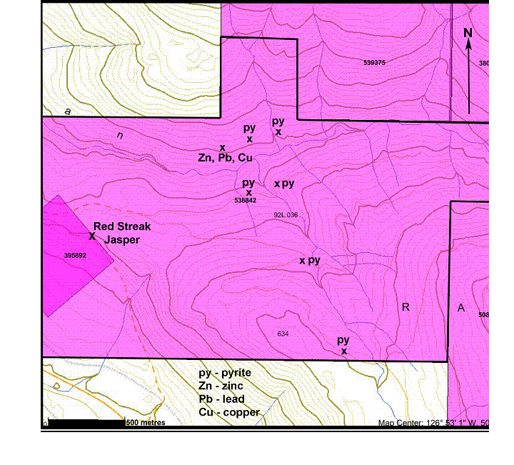
| 6. | Red Streak Property Map | 9 | |
| 7. | Red Streak Jasper Photo | 10 | |
| 8. | Lower Kinman Creek Valley Photo | 11 | |
EXECUTIVE SUMMARY
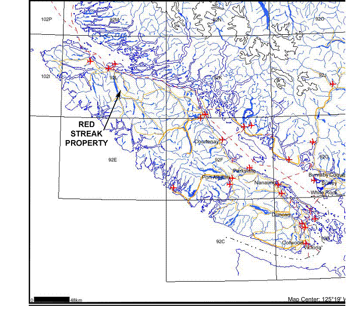
1. | The Red Streak Property is located near Nimpkish Lake, Northern Vancouver Island, about 300 kilometers northwest of Vancouver, BC. The Red Streak Property comprises one MTO cell claim totaling 412.508 hectares. The original Red Streak claim was staked on August 14, 2002. |
2. | The Red Streak Property was staked to cover a lapidary-quality red jasper occurrence. The claims were recently expanded to cover a large area with skarn and porphyry copper-molybdenum deposit potential, similar to the Merry Widow Mine, the Nimpkish Iron Mine, and the Island Copper Mine. |
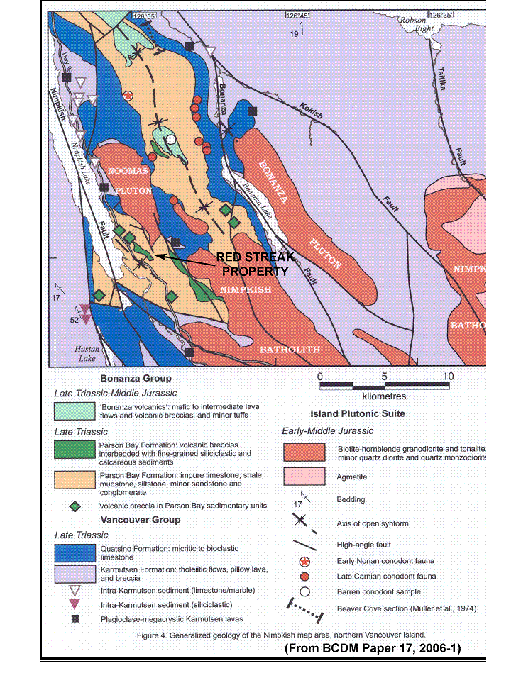
3. | The Nimpkish Map-Area is underlain by a 5 to 7 km thick stratigraphic sequence of Upper Triassic to Lower Jurassic Vancouver Group sedimentary and volcanic rocks. The sequence is composed of Upper Triassic Karmutsen Formation marine mafic volcanics, overlain by Quatsino Formation limestone and marble, Upper Triassic to lower Jurassic Parson’s Bay Formation calcareous sediments and tuffs, succeeded by the dominantly andesitic Lower Jurassic Bonanza Group Volcanics. All of these units have been intruded and metamorphosed by a large Jurassic granodiorite pluton called the Nimpkish Batholith. |
Skarn-type mineralization in the Nimpkish area is most often found along the contact of limestone and intrusive rocks, in limestone-hosted sulphide-rich mantos and replacements, and at the “triple point” contact between the Karmutsen and Quatsino formations and intrusives. Gem-lapidary grade red jasper occurs in shear-veins within calcareous sediments and overlying Bonanza Volcanics. There is geological potential for the area to contain a porphyry copper/molybdenum deposit similar in characteristics to the large Island Copper Mine located near Port Hardy.
4. | A proposed work program includes prospecting, geological mapping and sampling, construction of a control grid, soil and silt sampling, magnetometer and VLF-EM geophysical surveys, and trenching. Based on a compilation of these results, a diamond drill program will be designed to explore and define the potential resources. |
2
1.0 INTRODUCTION
1.1 Terms of Reference
This summary report is a compilation of geological data currently available regarding the Red Streak Property located near Nimpkish Lake, Vancouver Island, BC. Historical information from Laird Exploration Ltd. files, the BC Department of Mines, the Geological Survey of Canada, and other sources has been reviewed and used where pertinent.
Fig. 1
RED STREAK PROPERTY BC LOCATION MAP
3
1.2 Location and Access
The Red Streak Property is located near Nimpkish Lake, BC; about 35 minutes drive south of the town of Port McNeill on northern Vancouver Island. The property covers a recently logged area in the vicinity of Kinman Creek, which flows westward into Nimpkish Lake. The property is accessible to 4 wheel drive vehicles from the Island Highway via Canfor’s Kinman Creek logging road and by recent spurs which cross most of the claims. The property contains strong attributes toward cost-effective property development, including easy access to road, rail, and deep-water transportation facilities.
Fig. 2
RED STREAK PROPERTY REGIONAL LOCATION MAP
1.3 Topography, Climate, Vegetation
The climate of the Nimpkish area is mild and wet, with about 400 cm of precipitation falling annually, mostly as rain. Snowfall covers the higher areas from November to April, but seldom persists at lower elevations for more than a few weeks in mid-winter. First-growth conifer forest formerly covered all of the claims, but recent clear-cut logging has exposed more than half the ground covered by the claims. Karst topography and cave systems are commonly developed in the limestone near watercourses.
Fig. 3
RED STREAK PROPERTY LOCATION MAP

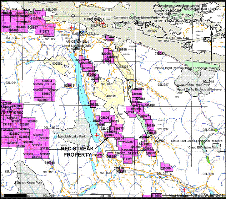
1.4 Property Status
The Red Streak Property currently consists of 412.508 hectares of mineral title, in good standing until August 7, 2007. The original 2-post Red Streak claim (#395892) was staked on August 14, 2002.
| BC Tenure # | Work Due Date | Staking Date | Total Area (Ha.) |
| 538842 | August 2, 2007 | Aug 2, 2006 | 412.508 |
| 395892 | August 14, 2007 | August 14 2002 | 25.00 (included) |
4
1.5 Previous Work
The Nimpkish Lake area has been explored for mineral deposits since the early 1800’s. The Nimpkish Iron Mine on the Nimpkish River was discovered in the late 1800’s, followed by the Kinman Creek Copper and Storey Creek or Smith Copper deposits in the 1920’s. After an initial flurry of development including short underground workings, numerous surface trenches, and diamond drilling in the late 1920’s and early 1930’s, activity in the area slowed greatly. Exploration for magnetite in the 1950’s and 1960’s brought about a resurgence of exploration. The Nimpkish Iron Mine was put into production from 1959 to 1963, producing 1.275 million tonnes of iron from 2.17 million tonnes of ore.
Exploration in the 1980’s and 1990’s concentrated on copper and gold skarns. Prospecting by James Laird in 1988 - 1990 located several promising skarn deposits and a large resource of high-grade white marble on what is now the CBL Property. Initial prospecting was also done over parts the ground covered by the Red Streak Property. A large area of highly altered rusty sediments intruded by granitic rocks in the lower Kinman Creek valley was found to contain widespread small deposits of pyrite, chalcopyrite, sphalerite and galena (BC AR#20092, 1990).
The Red Streak Jasper occurrence was located and staked in the summer of 2002 and has produced a limited amount (<1 tonne) of commercial lapidary-grade red jasper for test marketing. The Nimpkish area has more recently been the subject of several geological assessment reports and a 2005 BC GSB mapping project.
Fig. 4
NIMPKISH AREA GEOLOGICAL MAP
2.0 NIMPKISH AREA GEOLOGICAL OVERVIEW
The Nimpkish map-area is underlain by a 5 to 7 km thick stratigraphic sequence of Upper Triassic to Lower Jurassic Vancouver Group sedimentary and volcanic rocks. Mineralization in this stratigraphy generally occurs as skarn-type metal deposits forming in limestone or marble at or near the contact with younger intrusive granitic bodies.
Historically, skarn-type deposits on Vancouver Island have been economically important producers of base and precious metals, and several past mines have been in the multi-million tonne class. Marble deposits of good colour and purity are also presently being mined at several locations on Vancouver and Texada Islands.
5
2.1 Regional Geology and Mineralization
The Nimpkish map area is underlain by a 5 to 7 km thick stratigraphic sequence of Upper Triassic to Lower Jurassic Vancouver Group sedimentary and volcanic rocks. The sequence is composed of Upper Triassic Karmutsen Formation marine mafic volcanics, overlain by Quatsino Formation limestone/marble, and Parson’s Bay Formation calcareous sediments and tuffs, succeeded by the dominantly andesitic Lower Jurassic Bonanza Group Volcanics. All of these units have been intruded and metamorphosed by a large Jurassic granodiorite pluton called the Nimpkish Batholith. Major uplift, folding and faulting preceded and accompanied emplacement of the multi-phase granitic rocks and related skarn mineralization. Marble development is common in the Quatsino limestone proximal to intrusions.
Skarn-hosted mineralization in the Nimpkish area is most often found along the contact of limestone and intrusive rocks (exoskarn); in limestone-hosted sulphide-rich mantos and replacements; and at the “triple point” contact between the Karmutsen and Quatsino formations and intrusives. Numerous greenstone dikes and small intrusive stocks are found in the limestone adjacent to the major contact zones, and commonly have a “rind” or contact metasomatic zone of skarn minerals and sulphides.
The common skarn minerals present include; green grossularite and red-brown andradite garnet, epidote, diopside, manganese alteration (bustamite), calcite and quartz; with magnetite, chalcopyrite, sphalerite, pyrite, pyrrhotite, limonite and occasionally marcasite, hematite, bornite, covellite, tetrahedrite, galena, molybdenite, malachite, azurite, and greenockite. Other minerals noted in the altered zones include; sericite, biotite, k-feldspar and chlorite and occasionally red jasper, jade-green serpentine, blue to lavender dumortierite, lemon-yellow vesuvianite, and green to black tourmaline.
The Kinman and Smith properties have drill-inferred (non 43-101) mineral resources containing copper, zinc, lead, silver and gold. On the Kinman property, several small (~5000 tonnes) ore-grade massive sulphide deposits have been found in limestone-hosted skarns and mantos near granitic intrusions. Production from the Hazel open-pit on the Kinman property in the 1970’s amounted to about 3000 tonnes of high-grade copper-zinc ore with some gold and silver credits.
6
The adjoining Smith Copper Property hosts inferred reserves of approximately 85,000 tonnes of 12.5% zinc with copper, lead, silver and minor gold values. The Smith deposit occurs as a stratiform skarn/replacement of a regional volcanic/limestone formational contact proximal to a large granodiorite intrusion, the Noomas Pluton. Along the Nimpkish River south of Nimpkish Lake, the Nimpkish Iron Mine magnetite skarn produced 1.275 million tonnes of iron from 2.17 million tonnes of ore in the 1950’s and 1960’s in a similar geological environment.
The recent discovery on the adjoining CBL property of several new well-mineralized Zn, Cu, Fe skarns, and a large area of pure white marble shows that significant surface exploration potential still exists in the Nimpkish area.
Fig. 5
RED STREAK AREA STRATIGRAPHIC COLUMN
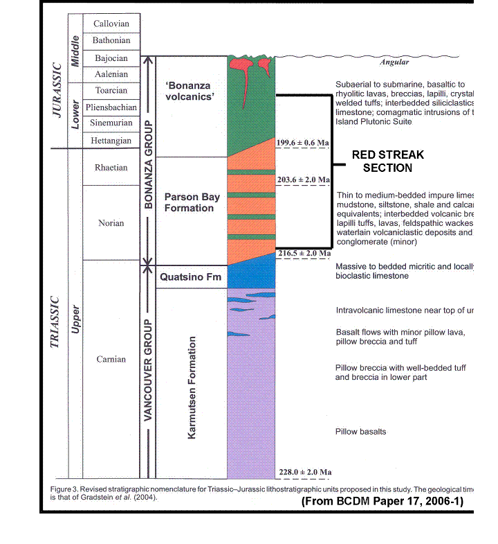
2.2 Red Streak Property Geology and Mineralization
The main rock units exposed on the Red Streak Property are Parson’s Bay Formation sediments and volcaniclastics, granodiorite of the Island Intrusions Plutonic Suite, and a limited area of Karmutsen Formation Basalt along the eastern edge of the property.
The Parson’s Bay Formation is a complex limestone and volcaniclastic sediment package with rapid vertical and lateral changes in facies. Rock types include black limestone, thin-bedded cherty tuffaceous limestone, agglomeratic limestone, grey coralline limestone reefs, thin-bedded calcareous argillite, and quartzite. Marine fossils are common in some units and are usually well preserved. Andesite flows, sills, breccias and dikes representing the earliest stages of the Bonanza Volcanics are locally present. The Parson’s Bay Formation is generally fractured and faulted near the numerous intrusives of the Island Intrusions, and is very rusty due to abundant pyritization. Minor mineral deposits containing pyrite, chalcopyrite, sphalerite, galena and tetrahedrite are common in shear zones near the intrusives.
The intrusive plutonic suite regionally known as the Island Intrusions includes stocks, sills, and dikes of granodiorite, with some diorite, quartz diorite, greenstone, hornblende-feldspar porphyry, felsite and quartz-feldspar porphyry. The contact-altered granitic rocks can host minor occurrences of pyrite, chalcopyrite and molybdenite in endoskarn zones, vein systems, shears, breccias and disseminations.
7
The limited area of Karmutsen basalt on the eastern boundary was found to contain minor amounts of pyrite, magnetite and chalcopyrite.
Fig. 6
RED STREAK PROPERTY MAP
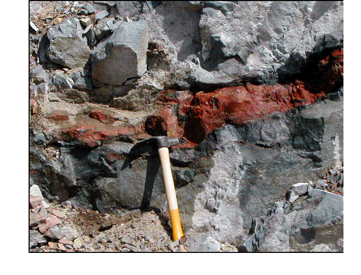
The original mineral deposit located on the Red Streak Property is a lapidary-quality red jasper deposit located close to a major logging road. Three separate jasper-bearing shear zones cross an andesite flow or sill. The jasper has been hand-trenched and test sampled, removing about one tonne of material for test-marketing. The jasper is a striking bright red colour with patches of pyrite and green epidote. It has been successfully fashioned into cabochons, polished slabs and tumbled stones by various lapidary shops and mineral clubs. An approximate price the raw material sold for in <1 kg.-sized pieces was $5.00/kg. Given the visible trenched length of the known deposits and assuming a similar depth and width, in excess of ten tonnes of jasper is approximated to be present.
On the north side of Kinman Creek along the access road, a one-metre wide shear-hosted deposit containing sphalerite, galena, chalcopyrite and tetrahedrite has been located. Assays from this zone give values up to 38 ppm silver, 9.74% zinc, 4.34% lead, 3.51% copper, 388 ppm molybdenum, and 811 ppm cadmium.
The rock units present in the lower Kinman Creek area are highly altered and pyritized by stocks and dikes of granodiorite. The style of mineralization present is possibly related to a porphyritic phase of the Nimpkish intrusion, which is similar to the geological setting of the Island Copper Mine located near Port Hardy. The Island Copper Mine produced approximately 345 million tonnes of ore from 1971 to 1994 having an average head-grade of 0.41% copper, 0.017% molybdenum, 0.19 g/t gold and 1.4 g/t silver.
Fig. 7
RED STREAK JASPER
8
3.0 CONCLUSIONS AND RECOMMENDATIONS
A proposed work program includes reconnaissance prospecting, geological mapping and rock sampling, construction of a control grid, EM and magnetometer geophysical surveys, and soil geochemical sampling. The anticipated costs of this development are presented in three results-contingent stages.
Phase 1 Cost Estimate
| Consultant/Project Manager - 7 days @ $450/day | $ | 3150.00 | ||
| Geologist - 7 days @ $450/day | $ | 3150.00 | ||
| Sampler/Geological Assistant - 7 days @ $250/day | $ | 1750.00 | ||
| Truck rental - 1500 km @ 0.75/km inclusive | $ | 1125.00 | ||
| Rock assay samples - 50 @ $50.00 per sample | $ | 2500.00 | ||
| Soil and silt samples - 150 @ $25.00 per sample | $ | 3750.00 | ||
| BC Ferries | $ | 250.00 | ||
| Per diem - 21 man-days @ $125.00 m/day | $ | 2625.00 | ||
| Misc. sampling and field supplies | $ | 500.00 | ||
| Report and reproduction costs | $ | 1500.00 | ||
Subtotal | $ | 14,000.00 | ||
| Management Fee @ 15% | $ | 2100.00 | ||
| Contingency @ 10% | $ | 1400.00 | ||
Total | $ | 17500.00 | ||
| GST@ 6% | $ | 1050.00 | ||
NET TOTAL | $ | 18550.00 | ||
| Phase 2 | ||||
| Detailed geological mapping and rock sampling, grid construction, soil and silt geochemical survey, IP and magnetometer surveys, establish drill and trenching targets, four-man crew with supplies, transportation, report; est.14 day program. | $ | 90,000.00 | ||
| Phase 3 | ||||
| 1000 metres of diamond drilling @ $100.00 per metre, plus geological supervision, assistant, supplies, transportation, assays, report and other ancillary costs; est. 21 day program. | $ | 170,000.00 | ||
| TOTAL | $ | 278,550.00 |
9
Fig 8
LOWER KINMAN CREEK VALLEY

4.0 REFERENCES
Gunning, H.C., (1930); Geology and Mineral Deposits of the Quatsino-Nimpkish Area, Vancouver Island, BC. Geological Survey of Canada Summary Report 1929 Part A, P. 94-107.
Laird, J.W., (1990); Geological Report on the Nimpkish Group. BC Assessment Report #20,092.
Nixon, G.T., Kelman, M.C., Stevenson, D., Stokes, L.A., Johnson, K.A., (2006); Preliminary Geology of the Nimpkish Map Area, Northern Vancouver Island, BC. Geological Fieldwork 2005, Paper 2006-1 p.135-152.
10
5.0 STATEMENTS OF QUALIFICATIONS
I: Gregory R. Thomson, of Langley, B.C., do hereby certify:
That I am a Professional Geoscientist registered in the Province of British Columbia.
That I am a graduate Geologist from the University of British Columbia (1970) and have over 25 years of mineral exploration experience in the Province of British Columbia.
That the information contained in this report was based upon a review of previous reports and geological studies related to the Red Streak Property area and of personal experience with local geology gained while employed as a consulting geologist in the Nimpkish Lake region of BC. In the company of Mr. J. Laird, the author made a visit to the Red Streak property on April 20, 2005.
I have read National Instrument 43-101, Form 43-101F1 and this report has been prepared in essential compliance with N1 43-101 and Form 43-101F1.
Dated at Vancouver, BC, October 10, 2006
/s/ Gregory R. Thomson, P. Geo
Gregory R. Thomson, P. Geo
11
STATEMENT OF QUALIFICATIONS
I, James W. Laird do state that:
My address is PO Box 672, Lions Bay, BC V0N 2E0
I am a prospector and mining exploration contractor and have been for more than 25 years.
I have completed the BC EMPR course “Advanced Mineral Exploration for Prospectors, 1980”.
I am very familiar with the geology of the Red Streak Property project area and have explored the Nimpkish Lake mining camp for more than 20 years.
Dated at Vancouver, BC, October 10, 2006
James W. Laird
Laird Exploration Ltd.
October 10, 2006
12