Geological Report
CUPRO VMS PROJECT
Mt. Woodside BC
Harrison Mills BC, New Westminster Mining Division
Latitude 49° 14' 11" N /Longitude 121° 53' 44"
UTM 10 (NAD 83)W
Northing 5454321 / Easting 580398
For:
BOLD VIEW RESOURCES LTD.
A Nevada Corporation
by:
David J. Bridge, P.Geo. , B.A.Sc., M.A.Sc.
Consulting Exploration Geologist,
601- 31 Elliott Street, New Westminster, BC, CANADA
Tel: 604-520-0508
davidjbridge@hotmail.com
 |
AUGUST 20, 2007
i
Geological Report
CUPRO VMS PROJECT
Harrison Mills BC
BOLD VIEW RESOURCES LTD.
SUMMARY
The company has acquired a large property within the Harrison Lake volcanic package, situated on Mt. Woodside near Harrison Mills, BC., east of Mission City The property encompasses a number of showings which have characteristics of volcanogenic massive sulphide (VMS) deposits. In addition there is a silver-mercury showing at low elevations which was rediscovered about 1975, but which has not been explored in detail. The property was inspected August 14, 2007 accompanied by property owner Bill Howell, P.Geo. and Barry Price, M.Sc., P.Geo.
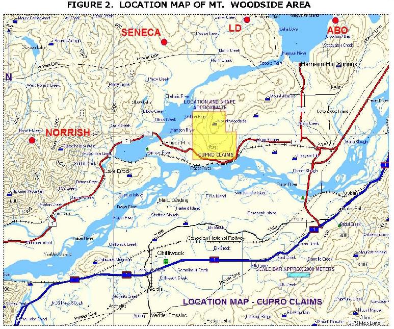
The property is situated adjacent to Harrison Mills BC, a small community between Mission and Agassiz on the Loughheed Highway on the north side of Fraser River, approximately 75 miles east of Vancouver BC. The CPR main rail line passes through the property. The Loughheed Highway and a number of logging roads provide access to the property. Small private land holdings at lower elevations are occupied as residential lots, but these do not affect the target areas.
The property contains the following showings:
| 1. | Ascot, Fab, TreblifVolcanogenic Massive Sulphide ("VMS") showings with copper, lead, zinc sulphides in stringer zones. |
| 2. | Fairplay, St. Alice VMS showings |
| 3. | HVB showingAn Epithermal? Showing of Mercury/Copper-Silver mineralization in altered volcanics, possibly related to a major fault. |
| 4. | A fourth showing, the Valleyview/Midnight VMS showing is just outside the east boundary of the property, on claims owned by Armstrong Sand and Gravel to the east of the Cupro property, and is occupied by a gravel and aggregate operation. |
The claims are situated at low to moderate elevations, within the influence of the Vancouver "maritime" climate, and can be worked for most of the year unless heavy snow falls.
The property is under-explored, although several Assessment reports are available which describe the work done fairly well. The volcanic package contains numerous gold, silver and VMS showings, of which the most prominent is the "Seneca" volcanogenic massive sulphide deposit, situated 10 kilometers to the north, and now being explored by Carat Explorations Ltd. Other VMS prospects in the same rock package are being explored at Norrish Creek and Chehalis Lake areas. As at the Seneca deposit to the north, mineralized footwall volcaniclastics and sediments and hangingwall unmineralized massive volcanic rocks have been recognized, which assists in defining the target for polymetallic volcanogenic massive sulphide (VMS) deposits.
ii
A prominent linear is visible on topographic maps, landsat photos and air photos which trends from Seneca directly through the Cupro claims. This feature has not been prospected or explored.
This report summarizes work done on the various showings in the past and sets out a proposed exploration program and budget for the next two phases of exploration.
Suggested work involves:
| · | Prospecting and mapping |
| · | Inspection of the known showings, with rock and soil samples |
| · | Compilation of existing geochemical surveys |
| · | Airborne magnetic-VLF-radiometric surveys |
| · | IP surveys over favourable areas |
| · | Drilling of IP anomalies, airborne geophysical anomalies or geochemical anomalies |
A first phase budget of US$ 60,000 and a second phase budget of US$ 140,000 for a total of US $ 200,000 is recommended.
Respectfully submitted
| /s/ David J. Bridge David J. Bridge, P.Geo., B.A.Sc., M.A.Sc. Qualified Person August 20, 2007 | | |
iii
TABLE OF CONTENTS | |
SUMMARY | ii |
TABLE OF CONTENTS | iv |
INTRODUCTION | 1 |
RELIANCE ON OTHER EXPERTS | 1 |
THE COMPANY | 1 |
MINERAL TITLES | 2 |
LOCATION AND ACCESS | 7 |
CLIMATE, PHYSIOGRAPHY AND VEGETATION | 7 |
LOCAL RESOURCES AND INFRASTRUCTURE | 7 |
HISTORY | 7 |
REGIONAL GEOLOGY | 9 |
LOCAL AND PROPERTY GEOLOGY | 10 |
MINERALIZATION | 13 |
HVB showing | 13 |
Ascot Showing | 13 |
Playfair showing | 14 |
Geochemistry | 16 |
THE KUROKO MODEL | 19 |
PAST PRODUCTION | 20 |
RESERVES AND RESOURCES | 20 |
ADJACENT PROPERTIES | 20 |
Valleyview Property | 21 |
Carat Property | 22 |
Fairplay (Queen | 26 |
Bee Uranium showing | 28 |
Empress copper Skarn | 28 |
DISCUSSION | 31 |
CONCLUSIONS | 31 |
RECOMMENDATIONS | 31 |
SUGGESTED BUDGET | 32 |
BIBLIOGRAPHY | 33 |
BIBLIOGRAPHY | 33 |
CERTIFICATE OF THE AUTHOR, DAVID J. BRIDGE | 36 |
APPENDIX I | 37 |
iv
LIST OF FIGURES | |
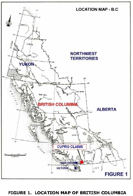
| FIGURE 1. LOCATION MAP OF BRITISH COLUMBIA | 3 |
| FIGURE 2. LOCATION MAP OF MT. WOODSIDE AREA | 4 |
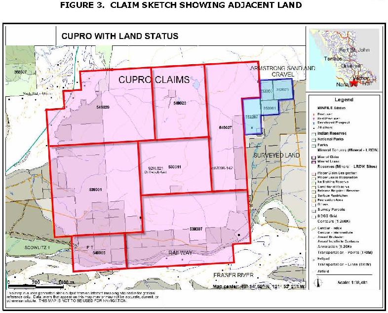
| FIGURE 3. CLAIM SKETCH SHOWING ADJACENT LAND | 4 |
| FIGURE 3. CLAIM SKETCH SHOWING ADJACENT LAND | 5 |
| FIGURE 4. SKETCH OF CLAIMS AND TOPOGRAPHY | 5 |
| FIGURE 4. SKETCH OF CLAIMS AND TOPOGRAPHY | 6 |
| FIGURE 5. REGIONAL GEOLOGY OF HARRISON LAKE AREA | 11 |
| FIGURE 6. LOCAL GEOLOGY AND MINERAL SHOWINGS (FROM MAP PLACE) | 12 |
| FIGURE 7. SKETCH OF HVB SHOWING, HARRISON MILLS BC | 14 |
| FIGURE 8. SKETCH OF GEOLOGY AT THE ASCOT SHOWING | 15 |
| FIGURE 9. 1981 GEOCHEMICAL GRID AND ANOMALY, MT. WOODSIDE | 17 |
| FIGURE 10. AEROMAGNETIC MAP OF HARRISON MILLS AREA | 18 |
| FIGURE 11. DIAGRAMMATIC CROSS-SECTION | 20 |
| OF A TYPICAL KUROKO VMS DEPOSIT | 20 |
| FIGURE 12. THE SENECA PROPERTY NEAR CHEHALIS RIVER | 23 |
| SHOWING MINERALIZED ZONES | 23 |
| FIGURE 13. DIAGRAMMATIC CROSS SECTION OF SENECA MINERALIZATION | 25 |
| FIGURE 14. FAIRPLAY AND QUEEN CLAIMS | 27 |
| FIGURE 15. MAP OF VOLCANOGENIC MASSIVE SULPHIDE DEPOSITS IN SOUTHERN B.C. | 29 |
v
Geological Report
CUPRO VMS PROJECT
Harrison Mills BC
BOLD VIEW RESOURCES LTD.
INTRODUCTION
The author has been retained by Bold View Resources, Ltd. (“Bold View”) to compile existing geological data for the Cupro property, which has been purchased from the registered owner, William A. Howell, B.Sc., P.Geo. The Cupro property covers a package of volcanic rocks located on Mt. Woodside near Harrison Mills BC. The property has been intermittently explored in the past and has a number of copper and zinc showings in highly altered volcanic rocks which resemble those at the Seneca volcanogenic massive sulphide property situated in the same package of rocks approximately 15 kilometers to the northwest.
Mt. Woodside is named after the late Frank E. Woodside, who was at one time, the owner of the Woodside group of mineral claims on the face of the mountain, purchased from the Crown. The property covers a package of volcanic rocks of the Harrison Lake Group, which, about 15 kilometers to the north, is host to the Seneca polymetallic volcanogenic massive sulphide (“VMS”) deposit.
The property was visited on August 14, 2007 accompanied by the property vendors Mr. Howell, and Barry Price, M.Sc., P.Geo., both of whom have explored in the general area for may years.
RELIANCE ON OTHER EXPERTS
In this report, the author has relied on geological descriptions provided in past Assessment Reports (listed in the Bibliography). Much of the information concerning the property, along with Bill Howell, P.Geo.
THE COMPANY
Bold View Resources, Ltd. ("Bold View") is a junior company based in Nevada, intending to list on the OTC exchange, under the jurisdiction of the SEC.
1
MINERAL TITLES
The Company has optioned 7 mineral titles totaling 2467 hectares as shown below:
Tenure Number | Tenure Type | Claim Name | Good to Date | Status | Area Ha |
| 539301 | Mineral | CUPRO | 2007/Aug/14 | Good | 527.247 |
| 539307 | Mineral | 2007/Aug/14 | Good | 527.355 | |
| 539311 | Mineral | 2007/Aug/14 | Good | 253.056 | |
| 540085 | Mineral | CUPRO 5 | 2007/Aug/29 | Good | 126.576 |
| 549027 | Mineral | TOP 1 | 2008/Jan/10 | Good | 337.341 |
| 549028 | Mineral | TOP 2 | 2008/Jan/10 | Good | 252.979 |
| 540929 | Mineral | TOP 3 | 2008/Jan/10 | Good | 442.72 |
7 Titles | Total Area | 2467.27 |
112364 (100%)
Registered Owners is W.A. Howell, P.Geo. Data from Mineral Titles Online May 7, 2007
Note 1 Hectare = 2.47 acres
The claims have not been surveyed but are defined as to latitude and longitude, which can be located precisely in the field using a GPS instrument. Work must be filed on some of the claims, or cash-in-lieu of work paid prior to January 10, 2008.
There are a number of Land Titles situated mainly on the south side of the mountain. Owners of these lots have surface rights, and exploration access to these areas may have to be negotiated. In addition, two Crown granted claims appear to be in good standing, covering one of the showings. Mineral title should be researched for these lots. (Note: Crown granted claims are similar to Patented mining claims)
There is adequate area within the claims for mining and/or development purposes. The author has checked title with Mineral Titles online, a BC Government website, and mineral title is believed to be secure. An exploration permit will be required prior to the commencement of work. If surface disturbance on the claims is required (for drilling etc.) a reclamation bond will likely be required.
To the writer's knowledge there are no outstanding environmental problems associated with the claims. The company must abide by provisions of the Mining Act and other provincial statutes and regulations. The company will have to arrange exploration permits and a reclamation bond prior to commencement of any major physical work (this is not needed for prospecting and mapping).
2
3
4
5

6
LOCATION AND ACCESS
The Cupro property claims are located in the New Westminster Mining Division approximately 7 to 10 kilometers west of the Village of Agassiz, B.C. on the south and east flank of Mount Woodside (map sheets NTS 92H.14 W & 5 W).
Access to the property is via the Mount Woodside-Mount Agassiz forestry access road leading north from Lougheed Highway #7 about 10 kilometers west of Agassiz. A logging road to the eastern showings can be accessed 4km west of Agassiz on Route #7 and 2km north on Southerland Road.
The property can be reached in about 2 hours driving time from Vancouver or less than one-half hour from Mission or Agassiz.
CLIMATE, PHYSIOGRAPHY AND VEGETATION
The climate is moist and temperature, typical of the southern coast range of British Columbia, with cool wet winters with occasional snow at higher elevations. Summers are warm but may be wet. Work can generally be done year round.
The property is situated on the densely wooded top and south and east-facing slopes of Mt. Woodside, adjacent to the Fraser River, to the south and Harrison River to the north.
Forest cover is mixed at lower elevations, but primarily coniferous in the higher or northern part of the area. Brush is generally dense but there are occasional open patches underlain by exposed bedrock.
The slopes are often steep, occasionally precipitous, and there are several incised stream gulleys. Bedrock is present in sufficient quantities for geological mapping and conventional prospecting.
LOCAL RESOURCES AND INFRASTRUCTURE
Most supplies and services can be provided locally. Power lines cross the lower parts of the property and also exist to the microwave tower on top of the mountain. Water is available for drilling. Motels and restaurants are situated in Mission, Agassiz and Harrison Mills. Geological service companies operate mainly out of Vancouver.
HISTORY
A brief history of the showings within or near the property is derived from Minister of Mines Annual Reports, Assessment Reports and Minfile.
1897-88 Two claims were staked on the banks of the Fraser, on what is now the Fairplay and Queen Crown granted claims. A lengthy tunnel was driven into the hill from near the railway tracks, following the trace of two mineralized zones with polymetallic copper-lead zinc mineralization. Claims were also known as Lady Jane, Fat Man, Queen and St. Alice. No plans of the workings remain
7
1929: This property was acquired by the late Frank E Woodside as the FEW claims. There is no record of additional work done.
1966: Trenching was carried out on the Ascot property by Ascot Mines Ltd. on mineralized showings near the switchback on the access road (approximately the same location as the later 1971 work. Work was also done on the nearby PF and Midnight property (now within the sand and gravel operation) by C.J. Coveney for Bethex Exploration Ltd. An IP survey was completed, 6 trenches totaling 1950 ft. were cut and two drillholes totaling 1056 feet were completed. A number of mineralized zones were explored.
1971: Mapping and sampling was done on the Fab claims, adjacent to the Ascot property in 1971 by geologist David Cooke, P.Eng., for Gary Schell of Geoquest Ltd. Stringer and vein polymetallic mineralization was seen. Approximately $1250 was expended.
1973 Harry Vernon Barley of Mission staked two claims on the copper-silver--mercury mineralized zones at the base of Mt. Woodside about 1 km east of Harrison River bridge. The property was inspected and sampled by geologist Barry Price, P.Geo in 1974 for Delphi Resources Ltd. a private company.
1981: A small program of mapping and sampling was done on the Treblif property (covering the same area as Fab) by Tim Sadlier Brown, P.Eng. for Invermay Resources Ltd. (Mel Pardek).
1984: A geological program was completed by Ken Northcote, Ph.D. for Star Mountain Resources Inc. on the Valleyview (Midnight) area claims, to the east of the Cupro property. Grab or selected samples assayed from 0.016% to 10.20% copper, and containing up to 9.6 oz/ton silver over narrow widths. Approximat.ely $9700 was expended. K.E. Northcote and Associates Ltd. were contracted by Star Mountain Resources Inc. to-carry out a ground magnetometer survey on the VALLEY VIEW and GOLDTOP claims, prepare a report outlining the results of this work. (AR # 13479)
1988: Also on the Valleyview claims, a geological program was completed by Marion Blank, B.Sc., for Gila Bend Resource Corp. The program looked at two showings:
1. Vallev View Showing; A strong northeasterly trending zone of hydrothermal alteration with massive sulphide mineralization along two superimposed fracture patterns -020 degrees and 310 degrees. Major mineralization consists of coarse crystalline pyrite, less chalcopyrite, minor sphalerite and galena with silver values and trace gold values.
2. Stacey Creek Showing; A siliceous brecciated alteration zone with irregular veins of barite. Minor sulphide mineralization consisting of pyrite, chalcopyrite, galena and sphalerite occurs locally in association with sericitic and siliceous alteration. Minor gold values are also noted.
The work program included comprehensive mapping, magnetometer and VLF EM surveys at a total cost of $46,000.
While minor other prospecting has been done on Mt. Woodside since JD.at time, (Murray Maclaren, personal communication) no other geological, geophysical or-geochemical work has been filed with the government.
8
REGIONAL GEOLOGY
The Cupro property occurs within a large volcanic-sedimentary belt of Jurassic age adjacent to, but on the east side of, the Coast Crystalline Complex. The belt is about 20 km wide and 60 km long and extends along the western side of Harrison Lake. A major fracture system (The Harrison Lake Fault zone) along Harrison Lake is associated with gold-bearing quartz diorite and granodiorite intrusions of mid-Tertiary age and recent to present day hot spring geothermal activity.
In general the North American Cordillera consists of a collage of fault-bounded ‟terranes”, each with a stratigraphy and/or lithological association which differs from those of neighbouring terranes and from sequences deposited along and on the North American craton. Most terranes consist of late Paleozoic and early Mesozoic volcanic and sedimentary rocks, although both older and younger strata are represented in places. The petrology of most of these terranes suggests that they formed in intra-oceanic settings, as ocean floor and overlying deposits, or island arcs or perhaps as oceanic plateaus. Terranes typically contain fossil (faunal) associations and/or paleomagnetic records which differ from one another and from those now at the same latitude on the craton. The implication is that the terranes formed in positions other than those they presently occupy, mainly independently of one another, on the western North American continental margin. Later, mainly in Jurassic and Cretaceous times, they were emplaced by convergent and transcurrent plate motions in the positions they now occupy within the continental margin. The geology of the area west of Harrison Lake is reviewed By Andrews (1993) below in this context:
In the western Canadian Cordillera, there are four large terranes with distinctive stratigraphic sequences that evolved mainly as magmatic arcs and related deposits. These are, from east to west, Quesnellia, Stikinia, Alexander and Wrangellia. Separating these are linear belts of highly disrupted strata and mafic/ultramafic bodies that probably represent deposits and basement of oceanic and marginal basins. In the east, between the ancient craton and Quesnellia, is the Slide Mountain Terrane; between Quesnellia and Stikinia, is the Cache Creek Terrane; in southwest British Columbia between Stikinia and Wrangellia are Cache Creek and Bridge River terranes. The latter contain fossils as young as Middle Jurassic in sediment, which strongly suggest that large ocean basins existed as late as the time represented by the collage of terranes comprising the western Cordillera.
The area west of Harrison Lake presently lies between Bridge River Terrane on the east and Wrangellia on the west. For the earlier part of its history, it apparently was separated by an ocean basin (represented by the Bridge River Terrane) from Quesnellia, which was accreted to the ancient cratonic margin in Early to Middle Jurassic time. Magmatic rocks as old as 170 Ma extend across the southwest Coast Belt from Harrison Lake, where they intrude the Harrison Lake sequence, to tidewater, where they intrude Wrangellian strata. Stratified rocks (Gambier Group) may correlate with Peninsula and Brokenback Hill formations, thus linking the region west of Harrison Lake with the Howe Sound area by early Cretaceous time.
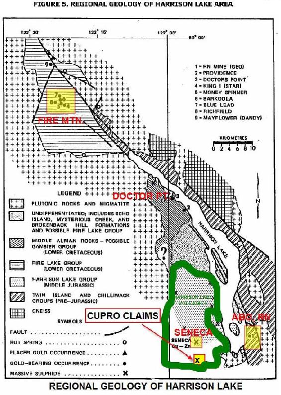
The regional Geology is show in Figure 4 on the following page.
9
LOCAL AND PROPERTY GEOLOGY
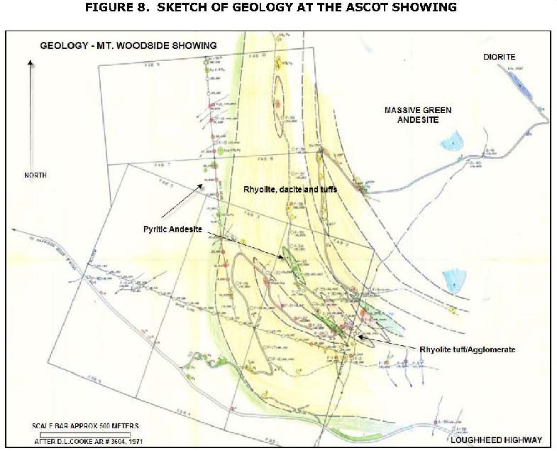
The property is underlain primarily by volcanic rocks of the Harrison Lake Group. To the northeast are intrusive rocks of dioritic composition, and probably of Cretaceous age. In the past, claim ownership has been fragmented and the present property has never been described as a whole. As described by Cooke (1971) from the "Ascot" showing area (also called Fab):
"The pyritic volcanic units which are exposed on the property consist, from west to east, mainly of massive andesite, rhyolite and dacite flows, end rhyolite tuffs and agglomerates. Fine-grained, unmineralized, andesitic tuffs and flows occur further t 0 the east. Some diorite in the northeast area. may be intrusive or extrusive in origin. The andesite is massive, fine-grained, and has a characteristic greenish colour, and the rhyolite and dacite flows are grey to white, fine-grained rocks containing small quartz phenocrysts.
The rhyolite pyroclastics are aphanitic units with a grey to pale green tinge. Because of the intensity of alteration and pyritization of these units, there is some doubt whether they are actually rhyolites or silicified andesites.
Bedding features ere obscure, and the sequence of deposition was therefore established on a very small number of attitude measurements. The overall strike appears t o be in the direction N 30' t o 40' W, and the dip ranges from 10' to 25 degrees E. Where dip measurements have been observed, they are generally well developed and persistent, where the WNW strike and shallow to steeper dips have been noted, but these are less persistent along strike, and ere thought to be very local in nature. It appears that the units which lie to the west are the stratigraphically lower members".
To the east, on the adjacent claims overlying the Midnight zone, Northcote has mapped essentially the same volcanic package.
Regional Geology is shown in Figure 4, on the following page. The local Geology (from Map Place- a BC Government Geological Survey website) is shown in the accompanying Figure 5.
10
11

12
MINERALIZATION
Mineralization at the various showings is described briefly (from Assessment Reports and Minfile)
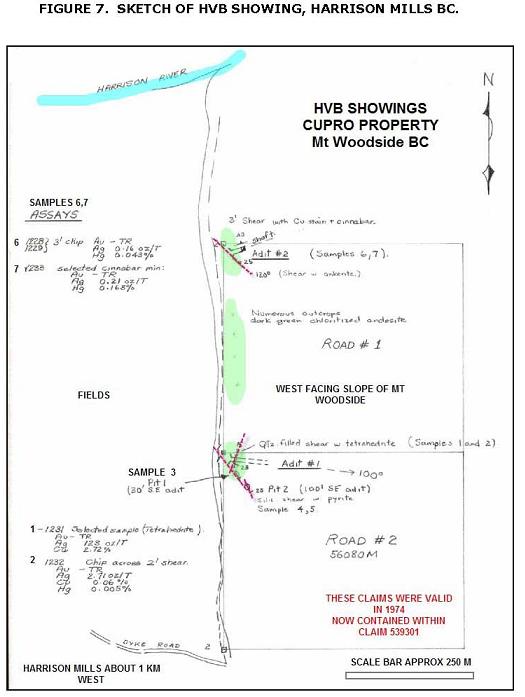
HVB showing.
This showing occurs along the west facing slope of Mt. Woodside where the fields adjoin the Highway. Along the slope are indications of probable shallow adits with some vein mineralization with Tetrahedrite (Copper Antimony sulphide) and minor Cinnabar (Mercuric sulphide) in quartz/carbonate veins. The property was briefly staked in about 1973 by Harry Vernon Barley. BJ Price wrote up a brief summary for Delphi Resources Ltd, a private company, in 1974. Seven samples were taken by Price in 1974 as shown below.
| SAMPLE | TYPE and DESCRIPTION | AU | AG | PG | CU | HG |
| No | opt | opt | % | % | ppm | |
| 1-1231 | Selected min from Adit 1 | Tr | 123.2 | 0.02 | 2.72 | na |
| 2-1232 | Adit 1 chip across 2 ft | Tr | 2.71 | Na | 0.06 | 0.005 |
| 3-1226 | Grab rusty andesite in pit 1 | Tr | .03 | Na | Na | <0.001 |
| 4-1227 | Grab rusty andesite in pit 2 | Tr | .13 | Na | Na | na |
| 5-1230 | Pit 2 2 ft chip across silicified zone | Tr | .05 | Na | Na | <0.001 |
| 6-1228.29 | Adit 2, chip across 3 ft, Cu Hg stain | Tr | .16 | Na | Na | 0.043 |
| 7-1233 | Selected sample cinnabar in carb. | Tr | .21 | Na | Na | 0.163 |
The showing should be relocated and mapped and sampled in detail.
Ascot Showing:
At the Ascot showing, the volcanic rocks are locally silicified and mineralized with sulphides, mainly pyrite, with minor amounts of chalcopyrite and a trace of sphalerite. Mineralization is associated with quartz stringers striking west-northwest and dipping steeply northeast in altered siliceous volcanic rocks including agglomerate or andesite flow breccia. A film of chalcocite coats the other sulphides where the stringers are vuggy. These sulphides also occur in small amounts in the country rock together with heavy concentrations of pyrite.
In the same vicinity, chalcopyrite is reported (Minfile) to occur in a shear in porphyritic andesite. The shear is 15 centimeters wide, strikes 110 degrees, dips 65 degrees southwest and is parallel to a band of grey, cherty pyritic rock about 3 meters wide. A sample of a sulphide-rich gossan zone yielded 0.35 per cent copper and less than 0.1 gram per tonne gold (Assessment Report 9640).
13
Playfair showing
Although the Playfair showing appears to be covered by two crown-granted mineral claims, ownership of this property is uncertain. There were two "lodes" reported in 1897, explored from working near the railway level. Polymetallic mineralization is present but it is not known whether this is vein material or VMS' or Kuroko type mineralization. The area needs to be examined and mapped.
14
15
Mineralization at the Ascot (or Fab) showing is described by D.L Cooke P.Eng. as follows: Pyrite Is the most widespread form of sulphide mineralization, and its abundance appears to be directly correlated with the intensity of fracturing and/or rock types. Little or no pyrite was observed in the massive rhyolite and dacite flows.
From a trace to about 5% pyrite was noted in the andesite flows, and up to 20% pyrite in some outcrops of rhyolitic fragmental rocks. Pyrite occurs both disseminated cubes and as sub-massive sulphide associated with fractures and quartz stringers within these siliceous pyroclastic members. Like the fragmented host rocks, these areas of intense mineralization have not been traced for any appreciable distances.
Minor amounts of chalcopyrite and a trace of sphalerite are associated with quartz stringers in altered siliceous agglomerates near the southeast boundary of the (former) Fab No.2 claim. These sulphides also occur in small amounts together with the heavy pyrite impregnating the country rock.
Where some of the stringers are vuggy, a secondary black film of chalcocite coats the other sulphides. Traces of disseminated chalcopyrite also occur in association with pyrite.
Copper-zinc-silver mineralization in a similar volcanic setting has been reported on the adjacent Ascot claims t o the east, and on the Seneca claims which lie several miles to the northwest on the west side of Harrison Lake (Minister of Mines and Petroleum Resources Annual Report, 1962).
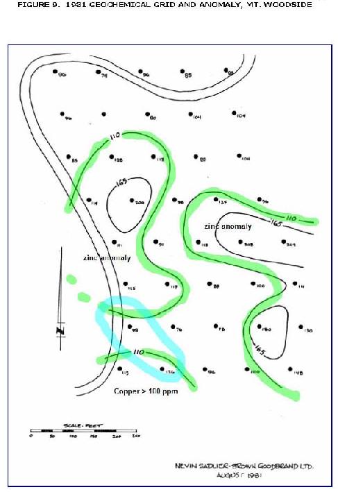
Geochemistry
A number of small geochemical soil and rock sampling programs have been undertaken on the claims. One such survey by Tim Sadlier Brown in 1981 developed a copper-zinc anomaly but the grid was rather small and the limits of the anomalous area were not completely defined. A larger grid is suggested as soil geochemistry work well in this area. One of the grid maps follows, reproduced from the 1981 report.
Sadlier Brown commented: "The massive sulphide target appears to be traceable through the use of copper soil geochemistry. Zn, Ag, and Mo values appear to be of limited use although Zn should be tested for in any future work in the light of earlier assay results. Expansion of the g rid to the southeast and west should define the area of interest with sufficient accuracy to locate trenches and possibly drillholes.
The zone should respond to EM testing as well but, as much of the sulphide is barren of economic metals, the favoured approach is additional geochemistry with the objective in mind being the discovery of lateral or vertical increases in base metal content within the massive sulphide zone".
16
17

18
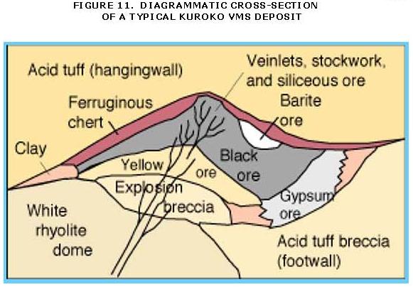
THE KUROKO MODEL
A brief description of characteristics of Kuroko deposits will serve as a guide for comparison of the various deposits in the Harrison Lake belt (such as Norrish, Thor-Odin and Seneca deposits) with the Kuroko (polymetallic volcanogenic massive sulphide deposits) of Japan, which are zoned massive base metal deposits which are largely stratiform in volcano-sedimentary sequences dominated by felsic tuffs, lavas and shallow intrusives of Miocene age. Base metal veins and stockwork deposits also occur in these sequences.
Typical characteristics are:
| · | Each mine consists of a number of closely clustered ore deposits. |
| · | Each deposit may be from 6 to 190 meters thick and range from 40 x 50 meters in surface area to 700 m x 350 m. |
| · | Zoned massive stratiform ore typically oval shaped in plan grades down into less economically ifllportant stockwork ore (siliceous ore) which generally has a funnel-shape and occurs In silicified felsic volcanics. |
| · | Thin beds or small lenses of ferruginous chert are commonly present either directly overlying the stratiform ore body or within hanging wall tuffs. Lenticular-or irregular masses of gypsum and/or anhydrite are also present in most cases. |
| · | The boundary between hanging wall rocks and ore is sharp. |
| · | Ore bodies are generally vertically zoned with "Black Ore"- (sphalerite-galena rich) at the top, and "Yellow Ore" (chalcopyrite-rich) at the bottom above stringer ore. Areas of massive gypsum, anhydrite, or barite mayor may not be present. |
| · | Ore in stringer zones is generally coarse n veins with quartz, etc., while massive ore is fine-grained and may be breccia. |
| · | Colloform textures are common in massive ore. |
| · | Each deposit is generally associated with a felsic domal center built up in a single short eruptive cycle. |
| · | Deposits are generally underlain by coarse felsic tuff |
| · | There are gradations between stratiform ore bodies, stockwork ore and fissure-filling veins; these formed penecontemporaneously from similar hydrothermal ore solutions. |
| · | Deposits are surrounded by clay-rich alteration zones. The stockwork (stringer) ore is associated with quartz, sericite and Mg-chlorite. The stratiform ore is surrounded by sericite or sericite/montmorillonite and kaolinite alterations, which grade outward to chlorite-rich and zeolite-rich alteration zones. |
| · | Deposits are generally aligned along faults or directions of elongation of lava flows. |
| · | Minor disseminations of pyrite and other sulfides may occur in hanging wall rocks. Vein deposits can be found at varying distances from stratiform deposits, but tend to be at stratigraphically lower levels. |
Typical features are illustrated in the accompanying Figure 11. Note that the diagram is simplified, variations occur, and most deposits are complicated by faulting, folding and metamorphism.
19
PAST PRODUCTION
There has been no known mine production from the property. The adjacent Valleyview property has achieved small production in the past.
RESERVES AND RESOURCES
There are no mineral reserves or resources (in Canadian terminology) on the Cupro property, and although mineralization is present, it is not within a defined "mineralized body" in US SEC terminology.
ADJACENT PROPERTIES
These mineral properties described above are owned by other individuals or exploration companies. Bold View Resources Ltd. does not have any interest in these properties. The descriptions and those in Appendix II are provided solely for the benefit of the reader to provide an insight into the styles and types of mineral deposits in the Harrison Lake area.
20
Valleyview Property
The Valleyview showing appears to be on claims held by Armstrong Sand and Gravel Company. There is an operating sand and gravel quarry on the site; the company may or may not be interested in base-metals.
Minfile Reports: "A strong, northeast trending zone of hydrothermal alteration extending for about 350 meters, pervades the rocks in the Valley View zone. The alteration consists of chlorite, locally strong sericite, lesser epidote with some pervasive feldspar (albite?) and quartz. Disseminated pyrite occurs throughout the alteration zone with much lesser pyrrhotite. Southeast trending and vertical to steeply dipping mineralized open space quartz-sericite-carbonate-epidote veins are superimposed on the alteration zones. These veins extend over several centimeters and are mineralized with coarse crystalline pyrite, minor chalcopyrite, sphalerite and galena yielding trace silver and gold values.
A second zone of significant hydrothermal alteration and mineralization is located along the lower reaches of Stacey Creek, and extends for about 45 meters along the stream bank. The altered zone occurs in siliceous chert, arkose and breccias which have undergone extensive sericitic and local brecciation with strong silica and feldspar impregnation and veining. An irregular vein of barite about 0.5 meter wide, occurs in the intensely sericitic (pyrophyllite) brecciated alteration zone. Minor sulphide mineralization consisting of pyrite, chalcopyrite, galena and sphalerite occurs locally in association with sericitic and siliceous alteration.
The significant differences between the Stacey Creek (Constantine) zone and the Valley View zone is the more intense sericitic (pyrophyllite) alteration, stronger brecciation and much less disseminated pyrite and other sulphides.
Selected samples from the mineralized zones were collected in 1984.
| 1. | A sample from a mineralized vein hosting pyrite and chalcopyrite assayed 0.064 per cent copper, 28.11 grams per tonne silver and 0.034 gram per tonne gold. |
| 2. | A chip sample from a mineralized, siliceous feldspathic fragmental rock from Stacey Creek analyzed 0.138 per cent copper, 0.86 per cent lead, 0.30 per cent zinc, 2.9 grams per tonne silver and 0.001 gram per tonne gold. |
| 3. | Another 0.5 meter chip sample from sericitized, weakly silicified breccia that is crosscut by barite veinlets, analyzed 0.087 per cent copper, 0.126 per cent lead, 0.364 per cent zinc, 10.4 grams per tonne silver and 0.014 gram per tonne gold. |
| 4. | A 0.5 meter chip sample of sulphide mineralization from this area yielded 0.295 per cent copper, 0.90 per cent lead, 1.40 per cent zinc, 30.0 grams per tonne silver and 0.45 gram per tonne gold (Assessment Report 12222). |
A small shipment of mineralized material was made in 1961.
21
Carat Property
The large Seneca property (Carat claim group) is now being explored by CARAT EXPLORATION INC. a junior company on the TSXV. The property is the subject of a recent Technical Report by Sean D. McKinley, M.Sc., P.Geo., Stuart Fraser, P. Geo. and William Gilmour, P.Geo., dated: October 1, 2004. and revised: January 18, 2005. The main focus of Carat's work is the Seneca Volcanogenic Massive Sulphide ("VMS") deposit near Chehalis River, although the property includes other showings such as Brett, Cloud and others.
Seneca Deposits (Summarized from McKinley et al. (1996))
The Seneca Prospect is a volcanic-hosted Zn-Cu-Pb deposit located 120 km east of Vancouver in southwestern British Columbia. The deposit was found by Isaac Miller by tracing massive sulphide float from the Chehalis River area. Early work was done by Noranda Inc. In 1969, 287 tons of ore grading 1.55% Cu, 8.15% Zn, 4.5 opt Ag and .12 opt au was shipped to the Britannia Mine from an open pit that constituted the Lucky Jim (Seneca) prospect. Considerable later work was done by Zenith Mines Ltd (1970's), Cominco Ltd. under the supervision of Bruce Mawer and by Chevron Minerals Corp., under the direction of Earl Dodson, P.Geo.
The volcanic rocks at Seneca form part of the lower to Middle Jurassic Harrison Lake Formation of the Harrison Terrane. The host stratigraphic sequence can be subdivided into three distinct intervals based on the presence of specific units and certain lithologic associations.
• The lowermost Footwall Interval is distinguished by the presence of subaqueous basaltic lavas. The limited distribution of these rocks suggests that they were deposited locally in rifted sub-basins.
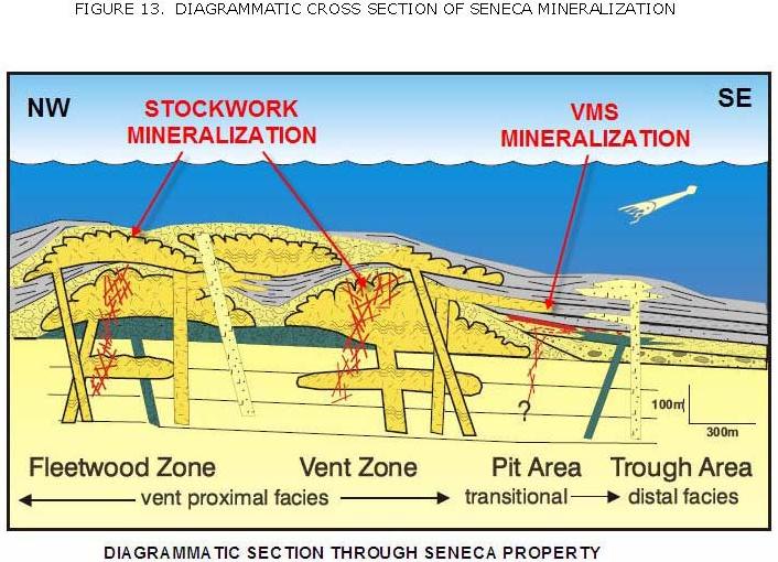
• The Footwall Interval is overlain by rocks of the Seneca Horizon which are host to stockwork mineralization in the Vent Zone and Fleetwood Zone, and to stratiform mineralization in the Pit Area.
• Above the Seneca Horizon is the Hanging wall Interval, which is characterized by felsic flows and dikes, and moderately to well-bedded felsic volcaniclastic turbidites and ashes.
Volcanic textures suggest that there is a transition from vent-proximal facies to distal facies approximately from northwest to southeast across the Seneca property. The Seneca volcanic sequence comprises a bimodal suite of mafic rocks and dacitic to rhyolitic rocks.
22

23
The Seneca property is divided into four major areas which are, from northwest to southeast,
| • | the Fleetwood Zone, |
| • | the Vent Zone, |
| • | the Pit Area, and |
| • | the Trough Zone. |
Historical Mineral Resources as estimated by Wright Engineers Ltd. for Cominco Ltd. about 1994 are at 1.5 million tonnes averaging 3.570/0 zinc, 0.630/0 copper, 0.150/0 lead, 41.1 g/t silver, and 0.8 g/t gold, based on extensive diamond drilling.
This resource estimate, although prepared by competent and experienced personnel, was prior to the implementation of NI 43-101 and should not be relied on. The estimate is comparable to an inferred resource within the CIM Resource definitions and is considered reliable and relevant. In the USA, under SEC regulations, this deposit would be called mineralized material
Carat Exploration Inc. acquired the core of the Seneca Property in 2004 and has progressively advanced exploration and land acquisition creating one of the largest claim holdings in the area. From a core acquisition of 6 unpatented two-post claims (6 units), Carat has expanded its ownership by staking, and has purchased an additional 23 MCX claims and 7 four-post claims. The total area of 12,249 hectares (30,267 acres), is now mostly 100% owned by Carat.
Observations in drill core suggest that strata on the property strike approximately northwest, and are essentially flat lying or moderately dipping to the east The sections are continuous along strike except for a 500 m separation where there is no drillhole coverage. The major lithologic associations at Seneca are defined on the basis of proximity to their primary source which is, in this case, a volcanic center or vent(s). The four principal volcanic facies assemblages are as follows:
Facies 1 - Vent to vent-proximal fades: Lavas of basaltic to rhyolitic composition
consisting of flows, domes and associated in-situ hyaloclastites and auto clastic breccias.
Facies 2 - Vent-proximal to distal facies: Volcaniclastic rocks consisting of juvenile to
reworked coarse volcanic breccias and tuffs, through to fine-grained silt-stones and ashes
Facies 3 - Coeval Intrusions: Basaltic to rhyolit.ic composition sills and dikes that have
intruded lavas and wet, unconsolidated volcaniclastic sediments
Facies 4 - Distal Marine: Rocks of volcano-sedimentary origin, consisting of argillite
which commonly contains flattened pumice fragments with feldspar +/- quartz phenocrysts.
Facies 1 to 3 are generally observed in all drill holes, but their relative abundances vary greatly from hole to hole, commonly over small distances, thus making detailed lithostratigraphic correlation difficult. The fourth facies is spatially restricted to the Pit Area and the Trough zone.
24
25
Mineralization in the Pit Area consists of zones of disseminated to conformable massive sphalerite, pyrite, chalcopyrite, galena, and barite hosted by a highly altered unit termed the Ore Zone Conglomerate (OZC). Stratigraphic relationships suggest that mineralization in the Pit Area formed contemporaneously with the stockwork sphalerite-pyrite-chalcopyrite mineralization in the Fleet-wood and Vent zones. The stockwork zones represent vertical conduits for hydrothermal fluids. Elsewhere fluids migrated laterally through the permeable OZC, causing quartz-sericite alteration, and interacting with cooler seawater to form the Pit Area sulfide mineralization.
Highly altered rocks from the Vent and Fleetwood stock-work-mineralized zones have experienced losses of Na20 and CaO, corresponding to the destruction of plagioclase, and variable gains in Si02, K20, and MgO corresponding to the formation of quartz, sericite and chlorite. Individual stockworks generally consist of an upper quartz-sericite zone and a lower sericite-chlorite (+quartz) alteration zone. MgO mass gains are prevalent throughout the Vent Zone stockwork but are much smaller or absent in the Fleetwood Zone stockwork, probably due to greater incorporation of seawater Mg in the former hydrothermal system. The overall tectonic setting of the Seneca sequence is interpreted on the basis of stratigraphic and geochemical features as the submarine, rifted flank of a mature island arc which was characterized in the Seneca area by bimodal volcanism.
While the Harrison Lake volcanics continue on to the eastern part of the Carat claims and also on to the Centurion property, (as shown in Figure 12A) controls of the massive sulphide bodies at Seneca are unknown, and it is not implied that mineralization continues on to the subject property, only that favourable volcanic host rocks are present. Detail is provided for the reason that the Carat property, under active exploration, lies immediately adjacent to the Centurion property. There is no guarantee however that similar mineralization will be found
The writer has no beneficial interests, direct or indirect, in any of the properties described under this heading, in full compliance with the relevant provisions of NI 43-101
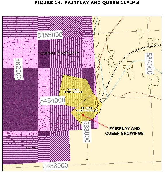
Fairplay (Queen)
The Fairplay showings are situated on two Crown granted claims, which, though covered by the Cupro claims, appear to be in good standing and belong to others. The claim details are as follows:
| CLAIM | PID NO. | LOT NO. | OWNER |
| Queen MC | 7198150 | DL 2092 | Unknown |
| Fairplay MC | 7197530 | DL 2085 | Unknown |
In 1897, there was reported to be two lodes on the Fat Man and Nancy Jane property, about 50 meters apart. These were from 1.5 to 5 meters in width and carried gold, silver, copper, lead and zinc. At this time it was considered a copper prospect. A shaft, 14 meters long, and three adits totaling 64 meters had been completed on the property to 1897.
By 1898, the Fairplay and St. Alice claims were situated on the ground formerly occupied by the Fat Man and Nancy Jane claims. In ·this year, a tunnel 55 meters long and two crosscuts, 12 and 21 meters long respectively, were completed. A total of about 122 meters of underground development: had been done on the property up to, and including 1898.
26
In 1929, on what was now the F.E.W claim, a short tunnel was run from the level of the railway track and a shaft sunk about 6 meters at the end of the tunnel on a small stringer showing a little zinc.
The property should be examined to see if massive "Kuroko" style mineralization might be present, and which might extend onto the Cupro property.
27
Bee Uranium showing
(From Minfile)
The Bee occurrence area (situated off the Cupro property about 4 kilometers to the northeast, is underlain by Lower-Middle Jurassic Harrison Lake Formation rocks comprised of intermediate to acidic flows and pyroclastics, and the Upper Jurassic Kent Formation conglomerate, chert and tuffs. These rocks are intruded by the Oligocene Chilliwack batholith. The property covers the contact between Kent Format.ion conglomerate and hornblende granodiorite of the Chilliwack batholith.
Radioactive pegmatite occurs in hornblende granodiorite. The siliceous pegmatite is comprised mainly of white to clear quartz enveloping subhedral crystals of potash feldspar and fragments of granodiorite host rock.
A uranium mineral, likely uraninite or uraniferous magnetite, occurs as sporadic, fine disseminated black crystals associated with clusters of fine-grained pyrite. A greenish yellow secondary uranium mineral, possibly phosphuranylite, also occurs in the matrix. The pegmatite also contains chalcopyrite, malachite, erythrite (cobalt stain) and limonite. A 2-metre chip sample assayed 0.017 per cent uranium (Assessment Report 6790).
The property should be examined and granodiorite areas adjacent in the Cupro claims checked for uranium potential with a scintillometer survey.
Empress copper Skarn
(From Minfile)
The Empress property of four Crown Granted claims is located along the contact between limestone of the Devonian-Permian Chilliwack Group and a middle Tertiary granodiorite intrusion which is part of the Coast Plutonic Complex. The property is about 10 km to the northeast of Cupro, near Harrison Hot Springs.
Mineralization occurs in the metamorphosed limestone and along the granodiorite-limestone contact. The garnet-wollastonite skarn hosts chalcopyrite with some bornite, molybdenite, pyrite and magnetite. Epidote, malachite and azurite is associated with the skarn and the metamorphosed limestones. Bedding strikes east-west and dips about 80 degrees north.
Considerable development work was done on the property between 1915 and 1917. A representative sample from the ore dump containing chalcopyrite in a gangue of magnetite and garnetite analyzed trace gold, 48.0 grams per tonne silver and 5.3 per cent copper (Mihister of Mines Annual Report 1917, page 287). About 181.4 tonnes of ore was shipped from the property between 1916 and 1917. In 1917, 91 tonnes of ore produced 6350 kilograms of copper.
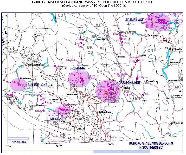
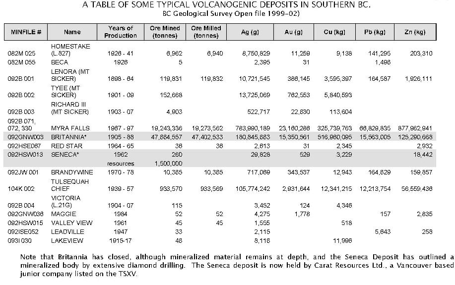
A map of ssome similar VMS deposits in southern BC follows, accompanied by a table of tonnages and grades of VMS deposits.
28
29
30
DISCUSSION
Within the Cupro claims are a number of polymetallic vein or stringer zones which have been explored in the past. These are hosted by the Harrison Lake Group of Jurassic volcanics, which, 10 kilometers to the north are host to a significant polymetallic volcanogenic massive sulphide (VMS) deposit (The Seneca massive sulphide deposit, which has 1.5 million tonnes of mineralization grading 3.57% zinc, 0.65% copper, 41.1 grams per tonne silver and 0.82 grams per tonne gold.). This deposit consists of massive barite, pyrite chalcopyrite, sphalerite and galena. The present property has not been thoroughly prospected or mapped.
Other VMS deposits occur in southern British Columbia, in similar Jurassic volcanics. The best example is the Britannia mine, near Squamish, which produced at one time 47.8 million tonnes of ore containing significant amounts of copper (517 M kilograms), lead zinc, gold and silver.
CONCLUSIONS
The Cupro property, which has been explored intermittently in the past, by a number of junior companies, each with small claim holdings, has been assembled into one large property which can now be explored by modern geochemical and geophysical methods.
Although there are no immediate drill targets, comparison with adjacent VMS properties such as the Seneca property, suggests that similar massive sulphide mineralization could exist in the area.
Within volcanic packages such as Harrison Lake formation (host to the Seneca deposits and the Cupro showings), deposits are generally found in strongly altered “footwall” volcanic (tuffs and volcanic sediments) generally at a sedimentary interface. The deposits are overlain by realatively unaltered, massive “Hangingwall” volcanic which are fresh and unmineralized. Such ssuccession is present at Mt. Woodside, where the known showings are at the base of the mountain, overlain by massives and volcaniclastics. This provides a good exploration target, and it appears that Footwall and Hanginwall sequences have been recognized.
RECOMMENDATIONS
Initially, base maps should be prepared at a favourable scale. New TRIM topographic maps are appropriate, and can be purchased in digital format.
A comprehensive prospecting and mapping program is suggested, to be followed by geochemical soil and silt stream sediment surveys and rock sampling. Any anomalous areas should have Induced Polarization (IP) survey grids completed to try and outline areas with sulphides.
An airborne geophysical multi-sensor survey might be useful, in light of the steep and relatively inaccessible terrain on the north slope of the mountain.
31
If areas of interest are outlined by anyone or more of the above noted surveys, a program of diamond drilling would follow.
SUGGESTED BUDGET
| COST ESTIMATE | |||||
| Phase 1 | |||||
| Complication of geochemical data | US $ 7,000 | ||||
| Prospecting | 8,000 | ||||
| Geological mapping, sampling | 18,000 | ||||
| Vehicle, fuel | 5,500 | ||||
| Room and board | 4,500 | ||||
| Analyses | 6,000 | ||||
| Supplies | 1,000 | ||||
| Report | 6,000 | ||||
| 55,000 | |||||
| Contingencies @ 10%, approx | 5,000 | ||||
| Total Phase 1 | 60,000 | US $ 60,000 | |||
| Phase 2 | |||||
| Geophysical surveys, drilling, allow | 140,000 | 140,000 | |||
| Total, Phases 1 and 2 | US $ 200,000 | ||||
Respectfully submitted
| /s/ David J. Bridge David J. Bridge, P.Geo., B.A.Sc., M.A.Sc. Qualified Person August 20, 2007 | | |
32
BIBLIOGRAPHY
Cairnes, CE., (1944);Hope Map Area: GSC Map 737A
Crickmay, CH., (1925); The Geology and Paleontology of the Harrison Lake District, British Columbia, together with a General Review of the Jurassic Faunas and Stratigraphy of Western North America. Ph.D. Thesis, Leland Stanford Junior Univerisity, 1925.
EMR/MEMPR; Aeromagnetic surveys Maps 85376 Chilliwack, 85386, Harrison Lake
MEMPR; Minister of Mines Annual Reports (MMAR) 1955-74; 1961-88; 1966-62
Geology, Exploration and Mining (GEM) 1970-247; 19"71-264; 1974-105; 1975-E62
Minfile 92H SW 015 Valley View Property File; 92H SW & NW; 92 G NE
Monger, J.W.H., (1969); Hope Map-Area West Half (92H W) British CC?lumbia, GSC Paper 69-47 pp 75.
Northcote, ICE. Mar. 1984, Feb. 1985); Report on Geological and Geophysical Surveys on the Valley View and Goldtop Claims, Private Report for Star Mountain Resources Inc.
Northcote, K.E.; Report on Ground Magnetometer Survey on the Valley View and Goldtop claims. Assessment report for Star Mountain Resources Inc., January 3 1,1985.
Arthur, A. (1987): Mesozoic Stratigraphy and Paleontology of the West Side of Harrison Lake, Southwestern British Columbia, Unpublished. M.Sc. Thesis, University of British Columbia.
Arthur, Andrew J., Paul L. Smith, James W. H. Monger, & Howard W. Tipper. (1993) Mesozoic Stratigraphy and Jurassic Paleontology West of Harrison Lake, Southwestern British Columbia. 62 pp .. 1993.Geological Survey of Canada, Bulletin 441
Friesen. P.S., P.Eng., (1987); Report on the Weaver Lake property. Private Report for Aaron Mining Ltd. dated 21 September, 1987.
Mitchell, Marvin A., (1989); Geological Report on the Keiko and KK Mining Claims, New Westminster Mining Division, British Columbia. Private Report prepared for Hera Resources Inc. dated January 15, 1989
Price, B.J., (1995); Opinion of Value for the Harrison Lake Gold Property. Draft Report for Pacific Comox Resources Ltd. dated March 7, 1995.
Price, B.J., (1987); Geological Report, Fire Mountain Gold Property, Fire Mountain Area, New Westminster M.D., Private Report for Plaskey Development Enterprises Ltd., dated November 25, 1987.
Price, B.J., (1986); Geological Summary, Bigfoot Property, Harrison Lake, BC, New Westminster Mining Division. Private Report for Shangri-La Minerals Ltd. dated 26 February 1986.
Price, B.J., and Howell, W.A., (1981); Geochemical Report, Fire Creek Prospect, Hades and
33
Brimstone claims, New Westminster M.D., Assessment Report for JMT Services Corp. and Territorial Gold Placers Ltd. dated November 15, 1981.
Price, B.J., and Howell, W.A., (2002); Geochemical Report, Zeus Prospect, Harrison Lake area, New Westminster M.D., private Geological Report for Corumel Minerals Ltd ..
Price, B.J., (2004); Assessment Report, Thor 7-12 mineral claims, , Harrison Lake area, New Westminster M.D., private Geological Report for Corumel Minerals Ltd. and filed as Assessment Report, dated February 25, 2004.
Price, B.J., (2006); Technical Report, Thor claims, , Harrison Lake area, New Westminster M.D., for Centurion Minerals Ltd.
Ray, G.E. (1983):The Nagy Gold Occurrences, Doctors Point, Harrison Lake (92H/12W), B.C. Ministry of Energy, Mines & Pet. Res., Geological Fieldwork, 1982, Paper 1983-1, pp. 55·61.
Ray, G.E., Coombes, S. and White, G. (1984): Harrison Lake Project (92H/5, 12; 92G/9), B.C. Ministry of Energy, Mines Pet. Res., Geological Fieldwork, 1983, Paper 1984-1, pp. 42-53.
Ray, G.E. and Coombes, S. (1985): Harrison Lake Project (92H/5, 12; 92G/9, 16),B.C. Ministry of Energy, Mines & Pet. Res., Geological Fieldwork and Current Research, 1985, Paper 1985-1.
G.E. Ray, 1986: Gold Associated with a Regionally Developed Mid Tertiary Plutonic Event in the Harrison Lake Area, Southwestern British Columbia; B.C. Ministry of Energy, Mines and Petroleum Resources, Geological Fieldwork 1985, Paper 1986-1, pp.95-97.
References - Seneca Mineral Deposit:
Arthur, A.J., Smith, P.I., Monger, JWH. and Tipper, H.W., 1993. Mesozoic stratigraphy and Jurassic paleontology west of Harrison Lake, southwestern British Columbia. Geological Association of Canada, 441, 62 p.
Mahoney, J.B., Friedman, R.M. and Mckinley, S.D., 1995. Evolution of a Middle Jurassic volcanic arc: Stratigraphic, isotopic and geochemical characteristics of the Harrison Lake Formation, Southwestern British Columbia. Canadian Journal of Earth Sciences, 32, p.1759-1776.
Mckinley, S.D., 1996. Volcanic Stratigraphy and Lithogeochemistry of the Seneca Zn-Cu-Pb Prospect, Southwestern British Columbia. M.5c. Thesis, University of British Columbia, 195 p.
McKinley, S.D., Barrett, T.J. and Thompson, J.F.H., 1996. Volcanic stratigraphy and lithogeochemistry at the Seneca Zn-Cu-Pb prospect, southwestern British Columbia. Exploration and Mining Geology, v. 5, p. 399-420.
McKinley, S.D., Barrett, T.J. and Thompson, J.F.H., (1996): Geology and lithogeochemistry at the Seneca Zn-Cu-Pb Prospect, southwestern British Columbia, Exploration and Mining Geology, vol. 5, no. 4, pp. 399-420.
34
McKinley, S.D., Thompson, J.F.H. and Barrett, T.J., (1995): Volcanic Stratigraphy and Lithogeochemistry of the Seneca Prospect, Southwestern British Columbia, (92Hj5W); in Geological Fieldwork 1994, Grant, B. and Newell, J.M., Editors, British Columbia Ministry of Energy, Mines and Petroleum Resources, Paper 1995-1, pages 503-512.
McKinley, S.D., Thompson, J.F.H., Allen, R., Sherlock, R.L., Burge, C. and Barrett, T.J. (1994): Geology of the Seneca Property, Southeastern British Columbia; in Geological Fieldwork 1993, Grant, B. and Newell, J.M., Editors, B.C. Ministry of Energy, Mines and Petroleum Resources, Paper 1994-1, pp. 345·350.
Pearson, D.E., 1973. Harrison, Lucky Jim. In Geology, Exploration and Mining in British Columbia 1973. British Columbia Ministry of Energy, Mines and Petroleum Resources, p.125-128.
Pride, K.R., 1'973. A mineralographic study of selected sulfide samples from the Seneca Property, near Harrison Mills, British Columbia. B.Sc. thesis, the University of British Columbia, 44 p.
Thompson, R.I., 1972. Report on Harrison, Lucky Jim Property. In Geology, Exploration and Mining in British Columbia 1972. British Columbia Ministry of Energy, Mines and Petroleum Resources, p.102-114.
Urabe, T., Scott, S.D. and Hattori, K., 1983. A comparison of footwall-rock alteration and geothermal systems beneath some Japanese and Canadian volcanogenic massive sulfide deposits. In The Kuroko and Related Volcanogenic Massive Sulfide Deposits. Economic Geology Monograph 5, p.345-364
35
CERTIFICATE OF THE AUTHOR, DAVID J. BRIDGE
I, David Bridge, hereby certify that:
I am an independent geologist residing at 601- 31 Elliott Street, New Westminster, BC, Canada, Telephone : 604-520-0508
I am a graduate of the University of British Columbia with a Bachelors degree in Geological Engineering in 1990 and a Masters Geological Engineering in 1994.
I am registered as a Professional Geoscientist with the Associaton of Professional Engineers and Geoscientists of British Columbia. (APEGBC Number 24974)
I have practiced my profession since 1994 as a geologist for junior and major mineral exploration companies.
By reason of my education, affiliation with a professional association and past relevant work experience, I fulfill the requirements to be a “qualified person” for the purposes filing this report to the SEC.
I am one of the authors of all sections of this report titled “The Report”).
I visited the property on August 14, 2007, accompanied bygeologists William A. Howell and Barry J. Price. I am not aware of any material fact or material change with respect to the subject matter of the Report that is not reflected in the Report, the omission to disclose which makes the Technical Report misleading.
I am independent of the issuer.
I consent to the filing of the Technical Report with any stock exchange and other regulatory authority and any publication by them for regulatory purposes, including electronic publication in the public company files on their websites accessible by the public, of the Report.
Dated at Vancouver B.C. this 20th day of August, 2007
Respectfully submitted
| /s/ David J. Bridge David J. Bridge, P.Geo., B.A.Sc., M.A.Sc. Qualified Person August 20, 2007 | | |
36
APPENDIX I
MINFILE DESCRIPTIONS
ASCOT,FAB,TREBLIF
Mining Division New Westminster BCGS Map
Status Showing NTS Map 092H04W
Latitude 49° 14' 11" N UTM 10 (NAD 83)
Longitude 121 ° 53' 44" W Northing 5454321 Easting 580398
Commodities Copper, Zinc Deposit Types G06 Noranda/Kuroko massive sulphide Cu-Pb-Zn
Tectonic Belt Coast Crystalline Terrane Harrison
Capsule Geology The Ascot occurrence is underlain by Lower and Middle Jurassic Harrison Lake Formation andesites, andesite porphyry, andesite breccia and basalt. Felsic volcanics and intrusions of Tertiary quartz diorite are also reported in this area.
The volcanic rocks are locally silicified and mineralized with sulphides, primarily pyrite. Minor amounts of chalcopyrite and a trace of sphalerite are associated with quartz stringers striking west-northwest and dipping steeply northeast in altered siliceous volcanic rock, reported variably as agglomerate or andesite flow breccia. A film of chalcocite coats the other sulphides where the stringers are vuggy. These sulphides also occur in small amounts in the country rock together with heavy concentrations of pyrite.
In the same vicinity, chalcopyrite is reported to occur in a shear in porphyritic andesite. The shear is 15 centimeters wide, strikes 110 degrees, dips 65 degrees southwest and is parallel to a band of grey, cherty pyritic rock about 3 meters wide.
A sample of a sulphide-rich gossan zone yielded 0.35 per cent copper and less than 0.1 gram per tonne gold (Assessment Report 9640).
Bibliography EMPR AR *1966-62
EMPR ASS RPT *3604, *9640
EMPR EXPL 1989-189
EMPR GEM 1972-102
EMPR OF 1999-2
GSC MAP 737A; 1069A; 12-1969; 41-1989
GSC P 69-47
37
FAIRPLAY (L.2085), F.E.W., FEW, FAT MAN,
NANCY JANE, QUEEN (L.2092), ST. ALICE
Mining Division New Westminster BCGS Map
Status Showing NTS Map 092H04W
Latitude 49° 13' 52" N UTM 10 (NAD 83)
Longitude 1210 51' 41" W Northing 5453772 Easting 582894
Commodities Copper, Zinc, Lead, Gold, Silver Deposit Types 105 Polymetallic veins Ag-Pb-Zn+/-Au
Tectonic Belt Coast Crystalline Terrane Harrison
Capsule Geology
The Fairplay occurrence is underlain by Lower and Middle Jurassic Harrison Lake Formation rocks which consists of intermediate, locally felsic flows and pyroclastics. Intrusions of Tertiary quartz diorite are reported in this area also.
In 1897, there was reported to be two lodes on the Fat Man and Nancy Jane property, about 50 meters apart. These were from 1.5 to 5 meters in width and carried gold, silver, copper, lead and zinc. At this time it was considered a copper prospect. A shaft, 14 meters long, and three adits totaling 64 meters had been completed on the property to 1897.
By 1898, the Fairplay and St. Alice claims were situated on the ground formerly occupied by the Fat Man and Nancy Jane claims. In this year, a tunnel 55 meters long and two crosscuts, 12 and 21 meters long respectively, were completed. A total of about 122 meters of underground development had been done on the property up to, and including 1898.
In 1929, on what was now the F.E.W claim, a short tunnel was run from the level of the railway track and a shaft sunk about 6 meters at the end of the tunnel on a small stringer showing a little zinc.
Bibliography EMPR AR *1897-579; *1898-1150; *1929-399
GSC MAP 737A; 1069A; 12-1969; 41-1989
GSC P 69-47
38
VALLEY VIEW, GOLD TOP, STACEY CREEK,
CONSTANTINE, PF, MIDNIGHT, NOREEN, REX
Mining Division New Westminster BCGS Map
Status Showing NTS Map 092HOSW
Latitude 490 15' 20" N UTM 10 (NAD 83)
Longitude 1210 51' 17" W Northing 5456496 Easting 583338
Commodities Copper, Zinc, Lead, Silver, Gold Deposit Types G06:
Noranda/Kuroko massive sulphide Cu-Pb-Zn
Tectonic Belt Coast Crystalline Terrane Harrison
Capsule Geology
The area is underlain mainly by Lower-Middle JurassiCcHarrison Lake Formation rocks comprised of volcanic flows, pyroclastics and tuff breccias with minor interbedded volcanic/sedimentary greywacke, tuff and arkose. These rocks are thought to be part of the Middle Jurassic Weaver Lake Member of the Harrison Lake Formation. These are in fault contact with the Upper Jurassic Kent Formation which is comprised of chert, interbedded tuffs and volcanic flow rocks which resemble the Weaver Lake Member suite.
A strong, northeast trending zone of hydrothermal alteration extending for about 350 meters, pervades the rocks in the Valley View zone. The alteration consists of chlorite, locally strong sericite, lesser epidote with some pervasive feldspar (albite?) and quartz. Disseminated pyrite occurs throughout the alteration zone with much lesser pyrrhotite. Southeast trending and vertical to steeply dipping mineralized open space quartz-sericite-carbonate-epidote veins are superimposed on the alteration zones. These veins extend over several centimeters and are mineralized with coarse crystalline pyrite, minor chalcopyrite, sphalerite and galena yielding trace silver and gold values.
A second zone of significant hydrothermal alteration and mineralization is located along the lower reaches of Stacey Creek, and extends for about 45 meters along the stream bank. The altered zone occurs in siliceous chert, arkose and breccias which have undergone extensive sericitic and local brecciation with strong silica and feldspar impregnation and veining. An irregular vein of barite about 0.5 meter Wide, occurs in the intensely sericitic (pyrophyllite) brecciated alteration zone. Minor sulphide mineralization consisting of pyrite, chalcopyrite, galena and sphalerite occurs locally in association with sericitic and siliceous alteration.
The significant differences between the Stacey Creek (Constantine) zone and the Valley View zone is the more intense sericitic (pyrophyllite) alteration, stronger brecciation and much less disseminated pyrite and other sulphides.
Selected samples from the mineralized zones were collected in 1984. A sample from a mineralized vein hosting pyrite and chalcopyrite assayed 0.064 per cent copper, 28.11 grams per tonne silver and 0.034 gram per tonne gold. A chip sample from a mineralized, siliceous feldspathic fragmental rock from Stacey Creek analyzed 0.138 per cent copper, 0.86 per cent lead, 0.30 per cent zinc, 2.9 grams per tonne silver and 0.001 gram per tonne gold. Another 0.5 meter chip sample from sericitized, weakly silicified breccia that is crosscut by barite veinlets, analyzed 0.087 per cent copper, 0.126 per cent lead, 0.364 per cent zinc, lOA grams per tonne silver and 0.014 gram per tonne gold. A 0.5 meter chip sample of sulphide mineralization from this area yielded 0.295 per cent copper, 0.90 per cent lead, 1040 per cent zinc, 30.0 grams per tonne silver and 0045 gram per tonne gold.
39
(Assessment Report 12222).
A small shipment was made in 1961.
Bibliography EMPR AR 1955-74; 1961-A49,88; 1966-62
EMPR ASS RPT *12222, *13479, *17318
EMPR BC METAL MM00232
EMPR EXPL *1975-E62; *1984-180
EMPR GEM 1970-247; 1971-264; 1974-105
EMPR OF 1999-2
GSC MAP 12-1969; 737A; 41-1989
GSC P 69-47, p. 66
Arthur, A.J. (1987): Mesozoic Stratigraphy and Paleontology of the West Side of Harrison Lake, Southwestern British Columbia, M .Sc. Thesis, University of British Columbia (Dec. 1987)
Crickmay, C.H. (1925): The Geology and Paleontology of the Harrison Lake District, British Columbia, Ph.D. Thesis, Leland Stanford Junior University, California